Vegetation history, climate and human impact in the Spanish Central System over the last 9,000...
26
Our reference: JQI 3855 P-authorquery-v9 AUTHOR QUERY FORM Journal: JQI Article Number: 3855 Please e-mail or fax your responses and any corrections to: E-mail: [email protected] Fax: +31 2048 52789 Dear Author, Please check your proof carefully and mark all corrections at the appropriate place in the proof (e.g., by using on-screen annotation in the PDF file) or compile them in a separate list. Note: if you opt to annotate the file with software other than Adobe Reader then please also highlight the appropriate place in the PDF file. To ensure fast publication of your paper please return your corrections within 48 hours. For correction or revision of any artwork, please consult http://www.elsevier.com/artworkinstructions. Any queries or remarks that have arisen during the processing of your manuscript are listed below and highlighted by flags in the proof. Location in article Query / Remark: Click on the Q link to find the query’s location in text Please insert your reply or correction at the corresponding line in the proof Q1 The following citations are unlisted “Martı ´n-Puertas et al., 1998; Fabia ´n, 1996”. Kindly check. Q2 Please confirm that given names and surnames have been identified correctly. Please check this box or indicate your approval if you have no corrections to make to the PDF file , Thank you for your assistance.
Transcript of Vegetation history, climate and human impact in the Spanish Central System over the last 9,000...

Our reference: JQI 3855 P-authorquery-v9
AUTHOR QUERY FORM
Journal: JQI
Article Number: 3855
Please e-mail or fax your responses and any corrections to:
E-mail: [email protected]
Fax: +31 2048 52789
Dear Author,
Please check your proof carefully and mark all corrections at the appropriate place in the proof (e.g., by using on-screen
annotation in the PDF file) or compile them in a separate list. Note: if you opt to annotate the file with software other than
Adobe Reader then please also highlight the appropriate place in the PDF file. To ensure fast publication of your paper please
return your corrections within 48 hours.
For correction or revision of any artwork, please consult http://www.elsevier.com/artworkinstructions.
Any queries or remarks that have arisen during the processing of your manuscript are listed below and highlighted by flags in
the proof.
Location
in article
Query / Remark: Click on the Q link to find the query’s location in textPlease insert your reply or correction at the corresponding line in the proof
Q1 The following citations are unlisted “Martın-Puertas et al., 1998; Fabian, 1996”. Kindly check.
Q2 Please confirm that given names and surnames have been identified correctly.
Please check this box or indicate
your approval if you have no
corrections to make to the PDF file ,
Thank you for your assistance.
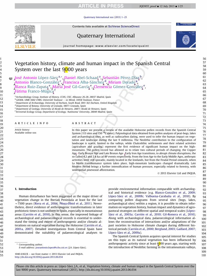
Vegetation history, climate and human impact in the Spanish CentralSystem over the last 9000 years
Q2 José Antonio López-Sáez a,*, Daniel Abel-Schaad a, Sebastián Pérez-Díaz b,Antonio Blanco-González c, Francisca Alba-Sánchez d, Miriam Dorado a,Blanca Ruiz-Zapata e, María José Gil-García e, Clemencia Gómez-González e,Fátima Franco-Múgica f
aArchaeobiology Group, Institute of History, CCHS, CSIC, Albasanz 26-28, 28037 Madrid, SpainbGEODE, UMR 5602 CNRS, Université Toulouse e Le Mirail, 31058 Toulouse, FrancecDepartment of Archaeology, University of Durham, South Road, DH1 3LE Durham, United KingdomdDepartment of Botany, University of Granada, 18071 Granada, SpaineDepartment of Geology, University of Alcalá de Henares, 28871 Alcalá de Henares, Spainf Terrestrial Ecology Group, Department of Ecology, ‘Autónoma’ University, 28049 Madrid, Spain
a r t i c l e i n f o
Article history:Available online xxx
a b s t r a c t
In this paper we present a review of the available Holocene pollen records from the Spanish CentralSystem (113 sites and 150 14C dates). Palynological data obtained from pollen analyses of peat-bogs, lakesand archaeological sites, as well as radiocarbon dating, were used to infer the human impact on vege-tation and landscape during the last 9 millennia. The Neolithic contribution to the configuration oflandscape is scarce, limited to the valleys, while Chalcolithic settlements and their related activities(agriculture and grazing) represent the first evidence of significant human impact on the high-mountains. The pollen record has allowed us to relate two cultural periods of changing, the CopperAgeeEarly Bronze Age and Late Bronze AgeeEarly Iron Age transitions, to abrupt climate disruptions, theso-called 4.2 and 2.8 ka cal BP events respectively. From the Iron Age to the Early Middle Ages, anthropicactivities were still sporadic, mainly located in the lowlands, but from the Feudal Period onwards, whenLa Mesta transhumance system takes place, high-mountain landscapes changed dramatically. LateModern Period brings a further intensification of human pressure, especially related to forestry, withwidespread pinewood afforestation.
� 2013 Elsevier Ltd and INQUA.
1. Introduction
Human disturbance has been suggested as the major driver ofvegetation change in the Iberian Peninsula at least for the lastw7500 years (Riera et al., 2004; Pérez-Obiol et al., 2011). Never-theless, direct evidence of anthropogenic transformations in laterprehistoric times is not uniform in Spain, especially inmountainousareas (Carrión et al., 2010). In this sense, the improved linkage ofarchaeological and palaeoecological records is essential to under-stand the timing and extent of anthropogenic and/or climatic al-terations on natural vegetation during the Holocene (Carrión et al.,2001a, 2007). Detailed investigations from Central Spain havedemonstrated the suitability of palaeoecological analyses to
provide environmental information comparable with archaeolog-ical and historical evidence (e.g. Blanco-González et al., 2009;López-Sáez et al., 2009b; Valbuena-Carabaña et al., 2010). Bycomparing pollen diagrams from several sites (bogs, lakes,archaeological sites) within a region, it is possible to obtain infor-mation on vegetation history, human impact and dynamics of agro-pastoral strategies on different spatial and temporal scales (López-Sáez et al., 2003a; Carrión et al., 2010; Gil-Romera et al., 2010).Along with archaeological data, palaeoecological information al-lows the reconstruction of interactions and/or adaptations of thepast societies to Holocene climate changes during different his-torical periods (Carrión et al., 2000; Berglund, 2003; Gaillard, 2007;López-Sáez et al., 2009a).
The Spanish Central System acquires special interest for studieson this topic as its natural vegetation has been influenced byanthropogenic activity since at least 6000 years ago, starting withthe introduction of Neolithic farming in the intramountain valleys,
* Corresponding author.E-mail address: [email protected] (J.A. López-Sáez).
Contents lists available at SciVerse ScienceDirect
Quaternary International
journal homepage: www.elsevier .com/locate/quaint
1040-6182/$ e see front matter � 2013 Elsevier Ltd and INQUA.http://dx.doi.org/10.1016/j.quaint.2013.06.034
Quaternary International xxx (2013) 1e25
Please cite this article in press as: López-Sáez, J.A., et al., Vegetation history, climate and human impact in the Spanish Central System over thelast 9000 years, Quaternary International (2013), http://dx.doi.org/10.1016/j.quaint.2013.06.034
12345678910111213141516171819202122232425262728293031323334353637383940414243444546474849505152535455
5657585960616263646566676869707172737475767778798081828384858687888990919293949596979899
100101102103104105106107108109110
JQI3855_proof ■ 12 July 2013 ■ 1/25
Original text:
Inserted Text
,
Original text:
Inserted Text
given name
Original text:
Inserted Text
surname
Original text:
Inserted Text
given name
Original text:
Inserted Text
surname
Original text:
Inserted Text
given name
Original text:
Inserted Text
surname
Original text:
Inserted Text
given name
Original text:
Inserted Text
surname
Original text:
Inserted Text
given name
Original text:
Inserted Text
surname
Original text:
Inserted Text
given name
Original text:
Inserted Text
surname
Original text:
Inserted Text
given name
Original text:
Inserted Text
surname
Original text:
Inserted Text
given name
Original text:
Inserted Text
surname
Original text:
Inserted Text
given name
Original text:
Inserted Text
surname
Original text:
Inserted Text
given name
Original text:
Inserted Text
surname
Original text:
Inserted Text
-
Original text:
Inserted Text
-
Original text:
Inserted Text
,
and continuously increasing throughout several millennia of hu-man occupation of these environments. The peculiar topographyof Central Iberia, with two sub-plateaus surrounded by high-mountains ranges, has allowed humans to implement mobilepastoralism practices to exploit available pastures in every season.This mountain system has been traditionally considered as one ofthe main routes for prehistoric transhumance (Klein, 1990), butcurrent data only allow to envisage short seasonal livestockmovements at least since the Iron Age (Sánchez-Moreno, 1998;Álvarez-Sanchís, 1999; Sánchez-Moreno, 2001). This long historyof human settlements and movements in the Spanish CentralSystem has shaped a landscape with broad extensions of grass-lands and shrublands, complemented with livestock resourceslocated in the plains on either side of the mountain range. In thissense, fire and grazing pressure are considered the main modelingfactors of the landscape in highland areas in southwestern Europe(e.g. Carrión et al., 2001b, 2007; Pausas and Keeley, 2009; López-Sáez et al., 2009b). Moreover, this mountainous massif shows agreat biogeographical value, as it is located in a transition areabetween Eurosiberian and Mediterranean regions (Rivas-Martínez,1963; Rivas-Martínez et al., 1987). It actually shelters a largenumber of endemic species (Peinado-Lorca and Rivas-Martínez,1987) and has played an important role as refugia of forest spe-cies during glacial times (Ashcroft, 2010). These features allow itsconsideration as a biodiversity “hot spot” (Médail and Diadema,2009).
Apart from the western sector of the Iberian Central System(Estrela Range), where the Lateglacial and the full Holocene arerecorded in pollen sequences (e.g. van der Knaap and van Leeuwen,1994, 1995, 1997), the Spanish Central System is scarce in Holocenerecords that extend back beyond the last 6000 years (Ruiz-Zapataet al., 1998). Most of them are short-term pollen records. In orderto assess the degree of human impact in this region, a great numberof investigations combining pollen analysis, archaeological studies,radiocarbon dating and information on past climate changes havebeen carried out by several researchers over a period of 30 years.
These studies have focused on humaneenvironment interactions,synchronism between environmental and cultural changes, andalso on palaeo-phytogeographical issues (e.g. López-Sáez andLópez-García, 1994; López-García, 1997; Ruiz-Zapata et al., 1997,1998; Pulido et al., 2007; Franco-Múgica, 2009; López-Sáez et al.,2009b, 2010a).
The main sources of information for this study are the palyno-logical and archaeological data from the Spanish Central System.The presence of a large number of deposits susceptible of beinganalyzed (>100), have allowed the achievement of numerouspalaeopalynological works (including 9 PhD theses) throughout thewhole mountainous range and valleys. However, the absence inmany cases of reliable dating hinders the establishment of anydiachronic vegetation model and the proposal of any anthropo-genic evolution during the Holocene. This paper provides a firstcomprehensive overview and addresses a critical evaluation of pastvegetation changes in relation to human occupation and climatechanges for the whole Spanish Central System.
2. Physical settings
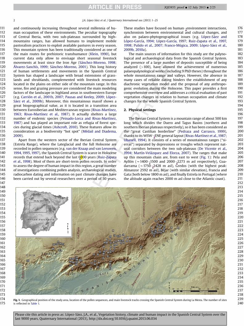
The Iberian Central System is a mountain range of about 500 kmlong which divides the Duero and Tagus Basins (northern andsouthern Iberian plateaus respectively), so it has been considered asthe “great Castilian borderline” (Pedraza and Carrasco, 1999),thanks to itsWSWeENE general layout (Rivas-Martínez et al., 1987;Ubanell, 1994). It consists of a series of mountainous ranges (“si-erras”) separated by depressions or troughs which represent nat-ural corridors between the two sub-plateaus (De Vicente et al.,1994; Martín-Velázquez and Elorza, 2007). The ranges that makeup this mountain chain are, from east to west (Fig. 1): Pela andAyllón (w1400e1500 and 2000e2273 m asl respectively), Gua-darrama (w1750e2428 m asl), Gredos (with the highest peak:Almanzor 2592 m asl), Béjar (with similar elevation), Francia andGata (both below 1800m asl), and finally Estrela in Portugal (wherethe altitude again reaches 2000 m asl close to the Atlantic coast).
Fig. 1. Geographical position of the study area, location of the pollen sequences, and main livestock tracks crossing the Spanish Central System during La Mesta. The number of sitesis reflected in Table 1.
J.A. López-Sáez et al. / Quaternary International xxx (2013) 1e252
Please cite this article in press as: López-Sáez, J.A., et al., Vegetation history, climate and human impact in the Spanish Central System over thelast 9000 years, Quaternary International (2013), http://dx.doi.org/10.1016/j.quaint.2013.06.034
111112113114115116117118119120121122123124125126127128129130131132133134135136137138139140141142143144145146147148149150151152153154155156157158159160161162163164165166167168169170171172173174175
176177178179180181182183184185186187188189190191192193194195196197198199200201202203204205206207208209210211212213214215216217218219220221222223224225226227228229230231232233234235236237238239240
JQI3855_proof ■ 12 July 2013 ■ 2/25
Original text:
Inserted Text
,
Original text:
Inserted Text
-
Original text:
Inserted Text
-
Original text:
Inserted Text
-
Original text:
Inserted Text
-
Original text:
Inserted Text
-
It is part of an ancient Hercynian and pre-Hercynian massif,swept along the Mesozoic and reactivated during the Paleogene,due to the Alpine Orogeny (Pedraza, 1989, 1994a; Ubanell, 1994).The result is a chain of sunken or elevated blocks (Pedraza, 1994b),which, according to the materials, granitic or metamorphic, issorted out in different tectonic styles (De Vicente et al., 1994). Inthis sense, the central section has the characteristic structure ofblocks, while at the edges it tends to be masked by the influence ofthe folded structure. These dynamics of blocks are responsible forthe asymmetry between the northern and southern slopes of themountainous chain, particularly in the western sector, because ofthe altitude of the northern plateau with respect to the deeply-setvalleys in the Tagus Basin. Glacial morphologies developedthroughout the Quaternary in the highest areas of the IberianCentral System, above 1900 m asl, so that only Francia and GataRanges remain outside their influence (Pedraza and Carrasco, 2006;Palacios et al., 2011). These processes and the subsequent peri-glacial phenomena, along with the fluvial shaping have essentiallycontributed to set the current relief.
The climate is of a Mediterranean type, characterized by a moreor less broad summer drought period and more intense rainfall inautumn and winter (Devesa, 1995). However, there are largeregional variations according to latitude, longitude, altitude andexposure (Gavilán et al., 1998). The asymmetry of the massif de-termines the regional climate: as for temperatures, there are morethermal conditions on the southern slopes, due to its lower eleva-tion and greater sun exposure. Furthermore, there is a markedgradient of increasing maritime influence towards the AtlanticOcean along the Iberian Central System, due to its predominantwesteeast alignment (Gavilán et al., 1998). Humidity tends todecrease from most western inlands areas along a westeeastgradient. The predominance of southwest humid winds causes,similarly, a larger rainfall accumulation on southern slopes and amoisture gradient which, in this case, tends to fall inland.
Differences in altitude offset in many cases the influence of thesegradients. In this way, the climate would have been the maindiscriminant factor on vegetation distribution among the differentmassifs of this ridge (Rivas-Martínez et al.,1987;Gavilán et al.,1998).
Biogeographically, the Spanish Central System is located in theMediterranean West Iberian province, at the boundary betweenCarpetano-Leonese and Luso-Extremaduran subprovinces. Thisbordering location denotes a great biological relevance, as amigratory route and a speciation center for orophilous and Atlanticelements (Peinado-Lorca and Rivas-Martínez, 1987; Costa-Tenorioet al., 1997).
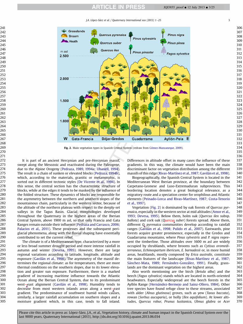
Vegetation (Fig. 2) is dominated by oak forests of Quercus pyr-enaica, especially in thewestern sector at mid altitudes (Amor et al.,1993; Devesa, 1995). Below them, holm oak (Quercus ilex subsp.ballota) and cork oak (Quercus suber) forests spread. Above them,different Q. pyrenaica communities develop according to rainfallranges (Gavilán et al., 1998; Pulido et al., 2007). Eastwards, pineforests acquire greater prominence, especially in the Gredos andGuadarrama mountains, where Pinus sylvestris and P. nigra repre-sent the timberline. Those altitudes over 1600 m asl are widelyoccupied by shrublands, where brooms such as Cytisus oromedi-terraneus, Echinospartum ibericum, E. barnadesii or, in more humidareas, heathlands, mostly composed by Erica australis, constitutethe main features of the landscape (Rivas-Martínez et al., 1987;Sánchez-Mata, 1989; Fernández-González, 1991). Finally, grass-lands are the dominant vegetation on the highest areas.
Also worth mentioning are the birch (Betula alba) and thebeech (Fagus sylvatica) stands which are located in north-orientedheadwaters. Especially widespread are the beech forests in theAyllón Range (Hernández-Bermejo and Sainz-Ollero, 1984). Othertree species have found refuge close to these streams, associatedwith alder (Alnus glutinosa) groves, such as yew (Taxus baccata),rowan (Sorbus aucuparia), or holly (Ilex aquifolium). At lower alti-tudes, Quercus robur, Prunus lusitanica, Ulmus glabra or Acer
Fig. 2. Main vegetation types in Spanish Central System (redraw from Gómez-Manzaneque, 2009).
J.A. López-Sáez et al. / Quaternary International xxx (2013) 1e25 3
Please cite this article in press as: López-Sáez, J.A., et al., Vegetation history, climate and human impact in the Spanish Central System over thelast 9000 years, Quaternary International (2013), http://dx.doi.org/10.1016/j.quaint.2013.06.034
241242243244245246247248249250251252253254255256257258259260261262263264265266267268269270271272273274275276277278279280281282283284285286287288289290291292293294295296297298299300301302303304305
306307308309310311312313314315316317318319320321322323324325326327328329330331332333334335336337338339340341342343344345346347348349350351352353354355356357358359360361362363364365366367368369370
JQI3855_proof ■ 12 July 2013 ■ 3/25
Original text:
Inserted Text
-
Original text:
Inserted Text
-
Original text:
Inserted Text
.
Original text:
Inserted Text
uercus

monspessulanum also grow as part of these riparian woods (López-Sáez, 1995; Pulido et al., 2007).
3. Methods
The collected pollen dataset consists of 113 spots (69 peatlands,7 lakes or lacustrine deposits, 4 paleosols, 33 archaeological sites)located in the Spanish Central System (Fig. 1, Table 1). The chro-nological setting of the study is established by 150 14C dates(Table 1), calibrated (2 sigma range) using CALIB 6.0 software
(Stuiver and Reimer, 1993). Calibrated radiocarbon dates are givenas cal BC or cal AD. The age-depth model in pollen diagrams hasbeen obtained by linear interpolation between uncalibratedradiocarbon ages using the mean of the calibration intervalfollowing the original published data. When the authors presenttheir own age-depthmodel it has been followed in the text. In thosesites without radiocarbon dates, we have adopted the chronologygiven by their original authors. In the case of archaeological sites itmay involve their available radiocarbon chronology or their widercultural framework.
Table 1Holocene pollen sequences in the Spanish Central System: A, archaeological; P, peatland; L, lacustrine; S, paleosoil
Ner Site Nature Latitude Longitude Altitude 14C BP (calibrated ages 2s) References
Pela range1 Somolinos L 4566415 30T 494572 1280 1385 � 30 (AD 605e675)
1525 � 30 (AD 503e604)2190 � 40 (383e164 BC)2410 � 40 (593e396 BC)
Currás et al. (2012)
Ayllón range2 Pelagallinas P 4561802 30T 490419 1340 2400 � 40 (768e393 BC)
3980 � 90 (2861e2206 BC)Franco-Múgica et al. (2001),Rubiales et al. (2012)
3 Hontanares P 4570010 30T 463264 1430 e Ruiz del Castillo (1993)4 Martín Muñoz de Ayllón P 4571853 30T 464952 1270 e Ruiz del Castillo (1993)5 San Benito P 4563544 30T 460848 1440 e Ruiz del Castillo (1993)6 Galve de Sorbe P 4563510 30T 485192 1370 e Hernández-Vera and Ruiz-
Zapata (1984)7 Puerto de la Quesera P 4564073 30T 464542 1400e1700 e Gil-García (1992), Gil-García
et al. (1995b, 1995d)8 Pico del Lobo P 4559204 30T 461333 2120e2130 1170 � 80 (AD 683e1012) Gil-García (1992), Gil-García
et al. (1994c)9 Buitrera P 4566988 30T 466605 2038 e Jiménez-Ballesta et al. (1985)10 Hayedo de Montejo P 4551002 30T 458221 1400 e Gil-García (1992), Gil-García
et al. (1993b, 1994c, 1995d),López-García (1997)
11 Tejera Negra P 4566581 30T 467883 1400 e Gil-García et al. (1995d)12 Cueva de los Torrejones A 4539924 30T 478197 1100 169.4 � 0.5 pM (AD 1963e1967)a
150 � 60 (AD 1663e1953)250 � 60 (AD 1468e1952)
Carrión et al. (2005)
Guadarrama range13 Arroyo de la Hoz P 4489978 30T 393303 1020 4220 � 70 (3008e2579 BC) Franco-Múgica (1995), López-
García (1997)14 Navacerrada P 4510620 30T 416767 1340 2380 � 50 (751e380 BC) Franco-Múgica (1995), López-
García (1997)15 Peñalara P 4521353 30T 419418 1930
194020022100
80 � 40 (AD 1682e1955)275 � 30 (AD 1499e1796)340 � 40 (AD 1462e1642)730 � 50 (AD 1209e1390)755 � 30 (AD 1221e1284)1100 � 60 (AD 778e1025)1300 � 30 (AD 661e772)1680 � 40 (AD 246e504)2800 � 50 (1112e831 BC)4160 � 70 (2899e2504 BC)
Alía et al. (1957), Jiménez-Ballesta et al. (1985), Ruiz-Zapata and García-Antón(1987), Ruiz-Zapata et al.(1988a, 1988b, 1988c), Bentley(1991), Vázquez (1992); Ruiz-Zapata et al. (1996c), López-García (1997), Gómez-González(2007), Gómez-González et al.(2007, 2009c), Ruiz-Zapata et al.(2009a)
16 Rascafría P 4529020 30T 426685 1113 50 � 40 (AD 1688e1955)920 � 50 (AD 1023e1213)1000 � 60 (AD 895e1172)2455 � 35 (755e411 BC)7180 � 70 (6220e5916 BC)8410 � 250 (8202e6768 BC)
Franco-Múgica and García-Antón (1994), Franco-Múgica(1995), López-García (1997),Franco-Múgica et al. (1998),Ruiz-Zapata et al. (2006a),Gómez-González (2007), Ruiz-Zapata et al. (2007c), Gómez-González et al. (2008), Ruiz-Zapata et al. (2008b), Franco-Múgica (2009), Gómez-González et al. (2009a, 2009b),Ruiz-Zapata et al. (2009b)
17 El Ventoso P 4537760 30T 434087 1862 e Vázquez (1992)18 El Villar P 4539122 30T 435333 1805 e Vázquez (1992)19 Hoyos de Pinilla P 4535465 30T 427942 1840 1080 � 60 (AD 778e1117) Vázquez (1992)20 Vaquerizas Bajas P 4523227 30T 416277 1550 e Vázquez (1992)21 Guarramillas P 4515155 30T 418436 2262 e Jiménez-Ballesta et al. (1985)22 Valdesquí P 4516899 30T 418013 1830 e Jiménez-Ballesta et al. (1985)
J.A. López-Sáez et al. / Quaternary International xxx (2013) 1e254
Please cite this article in press as: López-Sáez, J.A., et al., Vegetation history, climate and human impact in the Spanish Central System over thelast 9000 years, Quaternary International (2013), http://dx.doi.org/10.1016/j.quaint.2013.06.034
371372373374375376377378379380381382383384385386387388389390391392393394395396397398399400401402403404405406407408409410411412413414415416417418419420421422423424425426427428429430431432433434435
436437438439440441442443444445446447448449450451452453454455456457458459460461462463464465466467468469470471472473474475476477478479480481482483484485486487488489490491492493494495496497498499500
JQI3855_proof ■ 12 July 2013 ■ 4/25
Table 1 (continued )
Ner Site Nature Latitude Longitude Altitude 14C BP (calibrated ages 2s) References
23 Loma de Peñas Crecientes P 4533195 30T 423874 1775 1830 � 110 (88 BCeAD 504) Vázquez (1992), Vázquez andRuiz-Zapata (1992)
24 Lagunillas P 4537008 30T 431097 1780 e Ruiz del Castillo (1993)25 Lozoya P 4537567 30T 431653 1410 e Ruiz del Castillo (1993)26 Peña de la Morcuera P 4521425 30T 430376 1740 1120 � 60 (AD 775e1022)
1400 � 60 (AD 541e770)1770 � 60 (AD 93e407)2120 � 60 (359e0 BC)2520 � 60 (800e416 BC)
Ruiz del Castillo (1993)
27 Monasterio del Paular A 4526786 30T 425241 1100 e Gil-García (2004)28 Cachiporrilla P 4526820 30T 432134 1640 e Gil-García (1992), Gil-García
and Ruiz-Zapata (1994), Gil-García et al. (1995a)
29 Cerro Genciana P 4521662 30T 433149 1710 e Gil-García (1992), Gil-Garcíaet al. (1995c)
30 El Espartal P 4526339 30T 432007 1640 e Gil-García (1992), Gil-Garcíaand Ruiz-Zapata (1994), Gil-García et al. (1995a)
31 Portachuelo P 4528107 30T 433270 1500 e Gil-García (1992), Gil-Garcíaand Ruiz-Zapata (1994), Gil-García et al. (1995a)
32 Puerto de Canencia P 4521301 30T 434426 1000e13601450e1460
1170 � 50 (AD 711e986)2500 � 80 (793e413 BC)
Gil-García et al. (1989), Gil-García (1992), Gil-García et al.(1993a, 1994a, 1994b), López-García (1997), Gil-García et al.(1996a)
33 Puerto de la Morcuera P 4520043 30T 430121 1190e12001700e17201740e1750
640 � 50 (AD 1279e1405)1440 � 110 (AD 661e1151)1710 � 90 (AD 94e543)
Gil-García et al. (1989), Gil-García and Ruiz-Zapata (1991),Gil-García (1992), Gil-Garcíaet al. (1993a, 1993c, 1994a),Andrade et al. (1994b), Gil-García et al. (1996b, 1996c),Ruiz-Zapata et al. (1996a,1996b, 1996c), López-García(1997)
34 Pepe Hernando P 4523098 30T 420231 2120 2060 � 70 (352 BCeAD 80)3350 � 90 (1879e1450 BC)
Vázquez (1992)
35 Nicho de dos Hermanas P 4521144 30T 419627 2100 e Ruiz-Zapata et al. (1988a,1988b, 1988c, 1996c)
36 Collado de El Berrueco P 4526367 30T 449861 1040 530 � 40 (AD 1312e1444)680 � 30 (AD 1270e1389)2490 � 49 (782e416 BC)
Ruiz-Zapata et al. (2006a,2006b), Gómez-González(2007), Ruiz-Zapata et al.(2009c)
37 Cueva de la Buena Pinta A 4530841 30T 431956 1114 1920 � 40 (18 BCeAD 214)4010 � 40 (2832e2461 BC)4940 � 40 (3794e3647 BC)
Gómez-González (2007), Ruiz-Zapata et al. (2007a, 2007b,2007d, 2008a, 2008b)
38 Abrigo de Navalmaíllo A 4530859 30T 431956 1114 860 � 40 (AD 1044e1261)3690 � 60 (2278e1913 BC)3790 � 40 (2401e2045 BC)
Gómez-González (2007), Ruiz-Zapata et al. (2007a, 2008b)
39 Dehesa de la Oliva A 4525948 30T 462154 805e890 1565 � 40 (AD 412e580)1620 � 40 (AD 344e541)1640 � 40 (AD 263e537)1700 � 30 (AD 256e412)
López-García (1997)
40 Laguna de Lirialón L 4519425 30T 453641 750 e López-García (1997)Gredos range41 Hoyos del Espino P 4462522 30T 311221 1450 1750 � 70 (AD 87e428)
5960 � 70 (5022e4690 BC)Franco-Múgica (1995), Franco-Múgica (2009)
42 Navarredonda P 4469346 30T 322254 1550 1090 � 70 (AD 772e1150)1770 � 80 (AD 71e427)
Franco-Múgica (1995), Franco-Múgica et al. (1997), Franco-Múgica (2009)
43 Puerto de Serranillos P 4462901 30T 335764 1700 522 � 27 (AD 1326e1441)1664 � 35 (AD 257e530)1895 � 45 (AD 21e233)1938 � 35 (37 BCeAD 131)
López-Merino et al. (2009),López-Sáez et al. (2009b)
44 Lanzahíta P 4454242 30T 335290 588 110.01 � 0.3 pM (AD 1957e1997)a
780 � 35 (AD 1118e1283)1020 � 35 (AD 899e1151)1315 � 29 (AD 654e771)1907 � 35 (AD 59e214)2280 � 55 (481e183 BC)2387 � 32 (727e393 BC)
López-Sáez et al. (2010a)
45 Navalguijo P 4458578 30T 283957 1200 1920 � 90 (162 BCeAD 325) Franco-Múgica (1995)46 San Esteban del Valle P 4461427 30T 334950 1600 e López-Sáez et al. (1997)47 Puerto de Casillas P 4465578 30T 368862 1250 e López-Sáez et al. (1996, 1998)
(continued on next page)
J.A. López-Sáez et al. / Quaternary International xxx (2013) 1e25 5
Please cite this article in press as: López-Sáez, J.A., et al., Vegetation history, climate and human impact in the Spanish Central System over thelast 9000 years, Quaternary International (2013), http://dx.doi.org/10.1016/j.quaint.2013.06.034
501502503504505506507508509510511512513514515516517518519520521522523524525526527528529530531532533534535536537538539540541542543544545546547548549550551552553554555556557558559560561562563564565
566567568569570571572573574575576577578579580581582583584585586587588589590591592593594595596597598599600601602603604605606607608609610611612613614615616617618619620621622623624625626627628629630
JQI3855_proof ■ 12 July 2013 ■ 5/25
Table 1 (continued )
Ner Site Nature Latitude Longitude Altitude 14C BP (calibrated ages 2s) References
48 Pico Zapatero P 4480674 30T 336193 1650 e Andrade (1994)49 La Serrota P 4481841 30T 325723 1700 e Andrade (1994)50 Cuerda del Cervunal P 4453062 30T 312393 1840 e Ruiz-Zapata and Acaso (1981b,
1983, 1984, 1988), Ruiz-Zapataet al. (1996a, 1996b, 1996c)
51 Eliza S 4452912 30T 335165 450 e López-Sáez et al. (1999)52 Ojos Albos P 4507902 30T 375907 1483 101.7 � 0.5 pM (AD 1953e1956)a
255 � 35 (AD 1515e1951)955 � 40 (AD 999e1175)1280 � 40 (AD 658e861)1555 � 40 (AD 420e591)1720 � 40 (AD 237e412)
Blanco-González et al. (2009)
53 Puerto de las Fuentes P 4498342 30T 327001 1580 940 � 70 (AD 982e1251) Dorado (1993)54 Riatas P 4490090 30T 342817 1120 e Ruiz-Zapata et al. (1992),
Dorado (1993), López-Sáez andBlanco-González (2005)
55 San Martín de la Vegadel Alberche
P 4476376 30T 312120 1500 e Andrade et al. (1990), Andrade(1994), Andrade et al. (1996)
56 Prado de las Zorras P 4484377 30T 335043 1650 2040 � 90 (358 BCeAD 133) Andrade (1994), Andrade et al.(1994a, 1994b), Andrade andRuiz-Zapata (1995), Andradeet al. (1996), Ruiz-Zapata et al.(1996a)
57 Puerto de Chía P 4480768 30T 316528 1701 2250 � 100 (736e40 BC)2620 � 60 (913e545 BC)
Andrade (1994), Andrade et al.(1996), Ruiz-Zapata et al.(1996a)
58 Puerto de la Peña Negra P 4476828 30T 305112 1909 2465 � 110 (826e265 BC) Ruiz-Zapata et al. (1992),Andrade (1994), Andrade et al.(1996)
59 Puerto de Villatoro P 4490926 30T 323517 1160 e Dorado et al. (1990), Ruiz-Zapata et al. (1990), Dorado(1993), Andrade et al. (1994a)
60 Los Conventos P 4460944 30T 314260 1680 e Ruiz-Zapata and Acaso (1981a,1984, 1988), Franco-Múgica(2009)
61 Garganta de las Pozas P 4463960 30T 306984 1600 e Ruiz-Zapata and Acaso (1985,1988), Ruiz-Zapata et al.(1996a)
62 Narrillos del Rebollar P 4502810 30T 335181 1560 2953 � 68 (1387e980 BC) Atienza et al. (1991), Dorado(1993), Andrade et al. (1994a),Ruiz-Zapata et al. (1996a,1996c), López-García (1997),Dorado et al. (2001), López-Sáezand Blanco-González (2005),López-Sáez et al. (2009a)
63 Las Pozas-Amblés P 4500370 30T 333589 1360 e Dorado (1993)64 Laguna Grande de Gredos L 4458046 30T 307208 1960 e Toro et al. (1992, 1993)65 Las Lagunas L 4489190 30T 338749 1160 e Dorado et al. (1990), Dorado
(1993)66 Baterna P 4490546 30T 337153 1140 5930 � 100 (5444e5188 BC) Dorado (1993), Ruiz-Zapata
et al. (1996a, 1996b), López-Sáez et al. (2003b), López-Sáezand Blanco-González (2005),López-Sáez et al. (2009a)
67 Hoyocasero S 4472990 30T 331042 1250 530 � 80 (AD 1281e1616) Andrade et al. (1992), Andrade(1994), Andrade and González-Jonte (2007)
68 Trío los Pingos P 4479921 30T 332326 1550 e Andrade (1994), Andrade et al.(1994b)
69 Garganta del Villar S 4479000 30T 323000 1450 8030 � 180 (7451e6514 BC) This paper70 El Raso A 4450183 30T 299178 791 1840 � 140 (165 BCeAD 533)
2010 � 130 (376 BCeAD 252)2090 � 140 (405 BCeAD 232)2190 � 130 (733 BCeAD 81)2190 � 80 (395e51 BC)
López-García (1985, 1986),López-Sáez et al. (1991), López-Sáez and López-García (1994),López-Sáez et al. (2008)
71 Las Cogotas A 4511604 30T 343393 1118e1156 e López-Sáez et al. (2008)72 Ulaca A 4488255 30T 340301 1500 e López-Sáez et al. (2008)73 Mesa de Miranda A 4509581 30T 335615 1154 e López-Sáez et al. (2008)74 Castillejos de Sanchorreja A 4510436 30T 349371 1500 e González-Tablas (1983),
González-Tablas andDomínguez-Calvo (2002),López-Sáez and Blanco-González (2005)
J.A. López-Sáez et al. / Quaternary International xxx (2013) 1e256
Please cite this article in press as: López-Sáez, J.A., et al., Vegetation history, climate and human impact in the Spanish Central System over thelast 9000 years, Quaternary International (2013), http://dx.doi.org/10.1016/j.quaint.2013.06.034
631632633634635636637638639640641642643644645646647648649650651652653654655656657658659660661662663664665666667668669670671672673674675676677678679680681682683684685686687688689690691692693694695
696697698699700701702703704705706707708709710711712713714715716717718719720721722723724725726727728729730731732733734735736737738739740741742743744745746747748749750751752753754755756757758759760
JQI3855_proof ■ 12 July 2013 ■ 6/25
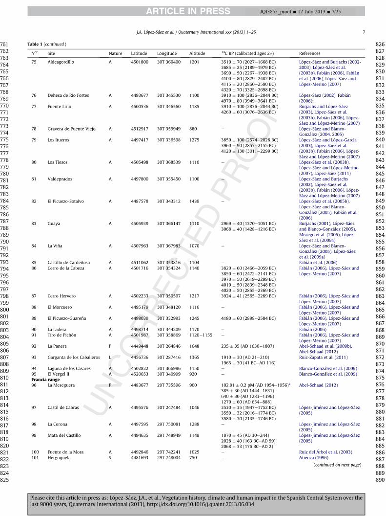
Table 1 (continued )
Ner Site Nature Latitude Longitude Altitude 14C BP (calibrated ages 2s) References
75 Aldeagordillo A 4501800 30T 360400 1201 3510 � 70 (2027e1668 BC)3685 � 25 (2189e1979 BC)3690 � 50 (2267e1938 BC)4100 � 80 (2879e2482 BC)4115 � 20 (2860e2580 BC)4320 � 70 (3325e2698 BC)
López-Sáez and Burjachs (2002-2003), López-Sáez et al.(2003b), Fabián (2006), Fabiánet al. (2006), López-Sáez andLópez-Merino (2007)
76 Dehesa de Río Fortes A 4493677 30T 345530 1100 3910 � 100 (2836e2044 BC)4970 � 80 (3949e3641 BC)
López-Sáez (2002), Fabián(2006);
77 Fuente Lirio A 4500536 30T 346560 1185 3910 � 100 (2836e2044 BC)4260 � 60 (3076e2636 BC)
Burjachs and López-Sáez(2003), López-Sáez et al.(2003b), Fabián (2006), López-Sáez and López-Merino (2007)
78 Gravera de Puente Viejo A 4512917 30T 359949 880 e López-Sáez and Blanco-González (2004, 2005)
79 Los Itueros A 4497417 30T 336598 1275 3850 � 100 (2574e2028 BC)3960 � 90 (2857e2155 BC)4120 � 130 (3011e2299 BC)
López-Sáez and López-García(2003), López-Sáez et al.(2003b), Fabián (2006), López-Sáez and López-Merino (2007)
80 Los Tiesos A 4505498 30T 368539 1110 e López-Sáez et al. (2003b),López-Sáez and López-Merino(2007), López-Sáez (2011)
81 Valdeprados A 4497800 30T 355450 1100 e López-Sáez and Burjachs(2002), López-Sáez et al.(2003b), Fabián (2006), López-Sáez and López-Merino (2007)
82 El Picuezo-Sotalvo A 4487578 30T 343312 1439 e López-Sáez et al. (2005b),López-Sáez and Blanco-González (2005), Fabián et al.(2006)
83 Guaya A 4505939 30T 366147 1110 2969 � 40 (1370e1051 BC)3068 � 40 (1428e1216 BC)
Burjachs (2001), López-Sáezand Blanco-González (2005),Misiego et al. (2005), López-Sáez et al. (2009a)
84 La Viña A 4507963 30T 367983 1070 e López-Sáez and Blanco-González (2005), López-Sáezet al. (2009a)
85 Castillo de Cardeñosa A 4511062 30T 353816 1104 e Fabián et al. (2006)86 Cerro de la Cabeza A 4501716 30T 354324 1140 3820 � 60 (2466e2059 BC)
3850 � 60 (2472e2141 BC)3970 � 50 (2619e2299 BC)4010 � 50 (2839e2348 BC)4020 � 50 (2855e2369 BC)
Fabián (2006), López-Sáez andLópez-Merino (2007)
87 Cerro Hervero A 4502233 30T 359507 1217 3924 � 41 (2565e2289 BC) Fabián (2006), López-Sáez andLópez-Merino (2007)
88 El Morcuero A 4495179 30T 348120 1116 e Fabián (2006), López-Sáez andLópez-Merino (2007)
89 El Picuezo-Guareña A 4498039 30T 332993 1245 4180 � 60 (2898e2584 BC) Fabián (2006), López-Sáez andLópez-Merino (2007)
90 La Ladera A 4498714 30T 344209 1170 e Fabián (2006)91 Tiro de Pichón A 4501987 30T 358869 1120e1155 e Fabián (2006), López-Sáez and
López-Merino (2007)92 La Panera P 4449448 30T 264846 1648 235 � 35 (AD 1630e1807) Abel-Schaad et al. (2009b),
Abel-Schaad (2012)93 Garganta de los Caballeros L 4456736 30T 287416 1365 1910 � 30 (AD 21e210)
1965 � 30 (41 BCeAD 116)Ruiz-Zapata et al. (2011)
94 Laguna de los Casares A 4502822 30T 366986 1150 e Blanco-González et al. (2009)95 El Vergel II A 4520653 30T 340999 920 e Blanco-González et al. (2009)Francia range96 La Meseguera P 4483677 29T 735596 900 102.81 � 0.2 pM (AD 1954e1956)a
385 � 30 (AD 1444e1631)640 � 30 (AD 1283e1396)1270 � 60 (AD 654e888)
Abel-Schaad (2012)
97 Castil de Cabras A 4495576 30T 247484 1046 3530 � 35 (1947e1752 BC)3559 � 32 (2016e1774 BC)3580 � 70 (2135e1746 BC)
López-Jiménez and López-Sáez(2005)
98 La Corona A 4497595 29T 750081 1288 e López-Jiménez and López-Sáez(2005)
99 Mata del Castillo A 4494635 29T 748949 1149 1870 � 45 (AD 30e244)2028 � 40 (163 BCeAD 59)2068 � 33 (176 BCeAD 2)
López-Jiménez and López-Sáez(2005)
100 Fuente de la Mora A 4492846 29T 742241 1025 e Ruiz del Árbol et al. (2003)101 Herguijuela S 4481693 29T 748004 750 e Atienza (1996)
(continued on next page)
J.A. López-Sáez et al. / Quaternary International xxx (2013) 1e25 7
Please cite this article in press as: López-Sáez, J.A., et al., Vegetation history, climate and human impact in the Spanish Central System over thelast 9000 years, Quaternary International (2013), http://dx.doi.org/10.1016/j.quaint.2013.06.034
761762763764765766767768769770771772773774775776777778779780781782783784785786787788789790791792793794795796797798799800801802803804805806807808809810811812813814815816817818819820821822823824825
826827828829830831832833834835836837838839840841842843844845846847848849850851852853854855856857858859860861862863864865866867868869870871872873874875876877878879880881882883884885886887888889890
JQI3855_proof ■ 12 July 2013 ■ 7/25
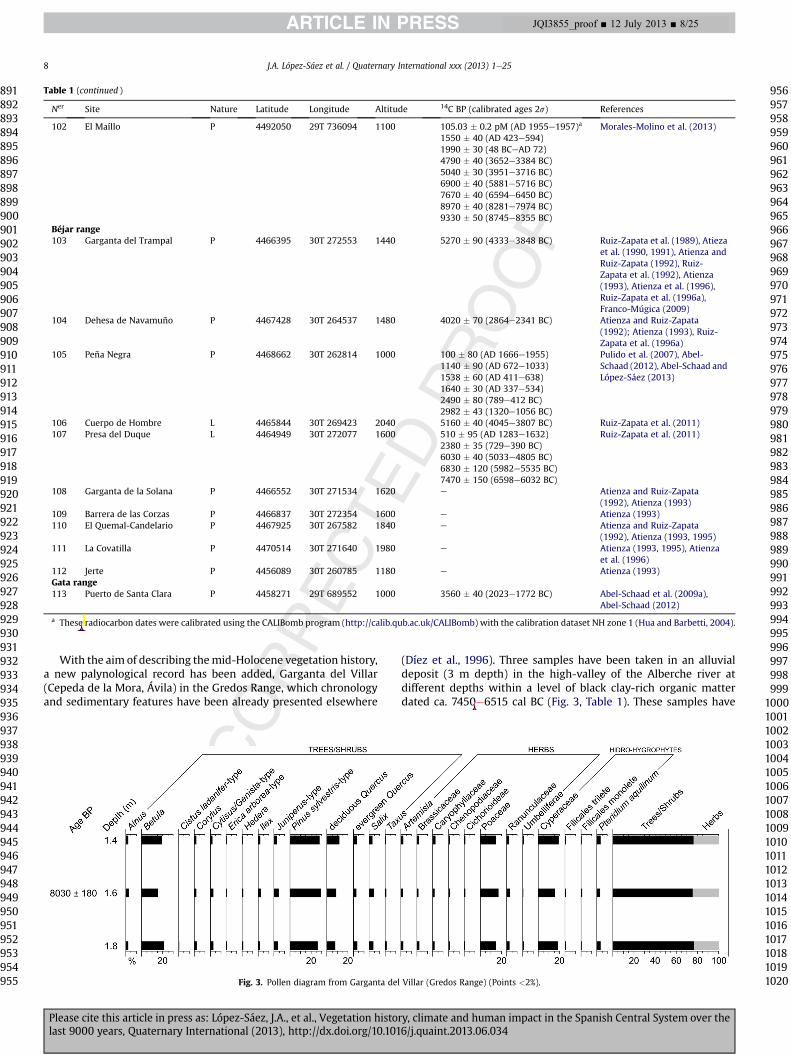
With the aim of describing themid-Holocene vegetation history,a new palynological record has been added, Garganta del Villar(Cepeda de la Mora, Ávila) in the Gredos Range, which chronologyand sedimentary features have been already presented elsewhere
(Díez et al., 1996). Three samples have been taken in an alluvialdeposit (3 m depth) in the high-valley of the Alberche river atdifferent depths within a level of black clay-rich organic matterdated ca. 7450e6515 cal BC (Fig. 3, Table 1). These samples have
Table 1 (continued )
Ner Site Nature Latitude Longitude Altitude 14C BP (calibrated ages 2s) References
102 El Maíllo P 4492050 29T 736094 1100 105.03 � 0.2 pM (AD 1955e1957)a
1550 � 40 (AD 423e594)1990 � 30 (48 BCeAD 72)4790 � 40 (3652e3384 BC)5040 � 30 (3951e3716 BC)6900 � 40 (5881e5716 BC)7670 � 40 (6594e6450 BC)8970 � 40 (8281e7974 BC)9330 � 50 (8745e8355 BC)
Morales-Molino et al. (2013)
Béjar range103 Garganta del Trampal P 4466395 30T 272553 1440 5270 � 90 (4333e3848 BC) Ruiz-Zapata et al. (1989), Atieza
et al. (1990, 1991), Atienza andRuiz-Zapata (1992), Ruiz-Zapata et al. (1992), Atienza(1993), Atienza et al. (1996),Ruiz-Zapata et al. (1996a),Franco-Múgica (2009)
104 Dehesa de Navamuño P 4467428 30T 264537 1480 4020 � 70 (2864e2341 BC) Atienza and Ruiz-Zapata(1992); Atienza (1993), Ruiz-Zapata et al. (1996a)
105 Peña Negra P 4468662 30T 262814 1000 100 � 80 (AD 1666e1955)1140 � 90 (AD 672e1033)1538 � 60 (AD 411e638)1640 � 30 (AD 337e534)2490 � 80 (789e412 BC)2982 � 43 (1320e1056 BC)
Pulido et al. (2007), Abel-Schaad (2012), Abel-Schaad andLópez-Sáez (2013)
106 Cuerpo de Hombre L 4465844 30T 269423 2040 5160 � 40 (4045e3807 BC) Ruiz-Zapata et al. (2011)107 Presa del Duque L 4464949 30T 272077 1600 510 � 95 (AD 1283e1632)
2380 � 35 (729e390 BC)6030 � 40 (5033e4805 BC)6830 � 120 (5982e5535 BC)7470 � 150 (6598e6032 BC)
Ruiz-Zapata et al. (2011)
108 Garganta de la Solana P 4466552 30T 271534 1620 e Atienza and Ruiz-Zapata(1992), Atienza (1993)
109 Barrera de las Corzas P 4466837 30T 272354 1600 e Atienza (1993)110 El Quemal-Candelario P 4467925 30T 267582 1840 e Atienza and Ruiz-Zapata
(1992), Atienza (1993, 1995)111 La Covatilla P 4470514 30T 271640 1980 e Atienza (1993, 1995), Atienza
et al. (1996)112 Jerte P 4456089 30T 260785 1180 e Atienza (1993)Gata range113 Puerto de Santa Clara P 4458271 29T 689552 1000 3560 � 40 (2023e1772 BC) Abel-Schaad et al. (2009a),
Abel-Schaad (2012)
a These radiocarbon dates were calibrated using the CALIBomb program (http://calib.qub.ac.uk/CALIBomb) with the calibration dataset NH zone 1 (Hua and Barbetti, 2004).
Fig. 3. Pollen diagram from Garganta del Villar (Gredos Range) (Points <2%).
J.A. López-Sáez et al. / Quaternary International xxx (2013) 1e258
Please cite this article in press as: López-Sáez, J.A., et al., Vegetation history, climate and human impact in the Spanish Central System over thelast 9000 years, Quaternary International (2013), http://dx.doi.org/10.1016/j.quaint.2013.06.034
891892893894895896897898899900901902903904905906907908909910911912913914915916917918919920921922923924925926927928929930931932933934935936937938939940941942943944945946947948949950951952953954955
956957958959960961962963964965966967968969970971972973974975976977978979980981982983984985986987988989990991992993994995996997998999
100010011002100310041005100610071008100910101011101210131014101510161017101810191020
JQI3855_proof ■ 12 July 2013 ■ 8/25
Original text:
Inserted Text
-
Original text:
Inserted Text
s
been treated following the classic chemical methodology (Faegriand Iversen, 1989) with concentration in heavy liquid to obtainpollen and non-pollen palynomorphs.
4. Vegetation changes, climate changes and human activity inthe Spanish Central System
The palynological evidence of anthropogenic vegetationchanges is summarized and correlated for the different mountainsin the Spanish Central System in Fig. 4. This summary is based onthe palynological sequences considered in this paper (Fig. 1,Table 1). The development of natural landscapes is discussed in thecontext of the changing human occupation of the massif and theclimate change events observed on a global scale.
4.1. Until the Early Neolithic (ca. 9000e4500 cal BC)
In western areas of the massif (Francia and Béjar Ranges), thepollen records of El Maíllo and Garganta del Trampal show that pre-Neolithic forests (ca. 8745e5500 cal BC) were dominated by birches(Betula w40e80%) and pines (Pinus w10e20%), with a certainpresence of deciduous Quercus and other mesophytes between1100 and 1440 m asl. Carpinus betulus is also documentedsporadically at this time in Garganta del Trampal record. The rela-tive abundance of mesophilous trees and hydro-hygrophytes(especially Osmunda regalis) could be associated with a humidclimate. Temperate and humid climatic conditions at this timewould have allowed the birch forest dominance not only in low-lands (El Maíllo, 1100 m asl) but also in highlands (Garganta delTrampal, 1440 m asl) (Fig. 4). However, the Presa del Duque pollenrecord (1600 m asl) shows a landscape ca. 6600e5535 cal BCdominated by Poaceae (w40%) with scattered occurrences ofBetula, Corylus and deciduous Quercuswhile Pinus is almost absent.Sporadic presences of Plantago, Rumex and coprophilous fungi(Sporormiella, Podospora) could indicate some kind of pastoralpressure without ruling out that it could be also the result of wildanimals. These data are very different from those above discussed,and, according to the authors, the two available radiocarbon datesfor these levels appear to be inconsistent with the inferred vege-tation. It seems to reflect cold and arid conditions more typical ofthe Younger Dryas or the 8.2 ka cal BP event. Anyway, the high-altitude of this site could explain these data: in fact, La Covatillapollen record (1980 m asl) shows at this moment an open land-scape (tree cover w55%) dominated by birch, scattered pines andprostrate juniper (Juniperus-type).
In central and eastern areas of the Spanish Central System(Gredos and Guadarrama Ranges), the pollen records of Hoyos delEspino, Baterna and Riatas, Garganta del Villar (Fig. 3), Peñalara andRascafría, show a well-developed pine forest (Pinus gr. sylvestris/nigra >50%) at higher altitudes, while towards the valleys decidu-ous and evergreen Quercus, Betula, Fraxinus, Salix, Corylus, Ilex andSambucus prosper from ca. 8200 cal BC (Fig. 4). Colder and a moreseasonal climate could explain these differences between central-eastern and western parts of the massif. The high percentages ofbirch pollen (w20%; unpublished data) in Garganta del Villar ca.7450e6510 cal BC (Fig. 3) may be explained by the lowering of theforest treeline and by its pioneer and heliophilous character, as thesedimentological facies maps these samples to fill an abandonedchannel that have suffered intense periglacial processes (Díez et al.,1996).
El Maíllo charcoal record shows that pine species whichcurrently inhabits high-mountain areas of the Spanish CentralSystem, grew during the early to mid-Holocene also at lower alti-tudes in western areas. In the Gredos Range pollen data from high-altitude sites (Hoyos del Espino, Garganta del Villar) demonstrate
the existence of a pine forest w1400 m asl. The presence of P. syl-vestris in high-altitude areas (w1300e1850 m asl) since the mid-Holocene has also been reported in the Gredos Range bynumerous radiocarbon-dated megafossils (Rubiales et al., 2007).However, in pollen sequences located below (w1100 m asl, Riatasand Rascafría), pine pollen percentages are unusually high (>50%)before 5500 cal BC, suggesting the presence of pines at lower alti-tudes. Studies on modern pollen rain in Gredos and GuadarramaRanges support this view (Vázquez and Peinado, 1993; Dorado andRuiz-Zapata, 1994; Andrade et al., 1994c; López-Sáez et al., 2010b).
In El Maíllo sequence twomaxima in the charcoal concentrationvalues are detected ca. 6100e6000 and 5500e5300 cal BC (Fig. 5)linked to episodes of grassland expansion. In the Rascafría pollensequence the microcharcoal record showed a maximum value ca.6200e6000 cal BC (Fig. 5) parallel to the decrease in Pinus valuesand the progress of herbaceous communities. Studies on the long-term occurrence of fire and the responses of vegetation are rela-tively common in Spain (Carrión et al., 2007; Gil-Romera et al.,2010), but they are fairly rare in the Iberian Central System (Franco-Múgica et al., 1998; López-Merino et al., 2009; López-Sáez et al.,2010a; Connor et al., 2012; Abel-Schaad and López-Sáez, 2013;Morales-Molino et al., 2013). Although fire is both a natural phe-nomenon and a human resource, used for example to clear andmaintain open agro-pastoral areas by early farming communities(Tinner et al., 2005; López-Sáez et al., 2005a; Colombaroli et al.,2008), it seems difficult to understand human impact on fire re-gimes without placing it in the context of Holocene climatic andvegetation changes. Recent studies from the Alps, the Pyrenees andthe Mediterranean area show that millennial variability in Holo-cene fire regimes is linked to climatic oscillations, particularly forthe early to mid-Holocene ca. 9750e3000 cal BC (Vannière et al.,2011), but also fire regimes are human-driven during the last4000 years (Tinner et al., 2005; Rius et al., 2009; Vannière et al.,2010; Rius et al., 2011, 2012). In fact, the charcoal record of ElMaíllo shows the highest concentration values ca. 8250 and ca.6550 cal BC linked to high tree pollen values (Fig. 5). This fire fre-quency is probably related to the dry climatic conditions andgreatly benefited from the early Holocene biomass increase. Thesynchronicity of frequency curves ca. 6000e5500 cal BC betweenthe charcoal records of El Maíllo, Rascafría and Charco da Candieira(Francia, Guadarrama and Estrela Ranges respectively) suggests aperiod of contrasted fire frequency with centennial oscillations anda millennial pattern similar to the regional Mediterranean fire ac-tivity (Connor et al., 2012; Morales-Molino et al., 2013). Therefore,climate control can be considered as the major forcing factor overfire occurrence during the mid-Holocene in the Iberian CentralSystem at the millennial scale, but shorter variability may beaccounted for by other factors such as human impact and/or fire-vegetation feedbacks (Carrión et al., 2010).
Some palynological records from the area come from high-altitudes (>1400 m asl: Garganta del Trampal, La Covatilla, Presadel Duque, Hoyos del Espino, Garganta del Villar), but in most casesthey are placed about 1100 m asl (El Maíllo, Riatas, Baterna, Ras-cafría) in fertile valleys, hence in the main area of activity of theNeolithic population (Rojo et al., 2012). Although anthropogenicpollen indicators (e.g. Aster-type, Cichorioideae, Echium vulgare-type, Plantago major/media-type, Rumex acetosa-type, Urtica dioica-type) are scarce and discontinuous in these last pollen sequencesfrom the Spanish Central System ca. 5500e4500 cal BC, we cannotrule out the possible influence of Early Neolithic communities,which appear precisely on this date in the whole of Central Iberia(Rojo et al., 2012). For instance, from ca. 5500 cal BC until ca.3300 cal BC, grasslands start to show especially high values (Poa-ceae >40%) in El Maíllo record, although birches, pines and oaksmaintain their presence in the area (Fig. 4). Instead, the Rascafría
J.A. López-Sáez et al. / Quaternary International xxx (2013) 1e25 9
Please cite this article in press as: López-Sáez, J.A., et al., Vegetation history, climate and human impact in the Spanish Central System over thelast 9000 years, Quaternary International (2013), http://dx.doi.org/10.1016/j.quaint.2013.06.034
10211022102310241025102610271028102910301031103210331034103510361037103810391040104110421043104410451046104710481049105010511052105310541055105610571058105910601061106210631064106510661067106810691070107110721073107410751076107710781079108010811082108310841085
10861087108810891090109110921093109410951096109710981099110011011102110311041105110611071108110911101111111211131114111511161117111811191120112111221123112411251126112711281129113011311132113311341135113611371138113911401141114211431144114511461147114811491150
JQI3855_proof ■ 12 July 2013 ■ 9/25
Original text:
Inserted Text
are
Original text:
Inserted Text
-
Original text:
Inserted Text
-
Original text:
Inserted Text
-
Original text:
Inserted Text
-
Original text:
Inserted Text
-
Original text:
Inserted Text
-
Original text:
Inserted Text
inus
Original text:
Inserted Text
-
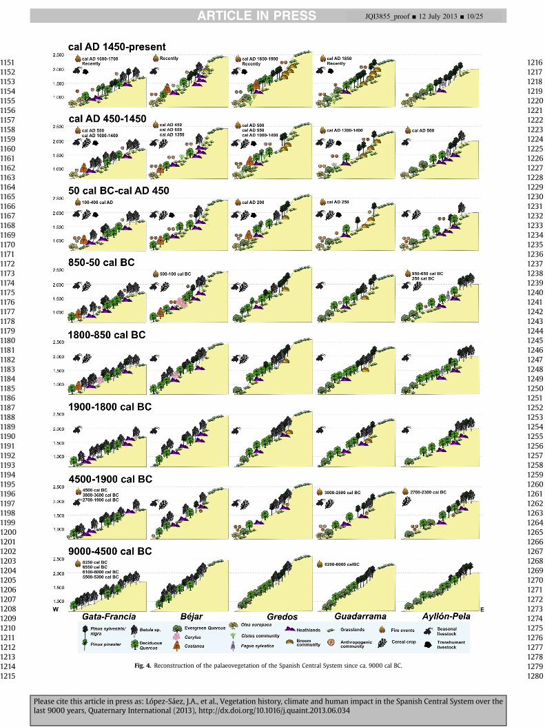
Fig. 4. Reconstruction of the palaeovegetation of the Spanish Central System since ca. 9000 cal BC.
Please cite this article in press as: López-Sáez, J.A., et al., Vegetation history, climate and human impact in the Spanish Central System over thelast 9000 years, Quaternary International (2013), http://dx.doi.org/10.1016/j.quaint.2013.06.034
11511152115311541155115611571158115911601161116211631164116511661167116811691170117111721173117411751176117711781179118011811182118311841185118611871188118911901191119211931194119511961197119811991200120112021203120412051206120712081209121012111212121312141215
12161217121812191220122112221223122412251226122712281229123012311232123312341235123612371238123912401241124212431244124512461247124812491250125112521253125412551256125712581259126012611262126312641265126612671268126912701271127212731274127512761277127812791280
JQI3855_proof ■ 12 July 2013 ■ 10/25
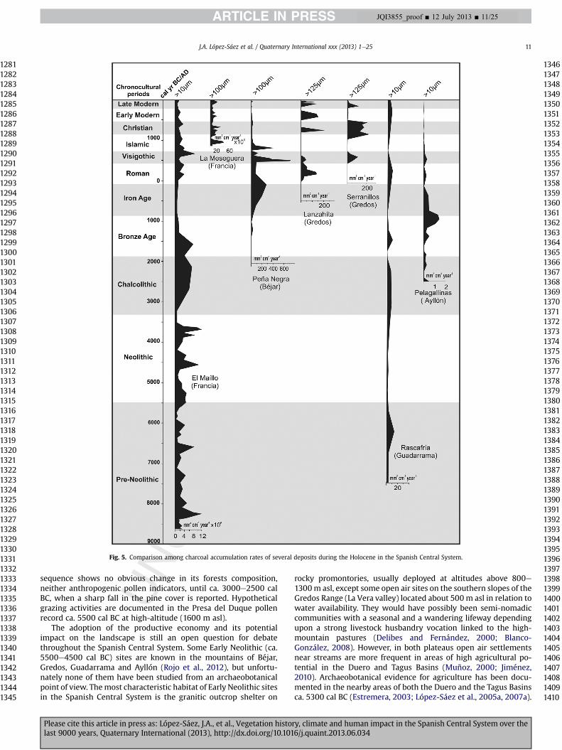
sequence shows no obvious change in its forests composition,neither anthropogenic pollen indicators, until ca. 3000e2500 calBC, when a sharp fall in the pine cover is reported. Hypotheticalgrazing activities are documented in the Presa del Duque pollenrecord ca. 5500 cal BC at high-altitude (1600 m asl).
The adoption of the productive economy and its potentialimpact on the landscape is still an open question for debatethroughout the Spanish Central System. Some Early Neolithic (ca.5500e4500 cal BC) sites are known in the mountains of Béjar,Gredos, Guadarrama and Ayllón (Rojo et al., 2012), but unfortu-nately none of them have been studied from an archaeobotanicalpoint of view. Themost characteristic habitat of Early Neolithic sitesin the Spanish Central System is the granitic outcrop shelter on
rocky promontories, usually deployed at altitudes above 800e1300m asl, except some open air sites on the southern slopes of theGredos Range (La Vera valley) located about 500 m asl in relation towater availability. They would have possibly been semi-nomadiccommunities with a seasonal and a wandering lifeway dependingupon a strong livestock husbandry vocation linked to the high-mountain pastures (Delibes and Fernández, 2000; Blanco-González, 2008). However, in both plateaus open air settlementsnear streams are more frequent in areas of high agricultural po-tential in the Duero and Tagus Basins (Muñoz, 2000; Jiménez,2010). Archaeobotanical evidence for agriculture has been docu-mented in the nearby areas of both the Duero and the Tagus Basinsca. 5300 cal BC (Estremera, 2003; López-Sáez et al., 2005a, 2007a).
Fig. 5. Comparison among charcoal accumulation rates of several deposits during the Holocene in the Spanish Central System.
J.A. López-Sáez et al. / Quaternary International xxx (2013) 1e25 11
Please cite this article in press as: López-Sáez, J.A., et al., Vegetation history, climate and human impact in the Spanish Central System over thelast 9000 years, Quaternary International (2013), http://dx.doi.org/10.1016/j.quaint.2013.06.034
12811282128312841285128612871288128912901291129212931294129512961297129812991300130113021303130413051306130713081309131013111312131313141315131613171318131913201321132213231324132513261327132813291330133113321333133413351336133713381339134013411342134313441345
13461347134813491350135113521353135413551356135713581359136013611362136313641365136613671368136913701371137213731374137513761377137813791380138113821383138413851386138713881389139013911392139313941395139613971398139914001401140214031404140514061407140814091410
JQI3855_proof ■ 12 July 2013 ■ 11/25
4.2. Consolidation of the productive economy: Middle Neolithic toCopper Age (ca. 4500e1900 cal BC)
During theMiddle and the Late Neolithic (ca. 4500e3300 cal BC)a dehesa landscape took form along both plateaus, as a result offarming and grazing activities into the oak forests (Quercus ilex andQ. suber), linked to new concepts of landscape organization repre-sented by the first megalithic tombs (Jiménez, 2000; Bueno et al.,2002; López-Sáez et al., 2007b). Areas with greater agriculturalaptitudes are increasingly populated from the Late Neolithic on-wards, with small farmsteads located in the valley bottoms and thesoft hills near streams; in short, these are the settings that will becolonised in the Chalcolithic period (Fabián, 2006; Blanco-González, 2008).
In the Amblés valley, within the lowlands of the Gredos Range,the pollen record from Dehesa de Río Fortes barrow shows a LateNeolithic landscape of meadows and ruderal communities whichprovides evidence of the increasing human pressure ca. 4000e3650 cal BC, mainly by grazing activities (high values of coprophi-lous fungi) without traces of crop cultivation. This is not strangedue to the funerary nature of the deposit. These facts allow theinterpretation of the monument, besides its sacred character, as asymbolic place of cattle transit (trasterminance). Pollen recordsfrom Baterna and Riatas peat-bogs reflect, at this time, an openevergreen oak forest (Quercus ilex-type) in the Amblés valleyaccompanied by a dense macchia of Olea europaea and nitrophilousand anthropozoogenous communities. Deciduous oaks (Q. pyr-enaica) and ash tree (Fraxinus) would occupy alluvial soils and pineswould be located at higher altitudes (Fig. 4). In the 3rd millenniumcal BC, the landscape of the intramontane Amblés valley is stillcharacterized by open evergreen oak forests between ca. 1200e1000 m asl. At this time, an increase in farming activity occurs, ledby pastoralism. Pollen records from 9 archaeological sites of theChalcolithic period (Aldeagordillo, Cerro de la Cabeza, Cerro Her-vero, Los Itueros, Fuente Lirio, El Picuezo-Guareña, Tiro de Pichón,La Ladera and Valdeprados) and 2 peat-bogs (Baterna, Riatas) showthe occurrence of Cerealia-type pollen (>3%), and high values ofanthropozoogenous taxa, carbonicolous and coprophilous fungalascospores, setting up an agropastoral landscape where the treecover was low due to the use of fire to clear the original forest(López-Sáez et al., 2003b; López-Sáez and López-García, 2004,2006; López-Sáez, 2007; López-Sáez and López-Merino, 2007).During the Copper Age (ca. 3300e1900 cal BC) crop farming seemsto have played a major role in the activities near archaeologicalsites, especially in the valleys.
During the Late Neolithic only Cercophora and Sordaria werereported in the Dehesa de Río Fortes record, while the Chalcolithicpalynological cores register both of them and also Sporormiella,Chaetomium and Podospora. The higher diversity of coprophilousfungal ascospores during the Copper Age could be the result ofincreasing grazing pressure from the Neolithic (López-Sáez andLópez-Merino, 2007). The identification of coprophilous fungi inthe pollen record of two Chalcolithic barrows (Los Tiesos, El Mor-cuero) emphasises their symbolic character and their landscapeprominence in the valley (Blanco-González and Fabián, 2010, 2011).
In the highlands of the Gredos Range, the pollen diagrams fromLos Conventos (1680 m asl), Cuerda del Cervunal (1840 m asl),Hoyos del Espino (1450 m asl) and Narrillos del Rebollar (1560 masl) show the first sporadic traces of human impact e expansion ofheathlands and Rumex, increase of heliophilous taxa, such asbirches, and pyrophilous taxa, such as Asphodelus e appearingduring the Chalcolithic, ca. 2200e2000 cal BC, although pine for-ests still dominate the landscape (P. sylvestris-type w50e80%)(Fig. 4). This is related to a more intensive Chalcolithic use of thehighlands (seasonal livestock). Hence, the first clearly noticeable
anthropogenic indicators in the high-altitude palynological recordcoincidewith the increasing number of settlements in the lowlands(Fabián, 2006; Blanco-González, 2008).
One of the most important environmental changes for the Ho-locene is shown in El Maíllo record (Francia Range) ca. 3300e2000 cal BC, when BetulaePinus forests declined and a rapidexpansion of heathlands (Erica arborea-type >20%) took place,although this began ca. 4400 cal BC. It could be explained bydifferent reasons: i) forest clearance by humans (althoughanthropogenic pollen indicators are scarce), ii) recurrent wildfirespromoting fire-tolerant communities (high charcoal concentrationsaround 4500, 3800e3600 and between 2700 and 1900 cal BC,Fig. 5), iii) a climatic trend to drier conditions (decrease of sedi-mentation rate and hygrophilous grasslands) (Morales-Molinoet al., 2013). A similar trend is documented in Peña Negra(1000 m asl, Béjar Range) ca. 2100 cal BC, where grasslands (Poa-ceae >30%) and heathlands (w10%) dominate this anthropogeniclandscape including the presence of Cerealia-type pollen (w2%). Inhigh-altitude sites from the Béjar Range (w1400e2000 m asl), thefirst evidence of anthropization ca. 2800e2300 cal BC is located inGarganta del Trampal, El Quemal-Candelario and La Covatilla pollenrecords, with grasslands, anthropogenic taxa and heathlandsexpansion, while a noticeable increase of birches is documented inDehesa de Navamuño (Fig. 4). These clearances were probablyperformed for grazing activities as underlined by the slight increaseof anthropozoogenous taxa and coprophilous fungi without Cere-alia-type pollen until ca. 2000 cal BC. On the other hand, at an evenhigher altitude (2040 m asl), the Cuerpo de Hombre record showsno evidence of human impact since ca. 4050 cal BC.
Towards the eastern parts of the massif, in the Lozoya-Paularvalley (w1100 m asl), the Rascafría record shows a sharp fall ofhigh-mountain pine forests ca. 3000e2500 cal BC, associated witha significant rise in anthropogenic herbs (Asteraceae, Asphodelus,Papaver, Plantago) and a slight increase in shrub pollen taxa (heaths,Cistus), giving rise to an open woodlands landscape (Fig. 4). Thedecline of P. sylvestris forest is linked to human impact because itcoincides with other features: i) local grazing (Sordariaceae), ii) thefirst appearance of Cerealia-type pollen, iii) a small peak in thecharcoal record (Fig. 5). At this time, climate was dry as reflected bythe disappearance of HdV-Type 128 (an indicator of open freshwater), a considerable increase of Zygnemataceae (characteristic ofshallow, stagnant temperate waters), and the substantial presenceof xerophytic taxa (Helianthemum, Artemisia). The timing of thisopening of the forest canopy bears a close similarity to the wood-land history of several other pollen records in the lowlands of theGuadarrama Range, such as Arroyo de la Hoz (1020 m asl) whereCerealia-type pollen is detected ca. 3000e2600 cal BC coincidingwith a maximum peak of microcharcoals and grazing indicators;and Cueva de la Buena Pinta (1114 m asl) with high values ofanthropogenic taxa and a decrease of the arboreal cover (Quercusilex-type) ca. 3000e2500 cal BC. Even this similarity is confirmed inhigh-altitude pollen records such as Peñalara (w2000 m asl),where heliophilous taxa (Betula) and grazing indicators shownoticeable values and Olea pollen is present ca. 2900e2500 cal BC.There is also a similar pattern in the Ayllón Range: the Pelagallinasrecord (1340 m asl) shows high values of anthropozoogenous taxaand Cerealia-type pollen ca. 2700e2300 cal BC (Fig. 4).
The existence of a dehesa landscape in lowlands and valleys ofthe Spanish Central System, from the Middle Neolithic to the end ofthe Copper Age (ca. 4500e1900 cal BC) was the outcome of aplanned and rational management of the agroforestry resources, allof which required a lasting permanence in the area and thereforeinvolved the progressive sedenterisation of the population, espe-cially from the Copper Age (Delibes et al., 1995; Blanco-González,2008). It is also important the fact that woodland-consuming
J.A. López-Sáez et al. / Quaternary International xxx (2013) 1e2512
Please cite this article in press as: López-Sáez, J.A., et al., Vegetation history, climate and human impact in the Spanish Central System over thelast 9000 years, Quaternary International (2013), http://dx.doi.org/10.1016/j.quaint.2013.06.034
14111412141314141415141614171418141914201421142214231424142514261427142814291430143114321433143414351436143714381439144014411442144314441445144614471448144914501451145214531454145514561457145814591460146114621463146414651466146714681469147014711472147314741475
14761477147814791480148114821483148414851486148714881489149014911492149314941495149614971498149915001501150215031504150515061507150815091510151115121513151415151516151715181519152015211522152315241525152615271528152915301531153215331534153515361537153815391540
JQI3855_proof ■ 12 July 2013 ■ 12/25
Original text:
Inserted Text
-
Original text:
Inserted Text
uercus
Original text:
Inserted Text
-
Original text:
Inserted Text
-
Original text:
Inserted Text
-
Original text:
Inserted Text
-
Original text:
Inserted Text
[space]
Original text:
Inserted Text
inus
Original text:
Inserted Text
-
Original text:
Inserted Text
-
Original text:
Inserted Text
-
Original text:
Inserted Text
-
Original text:
Inserted Text
-
Original text:
Inserted Text
-
Original text:
Inserted Text
inus
Original text:
Inserted Text
-
Original text:
Inserted Text
-
Original text:
Inserted Text
-
copper production was practiced on a small scale in some moun-tainous areas of the massif (Blasco and Rovira, 1992-1993; Fabián,1993, 1996; Delibes et al., 1996). Thus, the pollen record fromCerro de la Cabeza, a site probably related to metallurgical exploi-tation, is a good example (Quercus ilex-type values <2%). The vastmajority of the known Chalcolithic settlements lie at w1100e1300m asl, so that it can be assumed that their location is related tohaving a visual control of (i) fertile alluvial soils where their agri-cultural fields are installed, (ii) immediate foothills where theircattle would breed and (iii) other localised and valuable resources,i.e. cupriferous ores or flint nodules (Fernández et al., 1997; López-Sáez et al., 2003b; Fabián, 2006; López-Sáez and López-García,2006). It seems that the anthropogenic signal is rather of anextra-local character, as it is visible in all the palynological recordsconsidered, including those from the higher-mountains sites.
In summary, the Chalcolithic period was the climax of a processof demographic growth favoured by accumulation economy prac-ticed during the Neolithic (Sherrat, 1981; Vicent, 1995, 1998). In thesedimentary contexts of both the Duero and the Tagus Basins, aswell as in intramontane valleys in the Spanish Central System, afully agrarian character of the landscapes has been demonstrated atleast since the beginning of the 4th millennium cal BC. An increasein the number of prehistoric settlements is observed during theChalcolithic (ca. 3300e1900 cal BC), indicating a substantial in-crease in the population. This demographic trend is combined witha more prolonged nature of the settlements and the investment ofsome surplus in agricultural infrastructure and strategies of polit-ical economy, denoted by the occurrence of prestige items andfunerary constructions (Muñoz, 2000; Díaz del Río, 2001; Buenoet al., 2002, 2005; Fabián, 2006; Blasco et al., 2011).
4.3. A climatic change at the time of the ChalcolithiceEarly BronzeAge transition (ca. 2350e1800 cal BC)
During the transition from the 3rd to the 2nd millennia cal BC,the study area was subjected to the effects of a short and abruptclimate change of extreme aridity, the so-called 4.2 ka cal BP event(ca. 2350e1850 cal BC) (Magny, 1993, 2004) or Bond event 3 (Bondet al., 2001), which has been recognized as a marked aridificationphase in the Mediterranean Iberian region (Jalut et al., 2000, 2009;Carrión et al., 2010). According to Magny et al. (2009), this event ischaracterised in the western Mediterranean by a tripartite climaticoscillation: two phases with wetter conditions (ca. 2350e2150 and2000e1900 cal BC) bracketed a phase of drier conditions at ca.2150e2000 cal BC. Their consequences are clearly reflected in boththe archaeological and palynological records during the transitionalperiod between the end of the Chalcolithic and the onset of theEarly Bronze Age in the Spanish Central System. The final result wasthe collapse of the Chalcolithic agrarian landscape ca. 1900 cal BCand the emergence of a more pastoralist oriented landscape with amajor decline in the number of settlements in the Early Bronze Age(ca. 2200e1800 cal BC) (Fabián et al., 2006).
Although xerophytic taxa (Artemisia, Olea, Chenopodiaceae,Helianthemum-type) were abundant during the 3rd millennium calBC in the pollen records of the above mentioned Chalcolithic sitesfrom the Gredos Range, it is true that at the end of this period theyconsiderably increased. This is clearly detected in the Late Chalco-lithic levels of the Aldeagordillo pollen record, which lead to infer amaximum of aridity (w16% of xerophytic taxa versus w9% in theEarly Chalcolithic) ca. 2080 cal BC. In the time frame of this climateevent the abandonment of the traditional Chalcolithic sites placedin the valley bottoms occurs while new settlements of the EarlyBronze Age were created since ca. 2200 cal BC in highland settings(Delibes and Fernández, 2000; Fabián, 2006; Blanco-González,2008). Pollen records from two Early Bronze Age sites located at
high-altitudes (El Picuezo-Sotalvo and Castillo de Cardeñosa),reflect more humid climatic conditions, inferred by high values ofhydro-hygrophilous taxa and the dominance of open oak forests (Q.pyrenaica-type) with Pteridium aquilinum, Cistus ladanifer andheaths, pointing to a readjustment towards forestry and livestockmanagement strategies of the landscapes.
It is interesting to highlight the location chosen by these firstcommunities of the Bronze Age, usually in mountainous domains,and concretely on granitic promontories of conical shape that arevisual references in the landscape, always close to the presence ofwater (Jimeno,1988; Fabián,1995, 2006; Blanco-González, 2008). Itis possible that these sites had some symbolic nature, as landmarkswithin landscapes of livestock vocation (Samaniego,1999) occupiedby small groups following seasonal cycles of trasterminance, i.e.short distance movements from valley to hilltop pastures (Blanco-González, 2008). Livestock, in these new settlements, seems toconstitute the essential basis of subsistence (Harrison, 1994), asindicated by the abundance of anthropozoogenous taxa andcoprophilous fungi, and the absence of cereal pollen grains, in thepollen records of the above mentioned sites. Paleodiet analyseshave shown that the dietary pattern of Chalcolithic communitieswas based on a range of vegetables andmeat options, while those ofthe Early Bronze Age exhibited a less varied trend more dependenton meat (Trancho et al., 1996).
Someevidence of the 4.2 ka cal BP event also seems tobe found inthe pollen records of Arroyo de la Hoz, Peñalara, Pepe Hernando,Abrigo de Navalmaíllo, Rascafría and Pelagallinas (Guadarrama andAyllón Ranges), Hoyos del Espino, Baterna and Riatas (GredosRange), Peña Negra, Garganta del Trampal, Cuerpo de Hombre andDehesa de Navamuño (Béjar Range), and finally, Puerto de SantaClara (Gata Range), usually indicated by increases in Cytisus/Genista-type and Pinus percentages and decreasing levels of Betula in high-altitude sites, while xerophytic taxa (Helianthemum-type, Cheno-podiaceae, Artemisia), heaths and evergreen oaks extend at theexpense ofwet grasslands (Cyperaceae) at low-altitude sites (Fig. 4).The pollen records of Dehesa de Navamuño and Peña Negra, at highand low-altitudes respectively, are two very good examples of thesefacts. In all pollen records at both low and high-altitudes in theSpanish Central System, a very significant reduction in anthropo-genic taxa (except a few weak peaks of secondary anthropogenicindicators such as Plantago lanceolata-type, Polygonum aviculare-type, Cichorioideae and Urtica dioica-type) occurred ca. 2000e1750 cal BC, as well as a general decrease in the charcoal concen-tration record (Fig. 5), when it is available.
4.4. A new way of life in the Late Bronze AgeeEarly Iron Agetransition (ca. 1800e400 cal BC)
Middle and Late Bronze Age (ca.1800e1150 cal BC) communitiesfrom Central Iberia would be characterized as small kinship groupsliving in ephemeral homesteads, concentrated in the same agrarianlandscapes of preceding Neolithic groups with a clear preferencefor fertile soils in valleys and lowlands (w700e1000 m asl), and adispersed settlement pattern with certain degree of seasonalmobility (Harrison, 1994; Fernández-Posse, 1998; Muñoz, 2000;Blanco-González, 2008, 2010). Only a few poorly understood siteswere located above w1200 m asl. The end of the Bronze Age in theSpanish Central System occurred at ca. 1150 cal BC. In the GredosRange, the spread of Bronze Age settlements was influenced by alow phreatic level, in a semi-permanent lifestyle of small house-hold communities practicing a cyclical agriculture and livestockhusbandry (López-Sáez and Blanco-González, 2005). In westernareas of the Spanish Central System, the pollen sequence from theLate Bronze Age site of Castil de Cabras (1046 m asl, Francia Range)indicates a well-preserved forested landscape with both evergreen
J.A. López-Sáez et al. / Quaternary International xxx (2013) 1e25 13
Please cite this article in press as: López-Sáez, J.A., et al., Vegetation history, climate and human impact in the Spanish Central System over thelast 9000 years, Quaternary International (2013), http://dx.doi.org/10.1016/j.quaint.2013.06.034
15411542154315441545154615471548154915501551155215531554155515561557155815591560156115621563156415651566156715681569157015711572157315741575157615771578157915801581158215831584158515861587158815891590159115921593159415951596159715981599160016011602160316041605
16061607160816091610161116121613161416151616161716181619162016211622162316241625162616271628162916301631163216331634163516361637163816391640164116421643164416451646164716481649165016511652165316541655165616571658165916601661166216631664166516661667166816691670
JQI3855_proof ■ 12 July 2013 ■ 13/25
Original text:
Inserted Text
-
Original text:
Inserted Text
-
Original text:
Inserted Text
-
Original text:
Inserted Text
-
Original text:
Inserted Text
rd
Original text:
Inserted Text
uercus
Original text:
Inserted Text
-
Original text:
Inserted Text
-
Original text:
Inserted Text
-
Original text:
Inserted Text
-
Original text:
Inserted Text
-
and deciduous oaks, Castanea, Pistacia terebinthus, Arbutus, andViburnum, low values of anthropogenic and grazing indicators, andCerealia-type pollen (w3e4%) ca. 1300e1150 cal BC. A similar pic-ture is found both in low and high-altitude sites from the Gata,Béjar and Francia Ranges, with birch and pine forests in the high-lands (Cuerpo de Hombre, El Quemal-Candelario, La Covatilla,Dehesa de Navamuño, Garganta del Trampal), and oak, birch andhazel forests in lowlands (Puerto de Santa Clara, Jerte, Peña Negra,El Maíllo).
The vernacular and long-lasting ways of life characteristic of theBronze Age societies collapsed in the last centuries of the 2ndmillennium cal BC and the traditional patterns of occupation andexploitation of the environment were substituted by new schemesduring a short transitory period known as the Bronze-to-Irontransition (ca. 1100e900 cal BC). Guaya and La Viña archaeolog-ical sites (Gredos Range) are dated to the Bronze-to-Iron transition,and their pollen records show a deforested landscape under warmand dry climatic conditions (high values of xerophytic taxa andabsence of hygrophytes), evidence of agriculture (Cerealia-type>5%) and cattle raising (Plantago lanceolata-type, Sordaria). TheEarly Iron Age (ca. 850e400 cal BC) in the Spanish Central System ischaracterised by the concurrence of important demographical,technological, socio-political and environmental factors. Thus, the1st millennium cal BC exhibits a sustained trend of rising popula-tion (Fernández-Posse, 1998; Blanco-González and Fabián, 2005;Blanco-González, 2010). This is shown by the increasing amountof settlements, the nature of the sites themselves, which are theoutcome of processes of demographic aggregation. There is alsoevidence of clear expansive dynamics towards the highland regionsin Central Iberia (Blanco-González, 2010).
From ca. 950 cal BC onwards it has been recognised a gradualprocess of economic intensification, due to the introduction ofknow-how and devices from the southern Iberian societies. Thesefeatures represented a substantial improvement in the agriculturaltechniques among the local communities, such as the use of thelight plough and the implementation of more sustainable strategiesof cultivation, i.e. the fallow agriculture and the regeneration of soilnutrients with growing of legumes such as the bean (Vicia faba)(Álvarez-Sanchís, 1999, 2000). From the point of view of the socialorganization, the archaeological evidence for the Early Iron Ageallows to acknowledge the emergence of the first nucleated andlong-lasting permanent villages e very often on hilltop locations ealong with the persistence of small isolated farmsteads in the morefertile lowlands. The inception of this phenomenon occurs in thefirst centuries of the 1st millennium cal BC and by ca. 700 cal BC it iswidely spread and fully consolidated. The dispersed familiarhomesteads archetypical of the Bronze Age societies are nowreplaced by stable, sedentary and self-sufficient villages formed bythe aggregation of numerous families, occasionally with over 200inhabitants. Some of these sites are surrounded by ditches andramparts, and therefore they constitute the early hill forts in theregion (Álvarez-Sanchís, 2000; Blanco-González, 2010).
The onset of the Iron Age in the region has been linked to the so-called 2.8 ka cal BP event (López-Sáez and Blanco-González, 2005;López-Sáez et al., 2009a), an abrupt and short climatic change on aglobal scale which occurred ca. 850e760 cal BC (van Geel et al.,1998; van Geel and Berglund, 2000). The rather humid periodaround ca. 850e760 cal BC, corresponding to Bond event 2 (Bondet al., 2001), was contemporary with the Late Bronze AgeeEarlyIron Age transition in the Spanish Central System, and representsthe evolution from warm and dry conditions to wetter and colderones. The new climatic conditions were responsible for a significantraise in the flow of the main rivers and also affect the subsoil waterlevel, which had direct consequences on the agricultural practices(López-Sáez and Blanco-González, 2005). Pollen sequences from
both high (Hoyos del Espino, Narrillos del Rebollar) and low-altitude peat-bogs (Baterna, Riatas) in the Gredos Range showhow the increasing rainfall caused a higher environmental hu-midity ca. 900e850 cal BC, triggering the decline of high-mountainpine forests and increases of wetlands and anthropozoogenoustaxa. In the lowlands there was a decrease of evergreen oak forests,wild olive, and xerophytic grasses, while deciduous oak forests andriparian taxa developed. High values of Cerealia-type pollen as wellas grazing indicators have been documented in the Narrillos delRebollar record (1560 m asl) at this time. Since ca. 850e700 cal BC,the pollen record from the Early Iron Age site of La Corona (1288 masl; Francia Range), show a decrease of the arboreal cover and a riseof shrublands, anthropogenic indicators and coprophilous fungi,associated with a summer pastoral land use of high-mountain en-vironments (Fig. 4). On the other hand, in the lowlands, Corylusincrease its values in Peña Negra (Béjar Range) thanks to its pioneerrole, indicating continuous deforestation and intensification offarming and human impact (Cerealia-type w2% and first appear-ance of Secale). The wetter conditions of this period are character-ized by increased values of Cyperaceae and by the drop in thepercentages of P. sylvestris-type, a species better adapted to morecontinental climatic conditions. Ultimately, the Bronze AgeeIronAge transition did not occur abruptly, but there was a clear conti-nuity in land use patterns.
The 2.8 ka cal BP event is poorly recorded in the GuadarramaRange, because a sedimentary hiatus is documented in most of thepollen sequences from high-altitude sites or many of them startlater. In high-altitude pollen records, such as Peñalara or PepeHernando, ca. 900e800 cal BC birch-pine forests decreases andhazel levels increase. In the Lozoya-Paular valley, the Rascafríapollen record shows a decrease of pine values at this time and therise of anthropogenic indicators including Cerealia-type. Bycontrast, the valleys of the Ayllón Range (900e1000 m asl) wererelatively more densely inhabited than other areas of the massifduring the Bronze Age, with a certain population stability around aseries of settlements which seems to indicate a dominant trend tothe population concentration (López-Ambite, 2003). However, thepollen record of Pelagallinas only shows a big maximum in thecharcoal concentration curve ca. 950e650 cal BC (Fig. 5). Followingthis period of higher fire activity, Pinus is replaced by Betula ca.550 cal BC and the pollen record does not show any increases inanthropogenic indicators (only small peaks from Plantago lanceo-lata and Cirsium) and heaths nor clear signs of deforestation aroundthe site. Although these facts might be related to the first shepherdsof the Early Iron Age in these mountains, the scarcity of anthro-pogenic indicators not allow these directly relate to fire activity.
4.5. The emergence of oppida and the Celtic society (ca. 400e50 cal BC)
By the time the Romans got to Central Iberia, different Celticethnic groups inhabited the Spanish Central System. The westernpart of this mountainous system was included in the Vettonia(Álvarez-Sanchís, 1999, 2000) whereas the eastern highlandsconstituted the Carpetania region (Abascal and González, 2007).There are several striking features which characterize a distinctivestage within the Iron Age in the study area up to the Romanconquest and effective administrative organisation of the region ca.50 cal BC. The so-called Late Iron Age (ca. 400e50 cal BC) can thusbe regarded as the subsequent culmination of the several processesinaugurated in the Early Iron Age (Álvarez-Sanchís, 2000, 2005).From ca. 400 cal BC onwards, we can state a series of significanttrends, that precipitated in the last two centuries cal BC: i) amarkeddecrease in the number of settlements, with the disappearance ofthe open air farmsteads in lowland regions; ii) the strong
J.A. López-Sáez et al. / Quaternary International xxx (2013) 1e2514
Please cite this article in press as: López-Sáez, J.A., et al., Vegetation history, climate and human impact in the Spanish Central System over thelast 9000 years, Quaternary International (2013), http://dx.doi.org/10.1016/j.quaint.2013.06.034
16711672167316741675167616771678167916801681168216831684168516861687168816891690169116921693169416951696169716981699170017011702170317041705170617071708170917101711171217131714171517161717171817191720172117221723172417251726172717281729173017311732173317341735
17361737173817391740174117421743174417451746174717481749175017511752175317541755175617571758175917601761176217631764176517661767176817691770177117721773177417751776177717781779178017811782178317841785178617871788178917901791179217931794179517961797179817991800
JQI3855_proof ■ 12 July 2013 ■ 14/25
Original text:
Inserted Text
-
Original text:
Inserted Text
nd
Original text:
Inserted Text
-
Original text:
Inserted Text
-
Original text:
Inserted Text
st
Original text:
Inserted Text
-
Original text:
Inserted Text
-
Original text:
Inserted Text
-
Original text:
Inserted Text
-
Original text:
Inserted Text
-
Original text:
Inserted Text
-
Original text:
Inserted Text
-
Original text:
Inserted Text
inus
Original text:
Inserted Text
-
Original text:
Inserted Text
-
Original text:
Inserted Text
-
Original text:
Inserted Text
-
Original text:
Inserted Text
-
nucleation of the populations within a few large hill forts, some ofthem transformed into proto-urban centres or oppida ca. 150e50 cal BC; iii) the spread of new funerary rituals, with the gener-alised adoption of the cremation of the dead; iv) the introduction ofkey technological improvements, such as the potter’s wheel, therotary quern, as well as the widespread use of iron implements,including tools and weapons, and, v) a marked social hierarchicalorganisation, with the emergence of an elite of warriors, theprobable owners of the land e conspicuously delimited byzoomorphic sculptures acting as landmarks e (Fernández-Posse,1998; Álvarez-Sanchís, 1999, 2000, 2005).
In the Gredos, Gata and Béjar Ranges, within the Vettonian re-gion, pollen records from low (Lanzahíta, Peña Negra, Puerto deSanta Clara) and high-altitude (Puerto de Serranillos, Hoyos delEspino, Navarredonda, Narrillos del Rebollar, Cuerpo de Hombre,Presa del Duque, Garganta del Trampal) peat-bogs, show thepresence of a well-developed pine or pine-birch forest in thehighlands; and Pinus pinaster (Gredos Range), deciduous oaks-hazel (Béjar Range), or alderebirch (Gata Range) forests in thelowlands (Fig. 4). Despite the dominance of forests at this time,there is some evidence of anthropogenic activities linked to grazingand localized agriculture. By contrast, the pollen sequences fromarchaeological sites characterized as hill forts (El Raso, Las Cogotas,and Mesa de Miranda) or an oppidum (Ulaca), in the Gredos Range,document intense deforestation caused by human pressure. Theyall are located in mountain foothills (w1100 m asl), where thepalynological data show the sparse presence of forest in the vicinityof the sites. Their pollen diagrams show the great extensions ofgrazing pastures, ruderal and anthropogenic taxa, as well as theidentification of cereal pollen.
Within the Carpetanian region (Guadarrama and Ayllón ranges),both low (Arroyo de la Hoz) and high-altitude (Navacerrada,Peñalara, Puerto de la Morcuera, Peña de la Morcuera, Pepe Her-nando, Puerto de Canencia, Pico del Lobo, Pelagallinas) pollen re-cords show again a well-developed pine or pine-birch forest in thehighlands and evergreen and deciduous oaks in the lowlands, withlow percentages of anthropogenic pollen indicators (Fig. 4). How-ever, in the Lozoya-Paular valley (Guadarrama Range), the pollenrecords from Rascafría and Collado del Berrueco demonstrate arelatively deforested landscape, with a low tree cover (<20%) andthe proliferation of ruderal and anthropozoogenous taxa (Aster-type, Cichorioideae, Plantago lanceolata-type, Urtica dioica-type) aswell as shrublands (Erica, Cistus). However, these pollen sequencesdo not demonstrate a high pastoral pressure, since coprophilousfungi are absent while cyanobacteria (Rivularia-type) and otherindicators of oligotrophic conditions appear continuously (vanGeel, 1978; López-Sáez et al., 1998; Ruiz-Zapata et al., 2006a;Gómez-González et al., 2008).
Easternmost pollen sequence from Somolinos (Pela Range)shows also the presence of a well-developed pine forest (w50%),accompanied by evergreen and deciduous oaks, with low repre-sentation of herbs and an increase in anthropogenic pollen in-dicators values since ca. 400 cal BC. The identification of Cerealia-type and Secale is an evidence of economic productive activities inthis area, as well as coprophilous fungi ascospores (Sporormiella,Sordaria), indicating the presence of crops and some local grazingactivities.
4.6. Landscape management during Roman rulership (ca. 50 calBCecal AD 450)
The first fights between the indigenous peoples and the Romanarmy started in 193 BC, with decisive advances during the wars ofconquest (155e133 BC), but the hostilities remained till the cam-paigns of Caesar (61e60 BC) when the definitive pacification of the
region was achieved. Only from 50 cal BC it is archaeologicallyevident the incorporation of the study area under the Romanrulership, as shown by facts such as the presence of later Repub-lican imported commodities, coins or utensils in some of the laterpre-Roman hill forts, i.e. El Raso, and in the earlier cities, i.e. Avela(modern-day Ávila). The main organization of the Roman coun-tryside in the Lusitanian province was developed ca. 50 AD underthe Flavian dynasty, and consisted in the agrarian colonization ofthe more fertile lands through a web of dispersed sites and thefoundation of the earlier villae in these lowland landscapes (Blanco-González et al., 2009).
This period is characterized by increasing temperatures andthree phases regarding to rainfall are reported by high-resolutionpollen analyses of lakes both in south-east Iberia and the PelaRange (eastern Spanish Central System) (Martín-Puertas et al.,2008; Currás et al., 2012): i) a humid initial phase until 190 calBC; ii) an arid interval from 190 cal BC to cal AD 150; and, iii) ahumid phase parallel to the decline of the Roman Empire cal AD150e350. Generally, the intensification of human pressure it is alsodistinctive, with the pre-eminence of agricultural activities againstlivestock farming (Álvarez-Sanchís, 1999), so a greater impactshould be expected on lowlands than on montane areas (Sánchez-Palencia et al., 2003). The population gathers in urban centres andthe development of a strong network permits livestock long-distance movements (Gómez-Pantoja, 2004). In the Late RomanPeriod (cal AD 250e450) a significant change occurs, resulting in anincreasing drive of villae, which implies a further intensification offarming, especially in some montane areas (Blanco-González et al.,2009).
Pollen diagrams show this higher intensity of humanpressure inlow-altitude deposits around the western-central areas of themassif, such as Fuente de la Mora and El Maíllo on the northernslopes, or Jerte, Herguijuela, Lanzahíta, Puerto de Santa Clara andPeña Negra on the southern ones, some of them likely related togold mining, especially in the western part (Sánchez-Palencia et al.,2003). Archaeological sites like Mata del Castillo, Laguna de losCasares and El Vergel II provide much evidence of cereal croppingand high grazing pressure in lowlands. It is noteworthy the widecover of Juglans in Fuente de la Mora in the Francia Range. Arborealpollen reaches its minimum values eastwards in Rascafría, Arroyode la Hoz, Collado de El Berrueco and Cueva de la Buena Pinta(Guadarrama Range), Pelagallinas (Ayllón Range) and Somolinos(Pela Range) pollen records, pointing to pinewoods deforestationprobably due to the use of timber for construction or as fuel,without ruling out mining activities at neighboring sites. It is alsonoteworthy the high levels of Cerealia-type and Secale cereale pol-len in Somolinos, where can be highlighted the greatest humanimpact during this period in the whole of the Spanish CentralSystem (Fig. 4). This is probably related to the existence of largeurban centres such as Complutum or Duratón, or many small vil-lages and farming communities that are especially abundant in theeastern massif (Guadarrama and Pela Ranges) but much rarerwestwards (Gredos and Béjar Ranges). The pollen record from theDehesa de la Oliva Roman site also provides evidence of a highlydeforested landscape and cereal and olive cultivation.
In high-altitude deposits (w1400e2000 m asl) from the BéjarRange, pine pollen records its minimum values while grasslandsand heathlands spread, as shown by the pollen sequences of Gar-ganta del Trampal, Dehesa de Navamuño, Garganta de la Solana,Barreza de las Corzas, El Quemal-Candelario, La Covatilla, Cuerpo deHombre and Presa del Duque, linked to livestock intensification andthe extension of tree crops, without excluding the impact of miningactivities in the lowlands. In contrast, in the Gredos Range thelandscape appears scarcely altered by human activities in high-altitude deposits (w1400e1700 m asl) such as La Serrota, Prado
J.A. López-Sáez et al. / Quaternary International xxx (2013) 1e25 15
Please cite this article in press as: López-Sáez, J.A., et al., Vegetation history, climate and human impact in the Spanish Central System over thelast 9000 years, Quaternary International (2013), http://dx.doi.org/10.1016/j.quaint.2013.06.034
18011802180318041805180618071808180918101811181218131814181518161817181818191820182118221823182418251826182718281829183018311832183318341835183618371838183918401841184218431844184518461847184818491850185118521853185418551856185718581859186018611862186318641865
18661867186818691870187118721873187418751876187718781879188018811882188318841885188618871888188918901891189218931894189518961897189818991900190119021903190419051906190719081909191019111912191319141915191619171918191919201921192219231924192519261927192819291930
JQI3855_proof ■ 12 July 2013 ■ 15/25
Original text:
Inserted Text
-
Original text:
Inserted Text
-
Original text:
Inserted Text
-
Original text:
Inserted Text
-
Original text:
Inserted Text
-
Original text:
Inserted Text
-
Original text:
Inserted Text
-
Original text:
Inserted Text
-
Original text:
Inserted Text
-
de las Zorras, Puerto de Chía, Puerto de la Peña Negra, Hoyos delEspino, Navarredonda, Navalguijo, Puerto de Serranillos, Los Con-ventos, Garganta de las Pozas, Narrillos del Rebollar or Garganta delos Caballeros (Fig. 4). During this time, the Gredos Range was onlyan access route, and the area was a marginal territory sparselypopulated due to its inhospitable character for the development ofurban centres (Mariné, 1995).
The situation is completely different in some high-altitudepollen records from the Guadarrama Range such as Loma dePeñas Crecientes, Pepe Hernando and Peñalara, and even in theAyllón Range (Pelagallinas), inwhich ca.100 cal BCecal AD 450 pineforests are highly deforested and anthropogenic pollen indicatorsshow high values (Fig. 4). Other deposits, such as Navacerrada,Puerto de la Morcuera, Puerto de Canencia, Peña de la Morcueraand Lagunillas remain unaltered. Grazing pressure located only insome mountainous areas, related to the passage of the Roman road“XXIV” (Fuenfría pass) through the Guadarrama Range (Morenoet al., 2004), could explain such differences.
However, all of high-altitude pollen records show thementionedfarming intensification during Late Roman Period, resulting in abroader livestock pressure and a rise of pollen percentages ofdifferent crops. Castanea and Olea curves get continuous during thismoment in almost all cases (Fig. 4), with a wider extent of sweetchestnut westwards and olive tree eastwards, likely related to cli-matic patterns (Janssen, 1994; Atienza, 1996; López-Sáez et al.,1996). Cereal levels also increase, but the long distance to themost suitable places for its cultivation prevents a stronger signal inmost of these montane deposits.
Beyond the spread of grasslands to supply the increasing live-stock density, the Spanish Central System acted as a passage area ofherds through the communication network developed by Romans,who provide the first evidence of livestock long-distance move-ments (Gómez-Pantoja, 2004). In this sense, the Peña Negra pollenrecord shows clearly the transition from the land use during theearly phases of the Roman Period, when the Béjar Range wouldhave been a secondary cattle transfer zone, to a more intensivemodel during the Late Roman Period, with high values ofcoprophilous fungal spores, indicating a further development oflivestock grazing. It is also noteworthy the light expansion ofQuercus ilex and Q. pyrenaica forests favoured by the increasingtemperatures and the repeated use of fire, and the increase ofcharcoal accumulation rates in most of the deposits (Fig. 5) duringthis period.
4.7. The deep transformation of high-mountain landscapes in theMiddle Ages (cal AD 450e1450)
4.7.1. Early Middle Ages (cal AD 450e1100)The Visigothic kingdom (cal AD 450e711) that evolved in His-
pania after the Late Roman Empire was based on subsistencefarming, and the fall of international trade eased the pressure onforest resources (Valbuena-Carabaña et al., 2010). However, cli-matic conditions changed strikingly with the onset of Early Medi-eval Cold Episode (cal AD 450e950), marked by lowertemperatures and greater aridity (Desprat et al., 2003; Martín-Puertas et al., 2008). This climatic change clearly influenced thevegetation of the Spanish Central System in the Early Middle Ages,as evidenced in Somolinos pollen record which reports an aridphase extending from the final decades of the Late Roman Perioduntil cal AD 700.
Birch forests increase their representation in almost all pollenrecords favoured by cold temperatures, possibly indicating a dropof treeline in high-altitude deposits (Fig. 4). However, also lowerrecords located at the westernmost area of Spanish Central Systemdisplay this spread, like Puerto de Santa Clara or El Maíllo.
Eastwards, in the Presa del Duque record (Béjar Range) the drop oftreeline is featured by pinewoods, which undergo a wide expan-sion. Forests also recover in the highest-altitude deposits of theGuadarrama Range such as Navacerrada and Peñalara, and BéjarRange such as Cuerpo de Hombre, Garganta del Trampal andDehesa de Navamuño, these latter with new maxima of birchpollen.
Nevertheless, the Visigothic Period was a phase of large defor-estation processes (López-Sáez et al., 2009b; Abel-Schaad, 2012),especially in montane areas, within a clear livestock-orientedpattern, although cropping keeps on. Forests were cleared toobtain new pastures and new lands were brought into cultivation,in a period of rural habitat proliferation and a land exploitation ledby peasantry (Blanco-González et al., 2009). These forest clearancesweremainly driven bymeans of fire (Fig. 5). This is reported in low-altitude deposits like El Maíllo, Lanzahíta, Peña Negra, Collado de ElBerrueco, Rascafría and Arroyo de la Hoz, following the trend set byRomans, butmore strongly in higher ones like Puerto de Serranillos,Nalvalguijo, Narrillos del Rebollar, Hoyos del Espino and Nav-arredonda (Gredos Range), Puerto de la Morcuera, Puerto de Can-encia, Peña de la Morcuera and Lagunillas (Guadarrama Range),Pelagallinas (Ayllón Range) and Somolinos (Pela Range). This in-crease is likely related to grazing activities (high values of anthro-pozoogenous taxa and coprophilous fungi), in order to preserveupland pastures, but also to bring new lands into cultivation, in anew expansive dynamic of the farming strategies (Blanco-Gonzálezet al., 2009). In this sense, both climatic conditions and the livestockintensification prevent a further expansion of crops in mountainareas. Nonetheless some extension of olive and sweet chestnutgroves is detected, especially on southern slopes. The presence ofcereal pollen declines as it would grew at a greater distance in areaswith milder climatic conditions. However, rye (S. cereale), a cerealbetter adapted to low temperatures, appears in several sites duringthis period, like Ojos Albos or Peña Negra, pointing to thementioned increasing human pressure on montane areas.
Until the effective political possession (the so-known Re-conquest) and colonization of the Spanish Central System by thenorthern Christian kingdom ca. 1080 AD, this massif acted as aborderline between Muslim and Christian powers for several cen-turies (cal AD 711e1100) (Manzano, 1991). It is also a time of cli-matic transition, between the above mentioned Early MedievalCold Episode and the Late Medieval Warm Episode (cal AD 950e1350), the latter characterized by similar temperatures to the cur-rent ones andmoderate rainfall (Desprat et al., 2003), and amarkeddry period from the 9th to 11th centuries cal AD (Martín-Puertaset al., 1998 Q1). Moreover, severe drought episodes are recorded at theend of the 9th century on the southern slopes of the SpanishCentral System (García-Oliva, 2007).
At high-altitudes sites (>1400 m asl) in western areas of themassif (Béjar Range), an initial phase of forest recovery (birch, alder,deciduous oaks) is recorded cal AD 700e950 in the pollen recordsof Garganta del Trampal, Dehesa de Navamuño, Cuerpo de Hombreand Presa del Duque, as a result of a decline in livestock and farmingactivities. At this time, heathlands and grasslands decreased, aswell as anthropozoogenous taxa, and there is no evidence of oliveor sweet chestnut cultivation. Further west the same situation isdocumented on the southern slopes of the Gata Range (1000 m asl)in the Puerto de Santa Clara pollen sequence. Conversely, at low-altitude sites (w900e1100 m asl) of the Béjar Range (Peña Negra)grasslands spread again by means of fire (Fig. 5) in order to sustainthe increasing livestock population. Differences between bothslopes are evident in the Francia Range, where El Maíllo northernrecord shows the dominance of birch forests, while heathlands arewidely spread on the southern slopes as recorded in La Mesegueradeposit, where Betula pollen appears sporadically. The steeper
J.A. López-Sáez et al. / Quaternary International xxx (2013) 1e2516
Please cite this article in press as: López-Sáez, J.A., et al., Vegetation history, climate and human impact in the Spanish Central System over thelast 9000 years, Quaternary International (2013), http://dx.doi.org/10.1016/j.quaint.2013.06.034
19311932193319341935193619371938193919401941194219431944194519461947194819491950195119521953195419551956195719581959196019611962196319641965196619671968196919701971197219731974197519761977197819791980198119821983198419851986198719881989199019911992199319941995
19961997199819992000200120022003200420052006200720082009201020112012201320142015201620172018201920202021202220232024202520262027202820292030203120322033203420352036203720382039204020412042204320442045204620472048204920502051205220532054205520562057205820592060
JQI3855_proof ■ 12 July 2013 ■ 16/25
Original text:
Inserted Text
-
Original text:
Inserted Text
-
Original text:
Inserted Text
-
Original text:
Inserted Text
-
Original text:
Inserted Text
-
Original text:
Inserted Text
ecale
Original text:
Inserted Text
-
Original text:
Inserted Text
-
Original text:
Inserted Text
-
slopes and greater rainfall would have enhanced erosion processeson this side, which would prevent forests to develop.
A similar picture is documented in the Gredos Range at high-altitude sites (>1400 m asl) such as Cuerda del Cervunal, Puertode las Fuentes, Prado de las Zorras, Hoyos del Espino, Ojos Albos,Puerto de Chía, Puerto de la Peña Negra, Navarredonda and Puertode Serranillos, and even in the Ayllón Range (Pico del Lobo) cal AD680e1010, where high-mountain pine forests recover (P. sylvestris-type w50e70%) thanks to cooler and drier climate. There is littleevidence of anthropozoogenous taxa, coprophilous fungi, olivecultivation and low values of charcoal concentration (Fig. 5). In low-altitude (w450e600 m asl) pollen records of the southern slopes ofthe Gredos Range, such Lanzahíta and Eliza, by contrast, P. pinasterincrease considerably (>60%), as well as Cistus ladanifer, whileanthropogenic taxa, Olea, pyrophilous fungi (Chaetomium) andcharcoal concentration levels (Figs. 4 and 5) decrease cal AD 710e1120.
By contrast, some high-altitude pollen records from the Gua-darrama Range, such as Navacerrada or Puerto de la Morcuera,show the same recovery of pine and birch, while others, such asPeñalara, Peña de la Morcuera, Lagunillas, Loma de Peñas Cre-cientes, Hoyos de Pinilla and Pepe Hernando, show a very evidenthuman impact by both the increase of anthropozoogenous taxa andthe decreasing tree cover. In the Lozoya-Paular valley (GuadarramaRange), the Rascafría record shows a significant increase of Plantagolanceolata-type cal AD 800e1000 as well as a decline of tree cover(pines, deciduous and evergreen oak, ash tree) cal AD 895e1170.
The historical data about this period (cal AD 711e1100) fullycorroborate the presented palynological data. They describe aneconomic model based on livestock grazing and small subsistencecrops managed by relatively self-sufficient peasants, in central andwestern areas of the Spanish Central System, in a sparsely popu-lated land (Franco-Moreno, 2005), more dense on mid-altitudes(w900e1110 m asl) than on valleys or high-altitudes (García-Oliva, 2007; Blanco-González et al., 2009). In the GuadarramaRange, in contrast, the settlements were mostly located in the rivervalleys, while in the mountain a very large number of watchmenwere built in order to guard the mountain passes (Jiménez andRollón, 1987).
After this initial phase of forest recovery, forest clearance iscontinuous around the above mentioned high-altitude deposits ofthe Gata, Béjar, Gredos and Guadarrama Ranges cal AD 950. Thiscould be in relation to a seasonal exploitation of these areas, withina trasterminant-type model. Deposits located at lower altitudesshow a different pattern. Livestock intensification does not involvea broad clearance of forested areas, neither the use of fire, but evena recovery of pinewoods and oak forests. This is possible thanks topastures management, especially by means of irrigation, in previ-ously deforested areas, like Peña Negra in the Béjar Range (Abel-Schaad and López-Sáez, 2013), Rascafría and Arroyo de la Hoz inthe Guadarrama Range, or Pelagallinas in the Ayllón Range.
Fire and grazing indicators provide a bigger signal too, especiallycal AD 1000e1100 (Fig. 5), pointing to a slightly more intense hu-man pressure, in La Meseguera in the Francia Range, Range, prob-ably related to the presence of northern Christian settlers. Cropsslightly improve during this phase, helped by the milder climaticconditions of Late Medieval Warm Episode. Olive and, to a lesserextent, sweet chestnut groves grew in almost all sites and so didcereal crops, especially at the transition to the new millennium, asdetected in the deposit of Ojos Albos where both Cerealia-type andS. cereale increase their percentages.
4.7.2. Feudal Period (cal AD 1100e1450)From the political Re-conquest and demographic repopulation
of the Spanish Central System by 1080 AD, some of the members of
the urban councils directed a process of intensification of the ruraleconomy (Monsalvo, 2003; Franco-Moreno, 2004). This trend wasaimed at supplying the urban markets and was based on theintensification and specialization of livestock husbandry (withrelatively long-distance movements between urban centres at bothsides of the mountain range), cereal crops and olive and wineproduction. This period would last until the beginning of EarlyModern Period, at the end of 15th century AD. Climate is still underthe influence of the Late Medieval Warm Episode, a mild phasewhich ends with the onset of the Little Ice Age in the mid-14thcentury cal AD (cal AD 1350e1450) (Desprat et al., 2003). It ischaracterized by the intensification of farming activities, especiallyof livestock husbandry. Indeed, this is the ‘golden age’ of La Mesta,an organization founded in 1273 AD, which provided importantprivileges to large livestock owners (Klein, 1990; Anes and García,1994). Large transhumant herds travelled through the livestocktrails from wintering areas (Barceló, 1984), south of the SpanishCentral System, to the northern summer ranges (Fig. 1). This systembrought serious conflicts between local and foreign farmers,driving to the establishment of dehesas in a strict sense, as landslimited to local livestock use (Ezquerra and Gil, 2008).
Almost all pollen diagrams from high-altitude sites of the wholeSpanish Central System show the maximum extent of grasslandsand a clear rise in the levels of livestock indicators (anthro-pozoogenous taxa) (Fig. 4). These facts are in relation to the use ofmontane areas as summer pasturelands to complement the supplyof herds that occupy lowlands the rest of the year, following theancient trasterminant-type livestock model. Garganta del Trampal(Béjar Range), Hoyos del Espino (Gredos Range), Puerto de laMorcuera and Collado de El Berrueco (Guadarrama Range) pollenrecords, are good examples. However, some other pollen diagramsalso indicate the passage of cattle through long-distance trail ports(Fig. 1), indicated by a lower presence of those livestock indicators,specifically ascospores of coprophilous fungi such as Sordaria, Cer-cophora, Podospora, Sporormiella or Cercophora (van Geel, 1978; vanGeel et al., 2003; López-Sáez and López-Merino, 2007), within awider frame of increasing human pressure. This could be the case ofPuerto de Santa Clara in the Gata Range or Puerto de Serranillos inthe Gredos Range. In addition, some pollen profiles display certainabandonment of livestock, which allows forest recovery, mainly ofpinewoods (Fig. 1). This is the case of the pollen records fromNavarredonda and Narrillos del Rebollar in the Gredos Range;Puerto de Canencia, Peñalara and Navacerrada in the GuadarramaRange; or Pico del Lobo and Hayedo de Montejo in the AyllónRange.
The low-altitude deposit of Lanzahíta in the Gredos Range is agood example of an area with poor livestock interest. Pinewoodsalso recover in Arroyo de la Hoz, in the Guadarrama Range, and inPelagallinas in the Ayllón Range, while grasslands and livestockindicators drop steadily. On the other hand, birch forests reach totheir maximum extent in El Maíllo in the Francia Range. The lowvalues of Poaceae, the minimum of Erica pollen and the absence ofanthropogenic indicators in this pollen record suggest a continuoushuman depopulation.
The use of fire increases (Fig. 5), as shown, for instance, themaximum values in the Puerto de Serranillos record, becoming themain driver of landscape change. Previously deforested areas arealso managed in order to allow this broad livestock intensification.In this context of overall landscape clearance, heathlands reachtheir maximum extent, especially on western sector. Eastwards,from the Béjar Range, broom communities with C. oromediterraneusand other shrub legumes start their spread to the Ayllón Range,where heathlands are again dominant. The consolidation ofmountain settlements brings likewise crop intensification. Both aslight increase of Castanea pollen percentages and a more
J.A. López-Sáez et al. / Quaternary International xxx (2013) 1e25 17
Please cite this article in press as: López-Sáez, J.A., et al., Vegetation history, climate and human impact in the Spanish Central System over thelast 9000 years, Quaternary International (2013), http://dx.doi.org/10.1016/j.quaint.2013.06.034
20612062206320642065206620672068206920702071207220732074207520762077207820792080208120822083208420852086208720882089209020912092209320942095209620972098209921002101210221032104210521062107210821092110211121122113211421152116211721182119212021212122212321242125
21262127212821292130213121322133213421352136213721382139214021412142214321442145214621472148214921502151215221532154215521562157215821592160216121622163216421652166216721682169217021712172217321742175217621772178217921802181218221832184218521862187218821892190
JQI3855_proof ■ 12 July 2013 ■ 17/25
Original text:
Inserted Text
als
Original text:
Inserted Text
-
Original text:
Inserted Text
inus
Original text:
Inserted Text
-
Original text:
Inserted Text
-
Original text:
Inserted Text
inus
Original text:
Inserted Text
-
Original text:
Inserted Text
-
Original text:
Inserted Text
-
Original text:
Inserted Text
-
Original text:
Inserted Text
-
Original text:
Inserted Text
-
Original text:
Inserted Text
ecale
Original text:
Inserted Text
-
Original text:
Inserted Text
th
Original text:
Inserted Text
th
Original text:
Inserted Text
-
Original text:
Inserted Text
ytisus
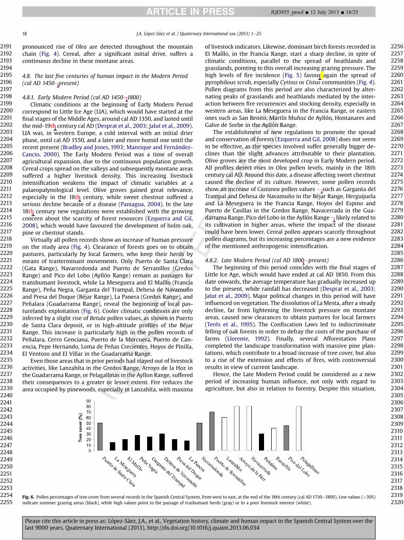
pronounced rise of Olea are detected throughout the mountainchain (Fig. 4). Cereal, after a significant initial drive, suffers acontinuous decline in these montane areas.
4.8. The last five centuries of human impact in the Modern Period(cal AD 1450epresent)
4.8.1. Early Modern Period (cal AD 1450e1800)Climatic conditions at the beginning of Early Modern Period
correspond to Little Ice Age (LIA), which would have started at thefinal stages of theMiddle Ages, around cal AD 1350, and lasted untilthe mid-19th century cal AD (Desprat et al., 2003; Jalut et al., 2009).LIA was, in western Europe, a cold interval with an initial drierphase, until cal AD 1550, and a later and more humid one until therecent present (Bradley and Jones, 1993; Manrique and Fernández-Cancio, 2000). The Early Modern Period was a time of overallagricultural expansion, due to the continuous population growth.Cereal crops spread on the valleys and subsequently montane areassuffered a higher livestock density. This increasing livestockintensification weakens the impact of climatic variables at apalaeopalynological level. Olive groves gained great relevance,especially in the 18th century, while sweet chestnut suffered aserious decline because of a disease (Paniagua, 2004). In the late18th century new regulations were established with the growingconcern about the scarcity of forest resources (Ezquerra and Gil,2008), which would have favoured the development of holm oak,pine or chestnut stands.
Virtually all pollen records show an increase of human pressureon the study area (Fig. 4). Clearance of forests goes on to obtainpastures, particularly by local farmers, who keep their herds bymeans of trasterminant movements. Only Puerto de Santa Clara(Gata Range), Navarredonda and Puerto de Serranillos (GredosRange) and Pico del Lobo (Ayllón Range) remain as passages fortranshumant livestock, while La Meseguera and El Maíllo (FranciaRange), Peña Negra, Garganta del Trampal, Dehesa de Navamuñoand Presa del Duque (Béjar Range), La Panera (Gredos Range), andPeñalara (Guadarrama Range), reveal the beginning of local pas-turelands exploitation (Fig. 6). Cooler climatic conditions are onlyinferred by a slight rise of Betula pollen values, as shown in Puertode Santa Clara deposit, or in high-altitude profiles of the BéjarRange. This increase is particularly high in the pollen records ofPeñalara, Cerro Genciana, Puerto de la Morcuera, Puerto de Can-encia, Pepe Hernando, Loma de Peñas Crecientes, Hoyos de Pinilla,El Ventoso and El Villar in the Guadarrama Range.
Even those areas that in prior periods had stayed out of livestockactivities, like Lanzahíta in the Gredos Range, Arroyo de la Hoz inthe Guadarrama Range, or Pelagallinas in the Ayllon Range, sufferedtheir consequences to a greater or lesser extent. Fire reduces thearea occupied by pinewoods, especially in Lanzahíta, with maxima
of livestock indicators. Likewise, dominant birch forests recorded inEl Maíllo, in the Francia Range, start a sharp decline, in spite ofclimatic conditions, parallel to the spread of heathlands andgrasslands, pointing to this overall increasing grazing pressure. Thehigh levels of fire incidence (Fig. 5) favour again the spread ofpyrophilous scrub, especially Cytisus or Cistus communities (Fig. 4).Pollen diagrams from this period are also characterized by alter-nating peaks of grasslands and heathlands mediated by the inter-action between fire recurrences and stocking density, especially inwestern areas, like La Meseguera in the Francia Range, or easternones such as San Benito, Martín Muñoz de Ayllón, Hontanares andGalve de Sorbe in the Ayllón Range.
The establishment of new regulations to promote the spreadand conservation of forests (Ezquerra and Gil, 2008) does not seemto be effective, as the species involved suffer generally bigger de-clines than the slight advances attributable to their plantation.Olive groves are the most developed crop in Early Modern period.All profiles detect rises in Olea pollen levels, mainly in the 18thcentury cal AD. Around this date, a disease affecting sweet chestnutcaused the decline of its culture. However, some pollen recordsshow an increase of Castanea pollen values e such as Garganta delTrampal and Dehesa de Navamuño in the Béjar Range, Herguijuelaand La Meseguera in the Francia Range, Hoyos del Espino andPuerto de Casillas in the Gredos Range, Navacerrada in the Gua-darrama Range, Pico del Lobo in the Ayllón Rangee likely related toits cultivation in higher areas, where the impact of the diseasecould have been lower. Cereal pollen appears scarcely throughoutpollen diagrams, but its increasing percentages are a new evidenceof the mentioned anthropogenic intensification.
4.8.2. Late Modern Period (cal AD 1800epresent)The beginning of this period coincides with the final stages of
Little Ice Age, which would have ended at cal AD 1850. From thisdate onwards, the average temperature has gradually increased upto the present, while rainfall has decreased (Desprat et al., 2003;Jalut et al., 2009). Major political changes in this period will haveinfluenced on vegetation. The dissolution of La Mesta, after a steadydecline, far from lightening the livestock pressure on montaneareas, caused new clearances to obtain pastures for local farmers(Terés et al., 1995). The Confiscation Laws led to indiscriminatefelling of oak forests in order to defray the costs of the purchase offarms (Llorente, 1992). Finally, several Afforestation Planscompleted the landscape transformation with massive pine plan-tations, which contribute to a broad increase of tree cover, but alsoto a rise of the extension and effects of fires, with controversialresults in view of current landscape.
Hence, the Late Modern Period could be considered as a newperiod of increasing human influence, not only with regard toagriculture, but also in relation to forestry. Despite this situation,
Fig. 6. Pollen percentages of tree cover from several records in the Spanish Central System, fromwest to east, at the end of the 18th century (cal AD 1750e1800). Low values (<30%)indicate summer grazing areas (black), while high values point to the passage of trashumant herds (gray) or to a poor livestock interest (white).
J.A. López-Sáez et al. / Quaternary International xxx (2013) 1e2518
Please cite this article in press as: López-Sáez, J.A., et al., Vegetation history, climate and human impact in the Spanish Central System over thelast 9000 years, Quaternary International (2013), http://dx.doi.org/10.1016/j.quaint.2013.06.034
21912192219321942195219621972198219922002201220222032204220522062207220822092210221122122213221422152216221722182219222022212222222322242225222622272228222922302231223222332234223522362237223822392240224122422243224422452246224722482249225022512252225322542255
22562257225822592260226122622263226422652266226722682269227022712272227322742275227622772278227922802281228222832284228522862287228822892290229122922293229422952296229722982299230023012302230323042305230623072308230923102311231223132314231523162317231823192320
JQI3855_proof ■ 12 July 2013 ■ 18/25
Original text:
Inserted Text
-
Original text:
Inserted Text
-
Original text:
Inserted Text
th
Original text:
Inserted Text
th
Original text:
Inserted Text
th
Original text:
Inserted Text
s
Original text:
Inserted Text
-
Original text:
Inserted Text
-
Original text:
Inserted Text
-
livestock continues to be the basis of the local economic system inmost of the region. Pollen diagrams show maxima of coprophilousfungi and anthropozoogenous taxa and the largest extension ofgrasslands. By way of illustration, the deposit of El Maíllo registersthe maximum extent of heathlands, grasslands and anthropogenicindicators in the uppermost samples, after more than 10 millenniaof forest dominance. Only a few records indicate a change ofexploitation towards forestry, such as La Meseguera, also in theFrancia Range, where the intensive pine plantations prevented afurther livestock development until recent decades, when largefires drove to a new spread of pastures ready for grazing (Fig. 5).Forestry has also become the main use in Navacerrada in theGuadarrama Range, a place where the area occupied by pinewoodshas hardly changed over the last 3000 years, and in Pelagallinas inthe Ayllón Range, which shows the maximum percentage of Pinuspollen in the uppermost samples.
All other records display a higher prevalence of livestock,although obviously forestry and cropping are also involved (Fig. 4).The deposit of Puerto de Santa Clara (Gata Range) has become apastureland for local farmers, but pinewoods and olive groves ac-quire greater relevance than before. High-altitude sites of Gredosand Béjar Ranges remain and even growas summer grasslands, alsowith a significant extent of pine plantations and, at lower altitudes,sweet chestnut and olive groves. Moreover, low-altitude sites inthese ranges, like Peña Negra in the Béjar Range or Lanzahíta in theGredos Range show a shared pattern of olive and chestnut crop-ping, livestock and forestry only altered by repeated fires. Oppositetrends are recorded in Rascafría and Peñalara, both in the Gua-darrama Range, the former with a greater livestock relevance in thevalley and the latter with a wide expanse of pinewoods in the high-mountain.
Fire incidence reaches high levels, not only its frequency, butalso its size (Fig. 5). Monospecific pine plantations favour large-scale fires and dramatic landscape changes. Cytisus and Cistuscommunities would have benefited from this situation, as theyreach their largest expansion in almost all records. In this sense, thehigh values of Cistus pollen in coprolites collected in Los Torrejones’Cave are striking and illustrative. Quercus ilex and Q. pyrenaica oakforests also show a slighter advance, likely related to the felling ofmature forests which prevent a further spread.
The impact on landscape caused by Afforestation Plans has beenmuch higher in those areas where pinewoods never dominated. Bycontrast, their effects have been scarce where they were the maintree formation over time, especially on the southern slopes of theGredos Range, because of a high fire incidence. This highlights theusefulness of long-term studies to designmanagement strategies ofplant cover.
5. Conclusions
Palynological evidence indicates that highland pines weredominant in central and eastern areas (Gredos and GuadarramaRanges) of the Spanish Central System during the early Holoceneca. 9000 cal BC until ca. 3000e2500 cal BC, while western areas(Francia and Béjar Ranges) were dominated by mixed forests ofbirches and pines until ca. 3300 cal BC. The marked gradient ofincreasing continentality towards the east (or maritime influencetowards the Atlantic Ocean) explains these facts (Franco-Múgica,2009; Abel-Schaad, 2012).
Palynological and charcoal data records show that vegetation ofthe Spanish Central Systemwas highly resilient to fire disturbancesduring the early and mid-Holocene. However, when the recurrenceof fire crosses a certain threshold, forests are not able to completelyrecover and shrublands and grasslands become dominant (Carriónet al., 2010; Gil-Romera et al., 2010; Ruiz-Labourdette et al., 2011;
Morales-Molino et al., 2013). In the whole massif this occurredapproximately since 4500 cal BC. The establishment of “culturallandscapes” during the expansion of earlier metallurgical com-munities is clearly depicted in pollen diagrams, especially since theCopper Age, although some evidence of the anthropization processis already denoted from theMiddle Neolithic period ca. 4500 cal BC,when a dehesa landscape took shape in lowlands and valleys.During the Chalcolithic (3300e1900 cal BC) grazing activitiesextended towards high-mountains zones, while signs of agricultureand human occupation are increasingly recorded on foothills andvalleys.
Currently available data support that agriculture was practicedin the Spanish Central System at the end of the 4th millennium calBC (ca. 3300e3000 cal BC) in the lowlands of Amblés and Lozoyavalleys (Gredos and Guadarrama Ranges respectively). However, itsimpact on vegetation and landscape seems low until its finalestablishment towards the 3rd millennium cal BC with the Chal-colithic communities, when the first signs of large-scale defores-tation and a more extensive land use are recorded, due both to alasting permanence and the progressive sedenterisation of thepopulation. From this time onwards, the clearance of forests andthe development of cultivated fields, pastures, meadows andheathlands took place, with small differences in time and spacedepending on natural constraints such as topography, soil andclimate, as well as cultural factors.
During the transition from the Late Chalcolithic to the onset ofthe Early Bronze Age (ca. 2350e1800 cal BC), coinciding with the4.2 ka cal BP dry event, there are almost no traces of anthropogenicimpact on vegetation (neither in charcoal nor in pollen records).The exceptions are a few weak peaks of anthropozoogenous taxaand coprophilous fungi, especially in high-altitude sites, pointing topasture activities and suggesting subsistence relying on herdingand the presence of fairly nomad groups. The convergence ofdiverse factors such as the progressive deforestation of low-altitudeforests during the MiddleeLate Bronze Age (ca. 1800e1150 cal BC),the likely demographic rise as shown by the increasing number andsize of the Early Iron Age villages (ca. 850e400 cal BC), and thearrival of a climatic abrupt change towards wetter conditions ca.850e760 cal BC (2.8 ka cal BP event), could have forced these lastfarming communities to leave the traditional strategies of exploit-ing the valley bottom and move to new territories, such high-mountain environments, from ca. 850 cal BC, where there weregreater hunting opportunities and better forest potential whichallowed small-scale agriculture. In any case, the effect of this cli-matic event in this cultural transition was not the same in eacharea.
At the time of the Late Iron Age (ca. 400e50 cal BC), anthropicdynamics had different impact on each consideredmountain range.Within the Vettonian region (western and central areas of theSpanish Central System), forests are well-developed both in high-lands and lowlands areas. Only in the vicinity of archaeological sites(hill forts) is documented an intense deforestation, showing a so-cioeconomicmodel deeply rooted in a combination of livestock andagriculture. A marked decrease in the number of settlements,mainly located in foothills (w1100 m asl), the strong nucleation ofthe population, and the disappearance of the open air farmsteads inlowland regions could explain these facts. Within the Carpetanianregion (eastern areas of the massif), high-mountain forests are alsowell-developed, but lowlands, especially easternmost ones (PelaRange), demonstrate a phase of socio-cultural change with an in-crease in the number of settlements, territorial organization andnew land use systems (Currás et al., 2012), resulting in a deforestedlandscape with evidence of both grazing and farming activities.
During Roman times (ca. 50 cal BCecal AD 450), large-scaledeforestations resulting in permanent open landscapes which
J.A. López-Sáez et al. / Quaternary International xxx (2013) 1e25 19
Please cite this article in press as: López-Sáez, J.A., et al., Vegetation history, climate and human impact in the Spanish Central System over thelast 9000 years, Quaternary International (2013), http://dx.doi.org/10.1016/j.quaint.2013.06.034
23212322232323242325232623272328232923302331233223332334233523362337233823392340234123422343234423452346234723482349235023512352235323542355235623572358235923602361236223632364236523662367236823692370237123722373237423752376237723782379238023812382238323842385
23862387238823892390239123922393239423952396239723982399240024012402240324042405240624072408240924102411241224132414241524162417241824192420242124222423242424252426242724282429243024312432243324342435243624372438243924402441244224432444244524462447244824492450
JQI3855_proof ■ 12 July 2013 ■ 19/25
Original text:
Inserted Text
th
Original text:
Inserted Text
-
Original text:
Inserted Text
rd
Original text:
Inserted Text
-
Original text:
Inserted Text
-
Original text:
Inserted Text
-
Original text:
Inserted Text
-
Original text:
Inserted Text
-
Original text:
Inserted Text
sim
Original text:
Inserted Text
-
characterize the lowlands areas of the Spanish Central System, as aconsequence of the intensification of human activities like crop-ping, grazing, mining or forestry. However, anthropogenic dy-namics in the highlands was different in each area of the massif andwas in connection with mining (western areas) or greater settle-ments (eastern areas), while the Gredos Range (central area) washardly altered due to its inaccessibility.
At the beginning of the Middle Ages (cal AD 450e1450), theintensity of human impact increased notably cal AD 450e700after the collapse of the Roman system. This is documented bylarge deforestation processes at high-altitudes and by a rise ofanthropogenic pollen indicators, within a clear livestock-orientedpattern, although new lands were brought into cultivation withthe onset of the Early Medieval Cold Episode (cal AD 450e950).An initial phase of forest recovery (birch, alder and deciduousoaks in western areas; pine in central and eastern ones) isrecorded in high-mountain environments since cal AD 700e950,as a result of a decline in livestock and farming activities, whileagro-pastoral pressure increased in low altitudes. Then a newphase of forest clearance took place in the whole massif cal AD950e1100, related to trasterminant movements and the milderweather conditions of the Late Medieval Warm Episode (cal AD950e1350). In the lowlands livestock intensification did notinvolve a broad clearance of forested areas but some diversifica-tion in crops (rye, olive, sweet chestnut cultivation). After theReconquest, the Feudal Period (cal AD 1100e1450) is the timewhen the current landscape of the high-mountain areas of theSpanish Central System originated: heathlands in western andeastern areas (Gata, Francia, Béjar and Ayllón Ranges) and broomcommunities in central ones (Gredos and Guadarrama Ranges).The intensification of farming activities and livestock husbandry,the creation of the La Mesta system with transhumant herdstravelling through the livestock trails of these mountains, as wellas the repeated use of fire, led to the extension of grasslands and asharp deforestation of many high-mountain areas, mainly relatedto their use as summer pasturelands. A few mountainous areaswhere grazing is limited, however, recovered their forest cover,mainly consisting of pinewoods.
The Early Modern Period is marked by a further intensificationof human pressure, not only related to cropping, with a noteworthybroad expansion of olive groves, but also to livestock husbandry,which undergoes an overall spread even in those areas with priorlow densities. High fire recurrence is also characteristic in thisperiod, inducing alternating peaks of grasslands and scrublands inpollen diagrams. This weakens the impact of climatic variables,despite this period corresponds to the Little Ice Age, indicated in thepollen records by slight rises of Betula. Finally, the Late ModernPeriod brought major political changes which did not lightenfarming pressure on most montane areas. It could be considered asa new period of increasing human influence. Livestock continues tobe the main use and the basis of the local economic system in mostof the region, despite recent afforestation plans, mainly made withpines, have led some areas to forestry. The high fire incidencepromoted growth of Cistus and broom communities throughout theridge.
Acknowledgements
We are indebted to the CONSOLIDER-INGENIO 2010 Program(CSD2007-00058), EXCELENCIA 2011 Program (RNM-7033) andAGRIWESTMED (ERC-Advanced Grants, proposal n� 230561) forfinancial and technical support. We wish to thank to FernandoPulido and Ana Valdeolmillos for valuable suggestions. SPD iscurrently supported by a post-doctoral research grant (BasqueGovernment) at Toulouse-Le Mirail University.
References
Abascal, J.M., González, P., 2007. Carpetania: argumentos para una definición delterritorio en época romana. Zona Arqueológica 10, 290e301.
Abel-Schaad, D., 2012. Evolución de la vegetación durante el Holoceno reciente en lavertiente extremeña del Sistema Central a partir del análisis palinológico (PhDdissertation). Universidad de Extremadura, Plasencia.
Abel-Schaad, D., López-Sáez, J.A., 2013. Vegetation changes in relation to fire historyand human activities at the Peña Negra mire (Béjar Range, Iberian CentralMountain System, Spain) during the past 4.000 years. Vegetation History andArchaeobotany 22, 199e214.
Abel-Schaad, D., Hernández, A.M., López-Sáez, J.A., Pulido, F.J., López-Merino, L.,Martínez-Cortizas, A., 2009a. Evolución de la vegetación en la Sierra de Gata(Cáceres-Salamanca, España) durante el Holoceno reciente. Implicaciones bio-geográficas. Revista Española de Micropaleontología 41, 91e105.
Abel-Schaad, D., Hernández, A.M., López-Merino, L., Pulido, F.J., López-Sáez, J.A.,2009b. Cabras y quemorros: Tres siglos de cambios en el paisaje de la vertienteextremeña de la Sierra de Gredos. Revista de Estudios Extremeños 65, 449e478.
Alía, M., Menéndez-Amor, J., Vidal, C., 1957. Livre-Guide de l’excursion C3 et C4Guadarrama, Massif Peñalara et variation El Escorial-Manzanares el Real. In:V Congres International INQUA. INQUA, Madrid, pp. 28e34.
Álvarez-Sanchís, J.R., 1999. Los Vettones. Real Academia de Historia, Madrid.Álvarez-Sanchís, J.R., 2000. The Iron Age in Western Spain (800 BCeAD 50): an
overview. Oxford Journal of Archaeology 19, 65e89.Álvarez-Sanchís, J.R., 2005. Oppida and Celtic society in western Spain. Journal of
Interdisciplinary Celtic Studies 6, 255e285.Amor, A., Ladero, M., Valle, C.J., 1993. Flora y vegetación vascular de la comarca de La
Vera y laderas meridionales de la Sierra de Tormantos (Cáceres, España). StudiaBotanica 11, 11e207.
Andrade, A., 1994. Dinámica de la vegetación durante los últimos 3.000 BP en lasSierras de la Paramera, La Serrota y Villafranca (Ávila) a partir del análisispolínico (PhD dissertation). Universidad de Alcalá de Henares, Madrid.
Andrade, A., González-Jonte, R.H., 2007. El pinar de Hoyocasero (Ávila) ¿antiguarepoblación o pinar natural conservado? Anales de Biología 29, 33e51.
Andrade, A., Ruiz-Zapata, M.B., 1995. Evolución de la vegetación en la vertienteseptentrional de la Sierra de la Paramera (Ávila, España), durante los últimos3000 BP, basada en análisis polínicos. In: III Reunião do Quaternario Ibérico.AEQUA, Coimbra, pp. 19e23.
Andrade, A., Martín, T., Ruiz-Zapata, M.B., 1990. Análisis palinológico de la cuencaalta del río Alberche (Ávila). Actas de Gredos 10, 15e18.
Andrade, A., Dorado, M., Ruiz-Zapata, M.B., Acaso, E., 1992. Análisis polínico deuna zona de alto interés botánico: el Pinar de Hoyocasero. Actas de Gredos12, 21e31.
Andrade, A., Dorado, M., Ruiz-Zapata, M.B., 1994a. Estudio comparativo de la evo-lución de la vegetación a partir del tránsito Subboreal-Subatlántico en las si-erras abulenses (Ávila, Sistema Central, España). In: Mateu, I., Dupré, M.,Güemes, J., Burgaz, M.E. (Eds.), Trabajos de Palinología Aplicada. Universitat deValència, València, pp. 247e261.
Andrade, A., Martín, T., Ruiz-Zapata, M.B., 1994b. Estimaciones de la paleo-vegetación de la Sierra de la Paramera (Ávila), mediante estudios polínicos. In:La Serna Ramos, I. (Ed.), Polen y Esporas: contribución a su conocimiento.Universidad de La Laguna, Tenerife, pp. 333e342.
Andrade, A., Valdeolmillos, A., Ruiz-Zapata, M.B., 1994c. Modern spectra andcontemporary vegetation in the Paramera Range (Ávila, Spain). Review ofPalaeobotany and Palynology 82, 127e139.
Andrade, A., Ruiz-Zapata, M.B., Gil-García, M.J., Fombella, M.A., 1996. Acciónantrópica y su impacto sobre la vegetación, desde el tránsito Subatlántico-Subboreal, en la vertiente norte de la Sierra de Gredos (Ávila, España). Estudiopalinológico. In: Ruiz-Zapata, M.B. (Ed.), Estudios Palinológicos. UniversidadAlcalá de Henares, Alcalá de Henares, pp. 7e12.
Anes, G., García, A. (Eds.), 1994. Mesta, trashumancia y vida pastoril. Junta deCastilla y León, Valladolid.
Ashcroft, M.B., 2010. Identifying refugia from climate change. Journal of Biogeog-raphy 37, 1407e1413.
Atienza, M., 1993. Evolución del paisaje vegetal en las Sierras de Béjar y Franciadurante el Holoceno, a partir del análisis polínico (PhD dissertation). Uni-versidad de Alcalá de Henares, Madrid.
Atienza, M., 1995. Estudio palinológico de los cambios en el límite superior delbosque durante el Holoceno en la Sierra de Béjar. Sistema Central Español. In:Aleixandre, T., Pérez, A. (Eds.), Reconstrucción de paleoambientes y cambiosclimáticos durante el Cuaternario. C.S.I.C., Madrid, pp. 329e338.
Atienza, M., 1996. Análisis polínico de un depósito próximo al haya de La Hergui-juela. Sierra de Francia. Salamanca. In: Ruiz-Zapata, M.B. (Ed.), Estudios Pal-inológicos. Universidad Alcalá de Henares, Alcalá de Henares, pp. 13e17.
Atienza, M., Ruiz-Zapata, M.B., 1992. Estudio comparativo, desde el punto de vistapolínico, de los datos procedentes de algunos depósitos de turba ubicados enlas vertientes de Ávila y Salamanca, en la Sierra de Béjar. Actas de Gredos 12,33e41.
Atienza, M., Gómez-Lobo, A., Ruiz-Zapata, M.B., 1990. Estudio polínico de undepósito localizado en la Garganta del Trampal (Sierra de Béjar, Ávila). Actas deGredos 10, 19e23.
Atienza, M., Dorado, M., Ruiz-Zapata, M.B., 1991. La palinología en el estudio de laacción antrópica. Aplicación a dos depósitos localizados en la Sierra de Béjar yen la Sierra de Ávila (Ávila). Actas de Gredos 11, 31e38.
J.A. López-Sáez et al. / Quaternary International xxx (2013) 1e2520
Please cite this article in press as: López-Sáez, J.A., et al., Vegetation history, climate and human impact in the Spanish Central System over thelast 9000 years, Quaternary International (2013), http://dx.doi.org/10.1016/j.quaint.2013.06.034
24512452245324542455245624572458245924602461246224632464246524662467246824692470247124722473247424752476247724782479248024812482248324842485248624872488248924902491249224932494249524962497249824992500250125022503250425052506250725082509251025112512251325142515
25162517251825192520252125222523252425252526252725282529253025312532253325342535253625372538253925402541254225432544254525462547254825492550255125522553255425552556255725582559256025612562256325642565256625672568256925702571257225732574257525762577257825792580
JQI3855_proof ■ 12 July 2013 ■ 20/25
Original text:
Inserted Text
-
Original text:
Inserted Text
-
Original text:
Inserted Text
-
Original text:
Inserted Text
-
Original text:
Inserted Text
-
Original text:
Inserted Text
-
Atienza, M., Dorado, M., Gómez-Lobo, A., Ruiz-Zapata, M.B., 1996. Estudio polínicode un depósito situado en la vertiente norte de la Sierra de Béjar. BotánicaMacaronésica 23, 201e209.
Barceló, J., 1984. Descripción de las Cañadas Reales. Editorial Museo Universal,Madrid.
Bentley, S., 1991. A Vegetational History of Peñalara in Central Spain. King College,London.
Berglund, B.E., 2003. Human impact and climate changes e synchronous events anda causal link? Quaternary International 105, 7e12.
Blanco-González, A., 2008. Tendencias del uso del suelo en el Valle Amblés (Ávila,España). Del Neolítico al Hierro inicial. Zephyrus 62, 101e123.
Blanco-González, A., 2010. ‘Arqueología de la población’ entre la Edad del Bronce yel Primer Hierro (1800-400 AC): sobre procesos migratorios y colonizadores enla Submeseta Norte. Arqueología Espacial 28, 361e379.
Blanco-González, A., Fabián, J.F., 2005. Los orígenes de las comunidades castreñasen el suroeste de la Meseta española: El proceso histórico Bronce Final-Segunda Edad del Hierro. Cadernos do Museu Municipal de Penafiel 11,41e53.
Blanco-González, A., Fabián, J.F., 2010. Un hito de la memoria: el túmulo de ElMorcuero (Gemuño, Ávila). Munibe (Antropologia-Arkeologia) 61, 183e212.
Blanco-González, A., Fabián, J.F., 2011. ¿Monumentos evocativos? Los túmulos de LosTiesos (Mediana de Voltoya, Ávila) en su contexto prehistórico. Munibe(Antropologia-Arkeologia) 62, 251e282.
Blanco-González, A., López-Sáez, J.A., López-Merino, L., 2009. Ocupación y uso delterritorio en el sector centromeridional de la cuenca del Duero entre la Anti-güedad y la Alta Edad Media (siglos I-XI D.C.). Archivo Español de Arqueología82, 275e300.
Blasco, C., Liesau, C., Ríos, P. (Eds.), 2011. Yacimientos calcolíticos con Campaniformede la región de Madrid: Nuevos estudios. Universidad Autónoma, Madrid.
Blasco, M.C., Rovira, S., 1992-1993. La metalurgia del Cobre y del Bronce en la regiónde Madrid. Tabona 8, 379e415.
Bond, G., Kromer, B., Beer, J., Muscheler, R., Evans, M.N., Showers, W., Hoffmann, S.,Lotti-Bond, R., Hajdas, I., Bonani, G., 2001. Persistent solar influence of NorthAtlantic climate during the Holocene. Science 294, 2130e2136.
Bradley, R.S., Jones, P.D., 1993. ‘Little Ice Age’ summer temperature variations: theirnature and relevance to recent global warming trends. The Holocene 3-4, 367e376.
Bueno, P., Barroso, R., Balbín, R., Campo, M., Exteberría, F., González, A., Herrasti, L.,Treserras, J.J., López García, P., López-Sáez, J.A., Matamala, J.C., Sánchez, B., 2002.Áreas habitacionales y funerarias en el Neolítico de la cuenca interior del Tajo:la provincia de Toledo. Trabajos de Prehistoria 59, 65e79.
Bueno, P., Barroso, R., Balbín, R., Campo, M., González, A., Etxebarría, F., Herrasti, L.,Galván, V., Juan-Treserras, J., López-Sáez, J.A., López, P., Matamala, J.C., Millos, J.,Robledo, B., Trancho, G., Sánchez, B., 2005. Alimentación y economía en con-textos habitacionales y funerarios del Neolítico meseteño. In: Arias, P.,Ontañón, R., García, C. (Eds.), III Congreso del Neolítico en la Península Ibérica.Universidad de Cantabria, Santander, pp. 83e92.
Burjachs, F., 2001. Análisis palinológico del yacimiento de Guaya, en Berrocalejo deAragona (Ávila). In: Strato, S.L. (Ed.), Excavación arqueológica en el yacimientode Guaya, en Berrocalejo de Aragona (Ávila) afectado por el trazado de laautopista de peaje de conexión A-6 (Villacastí n) a Ávila. Informe final, Análisisespecíficos, vol. II. Strato, Valladolid, pp. 21e32.
Burjachs, F., López-Sáez, J.A., 2003. Análisis paleopalinológico del yacimientoarqueológico de Fuente Lirio (Muñopepe, Ávila). Numantia 8, 51e54.
Carrión, J.S., Munuera, M., Navarro, C., Sáez, F., 2000. Paleoclimas e historia de lavegetación cuaternaria en España a través del análisis polínico. Viejas falacias ynuevos paradigmas. Complutum 11, 115e142.
Carrión, J.S., Andrade, A., Bennett, K.D., Navarro, C., Munuera, M., 2001a. Crossingforest thresholds: inertia and collapse in a Holocene sequence from south-central Spain. The Holocene 11, 635e653.
Carrión, J.S., Munuera, M., Dupré, M., Andrade, A., 2001b. Abrupt vegetation changesin the Segura mountains of southern Spain throughout the Holocene. Journal ofEcology 89, 783e797.
Carrión, J.S., Gil, G., Rodríguez, E., Fuentes, N., García-Antón, M., Arribas, A., 2005.Palynology of badger coprolites from Central Spain. Palaeogeography, Palae-oclimatology, Palaeoecology 226, 259e271.
Carrión, J.S., Fuentes, N., González-Sampériz, P., Sánchez, L., Finlayson, J.C.,Fernández, S., Andrade, A., 2007. Holocene environmental change in a montaneregion of southern Europe with a long history of human settlement. QuaternaryScience Reviews 26, 1455e1475.
Carrión, J.S., Fernández, S., González-Sampériz, P., Gil-Romera, G., Badal, E., Carrión-Marco, Y., López-Merino, L., López-Sáez, J.A., Fierro, E., Burjachs, F., 2010. Ex-pected trends and surprises in the Lateglacial and Holocene vegetation historyof the Iberian Peninsula and Balearic Islands. Review of Palaeobotany andPalynology 162, 458e475.
Colombaroli, D., Vannière, B., Chapron, E., Magny, M., Tinner, W., 2008. Fire-vege-tation interactions during the Mesolithic-Neolithic transition at Lago dell’Ac-cesa, Tuscana, Italy. The Holocene 18, 679e692.
Connor, S.E., Araújo, J., van der Knaap, W.O., van Leeuwen, J.F.N., 2012. A long-termperspective on biomass burning in the Serra da Estrela, Portugal. QuaternaryScience Reviews 55, 114e124.
Costa-Tenorio, M., Morla, C., Sainz-Ollero, H. (Eds.), 1997. Los bosques ibéricos. Unainterpretación geobotánica. Editorial Planeta, Barcelona.
Currás, A., Zamora, L., Reed, J.M., García-Soto, E., Ferrero, S., Armengol, X., Mezquita-Joanes, F., Marqués, M.A., Riera, S., Julià, R., 2012. Climate change and human
impact in central Spain during Roman times: High-resolution multi-proxyanalysis of a tufa lake record (Somolinos, 1280 m asl). Catena 89, 31e53.
Delibes, G., Fernández, J., 2000. La trayectoria cultural de la Prehistoria Reciente(6400e2500 BP) en la Submeseta Norte española: principales hitos de unproceso. In: Oliveira, V. (Ed.), Pré-historia recente da Península Ibérica, 3�
Congresso de Arqueologia Peninsular. Adecap, Porto, pp. 95e122.Delibes, G., Herrán, J.I., Santiago, J., Del Val, J., 1995. Evidence for social complexity
in the Copper Age of the Northern Meseta? In: Lillios, K.T. (Ed.), The Origins ofComplex Societies in Late Prehistoric Iberia, pp. 44e63. Ann Arbor, Michigan.
Delibes, G., Fabián, F.J., Fernández, J., Herrán, J.I., Santiago, J., Del Val, J., 1996. Losmás antiguos testimonios del uso y producción de metal en el suroeste de lasubmeseta norte: consideraciones tipológicas. Humanitas 1, 163e202.
Desprat, S., Sánchez-Goñi, M.F., Loutre, M.F., 2003. Revealing climatic variability ofthe last three millennia in northwestern Iberia using pollen influx data. Earthand Planetary Science Letters 213, 63e78.
Devesa, J.A., 1995. Vegetación y Flora de Extremadura. Universitas Editorial, Badajoz.De Vicente, G., González, J.M., Calvo, J.P., Muñoz, A., Giner, J., Rodríguez, M., 1994.
Evolución y estructuras alpinas en la zona del centro peninsular. Cadernos doLaboratorio Xeolóxico de Laxe 19, 175e190.
Díaz del Río, P., 2001. La formación del paisaje agrario. Madrid en el III y II mileniosBC. Comunidad de Madrid, Madrid.
Díez, A., Pedraza, J., Alonso-Azcárate, J., 1996. Evolución cenozoica de la fosa deGarganta del Villar (Sistema Central Español). In: Grandal d’Anglade, A., Pagés, J.(Eds.), IV Reunión de Geomorfología. Sociedad Española de Geomorfología, OCastro, pp. 59e77.
Dorado, M., 1993. Evolución de la vegetación durante el Holoceno en el Valle deAmblés (Ávila) (PhD dissertation). Universidad de Alcalá de Henares, Madrid.
Dorado,M., Ruiz-Zapata,M.B.,1994. Variabilidad de la lluvia polínica enlos transectosTP1 y TP2 del Valle de Amblés (Ávila). In: La Serna Ramos, I. (Ed.), Poleny Esporas:contribución a su conocimiento. Universidad de La Laguna, Tenerife, pp.147e157.
Dorado, M., Martín, T., Gil-García, M.J., Ruiz Zapata, M.B., 1990. Estudio comparativode los datos polínicos procedentes de dos depósitos de distinta naturalezalitológica (turba y material detrítico) localizados en el Valle de Amblés, Ávila.Actas de Gredos 10, 25e32.
Dorado, M., Valdeolmillos, A., Ruiz-Zapata, M.B., 2001. Actividad humana y diná-mica de la vegetación en la Sierra de Ávila (Sistema Central Español) desde elBronce Medio. Polen 11, 39e49.
Estremera, M.S., 2003. Primeros agricultores y ganaderos en la Meseta Norte: elNeolítico de la Cueva de la Vaquera (Torreiglesias, Segovia). Junta de Castilla yLeón, Zamora.
Ezquerra, F.J., Gil, L., 2008. La transformación histórica del paisaje forestal enExtremadura. In: Tercer Inventario Forestal Nacional 1997e2007. Ministerio deMedio Ambiente, Madrid.
Fabián, J.F., 1993. La secuencia cultural durante la Prehistoria reciente en el Sur de laMeseta Norte española. Trabalhos de Antropologia e Etnologia 33, 145e178.
Fabián, J.F., 1995. El aspecto funerario durante el Calcolítico y la Edad del Bronce enel Sur de la Meseta Norte. El enterramiento colectivo en fosa de El Tomillar(Bercial de Zapardiel, Ávila) en el marco cultural de la Prehistoria reciente delSur de la Meseta Norte española. Universidad de Salamanca, Salamanca.
Fabián, J.F., 2006. El IV y III Milenio AC en el Valle Amblés (Ávila). Arqueología enCastilla y León, Series Monografías n� 5. Junta de Castilla y León, Salamanca.
Fabián, J., Blanco-González, A., López-Sáez, J.A., 2006. La transición Calcolítico-Bronce Antiguo desde una perspectiva arqueológica y ambiental: el Valle Am-blés (Ávila) como referencia. Arqueología Espacial 26, 37e56.
Faegri, K., Iversen, J., 1989. Textbook of Pollen Analysis. Wiley, Chichester.Fernández, J., Herrán, J.I., Orejas, A., Hernández, M., Paradinas, S., 1997. Minería y
poblamiento Calcolítico en Ávila de Los Caballeros. In: Balbín, R., Bueno, P.(Eds.), II Congreso de Arqueología Peninsular: Neolítico, Calcolítico y Bronce.Fundación Rei Alfonso Henriques, Zamora, pp. 527e541.
Fernández-González, F., 1991. La vegetación del valle del Paular (Sierra de Gua-darrama, Madrid), I. Lazaroa 12, 153e272.
Fernández-Posse, M.D., 1998. La investigación protohistórica en la Meseta y Galicia.Editorial Síntesis, Madrid.
Franco-Moreno, B., 2004. Territorio y poblamiento en la Kura de Mérida durante elemirato omeya (siglos VIIIeX/IIeIV). Espacio, Tiempo y Forma, Serie III, HistoriaMedieval 17, 167e184.
Franco-Moreno, B., 2005. Distribución y asentamiento de tribus bereberes (Ima-zighen) en el territorio emeritense en época emiral (s. VIII-X). Arqueología yTerritorio Medieval 12, 39e50.
Franco-Múgica, F., 1995. Estudio palinológico de turberas holocenas en el SistemaCentral: reconstrucción paisajística y acción antrópica (PhD dissertation). Uni-versidad Autónoma, Madrid.
Franco-Múgica, F., 2009. El análisis polínico en la reconstrucción del paisaje vegetal.In: Génova, M., Gómez-Manzaneque, F., Morla-Juaristi, C. (Eds.), Los bosques deGredos a través del tiempo. Junta de Castilla y León, Valladolid, pp. 89e117.
Franco-Múgica, F., García-Antón, M., 1994. Análisis polínico de una turbera enRascafría (Madrid). In: La Serna Ramos, I. (Ed.), Polen y Esporas: contribución asu conocimiento. Universidad de La Laguna, Tenerife, pp. 361e369.
Franco-Múgica, F., García-Antón, M., Sainz-Ollero, H., 1997. Impacto antrópico ydinámica de la vegetación durante los últimos 2000 años BP en la vertienteseptentrional de la Sierra de Gredos: Navarredonda (Ávila, España). Revue dePaléobiologie 16, 29e45.
Franco-Múgica, F., García-Antón, M., Sainz-Ollero, H., 1998. Vegetation dynamicsand human impact in the Sierra de Guadarrama, Central System, Spain. TheHolocene 8, 69e82.
J.A. López-Sáez et al. / Quaternary International xxx (2013) 1e25 21
Please cite this article in press as: López-Sáez, J.A., et al., Vegetation history, climate and human impact in the Spanish Central System over thelast 9000 years, Quaternary International (2013), http://dx.doi.org/10.1016/j.quaint.2013.06.034
25812582258325842585258625872588258925902591259225932594259525962597259825992600260126022603260426052606260726082609261026112612261326142615261626172618261926202621262226232624262526262627262826292630263126322633263426352636263726382639264026412642264326442645
26462647264826492650265126522653265426552656265726582659266026612662266326642665266626672668266926702671267226732674267526762677267826792680268126822683268426852686268726882689269026912692269326942695269626972698269927002701270227032704270527062707270827092710
JQI3855_proof ■ 12 July 2013 ■ 21/25
Franco-Múgica, F., García-Antón, M., Maldonado, J., Morla, C., Sainz-Ollero, H., 2001.Evolución de la vegetación en el sector septentrional del Macizo de Ayllón(Sistema Central). Análisis polínico de la turbera de Pelagallinas. Anales delJardín Botánico de Madrid 59, 113e124.
Gaillard, M.J., 2007. Pollen methods and studies: archaeological applications. In:Elias, S. (Ed.), Encyclopedia of Quaternary Science. Elsevier, Amsterdam,pp. 2571e2595.
García-Oliva, M.D., 2007. Un espacio sin poder: la Transierra extremeña durante laépoca musulmana. Studia Historica, Historia Medieval 25, 89e120.
Gavilán, R., Fernández-González, F., Blasi, C., 1998. Climatic classification and ordi-nation of the Spanish Sistema Central: relationships with potential vegetation.Plant Ecology 139, 1e11.
Gil-García, M.J., 1992. Dinámica de la paleovegetación en el sector oriental delSistema Central español durante el Holoceno, en base al análisis polínico.Implicaciones climáticas (PhD dissertation). Universidad de Alcalá de Henares,Madrid.
Gil-García, M.J., 2004. Estudio polínico de la huerta del Monasterio del Paular(Rascafría, Madrid). Universidad de Alcalá de Henares, Madrid.
Gil-García, M.J., Ruiz-Zapata, M.B., 1991. Vegetación y clima holocenos en el puertode la Morcuera (Madrid) en base a datos polínicos. Geogaceta 9, 105e107.
Gil-García, M.J., Ruiz-Zapata, M.B., 1994. Resultados polínicos correspondientes alsector oriental del Sistema Central Español. In: La Serna Ramos, I. (Ed.), Polen yEsporas: contribución a su conocimiento. Universidad de La Laguna, Tenerife,pp. 381e391.
Gil-García, M.J., Ruiz-Zapata, M.B., Andrade, A., Vázquez, R., 1989. Datos pal-inológicos de una turbera localizada en el Puerto de Canencia (Madrid).Henares, Revista de Geología 3, 141e146.
Gil-García, M.J., Tomás Las Heras, R., Ruiz-Zapata, M.B., 1993a. Contribución alconocimiento de la dinámica de la vegetación en el sector oriental del SistemaCentral español, en base al análisis polínico. Geogaceta 13, 46e48.
Gil-García, M.J., Tomás Las Heras, R., Ruiz-Zapata, M.B., 1993b. Acción antrópica yreconstrucción de la vegetación durante el Holoceno reciente en el Hayedo deMontejo (Madrid). Nova Acta Científica Compostelana 4, 49e57.
Gil-García, M.J., Tomás Las Heras, R., Ruiz-Zapata, M.B., 1993c. Paleovégétationpendand le Quaternaire récent dans le Puerto de Morcuera “Col de Morcuera”(Système Central, Espagne). Quaternaire 4, 31e37.
Gil-García, M.J., Martín, T., Tomás Las Heras, R., Ruiz-Zapata, M.B., 1994a. Evoluciónde los táxones arbóreos más relevantes en el sector oriental del Sistema CentralEspañol. In: Mateu, I., Dupré, M., Güemes, J., Burgaz, M.E. (Eds.), Trabajos dePalinología Aplicada. Universitat de València, València, pp. 233e245.
Gil-García, M.J., Tomás Las Heras, R., Ruiz-Zapata, M.B., 1994b. Cambios climáticos yvegetación durante el Holoceno (2500 BP) en el Puerto de Canencia (Madrid-España). Revue de Paléobiologie 13, 381e389.
Gil-García, M.J., Tomás Las Heras, R., Ruiz-Zapata, M.B., 1994c. Evolución de loshayedos y dinámica de la vegetación en el Sistema Central Español en base aestudios polínicos. Revue de Paléobiologie 13, 399e409.
Gil-García, M.J., Tomás Las Heras, R., Ruiz-Zapata, M.B., 1995a. Degradación antro-pogénica de la vegetación, en base al análisis polínico, en la Sierra de Gua-darrama: Altos de Hontanar (Madrid). Lazaroa 15, 151e163.
Gil-García, M.J., Tomás Las Heras, R., Ruiz-Zapata, M.B., 1995b. Influencia humanasobre el paisaje vegetal pasado en el Puerto de la Quesera. Nova Acta CientíficaCompostelana 5, 153e160.
Gil-García, M.J., Tomás Las Heras, R., Ruiz-Zapata, M.B., 1995c. Historia del paisajevegetal y acción antrópica en el Cerro Genciana (Sierra de Guadarrama, Madrid)durante el Holoceno reciente. Polen 7, 32e39.
Gil-García, M.J., Martín, T., Tomás Las Heras, R., Ruiz-Zapata, M.B., 1995d. Recon-strucción del paleoambiente en el Macizo de Ayllón (Sistema Central Español)durante el Holoceno a través del análisis polínico. In: III Reunião do QuaternarioIbérico. AEQUA, Coimbra, pp. 49e54.
Gil-García, M.J., Martín, T., Tomás Las Heras, R., Ruiz-Zapata, M.B., 1996a. Dinámicade la vegetación durante el Holoceno en el Puerto de Canencia (Madrid):relación con el espectro polínico. Botánica Macaronésica 23, 221e232.
Gil-García, M.J., Tomás Las Heras, R., Ruiz-Zapata, M.B., 1996b. Degradaciónantropogénica de la vegetación en el Puerto de la Morcuera (Sierra deGuadarrama, España) durante los últimos 2.000 años, en base al análisispolínico. Boletín de la Real Sociedad Española de Historia Natural (SecciónBiología) 92, 29e36.
Gil-García, M.J., Tomás Las Heras, R., Ruiz-Zapata, M.B., 1996c. Paleovegetation,climate and human action during the Upper Holocene at Morcuera Pass(Madrid, Spain). Revue de Paléobiologie 15, 469e478.
Gil-Romera, G., López-Merino, L., Carrión, J.S., González-Sampériz, P., Martín-Puertas, C., López-Sáez, J.A., Fernández, S., García-Antón, M., Stefanova, V., 2010.Interpreting resilience through long-term ecology: potential insights in West-ern Mediterranean landscapes. The Open Ecology Journal 3, 43e53.
Gómez-González, C., 2007. Actividad antrópica y vegetación en el valle del Lozoya(Madrid) durante el Holoceno reciente (PhD dissertation). Universidad de Alcaláde Henares, Madrid.
Gómez-González, C., Ruiz-Zapata, M.B., López-Sáez, J.A., Gil-García, M.J.,Santiesteban, J., Mediavilla, R., Domínguez, F., 2007. El paisaje vegetal durante elHoloceno reciente en el Macizo de Peñalara (Sierra de Guadarrama, Madrid). In:XII Reunión Nacional de Cuaternario. AEQUA, Ávila, pp. 197e198.
Gómez-González, C., Ruiz-Zapata, M.B., López-Sáez, J.A., Gil-García, M.J., 2008. Usesof non pollen palynomorphs as a source of information of anthropic activities inthe Rascafría site (Lozoya valley river, Madrid, Spain) during the last 2.500 BP.In: Maritan, M., Miola, A. (Eds.), 3rd International Workshop on Quaternary
Non-pollen-palynomorphs. University of Padua and Regional Park of EuganeanHills, Padua, pp. 20e23.
Gómez-González, C., Ruiz-Zapata, B., López-Sáez, J.A., 2009a. Algunos palinomorfospolínicos y no polínicos como indicadores de antropización: un ejemplo.Ingeniería, Investigación y Desarrollo 8, 2e7.
Gómez-González, C., Ruiz-Zapata, M.B., López-Sáez, J.A., Gil-García, M.J., 2009b.Aportaciones de la palinología en la reconstrucción del impacto ganadero, enlos alrededores de Rascafría (Madrid), durante el Holoceno reciente. In:Romero, A., Belmonte, F., Alonso, F., López, F. (Eds.), Advances in Studies onDesertification, Topic 5: Impact of Livestock and Agriculture in TerrestrialEcosystems. Universidad de Murcia, Murcia, pp. 693e696.
Gómez-González, C., Ruiz-Zapata, B., Gil-García, M.J., López-Sáez, J.A.,Santiesteban, J., Mediavilla, R., Domínguez, F., Vera, S., 2009c. Evolución delpaisaje vegetal durante los últimos 1.680 años BP en el Macizo de Peñalara(Sierra de Guadarrama, Madrid). Revista Española de Micropaleontología 41,75e89.
Gómez-Manzaneque, F., 2009. La cubierta vegetal y la flora. In: Génova, M., Gómez-Manzaneque, F., Morla-Juaristi, C. (Eds.), Los bosques de Gredos a través deltiempo. Junta de Castilla y León, Valladolid, pp. 43e85.
Gómez-Pantoja, J., 2004. Pecora consectari: transhumance in Roman Spain. In:Santillo-Frizell, B. (Ed.), Pecus: Man and Animal in Antiquity. The SwedishInstitute in Rome, Rome, pp. 94e102.
González-Tablas, F.J., 1983. Los Castillejos de Sanchorreja y su influencia en lasculturas del Bronce Final y de la Edad del Hierro de la Meseta Norte (PhDdissertation). Universidad de Salamanca, Salamanca.
González-Tablas, F.J., Domínguez-Calvo, A., 2002. Los Castillejos de Sanchorreja(Ávila): campañas de 1981, 1982 y 1985. Ediciones Universidad de Salamanca,Salamanca.
Harrison, R.J., 1994. The Bronze Age in Northern and Northeastern Spain 2000e800BC. In: Mathers, C., Stoddart, S. (Eds.), Development and Decline in the Medi-terranean Bronze Age. University of Sheffield, Sheffield, pp. 73e97.
Hernández-Bermejo, J.E., Sainz-Ollero, H., 1984. Ecología de los hayedos mer-idionales ibéricos: el macizo de Ayllón. M.A.P.A., Madrid.
Hernández-Vera, T., Ruiz-Zapata, M.B., 1984. Datos preliminares de los análisispolínicos de las tollas ubicadas en Galve de Sorbe (Guadalajara). Anales de laAsociación de Palinólogos de Lengua Española 1, 71e76.
Hua, Q., Barbetti, M., 2004. Review of tropospheric bomb 14C data for carbon cyclemodelling and age calibration purposes. Radiocarbon 46, 1273e1298.
Jalut, G., Esteban, A., Bonnet, L., Gauquelin, T., Fontugne, M., 2000. Holocene climaticchanges in the western Mediterranean, from south-east France to south-eastSpain. Palaeogeography, Palaeoclimatology, Palaeoecology 160, 255e290.
Jalut, G., Dedoubat, J.J., Fontugne, M., Otto, T., 2009. Holocene circum-Mediterranean vegetation changes: climate forcing and human impact. Qua-ternary International 200, 4e18.
Janssen, C., 1994. Palynological indications for the extent of the impact of manduring Roman times in the western part of the Iberian Peninsula. In: Frenzel, B.(Ed.), Evaluation of Land Surfaces Cleared from Forest in the MediterraneanRegion during the Time of the Roman Empire, Palaeoclimate Research. GustavFischer, Stuttgart, pp. 15e22.
Jiménez, J., 2000. Megalithic tombs and chalcolithic settlement in the Guadarramamountains: following ancient roads, marking out territory. Journal of IberianArchaeology 2, 99e109.
Jiménez, J., 2010. Cazadores y campesinos: la neolitización del interior de laPenínsula Ibérica. Real Academia de Historia, Madrid.
Jiménez, J., Rollón, A., 1987. Guía de los castillos de Madrid. Editorial Tierra delFuego, Madrid.
Jiménez-Ballesta, R., López, J., López-García, P., Ibáñez, J.J., 1985. Contribución alconocimiento de las formaciones superficiales turbosas en las Sierras de Gua-darrama y Ayllón. Análisis polínicos. In: I Reunião do Quaternario Ibérico.AEQUA, Lisboa, pp. 213e224.
Jimeno, A., 1988. La investigación del Bronce Antiguo en la Meseta superior. Tra-bajos de Prehistoria 45, 103e121.
Klein, J., 1990. La Mesta: estudio de la historia económica española, 1273e1836.Alianza Editorial, Madrid.
Llorente, J.M., 1992. Identidad serrana, cultura silvícola y tradición forestal: La crisisde los aprovechamientos tradicionales en las tierras salmantinas y la opciónforestal. Agricultura Y Sociedad 65, 217e252.
López-Ambite, F., 2003. El poblamiento de Cogotas I en el valle de los ríos Aguisejo yRiaza (Segovia). Complutum 14, 125e168.
López-García, P., 1985. Resultados de análisis polínicos del Holoceno en la Mesetaespañola procedentes de yacimientos arqueológicos. Anales de la Asociación dePalinólogos de Lengua Española 2, 283e288.
López-García, P., 1986. Estudio palinológico del Holoceno español a través delanálisis de yacimientos arqueológicos. Trabajos de Prehistoria 43, 143e158.
López-García, P., 1997. El Paisaje Vegetal de la Comunidad de Madrid durante elHoloceno Final. Comunidad de Madrid, Madrid.
López-Jiménez, O., López-Sáez, J.A., 2005. Paleoambiente y formación de los paisajesantiguos de la comarca de la Sierra de Francia (Salamanca, España): de laestructura social a la creación del paisaje. Conimbriga 44, 5e24.
López-Merino, L., López-Sáez, J.A., Alba-Sánchez, F., Pérez-Díaz, S., Carrión, J.S.,2009. 2000 years of pastoralism and fire shaping high-altitude vegetation ofSierra de Gredos in central Spain. Review of Palaeobotany and Palynology 158,42e51.
López-Sáez, J.A., 1995. Las comunidades de Prunus lusitanica L. del Valle del Tiétar(Sierra de Gredos, Ávila). Anales de Biología 20, 111e113.
J.A. López-Sáez et al. / Quaternary International xxx (2013) 1e2522
Please cite this article in press as: López-Sáez, J.A., et al., Vegetation history, climate and human impact in the Spanish Central System over thelast 9000 years, Quaternary International (2013), http://dx.doi.org/10.1016/j.quaint.2013.06.034
27112712271327142715271627172718271927202721272227232724272527262727272827292730273127322733273427352736273727382739274027412742274327442745274627472748274927502751275227532754275527562757275827592760276127622763276427652766276727682769277027712772277327742775
27762777277827792780278127822783278427852786278727882789279027912792279327942795279627972798279928002801280228032804280528062807280828092810281128122813281428152816281728182819282028212822282328242825282628272828282928302831283228332834283528362837283828392840
JQI3855_proof ■ 12 July 2013 ■ 22/25
López-Sáez, J.A., 2002. Análisis paleopalinológico del yacimiento Dehesa de RíoFortes (Mironcillo, Ávila). Boletín del Seminario de Estudios de Arte yArqueología 68, 42e48.
López-Sáez, J.A., 2007. El Valle Amblés en el III milenio cal BC. Acerca del origenantropozoógeno del paisaje. Cuadernos Abulenses 36, 211e221.
López-Sáez, J.A., 2011. Análisis palinológico del túmulo de Los Tiesos (Mediana deVoltoya, Ávila). Munibe (Antropologia-Arkeologia) 62, 283e288.
López-Sáez, J.A., Blanco-González, A., 2004. El paisaje de una comunidad agraria enel borde de la Cuenca del Duero: análisis paleopalinológico del yacimientoProtocogotas de la Gravera de Puente Viejo (Mingorría, Ávila, España). Zephyrus57, 195e219.
López-Sáez, J.A., Blanco-González, A., 2005. La mutación Bronce Final/Primer Hierroen el suroeste de la Cuenca del Duero (provincia de Ávila): ¿cambio ecológico ysocial? In: Blanco, A., Cancelo, C., Esparza, A. (Eds.), Bronce Final y Edad del Hierroen la Península Ibérica. Universidad de Salamanca, Salamanca, pp. 229e250.
López-Sáez, J.A., Burjachs, F., 2002. Análisis palinológico de la Fosa de Valdeprados.Una contribución al conocimiento del paisaje calcolítico en el Valle Amblés(Ávila). Cuadernos Abulenses 31, 11e23.
López-Sáez, J.A., Burjachs, F., 2002-2003. El paisaje durante el Calcolítico en el ValleAmblés (Ávila). Análisis paleopalinológico del yacimiento de Aldeagordillo.Estudos Pré-históricos 10-11, 107e118.
López-Sáez, J.A., López-García, P., 1994. Contribution of the palaeoecologicalknowledge of Quaternary in the Tietar Valley (Sierra de Gredos, Ávila, Spain).Revista Española de Micropaleontología 26, 61e66.
López-Sáez, J.A., López-García, P., 2003. Análisis palinológico del poblado calcolíticode Los Itueros (Santa María del Arroyo, Valle Amblés, Ávila, España). Trabalhosde Antropologia e Etnologia 43, 171e180.
López-Sáez, J.A., López-García, P., 2004. La agricultura en el Valle Amblés (Ávila,España) durante el III milenio cal BC. Consideraciones arqueopalinológicas.Trabalhos de Antropologia e Etnologia 44, 169e180.
López-Sáez, J.A., López-García, P., 2006. Homme et milieu dans la Vallée Amblés(Massif Central, Ávila, Espagne) pendant le Chalcolithique. De la stratégie depeuplement à la paleoéconomie. In: Miras, Y., Surmely, F. (Eds.), Environnementet peuplement de la moyenne montagne du Tardiglaciaire à nos jours. PressesUniversitaires de Franche-Comté, Besançon, pp. 145e155.
López-Sáez, J.A., López-Merino, L., 2007. Coprophilous fungi as a source of infor-mation of anthropic activities during the Prehistory in the Amblés Valley (Ávila,Spain): the archaeopalynological record. Revista Española de Micro-paleontología 39, 103e116.
López-Sáez, J.A., López-García, P., Macías, R., 1991. Análisis polínico del yacimientoarqueológico de El Raso de Candeleda (Ávila). Actas de Gredos 11, 39e44.
López-Sáez, J.A., López-García, P., Gómez, C., Gil, P., 1996. Acerca del origen delcastaño (Castanea sativa) en el Valle del Tiétar (Sierra de Gredos, Ávila). In:Ruiz-Zapata, M.B. (Ed.), Estudios Palinológicos. Universidad Alcalá de Henares,Alcalá de Henares, pp. 79e82.
López-Sáez, J.A., López-García, P., Macías, R., 1997. Acción antrópica y reconstrucciónde la vegetación durante el Holoceno reciente en el valle del Tiétar, Sierra deGredos (Ávila). Cuaternario y Geomorfología 11, 43e54.
López-Sáez, J.A., van Geel, B., Farbos-Texier, S., Diot, M.F., 1998. Remarques paléo-écologiques à propos de quelques palynomorphes non-polliniques provenantde sédiments quaternaires en France. Revue de Paléobiologie 17, 445e459.
López-Sáez, J.A., Martín, M., López-García, P., 1999. Evolución del paisaje de Lan-zahíta (Valle del Tiétar, Ávila) durante el Holoceno reciente: Una interpretaciónpalinológica. Trasierra 4, 81e86.
López-Sáez, J.A., López-García, P., Burjachs, F., 2003a. Arqueopalinología: SíntesisCrítica. Polen 12, 5e35.
López-Sáez, J.A., Dorado, M., Burjachs, F., Ruiz-Zapata, B., López-García, P.,Fabián, J.F., 2003b. Paleoambiente y paleoeconomía durante la Prehistoria en elValle Amblés (Ávila). Polen 13, 129e141.
López-Sáez, J.A., López-García, P., López-Merino, L., Cerrillo, E., González, A.,Prada, A., 2005a. Prehistoric landscapes in North Extremadura between the VIthand the IVth millenia cal. BC. Journal of Iberian Archaeology 7, 23e35.
López-Sáez, J.A., Rodríguez-Marcos, J.A., López-García, P., 2005b. Paisaje y economíadurante el Bronce antiguo en la Meseta Norte desde una perspectiva paleo-ambiental: algunos casos de estudio. Boletín del Seminario de Estudios de Artey Arqueología 71, 65e88.
López-Sáez, J.A., González, A., Cerrillo, E., 2007a. Paleoambiente y paleoeconomíadurante el Neolítico antiguo y el Calcolítico en Extremadura: análisis arqueo-palinológico del yacimiento del Cerro de la Horca (Plasenzuela, Cáceres,España). Zephyrus 60, 145e153.
López-Sáez, J.A., López-García, P., López-Merino, L., Cerrillo, E., González, A.,Prada, A., 2007b. Origen prehistórico de la dehesa en Extremadura: Una per-spectiva paleoambiental. Revista de Estudios Extremeños 63, 493e509.
López-Sáez, J.A., López-Merino, L., Pérez-Díaz, S., 2008. Los vettones y sus paisajes:paleoambiente y paleoeconomía de los castros de Ávila. In: Álvarez-Sanchís, J.(Ed.), Arqueología Vettona. La Meseta Occidental en la Edad de Hierro, ZonaArqueológica 12. Museo Arqueológico Regional, Alcalá de Henares, pp. 140e152.
López-Sáez, J.A., Blanco-González, A., López-Merino, L., Ruiz-Zapata, M.B.,Dorado, M., Pérez-Díaz, S., Valdeolmillos, A., Burjachs, F., 2009a. Landscape andclimatic changes during the end of the Late Prehistory in the Amblés Valley(Ávila, central Spain), from 1200 to 400 cal BC. Quaternary International 200,90e101.
López-Sáez, J.A., López-Merino, L., Alba-Sánchez, F., Pérez-Díaz, S., 2009b. Con-tribución paleoambiental al estudio de la trashumancia en el sector abulense dela Sierra de Gredos. Hispania 69, 9e38.
López-Sáez, J.A., López-Merino, L., Alba-Sánchez, F., Pérez-Díaz, S., Abel-Schaad, D.,Carrión, J.S., 2010a. Late Holocene ecological history of Pinus pinaster forests inthe Sierra de Gredos of central Spain. Plant Ecology 206, 195e209.
López-Sáez, J.A., Alba, F., López-Merino, L., Pérez-Díaz, S., 2010b. Modern pollenanalysis: a reliable tool for discriminating Quercus rotundifolia communities inCentral Spain. Phytocoenologia 40, 57e72.
Magny, M., 1993. Solar influence on Holocene climatic changes illustrated by cor-relations between past lake-level fluctuations and the atmospheric 14C record.Quaternary Research 40, 1e9.
Magny, M., 2004. Holocene climate variability as reflected by mid-European lake-level fluctuations and its probable impact on prehistoric human settlements.Quaternary International 113, 65e79.
Magny, M., Vannière, B., Zanchetta, G., Fouache, E., Touchais, G., Petrika, L.,Coussot, C., Walter-Simonnet, A.V., Arnaud, F., 2009. Possible complexity of theclimatic event around 4300e3800 cal. BP in the central and western Mediter-ranean. The Holocene 19, 823e833.
Manrique, E., Fernández-Cancio, A., 2000. Extreme climatic events in den-droclimatic reconstructions from Spain. Climatic Change 44, 123e138.
Manzano, E., 1991. La frontera de al-Andalus en la época de los Omeyas. CSIC,Madrid.
Mariné, M., 1995. El patrimonio arqueológico de la Sierra de Gredos. In:Trotitiño, M.A. (Ed.), Gredos: territorio, sociedad y cultura. Diputación de Ávila,Ávila, pp. 19e48.
Martín-Puertas, C., Valero-Garcés, B.L., Mata, M.P., González-Sampériz, P., Bao, R.,Moreno, A., Stefanova, V., 2008. Arid and humid phases in southern Spain duringthe last 4000 years: The Zoñar Lake record, Córdoba. The Holocene 18, 907e921.
Martín-Velázquez, S., Elorza, F.J., 2007. Deformación cenozoica de la litosfera Ibér-ica: Sistema Central y cuencas del Duero y Tajo. Geogaceta 42, 11e14.
Médail, F., Diadema, K., 2009. Glacial refugia influence plant diversity in the Med-iterranean Basin. Journal of Biogeography 36, 1333e1345.
Misiego, J.C., Marcos, G.J., Martín, M.A., Sanz, F.J., Villanueva, L.A., 2005. Guaya(Berrocalejo de Aragona, Ávila): reconstrucción de la vida y economía de unpoblado en los albores de la Edad del Hierro. In: Blanco, A., Cancelo, C.,Esparza, A. (Eds.), Bronce Final y Edad del Hierro en la Península Ibérica. Uni-versidad de Salamanca, Salamanca, pp. 207e228.
Monsalvo, J.M., 2003. Frontera pionera, monarquía en expansión y formación de losconcejos de villa y tierra. Relaciones de poder en el realengo concejil entre elDuero y el Tajo (c. 1072ec. 1222). Arqueología y Territorio Medieval 10, 45e126.
Morales-Molino, C., García-Antón, M., Postigo-Mijarra, J.M., Morla, C., 2013. Holo-cene vegetation, fire and climate interactions on the westernmost fringe of theMediterranean Basin. Quaternary Science Reviews 59, 5e17.
Moreno, I., Rivas, J., Rodríguez, J., 2004. La vía romana del Puerto de la Fuenfría(desde Segovia a Galapagar). Estudios de Prehistoria y Arqueología Madrileñas13, 117e174.
Muñoz, K., 2000. The Tagus Middle Basin (Iberian Peninsula) from the Neolithic tothe Iron Age (V-I millenium cal. BC): the long way to social complexity. OxfordJournal of Archaeology 19, 241e272.
Palacios, D., Marcos, J., Vázquez-Selem, L., 2011. Last Glacial Maximum and degla-ciation of Sierra de Gredos, central Iberian Peninsula. Quaternary International233, 16e26.
Paniagua, J.A., 2004. Estudio etnográfico de Losar de la Vera. Revista de EstudiosExtremeños 60, 475e514.
Pausas, J.G., Keeley, J.E., 2009. A burning story: the role of fire in the history of life.BioScience 59, 593e601.
Pedraza, J., 1989. La morfogénesis del Sistema Central y su relación con la morfo-logía granítica. Cadernos do Laboratorio Xeolóxico de Laxe 13, 31e46.
Pedraza, J., 1994a. Los modelos genético-evolutivos del Sistema Central Español:Implicaciones morfotectónicas. Cadernos do Laboratorio Xeolóxico de Laxe 13,91e118.
Pedraza, J., 1994b. Geomorfología del Sistema Central. In: Gutiérrez-Elorza, M. (Ed.),Geomorfología de España. Editorial Rueda, Madrid, pp. 63e100.
Pedraza, J., Carrasco, R.M., 1999. Morfotectónica del Sistema Central Español. Ideasactuales. Studia Geologica Salmanticensia 7, 51e71.
Pedraza, J., Carrasco, R.M., 2006. El glaciarismo Pleistoceno del Sistema Central.Revista de la Asociación Española para la Enseñanza de las Ciencias de la Tierra13, 278e288.
Peinado-Lorca, M., Rivas-Martínez, S., 1987. La vegetación de España. Universidad deAlcalá de Henares, Madrid.
Pérez-Obiol, R., Jalut, G., Julià, R., Pèlachs, A., Iriarte, M.J., Otto, T., Hernández-Beloqui, B., 2011. Mid-Holocene vegetation and climatic history of the IberianPeninsula. The Holocene 21, 75e93.
Pulido, F., Sanz, R., Abel-Schaad, D., Ezquerra, F.J., Gil, A., González, G., Hernández, A.,Moreno, G., Pérez, J.J., Vázquez, F., 2007. Los bosques de Extremadura. Evolu-ción, ecología y conservación. Junta de Extremadura, Mérida, p. 343.
Riera, S., López-Sáez, J.A., Argilagós, J.B., 2004. Premières traces d’anthropisation àl’est de la Péninsule Ibérique et les Îles Baléares. In: Richard, H. (Ed.), Néo-lithisation précoce. Premières traces d’anthropisation du couvert végétal àpartir des données polliniques. Presses Universitaires Franc-Comtoises, Besan-çon, pp. 195e220.
Rius, D., Vannière, B., Galop, D., 2009. Fire frequency and landscape management inthe north-western Pyrenean piedmont (France) since the early Neolithic (8000cal. BP). The Holocene 19, 847e859.
Rius, D., Vannière, B., Galop, D., Richard, H., 2011. Holocene fire regime changes frommultiple-site sedimentary charcoal analyses in the Lourdes Basin (Pyrenees,France). Quaternary Science Reviews 30, 1696e1709.
J.A. López-Sáez et al. / Quaternary International xxx (2013) 1e25 23
Please cite this article in press as: López-Sáez, J.A., et al., Vegetation history, climate and human impact in the Spanish Central System over thelast 9000 years, Quaternary International (2013), http://dx.doi.org/10.1016/j.quaint.2013.06.034
28412842284328442845284628472848284928502851285228532854285528562857285828592860286128622863286428652866286728682869287028712872287328742875287628772878287928802881288228832884288528862887288828892890289128922893289428952896289728982899290029012902290329042905
29062907290829092910291129122913291429152916291729182919292029212922292329242925292629272928292929302931293229332934293529362937293829392940294129422943294429452946294729482949295029512952295329542955295629572958295929602961296229632964296529662967296829692970
JQI3855_proof ■ 12 July 2013 ■ 23/25
Rius, D., Vannière, B., Galop, D., 2012. Holocene history of fire, vegetation and landuse from the central Pyrenees (France). Quaternary Research 77, 54e64.
Rivas-Martínez, S., 1963. Estudio de la vegetación y flora de las Sierras de Gua-darrama y Gredos. Anales del Instituto Botánico A.J. Cavanilles 21, 5e325.
Rivas-Martínez, S., Belmonte, D., Cantó, P., Fernández-González, F., Fuente, V.,Moreno, J.M., Sánchez-Mata, D., Sancho, L.G., 1987. Piornales, enebrales ypinares oromediterráneos (Pino-Cytision oromediterranei) en el Sistema Cen-tral. Lazaroa 7, 93e124.
Rojo, M.A., Garrido, R., García-Martínez, I. (Eds.), 2012. El Neolítico en la PenínsulaIbérica y su contexto europeo. Ediciones Cátedra, Madrid.
Rubiales, J.M., García-Amorena, I., Génova, M., Gómez-Manzaneque, F., Morla, C.,2007. The Holocene history of highland pine forests in a submediterraneanmountain: the case of Gredos mountain Range (Iberian Central Range). Qua-ternary Science Reviews 26, 1759e1770.
Rubiales, J.M., Morales-Molino, C., García, S., García-Antón, M., 2012. Negative re-sponses of highland pines to anthropogenic activities in inland Spain: apalaeoecological perspective. Vegetation History and Archaeobotany 21, 397e412.
Ruiz del Árbol, M., Sánchez, J.F., López-Sáez, J.A., López-García, P., Macías, R., López-Jiménez, O., 2003. A geoarchaeological approach to the study of Roman ter-races: landscape transformations in a mining area in the north-western IberianPeninsula. In: Fouache, E. (Ed.), The Mediterranean World Environment andHistory. Elsevier SAS, Paris, pp. 331e339.
Ruiz del Castillo, J., 1993. Análisis palinológico de nueve perfiles turbosos cua-ternarios en el sector oriental del Sistema Central Español (PhD dissertation).Universidad Complutense, Madrid.
Ruiz-Labourdette, D., Martínez, F., Martín-López, B., Montes, C., Pineda, F.D., 2011.Equilibrium of vegetation and climate at the European rear edge. A reference forclimate change planning in mountainous Mediterranean regions. InternationalJournal of Biometeorology 55, 285e301.
Ruiz-Zapata, M.B., Acaso, E., 1981a. Análisis polínico de una turbera localizada en elGlaciar de Los Conventos (Macizo Central de Gredos e Ávila). Botánica Maca-ronésica 8-9, 249e253.
Ruiz-Zapata, M.B., Acaso, E., 1981b. Contribución al estudio del cuadro vegetal yclimático durante el Cuaternario reciente en el Macizo Central de Gredos(Ávila). Boletín de la Real Sociedad Española de Historia Natural (SecciónGeología) 79, 299e307.
Ruiz-Zapata, M.B., Acaso, E., 1983. Análisis polínico de un depósito lacustre en elMacizo Central de Gredos (Ávila). In: Solé, N., Suárez, M. (Eds.), IV Simposio dePalinología A.P.L.E. Universidad de Barcelona, Barcelona, pp. 423e432.
Ruiz-Zapata, M.B., Acaso, E., 1984. Clima y vegetación durante el Cuaternarioreciente en el Macizo Central de Gredos (Ávila). In: I Congreso Nacional deGeología. Colegio de Geólogos, Madrid, pp. 723e740.
Ruiz-Zapata, M.B., Acaso, E., 1985. Perfil polínico de un depósito glacio-lacustre, deposible edad Würm, en el Macizo Central de Gredos (Ávila). Anales de la Aso-ciación de Palinólogos de Lengua Española 2, 255e261.
Ruiz-Zapata, M.B., Acaso, E., 1988. La investigación palinológica en la Sierra deGredos: metodología y resultados. Actas de Gredos 7, 45e54.
Ruiz-Zapata, M.B., García-Antón, M., 1987. La palinología y su aplicación al estudiode la reconstrucción de la vegetación durante el Cuaternario (I): consid-eraciones generales. Henares, Revista de Geología 1, 77e84.
Ruiz-Zapata, M.B., García-Antón, M., Acaso, E., 1988a. Datos polínicos para el con-ocimiento de la vegetación en el Macizo de Peñalara (Sierra de Guadarrama).Acta Salmanticensia 65, 351e354.
Ruiz-Zapata, M.B., Acaso, E., Rebollo, L., 1988b. Aspectos geomorfológicos y paleo-climáticos del sector oriental de la Sierra de Guadarrama. Henares, Revista deGeología 2, 501e502.
Ruiz-Zapata, M.B., García-Antón, M., Vázquez, R., Gil-García, M.J., Andrade, A., 1988c.Análisis polínico de dos turberas localizadas en el Macizo de Peñalara (Sierra deGuadarrama, Madrid). In: II Congreso Geológico de España, pp. 321e332.Granada.
Ruiz-Zapata, M.B., Andrade, A., Atienza, M., Acaso, E., 1989. Contribución pal-inológica al conocimiento de la vegetación durante el Holoceno en la Sierra deBéjar. Actas de Gredos 9, 11e17.
Ruiz-Zapata, M.B., Vicente, R., Dorado, M., Martín, T., 1990. Datos polínicos ehidrológicos de un humedal localizado en el extremo occidental del Valle deAmblés (Ávila). In: Recio, J.M. (Ed.), Jornadas de Geografía Física y AnálisisMedio Ambiental. Universidad de Córdoba, Córdoba, pp. 129e137.
Ruiz-Zapata, M.B., Gil-García, M.J., Dorado, M., Andrade, A., Atienza, M., Gómez, L.,Martín, T., 1992. Evolución durante el Cuaternario reciente de los taxa arbóreosmás representativos en el Sistema Central y Sistema Ibérico. In: III CongresoGeológico de España y VIII Congreso Latinoamericano de Geología. Universidadde Salamanca, Salamanca, pp. 554e559.
Ruiz-Zapata, M.B., Andrade, A., Gil-García, M.J., Dorado, M., Atienza, M., 1996a.Evolución de la vegetación en los últimos 6000 años en los sectores Central yOriental del Sistema Central Español. Revista Española de Paleontología númeroextraordinario, 288e298.
Ruiz-Zapata, M.B., Dorado, M., Gil-García, M.J., Martín, T., Valdeolmillos, A.,Andrade, A., 1996b. Reflexiones sobre la Palinología del Cuaternario y su apli-cación en la reconstrucción paleoambiental y paleoclimática. II: Interpretaciónde los cambios de vegetación. Geogaceta 20, 221e224.
Ruiz-Zapata, M.B., Gil-García, M.J., Dorado, M., 1996c. Climatic changes in theSpanish Central zone during the last 3000 BP based on pollinic analysis. In:Diachronic Climatic Impacts on Water Resources with Emphasis on Mediter-ranean Region. Springer-Verlag, Berlin, pp. 9e23.
Ruiz-Zapata, M.B., Gil-García, M.J., Dorado, M., Andrade, A., Martín, T.,Valdeolmillos, A., 1997. Vegetación y paleoambientes en el Sistema Centralespañol. In: Rodríguez-Vidal, J. (Ed.), Cuaternario Ibérico. AEQUA, Huelva,pp. 248e260.
Ruiz-Zapata, M.B., Gil-García, M.J., Dorado, M., Valdeolmillos, A., Martín, T.,Andrade, A., 1998. Vegetación y paleoambientes en el Sistema Central Español.Boletín de Noticias de la A.P.L.E. 1, 12e24.
Ruiz-Zapata, M.B., Gómez-González, C., López-Sáez, J.A., Gil-García, M.J.,Santiesteban, J.I., Mediavilla, R., Dorado, M., Valdeolmillos, A., 2006a. Detecciónde la actividad antrópica durante el Holoceno reciente, a través de la asociaciónde palinomorfos polínicos y no polínicos en dos depósitos higroturbosos (ElBerrueco y Rascafría) en la Sierra de Guadarrama, Madrid. Revista Española deMicropaleontología 38, 355e366.
Ruiz-Zapata, M.B., Gómez-González, C., López-Sáez, J.A., Dorado, M.,Valdeolmillos, A., Gil-García, M.J., 2006b. Paleoambiente y usos del suelodurante el Holoceno reciente en la Tolla Collado de el Berrueco (Sierra deGuadarrama, Madrid). Geogaceta 40, 227e230.
Ruiz-Zapata, M.B., Gómez-González, C., Gil-García, M.J., Pérez-González, A.,Baquedano, E., Arsuaga, J.L., López-Sáez, J.A., Bauz, S., Márquez, B., 2007a. Climay vegetación durante el Holoceno reciente en El Calvero de la Higuera (Pinilladel Valle, Madrid): Nuevos datos polínicos. Revista Española de Micro-paleontología 39, 215e226.
Ruiz-Zapata, M.B., Gómez-González, C., Gil-García, M.J., López-Sáez, J.A., Pérez-González, A., Baquedano, E., Arsuaga, J.L., 2007b. Evolución de la vegetacióndurante el Pleistoceno superior-Holoceno en los alrededores de la Cueva de laBuena Pinta (Pinilla del Valle, Madrid): primeros datos polínicos. In: Braga, J.C.,Checa, A., Company, M. (Eds.), XXIII Jornadas de la Sociedad Española dePaleontología. I.G.M.E. e Universidad de Granada, Granada, pp. 210e211.
Ruiz-Zapata, M.B., Gómez-González, C., López-Sáez, J.A., Gil, M.J., Vera, M.S.,Mediavilla, R., Domínguez, F., Santiesteban, J., 2007c. Cambios en la vegetacióndurante el Holoceno reciente en el Valle del Lozoya (Sierra de Guadarrama,Madrid). Revista Española de Paleontología 22, 95e102.
Ruiz-Zapata, M.B., Gómez-González, C., Gil-García, M.J., López-Sáez, J.A., Pérez-González, A., Baquedano, E., Arsuaga, J.L., 2007d. El paisaje vegetal holoceno enel Valle Alto del río Lozoya (Pinilla del Valle, Madrid). Revista Española dePaleontología 22, 89e94.
Ruiz-Zapata, M.B., Gómez-González, C., Gil-García, M.J., Pérez-González, A., López-Sáez, J.A., Arsuaga, J.L., Baquedano, E., 2008a. Evolución de la vegetación duranteel Pleistoceno superior y el Holoceno en el valle alto del río Lozoya. Yacimientoarqueopaleontológico de la Cueva de la Buena Pinta (Pinilla del Valle. SistemaCentral Español). Geogaceta 44, 83e86.
Ruiz-Zapata, M.B., Gómez-González, C., Gil-García, M.J., López-Sáez, J.A.,Baquedano, E., Pérez-González, A., Arsuaga, J.L., 2008b. Comparación de lassecuencias polínicas del Holoceno reciente del yacimiento arqueopaleontoló-gico de El Calvero de la Higuera (Pinilla del Valle, Madrid) y de la turbera deRascafría (Madrid). Geo-Temas 10, 1483e1486.
Ruiz-Zapata, M.B., Gómez-González, C., Gil-García, M.J., López-Sáez, J.A.,Santiesteban, J.I., Mediavilla, R., Domínguez, F., Vera, M.S., 2009a. Reconstrucciónde las condiciones paleoambientales del depósito Pñ (Macizo de Peñalara, SierradeGuadarrama,Madrid) durante los últimos 2.000 años, a partir del contenidoenmicrofósiles no polínicos (NPPs). Geogaceta 46, 135e138.
Ruiz-Zapata, M.B., Gómez-González, C., Santiesteban, J.I., Mediavilla, R.,Domínguez, F., Gil-García, M.J., López-Sáez, J.A., Vera, M.S., 2009b. Recon-strucción paleoambiental y paleoclimática en el entorno del Valle del Lozoya:valoración del impacto humano. In: Sextas Jornadas Científicas del ParqueNatural de Peñalara y del Valle de El Paular. C.A.M., Madrid, pp. 87e95.
Ruiz-Zapata, M.B., Gómez-González, C., López-Sáez, J.A., Dorado, M.,Valdeolmillos, A., Gil-García, M.J., 2009c. Detección de la actividad antrópicadurante el Holoceno reciente en la Tolla Collado de El Berrueco (Sierra deGuadarrama, Madrid, España) a través de la asociación de palinomorfos polí-nicos y no polínicos. Boletín de la Real Sociedad Española de Historia Natural(Sección Biología) 103, 121e129.
Ruiz-Zapata, M.B., Carrasco, R.M., Gil-García, M.J., Pedraza, J., Razola, L., Domínguez-Villar, D., Gallardo, J.L., 2011. Dinámica de la vegetación durante el Holoceno enla Sierra de Gredos (Sistema Central Español). Boletín de la Real SociedadEspañola de Historia Natural (Sección Geología) 105, 109e123.
Samaniego, B., 1999. Espacios simbólicos en el Bronce Antiguo del Alto Duero.Complutum 10, 47e69.
Sánchez-Mata, D., 1989. Flora y vegetación del Macizo Oriental de la Sierra deGredos (Ávila). Institución Gran Duque de Alba, Ávila.
Sánchez-Moreno, E., 1998. De ganados, movimientos y contactos. Revisando lacuestión trashumante en la Protohistoria hispana: la Meseta Occidental. StudiaHistorica. Historia Antigua 16, 53e84.
Sánchez-Moreno, E., 2001. Cross-cultural links in Ancient Iberia: socio-economicanatomy of hospitality. Oxford Journal of Archaeology 20, 391e414.
Sánchez-Palencia, F.J., Ruiz del Arbol, M., López-Jiménez, O., 2003. Tierra, Agua yOro. Arqueología del Paisaje en la Sierra de Francia. Junta de Castilla y León,Salamanca.
Sherrat, A.G., 1981. Plough and pastoralism: aspects of the secondary productsrevolution. In: Hodder, I. (Ed.), Pattern of the Past. Cambridge University Press,Cambridge, pp. 261e305.
Stuiver, M., Reimer, P.J., 1993. Extended 14C database and revised CALIB radiocarboncalibration program. Radiocarbon 35, 215e230.
Terés, J., Valero, A., Pérez, C., 1995. Cuadernos de la Trashumancia n� 15-Extrem-adura. ICONA, Madrid.
J.A. López-Sáez et al. / Quaternary International xxx (2013) 1e2524
Please cite this article in press as: López-Sáez, J.A., et al., Vegetation history, climate and human impact in the Spanish Central System over thelast 9000 years, Quaternary International (2013), http://dx.doi.org/10.1016/j.quaint.2013.06.034
29712972297329742975297629772978297929802981298229832984298529862987298829892990299129922993299429952996299729982999300030013002300330043005300630073008300930103011301230133014301530163017301830193020302130223023302430253026302730283029303030313032303330343035
30363037303830393040304130423043304430453046304730483049305030513052305330543055305630573058305930603061306230633064306530663067306830693070307130723073307430753076307730783079308030813082308330843085308630873088308930903091309230933094309530963097309830993100
JQI3855_proof ■ 12 July 2013 ■ 24/25
Tinner, W., Conedera, M., Ammann, B., Lotter, A., 2005. Fire ecology north and southof the Alps since the last ice age. The Holocene 15, 1214e1226.
Toro, M., Stevenson, A.C., Rose, N., Montes, C., 1992. Análisis paleoecológicos ensedimentos lacustres como testigos de la sensibilidad de los humedales de altamontaña en la Sierra de Gredos. Actas de Gredos 12, 11e19.
Toro, M., Flower, R.J., Rose, N., Stevenson, A.C., 1993. The sedimentary record of therecent history in a high mountain lake in central Spain. Verhandlungen desInternationalen Verein Limnologie 25, 1108e1112.
Trancho, G.J., Robledo, B., López-Bueis, I., Fabián, J.F., 1996. Reconstrucción del pa-trón alimenticio de dos poblaciones prehistóricas de la Meseta Norte. Com-plutum 7, 73e90.
Ubanell, A.G., 1994. Los modelos tectónicos del Sistema Central Español. Cadernosdo Laboratorio Xeolóxico de Laxe 19, 249e260.
Valbuena-Carabaña, M., López de Heredia, U., Fuentes-Utrilla, P., González-Doncel, I., Gil, L., 2010. Historical and recent changes in the Spanish forests: asocio-economic process. Review of Palaeobotany and Palynology 162, 492e506.
van der Knaap, W.O., van Leeuwen, J.F.N., 1994. Holocene vegetation, human impact,and climatic change in Serra da Estrela, Portugal. Dissertationes Botanicae 234,497e535.
van der Knaap, W.O., van Leeuwen, J.F.N., 1995. Holocene vegetation and degra-dation as responses to climatic change and human activity in the Serra daEstrela, Portugal. Review of Palaeobotany and Palynology 89, 153e211.
van der Knaap, W.O., van Leeuwen, J.F.N., 1997. Late Glacial and early Holocenevegetation succession, altitudinal vegetation zonation, and climatic change in theSerra da Estrela, Portugal. Review of Palaeobotany and Palynology 97, 239e285.
van Geel, B., 1978. A palaeoecological study of Holocene peat bog sections in Ger-many and the Netherlands, based on the analysis of pollen, spores and macro-and microscopic remains of fungi, algae, cormophytes and animals. Review ofPalaeobotany and Palynology 25, 1e120.
van Geel, B., Berglund, B.E., 2000. A causal link between a climate deteriorationaround 850 cal BC as a subsequent rise in human population density in NW-Europe? Terra Nostra 7, 126e130.
van Geel, B., van der Plicht, J., Kilian, M.R., Klaver, E.R., Kouwenberg, J.H.M.,Renssen, H., Reynaud-Farrera, L., Waterbolk, H.T., 1998. The sharp rise of D14Cca. 800 cal BC: possible causes, related climatic teleconnections and the impacton human environments. Radiocarbon 40, 535e550.
van Geel, B., Buurman, J., Brinkkemper, O., Schelvis, J., Aptroot, A., van Reenen, G.,Hakbijl, T., 2003. Environmental reconstruction of a Roman Period settlementsite in Uitgeest (The Netherlands), with special reference to coprophilous fungi.Journal of Archaeological Science 30, 873e883.
Vannière, B., Colombaroli, D., Roberts, N., 2010. A fire paradox around the Medi-terranean. PAGES Newsletters 18, 63e65.
Vannière, B., Power, M.J., Roberts, N., Tinner, W., Carrión, J., Magny, M., Bartlein, P.,Colombaroli, D., Daniau, A.L., Finsinger, W., Gil-Romera, G., Kaltenrieder, P.,Magri, D., Pini, R., Sadori, L., Turner, R., Valsecchi, V., Vescovi, E., 2011. Circum-Mediterranean fire activity and climate changes during the mid-Holoceneenvironmental transition (8500e2500 cal. BP). The Holocene 21, 53e73.
Vázquez, R., 1992. Evolución del paisaje vegetal durante el Cuaternario recienteen la zona central y oriental de la Sierra de Guadarrama a partir delanálisis palinológico (PhD dissertation). Universidad de Alcalá de Henares,Madrid.
Vázquez, R., Peinado, M., 1993. Relations between modern pollen rain and vege-tation in the Sierra de Guadarrama (Madrid, Spain). Ecologia Mediterranea 19,59e76.
Vázquez, R., Ruiz-Zapata, M.B., 1992. Contribución al conocimiento de la historiade la vegetación durante los últimos 2.000 años en la zona oriental de laSierra de Guadarrama (Sistema Central Español), a través del análisis polí-nico. Boletín de la Real Sociedad Española de Historia Natural (Sección Bio-logía) 88, 235e250.
Vicent, J.M., 1995. Early social complexity in Iberia: some theorical remarks. In:Lillios, K.T. (Ed.), The Origins of Complex Societies in Late Prehistoric Iberia,pp. 177e183. Ann Arbor, Michigan.
Vicent, J.M., 1998. La prehistoria del modo tributario de producción. Hispania 58,823e839.
J.A. López-Sáez et al. / Quaternary International xxx (2013) 1e25 25
Please cite this article in press as: López-Sáez, J.A., et al., Vegetation history, climate and human impact in the Spanish Central System over thelast 9000 years, Quaternary International (2013), http://dx.doi.org/10.1016/j.quaint.2013.06.034
31013102310331043105310631073108310931103111311231133114311531163117311831193120312131223123312431253126
31273128312931303131313231333134313531363137313831393140314131423143314431453146314731483149315031513152
JQI3855_proof ■ 12 July 2013 ■ 25/25