Ground and marine magnetic surveys of the lower eastern flank of Etna volcano (Italy

ORIGINAL PAPER
Vegetation changes in the southern Pyrenean flankduring the last millennium in relation to climate and humanactivities: the Montcortes lacustrine record
Valentı Rull • Penelope Gonzalez-Samperiz •
Juan Pablo Corella • Mario Morellon •
Santiago Giralt
Received: 6 December 2009 / Accepted: 19 May 2010 / Published online: 11 June 2010
� Springer Science+Business Media B.V. 2010
Abstract We report vegetation changes of the last
millennium inferred from palynological analysis of a
sediment core from Lake Montcortes, situated at
*1,000 m elevation in the southern pre-Pyrenean
flank. The record begins in the Middle Ages (*AD
800) and ends around AD1920, with an average
resolution of *30 years. The reconstructed vegetation
sequence is complex and shows the influence of both
climate and humans in shaping the landscape. Pre-
feudal times were characterized by the presence of well-
developed conifer forests, which were intensely burned
at the beginning of feudal times (AD 1000) and were
replaced by cereal (rye) and hemp cultivation, as well as
meadows and pastures. In the thirteenth century, a
relatively short period of warming, likely corresponding
to the Medieval Warm Period, was inferred from the
presence of a low Mediterranean scrub community that
is today restricted to\800 m elevation. This community
disappeared during Little Ice Age cooling in the fifteenth
century, coinciding with a decline in human activities
around the lake. Forest recovery began around AD 1500,
at the beginning of the Modern period, coinciding with
wetter climate. Forests, however, declined again during
the seventeenth century, coinciding with maximum
olive and hemp cultivation. This situation was reversed
in post-Modern times (nineteenth century), character-
ized by an intense agricultural crisis and a significant
decline in population that favored forest re-expansion.
Correlations with nearby Estanya Lake, situated about
350 m below, provide a regional picture of environ-
mental change. Besides some climate forcing evident in
both sequences, human activities seem to have been the
main drivers of landscape and vegetation change in the
southern Pyrenean flank, in agreement with conclusions
from other studies in high-mountain environments.
Keywords Palynology � Climatic change �Human forcing � Historical records �Last millennium � Pyrenees
Introduction
Paleoecological study of mountain ecosystems is
useful to document the effects of climate warming
and predict potential future consequences of such
temperature increase. A key issue in these investiga-
tions is the need to disentangle the influence of
natural climatic variations from human disturbance
V. Rull (&)
Institut Botanic de Barcelona (CSIC-ICUB), Pg. del
Migdia s/n, 08038 Barcelona, Spain
e-mail: [email protected]
P. Gonzalez-Samperiz � J. P. Corella � M. Morellon
Instituto Pirenaico de Ecologıa (CSIC), Campus Aula Dei,
Av. Montanana 1005, 50059 Zaragoza, Spain
S. Giralt
Institut de Ciencies de la Terra ‘‘Jaume Almera’’ (CSIC),
Lluıs Sole i Sabarıs s/n, 08028 Barcelona, Spain
123
J Paleolimnol (2011) 46:387–404
DOI 10.1007/s10933-010-9444-2
on observed ecological shifts. One strategy is to
compare ecological changes that occurred before
human settlement (e.g., during glacial or postglacial
times) with those of the last few millennia, when
human activities intensely transformed mountain
landscapes and ecology. Another approach is to
develop multiproxy studies that include independent
proxies for climatic, ecological and anthropic pro-
cesses, and compare results. Given the available
paleoecological information for the Pyrenean range
and its recent human history, the region provides a
suitable setting to apply both approaches. On the one
hand, the Pyrenees have been recognized as an
important glacial refuge from which European forests
expanded during post-glacial and Holocene warming
(Jalut et al. 1992; Montserrat 1992; Brewer et al.
2002; Terhurne-Berson et al. 2004; Gonzalez-Sampe-
riz et al. 2004, 2005; Leroy and Arpe 2007; Benito
et al. 2008; Magri 2008). On the other hand, this
range has a history of *7,000 years of human
settlement and landscape utilization (Marsan and
Utrilla 1996; Galop 2001), with particularly intense
land use in the last millennium (Esteban 2003; Miras
et al. 2007).
Long-term ecological changes are often recon-
structed by pollen analysis, one of the best indicators
of vegetation and climate change (Birks and Birks
1980). In the Pyrenees, the northern slope has been
studied palynologically both extensively and inten-
sively (Jalut et al. 1992; Reille and Lowe 1993 and
Visset et al. 1996), but such detailed study has not
occurred on the southern slope, though studies by
Montserrat (1992), Gonzalez-Samperiz et al. (2006)
and Miras et al. (2007), among others, are worthy of
mention. Studies covering the last millennium in
detail are also scarce, but have increased recently
(Galop 2001; Riera et al. 2004, 2006; Morellon et al.
2009b; Ejarque et al. 2009; Pelachs et al. 2009a, b),
and an understanding of the recent paleoecological
history is starting to emerge. This paper reports
pollen analysis of recent sediments from Lake
Montcortes (1,027 m elevation), covering vegetation
changes that occurred during the last millennium. We
compare our results to those from neighboring Lake
Estanya (670 m elevation), covering the same period
(Riera et al. 2004, 2006; Morellon et al. 2009b).
Paleoclimatic trends are inferred from multiple
climate proxies (sedimentology, mineralogy, geo-
chemistry and physical properties) of the laminated
Montcortes sediments (Corella et al. 2010). Potential
influence of human activities on recorded ecological
changes is derived from relatively detailed historical
records from the area (Esteban 2003; Riera et al.
2004; Marugan and Rapalino 2005). Lake Montcortes
sediments are an excellent target for high-resolution
studies because they accumulated rapidly and are
varved, yielding excellent time control (Corella et al.
2010). These are ideal conditions for studying
changes during the last millennia and disentangling
the effects of natural environmental changes from the
impacts of human activities in shaping present-day
landscapes.
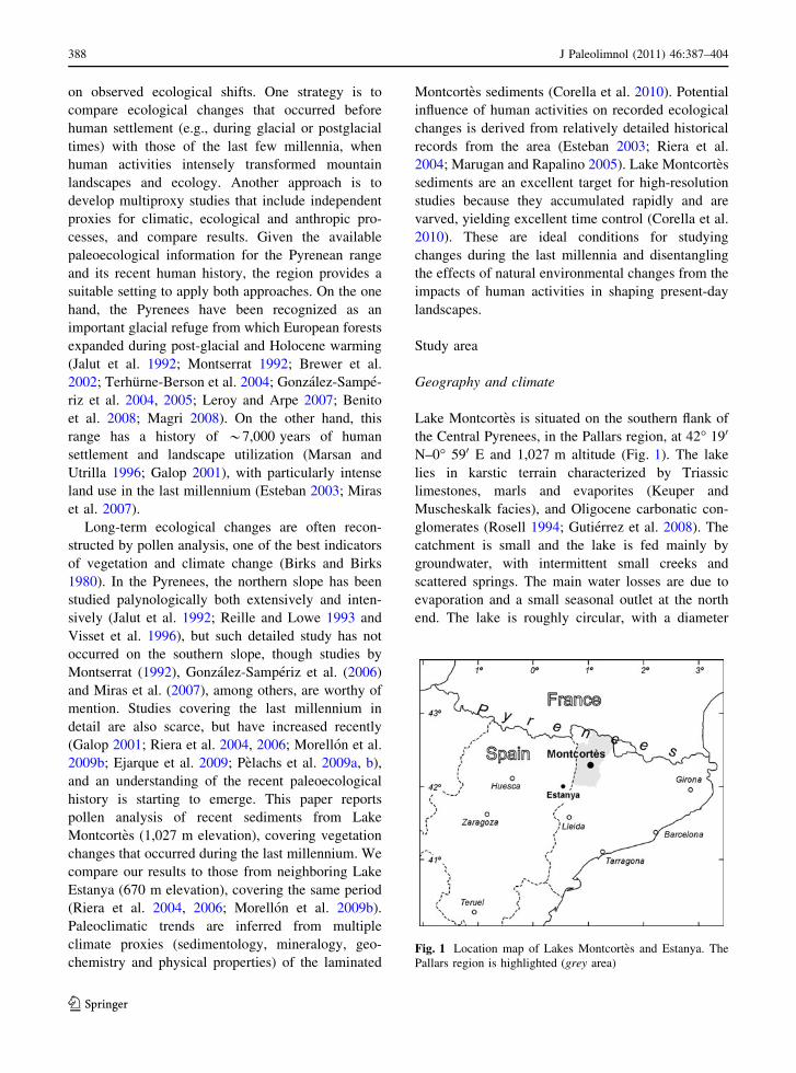
Study area
Geography and climate
Lake Montcortes is situated on the southern flank of
the Central Pyrenees, in the Pallars region, at 42� 190
N–0� 590 E and 1,027 m altitude (Fig. 1). The lake
lies in karstic terrain characterized by Triassic
limestones, marls and evaporites (Keuper and
Muscheskalk facies), and Oligocene carbonatic con-
glomerates (Rosell 1994; Gutierrez et al. 2008). The
catchment is small and the lake is fed mainly by
groundwater, with intermittent small creeks and
scattered springs. The main water losses are due to
evaporation and a small seasonal outlet at the north
end. The lake is roughly circular, with a diameter
Fig. 1 Location map of Lakes Montcortes and Estanya. The
Pallars region is highlighted (grey area)
388 J Paleolimnol (2011) 46:387–404
123

between 400 and 500 m and a maximum water depth
of 30 m near the center (Camps et al. 1976; Modamio
et al. 1988). The annual average temperature is
10.6�C, ranging from 1.9�C in January to 20.3�C in
July. Total annual precipitation is 860 mm, with
March is the driest month (46.6 mm) and May is the
wettest month (99.2 mm) (Corella et al. 2010).
Vegetation
The lake lies near the altitudinal boundary between
the Mediterranean lowlands and the Middle Montane
belt, which in the Pyrenees is situated around 800–
1,000 m elevation, depending on local conditions
(Vigo 2008). Three major forest formations occur
around the lake, reflecting this boundary condition
(Fig. 2). Evergreen oak forests dominated by Quer-
cus rotundifolia are representative of the Mediterra-
nean lowlands, while deciduous oak forests
dominated by Quercus pubescens represent the
Middle Montane belt, with higher total annual
precipitation. Conifer forests of Pinus nigra subsp.
salzmanii are mostly secondary, and colonize or
eventually replace the degraded deciduous oak forests
(Folch 1981). Carreras et al. (2005–2006), using the
CORINE system (CBM 1991), distinguished twelve
vegetation types in the catchment (Fig. 2, Table 1).
Around the lake shore, there is a belt of littoral
vegetation dominated by Juncus, Scirpus, Phrag-
mites, Typha and Sparganium (Camps et al. 1976).
Historical background
A summary history of the Pallars region is presented in
Fig. 3. The beginning of the Medieval Period was
marked by defeat of the Roman Empire by the
Visigoths (around AD 400), who dominated until the
early eighth century. The region was then under
the dominance of Muslims until about AD 800, when
the Carolingians became established. The last millen-
nium is divided into three main periods (Esteban 2003;
Marugan and Rapalino 2005): Medieval Ages (eighth
to fifteenth centuries), Modern Ages (sixteenth to
eighteenth centuries) and Post-modern Ages (nine-
teenth century onwards). Until the tenth century, the
southern Pyrenean flank was a poor and overpopulated
region, due to pressure from the northward Muslim
expansion. The land was divided into small properties
ruled by autonomous landholders. Forest clearance by
fire was a common practice to prepare the terrains for
shifting cultivation, the main economic activity at the
time. After AD 1000, the individual properties were
confiscated by the nobility and the church, thus
establishing the feudal system, which endured until
the end of the Middle Ages. Fire and shifting cultiva-
tion were replaced by more permanent land exploita-
tion. The increase in cattle, mainly sheep, led to
deforestation and the development of meadows and
pastures. The common crops were cereals (wheat,
barley and oat), olives and vineyards. The last two,
however, were restricted to the southern lowlands
(\1,000 m elevation), due to climate constraints.
Toward the end of the Medieval Period, depopulation
of the Pallars region was caused by wars, epidemics
and Little Ice Age cooling (Marugan and Oliver 2005).
Feudalism collapsed and was replaced by the mon-
archy around AD 1500 (Modern Ages). This led to the
return of a private property system, but this time land
owners were rich families and an oligarchic system was
established. The Pallars region became a marquisate and
was newly populated by immigrants from the north,
what is now France. Agriculture and cattle raising
expanded and diversified. There was increased animal
Fig. 2 Vegetation map according to the classification of
Carreras et al. (2005–2006), using the CORINE system
(CBM 1991). L, Lake Montcortes
J Paleolimnol (2011) 46:387–404 389
123
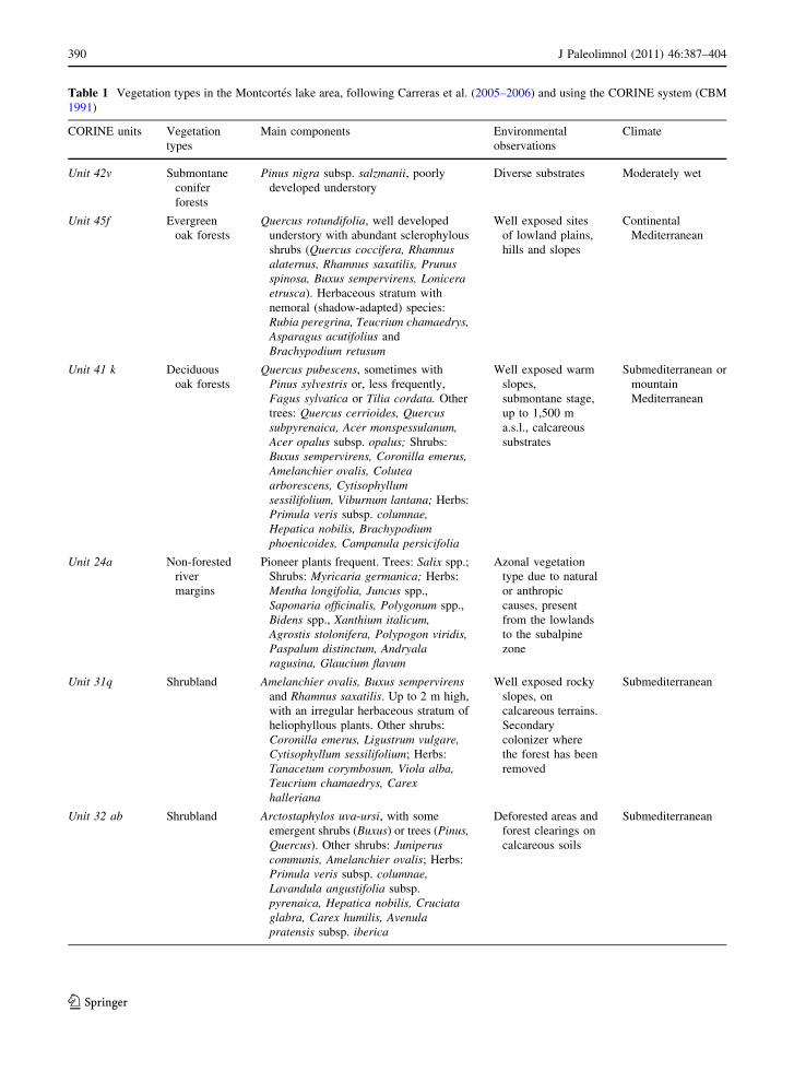
Table 1 Vegetation types in the Montcortes lake area, following Carreras et al. (2005–2006) and using the CORINE system (CBM
1991)
CORINE units Vegetation
types
Main components Environmental
observations
Climate
Unit 42v Submontane
conifer
forests
Pinus nigra subsp. salzmanii, poorly
developed understory
Diverse substrates Moderately wet
Unit 45f Evergreen
oak forests
Quercus rotundifolia, well developed
understory with abundant sclerophylous
shrubs (Quercus coccifera, Rhamnusalaternus, Rhamnus saxatilis, Prunusspinosa, Buxus sempervirens, Loniceraetrusca). Herbaceous stratum with
nemoral (shadow-adapted) species:
Rubia peregrina, Teucrium chamaedrys,Asparagus acutifolius and
Brachypodium retusum
Well exposed sites
of lowland plains,
hills and slopes
Continental
Mediterranean
Unit 41 k Deciduous
oak forests
Quercus pubescens, sometimes with
Pinus sylvestris or, less frequently,
Fagus sylvatica or Tilia cordata. Other
trees: Quercus cerrioides, Quercussubpyrenaica, Acer monspessulanum,Acer opalus subsp. opalus; Shrubs:
Buxus sempervirens, Coronilla emerus,Amelanchier ovalis, Coluteaarborescens, Cytisophyllumsessilifolium, Viburnum lantana; Herbs:
Primula veris subsp. columnae,Hepatica nobilis, Brachypodiumphoenicoides, Campanula persicifolia
Well exposed warm
slopes,
submontane stage,
up to 1,500 m
a.s.l., calcareous
substrates
Submediterranean or
mountain
Mediterranean
Unit 24a Non-forested
river
margins
Pioneer plants frequent. Trees: Salix spp.;
Shrubs: Myricaria germanica; Herbs:
Mentha longifolia, Juncus spp.,
Saponaria officinalis, Polygonum spp.,
Bidens spp., Xanthium italicum,Agrostis stolonifera, Polypogon viridis,Paspalum distinctum, Andryalaragusina, Glaucium flavum
Azonal vegetation
type due to natural
or anthropic
causes, present
from the lowlands
to the subalpine
zone
Unit 31q Shrubland Amelanchier ovalis, Buxus sempervirensand Rhamnus saxatilis. Up to 2 m high,
with an irregular herbaceous stratum of
heliophyllous plants. Other shrubs:
Coronilla emerus, Ligustrum vulgare,Cytisophyllum sessilifolium; Herbs:
Tanacetum corymbosum, Viola alba,Teucrium chamaedrys, Carexhalleriana
Well exposed rocky
slopes, on
calcareous terrains.
Secondary
colonizer where
the forest has been
removed
Submediterranean
Unit 32 ab Shrubland Arctostaphylos uva-ursi, with some
emergent shrubs (Buxus) or trees (Pinus,Quercus). Other shrubs: Juniperuscommunis, Amelanchier ovalis; Herbs:
Primula veris subsp. columnae,Lavandula angustifolia subsp.
pyrenaica, Hepatica nobilis, Cruciataglabra, Carex humilis, Avenulapratensis subsp. iberica
Deforested areas and
forest clearings on
calcareous soils
Submediterranean
390 J Paleolimnol (2011) 46:387–404
123

husbandry and use of animals in agriculture for plowing
and fertilizing. Forests were exploited mainly for wood.
Other common activities were mining, hunting and
fishing. At the end of the Modern period, commerce
became important (Bringue 2005).
The post-modern period began with the nascent
capitalist society typical of the nineteenth century,
characterized by the centralization of the production
system and development of routes for commercial
interchange. The Pallars region, however, remained
an isolated and self-sufficient subsistence economy
during the nineteenth cenury. At the beginning of the
twentieth century, the general agricultural crisis
caused renewed depopulation in the region, but
development of a widespread hydroelectric power
program soon promoted socio-economic revival. The
Spanish Civil War (AD 1936–1939) again interrupted
modernization, but a second hydroelectric program
and new mining efforts revitalized the economy.
Between 1960 and 1980, industrialization caused a
global crisis manifested in the massive emigration
from rural to urban areas. Today, the main economic
activities of the Pallars region are tourism and related
services (Farras 2005).
Materials and methods
In April 2004, four sediment cores were obtained from
the deepest part (*30 m water depth) of Montcortes
Table 1 continued
CORINE units Vegetation
types
Main components Environmental
observations
Climate
Unit 34n Meadows Aphyllanthes monspelliensis. Shrubs: Salvialavandulifolia, Santolinachamaecyparissus, Ononis natrix,Teurcium polium, Genista scorpius,Helianthemum italicum, Euphorbianicaeensis, Thymus vulgaris; Herbs:
Avenula pratensis subsp. iberica, Koeleriavallesiana, Brachypodium phoenicoides,Leuzea conifera, Linum narbonense,Carduncellus monspeliensium,Catananchae caerulea, Asphodeluscerasiferus, Asperula cynanchica
Light pastures from
1,000 to 1,400 m
a.s.l., on
calcareous,
generally unstable
terrains
Mediterranean to
Submediterranean
Unit 38b Mowing
meadows
Arrhenaterum elatius. Other herbs: Trisetumflavescens, Trifolium pratense, Dactylisglomerata, Rhinanthus mediterraneus,Gentiana lutea, Plantago lanceolata, Lotuscorniculatus, Daucus carota, Rumexacetosa
Plains and gentle
slopes with deep
and eutrophic soils
Submediterranean
Unit 82a Extensive
herbaceous
crops
Cereals, rarely forages, with abundant weeds.
Herbs: Hordeum sp., Avena sativa, Triticumsp., Secale cereale, Medicago sativa;
Weeds: Lolium rigidum, Papaver rhoeas,Bromus sp., Polygonum aviculare
Open valleys and
gentle slopes, on
clayey deep soils
Mediterranean
Unit 87a Abandoned
crops
Pasture-like terrains colonized by shrubs and
ruderal species like Inula viscosa and
Oryzopsis miliacea
Lowlands to
medium
elevations, on a
wide range of soils
Wide range of
climate conditions
Unit 61f Badlands Devoid of vegetation or with few scattered
plants like Achnatherum calamagrostis,Brachypodium phoenicoides, Erucastrumnasturtifolium, Tussilago farfara, Genistascorpius, Thymus vulgaris or Lithospermumfruticosum
Highly eroded
terrains, generally
on steep slopes
Unit 86a Urban areas Diverse ruderal and cultivated flora
J Paleolimnol (2011) 46:387–404 391
123

Lake along a NW–SE transect, using the Kullenberg
corer and platform from the Limnological Research
Centre (LRC), University of Minnesota, Minneapolis.
All the cores were split and imaged. Their physical
properties were measured with a Geotek core logger
(Corella et al. 2010). Core MON-04-1A-1 K, 6.69 m
long, was selected for palynological analysis and
sampled every 10 cm. In this paper, we report results
from the upper 3.60 m, roughly corresponding to the
last millennium. Chronology was taken from the age-
depth model of Corella et al. (2010), based on
radiocarbon dating of macroremains and bulk sedi-
ment samples. The average resolution of this pollen
record is around 33 years per sample interval, but
ranges between about 14 and 59 years.
Pollen samples consisted of *3–5 g of sediment,
which were processed using standard palynological
methods, including NaOH, HCl and HF digestions
and density gradient centrifugation, without acetoly-
sis (Bennett and Willis 2001). Two Lycopodium
tablets (batch n8 483216; 18,583 spores/tablet) were
added to each sample before chemical processing.
Residues were suspended in glycerine and slides were
mounted with glycerine jelly. Pollen and pteridophyte
spores were identified and counted until diversity
saturation (Rull 1987), obtaining total counts between
289 and 873 (average 427). Algae remains were also
identified to the genus level and counted. Fungal
spores and charcoal particles[5 lm were counted as
groups. The percentage diagram was based on the
pollen sum (RP), which included all pollen types
except those from aquatic plants (Cyperaceae, Cla-
dium, Myriophyllum, Pinguicula, Potamogeton,
Ranunculus, Typha/Sparganium-type and Utricular-
ia), ranging from 266 to 866 (average 421) counts.
Pollen and spore types below 0.1% of the RP were
not represented, these are: Acer, Androsace, Asph-
odelus albus/ramosus-t, Centaurea, Convolvulus,
Cornus, Cupressus, Draba-t, Echium, Gentiana,
Geranium, Linum, Myriophyllum, Paronychia-t,
Pedicularis, Pinguicula, Polygonum aviculare-t,
Populus, Potamogeton, Prunus avium-t, Ranunculus,
Rhamnus, Sideritis, Tilia, Utricularia, Valeriana,
Huperzia, Isoetes and Lycopodium cernuum. Zona-
tion was performed using the Optimum Splitting by
Information Content (OSIC) and the broken-stick
methods (Bennett 1996), considering only pollen
types. Pollen groups (Table 2) were defined
Fig. 3 Schematic account
of the main historical
periods and events in the
Pallars region, especially
those related to economic
models and land use.
Summary after Esteban
(2003), Marugan and Oliver
(2005), Bringue (2005), and
Farras (2005). LM, Lake
Montcortes; N, North; S,
South
392 J Paleolimnol (2011) 46:387–404
123

according to the present-day vegetation types. Per-
centages for non-pollen palynomorphs or NPP (algae,
fungi, etc.) were referred to the pollen sum.
Results
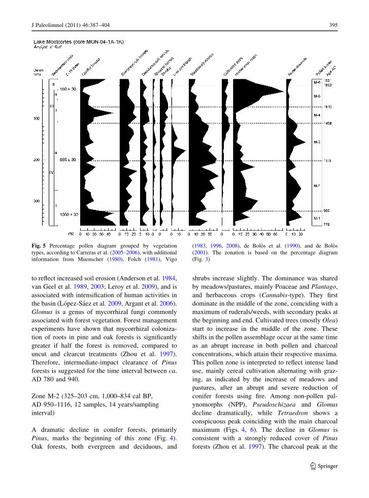
The pollen diagram is dominated, alternatively, by
trees and herbs, while shrubs are relatively scarce
(Fig. 4). Among trees, the more abundant are Pinus
and Quercus (evergreen) followed by Olea, whereas
the dominant herbs are Poaceae (others), Plantago,
Cannabis-type and Artemisia. Cyperaceae dominate
the aquatic assemblage, in which Typha/Spargani-
um is important only in the upper part. Fern spores
are comparatively scarce, in general. Total pollen
and charcoal particles have their maxima near the
base. The dominant vegetation types are conifer
forests at the beginning, meadows/pastures in the
middle, and herbaceous crops at the end. Oak
forests show a progressive increase towards the top,
while ruderal plants and weeds decline from the
base to the top (Fig. 5). The following pollen zones
were identified:
Zone M-1 (360–325 cm, 1,172–1,000 cal BP, AD
778–950, 4 samples, 45 years/sampling interval)
This zone is dominated by Pinus, followed by
Quercus (evergreen) and Poaceae (others), which
show a decreasing trend toward the top. Cannabis-
type, Artemisia and psilate monoletes, however,
increase toward the top. These patterns coincide with
an increase in charcoal concentration. Conifer forests
are the dominant vegetation type (Figs. 4, 5). Mead-
ows/pastures are important at the base, but they
decline around the middle, where herbaceous crops
and ruderal/weeds start to increase. Pseudoschizaea
has its maximum and Botryococcus is poorly repre-
sented (Fig. 6). Fungi are also at maximum values
and increasing. Among them, Glomus is well repre-
sented. The data suggest an initial pine woodland
landscape around AD 800 that was progressively
reduced by fires and replaced by crops and associated
elements. i.e., ruderal plants and weeds. The abun-
dance of Pseudoschizaea and the scarcity of plank-
tonic algae is consistent with low lake levels or
marshy environments, indicative of dry climates
(Scott 1992; Carrion 2002, Carrion et al. 2004,
2007). The presence of Glomus has been interpreted
Table 2 Pollen groups according to the present-day vegetation types, as defined by Carreras et al. (2005–2006), with additional
information from Muenscher (1980), Folch (1981), Vigo (1983, 1996, 2008), de Bolos et al. (1990), and de Bolos (2001)
Vegetation groups Pollen taxa
Conifer forests Pinus, Abies
Evergreen oak forests Quercus-evergreen type
Deciduous oak forests Quercus-deciduous type, Tilia, Acer, Betula, Cornus, Corylus, Fagus
Riverine forests Alnus, Populus, Salix, Ulmus
Cultivated trees Cupressus, Juglans, Olea, Prunus avium-type
Shrubs from both shrublands and the understory
of light oak forests
Buxus, Ericaceae, Juniperus, Phillyrea, Rhamnus
Low scrubs Rosmarinus-type, Hedysarum-type, Heliantehmum, Ephedra
Meadows and/or pastures Asphodelus albus/ramosus-type, Linum, Plantago, Poaceae, Sideritis,Pedicularis
Herbaceous Crops Cannabis-type, Triticum/Avena-type, other Fabaceae, Secale
Ruderal plants and/or weeds Artemisia, Centaurea, Chenopodium-type, Convolvulus, Echium,Polygonum aviculare-type, Rumex
Aquatic plants Cladium, other Cyperaceae, Myriophyllum, Pinguicula, Potamogeton,Typha/Sparganium, Utricularia
Others or taxa occurring in several vegetation types
or with insufficient taxonomic resolution
Ambrosia-type, Androsace, Apiaceae, Asteraceae, Bupleurum-type, Psilate
tricolporate (*Castanea), Cerastium-type, Draba-type, Gentiana-type,
Geranium, Paronychia-type, Ranunculus, Sanguisorba minor-type,
Valeriana
J Paleolimnol (2011) 46:387–404 393
123

Fig
.4
Per
cen
tag
esp
oro
mo
rph
dia
gra
m,
incl
ud
ing
the
tota
lp
oll
enan
dch
arco
alin
flu
x.
Ele
men
tsin
clu
ded
inth
ep
oll
ensu
m:
CF
,co
nif
erfo
rest
s;E
OF
,ev
erg
reen
oak
fore
sts;
DO
F,
dec
idu
ou
so
akfo
rest
s;R
F,
riv
erin
efo
rest
s;C
T,
cult
ivat
edtr
ees;
S,
shru
bla
nd
s;M
S,
Lo
wM
edit
erra
nea
nsc
rub
s;M
/P,
mea
do
ws/
pas
ture
s;H
C,
her
bac
eou
scr
op
s;R
/W,
rud
eral
/wee
ds.
Ele
men
tso
uts
ide
the
po
llen
sum
:A
,aq
uat
icp
lan
ts;
F,
fern
s.Z
on
atio
nw
asm
ade
usi
ng
the
Op
tim
um
Sp
litt
ing
by
Info
rmat
ion
Co
nte
nt
(OS
IC)
and
the
bro
ken
stic
km
eth
od
s(B
enn
ett
19
96
).S
oli
dli
nes
ind
icat
e1
09
exag
ger
atio
n
394 J Paleolimnol (2011) 46:387–404
123
to reflect increased soil erosion (Anderson et al. 1984,
van Geel et al. 1989, 2003; Leroy et al. 2009), and is
associated with intensification of human activities in
the basin (Lopez-Saez et al. 2009, Argant et al. 2006).
Glomus is a genus of mycorrhizal fungi commonly
associated with forest vegetation. Forest management
experiments have shown that mycorrhizal coloniza-
tion of roots in pine and oak forests is significantly
greater if half the forest is removed, compared to
uncut and clearcut treatments (Zhou et al. 1997).
Therefore, intermediate-impact clearance of Pinus
forests is suggested for the time interval between ca.
AD 780 and 940.
Zone M-2 (325–203 cm, 1,000–834 cal BP,
AD 950–1116, 12 samples, 14 years/sampling
interval)
A dramatic decline in conifer forests, primarily
Pinus, marks the beginning of this zone (Fig. 4).
Oak forests, both evergreen and deciduous, and
shrubs increase slightly. The dominance was shared
by meadows/pastures, mainly Poaceae and Plantago,
and herbaceous crops (Cannabis-type). They first
dominate in the middle of the zone, coinciding with a
maximum of ruderals/weeds, with secondary peaks at
the beginning and end. Cultivated trees (mostly Olea)
start to increase in the middle of the zone. These
shifts in the pollen assemblage occur at the same time
as an abrupt increase in both pollen and charcoal
concentrations, which attain their respective maxima.
This pollen zone is interpreted to reflect intense land
use, mainly cereal cultivation alternating with graz-
ing, as indicated by the increase of meadows and
pastures, after an abrupt and severe reduction of
conifer forests using fire. Among non-pollen pal-
ynomorphs (NPP), Pseudoschizaea and Glomus
decline dramatically, while Tetraedron shows a
conspicuous peak coinciding with the main charcoal
maximum (Figs. 4, 6). The decline in Glomus is
consistent with a strongly reduced cover of Pinus
forests (Zhou et al. 1997). The charcoal peak at the
Fig. 5 Percentage pollen diagram grouped by vegetation
types, according to Carreras et al. (2005–2006), with additional
information from Muenscher (1980), Folch (1981), Vigo
(1983, 1996, 2008), de Bolos et al. (1990), and de Bolos
(2001). The zonation is based on the percentage diagram
(Fig. 3)
J Paleolimnol (2011) 46:387–404 395
123

beginning of the zone coincides with a peak in
Cannabis-type and Secale, whereas the dramatic
charcoal decrease that occurs around 290 cm
(*AD 1000) coincides with the increase of mead-
ows/pastures and ruderal/weeds. This suggests that, at
that time, the use of fire was linked to herbaceous
cropping rather than to pastoralism. The Tetraedron
peak is indicative of lake fertilization due to
increased nutrient release linked to greater organic-
rich sediment input.
Zone M-3 (203–112 cm, 834–494 cal BP,
AD 1116–1456, 9 samples, 39 years/sampling
interval)
Evegreen and deciduous forests do not show signif-
icant changes with respect to zone M-2. The main
differences occur in the formerly dominant meadows/
pastures and herbaceous crops, which start a consis-
tent decreasing trend, and low scrub (Rosmarinus-
type, Helianthemum, Hedysarum-type and Ephedra),
which peak in the middle of the zone and decrease
around 140 cm (*AD 1360). This increase in low
scrub occurs shortly after a secondary charcoal peak,
which decreases in the middle of the zone and attains
minimum values at the end, where cultivated trees
(Olea) start to increase. Ruderal/weeds show a
maximum around the middle of the zone, just after
the low scrub peak and before the Olea maximum.
Total pollen attains its minimal values in this zone.
Today, the same low-scrub taxonomic association
that characterized this zone corresponds to the
Rosmarinetalia officinalis order (27.C), a thermoph-
ilous community typical of Mediterranean calcareous
lowland dry environments below 800 m elevation
(de Bolos 2001). This association is absent today at
the elevation of Lake Montcortes, which suggests an
upward displacement of this vegetation type by least
200 m due to warming between about AD 1100 and
1350. The small charcoal peak at the beginning of the
Fig. 6 Percentage diagram for non-pollen palynomorphs (NPP) with respect to the pollen sum. The scales of Tetraedron and
Botryococcus have been reduced for more clarity. Solid lines indicate 109 exaggeration. Zonation as in Fig. 3
396 J Paleolimnol (2011) 46:387–404
123

zone is not followed by an increase of taxa associated
with human activities and would therefore support the
occurrence of drier climatic conditions, favorable for
wild fires. In spite of absence or low incidence of fire,
Pinus forests did not recover and only evergreen oak
forests and shrubs expanded, suggesting drier cli-
mates and/or an intensification of seasonality. Also
noteworthy is the cessation of cereal and hemp
cultivation and the increase of olive crops since about
AD 1280.
Zone M-4 (112–72 cm, 494–337 cal BP,
AD 1456–1613, 4 samples, 29 years/sampling
interval)
The main changes in this zone are the sharp increase
of conifer forests, which peak around the middle, and
the equally abrupt decline of the meadows/pastures
and ruderal/weeds groups (mostly Artemisia). Oak
forests, especially the deciduous ones, and scrublands
also increase. Among cultivated plants, Olea shows a
slight decrease and cereals are nearly absent, whereas
hemp is very low at the beginning, but starts to
increase around the middle of the zone, after the
Pinus peak. There is no significant change in charcoal
influx, which is at low values. The general decline of
all cultivated elements and others associated with
human activities (ruderal/weeds, meadows/pastures)
and the low charcoal values indicate the low human
pressure between about AD 1480 and 1590, though
hemp cultivation seems to restart around AD 1550.
The increase in other elements, especially conifer
forests and deciduous Quercus forests, together with
the increase of Corylus and the abrupt Artemisia
decline, suggest a moderate increase in moisture.
Low scrub is at minimum values, suggesting colder
climates.
Zone M-5 (72–20 cm, 337–117 cal BP,
AD 1613–1833, 5 samples, 34 years/sampling
interval)
This zone is characterized by the decline of almost all
pollen groups, except for the spectacular increase of
Cannabis-type, which largely dominates the assem-
blage. This coincides with the increase in charcoal
and fungi spores, incuding Glomus. The whole
picture indicates reinitiation of human activities
around the lake since about AD 1630. Fires began
again, affecting primarily conifer and oak forests, and
cultivation was largely focused on hemp, while Olea
maintained the importance attained since the end of
zone M-3 (AD 1280). The increase of Typha/Spar-
ganium and the disappearance of Cladium suggest
increases in nutrient supply, mainly N and P (Chiang
et al. 2000, and literature therein).
Zone M-6 (20–5 cm, 117–29 cal BP,
AD 1833–1921, 2 samples, 30 years/sampling
interval)
This zone is characterized by a conspicuous change
in both the Pinus and Cannabis-type pollen curves,
the other pollen types remaining similar to the former
zone. Hemp cultivation declined sharply around AD
1860, and conifer forests reexpanded.
Discussion
Comparison between sedimentological,
palynological and historical records
The multiproxy study of the core analyzed here
provided a depositional and environmental history for
the lake catchment during the last 6,000 years
(Corella et al. 2010). The time interval recorded in
this study was divided into three main sedimentolog-
ical phases, represented by lithological units IV, III
and II. Sedimentary facies indicate that the lake has
been deep and meromictic during the last
1,500 years. During the Medieval epoch, represented
by lithologic unit IV (AD 690–1460), the lake had
high clastic input. This unit was divided into two
subunits (IVa and IVb), with the boundary around
AD 1000. Unit IVb is dominated by turbiditic Facies
4, reflecting events of high terrigenous input, while
Unit IVa is characterized by the dominance of
laminated Facies 1, indicating less sediment delivery
to the lake and low bottom bioturbation. Sedimento-
logical unit 4 includes pollen zones M-1 to M-3, and
coincides with the Medieval epoch. The boundary
between sedimentological units IVb and IVa coin-
cides with the end of the main charcoal peak (Fig. 4)
and the disappearance of Pseudoschizaea (Fig. 6),
indicators of forest fires and increased terrigenous
inputs to the lake, respectively. According to the
historical records, AD 1000 corresponds to the end of
J Paleolimnol (2011) 46:387–404 397
123
the pre-feudal epoch, when the predominant land use
was forest burning and shifting cultivation, and the
beginning of feudalism, characterized by more con-
trolled use of fire and more or less permanent land
exploitation (Marugan and Oliver 2005). The histor-
ical records also report the onset of vineyard and
olive cultivation around the same times. In the Lake
Montcortes pollen diagram, Olea pollen appear
consistently at 310 cm (AD 970), but Vitis is absent
throughout the sequence. A possible explanation is
that, during that time, olives and vineyards were
cultivated mainly in lowlands below 1,000 m eleva-
tion for climatic reasons (Marugan and Oliver 2005),
and Olea pollen was better dispersed upwards than
was pollen of Vitis. In support of this interpretation,
recent work in a nearby area showed the high upward
dispersal efficiency of Olea pollen, which was found
in surface samples from 800 to [2,600 m elevation,
in spite of the absence of the parent plant along the
transect (Canellas-Bolta et al. 2009). Another appar-
ent inconsistency between historical and pollen
records is the high amount of hemp pollen in the
diagram and the absence of any reference to its
cultivation in the Pallars region from the Medieval
Ages to the present (Esteban 2003; Marugan and
Rapalino 2005). One possibility is that hemp culti-
vation was restricted to favorable areas and this is not
commonly reflected in historical accounts. But it is
also possible that these crops were not autochthonous
and the lake was used for hemp retting, as occurred in
neighboring Lake Estanya during the same epoch
(Riera et al. 2004). This, however, is not reported in
the writings reviewed so far and more work is still
needed with respect to this matter. Among the cereals
mentioned in written documents, the better repre-
sented in the pollen diagram are wheat (Triticum) and
rye (Secale), but the Poaceae curve probably includes
rarer types that are harder to identify with confidence.
Pine woodlands were dramatically reduced by AD
950, during pre-feudalism, and did not recover during
the whole Medieval epoch, when the landscape was
likely a mosaic of predominantly crops and pastures,
with smaller pine/oak forest patches. This human-
induced vegetation change also coincides with an
increase in total pollen concentration, and the dom-
inance of turbidites in the sedimentary sequence,
indicating enhanced runoff and siliciclastic inputs to
the lake (Corella et al. 2010). The dilution effect of
higher sedimentation rates on pollen concentrations,
often observed elsewhere (Leroy et al. 2009), was not
recorded here. The maximum pollen concentration
corresponds to increases in herbaceous crops, mead-
ows/pastures and ruderal/weeds, and could be
explained by enhanced pollen production due to the
intensification of human activities linked to these
vegetation types.
The vegetation changes recorded until around AD
1100 were mainly driven by human activities, thus
paleoclimate signals are likely obscured. Historical
records indicate a phase of ‘‘favorable weather’’
during the tenth and eleventh centuries (Fig. 3) that
favored the expansion of crops and pastures in river
margins and wetlands (Esteban 2003; Marugan and
Oliver 2005), which is coherent with the interpreta-
tion of pollen zone M-2 (Fig. 4). Clearer palynolog-
ical indications of warming and aridity were found
afterwards, between about AD 1100 and 1350, by the
presence of low Mediterranean scrub communities in
pollen zone M-3. Similar warmer and drier phases
have been recorded during the Middle Ages in Lake
Estanya and other lakes from the Iberian Peninsula
(Morellon et al. 2009a), coinciding with the so-called
Medieval Warm Period (MWP) of the Northern
Hemisphere (Seager et al. 2007; Mann et al. 2009).
The Medieval period ended with cooling, inferred
from the decrease in thermophilous low scrub around
AD 1400 and its disappearance from the site around
AD 1460 (Fig. 5). Between this date and the end of
the fifteenth century, the Pallars region was largely
depopulated due to wars, epidemics and climate
cooling. This cooling is coeval with the onset of the
Little Ice Age (LIA) (Mann et al. 2009), which in
Europe was a cool and wet phase, also recorded at
Lake Estanya and at other lakes on the Iberian
Peninsula (Morellon et al. 2009a). As a result, many
villages were abandoned and the population concen-
trated in larger, lowland towns (Marugan and Oliver
2005). This land abandonment is reflected in the
pollen diagram by a decline in charcoal and herba-
ceous crops at the end of zone M-3. Curiously, Olea,
a lowland element, increases at the same time,
attaining its maximum values (*8%). It might be
hypothesized that olive cultivation increased in the
lowlands as a result of the population increase.
Lithological Unit III was deposited during the
Modern Ages, between AD 1460 and 1770, and is
characterized by the predominance of Facies 1,
indicating deep, meromictic conditions with high
398 J Paleolimnol (2011) 46:387–404
123

bioproductivity and carbonate precipitation, and
reduced terrigenous inputs (Corella et al. 2010). This
is consistent with the palynological interpretation of
zone M-4 as a period of forest expansion (mainly
pines), reduced human activity around the lake (low
values of charcoal, crop and ruderal elements), and
decreased terrigenous inputs to the lake [low values
of Pseudoschizaea and fungal spores (Fig. 6)]. Cli-
mate was still cool and probably wet, as was common
during the LIA, a period characterised by moisture
fluctuations, as shown in the nearby Lake Estanya
record (Morellon et al. 2009a). In this case, it is likely
that climate dominated over human activities with
respect to shaping the Montcortes landscape. A
similar situation was observed in other regional
sequences, such as Taravilla Lake (Moreno et al.
2008), where climate, rather than human action,
seems to have been the main cause of hydrological,
sedimentological and vegetation changes. Expansion
of pastures, documented in historical records after
feudalism in the Pyrenees, is not recorded in the
Montcortes pollen diagram, suggesting that once
more, it occurred primarily in the lowlands. A slight
increase in clastic inputs was recorded at AD 1660,
coinciding with the return to a phase of forest
clearance and farming, as suggested by the decline of
forests and the increase of charcoal and hemp pollen.
A significant sedimentological shift occurred at
AD 1770, close to the end of the Modern epoch
(Fig. 3), when turbiditic sedimentation (Facies 4)
appeared again and sedimentation rates increased and
remained high until the top of the sequence (Unit II).
This coincides with pollen zone M-5, when maxi-
mum hemp cultivation and/or retting is observed
(Fig. 4), suggesting strong human impact on the lake
watershed. Historically, this phase corresponds to the
pre-capitalist or pre-industrial period, when subsis-
tence agriculture dominated in the Pallars region due
to the area’s geographic isolation. In the lowlands,
below Lake Montcortes, crops expanded, whereas in
the mountains above the lake, cattle raising and forest
exploitation were the dominant practices (Bringue
2005). This situation is clearly reflected in the pollen
diagram by the reduction of trees, especially Pinus,
and the increase of herbaceous crops at the end of
zone M-5. Once more, the large amount of hemp
pollen contrasts with the lack of documentary
evidence for its cultivation or the use of the lake
for retting. Large amounts of Cannabis pollen in zone
M-5 favor the second option, but further work is
needed to draw a definitive conclusion. Pollen zone
M-6 coincides with a subsistence agriculture crisis
and significant decline in the population of the Pallars
region, coeval with the general European agricultural
crisis of the mid-nineteenth century (Farras 2005).
Both climate (floods) and agriculture pests have been
invoked to explain this phenomenon. Despite the low
number of samples in pollen zone M-6, the decline of
herbaceous crops and the forest recovery are evident
(Fig. 5) and consistent with historical accounts.
Correlation with the Estanya record: vegetation
and land use
When comparing the Lake Montcortes (LM) and Lake
Estanya (LE) records, it must be noted that the areas
possess different environmental characteristics due to
their different altitudes. LE is situated *50 km SW of
LM and is 350 m lower in elevation. Therefore, LM is
in the boundary between the Mediterranean lowlands
and the Middle Montane belt, within the Submediter-
ranean bioclimatic domain. By contrast, LE is in the
Mediterranean lowlands, around the transition
between the Submediterranean and the Mediterranean
bioclimatic regime (Morellon et al. 2009b; Corella
et al. 2010). The climate around LE is continental
Mediterranean, with a mean annual temperature of
14�C, ranging from 4 (January) to 24�C (July), and an
average annual precipitation of 470 mm, ranging from
18 (July) to 50 mm (October) (Morellon et al. 2009b).
At present, the vegetation is a mosaic of shrublands
(such as Buxus, Juniperus, and Pistacia), oak forests
(Q. rotundifolia), pastures, and barley (Hordeum)
crops. Littoral vegetation around the lake is domi-
nated by Tamarix, Phragmites, Juncus, Typha and
Scirpus (Avila et al. 1984). Two pollen records of the
last millennium are available for this lake: one from
the deepest part, at 20 m water depth (Morellon et al.
2009b) and another from the littoral zone, \1.5 m
water depth (Riera et al. 2004). The first covers the
last 800 years, whereas the second accounts for the
last two millennia, both with a similar average
resolution of around 50 years per sampling interval.
The main results of these studies and Lake Mont-
cortes, in terms of vegetation and land use, are
depicted in Fig. 7 for comparison.
There is an initial phase of apparently undisturbed
woodland around both lakes. In Montcortes, these
J Paleolimnol (2011) 46:387–404 399
123
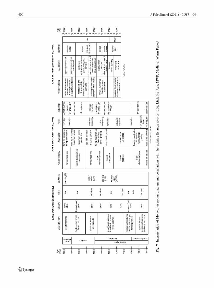
Fig
.7
Inte
rpre
tati
on
of
Mo
ntc
ort
esp
oll
end
iag
ram
and
corr
elat
ion
sw
ith
the
exis
tin
gE
stan
ya
reco
rds.
LIA
,L
ittl
eIc
eA
ge;
MW
P,
Med
iev
alW
arm
Per
iod
400 J Paleolimnol (2011) 46:387–404
123

forests were dominated by Pinus, while in Estanya,
Quercus (both deciduous and evergreen) were more
abundant, likely because of its lower altitude.
Subsequent deforestation took place in both locali-
ties, as recorded by sudden tree-pollen declines and
major charcoal peaks, but it occurred first at Lake
Estanya, around AD 900 (Riera et al. 2004) and then
at Montcortes, where it was not completed until the
end of the pre-feudal period, slightly before AD 1000.
Although dating errors can not be disregarded, this
northward trend would be consistent with historical
records that report a conspicuous migratory trend
towards the mountains caused by the northward
Muslim expansion (Marugan and Oliver 2005). In
this context, it is worth noting that Muslims occupied
the region near Lake Estanya between around AD
720 and AD 1030, but they did not reach the
Montcortes area (Riera et al. 2004; Esteban 2003).
Major deforestation also coincides with the end of
shifting cultivation and the beginning of a more or
less permanent and extensive land exploitation,
which marks the beginning of the feudal epoch. This
is manifested in the development of cereal and hemp
cultivation in both localities. As stated before,
occasional Olea and Vitis crops are mentioned in
written documents, thus the scarcity of the former and
the absence of the latter in the Montcortes diagram is
interpreted in terms of the required altitude for their
cultivation. In the Estanya record, Olea pollen is also
very scarce at that time, suggesting wind transport
from lower altitudes, but Vitis is already present,
though in low quantities (Riera et al. 2004).
The warming recorded at Montcortes between AD
1100 and 1350, correlated with the MWP, is paralleled
at Estanya by equally warmer and drier climate,
manifested by the increase of thermophilic elements
in the pollen diagrams (Riera et al. 2004; Morellon
et al. 2009a). During this warm and dry episode, fire
events reappear at both Montcortes, around AD 1100,
and Estanya, between about AD 1250 and 1300
(Morellon et al. 2009a). The first was of medium
intensity and is not linked to extensive deforestation,
and perhaps related to pastoralism. The second fire
event was inferred from a barren, charcoal-rich layer in
the deeper Estanya core (Morellon et al. 2009a), which
is absent in the shallow-water core (Riera et al. 2004),
and coincides with a conspicuous forest clearance
event. A possible explanation for this discrepancy is
that water levels were probably lower during that time,
consistent with warmer and drier climate, and the
shallow-water coring site was exposed, so charcoal
was not deposited in the littoral zone or was removed
by erosion. During this phase, agricultural activities
did not experience significant changes in the lake
catchments, but vineyard expansion around Estanya is
worth mentioning (Morellon et al. 2009a).
The LIA cooling initiated around AD 1350 in
Montcortes was also identified in Estanya, where
several moisture fluctuations occurred until the nine-
teenth century. Morellon et al. (2009a) suggested
several humidity oscillations, while Riera et al. (2004)
proposed the occurrence of a dry episode between
about AD 1600 and AD 1750, and two humid phases
before and after, respectively (Fig. 7). The LIA onset
was characterized, in both lake records, by a decline
of cultivated plants, suggesting agriculture depres-
sion. This coincides with the so-called ‘‘low medieval
crisis,’’ characterized by intense depopulation and
land abandonment. It is estimated that about one-third
of the population emigrated and concentrated in larger
towns in the southern lowlands (Marugan and Oliver
2005). The move is attributed to the combined effect
of climate deterioration, a ‘‘black death’’ epidemic
that occurred in AD 1348, local wars, and the probable
collapse of the feudal system (Fig. 3) (Esteban 2003;
Marugan and Rapalino 2005). Despite this agricul-
tural crisis, both the Montcortes and Estanya records
document a progressive increase of Olea pollen,
culminating around AD 1500, which is interpreted as
an expansion of olive crops in the region (Riera et al.
2004; Morellon et al. 2009a). According to written
documents, an expansion of olive and vineyard crops
occurred during this time in the southern lowlands, so
it is probable that most of the recorded Olea pollen
was transported upslope to the lake catchments by
wind (Canellas-Bolta et al. 2009).
The end of feudalism and the beginning of the
Modern epoch (AD 1500) is characterized in Mont-
cortes by forest recovery, also documented in Estanya,
where a cooler, but wetter climate has been suggested
(Riera et al. 2004). During the sixteenth century,
pollen records show some spatial heterogeneity with
respect to land use (Fig. 7). This is probably due to the
contrasting histories of lowlands used mainly for
agriculture, and highlands used mostly for pasture and
cattle raising since the beginning of the Modern
epoch, a consequence of land privatization (Bringue
2005). In the seventeenth century, a dramatic increase
J Paleolimnol (2011) 46:387–404 401
123

in hemp pollen was recorded in Montcortes and in the
Estanya shallow core, coinciding with a dry episode
and another forest clearance event (Riera et al. 2004).
As noted, the lack of written documentation about
hemp cultivation around Montcortes makes it difficult
to know if the Cannabis pollen peak was due to
cultivation, retting, or both. High amounts of hemp
pollen (10–80%), together with the presence of a
suitable environment, are indicative of retting
(Mercuri et al. 2002). At Montcortes, a suitable
environment is provided by the lake and hemp pollen
represents about 40–60% at that time, which strongly
suggests retting. Anyway, it seems that the hemp
industry was a predominant activity in the region at
that time. In the British Isles, similar Cannabis pollen
peaks, indicating increased hemp cultivation and
retting, have been associated with phases of expansion
of the naval industry, to satisfy the growing demand
for hemp fiber used to make ropes and sails (Godwin
1967a, b; Schofield and Waller 2005). In Montcortes,
the maximum of hemp pollen is recorded at 35 cm
(AD 1757), which falls within a period of maximum
development of ship building (AD 1750–1775) in
Barcelona (Fig. 1) and other nearby Catalan shipyards,
linked to a phase of general economic prosperity and
intensification of transcontinental commerce with
America (Andreu 1981; Delgado 1994). A similar
hemp pollen maximum was recorded in the Estanya
shallow-water core at about the same time (AD 1760),
and was interpreted in similar terms, thus suggesting a
regional event linked to maximum agrarian expansion
in Spain that occurred during the seventeenth and
eighteenth centuries (Riera et al. 2006). By contrast,
no peak in hemp pollen was recorded in the Estanya
deep-water core, where this pollen type is compara-
tively less abundant and does not display significant
changes through time (Morellon et al. 2009a). Sedi-
mentologic and taphonomic factors cannot be ignored,
and more records are still needed to provide a
satisfactory explanation.
Conclusions
A detailed comparison of the Montcortes and Estanya
records for the last millennium makes it clear that
human activities have played a major role in the
vegetation change history and have been crucial for
shaping southern Pyrenean landscapes (Ejarque et al.
2009; Pelachs et al. 2009a, b). Intense climatic shifts,
i.e., the MWP and the LIA, are still recognizable using
particular plant associations, for example the low
Mediterraean scrub in Montcortes. Minor oscillations,
however, are likely obscured by the consequences of
human land use. This is especially true for moisture
changes, as the appearance or disappearance of plant
assemblages commonly used as humidity proxies, for
example forests, have been determined mainly by
human activities rather than by climatic conditions.
Biological fossil records require independent evidence
to interpret them in terms of climatic or anthropic
factors, to avoid circular reasoning (Leroy 2010).
Fortunately, in the case of Lakes Montcortes and
Estanya, abundant independent evidence is available
from both sedimentological and documentary sources,
which greatly strengthens paleoecological interpreta-
tion. In this study, both independent lines of evidence
were used to try to disentangle the potential forcing
factors behind the vegetation changes recorded by
pollen analysis. In general, vegetation patterns in time
and human land-use changes show a high degree of
temporal coincidence, but climate-human-landscape
relationships are complex and there is still room to
improve our interpretations. For example, climate has
both a direct influence on natural communities, but also
an indirect one, by affecting human practices and
modifying the anthropic element of change. It would be
interesting to further investigate this aspect. Another
interesting issue, which is already being pursued, is
generating a detailed paleolimnological reconstruction
using aquatic proxies combined with sedimentological
and physico-chemical evidence. Montcortes is espe-
cially suited for such studies because it has annually
laminated sediments (Corella et al. 2010). Also,
comparison of pollen and aquatic remains records
would be useful to know the magnitude and time lag of
the response of the organisms to environmental
changes and, in this way, to evaluate their potential
usefulness as paleoclimatic indicators.
Acknowledgments Financial support for this research was
provided by the Spanish Ministry of Science and Technology,
through the projects LIMNOCLIBER (REN2003-09130-C02-
02), IBERLIMNO (CGL2005-20236-E/CLI), LIMNOCAL
(CGL2006-13327-C04-01) and GRACCIE (CSD2007-00067).
Additional funding was provided by the Diputacion General de
Aragon (grant PM073/2007) and the Aragonese Regional
Government–CAJA INMACULADA which partially funded
the microfacies analysis at GFZ (Potsdam) by means of a travel
grant. Juan Pablo Corella and Mario Morellon were supported by
402 J Paleolimnol (2011) 46:387–404
123

a PhD contract paid by the CONAI ? D (Aragonese Scientific
Council for Research and Development). Two anonymous
referees contributed to improvement of the manuscript.
References
Anderson RS, Homola RL, Davis RB, Jacobson GL (1984)
Fossil remains of the mycorrhizal fungal Glomus fascic-ulatum complex in postglacial lake sediments from
Maine. Can J Bot 62:2325–2328
Andreu M (1981) La financiacion de la industria naval en
Barcelona (1745–1760). Pedralbes 1:267–294
Argant J, Lopez-Saez JA, Binz P (2006) Exploring the ancient
occupation of a high altitude site (Lake Lauzon, France):
comparison between pollen and non-pollen Pal-
ynomorphs. Rev Palaeobot Palynol 141:151–163
Avila A, Burrel JL, Domingo A, Fernandez E, Godall J, Llo-
part M (1984) Limnologıa del Lago Grande de estanya
(Huesca). Oecol Aquat 7:3–24
Benito M, Sanchez de Dios R, Sainz H (2008) The evolution of
the Pinus sylvestris L. area in the Iberian Peninsula from
the last glacial maximum to 2100 under climate change.
Holocene 18:705–714
Bennett KD (1996) Determination of the number of zones in a
biostratigraphical sequence. New Phytol 132:155–170
Bennett KD, Willis KJ (2001) Pollen. In: Smol JP, Birks HJB,
Last WM (eds) Tracking environmental change using lake
sediments. Vol 3: terrestrial, algal, and siliceous indica-
tors. Kluwer, Dordrecht, pp 5–32
Birks HJB, Birks HH (1980) Quaternary palaeoecology. E
Arnold, London
Brewer S, Cheddadi R, de Beaulieu JL, Reille M (2002) The
spread of deciduous Quercus throughout Europe since the
last glacial period. For Ecol Manag 156:27–48
Bringue JM (2005) L’edat moderna. In: Marugan CM, Rapa-
lino V (eds) Historia del Pallars. Dels orıgens als nostre
dies. Pages Editors, Lleida, pp 87–120
Camps J, Gonzalvo I, Guell J, Lopez P, Tejero A, Toldra X,
Vallespinos F, Vicens M (1976) El lago de Montcortes,
descripcion de un ciclo annual. Oecol Aquat 2:99–110
Canellas-Bolta N, Rull V, Vigo J, Mercade A (2009) Modern
pollen-vegetation relationships along an altitudinal tran-
sect of the Central Pyrenees (southwestern Europe).
Holocene 19:1185–1200
Carreras J, Vigo J, Ferre A (2005–2006) Manual dels habitats
de Catalunya, vols I-VIII. Dep Medi Ambient i Habitatge,
Generalitat de Catalunya, Barcelona, Spain
Carrion JS (2002) Patterns and processes of late quaternary
environmental change in a montane region of southwest-
ern Europe. Quat Sci Rev 21:2047–2066
Carrion JS, Willis KJ, Sanchez-Gomez P (2004) Holocene
forest history of the eastern plateaux in the Segura
Mountains (Murcia, southeastern Spain). Rev Palaeobot
Palynol 132:219–236
Carrion JS, Fuentes N, Gonzalez-Samperiz P, Sanchez-Quir-
ante L, Finlayson JC, Fernandez S, Andrade A (2007)
Holocene environmental change in a montane region of
southern Europe with a long history of human settlement.
Quat Sci Rev 26:1455–1475
CBM (1991) CORINE biotopes manual. Habitats of the European
Community. Comiss European Communities, Luxemburg
Chiang C, Craft CB, Rogers DW, Richardson CJ (2000) Effects
of 4 years of nitrogen and phosphorus additions on
Everglades plant communities. Aquat Bot 68:61–78
Corella JP, Moreno A, Morellon M, Rull V, Giralt S, Rico MT,
Perez A, valero-Garces B (2010) Climate and human
impact on a meromictic lake during the last 6,000 years. J
Paleolimnol. doi:10.1007/s10933-010-9443-3
de Bolos O (2001) Vegetacio dels Paısos Catalans. Aster,
Barcelona
de Bolos O, Vigo J, Masalles RM, Ninot JM (1990) Flora
manual dels Paısos Catalans. Portic, Barcelona
Delgado JM (1994) La industria de la construccio naval ca-
talana (1750–1850). Drassana 2:34–39
Ejarque A, Julia R, Riera S, Palet JM, Orengo HA, Miras Y,
Gascon C (2009) Tracing the history of highland human
management in the eastern Pre-Pyrenees: an interdisci-
plinary palaeoenvironmental study at the Pradell fen,
Spain. Holocene 19:1241–1255
Esteban A (2003) La humanizacion de las altas cuencas de la
Garona y las Nogueras (4,500 aC–1,955 aC). Org Aut
Parques Nacionales. Min Medio Ambiente, Madrid
Farras F (2005) El Pallars contemporani. In: Marugan CM,
Rapalino V (eds) Historia del Pallars. Dels orıgens als
nostre dies. Pages Editors, Lleida, pp 121–144
Folch R (1981) La vegetacio dels Paısos Catalans. Ketres,
Barcelona
Galop D (2001) La foret, l’homme et le troupeau dans les
Pyrenees. Geode-Laboratoire d’Ecologie Terrestre, Univ
Toulouse-Le Mirail, Toulouse
Godwin H (1967a) The ancient cultivation of hemp. Antiquity
41:42–49
Godwin H (1967b) Pollen-analytic evidence for the cultivation
of Cannabis in England. Rev Palaeobot Palynol 4:71–80
Gonzalez-Samperiz P, Valero-Garces B, Carrion JS (2004)
Was the Ebro valley a refugium for temperate trees? Anal
Biol 26:13–20
Gonzalez-Samperiz P, Valero-Garces BL, Carrion JS, Pena-
Monne JL, Garcıa-Ruiz JM, Martı-Bono C (2005) Glacial
and Lateglacial vegetation in northeastern Spain: new data
and a review. Quat Int 140–141:4–20
Gonzalez-Samperiz P, Valero-Garces BL, Moreno A, Jalut G,
Garci9a-Ruiz JM, Marti9-Bono C, Delgado-Huertas A,
Navas A, Otto T, Deboub JJ (2006) Climate variability in
the Spanish Pyrenees during the last 30, 000 yr revealed
by the El Portalet sequence. Quat Res 66:38–52
Gutierrez F, Calahorra J, Cardona F, Ortı F, Duran J, Garay P
(2008) Geological and environmental implications of the
evaporite karst in Spain. Environ Geol 53:951–965
Jalut G, Montserrat J, Fortugne M, Delibrias G, Vilaplana JM,
Julia R (1992) Glacial to interglacial vegetation changes in
the northern and southern Pyrenees: deglaciation, vegeta-
tion cover and chronology. Quat Sci Rev 11:449–480
Leroy SAG (2010) Pollen analysis of core DS7–1 (Dead Sea)
showing intertwined effects of climatic change and human
activities in the Late Holocene. J Archaeol Sci 37:306–316
Leroy SAG, Arpe K (2007) Glacial refugia for summer-green
trees in Europe and S-W Asia as proposed by ECHAM3
time-slice atmospheric model simulations. J Biogeogr
34:2115–2128
J Paleolimnol (2011) 46:387–404 403
123
Leroy SAG, Boyraz S, Gurbuz A (2009) High-resolution pal-
ynological analysis in Lake Sapanca as a tool to detect
earthquakes on the North Anatolian Fault. Quat Sci Rev
28:2616–2632
Lopez-Saez JA, Lopez-Merino L, Mateo MA, Serrano O,
Perez-Dıaz S, Serrano L (2009) Palaeoecological potential
of the marine organic deposits of Posidonia oceanica: a
case study in the NE Iberian Peninsula. Palaeogeogr
Palaeoclimatol Palaeoecol 271:215–224
Magri D (2008) Patterns of post-glacial spread and the extent
of glacial refugia of European beech (Fagus sylvatica).
J Biogeogr 35:450–463
Mann ME, Zhang Z, Rutherford S, Bradley RS, Hughes MK,
Shindell D, Ammann C, Faluvegi G, Ni F (2009) Global
signatures and dynamical origins of the Little Ice Age and
Medieval Climate Anomaly. Science 326:1256–1260
Marsan G, Utrilla P (1996) L’implantation du Megalithisme
dans les passages des Pyrenees centrales. Comparaison
des vallees d’Ossau et Tena-Canfranc. Pyrenees Prehis-
toriques. Arts et Societes. CTHS, Paris, pp 521–532
Marugan CM, Oliver J (2005) El Pallars medieval. In: Marugan
CM, Rapalino V (eds) Historia del Pallars. Dels orıgens
als nostre dies. Pages Editors, Lleida, pp 45–86
Marugan CM, Rapalino V (2005) Historia del Pallars. Dels
orıgens als nostre dies. Pages Editors, Lleida
Mercuri AM, Accorsi CA, Bandini Mazzanti M (2002) The long
history of Cannabis and its cultivation by the Romans in
central Italy, shown by pollen records from Lago Albano
and Lago di Nemi. Veg Hist Archaeobot 11:263–276
Miras Y, Ejarque A, Riera S, Palet JM, Orengo H, Euba I
(2007) Dynamique Holocene de la vegetation et occupa-
tion des Pyrenees andorranes depuis le Neolithique
ancient, d’apres l’analyse pollinique de la tourbiere de
Bosc dels Estanyons (2180 m, Vall de Madriu, Andorre).
CR Paleovol 6:291–300
Modamio X, Perez V, Samarra F (1988) Limnologıa del lago
de Montcortes (ciclo 1978–79). Oecol Aquat 9:9–17
Montserrat J (1992) Evolucion glaciar y postglaciar del clima y
la vegetacion en la vertiente sur del Pirineo: estudio pal-
inologico. Monog Instit Pirenaico Ecologıa 6, 145 pp
Morellon M, Valero-Garces B, Gonzalez-Samperiz P, Vegas-
Vilarrubia T, Rubio E, Rieradevall M, Delgado-Huertas
A, Mata P, Romero O, Engstrom DR, Lopez-Vicente M,
Navas A, Soto J (2009a) Climate changes and human
activities recorded in the sediments of Lake Estanya (NE
Spain) during the Medieval Warm Period and Little Ice
Age. J Paleolimnol. doi:10.1007/s10933-009-9346-3
Morellon M, Valero-Garces B, Vegas-Vilarrubia T, Gonzalez-
Samperiz P, Romero O, Delgado-Huertas A, Mata P,
Moreno A, Rico M, Corella P (2009b) Lateglacial and
Holocene palaeohydrology in the western Mediterranean
region: The Lake Estanya record (NE Spain). Quat Sci
Rev 28:2582–2599
Moreno A, Valero-Garces BL, Gonzalez-Samperiz P, Rico
M (2008) Flood response to rainfall variability during
the last 2,000 years inferred from the Taravilla Lake
record (Central Iberian Range, Spain). J Paleolimnol
40:943–961
Muenscher WC (1980) Weeds. Cornell University Press, Ithaca
Pelachs A, Perez-Obiol R, Ninyerola M, Nadal J (2009a)
Landscape dynamics of Abies and Fagus in the southern
Pyrenees during the last 2,200 years as a result of anthro-
pogenic impacts. Rev Palaeobot Palynol 156:337–349
Pelachs A, Nadal J, Soriano JM, Molina D, Cunill R (2009b)
Changes in the Pyrenean woodlands as a result of the
intensity of human exploitation: 2, 000 years of metal-
lurgy in Vallferrera, northeast Iberian Peninsula. Veg Hist
Archaeobot. doi:10.1007/s003344-009-0218-6
Reille M, Lowe JJ (1993) A re-evaluation of the vegetation
history of the eastern Pyrenees (France) from the end of
the last glacial to the present. Quat Sci Rev 12:47–77
Riera S, Wansard G, Julia R (2004) 2000-year environmental
history of a karstic lake in the Mediterranean Pre-Pyre-
nees: the Estanya lakes (Spain). Catena 55:293–324
Riera S, Lopez-Saez JA, Julia R (2006) Lake responses to
historical land use changes in northern Spain: the contri-
bution of non-pollen palynomorphs in a multiproxy study.
Rev Palaeobot Palynol 141:127–137
Rosell J (1994) Mapa Geologico de Espana y Memoria. Escala
1:50.000, Hoja de Tremp (252)
Rull V (1987) A note on pollen counting in paleoecology.
Pollen Spores 29:471–480
Schofield JE, Waller MP (2005) A pollen analytical record for
hemp retting from Dungeness Foreland, UK. J Archaeol
Sci 32:715–726
Scott L (1992) Environmental implications and origin ofmicrsocopic Pseudoschizaea Thiegart and Franz ex Po-
tonie emend in sediments. J Biogeogr 19:349–354
Seager R, Graham N, Herweijer C, Gordon AL, Kushnir Y,
Cook E (2007) Blueprints for Medieval hydroclimate.
Quat Sci Rev 26:2322–2336
Terhurne-Berson R, Th Litt, Cheddadi R (2004) The spread of
Abies throughout Europe since the last glacial period. Veg
Hist Archaeobot 13:257–268
van Geel B, Coope GR, van der Hammen T (1989) Palaeoecology
and stratigraphy of the Late glacial type section at Usselo (the
Netherlands). Rev Palaeobot Palynol 60:25–129
van Geel B, Buurman J, Brinkkemper O, Schelvis J, Aptroot A,
van Reenen AG, Hakbijl T (2003) Environmental recon-
struction of a Roman Period settlement site in Uitgeest
(The Netherlands), with special reference to coprophilous
Fungi. J Archaeol Sci 30:873–883
Vigo J (1983) El poblament vegetal de la Vall de Ribes. I.
Generalitats i cataleg florıstic. Acta Bot Barcino 35:1–793
Vigo J (1996) El poblament vegetal de la Vall de Ribes. Les
comunitats vegetals i el paisatge. Inst Cartogr Catalunya,
Barcelona
Vigo J (2008) L’alta muntanya catalana: Flora i vegetacio.
Institut d’Estudis Catalans-C Excurs Catalunya, Barcelona
Visset L, Aubert S, Belet JM, David F, Fortugne M, Galop D,
Jalut G, Janssen CR, Voeltzel D, Huault MF (1996)
France. In: Berglund BE, Birks HJB, Ralska-Jasiewicz-
owa M, Wright HE (eds) Palaeoecological events during
the last 15, 000 years. Wiley, Chichester, pp 575–646
Zhou M, Sharik TL, Jurgensen MF, Richter DL (1997) Ecto-
mycorrhizal colonization of Quercus rubra seedlings in
response to vegetation removals in oak and pine stands.
For Ecol Manag 93:91–99
404 J Paleolimnol (2011) 46:387–404
123
Copyright © 2022 FDOKUMEN