utilising mātauraka māori knowledge and western
13
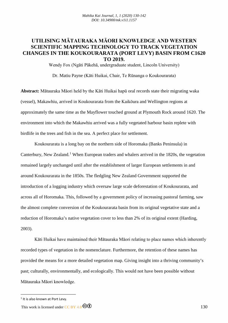
Mahika Kai Journal, 1, 1 (2020) 130-142 DOI: 10.34900/mk.v1i1.1157 This work is licensed under CC BY 4.0 130 UTILISING MĀTAURAKA MĀORI KNOWLEDGE AND WESTERN SCIENTIFIC MAPPING TECHNOLOGY TO TRACK VEGETATION CHANGES IN THE KOUKOURARATA (PORT LEVY) BASIN FROM C1620 TO 2019. Wendy Fox (Ngāti Pākehā, undergraduate student, Lincoln University) Dr. Matiu Payne (Kāti Huikai, Chair, Te Rūnanga o Koukourarata) Abstract: Mātauraka Māori held by the Kāti Huikai hapū oral records state their migrating waka (vessel), Makawhiu, arrived in Koukourarata from the Kaikōura and Wellington regions at approximately the same time as the Mayflower touched ground at Plymouth Rock around 1620. The environment into which the Makawhiu arrived was a fully vegetated harbour basin replete with birdlife in the trees and fish in the sea. A perfect place for settlement. Koukourarata is a long bay on the northern side of Horomaka (Banks Peninsula) in Canterbury, New Zealand. 1 When European traders and whalers arrived in the 1820s, the vegetation remained largely unchanged until after the establishment of larger European settlements in and around Koukourarata in the 1850s. The fledgling New Zealand Government supported the introduction of a logging industry which oversaw large scale deforestation of Koukourarata, and across all of Horomaka. This, followed by a government policy of increasing pastoral farming, saw the almost complete conversion of the Koukourarata basin from its original vegetative state and a reduction of Horomaka’s native vegetation cover to less than 2% of its original extent (Harding, 2003). Kāti Huikai have maintained their Mātauraka Māori relating to place names which inherently recorded types of vegetation in the nomenclature. Furthermore, the retention of these names has provided the means for a more detailed vegetation map. Giving insight into a thriving community’s past; culturally, environmentally, and ecologically. This would not have been possible without Mātauraka Māori knowledge. 1 It is also known at Port Levy.
-
Upload
khangminh22 -
Category
Documents
-
view
0 -
download
0
Transcript of utilising mātauraka māori knowledge and western
Mahika Kai Journal, 1, 1 (2020) 130-142 DOI: 10.34900/mk.v1i1.1157
This work is licensed under CC BY 4.0 130
UTILISING MĀTAURAKA MĀORI KNOWLEDGE AND WESTERN SCIENTIFIC MAPPING TECHNOLOGY TO TRACK VEGETATION
CHANGES IN THE KOUKOURARATA (PORT LEVY) BASIN FROM C1620 TO 2019.
Wendy Fox (Ngāti Pākehā, undergraduate student, Lincoln University)
Dr. Matiu Payne (Kāti Huikai, Chair, Te Rūnanga o Koukourarata)
Abstract: Mātauraka Māori held by the Kāti Huikai hapū oral records state their migrating waka
(vessel), Makawhiu, arrived in Koukourarata from the Kaikōura and Wellington regions at
approximately the same time as the Mayflower touched ground at Plymouth Rock around 1620. The
environment into which the Makawhiu arrived was a fully vegetated harbour basin replete with
birdlife in the trees and fish in the sea. A perfect place for settlement.
Koukourarata is a long bay on the northern side of Horomaka (Banks Peninsula) in
Canterbury, New Zealand.1 When European traders and whalers arrived in the 1820s, the vegetation
remained largely unchanged until after the establishment of larger European settlements in and
around Koukourarata in the 1850s. The fledgling New Zealand Government supported the
introduction of a logging industry which oversaw large scale deforestation of Koukourarata, and
across all of Horomaka. This, followed by a government policy of increasing pastoral farming, saw
the almost complete conversion of the Koukourarata basin from its original vegetative state and a
reduction of Horomaka’s native vegetation cover to less than 2% of its original extent (Harding,
2003).
Kāti Huikai have maintained their Mātauraka Māori relating to place names which inherently
recorded types of vegetation in the nomenclature. Furthermore, the retention of these names has
provided the means for a more detailed vegetation map. Giving insight into a thriving community’s
past; culturally, environmentally, and ecologically. This would not have been possible without
Mātauraka Māori knowledge.
1 It is also known at Port Levy.

M Payne & W Fox / Mahika Kai Journal, 1, 1 (2020) 130-142
131
The utilisation of GIS (geographic information system) in conjunction with Mātauraka Māori
knowledge and available literature has allowed for the digital mapping of the vegetation cover from
around 1830, and the Kāti Huikai place names. Additionally, existing GIS data of present-day
vegetation of Horomaka has been used as a comparison to the 1830s vegetation cover.
Keywords: Horomaka, Koukourarata, Mātauraka Māori, Port Levy, traditional place names, vegetation. Introduction
Koukourarata has been the tūrakawaewae of Kāti Huikai hapū since before Europeans arrived in
Aotearoa (New Zealand).2 Kāti Huikai have maintained their Mātauraka Māori knowledge relating
to place names which inherently recorded types of vegetation, important mahika kai spots, and
physical features in the landscape.3
Horomaka was originally largely covered in forests, shrublands and coastal tussock, and was
the ideal habitat to sustain many bird species which were used as food and sometimes kept as pets
(Beattie, 2013). The vegetation cover of Koukourarata and Horomaka has significantly changed from
before the Port Levy Deed of Purchase of 1849, to the present day (Beumont, Carter & Wilson,
2014), leading to a reduction in the diversity and abundance of birdlife. Vegetation data available for
Koukourarata is fairly limited, as most survey and black maps (a number of New Zealand survey
maps produced in the 1800s were called ‘black’ or ‘red’ maps) available from the 1800s contain little
or no vegetation information. Additionally, most early photographs are dated around 1900 by which
time most of the forest had already been felled or burned.
Environment Canterbury has been working collaboratively with Te Rūnanga o Ngāi Tahu,
archives NZ and Land Information NZ (LINZ) since the early 2000s to digitise and make available
old red and black maps which were created from 1848, as originals can be fragile (Canterbury Maps,
n.d.).
22 Tūrakawaewae: home or standing place, in Kāi Tahu dialect. 3 Mahika kai: places and practises where food is produced or procured.

M Payne & W Fox / Mahika Kai Journal, 1, 1 (2020) 130-142
132
This project investigated and analysed the vegetation changes between the 1830s and present-
day, and to discuss the differences found between them. Additionally, the Kāti Huikai place names
were investigated and digitally mapped. Some of these names give clues to the different vegetation
types and placement around Koukourarata. The use of ArcGIS for this project has allowed for the
production of three digital maps of the area which are useful visualisation tools for the vegetation
data and the place names which mostly exist as a list of names and oral histories.
Methods
Koukourarata is a long sheltered harbour positioned on the northern side of Horomaka. The marked
study area, shown in Figure 1 below, is approximately the catchment area of the harbour. Data was
acquired through available GIS data, archive records, literature, and oral histories.
The main data layers for this project were the present day vegetation land-cover layer (Iris-
lcdb-v40-land-cover-database-version-40-SHP) retrieved from Lincoln University’s data archive, the
1830s vegetation layer (Estimated Vegetation 1830), the study area (Koukourarata Area), and the
place names feature class layer (Place Names). Firstly, the Koukourarata study area was drawn as a
polygon feature class using a base-map to trace the catchment area. Secondly, the present day
vegetation layer was downloaded and clipped to the study area before using the ‘name_2012’ field to
individually symbolise the vegetation types. Thirdly, the place names were drawn and marked on a
current topographic map before being created into a feature layer in ArcGIS using points, lines, and
polygons to mark their positions.
Finally, the 1830s vegetation was created into a feature layer using polygons and the split tool
was used to separate some of the polygons before the ‘Dominant_Vegetation_Type’ was used to
symbolise the different vegetation types. This layer was based on available literature and oral
histories.

M Payne & W Fox / Mahika Kai Journal, 1, 1 (2020) 130-142
133
Figure 1: Shows the Koukourarata (Port Levy) study area outlined in yellow (above).
Figure 2: Shows where Koukourarata is located within New Zealand (right).
Results
Three maps of the Koukourarata area were produced: Vegetation cover present-day; 1830s
vegetation cover; Koukourarata place names. The present-day vegetation map shows the majority of
the area being high producing grassland, large areas of exotic plantation forest and small remnants of
native forest and mānuka and/or kānuka spread throughout the area as shown in Figure 3 below.

M Payne & W Fox / Mahika Kai Journal, 1, 1 (2020) 130-142
134
Figure 3: Shows present-day vegetation of Koukourarata4.
Figure 4: Shows the vegetation cover of Koukourarata around 1830.
4 Note that the Indigenous forest and Broadleaved Indigenous hardwoods are the same colour because they are similar vegetation types.

M Payne & W Fox / Mahika Kai Journal, 1, 1 (2020) 130-142
135
The 1830 vegetation cover map, above in Figure 4, shows podocarp and mixed broadleaf forest was
the dominant vegetation type of the area. It also shows large areas of scrub and grassland, pōhue and
grey scrub, and three substantial areas of māra (cultivated gardens) at the southern end of the harbour
on the flats.
The place names map
created using Mātauraka
Māori knowledge from the
Kāti Huikai hapū shows
thirty-nine different
locations spread throughout
the area, as shown here in
Figure 5. The place names
and meanings give insight
into vegetation types
present in specific areas;
mahika kai areas, land
features and their uses; and
significant ancestors.
Figure 5: Shows the place name locations.
Place names in the north of the harbour, see Figure 6 below.
Te Piaka: Fledging birds (seabirds), gathering place of fledglings and eggs. Also known as Adderley
Head.
Te Pōhue: The Pōhue. Pōhue, a native bindweed, is a name given to a few species but most
commonly Calystegia tuguriorum or Calystegia sepium.

M Payne & W Fox / Mahika Kai Journal, 1, 1 (2020) 130-142
136
Kakati tara: Place for gathering black-billed gulls. An original defensive pā site which was used as a
lookout. Also known now as Kaitara.
Te ana a Kōkiro: The lair/cave of Kōkiro. Kōkiro / conger eel is a kaitiaki (guardian).
Pukerarauhe: Island of bracken fern. Little island north of Horomaka Island. Also known as
Pukerauaruhe.
Te Ana Pepeke: Cave you can jump through. It can be seen from sea level.
Rakiriri: Angry sky. A place of refuge when the seas are rough. A bay at the north-eastern end of
Koukourarata harbour.
Te Ruahine: The crone (the wise old woman). Eastern headland of Koukourarata harbour.
Tokowhakahuka: Sea spray rock. Also known as Beacon rock.
Figure 6: Shows the positions and names of the place names in the northern end of the harbour.

M Payne & W Fox / Mahika Kai Journal, 1, 1 (2020) 130-142
137
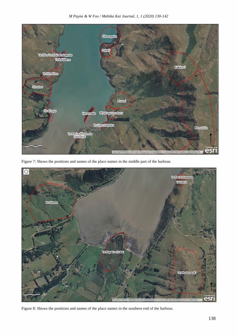
Place names in the middle of the harbour, see Figure 7 below.
Te Pā o Te Rakiwhakaputa: The place of Te Rakiwhakaputa’s Pā. Also known as Rangiwhakaputa.
Tokatātere: The rock where sharks could be procured. Pioke (spiny dogfish) and Makotātere (mako
shark). Also known as Flaehrty’s point. Positioned to the right of Te Pā o Te Rakiwhakaputa.
Te Hinahina: The land of pale soil. The pale soil being clay.
Ōtoetoe: Place of the toetoe bushes.
Ōkaihope: The place where food can be procured at waist height.
Ōtūtohio: The place of initiation (Urupā). Cemetery.
Te Pari a Hineteata: Cliff beneath the Urupā.
Horomaka: Horomaka Island. Main island in Koukourarata harbour.
Te Umu hāpuku: The groper ovens. Flat area of land that was used to cook groper in ground ovens.
Whakapaumahara: Exhaust all memory. This area has been occupied since time immemorial.
Puaari: Clear view of birding trees. This is the main Pā area. It was positioned where you could
clearly see the birding trees up in the forest behind the Pā.
Puketī: Hill of Tī kōuka (cabbage tree). It is the headland at the northern end of the Māori reserve.
Ōkoropeke: Place of Koropeke the ancestor. Also known as Chamberlain’s bay or Putiki farm bay.
Kākānui: Plentiful kākā. A place where you could find plenty of kākā (a large orangey-brown forest-
dwelling parrot).
Manukūia: Place where you hear the birds/kererū sing. Ku is the kererū5 call.
5 Kererū – native wood pigeon.
M Payne & W Fox / Mahika Kai Journal, 1, 1 (2020) 130-142
138
Figure 7: Shows the positions and names of the place names in the middle part of the harbour.
Figure 8: Shows the positions and names of the place names in the southern end of the harbour.

M Payne & W Fox / Mahika Kai Journal, 1, 1 (2020) 130-142
139
Place names in the south of the harbour, see Figure 8 above.
Te Kōpuru: The place where the digging spade was inserted. A good place to cultivate.
Te Rāpaki o Huikai: The headland at the head of Koukourarata harbour. Also known as Fernlea
Point.
Te Whatamaraki: The storage site of maraki. Maraki is dried groper. Small mountain on the corner of
the Māori reserve. It was used as a trading point with other hapū.
Stream names at the southern end of the harbour, see Figure 9 below.
Matakirikiri: The place of shingle. A shingle-bedded waterway, it is now very small and only runs in
winter.
Ōtūheikawa: Place of Tūheikawa the ancestor. The stream is named after the ancestor Tūheikawa.
Te Kaawa: The forging of the river. Positioned by the first bridge coming from Purau.
Ōwhetoro: The place of a whitebait fishing technique.
Figure 9: Shows the streams at the southern end of the harbour.

M Payne & W Fox / Mahika Kai Journal, 1, 1 (2020) 130-142
140
Figure 10: Shows streams on the eastern side of the harbour.
Stream names on the eastern side of the harbour, see Figure 10 above.
Koukourarata: Koukourarata stream. The last running stream that comes out by Horomaka Island.
Ōiri: The place of anointment. A spring fed stream (not tapu but rahui, not sacred but restricted).
Used for marriage consecration.
Te Rua Taniwha: The Taniwha’s lair. This Taniwha in this case is an octopus.
Werokanohi: The place where faces were challenged. Gateway to Puaari Pā, the place where
challenges were made by newcomers before entering the pā.
Kahukunu: Kahukunu the ancestor. A stream named after the ancestor Kahukunu.
Discussion
The research undertaken for this project has been illuminating, not only of an area of Aotearoa’s
history but a greater understanding of Koukourarata, both culturally and environmentally. The
comparison of the two vegetation layers showed significant differences over time, with a shift from
mostly forest to mostly pastoral grassland. The research undertaken to create the 1830s vegetation
layer was informative. It was unforeseen to find the range of vegetation types, including pōhue

M Payne & W Fox / Mahika Kai Journal, 1, 1 (2020) 130-142
141
(Wilson, 2013) and the large areas of māra (gardens) in the southern end of the harbour.
Additionally, investigating the species of birds that originally inhabited Horomaka in plentiful
numbers gave insight into the diversity and maturity of the forest and tree species that grew in the
area (Wilson, 2009). However, it was not surprising how little native forest, especially old-growth
forest, remains at present, as shown in the present-day vegetation layer. Rather, it shows the amount
of flora and fauna that had been lost in the area over time.
Although creating the place names layer was time consuming (including multiple checks
necessary for accuracy of positioning, area/size, placement, spelling and meanings), it was important
to listen, learn, and discuss the information and Mātauraka regarding these places. Many of these
names are connected with pre-colonial mahika kai sources and practises, while also identifying
current and future mahika kai and environmental opportunities. GIS was a useful tool for this project
because it allowed for the data to be collated and digitised into different data layers which give
insight into historical vegetation of the area as well as the place names which previously only existed
as a list of names and oral histories.
Improvement could be made of mapping this area if an updated present vegetation data layer
could be created, as the available layer within the timeframe was from 2012. This layer appeared
fairly accurate on inspection but could be improved by going into the field and taking GPS points
around the study area, or acquiring the next updated version of the layer when it becomes available.
The 1830s vegetation (Figure 4) was produced despite limitations of time, literature and resources
available at the time. This map layer was based on Hugh Wilson’s research (Wilson, 2013), and
available Mātauraka Māori knowledge. Investigating additional information could lead to a more
detailed 1830s vegetation map in future. Additionally, the place names layer could be improved by
taking GPS points in the field which with the available time and resources were not possible.
However, they were positioned using knowledge and guidance from a hapū member who knows the
Koukourarata oral histories and in conjunction with archival information given by Hone Taare Tikao
to James Cowan.

M Payne & W Fox / Mahika Kai Journal, 1, 1 (2020) 130-142
142
References
Archives New Zealand, (2019). Black Map, Port Levy Road District, graphic scale 1:31680, ID:R22668094, Archway series number:23142. Retrieved from http://ndhadeliver.natlib.govt.nz/delivery/DeliveryManagerServlet?dps_pid=IE40792338 Archives New Zealand, (2019). Cowan, James, 1870-1943: Papers. Record ID – MS-Papers-11310-146. Beattie, H. (2013). Tikao Talks: Traditions and Tales of the Canterbury Māori as told by Teone Taare Tikao to Herries Beattie. Christchurch: Cadsonbury Publications. (first published in 1939). Beaumont, L.; Carter, M.; Wilson, J. (2014, June). Banks Peninsula contextual historical overview and thematic framework. Retrieved from https://www.ccc.govt.nz/assets/Documents/Culture-Community/Heritage/14-974633-Banks-Peninsula-Contextual-Historical-Overview-and-thematic-Framework-FINAL-.pmd.PDF Canterbury Maps, (n.d.). Historic South Island Survey Maps. Retrieved from https://apps.canterburymaps.govt.nz/BlackMaps/index.html Evison, H. C. (2007). The Ngāi Tuhu Deeds: A Window on New Zealand History. Christchurch: Canterbury University Press. Harding, J. S. (2003). Historic deforestation and the fate of endemic invertebrate species in streams. New Zealand Journal of Marine and Freshwater Research, 37:2. 333-345. DOI:10.1080/00288330.2003.9517171 Wilson, H. (2009). Natural History of Banks Peninsula. Christchurch: Canterbury University Press. Wilson, H. D. (2013). Plant Life on Banks Peninsula. Cromwell: Manuka Press.