Use of 10 Be exposure ages and Schmidt hammer data for correlation of moraines in the Krkonoše...
22
Use of 10 Be exposure ages and Schmidt hammer data for correlation of moraines in the Krkonoše Mountains, Poland/Czech Republic Zbyne ˇk Engel, Andrzej Traczyk, Régis Braucher, Barbara Woronko, and Marek Krííek with 8 figures and 2 tables Summary. Exposure ages and relative-age data are presented from eight sites in the Łomnica and Łomniczka valleys to provide essential information for reconstructing local glaciation chronology. A combination of 10 Be exposure ages and Schmidt hammer data obtained for moraines indicate relatively short period of glacier accumulation lasting from 17.0 0.4 ka to 13.6 0.9 ka. Exposure age of 8.4 0.3 ka measured on the lowermost section of the Łomnica cirque headwall further confirms the view of glacier preservation in favourable sites until the beginning of the Holocene. A comparison of the obtained chronological data with timing of mountain glaciation in the nearby Úpa Valley is used to propose the first correlative model of Late Quaternary glaciation in the eastern part of the Krkonoše Mountains. The correlation implies that the lowermost preserved moraines originated during the local maximum of the last glaciation whereas recessional moraines were deposited until the Lateglacial period. A subse- quent melting of glaciers terminated at the beginning of the Holocene. The implications of the model are discussed and further investigations are suggested to extend its validity to the whole mountain area. Key words: moraines, 10 Be exposure dating, quartz grain microtextures, deglaciation chronology 1 Introduction Evidence of Quaternary mountain glaciation in the Krkonoše Mountains has been recognized at the end of 19th century (Partsch 1894). Since that time there have been a number of geomorphological investigations, identifying glacial landforms and extent of local glaciers (see Migon ´ & Pilous 2007). By contrast, the timing of the Quaternary glaciations remained unknown until recently and proxy for the glacia- tion chronology appeared sporadically. Attempts to solve the question of chronol- ogy of the local glaciation were usually based on morphological evaluation of the gla- cial landforms, which was not sufficient enough. Glacial landforms were attributed to Middle and Late Pleistocene but without any direct evidence (Sekyra 1964). Some progress has been reached lately when the relative age of moraines was suggested based on surface weathering of morainic boulders. Depending on the age the morainic material varies in the intact rock strength, the presence of characteristic sur- face microforms and weathering rinds (Traczyk 1989). © 2011 Gebr. Borntraeger Verlagsbuchhandlung, Stuttgart, Germany www.borntraeger-cramer.de DOI: 10.1127/0372-8854/2011/0055-0036 0372-8854/11/0055-0036 $ 5.50 Zeitschrift für Geomorphologie Vol. 55,2, 175–196 Article Stuttgart, June 2011
Transcript of Use of 10 Be exposure ages and Schmidt hammer data for correlation of moraines in the Krkonoše...

Use of 10Be exposure ages and Schmidt hammer data for correlation of moraines in the Krkonoše Mountains,
Poland/Czech Republic
Zbynek Engel, Andrzej Traczyk, Régis Braucher, Barbara Woronko, and Marek Krííek
with 8 figures and 2 tables
Summary. Exposure ages and relative-age data are presented from eight sites in the Łomnicaand Łomniczka valleys to provide essential information for reconstructing local glaciationchronology. A combination of 10Be exposure ages and Schmidt hammer data obtained formoraines indicate relatively short period of glacier accumulation lasting from 17.0 � 0.4 ka to13.6 � 0.9 ka. Exposure age of 8.4 � 0.3 ka measured on the lowermost section of the Łomnicacirque headwall further confirms the view of glacier preservation in favourable sites until thebeginning of the Holocene. A comparison of the obtained chronological data with timing ofmountain glaciation in the nearby Úpa Valley is used to propose the first correlative model ofLate Quaternary glaciation in the eastern part of the Krkonoše Mountains. The correlationimplies that the lowermost preserved moraines originated during the local maximum of the lastglaciation whereas recessional moraines were deposited until the Lateglacial period. A subse-quent melting of glaciers terminated at the beginning of the Holocene. The implications of themodel are discussed and further investigations are suggested to extend its validity to the wholemountain area.
Key words: moraines, 10Be exposure dating, quartz grain microtextures, deglaciation chronology
1 Introduction
Evidence of Quaternary mountain glaciation in the Krkonoše Mountains has beenrecognized at the end of 19th century (Partsch 1894). Since that time there have beena number of geomorphological investigations, identifying glacial landforms andextent of local glaciers (see Migon & Pilous 2007). By contrast, the timing of theQuaternary glaciations remained unknown until recently and proxy for the glacia-tion chronology appeared sporadically. Attempts to solve the question of chronol-ogy of the local glaciation were usually based on morphological evaluation of the gla-cial landforms, which was not sufficient enough. Glacial landforms were attributedto Middle and Late Pleistocene but without any direct evidence (Sekyra 1964). Someprogress has been reached lately when the relative age of moraines was suggestedbased on surface weathering of morainic boulders. Depending on the age themorainic material varies in the intact rock strength, the presence of characteristic sur-face microforms and weathering rinds (Traczyk 1989).
© 2011 Gebr. Borntraeger Verlagsbuchhandlung, Stuttgart, Germany www.borntraeger-cramer.deDOI: 10.1127/0372-8854/2011/0055-0036 0372-8854/11/0055-0036 $ 5.50
Zeitschrift für Geomorphologie Vol. 55,2, 175–196 ArticleStuttgart, June 2011

The first geochronological data for the glacial relief were gathered at the turn of20th century providing rough estimations of the Late Quaternary glacial episodes inthe northern part of the Krkonoše Mts. A single radiocarbon age (9,970 � 180 ka BP)of organic sediment from the bottom of the Łomnica valley was interpreted as thebeginning of the postglacial lake development whereas TL data (87–93 ka) from thewestern Krkonoše Mts gave the first indication of pre-Late Weichselian glaciation(Chmal & Traczyk 1999). Exposure-age dating of glacial surfaces in the Labe andÚpa valleys has brought information on deglaciation chronology more recently(Mercier et al. 2000). The recession of the Late Quaternary glaciation started before15 ka BP and glaciers persisted in suitably orientated parts of cirques until the begin-ning of the Holocene (Braucher et al. 2006). However, all the dated glacial land-forms are situated within troughs implying earlier glaciation of the valleys (Engel2003). According to current view local glaciers were probably formed already duringthe pre-Weichselian but their development was only confirmed in the Late Quater-nary (Carr et al. 2007).
The diverse time span of applied dating techniques and isolated pattern of inves-tigated area discouraged the correlation of the Quaternary glaciations in theKrkonoše Mts. The moraines were reported as Würmian, Rissian and earlier in thenorthern part of the mountains (Chmal & Traczyk 1999). A different interpretationimplying the Late Quaternary origin of all preserved moraines results from the recentinvestigation in the southern part of the mountains (Engel 2003, Carr et al. 2007).The contrasting hypotheses represent a problem for the establishment of the uniformstratigraphy and timing of Quaternary glaciation in the region. Consequently it is notpossible to include the local glaciation of the Krkonoše Mts into the chronostrati-graphic frame of the Quaternary glaciations of other parts of Central Europe (seeEhlers & Gibbard 2004). Therefore, it is currently difficult to utilize the localknowledge for solving problems of environmental changes in the Late Quaternary(Gillepspie & Molnar 1995).
In this paper, we use in situ produced cosmogenic dating and relative-age datingto determine glaciation chronology in the Łomnica and Łomniczka valleys. Thestudy area was selected because of abundance of well-preserved and morphologicallydistinct moraines and their clear relative age sequences. The same methods as in thenearby Úpa valley have been adopted (Mercier et al. 2000, Carr et al. 2007) so thatcomparable results will be obtained. The correlation of the local chronologies basedon obtained and previously reported data is tentatively suggested.
2 Study area
The area under investigation is located in the Sudetes Mountains in Central Europe.It is delimited to the eastern part of the Krkonoše Mts, extending north-westwardsfrom Sněžka Mountain (1,602 m, fig. 1). The mean annual temperature in the studyarea decreases with altitude from about 5.7 to 1.5°C. The temperature range is esti-mated from data collected from 1991 to 2010 at Karpacz (575 m), Luční (1,410 m) and Sněžka weather stations, located up to 3 km from the study area. The meanannual precipitation ranges between 1,042 and 1,102 mm/yr (Glowicki 2005). TheKrkonoše Mts consist mainly of granites and metamorphic rocks (mica schist, phyl-lites and gneiss). A main ridge of the mountains is built by fine grained equigranular
Z. Engel et al.176

granite whereas flanks are made up of coarse- to medium-grained porphyritic gran-ite (Chaloupské 1965). A narrow zone of contact metamorphism (mica schist andmetamorphic hornfels) marks the southern boundary of the granite area and meta-morphic unit.
The relief pattern of the eastern Krkonoše Mts reflects bedrock properties com-prising a large plateau limited by WNW-SES oriented ridges. The summit plateau
Use of 10Be exposure ages 177
Fig. 1. Simplified geomorphological and geological map of the study area in the eastern partof the Krkonoše Mountains with location of sampling sites (grey circles – sites sampled forquartz grain analyses, solid triangles – 10Be dating sites, unfilled triangles – 10Be data reportedby Braucher et al. 2006).

(1,400–1,450 m a. s. l.) has originated during the Paleogene or Neogene (Jahn 1980,Migon 1997). The Bílé Labe and Łomniczka valleys are incised into the summit sur-face following the less resistant zones of discontinuities (Dumanowski 1963). Thenorthern and southern flanks of the ridges are dissected by deeply incised valleys ofthe Łomnica and Úpa Rivers. Quaternary valley glaciers developed transformed val-ley heads to well-developed cirques. All the cirques are asymmetric having the steep-est headwalls cut into the E and NE margin of the summit plateau (fig. 2). A lee-wardposition of the cirques and their morphology was attributed to preglacial relief pat-tern and prevailing west winds (Partsch 1894, Migon 1999).
Z. Engel et al.178
Fig. 3. Dated ridge of the end moraine (II) in the Łomnica Valley.
Fig. 2. The summit plateau with cirque edges of the Úpa (left), Łomnica (right) andŁomniczka (right bottom) valleys seen from the east.

Cirques incised into the plateau margins built by metamorphic rocks are largerthan cirques which border the NE granite part of the summit surface. The first groupis represented by Úpa and Łomniczka Cirques which are characterized by long upperedges (2,800 m and 1,500 m, respectively) and big depths (500 m and 300 m, respec-tively). Headwalls are steeper and higher (up to 200 m) in the Úpa Cirque whereasrock steps in Łomniczka Cirque are lower than 50 m. Minor cirques are cut into thesummit plateau along its border with the Łomnica valley. The headwall of the MałyStaw cirque is 2,200 m long and 150–190 m high. The Wielki Staw cirque is delimitedby 1,350 m long upper edge and 170–190 m high rock walls. Moraine-dammed lakesare located on the bottom of the cirques in the Łomnica valley.
The well-developed series of moraines have been identified in the Łomnica val-ley (fig. 3). Lateral and terminal moraines are preserved from the cirques downvalleyto 900 m a. s. l. The height of terminal moraines ranges from 30–40 m in the cirquesto 15–25 m in the valley. Within the Łomniczka and Úpa valleys, only relics of lat-eral moraines have persisted. In deeply incised valleys with narrow bottoms (100–150 m), terminal moraines were destroyed by fluvial processes and mass movementsafter glacier recession. Among other landforms resulting from moraine destruction alarge fan was deposited at the mouth of the Łomniczka valley near Karpacz (Büdel1936).
3 Methods
3.1 Site selection for surface exposure dating
To determine the 10Be exposure age of the local glaciation, stable boulder on the sur-face of moraines have been identified and sampled together with the bedrock at thefoot of a cirque headwall (Site Lo-1; fig. 1). All sampled sites were composed ofcoarse-grained biotite porphyritic monzogranites, except for Lo-1 and Lo-2, whichwas composed of medium-grained biotite monzogranites. Samples were collectedfrom the surface of 1 to 2.5 m high boulders that lie at the top of moraine ridges oron flat surfaces, far from steep slopes. Boulders on four terminal moraines were sam-pled in the upper Łomnica Valley (Sites Lo-2 to Lo-7) and one sample was taken froma relic of a moraine ridge in the Łomniczka Valley (Site Lk-1). Although the ridge haslateral location it represents the only preserved moraine in the valley which can con-strain the timing of local glaciation. Samples were collected from rock surfaces (upper3 cm) using chisel and hammer. The dip and aspect of sampled surfaces were meas-ured with clinometers and compass. Geographic positions and altitudes of each sitewere recorded with GPS. Table 1 contains site characteristics and description.
3.2 Sample preparation and data treatment
Samples were crushed and sieved. The 0.25 to 1 mm quartz fraction was decontami-nated by successive acid leaching (HCl+H2SiF6 then dilute HF). Purified quartz wasspiked with 100 μl of a 3,025 ppm home-made carrier then dissolved in 48% HF.Beryllium was complexed by acetyl acetone in a 50% EDTA solution then extractedusing solvent extraction. Beryllium hydroxides were dried and oxidized at 800°C toBeO. Beryllium oxide was mixed to 325 mesh niobium powder, prior its measure-
Use of 10Be exposure ages 179

Z. Engel et al.180
Tabl
e1.
Sam
plin
g si
tes
for
10B
e su
rfac
e ex
posu
re d
atin
g.
Sam
ple
Alt
itud
eB
ould
erSa
mpl
e su
rfac
eR
-val
ue
Site
des
crip
tion
and
mor
aine
zon
e(m
)he
ight
(m)
dip/
aspe
ct (°
)in
tact
/pre
pare
d
Lo-
11,
195
–27
/325
53.2
/72.
1be
droc
k ou
tcro
p, fo
ot o
f cir
que
head
wal
lL
o-2
1,18
51.
90/
034
.3/7
1.2
cres
t of i
nner
mor
aine
rid
ge (I
II)
Lo-
31,
175
1.0
7/12
040
.2/6
9.2
cres
t of l
ater
al m
orai
ne (I
I)L
o-4
1,14
00.
610
/80
42.4
/65.
5cr
est o
f end
mor
aine
(III
)L
o-5
985
1.2
0/0
39.8
/65.
4cr
est o
f end
mor
aine
(II)
Lo-
692
52.
50/
035
.5/6
4.6
surf
ace
of te
rmin
al m
orai
ne (I
)L
o-7
910
1.2
0/0
37.2
/60.
1su
rfac
e of
term
inal
mor
aine
(I)
Lk-
11,
055
1.0
3/90
35.9
/66.
4cr
est o
f lat
eral
mor
aine
, 20
m fr
om ta
lus
foot

ment at ASTER, the French AMS located at CEREGE, Aix en Provence. 10Be/9Beratios were calibrated directly against the National Institute of Standards and Tech-nology standard reference material no 4,325 by using an assigned value of(2.79 � 0.03) � 10–11. A 10Be half life of (1.387 � 0.012) � 106 years was used based onrecent papers of Korschinek et al. (2009) and Chmeleff et al. (2009).
In order to determine Cosmic Rays Exposures (CRE) ages from the 10Be con-centrations measured in the quartz fractions, a modern 10Be spallation productionrate at sea level and high-latitude of 4.5 � 0.3 atoms g/yr Stone (2000) was used. Thissea-level and high-latitude production rate has then been scaled for the sampling alti-tudes and latitudes using the scaling factors proposed by Stone (2000). An additionalmuon production of 2.1% of the total production (~ 0.097 at/g/yr at SL) and scaledto the sampling area for altitude using an attenuation length of 240 g/cm2. Surfaceproduction rates were also corrected for local slope and topographic shielding due tosurrounding morphologies following Dunne et al. (1999). The shielding from snowwas estimated according to Reuther (2007) using average snow density of 0.3 g/cm3
and values for the mean thickness and the duration of snow cover measured byGlowicki (1977), Kwiattkowski & Lucerski (1979) in the study area. Analyticaluncertainties (reported as 1 sigma) include a conservative 0.5% uncertainty based onlong-term measurements of standards, a 1 sigma statistical error on counted 10Beevents, and the uncertainty associated with the chemical and analytical blank correc-tion (associated 10Be/9Be blank ratio was 1.7 � 0.5 � 10–15). CRE ages were calculatedusing the physical parameters determined by Braucher et al. (2003) (attenuationlengths of 150, 1,500 and 5,300 g/cm3 for neutrons, slow and fast muons respectively.Analysis of variance (ANOVA) was used to determine whether there exist anychronological differences among groups of dated moraines. The statistical signifi-cance of a relationship was tested by F test with p-level 0.05.
3.3 Schmidt hammer measurements
Schmidt hammer (SH) records were undertaken at each 10Be sampling site in accor-dance with the operating guidelines recommended by Day & Goudie (1977). Thestandard N-type of SH was applied to the same part of the dated rock surface not farthen 50 cm from sampling points. 25 hammer impacts were taken on the naturallyweathered surface first (Matthews & Shakesby 1984). The surfaces were then pol-ished using an electric grinder and re-examined with a hammer (Katz et al. 2007).Both datasets were processed following one of the three most accepted methodsamong the different SH rebound techniques (e. g. Hubbard & Glasser 2005). First,the mean and the standard deviation of the recorded readings were calculated. Then,the five values with the greatest deviation for each surface were excluded from thedataset and new mean rebound (R) values were calculated from the remaining 20 val-ues. The resulting mean R-values were taken as representative for each surface.
The mean R-values represent degree of surface weathering which can be used asa proxy for relative age of sampled surfaces. The mean R-values for the dated surfaceswere compared with published SH records obtained on five preserved moraines inthe Obří důl (Carr et al. 2007). A comparison of measured and published R-valuesprovides the data that allow limited correlation of moraines in the Łomnica and upperÚpa valleys. The mean R-values for the prepared surfaces allow more discriminating
Use of 10Be exposure ages 181

correlations with granite outcrop surfaces in the Sudetes Mountains (Cerná &Engel 2010).
3.4 Quartz grain microtextures
The morphology of quartz grains was studied in order to determine the mode oftransport and to reveal possible post-depositional changes. The history of glacialaccumulations is important for correct interpretation of obtained exposure ageswhich are often biased by overprinting or spalling of moraine surfaces (e. g. Cer-ling & Craig 1994, Putkonen & Swansson 2003). An analysis of quartz grainmicrotextures may reveal various post-depositional processes and is thus useful forelimination of errors in exposure datasets.
Altogether seven samples of coarse-grained sand representing investigatedbedrock and moraine belts in the Łomnica valley were analyzed. The granite bedrocksample (LQ1) was collected from the slightly inclined (4°) surface of the plateaubetween Łomnica and Łomniczka cirques. This sample represents weathering man-tle which has developed during the Quaternary as a result of periglacial weatheringand solifluction movements. Microscope analysis of quartz grains obtained from thissample allow to recognize typical microstructures formed due to the physical andchemical weathering processes and distinguish this microstructures from thoseresulted as an effect of grain abrasion and surface destructions in glacial environment(LQ2–LQ7). For the microtexture analysis 20–25 typical grains of 0.5–1.0 mm sizewere selected from each sample using the light microscope. The grains were rinsed in10% HCl and washed using distilled water. Finally, individual grains were goldcoated. Micromorphology of the grains was analyzed using the scanning electronmicroscope (SEM). The atlas of grain surface morphology of Mahaney (2002) anddescription of quartz grain microtextures of Helland & Holmes (1997) was usedfor microtexture evaluation.
4 Results
4.1 Chronology of moraines
Geomorphological position and morphology of glacial deposits indicate that threegroups of moraines can be distinguished in the Łomnica valley (Fig. 4, zones I to III).The zone I consists of relics of lateral and terminal moraines at the confluence of theŁomnica and Złoty Potok Rivers. These moraines were incised by Łomnica after thedeposition. Pronounced ridges of the second (II) moraine zone adjoin the deposits ofthe zone I. Well-developed melt-out depressions on lee side of the moraines are char-acteristic feature of the zone II. Lateral moraines representing this zone can be tracedup to the cirques of Wielki and Mały Staw Lakes. The highermost located zone IIIconsists of the best-preserved moraines in the cirques. Terminal moraines of this zoneare 30–60 m high which indicates rapid transport of material from headwalls into thecirques. Varying morphology and preservation of moraines within described zonessuggest that three main phases of glaciation occurred in the Łomnica valley. Morainesof the zones I and II were deposited by valley glacier whereas the youngest zone (III)represents cirque type of glaciation.
Z. Engel et al.182
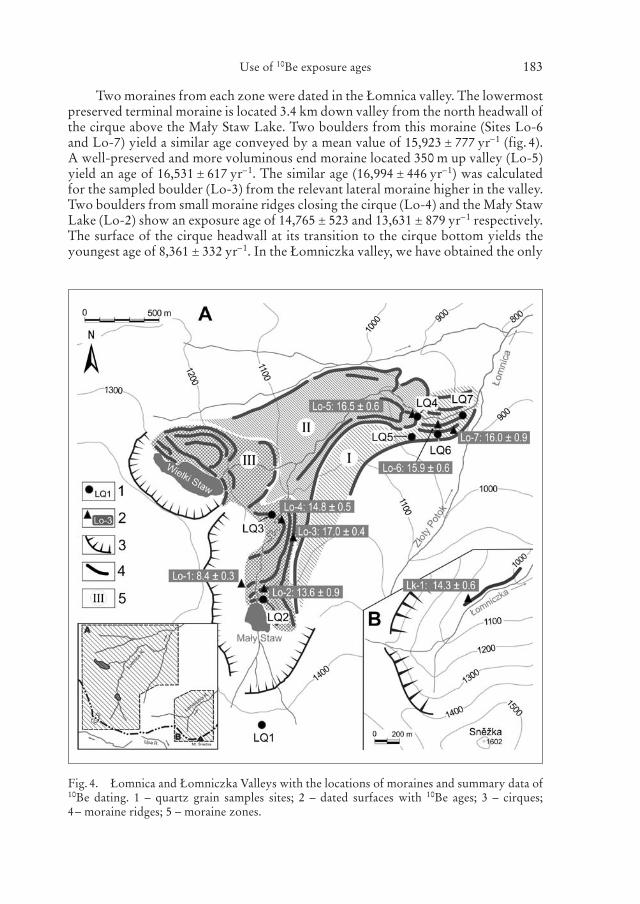
Two moraines from each zone were dated in the Łomnica valley. The lowermostpreserved terminal moraine is located 3.4 km down valley from the north headwall ofthe cirque above the Mały Staw Lake. Two boulders from this moraine (Sites Lo-6and Lo-7) yield a similar age conveyed by a mean value of 15,923 � 777 yr–1 (fig. 4).A well-preserved and more voluminous end moraine located 350 m up valley (Lo-5)yield an age of 16,531 � 617 yr–1. The similar age (16,994 � 446 yr–1) was calculatedfor the sampled boulder (Lo-3) from the relevant lateral moraine higher in the valley.Two boulders from small moraine ridges closing the cirque (Lo-4) and the Mały StawLake (Lo-2) show an exposure age of 14,765 � 523 and 13,631 � 879 yr–1 respectively.The surface of the cirque headwall at its transition to the cirque bottom yields theyoungest age of 8,361 � 332 yr–1. In the Łomniczka valley, we have obtained the only
Use of 10Be exposure ages 183
Fig. 4. Łomnica and Łomniczka Valleys with the locations of moraines and summary data of10Be dating. 1 – quartz grain samples sites; 2 – dated surfaces with 10Be ages; 3 – cirques; 4– moraine ridges; 5 – moraine zones.

Z. Engel et al.184
Tabl
e2.
Cos
mog
enic
10B
e ex
posu
re a
ges.
Sam
ple
Sam
ple
Pro
duct
ion
rate
M
ean
snow
cov
er S
hiel
ding
10
Be
10B
e10
Be
Age
m
ass
(g)
(at–1
g–1yr
–1)
dept
h/du
rati
onco
rrec
tion
conc
entr
atio
nun
cert
aint
y(y
r)(c
m/m
onth
)(a
t–1g–1
)(a
t–1g–1
)
Lo-
122
.174
12.6
116
4/6
0.84
1693
,482
3,70
98,
361
�33
2L
o-2
30.4
2112
.86
164/
60.
8642
155,
164
10,0
0613
,631
�87
9L
o-3
22.5
0512
.78
162/
50.
8900
1971
295,
168
16,9
94�
446
Lo-
424
.660
12.4
414
3/5
0.90
1116
8,95
65,
981
14,7
65�
523
Lo-
524
.857
10.9
612
7/5
0.91
0816
8,11
96,
278
16,5
31�
617
Lo-
628
.546
10.4
412
5/5
0.91
2015
3,93
66,
038
15,8
70�
622
Lo-
729
.028
10.3
212
4/5
0.91
2615
3,25
98,
935
15,9
75�
931
Lk-
123
.219
11.5
613
0/5
0.90
6215
3,27
66,
183
14,2
94�
577

age for a lateral moraine deposited by a short valley glacier. The moraine elongatedat the foot of the SE facing slope (Site Lk-1, fig. 4) lies between 1.1 and 1.6 km down-valley from the NE oriented cirque headwall. 10Be age of 14,294 � 577 yr–1 on a sam-pled boulder from the lateral moraine constrains the Late Weichselian timing in thestudy area. All mentioned 10Be ages are reported in table 2.
The ANOVA test shows that there is a significant difference in age among thethree moraine zones in the Łomnica valley. The F-score implies that the biggest dif-ference is between the second (II) and the third (III) groups of moraines (F (1;10) =35.8594, p = 0.0001) whereas the smallest difference in chronological classificationexists between the first (I) and the second groups of moraines (F (1;10) = 5.2859, p =0.0443). The apparently young age of the lowermost moraines (I) can be explained bypost-depositional tilting or rolling. To validate this interpretation the weathering ofboulder surfaces was measured with SH and grain size microtextures of nearby sed-iments was analyzed.
4.2 Schmidt hammer R-values
R-values measured on investigated granite surfaces range between 34.3 and 53.2(table 1). The highest value was recorded on a glacially smoothed surface of granitebedrock at the foot of the cirque headwall (Site Lo-1). The sampled surface at this siterepresents the youngest section of the glacial landscape in the study area. The upper-most end moraine damming the Mały Staw Lake shows a mean R-value of 34.3 whichis apparently lower than any other in the recorded dataset. This anomaly may beexplained by different granite texture of tested surface (medium granite) which ismore prone to weathering than homogeneous and more evenly jointed fine-grainedgranite boulders at remaining sites. R-values of sampled surfaces on other morainebelts decrease downvalley ranging from 42.4 at the nearest end moraine (Lo-4) to amean value of 36.6 for two boulders on the lowermost terminal moraine (Lo-6 andLo-7). The sampled surface on the lateral moraine in the Łomniczka valley shows acomparably low mean R-value (35.9) as the terminal moraine in the Łomnica valley.
4.3 Quartz grain microtextures
Quartz grains from the gruss sample (LQ1) have medium to high relief. All grains arefrosted and very poorly rounded with frequent solution pits, crevasses and orientedeach pits on the surface (fig. 5). The dissolution surface indicates the action of inten-sive chemical weathering in the formation of the surface relief (fig. 6A). Up to 10 μmlong conchoidal fractures and fracture faces are the most common mechanical fea-tures (fig. 6B). Amorphous precipitation occurs on the surface of most of the grainswhereas abraded grains comprise up to 45% of the sample.
The samples which represent glacial deposits show the effects of intensivemechanical processes and chemical weathering. They are characterized by a high fre-quency of abrasion microtextures ranging from 61% (LQ5) to 100% (LQ7). Thegrain surfaces are dominated by conchoidal fractures, linear steps and subparallel lin-ear fractures (fig. 6C and 6D) which is indicative for glacial environment (e. g.Mahaney 2002, Rose & Hart 2008). Other frequent mechanical features are smallconchoidal fractures (� 10 μm), arc-shaped steps, straight and curved grooves or deep
Use of 10Be exposure ages 185

Z. Engel et al.186
Fig. 5. Summary graph of microstructures on the quartz grain surfaces from thein situ waste deposits (LQ1) and glacial deposits from the Łomnica Valley (LQ2to LQ7).

Use of 10Be exposure ages 187
Fig. 6. Quartz grains from LQ1 site and from glacial deposits. A – the fragment of quartzgrain with dissolution surface; B – quartz grain with fresh conchoidal fractures on chemicalweathered surface; C – quartz grain with fresh conchoidal fractures (� 10 μm); D – sharpencorners as an effect of crushing processes; E – general view of quartz grain with dissolutionsurface; F – the breakage blocks microstructure as an effect of frost weathering.

troughs. Traces of dissolution surface and amorphous precipitation due to chemicalweathering are visible on the grains too (fig. 6E). Their share is higher in the samplesLQ5 and LQ6 whereas the mostly fresh grains occur in the samples LQ2 to LQ4 andLQ6. Silica precipitation is visible on the grains from sites LQ2 and LQ3.
5 Discussion
5.1 Chronology of local glaciations
Exposure data and relative-age estimates obtained in the Łomnica and Łomniczkasuggest that all preserved moraines in the study area originated during the last glacia-tion (Weichselian/Würmian) cycle. The measured SH data demonstrate that there isno significant difference in the degree of weathering between the sampled morainesin study area. This may be explained by rather old ages of tested surfaces concealingits weathering variations or by relatively narrow time span during which moraineswere deposited and boulder surfaces exposed. Regarding the overall range ofobtained SH data and only slightly higher R-value for the glacially abraded bedrockthan for moraine boulders the second hypothesis seems to be more likely. This sug-gests that the moraines are only slightly older than the glacial surface at the foot ofcirque headwall, implying the Late Quaternary age to all moraine systems.
Exposure ages which represent minimum age estimates for glacial surfaces in theŁomnica and Łomniczka valleys, allow for tentative reconstruction of the last glacia-tion history of the study area. Within the limits of available data, it appears that thelowermost preserved moraines (zone I) represent the initial advance of the Łomnicaglacier during the last glacial period (OIS 2). Although exposure ages from thesemoraines are apparently lower than expected, the proximity and age of first reces-sional moraines (zone II) suggest that the lowermost moraines originated during thelocal maximum of the Last Glaciation (LGM). The set of recessional moraines in thezone II was deposited at around 17.0 � 0.4 ka reflecting an oscillation of the glacierafter the LGM. A Lateglacial re-advance of glacier occurred around 14.8 � 0.5 kaleaving moraines at the lower limit of the cirque (zone III). The subsequent glacierretreat into the cirque was interrupted by a recession around 13.6 � 0.9 ka when thelast set of moraines was deposited near the cirque lake. The uncertainty of the singleexposure age complicates the chronological correlation but does not preclude theYounger Dryas origin of moraines near the lake. The deglaciation terminated at thebeginning of the Holocene when relics of the glacier melted at the foot of cirque head-walls (8.4 � 0.3 ka) or in small hanging depressions.
Exposure-age estimates obtained from the lowermost moraines (zone I) are notconsistent with the dataset indicating post-deposition changes of the lowermostmoraines. Exposition of boulders can be modified due to frost-heave, thawing ofdead ice, rotation or erosion. All these processes are spatially diversified affectingboulders on the moraine surface in various rate and yielding different exposure ages.However, dated boulders from the terminal moraine (Lo-6 and Lo-7) show a similarage. The vegetation cover cannot explain apparently younger exposure ages becauseit causes only changes up to 4% in the production rate (Kubik et al. 1998). The effectof snow cover shielding can be more prominent (e. g. Benson et al. 2004, Favilli etal. 2009) but a small difference in altitude (300 m) and uniform topography within
Z. Engel et al.188

sampled localities restrict significant variations in the depth and duration of snow.The analysis of the grain size microtextures from Sites LQ5 to LQ7 suggests that theterminal moraine was reworked by gravitational mass-movement which transformedmoraine morphology lowering moraine ridges into hummocky relief (fig. 7). Theanalysis show the effect of intensive crushing which erased the elements of abrasiveaction. Moreover, apparent precipitation and high proportion of broken grains sug-gest that this material was probably transformed after deposition by frost weather-ing. On the other hand the material sampled in the moraine zone II and III indicatesstrong influence of glacial abrasion on the grains. Angular and completely non-abraded grains dominate in the samples with only few traces of crushing in the sam-ple from the moraine near the Mały Staw Lake. These observations indicate differentgenetic processes which affected material in the lowermost moraines (I) and highermoraine zones (II and III). The grains in the samples from lowermost moraine zoneexhibit more complicated genesis of the deposits. Action of the glacial processes wasfollowed by chemical weathering and subsequent frost shattering.
According to obtained 10Be exposure ages, it can be suggested that the investi-gated moraine belts in the Łomnica and Łomniczka valleys reflect a single (Weich-selian/Würmian) glaciation. This finding corresponds to relative-age estimates based
Use of 10Be exposure ages 189
Fig. 7. Glacial transformation of the drainage network in the Łomnica Valley. 1 – youngerglaciation (II), 2 – older glaciation (I), 3 – V-shaped channel, 4 – flat-bottomed channel; 5 –wind gaps; 6 – presumed pre-glacial watersheds, 7 – presumed pre-glacial courses of theŁomnica river; 8 – direction of the Łomnica glacial transfluence to the Złoty Potok Valley.

on SH measurements, implying a Late Quaternary origin to all preserved morainesystems within study area. The interpretation of numerical and relative-age chrono-logical data appears to reject the idea of pre-Weichselian origin of moraines withinthe Łomnica valley suggested by Traczyk (1989). These findings are echoed byBraucher et al. (2006) and Carr et al. (2007) who find evidence only for Late Weich-selian to early Holocene deglaciation from the nearby Úpa and Labe valleys. Theexposure ages also correspond with the radiocarbon date reported by Chmal &Traczyk (1999) from the Łomnica cirque specifying a period of the glacier retreat andrefining maximum age for presence of local glacier relics.
5.2 Correlation of glaciations in the Łomnica and Úpa valleys
As noted above, the timing of preserved moraines in the Krkonoše Mts has been tra-ditionally attributed to either last glaciation or more glaciations. However, recentresearch and the data presented in this paper reject the second idea assigning only ero-sion landforms and relics of deposits to earlier glaciations. Obtained exposure agesand SH R-values along with published numerical age estimates and relative-age data(Braucher et al. 2006, Carr et al. 2007) enable tentative correlation of the local Qua-ternary glaciations chronologies across the mountain range.
The SH data measured on moraines in the Łomnica and Łomniczka valleys areapparently higher then R-values referred by Carr et al. (2007) from the upper Úpa val-ley. The difference results from various types of granites which build bedrock in thesource areas of moraine boulders. Regarding this fact the obtained SH data cannot beused neither for dating of moraines (sensu Engel 2007) nor for direct correlation ofmoraines in the Łomnica, Łomniczka and Úpa valleys. However, it is evident fromranges of mean R-values that all the preserved moraine ridges in these valleys have orig-inated during the Late Quaternary probably. Exposure ages from three moraine zonessuggest that three major periods of glaciation may be recognized in the Łomnica val-ley. The most extensive of these glaciations appears to have originated during the LGMor during earlier stages of the last glaciation. A major readvance of the glacier occurredaround 17 ka when recessional moraines terminated not far from the limit of the pre-vious glaciation. The last period of glaciation correlates with the Lateglacial period dur-ing which moraines located higher in the Łomnica cirque were deposited.
10Be dating reported by Braucher et al. (2006) from the Úpa valley providesinformation for roches moutonnées that originated during the deglaciation period ofthe last glaciation (fig. 8). A combination of exposure ages and R-values for the datedsurfaces allow to obtain age estimates for the SH measurements (Engel 2007). Appli-cation of the SH dating technique on preserved moraine systems in the Úpa valleyimplies a Late Weichselian age (Carr et al. 2007). Relics of glacial sedimentsdescribed from the lower part of the Úpa valley (Pec pod Sněžkou) was associatedwith the Weichselian glaciation following the river terrace sequences (Carr et al.2002). Tentative interpretations on the basis of exposure ages, R-values and sedimen-tary evidence suggest that the terminal moraine (I) in the Łomnica valley may be asso-ciated with the last glaciation (OIS 2 or 4) and possibly relates to the glacial depositsin Pec pod Sněžkou. The remaining moraines (II to III) in the Łomnica valley recordprogressive glacier retreat subsequent to the regional LGM and probably correlatewith the preserved moraine ridges located in the upper Úpa valley.
Z. Engel et al.190

Use of 10Be exposure ages 191
Fig
.8.
Sum
mar
y pr
ofile
for
10B
e da
ting
and
Sch
mid
t-ha
mm
er m
easu
rem
ents
in th
e Ł
omni
ca a
nd Ú
pa v
alle
ys. I
–III
– m
orai
ne z
ones
.

5.3 Implications for the Hercynian ranges in Central Europe
The Krkonoše Mts belong to the few Hercynian mountain areas in Central Europewhich were glaciated during the Quaternary. Within a periglacial environmentbetween the Scandinavian ice sheets and the glaciated area of the Alps, isolated moun-tain glaciations developed in the Vosges, the Schwarzwald, the Harz, the Šumava/Bayerischer Wald and the Hrubý Jeseník as well. Local glaciations of these moun-tains may provide important palaeoclimatic information for large regions of CentralEurope, as mountain glaciers are a very sensitive indicator of climatic oscillations(e. g. Menzies 1996). Moreover, this information is highly significant for establishinglocal stratigraphy, since mountain environments generally lack sufficient sedimentaryrecord. However, due to scarce glacial deposits and limited extent of glacial landscape,glaciation chronologies for the noted mountain areas are poorly understood (e. g.Traczyk 1989, Rother 1995). In this respect, the Krkonoše Mts together with theVosges and the Šumava/Bayerischer Wald are the most important areas with a well-preserved record of glaciation.
Up to the present time a consistent chronological data for local Quaternaryglaciations was derived only from the Vosges and the Bayerischer Wald. Both theHercynian ranges were repeatedly glaciated throughout the Quaternary (e. g. Woil-lard 1979, Hauner 1980). Glacial chronology from the western part of the Vosgessuggests a maximum glacial advance preceding the last interglacial whereas morainesfrom the eastern flank are referred as Late Würmian (Seret et al. 1990, Mercier &Jeser 2004). Radiocarbon dating and palynological studies from the Vosges indicatecold climate between 25 ka and 15 ka BP and subsequent glacial retreat (Woillard1979, Flageollet 2002). 10Be exposure ages of moraines and bedrock in five valleysin the eastern part of the Vosges were associated with deglaciation phase of the lastglaciation around 10.2 � 0.45 ka (Braucher et al. 2006).
A few chronological studies describe the timing of the Quaternary glacialadvances in the Bayerischer Wald. Exposure age of 61.5 � 3.1 ka from bedrock sur-face in the Grosser Arber summit region was interpreted as a result of a more exten-sive glaciation during the early Würmian (Reuther 2007). The most recent period ofglaciation was restricted to 12,470 � 202 14C years BP and 32.4 � 9.4 ka BP in theKleiner Arbersee area using radiocarbon and IRSL methods respectively (Raab 1999,Raab & Völkel 2003). A detailed chronology of Late Würmian advances of theKleiner Arbersee glacier as well as minimum age of previous glaciation was deter-mined using 10Be exposure dating (Reuther 2007). 10Be exposure ages show that themaximum glacial advance in the Late Weichselian occurred before 20.7 � 2.0 ka. Dur-ing the last readvance (15.5 � 1.7 ka) the glacier deposited moraine damming the KleinArbersee Lake and had melted back by 14.5 � 1.8 ka. Radiocarbon age of ~ 14 ka cal.BP from cirques in the Plechý and Poledník mountains were interpreted as the ter-mination of the last glaciation on the Czech side of the mountains (Praíáková et al.2006, Mentlík et al. 2010).
All preserved moraine ridges in the Łomnica and Łomniczka valleys representthe last (Weichselian) glaciation, similarly as dated moraines in the Bayerischer Waldand moraines at the eastern side of Vosges. Although any numerical data have beenobtained on moraines for earlier substage of the last glaciation, geomorphological andsedimentary evidence together with exposure ages of bedrock confirm the presence
Z. Engel et al.192

of pre-Late Weichselian glaciers in these areas. The Krkonoše Mts 10Be chronologyindicates that a Late Weichselian glacier advance was preceded by a more extensiveearlier advance which confirms the interpretation of exposure dating presented byReuther (2007) for the summit area of the Grosser Arber. Within the limits of avail-able exposure data, it appears that the deglaciation period in the Krkonoše Mts coin-cides with periods of glacier retreat both in the Bayerischer Wald and in the easternpart of the Vosges.
6 Conclusions
Exposure ages and Schmidt hammer data obtained in the Łomnica and Łomniczkavalleys indicate younger ages of moraines than previously considered. Similar 10Beages and R-values measured on glacially abraded bedrock in the cirque and onmoraines suggest that all preserved moraines originated during the last glaciation(Weischselian/Würmian) cycle. The range of numerical data further indicates rela-tively short duration of the glaciation lasting from the LGM to the Lateglacial period.It appears that the deposition of moraines before 17.0 � 0.4 ka and terminated around13.6 � 0.9 ka. Exposure age for the foot of cirque headwall (8.4 � 0.3 ka) suggests thatglacier persisted in favourable sites until the beginning of the Holocene. These find-ings have critical implications for the traditional model of glaciation in the KrkonošeMts. Key questions for future investigations are: Is it possible that cirques originatedduring the last glaciation only? If the area was glaciated earlier why moraines do notstand out in the landscape?
Analyses of quartz grain microforms in samples from the terminal morainesindicate effects of chemical weathering and frost shattering which have obscuredoriginal elements of glacial action. Frequent precipitation and high proportion ofbroken grains suggest that the surface of the lowermost moraine zone was trans-formed by post-deposition changes. Thus, exposure ages from the lowermost zonerefer to termination of the post-depositional moraine surface transformation ratherthan to deposition period.
It is suggested that further investigations and dating are necessary to validate theproposed glaciation chronology and to reliably correlate moraines within theKrkonoše Mts as well as with records of glaciations from Hercynian mountains inCentral Europe.
Acknowledgements
Funding was provided by the Czech Science Foundation (grant no. P209/10/0519) and by theMinistry of Education (MSM0021620831) to Z. Engel and by the University of Wroclaw grantno 1015/S/IGGR/2008 to A. Traczyk. The Krkonoše National Park Authorities (Polish andCzech) is thanked for providing permission to work in the region. The authors would like tothank M. Kasprzak and B. Janásková for research assistance in the field and M. Arnold andG. Aumaitre for their technical assistance during 10Be measurements.
Use of 10Be exposure ages 193

References
Benson, L., Madole, R., Phillips, W., Landis, G., Thomas, T. & Kubik, P. (2004): The prob-able importance of snow and sediment shielding on cosmogenic ages of north-centralColorado Pinedale and pre-Pinedalemoraines. – Quat. Sci. Rev. 23: 193–206.
Braucher, R., Brown, E. T., Bourlès, D. L. & Colin, F. (2003): In situ-produced 10Be meas-urements at great depths: implications for production rates by fast muons. – Earth Planet.Sci. Lett. 211: 251–258.
Braucher, R., Kalvoda, J., Bourlès, D., Brown, E., Engel, Z. & Mercier, J.-L. (2006):Late Pleistocene deglaciation in the Vosges and the Krkonoše mountains: correlation ofcosmogenic 10Be exposure ages. – Geografické časopis 58(1): 3–14.
Büdel, J. (1936): Eiszeitliche und rezente Verwitterung und Abtragung im ehemals nichtvereisten Teil Mitteleuropas. – Petermanns Geogr. Mitt. 50(229): 5–71.
Carr, S. J., Engel, Z., Kalvoda, J. & Parker, A. (2002): Sedimentary evidence to suggestextensive glaciation of the Úpa valley, Krkonoše Mountains, Czech Republic. – Z. Geo-morph. N. F. 46(4): 523–537.
Carr, S. J., Engel, Z., Kalvoda, J. & Parker, A. (2007): Towards a revised model of LateQuaternary mountain glaciation in the Krkonoše Mountains, Czech Republic. – In:Goudie, A. S. & Kalvoda, J. (eds.): Geomorphological Variations: 253–268; P3K.
Cerná, B. & Engel, Z. (2010): Surface and sub-surface Schmidt hammer rebound value vari-ation for a granite outcrop. – Earth Surf. Process. Landf., in press.
Chaloupské, J. (1965): Metamorphic development of the Krkonoše crystalline complex. –Krystalinikum 3: 31–54.
Chmal, H. & Traczyk, A. (1999): Die Vergletscherung des Riesengebirges. – Z. Geomorph.N. F. Suppl. 113: 11–17.
Chmeleff, J., von Blanckenburg, F., Kossert, K. & Jakob, D. (2009): Determination of the10Be half-life by multi-collector ICP mass spectrometry and liquid scintillation count-ing. – Geochim. Cosmochim. Acta 73 (Supplement 1): A221.
Day, M. J. & Goudie, A. S. (1977): Field assessment of rock hardness using the Schmidt testhammer. – British Geomorphology Research Group Technical Bulletin 18: 19–29.
Dumanowski, B. (1963): Stosunek rzeźby do struktury w granicie Karkonoszy. – Acta Univ.Wratisl. 9, Studia Geograficzne 1: 27–35.
Dunne, J., Elmore, D. & Muzikar, P. (1999): Scaling factors for the rates of production ofcosmogenic nuclides for geometric shielding and attenuation at depth on sloped sur-faces. – Geomorphology 27: 3–11.
Ehlers, J. & Gibbard, P. L. (2004): Quaternary Glaciations – Extent and Chronology. Part I:Europe. – Elsevier, Amsterdam, 475 pp.
Engel, Z. (2003): Pleistocénní zalednění české části Krkonoš. – Przyroda Sudetów Zachod-nich 6: 223–234.
Engel, Z. (2007): Measurement and age assignment of intact rock strength in the KrkonošeMountains, Czech Republic. – Z. Geomorph. N. F. Suppl. Iss. 51(1): 69–80.
Favilli, F., Egli, M., Brandová, D., Ivy-Ochs, S., Kubik, P. W., Cherubini, P., Mirabella,A., Sartori, G., Giaccai, D. & Haeberli, W. (2009): Combined use of relative andabsolute dating techniques for detecting signals of Alpine landscape evolution during thelate Pleistocene and early Holocene. – Geomorphology 112: 48–66.
Flageollet, J.-C. (2002): Sur les traces des glaciers vosgiens. – CNRS, Paris, 212 pp.Gillespie, A. & Molnar, P. (1995): Asynchronous maximum advances of mountain and con-
tinental glaciers. – Rev. Geophys. 33: 311–364.Glowicki, B. (1977): Struktura przestrzenna pokrywy śnieżnej w górnej części zlewni Potoku
Szrenickiego. – In: Śnieg i pokrywa śniegowa. Materiały badawcze IMGW, Ser. Meteo-rologia: 77–95.
Z. Engel et al.194

Glowicki, B. (2005): Klimat Karkonoszy. – In: Mierzejewski, M. P. (ed.): Karkonosze: 381–397; Wydawnictwo Uniwersytetu Wrocławskiego.
Hauner, U. (1980): Untersuchungen zur klimagesteuerten tertiären und quartären Morpho-genese des Inneren Bayerischen Waldes (Rachel-Lusen) unter besonderer Berücksichti-gung pleistozäner kaltzeitlicher Formen und Ablagerungen. – Regensburger Geogr.Schriften 14, 198 pp.
Helland, P. E. & Holmes, M. A. (1997): Surface textural analysis of quartz sand grains fromODP Site 918 of the southeast coast of Greenland suggests glaciation of southern Green-land at 11 Ma. – Paleogeogr. Paleoclimatol. Paleoecol. 135: 109–121.
Hubbard, B. & Glasser, N. (2005): Field Techniques in Glaciology and Glacial Geomorphol-ogy. – J. Wiley & Son, Chichester, 400 pp.
Jahn, A. (1980): Main features of the Tertiary relief of the Sudetes Mountains. – Geogr. Pol.43: 5–23.
Katz, O., Reches, Z. & Roegiers, J. C. (2000): Evaluation of mechanical rock propertiesusing a Schmidt Hammer. – Int. J. Rock Mech. Min. 37: 723–28.
Korschinek, G., Bergmaier, A., Dillmann, I., Faestermann, T., Gerstmann, U., Knie, K.,von Gostomski, C., Maiti, M., Poutivtsev, M., Remmert, A., Rugel, G. & Wallner,A. (2009): Determination of the 10Be half-life by HI-ERD and liquid scintillation count-ing. – Geochim. Cosmochim. Acta 73 (Supplement 1): A685.
Kubik, P. W., Ivy-Ochs, S., Masarik, J., Frank, M. & Schlüchter, C. (1998): 10Be and 26Alproduction rates deduced from an instantaneous event within the dendro-calibrationcurve, the landslide of Köfels, Ötz Valley, Austria. – Earth Planet. Sci. Lett. 161: 231–241.
Kwiatkowski, J. & Lucerski, P. (1979): Warunki śniegowe i narciarskie na północnychstokach Karkonoszy. – Opera Corcontica 16: 51–71.
Mahaney, W. C. (2002): Atlas of sand grain surface textures and applications. – Oxford Uni-versity Press, Oxford, 256 pp.
Matthews, J. A. & Shakesby, R. A. (1984): The status of the ‘Little Ice Age’ in southern Nor-way: relative-age dating of Neoglacial moraines with Schmidt Hammer and lichenome-try. – Boreas 13: 333–46.
Mentlík, P., Minár, J., Brízová, E., Lisá, L., Táborík, P. & Stacke, V. (2010): Glaciation inthe surroundings of Prášilské Lake (Bohemian Forest, Czech Republic). – Geomorphol-ogy 117: 181–194.
Menzies, J. (1996): Past glacial environments: sediments, forms and techniques. – Butter-worth-Heinemann, Oxford, 605 pp.
Mercier, J.-L. & Jeser, N. (2004): The glacial history of the Vosges mountains. – In: Ehlers,J. & Gibbard, P. L. (eds.): Quaternary Glaciation – extent and chronology, Part I:Europe: 113–118; Elsevier.
Mercier, J.-L., Kalvoda, J., Bourlès, D. L., Braucher, R. & Engel, Z. (2000): Preliminaryresults of 10Be dating of glacial landscape in the Giant Mountains. – Acta Univ. Caroli-nae, Geographica 35, Suppl.: 157–170.
Migon, P. (1997): Tertiary etchsurfaces in the Sudetes Mountains, SW Poland – a contributionto the pre-Quaternary morphology of Central Europe. – In: Widdowson, M. (ed.):Palaeosurfaces: recognition, reconstruction and palaeoenvironmental interpretation:187–202; Geological Society.
Migon, P. (1999): The role of “preglacial” relief in the development of mountain glaciation inthe Sudetes, with the special reference to the Karkonosze Mountains. – Z. Geomorph.N. F. Suppl. 113: 33–44.
Migon, P. & Pilous, V. (2007): Geomorfologie. – In: Flousek, J., Hartmanová, O., Átursa,J. & Potocki, J. (eds.): Krkonoše: 103–124; Baset.
Mierzejewski, M. P. & Oberc-Dziedzic, T. (1990): The Izera-Karkonosze Block and its tec-tonic development (Sudetes, Poland). – N. Jahrb. Geol. Paläontol. Abh. 179: 197–222.
Use of 10Be exposure ages 195

Nishiizumi, K., Imamura, M., Caffee, M. W., Southon, J. R., Finkel, R. C. & McAninch,J. (2007): Absolute calibration of 10Be AMS standards. – Nucl. Instrum. Methods Phys.Res., Sect. B 258: 403–413.
Partsch, J. (1894): Die Vergletscherung des Riesengebirges zur Eiszeit. – Verl. J. Engelhorn,Stuttgart, 194 pp.
Praíáková, M., Veselé, J., Fott, J., Majer, V. & Kropácek, J. (2006): The long-term succes-sion of Cladoceran fauna and palaeoclimate forcing: a 14,600 year record from PlešnéLake, the Bohemian Forest. – Biologia 61 (Suppl. 20): 387–400.
Raab, T. (1999): Würmzeitliche Vergletscherung des Bayerischen Waldes im Arbergebiet. –Regensburger Geographische Schriften 32, 327 pp.
Raab, T. & Völkel, J. (2003): Late Pleistocene glaciation of the Kleiner Arbersee area in theBavarian Forest, south Germany. – Quat. Sci. Rev. 22: 581–593.
Reuther, A. U. (2007): Surface exposure dating of glacial deposits from the last glacial cycle. –Relief Boden Palaeoklima 21, 213 pp.
Rose, K. C. & Hart, J. K. (2008): Subglacial comminution in the deforming bed: Inferencesfrom SEM analysis. – Sediment. Geol. 203: 87–97.
Rother, K. (1995): Die eiszeitliche Vergletscherung der deutschen Mittelgebirge im Spiegelneuerer Forschungen. – Petermanns Geogr. Mitt. 139: 45–52.
Sekyra, J. (1964): Kvartérně geologické a geomorfologické problémy krkonošského krystal-inika. – Opera corcontica 1: 7–24.
Seret, G., Dricot, E. & Wansard, G. (1990): Evidence for an early glacial maximum in theFrench Vosges during the last glacial cycle. – Nature 346: 453–456.
Stone, J. O. (2000): Air pressure and cosmogenic isotope production. – J. Geophys. Res. [SolidEarth] 105: 23,753–23,759.
Traczyk, A. (1989): Zlodowacenie doliny Łomnicy w Karkonoszach oraz poglady na ilośćzlodowaceń pleistoceńskich w średnich górach Europy. – Czas. Geogr. 60(3): 267–286.
Woillard, G. M. (1979): Grande pile peat bog: a continuous pollen record for the last140,000 years. – Quat. Res. 9: 1–21.
Manuscript received: February 2010; Revised version accepted: June 2010.
Addresses of the authors: Zbyněk Engel, Department of Physical Geography and Geoecology,Faculty of Science, Charles University in Prague, Albertov 6, 128 43 Praha 2, Czech Republic.(corresponding author: [email protected]) – Andrzej Traczyk, Department of Geomorphol-ogy, Institute of Geography and Regional Development, University of Wrocław, Plac Uniw-ersytecki 1, 50–205 Wrocław, Poland. – Régis Braucher, CEREGE, Plateau de l’Arbois BP80,13545 Aix-en-Provence, France. – Barbara Woronko, Department of Geography and RegionalDevelopment, University of Warsaw, Krakowskie Przedmieście 30, 00-927 Warszawa,Poland. – Marek Křížek, Department of Physical Geography and Geoecology, Faculty of Science, Charles University in Prague, Albertov 6, 128 43 Praha 2, Czech Republic.
Z. Engel et al.196