Urban Planning - Cogitatio Press
118
Urban Planning Open Access Journal | ISSN: 2183-7635 Volume 1 Issue 1 (2016) Editors Luca D’Acci, Tigran Haas and Ronita Bardhan Urban Forms and Future Cities
-
Upload
khangminh22 -
Category
Documents
-
view
1 -
download
0
Transcript of Urban Planning - Cogitatio Press

Urban PlanningOpen Access Journal | ISSN: 2183-7635
Volume 1 Issue 1 (2016)
Editors
Luca D’Acci, Tigran Haas and Ronita Bardhan
Urban Forms and Future Cities

Urban Planning, 2016, Volume 1, Issue 1
Theme: Urban Forms and Future Cities
Published by Cogitatio Press
Rua Fialho de Almeida 14, 2º Esq.,
1070-129 Lisbon
Portugal
Academic Editors
Luca D’Acci (Erasmus University Rotterdam, The Netherlands)
Ronita Bardhan (Indian Institute of Technology Bombay, India)
Tigran Haas (KTH Royal Institute of Technology, Sweden)
Managing Editor
Rita Rente (Cogitatio Press, Portugal)
Available online at: www.cogitatiopress.com/urbanplanning
This issue is licensed under a Creative Commons Attribution 4.0 International License (CC BY).
Articles may be reproduced provided that credit is given to the original and Urban Planning is
acknowledged as the original venue of publication.
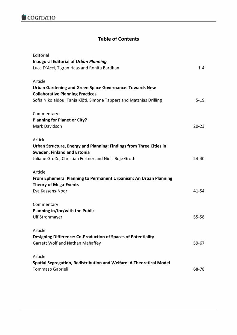
Table of Contents
Editorial
Inaugural Editorial of Urban Planning
Luca D’Acci, Tigran Haas and Ronita Bardhan 1-4
Article
Urban Gardening and Green Space Governance: Towards New
Collaborative Planning Practices
Sofia Nikolaidou, Tanja Klöti, Simone Tappert and Matthias Drilling 5-19
Commentary
Planning for Planet or City?
Mark Davidson 20-23
Article
Urban Structure, Energy and Planning: Findings from Three Cities in
Sweden, Finland and Estonia
Juliane Große, Christian Fertner and Niels Boje Groth 24-40
Article
From Ephemeral Planning to Permanent Urbanism: An Urban Planning
Theory of Mega-Events
Eva Kassens-Noor 41-54
Commentary
Planning in/for/with the Public
Ulf Strohmayer 55-58
Article
Designing Difference: Co-Production of Spaces of Potentiality
Garrett Wolf and Nathan Mahaffey 59-67
Article
Spatial Segregation, Redistribution and Welfare: A Theoretical Model
Tommaso Gabrieli 68-78

Article
Planners in the Future City: Using City Information Modelling to Support
Planners as Market Actors
Emine Mine Thompson, Paul Greenhalgh, Kevin Muldoon-Smith,
James Charlton and Michal Dolník 79-94
Article
Compact Cities Are Complex, Intense and Diverse but: Can We Design
Such Emergent Urban Properties?
Hye Kyung Lim and Jaan-Henrik Kain 95-113

Urban Planning, 2016, Volume 1, Issue 1, Pages 1-4 1
Urban Planning (ISSN: 2183-7635) 2016, Volume 1, Issue 1, Pages 1-4
Doi: 10.17645/up.v1i1.586
Editorial
Inaugural Editorial of Urban Planning
Luca D’Acci 1, Tigran Haas 2 and Ronita Bardhan 3
1 Institute for Housing and Urban Development Studies, Erasmus University Rotterdam, 3062 PA Rotterdam, The Netherlands; E-Mail: [email protected] 2 School of Architecture and Built Environment, KTH Royal Institute of Technology, 100 44 Stockholm, Sweden; E-Mail: [email protected] 3 Centre for Urban Science and Engineering, Indian Institute of Technology Bombay, Powai, 400076 Mumbai, India; E-Mail: [email protected]
Submitted: 15 December 2015 | Published: 8 February 2016
Abstract This editorial is the introductory piece of Urban Planning, a new international peer-reviewed open access journal of ur-ban studies aimed at advancing understanding of and ideas about humankind’s habitats in order to promote progress and quality of life.
Keywords future cities; progress; urban forms; urban planning
Issue This editorial is part of the issue “Urban Forms and Future Cities”, edited by Luca D’Acci (Erasmus University Rotterdam, The Netherlands), Tigran Haas (KTH Royal Institute of Technology, Sweden) and Ronita Bardhan (Indian Institute of Technology Bombay, India).
© 2016 by the authors; licensee Cogitatio (Lisbon, Portugal). This article is licensed under a Creative Commons Attribu-tion 4.0 International License (CC BY).
1. Humanistic and Scientific Approaches to Understanding Cities
Understanding cities by the knowledge of their com-plex emergence from bottom up evolutions is essential to designing plans. The latter should be aimed at ad-vancing humankind’s habitats and identifying patterns toward progress and quality of life at different scales and angles. This understanding and planning process is based on the premise that qualitative linked to quanti-tative approaches provide mutually sympathetic out-comes for adding knowledge to the complex and poly-hedral system par antonomasia as the city is.
The quantitative-scientific approach finds universal rules, viewing cities as part of the natural domain to be studied by scientific method. The humanistic approach claims a difference between the human and the natural domains, so studying cities and their phenomena quanti-tatively may lead to reductionism. Accordingly, this ap-proach finds soft hermeneutic methods more suitable.
This opposition is only a surface-deep as it is often
transformed into a profitable complementarity; that is using scientific methods when dealing with urban phe-nomena that are objective and universal, and the hu-manistic approach for phenomena that are not. We can also, when possible, quantify qualitative phenomena and qualitatively interpret quantified data. Sometimes quantifications without qualitative guides may be blind as well as the vice versa narrow.
The view of the world has repeatedly shifted be-tween these two pendulums: scientific and humanistic. During the first half of the 20th century, both sides were present; the system theory approach was preeminent and, during the 50’s, this induced re-searchers to see systems as centrally ordered, and as a hierarchical sum of subsystems dominated by negative feedback. Until the middle of the 20th century, a standard theory of cities as an economic and transpor-tation model prevailed, based predominantly on the monocentric city. Ideas and models were built on sta-tistical aggregations of units.
In the 1950’s the quantitative revolution criticized

Urban Planning, 2016, Volume 1, Issue 1, Pages 1-4 2
the scientific validity of the humanistic trend, which de-fined descriptive approaches. In turn, in the early 1970’s, scholars adopting urban social theories in the qualitative revolution criticized the positivist-quantitative approach.
The relatively recent science of urban complexity can be seen as a second scientific culture of cities, or, as I like, a junction between the scientific and human-istic cultures. Similarly, we often read the art of making cities versus the science of making cities, where art is viewed as the opposing counterpart to science. If for art we do not intend “beauty”—which is a fluctuating and baffling phenomenon—but intuition, then what we expect for a city to be a work of art is a personal ele-ment. Each city reveals unique features; each city is special, and in a different way for each of us.
The contemporary new science of cities, based on the complexity paradigm, is a science that induces art: each city emerges from unique contexts, from which the randomness of micro-fluctuations, the unpredicta-bility of positive feedback on the agent’s behaviour, and contextual historic successions, generate unique scenarios, each of them personally read. At the same time scientists clearly show a universality in several ur-ban phenomena, independently from where they are situated. Science sees the many in the one, art the one in the many, and this happens without the classical contradictions of art versus science, and of qualitative versus quantitative.
It is my wish that this opening should encourage a vibrant mixed-method community to strive towards a gainful use of the great promise offered by a multidis-ciplinary connection and the synergy of qualitative and quantitative sciences to understand and design our habitats.
Luca D’Acci
2. A Major Shift in Envisioning the Cities of the Future
The complexities of contemporary global urban, politi-cal, economic, and environmental issues are evident. It is not hyperbole to say that human beings are now confronted with the greatest challenge that we have ever faced; in fact, it is a matter of life and death. The planet has recently been experiencing a convergence of natural and human-made crises that are unprece-dented in our lifetime.
As we move toward 2050 we are facing the conse-quences of accelerating-rapid urbanization and popula-tion growth, the rise of mega-cities and mega-regions, the scarcity of natural resources and their misman-agement, the impact of major errors in our responses to disasters, and the increasing demand for and com-plexity of greatly expanding transportation flows. Our societies have also undergone rapid and radical shifts in terms of age and class, increasing inequities be-tween the rich and poor and intense demands for de-
mocracy in the public realm. With the lack of a dominating paradigm in urban
design and planning, we need to take a more thorough inquiry into the postmodern condition of cities. Various paradigms point to different forms of and approaches to design intervention in the public realm—each with conscious expectations, results, and consequences for the end users. Forces of structural and emergent change contribute to shaping the urban landscape and living infrastructures, presenting constant challenges for different measures for the reinvention of cities to be put in place. The importance of the digital and social media and network society in general, with its specific transformation and creation of new spaces and places is yet to be adequately explored.
The quality and the livability of the urban environ-ment in our cities, towns, districts and neighborhoods are the deciding factors in the social, cultural, econom-ic and environmental performance of societies and the quality of life of all their citizens. Our current studies need to encompass the history, culture and heritage management of cities. Previous studies in different fields, such as sociology, geography, architecture, envi-ronmental psychology, economics, etc. have explored people’s social behaviour and relationships with urban space. Unfortunately the findings of each of these fields remained just that—findings of different fields. There was no real attempt made to unify the rich data generated within each discipline in order to shed more light on which and what kinds of urban environments were more conducive to human life in cities.
There is obviously a paradigm shift on the horizon in urban planning and urban design, emphasizing its benefits for sustainable urban development through a people-centered approach. Traditionally, the focus of urban development has been on the hardware of cities (buildings and infrastructure), instead of the software (culture and place). There is a need to shift conven-tional urban thinking from objects to places.
The way forward is through sustainable (social-cultural-economic-ecological) and resilient cities: ener-gy-efficient neighborhoods and districts and green ur-banism, but also civic design that will help shape and organize the city on the basis of diversity, human scale and preservation. All of this requires immediate solu-tions but also a change in the worldviews of architects, urban planners, designers, landscape architects and urbanists. We need these professionals and experts to contribute their most imaginative, pragmatic, resilient, innovative and just solutions. New visions for neigh-borhood housing redevelopment should support a hu-man, economic, social and cultural recovery and re-newal. The systems and processes that we put in place to achieve these ends can be thought of as the “soft in-frastructure” of the community. This includes formal societal services and institutions as well as the com-munity’s informal structure, a unique and context-

Urban Planning, 2016, Volume 1, Issue 1, Pages 1-4 3
specific web of voluntary organizations and social rela-tionships. For any of this to happen, a major shift and change in habits, customs and adaptation to an uncer-tain future will be required from all citizens, and with-out a consensus of all, the vision of a sustainable and resilient urban world by 2050 will not be possible.
Tigran Haas
3. Redefining City Planning Agendas under the Contextual Realm
As we move towards an urbanized world, cities are be-coming the inevitable space for human interaction. Un-til now, cities were treated as engines of economic growth and the major focus was on the infrastructure that drives the city. However, it is the intangible ele-ment of culture which is the soft function for enhanc-ing cities’ competitiveness. The socio-economic fabric of the city does not only depend on the social and eco-nomic structure of the city, but also on the physical con-figuration and the context of the space. Urban planning should recognize the synergy between culture, economy and spatial patterns, and this inter-dependency should be reflected in new city planning agendas. With globali-zation, we are designing economically competitive glob-al cities to meet expectations, ignoring local natural in-clinations. The global city needs connotation of the intrinsic cultural transfusion into the capitalist form.
When we design a new city, we generally have cer-tain goals to meet. These goals are directed by the def-inition and description of the type of city we intend to develop, for example, a compact city, a smart city, an industrial city, etc. The definition generally contains goals regarding the hardware, i.e. housing and infra-structure needs, density targets and economic motiva-tions. But what are generally compromised are the context development objectives. This results in similar looking cities with rows of concrete structures packed within the space as per requirements. The inherent contextual and cultural setting which identifies and gives an ‘image to the city becomes secondary. Accord-ing to Sen (2004) “cultural matters are integral parts of the lives we lead. If development can be seen as en-hancement of our living standards, then efforts geared to development can hardly ignore the world of culture”. In the absence of it, the people residing there do not identify with the city and thus the ‘sense of belonging’ slowly dissipates (the community becomes egocentric) and thus the inhabitants do not ‘give back’ to the city.
It is often argued that it is the people and the kind of activity happening there that gives the city its identi-
ty and culture. Thus, its image should develop organi-cally with passage of time as it has happened with old cities. But the major difference between the evolution of old cities and new cities is that even the physical form of the city was previously developed organically, and this does not happen in new cities. Any type of ac-tivity or human interaction needs a particular type of physical space, and when this physical space itself can-not develop organically, the development of the cul-ture or the image of the city becomes less flexible. For example, to sustain a vibrant street culture, the city needs to make provision for the volumetric cultural space (physical space, for example wide footpaths for vendors, shops and sitting areas, and competitive eco-nomic space) along the roads. Without such provisions, development of the vibrant street culture is likely not possible and in turn inherently impedes walkability.
Future cities would need a quintessential shift in thinking to provide contextual culture solutions to the neo-urban challenges. And now is probably the most suitable time to initiate this change. With the advent of Big Data and its integration with geo-spatial technolo-gies, an enthusiasm for better understanding and man-aging cities with new and more extensive sources of data has emerged. Both urbanization and big data are unprecedented in their scope and can change irrevers-ibly how cities will be run. This is currently generating a space for quantifying the culture and context of place. The prospect of using big data in urban planning is an “obvious opportunity to understand urbanism as a way of life”. Despite this scope, the relationship between big data and urbanism is yet to be formalized. Since ur-ban planning is more about unearthing how citizens behave in the physical environment, hence it is neces-sary to forecast these human behaviour chains, which is the fundamental capacity of big data analysis. How-ever, many other computational issues associated with such large data sets need to be addressed. There is a need for conceptual frameworks that can resolve these existing dilemmas.
Ronita Bardhan
Conflict of Interests
The authors declare no conflict of interests.
Reference
Sen, A. (2004). Elements of a theory of human rights. Philosophy and Public Affairs, 32(4), 315-356.

Urban Planning, 2016, Volume 1, Issue 1, Pages 1-4 4
About the Authors
Dr. Luca D’Acci Luca D’Acci is the Head of Urban Management and Climate Change of the Institute for Housing and Urban Development Studies at Erasmus University Rotterdam, and an Honorary Research Fellow at the University of Birmingham.
Dr. Tigran Haas Tigran Haas is an Associate Professor and Reader of Urban Planning & Urban Design at the School of Architecture and the Built Environment at KTH Royal Institute of Technology. He is the Founder and Director of the Civitas Athenaeum Laboratory (CAL), Applied Social Science Research Platform at KTH and the Director of Graduate Studies in Urbanism.
Dr. Ronita Bardhan Ronita Bardhan is an Assistant Professor at the Centre for Urban Science and Engineering at The Indi-an Institute of Technology Bombay. She holds a PhD in Urban Engineering and is also a member of the Council of Architecture in India and IEEE-GRSS.

Urban Planning, 2016, Volume 1, Issue 1, Pages 5-19 5
Urban Planning (ISSN: 2183-7635) 2016, Volume 1, Issue 1, Pages 5-19
Doi: 10.17645/up.v1i1.520
Article
Urban Gardening and Green Space Governance: Towards New Collaborative Planning Practices
Sofia Nikolaïdou 1,*, Tanja Klöti 2, Simone Tappert 2 and Matthias Drilling 2
1 Centre of Social Morphology and Social Policy, Department of Social Policy, Panteion University of Social and Political Sciences, 17671 Athens, Greece; E-Mail: [email protected] 2 Institute for Social Planning, Organisational Change and Urban Development, School of Social Work, University of Applied Sciences and Arts Northwestern Switzerland, 4053 Basel, Switzerland; E-Mails: [email protected] (T.K.), [email protected] (S.T.), [email protected] (M.D.)
* Corresponding author
Submitted: 2 December 2015 | Accepted: 22 January 2016 | Published: 29 February 2016
Abstract In the context of urban densification and central urban areas’ lack of open spaces, new forms of small-scale urban gar-dening practices have emerged. These gardening practices respond to urban pressures and open new modes of green space governance, presenting alternative and multifunctional ways to manage and revitalise cities. Focusing on the case of Geneva, the article unfolds two levels of discussion. On the one hand—and with reference to the theorist Haber-mas—it examines how multiple actors with different interests interplay and cooperate with each other in order to ne-gotiate over open space, while discussing implications for local politics and planning. On the other hand, it describes how these negotiations result in new, innovative, and hybrid forms of public green space. The main findings indicate emerging forms of collaboration, partnerships, and governance patterns that involve public and private sectors and in-crease participation by civil society actors. Cooperation amongst several interested groups and the collective re-invention of public urban spaces increase these spaces’ accessibility for multiple users and actors, as well as present possibilities for alternative and diversified uses and activities. This might underline the hypothesis that future cities will be governed in less formalised ways, and that urban forms will be created through spontaneous, temporary, mobile, and adaptive negotiation processes.
Keywords collaborative planning; green space governance; hybrid space; open green space; urban gardening
Issue This article is part of the issue “Urban Forms and Future Cities”, edited by Luca D’Acci (Erasmus University Rotterdam, The Netherlands), Tigran Haas (KTH Royal Institute of Technology, Sweden) and Ronita Bardhan (Indian Institute of Technology Bombay, India).
© 2016 by the authors; licensee Cogitatio (Lisbon, Portugal). This article is licensed under a Creative Commons Attribu-tion 4.0 International License (CC BY).
1. Introduction
Political and urban restructuring processes since the late 1960s have caused city transformations on differ-ent levels (Soja, Morales, & Wolff, 1983). Concerning the form and fabric of urban settlements, new socio-spatial configurations have emerged, framed within the planning paradigm of urban growth and densification. These processes imply a change in planning approach-
es and in the meaning of urban open spaces, both of which are seen as highly important for sustainable ur-ban growth (Ward Thompson, 2002). Open space, which embraces both public and private lands, has been intrinsically associated with the ‘undeveloped’ nature of open pieces of land—vegetated or not (e.g. green spaces, playgrounds, vacant lots, etc.)—and with a regular accessibility to the public. However, tradi-tional open space strategies have generally related to

Urban Planning, 2016, Volume 1, Issue 1, Pages 5-19 6
publicly owned/managed open space that has been formally laid out for leisure and recreation. In light of new urban configurations and the changing social dy-namics of urban space, conceptual and analytic atten-tion has been given to the “access to space as a prod-uct of negotiations” (Hackenbroch, 2013, p. 38). On the socio-political level, this characterization of space as a product of negotiations indicates a shift towards col-laborative space and land management decisions through civic participation and increased public-private partnerships. Thus, new practices of urban politics treat open space as a ground for diverse uses and forms of coalition amongst several stakeholders, put-ting it at the core of participatory governance and col-laborative planning.
Urban gardening spaces—as one type of open space asset—are considered to promote civic engage-ment, collective empowerment, and community-building (Glover, 2004; Rosol, 2010; Saldivar-Tanaka & Krasny, 2004; Tan Leon & Harvey, 2009). They are also considered productive spaces for sustainable agricul-tural activities (Drescher, Holmer, & Iaquinta, 2006; Pothukuchi & Kaufman, 1999). Because they combine city and nature, as well as the social and environmental aspects of gardening, urban gardening spaces have be-come increasingly recognised as productive and social-ly inclusive uses of open green spaces in cities (Firth, Maye, & Pearson, 2011; Holland, 2004). Consequently, urban gardening initiatives have been strongly advo-cated and supported by many public and private ac-tors. Due to a scarcity of space, open green spaces compete with other potential uses of urban space like housing and business zones (Jim, 2004). They are treated as a valuable way to maintain and enable high quality densification of urban settlements, enhancing the attractiveness of the city within the context of in-creasing city competition. Alternative attempts to facil-itate neighbourhood greening and nature within the city have been either temporary (Kulke et al., 2011), or have developed formal and informal green sites in all possible, remaining enclaves within compact areas (Jim, 2004). Further, postmodern lifestyles and “atti-tudes to nature and sustainability” (Ward Thompson, 2002, p. 59) are generating new and diversified de-mands for open green space. This suggests that the meaning of open green space is expanding; increasing-ly, open green space is recognised as central not only to the ecosystem, but also in the amelioration of urban living conditions (Arnberger, 2012), which it does by of-fering social services, fulfilling psychological needs of citizens (Chiesura, 2004; Germann-Chiari & Seeland, 2004), and developing and maintaining the quality of life in the city.
2. Urban Space in Planning Paradigms
Thus far, urban planning—framed mainly by Rational
Theory—has been oriented towards the conventional, top-down model of comprehensive planning. Its most important function has been “to create a master plan which can guide the deliberations of specialist plan-ners” (Altshuler, 1965, p. 186) and to systematically analyse, predict, and control urban development (All-mendinger, 2009). This rather planner-centric planning model has been widely criticised as rational and objec-tive, anti-democratic, exclusive, and—in the positivist logic of cause and effect—apolitical, and, therefore, as neglecting the influence of society, as well as the values and meanings of the planning process. Moreover, its critics claim that it further disempowers stakeholders and ignores or exacerbates major societal problems, even creating new problems by not taking into account the social consequences of planning (Shannon, 1999).
In order to overcome these problems, emergent planning theories (for an overview, see Allmendinger, 2009; Fainstein & Campbell, 2012) were expected to become more inclusionary and consensus-based rather than expert-driven (McCann, 2001). The collaborative planning approach is one of these emergent theories, defining planning as an interactive and communicative process in which space utilisation and design issues are negotiated between different stakeholders (Harris, 2002). Its ideas are framed by Habermas’ idea of com-municative rationality, which seeks to realise objective decisions not through formal rationality, but through communication and agreement between individuals. Therefore, reason can be formed only through the ne-gotiation of equally empowered and fully informed stakeholders in a free and open discourse (Habermas, 1981). Ideally, this negotiation leads to an intersubjec-tive, mutual understanding, also referred to as consen-sus. Thus, all plans are a result of negotiation about values. Therefore, planning should stem from an open debate that achieves mutual understanding and, if pos-sible, results in consensus (Innes, 1996). This collabora-tive turn emphasises the political aspects of planning, and sets forward a normative agenda for a more dem-ocratic, socially just, and sustainable urban planning. The foremost means to achieve these goals are public participation and deliberation in order to better link the system’s logic (e.g. of the planning administration) with citizen’s lifeworlds (Healey, 1992).
Collaborative planning originated in a time when society experienced a changing relationship between the state, economy, and civil society. Referred to as the shift from government to governance, political pro-cesses, structures, and actors were fundamentally transformed (Heeg & Rosol, 2007), as seen in the redis-tribution of political power from the state to private actors. Economic as well as civic stakeholders gained more influence, responsibility, and competency in planning processes (Swyngedouw, Moulaert, & Rodri-guez, 2002) because collaborative planning pictures planning as a collaboration between state, economy,

Urban Planning, 2016, Volume 1, Issue 1, Pages 5-19 7
and civil society in the management of collective af-fairs. This development includes a broad opening of planning processes to non-state actors, as well as a turn towards local partnerships; the approach encourages participation of community organisations, local busi-nesses, and residents, and transcends the separation be-tween top-down and bottom-up activities (Elwood, 2002; Ghose, 2005). Therefore, according to Geddes (2006), this local partnership governance presents a new approach to democratic legitimacy and new possibilities for enhancing the capacity of local governance.
However, a critical approach to the so called de-mocratisation of planning addresses the role of neolib-eral policies and the repression of the state, which pre-sent a number of barriers to and complexities of participation (Elwood, 2002; Ghose, 2005). As Sullivan (2001) and McCann (2001) state, collaborative planning empowers, not only citizens, but also private capital, which often leads to a reproduction of the dominant model of economic development. This also includes the devolution of state responsibilities to citizens (Ghose, 2005), although not “accompanied by a parallel expan-sion in community organisations’ power and influence in urban governance” (Elwood, 2002, p. 123). In this context, the outsourced provision and maintenance of urban green spaces to civil organisations and individu-als illustrates how neoliberal policies influence plan-ning processes. As Perkins (2009) shows, these organi-sations depend heavily on voluntary civic engagement since processes are characterised by state control over resources and reduced planning responsibilities. Fur-thermore, questions about interests and who controls the planning process are crucial (McCann, 2001) since those in power often reproduce social inequalities in terms of access to and power over spaces, especially when supporting informal and uneven decision-making processes. Although labelled “inclusive planning”, col-laborative and participative processes are often framed by an expert-driven agenda and their arrangement is pre-set by organising agencies. According to Geddes (2006), informal governance structures may profit civil organisations, but exclude local communities or non-organised people who lack the necessary resources to participate (Elwood, 2002; Ghose, 2005). In this sense, the informality of the planning process reproduces ex-isting inequalities (Swyngedouw et al., 2002) and seems to undermine democracy, legitimacy, and ac-countability (Geddes, 2006; Sullivan, 2001).
3. Urban Gardening in Transforming Cities: Changing Meanings, Hybrid Functions, and New Actors
Urban gardening is representative of this shift in the meaning and conception of planning practices, as well as the strategic importance of open green space in compact cities. It can be defined as a spatial concept that promotes small-scale open green spaces that are
close to or within residential areas and characterised by their multifunctional uses. Its planning process is of-ten determined by collaborations between public and civil society actors.
Two major, complementary issues arise from the emergence of urban gardening within the city, urging us to consider the changing conditions under which ur-ban planning practices take place:
1) New, adaptive, and flexible forms of urban gar-dening represent a shift in the meaning and function of open green space; these forms cre-ate new open green spaces of hybrid character (Nissen, 2008) that are characterised by:
The temporary nature, flexibility, and adaptabil-ity of urban space. Urban gardening initiatives are often installed temporarily “on vacant lots and formerly or future built-up sites” (Fuhrich & Goderbauer, 2011, p. 53), where they serve rec-reational purposes and build green corridors, especially in areas with high structural density that lack open green space. They adapt to cur-rent spatial developments, represent social de-mands, and adjust to a site’s existing physical conditions and local characteristics. They repre-sent a flexible use of urban space that corre-sponds to dynamic and multiple activities as well as to the actual needs of the gardeners. Ur-ban gardening initiatives constitute new ways to re-appropriate land through community, collec-tive reactivation, and novel forms of governance (Altés & Serra, 2012).
New, multiple functions are recognised and im-plemented. It is widely acknowledged that—apart from its contribution to food provision, biodiversity, nature, and related ecosystem ser-vices within the urban fabric—urban gardening can enhance socially sustainable urban devel-opment by supporting local capacity building and providing the possibility for a development that is socially inclusive (Fritsche, Klamt, Rosol, & Schulz, 2011).
It creates economic value by contributing to the quality of a city’s landscape (its location, scenic setting, built environment, quality of life, recre-ational value, image, and level of identification) and by qualitatively improving urban areas or upgrading neglected areas. As such, urban gar-dening initiatives may also influence real estate prices (Lossau & Winter, 2011). By realising dif-ferent potential uses in a small area through civ-il engagement and public accessibility, urban gardens represent a new form of open green space in the city. However, urban gardening ini-tiatives that aim to improve the liveability of an urban area or to upgrade it may also reinforce social inequalities in cities. Although urban gar-

Urban Planning, 2016, Volume 1, Issue 1, Pages 5-19 8
dening initiatives adopt an environmental ethic, they implement a sustainable planning agenda of urban greening that may result in environ-mental gentrification, excluding politically and economically vulnerable groups from negotia-tions on access to urban green spaces (Checker, 2011; Hagerman, 2007). Thus, urban gardening initiatives to make the city greener through col-laborative planning approaches may not pro-duce benefits “that are universally enjoyed by all urban inhabitants” (Dooling, 2009, p. 630).
2) Collaborative planning practices in urban gar-dening projects reflect and enable new forms of urban governance and collaboration. According to Fritsche et al. (2011), slow real estate devel-opment or municipality budgetary difficulties open up possibilities for interim, temporary uses and new, collaborative partnerships. Since many urban gardening sites are on land that is not public property, and/or because the state lacks essential resources (such as professional know-how, time, financial capital, etc.), development of these areas is highly dependent on the resources and engagement of non-state actors. Therefore, instead of state-led planning of urban garden sites, collaborative planning practices that involve various stakeholders in all levels of planning, de-sign, use, and maintenance of the garden site have been applied. Andres (2013) argues that the weaker the planning authorities due to political, financial, or economic crises, the greater the pos-sibilities for non-state actors to—at least tempo-rarily—access and control urban spaces. In such situations, planning processes are more informal and disordered, and power relations are more fluid and complex. In this context, actors follow opportunistic as well as cooperative approaches to achieve their goals.
4. Research Questions and Method
This examination of newer urban gardening initiatives in Geneva is embedded in a collaborative planning framework that incorporates negotiation-based inter-actions among stakeholders with participative forms of governance. Therefore, this research poses the follow-ing questions about current gardening practices and their impact on the production and re-appropriation of urban open green space: 1) How do emerging collabo-rative processes on new urban gardening initiatives af-fect the negotiation, functions, and governance of green space? 2) How are power and interests distribut-ed amongst the different public and civic participants involved in the process? 3) To what extent are these in-itiatives linked to Geneva’s current planning practices and urban open space policies?
First, a literature review and document analysis were conducted in order to understand the general context of urban development and approaches to-wards open green spaces in Geneva. A broad definition of documents was applied, ranging from administrative documents (such as legal acts and spatial planning documents) to documents published by or circulated amongst particular gardening initiatives.
Second, to grant an in-depth understanding of cur-rent trends, several gardens were visited. For the aim of this small-scale, qualitative research project, the ‘Jardins du Centre horticole Beaulieu’ was chosen as a case-study representation of two current trends in Ge-nevan urban gardening: municipal and bottom-up initi-atives. It depicts new forms of cooperation between civil society, economic, and political-administrative ac-tors, influencing new urban planning and green space governance.
Third, nine semi-structured interviews (and various informal conversations) were conducted with a total of eight interviewees. Of these interviewees, five were public actors who represented the municipality of Ge-neva (Service of Green Spaces, Unit of Community Ac-tion, Service Agenda21 for Sustainable Development, Department of Urban Planning), three represented civil society organisations involved in urban gardening pro-jects (Equiterre, an association for sustainable devel-opment; Utopiana, an artistic non-profit organisation), and one represented the Jardins potagers de Beaulieu (Collective Beaulieu/Association les Artichauts). In or-der to identify initial themes and concepts from the da-ta, as well as move from raw data to evidence-based interpretations, a thematic analysis was conducted. This was undertaken in two stages. The first stage dealt with the management, sorting, and synthesising of the data. The second with systematically interpreting the data in order to move from descriptive to explanatory accounts (Rubin & Rubin, 2005).
5. Gardening Initiatives in the City of Geneva: Emerging Forms and Practices
5.1. Urban Gardening and Space Scarcity: Changing Forms and Conceptual Shifts
Ranked amongst the most competitive and economi-cally attractive cities in the world, Geneva is an im-portant city for international organisations and the banking sector. In its highly globalised context, the city seeks to attract not only capital and enterprises, but al-so new inhabitants. However, despite its abundant employment opportunities, strong migration, and pop-ulation growth, the housing market’s visible failure ex-plains the imbalance in Geneva between the high number of jobs and the relatively low number of flats (Quincerot & Weil, 2009, pp. 13-15). In the midst of its most acute housing crisis, one of Geneva’s top priori-

Urban Planning, 2016, Volume 1, Issue 1, Pages 5-19 9
ties is the construction of new housing areas, which the city hopes to achieve through urban expansion and ‘qualitative densification’ of existing, built-up areas. Therefore, its dominant city-planning strategy aims to increase urban density while integrating green spaces into the urban landscape (Quincerot & Weil, 2009, p. 17). Under these circumstances, new forms of small-scale urban gardening practices have emerged as al-ternative methods for making dense urban cores greener; these practices have been labelled jardins po-tagers, plantages, or potagers urbains. Though these terms are not clarified as concepts or in practice, they are widely used to describe many of the urban garden-ing projects that have been reported in Geneva and neighbouring municipalities. They usually refer to small plots in inner, dense areas, located on private or city-owned land (vacant/unused plots or existing open green spaces) that can be easily and quickly reused.
The Geneva municipality contains around eleven new urban gardening projects; most of these projects have developed within the last 2–3 years (see Figure 1). Two main types of jardins potagers should be distin-guished: municipal gardens that have developed on the local, neighbourhood scale within the framework of municipal social policies (mainly initiated by the Units
for Community Action—UAC), and several bottom-up initiatives that have been widely supported by public action through new forms of participation and cooper-ation between civil society and political-administrative actors.
Whether as top-down or bottom-up initiatives, they appear to be new and flexible forms of urban garden-ing, for they respond to the long waiting lists for tradi-tional allotment sites (family gardens) as well to the scarcity of open green space. Their general characteris-tics can be summarised as followed:
a) small plots in inner areas (6–10m2) b) on public or private land (vacant/unused plots
or existing green/open spaces—lawn front yards, parks etc.)
c) accessible to all people from the surrounding areas (5–10 minutes by foot)
d) allocated without rent or for a small, symbolic participation fee
e) under a generally non-renewable one-two year contract
f) long waiting lists for a plot, selection in order of preference (i.e. proximity to gardening site)
Figure 1. Urban gardening initiatives in the city of Geneva. Source: Google Maps, Nikolaidou, 2014. Green bullet: Family gardens (Jardins familiaux); Blue bullet: New urban gardening projects (Jardins potagers).

Urban Planning, 2016, Volume 1, Issue 1, Pages 5-19 10
5.2. Integration in the Local Policy Agenda: Urban Greening and Social Cohesion
Even though the jardins potagers are not at the centre of the municipal policy agenda, the city supports new forms of urban gardening initiatives, granting the initia-tives some political recognition. Though not clearly specified, the term jardin potagers has been intro-duced more at the cantonal and less at the municipal level through strategic development plans and the pol-icy agenda (Plan Directeur Cantonal 2030, Plan Di-recteur Communal 2020). Thereby, two main public ac-tion priorities, with a particular relevance to new urban gardening trends, can be distinguished. The first can be seen through promotion of the social dimension of public space policy. Perceived as part of the larger con-cept of social space, potagers urbains are considered part of the general development of collective and re-appropriated spaces in the city that aim to foster prox-imity, social cohesion, and conviviality while also diver-sifying uses of unused space in the neighbourhood (Canton de Genève, 2013). Situated around housing areas, they may help improve quality of life and en-hance urbanite social interaction and cohesion. The second priority is linked to nature and biodiversity. In order to support the city’s goal to be a green city, the contemporary concept of “Nature in the city and biodi-versity” (Quincerot & Weil, 2009, p. 175) is being de-veloped in a wider territorial context in which new forms of territories and networks of open spaces unite nature, gardening, and urban development (Daune & Mongé, 2011). Among other uses, municipalities can use gardening spaces to develop a network of green open spaces through green wedges that penetrate ur-ban core areas (pénétrantes de verdure) (Quincerot & Weil, 2009). Gardening spaces’ multifunctional role of providing corridors for the preservation of nature, agri-culture, and recreation in a diversified manner may es-pecially help protect and improve the natural environ-ment; this protection and improvement occurs in the context of increasing inner-city densification.
However, although the Neighbourhood Land Use Plans call for these aspects to be integrated, this inten-tion has not been realized. Apart from the above men-tioned strategic orientations at a cantonal level, jardins potagers have not been integrated in the land use plans. They’ve usually become spaces for negotiation, as well as for temporary and less formalised planning practices. The land is often used on a temporary basis, and projects are created on constructible land. The municipality’s approach adapts to citizens’ existing demands instead of imposing top-down initiatives. Therefore, the city examines each possible case and creates separate demands for each of them, following opportunistic and short-term strategies to recover un-used land. In this context, urban gardening is conceived as a low-cost way to reactivate and maintain unused
space in a way that carries a low risk of failure and can also be seen as an ad hoc ‘upcycling’ process of space (a reuse of the space by adding new value).
5.3. Increasing Collaborative Processes in the Negotiation of Space
The city of Geneva aims to increase citizen participa-tion and collaborative planning in different forms and on various spatial levels. With its so called contrats de quartiers (district contracts), the city has implemented new forms of governance through stronger collabora-tion with civil organisations in order to meet the needs of its inhabitants (Quincerot & Weil, 2009). In the case of urban gardening, local partnerships and new collabora-tions have been developed in order to negotiate open space and increase participation. Such collaborative pro-cesses can involve public actors from different services in municipal administration, as well as non-state actors like non-profit associations, grassroots movements, and other civil society representatives or private actors.
The City of Geneva usually structures public in-volvement in urban gardening projects through the dif-ferent units and services of municipal administration: Units for Community Action that are mainly in charge of municipal gardens (UAC—Unité d’Action Commu-nautaire, Département de la Cohésion Sociale), Service of Green Spaces (SEVE—Service des espaces verts, Département de l’environnement urbain et de la sécu-rité), Service Agenda 21—Sustainable City (Ville Dura-ble), and Municipal Property management (Gérance immobilière municipal) of the Department of Finance and Housing (Département des finances et du logement). In addition, the municipality seeks external help to implement urban gardening initiatives; non-profit organisations are becoming major channels for the development of participative urban gardening pro-jects. They advise and support the municipality in de-veloping and actively promoting urban gardening pro-jects. This feeds directly into the municipal approach of adapting to the existing demands of citizens by em-bracing a participatory approach. Future users are en-couraged to rethink their roles in a co-modified collec-tive space and to establish a cooperative structure among users; while the municipality makes use of the knowledge and expertise of non-profit organisations. The range of stakeholders and the roles these stake-holders play in the negotiation of space are shown in a three-stage collaborative process (see Figure 2).
Nevertheless, in a context of space scarcity, where access to land is most important, the negotiation of space and governance patterns often takes place through informal processes. According to the municipal administration, there is an infinite potential to support urban gardening projects in the inner-city area because land can be made available by re-activating and main-taining unused space (front yards of block of flats, parks,

Urban Planning, 2016, Volume 1, Issue 1, Pages 5-19 11
Figure 2. The different collaborative processes in urban gardening and negotiation of space in Geneva: Building consen-sus among actors. Source: Authors.
and vacant land). However, no accurate policy document or inventory of vacant land sets out the potential land available for urban gardening. Existing documents managed by the municipal property service (Gérance immobilière) do not point out the overall possibilities for open green space; there is a wide variety of unused land. For example, front yards of private buildings may be vacant land that has not necessarily been registered. Therefore, the city examines each possible case and demand for urban gardening separately and rather haphazardly, following opportunistic and short-term strategies that align with densification strategies.
Thus, urban gardening initiatives are considered flexible and barely formalised forms that adapt to the lack of open green space in the dense urban core with
a more temporal land-use dimension. New projects are often created on land that is classified as constructible, but is still undeveloped. The land might be informally classified as agricultural in order to create short-term urban gardens (2–3 years), but also be constructible until used for residential or other urban projects. Some urban gardening projects are not based on contracts. Instead, deals are based on mutual trust between users and land owners for the municipal services (contracts of confidence with private owners, NGOs, and/or mu-nicipalities as intermediates to guarantee that there will be no conflicts—i.e. in regards to noise, dirt, a healthy and safe living environment, etc.). The munici-pality gives priority to the front yards of flats (pelouses) and unused urban spaces rather than parks or other green areas that already have a public use. Though
Urban Planning, 2016, Volume 1, Issue 1, Pages 5-19 12
land can be either private or public (municipal), front yards are mainly privately owned, which complicates negotiation processes; attempts to reach a contract of confidence become time-consuming. Here, the municipality mediates to facilitate negotiation pro-cesses and guarantee the safe use of the space. Urban gardening is considered a short-term and low-cost land management approach that optimises vacant land use through production and greening and reduc-es the risk of failure.
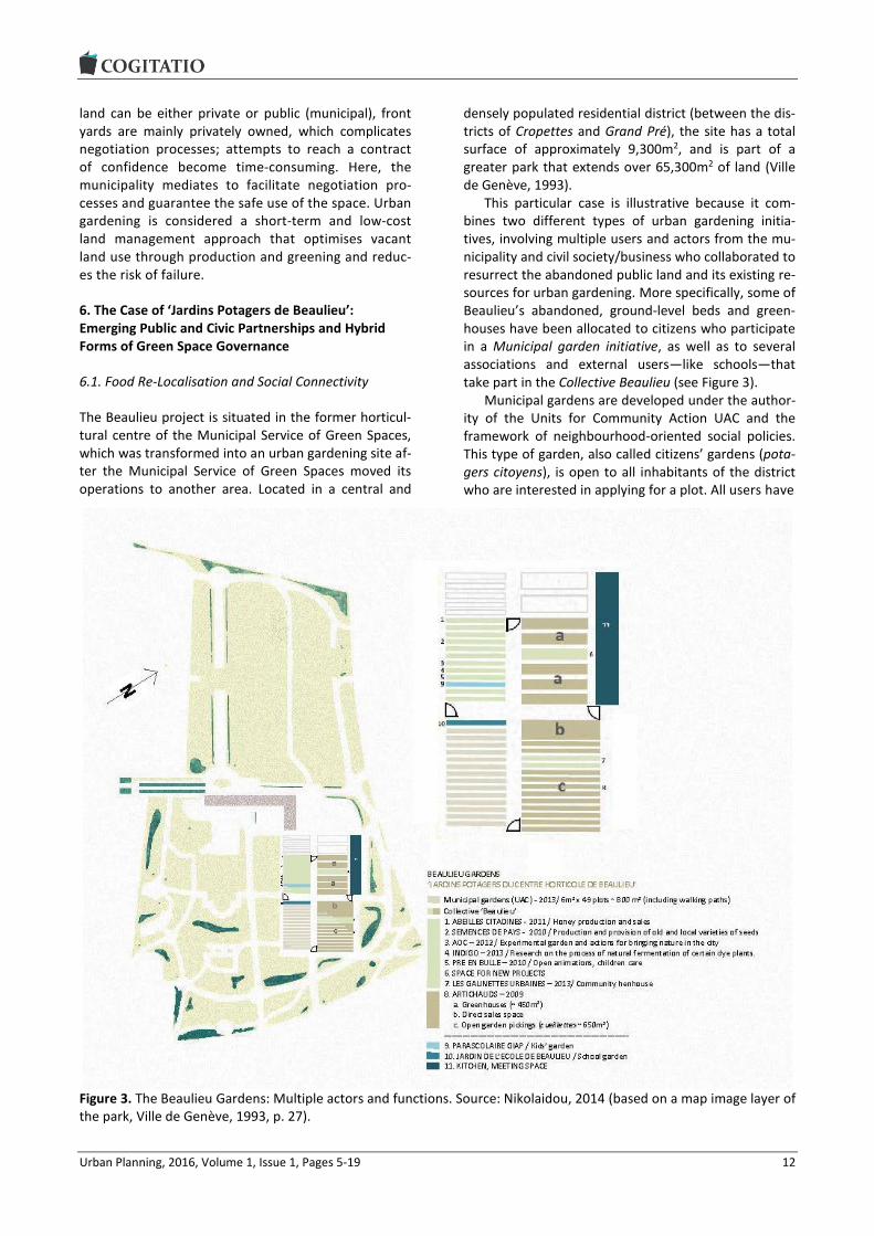
6. The Case of ‘Jardins Potagers de Beaulieu’: Emerging Public and Civic Partnerships and Hybrid Forms of Green Space Governance
6.1. Food Re-Localisation and Social Connectivity
The Beaulieu project is situated in the former horticul-tural centre of the Municipal Service of Green Spaces, which was transformed into an urban gardening site af-ter the Municipal Service of Green Spaces moved its operations to another area. Located in a central and
densely populated residential district (between the dis-tricts of Cropettes and Grand Pré), the site has a total surface of approximately 9,300m2, and is part of a greater park that extends over 65,300m2 of land (Ville de Genève, 1993).
This particular case is illustrative because it com-bines two different types of urban gardening initia-tives, involving multiple users and actors from the mu-nicipality and civil society/business who collaborated to resurrect the abandoned public land and its existing re-sources for urban gardening. More specifically, some of Beaulieu’s abandoned, ground-level beds and green-houses have been allocated to citizens who participate in a Municipal garden initiative, as well as to several associations and external users—like schools—that take part in the Collective Beaulieu (see Figure 3).
Municipal gardens are developed under the author-ity of the Units for Community Action UAC and the framework of neighbourhood-oriented social policies. This type of garden, also called citizens’ gardens (pota-gers citoyens), is open to all inhabitants of the district who are interested in applying for a plot. All users have
Figure 3. The Beaulieu Gardens: Multiple actors and functions. Source: Nikolaidou, 2014 (based on a map image layer of the park, Ville de Genève, 1993, p. 27).

Urban Planning, 2016, Volume 1, Issue 1, Pages 5-19 13
their own plot (49 parcels of 6m2 in a total of 800m2 in-cluding pathways), receive all the necessary water, tools, and support to start and maintain their garden. Plots are allocated only to neighbourhood residents—those who live within a close distance—under a non-renewable contract for two years. Residents pay no rent, only a reimbursable participation fee that guards against any damages that may occur in the garden. The plots have no fencing, and can be used by an individu-al, a family, or shared between more than one person. The UAC is responsible for the operation and surveil-lance of the site. According to UAC representatives, the gardens are highly diversified in terms of the social mixture of caretakers (e.g. high, middle, and low-income residents, multi-ethnic, intergenerational etc.). The UAC’s main aims are ‘strengthening community life and creating a social space for interaction, contact and creativity for the inhabitants of the nearby neighbour-hoods’ (Interviews with Municipal Service UAC) through the gardens. The project’s growing popularity has created a long waiting list; approximately 200 resi-dents wish to join Beaulieu gardens.
Gardens run by bottom-up initiatives combine edu-cational, food-activist, and market-oriented activities towards Community Supported Agriculture (CSA or ACP—Agriculture Contractuelle de Proximité) and short food chain networks. These initiatives are currently represented by the Collective Beaulieu and one school (School of Beaulieu). The Association Artichauts, the most important actor in Beaulieu, occupies the largest amount of land, including greenhouses and hotbeds. The association produces certified organic plants (200,000 seedlings per year), which are sold to 9–10 bigger farms and cooperatives in the agglomeration. All of their clients are working with CSA bio baskets, which are delivered to urban dwellers. At the same time, Arti-chauts provide local, organic, fresh vegetables on the local neighbourhood-scale through open garden pick-ings. During the sale, all residents and passers-by are welcome to collect vegetables straight from the plant, weigh them, and leave payment in a box. The garden also serves as a green meeting space, which hosts sev-eral activities and neighbourhood events and supplies gardening information and materials. The association Artichauts, together with Pré en Bulle, works regularly with schools and community centres to put on educa-tional events that enhance public awareness, knowledge, and participation in nature conservation.
6.2. Negotiation Process, Space, and Governance Patterns: The Power of Informality
Since the relocation in 2008 of the Beaulieu horticul-tural site of SEVE to another area, and shortly after the evacuation of the site, several civil-society actors in-volved themselves in the area’s re-vitalisation, all claiming the empty and unused space to perform their
activities. In 2009, SEVE (which manages the former horticultural centre) allocated Artichauts some of the site’s old greenhouses in response to the non-profit’s request for space in which to grow plants. Shortly thereafter—in 2010—Artichauts and Pré en bulle, in co-operation with other cooperatives, co-founded the Col-lective Beaulieu without official direction from the mu-nicipal authorities. In the context of anticipated renovations of the abandoned park, this group proposed to the municipality a collaborative project that would aim to foster urban garden development and related di-versified activities in the former horticultural centre.
Though the municipality initially reacted with disbe-lief and scepticism, the project was fated to succeed. Municipal support was finally obtained in 2010, primar-ily because the general public seemed to favor the Col-lective’s proposal because it would enrich the surround-ing neighbourhoods. Using the existing infrastructure, the project aimed to provide a green and versatile space for neighbourhood residents, integrate relations with nature, and meet the needs of sustainable local food production by promoting proximity farming activi-ties and food sovereignty (Collectif Beaulieu, 2010; Pré en Bulle, 2008). SEVE and UAC were the two major municipal actors that actively supported the establish-ment of urban gardening in the Beaulieu Park, which they demonstrated by contributing financially. SEVE embraced the idea because the “proposed activities were consistent with the goals of preserving the agri-cultural history and the horticultural heritage (green-houses) of the Park Beaulieu. At the same time it was considered as a way to penetrate greenery in the urban fabric” (Interview with SEVE). Likewise, according to UAC, the proposal was compatible with the municipal community gardens that already existed nearby, and could “steer a society’s demand for urban gardening by improving the quality of life of the surrounding neigh-bourhood”. Therefore, after a slow decision-making process, the UAC municipal garden was integrated into the site in 2013.
Beaulieu depicts new forms of space governance through collaboration and partnerships between public and private actors. Examining the Beaulieu negotiation process, several characteristics of planning through debate (Healey, 1992) can be revealed. The involved actors have different perceptions of proximity and dif-ferent motivations about urban agriculture and urban gardening; they also have different organisational and governance models. On the one hand, the municipality seeks proximity with citizens and to promote social contact and cohesion. On the other, associations in Beaulieu are linked with proximity agriculture net-works, community-supported agriculture farms, coop-eratives, and customers. Though driven from different conceptions of locality and proximity, experience shows that both initiatives (Collective Beaulieu and the UAC gardens) can be successfully related, and that

Urban Planning, 2016, Volume 1, Issue 1, Pages 5-19 14
both parties can agree on a collective vision about sharing a common space. From a perspective of com-municative rationality (Habermas, 1981), the actors es-tablished a mutual understanding about how to use the site; they promoted the normative ideas of sustainable production, protection of nature, and social cohesion as a consensual ground for their various actions. Thus, Beaulieu is a place where multiple and diverse user groups with compatible and complementary uses coex-ist, reclaim, co-modify, and revive an abandoned horti-cultural centre by installing various gardening projects and creating community space. It shows that mobilising various non-state stakeholders with the support of pub-lic authorities can produce a successful combination—successful in the sense of linking the logic of the plan-ning administration with the lifeworlds of activists, as well as surrounding neighbourhood (Healey, 1992).
The deliberative approach adapted in the Beaulieu case is embedded in a governance mode of collabora-tion: though primarily derived as a bottom-up initia-tive, the strong inter-dependence between public and civic actors questions the dichotomy between bottom-up and top-down approaches. It allows the utilisation of the different potentialities and capabilities of vari-ous stakeholders (Elwood, 2002; Ghose, 2005). In this sense, Beaulieu may be characterised not as a struggle between the ‘ones above and the others below’, but rather as a collaboration between state, economy, and civil society in the management of their collective af-fairs. However, both parties depend on each other: the Collective Beaulieu’s cooperation with public actors, under the active support of municipal administrative actors, is a win-win situation—the project would likely have failed without this synergy. But when this synergy is added to the already existing monetary connections between the Collective and the municipality (Ernwein, 2014), the Collective and its associations clearly cannot be pictured as financially autonomous. This means that the Collective relies on municipal support, which might jeopardise (or marginalise) Collective members’ roles and interests in the decision-making process. On the other hand, the municipality’s negotiations must end in mutual benefit in order for the municipality to make use of public land. Therefore, this project is also a way “to maintain and manage the communal land with min-imal cost” (interview with SEVE). In other words, the local partnership governance (Geddes, 2006) allows the state to prove its democratic legitimacy and its ca-pacity for administrative control in a context of urban challenges (Quincerot & Weil, 2009). However, the municipality collaborates via informal processes that are based on mutual commitment rather than on offi-cial contracts. The administration of garden operations typically requires the SEVE to partner with local com-munity groups, giving them permission to access the land. These informal contracts of confidence reveal an alternative governing structure that links several ac-
tors, interests, and perspectives through multi-actor decision-making.
As many critiques of Habermas’ communicative theory have stated, there is no such thing as a dis-course that is free of power (Flyvbjerg, 1998). There-fore, the result of the deliberative process in Beaulieu must be considered the outcome of power struggles. The Collective Beaulieu substantially widened its influ-ence, responsibility, and competencies through the process, and was able to claim the status of a powerful actor. Contrarily, the other gardeners cannot exercise power, neither through debate nor structure. The re-striction of gardeners’ contracts to two years creates a constant flux of gardeners; additionally, gardeners’ in-terests are not organised, but only represented by UAC. While access to the site is widely distributed to all Gene-van residents, actors with institutional, personal, and fi-nancial capital have exclusive power over the space.
6.3. The Shifted Meanings and Functions of Open/Green Space
As discussed in the theoretical part of this article, new forms of urban gardening can mainly be described within the framework of re-using and re-appropriating open green space and vacant land. These new, adap-tive, and flexible forms of green space governance rep-resent a shift in the meanings and functions of urban open green space, presenting new possibilities for urban development. In a compact urban context that lacks open spaces, green spaces can be re-configured and re-adjusted to serve multiple and diversified uses while the size and location of urban gardens are debated. The temporariness, flexibility, and adaptability that charac-terise these emerging garden types contribute to the formation of the hybrid character of open spaces. This hybridisation of space opens the accessibility and usa-bility of public resources (Nissen, 2008) to a variety of new uses and users, as well as the interactions be-tween them. Based on the Beaulieu example, we’ve noticed that a formerly derelict public green space to which persons have limited access, such as the Beau-lieu’s empty horticultural centre prior to creation of the collective gardens, can be transformed from a single-use (horticultural and nursery production) and single-actor space (SEVE managed the space) to a free-access, mul-ti-user, multi-actor, and multi-functional space.
Since they have different perceptions, interests, and motivations, the various actors involved use differ-ent terms for urban gardening. Thus, the negotiation of space is also a negotiation of the space’s meaning. Notwithstanding the differences and sometimes the divergence of views among actors and users, the gar-dening space displays complementary perceptions of urban gardening’s role and its multiple functions. By combining social, economic, and ecological aspects with alternative agri-food networks, this public garden-

Urban Planning, 2016, Volume 1, Issue 1, Pages 5-19 15
ing space represents the diversified role of a shared public space (see Figure 4). Through the threefold in-terest that was realised in Beaulieu (ecological, social, and economic), an agenda of sustainable and integrat-ed development can be identified. This hegemonic dis-course of urban development frames the activities on site while excluding those ideas that do not suit the dominant agenda. The common perception that Beau-lieu, a formerly derelict horticultural site, has been transformed into a sustainable project of urban devel-opment must therefore be challenged, particularly through concerns of environmental gentrification. We should ask the questions, “What could have been done instead of the actualized garden project (e.g. an auton-omous youth centre, allotment garden site, or an in-dustrial use—or even no use at all), and who is allowed to access the urban space or has been excluded through informal negotiation processes on urban green space (Checker, 2011; Dooling, 2009)?”
7. Conclusion
The research shows that current trends in urban gar-dening initiatives reflect a shift in the terms and con-
cepts of emerging forms of urban gardening. As a con-sequence of evolving social conditions and urban re-structuring processes (densification), changing and more adaptive forms of urban gardening are emerging through the use (re-use) of remnant or derelict public spaces at the local neighbourhood level. Thus, spacious forms of urban gardening are not supported, giving rise to small-scale, more flexible, informal, and adaptive forms. These initiatives spring from the city’s broader efforts to improve sustainability and social inclusion in neighbourhoods through green space governance.
The main findings show that weaknesses can be found mainly in the long-term viability of the projects and their integration in planning practices. Although the Genevan city administration supports these initia-tives and broad collaborations with bottom-up actors, there exists no clear, specific strategy or overall plan to promote urban gardening through concrete poli-cies or explicit regulations. Apart from some strategic orientations, a long-term vision for these initiatives could be seriously obstructed by reluctance to designate urban gardening as a special land use in zoning plans and other planning documents. Thus, these initiatives are small-scale, sporadic projects that involve informal
Figure 4. The Beaulieu example for new collaborative planning practices and the creation of hybrid forms of public space. Source: Authors.

Urban Planning, 2016, Volume 1, Issue 1, Pages 5-19 16
practices of negotiation and access to land. Urban gar-dening appropriately depends on urban density, and adapts to a given situation of low land availability and slow real-estate development; it is also a quick way to re-activate public space. At the same, as short-term land management practices, urban gardening pre-serves the attractiveness of vacant land for any kind of future real estate or alternative development while impeding a long-term use of space for food-growing. Therefore, urban gardens provide the means to adap-tively reuse temporary open/green space as long as they can be removed for future development of the land.
Whether as top-down, bottom-up, or mixed initia-tives, regulated or less formalised, these new forms of urban gardening depict new forms of participation and cooperation between civil society and political-administrative actors in urban governance. Beaulieu provides a vivid example of an innovative and alterna-tive area of experimentation that has created hybrid forms of urban gardening and green space governance. New socio-economic functions and transactions take place under emerging collaborative governance struc-tures and changing planning practices. It offers the possibilities of synergies, exchange platforms, and meeting spaces when occasional on-site product col-lection and sales are permitted—an active way to gather surrounding residents and engage them in par-ticipation. It presents a new, multifunctional way to manage and revitalise vacant open space while still giv-ing citizens—through a consensus-orientated approach to urban planning and governance—the right to re-use the public space.
In one way, through their more informal and ad hoc negotiation processes, these gardens represent a new form of citizen participation and a less actively engaged public sector. From a governance perspective, the dis-tinction between top-down and bottom-up approaches is not a suitable one; practices must be conceived as a two-way collaborative process. However, although the municipalities aim to strengthen citizens’ involvement and responsibility by allowing them to access land and by granting diversified activities to multiple users, they maintain a certain degree of municipal control in the decision-making process. Therefore, two contradictory trends emerge: the governance of urban space is char-acterised by less state responsibility and activity. The space is no longer fully managed by the municipality, yet it is still controlled by a range of municipal services. In this way, the municipality presents the possibility of interim, temporary uses; citizen participation; and grass-root involvement “quick and non-bureaucratically” (Kul-ke et al., 2011, p. 222). It builds a consensus and a win-win situation for all stakeholders, but still regu-lates/controls the (temporary) use of vacant spaces. Besides, the temporary nature of these initiatives may be exclusive and provide short-term benefits for a few people instead of long-term outcomes for society.
Therefore, rather than insisting on the dualism of ei-ther top-down or bottom-up strategies, a special signif-icance should be placed on how new modes of open space governance on new urban gardening initiatives depend on informal collaboration amongst different ac-tors. This means that the governance debate should take into account inherent power relations between different actors when negotiating governance principles.
Even in the absence of prolonged planning proce-dures, these changing forms of urban gardening initia-tives can influence future landscapes and synergies; they may be a promising area for cooperation on the local and policy level. They merge the social and envi-ronmental aspirations of several users and stakehold-ers with new forms of green or innovative, temporary use of the land. Yet the economic perspective on mar-ket-oriented possibilities for the site should not be un-derestimated; special attention should be given to food security aspects of the initiative that are associated with alternative, local food distribution networks. Co-operation amongst interested groups and collective re-invention of public urban space can increase the space’s accessibility to multiple users and actors, as well as its alternative uses, activities, and perspectives. Collective practices that stimulate the use of public and private space should be encouraged so that urban en-vironmental management may be enhanced and so that a more permanent and sustainable use of vacant lots may be facilitated. It is a question for further re-search how sustainable, new forms of urban gardening can influence policies at the local and national level, and whether these new governing structures are cen-tral in shifting new urban gardening and urban agricul-ture paradigms in urban planning paradigms.
Acknowledgments
This article is based on original fieldwork that was con-ducted by Sofia Nikolaidou during a short term scien-tific mission, partially funded by a STSM Grant from the COST Office (COST Action-TU 1202: Allotment Gardens in European Cities). Supported by the Institute for So-cial Planning in Basel (University of Applied Sciences and Arts, Northwestern Switzerland), the overall re-search is part of the project within the COST-Action en-titled, “Future Scenarios of Allotment Gardens in the context of increasing urban densification and urban open space policies”, which is financed by the State Secretariat for Education, Research and Innovation SE-RI. The authors would also like to thank all the people who were interviewed in the field and the anonymous referees who provided constructive comments that improved the manuscript.
Conflict of Interests
The authors declare no conflict of interests.

Urban Planning, 2016, Volume 1, Issue 1, Pages 5-19 17
References
Allmendinger, P. (2009). Planning theory (2nd ed.). Houndsmill and New York: Palgrave Macmillan.
Altés, A., & Serra, M. (2012). Latent spaces in the city: Hybrid practices in the urban realm. In D. Babalis (Ed.), Chronocity: Sensitive interventions in historic environment (pp. 24-26). Firenze, Italy: Alinea editrice, s.r.l.
Altshuler A. (1965). The goals of comprehensive plan-ning. Journal of the American Institute of Planners, 31(3), 186-195.
Andres, L. (2013). Differential spaces, power hierarchy and collaborative planning: A critique of the role of temporary uses in shaping and making places. Urban Studies, 50(4), 759-775.
Arnberger, A. (2012). Urban densification and recrea-tional quality of public urban green spaces: A Viennese case study. Sustainability, 4(4), 703-720.
Canton de Genève. (2013). Plan directeur cantonal 2030. A14: Promouvoir de nouvelles formes de jardins fa-miliaux et encourager la création de plantages. Ge-neva, Switzerland: République et Canton de Genève.
Checker, M. (2011). Wiped out by the “greenwave”: En-vironmental gentrification and the paradoxical poli-tics of urban sustainability. City & Society, 23(2), 210-229.
Chiesura, A. (2004). The role of urban parks for the sus-tainable city. Landscape and Urban Planning, 68(1), 129-138.
Collectif Beaulieu. (2010). Projet Beaulieu. Retrieved from www.preenbulle.ch/files/projet_collectif_beau lieu_2010.pdf
Daune, L., & Mongé, N. (2011). L’agriculture urbaine, un fondement dans le projet de territoire. Urbia—Les Cahiers du développement urbain durable, 12, 85-106.
Dooling, S. (2009). Ecological gentrification: A research agenda exploring justice in the city. International Journal of Urban and Regional Research, 33(3), 621-639.
Drescher, A., Holmer, R., & Iaquinta, D. (2006). Urban homegardens and allotment gardens for sustainable livelihoods: Management strategies and institutional environments. In B. M. Kumar & P. K. R. Nair (Eds.), Tropical homegardens: A time-tested example of sus-tainable agroforestry (pp. 317-338). Dordrecht, The Netherlands: Springer.
Elwood, S. (2002). Neighborhood revitalisation through ‘collaboration’: Assessing the implications of neolib-eral urban policy at the grassroots. GeoJournal, 58, 121-130.
Ernwein, M. (2014). Framing urban gardening and agri-culture: On space, scale and the public. Geoforum, 56, 77-86.
Fainstein, S., & Campbell, S. (2012). Introduction: The structure and debates of planning theory. In S. Fain-
stein & S. Campbell (Eds.), Readings in planning theo-ry (pp. 1-20). West Sussex: Wiley-Blackwell.
Firth, C., Maye, D., & Pearson, D. (2011). Developing “community” in community gardens. Local Environ-ment, 16(6), 555-568.
Flyvbjerg, B. (1998). Rationality and power: Democracy in practice. Chicago: University of Chicago Press.
Fritsche, M., Klamt, M., Rosol, M., & Schulz, M. (2011). Social dimensions of urban restructuring: Urban gar-dening, residents’ participation, gardening exhibi-tions. In W. Endlicher, P. Hostert, I. Kowarik, E. Kulke, J. Lossau, J. Marzlff, E. Van der merr . . . G. Wessolek (Eds.), Perspectives in urban ecology (pp. 261-296). London: Springer.
Fuhrich, M., & Goderbauer, E. (2011). Urban restructur-ing: Making ‘more’ from ‘less’. In B. Müller (Ed.), Ur-ban regional resilience: How do cities and regions deal with change (pp. 49-58). Berlin: Springer.
Geddes, M. (2006). Partnership and the limits to local governance in England: Institutionalist analysis and neoliberalism. International Journal of Urban and Regional Research, 30(1), 76-97.
Germann-Chiari, C., & Seeland, K. (2004). Are urban green spaces optimally distributed to act as places for social integration? Results of a geographical in-formation system (GIS) approach for urban forestry research. Forest Policy and Economics, 6(1), 3-13.
Ghose, R. (2005). The complexities of citizen participa-tion through collaborative governance. Space and Polity, 9(1), 61-75.
Glover, T. (2004). Social capital in the lived experiences of community gardeners. Leisure Sciences, 26(2), 143-162.
Habermas, J. (1981). Theorie des kommunikativen han-delns. Frankfurt: Suhrkamp Verlag.
Hagerman, C. (2007). Shaping neighbourhoods and na-ture: Urban political ecologies of urban waterfront transformations in Portland, Oregon. Cities, 24(4), 285-297.
Harris, N. (2002). Collaborative planning: From theoreti-cal foundations to practice forms. In P. Allmendinger M. & Tewdwr-Jones (Eds.), Planning futures: New di-rections in planning theory (pp. 21-43). London: Tay-lor & Francis.
Hackenbroch, K. (2013). Negotiating public space for livelihoods: About risks, uncertainty and power in the urban poor’s everyday life. Erdkunde, 67(1), 37-47.
Healey, P. (1992). Planning through debate: The com-municative turn in planning theory. The Town Plan-ning Review, 63(2), 143-162.
Heeg, S., & Rosol, M. (2007). Neoliberale Stadtpolitik im globalen Kontext. Ein Überblick. Prokla: Zeitschrift für kritische Sozialwissenschaft, 37(4), 491-509.
Holland, L. (2004). Diversity and connections in commu-nity gardens: A contribution to local sustainability. Local Environment, 9(3), 285-305.
Innes, J. E. (1996). Planning through consensus building:

Urban Planning, 2016, Volume 1, Issue 1, Pages 5-19 18
A new view of the comprehensive planning ideal. Journal of the American Planning Association, 62(4), 460-472.
Jim, C. Y. (2004). Green-space preservation and alloca-tion for sustainable greening of compact cities. Cities, 21(4), 311-320.
Kulke, E., Brammer, M., Otto, B., Baer, D., Weiß, J., & Za-kirova, B. (2011). Urban economy. In W. Endlicher, P. Hostert, I. Kowarik, E. Kulke, J. Lossau, J. Marzlff, E. Van der merr . . . G. Wessolek (Eds.), Perspectives in urban ecology. Studies of ecosystems and interaction between humans and nature in the metropolis of Berlin (pp. 196-230). London: Springer.
Lossau, J., & Winter, K. (2011). The Social construction of city nature: Exploring temporary uses of open green space in Berlin. In W. Endlicher, P. Hostert, I. Kowar-ik, E. Kulke, J. Lossau, J. Marzlff, E. Van der merr . . . G. Wessolek (Eds.), Perspectives in urban ecology. Studies of ecosystems and interaction between hu-mans and nature in the metropolis of Berlin (pp. 333-346). London: Springer.
McCann, E. J. (2001). Collaborative visioning of urban planning as therapy? The politics of public-private policy making. Professional Geographer, 53(2), 207-218.
Nikolaidou, S. (2014). Emerging forms of urban garden-ing in Geneva (STSM Report). Basel, Switzerland: Ur-ban Allotment Gardens. Retrieved from www.urban allotments.eu/fileadmin/uag/media/STSM/STSMRep ort_SN.pdf
Nissen, S. (2008). Urban transformation from public and private space to spaces of hybrid character. Sociolog-ickyčasopis, 44(6), 1129-1149.
Perkins, H. A. (2009). Out from the (green) shadow? Ne-oliberal hegemony through the market logic of shared urban environmental governance. Political Geography, 28(7), 395-405.
Pothukuchi, K., & Kaufman, J. L. (1999). Placing the food system on the urban agenda: The role of municipal institutions in food systems planning. Agriculture and Human Values, 16, 213-224.
Pré en Bulle. (2008). Projets enfants: Volet 2 du projet Beaulieu. Geneva: Pré en Bulle. Retrieved from www.preenbulle.ch
Quincerot, R., & Weil, M. (2009). Genève 2020: Plan di-recteur communal de la Ville de Genève. Genève: Ville de Genève.
Rosol, M. (2010). Public participation in post-Fordist ur-ban green space governance: The case of community gardens in Berlin. International Journal of Urban and Regional Research, 34(3), 548-563.
Rubin, H. J., & Rubin, I. S. (2005). Qualitative interview-ing: The art of hearing data. London: Sage.
Saldivar-Tanaka, L., & Krasny, M. (2004). Culturing com-munity development, neighborhood open space, and civic agriculture: The case of Latino community gar-dens in New York City. Agriculture and Human Val-ues, 21, 399-412.
Shannon, M. A. (1999). Moving from the limits and prob-lems of rational planning toward a collaborative and participatory planning approach. In P. Glück, G. Oes-ten, H. Schanz, & K. R. Volz (Eds.), EFI Proceedings 30: Formulation and implementation of national forest programmes (pp. 139-151). Finland: European Forest Institute.
Soja, E., Morales, R., & Wolff, G. (1983). Urban restruc-turing: An analysis of social and spatial change in Los Angeles. Economic Geography, 59(2), 195-230.
Sullivan, H. (2001). Modernisation, democratisation and community governance. Local Government Studies, 27(3), 1-24.
Swyngedouw, E., Moulaert, F., & Rodriguez, A. (2002). Neoliberal urbanisation in Europe: Large-scale urban development projects and the new urban policy. An-tipode, 34(3), 542-577.
Tan, L. H. H., & Harvey, N. (2009). “Community in bloom”: local participation of community gardens in urban Singapore. Local Environment, 14(6), 529-539.
Ville de Genève. (1993). Les parcs de Genève. 125 ans d’histoire. Genève: SEVE.
Ward Thompson, C. (2002). Urban open space in the 21st century. Landscape and Urban Planning, 60, 59-72.
About the Authors
Dr. Sofia Νikolaidou Sofia Νikolaidou is an urban and regional planner and research associate at the Centre of Social Mor-phology and Social Policy (Panteion University). She received her PhD in 2012 from the School of Ar-chitecture, Department of Urban and Regional Planning (National Technical University of Athens). Her research and teaching topics cover spatial planning and new approaches to sustainable urban devel-opment, with particular focus on urban sprawl, urban-rural relationships, local development, and green space governance.

Urban Planning, 2016, Volume 1, Issue 1, Pages 5-19 19
Tanja Klöti Tanja Klöti studied at the University of Fribourg (Switzerland), and concluded 2014 with a Masters in Social Sciences. Currently, she is employed at the Institute for Social Planning, Organizational Change and Urban Development as a junior researcher and teacher. Her research focus lies in social urban development, participative urban planning, and urban spatial policy.
Simone Tappert Simone Tappert holds a master degree in Social and Cultural Anthropology (University of Vienna) and Applied Social Research (Trinity College Dublin). Since 2012 she has worked as a researcher at the University of Applied Sciences Northwestern Switzerland in the field of social planning and urban de-velopment. Her research interest is in urban and social planning in European cities, with a particular interest in gender and qualitative research methods.
Dr. Matthias Drilling Matthias Drilling is Head of the Institute Social Panning, Organisational Change and Urban Develop-ment. He studied Geography and finished a Master in Spatial Planning at the Swiss Federal Institute of Technology (ETH) in Zürich. His research and teaching focuses on sustainable urban development and urban democratic action. He is reviewer for the DFG, Swiss National Foundation SNF, German Academic Exchange DAAD and several Ministries and Departments in Switzerland and Germany. He is also head of the neighbourhood research network of the German Geographical Society.

Urban Planning, 2016, Volume 1, Issue 1, Pages 20-23 20
Urban Planning (ISSN: 2183-7635) 2016, Volume 1, Issue 1, Pages 20-23
Doi: 10.17645/up.v1i1.604
Commentary
Planning for Planet or City?
Mark Davidson
Geography Department, Clark University, MA 01610, Worcester, USA; E-Mail: [email protected]
Submitted: 17 February 2016 | Accepted: 18 February 2016 | Published: 3 March 2016
Abstract If we now live with a planetary urban process (Brenner & Schmid, 2015a), the very idea of “future cities” must be brought into question. Indeed, we might ask whether urban planning has morphed into planetary planning, with its primary charge being the construction of vast networks of urban systems coordinating a global capitalist process. This commentary cautions against such over-extended theories of urbanization and related planning practices. Although global capitalism has engendered profound spatial changes, the concept of the city remains a crucial social and political idea. By outlining the continued centrality of the city to social and political life, the commentary argues for a democratic evaluation of the urban form in order to plan for, and realize, more just cities.
Keywords future cities; urban forms; urban planning; urbanization
Issue This commentary is part of the issue “Urban Forms and Future Cities”, edited by Luca D’Acci (Erasmus University Rotterdam, The Netherlands), Tigran Haas (KTH Royal Institute of Technology, Sweden) and Ronita Bardhan (Indian Institute of Technology Bombay, India).
© 2016 by the author; licensee Cogitatio (Lisbon, Portugal). This article is licensed under a Creative Commons Attribu-tion 4.0 International License (CC BY).
1. No More Cities on Planet Earth?
“Society has been completely urbanized. This hypothe-sis implies a definition: An urban society is a society that results from a process of complete urbanization. This urbanization is virtual today, but will become real in the future” (Lefebvre, 1970/2003 1)
The concept of “planetary urbanization” has be-come popularized across the urban studies literatures (e.g. Brenner & Schmid, 2015a; Harvey, 2014; Merri-field, 2013). The concept is drawn from Lefebvre’s (1970/2003) prophetic theorizations in The Urban Rev-olution. In this slim book, Lefebvre somewhat ironically claims (Merrifield, 2013) that society is becoming com-pletely urbanized: talk of cities could be replaced by talk of urban societies. If we fast-forward some forty years, it is perhaps unsurprising to find some urbanists claiming that Lefebvre’s provocative thesis has been realized. Since the 1970s, a whole set of social, political and economic changes, often collected up under the term globalization, have reshaped the capitalist land-scape. On almost all measures, the prominence of cit-
ies, and their inter-relations, have become more signif-icant to life across the globe. For example, since 1980 goods and commercial services, produced principally within city-regions, exchanged across the globe have grown in value from $2.31tn to $22.27tn in 2011 (World Trade Organization, 2013). The planet is also enmeshed in a communication network that currently has 40% of the global population hooked up to the internet.1
The documenting of urbanization’s very own global-ization provides a stimulus for Brenner and Schmid’s (2015a, 2015b) recent rethinking of urban theory. In their “new urban epistemology” they present a signifi-cant challenge to all urban scholars:
“If the urban is no longer coherently contained within or anchored to the city—or, for that matter, to any other bounded settlement type—then how can a scholarly field devoted to its investigation continue to exist? Or, to pose the same question as a challenge of
1 Such statistics and associated geographical transformations
are central to the work conducted at Harvard University’s Ur-
ban Theory Lab (http://www.urbantheorylab.net).

Urban Planning, 2016, Volume 1, Issue 1, Pages 20-23 21
intellectual reconstruction: is there—could there be—a new epistemology of the urban that might illuminate the emergent conditions, processes and transfor-mations associated with a world of generalized urbani-zation?” (Brenner & Schmid, 2015a, p. 155)
In their subsequent attempt to develop a new ur-ban epistemology, they generate a toolbox of concepts that attempt to capture the “moments” and “dimen-sions” of urbanization. Moments of urbanization in-clude “concentrated”, “extended” and “differential” urbanization. Dimensions of urbanization are “spatial practices”, territorial regulation” and “everyday life” (Brenner & Schmid, 2015a, p. 171). The resultant ma-trix of urbanization offers a powerful analytical device with which to generate an understanding of contempo-rary urbanization processes. Provocatively, it also ena-bles us to drop the term “city” from the urban studies lexicon, since references to such a bounded entity are replaced by a conceptual framework that sees an un-bounded, but differentiated, urban landscape.
The extent to which Brenner and Schmid’s (2015a) new urban epistemology transforms our thinking about cities and urbanization depends on which version of their theory you wish to engage with. There is both a modest and a more strident version of this new urban epistemology (see Davidson & Iveson, 2015a). In the modest version, Brenner and Schmid’s epistemology warns against the city-centrism of urban theory and, in doing so, urges us to pay more attention to the dimen-sions of urbanization that are not contained or condi-tioned by the “city” (also see Harvey, 2014). In the stronger version of their epistemology Brenner and Schmid (2015a) seek to dispense of the concept of the city altogether, principally by arguing that there is nothing like a “non-city” space outside of the urban fabric. The city is therefore replaced by “‘concentrated urbanization’ and agglomeration” in which there are no “distinct morphological conditions, geographical sites or temporal stages” but rather they are wrapped up in a process of sociospatial transformation that is both without borders and inherently urban (Brenner & Schmid, 2015a, p. 169 cited in Davidson & Iveson, 2015a, p. 651).
If we take the stronger version of Brenner and Schmid’s (2015a) argument and apply it to questions of urban planning, its implications are extensive. It would mean, for example, that urban planning would certain-ly supersede any remaining notions of city planning. It would also mean that urban planning for defined urban spaces (i.e. the city) becomes a very limited activity—if not completely irrelevant—since the constitutive prop-erties and processes of “city” space extend far beyond any identifiable boundaries. Although this line of ar-gument remains important in the context of an ongo-ing social and politico-economic transformation of the city, the over-extension of idea of planetary urbaniza-tion brings with it significant dangers. In particular, the
fundamental connection between politics and the city can get lost within attempts to conceptualize the im-plosions and explosions of planetary urbanization.
2. City and Politics
Within a world of global communications, international trade and increased (for some) mobility, the persistent relevance of the city to theory and practice does re-quire explanation. On the one hand, you might explain a persistent concern with “the city” as a manifestation of out-dated theory (Brenner & Schmid, 2015a), the remains of previous forms of city-based collectivism or stubborn institutions of governance. On the other hand, there are compelling reasons why the city re-mains crucial to contemporary social life. Most signifi-cantly, the city remains important today since it con-tinues to serve as an entity that constitutes and is constitutive of politics.
I am defining politics in the restrictive sense set out by Jacques Rancière (1999, p. 5): “The political begins precisely when one stops balancing profits and losses and worries instead about distributing common lots and evening out communal shares and entitlements to these shares, the axiai entitling one to community”. For Rancière, politics happen when the equality of all within a community—the foundational premise of democratic societies; and the only philosophically legit-imate form of government (Rancière, 1999, p. 1)—is tested by the enunciation of an inequality claim. Rather than politics being about social conflict per se, politics occurs in those conflicts that question how the parts of any order are distributed: “For political philosophy to exist, the order of political identities must be linked to some construction of city “parts”, to a count whose complexities may mask a fundamental miscount, a mis-count that may well be the blaberon, the very wrong that is the stuff of politics” (Rancière, 1999, p. 6). Rancière’s reference to city parts is important because it helps to signal to the close relationship between poli-tics and the city.
Of course, the idea of planetary urbanization can pose a significant challenge to the relationship be-tween urban community and politics: if city life no longer corresponds to urban life, how does the city provide any foundation for politics? And yet, a cursory look across the contemporary political landscape re-veals how the idea of “the city” remains critical to poli-tics today. For example, across the flash points of the Arab Spring, revolutionary moments were formed when peoples claimed a right to their cities (Davidson & Iveson, 2014); where forms of political equality were claimed (and, in many places, subsequently denied). A similar urbanizing of political concerns can be found in debates over growing social and income inequality. Although this corrosive trend is evidently a global phe-nomenon, more often than not, related protests and

Urban Planning, 2016, Volume 1, Issue 1, Pages 20-23 22
reform agendas are presented within the context of cities. It is not that the debate participants simply have the wrong urban epistemology, but rather it is the case that politics very often play out within certain, and with reference to, (urban) political communities. Ra-ther than seeing the city as less important to politics, the challenge has become concerned with what Doreen Massey calls a politics of place beyond place (2007): how can our communally-based political ac-tions reach beyond the immediacy of the community?
One possible solution is to view the (bounded) city as always in dialectical relations with the (planetary) urban (see Davidson & Iveson, 2015a, 2015b). Politics can transcend particularities of space and time not only through a tracing out of the global processes that con-stitute them, they can also become more-than-city-centric through an identification of the universal quali-ties of politics; namely the philosophical foundations of democratic politics (Rancière, 1999). While subjectifi-cation and social conflicts will always be particular, the organization of particularities with regards to the uni-versal foundations of politics makes it possible to transcend the context within which subjects and con-flicts emerge (Davidson & Iveson, 2015a, p. 662).
3. City Form and the Future
If the city remains central to politics, it means we should remain concerned with the processes that con-struct the city and its citizens. The current attempt to develop an understanding of the planetary urbaniza-tion process (Brenner & Schmid, 2015a) should there-fore be supplemented and mediated by a philosophical and theoretical (re)engagement with city politics. We must develop methods which make it possible to dif-ferentiate political claims from other types of claims within the places that they emerge (see Davidson & Iveson, 2015b) and begin a process of re-installing poli-tics within city life. Without such an effort, any political insights generated from the study of planetary urbani-zation will likely remain academic abstractions. Of course, a concern about the decline of certain forms of politics has been with us for some time (e.g. Sennett, 1974). In recent years, this concern has been manifest in arguments about the purely technocratic scope of contemporary politics and government (see Swyngedouw, 2010). And although these recent argu-ments about the absence of politics can seem to divert attention from attempts to reignite politics, the latter should be considered the urgent task.
Here a dialog between urban theorists and urban planners can play an important role. If today we wit-ness an overwhelming technocratic form of govern-ance that denies people the right to articulate those types of disagreements that constitute politics, the ways in which we approach questions of city form and urban planning can become tools through which we
support the enactment of (democratic) politics. The possible types of contribution are numerous, so I will briefly offer a couple of illustrative examples.
If the bounded thing we call “the city” still matters to urban theory and politics, we should be concerned with the common lots of the city. Since politics revolve around a concern with what is held in common, and political equality defines how these commons are allo-cated, then urban planners themselves have a criteria with which to access the democratic efficacy of their activities. Although Rancière (1999) discusses equality principally in terms of democratic/political equality, there is important work to be done in accessing how the contemporary urban form enables or restricts the political equality of citizens. Rancière himself discusses how the categorization of certain peoples and places can serve to deny them a political voice. In places like Paris, this has often been achieved through the gov-ernmental designation and characterization of places like the banlieues (Dikec, 2007). This carving up of the city and categorization of spaces and peoples has often served to erase the political equality of peoples. The particularities of identity and neighborhood can here be used to make claims about social inequality (i.e. pol-itics) the subject of targeted and un-relational state in-terventions. By this, I mean to say that state interven-tion is framed in such a manner that the city-wide constitutive processes that generate the social inequal-ity are never themselves subject to politics. The desig-nations that define and identify such places—regeneration, renewal, slum clearance, problem es-tates and so on—likely need to be replaced with other forms of spatial understanding and visualization. We could perhaps here learn something from utopians like Ebenezer Howard, where the prescription of city form provided a powerful basis for political representa-tion/subjectification. In the likes of the Garden City Movement you find foundational images of city form providing a standard by which to assess and critique existing designations (i.e. how everyone relates to the general purpose of the city).
Finally, it is crucial to recognize that in democratic societies, politics are possible in all places and all times. That is to say, an equality claim (i.e. a claim that some part of the city/community is unequal) can emerge at any time and in any space. Politics are therefore not reserved for government chambers or even public spaces. When Rosa Parks refused to move seats on the number 2857 Montgomery city bus, her actions trans-cended the confines of the bus precisely because her actions presented a powerful equality claim (Rancière, 1999). This act of politics did not rely on a public space or meeting hall. Rather, an expression of (democratic) equality required all of the particularities of the bus seat. If urbanists of all stripes make ourselves aware of how political claims can constitute themselves in this way, the implications for urban planning and urban

Urban Planning, 2016, Volume 1, Issue 1, Pages 20-23 23
theory are extensive. They include the acknowledg-ment that politics cannot be assigned to any one part of the city, even if certain spaces can act as symbolic sites of politics (see Davidson & Iveson, 2015b).
A concern with city form might therefore be pivotal to how we tackle the overwhelming nature of plane-tary urbanization.
Acknowledgments
The arguments developed in this paper have benefitted immensely from my ongoing collaboration with Kurt Iveson.
Conflict of Interests
The author declares no conflict of interests.
References
Brenner, N., & Schmid, C. (2015a). Towards a new epis-temology of the urban? City, 19(2/3), 151-182.
Brenner, N., & Schmid, C. (2015b). Combat, caricature & critique in the study of planetary urbanization. Retrieved from http://www.soziologie.arch.ethz.ch/ _DATA/90/BrennerSchmid2.pdf
Davidson, M., & Iveson, K. (2014). Occupations, media-tions, subjectifications: Fabricating politics. Space and Polity, 18(2), 137-152.
Davidson, M., & Iveson, K. (2015a). Beyond city limits.
City, 19(5), 646-664. Davidson, M., & Iveson, K. (2015b). Recovering the pol-
itics of the city. Progress in Human Geography, 39(5), 543-559.
Dikec, M. (2007). Badlands of the republic. Oxford, UK: Blackwell.
Harvey, D. (2014). The crisis of planetary urbanization. Retrieved from http://post.at.moma.org/content_ items/520-the-crisis-of-planetary-urbanization
Lefebvre, H. (2003). The urban revolution. Minneapolis, MN: University of Minnesota Press. (Original work published 1970)
Massey, D. (2007). World city. Cambridge, UK: Polity Press.
Merrfield, A. (2013). The urban question under plane-tary urbanization. International Journal of Urban and Regional Research, 37(3), 909-922.
Ranciere, J. (1999). Disagreement: Politics and philoso-phy. Minneapolis, MN: University of Minnesota Press.
Sennett, R. (1974). The fall of public man. New York: W.W. Norton.
Swyngedouw, E. (2010). Apocalypse forever? Post-political populism and the spectre of climate change. Theory, Culture & Society, 27(2/3), 213-232.
World Trade Organization. (2013). World trade report 2013. Location: World Trade Organization. Re-trieved from https://www.wto.org/english/res_e/ booksp_e/wtr13-2b_e.pdf
About the Author
Dr. Mark Davidson Mark Davidson is an Associate Professor of Geography at Clark University. He is an urban geographer whose research interests span gentrification, urban policy, society and community and metropolitan development, planning and architecture. His current research is examining the impacts of municipal bankruptcies in the United States and includes an attempt to re-theorize critical urban theory. He has held fellowships at the Nelson A. Rockefeller Centre for Public Policy and Social Science, Dartmouth College, and the Urban Research Centre, University of Western Sydney. He holds a BA (Hons) and PhD in Geography from King’s College London.

Urban Planning, 2016, Volume 1, Issue 1, Pages 24-40 24
Urban Planning (ISSN: 2183-7635) 2016, Volume 1, Issue 1, Pages 24-40
Doi: 10.17645/up.v1i1.506
Article
Urban Structure, Energy and Planning: Findings from Three Cities in Sweden, Finland and Estonia
Juliane Große *, Christian Fertner and Niels Boje Groth
Department of Geosciences and Natural Resource Management, University of Copenhagen, 1958 Frederiksberg, Denmark; E-Mails: [email protected] (J.G.), [email protected] (C.F.), [email protected] (N.B.G.)
* Corresponding author
Submitted: 12 November 2015 | Accepted: 18 February 2016 | Published: 4 March 2016
Abstract Transforming energy use in cities to address the threats of climate change and resource scarcity is a major challenge in urban development. This study takes stock of the state of energy in urban policy and planning and reveals potentials of and constraints to energy-efficient urban development. The relationship between energy and urban structure provides a framework for discussing the role of urban planning to increase energy efficiency in cities by means of three in-depth case studies of medium-sized cities in Northern Europe: Eskilstuna in Sweden, Turku in Finland and Tartu in Estonia. In some ways these cities go ahead when it comes to their national climate and energy policies and aim to establish urban planning as an instrument to regulate and influence the city’s transition in a sustainable way. At the same time, the cit-ies are constantly facing goal conflicts and limitations to their scope of action, which creates dilemmas in their strategic orientation and planning activities (e.g. regional enlargement and increased commuting vs. compact urban development). Finally, considering urban form and spatial structure along with the policy context as well as regional drivers and functional relations is suggested as a suitable approach for addressing the challenges of energy-efficient urban development.
Keywords climate change; energy efficiency; Northern Europe; sustainable development; urban form; urban planning
Issue This article is part of the issue “Urban Forms and Future Cities”, edited by Luca D’Acci (Erasmus University Rotterdam, The Netherlands), Tigran Haas (KTH Royal Institute of Technology, Sweden) and Ronita Bardhan (Indian Institute of Technology Bombay, India).
© 2016 by the authors; licensee Cogitatio (Lisbon, Portugal). This article is licensed under a Creative Commons Attribu-tion 4.0 International License (CC BY).
1. Introduction
In 2008, the European Union (EU) published the 2020 climate and energy package which contained three key objectives: a 20% reduction in EU greenhouse gas emissions from 1990 levels, an increase in the share of EU energy consumption produced from renewable re-sources to 20% and a 20% improvement in the EU's energy efficiency. Following these “20-20-20 targets”, energy has been high on the agenda in urban devel-opment issues. Energy is an important element in many visions of future urban development, including sustainable and CO2-neutral cities, self-sufficiency, re-generation and resilience, but also in more general
concepts such as a smart city (Girardet, 2015). The first planning responses to climate change in
urban areas date from the late-1980s/early-1990s. However, an analysis of urban climate change experi-ments revealed that they are mainly rather recent phenomena and showed that the experiments in Eu-rope were predominantly conducted in the fields of the built environment, urban infrastructure (energy, waste, water) and transport, whereas urban form/planning, adaptation and carbon sequestration played only a mi-nor role accounting for less than 25% of the experi-ments (Bulkeley & Castán Broto, 2013).
Recently, the proliferation of climate change ex-periments was reasserted by the European coopera-

Urban Planning, 2016, Volume 1, Issue 1, Pages 24-40 25
tion movement Covenant of Mayors, whose signatory cities, almost 6,500 by 2015, voluntarily commit to meet and exceed the EU’s 20% CO2-reduction target by 2020. Relevant examples of local initiatives (‘Benchmark of Excellence’) from the signatories show a focus on the public sector (municipal buildings, equipment/facilities, public lighting) as well as on lo-cal electricity production and transport (Covenant of Mayors, 2015), i.e. much in line with the findings of Bulkeley and Castán Broto (2013).
Hence, cities are already taking an active role in climate change policies. The interrelations between urban structure and energy are a key aspect of these urban climate policies. For decades, thus, develop-ment principles in urban planning for urban infra-structure and urban form were influenced by a con-cern for energy saving and efficiency. Related to these efforts concerning urban structure are initiatives to increase sustainable transport and the share of re-newable sources in local energy generation, enhance energy efficiency in buildings, the use of combined-heat-power (CHP) generation and regional product cycles.
This study contributes to the scientific discussion of energy and urban structure by establishing a linkage between the known beneficial influence of urban struc-ture to increase energy efficiency and the role of urban planning to affect urban structure purposefully. Start-ing point is that urban structure can facilitate efficient use of energy in cities. But, what we observe from the scientific literature and the case studies is that the pos-sibilities of urban planning to influence or change ur-ban structure are limited and that urban structure adapts only slowly to planning measures. However, op-timising urban structure by complementing policies, such as the transport system or incentives, is crucial to influence travel behaviour. In our study we, thus, look for ‘complementing’ policies and aim to conceptualise the scope (fields of action) and key framing conditions (potentials and constraints) for municipal urban plan-ning with an energy-efficiency agenda, especially in transport planning.
Section 2 provides a brief overview of the scientific literature focusing on the relationship between urban structure and energy use, which serves as a framework and ‘stepping stone’ for the empirical analysis. Section 3 summarises the applied empirical methods and in-troduces the multiple-case study of three Northern Eu-ropean cities: Eskilstuna in Sweden, Turku in Finland and Tartu in Estonia. The cases are separately investi-gated in sections 4−6; elaborating on the question, what role can cities—urban planning—play in increas-ing energy efficiency by working with urban structure? In section 7, we discuss the case study findings from the perspective of three interrelated dimensions of ur-ban energy policy, which leads to the final conclusions in section 8.
2. Urban Structure and Energy—Providing a Framework
The relationship between urban structure and energy use in cities has been investigated by researchers for more than three decades and is being increasingly in-corporated in policy-oriented documents from the EU and other institutions. Research ranges from studies which only focus on urban form-related aspects to broader approaches which also consider, for example, socio-economic factors.
This study uses the relationship between energy use and urban structure, with respect to its relevance for urban planning, as a framework for discussing the role of urban planning to increase energy efficiency by affecting urban structure. Urban structure itself is a disputed term. We focus on urban form and the transport system as we consider these to be two major components of urban structure when discussing energy efficiency.
2.1. Urban Form
One of the first in-depth studies to investigate urban structure and its implications for urban energy supply and consumption was conducted by Susan Owens (1986). Owens argues that energy supply, price and distribution shape urban and regional systems (spatial structure); but that in turn, the spatial structure (e.g. land use) determines energy demand and consumption (e.g. transport and district heating) and opportunities for alternative energy systems (feasibility). Owens identifies the energy-efficient characteristics of the spatial structure. The most influential characteristics are compactness, integration of land uses, clustering of trip ends and, at least to some degree, self-contained urban units of variable size and number. Owens de-scribes the ‘compact city’, the ‘archipelago pattern’ and the ‘linear grid structure’ as the basic types of en-ergy-efficient spatial structure.
An adaptation of the pure compact city concept is polycentric spatial structures (decentralised concentra-tion) that appears to provide an answer to the trade-offs of a single compact city (e.g. disadvantages of high density) while keeping its advantages (Holden & Nor-land, 2005). Also, polycentric spatial structures provide an alternative spatial principle for regions where com-pact city development is hardly feasible (e.g. sparsely populated regions). Sparsely populated regions such as Estonia or Finland are characterised by dispersed urban settlements and long commuting distances. Polycentric urban regions, however, favour shorter commuting dis-tances (Grunfelder, Nielsen, & Groth, 2015). A review of empirical studies from the Nordic countries (Næss, 2012, p. 41) also shows that “decentralized concentra-tion may be the most energy-efficient settlement pat-tern at a wider regional scale”.

Urban Planning, 2016, Volume 1, Issue 1, Pages 24-40 26
In summary, dense and concentrated cities are con-sidered to contribute reduce travel needs by car (Næss, Sandberg, & Røe, 1996). Newman and Kenworthy (1988) provide empirical evidence that locational fac-tors have a greater impact on energy (fuel) consump-tion than congestion. Næss and Jensen (2004, p. 37) state that “urban structure makes up a set of incen-tives facilitating some kinds of travel behaviour and discouraging other types of travel behaviour” and, thus, the structural conditions have relevant potential to influence people’s travel behaviour (Næss, 2006). Compact urban structures and concentrated develop-ment facilitate and favour the efficient use of energy in cities (Fertner & Große, in press).
2.2. Transport System as a Complement to Urban Form
Studies on the interrelations between urban form and travel behaviour embrace a number of urban concepts ranging from the ‘compact city’ stressing “the merits of urban containment” (Breheny, 1995, p. 82) to ‘decen-tralisation’ referring “to all forms of population and in-dustrial growth taking place away from existing urban centres” (Breheny, 1995, p. 87). This definition of ur-ban structure is related to the conceptualisation of cit-ies in the regional context (e.g. Kunzmann, 2003) and stresses the importance of mobility as an integral part of the urban phenomenon: Urban form not only shapes mobility, mobility also shapes urban form. Mobility as an independent driver is revealed by a study by Rickaby and Steadman (1991) who show that differences in ur-ban form between different compact city models do not have significant implications for energy use in transport; only competitive public transport systems and accompanying policies could induce reductions in energy use. Also Næss (2006) recognises the need to complement transport reducing urban planning with accompanying instruments to achieve significant changes. Likewise, public transport needs to be ac-companied by land use and transport planning to re-strict car use and direct development towards transit nodes (Anderson, Kanaroglou, & Miller, 1996).
Therefore, it is difficult to clearly verify the relation-ship between urban structure and travel behaviour. Some critics even consider it as ‘weak’ or ‘uncertain’, also due to the importance of socio-economic factors and people’s attitudes (Næss & Jensen, 2004). Breheny (1995), for instance, considers the present high mobili-ty levels as a relevant obstacle to inducing significant changes in travel patterns through changes in urban form. Certainly, socio-economic factors influence the effectiveness of energy efficient urban structures, such as actual travel patterns. But the consideration of so-cio-economic factors implies also the potential to carry out customised and, thereby, effective energy policies (Stead & Marshall, 2001; Stead, Williams, & Titheridge, 2004).
2.3. Energy and Urban Structure
Despite uncertainties, the literature persistently reveals that energy consumption corresponds with urban struc-ture (e.g. Næss, 2006; Newman & Kenworthy, 1988). Ac-cordingly, principles of urban development, notably ur-ban structure, are crucial for energy efficiency. Consequently, policies on urban structure are preferable as an energy conservation strategy. However, tapping the full potential of these policies requires knowledge on how to optimise urban structure by accompanying poli-cies (e.g. transport planning) since functional relations (e.g. transport system, mobility) and policy context (e.g. efficiency of local and national policies) are essential complements in order to constitute energy savings.
The literature, though, provides evidence that the implementation of energy efficiency policies is often limited by the policy context. This frames the potential and constraints for urban planning to affect and facili-tate the development of energy efficient urban struc-ture—and is also the issue we particularly look into by means of the case studies.
2.4. The Planning System, National and Local Policies as Complements
In energy planning, a particular role is accorded to mu-nicipalities. Brandoni and Polonara (2012) see the im-portance of municipal energy planning processes espe-cially in identifying the crucial aspects in energy consumption as well as assessing the most suitable en-ergy-saving initiatives and identifying renewable sources that can be more properly exploited in a given local area.
Williams (1999), however, questions the power of the (local) planning system to ensure urban ‘intensifi-cation’ and manage its consequences. Williams consid-ers the process of policy implementation as responsible for the divergence between theory and planning prac-tice. Local policy making takes place within policy regula-tions from higher tiers of government that determine the range of local options (van Stigt, Driessen, & Spit, 2013). Additionally, the prerequisite of administrative boundaries induces a problem whenever functional rela-tions exceed these boundaries. Thus, decision-making in line with the established government levels is insuffi-cient in, for instance, transport policies since transport widely exceeds administrative boundaries while respon-sibility for action is likewise contested (Marsden & Rye 2010). A case study of the Gothenburg Metropolitan Ar-ea (Lundqvist, 2015) illustrates how the jurisdictional fragmentation of a metropolitan area counteracts the coordination of planning processes and that coordina-tion which is built on administrative boundaries is not sufficient to achieve climate change adaptation.
However, according to Bulkeley and Betsill (2005), solutions remain tied to the local level instead of ex-ceeding the local frame due to the neglect of interac-

Urban Planning, 2016, Volume 1, Issue 1, Pages 24-40 27
tions of economic, social and political processes across different governance levels and systems as well as gaps in cooperation at the regional level and among constit-uent municipalities (Geerlings & Stead, 2003). Fur-thermore, Brandoni and Polonara (2012) consider co-ordination at the regional level as fundamental to enable municipalities to concentrate their efforts on their agenda.
To conclude, ambitious and purposeful municipal energy planning requires, on the one hand, policy-wise backup from the national level and, on the other hand, coordination at the regional level. This implies examin-ing governance structures and their influence on urban form in more depth to identify and establish “helpful governance structures” (Schwarz 2010, p. 44).
3. Methods and Introduction to the Cases
The empirical core of this study is conducted as in-depth, multiple-case study (Yin, 2014) of three North-ern European cities, which were part of the European project PLEEC—“Planning for Energy Efficient Cities” (Kullman et al., 2016): Eskilstuna in Sweden, Turku in Finland and Tartu in Estonia (see Figure 1). The select-ed cases are all medium-sized cities (see Table 1), which function as regional centres and each is striving to increase its energy efficiency. In some respects, the cases are therefore representative of medium-sized cit-ies in Europe. They also face similar challenges such as urban sprawl and regional commuting, which are relat-ed to their urban structure and their position within
the regional urban system. At the same time, the cities are faced with similar potential and constraints to ad-dressing urban structure and increasing their energy ef-ficiency. This supports the intention of this paper to draw some transferable conclusions by using “analo-gous generalization”, which Neergaard (2007, p. 271) defines as the extrapolation of a researched insight (role of urban planning in the three case cities) to new contexts (other medium-sized cities in Europe).
As we look at the role of urban planning in influenc-ing urban structure and energy efficiency, it was im-portant for the choice of the cases that the role of mu-nicipal planning in the planning system of each country was comparable. The countries’ planning systems are to a certain extent similar as the main competences in spatial planning are allotted to the municipal level, whereas planning on the regional level is rather weak (COMMIN Project Co-ordination, Academy for Spatial Research and Planning, 2015; Smas & Fredricsson, 2015). Also in terms of their planning culture and style—based on a general classification of major traditions of spatial planning in Europe (European Commission, 1997)—all three countries adopt the comprehensive in-tegrated approach, while Sweden also shows elements of the regional economic approach (ESPON, 2007). The comprehensive integrated approach is described as ‘framework management’ with a “very systematic hi-erarchy of plans from national to local level” (European Commission, 1997, pp. 36-37). The regional economic approach is characterised by wide social and economic objectives (European Commission, 1997). Accordingly,
Figure 1. Urban areas in Northern Europe and the three case study cities. Source: European Environment Agency, 2015.

Urban Planning, 2016, Volume 1, Issue 1, Pages 24-40 28
Table 1. Key figures of Eskilstuna, Turku and Tartu. Source: Eurostat, 2016; Giffinger, Hemis, Weninger, & Haindlmaier, 2014).
Eskilstuna Tartu Turku
Inhabitants in the municipality 99,804 97,847 180,225 Inhabitants in the urban region (99,804*) 150,528 316,634
Administrative area of the municipality in km2 1,100 39 245 Urban area of the municipality in km2 51 29 75 Population density in inhabitants per km² urban area 1,945 3,396 2,403 Average number of persons per household 2.2 2.3 1.9 GDP per capita in NUTS 3-region in Euro (2012) 35,500 9,300 33,800 PPS per capita in NUTS 3-region in % of EU average (2012) 101% 50% 106% Final energy consumption per capita in MWh 26.5 13.0 35.3
share of transport in final energy consumption 16% 20% 9% Level of motorisation - Registered cars per 1,000 inhabitants 450 250 420
GHG emissions reduction target 2020 (SEAP**) (base 2009) 25%
(base 2010) 20%
(base 1990) 20%
tons CO₂ equivalent/year by 2020 40,873 108,159 293,400 Required average annual GHG emissions reduction
-3,716 -10,816 -9,780 baseline—2020 (CO₂ equivalent)
Notes: * The administrative area of Eskilstuna can be considered as its urban region (see also Figure 1); ** According to
the cities’ Sustainable Energy Action Plans (City of Tartu, 2015; City of Turku, 2009; Municipality of Eskilstuna, 2013a).
the level of comprehensiveness differs between the three countries; Finland and Estonia show both vertical and horizontal coordination, whereas the Swedish planning system shows mainly horizontal and only weak vertical coordination (ESPON, 2007).
The investigation of the cases is based on the re-view of related scientific publications and national, re-gional and local planning documents, as well as field vis-its and interviews with civil servants and stakeholders in urban development and energy planning in each city.
The reviewed planning documents (see Appendix I) comprise current local planning documents (and selec-tive previous versions or drafts) that address issues of spatial development, transport, climate and energy planning. Planning documents of superordinate levels (regional, national) were included if relevant for local planning.
The fieldwork was conducted between March and June 2014 as part of the EU-FP7 project PLEEC. The in-terviews were semi-structured; the interviewees were asked about their perception of framing conditions and national energy regulations, the evolution of spatial planning, current transport planning as well as national and local energy policy and the role of regional plan-ning. One to three individuals from the respective de-partment or institution (see Appendix II) participated in each interview. All interviews were recorded and tran-scribed. The interview transcripts were coded manually or with the assistance of software by using keywords (e.g. “compact”, “commuting”, “land use”) and split in-to analytical categories (e.g. urban structure, municipal planning, cooperation) (Further information can be found in Fertner, Christensen, Große, & Hietaranta, 2015; Große, Groth, Fertner, Tamm, & Alev, 2015;
Groth, Große, & Fertner, 2014). For each case, we provide an overview of status
and practice of urban form and transport. Consequent-ly, we discuss potentials of and constraints on urban planning, while also addressing factors for success such as scope of action, local power relations and leading principles as the baseline for municipal actions to inte-grate energy issues in urban development.
The effort required to reach their 2020-target for GHG emissions reduction varies according to each city’s current baseline: Turku and Tartu need to reduce their annual GHG emissions on average by about 10,000 tons CO₂-equivalent each year, whereas Eskils-tuna only needs to reduce by less than 4,000 tons CO₂-equivalent each year (see Table 1).
At first glance, the figures in Table 1 suggest a nega-tive correlation between population density and ener-gy consumption. Tartu shows the highest density and by far the lowest energy consumption per capita, whereas Eskilstuna and Turku show lower densities of the urban area but significantly higher energy con-sumption per capita. However, a closer look at the fig-ures reveals that other factors, e.g. purchasing power standards per capita (PPS) or car ownership, which is considerably lower in Tartu, also appear to be relevant.
Figure 1 and Table 1 also reveal the differences be-tween the administrative boundaries and the actual urban area of the cities. While the total area of Eskils-tuna municipality is much larger than just its urban ar-ea, the urban area of Turku significantly exceeds its municipal boundary. In Tartu, the municipal boundary corresponds more or less to the urban area, but signs that it is exceeding its boundaries are already visible.
By means of the case studies, we investigate the

Urban Planning, 2016, Volume 1, Issue 1, Pages 24-40 29
question, what role can cities—urban planning—play in increasing energy efficiency by working with urban structure? In particular, we look at the role of urban planning, and its potential and possible constraints to facilitating the development of energy-efficient urban structure.
4. Energy and Planning in Eskilstuna
The Swedish municipality of Eskilstuna, with almost 100,000 inhabitants in 2013 (Eurostat, 2014) and a size of 1,250 km2, is located about 100 km west of Stock-holm and is within Stockholm’s commuter belt. Eskils-tuna is situated in the county of Södermanland, which is part of the Stockholm-Mälar Region, a polycentric region with about 3 million inhabitants. Eskilstuna marks a former major industrial location in Sweden; since the 1970s, its population has been rather stable at between 90,000 and almost 100,000 inhabitants. Deindustrialisation in the 1970s caused a pronounced decline in the number of jobs, making the city ripe for urban restructuring.
4.1. Urban Form and Transport
Urban densification and connectivity to transport routes facilitated by public transport are generally acknowledged as two main principles of energy-efficient urban development in Eskilstuna. With the current Comprehensive Plan (Översiktsplan 2030, Mu-nicipality of Eskilstuna, 2013b), a radical decision was made to abandon the former settlement planning in
the attractive coastal area of lake Mälaren (see Figure 2). Furthermore, future urban development will be concentrated within or close to the existing urban cores as well as in connection with public transport links between these cores (Figure 2). Currently, two thirds of the inhabitants live within 3 km of Eskilstuna city centre.
However, with few exemptions, transportation de-pends on fossil fuels. The design of effective incentives to reduce fossil fuels remains the key challenge, also at the national level. The main transport mode for com-muting—as far as to Stockholm—is the private car (Municipality of Eskilstuna, 2012, p. 6).
A key observation in this regard is that energy effi-ciency policies in Eskilstuna have been developed sub-ordinate to the basic drivers of economic development. Regional enlargement and the chance to enter Stock-holm’s labour market offered the municipality a way out of a long economic downturn, which lasted from the mid-1970s to the late 1990s, but is also facilitated by increased commuting.
4.2. Potential of and Constraints on Urban Planning—Factors of Success
The main legislative foundations for municipal ur-ban planning are the Planning and Building Act, the Swedish Environmental Code and Sweden’s 16 envi-ronmental quality objectives (Swedish Environmental Protection Agency, 2013). The latest Planning and Building Act from 2011 gave the municipal Compre-hensive Plan a stronger strategic role so that it became
Figure 2. Development concept of Eskilstuna Comprehensive Plan emphasising urban development in the core of Eskils-tuna City and along selected transport axes. Source: Municipality of Eskilstuna, 2013b).

Urban Planning, 2016, Volume 1, Issue 1, Pages 24-40 30
a key instrument of sustainable development. The Comprehensive Plan applies a broader perspective in-cluding topics such as economic development, regional aspects of transportation and water supply.1 The core planning documents, Comprehensive Plan, Climate Plan and Transport Plan (Municipality of Eskilstuna, 2012, 2013a, 2013b), as well as the interviews provide evidence that energy efficiency has become an almost omnipresent issue, integrated across sectors and be-tween levels in the municipal organisation.
However, energy and climate policy is carried out in the following two policy arenas in Eskilstuna, which is also emphasised by different planning documents: the municipality acting as a concern (‘planning’) and the municipality acting as a stakeholder of energy initia-tives (‘strategy’) (Municipality of Eskilstuna, 2013a). The concern is in charge of all decisions regarding mu-nicipal planning, services and infrastructure. The mu-nicipal climate plans and projects are carried out with a high level of effectiveness by the Eskilstuna municipal concern (municipal services, energy supply, public en-terprises, e.g. Eskilstuna Energi & Miljö AB), due to om-nipresent ‘sustainability thinking’. This is also supported by an annual ranking of all Swedish municipalities in re-gards to their climate ambitions and plans in which Eskilstuna achieved top positions (MiljöAktuellt, 2015).
The more comprehensive climate strategies that in-clude energy initiatives outside the municipal concern have, however, much greater potential regarding, e.g. CO2-savings. The concern’s share of potential CO2-emission reductions accounts for only 7% of the city’s total. However, the development and implementation of such comprehensive strategies relies on the estab-lishment of partnerships between the municipality and, e.g. private companies, organisations and the public, which operate outside the direct influence of the mu-nicipality.
Thus, although the municipal area of Eskilstuna cor-responds to its urban region, which provides a much larger territorial scope than in Tartu or Turku, the dis-tinction between the two policy arenas is very relevant for the operational preparation of plans, projects and strategies as well as their final practical effectiveness. Furthermore, particularly in regional transport plan-ning, the municipality depends on the National Traffic Authority due to its responsibility for investments in regional transport networks, whereas the municipality can regulate local public transport by contracting the public transport operators.2
However, policies of energy efficiency remain ‘sec-
1 Interview with Eskilstuna Municipality, Town Planning De-partment, Planavdelningen (översiktsplanerare), comprehen-sive planning, 07.05.2014. 2 Interview with Eskilstuna Municipality, Town Planning De-partment, Planavdelningen (trafikplanerare), Transport and bi-cycle plan, 08.05.2014.
ond-order’ compared to the economically driven ‘first-order’ development of the regional urban system that comes along with increased transport. The develop-ment of the regional urban system with its orientation towards Stockholm’s labour market is not questioned by the city authorities; it is taken as a starting point for policies that aim to compensate the effects of commut-ing such as policies to enhance commuting by train ra-ther than car and the development of a dense urban structure in hub-and-spoke patterns adjacent to public transport lines.
Thus, although the Transport Plan (Municipality of Eskilstuna, 2012) and the Climate Plan (Municipality of Eskilstuna, 2013a) contain measures for sustainable transport, these remain “mild answers to strong trends”. This twofold planning strategy—first, match-ing trends in the outside world and second, setting up hierarchies of sustainability visions (strategy) and goals (plans and projects)—is a major constraint on urban planning in Eskilstuna.
5. Energy and Planning in Tartu
Tartu is the second largest city in Estonia with 98,000 inhabitants (2014) and a municipal area of roughly 40 km². The city is located about 180 km southeast of the capital Tallinn. Tartu has no relevant big industries; the main employers are the municipality (incl. hospital) and the university.
5.1. Urban Form and Transport
Estonia is characterised by a generally low population density with only a few dispersed urban centres. The National Spatial Plan (NSP) “Estonia 2030+” (Ministry of the Interior, 2013) implemented a concept called “Low-density urbanised space”, which combines the concept of sustainable (compact) urban space with the low-density settlement characteristics of Estonia. The con-cept aims to match people’s daily activity spaces by applying a polycentric spatial strategy, which is sup-posed to favour shorter commuting distances (Grun-felder et al., 2015; Ministry of the Interior, 2013). The concept is also adopted in the previous and current Master Plan of Tartu (City of Tartu, 2006).
Although the core city is rather compact, Tartu is facing ongoing urban sprawl and car-dependent com-muting from the surrounding suburbs as well as long distance commuting, e.g. to the capital Tallinn, which provides diverse employment opportunities.3 The modal split shows significant differences between journeys within Tartu and journeys between Tartu and its surroundings. While the former shows a high share
3 Interview with City of Tartu, Department of Urban Planning, Land Survey and Use, city planner, planning documents and comprehensive planning, 05.06.2014.

Urban Planning, 2016, Volume 1, Issue 1, Pages 24-40 31
of public transport and walking, the latter involves a high share of car use, especially for work-related jour-neys. A strong driver for this development is a continu-ous increase in the number of registered cars in Tartu towards European levels of car ownership (Eurostat, 2014; Tartu City Government, 2011).
5.2. Potential of and Constraints on Urban Planning—Factors of Success
The outlined challenges of regional commuting and ur-ban sprawl require coordinated cross-municipal efforts at the regional level. The Estonian planning system del-egates the main responsibility for planning to the 215 municipalities. In the case of Tartu, this implies that the municipality’s planning competences are limited to the core city area and do not cover the urban region. This is also reflected in the city’s planning documents such as the Master Plan and the Transport Development Plan as they are limited to the municipal boundaries. Similarly, demands for regional positioning and integrated plan-ning within the functional urban area as mentioned in, e.g. the Development Strategy “Tartu 2030” (Tartu City Government, 2006) can be hardly addressed.
However, planning at the regional level (county) is rather weak in Estonia (Roose, Kull, Gauk, & Tali, 2013). Addressing problems that exceed the city scale requires voluntary cooperation between municipalities to, e.g. connect the surrounding settlements by a bus service. But as the municipalities’ interests reasonably exceed their municipal borders and may be in conflict, such as the assignment of residential areas in the urban fringe, suburban areas develop dispersed and contradicting.
Regulating urban sprawl requires coordinated ac-tion by Tartu and its surrounding municipalities as, both, city planning documents assign new residential areas on the outskirts of the city (City of Tartu, 2006); and zoning for suburban housing in the five surround-ing municipalities of Tartu significantly exceeds real demand (Gauk & Roose, 2011). Roose et al. (2013) con-sider the local governments’ lack of experience in land use planning as one reason for urban sprawl.
A planned reform to merge local governments (municipalities) to form geographically and demo-graphically logical entities with a minimum of 5,000 in-habitants may be an opportunity to improve regional and cross-border coordination. The reform, which is supposed to be implemented in 2017, also emphasises the need for cooperation at the county level. Further-more, a new county plan, the intention of which is to apply a more comprehensive perspective, is currently being developed and is supposed to be approved in late 2016 or early 2017.4
4 Interview with City of Tartu, Department of Urban Planning, Land Survey and Use, city planner, planning documents and comprehensive planning, 05.06.2014; see also haldusre-
A further constraint on municipal energy planning in Estonia concerns a different national commitment to energy efficiency or sustainability than for example in Sweden. In Estonia, energy production is responsible for the highest share of emissions. Estonia is highly de-pendent on oil and gas imports and more than 90% of its electricity production is based on oil shale (Rudi, 2010). In order to achieve the GHG-reduction target for 2020, the main challenge for Estonia lies in reducing this high share of oil shale, which is responsible for al-most 70% of GHG emissions from the energy sector (Roos, Soosaar, Volkova, & Streimikene, 2012). At the same time, local oil shale and peat resources are con-sidered an important replacement for imported re-sources. Thus, although regional energy production and increasing the share of renewable and local fuels are generally considered relevant measures, national efforts to achieve greater energy efficiency are driven by an ambition to decrease fuel dependency (e.g. Rus-sian gas) and secure energy supply rather than sustain-ability objectives (Ministry of the Interior, 2013).5
6. Energy and Planning in Turku
Turku is the centre of the region of Southwest Finland with a population of about 180,000 inhabitants (2014) in the municipality and 316,000 inhabitants in the urban region. The city is situated on the southwest coast of Fin-land about 150 km west of Helsinki. It is an important university city with about 40,000 resident students.
Since industrialisation, Turku has also been an im-portant industrial centre. Today, after considerable re-structuring of the industrial sector, 79% of the jobs in the city are in the service sector. However, the region still has a significant industrial sector (Hanell & Neubauer, 2005). Approximately a third of the 150,000 jobs in Turku’s urban region are located in the centre of the city.
6.1. Urban Form and Transport
The traditional low-density settlement structure in Fin-land represents a key challenge. Like Estonia, urban settlements are dispersed and long commuting dis-tances are usual.
Turku has experienced extensive urban growth since the 1950s. While the municipality of Turku has been stagnating since the 1970s, the city region has continued to grow resulting in a large urban area with a dispersed settlement structure on the fringe. In re-cent decades, sustainable urban development has been actively promoted and the city region has densified, al-beit with several growth centres at the regional scale
form.wordpress.com, accessed 15.01.2016. 5 Interview with Fortum Tartu, Management board and devel-opment management, 06.06.2014.

Urban Planning, 2016, Volume 1, Issue 1, Pages 24-40 32
(Vasanen, 2009). Thus, like many other Finnish cities, Turku is urbanising, but is experiencing urban sprawl at the same time, which is inducing regional and car-dependent commuting to as far as Helsinki. This urban-isation trend needs to be taken as a chance towards more energy-efficient urban structures.
According to a study of 240 European cities, Turku is in the group of cities which “are characterised by a higher number of patches, a lower compactness index of the largest patch and a higher area of discontinuous urban fabric” (Schwarz, 2010, p. 41). This kind of urban structure generally implies a greater need for transpor-tation (Clark, 2013; Næss, 2006) and, therefore, in-creased energy use for transportation.
The case of Turku exemplifies the importance of a regional dimension in terms of urban structure6, which is at odds with a focus on the local level, particularly in Finland with its comprehensive local self-government and participatory planning (Hentilä & Soudunsaari, 2008). Regional coordination is, therefore, dependent on voluntary collaboration between municipalities. An example of regional coordination for urban develop-ment is the “Regional structural model 2035” (City of Turku, 2012), which was set up by Turku and 13 neigh-
6 Interview with City of Turku, Climate, Environmental Policy and Sustainable Development, City Development Group, City Administration, 24.03.2014.
bouring municipalities as a common land-use strategy. The Structural model 2035 aims to establish common objectives for all significant land-use activities and fo-cuses on more compact urban development along pub-lic transport corridors.
The ‘Regional development and commuting struc-ture’ map (‘Yössäkäyntialueen aluerakenne ja seudullinen kehity’) depicts different centres (see Fig-ure 3), proposing—despite the strong urban core—a polycentric structure. Densification takes place at the regional scale with several growth centres. The chal-lenge for Turku is to connect growth policies, such as attraction of population and industries, with energy ef-ficiency policies.
6.2. Potential of and Constraints on Urban Planning—Factors of Success
Finland has a fragmented municipal structure, especially in urban areas, and extensive municipal self-government competencies. In the beginning of the 1990s, Finland experienced a deep economic recession, which became a turning point in Finnish planning. Municipalities started to review their relationship with the private sector and their administration and organisation methods in favour of incremental, project-based plan-ning. This turned local land-use planning into a reactive
Figure 3. Regional structural model 2035. Source: City of Turku, 2012.

Urban Planning, 2016, Volume 1, Issue 1, Pages 24-40 33
instrument to primarily provide the “judicial legitima-tion for development decisions made elsewhere” (Mäntysalo, 1999, p. 179).
The Regional structural model 2035 shows that even though the city of Turku aims to limit urban sprawl and focus on developing the central areas (the aim is 80% of the growth within the core), the fragmented municipal structure around Turku represents a major constraint because the surrounding municipalities simply have oth-er interests than pursuing this strategy of densification. Furthermore, for practitioners, energy is, in general, of less interest compared to other planning-related topics.7 This is also obvious in Turku’s “Resource wisdom roadmap”, the follow-up programme to the “Climate and Environment Programme 2009–2013” (City of Tur-ku, 2009), which explicitly focuses on economic growth, but intends to combine this with the climate and envi-ronmental goals under the headline of ‘green growth’.
7. Discussion: Urban Planning towards Energy Efficiency—Addressing Three Dimensions
The literature provides evidence that specific charac-teristics of urban form promote energy efficiency, but this does not constitute savings or generate specific energy consumption patterns. Increasing energy effi-ciency requires complementing urban form by accom-panying policies, such as organisation of the transport
7 Interview with City of Turku, Climate, Environmental Policy and Sustainable Development, City Development Group, City Administration, 24.03.2014; Interview with City of Turku, Ur-ban Planning/Environmental Division, Traffic & Transportation office, 25.03.2014.
system, which is also illustrated by the case studies. The cases illustrate the options for and limitations to
urban development regarding increasing energy effi-ciency. In all three cases, a major challenge is to address regional, especially car-dependent commuting, which is a consequence of urban sprawl and regional enlarge-ment, in order to connect with more distant labour mar-kets; also, to prevent further sprawl and stimulate com-pact and concentrated development of the urban core. An essential similarity and framing condition for the role of urban planning in all three cities is that the main spa-tial planning competences are allocated to the municipal level, whereas the regional level is rather weak. Howev-er, the territorial scope—municipal area compared to respective urban region—differs considerably.
Consequently, in all three cases the urban planning strategy is to focus rather on complementing and op-timising the given urban structure by considering those functional relations as well as the policy context than substantially altering urban form, which is not only a difficult but also a long-lasting procedure.
Therefore, based on the knowledge from the scien-tific literature and the findings from the case studies, we can position urban planning as acting with and within the interrelated dimensions of urban form/spatial struc-ture, functional relations and policy context (see Figure 4). Functional relations includes all kinds of urban flows and interactions between the physical urban areas such as the transportation and energy system as well as a city’s position in the regional urban system. The policy context includes the relevant organising princi-ples such as the planning system, the local power rela-tions and national and local energy policy.
Figure 4. Urban form/spatial structure, functional relations and policy context as interrelated dimensions.

Urban Planning, 2016, Volume 1, Issue 1, Pages 24-40 34
Energy and climate planning is characterised by the in-terplay of these dimensions; they determine the po-tentials of and constraints on urban planning and com-prise fields of action of urban energy planning.
7.1. Urban Form and Policy Context
All three case studies illustrate how a municipality’s scope of action is determined by the policy context:
through the allocation of planning competences to the national, regional and local level;
the territorial scope of a municipality, as defined by the municipal boundaries or
the policy arena in which energy and climate policy is carried out (e.g. coverage of a municipal concern as in Eskilstuna).
The differences between the three cases regarding their municipal area in relation to their actual urban area exemplify the interrelation between urban form and policy context. Eskilstuna municipality comprises its urban region and municipal planning can address urban form in relation to the core urban area and the surrounding regional urban system. Turku and Tartu municipality, however, hardly comprise their urban ar-ea. Moreover, municipal planning is bound to the mu-nicipal concern. Eskilstuna exemplifies how these boundaries can be purposively adopted in plans of the municipal concern and strategies that are carried out with stakeholders in the entire municipality but outside the municipal concern.
However, strong planning competencies at the local level combined with an urban area that stretches be-yond the administrative boundaries, as in Tartu and Turku, constrain municipal planning and imply chal-lenges for coordination at the regional level. Develop-ment tasks that exceed municipal borders have to be addressed on a voluntary basis by municipalities.
Consequently, the options for and constraints on urban energy planning are further framed by local power relations—the interplay between municipal planning competences, the involvement of stakehold-ers as well as coordination between neighbouring mu-nicipalities and regional planning bodies. Although these relations are not discussed in-depth in the case studies, their importance is obvious as exemplified by Eskilstuna municipality acting as a stakeholder of ener-gy initiatives that relies upon partnerships, as well as by voluntary regional cooperation as a necessary strat-egy in Turku and Tartu.
7.2. Urban Form and Functional Relations
The way people travel is not sufficiently explained by the characteristics of urban form. This is confirmed by the case studies, which show that travel patterns are
strongly influenced by the position of a city in the re-gional urban system and the distribution of labour markets. Eskilstuna, for instance, is a small and com-pact city, which facilitates environmentally friendly transport modes such as public busses or cycling; but the functional relations—regional commuting to Stock-holm—go far beyond its urban area. Obviously, func-tional relations do not necessarily correspond to spatial structure; the high and increasing mobility levels have initiated an ongoing detachment of mobility from the city boundaries (Breheny, 1995). In all three cases, prob-lems of regional and long-distance commuting confirm that energy efficient urban development is not just about ‘urban containment,’ but is increasingly related to the wider regional urban system. However, the out-lined challenges are particularly at odds with the scope of energy policies in Tartu and Turku, which is framed by extensive municipal self-government in combination with restrictive administrative boundaries.
7.3. Functional Relations and Policy Context
Constraints on addressing energy efficiency in urban development may also originate in contradictory lead-ing principles in national or local policies as well as the need to react to trends in the outside world.
The case of Tartu illustrates that the level of com-mitment to sustainability or the driver behind energy efficiency (e.g. decrease fuel dependency) in national or urban policies determines both the content and the total effect of established objectives and measures—either energy efficiency is a subordinate or a leading principle. Also Jørgensen and Ærø (2007) attest the state a still strong role in urban policy (‘national urban policy’). Solving urban problems at the local level requires back-ing from the state, but the state requires strong stake-holders at the local level in order to conceive and im-plement its urban policy (Uitermark, 2005).
In the case of Eskilstuna, the problem is not a lack of commitment to sustainability, but a twofold strategy in urban policies, following first-order economically driven policies and downgrading energy efficiency as a second-order policy. This strategy is partly a reaction to trends from the outside world, but this order of priority is also taken for granted and its negative effects are compensated by second-order ‘sustainability’ policies. Moreover, regional transport planning as compensation policy depends on the National Traffic Authority in Swe-den, which constrains efficiency policies even more.
Both cases provide examples of policy trade-offs that originate from goal conflicts, either due to subor-dinate commitment to energy efficiency or ambiguities in the development strategy. The cases also reveal common discrepancies between functional relations and policy context.
The outlined interrelations between the dimensions of urban form/spatial structure, functional relations

Urban Planning, 2016, Volume 1, Issue 1, Pages 24-40 35
and policy context disclose potential areas where to put complementing policies, e.g. organisation of the transport system, purposefully in place to complement urban structure.
8. Conclusion
The aim of this paper is to examine the role cities can play in increasing energy efficiency. The relationship be-tween urban structure and energy use provides a suita-ble framework for discussing the potential of and con-straints on urban planning to increase energy efficiency.
Research provides evidence that compact urban structures and concentrated development facilitate ef-ficient energy use. However, urban structure must not only be viewed from an urban form perspective, but should include considerations of functional relations and the policy context. Thus, urban planning has to act with and within these dimensions.
For example, mobility is a phenomenon that is not sufficiently explained by urban form, but underlies fur-ther conditions. Transport patterns are interwoven with land-use, distribution of functions and the position-ing of a city in the regional urban system. In terms of sustainable transport, cities encounter their limitations at their borders. Municipal transport planning addresses inner city transport. Increasing (energy intensive) mobili-ty beyond municipal boundaries emphasises, however, the relevance of regional transport planning.
The case studies illustrate that cities have a lot of potential with regards to addressing climate change; but there are quite different possibilities for action, in-cluding voluntary cooperation, improved institutional-ised regional plans, or even ‘soft’ regional strategies on climate and energy, which may be important as a benchmarking instrument. Moreover, creative use of available tools and instruments as well as providing space for innovative initiatives implies significant po-tential, but requires concerted interplay between these efforts by engaging the relevant actors and steering by the municipality.
Urban planning can play an influential role, but a major crux lies in acknowledging, enabling and promot-ing innovations as well as necessary partnerships and cooperation involving stakeholders, local and regional authorities and private actors for long-term strategic policy making and implementation. Besides a (plan-ning) system backing up such strategies, political com-mitment to sustainable energy development and en-trepreneurial spirit of the relevant stakeholders play a crucial role; something the three investigated cities, despite challenges due to the administrative structure, seem to be good examples of.
Acknowledgements
We would like to thank all our PLEEC co-workers in the
case studies who do not appear as co-authors in this paper. In addition, we are grateful to the civil servants and stakeholders that participated in the research pro-ject. The research was partly conducted in the frame of the project PLEEC (Planning for energy efficient cities), GA no. 314704, www.pleecproject.eu, funded by the European Commission’s 7th Framework Programme.
Conflicts of interests
The authors declare that there is no conflict of interest.
References
Anderson, W. P., Kanaroglou, P. S., & Miller, E. J. (1996). Urban form, energy and the environment: A review of issues, evidence and policy. Urban Studies, 33(1), 7-35.
Brandoni, C., & Polonara, F. (2012). The role of municipal energy planning in the regional energy-planning pro-cess. Energy, 48(1), 323-338.
Breheny, M. (1995). The compact city and transport en-ergy consumption. Transactions of the Institute of British Geographers, 20(1), 81-101.
Bulkeley, H., & Betsill, M. (2005). Rethinking sustainable cities: Multilevel governance and the ‘urban’ politics of climate change. Environmental Politics, 14(1), 42-63.
Bulkeley, H., & Castán Broto, V. (2013). Government by experiment? Global cities and the governing of cli-mate change. Transactions of the Institute of British Geographers, 38(3), 361-375.
City of Turku. (2009). City of Turku’s Climate and Envi-ronment Programme 2009–2013. Turku, Finland: City of Turku.
City of Turku. (2012). Turku Master Plan 2035 [Turun kaupunkiseudun rakennemalli 2035]. Turku, Finland: City of Turku.
City of Tartu. (2006). Master plan of Tartu [Tartu linna üldplaneering]. Tartu, Estonia: City of Tartu.
City of Tartu. (2015). Action plan for sustainable energy management 2015–2020 for the city of Tartu (draft). Tartu, Estonia: City of Tartu.
Clark, T. A. (2013). Metropolitan density, energy effi-ciency and carbon emissions: Multi-attribute tradeoffs and their policy implications. Energy Policy, 53, 413-428.
COMMIN Project Co-ordination, Academy for Spatial Re-search and Planning. (2015). COMMIN: The Baltic Sea Conceptshare, BSR INTERREG III B project ‘Promoting spatial development by creating COMon MINd-scapes’. Retrieved from http://www.commin.org
Covenant of Mayors. (2015). Benchmark of excellence. Covenant of Mayors. Retrieved from www.covenant ofmayors.eu/actions/benchmarks-of-excellence_en. html
ESPON. (2007). ESPON project 2.3.2. Governance of terri-

Urban Planning, 2016, Volume 1, Issue 1, Pages 24-40 36
torial and urban policies from EU to local level. Final report. Luxembourg. Retrieved from http://www. espon.eu/export/sites/default/Documents/Projects/ ESPON2006Projects/PolicyImpactProjects/Governan ce/fr-2.3.2_final_feb2007.pdf
European Commission. (1997). The EU compendium of spatial planning systems and policies. Luxemburg: European Commission.
Eurostat. (2014). Cities (Urban audit). Eurostat. Re-trieved from http://ec.europa.eu/eurostat/web/ cities
Eurostat. (2016). Eurostat database. Eurostat. Retrieved from http://ec.europa.eu/eurostat/data/database
European Environment Agency. (2015, August). CORINE land cover version 18. European Environment Agen-cy. Retrieved from http://land.copernicus.eu
Fertner, C., & Große, J. (in press). Compact and resource efficient cities? Synergies and trade-offs in European cities. European Spatial Research and Policy, 23(1).
Fertner, C., Christensen, E. M., Große, J., & Hietaranta, J. (2015). Urban energy planning in Turku (PLEEC Re-port D4.2/Turku). Copenhagen: EU-FP7 project PLEEC.
Gauk, M., & Roose, A. (2011). Urban energy consump-tion patterns in Estonia—a mandate of master plans. Proceeding of the the life cycle management (LCM) conference: Towards life cycle sustainability man-agement. Berlin: Technische Universität Berlin.
Geerlings, H., & Stead, D. (2003). The integration of land use planning, transport and environment in Europe-an policy and research. Transport Policy, 10(3), 187-196.
Giffinger, R., Hemis, H., Weninger, K., & Haindlmaier, G. (2014). Energy efficiency indicators WP2. Part of de-liverable 2.3 ‘Energy smart city profiles’ and delivera-ble 2.4. ‘methodology for monitoring’. Wien, Austria: EU-FP7 project PLEEC.
Girardet, H. (2015). Creating regenerative cities (1st ed.). Abingdon, UK: Routledge.
Große, J., Groth, N. B., Fertner, C., Tamm, J., & Alev, K. (2015). Urban energy planning in Tartu (Deliverable 4.2/Tartu). Copenhagen, Denmark: EU-FP7 project PLEEC.
Groth, N. B., Große, J., & Fertner, C. (2014). Urban ener-gy planning in Eskilstuna (Deliverable 4.2/Eskilstuna). Copenhagen, Denmark: EU-FP7 project PLEEC.
Grunfelder, J., Nielsen, T. A. S., & Groth, N. B. (2015). Changes to urban form and commuting patterns: trends in two Danish city regions. Geografisk Tidsskrift-Danish Journal of Geography, 115(2), 73-87.
Hanell, T., & Neubauer, J. (2005). Cities of the Baltic Sea region—Development trends at the turn of the mil-lennium. Stockholm, Sweden: Nordregio.
Hentilä, H. L., & Soudunsaari, L. (2008). Land use plan-ning systems and practices Oulu–Skanderborg–Umeå. Oulu, Finland: University of Oulu.
Holden, E., & Norland, I. T. (2005). Three challenges for
the compact city as a sustainable urban form: Household consumption of energy and transport in eight residential areas in the greater Oslo region. Ur-ban Studies, 42(12), 2145-2166.
Jørgensen, G., & Ærø, T. (2007). Urban policy in the Nor-dic countries—National foci and strategies for im-plementation. European Planning Studies, 16(1), 23-41.
Kullman, M., Campillo, J., Dahlquist, E., Fertner, C., Giffinger, R., Große, J., Groth, N. B., Haindlmaier, G., Kunnasvirta, A., Strohmayer, F., & Haselberger, J. (2016). Note: The PLEEC project—Planning for ener-gy efficient cities. Journal of Settlements and Spatial Planning, 5, 89-92.
Kunzmann, K. R. (2003). Creative planning in city-regions. The European city between globalisation, lo-cal identity and regional governance. In Ministry of the Environment, Spatial Planning Department (Ed.), European cities in a global era. Urban identities and regional development: Messages and conclusions (pp. 44-55). Copenhagen, Denmark: EU2002.
Lundqvist, L. J. (2015). Planning for climate change adap-tation in a multi-level context: The Gothenburg met-ropolitan area. European Planning Studies, 24(1), 1-20.
Mäntysalo, R. (1999). Learning from the UK: Towards market-oriented land-use planning in Finland. Hous-ing, Theory and Society, 16(4), 179-191.
Marsden, G., & Rye, T. (2010). The governance of transport and climate change. Journal of Transport Geography, 18(6), 669-678.
MiljöAktuellt. (2015). Miljöaktuellts municipality ranking 2015. MiljöAktuellt Retrieved from http://miljo aktuellt.se/kommunrankingen
Ministry of the Interior. (2013). National Spatial Plan Es-tonia 2030+. Tallinn, Estonia: Ministry of the Interior.
Municipality of Eskilstuna. (2012). Transport Plan for Eskilstuna Municipality. Strategy. Adoption proposal.
Municipality of Eskilstuna. (2013a). Climate Plan for Eskilstuna.
Municipality of Eskilstuna. (2013b). Comprehensive Plan 2030. Adopted by the City Council 2013-08-29.
Næss, P. (2006). Urban structure matters, residential lo-cation, car dependence and travel behaviour (1st ed.). London and New York: Routledge.
Næss, P. (2012). Urban form and travel behaviour: Expe-rience from a Nordic context. Journal of Transport and Land Use, 5(2), 21-45.
Næss, P., & Jensen, O. B. (2004). Urban structure mat-ters, even in a small town. Journal of Environmental Planning and Management, 47(1), 35-57.
Næss, P., Sandberg, S. L., & Røe, P. G. (1996). Energy use for transportation in 22 Nordic towns. Scandinavian Housing and Planning Research, 13(2), 79-97.
Neergaard, H. (2007). Sampling in entrepreneurial set-tings. In H. Neergaard & J. P. Ulhøi (Eds.), Handbook of qualitative research methods in entrepreneurship

Urban Planning, 2016, Volume 1, Issue 1, Pages 24-40 37
(pp. 253-278). Cheltenham, UK: Edward Elgar. Newman, P. W. G., & Kenworthy, J. R. (1988). The
transport energy trade-off: Fuel-efficient traffic ver-sus fuel-efficient cities. Transportation Research Part A - Policy and Practice, 22(3), 163-174.
Owens, S. E. (1986). Energy, planning and urban form. London: Pion Ltd.
Rickaby, P., & Steadman, P. (1991). Patterns of land use in English towns: implications for energy use and carbon dioxide emission. In Regional science associa-tion British section, twenty-second annual confer-ence. Oxford, UK: Mansfield College.
Roos, I., Soosaar, S., Volkova, A., & Streimikene, D. (2012). Greenhouse gas emission reduction perspec-tives in the Baltic States in frames of EU energy and climate policy. Renewable and Sustainable Energy Reviews, 16(4), 2133-2146.
Roose, A., Kull, A., Gauk, M., & Tali, T. (2013). Land use policy shocks in the post-communist urban fringe: A case study of Estonia. Land Use Policy, 30(1), 76-83.
Rudi, U. (2010). The future of power generation in Esto-nia. International Journal of Global Energy Issues, 34(1), 68-77.
Schwarz, N. (2010). Urban form revisited—Selecting in-dicators for characterising European cities. Land-scape and Urban Planning, 96(1), 29-47.
Smas, L., & Fredricsson, C. (2015). Changes and inherent tensions in the Nordic planning systems. Nordregio. Retrieved from http://www.nordregio.se/en/Meta meny/Nordregio-News/2015/Tensions-in-Nordic-urban-planning/Changes-and-inherent-tensions-in-the-Nordic-planning-systems
Stead, D., & Marshall, S. (2001). The relationships be-tween urban form and travel patterns. An interna-
tional review and evaluation. European Journal of Transport and Infrastructure Research, 1(2), 113-141.
Stead, D., Williams, J., & Titheridge, H. (2004). Land use, transport and people: Identifying the connections. In K. Williams, E. Burton & M. Jenks (Eds.), Achieving sustainable urban form (pp. 174-186). London and New York: E. & F. N. Spon.
Swedish Environmental Protection Agency. (2013). Swe-den’s environmental objectives. An introduction. Swedish Environmental Protection Agency. Retrieved from http://www.swedishepa.se/About-us/Publikati oner/ISBN/8600/978-91-620-8620-6
Tartu City Government. (2006). Development strategy Tartu 2030. Tartu, Estonia: Tartu City Government.
Tartu City Government. (2011, November 14). Tartu city transport development plan 2012–2020. Tartu, Esto-nia: Tartu City Government.
Uitermark, J. (2005). The genesis and evolution of urban policy: a confrontation of regulationist and govern-mentality approaches. Political Geography, 24(2), 137-163.
van Stigt, R., Driessen, P. P. J., & Spit, T. J. M. (2013). Compact city development and the challenge of en-vironmental policy integration: A multi-level govern-ance perspective. Environmental Policy and Govern-ance, 23(4), 221-233.
Vasanen, A. (2009). Deconcentration versus spatial clus-tering: changing population distribution in the Turku urban region, 1980–2005. Fennia, 187(2), 115-127.
Williams, K. (1999). Urban intensification policies in Eng-land: problems and contradictions. Land Use Policy, 16(3), 167-178.
Yin, R. K. (2014). Case study research, design and meth-ods (5th ed.). Los Angeles, USA: SAGE.
About the Authors
Juliane Große Juliane Große is PhD student at the University of Copenhagen, with an MSc in urban and regional planning from the Vienna University of Technology. Her PhD project deals with energy efficient urban development in Northern Europe. Her research interests include sustainable urban structure, energy considerations in urban planning and development, interactions between national and local energy policies, and questions of sustainable energy systems. She has worked in the EU-FP7 project PLEEC and is currently visiting researcher at Chalmers University of Technology.
Dr. Christian Fertner Christian Fertner is Assistant Professor in urban and regional planning, with an MSc from the Vienna University of Technology and a PhD from the University of Copenhagen. His main research interests include spatial planning, land use change, sustainable urban development, resource and energy effi-cient cities, smart cities, urban competitiveness, functional urban regions, small towns and GIS. He has worked in several international research projects, including EU-FP6 PLUREL and FP7 PLEEC.

Urban Planning, 2016, Volume 1, Issue 1, Pages 24-40 38
Niels Boje Groth Niels Boje Groth is Senior Researcher, MSc (civil engineering) & Art. (cultural sociology). Fields of re-search include contemporary life-forms and planning, urban systems, urban networking, regional de-velopment and local restructuring strategies. He has been coordinator of several international re-search projects, visiting professor at Strathclyde University, chairman of the council of experts at Nordic Centre for Spatial Development (Nordregio), head of the Danish ESPON Contact Point and member of the board of the Danish Town Planning Institute and worked in the EU-FP7 project PLEEC.

Urban Planning, 2016, Volume 1, Issue 1, Pages 24-40 39
Appendix I. Reviewed planning documents.
Eskilstuna
Eskilstuna kommun, 2005, Översiktsplan and Fördjupad Översiktsplan för Mälarstranden 2005 (comprehensive plan) Eskilstuna kommun, 2013, Översiktsplan 2030. Antagen av kommunfullmäktige 2013-08-29 (comprehensive plan, application draft) Eskilstuna kommun, 2012, Trafikplan för Eskilstuna Kommun. Strategidel. Antagende Förslag (transport plan, application draft) Eskilstuna kommun, 2013, Klimatplan för Eskilstuna (climate plan) Länsstyrelsen Södermanlands län, 2012, Klimat- och Energistrategi för Södermanlands Län. Länsstyrelsen Södermanlands län, Nyköping Regeringskansliet, 2014, The Swedish Energy System
Tartu
City of Tartu, 1999, Master plan of Tartu 2012 (Tartu linna üldplaneering aastani 2012) Tartu City Government, 2006, Development Strategy Tartu 2030 City of Tartu, 2006, Master plan of Tartu (Tartu linna üldplaneering) Tartu City Government, 2011, Tartu City Transport Development Plan 2012-2020 City of Tartu, 2015, Action Plan for Sustainable Energy Management 2015-2020 for the City of Tartu (draft) Ministry of the Environment, 2007, Estonian Environmental Strategy 2030 Ministry of the Interior, 2013, National Spatial Plan Estonia 2030+
Turku
City of Turku, 2009, Climate and Environment Programme 2009-2013 City of Turku, planned for 2015, Resource wisdom roadmap 2040 City of Turku, 2001, General Plan for Turku 2020 City of Turku, 2012, Master Plan for Turku 2035 City of Turku, planned for 2017, General Plan for Turku 2029 City of Turku, 2010, Transport Plan for Turku City-region of Turku, 2012, Regional Structural Model 2035 Southwest Finland, 2014, Southwest Finland Regional Strategy 2035+ (Programme for 2014-17) Southwest Finland, 2014, Southwest Finland Transport Strategy 2035+ Ministry of Employment and the Economy, 2014, Energy and Climate Roadmap 2050 Ministry of the Environment, 2009, The future of land use is being decided now - The Revised National Land Use Guidelines of Finland, retrieved from http://www.ym.fi/en-US/Latest_news/Publications

Urban Planning, 2016, Volume 1, Issue 1, Pages 24-40 40
Appendix II. List of interviews.
Eskilstuna, 7/8th May 2014
Eskilstuna Municipality, Town Planning Department, Planavdelningen (översiktsplanerare), Comprehensive Plan, 1,5 h Eskilstuna Municipality, Cultural Heritage, Culture and Leisure Department, Arkiv och muséer (arkivarie), history of Eskilstuna, 1 h Eskilstuna Municipality, Municipal Board, Kommunledningskontoret (project manager), Climate Plan, 1 h Eskilstuna Municipality, Town Planning Department, Planavdelningen/Trafikavdelningen (trafikplanerare), Transport and Bicycle Plan, new parking norms, 2,5 h Eskilstuna Energi & Miljö AB, district heating, 1,5 h Eskilstuna Energi & Miljö AB, water and sewage water, 1 h WSP Environmental, building certification, Eskilstuna indoor swimming hall and arena, 1,5 h
Tartu, 5/6th June 2014
City of Tartu, Department of Urban Planning, Land Survey and Use, city engineer, energy and transport planning, 1,5 h City of Tartu, Department of Urban Planning, Land Survey and Use, city planner, planning documents and comprehensive planning, 1 h City of Tartu, Department of Municipal Property, 1 h Fortum Tartu, Management board and development management, energy supply, 1,5 h
Turku, 24/25th March 2014
City of Turku, Climate, Environmental Policy and Sustainable Development, City Development Group, City Administration, Development Manager, general urban development, 1,5 h City of Turku, Urban Planning/Environmental Division, City Planning Architect, urban planning and Skanssi project, 1,5 h City of Turku, Urban Planning/Environmental Division, Traffic & Transportation office, transport planning, 1 h Regional Council of Southwest Finland, Natural resource planner, regional planning and development, 1 h Oy Turku Energia - Åbo Energi AB, Development manager, energy production and supply, district heating, electricity grid, 1 h

Urban Planning, 2016, Volume 1, Issue 1, Pages 41-54 41
Urban Planning (ISSN: 2183-7635) 2016, Volume 1, Issue 1, Pages 41-54
Doi: 10.17645/up.v1i1.532
Article
From Ephemeral Planning to Permanent Urbanism: An Urban Planning Theory of Mega-Events
Eva Kassens-Noor
School of Planning, Design and Construction & Global Urban Studies, Michigan State University, 48824 East Lansing, USA; E-Mail: [email protected]
Submitted: 15 December 2015 | Accepted: 1 March 2016 | Published: 10 March 2016
Abstract Mega-events like the Olympic Games are powerful forces that shape cities. In the wake of mega-events, a variety of positive and negative legacies have remained in host cities. In order to bring some theoretical clarity to debates about legacy creation, I introduce the concepts of the mega-event utopia, dystopia and heterotopia. A mega-event utopia is ideal and imaginary urbanism embracing abstract concepts about economies, socio-political systems, spaces, and socie-ties in the host during events. The mega-event utopia (in contrast to other utopian visions other stakeholders may hold) is dictated by the desires of the mega-event owners irrespective of the realities in the event host. In short, a mega-event utopia is the perfect event host from the owner’s perspective. Mega-event utopias are suggested as a theoretical model for the systematic transformation of their host cities. As large-scale events progress as ever more powerful transformers into this century, mega-event dystopias have emerged as negatives of these idealistic utopias. As hybrid post-event landscapes, mega-event heterotopias manifest the temporary mega-event utopia as legacy imprints into the long-term realities in hosting cities. Using the Olympic utopia as an example of a mega-event utopia, I theorize utopian visions around four urban traits: economy, image, infrastructure and society. Through the concept of the mega-event legacy utopia, I also provide some insight toward the operationalization of the four urban traits for a city’s economic development, local place marketing, urban development, and public participation.
Keywords heterotopia; legacy; mega-event; Olympic; place; planning theory; society; transformation; urban theory; utopia
Issue This article is part of the issue “Urban Forms and Future Cities”, edited by Luca D’Acci (Erasmus University Rotterdam, The Netherlands), Tigran Haas (KTH Royal Institute of Technology, Sweden) and Ronita Bardhan (Indian Institute of Technology Bombay, India).
© 2016 by the author; licensee Cogitatio (Lisbon, Portugal). This article is licensed under a Creative Commons Attribu-tion 4.0 International License (CC BY).
1. Introduction
Large-scale events such as the Olympic Games are temporary celebrations of creativity, athleticism, and excellence. They attract millions of people and have in-ternational media coverage. Mega-events permanently transform their hosts in the processes of bidding, plan-ning, and staging (Essex & Chalkley, 1998; Grix & Car-michael, 2011; Hiller, 2000; Horne, 2007; Müller, 2015c). A critical comparison of the many recent publi-cations on urban transformations through mega-events indicates a series of tensions and discrepancies in plan-ning for mega-events and their impacts (also called
legacies) for host nations: mega-events can accelerate existing urban plans (Essex & Chalkley, 1998) or create new ones (Kassens-Noor, 2012); revitalize urban areas (Cashman, 2011; Smith, 2012) or create structures burdening hosts (Gaffney, 2010); are able to produce temporary legacies (Gratton & Preuss, 2008) or lever-age legacies long-term (Grix, 2014; Smith, 2014). Amidst this uncertainty about legacies, I attempt to de-velop a theoretical model for understanding why these dualities exist by introducing the concepts of the mega-event utopia, dystopia and heterotopia.
A Mega-event utopia is ideal, imaginary, and grand urbanism embracing abstract concepts about econo-

Urban Planning, 2016, Volume 1, Issue 1, Pages 41-54 42
mies, socio-political systems, spaces, and societies in the host during mega-events. The term “grand” urban-ism is leaning on Bishop and Williams (2012, p. 7) defi-nition of temporary mega-events that permanently change urban fabrics. While the mega-event utopia is theorized as a temporary state (only present during mega-event staging), the temporary concept also en-capsulates the idea of a mega-event-legacy utopia that is the visioning of idealistic long-term consequences and possibilities mega-events enable and, indeed, which make them so attractive to host cities. Mega-event utopias are dictated by the desires of mega-event owners1 irrespective of the realities in the host city. In short, a mega-event utopia is the perfect mega-event host from the owner’s perspective; in planning and conceiving of mega-events, mega-event owners, planners and bidders have utopian visions about mega-events, including a strong sense of what an ideal host will be like during the event and which legacies the event is able to leave in the host. Such utopian visions, however, ignore the specific conditions that exist with-in the bidding city or nation and disregard possible negative legacies their utopias could leave in hosts. This counter-concept, the mega-event dystopia, is completely flawed urbanism. In mega-event dystopias, urban problems are exacerbated. Most recently, this concept has evolved through advocacy of anti-Olympic groups around narratives of forced evictions, displace-ments, and failed mega-projects built for mega-events.
Introducing the mega-event utopia and dystopia concepts suggests a model that can explain the well-known discrepancy of problematic legacies post-event. Because different utopian and dystopian visions by var-ious stakeholders encounter each other and the reali-ties in hosts, heterotopian legacies are created. Be-cause the mega-event utopia is a powerful force that shapes cities, a mega-event heterotopia as a hybrid post-event landscape manifests the temporary mega-event utopia as legacy imprints (for better or worse) in-to the long-term realities in hosting cities. It is not my intent to explain how mega-event heterotopias form when utopias and dystopias encounter the mega-event utopia and consequently adapt, change or reject each other during the stakeholders’ planning and decision-making process (this shall be left to another paper). In-stead, I introduce one very powerful utopia, the mega-event utopia, as a stepping stone towards a planning theory on mega-events, which the founders of mega-event legacy research, Stephen Chalkley and Brian Es-sex (1999, p. 391), have been advocating for almost two decades.
Theorizing mega-events and their contribution to urban change, is a critical but missing piece in the
1 Mega-event owners are overseeing bodies for mega-events, e.g. the International Olympic Committee (IOC) for the Olympic Games.
evolving mega-event literature. The core of my theo-retical work is the conceptualization of one utopia as an idealistic idea about what mega-events can be (mega-even utopia by owners) and what they can achieve (the mega-event legacy utopia operationalized by bidders). Conceptualizing one mega-event utopia—thereby suggesting the existence of others—is a poten-tial sensitizing device to orient legacy research in an at-tempt to bring some theoretical clarity to debates of the significance mega-events have in cities. As utopian visions increasingly find their way into mega-event bids, this theoretical grounding of urban change through mega-events is of high importance.
The novelty of the mega-event utopia concept lies in its approach to understanding, studying, interpreting and ultimately leveraging legacies. This concept is a deductive approach for studying legacies by exploring pre-disposed desires, expectations, and requirements mega-event owners set on hosts in contrast to the fre-quently-used inductive approach for studying legacy outcomes after they emerged. Not only does the de-ductive view provide a new lens to interpret legacies, but also to predict legacy developments as event re-quirements continue to evolve and change. If future hosts can foresee such legacies before they bid, they can efficiently leverage desirable ones (Grix, 2014; Smith, 2014). I develop the Olympic utopia as an ex-ample of the mega-event utopia concept. I do so through grounded theory using primarily empirical evi-dence collected as a staff member of Boston’s 2024 Olympic bid. Boston’s bid is a representative case, be-cause it reflected utopian ideals through bidding and encountered dystopian vision that prematurely ended the bid. It is in interview-reflections of staff members post-bid that a heterotopian framework evolved.
2. The Urban Planning Aspiration of Utopias and the Beginning of the Olympic Utopia
To ground the mega-event utopia concept in theory, the merging of two research streams is of particular relevance. The first is the utopian concept in planning theory; the second is mega-events as an increasingly sought-after tool for urban change. The word U-topia
has its origins in Greek, formed by the words “” or
“” (non or good) and “ς” (place). Utopia is a fic-tional place that portrays an ideal, yet unrealizable, setting in space, time, and society. Historically, the first proposal for an utopian society was written by Plato, a Greek philosopher (380 BC), in “The Republic.” Coinci-dentally, the Olympic utopia is rooted in the same place and time of origin. The ancient city of Olympia is located on a Greek plain in the northwestern Pelopon-nese. In Olympia, the ancient Olympic Games were held every four years between 776 BC–394 AD (Clarysse, Remijsen, Haiying, Jing, & Xiang, 2012).
Reintroducing the concept of “Utopia”, Thomas

Urban Planning, 2016, Volume 1, Issue 1, Pages 41-54 43
More (1516) philosophically described an ideal socio-political system and the spatial configuration of a fic-tional island nation. The utopian concept was reborn some centuries later in the USA and Europe, as a re-sponse to extraordinary urban change. The industrial revolution had brought an unprecedented acceleration of growth, raising living standards of the wealthy but creating numerous urban problems, including air and water pollution, overcrowding, inadequate sanitation, and race and class inequity. In response to these new problems, urban utopians developed uncompromising ideals on how to change the new misery of city living. Across the western world, utopian planners like Le Corbusier (the Radiant City), Daniel Burnham (the City Beautiful), Ebenezer Howard (the Garden City), and Frank Lloyd Wright (the Broadacre City) sought to re-move the filth and squalor that accompanied the ex-ponential growth of cities. Even though the utopians differed in their visions of how cities should be, all pro-posed radical and comprehensive changes to the phys-ical layout of cities to permanently resolve concurrent problems of the industrial society.
Around the same time, mega-event owners were founded such as the International Olympic Committee (IOC) in 1894. Over time, the IOC just like other mega-event owners (FIFA founded in 1904) developed visions for their events reaching far beyond showcasing athlet-icism. These include building a better world through peace, education, friendship, solidarity and fair play. Similar to the evolution of the mega-event owner vi-sions, the Olympic Games, the World Cup, and the World’s Fair have advanced from needing small scale urban interventions to large scale transformations (Chalkley & Essex, 1999; Essex & Chalkley, 1998; Gold & Gold, 2011; Hiller, 2006; Liao & Pitts, 2006). These trans-formations now require billions of dollars in investments to produce an impressive legacy (Cashman, 2011; Short, 2008), while the widely advertised developmental effect of mega-events for much-needed urban projects is a highly anticipated benefit for hosts (Cashman, 2006, 2011; Hiller, 2006). For an Olympic host, these projects must include sporting, media, transport, tourism and ac-commodation features (Wilson, 1996) that are present-able on the world stage (Roche, 2003).
Leveraging positive legacies through mega-events has long been an aspiration of bidding cities. Mega-events are primarily regarded as powerful catalysts that can transform metropolises within a few years rather than several decades (Chalkley & Essex, 1999; Gold & Gold, 2016). Despite this knowledge, leveraging mega-events to the advantage of their hosts has been a chal-lenge as competing mega-event demands have required a reorientation of resources for long-term endeavors in favor of more pressing short-term needs (Broudehoux, 2007; Jago, Dwyer, Lipman, Daneel van, & Vorster, 2010; Smith & Fox, 2007). The key in successfully leveraging legacies is early anticipation, strategic planning for local
stakeholder aims, and wholesome integration into long-term plans of the host (Grix, 2014; Smith, 2014).
Mega-events are good for governmental leaders, elites and boosters, because they are perceived to bring positive legacies such as economic growth, world-city status, urban regeneration, and positive memories (Cornelissen, Bob, & Swart, 2011; Gratton & Preuss, 2008; Malfas, Theodoraki, & Houlihan, 2004; Preuss, 2015, 2016; Ritchie, 1984). Their rigorous pur-suit to bid, the mega-event strategy (Burbank, Andra-novich, & Heying, 2001), has sacrificed planning means over planning outcomes. In contrast, planning a good city entails not only planning outcomes of human flour-ishing and multipli/city but also planning means in form of good governance on the merits of transparency, public accountability, inclusiveness, responsiveness, in-spired political leadership, and non-violent conflict res-olution (Friedman, 2012).
3. Methodology
My analysis focuses on the mega-event owners’ con-cept of the mega-event utopia. I will develop a mega-event utopian concept based on the criteria explicitly laid out by the mega-event owners in writing or during interviews and implicitly derived from their actions taken during bidding and candidacy (Table 1). Through grounded theory, I identify the four most prominent urban vision and legacy traits that perceivably define hosts’ transformations through mega-events: Econo-my, image, infrastructure, and society.
To emphasize, mega-event utopias are imaginative, planning-theoretic and visionary with limited reference to reality. They entail creating the perfect host for stag-ing mega-events. In practice, the idea of an ideal host has been proposed repeatedly. For example, Andreff (2012) and Goslett (2012) suggest one Olympic city or Platini suggests a continent-wide UEFA cup with 12 hosts (Bond, 2012). Through the conceptualization of mega-event utopias, I explain the legacy creation pro-cess as a systematic pattern that can be derived.
4. Mega-Event Utopias
Mega-event utopias exist because of idealism, imagina-tion, and flights of fancy. They cater to the aspirational sportsmanship of citius, altius, fortius (swifter, higher, stronger). During a mega-event the dream to break a world-record must come to reality. Consequently, the mega-event utopia (Figure 1) creates a type of tempo-rary environment in the host during the event to stage perfectionism. This includes an all-gain, no-risk eco-nomic strategy ensuring the mega-event takes place, an athlete experience in a dream-like atmosphere, and perfect built environments through venue, access and accommodation infrastructures. All of this enjoys 100% public support.

Urban Planning, 2016, Volume 1, Issue 1, Pages 41-54 44
Table 1. Data sources and methods.
Elite interviews with IOC members and bidding committee members (26 total)
Ethnography as staff member of Boston 2024 bidding corporation (3 months)
Content analysis of
1) Which considerations about a bid take center stage? 2) What role does the IOC play in creating legacies? 3) Where do you see the requirements for legacies evolve?
1) Topics dominant in meetings with US NOC, members of the mayoral office, city interest groups, public hearings and internal staff meetings on legacy 2) Topics dominant in personal interactions with CEO and the three VPs of Boston 2024
bidding questionnaires from the IOC, intermittent bidding negotiations and agreements, charters, requests for bid alterations made by the mega-event owners, presentations given by bidding cities and mega-event owners, and technical manuals that lay out minimum benchmarks that specify necessary and desired conditions during mega-event staging.
Visioning of the mega-event utopia Used to define traits of the mega-event utopia
Grounded-theory used to conceptualize and contextualize the four urban traits
Details on mega-event (legacy) utopia
Figure 1. The mega-event utopia.
Bidders localize these mega-event utopias through mega-event legacy utopias. It is in the intersect of pub-lic acceptance and the temporality of the event that the mega-event-legacy utopia is placed, by envisioning the temporary mega-event utopias as stepping stones for the creation of longer-term ‘goods’. In the mega-event discourse, these envisioned goods have been branded as expected positive legacies and have since then become an integral part of pursuing the mega-event strategy (Andranovich, Burbank, & Heying, 2001). It is this visioning of the long-term ideal, the mega-event-legacy utopia (though I fold it into the term mega-event utopia in the following analysis), that connects the temporality to permanence: the vision for
continuous economic development of the region, for becoming or remaining a world destination city, for ac-celerated urban regeneration, and for engaged citizens. These ideals are good urban planning. A planning pro-cess with high formal citizen participation, and deci-sion-making has become the hallmark of good urban planning (Fischler, 2012), so have neoliberal outcomes such as economic growth, world city status, and urban regeneration projects that in turn are perceived to make cities livable and attractive places.
Exemplary for the mega-event utopia, I theorize the concept of the Olympic utopia. Staging the perfect Olympic Games in a host city creates economic bene-fits, provides the perfect athlete experience that spurs

Urban Planning, 2016, Volume 1, Issue 1, Pages 41-54 45
competitors to achieve the best results of their lives on a global stage, allows access to perfect stadia and housing, and enjoys 100% public support. The closer a bid matches the Olympic utopia, the likelier the city is selected for the Games, because “the official discourse is that the Games go to the best technical bid” (Inter-view IOC legacy consultant and former bidder 2012). The IOC evaluates each bidder against technical benchmarks for 14 bid themes2 (communicated by the USOC on January 22, 2015). However, the winner of the bidding process is selected through other flights of fancy via a vote casted by individual IOC members that have personal preferences:
“To win the bid, B2024 will have to demonstrate that the Olympic Games experience that will be de-livered by Boston will be exceptional, and compel-ling in comparison to the other candidate cities. This means that B2024 has to show how its Games will be technically superior, meeting or exceeding the criteria of the International Sports Federations, the NOCs, the Media, the Broadcasters, the offi-cials, and the IOC. It must offer a compelling, and thoughtfully developed experience for the athletes and other client groups. It should be innovative, bringing new ideas, new solutions to the Olympic Games. And, it must have the “wow” factor. The IOC describes this as EXCELLENCE, RELEVANCE, IN-SPIRATION and INNOVATION.” (Source: Box 2024)3
4.1. The All-Gain, No-Risk Strategy—The Utopian Economy
The Olympic utopia artificially creates an economic benefit for the IOC at zero risk. The IOC requires all host cities to sign a guarantee, in which the host city assumes all risks associated with the staging of the Olympic Games. While the bid city commits to absorb all cost overruns, broadcasting rights and ticketing rev-enues of the Olympic Games are slated to become more than half of the IOC’s revenue sources (IOC, 2015). Furthermore, the host city must pay fees to the IOC. For example, the application fee for submission of the bid file officially is $250,000, but unofficially is es-timated to be twice as much (Source: Box 2024)4.
Bidding cities have until recently signed the host guarantee without questions, because the Olympic
2 Candidate file themes: 1. Vision, Legacy and Communications, 2. Overall concept of the Olympic Games, 3. Political and public support, 4. Legal aspects, 5. Environment, 6. Finance, 7. Mar-keting, 8. Sport and venues, 9. Paralympic Games, 10. Olympic Village(s), 11. Games Safety, Security and Medical Services, 12. Accommodation, 13. Transport, 14. Media Operations. 3 Sources not publicly available, collected during ethnographic research in bidding city. 4 Sources not publicly available, collected during ethnographic research in bidding city.
Games have been perceived as an economic motor off-setting associated costs. Projected economic impacts come from tax revenues of the developed lands for re-tail, hotels, housing, parking and office space, from ticket sales, from broadcasting rights, from sponsor-ships and from marketing. Boston 2024 described bid-ding for the Games as a way to “capitalize on one of the largest economic development opportunities in re-cent history” (Boston 2024 presentation of Bid 2.0 in July 2015, p. 75). This economic growth opportunity would create significant jobs, substantially increase housing, and substantially raise city revenue. The bid-ding committee promised to channel investments into local communities for workforce development, youth development, and business opportunities.
“You need to build a zero sum process for the oper-ation of your organizing committee, which basically means you have a zero sum budget, you spend what you need, and you are able to work with de-velopers within the city to produce the kind of in-frastructure that is required for the Games. What’s the benefit of that? If I were to come to you as the mayor of the city and say, look, I’ve got a proposal for you. I’m going to generate about $10 billion worth of business over the next 7 years, are you in-terested? What would your answer be?” (Source: Interview Consultant 2015)
Supported is the argument for the Olympic Games as an economic opportunity based on successful hosting examples, most notably the LA Games in 1984 regard-ed as the most profitable Games in history. The eco-nomic revenues reached into the nine-digits, making Los Angeles a $200million profit.
4.2. The Athlete Experience—The Utopian Image
The Olympic utopia artificially creates the perfect at-mosphere for athletes to compete. In video presenta-tions (headquarters IOC Lausanne, presentations to po-tential 2024 bidding cities in May 20156), sports victories, gold medalists, and winning teams held cen-ter stage. The videos show the most memorable mo-ments in Olympic history. Watching these videos stirs memories and creates hopes for victories causing goosebumps. This excitement translates into bidders:
“There’s something magical about sports…it makes the Olympics magic. I think the best day was when we won the domestic bid, and people were so excit-ed for Boston, across the globe, and there was this
5 Sources not publicly available, collected during ethnographic research in bidding city. 6 Sources not publicly available, collected during ethnographic research in bidding city.

Urban Planning, 2016, Volume 1, Issue 1, Pages 41-54 46
moment of history in the bid where there was hope and excitement and people were able to think big.” (Source: Boston 2024 Chief of staff to CEO and COO)
In conversations with various consultancies on how to win the 2024 Olympic bid, emphasis was placed on how to “wow” the International Olympic Committee. At the center of those discussions was the athlete experience: “the city must demonstrate that it will present an at-mosphere that will spur athletes on to the best results of their lives” (Source: Box 20247). Suggestions included permanent housing for athletes in the Olympic Village, an Olympic center dedicated to the Olympic Movement, an Olympic museum displaying the history of the Games, and a symposium series across Massachusetts on Olympic History and Impact: “We could let athletes talk about stories, about legacy and how the Olympics changed their lives” (Interview with Boston 2024 direc-tor of athlete engagement and sport legacy 2015).
While the athlete experience centers on the local conditions, it also is important to broadcast this at-mosphere to the world. This global visibility has been seen as an opportunity for bidding cities to showcase unique aspects and gain world-city status. For Boston, that meant “highlighting its innovation economy and world-class institutions and raising Boston’s profile even higher on the global stage.” This in turn was be-lieved to attract more investment, commerce, talent, and tourism (Boston 2024 stakeholder presentation of Bid 2.0 in July 2015, p. 78).
4.3. Venues, Access and Accommodation—The Utopian Infrastructure
The ideal form, geometry, and infrastructure siting for athletic competitions is reflected in the space Olympic utopia that artificially creates the perfect built environ-ment for athletes. This includes (a) closely-located ven-ues, (b) minimized travel times for athletes to access the venues, (c) high-quality secured athlete housing, and (d) sufficient spectator crowds that have high-speed, high-capacity access to venues. Consequently, utopias are spatially defined by the functions they have to fulfill dur-ing mega-events (Figure 2). Historically, the utopian de-sign of an Olympic city reflects the ancient city of Olym-pia. All athletes from different Greek tribes competed in the Olympic Park, where the competition venues were grouped together. Next to the adjacent Athlete Village and training facility, an Olympic hotel hosted visitors and public space was available for tents in the shadow of the pine forests near the Alfeios river. The modern Olympic
7 Sources not publicly available, collected during ethnographic research in bidding city. 8 Sources not publicly available, collected during ethnographic research in bidding city.
Games would not fit into the ancient utopia “Olympia” due to their increased attendance (from ~50,000 to sev-eral million visitors), number of competition venues (from ~3 to ~30) and athletes (from ~200 to ~10,500) (Chappelet, 2012; Clarysse et al., 2012).
The perfect geometry of the built environment is a circle to minimize distances. The main stadium sits in the center of the modern Olympic utopia, circled by 29 venues, whereby each has a minimum seating capacity and for security separate entrances for spectators and athletes. The circular utopian configuration maximizes convenience, security, safety for athletes, and mini-mizes their travel times to the venues. To optimize lo-cational access, athlete housing is directly adjacent to the venues and holistically integrated into the Olympic Park, which is 24/7 access-secured. The utopian central ring labeled as Olympic Village/Parklands, is surround-ed by a secondary ring of hotel clusters outside the Olympic Parklands, where Olympic Family members, the International Broadcast Center (IBC) and Main Press Center (MPC) are located.
Transportation in the Olympic utopia is primarily focused on providing point-to-point high-frequency services for visitors and athletes from the main ac-commodation areas to the competition and non-competition venues (IOC, 2008, pp. 67-110). While the IBC, MPC, IOC hotels, and judges’ accommodation are located along exclusive bus routes, visitor hotels are at the high-capacity rail stations. Visitor transportation is provided by a looped access ring. Because peak-demands on transportation systems from Olympic visi-tors are roughly 1-2 million additional travelers per day, rail transport is most efficient (Bovy, 2004).
“Of course the IOC would like every Olympic venue to be connected by high-capacity public transport systems….The London Olympic park is in fact a rail yard. Seven lines are arriving, leaving from, or going through the Olympic park. So, the IOC was happy about it.” (IOC legacy consultant and former bidder 2012)
Locating athlete housing close to or integrated with the
center of Olympic competition activity, minimizing
travel time, and providing high reliability of the trans-
portation system has historically received higher marks
from evaluation commissions (IOC, 2009a, 2009b). Es-
pecially in early years, many host cities closely resem-
ble the Olympic Utopia by clustering venues in an
Olympic Park. Over recent years, different clustering
strategies have been explored by hosts, in an attempt
to spread economic benefits, integrate historical land-
marks, use pre-existing stadia, or pursue ambitious
long-term urban plans by using the Summer Olympic
Games as a catalyst for urban development (Table 2).

Urban Planning, 2016, Volume 1, Issue 1, Pages 41-54 47
Figure 2. Utopian design of the Olympic city. Source: the author.
Table 2. Venue Clusters at the Summer Olympic Games
One venue cluster Two venue clusters Three venue clusters Four venue clusters
Host City
Amsterdam (1928), LA (1932), Berlin (1936), Helsinki (1952), Melbourne (1956), Munich (1972), Montreal (1976), Atlanta (1996), Sydney( 2000), Beijing (2008), London (2012)
Rome (1960), Tokyo (1964), Seoul (1988), Tokyo (2020)
Athens (2004) Barcelona (1992), Rio de Janeiro (2016)
Source: the author, Amsterdam 1928 pioneered the clustered event site, building the first Olympic Village on reclaimed land. First, the author classified a cluster as three or more venues within walking distance. Venues were mapped out by identifying their coordinates. Missing location data was excluded, hence cluster percentages were potentially under reported. Excluded are host cities (after 1928) with a dispersed venue structure. Second, the initial cluster was compared to writings in the four volumes of Gold and Gold (2012) and adjusted accordingly.
Bidders respond to urban infrastructure needs by em-phasizing that Olympic demands would “catalyze transportation investments and connect neighbor-
hoods”. The legacy left behind would be more green space, better connectivity, and more active transporta-tion like biking and pedestrian access (Boston 2024

Urban Planning, 2016, Volume 1, Issue 1, Pages 41-54 48
stakeholder presentation of Bid 2.0 in July 20159). At the same time bidders are thinking about the wow-factor and uniqueness their city could provide to the IOC. For example, the wow-factor that Hamburg in-tended to offer was making the Olympic Games a per-manent and defining feature in the skyline of Hamburg. These included a new urban neighborhood to be called “Olympia city” (renaming the Kleine Grasbrook), an Olympic stadium turned into permanent housing, an Olympic hall turned into a cruise ship terminal, and an Olympic pool turned into a recreational pool and sport center. The new urban neighborhood with its perma-nent features, so Hamburg’s bidding committee be-lieved, would create a competitive advantage over other bidders, like Los Angeles, in which the Games would not be able to leave a permanent mark.
4.4. 100% Public Support—The Utopian Society
An Olympic utopian society supports without any doubt the Olympic Games, the Olympic movement, Olympic values, and their expected legacies.
“To win, Boston must present a compelling case for the voters [the IOC members]. The city must appear excited and welcoming to the Games” (Source: Box 202410).
In order to create support from all local stakeholders, bidders have fostered “unprecedented collaboration across the city” with the legacy goal for “great civic pride, unity and inspiration” (Boston 2024 stakeholder presentation of Bid 2.0 in July 201511). Under the ban-ner of the unifying power of sport, bidders set aspira-tional goals dove-tailing the mega-event owners’ unity aspirations. For example, former chairman of Boston 2024, John Fish, said that this generation was the first one to leave the USA worse off than the one before—he added that an American Olympic Games would be able to change this. Previous hosts and bidders de-scribe this unifying power of planning through its abil-ity to bring different stakeholders together who were unable to come to an agreement without the Games.
“The power of unification of the mega-event and its ability to rally so many different aspects of the com-munity around bringing your city on a world stage. That was what was resoundingly clear when we brought in any other host city, you have no idea about the tremendous power of unification when your city
9 Sources not publicly available, collected during ethnographic research in bidding city. 10 Sources not publicly available, collected during ethnographic research in bidding city. 11 Sources not publicly available, collected during ethnographic research in bidding city.
is expecting the world for 3 or 4 weeks” (Boston 2024 Chief Marketing and Communications Officer).
To maximize support, the best interests of various stakeholders have to be integrated into the bid. There-fore, Boston 2024 organized a symposium series titled “Boston Futures.” It discussed the realm of Boston’s possibilities as a city and ultimately how the Olympic Games could support such possibilities. Former Boston Mayor Menino described the entrance of the Olympic bid as a vehicle for conversations that had not happened in the last 30 years. “I enjoy being a part of a big civic ini-tiative that was really going to have a big impact on the city and a long term impact and was bringing a lot of people together from across the city” (Boston 2024 VP of International Strategy). In parallel, new Boston Mayor Walsh inaugurated an ambitious project “Envision Bos-ton 2030” to set the city’s agenda for the next decades.
Generalizing, mega-event utopias share certain characteristics, they require specialized infrastructures to be erected in host cities, they create a mega-event society supportive of the event, they enjoy broad polit-ical support, and they are used to claim or maintain world-city status. As far as utopias go, the visions of the mega-event owners are global, all-encompassing, and aspirational while the mega-event embodies the proc-lamation and manifestation of their utopias.
5. Mega-Event Heterotopias and Dystopias
Over the past decade, the term “catalyst” has dominat-ed much of the discussion on mega-events and urban development (Chalkley & Essex, 1999; Coaffee, 2011; Es-sex & Chalkley, 1998; Hiller, 2000; Kontokosta, 2012; Poynter & MacRury, 2009; Steinbrink, Haferburg, & Ley, 2011). Catalyst is an often-used, incorrect and simplistic term to describe urban transformations in hosting cities; catalysts by definition accelerate processes, but do not alter them. Because mega-events have turned from a tool to an agent that plays a significant role in urban pol-icy (Chalkley & Essex, 1999), a more nuanced definition and understanding that causally connects the planning for legacies to their implementation is essential. It is not my intent to dissect the complex decision-making pro-cess leading to local legacies, instead I propose the con-cept of the mega-event heterotopia as a sensitizing de-vice to orient legacy research.
Mega-event heterotopias are the accumulation of legacies in hybrid post-event urban systems. Heterotopias were originally introduced by Michel Foucault (1967), who considered the consequences when utopias are sought to be put into place. Mega-event heterotopias manifest the temporary mega-event utopia (just like other utopian and dystopian visions) as legacy imprints in-to the long-term realities in hosting cities. For example, the Olympic transformation has an IOC legacy pattern:

Urban Planning, 2016, Volume 1, Issue 1, Pages 41-54 49
Through asking for detailed information in the bid-ding phase, it forces the candidate cities to start implementing what will become the working foun-dation of their future legacies. The IOC…defines this legacy through the questions on the subject con-tained within our Candidature documentation. (IOC Head of Sustainability and Olympic Legacy, 2013)
One such legacy-question asks to what extent the ex-pected legacies align with local urban planning goals. Depending on the suitability of the fit between the mega-event utopia, other stakeholder visions, and local conditions, discrepancy of outcomes can be observed. For example, while we saw better alignment in Barce-lona between both, in Rio we see a clash between the mega-event utopia and the locale. While the urban vi-sions in Rio’s 2016 Olympic bid books (2009) are posi-tively aligned, the heterotopian evolution of legacies we witness in Rio de Janeiro is terrifyingly different due to the locale and other stakeholder visions. Like the history of utopic thinking in urban planning, which is littered with lessons of abject failures, the history of Olympic staging has created dystopias. Dystopia, which also has its origins in Greek δυσ- (bad, hard) and τόπος
(place) is an undesirable place and society. As the Olympics transform Rio, they artificially create utopic places to house athletes by forcefully relocating urban slums (Vale & Gray, 2013). Similarly, the utopic notion of public support for the Games (and its legacies) promised in the bid books has been shattered by local protest movements, strategic gentrification, and pub-lic-space militarization (Gaffney, 2013, 2015).
The heterotopian mega-event concept proposed here reaches far beyond the notion of Olympic urbanism (Munoz, 2006; Viehoff, Poynter, & Carmona, 2015). The concept of the mega-event heterotopia distinguishes it-self from Olympic urbanism as follows: rather than being an ex-ante study of actual impacts, the mega-event het-erotopia is deductible as idealistic or worsts from diverse stakeholders through pre-event conceptions, broader scale, and its co-influence, co-dependence, and co-existence of legacies. Exemplary rather than focusing on Olympic infrastructures (most notably the Olympic vil-lage), heterotopias consider the city-wide urban “other-ing” of mega-events as they manifest the variety of u- and dystopias as legacies into the economy, image, in-frastructure, and society of the host (Table 3).
Table 3. Mega-event utopias, mega-event dystopias, and mega-event heterotopias.
Utopia (temporary & legacy) Dystopia (temporary & legacy) Ephemeral Planning for Heterotopias
ECONOMY All gain: no risk All risk: no gain Shared gain, shared pain
Profit-generating, no risk strategy through guarantees, support by public, increased economic activity, influx of external capital, increased tourism Ex: Los Angeles
Cost-overruns of mega-projects and mega-event staging Ex: Sochi
Economic Development of a region: Profit/Cost-sharing approach with mega-event owners, insurance, equal distribution of benefits
IMAGE Athlete experience Resident experience City experience
World-class city, memories, attractiveness, sportive, elitist, cultural amenities, media attention Ex: London
Security city/terrorism, grass roots Ex: Rio de Janeiro
Local place-marketing: safe, inclusive, visioning exercise for cities
INFRA-STRUCTURE
Venues & Accessibility Building &Mobility Urban System
Master planning – large scale development projects, eg cleaning up of brownfields, new city part, Ex: Barcelona
Traffic nightmares due to construction (during), white elephants (post) Ex: Athens
Urban Development: existing, flexible, transformable, multi-purpose, temporal structures
SOCIETY Silver bullet to solve urban problems
Bullet to increase urban problems
Targeted legacies
An event is 100% supported if each individual would benefit from mega-event staging Ex: Atlanta
Deviation of city resources, distraction from urban priorities Ex: Boston
Engaged and informed citizens: Fair trade offs, realistic expectations

Urban Planning, 2016, Volume 1, Issue 1, Pages 41-54 50
Ephemeral planning for the mega-event heterotopia must master the challenge to appeal to the hosting city (mega-event legacy utopia), to avoid negative legacies (mega-event dystopia), and to please the mega-event owner (mega-event utopia). In order to create hetero-topian visions, “good plans [must] marry idealism and realism” (Fischler, 2012, p. 12).
5.1. Economic Development of a Region
Governments of host cities envision the mega-event legacy utopia to align with economic growth of their region. This utopian perception is frequently met by two dystopian visions (1) only elites profit from the Games, and (2) tremendous cost-overruns. There is plenty of evidence for both, most notably Russian mega-events (Müller, 2014, 2015a). Anti-Olympic groups propagate those dystopias along three trains of thought (No Boston Olympics, 2015; Nolympia Ham-burg, 2015): 1) a recent failed mega-project that bur-dened the local regional economy, 2) residents are the only ones paying the bill for no benefits and 3) oppor-tunity costs that will occur because the Games are a distraction from important day-to-day tasks. Dystopias have created powerful local grass-roots oppositions that can stop bidding in its tracks as residents have asked for justifications on why their city should bid for a mega-event and have received non-satisfactory an-swers.
Good planning has to offer fair risk-sharing be-tween mega-event owners and bidders. A sharing agreement should distribute profits fairly and similarly share burdens like cost-overruns. This approach would result in a more realistic and accurate cost-estimating approach given it is in the best interest of both parties. Second, insurance should be acquired to protect against risks like cost-overruns. Mega-projects associ-ated with mega-events run 350% over budget (Zimbalist, 2015). In sum, economic growth of the re-gion, one of the steady goals of urban planning throughout the industrial, modern, postmodern and sustainable planning eras (Fischler, 2012), should be a secured outcome of good planning for a mega-event rather than a lofty goal.
5.2. Local Place Marketing through Image Creation
Branding a city and local place-marketing through the Olympics as a desirable utopian vision has been met by dystopian place-avoiding visions. Those were most no-tably created through the series of mega-events in Rio de Janeiro that have unleashed negative imagery of protests due to the violation of human rights (Gaffney, 2010, 2013). Social media has become the driving force in broadcasting such imagery as print media has been linked to mega-event proponents, e.g. local press co-sponsored Hamburg’s 2024 bid. In these dystopian vi-
sions, residents have taken the center stage as victims of the mega-event planning process that has turned the city into police states governed through violence, fear, and injustice.
In order to create a local-place marketing strategy, the mega-event must be built on positive imagery and compensate fairly for potential losses. Put simply, cit-ies are unwilling to make the trade-off of three weeks of utopian positive press against the dystopian press years leading up to the event dominated by negative imagery, such as cost-overruns, delays, violated worker rights, evictions, and displacements. Guaran-tees of none violations of human rights, no rent in-creases, ensuring minority, women and veteran-owned businesses participate equally in business op-portunities generated by the Games have to be de-signed jointly and signed publicly before a bid is sub-mitted. To be considered well-planned, those guarantees have to carry public accountability, be in-clusive, responsive, and transparent, assign responsi-bility and list consequences in case of non-compliance. Such guarantees would also be in the best interest of the mega-event owner, because the prestigious brand that the IOC, FIFA and BIE are sell-ing has taken a serious hit over the last two years, as more and more cities decline to bid for the Olympics.
5.3. Urban Development through Infrastructure
Aligning the infrastructure utopias with what a city needs for its development is difficult and has lead some to argue that both should be disjoint (Müller, 2015b). Dystopias of urban development are called white elephant12 legacies; these legacies are undesira-ble permanent infrastructures and costly to maintain for the host such as unfilled stadia, empty public spaces, vacant accommodations, or underused transport lines. Athens’ deteriorating stadia are traumatic examples.
To use a mega-event for urban development, bid-ding cities must use existing infrastructures, and design flexible, adaptable, temporal, transformable, or multi-purpose structures. Investments must be aligned with good-city planning of material equality, cultural diversi-ty, democratic participation, and ecological sustainabil-ity (Fainstein, 1999). Planned carefully, mega-events can provide for the better: more housing, more green space, and better urban transport—all needs cities around the world are seeking to meet. The challenge is that the investments have benefits for society at large for which some individuals are willing to accept a fair trade-off:
12 White elephants are precious animals and sign of the own-er’s status, prestige, and wealth. At the same time, they are very costly because these animals can not be put to work due to their statue.

Urban Planning, 2016, Volume 1, Issue 1, Pages 41-54 51
Mega-events require for people to think a little bit beyond themselves for it to be successful, and so often I think we heard the question what’s in it for me here in Boston. And while I think that’s a per-fectly legitimate question, a big event has to be more than just that (CEO of Boston 2024 Partner-ship Inc.)
5.4. Public Participation via an Engaged Society
Bidding for the Games in democratic countries has be-come a decision that the public must make. Dystopian visions have dominated the decision-making process evident through the series of publicly rejected failed bids for the 2022 Winter Olympics and 2024 Summer Olympics.
We’re not impacting the priorities of the city and the state, we are aligned with the priorities of the city and the state, and we are that forcing mechanism and that catalyst to get those things done that you the public say that we need to get done. A big part of the challenge we faced was that the public, and cer-tainly the opposition, never believed that that would really be possible. And believed that this bid and subsequent host planning and executing of the Games would consume and overwhelm all other civic priorities at the state and city level. (Source: Boston 2024 Vice president of international Strategy)
In order to assess whether a mega-event can be bene-ficial to the city for regional development, local place marketing, and urban development, it must be publicly planned, decided on, and evaluated. In short, mega-events must be openly governed. Open governance has to be managed online serving as a knowledge reposito-ry, active participation portal, and public decision-making tool. Targeted legacies have to be identified that benefit the host and are essential for the Olympics, while burdensome legacies have to be evaluated against the risk and potential benefits the mega-event could bring. In governing openly, Healey (2003) suggests that communicative planning holds the potential to realize a “process dream”—an economically, environmentally, and socially sustainable society that embraced both col-laboration and diversity to create a good city.
6. Conclusions
Legacies have been perceived as relatively unsystemat-ic, place-specific outcomes of mega-event staging that can be grouped into various categories (Cornelissen et al., 2011; Malfas et al., 2004; Preuss, 2015, 2016; Ritch-ie, 1984). In contrast, I propose that legacies—economical, pictorial, infrastructural, societal and so forth—are shaped by an imaginary ideal, the mega-event utopia. Therefore, what has been perceived as a
somewhat muddled and messy legacy creation process has a systematic pattern that can be deduced through its mega-event utopia. Consequently, the mega-event utopia can explain the systematic creation of legacies and the reshaping of hosts and are one of the most powerful visions of modern times that can radically re-structure urban systems.
As mega-events progress as ever more powerful transformers into this century, mega-event heteroto-pias as hybrid post-event landscapes continue to mani-fest the temporary mega-event utopia as legacy im-prints into the long-term realities in hosting cities. In the context of globalization, mega-event utopias can therefore also provide a lens of interpreting how global forces shape local outcomes (Swyngedouw, 1992; Whittaker, 2011). As mega-events continue to grow in size, scope, and scale, legacies have become of crucial importance to bidders. Because bidding governments frequently adhere to the long-established mega-event ideals to win the bid, mega-event utopias have become real concepts that intervene in urban planning agendas and consequently deserve acknowledgement by plan-ning theorists and practitioners as powerful utopias that transform contemporary cities.
Introducing the mega-event utopia, dystopia and heterotopia concepts suggests a model that can ex-plain the well-known discrepancy of problematic leg-acies post-event. While I only introduced one mega-event utopia and exemplified its utopian imprints on hosts, mega-event heterotopias can shed light on how different utopias and dystopias of various stakehold-ers are negotiated, compromised and adapted. In un-derstanding this legacy creation, the planning process instead of the planning outcomes has to become cen-ter-stage (Kassens-Noor, Wilson, Müller, Maharaj, & Huntoon, 2015). Process-focused, the three concepts introduced here direct new thinking in relation to planning policy for grand urbanism plans. They raise new questions around which temporary and legacy utopian and dystopian visions diverse stakeholders hold for mega-events; how these change in the dis-course of bidding or staging; how each vision is adapted, negotiated and changed in the heterotopia post mega-event; and how local political, institution-al, economic and social setting, stakeholder, leader-ship, management strategy, economic and financial mechanism play their role in creating the heteroto-pian legacy landscape? These three concepts also could affect city bids when they start to be conceived around realistic expectations of what a mega-event could and should accomplish in the context of the mega-event utopia and the locale. Understanding the scale of discrepancy of visions of diverse local-stakeholders with the mega-event utopia could also influence the IOC’s decision making process in realis-tically judging the legacies their Games will leave in bidding cities.

Urban Planning, 2016, Volume 1, Issue 1, Pages 41-54 52
Acknowledgments
I thank Dr. Andrew Smith for his continuous encour-agement to publish my theory on mega-events. I am al-so indebted to the many colleagues that provided con-structive feedback to drafts of this article including Professors Janice Molloy, Trixie Smith, Manuel Colunga, Wen Li, Chris Gaffney, Martin Müller, and Mark Wilson.
Conflict of Interests
The author declares no conflict of interests
References
Andranovich, G., Burbank, M., & Heying, C. H. (2001). Olympic cities: Lessons learned from mega-event politics. Journal of Urban Affairs, 23(2), 113-131.
Andreff, W. (2012). The winner’s curse: Why is the cost of mega sporting events so often underestimated? In W. Maenning & A. Zimbalist (Eds.), International handbook on the economics of mega sporting events (pp. 37-69). Northampton, MA: Edward Elgar Pub-lishing, Inc.
Bishop, P., & Williams, L. (2012). The temporary city. London: Routledge.
Bond, D. (2012, 6 December). European Championship: Uefa to hold 2020 finals across continent, BBC. Re-trieved from http://www.bbc.co.uk/sport/0/foot ball/20631963
Bovy, P. (2004). High performance public transport: A must for very large events. Public Transport Interna-tional, 53(2), 20-23.
Broudehoux, A. M. (2007). Spectacular Beijing: The con-spicuous construction of an Olympic metropolis. Journal of Urban Affairs, 29(4), 383-399.
Burbank, M., Andranovich, G., & Heying, C. H. (2001). Olympic dreams: The impact of mega-events on local politics. Boulder, CO: Lynne Rienner.
Cashman, R. (2006). The bitter-sweet awakening: The legacy of the Sydney 2000 Olympic games. Sydney: Walla Walla Press.
Cashman, R. (2011). Sydney Olympic park 2000–2010. Sydney: Walla Walla Press.
Chalkley, B., & Essex, S. (1999). Urban development through hosting international events: A history of the Olympic Games. Planning Perspectives, 14, 369-394.
Chappelet, J. L. (2012). Have the Olympics become too big? Paper presented at the The Olympic Games: Meeting New Global Challenges, Oxford University Conference.
Clarysse, W., Remijsen, S., Haiying, Y., Jing, W., & Xiang, W. (2012). Ancient Olympics. Retrieved from http://ancientolympics.arts.kuleuven.be/eng/TA000EN.html
Coaffee, J. (2011). Urban regeneration and renewal. In J. R. Gold & M. M. Gold (Eds.), Olympic cities, city
agendas, planning and the world's games, 1896–2012 (pp. 150-164). New York: Routledge.
Cornelissen, S., Bob, U., & Swart, K. (2011). Sport mega-events and their legacies: The 2010 FIFA world cup. Development Southern Africa, 28(3), 305-306.
Essex, S., & Chalkley, B. (1998). The Olympic Games: Catalyst of urban change Leisure Studies, 17(3), 187-206.
Fainstein, S. S. (1999). Can we make the cities we want? In S. Body-Gendrot & R. A. Beauregard (Eds.), The ur-ban moment (pp. 249-272). Thousand Oaks, CA: Sage.
Fischler, R. (2012). Fifty theses on urban planning and urban planners. Journal of Planning Education and Research, 32(1), 107-114.
Foucault, M. (1967). Des espace autres. Paris: Architec-ture/Mouvement/Continuité.
Friedman, J. (2012). The good city in defense of utopian thinking. In S. S. Fainstein & S. Campell (Eds.), Read-ings in Planning Theory (pp. 87-104). West Sussex, UK: Wiley-Blackwell.
Gaffney, C. (2010). Mega-events and socio-spatial dy-namics in Rio de Janeiro, 1919–2016. Journal of Latin American Geography, 9(1), 7-29.
Gaffney, C. (2013). Between discourse and reality: The un-sustainability of mega-event planning. Sustaina-bility, 5(9), 3926-3940.
Gaffney, C. (2015). Gentrifications in pre-Olympic Rio de Janeiro. Urban Geography, 1-22.
Gold, J. R., & Gold, M. M. (2011). Olympic cities—City agendas, planning, and the world's games, 1896–2012 (2nd ed.). London and New York: Routledge.
Gold, J. R., & Gold, M. M. (2012). The making of Olympic cities. London and New York: Routledge.
Gold, J. R., & Gold, M. M. (2016). Olympic Cities—City agendas, planning, and the world's games, 1896–2020 (3rd ed.). London and New York: Routledge.
Goslett, M. (2012, 23 July). Instead of disrupting a differ-ent city every four years, the Olympics should always be held in Athens, Mail Online. Retrieved from http://www.dailymail.co.uk/debate/article-2177650/ Instead-disrupting-different-city-years-Olympics-held-Athens.html
Gratton, C., & Preuss, H. (2008). Maximizing Olympic impacts by building up legacies. International Journal of the History of Sport, 25(14), 1922-1938.
Grix, J. (Ed.). (2014). Leveraging legacies from sports mega-events: Concepts and cases. Hampshire, UK: Palgrave Macmillan.
Grix, J., & Carmichael, F. (2011). Why do governments invest in elite sport? A polemic. International Journal of Sport Policy and Politics, 4(1), 73-90.
Healey, P. (2003). Collaborative planning in perspective. Planning Theory, 2, 101-123.
Hiller, H. H. (2000). Mega-events, urban boosterism, and growth strategies: An analysis of the objectives and legitimations of the Cape Town 2004 Olympic bid. In-

Urban Planning, 2016, Volume 1, Issue 1, Pages 41-54 53
ternational Journal of Urban and Regional Research, 24(2), 439-458.
Hiller, H. H. (2006). Post-event outcomes and the post-modern turn: The Olympics and urban transfor-mations. European Sports Management Quarterly, 6(4), 317-332.
Horne, J. (2007). The four 'knowns' of sports mega-events. Leisure Studies, 26(1), 81-96.
International Olympic Committee. (2008). Games of the XXXI Olympiad 2016 working group report. Lausanne, France: IOC.
International Olympic Committee. (2009a). Report of the 2010 IOC evaluation commission. Lausanne, France: IOC.
International Olympic Committee. (2009b). Report of the 2016 IOC evaluation commission. Games of the XXXI Olympiad. Lausanne, France: IOC.
International Olympic Committee. (2015). Revenue sources and distribution. Retrieved from http:// www.olympic.org/ioc-financing-revenue-sources-distribution?tab=sources
Jago, L., Dwyer, L., Lipman, G., Lill, D., & Vorster, S. (2010). Optimising the potential of mega-events: An overview. International Journal of Event and Festival Management, 1(3), 220-237.
Kassens-Noor, E. (2012). Planning Olympic legacies: Transport dreams and urban realities. Oxford: Routledge.
Kassens-Noor, E., Wilson, M., Müller, S., Maharaj, B., & Huntoon, L. (2015). Towards a mega-event legacy framework. Leisure Studies, 34(6), 665-671.
Kontokosta, C. (2012). The price of victory: The impact of the Olympic games on residential real estate mar-kets. Urban Studies, 49(5), 961-978.
Liao, H., & Pitts, A. (2006). A brief historical review of Olympic urbanization. The International Journal of the History of Sport, 23(7), 1232-1252.
Malfas, M., Theodoraki, E., & Houlihan, B. (2004). Im-pacts of the Olympic games as mega-events. Pro-ceedings of the Institute of Civil Engineers, Municipal Engineer, 157(ME3), 209-220.
Moore, T. (1516). Utopia. Müller, M. (2014). How Mega-events capture their
hosts: event seizure and the World Cup 2018 in Rus-sia. Social Science Research Network. doi:10.1080/ 01944363.2015.1038292
Müller, M. (2015a). After Sochi 2014: costs and impacts of Russia’s Olympic Games. Eurasian Geography and Economics, 55(6), 628-655.
Müller, M. (2015b). The mega-event syndrome: Why so much goes wrong in mega-event planning and what to do about it. Journal of the American Planning As-sociation, 81, 1-12.
Müller, M. (2015c). What makes an event a mega-event? Definitions and sizes. Leisure Studies, 34(6), 627-642.
Munoz, F. (2006). Olympic urbanism and Olympic villag-
es: Planning strategies in Olympic host cities, London 1908 to London 2012. The Sociological Review, 52(s2), 175-183.
No Boston Olympics. (2015). Why oppose Boston 2024? No Boston Olympics. Retrieved From http://www. nobostonolympics.org/why_oppose_the_games
Nolympia Hamburg. (2015). Acht Mythen rund um die Hamburger Olympia-Bewerbung. Nolympia Ham-burg. Retrieved from http://www.nolympia-hamburg.de/mythen.html
Plato. (380 BC). The Republic. Poynter, G., & MacRury, I. (2009). Olympic cities: 2012
and the remaking of London. Farnham, UK: Ashgate. Preuss, H. (2015). A framework for identifying the lega-
cies of a mega sport event. Leisure Studies, 1-22. Preuss, H. (2016). A theory of mega sport event legacies.
In G. B. Cunningham, J. S. Fink & A. Doherty (Eds.), Routledge handbook of theory in sport management. New York: Routledge.
Rio 2016. (2009). Candidature file for Rio de Janeiro to host the 2016 Olympic and Paralympic Games. Rio de Janeiro: Rio 2016.
Ritchie, J. B. R. (1984). Assessing the impact of Hallmark events: Conceptual and research issues. Journal of Travel Research, 23(1), 2-11.
Roche, M. (2003). Mega-events, time and modernity. Time & Society, 12(1), 99-126.
Short, J. R. (2008). Globalization, cities and the summer Olympics. City: Analysis of Urban Trends, Culture, Theory, Policy, Action, 12(3), 321-340.
Smith, A. (2012). Events and urban regeneration. The strategic use of events to revitalise cities. Oxford: Routledge.
Smith, A. (2014). Leveraging sport mega-events: New model or convenient justification? Journal of Policy Research in Tourism, Leisure and Events, 6(1), 15-30.
Smith, A., & Fox, T. (2007). From 'event-led' to 'event-themed' regeneration: The 2002 Commonwealth games legacy programme. Urban Studies, 44(5/6), 1125-1143.
Steinbrink, M., Haferburg, C., & Ley, A. (2011). Festival-isation and urban renewal in the Global South: socio-spatial consequences of the 2010 FIFA World Cup. South African Geographical Journal, 93(1), 15-28.
Swyngedouw, E. (1992). The mammon quest: 'glocaliza-tion', interspatial competition and the monetray or-der: The construction of new scales. In M. Dunford & G. Kafkalas (Eds.), Cities and regions in the New Eu-rope. London: Belhaven Press.
Vale, L. J., & Gray, A. (2013). The displacement decath-lon. Places Journal. Retrieved from https://places journal.org/article/the-displacement-decathlon
Viehoff, V., Poynter, G., & Carmona, M. (2015). Mega-event cities. Farnham, UK: Ashgate Publishing Lim-ited.
Whittaker, T. (2011). Between the dirty and the pretty: Bodies in utopia in dirty pretty things. International

Urban Planning, 2016, Volume 1, Issue 1, Pages 41-54 54
Journal of Cultural Studies, 14(2), 121-132. Wilson, H. (1996). What is an Olympic city? Visions of
Sydney 2000. Media, Culture and Society, 18, 603-618.
Zimbalist, A. (2015). Circus maximus. The economic gamble behind hosting the olympics and the world cup. Washinton, DC: Brookings Institution Press.
About the Author
Dr. Eva Kassens-Noor Eva Kassens-Noor is an Associate Professor of Urban and Transport Planning in the School of Plan-ning, Design, and Construction at Michigan State University. She holds a joint appointment with the Global Urban Studies Program and is an Adjunct Associate Professor in the Department of Geogra-phy, Environment and Spatial Sciences. Eva Kassens-Noor is currently on sabbatical (2015/2016) as a Visiting Associate Professor in the Department of Urban Studies and Planning at the Massachusetts Institute of Technology.

Urban Planning, 2016, Volume 1, Issue 1, Pages 55-58 55
Urban Planning (ISSN: 2183-7635) 2016, Volume 1, Issue 1, Pages 55-58
Doi: 10.17645/up.v1i1.599
Commentary
Planning in/for/with the Public
Ulf Strohmayer
School of Geography & Archaeology, The National University of Ireland, H91 TK33 Galway, Ireland; E-Mail: [email protected]
Submitted: 23 February 2016 | Accepted: 3 March 2016 | Published: 18 March 2016
Abstract This commentary traces key issues attaching to the use of the word ‘public’ within planning practices and theories. It argues for an alternative, non-binary engagement with public practices that may profit from being cast in a Foucauldian language and epistemology.
Keywords alternative practices; dispositive; Foucauldian language; public sphere
Issue This commentary is part of the issue “Urban Forms and Future Cities”, edited by Luca D’Acci (Erasmus University Rotterdam, The Netherlands), Tigran Haas (KTH Royal Institute of Technology, Sweden) and Ronita Bardhan (Indian Institute of Technology Bombay, India).
© 2016 by the author; licensee Cogitatio (Lisbon, Portugal). This article is licensed under a Creative Commons Attribu-tion 4.0 International License (CC BY).
Urban planning in general, and discursively motivated practices attaching to urban form in particular, are be-holden in many ways to notions of a ‘public’. In fact, it would not be an exaggeration to say that urban plan-ners continue to grapple with the idea and reality of the ‘public’ in many relevant contexts. It is also one of those terms that are customarily invoked when urban planning makes headlines in different media: from con-cerns over ‘public’ access to public consultation process-es, from normative practices embedded in a ‘public sphere’ to public relations, from ‘public sector’ involve-ment through ‘public’ policy to the everyday concerns of ‘public’ housing and ‘public’ transport—the notion of something ‘public’ marks a dimension we as planning practitioners or theoreticians (or both) ignore at our in-dividual and collective peril. This brief intervention aims to illuminate the outer contours of this ‘grappling’ in an attempt to open up future productive conversations in the pages of Urban Planning. There are at least three aspects of ‘the public’ that concern us here.
The first of these and arguably the aspect common-ly associated with the word ‘public’ in many present-day contexts emerges within the history of urban plan-ning in Europe. Indeed, it is at the turn of the 17th cen-tury that we can locate the origins of modern urban
planning—as distinct from largely undirected urbanisa-tion processes more generally or earlier notions of the ‘ideal city’—in the articulations of concerns for ‘a pub-lic’ in practices associated with Henri IV and his grand commissioner of highways and public works, Maxi-milien de Béthune, Duke de Sully. In these practices, urban planning began to influence the design of public spaces as key in the improvement of the quality of ur-ban life. A result of such meddling in urban affairs sees a more clearly articulated distinction between ‘public’ and ‘private’ spaces emerge, according to both differ-ent instruments in the developing practices of urban planning. The urban spaces that remain from such con-cerns with and for a ‘public’—squares, streets, institu-tional buildings, parks—often serve as material me-mentos of these ‘public’ concerns, as do the laws, decrees and ordonnances that regulated the conditions of their possibility and development (see Ballon, 1991; DeJean, 2014; Strohmayer, 2010). However, decades of neo-liberal privatisations attaching to the public realm (broadly construed) have put an end to this historical trajectory: we no longer separate the public from the private realm—or public from private spaces—as readi-ly as our predecessors did. Between gated communi-ties on the one side and those dockland-type develop-

Urban Planning, 2016, Volume 1, Issue 1, Pages 55-58 56
ments that redefine increasing swathes of our cities and faced with increasing obstacles that regulate access to public spaces (entrance fees, metal detectors, roads des-ignated for uses by automobiles), what we designate as ‘public’ space within a city arguably can no longer be subsumed underneath the designations of old.
Closely related to these historical articulations is the emergence of planning as a set of expert-led public practices. Tied in with the professionalization of proce-dures related to constructing the built environment and the rise of educational organisations like the École royale des ponts et chaussées (founded in 1747), plan-ning became planning for a public largely conceived as lay people in need of direction and guidance. Initially conceived mostly as a passive recipient of planning de-cisions, ‘the public’ throughout the twentieth century nonetheless acquired qualities that defied such easy, binary categorisations. Owing perhaps to perceived co-lossal failures in (re-)building cities in the aftermath of World War II, expertise over public urban matters be-gan to wane, gradually to be replaced with a redefini-tion of lay or everyday forms of knowledge. At any rate, gone are the days where planners could act with impunity as experts in matters pertaining to spatial de-sign only to engage with a ‘lay’ public when the imple-mentation of decisions came to occupy the agenda.
In addition to design and process-centred dimen-sions, a third aspect of concern here attaches to dis-tinctly normative aspirations associated with the ‘pub-lic’. Commonly linked more with political philosophy than with engineering, the idea of a ‘public’ corre-spondingly embodies sites of encounter and exchange that profit from unexpected events and happenstances as much as allowing for, indeed encouraging, the for-mation of opinions (Zukin, 1995). We employ the term ‘public’ in this sense to designate aspects of spaces that invite, rather than discourage, participation in the shaping and reshaping of society. Hence the widely acknowledged historical complicity of a public sphere with the fortunes of bourgeois (and critically proto-democratic and thus modern) society, which was in turn first investigated in the work of Jürgen Habermas (1991). The articulation of such a normatively im-portant public in spatial configurations was a key, if of-ten implicit, part of the planning endeavour, from the symbolic placing of sites (of government, monuments and sites of memory) to the functional embedding of a governmental logic in institutional arrangements. But here as well, chiefly as a result of technological change, spatial orderings of old no longer apply (Acconci, 1990). A public opinion that increasingly no longer requires salons to debate, cafés to read, city halls to submit forms or cinemas to watch films, will have to connect differently to the material world.
All of the contexts invoked above share a certain framing of the public as one pole of a binary distinc-tion. Be it in the form of a ‘public’-’private,’ as a variant
of the ‘expert’-’lay’ dichotomy or expressed in terms of an ‘a-spatial’-’spatial’ (or ‘open’ versus ‘closed’) charac-teristic, publics emerge as determined by and simulta-neously contingent upon dualistic structural properties. At the same time, as we have seen, most twenty-first century planners no longer dwell on such crude, dualistic distinctions, preferring instead to acknowledge the situ-ated and constructed nature of urban space. The idea, for instance, of positioning ‘a public’ antonymically to-wards some ‘private’ realm, practice or space is all but anathema for anyone working in academia, planning or civil society more generally. Akin to the dissolution of the old binary distinction between ‘agency’ and ‘struc-ture’ into a wide array of practice-based approaches, the very idea of a ‘public,’ involving any of the material, practical and normative aspects invoked above, is to-day articulated as a spectrum of sorts, involving co-constitutive aspects alongside socially constructed practices. To wit, the now customary practices of ‘pub-lic consultations,’ ‘stakeholder involvement’ or similar forms of participatory planning processes would ap-pear to involve just that: an opening of traditional op-posites towards novel, spectral and process-dependant positionings. It would appear that we have learned to work with what we’ve got: any particular situation thus begets its own kind of public along the three axes cen-tral to this commentary.
In reality, however, such innovative practices are often hampered by an underlying notion of the (or a) public as a unified field of practice, a singular articula-tion of civil society. The sticking point in all of this is, of course, the possibility, actuality, non-appearance, or success of contestation. All three of the axes cited ear-lier encounter this challenge to their stability and epis-temic or practical usefulness at some point; being able to account for its condition of possibility and impossi-bility is what conceptual and practical labour is all about. A contestation, we hasten to add, which itself is not cut from a unified block but comes in the form of legal forms of wrangling, refusal to co-operate, outright resistance, an insistence on non-compatible autonomy or, chiefly in the Global South, subaltern forms of expe-rience (see Legg, 2011).
So what kind of ‘public’ would allow urban planners and those interesting in planning from a theoretical position to conceptualise non-dualistic and ‘open’ prac-tices? An alternative approach would identify a dis-tinctly different conceptualisation of ‘the public’ that attributes characteristics not found in other concepts and from thence associates practices to it. Rather than embed the notion of a public within stable frames, working and critically engaging with ‘the public’ and with ‘public spaces’ would thus appear to require its own repertoire of discourses, practices and engage-ments more broadly. A good starting point for an en-gagement of this kind would perhaps reside in the open acknowledgement of the public’s phenomenal,

Urban Planning, 2016, Volume 1, Issue 1, Pages 55-58 57
rather than ideal or a priori material, character. To quote Jacques Derrida vis-à-vis the articulation of pub-lic opinion:
“Public opinion does not express itself, if one un-derstands by this that it exists somewhere deep down, before manifesting itself in broad daylight, as such, in its phenomenality. It is phenomenal.” (Der-rida, 1992, p. 95)
This phenomenal articulation of ‘the public’, its com-ing-into-being as a situated constellation that does not predate the moment of its practical or epistemological enunciation as a public would potentially invite a dif-ferent kind of planning as a non-binary practice, capa-ble of addressing all possible articulations attaching to a phenomenal public. Here, intention meets affect no less legitimately than a planning map dwells on aes-thetics and reason simultaneously (see for an example: Jensen, Sheller, & Wind, 2015).
Paul Rabinow’s justly famous recasting of planning (or ‘urbanisme’) as social engineering (Rabinow, 1989) with its accompanying shift from conceptualising the ‘public’ as the site of moral problems to a governmen-tal project still provides a role model of sorts here: its explicit Foucauldian logic reconciles the phenomenal nature of ‘a public’ (which does not exist outside of its manifestation) with the concrete discourses, technolo-gies and materialities that come to regulate the mod-ern city. The public here emerges as an always con-tested site of interventions which in turn are characterised by often hegemonic “practice(s) of rea-son” (Rabinow, 1989, p. 9). Foucault’s own term for the emerging constellation recast the ‘public’ in the form of a dispositif or ‘apparatus’ (Foucault 1980; for a pre-sent-day urban application, see Braun, 2014). In its contentious rendition by Giorgio Agamben, an ‘appa-ratus’ is:
“Literally anything that has in some way the capacity to capture, orient, determine, intercept, model, con-trol, or secure the gestures, behaviors, opinions, or discourses of living beings.” (Agamben, 2009, p. 14)
Here the regulation of publics and their simultaneously possible opening towards chance, alternatives or dif-ferently scaled practices becomes tangible, become decentred totalities that are ad hoc in their formation, to alter a formulation borrowed from Bruce Braun (2014, p. 52; see also the excellent introduction in Pløger, 2008). Public discourses about cities become mobile, asymmetric and change as they are scaled, en-counter different publics and dynamically adapt to dif-ferent milieux (McCann, 2011).
As the three dimensions of ‘the public’ make clear, we are not merely facing an epistemological need for change, the world of planning—or rather: the world we
plan—is changing at such a rate that the juxtapositions of old no longer provide the kind of guidance that we once believed they would. How does one plan for a world in which cars drive in a semi-automated fashion? Certainly not by dis-aggregating the various parts that contribute to form a novel practice into their known properties. Bruno Latour’s repeatedly used example of the speed bump (Latour, 1999, p. 186) or road-signs passively monitoring and displaying actually driven speeds in suburban neighbourhoods typify the chang-ing realities of public space and its regulative regimes (more broadly referred to in this particular context as ‘traffic planning’). Binary distinctions hold little explan-atory or offer direction for normative processes in these examples. Or take the affective and also highly political question of how individual and collective voic-es are accorded public status in the planning process: does the thought of a unified public help us to under-stand what is going on (see d’Avella, 2016)? If not, why not pursue a different path?
Conflict of Interests
The author declares no conflict of interests.
References
Acconci, V. (1990). Public space in a private time. Criti-cal Inquiry, 16(4), 900-918.
Agamben, G. (2009). What is an apparatus? In G. Agamben (Ed.), What is an apparatus? And other essays. Stanford, CA: Stanford University Press.
Ballon, H. (1991). The Paris of Henri IV. Architecture and urbanism. Cambridge, MA: MIT Press.
Braun, B. P. (2014). A new urban dispositif? Governing life in an age of climate change. Environment and Planning D: Society and Space, 32(1), 49-64.
D’Avella, N. (2016) Manifestations of the market. Pub-lic audiences and the cosmopolitics of voice in Bue-nos Aires. In A. Blok & I. Farías (Eds.), Urban cosmo-politics. Agencements, assemblies, atmospheres (pp. 105-124). New York: Routledge.
DeJean, J. (2014). How Paris became Paris. The inven-tion of the modern city. New York: Bloomsbury.
Derrida, J. (1992). Call it a day for democracy. In J. Der-rida (Ed.), The other heading. Reflections on today’s Europe (pp. 85-95). Bloomington, IN: Indiana Uni-versity Press.
Foucault, M. (1980). The confession of the flesh. In C. Gordon (Ed.), Power/knowledge: Selected inter-views and other writings (pp. 194-228). New York: Pantheon.
Habermas, J. (1991). The structural transformation of the public sphere. Cambridge, MA: MIT Press.
Jensen, O. B., Sheller, M., & Wind, S. (2015). Together and apart: Affective ambiences and negotiation in families’ everyday life and mobility. Mobilities,

Urban Planning, 2016, Volume 1, Issue 1, Pages 55-58 58
10(3), 363-382. Latour, B. (1999). Pandora’s hope: Essays on the reality
of science studies. Cambridge, MA: Harvard Univer-sity Press.
Legg, S. (2011). Assemblage/apparatus: Using Deleuze and Foucault. Area, 43(2), 128-133.
McCann, E. (2011). Veritable inventions: Cities, policies and assemblage. Area, 43(2), 143-147.
Pløger, J. (2008). Foucault’s dispositif and the city. Planning Theory, 7(1), 51-70.
Rabinow, P. (1989). French modern: Norms and forms of the social environment. Cambridge, MA: MIT Press.
Strohmayer, U. (2010). Bridges: Different conditions of mobile possibilities. In T. Cresswell & P. Merriman (Eds.), Mobilities: Practices, spaces, subjects (pp. 119-136). Surrey, UK: Ashgate.
Zukin, S. (1991). Landcsapes of power: From Detroit to Disney World. Berkeley, CA: University of California Press.
About the Author
Prof. Dr. Ulf Strohmayer Ulf Strohmayer teaches urban geography at the National University of Ireland in Galway. A native of Germany, he studied and taught in Sweden, France, Pennsylvania and Wales before settling in the West of Ireland. He has published widely on social philosophies, historical geographies of modernity and urban planning, with a particular emphasis on the geographies and histories of the French capital.

Urban Planning, 2016, Volume 1, Issue 1, Pages 59-67 59
Urban Planning (ISSN: 2183-7635) 2016, Volume 1, Issue 1, Pages 59-67
Doi: 10.17645/up.v1i1.540
Article
Designing Difference: Co-Production of Spaces of Potentiality
Garrett Wolf 1,* and Nathan Mahaffey 2
1 Manchester Architecture Research Centre, The University of Manchester, M13 9PL, Manchester, UK; E-Mail: [email protected] 2 Development Planning Unit, University College London, WC1H 9EZ, London, UK; E-Mail: [email protected]
* Corresponding author
Submitted: 5 January 2016 | Accepted: 7 March 2016 | Published: 22 March 2016
Abstract Design and Planning professionals have long been influenced by the belief in physically and spatially deterministic pow-er over people and the environment, a belief that their representations of space become space. As a result the goal of design often becomes “fixing” or directing behavior and culture instead of letting culture happen. This outlook often prevents designers from engaging critically with culture, through representational space and spatial practice, as a cru-cial, possibly the most crucial, aspect in the design process. Just as human cultures interact to constantly reproduce and co-produce hybrid cultures, the professional designer and those users and experiencers of design (at whatever scale) must interact to co-produce spaces and places of activity. Through a critique of the practice of placemaking, we high-light the need to differentiate between participation and co-production. Understanding participation as one element of the design process and the role of design at larger scales of co-productive processes can help designers have a better understanding of how spaces are produced, and the role of designers in the creation of spaces of potentiality. Agam-ben’s writing on potentialities and Lefebvre’s spatial triad offer a theoretical framework to investigate the ethical role of professional designers in society while taking a critical stance against the singular solutions of modernist urban trans-formation. Spaces of Potentiality are seen here as a designer’s simultaneous withdrawal from rational problem solving and deterministic solutions, and an engagement with open source strategies for the co-production of urban space.
Keywords Agamben; autogestion; co-production; differential space; Lefebvre; potentiality; spatial triad
Issue This article is part of the issue “Urban Forms and Future Cities”, edited by Luca D’Acci (Erasmus University Rotterdam, The Netherlands), Tigran Haas (KTH Royal Institute of Technology, Sweden) and Ronita Bardhan (Indian Institute of Technology Bombay, India).
© 2016 by the authors; licensee Cogitatio (Lisbon, Portugal). This article is licensed under a Creative Commons Attribu-tion 4.0 International License (CC BY).
1. Introduction
Design and Planning professionals have long been in-fluenced by the belief in physically and spatially deter-ministic power over people and the environment, a be-lief that their representations of space become space. As a result the goal of design often becomes “fixing” or directing behavior and culture instead of letting culture happen. This outlook often prevents designers from engaging critically with culture, through representa-tional space and spatial practice, as a crucial, possibly
the most crucial, aspect in the design process. Just as human cultures interact to constantly repro-
duce and co-produce hybrid cultures, the professional designer and those users and experiencers of design (at whatever scale) must interact to co-produce spaces and places of activity. Through a critique of the practice of placemaking, we highlight the need to differentiate be-tween participation and co-production. Understanding participation as one element of the design process and the role of design at larger scales of co-productive pro-cesses can help designers have a better understanding

Urban Planning, 2016, Volume 1, Issue 1, Pages 59-67 60
of how spaces are produced, and the role of designers in the creation of spaces of potentiality.
Placemaking, while having existed for several dec-ades, has become the term du jour, for the expression of new urbanist strategies. However, it is simply the newest iteration in a line of new urbanist “processes” which harness the production of abstract space. Placemaking is a contradictory process that despite claiming to “make” place and have transformative properties actually serves to dominate and homoge-nize spaces through generalized rules independent of context. These generalized rules and the common per-spective amongst designs and planners that behavior and activity can be controlled through the physical en-vironment can be linked to behaviorist ideas of space and a deeper environmental determinism. As scholars once believed that environments produced cultures and individuals, designers often fall into the same trap, believing that they can control people's’ movements and behaviors. These ideas can be traced to ideas of the Chicago School of Sociology, which had a profound impact on how designers and planners understood cit-ies, and the influence of space on people (Wolch, Pincetl, & Pulido, 2001).
When you have designer (or planner or developer) driven processes, even when they include collaboration and engagement, the spaces that are produced are all rooted in the professional perspective of designer, this means both in the case of the individual designer, but also the shared outlook of the field of design. As a re-sult of space being constantly produced (and repro-duced) from this perspective, you get space that tends towards homogeneity, that shares the characteristics thought, by the designer, to be important either to de-sign or the community. Only when design can reach the production of space through co-production, with the community or user group as equal partner in the crea-tion of knowledge about a place, the role of the knowledge in design, and design itself. If this engage-ment can be seen as between a designer and a com-munity, both possess necessary knowledge for produc-tion that the other does not, it is a recognition of the importance of these knowledges and respect for them that allows co-production to occur. Through this co-production, designers can avoid the pitfalls of practices such as placemaking by creating spaces that uniquely respond to the deep contextualization that can be achieved through the process of co-production.
The problematic of the notion of ‘participatory de-sign’ embedded within hegemonic processes and ‘tyr-anny’ has been critiqued by many (Awan, Schneider, & Till, 2011; Cooke & Kothari, 2001; Jenkins & Forsyth, 2010; Jones, Petrescu, & Till, 2005; Till, 2009). Still, de-signers partner with the usual suspects and continue offering their (improved) services to new clients, rather than changing their services and partnerships to ad-dress underlying systemic issues. It is not our intention
to promote another label or term (such as co-production) as the new best practice or a new set of rules, but rather just the opposite, to offer a critical stance, and develop a clearer shared understanding of the intended impact of co-production, and to empha-size the need to reposition the role of design to facili-tate community control over the production of space. There is also a need to differentiate between move-ments that claim to improve conventional processes, by merely disguising them with new tools, and those that seek to reposition their role in different processes, with different actor groups.
The coupling of Lefebvre and Agamben serves to set a point of departure for a goal and a methodology for co-production. These thinkers can be used to re-think the act of design, and intertwine critical design practice with everyday spatial practice, rather than re-fining technocratic problem solving and delivery of so-lutions. By simultaneously withdrawing from the “po-tential to actualize” and engaging with the creation of “spaces of potentiality,” the act of design becomes 1) a withdrawal from and resistance to forces of develop-ment that create inequality and exclude sections of so-ciety and 2) an engagement with dynamic, hybrid pro-cesses that enable a multiplicity of actors, other forms of knowledge, other forms of production, and other potentialities to manifest.
2. Producing Differential Space
The idea of space conjures a variety of images in the mind, some very clear and specific, others ethereal. In this context of the production of space, let us take space to mean the site of interaction. This image of in-teraction allows us to move beyond social space, be-cause the interactions that occur within this space go beyond the social.
Lefebvre’s theory on the production of space is based on his three-dimensional dialectic (Schmid, 2008). This conceptual triad is made up of conceived, perceived, and lived. Christian Schmid explains the moments of the triad as “material social practice”; “language and thought”; “and the creative, poetic act” (Schmid, 2008, p. 33). This is Lefebvre’s under-standing of social reality, and he applies it to a variety of fields, most famously space. Each part of the con-ceptual triad is a moment in the process of creation of social reality (Lefebvre, 1974/1991). Lefebvre trans-lates his conceptual triad into spatial terms to explain the production of space: spatial practice, representa-tions of space, and spaces of representation. This spa-tial triad links these three moments, which interact to produce space.
Spatial practice is the interaction of a person or thing with other people and things. This interaction is influenced by the context of the interaction. Spatial practice is the negotiation of physical space, “space

Urban Planning, 2016, Volume 1, Issue 1, Pages 59-67 61
that is generated and used”. This negotiation is a socie-ty “deciphering” space. This deciphering of space is linked to physical form people’s perceptions of daily and urban reality. These spatial practices structure “daily routine” and “the routes and networks which link up the places set aside for work, ‘private’ life and leisure” (Lefebvre, 1974/1991, p. 38). This structure “ensures societal cohesion, continuity, and a specific spatial competence” (Merrifield, 1993, p. 524). For Lefebvre, this space is concrete, material, physical, or real space.
Representations of space are conceptualizations of space. Spaces represented on paper through plans, maps, and mathematics. This also equates to mental space, space that is conceived by those with knowledge and power, to be imposed. For Lefebvre this is the space of architects, planners, engineers, urbanists, and technocrats. “This is the dominant space in any society (or mode of production)” (Lefebvre, 1974/1991, p. 39) and is “intimately tied to relations of production and to the ‘order’ those relations impose, and hence to knowledge, to signs, to codes, to ‘frontal’ relations” (Lefebvre, 1974/1991, p. 33). This is Lefebvre’s ab-stract, mental, geometric, or imagined space.
Representational space is the space of everyday life. This space is directly lived by ‘inhabitants’ and ‘us-ers’ through “associated images and symbols” (Lefebvre, 1974/1991, p. 39). As representations of space are dominant, so representational spaces are dominated. Lived space is the site of informal local knowledge, because this knowledge is elusive, those who conceive space seek to master and control it (Elden, 2004; Merrifield, 2006).
Andy Merrifield reminds us that “relations between conceived-perceived-lived spaces aren’t ever stable, nor should they be grasped artificially or linearly” (Merrifield, 2006, p. 111). This is important lest we for-get the perpetual dynamism of the production of space and the dialectical relationship amongst the three moments of the spatial triad. The spatial triad is not a precise formula, but rather an analytical method for how space is produced in historico-socio-geographic context.
“Lefebvre has been around long enough to know that lived experience invariably gets crushed and van-quished by the conceived” (Merrifield, 2006, p. 111). So, why is this important? Stuart Elden explains it well:
“Concrete space is the space of gestures and jour-ney’s of the body and memory, of symbols and sense. This concrete content, of time inscribed in a space is misunderstood by reflexive thought, which instead resorts to the abstract space of vision, of geometry. ‘Abstract space is measurable’ (Lefebvre, 1970/2003). Architects and urbanists work with this abstract space, this paper space of drawings, and are divorced from the level of the ‘lived’ in a dual
sense. This is because, as well as abstracting from it in their understanding, they then project this un-derstanding back onto the lived level. As Lefebvre notes, the plan does not rest innocently on paper—on the ground it is the bulldozer that realizes these ‘plans’. ‘Space has long ceased to be a passive geo-graphic or empty geometric milieu. It has become instrumental’ (Lefebvre, 1970/2003).
In order to make progress in understanding space we need to grasp the concrete and abstract togeth-er. As Lefebvre argued in Dialectical Materialism, if only one is grasped and turned into an absolute, a partial truth becomes an error: ‘By rejecting a part of the content it gives sanction to and aggravates the dispersion of elements of the real’ (Lefebvre, 1970/2003). Just as Lefebvre described the state as a ‘realized abstraction’ (Lefebvre, 1976, p. 67), space too is a realized (in both senses of the word) abstraction. Here there is a balance struck—a dia-lectical relation—between idealism and material-ism. Space is a mental and material construct. This provides us with a third term between the poles of conception and perception, the notion of the lived.” (Elden, 2004, pp. 189-190)
As Lefebvre states, and as evidenced by The Production of Space there are a multitude of spaces. In addition to the spatial triad, and in the context of the argument for a co-production of spaces of potentiality, abstract and differential space are particularly relevant, helping to il-lustrate the space that has resulted from the predomi-nant production of space today, and how space may be produced differently.
Abstract space is real space generalized or ab-stracted, the materializations of the domination of conceived space (Merrifield, 2006). Ideas of abstract space are influenced by behaviorist ideas of space, that space can control people’s movements and behavior. This understanding is influenced by traditions of envi-ronmental determinism and ideas of the Chicago School of Sociology (Wolch et al., 2001). This manifests in two ways in design and planning. First through the “expertise” of the designer as the possessor of knowledge, and second through the designer as crea-tor, who will use that knowledge to influence people and behavior. In this way, abstract space is particularly interesting because it acts both negatively and posi-tively. It acts negatively by destroying difference, by at-tempting to homogenize all manner of spaces. Abstract space also acts positively, because it produces some-thing new, replacements for the various spaces that it generalizes (Lefebvre, 1974/1991; Stanek, 2008, 2011). Abstract space is highly complex, and with complexity there can appear contradictions. Within these contra-dictions lies the opportunity to combat and resist ab-straction.

Urban Planning, 2016, Volume 1, Issue 1, Pages 59-67 62
“The reproduction of the social relations of produc-tion within this space inevitably obeys two tenden-cies: the dissolution of old relations on the one hand and the generation of new relations on the other. Thus, despite—or rather because of—its negativity, abstract space carries within itself the seeds of a new kind of space. I shall call that new space ‘differential space’, because, inasmuch as ab-stract space tends towards homogeneity, towards the elimination of existing differences or peculiari-ties, a new space cannot be born (produced) unless it accentuates differences.” (Lefebvre, 1991, p. 52)
This is the opportunity presented to those involved in the creation of space. The inherent opportunity cre-ated by abstract space in its attempt to homogenize and control, can be seized upon to create and inject spaces of difference. It is the job of the designer to understand the abstract space and strive to analyze perceived and lived space to create the spaces of po-tentiality. Spaces of potentiality directly contradict the ideas of homogeneity through co-production with people and material acting and interacting with and within the everyday.1
Differential space resists homogenization because instead of being dominated by conceived space, it is ra-ther lived space that dominates the production of dif-ferential space. Lived space helps to produce the dy-namic uniqueness that people produce in the everyday. This underpins Lefebvre’s idea of the right to difference. This right to difference is the right to resist generalization, the right to not be forced into catego-ries or spaces which attempt to fix and homogenize (Lefebvre, 1974/1991; Lefebvre, 1970/2003; Milgrom, 2008). Understanding this “difference” is important to how designers and planners can participate in the co-production of differential spaces, which necessarily in-volves constant co-creation of design and planning ide-as and goals with those in lived space, and the re-sistance to homogenization.
The right to difference is a powerful architectural thought, which can be understood through the spatial triad and how space is produced. By seeing differential spaces as a goal of the design process, designers can seek to turn sites of domination into sites of resistance. Using co-production to actively achieve spaces of dif-ference, can help lead to the architectural autogestion of a community, and the continuous potentiality of a community’s space. Lefebvre argues that autogestion can serve to resist homogenization, and thus produce differential space at a variety of scales (Brenner & Elden,
1 The everyday is a term used in the philosophical writings by Lefebvrian scholars. It is understood to mean the space and time within which people and things interact with each other. It is a conceptual description, which alludes to Lefebvre's scholarship on everyday life.
2009; Elden, 2004; Lefebvre, 1978/2009; Lefebvre, 1979/2009).
Autogestion is literally defined as “self-management”, but is better understood conceptually as “workers’ control” or “grassroots democracy” (Brenner & Elden, 2009; Brenner, Marcuse, & Mayer, 2012; Elden, 2004; Lefebvre, 1966/2009; Lefebvre, 1979/2009). As a concept it has additional characteris-tics as a “process through which participants continual-ly engage in self-criticism, debate, deliberation, con-flict, and struggle” (Brenner & Elden, 2009, p. 16). Architectural autogestion can be understood then as a community’s collective management of their own space, built environment, and the conditions of its pro-duction. The constant evaluation and critique of a giv-en space and its production, resulting from architec-tural autogestion also leads to the flexibility and potentiality of the space, its production, and usage.
For Lefebvre autogestion is the only way for people to appropriate or reappropriate control over their own life (Brenner & Elden, 2009). The same applies in de-sign and planning through the autogestion of space, or self-management of space. This autogestion of space or architectural autogestion, is grounded in people re-appropriating control over the conditions of the pro-duction, and continuous reproduction, of their space. Designers can facilitate architectural autogestion through a commitment to co-production. This co-production transfers the control over the production of space to the inhabitants of lived space and the produc-ers of differential space. Co-production of space resists generalization, because instead of designs and plans producing a constantly homogenizing abstract space, co-produced space redistributes control of design to those that reside within the everyday life that the de-signs or plans are intended for. Additionally, since the inhabitants of this lived space control the production of their space, they also retain control and ownership over the continuous management and reproduction of the space. Thus, co-production can be used to ulti-mately achieve architectural autogestion. Lefebvre de-scribes autogestion as an opening “toward the possi-ble” (Lefebvre 1966/2009, p. 150). This possible, in terms of space is differential space, but it is also an un-derstanding that space is dynamic, with constant po-tentiality. For Lefebvre, autogestion is not a fixed con-dition, but “must continually be enacted” (Lefebvre, 1979/2009, p. 135). For architectural autogestion the constant potentiality of space results from the constant critique and evaluation of space through its continuous management.
It is precisely through the engagement with per-ceived and lived spaces, but in particular lived spaces that allows architects and planners to understand space as a whole and the production of space as a whole process. By engaging in the deeply contextual nature of perceived and lived space, designers can bet-

Urban Planning, 2016, Volume 1, Issue 1, Pages 59-67 63
ter understand the triadic dialectical relationships of the spatial triad, and use this to alter and disrupt con-ceived space. This understanding can help shift the production of space, to a co-production of differential lived space with the people and communities they are responsible for engaging with, helping communities achieve architectural autogestion. By engaging with the real and imagined moments of space and how they in-tertwine and relate; to understand the physical, men-tal, and symbolic spaces, the movement within and through, the relations simultaneously amongst them all is to begin to grasp the process of the production of space. By grasping this, and understanding the design-er’s own role in the process, not only through the con-ception of space, but through the analysis, understand-ing, and engagement with perceived and lived space, designers can escape the established production of homogeneity enacted through conceived space to ab-stract space and the domination of these over lived space. Through engagement not just of the concepts of perceived and lived, but the people, things, move-ments and places that make up perceived and lived space, designers can strive to participate in the produc-tion of spaces of difference, spaces that are not in-tended as a destination, but rather designed to be in process, dynamic, and constantly interacting and re-producing differential space through the moments of the spatial triad, spaces of constant potentiality.
3. Spaces of Potentiality
Agamben’s writing on Potentialities serves not as a supplement to Lefebvre, but as a link between Lefebvre and the professional design disciplines, to-wards a methodology for connecting concrete and ab-stract space. This analytical framework explores a way to reconceptualize and reposition the role of design to deal with this dialectical relationship. This section will elaborate the notion of ‘spaces of potentiality,’ seen here as the result of a designer’s simultaneous with-drawal from rational problem solving and deterministic solutions, and an engagement with open source strat-egies for the co-production of urban space.
Where Aristotle posits potentiality and actuality as interrelated opposites, Agamben ventures beyond the binary of potential/actual. Rather than viewing poten-tial as something that becomes actual, he sought to manifest or illuminate a mode of existence of potenti-ality. He states that potentiality is “not simply non-Being, simple privation, but rather the existence of non-Being, the presence of an absence” (Agamben & Heller-Roazen, 1999, p. 179).
Agamben, rather than describe impotentiality as the privation of potentiality, expands Aristotle’s logic to mean that existing in the mode of potentiality means both the potential to be and not be, “Beings that exist in the mode of potentiality are capable of their own
impotentiality, and only in this way do they become potential. They can be because they are in relation to their own non-Being” (Agamben & Heller-Roazen, 1999, p. 182). Being capable of our own impotentiality fundamentally acknowledges our ability to not act, or to be inoperative, to step out of the ever flowing cur-rent that demands production.
“Deprived of the experience of what he can not do, today’s man believes himself capable of every-thing…precisely when he should instead realize that he has been consigned in unheard of measure to forces and processes over which he has lost all con-trol. He has become blind not to his capacities but to his incapacities, not to what he can do but to what he cannot, or can not, do.” (Agamben, 2010, p. 44)
Agamben begins to interrogate the relationship be-tween potentiality and impotentiality by asking, “How is it possible to consider the actuality of the potentiali-ty to not-be? The actuality of the potentiality to play the piano is the performance of a piece for the piano; but what is the actuality of the potentiality to not-play?” (Agamben & Heller-Roazen, 1999, p. 183).
Further exploring the potentiality to not do, in the chapter entitled ‘Bartleby’ of The Coming Community, Agamben states that “The perfect act of writing comes not from a power to write, but from an impotence that turns back on itself and in this way comes to itself as a pure act (which Aristotle calls agent intellect)”, then goes on to describe “Bartleby, a scribe who does not simply cease writing but ‘prefers not to,’ (…) [and] writes nothing but [his] potentiality to not-write” (Agamben, 2007, p. 36). Keeping in mind Bartleby (the scribe who does not write) and Aristotle’s image of tabula rasa (the tablet in which nothing is written), we turn back to Agamben’s elaboration on Aristotle’s ex-ample of potentiality and thought in De Anima: “Thanks to this potentiality to not-think, thought can turn back to itself (to its pure potentiality) and be, at its apex, the thought of thought. What it thinks here, however, is not an object, a being-in-act, but that layer of wax, that rasum tabulae that is nothing but its own passivity, its own pure potentiality (to not-think): “In the potentiality that thinks itself, action and passion coincide and the writing tablet writes by itself or, ra-ther, writes its own passivity” (Agamben, 2007, p. 36).
As Aristotle describes agent intellect as the pure act of turning a thing back on itself, can an agent architect be thought of as one who does not design and build a final outcome but rather one who becomes that layer of wax, a position of intervention between the act and the being, that all other actions must pass through? Can the architect cease to be an agent of production, to instead become an agent of design in itself—a de-signer of design—not as an agent of autonomous archi-

Urban Planning, 2016, Volume 1, Issue 1, Pages 59-67 64
tecture but a designer of processes and frameworks for engagement?
Here it is important to state that occupying the space of impotentiality does not mean to not build. Agamben states that “the root of freedom is to be found in the abyss of potentiality. To be free is not simply to have the power to do this or that thing, nor is it simply to have the power to refuse to do this or that thing. To be free is, in the sense we have seen, to be capable of one’s own impotentiality” (Agamben & Hel-ler-Roazen, 1999, p. 182-183).
This speculation on a reconfigured field of design intends to say—as Melville’s Bartleby did—”I would prefer not to” become complicit in hegemonic, singular processes of development and modernization, but ra-ther that an act of design can be an act of defiance; be-coming capable of our impotentiality gives us the free-dom to reconfigure engagement with social, political, economic and environmental dynamics. The balance of idealism/materialism and potentiality/impotentiality is a path for designers to demonstrate both withdrawal and engagement, a methodology for co-production that does not view “co-” as merging things together, but as a defense/preservation of “otherness”.
We have visited the importance of the notion of po-tentiality for the same reason that Agamben stated, “I think that the concept of potentiality has never ceased to function in the life and history of humanity, most notably in that part of humanity that has grown and developed its potency to the point of imposing its power over the whole planet” (Agamben & Heller-Roazen, 1999, p. 177). Acknowledging the limits of de-sign and planning is particularly relevant today, when design is re-emerging as a global phenomenon.
Although the intention of placemaking is to promote a collaborative process to reimagine and revitalize public spaces (Project for Public Spaces, 2015), one fundamen-tal limitation is that it accepts ‘making of place’ and ‘construction of space’ as separate processes—“Making a place is not the same as constructing a building, de-signing a plaza, or developing a commercial zone” (Pro-ject for Public Spaces, 2015). In other words, it often views the professional process of design as a flawed one that must be improved by a separate grassroots efforts.
4. The Role of Design
Design has traditionally been conceived as top-down, and occasionally bottom-up. There is a need to expand the space between these two typical modes to explore an alternative conceptual approach. The how in a con-ventional top-down process involves pre-planning all aspects of a project with select few actors (e.g. archi-tect, contractor, client), whereby the end users are seen as the “recipients” who may or may not be con-sulted during the design process (a gap that placemak-ing seeks to fill). A bottom-up process is conceptually
different in that it begins with individuals and commu-nity groups at a grassroots level, which incrementally solidify themselves into a larger movement that seek to affect those planning processes at the top of the hi-erarchy. This interplay between top-down and bottom-up processes creates a cyclical frame and a dialectical relationship between design professionals and the so-cial. In this sense, there is always ‘participation’ be-tween architects and society, but when it happens is a variable that changes the impact and responsiveness of a project to its respective people and place.
Both top-down and bottom-up approaches, which position the participation by the social before or after the act of design, create a displacement between the formal and informal acts of design and production (the conceived and lived). In a top-down approach much of the decision-making is delegated to political represent-atives and professional experts, whom Lefebvre (1970/2003) claims do not always properly act on the behalf of those they are elected to serve. In a hierar-chical system, bottom-up approaches risk becoming fragmented urban experiences, failing to influence the processes and decisions made by their representative politicians and professional experts. Additionally, Lefebvre (1970/2003) believed that active citizenship could have a significant impact on the projects, strate-gies and policies that shape the city, but he described one primary reason for this lack of effectiveness to be the lack of politicization of the problems. Despite ef-forts to fix a hierarchical system, which facilitates top-down and bottom-up design processes, it remains one that benefits a small percentage of the population at the expense of the majority, which in turn creates ine-quality and poverty (Peet & Hartwick, 2009). Rather than doing what Gilbert Rist (2006) describes as fixing planning failures with more planning, there is a need to explore an alternative form of engagement between social and design processes.
To reconceptualise the space between top-down and bottom-up as ‘co-production’, it is necessary to explore a non-hierarchical methodology, an indirect approach to problem solving that embraces complexi-ty, multiplicity of actors, processes, ideas and solutions. Deleuze and Guattari conceptualize and alternative to the hierarchical ‘arborescent model’ as that of the ‘rhi-zome’, “unlike trees or their roots, the rhizome con-nects any point to any other point, and its traits are not necessarily linked to traits of the same nature…a rhi-zome has no beginning or end; it is always in the mid-dle, between things, interbeing, intermezzo. The tree imposes the verb ‘to be,’ but the fabric of the rhizome is the conjunction, ‘and…and…and’” (Deleuze & Guat-tari, 2004, pp. 23-27). In this way, a rhizomatic process becomes a methodology to expand the process of de-sign and production as an evolution over time. Hierar-chical design processes create boundaries, whereas rhizomatic design processes create and expand collab-

Urban Planning, 2016, Volume 1, Issue 1, Pages 59-67 65
orative networks. As David Harvey (2012) emphasizes, fundamental and radical re-shaping of the city requires a collective power.
To reconfigure the role of design in the production of space would seek to enable a collective power, a counterweight to currently unequal process of devel-opment, rather than accepting what McDonough calls a strategy of tragedy which only makes the bad seem less bad (McDonough & Braungart, 2010). Designers must resist becoming complicit in translating the needs of the community into professional representations of space that reinforce existing power structures. Creating spaces of potentiality and difference instead captures design’s ability to redistribute power. Resisting hege-monic processes requires recognizing “other spaces of knowledge production…to enfranchise other spatial ra-tionalities” (Lu, 2012, p. 241) and shifting the role of professionals “to design infrastructure into which citi-zens literally add their own programmes, labour, mate-rials, and aesthetic. Here, high and low taste-cultures, static and dynamic processes, professionals and lay-men all mix to produce a complex yet highly organized landscape” (Salomon, 2012, p. 441).
A lack of theorization around this type of dynamic design and planning practice results in examples such as placemaking, which merely seek to increase com-munity participation without reconceptualizing the process by which space is produced. New and different forms of “participation” have been hot topics in design and planning professions recently, which we recognize as a positive change from more modernist perspectives of the all-knowing professional decreeing designs from above. However, these types of participation do not go nearly far enough. They are often co-opted by design-ers, planners, and developers to tick boxes and sell their products (Jones et al., 2005). As a result these processes of participation, and their products, often fail users and other actors. Co-production is more than talking to or consulting with stakeholders. Co-production can be imagined as if the user or communi-ty member were an equal partner in the design pro-cess. This may seem counter intuitive to trained de-signers and planners, however, if imagined in terms of knowledge and expertise, the designers possess the professional knowledge of site analysis, the creative process, and structural design, but the community or user possess unequalled knowledge of the spaces and places they occupy. Granted, this knowledge is some-times obscured by both its simplicity and complexity, which illustrates the need for professional design ex-pertise to co-productively participate in the analysis of spatial usage, interaction, peculiarities, and meaning. By capitalizing on these equally important types of ex-pertise both designers and users can benefit. Designers and planners should consider even more factors in their co-productive practice, beyond the user, partici-pants in the process of space can be various elements
of environment, technology, and material, which influ-ence not only the reality and physicality of space, but also how it will be interacted with by each participant in the spatial process and thus each iteration of the space’s dynamic future.
Heynen (2013) discusses different ways in which the dialogue between spatial form and social processes are negotiated and presents ways in which they can be conceptually understood. He points out that the spatial disciplines understand (and misunderstand) this elusive relationship from discrepant perspectives, methodolo-gies and objectives. In addition to finding commonali-ties and closer collaboration between the spatial disci-plines, the creation of spaces of potentiality seeks to assimilate both methodologies of social processes and professional design processes.
5. Co-Producing Spaces of Potentiality and Difference
The purpose of space is not to be fixed or finished, space is a constantly evolving thing and its production a constantly moving process, as influenced by its many inputs. Designers should consider this in the analysis of people and spaces as well as in designing with them, they should endeavor to co-produce space that re-sponds to these inputs and participates in this dyna-mism instead of serving as both an ideological and physical obstacle. Instead, the role of the designer or planner is to facilitate the continuation of the feedback loop of spaces of potentiality and spaces of difference, which can be constantly evaluated and managed through architectural autogestion. This can make real the spaces of potentiality and difference.
Co-producing spaces of potentiality and difference is an effort to further the closure of the gap between the design and planning professions and their under-standing of the production of space as a larger scale process. It is necessary to further develop the theoriza-tion and methodologies of co-productive practice. Not only do we contend that this would allow the “current” intended use of the space to flourish, but we also con-tend that as the space transforms into the many ver-sions of itself in the future it will be malleable enough to serve the shifting purposes.
Acknowledgments
The authors acknowledge the support of the Manches-ter Architecture Research Centre, The University of Manchester, and The Bartlett Development Planning Unit, University College London. We thank our col-league Colleen Hiner, for her comments on an earlier draft of this manuscript.
Conflict of Interests
The authors declare no conflict of interests.

Urban Planning, 2016, Volume 1, Issue 1, Pages 59-67 66
References
Agamben, G. (2007). The coming community. Minneap-olis, MN: University of Minnesota Press.
Agamben, G. (2010). Nudities. Stanford, CA: Stanford University Press.
Agamben, G., & Heller-Roazen, E. (1999). Potentialities: Collected essays in Philosophy. Stanford, CA: Stanford University Press.
Awan, N., Schneider, T., & Till, J. (2011). Spatial agency. London: Routledge.
Brenner, N., & Elden, S. (2009). State, space, world se-lected essays Henri Lefebvre. Minneapolis, MN: Uni-versity of Minnesota Press.
Brenner, N., Marcuse, P., & Mayer, M. (2012). Cities for people, not for profit: An introduction. In N. Brenner, P. Marcuse & M. Mayer (Eds.), Cities for people, not for profit: Critical urban theory and the right to the city (pp. 1-10). London: Routledge.
Cooke, B., & Kothari, U. (2001). The case for participa-tion as tyranny. In B. Cooke & U. Kothari (Eds.), Par-ticipation: The new tyranny? (pp.1-15). London: Zed Books.
Deleuze, G., & Guattari, F. (2004). A thousand plateaus: Capitalism and Schizophrenia. London: Continuum
Elden, S. (2004). Understanding Henri Lefebvre. London: Bloomsbury.
Harvey, D. (2012). Rebel cities: From the right to the city to the urban revolution. London: Verso.
Heynen, H. (2013). Space as receptor, instrument or stage: Notes on the interaction between spatial and social constellations. International Planning Studies, 18(3-4), 342-357.
Jenkins, P., & Forsyth, L. (2010). Architecture, participa-tion and society. London: Routledge.
Jones, P. B., Petrescu, D., & Till, J. (2005). Architecture and participation. New York: Spon Press.
Lefebvre, H. (1976). De l'état, II: Theorie marxiste de l'état de Hegel a Mao. Paris: Union Generale d'Edi-tions.
Lefebvre, H. (1991). The production of space. Oxford, UK: Blackwell. (Original work published 1974)
Lefebvre, H. (2003). The urban revolution, Minneapolis, MN: University of Minnesota Press. (Original work published 1970)
Lefebvre, H. (2009). Theoretical problems of autogestion In N. Brenner & S. Elden (Eds.), State, space, world: Selected essays (pp. 138-152). Minneapolis: Universi-ty of Minnesota Press. (Original work published 1966)
Lefebvre, H. (2009). Comments on a new state form. In N. Brenner & S. Elden (Eds.), State, space, world: Se-lected essays (pp. 124-137). Minneapolis, MN: Uni-versity of Minnesota Press. (Original work published 1979)
Lefebvre, H. (2009). Space and the state. In N. Brenner & S. Elden (Eds.), State, space, world: Selected essays (pp. 254-258). Minneapolis, MN: University of Min-nesota Press. (Original work published 1978)
Lu, D. (2012) Entangled modernities in architecture. In C. G. Crysler, S. Cairns & H. Heynen (Eds.), The SAGE handbook of architectural theory (pp. 231-246). Lon-don: SAGE.
McDonough, W., & Braungart, M. (2010). Cradle to cra-dle: Remaking the way we make things. London: MacMillan.
Merrifield, A. (1993). Place and space: A Lefebvrian rec-onciliation. Transactions of the Institute of British Geographers, 18(4), 516-531.
Merrifield, A. (2006). Henri Lefebvre: A critical introduc-tion. London: Routledge.
Milgrom, R. (2008). Lucien Kroll: Design, difference, eve-ryday life. In K. Goonewardena, S. Kipfer, R. Milgrom & C. Schmid (Eds.), Space, difference, everyday life: Reading Henri Lefebvre (pp. 27-45). London: Routledge.
Peet, R., & Hartwick, E (2009). Theories of development: Contentions, arguments, alternatives (2nd ed.). New York: The Guilford Press
Project for Public Spaces (2015). What is placemaking? Project For Public Spaces. Retrieved from www.pps. org/reference/what_is_placemaking
Rist, G. (2006). Before thinking about what next: Prereq-uisites for alternatives. Development Dialogue, 1(47), 65-96.
Salomon, D. (2012). Plural profession, discrepant prac-tices. In C. G. Crysler, S. Cairns & H. Heynen (Eds.), The SAGE handbook of architectural theory (pp. 430-442). London: SAGE.
Schmid, C. (2008). Henri Lefebvre’s theory of the pro-duction of space: Towards a three-dimensional dia-lectic. In K. Goonewardena, S. Kipfer, R. Milgrom & C. Schmid (Eds.), Space, difference, everyday life: Read-ing Henri Lefebvre (pp. 27-45). London: Routledge.
Stanek, L. (2008). Space as concrete abstraction: Hegel, Marx, and modern urbanism in Henri Lefebvre. In K. Goonewardena, S. Kipfer, R. Milgrom & C. Schmid (Eds.), Space, difference, everyday life: Reading Henri Lefebvre (pp. 62-79). London: Routledge.
Stanek, L. (2011). Henri Lefebvre on space: Architecture, urban research, and the production of theory. Min-neapolis, MN: University of Minnesota Press.
Till, J. (2009). Architecture depends. Cambridge, MA: MIT Press.
Wolch, J., Pincetl, S., & Pulido, L. (2001). Urban nature and the nature of urbanism. In M. Dear & J. Dallas Dishman (Eds.), From Chicago to L.A.: Making sense of urban theory (pp. 367-402). London: Sage.

Urban Planning, 2016, Volume 1, Issue 1, Pages 59-67 67
About the Authors
Garrett Wolf Garrett Wolf is a Doctoral Researcher in the Manchester Architecture Research Centre at The Univer-sity of Manchester. He is a designer and urban scholar whose research interests include the intersec-tion of everyday life and design, co-production, urban sustainability, and post-Soviet urbanism. His doctoral research examines urban transformations in Uzbekistan. He holds a BLA in Landscape Archi-tecture, and a BA and MA in Geography from Louisiana State University.
Nathan Mahaffey Nathan Mahaffey is a designer, researcher and development planner. Current interests explore alter-native strategies for design as an emancipatory process. Professional experience includes 10 years in architecture, community-based design, planning and research in Latin America, the Middle East, Southeast Asia and the United States. He received a B.Arch from Louisiana State University and an MSc in Building & Urban Design in Development from The Bartlett Development Planning Unit.

Urban Planning, 2016, Volume 1, Issue 1, Pages 68-78 68
Urban Planning (ISSN: 2183-7635) 2016, Volume 1, Issue 1, Pages 68-78
Doi: 10.17645/up.v1i1.537
Article
Spatial Segregation, Redistribution and Welfare: A Theoretical Model
Tommaso Gabrieli
Bartlett School of Planning, University College London, WC1H 0NN, UK; E-Mail: [email protected]
Submitted: 18 December 2015 | Accepted: 1 March 2016 | Published: 24 March 2016
Abstract This paper develops a theoretical model focusing on the effect that different neighborhood compositions can have on the formation of individual beliefs about economic opportunities. Specifically we highlight two effects that spatial seg-regation may have: (1) it can efficiently separate the individual effort choices of highly and low productive individuals, (2) it may imply that the median voter imposes a level of redistribution that is inefficient from the aggregate point of view. The trade-off implies that segregated and non-segregated cities may present very similar levels of aggregate wel-fare. We employ this framework to discuss how the structure of cities can play a role in the determination of US-type and Europe-type politico-economic equilibria and the implications for planning policies.
Keywords median voter; redistribution; spatial segregation; welfare
Issue This article is part of the issue “Urban Forms and Future Cities”, edited by Luca D’Acci (Erasmus University Rotterdam, The Netherlands), Tigran Haas (KTH Royal Institute of Technology, Sweden) and Ronita Bardhan (Indian Institute of Technology Bombay, India).
© 2016 by the author; licensee Cogitatio (Lisbon, Portugal). This article is licensed under a Creative Commons Attribu-tion 4.0 International License (CC BY).
1. Introduction
A large body of research across disciplines describes the correlation between the extent of spatial segregation—on the basis of many factors e.g. income or race—and the levels of income inequality and poverty. Typically spatial segregation is associated with very unequal eco-nomic outcomes, dramatic poverty levels, many social dimensions of deprivation and exclusion.1 According to standard economic theory, this pattern is not surprising as segregation can be explained as the spatial manifesta-tion of economic inequality, where poverty can lead to segregation through market forces. If the poor can only afford “poor” neighborhoods, then poor people end up living in one place and the rich in another. Moreover, preferences for assimilation can re-enforce this outcome known as sorting, see for example Cheshire, Monastiri-
1 A large literature documents the spatial patterns of segrega-tion in the Western world, where deprived neighborhoods in most American and European cities are the typical examples. See for example OECD (1998), Musterd and Ostendorf (1998), and Kazepov (2004).
otis and Sheppard (2003). We expect economic inequality and poverty to cause
spatial segregation, but spatial segregation may in turn increase the extent of inequality, exacerbate poverty and possibly create spatial poverty traps at the neigh-borhood level2. A recent literature in economics pointed to various possible causes for the existence of urban spatial poverty traps in developed economies: peer ef-fects3, networks and information4, education and public goods5. Despite the empirical challenges in establishing a robust causal relationship from spatial segregation to
2 A spatial poverty trap is defined as a situation where “geo-graphic capital” (the physical, natural, social, political and hu-man capital of an area) is low and poverty is high, partly as a result of geographic disadvantage. In other words, in a situa-tion of spatial poverty trap, people leaving in a poor area do not have physical, social or human resources to escape poverty and improve their socio-economic condition. See Bird, Higgins and Harris (2010) for a review. 3 See for example Durlauf (1996). 4 See for example Zenou (2013). 5 See for example the review of Fernandez (2001).

Urban Planning, 2016, Volume 1, Issue 1, Pages 68-78 69
poverty traps6, there are various channels by which ur-ban segregation can negatively impact on social wel-fare7and investigating the socio-economic effects of segregation remains an important question for policy.
Our paper contributes to this research question and to different strands of literature by focusing on the ef-fect that different urban structures and neighborhood social compositions can have on the formation of indi-vidual beliefs about economic opportunities. More spe-cifically, in our model individuals do not have perfect in-formation about their economic opportunities (i.e. the return on effort) but can learn by observing aggregate outcomes in their local community. In this situation liv-ing in a poor community will have a negative impact on potentially productive individuals (people with a high return on effort), because they will generally believe economic opportunities to be limited and therefore ex-ert low effort, thereby creating a self-fulfilling poverty trap. The opposite outcome could happen to lowly pro-ductive people living in a successful community, since they will believe the return on effort to be high and will therefore exert high effort, thereby helping their opti-mist belief to be self-fulfilled. This aspect of negative or positive neighborhood externality on effort choices is similar to models of peer and network effects.8
Our first contribution is to employ a micro-economic analysis to model the implications of different urban forms and of the extent of spatial segregation in a set-up with neighborhood social externalities.9
Secondly, we also model the effect that individual beliefs have on preferences for redistribution and we contribute to a novel and growing literature which—
6 Typically endogenous sorting and the unobserved individual variables create a natural econometric problem of endogenei-ty, where standard regression techniques of neighborhood economics outcomes against neighborhood social features would give biased results. Solutions have been found in large scale natural experiments or in advanced econometric tech-niques based on large data-sets. See Ross (2011) for an ex-tended review on this topic. 7 The papers reviewed by Fernandez (2001) model various channels through which sorting is inefficient. For example, Benabou (1993) discusses the role of complementary skills, Benabou (1996) and Fernandez and Rogerson (1996) analyze the interaction between local school financing and the produc-tion of human capital. 9 This methodology can be considered as complementary to more traditional methodologies that have been used in the broad field of urban studies to address related questions, see for example Arbaci (2007), and Arbaci and Rae (2013) among others. 8See for example Durlauf (1996), Mookherjee, Ray and Napel (2010), and Zenou (2013). 9 With this respect, our methodology can be considered as complementary to more traditional methodologies that have been used in the broad field of urban studies to address relat-ed questions, see for example Arbaci (2007), and Arbaci and Rae (2013) among others.
extending a long tradition in sociology and political sci-ence since De Tocqueville (1835)—focuses on the link between persistent differences in popular beliefs about the true extent of individual economic opportunities and social mobility and persistent differences in political out-comes.10 We extend this literature by analyzing the role played by urban structures in the formation of beliefs and we highlight two effects that spatial segregation may have: (1) it can efficiently separate the individual effort choices of highly and low productive individuals, (2) it may imply that the voted level of redistribution is too high or too low with respect to social welfare.
Thirdly, by developing a microeconomic model that jointly analyzes spatial segregation and politico-economic outcomes, we contribute to a recent and growing interdisciplinary literature that is introducing new mathematical formalizations in the study of urban forms and policy issues for urban planning.11 The rest of the paper is organized through an exposition of the theoretical model divided in three subsections and a fi-nal section with discussion and conclusions. All the technical proofs and the figures can be found in the fi-nal appendix.12
2. Model
2.1. Residents and Production
We model one city with two neighborhoods (or com-munities) j = {1, 2}. The entire city is inhabited by a unit measure of residents i who work, get paid by the amount that they produce, pay taxes, receive public transfers and consume the entire net income. The indi-vidual production function is: yi = ki + θiei, where ki is a given stock of resources that the agent cannot influence (i.e. parents’ wealth or “luck”), θi is the individual return on effort, ei is the individual level of exerted effort. Fol-lowing the standard formalization in public economics started by Romer (1975), we assume a linear redistribu-
10 Typically this literature has tried to explain the persistent dif-ference between European-type welfare states and US-type laissez-faire societies through the role of cultural beliefs. See the theoretical models of Piketty (1995), Alesina and Angeletos (2005), Benabou and Tirole (2006) and Gabrieli (2010) on how multiple politico-economic equilibria (US-type vs Europe-type) with different beliefs are possible. See the empirical works of Fong (2001), Corneo and Gruner (2002), Alesina and La Ferrara (2005) on the evidence that such beliefs are strong determi-nants of the demand for redistribution. See the surveys of Alesina, Glaeser and Sacerdote (2001) and Keely (2002) for a documentation of the cross-country differences in beliefs on social mobility and individual opportunities. 11See for example the psycho-economical benefits-based mod-els of D’Acci (2013) and D’Acci (2015) or the agent-based framework of Prunetti, Muzy, Innocenti and Pieri (2014). 12 Those technical results draw from the work of Gabrieli (2010).

Urban Planning, 2016, Volume 1, Issue 1, Pages 68-78 70
tion scheme where post-tax income equals wi = (1 − τ)yi + y¯ and over-lined variables denote averages.13 For the sake of simplicity, we initially assume an individual utili-ty function which is linear in income.14 As standard in the literature, we also assume a quadratic cost of effort to ensure that the utility is strictly concave in effort and hence there is a unique individual optimal effort choice. The individual utility function is therefore:
(1)
,2
2iii ea
wu
where a is the cost of effort.
We model that a fraction π of the population has low “opportunities” θL and the remaining fraction 1 − π has high “opportunities” θH, where θH > θL. Individuals do not know their “true” opportunities, but may learn something in their neighborhood. We assume a simple learning mechanism: agents observe the average re-turn on effort in the neighborhood, respectively la-beled as θ1 and θ2, and expect this to be their return on effort.15
We then model segregation through a parameter λ which is the fraction of θL agents living in community 1 and the fraction of θH agents living in community 2, which im-plies that the fraction of θL agents leaving in community 1 is p(θL, 1)= π λ and symmetrically p(θL, 2)= π(1 − λ), p(θH, 1)=(1 − π)(1 − λ), p(θH, 2)=(1 − π) λ. The expected (or aver-age) opportunity in community 1 is therefore given by and the one in community 2 by:
)]1)(1(/[])1)(1([)(1 HL,
and the one in community 2 by:
])1()1(/[])1()1([)(2 HL.
It is immediate to notice that θ1 and θ2 are symmetric with respect to λ = 0.5. By computation, we obtain an
13 This specification simply implies that the income is trans-ferred with a proportional tax rate from those richer than the average income to those poorer than the average. 14 Standard microeconomic analysis shows that in the case of linear utility a zero tax rate would maximize aggregate welfare and that the optimal tax rate would be positive and larger the more concave is the utility function. We will discuss the impli-cations of a concave utility function later in the paper. 15 This implies that all people living in the same neighborhood have the same expectation over the return on effort. We mod-el only two neighborhoods for the sake of simplicity. The re-sults of our analysis would not change if there were many neighborhoods, or equally if people were learning the average return on effort in smaller communities, e.g. families or other groups.
intuitive proposition showing that an increase in segre-gation increases the extent of income inequality be-tween the two neighborhoods:
Proposition 1: θ1 decreases in λ and θ2 increases in λ.
Because of the symmetry of θ1 and θ2 with respect to λ =0.5, we will only consider the case of λ ∈ [0.5, 1] in the rest of the analysis, with the intuitive feature that in this case an increase in λ is equivalent to an increase in the degree of segregation. Therefore, in our analysis, as seg-regation increases, θ1 decreases and community 1 be-comes progressively less productive, while exactly the op-posite happens in community 2.
By the first order condition in (1) with respect to ei, we find that the optimal effort exerted by an individual who lives in community j is:
(2) .)1(
ae
jj
Therefore, individual effort increases in the expected re-turn on effort θj and decreases in the tax rate τ. We then define the aggregate output produced in the city, net of the distortive effective of tax, as Γ(λ), where this depends on the effort exerted in each community and on the true productivity:
Γ(λ) = πθL(λθ1(λ) + (1-λ)θ2(λ)) + (1-π)θH((1-λ)θ1(λ) + λθ2(λ)).
We then obtain the following proposition showing the ef-fect of segregation on aggregate output:
Proposition 2: Γ is increasing and convex in the degree of segregation λ.
This result can be interpreted as the standard benefi-cial effect of information in reducing adverse selection: segregation efficiently separates the effort choices of individuals with different productivity and prevents that highly productive individuals exert lower than op-timal effort.
2.2. Redistribution
Plugging the individual optimal effort (2) and the ex-pression for net income wi into the utility function (1) we obtain an indirect utility as a function of τ:
(3) .2/)1(/)1(
/)1()1()(
22
22
aa
kaku
j
j
ii

Urban Planning, 2016, Volume 1, Issue 1, Pages 68-78 71
Assuming that 2θ 2L > θ 2H , we can show that expression
(3) is strictly concave in τ and that the individual ideal tax rate of an individual i, living in community j, can be obtained by the first order condition:
(4) .)(
)(1
1),(2
j
i
j
i
kka
k
Assumption 1: 2θ 2L > θ 2H.
Proposition 3: Under assumption (1), each individual i has a unique ideal rate of redistribution given by expression (4).
We notice that expression (4) is the result of two com-
ponents.
)( ikka is the standard motive for redis-
tribution—firstly discussed by Meltzer and Richard (1981)—where a lower relative endowment with re-spect to the average naturally increases the desired tax rate and whether progressive or regressive, such dis-tributive goals must be traded off against distortions to the effort-elastic component of the tax base. Instead,
/)( 2
j is the motive from redistribution that de-
rives from believing that individual productivity is be-low the average.16
Following the framework of Meltzer and Richard (1981), as standard in the related literature, we model
16 This component relates to the role of beliefs in "upper mobil-ity" firstly highlighted by Benabou and Ok (2001).
that the voted (or equilibrium) tax rate τ coincides with the median tax τM, where in our case this is jointly identified by the distribution of k and the values of j and Γ which, in turn, both depend on λ.
In order to understand the effect of segregation on the voted tax rate we proceed with a simple numerical analysis. We can think first about a case in which the endowment k is homogenous across individuals and therefore a(k¯ − ki) = 0. Given θL = 1, θH = 1.5 and π = 0.6, Figure 1a shows that moving from no segregation (λ = 0.5) to maximum segregation (λ = 1) would increase the ideal tax rate τ (·, 1) of someone leaving in the poorer community, i.e. some with expected productivi-ty θ1, from 0 to 25%. If we then set a(k¯ − ki) = 0.3, Figure 1b shows that moving from no segregation (λ = 0.5) to maximum segregation (λ = 1) would increase that ideal tax rate from 15% to 40%. Repeating the numerical analysis for different parameters values, while assuring that τ ∈ (0, 1), does not change the fact that τ (·, 1) in-creases in the extent of segregation λ. Hence, by nu-merical analysis we obtain the following result:
Proposition 4: The ideal tax rate of someone living in the poor community increases as the degree of segregation increases. Symmetrically, the ideal tax rate of someone living in the rich community decreases as the degree of segregation increases.
In the case of homogenous endowments across indi-viduals, k¯ = ki and therefore there are only two groups of voters: those in community 1 with expected productivi-ty θ1 and those in community 2 with expected produc-tivity θ2. In this case, it is therefore very easy to analyze the effect of segregation on the voted tax rate.
(a) (b) Figure 1. Effect of segregation on the ideal tax rate in community 1. Parameters: θL = 1, θH = 1.5 and π = 0.6, (A): a(k¯ − ki) = 0, (B): a(k¯ − ki) = 0.3.

Urban Planning, 2016, Volume 1, Issue 1, Pages 68-78 72
Proposition 5: In the case of homogenous endowments across individuals, if π > 0.5 the voted tax rate increases as the degree of segregation increases, if π < 0.5 the voted tax rate decreases as the degree of segregation decreases.
The previous proposition simply shows that with only two groups of voters the median voter belongs to the larger of the two groups and, therefore, as segregation makes each group respectively more and less pessimis-tic about productivity, the ideal tax rate of the median voter changes.
In the case of heterogeneous endowments across individuals, from expression (4) we notice that the me-dian ideal tax rate is determined by the joint distribution of θj and ki. In this case, changing the level of segregation does not generally have a monotonic effect on the voted tax rate, because the distribution of ideal tax rates changes with the level of segregation and the ideal tax rate may change discontinuously.17 In principle econom-ic opportunities and endowments are likely to be jointly determined and correlated through intergenerational transfers.18 As mentioned in the introduction, a vast lit-erature in urban economics shows that through the working of land and housing markets and because of homophily we generally expect a positive correlation be-tween individual wealth and likelihood of living in more expensive neighborhoods. Therefore in our model we expect people living in the richer neighborhood to have larger endowments. Provided that those endowments are not too heterogeneous across the neighborhoods, the effect of segregation on the voted tax rate would still be the one described by Proposition 5.
Summarizing the analysis of redistribution, our mod-eling of segregation captures the situation of many cities where large inequality of opportunities is correlated with wealth and income inequality across different neighborhoods of the city. The effect of segregation that we have analyzed is to separate the voters into two groups with different opinions about the return on ef-fort, i.e. the scope for social mobility. Depending on the underlying distribution of economic opportunities (the value of π) Proposition 5 shows that one group of voters will be the majority and impose its ideal tax rate.
From the previous analysis there are two possible dynamics describing the effects of an increase of the degree of segregation in a city. The first one is one in which the disadvantage group, the one with θL, is in the majority and more segregation could increase the pre-vailing tax rate by making this majority group more pessimistic about economic opportunities. This could be interpreted as the dynamic in cities with a small rich
17 See chapter II of Gabrieli (2009) for a detailed analysis of this case. 18 A full characterization of that dynamic process is beyond the scope of this paper and a related analysis can be found in Ga-brieli (2012).
area and where the middle and lower class live along-side in larger and more diverse areas; in this case greater segregation would increase the poor popula-tion in the poorer area and increase their desire for re-distribution.
The second dynamic is one in which the disad-vantage group is in the minority and more segregation decreases the prevailing tax rate by making the majori-ty richer group more optimistic about economic oppor-tunities. This could be interpreted as the dynamic in cities with small deprived areas and where more seg-regation makes the middle and upper class less em-pathic with those poor areas.
Although in our model we do not explicitly model land or housing markets, referring to standard theory we would expect wealthier individuals to be located in the richer area. Including intergenerational transfers would therefore imply a correlation between produc-tivity and endowments and would further separate the two groups. This can be interpreted as the effect of private housing markets where the best neighborhoods can only be afforded by the wealthiest. In this case we could even have a situation where the poorest are so excluded that some of them do not vote.19 If this is the case more segregation could decrease the level of redis-tribution because some of the voters among the disad-vantage group may not vote and those in the wealthier neighborhood may become the majority group.
2.3. Welfare
Given the effects of segregation on the voted tax rate, it is now a natural question to analyze the effect of segre-gation on the aggregate welfare of the city. For the sake of simplicity, we begin the analysis by using a standard aggregate welfare function equal to the average utility, i.e. the expected value of (3) in the economy, condi-tional on the degree of segregation λ. Noticing that the expected value of (θj)2 for the economy is given by ex-pression (3) we find that the expected value of the indi-vidual utility, i.e. the expression for aggregate welfare, given the degree of segregation:
(5) .2/)())(1()( 2 akuE i
As it is always with linear utility, a zero tax rate maxim-izes aggregate welfare because in the expression redis-tribution does not have benefits, being a pure transfer of resources between citizens that all weight equally for aggregate welfare, but at the same time redistribu-tion has a social cost because it decreases optimal ef-fort. We will also discuss the case of concave welfare function, where the welfare-maximizing tax rate is pos-
19 See Benabou (2000) for a related analysis of the effects of extreme inequality on the voting behavior of the poor.
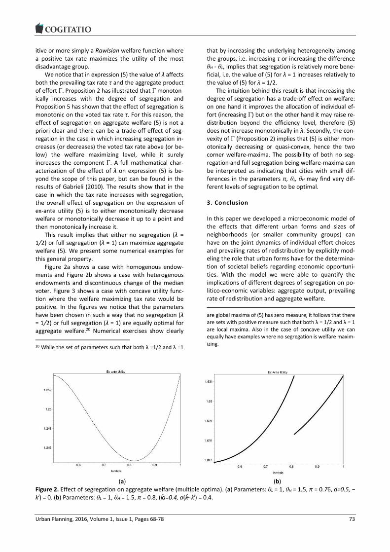
Urban Planning, 2016, Volume 1, Issue 1, Pages 68-78 73
itive or more simply a Rawlsian welfare function where a positive tax rate maximizes the utility of the most disadvantage group.
We notice that in expression (5) the value of λ affects both the prevailing tax rate τ and the aggregate product of effort Γ. Proposition 2 has illustrated that Γ monoton-ically increases with the degree of segregation and Proposition 5 has shown that the effect of segregation is monotonic on the voted tax rate τ. For this reason, the effect of segregation on aggregate welfare (5) is not a priori clear and there can be a trade-off effect of seg-regation in the case in which increasing segregation in-creases (or decreases) the voted tax rate above (or be-low) the welfare maximizing level, while it surely increases the component Γ. A full mathematical char-acterization of the effect of λ on expression (5) is be-yond the scope of this paper, but can be found in the results of Gabrieli (2010). The results show that in the case in which the tax rate increases with segregation, the overall effect of segregation on the expression of ex-ante utility (5) is to either monotonically decrease welfare or monotonically decrease it up to a point and then monotonically increase it.
This result implies that either no segregation (λ = 1/2) or full segregation (λ = 1) can maximize aggregate welfare (5). We present some numerical examples for this general property.
Figure 2a shows a case with homogenous endow-ments and Figure 2b shows a case with heterogenous endowments and discontinuous change of the median voter. Figure 3 shows a case with concave utility func-tion where the welfare maximizing tax rate would be positive. In the figures we notice that the parameters have been chosen in such a way that no segregation (λ = 1/2) or full segregation (λ = 1) are equally optimal for aggregate welfare.20 Numerical exercises show clearly
20 While the set of parameters such that both λ =1/2 and λ =1
that by increasing the underlying heterogeneity among the groups, i.e. increasing τ or increasing the difference θH - θL, implies that segregation is relatively more bene-ficial, i.e. the value of (5) for λ = 1 increases relatively to the value of (5) for λ = 1/2.
The intuition behind this result is that increasing the degree of segregation has a trade-off effect on welfare: on one hand it improves the allocation of individual ef-fort (increasing Γ) but on the other hand it may raise re-distribution beyond the efficiency level, therefore (5) does not increase monotonically in λ. Secondly, the con-vexity of Γ (Proposition 2) implies that (5) is either mon-otonically decreasing or quasi-convex, hence the two corner welfare-maxima. The possibility of both no seg-regation and full segregation being welfare-maxima can be interpreted as indicating that cities with small dif-ferences in the parameters π, θL, θH may find very dif-ferent levels of segregation to be optimal.
3. Conclusion
In this paper we developed a microeconomic model of the effects that different urban forms and sizes of neighborhoods (or smaller community groups) can have on the joint dynamics of individual effort choices and prevailing rates of redistribution by explicitly mod-eling the role that urban forms have for the determina-tion of societal beliefs regarding economic opportuni-ties. With the model we were able to quantify the implications of different degrees of segregation on po-litico-economic variables: aggregate output, prevailing rate of redistribution and aggregate welfare.
are global maxima of (5) has zero measure, it follows that there are sets with positive measure such that both λ = 1/2 and λ = 1 are local maxima. Also in the case of concave utility we can equally have examples where no segregation is welfare maxim-izing.
(a) (b) Figure 2. Effect of segregation on aggregate welfare (multiple optima). (a) Parameters: θL = 1, θH = 1.5, π = 0.76, a=0.5, − ki) = 0. (b) Parameters: θL = 1, θH = 1.5, π = 0.8, (k¯ a=0.4, a(k¯ − ki) = 0.4.

Urban Planning, 2016, Volume 1, Issue 1, Pages 68-78 74
Figure 3. Case of concave utility function. Parameters: θL = 1, θH = 1.5, π = 0.8, a=0.4, a(k¯ − ki) = 0.4
According to the model, an increase in the degree of segregation implies that beliefs about economic oppor-tunities become more heterogeneous across different neighborhoods, with people in poor neighborhoods having pessimistic beliefs about the return on effort and the scope for social mobility, while people in richer neighborhoods hold opposite beliefs. This separating effect is beneficial to aggregate output simply because, on average, individuals become better informed about their return on effort and therefore effort is more effi-ciently allocated between people with high and low opportunities.21
Although efficient from the perspective of aggre-gate output maximization, segregation increases in-come inequality across neighborhoods and this implies other effects. Allowing for intergenerational transfers would imply that individual endowments and return on effort are to some extent correlated22 and this would further increase the extent of both income and wealth inequality across neighborhoods. Moreover, private housing markets where high bids from wealthy individ-uals can outbid poorer individuals would, in turn, imply that a modest initial degree of segregation can pro-gressively increase over time through the implied wealth and income inequality that segregation fosters.
The model then shows that income inequality natu-rally increases the desired tax rate of poor people through the well-known Meltzer and Richard (1981)
21 This beneficial effect would generally be more limited in models with complementary skills, see for example Benabou (1993). 22 For example through investments in the human capital of children.
motive for redistribution and therefore the unequal ef-fects of segregation could in principle be corrected by higher voted redistribution. Nevertheless, in the model beliefs about economic opportunities which are formed in the neighborhood are also shown to affect the desired tax rate. The interaction of those two mo-tives for redistribution is studied through numerical examples and segregation is shown to generally in-crease the desired tax rate of those living in poorer neighborhoods and decrease the desired tax rate of those living in richer neighborhoods.23
Although the effect of segregation on the individual ideal tax rate is quite clear to quantify, the determina-tion of the prevailing tax rate imposed by the median voter is less clear because of discontinuous changes in the distribution of ideal tax rates. Two different dy-namics are shown to be possible. In one possible dy-namic, the majority of the population lives in the poor-er neighborhood and more segregation increases the prevailing tax rate by making this majority group more pessimistic about economic opportunities, thus partial-ly correcting the extent of income inequality. In a sec-ond possible dynamic, the majority of the population lives in the wealthier neighborhood and more segrega-tion decreases the prevailing tax rate by making the majority group more optimistic about economic oppor-tunities, thus contributing to even more unequal eco-nomic outcomes. The prevailing dynamic therefore de-pends on the urban form. The first one would be the case in cities with a small exclusive rich areas and where the middle and lower class live alongside in a
23 This is in line with the empirical findings of Bailey, Gannon, Kearns, Livingston and Leyland (2013).

Urban Planning, 2016, Volume 1, Issue 1, Pages 68-78 75
larger and more diverse areas; the second one would be the case in cities with small very deprived areas and where the middle and upper class live alongside in a larger areas.
Finally, by taking into account the joint effect of seg-regation on aggregate output and redistribution we ana-lyze aggregate welfare. With this respect, a critical varia-ble is represented by the definition of welfare function, where it is a standard result of microeconomics that the more concave the welfare function is then the larger the welfare-maximizing tax rate is, just like it would be the case with a Rawlsian welfare function that aims to max-imizes the utility of the most disadvantage group. De-spite the specific welfare function, we find that increas-ing the degree of segregation generally has a trade-off effect on welfare since, on the one hand, it improves the allocation of individual effort but, on the other hand, it may increase (or decrease) redistribution away from the efficient level. This trade-off effect implies that both no segregation and full segregation can be welfare-optimal for the same city and that small differences in the heter-ogeneity of the initial distribution of opportunities may justify very different levels of segregation.
This final result may be used to interpret the docu-mented lower redistribution rate in the US relative to European countries, where societies with similar initial “parameters” may find different levels of segregation to be optimal. In particular, the lower taxation in the US may be explained by a median voter that lives in a wealthier community and may overestimate her own abilities. Although stuck in different planning and polit-ical outcomes, the two societies may have similar levels of welfare.24
Our results have interesting implications for the analysis of planning policies. We show that the effect that different urban forms and neighborhoods social mixes have on voted redistribution has large quantita-tive effects on social welfare and therefore this effect should be accounted for in policy analysis. We also show that because the effect of segregation on voted redistribution is not monotonic, also the effect of seg-regation on welfare is generally not monotonic. Never-
24 Despite the fact that modeling a unique redistribution rate is a natural way to study different attitudes towards redistribu-tion across countries, more specific city-level taxation mecha-nisms could also be studied. For example one may consider an alternative system imposing different levels of taxes for resi-dents in different neighborhoods. One could also contrast this system to a more market-based redistribution mechanism based on subsidized land or house prices. In the present model even with different types of redistribution mechanism we would still have the trade-off effect of segregation on welfare, because segregation would still improve effort allocations but possibly raise redistribution over the optimal level. Neverthe-less different redistribution mechanisms would generally give different quantitative results. We thank an anonymous referee for this interesting suggestion for future research.
theless we show that as long as the ideal rate of redis-tribution is positive, given land and housing market forces that naturally push towards full segregation, planning policies that preserve socially mixed neigh-borhoods can maximize welfare.
Acknowledgments
The initial idea of this model was born while the author was completing his PhD at The University of Warwick researching on the topic of redistribution under in-complete information; the author is grateful to Hera-kles Polemarchakis for early discussions. The author al-so wishes to thank Gabriel Ahlfeldt, Olmo Silva, Danny Ben-Shahar, Anupam Nanda, Nikolaos Georgantzis, three anonymous referees as well as seminar partici-pants at University of Reading, AREUEA International Conference 2014 and ERSA Congress 2015 for precious comments and discussions at different stages of the project.
Conflict of Interests
The author declares no conflict of interests.
References
Alesina, A., & Angeletos, G.-M. (2005). Fairness and re-distribution: US versus Europe. American Economic Review, 95, 960-980.
Alesina, A., Glaeser, E., & Sacerdote, B. (2001). Why doesn’t the US have a European-type welfare state? Brookings Papers on Economic Activity, 2, 187-277.
Alesina, A., & La Ferrara, E. (2005). Preferences for redis-tribution in the land of opportunities. Journal of Pub-lic Economics, 89(5/6), 897-931.
Arbaci, S. (2007). Ethnic segregation, housing systems and welfare regimes in Europe. European Journal of Housing Policy, 7(4), 401-433.
Arbaci, S., & Rae, I. (2013). Mixed-tenure neighbour-hoods in London: Policy myth or effective device to alleviate deprivation? International Journal of Urban and Regional Research, 37(2), 451-479.
Bailey, N., Gannon, M., Kearns, A., Livingston, M., & Ley-land, A. H. (2013). Living apart, losing sympathy? How neighbourhood context affects attitudes to re-distribution and to welfare recipients,” Environment and Planning A, 45(9), 2154-2175.
Benabou, R. (1993). Workings of a city: Location, educa-tion, and production. The Quarterly Journal of Eco-nomics, 108(3), 619-652.
Benabou, R. (1996). Equity and efficiency in human capi-tal investment: The local connection. Review of Eco-nomic Studies, 63(2), 237-264.
Benabou, R. (2000). Unequal societies: Income distribu-tion and the social contract. American Economic Re-view, 90(1), 96-129.

Urban Planning, 2016, Volume 1, Issue 1, Pages 68-78 76
Benabou, R., & Ok, E. A. (2001). Social mobility and the demand for redistribution: The POUM hypothesis. The Quarterly Journal of Economics, 116(2), 447-487.
Benabou, R., & Tirole, J. (2006). Belief in a just world and redistributive politics. Quarterly Journal of Econom-ics, 121, 699-746.
Bird, K., Higgins, K., & Harris, D. (2010). Spatial poverty traps (Odi working paper 321). London: ODI. Re-trieved from www.odi.org/resources/docs/5514.pdf
Cheshire, P., Monastiriotis, V., & Sheppard, S. (2003). In-come inequality and residential segregation: Labour market sorting and the demand for positional goods. In R. Martin & P. S. Morrison (Eds.), Geographies of labour market inequality. London: Routledge.
Corneo, G., & Gruner, H. P. (2002). Individual prefer-ences for political redistribution. Journal of Public Economics, 83(1), 83-107.
D’Acci, L. (2013). Simulating future societies in Isobenefit cities: Social isobenefit scenarios. Futures, 54, 3-18.
D’Acci, L. (2015). Mathematize urbes by humanizing them. Cities as isobenefit landscapes: Psycho-economical distances and personal isobenefit lines. Landscape and Urban Planning, 139, 63-81.
De Tocqueville, A. (1835). De la democratie en Amerique. Paris.
Durlauf, S. N. (1996). A theory of persistent income ine-quality. Journal of Economic Growth, 1(1), 75-93.
Fernandez, R. (2001). Sorting, education and inequality (NBER Working Papers 8101). Cambridge, MA: Na-tional Bureau of Economic Research, Inc.
Fernandez, R., & Rogerson, R. (1996). Income distribu-tion, communities, and the quality of public educa-tion. The Quarterly Journal of Economics, 111(1), 135-164.
Fong, C. (2001). Social preferences, self-interest, and the demand for redistribution. Journal of Public Econom-ics, 82(2), 225-246.
Gabrieli, T. (2009). Redistributive politics under optimally incomplete information (Ph.D. thesis). University of Warwick, UK.
Gabrieli, T. (2010). Diverse societal beliefs and redistribu-tive policies, but equal welfare: The trade-off effect of
information (Discussion Paper N. 10/04). London: City University of London, Department of Economics. Retrieved from http://www.city.ac.uk/__data/ assets/pdf_file/0007/73807/1004.pdf
Gabrieli, T. (2012). Inequality, intergenerational mobility and redistributive policies under endogenous infor-mation. The Journal of Economic Asymmetries, 9(1), 23-49.
Kazepov, Y. (2004). Cities of Europe: Changing contexts, local arrangements, and the challenge to urban co-hesion. Malden, MA: Blackwell.
Keely, L. C. (2002). Mobility and fertility. University of Wisconsin-Madison. Unpublished manuscript.
Meltzer, A. H., & Richard, S. F. (1981). A rational theory of the size of government. Journal of Political Econ-omy, 89, 914-927.
Mookherjee, D., Ray, D., & Napel, S. (2010). Aspirations, segregation, and occupational choice. Journal of the European Economic Association, 8(1), 139-168.
Musterd, S., & Ostendorf, W. J. M. (1998). Urban segre-gation and the welfare state: Inequality and exclu-sion in western cities. London and New York: Routledge.
OECD. (1998). Integrating distressed urban areas. Paris: OECD Publishing.
Piketty, T. (1995). Social mobility and redistributive poli-tics. Quarterly Journal of Economics, 110, 551-584.
Prunetti, D., Muzy, A, Innocenti, E., & Pieri, X. (2014). Utility-based multi-agent system with spatial interac-tions: The case of virtual estate development. Com-putational Economics, 43(3), 271-299.
Romer, T. (1975). Individual welfare, majority voting, and the properties of a linear income tax. Journal of Public Economics, 4(2), 163-185.
Ross, S. L. (2011). Social interactions within cities: Neighborhood environments and peer relationships. In N. Brooks, K. Donaghy, & G.-J. Knaap (Eds.), The Oxford handbook of urban economics and planning. Oxford: Oxford University Press.
Zenou, Y. (2013). Spatial versus social mismatch. Journal of Urban Economics, 74(C), 113-132.
About the Author
Dr. Tommaso Gabrieli Tommaso Gabrieli is a lecturer in Real Estate at the Bartlett School of Planning, UCL. An economist by training and inspired by the Ambrosian tradition of social welfare, Tommaso has a strong interest in the socio-economic dynamics of cities, especially the extent of social mobility, the existence of pov-erty traps and the relative policy implications. His current research focuses on the links between spa-tial segregation and poverty traps, the application of game theory and real options to real estate val-uation and policy, as well as work on behavioural economic theory and asset pricing.

Urban Planning, 2016, Volume 1, Issue 1, Pages 68-78 77
Appendix. Proofs.
Proof of Proposition 1
The monotonic behavior is immediately proved from the computation of the first derivative with respect to λ :
.0)2(
))(1()(
,0)12(
))(1()(
2
2
2
1
LH
LH
Proof of Proposition 2
In order to prove the monotonicity, it is enough to compute the expression of the first derivative of Γ with respect to λ :
,)2()12(
)12()()1(
)2()12(
)12)()(1()1(
)2()12(
)12)(()1(
))()()1(()1(
))()1()((
22
222
22
2
22
2
2121
LH
LHH
LHL
HL
which is ≥ 0 for λ ≥ ½.
In order to prove the convexity, it is useful to compute the expression of the second derivative of Γ with respect to λ:
.))1()1(())1)(1((
))1(3)1(3)1)(1(121()()1(2
)( 33
222
2
2
LH
The expression is positive as it can be proved that the term (1 + 12π λ (1 − λ )(1 − π )—3π (1 − π) 3λ (1 − λ )) (call this X) is strict-ly positive. To see this, compute the first derivative with respect to λ which is equal to 3(2π − 1)2(2λ − 1) and therefore posi-tive. Hence the term X increases in λ; it is immediate that X is equal to zero for the smallest value of λ, i.e. λ = 1/2. Therefore for any value of π and λ, X is positive.
Proof of Proposition 3
The second derivative of the objective function (3) is equal to:
.)(2)(
22
a
u ji
The condition stated by Assumption 1 is sufficient for the expression to be strictly negative as the maximum value that θ 2
j can take is θ 2H and the minimum value that 2Γ can take is 2θ 2L.
Proof of Proposition 4
Proved by the numerical analysis reported in Figure 1.

Urban Planning, 2016, Volume 1, Issue 1, Pages 68-78 78
Proof of Proposition 5
If π > 1/2, since λ ≥ 0.5, the majority of the population is the group of θL agents living in community 1, i.e. p(θL,1) = π λ > 0.5. Their ideal tax rate τ (·,θ1) increases in λ by the previous proposition. Symmetrically, if π < 1/2, since λ ≥ 0.5, the majority of the population is the group of θH agents living in community 2, i.e.
p(θH, 2) = (1 − π )(1 − λ) > 0.5. Their ideal tax rate τ(·,θ2) decreases in λ by the previous proposition.

Urban Planning, 2016, Volume 1, Issue 1, Pages 79-94 79
Urban Planning (ISSN: 2183-7635) 2016, Volume 1, Issue 1, Pages 79-94
Doi: 10.17645/up.v1i1.556
Article
Planners in the Future City: Using City Information Modelling to Support Planners as Market Actors
Emine Mine Thompson *, Paul Greenhalgh, Kevin Muldoon-Smith, James Charlton and Michal Dolník
Department of Architecture and Built Environment, Northumbria University, Newcastle upon Tyne, NE1 8ST, UK; E-Mails: [email protected] (E.M.T), [email protected] (P.G.), [email protected] (K.M.-S.), [email protected] (J.C.), [email protected] (M.D.)
* Corresponding author
Submitted: 11 January 2016 | Accepted: 1 March 2016 | Published: 29 March 2016
Abstract Recently, Adams and Tiesdell (2010), Tewdwr-Jones (2012) and Batty (2013) have outlined the importance of infor-mation and intelligence in relation to the mediation and management of land, property and urban consumers in the fu-ture city. Traditionally, the challenge for urban planners was the generation of meaningful and timely information. To-day, the urban planners’ challenge is no longer the timely generation of urban data, rather, it is in relation to how so much information can be exploited and integrated successfully into contemporary spatial planning and governance. The paper investigates this challenge through a commentary on two City Information Modelling (CIM) case studies at Northumbria University, UK. This commentary is grouped around four key themes, Accessibility and availability of data, accuracy and consistency of data, manageability of data and integration of data. It is also designed to provoke discus-sion in relation to the exploitation and improvement of data modelling and visualisation in the urban planning discipline and to contribute to the literature in related fields. The paper concludes that the production of information, its use and modelling, can empower urban planners as they mediate and contest state-market relations in the city. However, its use should be circumspect as data alone does not guarantee delivery of a sustainable urban future, rather, emphasis and future research should be placed upon interpretation and use of data.
Keywords city information modelling; future cities; GIS; market actors; market rich intelligence; smart cities; spatial planning; urban planning
Issue This article is part of the issue “Urban Forms and Future Cities”, edited by Luca D’Acci (Erasmus University Rotterdam, The Netherlands), Tigran Haas (KTH Royal Institute of Technology, Sweden) and Ronita Bardhan (Indian Institute of Technology Bombay, India).
© 2016 by the authors; licensee Cogitatio (Lisbon, Portugal). This article is licensed under a Creative Commons Attribu-tion 4.0 International License (CC BY).
1. Introduction: Planning in the Future City
In order to reflect on the theme for this thematic issue, Urban Forms and Future Cities, this paper focuses on one of Adams and Tiesdell’s (2010) three recommend-ed areas for capacity building in relation to the con-temporary spatial planning process in the future city, that of the need for market rich information and knowledge. Justifying this focus, Adams and Tiesdell
(2010) argue that the generation and use of market rich Information and knowledge can assist in the medi-ation and management of land, property and urban consumers in the future city. This is because in most mature urban locations, urban development is fi-nanced by the private sector, making the ability of spa-tial planners to understand and influence property markets and development processes a crucial test of their effectiveness (Adams & Tiesdell, 2010, p. 188).

Urban Planning, 2016, Volume 1, Issue 1, Pages 79-94 80
The paper analyses this situation through the lens of two City information Modelling (CIM) projects in order to consider:
How CIM can assist in the creation of market rich information and knowledge.
The opportunities and challenges involved in this potential relationship in the future city.
In this paper, future cities is a term used to imagine what cities themselves will be like, how they will oper-ate, what systems will orchestrate them and how they will relate to their stakeholders (citizens, governments, businesses, investors, and others), in the future (Moir, Moonen, & Clark, 2014).
In this imagination of the future it is no longer enough to think of the city as the sum of its land, build-ings and infrastructure. The contemporary city should be engaging directly with all of its users, in order to understand and improve their lives. This is because; physical spaces, systems and users are increasingly be-coming part of Mitchell’s (1995) Soft City, emitting large quantities of data in real time. Indeed, why shouldn’t we focus in on this area? Graham (2004, p. 35) indicates that, over the past 8000 years, cities have always been places where the processing of infor-mation and the creation of knowledge have been con-centrated. However, this does not mean that the emergence and ubiquity of big data should be taken as a panacea for planning in the future city. Rather, big data provides the potential bedrock for new urban knowledge when it is efficiently utilized.
Illustrating this situation, from the mid-2000s, in-fluenced by Building Information Modelling (BIM) and its success and promises for the construction industry, the term City Information Modelling (CIM) or urban in-formation modelling, came into common use (Beirão, Duarte, Montenegro, & Gil, 2009; Duarte, Beirão, Mon-tenegro, & Gil, 2012; Gil, Almeida, & Duarte, 2011; Gil & Duarte, 2008; Hamilton et al., 2005; Khemlani, 2007). The authors define CIM as a cross disciplinary, holistic approach to the generation of spatial data models in which the integration, application and visualisation of city data is used to manage and mediate the demand for land, property and environmental resources; the aim being to balance multiple stakeholders’ needs in order to achieve sustainable and liveable cities whereby citizens play a major role in city governance. A simple way of understanding CIM is the following: if the smart city can be taken to mean the transference of the city from the analogue age to the digital one, then CIM is the practical application of this digital data in relation to the management and planning of the future city in collaboration with its citizens and stakeholders.
This paper does not attempt to illustrate a history of the smart city (for a thorough appraisal of the recent eruption in literature in relation to this debate see
Kitchin, 2014), instead it is enough to state that “the smart city concept has been around since the 1990s, but it is still a fairly new concept, evolving from, and in tandem with, technological developments...and the concepts and research areas of the ‘virtual city’, ‘wired city’, ‘informational city’, ‘telecity’, ‘intelligent city’, ‘urban cybernetics’, and the ‘digital city’, all of which reflects a technologically enhanced vision of a city” (Thompson, 2015, p. 501).
The analysis in this paper is focused on two on-going CIM projects in the Department of Architecture and Built Environment at Northumbria University, namely Geo-Visualising Commercial Real Estate Mar-kets (GV-CREM) and Virtual NewcastleGateshead (VNG). Collectively, these projects combine research in 4 specialist areas, City modelling and data (Thompson, 2015; Thompson & Greenhalgh, 2014; Thompson & Horne, 2010) urban visualisation (Charlton, Giddings, Thompson, & Peverett, 2015; Giddings, Charlton, & Horne, 2011; Horne, Thompson, & Charlton, 2014) real estate market modelling (Greenhalgh, 2008; Green-halgh et al., 2003; Greenhalgh & King, 2010, 2013) ur-ban finance and digital spatial preference modelling (Muldoon-Smith et al., 2015; Muldoon-Smith & Green-halgh, 2015) indicating the multi-disciplinary nature and collaborative ethos at the heart of CIM. Taken to-gether, the learning outcomes of these two projects enable the authors to reflect upon the opportunities and challenges involved in the generation of market rich information and knowledge and help answer the underlying research question in this paper:
How can City Information Modelling (CIM) help planners to influence urban form and the future city?
The aim of this appraisal is not to critique the re-spective projects and their methodologies (both have strengths and weaknesses) but rather to better under-stand how CIM can aid urban planning through the generation of market rich information and knowledge.
These reflections are structured around four key themes:
1. Accessibility and availability of data 2. Accuracy and consistency of data 3. Manageability of data 4. Integration of data
Each theme discusses the opportunities and challenges faced by each project while the proceeding section re-flects upon how deployment of CIM could be improved in the UK through our attempts to integrate the re-spective types of projects already introduced, into a holistic City Information Model (CIM).
Throughout, the paper reflects upon the broader concern of how urban planners can exploit the inher-ent potential in CIM and the challenges they face in do-ing so. The concluding section reflects upon the under-lying research question and argues that CIM offers new

Urban Planning, 2016, Volume 1, Issue 1, Pages 79-94 81
and enhanced opportunities for planners and other professionals working in the urban environment. Par-ticularly, in relation to the deployment of real time da-ta into the analysis of the conditions in which key plan-ning and resource allocation decisions are made and the appreciation of the longer term impact of such de-cisions. However, they should also proceed with cau-tion because ubiquitous urban data isn’t a panacea for urban problems, rather its application, through consid-ered interpretation, is a useful tool for informing the multi stakeholder spatial planning process.
Most of the reflection in this paper will take place in relation to spatial planning in the UK with particular emphasis on England, however the reflections and conclusions in this paper will also have salience for the devolved administrations and the international urban planning audience because most mature urban loca-tions face similar types of challenges in relation to the generation, management and application of urban da-ta. While the findings should also be useful to planners in emerging cities in the developing world where an understanding of the urban process will be beneficial.
2. Planning Intelligence
According to Clifford and Tewdwr-Jones (2013) urban planning in England is increasingly defined by spatial planning, taken to mean the strategic co-ordination and inclusion of disparate policy directives and stake-holder interests in contrast to traditional forms of more static ‘land use’ and ‘town and country plan-ning’ approaches. Yet, spatial planning’s underlying evidence base is still regularly founded on historical methods of data generation and analysis. Yes, the gathering of data and the use of current technology has been an everyday working practice for planners for decades; for example in the 1980s local govern-ments in the US started applying IT, notionally to speed up data processing but also to improve the delivery of services and to potentially increase political participa-tion (Guthrie & Dutton, 1992). Moreover, Booth (2003) tells us that computers have been used in the English tradition of Development Control since at least the 1970’s. However, in the main, technology has been used for routine administrative tasks and gathering da-ta, rather than as a means of managing and shaping the built environment holistically.
Examples to the contrary do exist; (Batty, 1991, 1997, 2007; Batty & Xie, 1994; Baud, Scott, Pfeffer, Sydenstricker-Neto, & Denis, 2014; Geertman, Ferreira Jr, Goodspeed, & Stillwell, 2015; Gordon, Karacapilidis, Voss, & Zauke, 1997; Laurini, 2002; Páez & Scott, 2005; Shiode, 2000; Wu, He, & Gong, 2010; and many others) researchers in transportation modelling, agent-based modelling, GIS, public participation, urban morphology, spatial analysis, and virtual cities, have been working in these overlapping fields for several decades now. In-
deed, research has emanated from various outlets such as Computers in Urban Planning and Urban Manage-ment Conference (CUPUM), Urban Data Management Symposium (UDMS), Journal of Urban Technology, and Computer, Environments and Urban Systems Journal and many more. Yet, in the UK we believe that exam-ples of this work are the exception, rather than the norm. Spatial planning in the UK finds itself in a state of inertia increasingly cognisant of the potential, and need for new data models (Adams & Tiesdell, 2010; Batty, 2013; Tewdwr-Jones, 2012) to inform strategic spatial planning but still reliant on tried and tested practices of strategy development and evidence gathering.
Illustrating this situation, Turley Planning Consul-tancy (2015) recently surveyed 326 Local Planning Au-thorities and found that 50% had an employment land evidence base which pre-dated the publication of the 2012 National Planning Policy Framework (NPPF) which is the most recent review of planning in England. Plan-ning Policy Guidance published in 2014 even recom-mends that ELR’s do not need to be carried out any-more regularly than every 5 years, although they should be updated more regularly to account for changing circumstances. This means that in certain cir-cumstances planning in England is quite literally con-ducted through the rear view mirror (Turley Planning Consultancy, 2015).
Exacerbating this situation it is quite common to see a long process of plan-led strategy formulation, traditionally through structure and unitary develop-ment plans and more recently, regional spatial strate-gies, local development frameworks and, laterally, local plans and core strategies. Each document goes through a long process of formulation and is underpinned by a wide selection of underlying research exercises, such as Employment Land Reviews (ELR) Strategic Housing Market Assessments (SHMA) and Strategic Housing Land Availability Assessments (SHLAA). However, many of these documents, by the time they are adopted, are years out of date. On one hand this is because of con-tinuing macro and micro level socio-economic changes, and on the other hand, the time taken for consultation and revision and the ceaselessly changing nature of the planning system in England (Clifford & Tewdwr-Jones, 2013) which leads to the requirement for continual re-formulation before publication.
So, the challenge is to capture information re-sources that have the capacity to inform urban plan-ning in a timely and accurate fashion; in order to in-form the strategy formulation process and to enable planners to exert influence over the form and devel-opment of the future city. The proceeding section dis-cusses how CIM can fill this deficit in knowledge and identifies the opportunities and challenges involved in this relationship. Consistent with Adams and Tiesdell (2010), we do not seek to contribute to the rich debate in relation to spatial planning (see Clifford & Tewdwr-

Urban Planning, 2016, Volume 1, Issue 1, Pages 79-94 82
Jones, 2013) for an account), rather, we seek to inves-tigate how CIM can be used as a tool by urban plan-ners, operating as market actors, to nourish the con-text in which spatial planning takes place and to inform strategic planning and resource allocation decisions.
3. The Projects
The first project, Geo-Visualising Commercial Real Es-tate Markets (GV-CREM) has generated an experi-mental multi-criteria urban real estate model which seeks to understand the nature and vitality of commer-cial real estate markets in England and Wales. Initial modelling has focused on Newcastle upon Tyne (Tyne and Wear), Leeds and Croydon, which exhibit large, mature commercial real estate markets and offer the potential for inter and intra-regional comparative anal-ysis. The underlying data is non-geometric and rests upon a GIS dataset comprising physical characteristics of commercial and industrial floorspace, occupancy
status and rental value information. The database con-tains approximately 5billion sq.ft .of floorspace data (1bnsq.ft.of office, 1bn sq. ft. of retail and 3bnsq.ft.of industrial space) and has its origins in the National Summary Valuation Data Set and National Non Domes-tic Rating Returns created by the Valuation Office Agency (VOA). Taken together, these data sets repre-sent an accurate picture of commercial and industrial real estate stock in the UK (Katyoka & Wyatt, 2008). The model is also capable of incorporating demand ap-proximation information secured through internet search activity. The data model is intelligent, can be disaggregated to individual buildings or aggregated to the metropolitan or functional economic area, and can be visualised in both 2D and 3D (with potential for 4D longitudinal analysis using time series data). The 3D representation in Figure 1 demonstrates the utility of this model, where the height of each tower indicates the quantity of floorspace in each location and the col-our denotes the relative value of that floorspace.
Figure 1. Topological representation of commercial real estate supply in Tyne and Wear.

Urban Planning, 2016, Volume 1, Issue 1, Pages 79-94 83
Furthermore, the representations in Figure 2 indicate the relative characteristics of commercial office space in Croydon. In this representation Croydon has been sub-divided into equal size grid squares. The dots indi-cate the location of commercial office property while each grid square has been scaled to indicate the rela-tive quantity of commercial office space in each loca-tion with the colour denoting the value of office space.
In response to the report from Turley Planning Con-sultancy (2015) Project GE-VCREM has the ability to provide up to date employment land data while it also has the ability to inform more efficient land use plan-ning and economic development strategy develop-ment. Following the recent turn towards fiscal decen-tralisation in England it also has the underlying ability to monitor and understand the impact of business rate retention and the contemporary performance of urban finance initiatives and economic stimulus programmes such as Tax Increment Financing and the continuing evolution of Enterprise Zones. This is because the basic data infrastructure of GV-CREM is founded on the Eng-lish business rate system.
Finally, Figure 3 describes the spatial distribution of potential office, retail and industrial occupier preference in Leeds. The aim of this emerging project is to use in-ternet search behaviour to approximate potential occu-pier preference for office, retail and industrial floorspace in Leeds (Muldoon-Smith et al., 2015). The intention is to use these urban search signals in the future to analyse the relationship between the location of office, retail and industrial premises and where potential occupiers of these types of commercial and industrial floorspace ac-
tually want to locate. This research has been developed to expose potential mis-matches between where busi-ness occupiers want to locate and the physical location of office, retail and industrial business premises and in order to help guide the location of new commercial and industrial floorspace development.
The second project, Virtual Newcastle Gateshead (VNG) (Figure 4) is geometric and has been designed to visualise the urban fabric of neighbouring settlements of Newcastle upon Tyne and Gateshead in the North East of England. Initiated in 2008, in partnership with the two local authorities, the project provides a defini-tive, accurate, interactive city model that offers a cost effective stakeholder communication tool and way of understanding the wider implications of planning ap-plications. VNG is; helping to streamline and increase the transparency of the planning process, supporting a number of research and enterprise activities, allowing the University to engage with a number of local and national external parties and public groups.
Both projects demonstrate the applicability of CIM to contemporary spatial planning England. On top of the perennial importance of ‘location, location, loca-tion’ we now have ‘evidence, evidence, evidence’. Yet, the design evolution of both projects has not been straight forward, each project has been beset, to vary-ing degrees, by issues of data accessibility and availabil-ity, data accuracy and consistency, data manageability and data integration. The following section explores these issues and reflects on the challenges involved in the integration CIM into the spatial planning practice to inform future CIM development.
Figure 2. Relative scaling in Croydon.

Urban Planning, 2016, Volume 1, Issue 1, Pages 79-94 84
Figure 3. Potential occupier preference in Leeds.
Figure 4. VNG model (central core area).
3.1. City Information Modelling: Opportunities and Challenges
3.1.1. Accessibility and Availability of Data
Making data available is one thing, doing this efficiently
is another entirely. In other words, how data is pub-lished and its format informs its accessibility and future usability for research and practical purposes. Illustrat-ing this situation, project GV-CREM had considerable difficulty accessing uniform information for its data-base despite the UK Government’s commitment to

Urban Planning, 2016, Volume 1, Issue 1, Pages 79-94 85
open data. Illustrating this situation, the VOA, charged with creating the national summary valuation data set every five years, only release information through its internet based Agent Mode System. Immediately, this would appear to be a positive situation, however, they only release information through an individual heredit-ament that is an individual parcel of property that is available for rent. The hereditament can pertain to an entire building or a in the case of office buildings, which are traditionally subdivided for rental purposes, a part of a building, for example a floor or suite. To put this in perspective there are 1.8 million hereditaments in England and Wales, if we place an approximate time of 1 minute per view on each individual hereditament in VOA agent mode, without sleep, it would take 4 years for one person to create an aggregated property data base for England and Wales. The solution to this issue was purchasing the information through universi-ty funds, an option open to the authors but not one that is readily available to smaller organisations and in-dependent researchers.
Furthermore, the database also makes use of Na-tional Non Domestic Rate Returns (NNDR) which is data related to vacant commercial properties. Access to this data is inconsistent, some local authorities publish it on a quarterly basis via their websites, and some only re-lease it through formal request while others refuse to release it at all.
Similarly, creating a 3D city model can be a chal-lenging task. Specialist companies use airborne acquisi-tion and photogrammetry techniques to create these 3D city models. Considering the VNG project started in 2008 the accessibility to 3D data was rather limited and expensive, preventing availability of this type of data to smaller organisations and independent researchers. During the initial years of creating VNG, there were ac-cessibility issues. These issues were generally in rela-tion to the different and sometimes incompatible IT systems and software within and across these three organisations and remote access and version control. Encouragingly, advances in data collection techniques, computer graphics cards, processing power and 3D re-construction methods (Gröger & Plümer, 2012) have enabled the capture, production, storage and visualisa-tion of more complex models an achievable goal. With new techniques and technologies increasing their availability and speed of creation, virtual city models similar to VNG are becoming more common. In fact, Morton , Horne, Dalton, & Thompson (2012) have identified over one thousand models worldwide.
However, the issues of accessibility and availability identified in this section could be greatly assisted if public data was open source by default, without re-strictions on commercial use, and made available in non-proprietary and open formats. This would be aided by national, regional and local governments publishing a list of the datasets that they do not publish as well as
the ones that that they do release. Clearly, the journey toward quality open data is an on-going process. How-ever, this debate should not only be in relation to gov-ernment transparency, perhaps the onus should also be on those involved in CIM and urban planning to prove that releasing quality open data is a worthwhile activity.
3.1.2. Accuracy and Consistency of Data
During the initial stages of project GV-CREM an early decision was taken to omit Edinburgh and Birmingham from the case study because the data that each local authority provided was of such poor quality. Both of these locations are significant omissions from the UK case study, both containing mature commercial office markets, and is a source of considerable frustration on the researchers’ part. Furthermore, different locations store and process their data in different ways and use different data storage applications which results in sig-nificant issues of consistency upon receipt of data in terms of format and the consequent time taken to re-fine data sets into a synthesis. This was particularly ev-ident in the NNDR data set. The VOA data set was more consistent in terms of format. However, the infor-mation that was input into the VOA data set was incon-sistent (especially in relation to address), reliant on the individual valuation officer conducting a building as-sessment, an issue also identified by Astbury and Thurstain-Goodwin (2014).
The VOA summary data could be immediately im-proved if each valuation office carried a GPS system and logged the geo-coordinates for each hereditament and building. This would counteract address infor-mation inconsistency and enable the differentiation of buildings with identical post codes. Furthermore, each building should be given a unique property reference number which can then be related to the underlying billing account reference numbers and hereditament. Currently, it is possible to subdivide a hereditament based valuation into its constituents parts, however, this facility would be exponentially more powerful if this process could be applied to entire buildings.
Furthermore, as VNG is being developed to be used within the urban planning process, confidence is re-quired in relation to the degree of accuracy of the data. A pilot study conducted by Horne (2009) compared the accuracy of the current 3D data with the true urban form, by comparing specific views from the model with traditional photomontage and surveying techniques. Undertaking this study proved that the accuracy of the model satisfied planners from both councils (Figure 5).
3.1.3. Manageability of Data
This issue of data manageability rests on Garnter Ana-lysts Doug Laney’s (2001) classic big data conundrums

Urban Planning, 2016, Volume 1, Issue 1, Pages 79-94 86
Figure 5. Verification of accuracy of Virtual Newcastle Gateshead. Source: Horne, 2009.
of volume, variety and velocity (not to mention the other two v’s veracity and validity). Firstly there is just so much information that it is difficult to know where to start or when to stop. Only a few years ago the frus-tration was not being able to do enough, now it is pos-sible to answer almost anything providing the volume of information can be harnessed. Then there is variety, perhaps the greatest challenge in CIM is the sheer quantity of incompatible data sets which cannot be in-tegrated without considerable re-engineering. The consequence is the need for multiple software and hardware solutions which operate at best in unhappy compromise. The final issue is velocity, not only is there a great deal of information produced, it is also generated repetitively and increasingly in real time. One of the key challenges for spatial planning will be to harness this challenging potential as there is now real scope for planning strategy, decision making and nego-tiation to be evidenced in relative real time. Hitherto, it has been common place for planning authorities to rely on evidence collected sometimes decades ago. How-ever, it is now possible for initiatives like Project GV-CREM and the emerging research into digital search preference signals to evidence and justify new strategic employment land allocations and to support or defend against new development proposals with contempo-rary market intelligence.
To date, VNG has been delivered and managed as set of “tiles” or city square areas that are stored in a widely used 3D graphical format (DWG) to support the managing and use of the 3D data. Within each tile a naming and layering convention is used to allow dis-tinction between roads, paths, vegetation, buildings etc. This format is ideally suited to loading selected ar-eas of the model and performing the required visuali-sation and analysis tasks. However up until recently, additional interoperability of the data beyond this vis-ual assessment is limited. This initial format is not suit-ed to many other forms of analysis that may require
bringing together data from several or all tiles, or the integration of other urban information from external databases. It is therefore the interoperability, rather than its similarity to the real world which should be the focus of such models moving forward (Bodum, Kjems, Kolar, Ilsøe, & Overby, 2006).
3.1.4. Integration of Data
Perhaps the greatest challenge in relation to project GV-CREM has been the problematic nature of data in-tegration. Ideally, all data providers should use con-sistent information database systems and all property data sets should contain a common unique property reference number (UPRN) with which to easily link data sets. A constant frustration throughout the research project is that there is a lot of information out there that remains un(der)exploited because of the time re-lated difficulty associated with linking them together. For instance, the researchers would have liked to link Environmental Performance Certificate Information (EPC) data to the model and the National Land Use Da-ta Base (NLUD). Although available to the public in non-aggregated form (EPC), and in raw format (NLUD), each assessment does not have a common identification code. Furthermore, the respective floor space meas-urement methods in the EPC data files did not appear to be consistent with the standard measurement of net internal area used by the VOA and NNDR systems.
Similar difficulties have been experienced with the VNG project. Although the CAD based structure of VNG and similar virtual city models are ideally suited for the loading of selected areas of the model for performing the required visualisation commonly associated with such models, additional interoperability of the data be-yond this visual assessment is limited. Authors have highlighted a range of other applications that virtual city models could be used for; tourism, pedestrian and transport modelling, culture and heritage, environmen-

Urban Planning, 2016, Volume 1, Issue 1, Pages 79-94 87
tal and energy simulations (Batty et al., 2000; Döllner, Kolbe, Liecke, Sgouros, & Teichmann, 2006; Lange & Bishop, 2005) however current attempts to expand the application of virtual city model have been limited. Where attempts have been made, there has been a tendency for such models to be optimised for their in-tended end purpose, which frequently results in con-straining future potential applications and therefore reducing the sustainability of the models created. The research described by Charlton (2011) and Horne, Thompson and Charlton (2014) demonstrated the in-teroperability of virtual city data to be utilised analyti-cal software tools to predict the performance and visu-al impact of urban proposals, enabling designers and planners to gain greater understanding of performance prior to construction. However, the authors highlighted how a fully integrated approach was currently limited by the interoperability between certain selected soft-ware applications and conclude that in its initial for-mat, VNG is not suited to many other forms of analysis that may require bringing together data from several or all tiles, or the integration of other urban infor-mation from external databases.
4. Discussion: Creating a City Information Model (CIM)
Digital capabilities of BIM, GIS, urban analysis, geo-design, urban design, urban data science, city infor-mation modelling and visualisation have the potential to change approaches to spatial planning. This change is arising partly because of the data infused solutions, as in Smart City applications becoming prominent and partly because requirements of holistic responses to urban problems and moving away from producing an-swers in silos.
The previous section discussed the opportunities and challenges involved in two CIM projects. This sec-tion explores the potential for both types of projects to be combined in order to exploit the data driven attrib-utes of projects GV-CREM and geometric properties of VNG. The remainder of this section explores this situa-tion through a pilot project conducted in the Depart-ment of Architecture and Built Environment at North-umbria University over the summer of 2015.
As more emphasis is put on the concept of the smart city and benefits of integrating systems and da-tasets in order to achieve holistic solutions, the in-teroperability of VNG is focusing towards the incorpo-ration of data into the geometrical representations. We have seen evidence of this within the construction in-dustry and the emergence of BIM. In this notion, digital three-dimensional geometrical data is linked with rela-tive information (material, dimensions, price, stress load, etc.) in order to create a virtual building. This pro-cess aids in the development, assessment, construction and management of a building throughout its lifecycle. Although this technology is often applied to single
buildings or a small group of buildings rather than city models, current research does highlight the possibili-ties of applying a BIM-based approach to support fu-ture city modelling and management, by utilising GIS (Döllner & Hagedorn, 2008; Gil et al.,2011; Gil, Beirão, Moutenegro, & Dunantie, 2010; Hudson-Smith et al., 2007; Laurini, 2002; Stojanovski, 2013; Thompson & Horne, 2010; and many others). The proposed infor-mation-rich virtual city models developed on a data-base platform would contain geometric parameters, alongside relevant city information to support the as-sessment and visualisation of the datasets, which would offer greater capabilities in managing, accessing and uti-lising the advantages of the 3D geometrical data.
5. Data Infused Virtual City Model
A pilot project undertaken during spring of 2015 aimed to examine the feasibility of the proposed approach in relation to the smart cities agenda, the project aimed to establish the capabilities to add spatial information to the model and to utilise the model for analytical purposes. In order to form the capabilities of the geo-metrical data linking spatial information, the study fo-cused to embed free and accessible datasets from the Ordnance Survey initially.
The VNG model comprises several layers: buildings, bridges, grass, roads, railroads, footpath, fences, walls, terrain, and trees. The focus of the research was on importing and utilising the buildings layer, due to its complex geometry and relevance and experimenting in attaching a variety of associated datasets. Therefore bridges, railroads, fences, walls and trees layers were excluded from the preliminary study and the grass, roads, railroads, footpath and terrain layers were com-bined to create a “new terrain” layer, before conver-sion to a TIN (Triangulated Irregular Network), a digital data structure used in GIS for the surface representa-tion. The aim was to store the buildings as a MultiPatch feature so that one record in the database corresponds with one building. Unfortunately, the structure of the VNG dataset did not allow for this aim to be fully real-ised; due to the initial 3D modelling techniques used, the individual buildings are not always defined as standalone entities and in many cases they belong to a block of buildings, therefore matching the address data to a specific building became problematic.
Similarly, the research established that due to the way VNG was modelled, the geometry of the buildings had a number of defects; unnecessary polygons and surfaces which were not closed. Although this is not a barrier in the usage of the model itself for city visuali-sation purposes, it impairs the performance of the 3D experience. Despite a number of attempts to try and resolve the aforementioned issues within the GIS soft-ware, via more automated and scripted routes, a usea-ble solution has yet to be achieved. As such, it was es-

Urban Planning, 2016, Volume 1, Issue 1, Pages 79-94 88
tablished that a reasonable way to fix this problem is to edit the geometry directly in CAD programme which of-fers a more powerful set of editing tools. If similar models are to be commonly used within GIS platforms in the future, automated geometry cleaning must be prioritised before importing into the GIS. However, by deriving and embedding some basic geometrical in-formation; height, elevation, area, etc. this experi-mental project still achieved some impressive out-comes in spatial-visual analysis terms such as skyline, line of sight, construct sight lines, skyline barrier, sun-shadow volume, etc. illustrated by Figure 6 (a–f).
From the Ordnance Survey, we utilized; wards, dis-tricts and streets data types within the boundary of VNG. By embedding this information within the context of VNG, it became possible to query for example; which ward certain building belongs to. By combining this knowledge with the derived geometrical data (height, elevation, etc.), it is possible to analyse which
building is the highest or lowest in a particular ward, district or street.
This approach was sufficient for establishing the scope of the proposed approach and highlights the possibilities of what could be done with more and dif-ferent types of data. For example rent and tax data would make it possible to find out the most expensive part of the city or a certain ward. With the recent rec-ord breaking rain fall in UK, flood damage can be de-termined by using the elevation of the buildings and the height of water level before hand and preparations can be done accordingly. VNG and similar virtual city models clearly have a big potential if GIS approach is to be adopted. Transferring the model to City GML format and embedding spatial information can also produce very useful outcomes. For example the resulting model can serve as an exchange platform and would also greatly extend the usage of the virtual city model.
(a)
(b)
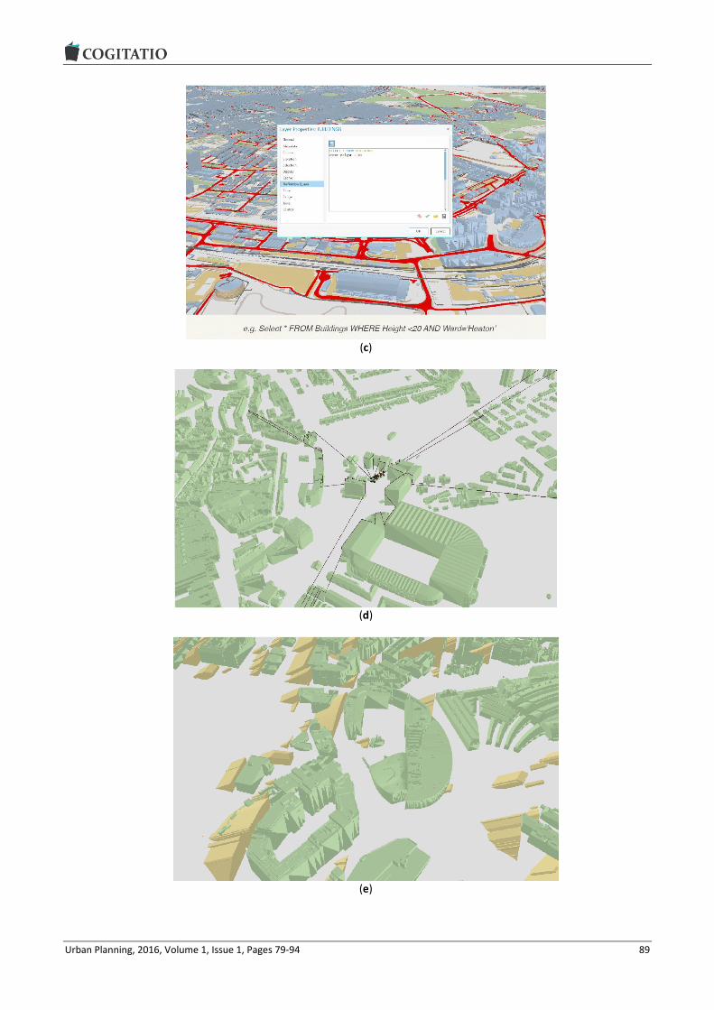
Urban Planning, 2016, Volume 1, Issue 1, Pages 79-94 89
(c)
(d)
(e)

Urban Planning, 2016, Volume 1, Issue 1, Pages 79-94 90
Figure 6. VNG 3D model in GIS platform: (a) Terrain model, (b) VNG in shape file format, (c) Querying in VNG, (d) Skyline analysis, (e) Sun-shadow volume, (f) Analysing roof types (flat etc.) and roof orientation.
This pilot study showed that although problematic, a 3D city model can be enriched with different data types and the resulting new model can be utilized for a variety of analysis that can be used within city planning purposes. Whilst it should be acknowledged that this is a limited experiment it is clear that VNG and other sim-ilar virtual city model data sets can be more aligned to the development of the “real” city, allowing both visual and analytical assessment of the urban environment.
6. Conclusion
The underlying research question in this paper con-templated how City Information Modelling (CIM) can help planners to influence urban form and the future city and the broader concern of how City Information Modelling (CIM) can be used to help planners as market actors understand and influence urban form and the fu-ture city. The evidence and experiences presented in this paper suggests that CIM can be used by Urban Planners and academics to re-engage in urban devel-opment as market actors. For instance the emerging research into search preference signals indicates how CIM can be used as a powerful tool to inform the tradi-tional basis of assessing planning applications on ‘their own merits’ in the UK and recognising and evidencing ‘other material considerations’ in local areas. Project GV-CREM can be used to substantiate employment premises reviews and allocations of employment land, while Virtual City Models (such as VNG) can be used to interrogate the situational detail of new planning ap-plications. In doing so, CIM can be used to counteract rapidly ageing planning documentation and to influ-ence complex negotiations in relation to viability and developer contributions through the Community Infra-structure Levy (CIL) for example. The central projects
indicate how planners can use CIM to model and evi-dence a better future, for instance by using search preference data to situate new development where occupiers want it. In contrast to the passive records of employment land and premises take up evidenced in traditional employment land studies.
Increasingly, neither state intervention, nor neo-liberal market solutions are seen as satisfactory ap-proaches to urban planning challenges. The former is criticised for its managerial inefficiency (see Booth, 2003 for an appraisal of development control and its latter day association with inefficiency) while the latter is criticised for its neglect of external and community interests. Drawing on behavioural and institutional theories of economics and property markets, Adams and Tiesdell (2010) have put forward the argument of planners as ‘market actors’ where planning practition-ers operate confidently within state-market relations. CIM offers an opportunity to answer their call for greater market-rich information and knowledge, how-ever, greater access to information does not automati-cally mean that planners hold all of the cards, nor should they. Rather, through the development and uti-lisation of CIM, local planners can play a hands-on role in evidencing and aiding urban change by providing in-formation in relation to potential occupier demand, lo-cal infrastructure provision and current land and prop-erty availability. This would go some way toward developing a planning intelligence tool which could be used pro-actively in collaboration with the various ur-ban development industries
Summarising our recommendations in the previous sections, we call for a research focus into CIM and the future city around the four key themes that structure this paper. Across the world many cities now have Open Data access sites where a variety of city related

Urban Planning, 2016, Volume 1, Issue 1, Pages 79-94 91
data can be downloaded by anyone. Research com-pleted in early 2015 shows that, 159 cities in 30 coun-tries across the world have one or more open data ac-cess sites. As well as these countries that have city level open data sites another 32 countries have coun-try level open data sites (Thompson, 2015). Illustrating this situation, building and digital terrain models of Berlin can be downloaded for free since 2013. Similar-ly, geocoded national address data will be made openly available from February 2016 in Australia. These devel-opments show the potential of open data availability. Yet, there is much more to be done before urban plan-ners can fully utilise the full potential of “urban big da-ta” and CIM in spatial planning.
Therefore, firstly, new research and scrutiny must take place in relation to the accessibility and availabil-ity of data in the UK. Secondly, it is imperative that steps are taken to improve the accuracy and consisten-cy of data. Thirdly, there is clear and present need for research into the manageability of urban data, particu-larly in relation to its volume, variety and velocity but also its validity and veracity. Within the latter two points, validity and veracity, resides a wider issue of data ethics in relation to the massive amounts of data, often personal, that is integrated into CIM platforms. In particular the trade offs and f(r)ictions involved in se-curing the future city through richer urban data and the security and personal integrity of the millions of in-dividuals who volunteer their data, either directly or passively (Marvin et al, 2016). Finally, the ability to in-tegrate urban data is of significant importance. New research must take place into common unique data referencing systems. The Unique Property Reference Numbering (UPRN) system is gaining ascendency in the UK; however, many datasets still do not carry this number. The difficulty outlined in the previous section, involving the merging of project GV-CREM and VNG, demonstrates this complication and the frustration in-volved in this situation.
Increasingly, both ‘big’ and ‘small’ data demands complex systems of storage and analysis. It is no longer enough to assume that data can be stored on a hard drive: distributed systems and the Cloud are increas-ingly the order of the day while increasingly complex data algorithms are being designed to understand the disparate nature of data. Therefore, the pressing chal-lenge is to understand how these CIM opportunities and challenges can be brought to bear on the spatial plan-ning pursuit in order to evidence and manage the in-creasingly complex and disparate nature of urban form.
Central to this concern is the acknowledgement that the use of CIM should be circumspect as more da-ta and intelligence alone does not guarantee delivery of a sustainable urban future. Rather, emphasis, and future research, should be placed upon how new mar-ket rich intelligence is turned into knowledge through interpretation and use of data. This is because, amidst
so much information, there is a risk that big data will provide planners with ‘all of the answers’ which echoes the unitary master planning tradition in the 1960’s which was criticised for its totalitarianism. Consequent-ly, CIM should be approached critically as a tool, rather than as a means of cursory confirmation. Certainly, new opportunities for real time information are seduc-tive but they do not necessarily solve the problems set out earlier in the paper in relation to old data. Rather, the use of CIM provides planers with a new lens for understanding and influencing the perennial challenge of what the city should be.
Acknowledgments
The authors would like to acknowledge the contribu-tions of Professor Steve Lockley, Professor of Building Modelling, and Martin Cerny, Senior Research Assis-tant, at Northumbria University
Conflict of Interests
There are no conflicts of interest.
References
Adams, D., & Tiesdell, S. (2010). Planners as market ac-tors: Rethinking state-market relations in land and property. Planning Theory & Practice, 11(2), 187-207.
Astbury, G., & Thurstain-Goodwin, M. (2014). Measuring the impact of out-of-town retail development on town centre retail property in England and Wales. Applied Spatial Analysis and Policy, 7(4), 301-316.
Batty, M. (1991). Urban information networks: The evo-lution and planning of computer-communications in-frastructure. In J. F. Brotchie, M. Batty, P. Hall, & P. Newton (Eds.), Cities of the 21st century: New tech-nologies and spatial systems (pp. 139-157). New York: Halsted Press.
Batty, M. (1997). The computable city. International Planning Studies, 2(2), 155-173.
Batty, M. (2007). Cities and complexity: Understanding cities with cellular automata, agent-based models, and fractals. Cambridge, MA: The MIT press.
Batty, M. (2013). Big data, smart cities and city planning. Dialogues in Human Geography, 3(3), 274-279.
Batty, M., Chapman, D., Evans, S., Haklay, M., Kueppers, S., Shiode, N., & Hudson-Smith, A. (2000). Visualizing the city: Communicating urban design to planners and decision-makers (CASA Working Papers 32). London, UK: University College London, Centre for Advanced Spatial Analysis.
Batty, M., & Xie, Y. (1994). From cells to cities. Environ-ment and Planning B: Planning and Design, 21(7), S31-S48.
Baud, I., Scott, D., Pfeffer, K., Sydenstricker-Neto, J., & Denis, E. (2014). Digital and spatial knowledge man-

Urban Planning, 2016, Volume 1, Issue 1, Pages 79-94 92
agement in urban governance: Emerging issues in In-dia, Brazil, South Africa, and Peru. Habitat Internac-ional, 44, 501-509.
Beirão, J. N., Duarte, J. P., Montenegro, N., & Gil, J. (2009). Monitoring urban design through generative design support tools: A generative grammar for Praia. Proceedings of the APDR Congress. Cidade da Praia, Cabo Verde: APDR.
Bodum, L., Kjems, E., Kolar, J., Ilsøe, P. M., & Overby, J. (2005). GRIFINOR: Integrated object-oriented solu-tion for navigating real-time 3D virtual environments. In P. J. M. van Oosterom, S. Zlatanova, & E. M. Fendel (Eds.), Geo-information for disaster management (pp. 937-949). Berlin, Germany: Springer.
Booth, P. (2003). Planning by consent: The origins and nature of British development control. London: Routledge.
Bourdakis, V. (2008). Low tech approach to 3D urban modelling. Paper presented at eCAADe 26, Antwerp.
Charlton, J. (2011). An integrated approach to the design of city centre squares, using three-dimensional com-puter representations (Doctoral dissertation). North-umbria University, UK.
Charlton, J., Giddings, B., Thompson, E. M., & Peverett, I. (2015). Understanding the interoperability of virtual city models in assessing the performance of city cen-tre squares. Environment and Planning A, 47(6), 1298-1312.
Clifford, B. P., & Tewdwr-Jones, M. (2013). The collabo-rating planner: Planning in the neoliberal age. Bristol, UK: Policy Press.
Dollner, J., & Hagedorn, B. (2008). Integrating urban GIS, CAD, and BIM data by service-based virtual 3D city models. In M. Rumor, V. Coors, E. Fendel, & S. Zlatanova (Eds.), Urban and regional data manage-ment: Annual 2007 (pp 157-170). London: Taylor & Francis.
Dollner, J., Kolbe, T. H., Liecke, F., Sgouros, T., & Teich-mann, K. (2006). The virtual 3d city model of Berlin: Managing, integrating and communicating complex information. Paper presented at the 25th Interna-tional Symposium on Urban Data Management, Aal-borg.
Duarte, J. P., Beirão, J. N., Montenegro, N., & Gil, J. (2012). City Induction: Formulating, generating, and evaluating urban plans. Digital Urban Modelling and Simulation. Communications in Computer and Infor-mation Science (CCIS), 242.
Geertman, S., Ferreira Jr, J., Goodspeed, R., & Stillwell, J. (2015). Introduction to ‘planning support systems and smart cities’. In S. Geertman, J. Ferreira Jr., R. Goodspeed, & J. Stillwell (Eds.), Planning support systems and smart cities (pp. 1-17). Switzerland: Springer International Publishing.
Giddings, B., Charlton, J., & Horne, M. (2011). Public squares in European city centres. Urban Design In-ternational, 16(3), 202-212.
Gil, J., Almeida, J., & Duarte, J. P. (2011). The backbone of a city information model (CIM). Respecting fragile places: Education in computer aided architectural de-sign in Europe (pp 143-151). Slovenia: eCAADe.
Gil, J., Beirão, J., Moutenegro, N., & Dunantie, J. (2010). Assessing computational tools for urban design: to-wards a “city information model”. 28th Conference on Future Cities (pp. 316-324). Switzerland: eCAADe
Gil, J., & Duarte, J. P. (2008). Towards an urban design evaluation framework. Architecture in computro: 26th eCAADe conference proceedings (pp. 257-264). Antwerpen: eCAADe
Gil, J., Duarte, J. P., Beirão, J., Montenegro, N., & Al-meida, J. (2013). The backbone of city information modelling spatial data models and tools for urban design. Paper presented at Pedagogy meets Big Data and BIM Conference, University College London.
Gordon, T., Karacapilidis, N., Voss, H., & Zauke, A. (1997). Computer-mediated cooperative spatial planning. Decision support systems in urban planning (pp. 299-399). London: Spon.
Graham, S., (2004). The cybercities reader (1st ed.). Lon-don: Routledge.
Greenhalgh, P. (2008). An examination of business occu-pier relocation decision making: Distinguishing small and large firm behaviour. Journal of Property Re-search, 25(2), 107-126.
Greenhalgh, P., Downie, M. L., Fisher, P., & Barke, M. (2003). Grease to the wheel or a spanner in the works? An investigation of office and industrial occu-pier displacement and property market filtering in Tyne and Wear using the chaining technique. Re-gional Studies, 37(4), 381-394.
Greenhalgh, P., & King, H. (2010). The application of GIS to investigate occupier chains and property market filtering (RICS Research Report). London: RICS.
Greenhalgh, P., & King, H. (2013).Developing an indica-tor of property market resilience—investigating the potential of GIS to analyse business occupier dis-placement and property market filtering: A case study of Tyne and Wear. Urban Studies, 50(2), 372-390.
Gröger, G., & Plümer, L. (2012). CityGML—Interoperable semantic 3D city models. ISPRS Journal of Photo-grammetry and Remote Sensing, 71, 12-33.
Guthrie, K. K., & Dutton, W. H. (1992). The politics of citi-zen access technology. Policy Studies Journal, 20(4), 574-597.
Hamilton, A., Wang, H., Tanyer, A. M., Arayici, Y., Zhang, X., & Song, Y. H. (2005). Urban information model for city planning. Journal of Information Technology in Construction, 10, 55-67.
Horne, M. (2009). A tale of two cities: A strategic ap-proach for city modelling on a regional scale. Paper presented at CUPUM09 11th International Confer-ence on Computers in Urban Planning and Urban Management, Hong Kong.

Urban Planning, 2016, Volume 1, Issue 1, Pages 79-94 93
Horne, M., Thompson, E. M., & Charlton, J. (2014). To-wards a multifunctional virtual city model. In N. Pin-to, J. Tenedório, A. Antunes, & J. Cladera (Eds.), Technologies for urban and spatial planning: Virtual cities and territories. (pp. 154-172). Hershey, PA: IGI Global.
Hudson-Smith, A., Milton, R., Batty, M., Gibin, M., Longley, P. A., & Singleton, A. D. (2007). Public do-main GIS, mapping & imaging using web-based ser-vices. Paper presented at the Third International Conference on e-Social Science, Ann Arbor.
Katyoka, M., & Wyatt, P. (2008) An investigation of the nature of vacant commercial and industrial property. Planning Practice and Research, 23(1), 125-145.
Khemlani, L. (2007). Autodesk university 2007. AECbytes Newsletter, 32.
Kitchin, R. (2014). The real-time city? Big data and smart urbanism. GeoJournal, 79(1), 1-14.
Lange, E., & Bishop, I. D. (2005). Visualization in land-scape and environmental planning: Technology and applications. London and New York: Taylor & Francis.
Laurini, R. (2002). Information systems for urban plan-ning: A hypermedia cooperative approach. London and New York: Taylor & Francis.
Marvin, S., Luque-Ayala, A., & McFarlane, C. (2016) Smart urbanism: Utopian vision or false dawn? Lon-don: Routledge.
Mitchell, W. J. (1995). City of bits: Space, place and the infobahn. Cambridge, MA: MIT Press.
Moir, E., Moonen, T., Clark, G., (2014). What are future cities—Origins, meanings and uses, complied by the business of cities for the foresight future cities pro-ject and the future cities. UK Government. Retrieved from https://www.gov.uk/government/uploads/sys tem/uploads/attachment_data/file/337549/14-820-what-are-future-cities.pdf
Muldoon-Smith, K., & Greenhalgh, P. (2015). Passing the buck without the bucks: Some reflections on fiscal decentralisation and the business rate retention scheme in England. Local Economy, 30(6), 609-626.
Morton, P. J., Horne, M., Dalton, R. C., & Thompson, E. M. (2012). Virtual city models: Avoidance of obsoles-
cence. Education and Research in Computer Aided Architectural Design in Europe—30th eCAADe Con-ference (pp. 213-224). Prague: eCAADe
Muldoon-Smith, K., Greenhalgh, P., Dalton, R., Alvanides, S., King, H., & Sparkes, B. (2015). Urban transactions: Investigating the relationship between spatial prefer-ence and spatial configuration in the city of Leeds. Paper presented at the 10th Space Syntax Symposi-um (SSS10), London.
Páez, A., & Scott, D. M. (2005). Spatial statistics for ur-ban analysis: A review of techniques with examples. GeoJournal, 61(1), 53-67.
Shiode, N. (2000). Urban planning, information technol-ogy, and cyberspace. Journal of Urban Technology, 7(2), 105-126.
Stojanovski, T. (2013). City information modeling (CIM) and urbanism: Blocks, connections, territories, peo-ple and situations. In Proceedings of the Symposium on Simulation for Architecture & Urban Design (p. 12). San Diego: Society for Computer Simulation In-ternational.
Tewdwr-Jones, M. (2012). Spatial planning and govern-ance: Understanding UK planning. London: Palgrave-Macmillan.
Thompson, E. M., & Horne, M. (2010). 3D-GIS integra-tion for virtual Newcastle gateshead. eCAADe 2010 Conference: Future Cities: Proceedings of the 28th Conference on Education in Computer Aided Archi-tectural Design in Europe (pp. 767-775). Zurich: eCAADe.
Thompson, E. M., & Greenhalgh, P. (2014). Shaping fu-ture cities. RICS Land Journal, (Dec/Jan). 14-16.
Thompson, E. M. (2015). City “is” real-time. In Proceed-ings of the 33rd eCAADe Conference—Volume 1 (pp. 501-510). Vienna: eCAADe
Turley Planning Consultancy. (2015). The Land that time forgot: Planning for employment land. UK: Turley Planning Consultancy.
Wu, H., He, Z., & Gong, J. (2010). A virtual globe-based 3D visualization and interactive framework for public participation in urban planning processes. Comput-ers, Environment and Urban Systems, 34(4), 291-298.
About the Authors
Dr. Emine Mine Thompson Emine Mine Thompson is senior lecturer in Visualisation and Programme Leader of MSc Future Cities programme at Northumbria University. Her research and teaching interests revolve around visualisa-tion, virtual city modelling, smart/future cities and technologies such as augmented reality, VR and BIM. Recently she led a visualisation project which was part of the Future of Cities Foresight Project. She is a council member of eCAADe and a member of Northumbria University's Virtual Reality and Visualisation Group (VRV).

Urban Planning, 2016, Volume 1, Issue 1, Pages 79-94 94
Dr. Paul Greenhalgh Paul Greenhalgh MRICS is a Reader in Real Estate Economics, Faculty Director of Research Ethics and Founder of the URB@NE Research Group and R3intelligence Consultancy. He is widely published in the field of Urban Policy evaluation and the spatial analysis of commercial real estate markets. Paul’s recent research investigates the implications of Government changes to the Business Rates System in England and the spatial modelling of their potential impact.
Dr. Kevin Muldoon-Smith Kevin Muldoon-Smith is a Research Consultant and Associate Lecturer at Northumbria University. He is co-founder of R3intelligence consultancy specialising in property market information and research. His expertise exists at the interface of real estate development, finance and public policy in which he is widely published in academic and professional circles. His current research and consultancy pro-jects are in two main areas: first, the impact of government policy on real estate and public finances in the UK; second, the use of big data to model urban real estate stock characteristics and occupier search behaviour.
Dr. James Charlton James Charlton is a lecturer in Architecture at Northumbria University and a member of the Universi-ty's Virtual Reality and Visualisation Group (VRV). Following his completion of his PhD in 2011, fo-cused on the interoperability and application of virtual city models and performance software in the design of city centre squares, James’ professional activities have continued to focus on the use of dig-ital tools to support design communication and evaluation within architecture and urban design.
Michal Dolnik Michal Dolnik studied GIS/Geomatics at Brno University of Technology, in the Czech Republic, during which he spent atteneded the Geoinformation and Geomatics programme at the Technische Univer-sität Wien in Vienna and spent an internship with the VirtualNewcastleGateshead (VNG) Project Northumbria University. Michal’s other work experience includes participation in smart City projects, conversion of 3D CityGML data to 3D GIS, data processing and collection from sensor network and as a developer of GIS web-based applications.

Urban Planning, 2016, Volume 1, Issue 1, Pages 95-113 95
Urban Planning (ISSN: 2183-7635) 2016, Volume 1, Issue 1, Pages 95-113
Doi: 10.17645/up.v1i1.535
Article
Compact Cities Are Complex, Intense and Diverse but: Can We Design Such Emergent Urban Properties?
Hye Kyung Lim * and Jaan-Henrik Kain
Department of Architecture, Chalmers University of Technology, 41296 Gothenburg, Sweden; E-Mails: [email protected] (H.K.L.), [email protected] (J.-H.K.)
* Corresponding author
Submitted: 16 December 2015 | Accepted: 8 March 2016 | Published: 30 March 2016
Abstract Compact cities are promoted by global and local policies in response to environmental, economic and social challenges. It is argued that increased density and diversity of urban functions and demographics are expected to deliver positive outcomes. ‘Emerged’ urban area which have developed incrementally seem to exhibit such dense and diverse charac-teristics, acquired through adaptation by multiple actors over time and space. Today, ‘design-based’ planning ap-proaches aim to create the same characteristics here and now. An example of such is the City of Gothenburg, Sweden, which strives to involve multiple actors to ‘design’ urban density and mixed use, but with unsatisfactory outcomes. There is reason to investigate in what way current planning approaches need modification to better translate policy goals into reality. This paper studied which type of planning approach appears to best deliver the desired urban charac-teristics. Two cities are studied, Gothenburg and Tokyo. Today, these cities operate under different main planning par-adigms. Tokyo applies a rule-based approach and Gothenburg a design-based approach. Five urban areas were studied in each city, representing outcomes of three strategic planning approaches that have been applied historically in both cities: 1) emergent compact urban form; 2) designed dispersed urban form; and 3) designed compact urban form. Plan-ning outcomes in the form of density, building scales and diversity were analysed to understand if such properties of density and diversity are best achieved by a specific planning approach. The results show that different planning ap-proaches deliver very different outcomes when it comes to these qualities. To better support ambitions for compact cit-ies in Gothenburg, the prevailing mix of ‘planning by design’ and ‘planning by developmental control’ needs to be com-plemented by a third planning strategy of ‘planning by coding’ or ‘rule-based planning’. This is critical to capacitate urban planning to accommodate parameters, such as timing, density, building scale diversity, and decentralization of planning and design activities to multiple actors.
Keywords compact city; density; diversity; emergent urban form; rule-based planning; urban adaptability; urban resilience
Issue This article is part of the issue “Urban Forms and Future Cities”, edited by Luca D’Acci (Erasmus University Rotterdam, The Netherlands), Tigran Haas (KTH Royal Institute of Technology, Sweden) and Ronita Bardhan (Indian Institute of Technology Bombay, India).
© 2016 by the authors; licensee Cogitatio (Lisbon, Portugal). This article is licensed under a Creative Commons Attribu-tion 4.0 International License (CC BY).
1. Introduction
1.1. Compact City Policies
Global and European policies on urban development promote the ‘compact city’ concept as a response to
challenges such as climate change, environmental is-sues, economic development, social cohesion and at-tractivity. A number of recent UN-Habitat reports and policy papers argue that compact city structures have positive effects on citizen health, economy, resource efficiency, social cohesion and cultural dynamics (UN

Urban Planning, 2016, Volume 1, Issue 1, Pages 95-113 96
Habitat, 2011, 2014a1, 2014c, 2015) and that low popu-lation density is the most environmentally harmful ur-ban form in both mono-centric and polycentric urban structures (UN Habitat, 2014b).
This line of argument is picked up by European Un-ion policy documents, arguing that a compact and di-verse city structure has positive effects on citizen health, economy and efficient use of resources (Com-mission of the European Communities, 2011), and that cultural, social and political dynamics are promoted by density, proximity and diverse choices available within compact cities (Commission of the European Commu-nities, 1990). The OECD, claims that compact city poli-cies will result in lowered CO2 emissions and reduced energy consumption in transportation, not only on the metropolitan scale but also on the neighbourhood scale, but also in conservation of farmlands and biodi-versity, and in reduction of infrastructure cost and in-crease of labour productivity (OECD, 2012).
In Sweden, the City of Gothenburg’s visions and poli-cies are developed along these lines, promoting dense and mixed use urban patterns to reduce socioeconomic segregation and increase liveability, e.g. in the Rivercity Gothenburg Vision (Gothenburg City Council, 2012) and the Development Strategy Gothenburg 2035 (Planning and Building Committee of Gothenburg, 2014).
1.2. The Compact City Paradox
As we can see, urban development policies at all levels favour dense and diverse urban patterns. Such policies are supported by the proponents of the agglomeration effects (e.g. Glaeser, 2011) rendered by the proximity of diverse urban components, leading to mixed land use, diversity of demographics and diversity of scales. It is claimed that such qualities provide better economic output (Quigley, 1998) and higher invention rates by providing fertile ground for knowledge spillover (Car-lino, Chatterjee, & Hunt, 2007; Glaeser, 2011), reduced energy use through employment density (Mindali, Raveh, & Salomon, 2004), and alleviate social segrega-tion (Burton, 2001). It is also argued that dense and di-verse urban patterns are more resilient forms of urban structure, providing a redundancy of functions (Betten-court & West, 2010), networkability and response-diversity to disturbances (Bristow, 2010; Glaeser, 2011; Offenhuber & Ratti, 2014).
However, compact city policies are also contested in research. It is argued that neighbourhood density might impact negatively on neighbourhood satisfaction (Bram-ley & Power, 2009), sense of attachment and sense of quality of public utilities (Dempsey, Brown, & Bramley, 2012), and psychological health due to overcrowding (Haigh, Ng Chok, & Harris, 2011). Furthermore, critics of ‘Compact city’ argue against the concept, highlighting
1 Urban planning discussion note3.
the bigger income gaps, increased ecological footprint due to higher consumption (Heinonen & Junnila, 2011), decreased living space for low income groups and acces-sibility issues to green space and nature areas (Burton, 2001). Still, negative social problems related to density may be due to the characteristics of the urban areas where poverty is concentrated, rather than to the urban form itself (Bramley & Power, 2009). Increased con-sumption rates and larger income gaps might be linked to the incidents of accumulation of wealthy population as well as low income population in dense urban areas, not to the urban form itself (Glaeser, 2011). Since crowding is a problem of perception of urban space, this may also be attributed to a design problem and not in-trinsically linked to urban compactness (Kearney, 2006).
The correlation between urban problems and urban form is thus unclear. There is a risk that generic prob-lems of urbanization are criticized as being problems of compact cities. As Edward Glaeser puts it: ‘Cities do not make people poor; they attract poor people. The flow of less advantaged people into cities from Rio to Rot-terdam demonstrates urban strength, not weakness’ (Glaeser, 2011, p. 9).
One explanation of the contradictory findings is the persistent lack of clear definitions for what a compact city actually is (Neuman, 2005). The classifications listed in the UN-Habitat’s and other policy papers are general, and do not provide concrete guidelines for global im-plementation. Even if several attempts have been made to establish ‘compact city’ or ‘sprawl’ indexes, the het-erogeneity of the concepts of density (Churchman, 1999; Manaugh & Kreider, 2013), and diversity (Manaugh & Kreider, 2013), and prevalence of different indexes (Lee, Kurisu, An, & Hanaki, 2015) is problematic for the practi-cal implementation of policy. Another explanation is that the positive properties of compact cities are found in re-search on urban economics (Bettencourt, 2013; Glaeser, 2011) while research showing negative effects focus on psychological impacts (Haigh et al., 2011), lowered satis-faction (Bramley & Power, 2009), and higher consump-tion rates (Heinonen & Junnila, 2011).
Due to such inconsistencies in research, there is a risk that the notion ‘compact city’, ends up as a ‘boundary object’ similar to concepts such as ‘resili-ence’ (Wilkinson, 2011) and ‘sustainable development’ (Muraca & Voget-Kleschin, 2011), vague enough to jus-tify any type of urban development (Leffers, 2015). However, seeing the notion of the ‘compact city’ as a boundary object also shifts the focus towards urban transformation as a process (Brand & Jax, 2007). Leav-ing the critique offered by Neuman regarding the bene-fits of more compact cities aside for the moment, his argument that ‘form is both the structure that shapes process and the structure that emerges from a process’ (Neuman, 2005, p. 22) merits further consideration. If form ‘is an outcome of evolution’ (Neuman, 2005, p. 23), then the arrangement of how to undertake plan-

Urban Planning, 2016, Volume 1, Issue 1, Pages 95-113 97
ning in ways that support and guide such an evolution-ary process becomes a key issue. Assuming that dense and diverse urban patterns may be beneficial, we need to understand more regarding what types of planning approaches can best promote such properties. There is a need to focus planning evaluation on the implementa-tion of plans, not least in the context of the growing in-terest in urban form as the spatial concretization of ur-ban sustainability (Oliveira & Pinho, 2010). This paper therefore aims to contribute to such evaluation efforts by responding to the question: What are the differences in outcome of different planning approaches in relation to urban characteristics, such as density and diversity?
Note that this study will only deliver a partial an-swer to this question, due to the limitation of the con-ducted study. The following section introduces the un-derstanding of cities as complex systems which will be used as the theoretical underpinning for the study. Thereafter, the methods used to gather and analyse data are described and the two case cities are intro-duced. The next section presents the results from the study. Finally, the results are discussed and some con-clusions are presented.
2. Cities as Emerging Complex Systems
The challenges facing cities are increasingly more com-plex due to the dispersion of power, the divergence of agents, increasing information flows and channels, and the prevailing processes of globalisation (Homer-Dixon, 2011). This complex urban condition is continuously ex-acerbated by the unpredictability of internal and exter-nal factors, such as climate change, sudden demographic changes and financial crisis (Davoudi et al., 2012).
Resilience studies pay particular attention to the problematic of unpredictability, although with a variety of interpretation of the meaning and application of the
term (Chelleri & Olazabal, 2012). In the urban context, evolutionary resilience appears appropriate (Davoudi et al., 2012), denoting the ability of a system, not only to bounce back from events causing a shock through robust behaviour, but also to adapt and learn from the past behaviours to surpass the previous state by ex-tending its capacity (Gunderson & Holling, 2002). Such an evolutionary and adaptive view of resilience empha-sizes characteristics of discontinuous change, chaos and order, self-organization, and nonlinear system be-haviour (Gunderson & Holling, 2002).
Self-organising in conjunction with nonlinear sys-tem behaviour, might increase an urban system’s ca-pacity for adapting and learning through complex in-teractions of the rational behaviour of individual ‘micro’ agents to adapt to changes, collectively render-ing a ‘macro’ adaptive urban emergence that is unin-tentional (Manesh & Tadi, 2011; Rowley, 1994).
Such emerging complexity is seen as beneficial com-pared to simplification, as it increases (Marshall, 2012):
1) Perceptual richness, where humans fare better psychologically in complex environment;
2) Functional capacity through properties such as hierarchy, flexibility, redundancy and specialization of different parts;
3) Synergy, where the entirety is greater than the sum of the parts.
When compared to the guidelines found in global poli-cy on urban development, the evolutionary resilience approach to urban planning seems to deliver the out-lined characteristics of compact cities. This is achieved through system properties, such as multi-functionality, redundancy and modularization, biodiversity and social diversity, multi-scale networks and connectivity, and adaptable planning (see Figure 1).
Figure 1. Policy characteristics of compact cities with properties delivered by a resilience approach to urban planning. Based on Ahern (2011), OECD (2012), and UN-Habitat (2014a).
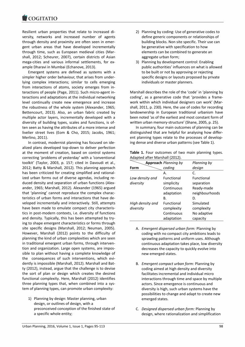
Urban Planning, 2016, Volume 1, Issue 1, Pages 95-113 98
Resilient urban properties that relate to increased di-versity, networks and increased number of agents through density and proximity are often seen in emer-gent urban areas that have developed incrementally through time, such as European medieval cities (Mar-shall, 2012; Scheurer, 2007), certain districts of Asian mega-cities and various informal settlements, for ex-ample Dharavi in Mumbai (Echanove, 2013).
Emergent systems are defined as systems with a simpler higher order behaviour, that arises from under-lying complex interactions; similar to cells emerging from interactions of atoms, society emerges from in-teractions of people (Page, 2011). Such micro-agent in-teractions and adaptations at the individual networking level continually create new emergence and increase the robustness of the whole system (Alexander, 1965; Bettencourt, 2013). Also, an urban fabric created by multiple actor layers, incrementally developed with a diversity of building types, scales and functions, is of-ten seen as having the attributes of a more intense and livelier street lives (Eom & Cho, 2015; Jacobs, 1961; Merlino, 2011).
In contrast, modernist planning has focused on ide-alized plans developed top-down to deliver perfection at the moment of creation, based on control systems correcting ‘problems of yesterday’ with a ‘conventional toolkit’ (Taylor, 2003, p. 157; cited in Davoudi et al., 2012; Batty & Marshall, 2012). This planning approach has been criticized for creating simplified and rational-ized urban forms out of diverse agendas, including re-duced density and separation of urban functions (Alex-ander, 1965; Marshall, 2012). Alexander (1965) argued that ‘planning’ cannot reproduce the complex charac-teristics of urban forms and interactions that have de-veloped incrementally and interactively. Still, attempts have been made to emulate compact city characteris-tics in post-modern contexts, i.e. diversity of functions and density. Typically, this has been attempted by try-ing to shape emergent characteristics or forms through site specific designs (Marshall, 2012; Neuman, 2005). However, Marshall (2012) points to the difficulty of planning the kind of urban complexities which are seen in traditional emergent urban forms, through interven-tion and organization. Large open systems, are impos-sible to plan without having a complete knowledge of the consequences of such interventions, which evi-dently is impossible (Marshall, 2012). Marshall and Bat-ty (2012), instead, argue that the challenge is to devise the sort of plan or design which creates the desired functional complexity. Here, Marshall (2012) identifies three planning types that, when combined into a sys-tem of planning types, can promote urban complexity:
1) Planning by design: Master planning, urban design, or outlines of design, with a preconceived conception of the finished state of a specific whole entity;
2) Planning by coding: Use of generative codes to define generic components or relationships of building blocks. Non site specific. Their use can be generative with specification to how elements can be combined to generate an aggregate urban form;
3) Planning by development control: Enabling public authorities’ influences on what is allowed to be built or not by approving or rejecting specific designs or layouts proposed by private individuals or master planners.
Marshall describes the role of the ‘code’ in ‘planning by coding’, as a generative code that ‘provides a frame-work within which individual designers can work’ (Mar-shall, 2011, p. 230). Here, the use of codes for recording landownership in European traditional urbanism have been noted ‘as of the earliest and most constant form of written urban memory-structure’ (Shane, 2005, p. 25).
In summary, four main outcomes of planning can be distinguished that are helpful for analysing how differ-ent planning types relate to the processes of develop-ing dense and diverse urban patterns (see Table 1).
Table 1. Four outcomes of two main planning types. Adapted after Marshall (2012).
Approach Form
Planning by coding
Planning by design
Low density and diversity
A. Functional simplicity Continuous adaptation
C. Functional separation Ready-made neighbourhoods
High density and diversity
B. Functional complexity Continuous adaptation
D. Simulated complexity No adaptive capacity
A. Emergent dispersed urban form: Planning by coding with no compact city ambitions leads to sprawling patterns and uniform uses. Although continuous adaptation takes place, low diversity decreases the capacity to quickly evolve into new emerged states.
B. Emergent compact urban form: Planning by coding aimed at high density and diversity facilitates incremental and individual micro interactions through time and space by multiple actors. Since emergence is continuous and diversity is high, such urban systems have the possibilities to change and adapt to create new emerged states.
C. Designed dispersed urban form: Planning by design, where rationalization and simplification

Urban Planning, 2016, Volume 1, Issue 1, Pages 95-113 99
create compartmentalized urban patterns. Typical for modernistic and top-down planned urban systems, these plans are often executed through large-scale site interventions with long-term projections into the future.
D. Designed compact urban form: Planning by design—often in combination with planning by development control—are often applied in new initiatives to emulate emergent compact city characteristics. They are initiated top-down and focuses on functional diversity, density as well as on diversity of property ownerships. As designed urban systems, they often include large site areas and incrementality is negligible.
Of these four planning outcomes, C and D are the most relevant for analysing initiatives to produce more com-pact cities, while outcome B is relevant to include in any analysis due to the persisting legacy into current days of the modernistic approach to urban planning and development.
3. Method
According to UN-Habitat (2015), density is measured in terms of the density of built areas and population, and of the concentration of urban functions. When it comes to diversity, both mixed land use and social makeup are included. Mixed land use is defined as a variety of compatible land uses and functions and provision of a cross-section of residential, commercial and community infrastructure in neighbourhoods. So-cial mix is defined as the presence of residents from different backgrounds and income levels in the same neighborhood, and suggested to be achieved by the availability of different housing options in terms of price ranges, tenure type and building types, and the availability of diversity of jobs in the proximity (UN Habitat, 2015).
However, as urban planning takes place in open systems with many purposeful parts (i.e., people and organizations pursuing their interests), it is difficult to link planning activities to outcomes in the urban reali-ty (Laurian et al., 2010). Therefore, this study has cho-sen two highly institutionalized planning systems—in Sweden and Japan—to increase the likelihood that planning has in fact affected the urban reality. Three indicators for compact city urban form were used for the assessment of dense and diverse built environ-ments: the density of built objects, the scales of built objects and the distribution of the diversity of the built objects. Data on these indicators was developed through analysis of building footprints. Analysis of building footprints is evidently insufficient for repre-senting the wide spectrum of qualities to be found in,
or realized through, the compact city. However, build-ing footprints represent the building coverage ratio of a site and can indicate both street level density and diversity in the form of urban grain sizes and rhythm, diversity of building types, and diversity of urban par-cel distribution. As an example, the size of individual plots of land play a role for promoting subsidiarity in decision making to better satisfy local needs (Hoff-mann-Axthelm, 1993, 1996, cited in Scheurer, 2007). Nevertheless, a remaining limitation is that building footprints never can include building volume and re-lated intensity of land use, a weakness common to any analysis solely based on land use.
The assessment was applied to three different kinds of planning outcomes (urban fabrics) resulting from two types of planning approaches as seen in Table 1 above. These were ‘emergent compact urban form’ achieved through planning by coding, ‘designed dis-persed urban form’ achieved through planning by de-sign, and ‘designed compact urban form’ achieved through planning by design in combination with plan-ning by development control. Both ‘emergent compact urban form’ and ‘designed compact urban form’ are expected to deliver some degree of density and diversi-ty while ‘designed dispersed urban form’ is seen as a control indicator for comparison purposes.
As case material, we selected urban fabrics corre-sponding to the abovementioned planning outcomes in one city, where the socio-cultural and historical context is similar. The result is then compared to similar urban fabrics in another city with other contextual relation-ships. The expectation was that identifying similarities and disparities within a city and between both cities would give insights into how density and diversity in more absolute terms are influenced by what planning approach has been applied. The study thus analysed three housing areas in Gothenburg and Tokyo, respec-tively, chosen to represent:
1) Emergent compact urban form (Type 1): An inner city urban fabric evolved through time by multiple actors’ interactions;
2) Designed dispersed urban form (Type 2): A modernist urban fabric from 1960-1970’s where the ideology was clearly to separate and create separation between the functions and to give uniform characteristics and standards;
3) Designed compact urban form (Type 3): An inner city urban fabric where density and diversity has been designed by a number of developers simultaneously.
The two cities are evidently incomparable both in scale and in sociocultural, political and historical contexts. However, in this study, the comparison was undertaken regarding relative proportions of density and diversity across the urban areas.

Urban Planning, 2016, Volume 1, Issue 1, Pages 95-113 100
3.1. Gothenburg and Tokyo
The city of Gothenburg has 544,261 in population and 1,209 persons/km2 in population density (Gothenburg City Council, 2015).
In Gothenburg, as in many other European cities, much of the development has been planned top-down by planners and architects through large-scale devel-opments. However, the small city core developed be-fore the 19th century has been left largely untouched. The period from 1961-1980 has produced 42% of the building stock constructed from 1931 until 2014 (Statis-tics Sweden, 2015). The city districts created during the Million Program period are identified as problem areas ridden with segregation issues (Lilja & Pemer, 2010).
Today, the City of Gothenburg is direly needs to in-crease its level of housing and to reduce socio-spatial segregation. The lack of housing and a constant in-crease of the population leads to a waiting period, counting from start of the search to a rental contract, reaching almost 4 years (Boplats, 2014). The persistent socio-economic spatial segregation coupled with a divi-sion into ‘immigrant’ and ‘native Swedish’ populations is also highly problematic (Lilja & Pemer, 2010). Inte-gration proceeds slowly and the quality of urban life is very much inferior to that in the Million Program areas where the immigrating population consists of up to 80% of the total population (Gothenburg City Council, 2013).
As a response to these problematic issues, Gothen-burg is currently adopting a strategy based on involve-ment of multiple actors, e.g. by employing a diversity of firms to ‘design’ new urban areas with mixed tenan-cy types and functions (Gothenburg City Council, 2011, 2012, 2014). Although this strategy needs to be as-sessed further after a longer time period, it has so far been criticized for failure to produce the desired com-pact dense and mixed urban areas, especially with con-troversial issues concerning gentrification (Thörn, 2013).
Tokyo houses more than 13 million people (Tokyo Metropolitan Government, 2012). Its 23 central special wards have a population of 9.2 million and a density of 14,818 persons/km2..
Most of the urban areas of Tokyo has emerged through continuous incremental adaptation over time. The post WWII land reform, saw 19,180 km2 of land force-purchased from 2,341,000 landlords and sold to 4,748,000 tenants significantly reducing the individual size of holdings. This led to piecemeal development with rather un-organized individual development initia-tives and composite mix of building types (Kawagoe, 1999). The city is seemingly chaotic with a rather form-less urban structure due to it piecemeal developments on narrow streets, but it still keeps its traditional urban patterns quite intact. According to a study on residen-tial class segregation, Tokyo demonstrates low class segregations based on occupation distribution, providing a juxtaposition of demographics (Fujita & Hill, 2012).
3.2. Study Areas
The ten study areas in Gothenburg and Tokyo (see Fig-ure 2) were chosen according to the applied planning approaches these include:
Type 1: Emergent compact urban form, evolved incrementally by multiple actors through time and space
A) Gothenburg Central area: Two areas developed from the 17th century representing one of the oldest neighbourhoods in the city.
1) Inom Vallgraven: Until 1864, when the city extended southwards, this area was the core of Gothenburg and still is a very central area of the city (Stadshem, 2015b), with a population of 3,917 (Gothenburg City Council, 2014).
2) Järntorget/Haga: Previously developed with small wooden houses where port workers resided. Larger buildings were built densely in the area from around the 1840’s when industry began attracting larger numbers of workers (Stadshem, 2015a). The population is 5,718 (Gothenburg City Council, 2014).
B) Tokyo Central areas: Two mixed neighbourhoods with diverse functions located in the central districts of Tokyo, selected to represent typical urban patterns found in the central areas of the Tokyo metropolis. Both areas have been developed since the Edo period of the 1600’s.
1) Nishiazabu: Located in Minato ward, in central Tokyo, with a population of 10,523 (Minato City, 2012).
2) Ebisu: Situated in Shibuya ward, also located in central Tokyo, with population of 13,019 (Shibuya City, 2010).
Type 2: Designed dispersed urban form, reductionist and top-down
C) Gothenburg Million Program Area. The ‘Million Program’ refers to a Swedish public housing program operated between 1965–1974 to deliver one million housing units (Nationalencyklopedin, 2015).
1) Hjällbo: Among the 7,273 residents, around 60% are born outside of Sweden. 15% are foreign citizens and 45% have Swedish citizenship. Statistics show a persistently higher percentage of population on social security benefits in the district, on average 8–10% from 2000–2007, compared to a 1–2% average in Gothenburg during that period (TILLIT, 2012).

Urban Planning, 2016, Volume 1, Issue 1, Pages 95-113 101
D) Tokyo New Town areas, referring to satellite districts developed around major cities by the Japan Housing Corporation to provide modern affordable apartments to the masses of workers migrating to the cities during the 1960’s. The features of the New Towns were attempts to emulate Western and modern ideal living with greenery and parks (Yokohari, Amemiya, & Amati, 2006). Both New Towns in this study face challenges due to decreasing populations (Ducom, 2008; The Japan Times, 2013).
1) Chiba New Town: This suburb was developed from 1969 and onwards and contains a population of approx. 143,300 people (Chiba Prefecture Government, 2013).
2) Tama New Town: This development took place from the mid 60’s until the mid 80’s (Ducom, 2008). According to the sensus in 2010, Tama New Town hosts 216,400 people (Bureau of urban development Tokyo Metropolitan government, 2010).
Type 3: Designed compact urban form, diversity-oriented to emulate emergent characteristics
E) Gothenburg Waterfront: Two areas on the
North of the Göta river represent ongoing urban intensification projects developed by the municipal agency, Älvstranden Development Ltd.
1) Kvillebäcken: 2,000 new apartments and offices/commercial functions are recently finalized, where seven firms were hired to design designated sites with a mix of tenancy types and functions in incremental development stages.
2) Eriksberg: 2,200 housing in different forms and tenure types are to be built on a disused shipyard from 2006 to 2019. A consortium of six construction firms and the municipal agency is involved in the planning and development of this area.
F) Tokyo Central area: 1) Roppongi Hills: Tokyo metropolis’ response to a
compact city within the central special wards. This urban intensification project was constructed by Mori building corporation and was completed in 2003. The complex with total floor area of 724,000 m2 contains offices, commercial activities, residential units and cultural activities.
Figure 2. The ten study areas in Gothenburg and Tokyo.
Urban Planning, 2016, Volume 1, Issue 1, Pages 95-113 102
3.3. Analytical Tools
Each chosen study area was overlaid with a grid of 25 cells measuring 100 by 100 meters, thus covering 10,000 m² each. The cells were numbered from 1 to 25 starting shown in image 4 in Figure 3. Each cell was an-alysed individually. Applying the analysis on cells pro-vided results based on a continuous urban fabric, i.e. not based on project sites. The reason for implementing this approach was to gain understanding of the areas as con-tinuous space, including transitional points between dif-ferent quarters, blocks or projected sites, encompassing urban patterns from various time periods.
The subsequent analysis of density and mixed use was based on three indicators: the density of built ob-jects; the scale of building footprints; and the distribu-tion and diversity of building footprints.
3.3.1. The Density of Built Objects
The building footprints were used as indicator for den-sity. The study of the built environment was achieved through analysis of open source maps retrieved from openstreetmap.org. The assessment of density was performed by analysing the raster image pixel count-ing. The vector shapes, which identify the borders of buildings, were separated from the rest of the infor-mation, such as roads, paths and site boundaries (see image 3 in Figure 3). This gave a gross density including public and private streets as well as unbuilt surfaces. Then the colour scale of the vector polygons represent-ing building footprint was reduced to black, i.e. with
red(R), green(G) and blue(B) in the RGB scale reduced to 0%. Through this measure, the density of BCR could be derived as 100-RGB %=x% where ‘RGB’ is the re-maining space excluding the building footprints.
3.3.2. The Scale and Distribution and Diversity of Building Footprints: Phase 1
The assessment of scale was done by measuring the size of the footprint of each building. To do this, the vector polygons representing the building footprints of the study areas were imported to the Adobe Illustrator software and consequently, a vector analysis script, ‘SelectPathBySize.jsx’ was executed for the analysis scales of built objects.
1. The script analysed areas smaller (or in ‘f’ below identical or bigger) than a certain surface area. The pa-rameters of the building footprint areas used for the calculation were:
a. smaller than 300 m² b. smaller than 750 m² c. smaller than 1,500 m² d. smaller than 2,250 m² e. smaller than 3,000 m² f. bigger than 3,000 m²
Each identified built object for a scale was removed and color-coded (see Figure 4), leaving only those larg-er than the values already analysed to be assessed fur-ther. The built objects larger than 3,000 m² were grouped together without further subdivision.
Figure 3. Process of analysis of building footprints in site areas with grids.
Figure 4. Analysis process of scale proportions: Phase 1.

Urban Planning, 2016, Volume 1, Issue 1, Pages 95-113 103
3.3.3. The Scale and Distribution/Diversity of Building Footprints: Phase 2
Subsequently, each cell with the categorically color-coded vector polygons were imported to the Adobe Photoshop software as separate layers and analysed with a histogram function to calculate the number of pixels of the combined area of a given scale object within a cell. The proportion of each building scale was then derived in relation to the total number of pixels in each cell (see Figure 5).
4. Results
Displayed below (Figure 6), are the results of the analy-sis of density, scale and distribution/diversity of build-ing footprints.
Figure 6 illustrates the analysis of the density of built objects. It shows the building coverage ratio in the ten areas in Gothenburg and Tokyo. It showed that in Gothenburg the highest density of 37% and 31% in type 1 and the lowest, 12% in type 2 and low density, 19% and 14% in type 3. In Tokyo, the study areas in type 1 and 3 showed similar density, 29%, 26% and respective-
ly, 29%, while both areas in type 2 showed the lowest density of 15%.
The median values of density of the two cities showed that both the highest and the lowest density clusters were found in Gothenburg (in the 50%–60% and 0%–10% spectra), while the distribution was more evenly clustered in Tokyo (between 10%–40%) (see Fig-ure 7 and Figure 8). It was also notable that the number of unbuilt neighbourhood areas represented by the cell on the 0% axis were much higher in Gothenburg.
Figure 9 illustrates the first phase of analysing the scale and distribution/diversity of building footprints. Through colour coding it facilitates the visualisation of the variation of building types and the street patterns.
The second phase of analysing scale and distribu-tion/diversity of building footprints is illustrated in Fig-ure 10, showing the differences between Gothenburg and Tokyo in terms of scale distribution of the building footprints. Smaller scale buildings were much more frequent in Tokyo for all urban types. Building foot-prints of under 750 m² consisted of 32% and 24% of all buildings in Tokyo, while in Gothenburg the percent-ages for those scales were 4% and 22%, respectively.
Figure 5. Analysis process of scale proportions—Phase 2.
Figure 6. Graph over building footprint densities in the ten study areas. The horizontal axis shows the density as a per-centage of the total area.

Urban Planning, 2016, Volume 1, Issue 1, Pages 95-113 104
Figure 7. Graphs showing the distribution of the density of each cell in the study areas.
Figure 8. Four graphs showing the distribution of density trends in both cities. The images to the left show the median level density while the images to the right show the general pattern of density distribution between the cells.
Figure 9. Building footprints in the ten study areas color-coded according to their scale; first phase of analysis.

Urban Planning, 2016, Volume 1, Issue 1, Pages 95-113 105
Figure 10. Diagrams showing the scale distributions of building footprints as well as the total proportions including un-built surfaces for each cell in the ten study areas; from the second phase of analysis.
However, looking at the proportions between the types within the same cities, we observed a gradual decrease of smaller scale buildings from Type 1, and to Type 3, and then to Type 2. Also, more vacant lots are observed in Type 2 in both cities.
5. Discussion
The graph displaying the density analysis of the study sites showed generally higher density in Type 1 areas in both cities. Gothenburg showed even higher density in those areas than Tokyo. The designed compact city ar-eas of Type 3 in Gothenburg showed a much lower density, which was rather similar to that of the mod-ernist designed Type 2 areas of Tokyo. The study of the median levels of density showed a much more even distribution of density in overall Tokyo, with a more consistently clustered density distribution throughout (see Figure 8). In Gothenburg, the highs and lows of the density were greater, with urban areas varying signifi-cantly from larger unbuilt sites to extremely dense sites. Type 1 Gothenburg areas showed much higher density than that of any other Type in both cities. Also here, extreme highs and lows were observed, com-pared to the more contained distribution of the Tokyo sites (see Figure 11).
When looking at the scale and distribution/diversity of building footprints across the study areas, including streets and unbuilt surfaces, the building shapes and
configuration of Gothenburg’s Type 3 areas exhibited resemblance to the reductionist oriented Type 2 areas of both cities, rather than the intended compact city type seen in Gothenburg Type 1 areas (see Figure 9). However, when looking at the distribution/diversity of the building footprints only, the results told a some-what different story (see Figure 12). A comparison of the scales of building objects within each city showed an increasing scale from Type 1 to Type 2 and then to Type 3. Also, the relative number of buildings found in the respective study areas was highest in Type 1 areas and lowest in Type 2 areas in both cities, while Type 3 areas remained in-between. However, assuming that the whole of a Type 3 area would be developed in the same manner as the individual intensification projects, Gothenburg’s Type 3 actually began to resemble Type 1, while in Tokyo, this adjusted value of Type 3 resem-bled that of Type 2 areas (see Figure 12). The density and mixed-use oriented design approach in Tokyo (Type 3) had thus resulted in a lower quantity of build-ings in a dense composition, emulating the density of Type 1 but the building scale and distribution of Type 2. In Gothenburg, it was unclear if the densities or build-ing scales exhibited any characteristics similar to the emerged urban form of Type 1. The slight increase of density was rather insignificant. However, the increase of the number of buildings found in the two Type 3 ar-eas, almost to the level found in Type 1 areas, seemed to indicate some of the characteristics found in Type 1.

Urban Planning, 2016, Volume 1, Issue 1, Pages 95-113 106
Figure 11. Graph showing the density of each cell in all four Type 1 areas. Highs and lows in Gothenburg are shaded grey.
Figure 12. Comparisons of scale distributions of the building footprints in the two cities. Numbers of buildings found in each study area is shown. As a comparison, for Type 3 the figure also shows the projected number of buildings as if the whole study area would have contained the same number of buildings as the intensification development sites. The percentage of building footprint density is provided for reference.
Furthermore, it might be speculated that wider roads and existence of larger public areas are contributing factors to the variation of density in Gothenburg seen in Figure 11. A quick tracking of visible parking spaces in two of the areas in Gothenburg and Tokyo showed larger parking spaces distributed less evenly in the Gothenburg Type 1 area (see Figure 13).
It is not surprising that the results showed reduced density and less diversity in areas designed with the reductionist approach (Type 2) compared to the areas designed with a density and diversity oriented ap-proach (Type 3) in both cities. However, the observa-tion that areas designed compact city areas in ongoing urban intensification programs in Gothenburg have a

Urban Planning, 2016, Volume 1, Issue 1, Pages 95-113 107
density that was closer to that of the suburban Million Program area, than to the density of the city core seems more remarkable. This might be due to the fact that these intensification plans were subjected to a wa-terfront development where the ‘Compact city’ motto is immediately followed by a ‘Close to green areas’ motto (Gothenburg City Council, 2012). To confirm this assumption, an additional analysis was carried out, fo-cusing only on the project development areas, thus dis-regarding previously existing green areas and sur-rounding housing areas (see Figure 14). When the result was compared to the total scale distribution and density of the study areas, it displayed slightly in-creased density. However, the building scale distribu-tions in the newly built intensification areas were much simplified, resulting in less diversity of scales compared to what was found in the total areas. This seemed to indicate that while the density efforts emulated Type 1 areas, the scale distribution followed the pattern ob-served in Type 2 areas.
For Tokyo, the results showed designed compact city of Type 3 actually displaying an overall density similar to the Type 1 areas. Once again, we singled out the Roppongi Hills project area and re-analysed
the density and the scale distribution and compared the results with the total study area and also to the other areas studied in Tokyo (see Figure 15). The ex-tended analysis showed that also in this case, the pro-ject area had an increased density. However, it also showed a reduced proportion of smaller scale build-ings, resulting in less buildings with footprints of un-der 1,500 m² than in both Type 1, Type 2, and the rest of the Type 3 area. The secondary analysis of the Type 3 areas in both cities seemed to indicate that an in-crease of the density was possible to engineer through urban design, while the design of diversity of building scales was not.
To sum up the findings on density and diversity, it was only in Gothenburg that density distinguished Type 1 from Type 3. An increase of building scales and uni-formity of scale distribution was observed in Type 3 ar-eas in both cities. The analysis of quantity of built ob-jects was showed contrasting results in the Type 3 in both cities. However, higher density, a higher quantity of small-scale built objects and a more even distribu-tion between the scales seemed to indicate the pres-ence of a kind of compact city form in Type 3 areas in both cities, compared to Type 2 areas.
Figure 13. The bird’s eye-view of Type 1 study areas in both cities with marked ground level spaces designated for parking.
Figure 14. Proportions of scale distributions of building footprints of Type 3 areas in Gothenburg re-analysed focusing only on the newly developed parts of the study area.

Urban Planning, 2016, Volume 1, Issue 1, Pages 95-113 108
Figure 15. Re-analysis of the Type 3 area in Tokyo. The overall Roppongi area is divided into the Roppongi Hills project area and the surrounding area.
Figure 16. Images show the information regarding the phasing of the project development. (Kvillebäcken, retrieved 2015).
If we apply Ahern’s (2011) resilience characteristics shown in Figure 1, increased density and number of built objects potentially indicate the required multiplic-ity of elements and components required for redun-dancy and modularization. Benefits of multiple, diverse agents for resilient and adaptive urban systems have been pointed out by many researchers (Bettencourt, 2013; Bettencourt & West, 2010; Glaeser, 2011; Quigley, 1998), and the characteristics of the emerged Type 1 seem to concur with those characteristics, if we consider a parcel as an individual agent (Hoffmann-Axthelm, 1993, 1996, cited in Scheurer, 2007). For Type 3 this is less obvious. An emergent system could be re-garded as a process of incremental adaptivity by di-verse agent’s self-modification, and interaction, and the characteristics of emergent urban form is the out-come of this process. Even though the urban intensifi-cation projects in Gothenburg waterfronts, represent-ed by the two Type 3 study areas Kvillebäcken and Eriksberg, aim to implement incremental development
strategies with varying phases of construction assigned to multiple actors, Figure 16 shows that this incremen-tality is designed already during the initial master plan-ning process.
The images in Figure 16 also show how the planned diversity of employed design firms and of urban func-tions is already extant at this early stage. A certain de-gree of density and variety of scales may possibly be emulated in planning processes if the parameters are set to achieve such characteristics. However, it seems that true diversity of scales as consequences of emergent de-sign processes through adaptation and incremental de-velopment is not delivered by pre-designed incremental-ity with a pre-assigned and controlled diversity.
One critique of the Kvillebäcken and Eriksberg areas in Gothenburg concerns the high rents and purchase fees in the project areas. The average rent per m² per year in Gothenburg for a one room apartment is 1,251 SEK (Statistics Sweden, 2015), while the lower rent scale for a one room apartment is 2,101 SEK per m²

Urban Planning, 2016, Volume 1, Issue 1, Pages 95-113 109
and year in Kvillebäcken (Kjellberg, 2013). The rent in Roppongi Hills residence is also much higher than the average of the same ward, costing 7,480 JPY per m² per month (Moriliving, 2015) compared to the 4,409 JPY average per month (REINS, 2015). Newly built apart-ments being expensive is not a new phenomenon. However, when large neighbourhoods are solely com-posed of costly new apartments, any diversity of the socio-economic demography can hardly be achieved. Kvillebäcken is especially criticized for negative gentri-fication, not least since the development of the site in-volved the removal of existing buildings and activities (Thörn, 2013). In this case, an incremental ‘adaptive process’ through time and space could proven to con-tribute more to the resilient characteristics of urban form rather than what was achieved through the pre-designed and pre-determined processes only mimick-ing incrementality (Alexander, 1965; Neuman, 2005).
In comparison with Gothenburg, the Type 1 study areas with emergent urban form in Tokyo showed slightly lower but more uniform rates of density, with higher proportion of smaller buildings and overall quantity of buildings (see Figures 8 and 10). The distri-bution of this type is prevalent in the overall Tokyo metropolitan area. It is interesting to discuss whether the less problematic class segregation issues observed in Tokyo (Fujita & Hill, 2012) might relate to these ur-ban-form characteristics. It is speculated that contrib-uting urban form factors might be a well-networked public transportation, renewability of aged buildings and housing stocks, smaller scale real-estate develop-ment, and less strict land use which create micro pattern of land-use with mixed functions (Fujita & Hill, 2012). Presumably, such patterns of multi-functionality, redun-dancy, modularization and diversity (Ahern, 2011) can be seen to increase socioeconomic resilience to the benefit of less affluent citizens.
Tokyo is operating under an overarching ‘rule-based’ planning approach with a highly mixed accumu-lative zoning, where building standard laws are con-sistent to ‘planning by coding’ (Marshall, 2012). The implementation of the zoning codes is top-down, thus indicating, also the ‘planning by development control’. Compared to Type 2, shaped through ‘planning by de-sign’, and Type 3, delivered through ‘planning by de-velopment control’, and ‘planning by design’, the ques-tion whether ‘planning by coding’ generates more emergent behaviour with incremental adaptive chang-es as seen in Type 1 needs to be further studied. Also, our understanding of how Tokyo’s rule-based planning approach—and its outcomes—came into being would be further strengthened from understanding more about how the historical background of urban devel-opment processes in Tokyo plays into this. First, the lack of centralized planning can be explained by the post WW II situation. After the destruction of the city structure during the war and the great Kanto earth-
quake, a prevailing lack of resources resulted in a lack of centralized planning, leaving the city to be recon-structed by citizen efforts, neighbourhood by neigh-bourhood, mimicking structures existing before the de-struction (Hein, 2010; Okata & Murayama, 2011). Second, land reform policy of post WWII forced agricul-tural landlords to sell land to smaller farmers, resulting in piecemeal land divisions with a diversity of smaller scale independent actors (Kawagoe, 1999). Third, as railways were constructed the areas were developed around each station, so that the next station could be expanded with the capital gains from the real-estate development, incrementally expanding the city station by station (Okata & Murayama, 2011).
6. Conclusions
This paper sets out to answer the question: What are the differences in outcome of different planning ap-proaches in relation to urban characteristics, such as density and diversity?
We have shown how different planning approaches seem to deliver very different outcomes when it comes density and diversity of built objects. While the process of Type 3 development (designed compact urban form) to some extent emulates Type 1 (emergent compact urban form), some of the differences seem to be criti-cal to the detriment of Type 3 planning:
1. The time factor. By completely eliminating the existing building stocks and activities on site, as was done in the Kvillebäcken area, the planners also eliminated the time factor, leading to a total lack of incrementality and with no remaining population to engage in post-destruction piecemeal reconstruction.
2. The lack of diversity of building scales and absence of smaller estate patterns. Even with the efforts to involve multiple design and development companies to create diversity, the uniformity of overall scale still remains. Also, higher costs in larger scale development projects seems to contribute to a less diverse mix of socio-economical demographics.
3. Employment of a top-down planning hierarchy. The main planning body analyses and draws up a form plan, which is then approved by the city council. Multi-actor participation is only served through designing individual buildings assigned to them centrally, through ‘planning by design’ and ‘development control’ (Marshall, 2012).
Here this study might be able to contribute in relation to the how planning is carried out in Gothenburg, cur-rently mixing ‘planning by design’ with ‘planning by de-

Urban Planning, 2016, Volume 1, Issue 1, Pages 95-113 110
velopmental control’ (Marshall, 2012). We have shown how parameters, such as timing, density, building scale diversity, and decentralization of planning and design activities to multiple actors are critical factors also in large scale development projects, for example in brown-field regeneration or urban infill areas. Although these parameters need to be studied more in-depth, with consideration to the local context for understand-ing the optimal level of timing, density and building scale in site areas. The ‘planning by coding’ (Marshall, 2012) strategy, with ‘generative’ rules, seems to offer a promising third path also in Swedish urban regenera-tion for density and mixed use, as seen with the rule-based approach in Japan. Consequently, feasibility studies for implementation of ‘planning by coding’ or rule-based planning strategies should be carried out to support incrementality whenever possible.
Conflict of Interests
The authors declare no conflict of interests.
References
Ahern, J. (2011). From fail-safe to safe-to-fail: Sustaina-bility and resilience in the new urban world. Land-scape and Urban Planning, 100(4), 341-343.
Alexander, C. (1965). A city is not a tree. Architectural Forum, 122(1/2), 58-62.
Batty, M., & Marshall, S. (2012). The origins of complexi-ty theory in cities and planning. In J. Portugali, H. Meyer, E. Stolk & E. Tan (Eds.), Complexity theories of cities have come of age (pp. 21-46). Berlin, Germany: Springer Berlin Heidelberg.
Bettencourt, L. (2013). The kind of problem a city is. In D. Offenhuber & C. Ratti (Eds.), Die Stadt Entschlusseln: Wie Echtzeitdaten Den Urbanismus Verandern: Wie Echtzeitdaten den Urbanismus Verandern (pp. 175-187). Heidelberg, Germany: Birkhauser.
Bettencourt, L., & West, G. (2010). A unified theory of urban living. Nature, 467(7318), 912-913.
Boplats. (2014). Boplats i siffror. Boplats. Retrieved from https://nya.boplats.se/om/statistik
Bramley, G., & Power, S. (2009). Urban form and social sustainability: The role of density and housing type. Environment and Planning B: Planning and Design, 36(1), 30-48.
Brand, F. S., & Jax, K. (2007). Focusing the meaning(s) of resilience: Resilience as a descriptive concept and a boundary object. Ecology and Society, 12(1), 23.
Bristow, G. (2010). Resilient regions: Re-‘place’ing re-gional competitiveness. Cambridge Journal of Re-gions, Economy and Society, 3(1), 153-167.
Bureau of Urban Development Tokyo Metropolitan Gov-ernment. (2010). Article 05-NT population trends. Bu-reau of Urban Development Tokyo Metropolitan Gov-ernment. Retrieved from http://www.toshiseibi.me
tro.tokyo.jp/bosai/tama/pdf/tama09.pdf Burton, E. (2001). The compact city and social justice. In
Proceedings of the housing studies association spring conference on housing, environment and sustainabil-ity. York: University of York.
Carlino, G. A., Chatterjee, S., & Hunt, R. M. (2007). Urban density and the rate of invention. Journal of Urban Economics, 61(3), 389-419.
Chelleri, L., & Olazabal, M. (2012). Multidisciplinary per-spectives on urban resilience: A workshop report. Bil-bao, Spain: BC3, Basque Centre for Climate Change.
Chiba Prefecture Government. (2013). Chiba new town. Chiba Prefecture Government. Retrieved from: https://www.pref.chiba.lg.jp/kigyou/nt/index-e.html
Churchman, A. (1999). Disentangling the concept of density. Journal of Planning Literature, 13(4), 389-411.
Commission of the European Communities. (1990). Green paper on the urban environment. Luxem-bourg: Publications Office of the European Office.
Commission of the European communities. (2011). Cities of tomorrow: Challenges, visions, ways forward. Lux-embourg: Publications Office of the European Office.
Davoudi, S., Shaw, K., Haider, L. J., Quinlan, A. E., Peter-son, G. D., Wilkinson, C. . . ., & Davoudi, S. (2012). Resilience: A bridging concept or a dead end? ‘Re-framing’ resilience: Challenges for planning theory and practice interacting traps: Resilience assessment of a pasture management system in Northern Af-ghanistan Urban Resilience: What does it mean in planning practice? Resilience as a useful concept for climate change adaptation? The politics of resilience for planning: A cautionary note. Planning Theory & Practice, 13(2), 299-333.
Dempsey, N., Brown, C., & Bramley, G. (2012). The key to sustainable urban development in UK cities? The influence of density on social sustainability. Progress in Planning, 77(3), 89-141.
Ducom, E. (2008). Tama new town, west of Tokyo: Anal-ysis of a shrinking suburb. HAL-Inria. Retrieved from http://hal.inria.fr/docs/00/21/59/89/PDF/LaUP-DUCOM.pdf
Echanove, M. (2013). Beyond the informal: Reconceptu-alizing Mumbai‘s urban development (MMG Working Paper). Goettingen, Germany: Max Planck Institute for the Study of Religious and Ethnic Diversity
Eom, H.-J., & Cho, G.-H. (2015). Exploring thresholds of built environment characteristics for walkable com-munities: Empirical evidence from the Seoul metro-politan area. Transportation Research Part D: Transport and Environment, 40, 76-86.
Fujita, K., & Hill, R. C. (2012). Residential income inequal-ity in Tokyo and why it does not translate into class-based segregation. In T. Maloutas & K. Fujita (Eds.), Residential segregation in comparative perspective: Making sense of contextual diversity (pp. 37-68). Ab-ingdon, UK: Ashgate Publishing Group.

Urban Planning, 2016, Volume 1, Issue 1, Pages 95-113 111
Glaeser, E. L. (2011). The triumph of the city: How our greatest invention makes us richer, smarter, greener, healthier, and happier. New York: Penguin Press.
Gothenburg City Council, (2011). Hållbar utveckling I Kvillebäcken. Gothenburg: City of Gothenburg.
Gothenburg City Council. (2012). Rivercity Gothenburg Vision. Gothenburg: City of Gothenburg.
Gothenburg City Council. (2013). Statistisk Årsbok. Gothenburg City Council. Retrieved from http://www 4.goteborg.se/prod/sk/statistik/statistikR5.nsf
Gothenburg City Council. (2014). Statistisk Årsbok. Gothenburg City Council. Retrieved from http://www 4.goteborg.se/prod/sk/statistik/statistikR5.nsf
Gothenburg City Council. (2015). Statistisk Årsbok. Gothenburg City Council. Retrieved from http://www 4.goteborg.se/prod/sk/statistik/statistikR5.nsf
Gunderson, L. H., & Holling, C. S. (2002). Panarchy: Un-derstanding transformations in human and natural systems. Chicago, IL: Island Press.
Haigh, F., Ng Chok, H., & Harris, P. (2011). Housing densi-ty and health: A review of the literature and health impact assessments. Sydney: UNSW Research Centre for Primary Health Care and Equity.
Hein, C. (2010). Shaping Tokyo: Land development and planning practice in the early modern Japanese me-tropolis. Journal of Urban History, 36(4), 447-484.
Heinonen, J., & Junnila, S. (2011). Implications of urban structure on carbon consumption in metropolitan areas. Environmental Research Letters, 6(1), 014018.
Hoffmann-Axthelm, D. (1993). Die dritte Stadt. Bausteine eines neuen Grundungsvertrages. Frankfurt (M), Germany: Suhrkamp.
Hoffmann-Axthelm, D. (1996). Anleitung zum Stadtum-bau. Frankfurt (M), Germany: Campus.
Homer-Dixon, T. (2011). Complexity science. Oxford Leadership Journal, 2(1), 1-15.
Kjellberg, I. (2013). Nu startat vi uthyrningen I Kvil-lebäcken. Ivar Kjellberg Fastighetes AB. Retrieved from http://ikfab.kjellberg.se/nu-startar-vi-uthyrning en-i-kvillebacken
Jacobs, J. (1961). The death and life of great American cities. New York: Random House.
Kawagoe, T. (1999). Agricultural land reform in postwar Japan: Experiences and issues (Vol. 2111). World Bank Publications.
Kearney, A. R. (2006). Residential development patterns and neighborhood satisfaction: Impacts of density and nearby nature. Environment and Behavior, 38(1), 112-139.
Kvillebäcken. (n.d.). Kvarteren. Kvillebäcken. Retrieved from http://www.kvillebacken.se/om-kvillebaecken/ kvarteren
Laurian, L., Crawford, J., Day, M., Kouwenhoven, P., Ma-son, G., Ericksen N., Beattie, L. (2010). Evaluating the outcomes of plans: Theory, practice, and methodol-ogy. Environment and Planning B: Planning and De-sign, 37(4), 740-757.
Lee, J., Kurisu, K., An, K., & Hanaki, K. (2015). Develop-ment of the compact city index and its application to Japanese cities. Urban Studies, 52(6), 1054-1070.
Leffers, D. (2015). Urban sustainability as a “boundary object”: Interrogating discourses of urban intensifica-tion in Ottawa, Canada. In C. Isenhour, G. McDonogh, & M. Checker (Eds.), Sustainability in the global city: Myth and practice (pp. 329-349). Cam-bridge, UK: Cambridge University Press.
Lilja, E., & Pemer, M. (2010). Boendesegregation—Orsaker och mekanismer: En genomgång av aktuell forskning. Karlskrona: Boverket
Manaugh, K., & Kreider, T. (2013). What is mixed use? Presenting an interaction method for measuring land use mix. Journal of Transport and Land Use, 6(1), 63-72.
Manesh, S. V., & Tadi, M. (2011). Sustainable urban morphology emergence via complex adaptive system analysis: Sustainable design in existing context. Pro-cedia Engineering, 21, 89-97.
Marshall, S. (2011). Urban coding and planning. London and New York: Routledge.
Marshall, S. (2012). Planning, design and the complexity of cities. In J. Portugali, H. Meyer, E. Stolk, & E. Tan (Eds.), Complexity theories of cities have come of age (pp. 191-206). Berlin: Heidelberg: Springer Berlin Heidelberg.
Merlino, K. R. (2011). Urban grain and the vibrancy of older neighbourhoods: Metrics and measures. In Considering research: Reflecting upon current themes in architectural research (pp. 477-488). Detroit, USA: Lawrence Tech University.
Minato City. (2012). Minato-ku of population and num-ber of households (based on the Basic Resident Reg-ister). 2012 (Number of Population and Households in Minato-ku, Tokyo). Retrieved from http://www. city.minato.tokyo.jp/toukeichousa/kuse/toke/jinko/jinko/index.html
Mindali, O., Raveh, A., & Salomon, I. (2004). Urban den-sity and energy consumption: A new look at old sta-tistics. Transportation Research Part A: Policy and Practice, 38(2), 143-162.
Moriliving. (2015). Roppongi Hills Residence. Moriliving. Retrieved from http://www.moriliving.com/en/esta te/residence/roppongihills
Muraca, B., & Voget-Kleschin, L. (2011). Strong sustaina-bility across culture(s). In G. Banse, G. L. Nelson, & O. Parodi (Eds.), Sustainable development—The cultural perspective: Concepts, aspects, examples (pp. 187-201). Berlin: Edition Sigma.
Nationalencyklopedin. (2015). miljionprogrammet. NE. Retrieved from http://www.ne.se/uppslagsverk/ency klopedi/lång/miljonprogrammet
Neuman, M. (2005). The compact city fallacy. Journal of Planning Education and Research, 25(1), 11-26.
OECD. (2012). Green growth studies, compact city poli-cies: A comparative assessment. Paris, France: OECD

Urban Planning, 2016, Volume 1, Issue 1, Pages 95-113 112
Publishing. Offenhuber, D., & Ratti, C. (2014). Decoding the city: Ur-
banism in the age of big data. In EBOOK PACKAGE Arts and Architecture 2014. Basel: De Gruyter Birkhäuser.
Okata, J., & Murayama, A. (2011). Tokyo’s urban growth, urban form and sustainability. In A. Sorensen & J. Okata (Eds.), Megacities (Vol. 10, pp. 15-41). Tokyo: Springer Japan.
Oliveira, V., & Pinho, P. (2010). Evaluation in urban plan-ning: Advances and prospects. Journal of Planning Literature, 24(4), 343-361.
Page, S. E. (2011). Diversity and complexity. Princeton, NJ: Princeton University Press.
Planning and Building Committee of Gothenburg. (2014). Development Strategy Göteborg 2035. Gothenburg: City of Gothenburg.
Quigley, J. M. (1998). Urban diversity and economic growth. Journal of Economic Perspectives, 12(2), 127-138.
REINS. (2015). REINS Tower. REINS. Retrieved from http:// www.reins.or.jp/pdf/trend/sc/sc_201501-03.pdf
Rowley, A. (1994). Definitions of urban design: The na-ture and concerns of urban design. Planning Practice and Research, 9(3), 179-197.
Scheurer, J. (2007). Compact city policy: How Europe re-discovered its history and met resistance. The Urban Reinventors, 2. Retrieved from http://www.urban reinventors.net/2/scheurer/scheurer-urbanreinvent ors.pdf
Shane, D. G. (2005). Recombinant urbanism: Conceptual modeling in architecture, urban design, and city the-ory. New York, USA: Wiley.
Shibuya City. (2010). Statistics data. Population by basic resident register, alien reistration. Retrieved from http://www.city.shibuya.tokyo.jp
Stadshem. (2015a). Haga. Stadshem. Retrieved from http://www.stadshem.se/omrade/haga
Stadshem. (2015b). Inom Vallgraven. Stadshem. Re-trieved from http://www.stadshem.se/omrade/inom -vallgraven
Statistics Sweden. (2015). Nybyggnad av bostäder. SCB. Retrieved from http://www.scb.se/BO0101
Taylor, P. (2003). Time: From hegemonic change to eve-ryday life. In S. Holloway, S. Rice, & G. Valentine (Eds.), Key concepts in geography (pp. 146-152).
London, United Kingdom: Sage Publications. The Japan Times. (2011). The aging issue of Chiba New
Town. The Japan Times. Retrieved from http://www. japantimes.co.jp/community/2011/11/01/how-tos/ja pans-new-towns-are-finally-getting-too-old/#.VnFD0p MrI0o
Thörn, C. (2013). Här utplånas mångfalden. Arkitektur. Retrieved from www.arkitektur.se/har-utplanas-mangfalden
TILLIT. (2010). TILLIT: Hjällbo. Presentation documenta-tion for Den nödvändiga samverkan for Gothenburg City. TILLIT. Retrieved from http://www4.goteborg. se/prod/storstad/dalis2.nsf/vyFilArkiv/TILLIT.Hjallbo.Samv.25.feb.ppt/$file/TILLIT.Hjallbo.Samv.25.feb.ppt
Tokyo Metropolitan Government. (2012). Tokyo’s histo-ry, geography, and population. Tokyo Metropolitan Government. Retrieved from http://www.toukei. metro.tokyo.jp/tnenkan/tn-eindex.htm
UN Habitat. (2011). The economic role of cities. United Nations Human Settlements Programme 2011. Nai-robi, Kenya: United Nations Human Settlements Pro-gramme.
UN Habitat. (2014a). A new strategy of sustainable neighbourhood planning: Five principles. Nairobi, Kenya: United Nations Human Settlements Pro-gramme.
UN Habitat. (2014b). The economics of urban form: A lit-erature review. Nairobi, Kenya: United Nations Hu-man Settlements Programme 2014.
UN Habitat. (2014c). Urban patterns for a green econo-my leveraging density. Nairobi, Kenya: United Na-tions Human Settlements Programme.
UN Habitat. (2015). Issue Paper On Urban And Spatial Planning And Design. Nairobi, Kenya: United Nations Human Settlements Programme 2015.
Västraeriksberg. (2013). Utbyggnadsplan. Västraeriks-berg. Retrieved from http://www.vastraeriksberg.se/ utbyggnadplan
Wilkinson, C. (2011). Social-ecological resilience: Insights and issues for planning theory. Planning Theory, 11(2), 148-169.
Yokohari, M., Amemiya, M., & Amati, M. (2006). The his-tory and future directions of greenways in Japanese new towns. Landscape and Urban Planning, 76(1-4), 210-222.
About the Authors
Hye Kyung Lim Hye Kyung Lim is a PhD candidate in the department of architecture at Chalmers University of Tech-nology, Gothenburg, Sweden and is affiliated with Mistra urban futures Gothenburg. Her current re-search focuses on compact city strategies based on comparative studies of urban systems, and devel-opment of collaborative urban planning tools using both digital mapping on mobile devices and augmented reality based urban design methods.

Urban Planning, 2016, Volume 1, Issue 1, Pages 95-113 113
Dr. Jaan-Henrik Kain Jaan-Henrik Kain is Professor in Urban Transformation and Planning Processes at Chalmers Architec-ture, Chalmers University of Technology, Gothenburg, Sweden. Current research topics include digital tools for inclusive planning, planning for urban ecosystem services, reviewing qualities, drivers and strategies for urban densification, and building democracy through waste management in develop-ment settings.

Urban Planning (ISSN: 2183-7635)
Urban Planning is an international peer-reviewed open access journal of urban studies aimed at advancing understandings and ideas of humankind’s habitats.
www.cogitatiopress.com/urbanplanning