
Urban Pattern Specification - CiteSeerX
48
1 Urban Pattern Specification Stephen Marshall Institute of Community Studies, London 21st January 2005 [Version for publication] The purpose of this document is to set out a series of issues relating to ‘urban pattern specification’ in connection with the SOLUTIONS project (Sustainability of Land Use and Transport In Outer NeighbourhoodS). In doing so it serves both to present a general background to the role and relevance of the ‘pattern specification’ component of the SOLUTIONS project, and to air parts of the ongoing work within the project, for the purposes of discussion and feedback at the Cambridge Symposium. It is therefore not the ‘final word’ on the topic but a snapshot of work that is currently under ongoing development. 1. INTRODUCTION “It is increasingly being recognised that the outer cities are not an aberrational form, or an extension of, the old core-periphery model. Rather, outer cities represent a new organisational model.” – Palen (1995:92) Considering the form and structure of urban areas is not just a theoretical exercise, but is given particular practical significance in the current UK context of large scale urban development. The Government’s Sustainable Communities programme proposes the construction of millions of new homes, not in isolation but assembled in ‘communities’ or ‘settlements’. Many of the new development areas will be on greenfield land or, in
-
Upload
khangminh22 -
Category
Documents
-
view
3 -
download
0
Transcript of Urban Pattern Specification - CiteSeerX
1
Urban Pattern Specification
Stephen Marshall
Institute of Community Studies, London
21st January 2005
[Version for publication]
The purpose of this document is to set out a series of issues relating to ‘urban pattern
specification’ in connection with the SOLUTIONS project (Sustainability of Land Use
and Transport In Outer NeighbourhoodS). In doing so it serves both to present a general
background to the role and relevance of the ‘pattern specification’ component of the
SOLUTIONS project, and to air parts of the ongoing work within the project, for the
purposes of discussion and feedback at the Cambridge Symposium. It is therefore not the
‘final word’ on the topic but a snapshot of work that is currently under ongoing
development.
1. INTRODUCTION
“It is increasingly being recognised that the outer cities are not an aberrational
form, or an extension of, the old core-periphery model. Rather, outer cities
represent a new organisational model.” – Palen (1995:92)
Considering the form and structure of urban areas is not just a theoretical exercise, but is
given particular practical significance in the current UK context of large scale urban
development. The Government’s Sustainable Communities programme proposes the
construction of millions of new homes, not in isolation but assembled in ‘communities’
or ‘settlements’. Many of the new development areas will be on greenfield land or, in
2
any case, on urban peripheries which even if having previously been used for some form
of non-agricultural development, tend to be large sites (such as ex airfield, ex power
station, ex quarry) that have no prior urban structure, that is to say, not a pre-existing set
of patterns of roads, streets, neighbourhoods, local centres, and so on, that act as a guide
or constraint. The combination of the vast scale of new development and the degrees of
freedom concerning how new development is laid out gives the professional activities of
land use and transport planning a particularly significant influence on what these
‘sustainable communities’ will be like, and indeed whether or not or to what extent they
are in fact ‘sustainable’ (and indeed ‘communities’ in any traditional sense).
Considering and evaluating theoretical and optimal forms of settlements from first
principles was particularly common in the era of the UK New Towns programme. Since
then, development has taken place on a more ad hoc, piecemeal basis; or, at least,
development patterns were generated and optimised from a site-specific point of view,
rather than from consideration of generalised ‘models’. With the scale and sense of
common purpose of the Sustainable Communities programme – perhaps for the first time
since the New Towns programme – there is a renewed need and desire to consider what
possible patterns of urban form there are, are and what are optimal for today’s needs.
A fresh look is required, since priorities (and technological and legislative possibilities)
have changed. In contrast to the New Towns programme, one might say that the
overarching concern of sustainability is the key significant difference, which includes in
particular:
• The need to create layouts that minimise the demand for energy, including
minimising the need for motorised travel in particular;
• The prerogative to use environmentally friendly modes of transport, especially
walking and cycling (which may also bring health benefits);
• The need to cater for all users, including those who do not or cannot use the car.1
1 To be consistent, it should be said, policy and design also have to cater for those who cannot walk, cycle or use public transport.
3
In other words, at the very least, we nowadays no longer assume it is desirable or
acceptable to plan settlements on the assumption of universal car use.2
Working out and testing possible land use and transport options for current and future
decades’ needs is the general concern of the SOLUTIONS project. This paper reports on
a particular strand of work relating to the specification of patterns.3
2. PATTERN SPECIFICATION
2.1 Context
Physical planning is effectively concerned with providing a physical setting for urban
activities – providing physical places such as streets, parks, district centres and so on,
where different kinds of activity are permitted or encouraged. City planners have
traditionally been concerned with proposing ideal or optimal physical forms for urban
areas. This typically involves envisaging certain combinations of size, density, structure
and built form, married explicitly or implicitly to various urban functions.
Much of twentieth century city planning was concerned with reducing the overcrowding
of the nineteenth century industrial city, in the quest for better living and housing
standards. This implied dispersion and reducing density, and often entailed the provision
of gardens (e.g. garden cities or suburbs) or landscaped open spaces. However, the late
twentieth century rise to prominence of the environmental movement and concern for
sustainable development led to renewed favour for compact cities whose dense form
could in principle minimise landtake and reduce travel distances. Having said that, many
researchers and commentators have questioned some of the assumptions that underlie the
‘compact city’ idea, since compact forms of themselves do not necessarily result in
‘compact’ (travel-minimising) behaviour.4
2 For example, towns such as Washington, Skelmersdale and Livingston (originally), sited at locations with no passenger railway service; Cumbernauld with its extreme car-oriented road layout, with circuitous loops suitable for private transport but sub-optimal for bus accessibility. These may have been optimised for their day’s needs, but would not be considered optimal now. 3 This is SOLUTIONS Workpackage 4, Pattern Specification. 4 They in any case will not be optimal if they are not attractive to users; and ‘compact’ development deposited in an outer urban location will not necessarily perform like the equivalent compact core areas of traditional cities.
4
Part of the problem with the compact city debate is that commentators may be arguing
about different things, since there is not necessarily a common consistent basis for
specifying attributes such as ‘compactness’. For example, when being criticised the
compact city is sometimes caricatured as a monolithic ‘compact city’ of Victorian density
and lacking in open space, and with a single central business district. But both
‘polycentric’ and ‘permeable’ settlement patterns could also be interpreted as compact –
depending on how each of these terms is defined.
Sustainability research often demands the testing of form-related variables for their
effects on, for example, travel or resources (Banister et al., 1997). While there is a fine
resolution of sustainability indicator (e.g., CO2), or travel variables (e.g., veh km, pass
km, etc.), there is not a similarly high-resolution, commonly agreed understanding of
urban spatial and network patterns (Stead and Marshall, 2001).
To take just one example from the literature, in Travel By Design, Boarnet and Crane
(2001) use a raft of indicators in their analysis of the effects of urban form on travel.
They include socio-economic indicators of gender, race, age, education, income, tenure,
number of children, number of members in household – each indicator subdivided into
clearly defined categories. However, ‘urban form’ is only represented by a rather limited
selection of land use variables – limited, at least, compared with the rich breadth of
socio-economic variables considered. Apart from the physically non-specific land use
indicators, the only apparent indicator of actual form or pattern is a single street pattern
indicator – which has only three possible states, ‘grid’, ‘cul-de-sac’ or ‘mixed’, which are
not unambiguously defined.
To date, in effect, there is no single consistently adopted means of systematically
specifying these kinds of pattern across – and common to – the urban disciplines.
Marshall (2005) identifies over 100 descriptors of urban structure relating to street pattern
alone (e.g., radial, grid, tree, linear, etc.) and there are yet more referring to more other
kinds of spatial topology (e.g. polycentricity, decentralised concentration). Without
5
systematic specification of urban patterns, the options for design may be limited to
arbitrary stereotypes, and the evaluation results are liable to be ambiguous or misleading.
The task of the ‘pattern specification’ component of the SOLUTIONS project is to
support the specification and testing of different forms, not to make a priori normative
assumptions. It is more concerned with what we mean by ‘compact’ and ‘polycentric’ –
that allows a systematic basis for testing – than with advocacy for one or the other.
(Indeed, as implied above, there is no reason that an urban form cannot be both compact
and polycentric.)
Specifically, the task of the pattern specification component is to develop a meaningful
and manageable system of description, addressing physical patterns – urban forms and
networks – and relationships between different patterns, at different scales. This may be
used to:
(1) assist generation and specification of design options;
(2) interpret physical/spatial patterns (existing ‘on the ground’ or modelled); and
(3) assist the drawing up of coherent and transparent design guidance.
2.2 Testing options for sustainability
We can represent the process of testing options for sustainability as a very simple model
in the first instance (Figure 1).

6
Figure 1. Example of comparing the sustainability of two sets of ‘activities, uses and
behaviours’ at different times. (An alternative process is to compare the sustainability of
a series of alternative options at the same future time – see later, Figure 5).
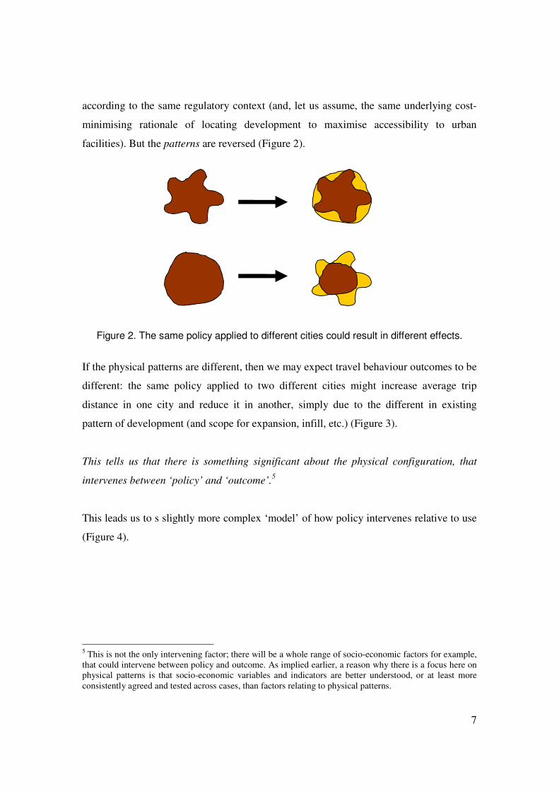
This model might be satisfactory for accounting for the effects of policy intervention I on
a single city at a certain point in time. However, this does not necessarily provide a robust
basis for estimating the impact of the policy intervention I on other cities, or in other
words, generalising the likely impacts of policy intervention I across cities in general.
This is, not least, because different cities are different to start with; and because users do
not generally react directly to policy interventions per se, but react to the ‘supply’ that is
presented to them – the supply of transport infrastructure, land, buildings and facilities.
This means that if the existing pattern is different between two cities, then the effect of
what is ostensibly the same policy will be different.
For example, a complete relaxation of locational policy – ‘build anything anywhere’ –
could give rise to different physical patterns in, say, a star-shaped city versus a circular
city. It is quite possible that the originally star-shaped city could have its ‘green wedges’
built over, to form a compact circular shape, whereas the originally circular city might
grow out along radials to produce a star shape. In each case, development is taking place
Existing activity, uses and behaviour
(travel and land use). U1
Future activity, uses and behaviour
(travel and land use). U2
Measurement of sustainability S1
at time t1
Measurement of sustainability S2
at time t2
Transport and urban planning
policy and design intervention
I
7
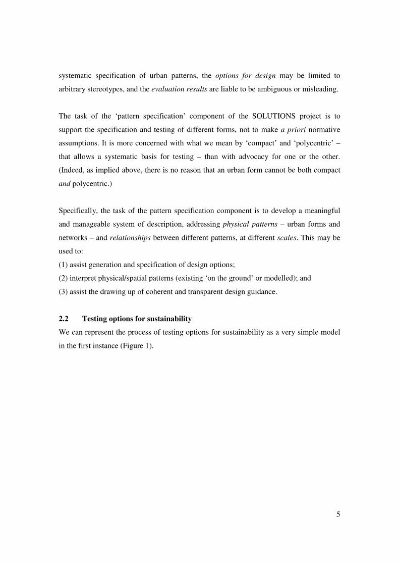
according to the same regulatory context (and, let us assume, the same underlying cost-
minimising rationale of locating development to maximise accessibility to urban
facilities). But the patterns are reversed (Figure 2).
Figure 2. The same policy applied to different cities could result in different effects.
If the physical patterns are different, then we may expect travel behaviour outcomes to be
different: the same policy applied to two different cities might increase average trip
distance in one city and reduce it in another, simply due to the different in existing
pattern of development (and scope for expansion, infill, etc.) (Figure 3).
This tells us that there is something significant about the physical configuration, that
intervenes between ‘policy’ and ‘outcome’.5
This leads us to s slightly more complex ‘model’ of how policy intervenes relative to use
(Figure 4).
5 This is not the only intervening factor; there will be a whole range of socio-economic factors for example, that could intervene between policy and outcome. As implied earlier, a reason why there is a focus here on physical patterns is that socio-economic variables and indicators are better understood, or at least more consistently agreed and tested across cases, than factors relating to physical patterns.

8
Figure 3. Application of a policy of ‘allowing development at the most accessible location
to the centre’ may result in either a decrease or increase in average distance to the
centre – depending on the existing configuration. (This example assumes the
settlements are significantly monocentric, but the principle would also apply for different
kinds of polycentric pattern.)
2 4
8 6 4 2 2 4 6 8
8 6 4 2 2 4 6 8
2 2
2 2
6 4 2 2 4 6
6 4
4 4 2
2 4 4
4 6
Average distance to centre = 3.33
Average distance to centre = 5
4 2
4
4 4 2
2 4 4
4
2 4
Average distance to centre = 4
Average distance to centre = 4
Growth of a linear city Growth of a concentric city
9
Figure 4. This is equivalent to Figure 1, but has ‘physical pattern’ as an intervening
variable. Physical pattern here refers to the pattern of supply of transport network
infrastructure, land parcels, buildings for occupation, facilities for use, etc.
Therefore, if it is desired to generalise the results of the effects of different policies and /
or patterns on use, it is necessarily to somehow generalise about both the policies and the
physical patterns that frame the matrices of trip distances (etc.) that in turn influence
behavioural outcomes.
It should be stated that the focus of this work component on physical patterns is not to
prejudge the relative significance of physical patterns, relative to other variables; but to
flag up the need to at least consider physical pattern among other variables.
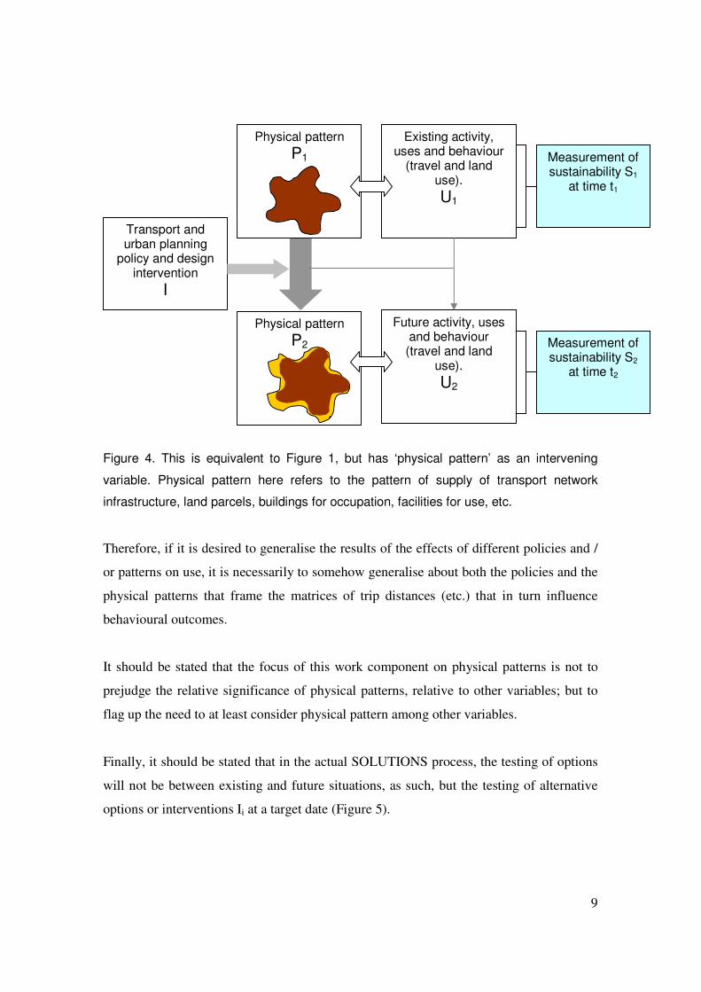
Finally, it should be stated that in the actual SOLUTIONS process, the testing of options
will not be between existing and future situations, as such, but the testing of alternative
options or interventions Ii at a target date (Figure 5).
Existing activity, uses and behaviour
(travel and land use). U1
Future activity, uses and behaviour
(travel and land use). U2
Measurement of sustainability S1
at time t1
Measurement of sustainability S2
at time t2
Transport and urban planning
policy and design intervention
I
Physical pattern P1
Physical pattern P2
10
Figure 5. This is equivalent to Figure 4, but using the actual SOLUTIONS testing
process. This concentrates on policy options affecting physical patterns, and for clarity
omits relationships pertaining to other variables.
Activity, uses and behaviour (travel and land
use). U0
Measurement of sustainability Si
across all options Ii
Physical pattern P
Physical pattern P0
Intervention I0
Intervention I1
Intervention I2
Physical pattern P2
Physical pattern P1
Activity, uses and behaviour
(travel and land use). U1
Activity, uses and behaviour (travel and land
use). U2
11
3. ANALYSIS
This section forms the core of the paper. It is organised in four parts: firstly, a brief
discussion of the ‘problem of type’; secondly, a brief discussion of the problem of what it
is we are trying to classify (or ‘type’); then a more detailed discussion of the ‘problem of
shape’ (and hence, the issues pertaining to the classification of shape or pattern); and
finally a discussion on lessons learned, for onward application.
3.1 The problem of type It is possible to describe different urban patterns and forms in many ways. Qualitative
methods include morphological and morphographic description (Conzen, 1969;
Whitehand, ed., 1981; Gordon, 1984; Larkham and Jones, 1991; Vernez Moudon, 1994).
Quantitative methods include network component analysis, graph theory, space syntax
and fractal dimension (see for example, Kansky, 1963; Vaughan, 1987; Wright et al.,
1995; Batty and Longley, 1995; Hillier, 1996; Southworth and Ben Joseph, 1997; Taylor,
1999).
However, the aim of pattern specification here is not simply to describe or measure urban
patterns for their own sakes, but to extract usefully discriminating information about
them – to capture a kind of ‘active ingredient’ relating to them – that allows some kind of
generalisation about patterns, between different locations. For the purposes of option
generation, there is a need to generate a limited number of meaningful types to test.
A type of entity may be regarded as a representative or characteristic kind of a given
entity, which embodies the characteristics of a group of actual entities. For example, a
city type implies a generalised, typical city – an abstract, idealised entity, of which each
actual city is an example. A typology may refer to the system of recognition or
classification of types, or may more loosely refer to an actual set of types (adapted from
Marshall, 2004c)
12
Typologies allow generalisations to be made about phenomena. This effectively allows
controlling for one variable while discussing diversity on other fronts, or setting one
variable against another. For example, the recognition of a ‘linear’ city as a type allows
comparison or contrast between different kinds of city as diverse as a chain of townships
along a coast or valley, or a new town consciously organised along a public transport
spine. A type allows us to recognise a common characteristic in a group of cities, which
may assist examination of a shared set of problems or opportunities.
The extent to which types – and their inherent generalisations – are meaningful and
useful will depend on the purpose to which they are to be put, and their context of
application. For example, when it comes to urban patterns:
• a historian or morphologist may be most interested in the sequence of formation
of the urban structure;
• the transport planner might be more concerned with the relative distribution of
‘trip ends’;
• the town planner might be interested in the distribution of neighbourhoods, their
facilities, and green spaces.
Accordingly, there can be no single correct or definitive way of classifying patterns or
identifying pattern types, and a diversity of overlapping types and themes are both
appropriate and inevitable.
Creating a typology is strongly concerned with bases for distinction and difference, and
the relative positioning of boundaries, rather than necessarily with absolute values. The
boundaries between different types may be ‘fuzzy’ – where there is really a continuous
spectrum or a series of shades of meaning, rather than a discrete set of mutually exclusive
types. For example, there are subtle distinctions between radial, concentric and radio-
concentric patterns, or between polycentric and multi-nucleated structures, between
compact and dense urban forms, and so on.
13
That said, even if a typological label can be precisely defined, the meaning is not
necessarily significant. We could in principle define a ‘connective’ pattern in precise
topological terms, but whether or not the label is useful in characterising cases as
different as, say, a maze of streets in a medieval town, a Victorian grid of streets and
alleys, or a Modernist new town with a web of pedestrian walkways, would depend on
the context of application of the typology.
In general, there is a balance to be struck between having too few broad categories or too
many narrow ones. In the former case, taken to the extreme, we have a single category,
into which all actual patterns are lumped. Clearly, this fails to differentiate and is not
much use as a typological system. At the other extreme, we could have a multitude of
finely defined categories, each of which contains a unique actual case (e.g., a
‘Bloomsbury’ pattern or a ‘Parker’s Piece’ layout). This is not much use as a typology
either. Hence, although the use of types may carry the latent danger of over-
generalisation or stereotyping, we have to have some sort of collective or representative
label, if we are to be able to generalise about patterns at all, and not simply refer to each
one by their own locational label.
In other words, in the context of SOLUTIONS, acceptance that some generalisation of
the results is necessary if the research results are to be of any use, in terms of transferring
conclusions or recommendations to cities not studied. The aim of the project is not, for
example, to work out the most sustainable course of action for each British city (with ‘x’
number of different results for ‘x’ number of cities), but to draw conclusions from a
sample of different cities, to allow generalisation to the rest.
3.2 The ‘object’ of classification The first issue we have to deal with when considering typologies of urban pattern is to
identify what exactly it is that we are intending to classify. This sets the classification of
urban form or pattern apart from, say, the classification of cities, streets or buildings. That
is to say that although there is some ‘fuzziness’ at the margins as to what exactly is a city,
a street or a building, in most cases it is a trivially simple exercise to point at a city and
14
identify it as such, just as it is to point at a street and identify it as a street, or point to a
building and identify it as a building. The problem of classifying buildings, streets and
cities can be a subtle and complex business, but normally the general ‘object of
classification’ is quite clear. In contrast, it is not necessarily clear what we mean by an
urban form or pattern, to start with.
Urban form can refer to the physical form of urban areas in three dimensions at a variety
of scales. Marshall (2004d) distinguishes urban form from other urban and form related
terms – these are set out below. Their reproduction here is not intended to adopt these
rigidly for onward use, but to act as a starting point, and at the very least to demonstrate
that there are indeed different kinds of ‘objects of classification’ to decide upon, even
before deciding how to identify different types or categories.
Urban structure is sometimes used to describe a variety of patterns and spatial
distributions. Urban structure may best be equated with the two-dimensional organisation
of the ground plan of an urban area, such as the street pattern or the structure of land
parcels. In this sense, it can be regarded as a specialised aspect of urban form; however,
urban structure can also have socio-economic interpretations which have no direct
associations with physical form. In its physical manifestation, urban structure is perhaps
best reserved for application to forms that are or relate to contiguous structures, such as
transport networks, or the structure of public spaces plus private parcels of land. This
interpretation would exclude non-contiguous scatters (constellations) of buildings or land
parcels.
Settlement form is more specific than urban form in implying the form of discrete units
of settlement such as cities, towns and villages. In contrast, urban form could apply to
any portion of urbanity, whether constituting part of a city, town or other urban accretion.
Development pattern implies the layout of an urban area in deliberate formations – as
opposed to emergent accretions. In other words, a development pattern is one that is
consciously conceived (e.g. a housing layout, or a linear extension to a city), whereas a
15
settlement pattern might be a spontaneous aggregation of dwellings with no conception as
an entity. The term development pattern might also connote the dynamic or chronological
development of a settlement, as where an original core gains a gridded extension and then
a suburban fringe.
Built form typically implies urban form in three dimensions, at the scale of individual
buildings. Like development pattern, built form has the connotation of the representation
or construction of a preconceived artefact rather than an emergent accretion of
independently assembled parts.
Urban fabric has the connotation of being a continuous surface, often a pre-existing
form that may be ‘torn’ by new interventions (e.g., urban highways), or ‘repaired’ again
(e.g., by sensitive infill development). It is suggested that the urban fabric has a fractal
dimension lying between two and three. Like a garment fabric, it is composed of
surfaces, with a variety of tucks and folds, laying out a configuration of adjacency and
accessibility, without necessarily including the solid three-dimensional material of which
it is made.
Urban form is perhaps the most all-encompassing of these terms, that can imply either
design or emergence of form, in two or three dimensions, from the scale of courtyards to
conurbations. Although urban form includes all three dimensions in principle, at the
widest scale, an urban area approximates to a two-dimensional surface, akin to an image
on a map. From this point of view, urban form may refer to the overall size or shape of
the urban area (e.g., a linear or star-shaped form), or its degree of articulation into
discrete settlement units.
Finally, the term pattern will be used in the most general sense, to encompass any kind
of form or structure, or recurring feature.
Some urban form descriptors imply packages of features or associations. For example,
‘transit oriented development’ implies a mixture of land uses in a fine-grained streetgrid
16
arranged along a superstructure of transport nodes. Sprawl has connotations of unplanned
growth, as well as low density extension over a large area. Different associations may
attach to the same basic form. Whereas the linear city label is often positively identified
with efficient and transit-friendly planning, ribbon development – also a linear form – is
often associated with inefficiency and sprawl.
Some urban form packages imply functional correspondences. ‘Decentralised
concentration’ implies functions spread over an urban region in relatively dense nodes or
clusters. Similarly, the distinctions between monocentric and multi-centric or polycentric
cities, or between central cities, satellite cities and urban villages, are more than matters
of physical arrangement, but imply functional relationships.
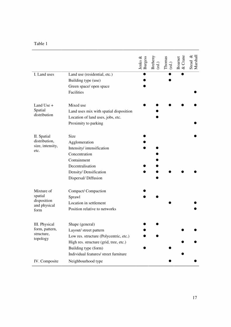
Table 1 gives a summary overview of the different kinds of potential ‘objects of
classification’. This is not exhaustive nor a final definitive interpretation, but is a prelude
to a more detailed analysis of urban patterns. Table 1 demonstrates the breadth of factors
potentially involved. Unlike various other indicators or variable in the urban sphere, the
variables in Table 1 do not necessarily have clear, consistent or conventional
interpretations. In some cases, of course, there are simple, transparent systematic
definitions of parameters, such as with city size (whether by population or physical area);
or there are conventional categorisations of say, land use, or ‘location in settlement’,
which even if are to some extent arbitrary or subjective, are commonly recognised or at
least explicitly stated in relevant policy documents.
However, especially those terms dealing with spatial distribution, definitions and
categories are less clear or consistent or at least not commonly agreed. With entities such
as sprawl, compaction, shape and structure, it is not necessarily clear what the ‘object of
classification’ is in the first place. For example, is ‘sprawl’ a property (like density), an
abstract entity (like an axis, or cluster) or a place (like suburbia, or downtown)?
17
Table 1
Jenk
s &
B
urge
ss
Bre
heny
(e
d.)
Tho
mas
(e
d.)
Boa
rnet
&
Cra
ne
Stea
d &
M
arsh
all
Land use (residential, etc.)� � � � Building type (use)� � � Green space/ open space� �
I. Land uses
Facilities �
Mixed use� � � � � � Land uses mix with spatial disposition � Location of land uses, jobs, etc. �
Land Use + Spatial distribution
Proximity to parking �
Size� � � Agglomeration� �� Intensity/ intensification� �� � Concentration� � � Containment� � � Decentralisation� �� � Density/ Densification� �� � � � �
II. Spatial distribution, size, intensity, etc.
Dispersal/ Diffusion� � � � � � � �
Compact/ Compaction� �� Sprawl� �� � Location in settlement� � � �
Mixture of spatial disposition and physical form Position relative to networks� � �
� � � � �
Shape (general)� � � Layout/ street pattern� �� � � Low res. structure (Polycentric, etc.)� �� � High res. structure (grid, tree, etc.)� � � �
III. Physical form, pattern, structure, topology
Building type (form)� �� � Individual features/ street furniture� � �
IV. Composite Neighbourhood type � �
18
M J T Krüger gives a useful introduction to the topic of built form:
“Built forms can be thought of as conceptual models, expressed usually in mathematical language in order to achieve an exact representation of the properties of buildings and land. As was pointed out by March and Trace (1968:1), ‘built forms are mathematical or quasi mathematical models which are used to represent buildings to any degree of complexity in theoretical studies.’ They are not exactly buildings but rather are representations of those properties of buildings that are under study, and are constructed under some initial assumptions with the specific aim of making the problem ‘mathematically manageable’. They should, in order to achieve this, be designed and defined specifically for each theoretical study (Bullock et al., 1968).
The following conclusions may be drawn for the purposes of the present study.
Firstly, we can note that built forms are not exactly buildings, but representations; by
extension, urban forms are not exactly urban areas, but representations; effectively they
are types. For example, if a ‘ribbon’ is an urban form, it is a type or typical arrangement
of buildings along a linear route. The study of urban forms and patterns is a study of
abstract types, that allow generalisation across cases. In a sense, urban forms and built
forms are concerned with non-metric data: they are about configurations, or topologies:
concerned with factors such as connectivity, orientation, adjacency and containment
(Laurini and Thompson, 1992:41); or proximity, separation, succession, continuity and
closure, but not permanent distances, angles and areas Norberg-Schulz (1975:430).
Secondly, we can note that representations contain assumptions that make the problem
‘mathematically manageable’ – which might also be taken to imply practically
manageable. This implies that the forms handled should not be too abstract nor too
detailed. Just as a map at scale 1:1 defeats the main advantage of a map, a description of
an urban or built form should not attempt to replicate every detail, otherwise the data
burden and comprehensibility is liable to suffer.
Finally, we can note that built forms (and by extension urban forms) should be designed
and defined specifically for each study. This supports the idea that representations are
selective and selected for specific purposes. It implies that experimentation and
adaptation are quite appropriate, rather than necessarily using off-the-shelf systems,
19
although this does not mean that existing systems might not be employed as the main
basis for a specific application. Of course, the more general form of description
employed, the more likely that it could be usefully employed elsewhere, and therefore
there is some value in not being too unique. In the particular context of SOLUTIONS,
overall, the systems of description must be able to address all case study areas (and
scales), and in principle allow generalisation with other cities elsewhere. The specificity
of the systems of description will not be geographical, but relate to the subject matter of
the project: the sustainability-orientation of different transport, land use and urban design
options.
3.3 The problem of shape
“Shape has proved one of the most elusive of geometric characteristics to capture in any
exact quantitative fashion. Many of the terms in common usage… turn out to be arbitrary
so that misclassification is common, while some of the more mathematical definitions fail
to do justice to our intuitive notions of what constitutes shape” – Haggett and Chorley
(���������
At this point we focus on physical patterns, that is to say, patterns of physical entities
such as roads, land-use areas, built-up areas, open spaces, and so on. These are entities
that are represented on maps as lines and areas. These is distinct from patterns of activity
or use (such as patterns of trip-making or commercial activity), or trajectories of
movement.
We can also make the distinction between, for example, the pattern of land use in terms
of taking a map of pre-defined land use definitions and categories, and describing the
geometric or topological pattern so formed, rather than confusing this with the definition
of land use itself.
20
The exploration of patterns is an ongoing component of the SOLUTIONS project. A
range of urban patterns is presented in the Appendix. Within this section, some selected
examples are discussed.
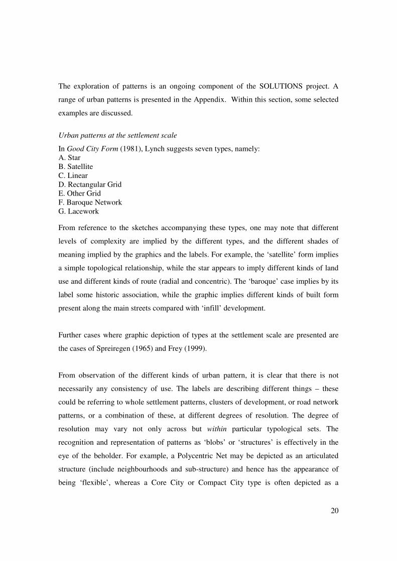
Urban patterns at the settlement scale
In Good City Form (1981), Lynch suggests seven types, namely: A. Star B. Satellite C. Linear D. Rectangular Grid E. Other Grid F. Baroque Network G. Lacework From reference to the sketches accompanying these types, one may note that different
levels of complexity are implied by the different types, and the different shades of
meaning implied by the graphics and the labels. For example, the ‘satellite’ form implies
a simple topological relationship, while the star appears to imply different kinds of land
use and different kinds of route (radial and concentric). The ‘baroque’ case implies by its
label some historic association, while the graphic implies different kinds of built form
present along the main streets compared with ‘infill’ development.
Further cases where graphic depiction of types at the settlement scale are presented are
the cases of Spreiregen (1965) and Frey (1999).
From observation of the different kinds of urban pattern, it is clear that there is not
necessarily any consistency of use. The labels are describing different things – these
could be referring to whole settlement patterns, clusters of development, or road network
patterns, or a combination of these, at different degrees of resolution. The degree of
resolution may vary not only across but within particular typological sets. The
recognition and representation of patterns as ‘blobs’ or ‘structures’ is effectively in the
eye of the beholder. For example, a Polycentric Net may be depicted as an articulated
structure (include neighbourhoods and sub-structure) and hence has the appearance of
being ‘flexible’, whereas a Core City or Compact City type is often depicted as a
21
monolithic ‘blob’, and therefore characterised (caricatured) as being rigid and crude (see
for example Frey, 1999).
There is also a confusion of ways in which each label relates to each kind of form. In
some cases, the same form could be described by different labels. Conversely, a
particular label may have different structural connotations, and could be used to describe
quite different patterns in different contexts.
For example, the label ‘linear’ could be (and has been) applied to quite distinct kinds of
form (Keeble, 1969:110). Linearity in this case appears to refer to development laid out
along a transportation ‘spine’, whatever spatial shape that development should ultimately
form.
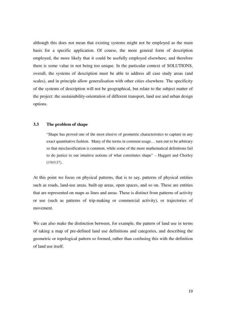
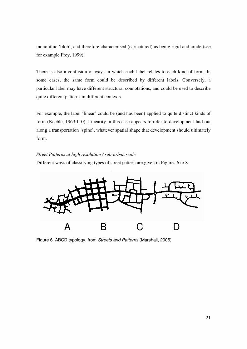
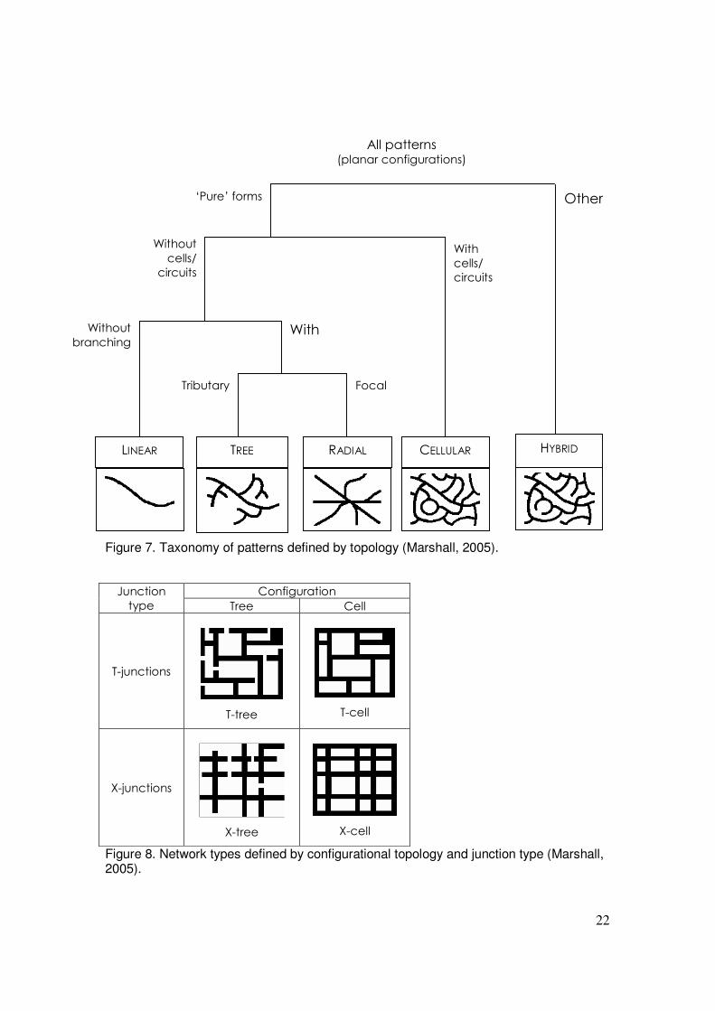
Street Patterns at high resolution / sub-urban scale
Different ways of classifying types of street pattern are given in Figures 6 to 8.
A B C D
Figure 6. ABCD typology, from Streets and Patterns (Marshall, 2005)
22
Figure 7. Taxonomy of patterns defined by topology (Marshall, 2005).
��������������� ����
���� ����� �����
����� �����
�
�
������
�
�
�� ����
����� �����
�
�
������
�
�
�� ����
Figure 8. Network types defined by configurational topology and junction type (Marshall, 2005).
� �����
������
�� ���
� ����
������
�� ���
���������
� �����
��� ������ ���
� !���� ������ ��" ���
�������� #� ��
����������$����� �����������%�
&'���(����)�� *����
+,-� "�
23
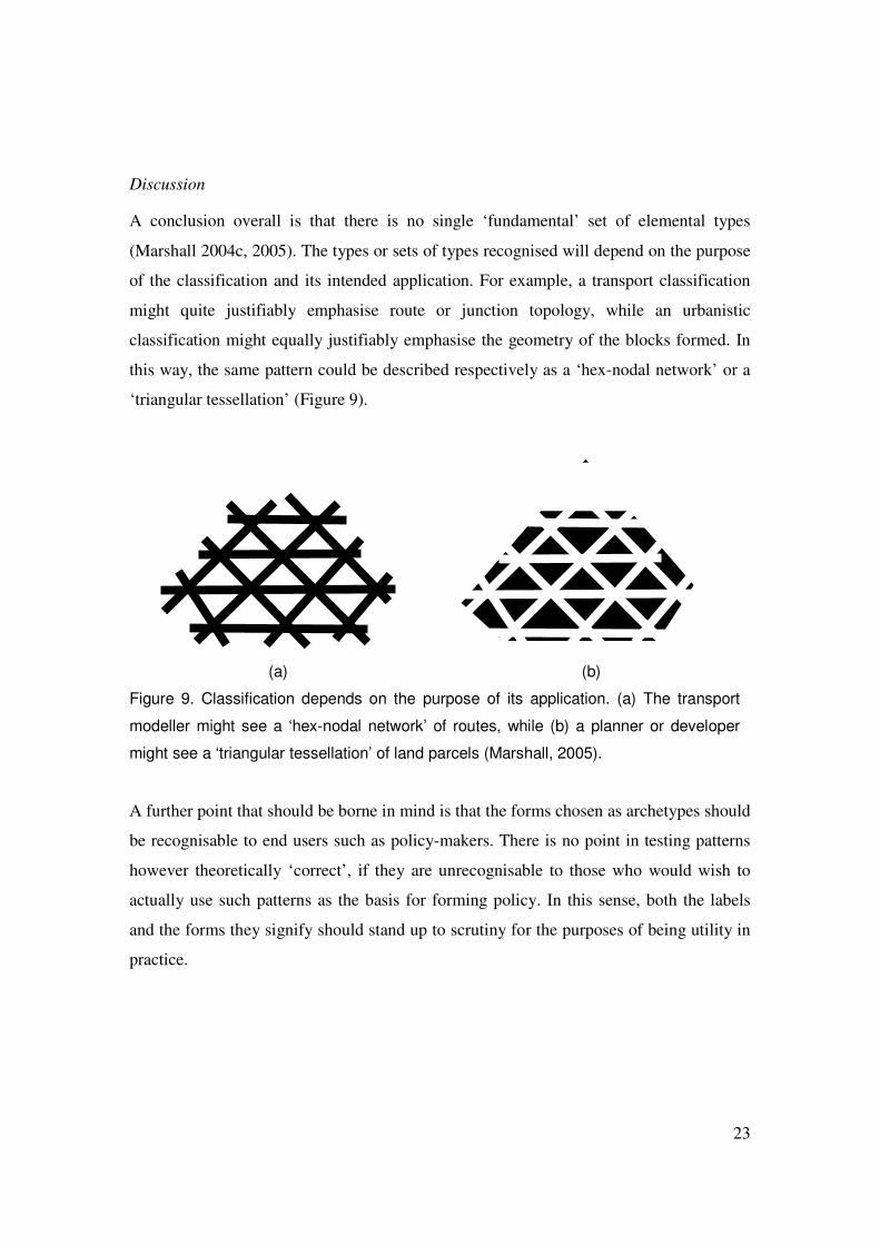
Discussion A conclusion overall is that there is no single ‘fundamental’ set of elemental types
(Marshall 2004c, 2005). The types or sets of types recognised will depend on the purpose
of the classification and its intended application. For example, a transport classification
might quite justifiably emphasise route or junction topology, while an urbanistic
classification might equally justifiably emphasise the geometry of the blocks formed. In
this way, the same pattern could be described respectively as a ‘hex-nodal network’ or a
‘triangular tessellation’ (Figure 9).
(a) (b)
Figure 9. Classification depends on the purpose of its application. (a) The transport
modeller might see a ‘hex-nodal network’ of routes, while (b) a planner or developer
might see a ‘triangular tessellation’ of land parcels (Marshall, 2005).
A further point that should be borne in mind is that the forms chosen as archetypes should
be recognisable to end users such as policy-makers. There is no point in testing patterns
however theoretically ‘correct’, if they are unrecognisable to those who would wish to
actually use such patterns as the basis for forming policy. In this sense, both the labels
and the forms they signify should stand up to scrutiny for the purposes of being utility in
practice.
24
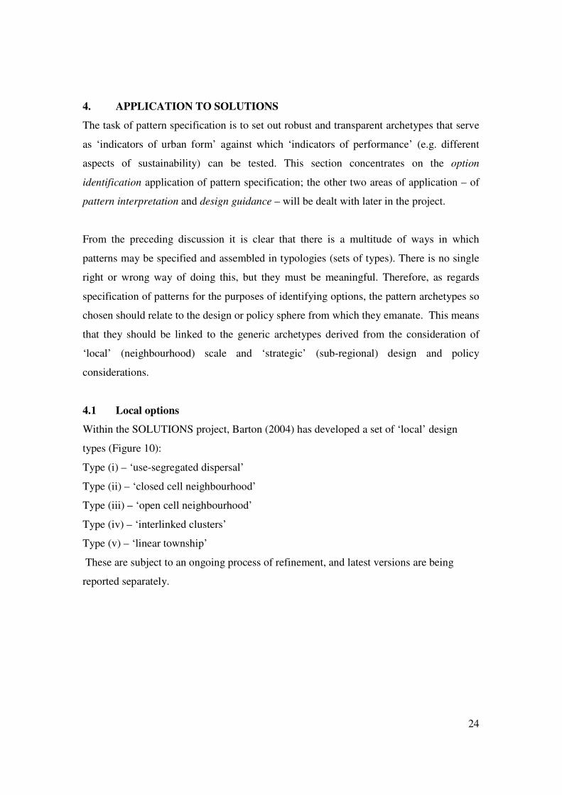
4. APPLICATION TO SOLUTIONS
The task of pattern specification is to set out robust and transparent archetypes that serve
as ‘indicators of urban form’ against which ‘indicators of performance’ (e.g. different
aspects of sustainability) can be tested. This section concentrates on the option
identification application of pattern specification; the other two areas of application – of
pattern interpretation and design guidance – will be dealt with later in the project.
From the preceding discussion it is clear that there is a multitude of ways in which
patterns may be specified and assembled in typologies (sets of types). There is no single
right or wrong way of doing this, but they must be meaningful. Therefore, as regards
specification of patterns for the purposes of identifying options, the pattern archetypes so
chosen should relate to the design or policy sphere from which they emanate. This means
that they should be linked to the generic archetypes derived from the consideration of
‘local’ (neighbourhood) scale and ‘strategic’ (sub-regional) design and policy
considerations.
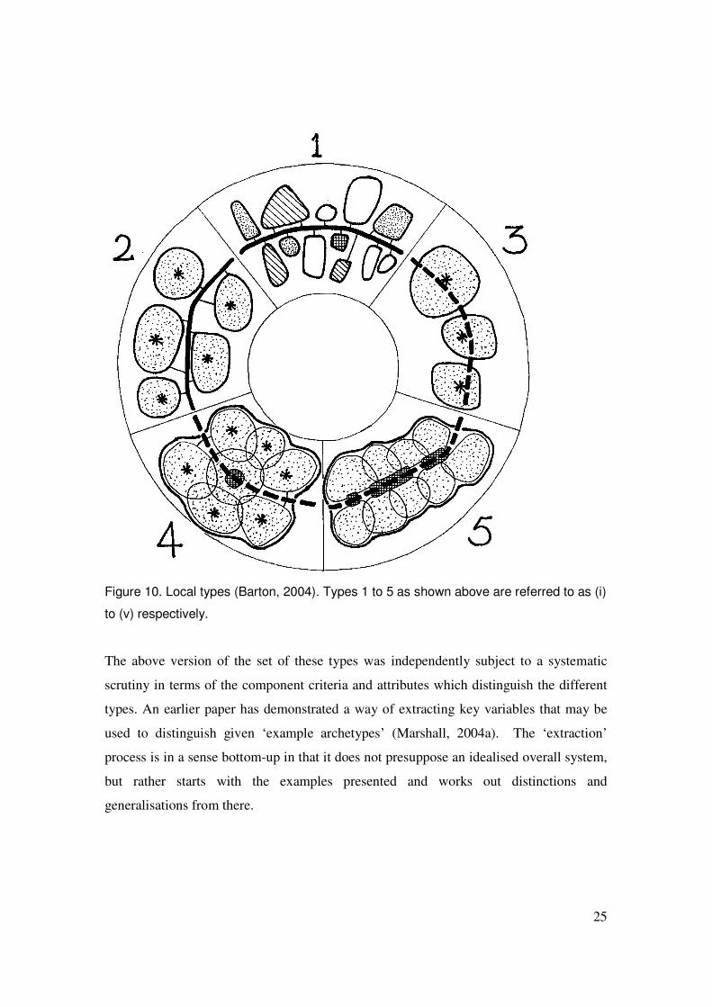
4.1 Local options
Within the SOLUTIONS project, Barton (2004) has developed a set of ‘local’ design
types (Figure 10):
Type (i) – ‘use-segregated dispersal’
Type (ii) – ‘closed cell neighbourhood’
Type (iii) – ‘open cell neighbourhood’
Type (iv) – ‘interlinked clusters’
Type (v) – ‘linear township’
These are subject to an ongoing process of refinement, and latest versions are being
reported separately.
25
Figure 10. Local types (Barton, 2004). Types 1 to 5 as shown above are referred to as (i)
to (v) respectively.
The above version of the set of these types was independently subject to a systematic
scrutiny in terms of the component criteria and attributes which distinguish the different
types. An earlier paper has demonstrated a way of extracting key variables that may be
used to distinguish given ‘example archetypes’ (Marshall, 2004a). The ‘extraction’
process is in a sense bottom-up in that it does not presuppose an idealised overall system,
but rather starts with the examples presented and works out distinctions and
generalisations from there.
26
From the information available relating to the five types, seven criteria were extracted,
each of which has two or three attributes (See Table 2).
Table 2.
Types Criterion Attributes (i) (ii) (iii) (iv) (v)
A. Land use A1. Different mono A2. Same mixed
A1� �
A2��
A2��
A2��
A2�B. Nucleation B1. No nucleus
B2. With nucleus B1� �
B2��
B2��
B2��
B2�C. Spine type C1. Solid (segregated)
C2. Dashed (all-purpose) C1� C1� �
C2��
C2��
C2�D. On/off-line D1. Off-line
D2. On-line (astride) D3. Edge-on
D1� D1� �
D2��
�
D3�
�
�
D3�E. Boundedness E1. Each area bounded
E2. Areas merge – ensemble bounded
E1� E1� E1� �
�
E2�
�
�
E2�F. Central services F1. Centred on centre of
land use area F2. Centred on spine F3. No central services
�
�
�
F3�
F1� F1� F1� �
�
F2�
G. Special status G1. No special areas G2. Special status area
G1� G1� G1� �
G2�G1�
Having demonstrated this, the earlier paper went on to demonstrate that the five types
could be distinguished by two criteria alone. These form a ‘spectrum’ as shown in Table
3.
Table 3.
F. Central services (ie, relationship of local centre to neighbourhood or transport spine)
D. On / off-line (ie, relationship of neighbourhood to transport spine)
Type
F3. No centre D1. Off-line (i) D1. Off-line (ii) D2. On-line (astride) (iii)
F1. Centre of neighbourhood
D3. Edge-on (iv) F2. Along transport spine D3. Edge-on (v)
27
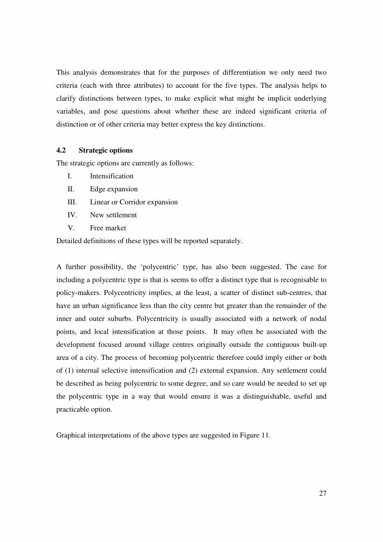
This analysis demonstrates that for the purposes of differentiation we only need two
criteria (each with three attributes) to account for the five types. The analysis helps to
clarify distinctions between types, to make explicit what might be implicit underlying
variables, and pose questions about whether these are indeed significant criteria of
distinction or of other criteria may better express the key distinctions.
4.2 Strategic options
The strategic options are currently as follows:
I. Intensification
II. Edge expansion
III. Linear or Corridor expansion
IV. New settlement
V. Free market
Detailed definitions of these types will be reported separately.
A further possibility, the ‘polycentric’ type, has also been suggested. The case for
including a polycentric type is that is seems to offer a distinct type that is recognisable to
policy-makers. Polycentricity implies, at the least, a scatter of distinct sub-centres, that
have an urban significance less than the city centre but greater than the remainder of the
inner and outer suburbs. Polycentricity is usually associated with a network of nodal
points, and local intensification at those points. It may often be associated with the
development focused around village centres originally outside the contiguous built-up
area of a city. The process of becoming polycentric therefore could imply either or both
of (1) internal selective intensification and (2) external expansion. Any settlement could
be described as being polycentric to some degree, and so care would be needed to set up
the polycentric type in a way that would ensure it was a distinguishable, useful and
practicable option.
Graphical interpretations of the above types are suggested in Figure 11.

28
Existing city
I. Intensification (shown here as densification of existing footprint)
II. Edge expansion
III. Linear corridor IV. Satellite
V. Free Market Polycentric
Figure 11. Graphical interpretation of strategic options.

29
Some forms will ‘morph’ into each other. For example, an elongated form of edge
expansion could morph into a linear corridor pattern, or a series of linear corridors might
form a radial or polycentric network. It would also be possible to recognise distinct
intermediate or variant forms. For example, one could image ‘beads on a string’
formation, being a series of discrete townships strung along a transport spine (Figure 12).
Figure 12. ‘Beads on a string’: a variant on the linear corridor option.
This could be interpreted as a string of new settlements (IV), or as a linear corridor which
happened to have clear green space between neighbourhoods (III). Identification of such
kinds of intermediate or variant case could in principle improve the degree of ‘fit’
between the generic archetypes and example cases (existing places or proposals) – but at
the expense of both practical manageability (multiplication of analytic work required)
and the ability to generalise across cases (since, even with unlimited resources, the
creation of more and more archetypes ultimately reduces the likelihood of each one
representing a useful proportion of all cases).
An alternative proposition is that the distinction between a ‘solid’ linear corridor and the
‘beads on a string case’ is, at the strategic scale, rather subtle or of limited significance.
Rather, the distinction is more obviously significant at the ‘local’ (neighbourhood) scale.
In other words, the distinction is one captured by the difference between different local
archetypes, such as between a continuous ‘linear township’ form (v) versus a discrete
‘closed cell neighbourhood’ forms (ii) – either of which, when multiplied up in a linear
end-on extension, gives the ‘Linear Corridor’ archetype at the strategic scale.
30
4.3 Issues of scale
One of the major challenging areas that SOLUTIONS faces is the issue of scale.
SOLUTIONS addresses at least two scales explicitly (strategic and local) and recognises
other scales implicitly (through awareness of scales above, below and between these
scales).
A variety of scale-related issues have been discussed by Marshall (2004b). Some of the
key points are:
• Strategic + local options. There is a need to consider the packaging of strategic
and local options. Do the ‘test archetypes’ represent the individual strategic or
local options, or the combination of strategic and local options? This is still to be
resolved.
• Strategic – local crossover. Some ‘strategic’ options may imply intervention at
the local scale, and some ‘local’ options may be multiplied to cover a large
physical area. In effect, strategic planning options will ‘frame’, or set constraints
on, the extent of the local design option ‘units’. In other words, the strategic
options set the framework for the overall pattern of developable land, while local
options propose their internal structure.
• Meso scale – it is possible that there is need to consider a scale intermediate
between the ‘strategic’ and ‘local’ scale discussed up till now. This could arise,
for example, when considering the internal structure of a new settlement (where
such sub-structure is clearly not part of the strategic designation, nor is it
necessarily accounted for by clustering neighbourhood types.6
4.4 Issues of pattern versus process
The archetypes (acting as indicators of urban form or pattern) will be to some extent
based on static forms, representing a snapshot of a form at any given moment in time, or
may be related to the growth of form.
6 It might also arise in the case of London case study, where the scale is shifted upwards relative to other city cases.
31
The static form is of interest since for any trip (or iteration of any urban activity or human
behaviour) a person makes a decision based on the existing provision (e.g. existing
network), irrespective of the dynamic process (of which this existing form is a but a
snapshot). In other words, the decision to travel to, say, a downtown department store
versus an edge-of-town superstore will depend on, inter alia, the current relative
accessibility and drawing power of the two locations, whether or not the edge of town
location is the process of ‘morphing’ into an Edge City, or whether the city centre is in a
process of revival, becoming the hub of a new radial light rail system.
The growth of form is of interest to the design/policy sphere because this is the part that
relates from the present base case to the future to-be-optimised case. In particular, general
strategic policies may be more likely to be expressed in terms of allowable processes of
growth, rather than specification of a particular (static) target form.
Some indicators may be ambivalent as to whether they refer mainly to (static) form or
(dynamic) process. For example, a ‘green belt’ can be interpreted:
• firstly, in physical (urban geometric) terms as an unbuilt-on annular area around a
core settlement area;
• alternatively, it could be interpreted as a regulatory policy that applies to that
area;
• thirdly, it could be regarded as a combination of the two, or, more specifically,
the application of the said regulatory policy to have the said geometric effect.
These points draw attention to the distinction between policy interventions that we could
refer to ‘pattern templates’ as opposed to relational ‘processes’, or perhaps more
specifically, ‘programs’. Here it is suggested that:
• A pattern template is taken to mean the case where some generic geometric
pattern is used as an explicit ‘template’ for the layout of a settlement or quarter.
This could be either a general configuration (e.g. City + satellites) or a specific
layout geometry (e.g. orthogonal gridiron). The key point is that a definite ‘target’
form is envisaged at the outset, and executed in full.
32
• A relational program is when an envisaged growth process is specified, where the
program is not set out in terms of any fixed target outcome, but rather the relation
of a new increment to the existing form. For example, a program for ‘edge
expansion’ would simply specify that growth take place on the edge of existing
development (without specifying either the existing or resulting urban form).
It may be noted that different programs can generate different patterns; moreover,
depending on the site context, a given program may create different patterns, or different
programs may generate the same pattern (recall Figure 2).
As noted previously, if the physical patterns are different, then we may expect travel
behaviour outcomes to be different: the same policy applied to two different cities might
increase average trip distance in one city and reduce it in another, simply due to the
different in existing pattern of development (and scope for expansion, infill, etc.). This is
the point about there being something significant about the physical configuration, that
intervenes between ‘policy’ and ‘outcome’.
This is significant, because we have to be clear about what we are specifying and why:
• On the one hand, there is the specification of the instrument of policy, by which a
policy objective is enacted. For example, the instrument of green belt land release
is the means that enables peripheral growth to take place in an otherwise
constrained urban edge.
• On the other hand, there is the specification of the physical form or provision. The
physical form is the result direct (or directed) of the instrument – due to the
actions of authority’s infrastructure provision, or to the actions of developers and
others deciding to develop here or there as a result of the instrument; at the same
time the physical form influences ongoing travel behaviour and other activities by
individuals.
A potentially significant point is that for the ‘local’ (neighbourhood) scale options,
the option specification is effectively both instrument and pattern template. That is,
33
the specification of, say, a ‘closed cell neighbourhood’ implies the local authority
laying out a specific structure of routes and available land parcels.
Overall we can say that the strategic options tend to be geared to ‘relational
processes’ (e.g. edge or linear expansion, or free market growth), while the local
options are closer to being pure ‘pattern templates’. The extent to which this is
exactly the case will depend on the precise wording of the option definitions. For
example, in defining strategic option (IV) a ‘satellite’ system of strategic
development could imply a fairly definite overall topological pattern; whereas ‘new
settlements’ does not presuppose a particular topology. Similarly, the ‘use segregated
dispersal’ local option (i) could imply a relatively free interpretation regarding
physical pattern, or might be represented by a particular physical configuration as per
Figure 14).
4.5 Discussion
However they are specified, the strategic and local options will work together:
• The strategic option influences the location of development, but not its detailed
form.
• The local option then gives form and structure to the development at the
neighbourhood scale.
The users then react to the whole pattern of provision (of routes, land parcels,
facilities, etc) so formed. In other words, there are not separate reactions to the
‘strategic’ layout and to the ‘local’ layout; but rather a simultaneous reaction to the
whole and its parts (Figure 13).7
This implies that the ‘generic options for testing’ should consider a combination of
strategic and local; although conclusions about the general relative merits of a
7 An exception would be the case of extremely micro scale patterns of behaviour, such as trips between houses within a street, where the strategic form may be negligible. That said, even some kinds of short trips such as to local shops and facilities will in principle be influenced by the availability of facilities further away.
34
particular local (or strategic) option may be drawn from the superposition of results
across all combinations with strategic (or local) options.
Macro structure
Less connective
(tree)
More connective
(grid)
Less connective
(tree)
Micro
structure
More connective
(grid)
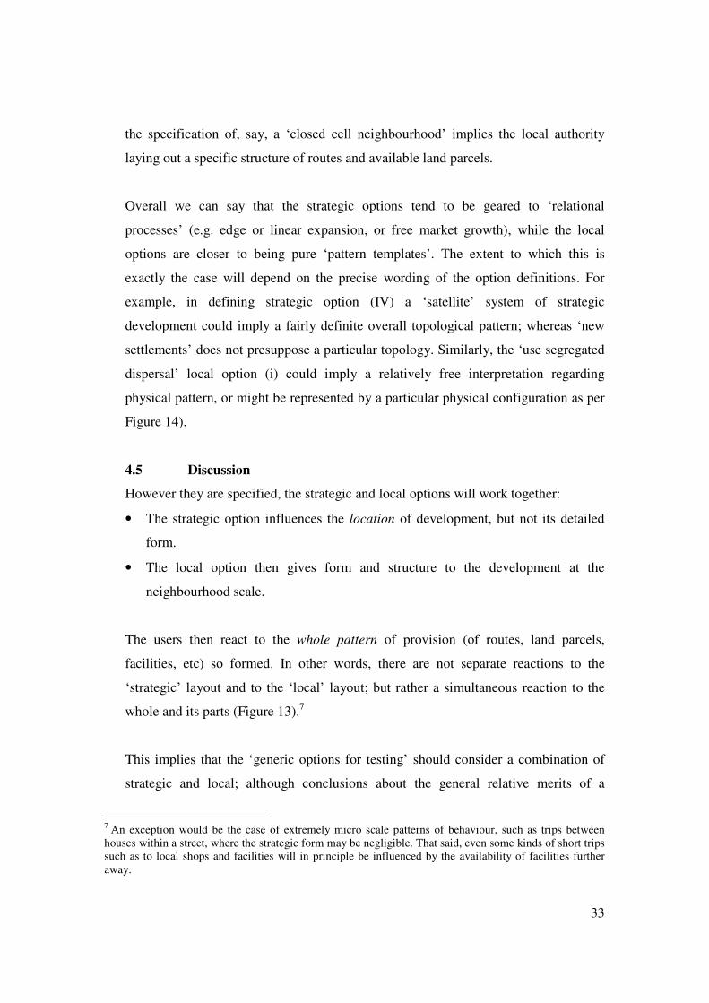
Figure 13. Simple example of two structures (grid, tree) at different scales (macro,
micro). For each case, the performance and use will be a result of reaction to the whole
structure. Note that here the structure is graphically presented as a route structure; but
the same would apply to a combined ‘macro and micro’ pattern of land uses, facilities,
etc.
5. CONCLUSIONS This paper has intended to suggest the significance of pattern – or a series of urban
pattern variables – as a variable that intervenes between policy instruments and user
reactions. This is not to say that pattern is necessarily significant in every or any case, or
that physical pattern ‘determines’ behaviour as such; but simply that pattern exists as a
variable alongside others, and that should potentially be taken into consideration. The
need for a detailed investigation into the nature of pattern is because, as has been argued
here, unlike other variables habitually used in urban and sustainability analysis, pattern
variables tend to be poorly defined, or at least, not defined on a consistent unambiguous
basis.
35
The paper has investigated the nature of different types of pattern, and demonstrated that
urban patterns of various types may be described and classified in a multitude of ways.
There is no single ‘right’ way of classification; but some ways are better than others to
suit different purposes. For example, any typological set should usefully contain clearly
distinct, mutually exclusive types.
The analysis has suggested that we are interested not only in patterns as static forms, but
also patterns or forms of growth. The interaction between scales is also deserving of
further scrutiny.
This paper has presented ongoing work concerning types of pattern. Overall the
specification of pattern will involve an interplay between theory and practice. Theory and
examples from the literature can be useful to generate a large number of theoretically
possible options, organised in a systematic and transparent way, from which to choose
key types for onward use.
To be an effective typology, the types selected must be ‘meaningful and manageable’.
This methodological consideration acts as a first filter on the types to be actually used in
any application.
The resulting types when expressed as options must also be ‘realistic and recognisable’,
for example to policy-makers, who in turn must be able to communicate these policies to
the public (for example, the Cambridge Futures work, Echenique, M. H. et al., 1999).
The options must also be ‘testable’, consistent with the workings of the rest of the
project. The significance and performance of different kinds of pattern or form would be
determined by testing during the project.
Further work is required in the following areas:
• Further examination of means of description and classification of patterns. This
will look in more detail at European literature and quantitative descriptive tools,
and the most recent literature across all topics; and also pattern types used in

36
practice (from consultation with policy making bodies). This will also inform the
later stages of the pattern specification work component (i.e. beyond the option
generation stage);
• Systematic ordering of the different kinds of category of pattern classification (i.e.
completion of process of ordering typologies, as presented currently in Table 1
and the Appendix). Also, harmonisation of use of language and terms;
• Selection of ‘options for testing’. This will require pinning down precisely what
the types are, so that the boundaries between types are clear, and how these types
are manifested when combined at strategic and local scales. The selection process
will arise from discussion and feedback between different parts of the
SOLUTIONS project and different stakeholders – not least, at the Cambridge
Symposium.
37
6. REFERENCES Abercrombie, P. (1933) Town and Country Planning. London: Thornton Butterworth. Abrams, C. (1971) The Language of Cities. A Glossary of Terms. New York: The
Viking Press. Banister, D., Watson, S. and Wood, C. (1997) Sustainable cities: transport, energy and
urban form, in Environment and Planning B: Planning and Design, 24, 125–143. check proposal
Barton, H. (1992) in Breheny, M. (ed.) Sustainable Development and Urban Form. London: Pion.
Barton, H. (2004) Local design. Typologies and tests. SOLUTIONS internal working note (27.05.04) plus graphic.
Batty, M. and Longley, P. (1994) Fractal Cities. A Geometry of Form and Function. London and San Diego: Academic Press
Bell, M. G. B. and Iida, Y. (1997) Transportation Network Analysis. Chichester: John Wiley.
Boarnet, M. G. and Crane, R. (2001) Travel by Design: The Influence of Urban Form on Travel. New York: Oxford University Press.
Breheny, M. J. (ed.) (1992) Sustainable Development and Urban Form. London: Pion. Breheny, M., Gent, T. and Lock, D. (1993) Alternative Development Patterns: New
Settlements. London: HMSO. (Report for Department of the Environment: Planning Research Programme).
Brindle, R. (1996). Road hierarchy and functional classification, in Ogden, K. W. and Taylor, S. (eds.) Traffic Engineering and Management. Melbourne: Institute of Transport Studies, Department of Civil Engineering, Monash University.
Bullock, N., Dickens, P. and Steadman, P. (1968) A theoretical basis for university planning, Report 1, Land Use and Built Form Studies, Department of Architecture, University of Cambridge, Cambridge.
Cervero, R. and Gorham, R. (1995) Commuting in transit versus automobile neighborhoods, in Journal of the American Planning Association, 61 (2), 210–225.
Clifford Culpin and Partners (1969) Mosborough Master Plan. Sheffield: Sheffield Corporation.
Colin Buchanan and Partners (1968) The South Hampshire study, in Lewis, D. (ed.) Urban Structure, Architectural Yearbook 12. London: Elek Books.
Conzen, M.R.G. (1969) Alnwick, Northumberland: A Study in Town Plan Analysis. Publication no. 27. London: Institute of British Geographers.
Culot, M. (1995) Percevoir – Concevoir – Rechercher. La Ville Durable. Une Tétralogie Européene. Partie IV. Esthétique, Fonctionalité et Désirabilité de la Ville Durable. Luxembourg: Office des Publications Officielles des Communautés Européennes.
Dickinson, R. E. (1961) The West European City. A Geographical Interpretation (2nd ed.). London: Routledge and Kegan Paul Ltd.
DoE/DoT (1992) Design Bulletin 32. Residential Roads and Footpaths: Layout Considerations (2nd ed.). London: HMSO.
38
DTLR and CABE (2001) By Design: Better Places to Live. A companion guide to PPG3. Tonbridge: Thomas Telford.
Echenique, M., Crowther, D. and Lindsay, W. (1972) A structural comparison of three generations of New Towns, in Martin, L. and March, L. (eds.) Urban Space and Structures. Cambridge: Cambridge University Press.
Echenique, M. H. et al., (1999) Cambridge Futures. CUP. Farby, B. A. and Murchland, J. D. (1967) Towards an evaluation of road system designs,
in Regional Studies, 1 (1), 27–37. Frey, H. (1999) Designing the City. Towards a More Sustainable Urban Form. London:
Routledge. Friedman, B., Gordon, S. & Peers, J. (1994) Effect of neotraditional neighborhood design
on travel characteristics, in Transportation Research Record 1466, 63–70. Gordon, G. (1984) The shaping of urban morphology, in Reeder, D. (ed.) Urban History
Yearbook 1984. Leicester: Leicester University Press. Gwilliam, M., Bourne, C., Swain, C. and Prat, A. (1998) Sustainable renewal of
suburban areas. York: York Publishing Services for Joseph Rowntree Foundation. Haggett, P. and Chorley, R. J. (1969) Network Analysis in Geography. London: Edward
Arnold. Hall, P. and Marshall, S. (2000) Land use and transport. Interim working paper. Bartlett
School of Planning, University College London. Headicar, P. (2000) The Exploding City Region: Should It, Can It, Be Reversed.
Williams, K., Burton, E. and Jenks, M, (eds) Achieving Sustainable Urban Form. London: E & F N Spon.
Hillier, B. (1996) Space is the Machine. Cambridge: Cambridge University Press. Jamieson, G. B., Mackay, W. K. and Latchford, J. C. R. (1967) Transportation and land
use structures, in Urban Studies, 4 (3), 201–217. Jenks, M. and Burgess, R. (eds) (2000) Compact Cities: Sustainable Urban Forms for
Developing Countries. London: Spon. Kansky, K. J. (1963) Keeble, L. (1969) Principles and Practice of Town Planning (4th ed.). London: The
Estates Gazette Limited. Krüger, M. T. J. (1979) An approach to built-form connectivity at an urban scale: system
description and its representation, in Environment and Planning B: Planning and Design, 6, 67–88.
Kulash, W. M. (1990) Traditional neighbourhood development: will traffic work? Paper presented at the Eleventh International Pedestrian Conference, Bellevue, WA.
Larkham, P.J. and Jones, A. N. (1991) A Glossary of Urban Form. Historical Geography Research Series no.26. London: Institute of British Geographers.
Laurini, R. and Thompson, D. (1992) Fundamentals of Spatial Information Systems. London: Academic Press.
Lynch, K. (1962) Site Planning. Cambridge, Mass.: MIT Press. Lynch, K. (1981) [A Theory of] Good City Form. Cambridge, Mass.: MIT Press. March, L. and Trace, M. (1968) The land use performance of selected arrays of built
forms, WP-2, Land Use and Built Form Studies, Department of Architecture, University of Cambridge, Cambridge.
March, L. and Steadman, P. (1971) The Geometry of Environment. London: Methuen.
39
Marshall, S. (2004a) Development of Pattern Archetypes. SOLUTIONS internal working paper, 13.07.04.
Marshall, S. (2004b) Strategic and Local Issues. SOLUTIONS internal working paper, 24.08.04
Marshall, S. (2004c) ‘City Typologies’ in Caves, R. (ed.) Encyclopedia of the City. London: Routledge.
Marshall, S. (2004d) ‘Urban Form’ in Caves, R. (ed.) Encyclopedia of the City. London: Routledge.
Marshall, S. (2005) Streets and Patterns. London and New York: Spon Press. Masnavi, M. (2000) The New Millennium and the New Urban Paradigm: The Compact
City in Practice, in Williams, K., Burton, E. and Jenks, M., (eds) Achieving Sustainable Urban Form. London: E & F N Spon.
McCluskey, J. (1992) Road Form and Townscape (2nd ed.). Oxford: Butterworth Architecture.
McNally, M. G. and Kulkarni, A. (1997) Assessment of influence of land use–transportation system on travel behavior. Transportation Research Record, 1607, 105–115.
Moholy-Nagy, S. (1968) Matrix of Man. An Illustrated History of Urban Environment. London: Pall Mall Press.
Morlok, E. (1967) An Analysis of Transport Technology and Network Structure. Evanston, Illinois: the Transportation Center, Northwestern University.
Moudon, A. V. (1994) Getting to know the built landscape: typomorphology, in Franck, K. and Schneekloth, L. (eds.) Ordering Space. Types in Architecture and Design. New York: Van Nostrand Reinhold.
Mumford, L. (1961) The City in History. Its Origins, its Transformations, and its Prospects. San Diego: Harcourt, Brace and Company.
Norberg-Schulz, C. (1965) Meaning in Western Architecture. London: Studio Vista. O’Flaherty, C. A. (1986) Highways. Volume 1. Traffic Planning and Engineering (3rd
ed.) London: Edward Arnold. Orrskog and Snickers (1992) in Breheny, M. (ed.) Sustainable Development and Urban
Form. London: Pion. Palen, J. J. (1995) The Suburbs, NY: McGraw Hill Potter, S. (1977) Transport and New Towns. Volume 3. Conflicts and Externalities in
New Town Transport Plans. Milton Keynes: Open University, New Towns Study Unit.
Pressman, N. (1985) Forces for spatial change, in Brotchie, J., Newton, P., Hall, P. and Nijkamp, P. (eds.) The Future of Urban Form. London: Croom Helm.
Rickaby, Steadman and Barrett (1992) in Breheny, M. (ed.) Sustainable Development and Urban Form. London: Pion.
Satoh, S. (1998) Urban design and change in Japanese castle towns, in Built Environment, 24 (4), 217–234.
Sitte, C. ([1889] 1945) The Art of Building Cities. City Building According to its Artistic Fundamentals. New York: Reinhold.
Southworth, M. (1997) Walkable suburbs? An evaluation of neotraditional communities at the urban edge, in Journal of the American Planning Association, 63 (1), 28–44.
Southworth, M. and Ben Joseph, E. (1997) Streets and the Shaping of Towns and Cities.

40
New York: McGraw-Hill. Southworth, M. and Owens, P. (1993) The evolving metropolis. Studies of Communities,
neighborhood, and street form at the urban edge, in Journal of the American Planning Association, 59 (3), 271–287.
Spreiregen, P. (1965) Urban Design: the Architecture of Towns and Cities. McGraw-Hill, New York.
Stead, D. and Marshall, S. (2001). The Relationships between Urban Form and Travel Patterns: An International Review and Evaluation, in European Journal of Transport and Infrastructure Research, 1 (2), 113–141.
Taylor, M. A. P. (1999) Using network reliability concepts for traffic calming: permeability, approachability and tortuosity in network design. Paper presented at Newcastle University (July 1999). [since published as a chapter in a book]
Thomas, R. (ed.) (2003) Sustainable Urban Design. An Environmental Approach. London: Spon Press.
Tripp, H. A. (1950) Road Traffic and its Control. (2nd ed.). London: Edward Arnold. Unwin, R. (1920 [1909]) Town Planning in Practice. An Introduction to the Art of
Designing Cities and Suburbs (2nd ed.). London: Bern. Vaughan, R. (1987) Urban Spatial Traffic Patterns. London: Pion. von Borcke, C. (2003) Landscape and nature in the city, in Thomas, R. (ed.) Sustainable
Urban Design. An Environmental Approach. London: Spon Press. Whitehand, J.W.R. (ed.) (1981) The Urban Landscape: Historical Development and
Management: Papers by M.R.G. Conzen. IBG Special Publication no. 13. London: Academic Press.
Wright, C., Jarrett, D. and Appa, G. (1995) Spatial aspects of traffic circulation: II. routing patterns that exactly minimise path crossings, in Transportation Research B, 29B, 33–46.

41
APPENDIX: CATALOGUE OF PATTERNS
General archetypes Sitte ([1889]1945)
1. Rectangular system 2. Radial system 3. Triangular system 4. ‘bastard offspring’
Unwin (1920)
Irregular (Various) Regular 1. rectilinear 2. circular 3. diagonal 4. radiating lines
Abercrombie (1933)
1. Gridiron 2. Hexagonal 3. Radial 4. Spider’s web
Tripp (1950:328)
Rectangular Gridiron with Superimposed
Diagonals Radial Concentric Topographical-Informal Irregular-Medieval Radials Blended with Gridiron Combined Rectangular and
Irregular
Dickinson (1961)
1. Irregular 2. Radial-concentric 3. Rectangular or grid
Mumford (1961)
1. Street village (=) 2. Cross-roads village (+) 3. Commons village (#) 4. Round village (O)
Lynch (1962:34)
1. Grid 2. Radial (inc.branching) 3. Linear
Jamieson et al. (1967)
1. Cartwheel 2. Linear 3. Ring and radial 4. Single strand 5. Double strand etc.
Farbey and Murchland (1967)
1. Radial and circumferentiall system
2. Grid system 3. Hyperbolic grid system
Morlok (1967:65)
1. Spinal or Tree 2. Grid network 3. Delta network
Colin Buchanan and Partners (1968)
1. Centripetal 2. Linear 3. Grid
Moholy-Nagy (1968) 1. Geomorphic 2. Concentric 3. Orthogonal-connective 4. Orthogonal-modular
Clustered
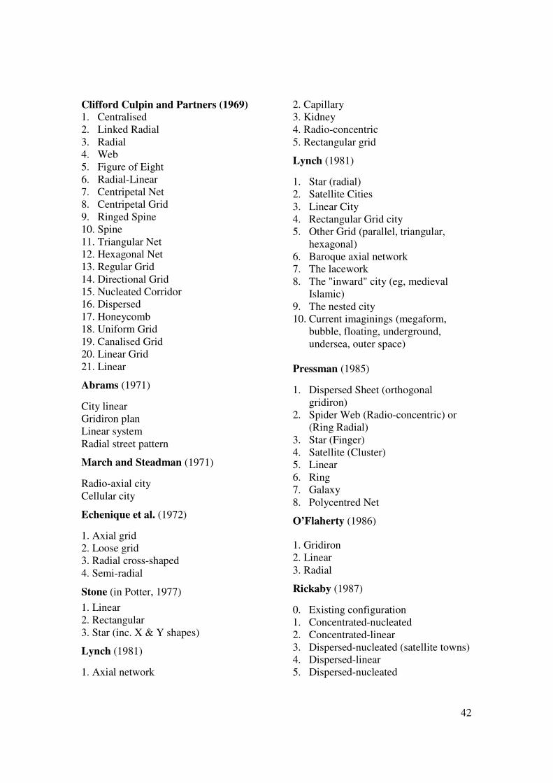
42
Clifford Culpin and Partners (1969) 1. Centralised 2. Linked Radial 3. Radial 4. Web 5. Figure of Eight 6. Radial-Linear 7. Centripetal Net 8. Centripetal Grid 9. Ringed Spine 10. Spine 11. Triangular Net 12. Hexagonal Net 13. Regular Grid 14. Directional Grid 15. Nucleated Corridor 16. Dispersed 17. Honeycomb 18. Uniform Grid 19. Canalised Grid 20. Linear Grid 21. Linear
Abrams (1971)
City linear Gridiron plan Linear system Radial street pattern
March and Steadman (1971)
Radio-axial city Cellular city
Echenique et al. (1972)
1. Axial grid 2. Loose grid 3. Radial cross-shaped 4. Semi-radial
Stone (in Potter, 1977) 1. Linear 2. Rectangular 3. Star (inc. X & Y shapes)
Lynch (1981)
1. Axial network
2. Capillary 3. Kidney 4. Radio-concentric 5. Rectangular grid
Lynch (1981)
1. Star (radial) 2. Satellite Cities 3. Linear City 4. Rectangular Grid city 5. Other Grid (parallel, triangular,
hexagonal) 6. Baroque axial network 7. The lacework 8. The "inward" city (eg, medieval
Islamic) 9. The nested city 10. Current imaginings (megaform,
bubble, floating, underground, undersea, outer space)
Pressman (1985)
1. Dispersed Sheet (orthogonal gridiron)
2. Spider Web (Radio-concentric) or (Ring Radial)
3. Star (Finger) 4. Satellite (Cluster) 5. Linear 6. Ring 7. Galaxy 8. Polycentred Net
O’Flaherty (1986)
1. Gridiron 2. Linear 3. Radial
Rickaby (1987)
0. Existing configuration 1. Concentrated-nucleated 2. Concentrated-linear 3. Dispersed-nucleated (satellite towns) 4. Dispersed-linear 5. Dispersed-nucleated
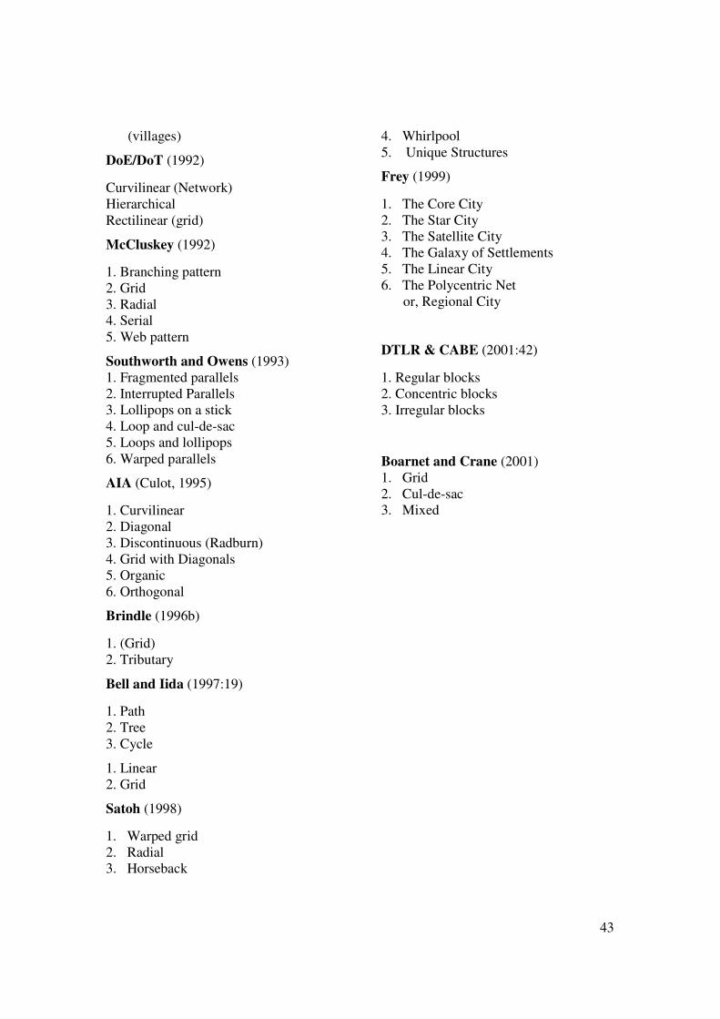
43
(villages)
DoE/DoT (1992)
Curvilinear (Network) Hierarchical Rectilinear (grid)
McCluskey (1992)
1. Branching pattern 2. Grid 3. Radial 4. Serial 5. Web pattern
Southworth and Owens (1993) 1. Fragmented parallels 2. Interrupted Parallels 3. Lollipops on a stick 4. Loop and cul-de-sac 5. Loops and lollipops 6. Warped parallels
AIA (Culot, 1995)
1. Curvilinear 2. Diagonal 3. Discontinuous (Radburn) 4. Grid with Diagonals 5. Organic 6. Orthogonal
Brindle (1996b)
1. (Grid) 2. Tributary
Bell and Iida (1997:19)
1. Path 2. Tree 3. Cycle
1. Linear 2. Grid
Satoh (1998)
1. Warped grid 2. Radial 3. Horseback
4. Whirlpool 5. Unique Structures
Frey (1999)
1. The Core City 2. The Star City 3. The Satellite City 4. The Galaxy of Settlements 5. The Linear City 6. The Polycentric Net
or, Regional City
DTLR & CABE (2001:42)
1. Regular blocks 2. Concentric blocks 3. Irregular blocks
Boarnet and Crane (2001) 1. Grid 2. Cul-de-sac 3. Mixed
44
Mixed & miscellaneous urban forms
A) typologies that are arranged by a mixture of classification themes B) themes by which different typologies might be generated
Boarnet and Crane (2001) 1. Density 2. Extent of land use mixing 3. Traffic calming 4. Street and circulation pattern 5. Jobs-housing and/or land use balance 6. Pedestrian features (e.g. sidewalks) Stead and Marshall (2001) 1. distance of residence from the urban centre 2. settlement size 3. mixing of land uses 4. provision of local facilities 5. density of development 6. proximity to transport networks 7. availability of residential parking 8. road network type 9. neighbourhood type von Borcke (2003)
1. Inner urban areas (positional) 2. Dense residential areas (land use spatial) 3. Mixed-use areas (land use spatial) 4. Terraced housing (built form) 5. Semi-detached, with small gardens (built form) 6. Semi-detached, with medium gardens (built form) 7. Detached houses with large gardens (built form)
Barton (1992) 1. Density 2. Location of jobs and facilities 3. Shape of the city.
Jenks and Burgess (2000) 1. urban size 2. urban structure (see under urban structure) 3. urban regions and agglomerations; 4. urban form at city scale; 5. density and urban intensification; 6. urban sprawl and peripheries; 7. urban compaction; 8. polynucleated urban form.
45
Composite (more than one variable)
Mohammed-Reza Masnavi (2000) 1. Compact mixed use; 2. Compact mono use; 3. Dispersed mixed use; 4. Dispersed mono use.
Composite: types of neighbourhood or suburb
Kulash (1990) 1. Traditional neighborhood development (a) mixed use; (b) connected/gridded streets; (c) reduced street hierarchy 2. Conventional suburban development (a) segregated uses; (b) partially connected streets and cul-de-sacs; (c) hierarchical street networks
Friedman et al. (1994)
1. Traditional communities (a) mostly developed before 1940; (b) mixed-use downtown commercial district with significant on-street parking; (c) interconnecting street grid; (d) residential neighbourhoods in close proximity to non-residential land uses.
2. Suburban communities (a) developed since the early 1950’s with segregated land uses; (b) well-defined hierarchy of roads; (c) access concentrated at a few key points; (d) relatively little transit service.
Cervero and Gorham (1995)
1. Transit neighborhoods (a) initially built along a streetcar line or around a rail station; (b) primarily gridded (over 50 per cent of intersections four-way or ‘X’ intersections); (c) laid out and largely built up before 1945.
2. Auto neighborhoods (a) laid out without regard to transit, generally in areas without transit lines, either present or past; (b) primarily random street patterns (over 50 per cent of intersections either 3-way, ‘T’ intersections or cul-de-sacs); (c) laid out and built up after 1945.
McNally and Kulkarni (1997)
1. Traditional neighborhood design (TND)
46
(a) gridlike transportation networks with few or no access cul-de-sacs; (b) a large number of access points into the neighbourhood; (c) high population densities
2. Planned unit development (PUD) (a) circuitous transportation networks with many cul-de-sacs; (b) a very limited number of access points in the neighbourhood; (c) very segregated land uses; (d) low residential densities.
3. Hybrid
Gwilliam et al. (1998:8) ‘Types of suburbs’
1. Historic inner suburb Established terrace or semi-detached developments now integrated to the rest of town; urban qualities, e.g. mix of uses, ‘walkability’, good public transport.
2. Planned suburb Few enclaves now absorbed into the rest of town; usually successful.
3. Social housing suburb High or low rise housing estates often with problems of maintenance, safety, vandalism, lack of social mix and non-residential uses.
4. Suburban town. Suburbs acquiring urban village functions for a wider sub-metropolitan area.
5. Public transport suburb. Medium density homogeneous speculative suburbs, usually in a closely structured urban fabric.
6. Car suburb. Low density, detached housing, homogeneous speculative suburbs, often in an ‘open’ townscape fringe area (motoways, out of town shopping centres and golf clubs).
Gwilliam, M., Bourne, C., Swain, C. and Prat, A. (1998) Sustainable Renewal of Suburban Areas. York: York Publishing Services.
Urban Structure
Jenks and Burgess (2000) 1. Concentrated decentralisation; 2. Monocentric; 3. Polycentric.
Land use pattern
Orrskog and Snickars (1992) (see Figure 6) 1. Land use disposition 1 2. Land use disposition 2 3. Land use disposition 3 4. Land use disposition 4

47
Rickaby et al. (1992) 1. Concentrated development in the central city; 2. High-density linear development along main roads; 3. New satellite towns; 4. High density linear development along secondary roads; 5. Development dispersed to villages.
Headicar (2000)
Headicar refers to two ‘trends’:
• Counter-urbanisation: shift downwards in the hierarchy (e.g., decline in
population of big cities, growth in population of small towns.
• Deconcentration: shift in population within settlements, from inner to outer areas.
Hall and Marshall (2000)
Notes where clarification of terminology may be beneficial, concerning the following
‘spatial’ pattern terms:
(a) Deurbanisation;
(b) Deconcentration;
(c) Deintensification (or de-densification);
(d) Decentralisation;
(e) Dispersal;
(f) Diffusion.
Some may mean the same thing, others may usefully be used to distinguish quite
distinct concepts, for example:
(i) the general reduction in density of a city;
(ii) the enlargement of a city by low density peripheral development, which
reduces the net density of the whole city;
(iii) the scatter of existing functions, once centralised, throughout an urban area;
(iv) the scatter of existing functions, once centralised, to the periphery;
(v) the removal of the bundle of central functions from an original central
location to a new off-centre or peripheral location;
(vi) the ‘devolution’ of the bundle of city-wide functions to become a series of
local functions at local ‘centres’;
48
(vii) the loss of population from higher order centres (big cities), and the
growth of lower order centres (eg, small towns) – approximately what is
referred to as ‘counter urbanisation’ by Headicar (2000).
Forms of Urban Growth
Breheny, Gent and Lock (1993)
Note: these refer to planning strategies, rather than observed (i) urban infill – urban growth takes place within the boundaries of existing
cities and towns (SM – perhaps ‘existing built-up area’ would be clearer); (ii) urban extensions – development takes place at the edges of existing urban
areas, typically on green fields or on other open land at the urban fringe; (iii) key village extensions – new development takes the form both of
expansion at the edge of the village, and intensification at its centre; (iv) multiple village extensions – as above but spread through any/all villages
(without selecting any in particular for provision of critical mass of services, etc.);
(v) new settlements – a free-standing settlement, where the completed new development – of whatever size – constitutes 50% or more of the total size of the settlement, measured in terms of population or dwellings.
Cambridge Futures (Echenique et al., 1999)
Note that although these are generic options, they relate to the specific context of Cambridge and its hinterland. 1. Minimum Growth 2. Densification 3. Necklace development 4. Green swap 5. Transport links 6. Virtual highway 7. New Town Note that the above are strongly related to processes of change (growth, densification, swap – even ‘development’) rather than just pattern per se.