Untitled - LAPAN
54
-
Upload
khangminh22 -
Category
Documents
-
view
0 -
download
0
Transcript of Untitled - LAPAN

ISSS 2019 AGENDA
BANDUNG, 25 SEPTEMBER 2019
Opening Ceremony Location : Ruang Matahari
Time Schedule 08:00 – 08:45 Registration
08:45– 09:00 OPENING CEREMONY Opening Speech
Director of Space Science Center LAPAN
09:00 – 09:25 Keynote Speaker 1: Prof. Dr. Thomas Djamaluddin
Head of Indonesian National Institute for Aeronautics and Space (LAPAN)
09:25 – 09:50 Keynote Speaker 2: Prof. Ir. Dr. Mardina Abdullah
Department of Electrical, Electronic & Systems Engineering, Space Science Centre (ANGKASA), Universiti Kebangsaan Malaysia (UKM), Malaysia
09.50-10.00 Photo Session & Coffee/Tea Break
TRACK-1 Astronomy and Astrophysics Location : Ruang Matahari No Time Speaker Title
First Session 10:00 – 12:00 1 10:00-10:20 Judhistira Aria Utama
(Invited) From Near-Earth Asteroid to Near-Sun Asteroid
2 10:20-10:40 Nizam Ahmad (Invited)
Determination of Mean Local Time on the Day of Anomaly on LEO Spacecraft
3 10:40-10:55 Ayu Dyah Pangestu (Oral)
Long Term Orbital Dynamics of a Retrograde Centaur 2006 RJ2
4 10:55-11:15 M.B.N. (Thijs) Kouwenhoven (Invited)
Dynamical evolution of planetary systems
5 11:15-11:30 Sparisoma Viridi (Oral)
Compaction of two-dimensional system of composite spherical particles under influence of self-gravitation: Between lock-and-key model and tetris-structure
i

6 11:30-11:45 Giga Ahmad Rizki Jatmiko (Oral)
Detection and Discrimination of Astronomical Objects using Global and Local Detection Methods: Case of Sloan Digital Sky Survey (SDSS) Images with GRIZ-Filters
7 11:45-12:00 Itsna Khoirul Fitriana (Oral)
Star formation properties of X-ray detected galaxies in COSMOS field: Connection between AGN activity and recent star formation.
Second Session 13:00 – 14:30 8 13:00-13:20 Dhani Herdiwijaya
(Invited) Dynamics of Sunspot Motion
9 13:20-13:35 Muhammad Abdul Haq (Oral)
Sunspot Detection System to Analyze the Location of Sunspot on Telescope Using Contour Detection
10 13:35-13:55 Rhorom Priyatikanto (Invited)
Coronal Active Region Parameters As Predictor of Flaring Activity
11 13:55-14:15 E. Sungging Mumpuni (Invited)
Space Weather Information and Forecasts Services (SWIFtS)
12 14:15-14:30 Timbul Manik (Oral)
The effects of solar flare on the low frequency radiowave transmitter signals observed in Pontianak Indonesia
Third Session 14:45 – 15:40 13 14:45-15:05 Hakim L. Malasan
(Invited) Building and Networking Public Observatory: Case of Gunma Astronomical Observatory, Japan and ITERA Astronomical Observatory, Indonesia
14 15:05-15:25 Satriya Utama (Invited)
Observing Earth Magnetic Field using Satellite LAPAN-A3
15 15:25-15:45 Johan Muhamad (Invited)
Long Term Evolution of Magnetic Field in the Flaring Active Region NOAA 12673
ii

16 15:45-16:00 Arwin Juli Rakhmadi Butar-Butar (Oral)
The Effect of Total Lunar Eclipse of July 28, 2018 on the Night Sky Brightness at the Observatorium Ilmu Falak Universitas Sumatera Utara
POSTER SESSION 16.00 – 17.30 (Loc : Ruang Matahari)
iii

TRACK-2 Ionospheric and Atmospheric Physics Location : Ruang Korona No Time Speaker Title
First Session 10:00 – 12:00 1 10:00-10:20 Guozhu Li
(Invited) Recent progress in EPB studies and development of ionospheric observation network in China
2 10:20-10:40 Yuichi Otsuka (Invited)
Review of the Generation Mechanisms of Post-Midnight Irregularities in the Equatorial and Low-Latitude Ionosphere
3 10:40-10:55 Asnawi Husin (Oral)
Effects of Ionospheric Scintillation on Variometric Method GNSS-Based Velocity Displacement Estimation
4 10:55-11:15 Acep Purqon (Invited)
Identification of Ionospheric TEC irregularities during geomagnetic storm and substorm using Outliers and Novelty Detection Method
5 11:15-11:30 Haiyong Xie (Oral)
Study on the coupling of ionospheric E/valley region irregularities and F region disturbances at low-latitude China
6 11:30-11:45 Angelikus Olla (Oral)
Investigation of latitudinal occurrence of plasma bubble in case of strong and weak pre- reversal enhancement in Southeast Asia
7 11:45-12:00 Nur Awatiff Mohamad Rizal (Oral)
Variation of Electron Density Profile Before the Large Earthquake in South East Asia Observed by CHAMP Satellite
iv

from 2004 to 2009
Second Session 13:00 – 14:30 8 13:00-13:20 Jiyao Xu
(Invited) The global structure of the thermospheric density caused by auroral heating
9 13:20-13:35 Rahmi Rahmatillah (Oral)
Development of Total Electron Content Data Derivation from SPATIUM-I Satellite Signal
10 13:35-13:55 Gamantyo Hendrantoro (Invited)
Radio Propagation Channel Modelling for HF Skywave Communications
11 13:55-14:15 Susumu Saito (Invited)
Ionospheric effects on GNSS for air navigation
12 14:15-14:30 Guotao Yang (Oral)
The development of the comprehensive lidar station in Yanqing and upper atmospheric study with lidar data
Third Session 14:45 – 15:40 13 14:45-15:05 Septi Perwitasari
(Invited) Development of a Phase Velocity Spectral Analysis Software (M-transform) for Airglow Data and Its Application on Atmospheric Gravity Waves Studies
14 15:05-15:25 Noersomadi (Invited)
Characteristics of temperature perturbations in the upper troposphere and lower stratosphere observed with COSMIC GPS radio occultation
15 15:25-15:45 Yan Chunxiao (Oral)
Ionospheric Irregularities Research in Low Latitude Based on Fuke VHF Radar
16 15:45-16:00 Tao Chen (Oral)
Ballooning observation of 0-13 km atmospheric electric field
v

in middle latitude dessert during quiet time
POSTER SESSION 16.00 – 17.30 (Loc : Ruang Matahari)
vi

DAFTAR ISI INVITED TALK .............................................................................................................................................. 2
1. TOPIC : ASTRONOMY AND ASTROPHYSICS ...................................................................................... 2
2. TOPIC : SOLAR ACTIVITY .................................................................................................................. 3
3. TOPIC : ASTRODYNAMICS ............................................................................................................... 5
4. TOPIC : MAGNETOSPHERIC RESEARCH ........................................................................................... 6
5. TOPIC : IONOSPHERIC RESEARCH .................................................................................................... 6
6. TOPIC : IONOSPHERIC RADIO COMMUNICATIONS .......................................................................... 9
7. TOPIC : IONOSPHERIC EFFECTS ON SATELLITE-BASED TECHNOLOGIES ........................................... 9
8. TOPIC : COUPLING BETWEEN ATMOSPHERE AND IONOSPHERE DYNAMICS ................................ 10
ORAL ......................................................................................................................................................... 12
1. TOPIC : ASTRONOMY AND ASTROPHYSICS .................................................................................... 12
2. TOPIC : SOLAR ACTIVITY ................................................................................................................ 14
3. TOPIC : IMAGE PROCESSING IN ASTRONOMICAL IMAGES ............................................................ 14
4. TOPIC : IONOSPHERIC RESEARCH .................................................................................................. 15
5. TOPIC : IONOSPHERIC EFFECTS ON SATELLITE-BASED TECHNOLOGIES ......................................... 18
6. TOPIC : COUPLING BETWEEN ATMOSPHERE AND IONOSPHERE DYNAMICS ................................ 19
7. TOPIC : INTERDISCIPLINARY SPACE SCIENCE ................................................................................. 20
POSTER ..................................................................................................................................................... 22
1. TOPIC : ASTRONOMY AND ASTROPHYSICS .................................................................................... 22
2. TOPIC : SOLAR ACTIVITY ................................................................................................................ 31
3. TOPIC : SPACE DEBRIS MONITORING ............................................................................................ 35
4. TOPIC : MAGNETOSPHERIC RESEARCH ......................................................................................... 35
5. TOPIC : IONOSPHERIC RESEARCH .................................................................................................. 39
6. TOPIC : COUPLING BETWEEN ATMOSPHERE AND IONOSPHERE DYNAMICS ................................ 42
7. TOPIC : INTERDISCIPLINARY SPACE SCIENCE ................................................................................. 43
INVITED TALK
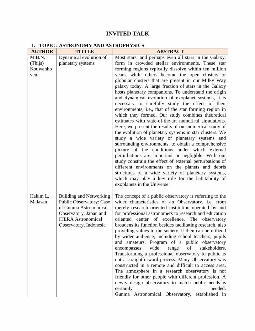
1. TOPIC : ASTRONOMY AND ASTROPHYSICS AUTHOR TITTLE ABSTRACT M.B.N. (Thijs) Kouwenhoven
Dynamical evolution of planetary systems
Most stars, and perhaps even all stars in the Galaxy, form in crowded stellar environments. These star forming regions typically dissolve within ten million years, while others become the open clusters or globular clusters that are present in our Milky Way galaxy today. A large fraction of stars in the Galaxy hosts planetary companions. To understand the origin and dynamical evolution of exoplanet systems, it is necessary to carefully study the effect of their environments, i.e., that of the star forming region in which they formed. Our study combines theoretical estimates with state-of-the-art numerical simulations. Here, we present the results of our numerical study of the evolution of planetary systems in star clusters. We study a wide variety of planetary systems and surrounding environments, to obtain a comprehensive picture of the conditions under which external perturbations are important or negligible. With our study constrain the effect of external perturbations of different environments on the planets and debris structures of a wide variety of planetary systems, which may play a key role for the habitability of exoplanets in the Universe.
Hakim L. Malasan
Building and Networking Public Observatory: Case of Gunma Astronomical Observatory, Japan and ITERA Astronomical Observatory, Indonesia
The concept of a public observatory is referring to the wider characteristics of an Observatory, i.e. from merely research oriented institution operated by and for professional astronomers to research and education oriented center of excellence. The observatory broadens its function besides facilitating research, also providing values to the society. It then can be utilized by wider audience, including school teachers, pupils and amateurs. Program of a public observatory encompasses wide range of stakeholders. Transforming a professional observatory to public is not a straightforward process. Many Observatory was constructed in a remote and difficult to access area. The atmosphere in a research observatory is not friendly for other people with different profession. A newly design observatory to match public needs is certainly needed. Gunma Astronomical Observatory, established in
1999, is a typical and a unique public observatory. Equipped with sophisticated medium size telescope (diameter of 1.5 meter) with its state of the art instruments (Echelle spectrograph, IR camera, CCD camera), and supported by human resources (teachers, educators, researchers) this Observatory actively participate in the frontline of astronomical research. Nevertheless it is a public observatory with regular duty to serve communities. An optimum arrangement including scheduling, staffing and research management enables this observatory to maintain high research outputs as well as large number of community services. Similarly, a new Observatory with more or less similar platform is now being designed and will be constructed in Lampung Province. These Observatory share similar main stakeholder, the provincial government. ITERA Astronomical Observatory is built with the main supporter Provincial Government of Lampung and will be operated by ITERA. It will be equipped with a 2-m class modern robotic telescope. This talk will present an overview of these two observatories and will give insight on future network of observatories in Indonesia.
Judhistira Aria Utama
From Near-Earth Asteroid to Near-Sun Asteroid
We present our orbital simulation of thousands real near-Earth asteroids with well-known orbit. During the course of evolution, asteroids from the four main classes of near-Earth asteroids population can have small perihelion distances. We have traced the evolution of Amor, Apollo, Aten and Atira class to obtain the fractional decay rate (FDR) of near-Earth asteroids population becoming near-Sun asteroids. Utilizing the available orbital distribution model, we can obtain estimation of the near-Sun asteroids population originating from the four main classes.
2. TOPIC : SOLAR ACTIVITY AUTHOR TITLE ABSTRACT
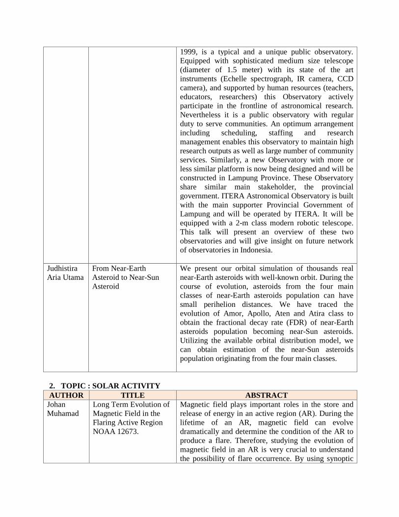
Johan Muhamad
Long Term Evolution of Magnetic Field in the Flaring Active Region NOAA 12673.
Magnetic field plays important roles in the store and release of energy in an active region (AR). During the lifetime of an AR, magnetic field can evolve dramatically and determine the condition of the AR to produce a flare. Therefore, studying the evolution of magnetic field in an AR is very crucial to understand the possibility of flare occurrence. By using synoptic
maps and modeling the Sun as a rigid sphere, we identified that the AR 12673, which produced many large flares in solar cycle 24, was a long-lived active region that survived for several solar rotations. Because of its long-lived property, studying magnetic field evolution of this AR is important to know the possibility of long term prediction of solar flares. We used Space weather HMI Active Region Patch (SHARP) to investigate the evolution of magnetic field and other physical properties of the AR during the five Carrington rotations. We found that the AR was dynamically evolved through the series of solar rotation. We also found that there was no clear indication that all the parameters we investigated could give useful information about the flaring probability of the AR within the time window of more than a week. Furthermore, our detail analysis of the magnetic field in this AR during the peak flaring period showed that the signal of the flare precursor could only be detected within the time range of several hours prior to the flares.
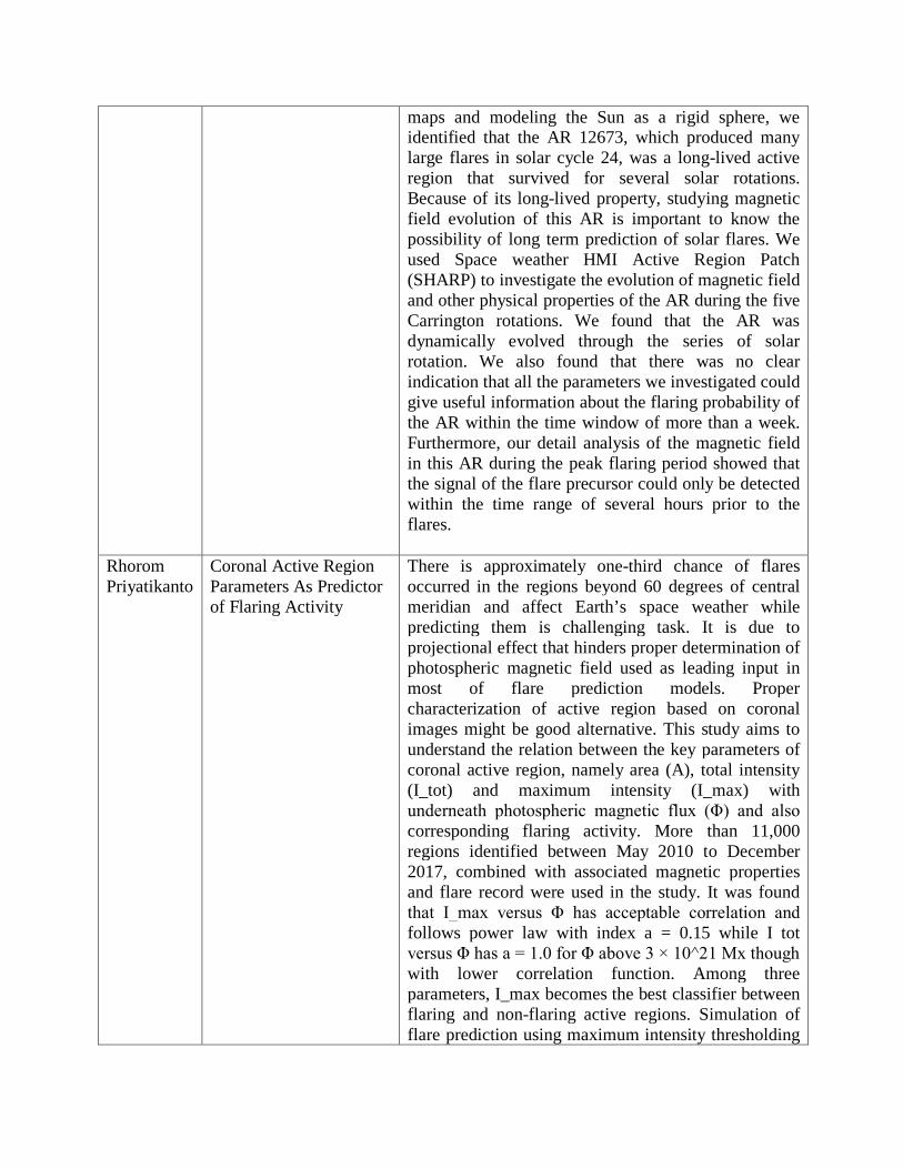
Rhorom Priyatikanto
Coronal Active Region Parameters As Predictor of Flaring Activity
There is approximately one-third chance of flares occurred in the regions beyond 60 degrees of central meridian and affect Earth’s space weather while predicting them is challenging task. It is due to projectional effect that hinders proper determination of photospheric magnetic field used as leading input in most of flare prediction models. Proper characterization of active region based on coronal images might be good alternative. This study aims to understand the relation between the key parameters of coronal active region, namely area (A), total intensity (I_tot) and maximum intensity (I_max) with underneath photospheric magnetic flux (Φ) and also corresponding flaring activity. More than 11,000 regions identified between May 2010 to December 2017, combined with associated magnetic properties and flare record were used in the study. It was found that I_max versus Φ has acceptable correlation and follows power law with index a = 0.15 while I tot versus Φ has a = 1.0 for Φ above 3 × 10^21 Mx though with lower correlation function. Among three parameters, I_max becomes the best classifier between flaring and non-flaring active regions. Simulation of flare prediction using maximum intensity thresholding

revealed maximum True Skill Score of 0.42, 0.57 and 0.64 for ≥C1.0, ≥M1.0 and ≥X1.0 flare prediction respectively. The achieved scores are comparable to other methods based on univariate statistics.
Dhani Herdiwijaya
Dynamics of Sunspot Motion
The appearance of sunspots has been observed by Galileo in the beginning of the telescopic era more than 400 years ago. Sunspots were known as the seat of strong magnetic fields through Zeeman splitting a century earlier. Measurements of the Sun’s magnetic field have guided the development of magneto-hydrodynamics and dynamo theories. The sunspot magnetic field is the engine and energy source driving all phenomena collectively defining solar activity, from probing the interior and driving energetic atmospheric events, which in turn structures the whole heliosphere and significantly impacts Earth’s atmosphere down at least to the stratosphere. The dynamic of sunspot motion and magnetic foot-points obtained from diffraction limited ground and space-based images are more multifaceted and challenging than they are described by the current sunspot classic models. We will discuss the recent dynamics of sunspot motion that have produced a new paradigm of plasma flows extending from the interior, connected to the surface, and spreading to layers of the solar atmosphere.
3. TOPIC : ASTRODYNAMICS AUTHOR TITLE ABSTRACT Nizam Ahmad
Determination of Mean Local Time on the Day of Anomaly on LEO Spacecraft
Numerous spacecraft have been reported to experience failures or anomalies due to various sources such as solar and geomagnetic storms. One of important keys to investigate anomalies on spacecraft is satellite local time (SLT) utilized to track satellite position in space. Since not every local time of anomaly was registered and recorded well especially for low Earth orbit (LEO) spacecraft, it is necessary to find a method to determine SLT. A Simplified General Perturbations-4 (SGP4) method has been applied to overcome the absence of SLT information in satellite anomaly database. A series of DMSP satellites are employed for case study. In addition, the AACGM model is also taken into account for MLTs calculation. The discrepancy of MLTs is founded between the

observation, calculation and AACGM model and supposedly comes from the TLE data which seemingly give rise to incorrect orbital parameters. The deviation of MLTs leads to different morphology of MLT distribution in which the observed MLTs scatter from dusk to midnight sector, whereas the others spread within dusk and noon sectors of MLT.
4. TOPIC : MAGNETOSPHERIC RESEARCH AUTHOR TITLE ABSTRACT Satriya Utama
Observing Earth Magnetic Field using Satellite LAPAN-A3
LAPAN-A3 satellite has been launched at June 2016. One of the payloads is a magnetometer sensor for scientific mission to measure earth magnetic field. The sensor is a hybrid flux gate magnetometer. The sensor can measure magnetic field in 3 axes with range from -60000 nT to 60000 nT with resolution 0.0071525574 nT. With data frequency 128 Hz and orbit altitude 510 km, the satellite can measure earth magnetic field for every 60 m in along track direction. Since then more than 2000 hours earth magnetic field data has been collected by LAPAN-A3.
5. TOPIC : IONOSPHERIC RESEARCH AUTHOR TITLE ABSTRACT Guozhu Li Recent progress in EPB
studies and development of ionospheric observation network in China
There have been a lot of instruments including VHF radars, ionosondes, GNSS TEC/ scintillation receivers, and all-sky airglow imagers installed by Institute of Geology and Geophysics, Chinese Academy of Sciences (IGGCAS), to investigate the onset and evolution characteristics of equatorial plasma bubbles (EPBs) producing ionospheric scintillations over low latitude. In this talk, we will present a brief review on the recent studies of EPB irregularities and scintillations, discuss and seek to enhance possible future cooperation in the development of ionospheric disturbance observational Network (IONDNet) for irregularity and scintillation in East/Southeast Asia and the data sharing. The talk will be focused on the following aspects: (1) Recent results on the longitudinal variation of EPB generation in East/Southeast Asia, and the potential seeding sources for EPBs. (2) The crossed chains of Beidou Geostationary satellite TEC/scintillation receivers conducted around 110°E and 23°N respectively, to

detect fine-scale structures of ionospheric disturbances along the same longitude/latitude, and track the onset and propagation of EPBs which extend to low latitude. (3) Development of portable digital ionosonde (PDI) and multi-static PDI network for the detection of ionospheric F-region bottomside disturbances with temporal scales/periods down to a few minutes, to obtain a better understanding of the seeding source by associating ionospheric disturbance with the occurrence of EPBs. (4) The world data center for Geophysics-Beijing which provides access to the data from IGGCAS. A brief introduction on our future efforts in low latitude ionosphere will also be given.
Yuichi Otsuka
Review of the Generation Mechanisms of Post-Midnight Irregularities in the Equatorial and Low-Latitude Ionosphere
In this presentation, ionospheric irregularities that occur in magnetically equatorial and low-latitude regions post-midnight during low solar activity periods are reviewed. Ionospheric irregularities can occur in equatorial plasma bubbles. Plasma bubbles are well-known to frequently occur post-sunset when the solar terminator is nearly parallel to the geomagnetic field lines (during equinoxes at the longitude where the declination of the geomagnetic field is almost equal to zero and near the December solstice at the longitude where the declination is tilted westward), especially during high solar activity conditions via the Rayleigh-Taylor instability. However, recent observations during a solar minimum period show a high occurrence rate of irregularities post-midnight around the June solstice. The mechanisms for generating the post-midnight irregularities are still unknown, but two candidates have been proposed. One candidate is the seeding of the Rayleigh-Taylor instability by atmospheric gravity waves propagating from below into the ionosphere. The other candidate is the uplift of the F layer by the meridional neutral winds in the thermosphere, which may be associated with midnight temperature maximums in the thermosphere.
Acep Purqon
Identification of Ionospheric TEC irregularities during geomagnetic storm and substorm using Outliers and Novelty Detection Method
In this study, we compare two learning mechanisms: outliers and novelty detection in order to detect ionospheric TEC disturbance by November 2004 geomagnetic storm and January 2005 substorm. The mechanisms are applied by using _-SVR learning algorithm which is a regression version of SVM. Our results show that both mechanisms are highly accurate
in learning TEC data. However, novelty detection is more accurate than outliers detection in extracting anomalies related to geomagnetic events. The detected anomalies by outliers detection are mostly related to trend of data, while novelty detection are associated to geomagnetic events. Novelty detection also shows evidence of LSTID during geomagnetic events.
Jiyao Xu The global structure of the thermospheric density caused by auroral heating
We use thermospheric mass densities measured by the accelerometers on satellites of GRACE at ~480 km and CHAMP at ~380 km from 2002–2010 to study the longitudinal and latitudinal distribution of the diurnally averaged thermospheric mass density. The result shows that there are strong longitude variations in the diurnally averaged thermospheric mass density. These variations are global and have the similar characteristics at the two heights under geomagnetically quiet conditions (Ap<10). The largest relative longitudinal changes of the diurnally averaged thermospheric mass density occur at high latitudes from October to February in the Northern Hemisphere and from March to September in the Southern Hemisphere. The positive density peaks locate always near the magnetic poles. The high density regions extend toward lower latitudes and even into the opposite hemisphere. This extension appears to be tilted westward, but mostly is confined to the longitudes where the magnetic poles are located. Thus, the relative longitudinal changes of the diurnally averaged thermospheric mass density have strong seasonal variations and show an annual oscillation at high and middle latitudes but a semiannual oscillation around the equator. Our results suggest that heating of the magnetospheric origin in the auroral region is most likely the cause of these observed longitudinal and latitudinal structures. Our results also show that the relative longitude variation of the diurnally averaged thermospheric mass density is hemispherically asymmetric and more pronounced in the Southern Hemisphere. To check how deep the auroral heating can affect the atmosphere, we analyze the diurnally averaged temperature observed by TIMED/SABER and MIPAS. Results indicate that there is similar structure in the lower thermosphere and the impact of auroral heating on the thermodynamics of the neutral atmosphere can penetrate down to about 105km under

geomagnetically quiet conditions.
6. TOPIC : IONOSPHERIC RADIO COMMUNICATIONS AUTHOR TITLE ABSTRACT
Gamantyo Hendrantoro
Radio Propagation Channel Modelling for HF Skywave Communications
A mathematical model of the HF skywave radio propagation channels together with statistical characterization of the channel parameters is necessary for the design and evaluation of high-rate digital communications in the HF band making use of the ionospheric down-bending mechanism. Previous studies observed that a unique feature of the HF skywave channels is the two characteristic waves, i.e., the ordinary (O) and extraordinary (X) waves that are generally elliptically polarized with opposite senses of rotation, which emerge out of the transmitted radio waves when entering the ionospheric magnetoplasma. Accordingly, not only does the complex impulse response (CIR) of the channel depend on the departure and arrival elevation angles and the modes of the propagation paths (e.g., 1F, 2F, 3F, etc.), but it is also influenced by the polarizations of the transmit and receive antennas. This presentation discusses the mathematical model of the slow-fading HF skywave propagation channel CIR for both frequency-selective and frequency-flat conditions on either single-hop (i.e., NVIS) links or multi-hop multi-mode (i.e., long-distance) links. The model takes into account the presence of the O and X waves, the occurrence of multiple paths of different modes and the polarization of the antennas. Statistical characterization of the channel parameters can be achieved by ray-tracing simulation and/or field measurement, which has thus far been accomplished for some channel conditions with ground distances ranging from 70 to 3000 km.
7. TOPIC : IONOSPHERIC EFFECTS ON SATELLITE-BASED TECHNOLOGIES AUTHOR TITLE ABSTRACT Susumu Saito
Ionospheric effects on GNSS for air navigtion
Global navigation satellite system (GNSS) is now widely used for air navigation. Since single-frequency GNSS has been standardized so far by International Civil Aviation Organization (ICAO), the propagation delay in the ionosphere is one of the largest error sources. GNSS augmenation systems are necessary to meet the requirements for air navigation systems
defined by ICAO, differential GNSS systems, such as the ground-based augmentation system (GBAS) and the satellite-based augmentation system (SBAS), are used. However, spatial decorrelation of the ionospheric delay may cause differential correction errors. Therefore, it is important to define ranges of variation of ionospheric parameters, which is called the ionospheric threat model, to design a safe and practically usable navigation systems. Another ionospheric effect is the scintillation due to ionospheric irregularities. In the magnetic low latitude region, amplitude scintillation that is a rapid fluctuation in GNSS signals makes it difficult for GNSS receivers to track GNSS signals, which may degrade ranging accuracy and may result in lock-off of the signals. In this talk, development of the ionospheric threat model for GBAS in the Asia-Pacific region by ICAO is reviewed. Localization effort of the model for Japan is also presented. Effects of ionospheric scintillations for GBAS are also discussed in terms of effects on integrity monitors for ionospheric threat mitigation.
8. TOPIC : COUPLING BETWEEN ATMOSPHERE AND IONOSPHERE DYNAMICS AUTHOR TITLE ABSTRACT Septi Perwitasari
Development of a Phase Velocity Spectral Analysis Software (M-transform) for Airglow Data and Its Application on Atmospheric Gravity Waves Studies
We have developed a user-friendly software based on Matsuda et al., 2014’s 3D-FFT method (M-Transform) for airglow data analysis as a function on Interactive Data Language (IDL). Input of this function is 3-D array of a time series of airglow image that have already been converted to geographical coordinate (x, y, t). The user can customize the wave parameters (e.g. horizontal wavelength (λh), wave period (τ), phase speed (c), image resolution in space (dx, dy) and time (dt)) in one-line command when executing the program, which depends on their analysis purpose. This new function has been applied to airglow data at different observation sites, Syowa Station (40°E, 69°S), Shigaraki (136°E, 35°N), and Tomohon Observatory (122°E, 1°N). The application of this function on airglow data at various locations is expected to reveal the global atmospheric gravity waves (AGWs) propagation direction and energy distribution. In addition, we will discuss the application of this software for other 2D images, such

as GPS-TEC data.
Noersomadi Characteristics of temperature perturbations in the upper troposphere and lower stratosphere observed with COSMIC GPS radio occultation
In April 2006, a joint project between National Space Organization (NSPO), Taiwan and University Corporation for Atmospheric Research (UCAR) launched the Formosa Satellite mission 3 / Constellation Observing System for Meteorology Ionosphere and Climate (FORMOSAT-3/COSMIC) employing the six LEO satellites. COSMIC becomes the first constellation satellite dedicated primarily to GPS radio occultation (GPS-RO) measurement and for improving near-real time weather prediction. We retrieved high resolution temperature profiles from COSMIC GPS-RO to study the characteristics of temperature perturbations in the upper troposphere and lower stratosphere. We discuss the detailed temperature stability profiles in the tropical tropopause influenced by intra seasonal and inter annual variations, and the temperature fluctuations caused by the atmospheric gravity waves in the lower stratosphere.
ORAL
1. TOPIC : ASTRONOMY AND ASTROPHYSICS AUTHOR TITLE ABSTRACT Arwin Juli Rakhmadi Butar-Butar
The Effect of Total Lunar Eclipse of July 28, 2018 on the Night Sky Brightness at the Observatorium Ilmu Falak Universitas Sumatera Utara
Measurement of the Night Sky Brightness (NSB) has been done at the Observatorium Ilmu Falak Universitas Muhammadiyah Sumatera Utara (OIF UMSU) during the total lunar eclipse on 28 July 2018. NSB was measured using 3 Sky Quality Meters (SQM). They were directed to the eastern horizon, zenith, and the western horizon with a resolution of 2 seconds. The results showed that zenith direction SQM data had a change in NSB due to the lunar eclipse. Before the eclipse, the NSB was 14 mpsas and the NSB during the total Moon phase was 18 mpsas. While the results shown in the SQM data in the direction of the eastern horizon and the western horizon show insignificant changes. It was 15 mpsas. This is because the area in the direction of the east and west horizons is heavily influenced by fog and light pollution originating from the city center of Medan.
Itsna Khoirul Fitriana
Star formation properties of X-ray detected galaxies in COSMOS field: Connection between AGN activity and recent star formation.
Background. A galaxy is a gravitationally bound entity, typically consisting of stars, dust, and gas as well as a central supermassive blackhole. In some galaxies, accreting gas onto the supermassive blackhole emits huge amounts of radiation across the electromagnetic spectrum, which is called as active galactic nuclei (AGN). One of the key outstanding problems in studies of galaxy evolution is understanding the connection between AGN and star formation (SF). Nevertheless, finding the existence of a SF-AGN connection is undisputed, still it is not clear which process dominates the energetic output in both local and high redshift Universe. Moreover there is no consensus on whether AGN fueling is synchronous with star formation or follows it during a post-starburst phase. Aims. The goal of this research is to examine the evolutionary connection between AGN activity and star formation in the AGN’s host galaxy for X-ray selected obscured (type 2) AGN at redshift z < 1.5. Methods. We acquired star formation properties for those X-ray detected AGN which available in Cosmological Evolution Survey (COSMOS) project. The COSMOS survey is a large and deep survey with multiwavelength observations of sources rom X-ray to

radio wavelengths covering a 2-deg2 area. We compared the star formation properties for our X-ray detected AGNs and non-X-ray objects with using starburstiness (RSB) as the representative of star formation properties. High starburtiness value means high star forming activity too. We classified the galaxies based on their starburstiness value into four classes of star forming activity: starburst, main-sequence, sub-mainsequence and quiescent star forming activity. The step further is analyzing the X-ray properties and starburstiness of X-ray detected AGN for proving the existence of connection. Results. We present 365 type2 X-ray detected AGNs from COSMOS survey. The starburtiness distribution of X-ray detected AGNs shows some excess both in starburst and sub-main sequence star forming activity compared with the non-AGN objects. This trend is also can be seen in the AGN fraction, shows decreasing behavior from high to low star forming activity, except for the excess in the sub-main sequence population. This excess might be an interesting topic to analyze the AGN type. For X-ray detected AGNs, We found that X-ray activities arise from high to low star forming activity. From those properties relation, we conclude that AGNs show sign of star forming quenching, with AGN properties decreasing from higher to lower star forming activity.
Ayu Dyah Pangestu
Long Term Orbital Dynamics of a Retrograde Centaur 2006 RJ2
Centaurs are small bodies whose semi-major axes are between Jupiter and Neptune. They have chaotic orbits and may in orbital resonances with giant planets. An orbital resonance occurs when a simple commensurability presents between some fundamental frequencies of orbital elements. One of the resonance states is 1:1 (mean-motion) resonance or co-orbital with the respected planet. This resonance can also occur on high inclination Centaurs. This study describes results of long term orbital integration of a retrograde Centaur 2006 RJ2 (inclination of 165 deg) for 200.000 years. Resonance state of 2006 RJ2 was examined using the FAIR (Fast Identification of Mean Motion Resonance) Method for 243 orbital clones with an automation by developing Python codes. We report that 2006 RJ2 may be in retrograde 1:1 resonance with Saturn for about 160.000 years in the future. However, the clones exhibit chaotic orbits and show many temporally unstable
resonances. Since quality of its orbital elements is not quite precise, 2006 RJ2 shows low possibility in state of long retrograde 1:1 resonance with Saturn. Keywords: Centaurs, retrograde-polar resonance, co-orbital, temporally resonance, FAIR Method automation.
2. TOPIC : SOLAR ACTIVITY AUTHOR TITLE ABSTRACT Muhammad Abdul Haq
Sunspot Detection System to Analyze the Location of Sunspot on Telescope Using Contour Detection
Sunspot are temporary phenomena on the Sun’s photosphere that appear as spots darker than the surrounding areas. They are regions of reduced surface temperature caused by concentrations of magnetic field flux that inhibit convection. Sunspot usually appear in pairs of opposite magnetic polarity. Their number varies according to the approximately 11-year solar cycle. The purpose of this study is to analyze the location of the sunspot on the telescope using the contour detection. The data obtained from this telescope is in form of solar image data which is then processed using contour detection and produces an output in the form of solar image data along with location and information on the diameter of sunspots.
3. TOPIC : IMAGE PROCESSING IN ASTRONOMICAL IMAGES AUTHOR TITLE ABSTRACT Giga Ahmad Rizki Jatmiko
Detection and Discrimination of Astronomical Objects using Global and Local Detection Methods: Case of Sloan Digital Sky Survey (SDSS) Images with GRIZ-Filters
Image processing is very important for the advancement of science. Scientists observe and obtain images so as to produce new information for the development of science. In this connection, image processing plays a major role. Image processing can be a vital element of application such as in Medical Science, Biology, Robotic and many other branches. Among sciences that relies heavily on image processing technique is Observational Astronomy. With the development of the science of image processing in Astronomy, astronomical knowledge will also develop. One of the interesting things from the science of astronomical image processing today is how we can detect object from an image observed through an astronomical telescope or a camera lens on a satellite with various image characteristics such as low illumination, high noise, low brightness, blurred

and also stretched due the rotation of the earth that causes the true object in the image become distorted. To process an astronomical image that has been obtained and to produce useful information from that image, an effective algorithm is needed. In this research it is shown how an algorithm to detect objects in astronomical images can work even with conditions images that suffered from high noise and inhomogeneous illuminations. The detection of objects in astronomical images will be carried using the global detection method and local detection method, then followed by a discriminating step, so that objects that have been detected in these astronomical images can be categorized according to their geometric shapes, namely, stellar object and non-stellar object. The image used in this work was obtained from the Sloan Digital Sky Survey (SDSS). In this research, GRIZ-filters were used to visualize astronomical images.
4. TOPIC : IONOSPHERIC RESEARCH AUTHOR TITLE ABSTRACT Nur Awatiff Mohamad Rizal
Variation of Electron Density Profile Before the Large Earthquake in South East Asia Observed by CHAMP Satellite from 2004 to 2009
This project studies the behavior of pre-earthquake ionospheric parameter by analyzing the variation of electron density (Ne) measured from the CHAMP satellite. This satellite is one of the satellites that collected the actual data of Ne at the ionosphere and pass through the study region two to four times per day. The data from two weeks before the main shock of an earthquake (EQ) is analyzed to observe and pattern the behavior of the Ne profile before the EQs. Analyzing this parameter is one of the methods in monitoring the ionosphere for earthquake precursor study. The region of the study (South East Asia region) is a region that where the earthquake happened quite frequent. This study involving the large earthquakes with a magnitude (M> 7.5) for the 5 years from 2004 until 2009. Significant anomalous behavior of Ne was identified within the 14 days prior to the EQs
Haiyong Xie
Study on the coupling of ionospheric E/valley region irregularities and F region disturbances at low-latitude China
The coupling of equatorial and low-latitude ionosphere has been an active area of research for many years. Based on the observations from VHF radars and IONISE, an observatory network including digisondes and GNSS receivers, electrodynamic coupling between F region disturbances (spread F and medium-scale
traveling ionospheric disturbances) and the underlying E and valley region irregularities was investigated. (1) A statistically significant correlation between the presence of valley region irregularities and that of ESF was found at low-latitude China. For the days without ESF, valley region irregularity was rarely observed. The Doppler velocities of valley region irregularities were mainly upward which resemble those of simultaneous ESF irregularities. On the other hand, an occurrence peak of E region irregularities was detected around sunset. After sunset, E region irregularity echo was frequently disrupted. The disruption can appear on both ESF and non-ESF days, when the amplitudes of F layer postsunset rise were significantly different. (2) Case study showed that QP echoes tended to be clustered associated with the reduced total electron content (TEC) caused by medium-scale traveling ionospheric disturbances (MSTIDs). Perturbation in Doppler velocity of QP echoes coincided well with the period of MSTIDs. Our results suggested that the electrodynamic processes associated with F region disturbances contribute significantly to the underlying E and valley instabilities producing irregularities through geomagnetic field lines, such as gradient drift instability for the generation of irregularities and Es layer instability for the occurrence of QP echoes.
Yan Chunxiao
Ionospheric Irregularities Research in Low Latitude Based on Fuke VHF Radar
The Fuke very high frequency (VHF) coherent scatter radar is one of the most important radio systems of the Meridian Space Weather Monitoring Project of China (Meridian Project) and located at Fuke station (19.5°N, 109.1°E, dip latitude 8.1°N), Hainan island of China for the observation of the field aligned irregularities in ionospheric E and F-region from 2013. This VHF radar is operated with a peak power of 54 kW and uses the Barker codes for good sensitivity. Its antenna array is composed of 18×4 five-element Yagi antennas and used for both transmitting and receiving. This antenna arrangement forms seven radar beams from -22.5° to 22.5° in azimuth with the angle step of 7.5°.A brief description of the radar system, data processing and signal characteristics is also provided. Some observations and research results based on this VHF Radar are presented.
Angelikus Investigation of The enhancement of the eastward electric field in

Olla latitudinal occurrence of plasma bubble in case of strong and weak pre- reversal enhancement in Southeast Asia
equatorial F-region in the dusk sector, so-called pre-reversal enhancement (PRE), is one of the important factors for the equatorial plasma bubble (EPB) generation. The probability of EPB occurrence increases as increasing the PRE strength. However, the role of PRE on the altitudinal/latitudinal variation of EPB is not well understood. In this study, we aim to disclose statistically the latitudinal variation of EPB based on two PRE values classification namely the latitudinal variation of EPB occurrence rate when values of PRE are strong (≥30 m/s) and weak (<30 m/s). We employed the ionosonde at Chumphon (99.4°E, 10.7°N, dip latitude: 3.0°N) in Thailand to estimate the PRE strength. Nine GPS receivers around Southeast Asia, which belong to SuGAr and IGS networks, were employed to investigate the latitudinal variation of EPB in equinox (March–April) from 2004 to 2005 and 2011 to 2015. The nine GPS receivers span from magnetic latitudes (ML) of ~4.4°S until ~21.6°S. The latitudinal variation of EPB was investigated using the rate of TEC (total electron content) index or ROTI occurrence rate. We defined the occurrence of EPB at a certain receiver when ROTI value is higher than 0.2 TECU/min, and below this ROTI value is defined as EPB not occur. Result in this study shows that from ML of ~4.4˚S until ~12.1˚S, the EPB occurrence rates seem constant (43–46%) afterward decrease rapidly as increasing of magnetic latitudes and reach 5% at ML of ~21.6˚S for the case of strong PRE. On the other hand, the EPB occurrence rates tend to decrease (18-26%) from ML of ~4.4˚S until 12.1˚S and reach less than 5% at ML 16.1˚S and beyond for the case of weak PRE and it almost 0% at ML of 21.6˚S. Based on findings in this study, we disclose statically that the latitudinal variation of the EPB occurrence rates in cases of strong and weak PRE are different. The EPB occurrence rate in case of strong PRE is constant on the first stage afterward decrease significantly as increasing of magnetic latitudes meanwhile the EPB occurrence rate tends to decrease directly as increasing of magnetic latitudes in case of weak PRE.

5. TOPIC : IONOSPHERIC EFFECTS ON SATELLITE-BASED TECHNOLOGIES AUTHOR TITLE ABSTRACT Rahmi Rahmatillah
Development of Total Electron Content Data Derivation from SPATIUM-I Satellite Signal
Radio wave signal from a satellite must go through ionosphere layer on the way to the ground receiver. This layer contains free electrons which are distributed unequally and keep changing over time. Local season, time, and solar activity may affect the density of the free electrons. These free electrons affect the signal quality as well, by changing the direction and speed along the path. This is known as signal delay, and in the worst case it can result in 10-meters order error. Navigation and positioning quality will be disturbed, thus further error correction is necessary. In order to mitigate and reduce the error, it is important to study the electron density distribution using modelling and continuous monitoring. Electron density of Ionosphere is often introduced in Total Electron Content (TEC) number. This paper presents the basic algorithm to derive the Total Electron Content (TEC) of Ionosphere layer from SPATIUM satellite signal. SPATIUM is small satellite constellation project in Low Earth Orbit which aims for ionosphere monitoring and 3D mapping the electron density distribution. Each satellite will do inter satellite ranging to measure the TEC along the ranging path. The satellite project has several stages completion, with SPATIUM-I as the pioneer to demonstrate several key technologies. Using lower orbit and lower frequency, 467 MHz and 401 MHz (UHF), we expect to have higher accuracy of TEC measurement. To measure the TEC, one of the method using timing delay measurement between received data frame will be presented in this paper. The main measurement instrument is HackRF one SDR as a receiver, to capture and save the spread spectrum SPATIUM-I signal. Then, to analyze the timing delay, post processing signal is done.
Asnawi Husin
Effects of Ionospheric Scintillation on Variometric Method GNSS-Based Velocity Displacement Estimation
The Global Navigation Satellite System (GNSS) technologies have been contributed on seismology studies. Some processing strategies have been well known, for example real time PPP and DGPS techniques. These two positioning methods have been used for GNSS based seismic activity monitoring. The first method requires accurate models of GNSS measurement errors to achieve cm accuracy and need

convergence time in order minutes to hours. The second method need short distance of reference stations to reduce significantly measurements errors. To overcome two methods disadvantages, the variometric approach has been used for cm accuration of GNSS displacements detection, but the method never tested during high ionospheric disturbance at equatorial region. During occurrences of plasma bubble, the radio signals from satellite passing through the ionosphere sometimes show rapid amplitude and phase variations that are called ionospheric scintillation. The GNSS is one of system that affected by the occurrences of ionospheric scintillation because it can degrade the performance of systems and generate errors in received messages. For this study, measurements are performed during equinox March 2012 when the occurrence of scintillation more intense. Results show during strong scintillation, the accuracies measurement of velocity displacement has degraded. The errors reached more than 1 m/s, especially for Up-Down measurement.
6. TOPIC : COUPLING BETWEEN ATMOSPHERE AND IONOSPHERE DYNAMICS AUTHOR TITLE ABSTRACT Guotao Yang
The development of the comprehensive lidar station in Yanqing and upper atmospheric study with lidar data
A lidar station was constructed in 2009 in Yanqing (40.5°N, 116.0°E), under the support of Chinese Meridian Project. This lidar is a dual -wavelength lidar, mainly for sodium and atmospheric density observations. The signal noise ratio of this lidar is so high, and then the observations with high spatial or temporal resolutions have been done. Later, based on this lidar, we successfully get the daytime sodium atom layer measurements, as well as the potassium layer detection. Otherwise, under the support of NSFC of China and the State Key Lab, an all solid sodium temperature/wind lidar and a Doppler wind lidar were also developed in recent years. And now we are working on the Ni, Ca+ and Ca layers detection with a new telescope and lasers. Thus a comprehensive lidar station has been developed in Yanqing. Very large amounts data have been obtained by the above lidars, and upper atmospheric study was done with these data. The study mainly includes the
properties of mental layers study and gravity wave study: A series of low-thermospheric sodium layer cases were detected by Yanqing lidar and it aroused people`s interest worldwide to study sodium layers at high altitudes; The maximum of the seasonal variation of potassium layer density is in winter, different with other potassium lidar observations; The gravity wave activity above Yanqing was obtained and was compared with other lidar results in China. Until now, based upon Yanqing lidar data, more than 30 papers has been published.
Tao Chen Ballooning observation of 0-13 km atmospheric electric field in middle latitude dessert during quiet time
The height distribution curve of 0-13 km atmospheric electric field in middle latitude desert during quiet time has been obtain by ballooning experiments in the in April. The data analysis has demonstrated that there are two obvious layer of electric field. A layer with maximum vertical electrostatic field 5kV/m is from ground to 1.5km height that indicates a flown sand layer pending in the sky above desert. The other is a layer with maximum vertical electrostatic field 2kv/m from 8.5 km height to9.8km height that indicates a charged cloud layer also pending in the sky above desert. Ballooning experiment demonstrated that vertical electrostatic field measurement aboard can explore electrostatic environment from ground to 45km height (balloon lift limitation) in future and benefit to people to study weather and climate.
7. TOPIC : INTERDISCIPLINARY SPACE SCIENCE AUTHOR TITLE ABSTRACT Sparisoma Viridi
Compaction of two-dimensional system of composite spherical particles under influence of self-gravitation: Between lock-and-key model and tetris-structure
In a self-gravitation system particles tends to make a compact structure with the highest contactopy value, which is rather different than the concept of entropy. In previous work two-dimension monodispersed system will have a favorite structure in the form of hexagonal close packing (HCP), while similar system with density variation will have different structure but still with minimum gravitation energy. In this work instead of loosy spherical particles, composite particles is introduced to the system. Drive only by their self-gravitation and limited by normal force between particles, the composite particles form a compact tetris-structure or something like lock-and-key model. Coefficient of restitution between particles determines
how long a configuration reaches it lowest potential energy state. Several configuration with the same parameters are produced to give better statistical results. It is observed that there is only a weak relation between number of composite particles and compaction time and also with contactopy value.
Timbul Manik
The effects of solar flare on the low frequency radiowave transmitter signals observed in Pontianak Indonesia
Low Frequency (LF) radio wave transmitter observation has been conducted at Pontianak station as a part of collaboration research named AVON (Asia VLF-Receiver Observation Network) between LAPAN and Japan Universities team since 2010. Solar flare occurences can be detected from the effects of the solar flare on the propagation of LF radio waves along the Ionospheric Earth Wave Guides (EIWG), which can be detected by observing the phase and amplitude changes of LF radio wave transmitter signals during the occurrence of solar flares. In this paper, the processing of LF radio wave transmitter signals observed at Pontianak station on the period of 2011-2016 are presented, including phase and amplitude analysis of LF radio wave transmitters signals, noise filter analysis, same time GOES 15 X-ray flux data analysis, and comparison of phase and amplitude changes of LF signals with X-ray fluxes. It can be seen that there is a time difference between the peaks of the x-ray flux with the phase and amplitude changes, which may related to the electron enhancements and reactions in the ionosphere due to solar flares.
POSTER
1. TOPIC : ASTRONOMY AND ASTROPHYSICS AUTHOR TITLE ABSTRACT
Rhorom Priyatikanto
Extinction and scattering parameters derived from sky brightness measurements
In 2018, continuous sky brightness measurements were conducted at several places in Indonesia in order to evaluate the level of light pollution and also to study the pattern of morning twilight. Some measurements were also performed during moonlit conditions such that multivariate sky brightness model (e.g. Kriciunas & Schaefer model) can be fitted to the data in order to obtain parameters of extinction and scattering of moonlight by the atmosphere. In this paper, we would like to present the results of our analysis and their implication of light pollution modelling.
Achmad Zainur Rozzykin
Contact Forces in Brazil Nut Effect Phenomenon of Boulders on Asteroid Surface
Granular particles can be found on asteroid surface in the form of regolith. Regolith is a pile of boulders and gravel that covers the surface. These boulders and gravels have various size. Brazil Nut Effect (BNE) is a well-known phenomenon that happened in this sort of system. This phenomenon leads to show a tendency for larger boulders to come up to the surface. Some asteroids like Eros and Itokawa show that BNE is supposed to happen also in a low gravity environment. BNE in asteroid may be generated by seismic vibration that causes inter-particle collisions. These collisions will induce some contacts between particles. So that, contact forces need to be counted in a modelling of BNE. This study aims to build a modelling of BNE in asteroid surface involving contact forces caused by inter-particles collisions during the seismic vibration. This study reveals that contact forces have a positive role in BNE by the inter-particle contacts. In a model that only involves static friction (without rolling), vector of normal forces will dominate over the tangential one. Rising of the larger boulders has been observed in the simulation, but most of them are still buried underneath the smaller ones. It is predicted that a seismic vibration with appropriate large energy is needed to move all of the larger boulders to come up to the surface. As a consequence, larger boulders observed nowadays on asteroid surfaces may actually be the result of BNE generated by heavy bombardment of meteoroids in the early stage of solar system.
Yuda Arif Hidayat
An Implementation of Bayesian Framework in Determining Projected Spatial Distributions of Star Clusters
Star clusters are groups of stars that are bonded to each other by their gravitational forces. In general, star clusters are divided into the globular cluster and open cluster. There will always be some dynamic interactions in their lifetime, i.e. the process of relaxation and equipartition of interstellar encounter energy. The aims of this study are (1) to construct the models of various spatial distributions of globular cluster and open cluster with the age of < 10 Myr and > 10 Myr using Bayesian evidence; (2) to calculate the posterior ratio of the model or Bayes factor using the Bayesian framework and determine the best model of spatial distribution of globular cluster and open cluster; (3) to determine the total mass and estimate the mass segregation of the globular cluster and open cluster. The modelling is done by using King, GKing (Generalised King), OGKing (Optimised Generalised King), EFF (Elson Fll Freeman), GDP (Generalised Density Profile), and RGDP (Restricted Generalised Density Profile) profiles. Based on the Bayes factor, the results of a review of the density structure for star clusters aged > 10 Myr (Blanco 1) are dominated by King group profiles (King, GKing, and OGKing) while for < 10 Myr, IC 1396 is dominated by EFF profile on symmetrical model. Ellipticity values at the core radius and tidal radius obtained for Blanco 1 and IC 1396 0.07 and 0.10, 0.28 and 0.44, respectively. The estimation of the occurrence of mass segregation can be viewed from the value of κ. The κ value obtained for each star clusters are 0.06 and 0.11, which means that each star clusters has mass segregation. The total mass obtained for each group using the tidal force relationship of gravitational interactions with the potential of Galaxy are 1259 and 1023000 Msun, respectively.
Abdurrahman Naufal
Analysis of Binary Star Cluster Interactions with Gaia DR2
Two star clusters can be located near each other as a result of either simultaneous birth or system encounters, and thus are called a binary cluster system. There are various cluster separation criteria used by studies in order to determine the bina- rity of a pair of clusters. Studies of binary clusters in Magellanic Clouds classified two clusters with projected separation < 20 pc as a binary cluster (e.g., Bhatia & Hatzidimitriou 1988), while in studies of Galactic

binary clusters have used physical separation < 30 pc (de la Fuente Marcos & de la Fuente Marcos 2009) or 100 pc and velocity difference of < 20 km s−1 (Conrad dkk.2017). In this research, a list of Galactic binary cluster candidates is compiled from the open cluster catalogue by Cantat-Gaudin dkk. (2018), which is based on Gaia DR2. The criterion adopted by this work is the pair’s physical separation must be less than 50 pc. With this criterion, 66 pairs are found; some of which have more than one neighbour identified. From the list, three candidate pairs were chosen to be analysed further: ASCC 16–ASCC 21, NGC 6716–Collinder 394, dan NGC 2547–Pozzo 1. Each pair has physical separation of 13 pc, 13 pc, and 46 pc. For each cluster, membership analysis and isochrone fitting are done to estimate its age and photometric mass. The pairs ASCC 16–ASCC 21 and NGC 6716–Collinder 394 are found to be coeval with ages 10 Myr and 126 Myr respectively, while NGC 2547 and Pozzo 1 are found to be 25 and 13 Myr old respectively. For ASCC 16– ASCC 21 and NGC 6716–Collinder 394, the separation between each cluster in the respective pairs is close enough to be interacting binary, while the wide pair NGC 2547–Pozzo 1 is not. Analysis of tangential kinematics of ASCC 16–ASCC 21 dan NGC 6716–Collinder 394 also shows that each pair may be gravitationally bound.
Muhammad Bayu Saputra
Atmospheric Model and Synthetic Spectrum of LL Aquarii Using Kurucz Model
Not only have interior structure, but stars also have an atmosphere. Physical processes and phenomena occur in the atmosphere of a star also have a relationship with the star's interior. One of them is the energy transport process produced from the stellar core and delivered to the surface and atmosphere of the star. The stellar atmospheric model is built by taking into account the changes in various parameters, such as mass depth (∫▒〖ρ dx〗), temperature (T), gas pressure (Pgas), electron density (ne), Rosseland absorption coefficient (κ_R), and radiation pressure (Prad ) to the changes in optical depth (τ) of the star. The stellar parameters used for building this model are from the LL Aquarii star which is a detached eclipsing binary star. The star system has a mass of 1.1885 M_⨀ for LL Aqr A and 1.05925 M_⨀ for LL Aqr B with effective temperatures of 6124 K and 5747 K
respectively. The obtained atmospheric model is the result of bilinear interpolation of the Kurucz atmospheric grid model with Teff and g parameters. The results of the LL Aqr atmospheric model become inputs for modeling the stars synthetic spectrum using the SPECTRUM program. Convolution with rotational velocity of the star and spectral parameters of the spectrograph instrument used will produce a synthetic spectrum that corresponds to the spectrum acquired from observations. The results showed conformity with the spectrum of observations with an O-C difference of 0.05 on average.
Farahhati Mumtahana
Interior Structure Model of Solar-like Star τ Ceti
τ Ceti, a G8-V class star, is an interesting object to learn as it has similar physical properties with our sun, even though most values are smaller and not as active as the sun. It has also been widely reviewed that this metal-poor population II star has terrestrial planetary systems, some of which are in the Habitable Zone. This paper aims to build the interior structure of τ Ceti through modeling experiments with Modules for Experiments in Stellar Astrophysics (MESA) program. The work began with the determination of several fundamental parameters obtained from previous observations of both interferometry and spectroscopy on several references, and also from basic calculations which are then used as input to build the model in MESA. Structural modeling has been carried out in accordance with current star conditions, which is in the main sequence phase. Finally the result in various physical parameters so-called stellar interior structure such as mass, luminosity, pressure, temperature, radius, and age, also zonal division of nuclear core, radiative, and convective zone of this nearby bright star were obtained.
Ade Nur Istiqomah
Revisiting correlations between DIBs by using GALAH data
Diffuse Interstellar Bands (DIBs) is a collection of absorption features originated from the interstellar region that appear in optical to near infrared domain toward various astronomical objects. Despite their exact origins are still a matter of debate, some carriers are proposed e. g. dust, carbon-bearing molecules or ion, and polyatomic hydrocarbon. Several attempts have been made to identify the carrier(s) of this mysterious features. One of the attempts is by searching correlations of pairs of DIBs by using high
resolution spectra from stellar survey as some DIBs are more correlated with each other than other pairs of DIBs. This information could give us hints about sets of DIBs that are caused by similar carrier(s). DIBs strength are closely related to several interstellar parameters, namely interstellar extinction and both molecular and atomic hydrogen column density. Correlations that have been found might be useful to obtain interstellar parameters where direct methods are failed to do so. Strong DIBs (e. g. DIB 5780, DIB 5797, DIB 6614) that have been extensively studied, showed positive correlation with one another. Correlation between DIBs were mostly investigated without necessarily considering the line of sight of the targets. In this work, relationship between DIBs are examined in certain line of sights in the Galaxy, in order to obtain possibility of numerous behavior in DIB-DIB correlation in different interstellar environments. This work examine band strength correlation between the most studied DIBs (DIB 5705, DIB 5780, DIB 5797, DIB 5850, DIB 6614, and DIB 6660) towards several line of sights. Those DIBs are extracted from spectra of GALactic Archaeology with HERMES (GALAH) DR 2 (Buder et al. 2018) with resolving power up to 28,000. A model that consists of stellar synthetic spectra of corresponding target, model of atmospheric transmission, and interstellar profile are used to measure the strength of the aforementioned DIBs.
Muhammad Rezky
The Orbital Dynamics of Asteroid 469219 Kamo'oalewa
This paper discusses the orbital dynamics of asteroid 469219 Kamo’oalewa, one of Earth Quasi-satellite (QS). The gravitational effects from neighbouring objects like planets and our Moon heavily influenced the stability of its orbit, making it susceptible to trajectory shift in a short time. We performed N-body calculation from its latest orbital solution at epoch 27 April 2019 (JD 2458600.5) to obtain its current co-orbital status, using IAS15 integrator which available on REBOUND code package. We found that the gravitational attraction from Venus, Earth and its Moon, and Jupiter directly influence separate events during the asteroid's orbital evolution. The asteroid itself does not follow the Kozai–Lidov resonance state along its co-orbital time frame, but rather briefly
occurred during a long period of horseshoe (HS) configuration. We also noticed that the asteroids which experienced QS-HS transition, such as 469219 Kamo'oalewa and (164207) 2004 GU9, may present a distinct trend compared to other types of co-orbital configuration.
Wulandari Effect of Magnetic Field on the Rotation Curves of Dwarf Spiral Galaxies
Discrepancies between expected and observed rotation curves in spiral galaxies are commonly interpreted as a proof for the existence of dark matter. Dark matter can explain the flat rotation curves observed in the outer radii. Various studies discuss the possibility that the flat or even increased rotation curves on an outer galactic disc radii may not be attributed solely to dark matter, but also due to the influence of galactic magnetic field. Magnetic field that interacts with the cosmic beam generates pressure, which can accelerate gas flow/dynamics and affect the speed of gas rotation. However, magnetic field has a contribution limit to the rotation curve, to avoid gas dispersion in the galactic plane due to the large vertical force of the magnetic field. This thesis aims to investigate whether galactic magnetic field can be used as an alternative, i.e. to replace the role of dark matter on the rotation curve, and to get a rough idea about the maximum amount galactic magnetic field can contribute to the rotation curves of spiral dwarf galaxies. In this thesis, the author examined 16 rotation curve data of the spiral dwarf galaxies in SPARC catalogue obtained by Spitzer in 3.6 μm. For each galaxy, three models were considered: decomposition of the rotation curves into disk, gas, and dark matter halo components (model I), decomposition into a disk, gas, and magnetic field components (model II), and the last is decomposition into a disk, gas, dark matter halo, and magnetic field components (model III). To perform the decomposition Markov Chain Monte Carlo (MCMC) method with the Metropolis-Hastings algorithm was employed. The shape of the observed rotation curves can be accommodated both well by model I and model III. Based on model III we found that magnetic field play an important role in rising the feature of the rotation curves at the outermost radii of some galaxies. Meanwhile, the decomposition of the model II shows that the magnetic field can only accommodate the

shape of the rotation curve which tends to rise at a large distance from the galactic center. Besides, the values of the magnetic field in the galactic centers deduced from model II are too large, which can generate large vertical pressure and may cause gas dispersion in the galactic plane. Thus, we conclude that galactic magnetic field is not a substitute to dark matter in explaining the shapes of rotation curves of dwarf galaxies.
Rukman Nugraha
Estimation of Crescent Moon’s parameters at Pelabuhan Ratu and Lhok Nga By Using The Peak of Contrast's Value
The beginning of the Islamic month is marked by positive sighting of the crescent moon at dusk. Unfortunately, this positive sighting cannot be estimated theoretically since complex physical process for near-horizon phenomena. Therefore, there are many reported sighting cannot be verified astronomically. In order to solve this problem, we applied Utama & Siregar (2013) method on the contrast of crescent moon to the unaided eye sighting at Pelabuhan Ratu and Lhok Nga from 600 AD to 2150 AD. The result of this calculation is compared with crescent moon parameters that known in Indonesia, i.e. moon altitude, elongation, moon age, and lag. When the peak of contrast is zero, it is found that average value of these parameters at Pelabuhan Ratu is 5.28 ± 0.23 degrees, 7.01 ± 1.53 degrees, 13.67 ± 3.11 hours, and 25.10 ± 1.37 minutes, respectively. Meanwhile, for Lhok Nga location, the result is 5.39 ± 0.29 degrees, 7.06 ± 1.39 degrees, 13.61 ± 2.87 hours, and 26.57 ± 1.89 minutes, respectively. According to these results, we suggest that the reported sighting below these values must be rejected.
Alka Budi Wahidin
Dark Decay Effect on Properties of Neutron Stars with Hyperon
It has been reported that there is a discrepancy of 4 in the neutron life time measurement with two methods, namely the trap method (measuring the number of neutrons remaining in the varied time interval) and beam (measuring the number of protons formed from regulated neutron currents). Fornal and Grinstein (2019) proposed that perhaps neutrons decay into dark matter to explain the event. In this study the author tested the proposal by influencing its impact on neutron stars with Hyperon. It was found that dark matter may be present in the core of a neutron star, but it only appears at high densities and the population is very small with a maximum population of about 0.1%
Agustinus Gunawan Admiranto
Preliminary Results of Moving Sky Brightness Across Indonesia
Light pollution is a big problem for astronomers which need very dark sky to conduct their observation. One of the first steps in dealing with the effects of light pollution is by measuring the level of light pollution, so the mitigation efforts that will be executed can be more measurable. Measurement of sky brightness using Sky Quality Meter (SQM) from Unihedron can be done massively through a mobile observation. Several LAPAN stations such as Agam, Bandung, Garut, Kupang, Pasuruan, and Sumedang have conducted observations using SQM which attached on a vehicle. Each station has gone through 80-980 km journey and the total distance traveled was about 2870 km. Observation data showed that the sky brightness above Agam, Semarang, Sumedang, Kupang, and its surroundings were 14-21 mpsas (magnitudes per square arcsecond), except Semarang which has 20 mpsas as the maximum magnitude. On the other hand, the sky of Pasuruan, Surabaya, and surroundings have a minimum sky brightness of 10 mpsas. The sky brightness of Pasuruan and Surabaya are in the range of 10-21 mpsas and 10-22 mpsas. The results then compared with results from Visible Infrared Imaging Radiometer Suite (VIIRS) which records data of light intensity on the Earth. Both data show a linear correlation which means that the lower sky brightness or magnitude that monitored from Earth using SQM, the higher intensity of light that captured from satellites. By knowing the relation of in situ measurement of Indonesia’s sky brightness and VIIRS data, a map of Indonesia’s sky brightness can be built to be more accurate than the global map of sky brightness that had already existed.
Azlizan Adhyaqsa
Spectroscopic Observation of Wolf-Rayet Stars : Study of Expansion Velocity and Mass Loss as Contributors of Interstellar Matter Enrichment
Wolf-Rayet (WR) stars exhibit broad emission lines in their spectra. Based on the featured lines, they could be classified into three types: nitrogen-rich WN, carbon-rich WC, and oxygen-rich WO. Broad emission lines are indication of high expansion velocity and previous studies showed that WR stars possessed higher mass loss rates compared with other type of stars. Thus, it is suggested that the expansion velocity and mass loss of WR stars play a role in the enrichment of interstellar matter. Our observations were conducted between July 2018 and June 2019 using NEO-R1000 (R~1000)
spectrograph with spectral range of 4500-7000 Å at the Bosscha Observatory and consisted of WN and WC type stars. Data reduction and expansion velocities determination were carried out using IRAF with longslit-transform routine and Gaussian fitting respectively. To obtain mass loss rates, we compared our observed spectra with models provided by Potsdam Wolf-Rayet Models (PoWR). Assuming that the total of WR stars in the Milky Way is ~ 2600 (Kanarek 2017), we estimated that the population release ~ 0.46 Solar Mass of material per year into Galactic environment. In several cases, the contribution of WR stars could be directly observed as Wolf-Rayet nebulae, whose structures are influenced by high expansion velocity of the nearby WR stars.
Muhammad Rafif Rabbani
Spectroscopic Observations of Emission-Line Objects at Bosscha Observatory
We report low-resolution optical spectroscopic observation program of emission-line objects at Bosscha Observatory. The observations are conducted on three nights between May to July 2019. We employ the spectrograph NEO-R1000 (R=1000) equipped with SBIG ST-8 XME CCD camera attached to a 28 cm (F/10) telescope and the spectrograph LHIRES III (R∼5000) equipped with SBIG ST-402 CCD camera attached to a 25 cm (F/10) telescope. Data reduction is carried out using longslit transform routines within Image Reduction and Analysis Facility (IRAF). We obtain the spectra of 3 Wolf-Rayet (WR) stars: WR 78, WR 79a, WR 90; 10 B-emission (Be) stars: HD 143275, HD 144470, HD 149757, HD 148184, HD 158643, HD 121743, HD 134481, HD 127972, HD 183656, HD 187567; 1 Luminous Blue Variable (LBV) star: HD 160529; and 2 Herbig Ae/Be (HAeBe) stars: HD 144668, HD 141569. The WR spectra show different features for the two classes, i.e. the ionized Nitrogen dominated (WN) type and the ionized Carbon dominated (WC) type. The Be spectra show Hα and Hβ emissions that varies for each star. The HAeBe spectra show numerous emission lines in the blue region. The observed LBV spectrum exhibits a strong Hα emission and several absorption lines. We discuss the astrophysical properties of the observed stars.
Judhistira Aria Utama
The Brightness Of Total Lunar Eclipse Of
This work presents our observational results on Danjon scale and night sky brightness obtained during the total
July 28, 2018 And Its Impact On Night Sky Brightness
lunar eclipse on July 28, 2018. A total of 30 Danjon estimates around mid-eclipse by six observers of physics education department student, have been gathered to provide the average Danjon scale estimation around mid-eclipse of 2.8. We also measured the brightness of the night sky by directing the Sky Quallity Meter to constant alt-azimut coordinate throughout the night. The sky brightness at mid-eclipse was 17.58 MPSAS which corresponds to a limiting visual magnitude of 3.6 to ~4. We also found that the predicted brightness of the Moon at mid-eclipse (-0.44) was dimmer than the magnitude (-2.2) obtained from the Danjon scale observations.
2. TOPIC : SOLAR ACTIVITY AUTHOR TITLE ABSTRACT Isna Kusuma Dewi Astuti
Morphology and Evolution of Coronal Holes at the Wavelength 171 Å, 193 Å, 211 Å in the 24th Solar Cycle
Coronal holes are areas that appear dark in korona, the outermost layer solar atmosphere, which observable at EUV and X-ray wavelengths. This area has an open magnetic field structure. The magnetogram image shows that the coronal hole has one polarity (unipolar). Commonly, the shape and size of the coronal hole at the poles are related to the structure and strength of the magnetic field. Because of this unipolar nature, the coronal hole becomes a source of the high-speed solar wind, which can cause a geomagnetic storm. Therefore it’s very important to learn. The sunspot numbers determine the 11-year solar cycle. There is a day where there are no sunspots, called spotless day. The number, size, and position of the coronal hole vary as a function of the solar cycle, with the exchange of magnetic polarity every 11 years. When there is no sunspot, there is no concentration of a strong magnetic field on the solar surface. Then, the characteristics of the coronal hole will be different at the maximum and minimum solar cycle. Aims of this study are to determine the morphology of coronal hole in the form of area, magnetic field strength, magnetic flux, and the evolution of the corona hole according to latitude during minimum solar activity (or spotless days) and maximum at the 24th solar cycle. The main method applied in this study is CHIMERA (Coronal Hole Identification via Multi-thermal Emission Recognition Algorithm). There are relations between magnetic field strength

and magnetic flux with areas of coronal holes with time from September 2010 until May 2019. In addition, there is a correlation between monthly mean sunspot numbers and monthly mean area of the coronal hole, which is showed by the correlation coefficient.
Tiar Dani Automatic Near-Realtime Solar Coronal Hole Area Detection
One of the most significant forms of solar activity during the minimum period is the appearance of coronal holes. This appearance causing a disruption of space weather on the Earth's magnetosphere layer. The scales of magnetosphere disturbances depend on the location and the area of the coronal holes called geoeffective coronal hole areas. We develop an automatic near-Realtime detection of the geoeffective area of the coronal holes based on images from SDO satellite observations at 193 Angstrom wavelengths (SDO/AIA193). The SDO/AIA193 image list obtained from NASA data feeds and downloaded utilizing Python code. Then, coronal holes detected and measured it's geoeffective area automatically from the obtained images. This measured coronal holes area plotted as changes over time then displayed web-based utilizing HTML with JavaScript and updated every hour.
Sara Said Khodairy
Impact of Solar Activity on Low Earth orbiting Satellites
In the present paper, we investigate the impact of solar activity on Low Earth Orbiting Satellites, so we study the effect of perturbation forces on the Keplerian orbital elements of two LEO satellites using atmosphere model NRLMSISE00. The equation of motion and the effect of all perturbation is solved by using High-Precision Orbit Propagation (HPOP) model, with Runge-Kutta 7 method, this method was treated by Cowell’s technique. In this respect we deduce that the solar activity influences the upper atmosphere; this influence is mediated through rapid geomagnetic disturbances.
Muhamad Zamzam Nurzaman
A Photospheric Magentic Field Properties of Active Region 12740
Active regions which mainly responsible for energetic blast from the sun called flare have highly concentrated magnetic field. Therefore almost all flares have been attributed to the dynamic of its magnetic field on the photospere. One method to know the changing of it, is through studying their properties using magnetogram data. The data that obtained from
Helioseismic Magnetic Imager (HMI) instruments on board Solar Dynamics Observatory (SDO) have a good temporal sampling which can make better analysis. We analyze three properties of photospheric magnetic field namely total unsigned vertical current (TOTUSJZ), total photopheric magnetic free energy (TOTPOT), and total unsigned current helicity (TOTUSJH) for active region (AR) 12740 which produced almost M-class flare at the very minimun stage of solar cycle. Then, we compared it to the average for almost one solar cycle. The preliminary results showed that the properties of AR 12740 have a value below the average. The TOTPOT has a half of the average while TOTUSJH and TOTUSJZ around one-third.
Agustinus Gunawan Admiranto
Comparison of Two ribbon Flare with Circular Ribbon Flare
We analyzed two flares, namely a circular ribbon flare C 5.5 class in NOAA 2149, and a two-ribbon lare C 2.1 class which occurred in active region NOAA 2615. The purpose of this observation is to compare the different mechanisms behind these two flares. Data we used obtained from Atmospheric Imaging Assembly (AIA) instrument onboard Solar The Dynamics Observatory (SDO) which observed at 193 and 304 angstroms. We also use data from Helioseismic and Magnetic Imager (HMI). to understand the magnetic configuration of the flares. We used the running difference analysis to understand the dynamics of the two ribbon flares observed.. The circular ribbon flares occurred in the corona region and hot plasma flares, have a circular band shape, have quite complex magnetic configurations, started at 4:50 UT and ended at 05:11 UT. The two ribbon flares observed occured in the upper chromosome region and lower transition region, shaped like two long stretched bands with bright light, has a simple magnetic configuration, occurred at 5:58 UT and ends at 6:19 UT. This two ribbon flare occurred because it was triggered by the blowout jet that had previously occurred in the same area as the two ribbon flare. The time difference between the occurrence of flares F1 and F2 is due to one of the magnetic flare fields, namely F1 is closer to the blowout jet, so F1 is first induced and produces ribbon flare. The ribbon flare is caused by the occurrence of magnetic reconnection that occurs in the active region. The differences observed in circular ribbon flares and two ribbon flares are seen in terms of
shape, which are round for the Circular ribbon, while in two ribbon flares it is not. In addition to its shape, the most obvious difference in circular ribbon with two ribbon flare is the complexity of the second magnetic configuration of the ribbon flare, where more complex magnetic configurations have the potential to cause circular ribbon flare. So one can see the strength of each ribbon flare, where ribbon flares with a more complicated magnetic configuration will produce a stronger ribbon flare, which proved by the strength of the circular ribbon flare, which looks brighter.
Kamila Permata
The Proper Motion of Sunspots Umbra in the Rising Phase of Cycle 24
The differential rotation is the difference in the rate of rotation of each latitude in the Sun indicating that the Sun is not a solid body. The differential rotation is the result of the interaction between rotation and convection and causes dynamo circulation that affects the cycle of solar activity. In this thesis, we measured the coordinates of 304 sunspots umbra as tracer in the rising phase of the solar cycle 24th to obtain the differential rotation equation. Coordinates of sunspots were measured using AIA images at a wavelength of 4500 Å from SDO (Solar Dynamic Observatory) with JHelioviewer software. The areas of sunspots were measured using HMI (Helioseismic Magnetic Imager) images from SDO with ImageJ software. From the measurement, we derived the differential rotation equation, the relation of sidereal rotation and area of sunspots umbra, the relation of sunspots umbra’s velocity and Zurich and McIntosh classification, the relation of sunspots umbra’s velocity and coronal hole, and the relation of sunspots umbra’s velocity and spotless days. The differential rotation equation obtained in this thesis is ω (B) = (14,27 ± 0,01) - (0,78 ± 0,10) sin2B (°/day). There is a difference between the differential rotation equation of northern and southern hemisphere that indicates the asymmetry between different hemispheres. We got the sidereal rotation of sunspots with area <5 mHem is 0,70% higher than sunspots with area > 15 mHem. For the relation between sunspots umbra’s velocity and Zurich classification, AB class (young sunspot) has the highest velocity, while H class (old sunspot) has the lowest velocity. For the penumbral class in McIntosh classification, x class (no penumbra) and r class (incomplete

penumbra) has the largest latitudinal and longitudinal velocity. For the sunspot distribution in McIntosh classification, i class (intermediate) and c class (compact) has highest latitudinal and longitudinal velocity. The average of sunspot’s speed after the spotless days is higher than before spotless days. When the coronal hole is large, the activity of the sunspots is lower, indicated by the low sunspot’s speed when the coronal hole is small.
3. TOPIC : SPACE DEBRIS MONITORING AUTHOR TITLE ABSTRACT
Ahmed Magdy Abdelaziz Moursi
Orbit Determination Of Leo Space Objects Using Trackiing Data With Least Squares And Extended Kalmen Filter Techniques
The current paper presents an accurate model for orbit determination of low Earth orbit (LEO) satellites depends on optical tracking observations. Using our software, we obtained the initial orbit from angles only observation of satellites. Gauss method supported with Gibbs and Herrick Gibbs was used to provide initial state vector to calculate initial orbital elements. The least square technique (LST) and extended Kalmen filter (EKF) are considered for accurate orbit determination from N number of tracking data. High precession orbit propagation was used with LST and EKF. In this paper, we used tracking data from a single station for Iridium 53 and MTI satellites. We have compared our results for orbit determination with known orbital information based on two-line elements (TLE). The results show that the accuracy of semi-major axis about 120 m, eccentricity about -0.001 and inclination about -0.06 degree for Iridium 53 and MTI satellites.
4. TOPIC : MAGNETOSPHERIC RESEARCH AUTHOR TITLE ABSTRACT
Fitri Nuraeni Analysis of geomagnetic disturbance intensity relation to interplanetary parameters in Indonesia
We have analyzed 14 geomagnetic storms (Dst ≤ -50 nT) that occurred on 2013 using geomagnetic data from stations in Indonesia. Since Indonesia region lay at low latitude, we assume that geomagnetic disturbance recorded in the region will have same attitude as Dst. In order to give forecast information of geomagnetic storm intensity we manage to use Wang, 2003 formulation. In that case we analyze those 14

geomagnetic storm responses to compare with the formula and to find best fit approximation by analyzing the relation between the geomagnetic disturbances to interplanetary parameters. From the result we found out that onset time of geomagnetic storm based on Dst and local observations are almost at the same time the different was only seen at the intensity of the disturbance received. The correlation coefficient between Dst and geomagnetic disturbance from local stations in Indonesia is 0.7202, while the correlation coefficient between Dstmin and geomagnetic disturbance of local station is 0.5409.
Setyanto Cahyo Pranoto
Analysis Of Pc5 ULF Waves During Geomagnetic Storms
Pc5 ULF waves have attracted significant attention and been studied through theory, simulation, and observations. A number of authors have studied these to understand the global morphology and identify the generation mechanisms. To understand the generation mechanisms of ULF waves, one should consider frequency characteristics, spatial distribution, relation to solar wind parameters and correlation with geomagnetic activity. In this paper, we describe some observational studies of Pc5 pulsations using ground-based magnetometer and satellite data. Especially, we focus on the Pc5 ULF waves excited during geomagnetic storm times. The result show that Pc 5 ULF pulsations are thought to play a role in mass and energy transport and magnetospheric dynamics.
L. Muhammad Musafar
Lunar Variation of Geomagnetic Field Observed in Biak Station, Indonesia
In this paper we applied fourier analyses to the geomagnetic field in Biak station, Indonesia during period 1992 - 2004. The analysis is performed to the H- and D-component of geomagnetic field to the 4th-order Fourier series. The lunar variation was expressed as the function of solar local time.
Mulya Diana Murti
Characteristic of Sq Variation in Horizontal Components in Biak Station
In this paper we applied fourier analyses to the geomagnetic field in Biak station, Indonesia during period 1992 - 2004. The analysis is performed to the H- and D-component of geomagnetic field to the 4th-order Fourier series. The solar quiet variation was expressed as the function of solar local time.
Nanda Nur Aini
Derivation of the K Index from Biak Station for Data Service in
To support the Swifts (Space Weather Information and Forecast Services) of LAPAN, we performed analysis of the horizontal (H- and D-components) of

LAPAN geomagnetic field from Biak station for one solar cycle data, during period 1992-2004. The first step we remove the non-cyclical variation and Dst effect from the data and then, Fourier series analyses was conducted to extract the geomagnetic disturbances from both components of geomagnetic field. We used the 5 days of international quietest days which provid by WDC (World Data Center) as baseline to derive monthly geomagnetic disturbance. Then, The geomagnetic disturbance was converted to logarithmic scale and the ranges of the disturbance was fitted with Kp indeks.
Mira Juangsih
Determination Of Conversion Table K Index Geomagnet In Sumedang Observatory
K index is one of the parameters used to see local geomagnetic activity. To determine the K index, required a conversion table of the data variation geomagnetic disturbance. In this study compiled the index conversion table K for Sumedang observatory in the range 2007-2015. To calculate K index, we get quiet day variation from International Quiet Day. Testing the K index, which is calculated from a conversion table which has been obtained, using the data from Sumedang observatory, Kupang observatory, and Manado observatory in 2016-2018.
Afrizal Bahar
Response of the Earth's Magnetic Field to Solar Activity using the Kototabang Observatory
Solar activity, especially flares and corona mass ejection (CME), can cause disturbances in the earth's environment. Geomagnetic storms can occur when solar winds have high speeds. Changes that occur in the Earth's magnetosphere have a considerable contribution to the structure and dynamics of the ionosphere.Geomagnetic storms is one of space weather phenomena as an impact relationship between solar activity and the Earth. We are using data index DST and Kototabang magnetometer observatory while index DST value was high in June 2015. We analyze that respond to the ionospheres using ionosonde and magnetometer data at Kototabang observatory ( BPAA Agam). The result shows that the frequency of F layer increase started from 13.00 LT – 17.00 LT 23 June 2015 .The geomagnetic storm over Indonesia region happened because of CME which caused by the strong flare.
Siska Filawati
Analysis on IMF cone angle and Pc5 Power
The IMF cone angle is the angle between the direction of Bx with its resultant. The IMF cone angle can detect
during St. Patrick Geomagnetic Storm 17-20 March 2015
the energy going into the magnetosphere by identifying particle angles of 100 ~ 900 degrees which can lead to Kelvin-Helmholtz instability. The energy will enter the magnetosphere that will be detected by satellites of THEMIS and ground-based MAGSON. The THEMIS-D (THD) satellite has an orbit at plasmaphere to ~ 10 RE in magnetotail and the ground-based MAGSON located in Pasuruan. Geomagnetic Storm St. Patrick reached its peak on March 17, 2015 with Dst index was -222 nT. The propagation of the geomagnetic storm St. Patrick can be analyzed through how the energy propagation from interplanetary space, Pc5 power at plasmaphere and ground-based MAGSON. The results of this study indicate that there is interference in the IMF as indicated by the IMF cone angle at an angle of 100 ~ 900 and PC5 power THD has increased during dawn to dusk and the PC5 power of ground-based MAGSON is more responsive. The purpose of this study is to determine the initial characteristics of geomagnetic storm by studying energy propagation in the interplanetary space and magnetosphere and involving the Kelvin-Helmholtz instability theory.
Harry Bangkit
Preliminary Analyses of Geomagnetic Data From LAPAN-A3 Satellite
This paper will describe some results on the examination and analyses of geomagnetic field data from the experimental magnetometer on LAPAN-A3 satellite. The magnetometer record 3-components of magnetic field with high sensitivity and resolution, and the satellite orbit is in polar orbit with altitude in Low Earth Orbit. The analyses were conducted by performing comparation between the satellite data and global geomagnetic models based on Two Line Element parameters. Total magnetic field in period from 2016-2018 has been analyzed rather than its components due to lack of information on satellite attitude. During those period we found good correlation between data and models; the minimum values of observed data consistently around the equatorial-dip as well as, maximum values around the polar. From this study, some recommendations for the next mission of space-based measurement of magnetic field is provided.
5. TOPIC : IONOSPHERIC RESEARCH AUTHOR TITLE ABSTRACT N. C. Patel GPS-TEC variation over
an equatorial and anomaly crest region in India during high solar activity year 2014
The measurements of total electron content (TEC) are conducted at Bangalore (13.02°N, 77.57°E) lying at the equatorial region, and Lucknow (26.91°N, 80.95°E) lying at equatorial ionospheric anomaly (EIA) crest region in India, during high solar activity (Year : 2014) using a Global Positioning System (GPS) receiver. The monthly, the seasonal and annual variability of GPS-TEC have been compared with those derived from latest International Reference Ionosphere (IRI-2016) using three different options of topside electron density: NeQuick, IRI01-corr and IRI-2001. The semi-annual variations in the daytime maximum values of GPS-TEC are clearly observed from both GPS and IRI-2016 model derived TEC values with two peaks around March-April and September-October months. A good agreement is found between the GPS-TEC and IRI-2016 model derived TEC at both the stations.
Prayitno Abadi
Statistical analysis of geomagnetic activity effect on the suppressions of pre-reversal enhancement strength and plasma bubble occurrence in Southeast Asia
The ionospheric plasma bubble (PB) refers to localized plasma depletion in the nighttime equatorial and low-latitude ionosphere regions. One of the main components for the PB generation is the enhancement of eastward electric field in the evening equatorial ionosphere or the phenomenon so-called the pre-reversal enhancement (PRE). Previous studies reported that the PRE strength and the PB occurrence can be suppressed when the geomagnetic activity at higher latitudes is increased. In this study, we utilized an ionosonde installed at Chumphon (99.4°E, 10.7°N, magnetic latitude: 3.0°N) in Thailand to unveil statistically geomagnetic activity effects on the suppressions of the pre-reversal enhancement (PRE) strength and the ionospheric plasma bubble (PB) occurrence in Southeast Asia. We employed the data obtained from that ionosonde during equinox months (March–April) 2004–2005 and 2011–2015 with the average of F10.7 (solar activity level) is ~124 s.f.u. From ionosonde observations, we calculated upward motion of bottomside F-region in the evening sector as a proxy for PRE and we observe the occurrence of PB by examining the appearance of spread-F in the nighttime ionograms. In this study, the Kp index is used as a measure for the geomagnetic activity level.
Our findings can be summarized as follows. The first analysis is that we analyzed the relationship between Kp indices and PRE strength. We found that the relationship between Kp index at 3-6 UT and PRE strength has the largest cross-correlation coefficient, that is, 0.38. The Kp index written hereafter means the Kp index at 3-6 UT. In general, the PRE strength decreases as increasing the Kp index. We found that the PRE strength higher than 30 m/s mostly occurs when the Kp index is less than 2. On the other hand, the PRE strength of less than 30 m/s mostly occurs when the Kp index is ≥ 2. Furthermore, we found that the PB also mostly occurs for the Kp index <2 with the probability occurrence higher than 0.9. The probability of the PB occurrence then decreases rapidly as increasing the Kp index. Based on these findings, we suggest that the increase of geomagnetic activity at higher latitude around 3-6 UT generates equatorward disturbance wind that can reduce the strength of PRE in the evening sector in Southeast Asia, subsequently, can suppress the occurrence of PB in this region.
Slamet Supriadi
Optimum parameters in MMRIT (Mechanical Rotary Motion-Implicit Terrain) for detection of plasma bubble movement using GPS data in Indonesia
The movement of the plasma bubble is usually detected using the All-Sky-Imager or VHF radar. In this study the plasma bubble movement was developed through effective detrending method on GPS data. The MMRIT (Mechanical Rotary Motion-Implicit Terrain) method is an effective method of separating the effects of terrain from the ionospheric depletion due to the presence of plasma bubble or traveling ionospheric disturbance. This method has been applied to the South American region and being applied to the Indonesian region with the selection of optimum parameters with the conditions of GPS distribution in Indonesia not spread evenly.
Adi Purwono
Experimental analysis of HF channel quality for NVIS propagation using OFDM transmission during minimum MUF period
Near Vertical Incidence Skywave (NVIS) uses vertical radiation to send signals straight upward to ionosphere to be reflected back to ground for any effective medium distance HF communications. This mode of radiation signal makes it ideal for in-state communications during emergency as well as important situations. The ionospheric-based communication is somewhat special regarding medium it is used. The D layer of ionosphere tends to absorb the lower frequencies and the higher the frequencies

will not bounce the F layer furthermore, the vertical incidence makes the higher frequencies further penetrate the layer and goes out into space. In this paper, we demonstrate the OFDM (Orthogonal Frequency Division Multiplexing) for digital mode of NVIS communication during day time when maximum usable frequency period exist for three stations located in radius of about 250 km. With OFDM implementation in HF digital mode the sensitivity of the HF NVIS communication is analyzed on its BER (Bit Error Rate) value. The maximum BER value of OFDM NVIS communication for our experimental setup is about 63%.
Dessi Marlia
Analysis of Ionospheric TEC Responses and Predictability with IRI - 2016, IRI Plas 2017, and IGS- GIM models during St. Patrick’s Storm in South East Asia Region
This research analyzed the Total Electron Content (TEC) prediction performances of all the three topside electron density of IRI – 2016 model (IRI - 2001, IRI - 2001COR and IRI - NeQuick), IRI - Plas 2017 and IGS - Global Ionospheric Modelling (GIM) models during St. Patrick’s storm occurred on 17 March 2015 in South East Asia region. The prediction performances of the models were statistically analyzed based on the differences between the GPS-TEC and the empirical models, considering the maximum and minimum deviations, correlation analysis for the linear fit of model’s outcomes, quiet time and disturbed time variations of GPS-TEC and evaluation of model outcomes, (GIM-TEC, IRI-TEC, IRI-TEC PLAS) with the GPS-TEC, and the root mean square error (RMSE), respectively. For the assimilation of TEC into IRI – Plas 2017, hourly GIM-TEC from UPC, IRI - Plas TEC map with (a) no GIM-TEC input, (b) UHRG GIM-TEC, (c) IRI-PLAS-TEC map with GIM-TEC input have been chosen for this study. The results show the diurnal and seasonal variation of TEC and model comparisons, storm time variations in the measured TEC and modeled TEC, the variation in time of TEC values predicted by different solar proxy options (SSN1, IG, F10.7) of IRI - Plas 2017 model and by three different topside options of IRI - 2016 model and of GPS-TEC values has been investigated. It can be seen that the empirical models have similar predictive performances when the plasmaspheric effects are neglected, and the IRI – Plas 2017 estimations are generally a little closer to the observed GPS-TEC values than all options of IRI-2016 model.

The TEC – IRI Plas values, obtained by the SSN1 option, are closer to the IRI - 2016 TEC values. The IRI - Plas 2017 are appeared as the best model compared to all of the models with regard to the prediction of the EIA crest during storm time.
6. TOPIC : COUPLING BETWEEN ATMOSPHERE AND IONOSPHERE DYNAMICS AUTHOR TITLE ABSTRACT
Dyah Rahayu Martiningrum
Coupling Of The Lower Atmosphere And Ionosphere During Tropospheric Mesoscale Convective Complexes (Mccs) Events
The coupling of processes in the lower atmosphere to the ionosphere remains a complex and challenging problem. The ionosphere consists of several conductive layers that reflect radio waves, a characteristic which is of interest problem for scientists and engineers, especially in the telecommunications industry. Disruption of the ground to satellite communication cause loss of lock on satellite signal driven by mechanism that involved the coupling process of lower atmosphere and ionosphere. This study investigate possibility effect of the tropospheric mesoscale convective complexes (MCC) events on the F-region of the ionosphere over Indonesia. The presence of meteorological systems like MCC over Indonesia are detected during 2007 to 2012 in several sites such as over Indian Ocean, Western Sumatera, Central and Eastern of Kalimantan and Central of Sulawesi. Three types of ionospheric data, critical frequency of F2-layer (foF2) and virtual height of F-layer (h'F) from ionosonde, and also RTI plot of Field Aligned Irregularities from Equatorial Atmosphere Radar data are analyzed during periods of geomagnetic storms and periods of without geomagnetic storms related to evolution of MCC generation. The results show the effect of the tropospheric MCC events on the F-region of ionosphere.
Jihong Wang The comprehensive study of thermospheric sodium layers during the 24th solar cycle
The low thermospheric sodium layer (LTSL) is the separate sodium atom layer above 105 km. Based on 11607 hours of lidar observations from Yanqing (40.5°N, 116.0°E) from 2010 to 2016, we found 38 LTSLs wherein the peak densities were more than five percent those of the main sodium layers. This work presents the peak altitudes, peak local times and peak densities of the LTSLs. We analyzed the correlation between the LTSL and sporadic E layer (Es). The seasonal variation trends of the occurrences of LTSL

and Es are similar. Combined the K atom data, the LTSLs were accompanied by low thermospheric potassium layer (LTKL). We also found that the horizontal scale of LTSL is more than 250 km. However, the horizontal scale of thermospheric sodium layer (TSL: above 130 km) is less than 250 km.
Resa Pratikasari
Empirical Study of Spatial and Temporal Distribution Atmospheric Boundary Layer Parameters in Indonesia (Case study: Bogor, Karawang, and Pramuka Island)
Atmospheric Boundary Layer is the lowest portion of the atmosphere which is formed as a consequence of direct interactions between the atmosphere and the underlying land or water surface over short time scales of the order of an hour to a day. Such interactions result in sharp variations in wind speed, temperature, and scalar concentrations near the surface. Radiosonde data at Bogor, Karawang, and Pramuka Island are used to investigate the characteristics of the boundary layer of the region. As supported by theory, it is found that the height of boundary layer is much less over sea than it is over land due to less extensive thermal response of water. Humidity in the lower atmospheric layer is found to be high over sea, while cloud base is located at, relatively, low altitude. Characteristics of the boundary layer is further discussed using meteorological parameters including virtual air temperature, virtual potential temperature, mixing ratio, wind speed and direction, and static stability parameter.
7. TOPIC : INTERDISCIPLINARY SPACE SCIENCE AUTHOR TITLE ABSTRACT
Cahyo Puji Asmoro
The performance of PortLog- Weather Station during the Total Lunar Eclipse July 28, 2018 at the Universitas Pendidikan Indonesia
PortLog-Weather Station is a tool that can measure and record weather parameters owned by the Earth and Space Laboratory Universitas Pendidikan Indonesia. Lunar eclipses are conditions in which the Sun-Earth-Moon is on a straight line and the shadow of the Earth covers the Moon. Lunar eclipses occur when the full moon phase but not every full moon will occur because the moon has an orbital slope of 5 ° to Earth's orbit so that the Sun-Earth-Moon is not always in a straight line. This study aims to determine the performance of PortLog in measuring weather profiles with parameters of Temperature, Humidity, Pressure, Dew Point and Maximum Wind Speed when the Full Moon and when a Total Lunar Eclipse (TLE) occurs.
Three data were obtained, namely the Full Moon weather profile April 30, 2018 (Fullmoon01), Full Moon weather profile July 28, 2018 (FullmoonTLE) and Full Moon weather profile August 26, 2018 (Fullmoon02). By using the Cosine Similarity method, we calculate the value of Sim (Fullmoon01,FullmoonTLE), Sim (Fullmoon01,Fullmoon02) and Sim (Fullmoon02,FullmoonTLE) on each parameter of Temperature, Humidity, Pressure, Dew Point and Maximum Wind Speed to determine the highest similarity of the three weather profile above.. The measurement results of cosine similarity values showed the value of Sim (Fullmoon01,Fullmoon02) which is greater than the value of Sim (Fullmoon01,FullmoonTLE) and Sim (Fullmoon02,FullmoonTLE) which means that the weather profile of Fullmoon01 and Fullmoon02 has a high similarity for each weather parameter. The results indicate that PORTLOG has a performance that is quite sensitive because it can measure and record weather anomalies during the total lunar eclipse.
Arman Abdul Rochman
Forming of Manual Junior High School Telescopes in Bandung
Many junior secondary schools have telescopes. But of the 32 students in 3 schools, never used school telescope. Even though 78% of students know that there is a telescope at school. With a large population, this contribution from observations made at the junior high school level is of great benefit to professional astronomers. In addition, the use of telescopes in carrying out observations in schools will increase interest in learning for students. From this issue, a manual is used in the form of modules. This is because text books have several advantages, among others: re-usable, re-distributable, revisable, re-mixable, and retainable. The Forming of this manual uses some of the stages of the 4D development model, among other: define stages and design stages. The survey of the telescope population at the design stage found that telescopes in Bandung junior high school were dominated by certain types and brands, namely Ioptron Cube E. In addition to the distribution of questionnaires, students in science club extracurricular activities were very interested in learning to use telescopes. Based on the telescope guidebook, 5 modules and 1 material were arranged in a set of
manual. It includes the basic theories of celestial body motion, guidelines for preparation, observation guidelines, to potential observations.
Mohamad Dena Nugraha
Investigation of the Relationship between the Position of the Moon and the Sun to Earthquakes in West Java
Earthquakes are vibrations that arise on the surface of the Earth due to the release of energy from within such as the movement of plates or Earth's crust which creates seismic waves. Although earthquakes are caused by energy from within the Earth itself, many researchers try to find the relationship of earthquakes to the effects of external gravity such as the Moon and the Sun because the Earth itself is indeed affected by the space object. This study aims to determine whether the occurrence of an earthquake is affected by the position and gravity of the Moon and the Sun. Data used in the form of earthquake data in West Java from 2000th to 2017th with a magnitude > 4 SR, which was obtained from the Meteorological, Climatological, and Geophysical Agency (BMKG). This study connects the distribution of earthquake occurrence to the Moon cycle which is represented by the date of the Hijri. Then, see the phase and position of the Moon where the occurrence of the earthquake occurs most often. In this study, the Moon phase is obtained which often occurs when an earthquake is when the Moon phase of the gibbous goes to the Half Moon with its appearance around 243 times. From the position of the Moon, the occurrence of an earthquake is more frequent when the Moon is below the horizon but does not mean there are no earthquakes when the Moon is above the horizon. Next is the relationship between the distribution of earthquake occurrences and the position of the Sun represented by the seasonal cycle in Indonesia. The occurrence of earthquakes that often occur during the dry season or around July - September is around 456 times, from the results the position of the Sun is at its farthest position (aphelion) from Earth. It was found that in the span of 18 years, the earthquake in West Java had no significant effect on the position of the Moon or the Sun.
Afrizal Bahar
Identification of Weather Condition Based on the Sky Quality Meter (SQM) at Kototabang Observatory
Clouds affect weather movements in an area with other regions. By looking at the cloud conditions we could predict accurately what, when and how the weather will happen. The instrument used for observing clouds is the ceilometer. Ceilometer is the

most common instrument used to determine the height of the cloud base which provides accurate and continuous estimates of the cloud base as its standard output. In addition, one other method that is thought to be able to know cloud events is to use Sky Quality Lens USB-Data Logger (SQM-LU-DL). SQM is a tool to observe the brightness of the night sky using the photometry method of unihedron. In its observation and development, SQM is thought to have other functions besides to know the brightness of the night sky. This research was conducted to determine other functions of SQM in identifying weather conditions. Observations were carried out at Kototabang Observatory using ceilometer data as a correction of SQM data at the end of 2018. From the results of the observations, it can be concluded that there is a match between the Sky Quality Meter (SQM) data and the cloud height equipment (ceilometer). Sky Quality Meter can not only be used to measure light pollution but also to identify weather conditions at Kototabang Observatory.
Neflia Semiannual Variation of Atmospheric Density According to Satellite Atmospheric Drag Data
The density of the atmosphere, atmospheric temperature and atmospheric composition are fluctuate depending on the interaction between the molecular structure of the atmosphere, solar flux and geomagnetic activity. These parameters lead to atmospheric density variation according to the altitude of the atmosphere. The atmospheric density also experienced semi-annual variations that caused by semiannual variation of geomagnetic activity. In this paper semiannual variation of atmospheric density will be analyzed using atmospheric drag data from several satellites that had been decayed (ROSAT, BeppoSAX, and Yohkoh Satellite). This data is obtained using SGP-4 model. The results of this analysis showed that although the atmospheric density will be denser in the lower altitude, semiaannual variations in atmospheric density does not depend on the altitude of the satellite. The semiannual atmospheric density variation is more influenced by solar activity and geomagnetic activity.
Yoga Andrian
A Reliable Data Transfer System for Space Weather Data
The availability of space weather data is important to fulfill the most recent data for research activities whereas a delay in the data renewal would hamper researchers to yield actual information regarding
conditions especially in space environment such as solar activity and ionosphere disturbance as well as other important information. The high availability data has a tight relation with the data transfer system between observation instruments and storage server. Therefore, the reliability of data transfer systems is essential to support the real-time data availability in addition, the data integrity as well being a concern to avoid tamper during the transfer process. In this paper, we propose a real-time data transfer system using the directory watcher method where it also has to perform the hashing to data file before delivering process to the server. Such that the method is aimed to guarantee the files originality received by the server.
Dhani Herdiwijaya
On the beginning of the morning twilight based on the sky brightness measurements
We present the results of measurements of night sky brightness with portable photometers for five locations, namely the Bosscha Observatory, Cimahi, Bandung, Yogyakarta, and Kupang. In the first place, instead of zenith direction, we also evaluated night sky brightness in various angles of zenith distances. The beginning of the morning twilight was significantly affected by light pollution. It will cause a false extended night effect, resulting from absorption by particles of low atmospheric height, which is due to air pollution. We estimated geometrically that the height of anomaly in particles concentration occurred at an altitude of up to 24 km.
Lucky Puspitarini
Telluric Contamination Measurement based on Bosscha Observatory Spectroscopic Data
Astronomical observations are meant to measure the light of celestial objects. However, in the case of ground-based observation, stellar spectra will not only give the absorption features from the astronomical object, but also the absorption features caused by Earth's atmosphere. The features are known as telluric contamination. The telluric contamination is unwanted features and is usually removed from the astronomical spectra. Yet, it can be useful information for atmospheric study as the contamination will vary in strength with airmass and other cause. We therefore aim at measuring the telluric contamination by means of fitting to the stellar spectra taken at Bosscha Observatory since 2015 to 2019 by using synthetic atmospheric transmission model.