Price elasticity of rideshare: Commuter fringe benefits for vanpools
Upload
khangminh22Category
view
0download
0
1
Unruly urbanisationon Delhi’s fringe
2
ISBN 90-6809-294-4 (NGS)ISBN 90-367-1260-2 (thesis)
Copyright © J.V. Bentinck, 2000. Per adres: Faculteit der Ruimtelijke WetenschappenRijksuniversiteit Groningen 1999
Niets uit deze uitgave mag worden vermenigvuldigd en/of openbaar gemaakt door middelvan druk, fotokopie of op welke ander wijze dan ook zonder voorafgaande schriftelijketoestemming van de uitgevers.
All rights reserved. No part of this publication may be reproduced in any form, by printor photoprint, microfilm or any other means, without written permission by thepublishers.

3
Rijksuniversiteit Groningen
Unruly urbanisation on Delhi’s fringe
changing patterns of land use and livelihood
Proefschrift
ter verkrijging van het doctoraat in deRuimtelijke Wetenschappen
aan de Rijsuniversiteit Groningenop gezag van de
Rector Magnificus, dr. D.F.J. Bosscher,in het openbaar te verdedigen op
maandag 26 juni 2000om 16:00
door
Johan Volkier Bentinckgeboren op 21 mei 1969
te Haarlemmermeer

4
Promotor: Prof. dr. P.H. PellenbargCo-promotor: Dr. P.C.J. Druijven
Beoordelingscommissie: Prof. dr. G.A. de BruijneProf. dr. P.F. LanjouwProf. dr. ir. F.J. Willekens

5
CONTENTS
TABLES 9
FIGURES 9
PREFACE 11
1 INTRODUCTION: THEORETICAL LEADS, RESEARCH QUESTIONS,AND METHODOLOGY 13
1.1 Introduction 13
1.2 Urbanisation: rural transformation and environmental change 171.2.1 Definitions and the descriptive models of the rural-urban fringe 171.2.2 Urbanisation and its implications for land use 211.2.3 The actor approach to land issues in the rural-urban fringe 231.2.4 Choosing the levels of analysis: areas, villages, and households 241.2.5 Changing environmental conditions for residents in urbanising places 27
1.3 Research questions 28
1.4 The research area and the selected villages 29
1.5 Methodology and data sources 291.5.1 Secondary data sources 301.5.2 Primary surveys and interviews 31
1.6 Structure of the thesis 33
2 THE RURAL-URBAN FRINGE AS PART OF METROPOLITAN DELHI 35
2.1 Delhi: an introduction to the Metropolis and its surroundings 35
2.2 Occupational change in Delhi’s rural area 39
2.3 Alipur Block as part of Delhi’s rural-urban fringe 40
2.4 The study villages from rural to urban 442.4.1 The village clusters of stages of urbanisation 442.4.2 A village still in the rural stage? 492.4.3 Villages in the stages of occupational change 502.4.4 Villages in the stage of increasing urban land use 522.4.5 An urbanised village 54
6
2.5 Epilogue 54
3 LAND-USE DYNAMICS 57
3.1 Land uses observed in the rural-urban fringe 57
3.2 The heterogeneity in types of land use: a mix of urban and rural features 57
3.3 Using remote sensing to map land use 633.3.1 Advantages of remote sensing and reasons for its application 633.3.2 The generated remote sensing classification compared with the types
of land use 64
3.4 The dynamics of land use: changes, effects and future developments 693.4.1 Most frequently occurring land-use changes 693.4.2 Impact of urban land use on adjacent and nearby agricultural land 693.4.3 Future developments concerning land in Delhi’s rural-urban fringe 70
3.5 Links with debates on urbanisation and land-use change 723.5.1 The usefulness of remote sensing (RS) in the rural-urban fringe 723.5.2 The issue of land degradation from a socio-economic perspective 73
4 ROLES OF ACTORS IN LAND-USE ISSUES .75
4.1 Land-use issues from a socio-political perspective 75
4.2 The actors and their interests in land 764.2.1 Private actors 774.2.2 Public institutions, government policy, and urban planning regulations 83
4.3 Manifestations of actor networks in land-use issues 854.3.1 Unauthorised colonies 854.3.2 The lal dora issue 864.3.3 Formal land acquisition: the case of the village Rithala 874.3.4 Land prices; determinants and differentiation 89
4.4 Strength and weakness of the actors 90
4.5 The consequences of the actor network for urban land supply 91
5 THE IMPACT OF URBANISATION ON HOUSEHOLD LIVELIHOOD 95
5.1 Structure of the analysis 95
5.2 Urbanisation defined in terms of changes in local ‘site’ and ‘situation’ 96
5.3 Changing occupational and income opportunities 97

7
5.3.1 Upcoming local and extra-local occupational and income possibilities 975.3.2 Pressures on occupational and income possibilities 99
5.4 The village households and their livelihood patterns 1005.4.1 The socio-economic profile of the households 1005.4.2 Socio-economic stratification of households 102
5.5 Urbanisation and household livelihood: socio-economic background 104
5.6 Household features and livelihood patterns 1095.6.1 The place of residence: influence of the local ‘site’ and ‘situation’ 1095.6.2 Ownership of agricultural land and aspects of land management 1135.6.3 Demographic structure: nuclear and joint type of households 117
5.7 Processes, generational change and perceived changes in livelihood 1205.7.1 Inter-generational processes in occupations and other sources of
income 1205.7.2 Livelihood concerns: unemployment, aspirations and status issues 1265.7.3 Perceptions and non-economic factors 127
5.8 Links to debates about urbanisation and rural transformation 127
6 THE EFFECTS OF URBANISATION ON LIVING CONDITIONS 131
6.1 Positive effects: better amenities, housing and health awareness 131
6.2 The adverse effects of environmental stress 1346.2.1 Pollution 1346.2.2 Congestion 1356.2.3 Stress on amenities 136
6.3 Samaipur: how urbanisation encompassed a village 1366.3.1 The village: prosperity at high cost 1376.3.2 The slum: an environmental basket case 1396.3.3 Industry: small, dirty and hazardous 1406.3.4 Environmental conditions and the health of residents and workers 1426.3.5 Health concerns among the population and workers in the settlements 144
6.4 Environmental conditions caused by spatial legislation and policy 146
6.5 Samaipur and the literature on urbanisation and the environment 147

8
7 CONCLUSIONS 149
7.1 Land-use changes due to urbanisation 150
7.2 The roles of ‘actors’ and their influence on the urbanisation of land 151
7.3 The effect of urbanisation on the villagers’ livelihood 153
7.4 Urbanisation and living conditions 156
7.5 Some reflections concerning the literature 158
7.6 Epilogue 159
REFERENCES 161
GLOSSARY 168
SUMMARIES IN HINDI AND DUTCH 171
fgUnh la{ksssi 171
Samenvatting 175
APPENDICES 179
A Technical details on Remote Sensing analysis 179
B Statistical analyses with basic household survey 181
C Non-agricultural occupations encountered among the village population 187
D Contents of the CD-ROM 190

9
TABLES
Table 2.1 Comparison of the occupational characteristics of rural Delhi with otherregions, 1971 40
Table 2.2 Comparison of the occupational characteristics of rural Delhi with otherregions, 1991 40
Table 2.3 The stage of urbanisation of the study villages, 1971 45Table 2.4 The stage of urbanisation of the study villages, 1971 45Table 3.1 Comparison of the observed types of land use and the RS classification 66Table 5.1 Livelihood characteristics of households; indicators of relevance to
urbanisation 101
FIGURES
Figure 1.1 Project context of this thesis 15Figure 1.2 The study area: Alipur Block in the National Capital Territory of Delhi 16Figure 1.3 The accompanying CD-ROM 16Figure 1.4 Stages of urbanisation of villages in the rural-urban fringe 19Figure 1.5 Delimitation of the rural-urban fringe according to various concepts and
superimposed on the map of Delhi 20Figure 1.6 Central research questions 28Figure 2.1 Topographic map of Delhi 36Figure 2.2 Topographic map of Alipur Block 41Figure 2.3 Operationalisation of the stages of urbanisation 42Figure 2.4 Stages of urbanisation in Alipur Block 43Figure 2.5 The study villages 46Figure 3.1 Brick kilns: the interaction between farmers and agricultural land 61Figure 3.2 The result of the remote sensing classification of Alipur Block 67Figure 3.3 RS map of the study area with overlay of land-use types 67Figure 3.4 Most occurring land use changes in Alipur Block 68Figure 3.5 Estimation of ‘consumption’ of land by urban in Delhi and India 71Figure 4.1 Private actors with roles and interests in land 77Figure 4.2 The role of a small-scale property dealer 82Figure 4.3 Actors within government and other public institutions with roles in
land-use issues 84Figure 4.4 Image of Rithala and surroundings 88Figure 4.5 Spatial representation of land prices around Pehladpur Bangar and
Rithala at current prices (1998) 89Figure 5.1 Outline of the overview of the impact of urbanisation on the livelihood
of households 95Figure 5.2 Expanding income and occupational possibilities in the rural-urban
fringe of Delhi 97

10
Figure 5.3 Pressures on occupational and income possibilities for people residingin rural-urban fringe villages 99
Figure 5.4 Agricultural assets per socio-economic group 105Figure 5.5 Occupational characteristics per socio-economic group 105Figure 5.6 The main occupations of individual workers per socio-economic group 105Figure 5.7 Specific occupations and incomes per socio-economic group
(in descending order of estimated importance) 107Figure 5.8 Living standard per socio-economic group 108Figure 5.9 Representation of socio-economic groups in the study villages 110Figure 5.10 Agricultural assets of households per village 110Figure 5.11 Occupational characteristics per village 111Figure 5.12 The main occupations of working adults per village 112Figure 5.13 Scores on the index of living standard of households per village 112Figure 5.14 Representation of socio-economic groups in the categories of
landownership 113Figure 5.15 Agricultural assets per category of ownership of agricultural land 113Figure 5.16 Occupational characteristics per category of ownership of agricultural
land 114Figure 5.17 Main occupations of working adults per category of ownership of
agricultural land 114Figure 5.18 Living standards per category of landownership 115Figure 5.19 Living standard of households that sold land among Group I 115Figure 5.20 Representation of socio-economic groups per category of demographic
structure 118Figure 5.21 Agricultural assets per category of demographic structure 118Figure 5.22 Occupational characteristics per category of demographic structure 119Figure 5.23 The main occupations of workers per category of demographic structure 119Figure 5.24 Living standard per category of demographic structure 119Figure 5.25 Case of favourable livelihood development in Group I 121Figure 5.26 Case of unfavourable livelihood development in Group I 122Figure 5.27 Case of a favourable livelihood development in Group II 123Figure 5.28 Case of unfavourable livelihood development in Group II 124Figure 5.29 Case of favourable livelihood development in Group III 125Figure 5.30 Case of unfavourable livelihood development in Group III 125Figure 6.1 Level of amenity in rural Delhi compared, 1981-91 132Figure 6.2 The location of Samaipur at the urban fringe of Delhi 138Figure 6.3 Land use in Samaipur, the industrial area and Sanjay Colony 138

11
PREFACE
As a child I was fascinated by a poster series that was hanging in the orthodontist’s waiting room. The first in this series of very realistic drawings depicted a little peaceful farm; subsequent pictures showed it becoming engulfed by construction sites, then enclosed by roads, then crowded with buildings, and eventually overwhelmed by skyscrapers and highways. The green pastures ultimately had to make way for the urban monster and bow to modernisation. The little farm is no more. I used to wonder what happened to the (victimised?) farmer. Although the posters were meant to evoke pity for a defeated idyllic rural situation, I could not help but feel impressed by the urban jungle. I never imagined that I would spend more than four years doing research on a topic so close to that series of images. I thank Delhi for satisfying my wildest dreams about experiencing an ‘urban jungle’. Given the chance to do research in India, I felt a mix of high expectations and weak knees. The theme and setting were very appealing. I had already done the research for my MA thesis there, and with that experience behind me, I was not stepping into something totally unknown. The challenge was to combine aspects of urbanisation, the environment, and the livelihood of the people into a single investigation. The cross-disciplinary character of doing this research in a then exotic setting often puzzled me – and it certainly puzzled others I tried to explain the multiple facets of land and life in a rural-urban fringe. I hope that if this thesis does not synthesise everything, it will at least demonstrate a good comprehension of the local situation. Although India can be a tough place, for a researcher it was very pleasant. The urbanising villages have retained that warm hospitality that characterises rural India. Almost all of the respondents were generous with their time. Non-responders were few and far between. Therefore, first and foremost, my sincere thanks go to the villagers and others who have welcomed me with tea, local sweets, lunches and even one or more night’s stay but, most importantly, with insightful and usually honest answers to our questions. I am grateful to several people in Groningen for the important roles they have played: my supervisor and co-promotor Peter Druijven for acquiring the IDPAD project and for his continued capable and committed guidance; my promotor Piet Pellenbarg for providing practical feedback as well as very useful support of a more general academic nature; Jan Dekker for sharing his vast experience and helping re-interpret facts once they had been stripped of opportunist, fashionable, and politically correct academic biases – his trademark; and Dirk Strijker for enthusiastically taking up the guidance of a fieldwork student from the Department of Economics. Doing PhD research can be a lonely affair. I was lucky to be accompanied to the field by colleagues from Delhi, who assisted in the interpretation – and I don’t only mean their help in crossing the language barrier. I could also count on them for feedback and suggestions about the research approach. Besides, during the many long fieldwork days, we built up lasting friendships. I thank Rajeev Sharma, Prakash Mondal, and Jagmohan for their companionship. Dr. R.B. Singh provided a home base at the University of Delhi. I am happy that I could work with Surinder Aggarwal and Vineet Katariya in an enjoyable mode of co-operation on the study of Samaipur. I thank Mr. Bachi Ram for giving me some cartographic advice along the way. Mr. Yoginder Singh prepared a good
12
summary in Hindi. Some rural-urban fringe residents really went out of their way to help me; I would particularly like to thank Tejbir Singh Rana, Satya Prakash, the Tyagi family, Niranjan Kaushik, Ashwini Rana, and Dr. P.V. Khatri. It has been both gratifying and fruitful that eight students from my institute could take part in the research. It was a learning experience for all of us. I particularly want to thank them for conducting basic household surveys and for bringing depth to the following topics in the fringe villages: land prices (Casper van Nassau), women’s work (Wendy Warnar), women and environment (Natasja Stamsnieder), commuting (Jan Postmus), industrial location and work (Robert-Jan Lassche), housing (Constanze Cromwell), migration (Taeke Gjaltema), and industrial labour migration (Joost van der Geest). I was also fortunate that the opportunity arose to work together with Arjen de Vries and Jan Skornsek on remote sensing and GIS, mostly on memorable Fridays. Apart from taking advantage of their indispensable expertise, I drew inspiration from a bond that grew among friends at a similar stage in our careers. I also appreciate the actual computer-related support provided by Jan de Ruiter, Henk Oosterhoff, Wim Blanken, Johan Zwart, Theo Smit, Joop Arnolli. Tamara Kaspers-Westra, thanks for making so many maps. And Jon Ubbink, thanks for the instructions regarding statistics. I am grateful to Nancy Smyth van Weesep for the thorough and very professional correction of my English. Jaap Sibma, thanks for the strict yet fair treatment of financial and accommodation matters. With all of my roommates at the department – Rens Kern, Ruud Dorenbos, George van der Weij, Esther de Boer, Bert Liewes, and Hilko van der Wal – I have shared good comraderie. Among the friends who were helpful and inspiring in other ways, I would like to mention Edmond Varwijk, Kees Lazonder, Daan Groeneveld, en Sabu Padmadas. Happiness and peace of mind are necessary preconditions for preserving such an unnatural and long process as writing a dissertation. The support of my family was crucial in helping me overcome the dips and insecurities of this long-distance run – especially in the final stages: thanks! My gratitude also goes to my family in India, who showed an extraordinary degree of interest and trust. Although finishing this book feels pretty good, the best outcome of my sojourn in Delhi is my marriage with Shilpa. Shilpa, your love, trust, and the comfort you have so generously given have been essential – not only for finishing the book, but also for making this period such an enriching and enjoyable enterprise.

13
1 INTRODUCTION: THEORETICAL LEADS, RESEARCH QUESTIONS,
AND METHODOLOGY
Metropolitan cities grow beyond imaginable proportions, particularly in the developing world. Urban issues therefore warrant – and receive – increasing attention. The national capital of India, Delhi, is a city where indisputable economic progress related to urbanisation is accompanied by tremendous environmental concerns, congestion, poverty, and housing shortages. This thesis focuses on the rural-urban fringe, which is the ultimate ‘battlefield’ of the environmental and socio-economic change brought about by urbanisation. The population of urbanising villages is confronted with new problems and possibilities regarding their livelihood and living conditions.
1.1 Introduction
India is experiencing a relatively moderate pace of urbanisation compared to other developing countries. Today, India remains a largely agricultural country: the share of agricultural workers in the workforce has barely decreased: from almost 73 per cent in 1971 to 70 per cent in 1991 (Mohan 1996, p. 97). Meanwhile, the share of population living in urban areas increased from 20.2 per cent in 1971 to 23.7 per cent in 1981 and to 26.1 per cent in 1991 (Mohan 1996). On the basis of the same figures, Krishan (1993) and Visaria (1997) conclude that during the decade 1981-91, the rate of urbanisation slowed down a little. But these figures do not tell the whole story. There is evidence that urban growth is increasingly dispersed and is therefore not reflected in the census of population. Urban sprawl promotes the spread of urban land use into the rural-urban fringe and draws a larger number of people into the rural-urban interface. And even though the growth rate is not rising steeply, the absolute increase in urban population is very large, having doubled from 109 million in 1971 to 218 million in 1991 (Observer 1998). There are no signs that the growth of cities will decrease substantially (Hindustan Times 11-11-1999). In the course of development, it is likely that out of the enormous number of rural people lacking opportunity in the economically underdeveloped places where they usually come from, many will continue to migrate to the cities. Most of the population growth in cities is due to migration; slightly less is due to natural population growth in towns and cities; and villagers in settlements that are integrated into the urban fold account for a small share (Gugler 1996). The last group is often overlooked in urbanisation studies. Brookfield et al. (1991), studying similar issues in Kuala Lumpur, conclude that “the literature on land and population issues in urban fringe areas is remarkably lean” (p. vi). The rural-urban fringe in general is frequently ignored as a specific area within the study of urbanisation. “It is symptomatic that ‘urban studies’ and ‘rural and regional studies’ prevail over ‘fringe studies’” (Ansari and von Einsiedel 1998, p. 85, and similarly expressed by Stren 1994). The rural-urban fringe of the bustling metropolis of Delhi therefore promises to be a very interesting area in which to explore important aspects of the development of India.

14
Delhi’s population increases much faster than the national average rate. Delhi grows by almost 5 per cent annually, adding 400,000 people per year to the current estimated 13.5 million (United Nations 1995). In 1971, the population was barely 3.6 million, but in 1991 it was 8.4 million (Census of India 1971 and Census of India 1991). In 2015, the urban area of Delhi is expected to contain 17.6 million people (Ansari and Von Einsiedel 1998, p. 3). The expansion of the city strongly influences the villages in terms of land use and population, both physically and in a socio-economic sense. Its influence stretches far beyond the immediately adjacent area. This study concentrates on the livelihood of the villagers who have lived there for generations as well on that of the migrants residing in the villages. The notion of livelihood is narrowed down here to reflect social and economic household variables; of these, especially the occupational characteristics are studied thoroughly. The traditionally dominant agricultural activities are under increasing pressure, although new chances are emerging for market-oriented agriculture. There are great differences in access to resources and opportunities among villagers, leading to interesting new patterns of livelihood. For non-agricultural occupations, the villagers’ options are enhanced by their proximity to the expanding city. Land use and occupational trends are highly interrelated. For example, Brookfield et al. (1991) found that in Kuala Lumpur’s fringe, as “educated children leave home to seek wage employment, leaving an increasingly elderly population in the kampung, the land acquires an aspect of neglect” (p. 43). Other sources emphasise the stimulating effects on agriculture (e.g. Mulay and Ray 1973). The dynamic agricultural scenario in the rural-urban fringe prompts “the development of new agricultural areas, which are cultivated by in-migrating farmers” (Hill 1986, p. 27-28). Quotes like these inspired us to find out if and to what extent this is valid for Delhi. A number of other consequences of urbanisation – namely environmental concerns, land markets, and planning for the city’s expansion – are also treated in this study. Although Delhi is a relatively fast grower in the club of Indian metropolitan cities (Delhi Development Authority 1992), the issues examined here are certainly not limited to Delhi. Some of its circumstances are obviously unique. Delhi nonetheless forms a suitable case, since it shows numerous similarities with other (metropolitan) cities as well. Like many other cities in Asia, Delhi is expanding fast. Moreover, it too is surrounded by a populous rural area with productive agricultural land. These are common features of the developing world in general and Asia in particular (e.g. McGee 1991). Such conditions give rise to many conflicts between rural and urban economies, traditions, and people. However, they can also generate mutually beneficial complementarities in the rural and urban spheres. The net outcome is highly selective for different groups and different locations. The empirical results of this study are on occasion compared with other cases gleaned from the available literature. In order to study the socio-economic impact, the question of which aspects are part of urbanisation has to be considered. Urbanisation is a very broad term. Generally it refers to a society in which the trend is for a higher share of the population to be living in towns and cities. Sometimes it is used in the narrower sense of the morphological aspects of the process. In this research, a more concrete operationalisation was necessary in view of the manifestation of urbanisation on the micro level. Some indications of its scope were derived from the various descriptions in the literature (e.g. Ramachandran 1989, McGee
15
1991, Nangia 1976, Thakur 1991). But exploratory fieldwork was needed to find leads to relevant aspects of urbanisation at the village level in the study area.
Figure 1.1 Project context of this thesis
The organisational framework of this study is provided by the research project Environmental degradation and its socio-economic consequences in the rural-urban fringe of Delhi, project 4.1.1. in the Indo-Dutch Programme of Alternatives in Development (IDPAD), running from 1997 through 2000. This project involves a collaboration between the Department of Geography, Delhi School of Economics, University of Delhi with the Faculty of Spatial Sciences, University of Groningen, the Netherlands. Other researchers involved in the project take different angles, placing greater emphasis on land and water degradation, gender issues, and GIS mapping. This collaboration will result in joint publications and seminars. Although it is mainly an academic effort, it is also meant to inform policy-makers about the future course of planning in Delhi’s region.
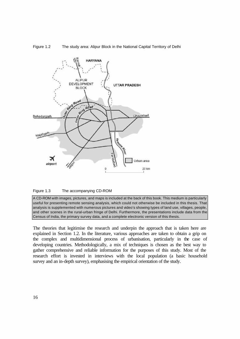
The following aspects were found to be directly or indirectly caused by urbanisation: land-use changes in favour of urban types of land use; location of urban-related activities in or near the village; better access from the village to urban areas and vice-versa; and expansion of urban types of amenities and infrastructure. All these processes have far-reaching consequences for the livelihood of the village population, as they lead to a diversification of employment and sources of income among the villagers, to different uses of the agricultural land, and to change in living conditions. A period of about 25 years, approximately one generation, was chosen as the time frame for three reasons. First, there are some relevant secondary sources that provide insight into local history and the situation in the 1970s. Second, there are consistent data available for this period from the Census of India. Third, this time span corresponds with the period of reliable ‘recall’ by most respondents and is manageable for the researcher. The selected research area is Alipur Development Block, comprising 59 villages situated on the north side of the city within the National Capital Territory (Figure 1.2). This area encompasses a wide range of types of villages: from places that have remained relatively rural, deriving an income mainly from agriculture, to villages that have been entirely enveloped by urbanisation. The land-use pattern and the transformation of the occupational structure are the most important criteria for clustering and selecting villages for further study. Through this method, it is possible to select villages representing the continuum from almost urban to further out on the rural end of the rural-urban fringe. A basic household survey has been conducted to describe the situation in six villages. For the in-depth investigation, the study describes three selected villages that are subject to a strong impact of urbanisation. In addition, one case study concerns a completely urbanised village, which is included to show the ultimate impact of urbanisation on the living conditions of villagers as well as that of numerous migrants who have settled in and around that village. Chapter 2 describes the villages in detail.
16
Figure 1.2 The study area: Alipur Block in the National Capital Territory of Delhi
Figure 1.3 The accompanying CD-ROM
A CD-ROM with images, pictures, and maps is included at the back of this book. This medium is particularly useful for presenting remote sensing analysis, which could not otherwise be included in this thesis. That analysis is supplemented with numerous pictures and video’s showing types of land use, villages, people, and other scenes in the rural-urban fringe of Delhi. Furthermore, the presentations include data from the Census of India, the primary survey data, and a complete electronic version of this thesis.
The theories that legitimise the research and underpin the approach that is taken here are explained in Section 1.2. In the literature, various approaches are taken to obtain a grip on the complex and multidimensional process of urbanisation, particularly in the case of developing countries. Methodologically, a mix of techniques is chosen as the best way to gather comprehensive and reliable information for the purposes of this study. Most of the research effort is invested in interviews with the local population (a basic household survey and an in-depth survey), emphasising the empirical orientation of the study.
17
1.2 Urbanisation: rural transformation and environmental change
In the present study, five basic issues have been distinguished as topics for research. The first of these concerns the need to refine the concepts relating to rural-urban fringes and rural transformation due to urbanisation, before attempting to model and describe the different types of villages. Second, the study moves on to land-use issues and the pressing problem of how land degradation should be interpreted in a rural-urban fringe. Third, the study shows how local and extra-local ‘actors’ interact to determine land-use patterns. Then, in the main empirical part, issues related to livelihood are treated, for which the village and household are important levels of observation. The final part discusses the environmental implications of the growth of metropolitan cities for the urbanising villages.
1.2.1 Definitions and the descriptive models of the rural-urban fringe
The rural-urban fringe has many different manifestations in the literature in terms of the way it is conceptualised and delimited. As far as the term can be traced, Wehrwein (1942) was the first to use the term rural-urban fringe, applying it in his work on cities in the United States. His example was followed by many others, including Ramachandran (1989), Thakur (1991), Lin (1994), Nangia (1976), Yadav (1987), and Lucas and Van Oort (1993). Many other terms are found in the literature, implying different delimitations and levels of analysis. The following list illustrates the diversity in terminology: rurban fringe (Schenk 1997), urban fringe (Kumar 1998, Kabra 1980, Hill 1986), rural hinterland of the city (Kundu 1991), the city’s countryside (Bryant et al. 1982), peri-urban fringe (Swindell 1988), rural fringe of the city (Leeming and Soussan 1979), peri-urban areas (Dupont 1997, McGee 1991), desakota regions (McGee 1991), and metropolitan fringe (Browder et al. 1995, Rao 1991, Saini 1989). Research in languages other than English includes descriptions such as the Dutch ruraal-urbane overgangszone tussen stad en platteland (Druijven 1996) and the French Péri-urbanisation (Dupont 1997), le périurbain (Banzo 1998), espace péri-urbains (Vennetier 1989). How far the area around the city extends varies considerably, but many studies do not provide delimitations. An indication of the approximate spatial connotation of some the above terms is depicted in Figure 1.5. For the villages near Delhi, it was necessary to translate terms with a profoundly ‘Western’ bias into their Hindi-equivalent. Shahari karan (literally: urban development) proved to be the most appropriate term to explain the purpose of the study during the interviews, as it evoked references to changes in the lives of households and their villages as a result of urbanisation. This thesis sticks to the term rural-urban fringe because a descriptive definition of that term by Ramachandran (1989) is found to be a quite accurate basis to build upon: “the rural-urban fringe is an area of mixed rural and urban populations and land uses, which begins at the point where agricultural land uses appear near the city and extends up to the point where villages have distinct urban land uses or where some persons, at least, from the village community commute to the city daily for work or other purposes” (Ramachandran 1989, pp. 297). The same criteria – urban land use on the urban side of
18
the fringe and occupation on the rural side of the fringe – are used here to formulate a working definition of rural-urban fringe:
The rural-urban fringe extends from the contiguous built-up area of the city (no rural land use) to the area where most villages show a majority of workers engaged in non-agricultural occupations (many of whom commute).
Note the central role accorded to two criteria: land use and occupational structure. Data about commuting is not available in the census. It is therefore assumed, after verification in the field, that a high figure for non-agricultural occupations indicates a high number of commuters. The second step is to identify stages of urbanisation of villages in a rural-urban fringe. For example, Galjart (1982) gives a typology of villages based on the degree to which they are incorporated into a wider economic system. This typology ranges from more or less remote villages that are completely isolated to urban villages completely incorporated in the city. The present study requires a more limited spectrum: the area within which people commute. Sundaram and Prakasa Rao (1984) made a valuable attempt in this direction, calling it ‘stages of metropolitanisation’. However, Ramachandran (1989) developed the most useful concept, which could be altered to serve the purpose of this study. Following his definition of the rural-urban fringe, a ‘fringe’ village at the rural end of the spectrum has a distinctly rural land use, while the population already starts ‘urbanising’. The first transformation of the rural local situation is characterised by a change in land use towards market-oriented agriculture. After that, the villagers start commuting and adopting an urban livelihood. This occurs before urban land use starts to dominate the local landscape. Finally, the village is incorporated into the urban area. Following these steps, Ramachandran (1989) classified the villages according to five stages ranging from rural to urban (pp. 310-318): first, rural (showing no visible influence of the city, either on the population or on the land); second, agricultural land-use change (showing influence of the agricultural markets in the city on the land use of the village); third, occupational change (where the majority of the population is no longer working in agriculture), fourth, urban land-use growth (where urban land-use types start dominating the area around the village settlement); and fifth, urban (where urban land-use types have taken up all rural land). This study makes one major adjustment to Ramachandran’s stages. The second stage is not found to be applicable to the study area and has thus been dropped. The reason is that many of Delhi’s food requirements are actually supplied by areas too far away from the city to be included in its rural-urban fringe. Many specialised areas for growing apples, onions, potatoes, and other vegetables are located very far from the city. Besides, the entire alluvial plain, ranging from Punjab to deep into Uttar Pradesh, is characterised by productive market-oriented agriculture. Furthermore, the assumption had to be made that commuting is not the only cause of occupational transformation. The increase in local non-agricultural occupations is considerable as well. A high relative figure of non-agricultural occupations is therefore considered useful for determining if a village is in the stage of occupational change. The above arguments thus suggest the classification of villages as in Figure 1.4.

19
Figure 1.4 Stages of urbanisation of villages in the rural-urban fringe
1. Rural: land use and occupations are dominated by agricultural orientation 2. Occupational change: high proportion of non-agricultural occupations (of whom there
are many commuters)
3. Increasing urban land use: urban land-use types start to dominate
4. Urban: the land is almost entirely urban
This typology refers to development in the course of time, but it would be valid for development in space as well. The villages in the second and third stage are typical for a rural-urban fringe, which is the case for Alipur Block (see Section 2.4). The threshold values are explained then, but are quite arbitrary. Nevertheless, the resulting maps indicate that the typology is helpful to select study villages for more detailed empirical research. In fact, Delhi’s rural-urban fringe extends beyond Delhi’s administrative area. The easily accessible villages in Haryana also have strong daily links to Delhi, although nearby cities (such as Sonepat) have their own smaller rural-urban fringes. Besides, there are conceptual weaknesses: “a stages-model should be interpreted carefully, as stages might overlap both in space and time, and some villages might be in one stage permanently while others go through all the stages” (Druijven 1996, p. 7). The diversity of the villages that are studied limits the usefulness of the stages of urbanisation. Within each stage there are profound differences in the course of development of land use and population, which warrant further in-depth research. Much of the literature on rural areas near cities is descriptive in nature. McGee, however, proposes a descriptive model based on the regional economy specific to the surroundings of Asian metropolitan cities: the desakota (in Malay, desa means rural or village and kota refers to a city or town). He claims that for Asia, the traditional concepts of settlement patterns distinguishing urban and rural areas are not valid, given the emergence of high-growth rural areas close to cities and along highway corridors. In short, these areas tend to combine highly productive, chiefly smallholder agriculture with increasing participation in non-agricultural occupations and high spatial interaction of economic activity. Within the desakota region that is closest to the city, namely the peri-urban areas, this trend is enhanced by the possibility of daily commuting to work. This peri-urban area is comparable with what was earlier defined as the rural-urban fringe. Delhi would feature as ‘Desakota type II’, which refers to the relatively populous and economically strong regions within developing countries. McGee’s hypotheses are discussed briefly in the end of Chapter 5. There, additional information is given about the socio-economic repercussions of urbanisation on the villages. Although McGee identifies the main processes, he does not specify which differences exist within the local population. The results of this thesis should provide answers to two questions: First, does Delhi’s rural-urban fringe really correspond to the peri-urban area? Second, how are different groups within the local population involved in the transformation?
Chr
onol
ogic
al p
roce
ss
Spa
tial c
onno
tatio
n

20
Figure 1.5 Delimitation of the rural-urban fringe according to various concepts and superimposed on the map of Delhi
Derived from Ramachandran (1989), McGee (1991) and Bryant et al. (1982) A few sources go more deeply into the micro-level changes in rural-urban fringes in India (e.g. Yadav 1987, Thakur 1991, Chakraborty 1991, and Ramachandran 1989). The study that comes closest to the approach taken here is the one by Brookfield et al. (1991), who study the socio-economic impact of urbanisation in Kuala Lumpur. They rightly refer to in-situ urbanisation, implying that the research population experiences urbanisation without actually migrating from a village to a town or city. They also note that urbanisation in a socio-economic sense can occur not only on the immediate fringe, where the city is expanding in physical terms, but also at places that are further away yet effectively connected to urban areas. They conclude that “…analysis of the data showed a much greater degree of transformation than was visible on the ground” (p. 5). This raises the question whether the same is true for the seemingly quiet villages in Delhi’s rural area. This also justifies the selection of villages both on the immediate fringe as well as further out into the rural areas.
21
1.2.2 Urbanisation and its implications for land use
Urbanisation consumes agricultural land and takes up other land from villages. Barrow (1991) draws attention to the following: “It is not unusual for urban extension to take some of the best agricultural land for the simple reason that towns have tended to grow up in lowlands or on plateaux, especially near rivers where the soil is good” (p. 238). In India, there is a growing awareness that land needs to be protected. With increasing population pressure, it is imperative to prevent the creation of wastelands (Singh 1985). Is urbanisation creating wastelands? Khan (1997) states that 98 per cent of the urbanised land in Aligarh, located about 100 kilometres from Delhi, was of good agricultural quality, indicating the trade-off between rural and urban interests. This is clearly true for Delhi’s region as well. Besides the direct conversion of farmland into built-up urban areas, there are other effects that have an impact on a much wider area. The issue of soil excavation by brick kilns is important in that respect (Nusrath and Mahadev 1991, Bentinck 1995). Limestone mining poses another threat to the peri-urban land (Chandrasekaran and Ramkumar 1991). Vleugels reveals the implicit negative consequences of urban expansion on peri-urban agriculture. “Rich agricultural lands were transformed into urban land use, and irrigation waters polluted by industries and urban households, which led to considerable production decreases in agriculture” (Vleugels 1990, cited in: Zoomers and Kleinpenning 1996, p. 162). Beyond the immediate vicinity of the city, Asuncion shows less influence on cropping patterns; the net effect is neither positive (intensification) nor negative (loss of productivity). “No clear tendency towards agricultural intensification can be observed in smallholder’s production in the surroundings of Asunción (Zoomers and Kleinpenning p. 166)”. In view of the pressure on agricultural land as a result of urbanisation, the term land degradation would seem appropriate to the present study. However, more than the physical change implied by this term, this thesis is concerned with how urbanisation affects the livelihood of villagers. Specifically, it investigates the mechanisms by which changes in land use affect people’s livelihoods and how land-use patterns are determined by people (or ‘actors’, see next section). Therefore, functional rather than physical aspects of land use are considered relevant. In deciding on the focus of this research, it was evident that looking at land degradation from a purely technical angle – that is, in terms of agricultural fertility, quality of vegetation, and other physical indicators – would not necessarily be relevant to the livelihood of the local population or to other interests with a stake in the land. Blaikie (1996) argues that “the word degradation is involved with normative connotations” (p. 210). It is imperative to avoid the value-laden and therefore arbitrary and subjective standpoints that the term degradation implies. Blaikie and Brookfield (1987) proposed a state-of-the-art concept of land degradation in the context of the social sciences, arguing that from a socio-economic perspective, “land degradation implies a reduction of the capability of land to satisfy a particular use” (p. 6). The most beneficial use of land varies from place to place and from user to user, depending on its location-specific context. A rural-urban fringe includes many actual users and potential users of the same land. In remote rural areas, the use of rural land is quite straightforward: it is almost exclusively related to agriculture or forestry. For these rural uses, consistent physical indicators can be applied. In the case of a rural-urban fringe, however, this is

22
much more difficult. The land can be used by, or is useful for, many different individuals, groups of people, and interest groups, leading to a high heterogeneity of land uses. Moreover, there are multiple options for using land, and there are many that could be more beneficial to the owner than agricultural use. This situation lens itself to the actor-approach, as advocated in the field of political ecology (Bryant and Bailey 1997). The preferred or desired use for land is arbitrary, being a complicated sum of uses by many different users. For example, even an individual peri-urban farmer can have multiple interests such as land speculation, sale of land, and non-agricultural sources of income, compared to which the income from agriculture may be negligible. The arbitrary situation is enhanced by the fact that land is becoming a frequently traded commodity, with prices far above the value that would be justified by agricultural production. The new buyers may apply very different criteria to their use of land than the former owners. Of the possible criteria, location and access are the more important ones in an urbanising context whereas soil profile and elevation are secondary or unimportant. In short, the physical condition of land does not say much about its particular use, and the particular use differs per user. Thus, the concept of Blaikie and Brookfield suggests that land degradation in a rural-urban fringe should be studied through the role that land plays in the economic lives of the population. In that light, it is attempted here to quantify and describe land-use changes and relate these to the livelihood issues that pertain to people residing in the villages. Area-specific arguments also play a role in an approach based on functional land use rather than on physical characteristics. The research area consists of land that is flat and easy to adapt to almost any beneficial use. The quality of the land can therefore be easily improved at a relatively low cost. Even seemingly dry and barren land can be reclaimed for agriculture. Consequently, the condition of a piece of land may change radically from one moment to the next. This is quite different in mountainous areas, where soil erosion can be irreversible and may do permanent damage to cultivated fields. This leads to the same conclusion as drawn earlier: for our purposes, it is far more relevant to look at functional changes in land use than at land degradation in a physical sense. The question about how to value land for different uses can be answered from different perspectives. Some approach land issues from a purely economic point of view, taking the price of land as the main factor for determining optimal use (Pond and Yeates, 1994, Wadhva 1983, Rajalakshmi and Birundha 1994, Amitabh 1997). The basis of many studies is the model developed by Von Thünen, which assumes an optimal allocation of land according to a bid-rent curve of maximum returns, in which distance to the urban market is the most important factor (Haggett 1983). This model is particularly valid for agricultural crops. The neo-classical assumption that the markets allocate properly and users, buyers, and sellers have optimal information holds true to some extent. But the rationality of actors regarding their use of land is determined by various factors that influence decision-making as well, such as political, strategic, and particular household livelihood variables. Another problem with a purely economic approach is that information on land prices and its determinants is very difficult to find. Therefore, for this study, an ‘actor approach’ focusing on how people deal with land was found more suitable.

23
1.2.3 The actor approach to land issues in the rural-urban fringe
Focussing on what happens with the land and which people or groups are involved, it helps to seek guidance in the principles of ‘political ecology’ (e.g. Bryant and Bailey 1997, Blaikie and Brookfield 1987, Blaikie 1996). In short, this approach is based on the assumption that the environment (in this case the land) is strongly influenced by the way different actors interact in a local arena. Unequal power relations would imply that weak actors, mostly on the grassroots level, have the least influence and pay the heaviest price if there is environmental degradation. Dietz et al. (1996) explain this academic approach in the following way: “…students of political environmental geography regard landscapes and regional natural resource stocks as contested political arenas” (p. 85). Accordingly, this study describes and analyses how the actors influence the process of urbanisation when conflicting interests lead to disputes and identifies who are the winners and losers in the process. The situation in urbanising areas is rather complex. Many seemingly one-dimensional actors actually pursue conflicting goals. Furthermore, the poorest and seemingly weakest actors often connive with more powerful actors to achieve certain goals with respect to land. Space for housing is an important issue, especially where land values are rising and land is becoming scarce (Pugh 1990, Prins 1994). Other important interests concern acquiring space for industrial and commercial activities. Government and private actors are often engaged in complementary and conflicting activities, leading to a local power structure based on political strength (Miglani 1993). In a rural-urban fringe, the bargaining that accompanies government acquisition of farmland is strongly related to the identity of the actors (e.g. groups of individuals, businesses, and institutions). Some are more capable of turning a situation to their advantage than others. Government acquisition would happen “at the cost of the poor farmer whose land had been taken away compulsorily by the public authority, giving him only meagre compensation in return” (Acharya 1987, p. 112). In the 1970s, the government used ruthless practices for land acquisition. “Sans aucune information peralable, donc sans avoir pu se preparer aux changement qui allaient les affecter, les villageois ont perdu brutalement leurs moyens d’existence tranditionels” (Dupont 1997, p. 238). This tells us that the villagers were weak actors. The notion of what is a fair compensation for the inevitable land acquisition is a subjective one. This issue also draws attention to the ethical considerations of removing people’s livelihood (Spalding and Wood 1998) and the perception of the people involved. Rural-urban fringes, especially in developing countries, are often characterised by faulty and ad-hoc government planning and intervention. Omuta (1985) observes that the rural-urban fringe can be called an ‘institutional desert’, leading to filling of the power vacuum by private actors. Hamid (1992) adds that the unstable political situation in developing countries implies that strategies of individual actors depend particularly on the local ‘power game’. Nowadays, there is evidence that the local farmers and other private parties are stronger actors, which limits the scope of formal urban and regional planning. The ambition of the planning authorities to determine the land-use pattern is not realised, resulting in vast areas of ‘unauthorised construction’ (Breese 1974, Nath 1993). This is not only a result of the limited financial means of the government. It is also because the government bodies
24
do not always pursue the same objectives, and the behaviour of individuals within the institutions frequently frustrates the formal tasks and objectives. Bryant and Bailey (1997) claim that the current ‘environmental crisis’ in rural areas in the Third World can be attributed to the political and economic relations between ‘actors’. In that light, environmental issues should be linked to more general developmental issues. The authors identify global, regional, and local actors and consider how each of these actors might experience the impact of the environmental crisis: “… political ecologists attempt to complete the story through work oriented around the idea of a ‘politicised environment’. In the process, they agree with their mainstream counterparts that the “Third World is wracked by an environmental crisis but, unlike the latter, ask ‘whose environmental crisis?’” (Ibid. p. 27). This thesis discusses the question of who experiences the impact of environmental change (rather than supposing an environmental crisis from the start) and describes the actors at the local level (see Chapter 4).
1.2.4 Choosing the levels of analysis: areas, villages, and households
After reviewing what happens on and to the land and how different actors are involved, the study moves on to how the socio-economic transformation takes place for one group of actors: the residents of the villages. In this context, Rodriguez (1995) remarks that “the conversion of agricultural land to suburban uses is of major importance, not so much in terms of the total area involved, but in terms of its social and economic effects” (p. 34). Hill (1995) adds: “many rural surveys fail to investigate … manifestations of links with the city as town-to-village flows of money and goods, income from (temporary) urban employment, frequency and nature of visiting pattern and employment change in peri-urban villages” (p. 32). These insights suggest that this topic is certainly worth exploring further. For this part of the study, other units of analysis need to be selected: the village as the context of change and the household as the unit in which socio-economic change can be explained. These levels of analysis are commonly used in a few other disciplines, such as rural development geography, anthropology, and economics. Lipton (1977) emphasises that rural micro-research receives too little attention in terms of funding and academic prestige. The strength of such studies is that they describe the village economy in great detail while seeking to explain general developments in rural transformation (e.g. Preston 1994, Breman et al. 1998, Lanjouw and Stern 1998, Maria Saleth 1997). There are some studies that describe how the occupational shift occurs in the course of rural transformation, but the authors base their conclusions on secondary data on a much higher (i.e. district/state) level (Bhalla 1997, Haque and Jha 1997). Village-level research has not yet gone into depth on villages in the rural-urban fringe. More general observations such as “Inhabitants of the fringe villages find employment in lower-paid unskilled jobs in rural industries and in the informal sector” (Chakraborty 1991, p. 305) call for further research. To know how this occupational sorting out occurs in Delhi’s rural-urban fringe, one needs to descend to the village level to conduct a survey among village households. It seems challenging to combine the methodology of rural village-level studies with the specific topic that is the subject of research in this

25
study. The results of the village-level research are given in Chapter 2 and 4, respectively, where the findings are used to describe the villages and analyse the villager’s livelihood. Rural village studies use a wide range of variables to analyse the transformation of the population. Drèze and Sharma (1998) and Lanjouw and Stern (1998) provide us with criteria and variables that are relevant at the village level. The following variables were selected: access to locally available resources; ownership of agricultural land; the significance of the traditional socio-economic division (according to the caste system); the occupational structure of rural households; trends in local and extra-local agricultural and non-agricultural activity; standards of living; links to neighbouring settlements and urban areas; the seasonal and daily mobility of the population; and in- and out-migration. Much of the village-based research is concerned with only one village. For the purpose of this thesis, it was necessary to study several villages. The study areas were selected to represent the earlier-mentioned stages of urbanisation and the great variety between villages due to different processes of incorporation and differentiation (Galjart 1982). The depth to which individual villages are analysed and the detail in which they are described are consequently not as great as in studies treating only one village. Nonetheless, the basic idea of using the village level to represent the research issues remains intact. A comparison of the results with other rural village studies sheds light on the degree of transformation in rural-urban fringe villages compared to their rural counterparts. In various cases, it is possible to confirm or reject claims about how urbanisation influences rural transformation in the case of Delhi. In village studies, the household is the most frequently used level of analysis. It is the “lowest level unit within which individuals are collectively organised”, and “a household focus permits a better understanding of how and why people organise their activities” (Preston 1994, p. 203). Especially in the developing world, the maintenance and/or advancement of the household as a whole is the prime goal of individuals. Schmink puts it in a broader sense: “the household is regarded as a production as well as a consumption unit in which individuals take joint decisions regarding the allocation of production factors such as labour and capital in order to satisfy common household needs” (1984, p. 87). Druijven et al. add that “there is considerable support in the literature that the household is a relevant entity in micro-level livelihood research, especially in rural areas of developing countries where family and household coherence is strong, and where small household based entrepreneurship dominates” (1992, p. 40). However, the same authors also point out some shortcomings of household-level research. First of all, it ignores the process of decision-making by the individual. Another problem is identifying the ‘common’ goal of a household. And they emphasise the lack of attention to intra-household relations and strategies (Druijven 1990). Notwithstanding its drawbacks, the household approach is the most workable level to measure material assets, agricultural land and standard of living within a village population. Land and housing variables in particular are of key importance to this study. Furthermore, especially in a traditional rural context, household characteristics determine the cultural and socio-economic status of the individual to a large degree. Within households, there are structures that determine the actions of households and their individual members. The ‘head’ of the household is usually considered its decision-maker, although others exert influence too. Despite this individual dimension, decisions about the management of agricultural land, employment, and other economic activities
26
are usually made according to the possibilities, needs, and availability of labour within the household. A rigorous definition of the household is a pre-requisite for research on the household level. The definition of a household used in this study is based on a shared cooking unit. This criterion leads to the following definition:
A household is an entity of people living in the same house or room who have all eaten meals from the same kitchen at least four times per week during most of the past one year.
The criterion of a common kitchen is based on the assumption that the household functions as an economic unit whereby the resources are pooled to a large extent. There are some problems with this definition, however. Usually, a household has a separate front door and a separate house or a portion of it, but this is not always the case. Households can share a house even if the constituent units do little together. Nonetheless, because the Census of India uses roughly the same definition, applying it here would make both sources of information compatible. According to the census, “The important link in finding out whether there is a household or not is the common kitchen.” (Census of India 1991, p. 53). Even with the joint kitchen as the defining characteristic, there are ambiguous cases. But for those households who are originally from the village, the definition is relatively easy to apply, as it conforms to the perception of the people themselves. This last argument is important, since a fundamental difference in the definition held by the researcher and respondent would lead to confusion. In the present research in the villages, the ambiguous cases were mostly found among migrants. For example, labourers may live in the same compound but do not always eat together; or groups of migrants may not live together but do eat from the same kitchen (e.g., at their place of work). Furthermore, migrants are often considered part of other households back in their place of origin, although this study only includes persons residing with the respondent as members of the household. A few practical problems in counting members of a household were related to the temporary absence of a member. Despite a few practical and conceptual problems, the household is still the most workable level for gathering information among residents of villages concerning land ownership and occupational structure. There is a basic distinction between ‘joint’ (sometimes called ‘extended’) and ‘nuclear’ households. “Nuclear households consist of a married or cohabiting couple and their children”, while joint households “consist of a core nuclear or one-parent family residing with other relatives who share in daily consumption and financial arrangements” (Brydon and Chant 1989, pp. 135-136). In rural areas in India, there is a traditional predominance of joint households as compared to nuclear households. This tradition is often partly explained by the socio-economic strategy that the household pursues in the light of continuity vis-à-vis social and economic uncertainty. With respect to agricultural work, for example, an extended household offers the advantage of flexible labour and prevents the fragmentation of agricultural land. Cultural factors play an important role as well. In the research area, extended households proved to be less prevalent than could be expected in an area with a rural background, although this might just be one of the effects of urbanisation. The interviews also revealed that extended households are definitely less common than a few decades ago. In addition, the most common type of extended

27
household is limited to one nuclear family with one or both parents in the house. Cohabitation of all married brothers with their wives is much less common. The scaled-down version may indicate the transition to a ‘semi-urban society’ (Ramachandran 1989), which is discussed in more detail in Chapter 5. This study does not pretend to fully analyse the livelihood strategies of households, an important topic in the literature (e.g., Druijven 1990, Ellis 1998, Preston 1994). To do so would require an in-depth analysis on the level of intra-household processes and transfers. Nevertheless, this study shows that the household remains a workable unit of analysis even in an increasingly urban context. Moreover, this study shows that the type of household correlates with distinct patterns of livelihood.
1.2.5 Changing environmental conditions for residents in urbanising places
The spread of urbanisation is clearly a cause for concern with respect to land use and environmental issues. International organisations disseminate dramatic accounts of environmental health in large cities of the developing world (e.g. United Nations 1995, World Health Organisation 1993). Lin (1994) points out some key questions concerning the development of ‘extended metropolitan regions’, as identified by McGee (1991): “…what negative impact does this new form of intensive rural/urban interaction and land use conflict have on the environmental sustainability of development, and what policies and planning measures could be devised to ameliorate the problems of environmental deterioration in these regions?” (p. 18). Ruiters (1996) warns that urbanisation is “a predator of its environment”. Disputed and vacant lands become reservoirs of pests and disease (Hill 1986). The evidence, however, is very fragmented or general in nature, specifying neither the scale nor the location of the problems. Unauthorised colonies have to cope with faulty urban amenities (World Health Organisation 1993). Ali and Singh (1998) and Arya and Abbasi (1995) describe at length the environmental difficulties faced by the slum dwellers in Delhi; many of these slums are located at the city’s fringes. Pollution, congestion, and stress on civic amenities contribute to the difficulties of a population that is already economically weak. Pugh (1990) accuses ineffective land management of indirectly causing environmental problems. Because the supply of urban land is insufficient, he argues, the patterns of urban land use are chaotic. In this sense, the fringe areas are vulnerable: “fringes become the easy outlet for industrial activities which are environmentally hazardous, as pollution control is even less effective than in central urban areas” (Schenk 1997, p. 221). Former rural villages are vulnerable spots: “the industries that have come up in the abadi (built-up) area of the villages firstly create environmental problems in the village” (Solanki 1987, p. 157). The number of specific problems caused by pollution is large. A cursory review of the literature yields the following reports. The levels of lead found in the blood is alarmingly high, especially for people living near or and working in factories and for people who are exposed to traffic exhaust (Yueng 1993). Groundwater is polluted due to seepage of polluted water (Centre of Science and Environment 1989, Soni 1998). Of the 246 million litres of liquid waste produced in Delhi, only 46 million receive full treatment and 72 partial treatment (United Nations 1995), making one wonder where all the dirty water

28
collects. There are dramatic accounts of the exposure of factory labour to communicable diseases, of mental disorders, trauma, poisoning, and burns and other injuries. “Squatters and slum-dwellers are particularly at risk, because they often have no alternative but to live in close proximity to dirty industries, contaminated water courses, or swamps” (World Health Organisation 1993, p. 16). Poor city dwellers have the least means to protect themselves against environmentally adverse situations: “perhaps the least surprising point arising from the review of environmental problems … is that poorer groups bear most of the ill-health and other related costs” (Hardoy et al. 1992, p. 100). There has also been a cautious reaction to the environmental rhetoric as well: “is there really an environmental crisis? Now it has become a cliché, with little real proof” (Barrow 1991, p. 10). To dispell any doubt, research should look at both the negative and the positive consequences of urbanisation in large cities. A balanced approach would share the “dissatisfaction with literature associated with negative notions of urban ‘disfunctionality’, ‘overurbanization’ etc.” (Ginsburg et al. 1991, p. xiv). This is why the present study looks at a single case of an urban village where many of the circumstances described above can be found. That village was selected because it allows the study to go deeper into the environmental effects of urbanisation for residents and workers.
1.3 Research questions
The objective of this study is to reveal the impact of urbanisation on the villages in Delhi’s rural-urban fringe. The exploratory stage turned up many different aspects, in the light of which the following research questions are formulated:
Figure 1.6 Central research questions
What is the influence of urbanisation on: 1. Occupational features of villages in the rural-urban fringe? 2. Land use in and around the villages? 3. The actors and their strategies for coping with urbanisation? 4. The livelihood of the villagers? 5. The living conditions of villagers and workers in urbanising villages?
These central research questions can be expanded to form more specific research questions: 1. The rural-urban fringe and the villages (Chapter 2): • What are the characteristics of Delhi’s rural-urban fringe? • How do the villages differ in type of development? 2. Land use (Chapter 3): • How does urbanisation affect rural land? • What are the indicators of urbanising land and what are the influencing factors? • Does land degradation occur from a socio-economic perspective? • How can remote sensing be used to map land use?

29
3. The actors influencing land use (Chapter 4): • Who are the key local and extra-local actors with a stake in spatial developments and
what is their relative strength? • What are the strategies of the actors in the urbanisation process? • How does the interaction between actors influence patterns of land use and the supply
of urban land? 4. Household livelihood (Chapter 5): • What is the former and current situation regarding agricultural assets, occupational
diversity, and sources of income? • Which factors influence the integration into urban occupations and income? • Which livelihood patterns are emerging and what is the resulting standard of living? • What are the prevailing perceptions of urbanisation? 5. Living conditions (Chapter 6): • What are the consequences of urbanisation in terms of living conditions? • Who is most vulnerable to negative living conditions? • What are the most precarious locations? • What are the prevailing perceptions about living conditions?
1.4 The research area and the selected villages
The IDPAD project outline (see Figure 1.1) determined the choice of two research areas: Alipur Development Block north of the urban area of Delhi, and Najafgarh Development Block west of Delhi. This choice was preceded by exploratory visits to ensure that these areas are representative of the studied issues. Both ‘rural development blocks’ comprise many villages and a few towns. For the present study, the area of the investigation had to be scaled down further. Alipur Block was found to be a good and sufficiently large setting for investigating the research topics. All villages in Alipur Block have been visited. The basic household survey was carried out within Alipur Block, where six villages, representing the stages of urbanisation, were surveyed (see Section 1.5.2). Three villages were singled out for the in-depth study. Analysis of stages in the rural-to-urban transformation according to occupational structure and land use proved to be a useful exercise (see Section 2.3). That information, in combination with practical considerations (such as access, settlement size, and local co-operation), was used to make a representative selection.
1.5 Methodology and data sources
In order to draw upon a comprehensive range of information, the study makes use of a variety of resources and methods. The census data and other records are used to get a more general picture of the population profile and employment structure. Information on land use is taken from existing maps, remote sensing maps, and field mapping as well as from agricultural land records. Interviews in different forms (surveys and interviews with
30
key informants) are the main instruments to find out about livelihood issues. Newspaper articles and reports giving details about the situation in the research area are also used and will be frequently cited in the text.
1.5.1 Secondary data sources
Secondary sources include information and figures from census documents, local land records, publications, and the media. Census data Census data provide useful information at the village level and, more generally, about the land and population in the area. Census data are used to categorise the research villages within the rural-to-urban continuum on the basis of land use and occupational characteristics (see Section 2.3). The Indian census takes place every 10 years. Because the focus of this study is on developments over the last 25 years, the census figures that are used mostly are from 1971 and 1991, and occasionally 1981. However, it is dangerous to rely exclusively on the census. It contains errors in enumeration as well as inconsistencies in the application of definitions of variables. Census data on land use in particular can be inaccurate and confusing. And census classifications are not always very relevant to urbanising areas. Local land records A village revenue officer (Patwari) keeps records on village land, including its use and ownership. The aggregated data on crop patterns at the village level was used to supplement the village description and to sketch the context. Disaggregated data at the plot level are used in the case studies to analyse land ownership and transactions. Reports and books Some background information about the villages is derived from books and government publications, as they provide a historical perspective. Some PhD and MA theses available in Delhi describe the same area. Therefore, these sources have been used to depict the local situations and to describe the villages and surrounding areas. Newspapers Articles from various newspapers have been collected throughout the research period. This is a way to keep track of important events, policy measures, conflicts, environmental issues, and political developments. Maps and remote sensing Detailed maps are crucial to this study because they show the physical aspects of the urbanising environment of the villages. The maps are essential to understand the context of local socio-economic developments as well. The topo sheet maps from the survey of India (1976) at the scales 1:50,000 and 1:25,000 are used for orientation in the field and to generate topographic maps. The outdated map (the survey date is from the 1970s) illustrates the importance of making maps for the purpose of this study. Census maps
31
show village boundaries, but very imprecisely. Cadastral maps were obtained from the local land administrator providing details about the ownership of individual plots. Satellite images are used as input for the mapping of land use. The resulting maps are particularly helpful, since detailed and recent land-use maps were not available. A Global Positioning System (GPS) was used to determine the location of observations in an exercise known as ground truth verification. Geographic Information Systems (GIS) are used to process remote sensing data.
1.5.2 Primary surveys and interviews
The basic household survey The basic household survey provides basic information about the village population. It includes 337 interviews in six different villages conducted by MA students from the University of Groningen and the present author, with the help of students from the University of Delhi, in the course of 1997 and 1998. The basic household survey includes variables on the following subjects: - Land ownership (agricultural land, how much land sold, use of the land) - Place of origin (original villager or migrant, caste) - Demographic structure (age, type of household, number of children) - Occupational characteristics (type of work, place of work) - Assets and living standards. The basic household survey provides quantitative data about the livelihood characteristics of the population. The economic standard of living can be determined through household assets. This survey sheds light on the differences between the distinguished groups in the population. A random sample of around 25 per cent is used in the smaller villages and a sample of 10 per cent in the larger ones. In view of the objective of this study, these sample sizes are considered sufficiently representative. Sampling is done on random basis with the help of village maps, whereby each population cluster is equally represented. The questions are largely concerned with the present population; the consequences of urbanisation are not treated in depth. The results are presented in Chapter 5 in combination with the in-depth survey. Statistical analysis is performed for the main independent variables. It would have been interesting to further split up the data into sub-groups (for example, the types of household within one socio-economic group). But the numbers would have become too low to make significant results feasible.
The in-depth survey The in-depth survey includes 67 lengthy interviews (lasting on average 2-3 hours) with people about their households. The author conducted all interviews during two fieldwork periods in 1997 and 1998/99. The input of the three Indian counterparts/interpreters was encouraged, which resulted in valuable insights and additions. The households were selected through purposive sampling with the following eligibility criteria. Some of them had already been selected for the basic household survey and were found suitable to depict the variety and changes in occupational orientation, household size, land ownership, and living standards. Others were added to provide more insight into the actual and potential effects of land acquisition by the government. Since many questions
32
were of a sensitive nature, the impression whether the informant was responding openly and honestly was also taken into account in deciding about continuing the interview. Besides, the availability of time with the respondent was essential for obtaining all the information. Therefore, it was necessary to improvise during the interviews. The interviews were held in three different villages (Zindpur, Ibrahimpur, and Pehladpur Bangar), each of which has been subject to strong urbanisation pressures. The purpose of the interviews was to select a number of households that had either different starting positions 25 years ago or have responded to urbanisation in different ways. The list of questions was not entirely fixed because the interviews were long and sometimes improvised according to the specific situation of the household. The following topics were covered in each in-depth interview: - How households manage their land and what the implications might be for its use - Land prices and compensation rates for sale or acquisition - Strategies concerning land transactions - The local structure of agricultural employment and income - The longitudinal aspects of change in occupation and income - Change of occupations between generations (mostly father-son change) - The spatial aspects of livelihood: urban and other extra-local work versus local
economic activities - Perception of village and household changes related to urbanisation - Perception of living conditions. The in-depth survey provides grounds for answering most of the research questions about urbanisation. Specifically, it allows us to generalise about its effects on – and the response by – the village population. Rather than consisting of quantifiable variables, the in-depth survey is an open interview, including longitudinal elements as well. The focus is on changes in employment structure of the households. The questions elicit information on circumstances that influence reactions, choices, and strategies. Furthermore, the interviews cover household histories over the last 25 years. This period more or less coincides with the secondary data analysis. Moreover, it seems to reflect what an average middle-aged respondent can reasonably recall. Key informants Key informants have provided useful and sometimes indispensable information at all stages of the research. The local informants could include village headmen, former headmen, property dealers, elderly people who know the village history, and local teachers and other well-informed local people. Persons in relevant positions at government departments, planning agencies, academic institutions, and in the local administration have also been consulted. They were particularly helpful when starting the research. Later they provided a means to double-check dubious information, and they gave feedback on research results. Various people in such positions were interviewed to find out about policy and practice and to appreciate the discrepancy between the two. Most interviews with key informants were conducted in a similar fashion as the in-depth interviews with the help of an Indian interpreter. Some informants spoke English, so the interview could be conducted by the author himself.

33
1.6 Structure of the thesis
The structure of this thesis more or less reflects the sequence of the research questions. The current chapter formulates the research questions, identifies the most important literature and the academic context, and outlines the methodology used for the study. Chapter 2 describes the regional and local setting. Furthermore, this chapter presents the operationalisation of the descriptive model of phases in the urbanisation process. This model is also used to select and characterise the research area and villages. Chapter 3 concerns the extent of the land-use changes in the research area. The types of land use are classified to reveal the impact of urbanisation on the land-use pattern. In addition, remote sensing images are used here for two purposes: to localise and quantify the land uses; and to compare the types of land-use change with the land classification according to the physical criteria distinguished by remote sensing. Chapter 4 identifies the actors who have a stake in the expansion of urban land. The degree of political and economic strength of each actor, local and extra-local, determines the land-use patterns to a very large extent. This overview is also of great importance for issues on a higher level, such as land supply, the environment, housing and infrastructure. Consequently, actor strategies are crucial to changes in livelihood as well, which is the main issue of this thesis (Chapter 5). This core chapter deals with the effects of urbanisation on livelihood. For that analysis, three different types of households are distinguished: two groups in the original population (historically the resource-rich and the resource-poor) and the migrant group. Chapter 6 concerns the effects of urbanisation on the living conditions for residents and workers. To demonstrate these effects, this chapter presents a case study of an urban village (Samaipur), a settlement where all rural land had disappeared in favour of a mix of urban land uses. Finally, Chapter 7 presents the conclusions of this thesis.

35
2. THE RURAL-URBAN FRINGE AS PART OF METROPOLITAN DELHI
2.1 Delhi: an introduction to the Metropolis and its surroundings
The conditions for living and working in the study area are obviously influenced by the physical geography, history, rates of growth, and the administrative and political institutions of the metropolitan region as a whole. The city is characterised by a dual core: the ancient city of Delhi (or Shahjahanabad); and the administrative city built by the British, New Delhi. Delhi lies in the flat and densely populated Indo-Gangetic plains and is expanding in all directions. Relatively fertile alluvial soils dominate towards the northern and western sides of the city’s fringe. The flat landscape there contributes to the high suitability for agriculture. The south of the city is different: it is part of the Aravali hills, stretching far into Rajasthan. Although the undulations are not very high, the land is less fertile and agriculture is more difficult. The rocky and hilly topography of the southern fringes has other consequences for development as well, providing an attractive environment for higher-class housing and recreational land uses. This type of development is facilitated by the fact that the urban elite is already concentrated in the southern part of Delhi. Similarly, Mehrauli Block and the southern side of Najafgarh are preferred locations for multinationals and domestic companies with an export component. The ‘satellite towns’ of Gurgaon and Faridabad are fast-growing areas. Their growth is supported by government action in the provision of serviced industrial sites. Other important locational advantages include the location of the airport and accessibility to the central business district of New Delhi. Similar advantages apply to the concentration of upper-class mansions, commonly known as ‘farmhouses’, in the southern rural-urban fringe. Lately, farmhouses have also been mushrooming on the northern side. Despite the relatively faster modernisation of the southern fringe areas, the other rural areas that surround Delhi also face rapid growth. But their growth tends to be a consequence of local and domestic economic activities. Alipur and Kanjhawala Blocks traditionally accommodate many brick kilns, supplying bricks and tiles for construction activities. The north also contains much small-scale industrial activity. Manufacturers, factories making construction material, plants for the processing and distribution of agricultural products (like rice mills and exporters), and storage facilities are all expanding rapidly on the northern side (see Chapter 3). The city has no real natural constraints, such as steep mountain slopes, oceans, or lakes. Historically, the Yamuna River forms the most important physical barrier. At present, various bridges give access to the Trans-Yamuna area, which now houses 40 per cent of Delhi’s population. The riverbed itself is still less suitable for human habitation due to frequent flooding, although some small villages and sizeable slum clusters can be found there. The status of Delhi as the capital of India has led to a complex structure of municipal administration. The National Capital Territory (NCT) includes areas administered in tandem by the Government of Delhi and three Municipal Corporations. The largest of

36
these is the Metropolitan Corporation of Delhi (MCD); the other two are the New Delhi Municipal Corporation (NDMC) and the Cantonment Board. The MCD administers the largest area, including all rural areas within the NCT. The NCT is a recent name: before 1994, the same area carried the name Delhi Union Territory (DUT). The DUT was founded in 1911, when Delhi became the capital of British India. Later, in 1947, Punjab and Haryana were split up, and Delhi was given a considerable rural area around the city. Administratively, the NCT is still a union territory, which formally means that the central government has more direct power over it than could be exerted over a state. Recently, the Delhi government has been lobbying to attain statehood. This is done to enhance the financial means and the political strength of the government of Delhi (Hindustan Times 28-3-1998). The NDMC governs the area of New Delhi, where the central government buildings are concentrated. The Cantonment Board rules an even smaller area, where there are military bases and military housing – a legacy from British rule.
Figure 2.1 Topographic map of Delhi

37
The history of Delhi is fascinating, even if we only look back over the twentieth century. After centuries of relative decline, its fortunes turned when the capital of British India was established in 1911. At that time, the city did not have muuh more than 100,000 inhabitants (Nagpaul 1996), and the vast majority of the present NCT consisted of rural villages. The initial plan of the British Raj envisaged locating New Delhi at the northern side of the old city, but this plan was changed due to excessive problems with flooding there. As a result, it was decided to locate New Delhi at its present location, south of the old city. Consequently, northward expansion until 1947 was limited to the present Civil Lines area, Delhi University, and some smaller neighbourhoods around it. The period from 1946 to 1970 showed massive expansion northward. Large camps for refugees from Pakistan who came during Partition were set up. Many of the same families were provided plots for houses during the 50s and 60s. In the 70s, 80s, and 90s, planned as well as unplanned development continued to convert village land into many types of residential, commercial, and industrial land use. Nowadays, about half of the NCT area is urban. In the 1950s, the rural area of the NCT was divided into five Rural Development Blocks (in the rest of the thesis, referred to as Blocks): Alipur Block (north), Kanjhawala Block (north-west), Najafgarh Block (south-west), Mehrauli Block (south) and Shahdara Block (east). The first three still encompass a considerable rural area of respectively 52, 39, and 65 ‘rural’ villages (Census of India 1991, p. 92). Mehrauli has only 22 villages left, while Shahdara contains only 23 villages due to the physical constraint of the boundary with the neighbouring city of Ghaziabad. The total number of villages in rural Delhi is currently 209, down from 304 in 1951 and 243 in 1971 (Census of India 1951, Solanki 1987, Katariya 1997). Of the 209 villages, 10 are uninhabited. The city’s ‘jacket is least tight’ on the northern and western sides, encompassing the largest rural area within the NCT. Since the end of the 1950s, the Delhi Development Authority (DDA) was ‘chief developer’ for land supply and the construction of infrastructure and housing, a role that was approved of by the government in 1961 (United Nations 1995, p. 79). Up to 1983, the DDA had acquired and developed 18,200 hectares of land (Ibid.). To the north of the city, the most important project of the DDA is Rohini Township, planned to accommodate a population of over one million people. Most of the land for Rohini was acquired from villages in Kanjhawala Block, but it also included land from villages in Alipur Block such as Badli, Haiderpur, and Samaipur (see Figure 2.2). There are now preparations for Rohini Phase II and Narela sub-city, which is planned to stretch far into Alipur Block at the west side of the GT road. However, progress is very slow, and the DDA is forced to incorporate the mushrooming spontaneous unauthorised neighbourhoods founded by private developers, property dealers, and settlers (see Chapter 4). A more recent plan is Dwarka sub-city in northern Najafgarh Block, where all the necessary land is acquired and construction activity is under way. The housing supply does not come anywhere near the actual demand exerted by the growing population of Delhi, despite the high ambitions in large-scale housing projects. The gap of housing for the poor and the lower-middle class is filled by the ‘unauthorised’ sector that develops land illegally (see Chapter 4). This leads to a mixed land-use pattern characterised by a rather haphazard pattern of the following types of built-up land in recently urbanised areas of Delhi: - Formal housing ‘colonies’

38
- Unauthorised settlements - Squatter settlements or slums - Planned industrial/commercial/institutional areas - Unplanned or unauthorised industrial and commercial areas - Urban villages The urban villages become incorporated in the urban extension but largely keep their original morphology. The transformation of the livelihood of these villages is much more radical, although some households retain agricultural activity in the form of dairy farming. The dispersal of urbanisation into the rural-urban fringe causes substantial transformation in the villages beyond the urban limits as well. This is confirmed by the analysis of population data of the census, presented in the next section. In a functional sense, the rural-urban fringe clearly extends beyond the borders with the neighbouring states of Haryana and Uttar Pradesh. Nearby Ghaziabad has more than half a million inhabitants, of which many commute to Delhi. Smaller but fast-growing towns such as Gurgaon, Faridabad, and Bahadurgarh, located at Delhi’s borders, are also integral parts of Delhi’s agglomeration. In Kundli, a village just across the border in Haryana north of Alipur Block, there is rapid development in anticipation of the expected relocation of the enormous fruit and vegetable market of Azadpur. Part of that market will be relocated in Alipur Block, for which 25 hectares has been acquired from village Khanpur (The Hindu 15-4-1998). The authorities recognise the relevance of the area beyond the NCT. The Delhi Master Plan (National Capital Region Planning Board 1986) envisages a new layer of planning that would cover these ‘satellite towns’ in the Delhi Metropolitan Area (DMA). The DMA consists of the present NCT with Gurgaon, Faridabad, Ghaziabad, Bahadurgarh, and Kundli. The DMA is intended to function as a framework in which the development authorities of Delhi and its two neighbouring states, Haryana and Uttar Pradesh, can operate. In reality, the DMA framework hardly plays a role in planning. The planning authorities in the neighbouring states bargain with the Delhi government on the basis of their own interests. They have their own state-level policies for industrialisation and housing (as in Gurgaon and NOIDA). In a way, these neighbouring authorities are competing with Delhi for tax-revenues and employment benefits. Industrial development beyond Delhi’s borders is highly concentrated. That is because industry needs good transport links to Delhi, and good amenities (such as electricity and water) are only present at certain locations. DMA framework does not yet seem capable of creating a similar level of amenities and infrastructure at both sides of the borders. The largest administrative planning entity of Delhi and its region is the National Capital Region (NCR). This area of 30,000 km² extends beyond the state boundaries shown in Figure 2.1 and includes the satellite towns of Meerut, Rewari, Panipat, Rohtak, Khurja, Palwal, and Alwar District in Rajasthan (National Capital Region Planning Board 1986). In creating both the DMA and NCR planning framework, the Delhi Master Plan (DMP) envisions the decongestion of urban Delhi by decentralising economic development and population growth. Better transport seems to be the most important component of a policy to make the peripheral areas more competitive. The population growth in the satellite towns is higher (Mahavir 1996), but it is unlikely that the DMP can be credited for this development. The diseconomies of scale, such as shortage of developed land due to inadequate land supply, is probably more important (see Chapter 4).

39
2.2 Occupational change in Delhi’s rural area
A large part of this thesis deals with the occupational transformation of the villages. This section compares key figures on population and occupational structure of rural Delhi with other relevant spatial delimitations. Most data are derived from the Census of India. The figures should be interpreted rather loosely, since there are relatively large errors of enumeration in the census – especially in the rural-urban fringe, where changes occur rapidly. Nevertheless, Tables 2.1 and 2.2 indicate that the rural-urban fringe is a mix of urban and rural characteristics. The share of agricultural occupations in rural Delhi is far below the figure for rural India and even below the national average. The comparison between 1971 and 1991 is problematic, due to inconsistencies in the classification. In addition, the areas that are already incorporated into the city cannot be extracted. Particularly the comparison of rural Delhi with the rural area of Sonepat District in Haryana State is striking. Haryana surrounds Delhi on three sides. Culturally and historically, the villages of Haryana and Delhi are quite similar. Nevertheless, bordering rural Sonepat indicates a much lower degree of urban influence on the occupational structure. In 1991, the villages in Haryana had an average of 61 per cent of its workers in agriculture, whereas those in Delhi had only 17 per cent. Agricultural employment has decreased sharply in Delhi’s villages, at least in relative terms. The figures would diverge even more if both years had used the same delimitation for rural Delhi including the villages that were urbanised between 1971 and 1991. Many villages (48) belonging to rural Delhi in 1971 have since been incorporated into the city. The percentage of workers in an agricultural occupation in rural Delhi is close to the figure for urban India! Agricultural occupations in urban India are still common due to the incorporation of villages into the urban area. These urban villages retain some of their agricultural activities, and there are many dairy colonies in urban areas. In 1951, around 52 per cent of rural Delhi’s workers were engaged in agriculture, although it must be noted that the sectoral definitions were slightly different at that time (Census of India 1951). In 1971, the share was 38 per cent, which indicates that the transformation in occupations started before 1971. A large part of the transformation is explained by the massive influx of migrants. Although many migrants work in agriculture, they are not included in the census since they are only seasonally present (the census enumeration sets a threshold of six months residing in the area for inclusion). The share of the population in agricultural work is also low because the labour participation rate is substantially lower than in rural India (see Table 2.2). This, in turn, is due to the fact that very few women are enumerated as employed. The female participation rate in employment was only 5 per cent in 1971 and a mere 6 per cent in 1991. Of the agricultural workers, just 7 per cent are female. This is probably the main reason for the low labour participation rate in rural Delhi. ‘Real’ rural places as well as urban areas generally show much higher rates. For example, even rural Sonepat has 12 per cent females among all workers and 16 per cent females among agricultural workers. Northern India is known for having low female participation rates due to a dominant cultural preference for women not to work if the household can afford it. It should, however, be noted that despite the sharp decline in the relative share of employment in agriculture and the decrease in the amount of cultivated area, the absolute number of people employed in agriculture has increased slightly.

40
Table 2.1 Comparison of the occupational characteristics of rural Delhi with other regions, 1971
Rural Delhi
(in 1,000s)
Urban Delhi
(in 1,000s)
Rural Sonepat
(in 1,000s)
Rural India
(in millions)
Urban India
(in millions)
Total Population 419 3,647 312 439 109
Workers 105 (25%) 1,117 (31%) 83 (26%) 149 (34%) 32 (29%)
Agric. workers* 40 (38%) 18 (2%) 58 (70%) 126 (85%) 5 (17%)
Non-agric. workers 64 (62%) 1,099 (98%) 25 (30%) 23 (15%) 27 (83%)
Area (km²) 1,039 361 1,161 n.a. n.a.
Sources: Census of India 1971, Observer 1998 * Including the categories: I. cultivators, II. agricultural labourers, and III. livestock, forestry, fishing,
hunting, plantations, orchards, and allied activities
Table 2.2 Comparison of the occupational characteristics of rural Delhi with other regions, 1991
Rural Delhi
(in 1,000s)
Urban Delhi
(in 1,000s)
Rural Sonepat
(in 1,000s)
Rural India
(in millions)
Urban India
(in millions)
Total population 949 8,472 577 629 218
Workers 273 (29%) 2,694 (32%) 172 (30%) 225 (36%) 65 (30%)
Agric. workers** 46 (17%) 35 (1%) 105 (61%) 186 (83%) 9 (14%)
Non-agric. workers 226 (83%) 2,659 (99%) 67 (39%) 39 (17%) 56 (86%)
Area (km²) 783 685 1,349 n.a. n.a.
Sources: Census of India 1991, Observer 1998 * Including the census towns
2.3 Alipur Block as part of Delhi’s rural-urban fringe
In total, Alipur Block covers an area of 221 km², corresponding with dimensions of approximately 15 by 15 km. Alipur Block has fertile soils, especially near the river, and the quality of groundwater also makes the area quite suitable for cultivation. The main road running towards Amritsar (GT Road) separates the block into an eastern and a western part. The eastern part has relatively more land under intensive cultivation and yields better harvests, including horticultural crops. The most important service centres are Burari and Bakhtawarpur. The western part contains more urban sprawl, and the soils are less fertile in some places. The town of Narela (50,000 inhabitants) is growing rapidly. Smaller towns include Alipur and Bawana (just across the border in Kanjhawala Block but nevertheless important as a service centre for Alipur Block as well). The railway has little importance for the villages (there are no stations) but does have considerable meaning for Narela, where there is a large grain market. A more detailed account of land use in Alipur Block is provided in Chapter 3. There are 52 census areas in Alipur Block. Most census areas coincide with village settlements, although there are three uninhabited villages and four census areas that have more than one settlement. Since 1991, four census areas have been recognised as census

41
towns (see Glossary). Administratively, Narela is administratively part of urban Delhi. Consequently, Narela is not included in the figures for Alipur Block.
Figure 2.2 Topographic map of Alipur Block
The census figures for Alipur Block are similar to those for rural Delhi as a whole, although the figure on agricultural occupation is higher. There are many villages in Alipur Block where agriculture is still quite important. There is some difference between the figures, depending on whether the census towns are included or not. For the calculation of the figures for rural Delhi as a whole in the previous paragraph, the census towns are included because they show a decided mix of rural and urban characteristics at the time of the census. The staged model of urbanisation of villages (see Section 1.2.1) is applied to Alipur Block, using village-level data from the census. The model derived from Ramachandran (1989) does not provide exact threshold values for land-use and occupational characteristics at the village level. Lacking a basis in the literature, some arbitrariness of key values is inevitable. In most of Rural India, figures well over 70 per cent are common, down from figures over 80 per cent in the 1970s (Visaria and Basant 1994, p. 16). Furthermore, adjacent rural Sonepat District still scores substantially higher than 50 per cent (71 per cent in 1991). The threshold value of 50 per cent therefore indicates a
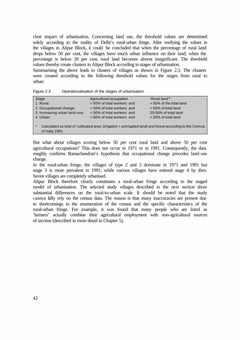
42
clear impact of urbanisation. Concerning land use, the threshold values are determined solely according to the reality of Delhi’s rural-urban fringe. After verifying the values in the villages in Alipur Block, it could be concluded that when the percentage of rural land drops below 50 per cent, the villages have much urban influence on their land; when the percentage is below 20 per cent, rural land becomes almost insignificant. The threshold values thereby create clusters in Alipur Block according to stages of urbanisation. Summarising the above leads to clusters of villages as shown in Figure 2.3. The clusters were created according to the following threshold values for the stages from rural to urban:
Figure 2.3 Operationalisation of the stages of urbanisation
Stage Agricultural occupation ‘Rural land’* 1. Rural: > 50% of total workers and > 50% of the total land 2. Occupational change: < 50% of total workers and > 50% of total land 3. Increasing urban land-use: < 50% of total workers and 20-50% of total land 4. Urban: < 50% of total workers and < 20% of total land * Calculated as total of ‘cultivated area’ (irrigated + unirrigated land) and forest according to the Census
of India 1991
But what about villages scoring below 50 per cent rural land and above 50 per cent agricultural occupations? This does not occur in 1971 or in 1991. Consequently, the data roughly confirms Ramachandran’s hypothesis that occupational change precedes land-use change. In the rural-urban fringe, the villages of type 2 and 3 dominate in 1971 and 1991 but stage 3 is more prevalent in 1991, while various villages have entered stage 4 by then. Seven villages are completely urbanised. Alipur Block therefore clearly constitutes a rural-urban fringe according to the staged model of urbanisation. The selected study villages described in the next section show substantial differences on the rural-to-urban scale. It should be noted that the study cannot fully rely on the census data. The reason is that many inaccuracies are present due to shortcomings in the enumeration of the census and the specific characteristics of the rural-urban fringe. For example, it was found that many people who are listed as ‘farmers’ actually combine their agricultural employment with non-agricultural sources of income (described in more detail in Chapter 5).

43
Figure 2.4 Stages of urbanisation in Alipur Block
2.4a Stages of urbanisation in 1971 2.4b Stages of urbanisation in 1991
2.4c Changes in stage of urbanisation 2.4d Location of the study villages
from 1971 to 1991

44
2.4 The study villages from rural to urban
2.4.1 The village clusters of stages of urbanisation
The variation between the villages in Alipur Block, including those urbanised between 1971 and 1991, is large. For the village-level study, it was necessary to select a few representative settlements. Five main criteria were used. First, the selected villages have to represent the clusters as distinguished above. Second, there is a preference for smaller villages with a large traditional farming population, whereby a change in livelihood could be expected. Third, an attempt was made to select villages with different caste structures. Fourth, different characteristics were sought in terms of location relative to the main roads and types of local land use. Fifth, there were a few practical considerations such as availability of local contacts and access from where the researcher resided. This led to the final selection of villages. Among the study villages, the only one that in 1991 was still in stage 1 is Khushk. But it can be argued that it has already entered stage 2 since. Jagatpur, Sungarpur, and Zindpur clearly entered stage 2 between 1971 and 1991. Zindpur and Ibrahimpur are developing fast. Exploratory visits reveal that they are on the brink of entering stage 3. Nangli Poona is in stage 3, having undergone widespread transformation of occupations and land use between 1971 and 1991. It is presently developing into an urban village. Pehladpur Bangar is a large village and had already been through substantial occupational change before 1971. The village selected to represent stage 4, Samaipur, does not appear in the socio-economic analysis of Chapter 5. Instead, it will appear in Chapter 6 in the discussion about living conditions. The distances to the city (see Tables 2.3 and 2.4) are calculated by taking the shortest route by road. In 1971, the edge of the contiguous urban area was close to the Ring Road; in 1991, it was near the Outer Ring Road, which was constructed in the 1980s. Therefore, the tables give these distances as a measure of access to the city. There are two reasons for the discrepancies between the census data and the figures from the basic household survey as presented in Chapter 5. First, there is a gap of six years. Second, the basic household survey applies different definitions for occupational characteristics (taking the household level instead of the individual level). The village maps illustrate the local setting in terms of land use. Urban expansion has affected all villages except Sungarpur and Khushk. The descriptions of the villages in the next section give more details about the rural-to-urban transformation in terms of the land that is occupied by urban functions. The history of the villages is also described as far as necessary to give a comprehensive overview of the settlement and to interpret the research results.
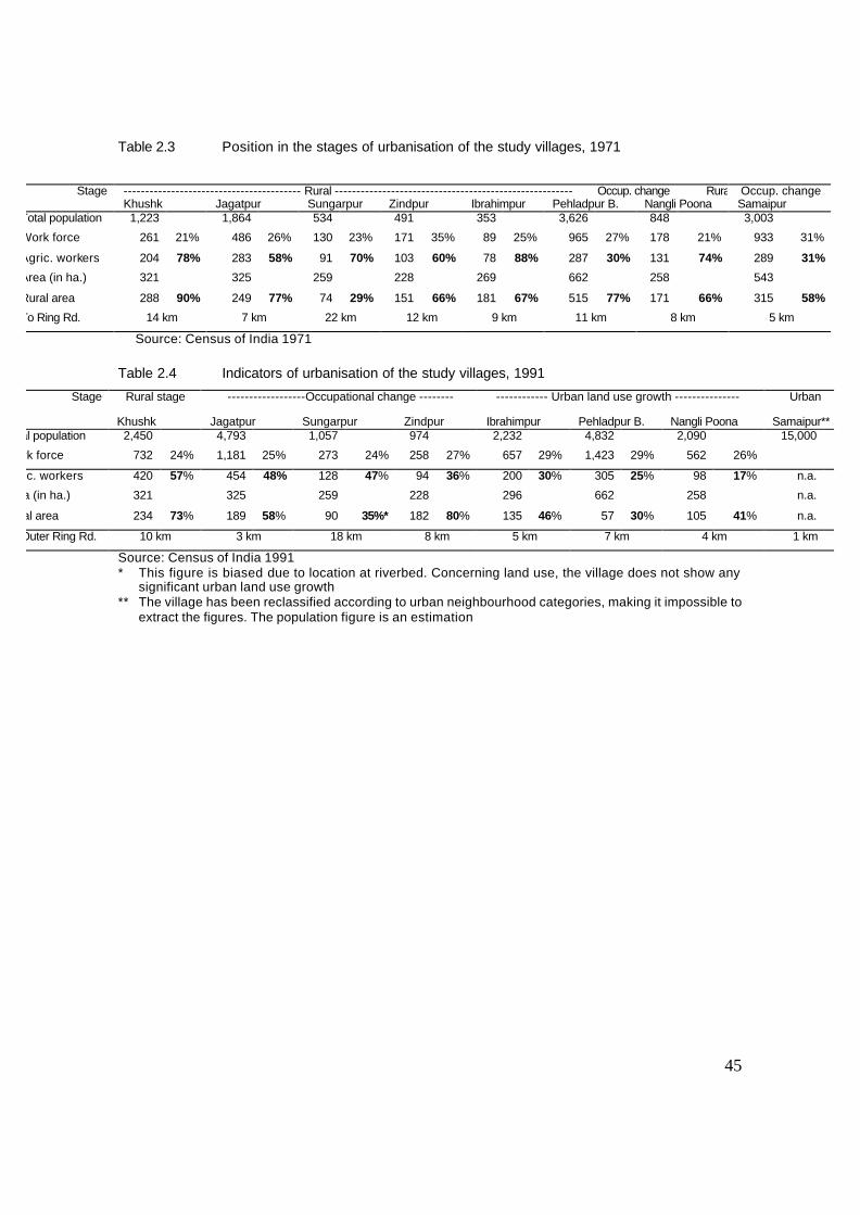
45
Table 2.3 Position in the stages of urbanisation of the study villages, 1971
Stage ----------------------------------------- Rural ------------------------------------------------------- Occup. change Rural Occup. change
Khushk Jagatpur Sungarpur Zindpur Ibrahimpur Pehladpur B. Nangli Poona Samaipur Total population 1,223 1,864 534 491 353 3,626 848 3,003
Work force 261 21% 486 26% 130 23% 171 35% 89 25% 965 27% 178 21% 933 31%
Agric. workers 204 78% 283 58% 91 70% 103 60% 78 88% 287 30% 131 74% 289 31%
Area (in ha.) 321 325 259 228 269 662 258 543
Rural area 288 90% 249 77% 74 29% 151 66% 181 67% 515 77% 171 66% 315 58%
To Ring Rd. 14 km 7 km 22 km 12 km 9 km 11 km 8 km 5 km
Source: Census of India 1971
Table 2.4 Indicators of urbanisation of the study villages, 1991
Stage Rural stage ------------------Occupational change -------- ------------ Urban land use growth --------------- Urban
Khushk Jagatpur Sungarpur Zindpur Ibrahimpur Pehladpur B. Nangli Poona Samaipur** Total population 2,450 4,793 1,057 974 2,232 4,832 2,090 15,000
Work force 732 24% 1,181 25% 273 24% 258 27% 657 29% 1,423 29% 562 26%
Agric. workers 420 57% 454 48% 128 47% 94 36% 200 30% 305 25% 98 17% n.a.
Area (in ha.) 321 325 259 228 296 662 258 n.a.
Rural area 234 73% 189 58% 90 35%* 182 80% 135 46% 57 30% 105 41% n.a.
To Outer Ring Rd. 10 km 3 km 18 km 8 km 5 km 7 km 4 km 1 km
Source: Census of India 1991 * This figure is biased due to location at riverbed. Concerning land use, the village does not show any
significant urban land use growth ** The village has been reclassified according to urban neighbourhood categories, making it impossible to
extract the figures. The population figure is an estimation
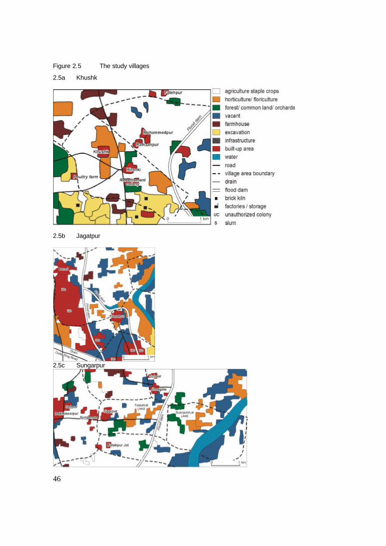
46
Figure 2.5 The study villages
2.5a Khushk
2.5b Jagatpur
2.5c Sungarpur

47
2.5d Zindpur
2.5e Ibrahimpur

48
2.5f Pehladpur Bangar
2.5g Nangli Poona
(For Samaipur, see Figure 6.2 and 6.3)
49
2.4.2 A village still in the rural stage?
Khushk A peculiar event in the history of Khushk is that the village was relocated in 1911 to its present place when the British Raj established New Delhi as the capital of India. Its former location was very near the presidential palace, a place still known as Khushk Road. With the compensation money, the Khushk villagers bought land from Hiranki farmers for settlement and agriculture so they could continue with their original livelihood of growing vegetables. Khushk is mainly (85 per cent) inhabited by households of the Saini caste (a horticultural caste, neither high nor low in status); 15 per cent of the inhabitants are of lower castes. An uncounted number of seasonal migrants live in and around the village. In total, Khushk has approximately 700 inhabitants (the data for Khushk in Tables 2.3 and 2.4 include the village of Hiranki, which is part of the same census area). Hiranki is also an agricultural village; therefore, its inclusion is not expected to distort the relative occupational and land-use figures seriously. The adjacent villages of Zindpur and Mukhmelpur show much more urban influence on their land. The farmers of these villages are selling land to outsiders on a massive scale. The farmers of Khushk wish to resist the temptation. Many households are dependent on cultivating high-value crops for both income and employment. The Sainis take pride in their agricultural lifestyle. They manage to achieve high standards from the cultivation of relatively small plots of land. A typical detail is that no Khushk landowner has ever leased out land for excavation activities of brick kilns. Continuous agriculture is considered too essential for the Khushk farming community. The relatively strong caste homogeneity is probably one of the reasons for the comparatively even distribution of land as well as for the success of horticulture and agriculture. Some farmers who need more land lease fields from landowners in neighbouring villages. Ownership of tractors is widespread; nevertheless, the types of crop require a high labour input. Many farmers have small trucks to transport agricultural products to the Azadpur vegetable market in the city. Another type of agricultural enterprise is the large poultry farm owned by a villager from Khushk. During the rabi (winter) cropping season, the cropping pattern is similar to that of other villages (mostly growing wheat). During the rest of the season, however, the Khushk farmers manage to cultivate at least two more crops of vegetables or flowers. The good quality of soil and the availability of water for irrigation enable the farmers to harvest high yields. The water is slightly saline but good enough for most crops. Groundwater is sufficient, due to the proximity of the Yamuna River. As in some other research villages, the construction of a higher levee around 1980 reduced the risk of flooding considerably, which was favourable for investments in agricultural infrastructure. The increase in the absolute number of persons working in agriculture (see Table 2.3 and 2.4) is indicative of the expansion and intensification of the labour-intensive sectors of horticulture and floriculture. Despite the strong agricultural orientation, commuting for government jobs and other service activities is also very common, particularly among the landless households. The few lower-caste households in Khushk, owning no land, are employed in government services, transportation, industrial work, and trade. Migrants are hired to do most of the agricultural labour. The majority of them are seasonal workers who are not permanently settled in the village. Observation of the villagers’ dwellings

50
and other assets indicates that commercial agriculture and urban service activities have brought considerable wealth to Khushk. Few non-agricultural activities are found in the village: there is one factory of oil lamps and one large repair shop for agricultural equipment. There are four shops in the village, all general stores for daily household needs. With respect to the provision of urban amenities, it seems that the government has forgotten the village. Tap water connections have not yet been installed, while the groundwater is not potable. Consequently, the villagers collect drinking water at neighbouring Hiranki. Bus services are also very infrequent, although the villagers can walk to nearby Hiranki or Zindpur to get the bus to Delhi.
2.4.3 Villages in the stages of occupational change
Jagatpur The village of Jagatpur has a history of frequent flooding. Due to a serious flood, the village had to be relocated to its current place in 1952, explaining the grid pattern of the streets. A levee was constructed in 1978 to protect the settlement from the river. Jagatpur is quite a large village. Its most remarkable feature is the enormous number of cattle. Close to 80 per cent of the population is of the Gujjar caste, originally a cattle-herding community. A little over 12 per cent of the original households belong to lower Hindu castes and 8 per cent are Muslims. Furthermore, there are a few other high-caste households (Brahmins, Banias), barely exceeding 1 per cent. Jagatpur is located very near urban Delhi but lies slightly off the route. Therefore, the village land does not show much urban influence. Originally, the villagers of Jagatpur had little access to agricultural land. They have managed to expand their dairy business, and over the past few decades they have acquired more agricultural land from surrounding villages. Most of that land is located in the floodplain and was therefore relatively cheap. This flood-prone land can hardly be used during monsoon, but in other seasons it provides wheat and fodder for cattle. Other landowners lease out land to villagers from the Muslim community, who cultivate pumpkins and melons in the sandy parts of the dry riverbed. There are no factories in the village and only a few repair shops. Shops selling daily household items are plentiful, as are shops selling building materials. Although dairy farming is still important, jobs in government service and commerce have become common as well. Often both activities are combined in the same household, sometimes being carried out by the same person. The Jagatpur residents are proud of being hard-working people: rearing cattle in their village, bringing milk to the city, and also working in a government job. Migrants are not as numerous as one might expect on the basis of the location of the village. The main reason is that cattle-rearing takes up too much space in the village residential area, so landowners have no desire to rent out property to tenants. A small number of individual migrants reside in the village, doing labour related to the cattle. Many better-off households now seek to acquire plots and build new houses between Wazirabad and Jagatpur. The high demand for residential space may therefore be explained by the strong orientation on dairy farming.

51
Sungarpur The dominant community (65 per cent of the original population) is a type of Rajput caste that has been specialising in cultivation over the last centuries. Traditional labour and artisan castes form the rest of the population. There are only few residing migrants, although many seasonal migrants work on the fields in the planting and harvesting seasons. Sungarpur is a small village with no significant amount of urban expansion on its land. The villagers have not sold any of their land for urban purposes. Most of the land is used for agriculture, specifically for the production of staple crops (wheat, rice, and fodder). Horticulture and floriculture are increasingly common, though not to the extent found in some other highly specialised villages such as Khushk. Before 1976, Sungarpur was located very close to where the river now runs. In 1976, the Yamuna River flooded the original settlement. The village was then moved to its current site to the west of the village of Tiggipur. The agricultural land owned by Sungarpur farmers still remains beyond Tiggipur, close to the Yamuna; the farmers even own some land on the other side of the river. At least half of the land is located in the floodplain and therefore only cultivable in rabi. Part of that land cannot be cultivated at all. Since the construction of the levee, the area on the safe side of the dam (about one-third of the total village land) is very intensively cultivated, much of it with vegetables. The rest of the land is only marginally cultivated or left unused. Consequently, the census figures show a low percentage of land covered by agriculture and forest, although this is not due to urban expansion. According to the figures on Sungarpur’s occupational characteristics, agriculture has increased considerably in absolute numbers but has decreased in relative terms (see Table 2.3 and 2.4). It is a small village and has no industry. There are a few very small shops selling groceries to the villagers. Local non-agricultural employment is almost absent except for a few shops. Many Sungarpuris have jobs in nearby Bakhtawarpur village (e.g. shop-keeping and construction) or in Delhi. Employment in the government is also common. Zindpur The dominant original community, constituting about 60 per cent of the original population of Zindpur, consists of the Jats. They are a cultivating community commonly found in the wider region. People of lower castes (38 per cent) are relatively numerous as well, while only one household belongs to a non-Jat high caste. Furthermore, a large number of migrants have settled in and around Zindpur. Zindpur is a small village with a mainstream cultivation pattern. Traditionally, its farmers cultivated staple crops (wheat, fodder, and more recently rice). About 40 per cent of the village land has already been sold by the farmers and is used for urban purposes. As an occupation, agriculture is rapidly losing importance here: no more than half of Zindpur’s land remains under cultivation, and part of that is leased to Khushk villagers. During the last 20 years, landowning households have frequently leased out land to brick-kiln operations. Over the last five years, all brick kilns have disappeared from Zindpur’s agricultural land. Loam excavations for brick kilns have seriously affected the elevation of many fields. Nevertheless, especially in the western part of the village, the land has
52
become very valuable; it is in high demand for industrial sites and storehouses. Elsewhere in the village, land is in demand for farmhouses. Changes in this village occur very rapidly; the census figures of 1991 are already outdated. Only a few households still consider agriculture as their most important source of income. The dynamic situation of Zindpur’s agricultural land reflects the diverse orientation of the villagers. Agricultural employment has decreased in absolute terms and has dropped sharply in relative terms. An even larger part of the population than in other villages is in government service, mostly in urban Delhi. Relatively much agricultural land is left unused, as the villagers have much more lucrative options for their livelihood. Many economic activities are present on Zindpur land. There are 20 storage houses, eight industries (e.g. plywood and metal scrap), 15 shops of various kinds, five tea stalls, and seven repair shops. Three farmhouses are under construction. All communities are now represented in government service, but local services, such as tailor shops, tea stalls and retail also offer non-agricultural opportunities.
2.4.4 Villages in the stage of increasing urban land use
Ibrahimpur In this village, there are two dominant castes. The larger of the two is the Tyagis (35 per cent), which is a cultivating caste originating from the Brahmins. The other dominant caste is the Brahmins (30 per cent), who are also cultivators and own considerable acreages. Other castes include a range of lower artisan, service, and labour castes; all of them fall into the category of Scheduled Castes (SC) and Other Backward Castes (OBC). There are few migrants residing in the village, but a large number live in adjacent colonies. It is hard to estimate how many live there, but there are certainly thousands. Agriculturally, the cropping pattern resembles that found in Zindpur and Nangli Poona (described below). Like Sungarpur, some of the land in Ibrahimpur is situated near the riverbed and cannot be cultivated during kharif (the summer growing season). Unlike other villages, Ibrahimpur has relatively many orchards and nurseries owned by the villagers themselves and people from nearby Burari. Migrant workers do the daily labour at orchards. Despite the growth of urban land use in the village, the census data report a higher number of people working in agriculture. This may be an exaggeration, reflecting unemployment among the original farming families. Many people also work in the city in government jobs and private trade or construction activity. Ibrahimpur has sold a little over half of its land to outsiders, although some of that land is still cultivated. Much of the land has become residential in the form of unauthorised colonies. Farmhouses, factories, and storehouses have also been built on Ibrahimpur’s land. However, the rate of development is slower than in Zindpur. Much of its agricultural land, especially that lying close to the river, is not in high demand for urban use. There are four factories in and adjacent to Ibrahimpur (a soap factory, a chewing tobacco processor, a small scrap-iron recycling plant, and a cardboard box manufacturer) and eight factories of varying types on its former agricultural land. A few storehouses, five farmhouses, and a large temple under construction are situated along the road to Hiranki.

53
Pehladpur Bangar The original population consists of Jats (30 per cent), Brahmins (30 per cent), both of which are dominant castes, and 40 per cent of labour and artisan castes. The migrant population, which currently outnumbers the original population, lives mainly in rented accommodation in the village, on the premises of factories, and in unauthorised colonies. Migrants arrived in Pehladpur Bangar at an earlier stage than they did in other villages, since there have been factories in the village since the late 1960s. Pehladpur Bangar lies along the busy Auchandi Road, which divides the settlement and its agricultural land into two parts. A little more than half of all agricultural land has already been sold to outsiders. On the north side, all land, except for the immediate roadside, is still used for agriculture. The harvests are good, and the cropping pattern is similar to that in Zindpur and Nangli Poona: wheat in the winter, fodder and paddy in the summer, and some leased-out land used for horticulture. The groundwater is of much poorer quality than in the other villages, but the nearby canal (Western Yamuna Distributary) supplies plenty of good irrigation water for the northern side of the village. At the southern side of the village, agriculture has virtually disappeared to make way for unauthorised colonies. The degree of residential use is still low. Most of the land is vacant and has been plotted for future construction, in anticipation of higher land prices. There is a ban on transactions or conversion of agricultural land in Pehladpur. According to the land-use plans, this ban is also valid in the other villages. However, it is more effectively enforced in Pehladpur because it is part of the area where Rohini Phase II is to be built in the near future. The ban makes it difficult for people to colonise agricultural land and convert it into residential areas. In the already colonised areas, however, illegal land transactions are still going on. It is not yet certain exactly when the DDA will acquire the remaining agricultural land from the villagers, but the announcement has been published in a local newspaper (Navbharat Times 14-9-1997). These southern fields were never very fertile, and the groundwater was too saline. The Pehladpur farmers sold that land at the first possible opportunity. The occupational transformation the villagers started relatively early. Many are shopkeepers, many are civil servants, and the transport sector is big. A very large source of income is rent, which people derive from renting out factory compounds and housing for migrants, or from leasing out agricultural fields. Nangli Poona The dominant landowning community of Nangli Poona consists of the Jats. Originally, the Jat population constituted a majority, but now the number of migrants is just about equal to that of the original population. Non-dominant original communities include 40 per cent local low castes and 5 per cent non-dominant high castes (Brahmins and Banias). Among the migrants, most are from distant poor rural areas. Some of them who have lived in Delhi for a number of years bought a plot in Nangli Poona after saving some money. Most of them are poor, though a few could be considered lower-middle class. The owners of the local factories do not live in the village. Urbanisation has a long history in Nangli Poona. The broadcasting station, a large area with transmission masts, dates from 1936. At that time, the government acquired about 20 per cent of the agricultural land of the village. Another important historical event is the land reform act of 1952, which gave the lower caste households legal access to the
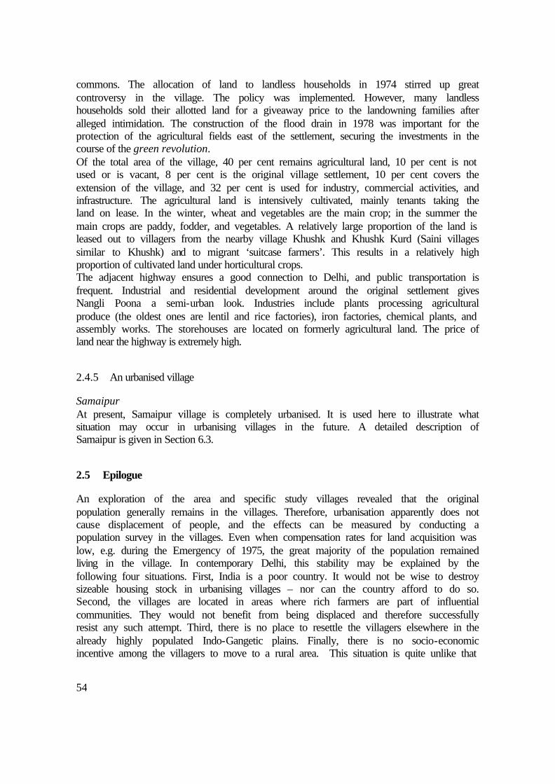
54
commons. The allocation of land to landless households in 1974 stirred up great controversy in the village. The policy was implemented. However, many landless households sold their allotted land for a giveaway price to the landowning families after alleged intimidation. The construction of the flood drain in 1978 was important for the protection of the agricultural fields east of the settlement, securing the investments in the course of the green revolution. Of the total area of the village, 40 per cent remains agricultural land, 10 per cent is not used or is vacant, 8 per cent is the original village settlement, 10 per cent covers the extension of the village, and 32 per cent is used for industry, commercial activities, and infrastructure. The agricultural land is intensively cultivated, mainly tenants taking the land on lease. In the winter, wheat and vegetables are the main crop; in the summer the main crops are paddy, fodder, and vegetables. A relatively large proportion of the land is leased out to villagers from the nearby village Khushk and Khushk Kurd (Saini villages similar to Khushk) and to migrant ‘suitcase farmers’. This results in a relatively high proportion of cultivated land under horticultural crops. The adjacent highway ensures a good connection to Delhi, and public transportation is frequent. Industrial and residential development around the original settlement gives Nangli Poona a semi-urban look. Industries include plants processing agricultural produce (the oldest ones are lentil and rice factories), iron factories, chemical plants, and assembly works. The storehouses are located on formerly agricultural land. The price of land near the highway is extremely high.
2.4.5 An urbanised village
Samaipur At present, Samaipur village is completely urbanised. It is used here to illustrate what situation may occur in urbanising villages in the future. A detailed description of Samaipur is given in Section 6.3.
2.5 Epilogue
An exploration of the area and specific study villages revealed that the original population generally remains in the villages. Therefore, urbanisation apparently does not cause displacement of people, and the effects can be measured by conducting a population survey in the villages. Even when compensation rates for land acquisition was low, e.g. during the Emergency of 1975, the great majority of the population remained living in the village. In contemporary Delhi, this stability may be explained by the following four situations. First, India is a poor country. It would not be wise to destroy sizeable housing stock in urbanising villages – nor can the country afford to do so. Second, the villages are located in areas where rich farmers are part of influential communities. They would not benefit from being displaced and therefore successfully resist any such attempt. Third, there is no place to resettle the villagers elsewhere in the already highly populated Indo-Gangetic plains. Finally, there is no socio-economic incentive among the villagers to move to a rural area. This situation is quite unlike that

55
which Hardoy et al. 1992 observe for Jakarta, where villagers are displaced on a large scale as a consequence of urbanisation. This exploration corrobonates Ramachandran’s (1989) assertion that commuting is crucial to the livelihood of the villagers. However, a staged model of the villages undergoing urbanisation tends to underestimate the unique features of individual villages. This is true for Jagatpur, which is very close to the city limits but nevertheless continues to focus on agricultural income. Some villages can enter the urban stage directly, skipping stages, when the government suddenly acquires all the land. This is not the case in the study villages, however. As the data and the descriptions of the villages show, the rural-urban fringe is heterogeneous. Although the census records on occupation are not particularly reliable, their biases are fairly consistent. Villages were selected to represent of common characteristics as well as a variety of profiles of the villages in the rural-urban fringe, as defined above. The desakota area (McGee 1991) comprises a larger metropolitan region, which is not covered in this study. The next chapter is concerned with land use. It describes the land-use pattern observed in Alipur Block. The input from remote sensing, as explained in the next chapter, was vital for generating the village maps shown in Figure 2.5. The contextual information presented in this chapter also provides crucial background material for the analysis of the livelihood pattern in Chapter 5. That analysis refers to historical, communal, and other site- and situation-specific circumstances described in this chapter.


57
3 LAND-USE DYNAMICS
3.1 Land uses observed in the rural-urban fringe
Rural-urban fringes are characterised by a wide variety of land uses (Ramachandran 1989, Yadav 1987, and Thakur 1991). Ramachandran’s chapter about the rural-urban fringe is most specific about developments around Indian cities, particularly Delhi: “the city has penetrated, in some cases deeply, into rural areas to a distance of 10 to 15 kilometres. As one moves out of a major city along one of the arterial roads, one observes new residential colonies, a considerable amount of vacant land, partially developed residential plots, a few factories, commercial squatters on either side of the road, and further away from the city, storehouses, cold storage plants, timber yards and brick kilns” (1989, pp. 293-294). Ramachandran also notices large areas used as sites for quarries, claypits, sand and gravel pits, sewerage disposal tanks, and garbage dumps (p. 317). Yadav (1987) draws particular attention to the mix of intensively cultivated land in combination with unused (speculative) land and the progressively built-up land. Thakur (1991) furthermore finds infrastructural use typical for a rural-urban fringe, noting a number of agricultural responses to increasing urban pressures on land. The land-use typology described in next section has much the same features as mentioned in the literature cited above. In order to make a limited and consistent land-use classification, some categories are combined. Others are determined by the specific requirements of this study. A land-use map that shows the influence of urbanisation on the land of individual villages is essential to visualise the influence of urbanisation on the land. Moreover, such a map is also essential for the ‘site’ where socio-economic changes occur (see Chapter 2 and 5).
3.2 The heterogeneity in types of land use: a mix of urban and rural features
The land-use types are categorised according to their position along the spectrum from rural to urban. Naturally, the classification involved some arbitrary choices, as rural and urban characteristics interfere with one another. In this classification, functional aspects are more important than morphological ones. For example, a village settlement is classified as urban land in terms of land use. But because rural people live there, there is a rural dimension to it as well. Apart from the socio-economic features of land use related with urbanisation, Some of the physical characteristics are also mentioned, which is particularly important for the interpretation of the remote sensing map. Typically rural land uses include agriculture for staple crops, forests, and common lands. These uses correspond to the traditional land-use pattern as a part of the agricultural livelihood of the village population. More commercially grown crops (horticulture and flowers) have a more direct link with the urban market. Of the combined class of ‘forested land’, some types have urban links. The other types of land use have more obviously urban dimensions. One of these, namely vacant land is an intermediary land use. Another type, built-up land, lies at the urban end of a rural-to-urban continuum.
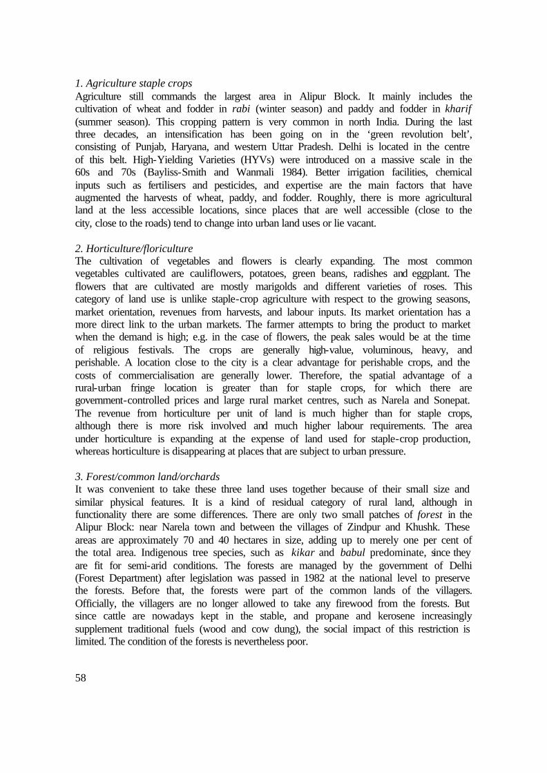
58
1. Agriculture staple crops Agriculture still commands the largest area in Alipur Block. It mainly includes the cultivation of wheat and fodder in rabi (winter season) and paddy and fodder in kharif (summer season). This cropping pattern is very common in north India. During the last three decades, an intensification has been going on in the ‘green revolution belt’, consisting of Punjab, Haryana, and western Uttar Pradesh. Delhi is located in the centre of this belt. High-Yielding Varieties (HYVs) were introduced on a massive scale in the 60s and 70s (Bayliss-Smith and Wanmali 1984). Better irrigation facilities, chemical inputs such as fertilisers and pesticides, and expertise are the main factors that have augmented the harvests of wheat, paddy, and fodder. Roughly, there is more agricultural land at the less accessible locations, since places that are well accessible (close to the city, close to the roads) tend to change into urban land uses or lie vacant. 2. Horticulture/floriculture The cultivation of vegetables and flowers is clearly expanding. The most common vegetables cultivated are cauliflowers, potatoes, green beans, radishes and eggplant. The flowers that are cultivated are mostly marigolds and different varieties of roses. This category of land use is unlike staple-crop agriculture with respect to the growing seasons, market orientation, revenues from harvests, and labour inputs. Its market orientation has a more direct link to the urban markets. The farmer attempts to bring the product to market when the demand is high; e.g. in the case of flowers, the peak sales would be at the time of religious festivals. The crops are generally high-value, voluminous, heavy, and perishable. A location close to the city is a clear advantage for perishable crops, and the costs of commercialisation are generally lower. Therefore, the spatial advantage of a rural-urban fringe location is greater than for staple crops, for which there are government-controlled prices and large rural market centres, such as Narela and Sonepat. The revenue from horticulture per unit of land is much higher than for staple crops, although there is more risk involved and much higher labour requirements. The area under horticulture is expanding at the expense of land used for staple-crop production, whereas horticulture is disappearing at places that are subject to urban pressure. 3. Forest/common land/orchards It was convenient to take these three land uses together because of their small size and similar physical features. It is a kind of residual category of rural land, although in functionality there are some differences. There are only two small patches of forest in the Alipur Block: near Narela town and between the villages of Zindpur and Khushk. These areas are approximately 70 and 40 hectares in size, adding up to merely one per cent of the total area. Indigenous tree species, such as kikar and babul predominate, since they are fit for semi-arid conditions. The forests are managed by the government of Delhi (Forest Department) after legislation was passed in 1982 at the national level to preserve the forests. Before that, the forests were part of the common lands of the villagers. Officially, the villagers are no longer allowed to take any firewood from the forests. But since cattle are nowadays kept in the stable, and propane and kerosene increasingly supplement traditional fuels (wood and cow dung), the social impact of this restriction is limited. The condition of the forests is nevertheless poor.

59
Common land is usually covered with trees and bushes. The village pond can also be considered part of the common land. The common lands are traditionally owned and administered by the village community, represented by the Panchayat, for collective needs including cattle grazing and bathing, firewood collection, and space for drying cow dung cakes. Common lands have decreased for the same reasons as mentioned for the forests. They are scattered throughout the area, usually adjacent to or very near the village settlements. Some villages do not have any common land, or do not have any left. Some village residential areas have expanded at the cost of the common land. On paper, the Delhi government administers the common lands. As a consequence, they are often used for locating government facilities such as schools and clinics. Orchards, which in some cases can be more accurately described as plantations, are forested lands kept for a wide variety of purposes. The production of fruits and wood is one, often combined with small patches of tree and plant nurseries. Orchards are part of the traditional land-use pattern. Increasingly, ‘outsiders’ keep orchards on a commercial basis, making use of the proximity of the city for easy marketing. Most of the plantations that are planted with poplar and eucalyptus trees are kept for speculative purposes. The revenue from the wood products is quite low, but the land continuously increases in value, while the tax-exempt status is maintained by preserving the agricultural designation of the land. 4. Vacant land Vacant land is all unused land with no clear designation, though often it is in the middle of a process of conversion. This land may be covered with bushes and grass, but it might also be completely barren. Many plots of vacant land are kept for speculative purposes and are therefore left vacant for extensive periods. Rising land prices induce some of the landowners to discontinue agriculture, construct a boundary wall, and leave the plot temporarily unused. The owners include wealthy city dwellers as well as local landowners who have abandoned farming. Some village households keep empty plots for possible future construction. The agricultural designation can be maintained in connivance with the Patwari (local land registrar) who can be induced to record false information on land use. Vacant land frequently emerges out of former excavation sites and brickfields when the owner is either unable or unwilling to reclaim the land for agriculture. In particular, it may be found near roads and adjacent to villages, where the land values are rising steeply. But vacant land is also found along the riverbanks, due to the seasonal risk of flooding. 5. Farmhouse Farmhouses are large country estates, the owners of which have little or no intention of using the land for agriculture. They range from small houses with a few trees to luxurious mansions surrounded by a garden. The name farmhouse is deliberately retained to suggest agricultural land use, because the owner intends to maintain it as untaxed agricultural property. A farmhouse is usually constructed by a wealthy urban industrialist, trader, politician, or professional based in Delhi. The legalities involved are also relatively simple if certain legal requirements are met. Most of the farmhouses occupy at least two acres, which is the minimum acreage according to the land-use regulations (Hindustan Times 8-3-1997). In the research area, the farmhouses are built for four main

60
reasons. First, it is a profitable way to invest undeclared income. The location of the land at the city’s fringe practically ensures that the value of land will rise sharply, making the investment lucrative. Second, a farmhouse can be used to launder black money by claiming non-existent agricultural revenues. Third, it serves as a place to hold celebrations and parties, adding to the status of members of the urban elite. Finally, some farmhouses accommodate businesses, such as light manufacturing, garment sweatshops, and illegal shops to market a large variety of products (also observed by Soni 1998). The government is presently considering easing regulations concerning farmhouses (Hindustan Times 23-1-1996). Some authors, mostly in the area of journalism, report environmental problems relating to these estates. Often, the owners extract large amounts of groundwater from the soil (Soni 1998). They are also said to be straining municipal amenities without paying the charges (the Hindu 23-10-1997). Farmhouses may be found at many places in Alipur Block, although they are concentrated along particular roads. There are many on the Alipur-Narela road, quite a few in the Hamidpur-Bakhtawarpur area, seven on the land of the villages Mukhmelpur and Zindpur, and three or four in the Burari-Ibrahimpur area. 6. Brick kiln Brick kilns are a typical feature of rural-urban fringes. Large numbers of kilns are found in the rural areas near Delhi. Approximately 70 were counted in Alipur Block during the survey. Even though they take up little space, brick kilns form a separate land use because they are dependent on adjacent agricultural land for loam. Figure 3.1 expands on the issues relating to brick kilns. In Alipur Block, there are six brick kilns near Mukhmelpur, three on the land of Hamidpur, more than 20 between Ghoga, Narela, and Lampur, and more than 30 in the area around Pooth Kurd. Most soils in Alipur Block are suitable for making bricks, except for soils close to the river, where it is too sandy. The first requirement is the availability of the right kind of loam, which is raw material for bricks. The clustering of the production makes it easy for contractors to compare the quality and the prices of bricks. At the same time, the brick kilns depend on relatively inexpensive agricultural land. As a result, there are none very close to the city or adjacent to the major transport routes. In 1997, by order of the Supreme Court, all kilns within the NCT boundary were forced to close down for being polluting industries. 7. Excavation Loam excavation fields for the brick kilns interact with agricultural land in a rather complex way (see Figure 3.1). They are invariably located within half a kilometre of the kilns, since the heavy sun-dried bricks are transported by hand and with donkey carts. A type of excavation that takes less space is sand mining. These sites are mostly exploited to supply the sand needed for construction in urban areas. Most sites for sand excavation are in the riverbed, where there is little competition with agriculture. However, at some places, sand is also dug in agricultural land at former brickfields, where sand emerges at the surface after the top layer of loam is taken off. These places are left unused afterwards because the depth (up to 12 metres) causes seasonal waterlogging. At less deep former excavation sites, the farmers only manage to cultivate a winter crop.

61
Figure 3.1 Brick kilns: the interaction between farmers and agricultural land
Brick kilns are never permanent, since they depend on the availability of loam. It is expensive to bring in this from a distant source. So when fields with loam are no longer available, the kiln owner will close down the operation and move it to shift to another location.1 The brick kiln itself occupies less than half a hectare. But the extra space needed to pile up bricks, for a tubewell, for the labour quarters and for other purposes adds one hectare. For loam digging, about five hectares is leased in, of which 1.5 hectares per year is used to a depth 1.5 metres. Consequently, every four years the kiln operator needs to lease fresh land. In most lease contracts, the brick kiln owner has to ensure that the land is made level again when the lease period comes to an end. It requires considerable effort for the farmer to restore the land to its previous agricultural productivity. There is not much choice for the landowner, usually a farmer: he can choose to lease out or to not lease out land to an operator of a brick kiln. This decision will depend on the local situation. If adjacent land is being excavated, one farmer’s land will become elevated above its surroundings. Consequently, the connection with irrigation facilities may also become more difficult. The land will starts eroding, and fertilisers will be washed out into the lower fields. Therefore, the farmer has no realistic option not to lease out his land. He may just have to go along with the domino effect (Bentinck 1995). Large stretches of land in Alipur Block have become depressed due to loam excavation. A newspaper article reported at least one example of excavation leading to seasonal waterlogging in colonies built on excavated land (Indian Express 4-2-1995). Nevertheless, more than half of the old brick kiln sites are eventually taken back into cultivation, although this may take some time. Other abandoned kiln sites remain vacant or are sold to outsiders. Eventually, they may become a site for a farmhouse, factory, or other urban function. A few kilns still remain as ‘ruins’. Locations of brick kilns in Alipur Block
1 The issue of the brick kilns is visually illustrated on the enclosed CD-ROM.

62
8. Infrastructure This is a combined type of land use with a public function. Infrastructure is usually owned and built by government agencies. It includes roads, canals, levees, garbage dumps, sewage treatment sites, broadcasting stations, and parks. In a rural-urban fringe environment, this type of land use takes up a significant amount of space, due to the high density required of infrastructure. It includes the following subtypes: Roads are constructed, widened, and improved all over Alipur Block. The land for road building is usually acquired from local landowners. There is one major railway line crossing Alipur Block from north to south. Canals and drains are found throughout the area. In more remote rural areas, such waterworks are built almost exclusively for agricultural purposes (irrigation canals and drainage). In Alipur Block, however, there are various other functions associated with drainage and the supply of water to the city. Dams are constructed on the Yamuna side; there is also one crossing the flood-prone area from east to west. After the 1976 floods, the levees were widened and raised, mainly to protect the city from floodwaters from the Yamuna during the monsoon. Garbage dumps (or ‘sanitary landfills’) are located right at the urban fringe. There are two large garbage dumps in Alipur Block: one near Bhalswa and another adjacent to Badli. Water treatment plants are also located directly at the urban fringe. Smaller wells (so-called ‘Ranney’ wells) are located at the Yamuna flood levee. Broadcasting stations occupy considerable space near Khampur (70 hectares) and near Nangli Poona (80 hectares). Other infrastructural land uses include smaller areas occupied by electricity relay stations and telephone exchanges, but those do not occupy much land and coincide with the built-up area. 9. Built-up area This heterogeneous type of land use on the urban side of the spectrum can be broken down into the following subtypes: Villages are physically expanding into the surrounding fields as a consequence of increased wealth and a growing population. Villagers usually build larger residences at the edge of the village. New residential areas (‘colonies’) are mainly owned and developed by outsiders, although sometimes the villagers themselves have a stake in the development as well. Basically, there are two types of settlements: unauthorised and planned (see Chapter 4). Formal planned development takes place in the south-west of Alipur Block (Rohini) and in the northern part around the town of Narela. Unauthorised colonies are expanding at many more places, of which development ‘hotspots’ are found near Burari and Pehladpur Bangar. Factories can be found at many places. The larger industries are located along the GT Road, the Alipur-Bakhtawarpur Road, and the Auchandi Road, and near Narela. There are vegetable oil refineries, rice processing and export industries, other food processing plants, cement factories, saw mills, and industries of many other kinds. Small businesses usually predominate in and near the settlements, as they need less space and cam establish premises within the existing residential areas. Many factories are located in and around the ‘villages’ of Samaipur (described at length in Chapter 6), Badli, Libaspur, Siraspur, and Shahabad-Daulatpur. Similar to the case of industry, storehouses are located adjacent to paved roads and usually require a considerable amount of space. This function depends on low-cost but well-accessible locations. Other land uses with structures on it include commercial, recreational, and

63
religious activities. Hotels, shops, and repair shops fall under this residual category. Shops and temples are mostly interspersed with dwellings in residential areas. Schools and hospitals are an important category of built-up land and are usually mixed with residential land. Water bodies are not listed in the classification of land use, because they are either too small or form part of other land uses. Larger water bodies are only found as part of the Yamuna River and Bhalswa Lake.
3.3 Using remote sensing to map land use
3.3.1 Advantages of remote sensing and reasons for its application
The available maps do not satisfy the mapping needs of this research. The topo sheet maps of the Survey of India are outdated and do not distinguish the above types of land use. The precision of these maps is not satisfactory either. Due to the diversity and heterogeneity of the landscape of a rural-urban fringe, it is difficult to rely on secondary sources. Preparing maps on the basis of one’s own land-use survey is both difficult and time-consuming without ‘remotely sensed information’ (aerial photographs and satellite images). Since the land is flat, it is otherwise hard to get a good overview of the land. The interpretation of satellite images has partially solved this problem. On that basis, it was possible to generate village maps (Figure 2.5) that show the ‘site’ of each village. Furthermore, the remote sensing (RS) classification shows how the physical land-use features are related with the above land-use types. That exercise thus provides grounds for environmental impact of land-use change, such as land degradation. This section compares the results of the RS classification with the land-use types. The RS analysis as such is not treated in this text but is presented in Appendix A and on the CD-ROM (also in Bentinck et al. 1999, and de Vries et al. 1999). Nonetheless, some basic characteristics and limitations of using RS should be explained here. Two images are used: one from May 1995 and one from March 1996. The images date from before and after the harvest, which takes place in April each year. The ground-truth verification dates from 1996 and 1997. In some cases, this is later than the RS images, but the amount of deviation is small. A Global Positioning System (GPS) was used to carry out gound-truth verification and to gather information to interpret the image. The GPS indicates the approximate location of each type of land use in a part of the total image (see rectangle in Figure 3.2). Furthermore, RS does not classify objects in the field if they are smaller than a certain size, in this case approximately 20 by 20 metres (the resolution of the images is 25 by 25 metres per pixel). Obviously, the satellite’s sensor cannot detect socio-economic features such as ownership and function of land. Its power lies in its capacity to distinguish physical features, and to store the information in digital files. Basically, RS registers differences in densities of vegetation, the type of vegetation, the type and structure of the soil, and the humidity of the ground surface. RS is an appropriate technique when the requirements are consistent with these physical characteristics. Land-use mapping with the help of RS is only

64
partially successful because the socio-economic aspects of land use do not necessarily correspond to the physical characteristics of the land. Table 3.1 shows that there is a significant degree of overlap in the physical characteristics of the land-use types, while other types of land uses are characterised by a mix of various physical characteristics. Figure 3.2 shows the results of the RS analysis for the whole of Alipur Block. The interpreted sub-area in Figure 3.3 clarifies how the types of land use relate to the RS classes.
3.3.2 The generated remote sensing classification compared with the types of land use
The RS classes that seemed to be closest to the land-use types in Section 3.2 are briefly described below. The classification is based on the physical characteristics, the percentage of the total area in Alipur Block that is covered, and the dates of RS images used. Ground-truth verification reveals where each RS class can be found and shows up the inaccuracies of the classification. It also illustrates the complexities of generating a consistent RS interpretation on land use in a rural-urban fringe area like Alipur Block. A. Staple-crop agriculture (45 per cent) Using images from the pre- and post-harvest dates resulted in a quite accurate classification of agricultural land while under the winter (rabi) crop, which is mainly wheat. This includes only a small part of horticulture and floriculture, since these crops often have different growing and harvesting seasons. The analysis is based on a seasonal difference in vegetation with a gap of nine months. Therefore, it may also include small areas of land where other vegetation has grown during the past year, although this deviation is very small. B: Flower cultivation (2 per cent) RS was not capable of classifying all horticultural land and flowers. It did provide an indication of where a flower crop was growing at the time of the image used (March 1996). The variety of vegetation types is large and the harvesting seasons are irregular. Nevertheless, the small patches of class B in Figure 3.2 indicate where horticulture and floriculture is common. C: Woodland (11 per cent) Woodland includes areas with a high density of vegetation that does not share much seasonal variation (trees, sometimes mixed with shrubbery). The date of observation for this RS image is May 1995. The area falling into this class largely corresponds to land-use type 3. But woodland is also visible at infrastructural sites where high-density vegetation dominates; for instance, woodland is found around the radio broadcasting stations and along levees, drainage channels and roads. Infrastructure is often mixed with class D because the density of vegetation varies. This is also true for common lands and, to a lesser extent, vacant land. In many areas, the data show orchards and plantations. Since class C encompasses quite a variety of land uses, it is spread quite evenly over the whole area, though concentrations occur where there is forest and infrastructure.

65
D: Other vegetation (18 per cent) This class includes the land that had a medium coverage of vegetation in March 1996, but excludes areas in class A, such as grass and light shrubs. Class D appears in many types of land use, or vacant land, at farmhouses (the garden), and on horticultural land. Also, class D is relatively common along transport routes where much vacant land is present. E: Built-up and barren (25 per cent) This includes land that is dry, which means that it has little or no vegetation and a small amount of surface moisture. In practice this class comprises both built-up and barren land. It is not possible to differentiate these land covers because the satellite’s sensor cannot register sufficient difference in reflection between built-up and barren land. Class E refers to all built-up land (except the larger patches of greenery within settlements), part of the vacant land, and the excavation sites that were in use at the time of the observation (March 1996). Class E also includes a small area of barren cultivated land that is not cropped at the time, most of which lies in the riverbed. Farmhouses also show small patches of class E, but only when the houses are large or where another kind of paved surface is present. Since most of class E shows urban land use, it indicates a high degree of urbanisation of land. F: Brick kiln (less than 1 per cent) All brick kilns show up on the RS map with a surprising accuracy. Only two other objects (two storage facilities) mistakenly appear as class F. This class is very small in terms of occupied land. However, keeping its impact on change on agricultural land in mind, brick kilns comprise a very important aspect of land use (see Figure 3.1). G: Wetland (1 per cent) This small class refers to shallow water with or without vegetation growing in it. Class G is associated with excavation sites at places where land has become waterlogged. Smaller water bodies, such as village ponds and drains, are not visible because they are overgrown by vegetation or are too small. There is not much surface area covered by wetlands. Class G can be found at the former excavation sites of Mukhmelpur, Ibrahimpur, and at the outer border of Rohini. Another concentration can be found at the edges of Bhalswa Lake, where the water is shallow. H: Water (2 per cent) Class H includes water bodies of approximately one metre or more in depth. In Alipur Block, water is limited to the Yamuna River and part of Bhalswa Lake. Other deep waters, such as canals, are not wide enough to show up consistently as class H. Actually, they are more frequently represented by classes B and C.

66
Table 3.1 Comparison of the observed types of land use and the RS classification
Remote sensing classification On the basis of vegetation On the basis of soil and water Types of land use A A
gric
ultu
re
B
Flo
wer
s
C
Woo
dlan
d
D
Oth
er
vege
tatio
n
E
Bui
lt-up
/ ba
rren
F Bric
k ki
ln
G
Wet
land
H
Wat
er
1. Agriculture staple crops X
2. Horticulture X X 3. Forest/ commons/orchard X X 4. Vacant X X X X 5. Farmhouse X X X 6. Brick kiln X 7. Excavation X X 8. Infrastructure X X X 9. Built-up area X
Description of the physical features on which the RS classes are based:
A: a difference in vegetation: a high level of vegetation in March 1996 and no (or little) vegetation in May 1995 (harvesting takes place mid-April)
B: a specific type of vegetation that radiates a different reflection in March 1996 C: the highest degree of vegetation in May 1995 D: the remaining vegetation after classifying A, B, and C E: dry land with little or no vegetation in March 1996 F: a specific reflection caused by dust of ‘baked’ loam G: a high level of humidity, or high humidity combined with vegetation H: the highest level of humidity Some conclusions may be drawn regarding the usefulness of the RS analysis in this study. For one thing, it is clear that the application of RS analysis is difficult for the type of landscape concerned here. The heterogeneity, the rapid pace of change, and the wide variety of land uses make it impossible to generate a map directly from the RS observations. Along with the maps, the table helps to clarify the problems encountered because of overlap and imprecision of the RS classification with respect to the observed land uses. In short, the classification was successful in distinguishing some features (agriculture for staple crops, brick kilns). Areas under horticulture and floriculture were more difficult to extract due to the irregular harvesting patterns. Built-up land is hard to distinguish from barren land. Vacant land and farmhouses are also difficult categories to distinguish with RS only. Nevertheless, when RS images are supplemented with thorough ground information and an understanding of the RS classes, satellite image interpretation is useful as a method of land-use mapping, as demonstrated in Figure 3.3. The village maps in Chapter 2 (Figure 2.5) were drawn with the help of the RS analysis described above.

67
Figure 3.2 The result of the remote sensing classification of Alipur Block
Figure 3.3 RS map of the study area with overlay of land-use types

68
Figure 3.4 Most occurring land use changes in Alipur Block
Change from (in estimated hierarchy of importance)
Current land use Change to (in estimated hierarchy of importance)
4. Vacant 7. Excavation 6. Brick kiln 1. Agriculture staple crops 4. Vacant 7. Excavation 6. Brick kiln 1. Agriculture staple crops 7. Excavation 3. Forest/commons/orchard 2. Horticulture/floriculture 6. Brick kiln 1. Agriculture staple crops 2. Horticulture/floriculture 4. Vacant 3. Forest/commons/orchard 1. Agriculture staple crops 7. Excavation 2. Horticulture/floriculture 4. Vacant 1. Agriculture staple crops 4. Vacant 3. Forest/commons/orchard 2. Horticulture/floriculture 6. Brick kiln 1. Agriculture staple crops 2. Horticulture/floriculture 4. Vacant 3. Forest/commons/orchard 5. ‘Farmhouse’ 1. Agriculture staple crops 4. Vacant 3. Forest/commons/orchard 7. Excavation 5. ‘Farmhouse’
1. Agriculture staple crops 2. Horticulture/floriculture 3. Forest/commons/orchard 4. Vacant 5. ‘Farmhouse’ 6. Brick kiln 7. Excavation 8. Infrastructure 9. Built-up
9. Built-up 4. Vacant 7. Excavation 5. ‘Farmhouse’ 2. Horticulture/floriculture 8. Infrastructure 6. Brick kiln 9. Built-up 4. Vacant 5. ‘Farmhouse’ 8. Infrastructure 1. Agriculture staple crops 9. Built-up 4. Vacant 7. Excavation 5. ‘Farmhouse’ 8. Infrastructure 1. Agriculture staple crops 2. Horticulture/floriculture 9. Built-up 7. Excavation 5. ‘Farmhouse’ 2. Horticulture/floriculture 8. Infrastructure 6. Brick kiln 1. Agriculture staple crops 8. Infrastructure 4. Vacant 1. Agriculture staple crops 7. Excavation 5. ‘Farmhouse’ 1. Agriculture staple crops 4. Vacant 5. ‘Farmhouse’ 2. Horticulture/floriculture 8. Infrastructure

69
3.4 The dynamics of land use: changes, effects and future developments
3.4.1 Most frequently occurring land-use changes
This analysis is based on observation and interviews. It is not based on RS, since similar longitudinal data sets that cover a sufficient time span are inconsistent with the recent images. Combining the results of this chapter with information from plans, newspapers, and the census data, a picture was drawn depicting the future of urbanisation in the study area. Figure 3.4 shows the main changes in types of land use. Built-up land hardly ever changes back into another rural use, nor do infrastructure and farmhouses. Vacant land is the most transitional type of land use: many land use types can become vacant and many may follow it up. Some types of land use are by definition temporary, such as brick kilns and excavation sites. These activities are most likely to locate on agricultural land due to their specific physical and locational requirements. Built-up land, infrastructure, and to some extent farmhouses are typical ‘end-uses’; they are only converted to other uses in exceptional cases.
3.4.2 Impact of urban land use on adjacent and nearby agricultural land
At a micro-scale, expanding urban land has some effects on nearby and adjacent agricultural land. The negative effects are certainly not major problems. Nevertheless, they are worth mentioning because they are indicative of the variety of problems that occur due to urbanisation. With the very high heterogeneity of land uses in the rural-urban fringe, it seems unavoidable that problems would arise. However, there are also positive effects, which show are mentioned afterwards: Negative effects 1. Soil excavation is accompanied by the erosion of adjacent plots. Similarly, soil
excavation disrupts the level grade of the land and thereby causes run-off of irrigation water, fertilisers, and pesticides. Usually, the problem is limited in scale and can be solved amicably between the owner of the brick kiln and the landowner. Sometimes, however, fertile topsoil erodes from the fields, leading to serious problems for the cultivator. There are cases of long-lasting legal conflicts that follow a situation like this.
2. There are disadvantages for agriculture when excavation causes the fields to be split up into smaller units. This happens when a farmer leases out part of his landholding to the brick kiln owner. Sand excavation sites cause similar problems, although there are only a few of these sites in the agricultural fields.
3. Excavation alters the local topography, which can have negative consequences on access to tubewells for irrigation. Higher fields adjacent to or nearby the excavations
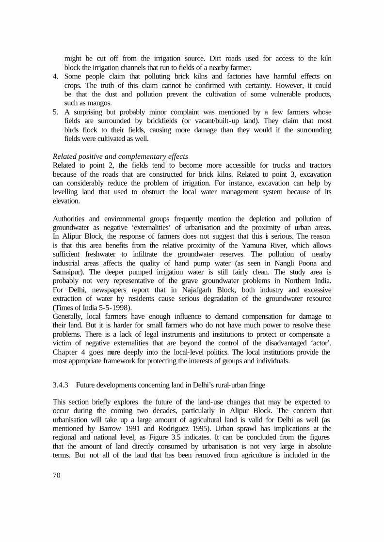
70
might be cut off from the irrigation source. Dirt roads used for access to the kiln block the irrigation channels that run to fields of a nearby farmer.
4. Some people claim that polluting brick kilns and factories have harmful effects on crops. The truth of this claim cannot be confirmed with certainty. However, it could be that the dust and pollution prevent the cultivation of some vulnerable products, such as mangos.
5. A surprising but probably minor complaint was mentioned by a few farmers whose fields are surrounded by brickfields (or vacant/built-up land). They claim that most birds flock to their fields, causing more damage than they would if the surrounding fields were cultivated as well.
Related positive and complementary effects Related to point 2, the fields tend to become more accessible for trucks and tractors because of the roads that are constructed for brick kilns. Related to point 3, excavation can considerably reduce the problem of irrigation. For instance, excavation can help by levelling land that used to obstruct the local water management system because of its elevation. Authorities and environmental groups frequently mention the depletion and pollution of groundwater as negative ‘externalities’ of urbanisation and the proximity of urban areas. In Alipur Block, the response of farmers does not suggest that this is serious. The reason is that this area benefits from the relative proximity of the Yamuna River, which allows sufficient freshwater to infiltrate the groundwater reserves. The pollution of nearby industrial areas affects the quality of hand pump water (as seen in Nangli Poona and Samaipur). The deeper pumped irrigation water is still fairly clean. The study area is probably not very representative of the grave groundwater problems in Northern India. For Delhi, newspapers report that in Najafgarh Block, both industry and excessive extraction of water by residents cause serious degradation of the groundwater resource (Times of India 5-5-1998). Generally, local farmers have enough influence to demand compensation for damage to their land. But it is harder for small farmers who do not have much power to resolve these problems. There is a lack of legal instruments and institutions to protect or compensate a victim of negative externalities that are beyond the control of the disadvantaged ‘actor’. Chapter 4 goes more deeply into the local-level politics. The local institutions provide the most appropriate framework for protecting the interests of groups and individuals.
3.4.3 Future developments concerning land in Delhi’s rural-urban fringe
This section briefly explores the future of the land-use changes that may be expected to occur during the coming two decades, particularly in Alipur Block. The concern that urbanisation will take up a large amount of agricultural land is valid for Delhi as well (as mentioned by Barrow 1991 and Rodriguez 1995). Urban sprawl has implications at the regional and national level, as Figure 3.5 indicates. It can be concluded from the figures that the amount of land directly consumed by urbanisation is not very large in absolute terms. But not all of the land that has been removed from agriculture is included in the
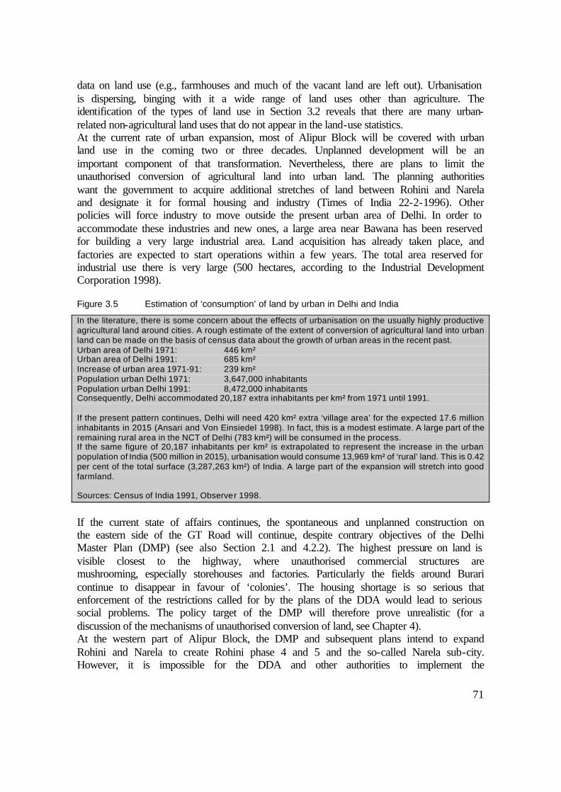
71
data on land use (e.g., farmhouses and much of the vacant land are left out). Urbanisation is dispersing, binging with it a wide range of land uses other than agriculture. The identification of the types of land use in Section 3.2 reveals that there are many urban-related non-agricultural land uses that do not appear in the land-use statistics. At the current rate of urban expansion, most of Alipur Block will be covered with urban land use in the coming two or three decades. Unplanned development will be an important component of that transformation. Nevertheless, there are plans to limit the unauthorised conversion of agricultural land into urban land. The planning authorities want the government to acquire additional stretches of land between Rohini and Narela and designate it for formal housing and industry (Times of India 22-2-1996). Other policies will force industry to move outside the present urban area of Delhi. In order to accommodate these industries and new ones, a large area near Bawana has been reserved for building a very large industrial area. Land acquisition has already taken place, and factories are expected to start operations within a few years. The total area reserved for industrial use there is very large (500 hectares, according to the Industrial Development Corporation 1998).
Figure 3.5 Estimation of ‘consumption’ of land by urban in Delhi and India
In the literature, there is some concern about the effects of urbanisation on the usually highly productive agricultural land around cities. A rough estimate of the extent of conversion of agricultural land into urban land can be made on the basis of census data about the growth of urban areas in the recent past. Urban area of Delhi 1971: 446 km² Urban area of Delhi 1991: 685 km² Increase of urban area 1971-91: 239 km² Population urban Delhi 1971: 3,647,000 inhabitants Population urban Delhi 1991: 8,472,000 inhabitants Consequently, Delhi accommodated 20,187 extra inhabitants per km² from 1971 until 1991. If the present pattern continues, Delhi will need 420 km² extra ‘village area’ for the expected 17.6 million inhabitants in 2015 (Ansari and Von Einsiedel 1998). In fact, this is a modest estimate. A large part of the remaining rural area in the NCT of Delhi (783 km²) will be consumed in the process. If the same figure of 20,187 inhabitants per km² is extrapolated to represent the increase in the urban population of India (500 million in 2015), urbanisation would consume 13,969 km² of ‘rural’ land. This is 0.42 per cent of the total surface (3,287,263 km²) of India. A large part of the expansion will stretch into good farmland. Sources: Census of India 1991, Observer 1998.
If the current state of affairs continues, the spontaneous and unplanned construction on the eastern side of the GT Road will continue, despite contrary objectives of the Delhi Master Plan (DMP) (see also Section 2.1 and 4.2.2). The highest pressure on land is visible closest to the highway, where unauthorised commercial structures are mushrooming, especially storehouses and factories. Particularly the fields around Burari continue to disappear in favour of ‘colonies’. The housing shortage is so serious that enforcement of the restrictions called for by the plans of the DDA would lead to serious social problems. The policy target of the DMP will therefore prove unrealistic (for a discussion of the mechanisms of unauthorised conversion of land, see Chapter 4). At the western part of Alipur Block, the DMP and subsequent plans intend to expand Rohini and Narela to create Rohini phase 4 and 5 and the so-called Narela sub-city. However, it is impossible for the DDA and other authorities to implement the

72
comprehensive plan for the whole area. The government is not able to ‘freeze’ urban development in these areas either. Most likely, the DDA and other development authorities will acquire the land in phases, leaving pockets of unauthorised construction as they are. Meanwhile, the unauthorised sector will be given ample space to continue to develop colonies on agricultural land. In addition, it seems inevitable that the authorities will have to provide the villagers with more space (that is, to expand the lal dora), now that the village settlements are bigger and their political force is growing. The present Rohini Township is already characterised by a mix of planned development, villages, and vast areas of unauthorised construction. Apart from the strong presence of the unauthorised sector, there are also forces within governments that frustrate planning. The press regularly reports on the ‘violation of the Delhi Master Plan’ (The Hindu 1-4-1998) or ‘developments against the spirit of the Delhi Master Plan’ (Indian Express 3-4-1996). One such violation consists of the plan of the state Tourist Corporation to put in motels on the urban fringe along the main access roads. The Delhi Master Plan intends to keep these roads free of ‘encroachments’ up to 300 metres on both sides of these roads. However, the lobby for motels and other commercial services, from both the private sector and government agencies that are involved in the tourism industry, is too strong to resist. Brick kilns are effectively banned from the NCT, but in the neighbouring states they continue to spread rapidly. Other urban land uses do not stop at the administrative borders either. The expansive nature of urban land uses, especially along the main transport routes, makes rural-urban land-use types increasingly relevant for areas that were previously beyond reach of the city. The judiciary, especially the Supreme Court, is an emergent force in land-use planning (see also Chapter 4 and 6). This institution increasingly objects to certain land uses and conversions, referring to the DMP. The judiciary often rules against the interests of bureaucratic agencies and political groups. Some important verdicts include the removal of all ‘encroachments’ and polluting factories from ‘unconforming areas’. Although interference from the Supreme Court is not always immediately effective, it can be seen as a new trend in city administration, a trend with considerable impact on spatial development. As a consequence of the above-mentioned diversity of forces in urbanisation and the weak political framework in which the DDA operates, it seems that planned urban development will appear only sporadically and with long delays.
3.5 Links with debates on urbanisation and land-use change
3.5.1 The usefulness of remote sensing (RS) in the rural-urban fringe
Closer monitoring of the land-use patterns in the urban fringe could contribute to more realistic and better-enforced land-use plans. Mapping processes of urbanisation with RS is a subject that as yet is not very well developed, although many sources cite valuable attempts (e.g., De Jong et al. 1998, Yeh and Li 1996, Mahavir 1996, Karstkarel 1997). The lack of recent and detailed spatial information on rural-urban fringes in developing countries justifies further efforts at RS analysis and mapping. Socio-economic

73
characteristics and physical features of the land have to be closely examined in order to apply RS in a reliable and useful way. Human geographers can contribute by analysing functional aspects of land use while collaborating with physical geographers, who have superior expertise on soil and vegetation structures and can interpret the reflections picked up by the RS sensors. The experience of this study with RS shows that it does not fill all the gaps in information on land use. It is particularly important to be aware of the overlaps and inconsistencies that arise as a result of the high heterogeneity of land use. It should be recognised that the physical land cover does not necessarily correspond to the socio-economic realities. Automatic generation of RS maps can even lead to manipulation and misuse of the data. In some cases, regardless of the actual reliability of the results, the appearance of nicely designed and colourful maps gives people the impression that the analysis is based on one hundred per cent accuracy and truth. For example, an official publication wrongly identifies excavation land as built-up land (National Capital Region Planning Board 1999). Some scepticism is justified regarding perfect-looking RS interpretations. Besides, RS cannot help improve the quality of the crucial information on ownership of both rural and non-rural land. It therefore remains important to collect spatial information in the field.
3.5.2 The issue of land degradation from a socio-economic perspective
Fertile lands are being transformed from agricultural into urban land use. The rough calculations given in Figure 3.5 about the conversion of cultivated land due to urbanisation do not present an alarming picture. In absolute figures, however, the amount of rural land that is being taken up for urban expansion is considerable. The issue of land degradation for the local people however is played out on an entirely different level. In a physical sense, land degradation can be defined as a reduction of physical qualities, e.g. density or type of vegetation and soil structure (Barrow 1991). The RS classification gives an ambivalent picture of this process. On the one hand, vegetation densities are reduced; in some conversions, the green cover is removed completely. Soils are excavated, and vast areas are losing their agricultural designation. On the other hand, expanding horticulture and floriculture improve the agricultural value of soils while sustaining high vegetation levels. Vacant land and (speculative) plantations and farmhouses, all manifestations of urbanisation, support many trees and other healthy vegetation. The impact of brick kilns and loam excavations is sizeable and under-researched, but historical equivalents can be found in the literature. Barrow (1991) reminds us that in Europe this industry was also concentrated near urban agglomerations: “Brick-pits have been dug in many parts of the UK and Europe, for example around London. Once abandoned, these excavations have proved valuable for domestic refuse disposal and recreational use” (p. 229). Whether all excavations can be put to such a positive use in Delhi remains doubtful. The demand for construction materials in the contemporary metropolis of Delhi is much larger than in the European antecedents. Besides, the socio-economic mechanisms around the lease and excavation of land result in land remaining barren for extensive periods, during which the land is not used.
74
The interpretation of land degradation in a socio-economic sense, introduced in Section 1.2.2, disqualifies the idea that physical characteristics are the only relevant measure (Blaikie and Brookfield 1987). From this perspective, much of the urbanising land obviously continues to satisfy many uses and an increasing number of users, although this process is highly selective. The next chapters will show that in an overwhelming majority of cases, there is no general ‘victimisation’ of people during the conversion of land use. Land transactions take place in many forms. Both formal and informal compensation mechanisms operate in such a way that the local farming community is able to make a shift in their source of income. Nevertheless, Chapter 6 describes how the changes on land due to urbanisation cause environmental stress. The adverse environmental conditions at some places are the most obvious sign of environmental degradation in this study area.

75
4 ROLES OF ACTORS IN LAND-USE ISSUES
A rural-urban fringe is a fascinating arena for land-use issues. Alipur Block is a spectacular example of the interplay of complementary and conflicting interests of different human and institutional ‘actors’. The interaction between these players largely explains the land-use pattern. An increasing number of actors become involved as urbanisation advances into the rural-urban fringe. The actor approach was originally used in the field of the political ecology (Bryant and Bailey 1997, Blaikie and Brookfield 1987, Blaikie 1996), where similar notions apply, e.g. actor-system dynamics (Burns 1985). Since the situation in the research area is very complex, it is impossible to describe all the issues that arise with regard to land management. The description given here provides an overview of the interests of the main actors. That overview is followed by a number of cases that highlight the main land-use issues.
4.1 Land-use issues from a socio-political perspective
Chapter 2 and 3 give an overview of the local situation and the land-use pattern in Alipur Block. The city is expanding very fast, leading to a massive conversion of agricultural fields into built-up property. Most land, however, remains agrarian. It is thus also relevant to look at the conversion form the perspective of the people involved, including owners, cultivators, lease-holders and labourers. In this chapter, our focus is on the interface between rural and urban land, where the agricultural fields are turned into construction sites. Section 1.2.3 identifies Bryant and Bailey (1997) as important advocates of political ecology. They describe it as “an exciting new research field that aims to develop an integrated understanding of the political economy of environmental change in Third World countries” (p. I). Other authors argue that in the modern context, purely geographical factors such as absolute distance are no longer the most important determinants of how land-use patterns emerge. Harvey (1989) calls this situation time-space compression, while Giddens (1990) refers to it as time-space distanciation. Murdoch (1998) advocates an actor-network theory as opposed to the “tyranny of distance” (p.357). He tries to explain “that geographical areas might be seen as folded and pleated by formal and informal sets of associations” (p. 370). This is a logical consequence of the “low-tech transportation revolution”, which has been identified as an important feature of well-accessible rural areas near metropolitan cities (Ginsburg et al. 1991). Therefore, it is desirable to explain the mechanisms in play between actors that influence land use. Many of the advocates of political ecology stress that environmental issues are strongly linked with land use issues. This chapter offers insight into the mechanisms of land management that lead to environmentally adverse conditions. In adopting notions from political ecology, it should be kept in mind the studies in that field usually deal with very different topics and areas. Some concern global issues such as logging and use the actor approach to analyse the roles of the governments, institutes, NGOs, industries and the ‘grassroots’ actors with a stake in wood-logging (Bryant and Bailey 1997). Another issue

76
typical of political ecology concerns soil erosion in a peripheral mountainous area (Blaikie 1995). The activist stance that often prompts studies in the field of political ecology and underpins actor-network approaches calls for radical changes in the power structure in society in favour of the weak grassroots actors. As some authors point out, a change in that direction would also be good for the environment (e.g. Atkinson 1991). Be that as it may, in this chapter, this approach is used for neither analytical nor political reasons but merely as a method to structure and describe the socio-political influences on land-use issues.
4.2 The actors and their interests in land
The strength of the actor approach lies in the integration of place and non-place based analysis. A situation of actor-network dynamics can be described according to institutions at a higher level, the local population, and various other actors, focussing on the way they interact. In an attempt to identify the most important actors, Bryant and Bailey (1997) list “states, the grassroots (e.g. poor farmers, shifting cultivators, fishers, hunter-gatherers, and the like), businesses, multilateral institutions and environmental NGOs” (p. 35). To design a typology for the study area, the above-mentioned actors can be compared with those to be found in the study area. The government is a very important player, although it appears in many different guises. Multilateral institutions and (environmental) NGOs are hardly represented in the local situation and are therefore not very relevant to land management. At the grassroot level, the actors are of a different kind than the above list would suggest; there are no hunters-gatherers, fishermen or shifting cultivators in the rural-urban fringe of Delhi. Some farmers are poor but many are not. But, besides the farmers, there are many other local people and households who use land for something other than farming. Many have an interest in land as a resident. Some have an economic activity related to land, such as manufacturing or real estate business. The description specifies whether the actor is a local resident (villager) or an extra-local person (outsider). This distinction is desirable to be able to assess the political strength and representation of the villagers. The distinction between local and extra-local is also relevant for Chapter 5, which analyses the socio-economic position of the villagers. Government actors are almost exclusively extra-local, in the sense that the main offices are located in other places. Private business is represented in many forms as well. The above considerations result in a typology of actors that is relevant for the study area, including the persons, groups of persons, and institutions that are involved in land management. A person, household, or institution may act as several actors. For example, a farmer is usually also a resident and is sometimes involved in property dealing and in local retailing. Therefore, the focus is on the ‘roles they play’. The political ecology approach assumes that the environment (in this case the land) is strongly influenced by the way different actors interact in a local arena and vice-versa. Actors are present at a micro level (village) as well as at higher levels, interacting within an intricate local political framework. The interests can be complementary and conflicting in nature, leading to various alliances as well as conflicts. The political ecologists often assume that poor and dispersed local actors (such as farmers) have a weak power base and therefore bear the heaviest burden of change and environmental

77
degradation. This assumption is critically examined within the setting of Delhi’s rural-urban fringe. Moving on to the specific typology of actors, Bryant and Bailey’s (1997) distinction between private and government actors is highly applicable to the study of land-use issues. The informal and unplanned conversions of land are mainly initiated by private actors, although some government actors are accomplices in this process. There are certain government bodies that represent the formal side of land supply and spatial planning. As the cases in this chapter show, the administrative legislation and organisation leads to frequent conflicts about land.
4.2.1 Private actors
Farmers Land-owning farmers are the beneficiaries of agricultural land on the production side. They are the representatives of agricultural interests, although they are hardly ever solely dependent on agriculture. They have multiple interests, both as individuals and within the context of their household, which result in strategies that may or may not give priority to agriculture (see Chapter 5). The pursuit of multiple objectives influences a person’s attitude on land transactions. Whether a landowner is eager or reluctant to sell land depends mainly on his ability to find other occupations and targets for investment for the household. Even if the farmer withdraws from agriculture as an occupation, he may keep the land for speculative purposes.
Figure 4.1 Private actors with roles and interests in land
Actor Role in land Profile Farmers
• Farming • leasing-out, leasing-in
• Mostly original farming households
• Some leaseholders Residents • Original residents • Settlers
• Residential space (buying,
renting out) • Residential space (buying
land, squatting land renting/buying house, authorisation of settlement)
• Original village households • Migrant households
Entrepreneurs and speculators • Factory/warehouse • Shopkeepers • Farmhouse owners • Brick kiln owners
• Buying/renting land/building • ” • Buying (agricultural) land • Leasing-in (agricultural)
land
• Outsiders, few villagers • Villagers, migrants &
outsiders • Outsiders, few villagers • Outsiders, some villagers
Property dealers • Mediation in transactions, information, care-taking
• Outsiders, some villagers
Developers • Financing, ‘planning’ unauthorised colonies, speculation
• Outsiders, some villagers

78
Research in the villages of Alipur Block has revealed which four factors are crucial to decisions about land. First, the household’s need for cash (for marriages, education, a building, investments, etc.) may lead to the sale of land. Second, the prospect of rising land values and the risks involved in maintaining the ownership of land can induce a farmer to sell or convince him not to sell. Third, the possibility of deriving an income from owned land by leasing it out influences the point in time at which the owner will decide to sell. Fourth, occupational transformation may speed up the decision to sell part or all of the land. It is very common for a farmer to sell only part of his land in order to diversify sources of income. In this way, agriculture is continued in a more limited way or through a lease-contract. The cash obtained from selling land can be used to run a business or to buy property. When used for speculation on higher land prices it is likely to have high returns as well. The combination of the above factors in specific situations explains the great diversity of attitudes within the local land-owning group concerning their farmland. Politically, the original farming community in rural Delhi is quite strong. They are indigenous to the area, having lived there for a very long time. They have developed useful connections in the bureaucracy, with political parties, and among individual politicians. Many of them also have the financial resources to protect their interests. In private land transactions, the farmers are in a position to take a large share of the profits. The terms of trade are mainly dictated by powerful property dealers and developers (locally called ‘colonisers’). Nonetheless, the pressure sometimes applied by large property dealers and developers is not likely to intimidate the local farmers. They can usually count on the backing of the dominant community in the village, which is an important force. However, the support that a local landowner receives from the village community also depends on earlier demonstrated solidarity. Therefore, the predominating interests among the village population are definitely a consideration when a farmer has to decide what to do with his land. The landowners receive compensation according to the size of their landholding, which can add up to enormous sums of money (see 4.3.3). Whether the rates of compensation are fair is a subjective matter. Some sources emphasise the unfavourable bargaining position of local farmers vis-à-vis land acquisition by the government (Mohan 1996, Dupont 1997, Pugh 1990, Van der Linden 1996). The government can reap sizeable profits from developing, plotting, and selling acquired land for urban use. In the case of Delhi, the real rates of compensation have increased substantially over the past decades. A serious problem is the ensuing legal conflict over compensation, which starts during land acquisition and persists long after the fact (see Section 4.3.4). Non-economic factors play a role as well. Some farmers feel a strong emotional attachment to their land. The cultivating castes, such as the Jats and Tyagis, have had ownership of ancestral land for centuries. Their tie to the land has determined their life styles, habits, and occupational preferences, whereby social status can be at least as important as economic gain. The farmers frequently raise the issue of emotional loss when bargaining with the authorities about compensation rates in the case of land acquisition (e.g. Times of India 14-10-1989). However, the youngsters belonging to the original farming community become indifferent to the role of land for social status. As they are increasingly involved in the urban economy, they derive more status from

79
typically urban activities and assets. This process clearly creates an incentive to sell off agricultural land. There is a smaller group of farmers who do not own the land they cultivate. Most of them are migrants who lease-in land from local landowners. The latter no longer have the interest or the time to cultivate the land themselves. There are also lease arrangements between the farmers of the original community, and with indigenous farmers from nearby villages (e.g. as described earlier for the village Khushk, Section 2.4.2). Lease contracts are usually arranged on a yearly basis. Nowadays, most leases stipulate monetary compensation (the leaseholder pays a fixed amount to the owner). In a minority of cases, the land is cultivated on a more traditional ‘sharecropping’ basis, whereby the landowner and the cultivator share the cost of the inputs and the revenues from the harvest. This form is chosen when the leaseholder is poor and cannot raise the funds to pay the amount for lease and inputs beforehand. The risks for the cultivator are lower, but so are the revenues. An increasingly common form of agricultural contract is lease by the so-called ‘suitcase farmers’ (Singh Rana 1994). Suitcase farmers are outsiders with sufficient resources to lease land at various places, to hire workers, and to market the crops themselves. They specialise in high-value seasonal crops such as vegetables and are highly mobile. Some land reform programs in India seek expropriation from non-cultivating landowners to the actual farmer, but these programmes are largely ineffective. Consequently, a landowner runs virtually no risk. Any attempt by a leaseholder to expropriate the landowner would require too lengthy and court procedures, which are impossible to pursue for migrant leaseholders. Landless labourers are numerous. Obviously, they depend on the availability of agricultural land, but strictly speaking they are not farmers. They work on other people’s land for wages or on the basis of piecework. Among the original population, there are not many landless agricultural labourers left (see Chapter 5). Most of the agricultural labourers are highly mobile seasonal migrant workers, and they do not necessarily come back to the same village each time. When a village becomes fully urbanised, these transients obviously have to find employment elsewhere. The supply of labour is in many cases regulated by labour contractors, who make a contract with the landowner to have a certain job done. Neither the leaseholders nor the agricultural labourers are significant players in decision-making about land transactions. They may be affected by urbanisation if land is sold for urban purposes, but they can also benefit from urbanisation by temporarily leasing land awaiting sale at a relatively low rate from landowners who are not residing in the village. These non-local landowners often buy land for speculative reasons and do not mind the fact that the revenues coming from the lease are low. However, the lease may stipulate that the leaseholder has to vacate the land on short notice. Residents The local population can be divided into three groups: the local land-owning community, the local landless group, and outside settlers (see Chapter 5). Many residents play other roles too: as farmers, entrepreneurs, as speculators, or even as political representatives and civil servants. People are mainly concerned about acquiring residential space and improvements in levels of amenities and infrastructure in their locality.

80
Households among the original population often want to obtain additional land for residence, and there are three reasons to do so. First, many families are growing and thereby splitting into separate households, for which additional housing is required. Second, some decide to rent out all or part of their original house for additional income. Third, the development of commercial and industrial activities in villages provides an incentive for the villagers to start retail businesses and workshops in part of their dwelling space. Alternatively, they rent out space to others for that purpose; this is most likely when their residence is located at the roadside. As a result of these actions, people have to find another place to live. Some original households have trouble acquiring sufficient space for housing; this is especially common among the poor section of the population. The inflating land prices make it difficult to buy additional land on the free market. Settlers, the great majority of whom are migrants, go about finding a home differently. They do not originally come from the villagers. Therefore, as individuals, they do not have much influence or powerful connections. Some find rented accommodation in the village itself, but most reside in colonies on the former agricultural fields. They have three main interests. First, they want to find relatively cheap accommodation. Second, if the colony is unauthorised, they want official assurance of official legal status for the settlement. Third, they want the government to invest in the public amenities of their colony. Individually, the poorest settlers are not very influential, but their power lies in their large numbers. Political parties and representatives champion their cause to gain their votes during elections. This kind of political patronage is common all over urban India (Amitabh 1997). Members of the original population sometimes complain about the dilution of their political representation. When a village becomes urbanised, the original villagers become outnumbered by migrants residing in the (unauthorised) colonies. Previously, when the village was still in a rural setting, a member of the municipal legislative assembly (MLA) would automatically be a villager. This has changed with urbanisation. Sometimes migrants have the largest vote and can get their own candidate elected. However, it is not always a contest between migrants and original villagers. The village population also includes developers of land or landlords, some of whom are in politics as well. Often the migrants opt for a local village candidate because they expect better contacts within the bureaucracy. The villagers earn from the migrants through rent and retail. The whole population stands to gain from legalisation of an unauthorised colony through higher land prices and better infrastructural provisions. Generally, the authorisation of a colony is an issue that enjoys the support of the original population as well as the migrants. Besides, within every village there are (historical) rivalries, which are expressed in conflicting political objectives. The local political structure in villages is changing. The government decided in 1986 not to extend the Panchayats (local board of elected villagers), which were formed in 1983. The reason given was that a three-tier election system already existed in the National Capital Territory. Now, the village resident has to rely on the more distant urban authorities. Meanwhile, the traditional mechanisms of protest and appeal are disappearing, with the result that conflicts of minor importance to other villagers are individualised. This departure from the tradition requires a considerable change in mentality. Previously, it was important to maintain good relations with local village

81
representatives; nowadays, it is important to be well connected with echelons of higher politics and the urban bureaucracy. The original villagers are usually not in the weakest position. Yet, among those who happen to be less fortunate, there are many victims of the ‘power vacuum’. One could say that the villages are subject to some kind of ‘law of the jungle’. When land acquisition by the government occurs, the land-owning villagers are able to strike for alternative commercial and residential plots near the village settlement when negotiating terms for the sale of their land. In an economic sense, there is no doubt that the local population shares in the profits from land transactions when urbanisation encroaches upon the village. Entrepreneurs and speculators Private entrepreneurs represent an important part of the demand side of the land market, as they require space for commercial and industrial activities. At more peripheral sites in the agricultural area, brick kiln owners and operators are strong actors, initiating changes on the land (see Figure 4.1). They place a strong temporal claim on land. Some of these kiln owners/operators are from the original land-owning communities in the villages, but they certainly do not account for more than 30 per cent of the total. The majority of them are specialised entrepreneurs who come from the city. The pressure on the land increases closer to the better-serviced and accessible areas along the roadsides and near the villages. The greater demand leads to conversion of farmland for industrial and commercial purposes. In practice, the supply of land by the government for commercial and industrial purposes is too limited. The informal sector also puts land on the market. Owners of industry, storehouses, and other commercial activities on former agricultural land come almost exclusively from outside the village, although many plots are still owned by original villagers. The latter tend to concentrate on less space-consuming activities such as retail businesses and repair shops within the residential areas. Entrepreneurs tend to work closely with local property dealers, especially in unauthorised operations. The property dealers negotiate the transaction, keep the authorities at bay, and keep an eye on the property if the transfer of title does not result in the intended new use. Farmhouse owners fall into a different category, which was described in detail in Section 3.2. They are not real entrepreneurs, in that they buy land for productive purposes. Nevertheless, they form an important category of land buyers and speculators. Occasionally, they have some kind of production facility on the farmhouse compound. They also combine some speculative venture with other land uses such as plantations and orchards. In fact, much of the vacant land in the study area is kept for speculative purposes. Local farmers, developers, and even entrepreneurs engage in this practice. Land is an attractive investment object due to the escalating land prices in the rural-urban fringe. The owner is obviously waiting for a more profitable use to come his way or for a buyer who is prepared to pay a higher price. In many cases, speculation is mixed with other intentions. Certain land uses are actually meant to conceal the main goal, which is speculation. For example, while waiting, the owner may build a farmhouse and keep a plantation (see Section 3.2). Meanwhile, a small part of the land that is still used for agriculture has already been sold to speculators, who let the former owner or leaseholders cultivate it until they need the land.

82
Property dealers Property dealers deal are involved with both the supply and the demand side of the land market. The majority of them are outsiders, although some are original villagers. There are enormous monetary benefits connected with the development of land into residential, commercial and industrial premises. Property dealers have access to the most detailed local information on the legal status, ownership, prices and names of landowners who want to sell land. They have jumped in to fill the gap left by the government in areas where the formal control of development is weak. They have a captive market in the large number of migrants who are looking for a place to stay. This seller’s market is good for their business, as is illustrated in Section 4.3.1. The demand created by industrialists, speculators, and farmhouse owners is another important source of earnings, as the property dealers charge commission on the transaction. Some of the former and current landowners from the indigenous community are property dealers as well. They have an advantage over the outsiders due to the solidarity between the land-owning group in the villages, their knowledge of the land issues, and their ease of movement in the social structures of their village. It must be said, however, that as the village becomes more and more urbanised and the real estate sector expands, the community loses some of its coherence. This causes the community to lose its communal grip on the property business. Besides, the press frequently reports conflicts about land and criminal acts in the land business (e.g. Hindustan Times 24-10-1999). Even with limited financial means, it is possible for local people to enter the real estate business and do well, taking advantage of their familiarity with the residents and the local setting. A profile of a small-scale property dealer is given in Figure 4.2. The activities of such business people illustrate how the land market operates, and these dealers possess a large amount of information about the land market in a particular village. Therefore, they were an important source of information for this study, and particularly for this chapter.
Figure 4.2 The role of a small-scale property dealer P.T. Bhardwaj is the son of a primary school teacher in Burari. He conducts his office at the roadside. Under the glass top of his desk, he keeps a plot map of the small colony arising behind his office. He owns only one plot himself; the other 40 or so are still owned by other villagers or private parties from elsewhere. Around 10 plots have already been sold to residents, who have constructed small brick houses there. Electricity is illegally tapped from the main line at the roadside. For drinking water, the colony relies on deliveries by a tanker truck the Municipal Corporation. Bhardwaj explains that even though his job is easy-going, it involves great insecurity: one week the earnings are good, the next week not. His only certain earnings are from taking care of uninhabited plots. The real estate business suffers from a bad reputation. Cheating is common. As Bhardwaj admits; “the only way to find out whether a plot is not sold twice is to take a chair and sit on the land for a few days. If somebody else comes to dispute your presence, you know that buying the plot will run into legal trouble or other kind of difficulties.” Once in a while the ‘big shots’ of the property business stop by to inform him of going prices and to give him instructions. He politely arranges tea for them and takes their instructions as orders. “These big boys have access to the money and pull the political strings, so that police and bureaucracy do not interfere with the illegal colonisation taking place here.” Bhardwaj says they sometimes charge money for what they claim are expenses to grease the authorities. They also exercise their influence when prices are declining. They tend to ‘advise’ not to sell land below a certain price to make sure that profits made on speculative plots are not dropping.

83
Developers Developers (or sometimes called colonisers) are people with a strong financial basis and political contacts. Many of the developers actually are politicians, making optimal use of the power and information they acquire through their office (e.g. Hindustan Times 24-10-1999). Some of them are local villagers, but most are wealthy urban businessmen. They are in a good position to orchestrate the development of unauthorised colonies. The activities of developers in the research area are mostly illegal. The law still provides for a government monopoly on acquiring agricultural land that is slated for development. Consequently, if a private developer would operate legally, they can only buy government land. Recent legislation allows for more private developers and contractors to buy land and put up housing, such as apartment buildings. But the liberalisation is only at the beginning of its trajectory, and will continue only in a slow pace (The Hindu 6-4-1998).
4.2.2 Public institutions, government policy, and urban planning regulations
The government enters the scene in many guises. It clearly appears in the form of different actors, sometimes even pursuing contradictory goals. Figure 4.3 lists the most important actors within the public sector, which for the sake of convenience also includes the judiciary. The interests and objectives of authorities do not only vary according to the roles they have as an institute, but may sometimes reflect individual or fractional interests, depending on many personal agendas. Consequently, private actors are able to influence and manipulate government administration and policies. Various levels of government are relevant to land management. The government of Delhi is the highest level for politics and policy-making. For most aspects relevant to the study area, it operates through local bureaucratic channels, e.g. the Block Development Office. The government has decentralised many tasks in urban administration, creating many departments. The most important one is the Municipal Corporation of Delhi (MCD). It is responsible for most of the garbage collection, public transportation, and much of the registration of ownership. Specific registration of land use and ownership is done by the Patwari, who keeps records at the village level. The judiciary plays an important role in land issues. Its hand is visible in land-use policy as well as in civil cases in the event of conflict and litigation. The police performs their obvious task of preventing illegal activity in general, which includes illegal land occupations, conversions and the like. In practice, however, the police are not very active in this respect and can be bribed. Higher-level interests in the preservation of farmland are mainly a responsibility of the municipal and the national government. The official aspects of land-use policies are formulated in the Delhi Master Plan (DMP) (National Capital Region Planning Board 1990). The DMP even aims to protect an agricultural belt around Delhi of 1.6 kilometres wide around just outside the city limits. Despite the somewhat obligatory formulation of this target, the most recent DMP is more realistic: “The rapid growth of urban population of Delhi implies that expansion of the urban limits is inevitable. The urban extension only beyond the existing belt would not be feasible as it would involve extension of infrastructure over this stretch of green belt and there would be constant threat of
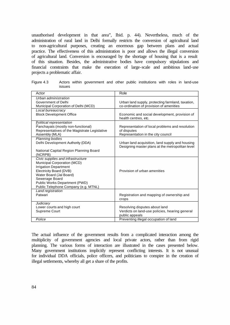
84
unauthorised development in that area”, Ibid. p. 44). Nevertheless, much of the administration of rural land in Delhi formally restricts the conversion of agricultural land to non-agricultural purposes, creating an enormous gap between plans and actual practice. The effectiveness of this administration is poor and allows the illegal conversion of agricultural land. Conversion is encouraged by the shortage of housing that is a result of this situation. Besides, the administrative bodies have compulsory stipulations and financial constraints that make the execution of large-scale and ambitious land-use projects a problematic affair.
Figure 4.3 Actors within government and other public institutions with roles in land-use issues
Actor Role Urban administration Government of Delhi Municipal Corporation of Delhi (MCD)
Urban land supply, protecting farmland, taxation, co-ordination of provision of amenities
Local bureaucracy Block Development Office
Economic and social development, provision of health centres, etc.
Political representation Panchayats (mostly non-functional) Representatives of the Magistrate Legislative Assembly (MLA)
Representation of local problems and resolution of disputes Representation in the city council
Planning bodies Delhi Development Authority (DDA) National Capital Region Planning Board (NCRPB)
Urban land acquisition, land supply and housing Designing master plans at the metropolitan level
Civic supplies and infrastructure Municipal Corporation (MCD) Irrigation Department Electricity Board (DVB) Water Board (Jal Board) Sewerage Board Public Works Department (PWD) Public Telephone Company (e.g. MTNL)
Provision of urban amenities
Land registration Patwari
Registration and mapping of ownership and crops
Judiciary Lower courts and high court Supreme Court
Resolving disputes about land Verdicts on land-use policies, hearing general public appeals
Police Preventing illegal occupation of land The actual influence of the government results from a complicated interaction among the multiplicity of government agencies and local private actors, rather than from rigid planning. The various forms of interaction are illustrated in the cases presented below. Many government institutions implicitly represent conflicting interests. It is not unusual for individual DDA officials, police officers, and politicians to conspire in the creation of illegal settlements, whereby all get a share of the profits.

85
4.3 Manifestations of actor networks in land-use issues
The following cases are presented to illustrate the mechanisms that influence the pattern of urbanisation. It is evident that many actors are involved in the development of unauthorised colonies, frustrating government aims to guide the urban expansion in an orderly fashion. The lal dora (the boundary of the village’s built-up land) legislation determines the way land-use changes occur in and around village settlements. Land acquisition by the government is a process that touches the lives of many villagers, as a result of the large scale of formal urban development. Finally, the price reflects the type of development that occurs at a certain place, and provides an indication of the way that the landowners bargain under specific local circumstances.
4.3.1 Unauthorised colonies
Despite the official objective of government policy to ensure a sufficient ‘formal’ land supply, informal and unauthorised developments are taking place on a massive scale. Informal small-scale development even takes place in areas that are earmarked for future formal land acquisition. Based on observation and numerous interviews, it is fair to say that unauthorised colonies are being created in the manner described below. At the start, a private developer raises the money to buy a plot of land from one or more local farmers. The scale can vary between less than one to many hectares at a time. He co-operates with a few local property dealers who keep an eye on the land to make sure that nobody occupies or claims it. A few poor individuals or families are persuaded to build a little house on that land and live in it. Initially, they do not have to pay any rent. The coloniser arranges at least an illegal electricity connection for them. Meanwhile, the coloniser starts to construct boundary walls and a road network. He invites and sponsors a religious organisation or person to build a temple or mosque somewhere in the middle of the property. This is an important step, since bulldozing religious structures is unpopular and therefore a risky affair for the government. To carry out all of these steps undisturbed, the developer together with the property dealers have to cover their backs. Concretely, the developer has to pay bribes to maybe four different people: first, the local police; second, the administrator of agricultural land; third, the registrar of urban land transactions in court; and fourth, the political representatives; furthermore, he might have to pay off key persons in the DDA if the area is on the list for acquisition. As soon as there is more security about the future of the colony, the developer and his partners try to lure more residents to live in the new neighbourhood. This time, however, they start charging some rent and even start selling small plots to the settlers. The developer advises and helps the residents to obtain a ration card, a proof of residence in Delhi, which enhances the political status of the residents. By the time these efforts are successful and the occupancy rate rises to 30 or 40 per cent, the authorities that are in charge of control on land use are already too late to intervene since the political risks have become too large. After the risk of eviction decreases, the colony continues along its path to consolidation. The prices of plots and houses consequently shoot up. Residents request local politicians to put pressure on government agencies to install better amenities (electricity, sewerage, roads, telephone, bus service,

86
etc.). These local politicians are likely to lobby for this improvement, since they are out to get votes for their re-election. Eventually, the colony’s name will appear on the list of unauthorised neighbourhoods that are to be regularised by the Government of Delhi. After full regularisation, the colony can develop into a lower-middle-class locality or even better. The poor residents who had been renting are then charged the full price and thus have to move out. The slightly better-off are tempted to sell their more valuable property and move somewhere else. Sometimes they have no other choice, as they have to pay off their debts. They may go through the same procedure again at another place. Other residents may move up on the social ladder along with the locality. Since conversion of agricultural land is illegal, most of the sales occur by ‘power of attorney’, meaning that the new owner does not acquire full ownership. Malversation is very common. Property dealers sell the same plot to several buyers, and the original owners sometimes try to claim land back that was already paid for by somebody who only had the power of attorney, not the title to the land. On the one hand, the land-use legislation is overregulated. But on the other hand, it allows a great deal of room for illegal practices. Slum formation takes place through similar mechanisms, but there are some important differences. The rough distinction between unauthorised colonies and slums is that the latter evokes the image of extremely densely populated and under-serviced clusters where people live in small huts. This type of settlement is almost exclusively found on illegally occupied government-owned land, not on privately converted agricultural land. When the slums are large and the population is politically well connected, eviction is not likely to happen. There are slumlords who, similar to developers, regulate the rates of rents and arrange political patronage. In case of eviction, the population of the slum will bargain for a resettlement scheme as compensation for loss of residence. These ‘resettlement colonies’, which are built for the displaced occupants of removed slums, are often found at the periphery of the city. Because of their authorised status, resettlement colonies tend to develop quickly into colonies for households with some money to spend. Property dealers sell two or more plots at the same time to provide wealthier residents with sufficient space, buying out the initial beneficiaries. Close to resettlement colonies, slums tend to mushroom again, making illegal use of the electricity and water connections in the resettlement colonies.
4.3.2 The lal dora issue
The legal status of the village lal dora (the boundary of the village’s built-up land) has major consequences for the type of construction in and adjacent to the villages. The lal dora legislation is meant to make residential land available to the villagers and to stimulate ‘rural industry’ while saving the agricultural land. In that light, it is understandable that the land use restrictions and property tax burdens are less under lal dora. The value of the land covered by this regime is therefore usually very high, especially in places with good commercial opportunities. This land is also highly sought after by small entrepreneurs who run the type of industries that are not allowed elsewhere and want to avoid paying taxes.

87
When acquisition from the government takes place, the lal dora regime is usually expanded to provide villagers with the opportunity to acquire more residential and commercial land. This leads to a big political scramble for the most attractive locations, in which much off-the-record trading is done and many alliances are formed. Whether a villager can make a good profit on the increasing land values depends on his entrepreneurship but also on luck. It can happen that one side of the village develops into a high-value market area, while another part of the village might become an inaccessible and poorly serviced backwater.
4.3.3 Formal land acquisition: the case of the village Rithala
The procedure of land acquisition is best explained by describing a representative example: Rithala. This urban village is located on the outskirts of Rohini Township. The land was acquired by the DDA between 1981 and 1990. Figure 4.4 gives an impression of the land use in Rithala and surroundings. At present, the village looks quite wealthy but also severely overcrowded. The current population is at least 6,000, many times the number of occupants when the process started. There is abundant commercial activity in the village. It contains a large number of factories as a result of lenient lal dora land-use regulations. The industry consists mostly of small-scale manufacturing units. Rithala’s villagers possessed 800 hectares of agricultural land, of which 320 hectares Was already sold off prior to the notification that the remaining 480 hectares would be acquired in 1981. The lal dora was enlarged by 160 hectares. Part of this extended lal dora area was made available to the villagers, allowing them to buy plots for residential and commercial purposes at low prices. Compensation was paid in 1984 at very low rates: 2.2 Rs./m2 for good agricultural land, 1.7 Rs./ m2 for less productive land, and 1.5 Rs./m2 for land excavated by brick kiln operators. The villagers went to the lower court to plea for higher rates of compensation. They won and got 4.2 Rs./m2, regardless of the type of land, based on 1981 prices plus interest. Later in the decade, another successful appeal resulted in rates of 9.0 Rs./m2, 7.5 Rs./m2 and 5.9 Rs./m2 for the respective qualities of land. In 1996, the courts again overruled the previous decision. The compensation was set at 17.5 Rs./m2 according to a new policy stating that the acquisition should reflect the level of the highest registered land transactions during that time. This is still lower than the real value of the transactions, because black money is part of almost any private land transaction. Taking inflation into account, this amounted to around 85 Rs./m2 at current prices in 1995. At the same time, the DDA started allotting serviced vacant pots of land for 700 Rs./m2. In 1998, the value of the same plots is 2,500 Rs./m2
(in 1998) (inflation was running at less than 10 per cent per year, so one can speak of a real increase). The most favourably situated plots – on a corner along the main road – go for up to 33,000 Rs./m2. The land-owning villagers have received high amounts in compensation, though not as much as they could have obtained by selling their land on the private market. They complain that the plots made available to them are poorly serviced and at unfavourable locations. They also have serious environmental concerns. One is the mosquito menace caused by a clogged drain just north of the village, the result of a partly dysfunctional sewerage treatment plant nearby. Furthermore, there are large heaps of trash at the DDA-
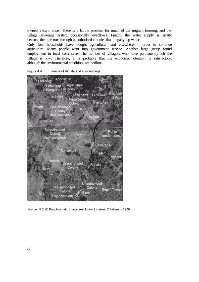
88
owned vacant areas. There is a latrine problem for much of the migrant housing, and the village sewerage system occasionally overflows. Finally, the water supply is erratic because the pipe runs through unauthorised colonies that illegally tap water. Only four households have bought agricultural land elsewhere in order to continue agriculture. Many people went into government service. Another large group found employment in local commerce. The number of villagers who have permanently left the village is low. Therefore, it is probable that the economic situation is satisfactory, although the environmental conditions are perilous.
Figure 4.4 Image of Rithala and surroundings
Source: IRS 1C Panchromatic image, resolution 2 metres, 2 February 1996

89
4.3.4 Land prices; determinants and differentiation
Prices is a key indicator of the quality of land, of what the land is going to be used for, and of the revenue it generates for his owner. The price range for private land in the rural-urban fringe is extremely wide. The most important determinant of price is location. Private roadside plots go for 10 to 20 times the price of land further out in the agricultural fields. The compensation rates for government land acquisition are more homogeneous. Therefore, the extent of enrichment of local landowners from land varies. For example, a farmer just happens to possess land along a new or improved road, whereby chance is the main determinant of the price that the farmer receives. However, smart lobbying can also be of considerable influence. An influential and well-informed farmer can sometimes lobby for better infrastructure, bus service, better pavement, and other amenities that determine land prices at the micro level.
Figure 4.5 Spatial representation of land prices around Pehladpur Bangar and Rithala at current prices (1998)
It is impossible to analyse the situation in the whole of Delhi. Therefore, a smaller area is selected to represent the situation on the interface of rural and urban land use. The area described here lies between the urban village of Rithala (see Section 4.3.3) and Pehladpur Bangar (see Section 2.4.4). Figure 4.5 shows the ‘landscape’ of land prices, as quoted by a representative selection of local property dealers. The price is lowest in the least

90
accessible agricultural areas (A). Even so, it is considerably higher than the price justified by agricultural revenues. The farmers who have land north of Pehladpur Bangar prefer to wait for the government to acquire their land or for prices to rise. In that area, the ongoing insecurity leads to prices in the private market that are below the acquisition rate. In the meantime, they are assured of an agricultural income through farming or leasing out land. The price of land along the roadside is obviously much higher (e.g. B). Prices increase closer to and in the immediate surroundings of villages (C). The prices are lower in the unauthorised colonies (D), at least for the time being, due to an unforeseen crackdown on unauthorised construction. There is to much uncertainty to justify high prices. If and when the colony were to be authorised, the prices would go up enormously. Land prices are highest in privately traded plots in the formal housing colony within Rohini (E). The prices are low for the disputed fringe areas of Rithala (F). In Rithala itself, though, the prices are higher (G). Three determinants have been found to be the most important ones: first, accessibility (e.g. bus routes, quality of road); second, legal status (authorised developments generally have higher prices due to better infrastructure and less insecurity); and third, level of amenities (e.g. electricity, telephone, sewerage, water supply).
4.4 Strength and weakness of the actors
The actor approach as chosen by Bryant and Bailey (1997) provides a useful structure for insight in the people and institutions involved with land issues in the rural-urban fringe, as shown by examples in foregoing section. In a rural-urban fringe, it is nevertheless difficult to identify consistent groups of actors, since they are highly interwoven. The area is characterised by a great diversity of actors and a complex mix of conflicting and complementary interests. The assumption that the weaker, mostly local-level actors are the victims of this unruly type of urbanisation is not fully endorsed in this study. Evidence from the study area shows that ‘beneficiaries’ and ‘victims’ can be encountered in any group, depending on the local situation. As found in the case studies in described in Sections 4.3.2 and 4.3.3, the outcome depends mainly on the economic and political strength, the connections, and the alliances of the actors. In this respect, the migrants seemingly have the weakest position. Yet because of their large numbers they can form a formidable force. The government is both a strong and a weak actor at the same time. An alliance of residents, property dealers, politicians, and developers frequently cheat the government (see Sections 4.3.1 and 4.3.3). For local landowners, the relationship with developers, property dealers is one of mutual benefit; at least in economic terms. Even smaller landowners are part of a finely branched political framework. The households among the original villagers who do not possess agricultural land are excluded from any direct benefits of the process, which results in a less rapid accumulation of wealth among them (see Chapter 5). Elevated land prices can limit their ability to acquire extra residential and commercial space. On the other hand, these landless households do benefit from the ancestral land that they have within the settlement, whatever little they have. The weakest group, the settlers (migrants), have difficulty in obtaining cheap accommodation when they come to live and work in Delhi. However, they receive help from powerful actors

91
who have a political or financial interest in providing more security for housing and amenities. Whether or not they are exploited in the process of starting informal settlements is a subjective judgement. They are quite vulnerable, since they depend on shady financial transactions and sometimes face instances of cheating and intimidation. Nevertheless, since the formal sector fails to provide access to land for the poorest, the poor are probably glad that to find a place to live in the informal settlements. Solanki’s (1987, see Section 1.2.5) standpoint – namely, that the increasing domination of outsiders on the local scene of urbanising villages would have alarming effects on income and employment – is not supported by this research. Solanki seems to underestimate the capacity for success among the majority of the original population. This study documents their ingenuity in turning the changing situation to their own advantage. This applies both to occupational opportunities (see Chapter 5) and to the benefits of the conversion of agricultural land.
4.5 The consequences of the actor network for urban land supply
Delhi is experiencing an extreme amount of pressure on land. However, similar mechanisms are at work in other cities in India. Schenk (1997) sketches unauthorised development in and around the city of Bangalore: “[Developers] provide for a temporary, makeshift building on their land and ‘invite’ a squatter family to come and live there for the time being and act as a guard to protect the owner’s rights against other squatters” (p. 219). Amitabh (1997) expresses concern about the poor service levels in the periphery of Lucknow, where there are many unauthorised colonies as well. Van der Linden (1996) argues that the type of rural area around the city influences the pattern of urbanisation. He compares the market in Delhi with the area around Karachi, which is state-owned desert. Thus, in the surroundings of Karachi, the indigenous farmer is missing from the set of actors. Nevertheless, a similar kind of scramble for land occurs in both settings. In Mumbai, there is a scarcity of land and an over-institutionalisation of land and housing supply. As a result, poor migrants are in an even more difficult situation (Jacquemin 1999). The sales prices and rents for dwellings in colonies on the periphery of Mumbai are much higher than in Delhi. Nevertheless, the same mechanisms as in Delhi seem to be at work there too. Informal urban development provides for the needs of many of the city’s poorer residents. Yet there are some problems related to the unauthorised status of the settlements. First, formal planning is frustrated: access routes are encroached upon, amenities are overburdened, and conflicts lead to lengthy legal battles in court (e.g. Pugh 1990, Times of India 24-1-1999). Second, the system is unreliable: cheating as well as extortion and intimidation to protect the developer’s interests are very common. The parties have no recourse to the courts, since these damages are incurred outside the law. Third, in large areas where the informal sector dominates urban development, hardly any space is reserved for parks, schools, and other necessary – or at least desirable – social infrastructure. Every piece of land is a tradable commodity, and the pursuit of short-term profits is the predominant ethic. It is very difficult for the authorities to acquire land for facilities.

92
Traditionally, the primary aim of most master plans for large cities in developing countries has been the containment and reduction of population pressure. Recently, urbanisation has met with increasing approval. The proponents argue that cities create an efficient multi-opportunity environment for the rapidly growing populations in developing countries: “The…increase in the density of population will reduce the per-capita cost of providing various services to the people. Therefore, the growth of urban centres must be welcomed and the emphasis of policy and public investment must shift towards minimising the unfavourable aspects of urban growth and removing critical bottlenecks” (Visaria 1997, p. 286). Due to the continuing influx into the city and the fact that government institutions do not reach the targets they set for land and housing supply, the privatisation of a large part of the sector seems inevitable. The prevailing duality in the system of land supply raises at least five concerns. First, it partly explains the chronic shortage in the supply of urban land (Pugh 1990, Prins 1994, Ansari and von Einsiedel 1998, Schenk 1997). Second, it leads to conflicts between actors whereby the ‘law of the jungle’ prevails. Practices of intimidation and manipulation to defend certain interests are widespread; so is the murder of property dealers, as frequently reported by the press (e.g. The Hindu 8-4-1998). Third, there are problems with the provision of services and infrastructure and the co-ordination of site servicing with the construction of housing. Fourth, the present state of chaotic spatial development leads to excessive inter-mixing of spatial functions. Especially industrial and residential areas are strongly mixed, causing adverse environmental conditions (see Chapter 6). Eventually, this problem will have to be addressed, but by then the costs of relocation will be high and the legal proceedings very long. Fifth, chaotic development leads to very high population densities, clogging the access roads. Because of unforeseen unauthorised construction, the roads are not wide enough to sustain the traffic accompanying such high intensities of inter-urban transport. The poor cannot afford the high prices and rents resulting from inadequate land supply. In the absence of enough formal housing that is affordable to the poorest half of the population, people resort to squatting public spaces, thereby creating slums. Very often, squatting is orchestrated by powerful actors, such as developers and politicians. The poor are keen to save money on accommodation – something they are not used to paying for in their villages of origin. Therefore, they tend to opt for a free or low-cost hut in a slum rather than to pay good money to rent an equally small room. At the better-located slums, the rents for huts can even be quite high. Besides, the labour provided by slum-dwellers is in great demand: servants, washermen, people who iron clothes, garbage collectors, other sweepers, watchmen, rickshaw-pullers, repairmen etc. Local industry requires labour for both day and night shifts. Considering these people’s daily work and monetary budgets, it is hardly possible for them to commute long distances. As long as cheap housing remains scarce, and informal construction remains illegal, the slum areas will continue to be created alongside middle-class residential neighbourhoods and near commercial and industrial localities. Consequently, the emergence of slums – also in the rural-urban fringe areas, where employment is increasing – seems inevitable. It can only be avoided if lowest-cost housing is truly integrated with industry and middle-class housing and if land-grabbing is prevented by a more effective administration. The actor approach proved to be useful as framework to explain the mechanisms of land supply and demand. In a rural-urban fringe situation, it is hard to generalise about the

93
economic and political strength of the local population. The next chapter will go into greater depth on the responses of local residents to urbanisation.


95
5 THE IMPACT OF URBANISATION ON HOUSEHOLD LIVELIHOOD
5.1 Structure of the analysis
As the descriptive literature (Chapter 1) and census data (Chapter 2) reveal, Delhi’s rural-urban fringe is undergoing an economic transformation at the level of village households. There are shifting from predominantly rural sources of livelihood to urban sources. The villagers to react and anticipate upon urbanisation in many different ways by making use of the changing economic context. It is important to take the general contextual changes into account, because are related to way urbanisation takes place at the local level. Urbanisation must first be clearly defined in order to appreciate the kinds of change that may be attributed to it. Then, the way in which urbanisation is changing the economic circumstances has to be analysed for the specific study area. Only then can the impact on household livelihood be measured according to specific determinants. Households and their individual members anticipate, react to, and are affected by urbanisation in a variety of ways, depending on a number of characteristics. The actual impact of urbanisation is therefore expected to be selective.
Figure 5.1 Outline of the overview of the impact of urbanisation on the livelihood of households
Situation • Increased access to and from the city, leading to commuting Site • Population growth • Land-use change from rural to urban • Increase of economic activities in and around the villages • Increasing involvement of ‘urban’ actors
Changing context of livelihood possibilities (occupation and income) • Expanding possibilities: local and extra-local • Pressure on possibilities: local and extra-local
Consequences for livelihood of households in terms of: • Agricultural assets and land management • Occupational transformation • Living standard • Perception and non-economic effects
Selective impact on village households according to: • Socio-economic background • Village of residence • Size of landholding • Demography of the household

96
In the situation specific to the study area, origin and caste seem to be the main factors of socio-economic background, though determinants of livelihood are analysed in this chapter as well. These are village of residence, ownership of agricultural land, and demographic characteristics of the household. The independent variables used to ascertain the impact of urbanisation are agricultural assets, the type and location of employment and other sources of income, and the standard of living. The basic household survey elucidates the quantitative aspects of the transformation, whereas the in-depth survey gives more insight into the longitudinal aspects. For instance, it deals with inter-generational change, sources of income that are not captured by the basic household survey, coincidental factors, and the element of perceived change.
5.2 Urbanisation defined in terms of changes in local ‘site’ and ‘situation’
Urbanisation is a rather complex term, as it can be applied at different scales. In geography, it is common to distinguish between site and situation. “Site refers to the physical and cultural characteristics and attributes of the place itself” … while “situation specifies the external relations of a locale” (Fellmann et al. 1997, p. 10). In the context of a rural-urban fringe, a change in situation usually precedes a change in the site. Namely, better access to a location strengthens the external relations of that place, leading to changes in its site. Some sources give an indication of the kinds of changes that can occur in a site and situation of a rural-urban fringe (see also Section 1.2). For example, Brookfield et al. (1991) refer to ‘in-situ urbanisation’ focussing on the increasingly urban context of the settlements in their study. In their definition of local transformation, they include land-use changes, change in the occupational structure of workers, and better transport linkages. McGee (1991) concentrates on the ‘situation’ of the urbanising countryside, emphasising the strong impetus from the increased interaction between villages and cities. This incentive to change is further explored by Ginsburg et al. (1991); Ginsburg identifies the ‘low-tech transportation revolution’ as the main cause of the dispersion of urbanisation (p. 37). Ramachandran (1989) mentions commuting to work as an outcome of urbanisation and observes a rapidly growing population due to in-migration. Drawing upon these various sources, it may be concluded that better linkages, land-use changes, diversified local economic activity, and population growth are the main manifestations of change as a consequence of urbanisation. Drawing upon our own observations in the study villages and adding these to the above features, we may say that urbanisation consists of the following characteristics: Situation: - Better access from the village to urban areas and vice versa - More opportunity for villagers to commute and bring goods to urban markets - More attractive as location for diverse economic activities Site: - Rapid population growth due to in-migration - Local types of land use shifting to urban types - Non-agricultural activities located in or near the village (involving a greater variety of
actors)

97
- Expansion of urban amenities and infrastructure The next step is to describe how urbanisation affects income and occupational possibilities in the villages of Delhi’s rural-urban fringe.
5.3 Changing occupational and income opportunities
Urbanisation, through its impact on the local ‘site’ and ‘situation’, changes the possibilities to earn an income. The traditional land-based agricultural activities are in decline, at least relatively, especially where rural land use gives way to urban functions. But a counter force is the development of the more productive and labour-intensive cultivation of vegetables and flowers, which requires less land. The greatest improvement in scope for livelihood, however, will come from expanding the opportunities for non-agricultural income and employment. The next section focuses on this issue. It starts with the many emerging occupational and income possibilities that are related to urbanisation.
5.3.1 Upcoming local and extra-local occupational and income possibilities
Local occupational and income possibilities are those that lie within the boundaries of the area that belongs to a village. Extra-local income and occupation possibilities are those that lie outside those bounds. Figure 5.2 summarises the expanding and diversifying sectors that are important to the local population. There is no hierarchy or indication of frequency in this overview. Relative importance and frequency are both difficult to quantify. The exact importance of each local possibility depends largely on the conditions in each particular village (see Chapter 2 and 3).
Figure 5.2 Expanding income and occupational possibilities in the rural-urban fringe of Delhi
Local Extra-local • Retail • Trade/production construction materials • Construction • Industry • Allied and supporting services (workshops,
repair shops, etc.) • Transport (buses, (mini) trucks) • Property dealing • Rent and lease of property (land, house) • Dairy • Horticulture, floriculture, nurseries, etc. • In schools, day-care centres, etc.
• Government employment: - Administration - Utility sector (e.g. electricity, water,
sewers) - Public-sector companies (e.g. banks,
railways, hospitals) - Police - Schools, colleges
• Private commercial activities • Industry • Markets for certain agricultural products • Retail
Local Villages close to the city and those along the roads are bustling with economic activity, including a vibrant retail sector. The number of establishments keeps rising in pace with the fast increase of population and purchasing power. Some shops benefit from being located at the roadside, where they cater for through traffic. Production and sales of building materials is also a sizeable sector. There is much construction going on: houses, farmhouses, factories, storehouses and infrastructural works. Besides, the rural-urban
98
fringe supplies building materials to the city, including bricks, sand, gravel and cement. Brick kilns are scattered throughout the area; there are several cement factories; and along the roadside, numerous shops are selling everything from windowpanes to asbestos roofing. Shops, industrial compounds and so forth generate a need for construction (materials) in the rapidly expanding villages. The numerous factories sprouting up in and around the villages provide work for entrepreneurs, labourers and builders, but they also provide income for people who rent out land and property for this purpose. Industry employs a large variety of people, ranging from carriers and unskilled labour to skilled and administrative personnel. Industrial development also generates demand for allied services, constituting of repair work, transportation, tea shops and other related services. Many mini-trucks are seen in the villages. Furthermore, storage facilities generate a similar demand for services in the local economy. The intensive interaction with the city leads to a great demand for buses. Quite a few buses operate from the villages, generating employment for drivers, conductors and mechanics. The land and real estate sector also creates scope for economic activity; the impact of the property market is typical for a rural-urban fringe. The sector is closely tied to the construction sector; like the building trade, the property market benefits from the growing local population and the expanding economic activities. Better access to the city generates demand for property in the form of houses as well as land. Dealing and brokering in property is a common occupation in the area (see Chapter 4). Property values are rising, creating an opportunity for speculation and profit-taking. Strongly market-oriented agriculture is found in the vicinity of Delhi. It is mainly geared to the production and sale of perishable and high-value commodities such as flowers, vegetables and dairy products. Generally, producers of agricultural goods nearby the cities enjoy low transport costs and good information about the markets. The location advantages for growing staple crops such as rice and wheat are less evident however. First of all prices are generally fixed by the government. Furthermore, there are many rural wheat and rice depots and markets. Therefore, the location of a particular plot of farmland is of less importance. There is only limited growth in local government employment, although demand for schoolteachers and other school staff is increasing. Due to the rapid population growth, the number of schools is rising. Some of the larger villages have secondary schools and even colleges. Yet the bulk of government employment is extra-local. One more important aspect of the local economy should be mentioned: the fact that money accumulates due to the sale of land. Many farmers are able to sell land for elevated prices to private parties. Others are forced to sell land to the government, though they receive high compensation rates in return. Where brick kilns are operating, the landowners can lease out their land for soil excavation. Generally, the compensation far exceeds the opportunity costs for the out-leasing farmer. This creates scope for investment, turning the loss of agricultural resources into opportunities for economic advantage.

99
Extra-local Many of the local occupational and income opportunities in the villages are also present in the city as well as in nearby villages and towns. More frequent and better bus service and faster roads have improved the villagers’ access to these alternative locations. In addition, the widespread use of motorscooter and motorcycles enables villagers to travel considerable distances, in many cases on a daily basis. Even the most remote villages in Alipur Block have had a direct bus connection to the city since the 1970s. The most important contribution of the city to the occupational situation in the villages lies in government employment. Because the city is so close, physical access to government employment is very easy from the villages on the fringe compared to remoter rural areas. About 25 per cent of Delhi’s working population is in some sort of government employment, both in the central government as well as in the local authorities (National Capital Planning Board 1986). This amounted to 542,000 workers in 1981, when the public sector was growing by 4.6 per cent per year (United Nations 1995, p. 79). This figure includes administrative bodies and providers of amenities (such as electricity, sewer, and water companies) and many (semi-)government institutions such as nationalised banks, schools, bus companies, colleges, universities, state radio and TV, and numerous other bodies. Government jobs are attractive. The salary may not be high, but the job is secure, pensions and health care are provided for, there are more holidays than in any other country in the world, and widespread corruption provides ample opportunity for a civil servant to collect money on the side.
5.3.2 Pressures on occupational and income possibilities
Pressures on the possibilities for work have a local and an extra-local component. Besides the economic aspects, there are socio-cultural developments that put constraints on certain kinds of occupations for particular groups. Here these are classified as occupations that are declining in status.
Figure 5.3 Pressures on occupational and income possibilities for people residing in rural-urban fringe villages
Local Extra-local • (Staple crop) agriculture • Declining status of agricultural work • Competition from migrant workers
• Stagnating availability of government jobs (during 1990s)
Local Agricultural production is under pressure in many rural-urban fringe villages. Vast stretches of land are being converted into non-agricultural land uses. Obviously, this leads to a loss of agricultural revenue, both for the cultivator who previously worked the land and for those who had been employed as agricultural labour. According to the census data (Census of India 1971-91), on aggregate, conversion only occurs in a relative sense (see Section 2.4). Only in those villages that had entered in the stage of growing urban land use did the number of workers in agricultural employment decrease. It is important to note the social and cultural constraints on agricultural activity. This relates to the declining status of farming. Due to the penetration of urban values and

100
higher levels of education, agricultural work is perceived as a ‘backward’ source of livelihood. Social pressures can be so strong that they encourage inactivity despite the availability of agricultural work or land. The same mechanisms apply for other low-status jobs, such as work at brick kilns, work as domestic servants, and work in construction. Finally, the villagers have to compete with migrants on the local labour market. The competition has a moderating influence on wages and further stigmatises manual labour as a low-status activity. Extra-local In the 1990s, the availability of government employment was stagnating. This represents a considerable change from the situation of the 1970s and 1980s. For decades, there had been a steady expansion of government jobs. The economic crisis of 1991 led to stricter budget control, moderating the recruitment of government employees. This is clearly noticeable in the villages; there, young adults do not enter government employment as easily as before. However, the policy of reduction of government staff has not been implemented very consistently, due to the entrenched influence of labour unions and the established practice of political patronage. On a favourable note, the increasing role of private enterprise provides more possibilities for employment. For example, the monopoly of the Delhi Transport Corporation was broken in 1990. Private buses were consequently introduced on a massive scale.
5.4 The village households and their livelihood patterns
5.4.1 The socio-economic profile of the households
The present analysis of the livelihood situation of the households in the village population focuses on a few key figures (Table 5.1). The data can be broken down into three categories: agricultural assets, occupational characteristics, and living standard. These figures reflect the agricultural background of the households, the prevailing occupational structure, and the living standard as measured according to certain household possessions. The following observations can be made from Table 5.1. The total aggregate data of row 1a show how little agricultural land is available. Landholdings are small and unevenly distributed. Not more than 40 per cent of the original households owns more than one hectare. Selling of agricultural land (row 1b), which for the most part is to outsiders, has occurred in all the selected villages, although the sample did not include any in Sungarpur. On average, about two out of ten households in the selected villages sold more than one acre (0.406 hectare) during the last 25 years. Most sales have occurred in the most rapidly urbanising villages. Cattle prove to be a significant source of livelihood (row 1c), although there is a high variation among households and villages. The data under category 2 in Table 5.1 describe two main aspects of the transformation of household livelihood. The figure for participation in agriculture, amounting to a little more than 20 per cent (row 2a), includes both part-time farmers who are also in the service sector as well as women who occasionally do agricultural work alongside their

101
household work. These women are somewhat arbitrarily counted as half a worker because they hardly ever work on the land full time. Dairy farming is also included among the agricultural occupations. However, it is only counted as such if (part of) the produce is sold. The reason is that keeping one cow for the household’s own consumption of milk products is considered to make an insignificant contribution to the household economic situation. In the more rural villages, the share of agricultural occupations is higher, but not much more than 40 per cent. The figures for employment differ slightly from the census figures (see Table 2.4 in Section 2.2). Besides the inaccuracies inherent in a sample survey, the differences may be explained by two other methodological limitations. First, there is a gap of five to six years, during which time the process of urbanisation has continued. Second, the census figures probably overestimate the number of farmers, since that occupation is the easiest answer for the respondent to give to the census enumerator, even if other sources of income and employment might actually be more important.
Table 5.1 Livelihood characteristics of households; indicators of relevance to urbanisation
Significance (at 95% simultaneous confidence interval) Household indicators
Total
n Standard deviation
Lower bound Upper bound
1. Agricultural assets 1a. Land owned1 0.84 337 1.69 0.66 1.02 1b. Land sold2 0.20 337 0.74 0.13 0.28 1c. Cattle owned3 1.83 337 3.97 1.42 2.26 2. Occupational structure 2a. Agricultural work4 0.22 337 0.31 0.19 0.26 2b. Commuting5 0.41 337 0.42 0.37 0.46 3. Economic situation 3a. Living standard6 24.4 337 14.9 22.8 26.0
Source: basic household survey 1 Mean amount of agricultural land owned in hectares per household of the original population
(i.e., excluding migrant households). 2 Proportion of households or (parent’s household) that have sold at least 0.406 hectare (1
acre) of agricultural land during the last 25 years. 3 Mean number of cattle owned per household (number of cows and buffalos). 4 Mean proportion of persons employed in agricultural activities out of all working members of
the household. 5 Mean proportion of commuting persons out of all working members of the household (at least
four times a week going outside the village area). 6 The measure of the living standard ranges from a minimum of nearly 0 to a maximum of 100.
It is a combination of the following indicators: - mean number of rooms in the residence per household member (A) - mean number of motorscooters and motorcycles per household (B) - mean number of TVs owned per household (C)
Formula: 3 x A + B + C. The highest score is standardised at 100, the other scores are scaled accordingly.
It is obvious that commuting (row 2b) has a stronger influence on household livelihood than agriculture. If there is only one commuting member of the household, he (in very few cases she) is often the main breadwinner. The average living standard (row 3a) only gives an indication of the level of the household’s wealth in relative terms. Therefore, the aggregate figure does not mean
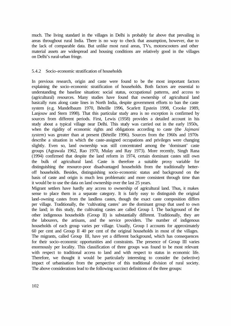
102
much. The living standard in the villages in Delhi is probably far above that prevailing in areas throughout rural India. There is no way to check that assumption, however, due to the lack of comparable data. But unlike most rural areas, TVs, motorscooters and other material assets are widespread and housing conditions are relatively good in the villages on Delhi’s rural-urban fringe.
5.4.2 Socio-economic stratification of households
In previous research, origin and caste were found to be the most important factors explaining the socio-economic stratification of households. Both factors are essential to understanding the baseline situation: social status, occupational patterns, and access to (agricultural) resources. Many studies have found that ownership of agricultural land basically runs along caste lines in North India, despite government efforts to ban the caste system (e.g. Mandelbaum 1970, Béteille 1996, Scarlett Epstein 1998, Crooke 1989, Lanjouw and Stern 1998). That this particular study area is no exception is confirmed by sources from different periods. First, Lewis (1958) provides a detailed account in his study about a typical village near Delhi. This study was carried out in the early 1950s, when the rigidity of economic rights and obligations according to caste (the Jajmani system) was greater than at present (Béteille 1996). Sources from the 1960s and 1970s describe a situation in which the caste-assigned occupations and privileges were changing slightly. Even so, land ownership was still concentrated among the ‘dominant’ caste groups (Agrawala 1962, Rao 1970, Mulay and Ray 1973). More recently, Singh Rana (1994) confirmed that despite the land reform in 1974, certain dominant castes still own the bulk of agricultural land. Caste is therefore a suitable proxy variable for distinguishing the resource-poor disadvantaged households from the traditionally better-off households. Besides, distinguishing socio-economic status and background on the basis of caste and origin is much less problematic and more consistent through time than it would be to use the data on land ownership over the last 25 years. Migrant settlers have hardly any access to ownership of agricultural land. Thus, it makes sense to place them in a separate category. It is fairly easy to distinguish the original land-owning castes from the landless castes, though the exact caste composition differs per village. Traditionally, the ‘cultivating castes’ are the dominant group that used to own the land; in this study, the cultivating castes are called Group I. The background of the other indigenous households (Group II) is substantially different. Traditionally, they are the labourers, the artisans, and the service providers. The number of indigenous households of each group varies per village. Usually, Group I accounts for approximately 60 per cent and Group II 40 per cent of the original households in most of the villages. The migrants, called Group III, have yet a different background, which has consequences for their socio-economic opportunities and constraints. The presence of Group III varies enormously per locality. This classification of three groups was found to be most relevant with respect to traditional access to land and with respect to status in economic life. Therefore, we thought it would be particularly interesting to consider the (selective) impact of urbanisation from the perspective of this traditional division of rural society. The above considerations lead to the following succinct definitions of the three groups:
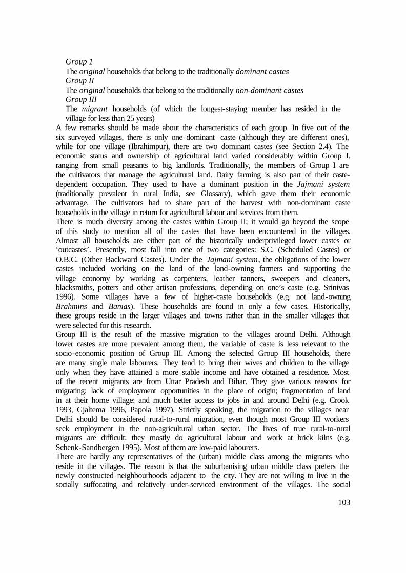
103
Group 1 The original households that belong to the traditionally dominant castes Group II The original households that belong to the traditionally non-dominant castes Group III The migrant households (of which the longest-staying member has resided in the village for less than 25 years)
A few remarks should be made about the characteristics of each group. In five out of the six surveyed villages, there is only one dominant caste (although they are different ones), while for one village (Ibrahimpur), there are two dominant castes (see Section 2.4). The economic status and ownership of agricultural land varied considerably within Group I, ranging from small peasants to big landlords. Traditionally, the members of Group I are the cultivators that manage the agricultural land. Dairy farming is also part of their caste-dependent occupation. They used to have a dominant position in the Jajmani system (traditionally prevalent in rural India, see Glossary), which gave them their economic advantage. The cultivators had to share part of the harvest with non-dominant caste households in the village in return for agricultural labour and services from them. There is much diversity among the castes within Group II; it would go beyond the scope of this study to mention all of the castes that have been encountered in the villages. Almost all households are either part of the historically underprivileged lower castes or ‘outcastes’. Presently, most fall into one of two categories: S.C. (Scheduled Castes) or O.B.C. (Other Backward Castes). Under the Jajmani system, the obligations of the lower castes included working on the land of the land-owning farmers and supporting the village economy by working as carpenters, leather tanners, sweepers and cleaners, blacksmiths, potters and other artisan professions, depending on one’s caste (e.g. Srinivas 1996). Some villages have a few of higher-caste households (e.g. not land-owning Brahmins and Banias). These households are found in only a few cases. Historically, these groups reside in the larger villages and towns rather than in the smaller villages that were selected for this research. Group III is the result of the massive migration to the villages around Delhi. Although lower castes are more prevalent among them, the variable of caste is less relevant to the socio-economic position of Group III. Among the selected Group III households, there are many single male labourers. They tend to bring their wives and children to the village only when they have attained a more stable income and have obtained a residence. Most of the recent migrants are from Uttar Pradesh and Bihar. They give various reasons for migrating: lack of employment opportunities in the place of origin; fragmentation of land in at their home village; and much better access to jobs in and around Delhi (e.g. Crook 1993, Gjaltema 1996, Papola 1997). Strictly speaking, the migration to the villages near Delhi should be considered rural-to-rural migration, even though most Group III workers seek employment in the non-agricultural urban sector. The lives of true rural-to-rural migrants are difficult: they mostly do agricultural labour and work at brick kilns (e.g. Schenk-Sandbergen 1995). Most of them are low-paid labourers. There are hardly any representatives of the (urban) middle class among the migrants who reside in the villages. The reason is that the suburbanising urban middle class prefers the newly constructed neighbourhoods adjacent to the city. They are not willing to live in the socially suffocating and relatively under-serviced environment of the villages. The social

104
position of migrants in the villages is weak. For example, they do not qualify for any official benefit that is meant to compensate villagers for the consequences of land acquisition by the government. Nor do they have an ancestral claim on land for residential space. The outsiders who do own land in the study villages – such as speculators, industrialists, entrepreneurs, and farmhouse owners – hardly ever reside in the village (see Chapter 4). Therefore, they were not included in the sample of the basic household survey. It should be noted that the data for Group III are less representative than those from the indigenous groups. For practical reasons, Group III has been excluded in two out of the six villages selected for the basic household survey. In one village (Khushk), there were no non-seasonal migrants. The selection in the remaining three villages is limited to the migrant households that are residing inside or adjacent to the village settlements.
5.5 Urbanisation and household livelihood: socio-economic background
This section starts with an overview of the specific patterns of livelihood that have emerged in the three groups identified above. In the next section (5.6), three other determinants of livelihood are examined in more detail. Figures 5.4 through 5.8 depict the results from the household variables introduced earlier. Statistical calculations have also been made, but to keep the chapter readable these were placed in Appendix B. The differences are verified according to 95 per cent confidence interval, which helps to assess the statistical reliability of the figures. Simultaneous margins rather than single margins were needed to make comparisons between the groups. For the data on the occupations of individual workers, statistical calculations have not been included due to an excessive number of categories. As Figure 5.4 clearly shows, agricultural land is concentrated in Group I. In spite of urbanisation, the members of this group have sold only a minor portion of their land. Group I also own the most cattle, although there is a wide variance among the households, leading to a high standard deviation (see Appendix B). The largest ‘dairy household’ in the sample has 25 cows and buffalos, but about half of all households do not own any cattle at all. Group II owns less cattle, and members of Group III only occasionally own cattle. Four conditions seem to be positively correlated with commercial cattle ownership. First, there are caste-related traditions of keeping cattle (especially in the case of the Gujjars, but the Jats and the Tyagis also keep cattle). Second, owning agricultural land is an advantage since the land can provide cheap fodder. Third, the adult members should always be at home to take care of the cattle. Fourth, there has to be capital available to a household to buy and maintain the animals.

105
Figure 5.4 Agricultural assets per socio-economic group
Figure 5.5 Occupational characteristics per socio-economic group
Figure 5.6 The main occupations of individual workers per socio-economic group
-
1.0
2.0
3.0
Land Land sold Cattle
mea
n(la
nd: h
a.,c
attle
: no.
)
Group I
Group II
Group III
0
0.1
0.2
0.3
0.4
0.5
Agriculture Commuting
Mea
n pr
opor
tion
Group I
Group II
Group III
0
0.1
0.2
0.3
0.4
0.5
0.6
0.7
0.8
0.9
1
Group I Group II Group III
Pro
port
ion
Other
Industry (labourer)
Industry (entrepreneur)
Extra-local service
Local service
Agriculture/service
Agriculture/household
Agriculture
n=799

106
Figure 5.5 shows the occupational characteristics as the mean proportion of household members who are into agriculture or are commuters. With respect to the figures for agriculture, part-time agricultural activity (mostly combined with household work or a service occupation) has been calculated as half an agricultural worker. Group I has the highest share of agricultural workers within the households. Nonetheless, commuting (mostly for employment in the city) is now becoming more important. Among Group II, work in agriculture has become rare. The members of this group own hardly any agricultural land, and they certainly do not want to work for other farmers. Group II contains relatively many commuters. The few workers who do still work in the fields during the harvest season usually come from deprived households and therefore do not have much choice. Both the wages and the social status of agricultural labour are low. Group III has an even lower rate of participation in agriculture. Most of the hired agricultural labourers are migrants, but they are usually seasonal workers who do not live in the village settlement (and therefore they do not appear in the sample). The importance of commuting is not very different among the groups; at least the difference is not statistically significant. Figure 5.6 shows the main categories of occupations as distinguished in the basic household survey. It demonstrates that the workers of Group I still have the largest share of persons combining occupations: agriculture/household and agriculture/service. In fact, these persons are part-time farmers. Group II obviously has a higher share of local service workers than Group I. Figure 5.7 confirms that among them there are many persons who run a local retail or repair shop. The extra-local service sector concerns mostly government employment for both Group I and II and ‘informal’ service activities for Group III. People in Group III are frequently employed as industrial labourers. Among the original population, this occupation is not favoured and seldom done. There are some factory owners and supervisors among Group I, but not many. Group II and III have none at all. Most of the factory owners are ‘outsiders’ who live in the city or in nearby towns, as mentioned in Chapter 4. The importance of the occupations and sources of income is estimated by compiling the results of all surveys and interviews (Figure 5.7). Because of this mix of sources, the data do not allow the calculation of representative frequencies. Nevertheless, the data give a detailed impression of the selective integration of the three socio-economic groups in the various occupations and other income-generating activities. Income from rent (mostly houses, but also factories, storehouses, etc.) and lease (some farmers lease out agricultural land to migrant farmers and brick kilns) is one of the pillars of the local economy, especially for Group I. This is much less so for Group II and not at all for Group III. Households of Group I possess the most land within the boundaries of the village settlement. The households in this group can exploit that land in many profitable ways. Group I, being the local ‘ruling class’, has a clear advantage in property-related dealing, for which it is essential to know about other landholdings in the village. Furthermore, Group I has more influence and better connections with the authorities and the administration in charge of property matters.

107
Figure 5.7 Specific occupations and incomes per socio-economic group (in descending order of estimated importance)
Group I Local Extra-local Agricultural: • Agriculture • Horticulture/floriculture/nurseries • Dairy Non-agricultural: • Rent, leasing out of land/houses • Transport business (owning/driving trucks,
buses) • Retail (e.g. general stores) • Property dealing • Brick kiln owner
Non-agricultural: - Government employment: • Transport (bus drivers, conductors,
mechanics, clerks) • Utility (clerks, supervisors, gardeners,
watchmen) • Police (constables, officers) • Bank clerks • School teachers and other staff - Private • Business/commerce/trade occupations
Group II Local Extra-local Agricultural: • Agricultural labour, cultivating leased land
(very little) Non-agricultural: • Workshops (repair, tailoring, welding, etc.) • Retail (general stores, teashops) • Rent • Transportation (owning/driving trucks, auto
rickshaws, etc.)
Non-agricultural: - Government employment:
• Government utilities (labourers, clerks, supervisors, gardeners, watchmen)
• Schoolteachers and other school staff • Police (constables, officers) • Transport (bus drivers, conductors,
mechanics, clerks) • Bank clerks
- Private • Business/commerce/trade
Group III Local Extra-local Agricultural • Agricultural labour and cultivating leased land Non-agricultural • Factory labour • Storehouse labour • Transportation (drivers, helpers) • Shops (assistants, few shopkeepers) • Servants • Private watchmen • Petty trade
Non-agricultural: • Factory labour • Storehouse labour • Transportation (drivers, helpers) • Petty trade • Rickshaw / auto rickshaw driving • Private watchmen
Without many of the assets that Group I possesses, Group II takes advantage of expanding local economic activities in a different way. Group II households have relatively many workers who are locally ‘self-employed’. Some run shops while others are small traders, repairmen, builders, etc. Among the commuting workers of Group II, government employment is common. Most are working in blue-collar jobs, but employment in white-collar jobs (e.g. teachers and low-level administration) is increasing considerably. Children of blue-collar government workers have generally enjoyed better education than their parents. Therefore, they are better qualified on the labour market. Some informally and privately employed people are commuting to nearby towns and the city as well.
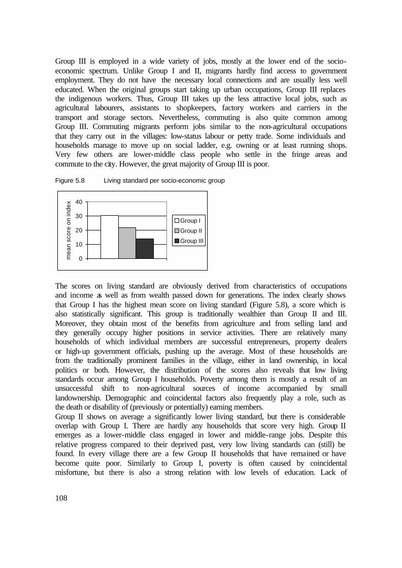
108
Group III is employed in a wide variety of jobs, mostly at the lower end of the socio-economic spectrum. Unlike Group I and II, migrants hardly find access to government employment. They do not have the necessary local connections and are usually less well educated. When the original groups start taking up urban occupations, Group III replaces the indigenous workers. Thus, Group III takes up the less attractive local jobs, such as agricultural labourers, assistants to shopkeepers, factory workers and carriers in the transport and storage sectors. Nevertheless, commuting is also quite common among Group III. Commuting migrants perform jobs similar to the non-agricultural occupations that they carry out in the villages: low-status labour or petty trade. Some individuals and households manage to move up on social ladder, e.g. owning or at least running shops. Very few others are lower-middle class people who settle in the fringe areas and commute to the city. However, the great majority of Group III is poor.
Figure 5.8 Living standard per socio-economic group
The scores on living standard are obviously derived from characteristics of occupations and income as well as from wealth passed down for generations. The index clearly shows that Group I has the highest mean score on living standard (Figure 5.8), a score which is also statistically significant. This group is traditionally wealthier than Group II and III. Moreover, they obtain most of the benefits from agriculture and from selling land and they generally occupy higher positions in service activities. There are relatively many households of which individual members are successful entrepreneurs, property dealers or high-up government officials, pushing up the average. Most of these households are from the traditionally prominent families in the village, either in land ownership, in local politics or both. However, the distribution of the scores also reveals that low living standards occur among Group I households. Poverty among them is mostly a result of an unsuccessful shift to non-agricultural sources of income accompanied by small landownership. Demographic and coincidental factors also frequently play a role, such as the death or disability of (previously or potentially) earning members. Group II shows on average a significantly lower living standard, but there is considerable overlap with Group I. There are hardly any households that score very high. Group II emerges as a lower-middle class engaged in lower and middle-range jobs. Despite this relative progress compared to their deprived past, very low living standards can (still) be found. In every village there are a few Group II households that have remained or have become quite poor. Similarly to Group I, poverty is often caused by coincidental misfortune, but there is also a strong relation with low levels of education. Lack of
0
10
20
30
40
mea
n sc
ore
on in
dex
Group I
Group II
Group III

109
schooling results in insufficient development of skills and low awareness levels. Both of those qualities are essential if an individual is going to make it into a government job. The mean living standard is much lower for Group III than for the other groups. The gap is due to the limited scope of opportunity. That, in turn, leads to poor and congested housing conditions and few assets. This applies most painfully to the recent arrivals among labour-class migrants. Many of them share one room with many others. And the incidence of the key assets, namely a TV and a motorscooter or motorcycle, is also low. The household assets may be less representative for their economic situation. They are also part of a household of kin that is not residing in the village. Many Group III households choose to save and send their earnings home instead of spending money on local comforts.
5.6 Household features and livelihood patterns
In this section, the data is sorted according to three characteristics of households that are considered relevant to the urbanisation process. First of all, this includes the characteristics of the resident village (in effect; the specific site and situation of the village); second, this refers to the amount of ownership of land; and third, it covers the demographic structure in terms of nuclear, joint and other types of households. Nevertheless, the socio-economic division remains critical for explaining the emerging picture.
5.6.1 The place of residence: influence of the local ‘site’ and ‘situation’
The local economic setting in which households reside influences their occupational patterns to some extent. The ‘situation’ seems to be of less importance. That is because the range of the study area is such that all villages have access to the city. The ‘sites’, however, differ considerably, as shown in the maps in Figure 2.5. Figure 5.9 shows the proportions of each of the three socio-economic groups represented in the study villages. Not all differences have clear spatial dimensions. Some features are related to different castes that represent the population in the villages. To some extent, the explanation of the variation in ownership of agricultural land and cattle (Figure 5.10) may be explained by the fact that various caste groups inhabit the villages. The castes that traditionally own large pieces of agricultural land include the Jats in Zindpur and Nangli Poona, the Rajputs in Sungarpur, and the Brahmins and Tyagis in Ibrahimpur. The dominant Sainis in Khushk and the Gujjars in Jagatpur are traditionally less well endowed with agricultural land. There is a historical reason for this: the Gujjars and the Sainis are not higher castes, and therefore had and still have less access to land. In the case of the Sainis, this is still visible in the small size of their landholdings. But the Jagatpur villagers have acquired more land during the last 25 years, leading to a relatively high rate of land ownership, although much of it is low-value land in the riverbed.
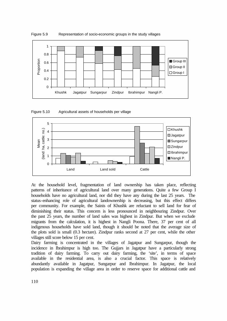
110
Figure 5.9 Representation of socio-economic groups in the study villages
Figure 5.10 Agricultural assets of households per village
At the household level, fragmentation of land ownership has taken place, reflecting patterns of inheritance of agricultural land over many generations. Quite a few Group I households have no agricultural land, nor did they have any during the last 25 years. The status-enhancing role of agricultural landownership is decreasing, but this effect differs per community. For example, the Sainis of Khushk are reluctant to sell land for fear of diminishing their status. This concern is less pronounced in neighbouring Zindpur. Over the past 25 years, the number of land sales was highest in Zindpur. But when we exclude migrants from the calculation, it is highest in Nangli Poona. There, 37 per cent of all indigenous households have sold land, though it should be noted that the average size of the plots sold is small (0.3 hectare). Zindpur ranks second at 27 per cent, while the other villages still score below 15 per cent. Dairy farming is concentrated in the villages of Jagatpur and Sungarpur, though the incidence in Ibrahimpur is high too. The Gujjars in Jagatpur have a particularly strong tradition of dairy farming. To carry out dairy farming, the ‘site’, in terms of space available in the residential area, is also a crucial factor. This space is relatively abundantly available in Jagatpur, Sungarpur and Ibrahimpur. In Jagatpur, the local population is expanding the village area in order to reserve space for additional cattle and
0
0.2
0.4
0.6
0.8
1
Khushk Jagatpur Sungarpur Zindpur Ibrahimpur Nangli P.
Pro
port
ion Group III
Group II
Group I
0
1
2
3
4
5
Land Land sold Cattle
Mea
n(la
nd: h
a, c
attle
: no.
) Khushk
Jagatpur
Sungarpur
Zindpur
Ibrahimpur
Nangli P.
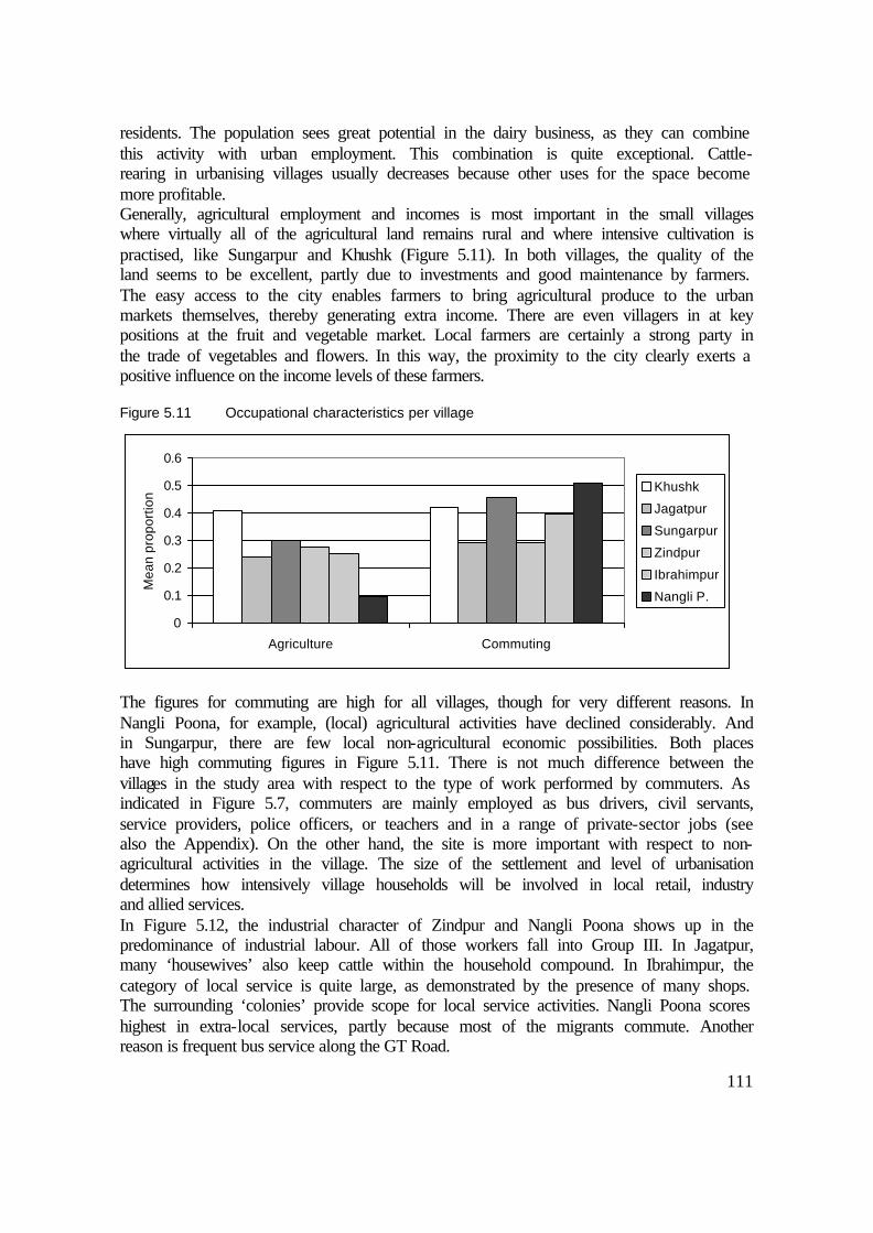
111
residents. The population sees great potential in the dairy business, as they can combine this activity with urban employment. This combination is quite exceptional. Cattle-rearing in urbanising villages usually decreases because other uses for the space become more profitable. Generally, agricultural employment and incomes is most important in the small villages where virtually all of the agricultural land remains rural and where intensive cultivation is practised, like Sungarpur and Khushk (Figure 5.11). In both villages, the quality of the land seems to be excellent, partly due to investments and good maintenance by farmers. The easy access to the city enables farmers to bring agricultural produce to the urban markets themselves, thereby generating extra income. There are even villagers in at key positions at the fruit and vegetable market. Local farmers are certainly a strong party in the trade of vegetables and flowers. In this way, the proximity to the city clearly exerts a positive influence on the income levels of these farmers.
Figure 5.11 Occupational characteristics per village
The figures for commuting are high for all villages, though for very different reasons. In Nangli Poona, for example, (local) agricultural activities have declined considerably. And in Sungarpur, there are few local non-agricultural economic possibilities. Both places have high commuting figures in Figure 5.11. There is not much difference between the villages in the study area with respect to the type of work performed by commuters. As indicated in Figure 5.7, commuters are mainly employed as bus drivers, civil servants, service providers, police officers, or teachers and in a range of private-sector jobs (see also the Appendix). On the other hand, the site is more important with respect to non-agricultural activities in the village. The size of the settlement and level of urbanisation determines how intensively village households will be involved in local retail, industry and allied services. In Figure 5.12, the industrial character of Zindpur and Nangli Poona shows up in the predominance of industrial labour. All of those workers fall into Group III. In Jagatpur, many ‘housewives’ also keep cattle within the household compound. In Ibrahimpur, the category of local service is quite large, as demonstrated by the presence of many shops. The surrounding ‘colonies’ provide scope for local service activities. Nangli Poona scores highest in extra-local services, partly because most of the migrants commute. Another reason is frequent bus service along the GT Road.
0
0.1
0.2
0.3
0.4
0.5
0.6
Agriculture Commuting
Mea
n pr
opor
tion
Khushk
Jagatpur
Sungarpur
Zindpur
Ibrahimpur
Nangli P.

112
Figure 5.12 The main occupations of working adults per village
Figure 5.13 Scores on the index of living standard of households per village
The villages do not differ much in living standard. When we have the poor and unequally represented Group III households out of the index, the differences are even smaller (e.g. 29 for Nangli Poona). The fact that the more urbanised villages have higher standard deviations (see the Appendix) is explained by wider spread between the extremes. As a village urbanises, a considerable number of households get very rich, while the number of poor migrant labour households increases.
5.6.2 Ownership of agricultural land and aspects of land management
The following question forms the basis of this section: To what extent does the amount of agricultural land owned determine the variables for occupation, income and standard of living? An analysis of the data according to different rates of ownership of agricultural
0
0.1
0.2
0.3
0.4
0.5
0.6
0.7
0.8
0.9
1
Khushk
Jaga
tpur
Sunga
rpur
Zindpu
r
Ibra
himpu
r
Nangli
P.
Total
Pro
port
ion
Other
Industry (labourer)
Industry (entrepreneur)
Extra-local service
Local service
Agriculture/service
Agriculture/household
Agriculture
0
10
20
30
40
1
mea
n sc
ore
on in
dex Khushk
Jagatpur
Sungarpur
Zindpur
Ibrahimpur
Nangli P.
n=799

113
land can partially answer this question. The categories reflect what is locally considered small and large holdings. One hectare is an approximate threshold size for making commercial agriculture profitable. Figure 5.14 Representation of socio-economic groups in the categories of landownership
Naturally, there is a great difference in the mean of landownership between those households who own less than one hectare and those who own more (Figure 5.15). Traditionally, both economic status and access to agricultural land vary considerably within Group I, as its members range from small peasants to big landlords. This is still the case, although the group owning more than three hectares is small (all in Group I, constituting 11 per cent of that group). Keeping cattle coincides with ownership of land. In all known cases, at least one male member of the household takes responsibility for cultivating the land. Other members of the household – persons with work, retired people and youngsters – occasionally help out when more hands are needed. If there is little surplus labour available within the household, the farmer hires extra workers. Hiring flexible labour has become easier in the last 25 years, with the breakdown of the Jajmani system and the arrival of large groups of seasonal migrants. Figure 5.15 Agricultural assets per category of ownership of agricultural land
00.10.20.30.40.50.60.70.80.9
1
No land >0-1 ha. >1 ha.
Pro
port
ion
Group III
Group II
Group I
0.0
1.0
2.0
3.0
4.0
Land Land sold Cattle
Mea
n(la
nd: h
a., c
attle
: no.
)
No land>0-1 ha.
>1 ha.
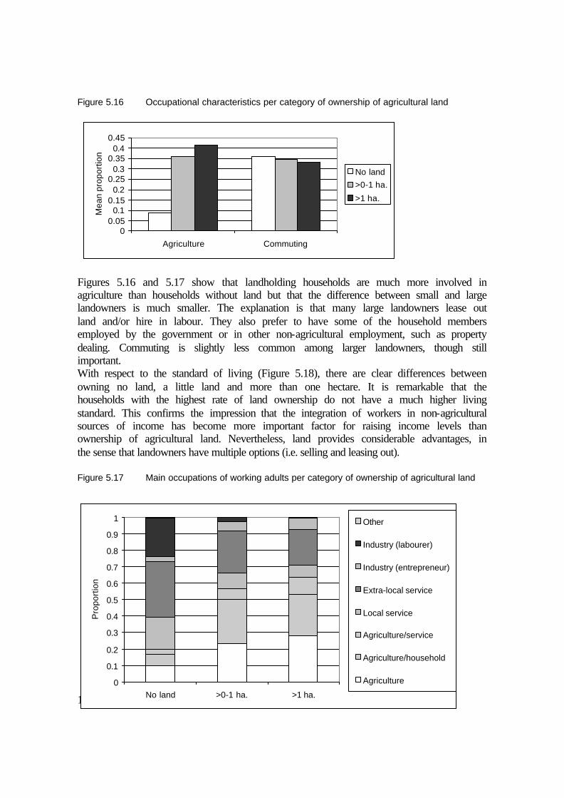
114
Figure 5.16 Occupational characteristics per category of ownership of agricultural land
Figures 5.16 and 5.17 show that landholding households are much more involved in agriculture than households without land but that the difference between small and large landowners is much smaller. The explanation is that many large landowners lease out land and/or hire in labour. They also prefer to have some of the household members employed by the government or in other non-agricultural employment, such as property dealing. Commuting is slightly less common among larger landowners, though still important. With respect to the standard of living (Figure 5.18), there are clear differences between owning no land, a little land and more than one hectare. It is remarkable that the households with the highest rate of land ownership do not have a much higher living standard. This confirms the impression that the integration of workers in non-agricultural sources of income has become more important factor for raising income levels than ownership of agricultural land. Nevertheless, land provides considerable advantages, in the sense that landowners have multiple options (i.e. selling and leasing out). Figure 5.17 Main occupations of working adults per category of ownership of agricultural land
00.05
0.10.15
0.20.25
0.30.35
0.40.45
Agriculture Commuting
Mea
n pr
opor
tion
No land>0-1 ha.
>1 ha.
n=799
0
0.1
0.2
0.3
0.4
0.5
0.6
0.7
0.8
0.9
1
No land >0-1 ha. >1 ha.
Pro
port
ion
Other
Industry (labourer)
Industry (entrepreneur)
Extra-local service
Local service
Agriculture/service
Agriculture/household
Agriculture

115
It would be interesting to compare the living standard of households that sold land during the last 25 years with the situation of those households that did not. Unfortunately, the sample of the basic household survey contains only 22 cases of households that have sold more than one hectare and 27 that have sold less than one hectare. The mean of living standards is clearly in favour of the households that have sold land, although this number is not statistically significant (Figure 5.19 and Appendix B). It should be noted that most of the households that have sold land are still holding on to part of their land and have used the revenues for their economic benefit. Figure 5.18 Living standards per category of landownership
Figure 5.19 Living standard of households that sold land among Group I
There are many ways to make use of the land, even if there is little or no labour available in the household. Most landowners are personally engaged in cultivating the land. But some landowning households lease out land on a sharecropping or rental basis (see Section 4.2.1). The variety of lease constructions illustrates the many options that Group I households have in managing their agricultural land. The basic household survey provides an indication of the incidence of lease. There are a few Group I households (9 per cent of the total) that lease in land (at an average of 1.7 hectares), usually to supplement their own (shortfall of) land. Only 4 per cent of Group II households lease in land (at an average of 0.7 hectares). The indigenous households that lease in land are mostly commercial farmers looking for a higher income from cultivation. Others are
05
1015202530354045
1
Mea
n sc
ore
on in
dex
No land>0-1 ha.>1 ha.
0
5
10
15
20
25
30
35
1
Mea
n sc
ore
on in
dex
No land
>0-1 ha.>1 ha.

116
migrants cultivating commercial crops on small plots of leased land. About 12 per cent of these households in Group I lease out land (at an average of 2.2 hectares). Leasing out occurs most in landowning households where workers are (successfully) engaged in non-agricultural activities. The location of brick kilns is another land-based activity with relevance to the livelihood situation of Group I landowners. Loam excavation on farmland has various implications for the livelihood of Group I (see also Section 3.2). The lease rates are high and have been rising steadily over the past 25 years, being invariably higher than the opportunity cost of agricultural income. When a local farmer leases out agricultural land, activities in farming are at least temporarily stalled. In this way, brick kilns lead to some degree of unemployment for the households involved, although their income situation temporarily improves. As one villager remarked, “at one point in time, half of all the farmers could be found playing cards every day when there were 8 brick kilns on the village land”. Brick kilns brought cars, TVs and other status goods to the villages at a relatively early stage. Both continuous agricultural income and revenues from selling and leasing out land are often invested in transport companies, brick kilns, property dealing, and in a number of other activities for which access to capital is essential. Also, a secured income from land enables households to place more stress on the education of the youth. The relatively high level of education found in Group I helps people start up private businesses and find government jobs. However, there is an indirect threat to this comfortable situation. Farming households that have sufficient land are lured into conspicuous consumption. They feel less compelled to diversify and invest in alternative employment and sources of income. After some moneyed years, this complaisance can lead to a relative or even absolute decline in their economic status. The poorer households among Group I, often landowners, have not managed to find significantly gainful employment outside farming. Forced sale of land through government acquisition can have favourable consequences (see also Chapter 4). Sometimes the landowners claim the right to a government job as part of the bargain (also reported in the press: Times of India 14-10-1989, Business Line 25-7-1998). This study came across little evidence that workers obtained government employment as a direct consequence of land acquisition. What they did gain is an awareness of the range of possibilities that arise though obtaining access to the application procedures. Another advantage of selling land to the government is that the revenue can be used to pay the bribes that are often demanded by superiors for employing government staff. In such cases, the compensation money received for the land is used directly to ‘buy’ an attractive desk job in a government institute. Group II plays a rather insignificant role in the management of agricultural land. The land reform of 1974 (within the so-called twenty-point programme initiated by the then Prime Minister Indira Gandhi) was intended to change the disadvantaged situation of the lower castes regarding land ownership. The programme aimed at allotting one acre to all landless households out of the common land of the village. Its success varied from place to place, as reflected by the selected villages. In Khushk, Sungarpur, and Jagatpur, the programme was not implemented at all due to the non-existence of village common land. In Nangli Poona, the common land was allotted to the landless. However, soon after the allotment, the landowning community was able to buy the land at a low price as a result of local political hassles. In Ibrahimpur and Zindpur, the common land was allotted after a controversial decision by the village Panchayat, but the agricultural quality of the fields
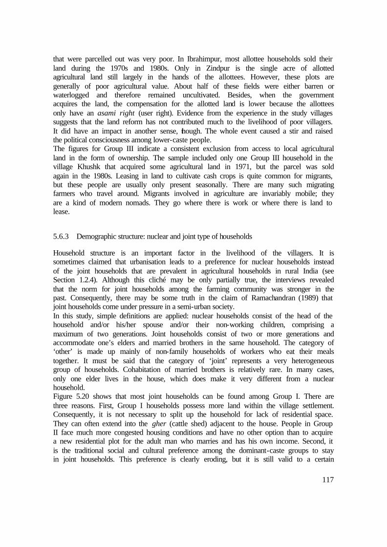
117
that were parcelled out was very poor. In Ibrahimpur, most allottee households sold their land during the 1970s and 1980s. Only in Zindpur is the single acre of allotted agricultural land still largely in the hands of the allottees. However, these plots are generally of poor agricultural value. About half of these fields were either barren or waterlogged and therefore remained uncultivated. Besides, when the government acquires the land, the compensation for the allotted land is lower because the allottees only have an asami right (user right). Evidence from the experience in the study villages suggests that the land reform has not contributed much to the livelihood of poor villagers. It did have an impact in another sense, though. The whole event caused a stir and raised the political consciousness among lower-caste people. The figures for Group III indicate a consistent exclusion from access to local agricultural land in the form of ownership. The sample included only one Group III household in the village Khushk that acquired some agricultural land in 1971, but the parcel was sold again in the 1980s. Leasing in land to cultivate cash crops is quite common for migrants, but these people are usually only present seasonally. There are many such migrating farmers who travel around. Migrants involved in agriculture are invariably mobile; they are a kind of modern nomads. They go where there is work or where there is land to lease.
5.6.3 Demographic structure: nuclear and joint type of households
Household structure is an important factor in the livelihood of the villagers. It is sometimes claimed that urbanisation leads to a preference for nuclear households instead of the joint households that are prevalent in agricultural households in rural India (see Section 1.2.4). Although this cliché may be only partially true, the interviews revealed that the norm for joint households among the farming community was stronger in the past. Consequently, there may be some truth in the claim of Ramachandran (1989) that joint households come under pressure in a semi-urban society. In this study, simple definitions are applied: nuclear households consist of the head of the household and/or his/her spouse and/or their non-working children, comprising a maximum of two generations. Joint households consist of two or more generations and accommodate one’s elders and married brothers in the same household. The category of ‘other’ is made up mainly of non-family households of workers who eat their meals together. It must be said that the category of ‘joint’ represents a very heterogeneous group of households. Cohabitation of married brothers is relatively rare. In many cases, only one elder lives in the house, which does make it very different from a nuclear household. Figure 5.20 shows that most joint households can be found among Group I. There are three reasons. First, Group I households possess more land within the village settlement. Consequently, it is not necessary to split up the household for lack of residential space. They can often extend into the gher (cattle shed) adjacent to the house. People in Group II face much more congested housing conditions and have no other option than to acquire a new residential plot for the adult man who marries and has his own income. Second, it is the traditional social and cultural preference among the dominant-caste groups to stay in joint households. This preference is clearly eroding, but it is still valid to a certain

118
extent. Third, there is a compelling economic reason, as mentioned in the literature; the farming families stay together to jointly manage the land and to avoid fragmentation. Figure 5.20 Representation of socio-economic groups per category of demographic structure
Figure 5.21 Agricultural assets per category of demographic structure
The rate of land ownership is higher among joint households, also because they are less susceptible to fragmentation of land. Cattle ownership is much more common in joint households. For one thing, it is easier to spread out the task of looking after the cattle; moreover they also tend to have more space for cattle. Figures 5.22 and 5.23 show that agricultural occupations are more common in joint households, corresponding roughly to the differences between the socio-economic groups. This correspondence indicates that the factor demographic structure does not play a very important role. Furthermore, there is little difference in living standard between joint and nuclear households. The category of ‘other’ is significantly poorer; these households are almost all migrant labourers who share a dwelling. Nuclear households among Group I have an obviously higher living standard than the joint households of that group, with a score of respectively 34.6 and 27.5. It is likely that the nuclear households in Group I consist of relatively more workers in good non-agricultural urban employment.
00.10.20.30.40.50.60.70.80.9
1
Nuclear Joint Other
Pro
port
ion
Group III
Group IIGroup I
0
1
2
3
Land Land sold Cattle
Mea
n (la
nd: h
a., c
attle
: no.
)
Nuclear
Joint
Other

119
Figure 5.22 Occupational characteristics per category of demographic structure
0
0.1
0.2
0.3
0.4
0.5
Agriculture Commuting
Mea
n pr
opor
tion
Nuclear
Joint
Other
Figure 5.23 The main occupations of workers per category of demographic structure
0.0
0.1
0.2
0.3
0.4
0.5
0.6
0.7
0.8
0.9
1.0
Nuclear Joint Other
Pro
port
ion
Other
Industry (labourer)
Industry (entrepreneur)
Extra-local service
Local service
Agriculture/service
Agriculture/household
Agriculture
n=799
Figure 5.24 Living standard per category of demographic structure
0
5
10
15
20
25
30
1
Mea
n sc
ore
on in
dex
Nuclear
Joint
Other

120
There is a rapidly growing preference to start a separate household if the income is sufficient and stable. Government jobs in particular provide security of income. It is therefore not very surprising that the joint household system is breaking down. When there is agricultural land in the family, a joint household sometimes splits up without subdividing the agricultural land. If there is only one brother who continues cultivation, he manages the land and earns his livelihood from it, sometimes along with his father. The farming brother takes most of the revenue, though he is obliged to support his parents if they are still alive. If the land is sold, however, the brothers share the profit, which can be invested in new sources of income for the family.
5.7 Processes, generational change and perceived changes in livelihood
5.7.1 Inter-generational processes in occupations and other sources of income
In addition to the basic household data about the change of income and occupation, the in-depth survey provides more information about the follow-up between generations. This elucidates the different ‘occupation and income careers’ that are typical of village households in the rural-urban fringe. Figures 5.25 to 5.30 present case studies of six households/families that have shown different degrees of success in the transformation of their livelihood. The cases illustrate the most important influential variables identified in earlier sections of this chapter. Those variables are combined with numerous coincidental and personal factors that play crucial roles in how (individuals in) households anticipate and respond to opportunities and constraints resulting from urbanisation. The transformation of occupations among Group I largely happens from one generation to the next. Individual farmers diversify their income without giving up farming entirely. There are relatively few cases of individuals making a radical shift in occupation (for example; from being a full-time farmer to taking a full-time service job). The transformation of Group II is characterised by more abrupt changes. In the development of the occupational structure of the older members of Group II, the caste-assigned patterns are still visible, e.g. in the many repair shops that are run by Group II workers. The occupations of the younger generations resemble their caste’s traditional orientation much less. In a rural-urban fringe, the breakdown of the economic side of the caste system has clearly proceeded faster than in remote rural areas. Considering the original population, out of the 143 government employees covered by the in-depth survey, 129 got their jobs at a young age (before 25 years). Even retired and senior government servants obtained their jobs when they were young, indicating that it is difficult to get into government employment at a later age. The exceptions to this rule were almost all employed in the 1980s, which was a time that the government was still expanding its staff. The same pattern holds true for professional higher-skilled jobs in the private sector. Those who obtained these jobs usually make extra non-agricultural income by setting up their own business or investing in local property.

121
Figure 5.25 Case of favourable livelihood development in Group I
Sunder Singh Tyagi was one of the larger landowners in Ibrahimpur village. He died a few years ago. The farmer from Ibrahimpur was hardly educated, but he earned a reasonable living with cultivation. In the 1970s, he had so much land that he and his eldest sons could only cultivate half of their land themselves. Presently, his two eldest sons have extended cultivation, covering all of their owned land. A quarter of their total land (3 hectares of the total 12) was sold in 1985, when the land prices suddenly tripled. Most of their land is near the Yamuna River, and two acres of high-value land are owned at the roadside near the village. For cultivation, they used to employ original low-caste villagers, whoever was available, but now they only employ ‘Biharis’ (common name for labour from the impoverished region of Eastern Uttar Pradesh and Bihar). The construction of the higher levee in 1982 greatly improved the land on the inner side of the levee, but the land at the riverside can only be cultivated during rabi. The land closest to the river is seasonally leased out to people who harvest a rough type of straw used for construction. Sunder had six sons and three daughters. The daughters are, as usual, married off to men in other villages not very far from Ibrahimpur. While the eldest and least educated sons maintained and improved the cultivation, the other sons went to college. The eldest son, who is illiterate, runs a small roadside restaurant in addition to farming. His 24-year-old son (carrying a mobile phone!) teams up with the second son of Sunder for farming, but he seems to have more interest in the lucrative property business. The other sons are employed in a large variety of jobs: the eldest is principal of a nearby secondary school; the second is a journalist; and the third is a local merchant in building materials. One son has left the village to become a lecturer in physics in the USA! The second son argues that it was good that their land was not acquired in the 1970s, which happened in a village where they have relatives. “We knew that we had to work hard to advance and support our brothers with their studies. In these urban villages there is more unemployment. People can earn money passively by renting out property. Education has lagged behind there. Some people from our village have sold all their land at a too early stage. They became rich overnight, but did not know how to handle their fortune very well. They spent too much money in marriage ceremonies, the construction of a bigger house and a car. My family knew how to handle it and has gained prestige. Nobody in this village dares to speak against us now!” Despite their undoubtable progress, the Tyagi family thinks that the government does a disservice to the dominant castes by enforcing the reservation policy: “presently it is very hard for us higher castes to become employed in the government. ‘Scheduled castes’ get advantaged systematically. They are hardly educated but they all have well-paid government jobs, while many Brahmins and Tyagis in our village are jobless.”
Commercial activity is often started with financial help from the household or from family members beyond the household. People hardly resort to official credit from banks. This indicates both the inefficiency of banks as well as the strong economic ties in families. The role of private money lending (e.g. by the Bania caste as part of the Jajmani system) has almost disappeared, making the strength and the solidarity within the household/family even more important. Income from one member of the household is used to get the other person started, whether it is used for an initial investment, or for education, for bribes to government agencies, etc. The other side of the coin is that these are obligations within households that may restrain individuals from expanding their commercial activities or developing new ones. In addition, risk aversion is considered necessary to ensure the household’s long-term economic position. Individuals can take risks as long as they do not jeopardise the economic status of the household as a whole. The integration of Group II into non-traditional jobs had already started 25 years ago. At and present, there is hardly anybody left doing caste-assigned occupations. However, for government jobs as well as (local) service jobs, they are often doing work similar to their traditional labour or artisan jobs, but now the work is commercialised or institutionalised. Some are working in construction. They are either involved in trading and making materials or have semi-skilled jobs as a mason or a construction supervisor. This type of income generation somewhat resembles the original tasks as carpenter, potter, blacksmith, etc., taking advantage of certain skills that are typical of caste and family.

122
Figure 5.26 Case of unfavourable livelihood development in Group I
Balbir Singh from Pehladpur Bangar shares his family’s land (1.3 hectares) with his two elder brothers, all of them married. Their land, located in the middle of other agricultural fields, renders them average harvests of wheat and fodder. They live in relative poverty. The two younger brothers have enough ancestral residential space, but only a small brick structure fills one corner, and there is (only) one buffalo and a calf in the other. The eldest brother lives separately in a small house on the other side of the street. Since 1979, the eldest brother has been a gardener for the DDA (among the lowest class jobs in government) in nearby Rohini Township. He can easily get there by cycle. The middle brother, who is also doing farming, seems to have psychological troubles and does not contribute much to the income of the family. Some years he leases in some extra land near his plot, but this year he could not manage. Balbir, 25 years old, helps with the farming but considers himself to be unemployed. The brother’s wives occasionally help in agriculture and looking after the cattle but cannot do paid work. “My wife’s father or brother would come over to kill me if I allowed that to happen!” Balbir hopes for acquisition of their land. “Then we could file for an alternative plot in the lal dora, sell one part of it and start a shop. I only fear that my education is insufficient to do this kind of business. Even our fellow villagers become increasingly tricky in business and do not even refrain from cheating their own caste members.” Another villager considers why this family has not progressed: “Well, I don’t know exactly. In earlier times we knew the concerns of each and every household. But the village depersonalises. People think it is their own business. Their father Vishnu was known as a jolly fellow eating too good for what their economic situation allowed, and did not see to the education of his sons. There was also trouble in the family. But their grandfather was a well-known ‘freedom fighter’ and enjoyed respect in the village and beyond! It is tragic what happened to these people.”
Group II started to gain access to government employment that matched their caste-assigned occupation, involving the handling of garbage, cleaning etc. Their status, wages and security are better than they would find in similar jobs in the village within the Jajmani system. Presently, the same types of work are still performed by Group II everywhere in urban Delhi. Some are still employed as sweepers, garbage collectors and other menial tasks, but supervisory positions are increasingly common. The easier access to the city has been particularly instrumental in bringing about their rapid detachment from local labour and artisan jobs and their integration in government. Government employment ensures a stable and secure salary (although quite low), access to health facilities, pensions and other privileges. Presently, Group II is still most strongly represented in blue-collar jobs but also increasingly in white-collar jobs, especially in the government. Within the blue-collar category, there is a shift towards more ‘attractive’ positions. Urbanisation enhances the process of sanscritisation whereby the lower-caste population adopts higher-caste habits, inhibitions and values (Srinivas 1996). Therefore, occupations such as handling dead animals and garbage are becoming unacceptable for them as well. More acceptable blue-collar positions include gardener, watchman and mechanic. Due to their improved education, the range of jobs for which Group II can qualify is broadening considerably. The moderate upward mobility of Group II is largely explained by their increased access to a wider variety of government positions such as clerks and teachers. Some respondents from Group I complain that the official policy of job reservation for lower castes makes life unfairly easy for the lower castes. This is only partially true. First, very few of the manual occupations in government service are acceptable to Group I, so they do not compete anyway. The ‘lowest’ jobs that Group I can perform and still be socially acceptable are gardening and care-taking (as a watchman). Second, for access to government service, connections inside government institutions through kin and community are definitely more important than formal quota,
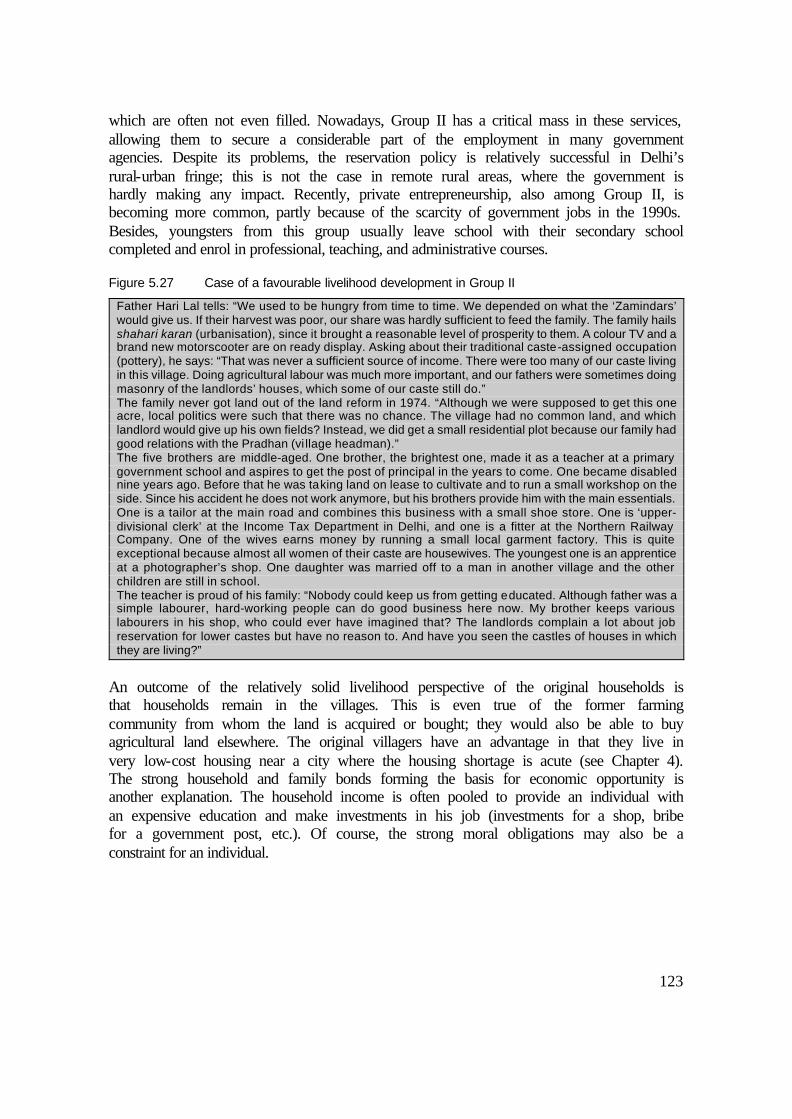
123
which are often not even filled. Nowadays, Group II has a critical mass in these services, allowing them to secure a considerable part of the employment in many government agencies. Despite its problems, the reservation policy is relatively successful in Delhi’s rural-urban fringe; this is not the case in remote rural areas, where the government is hardly making any impact. Recently, private entrepreneurship, also among Group II, is becoming more common, partly because of the scarcity of government jobs in the 1990s. Besides, youngsters from this group usually leave school with their secondary school completed and enrol in professional, teaching, and administrative courses.
Figure 5.27 Case of a favourable livelihood development in Group II
Father Hari Lal tells: “We used to be hungry from time to time. We depended on what the ‘Zamindars’ would give us. If their harvest was poor, our share was hardly sufficient to feed the family. The family hails shahari karan (urbanisation), since it brought a reasonable level of prosperity to them. A colour TV and a brand new motorscooter are on ready display. Asking about their traditional caste-assigned occupation (pottery), he says: “That was never a sufficient source of income. There were too many of our caste living in this village. Doing agricultural labour was much more important, and our fathers were sometimes doing masonry of the landlords’ houses, which some of our caste still do.” The family never got land out of the land reform in 1974. “Although we were supposed to get this one acre, local politics were such that there was no chance. The village had no common land, and which landlord would give up his own fields? Instead, we did get a small residential plot because our family had good relations with the Pradhan (vi llage headman).” The five brothers are middle-aged. One brother, the brightest one, made it as a teacher at a primary government school and aspires to get the post of principal in the years to come. One became disabled nine years ago. Before that he was taking land on lease to cultivate and to run a small workshop on the side. Since his accident he does not work anymore, but his brothers provide him with the main essentials. One is a tailor at the main road and combines this business with a small shoe store. One is ‘upper-divisional clerk’ at the Income Tax Department in Delhi, and one is a fitter at the Northern Railway Company. One of the wives earns money by running a small local garment factory. This is quite exceptional because almost all women of their caste are housewives. The youngest one is an apprentice at a photographer’s shop. One daughter was married off to a man in another village and the other children are still in school. The teacher is proud of his family: “Nobody could keep us from getting educated. Although father was a simple labourer, hard-working people can do good business here now. My brother keeps various labourers in his shop, who could ever have imagined that? The landlords complain a lot about job reservation for lower castes but have no reason to. And have you seen the castles of houses in which they are living?”
An outcome of the relatively solid livelihood perspective of the original households is that households remain in the villages. This is even true of the former farming community from whom the land is acquired or bought; they would also be able to buy agricultural land elsewhere. The original villagers have an advantage in that they live in very low-cost housing near a city where the housing shortage is acute (see Chapter 4). The strong household and family bonds forming the basis for economic opportunity is another explanation. The household income is often pooled to provide an individual with an expensive education and make investments in his job (investments for a shop, bribe for a government post, etc.). Of course, the strong moral obligations may also be a constraint for an individual.

124
Figure 5.28 Case of unfavourable livelihood development in Group II
Katcheroo from Ibrahimpur has five sons and four daughters. All claim to be ‘self-employed’, but as it seems with quite marginal results. All are illiterate. Their father used to be an agricultural labourer until he became disabled fifteen years ago. This happened when the children were not yet grown up. At present, only Katcheroo’s wife is working as a hand in agriculture from time to time. Dowry for the daughters’ marriages has indebted the family, which continues to be a burden. Although all the sons are adults now, the household earnings are still low. One son tried to set up a TV repair shop in the village, but he hardly gets any customers. One combines a cycle repair shop with a teashop but barely manages to earn Rs. 800 per month. One is an industrial labourer in a factory in Delhi and earns slightly more, but he has pay the bus fare. They complain about the labour situation. “The ‘Biharis’ work under the wage level that is acceptable to us. Besides, we do not get anywhere if we ask to be employed in the factories nearby they use all kind of excuses not to hire us. They know they cannot cheat us like the Biharis”. Explaining why they do not apply for government employment: “There are only a few jobs for which we could qualify. We filled in forms with the help of some office clerk in Delhi, but for some reason we never got to hear about it. We doubt if the clerk did our work.” Katcheroo obtained one acre of agricultural land during the twenty-point programme in 1974, but he sold it for a low price soon afterwards to pay off part of his debt. It was not cultivable anyway due to continuous waterlogging, dense cane vegetation with tough roots, and problematic road access. The housing conditions of the family are poor. They have no indoor latrines, little space, and no plaster on the bricks. All brothers live in the same compound, but in separate rooms and with their own cooking units. A joint household proved to be impossible due to disputes. “Since father died, there is a lot of arguing about money.” Excessive drinking often ignites arguments. Hopefully, the (numerous) children will break out of the downward spiral of things.
The transformation leads to less participation of women in outdoor labour (Chikara and Warnar 1999). The basic household survey found only a few cases of women in formal employment. The earlier-mentioned process of sanscritisation plays a role in the social and cultural preferences. In addition, increasing prosperity leads to a situation in which the woman’s income from outdoor employment is no longer essential for the household’s survival. Of the few women who are employed in government work, most are widows of civil servants. They automatically became employed when their husband died on the job. However, there are some exceptions. A few women are schoolteachers, some are working at the local angandwari (child-care centre), and some poor women perform menial work locally due to necessity. Migrant women are much more often found doing heavy outdoor labour in construction, agriculture and at the brick kilns. One could say that the employment curve of women in relation to class is U-shaped: employment of women is higher among the poor and also slightly higher among the educated elite (teachers). There is some social mobility among the migrants, although not as much as among the original population. Many migrants return to their home village with little savings after a long life of hard manual labour. Others do manage to move into a better income situation via petty trade and skilled labour. They occasionally move up to become shopkeepers, supervisors in factories, truck drivers, etc. Especially in Pehladpur Bangar, where urbanisation came early and where Group III has been represented since the 1960s, 82 of the 104 shops are run by outsiders. Some are from an urban lower-middle-class background. But quite a few of them started out as labour class migrants in the same village, although they had to be at least literate to gain access to such forms of occupation. Sometimes they are second-generation migrants. Migrants often start working in the area of transport as a driver or conductor, a profession shared with many among the original population and has a better status than that of a simple labourer.

125
Figure 5.29 Case of favourable livelihood development in Group III
Akbar Mahmood, a Muslim of 35 years old, arrived in Nangli Poona village in 1990. In his home village, not far from Aligarh in Uttar Pradesh, there was nothing else to do than marginal seasonal agricultural labour or become a brick kiln labourer, which was and still is very common for the poorer class in Aligarh district. At a young age he started helping a shopkeeper in Aligarh with his business of collecting waste materials from rag pickers, selecting it and selling it again. After he learned the business he decided to go to Nangli Poona, where a relative was doing factory labour. He settled there, worked two years in a factory as well, and after some time he started a waste-material shop in the village, selling the material again to factories in Samaipur. After the first comfortable earnings, his wife and children came over in 1993. Presently, his occupation produces an income of approximately Rs. 4,000 per month. He bought a plot of land in the extended lal dora of the village from a local Jat; he is still paying off the purchase. His house has two rooms, he owns a second-hand motorscooter and a black-and-white TV, and he is having an indoor latrine put in. His business is going pretty well, but there is much insecurity in his mind. There are larger operators in the waste-material business, threatening to take away his livelihood. Although he gets along with the villagers fairly well, he fears ethnic prejudice against Muslims, of which he is one of the few in the village. Nonetheless, he is fairly optimistic about the future. His two young daughters are going to the government school, but he thinks of sending his only son to the more highly reputed private school, provided he can afford the tuition.
Figure 5.30 Case of unfavourable livelihood development in Group III
Kishan Kumar is living with seven other young labourers from Bihar in a small two-room structure, formerly used as a cattle shed by a Zindpur farmer. Together, they pay Rs. 500 per month in rent. Two are from the Yadav Caste (in his home state, included in the so-called OBC category). Five claim to be Rajputs, an upper caste. Housing conditions are quite difficult. There is no latrine. There is only one hand pump for water. And there is hardly enough space in the rooms for all seven to sleep at the same time. Fortunately, some of them work nightshifts. Presently they all work in the plywood-sawing factory nearby. They are employed via a labour contractor and do not have a permanent job there. All perform manual labour at a wage of approximately Rs. 900 per month, which is below the legal minimum wage for Delhi. They do not do this job all year round. The work at the factory varies. In the harvesting season, they try to earn more by doing agricultural labour around Zindpur. Four of them worked last year in a rice mill in Haryana. They try to be in their home village at least one month per year. Although two of them are already married, it is not feasible for them to bring their family to where they live. Two others return home to help on their family fields, while the rest come from families with no land. Talking about their situation, they acknowledge their difficulties. They complain most about the place where they come from: “In Bihar there is nothing. Wages are three times lower, if you can get any work at all. Besides, it is dangerous due to caste disputes. Eventually we want to come back to the village with some money, but this is hardly feasible because our earnings are meagre.”
5.7.2 Livelihood concerns: unemployment, aspirations and status issues
Unemployment is definitely a problem for Group I as well as Group II, although in different ways. For Group I, the privilege of owning agricultural land can prevent people from making a timely reorientation towards non-agricultural sources of income. Nevertheless, the livelihood problems due to acquisition of land now seem to be limited. The villages that were urbanised in the 1970s and 1980s, however, abound with stories of land acquisition and the consequent problems of livelihood and (un)employment. The literature also provides some evidence that dealing with the ‘urban future’ was more problematic in the past. For example, Dupont (1997) describes the ruthless expropriation of village agricultural land for the creation of NOIDA (a large-scale formal housing and industrial project, see map in Figure 2.1) during the Emergency of 1976. Later, the
126
former farmers were compensated for the loss of their land. But initially it posed a serious threat to their livelihood and employment. Since then, the strength of the villagers as ‘actors’ has steadily improved (see Chapter 4). Unemployment occurs among Group I regardless of the economic situation of the household. Better education, sometimes even up to university level, raises a person’s aspirations and forms a higher threshold for ‘inferior’ occupations such as ordinary labour jobs, cultivation, petty trade and commerce, and nowadays even clerical positions. Other more socially acceptable types of employment suffer from low status due to poor wages (e.g. teaching at a school). Consequently, young villagers with BA or MA degrees are not generally satisfied with a teaching job at a primary school. For higher-educated villagers, it is still not easy to compete with their counterparts from urban Delhi for professional jobs in Delhi, although the competitiveness of the villagers is clearly increasing. Unemployment is also common among people with insufficient education. The rural population still suffers from the lesser quality of schools and colleges in Delhi’s rural area in comparison with the urban ones. Nowadays, many students from the wealthier segments attend schools in the urban area, mainly to overcome that problem. One of the ‘booming businesses’ in the larger villages is setting up private schools and tutoring centres. Group II workers who are employed for daily wages and self-employed workers are quite vulnerable to unemployment too. When they are older than approximately thirty, they no longer qualify for a government job. An important exception to the age rule is when a government worker dies on the job; then, a family member (usually the wife) is given a job in the same government agency. The increasing social inhibition to perform ‘inferior’ jobs (due to sanscritisation) leads to unemployment in a manner similar to that found in Group I. The great majority of Group III show the least inhibition for doing low-status work. Besides, if a migrant becomes unemployed for an extended period, the individual or even the whole household is likely to go back to their home village or move on to another place where they can find work. Therefore, unemployment is rare in Group III. Nonetheless, people in Group III are usually struggling; they have to do underpaid casual labour with very little security. They do not have much access to formal employment, let alone government employment. They simply do not have the education, networks, or money to bribe their way in. Within most government agencies, employment, especially jobs at the lower and intermediary level, are monopolised by the ‘locals’. The great majority of the migrants are self-employed or work as daily (or casual) labour. Real unemployment, if it is defined as inactivity, is quite low for the simple reason that this is a situation that a migrant household cannot afford. Among Group III, the participation of women in labour is also quite low, except for performing agricultural labour in brick kilns and certain tasks in factories.
5.7.3 Perceptions and non-economic factors
The economist’s notion of progress does not always correspond to the perception of such by the people, who also take non-economic considerations into account. There is definitely a sense of nostalgia, especially among the older farmers facing forced sale of

127
their land. This sense is common among members of Group I, who also see that their domination in the previous economic order has eroded. Social status and economic influence no longer depend solely on caste, agricultural ingenuity and the size of one’s landholdings. Therefore, some previously prestigious households have seen their economic position decline in comparison to that of more enterprising villagers. On the other hand, some farming households say that they wish to sell land but cannot find a buyer who is prepared to pay a decent price. They feel disadvantaged compared to other landowners who have sold land. A major source of dissatisfaction and sense of failure among people who remain in low-status activities is related to the process of sanscritisation, which refers to the adoption of high-caste values by lower-caste people. Generally, the population’s experience with and perception of shaharikaran (urban development) is much more positive than depicted in the newspapers. The papers highlight the adverse effects of urbanisation on the villagers’ livelihood (e.g. Frontline 20-5-1994 p. 110, Indian Express 14-2-1998, The Hindu 10-4-1998). This point of view probably originates from the image of an idyllic village in the countryside. Against that background, urbanisation would either deprive the villagers of their livelihood or negatively affect their culture by bringing in an abundance of money. Consumerism would presumably take over the originally peaceful and hard-working villages. The youth would become bored while money is available, which would lead to an excessive rate of crime, abuse of alcohol and drugs, etc. Although these observations are undoubtedly correct to some degree, these journalists put a one-sided and sensational twist on the story. The reality is better characterised by a strong political consciousness, educational standards that are rising, more awareness of the possibilities on the urban job market (possibly including crime) and in the commercial sector, and in improving urban amenities.
5.8 Links to debates about urbanisation and rural transformation
As argued elsewhere, urbanisation is very instrumental to a successful switch in occupational and income possibilities. Urbanisation can lead to higher living standards than before and in comparison to more remote rural areas. In this section, the results of this study will be compared with the findings from sources that are introduced in Section 1.2. The Delhi case supports statements by McGee (1991) and Ginsburg et al. (1991), referring to ‘desakota’, that it is increasingly difficult to delimit urban and rural areas, since the occupational orientation of many villages is increasingly ‘urban’. It should be emphasised that this study concerns the ‘peri-urban’ area and says nothing about the more distant ‘desakota’ region that surrounds it. The census data displayed in Section 2.2 about Haryana and Sonepat district do not indicate a very strong transformation towards non-agricultural occupations there. Kumar (1999), studying the census data of an area beyond the Delhi NCT, reports an increasing share of agricultural activity the farther away from Delhi one gets. But even near Delhi’s borders, there are much higher percentages of agricultural workers than in Alipur Block. Therefore, in Delhi’s region the ‘desakota’ may not extend as far as McGee and others hypothesise. Unfortunately,

128
neither Ramachandran’s nor McGee’s concepts are sufficiently operationalised. Therefore, the threshold values of occupational diversification for certain delimitations are not clear. Concerning the occupational structure, there is an important contrast with the industrialising areas in the Western world, where the Industrial Revolution engaged relatively more (previously) rural people. Lin (1994) criticises the use of Western models in an Asian context, where more agricultural workers go straight into the tertiary sector. This is clearly visible among the original population. McGee (1991) and Chakraborty (1991) emphasise the role of the informal sector in the tertiary sector, referring to a ‘bazaar economy’ due to the shortage of formal jobs. This study, however, shows that the original village population claims a high share of formal employment, of which government jobs are the most important. It should be kept in mind that Delhi, being the national capital, has an extensive civil service sector. The scope for government jobs may not be as high in other cities in India. At the household level, there is often a sectoral mix in occupations and income. Therefore, the household does not depend exclusively on one sector. Besides, the line between formal and informal economic activity is difficult to draw. ‘Informal’ has an air of marginality to it, which is certainly not the case for many types of private business that are performed by villagers in Delhi’s rural-urban fringe. The migrants, however, do suffer from a lack of access to formal employment and remain marginal to a large extent. If a ‘proto-proletariat’ would have to be identified, it would consist of these migrants. Most of them maintain strong ‘rural’ ties with their region of origin. They are highly mobile thus do not emerge as a very strong force on the formal urban job market. It is interesting to see how the villages in Alipur Block compare with villages farther away from the city, such as Palanpur in Western Uttar Pradesh (Lanjouw and Stern 1998). Palanpur would be closer to a typical village in Northern India than the villages in this study, which lie half way on the core-periphery continuum. Commuting is much more difficult, while exogenous local non-agricultural activity is nearly absent. The impact caused by urbanisation can be seen in another light. Palanpur has shown considerable occupational change from agricultural to non-agricultural jobs, but the change is not nearly as radical as found in the study villages. Besides, Palanpur has shown considerable out-migration (both permanent and seasonal), a phenomenon which is hardly observed in the study villages among the original population. Many of the migrant workers in Alipur Block come from villages such as Palanpur. The comparison suggests that urbanisation is the driving force behind the transformation in the study villages. Longitudinal comparison is possible on the grounds of the work by Lewis (1958), who studied a typical village in what is now the rural-urban fringe of Delhi. The same village is presently part of urban Delhi. Lewis did not place his study village within the direct sphere of influence of the city, although even at that time that village showed a clear urban influence. Migrants were not yet present there. A small minority of workers among the original population were then working in Delhi. In those days, it was much more difficult to commute on daily basis, and the city offered less occupational and commercial opportunity. Especially for Group II households, this situation contributed to their marginal existence as landless agricultural labour and particularly in unrewarding artisan occupations. Relatively more people served in the army, staying away from the
129
village for most of the year, especially among the Jat caste. The caste system was still rigorous, determining the occupational structure of households to a much larger degree. Not even half of the fields were taken into cultivation, and then only to grow one or sometimes two crops per year. Drèze (1998) sheds light on the problem of the economic backwardness of lower-caste people and the (formal) government effort to integrate them in government jobs through the reservation scheme. He concludes that the effect of job reservation is quite insignificant for remote villages. Higher castes can enter government jobs on a Scheduled Caste quota if the institute ‘cannot find’ a suitable SC candidate. Besides, the reservation policy is highly politicised, leading to ineffective implementation. For example, the dominant Jats have recently been included in the OBC category after fierce lobbying (Hindustan Times 24-10-1999). This study shows that the proximity of a large urban area is probably a stronger force in the emancipation of the lower castes. It works both through access to reserved government employment as well as through better education levels and political awareness. In the 1970s, there was a strong debate in development studies on the supposed exploitative mechanisms that favour the cities. Lipton (1977) draws our attention to an ‘urban bias’ in terms of development effort, the economic system and political force. In this regard, the question arises whether the rural-urban fringe is part of the rural or the urban area. Lipton (1977) first claims that “in poor countries, one usually can draw a fairly sharp line between city and countryside” but recognises that exceptions may include “regions where part-time farming and townward commuting are made possible by cheap and highly developed transport systems, as in the Wet Zone, Sri Lanka; and in semi-developed Third World city-states with considerable small-scale horticulture, such as Singapore” (p. 56). Delhi’s rural area should also feature in this list, indicating that Lipton may underestimate the extent of the zones of direct influence of cities. On the other hand, there is a ‘bias’ in favour of the villages within Delhi’s NCT in terms of amenities, transport links and occupational possibilities compared to the villages beyond the administrative boundary of the city. Since the 1970s, the neo-classical approaches have gained ground, focusing on cities as nuclei for modernisation and engines of growth. Marxists such as Kundu (1989) tend to see cities as ‘vanguards of exploitation’. Going even farther than Lipton, they identify exploitative mechanisms in terms of resources, talented people (brain drain), unfavourable biases of government spending and taxation and the terms of trade of agricultural products. A study by Zoomers and Kleinpenning (1996) re-enters the discussion. For the region of Asunción, they find a similar occupational diversification as was found in this study, opposing the idea of exploitation of the rural population. They emphasise “the role of Asunción as a ‘safety valve’ for the rural poor by providing them with opportunities for finding additional income sources outside the farming sector” (pp.162-163). Migrants represent an important economic link of the rural-urban fringe with remote rural areas. It is hard to judge whether they are exploited or not. Although their wages are low and their living standard is poor, the remittances that they send to their village secure the survival of relatives. It should be reiterated that the analysis presented in this chapter is based exclusively on the perspective of (economic) livelihood. The consequences of urbanisation for the

130
environment in which people live are described in the next chapter, which shows a less favourable picture. The dark side of the impact of urbanisation on the urban fringe can be quite severe, offsetting the positive effects of socio-economic progress to a considerable degree.

131
6 THE EFFECTS OF URBANISATION ON LIVING CONDITIONS
Urbanisation causes changes in the living conditions under which people live and work. Especially in developing countries, this often leads to adverse living conditions (see introductory remarks in Section 1.2.5). In the particular setting of urbanising villages, there are places where chaotic urbanisation and industrialisation causes hardship, particularly for local residents. This is not the whole story, however. There are also many positive effects of urbanisation: improving housing conditions, better amenities and services, and higher living standards. Yet these benefits are often ignored in the literature on urban environmental issues in developing countries. As argued in this chapter, the selective impact that one can observe there depends to a large degree on the type of settlement, the socio-economic position of the population, and people’s occupations. This is illustrated by presenting the case of the fully urbanised and industrialised village of Samaipur. It was chosen for a case study because of its radical and rapid transformation; Samaipur was a rural village until 15 years ago. Presently, this ‘village’ is the scene of many of the environmental problems generally ascribed to urbanisation mentioned in the literature (Section 1.2.5). Before turning to the case study, it is instructive to describe the prevailing situation regarding urban amenities and services in the region. In this respect, the situation of the urbanising area of Delhi stands out favourably. Subsequently, the description narrows in on environmental problems, treating pollution, congestion and pressure on amenities. These adverse effects, which economists call negative externalities, usually go uncompensated; e.g. a factory is not held directly responsible to pay compensation to nearby residents who suffer from its pollution (Pearce 1981). A discussion of externalities belongs to a more economic approach. In contrast, this study attempts to measure both the positive and the adverse effects in terms of residential quality, availability of services and amenities, and health indicators. The treatment of these issues remains on a descriptive level. Sometimes, the only aim is to formulate hypotheses, since tracing the causality between environmental factors and health is an extremely complicated and tricky issue (Geddes 1997, Wildavski 1995, de Lepper et al. 1995).
6.1 Positive effects: better amenities, housing and health awareness
Over the past few decades, the urban amenities and infrastructure in the villages in Delhi’s rural-urban fringe have been expanded and improved. As a consequence, the villagers generally refer to their settlements as being ‘more developed’ in comparison with villages beyond the boundaries of the NCT. At the same time, they complain about the remaining gap in the level of amenities and the quality of infrastructure compared to middle-class urban neighbourhoods. The difference is increasingly relevant to their self-perception and their degree of satisfaction.

132
Figure 6.1 Level of amenity in rural Delhi compared, 1981-91
Source: Bose 1996, pp. 184-196, according to data from the census of 1981 and 1991 Figure 6.1 shows the difference in housing conditions. Pucca is a local term for permanent material such as bricks and concrete; katcha refers to mud, straw, cardboard, plastic and other traditional and provisional construction material. In rural Delhi, the housing conditions and amenities are significantly better than in rural Haryana and the rest of rural India. Rural Delhi was even catching up with urban Delhi from 1981 to 1991, if one looks at the physical aspects of urbanisation in the villages in Delhi. The situation in urban Delhi has hardly been improving, which means that many households in Delhi are housed very poorly. Unfortunately, the figures for 1971 are not available. But even compared to 1981, the pace of change is striking. For example, Samaipur was still rural in 1981, but urban in 1991 (Census of India 1991). The municipal authorities, in most cases the MCD, have the responsibility of providing infrastructure and amenities to the villages within their territory. The infrastructure is much better compared to that provided elsewhere, e.g. in adjacent rural Haryana, with the exception of electrification. In terms of households connected with electricity, rural Haryana scores better. This discrepancy might also be caused by a bias in the data, which does not take the many households with an illegal connection into account.
0
20
40
60
80
100‘p
ucca
’ho
use
safe
drin
king
wat
er
toile
tfa
cilit
y
elec
tric
ity
% o
f tot
al h
ouse
hold
s
Urban Delhi 1981
Rural Delhi 1981
Rural Haryana 1981
Rural India 1981
0
20
40
60
80
100
‘puc
ca’
hous
e
safe
drin
king
wat
er
toile
tfa
cilit
y
elec
tric
ity
% o
f tot
al h
ouse
hold
s
Urban Delhi 1991
Rural Delhi 1991
Rural Haryana 1991
Rural India 1991

133
Even within villages, there are very wide differences between the level of amenity and infrastructure in certain parts of the built-up area. The difference is due to the fact that new unauthorised colonies start off without amenities. In terms of the provision of infrastructure, the villages lag behind urban middle-class colonies, but there are signs of substantial improvement. All villages in Alipur Block are connected to tarmac roads. Bus service has started running to all the villages. Both electricity and tap water supply are available in all but one village, although some households have to resort to illegal connections. Especially in the fast-growing villages, the provision of municipal services for recently established streets and houses is slow and faulty. The provision of amenities and infrastructure by municipal authorities clearly depends on whether or not the settlement has an ‘authorised’ status (see Chapter 4). Unauthorised parts of the village outside the lal dora or ‘colonies’ usually do not have paved roads and a cemented sewerage system, unless the residents and/or the colonisers have put in these features themselves. Most streets in the villages are paved, although this provision lags behind the fast growth of the settlements. A simple open sewerage system, made of bricks and cement, is constructed in most villages. In contrast, many of the villages across the border in Haryana still have muddy ditches. It is debatable whether rural villages with small populations really need a closed sewerage system. At least, the residents of such places hardly complain about not having one, and an open sewer is easier to clear when it is clogged. In urban villages, the municipal authorities usually construct a closed sewer, but happens only after many years of problems with an inappropriate open sewer. Overall, 9.7 per cent of the households in Delhi still have no drainage arrangement. Furthermore, 15.1 per cent are exposed to the risk of waterlogging, partly due to insufficient drainage (Visaria 1997, reporting on the basis of 1988-9 data from the 44th round of the National Sample Survey). An important advantage of incorporation into the urban area is the widespread presence of hospitals and other services related to health care. Along with the rising economic standard, access to health-care facilities is one of the main explanatory factors of the higher average life expectancy in urban and peri-urban areas compared to rural areas (Bose 1993). The government runs a few large hospitals in Alipur Block. The quality of these government hospitals is not always very good, but it is better than the care available in remote areas. Even in urban areas, the access of the poor to government hospitals is a problem (Drèze and Sen 1996). Therefore, the private sector plays a major role in health care in urban areas, even in the poorest slums. Although the quality of care available though private doctors, clinics and pharmacies varies enormously, the private sector does ensure relatively easy access to medicines, basic care in case of emergencies, and the distribution of information on diseases and hygiene. In the villages, all traditional katcha houses have disappeared in favour of pucca houses. This definitely meant an improvement in the housing conditions for the villagers, although elderly people have complained occasionally that the original mud-wall houses stay cooler in summer. Even if this is the case, the widespread availability of fans and water coolers (and nowadays even air-conditioning) brings relief from the scorching heat of the North-Indian summer. The remaining katcha houses (around 15 per cent in rural Delhi according to Figure 6.1) are found mostly in slums and unauthorised colonies.
134
There is one more indirect positive effect on the health conditions of villagers that should not be ignored. It is the increased knowledge about hygiene and disease that comes from education and exposure to urban lifestyles.
6.2 The adverse effects of environmental stress
6.2.1 Pollution
There are three main types of pollution in the rural-urban fringe: air, water and solid waste. Though less noxious, noise and odour complete the picture. Air pollution is particularly noticeable in rapidly urbanising villages, where industry tends to be located within or adjacent to the settlements. There, enforcement of environmental legislation is almost non-existent. In the absence of a (reliable) supply of industrial electricity, low-grade coal is used to fire the furnaces, which causes many factories to emit black smoke. Similarly, brick kilns generate considerable air pollution as well. But, because they are dispersed in the fields, they create less nuisance for the residents of the settlements, except for those living in the adjacent labour quarters. However, at some locations, brick kilns emit so much smoke that the laundry turns foul and villagers can no longer sleep on the roof during the summers Most villagers do not link any of their health problems to the smoke from brick kilns. However, some people with asthma say their situation certainly worsens when and where factories and brick kilns emit smoke. It should be noted that at the metropolitan level, traffic is considered the most important source of air pollution, accounting for approximately 60 to 65 per cent of the total (Centre for Science and Environment 1989, United Nations 1995). At the micro level, traffic pollution varies enormously; in the rural-urban fringe, smog is considerably less common. Nonetheless, many villages experience increasing levels of through traffic, although congestion is less than in urban areas. A frequently heard complaint voiced by people living along busy roads is that the dust created by traffic, especially trucks transporting bricks and sand, causes respiratory problems. Whether or not this problem arises depends on the exact location of a person’s dwelling and workplace. Most water pollution is caused by industry and households, as the examples provided in Section 6.3.4 show. It is mainly a problem where a good sewerage system is lacking. Some villages still have open sewerage drains, even though the population densities are becoming very high. The newspapers frequently report cases of pollution of surface waters and groundwater in the urban area (Hindustan Times 16-9-1998, Times of India 5-5-1998). The quality of groundwater used for drinking is alarming in some industrial areas, e.g. around the villages Nangli Poona and Samaipur. Generally, increased population densities generate more human waste and domestic discharge, which are said to seep into the shallow groundwater. Since almost all villages have access to drinking water on tap, this problem has largely been overcome. The low pressure in the municipal water supply pipes is still a major problem, though. Farmers in the study area do not complain of an alleged reduction in the quality of irrigation water due to water pollution. Salinity of the groundwater is still a problem. But

135
this has been an issue as long as anyone can remember and therefore could not be related to industry or urban development. Besides, soil salinity caused by inadequate drainage facilities has gradually decreased since the Green Revolution started (see Section 3.1). Now, the collection of solid wastes is the responsibility of the municipal authorities (mainly the MCD). But at the city’s fringes, its capacity often falls short, particularly in the peripheral unauthorised colonies and village extensions. The places that usually become littered with trash are vacant land owned by the government, unused village common lands, and the village pond.
6.2.2 Congestion
Many households in villages have to cope with increasingly crowded conditions, although this is certainly not true for everyone. The housing conditions improve when villagers build high buildings, sometimes up to five storeys, increasing the amount of available indoor floor surface. Many villages have very high population densities because numerous rooms are rented out to migrants. Poor migrants live under the most crowded conditions. They do not have access to ancestral residential land. Therefore, they depend on rented accommodation, which they often share with many others to save money. Some poor households of the original population also live in very crowded dwellings for two other reasons. First, many families expand and split up into multiple households, while the land available for construction becomes unaffordable. They are thus forced to fit more people into the same space or house or else to split up existing plots and dwellings to accommodate a new household. Second, in the absence of sufficient income from other sources, some households are inclined to rent out a portion of their living space or cattle sheds to tenants. The original dominant castes are traditionally endowed with the most residential space, so they normally have fewer problems. The wealthiest, who traditionally live in the central part of the village, often acquire a larger plot outside the village to construct a new home, often competing with the other rich families to construct the highest house. Nowadays, the strict spatial separation of caste groups is no longer considered essential. In urbanising villages, the access to indoor toilets connected to the sewerage system has become a necessity, since the open fields are no longer available for sanitary purposes. For the poor people who do not have access to this facility, the situation is becoming problematic. As a result, very unsanitary conditions prevail at the remaining few plots of vacant land. Through traffic often still takes the main village road. That road is simply not wide enough to let the trucks, cars, buses and many other road users pass in both directions. Widening the street is a difficult affair. Not only are the houses built very close to the road, but commercial encroachments are inevitable, due to the high profitability of running a shop or other business along the main road. Demolition is a politically sensitive issue. Construction of by-pass roads is often planned after the built-up area already surrounds the village, when it is more difficult to clear land. Therefore, (urban) villages are important nodes of congestion in Delhi, with traffic literally plying at people’s doorstep.

136
An key factor in the emergence of environmental problems is the practice of mixing residential and industrial land uses in industrial villages. Consequently, factories are located very near the dwellings. In villages like Nangli Poona and Pehladpur Bangar, more and more residents have to cope with a factory as their neighbour. These problems are elaborated in the description of Samaipur village, in Section 6.3.
6.2.3 Stress on amenities
Stress on amenities is most visible in rapidly urbanising villages. The electricity supply is certainly more reliable in the villages within the NCT than outside it. Nonetheless, power cuts are a frequent source of irritation and discomfort among the increasing share of households that own electrical appliances. Consequently, diesel generators are widely found among factories as well as residents, causing a great deal of smoke and noise. Chapter 4 describes the complexity of servicing (unauthorised) urban areas. While the presence of large consumers of electricity such as factories cause many power breakdowns, the factory owners also successfully lobby the authorities for a better supply. On the other hand, many households in the village as well as those of most unauthorised colonies nearby have illegal connections. The result is an unforeseen high demand in electricity, exceeding the capacity of the local transformers. Regarding the supply of piped water, similar mechanisms are at work. Illegally tapped water decreases the pressure in the pipes, so that water is only available for a few hours per day. The process of urbanisation is usually accompanied by an extended period of disruptions of the water supply. The wealthier households can overcome this problem by storing in water tanks on the roofs of their houses. The poor households have to improvise in simpler ways, storing water in jerry cans and earthen pots. In rapidly urbanising villages, people complain about the insufficient capacity of the sewerage system. The authorities designed the sewerage systems to serve a smaller population than is currently living in the villages; the higher utilisation overburdens the system.
6.3 Samaipur: how urbanisation encompassed a village
This case study is an attempt to elucidate the complex local historical and geographical aspects of urban development. It does not claim that the environmental impact at one place is exactly the same at other places. But it does argue that the same mechanisms are at work all over Delhi’s urbanising and industrialising fringes. Samaipur is chosen to illustrate these mechanisms because this formerly rural village is now very congested and highly industrialised. When visiting Samaipur, the smoke, the garbage, the filthy water in the open drains and stagnant pools, the noise level and the enormous number of people overwhelm the outsider. But the first impression des not tell the whole story. Studying the settlement for a longer time allows one to unravel the mechanisms to some extent and put many of the environmental problems in perspective1.
1 This case study was done for a joint paper of the author of this thesis together with V. Katariya and S.K. Aggarwal (Katariya et al. 1997).

137
Figure 6.2 shows the location of Samaipur and its setting. Figure 6.3 depicts the surveyed part, where the respondents were selected from the population of industrial owners, residents, doctors, pharmacists, and some other key informants. As the maps indicate, the residential, commercial, and industrial land uses are highly mixed as a result of unplanned settlement of both industries and new settlers.
6.3.1 The village: prosperity at high cost
According to census figures, Samaipur became fully urbanised in the 1980s. In 1971, it was classified as a rural village; in 1981, it fell into in the category of Census Town (part of rural Delhi); and in 1991, it was fully incorporated into urban Delhi. By now, all agricultural fields have disappeared in favour of commercial, residential and industrial uses. This study focuses on the village and its direct vicinity: the village; the squatter settlement Sanjay Colony, located east of the village; and the industrial area lying in between (Figure 6.3). The Yadav caste comprises the dominant original community in Samaipur. The Yadavs make up the great majority of the original households (80 per cent). According to the definition given in Chapter 5, fall into Group I. Previously, they were cultivators, similar to the Jats in other villages in Alipur Block, though the Yadavs placed particular emphasis on keeping cattle. Now even fewer cattle are left in Samaipur than in other urban villages, due to the lack of space and the presence of more rewarding income-generating opportunities and different types of land use. There are just about as many migrants (Group III) in the village as members of the original population. The migrants rent rooms and houses in the village or sleep in shops, factories and storehouses. The other indigenous households (Group II) are mostly from Scheduled Castes (SCs) and Other Backward Castes (OBCs). At present, the village itself has over 15,000 inhabitants. Besides, numerous ‘colonies’ have sprung up on what was formerly Samaipur’s agricultural land (see Figure 6.2). The structure of occupations and other sources of income in Samaipur is similar to the livelihood situation described in Chapter 5, with the difference that the agricultural sector has nearly disappeared. Government service is common, and there is a wide variety of private commercial occupations. Many businesses are located in the village itself, more so than in the rural villages of Alipur Block. Rarely are original villagers directly involved in manufacturing. Instead, they provide many services to factories (transportation, repair shops, other shops, etc.). The presence of industries generates a high demand for housing for the workers. Renting out accommodation contributes significantly to the income of the original villagers. Consequently, many village households have spectacularly high incomes. Group II households derived less benefit from the sale and lease of land. Because they did not own agricultural land, they could not obtain compensation for government acquisition, nor could they take part in the subsequent private transactions of agricultural land. They also have less space for housing that they could rent out. But their income position has improved over the past 25 years, mainly because of holding a government job and being involved in the booming local commercial sector.

138
Figure 6.2 The location of Samaipur at the urban fringe of Delhi
Figure 6.3 Land use in Samaipur, the industrial area and Sanjay Colony
139
Two factors – the rising living standard and the increasing number of urban amenities – have improved the villagers’ housing conditions over the past 25 years. Although their situation is better in general, the congested and polluted environment has had considerable side effects. Factories have entered the village, while the morphology of the village has hardly changed. Its streets are narrow lanes, and many villagers reside adjacent to or near a factory. Numerous flour mills and workshops are located in the village, creating a lot of noise. Other factories cause water and air pollution, even within the village settlement. For this reason, Figure 6.2 classifies a large part of the village as mixed residential and industrial. The interviews evoked a very mixed response when local residents were asked about pollution. This may be explained by three main situations. First, the impact varies enormously between the place of residence and the place of work, depending on the proximity to factories. Second, some villagers have high financial stakes in the industry and would prefer to avoid any criticism of their own source of income. Third, pollution has not yet been fully recognised as a (potential) threat to health.
6.3.2 The slum: an environmental basket case
The slum settlement of Sanjay Colony houses around 6,000 people in 1,200 huts and small brick structures. Some are so small that not all of the residents can lie down to sleep at the same time. The one acre on which Sanjay Colony is built had been vacant land owned by the government until it was squatted by a small group of factory workers in 1985. By now, the population has grown so much that it is virtually impossible for the authorities to remove the settlement. Sanjay Colony ‘benefits’ from the kind of political patronage described in Section 4.3. The name of the colony refers to Sanjay Gandhi, the deceased son of Indira Gandhi and member of the Congress Party. The choice of this name implies that the colony banks on that party for political backing. (Ironically, as part of the Indira Gandhi administration, Sanjay was a notorious ‘demolisher’ of slums.) The lower-lying land adjacent to Sanjay Colony is left unused while two different government authorities, the Transport Department and the MCD, dispute the responsibility of levelling it. The impasse creates a precarious situation, jeopardising the health of nearby residents. Dirty water frequently collects there; factories and households dump garbage in this area; and it is used for ‘nightsoil’ by the slum population in the absence of toilets in the settlement. Insects breed there especially in the monsoon time. Waterlogging is also a problem within the settlement itself, where some slums are below ‘street’ level. More and more residents take steps to raise the ground level of their dwellings. Consequently, the situation for the remaining low-lying huts becomes even worse. Sanitary conditions are still poor, although the MCD, supporting a local initiative, provided a simple half-closed sewer. The main problem is that during monsoon the sewerage flows into houses and into the stagnant pools. Water taps are present, but not in the huts themselves. There are still too few of public water faucets, and people have to line up to use this facility. The hand-pumped water is of too poor quality to drink but can be used for washing. Electricity is illegally tapped from nearby wires. The continuing uncertainty about the legal status of Sanjay Colony does not give people much incentive to improve their housing conditions. Nevertheless, people keep constructing provisional
140
second storeys on their huts, mainly to accommodate newly arrived family members and acquaintances. All the residents are migrants: the majority of them are young workers and their families from eastern Uttar Pradesh and Bihar. Generally, a male worker is the first to arrive; if there is more work, he calls other male relatives and acquaintances. When he has built up some job security and has saved some money, he sends for his wife and children. Most of these migrants are industrial labourers, some are into petty trade, and some others ply rickshaws.
6.3.3 Industry: small, dirty and hazardous
The first industries settled in Samaipur in the mid-1970s. There are now 500 establishments, mostly small units, within the Samaipur village area and around 100 in the surveyed area depicted in Figure 6.3. Samaipur is part of a larger industrial area, comprising Badli (which has an unauthorised as well as authorised industrial area), adjacent Libaspur and Siraspur (see Figure 6.2). In the total area, there are more than 1,200 manufacturing units, employing approximately 25,000 workers. Most industries produce relatively low-value goods for the domestic market. The location at the crossing of the GT Road and the outer ring road makes the location attractive to factories that are closely linked with the many storehouses and transportation companies. The flour and lentil mills are among the earliest industries that settled in Samaipur itself. Most of the initial agro-based factories still remain in the village. Adjacent to the village towards Sanjay Colony, there are many types of industry, though factories handling plastics (PVC and acrylics), rubber and metal predominate. There are two types of industry that deal with plastics. One type recycles used material (Which is sometimes even imported from industrialised countries) and turns it into grains that are used for making new plastic goods. The other type makes plastic products and often uses the same grains for e.g. household bags. Some factories make rubber products such as auto parts, slippers and mats. Factories working with metals include iron foundries and producers of small metal parts, usually made of iron and copper. There is a wide range of products: metal sheets, metal boxes, tools, nails, car parts and other engine parts. Some factories combine metal and plastic in manufacturing electric wires and cables. There are a few factories making asbestos roof sheeting. Other industries include textile dyeing, manufacture of paints and other chemicals, soap, wax, construction materials, and assembly of cardboard boxes. In addition, numerous workshops and repair services are scattered throughout the area, mostly run by local villagers. These are very closely linked with industries since they supply the required repair services. The industries are owned exclusively by urban-based industrialists. But in about half of all cases, the compound is still owned by the original villagers who rent out the land. The intricate structure of the local economy gives wide scope to the informal sector. In reality, it is hard to distinguish between a formal- and an informal-sector activity. Even factories themselves might be counted as informal industrial activity. Since their activities are largely unauthorised, the capital intensity is much lower than in ‘formal’ industry. Moreover, the machinery is old and much of the work is done manually by large pools of non-unionised labour. This mode of operation is in stark contrast with the large-scale

141
(semi-)government-owned companies, the production facilities of large private companies in India, and multinationals. In spare parts for cars, scooters and machinery, consumers in India have a choice; they can buy the original parts or locally manufactured (copied) parts. The original parts are usually much more expensive, but the quality is higher. The local parts are produced in areas such as Samaipur. The machinery used by the factories is often second-hand and outdated, already written off by formal industry from many places around the world. Most production processes require a large input of labour. Even in very small factories, workers are employed in day and night shifts. Another clear aspect of the informal sector is the way it involves many rag pickers who bring waste plastics to the factories and individuals with hand carts who provide transport services. There are plans to force the industries in areas such as Samaipur to move to special industrial sites further from the city. This is a difficult issue. At present, the factories take advantage of the large labour reserves in nearby slum areas and congested quarters of the villages. The alternative locations farther from the city may not offer the same locational and labour-market advantages as the companies enjoy at their current sites. Representatives from the local ‘Rural Area Manufacturers Association’ as well as individual industrialists complained that the plans to relocate the industries at a more peripheral location do not include provisions to house labourers and their families. A social action group from Delhi is criticising the indifference shown towards their labourers by the few factories that have already moved (Delhi Janwadi Adhikar Manch 1997). Besides, the services provided in the village are of crucial importance. In the slum area, the relocation measures meant to improve local environmental conditions are met with very little enthusiasm, since the policy introduces further insecurity into people’s already troublesome livelihood. All the above reasons make the relocation of industry a complicated issue. The most recent state of affairs is that a large area is being developed near Bawana for relocating industries originating from so-called ‘non-conforming areas’ in Delhi (Hindustan Times 16-9-1998). Although a Supreme Court decision ordering acute relocation makes their situation even less certain, most industries still remain where they are. Even where factories have been removed, the existing factory premises are often used for industry again. This is a logical consequence of the expanding industrial sector and the shortage of space. Another question is where the new labourers will live at the new sites; the allocation of industrial land is not accompanied by plans for appropriate housing. The emergence of new slum areas near the new industrial site seems therefore inevitable. There is also a possibility that along with the newly authorised industry, unauthorised industries will settle in these sites as well. In that light, it remains to be seen whether enforcement of the legislation based on verdicts of the Supreme Court will have a positive effect on the urban environment. The insecure legal status of industry in Samaipur is clearly a disincentive to investment in additional machinery and newer production technologies.

142
6.3.4 Environmental conditions and the health of residents and workers
Air pollution There are three main sources of air pollution in Samaipur: first, combustion of fossil fuels and wastes in factories; second, emission during the process of manufacturing; and third, road traffic. The most serious air pollutants were identified as particulate matter (SPM), sulphur dioxide, suspended nitrates and carbon monoxide. Although the concentrations are different depending on season and place, the measurements taken by Katariya et al. (1997) indicate that pollution levels are certainly higher than allowed by Indian environmental legislation. Climatic and seasonal factors strongly influence the concentration of pollutants. Air quality is worse during winter evenings and nights, when inversion keeps foul air low to the ground. The dominant wind direction carries the smoke to the east and northeast towards Sanjay Colony. Consequently, air pollution is worst in and near the factories and in Sanjay Colony, which means that the industrial labourers living in Sanjay Colony receive double exposure. Indigenous villagers and migrant households alike complain that they cannot hang their laundry to dry outside because it turns black from the soot no time. People find it hard to estimate the effect of pollution beyond such visible effects, although they realise that their breathing problems may have something to do with it as well. As was formerly also the case in Western countries, smoke seems to be regarded as a by-product of economic activity and progress. Members of the well-educated middle class in the village, especially those who do not have a stake in local industry, express their concern about air pollution. The owners of the factories cannot deny that their factories cause pollution. Yet they are evasive, blaming it on corruption and ineffective government regulations. To deflect criticism, they point at studies that identify road traffic as the most important air pollutant. Of course, this argument is only valid for smog formation. At the micro level, industrial pollution can be much worse than vehicular emissions. The factory owners also claim that they cannot do anything about without the provision of proper facilities by the government. The say they can only introduce emission control individually when the government gives them a legal status that ensures that their investments will not go waste. Water pollution Factories also cause the most serious water pollution. Dyeing of textiles, rolling and pickling units (washing of steel), acid baths and the production of many types of chemicals generate a discharge of fluid waste that has not been treated. The dyeing factories cause the most spectacular-looking water pollution. Not only is the waste water reported to be acidic; but it contains high concentrations of (heavy) metals such as chromium, copper, iron, cadmium, nickel and lead (Katariya 1997). Sulphate concentrations are high as well. Households produce considerable sewerage water, but this is limited to organic wastes and some nitrates from the use of soaps and detergents. The main problem arises from leaks and overflows of the sewerage system. This leaves stagnant pools, creating environments for disease-breeding insects and other organisms. Both industrial and household waste water get mixed up in the area’s open drains. During the monsoon, the drains frequently overflow and cause the polluted water to spread. Industrial wastewater seeps into the groundwater, polluting the water from hand pumps.

143
As with air pollution, the problem of water pollution is worst for the people working in factories and residing in Sanjay Colony. The industrial area slopes down towards Sanjay Colony and is surrounded by low-lying vacant land where the (polluted) water collects. Especially during the monsoon, the rainwater occasionally flushes the pollutants into the homes of the slum residents. Solid waste problems Households and industries generate different types of solid wastes. Household wastes are mostly organic and contain few toxic substances; industrial wastes are more dangerous. There is a garbage landfill site very nearby (see Figure 6.2), but not all garbage from Samaipur actually reaches that dump. There is no municipal collection of industrial waste. Consequently, all kinds of waste materials are swept out on the roads, heaping up on vacant plots. The exact contents of the industrial solid wastes are not known, but the many chemical factories as well as the use of asbestos make it likely that harmful contents are present. The collection of the municipal waste by the authorities (the MCD) falls short of demand. Since both industry and the slum are unauthorised, the authorities feel only partially responsible for the sanitation in those areas. In the village, waste collection is relatively well organised. The residents pay individual garbage collectors who bring the rubbish to a place where the MCD picks it up. In Sanjay Colony, much waste tends to end up on the vacant land surrounding the settlement. This is clearly a threat to the health of the residents. It attracts flies and other insects, which breed in the organic waste. Especially children are vulnerable to diseases transmitted by uncollected waste, because they play out in the open. Other problems In the village, almost every resident has access to a toilet connected to the sewerage system, of which some parts are still open. The number of tenants exceeds the size of the local original population. Therefore, the pressure on the system is very high. Sewerage breakdowns and overflows are commonplace. The sewers are frequently dug out. But since this sludge is not always immediately removed, it can provide breeding places for flies and mosquitos. Similar problems occur as a result of absence of toilet facilities in Sanjay Colony; people have no choice but to defecate on nearby vacant land. To an outsider, the noise level around the industries is maddening; it is also experienced as such by many of the local residents. A large part of the noise comes from the many industries that rely on power generators in case the electricity supply fails. Other machines also produce noise as well, notably those in the sheet-metal factories, in plants manufacturing tools and construction materials, and in the repair shops. The noise caused by the flour and lentil mills, which keep running day and night, is particularly bad inside the village. It has even been claimed that vibrations caused by machines are so severe that cracks are showing up in the walls of houses. The odour of industrial emissions and materials is obvious. Yet in view of the response of the local population, they have apparently become used to it.
144
6.3.5 Health concerns among the population and workers in the settlements
Because of its industrial setting, the health situation in Sanjay Colony is even more precarious than in ‘normal’ slums in developing countries. However, one should be cautious about supposing a direct link between the health of the residents and the state of pollution, congestion, and civic amenities. Numerous discussions, an analysis of health records, and observations in Samaipur suggest that one should be aware of the following complications: 1. Living conditions are only one of many factors that influence health. Lifestyle effects,
such as smoking, drinking and drug use, are important factors as well; all of these behaviours are common among the study population.
2. The residents of Sanjay Colony are extremely mobile. Some workers live in different places, depending on the current availability of work. The labours and their families frequently move to other places in pursuit of new opportunities. Therefore, the individuals who lived there last year are not the same as those living there now. Furthermore, many migrants go back to their area of origin during the summer, possibly contracting diseases there. More than occasionally, migrants have relatives stay over to receive medical treatment in Delhi, causing bias in the records of the local clinics.
3. The level of preventive health care is very important to local patterns of disease. It is also pertinent to individual household hygiene. These kinds of circumstances play an unknown role in the disease pattern and are not related to the environmental setting.
4. Some diseases have a very long period of incubation or long evade diagnosis. A good example is cancer, which can appear after many decades. Although a person harbouring this disease may show no symptoms, it may later turn out to be caused by living conditions.
5. Poverty, especially among the migrants, causes malnutrition and low standards of medical care. This leads to illness independent of environmental circumstances, or in which the living conditions play a contributing role.
The rather strong claim made by Hardoy et al. (1992) and numerous activist sources (e.g. Centre for Science and Environment 1991) – that urbanisation directly causes environmental peril for poor city dwellers – seems a little preliminary. In light of the above complications, the health implications of living conditions appear to be an extremely difficult subject. Finding a control population with similar socio-economic conditions but without this particular industrial setting would be one way to verify the environmental effects. Such a place is difficult to find, however, and such an approach is very time-consuming. The following brief account of the health situation is therefore largely based on what local doctors, pharmacists and quacks identify as the main diseases. Respiratory diseases are rampant, although it is feared that they often go undiagnosed. Respiratory disorders are commonly connected with air pollution. Doctors and pharmacists identify tuberculosis as a major threat to health, especially among the migrant workers and their families. Air pollution and congestion are expected to be partly to blame. Tuberculosis is a highly contagious disease that is easily spread at places with a high density of population. Climatic factors are also important; cold weather is unfavourable for (potential) tuberculosis patients. Notably, migrants often come from

145
warmer places and are used to the local climate. Bad ventilation in the dwellings and industries adds to the problem. It is confirmed that tuberculosis occurs most during the winter. The housing conditions in Sanjay Colony are such that the huts offer insufficient protection against the chilly weather in Delhi. During a one-time check up of the children of Sanjay Colony, half of all children were found to be infected during the winter of 1997. Asthmatic problems are reported to be on the rise as well. This is a phenomenon found in the whole of Delhi, but it is particularly serious where there are high concentrations of dust and pollution. Bronchitis and silicosis are also reported frequently; these diseases have known links to inhalation of fine dust particles from fly-ash (burnt coal), fine sand particles and suspended particulate matter (SPM). In the houses of factory workers, a relatively high incidence of respiratory diseases was encountered. Skin diseases are found especially during the monsoon, coinciding with high humidity. Some chemicals are identified as causing problems to the skin of feet and legs when the sewerage overflows. Labourers who handle chemicals and are exposed to much heat are especially vulnerable to exposure to chemicals that are harmful to the skin. Digestive disorders occur frequently, particularly among the poorer sections. The causes are varied, but to some extent they are linked to the unhygienic conditions that prevail in Sanjay Colony. Stomach infections are normally caused by contaminated food, but work stress, exposure to chemicals and drinking of polluted water are other important contributing factors. Regarding food, problems have been reported among people who are habituated to eating fish. Fish is not usual in the food tradition of Delhi, and its quality is poor. (Viral) fevers are very common and often linked to contaminated water. Dengue fever – a rare disease transmitted by mosquitos that breed in clear stagnant water, though it reached epidemic proportions in Delhi during 1996 and 1997 – made a disproportionately high number of people ill and caused a few fatalities, both in Samaipur village and in Sanjay Colony. Other types of disease are of a more diverse nature. Decay of teeth, especially among factory labourers, is mentioned as one of the consequences of exposure to heat and chemicals such as acids, alkalis, nickel and silver. Similarly, eye problems are also frequently mentioned, sometimes as a result of accidents leading to blindness. In addition, heat-related diseases such as nasopharyngitis and noise-related afflictions such as deafness also occur among factory labourers. One would not immediately think of psychological troubles, psychiatric diseases or depression as obvious health hazards. Nevertheless, they are very widespread. Doctors mentioned mental problems as one of the main and fastest-growing complaints. They could be related to the environment through the effects of noise and extreme population density and congestion. It is possible that pollution takes its toll on the mental condition of people who are subjected to high levels of exposure. Another cause is the inability of rural people to adapt to extreme urban conditions. This may apply to migrants as well as to the original population. Finally, accidents occur causing physical injuries of many kinds. They take place, especially in factories. Injuries can cause permanent disabilities; fatal accidents are certainly not rare. Safety measures in the factories are not given any priority. The steel rolling mills are particularly hazardous. Injuries include burns, concussions, fractures and wounds.

146
There are certainly many serious diseases and health problems that have been overlooked. On a positive note, strangely enough, sick relatives from remote areas frequently visit their kin in Sanjay Colony or Samaipur to recover from disease! The explanation for this paradoxical situation is that health care is available there for every market segment, also for the poor. For the rich, Delhi has many top-class hospitals. The poor are served by the numerous small clinics, doctors (ranging from competent licensed doctors to quacks) and pharmacies (ranging from official shops to illegal off-the-street sales of medicines to cheats). Besides, numerous government programmes and NGOs (occasionally) serve the urban poor for little or no cost. Apparently, people reason that if you are sick in a remote place where health care is not available or accessible, the clean environment does not help much.
6.4 Environmental conditions caused by spatial legislation and policy
Samaipur has an extremely congested mix of residential and industrial land use, high pollution levels, an absence of investments in pollution reduction, and a range of consequent problems for the living conditions and for the health of the residents. The question arises how this situation could occur here, as it does in many other places with similar concerns. Basically, it comes down to the chaotic supply of land as examined in Chapter 4, which inevitably leads to the creation of slums. Another important factor is the administrative status of the lal dora in the villages. Within this boundary, the administration allows almost all types of land use and provides amenities. Consequently, unauthorised factories are actually semi-legal inside village settlements. In addition, in case the lal dora is being officially extended, it is always located adjacent to the village, thereby preventing proper zoning to separate between industrial and residential land use. This policy originated from the idea that villagers should be stimulated to set up small (cottage) industries, while the agricultural fields should be protected from excessive and unnecessary urban land use. Instead of the villagers setting up their own industries, as was intended by the policy, outsiders rent or buy the space to set up any type of factory. The results presented in Chapter 5 also show that very few villagers go into industrial activity themselves, preferring government service and (local) trade and commerce. Because the factories established by outsiders include many polluting units, the policies of the administration indirectly lead to an (unintended) unfavourable situation regarding living conditions in urbanising villages. The Supreme Court has recently banned all industries from operating in so-called ‘non-conforming areas’, including (urban) villages. This decision was reached by Judge Kuldeep Singh on a public petition by lawyer M.C. Mehta (Hindustan Times 16-9-98, The Hindu 5-4-98). However, it is doubtful whether the situation will actually change for the better. The relocations have been limited to a few so far, although it may be a little early to judge. Before strict enforcement of the verdict is possible, the government needs to develop new industrial sites that conform with the directions of the judiciary. A large industrial area is now planned near Bawana (see Figure 2.2). There, the infrastructure is going to be better, the plots will be larger, and joint pollution control devices are to be installed. The environmental situation will no doubt be more favourable there than in Samaipur, but many questions remain. The first signs suggest that industries that had

147
moved away from Samaipur are being replaced by (similar) factories in the same compound. The ongoing expansion of the industrial sector in Delhi continues to put pressure on the available sites. In an area like Samaipur, all unwanted factories will have to be moved in a short period of time and an alternative use should be sought for the vacated land. Another concern is the enormous loss of revenue from rents and jobs for the villagers. In planning the relocation of industry, there seems to be too little awareness on the part of the authorities of the enormous demand of such industries for (housing for) labour and ancillary services. As shown in this study, a village proves to be an attractive location for small-scale labour-intensive manufacturing. The labourers have little choice but to live close to the factory, due to the low wages and irregular working hours, including frequent night shifts. Government land is always an easy target for squatting, whereby the urban village becomes congested with tenants as well as with ancillary services such as repair shops, transportation and retail. This can be quite favourable for the economic opportunities for the population> At the same time, however, it creates adverse living conditions, leading to problems in the areas of health, infrastructure and urban planning.
6.5 Samaipur and the literature on urbanisation and the environment
Many other authors have written about areas like Samaipur, commenting for instance that “sub-urbanisation leads to problems in the older built-up area, urban decay, economic decline, pollution, neglect of conservation, traffic congestion and inadequate housing” (Ramachandran 1989, p. 47). However, very few empirical studies have been done on the relation between environmental health and urbanisation. In view of the complications mentioned in Section 6.3.5, research in this field is certainly not guaranteed of success. Nor does this limited study provide definitive answers. The description of the development of Samaipur does offer insight into the local circumstances that can lead to environmental problems. The enormous heterogeneity in settlement types underlines the importance of micro-level analyses to policy making. Understanding the micro level is crucial when strategies must be designed to improve current situations and to develop an approach to urban planning that prevents negative effects of spontaneous industrialisation. Hardoy et al. (1992) focus on living conditions and public health. When describing many different known situations, they identify many of the environmental problems that occur in cities and that are also found in Delhi. Studying the environmentally sensitive activities in the rural-urban fringe, they also consider pollution, congestion, solid wastes, water depletion and pressure on civic amenities. Douglass (1991) identifies several policy challenges based on circumstances he observed in Jakarta: “It is already evident that land use management within the region must be dramatically improved if the negative impacts of land use changes and conflicts are to be reduced to allow for an environmentally sustainable development process.” (Ibid., p. 112). What is actually meant by an environmentally sustainable development process remains to be seen. This question brings up all kinds of dilemmas. The main one is how to reconcile economic progress with protection of environmentally sensitive situations? This dilemma emerges in
148
numerous places around the world. The policy challenge is to identify and change unnecessary and inappropriate land policies and administrative structures. Samaipur provides a striking example of what happens when government-level actors clash. The administrative disputes can have severe consequences for the living conditions. The ongoing legal conflict about who should take responsibility for the vacant land around Sanjay Colony allows stagnant pools to become ‘environments for pests and disease’ (in the words of Ramachandran 1989, p. 317). Urbanising villages exist in an administrative twilight zone where the health of the residents is in jeopardy. It is the poor slum dwellers who often live closest to the factories but have the least capacity to protect themselves from the environmental impact of the industries. Yet the better-off groups suffer the consequences as well (e.g. as found in the case of Rithala, mentioned in Figure 4.5). It is therefore evident that the realm of policy and administration fails to recognise the rural-urban fringe as an area with unique features that need specific policy measures (as claimed by Hill 1986 and Ginsburg et al. 1991). The information systems, land records, and revenue systems are inappropriate and outdated remnants of a rural past. For example, the village Patwari is trained to register rural land titles and crop patterns, not factories and unauthorised colonies. This creates opportunity for polluting as well as non-polluting industry in the over-bureaucratised Indian society. Mohan (1996), considering ways to stimulate the development of industry, criticises the excessive focus on national-level policies and the lack of solutions at the micro level. He points out that the forced decentralisation of industry, a strategy frequently advocated by planners, has some serious disadvantages. “If industries do locate outside town and city limits, the infrastructure service lines are stretched prematurely and excessive expenditures are incurred. Labour also encounters considerable transport difficulty along with housing problems. The experience of the industrial estates programme provides enough evidence that the objective of locating industries away from urban areas seldom succeeds.” (p. 314). The problems that have been encountered in the course of establishing the relation between the type of settlement, living conditions, and health call attention to the need for more place-specific approaches to research. The limitations of the present study reflect the lack of specific input from the fields of medical science and engineering. More interdisciplinary research is needed geared to the analysis of the spatial course of urbanisation. The insights it could yield should initiate the development of realistic strategies to prevent very unhealthy situations from arising though without jeopardising the economic livelihood of the people living and working in the settlements in question.

149
7 CONCLUSIONS
The force of urbanisation generated by Delhi’s rapid growth has a strong impact on the land and the villagers in Delhi’s rural-urban fringe. Recalling the research questions, this process has four different dimensions. The first and most prominent dimension is the changing occupational structure and the livelihood of the villagers: how they prepare for and react to circumstances such as the decreasing availability of agricultural land, the improved access to the city, the location of more economic activities in and around the villages and the arrival of large numbers of migrants during the last two decades. This dimension is elaborated in Chapter 5, which is preceded by a description of the research setting, an analysis of land-use changes and an overview of which ‘actors’ play a role in the urbanisation process. After a discussion of the impacts on livelihood, Chapter 6 describes the problematic situation regarding the changing living conditions of the residents of urbanising villages. With respect to the livelihood of villagers, this study takes an approach that is common in rural studies, namely village-level surveys. This level of research is not often used to study urbanisation. In this case, however, it is appropriate because the study concerns (former) village populations. It is also relevant because it provides insight into the issue of urbanisation from a micro-level perspective – that is, from the angle of villages and the village households. Furthermore, the approach positions villages in the specific geographical context of a rural-urban fringe. That context is not very prominent in the debate on rural transformation. The eclectic methodology – mixing household surveys with in-depth interviews and taking additional information from remote sensing and various other sources – proves to be a fruitful way to tackle this subject. The conclusions can be summarised as follows: Land-use changes occur very rapidly, especially in villages on the immediate urban fringe of Delhi and its satellite towns and along the main transport routes. It is mainly agricultural and other rural land that is converting into permanently built-up areas and covered with infrastructure. But there are many other types of land use that are linked to urbanisation, such as sand and loam excavations, brick kilns, farmhouses, and vacant land. Physical criteria (e.g. decline of fertility, reduction of vegetation cover, waterlogging) are of limited use as indicators of degradation from a socio-economic point of view. This is particularly true for a rural-urban fringe. There, the degraded condition of the land is usually temporary, and the local population is able to combine agricultural use with other uses. Remote sensing helps us to demonstrate how physical and socio-economic characteristics of land are interrelated. This technology also provides the images that are used for designing maps. Diverse local-level actors have a role to play in the urbanisation of land in the rural-urban fringe. These actors are local landowners (mostly farmers), local property dealers, various government agencies, politicians and political parties, private entrepreneurs, speculators and colonisers, and new settlers. The strategies used by the actors, and the interaction between them, elucidate more abstract problems such as the shortage of urban land and housing, environmental pollution, and congestion. The land market is partially monopolised by the government and partially characterised by a chaotic ‘free’ market. Its

150
dual nature is a source of legal conflict and uncertainty, which in turn results in an inadequate supply of land, congestion, human hardship, and environmental hazards. The informal sector is particularly quick to fill the gap left by inadequate formal government planning. The result is rampant growth of ‘unauthorised colonies’ and industrial/commercial areas on former agricultural land of the villages. Urbanisation causes village households to improve and diversify their livelihood situation. Much of this diversification is explained by increasing opportunities for commuting to the city. These opportunities are intensively used by the local population, mainly for government employment and other formal and informal work in the service sector. Other new ways to earn an income are linked with the emerging (non-agricultural) economic activity in and around the villages. Villagers participate actively in commercial activities and in the construction and transport sectors, but they are hardly involved with running local factories. Considerable income is derived from renting out property to tenants and entrepreneurs. In general, there is convincing evidence that the conversion of agricultural land into urban use contributes to a wide range of options for the villagers to earn a livelihood. Besides, the agricultural decline is only partial. Many of the agricultural fields that are left are used for intensive agriculture and horticulture. Combined with the added value derived from transporting crops to the city, this brings good revenues for enterprising farmers. Similarly, dairy farming is an increasingly commercial ‘rural’ source of income in rural-urban fringe villages. The living conditions of the villagers are improving in terms of civic amenities, housing conditions and infrastructure. But there are also evident negative consequences of urbanisation for the conditions in which residents live and work. Congestion, pollution and stress on amenities are present to varying degrees. The situation is not (yet) very serious for villages in the rural-urban fringe. However, in some of the urban villages, the dense mix of industrial land use with residential areas poses a threat to health. The labour-class migrants living in slums, at or near the industrial sites, or in crowded conditions in the original village settlement, are more vulnerable than the original village population. In the subsequent sections, the conclusions are discussed in greater detail. They follow the order in which the topics are presented in this thesis.
7.1 Land-use changes due to urbanisation
Land use, land-use changes, and the physical condition of the land are closely related to the livelihood of the villagers residing in the rural-urban fringe. In rural areas, land degradation is mentioned frequently in relation to environmental concerns. One of the questions is whether land degradation occurs in the rural-urban fringe. The answer depends on how land degradation is defined. According to a socio-economic definition, it is “a process on the land that decreases the use to its user(s)” (Blaikie and Brookfield 1987, p. 6). In a rural-urban fringe, the deterioration of physical conditions (such as soil, water and vegetation) does not always reflect a decline of use to its user(s). The uses are too diverse, and the owners have many different possibilities to take advantage of the land. Besides, the livelihood situation in the rural urban fringe is very dynamic, offering a wide variety of income-generation possibilities. As the empirical research demonstrates,

151
the local population generally benefits from urbanisation of land in terms of providing a better household income position. Occasionally an owner or other user of land is confronted with the disadvantages of urbanisation, which causes at least agricultural income to decline. Instead of using physical indicators, this study distinguishes types of land use on the basis of functional criteria. The diverse types of land use are classified as either rural or urban uses. Generally, urban land uses advance at the cost of rural land uses. The distinction is not always easy, since the land shows urban and rural aspects simultaneously. The most common urban land uses are for built-up areas (including residential areas, industrial and storage sites, and commercial land use), infrastructure (e.g., roads, sanitary landfills and radio broadcast centres), brick kilns, excavations, farmhouses and vacant lots. The usual rural land uses are for agricultural, horticulture/floriculture, orchards, common land, and forests. Within the category of agricultural land use, the incentive created by the expanding markets in Delhi results in an intensification of agriculture at many places. Floriculture and horticulture expand at the expense of staple crops (e.g. wheat, rice, fodder etc.). Some villages specialise in high-value perishable crops and even take advantage of the possibility to market the produce themselves. The agricultural sector faces some problems due to the expansion of urban land use. The most obvious one is that fields become increasingly fragmented. Occasionally the farmer has trouble getting to his land due to ‘urban’ obstacles. Brick kilns require the excavation of soil and thereby have adverse effects on nearby and adjacent agricultural land. Erosion of plots, difficult access to water for irrigation, and run-off of agricultural chemicals are the most frequently observed problems. The effects, however, are not consistently negative, neither from brick kilns nor from other urban land uses. Besides the advantage of better access to urban markets, the positive effects include three that are linked with urbanisation. First, the easier access to fields through better roads; second, the removal of higher grounds through excavation improves the reach of the irrigation facilities; and third, the construction of flood dams, meant to protect settlements, also lowers the risk of flooding of agricultural fields. Weighing the negative and positive effects, the research does not find a net-negative effect of urbanisation on agricultural land. To understand more about how urbanisation relates to the physical characteristics of land, it is useful to apply remote sensing (RS). The physical indicators that the RS sensor uses to distinguish characteristics of the land frequently overlap with the land use types differentiated earlier. Consistent results came out for agricultural land and brick kilns, other land use types overlap in the remote sensing classification, of which the distinction between vacant barren land and built-up land is most problematic. Nevertheless, knowing how the physical characteristics correspond with types of land use, it is possible to make useful maps with the RS images. RS is particularly important when land-use maps are unavailable, out of date or contain an inappropriate classification of types of land use, as is the case in the research area.
7.2 The roles of ‘actors’ and their influence on the urbanisation of land
Actors present at the local level strongly influence the process of urbanisation. These actors include local landowners (mostly farmers), other residents, colonisers, property
152
dealers, factory owners, brick kiln owners, farmhouse owners, speculators and many government agencies. Official planning, as formulated in the Delhi Master Plan, is selectively practised or even ignored by all actors, including the government. The government has many conflicting interests within. Besides, the urban growth rates are so high that the government cannot keep up with developments at the city’s fringe. Given this situation, the wide variety of planned and spontaneous spatial developments is not surprising. While government-housing schemes are being built at one place, construction of unauthorised colonies is underway at other places. Industry, warehouses and other commercial land uses are mushrooming, especially along the main roads. Farmhouses are constructed without conforming to the land-use regulations that prescribe an agricultural purpose. Delhi has a relatively powerful Development Authority (DDA) in charge of land supply. Nevertheless, the DDA only makes plans for part of the area that has been conquered by the city. In areas ignored by planning, there is a more spontaneous and unregulated urbanisation process going on. This process provides slums for the urban poor, unauthorised colonies for the poor and lower-middle class, as well as factories and farmhouses for industrialists and upper-class residents. In most of the villages selected for this study the government has very little influence on changes in land use. Legal restrictions are widely violated, even (or especially) by politicians who depend on their popularity among the local population. Ineffective control leads to a wide discrepancy between what the city authorities are planning (through the Delhi Master Plan) and what really happens. Large spaces designated as green belts are actually converted into built-up land. The landowning villagers are certainly no underdog. While 25 years ago the villagers were easily deceived by outside private parties and government acquisition, nowadays they participate actively in land transactions. There are some indications that in many cases the villagers are better off without government control, since then they can decide when and how much land to sell at their own convenience. In areas where the government (usually though the DDA) acquires the land, the land-owning villagers receive monetary compensation. They bargain hard with the government and apply several tricks to obtain higher monetary compensation. Nowadays, the compensation rates are quite high, at least compared with the value of land as a production factor for agriculture. However, land prices as determined by the free market soar in relation to the location and other features of the particular plot. Furthermore, once it has been announced that acquisition will take place in a particular village, the actual construction and compensation process may take many years. In the meantime, the original households remain in a state of uncertainty, and few property transactions are conducted due to the fear of acquisition. Acquisition by the government generally leads to endless judiciary conflicts between local landowners and government agents. The conflicts do not benefit either side and hampers the development of infrastructure and services. When spontaneous developments are initiated by the private sector, the original land-owning households have more influence on the changes in land use. Moreover, they can sell out if they want to cash in while prices are high. Private land transactions mostly involve much black money as well, but it can be used for construction or other property business without much difficulty. The most influential players in private land transactions are large urban-based property dealers. They dictate the prices and determine when and
153
where land can be sold. Prices are kept high even when there is a temporary slump in the market. Property dealers benefit most when prices rise, as this keeps land in short supply. Land administrators, the police force and other local authorities are usually part of the system and share in the benefits of an artificial shortage. The result of land development by the DDA is that housing and infrastructure are more planned. After developing it, the DDA sells much of the land directly or indirectly to property dealers. Consequently, land speculation is rampant at these places as well, although at a later stage. Besides, the DDA itself is often accused of pursuing speculative strategies. The DDA furthermore runs into legal conflicts with villagers and other landowners who feel that the price they obtain for their land is too low. An additional problem that arises when the DDA plans new residential areas is that coordination with the provision of civic amenities is poor. Other government authorities are responsible for putting in sewers, supplying electricity and water, and paving roads. All in all, the process of official housing supply is slow and lengthy. Unauthorised colonies also start out with a shortage of civic amenities, but the usually poor settlers accept this situation for the time being. The existing mix of formal land development and an unsuccessfully restricted, and therefore profitable, private property business results in an insufficient supply of serviced urban land. This is directly connected with the enormous housing shortage in Delhi. The number of households needing a dwelling is high, and most of them have very limited financial means. Given the present situation of land and housing supply, Delhi’s residents, particularly the recent migrants, have to cope with too low (quality) supply for too high prices.
7.3 The effect of urbanisation on the villagers’ livelihood
Due to increasing levels of urbanisation, the villages can offer local residents more and more income- and employment opportunities. This is mainly the result of better linkages to the city. Meanwhile, income and employment opportunities expand locally as well. There is a general shift of occupations away from agricultural to typical urban activities. This shift is illustrated by the analysis of data from the Census of India. It proves that in the typical rural-urban fringe village, the proportion of non-agricultural workers rises sharply before any significant growth of urban land use occurs at the expense of the agricultural land. Commuting makes a very important contribution to the household’s livelihood, especially for the original population. But agricultural employment certainly does not disappear. In fact, agricultural employment tends to increase in villages where the fields are still cultivated and declines sharply in villages where land is becoming urbanised. Based on the socio-economic diversity of the population, it is relevant to distinguish between three groups. Group I consist of long-time original residents who are from the land-owning caste(s). Group II comprises the other (mostly lower) castes in the original population, households owning little or no agricultural land. Group III is the migrant community in the village. Each of these groups takes its own path in the transformation of its livelihood.

154
Members of groups I and II participate in government employment, work in commerce and in the transport sector, and engage in many kinds of formal and informal service activities. Among those working for the government, many are either in white-collar or blue-collar jobs in the public utility sector such as with the bus company, the electricity board, the water supply board and the public works department. Locally, residents of the larger and rapidly urbanising villages have opportunities to start shops, go into the construction materials business, or operate buses and small trucks. Rent from tenants is also an important source of income, as is property dealing and brokerage in land or other property. Group I enjoys considerable privileges, including the possibility to sell off land and invest the revenue in other businesses. A large part of that money is invested to secure the household’s livelihood. Part of the investment is speculative (e.g. in empty plots of land), but many also generate direct employment for household members and others. Members Group I buy trucks and buses, for which demand is growing due to the increasing local economic activity and intensive links to the city. They also frequently invest in real estate as rental property. Being the original landowners, Group I certainly had a head start in the lucrative business of property dealing, both in real estate and land. As a result, almost all of the very wealthy households in the villages belong to Group I. The persistent claim made in the press – that the revenues of land sales go mainly into consumption goods, prestigious personal housing and other status-enhancing expenditure – is baseless. The following question arises with respect to Group I: how do farmers find new employment after they (have to) sell their agricultural land? Selling the land obviously has a profound effect on the employment structure of the household. The land-owning cultivators, almost exclusively found in Group I, usually cease their land-based agricultural activity. There are rare cases of farmers who turn around and buy agricultural land elsewhere and cultivate it. The experience of urbanisation often coincides with a generational transition within households, and the younger generations clearly prefer non-agricultural employment. Consequently, when farmers sell their land, they usually invest in local property for rent, for shops, for speculative purposes, and for ‘buying’ jobs in government service. For enterprising farmers who retain their agricultural land, highly capital- and labour intensive cultivation (horticulture, flowers) can be a rewarding option. They cash in on increasing added value by transporting the crops to the city on daily basis. Finally, many households among Group I are expanding their cattle-rearing activities, which generate substantial profits. This activity is viable due to the proximity of the city and the increasing demand for dairy products. Both Group I and II entered into government jobs on a massive scale, especially during the 1980s when the government was still expanding its labour force. Generally, workers in Group I are employed in better positions than Group II workers. But there is a large area in which the jobs of both groups are similar, especially in clerical functions. Lower-educated members from Group I who are only qualified for blue-collar jobs prefer to work in transportation (as bus drivers, truck drivers, conductors) or as police officers. White-collar jobs are becoming increasingly common among the villagers, with the improvement of education and urban connections. These jobs include clerical positions, bank employees, higher staff, police officers, and teachers. The availability of government positions declined in the 1990s. Therefore, private commercial and service

155
jobs, previously only found among the urban middle class, are becoming common among the villagers as well. Group II has made remarkable socio-economic progress, although they lag behind Group I in average standard of living. Many old people can still recall the days when there was hardly anything else to do besides agricultural labour for the owner/cultivators and marginal caste-bound local services. As a source of livelihood, agriculture has lost almost all significance for Group II. They benefit considerably from the nearby city, taking jobs in government institutes and working in the informal transport and trade sectors. Within government employment, it is striking how many of Group II work in the agencies providing municipal utilities, such as water, electricity, and sewerage. Most Group II workers perform blue-collar jobs. Part of the explanation of the relatively easy access for Group II to low-level government employment is the fact that some of the professions are socially unacceptable to the higher castes. Older generations still do manual labour, but the younger generations increasingly manage to obtain better occupations such as clerks and teachers. Private-sector jobs are also on the rise. Group II people run many shops: repair shops, telephone offices, tailors and distributors of building materials. Others are ‘self-employed’ as labour contractors, builders, masons and other small proprietors. Urbanisation is very instrumental for the progress of Group II, which consists mainly of the lower castes. It facilitates better access to the city but also an easier spread of information, awareness, and education than in remote areas. The caste system, although still quite strictly observed in social life, is losing some of its rigidity in economic life. It is remarkable that the original villagers are hardly involved in the industry that is being established in their villages. They let the space but do not run the factories and are not employed as labourers. Outsiders, usually urban entrepreneurs, dominate the local industrial sector. They choose to locate factories in the villages because of the availability of cheap land and weak government regulations regarding land use, labour and pollution. Industrialists prefer to employ migrants, who accept lower wages and have a weaker power base in the village. They are easier to dispose of, and labour disputes do not become village issues. The original villagers give various reasons why they do not own industries, including the high degree of technical and commercial expertise that is needed and which they do not possess, and a lack of funds to make the initial investment capital. An exception is the brick kilns: about a third to half of the owners come from villages in rural Delhi. The labourers, however, do not (anymore) come from the villages; they are (seasonal) migrants. Group III, the migrants, are steadily replacing Group II as the poorest labour class. The villages in the rural-urban fringe attract many migrants from poor areas in the rural periphery of India, mostly Eastern Uttar Pradesh and Bihar. Earlier migrants originate from Rajasthan and Haryana. Some of the earlier migrants have managed to move up on the social ladder. A minority of migrants have previously lived in the city and come to the fringe villages to find accommodation at low rents. Sometimes they buy relatively cheap ‘unauthorised’ plots of land in the ‘colonies’ near the villages. Some originate from other states but settle first in the city before they come to a village at the city’s periphery. Group III hardly has access to government employment for two reasons. The first is that they have a lower level of education. The second is that they lack the necessary contacts, both in local society and with employment agents in Delhi.
156
Most of Group III workers are either employed as local labourers or commute to urban Delhi for jobs in the industrial sector or informal service activities. Some do agricultural work on the land of local landlords. Like the owners of factories, local landowners prefer migrant labour to original villagers, the latter of whom prefer not to do this type of work anymore. However, much of the agricultural labour is seasonal (not included in Group III). These transient workers arrive at the time of preparing land, sowing crops and harvesting. A large number of migrant families work at the brick kilns located on the village’s agricultural land. They reside at the kilns for eight to nine months a year. They spend the rest of the year back in their home village, and/or working at rice mills and in agriculture. For all Groups of local residents, the household remains a very important unit; it provides security for the individual. The strong family ties also explain why so few members from original households move away from the village; they prefer to commute across very long distances rather than lose that sense of security. The urbanising environment offers many opportunities but no guarantees. The household bond prevents the unable or unlucky individuals from slipping into economic deprivation. Despite the creation of new jobs, the unemployment rate is high – especially among the original population. These people no longer consider taking a low-status job. Very few women are involved in the labour market, notwithstanding their role as homemakers or in dairy production. The low participation among original households is explained by the cultural preference to keep women in the house, by the scarcity of work in the fields, and the possibility to rely exclusively on male ‘providers’ in the household. Data on living standards, indexed in terms of material belongings of households, indicate that the level of socio-economic development is far above the Indian average. The villagers are aware of that and refer to their village as ‘developed’. This explains why most villagers feel that urbanisation has more merits than drawbacks. Village life compares less favourably to middle-class life in urban Delhi. Villagers increasingly compare themselves to that population, relative to whom they feel disadvantaged in terms of political strength. Occasionally, individuals in Group I bemoan the changing cultural and economic values, saying the changes are affecting community spirit in a negative way. However, this is not the opinion expressed by the majority. Especially in the press, negative reports predominate. Newspaper articles on ‘lavish unproductive spending’ and ‘criminalisation of local youth’ in the villages are highly exaggerated. They certainly do not do justice to the majority, who earns an honest living. Some farmers feel sorry that they (may) have to stop farming the land, but they do not represent a majority opinion. Poor and deprived households do not blame their situation on events related to urbanisation. Rather, they see it as a result of personal misfortune such as the death of the provider(s), illness, lack of education, or addiction. Situations like that occur everywhere. Thus the influence of urbanisation on the livelihood of the population is considered positively.
7.4 Urbanisation and living conditions
Some villages experience serious environmental problems, although as their income situation improves, so do their household amenities and housing as well as urban

157
infrastructure. In some urban villages, there are severe problems regarding congestion, pollution and strain on services. This research studied one heavily industrialised village (Samaipur) to illustrate the local-level environmental concerns. In the majority of rural-urban fringe villages, the situation is not that bad. Nevertheless, living conditions in an urban village should be investigated since many villages are heading for a similar future. One of the main problems of a deteriorating environment is the adverse effect on the health of the population. This health effect is very difficult to analyse. Apart from the state of the environment (such as pollution and congestion), there are many other factors that determine disease patterns. In legal terms one could say that the evidence is only circumstantial. Furthermore, there is a gap between the appearance to the outside observer and local perception. For example, even heavy smoke from factories may be perceived differently, ranging from environmental deterioration to a symbol of progress and wealth. It must be noted that the living conditions have improved greatly with better housing conditions and the spread of public amenities. The authorities in charge of land-use planning have hardly any effective jurisdiction over the residential areas of urbanising villages. In the case of the village selected for a case study, factories were located in and near the residential areas, regardless of their type and scale of production. To an outside observer, the local environment looks extremely degraded. The small-scale factories producing goods such as plastics, steel and dyed clothes do not invest in pollution control or workers’ safety. An urban mix of functions, originating from uncontrolled urban development in and around a village, is probably detrimental to the living conditions of the residents. Although the villagers frequently emphasise the economic benefits, there is some concern as well. The poorest inhabitants – migrant labourers who have to worry about their daily bread – are less concerned about the living conditions. However, they are also the ones who are most precariously situated, residing in slums adjacent to the factories and working under very dirty conditions. Most vulnerable are the workers living close to the factory area, who work under hazardous conditions. The incidence of tuberculosis is extremely high, while other infectious diseases also (seasonally) claim many victims. Skin infections and respiratory problems (e.g., asthma) are certainly more prevalent than normal. Accidents at work happen almost every day. Doctors in the area frequently mention the high number of psychiatric patients, possibly connected with the extremely high population density in the slum and the inhabitants’ displacement from their place of origin. The informal sector caters for the health problems of the poor; there are many ‘quacks’ and illegal pharmacies in urbanised villages. Thus, many relatives from poor rural areas (ironically) come to the slum settlement in search of a cure. In view of the current chaotic process of urbanisation, there are still many Samaipurs in the making. The government is planning to relocate the factories to industrial areas. However, the resulting policies will not improve the situation very rapidly. The implementation of the policy is slow and imperfect. Even if the present factories are forced to relocate, the factory compounds that are abandoned will again be put into use for new industrial activities.

158
7.5 Some reflections concerning the literature
There is a large body of literature from different disciplines that is concerned, directly or indirectly, with the impact urbanisation in the rural-urban fringe. Four of the five stages of urbanisation of rural-urban fringe villages as identified by Ramachandran (1989) are applicable to Delhi’s rural-urban fringe. The omitted stage is the second, of agricultural land-use change; the cultivation of most villages on Delhi’s fringe resembles the larger rural region of which it is a part. According to the operationalisation, the research area includes mainly villages that are in stage two (stage of occupational change) and stage three (increasing urban land use). McGee (1991) positions Delhi in ‘league 2’ of ‘desakota regions’, the fast-growing Asian rural areas near large cities. His evidence is clearly derived from experience in Southeast Asia. For Delhi, he hypothesises that the area develops into a highly interactive economic environment, combining highly productive smallholder agriculture with a phenomenal increase in non-agricultural employment. The case presented here demonstrates that urbanisation should not be perceived as negative development because, in economic terms, the already densely populated rural areas absorb a fast population growth successfully. This case study of Delhi differs from McGee’s description on a few vital points. First, large-scale manufacturing with international links is hardly found in the present study area. Second, the image that emerges from this study does not include an increase in women’s participation in paid work, as observed in ‘desakota’. Third, local villagers are hardly involved in industrial activity. McGee describes this situation as primarily ‘Asian’. This seems doubtful because, the situation resembles cases outside of Asia, such as Caracas (Rodriguez 1995), Montevideo (Zoomers en Kleinpenning 1996), and Mexico City (Banzo 1998). Certain developments in the ‘desakota’ that McGee does not treat are examined more closely in this thesis. For example, he does not identify which members of the local population take part in the process of transformation. In ignoring the question of “who does what” he disregards the importance of migration flows. Environmental issues are treated by different sources and take a different angle. For example, Hardoy (1992) sketches a rather dramatic image of severe degradation as a consequence of urbanisation. Douglass (1992) fears that the villagers are pushed out because degradation of their land forces them to go elsewhere. But the present study gives evidence to the contrary. Improved livelihood and the fact that hardly any cases of villagers have been ‘pushed out’ by urbanisation suggest that Hardoy’s conclusions do not generally apply to Delhi. The environmental problems that do occur are usually very localised resulting from crowded conditions and unplanned location of industry, problems which can nevertheless be quite serious. Pugh (1990) and many others associate the shortage of land and housing supply with systematic institutional shortcomings. In contrast, this study emphasises how the interplay between ‘actors’ at the local level can lead to insufficient supply of land and housing in qualitative as well as quantitative terms. Rural transformation in villages is a frequent topic of research in developing countries. Researchers usually try to find one or more representative villages as a model for describing the process of rural transformation. It should be noted that villages in the rural-urban fringe take a shortcut to development. From comparison with more remote villages, it can be concluded that in a socio-economic sense the villages that are studied

159
are rather fortunate to be located in the rural-urban fringe. But in a physical sense, there is a mixed effect of improvements of infrastructure and housing versus environmental problems, in many cases leading to adverse living conditions for the poorest people.
7.6 Epilogue
The inhabitants of urbanising villages are generally not displaced or victimised by urbanisation but participate actively in the process. They particularly benefit from the increased opportunities related with the proximity to the city. This is valid for all investigated villages, even the ones farthest from the city. Urbanisation in general does involve a radical and sometimes involuntary change in socio-economic position and living conditions. But, in a socio-economic sense, the situation of the villagers in Delhi’s rural-urban fringe cannot be compared with small hillside farmers confronted with soil erosion, for example. The dynamic situation usually results in socio-economic progress for the great majority of the original households. Urbanisation should not be equated with environmental degradation in a socio-economic sense. Adverse living conditions can nevertheless occur spot-wise, mostly due to unplanned and chaotic urbanisation. This has a negative impact on the residential and work environment. However, there is evidence that major environmental problems occur due to uncontrolled and mismanaged urban expansion and leads to dramatic shortages of developed urban land and housing, particularly for the economically weak (mostly migrant) households. The increasing dispersion of urbanisation in India and other developing countries will involve large numbers of villages into types of development like those described in this thesis.


161
REFERENCES
ACHARYA, B.P. (1987), Policy of land acquisition and development analysis of an Indian experience. Third World Planning Review, 9 (2), pp. 99-116.
AGRAWALA, S.N. (1962), A demographic study of six urbanising villages. Bombay: Asia Publishing House.
ALI, S & S.N. SINGH (1998), Major problems of Delhi slums. New Delhi: Uppal. AMITABH (1997), Urban land markets and land price changes: a study in the Third World context.
Aldershot: Ashgate. ANSARI, J.H. & N. VON EINSIEDEL, eds. (1998), Urban land management, improving policies and
practices in developing countries of Asia. New Delhi: Oxford & IBH. ARYA, D.S. & S.A. ABBASI (1995), Urbanization and its environmental impacts. New Delhi: Discovery
Publishing House. ATKINSON, A. (1991), Principles of political ecology. London: Belhaven Press. BANZO, J. (1998), Processus d’urbanisation de la frange péri-urbaine de México: approche
méthodologique. L’espace Geographique, no. 2 pp. 143-154. BARROW, C.J. (1991), Land degradation, development and breakdown of terrestrial environments.
Cambridge & New York: Cambridge. BAYLISS-SMITH, T.P. & S. WANMALI (1984), Understanding green revolutions, agrarian change and
development planning in South Asia. Cambridge: Cambridge University Press. BENTINCK, J.V. (1995), Bricks or crops? Brick kilns and its impact on land degradation in the rural-urban
fringe of Delhi. Groningen: unpublished MA thesis. BENTINCK, J.V., J. SKORNSEK & A.C. DE VRIES (1999), The degradation of rural land in the rural-
urban fringe of Delhi: integration of GIS and remote sensing. In: G.P. Chapman, A.K. Dutt & R.W. Bradnock, Urban growth and development in Asia, Volume II: living in the cities. London: Ashgate, pp. 451-465.
BÉTEILLE, A. (1996), Caste, class and power, changing patterns of stratification in a Tanjore village, 2nd edition, Delhi: Oxford University Press.
BHALLA, S. (1997), The rise and fall of workforce diversification processes in rural India. In: G.K. Chadha & A.N. Sharma, eds. (1997), Growth, employment and poverty: Change and continuity in Rural India. New Delhi: Vikas, pp. 145-183.
BLAIKIE, P. & H. BROOKFIELD, eds. (1987), Land degradation and society. London: Methuen. BLAIKIE, P. (1995), Changing environments or changing views (a political ecology for developing
countries). Geography, vol. 80 (3), pp. 203-214. BLAIKIE, P. (1996), New knowledge and rural development: a review of views and practices. Paper for
the 28th International Geographical Congress, The Hague, August 5-10. BOSE, A. (1993), India and the Asian population perspective. Delhi: B.R. Publishing Corporation. BOSE, A. (1996), India’s demographic statistics: 177 key tables with graphics. Delhi: B.R. Publishing
Corporation. BREESE, G. (1974), Urban and regional planning for the Delhi-New Delhi area, capital for conquerors and
country. New Jersey: Princeton. BREMAN, J., P. KLOOS & A. SAITH, eds. (1998), The village in Asia revisited. Delhi: Oxford University
Press. BROOKFIELD, H., A.S. HADI & Z. MAHMUD (1991), The city in the village, the in-situ urbanization of
villages, villagers and their land around Kuala Lumpur, Malaysia. Oxford: Oxford University Press. BROWDER, J.O., J.R. BOHLAND & J.L. SCARPACI (1995), Patterns of development on the
metropolitan fringe, urban fringe expansion in Bangkok, Jakarta, and Santiago. APA Journal, summer 1995, pp. 310-327.
BRYANT, C.R., L.H. RUSSWURM & A.G. MCLELLAN (1982), The city’s countryside: land and its management in the rural-urban fringe. London: Longman.
BRYANT, R.L. & S. BAILEY (1997), Third World political ecology. London and New York: Routledge. BRYDON, L. & S. CHANT (1989), Women in the Third World: gender issues in rural and urban areas.
Aldershot: Edward Elgar.

162
BURNS, T.R, T. BAMGARTNER & P. DEVILLE (1985), Man, decisions, society; the theory of actor-system dynamics for social scientists. New York: Gordon and Breach Science Publishers.
CENSUS OF INDIA (1951), Census record of Delhi. New Delhi. CENSUS OF INDIA (1971), Delhi village and town primary; village directory amenities and land use
Directory. New Delhi. CENSUS OF INDIA (1991), Delhi village and town primary Village Directory Amenities and Land Use
Directory, New Delhi. CENTRE OF SCIENCE AND ENVIRONMENT (1989), The environmental problems associated with
India’s major cities. Environment and Urbanization, vol. 1, no.1 April, pp. 7-15. CHADHA, G.K. & A.N. SHARMA, eds. (1997), Growth, employment and poverty: Change and continuity
in Rural India. New Delhi Vikas Publishing House. CHAKRABORTY, S.C. (1991), Extended metropolitan areas, a key to understanding urban processes in
India. In: N. Ginsburg, B. Koppel & T.G. McGee, eds., The extended metropolis, settlement transition in Asia. Honolulu: University of Hawaii Press, pp. 299-325.
CHANDRASEKARAN, V.A. & M. RAMKUMAR (1991), Environmental Impact of Limestone Mining near Ariyalur, Tamil Nadu, India. The Indian Geographical Journal, Dec. 1991, pp. 120-127.
CHIKARA, S. & W. WARNAR (1999), Home truths. Delhi Speaks, Indian Express, 7 April, p. 5. CROOK, N. (1993), India’s industrial cities, essays in economy and demography. Oxford: Oxford
University Press. CROOKE, W. (1989), A glossary of North Indian peasant life, Oxford University Press, Delhi. DELHI DEVELOPMENT AUTHORITY (1992), Mini Master Plan for Rural Delhi. Delhi. DELHI JANWADI ADHIKAR MANCH (1997), The day after: a follow-up report on the mass
displacement of workers in Delhi: findings of a survey of 100 closed units, Delhi, July. DIETZ T., P. DRUIJVEN & D. FOEKEN (1996) Coping mechanisms and livelihood strategies – a
summary of concepts. In: Entitlements to natural resources, contours of political environmental Geography. Amsterdam: International Books, pp. 37-43.
DIRECTORATE OF ECONOMICS & STATISTICS (1997), Government of National Capital Territory of Delhi. Delhi Statistical Handbooks.
DOUGLASS, M. (1991), Planning for environmental sustainability in the extended Jakarta Metropolitan Region. In: N. Ginsburg, B. Koppel & T.G. McGee, eds., The extended metropolis, settlement transition in Asia. Honolulu: University of Hawaii Press. pp. 239-273.
DRÈZE, J, P. LANJOUW & N. SHARMA (1998), Economic development in Palanpur, 1957-93. In: P. Lanjouw & N. Stern, Economic development in Palanpur over five decades. Delhi: Oxford University Press. pp. 126-174.
DRÈZE, J. & A. SEN (1996), India: Economic development and social opportunity. Delhi: Oxford University Press.
DRÈZE, J. & N. SHARMA (1998), Palanpur: population, society, economy. In: P. Lanjouw, & N. Stern, Economic development in Palanpur over five decades. Delhi: Oxford University Press, pp. 3-111.
DRÈZE, J. (1998), Palanpur ‘57-’93 Occupational change, land ownership and societal inequality. In: Breman et al., pp. J. Breman, P. Kloos & A. Saith, eds., The village in Asia revisited. Delhi: Oxford University Press, pp. 126-174.
DRUIJVEN, P.C.J. (1990), Mandenvlechters en mezcalstokers in Mexico. Het belang van rurale nijverheid in de bestaansstrategie van huishoudens in de Tlacolula Vallei, Oaxaca. Amsterdam: PhD Thesis.
DRUIJVEN, P.C.J. (1996), The urban fringe of Delhi: the socio-economic impact of the interpenetration of city and countryside. Paper for the 28th International Geographical Congress, The Hague, Aug. 5-10.
DRUIJVEN, P.C.J., T. DIETZ & D. FOEKEN (1992), Coping mechanisms and livelihood strategies; a summary of concepts. In: H. Reitsma, T. Dietz & L. de Haan, eds., Coping with semiaridity: how the rural poor survive in dry-season environments. Netherlands Geographical Studies 146, Royal Dutch Geographical Society / University of Amsterdam, pp. 37-43.
DUPONT, V. (1997), Les ‘rurbains’ de Delhi, espace, populations, societes, 2-3, pp. 225-240, Paris: ORSTOM.
ELLIS, F. (1998), Household strategies and rural livelihood diversification. Journal of Development Studies, vol 35, no.1, pp.1-38.
FELLMANN, J., A. GETIS & J. GETIS (1997), Human Geography, landscapes of human activities. Madison: Brown & Benchmark.

163
GALJART, B. (1982), Participatie: toegang tot ontwikkeling, pleidooi voor niet-westerse sociologie. Leiden Development Studies nr. 1.
GEDDES, R., ed. (1997), Cities in our future: growth and form: environmental health and social equity. Washington D.C: Island Press.
GIDDENS, A. (1990), The consequences of modernity. Cambridge: Polity Press. GINSBURG, N., B. KOPPEL & T.G. MCGEE, eds. (1991), The extended metropolis, settlement transition
in Asia. Honolulu: University of Hawaii Press. GUGLER, J., ed. (1996), The urban transformation of the developing world. Oxford: Oxford University
Press. HAQUE, T. & D. JHA (1997), Agricultural growth, employment and poverty in India: a critical review. In:
G.K. Chadha & A.N. Sharma, eds., Growth, employment and poverty: Change and continuity in Rural India. New Delhi Vikas Publishing House, pp. 110-122.
HAGGETT, P. (1983), Geography: a modern synthesis. New York/London: Harper & Row. HAMID, G.M. (1992), Livelihood patterns of displaced households in Greater Khartoum. Disasters, vol.
16, nr. 3. HARDOY, J.E. & D. SATTERTHWAITE (1997), Building the future city. In: Gugler, J., Cities in the
developing world, issues, theory, and policy. New York: Oxford University Press, pp. 265-279. HARDOY, J.E., D. MITLIN & D. SATTERTHWAITE (1992), Environmental problems in Third World
cities. London: Earthscan. HARVEY, J. (1989), The condition of postmodernity. Oxford: Blackwell. HILL, R. (1986), Land use change on the urban fringe. In: Nature and Resources, 22 (1-2), pp. 24-33. HILL, R.D. (1995), The impact of urbanisation on rural-urban linkages in Thailand & Malaysia. Asian
Geographer, vol. 14. no 1. pp. 28-44. JACQUEMIN, A. (1999), Urban development and new towns in the Third World – Lessons from the New
Bombay experience. Aldershot: Ashgate. JONES, G.W. & P. VISARIA (eds.) (1997), Urbanization in large developing countries, China, Indonesia,
Brazil, and India, Clarendon Pres, Oxford. JONG, S. DE, P. VAN TEEFFELEN, L. TON & M. DORRESTEIN (1998), Groei van La Paz gevolgd
vanuit de ruimte. In: Geografie Educatief, 2de kwartaal. KABRA, K.N. (1980), Developing an urban fringe, blueprint for voluntary action. New Delhi: Indian
Institute of public administration. KARLEKAR, M. (1995), Gender dimensions in labour migration: an overview. In: L. Schenk-Sandbergen,
Women and seasonal labour migration, IDPAD 16, New Delhi: Sage, pp. 23-78. KARSTKAREL, N. (1997), ‘Gissen’ naar veranderingen in de stedelijke randzone van San José, Costa
Rica tussen 1980 en 1996. Unpublished MA thesis, Faculty of Spatial Sciences, Groningen. KATARIA, V., S.K. AGGARWAL & J.V. BENTINCK (1997), Environmental and health implications of
industrialization in an urban village at Delhi’s fringe. Paper for the International Seminar on the Promotion of Environmentally Sound and Healthy Cities.
KHAN I.S. (1997), Aligarh City: urban expansion and encroachment. Asian Profile, vol. 25, no. 1. KRISHAN, G. (1993), The slowing down of Indian urbanisation, Geography, pp. 80-84. KUMAR, B., ed. (1998), Urbanisation and land use conflict at urban fringes, A.P.H. Publishing
Corportation, New Delhi. KUMAR, N. (1999), The provision of infrastructure services in Rohtak and Bhiwani Districts, Haryana,
India, 1981-98: a geographical analysis. University of Durham: thesis. KUNDU, A. (1989), The dynamics of city hinterland relationships: the Indian case. In: P. Vennetier, ed.,
La péri-urbanisation dans les pays tropicaux, Centre d'Études de Géographie Tropicale, Valence., pp. 306-325.
LAMBA A.L. & S.S. SOLANKI (1987), Impact of urbanization and industrialisation on rural society, New Delhi, Wily Eastern.
LANJOUW, P. & N. STERN (1998), Economic development in Palanpur over five decades. Delhi: Oxford University Press.
LEEMING, F. & J. SOUSSAN (1979), Structures at the fringe of the city. International Social Science Journal, vol. 31, no 1, pp. 273-281.
LEPPER, M.J.C. DE, H.J. SCHOLTEN & R.M. STERN, eds. (1995), The added value of geographical information systems in public and environmental health, Dordrecht: Kluwer Academic Publishers.

164
LEWIS, O. (1958), Village life in Northern India, studies in a Delhi village. Urbana: University of Illinois Press.
LIN, G.C.-S. (1994), Changing theoretical perspectives on urbanisation in Asian developing countries, Third World Planning Review, 16 (1).
LINDEN, J. VAN DER (1996), Pleidooi voor actievere overheid, illegale huisvesting in Derde Wereldlanden. Geografie, nr. 3, pp. 16-20.
LIPTON, M. (1977), Why people stay poor, urban bias in world development, London: Temple Smith. LUCAS, P. & G. VAN OORT (1993), Dynamiek in een stadsrandzone, werken en wonen in de
stadsrandzone van de agglomeratie Utrecht. Netherlands Geographical Studies 154, Utrecht. MAHAVIR (1996), Modelling settlement patterns for metropolitan regions: inputs from remote sensing.
Enschede: ITC. MANDELBAUM, D.G. (1970), Society in India: continuity and change. Berkeley: University of California
Press. MARIA SALETH, R. (1997), Occupational diversification among rural groups, a case study of rural
transformation in Tamil Nadu, Economic and Political Weekly, pp. 1908-1916, July 26, Mumbai. MCGEE, T.G. (1991), The emergence of Desakota regions in Asia: expanding a hypothesis. In: N.
Ginsburg, B. Koppel & T.G. McGee, eds., The extended metropolis, settlement transition in Asia. Honolulu: University of Hawaii Press, pp. 3-26.
MÉNDEZ, R.P. (1993), Alternative livelihood systems in the drylands: the need for a new paradigm. GeoJournal 31.1, pp. 67-75.
MIGLANI, D. (1993), Politics and rural power structure. New Delhi: Deep & Deep. MOHAN, R. (1996), Urbanization in India: patterns and emerging policy issues. In: J. Gugler, ed., The
urban transformation of the developing world. Oxford: Oxford University Press, pp. 94-131. MULAY, S. & G.L. RAY (1973), Towards Modernization (a study of peasantry in rural Delhi). Delhi:
National. MURDOCH, M. (1998), The spaces of actor-netwok theory. Geoforum vol.29 no. 4, pp.357-374. NAGPAUL, H. (1996), Modernisation and urbanisation in India; problems and issues. Jaipur: Rawat. NANGIA, S. (1976), Delhi Metropolitan Region, a study in settlement geography. New Delhi: K.B.
Publishing House. NATH, V. (1993), Planning for Delhi. GeoJournal 29.2, pp. 171-180. NATIONAL CAPITAL REGION PLANNING BOARD (1986), Delhi Master Plan 2001. New Delhi. NATIONAL CAPITAL REGION PLANNING BOARD (1988), Regional Plan 2001 National Capital
Region, New Delhi. NATIONAL CAPITAL REGION PLANNING BOARD (1999), Delhi 1999, a fact sheet. New Delhi:
NCRPB. NUSRATH, A. & P.D. MAHADEV (1991), Environmental impact of brick Loam quarrying on agricultural
soil. The Indian Geographical Journal, Dec., pp. 83-88. OBSERVER RESEARCH FOUNDATION (1998), India 1998. Observer statistical handbook, New Delhi. OMUTA, G.E.D. (1985), Land use and environmental dereliction in the urban fringe: the case of Benin
City, Bendel State, Nigeria. Socio-economic Planning Science, vol. 19, no.5, pp. 303-311. PAPOLA, T.S. (1997), Extent and implications of rural-urban migration in India. In: G.W. Jones, G.W. &
P. Visaria (eds.), Urbanization in large developing countries, China, Indonesia, Brazil, and India, Clarendon Pres, Oxford. pp. 315-320.
PEARCE, D.W. (ed.) 1981 Dictionary of modern Economics. London: Macmillan. POND, B. & M. YEATES (1994), Rural/urban land conversion II: identifying land in transition to urban
use. Urban Geography, 15, 1, pp. 25-44. PRESTON, D. (1994), Rapid household appraisal: a method for facilitating the analysis of household
livelihood strategies. Applied Geography, 14, pp. 203-213. PRINS, W.J.M. (1994), Urban growth and housing delivery past and present: a comparative analysis of
nineteenth-century London and contemporary Delhi. PhD thesis, University of Leiden. PUGH, C. (1990), Housing and urbanisation, a study of India. New Delhi: Sage. RAJALAKSHMI N. & D. BIRUNDHA (1994), Environomics, economic analysis of environment.
Ahmedbad: Allied. RAMACHANDRAN, R. (1989), Urbanisation and urban systems in India. Delhi: Oxford University Press. RAO, M.S.A. (1970), Urbanization and social change, New Delhi: Orient Longman.

165
RAO, M.S.A. (1991), A rural community on the Delhi metropolitan fringe. In: M.S.A. Rao, C. Bhat & L.M. Kadekar, eds., A reader in urban sociology. New Delhi: Orient Longman, pp. 389-409.
RODRIGUEZ, O. (1995), Land use conflicts and planning strategies in urban fringes, a case study of Western Caracas, Venezuela. ITC publication 27.
RUITERS, W. (1996), Duurzame stedelijke ontwikkeling: de roofbouw van de Derde-Wereldstad. Geografie, nr. 4, pp. 34-38.
SAINI, N.S. (1989), Rural development at metropolitan fringe: resource conservation approach. New Delhi: Anmol.
SCARLETT EPSTEIN, T., A.P. SURYANARAYANA & T. THIMMEGOWDA (1998), Village voices, forty years of rural transformation in South India. New Delhi: Sage.
SCHENK, H. (1997), The rurban fringe: a central area between region and city: the case of Bangalore, India. In: M. Chatterji & Y. Kaizhang, Regional science in Developing countries, New York: MacMillan, pp. 212-223.
SCHENK-SANDBERGEN, L. (1995), Women and seasonal labour migration, IDPAD 16, New Delhi: Sage.
SCHMINK, M. (1984), Household economic strategies: review and research agenda. In: Latin American Research Review, Vol. 19, nr. 3, pp. 87-101.
SINGH RANA, T. (1994), Environmental implications of farmland diversification in rural-urban fringe of north Delhi, Ph.D. Proposal.
SINGH, A.L. (1985), The problem of Wastelands in India. Delhi: B.R. Publis hing Corporation. SINGH, R.B. & P.C.J. DRUIJVEN (1994), Environmental degradation and its socio-economic implications
in the rural-urban fringe of Delhi. Project outline IDPAD. 4.1.1, Delhi/Groningen. SOLANKI, S.S. (1987), Environmental Hazards – a case of Delhi villages. In: A.L. Lamba & S.S. Solanki,
Impact of urbanization and industrialisation on rural society, New Delhi, Wiley Eastern, pp. 154-158.
SONI, A. (1998), Urban conquest of Outer Delhi: beneficiaries, intermediaries and the victims. The case of Mehrauli countryside. Paper for CSDS seminar.
SPALDING, H., J.R. WOOD (1998), Greed, need or creed? Farmland ethics in the rural-urban fringe. Land Use Policy, vol. 15, no. 2, pp. 105-118.
SRINIVAS, M.N. (1996), Social change in modern India. Bombay: Allied. STREN, R., ed. (1994), Urban research in the developing world, Vol. I, Asia. University of Toronto. SUNDARAM, K.V. & V.L.S. PRAKASA RAO (1984), Metropolitan expansion in India: spatial dynamics
and rural transformation. In: T.P. Bayliss-Smith, & S. Wanmali (1984), Understanding green revolutions, agrarian change and development planning in South Asia. Cambridge: Cambridge University Press, pp. 80-100.
SURVEY OF INDIA (1977), Toposheet Map 1:50,000, sheet 53 H/1, first edition. SWINDELL, K. (1988), Agrarian change and peri-urban fringes in tropical Africa. In: D. Rimmer, ed.,
Rural transformation in tropical Africa. Ohio University Press, pp. 98-115. TATA SERVICES LIMITED (1998), Statistical outline of India 1997-1998. 24th Edition. Mumbai:
Department of Economics and Statistics. TEEFFELEN, P, L. L. VAN GRUNSVEN & O. VERKOREN, eds. (1991), Possibilities and constraints of
GIS applications in developing countries. Netherlands Geographical Studies 152, Utrecht. THAKUR, B. (1991), Land utilization and urbanization, the rural-urban fringe, New Delhi: Deep & Deep. THAPLIYAL, U.P., ed. (1987), Gazetteer of rural Delhi, Delhi: Delhi Administration. TIFFEN, M, M. MORTIMORE & F. GICHUKI (1994), More people, less erosion: environmental recovery
in Kenya, Chichester: Wiley. TYAGI, V.K. (1982), Urban growth and urban villages (a case study of Delhi). New Delhi: Kalyani. UNITED NATIONS (1995), The challenge of urbanization: the world’s largest cities. New York:
Department for Economic and Social Information and Policy Analysis, Population Division. VENNETIER, P., ed. (1989), La péri-urbanisation dans les pays tropicaux, Centre d'Études de Géographie
Tropicale, Valence. VISARIA, P. (1997), Urbanisation in India: an overview. In: G.W. Jones, G.W. & P. Visaria (eds.),
Urbanization in large developing countries, China, Indonesia, Brazil, and India, Clarendon Pres, Oxford, pp. 266-288.
VISARIA, P. & R. Basant (1994), eds., Non-agricultural employment in India. New Delhi: Sage.

166
VLEUGELS, R.M.P. (1990), Industrialization and secondary cities in central Mexico. Nijmegen Studies in Development and Cultural Change 2., Saarbrücken: Verlag Breitenbach.
VRIES, A.C. DE, J.V. BENTINCK & J. SKORNSEK (1999), Land use mapping of Delhi’s rural-urban fringe using remote sensing. In: G.P. Chapman, A.K. Dutt & R.W. Bradnock, Urban growth and development in Asia, Volume II: living in the cities. London: Ashgate, pp. 466-473.
WADHVA, K. (1983), Urban fringe land markets, an economic analysis. New Delhi: Concept. WEHRWEIN, E.G. (1942), The rural urban fringe. Economic Geography, Vol. 18, pp. 217-228. WILDAVSKY, A. (1995), But is it true? A citizen's guide to environmental health and safety issues.
Cambridge: Harvard University Press. WORLD HEALTH ORGANISATION (1993), The urban health cirsis. Strategies for health for all in the
case of rapid urbanisation. Geneva. YADAV, C.S. (1987), Rural-urban fringe. New Delhi: Concept. YADAVA, K.N.S. (1989), Rural-urban migration in India. Determinants, patterns and consequences.
Delhi: Independent Publishing Company. YEH, A.G.O. & X. LI, (1996), Urban Growth Management in the Pearl River Delta: an Integrated Remote
Sensing and GIS Approach. ITC Journal 1, pp. 77-86. YEUNG, Y. (ed.) (1993) Pacific Asia in the 21st Century, Geographical and developmental perspectives.
Chinese University Press, Hong Kong. ZOOMERS, A.E.B. & J. KLEINPENNING (1996), Livelihood and urban-rural relations in Central
Paraguay. Tijdschrift voor Economische en Sociale Geografie, vol. 87, no. 2, pp. 161-174. Newspaper articles BUSINESS LINE 22-1-1996 (J. Murali), BDA’s Ring Road project runs into trouble with villagers. 2-4-1996 (H. Damodaram), Urban population growth slows down. 5-11-1997 (R. Rambabu), Redefining ‘farmhouse’ to check its mis use. 2-2-1998 (M. Pandy), Losing ground rapidly. 23-3-1998 (C.P. Krishnan), Reshaping our cities. 24-6-1998, Atomised farmlands. 25-7-1998 (G. Rambabu), Land Acquisition Act to be amended. 11-8-1998 (R.N. Sahai), SC verdict on acquisition of land in Noida. 12-10-1998 (G. Rambabu), Realtors seek review of Delhi industrial policy. FRONTLINE 20-5-1994 (J. Ghogh), The expansionist city, p. 110. 14-8-1998 (S. Mahahangam), The false ceiling. THE HINDU 23-3-1998, DDA employee held for accepting bribe. 25-3-1998, Delhi to have new zoning regulations. 1-4-1998 (S. Mehludia), DDA clears motels in green belt. 5-4-1998, Project to relocate industries launched. 6-4-1998 (S. Mehludia), Major privitization proposal with DDA. 8-4-1998, MCD officials present grim scenario. 10-4-1998, CM for better deal to farmers. 15-4-1998, Plan to shift Azadpur market runs into trouble. 24-4-1998, MCD Witnesses noisy scenes. HINDUSTAN TIMES 1-2-1997 (A. Phadnis), Treat relocation funds as total package. 26-12-1997, IT targets 300 farmh ouse owners in Delhi under UDIS,
167
2-3-1998, Indian village breaking caste barrier. Scholar walks in after 10 years to find many positive changes.
16-3-1998 (H. Singh Bartwal), High-rise therapy for bloated Delhi, Master Plan 2021: Skyscrapers to replace old colonies.
23-3-1998, Delhi’s dreams will come true soon: Lt. Governor. 14-4-1998, City fringes reel under power cuts. 22 –4-1998, Fashion shops enter villages. 16-9-1998 (A. Shukla), Relocation of polluting factories begin. 17-1-1999, UN warns of urban nightmares. INDIAN EXPRESS 25-3-1998, DDA junior engineer held for allegedly accepting Rs. 10,000. 21-4-1998 (J.V. Bentinck), A metropolitan Mayhem. 14-2-1998 (Vivek Shukla), Pop goes the village. 18-2-1999, Express newsline: No new taxes proposed in MCD budget. THE PIONEER 10-3-1993, How green was my Delhi? TIMES OF INDIA 14-10-1989, Call against land acquisition. 9-3-1993 (A. Agashe), Pastoral dream becomes farmer’s nightmare. 30-10-1996, SC asks Government to issue public notice for land to relocate units. 13-2-1997, SC pulls up officials for failure to check polluting units. 5-3-1997, What on earth is DDA doing, mud-slinging? 14-1-1997 (U. Trakroo), No Respite for Kiln Labourers. 5-5-1998, Strait answers: Dr. S.K. Sharma, member Central Ground Water Board, on the depleting ground
water level in the capital. 25-10-1998, Government has 6 days for relocation. MA theses of students from the University of Groningen about Delhi CROMWELL, C. (1997), Delhi: tijdbom of thuishaven? Een evaluatie van het resettlementbeleid voor de
squattersettlements van stedelijk Delhi (1951-1991), MA thesis Faculty of Spatial Sciences, Groningen.
GEEST, J.M. VAN DER (1996), Migration to three industrializing villages in the rural-urban fringe of Delhi: a case study, MA thesis Faculty of Spatial Sciences, Groningen.
GJALTEMA, T.A. (1996), Migrants in the fringe: Migration to Alipur Block in the rural-urban fringe of Delhi MA thesis Faculty of Spatial Sciences, Groningen.
LASSCHE, R.J. (2000), De gevolgen van de vestiging van industrie voor de bevolking van een stadsranddorp nabij Delhi. MA thesis, Faculty of Spatial Sciences, Groningen.
NASSAU, C.S. (1999) Rural-urban fringe land prices, a theoretical and empirical study of the determinants of land prices in Delhi. MA thesis Faculty of Economics, Groningen.
POSTMUS, J.M. (1998), Commuters: connecting the fringe with the city: a study into commuting behaviour in villages in the rural-urban fringe of Delhi, MA thesis Faculty of Spatial Sciences, Groningen.
STAMSNIEDER, N. (1998), Landless women in the fringe: the impact of declining farmland and common property resources on the activities of women of landless households in the rural-urban fringe of Delhi, MA thesis Faculty of Spatial Sciences, Groningen.
WARNAR, W. (1999), Employment opportunities and constraints for women in the rural-urban fringe of Delhi. MA thesis Faculty of Spatial Sciences, Groningen.
168
GLOSSARY
Acre: 0.405 hectare. Abadi: Built-up area of the village; the area encircled by the ‘lal dora’. Assami right: Ownership structure of land with limited sale and inheritance rights. BDO (Block Development Office): Government representation in the rural areas in charge
of e.g. cadastres and basic health services. Bhiga: Local land measurement: a little less than 0.1 hectare. Bihar: Poor state in north-east India. Biharis: People from Bihar; a name used by villagers to denote migrant labour. Brahmins: The highest caste in Indian society, dominant in the village Ibrahimpur. In the
study area they traditionally are land-owning cultivators. Caste: Complex societal hierarchy in the population in India. There are four main caste
groups. 1. Brahmins are traditionally the priests/teachers (e.g. Brahmins, Tyagis). 2. Ksatriyas are the warrior caste; presently, they are often land-owning cultivators (e.g. Jats, Rajputs, Thakurs). 3. Banias are the traditional traders/money-lenders. 4. Shudras include the labour and artisan castes. Below that are Dalits (or Untouchables or Harijans) who are outside the caste system. Officially, the Dalits are called Scheduled Castes (SC). Some of the Shudra castes are included in the category ‘Other Backward Castes’ (OBC).
Census town: Some larger villages and towns in rural Delhi have been classified as census towns. The definition from the Census of India in 1991 includes the census areas that were projected in 1981 to have a minimum population of 5,000, at least 75% of the male working population engaged in non-agricultural occupations, and a density of population of at least 400 per km2 in 1991.
Colony: Indian English for neighbourhood/settlement. DDA (Delhi Development Authority): Delhi’s government agency in charge of land
supply, urban and regional planning, and construction of mass housing. Degradation (land, environmental): In a physical sense: reduction of quality of soil,
water and/or vegetation. In a socio-economic sense: “reduction of a particular use” (according to Blaikie and Brookfield 1987, p. 6).
Desakota: Typically Asian rural area characterised by intensive small-holder cultivation accompanied by a high density of population, economic growth, and spatial interaction near and between large metropolises (see McGee 1991).
DESU: Delhi Electrical Supply. DMA (Delhi Metropolitan Area): The National Capital Territory (NCT) and a few
adjacent towns (see Figure 2.1). DUT (Delhi Union Territory): The name for the National Capital Territory (NCT) before
1995. DTC (Delhi Transport Corporation): State-owned bus company. DWS: Delhi Water Supply. Excavation: site for extraction of loam and sand. Externalities: “Externalities are variously known as external effects, external economies
and diseconomies, spillovers and neighbourhood effects” (Pierce 1981), for which there is no functioning compensation mechanism.

169
Gher: Cattle shed in the residential area of a village, currently sometimes used for other purposes.
GIS (Geographical Information Systems): Computer-based applications of spatial databases and spatial analysis.
Green Revolution: a generic name for the intensification of agriculture in developing countries that started in the 1960s. The core area of the green revolution in North India includes Punjab, Haryana, and Western Uttar Pradesh. Delhi is located in the middle of it.
GT Road (Grand Trunk Road): Main road through the Indian Subcontinent, crossing the study area from north to south.
Gujjars: An intermediary caste, dominant in the village of Jagatpur. In the study area they are traditionally involved in keeping cattle.
Haryana: State surrounding Delhi to the north, south, and west (see Figure 2.1). Horticulture: Cultivation of vegetables (fruit is also part of horticulture, but its cultivation
is hardly found in the research area). Household: A group of persons who live together and share a single kitchen. Household, joint: Two or more generations in a household comprising elders and married
brothers. Household, nuclear: The head of the household and/or his/her spouse and/or his non-
working children, comprising a maximum of two generations. Kotadesasi: Desakota implying a process (see McGee 1991). Lal dora: Literally ‘red line’. Designated border of the built-up area (village abadi). Living standard: Referring to the economic situation of the household. In this thesis it is
measured as an index including the following variables: available rooms per household member, number of motorcycles/scooters, and number of TVs in the household.
Jajmani system: Traditional economic obligatory and reciprocal system in villages based on the castes. (E.g. the landless had to work on the land of the land-owning castes and provide services in exchange for a share of the crop.)
Jats: A high caste from the martial category, dominant in the villages of Zindpur, Nangli Poona, and Pehladpur Bangar. In the study area they traditionally are land-owning cultivators.
MCD (Metropolitan Corporation of Delhi): Government of Delhi. NCR (National Capital Region): Delhi and its region extending to approximately 80 km
from the city limits used as a (future) planning framework. NCT (National Capital Territory): The urban area of Delhi and surrounding rural areas. OBC (Other Backward Castes): See Caste. Panchayat: A locally elected village administrative body in charge of village-level issues.
In some states the Panchayat system is working quite well (e.g. Haryana). But in other states (e.g. Uttar Pradesh) the system is defunct due to political controversy. In Delhi the system was abolished in 1986 because the Delhi Administration saw it as an obstacle to land acquisition, infrastructural development, etc.
Pradhan: Village headman. Head of the Panchayat. PWD (Public Works Department): Government body in charge of roads and other
infrastructure.

170
Rajputs: A high caste from the martial category, dominant in the village of Sungarpur. In the study area they are traditionally land-owning cultivators.
RS (Remote Sensing): Observation of the earth from a device in the sky or in space, mostly referring to satellite imagery.
Rupee (Rs.): Indian currency: about 40 Rs. = US$ 1 or NLG 2. Rural-urban fringe: Area extending from the contiguous built-up area of the city (no rural
land use) to where most villages show a majority of workers engaged in non-agricultural occupations (many of whom commute).
Sainis: An intermediary caste, dominant in the village of Khushk. In the study area they are traditionally involved in growing vegetables.
Sanscritisation: Lower castes adopting the morals and values from higher castes, leading to more occupational inhibitions among lower castes.
SC (Scheduled Castes): see Caste. Speculation (land): Temporarily unproductive or underproductive ownership of asset
with the goal of making profit upon later sale, involving a degree of risk. Suitcase farmer: Migrant who leases land to cultivate high-yielding market-oriented
crops, usually hiring workers (also migrants). Tempo: Small truck Tyagis: A high caste split off from the Brahmins, dominant in the villages of Ibrahimpur
and Pehladpur Bangar. In the study area they are traditionally land-owning cultivators. Urbanisation: In this thesis: process in the (formerly) rural areas implying one or more of
the following developments: growth of urban land use, settlement of non-agricultural economic activities, expansion of (urban) amenities, and/or increased access to urban areas.
Uttar Pradesh: Large Indian state, adjacent to Delhi to the east. Yadavs: an intermediary caste (in most states OBC), dominant in the village of Samaipur.
They are traditionally involved in keeping dairy animals.


175
,d vge Hkwfedk fuHkk ldrk gSA varr% ,slk dgk tk ldrk gS fd xkao okyksa dks Lor%LQ~rZ 'kgjh foLrkj ls Qk;ns dh laHkkouk jgrh gS] ftlds pyrs 'kgjhdj.k ds tfj;s mudh vkfFkZd vkSj is'kkxr fLFkfr lq/kjsxhA
Samenvatting
Ongeregelde urbanisatie aan Delhi’s stadsrand, veranderende patronen van grondgebruik en bestaanswijze
Het centrale onderzoeksthema van dit proefschrift betreft de gevolgen van urbanisatie op het ruraal-urbane randgebied van Delhi. Deze gevolgen omvatten vier delen: het grondgebruik, de ‘actoren’ met een rol in het grondgebruik en de lokale economie, de (veranderende) situatie van werk en inkomen onder de dorpsbevolking, en de kwaliteit van de leefomgeving. De metropool Delhi telt ruim 13 miljoen inwoners en breidt snel uit onder invloed van een sterke bevolkingsaanwas (meer dan de helft door migratie), door expanderende economische bedrijvigheid en door incorporatie van dorpen in de stad. Dit laatste geschiedt in een tempo van een tiental dorpen per decennium. De dorpen die nog in het ruraal-urbane overgangsgebied liggen laten ook een sterke transformatie zien. Veranderingen in de lokale economische omgeving (‘site’) en de bereikbaarheid (‘situation’) hebben sterke gevolgen voor de beroepsoriëntatie van de bevolking in de vorm van forenseren en de ontwikkeling van lokale niet-agrarische activiteiten. Door bestudering van de secundaire data ontstaat weliswaar een beeld, maar we weten nog niet voldoende verbanden en details over het urbanisatieproces in de dorpen. Voor het empirische deel van het onderzoek is gebruikgemaakt van diverse methoden. Huishoudenquêtes alsmede gerichte diepte-interviews waren het belangrijkste instrument voor het analyseren van de veranderende bestaanswijze. Voor het in kaart brengen van het landgebruik werden satellietbeelden gebruikt, en voor beleidsaspecten werden er kranten en andere media op nageslagen. De invloed van de fysieke incorporatie van de dorpen in de stad op de leefomgeving wordt geï llustreerd met behulp van een casestudy, om zo ook het voorland van de nu nog relatief landelijke stadsranddorpen te verkennen. De enorme dynamiek van het grondgebruik is een kenmerkend aspect van ruraal-urbane randgebieden van snelgroeiende steden zoals Delhi. Grondbestemmingen veranderen van agrarische naar urbane functies, grondprijzen stijgen snel, en veelvuldige transacties hebben tot gevolg dat ook de eigendomstructuur verandert. De volgende relevante klassen van grondgebruik domineren in het onderzoeksgebied, en illustreren de overgang van ruraal naar urbaan in de tijd en in de ruimte: 1. akkerbouw (afnemend onder invloed van urbanisatie) 2. tuinbouw en bloemen (licht toenemend door impuls van de stedelijke markt) 3. bos, communaal land en plantages (afnemend door bevolkingsdruk) 4. ongebruikt (in totaal stabiel, maar ruimtelijk veel verschuivend in de transitie naar
een ander gebruik of voor speculatieve doeleinden) 5. steenfabrieken en ermee gelieerde afgravingen (nu weer afnemend door verschuiving
naar verder weg gelegen platteland)

176
6. (luxe) buitenhuizen (toenemend) 7. infrastructuur (toenemend) 8. bebouwd (sterk toenemend, vooral illegale wijken, industrie en opslagplaatsen, maar
ook geplande bebouwing). Remote sensing (RS) in de vorm van satellietbeeldinterpretatie bleek nuttig, maar de RS analyse kon niet ieder type grondgebruik naar tevredenheid onderscheiden. Desondanks konden in combinatie met visuele interpretatie bruikbare kaarten worden gemaakt van het studiegebied. Bovendien verschafte RS inzicht in de fysieke kenmerken van elk type landgebruik. Er zit nog veel potentie in de verfijning van toepassing van RS in stedelijke randgebieden. Urbanisatie wordt vaak in verband gebracht met milieudegradatie. Maar vanuit een sociaal-economisch perspectief is de eventuele aantasting van de fysieke eigenschappen van het land (bijvoorbeeld bodem en vegetatie) vaak niet relevant. Het gebruikersnut wordt steeds diverser, er wordt druk gehandeld en de grond is relatief makkelijk klaar te maken voor elk willekeurig gebruik. Soms zijn er spanningen tussen soorten grondgebruik, zoals het afgraven van landbouwgrond voor zand en klei, die niet alleen (tijdelijk) nadelig zijn voor de grond in kwestie maar ook voor aanliggende percelen landbouwgrond (bijvoorbeeld door erosie en verstoring van het irrigatiesysteem). Deze complexe relatie voorziet echter ook in positieve effecten (b.v. het afsteken van licht saline bodems en moeilijk te irrigeren hoger gelegen landbouwgrond). De actorbenadering biedt inzicht in de betrokken personen, groepen en instituties die invloed en belangen hebben in grond. Naarmate de urbanisatie voortschrijdt neemt het aantal en de diversiteit van belanghebbenden toe. Bepaalde groepen binnen de lokale bevolking, vooral (voormalige) landbezittende boeren, blijven invloedrijk. Grote aantallen arme migrantenhuishoudens vinden op illegale manier een stukje land om te wonen. Andere belangrijke private actoren zijn grondmakelaars, speculanten, ontwikkelaars en industriëlen. De overheid mengt zich in het ‘spel’ in vele gedaanten. Eén van de belangrijkste instanties, de Delhi Development Authority (DDA), heeft een monopolie op de officiële stadsuitbreiding (onteigening en ontwikkeling van grond). Dit betekent niet dat de DDA de ruimte ongestoord kan plannen. De DDA schiet duidelijk tekort in zijn taak van de grond- en huizenbouwvoorziening. De informele sector springt in dit gat en bouwt op grote schaal illegale nederzettingen waarin ook de voorheen rurale dorpelingen vaak een belangrijke rol spelen. De schaarste aan grond, de moeilijkheden met de aanleg van infrastructuur en de milieuproblemen zijn terug te voeren op conflicten tussen de formele en informele actoren. Veel bronnen uit de ontwikkelingsgeografie (vooral uit de hoek van de political ecology) benadrukken de ongunstige positie van (kleine) boeren en (armere) lokale huishoudens. In de dagelijkse praktijk van het stedelijk randgebied is echter meestal geen sprake van slachtoffering. De prijzen van de grond en de tarieven van onteigening zijn vrij hoog, de bevolking houdt een behoorlijke vinger in de pap, en participeert sterk in economisch aantrekkelijke stedelijke activiteiten. De zwakste groep zijn de migranten die geen erfrechten hebben in de dorpen, zeer laagbetaalde arbeid verrichten, en een speelbal vormen van autoriteiten en politici. De sociaal-economische situatie van de dorpelingen verandert sterk onder invloed van urbanisatie. Op dorpsniveau is urbanisatie merkbaar in de geografische aspecten van ‘site’ en ‘situation’. De site verandert in de vorm van landgebruikveranderingen, meer
177
lokale bedrijvigheid en uitbreiding van het voorzieningenniveau, en de situation verandert als gevolg van betere verbindingen met de stad waar de (arbeid)markten zich sterk ontwikkelen. Onder de dorpsbevolking is bij voorbaat een driedeling te onderscheiden op basis van de sociaal-economische uitgangspositie van huishoudens: de oorspronkelijke dominante (landbezittende) huishoudens (Groep I), de overige autochtone huishoudens die meestal bij lagere kasten behoren (Groep II) en de migrantenhuishoudens (Groep III). Aangaande de sociaal-economische bestaanswijze van de bevolking kan worden geconcludeerd dat verreweg de meeste huishoudens reeds gebruik (kunnen) maken van stedelijke werkgelegenheid. Ook inkomsten die nauw samenhangen met urbanisatie (verhuur van huizen en grond, (detail)handel, etc.) zorgen voor een algemene stijging van het welvaartspeil. Groep I houdt nog het sterkste vast aan agrarische inkomsten, maar integreert ook in grote getale in de stedelijke arbeidsmarkt, vooral in overheidsbanen (variërend van buschauffeur tot politieofficier). Groep I kan het meeste profijt trekken van landtransacties en verhuur van huizen en verpachten van land doordat de leden van deze groep (nog steeds) veel lokale macht en informatie bezitten. Groep I behoudt mede hierdoor duidelijk een voorsprong in gemiddelde levensstandaard. Groep II, oorspronkelijk afhankelijk van landarbeid en kleinschalige nijverheid in het kastengebonden Jajamani systeem, richt zich vrijwel geheel op stedelijke werkgelegenheid (ook veel in overheidsdienst, variërend van arbeider tot medewerker administratie), en lokale diensten en handel. De traditionele kaste-gebonden activiteiten worden losgelaten, geï nstitutionaliseerd of gecommercialiseerd. Vooral de groeiende kleine middenstand is in handen van Groep II. De gemiddelde levensstandaard stijgt, maar is duidelijk lager dan die van Groep I. Groep III neemt langzamerhand de positie van laagste arbeidersklasse over. Deze migranten hebben meestal te kampen met een abominabele levensstandaard. Echter, men vindt in de stedelijke randzone een bestaansmogelijkheid die er in hun gebied van herkomst niet is. Het laatste aspect gaat over de veranderende leefomgeving in en rond de urbaniserende dorpen. Hiervoor wordt een casestudy gebruikt van een reeds volledig geürbaniseerd en verregaand geï ndustrialiseerd dorp, waar het oorspronkelijke dorp verweven is met fabriekjes, sloppenwijken en verwaarloosd lager gelegen land. Uit de chaotische urbanisatie resulteert congestie, vervuiling en druk op de voorzieningen. Deze hebben sterk negatieve gevolgen voor de leefomstandigheden en de gezondheid van de bevolking. Dit is een lastig te onderzoeken onderwerp omdat omgevingsfactoren erg moeilijk zijn te relateren met gezondheid, en bij navraag de perceptie vaak afwijkt van de werkelijke situatie. Desondanks kan worden geconcludeerd dat de slechte leefomgeving vooral infectieziekten (bijvoorbeeld veel TBC), respiratoire aandoeningen, huidaandoeningen en psychische klachten (mede) veroorzaakt. De vele ongelukken in de fabrieken door de slechte werkomstandigheden zijn natuurlijk direct terug te voeren op het soort industrialisatie dat zich in dit dorp heeft voorgedaan. Er is ook een positieve kant van stedelijke ontwikkeling in de vorm van de toegenomen welvaart die zorgt voor betere behuizing en een hoger voorzieningenniveau. Dit geldt voornamelijk voor de oorspronkelijke dorpsbewoners. Voorts dragen de alom aanwezige medische voorzieningen (variërend van kwakzalvers tot zeer capabele artsen) bij aan een betere toegang tot medische zorg, zeker in vergelijking met perifere plattelandsgebieden. Aan de negatieve kant leidt de ongeplande urbane uitbreiding tot vermenging van

178
residentieel, industrieel en commercieel landgebruik, en tot een enorme bevolkingsdichtheid. De huishoudens die zich nabij illegale industrie bevinden, en werkgelegenheid vinden in dezelfde industrie, vormen de meest kwetsbare groep (vrijwel uitsluitend migranten). Voor de migranten leggen milieuproblemen het af tegen de zorg om de broodwinning. Bovendien zijn de omstandigheden in de merendeels achtergebleven plattelandsgebieden waar men vandaan komt welbeschouwd nog ongunstiger. Niettemin zou een groot deel van de milieuproblemen te voorkomen zijn door middel van regels en planning die inspringt op het specifieke urbanisatieproces van stadsranddorpen. Het ligt in de lijn der verwachting dat de stedelijke invloed zich over een steeds groter gebied gaat uitstrekken. Desondanks zal door de enorme vraag naar grond en het gebrekkig functioneren van overheidsinstanties het grote huizentekort blijven bestaan. De informele sector zal door middel van spontane stadsuitbreiding mee moeten helpen. Dit over het algemeen overigens niet tot verdriet van de lokale dorpelingen, die op deze manier veel vaker profiteren van baten die voortkomen uit urbane ontwikkeling.

179
APPENDICES
A Technical details on Remote Sensing analysis
Data Two IRS-1B images were used from the dates May 28, 1995 and March 31, 1996. The sensor operates in a multi-spectral four-band mode with a spatial resolution of 25 metres. The March 1996 image is from before winter harvest, while the May 1995 image is from after that harvest. A subarea, covering the rural urban fringe north of urban Delhi, was extracted. This study area encompasses the rural area of Alipur Block situated in the National Capital Territory of Delhi. Preprocessing Both images were georeferenced and atmospherically corrected. Georeferencing was based on six control points. The co-ordinates were derived from GPS field measurements at intersections of roads and/or canals and map co-ordinates. Co-registration displayed a total RMS error of approximately 0.5 pixel. In order to compare the two images, atmospheric correction was carried out. Raw reflection values were converted into calibrated radiances by subtracting the offset value, i.e. the minimum grey value. For classification purposes, two false colour images were generated based on the near-infrared band 4 (0.77-0.88 µm), the red band 3 (0.62-0.68 µm), and the green band 2 (0.52-0.59 µm) with a 0.5% saturation. Furthermore a vegetation change cover map was prepared using the NDVI (normalised difference vegetation index). The NDVI is the result of rationing the near-infrared spectral band and the red spectral band. It enhances the variation in vegetation cover and is therefore an ideal tool for land cover classifications. Classification An unsupervised clustering did not give any satisfactory results. This may be attributed to the high level of heterogeneity of the study area, resulting in a large number of mixed pixels and small classes. Therefore, a supervised classification was carried out using the maximum likelihood classifier. That criterion is based on the probability density function associated with a particular training site signature. Pixels of unknown class are assigned to the most likely class based on a comparison of its signature with the signatures of the training sites that were considered. Fourteen different classes were selected using the March 1996 false colour image and field data. A scatter diagram of spectral band 4 versus spectral band 3, derived from the signatures of the training sites, showed a large overlap in reflectance of agriculture, woodland and other types of vegetation cover. Furthermore the plot indicated that sufficient classes were selected to explain most of the variance in reflectance. To overcome the problem of overlapping classes, the image of May 1995 was classified through a supervised classifier with special reference to vegetation cover. As this image
180
was acquired after the harvest, implying the virtual absence of crops, a more accurate identification and classification of woodland was possible. This woodland class was used as an overlay for the March 1996 classification. To further improve the classification results, a comparison was made between both NDVI images. To study the change in vegetation cover, the May 1995 NDVI image was subtracted from the March 1996 NDVI image. The resulting image was reclassed into three classes: a negative change, a positive change, and little or no change in vegetation. A negative change in NDVI indicates a decrease in areas with vegetation. No change in NDVI is an indicator for vegetated areas that do not consist of agricultural crop harvested in April. A positive change in NDVI implies the existence of agricultural areas, harvested in April, and areas with an increase in vegetation cover from 1995 to 1996. These agricultural areas were used as an overlay for the March 1996 classification. Finally, the land-use map consisting of fourteen classes was resampled into seven general classes. The results were carefully validated by a comparison with the detailed site descriptions from the field survey.

181
B Statistical analyses with basic household surveys
Tables with the figures in Chapter 5. 5.4 Agricultural assets per socio-economic group
5.5 Occupational characteristics per socio-economic group
5.8 Living standard per socio-economic group
A g r i c u l t u r a l o c c u p . C o m m u t i n gG r . I Gr. I I Gr . I I I G r . I Gr. I I Gr . I I I
M e a n 0 . 3 7 0 . 1 1 0 . 0 3 0 . 3 7 0 . 4 7 0 . 4 2n 1 6 5 1 0 4 6 8 1 6 5 1 0 4 6 8S t . d e v . 0 . 3 2 0 . 2 3 0 . 1 7 0 . 3 7 0 . 4 4 0 . 4 2
D i f f e r e n c e s : = s i g n i f i c a n tG r . I Gr. I I Gr . I I I G r . I Gr. I I Gr . I I I
G r . I 0 0 . 2 6 0 . 3 4 0 - 0 . 1 1 - 0 . 0 5Gr. I I 0 0 . 0 8 0 0 . 0 5Gr . I I I 0 0
Agricultural occup. Commuting
Khu
shk
Jaga
tpur
Sun
garp
ur
Zin
dpur
Ibra
him
pur
Nan
gli P
.
Khu
shk
Jaga
tpur
Sun
garp
ur
Zin
dpur
Ibra
him
pur
Nan
gli P
.
Mean 0.41 0.24 0.30 0.28 0.25 0.10 0.42 0.29 0.45 0.29 0.40 0.51n 36 52 38 51 48 112 36 52 38 51 48 112St. dev. 0.35 0.19 0.31 0.37 0.32 0.25 0.38 0.30 0.46 0.38 0.42 0.46
Differences: =significant
Khu
shk
Jaga
tpur
Sun
garp
ur
Zin
dpur
Ibra
him
pur
Nan
gli P
.
Khu
shk
Jaga
tpur
Sun
garp
ur
Zin
dpur
Ibra
him
pur
Nan
gli P
.
Khushk 0.00 0.17 0.11 0.13 0.16 0.31 0.00 0.13 -0.04 0.13 0.02 -0.09Jagatpur 0.00 -0.06 -0.04 -0.01 0.14 0.00 -0.16 0.00 -0.10 -0.22Sungarpur 0.00 0.03 0.05 0.21 0.00 0.16 0.06 -0.05Zindpur 0.00 0.02 0.18 0.00 -0.11 -0.22Ibrahimpur 0.00 0.16 0.00 -0.11Nangli P. 0.00 0.00
Living standard
Khu
shk
Jaga
tpur
Sun
garp
ur
Zin
dpur
Ibra
him
pur
Nan
gli P
.
Mean 26.5 22.0 25.2 25.1 29.5 21.9n 3 6 5 2 3 8 5 1 4 8 1 1 2St. dev. 12.9 11.2 12.2 14.7 17.1 16.5
Differences: =significant
Khu
shk
Jaga
tpur
Sun
garp
ur
Zin
dpur
Ibra
him
pur
Nan
gli P
.
K hushk 0 4.5 1.3 1.4 -3.1 4.5Jagatpur 0 -3.2 -3.1 -7.6 0.0Sungarpur 0 0.1 -4.4 3.2Zindpur 0 -4.4 3.2Ibrahimpur 0 7.6Nangl i P. 0

5.10 Agricultural assets of households per village
Land Land sold Cattle
Khu
shk
Jaga
tpur
Sun
garp
ur
Zin
dpur
Ibra
him
pur
Nan
gli P
.
Khu
shk
Jaga
tpur
Sun
garp
ur
Zin
dpur
Ibra
him
pur
Nan
gli P
.
Khu
shk
Jaga
tpur
Sun
garp
ur
Zin
dpur
Ibra
him
pur
Nan
gli P
.
Mean 0.71 1.32 1.08 0.84 1.35 0.37 0.26 0.00 0.00 0.42 0.33 0.20 0.92 4.65 2.58 1.31 2.10 0.7136 52 38 51 48 112 36 52 38 51 48 112 36 52 38 51 48 112
St. dev. 0.93 2.18 1.59 1.31 2.87 0.81 0.79 0.01 0.00 0.95 1.17 0.63 0.87 6.86 3.44 1.54 5.56 1.44
Differences: =significant
Khu
shk
Jaga
tpur
Sun
garp
ur
Zin
dpur
Ibra
him
pur
Nan
gli P
.
Khu
shk
Jaga
tpur
Sun
garp
ur
Zin
dpur
Ibra
him
pur
Nan
gli P
.
Khu
shk
Jaga
tpur
Sun
garp
ur
Zin
dpur
Ibra
him
pur
Nan
gli P
.
Khushk 0 -0.61 -0.37 -0.13 -0.64 0.34 0 0.25 0.26 -0.16 -0.07 0.05 0 -3.74 -1.66 -0.40 -1.19 0.21Jagatpur 0 0.24 0.48 -0.02 0.96 0 0.00 -0.41 -0.33 -0.20 0 2.07 3.34 2.55 3.95Sungarpur 0 0.24 -0.27 0.71 0 -0.42 -0.33 -0.20 0 1.27 0.47 1.87Zindpur 0 -0.51 0.47 0 0.09 0.21 0 -0.79 0.61Ibrahimpur 0 0.98 0 0.13 0 1.40Nangli P. 0 0

183
5.11 Occupational characteristics per village
5.12 Living standard per village
land sale: only group I
Living standard Living standard
No
land
>0-1
ha.
>1 h
a.
No
land
>0-1
ha.
>1 h
a.
M e a n 2 0 3 0 3 0 2 8 3 1 4 0n 187 6 4 8 6 121 2 7 2 2St. dev. 1 2 1 5 1 7 1 4 1 4 2 3
Dif ferences: =signif icant
No
land
>0-1
ha.
>1 h
a.
No
land
>0-1
ha.
>1 h
a.
N o l and 0 -10 -10 0 -4 -12>0-1 ha . 0 0 0 -8>1 ha . 0 0
Land Land sold Cattle
Nuc
lear
Join
tO
ther
Nuc
lear
Join
tO
ther
Nuc
lear
Join
tO
ther
Mean 0.64 1.13 0.00 0.19 0.250.00 0.89 2.92 0.15n 152 165 20 152 165 20 152 165 20St. dev. 1.52 1.88 0.00 0.64 0.850.00 1.27 5.33 0.67
Differences: =significant
Nuc
lear
Join
tO
ther
Nuc
lear
Join
tO
ther
Nuc
lear
Join
tO
ther
Nuclear 0-0.49 0.64 0 -0.060.19 0 -2.02 0.74Joint 0 1.13 00.25 0 2.77Other 0 0 0

184
5.15 Agricultural assets per category of ownership of agricultural land
5.16 Occupational characteristics per category of ownership of agricultural land
A g r i c u l t u r a l o c c u p . C o m m u t i n g
Nuc
lear
Join
t
Oth
er
Nuc
lear
Join
t
Oth
er
M e a n 0 . 1 9 0 . 2 7 0 . 0 5 0 . 4 4 0 . 3 9 0 . 3 5n 1 5 2 1 6 5 2 0 1 5 2 1 6 5 2 0S t . d e v . 0 . 3 1 0 . 3 0 0 . 2 2 0 . 4 8 0 . 3 6 0 . 4 9
D i f f e r e n c e s : = s i g n i f i c a n t
Nuc
lear
Join
t
Oth
er
Nuc
lear
Join
t
Oth
er
N u c l e a r 0 - 0 . 0 8 0 . 1 4 0 0 . 0 4 0 . 0 9J o i n t 0 0 . 2 2 0 0 . 0 4O t h e r 0 0
Only group I
Living standard Living standard
Nuc
lear
Join
t
Oth
er
Nuc
lear
Join
t
Oth
er
Mean 26.2 23.7 15.6 34.6 27.3 -n 152 165 20 65 100 0St. dev. 17.2 12.8 8.8 17.9 13.7 -
Differences: =significant
Nuc
lear
Join
t
Oth
er
Nuc
lear
Join
t
Oth
er
Nuclear 0 2.5 10.7 0 7.2 -Joint 0 8.1 0 -Other 0 -

185
5.17 and 5.19 Living standard per category of ownership of agricultural land
5.21 Agricultural assets per category of demographic structure
land sale: only group I
Living standard Living standard
No
land
>0-1
ha.
>1 h
a.
No
land
>0-1
ha.
>1 h
a.
Mean 20 30 30 28 31 40n 187 64 86 121 27 22St. dev. 12 15 17 14 14 23
Differences: =significant
No
land
>0-1
ha.
>1 h
a.
No
land
>0-1
ha.
>1 h
a.
No land 0 -10 -10 0 -4 -12>0-1 ha. 0 0 0 -8>1 ha. 0 0
Land Land sold Cattle
Nuc
lear
Join
t
Oth
er
Nuc
lear
Join
t
Oth
er
Nuc
lear
Join
t
Oth
er
Mean 0.64 1.13 0.00 0.19 0.25 0.00 0.89 2.92 0.15n 152 165 20 152 165 20 152 165 20St. dev. 1.52 1.88 0.00 0.64 0.85 0.00 1.27 5.33 0.67
Differences: =significant
Nuc
lear
Join
t
Oth
er
Nuc
lear
Join
t
Oth
er
Nuc
lear
Join
t
Oth
er
Nuclear 0 -0.49 0.64 0 -0.06 0.19 0 -2.02 0.74Joint 0 1.13 0 0.25 0 2.77Other 0 0 0
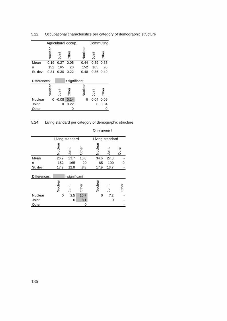
186
5.22 Occupational characteristics per category of demographic structure
5.24 Living standard per category of demographic structure
Agricultural occup. Commuting
Nuc
lear
Join
t
Oth
er
Nuc
lear
Join
t
Oth
er
Mean 0.19 0.27 0.05 0.44 0.39 0.35n 152 165 20 152 165 20St. dev. 0.31 0.30 0.22 0.48 0.36 0.49
Differences: =significant
Nuc
lear
Join
t
Oth
er
Nuc
lear
Join
t
Oth
erNuclear 0 -0.08 0.14 0 0.04 0.09Joint 0 0.22 0 0.04Other 0 0
Only group I
Living standard Living standard
Nuc
lear
Join
t
Oth
er
Nuc
lear
Join
t
Oth
er
Mean 26.2 23.7 15.6 34.6 27.3 -n 152 165 20 65 100 0St. dev. 17.2 12.8 8.8 17.9 13.7 -
Differences: =significant
Nuc
lear
Join
t
Oth
er
Nuc
lear
Join
t
Oth
er
Nuclear 0 2.5 10.7 0 7.2 -Joint 0 8.1 0 -Other 0 -

187
C Non-agricultural occupations encountered among the village population
The list below is derived from both the basic household surveys and the in-depth surveys. Since basic household questionnaires were sometimes coded, not all specific occupations of working members in the villages could be listed. Nevertheless, it provides a fair impression of the occupational diversification in Delhi’s rural-urban fringe villages. Group I: Khushk : 1 Police officer, 1 gardener in government service, 1 employee of DTC, 1 DTC driver, 1
scooter mechanic in Delhi in private sector, 1 civil servant unspecified, 2 construction contractors, 5 tempo drivers, 2 taxi drivers, 1 vegetable trader, 1 car mechanic in Delhi, 1 shopkeeper in the village, 1 shopkeeper in a nearby village, 2 employees of DWS, 1 gardener in a school in Delhi, 1 gardener in the Forest Department, 1 local electrician, 2 gardeners in a hospital in Delhi, 3 drivers of their own tempo, 1 car mechanic in another village, 1 government employee of the radio station in Delhi, 1 property dealer in a nearby town, 1 electrician in Delhi, 1 truck driver, 1 employee of the tax department in Delhi and local shopkeeper, 2 local shopkeepers, 1 employee of the Department of Law of Delhi Government, 1 teacher in a private school, 1 teacher in a private school and politician, 1 auditor in Delhi, 2 industrial workers in Delhi, 1 trader in milk in a nearby town.
Jagatpur: 1 employee of the Post Office in Delhi, 4 part-time milk collectors and transporters, 9 employees of the Water Supply Company in Delhi, 1 construction contractor, 1 civil servant (unspecified), 2 property dealers working in Delhi, 1 owner/driver of mini truck, 1 clerk in government service, 2 teachers, 1 manager at the Ministry of Education in Delhi, 2 drivers of private cars, 2 mechanics in DTC, 2 police constables, 1 army officer of the border security in Jammu, 1 clerk at the Ministry of Urban Development, 1 clerk in government service, 1 counter sales clerk at the government insurance company, 1 employee of the Health Department of the government of Delhi, 1 employee at the Sanitation Department in Delhi.
Sungarpur: 1 property dealer, 1 government contractor, 1 private bus driver, 1 medical doctor in Delhi, 1 employee of the Flood Control Department in Delhi, 1 tempo driver in Delhi, 1 driver on his own tempo, government employee in Delhi vegetable market, 1 businessman unspecified, 1 shopkeeper in nearby town, 1 teacher in nearby village, 1 teacher in Delhi, 1 manager of food grain mill in Delhi, 1 clerk in DTC, 1 government employee in nearby town unspecified, 1 transporter of milk to Delhi, 1 manager in Delhi unspecified, 1 employee of DESU, 1 taxi driver.
Zindpur: 1 Labourer in village water supply (government), 3 employees of the DTC (1 driver, 2 unspecified), 1 property dealer, 1 proprietor of shop selling kerosene oil in Delhi, 1 operator of brick kiln in rural area of Alipur Block, 1 clerk in a bank in Delhi, 1 professional wrestler, 3 teachers (1 at a college, 2 at a secondary school), 1 medical assistant (Delhi), 1 employee of Post and Telegraph Company, 1 clerk at a college (Alipur town), 1 bus owner (bus plying at the route from Palla village to Delhi Railway Station), 1 civil servant in Delhi (unspecified), 1 worker in village water supply.
Ibrahimpur: 1 labourer in sanitary works in Delhi, 2 shopkeepers of general stores, 1 employee of Delhi Police, 1 employee of Defence Ministry in New Delhi, 1 property dealer, 1 employee of Water Works Department in Delhi, 1 bus driver, shopkeeper and landlord, 1 employee of Telecom Company (government), 1 milk supplier, 1 owner/driver of a truck, 1 inspector with the Delhi Police, 1 employee in a hospital in Delhi, 1 driver of private cars, 1 pharmacist in government hospital in Delhi, 1 employee of DWS, 1 employee of DDA, 1 taxi driver, 1 guard at the sewerage company (government), 1 pharmacist at DTC, 1 teacher, 1 person running a food stall at the roadside, 1 journalist, 1 school principal, 1 professor in USA.
Pehladpur Bangar: wire factory owner, 1 property dealer, 1 businessman in import/export, 1 marketer for a factory in insulation material, 2 teachers in Delhi, 1 conductor in DTC, 3 mechanics in DTC, 2 drivers in DTC, 1 wheat shop owner, 1 pharmacist, 1 shopkeeper in

188
Samaipur, 3 local general store owners, 1 accountant with the Delhi Police, 1 gardener in DDA, 1 sorter at the post office, 1 worker for the Congress Party, 1 shopkeeper in dairy products, 1 owner of a beauty parlour, 1 clerk in the Publication Division of the central government, 1 watchman in the Education Department, 1 watchman in the Income Tax Department, 1 clerk in All India Institute for Medical Sciences.
Nangli Poona: 4 teachers in Delhi, 1 local teacher, 1 person running a small factory in his house, 2 employees of the DDA, 4 employees of DTC (unspecified), 1 mechanic at DTC, 2 bus drivers at DTC, 1 conductor of DTC, 1 bus driver of a private bus, 1 clerk at the Food and Civil Supplies Corporation (government), 1 employee of a hospital in Delhi, 1 labourer at a factory in Delhi, 1 owner of a local transport business, 1 person working at his father’s local transport business, 6 constables with the Delhi Police, 1 employee of DWS in Delhi, 1 trader in leather goods, 1 animal doctor, 1 engineer in a private company in Delhi, 1 mailman in Delhi, 2 lawyers, 1 owner of a telephone shop.
Group II: Khushk : 2 employees of Delhi Government unspecified, 1 employee of the Education
Department, Delhi Government, 1 employee of Indian Navy in Delhi, 1 small trader in plastic waste.
Jagatpur: 1 employee of the Flood Control Department in Delhi, 1 shopkeeper in village, 2 politicians, 2 employees of Delhi Water Supply, 1 clerk at DWS, 1 auditor with a government institute in Delhi, 1 cashier in a bank in Delhi, 1 musician, 1 metal fitter in Delhi, 1 driver of private cars, 2 blacksmiths, 2 labourers in factories in Delhi, 1 property dealer in a nearby village.
Sungarpur: 1 government employee unspecified, 1 milk salesman, 1 industrial labourer in Delhi, 1 industrial labourer in nearby village, 1 local tea stall holder, 1 MCD gardener, 2 employees of local school, 2 employees of MCD in nearby villages, 2 employees of MCD unspecified, 2 employees of DESU in Delhi, 1 employee of DWS, 1 local barber, 1 sweeper in Supreme Court in Delhi, 1 labourer in an electronics factory in a nearby village, 1 tailor in nearby village, 2 shopkeepers in nearby village.
Zindpur: 1 operator of a tea stall in the village, 1 proprietor of a general store in the village, 1 teacher in Delhi, 1 owner and operator of school bus and truck, 1 employee of Delhi Police, one carpenter mostly in village, 1 property dealer in Delhi, 3 employees of a shop in electronic goods in Delhi, 1 tailor at his own home, 1 employee of the telephone company and making quilts in his house.
Ibrahimpur: 2 drivers of personal cars, 2 government employees (unspecified), 1 cleaner in government service, 2 shopkeepers in the village, 1 stenographer in Delhi, 1 person running vegetable shop, 1 repairman for hand pumps (irregularly employed), 1 mechanic in DTC, 6 construction labourers, 1 clerk in Income Tax Department in Delhi, 2 mobile vegetable sellers, 1 guard, 2 tailors in/near their own houses, 2 drivers of mini truck, 1 auto rickshaw driver, 1 person running a small poultry farm, 1 cycle repairman in village, 1 person running a tea stall in the village, 1 mechanic in Delhi, 1 photographer in Delhi, 2 brick kiln labourers, 1 headman of the PWD in Delhi, 1 textile trader, 1 childcare lady working in Delhi,
Pehladpur Bangar: 1 government hospital assistant, 1 photographer, 1 local mechanic, 3 local tailors, 1 upper divisional clerk in the Income Tax Department, 1 fitter in the railways, 1 servant in the school, 1 local welder, 1 peon at the Delhi Police, 1 telephone shop operator, 1 factory labourer in Delhi, 1 teacher, 1 local owner of a building materials shop, 1 peon at the PWD, 1 lower divisional clerk at the Central Government, 1 clerk at the railways, 1 peon at the Malaria Department in Delhi, 1 plumber in the military.
Nangli Poona: 4 shopkeepers in the village, 2 tailors in the village, 1 person selling pigs, 3 drivers of personal cars usually in Delhi, 1 social worker, 1 plumber working at New Delhi International Airport, 1 lock repairman working in Delhi, 2 auto rickshaw drivers, 1 bus driver for DTC, 1 assistant in a government hospital in Delhi, 1 head constable in Delhi Police, 1 constable with the Delhi Police, 1 mechanic working in Delhi, 2 labourers at MCD, 1 clerk in a bank in Delhi, 1 plumber in a government institute in Delhi, 1 shopkeeper in Delhi, 1 clerk at DDA, 1 electrician at DESU, 1 labourer in a local glass factory, 1 clerk in a library in nearby

189
village, 1 plumber at a college in Delhi, 1 owner of a small factory, 1 local tea stall owner, 1 vegetable seller in the village.
Group III: Khushk : 1 labourer in spices factory in Delhi, 1 part-time female tailor. Jagatpur: no data Sungarpur: no data Zindpur: 13 employees of a plywood factory in Delhi, 1 person pressing clothes in the village, 1
worker in storage of spare engine parts in Alipur, 1 person selling vegetables in the village, 2 truck drivers, 2 truck loaders, 1 labourer in a steel factory near Delhi, 1 labourer in a plastic factory near Delhi, 1 part-time labourer at brick kilns, part-time labourer at other factories, 1 owner of huts in the fields near the village drawing his income from the rent.
Ibrahimpur: no data. Pehladpur Bangar: no data Nangli Poona: 1 software engineer, 2 auto rickshaw drivers, 10 labourers at the local plywood
factory, 2 labourers at the local sewer pipe factory, 1 labourer at a local tyre factory, 1 labourer at the local clothes mill, 1 labourer at local plastic factory, 1 watchman at a local factory, 1 carpenter working in Delhi, 9 labourers at a factory in Delhi, 1 tailor working in Delhi, 1 person running a shop of waste materials in the village, 4 local construction labourers, 1 car mechanic in Delhi, 1 local cycle rickshaw driver, 1 person running a local food stall, 1 supervisor in a steel factory in Delhi, 9 labourers on trucks, 1 musician beating drums at marriages, 2 truck drivers, 2 timber traders with a shop in Delhi, 1 watchman with the Delhi Police, 1 watchman of a private home in Delhi, 1 transporter of flowers to Delhi, 1 employee of MCD, 1 worker at a car parts shop in Delhi, 1 scooter mechanic working at a repair shop in Delhi, 2 labourers in PWD, 2 local mobile food sellers, 1 property dealer, 3 persons making boxes for lipstick in the village, 1 labourer at the Delhi vegetable market, 1 mason, 1 person running a factory in Delhi.
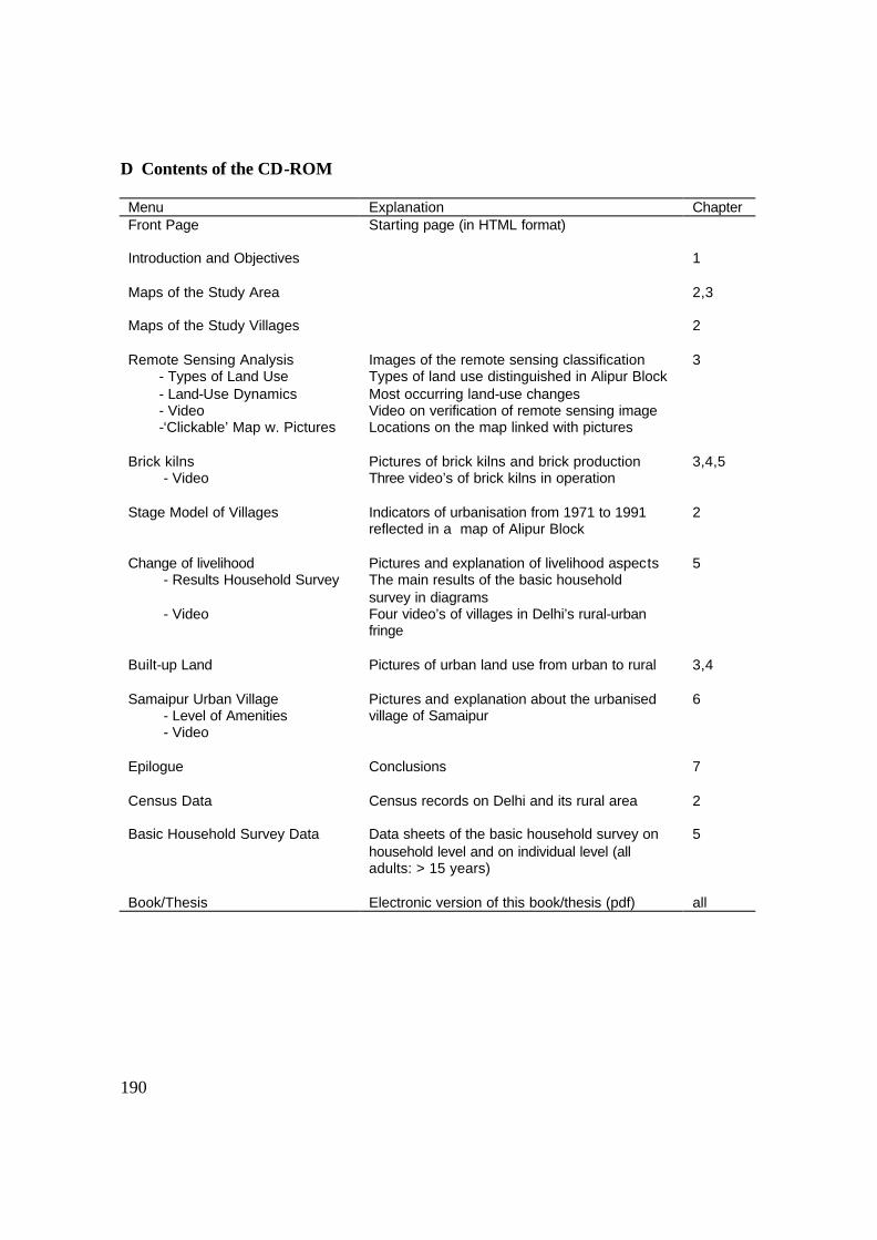
190
D Contents of the CD-ROM
Menu Explanation Chapter Front Page Starting page (in HTML format)
Introduction and Objectives
1
Maps of the Study Area
2,3
Maps of the Study Villages
2
Remote Sensing Analysis - Types of Land Use - Land-Use Dynamics - Video -‘Clickable’ Map w. Pictures
Images of the remote sensing classification Types of land use distinguished in Alipur Block Most occurring land-use changes Video on verification of remote sensing image Locations on the map linked with pictures
3
Brick kilns - Video
Pictures of brick kilns and brick production Three video’s of brick kilns in operation
3,4,5
Stage Model of Villages Indicators of urbanisation from 1971 to 1991 reflected in a map of Alipur Block
2
Change of livelihood - Results Household Survey - Video
Pictures and explanation of livelihood aspects The main results of the basic household survey in diagrams Four video’s of villages in Delhi’s rural-urban fringe
5
Built-up Land
Pictures of urban land use from urban to rural 3,4
Samaipur Urban Village - Level of Amenities - Video
Pictures and explanation about the urbanised village of Samaipur
6
Epilogue
Conclusions 7
Census Data Census records on Delhi and its rural area 2
Basic Household Survey Data Data sheets of the basic household survey on household level and on individual level (all adults: > 15 years)
5
Book/Thesis Electronic version of this book/thesis (pdf) all
Copyright © 2022 FDOKUMEN