Flexible calibration technique for fringe-projection-based three-dimensional imaging
Upload
khangminh22Category
view
0download
0

Conservation Management Plan for Darlington’s Town Centre Fringe
Archaeo-Environment Ltd for Darlington Borough Council 2
SUMMARY
The town centre fringe (TCF) has much that is of heritage significance;
however it is an area that hides its heritage assets well. Historic bowed
windows peer out from behind freezers, ornate rooftops are obscured by
modern buildings, houses of international significance sit shyly behind a
kebab shop, the town’s much loved Bulmer stone sits trapped behind railings
and renowned poets are long forgotten. It is time that the town centre fringe
celebrated its rich heritage.
It is the railway heritage that consistently appears as the exceptional
contributor to local distinctiveness and as Darlington’s unique selling point.
The architecture is exceptionally significant because of the contribution that it
makes towards our understanding of the birth and early years of a mode of
transport that was to change the face of the world. Its educational value is
already exploited via the Head of Steam museum and has the potential to
provide more. The railway heritage also has considerable potential to draw
visitors to Darlington from across the world. However its condition and
management would have to match that of the Head of Steam Museum before
it was worth crossing continents for.
Decisions regarding the future management of the town will want to be guided
by the existing historic building stock and the predominantly 19th century
street pattern. It will need to consider the contribution that traditional building
materials, such as red brick and the beautiful scoria blocks, will make to the
Darlington of the future. New developments and the adaptation of existing
development will need to recognise the importance of designed and fortuitous
views towards significant skyline features and the restoration of more general

Conservation Management Plan for Darlington’s Town Centre Fringe
Archaeo-Environment Ltd for Darlington Borough Council 3
views which have been blighted by 20th century development. It will also need
to recognise the recent loss of important physical links with the town centre
and the river and important existing links to green spaces such as South Park.
Throughout all of the important future management decisions, we must ask, is
this proposal good enough for an area of town of international importance
because of its association with the birth of the railways?
The Vision
By 2025, two hundred years after the birth of the railway, Darlington’s town
centre fringe will be transformed into a vibrant urban area with well-
maintained historic buildings, exciting small scale modern development, a
thriving tourism industry based on the railway heritage and a healthy
accessible river cherished by the local community.
In order to achieve this, the Borough Council in partnership with local
residents and businesses, will revitalise the town centre fringe through
sustainable imaginative regeneration which recognises the historical value
and embodied energy of existing pre 1919 building stock.
The Council will also recognise the international importance of the town centre
fringe’s railway heritage through conservation, restoration and celebration of
its role in the birth of the railways.
In order to achieve this, the following broad management recommendations
have been made, in addition to more detailed management recommendations
for each character area. These recommendations have arisen out of the
public consultation process and the first two stages of the conservation
management plan which looks at our understanding of the TCF, its
significance and its issues. Shaded recommendations may require the
adoption of new or altered policy.
Summary of management recommendations HE1 – loss of river Timetable

Conservation Management Plan for Darlington’s Town Centre Fringe
Archaeo-Environment Ltd for Darlington Borough Council 4
a) Restore Cocker Beck access from Northgate to Westbrook 1-3 years1
b) negotiate visual access to beck and its management (litter collection) from the Bridge Inn beer garden
1-3 years
c) Move sheds back 3-5m from the east bank of the Skerne between Russell Street and Chesnut Street
gradual over 10 years
d) Negotiate access from the side of Magnets on John Street to the Skerne Bridge then improve path facilities from the bridge to Northgate with signage to the museum
1-3 years
e) Recreate attractive footpath walks along Weir Street as part of a wider redevelopment package which will link existing riverside access beside the printing Works and Edward Pease’s House.
1-15 years and as opportunities arise through the planning process
f) Ensure redevelopment of MFI site improves and enhances access to the river bank.
1-5 years
Redesign road crossing to link the river across the road. 1-15 years
Repair missing cap from listed bridge pier. 1-3 years
g) Bring the river back to the surface in the vicinity of St Cuthbert’s Way and Victoria Road as part of wider landscaping scheme to reduce the visual impact of the ring road
within 15 years
h) Enhance the scoria block back lane between Victoria Embankment and Feethams through the redevelopment of Feethams to create a safer walking/cycling environment and as part of this scheme, repair the listed bridge across the Skerne.
within 7 years
Summary of Management Recommendations HE2 – Streets dominated by cars
Timetable
a)Create design briefs for the ring road area to encourage street fronted development with varied roof lines and detailed designed elevations facing the ring road and Parkgate (where appropriate), with gaps to create vistas towards the town centre and St. Cuthbert’s spire in particular. There are plots currently available for redevelopment plus proposals to move the fire station and police station away from the ring road and so this policy should be implemented immediately.
Immediate
b)Traffic management should give priority to pedestrians and cyclists and prevent the construction of further subways or dual carriageways within the town centre fringe.
Immediate
c) the Council to explore a park and ride scheme
Summary of Management Recommendations HE3 – Car parking Timetable
Car parking strategy to consider the following:
a) Beaumont Street, Houndgate and Feethams to be redeveloped as mixed use development with a design brief to reflect varied roof lines, vistas to town centre and historic skyline features, yards and alleys
Production of design brief immediate
b) Garden Street to be redeveloped with mixed use, restore Weavers Yard, re-instate ‘Edward Pease’s garden’ in part or allotment element – design brief required
Production of design brief immediate
c) Kendrew Street and King Street car parks reduced through landscaping and possibly street fronted development
up to 10 years
1 Subsequent consultation has suggested that local residents would like to see this actioned sooner

Conservation Management Plan for Darlington’s Town Centre Fringe
Archaeo-Environment Ltd for Darlington Borough Council 5
Summary of Management Recommendations HE4 – Skyline features (New policy is shaded)
Timetable
a) New developments should seek to incorporate views towards historic skyline features
immediate adoption of policy
b) Planning applications will be assessed against the impact of the proposal against skyline features.
immediate adoption of policy
Summary management recommendations: Multiple Occupancy as indicator of decline
Timetable
a) The council has already decided to put a moratorium on multiple occupancy planning permissions and so no action is required
N/A
b) Enforcement needs to be improved where loss of historic character is threatened
Immediate
c) The Council need to consider how best to respond to resident’s complaints regarding anti-social behaviour of its own tenants or breaches of local bye-laws
Immediate
d) The police and the council need to consider if dog fouling and fly-tipping can be targeted for a rapid response when complaints are made and the council needs to reconsider charging honest residents for the acts of dishonest ones.
Immediate
e) The council and local communities to join together to create a wardening service collecting litter until such time as the area regenerates and litter dropping becomes more difficult
Immediate
f) Consult with the local community to see if there is a demand to trial gated and landscaped back lanes.
1-5 years
Summary management recommendations HE6: Inappropriate maintenance of historic buildings (new Policy is shaded)
Timetable
6a.1 Planning permission to replace shop windows on properties pre-dating 1919 should only be granted for traditional window types in consultation with the Conservation Officer
Immediate
6a.2 Permitted development rights should be withdrawn in Victoria Embankment Conservation Area (they are already withdrawn in Northgate Conservation Area) and should be withdrawn in any future Conservation Areas that are created.
1-5 years
6a.3 The council needs to improve its enforcement procedure for Article 4 directions, listed building consents and planning conditions relating to historic buildings
Immediate
6a.4 Building regulation staff should attend a course run by Heritage Skills Initiative on the breathability of pre-1919 houses so that they can make informed decisions regarding the application of the regulations on historic buildings
1-3 years
6a.5 The council should provide free written or oral advice on home maintenance as leaflets, web pages or DVDs covering everyday maintenance, energy efficiency in older buildings, windows, doors, roofing, domestic chimneys and flues, damp, cast iron rainwater goods, painting and repointing.
1-5 years
6a.6 Create a traditional skills web site, possibly in partnership with Durham County Council and Tees Valley for home owners to source the skills necessary to properly maintain their historic buildings
1-5 years
6a.7 The council should apply for Townscape Heritage Initiative Funding for all conservation areas (once Parkgate and any others have been designated)
1-5 years
6bThe council should formally create a conservation area based on Parkgate and possibly include the east side of Hargreave Terrace. A conservation area appraisal and management plan will then be required in consultation with the residents
1-5 years
c) The council should create a conservation area based on Victoria Road, to be followed by a conservation area appraisals and management plan
1-7 years
d) The town centre conservation area should be extended to include Victoria Road west of South Arden Street (and possibly with a little less justification land

Conservation Management Plan for Darlington’s Town Centre Fringe
Archaeo-Environment Ltd for Darlington Borough Council 6
east of South Arden Street).
e) The Victoria Embankment conservation area could be extended to include South Terrace
Summary management recommendations HE7: Reuse of historic buildings stock (new Policy is shaded)
Timetable
a) No new large scale development should take place outside the town until existing historic buildings are used and brown field sites are developed within the TCF
immediate
b) No demolition of properties should be agreed without a full planning application showing what will replace it
immediate
c) There should be a presumption against planning permission for the demolition of any property built before 1919
immediate
d) The local development framework should actively encourage the reuse of historic buildings and the need for a Statement of Significance to guide conversions. The council should favour mixed use development so that there is a residential element to all areas providing the necessary profits in redevelopment and ensuring that the area does not empty outside office hours
immediate
e) The Council also need to exert their repair and compulsory powers quickly before decline in buildings is too advanced
immediate
f) Design briefs should be prepared for the following TCF areas (where they have not already been carried out): ‘Left Bank’ of the Skerne between Russell Street and John Street Borough Road Waste ground in front of Skerne Bridge Land between Valley Street and East Mount Cattle Market
Immediate Immediate TBC 1-5 years TBC
Summary Management Recommendations HE8– the design of new build Timetable
a) Developers should be discouraged from creating pastiches of old build, but instead use historic buildings to inform exciting new designs of high quality. Developers will be expected to outline how their build will fit into the historic environment in their design statement which must accompany their planning application.
immediate
b) Where a development does not conform to council prepared design briefs, the developer will be encouraged to discuss their designs with the conservation officer at an early stage in the application process
immediate
Summary Management Recommendations HE9 – the protection of historic buildings
Timetable
a) Include terrace houses with traditional windows and doors in the local list 1-2 years
b) Have the local list adopted as a material consideration in the planning process 1-2 years
c) The Borough Council should ensure that they have a Statement of Significance for each heritage asset in their care
1-7 years
d) Each planning application or listed building consent application should be accompanied by a Statement of Significance
ongoing
e) Submit the Railway Tavern and 1-5 Victoria Road for spot listing to English Heritage
Conservation Management Plan for Darlington’s Town Centre Fringe
Archaeo-Environment Ltd for Darlington Borough Council 7
Facilities for younger people – HE11. Summary Management Recommendations
Timetable
See HE 10.10 and HE 7
Summary Management Recommendations HE 12 Local production of materials
Timetable
a) Encourage through strategic planning the housing of small scale science or green based businesses or research establishments within the TCF
Immediate policy creation- implementation opportunity driven
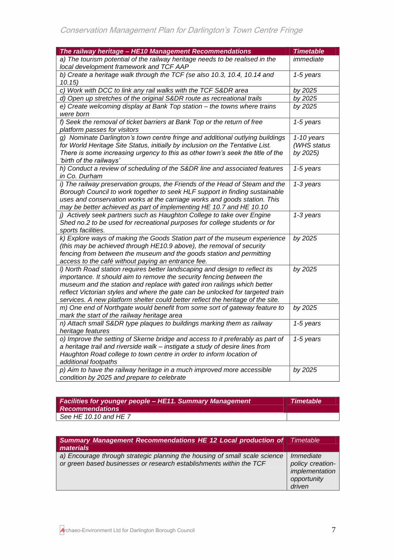
The railway heritage – HE10 Management Recommendations Timetable
a) The tourism potential of the railway heritage needs to be realised in the local development framework and TCF AAP
immediate
b) Create a heritage walk through the TCF (se also 10.3, 10.4, 10.14 and 10.15)
1-5 years
c) Work with DCC to link any rail walks with the TCF S&DR area by 2025
d) Open up stretches of the original S&DR route as recreational trails by 2025
e) Create welcoming display at Bank Top station – the towns where trains were born
by 2025
f) Seek the removal of ticket barriers at Bank Top or the return of free platform passes for visitors
1-5 years
g) Nominate Darlington’s town centre fringe and additional outlying buildings for World Heritage Site Status, initially by inclusion on the Tentative List. There is some increasing urgency to this as other town’s seek the title of the ‘birth of the railways’
1-10 years (WHS status by 2025)
h) Conduct a review of scheduling of the S&DR line and associated features in Co. Durham
1-5 years
i) The railway preservation groups, the Friends of the Head of Steam and the Borough Council to work together to seek HLF support in finding sustainable uses and conservation works at the carriage works and goods station. This may be better achieved as part of implementing HE 10.7 and HE 10.10
1-3 years
j) Actively seek partners such as Haughton College to take over Engine Shed no.2 to be used for recreational purposes for college students or for sports facilities.
1-3 years
k) Explore ways of making the Goods Station part of the museum experience (this may be achieved through HE10.9 above), the removal of security fencing from between the museum and the goods station and permitting access to the café without paying an entrance fee.
by 2025
l) North Road station requires better landscaping and design to reflect its importance. It should aim to remove the security fencing between the museum and the station and replace with gated iron railings which better reflect Victorian styles and where the gate can be unlocked for targeted train services. A new platform shelter could better reflect the heritage of the site.
by 2025
m) One end of Northgate would benefit from some sort of gateway feature to mark the start of the railway heritage area
by 2025
n) Attach small S&DR type plaques to buildings marking them as railway heritage features
1-5 years
o) Improve the setting of Skerne bridge and access to it preferably as part of a heritage trail and riverside walk – instigate a study of desire lines from Haughton Road college to town centre in order to inform location of additional footpaths
1-5 years
p) Aim to have the railway heritage in a much improved more accessible condition by 2025 and prepare to celebrate
by 2025

Conservation Management Plan for Darlington’s Town Centre Fringe
Archaeo-Environment Ltd for Darlington Borough Council 8
Acknowledgements
This report has been written with considerable help from a number of people.
Heather Grimshaw, Tim Crashaw, Gabriella White, Peter Roberts, Phil Roxby
and the staff of the Local Studies Library, all of Darlington Borough Council,
have made information available on the area, offered advice and helped with
the consultation process. Charles McNab, Brian Denham and Ian Dougill of
the Darlington Historical Society have kindly provided additional information
derived from their extensive researches and Mr Dougill has also provided a
guided walk around the Skerne, old photographs, newspaper cuttings, historic
maps and his own paintings of the river and its historic environment. We are
particularly indebted to Dave Tetlow of the Head of Steam Museum who
made the museum available for our consultation event and provided free entry
to those attending so they could spend time at the museum and enjoy its
delights. We are also indebted to Sarah Goldsborough and staff at the
museum who provided information on visitor use and helped with the
consultation event. Richard Wimbury, Chair of the Friends of the Head of
Steam Museum gave us hours of his time to talk through the importance of
the railway heritage and provided a guided walk around a number of railway
buildings. He also delivered a group of railway enthusiasts to the consultation
event for which we are very grateful. Don Whitfield provided photographs of
various features of historic interest throughout Darlington and Chris Fish, a
former conservation officer for the Borough shared his in depth knowledge of
the railway heritage and provided books, property deeds and tea. The local
historian Jean Kirkland also offered support and advice and from further afield
we were delighted to received contributions and support from Darlington
enthusiasts across the world. Many residents came out to talk to us when we
were conducting the fieldwork and we would like to thank all of them for their
advice and for expressing their concerns.
The main consultation event was held on the 22nd May 2010 at the Head of
Steam Museum. Additional consultation meetings were held with the Friends
of the Head of Steam Museum and Darlington Historical Society. A wider
consultation process took place concurrently on the future of the town centre

Conservation Management Plan for Darlington’s Town Centre Fringe
Archaeo-Environment Ltd for Darlington Borough Council 9
fringe and this provided additional opportunities for the local community and
stakeholders to become involved. Our grateful thanks go to the people who
attended the consultation events, completed questionnaires or made their
views known by other means.
Author: Caroline Hardie
Additional fieldwork: Niall Hammond
Mapping: Jane Skriabin
Cover Illustration: Bank Top Station
All mapping is reproduced from Ordnance Survey Material with the permission
of Ordnance Survey on behalf of the Controller of Her Majesty's Stationery
Office. © Crown copyright. Unauthorised reproduction infringes Crown
copyright and may lead to prosecution or civil proceedings. Darlington
Borough Council. Licence No. 100023728. 2010
‘The numerous Churches, Chapels, Recreation Grounds, Public Baths,
Hospitals, and other necessary Municipal Institutions, though not within the
scope of this guide to severally detail, show that the town in matters religious
and social is not content to stand still or even to lag behind.
These in conjunction with unusually low rates, with beautiful surroundings,
ready facilities and easy access to still more beautiful and interesting districts,
explain why Darlington is becoming so attractive and well appreciated a
residential centre.’
Darlington Half Holiday Guide 1899

Conservation Management Plan for Darlington’s Town Centre Fringe
Archaeo-Environment Ltd for Darlington Borough Council 10
CONTENTS
VOLUME I
Summary 2
Acknowledgements 8
1.0 Introduction 12
2.0 Historic Background: Understanding the town centre fringe 18
3.0 The Built Form 33
4.0 Statement of Significance 59
4.1 Historical Values 60
4.2 Aesthetic Values 78
4.3 Communal Values 105
4.4 Evidential Values 108
5.0 Statement of Significance Conclusion 114
VOLUME II
Introduction 119
Issues and Management Recommendations 122
Loss of River 123
Streets dominated by cars 131
Car parking 135
Skyline features 138
Multiple occupancy as an indicator of decline 139
Inappropriate maintenance of historic buildings 144
Reuse of historic buildings stock 162
The design of new build 169
The protection of historic buildings 170
The railway heritage 174
Facilities for younger people 185
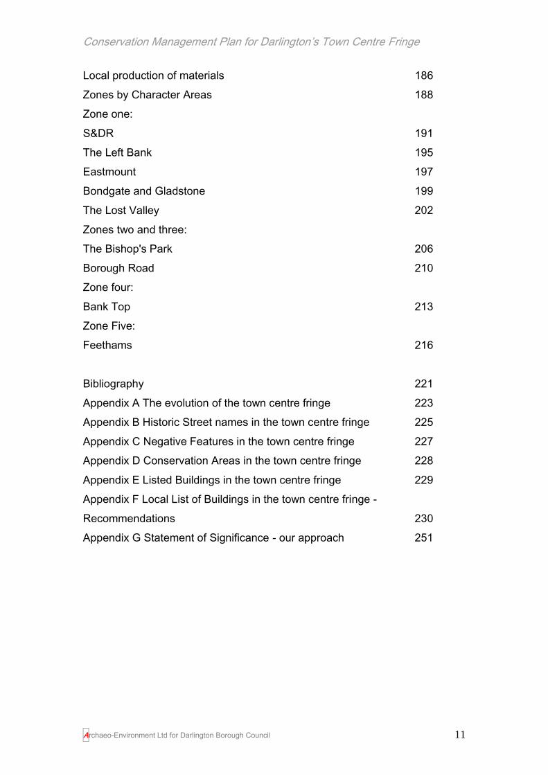
Conservation Management Plan for Darlington’s Town Centre Fringe
Archaeo-Environment Ltd for Darlington Borough Council 11
Local production of materials 186
Zones by Character Areas 188
Zone one:
S&DR 191
The Left Bank 195
Eastmount 197
Bondgate and Gladstone 199
The Lost Valley 202
Zones two and three:
The Bishop's Park 206
Borough Road 210
Zone four:
Bank Top 213
Zone Five:
Feethams 216
Bibliography 221
Appendix A The evolution of the town centre fringe 223
Appendix B Historic Street names in the town centre fringe 225
Appendix C Negative Features in the town centre fringe 227
Appendix D Conservation Areas in the town centre fringe 228
Appendix E Listed Buildings in the town centre fringe 229
Appendix F Local List of Buildings in the town centre fringe -
Recommendations 230
Appendix G Statement of Significance - our approach 251

Conservation Management Plan for Darlington’s Town Centre Fringe
Archaeo-Environment Ltd for Darlington Borough Council 12
1.0 Introduction
What is a Conservation Management Plan?
A conservation management plan (CMP), is a document which provides an
understanding of an area’s historic environment composed of buildings,
landscape, culture, character and archaeology. The CMP will identify what is
significant and worthwhile about that place, the issues facing it and provide
policies to guide the long-term-management and conservation of the place.
Through application of the CMP by local authority, statutory bodies and
community, the best of the old is valued and kept, and a sustainable future for
the place is delivered, inspired and enhanced by the past. This Plan is a non-
statutory document. It has been prepared to supply guidance and direction for
future management and decision making in relation to Darlington’s town
centre fringe. Figure 1 shows where the town centre fringe is in relation to the
rest of Darlington.
The town centre fringe was identified as a key area of strategic importance for
Darlington in 2006 as part of work commissioned to underpin Darlington’s
Economic Regeneration Strategy. Archaeo-Environment was commissioned
by Darlington Borough Council in 2010 to prepare this Conservation
Management Plan in order to inform the process of regeneration. By
commissioning this work at a very early stage when no decisions have been
set in stone, it will ensure that heritage and local distinctiveness are key
drivers in the regeneration of the area.

Conservation Management Plan for Darlington’s Town Centre Fringe
Archaeo-Environment Ltd for Darlington Borough Council 13
‘The Vision: That the value of the historic environment is recognised by all
who have the power to shape it; that Government gives it proper recognition
and that it is managed intelligently and in a way that fully realises its
contribution to the economic, social and cultural life of the nation’.
The Government’s Statement on the Historic Environment for England 2010:
the vision
The role of the historic environment in the cultural, social, economic and
environmental success of a place is recognised by government. It is accepted
fact that the historic environment makes a very real contribution to our quality
of life and the quality of our places (DCMS 2010, 1). Aside from its inherent
cultural value, the historic environment also has an important role to play in
helping local and national Government to achieve many of its broader goals. It
can be a powerful driver for economic growth, attracting investment and
tourism, and providing a focus for successful regeneration. Alongside the best
in new design, it is an essential element in creating distinctive, enjoyable and
successful places in which to live and work. Heritage can be a significant
focus for the local community, helping to bring people together, to define local
identities and to foster a new understanding of ourselves and those around
us.
North East Research Recommendation SU 21. The possibility for heritage-led
urban regeneration projects should be explored, combining a drive for
economic renewal with the opportunity for conservation-led research. An
example of good practice is the Grainger Town Project, carried out by a
partnership including One North-East, English Heritage and Newcastle City
Council.
(Petts and Gerrard 2006, 207 )
Darlington Borough Council is aware that successful regeneration means
bringing social, economic and environmental life back, not just into the town
centre fringe, but the community as a whole. Conservation-led regeneration

Conservation Management Plan for Darlington’s Town Centre Fringe
Archaeo-Environment Ltd for Darlington Borough Council 14
transforms places, strengthens a community’s self image and recreates
viable, attractive places which encourage sustained inward investment
(English Heritage, 2005).
At a time when we are all concerned with climate change, we must also
recognise and value the inherent sustainability and embodied energy of
historic buildings and their surroundings and by learning from them and the
other types of evidence left by the low carbon economies of the past, we can
make real progress in helping to mitigate and adapt to climate change (ibid).
This historic environment is all around us. In Darlington it is not just the listed
buildings and conservation areas which are the most visible signs of our
heritage, but the rows of terraced houses and railway buildings which
transformed the town in the 19th century, the street names and skyline, the
ground beneath our feet which covers the remains of the earliest settlements.
Through the centre of it all, flows the life line of the River Skerne; once the
very reason for establishing a settlement here, sometimes cruelly tamed and
channelled, often neglected and inaccessible, but a constant presence with a
potential central position in the heart of community life; as such, it cannot be
ignored in any regeneration scheme.
Much of the historic environment has been lost in Darlington, but much more
survives, sometimes cherished, sometimes under-valued and hidden. This
Conservation Management Plan flags up that which is of significance to the
historic environment and those elements of the town centre fringe which
detract from the historic environment. It offers guidance, created through
expert advice and public consultation, on how the negative can be reversed,
how the valued can be enhanced and how the past can inspire, but not dictate
the designs of the future.

Conservation Management Plan for Darlington’s Town Centre Fringe
Archaeo-Environment Ltd for Darlington Borough Council 15
The organisation of the Conservation Management Plan
Understanding the town centre fringe (volume 1)
In order to manage such changes without compromising the cultural values of
the town centre fringe we need to understand what elements contribute to the
significance and character of the area, and how these may be vulnerable and
susceptible to any changes in the future. The following Conservation
Management Plan aims to look at the area from a wide range of different
perspectives including its history, the built form, the open spaces, use,
community involvement and local distinctiveness.
“These assets are unique and once they have been damaged or destroyed
they cannot be recovered or be re-created. However, conservation of historic
assets need not prevent development and change. English Heritage
recognises that the most effective way to conserve cultural values is to
manage change by prompting awareness of the values that will be affected”.
English Heritage 2006, 1
The Statement of Significance (volume 1)
The Statement of Significance covers those aspects of the town centre fringe
which contribute towards its significance whether that be its buildings, open
spaces, street pattern, traditions or associations with notable people or
events. The Planning Policy Statement issued by the Department for
Communities and Local Government (PPS5 2010) makes it clear that
planning decisions should be based on the heritage significance of an asset
and the impact of any proposals on that significance. This section of the
Conservation Management Plan is therefore very important in dealing with
how the town centre fringe should be developed in future.
Issues, Policies and Management (volume 2)
In terms of looking at the issues affecting significance, the Plan has aimed to
provide a general, unbiased assessment of the current factors influencing the

Conservation Management Plan for Darlington’s Town Centre Fringe
Archaeo-Environment Ltd for Darlington Borough Council 16
various aspects of each character area. It does not specifically set out to
address the current regeneration proposals, or provide the type of detailed
assessment that would be needed to support a planning application. For
ease of use, the area has been divided into zones when considering
management options; within each zone there are areas of distinctive
character with different management issues. In order to maintain that local
distinctiveness the management recommendations may be specific to
individual character areas, but there are some issues which run through the
whole area. These issues and management recommendations are contained
within volume two.
The Team
In compiling the Plan a team of key specialists were consulted including the
Conservation Team of Darlington Borough Council, the Darlington Historical
Society and The Friends of the Head of Steam Museum. Additional
consultation has taken place with Urban Splash, English Heritage, The
Environment Agency and the Department of Culture Media and Sport (re
World Heritage Site status). The Conservation Management Plan was
compiled by Archaeo-Environment after a wider programme of consultation
open to residents and businesses in the town centre fringe.

Conservation Management Plan for Darlington’s Town Centre Fringe
Archaeo-Environment Ltd for Darlington Borough Council 17
Figure 1. The town centre fringe outlined in green. This is the area covered by this conservation
management plan

Conservation Management Plan for Darlington’s Town Centre Fringe
Archaeo-Environment Ltd for Darlington Borough Council 18
2.0 Historic Background: Understanding the Town Centre Fringe
Darlington before the 19th century.
From the end of the last ice-age around 10,000 years ago, the presence of
the river Skerne was vital in establishing whether settlement here would be
desirable or successful. The river provided an abundance of resources such
as fish, bird life and reeds and it was later to be used as a source of power for
mills in the 19th century.
While the land in the wider area around the Skerne was well drained and
fertile making it attractive to settlers, immediately adjacent to the river it was
waterlogged and so settlement was restricted to the higher river terraces such
as that excavated in the Market Place (HER 4000)2 and was normally
seasonally occupied. The earlier river bed was wider and a little to the east of
where it is today and settlement grew up at a point where the river could be
crossed and on a river terrace (equivalent to High Row, Bondgate and
Skinnergate) above and to the west of the Skerne to reduce the threat from
flooding (Cookson 2003, 3). Research into other early settlements (Hardie
and Hammond 2007, 35-6) has shown that such positions on a terrace above
a floodplain and at the junction of a tributary stream with its main river, was
the most popular location for growing settlements from prehistoric times until
industrialisation shifted the criteria away from the need for water.
Some evidence of early settlement has also been found in the suburbs, but
evidence is not plentiful. Evidence for a more permanent form of settlement
can be found at Faverdale (HER 5959) dating to about 2,000 years ago, but
2 Any HER references in this report refer to the Historic Environment Record which is a record of sites
of historic environment interest held by Durham County Council. A publicly accessible version of this
record can be found at www.keystothepast.info.

Conservation Management Plan for Darlington’s Town Centre Fringe
Archaeo-Environment Ltd for Darlington Borough Council 19
the main focus of Roman settlement was probably at Piercebridge, not
Darlington. However in 1903 an ‘ancient bridge’ was found underground in
Garden Street (date unknown) and in 1904 a bronze Roman coin dating from
the reign of Tiberius, was found in the same street (Lloyd, Echo Memories
5.8.1994). The bridge would have been on the route of the river before it was
canalised and could be of any date before the 19th century; the Roman coin
may simply be a stray find, dropped by anyone in the last 2,000 years and
may not in itself be an indicator of Roman activity in this area.
The real origins of the present day town do not start until Anglo-Saxon times
with a settlement known as 'Dearthingtun' in 1050 or 'Dearnington', possibly
coming from 'Derning' (Watts 2002, 33), which may have been an Old English
name for the River Skerne or a personal name, such as Dēornōp, of an early
inhabitant (Ekwall 1987, 139). An Anglian cemetery dating to the 5th to 6th
centuries AD was found at Greenbank on the margins of the town centre
fringe in 1876 supporting evidence of early medieval settlement in this area,
but other early medieval evidence in the area is some centuries later.
It has been suggested that Darlington may have been an Anglian burgh – a
fortified town. Wooler stated that this burgh was:
“protected by a ditch and rampart of earth surmounted by a wooden stockade
formed of one or two rows of stout palisades, pointed at the top and fixed
deeply in the ground” (Wooler & Boyd 1913, 43-45).
He maintained that these boundary defences extended west from the River
Skerne (which formed the eastern boundary), along East Street, crossing
Northgate and turning south at Union Street. The western boundary continued
south through properties between Skinnergate and High Row, crossing
Blackwellgate and Houndgate, and turning east at the rear of No 37
Blackwellgate (Post Office). The course of the ditch followed a route roughly
parallel with Beaumont Street back to the river (see Figure 2).

Conservation Management Plan for Darlington’s Town Centre Fringe
Archaeo-Environment Ltd for Darlington Borough Council 20
No evidence of such a defensive system has ever been found but evidence
has been found of an Anglian settlement around St Cuthbert’s church. While
the church did not exist in its present form, the area was the focus of a late
10th or early 11th century cemetery and gravestones have been found which
suggest that the local populace was part Scandinavian. Indeed in the early
11th century the town of Darlington was given to the Bishop of Durham by the
Viking nobleman Styr, son of Ulf, suggesting that it was the Vikings who held
the power in the town at that time. Carved stone crosses have also been
located here suggesting that it was some sort of spiritual centre for the
settlement by the 10th century.
St Cuthbert’s remained the focus of settlement throughout medieval times. By
the 12th century the town had the bishop’s corn mill on the west bank of the
Skerne, north of the church (Cookson 2003, 29). The course of the mill race
was already so well established that it was used as the boundary for the
borough, suggesting that the mill pre-dated the borough’s foundation. The
Skerne also supported other mills at Haughton and Blackwell in the 12th
century and other mills were later constructed in the town one of which was
maintained by the tenants of Bondgate (ibid).
The existence of an early cloth making industry is shown by references in the
Boldon Book of 1183 to the presence of dyers. It was also an important
trading centre, and goods such as wine, salt and herrings were bought and
sold here. All of this remained in the ownership of the Bishop who had a
residence here, built in 1164, and the tenants of the Bishop’s land which
extended throughout the north of England and parts of Northumberland all
had duties to provide both for the Bishop on his journeys and to farm his land.
The borough of Darlington may have been an administrative creation by the
bishops to enhance an already important settlement in the 11-12th century.

Conservation Management Plan for Darlington’s Town Centre Fringe
Archaeo-Environment Ltd for Darlington Borough Council 21
‘In Darlington there are 48 bovates3 which the villeins4 hold as much by old
villain tenure as by new, and they pay 5s for each bovate, and they ought to
mow the whole meadow of the Bishop, and make and lead the hay and to
receive subsistence once, and enclose the copse and the court and do the
works they were accustomed to do at the mill, and for each bovate to carry 1
cart-load of wood and carry loads on the Bishop’s journeys, and in addition 3
loads a year for transporting wine, herring and salt.’ (Boldon Book)
Medieval Darlington grew out from the market place with properties on three
sides and St. Cuthbert’s church on the fourth. The Market Place formed the
junction of the roads into and out of the town. The plan form followed a typical
street pattern with burgage plots and street fronted properties. Narrow lanes
ran along burgage plot boundaries to back lanes and beyond lay agricultural
land and Bondgate.
Bondgate, close to the 5th to 7th century Anglian cemetery discovered on
Greenbank Road, may have evolved as an earlier settlement or more likely as
a suburb to the main town laid out in the 12th to 14th centuries and with its own
administration. Bondgate grew as a two row settlement of bond holdings5
facing a green which survives in the street name today. This plan form is
typical of villages in the 11th century onwards and has parallels in other
northern towns such as West Auckland, Bishop Auckland, Staindrop and
Sedgefield.
3 Bovate Derived from the Latin word bo, meaning ox, a bovate was a measure of land which
could be ploughed by one eighth of a plough; this varied depending on the land but in Darlington was about 15 acres. 4 The wealthiest class of peasant, they usually cultivated 20-40 acres of land, often in isolated
strips. They were required to carry out a range of duties as part of their tenancy, such as spending a specified number of days ploughing the bishop’s land or providing eggs for particular feasts 5 Where bondsmen lived who were bound to the land and required to work without payment

Conservation Management Plan for Darlington’s Town Centre Fringe
Archaeo-Environment Ltd for Darlington Borough Council 22
‘This is a Little Market town, the Market day was on Munday wch was the day I
passed through it: it was a great Market of all things, a great quantety of
Cattle of all sorts but mostly Beeves6- it seems once in a fortnight its much
fuller.’ Celia Fiennes 1698 Tour Durham to Shropshire
Figure 2. 1850s public health map showing the street pattern of Bondgate. This is a typically medieval street pattern of long burgage plots extending from a wide market place or village green. The long plots are still discernable running from the west of the market place and at this time Archer Street and Temperance have been developed along the plot boundaries. The plot boundaries on the east side are more complex to accommodate the widening of the market place or green and then to meet the borough boundaries at Skinnergate.
The pattern of development within Darlington rarely extended over the
borough boundary before the 18th century. Indeed by the late 18th century,
development within Darlington was still almost entirely within this boundary
and St Cuthbert’s church spire still dominated the skyline. The streets were of
‘princely width’ and trees and gardens in the town centre added to the
generally spacious and pleasant surroundings (Cookson 2003, 59). The
Skerne may have fed a number of mills, but rushes grew ‘luxuriantly’ in the
water and were ‘harvested for conversion into matting and chair seats’ and
dried on a hedgerow near the road to Cockerton. Across the Skerne towards
what was later to become Park Place was the Bishop’s Park and Feetham’s
which consisted of open fields with a tithe barn in the 15th century (Longstaffe
1854, ciii) where dues were collected and stored for the bishop as rent. The
common fields for the mainly agricultural residents were located on the east
side of the Skerne.
6 Beef cattle

Conservation Management Plan for Darlington’s Town Centre Fringe
Archaeo-Environment Ltd for Darlington Borough Council 23
‘Darnton! I think it is Darnton I’t dirt.’
James I, King of Scotland and England in 1617 on visiting Darlington
The early 19th century saw new civic buildings being constructed within the
town and an Act of Parliament was obtained to improve paving, cleansing and
lighting in the central area in 1823. The process of expanding beyond the
borough boundary was slow and hesitant and the result of a number of
factors.
The earliest development outside the borough boundary was in the form of
villas, constructed from the late 18th century, such as Polam Hall in 17807,
West Lodge at about the same time, Elmfield off Northgate in the early 19th
century and Greenbank. Within what was to become the town centre fringe,
East Mount was built about 1832 above Freeman’s Place and this was the
only villa to be constructed at that time on the east side of the Skerne (ibid,
65).
The choice of Darlington for a number of Quaker families as their home in the
1700s was to have significant implications for Darlington’s growth post 1800.
Debarred from many professions, Quaker talents were channelled into
commerce and banking where they prospered and gained an influence out of
all proportion to their numbers (Flynn 1983, 1) In particular the Pease family
were to become major landowners and entrepreneurs who were able to
withhold or release land for development as they saw fit. Most Quaker houses
were outside the town centre fringe - the Backhouses lived at Polam Hall;
Joseph Pease at Feethams, close to the Market Place; his son John
Beaumont Pease at North Lodge. Brinkburn, Woodburn, Elm Ridge,
Hummersknott and Mowden Hall were all built for Quakers.
7 Polam was known as Polumpole in the 12
th century

Conservation Management Plan for Darlington’s Town Centre Fringe
Archaeo-Environment Ltd for Darlington Borough Council 24
Figure 3. The extent of development in Darlington in the 1850s (Public Health Map). Development is underway along Northgate and Hopetown and there is some development east of the river Skerne along Yarm Road and on the former parkland of the Bishops. However Bank Top and Polam remain rural (the land around Polam (Powlam) Hall is clearly depicted as a designed landscape showing typical 18
th century layout in tree cover.
They were also pioneers of the railway age, foremost of which was Edward
Pease, born in Darlington in 1767. Like his father he joined the wool trade,
and during his time buying and selling wool he realised that there was a need
for a railway to carry coal from the collieries of West Durham to the port of
Stockton. Pease and a group of businessmen formed the Stockton &
Darlington Railway Company in 1821. On 19th April 1821 the Stockton &
Darlington Railway Act was passed to allow the company to build a horse-

Conservation Management Plan for Darlington’s Town Centre Fringe
Archaeo-Environment Ltd for Darlington Borough Council 25
drawn railway that would link West Durham, Darlington and the River Tees at
Stockton.
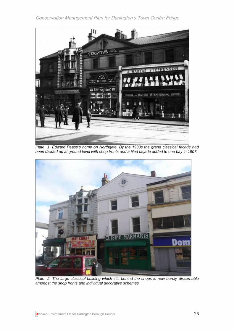
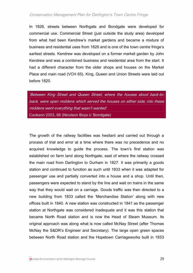
Pease’s home from 1798, which was in the town centre fringe at 138-148
Northgate, was a plain three storied 18th century house with a garden running
down to the Skerne where it joined the grounds of East Mount, home of his
eldest son John from 1838. A rustic bridge led over the stream to an orchard
(VCH 87) and this valley was nick-named the Peaceful Valley (Pease-full).
The Quakers had a particular fondness for gardening and Pease’s garden
was renowned for its orchards, vinery and gardens. Sadly the only hint that
the garden ever existed today is in the name of Garden Street which once
formed the north boundary of the garden. The house of Edward Pease has
survived but is hidden behind later shop fronts and additions (plate 1 and 2).
George Stephenson met with Pease at the latter’s home in Northgate (see
plates 1 and 2) and persuaded him to use steam powered locomotives on the
railway, when all previous discussions had involved using horse-power.
Stephenson also convinced Pease that the locomotive should run on rails
raised above the ground rather than tram tracks set into the ground. These
two factors (especially the first) separated the Stockton & Darlington Railway
from all the other colliery railways and changed the history of Darlington, the
North East, and the world. Pease had been so impressed with Stephenson
that he gave him the post of Chief Engineer of the Stockton & Darlington
Company. Following intense lobbying, a second Act of Parliament was
passed to allow the company ‘to make and erect locomotives or moveable
engines’. This led to the world changing introduction of the railway starting
with the Stockton & Darlington Railway. While the railway was to change the
face of the world, it was to take a little longer to change the face of Darlington
with development associated with the new railway works largely restricted to
the station area and north around Albert Hill and beyond the town centre
fringe.
Conservation Management Plan for Darlington’s Town Centre Fringe
Archaeo-Environment Ltd for Darlington Borough Council 26
Plate 1. Edward Pease’s home on Northgate. By the 1930s the grand classical façade had been divided up at ground level with shop fronts and a tiled façade added to one bay in 1907.
Plate 2. The large classical building which sits behind the shops is now barely discernable amongst the shop fronts and individual decorative schemes.

Conservation Management Plan for Darlington’s Town Centre Fringe
Archaeo-Environment Ltd for Darlington Borough Council 27
However the presence of the station, the need to engineer and manufacture
railway and locomotion goods, encouraged other industry into the area,
including the iron industry. The burgeoning industries needed workers and
workers needed houses, shops and entertainment and the most obvious
place to start developing was the land between the borough and the railway
line. This coincided with an increasing unacceptability of wealthy families
living cheek by jowl with poorer families and by the mid 19th century the
Quaker families moved out towards the countryside and the town centre fringe
became dominated by yards, back to backs, back and fronts, terraces of all
descriptions and civic buildings. The larger Quaker residences were divided
up and the plots sold for development. Thus Elmfield was developed from
1855 with swimming baths and a new street (Kendrew Street),8 followed later
with Elmfield Terrace and Gladstone Street within the town centre fringe area
while the reminder became North Lodge Park. It was from this period of
growth that the present day character of the town centre fringe with its
distinctive skyline of spires and clock towers was derived.
Development within the Study Area
Development in what was to become the town centre fringe had a hesitant
start. A few 18th century houses appeared in Bondgate and Northgate as part
of the town’s growing affluence resulting from the Quaker owned woollen and
linen industries (Pevsner 1990, 140). These were large villas and John
Wood’s later map of 1826 shows the villas on Northgate with long gardens
extending down to the river.
8 Named after John Kendrew who was a weaver who lived in this area as a child. He adapted the
Spinning Jenny for the spinning of flax for linen and also invented a machine for polishing optical
glasses.

Conservation Management Plan for Darlington’s Town Centre Fringe
Archaeo-Environment Ltd for Darlington Borough Council 28
Figure 4. An extract from John Wood’s map of 1826 showing Northgate and the position of villas along the main road with long gardens extending down to the river
Smaller cobble houses also grew along Northgate opposite Pease’s villa; their
appearance anything from 17th – early 19th century in date and several old
(17th century?) cottages on Bondgate with steeply pitched pantile roofs
survived until the 1850s. By 1826, much of the land around Bondgate still
consisted of orchards or fields. East Mount, another Pease residence, was
built in 1832 (VCH 65).
‘The old cottages opposite the house of Edward Pease esq., in Northgate,
close to the great boulder stone, were known as “Darlington House,” ending
the town to the north. Now in that and all directions, handsome villas and
spreading gardens extend themselves, stretching from Bondgate to
Northgate, and from Northgate to Haughton Road: a belt of countrified farm
land intervenes: but near the church they again begin , covering the Skerne’s
deep holmes, and insinuating themselves to its bank tops’.
Longstaffe 1909, 338 (originally printed in 1854)
Conservation Management Plan for Darlington’s Town Centre Fringe
Archaeo-Environment Ltd for Darlington Borough Council 29
In 1826, streets between Northgate and Bondgate were developed for
commercial use. Commercial Street (just outside the study area) developed
from what had been Kendrew’s market gardens and became a mixture of
business and residential uses from 1826 and is one of the town centre fringe’s
earliest streets. Kendrew was developed on a former market garden by John
Kendrew and was a combined business and residential area from the start. It
had a different character from the older shops and houses on the Market
Place and main road (VCH 65). King, Queen and Union Streets were laid out
before 1820.
‘Between King Street and Queen Street, where the houses stood back-to-
back, were open middens which served the houses on either side; into these
middens went everything that wasn’t wanted’.
Cookson 2003, 66 (Nicolson Boys o’ Bondgate)
The growth of the railway facilities was hesitant and carried out through a
process of trial and error at a time where there was no precedence and no
acquired knowledge to guide the process. The town’s first station was
established on farm land along Northgate, east of where the railway crossed
the main road from Darlington to Durham in 1827. It was primarily a goods
station and continued to function as such until 1833 when it was adapted for
passenger use and partially converted into a house and a shop. Until then,
passengers were expected to stand by the line and wait on trains in the same
way that they would wait on a carriage. Goods traffic was then directed to a
new building from 1833 called the ‘Merchandise Station’ along with new
offices built in 1840. A new station was constructed in 1841 as the passenger
station at Northgate was considered inadequate and it was this station that
became North Road station and is now the Head of Steam Museum. Its
original approach was along what is now called McNay Street (after Thomas
McNay the S&DR’s Engineer and Secretary). The large open green spaces
between North Road station and the Hopetown Carriageworks built in 1853

Conservation Management Plan for Darlington’s Town Centre Fringe
Archaeo-Environment Ltd for Darlington Borough Council 30
were allotments in the 1850s adding some continuity to its function as open
green space today.
Development of the wider North Road area instigated by the presence of the
railway began in 1831 when Kitching’s relocated their iron foundry from
Tubwell Row in the town centre to the station area and acquired the role as
the S&DRs locomotive works for Darlington (Darlington Borough Council
2006, 6). The foundry was partially demolished in 1870-1895 to make room
for more sidings possibly as part of the Royal Agricultural Show held in
Darlington in 1895 (DBC 2006, 11)
No.s 69-81 High Northgate were the first railway properties to be built in the
town c.1825. The construction of the lime cells, sometime between 1840-55,
on Hopetown Lane on the coal yard branch line (now fossilised as part of
Station Road and Hopetown Lane) may have been indicative of the
development boom which was about to take place around the station. The
lime cells stored lime imported by train and made available for collection from
Hopetown Lane for builders requiring it to provide lime mortar for the many
new houses that were being constructed.
The Cocker Beck Valley was initially developed sometime before 1835 as
large and beautiful gardens with intersecting walks, a pond and a temple by
Henry Pease (unkindly known as Henry’s folly’ by his father, but more kindly,
if less imaginatively as Westbrook gardens).
The creation of Bank Top station in 1842, albeit rather badly served by sheds
rather than a station proper, triggered development of streets of houses all
around the station. Longstaffe in 1854 saw Bank Top as a new town
‘gradually arising on the east of the Skerne’. Initially it was a railway colony, its
church first established in a converted railway warehouse.

Conservation Management Plan for Darlington’s Town Centre Fringe
Archaeo-Environment Ltd for Darlington Borough Council 31
Then and Now…
Plate 3. Bank Top station in the 1950s
Plate 4. Bank Top station in 2010
After the discovery of new mineral deposits in Cleveland in 1851 came a
major expansion of the Stockton and Darlington Railway. A decision was
taken to enlarge and relocate the railway’s locomotive works, from Shildon,
Conservation Management Plan for Darlington’s Town Centre Fringe
Archaeo-Environment Ltd for Darlington Borough Council 32
where they had been established in 1826, to Darlington. The new works, north
of the old station, opened in 1862. This decision in turn attracted a number of
iron related firms including the Darlington Forge; the first of four businesses to
locate at Albert Hill (outside the study area) between 1854 and 1864. The
demand for workers was to encourage inward migration and an explosion in
house building leading to the creation of the industrial suburbs, part of which
form the town centre fringe today. In the 20 years to 1881 the population more
than doubled and the townscape was transformed by industrial suburbs, many
of which were within the town centre fringe. By 1898 North Road station had
become surrounded by terraced housing, largely associated with the North
Road Shops (outside the town centre fringe). However the green space
between the station and the carriage works was only ever developed as
allotments and then sidings and has never been used for housing. By 1901
there were more than 42,000 people living in the town, nine times the number
of a century earlier (Cookson 2003,102).

Conservation Management Plan for Darlington’s Town Centre Fringe
Archaeo-Environment Ltd for Darlington Borough Council 33
3.0 The Built Form
Early Days
Evidence suggests that one of the earliest buildings in the town centre fringe
was the Bishop’s Manor House, described by Leland in the 16th century as a
‘pretty place’ (Flynn 1994, pl 115). This stood on the site of the present day
town hall car park. It was built in the 12th century and had become ruinous by
the 17th century, but was restored by Bishop Cosin. It was neglected again
and became the town’s poor house in the 18th century. The town bought the
building in 1806 and added two wings and a pediment to the centre, creating
a more classical façade to the front in keeping with architectural fashions of
the time. With such a long history, it represented a number of changing
architectural traditions and by 1834 the building was said to retain ‘many
traces of antiquity in its low arches, thick walls and long passages’ (ibid). It
was a long building with windows of all periods from medieval to the 18th
century including three lancets on the street front, possibly the location of the
bishop’s chapel. Ironically the Gothic arches were to become fashionable
again in the mid Victorian period with architects such as Waterhouse and GG
Hoskins designing new buildings with similar arched windows and doorways.
Next to the Palace was The Deanery which stood at the corner of
Horsemarket and Feetham’s. This was a half timbered structure and
represents a more typical building form of medieval urban areas. It was
demolished in 1876.

Conservation Management Plan for Darlington’s Town Centre Fringe
Archaeo-Environment Ltd for Darlington Borough Council 34
Plate 5. The Bishop’s Manor House in the late 18
th century (Darlington
Centre for Local Studies)
Early photographs of the town centre fringe area, often featuring the Bulmer
Stone, depict old two storey cobblestone buildings on the site of what is now
the technical college on Northgate, known at the time collectively as
Darlington House. Such buildings were commonly built in the 17th to early 19th
centuries of river cobbles or random rubble stonework, the surface
whitewashed which helped to weatherproof the structure and acted as a
fungicide and pesticide. They had thatched roofs, the thatch perhaps being
obtained locally from the riverbanks of the Skerne. Windows appeared to be
small multi pane sashes, possibly Yorkshire sliding sashes and doors of
simple batten and ledge type.
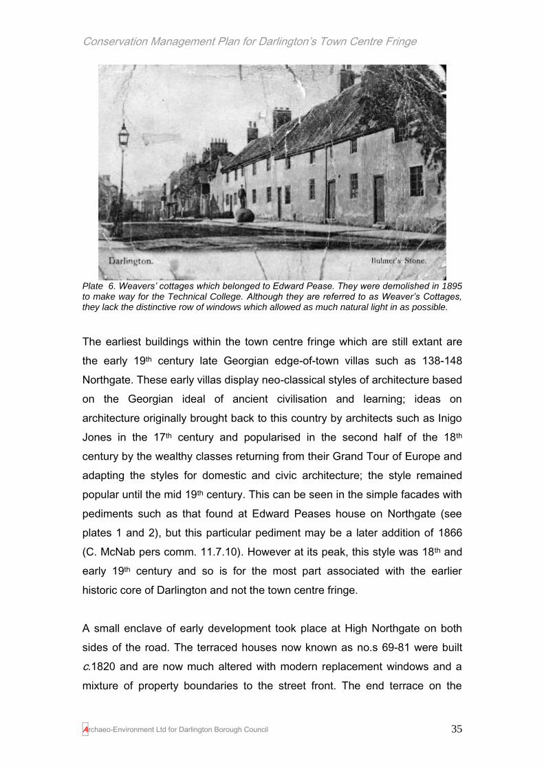
Small 16th century cottages also existed on Bondgate and were shown on
postcards in 1853 (Flynn 1994, pl 62). These two storied buildings had steeply
pitched pantiled roofs, which may have been thatched in the past, with the
upper windows tucked immediately below them. They were demolished in
1854.
Conservation Management Plan for Darlington’s Town Centre Fringe
Archaeo-Environment Ltd for Darlington Borough Council 35
Plate 6. Weavers’ cottages which belonged to Edward Pease. They were demolished in 1895 to make way for the Technical College. Although they are referred to as Weaver’s Cottages, they lack the distinctive row of windows which allowed as much natural light in as possible.
The earliest buildings within the town centre fringe which are still extant are
the early 19th century late Georgian edge-of-town villas such as 138-148
Northgate. These early villas display neo-classical styles of architecture based
on the Georgian ideal of ancient civilisation and learning; ideas on
architecture originally brought back to this country by architects such as Inigo
Jones in the 17th century and popularised in the second half of the 18th
century by the wealthy classes returning from their Grand Tour of Europe and
adapting the styles for domestic and civic architecture; the style remained
popular until the mid 19th century. This can be seen in the simple facades with
pediments such as that found at Edward Peases house on Northgate (see
plates 1 and 2), but this particular pediment may be a later addition of 1866
(C. McNab pers comm. 11.7.10). However at its peak, this style was 18th and
early 19th century and so is for the most part associated with the earlier
historic core of Darlington and not the town centre fringe.
A small enclave of early development took place at High Northgate on both
sides of the road. The terraced houses now known as no.s 69-81 were built
c.1820 and are now much altered with modern replacement windows and a
mixture of property boundaries to the street front. The end terrace on the

Conservation Management Plan for Darlington’s Town Centre Fringe
Archaeo-Environment Ltd for Darlington Borough Council 36
corner of Station Road is perhaps the best not having been masked under a
layer of render and still retaining its kneeler on its southern gable. By 1850
when the first edition Ordnance Survey map was published, another row of
terraces were in place opposite what is now Station Road. These buildings
today have been recently improved with replacement render and paintwork,
but still retain inappropriate modern windows. They render is probably not part
of the original design.
There are some surprising survivals; 12 High Northgate is a little shop with
two 12 pane bow windows. Such windows often date to about 1830, but this
row of terraces were not built until after 1850, but before the 1890s. The
windows may have been moved here from another building, simply be a late
example or are more recently built using old fashioned styles (the glazing bars
are quite crude and thick for the mid 19th century). Whatever their date they
are quite a rarity in the town, albeit hidden behind fridges and freezers with
massive metal shutters to protect them at night. From 1825 onwards, homes
of the senior railway management and skilled railway workers were
constructed at North Lodge and at Westbrook Villas, both middle class
enclaves now outside the study area.
Plate 7. Darlington hides its historic assets well. Edward Pease’s house should be celebrated for its role in changing the face of the world, but instead its tawdry appearance and poor shop fronts contribute towards the general decline of Northgate. Delightful little early to mid 19
th
century bow windows with rather crude glazing bars hide behind fridges and freezers on High Northgate.

Conservation Management Plan for Darlington’s Town Centre Fringe
Archaeo-Environment Ltd for Darlington Borough Council 37
The pendulum of fashion swung away from such foreign styles of architecture
in the mid to late 19th century in favour of design which was inspired by the
British historic traditions of medieval, Tudor and Jacobean times. This was to
give rise to the neo-Gothic style of architecture, with increasing ornamentation
which was a reaction to the plain symmetrical facades of the Georgian period
and so door lintels and jambs were carved, shop fronts ornamented, barge
boards and tall gables created to produce a Gothic appearance made
possible by the lighter Welsh slate which found favour over the stone slate
roof.
The Westbrook Villas just outside the study
area are an excellent example of this neo
Gothic style of architecture which was
promoted by at least two of Darlington’s
finest talents – GG Hoskins (responsible for
what is now Barclays Bank on High Row)
and Robert Borrowdale, responsible for
some of the Westbrook Villas, Melville
House and 1 Leadenhall Street. Tall
chimneys and steeply pitched gables with
vents and stone leaf finials combined with
the ornate stonework, such as flower stops
to hood moulding over windows and cast iron rain water goods were the
ultimate rejection of classical styles and a Victorian celebration of English
Tudor and Jacobean architectural traditions. Such ornate styles can be seen
on Victoria Road opposite Sainsbury’s and in a more restrained way on High
Northgate where otherwise plain buildings (as much as one can tell given that
they are plastered beneath cement render), have windows with pointed
arches rather than the earlier classical arch or the simpler rectangular sash
window.
Plate 8. A neo-Gothic extravaganza at Westbrook Gardens

Conservation Management Plan for Darlington’s Town Centre Fringe
Archaeo-Environment Ltd for Darlington Borough Council 38
Shop Fronts
Many 19th century buildings along the
major thoroughfares such as Northgate
and Bondgate are predominantly shops
or offices today. Some of these may
have had ornate Victorian shop fronts,
but areas such as Parkgate and Victoria
Road may have had more early 20th
century shop fronts reflecting their later
development. For areas of Victorian
expansion, a shop front may have had
little to distinguish it from adjacent homes. Windows at ground floor level at
least, may have had bay windows originally, and a greater commercialisation
of businesses through prominent window displays, welcoming doorways and
trade signs. Improved glass-making allowed larger windows mainly from the
1830s in Darlington, and so a number of multi-paned windows were replaced
with larger plate glass windows. The 1830s also saw the introduction of
retractable blinds and gas lighting to shop fronts. By the mid-19th century, only
fresh food shops had open fronts. By 1860 every shop front on High Row had
large plate glass windows, but these fashions did not necessarily extend to
the outer reaches of Northgate where shops were likely to be more modest
affairs.
‘In this summer [of 1834] a great change took place in the shops in Darlington.
Large windows became all the fashion. A number of new shops were opened
out this year in consequence of the sale of Allan’s houses; and no sooner
had one shopkeeper put out a large elegant window than his neighbour did
likewise’ (Cookson, 71, quoting Mewburn, Larchfield Diary, 35)
In the late 19th century, shop front styles became more eclectic introducing
new materials, such as terracotta and tiling and these styles can be seen in a
variety of buildings on Victoria Road and Parkgate. Signage became more
flamboyant with cut-out letters, gilding and colourful sign writing. The
Plate 9. Tile detail from the Black Swan pub on Parkgate

Conservation Management Plan for Darlington’s Town Centre Fringe
Archaeo-Environment Ltd for Darlington Borough Council 39
Edwardian fashion for transom lights allowed for ventilation grilles and
coloured glass to conceal gas light fittings and in Parkgate green glazed tiles
adorned the Black Swan and the Cricketers Arms. Entrances were recessed
to increase window display areas. As shop fronts became an everyday part of
the high street in the 19th and early 20th centuries, a range of pattern books
were published to provide advice for joiners on their design, construction and
installation. However, they tended to avoid standardised detail in order to
allow for local variations. Shops
became a more integral part of new
buildings in the 20th century. In the
1920s, the use of bronze in window
frames allowed the structural
elements to become elegantly more
slender often accompanied by the
sophistication of polished granite or
marble. Art deco styles in the 1930s
introduced features, such as sunbursts and stepped fascias, and new
materials, such as chrome and vitrolite.
The town centre fringe is perhaps
better associated with the corner shop.
These have evolved from end of
terrace houses and served the local
community; the terraced houses were
once well served by these enterprises
with every few streets having one.
However they have since gone out of
fashion as local residents obtain their
purchases from larger supermarkets. Many now stand empty or have been
returned to residential use. Those that survive have shop front designs
popular since the 1920s and 30s with the distinctive corner doorway.
Plate 10. Early 20th century shop front detail
on Parkgate
Plate 11. A surviving corner shop on Northgate
Conservation Management Plan for Darlington’s Town Centre Fringe
Archaeo-Environment Ltd for Darlington Borough Council 40
Since the mid-20th century, modern architecture has minimised the design
detail of shop fronts. Float glass became available in large sheets from 1959
and frameless jointing techniques have made most of the structural elements
unnecessary, leading to large glass fronts such as can be found in Northgate.
In the 1970s air curtain technology imported from America enabled some
shops to operate without a shopfront other than folding doors for the night-
time, but none of these have been used in the town centre fringe. However,
there are signs nationally that sustainability issues and rising fuel cost are
forcing a return to more traditional forms of shop front.
19th century Domestic Architecture
Most of the surviving housing in the
town centre fringe takes the form of the
Victorian and Edwardian terraced
house, but there were other forms,
mostly now demolished. Housing was
crammed into small plots around a
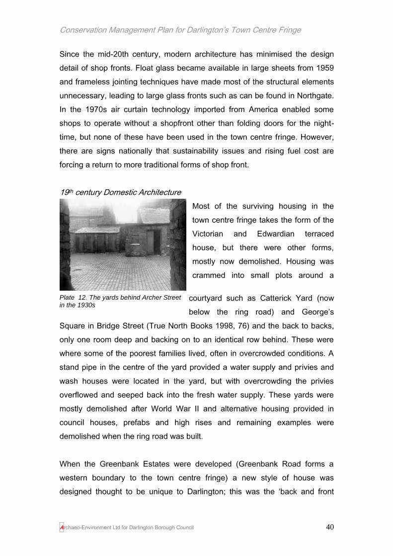
courtyard such as Catterick Yard (now
below the ring road) and George’s
Square in Bridge Street (True North Books 1998, 76) and the back to backs,
only one room deep and backing on to an identical row behind. These were
where some of the poorest families lived, often in overcrowded conditions. A
stand pipe in the centre of the yard provided a water supply and privies and
wash houses were located in the yard, but with overcrowding the privies
overflowed and seeped back into the fresh water supply. These yards were
mostly demolished after World War II and alternative housing provided in
council houses, prefabs and high rises and remaining examples were
demolished when the ring road was built.
When the Greenbank Estates were developed (Greenbank Road forms a
western boundary to the town centre fringe) a new style of house was
designed thought to be unique to Darlington; this was the ‘back and front
Plate 12. The yards behind Archer Street in the 1930s
Conservation Management Plan for Darlington’s Town Centre Fringe
Archaeo-Environment Ltd for Darlington Borough Council 41
house’. They differed from back to backs in having both a back and front door
linked by a long passage (Cookson 2003, 90). However for many people the
standard of living improved between the beginning of Victoria’s reign and the
end with an expectation not of a family in one room, but of a two up two down
terraced house.
The term ‘jerry-built’ appears in Victorian times from 1869 and describes poor
quality housing put up too quickly, with too few materials and not built to last
examples of which in the town centre fringe have long been demolished.
The external design of the domestic terrace house relies on the relinquishing
of individual expressions of taste in return for a uniformity of window and door
styles which create pleasing lines and harmonious facades. Much of this has
been lost throughout the town centre fringe today, even though some planning
restrictions were imposed at an early stage. Just to the north of the study
area, former Allen Estates land around Albert Hill was sold with a covenant
requiring some uniformity in size, quality and use of buildings including the
use of Westmoreland slate on roofs (Cookson, 76).
The basic terraced house was a successful design which has proven its worth
many times over. For the most part it was high density housing using mostly
local materials; a possible template for today. Most houses started as two up
and two down, although most have been extended to the rear since their
original construction. A small back yard contained a privy and a coal shed.
Two doors in the back wall led to a back lane, floored with scoria blocks from
Middlesbrough. One door was for the coalman to deliver coal through from his
cart (straight from the railway depot near Northgate) and the other was so that
the night soil could be collected, also by cart. The back lane was also a
meeting place, a chance to stop and chat and a place to hang out the washing
on wash day (not the same as coal day!). Being out of sight, the back lane
was presumably also used for activities that required some discretion. It is
also from this back lane that the backs of the houses can still be observed.

Conservation Management Plan for Darlington’s Town Centre Fringe
Archaeo-Environment Ltd for Darlington Borough Council 42
Often without the ornamentation of the fronts, the backs still display tall
arched stair light windows where they were fitted, or a jumble of roof lines
where houses were extended into the rear in later years and the occasional
forgotten sash window.
Plate 13. The back views of terraces provide an eclectic mix of roof lines and extensions which display the archaeology of development
The northern end of Northgate and along High Northgate includes railway
related housing including the earliest examples at 69-81 High Northgate, and
the tightly-packed terraces on Stephenson Street. 69-81High Northgate, set
well back from the road, display architectural styles which are transitional
between late Georgian and Victorian periods with kneelers, small hand made
bricks with stone lintels over windows, 12 pane sash windows, wide doorways
and rectangular overlights with glazing bars, mostly now gone. Opposite,
humbler terraced houses were laid out before 1850 and these were street
fronted and very plain. Further along Northgate, terraces reflect the next stage
of Victorian middle class designs. Doorways are set up a flight of steps (this
allows for cellar room too) and are surrounded by ornate designs; in this case
Ionic columns or ornate consoles. The houses are set a little back from the
road with small gardens and boundaries are formed by dwarf stone walls and
railings.

Conservation Management Plan for Darlington’s Town Centre Fringe
Archaeo-Environment Ltd for Darlington Borough Council 43
A later infill at the north end of this terrace is reputedly the former location of a
railway signal, possibly a crossing point associated with the very early days of
train travel where a branch line met the main line (C. Fish pers comm.). On
the first edition map dating to 1850 there is no development here but there is
a guide post9 just to the north where McNay Street was laid out. The gap
between the houses10 is clearly discernable on the 2nd edition OS map dating
to the 1890s, but no railway line is apparent.
The status of the residents was displayed through a variety of means. An
ornate doorway and window lintels could attract a higher rent. A small patch of
garden, bounded by a dwarf wall and railings, no matter how small
distinguished these houses from straight forward street fronted properties.
Steps leading up to the front door displayed additional wealth and superiority.
The overall effect was mostly pleasing, but in some rows of terraces the levels
of ornamentation today appears rather ostentatious for the humble dwelling
behind it, for example a row of terraces
on Haughton Road. The reason for this
can be found in the way that houses
were built. Property developers were
often builders, stonemasons or joiners
who could only afford to buy a few
plots for development. Their profit
margins were tight and so they played
safe with their borrowed funds and
chose well-established and popular
forms and ordered period features often of inappropriate proportions, with little
understanding of the style they sought to imitate. However with the addition of
a couple of highly ornate door consoles, even if they did not quite fit, the
builder could attract more potential customers and a higher rent. This
9 NGR 428999 515589
10 NGR 429011 515576
Plate 14. Mid to late 19th century terraced
houses on High Northgate; the pink infill building reputedly marks the site of a former railway signal

Conservation Management Plan for Darlington’s Town Centre Fringe
Archaeo-Environment Ltd for Darlington Borough Council 44
speculative build can be seen on streets such as East Mount Road and
throughout the Bank Top area where part of the row conforms to one design,
then the ornamentation alters for a group of houses creating a new style, then
it alters again, but always based on the two storeyed terrace house of brick.
Each group represents a particular speculative enterprise by a small scale
developer.
Middle class terraces had a number of
distinguishing features that raised
them architecturally above the worker’s
housing. Park Place, Model Place
(now demolished) and Swan Street in
the Bank Top area housed skilled
manual workers such as textile factory
mechanics, a master builder and a
railway inspector in the 1871 census.
Hargreave Terrace, still under developed by 1871 housed a railway clerk, a
master stonemason and master hatter (Cookson 2003, 82). A row of terraces
along East Mount Road (dating to the opening years of the 20th century) have
fantastically ornate doorways with Corinthian columns, a stone plaque proudly
boasting the street name, glazed brick detailing and entrances set back from
the road with a few steps to the front door, just enough to create an imposing,
but nevertheless welcoming entrance for the visitor. Similar styles are also to
be found along part of Haughton Road.
Plate 16. Ostentatious doorways: East Mount Road (left and second left), Haughton Road (centre right) and Montrose Terrace (right). These doorways all display the appearance of having off-the-peg decorative additions designed to attract ‘better class’ customers by a speculative builder. Sadly few of the doors themselves are original designs and now detract from the fine surrounds
Plate 15. 101 High Northgate with a six panel door and classical style which reflects earlier Georgian fashions

Conservation Management Plan for Darlington’s Town Centre Fringe
Archaeo-Environment Ltd for Darlington Borough Council 45
Such signs of ostentation were rarely included in the lower status houses
such as those to be found along Dundee Street or Stephenson Street for
example. Here the door fronted directly on to the road, doorways and
windows were simple, but still displayed a degree of off-the-peg craftsmanship
with ornate window mullions carved with pretty designs, and brickwork which
picked out some detailing at the very least at below eaves level, but often
using coloured or glazed brick to pick out patterns which lightened the
elevations and drew the eye along the terrace.
Around Bank Top Station rows of brick terraces were constructed for workers
housing with the end terraces offering more space and privacy designed for
the foremen. Brick detailing below eaves level matched that to be found on
the railway buildings themselves bringing a coherent whole to the area.
Much of this detailing has been lost in the town centre fringe through the use
of pebble dash coating and replacement windows in a variety of styles leading
to a loss of uniformity which was key to their design. Where railings were used
in those houses which were set back even a modest distance from the street,
the metal work has now disappeared, presumably due to the war effort, but
original examples can still be found in most areas, particularly in the boundary
wall between the properties.
Plate 17. Montrose Terrace gently curves to form a crescent but it has lost its original harmony created by matching brick facades with the same brick detailing and the same window and door styles now hidden behind render and pebble-dash (colours would always have varied).
The predominant street
pattern for the terraced
houses was based on a grid which complimented the rows of terraces and
allowed a high density of buildings to be fitted into a small area and allowed

Conservation Management Plan for Darlington’s Town Centre Fringe
Archaeo-Environment Ltd for Darlington Borough Council 46
the best use of space through shared access to the rear. Some rows such as
at Hargreave Terrace and Montrose Terrace were based on a crescent, but
they were very much in a minority.
The design of the terraced house was adaptable, with many being converted
into corner shops serving the local community. In such cases, the ground floor
windows were opened up (this may have been part of the original design in
many cases) in order to create a shop front suitable for displaying wares.
Terraces could be extended to the rear or knocked together. Attics could have
dormer windows added, often with decorative barge boarding and additional
accommodation thus provided.
Railway Architecture
The character of the built form associated with the railway was of course very
different to the domestic architecture which housed its workers. The first
station, now demolished, was on two storeys as all early goods stations were
(see Liverpool Road in Manchester). This arrangement was impractical and
so the new station, designed by Thomas Storey, was built on one level. North
Road Railway Station and related infrastructure from the early 19th century
included rail sheds, workshops and bridges some of which survives today.
The stone station was designed in a neo-classical style still favoured in the
early 19th century and also apparent at Edward Pease’s house on Northgate.
This formal and expensive style was designed to reflect the station’s main
users; prosperous merchants (DBC 2006, 18). Harris designed an even more
flamboyant Goods Agent’s Offices in 1840 reflecting the continued importance
of that sector to the economic prosperity of the railway company. Like the
North Road station, it was built in stone and was ornamented with stone
ashlar pilasters at the corners and dressed stone door and window surrounds.
The pyramidal roof with central chimney stack, the openings with segmental
heads and over hanging eaves all give a slightly Italianate flavour (DBC 2006,
25).
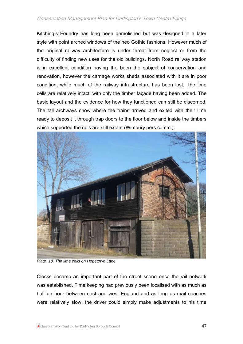
Conservation Management Plan for Darlington’s Town Centre Fringe
Archaeo-Environment Ltd for Darlington Borough Council 47
Kitching’s Foundry has long been demolished but was designed in a later
style with point arched windows of the neo Gothic fashions. However much of
the original railway architecture is under threat from neglect or from the
difficulty of finding new uses for the old buildings. North Road railway station
is in excellent condition having the been the subject of conservation and
renovation, however the carriage works sheds associated with it are in poor
condition, while much of the railway infrastructure has been lost. The lime
cells are relatively intact, with only the timber façade having been added. The
basic layout and the evidence for how they functioned can still be discerned.
The tall archways show where the trains arrived and exited with their lime
ready to deposit it through trap doors to the floor below and inside the timbers
which supported the rails are still extant (Wimbury pers comm.).
Plate 18. The lime cells on Hopetown Lane
Clocks became an important part of the street scene once the rail network
was established. Time keeping had previously been localised with as much as
half an hour between east and west England and as long as mail coaches
were relatively slow, the driver could simply make adjustments to his time
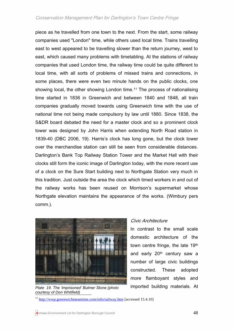
Conservation Management Plan for Darlington’s Town Centre Fringe
Archaeo-Environment Ltd for Darlington Borough Council 48
piece as he travelled from one town to the next. From the start, some railway
companies used "London" time, while others used local time. Trains travelling
east to west appeared to be travelling slower than the return journey, west to
east, which caused many problems with timetabling. At the stations of railway
companies that used London time, the railway time could be quite different to
local time, with all sorts of problems of missed trains and connections, in
some places, there were even two minute hands on the public clocks, one
showing local, the other showing London time.11 The process of nationalising
time started in 1836 in Greenwich and between 1840 and 1848, all train
companies gradually moved towards using Greenwich time with the use of
national time not being made compulsory by law until 1880. Since 1838, the
S&DR board debated the need for a master clock and so a prominent clock
tower was designed by John Harris when extending North Road station in
1839-40 (DBC 2006, 19). Harris’s clock has long gone, but the clock tower
over the merchandise station can still be seen from considerable distances.
Darlington’s Bank Top Railway Station Tower and the Market Hall with their
clocks still form the iconic image of Darlington today, with the more recent use
of a clock on the Sure Start building next to Northgate Station very much in
this tradition. Just outside the area the clock which timed workers in and out of
the railway works has been reused on Morrison’s supermarket whose
Northgate elevation maintains the appearance of the works. (Wimbury pers
comm.).
Civic Architecture
In contrast to the small scale
domestic architecture of the
town centre fringe, the late 19th
and early 20th century saw a
number of large civic buildings
constructed. These adopted
more flamboyant styles and
imported building materials. At
11
http://wwp.greenwichmeantime.com/info/railway.htm [accessed 15.4.10]
Plate 19. The ‘imprisoned’ Bulmer Stone (photo courtesy of Don Whitfield)

Conservation Management Plan for Darlington’s Town Centre Fringe
Archaeo-Environment Ltd for Darlington Borough Council 49
the time there was much local opposition to the building of the Technical
College at the foot of Northgate and even more opposition to the
‘imprisonment’ of the Bulmer Stone behind its railings in 1923. The college
was designed by G.G.Hoskins reflecting earlier styles from Tudor England. It
was made of local red brick with layers of Staffordshire purple brick (McNab
pers comm.) and yellow terracotta decoration. The gables were decorated
with female figures representing the arts and sciences. In 1919 the Higher
Grade School was opened on Gladstone Street with similar Tudor influences,
but without the flamboyant materials. The Darlington Temperance Institute
(designed to provide meeting rooms away from the temptations of drink) also
on Gladstone Street was in a similar style. At the opening ceremony the Earl
of Carlisle reflected what the Institute still partially provides today in terms of
townscape when he said he was glad to see before him ‘a building which will
beautify your town physically as well as morally’.
The pendulum of architectural fashion
swung once again in the early 20th
century; this time rejecting the ornate
fussiness of Victorian neo-Gothic in
favour of more delicately ornamented
1900s (such as the Temperance Hall
and numerous Parkgate buildings) and
subsequently towards the stark simplicity
of the 1930s.
Twentieth Century Architecture
In the 1920s-30s tastes reacted against
this high degree of ornamentation to
produce simpler designs again. New
styles of architecture in Darlington generally lacked local distinctiveness and
increasingly less attention to detail so that by the 1920s and 30s, the buildings
constructed could have been from anywhere in the country. While a lack of
local distinctiveness is regrettable, some of these buildings are of good quality
Plate 20. The former Technical College

Conservation Management Plan for Darlington’s Town Centre Fringe
Archaeo-Environment Ltd for Darlington Borough Council 50
and distinctive of their period and so can make a positive contribution to the
townscape. Most bungalows dating to the 1920s and 30s were located in the
leafy suburbs and these are mostly outside the study area. In 1937 the council
built 10 houses for the aged in Hilda Street and these were little bungalows
built of brick and render, set around a cul-de-sac, rather than the traditional
grid pattern of earlier housing. In Lodge Street, Dun and Dunwells purchased
land from the North of England School Furnishing Company (land which had
been in the ownership of the Brown’s, the Fry’s and John Pease before) in
order to build a row of 1930s semi detached houses with sunburst bay
windows and gardens. Their size and layout was different to what had gone
before and required more land than was generally available in areas already
developed in Victorian times, but the materials used still concentrated on brick
with the addition of pebble dashing and render to break up the façade and
railings on dwarf walls to provide a boundary.
Plate 21. Bungalows for the ‘aged’ were built by the council in 1937 on St Hilda’s Street and were part of a move away from terraced housing towards larger plots with gardens, based around a cul-de-sac. The 1930s saw semi detached houses springing up throughout the suburbs but here on Lodge Road they were used as infill amongst existing terraced development. These houses were built by Dunwell who bought a tract of land between here and East Mount for development (C. Fish pers comm.)
The 1930s also produced a style of architecture found in offices, cinemas and
industrial units throughout the study area. These brick built blocks usually had
wide shallow windows with horizontal metal glazing bars with glass doors to
match. Examples can be found along Valley Street and Haughton Road.
Darlington boasted more cinema seats per head of population in 1939 than
any other town in the country (Lloyd undated, 31). Of those, the old Regal on

Conservation Management Plan for Darlington’s Town Centre Fringe
Archaeo-Environment Ltd for Darlington Borough Council 51
Northgate (now the Odeon) reflects the styles of the 1930s and the former
Majestic (now a snooker club) on Bondgate, designed by Joshua Clayton of
Darlington in 1932, still harbours 1930s fashions beneath its 1970s facade. Its
interior, (plaster work made by Davidsons of Sunderland), is largely intact and
the façade, with the exception of the ground floor, remains beneath the 1970’s
grill including the stained glass windows with their metal frames. The cinema
is the largest and showiest Art Deco building in Darlington by far and
deserves some effort to restore the original features (I. Dougill pers comm.
(12.7.10)) including its cleverly designed interior lighting which included a
coved ceiling over the balcony with flame effect flounce lighting, the organ
grilles shown in silhouette against a gold background and concealed main
roof lighting which could alter colour and intensity (Darlington & Stockton
Times 24.12.1932).
Plate 22. The Majestic on Bondgate ready for its opening night on Boxing Day 1932
The 1930s also saw the loss of significant historic buildings such as the
cornmill on the Skerne in what is now South Park; a superb assembly of

Conservation Management Plan for Darlington’s Town Centre Fringe
Archaeo-Environment Ltd for Darlington Borough Council 52
buildings going back to medieval times and often painted by artists – perhaps
reflecting its similarity to Constable’s Mill on the Stour! (I.Dougill pers comm.
12.7.10).
Then and Now….
Plate 23. A 1930s building (Darlington Electricity in the 1930s) on Haughton Road with its typical low wide windows with horizontal metal glazing bars which contrast with earlier Edwardian and Victorian styles of tall narrow windows in timber. It retains the use of brick with stone detailing however. The old coat of arms pictured in the black and white photo remains boxed-in behind the modern sign and is a splendid piece of coloured tile or faience (I. Dougill pers comm. (12.7.10))
Inevitably the war limited the amount of development that could take place in
Darlington, although air raid shelters were constructed at the railway works
and at schools. A large concrete shelter can still be found on Weavers Yard,
off Weir Street but it has been blocked up to prevent anti-social behaviour and
is now reduced to little more than an eyesore. As a quick and cheap solution
to the post war building problem, Nissen Huts were constructed to house
services, such as cafes and shops on the market place and prefabs used for
houses. They were also used at the Borough Road Industrial Estate where
they can still be seen. It was in the 1950s that construction for housing picked
up again. The styles of housing between the 1930s and 50s did not vary much
due to the general lack of development at that time and post 1940s
development concentrated on 3,000 council houses and homes for heroes.
Nissen Huts were developed by Major Peter Norman Nissen of the 29th
Company Royal Engineers in 1916 with additional help from Lieutenant
Colonels Shelly, Sewell and McDonald, and General Liddell. They went on to

Conservation Management Plan for Darlington’s Town Centre Fringe
Archaeo-Environment Ltd for Darlington Borough Council 53
be used in both World Wars and during the post war period. The semi-circular
huts were designed to be economical and portable and one Nissen hut could
be packed in a standard Army wagon and erected by six men in four hours.12
Plate 24. Nissen Huts on the Borough Road Industrial Estate
Development within the town centre
fringe in the mid 20th century did little
to enhance its historic character and
much to divorce the area from the
historic core. The construction of the
ring road created a barrier between the town centre and the rest of Darlington.
This barrier was physical – pedestrians could not easily cross it, and also
perhaps economic and psychological in divorcing town centre and areas of
19th century growth, perhaps ultimately confirmed by the area being referred
to as ‘fringe’.
Large scale development was attracted to the ring road such as the
showrooms of Skippers, later Sanderson Ford, designed by Darlington
architects H B Richardson and completed in 1966. A plaque within the
building identified the precise location as the site of Darlington’s very first
Methodist meeting in 1753. It too has now been demolished; 20th century
architecture appears to have a faster turnover than what went before.
Most of the large scale buildings along the ring road had no design detail
which presented dull uniform facades to the outside world, while the attractive
leafy terraces of Victoria Road were demolished to make way for it. The police
station was built in 1962, the fire station 10 years later and the Royal Mail
house in 1981. A large office bock was also constructed next to the ring road
at the foot of Northgate and completed in 1975 from which date it has spent
much of its life empty. These large blocks of monotony also prevented views
12
http://en.wikipedia.org/wiki/Nissen_hut#History

Conservation Management Plan for Darlington’s Town Centre Fringe
Archaeo-Environment Ltd for Darlington Borough Council 54
across to the historic core so that St Cuthbert’s spire and the Market Hall
tower both of which had been visible throughout the town were now hidden
from view. The river which had flowed through the town was at worst buried
beneath concrete and a major roundabout, and at best canalised like a drain,
while the windy open spaces created by ring road, roundabouts, car parks
and large buildings heralded a new era where the car ruled and pedestrians
were channelled underground just like their river.
Then and Now…
Plate 25 Bishops Low Park 1760
Plate 26 Bishop’s Low Park 2010 (Park Lane). The large massing of 20
th century buildings
with no design detail create a physical barrier between the town centre and the town centre fringe

Conservation Management Plan for Darlington’s Town Centre Fringe
Archaeo-Environment Ltd for Darlington Borough Council 55
The new Town Hall was officially opened in 1970, designed by Williamson,
Faulkner-Brown of Newcastle upon Tyne and is typical of civic architecture of
its time. The stark simplicity of the main block (or ‘uninviting and monolithic’
(Pevsner 1990, 144)) is in contrast to the ornate Victorian styles of much of
the town centre fringe. However internally expensive materials were used in
the foyer and the council chamber was designed to be relatively luxurious.
The main block was built of grey aggregate with dark grey tinted windows,
apparently intending to compliment the church; indeed the design was a result
of consultation with the Royal Fine Art Commission (VCH 143). Instead it
overwhelms the church and blocks views to it from the south. Its large scale
massing adds to the visual barrier created by a number of mid 20th century
buildings along St Cuthbert’s Way.
It was conceived to be part of a much larger development which would have
included covered shopping malls and a multi-storey car park necessitating the
demolition of the north side of the market place, the demolition of the whole of
Bakehouse Hill and Chantry Lane with only the clock tower being left as a
gesture to the past. The plans were aborted after a change in political control
and a public inquiry call-in over local residents’ vocal concerns. Another
similar plan followed designed by the Borough Architect but these plans were
also dropped after another public inquiry and a review of the listed buildings in
the town centre. The resulting development was the Cornmill Centre where
shops were built behind the retained facades leaving the spatial identity of the
town intact (I.Dougill pers comm. 12.7.10).
The process of reversing these mistakes started in the 21st century. The
construction of street fronted housing on Victoria Road reintroduced a
domestic scale of architecture and partially shielded from view the open
spaces of Sainsbury’s car park. Developments were encouraged to be smaller
in scale along the ring road with more architectural detailing. Shop fronts
which had been lost along Northgate were replaced with support from English
Heritage, One North East and Darlington Borough Council.

Conservation Management Plan for Darlington’s Town Centre Fringe
Archaeo-Environment Ltd for Darlington Borough Council 56
Building materials
The majority of buildings in the town centre fringe were constructed of brick. It
is not clear when brick replaced stone as the main building material – Clay
Row was known as such by the 15th century, but there is little evidence of
brick buildings of that date. Bricks were apparently used for decorative
purposes in cottages in Bondgate which were reputedly 16th century (Cookson
2003, 124). By the 17th century bricks were being used on higher status
buildings and bricks from Brankin Moor were used for repairs to the Bishop’s
Palace. Late 18th century insurance policies for Darlington houses and
workshops suggest that brick had become the main building type. These
bricks were made locally – one location was the Bishop’s Low Park, another
Clay Row. Other brick production sites were just outside the town.
Tiles for roofing were also manufactured in the town at Brankin Moor in the
18th century. Stone continued to be used for high status houses and a
stonemason’s yard existed on the east side of Stone Bridge, facing St
Cuthbert’s, where the stonemason Andrew Lockie was accused of
encroaching upon the river with his stone cutting (Cookson 2003, 127-8). By
the 19th century brickworks had also been established at Bank Top,
Freeman’s Place (also a tile works), Tubwell Row, on land between Stockton
and Yarm Road, on land behind Victoria Embankment and behind St John’s
church. Indeed any major new development was accompanied by the need to
find a local source of clay for brick making which was subsequently infilled by
new development. By the 1860s Pease brick was becoming popular, a buff
coloured ceramic which was a by-product of mining elsewhere in the county,
mainly Crook, and was used for a number of buildings on Victoria Road.
As brick making became increasingly mechanised, brickworks became more
settled, especially around Bank Top, Whessoe Lane and Albert Hill and by the
1870s there were 10 brick and tile makers in the town. This number reduced
in the early 20th century as clay pits were exhausted and developed for
housing and by the mid 20th century the only brick works left were on
Haughton Road, Firth Moor, Whessoe and Harrowgate; all given a new lease

Conservation Management Plan for Darlington’s Town Centre Fringe
Archaeo-Environment Ltd for Darlington Borough Council 57
of life by the construction of the Patons and Baldwins’ factory and the
council’s ambitious housing programme.
Plate 27. Distinctive building materials in the town centre fringe: red brick for boundary walls and buildings, often with detailing, scoria blocks for back lanes and drains, and stone blocks for back lanes – all locally sourced
Another distinctive material used in the town was supplied by the Tees Scoria
Brick Co. Ltd from their office in Station Street (now demolished) at Bank Top.
Scoria Blocks have an interesting history and were distinctive to the streets of
south Durham until the car came to dominate the road. The name comes from
the Greek word skōr meaning excrement. However the shiny blue/grey bricks
are not to be sniffed at. They were a product of the creative Victorian minds
who sought to find a use for the huge amounts of waste slag generated by
iron production. One ton of iron produced one ton of slag and in Cleveland
2.5million tons of pig iron were being produced a year by the end of the 19th
century. An early attempt was made to turn it into insulating material called
slag wool. It is interesting to speculate whether it might have been a safer
alternative to asbestos? However it was a Darlington man, Joseph Woodward
who in 1872, discovered that the slag could make an extremely robust,
waterproof, chemical proof, easy to clean brick and he formed the Tees
Scoria Brick Company. The bricks were produced in moulds so they were
identical and easy to lie flat on a bed of sand and compressed. The bricks
proved so popular they were exported from Teesmouth to Canada, the West
Indies, Europe, the US, South America and Africa.13 They fell out of favour
when motor cars became faster in the 1960s and 70s; the journey was too
bumpy on the scoria brick roads and tarmac was favoured instead. However
they still line most of the back lanes and gutters where fast car travel is not
13
Lloyd Echo Memories 8.7.06

Conservation Management Plan for Darlington’s Town Centre Fringe
Archaeo-Environment Ltd for Darlington Borough Council 58
possible. In some instances they are combined with rows of large rectangular
stone slabs where they provided a less slippy surface for horse drawn traffic
(Weavers Yard, off Weir Street and the back lane to the rear of Westbrook
Villas).
The 20th century saw Darlington as the manufacturing base for metal windows
a popular style for houses in the 1930s onwards and supplying 95% of the UK
market (VCH 131). Such windows can still be seen on the 1930s Darlington
Electricity building on Haughton Road (see p54) and were used in council
housing throughout the north east at that time. They too have become a
relative rarity with many having been replaced by plastic substitutes.
The majority of building materials in the town centre fringe were therefore
produced locally – in today’s terms they had a low carbon footprint. Only
specialist decorative elements were brought in from afar such as the purple
bricks used on the Technical College built 1896-7, which came from
Staffordshire (McNab pers comm.) and gradually, as the rail network
improved, Welsh slate replaced locally produced tiles. The Victorian drive to
find a use for waste products, resulting in the invention of the scoria brick, is
an exemplar for today.

Conservation Management Plan for Darlington’s Town Centre Fringe
Archaeo-Environment Ltd for Darlington Borough Council 59
4.0 Statement of Significance – The Town Centre Fringe
The following Statement of Significance explores the different values which
the town centre fringe possesses. These values are divided according to a
series of criteria set out by English Heritage (2008) which recommends
assessing significance under historical value, aesthetic value, communal
value and evidential value (see appendix G for definitions).
‘Even now hardly a single country the wide world over is without its railway,
and wherever a railway and railway engineers push their way there is known
the historic Stockton and Darlington, and the names at least of Darlington,
Stephenson, and Edward Pease….
We must not claim too much for the Stockton and Darlington. “It was not the
first railway – it was not the first public railway – it was not the first railway
worked by locomotives. What then was it? In each of these essentials, but
nowhere all combined, had it predecessors. But it was the first public railway
on which locomotives did the haulage. It was the true germ of our present
railway systems. It was the first railway of the kind now known as railways. It
was the first complete and successful venture in which all the conditions of the
modern railway system were combined.” This was recognised by the railway
world and the country generally by the truly national way in which the Railway
Jubilee in 1875 was celebrated.’
Darlington Half Holiday Guide 1899, 154-5

Conservation Management Plan for Darlington’s Town Centre Fringe
Archaeo-Environment Ltd for Darlington Borough Council 60
4.1 Historical Value and Significance
This section addresses associations with notable individuals and events.
Associations with George Hoskins 1837-191114
George Gordon ("Gee-Gee") Hoskins was an
English architect responsible for the design of
several public buildings in the North East of
England. His works include many large and
important buildings - mansions, banks, hotels,
hospitals, libraries, and schools.
Hoskins was the eldest son of Francis Hoskins, an
army officer, and his wife Julia Brooks and was born
in Birmingham at the end of 1837. He was the
grandson of Abraham Hoskins who built the folly of Bladon Castle at Newton
Solney and was brother-in law to the brewer Michael Bass. Hoskins'
godmother was the Duchess of Gordon.
Hoskins studied Architecture in London and Paris and was a pupil of W. D.
Haskoll of Westminster. In 1864 he moved to Darlington, and his first
domestic commission that year was probably 15 and 16 Westbrook Villas (just
outside the study area). He became ARIBA on the 3rd June 1867, proposed
by P C Hardwick, A Waterhouse and J P Pritchett and was based at Russell
Street Buildings from 1867 to 1870. In 1870 on the 2nd May Hoskins became
an FRIBA proposed by T Oliver, J P Pritchett and J Ross. He made useful
contacts with Quaker families which lead to many commissions including
Quaker houses at Woodburn and Elm Ridge, for John Pease in 1867.
Extended Quaker connections outside the town led to commissions at the
Temperance Hall at Hurworth, (1864), and the Victoria Hall in Sunderland,
(1870), which was largely funded by the Backhouse family. He gained the role
14
http://en.wikipedia.org/wiki/George_Gordon_Hoskins [accessed 5.4.10]

Conservation Management Plan for Darlington’s Town Centre Fringe
Archaeo-Environment Ltd for Darlington Borough Council 61
of architect to the banking house of Backhouse after designing a manager's
house added to the Backhouse Bank in 1867. Following this he designed
branches in Sunderland (1868), Bishop Auckland (1870), Middlesbrough
(1875), Thirsk (1877) and Barnard Castle (1878). His major work was the
Middlesbrough Town Hall and Municipal Buildings won in open competition in
1882. Alfred Waterhouse, R.A. acted as assessor, and the Prince and
Princess of Wales opened the building in 1889.
In Darlington, major works include the Oueen Elizabeth's Grammar School
(1875-6), Bank Top board school (1882), the Pease Public Library (1884),
rebuilding of the King's Head Hotel (1890-3), Greenbank Hospital (1885),
Poor Law Offices (1896), the Technical College (1896-7), North of England
School Furnishing Company, Blackwellgate (1897), and Rise Carr Board
School (1902). He may have also worked with William Hope of Newcastle and
G. F. Ward of Birmingham on the designs for the Civic Theatre (Cookson
p123). He was for two years successively President of the Darlington School
of Art and President of the Northern Architectural Association from 1886 to
1887. He was for some years a Conservative member of the Darlington Town
Council and was also a Justice of the Peace. He was injured when the
gumaker's shop of Joseph Smythe exploded on 9 October 1894, destroying a
substantial part of the town centre. Hoskins retired in 1907, passing the
practice to his brother Walter Hoskins. GG Hoskins was almost entirely
responsible for Victorian Darlington and his funeral was a solemn public
occasion in the town. He was buried in the town's West Cemetery.
He is widely associated with Darlington where he lived and where he
practiced, however some of his best examples of work are from outside the
study area with only the Technical College of note within the study area.
Therefore his association with Darlington as a whole is exceptional, but only
of some significance within the study area.

Conservation Management Plan for Darlington’s Town Centre Fringe
Archaeo-Environment Ltd for Darlington Borough Council 62
Associations with Alfred Waterhouse
Waterhouse (1830-1905) was based in Manchester and London, but his
Quaker connections brought his work to Darlington. The majority of his works
are outside the study area (the market hall and public offices, Blackwell
House, Backhouses Bank (Barclays), but the market hall is a prominent
landmark visible from the town centre fringe. His association with the town
centre fringe is therefore of some significance.
Associations with William Bell, Architect
William Bell was born in Darlington in 1846 and
with wife Fanny and son Robert (born in 1879)
lived in Elton Terrace. His office was in West
End Buildings, Skinnergate, outside the town
centre fringe area. He started as architect in the
North East Railway Company in 1857 and
became Chief Architect in 1877 - 1914. He was
the architect of railway buildings in Darlington
and throughout the country. In 1887 he built
Darlington Bank Top Station notable for its
majestic high arched roof with twin spans and
the pyramid-topped Italianate Clock Tower set in
a well-proportioned arcaded frontage with Dutch gables. He also added
various elements to the North Road engineering works between 1884 and
1910 (Cookson 2003, 121). Besides the prize-winning Head Office in York he
also designed the stations at Alnwick, Stockton, Hull, West Hartlepool, Whitley
Bay, Tynemouth, Thornaby and many others. A piece de resistance was the
first class refreshment room at Newcastle Central Station, designed in 1892.
In 1893 he persuaded the NER directors to clad the refreshment room in
faience from Burmantofts in Leeds which provided a durable washable
surface. In 1887 William Bell sold up his premises in Darlington. The contents,
auctioned off at Watsons were impressive and included several paintings of
the Westbrook Villas (just outside the study area) by artist Samuel Elton.

Conservation Management Plan for Darlington’s Town Centre Fringe
Archaeo-Environment Ltd for Darlington Borough Council 63
William Bell died in Whitby in 1919. His association with the town centre fringe
is exceptional.
Associations with John Green Junior
Green (1807-1868) was related to the better known Greens the architects and
was Darlington’s first professional architect. He had offices in Bondgate and
Northgate, both in the study area, between 1839-1844, but most of his best
known buildings are outside the town (Cookson 2003, 107). He carried out
projects for the North of England Railway Company including in 1840-1,
workshops, coal depots and warehouses and a coach station and repair shop
at Bank Top. As North Road station was built on its present site in 1842 it
raises the possibility that Green was the architect of that too, although no firm
evidence has been found (ibid). His association with the town centre fringe is
considerable.
Associations with Robert Borrowdale, stonemason
Robert Borrowdale was born in 1833 at Barnard Castle and died in 1908. He
was a skilled stonemason and cut the stonework for many buildings in
Darlington, such as the Cocoa Palace in Northgate (currently empty) and
Westbrook Hall (demolished) and the chapels and lodges at North Cemetery.
Westbrook Hall was a particularly ornate building constructed by Borrowdale
in 1873 and located on Northgate next to the Cocker Beck bridge. The
building had at least 25 gargoyles and carved around the tower were the
words ‘Glory to God in the highest. Peace on earth and goodwill to all men’.
The angel of nativity perched on top of the building’s dome. The building was
demolished to make way for road widening in 1951 and one can’t help but
think that Northgate is less fun without it. Borrowdale was particularly well
known for his monumental sculptures and had a sculpture and stone yard
premises at Bridge Close, Northgate. Most of his work is outside the study
area such as at Westbrook Villas, but no. 1 Leadenhall Street is a prominent if
neglected example of his work. Much of his stock (‘…costly, artistic, valuable
and current…’) appears to have been sold off when he changed his business

Conservation Management Plan for Darlington’s Town Centre Fringe
Archaeo-Environment Ltd for Darlington Borough Council 64
in 1869 and has presumably found its way into a number of buildings in the
region. His association with the town centre fringe is considerable.
Plate 28. A poster advertising the auction of Robert Borrowdale’s sculptures at Bridge Close, Northgate in 1869.

Conservation Management Plan for Darlington’s Town Centre Fringe
Archaeo-Environment Ltd for Darlington Borough Council 65
Associations with Edward Pease and the growth of the railways15
Edward Pease, the son of a wool merchant, was born
in Darlington on 31st May, 1767 and worked in the
family woollen business until he was fifty when he
retired and began to concentrate on his idea of
starting a public railway. On his travels buying and
selling wool, Pease has come to the conclusion that
there was a great need for a railroad with waggons
drawn by horses to carry coal from the collieries of
West Durham to the port of Stockton. In 1821 Pease
and a group of businessmen from the area formed the Stockton & Darlington
Railway Company.
Edward Pease – a good head for railways
“I think, sir, that I have some knowledge of craniology, and from what I see of
your head I feel sure that, if you will fairly buckle to this railway, you are the
man to carry it through.”
“ I think so too and I may observe to thee that if thou succeed in making a
good railway thou may consider thy fortune as good as made.”
An extract of the conversation as later retold between George Stephenson
and Edward Pease at their meeting in the Northgate house, quoted in the
Darlington Half Holiday Guide 1899, 158
On 19th April 1821 an Act of Parliament was passed that authorised the
company to build a horse railway that would link the collieries in West
Durham, Darlington and the River Tees at Stockton. Nicholas Wood, the
manager of Killingworth Colliery, and his enginewright, George Stephenson,
met Pease at 138-148 Northgate, and suggested that he should consider
building a locomotive railway. Stephenson told Pease that "a horse on an iron
road would draw ten tons for one ton on a common road". Stephenson added
15
http://www.spartacus.schoolnet.co.uk/RApease.htm [accessed 5.4.10] and
(http://www.thisisstockton.co.uk/history/The_Stockton_and_Darlington_Railway.asp) [accessed
5.4.10]

Conservation Management Plan for Darlington’s Town Centre Fringe
Archaeo-Environment Ltd for Darlington Borough Council 66
that the Blutcher locomotive that he had built at Killingworth was "worth fifty
horses".
That summer Pease took up Stephenson's invitation to visit Killingworth
Colliery. When Pease saw the Blutcher at work he realised George
Stephenson was right and offered him the post as the chief engineer of the
Stockton & Darlington Company. It was now necessary for Pease to apply for
a further Act of Parliament. This time a clause was added that stated that
Parliament gave permission for the company "to make and erect locomotive
or moveable engines".
In 1823 Edward Pease joined with Michael Longdridge, George Stephenson
and his son Robert Stephenson, to form a company to make the locomotives.
The Robert Stephenson & Company, at Forth Street, Newcastle-upon-Tyne,
became the world's first locomotive builder. Stephenson recruited Timothy
Hackworth, one of the engineers who had helped William Hedley to produce
Puffing Billy, to work for the company. The first railway locomotive,
Locomotion, was finished in September 1825.
The Stockton & Darlington Railroad was opened on 27th September, 1825.
Edward Pease missed the opening day celebrations as his son Isaac had died
the previous night. Large crowds saw George Stephenson at the controls of
the Locomotion as it pulled a series of wagons filled with sacks of coal and
flour. The train also included a purpose built railway passenger coach called
the Experiment. All told, over 500 people travelled in the train that reached
speeds of 15 mph (24 kph). This meant that for the first time in history, a
steam locomotive had hauled passengers on a public railway.
The Stockton & Darlington Railway was to grow and develop. Steam engines
were adapted and improved and the use of horse power declined, timetables
developed and methods of operation established which are still used today.
The S&DR proved a huge financial success, and paved the way for modern

Conservation Management Plan for Darlington’s Town Centre Fringe
Archaeo-Environment Ltd for Darlington Borough Council 67
rail transport. The expertise that Stephenson and his apprentice Joseph
Locke gained in railway construction and locomotive building on the S&DR
enabled them a few years later to construct the Liverpool and Manchester
Railway, the first purpose-built steam railway, and also his revolutionary
Rocket locomotive. The company also proved a successful training ground for
other engineers: in 1833 Daniel Adamson was apprenticed to Timothy
Hackworth, and later established his own successful boiler-making business
in Manchester.
The S&DR was absorbed into the North Eastern Railway in 1863, which
merged into the London and North Eastern Railway in 1922. Much but not all
of the original S&DR line is still operating today.
When Pease retired he was replaced by his son Joseph Pease. He expanded
the business and by 1830 had bought up enough local collieries to become
the largest colliery owner in the whole of the South Durham coalfield. In 1832
Pease became Britain's first Quaker MP when he was elected to represent
South Durham.
Edward Pease also made an impact on the built form of the town. A number
of buildings have been constructed of the pale cream brick known locally as
Pease’s Brick. These bricks were manufactured at Pease’s brickworks in
Crook and are a locally distinctive element to the town. They were created
from a layer of clay below the coal which had no iron in it, leaving it a pale
cream colour rather than the traditional red of other town bricks. It appears
within the town centre fringe mostly in Victoria Road.
Pease, a member of the Society of Friends, supported the Anti-Slavery
movement. He also supported Elizabeth Fry (also a Quaker) in her campaign
for prison reform. Pease lived until he was 92 and so he outlived George
Stephenson. When he attended his funeral in Chesterfield, he mused on his
‘first acquaintance with him and the resulting consequences my mind seems
almost lost in doubt as to the beneficial results – that humanity has been

Conservation Management Plan for Darlington’s Town Centre Fringe
Archaeo-Environment Ltd for Darlington Borough Council 68
benefited in the diminished use of horses and by the lessened cruelty to them,
that much ease, safety, speed and lessened expense in travelling is obtained’
(taken from Pease’s diary for Wed Aug 16 1848 and quoted in Wall 2001,
176-7) Pease died on 31st July, 1858 and is buried in a simple grave in the
Quakers’ cemetery in Darlington. In many respects he is the unsung hero of
the railways and recent attempts have been made to revive interest in him by
naming a room after him at the Head of Steam museum. His association with
the town centre fringe is exceptional.
Associations with Ignatius Bonomi16
Ignatius Bonomi (1787-1870) was an English architect and surveyor, with
Italian origins by his father, strongly associated with the north-east. He was
the son of an architect and draughtsman, Joseph Bonomi (1739-1808), who
had worked with Robert and James Adam, the famous Scottish architects,
while his brother Joseph Bonomi the Younger was a noted artist, sculptor and
Egyptologist.
Ignatius's work (he was Surveyor of Bridges for the County of Durham)
included one of the first railway bridges in the UK over the River Skerne for
the Stockton and Darlington Railway in 1824 (hence he is sometimes referred
to as 'the first railway architect'). He was also responsible for a number of
church buildings (including commissions at Durham Cathedral). Other historic
buildings, in Gothic and neo-classical styles, included parts of Durham Castle,
Lambton Castle (continuing the work started by his father), Durham Prison,
Elvet Hill House (1820), Burn Hall and Eggleston Hall, all in County Durham.
In Derbyshire he designed Christ Church King Sterndale near Buxton, built in
1848/1849 for the Pickford family, founders of the Pickfords Removals
business. He and his friend John Dobson were the only professional
architects, as opposed to builder-architects between York and Edinburgh.
Between them they dominated the architectural scene in the first half of the
nineteenth century, working in all manner of styles and on all types of
16
http://en.wikipedia.org/wiki/Ignatius_Bonomi [accessed 15.4.10]

Conservation Management Plan for Darlington’s Town Centre Fringe
Archaeo-Environment Ltd for Darlington Borough Council 69
building.17 His associations with Darlington’s town centre fringe is restricted to
the ‘Five Pound Note’ Bridge and so he is only of some significance to the
town centre fringe.
Associations with John Middleton
Middleton was appointed as architect to the S&DR in 1840, but most of his
work was outside Darlington. He did however design Central Hall and the
National Provincial Bank on High Row (outside the study area) and St John’s
Church on Neasham Road – a prominent landmark building on an elevated
site in the fork of a road within the study area. St John’s known as the
Railwayman’s Church, was a consolatory commission after Middleton ceased
working as the GNER’s architect in 1847. It became known as the
Railwayman’s Church because it was built in response to the growing
population around the station which led to the creation of a new parish in
1853. Before the church was built, the railway company had set aside one of
their own buildings for services of worship. The foundation stone of the church
was laid by George Hudson, the ‘railway king’ when Lord Mayor of York on
September 10, 1847 (Darlington District Civic Society 1975, 65). Middleton’s
practice was taken over by his partner James Pigott Pritchett junior after
Middleton left to tour Europe. His association with the town centre fringe is of
some significance.
Associations with James Pigott Pritchett junior
Pritchett was a founder of the Northern Architectural Association in 1859 and
designed almost exclusively in the neo-Gothic style. He was renowned for his
churches and chapels in the north and in Yorkshire. He designed the
Darlington Bicentenary Memorial Congregational Chapel in Union Street in
1861-2 and its later Sunday School. His practice designed 35 buildings,
mostly houses, in Darlington and mostly outside the study area. Three of the
churches he designed were in the study area, but have been demolished: St
Paul’s in North Road, St Luke’s in Leadenhall Street and the Northlands
Wesleyan Chapel in North Road. He undertook commissions for the offices of
17
http://www.seaham.i12.com/myers/bonomi.htm [accessed 15.4.10]

Conservation Management Plan for Darlington’s Town Centre Fringe
Archaeo-Environment Ltd for Darlington Borough Council 70
the S&DR in Northgate which he enlarged in 1856 and 1863. Overall his
contribution to the town and the study area in particular is only of some
significance.
Associations with Joseph Sparkes
Sparkes (1817-1855) practiced briefly in the 1850s. His best work is the
Mechanic’s Institute on Skinnergate outside the study area, but he also
designed the extensions to North Road Station and carriage repair shops in
1853. His association with the town centre fringe is therefore of some
significance.
Associations with John Loughborough Pearson
Pearson designed St Hilda’s church on Parkgate in 1886. He was born in
Durham and was trained by Bonomi, but did little else in the town. His
association with the town centre fringe is therefore only of some significance.
Associations with John Dobbin
John Dobbin's (1815 -
1888) painting of the
opening of the first public
railway on 27 September
1825 hangs in the Head
of Steam Museum.
Dobbin was just ten
years old when the
S&DR officially opened
on September 27, 1825.
He did witness the
scenes, but it wasn’t until
the 50th anniversary celebrations that he committed them to paper – probably
referring to a sketch either he or his father had done in 1825. It is little wonder,
then, that Dobbin’s view is a highly romanticised one. He also painted Bank
Top meadows looking towards St Cuthbert’s Church (Wall 2001, 155). A
Plate 29. The Opening of the S&DR by John Dobbin, painted 50 years after it was witnessed by a ten year old Dobbin.

Conservation Management Plan for Darlington’s Town Centre Fringe
Archaeo-Environment Ltd for Darlington Borough Council 71
mosaic reredos18 by John Dobbin can be seen in St Cuthbert’s Church
(outside the study area). A small lane is named after him within the town
centre fringe area. His association with the town centre fringe is therefore of
some significance.
Associations with J M Dent, publisher
The Britannia public house in
Archer Street (within the study
area) was the birthplace of J. M.
Dent who left Darlington after
serving an apprenticeship with a
printer in the town, and went to
London where he set up the
famous Everyman Library
publishing house, now renowned
nationally. Dent’s association with
the town centre fringe is therefore of some significance.
Associations with the 1983 by-election and general election19
‘In 1983 a by-election was called in Darlington following the death of the
sitting Labour MP Ted Fletcher. It was a very high profile event that did, quite
literally, draw the eyes of the world to Darlington. The general tenor in politics
throughout the western world was a shift to the right, with Margaret Thatcher
in No 10 since 1979 and Ronald Reagan in the White House since 1981. Both
had won power from relatively left wing predecessors, and the left was going
through a painful reappraisal. Thatcher had gone to war the previous year
over the Falkland Islands in the South Atlantic. There were riots in London
and Liverpool, women had been camping outside Greenham Common since
1981, CND was at its height - pretty revolutionary times, all-in-all.’
18
Altarpiece 19
This information has kindly been provided by Peter Roberts of Darlington Borough Council and is
an extract of his account of the events
Plate 30. The Britannia – birthplace of J M Dent

Conservation Management Plan for Darlington’s Town Centre Fringe
Archaeo-Environment Ltd for Darlington Borough Council 72
‘The Darlington seat had been a safe Labour seat for many years, but was
going to provide a barometer of the state of the confrontation between right
and left. This was more than a matter of domestic politics; it had a global (or
at least western) context. The Labour candidate was Ossie O'Brien, a local
lad who wanted to serve his home town in Parliament. The Conservative was
Michael Fallon, a rising Tory career politician. The other bit of political spice
was that the Social Democratic Party (SDP) had been formed in 1981 by
disaffected Labour right wingers (David Owen, Shirley Williams, etc) and
since 1981 were in an alliance with the Liberals - the Liberal Democrats were
formed later out of the rubble when the Alliance imploded in 1988. They chose
a local TV journalist, Tony Cook, as their candidate - and that was also a first,
going for a high profile local figure rather than a career politician. All of this -
right v left, the SDP and its alliance with the Liberals, the high profile local TV
personality, the justification for war - was getting its first electoral run-out...in
Darlington and in particular from a building on Victoria Road in the town
centre fringe.’
‘In 1983, the white building on Victoria
Road that is now the Groundwork
office was then the Labour rooms, and
the venue every morning for about
four weeks for the Labour press
conference. Leading figures like
Dennis Healy, Peter Shore, Barbara
Castle, Michael Foot, Jack Straw,
James Callaghan and the new kid on
the block, Neil Kinnock, all took their
turn at the morning press conference.
Dennis Healey was to make the
notable remark that ‘If you can sell
anything in Darlington you can sell it
anywhere’ (I. Dougill pers comm.).
The town was heaving with journalists
Plate 31. The labour party offices on Victoria
Road in 1983, now the home of Groundwork

Conservation Management Plan for Darlington’s Town Centre Fringe
Archaeo-Environment Ltd for Darlington Borough Council 73
and TV crews from all over the world
- Japan, Scandinavia and America. It
was amazing how many times we
heard the rather patronising view
expressed (usually from the bar of
the Kings Head) that, actually,
Darlington was rather a pleasant
place, not at all what everyone had
expected. I went along to all three party press conferences each morning, with
friends from Darlington Media Group, to photograph proceedings.’
Ossie O'Brien won by a much reduced majority of 2,400 votes. Roy Hattersley
described him as the best by-election candidate of the decade.20 ‘Sadly for
Ossie, the by-election in March was followed by a general election in June,
and Fallon came back and took the seat off him with a 3,000 majority. Ossie
had been MP for just 77 days, the shortest tenancy in Parliamentary history,
and he never stood again. Instead he went on to work for Alcohol Concern
and participated in the growing debate about drugs’.
‘Being such a high profile event the by-election attracted a number of colourful
fringe candidates. Screaming Lord Such himself stood for the Monster Raving
Loony Party, there was a Yoga candidate, a Republican and a couple of angry
disaffected ex Labour Party members.’ (Roberts pers comm.). The
association of the town centre fringe with this brief political event was
exceptional at the time, but is probably only now of some significance as time
passes.
Associations with John Kendrew.
Kendrew Street is named after John Kendrew. Kendrew was a weaver who
lived in this area as a child. He adapted the Spinning Jenny for the spinning of
flax for linen and also invented a machine for polishing optical glasses (Flynn
20
http://www.independent.co.uk/news/people/obituary-ossie-obrien-1272607.html [accessed 20.4.10]

Conservation Management Plan for Darlington’s Town Centre Fringe
Archaeo-Environment Ltd for Darlington Borough Council 74
1983, pl 54). His association with the town centre fringe is therefore of some
significance.
Associations with Quakers
The Quakers have a long association with Darlington. The arrival of the first
Quaker families in the 1700s was to have significant implications for
Darlington’s growth post 1800. They were debarred from many professions,
and so they were channelled into commerce and banking (the Backhouse
family) where they prospered and gained an influence out of all proportion to
their numbers (Flynn 1983, 1). The majority of large Quaker villas initially
established in the town or just outside in the 18th century were to be sold off
as Victorian fashions dictated that the wealthy should live in the countryside
and not cheek by jowl with their poorer neighbours. In particular the Pease
family were to become major landowners and entrepreneurs who were able to
withhold or release land for development as they saw fit. In the town centre,
Barclays Bank, originally Backhouse's Bank, was built and ran by the
Backhouse family, another of Darlington's prominent Quaker families. The
bank was designed by Alfred Waterhouse, a local Quaker architect who also
designed Darlington’s splendid covered Market and Clock Tower. Edward
Pease was the father of the railways and a founder of the Stockton and
Darlington Railway; the Stockton and Darlington Railway was known as the
Quaker Line (Wall 2001, 155). His son, Joseph Pease, the world's first Quaker
MP, was a businessman and philanthropist who supported many Darlington
and international causes including the abolition of slavery. Most Quaker
houses were outside the town centre fringe - the Backhouses lived at Polam
Hall; Joseph Pease at Feethams, close to the Market Place and inside the
study area; his son John Beaumont Pease at North Lodge and East Mount,
also inside the study area. Edward Pease lived on Northgate inside the study
area; the Quakers had a particular fondness for gardening and Pease’s
garden was renowned for its orchards and vinery and survives in name only in
Garden Street. The Quakers opened their gardens for their workers at least
on an annual basis in order to encourage their education and well-being (I.
Dougill pers comm. 12.7.10). Brinkburn, Woodburn, Elm Ridge,

Conservation Management Plan for Darlington’s Town Centre Fringe
Archaeo-Environment Ltd for Darlington Borough Council 75
Hummersknott and Mowden Hall were all built for Quakers and they went on
to be developed a suburbs, but they also owned additional properties within
the town centre fringe which were presumably rented out. The local football
club, once located in the town centre fringe, but now on the outskirts of the
town, is known as the Quakers and the Quakers feature on the club crest.
There is also a more recent Quakers Running Club and a number of local
business use the Quaker name. Their association with Darlington and the
town centre fringe is therefore exceptional.
Associations with Ralph Hodgson21
Probably Darlington’s greatest poet, he was born in 1871 in Garden Street.
His works were much admired by TS Eliot and Siegfried Sassoon. From about
1890 he worked for a number of London publications. He was a comic artist,
signing himself 'Yorick', and became art editor on C. B. Fry's Weekly
Magazine of Sports and Out-of-Door Life. His first poetry collection, The Last
Blackbird and Other Lines, appeared in 1907. In 1912 he founded a small
press, ‘At the Sign of the Flying Fame’, with the illustrator Claud Lovat Fraser
(1890–1921) and the writer and journalist Holbrook Jackson (1874–1948). It
published his collection The Mystery (1913). Hodgson received the Edmond
de Polignac Prize in 1914, for a musical setting of The Song of Honour, and
was included in the Georgian Poetry anthologies. He served in the war and in
1917 his reputation was established by Poems. He taught English at Tohuko
University in Japan and while in Japan Hodgson worked, almost
anonymously, as part of the committee that translated the great collection of
Japanese classical poetry, the Manyoshu, into English. The high quality of the
published translations is almost certainly the result of his "final revision" of the
texts and could arguably be considered Hodgson's major accomplishment as
a poet. In 1938 Hodgson left Japan, visited friends in the UK including
Siegfried Sassoon (they had met 1919) and then settled permanently with his
second wife in Minerva, Ohio. He was involved there in publishing, under the
Flying Scroll imprint, and some academic contacts. In 1954, he was awarded
the King's Gold Medal for Poetry. He died in Minerva in 1962. His privacy was
21
Information mostly from http://en.wikipedia.org/wiki/Ralph_Hodgson [accessed 22.6.10]

Conservation Management Plan for Darlington’s Town Centre Fringe
Archaeo-Environment Ltd for Darlington Borough Council 76
important to him and he shied away from publicity; it is perhaps because of
this that he is so unrecognised and unappreciated in Darlington today,
although his works are to be found in Darlington library which has done much
to revive interest in him. His association with the town centre fringe is
therefore only of some significance.
Association with Joseph Woodward
Very little is known about Joseph Woodward, but as the founder of the Tees
Scoriae Brick Company in 1872 he was responsible for creating the distinctive
blue/grey bricks which floor the back lanes and gutters of the town and once
floored the main thoroughfares too. His bricks were exported across the
world, many of them originally being stamped with ‘Woodward patent’.22 Even
if little is known about him, his association with the town centre fringe has to
be exceptional because his invention literally lines the streets.
Historical Values: Associations with notable people
SIGNIFICANCE SUMMARY
GG Hoskins SOME Responsible for Darlington’s technical college – a landmark building and prominent skyline feature. He may also have had a hand in the design of the Civic Theatre.
Alfred Waterhouse SOME
William Bell EXCEPTIONAL Responsible for the iconic Bank Top railway tower and associated with the town’s railway architecture
John Green Junior CONSIDERABLE Darlington’s first professional architect; he had offices in Bondgate and Northgate, both in the study area, between 1839-1844, but most of his best known buildings
22
Lloyd’s Echo Memories 8.7.06

Conservation Management Plan for Darlington’s Town Centre Fringe
Archaeo-Environment Ltd for Darlington Borough Council 77
are outside the town. He carried out work for the North of England Railway Company and there is some speculation that he may have been involved in the designed North Road Station
Robert Borrowdale CONSIDERABLE Responsible for 1 Leadenhall Street and Westbrook Gardens, just outside the study area. Brought a fun and quirky style to the architecture of the town, but much has been lost
Associations with Edward Pease and the earliest days of the railways
EXCEPTIONAL Responsible with Robert Stephenson for the introduction of passenger railways to the world
Ignatius Bonomi SOME Responsible for the world’s first railway bridge and he was the world’s first railway architect
John Middleton SOME Designer of St John’s Church on Neasham Road – a prominent landmark building on an elevated site within the study area and also known as the Railwayman’s Church
James Pigott Pritchett junior
SOME Designed alterations to offices of the S&DR in Northgate which he enlarged in 1856 and 1863
John Loughborough Pearson
SOME designer of St Hilda’s church on Parkgate a prominent landmark with dramatic massing and simple ornament
Joseph Sparkes SOME Only briefly operated in Darlington – his best work is outside the study area, but he did design the Hopetown
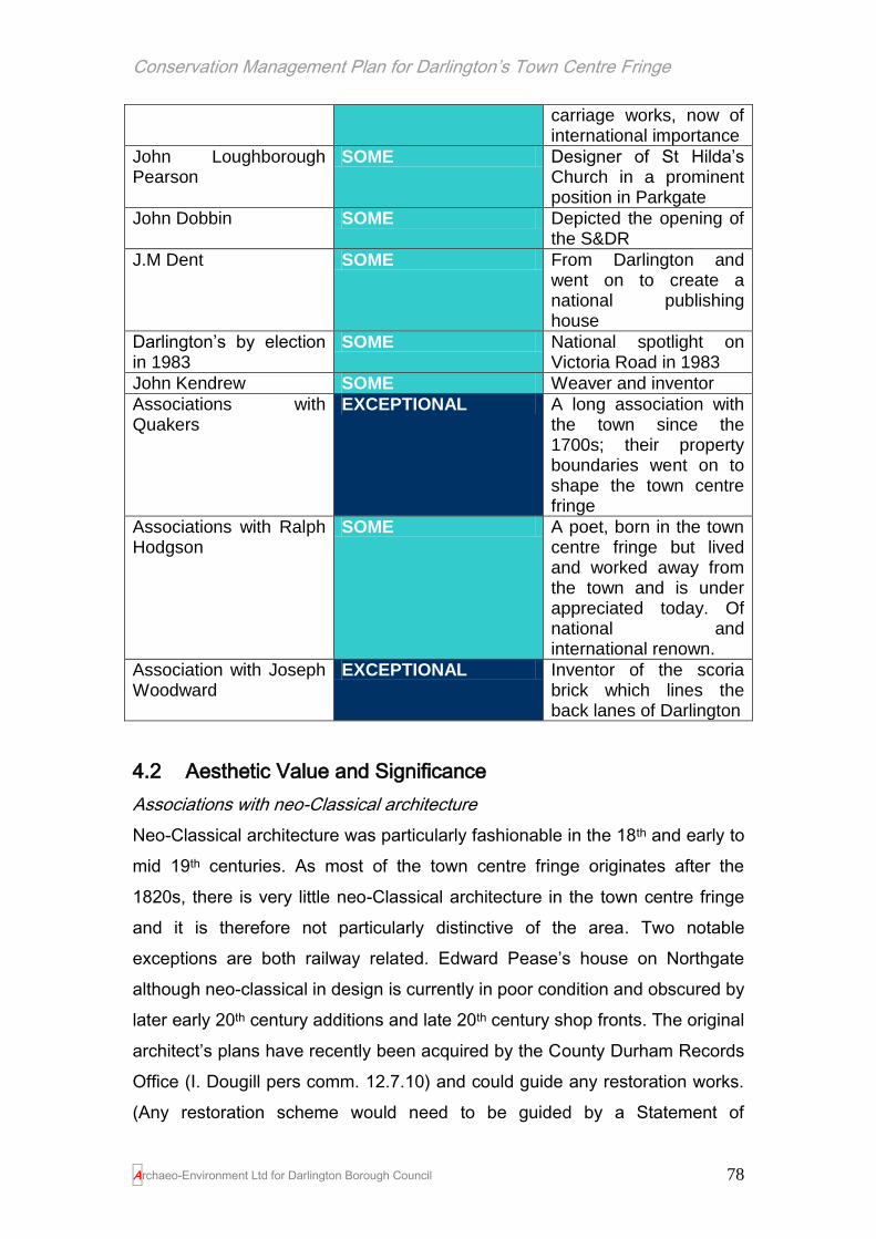
Conservation Management Plan for Darlington’s Town Centre Fringe
Archaeo-Environment Ltd for Darlington Borough Council 78
carriage works, now of international importance
John Loughborough Pearson
SOME Designer of St Hilda’s Church in a prominent position in Parkgate
John Dobbin SOME Depicted the opening of the S&DR
J.M Dent SOME From Darlington and went on to create a national publishing house
Darlington’s by election in 1983
SOME National spotlight on Victoria Road in 1983
John Kendrew SOME Weaver and inventor
Associations with Quakers
EXCEPTIONAL A long association with the town since the 1700s; their property boundaries went on to shape the town centre fringe
Associations with Ralph Hodgson
SOME A poet, born in the town centre fringe but lived and worked away from the town and is under appreciated today. Of national and international renown.
Association with Joseph Woodward
EXCEPTIONAL Inventor of the scoria brick which lines the back lanes of Darlington
4.2 Aesthetic Value and Significance
Associations with neo-Classical architecture
Neo-Classical architecture was particularly fashionable in the 18th and early to
mid 19th centuries. As most of the town centre fringe originates after the
1820s, there is very little neo-Classical architecture in the town centre fringe
and it is therefore not particularly distinctive of the area. Two notable
exceptions are both railway related. Edward Pease’s house on Northgate
although neo-classical in design is currently in poor condition and obscured by
later early 20th century additions and late 20th century shop fronts. The original
architect’s plans have recently been acquired by the County Durham Records
Office (I. Dougill pers comm. 12.7.10) and could guide any restoration works.
(Any restoration scheme would need to be guided by a Statement of

Conservation Management Plan for Darlington’s Town Centre Fringe
Archaeo-Environment Ltd for Darlington Borough Council 79
Significance to help decide whether the 1866 alterations and 1907 additions
on one bay should be retained). The North Road railway and merchandising
station are both in a classical style reflecting their early date before the neo-
Gothic styles became associated with railway architecture. Its association with
the town centre fringe is therefore of some significance.
Then and Now…
Plate 32. North Road station in 1936
Plate 33. North Road station (Head of Steam Museum) in 2010; its role as a museum and its listed status is clearly benefitting the conservation of the building

Conservation Management Plan for Darlington’s Town Centre Fringe
Archaeo-Environment Ltd for Darlington Borough Council 80
Associations with Victorian architecture
The town centre fringe originated for
the most part in the Victorian period
(1837-1901), although the
architectural styles continued in use
up to and around 1910 and in that
respect it is Victorian architecture
which makes the area particularly
distinctive. Victorian architecture
takes a number of different forms
(see Built Form section) ranging from rows of terraced houses to the ornate
G.G. Hoskins designed Technical College. The architects and builders used
as their inspiration England’s past and so their architectural designs
incorporated Tudor, Gothic and Jacobean styles, often in the same building.
Their designs were also ornate. Even in the simplest worker’s housing, the
window mullions would have a small carved detail to lighten the effect and
perhaps some below eaves brick detailing which is widespread throughout the
town, while higher status terraces would be embellished with ornate
doorways, railings and window lintels.
Nationally, much of the Victorian housing stock has been demolished. The
larger houses proved too expensive to maintain and were sub-divided or
demolished. The plain simpler styles of the 20th century made the Victorian
ostentation look fussy and out of date and so more houses were demolished.
The back-to-backs were too tightly laid out and were associated with disease
and deprivation. Those that survived the health board clean ups were taken
out by the ring road. However what was left was of good quality, sufficiently
spacious and versatile with lively facades and colourful detailing. It is Victorian
architecture which provides the historic skyline and Victorian architecture
which is now in decline due to inappropriate management of those buildings
not protected through listing. The key to the vitality of the town centre fringe is
Plate 34. Brunswick Street Board School, built 1881

Conservation Management Plan for Darlington’s Town Centre Fringe
Archaeo-Environment Ltd for Darlington Borough Council 81
therefore in the condition and successful reuse of the Victorian architecture.
Its association with the town centre fringe is therefore exceptional.
Associations with Edwardian architecture
Victorian styles continued in use particularly for
terraced houses, but new styles of architecture
gradually appeared. The town centre fringe has a
fine collection of Edwardian buildings particularly
around Parkgate, Victoria Road and the south end
of Northgate and Gladstone Street. These buildings
tend to have terracotta tiled facades providing a
more delicate and finished façade than plain brick,
although glazed tiles were also used on shop fronts
and inns. Ball finials were popular to the gable ends as were decorated
doorways and window lintels, often in the form of draped floral arrangements.
Stained glass, also in floral styles, was also popular and survives in Parkgate
at the Greyhound Inn. Its association with the town centre fringe is therefore
considerable.
Associations with neo-
Classical architecture
SOME
Associations with
Victorian architecture
EXCEPTIONAL
Plate 35. Borough Road next to the Fire Station, built 1904

Conservation Management Plan for Darlington’s Town Centre Fringe
Archaeo-Environment Ltd for Darlington Borough Council 82
Associations with
Edwardian Architecture
CONSIDERABLE
Associations with artistic views
Significant buildings and picturesque landscapes have been the focus of the
British artist and the inspiration of poets since at least the 18th century when
the exploration and depiction of the British countryside became an alternative
to the Grand Tour in Europe. However Darlington never really met the early
criteria for picturesque landscapes as defined by the likes of Gilpin and so
was not depicted by nationally renowned artists such as Turner. However the
picturesque traditions gradually moved towards architecture and in particular
Gothic architecture and so buildings with a long history of portraying
picturesque ideals soon became the focus of attention. A trawl through
depictions of Darlington curated by the Palace Green Library and in
secondary antiquarian publications shows quite clearly that the main focus of
artistic attention in Darlington has been St Cuthbert’s church. Of forty four
prints, sketches and architects’ drawings in the Palace Green collection for
Darlington, eighteen have St Cuthbert’s as its focus. While St Cuthbert’s is
outside the town centre fringe area, views towards it remain important and the
recent demolition of the bus station has restored a much valued view of the
church from what was Feetham’s Field.
The other main subjects of artistic attention are the market place, the old town
hall, the manor house, the Deanery and the old bridge, all outside or
peripheral to the town centre fringe.
Within the town centre fringe there are depictions of Northgate’s United
Reform Church in 1861 by an unknown artist and Thomas Allom’s view of
Yarm Road dating to 1830. Allom’s painting and some of those which depict

Conservation Management Plan for Darlington’s Town Centre Fringe
Archaeo-Environment Ltd for Darlington Borough Council 83
St Cuthbert’s from a distance also show rural scenes before they were
developed as part of the town’s Victorian expansion and can show the
evolution of the town from a medieval borough to a Victorian industrial town.
Plate 36. Thomas Allom’s view of Yarm Road 1830 with the beginnings of terraced housing in the distance and St Cuthbert’s Church
Other depictions which relate to the town centre fringe include the railway as
the main theme. Prints of Locomotion No. 1 dating to 1857 by an unknown
artist and the first railway coach dating to sometime after 1825, again by an
unknown artist concentrate on the machinery, but other depictions focus on
the opening of the railway line in 1825. The depiction of the bridge designed
by Ignatius Bonomi also featured on the five pound note from 1990 to 2003 to
be replaced by Elizabeth Fry (a Quaker, prison reformer and part of the family
which founded Barclay’s Bank). The design of the banknote drew heavily on
Dobbin’s (q.v.) view for the illustration. Curiously, the Bank embellished
Bonomi’s simple bridge even further by adding a couple of decorative stone
slabs just beneath the parapet. These
slabs were only on the north side of the
bridge and disappeared when it was
widened at the turn of the last century.
However, the view on the bank note is
from the south so, once more, artistic
Plate 37. The five pound note with the Skerne bridge, Stephenson and Locomotion

Conservation Management Plan for Darlington’s Town Centre Fringe
Archaeo-Environment Ltd for Darlington Borough Council 84
licence has been taken with the bridge.
There are therefore two significant themes to artistic depictions in Darlington,
St Cuthbert’s Church and the railway.
Artistic Associations: Significance
Railway depictions EXCEPTIONAL
Views of St Cuthbert’s from the town centre fringe area CONSIDERABLE
Views of the town centre fringe before development SOME
Views of buildings within the town centre fringe MARGINAL
Historic skylines
‘The grand old spire they did admire When to my roost I flew
And I’ve kept my stand high above the land With my weather eye in view.
I’ve looked o’er my wings at wondrous things Since George the Fourth did reign.
I saw from my nest a wondrous guest They called a railway train.’ 23
Darlington has a number of iconic skyline features which can be seen from
the town centre and the town centre fringe. Many of these are important views
from residential areas and provide a visual link with the historic core of the
town, or terminate views from main streets. The view along Victoria Road to
Bank Top Station is no accident. When the North Eastern Railway opened its
new station at Bank Top in 1887, the Council went to great expense in
purchasing Feetham’s Road to enable a direct route to be made to the front of
the entrance of the station (Flynn 1983, pl102).
The Methodist New Connexion Church opened in 1884 and while it still
contributes something to the historic skyline, the loss of its spire top has given
the church a stunted appearance. If the old spire top no longer exists, a new
23
(Extract from a poem written by J Horsley, February 1873 on the view of the town from the weather
vane of St Cuthbert’s.)

Conservation Management Plan for Darlington’s Town Centre Fringe
Archaeo-Environment Ltd for Darlington Borough Council 85
lightweight one could be designed by the local community or the owners with
funding from the heritage lottery fund. The Spire of St Cuthbert’s church and
Northgate United Reform church and the market hall clock tower are
particularly significant to the character of the area. Other rooflines also make
some contribution to the historic skyline, such as the technical college with its
female figures representing Art and Science and the civic theatre’s lacy
crown. The church of St John the Evangelist has no spire – the congregation
of railway workers could not afford one (Flynn 1983, pl 121), but it occupies
such a prominent position on high ground, that its chunky tower still makes an
exceptional contribution to the skyline when seen from the Town Hall,
Parkgate and Victoria Road. The historic skyline has been incorporated into
the Borough Council’s logos and is now therefore the trademark of Darlington.
Plate 38. St Cuthbert’s church spire and the market hall tower offer an historic skyline
throughout the town centre fringe.
Historic Skyline building Significance
Bank Top Station Tower EXCEPTIONAL Inside the town centre fringe with views

Conservation Management Plan for Darlington’s Town Centre Fringe
Archaeo-Environment Ltd for Darlington Borough Council 86
throughout the town. The tower also terminates views along Victoria Road. Built 1887 and designed by William Bell ‘one of his best efforts’ (Pevsner 1990, 149). The bell no longer rings now being displayed on a station platform.
St Cuthbert’s church EXCEPTIONAL Outside the study area
United Reformed
Church, Northgate
EXCEPTIONAL Within the study area, prominent spire in dark stone built 1861-2 and designed by J.P.Pritchett and Son.
Market Hall clock tower EXCEPTIONAL A prominent tower and clock visible as an equal partner to St Cuthbert’s spire throughout the town centre fringe.
Technical College SOME The top of the technical college offers a modest contribution to the historic skyline only seen from parts of Valley Street, East Mount and Borough Road.
Civic Theatre SOME The lacy crown of the roof can be seen from Brunswick Street, Parkgate and Park Lane.
Church on Victoria Road SOME Tower has lost its top in the past and so it presents a decapitated head rather than the lantern it once supported.
Clock Tower, North
Road Merchandising
Station
SOME The tower has lost its clock, but can still be discerned from parts of the Valley Street area on the approach to the Five Pound Note Bridge.
St John’s Church, EXCEPTIONAL Designed by John Middleton, the church

Conservation Management Plan for Darlington’s Town Centre Fringe
Archaeo-Environment Ltd for Darlington Borough Council 87
Neasham Road has no spire but a large square tower. Because the building sits on an elevated position, it can be seen in many places throughout the town centre fringe, although the site itself is immediately outside the study area boundary.
Bellcote, Brunswick
Street school
SOME Add interest to Borough Road and terminates views from Middleton Street.
Kings Head Hotel MARGINAL The top of the hotel is visible over the Cornmill multi-storey car park and JJB Sports; it is an interesting roofline which would benefit from being seen from further afield

Conservation Management Plan for Darlington’s Town Centre Fringe
Archaeo-Environment Ltd for Darlington Borough Council 88
Figure 5.Location of buildings which are prominent historic skyline features in views from or within the town centre fringe

Conservation Management Plan for Darlington’s Town Centre Fringe
Archaeo-Environment Ltd for Darlington Borough Council 89
Associations with early railway architecture
Darlington’s collection of railway related buildings around the Head of Steam
Museum has been described as the world’s most important group of surviving
early railway buildings. Since the 1830s it has been known as North Road and
was developed by the S&DR as its base in Darlington. The focus of the
railway heritage is located around the stations in a triangle of land between
what was the S&DR main line (now the
railway to Bishop Auckland to
Darlington), the former branch line to
the S&DR coal yard in Darlington (now
a road liking Hopetown Lane to Station
Road) and the main road north from
Darlington to Durham. All the key
buildings on the site were from the first
generation of the railway age, when the
form and function of railway buildings
was still being developed by trial and
error. When the S&DR first opened in
1825 it owned no station buildings – the
concept of a railway station had not
been invented yet. The first station was
a converted warehouse to which were
added a booking office and waiting
room in 1833. North Road Station
replaced these in 1842 and was
extended to meet he needs of growing traffic (Dean 1984, pl 48). After 1853,
the S&DR replaced two elements of the site with larger facilities elsewhere
because there was insufficient space at North Road. In 1863 the S&DR
merged with the North Eastern Railway and North Road became a minor
satellite site for a large railway company rather than the hub of a small railway
company. This shift of the main functions off-site may well have been
responsible for the preservation of the North Road buildings as they were no
Plate 39. When this postcard was produced in 1912, they knew that the town’s connections with the railway were worth promoting (picture from Flynn 1994, pl 140)

Conservation Management Plan for Darlington’s Town Centre Fringe
Archaeo-Environment Ltd for Darlington Borough Council 90
longer adapted to meet new needs, or indeed demolished to make way for
larger buildings. Kitching’s foundry which moved here in 1831 from the town
centre in order to build locomotives is now demolished. The Goods Station,
the Goods Agent’s Offices, North Road Station, the Lime Cells and Hopetown
Carriage works all survive. In addition there are remnant remains of the first
station, the coal drops and the branch line. Collectively this group represents
great diversity of form and function with only the locomotive works now absent
(DBC 2006, 56).
Beyond this collection of North Road buildings there are other railway related
buildings – Edward Pease’s house on Northgate, The Railway Inn, the
Ignatius Bonomi Bridge, the viaduct and more ephemeral evidence such as
street names. Worker’s housing also abounds, and outside the study area
there is one of a very few original cow tunnels which passed through the first
S&DR line. Collectively, these structures represent the birth of the railway
network which was to change the face of the world and are therefore of
exceptional significance and internationally important.
The international importance of Darlington and the birth of the railways was
recognised in 1925 when railway companies sent representatives to the
centenary celebrations and an International Railway Congress was held at
Faverdale. At the presentations, Alipo Chiarugi, the leader of the Italian
delegation, spoke of the admiration felt by all Italian railwaymen for George
Stephenson, the ‘first railwayman of the world’ and reminded his audience
that Italy’s first railway line had been constructed under the supervision of
George’s son, Robert Stephenson. (Flynn 1994, pls 58-9)
Remnant remains
The world’s first railway station consisted of a large warehouse building which
initially at least, had a waiting room, offices and a shop, suggesting even at
the outset, waiting for a train involved perusing in a shop! The rooms were
rented by Mary Simpson at £5 p.a. in return for which she was to ‘keep the
coach office clean and afford every necessary accommodation to coach

Conservation Management Plan for Darlington’s Town Centre Fringe
Archaeo-Environment Ltd for Darlington Borough Council 91
passengers’ (Fawcett 2001, 18). Her duties appear to have consisted of
keeping a fire burning in the waiting room. Parts of the building were under-
used and were gradually converted into cottages. After its replacement by a
new passenger station in 1842, part of the station was used as offices for the
companies for the lime trade, but its position very close to the railway line
became an obstruction and demolition was ordered in 1864 (ibid). There are
remains of a large stone wall along the railway embankment to the east of
High Northgate which represent the lower walls of the back of the station
building. It is astonishing that these remnant remains of the world’s first
railway station are unprotected from demolition.
Plate 40. The 1827 S&DR warehouse which was used as a passenger station from 1833 with the ticket office on the upper floor – access was from the level crossing, but this picture was drawn after 1856/7 when the bridge over North Road was built (picture from Fawcett 2001, 18). This now survives as a large piece of retaining wall against the rail embankment and carries no form of statutory protection.
Hopetown Carriage Works
The buildings were designed by the local architect Joseph Sparkes (1817-
1855). The original design may have been more elaborate but there was no
need to impress customers and so the design was stripped of some of
Sparkes’ ornamental features and overall supervision of the project placed in
the hands of Thomas McNay. The building materials are of poor quality and

Conservation Management Plan for Darlington’s Town Centre Fringe
Archaeo-Environment Ltd for Darlington Borough Council 92
the workmanship is not much better. Originally the building may have been
covered with a lime based rough cast render.
‘Darlington and its Friends have set in motion a vast motive power, and what
shall the end be?
“From what small causes do great matters spring!”’
Longstaffe 1909, 374, originally published in 1854
These former carriage works are Grade II listed and therefore nationally
important. It is still used by two locomotive preservation trusts for the building
and restoration of locomotives, reputedly the oldest such association in the
world giving it international significance. It is the oldest purpose built railway
carriage manufactory to survive in the British Isles, and perhaps the second
oldest in the world. It contains an early example of a travelling crane. It was
explicitly designed to handle the short, four-wheeled carriages that made up
the first generation of railway rolling stock and became obsolete when
carriages increased in length (DBC 2006, 56). Its design is radically different
to later railway carriage manufactories and it is one of a handful of world
survivors able to show how the first generation of railway carriages were built
and handled. In that respect, the design features that brought about its early
obsolescence – critically, the central, transverse, access using turntables
rather than gable end doors – come into prominence and support arguments
about its importance in the evolution of the railway building design. The
carriage works are therefore of exceptional significance.
About 1848, Mr Heslegrave, land surveyor, Darlington, patented a very
superior spring for railway carriages which was soon in constant operation on
the Stockton and Darlington line. In 1848 also, Mr W. Froude, of Darlington,
obtained a patent for a valve to cover the longitudinal opening of an
atmospheric railway tube. Mr. Stephen Carlton, coachmaker, Northgate, is
proprietor of a very simple and comfortable carriage-spring, which is
registered.’
Longstaffe 1909, 336

Conservation Management Plan for Darlington’s Town Centre Fringe
Archaeo-Environment Ltd for Darlington Borough Council 93
Good’s Agents Offices
Plate 41. The Goods Agent’s Offices on McNay Street
These are located on McNay
Street and visible from the
station. They are important
because they are an unusual
survival of an ancillary office
block on a multi-use site
developed by a single owner and are one of a very few from the early years of
the railway age. They must be seen alongside the Goods Station which was
contemporary and its function intertwined (DBC 2006, 25). McNay Street is
one of the earliest streets in the area having been laid out as the access to
the station presumably in the 1830s. This building is of exceptional
significance.
North Road Station and Goods Station
The Goods Station or Merchandising Station was the first major building to be
erected by the S&DR on what later became a very extensive railway site to
the west of North Road. It was built in 1832/3 and designed by Thomas Storey
and was considerably extended in 1839/40 under the direction of John Harris
(Fawcett 2001, 19). The Goods Station is highly significant in terms of design.
Other railway goods sheds were on two levels, and this was probably the first
in the world to be built with the single-level arrangement that became, and
remained, the norm for railway
goods handling until the move to
containers in the 20th century (DBC
2006, 57).
Plate 42. The Goods/Merchandising Station with clock tower. Some of the arched openings were lost when it was used as a fire station (Fawcett 2001, 20)

Conservation Management Plan for Darlington’s Town Centre Fringe
Archaeo-Environment Ltd for Darlington Borough Council 94
Although the buildings have been extended five times and modified internally
on an almost constant basis from the 1840s to the 1920s, the design
approach by John Harris in 1842 was always maintained. As such, their
Italianate form belongs to a period before railway companies had established
the fully blown High Victorian styles which were associated with later railway
architecture. The survival of the North Road buildings in substantially the
original form is exceptionally significant. Today, North Road Station has one
of only two timber trainshed roofs to survive from the first generation of the
railway age. The good survival of the buildings at North Road is largely
because Bank Top became the principal station for Darlington and so it was
Bank Top which had to absorb the changes required with improving train
technology. Although North Road Station is not the only station building of the
period in existence, it is probably the most complete, with a station building
and train shed of the same date (DBC 2006, 46). They are therefore of
exceptional significance.
The Lime Cells
The lime cells represent a once common but now rare building type designed
for the bulk unloading of materials from rail to road. They are intact with only a
shaky set of timber doors having been added to the structure. They were built
between 1840 and 1855, but probably around 1840 when urban expansion
offered a ready market for the lime. Their significance is also because of their
association with the rest of the group of S&DR buildings at North Road and
because of their association with the expansion of Darlington. They are also
one of a small number of well-preserved examples of a once significant and
very distinctive regional building type associated with the railways (DBC 2006,
53-4). They fell out of use as lime cells by about 1870 and since then have
found alternative uses that have left the structure relatively intact. They are
currently empty and for sale. They are listed buildings grade II. They are
therefore of exceptional significance.
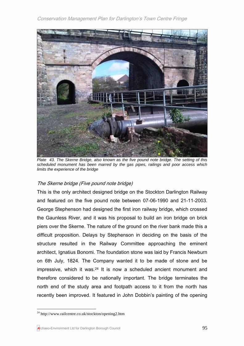
Conservation Management Plan for Darlington’s Town Centre Fringe
Archaeo-Environment Ltd for Darlington Borough Council 95
Plate 43. The Skerne Bridge, also known as the five pound note bridge. The setting of this scheduled monument has been marred by the gas pipes, railings and poor access which limits the experience of the bridge
The Skerne bridge (Five pound note bridge)
This is the only architect designed bridge on the Stockton Darlington Railway
and featured on the five pound note between 07-06-1990 and 21-11-2003.
George Stephenson had designed the first iron railway bridge, which crossed
the Gaunless River, and it was his proposal to build an iron bridge on brick
piers over the Skerne. The nature of the ground on the river bank made this a
difficult proposition. Delays by Stephenson in deciding on the basis of the
structure resulted in the Railway Committee approaching the eminent
architect, Ignatius Bonomi. The foundation stone was laid by Francis Newburn
on 6th July, 1824. The Company wanted it to be made of stone and be
impressive, which it was.24 It is now a scheduled ancient monument and
therefore considered to be nationally important. The bridge terminates the
north end of the study area and footpath access to it from the north has
recently been improved. It featured in John Dobbin’s painting of the opening
24
http://www.railcentre.co.uk/stockton/opening2.htm

Conservation Management Plan for Darlington’s Town Centre Fringe
Archaeo-Environment Ltd for Darlington Borough Council 96
of the railway and now in the Pease room of the Head of Steam Museum. It
also features in another painting by an unknown artist of the ‘inaugural train
crossing Skerne Bridge, Darlington’ (Wall 2001, 116-7). It is of exceptional
significance.
"There is at present a great probability that locomotive carriages will speedily
be brought to run on rail-roads for public accommodation. Should this be the
case, and should the advantages of such a mode of conveyance be as great
as described, they must supersede common roads, and all vehicles moved by
animal power. The changes this will effect in the face of the country, and in
the moral relations of its inhabitants, seem likely to be very extensive. Places
will be brought nearer to each other, and communication between them will be
more rapid and frequent. Nobody will consent, we presume, to be jolted along
a rough road, 10 or 12 miles an hour, when he can be whirled along a smooth
and pleasant one with twice the velocity."
The Observer 25th April 1830
Viaduct
The viaduct over North Road was built in 1856 for the Stockton and Darlington
Railway and was altered in 1935, although plans for the bridge were
underway by the 1840s. Before 1856 the railway crossed the road by means
of a level crossing. Early photographs show that it had a plaque with the date
MDCCCLVI on the side. It has solid iron parapets which flank the track,
supported by a pair of rusticated piers with cornices and rounded low caps.
The abutments have become banked up with earth but were probably
originally exposed. The viaduct is listed Grade II* because of its association
with the S&DR (DCMS 1977) and is therefore nationally important and of
exceptional significance.

Conservation Management Plan for Darlington’s Town Centre Fringe
Archaeo-Environment Ltd for Darlington Borough Council 97
Then and Now…
Plate 44. The Viaduct in High Northgate and the northern boundary of the town centre fringe. Date unknown, but possibly 1930s?
Plate 45. The viaduct in 2010

Conservation Management Plan for Darlington’s Town Centre Fringe
Archaeo-Environment Ltd for Darlington Borough Council 98
First railway inn
Nos. 6 to 16 High Northgate includes The Railway Tavern, built by John
Carter in 1827 who was the Stockton & Darlington Railway’s first architect-
cum-builder. It was apparently built by the Quakers, as a place for the carters
to wait for trains, ready to load their wagons from the lime cells and was also
used by passengers up until 1833. The Tavern was originally owned by the
Stockton and Darlington Railway and was called ‘The Blue Bell Inn’ (first
mentioned in 1791), but this was presumably an earlier version of the building
on the same site. With the arrival of the railways the inn was renamed and
provided accommodation and hospitality for rail travellers. The inn remained
in railway ownership until 1870 when it was put up for auction (HER 7301). It
is reputed to be the first ever inn built specifically for a railway in the world.
The ground floor windows have been enlarged, but the distinctive glazing of
the upper lights is also found in the door fanlights of the company’s relatively
unaltered Stockton tavern (Fawcett 2001, 10). Its association with the S&DR
makes it exceptionally significant and if it is indeed the earliest railway inn in
the world, then it is internationally important. It is also worthy of listing given its
national significance.
Edward Pease’s house, 138- 148 Northgate
Edward Pease’s house on Northgate is where Pease met with Robert
Stephenson to discuss the formation of a railway and agreed to use steam
locomotion. Although the town centre fringe as a whole represents the birth
place of the railways, it is in this house that the plan appears to have been
fleshed out and made real. Its setting has altered dramatically. At the time of
the meeting it was a large street fronted classical villa with a long garden
extending down to the river. The street elevation is now divided up so that the
façade has lost its uniformity. Research currently being carried out by Charles
McNab of the Darlington Historical Society has uncovered the original ground
plans of the house as it was when the meeting took place between
Stephenson and Pease in his kitchen. He has also uncovered plans showing
the house being subdivided into four properties in 1866 (it consisted of the
main residence plus an additional apartment to the south even in 1825) and

Conservation Management Plan for Darlington’s Town Centre Fringe
Archaeo-Environment Ltd for Darlington Borough Council 99
further plans showing proposals to add the classical cladding to one bay in
1909, designed by the architect G. Walesby Davis. The main significance of
the building is its association with Edward Pease and the birth of the railways,
but the classical façade added in 1909 is now somewhat of a rarity. The
house is therefore of exceptional significance because of its association with
the birth of the railways and its wealth of documentary evidence and of some
significance because of its 1909 partial cladding which includes a
commemorative plaque referring to the house’s role in the birth of the
railways.
Engine Shed, Haughton Road
This engine shed was built in the
1840s and is the oldest engine shed in
the country; it is a listed building grade
II and is therefore nationally important.
It was probably designed for the
Newcastle & Darlington Junction
Railway by George Townsend
Andrews (Fawcett undated.25), who
was particularly noted for his railway work for George Hudson between 1839
and 1849. This is based on the shed’s appearance which looks like a typical
GT Andrews’ two-road shed with brick walls which rise from a stone plinth and
on the side walls, the windows are recessed into shallow panels, allowing a
small reduction in the volume of brick required, with no loss of strength. This
feature, with the stone window cill carried right across the panel, occurs in a
number of Andrews’ buildings, but is apparently less common among his
engine sheds (ibid). However, there is also documentary support which
suggests that this may be a building of his design. The NDJ Board on 16
August 1844 instructed Andrews to plan workshops at Gateshead, an engine
shed at Brockley Whins, and an engine shed and two cottages at Darlington.
It is of exceptional significance because of its listed status, its association with
25
Darlington’s ‘GNE Shed’ available from http://www.staff.ncl.ac.uk/m.h.ellison/nera/gneshed.pdf
[accessed 16.7.10]
Plate 46. The Engine Shed

Conservation Management Plan for Darlington’s Town Centre Fringe
Archaeo-Environment Ltd for Darlington Borough Council 100
G.T. Andrews and its relative rarity. There are few engine sheds of this date
left in the country (ibid).
The Railwayman’s Church (outside the study area)
The parish of St John the Evangelist was formed in July 1845 and the church
designed by John Middleton built in 1847. The foundation stone was laid by
George Hudson, the Lord Mayor of York; ‘The Railway King’ who also partly
funded its construction (Wall 2001, 156). The directors and shareholders of
the railway company had provided a warehouse for use as a church before
the building was completed (Flynn 1983, pl 120). The church is also known as
the Railwayman’s Church because its congregation was mainly railway
workers, however they were not appreciative of its peal of six bells especially
if on a nightshift (Wall 2001, 156). Its significance in terms of railway heritage
is some.
Cow Tunnel (outside the study area)
Plate 47. The cow tunnel today is encapsulated in a modern tunnel (left) but the join where it becomes the original S&DR cow tunnel can still be seen inside (right)
This represents one of the only concessions to local farmers when the S&DR
line was put through farming land in 1825 (Wimbury pers comm.). The road
above it has since been widened so the original cow tunnel has become
encased within a larger tunnel. However it can still clearly be seen from inside
the tunnel. Its significance is therefore considerable.

Conservation Management Plan for Darlington’s Town Centre Fringe
Archaeo-Environment Ltd for Darlington Borough Council 101
Morrison’s Clock (outside the study area)
This is a clock rescued from the railway works now demolished and is close to
its original location but no longer in situ. It is outside the study area, but adds
to the general collection of railway related assets. Its significance in terms of
railway related architecture is some.
The importance, magnitude and impact of the birth of the Stockton &
Darlington Railway on the transport systems of the world cannot be
measured.26
Bank Top
This station was designed by William Bell for
the North Eastern Railway Company and
opened in 1887. It replaced ‘a mean shed’
which had been used since the 1840s (Flynn
1994, pl 8) and which had left Queen Victoria
distinctly unamused when she alighted the
train in 1849. She pointed out that for the main
line station of the very place in which the
railway had been born to look so down-at-heel
was just not good enough (Emett 2007, 22).
The development of this station triggered the
growth of the wider area, creating a railway
colony. The station is largely unaltered since its construction. Its two
immensely high and wide arches were designed to permit the passage of
carriages of the wealthiest first class passengers, with their coachmen sitting
aloft. These arches opened into a porte cochere, four bays deep and large
enough to enable carriages to enter by one arch, swing round and depart by
another. The vestibule is protected by the train shed style roof, in imitation of
those above the station proper. On either side of the arches are two smaller
arches for foot passengers. In between a soaring Italianate clock tower over
27m high which is Bank Top’s crowning glory. It can be seen from every part
26
http://www.railcentre.co.uk/
Plate 48. Bank Top’s clock tower
Conservation Management Plan for Darlington’s Town Centre Fringe
Archaeo-Environment Ltd for Darlington Borough Council 102
of town with its windows and galleries opening to Victoria Road surmounted
by a pyramidal roof with a round window in each gable and crowned by a
gilded fleche. Historically the clock was set to run five minutes fast to ensure
passengers always caught their trains. The main down line is one third of a
mile long and is one of the longest in Britain. The train shed roofs are
supported on parallel rows of 80 massive cast iron Corinthian columns. Each
spandrel of the arches is decorated with painted and gilded shields of arms
amounting to 158 spandrels in total containing 948 coats of arms (Wall 2001,
157-9). Its association with the railway heritage and the town centre fringe is
exceptional.
‘In the incomparable railway enterprise, Darlington was then, and therefore will
always remain – FIRST IN THE WORLD’. Wall 2001, 177
North Eastern Hotel, Victoria Road
This was built in the early 1880s on land which had been part of the Bishop’s
High Park. Its name was derived from the North Eastern Railway who had
built Bank Top Station next door. The hotel, whose registered address was
‘Comfort, Darlington’, had twenty six bedrooms, public rooms and lavatories
‘of the most improved description’. There were sufficient stables to house
twenty-five to thirty horses and a large lock up coach house (Flynn 1983,
pl104). It contributed towards a positive first impression for the late Victorian
visitor and its association with the railway heritage is therefore considerable.

Conservation Management Plan for Darlington’s Town Centre Fringe
Archaeo-Environment Ltd for Darlington Borough Council 103
Plate 49. The North Eastern Hotel in 1880
Housing
The main residential building type throughout the town centre fringe is the
terraced house. Many of these were built for railway workers or workers in
railway related industries. The earliest terraces to be built close to North Road
station were built in the 1820s and are now in the Conservation Area.
However many more terraces are outside the town centre fringe around Albert
Hill. Longstaffe in 1854 saw Bank Top as a new town ‘gradually arising on the
east of the Skerne’. Initially it was a railway colony, its church first established
in a converted railway warehouse. As the town expanded to the north towards
North Road Station and to the east to Bank Top station, it was the terraced
house that was constructed, often interspersed with non conformist places of
worship. The distinctive railway terraces around the stations were not
constructed by the railway companies however, but by speculators for rent
and profit. By 1849 the Stockton and Darlington Railway owned only 19
cottages and one public house (Wall 2001, 155). Terraced housing is of
exceptional significance to the character of the town centre fringe, and while it
is less directly connected to the railway heritage, it has, especially around
Bank Top, strong railway connections. The significance of terraced housing in
relation to the railway heritage is therefore considerable.
Railway influence on decorative elements in landscaping

Conservation Management Plan for Darlington’s Town Centre Fringe
Archaeo-Environment Ltd for Darlington Borough Council 104
The railway heritage features in some design details in buildings and street
furniture in Darlington. In the town centre, the old Town Hall designed by
Waterhouse and paid for by Joseph Pease, has balconies and a clock tower
embellished with reproductions of railway engine plug wheels. The design has
been copied on the walls of the Dolphin Centre (opened in 1983) and on bus
shelters (Wall 2001, 176). Rails have been set into the entrance of the market
place. However these features and their significance is easily missed and they
are outside the study area. Seating which has used the locomotive wheel has
been replaced as part of the recent town centre landscaping along High Row
but it can still be found on the Market Place. The large roundabout on Victoria
Road (within the study area) has a floral display based on the railway, but no
other indicators of the importance of the railway heritage were identified. The
railway heritage was used as a design reference in the late 19th century where
the spandrels of Bank Top Station were decorated with references to
Locomotion and Locomotion was featured on the town coat of arms and
appears on civic buildings and railway bridges. However the international
importance of the town centre fringe (and the town) is easily missed. The
significance of the railway heritage in the landscaping and street furniture of
the modern day town centre fringe is therefore marginal.
‘Thus Darlington has had much to associate it with that wondrous system
which threatens to annihilate time and space.’ (Longstaffe 1909, 376 originally
published in 1854)
Street names
A number of the streets take their names from railway pioneers and figure
heads (Stephenson Street, McNay Street) or relate to the railway (Station
Street). A relatively recent lane in the town centre fringe is named after John
Dobbin who painted the opening of the S&DR. Their association with the town
centre fringe is therefore of some significance. Street names around Bank
Top are more associated with royalty such as Victoria Road, Albert Street,
Adelaide Street, King William Street and Princes Street (Wall 2001, 156) and

Conservation Management Plan for Darlington’s Town Centre Fringe
Archaeo-Environment Ltd for Darlington Borough Council 105
other street names in the area reflect landowners and property developers of
the 19th century.
Overall associations with early railway
architecture and technology
EXCEPTIONAL
4.3 Communal Values and Significance
Local History and Railway Heritage:
The history, civic pride and built heritage of Darlington are important to a
significant number of people within the town and region. In particular the
Darlington Historical Society has a wide membership to whom the heritage of
the area has both personal and family meaning, as well as longer term
cultural significance.
In addition to community interest in the broad history of Darlington, the area is
of exceptional importance to the community of those interested in railway
heritage. This is in effect an international community, but specific note needs
to be made of the Friends of The Head of Steam Museum, the A1 Steam
Locomotive Trust and the North East Locomotive Preservation Society, all
based in and around the historic heart of the S&DR and whose presence
makes the area more than just a heritage site, especially with the recent
successful new build of the A1 pacific class locomotive Tornado. The
communal value of the railway heritage to the town centre fringe is therefore
exceptional.

Conservation Management Plan for Darlington’s Town Centre Fringe
Archaeo-Environment Ltd for Darlington Borough Council 106
Plate 50. Tornado. Newly built A1 Pacific Class locomotive, constructed at the former Hopetown Lane carriage works by the A1 Preservation Trust, and emblematic of the railway community passion and interest in the area.
Local myths and legends:
Bulmer stone
The Bulmer Stone is a boulder of red granite, carried down from Shap Fell, in
Westmorland, during the Ice Age. This stood in Northgate, marking what was
once the northern boundary of the town. It was located opposite the old
cobblestone cottages which were known collectively as Darlington House.
These cottages were demolished to make way for the technical college. For
centuries the boulder was a significant local landmark, occupying a prominent
position on Northgate's pavement in close proximity to the road. In the
nineteenth century Willy Bulmer, Darlington's unofficial town crier, read the
London news standing on the boulder and it is probably from him that it
derives its name. It is also said that George Stephenson and Nicholas Wood
(a colliery manager from Northumberland) sat on the stone to re-tie their
boots, having walked from Stockton to Darlington to see Edward Pease and to
convince him of the benefits of steam locomotives. An alternative and more
likely explanation is that both Stephenson and Wood had to remove their
muddy boots having walked from Stockton, to replace them with clean shoes

Conservation Management Plan for Darlington’s Town Centre Fringe
Archaeo-Environment Ltd for Darlington Borough Council 107
ready for their important visit (McNab pers comm.). It was as a result of this
meeting that Pease chose to appoint Stephenson as the Chief Engineer of the
Stockton and Darlington Railway.
Local legend states that when the boulder hears the clock strike twelve the
Bulmer Stone turns around nine times. The stone remained in position until
1923 when it was removed and placed behind the college railings, where it
still stands. This might explain why no-one has seen it move since.
Plate 51. The Bulmer Stone on Northgate before it was moved behind railings
The significance of the Bulmer Stone is therefore exceptional, it having
several associations from the ice age to the birth of the railways and its
associations with myth and legend. There are few such features in the town
centre fringe and it therefore has added rarity value.
Other local myths and legends
Part of the Skerne, or possibly the Cocker Beck, off Northgate was used as a
ducking pond. Records from the 17th century recount a number of legal cases
where women accused of ‘scolding’ were ducked as punishment. These
traditions are not well known now and have little local resonance. Their
significance is therefore some.

Conservation Management Plan for Darlington’s Town Centre Fringe
Archaeo-Environment Ltd for Darlington Borough Council 108
The area has a few associations with ghosts including Lady Jarratt who once
stalked the Bishop’s Palace where she had an arm cruelly cut off during a
robbery in the Civil War. She apparently continued to make an appearance in
the Palace when it was turned into a workhouse and the silky swish off her
skirts has been heard along the corridors of the Town Hall which sits on the
site of the Palace (Lloyd undated, 108). The ghost of North Road Station has
at least managed to retain his haunting ground. A porter named Winter
committed suicide in the cellars below the station in the 19th century and he
has reputedly been seen walking along the platform with his black dog since
the 1850s (ibid). The dog has mysteriously turned white in the museum’s most
recent display of the cellars, but is undoubtedly a star attraction nevertheless.
COMMUNAL VALUES Significance
Community Interest in heritage of Darlington CONSIDERABLE
Railway Heritage EXCEPTIONAL
The Bulmer Stone EXCEPTIONAL
Local myths and legends SOME
4.4 Evidential Value and Significance
Archaeological potential of below ground
Existing records on the buried archaeology of the town centre fringe are
sparse. Early settlements are often to be found at the junction of a tributary
stream with its main river course. Evidence has been found of Mesolithic27
occupation along the river terrace which is now occupied by High Row and
this conforms to that pattern. The original route of the Skerne can be partly
discerned at Russell Street via Valley Street where a semi-circular brick
tunnel was built in 1900 to accommodate the river. This was smashed through
a few years ago by a utility company in Valley Street (I.Dougill pers comm.
27
10,000 years ago

Conservation Management Plan for Darlington’s Town Centre Fringe
Archaeo-Environment Ltd for Darlington Borough Council 109
12.7.10), but it marks the route of the river and therefore the river terraces
nearby which are in effect the areas of highest archaeological potential.
To the east of the river there is a potential for post medieval archaeological
deposits to survive along Parkgate and Freeman’s Place, and also along St.
Cuthbert’s Way between these two streets, although construction of St.
Cuthbert’s Way is likely to have severely truncated deposits in this latter area.
Elsewhere on this side of the river, the archaeological potential is low (ASUD
2009, 1).
An Anglian cemetery has been found at Greenbank, suggesting a settlement
of the 6th century AD not far away, which could be uncovered in any
development works in that area. Those areas with the highest potential are
nearest the medieval core around Houndgate, the Town Hall, Feethams and
Bondgate. However these areas have also been through considerable
redevelopment and archaeological work previously carried out has often been
disappointing because of the damage done to the ground by cellars,
especially in the 18th century, and by modern development. In Bondgate the
highest potential is likely to be in the areas of the medieval property
boundaries running back from Bondgate, but these areas are often just as
damaged and developed often resulting in a limited picture of earlier
occupation consisting of hearths and post holes, but dating evidence is often
too disturbed to be useful. Garden Street has already produced ‘an ancient
bridge’ of unknown date, found in 1903 and a Roman coin, found in 1904. The
former route of the river and the land to either side of it may be of some
archaeological potential particularly at crossing points. Perhaps of more
interest in this area is the potential for the mid 19th century layout of Edward
Pease’s renowned gardens to be preserved below the Garden Street car
park.
The railway heritage is an area of higher potential. Early maps such as the 1st
edition OS map dating to the 1850s show a number of buildings such as the
Railway Worsted Mill in the town centre fringe which are no longer in

Conservation Management Plan for Darlington’s Town Centre Fringe
Archaeo-Environment Ltd for Darlington Borough Council 110
existence but for which there might be below ground evidence. Further the
layout of the earliest buildings at the top of Northgate and their relationship to
early branch lines is not clearly understood. The excavation of buried railway
deposits has the potential to throw additional light on these exciting times
between the 1820s and the 1890s. Overall, there is therefore some potential
in the area for below ground archaeological remains.
Potential of buildings to contain archaeological information
The majority of buildings in the town centre fringe post date 1825. Earlier
buildings have long since been demolished. The potential for the buildings to
contain evidence relating to earlier buildings is therefore limited. Those
buildings at the top of High Northgate and south of the viaduct are most likely
to incorporate evidence relating to the earliest station.
Other buildings containing archaeological evidence include all the railway
buildings such as the lime cells and the carriage works which will help us to
understand the evolution of the railway and the growth of the town. Evidence
can be sparse and fragmentary. The coal drops to the rear of Westbrook
Villas along with the tallyman’s house are easily overlooked being along a
back lane and their function is not understood. For example what was the
purpose of the now blocked neo-Gothic arch in the coal drops? Could it be
part of Westbrook Cottage shown on the 1st edition OS map? Other coal
drops off Northgate are evidenced only in walling behind houses facing the
Cocker Beck (HER 7302) and coal drops on John Street are in perilous
condition requiring urgent recording.
At the foot of Northgate behind Edward Pease’s house is the only remaining
Weavers Cottage which merits recording so that a record exists for this
building type now so nearly extinct. The rest of the row was demolished
possibly to make way for the Lily Laundry, also now demolished and much of
Garden Street was demolished in the 1960s (I.Dougill pers comm. 12.7.10).

Conservation Management Plan for Darlington’s Town Centre Fringe
Archaeo-Environment Ltd for Darlington Borough Council 111
Edward Pease’s house has been through a number of alterations but plans
exist showing how it looked in 1825 and how it was altered in 1903, although
it is not always clear what alterations were actually made. Any future
alterations to this building should be accompanied by additional recording
enforced through listed building consent so that further light on the form and
evolution of the building can help to make decisions regarding its future uses.
The origins of the Railway Tavern are confused. Was the Blue Bell Inn an
earlier building on the same site which was renamed when the S&DR decided
to use it for carters and passengers, or was the old Blue Bell demolished and
a new railway tavern built? The answers may lie in the fabric of the building.
The shop at 112 High Northgate may contain evidence of the early 19th
century shop and the Skerne Bridge is likely to contain evidence relating to
the first railway bridges and the engineering solutions that were used at that
time. The tannery buildings off Parkgate on Tannery Row also represent a
near extinct building type and recording could expose information relating to
these small scale industries.
Buildings dating to WW2 are now rare and so a record should be made of the
air raid shelter on Weir Street. Air raid shelters took a number of forms but this
example appears to be a one-off, possibly a commission for a local works.
This information could perhaps be supplemented by oral history accounts and
wartime records in the local studies library.
Structures are also associated with the management of the Skerne. The weir
at Russell Street has evidence of a sluice system and the arch which carried
the mill race across to what is now Crown Street and down to Pease’s Mill.
The effective management of the river was critical to the success of
Darlington given the poor water supply that it was renowned for. Through this
management sufficient power was obtained to run a number of water powered
mills (I. Dougill pers comm. 12.7.10).

Conservation Management Plan for Darlington’s Town Centre Fringe
Archaeo-Environment Ltd for Darlington Borough Council 112
The role of urban archaeology in understanding settlement and urbanism has
been flagged up in the region’s Research Agenda and Strategy (Petts and
Gerrard 2006, 205-7). Of particular relevance is the need to routinely record
urban industrial structures (SU 19), the targeting of back plots which has
relevance around Pease’s house and adjacent buildings which pre-date the
expansion associated with increasing industrialisation (SU18). Collectively the
potential of the buildings in the town centre fringe to contain valuable
archaeological information is limited by the date range, but significant
because it can contribute towards our understanding of the railway heritage
(exceptional) and the 19th century development of the town (some). Proposals
to alter or demolish buildings which pre-date the 1930s should be
accompanied by a Statement of Significance so that it is clear to the decision
makes what will be preserved reused or lost that is of significance.
Educational value of railway heritage through extant remains
The town centre fringe area is already an educational resource based on the
growth of the railways. In addition to the more obvious resources such as the
Head of Steam Museum where the station and historic engines and railway
displays can be explored (free for educational visits), free teachers packs are
available including walks to Bank Top Station and railway related buildings
such as Edward Pease’s house and the Railway Tavern on Northgate, railway
buildings on McNay Street, the identification of railway names and the use of
the locomotion wheel in the design of seating in the town centre and the use
of rails in floorscaping in the market place. The majority of the schools using
the museum teacher’s packs are local; indeed no schools are using either
from the wider area. The post of Learning Officer in the Museum was only
established in September 2006 having been unfilled for a while and since then
educational use of the museum has grown from 2203 to 3326. However a
pattern of growth is not yet possible to identify as the museum has also been
closed for refurbishment. Consultation with teachers and the museum would
suggest that Darlington is less attractive to use as an educational resource
because of its environment. School teachers have little desire to walk children
passed a sex shop on the way to Bank Top or to peer at the world’s earliest

Conservation Management Plan for Darlington’s Town Centre Fringe
Archaeo-Environment Ltd for Darlington Borough Council 113
railway bridge through razor wire fencing. It would take considerable
imagination to see passed the pizza and kebab shops to imagine Edward
Pease meeting George Stephenson in his kitchen on Northgate (one suspects
that they might picture Pease tucking into a kebab!)
Looking at the wider educational value of the museum, statistics on the Head
of Steam’s visitor numbers suggest in the region of 25 to 28, 000 visitors per
year, of which between a third and a half are non-paying visitors.28 Again, it is
too soon after the museum’s recent refurbishment and new reduced winter
opening hours to have an accurate picture of the likely future trend. Much of
the site is under used; there is no public access to the Merchandising Station
and the land around it is surrounded by Darlington’s distinctive security
fencing. Further there is ironically no access to the museum from North Road
station; instead anyone alighting a train here has to walk a considerable
distance to access the museum or simply peer through more security fencing.
Overall the potential of the area to provide an educational resource through its
extant railway remains is exceptional, but it is currently only of some
significance due to a lack of positive management of the railway heritage
beyond the museum and due to the under-use of the museum site as a whole.
Evidential Value Summary Significance
Potential of the town centre fringe for below
ground remains
SOME
Potential for the town centre fringe for buildings
to contain archaeological information relating to
the railway heritage
EXCEPTIONAL
Potential for the town centre fringe for buildings
to contain archaeological information relating to
other building types
SOME
Potential educational value of railway heritage
through extant remains
EXCEPTIONAL
28
With thanks to Sarah Goldsborough from the Head of Steam Museum for these statistics which I
have summarised here
Conservation Management Plan for Darlington’s Town Centre Fringe
Archaeo-Environment Ltd for Darlington Borough Council 114
5.0 Statement of Significance Conclusion
The town centre fringe has much that is of significance; however it is an area
that hides its heritage assets well. Historic bowed windows peer out from
behind freezers, ornate rooftops are obscured by modern buildings, houses of
international significance sit shyly behind a kebab shop, the towns much loved
Bulmer stone sits trapped behind railings and renowned poets are long
forgotten. It is time that the town centre fringe celebrated its distinctive
heritage and its worthy residents past and present.
It is the railway heritage that consistently appears as the exceptional
contributor to local distinctiveness and as Darlington’s unique selling point.
The architecture is exceptionally significant because of the contribution that it
makes towards our understanding of the birth and early years of a mode of
transport that was to change the face of the world. Its educational value is
already exploited via the Head of Steam museum and has the potential to
provide more. The railway heritage also has considerable potential to draw
visitors to Darlington from across the world. However its condition and
management would have to match that of the Head of Steam Museum before
it was worth crossing continents for.
Decisions regarding the future management of the town will want to be guided
by the existing historic building stock and the predominantly 19th century
street pattern. It will need to consider the contribution that traditional building
materials, such as red brick and the beautiful scoria blocks, will make to the
Darlington of the future. New developments and the adaptation of existing
development will need to recognise the importance of designed and fortuitous
views towards significant skyline features and the restoration of more general
views which have been blighted by 20th century development. It will also need
to recognise the recent loss of important physical links with the town centre

Conservation Management Plan for Darlington’s Town Centre Fringe
Archaeo-Environment Ltd for Darlington Borough Council 115
and the river and important existing links to green spaces such as South Park.
Throughout all of the important future management decisions, we must ask, is
this proposal good enough for an area of town of international importance
because of its association with the birth of the railways?
‘The historic environment provides a tangible link with our past and
contributes to our sense of national, local and community identity. It also
provides the character and distinctiveness that is so important to a positive
sense of place. It can support the regeneration and sustainable economic and
social development of our communities. It can assist in the delivery of
housing, education and community cohesion aims. It is a key part of
England’s tourism offer. Through all this it enhances the quality of our daily
lives.’
PPS5 Historic Environment Planning Practice Guide 2010, Para 5
The management guidance which follows arises from a set of issues identified
through historic research and consultation with the local community. It covers
the whole of the town centre fringe first, before making more specific
management recommendations for each character area. These are broad
based recommendations; some are relatively easy to implement and are quick
fixes. Others are aspirational and longer term. Turning around the decline that
has set into parts of the town centre fringe cannot happen quickly and will be
hindered by the current economic decline, but short term solutions are not
always appropriate for the longer term benefit of the town centre fringe.


Conservation Management Plan for Darlington’s Town Centre Fringe
Archaeo-Environment Ltd for Darlington Borough Council
117
The Management Plan
CONTENTS
VOLUME II
Introduction 119
Issues and Management Recommendations 122
Loss of River 123
Streets dominated by cars 131
Car parking 135
Skyline features 138
Multiple occupancy as an indicator of decline 139
Inappropriate maintenance of historic buildings 144
Reuse of historic buildings stock 162
The design of new build 169
The protection of historic buildings 170
The railway heritage 174
Facilities for younger people 185
Local production of materials 186
Zones by Character Areas 188
Zone one:
S&DR 191
The Left Bank 195
Eastmount 197
Bondgate and Gladstone 199
The Lost Valley 202
Zones two and three:
The Bishop's Park 206
Borough Road 210
Zone four:
Bank Top 213
Zone Five:
Feethams 216
Bibliography 221
Appendix A The evolution of the town centre fringe 223
Appendix B Historic Street names in the town centre fringe 225
Appendix C Negative Features in the town centre fringe 227
Appendix D Conservation Areas in the town centre fringe 228
Appendix E Listed Buildings in the town centre fringe 229

Conservation Management Plan for Darlington’s Town Centre Fringe
Archaeo-Environment Ltd for Darlington Borough Council
118
Appendix F Local List of Buildings in the town centre fringe - Recommendations 230
Appendix G Statement of Significance - our approach 251

Conservation Management Plan for Darlington’s Town Centre Fringe
Archaeo-Environment Ltd for Darlington Borough Council
119
‘The historic environment can also be a positive force for change. Some of the
most successful regeneration schemes have used the historic environment as
a key inspiration for the delivery of dramatic physical and economic
transformation.’ Department for Communities and Local Government (2010)
Planning Practice Guide PPS5 Para 7
Introduction
This Conservation Management Plan is part of a suite of background reports
which will inform a number of forthcoming planning policy documents being
prepared by Darlington Borough Council. Of particular relevance is the Town
Centre Fringe Area Action Plan which will ensure that development and
regeneration in the area takes place in a way that maximises its contribution
to the prosperity and quality of life of the Borough. This will cover issues such
as land use, designations, local distinctiveness and design all of which are
covered in this report. It will also cover the promotion and enhancement of
the tourism and cultural heritage sector and what new and existing sites
should be retained for culture and tourism.
The recommendations in this management plan fall out of the first two parts of
the Conservation Management Plan, namely the Understanding the Town
Centre Fringe section and the Statement of Significance, both in volume I.
This management section looks at Management Issues, Conservation
Policies and cascades general town centre fringe wide advice down to
individual character areas. These policies and recommendations have been
devised as part of a programme of consultation and the views of consultees
are flagged up throughout the report.
Arising out of this report and the consultation process is a vision for the town
centre fringe which the Borough Council may wish to adopt:

Conservation Management Plan for Darlington’s Town Centre Fringe
Archaeo-Environment Ltd for Darlington Borough Council
120
The Vision
By 2025, two hundred years after the birth of the railway, Darlington’s Town
Centre Fringe will be transformed into a vibrant urban area with well-
maintained historic buildings, exciting small scale modern development, a
thriving tourism industry based on the railway heritage and a healthy
accessible river cherished by the local community.
In order to achieve this, the Borough Council in partnership with local
residents and businesses, will revitalise the Town Centre Fringe through
sustainable imaginative regeneration which recognises the historical value
and embodied energy of existing pre 1919 building stock.
The Council will also recognise the international importance of the Town
Centre Fringe’s railway heritage through conservation, restoration and
celebration of its role in the birth of the railways.

Conservation Management Plan for Darlington’s Town Centre Fringe
Archaeo-Environment Ltd for Darlington Borough Council
121
Figure 1. Darlington’s Town Centre Fringe outlined in green

Conservation Management Plan for Darlington’s Town Centre Fringe
Archaeo-Environment Ltd for Darlington Borough Council
122
Issues
The following issues were identified in the process of carrying out research
into the development of the town centre fringe, the Statement of Significance
and the public consultation. These issues are addressed below as policies
which will guide future decision making in the town centre fringe and in a
series of management recommendations either for the whole area or for
specific character areas. The following table summarises the issues identified
and cross references the related policy and management recommendation(s).
Issue (in no particular order) TCF
Policy
TCF Management
Recommendation
Loss of river HE1 a-h
Townscape dominated by cars, safety
railings and security fencing
HE2b HE2 a-c
Car Parking HE3 a-c
Loss of key views HE4 a-b HE4 a-b
Multiple occupancy as indicator of decline
and anti social behaviour
HE5 a-f
Inappropriate maintenance techniques on
historic buildings
HE6 a 1 HE6 a 1 and b-e
Re-use of historic building stock and their
adaptability for change
HE7 a-e HE 7a-f
The design of modern buildings and new
development
HE 8 a-b
Protecting historic buildings HE9 b
and d
HE 9 a-e
The railway heritage – an under
appreciated heritage asset
HE10 a-p
Lack of (inexpensive) facilities for younger HE 11

Conservation Management Plan for Darlington’s Town Centre Fringe
Archaeo-Environment Ltd for Darlington Borough Council
123
people See HE 10.10 and
HE7
Local production of materials HE 12a HE 12 a
Issues and Management Recommendations (whole area)
The following issues which could be addressed through future regeneration
works have been raised as a result of historic research carried out in
preparation for this Plan. However, most importantly, they have also been
raised through public consultation. Management recommendations follow on
from each issue. In some instances these recommendations are in the form of
a change or clarification of policy and where this occurs it has been shaded in
grey in the tables.
Issue HE 1. Loss of river
The river has been through many
guises in the town and each period
has brought its own advantages and
disadvantages. The ‘Peaceful Valley’
between Pease’s house and East
Mount with its rustic bridge and
orchards has long gone, to be
replaced by Edwardian warehouses,
empty car showrooms, unattractive
modern buildings and ruler straight
roads laid out in 1900; only a few
islands of architectural sanity remain
along the banks of the Skerne. The
river has been entirely culverted
below the ring road at Feethams and Victoria Road and is canalised along St
Cuthbert’s Way where it is overshadowed by massive modern sheds housing
shops and multi-storey car parks.
Plate 1. Floods at Haughton Road in 1963

Conservation Management Plan for Darlington’s Town Centre Fringe
Archaeo-Environment Ltd for Darlington Borough Council
124
When Daniel Defoe passed through in 1727 he recorded that Darlington had
‘a high stone bridge over little or no water’. At this time it was a broad shallow
stream with a tendency to rise rapidly after heavy rain. The river and its mill
races required regular scouring, a responsibility much avoided, but part of the
tenancy agreements of the bond holders of Bondgate (Cookson 2003, 48) and
this suggests that even in the 17th and 18th centuries it was not very fast
flowing. Yet in 1810 along its 13 miles of banks through Darlington it provided
enough energy for 12 mills. It has also been a source of reeds which were
used in local cottage industries to provide resources for basket weaving and
presumably also thatching.
The river was prone to bursting its banks and flooding low lying homes. In the
19th century this flooding could even extend to the town centre and Haughton
Road was particularly badly affected. In 1872 works to the river started to
address this problem and additional embankment works have eliminated the
flooding problem entirely. However in the course of taming the river, the river
has been lost from its central position in the town centre fringe and an
important wildlife habitat and amenity has been removed in the process.
‘The Skerne is a fertile source of disease, improved though it may be….when
at the town what small descent it had has been for centuries nullified by the
damming requisite for ancient mills, no wonder if in summer its surface should
be green and its smell offensive.’ Longstaffe 1909, 332 quoting Mr Ranger
reporting to the General Board of Health in 1849
The implications of climate change are not yet well understood but it is likely
to increase the risk of flooding and with one in six homes in England at risk
(Environment Agency), the removal of the defences which have tamed the
Skerne should not be undertaken lightly. However there may be a better
balance which combines the potential amenity value of the river, its natural
energy resource and its value as a wildlife habitat, but which still protects the
area from flooding?

Conservation Management Plan for Darlington’s Town Centre Fringe
Archaeo-Environment Ltd for Darlington Borough Council
125
There are two particular problems. One is the lack of water feeding into the
Cocker Beck. This needs to be remedied by the Environment Agency who
control the water flow from the Baydale Beck. Some additional flow will help to
scour the banks and oxygenate the river which will help to keep it clean and
improve its wildlife value. This is particularly important for the water vole
population along the Cocker Beck (I.Dougill pers comm. 12.7.10).
The second problem is the lack of access to the river resulting in its loss as an
amenity and a subsequent tendency for it to be used to dump rubbish from
the lanes off Chesnut Street and from Northgate into the Cocker Beck.
Loss of River - Management
Recommendation HE 1
The approach to returning the river
back to the inhabitants of Darlington
will be a piecemeal one. Access
already exists at a number of places
and these are marked on figure 2 in
green.
a) Access from Northgate to the
Cocker Beck was provided in
Victorian times by a small gate
(opposite the Bridge Inn and next to
the monument sculpturer’s) and this
Figure 2. Red temples indicate features, buildings or streets which enhance or have the potential to enhance historic character and should therefore be retained with new uses identified where appropriate. Green paths indicate where existing access to the Skerne can be obtained and blue lines are where access could be negotiated in the short term.

Conservation Management Plan for Darlington’s Town Centre Fringe
Archaeo-Environment Ltd for Darlington Borough Council
126
still exists, but is overgrown and neglected. The beck is now overlooked by an
RSJ supported garden which partially covers the beck and reduces the flow.
While this arrangement of building over part of the beck may have been
legitimate, there is scope to reopen the gateway and bring this access back
into use, without impinging on the garden. This small stretch of beck leads
upstream to another gate and on to Westbrook where the river has a greater
role to play in the amenity of local residents, flowing as it does through what
was once Henry’s Folly or Westbrook Gardens. The gateway requires some
repair work and the beck bank promoted as an attractive place to sit away
from the traffic.
Plate 2. A forgotten gate into the Cocker Beck from Northgate
b) Opposite this gate is the Bridge
Inn on Northgate. This has a
small beer garden on its north
side. Beyond the high wooden
fence which forms the boundary
of the beer garden is the Cocker Beck, enclosed between the beer garden
and the adjacent historic building which is much neglected. If the beer garden
fence was replaced with iron railings at a lower height it would bring the beck
into the beer garden and create a more attractive area than the one which
exists at present. There is a risk that some drinkers might throw rubbish into
the beck, but as part of the package the pub tenants would need to agree to
collect any rubbish from their stretch.

Conservation Management Plan for Darlington’s Town Centre Fringe
Archaeo-Environment Ltd for Darlington Borough Council
127
c) Buildings which front on to
Valley Street also back on to the
Skerne. Originally these buildings left
a strip of land about 3-5m wide
between the property boundaries and
the river/weir. This has been
encroached upon by sheds, probably without planning permission (it may not
have been required for such small structures). With the agreement of the
landowners, this strip could be restored in order to improve access to the river
bank on the east side between Valley Street and Chesnut Street.
d) Additional access will have to be long term based on opportunity. As
buildings are vacated or planning permission applied for, an access path
needs to be part of any enabling development. Some can and should be
negotiated quickly, for example access to the river and the Skerne Bridge
along the side of Magnet off John Street. While the roadway is used for lorries
loading, there is sufficient room for a pavement which, if agreed by the
owners, would link up to the footpath which currently runs to the Skerne
Bridge from the north side. The pavement may require some railings for
health and safety reasons in order to protect users from reversing lorries. This
bridge is a nationally important scheduled ancient monument and of
international significance and deserves better than the current distant views of
it from behind razor wire at Magnets showroom. Further this particular access
Figure 3. Deeds map of c1895 showing a public footpath running between Russell Street and Chesnut Street before the area was developed c1900. Only a small section of this survives but the potential exists to create a near-riverside walk along Weir Street’s back lanes as part of the area’s regeneration (map courtesy of Chris Fish). The buildings shown just above the word ‘footpath’ still exists, probably the oldest building in this part of the TCF.

Conservation Management Plan for Darlington’s Town Centre Fringe
Archaeo-Environment Ltd for Darlington Borough Council
128
will provide an alternative quieter route towards North Road station and the
Head of Steam museum and so provides the impetus for a railway heritage
walk within the town. This would require an additional linking path across what
is currently waste ground between the Skerne Bridge and Northgate. This
exists as a permissive path at the moment but is not signed and there is
nothing to encourage walkers to use it.
Once riverside areas are accessible and well –used, the opportunities for anti-
social behaviour will hopefully diminish in time.
‘We are pleased to see that the document contains proposals for restoring the
river and improving access to it - healthy rivers can increase property values,
boost recreational opportunities, attract tourists, reduce water pollution, and
protect people and property from flooding.
Culverts, dams, and other man-made structures disrupt the natural functions
of rivers, leaving many of them lifeless or cut off from their communities. We
therefore welcome the proposals in the document, which show others how
quickly a river can heal and how local businesses and property owners, as
well as fish and wildlife, thrive when rivers are restored.’
Sophie Evans, Planning Officer, Environment Agency. 9.7.10
e) Maps dating to c.1895 (figure 3) show that there was a public footpath
running along roughly what is now Weir Street before that area was
developed. The path is in fact the old course of the Skerne before it was
canalised (I. Dougill pers comm. 12.7.10). There is an existing riverside
access along the Skerne from Russell Street to Weir Street, but as the area is
hopefully developed (see HE7 and the ‘Left Bank’ section) creating an
attractive near riverside environment should be part of the overall vision for
the ‘Left Bank’.
f) The riverbank between Russell Street and the ring road is under used,
with steep banks which discourage access while making any use of the banks

Conservation Management Plan for Darlington’s Town Centre Fringe
Archaeo-Environment Ltd for Darlington Borough Council
129
hazardous because of the steep slope downwards. The placing of the storage
and waste area of the former MFI store and the existing Halfords, means that
youths have access to rubbish which they acquire and throw into the river.
This stretch of riverbank needs to be linked through better landscaping with
the rest of the riverbank with matching crossings on the ring road. When the
MFI site is redeveloped, consideration should be given to acquiring more land
as a riverside walkway. The capping stone from one of the piers of the listed
bridge made by Pease and Fry in 1881 has been toppled off. It was visible for
some time in the river (I. Dougill pers comm.) but has since disappeared. A
new one needs to be made or the original found downstream and refitted.
Plate 3. The 19
th century Pease and Fry bridge and the river are not shown at their best
being encased in vandalised concrete with safety barriers necessitated by the angle of slope. Additional land acquired from MFI (possibly as part of enabling development?) could improve riverside access here.
g) The river has been culverted below the ring road and Victoria Road
and makes a reappearance along Victoria Embankment. As part of a wider
scheme to reduce the visual impact of the ring road, consideration needs to

Conservation Management Plan for Darlington’s Town Centre Fringe
Archaeo-Environment Ltd for Darlington Borough Council
130
be given to returning the river to the surface as a townscape feature and an
amenity asset.
h) The listed bridge near South Park on Victoria Embankment is suffering
from vandalism and has temporary boarding up to protect it. It needs repair
work as part of a package to improve pedestrian and cycle links between
Victoria Embankment, South Park and Feethams (see HE9 and Bank Top
character area and Zone 5 management recommendation, all below).
Summary of management
recommendations HE1 – loss of river
Timetable
a) Restore Cocker Beck access from Northgate to Westbrook
1-3 years1
b) negotiate visual access to beck and its management (litter collection) from the Bridge Inn beer garden
1-3 years
c) Move sheds back 3-5m from the east bank of the Skerne between Russell Street and Chesnut Street
gradual over 10 years
d) Negotiate access from the side of Magnets on John Street to the Skerne Bridge then improve path facilities from the bridge to Northgate with signage to the museum
1-3 years
e) Recreate attractive footpath walks along Weir Street as part of a wider redevelopment package which will link existing riverside access beside the printing Works and Edward Pease’s House.
1-15 years and as opportunities arise through the planning process
f) Ensure redevelopment of MFI site improves and enhances access to the river bank.
1-5 years
Redesign road crossing to link the river across the road.
1-15 years
Repair missing cap from listed bridge pier. 1-3 years
g) Bring the river back to the surface in the vicinity of St Cuthbert’s Way and Victoria Road as part of wider landscaping scheme to reduce the visual impact of the ring road
within 15 years
h) Enhance the scoria block back lane between Victoria Embankment and
within 7 years
1 Subsequent consultation has suggested that local residents would like to see this actioned sooner

Conservation Management Plan for Darlington’s Town Centre Fringe
Archaeo-Environment Ltd for Darlington Borough Council
131
Feethams through the redevelopment of Feethams to create a safer walking/cycling environment and as part of this scheme, repair the listed bridge across the Skerne.
Issue HE 2. Streets dominated by cars
Plans were discussed for a Darlington ring road soon after WW2 and were
approved in 1952. The development, completed a stage at a time, involved a
huge amount of demolition, and the new road scythed through houses,
offices, shops and pubs as it swept around Victoria Road, Bondgate,
Northgate and Valley Street. The final section which would have completed
the circle around the historic town centre, involved demolition of properties in
Larchfield Street and in 1990 the decision was made not to go ahead. There
are a few lonely survivors stranded by the roadside such as the Cricketers
pub, St Hilda’s Church and the Britannia pub.
‘Darlington may be considered an ideal cycling centre either for the lover of
nature or the maker of road records; as the scenes to which it gives ready
access are of more than ordinary variety and interest, and the roads are
generally of good condition.’
Darlington Half Holiday Guide 1899, 233
The arguments for building the ring road seemed sound. The traffic through
the town was busy and noisy and by getting the traffic moving and providing
car parks close to the town centre, local business would thrive as access to
the shops improved. But there were other consequences and other factors
have created a different set of priorities today.
Since then the outer ring road has been built and this has taken some of the
pressure off Darlington as through traffic can now use the A1 or the A66. The
inner ring road is therefore serving Darlington residents helping them get from
A to B within Darlington and beyond. The stretch between Northgate and
Bondgate has become less essential as the road only leads to Bondgate

Conservation Management Plan for Darlington’s Town Centre Fringe
Archaeo-Environment Ltd for Darlington Borough Council
132
where the traffic has to slow down in order to travel along conventional town
centre roads.
Then and Now…
Plate 4. Parkgate roundabout before the ring road
Plate 5. It is no longer possible to obtain the same view due to demolition and the presence of safety fencing which restricts access to pedestrians along the dual carriageway
Further research has since been carried out which suggests that building new
roads only creates additional traffic, although this argument was first aired in a

Conservation Management Plan for Darlington’s Town Centre Fringe
Archaeo-Environment Ltd for Darlington Borough Council
133
report as far back as 1963. Critics of the approach of adding capacity have
compared it to "fighting obesity by letting out your belt" (inducing demand that
did not exist before).2 Whether the ring road achieved what it set out to
achieve is beyond the remit of this report, but what it did do was create a
physical and psychological barrier between the town centre and the town
centre fringe and it resulted in the demolition of many historic buildings with a
resulting loss of historic character.
Before the ring road, shoppers had been able to walk along Northgate and
continue onwards to what has since become the town centre fringe and the
eye was drawn onwards to the shops below Edward Pease’s house, the
technical college and the United Reform Church spire. The ring road has
divided Northgate into one half with a successful shopping environment and
(presumably) high rateable values and a second half of less accessible shops
with (presumably) low ratable values and a collection of shops dominated by
take aways and empty buildings.
Cars are given the priority over pedestrians. Pedestrians are forced under
ground into subways while cars can speed ahead to the next roundabout and
a bottle neck. The adjacent car parks should be well used by shoppers, but
they are not especially busy on Kendrew, Garden and Gladstone Streets
where shoppers have to use subways to get back to the main shopping area.
Meanwhile illegal car parking on yellow lines around Garden Street and other
lanes is not tackled and the landscaping in the car parks is poor, enforcing a
sense of decay and neglect.
The physical nature of the ring road barriers has been exacerbated by
permitting the development of very large unattractive buildings around its
perimeter which as well as destroying historic character also block views to
historic roof lines, spires and towers in the town centre. This wall of monotony
also encourages careless driving. There is no sense that this is a road
through a community. Instead the dual carriageway, central barriers, restricted
2 http://en.wikipedia.org/wiki/Traffic_congestion#Supply_and_demand [accessed 16.5.10]
Conservation Management Plan for Darlington’s Town Centre Fringe
Archaeo-Environment Ltd for Darlington Borough Council
134
pedestrian use and buildings which stare blankly into nothingness, create the
impression of a traffic corridor, no matter how many flowers are planted on the
roundabout.
Streets dominated by cars - Management Recommendations HE2
a) After so much investment is it realistic to revisit the role of the ring
road? Some difficult questions should be asked. For example, do we really
need St Augustine’s Way to be a dual carriageway? The expanse of the ring
road needs to be reduced, if not physically, then visually. This can be done by
creating road fronted development of a different design standard than has
been allowed in the past half century. The existing development alongside St
Cuthbert’s Way and St Augustine’s Way lacks design detail and looks no
better than huge empty boxes. By introducing road fronted development
which has interesting design features facing the ring road and Parkgate, we
create the feeling of a narrower corridor more sympathetic to the original
street patterns of the town. New development needs to create varied roof
lines, and designed gaps affording views to the town centre and St Cuthbert’s
in particular. By doing this we can convey to passing traffic that this is a
vibrant town where pedestrians and cyclists can be expected to have equal or
greater access to the streets than cars.
b) The presence of the subway which cuts Northgate in two and channels
many shoppers away from Northgate puts pedestrians underground while
giving cars the right of way. It has bisected the historic north road of the town
creating an area where large retailers are prepared to invest in the south side,
but the north side displays evidence of decline. It is beyond the remit of this
report to come up with solutions to this problem and solutions have been
sought in other historic cities to put right similar townscape mistakes of the
60s and 70s, but they are prohibitively expensive. However, it should be a
policy decision within the town centre fringe that traffic management should
give pedestrians and cyclists priority and that subways and dual carriageways
are detrimental to historic character and are therefore not appropriate in the
town centre fringe.

Conservation Management Plan for Darlington’s Town Centre Fringe
Archaeo-Environment Ltd for Darlington Borough Council
135
c) The consultation process flagged up a desire for a park and ride scheme
which would reduce the traffic in the town and along the ring road.
Summary of Management Recommendations HE2 – Streets dominated by cars
Timetable
a)Create design briefs for the ring road area to encourage street fronted development with varied roof lines and detailed designed elevations facing the ring road and Parkgate (where appropriate), with gaps to create vistas towards the town centre and St. Cuthbert’s spire in particular. There are plots currently available for redevelopment plus proposals to move the fire station and police station away from the ring road and so this policy should be implemented immediately.
Immediate
b)Traffic management should give priority to pedestrians and cyclists and prevent the construction of further subways or dual carriageways within the town centre fringe.
Immediate
c) the Council to explore a park and ride scheme
Issue HE 3. Car parking
There is a curious, if sometimes coincidental, link between the growth of car
parks and the loss of historic assets. The Bishop’s Palace (demolished 1870)
is under the Town Hall car park; Beaumont Street and Houndgate sit atop the
site of part of medieval Darlington; Pease’s garden and Weavers Cottages are
under Garden Street car park; old properties were demolished to make way
for Kendrew Street and some of the earliest development in the town centre
fringe was demolished to make way for the Commercial Street car parks.
These car parks lack landscaping and make a negative contribution towards
townscape, but many lie empty, presumably because they are too expensive,
in the wrong place or illegal parking elsewhere is not being enforced. A
strategic review of car parking is now underway which needs to consider the
following:
Car Parking – HE3 Management Recommendations

Conservation Management Plan for Darlington’s Town Centre Fringe
Archaeo-Environment Ltd for Darlington Borough Council
136
a) Beaumont Street, Houndgate and Feethams car parks sit within the
medieval townscape but are currently historic character vacuums. They would
be better filled with high density mixed use development, street fronted with
varied roof lines, yards and alleys as streetscape. Design briefs should reflect
this and look for buildings of no more than three storeys, with a
preponderance of brick with below eaves detailing and the use of further
detailing, windows and doors to create interesting facades. As with all new
development, vistas should be affording glimpses towards skyline features
such as the market hall clock tower and St Cuthbert’s, but also views into the
medieval street pattern of the town centre and the back of Central Hall and
such open spaces could still accommodate some car parking behind the new
properties. The use of hanging shop signs and design details reflecting the
town’s railway heritage can also contribute towards historic character.
b) Garden Street car park is under-used and access to it is along narrow back
lanes. It is the former site of Edward Pease’s gardens which extended down
to the river and is therefore the setting of Pease’s house, a listed building. The
last remaining weaver’s cottage behind Pease’s house has also been
included in this report as a recommendation for inclusion in the local list of
historic buildings. The area of the car park could be put to better use more in
keeping with the historic importance of the area. This report has made a
number of recommendations regarding the railway heritage (see HE10) and
the redevelopment of this car park should be part of this process. The wider
Weir Street area, extending from Russell Street to John Street should be the
focus of mixed use development with an emphasis on residential development
consisting of existing Victorian housing stock and conversions of warehouses.
The car park itself presents a number of options and a design brief would help
point potential developers in the right direction:
1. the simplest and easiest is to restore the Weavers Yard from the
remaining Weavers cottage down through the centre of the car park,
down the side of the world war air raid shelter(where original sandstone
and scoriae block surfacing survives) and terminating at a T-junction in

Conservation Management Plan for Darlington’s Town Centre Fringe
Archaeo-Environment Ltd for Darlington Borough Council
137
front of the Skerne Printing Works conversions. This would then
release land on either side of it for mixed use development, or a
mixture of car parking and developments.
2. The car park could be partly developed (restoring the Weavers Yard)
and a garden or allotment area created for residents of the area as it is
developed. This would be in keeping with its former use as a garden.
c) The car parks at Kendrew Street and King Street provide parking for town
centre users, but they are open windy expanses devoid of character. A
combination of landscaping and some limited street fronted development
would reduce their negative impact.
The loss of these car parks in full or in part may be keenly felt by current
users and so alternative car parking needs to be found. Sainsbury’s make a
significant contribution with free parking for two hours within walking distance
of the town centre. This should be recognised for the contribution it makes
towards the economy of Sainsbury’s and the town. The site of MFI, now
closed, also offers some unofficial car parking and this could be formalised in
any new development of the site. New residential developments should also
be encouraged to consider below ground parking as has already happened on
Victoria Road adjacent to Sainsbury’s, although the archaeological
implications of this will need to be tested before any plans are drawn up in
detail. Finally, future street fronted development along the ring road should
include small areas of car parking within the development suitable for people
wishing to use the town centre shops. As part of this car parking strategy, the
maintenance of the car parks needs to be agreed. Garden Street has had
broken walls and barriers for some time and this adds to the air of neglect
surrounding the car parks.
Summary of Management Recommendations HE3 – Car parking
Timetable
Car parking strategy to consider the following:

Conservation Management Plan for Darlington’s Town Centre Fringe
Archaeo-Environment Ltd for Darlington Borough Council
138
a) Beaumont Street, Houndgate and Feethams to be redeveloped as mixed use development with a design brief to reflect varied roof lines, vistas to town centre and historic skyline features, yards and alleys
Production of design brief immediate
b) Garden Street to be redeveloped with mixed use, restore Weavers Yard, re-instate ‘Edward Pease’s garden’ in part or allotment element – design brief required
Production of design brief immediate
c) Kendrew Street and King Street car parks reduced through landscaping and possibly street fronted development
up to 10 years
Issue HE 4. Loss of key views to historic skyline buildings
The Statement of Significance (figure 5 volume I) has shown the importance
of views towards historic skyline features as a contributor to historic character.
The most important skyline features are Bank Top Station clock tower, St
Cuthbert’s spire, the Northgate United Reform Church, St John’s Church and
the Market Hall clock tower.
Loss of historic skyline features – HE4 management recommendation
a) Before granting planning permission for new development the impact on
these views needs to be considered and developers are to be encouraged to
incorporate vistas towards any of these features, or other historic skyline
features, in their development.
Summary of Management Recommendations HE4 – Skyline features (New policy is shaded)
Timetable
a) New developments should seek to incorporate views towards historic skyline features
immediate adoption of policy
b) Planning applications will be assessed against the impact of the proposal against skyline features.
immediate adoption of policy

Conservation Management Plan for Darlington’s Town Centre Fringe
Archaeo-Environment Ltd for Darlington Borough Council
139
Issue HE 5. Multiple occupancy and anti-social behaviour as an indicator of
decline
When Victorian houses were built, over 90% of them were rented (Yorke
2007, 15) with the remaining few owned as freehold. This figure has altered in
favour of home ownership, but some areas such as Northgate have a high
multiple occupancy rate consisting of bedsits and older properties sub-divided
into many flats. These have been identified as being associated with anti-
social behaviour and badly maintained historic buildings by residents and the
local police. The division of a historic property into bedsits is not the best
management regime for large houses as they become over-divided leading to
a loss of understanding regarding how space was originally used and many
traditional features are removed and sold on in the process of conversion.
Multiple Occupancy and anti-social behaviour HE5 Management
Recommendation.
a) The Borough Council have recognised the spiral of decline associated with
multiple occupancy and no more planning permissions will be granted for
such accommodation in the town centre fringe. For those properties already
in multiple occupancy or with absentee landlords who do not adequately
maintain their proprieties, provision already exists to enforce higher standards
of care under the under Section 215 of the Town and Country Planning Act
1990 (as amended by the Planning and Compensation Act 1991) and has
been used to some effect in Hastings3 where visible improvements have been
made in areas with high absentee landlord ownership. However this requires
investment in enforcement action and this is an area that the consultation
process has suggested that Darlington Borough Council could improve (see
HE 5b below).
b) The consultation process has suggested that residents would like to see
more enforcement of planning regulations, even where it is the council who
3 Judith Warren pers comm. (1.6.2010), Conservation & Design Team, Hastings Borough Council
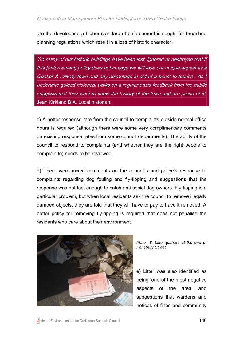
Conservation Management Plan for Darlington’s Town Centre Fringe
Archaeo-Environment Ltd for Darlington Borough Council
140
are the developers; a higher standard of enforcement is sought for breached
planning regulations which result in a loss of historic character.
‘So many of our historic buildings have been lost, ignored or destroyed that if
this [enforcement] policy does not change we will lose our unique appeal as a
Quaker & railway town and any advantage in aid of a boost to tourism. As I
undertake guided historical walks on a regular basis feedback from the public
suggests that they want to know the history of the town and are proud of it’.
Jean Kirkland B.A. Local historian.
c) A better response rate from the council to complaints outside normal office
hours is required (although there were some very complimentary comments
on existing response rates from some council departments). The ability of the
council to respond to complaints (and whether they are the right people to
complain to) needs to be reviewed.
d) There were mixed comments on the council’s and police’s response to
complaints regarding dog fouling and fly-tipping and suggestions that the
response was not fast enough to catch anti-social dog owners. Fly-tipping is a
particular problem, but when local residents ask the council to remove illegally
dumped objects, they are told that they will have to pay to have it removed. A
better policy for removing fly-tipping is required that does not penalise the
residents who care about their environment.
Plate 6. Litter gathers at the end of Pensbury Street
e) Litter was also identified as
being ‘one of the most negative
aspects of the area’ and
suggestions that wardens and
notices of fines and community

Conservation Management Plan for Darlington’s Town Centre Fringe
Archaeo-Environment Ltd for Darlington Borough Council
141
vigilance would help. There are already a number of local heroes who collect
litter, bottles and spent syringes from the area, but a more formal wardening
service to support these people with additional local voluntary support, could
in time, help to prevent further littering. A model for a wardening service
already exists in Middlesbrough and offers a service 365 days a year from
about 10.20am until 11.30pm. These wardens collect rubbish but also tackle
anti-social behaviour on the ground, such as fly tipping and dog fouling.
Other suggestions include creating ‘Street Champions’ to report
environmental problems to the council. However such unofficial champions
already exist and they complain that the council’s opening hours and
response times are not fit for purpose. The council, in addition to considering
if they can better respond to complaints regarding littering, fly-tipping and dog
fouling, might also want to consider naming and shaming offenders.
f) The back lanes tend to be a focus for illegal dumping, but surprisingly this
was not raised in the consultation process.4 Other local authorities have
carried out ‘back lane blitzes’ where back lanes are cleaned up and residents
have notices put through their doors reminding them that it is illegal to dump
rubbish in the lanes. However this can alienate the upstanding citizens and
has to be followed up by public prosecutions and fines of repeat offenders
under the Environmental Protection Act. If offenders are in rented
accommodation, then the landlord has to carry some responsibility for the
tenant’s behaviour. The extent of dumping along back lanes was not
especially bad in Darlington, with the worse areas being in the back lanes of
Roslyn Street.
4 However when the draft report was circulated publicly for comment, there was some agreement that
this was an issue and that back lanes could be perceived to be threatening places.
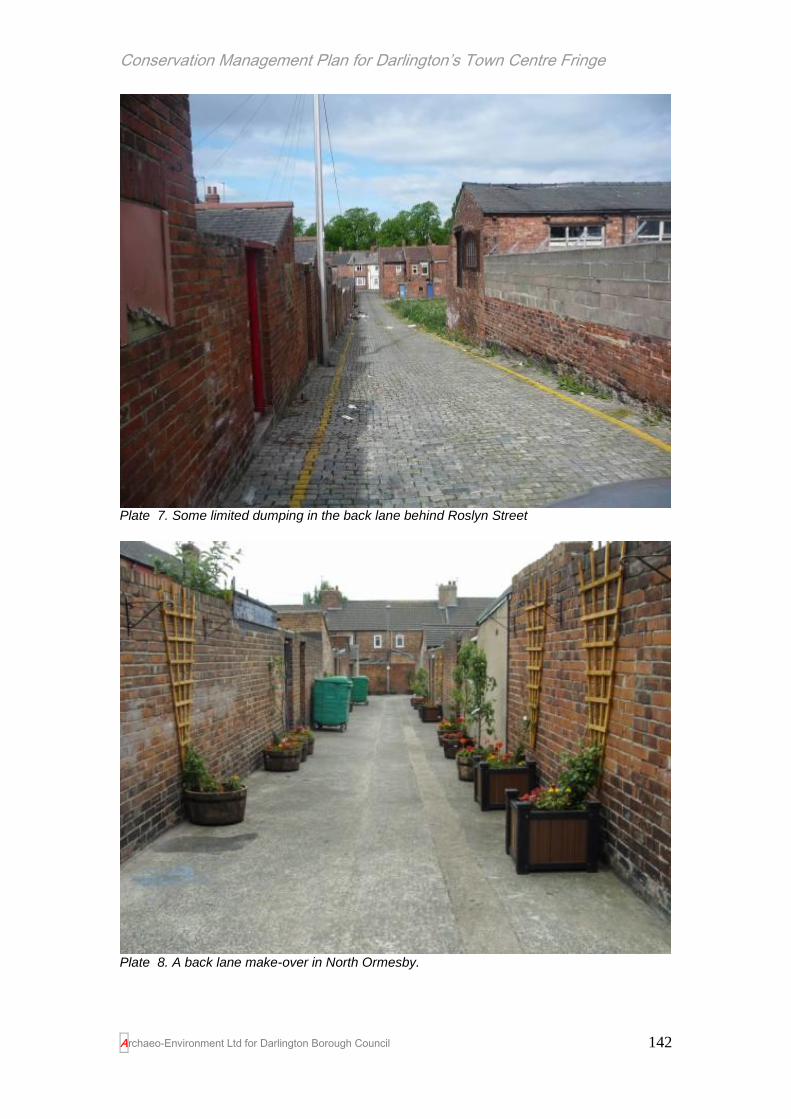
Conservation Management Plan for Darlington’s Town Centre Fringe
Archaeo-Environment Ltd for Darlington Borough Council
142
Plate 7. Some limited dumping in the back lane behind Roslyn Street
Plate 8. A back lane make-over in North Ormesby.

Conservation Management Plan for Darlington’s Town Centre Fringe
Archaeo-Environment Ltd for Darlington Borough Council
143
The back lanes tend to be perceived as being the focus of anti-social
behaviour, because the activities within them cannot be monitored from the
houses due to the high back walls. There have been attempts to renovate
back lanes in other terraced housing areas of the north east. These ‘make-
overs’ consist of gating the back lanes and residents are encouraged to
create planters and hanging baskets. Household rubbish is also collected in
larger bins which are shared rather than a wheelie bin for every house. The
result has been a reduction in arson incidents and fly-tipping, the creation of a
healthier environment for residents and a greater sense of community. A
similar scheme could be trialled in parts of the TCF, but the back lanes would
have to be carefully chosen. Many have had garage doors inserted of different
sizes and shapes which detract from the original lines of red brick walls, with
two small wooden openings. The design of the gates would need to be
carefully chosen to reflect the Victorian style of housing, to be robust enough
to deter damage and have some transparency to allow light into the lane.
They should not add to the sense of fear already created by wall tops with
sherds of glass or razor wire. Areas for consideration could include Borough
Road, Russell Street, Haughton Road, Sun Street, Gladstone Street or
Pensbury Street.
In the end, it will be the fact that people are living and are being active in the
area that will prevent littering and fly-tipping and so the reuse of empty
buildings and high density housing in currently derelict areas will all help to
make litter dropping less possible without being caught.
Summary management recommendations: Multiple Occupancy as indicator of decline
Timetable
a) The council has already decided to put a moratorium on multiple occupancy planning permissions and so no action is required
underway
b) Enforcement needs to be improved where loss of historic character is threatened
Immediate
c) The Council need to consider how best to respond to resident’s
Immediate

Conservation Management Plan for Darlington’s Town Centre Fringe
Archaeo-Environment Ltd for Darlington Borough Council
144
complaints regarding anti-social behaviour of its own tenants or breaches of local bye-laws
d) The police and the council need to consider if dog fouling and fly-tipping can be targeted for a rapid response when complaints are made and the council needs to reconsider charging honest residents for the acts of dishonest ones.
Immediate
e) The council and local communities to join together to create a wardening service collecting litter until such time as the area regenerates and litter dropping becomes more difficult
Immediate
f) Consult with the local community to see if there is a demand to trial gated and landscaped back lanes.
1-5 years
Issue 6. Inappropriate maintenance techniques on historic buildings
The techniques used to build and maintain buildings in Victorian times and
indeed until as recently as the 1950s were different to those used today. This
has created problems in the health of the housing stock because modern
materials such as concrete, plastic air tight windows and damp proofing can
be damaging to pre 1919 buildings. The use of replacement windows and
doors, usually in plastic and usually of all different shapes and sizes has
resulted in a loss of design detail such as the harmonious facades created by
the terraced house when they were first built. There are also issues of
sustainability with plastic windows which use considerable non-renewable
resources in their production, which fail to degrade once in landfill and which
cannot last as long as a well-maintained timber window.
Repointing, pebbledash, render and cladding
Most houses in the town centre fringe were built before 1919 and the walls
were held together by lime mortar cement. Increasingly from the middle of the
19th century Portland cement came into use which was harder. When
carrying out repairs it is important to use the same materials as those
originally used. The finished pointing was in all cases either flush with the

Conservation Management Plan for Darlington’s Town Centre Fringe
Archaeo-Environment Ltd for Darlington Borough Council
145
brickwork or slightly recessed. Lime mortar is porous so when the brickwork
becomes wet, the rainwater drains through the porous pointing and allows the
brick to dry out. Modern cements are impervious and so do not allow the
water to drain out through the pointing. It has to find a way out through the
brickwork or stone and this causes the bricks to flake away. It is therefore
important that when brickwork is re-pointed that careful consideration is given
to the appropriate mortar which should be recessed back from the brick’s
face. Changing the mortar mix from lime mortar to a modern cement can alter
the way the building breathes and lead to damp and condensation.
Lime mortar is self-healing. This means that slight movement caused by
subsidence or settling and thermal movement can generally be
accommodated. Cement mortars do not have any of these healing properties
and will fracture and fail and encourage moisture to enter the walls. Over time
this will accelerate the decay of the brickwork. Similarly spray or paint on
sealants should not be used on brick without considerable thought.
Some residents have however chosen to dispense with repointing altogether
and have opted for a range of claddings ranging from hard cement render to
stone effect cladding. These create similar problems for the house as using
hard cement in repointing, but the problem is exacerbated because there is no
escape route for moisture and so it collects behind the cement barrier. This
leads to damp problems, the fracturing of the brick and any soluble salts in the
water (from road gritting) form powdery deposits on the wall face causing
more damage. Cement is applied densely is also inflexible. Buildings move
slightly with temperature and moisture levels, but a cement coating will not be
able to move with the building and cracks will appear. Water can be trapped in
those cracks and exacerbates them and the masonry behind the render starts
to deteriorate rapidly. This leads to a build up of moisture in the walls and
damp (Historic Scotland 2001, 8).
However external render can be made of a lime based mortar in which case
the visual effect is the same, but the building can still breathe and the render

Conservation Management Plan for Darlington’s Town Centre Fringe
Archaeo-Environment Ltd for Darlington Borough Council
146
is flexible enough to accommodate slight movement. The lime has the added
benefit of being a mild fungicide which if maintained, prevents moss from
growing on the walls. In general terms however, no render should be applied
to brick buildings which were designed to retain their brick facades because
these facades normally contain design details which are lost when coatings
are applied.
The same principle of care applies as choosing repointing techniques; if the
house was built with a lime wash, continue to use a lime wash. If it was not
rendered, do not add render to it as you will upset the house’s long
established natural balance. Similarly, if it was originally rendered, removing
the render and exposing stonework or brickwork to the elements for the first
time, will alter the building’s established breathability with unpredictable
consequences.
A combination of lime based renders and stone can be found in the town
centre fringe (North Road Station), but it is not predominant.
Plate 9. Cement renders damage the brickwork beneath, reduce thermal performance, cause condensation and damp and create a negative visual impact.
The lack of breathability of cement renders and pointing also affects the
thermal performance of a building (Historic Scotland 2007). The process of
moisture movement in a building with lime mortar allows a degree of control
over condensation within a building. This creates a better thermal
performance than a building which is repaired with cement mortar or renders,
as these walls are likely to remain damp. In direct contrast, the use of cement
mixes for pointing repairs and the application of hard cement renders

Conservation Management Plan for Darlington’s Town Centre Fringe
Archaeo-Environment Ltd for Darlington Borough Council
147
dramatically reduces the passage of moisture, slowing the drying out times
considerably and increasing the risk of condensation problems.
As a response to damp problems, owners are inclined (and are indeed
required, if they want a mortgage) to have a damp proof course inserted. This
will not cure the damp if it is being caused by using hard cements. Indeed
there is considerable research showing that damp proofing old properties is of
no use whatsoever and can in fact cause damp.
Old properties need to breathe. The insertion of a damp proof course, cement
renders, cement repointing and cladding will all restrict the building’s ability to
breathe. Other causes of damp in old properties can be as simple as using
rubber backed carpets, which again restrict breathability. The blocking off of
air movement in older properties (and indeed in new ones) can also cause
woodbeetle infestation, dry rot and wet rot as a result of increased moisture
levels (Historic Scotland 2007).
Windows
Most windows in the town centre fringe were originally wooden sashes of
several small panes (pre mid 19th century) or wooden sashes of four panes
(post mid 19th century). Such windows have a life span of about 100 years if
maintained and can in fact last much longer. Very early examples of Yorkshire
sliding sashes, or
casement windows
are no longer
extant. One shop in
High Northgate has
a mid 19th century
example of a bowed
window with lead
dome above.
Plate 10. Two window types in the town centre fringe. On the left is a multi-pane sash window as seen in properties pre-dating the mid 19
th
century. On the right is a four pane sash which would have been in most terraced houses.

Conservation Management Plan for Darlington’s Town Centre Fringe
Archaeo-Environment Ltd for Darlington Borough Council
148
Nearly all examples of these windows have been lost and replaced with more
recent windows which are mostly made of uPVC. But research by English
Heritage has shown that it is much cheaper to repair old windows than it is to
install plastic substitutes (English Heritage 1994). These modern windows can
be made to look and open like sash windows, but in most cases, no attempt
has been made to copy the original design. The use of plastic instead of a
sustainable resource such as wood is questionable in any case, but it also
restricts the breathability of the house and can lead to damp. Victorian houses
were also originally built with fireplaces which changed the air throughout the
house, but many of these chimneys have been blocked up creating an
environment where air does not move throughout the house and this can lead
to the creation of mould and an increase in allergens (Centre for Research on
Indoor Climate and Health 2007 and Historic Scotland 2007). To compensate
for this, new wooden windows are required to have trickle vents inserted, but
in fact this is wholly unnecessary if the building is managed in a traditional
way with lime mortar, wooden windows and open chimneys fitted with a
ventilated chimney cap where it is no longer in use (ibid).
Plate 11. Local variations on traditional sash windows can be found throughout the town centre fringe. These local differences create distinctive character areas and should be retained. Starting from the left: three pane sash windows can be found on Borough Road towards Haughton Road, but towards Parkgate and on Middleton Street these distinctive arched sashes can be found. The houses on Greenbank road were designed with these bay windows to the main ground floor reception room and the main bedroom above. It was thought that using small panes of glass on the top would restrict light and protect furnishings. Arched stairlight windows can be found to the rear of some properties especially along McNay Street/ Station Road, although the survival of stained glass as seen here is very rare in the town centre fringe

Conservation Management Plan for Darlington’s Town Centre Fringe
Archaeo-Environment Ltd for Darlington Borough Council
149
Windows are perceived to be a source of
heat loss and in times when energy
efficiency has become important, the
childhood recollections of rattling sash
windows have driven people towards uPVC
double glazing. However there are
alternatives. In listed buildings traditional sash windows have to be used if that
is what was originally used, but for any sash window draught stripping can be
fitted cheaply and unobtrusively to a timber sash and case windows.
However for other older properties, there are real alternatives to uPVC in
addition to draught stripping. Wooden sashes can be made with double
glazing if new windows are required. Secondary double glazing can be
installed to existing sash windows. Sash windows which rattle or where the
wood has rotted can be repaired indefinitely providing that they are cared for.
They will outlive plastic windows and once removed the glass can be recycled
and the timber burnt or reused. They need never appear in landfill. The
energy efficiency of an existing 19th century sash window can be made to
equate to a double glazed unit simply through the addition of heavy curtains,
blinds and/or shutters (Baker 2008). If shutters and blinds are added to well
maintained windows, they will reduce heat loss by 58% - this is what our
ancestors did and we need to relearn from the past how to make our homes
not just energy efficient, but healthy.
Doors
Traditional doors in the town centre fringe have gone the same way as
windows with many fine ornamented doorways being ruined by the insertion
Plate 12. These two terraced houses on Middleton Street were built to look the same. No. 10 on the left has retained its traditional sash windows and four panelled door. It has also avoided cladding and so the brick detailing can be seen. The house next door has been pebble- dashed and has had mid to late 20
th century windows and door inserted and now
does a good impersonation of a house built in the 1970s.The pebble dashed exterior will be damaging the brickwork beneath.

Conservation Management Plan for Darlington’s Town Centre Fringe
Archaeo-Environment Ltd for Darlington Borough Council
150
of a narrow plastic door from a do-it-yourself chain. The issue of breathability,
the lack of a sustainable resource and the inability of the product to
biodegrade once it has been consigned to landfill, is the same as for windows.
They create additional problems in that it is difficult to attach door bells or
house numbers to plastic doors and so these features gradually disappear
from use. Traditionally doors were made of wood and often had a door light
above. Most door lights in the town centre fringe would have been rectangular
possibly with the house name painted in gold and some Edwardian examples
will have made use of stained glass which would have cast colourful patterns
into the hallway. These door lights allowed light into the entrance hall and
made door lights unnecessary. Victorian doors were mostly four panelled
doors, but the earliest properties of the early 19th century probably had 6
panelled doors. There were however local variations. On Greenbank Road
and Victoria Embankment houses were built with three panelled doors and a
circular design detail that is still used on a number of houses, creating an
individual Greenbank/Embankment style. Poorer houses, outbuildings and
entrances to yards used simple batten and ledged doors. Generally, doors are
responsible for 10% of the heat loss from a home (as opposed to 35% from
the walls and 25% from the roof). Traditionally, insulation would be provided
by a heavy curtain behind the door and this continues to be an effective and
cheap way to reduce heat loss. Victorian door furniture also favoured
unassertive styles, usually in black or the same colour as the door, but never
in shiny brass. Fittings would be attached to the structural members of the
door, never into the panels.

Conservation Management Plan for Darlington’s Town Centre Fringe
Archaeo-Environment Ltd for Darlington Borough Council
151
Plate 13. Traditional door styles from the town centre fringe. Starting from the left: the Greenbank/Victoria Embankment doors, then six panelled doors favoured in the Georgian period, a batten and ledged door for a side entrance into a school near Winston Street.
Inappropriate maintenance techniques on historic buildings – HE 6
management recommendations
a) Stopping the decline
Home owners can change their windows and doors without planning
permission. It is a requirement to conform to building regulations, but these
regulations have been drawn up for modern properties and are not
appropriate for houses built pre 1919. With no requirement for planning
permission it is difficult to control what replacement windows should be used.
There are a number of options:
1. Shop windows do require planning permission and so it should only be
granted where traditional designs and preferably materials are to be
used in pre 1919 buildings.
2. Conservation Areas can have permitted development rights withdrawn
so that permission must be obtained to replace windows, doors,
boundary details or roofing materials. This has already been done for
Northgate Conservation Area and should be extended to Victoria
Embankment. The proposed Parkgate Conservation Area should also
have permitted development rights withdrawn when it is designated
and a further conservation area (with permitted development rights
withdrawn) should be created along Victoria Road and Hargreave
Terrace. This will create three key zones with a good geographical
spread within the town centre fringe where the process of decline will

Conservation Management Plan for Darlington’s Town Centre Fringe
Archaeo-Environment Ltd for Darlington Borough Council
152
be halted and gradually reversed. In time, the quality of the buildings in
the Conservation Areas will infect the maintenance decisions in other
areas of the town centre fringe.
Policy HE4 of the Planning Policy Statement on the Historic Environment
(PPS5) against which all planning decisions must be assessed reads as
follows:
‘Local planning authorities should consider whether the exercise of permitted
development rights would undermine the aims for the historic environment. If
it would, local planning authorities should consider the use of an article 4
direction to ensure any development is given due consideration.’
3. The consultation process has raised the concern that the Borough
Council has a poor track record for enforcement action relating to
historic buildings. Enforcement of Article 4 directions, listed building
consents and planning conditions are key to the regeneration of the
area and are a core function of the council. It should not be selective.
The council’s needs to revisit its enforcement procedure.
4. Buildings regulations officers for Darlington Borough should attend
courses run by the Traditional Skills Initiative in order to learn about
how older properties function and so feel more confident about relaxing
the regulations for historic buildings (this facility to relax building
regulations already exists, but officers are reluctant to use it). This is in
line with government advice in their Planning Practice Guide on
implementing PPS5 which encourages local planning authorities to
keep abreast of up-to-date information on the efficiency and
sustainability of historic buildings and the best means of improving their
performance (DCLG 2010, Para 23)
5. In order to help home owners make informed decisions regarding their
home maintenance the council should make a series of leaflets and/or
DVDs freely available covering everyday maintenance, energy
efficiency in older buildings, windows, doors, roofing, domestic
chimneys and flues, damp, cast iron rainwater goods, painting and

Conservation Management Plan for Darlington’s Town Centre Fringe
Archaeo-Environment Ltd for Darlington Borough Council
153
repointing. Funding may be available for this through the Heritage
Lottery Fund which has the revival of traditional skills as a funding
priority. This is in line with government advice outlined in their practice
guide for PPS5 (DCLG 2010, Para 24.1)
6. The local enterprise agency can help home and shop owners source
craftspeople with traditional skills (such as working with lime, making
railings, stone masonry and joinery) by creating a traditional skills web
site for local and regional businesses. This may also be eligible for
funding through HLF and could be part of a wider package to include
item 4.
7. Townscape Heritage Initiative funding should be applied for covering all
conservation areas, so that additional grant aid can be brought into the
area and council funds better targeted towards conservation led
regeneration. This will benefit local business such as the iron works on
East Mount Road which can produce replacement railings (and finials)
to templates which already exist on East Mount, Lodge Street, Portland
Place, Victoria Embankment and Northgate.
Townscape Heritage Initiative funding
There are a number of criteria for being awarded this funding. The highest
priority is given to areas of social and economic deprivation where
investment in historic buildings could prompt the beginnings of urban
revival and in this respect the town centre fringe should have no difficulty
in qualifying. There are other considerations too:
1) Priority is given to bringing back life into derelict and under-used
buildings (this could include the railway carriage works, the lime cells,
empty buildings on Weir Street, empty terraces and shops on
Northgate and around Bank Top)
2) Priority is given to projects which will raise the standards of repair and
set a precedent to encourage good practice amongst property owners
(identify key buildings and infrastructure where impact will be greatest,
such as corner properties, skyline features, elevated properties)
Conservation Management Plan for Darlington’s Town Centre Fringe
Archaeo-Environment Ltd for Darlington Borough Council
154
3) Continued viability of projects has to be shown (ensure where there is
change of use in target areas that it is sustainable, for example greater
residential use around Weir Street and along the Skerne)
4) Priority is given to projects which show a good overall regeneration
strategy and not a focus on individual buildings (the council’s town
centre fringe regeneration scheme already exists and so this criterion
has been met.
5) Priority is given to projects with good community involvement,
education benefits and long term community enhancement (this can be
shown through the existing Talking About…. series, and through the
existing provision for educational visits by the Head of Steam Museum.
The Conservation Areas
Northgate
Much of Northgate is already a conservation area and has benefitted from a
Historic Environment Regeneration Scheme and the withdrawal of permitted
development rights. This has made inroads into the decline by providing new
shop fronts and the restoration of traditional features to a number of early 19th
century terraced houses on High Northgate, although the enforcement of the
article 4 direction has been poor. Additional work could prioritise the
enhancement of the mixed street fronted property boundaries to no.s 69-81
High Northgate with a uniform design and the targeted enhancement of corner
properties which currently form negative features.
Victoria Embankment
Another conservation area exists at Victoria Embankment. This has not had
any grant supported scheme, nor have permitted development rights been
withdrawn. This means that many houses have inappropriate windows and
some houses have had their brickwork cladded over. South Terrace on the
other side of the river has a similar leafy character and the conservation area
could be extended to include this street. Tree management here (and
throughout the town) is patchy with views spoiled by a lack of pruning at
pedestrian level (see plates 14 and 15). If the canopy of trees, whether self

Conservation Management Plan for Darlington’s Town Centre Fringe
Archaeo-Environment Ltd for Darlington Borough Council
155
seeded or not, is restricted to above head height, it also ensures that trees do
not become cover for anti-social behaviour.
Then and Now…
Plate 14. Victoria Embankment in the 1890s
Plate 15. Victoria Embankment in 2010. From South Park, the street is bearing up quite well, but some tree management along the river bank might better expose views of the river and of St Cuthbert’s in the distance.

Conservation Management Plan for Darlington’s Town Centre Fringe
Archaeo-Environment Ltd for Darlington Borough Council
156
Parkgate
A further conservation area has already been proposed by the Borough
Council at Parkgate. The Parkgate area has a distinctive character with
predominantly very early 20th century architecture which introduced glazed
decorative tiles and stained glass windows. The work carried out as part of
this Conservation Management Plan would support the proposal to make
Parkgate a conservation area, however the quality of architecture along the
east side of Hargreave Terrace and the good survival of railings and some
sash windows could be recognised in its inclusion in the proposed Parkgate
conservation area. This would also link with the proposed conservation area
centred on Victoria Road and so create a corridor of well-managed historic
houses.
Victoria Road
The research carried out in the production of the Conservation Management
Plan would suggest that there would be considerable benefit to the historic
environment and therefore to the local economy in creating an additional
conservation area based around Victoria Road.
Plate 16. The top of Victoria Road in 1909. The house with three gables on the left and the two storey house beyond it are both boarded up now. These buildings with Bank Top formed

Conservation Management Plan for Darlington’s Town Centre Fringe
Archaeo-Environment Ltd for Darlington Borough Council
157
a coherent group, all being in red brick with stone detailing. The use of railings on stone dwarf walls also helped to bring them together behind a harmonious façade.
Victoria Road as the name suggests is a product of Victorian times, although
much of the housing in adjacent streets was built soon after the queen’s death
in 1901. The now listed Bank Top Station (1887) was the trigger for the
growth of this area, although it replaced an earlier set of ‘mean sheds’ built in
the 1840s. The Victorians took some pride in their stations, although in
Darlington it took a while for the railway company to invest in one and a sharp
comment from Queen Victoria that the old station which preceded Bank Top
was not worthy of the town where trains were born, seems to have fallen on
deaf ears for a while.
Throughout the land, landscaping was carried out near stations in order to
provide an appropriate entrance to each town or village newly blessed with
the arrival of the railway. In rural areas and in towns, roadsides were planted
with trees forming avenues between station and attractions creating a positive
first impression for visitors arriving by rail. Not only was the station at Bank
Top of superb quality and visible throughout the town, but quality buildings
were constructed near the top of the hill. A fine hotel with 26 bedrooms was
built in the 1880s, quality red brick buildings with stone detailing, cascaded
down the hill, and the Methodist New Connexion Church built in 1884 adding
to the quality skyline.
Plate 17. How not to treat an historic building….
Despite buildings towards the
top of Bank Top being boarded
up they remain fine townscape
features, but as the hill declines
down towards the roundabout,
the poor quality shop fronts take
over and create a shabby impression. Many of these terraces were built in the
local Pease’s brick, but some have had rather cruel 1970s treatment. In

Conservation Management Plan for Darlington’s Town Centre Fringe
Archaeo-Environment Ltd for Darlington Borough Council
158
amongst these poorly maintained buildings are some eye catchingly attractive
ones. Rachel Coads School of Dance incongruously placed next door to a sex
shop has fine brown glazed tiles, stone dentiled cornicing, a hanging shop
sign, all suggesting a turn of the century date. But it also has a rather
unattractive shop front, made even less so by the shuttering and a few
inappropriate chunky plastic windows in the dormers.
The bottom of Victoria Road links with an existing conservation area at
Victoria Embankment. Then there is a rather difficult urban roundabout which
is to all intents and purposes is an historic character black hole. Left
somewhat stranded are a row of terraced houses which once represented the
continuation of Victoria Road, but which sit isolated on the north side of a dual
carriageway. This is unfortunate, because here we have some of the finest
intact examples of Victorian middle class niceties, with beautiful moulded door
surrounds, sash windows, original railings and a splash of neo-Gothic.
Conservation Area status for Victoria Road could achieve a number of aims:
1. Return a sense of civic pride to the area and create a positive first
impression to visitors arriving by train (this is especially important if we
are to look at celebrating the bicentenary of train travel in 2025).
2. Help the quality architecture and shop fronts around Bank Top return to
its intended potential
3. It will create another zone of quality architecture which will infect
properties in the surrounding streets; collectively there will therefore be
three zones of historic building management which spread across the
town centre fringe, offering exemplary designs and standards for others
to follow.
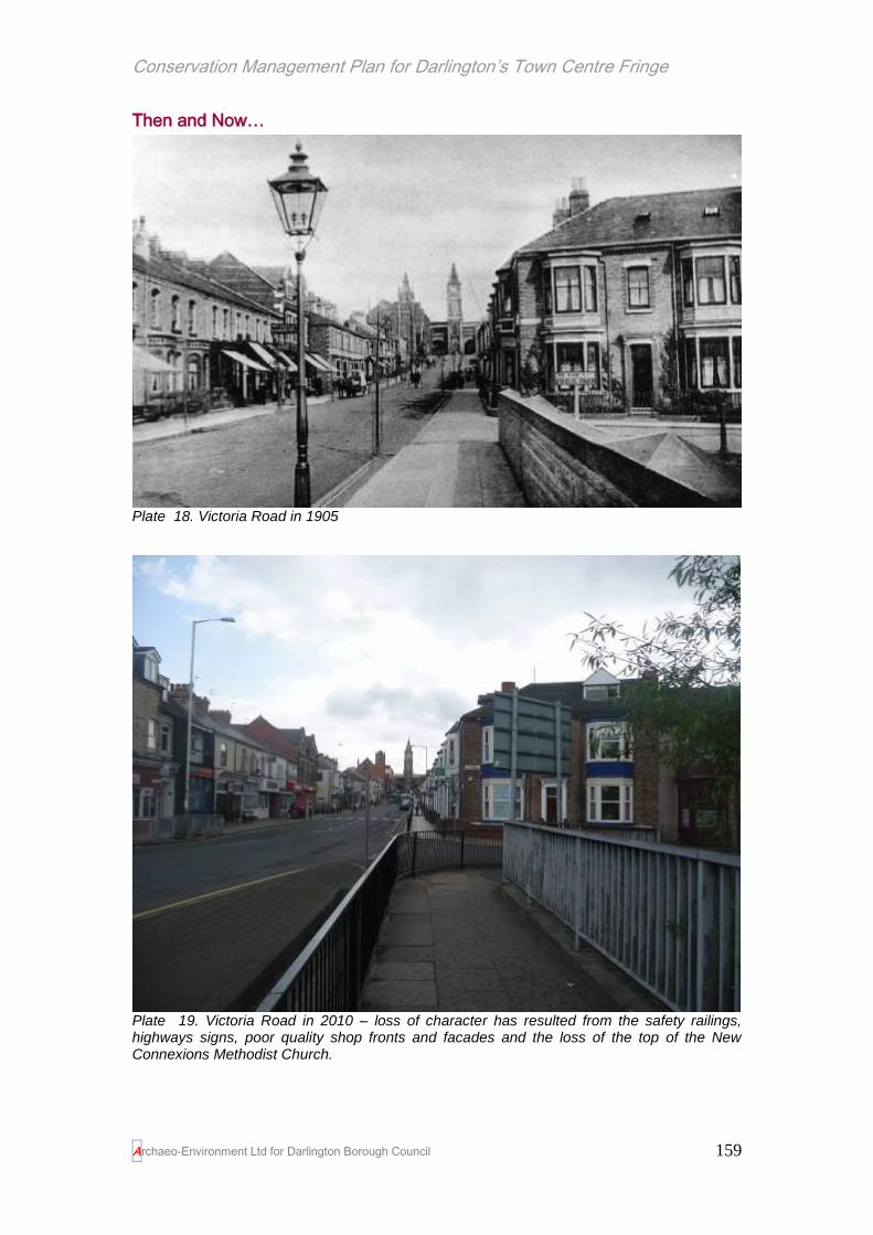
Conservation Management Plan for Darlington’s Town Centre Fringe
Archaeo-Environment Ltd for Darlington Borough Council
159
Then and Now…
Plate 18. Victoria Road in 1905
Plate 19. Victoria Road in 2010 – loss of character has resulted from the safety railings, highways signs, poor quality shop fronts and facades and the loss of the top of the New Connexions Methodist Church.
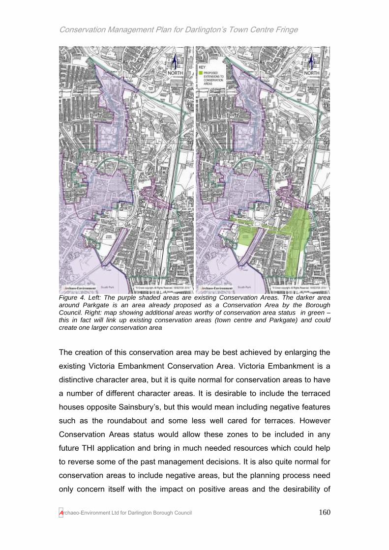
Conservation Management Plan for Darlington’s Town Centre Fringe
Archaeo-Environment Ltd for Darlington Borough Council
160
Figure 4. Left: The purple shaded areas are existing Conservation Areas. The darker area around Parkgate is an area already proposed as a Conservation Area by the Borough Council. Right: map showing additional areas worthy of conservation area status in green – this in fact will link up existing conservation areas (town centre and Parkgate) and could create one larger conservation area
The creation of this conservation area may be best achieved by enlarging the
existing Victoria Embankment Conservation Area. Victoria Embankment is a
distinctive character area, but it is quite normal for conservation areas to have
a number of different character areas. It is desirable to include the terraced
houses opposite Sainsbury’s, but this would mean including negative features
such as the roundabout and some less well cared for terraces. However
Conservation Areas status would allow these zones to be included in any
future THI application and bring in much needed resources which could help
to reverse some of the past management decisions. It is also quite normal for
conservation areas to include negative areas, but the planning process need
only concern itself with the impact on positive areas and the desirability of

Conservation Management Plan for Darlington’s Town Centre Fringe
Archaeo-Environment Ltd for Darlington Borough Council
161
enhancing negative areas. If alterations are made to the landscaping around
the roundabout as are recommended in HE1, then in time, this area will
complement, not detract from the proposed conservation area. An alternative
would be to include this particular row in the Town Centre Conservation Area
which is very nearby and exclude the roundabout from both conservation
areas.
Summary management recommendations HE6: Inappropriate maintenance of historic buildings (new Policy is shaded)
Timetable
6a.1 Planning permission to replace shop windows on properties pre-dating 1919 should only be granted for traditional window types in consultation with the Conservation Officer
Immediate
6a.2 Permitted development rights should be withdrawn in Victoria Embankment Conservation Area (they are already withdrawn in Northgate Conservation Area) and should be withdrawn in any future Conservation Areas that are created.
1-5 years
6a.3 The council needs to improve its enforcement procedure for Article 4 directions, listed building consents and planning conditions relating to historic buildings
Immediate
6a.4 Building regulation staff should attend a course run by Heritage Skills Initiative on the breathability of pre-1919 houses so that they can make informed decisions regarding the application of the regulations on historic buildings
1-3 years
6a.5 The council should provide free written or oral advice on home maintenance as leaflets, web pages or DVDs covering everyday maintenance, energy efficiency in older buildings, windows, doors, roofing, domestic chimneys and flues, damp, cast iron rainwater goods, painting and repointing.
1-5 years
6a.6 Create a traditional skills web site, possibly in partnership with Durham County Council and Tees Valley for home owners to source the skills necessary to properly maintain their historic buildings
1-5 years
6a.7 The council should apply for Townscape Heritage Initiative Funding for all conservation areas (once Parkgate and any others have been designated)
1-5 years
6bThe council should formally create a conservation area based on Parkgate and possibly include the east side of Hargreave Terrace. A conservation area appraisal and management plan will then be required in consultation with the residents
1-5 years
c) The council should create a conservation area based on Victoria Road, to be followed by a conservation area appraisals and management plan
1-7 years
d) The town centre conservation area should be extended to include Victoria Road west of South Arden Street (and possibly with a little less justification land east of South Arden Street).

Conservation Management Plan for Darlington’s Town Centre Fringe
Archaeo-Environment Ltd for Darlington Borough Council
162
e) The Victoria Embankment conservation area could be extended to include South Terrace
Issue 7. Reuse of historic building stock
The consultation process has highlighted people’s desire to see historic
buildings reused rather than demolished. This is in line with government policy
which is quoted below in full from the Planning Practice Guide which
accompanies Planning Policy Statement 5 on the Historic Environment (Para
22):
‘By taking a narrow and rigid view of what makes a building or development
sustainable, opportunities may well be missed to adapt and enhance what is
already there. In considering development proposals, local authorities will find
it useful to take into account the embodied energy within existing buildings
and the whole-life costs of any new scheme or proposed alterations. The
creative adaptation of heritage assets can dramatically reduce the whole-life
energy costs and waste impacts that would result from demolition and
replacement, even where the proposed development would in itself be of an
acceptable standard in terms of energy performance. The adaptation of
heritage assets need not be more expensive or difficult than replacement. It is
quite possible that the recycling of existing buildings at a site may cut the
overall financial cost of development and even save time.’
Throughout the TCF there are gaps where demolition of historic properties
has taken place but nothing of value has yet been constructed in its place.
Some have planning permission and await a better economic climate, but
others have no permissions at all. Such gaps create a townscape reminiscent
of post war Britain. They encourage anti-social behaviour such as fly-tipping
and so they are surrounded by security fencing which is all too predominant in
the TCF. There is also a risk that buildings are deliberately allowed to decay
so that planning permission might be more easily obtained for their demolition.
This is contrary to government policy which reads:

Conservation Management Plan for Darlington’s Town Centre Fringe
Archaeo-Environment Ltd for Darlington Borough Council
163
‘Where there is evidence of deliberate neglect or of damage to a heritage
asset in the hope of obtaining consent, the resultant deteriorated state of the
heritage asset should not be a factor taken into account in any decision’
HE7.6 of Planning Policy Statement 5 on the Historic Environment
Empty buildings add to the air of neglect, but the consultation process has
also raised that empty buildings and wasteland are used for alcohol and drug
abuse, but have the potential to provide facilities and houses which reduce
the ‘dark corners’ of the area and create much needed facilities for younger
people (see issue HE11). There are also houses which have been
condemned because of their poor condition and are now awaiting demolition.
However it is not clear why the properties were allowed to fall into such a
state of neglect over such a long time, that demolition was the only practical
outcome. In the meantime streets such as Borough Road are blighted by the
regular appearance of houses with boarded up windows.
The Weir Street area and the lanes which lead off it has a number of under-
used or empty buildings which are worth cherishing and which can lead the
way in terms of use and design for the future. For the most part these are
early 20th century buildings of red brick, often with below the eaves detailing.
They represent a variety of uses (or no use), but could be adapted to other
uses, in particular residential use, small scale offices, craft, art and
independent shops, small workshops, bars and cafes – all activities suggested
in the consultation process. ‘Viable uses will fund future maintenance’ (DCLG
2010, PPG for PPS5 Para 89)
Plate 20. Existing housing stock is becoming run down and warehouses await conversion around Weir Street and Garden Street
The river bank is not best
served by large scale
development such as that which

Conservation Management Plan for Darlington’s Town Centre Fringe
Archaeo-Environment Ltd for Darlington Borough Council
164
appears alongside St Cuthbert’s Way and many of these businesses such as
carpet and furniture showrooms have now moved out of the area. This is an
opportunity to reinvent the character of the area and find a more appropriate
use for a riverbank area close to the town centre. The regeneration of the
Weir Street area should concentrate on the conversion of existing building
stock into housing or mixed use development, retain or create new scoria
block pathways and riverside walkways or views, create physical and visual
links with the town centre, reuse old boundaries and pathways (the Weavers
Yards) and the gradual demolition of large unattractive buildings such as
Philips in the middle of the area that once consisted of Pease’s gardens.
Positive signs of change have already taken place, but there has been
insufficient encouragement from the Borough Council planning department to
build on these successes. The conversion of the Skerne Printing Works and
Hanratty’s scarp yard into quality studio apartments has retained the qualities
of the buildings constructed in 1900 and reintroduced residential uses which
places caring residents into an area otherwise neglected. The conversion of a
warehouse into an apartment along Weir Street won national awards including
Winner of the Best Conversion in Build It magazine in 2004, and a short list
for the Daily Telegraphs Home Building and Renovation magazine in 2003. It
has featured in several magazines and in TVs Location, Location, Location
(N. Massie pers comm. 12.7.10).
It is important that even TCF areas designated as being of commercial or
employment use in strategic development plans, that this use is mixed with
residential development. The residential development brings in greater
capacity for profit which funds conversions and also places people in the town
centre fringe after opening hours where they police the area and ensure that it
does not fall victim to anti-social behaviour after hours.

Conservation Management Plan for Darlington’s Town Centre Fringe
Archaeo-Environment Ltd for Darlington Borough Council
165
Then and Now…
Plate 21. The Skerne Printing Works derelict and partially used as a scrap yard in 1992
Plate 22. The Skerne Printing Works redeveloped as housing by 2010 and a source of inspiration for future conversions of historic buildings in the area
Empty properties also exist above shops on Northgate and some attempt has
been made in the recent Historic Environment Scheme to bring these spaces
above the shop into active use. The current Urban Capacity Study tends to
see these as difficult places to house people because of the practical

Conservation Management Plan for Darlington’s Town Centre Fringe
Archaeo-Environment Ltd for Darlington Borough Council
166
problems of storing wheelie bins. However we cannot allow the recent use of
wheelie bins to condemn buildings which have existed for over a hundred
years and it is clear that most urban areas have managed to cope with flats
over shops and waste collection.
Reuse of historic buildings stock – HE7 Management Recommendations
With so many empty historic properties the message from the public
consultation was clear. That no new housing estates should be developed
until existing historic building stock is used and brown field sites have been
filled with appropriate high density development in keeping with the historic
character of the town centre fringe.
a) In order to prevent further decline of historic character, no planning
permission or conservation area consent should be granted for the demolition
of any property in the TCF unless it is accompanied by a full planning
application for its replacement, or where health and safety issues over-ride all
other considerations.
b) There should be a presumption against the demolition of any pre 1919
buildings because of the positive contribution they make towards the
distinctive character of the TCF.
c) The planning policy in the local development framework should actively
encourage the reuse of historic buildings, although a statement of significance
should be carried out first by the developer identifying those features which
should be retained in any conversion or recorded during construction works.
d) Areas preparing for redevelopment should have a design brief prepared
(many already have them) and developers should submit a design statement
with their proposals to include the following:
Explain the design principles and design concept.
Explain how the design relates to its wider context
(through a full context appraisal where appropriate).

Conservation Management Plan for Darlington’s Town Centre Fringe
Archaeo-Environment Ltd for Darlington Borough Council
167
The written design statement should be illustrated, as
appropriate, by:
Plans and elevations.
Photographs of the site and its surroundings.
Other illustrations, such as perspectives.
Other supporting material
For example, retail, environmental or transport
assessments.
There should also be a presumption in favour of mixed use development so
that there is a residential component in all areas and no places are vacated
entirely outside office hours.
e) There should be a presumption against the covering over or removal of
scoria block paving, but where this does happen, the blocks should be
retained in a depot by the council and used for repair or the reconstruction of
new lanes.
f) Some areas are crying out for redevelopment and being relatively close to
the town centre offer superb facilities within walking distance. In particular the
‘Left Bank’ of the Skerne offers an exciting quarter with a good mix of old
buildings and empty spaces for innovative new design that could create an
exciting mixed use area. The east side of Valley Street has a different
character based around light industry and car sales, however it is an area of
change and also offers mixed use opportunities, such as small scale craft
industries that complement the needs for heritage skills, a more attractive link
with housing in East Mount and Haughton College and better riverside
access.
g) The level of decline around Borough Road is also considerable, and the
terraced house format here and possibly along Pensbury Street, could inspire
a 21st century equivalent of the terraced house or a remodelling of existing
housing stock, along the lines of the innovative schemes in Salford by Urban
Splash.

Conservation Management Plan for Darlington’s Town Centre Fringe
Archaeo-Environment Ltd for Darlington Borough Council
168
Plate 23. Redesigned terraced houses in Salford by Urban Splash keep the terraced house format, but remodels the layout and use of the back lanes to better reflect the needs of modern society – similar schemes could be devised for some of the more run down areas of terraced housing around parts of Borough Road and Pensbury Street
h) The Council also need to exert their repair and compulsory powers more
quickly before buildings can only be demolished, or a poorer design solution is
forced upon the council.
Vast areas of open wasteland between John’s Street and the Skerne Bridge
are also creating a negative contribution to townscape, but have the potential
to create a safer more attractive setting to the scheduled Skerne Bridge. It is
also of some archaeological potential as some early works associated with
the railway may have been located here.
Development opportunities may arise on the site of the Cattle Market on Park
Road in the future. This will take the form of new development, presumably
residential, but there is also scope to retain the round auction mart building
and incorporate it into the development.
Summary management recommendations HE7: Reuse of historic buildings stock (new Policy is shaded)
Timetable
a) No new large scale development should take place outside the town until existing historic buildings are used and brownfield sites are developed within the TCF
immediate
b) No demolition of properties should be agreed without a full planning application showing what will replace it
immediate
c) There should be a presumption against planning permission for the demolition of any property built before 1919
immediate
d) The local development framework should actively encourage the reuse of historic buildings and the need for a Statement of Significance to guide conversions.
immediate

Conservation Management Plan for Darlington’s Town Centre Fringe
Archaeo-Environment Ltd for Darlington Borough Council
169
The council should favour mixed use development so that there is a residential element to all areas providing the necessary profits in redevelopment and ensuring that the area does not empty outside office hours
e) The Council also need to exert their repair and compulsory powers quickly before decline in buildings is too advanced
immediate
f) Design briefs should be prepared for the following TCF areas (where they have not already been carried out): ‘Left Bank’ of the Skerne between Russell Street and John Street Borough Road Waste ground in front of Skerne Bridge Land between Valley Street and East Mount up to Haughton College Cattle Market
Immediate Immediate TBC 1-5 years TBC
Issue HE 8. The design of modern buildings and new development
Development within the TCF from the mid 20th century detracted from the
historic environment and was responsible for some particularly unattractive
buildings which have now been identified as negative features within the
townscape. This has left many residents short on confidence in new build.
There is ample guidance on new build within historic areas published by
English Heritage and CABE and potential developers need to be encouraged
towards such publications if we are not to repeat the mistakes of the 20th
century.5 The conservation of the historic environment does not need to stifle
modern development but should inform it.
Management Recommendation HE8 the design of modern buildings and new
development
Much of the building stock which is pre 1919 is of a high standard with
attention to detail creating interesting facades. It is high density development
based on grid patterns and is predominantly of red brick. New development
needs to conform to some principles if it is to fit in with, or enhance, the
existing historic character of the TCF and in that respect, it is expected that
much of it will be street fronted and high density. However the influence of
past design does not mean that new build should create poor pastiches. New
development needs to consider the existing street pattern and how the new
5 Building in Context: new Development in Historic Areas (2001); Guidance on Tall Buildings (2007)
and the Building in Context Toolkit (2006)

Conservation Management Plan for Darlington’s Town Centre Fringe
Archaeo-Environment Ltd for Darlington Borough Council
170
development will work with this. New build does not have to use traditional
building materials, but it does need to consider whether the materials used will
compare or contrast with existing materials in the wider area. New build does
not have to be two storeys; it can be higher, but how will that affect views of
skyline features and will it contribute towards an interesting skyline, or
obscure views of significant features? In essence new build needs to be of a
high quality and show thoughtfulness in design and meet its needs and uses
in an elegant way. The Building in Context Toolkit can help with this process.6
This approach was supported in the consultation process with suggestions
such as ‘no more new build unless it’s exciting and really innovative in design
(e.g. like the Sage in Gateshead)’
Summary Management Recommendations HE8– the design of new build
Timetable
a) Developers should be discouraged from creating pastiches of old build, but instead use historic buildings to inform exciting new designs of high quality. Developers will be expected to outline how their build will fit into the historic environment in their design statement which must accompany their planning application.
immediate
b) Where a development does not conform to council prepared design briefs, the developer will be encouraged to discuss their designs with the conservation officer at an early stage in the application process
immediate
Issue HE 9.Protecting historic buildings
A message often repeated in the consultation process was the need to protect
historic buildings, although there was less agreement about how to do this,
varying from converting them and reusing them so that their viability will fund
their upkeep, to the preparation of a local list. The government is encouraging
local authorities to prepare local lists, but there are also a number of buildings
in the TCF which are worthy of listing, namely the Railway Tavern on
Northgate and 1-5 Victoria Road.
‘In addition to national and statutory designations, local authorities may
6 Available from http://www.building-in-context.org/_documents/sheets.pdf [accessed 27.5.10]

Conservation Management Plan for Darlington’s Town Centre Fringe
Archaeo-Environment Ltd for Darlington Borough Council
171
formally identify heritage assets that are important to the area, for example
through local listing as part of the plan-making process…Though lacking the
statutory protection of other designations, formal identification by the local
authority through these processes is material in planning decisions.’
(PPG for PPS5 Para 15)
What is a local list?
This is a list of buildings, structures, parks and gardens (including cemeteries
and open spaces) that have special local architectural or historic interest and
which local communities feel are an important part of their local heritage. They
are different from, and do not include, legally protected Listed Buildings and
Registered Parks and Gardens, which are already recognised as being of
importance and have protection. Buildings and parks on the Local List may
not be as important as those on the national list, but they are special to the
town centre fringe
Why have a Local List?
The Conservation Management Plan has identified a number of buildings and
types of buildings which are distinctive and deserve care and attention for
their contribution to the unique qualities of the area. These include buildings
reflecting the area’s industrial heritage in the birth of the railways and the
growth of the town as well as the social legacy seen in institutes, chapels,
memorials and housing, and the little things often overlooked until they have
gone such as old fashioned street signs and railings.
What does being on the Local List Mean?
Unlike Listed Buildings or Registered Parks and Gardens, being included on
the Local List will not provide any additional planning controls or costs to
owners. It will however recognise the importance of any identified buildings
and value to local communities and encourage future care and consideration.
It can be a material consideration in the planning process if it is adopted by
the Borough Council.

Conservation Management Plan for Darlington’s Town Centre Fringe
Archaeo-Environment Ltd for Darlington Borough Council
172
Management Recommendation HE 9. Protecting historic buildings.
The Local List
A recommended local list was put out for community consultation and this
now forms appendix F. No additional buildings were added by consultees,
although some were not convinced by the proposed inclusion of the Nissen
Huts on Borough Road nor the shop at 112 High Northgate which they
thought was ugly. The shop does have an unattractive appearance because
of the shutters, but it may be that these very shutters are also the reason that
the shop front has survived. The storage of white goods outside the shop also
hides the attractive windows. Nissan Huts are perhaps not the most beautiful
historic buildings but they are increasingly rare and for that reason were
included.
Other buildings on the list vary in condition. Some are fine buildings marred by
poor quality shop fronts; others offer a terminus to views which make a
positive contribution to the townscape. The inclusion on the list does not mean
that they are in excellent condition, but that they are of particular value.
Terraced houses which retain their traditional features
The Statement of Significance would suggest that all pre 1919 buildings make
a positive contribution to the townscape and historic character and so should
also be protected. Indeed there is a case for including at least those terraces
which still retain their traditional sash windows and doors, however the
inclusion of every example from every street in a local list is beyond the remit
of this report and could be carried out at a later date.
It is therefore recommended that each example of a terraced house which
retains its traditional sash windows and doors be added to the local list and
that the local list be adopted and becomes a material consideration in the
planning process.
Identifying significance

Conservation Management Plan for Darlington’s Town Centre Fringe
Archaeo-Environment Ltd for Darlington Borough Council
173
Historic buildings and places, whether listed or not, are best protected by
understanding what is significant about them before making decisions
regarding their future use and management. This is recognised in Planning
Policy Statement 5 on the Historic Environment which requires local
authorities to base their planning decisions on significance. A key tool in doing
this successfully is to ensure that heritage assets each have a Statement of
Significance. This need not be long and complex, but does need to lay out
what is significant about an asset (it might be its townscape value, position
within a view, traditional railings, ornate plasterwork, staircase etc) and then
seek to incorporate those elements in any development proposal. The level of
detail of a Statement of Significance will depend on the asset’s importance.
For example a listed building will require a more detailed Statement than an
unlisted dwelling. The Borough Council should therefore ensure that it has a
Statement of Significance for each asset in its ownership, and that planning
applications or listed building consent applications include a Statement of
Significance as part of the application procedure. It is important that these are
provided pre-determination as they are key in ensuring that informed
decisions are made. If they are required as part of a planning condition, the
information they may flag up will be too late to inform the process.
The process of creating a general Statement of Significance for this
Conservation Management Plan has suggested that the Railway Tavern on
Northgate and 1-5 Victoria Road are worthy of listing.
Summary Management Recommendations HE9 – the protection of historic buildings
Timetable
a) Include terrace houses with traditional windows and doors in the local list
1-2 years
b) Have the local list adopted as a material consideration in the planning process
1-2 years
c) The Borough Council should ensure that they have a Statement of Significance for each heritage asset in their care
1-7 years
d) Each planning application or listed building consent application should be accompanied by a Statement of Significance
ongoing
e) Submit the Railway Tavern and 1-5 Victoria Road for immediate

Conservation Management Plan for Darlington’s Town Centre Fringe
Archaeo-Environment Ltd for Darlington Borough Council
174
listing to English Heritage
Issue HE 10.The railway heritage – an under appreciated heritage asset
One of the loudest and strongest outcomes of the Conservation Management
Plan is the international importance of the railway heritage and its apparent
neglect by the council, owners and the tourist industry. Where other towns
struggle to find something unique that will draw visitors to the area, Darlington
has the sort of unique selling point that could draw visitors in from around the
world. With the notable and proud exception of the Head of Steam Museum,
the condition of the buildings and spaces associated with the railway heritage
and its lack of care in the planning process is shocking. To selectively recap
on the TCF’s importance to the railway heritage:
The Skerne Bridge is the oldest surviving railway bridge still
in use in the world and was designed by the world’s first
railway architect
The Railway Tavern is the oldest railway associated pub in
the world
138-148 Northgate is where Pease and Stephenson
discussed and agreed to use locomotives instead of horse
power and iron rails instead of tram lines (shortly before
Stephenson and his friend Nicholas Wood, the colliery
manager from Killimgworth, put on clean shoes at the Bulmer
Stone) and in doing so changed the face of the world;
The remains of the world’s first railway station stand
unprotected just off High Northgate
The use of the Hopetown carriage works by railway
preservation trusts is the oldest such association in the
world;
The Hopetown carriage works are the oldest purpose built
railway carriage manufactory to survive in the British Isles,
and perhaps the second oldest in the world;

Conservation Management Plan for Darlington’s Town Centre Fringe
Archaeo-Environment Ltd for Darlington Borough Council
175
The Goods Agent’s Office on McNay Street is one of a very
few from the early years of the railway age;
The Goods Station was probably the first in the world to be
built with the single-level arrangement that became, and
remained, the norm for railway goods handling until the move
to containers in the 20th century;
The North Road Station (Head of Steam Museum) is
probably the most intact station building of its kind from the
early days of the railway
The lime cells represent a once common but now rare
building type associated with the growth of Darlington post
railway;
The viaduct was built in 1856 for the Stockton and Darlington
Railway and is a listed building and of national importance
The engine shed on Haughton Road was built c.1841 and is
the oldest engine shed in the country;
The listed Bank Top railway station is largely unaltered since
its construction and was designed, along with the North
Eastern Hotel, to create a positive first impression to visitors
coming to the place where railways were born.
The importance of the railway heritage can also be discerned
in street names and in artistic views.
“The railway heritage is seminal to the rebranding of the town”
Richard Wimbury, Friends of the Head of Steam Railway Museum.
Management Recommendations HE 10. The Railway Heritage – an under
appreciated asset
The consultation event drew opinions from railway enthusiasts from as far
afield as San Francisco and Toronto and the overwhelming view was that
people would cross continents to see this heritage but that it was currently in a
shabby state and is a source of some embarrassment. In addition to
improving the physical appearance of the structures such as the carriage

Conservation Management Plan for Darlington’s Town Centre Fringe
Archaeo-Environment Ltd for Darlington Borough Council
176
works and Pease’s house, there were demands for the setting of the Skerne
Bridge to be improved, and for railway walks to be created along parts of the
S&DR route and around the TCF where railway heritage can be seen.
Recommendations which have arisen from the Statement of Significance and
the community consultation are as follows:
a) The tourism potential of the town needs to be realised in the local
development framework and the railway heritage recognised in the AAP and
Accommodation Growth DPD as part of the Vibrant Cultural and Tourism
Offer.
‘Stop thinking England and start thinking the world!’
Sally Taylor, San Francisco
b) Create a railway heritage walk through the town linking the museum,
carriage works, lime cells, McNay Street, the remains of the first station,
Skerne bridge, the Railway Tavern, Pease’s House and the Bulmer Stone;
c) Work with Durham County Council to link the local rail walk with the
proposed South West Durham Heritage Corridor which in due course may
include circular walks which take in Gaunless, Brusselton, Etherley and the
National Rail Museum at Shildon, which all had a role to play in the opening of
the S&DR. This then works towards Darlington being part of a regional railway
tourism offer.
d) the consultation process flagged up that people were interested in walks
along the S&DR route (where it is safe to do so) and parts of this could be
opened up gradually as resources and safety permit;
e) Work with East Coast trains to create a welcoming display or sign in Bank
Top Station which proclaims Darlington as the birth of the railways;

Conservation Management Plan for Darlington’s Town Centre Fringe
Archaeo-Environment Ltd for Darlington Borough Council
177
f) East Coast mainline to consider the longer term removal of ticket barriers at
Bank Top which prevent people visiting who are not travelling;
"There are huge long-term benefits to preserving these abandoned railway
lines to become hiking/biking trails. Communities along the way eventually
discover there is an influx of new customers for local businesses such as
b&b's, restaurants, pubs, bike shops, etc. SDR has an exceptional attraction
as the first passenger railway in the world and this will give area tourism a
huge marketing advantage in world marketing, especially with railfans. Our
country has virtually exploded with new rail trails and corporations as well as
local, provincial and federal governments have all responded favourably to
funding requests (a bit of a slowdown during this recession, but it will pick as
the it recedes). All provinces now have rail trails and there are links to the
Trans Canada Trail (TCT) which is one of the longest hiking/biking trail in the
world. Quebec is one of the leaders in establishing rail trails with over 4,000
km of trails throughout the province. One of the major ones is the ex-CPR rail
trail which runs from Mont-Laurier in the Laurentians to St-Jerome, just north
of Montreal for a distance of 180 km. The top half of the trail is stone-dust
surface and the bottom half is paved."
Iain NcNab,Toronto, Canada
g) Nominate Darlington’s town centre fringe and additional outlying buildings
for World Heritage Site Status, initially by inclusion on the Tentative List. This
should be based on Darlington’s role in changing the face of the world through
the establishment of a rail network – the town where the railways were born.
The relevant criteria for nomination are as follows, with those in bold
considered to be most pertinent to Darlington. At least one of these criteria
must be met (Darlington meets three):
i. to represent a masterpiece of human creative genius;
ii. to exhibit an important interchange of human values, over a span of
time or within a cultural area of the world, on developments in

Conservation Management Plan for Darlington’s Town Centre Fringe
Archaeo-Environment Ltd for Darlington Borough Council
178
architecture or technology, monumental arts, town-planning or
landscape design;
iii. to bear a unique or at least exceptional testimony to a cultural tradition
or to a civilization which is living or which has disappeared;
iv. to be an outstanding example of a type of building, architectural or
technological ensemble or landscape which illustrates (a) significant
stage(s) in human history;
v. to be an outstanding example of a traditional human settlement, land-
use, or sea-use which is representative of a culture (or cultures), or
human interaction with the environment especially when it has become
vulnerable under the impact of irreversible change;
vi. to be directly or tangibly associated with events or living traditions, with
ideas, or with beliefs, with artistic and literary works of outstanding
universal significance. (The Committee considers that this criterion
should preferably be used in conjunction with other criteria);
The protection, management, authenticity and integrity of properties are also
important considerations. It is therefore important that the process of bringing
the railway heritage of the area into better management starts immediately so
that the process of nomination is seen as part of a long term strategy of
appreciating and cherishing the town’s internationally important heritage
assets.
There is now some urgency to this recommendation. Manchester has
submitted a bid for World Heritage Site Status on the basis of being the
Birthplace of the Railway Age. Darlington and some of the surrounding areas
such as Shildon and Stockton must have a greater claim to this title than
Manchester, but the lack of progress in this area could result in a missed
opportunity. The Department of Culture Media and Sport need to take a more
pro-active role in ensuring that multiple claims do not arise from different
towns all claiming to be the birthplace of the railway – some co-ordination is
required.

Conservation Management Plan for Darlington’s Town Centre Fringe
Archaeo-Environment Ltd for Darlington Borough Council
179
‘People worldwide would be interested in what this town has to offer. Railway
heritage is our unique selling point. No-one will come to Darlington to see a
new department store or a revamped town centre, but they will come from
thousands of miles to see our railway heritage.’
Richard Wimbury, Friends of the Head of Steam Railway Museum
h) The scheduling for the S&DR is confusing and inconsistent. It should be
revisited by English Heritage and should consider the remnant remains of the
first railway station and additional lengths of rail track. The Railway Tavern
should be listed.
i) The carriage works are in poor condition and give the wider area a
neglected feel. There is no indication of their international importance from the
outside. If the council cannot afford to look after their own listed buildings it is
difficult for them to enforce listed building regulations on private owners.
Funding has to be found to carry out works to this building. It can be difficult
for local authorities to obtain HLF support for maintenance, but the local rail
preservation trusts with the Friends of the Head of Steam and the support of
the Council, may be able to attract funding, especially if it was part of a larger
package covering the railway heritage. This would require all the separate
groups to work together for the greater good. If they are unable to do this,
then the condition of the buildings will in due course prevent their use. This
could also be a target for THI funding (see HE 6.7)
j) The Engine Shed on Haughton Road is close to Haughton College. It is
derelict but its open spaces, high ceiling, good distance from housing and
easy access to a main road mean that it is adaptable for possible new uses.
The consultation process flagged up a number of possible uses for this
building:
Haughton College might like to acquire it and use it for
student parties, discos etc;
It would make a good centre for extreme sports such as rock
climbing for beginners, ice skating, racket sports

Conservation Management Plan for Darlington’s Town Centre Fringe
Archaeo-Environment Ltd for Darlington Borough Council
180
It is sufficiently adaptable to do all of the above
Funding to help with such a conversion could perhaps come from Sport
England and the HLF with additional support from local charities such as
Northern Rock. The building is listed and would require careful design and
consent.
k) The Head of Steam Museum has recently been refurbished and is looking
fresh, bright and exciting. Having only recently had an investment of funds, it
is not likely to be a high priority for the council for additional capital works, but
there are a few areas which need to be considered longer term. Much of the
site is simply under-used and brings in little income. The Goods Station is not
accessible to the public without special arrangements and it sits within a large
yard which is not accessible and is surrounded by security fencing. There is
no access to the café without paying the entrance fee to the museum, but it
surely has more chance of success if people can use the café on its own? As
a comparison, last year the Bowes Museum in Barnard Castle which allows
café use without paying museum access, had 15,000 non paying visitors to
the café (as compared to 90,000 visitors who had paid for museum entry) with
an average spend of £4.50 per head, however no figures have been collated
to show how many people translated this into a later museum visit.
Anecdotally, staff at the museum know that people do hear about the café and
come, and then decide to convert to paying visitors.7
Longer term plans should be devised to make at least the exterior of the
Goods Station accessible to museum visitors (this does not preclude the
current railway preservation group from using it, although other uses could be
considered) and the removal of the security fencing between the museum and
the goods station. This could also be a target for THI funding (see HE 6.7)
7 Matt Leng, Head of Business & Operations, Bowes Museum pers comm

Conservation Management Plan for Darlington’s Town Centre Fringe
Archaeo-Environment Ltd for Darlington Borough Council
181
l) North Road station also needs improved landscaping and better visual links
with the museum so that it better reflects the importance of the site. This
might include at least, the replacement of the security fencing with iron rails
more in keeping with the Victorian architecture and the provision of a new
platform shelter which is designed to celebrate the town where railways were
born. If the rooms are reorganised in the museum to allow café access
without museum access, then a lockable gate between the museum and
North Road station would allow passengers direct access to the museum or
café having arrived by train and provide a refreshments facility for rail users.
This would be a key attraction for visitors to the area especially given that this
train service links Bishop Auckland and Shildon to Darlington, all of which
have important rail attractions. This could also be a target for THI funding (see
HE 6.7) and could link in with projects being developed by Durham County
Council along the South West Durham Heritage Corridor and Heritage Lottery
Funding.
m) Identify a suitable gateway site at one end of Northgate (either near North
Road Station, possibly the junction with Albert Road or near Pease’s House)
which signals the start of the railway heritage area. This should proclaim
visually in some way, the start of an area of international importance. Ideas to
consider range from the traditional – a bronze statue of Edward Pease, for
example (he himself was not keen on this idea however), or a sculpture based
on the chimney of locomotion with its distinctive shape, or turn the glass office
block next to the former technical college on Northgate from a negative to a
positive asset by adding a tint to the windows creating a glass engraving of
locomotion across one elevation.
n) With the owner’s permission and any necessary consents, add a small
ceramic plaque possibly modelled on the original S&DR plaque to each
building associated with the early days of the railway. This will complement
any walk routes that are devised in the meantime and gradually instill a sense
of pride in the heritage of the town. Such plaques could be designed by

Conservation Management Plan for Darlington’s Town Centre Fringe
Archaeo-Environment Ltd for Darlington Borough Council
182
elements of the local community and funds are available to do this as part of a
wider heritage awareness project eligible for HLF support.
Plate 24. Watercolour of Skerne Bridge by local resident Ian Dougill. The caption reads ‘ This bridge was on the back of the £5 note for some years, yet its setting & condition leave much to be desired’.
o) The setting of Skerne Bridge is in very poor condition and access
restricted. The Borough Council have recently opened up an existing footpath
on its north side, but it currently peters out in rather threatening wasteland.
This wasteland affords a link to Northgate along a permissive path, which in
turn links to the museum and other S&DR buildings. There is also potential to
link the path down the side of Magnet so that it can create a link towards the
town centre and Edward Pease’s house and the river. The creation of such
footpaths and the pulling down of security fencing and razor wires will do
much to enhance the setting of the bridge. The bridge is also encumbered
with a number of gas pipes – longer term, the gas board should seek to find
an alternative way of crossing the Skerne that does not deface the monument.
As part of establishing new footpath links across the TCF, a study of desire

Conservation Management Plan for Darlington’s Town Centre Fringe
Archaeo-Environment Ltd for Darlington Borough Council
183
lines created by the presence of students at the new Haughton Road campus
wanting to reach the town centre, might suggest additional routes which could
also take in railway related features. ‘This is a new and frequent movement of
people which almost certainly needs consideration beyond the provision of the
new [proposed] bridge.’ (I. Dougill pers comm. 12.7.10)
p) 2025 will mark the 200th anniversary of the opening of the S&DR. This is a
target date for considerable achievement in the TCF. By this date the
appreciation of the railway heritage should be transformed and Darlington will
be ready to welcome visitors from around the world and have a year of
festivals, parties and conferences to celebrate the bicentenary. It will create
considerable economic input into the area and opportunities for local
businesses.
Plate 25.Celebrating the railway heritage in 1875 –can we prepare for the same in 2025?

Conservation Management Plan for Darlington’s Town Centre Fringe
Archaeo-Environment Ltd for Darlington Borough Council
184
The railway heritage – HE10 Management Recommendations
Timetable
a) The tourism potential of the railway heritage needs to be realised in the local development framework and TCF AAP
immediate
b) Create a heritage walk through the TCF (se also 10.3, 10.4, 10.14 and 10.15)
1-5 years
c) Work with DCC to link any rail walks with the TCF S&DR area by 2025
d) Open up stretches of the original S&DR route as recreational trails
by 2025
e) Create welcoming display at Bank Top station – the towns where trains were born
by 2025
f) Seek the removal of ticket barriers at Bank Top or the return of free platform passes for visitors
1-5 years
g) Nominate Darlington’s Town Centre Fringe and additional outlying buildings for World Heritage Site Status, initially by inclusion on the Tentative List. There is some increasing urgency to this as other town’s seek the title of the ‘birth of the railways’
1-10 years (WHS status by 2025)
h) Conduct a review of scheduling of the S&DR line and associated features in Co. Durham
1-5 years
i) The railway preservation groups, the Friends of the Head of Steam and the Borough Council to work together to seek HLF support in finding sustainable uses and conservation works at the carriage works and goods station. This may be better achieved as part of implementing HE 10.7 and HE 10.10
1-3 years
j) Actively seek partners such as Haughton College to take over Engine Shed no.2 to be used for recreational purposes for college students or for sports facilities.
1-3 years
k) Explore ways of making the Goods Station part of the museum experience (this may be achieved through HE10.9 above), the removal of security fencing from between the museum and the goods station and permitting access to the café without paying an entrance fee.
by 2025
l) North Road station requires better landscaping and design to reflect its importance. It should aim to remove the security fencing between the museum and the station and replace with gated iron railings which better reflect Victorian styles and where the gate can be unlocked for targeted train services. A new platform shelter could better reflect the heritage of the site.
by 2025
m) One end of Northgate would benefit from some sort of gateway feature to mark the start of the railway heritage area
by 2025
n) Attach small S&DR type plaques to buildings marking them as railway heritage features
1-5 years
o) Improve the setting of Skerne bridge and access to it preferably as part of a heritage trail and riverside walk – instigate a study of desire lines from Haughton Road college to town centre in order to inform location of additional footpaths
1-5 years
p) Aim to have the railway heritage in a much improved more accessible condition by 2025 and prepare to celebrate
by 2025

Conservation Management Plan for Darlington’s Town Centre Fringe
Archaeo-Environment Ltd for Darlington Borough Council
185
Issue HE 11. Lack of (inexpensive) facilities for younger people
This was raised as part of the community consultation event. The area does
have a cinema, the museum a gym and a boxing academy and easy access
to the town centre, however young people often just need somewhere to hang
out or kick a ball. North Lodge Park (just outside the study area) fulfils this
function during the day, but at night they move towards better lit areas such
as car parks (a recent bid for £7,000 to pay for night time lighting in the park
failed). Once in the car parks, the noise of children tends to annoy the
residents. Borough Road has an excellent conversion of an old Victorian
School which is now the Forum where younger people can meet, drink,
socialise and rehearse to be rock
stars.
Plate 26. The Brunswick Board School of 1881 is now the Forum - a place for young people to hang out and conduct band practice. While not advocating breeze blocks as a suitable means of blocking windows, this is a good example of an historic buildings being adapted to meet modern needs
It was also raised in the consultation that young people and adults would like
access to sports facilities cheaper than Bannatynes and wider ranging than
that offered by the Dolphin Centre. Some empty buildings near Weir Street
are being unofficially used as a boxing academy for children, but there are no
facilities, consequently children are to be found using the surrounding area as
a toilet. Another former warehouse next to the river is being used as a gym,
but the building is in poor condition and planning permission was recently
refused to convert it into housing. Anecdotal evidence presented at the
consultation event would suggest that there is a demand for sports related
facilities for children in the area.

Conservation Management Plan for Darlington’s Town Centre Fringe
Archaeo-Environment Ltd for Darlington Borough Council
186
Lack of (inexpensive) facilities for younger people HE 11. Management
Recommendations
This issue can be resolved by finding alternative uses for Engine Shed no.2
off Haughton Road and by encouraging applications for conversions of
buildings around Weir Street for sports facilities and housing (see HE 10.10).
Facilities for younger people – HE11. Summary Management Recommendations
Timetable
See HE 10.10 and HE 7
Issue HE 12. Local production of materials
In the past Darlington has made its own bricks for building, gathered its own
reeds for thatching, was a centre of woollen manufacture, and made its own
tiles for roofing. Before an area of town was developed, it was first emptied of
any resource, so clay pits were excavated, the clay removed to make bricks
and the area subsequently developed for housing. In the 19th and first half of
the 20th century, Darlington provided the world with trains and carriages. The
blue marbled bricks of the back lanes and streets was manufactured from a
local waste product with its offices in Darlington. In the 1930s if you bought a
new fashionable set of metal windows in the UK, they probably came from
Darlington.
Management Recommendations HE 12 Local production of materials
Realistically manufacturing is not going to return to Darlington to any greater
extent, and like much of Britain, the economy will be based on services and
tourism. However the consultation event flagged up that the town centre fringe
is an ideal place, not for large industry, but for smaller scale light industry that
can sit cheek by jowl with housing. In particular people are hoping that it can
be a place of culture, crafts and arts and also a place for green technology. In
addition suggestions have been made to incorporate the use of the Engine
Shed No.2 by students at Haughton College into a course on engineering to
help restore the lost skills once so prevalent in this railway town. Further it
was suggested that Darlington could run apprenticeships into the restoration
of steam engines and railways which is needed to maintain historical railway
Conservation Management Plan for Darlington’s Town Centre Fringe
Archaeo-Environment Ltd for Darlington Borough Council
187
lines (J. Kirkland pers comm. 5.7.10). They hope that the expansion of the
University of Teesside into Darlington might generate more science based or
green industries or research establishments into the town and this might
mean the gradual creation of some small enterprises which could be housed
in older buildings, or innovative new buildings in the TCF. Is it possible with
the expansion of research facilities that Darlington might lead the way in new
forms of travel, or making older homes more energy efficient without a loss of
character.
Summary Management Recommendations HE 12 Local production of materials
Timetable
a) Encourage through strategic planning the housing of small scale science or green based businesses or research establishments within the TCF
Immediate policy creation- implementation opportunity driven

Conservation Management Plan for Darlington’s Town Centre Fringe
Archaeo-Environment Ltd for Darlington Borough Council
188
The Character Areas
As part of the wider town centre fringe consultation process, the area has
been divided into smaller zones; these zones are depicted on figure 4 and in
themselves have no particular meaning. In some instances, the significance of
a particular area within a zone or its local character is sufficiently different for
it to be a character area within a zone and in these instances the
management of that character area may be different to the rest of the zone.
Such character areas have been defined on the basis of the character mainly
of the built form, but also contemporary land use and open spaces.
Thus far, management recommendations have covered the whole town centre
fringe area, but the approach to long term management will vary between
areas of different character. Therefore a brief exploration of the significance of
each character area follows along with management recommendations.

Conservation Management Plan for Darlington’s Town Centre Fringe
Archaeo-Environment Ltd for Darlington Borough Council
189
Figure 5. The Town Centre Fringe split into management zones. Where appropriate these have been further divided into character areas.

Conservation Management Plan for Darlington’s Town Centre Fringe
Archaeo-Environment Ltd for Darlington Borough Council
190
Figure 6. Town Centre Fringe Character Areas. There is some overlap between areas as character gradually shifts from one area to another
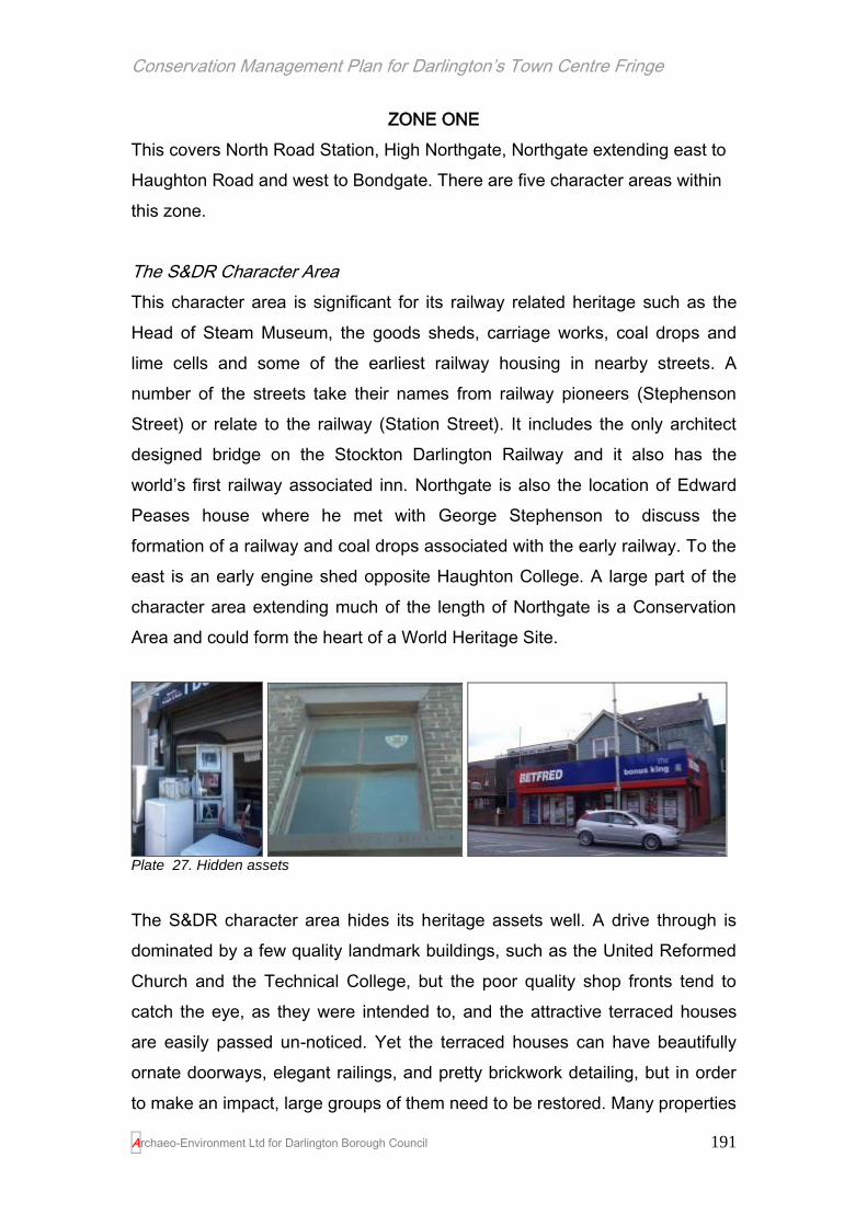
Conservation Management Plan for Darlington’s Town Centre Fringe
Archaeo-Environment Ltd for Darlington Borough Council
191
ZONE ONE
This covers North Road Station, High Northgate, Northgate extending east to
Haughton Road and west to Bondgate. There are five character areas within
this zone.
The S&DR Character Area
This character area is significant for its railway related heritage such as the
Head of Steam Museum, the goods sheds, carriage works, coal drops and
lime cells and some of the earliest railway housing in nearby streets. A
number of the streets take their names from railway pioneers (Stephenson
Street) or relate to the railway (Station Street). It includes the only architect
designed bridge on the Stockton Darlington Railway and it also has the
world’s first railway associated inn. Northgate is also the location of Edward
Peases house where he met with George Stephenson to discuss the
formation of a railway and coal drops associated with the early railway. To the
east is an early engine shed opposite Haughton College. A large part of the
character area extending much of the length of Northgate is a Conservation
Area and could form the heart of a World Heritage Site.
Plate 27. Hidden assets
The S&DR character area hides its heritage assets well. A drive through is
dominated by a few quality landmark buildings, such as the United Reformed
Church and the Technical College, but the poor quality shop fronts tend to
catch the eye, as they were intended to, and the attractive terraced houses
are easily passed un-noticed. Yet the terraced houses can have beautifully
ornate doorways, elegant railings, and pretty brickwork detailing, but in order
to make an impact, large groups of them need to be restored. Many properties

Conservation Management Plan for Darlington’s Town Centre Fringe
Archaeo-Environment Ltd for Darlington Borough Council
192
are empty and these enhance an air of neglect. Even landmark buildings such
as the Coco Rooms are empty, and their otherwise prominent position is
dwarfed by the petrol station. The Skerne Bridge, also known as the Five
Pound Note Bridge, can only be viewed from within the town centre fringe
area through razor wire, dumped rubbish and security fencing. However
recent clearance works on the north side of the bridge had restored a
delightful footpath to the bridge, even if it is currently terminates in threatening
waste ground. Edward Pease’s house has become shabby and its façade
divided up into unattractive little shops advertising kebabs and pizzas. The
plaques which bear his name are barely noticeable to shoppers or drivers.
Pease’s garden, once renowned for its fruit trees, has long gone. An under
used car park and a modern building devoid of any architectural merits takes
its place. Its condition is an international embarrassment.
Yet there is much of interest, such as Borrowdale’s
house at no.1 Leadenhall Street, or a tiny shop
with bowed windows at 112 High Northgate. Even
those terraces which appear to have been
‘improved’ beyond recognition, still carry
inscriptions or fragments of the past for anyone
who cares to take the time to look. For example
the empty property on High Northgate which once housed Clacher’s the
Plumbers bears an inscription below the window sill; barely legible and much
weathered –‘1857 FAITH HOUSE’ and even a sash window, but its overall
appearance is a house that has been so modified it has lost its historic
character. There is no hint that this land close to the world’s first railway
station, was once given to the Darlington Christian Workmen’s Mutual
Improvement Society in 1857 to build a reading room by John Pease and that
the building went on to be a mortuary caretaker’s cottage. Recent
Conservation Area work has also started to reverse the trend of decline.
Some of the earliest terraced houses built in the 1820s have had their railings,
windows and doors restored; shops have had new traditional frontages to help
Plate 28. A Borrowdale sculpture

Conservation Management Plan for Darlington’s Town Centre Fringe
Archaeo-Environment Ltd for Darlington Borough Council
193
combat economic decline and even Edward Pease’s house has had a little
tender loving care, although much more is needed.

Conservation Management Plan for Darlington’s Town Centre Fringe
Archaeo-Environment Ltd for Darlington Borough Council
194

Conservation Management Plan for Darlington’s Town Centre Fringe
Archaeo-Environment Ltd for Darlington Borough Council
195
The ‘Left Bank’ Character Area
Sandwiched between the town centre and
Northgate this riverside patchwork of
buildings, old and new, some empty,
some converted and some just waiting,
ought to be an area of vibrant urban living
with riverside access. It has a long way to
go. It has a good stock of under-used
buildings waiting to find a new purpose
and when they do, the area will come
alive again. The area is significant for its
riverside location with the potential for
improved access and its warehouse
buildings; their utility did not prevent their
original builders from adding detail such
as patterned window lintels. The network of scoria blocked lanes are
particularly distinctive and offer the potential of gentle walking away from the
traffic of Northgate and in due course, they should offer a potential route to
the river. It has historic significance as having been the location of Edward
Pease’s renowned garden of orchards and vineries and there is considerable
historic documentation relating to Pease’s time there in the Local Studies
Library. It is also significant for having the last remaining Weaver’s Cottage,
tucked in behind Pease’s house.
The public consultation sees this as an area of mixed use with old buildings
adapted for modern uses and new buildings conforming to innovative exciting
designs. In the ‘Left Bank’ of the future there will be no room for some of the
less attractive buildings in the area and its high density urban lifestyle will
have little use for a large, poorly maintained car park. However an element of
garden or allotment on the site of the car park would remind visitors and
residents of the fine gardens that once ran from Pease’s house to the river
before crossing a rustic bridge towards East Mount.
Plate 29. Red brick warehouse style buildings predominate in this area

Conservation Management Plan for Darlington’s Town Centre Fringe
Archaeo-Environment Ltd for Darlington Borough Council
196

Conservation Management Plan for Darlington’s Town Centre Fringe
Archaeo-Environment Ltd for Darlington Borough Council
197
Eastmount Character Area
This character area is significant for its location on high ground (the East
Mount) which was the location of John Pease’s home in the 19th century.
Edward Pease would walk across the valley to visit his family here. The land
was sold off c.1895 and development started at the turn of the century. The
front street, East Mount Road, was designed to have superb views across
Darlington. Consequently the houses were set a little back from the street with
low walls and railings. Steps up to the front door were another indication of
prosperity and the doors had ornate surrounds. Bay windows flooded the
main reception room with light and ensured a promising view from their
elevated position. The streets behind, all with Scottish names, were of a lower
social status. Here the houses opened straight on to the street, but
nevertheless they still had some ornate detailing to doors and string courses
picked out in alternatively coloured bricks. Below the eaves, bricks were set at
angles to create another design detail. All of the terraces had back lanes,
floored with scoria blocks, where the walls were pierced with two wooden
doors, one for the coal and one for the night soil.
The area has the potential to be much ‘sought after’ with its high quality
houses on East Mount Road but this is dependent on no additional
thoughtless development such has already taken place on the west side of
the road and tree management (mainly self-seeded sycamores) to return
views from the mount over the town centre fringe. The consultation process
has also flagged up that the area could also be better linked by improved
landscaping of the open space along Haughton Road with an extension of its
green space so that it provides a green linking corridor for pedestrians
between Haughton College and the town centre. This should tie into the
recommendation HE10.o above).

Conservation Management Plan for Darlington’s Town Centre Fringe
Archaeo-Environment Ltd for Darlington Borough Council
198

Conservation Management Plan for Darlington’s Town Centre Fringe
Archaeo-Environment Ltd for Darlington Borough Council
199
Bondgate and Gladstone Character Area
This is a distinctive part of zone one having its origins in medieval times rather
than in Victorian times. Bondgate is the site of a horse fair until 1914 and
associated with the buying and selling of horses (True North Books, 1998,
76). Its significance is derived from its street pattern which is based on
medieval burgage plots facing a central wide market place or green, although
much of this is outside the town centre fringe. The street pattern however
continues westwards where it joins the town centre fringe area. The medieval
street pattern at its heart is intimate in character and consequently places little
reliance on views in or out of it. There are however some important views in
the Victorian streets surrounding the older part of Bondgate including the view
down Portland Street towards the telephone exchange which terminates the
views with an attractive red brick neo-Gothic building. Views in Bondgate itself
towards the town centre currently have the statue of Joseph Pease with the
Kings Head as the terminus, however the broad street based on the medieval
green allows the eye to drift rather than focusing it on the end view.
Plate 30. A mix of traditional shop fronts with plastic eyesores on Bondgate

Conservation Management Plan for Darlington’s Town Centre Fringe
Archaeo-Environment Ltd for Darlington Borough Council
200
The building stock in Bondgate is also significant for including a high density
of listed buildings; many of the buildings are much earlier than in the Victorian
areas with extant buildings looking 17-18th century in origin and with Victorian
and later additions. As a result of the protected status of these buildings, they
are in better condition than other buildings in the TCF, but amongst the
attractive traditional shop fronts is a sprinkling of gawdy plastic ones and a
loss of traditional windows to first floor levels. Just behind Bondgate where the
streets are dominated by terraced housing, the quality of the buildings
declines with boarded or plastic windows and pebble dashing all conspiring to
hide the historic origins of the area. Sun Street seems to suffer from empty
properties in particular. There are also a few negative features, such as the
boxing academy on Portland Place and some ill considered attachments to
buildings and back lane encroachment on Sun Street, Gladstone Street and
four Riggs. This may therefore be an area which would benefit from innovative
remodelling of terraced housing stock (see HE 7) or gated back lanes. There
are also a large number of car parks in this character area which would
benefit from some landscaping or street fronted development to reduce the
prairieland effect. Greenbank (east side) however is significant for its relatively
high survival of traditional features in the terraced houses. These houses, set
back slightly from the road and with bay windows, display a particular series
of features which draws them together as having been the product of one
speculative builder. Front doors are of a distinctive type which was also used
in Victoria Embankment and a good number survive.
Plate 31. Greenbank forms a small character area in its own right with distinctive doors and windows, terraces set back from the street, bay windows, dormers and some relic railings

Conservation Management Plan for Darlington’s Town Centre Fringe
Archaeo-Environment Ltd for Darlington Borough Council
201

Conservation Management Plan for Darlington’s Town Centre Fringe
Archaeo-Environment Ltd for Darlington Borough Council
202
The Lost Valley
This area is significant for its early use as gardens linking Edward Pease’s
house on Northgate with John Pease’s house on East Mount. It also contains
the original course of the Skerne, long since cut off and culverted in 1900
below Valley Street. Freeman’s Place was developed first, sometime before
1826, but this has since been demolished and is now under the car park at
MFI, then Russell Street in the 1850s-60s, terraced houses between John
Street and East Mount were built in the 1870s. Around 1900 Valley Street was
laid out as a ruler straight road with Chesnut Street (started in 1864)
extended across east west – the name again possibly referring to the earlier
gardens. Lodge Street, named after the lodge associated with East Mount
House was not developed until after the 1900s. Additional infill was created
along Lodge Street in the 1930s introducing semi-detached houses into the
area for the first time.
The present day character could not be further removed from the Quaker
gardens. The terraced and semi-detached houses of Lodge Street remain.
The pretty terraced houses with hood moulding with floral stops have survived
on Russell Street when so much around them has been demolished. The iron
bridges built over the Skerne by Pease and Fry in 1881 also survive, but the
cap is missing from a pier. There are one or two attractive early 20th century
brick buildings which retain their below eaves detailing around Valley Street,
but some vey non-traditional colours have been use to paint the in bright blue
or green. The terraced houses along East Mount Road towards John Street
have suffered from a loss of historic character, although those on the north
side retain their timber porches over their doors and windows. The coal drops
on John Street sit within unsightly waste ground and a distinctive red brick
stone wall with detailing is spoiled by large hand painted letters warning that
the wasteland beyond is private.
A number of the larger business are moving out of his area. It is perhaps
better that they relocate to the A66 where there is more space and better

Conservation Management Plan for Darlington’s Town Centre Fringe
Archaeo-Environment Ltd for Darlington Borough Council
203
communications, but there is still scope for smaller business to remain close
to the population centre. This is an area where its character has faltered and it
is ready to find a new character to suit Darlington’s present day needs. New
uses will wish to conserve the older properties (see figure 2), consider the
views across this area from East Mount, consider that it is an area which can
improve links between East Mount, Haughton and Northgate and the town
centre and might also include improved access along the riverside.

Conservation Management Plan for Darlington’s Town Centre Fringe
Archaeo-Environment Ltd for Darlington Borough Council
204
Then and Now…
Plate 32. The Peaceful Valley in the 1850s (1
st ed
OS map)
Plate 33. Valley Street in 2010 (taken from Google Earth)

Conservation Management Plan for Darlington’s Town Centre Fringe
Archaeo-Environment Ltd for Darlington Borough Council
205

Conservation Management Plan for Darlington’s Town Centre Fringe
Archaeo-Environment Ltd for Darlington Borough Council
206
ZONE TWO and THREE
This zone has three main roads running through it. St Cuthbert’s Way, the
modern dual carriageway, runs into Haughton Road. Running parallel to it is
Borough Road, predominantly residential with side streets off, but gradually
becoming industrialised in the centre before joining the commercial and
cultural area of Parkgate.
The Bishop’s Park Character Area
This character area is significant for its early 20th century buildings stock. The
Civic Theatre, built in 1907, sets the tone for Parkgate with its prominent
corner position and modern extension, flamboyant façade and recently added
torches and replacement iron canopy. This area must have been a hive of
activity in the opening years of the 20th century with the opening of the theatre
and the Greyhound Inn opposite. It is also significant for its survival of the
tannery buildings already on maps by the 1850s. These are the remains of a
once common industry usually placed on the edge of the town because of the
anti-social smells which originated there. The buildings and the lane may be
much older than the 1850s and excavation of such sites elsewhere has often
uncovered tanning pits and leather offcuts from the 17th century. There are no
bad smells there today, just an attractive lane with scoria blocks and
sandstone slabs and smoke houses. Any re-use should be accompanied by a
statement of significance first in order to inform what should be retained.
Landmark buildings which contribute to the historic skyline and provide high
quality features at the edges of the character area are also significant. St
Hilda’s occupies an important prominent position in the area providing a
terminus to Parkgate and a welcome from the busy ring road. It was built in
1887 and its height and long narrow windows were dictated by the wish of the
architect, J.L. Pearson, for natural lighting and by the fact that it was hemmed
in by tall buildings (Flynn 1983, pl116). However today the church is
surrounded by vacant plots which have the potential to enhance or detract
from the church’s architecture and fine railings depending on what is built

Conservation Management Plan for Darlington’s Town Centre Fringe
Archaeo-Environment Ltd for Darlington Borough Council
207
there. St Cuthbert’s also draws the eye down Parkgate and so the origins of
this road as a main route into the historic town long before the town centre
fringe was created, is apparent. At the other end of Parkgate, St John’s on its
elevated position overlooks the character area while the railway bridge brings
the character area to an end.
The area has a wealth of glazed tiles and stained glass, from the rich red
terracottas of the theatre and the Greyhound Inn, the Fire Station and St
Hilda’s clergy house to the deep greens of the Black Swan and the Cricketers.
However their local distinctiveness to Darlington has not always been
recognised with the loss of the Co-op premises with its superb glazed tiles
(I.Dougill pers comm. 12.7.10). Damage has occurred to the glazed tiles of
the Black Swan and repairs are urgently required. The Victorian Society have
published guidance on repairing glazed tiles (1992).
‘The Bishop’s Park was on the east side of the Skerne; it is now divided into
fields, chiefly held by lease under the see. Depressions have been filled up
with bark and rubbish, and on this decaying substructure streets have been
built, the perpetual abode of fever and disease.’
Longstaffe 1909, 339, but originally published in 1854
The views into Parkgate are also attractive from the vacant plot next to the
Cricketers. Here the jumble of roof lines and the tannery buildings creates a
view buzzing with historic character. The views along Park Lane are less
attractive. Too much has been demolished here and the quality of the new
build does little to enhance the area. When the police, fire and royal mail
move or seek to redevelop, there will be an opportunity to restore the open
spaces with some of the high density and high quality development that will
create an environment more suited to living and working in and reduce the
motorway – like feel of the ring road.
Hargreave Terrace offers other opportunities. Here the quality of housing,
developed from the 1870s, is still high with rusticated stone detailing, some

Conservation Management Plan for Darlington’s Town Centre Fringe
Archaeo-Environment Ltd for Darlington Borough Council
208
sash windows and original railings. These houses being set back from the
road a little with steps up to the front door and the potential in places for views
across to the town centre, offer inspiration for future building stock in the area
and an opportunity to extend the proposed Parkgate conservation area to
include at least the east side of this street.
Modern local authority housing on Hargreave Terrace fails to live up to these
standards. The properties turn their backs on to the main road and so the best
elevations face a courtyard to the detriment of the townscape. Other new
development next to the New Connexions church uses a mix of brick and
stone and is street fronted and so manages to be in keeping with the styles in
the street. It is able to get away with being tall because of its proximity to the
church and its varied roofline.

Conservation Management Plan for Darlington’s Town Centre Fringe
Archaeo-Environment Ltd for Darlington Borough Council
209

Conservation Management Plan for Darlington’s Town Centre Fringe
Archaeo-Environment Ltd for Darlington Borough Council
210
Borough Road Character Area
This area is significant for its terraced housing which dates to the late 19th and
early 20th centuries. However much of it is suffering from a loss of historic
character with a number of properties boarded up or derelict. The back lanes
have high walls topped with broken glass and razor wire suggesting that anti-
social behaviour is a problem here. However the condition of the properties on
the side streets is better and there are a few quality civic buildings such as the
former Brunswick School and the quality of architecture increases towards
Parkgate. Too much demolition has left Brunswick Street devoid of historic
interest (with the exception of the school) and the predominance of poor
quality buildings and security fencing with open views to the ring road and
some singularly unattractive modern buildings opposite has left this area
looking neglected. Terraced houses on Haughton Road (east side) have
highly ornate doorways, but even the simpler houses of Borough Road once
had nicely turned window mullions and below eaves detailing. The spilling out
of small scale industrial buildings from the industrial estate, the use of
advertising bill boards on Haughton Road do little to enhance historic
character.

Conservation Management Plan for Darlington’s Town Centre Fringe
Archaeo-Environment Ltd for Darlington Borough Council
211
Then and Now…
Plate 34. The loss of the cooling towers is not regrettable, but the loss of the terraced houses has also resulted in a loss of community
Plate 35. Where large scale demolition is proposed, it should be to make way for higher quality of development. Clearly that was not the case at Brunswick Street

Conservation Management Plan for Darlington’s Town Centre Fringe
Archaeo-Environment Ltd for Darlington Borough Council
212

Conservation Management Plan for Darlington’s Town Centre Fringe
Archaeo-Environment Ltd for Darlington Borough Council
213
ZONE FOUR
Bank Top Character Area
The area is significant because of its fine listed railway station which is also
an important skyline feature in the town. It is also significant as representing
the largest group of late 19th and early 20th century terraced houses in the
TCF area. It is possible, through subtle shifts in the detailing to identify which
groups of housing belong to which phase of speculative build. While there is
an overall loss of historic character in this area through the replacement of
traditional windows and doors with plastic inserts and through the use of
cladding and pebble dash which obscures the original design dentils, the area
is generally in good condition with its street pattern intact. Bedford Street,
Chatsworth Terrace and Victoria Embankment have views southwards to
South Park and Leafield Road has views westward, down to the greenery of
Victoria Embankment and the cricket ground beyond.
Victoria Embankment, now a conservation area, was designed in the 1870s
as a leafy riverside approach to South Park. Trees were planted on both sides
of the road, but those on the east side were subsequently removed when
residents complained that they were blocking too much light. A lack of tree
management on the remaining row of trees has blocked views towards St
Cuthbert’s and has reduced views of the river. The posts and chains which
ran along the bank were acquired from High Row where they were installed to
keep cattle off the pavement on market days. They were re-erected on the
Embankment in the 1890s (Flynn 1983, pl 105).
The cattle market at Bank Top was opened by the council in May 1864,
although horses continued to be bought and sold in Bondgate. This replaced
the earlier tradition of selling beasts in the town centre (True North Books
1998, 124). If the site becomes available for development it should consider
retaining the circular auction building and could model the street pattern on
the high density grid patterns which form this area’s distinctive character, but
with a modern version of the terraced house.
Conservation Management Plan for Darlington’s Town Centre Fringe
Archaeo-Environment Ltd for Darlington Borough Council
214
The majority of the houses here were built to accommodate railway workers
and although they were not built by the railway company they use the same
below eaves decorative detailing that is to be found on the station buildings.
Victoria Road has a number of quality Victorian and Edwardian buildings
particularly near the station. These would have been designed to create a
good first impression for visitors arriving by train. Although the predominant
building material here is brick, Victoria Road has a number of properties built
of Pease’s brick, but many have been defaced by inappropriate shop fronts
and cladding. Perhaps the most significant aspect of this character area is the
view towards the station clock tower from the rest of Victoria Road. The tower
for the New Connexions church was a significant skyline feature, but is now
marred by the loss of its top.

Conservation Management Plan for Darlington’s Town Centre Fringe
Archaeo-Environment Ltd for Darlington Borough Council
215
Conservation Management Plan for Darlington’s Town Centre Fringe
Archaeo-Environment Ltd for Darlington Borough Council
216
ZONE FIVE
Feetham’s Character Area
Feetham’s Field was once thought to be the most picturesque part of
Darlington and it features in a number of artistic depictions of the town. It has
gone through many changes with its large open space being gradually
reduced. Weekly sales were held on Feetham’s Field and it was also where
labour was sold or hired (True North Books 1998, 94). The market site for the
markets, hirings and other public uses was built over for the bus station (Dean
1984, pl 6). Darlington Football Club and Darlington Cricket Club have for
large parts of the 20th century occupied adjoining grounds beside the river
Skerne on Feetham’s Fields, but the football ground is due to be redeveloped.
The area is significant today for its access to South Park and its potential to
extend the green space into Darlington and thus create a wildlife corridor and
amenity space.
The area is also significant for its Victorian buildings on the north side of
Victoria Road. Here there is a mixture of 19th century styles with neo-Gothic
windows and doors, ornate door surrounds and a good survival of railings and
windows. Some of the terraces have been badly treated, especially towards
the east end of the road – here entire facades have been built over or opened
up as glass, however the reinvention of a row of these houses as a 1930s Art
Deco style building does at least retain the scale of building, if not the detail.
The impact of Sainsbury’s is relatively neutral. The car park and buildings are
sunk into the ground and the car park planted with trees around the edges.
The position of a prominent landmark building – the church on the corner, also
hides the supermarket’s modern indistinctive structure and another early 19th
century building on the corner of Grange Road also gets Victoria Road off to a
promising start.

Conservation Management Plan for Darlington’s Town Centre Fringe
Archaeo-Environment Ltd for Darlington Borough Council
217
Then and Now…
Plate 36. Victoria Road as it was designed to be with housing down both sides
Plate 37. Victoria Road in 2010. The road has been widened and the houses demolished on the right, but the views to Bank Top remain. The brick walls with stone capped piers also remain, but there is considerably more street clutter
A small group of terraced houses with ornate doorways towards the bottom of
Victoria Road also provide historic character; but they are overwhelmed by
the large bill boards and behind these South Terrace is an oasis of calm of

Conservation Management Plan for Darlington’s Town Centre Fringe
Archaeo-Environment Ltd for Darlington Borough Council
218
Victorian detailing and gardens beside the cricket ground. In terms of
character it should be part of Victoria Embankment, but the ring road has
divorced the two areas. It has good quality terraced houses with a reasonable
number of traditional windows and doors. The streets terminate on the east in
the leafy areas of the river Skerne and the houses have views over the
Cricket Ground – there since the second half of the 19th century. The entrance
into the cricket ground is particularly interesting and is said to be a miniature
of the lost gates of Wembley Stadium (I.Dougill pers comm. 12.7.10) and
consequently merit retention in any future development. For this reason they
have also been included on the recommended Local List of buildings.
This area is also significant as a linking route with the town centre. South
Arden Street takes pedestrians from Sainsbury’s car park into town. Here they
can enjoy the neo-Gothic pointed arches of the solicitors while waiting to
cross the road and then the quiet streets toward Beaumont Street with an
unfortunate view of Boyes – wholly lacking in charm. The decaying office
block also mars views into town and starts the approach into the town centre
with an air of neglect. It has no place in an historic town centre. The car parks
look like they ought to be crowded with yards, and medieval burgage plots;
indeed historic mapping shows that was exactly what was there before the car
parks were built. Indeed high density development would suit this area while
retaining the views towards Bank Top, St Cuthbert’s and St John’s. It could
restore quality architecture to the site, creating an exciting place to walk
through and help to reduce the impact of buildings such as Boyes on
Houndgate.
The greatest loss of historic character in this area is the ring road and the
large scale buildings alongside it, in particular the Town Hall and the Royal
Mail. The construction of the ring road involved the demolition of attractive
Victorian houses, but the key view towards Bank Top remains. The
roundabout is large and open and lacks historic character. It introduces to
much street clutter in the form of traffic signs and safety fencing. The scale of
the Town Hall is unsympathetic to the town and to views from the ring road.

Conservation Management Plan for Darlington’s Town Centre Fringe
Archaeo-Environment Ltd for Darlington Borough Council
219
Its impact could be softened by development in Feethams and south of the
Town Hall which introduces varied roof lines and design features which can
be appreciated from the ring road as well as from the town centre.
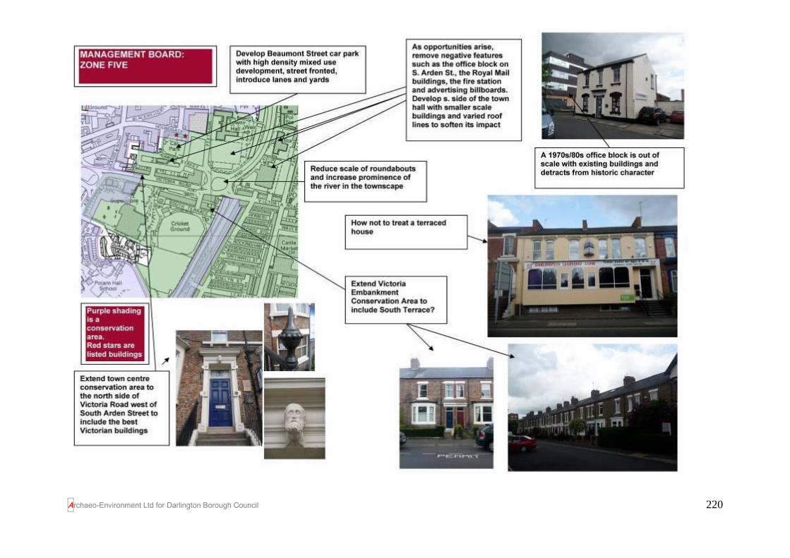
Conservation Management Plan for Darlington’s Town Centre Fringe
Archaeo-Environment Ltd for Darlington Borough Council
220

Conservation Management Plan for Darlington’s Town Centre Fringe
Archaeo-Environment Ltd for Darlington Borough Council
221
BIBLIOGRAPHY
ASUD 2009 Darlington Town Centre Fringe Project Desk Based Assessment
Austin, D 1982, Bolden Book
Baker, P 2008 The Thermal Performance of Traditional Windows and
Practical Measures to Reduce Heat Loss and Shrinkage (a paper given
in Historic Scotland’s Seminar on insulating historic properties in 2008
citing research by Glasgow University’s Centre for Research on Indoor
Climate and Health).
Centre for Research on Indoor Climate and Health 2007 Domestic
Technical Handbook
Cookson, G 2003 The Townscape of Darlington
Cudworth, W J 1899 Darlington Half Holiday Guide (first published 1882 by
Wm Dressers of High Row)
Darlington Borough Council 2006 The Early Railway Buildings at North Road,
Darlington
Darlington Borough Council 2010 Accommodating Growth Development Plan
Document
Darlington District Civic Society 1975 Buildings and Places
Dean, D and S 1984 Darlington in the 1930s & 40s
Department for Communities and Local Government 2010 Planning Policy
Statement 5: Planning for the Historic Environment
Ekwall E 1987 The Concise Oxford Dictionary of English Place Names
English Heritage 2004 Window Comparisons
English Heritage 2008 Conservation Principles
Fawcett B 2001 A History of North Eastern Railway Architecture Vol 1:
The Pioneers
Fawcett B undated ‘Darlington’s “GNE Shed”’ available at
http://www.staff.ncl.ac.uk/m.h.ellison/nera/gneshed.pdf [accessed 16.7.10]
Fiennes, C 1698 Tour Durham to Shropshire
Flynn, G. J 1983 Darlington in Old Picture Postcards
Flynn, G.J. 1994 Darlington in Old Picture Postcards Vol 2
Hardie, C and Hammond, N 2007 History in the Landscape. The archaeology
and architecture of Weardale

Conservation Management Plan for Darlington’s Town Centre Fringe
Archaeo-Environment Ltd for Darlington Borough Council
222
Historic Scotland 2007 Inform: The use of lime and cement in traditional
buildings
Historic Scotland 2007 Inform: Repairing brickwork
Historic Scotland 2007 Inform: Maintaining sash and case windows
Historic Scotland 2007 Inform: Damp Causes and Solutions
Historic Scotland 2008 Inform: External Timber Doors
Lloyd, C undated Memories of Darlington
Longstaffe, WHD 1909 The History and Antiquity of the Parish of
Darlington in the Bishopricke of Durham (originally published in 1854)
Meadows, P and Waterson, E 1993 Lost Houses of County Durham
Petts, D and Gerrard, C 2006 Shared Visions: The North-East Regional
Research Framework for the Historic Environment
Pevsner, N 1990 The Buildings of England, County Durham
The Victorian Society 1992 Care for Victorian Houses number two:
Decorative Tiles
True North Books 1998 Darlington’s Golden years
Wall, J 2001 First in the World. The Stockton & Darlington Railway
Wooler, E and Boyd, A. C 1913 Historic Darlington
Yorke, T 2007 The Victorian House Explained

Conservation Management Plan for Darlington’s Town Centre Fringe
Archaeo-Environment Ltd for Darlington Borough Council
223
APPENDICES
Appendix A
Chronology of development for Darlington’s Town Centre Fringe
1812 Union Street independent chapel by James Ianson of London, enlarged 1924
1821-2 Queen Street Primitive Methodists chapel
pre-1820s King, Queen, Regent, Union and Commercial Streets exist, but not fully developed.
Directory 1820. Businesses grow there in conjunction with railway. Houses a mixture of sizes and styles from impressive town houses to modest cottages, badly planned drains and sewers
1825 stone viaduct at north end of study area built by George Stephenson and the architect Joseph Brown, widened in brick in 1854
1825 The £5 note bridge built, designed by Ignatius Bonomi to carry the railway over the River Skerne.
A Scheduled Ancient Monument believed to have been the first – and certainly the only architect-designed – bridge on the Stockton and Darlington Railway. The bridge became known as the ‘£5 bridge’ after being shown on the banknotes.
pre-1826 Park Street, Freemans Place
1830s Land between Park Street and the river
pre 1837 Archer Street and Temperance Place
1833 Allan Estate, north of Bondgate, fields around Northgate railway, Clay Row
Land sold for development and agricultural use
1850 Health improvements including relocation of water pumps, street repairs and paving
1850 demolition of cottages in Bondgate
1850s Subway beneath the S&DR to connect Rise Carr to Hopetown
1855 -1871
Villas at Westbrook gardens
1857-60 Russell Street buildings added in 1864
1858 Whessoe Lane diverted and becomes Hopetown Lane
1859 first suggestion that cattle market be moved outside the town
1860s additional development between town and northwards up Northgate and the new Whessoe Lane is developed
1860s Park Place, Model Place and Swan Street, land around Victoria Embankment, Neasham, Yarm Road
1864 Chesnut Street
1867 Victoria Road
1861-4 Town Hall and market building – prominent skyline feature
1864 onwards
Leadenhall street and additional buildings on Russell Street near Northgate
1867 Victoria Road and Beaumont Street started and extended to Bank Top towards new station
Conservation Management Plan for Darlington’s Town Centre Fringe
Archaeo-Environment Ltd for Darlington Borough Council
224
(1887)
1868 Chesnut Street (36 plots)
1870 Livingstone buildings on Northgate
1870 bishop’s palace demolished for terraced housing Luck street?
1870s? Hill House estate land sold sw of S&DR line and near Albert Hill to be developed with railway sidings and coal depots
1870s East Mount Estate started to be developed between upper John Street (now East Mount Road) and the railway
development complete by 1900
1870s McNay and Stephenson Streets fitted into a confined site along with several other working class terraces
1870s Victoria Embankment built
1871 Hargreave Terrrace partially developed
1872 McNay Street and Stephenson Street
1874 Pensbury Street completed
1875 Greenbank villa demolished and the area starts to be developed (Wycombe Street, north side of Dodds Street)
Lots sold in 1881 with land for a hospital.
1881 bridges on Russell Street and Chesnut Street built
Stone piers now eroded
1884 Edward Pease free library (Hoskins)
1885 new streets between Russell Street and Chesnut Street
still some vacant plots by 1902
1887 New Bank Top Station
1892 Land north of Corporation Road developed
1894 the technical college (Hoskins)
1895 St Cuthbert’s Bridge
1899 Northgate widened
1899 Parkgate widened
late 19th c
to early 20
th c
streets off Haughton Lane
1900 Valley Street and Weir Street laid out for development and the Skerne undergrounded. Borough Road area, and land around the power station developed
1912 Land acquired by the Council for allotments in the Cocker beck valley
1937 Old people’s homes in Hilda Street

Conservation Management Plan for Darlington’s Town Centre Fringe
Archaeo-Environment Ltd for Darlington Borough Council
225
Appendix B Historic Street Names
Street names carry with them recollections, no matter how feint, of people and
events from our past. Reusing such names or using the names of local
historical figures to name new developments or streets, can help to make
links with the past and help new development to fit in. Local figures such as
Ralph Hodgson the poet, born in Garden Street in 1871 and Joseph
Woodward, inventor of the scoriae bricks, have yet to be recognised in street
names.
Historic Street Names
Chesnut Street Possibly named after magnificent chestnut trees which existed in the area when it was still rural in the mid 19
th century, but the
spelling appears to have been a signwriting mistake.
Commercial Street Carved out of part of Kendrew’s Market Garden in 1826 and designed from the start to be a mixed residential and commercial area.
Elmfield Named after a villa built off Northgate in the early 19
th century
Fatty Man’s Squeeze The name of a narrow lane which ran from Garden Street through to Russell Street beside the Lily Laundry. It was necessary to turn sideways to get through it. Now gone.
Garden Street Names after Edward Pease’s back garden which ran from his house down to the Skerne. It was renowned for its fruit trees (vines, fig, apricots, peaches, mulberries, cherries and plums) and the layout of the gardens can be seen on 25” OS maps dating to 1850. It is now the site of a car park and Philips – a modern brick building of no merit.
John Dobbin Street Named after a renowned artist who painted the opening of the Stockton and Darlington Railway at the Skerne Bridge, although the painting was produced 50 years after the event. He is also responsible for a mosaic reredos in St Cuthbert’s Church. The street is a 1960s creation and the name therefore relatively recent.
Kendrew Street Named after John Kendrew who was a weaver who lived in this area as a child. He adapted the Spinning Jenny for the spinning of flax for linen and also invented a machine for polishing optical glasses.
Lodge Street Named after the entrance lodge to East Mount villa, home of John Pease
McNay Street Named after Thomas McNay, S&DRs Engineer and Secretary
North Lodge An estate carved out of Elmfield’s grounds, presumably where Elmfields North Lodge

Conservation Management Plan for Darlington’s Town Centre Fringe
Archaeo-Environment Ltd for Darlington Borough Council
226
was.
Park Lane Named after the Bishop’s Low Park that was located in this area
Peaceful Valley The area around what is now Garden Street, Weir Street and across to East Mount. It was named after the Pease’s families who lived on Northgate and at East Mount – hence Pease-full. The two families could walk across their gardens and rural countryside to visit each other. The name continued in use even when the area was no longer peaceful – a row of cottages, now demolished at the foot of Chesnut Street beside the Skerne, took the name in the early 20
th century when the
area was developed. They have since been demolished.
Polam Hall The first villa to be built outside the borough dating to 1780
Valley Street Named after the river Skerne which had flowed through the area. The street was carved out of the river area in c1900 and the river culverted into a brick tunnel which still exists below Valley Street (Dougill pers comm.)
Westbrook Named after Westbrook (the west brook being Cocker Beck) Gardens created by Henry Pease before 1835, described as large and beautiful with intersecting walks, a pond and a temple. Called Henry’s Folly by Edward Pease (his father)
Weir Street Named after the weir which ran off the Skerne in order to power nearby mills.
Weaver’s Yard Names after a row of weavers cottages which rand from behind Edward Pease’s House on Northgate to the Skerne. Only one remains to the rear of Pease’s House.
Wooler Street Named after William Alexander Wooler of Sadbergh Hall, a member of a prosperous family of businessmen originally from Wolsingham but settled in Darlington. He developed land which had belonged to the Buck’s Charity Land prior to 1864 and had the street named after himself (Lloyd’s Echo Memories 11.1.06).

Conservation Management Plan for Darlington’s Town Centre Fringe
Archaeo-Environment Ltd for Darlington Borough Council
227
APPENDIX C NEGATIVE FEATURES IN THE TOWN CENTRE FRINGE

Conservation Management Plan for Darlington’s Town Centre Fringe
Archaeo-Environment Ltd for Darlington Borough Council
228
APPENDIX D CONSERVATION AREAS IN THE TOWN CENTRE FRINGE

Conservation Management Plan for Darlington’s Town Centre Fringe
Archaeo-Environment Ltd for Darlington Borough Council
229
APPENDIX E LISTED BUILDINGS IN THE TOWN CENTRE FRINGE
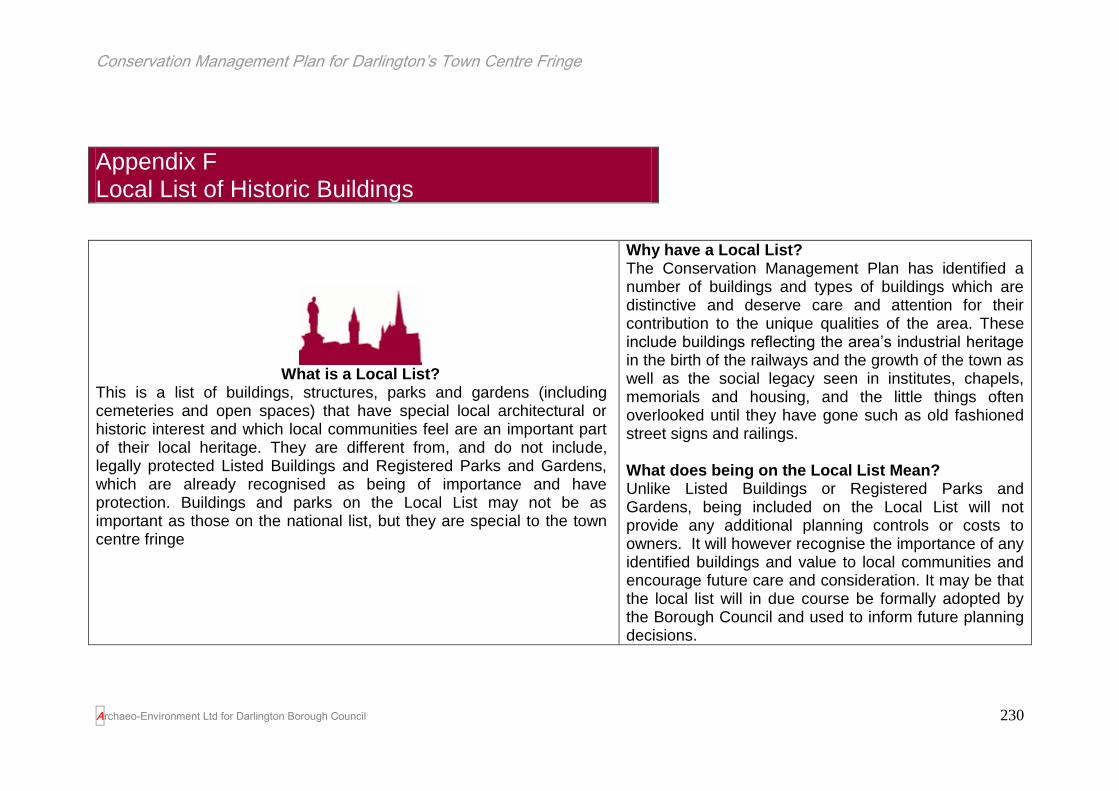
Conservation Management Plan for Darlington’s Town Centre Fringe
Archaeo-Environment Ltd for Darlington Borough Council
230
Appendix F Local List of Historic Buildings
What is a Local List?
This is a list of buildings, structures, parks and gardens (including cemeteries and open spaces) that have special local architectural or historic interest and which local communities feel are an important part of their local heritage. They are different from, and do not include, legally protected Listed Buildings and Registered Parks and Gardens, which are already recognised as being of importance and have protection. Buildings and parks on the Local List may not be as important as those on the national list, but they are special to the town centre fringe
Why have a Local List? The Conservation Management Plan has identified a number of buildings and types of buildings which are distinctive and deserve care and attention for their contribution to the unique qualities of the area. These include buildings reflecting the area’s industrial heritage in the birth of the railways and the growth of the town as well as the social legacy seen in institutes, chapels, memorials and housing, and the little things often overlooked until they have gone such as old fashioned street signs and railings. What does being on the Local List Mean? Unlike Listed Buildings or Registered Parks and Gardens, being included on the Local List will not provide any additional planning controls or costs to owners. It will however recognise the importance of any identified buildings and value to local communities and encourage future care and consideration. It may be that the local list will in due course be formally adopted by the Borough Council and used to inform future planning decisions.

Conservation Management Plan for Darlington’s Town Centre Fringe
Archaeo-Environment Ltd for Darlington Borough Council
231
Weaver’s Cottage to the rear of Edward Pease’s House on Northgate.
The rest of the row is demolished, but the name Weavers Yard survives on some maps. Weavers cottages normally have a distinctive row of windows along the top floor, very close together in order to let in the maximum amount of light. However these do not exist here or in the historic photographs of so-called Darlington House which stood on the site of the Technical College before it was built. RECENTLY RENDERED SO UNDER THREAT
Shop on 110-112 High Northgate with mid 19th century bowed 12 pane windows topped with a lead dome– a real rarity
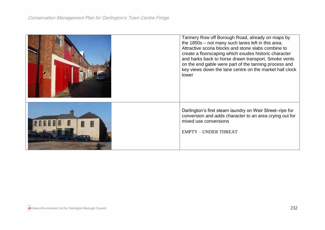
Conservation Management Plan for Darlington’s Town Centre Fringe
Archaeo-Environment Ltd for Darlington Borough Council
232
Tannery Row off Borough Road, already on maps by the 1850s – not many such lanes left in this area. Attractive scoria blocks and stone slabs combine to create a floorscaping which exudes historic character and harks back to horse drawn transport. Smoke vents on the end gable were part of the tanning process and key views down the lane centre on the market hall clock tower
Darlington’s first steam laundry on Weir Street–ripe for conversion and adds character to an area crying out for mixed use conversions
EMPTY – UNDER THREAT

Conservation Management Plan for Darlington’s Town Centre Fringe
Archaeo-Environment Ltd for Darlington Borough Council
233
Darlington Bottling works, Gladstone Street built 1900 and one of the few Arts and Crafts designs in the town
The Temperance Institute on Gladstone Road, built to provide a meeting place without the temptations of alcohol and with the same stone detailing as the listed Technical College and Central School. The shop front below is of poor quality however and detracts from the architecture above
EMPTY – UNDER THREAT

Conservation Management Plan for Darlington’s Town Centre Fringe
Archaeo-Environment Ltd for Darlington Borough Council
234
Richardson Construction, Portland Place – a small architectural treat which provides a terminus to views along Portland Place
19th century warehouse building on Weir Street shows several phases of extensions and rebuilding and may incorporate the remains of a building originally shown on maps dating to 1827

Conservation Management Plan for Darlington’s Town Centre Fringe
Archaeo-Environment Ltd for Darlington Borough Council
235
Melville House, High Northgate built 1876 by Robert Borrowdale as the town’s first cocoa palace. This should be a prominent building with a positive contribution to make to the townscape, but it is hidden behind a petrol station sign. It lacks the ornate scupltures associated with Borrowdale – perhaps they have been removed? (The first Chocolate House/Cocoa Palace in England opened in London in 1657 followed rapidly by many others. Like the already well established coffee houses, they were used as clubs where the wealthy and business community met to smoke a clay pipe of tobacco, conduct business and socialise over a cup of chocolate.) EMPTY - UNDER THREAT

Conservation Management Plan for Darlington’s Town Centre Fringe
Archaeo-Environment Ltd for Darlington Borough Council
236
The glassworks on Station Road/McNay Street. Delightful stone and brick mix with jaunty finial (most have fallen off) and sash windows – a relative rarity in the town centre fringe. Beautiful below eaves detailing. Its corner position gives it added prominence and streetscape presence.
Melville Street - Just because it must be the skinniest terrace in Darlington and quirky buildings make for interesting places!

Conservation Management Plan for Darlington’s Town Centre Fringe
Archaeo-Environment Ltd for Darlington Borough Council
237
1-5 Victoria Road (opposite Sainsbury’s). A series of speculatively built middle class Victorian properties with fine stone detailing and below eaves decoration. Most have their original sash windows (No. 3 has some plastic replacements which spoil the row). No 5 (Victoria Dental Practice) was built by the developer for himself and his bust sits over the door. Inside the plaster work detailing is highly ornate and in excellent condition, as is the tilework on the porch floor and bookcases. Most have their original railings which is extremely rare in Darlington’s town centre fringe and their original Victorian doors. A group which represents Victorian domestic architecture at its best and worthy of listing Grade II to protect the exteriors and interiors.

Conservation Management Plan for Darlington’s Town Centre Fringe
Archaeo-Environment Ltd for Darlington Borough Council
238
Grange House, a prominent corner position added much needed aesthetic value to a rather exposed roundabout area. An early 19th century design which still harks back to the Georgian styles. Multi pane sash windows, although some of these have been replaced with poorer quality plastic ones. Some ornate stone work amongst the brick facades.
Grange Vets and A. Pickering vets. Substantial brick buildings with octagons behind a brick wall with stone caps. Multi-pane sash windows in need of maintenance. This appears to have been the outbuildings to Grange House. Visible on photographs which pre-date the building of the ring road.

Conservation Management Plan for Darlington’s Town Centre Fringe
Archaeo-Environment Ltd for Darlington Borough Council
239
11 Victoria Road (Freeman Johnson Solicitors) red brick with stone detailing to neo-Gothic doorway and top floor windows, original Victorian door, sash windows and thistle and rose end stops to the door arch. Replacement railings not of the quality of the originals but help to create a harmonious street front with the other railings.
7-9 Victoria Road (Sanders Swinbank), red brick with stone detailing, ball finials to gables, wide bayed windows. Stonework highly ornate, original railings and doors, cellar level with lead glazing bars and coloured glass. Possibly 1900 in date and consequently later than no.s 1-5.

Conservation Management Plan for Darlington’s Town Centre Fringe
Archaeo-Environment Ltd for Darlington Borough Council
240
13-45 Victoria Road included as a group, but excludes no.s 23-25 which has been modernised in a 30s style and which is a broadly neutral feature (it has lost all sense of Victorian character, but retains its scale and massing as the original building sits behind), the Darlington Learning Zone is also excluded as it has a very poor replacement façade which spoils the entire street, and it excludes the Darlington Bedding Centre, which has removed the ground floor of the original Victorian houses. Otherwise the group includes Victorian Houses which have suffered some losses of traditional features, but overall the balance is still in favour of survival with a good number of original railings, sash windows and panelled doors. The below eaves detailing has survived in all the properties.

Conservation Management Plan for Darlington’s Town Centre Fringe
Archaeo-Environment Ltd for Darlington Borough Council
241
70 Victoria Road on the corner of Feethams south, next to Sainsbury’s. A prominent position, but the Edwardian arched doorway with stained glass overlight is not appreciated by car drivers now that this side of the road is one way. The façade facing Victoria Road is poorer with plastic replacement windows, but its striking appearance still helps to lift the side of Victoria Road which has suffered most from the construction of the ring road.
Baptists Church, Victoria Road. An important landmark building located on a roundabout and so has added streetscape presence. One of those visual gateways into the town centre fringe.

Conservation Management Plan for Darlington’s Town Centre Fringe
Archaeo-Environment Ltd for Darlington Borough Council
242
The former Old Skerne Printing Works & Hanratty’s Scrap Yard converted into residential studios, Weir Street – an oasis of well maintained calm amongst what looks like post war dereliction (it isn’t – this is modern dereliction). An example of successful reuse of former industrial buildings and a template for the town centre fringe. The printing works date to 1904 when it was built in what had been the back garden of Edward Pease’s home. The printing works were taken over by the North of England newspapers in the 1930s/40s and used as a paper store. Planning permission for the conversion was granted in 1987 and is still underway.
Old gateway into the Cocker Beck, Northgate. Stone gateposts topped with Victorian gables with roll top and stone wall with dressed stone capping.

Conservation Management Plan for Darlington’s Town Centre Fringe
Archaeo-Environment Ltd for Darlington Borough Council
243
A Robert Borrowdale designed house on 1 Leadenhall Street. One of the few remaining delights built by Borrowdale, a stonemason who operated out of Northgate and carved busts, statues, gargoyles and livened up the town centre fringe. This was one of a row designed by Borrowdale – renowned as a local builder and ‘gargoyle fetishist’! (Lloyd, Echo Memories 12.8.1994)
Tallyman’s houses and coal drops, behind Westbrook Villas (Westbrook Villas are outside the study area). Very early examples of buildings associated with the railway. The tallyman’s house is in poor condition with a render coating which is exacerbating its problems. Neo-Gothic arch with hood moulding, recent door insertion to convert into a garage.

Conservation Management Plan for Darlington’s Town Centre Fringe
Archaeo-Environment Ltd for Darlington Borough Council
244
In poor condition but with an interesting mixture that virtually constitutes the town centre fringes entire range of Victorian window types, ranging from arched, pointed arched, conventional double sashes, blocked windows and bays. This combined with its corner position means that it has the capacity to lift the area if it is maintained properly or pull the area down if it is allowed to decline further.
The Forum Music Centre, Brunswick Street (Brunswick School). One of the few remaining Victorian buildings on the largely demolished Brunswick Street. Despite the windows being blocked (in some cases inappropriately with breeze block) it retains the significant architectural neo-Gothic style which was popular with churches and schools in the mid to late 19th century. Good below eaves brick detailing, stone detailing to kneelers, gothic arched windows and buttresses. Another good example of a historic building being reused and their capacity to regenerate an area.
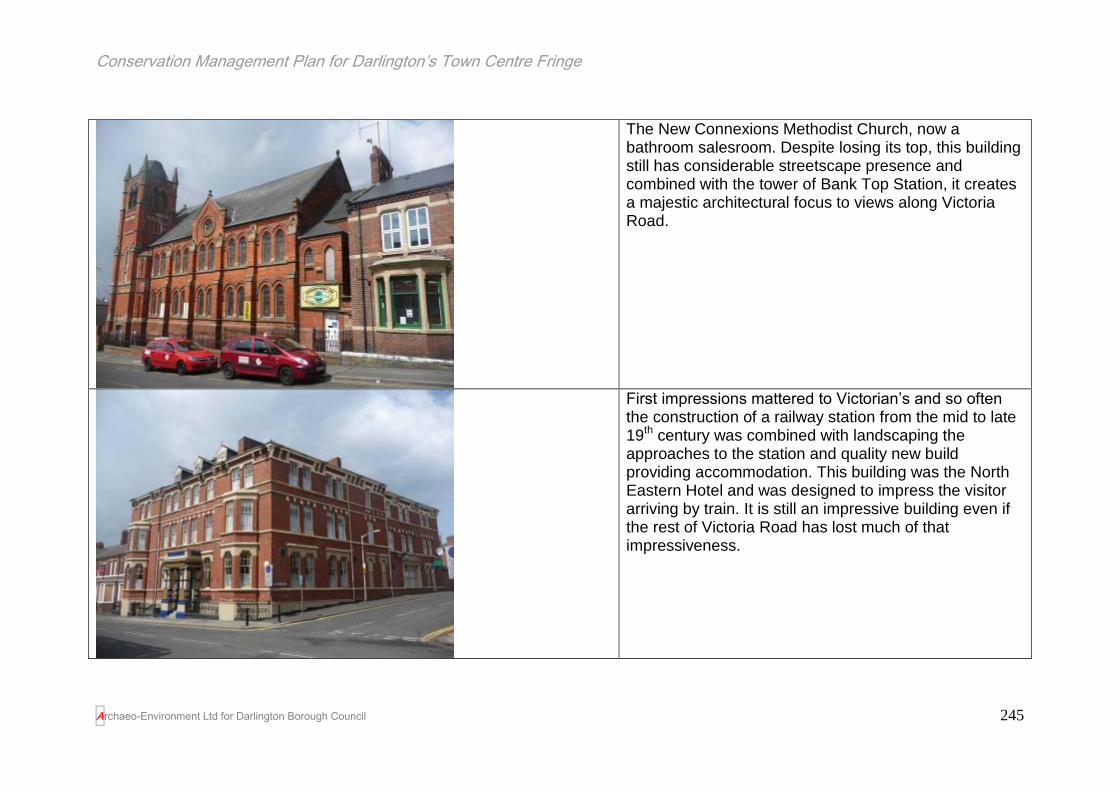
Conservation Management Plan for Darlington’s Town Centre Fringe
Archaeo-Environment Ltd for Darlington Borough Council
245
The New Connexions Methodist Church, now a bathroom salesroom. Despite losing its top, this building still has considerable streetscape presence and combined with the tower of Bank Top Station, it creates a majestic architectural focus to views along Victoria Road.
First impressions mattered to Victorian’s and so often the construction of a railway station from the mid to late 19th century was combined with landscaping the approaches to the station and quality new build providing accommodation. This building was the North Eastern Hotel and was designed to impress the visitor arriving by train. It is still an impressive building even if the rest of Victoria Road has lost much of that impressiveness.

Conservation Management Plan for Darlington’s Town Centre Fringe
Archaeo-Environment Ltd for Darlington Borough Council
246
Old street sign – there are not many left in the town centre fringe and this has a newer sign sitting alongside it. Woooler Street was named after a 19th century developer who purchased the land from Buck’s Land Charity in 1864.
Oxford Garage. Now a squat for an assortment of cats, this building was constructed in the early summer of 1869 after the land was bought by William Alexander Wooler (Wooler Street is named after him) from the Buck’s Land Charity in 1864. He sold the empty plot of land on to James Woodward the Younger on 22 January 1869. Mr Woodward built the warehouse in that summer and sold it to Joseph Morrell. One of the warehouse’s first occupiers was ‘ale and porter merchant’ Henry Burton. At that time the building had an earth floor with a stables for the horses and a forge for the smithy. IT was said that there was a hatch on the outside of the building where locals could obtain a swift jug of foaming ale in return for a few pennies. In 1924, Henry’s family sold the warehouse to Russells and Wrangham Brewery, of Malton; a brewery that had been established in 1771 and which ended up as part of Cameron’s in the 1960s. The next occupier was tettotaller Henry Walton, whose 1930’s business made gauges to sit on top of Whessoe oil tanks that were sold

Conservation Management Plan for Darlington’s Town Centre Fringe
Archaeo-Environment Ltd for Darlington Borough Council
247
around the world. His toolkit and machinery were acquired from a failed company which had acquired machinery from the States in anticipation of building cars; Walton was able to acquire this machinery at knockdown prices and moved it into his Oxford Engineering Works. The business passed to his son who died in February 2005 and the building has remained empty (cats excluded) ever since. The machinery was offered to museums but there was no interest and it was sold for scrap. ((Information from Lloyd’s Echo Memories 11.1.06). The front elevation has more recent rick in the centre suggesting that the warehouse has either had its central bay replaced, or it was two buildings, possibly keeping the stables apart from the forge in case of fire. Otherwise the external elevations are little altered and the windows are the traditional ones it was made with.

Conservation Management Plan for Darlington’s Town Centre Fringe
Archaeo-Environment Ltd for Darlington Borough Council
248
Warehouse building c1900. Presumably one of the first industrial buildings to move into the Valley Street area after the river was culverted and the roads laid out in 1900.

Conservation Management Plan for Darlington’s Town Centre Fringe
Archaeo-Environment Ltd for Darlington Borough Council
249
Faith House, High Northgate (former Clacher’s the plumbers). This has become a rather unattractive building due to alterations at ground floor level but it is of some historic interest and the alterations to the ground floor may be reversible. In 1857 John Pease gave away a plot of land to the Darlington Christian Workmen’s Mutual Improvement Society, so that it could build a reading room (Lloyd, 20028). The society called its new premises Faith House and its name and date of 1857 are carved on the window sill (north) at first floor level. Two sash windows survive at first floor level. The building belongs to a tradition of self-improvement which started with the founding of Mechanic’s Institutes and became particularly popular in the second half of the 19th century. This Victorian self-improvement was to have wider ramifications in opening up the Cambridge and Oxford Universities to a wider audience and the formal creation of adult education. The house later became the mortuary caretaker’s house when a mortuary was built to the rear (this was after an unfortunate incident involving the burning down of he North of England School Furnishing co.). The mortuary had been a single storey building with a pitched roof but was demolished in the 1970s by the gas board. The site also has the added significance of the childhood recollections of one of the caretaker’s (John Charlton Cooke) having been written, which adds historical significance to the building.
8 The Northern Echo 26.6.2002, p 6B

Conservation Management Plan for Darlington’s Town Centre Fringe
Archaeo-Environment Ltd for Darlington Borough Council
250
Rachel Coad School of Dance, Victoria Road. An attractive early 20th century building in a prominent street corner position. It has had some alterations to the ground floor, but the brown glazed tiles on the corner are especially attractive. A mix of brick with stone detailing with below eaves dentilling and kneelers. This building represents a shift away from the fussiness of the high Victorian styles towards plainer facades that were to become plainer still. Selected because of its streetscape value in an area where much has been lost through ill informed alterations.
Entrance gates into Feetham’s cricket and football ground – a 1930s (?) structure and said to be a miniature of the now lost gates of Wembley Stadium

Conservation Management Plan for Darlington’s Town Centre Fringe
Archaeo-Environment Ltd for Darlington Borough Council
251
Appendix G Definitions of value and significance
Historical Value This derives from ways in which people, events and aspects of life can be connected through a place to the present. It tends to be
illustrative or associative, for example it might be an association with an architect or illustrate through visible connections with the past
how communities used a place
Evidential Value The potential of a place to yield evidence about past human activity
Aesthetic Value This derives from ways in which people draw sensory and intellectual stimulation from a place. It can relate to the design of a place, or the patina
of age which adds to local distinctiveness and character
Communal value This derives from the meanings of a place for the people who relate to it, or for whom it figures in their collective experience or memory.
With regard to the town centre fringe of Darlington, significance is also broken down into individual elements and it is these combined which give the area its overall
significance or value as described by English Heritage. The significance rating is considered under four headings and for each specific statement made a grading is
assigned as follows.
Exceptional Significance. Aspects of the site considered as seminal to the historical, architectural, or aesthetic character or development of the site, the
unsympathetic or ill-informed alteration or loss of which would destroy or significantly compromise the integrity of place. This category may be determined by
the date, rarity, completeness, duration, setting or the representative quality of the element discussed.
Considerable Significance. Aspects that help to define the historical, architectural, or aesthetic character of the place, without which the character and
understanding of place would be diminished but not destroyed.
Conservation Management Plan for Darlington’s Town Centre Fringe
Archaeo-Environment Ltd for Darlington Borough Council
252
Some Significance. Aspects which may contribute to, or complement, the historical, architectural, ecological or aesthetic character of the place but are not
intrinsic to it, and in some circumstances may be intrusive, and the removal or alteration of which may have a degree of impact on the understanding and
interpretation of the place.
Marginal Significance. Those aspects which have only a minor connection with the historic, architectural and aesthetic character of the site and could be
considered intrusive, the removal or alteration of which could have a limited or even beneficial affect on the understanding of place.
The reader should note that significance should not be confused with importance. Many buildings have already been assessed according to national criteria
and judged to be of sufficient importance to be given status as Listed Buildings or Scheduled Ancient Monuments. The statement of significance accepts this
level of importance and seeks to identify in detail the elements which define the area’s special character and grades each element’s contribution to this.
However if buildings are identified as being worthy of designation, but which are currently not designated, or if they are considered to be worthy of inclusion
on a local list, then these are flagged up.
Copyright © 2022 FDOKUMEN