Unifying Terrain Awareness for the Visually Impaired through ...
32
Article Unifying Terrain Awareness for the Visually Impaired through Real-Time Semantic Segmentation Kailun Yang 1 , Kaiwei Wang 1, *, Luis M. Bergasa 2 ID , Eduardo Romera 2 , Weijian Hu 1 , Dongming Sun 3 , Junwei Sun 4 , Ruiqi Cheng 1 , Tianxue Chen 5 and Elena López 2 1 State Key Laboratory of Modern Optical Instrumentation, Zhejiang University, Hangzhou 310027, China; [email protected] (K.Y.); [email protected] (W.H.); [email protected] (R.C.) 2 Department of Electronics, University of Alcalá, Madrid 28805, Spain; [email protected] (L.M.B.); [email protected] (E.R.); [email protected] (E.L.) 3 Department of Computing, Imperial College London, London SW7 2AZ, UK; [email protected] 4 KR-VISION Technology Co., Ltd., Hangzhou 310023, China; [email protected] 5 Department of Electrical and Computer Engineering, University of California, Los Angeles, CA 90095, USA; [email protected] * Correspondence: [email protected]; Tel.: +86-571-8795-3154 Received: 5 April 2018; Accepted: 8 May 2018; Published: 10 May 2018 Abstract: Navigational assistance aims to help visually-impaired people to ambulate the environment safely and independently. This topic becomes challenging as it requires detecting a wide variety of scenes to provide higher level assistive awareness. Vision-based technologies with monocular detectors or depth sensors have sprung up within several years of research. These separate approaches have achieved remarkable results with relatively low processing time and have improved the mobility of impaired people to a large extent. However, running all detectors jointly increases the latency and burdens the computational resources. In this paper, we put forward seizing pixel-wise semantic segmentation to cover navigation-related perception needs in a unified way. This is critical not only for the terrain awareness regarding traversable areas, sidewalks, stairs and water hazards, but also for the avoidance of short-range obstacles, fast-approaching pedestrians and vehicles. The core of our unification proposal is a deep architecture, aimed at attaining efficient semantic understanding. We have integrated the approach in a wearable navigation system by incorporating robust depth segmentation. A comprehensive set of experiments prove the qualified accuracy over state-of-the-art methods while maintaining real-time speed. We also present a closed-loop field test involving real visually-impaired users, demonstrating the effectivity and versatility of the assistive framework. Keywords: navigation assistance; semantic segmentation; traversability awareness; obstacle avoidance; RGB-D sensor; visually-impaired people 1. Introduction In this paper, the main purpose is focused on navigation assistance for visually-impaired people in terrain awareness, a technical term that was originally coined for commercial aircraft. In aviation, a Terrain Awareness and Warning System (TAWS) is generally an on-board module aimed at preventing unintentional impacts with the ground [1]. Within a different context, precisely blind assistance, the task of terrain awareness involves traversable ground parsing and navigation-related scene understanding, which are widely desired within the visually-impaired community [2,3]. According to the World Health Organization (WHO), an estimated 253 million people live with vision impairment, 36 million of whom are totally blind [4]. Over the past decade, the striking Sensors 2018, 18, 1506; doi:10.3390/s18051506 www.mdpi.com/journal/sensors
-
Upload
khangminh22 -
Category
Documents
-
view
1 -
download
0
Transcript of Unifying Terrain Awareness for the Visually Impaired through ...

Article
Unifying Terrain Awareness for the Visually Impairedthrough Real-Time Semantic Segmentation
Kailun Yang 1, Kaiwei Wang 1,*, Luis M. Bergasa 2 ID , Eduardo Romera 2, Weijian Hu 1,Dongming Sun 3, Junwei Sun 4, Ruiqi Cheng 1, Tianxue Chen 5 and Elena López 2
1 State Key Laboratory of Modern Optical Instrumentation, Zhejiang University, Hangzhou 310027, China;[email protected] (K.Y.); [email protected] (W.H.); [email protected] (R.C.)
2 Department of Electronics, University of Alcalá, Madrid 28805, Spain; [email protected] (L.M.B.);[email protected] (E.R.); [email protected] (E.L.)
3 Department of Computing, Imperial College London, London SW7 2AZ, UK;[email protected]
4 KR-VISION Technology Co., Ltd., Hangzhou 310023, China; [email protected] Department of Electrical and Computer Engineering, University of California, Los Angeles, CA 90095, USA;
[email protected]* Correspondence: [email protected]; Tel.: +86-571-8795-3154
Received: 5 April 2018; Accepted: 8 May 2018; Published: 10 May 2018�����������������
Abstract: Navigational assistance aims to help visually-impaired people to ambulate the environmentsafely and independently. This topic becomes challenging as it requires detecting a wide varietyof scenes to provide higher level assistive awareness. Vision-based technologies with monoculardetectors or depth sensors have sprung up within several years of research. These separate approacheshave achieved remarkable results with relatively low processing time and have improved the mobilityof impaired people to a large extent. However, running all detectors jointly increases the latencyand burdens the computational resources. In this paper, we put forward seizing pixel-wise semanticsegmentation to cover navigation-related perception needs in a unified way. This is critical not onlyfor the terrain awareness regarding traversable areas, sidewalks, stairs and water hazards, but alsofor the avoidance of short-range obstacles, fast-approaching pedestrians and vehicles. The core ofour unification proposal is a deep architecture, aimed at attaining efficient semantic understanding.We have integrated the approach in a wearable navigation system by incorporating robust depthsegmentation. A comprehensive set of experiments prove the qualified accuracy over state-of-the-artmethods while maintaining real-time speed. We also present a closed-loop field test involving realvisually-impaired users, demonstrating the effectivity and versatility of the assistive framework.
Keywords: navigation assistance; semantic segmentation; traversability awareness; obstacleavoidance; RGB-D sensor; visually-impaired people
1. Introduction
In this paper, the main purpose is focused on navigation assistance for visually-impaired peoplein terrain awareness, a technical term that was originally coined for commercial aircraft. In aviation,a Terrain Awareness and Warning System (TAWS) is generally an on-board module aimed at preventingunintentional impacts with the ground [1]. Within a different context, precisely blind assistance, the taskof terrain awareness involves traversable ground parsing and navigation-related scene understanding,which are widely desired within the visually-impaired community [2,3].
According to the World Health Organization (WHO), an estimated 253 million people live withvision impairment, 36 million of whom are totally blind [4]. Over the past decade, the striking
Sensors 2018, 18, 1506; doi:10.3390/s18051506 www.mdpi.com/journal/sensors

Sensors 2018, 18, 1506 2 of 32
improvement of Computer Vision (CV) has been an enormous benefit for the Visually-Impaired(VI), allowing individuals with blindness or visual impairments to access, understand and exploresurrounding environments [3,5,6]. These trends have accelerated the proliferation of monoculardetectors and cost-effective RGB-Depth (RGB-D) sensors [5], supposing essential prerequisites to aidperception and navigation in visually-impaired individuals by leveraging robotic vision [7]. Alongthis line, a broad variety of navigational assistive technologies have been developed to accomplishspecific goals including avoiding obstacles [8–17], finding paths [18–29], locating sidewalks [30–33],ascending stairs [34–38] or descending steps [39,40] and negotiating water hazards [41].
As a matter of fact, each one of these navigational tasks has been well tackled through itsrespective solutions, and the mobility of the visually impaired has been enhanced. Along with theincreasing demand during everyday independent navigation [2,3], the assistance topic highlightschallenges in juggling multiple tasks simultaneously and coordinating all of the perception needsefficiently. In response to these observations, the research community has been motivated to offermore independence by integrating different detectors at the basis of traversability perception, which isconsidered as the backbone of any VI-dedicated navigational assistive tool [26].
However, a majority of processing pursues a sequential pipeline instead of a unified way,separately detecting different navigation-related scene elements. Thereby, it is computationallyintensive to run multiple detectors together, and the processing latency makes it infeasible withinthe blind assistance context. For illustration, one of the pioneering works [23,35,38] performed twomain tasks for its personal guidance system. It approximately runs the full floor segmentation at0.3 Frames Per Second (FPS) with additional stair detection iteration time ranging from 50–150 ms [35].In spite of being precise in staircase modeling, this approach depends on further optimization toprovide assistance at normal walking speed. A more recent example could be the sound of visionsystem [16,17,29], which aims to support impaired people to autonomously navigate in complexenvironments. While their fusion-based imaging was visually appealing, a long latency was incurredwhen identifying the elements of interest such as ground, walls and stairs. It takes more than 300 msto compute stereo correspondences and detect negative obstacles [17], let alone other processingcomponents that make it non-ideal for real-time assistance on embedded platforms. This systemshould be enhanced by avoiding significant delays in its main processing pipeline. Towards thisobjective, multi-threading is an effective way to reduce latency while sharing computational burdenbetween cores. The commercial version of smart glasses from KR-VISION [42] has shown satisfactoryperformance for the detection of obstacles and hazardous curbs across different processing threads.It continuously receives images from the sensors and multi-tasks at different frame rates. Alternatively,a unified feedback design was proposed to complement the discrete detection of traversable areas andwater puddles within a polarized RGB-Depth (pRGB-D) framework [41]. However, the user studyrevealed a higher demand for discerning terrain information.
In the literature, a number of systems [43–46] rely on sensor fusion to understand more of thesurrounding scenes. Along this line, proof-of-concepts were also investigated in [47–50] to use highlyintegrated radars to warn against collisions with pedestrians and cars, taking into considerationthat fast-moving objects are response-time critical. Arguably, for navigation assistance, an evengreater concern lies in the depth data from almost all commercial 3D sensors, which suffer froma limited depth range and could not maintain the robustness across various environments [22,26,29,37].Inevitably, approaches based on a stereo camera or light-coding RGB-D sensor generally performrange expansion [13,14], depth enhancement [22] or depend on both visual and depth informationto complement each other [23]. Not to mention the time consumption in these steps, underlyingassumptions were frequently made such as: the ground plane is the biggest area [9,10]; the areadirectly in front of the user is accessible [18,19]; and variant versions of flat world [24,36], Manhattanworld [23,27,35,38] or stixel world assumptions [15,25,41]. These factors all limit the flexibility andapplicability of navigational assistive technologies.

Sensors 2018, 18, 1506 3 of 32
Nowadays, unlike the traditional approaches mentioned above, Convolutional Neural Networks(CNNs) learn and discriminate between different features directly from the input data usinga deeper abstraction of representation layers [51]. More precisely, recent advances in deep learninghave achieved break-through results in most vision-based tasks including object classification [52],object detection [53], semantic segmentation [54] and instance segmentation [55]. Semanticsegmentation, as one of the challenging tasks, aims to partition an image into several coherentsemantically-meaningful parts. As depicted in Figure 1, because traditional approaches detect differenttargets independently [56], assistive feedback to the users are generated separately. Intuitively, it isbeneficial to cover the tasks of the perception module of a VI-dedicated navigational assistive system ina unified manner, because it allows solving many problems at once and exploiting their inter-relationsand spatial-relationships (contexts), creating reasonably favorable conditions for unified feedbackdesign. Semantic segmentation is meant to fulfill exactly this purpose. It classifies a wide spectrumof scene classes directly, leading to pixel-wise understanding, which supposes a very rich sourceof processed information for upper-level navigational assistance in visually-impaired individuals.Additionally, the incessant increase of large-scale scene parsing datasets [57–59] and affordablecomputational resources has also contributed to the momentum of CNN-based semantic segmentationin its growth as the key enabler, to cover navigation-related perception tasks [56].
Figure 1. Two approaches of perception in navigational assistance for the visually impaired. A differentexample image is used for water hazards’ detection, but these images are all captured in real-worldscenarios and segmented with the proposed approach.
Based on these notions, we propose to seize pixel-wise semantic segmentation to provide terrainawareness in a unified way. Up until very recently, pixel-wise semantic segmentation was notusable in terms of speed. To respond to the surge in demand, efficient semantic segmentation hasbeen a heavily researched topic over the past two years, spanning a diverse range of applicationdomains with the emergence of architectures that could reach near real-time segmentation [60–68].These advances have made possible the utilization of full scene segmentation in time-critical cases likeblind assistance. However, to the best of our knowledge, approaches that have customized real-timesemantic segmentation to assist visually-impaired pedestrians are scarce in the state of the art. In thisregard, our unified framework is a pioneering attempt going much further than simply identifyingthe most traversable direction [28,41], and it is different from those efforts made to aid navigation

Sensors 2018, 18, 1506 4 of 32
in prosthetic vision [27,69,70] because our approach can be used and accessed by both blind andpartially-sighted individuals.
We have already presented some preliminary studies related to our approaches [22,41]. This paperconsiderably extends previously-established proofs-of-concept by including novel contributions andresults that reside in the following main aspects:
• A unification of terrain awareness regarding traversable areas, obstacles, sidewalks, stairs,water hazards, pedestrians and vehicles.
• A real-time semantic segmentation network to learn both global scene contexts and localtextures without imposing any assumptions, while reaching higher performance thantraditional approaches.
• A real-world navigational assistance framework on a wearable prototype for visually-impairedindividuals.
• A comprehensive set of experiments on a large-scale public dataset, as well as an egocentricdataset captured with the assistive prototype. The real-world egocentric dataset can be accessedat [71].
• A closed-loop field test involving real visually-impaired users, which validates the effectivity andthe versatility of our solution, as well as giving insightful hints about how to reach higher levelsafety and offer more independence to the users.
The remainder of this paper is structured as follows. Section 2 reviews related work thathas addressed both traversability-related terrain awareness and real-time semantic segmentation.In Section 3, the framework is elaborated in terms of the wearable navigation assistance system,the semantic segmentation architecture and the implementation details. In Section 4, the approachis evaluated and discussed regarding real-time/real-world performance by comparing to traditionalalgorithms and state-of-the-art networks. In Section 5, a closed-loop field test is fully described withthe aim to validate the effectivity and versatility of our approach. Section 6 draws the conclusions andgives an outlook to future work.
2. Related Work
In this section, we review the relevant literature on traversability/terrain awareness and pixel-wisesemantic segmentation for the visually impaired.
2.1. Traversability Awareness
The study of the traversable part of a surface is usually referred to as traversability [22,41], whichhas gained huge interest within the research community of blind assistance. Among the literature,a large part of the proposals detected traversability with a commercial stereo camera. As one of themost representative, RANdom SAmpling Consensus (RANSAC) [72] is adapted to model the groundplane. A. Rodríguez et al. [9,10] estimated the ground plane based on RANSAC and filtering techniquesby using the dense disparity map. Multiple variations of the RANSAC approach were reported later,each trying to improve the classic approach [12,22]. Furthermore, ground geometry assessment [29]and surface discontinuity negotiation [73] were addressed, taking into account that real-world groundareas are not always planar surfaces [74] and the wearable camera lenses share a distortion given thewide field of view. Inspired exactly by this observation, the stixel world [75] marked a significantmilestone for flexibly representing traffic environments including the free road space, as well asstatic/moving obstacles. In this line, possibilities were explored to leverage the stixel-based techniquesfor autonomous vehicles and transfer them into assistive technology for the visually impaired [15,25,41].To overcome the limitation of incompatible assumptions across application domains, [25] followedthe Manhattan world stereo method [76] to obtain ground-to-image transformation; [15] clustered thenormal vectors in the lower half of the field of view; while [41] integrated Inertial Measurement Unit(IMU) observations along with vision inputs in a straightforward way.

Sensors 2018, 18, 1506 5 of 32
Another cluster of classic methods involves light-coding sensors, which are able to deliverdense depth information in indoor environments. R. Cheng et al. [20] detected ground and obstaclesbased on the algorithm of seeded growth within depth images. However, as the depth range of thelight-coding sensor is limited, namely 0.8–4 m without direct sunshine, speckle-based approachesare just proof-of-concepts or only feasible in indoor environments. Since close-range depth imagingis desirable for safety-critical obstacle avoidance, heuristic approaches were developed to decreasethe minimum range of the light-coding sensor in [13,14] by combining active speckle projecting withpassive Infrared (IR) stereo matching. As far as longer traversability is regarded, A. Aladren et al. [23]robustly expanded range-based indoor floor segmentation with image intensities, pursuing a complexpipeline, which fails to provide real-time assistance. With the same concern on scene interpretation inthe distance, a dual-field sensing scheme [21] was proposed by integrating a laser scanner and a camera.It interpreted far-field image data based on the appearance and spatial cues, which were modeledusing the near-field interpreted data. In our previous work [22], large-scale IR stereo matching [14,77]and RGB guided filtering [78] were incorporated to enhance the multi-modal RGB-Infrared-Depth(RGB-IR-D) sensory awareness. It achieves superior detection results of the traversable area, whichcovers a broader field of view and a longer navigable depth range. However, what remains practicallyunexplored is the unified awareness of not only traversable areas, but also other navigation-relatedterrain classes such as stairs and water hazards.
2.2. Terrain Awareness
Motivated by the enhanced mobility and higher level demand of visually-impaired people,the research community has begun to integrate different terrain detectors beyond traversabilityawareness. In this line, the upper-level knowledge is offered by perception frameworks of stairsand curbs, which represent hazardous situations in everyday indoor and outdoor environments.T. Schwarze and Z. Zhong [36] propagated the valid ground plane measurements and trackedthe stairs with a helmet-mounted egocentric stereo camera. J.J. Guerrero et al. [35,38] createda chest-mounted personal guidance system to detect ground areas and parametrize stairs in a sequentialway. For descending steps’ classification, C. Stahlschmidt et al. [39] simplified the ground planedetection and considered depth jumps as the main characteristics by using the point cloud froma Time-of-Flight (ToF) sensor.
Intersection navigation is also one of the major ingredients of independent living. M. Poggi et al. [79]projected the point cloud from a top-view perspective thanks to the robust RANSAC-based groundsegmentation and detected crosswalks by leveraging 3D data provided by a customized RGB-Dcamera and a Convolutional Neural Network (CNN). Taking steps further than the seeded growingground/obstacle perception [20], R. Cheng et al. [80,81] proposed the real-time zebra crosswalk andcrossing light detection algorithms to assist vulnerable visually-impaired pedestrians, which exhibitedhigh robustness at challenging metropolitan intersections. In a previous work [41], we addressed waterpuddles’ detection beyond traversability with a pRGB-D sensor and generated stereo sound feedbackto guide the visually-impaired to follow the prioritized direction for hazard avoidance. In spite ofthe impressive strides towards higher mobility of visually-impaired people, the detection of differentterrain classes pursues a sequential manner instead of a unified way. As a consequence, it is notcomputationally efficient to run different detectors together, and the processing latency is deemedinfeasible for time-critical blind assistance.
2.3. Semantic Segmentation for the Visually Impaired
Pixel-wise semantic segmentation has emerged as an extremely powerful approach to detect andidentify multiple classes of scenes/objects simultaneously. However, the research topic of designingpixel-wise semantic segmentation to assist the visually impaired has not been widely investigated.A team of researchers proposed the semantic paintbrush [82], which is an augmented reality systembased on a purely passive RGB-Infrared (RGB-IR) stereo setup, along with a laser pointer allowing

Sensors 2018, 18, 1506 6 of 32
the user to draw directly onto its 3D reconstruction. Unlike typical assistive systems, it places theuser “in the loop” to exhaustively segment semantics of interest. L. Horne et al. [69,70] presenteda computer system to aid in obstacle avoidance and distant object localization by using semanticlabeling techniques. Although related, the produced stimulation pattern can be thought of as a lowresolution, low dynamic range, distorted image, which is insufficient for our task. With similarpurposes for prosthetic vision, A. Perez-Yus et al. [27] adopted a head-mounted RGB-D camera todetect free space, obstacles and scene direction in front of the user.
The Fully-Convolutional Network (FCN) [54], as the pioneering architecture for semanticsegmentation, has been leveraged to detect the navigational path in [26], inherently alleviating theneed for hand-crafting specific features, as well as providing a reliable generalization capability.A different piece of related work [28] has been recently presented to identify the most walkabledirection for outdoor navigation, while semantic segmentation constitutes an intermediate step,followed by a spatial-temporal graph for decision making. It achieved decent accuracy for predictinga safe direction, namely 84% at a predetermined safety radius of 100 pixels. While inspiring, this workfocused on the tracking of a safe-to-follow object by providing only sparse bounding-box semanticpredictions and hence cannot be directly used for upper-level reasoning tasks. Similar bounding-boxinterpretation was addressed when ultrasonic sensors and computer vision joined forces [44] bysemantically assigning a relative degree of danger, which is limited to only four categories of detectedobstructions. Although sporadic efforts have been made along this line, these approaches are unableto run in real time, which is a critical issue for blind assistance. Additionally, they did not provideunified terrain awareness nor demonstrate closed-loop field navigation. Considering these reasons,this task represents a challenging and so far largely unexplored research topic.
2.4. Real-Time Pixel-Wise Semantic Segmentation
Semantic segmentation has been fueled by the recently emerging deep learning pipelines andarchitectures. Among the literature, a vital part of networks is predominantly based on FCNs [54],which were proposed to adapt CNNs, initially designed for classification, to produce pixel-wiseclassification outputs by making them fully convolutional. SegNet [60] is known as anotherrevolutionary deep CNN architecture with a topologically symmetrical encoder-decoder design.Instead of storing all feature maps, SegNet uses max-pooling indexes obtained from the encoder toup-sample the corresponding feature maps for the decoder, which dramatically reduces the memoryand computational cost. ENet [61] was proposed as an efficient alternative to enable the implementationof semantic segmentation in real time. Adopting views from ResNet [83], ENet was constructed withmultiple bottleneck modules, which can be used for either down-sampling or up-sampling images.Unlike SegNet’s symmetric architecture, ENet has a larger encoder than its decoder as it is believedthat the initial network layers should not directly contribute to classification. Instead, the encodershould rather act as good feature extractors and only pre-process the input for later portions of thenetwork, while the decoder is only required to fine-tune the details. This simplified structure allowsENet to perform fast semantic segmentation. However, ENet sacrifices a good deal of accuracy earnedby more complex architectures in order to remain efficient.
In our previous work, we proposed ERFNet [64,65], which aimed at maximizing the trade-offbetween accuracy/efficiency and making CNN-based segmentation suitable for applications on currentembedded hardware platforms. With a similar purpose, SQNet [63] used parallel dilated convolutionsand fused them as an element-wise sum to combine low-level knowledge from lower layers of theencoder, which helped with classifying the contours of objects more exactly. LinkNet [67] made anattempt to get accurate instance-level prediction without compromising processing time by linkingthe encoder and the corresponding decoder. These architectures have surpassed ENet in terms ofpixel-exact classification of small features. For large-scale scene parsing tasks, PSPNet [84] wasproposed to use a decoder with max-pooling layers with diverse widths in order to gather diverselevels of context in the last layers. However, PSPNet requires excessively large processing time,

Sensors 2018, 18, 1506 7 of 32
namely more than one second to predict a 2048 × 1024 high-solution image on one Nvidia TitanXGPU card. ICNet [66] proposed a compressed-PSPNet-based image cascade network that incorporatesmulti-resolution branches under proper label guidance. Although these networks claimed to yieldnear real-time inference, most of them are designed for autonomous vehicles [63–65], biomedicalimage segmentation [62] or human body part segmentation [68]. None of the current real-timesegmentation approaches have been tailored for blind assistance, which is a time-critical, context-criticaland safety-critical topic. In addition, architectures in the state-of-the-art have not been thoroughlytested in the real world. Based on this notion, we aim to customize real-time semantic segmentationto aid navigation in visually-impaired individuals and offer an in-depth evaluation, focusing on aquantitative analysis of real-world performance, followed by qualitative results, as well as discussions.
3. Approach
In this section, our approach to unify the navigation-related terrain awareness is described indetail. As shown in Figure 2, our approach is outlined in terms of the wearable navigation assistancesystem, which incorporates the robust depth segmentation and the real-time semantic segmentation.
Figure 2. Overview of the navigation assistance system.
3.1. Wearable Navigation Assistance System
3.1.1. System Overview
In this framework, the main motivation is to design a prototype that should be wearable withouthurting the self-esteem of visually-impaired people. With this target in mind, we follow the trendof using head-mounted glasses [22,36,41,46] to acquire environment information and interact withvisually-impaired people. As worn by the user in Figure 2, the system is composed of a pair of smartglasses and a portable processor, which can be easily carried, and it is robust enough to operate inrough terrain. The pair of smart glasses, named Intoer, has been made available at [42]. Intoer iscomprised of a RGB-D sensor, RealSense R200 [85], and a set of bone-conducting earphones [86].
3.1.2. RGB-D Perception
Illustrated in Figure 3, this pair of smart glasses is quite suitable for navigational assistance dueto its small size and light weight, as well as the environmental adaptability. Precisely, it is able toperform large-scale RGB-IR-D perception in both indoor and outdoor environments owing to theactive stereo design [87]. It leverages a combination of active speckle projecting and passive stereomatching. An IR laser projector projects static non-visible near-IR patterns on the scene, which arethen acquired by the left and right IR cameras. The image processor generates a depth map throughthe embedded stereo matching algorithm. For texture-less indoor environments, the projected patternsenrich textures. As shown in the indoor scenario in Figure 3, the texture-less black shirt hanging onthe chair has been projected with plentiful near-IR patterns, which are beneficial for stereo matching togenerate dense depth information. In sunny outdoor environments, shown in the outdoor scenariosin Figure 3 (see the shadow of the user on the ground), although projected patterns are submergedby sunlight, the near-IR components of sunlight shine on the scene to form well-textured IR images.

Sensors 2018, 18, 1506 8 of 32
With the contribution of abundant textures to robust stereo matching, the combination allows thesmart glasses to work under both indoor and outdoor circumstances.
Figure 3. RGB-D perception of the smart glasses in indoor and outdoor environments.
It is important to remark that although the pair of smart glasses enables indoor/outdoor RGB-Dperception, there exist various noise sources, mismatched pixels and black holes in the depth images,as displayed in Figure 4b. According to the technique overview [85], the original depth pointsgenerated by the hardware correlation engines are high-quality photometric matches between theleft-right stereo image pairs. This allows the embedded algorithm to scale well to noisy infrared imagesacross indoor/outdoor scenarios, delivering accurate, but sparse depth information. For this reason,a large portion of pixels remain mismatched with relatively lower correlation confidence, causing manyholes in the original depth image. However, in this paper, the depth image is used for robust obstacleavoidance at the basis of navigation-related terrain segmentation of CNNs. To this end, a densedepth image is preferred to assist the visually impaired so as not to leave out potential obstacles,based on the knowledge that the stereo sensor generally requires a good trade-off between densityand accuracy. Following the rationale, unlike our previous work, which performed time-consumingguided hole-filing [22], we use a simple, yet effective way to deal with the noises and pre-process thedepth image.
(a) (b) (c) (d) (e)
Figure 4. (a,b) Original RGB-D perception, depth images are sparse with many mismatched pixels;(c,d) RGB-D perception with a dense preset configuration; (e) depth images with noise reduction.
1. We enable a stream of a 640 × 480 RGB image, a stream of a 320 × 240 IR stereo pair with globalshutter, which produces a high-speed stream of a 320 × 240 depth image. Depth information isprojected to the RGB image so as to acquire a synchronized 640 × 480 depth stream.
2. To achieve high environmental adaptability, the automatic exposure and gain control of the IRstereo pair are enabled, while the power of the IR projector is fixed.
Sensors 2018, 18, 1506 9 of 32
3. To enforce the embedded stereo matching algorithm to deliver dense maps, we use a differentpreset configuration with respect to the original depth image of RealSense (see Figure 4b),by controlling how aggressive the algorithm is at discarding matched pixels. Precisely, most of thedepth control thresholds are at the loosest setting, while only the left-right consistency constraintis adjusted to 30 from the range [0, 2047].
4. As shown in Figures 2 and 4d,e, the depth images are de-noised by eliminating small segments.Depth noises can be denoted as outliers in disparity images due to low texture, reflections,noise, etc. [88]. These outliers usually show up as small patches of disparity that is very differentfrom the surrounding disparities. To identify these outliers, the disparity image is segmentedby allowing neighboring disparities within one segment to vary by one pixel, considering afour-connected image grid. The disparities of all segments below a certain size are set to invalid.Following [77], we remove small segments with an area smaller than 200 pixels.
The dense depth image with noise reduction leads to robust segmentation of short-range obstacleswhen using the semantic segmentation output as the base for upper-level assistance. For illustrativepurposes, in Figures 1 and 2, 5 m is set as the threshold to segment directly at the pixel level if notclassified as navigation-related classes including traversable area, stair, water, pedestrian or vehicle.
3.1.3. Feedback Device
As far as the feedback is concerned, the bone conduction headphones transfer the detection resultsto the visually impaired for both terrain awareness and collision avoidance. This is important asvisually-impaired people need to continue hearing environmental sounds, and the bone conductinginterface allows them to hear a layer of augmented acoustic reality that is superimposed on theenvironmental sounds. The detailed acoustic feedback design will be introduced in Section 5.2.
3.2. Real-Time Semantic Segmentation Architecture
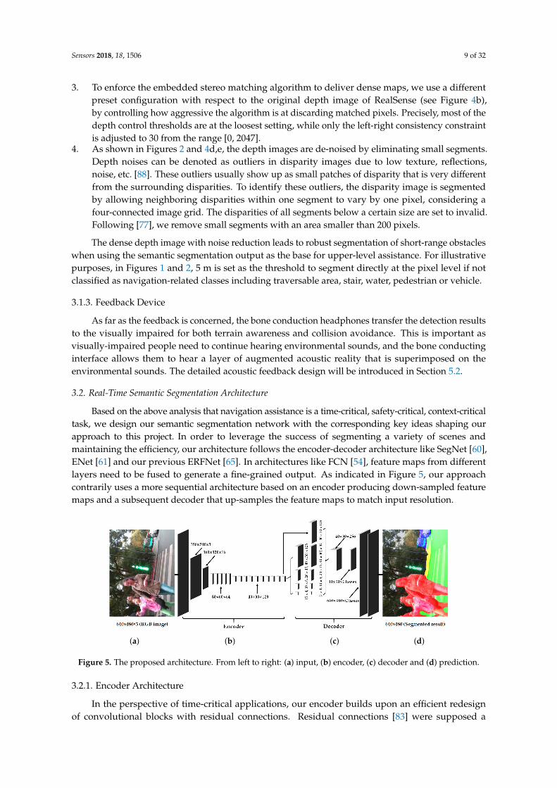
Based on the above analysis that navigation assistance is a time-critical, safety-critical, context-criticaltask, we design our semantic segmentation network with the corresponding key ideas shaping ourapproach to this project. In order to leverage the success of segmenting a variety of scenes andmaintaining the efficiency, our architecture follows the encoder-decoder architecture like SegNet [60],ENet [61] and our previous ERFNet [65]. In architectures like FCN [54], feature maps from differentlayers need to be fused to generate a fine-grained output. As indicated in Figure 5, our approachcontrarily uses a more sequential architecture based on an encoder producing down-sampled featuremaps and a subsequent decoder that up-samples the feature maps to match input resolution.
(a) (b) (c) (d)
Figure 5. The proposed architecture. From left to right: (a) input, (b) encoder, (c) decoder and (d) prediction.
3.2.1. Encoder Architecture
In the perspective of time-critical applications, our encoder builds upon an efficient redesignof convolutional blocks with residual connections. Residual connections [83] were supposed a

Sensors 2018, 18, 1506 10 of 32
breakthrough because the degradation problem could be avoided, which is present in architectureswith a large amount of stacked layers. Residual layers have the property of allowing convolutionlayers to approximate residual functions. Formally, the output y of a layer vector input x becomes:
y = F(x, Wi) + Wsx (1)
where Ws is usually an identity mapping and F(x, Wi) represents the residual mapping to be learned.This residual formulation facilitates learning and significantly reduces the degradation problem presentin architectures that stack a large amount of layers [83]. The original work proposes two instances of thisresidual layer: the non-bottleneck design with two 3 × 3 convolutions as depicted in Figure 6a, or thebottleneck version as depicted in Figure 6b. Both versions have a similar number of parameters andenabled almost equivalent accuracy. However, the bottleneck requires less computational resources,and these scale in a more economical way as depth increases. For this reason, the bottleneck designhas been commonly adopted in state-of-the-art networks [61,83]. However, it has been reportedthat non-bottleneck ResNets gain more accuracy from increased depth than the bottleneck versions,which indicates that they are not entirely equivalent, and the bottleneck design still suffers from thedegradation problem [83,89].
(a) (b) (c) (d)
Figure 6. Depiction of the residual layers and the down-sampler block: (a) non-bottleneck, (b) bottleneck,(c) the proposed non-bottleneck-1D and (d) down-sampler block. w: width of the convolution,representing the number of feature maps, s: stride.
It is worthwhile to review the redesign of the non-bottleneck residual module in our previouswork [64]. As demonstrated in [90], any 2D filter can be represented by a combination of 1D filters inthe following way. Let W ∈ RC×dh×dv×F denote the weights of a typical 2D convolutional layer, whereC is the number of input planes, F is the number of output planes (feature maps) and dh× dv representsthe kernel size of each feature map (typically dh ≡ dv ≡ d). Let b ∈ RF be the vector representing thebias term for each filter and fi∈ Rdh×dv
represent the i-th kernel in the layer. Common approachesfirst learn these filters from data and then find low-rank approximations as a post-processing step [91].However, this approach requires additional fine tuning, and the resulting filters may not be separable.Instead, ref. [92] demonstrates that it is possible to relax the rank-1 constraint and essentially rewrite fi
as a linear combination of 1D filters:
fi =K
∑k=1
σik v̄i
k(h̄ik)
T (2)
where v̄ik and (h̄i
k)T are vectors of length d, σi
k is a scalar weight and K is the rank of fi. Based onthis representation, J. Alvarez and L. Petersson [90] proposed that each convolutional layer can bedecomposed with 1D filters, which can additionally include a non-linearity ϕ(·) in between. In thisway, the i-th output of a decomposed layer a1
i can be expressed as a function of its input a0∗ according
to the following manner:

Sensors 2018, 18, 1506 11 of 32
a1i = ϕ
(bh
i +L
∑l=1
h̄Til ∗[
ϕ(
bvl +
C
∑c=1
v̄lc ∗ a0c
)])(3)
where L represents the number of filters in the intermediate layer and ϕ(·) can be implemented withactivation functions ReLU [52] or PReLU [93]. The resulting decomposed layers have intrinsically lowcomputational cost and simplicity. Additionally, the 1D combinations improve the compactness ofthe model by minimizing redundancies (as the filters are shared within each 2D combinations) andtheoretically improve the learning capacity by inserting a non-linearity between the 1D filters [90].
Considering an equal kernel size d for simplicity, it is trivial to see that the decomposition reducesW2D ∈ RC×d×d×F of any 2D convolution into a pair of W1D ∈ RC×d×F, resulting in the equivalentdimensions of each 1D pair in dim = 2 × (C × d × F). For this reason, this factorization can beleveraged to reduce the 3× 3 convolutions on the original residual modules. While larger filters wouldbe benefited by this decomposition, applying it on 3 × 3 convolutions already yields a 33% reductionin parameters and further increases its computational efficiency.
By leveraging this decomposition, “Non-bottleneck-1D” (Non-bt-1D) was proposed in previouswork [64,65], as depicted in Figure 6c. It is a redesign of the residual layer to strike a rational balancebetween the efficiency of the bottleneck and the learning capacity of non-bottleneck, by using 1Dfactorizations of the convolutional kernels. Therefore, it enables an efficient use of a minimized amountof residual layers to extract feature maps and achieve semantic segmentation in real time.
In addition, our down-sampler block (Figure 6d) inspired by the initial block of ENet [61] performsdown-sampling by concatenating the parallel outputs of a single 3 × 3 convolution with stride 2 and amax-pooling module. It is true that down-sampling has the drawback of resulting in coarser outputs,but it also has two benefits: it enables the deeper layers to gather more context, leading to betterclassification, and it helps to reduce computation, as well as allowing for more complex layers in thedecoder. Still, we argue that for the visually impaired, contextual information is more important thanpixel-exact small features. In this regard, we perform three down-samplings to maintain a judicioustrade-off between learning textures and extracting contextual information. Table 1 gives a detaileddescription of the integral architecture, where the redesigned residual layers are stacked in the encoderafter corresponding down-samplers with different dilation rates.
Table 1. Layer disposal of our proposed network. “Out-F”: Number of Feature maps at the layer’sOutput, “Out-Res”: Output Resolution for input size of 640 × 480 RGB images from the smart glasses,“C”: number of semantic prediction Classes. Encoder: Layers 1–16, decoder: Layers 17–19.
Layer Type Out-F Out-Res
0 Scaling 640 × 480 3 320 × 240
1 Down-sampler block 16 160 × 120
2 Down-sampler block 64 80 × 603–7 5 × Non-bt-1D 64 80 × 60
8 Down-sampler block 128 40 × 309 Non-bt-1D (dilated 2) 128 40 × 30
10 Non-bt-1D (dilated 4) 128 40 × 3011 Non-bt-1D (dilated 8) 128 40 × 3012 Non-bt-1D (dilated 16) 128 40 × 3013 Non-bt-1D (dilated 2) 128 40 × 3014 Non-bt-1D (dilated 4) 128 40 × 3015 Non-bt-1D (dilated 8) 128 40 × 3016 Non-bt-1D (dilated 2) 128 40 × 30
17a Original feature map 128 40 × 3017b Pooling and convolution 32 40 × 3017c Pooling and convolution 32 20 × 1517d Pooling and convolution 32 10 × 817e Pooling and convolution 32 5 × 417 Up-sampler and concatenation 256 40 × 30
18 Convolution C 40 × 30
19 Up-sampler C 640 × 480
Sensors 2018, 18, 1506 12 of 32
3.2.2. Decoder Architecture
For the terrain awareness in intelligent assistance, we propose to attach a different decoder withrespect to the previous work. This key modification aims to collect more contextual information whileminimizing the sacrifice of learning textures. Global context information is of cardinal significationfor terrain awareness in order to prevent the feedback of confusing semantics. To detail this, severalcommon issues are worthwhile to mention for context-critical blind assistance:
• The context relationship is universal and important especially for complex scene understanding.If the network mispredicts descending stairs in front of a lake, the visually impaired would beleft vulnerable in dynamic environments. The common knowledge should be learned by thedata-driven approach that stairs are seldom over a lake.
• There are many class label pairs that are texture-confusing in classification such assidewalk/pavement versus roadways. For visually-impaired people, it is desired to identifythe traversable areas that are sidewalks beyond the detection of “walkable” ground planes.Following this rationale, such distinctions should be made consistently.
• Scene targets such as pedestrians and vehicles have arbitrary sizes from the sensor perspective.For close-range obstacle avoidance and long-range warning of the fast-approaching objects,a navigation assistance system should pay much attention to different sub-regions that containinconspicuous-category stuff.
These risks could be mitigated by exploiting more context and learning more relationshipsbetween categories. With this target in mind, we reconstruct the decoder architecture. In thisreconstruction, the decoder architecture follows the pyramid pooling module as introduced byPSPNet [84]. This module is applied to harvest different sub-region representations, followed byup-sampling and concatenation layers to form the final feature representation. As a result, it carriesboth local and global contextual information from the pooled representations at different locations.Since it fuses features under a group of different pyramid levels, the output of different levels in thispyramid pooling module contains the feature map from the encoder with varied sizes. To maintainthe weight of global features, we utilize a convolution layer after each pyramid level to reduce thedimension of context representation to 1/N of the original one if the level size of the pyramid is N.As for the situation in Figure 5c, the level size N equals four, and we decrease the number of featuremaps from 128–32. Subsequently, the low-dimension feature maps are directly up-sampled to obtainthe same size features as the original feature map through bilinear interpolation. Figure 6 contains adepiction of the feature maps generated by each of the blocks in our architecture, from the RGB inputto the pixel-level class probabilities and final prediction.
3.3. Implementation Details
3.3.1. Dataset
In our work, the challenging ADE20K dataset [57] is chosen as it covers both both indoor andoutdoor scenarios. Furthermore, this dataset contains traversability-related classes and many scenesthat are very important for navigation assistance such as stairs and water areas. To enrich the trainingdataset, we add some of the images that have the classes of sky, floor, road, grass, sidewalk, ground,water and stairs from the PASCAL-Context dataset [58] and the COCO-Stuff 10K dataset [59]. Hence,the training involves 37,075 images, within which 20,210 images are from ADE20K, 8733 images fromPASCAL-Context and the remaining 8132 images from COCO-Stuff. In addition, we have 2000 imagesfrom ADE20K for validation. To provide awareness regarding the scenes that visually-impaired peoplecare the most about during navigation, we only use the most frequent 22 classes of scenes or objectsfor training. Additionally, we merge the water, sea, river, pool and lake into a class of water hazards.In a similar way, the stairs, stairway and staircase are merged into a class of stairs. In total, the traininginvolves 24 classes: water areas, stairs and 22 frequent scene elements.
Sensors 2018, 18, 1506 13 of 32
3.3.2. Data Augmentation
To robustify the model against the various types of images from the real world, we perform a groupof data augmentations. Firstly, horizontally flipping with a 50% chance, random cropping and randomscaling are jointly used to resize the cropped regions into 320 × 240 input images. Secondly, a randomrotation is implemented without cropping by sampling distributions from the range [−20◦, 20◦].This intuition comes from the fact that during navigation, the orientation of the smart glasses wouldbe constantly changing and the images would rotate. This is also beneficial to eliminate the needs ofpreviously-used IMU-based processing [22,43] that requires reasonable synchronization between IMUobservations and vision inputs, which partially hinders real-time feedback. Thirdly, color jitteringin terms of brightness, saturation, contrast and hue is applied. Jittering factors regarding brightness,saturation and contrast here are chosen uniformly from the range [0.8, 1.2]. Hue augmentation isperformed by adding a value from the range [−0.2, 0.2] to the hue value channel of the Hue SaturationValue (HSV) representation.
3.3.3. Training Setup
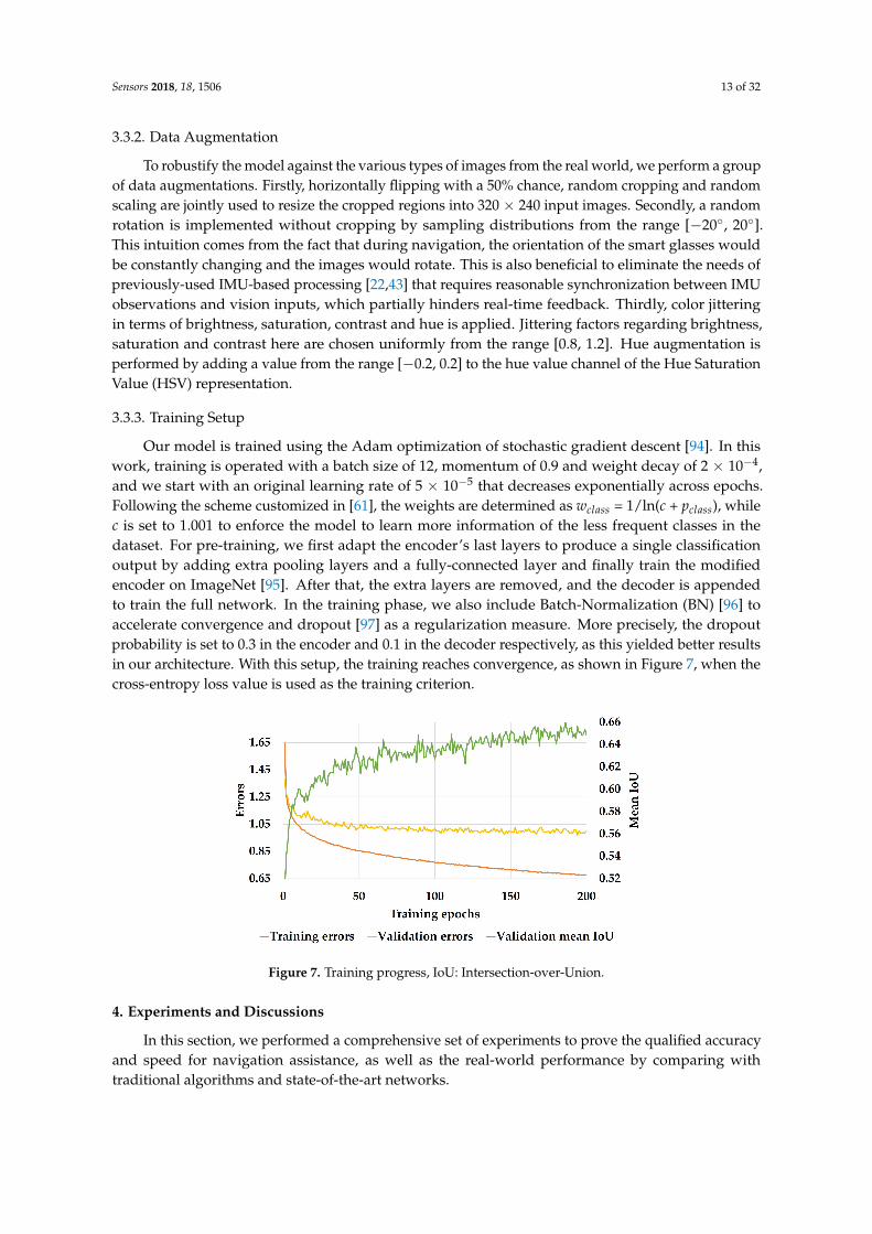
Our model is trained using the Adam optimization of stochastic gradient descent [94]. In thiswork, training is operated with a batch size of 12, momentum of 0.9 and weight decay of 2 × 10⁻⁴,and we start with an original learning rate of 5 × 10⁻⁵ that decreases exponentially across epochs.Following the scheme customized in [61], the weights are determined as wclass = 1/ln(c + pclass), whilec is set to 1.001 to enforce the model to learn more information of the less frequent classes in thedataset. For pre-training, we first adapt the encoder’s last layers to produce a single classificationoutput by adding extra pooling layers and a fully-connected layer and finally train the modifiedencoder on ImageNet [95]. After that, the extra layers are removed, and the decoder is appendedto train the full network. In the training phase, we also include Batch-Normalization (BN) [96] toaccelerate convergence and dropout [97] as a regularization measure. More precisely, the dropoutprobability is set to 0.3 in the encoder and 0.1 in the decoder respectively, as this yielded better resultsin our architecture. With this setup, the training reaches convergence, as shown in Figure 7, when thecross-entropy loss value is used as the training criterion.
Figure 7. Training progress, IoU: Intersection-over-Union.
4. Experiments and Discussions
In this section, we performed a comprehensive set of experiments to prove the qualified accuracyand speed for navigation assistance, as well as the real-world performance by comparing withtraditional algorithms and state-of-the-art networks.
Sensors 2018, 18, 1506 14 of 32
4.1. Experiment Setup
The experiments were performed with the wearable navigation systems in public spaces aroundWestlake, the Zijingang Campus and the Yuquan Campus at Zhejiang University in Hangzhou andthe Polytechnic School at University of Alcalá in Madrid, as well as Venice Beach and University ofCalifornia in Los Angeles. When navigating in different scenarios, we captured real-world images whilekeeping moving by using our head-worn smart glasses available at [42]. In this fashion, a real-worldegocentric vision dataset can be accessed from the TerrainAwarenessDataset [71]. The metrics reportedin this paper correspond to Intersection-over-Union (IoU) and Pixel-wise Accuracy (PA), which prevailin semantic segmentation tasks [57,58]:
IoU =TP
TP + FP + FN(4)
where TP, FP and FN are respectively the number of True Positives, False Positives and False Negativesat the pixel level,
PA =CCPLP
(5)
where TP and LP are respectively the number of Correctly-Classified Pixels and Labeled Pixels.
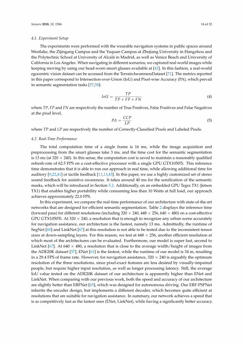
4.2. Real-Time Performance
The total computation time of a single frame is 16 ms, while the image acquisition andpreprocessing from the smart glasses take 3 ms, and the time cost for the semantic segmentationis 13 ms (at 320 × 240). In this sense, the computation cost is saved to maintain a reasonably qualifiedrefresh-rate of 62.5 FPS on a cost-effective processor with a single GPU GTX1050Ti. This inferencetime demonstrates that it is able to run our approach in real time, while allowing additional time forauditory [9,22,41] or tactile feedback [11,13,43]. In this paper, we use a highly customized set of stereosound feedback for assistive awareness. It takes around 40 ms for the sonification of the semanticmasks, which will be introduced in Section 5.2. Additionally, on an embedded GPU Tegra TX1 (JetsonTX1) that enables higher portability while consuming less than 10 Watts at full load, our approachachieves approximately 22.0 FPS.
In this experiment, we compare the real-time performance of our architecture with state-of-the-artnetworks that are designed for efficient semantic segmentation. Table 2 displays the inference time(forward pass) for different resolutions (including 320 × 240, 448 × 256, 640 × 480) on a cost-effectiveGPU GTX1050Ti. At 320 × 240, a resolution that is enough to recognize any urban scene accuratelyfor navigation assistance, our architecture is the fastest, namely 13 ms. Admittedly, the runtime ofSegNet [60] and LinkNet [67] at this resolution is not able to be tested due to the inconsistent tensorsizes at down-sampling layers. For this reason, we test at 448 × 256, another efficient resolution atwhich most of the architectures can be evaluated. Furthermore, our model is super fast, second toLinkNet [67]. At 640 × 480, a resolution that is close to the average width/height of images fromthe ADE20K dataset [57], ENet [61] is the fastest, while the runtime of our model is 34 m, resultingin a 29.4 FPS of frame rate. However, for navigation assistance, 320 × 240 is arguably the optimumresolution of the three resolutions, since pixel-exact features are less desired by visually-impairedpeople, but require higher input resolution, as well as longer processing latency. Still, the averageIoU value tested on the ADE20K dataset of our architecture is apparently higher than ENet andLinkNet. When comparing with our previous work, both the speed and accuracy of our architectureare slightly better than ERFNet [65], which was designed for autonomous driving. Our ERF-PSPNetinherits the encoder design, but implements a different decoder, which becomes quite efficient atresolutions that are suitable for navigation assistance. In summary, our network achieves a speed thatis as competitively fast as the fastest ones (ENet, LinkNet), while having a significantly better accuracy.

Sensors 2018, 18, 1506 15 of 32
Table 2. Runtime and accuracy analysis of our architecture compared to other networks that are alsodesigned for real-time applications in the state of the art. IoU: Intersection-over-Union, Fwt: Forwardpass time. The runtime are tested on a cost-effective GPU GTX1050Ti.
Architectures IoU on ADE20K [57] Fwt at 320 × 240 Fwt at 448 × 256 Fwt at 640 × 480
UNet [62] 28.5% 27 ms 43 ms 131 msSegNet [60] 55.6% N/A 69 ms 178 msENet [61] 58.4% 15 ms 17 ms 24 ms
SQNet [63] 55.5% 33 ms 44 ms 89 msLinkNet [67] 56.5% N/A 14 ms 32 msERFNet [65] 63.1% 15 ms 20 ms 44 ms
Our ERF-PSPNet 66.0% 13 ms 16 ms 34 ms
4.3. Segmentation Accuracy
The accuracy of our approach is firstly evaluated on the challenging ADE20K dataset [57] bycomparing the proposed ERF-PSPNet with deep neural networks in the state-of-the-art for real-timesegmentation including UNet [62], SegNet [60], ENet [61], SQNet [63], LinkNet [67] and our previousERFNet [65]. Table 3 details the accuracy of traversability-related classes including floor, road, grass,sidewalk, ground and other important navigation-related classes including sky, person, car, water andstairs. In our implementation, the IoU value of ENet is higher than SQNet and LinkNet on the ADE20Kdataset, which is a challenging dataset requiring the architecture to learn rich contextual information.Since ENet applies multiple dilated convolution layers in order to take a wider context into account,it outperforms SQNet and LinkNet, even though these two networks claimed to achieve higheraccuracy than ENet on the datasets for intelligent vehicles. As far as our architecture is concerned,it could be said that the accuracy of most classes obtained with the proposed ERF-PSPNet exceeds thestate-of-the-art architectures that are also designed for real-time applications, especially the importantimprovements achieved on water and stairs. Our architecture builds upon previous work, but has theability to collect more contextual information without the major sacrifice of learning from textures.As a result, only the accuracy values of sky and person are slightly lower than ERFNet.
Table 3. Accuracy analysis on ADE20K [57].
Networks Sky Floor Road Grass Sidewalk Ground Person Car Water Stairs Mean IoU
UNet [62] 75.3% 22.4% 41.4% 52.7% 5.3% 25.3% 16.8% 21.1% 20.4% 4.2% 28.5%SegNet [60] 91.3% 61.8% 63.0% 62.8% 36.0% 72.3% 31.4% 63.0% 58.4% 15.6% 55.6%ENet [61] 89.7% 72.4% 69.4% 56.5% 38.2% 75.0% 26.7% 64.8% 67.3% 23.7% 58.4%
SQNet [63] 92.2% 59.1% 66.7% 65.1% 37.0% 68.8% 31.2% 54.2% 63.0% 17.1% 55.5%LinkNet [67] 91.3% 63.5% 66.3% 63.5% 35.6% 71.6% 30.6% 61.0% 66.6% 15.4% 56.5%ERFNet [65] 93.2% 77.3% 71.1% 64.5% 46.1% 76.3% 39.7% 70.1% 67.9% 24.1% 63.1%
Our ERF-PSPNet 93.0% 78.7% 73.8% 68.7% 51.6% 76.8% 39.4% 70.4% 77.0% 30.8% 66.0%
4.4. Real-World Performance
To analyze the major concern of detection performance for real-world assistance, we collect resultsover several depth ranges: within 2 m, 2–3 m, 3–5 m and 5–10 m on the TerrainAwarenessDataset [71],which contains 120 images for testing with fine annotations of seven important classes for navigationassistance including: sky, ground, sidewalks, stairs, water hazards, persons and cars. This adequatelyconsiders that in navigational assistance, 2 m is the general distance for avoiding static obstacles,while the warning distance should be longer when a moving object approaches, e.g., 3 m for pedestriansand 10 m for cars in urban environments. In addition, the short range of ground area detection helpsto determine the most walkable direction [28], while superior path planning could be supported bylonger traversability awareness [22], e.g., 5–10 m. Table 4 shows both the IoU and pixel-wise accuracyof traversability awareness, which is the core task of navigational assistance. Here, the traversableareas involve the ground, floor, road, grass and sidewalk.

Sensors 2018, 18, 1506 16 of 32
Table 4. On the real-world TerrainAwarenessDataset [71] in terms of traversable area parsing. “WithDepth”: Only the pixels with valid depth information are evaluated using pixel-wise accuracy.
Approaches IoU Pixel-Wise Accuracy With Depth Within 2 m 2–3 m 3–5 m 5–10 m
3D-RANSAC-F [9] 50.1% 67.2% 73.3% 53.9% 91.8% 85.2% 61.7%UNet [62] 52.1% 59.6% 57.1% 56.9% 48.1% 54.0% 56.5%
SegNet [60] 73.1% 90.1% 89.5% 86.1% 84.0% 87.7% 89.3%ENet [61] 62.4% 85.2% 88.4% 79.9% 84.3% 89.7% 93.1%
LinkNet [67] 74.1% 89.2% 93.8% 93.4% 92.8% 93.5% 93.5%Our ERF-PSPNet 82.1% 93.1% 95.9% 96.0% 96.3% 96.2% 96.0%
We compare the traversable area detection of our ERF-PSPNet to state-of-the-art architectures anda depth-based segmentation approach 3D-RANSAC-F [9], which estimates the ground plane basedon RANSAC and filtering techniques by using the dense disparity map. As the depth informationof the ground area may be noisy and missing in dynamic environments, we implemented an RGBimage-guided filter [78] to fill holes before detection. In this way, the traditional 3D-RANSAC-Fachieves decent accuracy ranging from 2–5 m, and it excels SegNet and ENet from 2–3 m, as thedepth map within this range is quite dense thanks to the active stereo design of the smart glasses.However, 3D-RANSAC-F simply segmented the ground plane from obstacles, but has no ability todistinguish traversable areas from other semantic classes such as water areas, resulting in a low IoU onthe real-world dataset, where the biggest ground plane assumption fails in a vital part of the images.
Intriguingly, although ENet exceeds SegNet/LinkNet on the ADE20K dataset, it cannot generalizewell in real-world scenarios due to the limited learning capacity that hinders its usability. As aresult, SegNet and LinkNet exceed ENet in terms of IoU and pixel-wise accuracy when testing onour real-world dataset. UNet is a classic convolutional network for biomedical image segmentation,which suffers even more from the model capacity because it is designed to use limited availableannotated samples. Despite being efficient, it continues to struggle at delivering effective segmentationand predicting high-quality semantics. Still, the proposed ERF-PSPNet outperforms 3D-RANSAC-Fand these networks in both ranges by a significant margin, due to the judicious trade-off betweenlearning capacity and inferring efficiency achieved in our architecture. As far as terrain awarenessis concerned, even if the IoU is not very high, the segmentation results are still of great use. For thevisually impaired, it is preferred to know that there are stairs or there is an approaching pedestrian insome direction even if the shape is not exactly accurate. Furthermore, it is observed in Table 5 thatmost of the pixel-wise accuracy within different ranges is over 90%, which reveals the capacity ofour approach for the unification of these detection tasks. It is noteworthy that IoU values of stairsand persons on the real-world dataset that mainly contains outdoor daytime images are apparentlyhigher than those achieved on the ADE20K dataset. Although our dataset represents totally unseenscenarios, it mainly focuses on assistance-related urban scenes, while most persons are pedestriansand stairs are close to the user. In comparison, ADE20K features a high variability of person posturesand far-away stairs. In this sense, ADE20K is more challenging than the real-world dataset in terms ofthese two classes.
Table 5. ERF-PSPNet on the real-world dataset [71] in terms of terrain awareness. “Traversability”:Accuracy of the traversable area parsing. Depth information of sky is too sparse to calculate reasonableaccuracy values at different ranges.
Accuracy Term Sky Traversability Ground Sidewalk Stairs Water Person Car
IoU 88.0% 82.1% 72.7% 55.5% 67.0% 69.1% 66.8% 67.4%Pixel-wise Accuracy 95.3% 93.1% 81.2% 93.1% 90.1% 86.3% 90.8% 93.1%
With Depth N/A 95.9% 84.9% 93.1% 90.8% 89.8% 90.4% 92.7%Within 2 m N/A 96.0% 76.9% 95.0% 91.9% 96.2% 97.7% 94.3%
2–3 m N/A 96.3% 81.7% 96.5% 91.9% 82.3% 93.7% 95.2%3–5 m N/A 96.2% 87.4% 94.5% 89.4% 76.9% 93.6% 90.8%
5–10 m N/A 96.0% 86.6% 93.6% 93.1% 84.3% 87.4% 91.4%

Sensors 2018, 18, 1506 17 of 32
4.5. Qualitative Analysis
This subsection investigates the qualitative segmentation by comparing against traditionalalgorithms, as well as data-driven-based methods. Figure 8 exhibits the montage of pixel-wise resultsgenerated by our ERF-PSPNet, LinkNet [67], ENet [61], FreeSpaceParse [25], 3D-RANSAC-F [9] and3D-SeededRegionGrowing [20].
For traditional approaches, 3D-SeededRegionGrowing and 3D-RANSAC-F both assume aplane model regarding ground area identification for visually impaired applications. This planemodel can be recovered using a local approach such as 3D-SeededRegionGrowing exploringneighboring patches, or globally making use of RANSAC for ground plane equation identification.3D-SeededRegionGrowing relies on the sensor to deliver a dense 3D point cloud and strugglesat producing complete segmentation in highly-dynamic environments. Although 3D-RANSAC-Fexpands the detection range of the traversable area due to the global strategy, its pixel-wise parsingresults are also substantially fragmented. It is worth mentioning that FreeSpaceParse [25], a procedurethat renders stixel-level segmentation with the original purpose of representing traffic situations,has been applied successfully thanks to the sensor fusion [41] by utilizing attitude angles. However,the procedure tailored to the problem relies on additional IMU observations and could not differentiatebetween ground and water areas. This problem also exists in other traditional algorithms, while3D-SeededRegionGrowing even completely misdetects hazardous water areas as traversable areas,due to the assumption that the ground plane should be the lowest part, as it made.
As far as the deep learning-based approaches are concerned, they have the crucial advantagesof exploiting a significant amount of data, thus eliminating the dependencies on assumptions.However, for ENet and LinkNet, we can observe that sometimes, trees/walls would be misclassifiedas sky/ground. In addition, these networks cannot draw a distinction of ground areas vs. sidewalksconsistently. This is mainly due to the incompetence to collect sufficient contextual information.Qualitatively, our approach not only yields longer and more consistent segmentation, which willdefinitely benefit the traversability awareness, but also retains the outstanding ability to provide theterrain awareness within this unified framework.
(a) (b) (c) (d) (e) (f) (g) (h) (i)
Figure 8. Qualitative examples of the segmentation on real-world images produced by ourapproach compared with ground-truth annotation, 3D-SeededRegionGrowing [20], 3D-RANSAC-F [9],FreeSpaceParse [25], ENet [61] and LinkNet [67]. From left to right: (a) RGB image, (b) depthimage, (c) annotation, (d) 3D-SeededRegionGrowing, (e) 3D-RANSAC-F, (f) FreeSpaceParse, (g) ENet,(h) LinkNet and (i) our approach.

Sensors 2018, 18, 1506 18 of 32
4.6. Indoor/Outdoor Detection Analysis
We have already proven that our sensory awareness with the smart glasses can deliver robustdepth segmentation under different situations in [22]. Here, to prove that our approach can work acrossindoor/outdoor environments, we evaluate the traversable area segmentation of day/night scenariosfrom the Gardens Point dataset [98], which mainly contains ground areas in most images alongthe same trajectory as was originally captured for visual localization. For the reader’s information,the Gardens Point dataset was recorded while moving on the Gardens Point Campus of QueenslandUniversity of Technology in Brisbane. Qualitatively, our approach can provide quite robust andeffective segmentation for traversability awareness. However, as demonstrated in Figure 9, we observethat generally in the daytime, the segmentation of outdoor scenarios is more robust than indoorcases; while at night, the indoor segmentation is slightly better than outdoors. This is mainlybecause most of the images we used for training are RGB images with well-balanced illuminationconditions. To further enhance the robustness in the future, we aim to implement illumination-invariantimage pre-transformation, as well as to incorporate near-infrared spectral and pixel-wise polarimetricinformation [41].
(a) (b) (c) (d)
Figure 9. Qualitative examples of the traversable area segmentation on day/night images from theGardens Point dataset [98] produced by our approach across indoor/outdoor environments. From leftto right: (a) RGB images during the daytime; (b) traversable area parsing during the daytime; (c) RGBimages at night; (d) traversable area parsing at night.
5. Field Test
5.1. Field Test Setup
We performed a closed-loop field test in February 2018, with six visually-impaired users aroundHolley Metering Campus in Hangzhou, as displayed in Figure 10. The terrain traversed involves grass,ground and pavement. After learning the stereo sound feedback of the system when wearing oursmart glasses, participants had to start the navigation and reach the staircase by hearing real-timeacoustic feedback. Obstacles along the trajectory (around 85 m) include low-lying traffic cones, staticand moving vehicles/pedestrians, as well as other different kinds of obstacles. For safety reasons,

Sensors 2018, 18, 1506 19 of 32
the traffic condition is relatively peaceful compared with urban roadways, and most vehicles are at alow speed when passing through the campus.
Figure 11 depicts typical scenarios of the field test and traversable lines, which represent the walkabledistances of different directions. In each direction, the farthest distance for navigation is determined byboth the traversable areas and the depth images with noise reduction. Unlike our previous work [22,41],the traversable areas are segmented using the semantic masks instead of stixel computation or depthsegmentation. For illustrative purposes, the maximum traversable distance in Figure 11 is set to9.5 m. As a result, it sometimes appears as a flat line, denoting the scenario is obstacle-free and the usershould feel quite safe to walk forward. Following [41], the traversable line is mapped to the sounds ofinstruments, aimed to provide real-time acoustic feedback for hazard avoidance and safety awareness.
(a) (b) (c) (d)
Figure 10. The moments of the field test. (a–c) Participants’ faces are blurred for the protection of theirprivacy. We have obtained approval to use the navigation assistance results for research work. (d) Thefield test around the campus with several locations marked corresponding to Figure 11.
(a) (b) (c) (d) (e)
Figure 11. Qualitative examples of detection results and traversable lines produced by our approach in thereal-world scenario of the field test, corresponding to the locations marked in Figure 10: (a) RGB image, (b)original depth image; (c) depth image with noise reduction; (d) segmentation result and (e) traversable line.
Sensors 2018, 18, 1506 20 of 32
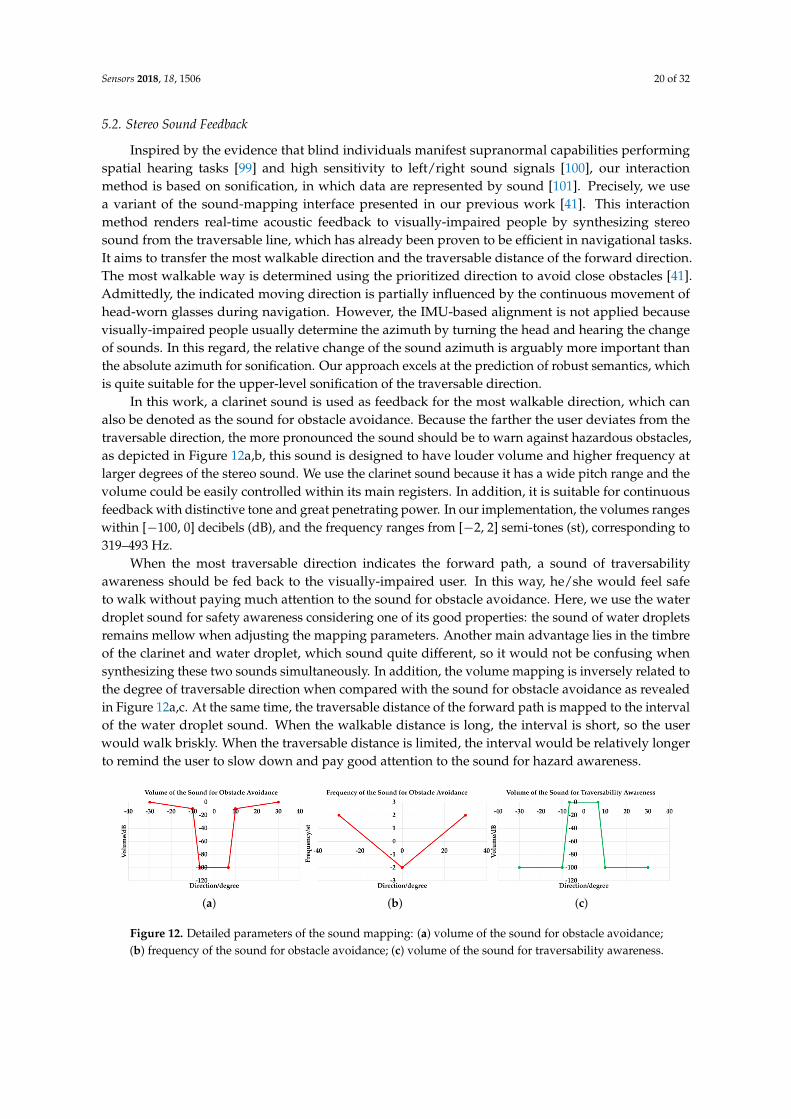
5.2. Stereo Sound Feedback
Inspired by the evidence that blind individuals manifest supranormal capabilities performingspatial hearing tasks [99] and high sensitivity to left/right sound signals [100], our interactionmethod is based on sonification, in which data are represented by sound [101]. Precisely, we usea variant of the sound-mapping interface presented in our previous work [41]. This interactionmethod renders real-time acoustic feedback to visually-impaired people by synthesizing stereosound from the traversable line, which has already been proven to be efficient in navigational tasks.It aims to transfer the most walkable direction and the traversable distance of the forward direction.The most walkable way is determined using the prioritized direction to avoid close obstacles [41].Admittedly, the indicated moving direction is partially influenced by the continuous movement ofhead-worn glasses during navigation. However, the IMU-based alignment is not applied becausevisually-impaired people usually determine the azimuth by turning the head and hearing the changeof sounds. In this regard, the relative change of the sound azimuth is arguably more important thanthe absolute azimuth for sonification. Our approach excels at the prediction of robust semantics, whichis quite suitable for the upper-level sonification of the traversable direction.
In this work, a clarinet sound is used as feedback for the most walkable direction, which canalso be denoted as the sound for obstacle avoidance. Because the farther the user deviates from thetraversable direction, the more pronounced the sound should be to warn against hazardous obstacles,as depicted in Figure 12a,b, this sound is designed to have louder volume and higher frequency atlarger degrees of the stereo sound. We use the clarinet sound because it has a wide pitch range and thevolume could be easily controlled within its main registers. In addition, it is suitable for continuousfeedback with distinctive tone and great penetrating power. In our implementation, the volumes rangeswithin [−100, 0] decibels (dB), and the frequency ranges from [−2, 2] semi-tones (st), corresponding to319–493 Hz.
When the most traversable direction indicates the forward path, a sound of traversabilityawareness should be fed back to the visually-impaired user. In this way, he/she would feel safeto walk without paying much attention to the sound for obstacle avoidance. Here, we use the waterdroplet sound for safety awareness considering one of its good properties: the sound of water dropletsremains mellow when adjusting the mapping parameters. Another main advantage lies in the timbreof the clarinet and water droplet, which sound quite different, so it would not be confusing whensynthesizing these two sounds simultaneously. In addition, the volume mapping is inversely related tothe degree of traversable direction when compared with the sound for obstacle avoidance as revealedin Figure 12a,c. At the same time, the traversable distance of the forward path is mapped to the intervalof the water droplet sound. When the walkable distance is long, the interval is short, so the userwould walk briskly. When the traversable distance is limited, the interval would be relatively longerto remind the user to slow down and pay good attention to the sound for hazard awareness.
(a) (b) (c)
Figure 12. Detailed parameters of the sound mapping: (a) volume of the sound for obstacle avoidance;(b) frequency of the sound for obstacle avoidance; (c) volume of the sound for traversability awareness.

Sensors 2018, 18, 1506 21 of 32
To simplify the sonification of the semantic masks for unified terrain awareness, we use a similarapproach in [9] to detect stairs, pedestrians and vehicles at the basis of semantic masks. An instance ofstaircase, person or car would be fed back by empirically setting 500 points as the detection thresholdfor 320× 240 resolution pixel-wise segmented images within 5 m. This is also beneficial to remove falsepositives caused by erroneous semantic pixels due to noises. Here, the sounds of stairs, pedestriansand vehicles correspond to the instruments bell, xylophone and horn, respectively. Because a staircaserepresents a special traversable region, we use a compressor (see Figure 13) to reduce the volumeof traversability-related feedback, including the sound for obstacle avoidance and safety awarenessas introduced above. Intriguingly, the stairway sound follows the Shepard tone [102], to createthe auditory illusion of a tone that continually ascends or descends in pitch, corresponding to theascending/descending stairs. The ascending stairs and descending steps are distinguished usingdepth information, so visually-impaired people would perceive the terrain in advance. Our soundsystem is implemented with FMOD [103], which is a game sound engine supporting high-speed audiosynthesis. As a result, our stereo sound feeds back the semantic information within 40 ms.
Figure 13. The mutual interaction between different sound mapping sources for navigation assistance.
5.3. Field Test Results
During this assistance study, participants would learn the stereo sound feedback in the first place.The working pattern of the system and signals from the bone conduction headset were introduced.Each participant had 10 min to learn, adapt to the audio interface and wander around casually.By touching obstacles, navigating pathways and listening to the sonified sound, we had ensured thatthe participants fully understood the rules of the sonification-based interaction method. After that,participants were asked to navigate without collisions and reach the staircase (see the staircase imagesin Figure 11). To provide the participants with a sense of orientation, the users would get an extra hintto turn at the bends or the road intersection. Admittedly, in a more general usage scenario, a higherlayer of knowledge could be offered by GPS (Global Positioning System) or topological localization.For readers’ information, we have also blindfolded ourselves and traversed more than 5 km withoutfatigue using the proposed system and AMAP [104].
In this research, all visually-impaired participants completed the test, although sometimes theyhad to turn to us for help as displayed in Table 6, mostly to ensure the orientation. The numberof collisions and time to complete the test were also recorded. Collisions include collisions withobstacles such as traffic cones, vehicles, walls, and so on. The timer started when a participant beganthe navigation and stopped when the participant completed a single test. As recorded in Table 6,the number of collisions was few when traversing such a long trajectory more of than 80 m, and eachuser had successfully avoided at least five obstacles. In this test, explicit feedback about directions totraverse were found helpful for navigation assistance. The results suggest that participants were awareof obstacles and semantics with our system and could make use of the stereo sound to keep away fromhazards including approaching pedestrians, vehicles and close-range obstacles. They had learned tonavigate traversable paths and finally reached the staircase provided with the assistive awareness.
Sensors 2018, 18, 1506 22 of 32
In addition, most of the traversing time suggests that our system supported navigation at normalwalking speed, although some individuals took a relatively longer time to finish the test. In summary,the safety and versatility of the navigation assistance system have been dramatically enhanced.
Table 6. Field test results.
Users Collisions Times of Asking for Help Traversing Time to Reach the Stairs
User 1 1 1 208 sUser 2 1 0 91 sUser 3 0 2 123 sUser 4 1 1 157 sUser 5 0 2 323 sUser 6 1 1 143 s
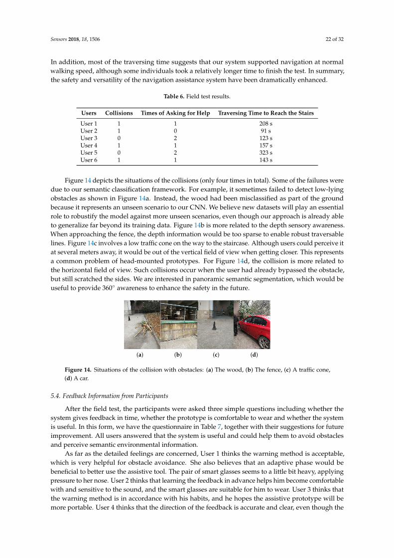
Figure 14 depicts the situations of the collisions (only four times in total). Some of the failures weredue to our semantic classification framework. For example, it sometimes failed to detect low-lyingobstacles as shown in Figure 14a. Instead, the wood had been misclassified as part of the groundbecause it represents an unseen scenario to our CNN. We believe new datasets will play an essentialrole to robustify the model against more unseen scenarios, even though our approach is already ableto generalize far beyond its training data. Figure 14b is more related to the depth sensory awareness.When approaching the fence, the depth information would be too sparse to enable robust traversablelines. Figure 14c involves a low traffic cone on the way to the staircase. Although users could perceive itat several meters away, it would be out of the vertical field of view when getting closer. This representsa common problem of head-mounted prototypes. For Figure 14d, the collision is more related tothe horizontal field of view. Such collisions occur when the user had already bypassed the obstacle,but still scratched the sides. We are interested in panoramic semantic segmentation, which would beuseful to provide 360◦ awareness to enhance the safety in the future.
(a) (b) (c) (d)
Figure 14. Situations of the collision with obstacles: (a) The wood, (b) The fence, (c) A traffic cone,(d) A car.
5.4. Feedback Information from Participants
After the field test, the participants were asked three simple questions including whether thesystem gives feedback in time, whether the prototype is comfortable to wear and whether the systemis useful. In this form, we have the questionnaire in Table 7, together with their suggestions for futureimprovement. All users answered that the system is useful and could help them to avoid obstaclesand perceive semantic environmental information.
As far as the detailed feelings are concerned, User 1 thinks the warning method is acceptable,which is very helpful for obstacle avoidance. She also believes that an adaptive phase would bebeneficial to better use the assistive tool. The pair of smart glasses seems to a little bit heavy, applyingpressure to her nose. User 2 thinks that learning the feedback in advance helps him become comfortablewith and sensitive to the sound, and the smart glasses are suitable for him to wear. User 3 thinks thatthe warning method is in accordance with his habits, and he hopes the assistive prototype will bemore portable. User 4 thinks that the direction of the feedback is accurate and clear, even though the
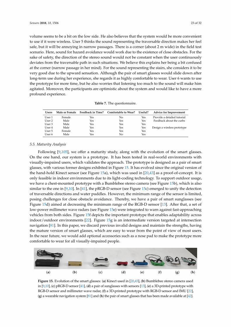
Sensors 2018, 18, 1506 23 of 32
volume seems to be a bit on the low side. He also believes that the system would be more convenientto use if it were wireless. User 5 thinks the sound representing the traversable direction makes her feelsafe, but it will be annoying in narrow passages. There is a corner (about 2 m wide) in the field testscenario. Here, sound for hazard avoidance would work due to the existence of close obstacles. For thesake of safety, the direction of the stereo sound would not be constant when the user continuouslydeviates from the traversable path in such situations. We believe this explains her being a bit confusedat the corner (narrow passage in her mind). For the sound representing the stairs, she considers it to bevery good due to the upward sensation. Although the pair of smart glasses would slide down afterlong-term use during her experience, she regards it as highly comfortable to wear. User 6 wants to usethe prototype for more time, but he also worries that listening too much to the sound will make himagitated. Moreover, the participants are optimistic about the system and would like to have a moreprofound experience.
Table 7. The questionnaire.
Users Male or Female Feedback in Time? Comfortable to Wear? Useful? Advice for Improvement
User 1 Female Yes No Yes Provide a detailed tutorialUser 2 Male Yes Yes Yes Feedback about the curbsUser 3 Male Yes Yes YesUser 4 Male Yes Yes Yes Design a wireless prototypeUser 5 Female Yes Yes YesUser 6 Male Yes No Yes
5.5. Maturity Analysis
Following [9,105], we offer a maturity study, along with the evolution of the smart glasses.On the one hand, our system is a prototype. It has been tested in real-world environments withvisually-impaired users, which validates the approach. The prototype is designed as a pair of smartglasses, with various former designs exhibited in Figure 15. It has evolved since the original version ofthe hand-hold Kinect sensor (see Figure 15a), which was used in [20,43] as a proof-of-concept. It isonly feasible in indoor environments due to its light-coding technology. To support outdoor usage,we have a chest-mounted prototype with a Bumblebee stereo camera (see Figure 15b), which is alsosimilar to the one in [9,10]. In [41], the pRGB-D sensor (see Figure 15c) emerged to unify the detectionof traversable directions and water puddles. However, the minimum range of the sensor is limited,posing challenges for close obstacle avoidance. Thereby, we have a pair of smart sunglasses (seeFigure 15d) aimed at decreasing the minimum range of the RGB-D sensor [13]. After that, a set oflow-power millimeter wave radars (see Figure 15e) were integrated to warn against fast-approachingvehicles from both sides. Figure 15f depicts the important prototype that enables adaptability acrossindoor/outdoor environments [22]. Figure 15g is an intermediate version targeted at intersectionnavigation [81]. In this paper, we discard previous invalid designs and maintain the strengths, havingthe mature version of smart glasses, which are easy to wear from the point of view of most users.In the near future, we would add optional accessories such as a nose pad to make the prototype morecomfortable to wear for all visually-impaired people.
(a) (b) (c) (d) (e) (f) (g) (h)
Figure 15. Evolution of the smart glasses: (a) Kinect used in [20,43], (b) Bumblebee stereo camera usedin [9,10], (c) pRGB-D sensor [41], (d) a pair of sunglasses with sensors [13], (e) a 3D-printed prototype withRGB-D sensor and millimeter wave radar, (f) a 3D-printed prototype with RGB-D sensor and IMU [22],(g) a wearable navigation system [81] and (h) the pair of smart glasses that has been made available at [42].
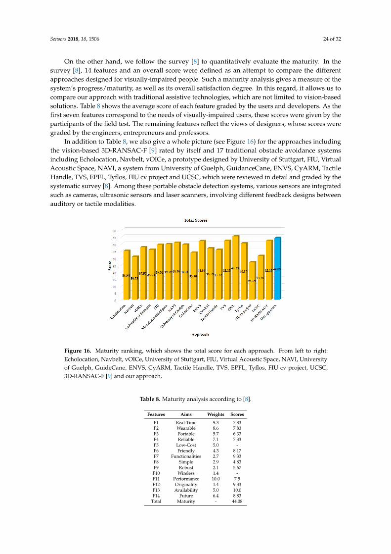
Sensors 2018, 18, 1506 24 of 32
On the other hand, we follow the survey [8] to quantitatively evaluate the maturity. In thesurvey [8], 14 features and an overall score were defined as an attempt to compare the differentapproaches designed for visually-impaired people. Such a maturity analysis gives a measure of thesystem’s progress/maturity, as well as its overall satisfaction degree. In this regard, it allows us tocompare our approach with traditional assistive technologies, which are not limited to vision-basedsolutions. Table 8 shows the average score of each feature graded by the users and developers. As thefirst seven features correspond to the needs of visually-impaired users, these scores were given by theparticipants of the field test. The remaining features reflect the views of designers, whose scores weregraded by the engineers, entrepreneurs and professors.
In addition to Table 8, we also give a whole picture (see Figure 16) for the approaches includingthe vision-based 3D-RANSAC-F [9] rated by itself and 17 traditional obstacle avoidance systemsincluding Echolocation, Navbelt, vOICe, a prototype designed by University of Stuttgart, FIU, VirtualAcoustic Space, NAVI, a system from University of Guelph, GuidanceCane, ENVS, CyARM, TactileHandle, TVS, EPFL, Tyflos, FIU cv project and UCSC, which were reviewed in detail and graded by thesystematic survey [8]. Among these portable obstacle detection systems, various sensors are integratedsuch as cameras, ultrasonic sensors and laser scanners, involving different feedback designs betweenauditory or tactile modalities.
Figure 16. Maturity ranking, which shows the total score for each approach. From left to right:Echolocation, Navbelt, vOICe, University of Stuttgart, FIU, Virtual Acoustic Space, NAVI, Universityof Guelph, GuideCane, ENVS, CyARM, Tactile Handle, TVS, EPFL, Tyflos, FIU cv project, UCSC,3D-RANSAC-F [9] and our approach.
Table 8. Maturity analysis according to [8].
Features Aims Weights Scores
F1 Real-Time 9.3 7.83F2 Wearable 8.6 7.83F3 Portable 5.7 6.33F4 Reliable 7.1 7.33F5 Low-Cost 5.0 -F6 Friendly 4.3 8.17F7 Functionalities 2.7 9.33F8 Simple 2.9 4.83F9 Robust 2.1 5.67
F10 Wireless 1.4 -F11 Performance 10.0 7.5F12 Originality 1.4 9.33F13 Availability 5.0 10.0F14 Future 6.4 8.83
Total Maturity - 44.08

Sensors 2018, 18, 1506 25 of 32
In total, our proposal ranked in the top two of these approaches, second to EPFL, which achieveda score of 45.33 using a stereoscopic sonar system and vibrator-based tactile feedback, but it cannotadequately describe the 3D space and collect semantic information. Comparatively, our high scoreis mainly contributed by the scores on F1 (real-time), F7 (functionalities), F12 (originality) andF13 (availability). Real-time semantic segmentation allows us to provide assistive awareness ina unified way. It covers multiple perception tasks to aid navigation in visually-impaired individuals.This explains the high scores of F1 (real-time) and F7 (functionalities). As far as F12 (originality) isconcerned, our approach represents one of the pioneering efforts to develop pixel-wise semanticsegmentation for navigation assistance systems. F13 (availability) denotes that the system isimplemented and ready for field navigation. F8 (simple) and F9 (robust) are the relative weaknesses ofour framework. F8 (simple) requires the complexity of both hardware and software to be small. In thisregard, deep learning-based approaches are intrinsically more complex than traditional prototypes.According to [8], F9 (robust) requires that the system still functions in the presence of partial failures.Although our approach is robust in different environmental conditions, which have been proven bythe real-world experiments and the outdoor field test, the depth sensory awareness and pixel-wisesemantic segmentation are coupled with each other. As far as the indoor test is concerned, we havealso blindfolded ourselves to safely navigate in several buildings using our smart glasses. Becauseindoor environments contain less navigation-related semantics of interest, our system is more like anobstacle avoidance tool provided with superior traversability awareness, where the warning distanceis closer due to safety considerations. Readers are advised to refer to our previous work [13,14,22] tolearn more about the precisely-designed feedback system and relevant indoor field tests. In addition,we aim to develop semantics-aware SLAM (Simultaneous Localization And Mapping) by making fulluse of the indoor semantic masks such as desk, chair and door. Following the rules of the survey [8],F5 and F10 are not scored due to the usage of a single Universal Serial Bus (USB) 3.0 cord and the lackof cost information for future deployment. Despite being a possible subjective measure, it is a goodreference for a numerical comparison over the surveyed works.
6. Conclusions and Future Work
Navigational assistance for the Visually Impaired (VI) is undergoing a monumental boom thanksto the developments of Computer Vision (CV). However, monocular detectors or depth sensors aregenerally applied in separate tasks. In this paper, we derive achievability results for these perceptiontasks by utilizing real-time semantic segmentation. The proposed framework, based on deep neuralnetworks and depth sensory segmentation, not only benefits the essential traversability at both shortand long ranges, but also covers the needs of terrain awareness in a unified way.
We present a comprehensive set of experiments and a closed-loop field test to demonstrate thatour approach strikes an excellent trade-off between reliability and speed and reaches high effectivityand versatility for navigation assistance in terms of unified environmental perception.
In the future, we aim to continuously improve our navigation assistive approach. Specifically,pixel-wise polarization estimation and multi-modal sensory awareness would be incorporated torobustify the framework against cross-season scenarios. Deep learning-based depth interpolationwould be beneficial to enhance the RGB-D perception in high dynamic environments and expandthe minimum/maximum detectable range. Intersection-centered scene elements including zebracrosswalks and traffic lights would be covered in the road crossing context. Hazardous curbs andwater puddles would be addressed to further enhance traversability-related semantic perception byour advanced version of CNNs using hierarchical dilation. In addition, we are interested in panoramicsemantic segmentation, which would be useful and fascinating to provide superior assistive awareness.
Moreover, it is necessary to run a larger study with visually-impaired participants to test thisapproach, while different sonification methods and audio output settings could be compared in a moregeneral usage scenario with semantics-aware visual localization.

Sensors 2018, 18, 1506 26 of 32
Author Contributions: K.Y. conceived of the approach, designed the framework and performed the experimentsunder the joint supervision of K.W. and L.M.B. K.Y. and E.R. trained the semantic segmentation network. K.Y.,W.H. and D.S. developed the stereo sound feedback interface. K.Y., K.W. and J.S. coordinated and organizedthe field test. K.Y., R.C. and T.C. captured the real-world egocentric dataset. K.Y. wrote the paper. All authorsreviewed, revised and approved the paper.
Funding: This research has been partially funded by the Zhejiang Provincial Public Fund through the projectof visual assistance technology for the blind based on 3D terrain sensors (No. 2016C33136) and co-funded bythe State Key Laboratory of Modern Optical Instrumentation. This work has also been partially funded by theSpanish MINECO/FEDER through the SmartElderlyCar project (TRA2015-70501-C2-1-R), the DGT through theSERMON project (SPIP2017-02305) and from the RoboCity2030-III-CM project (Robótica aplicada a la mejora de lacalidad de vida de los ciudadanos, fase III; S2013/MIT-2748), funded by Programas de actividades I+D (CAM)and co-funded by the EU Structural Funds.
Acknowledgments: We would like to thank the anonymous reviewers for the insightful comments and valuablesuggestions.
Conflicts of Interest: The authors declare no conflict of interest.
Abbreviations
The following abbreviations are used in this manuscript:
TAWS Terrain Awareness and Warning SystemWHO World Health OrganizationCV Computer VisionVI Visually ImpairedRGB-D RGB-DepthFPS Frames Per SecondpRGB-D polarized RGB-DepthCNN Convolutional Neural NetworkRANSAC RANdom SAmpling ConsensusIMU Inertial Measurement UnitIR InfraredRGB-IR-D RGB-Infrared-DepthToF Time-of-FlightRGB-IR RGB-InfraredFCN Fully-Convolutional NetworkNon-bt-1D Non-bottleneck-1DHSV Hue Saturation ValueBN Batch-NormalizationIoU Intersection-over-UnionTP True PositivesFP False PositivesFN False NegativesPA Pixel-wise AccuracyCCP Correctly-Classified PixelsLP Labeled PixelsdB decibelst semi-toneGPS Global Positioning SystemSLAM Simultaneous Localization And MappingUSB Universal Serial Bus
References
1. Terrain Awareness and Warning System. Available online: https://en.wikipedia.org/wiki/Terrain_awareness_and_warning_system (accessed on 15 February 2018).
2. Wang, S.; Yu, J. Everyday information behavior of the visually impaired in China. Inf. Res. 2017, 22, paper743.

Sensors 2018, 18, 1506 27 of 32
3. Bhowmick, A.; Hazarika, S.M. An insight into assistive technology for the visually impaired and blindpeople: State-of-the-art and future trends. J. Multimodal User Interfaces 2017, 11, 149–172. [CrossRef]
4. Bourne, R.R.; Flaxman, S.R.; Braithwaite, T.; Cicinelli, M.V.; Das, A.; Jonas, J.B.; Keeffe, J.; Kempen, J.H.;Leasher, J.; Limburg, H.; et al. Magnitude, temporal trends, and projections of the global prevalenceof blindness and distance and near vision impairment: A systematic review and meta-analysis.Lancet Glob. Health 2017, 5, e888–e897. [CrossRef]
5. Tian, Y. RGB-D sensor-based computer vision assistive technology for visually impaired persons. In ComputerVision and Machine Learning with RGB-D Sensors; Shao, L., Han, J., Kohli, P., Zhang, Z., Eds.; Springer: Cham,Switzerland, 2014; pp. 173–194.
6. Elmannai, W.; Elleithy, K. Sensor-based assistive devices for visually-impaired people: Current status,chanllenges, and future directions. Sensors 2017, 17, 565. [CrossRef] [PubMed]
7. Pradeep, V.; Medioni, G.; Weiland, J. Robot vision for the visually impaired. In Proceedings of the 2010IEEE Computer Society Conference on Computer Vision and Pattern Recognition Workshops (CVPRW),San Francisco, CA, USA, 13–18 July 2010; pp. 15–22.
8. Dakopoulos, D.; Bourbakis, N.G. Wearable obstacle avoidance electronic travel aids for blind: A survey.IEEE Trans. Syst. Man Cybern. Part C (Appl. Rev.) 2010, 40, 25–35. [CrossRef]
9. Rodríguez, A.; Yebes, J.J.; Alcantarilla, P.F.; Bergasa, L.M.; Almazán, J.; Cela, A. Assisting the visuallyimpaired: Obstacle detection and warning system by acoustic feedback. Sensors 2012, 12, 17476–17496.[CrossRef] [PubMed]
10. Rodríguez, A.; Bergasa, L.M.; Alcantarilla, P.F.; Yebes, J.; Cela, A. Obstacle avoidance system for assistingvisually impaired people. In Proceedings of the IEEE Intelligent Vehicles Symposium Workshops, Madrid,Spain, 3–7 June 2012; p. 16.
11. Ni, D.; Song, A.; Tian, L.; Xu, X.; Chen, D. A walking assistant robotic system for the visually impaired basedon computer vision and tactile perception. Int. J. Soc. Robot. 2015, 7, 617–628. [CrossRef]
12. Schwarze, T.; Lauer, M.; Schwaab, M.; Romanovas, M.; Bohm, S.; Jurgensohn, T. An intuitive mobility aid forvisually impaired people based on stereo vision. In Proceedings of the IEEE International Conference onComputer Vision Workshops, Santiago, Chile, 11–18 December 2015; pp. 17–25.
13. Yang, K.; Wang, K.; Zhao, X.; Cheng, R.; Bai, J.; Yang, Y.; Liu, D. IR stereo RealSense: Decreasing minimumrange of navigational assistance for visualy impaired individuals. J. Ambient Intell. Smart Environ. 2017, 9,743–755. [CrossRef]
14. Yang, K.; Wang, K.; Chen, H.; Bai, J. Reducing the minimum range of a RGB-depth sensor to aid navigationin visually impaired individuals. Appl. Opt. 2018, 57, 2809–2819. [CrossRef] [PubMed]
15. Martinez, M.; Roitberg, A.; Koester, D.; Stiefelhagen, R.; Schauerte, B. Using Technology Developed forAutonomous Cars to Help Navigate Blind People. In Proceedings of the 2017 IEEE International Conferenceon Computer Vision Workshop (ICCVW), Venice, Italy, 22–29 October 2017; pp. 1424–1432.
16. Caraiman, S.; Morar, A.; Owczarek, M.; Burlacu, A.; Rzeszotarski, D.; Botezatu, N.; Herghelegiu, P.;Moldoveanu, F.; Strumillo, P.; Moldoveanu, A. Computer Vision for the Visually Impaired: The Sound ofVision System. In Proceedings of the IEEE Conference on Computer Vision Vision and Pattern Recognition,Venice, Italy, 22–29 October 2017; pp. 1480–1489.
17. Herghelegiu, P.; Burlacu, A.; Caraiman, S. Negative obstacle detection for wearable assistive devices forvisually impaired. In Proceedings of the 2017 21st International Conference on System Theory, Control andComputing (ICSTCC), Sinaia, Romania, 19–21 October 2017; pp. 564–570.
18. Koester, D.; Schauerte, B.; Stiefelhagen, R. Accessible section detection for visual guidance. In Proceedings ofthe 2013 IEEE International Conference on Multimedia and Expo Workshops, San Jose, CA, USA, 15–19 July2013; pp. 1–6.
19. Schauerte, B.; Koester, D.; Martinez, M.; Stiefelhagen, R. Way to go! Detecting open areas ahead of awalking person. In Proceedings of the 2014 European Conference on Computer Vision, Zurich, Switzerland,6–12 September 2014; pp. 349–360.
20. Cheng, R.; Wang, K.; Yang, K.; Zhao, X. A ground and obstacle detection algorithm for the visually impaired.In Proceedings of the IET International Conference on Biomedical Image and Signal Processing, Beijing,China, 19 November 2015; pp. 1–6.
21. Lin, Q.; Han, Y. A Dual-Field Sensing Scheme for a Guidance System for the Blind. Sensors 2016, 16, 667.[CrossRef] [PubMed]

Sensors 2018, 18, 1506 28 of 32
22. Yang, K.; Wang, K.; Hu, W.; Bai, J. Expanding the detection of traversable area with RealSense for the visuallyimpaired. Sensors 2016, 16, 1954. [CrossRef] [PubMed]
23. Aladren, A.; López-Nicolás, G.; Puig, L.; Guerrero, J.J. Navigation assistance for the visually impaired usingRGB-D sensor with range expansion. IEEE Syst. J. 2016, 10, 922–932. [CrossRef]
24. Lee, Y.H.; Medioni, G. RGB-D camera based wearable navigation system for the visually impaired.Comput. Vis. Image Underst. 2016, 149, 3–20. [CrossRef]
25. Wang, H.C.; Katzschmann, R.K.; Teng, S.; Araki, B.; Giarré, L.; Rus, D. Enabling independent navigationfor visually impaired people through a wearable vision-based feedback system. In Proceedings of the2017 IEEE International Conference on Robotics and Automation (ICRA), Singapore, 29 May–3 June 2017;pp. 6533–6540.
26. Saleh, K.; Zeineldin, R.A.; Hossny, M.; Nahavandi, S.; El-Fishawy, N.A. Navigational Path Detection for theVisually Impaired using Fully Convolutional Networks. In Proceedings of the IEEE Conference on Systems,Man and Cybernetics (SMC), Banff, AB, Canada, 5–8 October 2017; pp. 1399–1404.
27. Perez-Yus, A.; Bermudez-Cameo, J.; Lopez-Nicolas, G.; Guerrero, J.J. Depth and Motion Cues with PhosphenePatterns for Prosthetic Vision. In Proceedings of the IEEE Conference on Computer Vision and PatternRecognition, Venice, Italy, 22–29 October 2017; pp. 1516–1525.
28. Mehta, S.; Hajishirzi, H.; Shapiro, L. Identifying Most Walkable Direction for Navigation in an OutdoorEnvironment. arXiv 2017, arXiv:1711.08040.
29. Burlacu, A.; Baciu, A.; Manta, V.I.; Caraiman, S. Ground geometry assessment in complex stereo visionbased applications. In Proceedings of the 2017 21st International Conference on System Theory, Control andComputing (ICSTCC), Sinaia, Romania, 19–21 October 2017; pp. 558–563.
30. Ghilardi, M.C.; Macedo, R.C.; Manssour, I.H. A new approach for automatic detection of tactile pavingsurfaces in sidewalks. Procedia Comput. Sci. 2016, 80, 662–672. [CrossRef]
31. Phung, S.L.; Le, M.C.; Bouzerdoum, A. Pedestrian lane detection in unstructured scenes for assistivenavigation. Comput. Vis. Image Underst. 2016, 149, 186–196. [CrossRef]
32. Ahmed, F.; Yeasin, M. Optimization and evaluation of deep architectures for ambient awareness on asidewalk. In Proceedings of the 2017 International Joint Conference on Neural Networks (IJCNN), Anchorage,AK, USA, 14–19 May 2017; pp. 2692–2697.
33. Li, Z.; Rahman, M.; Robucci, R.; Banerjee, N. PreSight: Enabling Real-Time Detection of AccessibilityProblems on Sidewalks. In Proceedings of the 2017 14th Annual IEEE International Conference on Sensing,Communication, and Networking (SECON), San Diego, CA, USA, 12–14 June 2017; pp. 1–9.
34. Lee, Y.H.; Leung, T.S.; Medioni, G. Real-time staircase detection from a wearable stereo system.In Proceedings of the 2012 21st International Conference On Pattern Recognition (ICPR), Tsukuba, Japan,11–15 November 2012; pp. 3770–3773.
35. Guerrero, J.J.; Pérez-Yus, A.; Gutiérrez-Gómez, D.; Rituerto, A.; López-Nicolaás, G. Human navigationassistance with a RGB-D sensor. In Proceedings of the VI Congreso Internacional de Diseno, Redes deInvestigacion y Tecnologia para todos (DRT4ALL), Madrid, Spain, 23–25 September 2015; pp. 285–312.
36. Schwarze, T.; Zhong, Z. Stair detection and tracking from egocentric stereo vision. In Proceedings of the2015 IEEE International Conference on Image Processing (ICIP), Québec City, QC, Canada, 27–30 September2015; pp. 2690–2694.
37. Munoz, R.; Rong, X.; Tian, Y. Depth-aware indoor staircase detection and recognition for the visuallyimpaired. In Proceedings of the 2016 IEEE International Conference on Multimedia & Expo Workshops(ICMEW), Seattle, WA, USA, 11–15 July 2016; pp. 1–6.
38. Perez-Yus, A.; Gutiérrez-Gómez, D.; Lopez-Nicolas, G.; Guerrero, J.J. Stairs detection with odometry-aidedtraversal from a wearable RGB-D camera. Comput. Vis. Image Underst. 2017, 154, 192–205. [CrossRef]
39. Stahlschmidt, C.; von Camen, S.; Gavriilidis, A.; Kummert, A. Descending step classification usingtime-of-flight sensor data. In Proceedings of the 2015 IEEE Intelligent Vehicles Symposium (IV), Seoul, Korea,28 June–1 July 2015; pp. 362–367.
40. Cloix, S.; Bologna, G.; Weiss, V.; Pun, T.; Hasler, D. Low-power depth-based descending stair detection forsmart assistive devices. EURASIP J. Image Video Process. 2016, 2016, 33. [CrossRef]
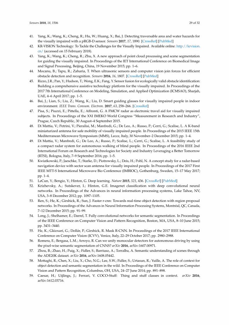
Sensors 2018, 18, 1506 29 of 32
41. Yang, K.; Wang, K.; Cheng, R.; Hu, W.; Huang, X.; Bai, J. Detecting traversable area and water hazards forthe visually impaired with a pRGB-D sensor. Sensors 2017, 17, 1890. [CrossRef] [PubMed]
42. KR-VISION Technology: To Tackle the Challenges for the Visually Impaired. Available online: http://krvision.cn/ (accessed on 15 February 2018).
43. Yang, K.; Wang, K.; Cheng, R.; Zhu, X. A new approach of point cloud processing and scene segmentationfor guiding the visually impaired. In Proceedings of the IET International Conference on Biomedical Imageand Signal Processing, Beijing, China, 19 November 2015; pp. 1–6.
44. Mocanu, B.; Tapu, R.; Zaharia, T. When ultrasonic sensors and computer vision join forces for efficientobstacle detection and recognition. Sensors 2016, 16, 1807. [CrossRef] [PubMed]
45. Rizzo, J.R.; Pan, Y.; Hudson, T.; Wong, E.K.; Fang, Y. Sensor fusion for ecologically valid obstacle identification:Building a comprehensive assistive technology platform for the visually impaired. In Proceedings of the2017 7th International Conference on Modeling, Simulation, and Applied Optimization (ICMSAO), Sharjah,UAE, 4–6 April 2017; pp. 1–5.
46. Bai, J.; Lian, S.; Liu, Z.; Wang, K.; Liu, D. Smart guiding glasses for visually impaired people in indoorenvironment. IEEE Trans. Consum. Electron. 2017, 63, 258–266. [CrossRef]
47. Pisa, S.; Piuzzi, E.; Pittella, E.; Affronti, G. A FMCW radar as electronic travel aid for visually impairedsubjects. In Proceedings of the XXI IMEKO World Congress “Measurement in Research and Industry”,Prague, Czech Republic, 30 August–4 September 2015.
48. Di Mattia, V.; Petrini, V.; Pieralisi, M.; Manfredi, G.; De Leo, A.; Russo, P.; Cerri, G.; Scalise, L. A K-bandminiaturized antenna for safe mobility of visually impaired people. In Proceedings of the 2015 IEEE 15thMediterranean Microwave Symposium (MMS), Lecce, Italy, 30 November–2 December 2015; pp. 1–4.
49. Di Mattia, V.; Manfredi, G.; De Leo, A.; Russo, P.; Scalise, L.; Cerri, G.; Scalise, L. A feasibility study ofa compact radar system for autonomous walking of blind people. In Proceedings of the 2016 IEEE 2ndInternational Forum on Research and Technologies for Society and Industry Leveraging a Better Tomorrow(RTSI), Bologna, Italy, 7–9 September 2016; pp. 1–5.
50. Kwiatkowski, P.; Jaeschke, T.; Starke, D.; Piotrowsky, L.; Deis, H.; Pohl, N. A concept study for a radar-basednavigation device with sector scan antenna for visually impaired people. In Proceedings of the 2017 FirstIEEE MTT-S International Microwave Bio Conference (IMBIOC), Gothenburg, Sweden, 15–17 May 2017;pp. 1–4.
51. LeCun, Y.; Bengio, Y.; Hinton, G. Deep learning. Nature 2015, 521, 436. [CrossRef] [PubMed]52. Krizhevsky, A.; Sutskever, I.; Hinton, G.E. Imagenet classification with deep convolutional neural
networks. In Proceedings of the Advances in neural information processing systems, Lake Tahoe, NV,USA, 3–8 December 2012; pp. 1097–1105.
53. Ren, S.; He, K.; Girshick, R.; Sun, J. Faster r-cnn: Towards real-time object detection with region proposalnetworks. In Proceedings of the Advances in Neural Information Processing Systems, Montréal, QC, Canada,7–12 December 2015; pp. 91–99.
54. Long, J.; Shelhamer, E.; Darrel, T. Fully convolutional networks for semantic segmentation. In Proceedingsof the IEEE Conference on Computer Vision and Pattern Recognition, Boston, MA, USA, 8–10 June 2015;pp. 3431–3440.
55. He, K.; Gkioxari, G.; Dollár, P.; Girshick, R. Mask R-CNN. In Proceedings of the 2017 IEEE InternationalConference on Computer Vision (ICVV), Venice, Italy, 22–29 October 2017; pp. 2980–2988.
56. Romera, E.; Bergasa, L.M.; Arroyo, R. Can we unify monocular detectors for autonomous driving by usingthe pixel-wise semantic segmentation of CNNS? arXiv 2016, arXiv:1607.00971.
57. Zhou, B.; Zhao, H.; Puig, X.; Fidler, S.; Barriuso, A.; Torralba, A. Semantic understanding of scenes throughthe ADE20K dataset. arXiv 2016, arXiv:1608.05442.
58. Mottaghi, R.; Chen, X.; Liu, X.; Cho, N.G.; Lee, S.W.; Fidler, S.; Urtasun, R.; Yuille, A. The role of context forobject detection and semantic segmentation in the wild. In Proceedings of the IEEE Conference on ComputerVision and Pattern Recognition, Columbus, OH, USA, 24–27 June 2014; pp. 891–898.
59. Caesar, H.; Uijlings, J.; Ferrari, V. COCO-Stuff: Thing and stuff classes in context. arXiv 2016,arXiv:1612.03716.
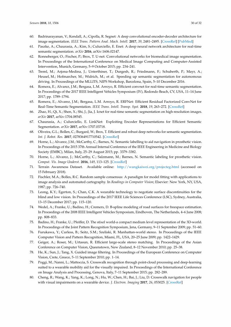
Sensors 2018, 18, 1506 30 of 32
60. Badrinarayanan, V.; Kendall, A.; Cipolla, R. Segnet: A deep convolutional encoder-decoder architecture forimage segmentation. IEEE Trans. Pattern Anal. Mach. Intell. 2017, 39, 2481–2495. [CrossRef] [PubMed]
61. Paszke, A.; Chaurasia, A.; Kim, S.; Culurciello, E. Enet: A deep neural network architecture for real-timesemantic segmentation. arXiv 2016, arXiv:1606.02147.
62. Ronneberger, O.; Fischer, P.; Brox, T. U-net: Convolutional networks for biomedical image segmentation.In Proceedings of the International Conference on Medical Image Computing and Computer-AssistedIntervention, Munich, Germany, 5–9 October 2015; pp. 234–241.
63. Treml, M.; Arjona-Medina, J.; Unterthiner, T.; Durgesh, R.; Friedmann, F.; Schuberth, P.; Mayr, A.;Heusel, M.; Hofmarcher, M.; Widrich, M.; et al. Speeding up semantic segmentation for autonomousdriving. In Proceedings of the MLLITS, NIPS Workshop, Barcelona, Spain, 5–10 December 2016.
64. Romera, E.; Alvarez, J.M.; Bergasa, L.M. Arroyo, R. Efficient convnet for real-time semantic segmentation.In Proceedings of the 2017 IEEE Intelligent Vehicles Symposium (IV), Redondo Beach, CV, USA, 11–14 June2017; pp. 1789–1794.
65. Romera, E.; Alvarez, J.M.; Bergasa, L.M. Arroyo, R. ERFNet: Efficient Residual Factorized ConvNet forReal-Time Semantic Segmentation. IEEE Trans. Intell. Transp. Syst. 2018, 19, 263–272. [CrossRef]
66. Zhao, H.; Qi, X.; Shen, X.; Shi, J.; Jia, J. Icnet for real-time semantic segmentation on high-resolution images.arXiv 2017, arXiv:1704.08545.
67. Chaurasia, A.; Culurciello, E. LinkNet: Exploiting Encoder Representations for Efficient SemanticSegmentation. arXiv 2017, arXiv:1707.03718.
68. Oliveira, G.L.; Bollen, C.; Burgard, W.; Brox, T. Efficient and robust deep networks for semantic segmentation.Int. J. Robot. Res. 2017, 0278364917710542. [CrossRef]
69. Horne, L.; Alvarez, J.M.; McCarthy, C.; Barnes, N. Semantic labelling to aid navigation in prosthetic vision.In Proceedings of the 2015 37th Annual Internal Conference of the IEEE Engineering in Medicine and BiologySociety (EMBC), Milan, Italy, 25–29 August 2015; pp. 3379–3382.
70. Horne, L.; Alvarez, J.; McCarthy, C.; Salzmann, M.; Barnes, N. Semantic labeling for prosthetic vision.Comput. Vis. Image Underst. 2016, 149, 113–125. [CrossRef]
71. Terrain Awareness Dataset. Available online: http://wangkaiwei.org/projecteg.html (accessed on15 February 2018).
72. Fischler, M.A.; Bolles, R.C. Random sample consensus: A paradigm for model fitting with applications toimage analysis and automated cartography. In Readings in Computer Vision; Elsevier: New York, NY, USA,1987; pp. 726–740.
73. Leong, K.Y.; Egerton, S.; Chan, C.K. A wearable technology to negotiate surface discontinuities for theblind and low vision. In Proceedings of the 2017 IEEE Life Sciences Conference (LSC), Sydney, Australia,13–15 December 2017; pp. 115–120.
74. Wedel, A.; Franke, U.; Badino, H.; Cremers, D. B-spline modeling of road surfaces for freespace estimation.In Proceedings of the 2008 IEEE Intelligent Vehicles Symposium, Eindhoven, The Netherlands, 4–6 June 2008;pp. 808–833.
75. Badino, H.; Franke, U.; Pfeiffer, D. The stixel world-a compact medium level representation of the 3D-world.In Proceedings of the Joint Pattern Recognition Symposium, Jena, Germany, 9–11 September 2009; pp. 51–60.
76. Furukawa, Y.; Curless, B.; Seitz, S.M.; Szeliski, R. Manhattan-world stereo. In Proceedings of the IEEEComputer Vision and Pattern Recognition, Miami, FL, USA, 20–25 June 2009; pp. 1422–1429.
77. Geiger, A.; Roser, M.; Urtasun, R. Efficient large-scale stereo matching. In Proceedings of the AsianConference on Computer Vision, Queenstown, New Zealand, 8–12 November 2010; pp. 25–38.
78. He, K.; Sun, J.; Tang, X. Guided image filtering. In Proceedings of the European Conference on ComputerVision, Crete, Greece, 5–11 September 2010; pp. 1–14.
79. Poggi, M.; Nanni, L.; Mattoccia, S. Crosswalk recognition through point-cloud processing and deep-learningsuited to a wearable mobility aid for the visually impaired. In Proceedings of the International Conferenceon Image Analysis and Processing, Genova, Italy, 7–11 September 2015; pp. 282–289.
80. Cheng, R.; Wang, K.; Yang, K.; Long, N.; Hu, W.; Chen, H.; Bai, J.; Liu, D. Crosswalk navigation for peoplewith visual impairments on a wearable device. J. Electron. Imaging 2017, 26, 053025. [CrossRef]

Sensors 2018, 18, 1506 31 of 32
81. Cheng, R.; Wang, K.; Yang, K.; Long, N.; Bai, J.; Liu, D. Real-time pedestrian crossing lights detectionalgorithm for the visually impaired. Multimedia Tools Appl. 2017, 1–21. [CrossRef]
82. Miksik, O.; Vineet, V.; Lidegaard, M.; Prasaath, R.; Nießner, M.; Golodetz, S.; Hicks, S.L.; Perez, P.; Izadi, S.;Torr, P.H.S. The semantic paintbrush: Interactive 3D mapping and recognition in large outdoor spaces.In Proceedings of the 33rd Annual ACM Conference on Human Factors in Computing Systems, Seoul, Korea,18–23 April 2015; pp. 3317–3326.
83. He, K.; Zhang, X.; Ren, S.; Sun, J. Deep residual learning for image recognition. In Proceedings of theIEEE Conference on Computer Vision and Pattern Recognition, Las Vegas, NV, USA, 26 June–1 July 2016;pp. 770–778.
84. Zhao, H.; Shi, J.; Qi, X.; Wang, X.; Jia, J. Pyramid scene parsing network. In Proceedings of the IEEEConference on Computer Vision and Pattern Recognition (CVPR), Honolulu, HI, 21–26 July 2017; pp.2881–2890.
85. Keselman, L.; Woodfill, J.I.; Grunnet-Jepsen, A.; Bhowmik, A. Intel RealSense Stereoscopic Depth Cameras.arXiv 2017, arXiv:1705.05548.
86. AfterShokz: Bone Conduction Headphones. Available online: https://aftershokz.com/ (accessed on15 February 2018).
87. Konolige, K. Projected texture stereo. In Proceedings of the 2010 IEEE International Conference on Roboticsand Automation (ICRA), Anchorage, AK, USA, 3–8 May 2010; pp. 148–155.
88. Hirschmuller, H. Stereo processing by semiglobal matching and mutual information. IEEE Trans. PatternAnal. Mach. Intell. 2008, 30, 328–341. [CrossRef] [PubMed]
89. Zagoruyko, S.; Komodakis, N. Wide residual networks. arXiv 2016, arXiv:1605.07146.90. Alvarez, L.; Petersson, L. Decomposeme: Simplifying convnets for end-to-end learning. arXiv 2016,
arXiv:1606.05426.91. Jaderberg, M.; Vedaldi, A.; Zisserman, A. Speeding up convolutional neural networks with low rank
expansions. arXiv 2014, arXiv:1405.3866.92. Rigamonti, R.; Sironi, A.; Lepetit, V.; Fua, P. Learning separable filters. In Proceedings of the 2013 IEEE
Conference on Computer Vision and Pattern Recognition (CVPR), Portland, OR, USA, 23–28 June 2013;pp. 2754–2761.
93. He, K.; Zhang, X.; Ren, S.; Sun, J. Delving deep into rectifiers: Surpassing human-level performance onimagenet classification. In Proceedings of the IEEE International Conference on Computer Vision, Boston,MA, USA, 7–12 June 2015; pp. 1026–1034.
94. Kingma, D.P.; Ba, J. Adam: A method for stochastic optimization. arXiv 2014, arXiv:1412.6980.95. Russakovsky, O.; Deng, J.; Su, H.; Krause, J.; Satheesh, S.; Ma, S.; Huang, Z.; Karpathy, A.; Khosla, A.;
Bernstein, M.; Berg, A.C.; Li, F. Imagenet large scale visual recognition challenge. J. Comput. Vis. 2015, 115,211–252. [CrossRef]
96. Ioffe, S.; Szegedy, C. Batch normalization: Accelerating deep network training by reducing internal covariateshift. In Proceedings of the International conference on machine learning, Lille, France, 6–11 July 2015;pp. 448–456.
97. Hinton, G.E.; Srivastava, N.; Krizhevsky, A.; Sutskever, I.; Salakhutdinov, R.R. Improving neural networksby preventing co-adaptation of feature detectors. arXiv 2012, arXiv:1207.0580.
98. Sünderhauf, N.; Shirazi, S.; Dayoub, F.; Upcroft, B.; Milford, M. On the performance of convnet featuresfor place recognition. In Proceedings of the IEEE/RSJ International Conference on Intelligent Robots andSystems (IROS), Hamburg, Germany, 28 September–2 October 2015; pp. 4297–4304.
99. Kolarik, A.J.; Cirstea, S.; Pardhan, S. Evidence for enhanced discrimination of virtual auditory distanceamong blind listeners using level and direct-to-reverberant cues. Exp. Brain Res. 2013, 224, 623–633.[CrossRef] [PubMed]
100. Dufour, A.; Després, O.; Candas, V. Enhanced sensitivity to echo cues in blind subjects. Exp. Brain Res. 2005,165, 515–519. [CrossRef] [PubMed]
101. Grond, F.; Berger, J. Parameter mapping sonification. In The Sonification Handbook; Logos Verlag Berlin GmbH:Berlin, Germany, 2011; pp. 363–397.
102. Shepard Tone. Available online: https://en.wikipedia.org/wiki/Shepard_tone (accessed on 15 February 2018).

Sensors 2018, 18, 1506 32 of 32
103. FMOD. Available online: https://www.fmod.com (accessed on 15 February 2018).104. AMAP. Available online: http://www.autonavi.com/ (accessed on 15 February 2018).105. Li, W.H. Wearable computer vision systems for a cortical visual prosthesis. In Proceedings of the 2013 IEEE
International Conference on Computer Vision Workshops (ICCVW), Sydney, Australia, 1–8 December 2013;pp. 428–435.
c© 2018 by the authors. Licensee MDPI, Basel, Switzerland. This article is an open accessarticle distributed under the terms and conditions of the Creative Commons Attribution(CC BY) license (http://creativecommons.org/licenses/by/4.0/).