Transport of carbon dioxide, water vapor, and ozone by turbulence and local circulations
13
JOURNAL OF GEOPHYSICAL RESEARCH, VOL. 103, NO. D20, PAGES 25,873-25,885, OCTOBER 27, 1998 Transport of carbon dioxide, water vapor, and ozone by turbulence and local circulations Jielun Sun, •,: Raymond Desjardins, • Larry Mahrt, 4 and Ian MacPherson s Abstract. Nocturnal land breezesand daytime lake breezes are studied using data collected by the Canadian Twin Otter aircraft and a deck boat which traversedCandle Lake during the Boreal Ecosystem-Atmosphere Study (BOREAS). The nocturnal vertical transport of COg,water vapor,and ozoneover the lake consists of two parts:(1) mesoscale rising motion associated with land breeze convergence and (2) significant turbulence and vertical mixing driven by buoyancy in the lower part of the internal boundary layer and sheargenerationin the top part of the internal boundarylayer. For comparison, the role of the lake in the daytime is examinedin terms of formation of a stableinternal boundarylayer due to advection of warm air from land with small CO2 concentration over the cooler lake surface. Analysisof the aircraft and boat data indicates that the nocturnalland breezeplaysan important role in the regional COg budget in the lake region. In the presentstudy,COg is advected horizontallyby a nocturnal land breeze circulation and ventedvertically over Candle Lake ("chimney effect"). Suchnear-surface horizontaltransport impliesthat part of the respirated COg never reaches the tower observational level, particularlyunder light wind conditions. This studyspeculates that preferred locations of vertical venting of COg may also occur due to convergence of nocturnaldrainagecirculations or flow meandering, althoughprobablyweaker than that associated with the land breeze.These circulations partly explainrecent findings that tower-measured nocturnalturbulent fluxesof COg above the canopyand the subcanopy storage of CO2 frequently sum to lessthan the total respirationof CO2, leading to "missing CO2." Unfortunately, the present studydoesnot allow evaluationof all of the terms in the carbon dioxide budget. 1. Introduction Vertical transport of tracegases in the present study consists of two parts, turbulent flux and local mesoscale vertical trans- port. Analysis of nocturnal budgets of heat, moisture, and is hindered by the difficulty of measuring weak intermittent nocturnal turbulent fluxes, particularly in the subcanopy [e.g., Baldocchi et al., 1996], and difficulties measuring transportby local circulations associated with slopes and differential cool- ing [Hollinger et al., 1994].Furthermore, Lee et al. [1996]found that nocturnal wave-likemotion above the canopy can enhance transport of CO2 and other quantities upward or downward. Lee [1998] found that vertical advection of CO2, possibly driven by cold air drainageflows,could be a major term in the C02 budget near the surface. With clear nocturnal skies, radiative cooling of the land surface [Shuttleworth et al., 1994] and nearly time-independent temperature of the water surfacelead to differential surface heating and generation of the land breeze [Yoshino,1975]. When the large-scale wind is weak, the land breeze effectively •National Center for Atmospheric Research, Boulder, Colorado. 2Also withPAOS, University of Colorado, Boulder. 3Eastern Cereal and Oilseed Research Centre,Agriculture and Agri-Food Canada, Ottawa, Ontario. 4COAS, Oregon State University, Corvallis. 5Flight Research Laboratory, National Research Council, Ottawa, Ontario, Canada. Copyright1998 by the American Geophysical Union. Paper number 98JD02439. 0148-0227/98/98 JD-02439 $09.00 redistributes heat, moisture, carbon dioxide, and ozone. Few field observations are available on the vertical structure or the maintenance of turbulence in the land breeze circulation be- yond the fact that the land breeze growsas an internal bound- ary layer as it flowsout over the warmer water surface[Bacci et al., 1984; Zhongand Takle, 1992].Studies of the flow of cool air over the warmer sea surfacehave concentrated mainly on scales of tens of kilometersor more (see review by Gattart [1990]) where the wind is drivenby large-scale pressure gradi- ents. Local circulationsassociated with horizontal convergence and verticalventing of any trace gases may alsooccurin small valleys or low areasat the termination of downslope cold air drainage flows, which can be generated even on weak local slopes [Geiger, 1959;Yoshino, 1975;Brost and Wyngaard, 1978; Caughey et al., 1979]. Vertical transport of CO2 by quasi- stationary vertical venting is difficult to measure since the meanverticalmotion computed from the sonic anemometers is too vulnerablewith respectto errors in attempting to correct for the vertical tilt of sonic anemometers and flow distortion. Aircraft probably do not adequately sample such localventing events. Coupled with the general problem of measuring weak intermittent turbulentfluxes, the complete nocturnal budgetof CO 2 is presently beyond accurateevaluation. The problem of evaluatingnocturnal budgetsof any trace gases can be most clearlyexemplified in terms of carbondiox- ide [Wofsy et al., 1988]. In the work of GouMen et al. [1996]the sumof the within canopy-storage of CO2 and vertical turbulent flux of CO2 abovethe canopy were roughly equal to an inde- pendent estimate of the ecosystem respirationwhen surface 25,873
-
Upload
independent -
Category
Documents
-
view
4 -
download
0
Transcript of Transport of carbon dioxide, water vapor, and ozone by turbulence and local circulations
JOURNAL OF GEOPHYSICAL RESEARCH, VOL. 103, NO. D20, PAGES 25,873-25,885, OCTOBER 27, 1998
Transport of carbon dioxide, water vapor, and ozone by turbulence and local circulations
Jielun Sun, •,: Raymond Desjardins, • Larry Mahrt, 4 and Ian MacPherson s
Abstract. Nocturnal land breezes and daytime lake breezes are studied using data collected by the Canadian Twin Otter aircraft and a deck boat which traversed Candle Lake during the Boreal Ecosystem-Atmosphere Study (BOREAS). The nocturnal vertical transport of COg, water vapor, and ozone over the lake consists of two parts: (1) mesoscale rising motion associated with land breeze convergence and (2) significant turbulence and vertical mixing driven by buoyancy in the lower part of the internal boundary layer and shear generation in the top part of the internal boundary layer. For comparison, the role of the lake in the daytime is examined in terms of formation of a stable internal boundary layer due to advection of warm air from land with small CO2 concentration over the cooler lake surface. Analysis of the aircraft and boat data indicates that the nocturnal land breeze plays an important role in the regional COg budget in the lake region. In the present study, COg is advected horizontally by a nocturnal land breeze circulation and vented vertically over Candle Lake ("chimney effect"). Such near-surface horizontal transport implies that part of the respirated COg never reaches the tower observational level, particularly under light wind conditions. This study speculates that preferred locations of vertical venting of COg may also occur due to convergence of nocturnal drainage circulations or flow meandering, although probably weaker than that associated with the land breeze. These circulations partly explain recent findings that tower-measured nocturnal turbulent fluxes of COg above the canopy and the subcanopy storage of CO2 frequently sum to less than the total respiration of CO2, leading to "missing CO2." Unfortunately, the present study does not allow evaluation of all of the terms in the carbon dioxide budget.
1. Introduction
Vertical transport of trace gases in the present study consists of two parts, turbulent flux and local mesoscale vertical trans- port. Analysis of nocturnal budgets of heat, moisture, and is hindered by the difficulty of measuring weak intermittent nocturnal turbulent fluxes, particularly in the subcanopy [e.g., Baldocchi et al., 1996], and difficulties measuring transport by local circulations associated with slopes and differential cool- ing [Hollinger et al., 1994]. Furthermore, Lee et al. [1996] found that nocturnal wave-like motion above the canopy can enhance transport of CO2 and other quantities upward or downward. Lee [1998] found that vertical advection of CO2, possibly driven by cold air drainage flows, could be a major term in the C02 budget near the surface.
With clear nocturnal skies, radiative cooling of the land surface [Shuttleworth et al., 1994] and nearly time-independent temperature of the water surface lead to differential surface heating and generation of the land breeze [Yoshino, 1975]. When the large-scale wind is weak, the land breeze effectively
•National Center for Atmospheric Research, Boulder, Colorado. 2Also with PAOS, University of Colorado, Boulder. 3Eastern Cereal and Oilseed Research Centre, Agriculture and
Agri-Food Canada, Ottawa, Ontario. 4COAS, Oregon State University, Corvallis. 5Flight Research Laboratory, National Research Council, Ottawa,
Ontario, Canada.
Copyright 1998 by the American Geophysical Union.
Paper number 98JD02439. 0148-0227/98/98 JD-02439 $ 09.00
redistributes heat, moisture, carbon dioxide, and ozone. Few field observations are available on the vertical structure or the
maintenance of turbulence in the land breeze circulation be-
yond the fact that the land breeze grows as an internal bound- ary layer as it flows out over the warmer water surface [Bacci et al., 1984; Zhong and Takle, 1992]. Studies of the flow of cool air over the warmer sea surface have concentrated mainly on scales of tens of kilometers or more (see review by Gattart [1990]) where the wind is driven by large-scale pressure gradi- ents.
Local circulations associated with horizontal convergence and vertical venting of any trace gases may also occur in small valleys or low areas at the termination of downslope cold air drainage flows, which can be generated even on weak local slopes [Geiger, 1959; Yoshino, 1975; Brost and Wyngaard, 1978; Caughey et al., 1979]. Vertical transport of CO2 by quasi- stationary vertical venting is difficult to measure since the mean vertical motion computed from the sonic anemometers is too vulnerable with respect to errors in attempting to correct for the vertical tilt of sonic anemometers and flow distortion.
Aircraft probably do not adequately sample such local venting events. Coupled with the general problem of measuring weak intermittent turbulent fluxes, the complete nocturnal budget of CO 2 is presently beyond accurate evaluation.
The problem of evaluating nocturnal budgets of any trace gases can be most clearly exemplified in terms of carbon diox- ide [Wofsy et al., 1988]. In the work of GouMen et al. [1996] the sum of the within canopy-storage of CO2 and vertical turbulent flux of CO2 above the canopy were roughly equal to an inde- pendent estimate of the ecosystem respiration when surface
25,873
25,874 SUN ET AL.: TRANSPORT OF CO2 BY LAND/LAKE BREEZE
CO 2 respiration
Figure 1. Schematic of carbon dioxide transport at night.
friction velocity is sufficiently large (significant mixing). How- ever, for small surface friction velocity the sum of the storage and eddy correlation turbulent flux of CO2 estimates were much smaller than the estimated respiration. This "missing CO2" has also been observed by Lavigne et al. [1997] and Jarvis et al. [1997]. Goulden et al. [1996] speculates that the missing carbon dioxide may be advected horizontally below the eddy correlation level by subcanopy motions such as cold air drain- age. In previous CO2 balance studies, the horizontal advection of CO2 is commonly assumed to be small [Fan et al., 1990; Greco and Baldocchi, 1996; Grace et al., 1996].
The exchanges of radiative energy, heat, water, CO2, and trace gases between the boreal forest and the lower atmo- sphere has been studied during the large-scale international field experiment, the Boreal Ecosystem-Atmosphere Study (BOREAS) [Sellers et al., 1995]. One of the goals of the BOREAS is to study the carbon cycle and biogeochemistry in the boreal forest. The lakes in the boreal forest provide well- defined surface heterogeneity and therefore an excellent loca- tion for studying the influence of horizontal transport of car- bon dioxide and preferred CO2 venting locations in the nocturnal boundary layer. In this paper, we study the first observations of detailed vertical structure of the land breeze
over lakes. We also focus on transport of CO2 by a land breeze and its influence on the local budget of CO2, which is summa- rized in Figure 1. In addition, we compare the lake influence on atmospheric transport of CO2, water vapor, and ozone between daytime and nighttime conditions.
To study the structure and dynamics of the land breeze over lakes and its influence on local budgets of heat, moisture, carbon dioxide, and ozone, low-level aircraft and boat obser- vations were taken over Candle Lake in Saskatchewan (section 2). This paper analyzes observations of vertical structure of the land breeze over Candle Lake. The interaction of the land
breeze with the nocturnal jet leads to unexpected evolution and vertical structure (section 3), while the daytime lake breeze is analyzed in section 4. The regional carbon dioxide budget is discussed in section 5. The summary is in section 6.
2. Data
The data used in this study were collected over Candle Lake during BOREAS 1996. Candle Lake is located in Saskatche- wan, Canada, about 90 km NNE of Prince Albert. The lake is about 10 km wide in the NE-SW direction and about 20 km
long in the NW-SE direction. The aircraft data were collected by the Twin Otter research aircraft from the Canadian Na- tional Research Council. The Twin Otter measured CO2, wa- ter vapor, and ozone concentrations as well as three wind components and air temperature at a rate of 32 samples per second. Both the CO2 and the water vapor were measured with
a fast response (10 Hz) LICOR instrument LI-6262. The stan- dard pressure and temperature corrections recommended in the LICOR manual were considered satisfactory for both hor- izontal flux runs at a constant pressure altitude and profiles over the land and the lake. An automated calibration system used onboard the Twin Otter confirms that the drift of the CO2 analyzer was negligible. Ozone profiles were measured with a Scintrex instrument with a frequency response of about 1 Hz.
Two Candle Lake flights are analyzed, one on July 14, 1996, centered at 1100 local standard time (LST) and the other on July 20, 1996, centered on 0600 LST (Figure 2). The flight track was the same for both flights and was oriented NE to SW, approximately perpendicular to the lake shore (Figure 5b). There were two sounding flights for the midday case, one over the land surrounding Candle Lake and one over Candle Lake. In addition, the midday flight over the lake started at 27 m and 33 m levels. The flight level was incrementally increased about 17 m for each run to 50, 67, 83, and 100 m (Figure 2a). For the early morning flight on July 20, 1996, an M pattern was de- signed to investigate the vertical structure over the lake and over the land at both sides of the lake (Figure 2b). The Twin Otter crossed the lake at approximately four levels, 17, 67, 167, and 330 m with six repeated passes at 17 m and three passes at the other three levels. One of the three passes around the 333 m level was vertically displaced by 20 m and is not consid- ered in the composite plot at the level of 333 m.
Although the early morning flight on July 20, 1996, was carried out around 0600 LST, when there was sufficient light for the safety of the aircraft mission, the observed boundary layer structure still represented the classical nocturnal bound- ary layer over forests, as shown in section 3. About 2 hours after the flight mission the land surrounding Candle Lake warms due to solar heating, and the well-defined land breeze disappears. At this time, the boundary layer changes from the stable boundary layer to a shallow convective boundary layer over the land as indicated from nearby radiosonde measure-
(a) Twin Otter Flight Pattern on 14 July 1996
100m
83m
67m )
50m < • 33m
Land Candle Lake Land
(b) Twin Otter Flight Pattern on 20 July 1996
333m
167m
67m
17m
West
9,19 14 >
• / s,•s,
Land C-andle Lake Land
Figure 2. Canadian Twin Otter flight pattern on (a) July 14, 1996, and (b) July 20, 1996. Numbers 1-19 in Figure 2b indi- cate the sequential order of the flight legs; the vectors indicate the flight direction.
SUN ET AL.: TRANSPORT OF CO2 BY LAND/LAKE BREEZE 25,875
ments. Since the morning flight occurs before this transition and during the time of minimum surface temperature, we refer the early morning flight as the nocturnal case.
In addition to the Twin Otter flight on July 20, 1996, a LICOR LI-6262 CO:/H20 analyzer was carried on a deck boat with repeated passes across the lake. The LICOR instrument, LI-6262, which was calibrated throughout the traverses, mea- sures CO2/H:O concentrations by drawing air through a tube into an infrared gas analyzer where it is subjected to radiation from dull-red filaments. The degree of absorption of radiation by the air is related to the amount of CO• in the air. To measure the absolute CO• concentration, the level of the de- pletion from the air sample is compared against that in a reference gas tank with known CO: concentration.
In addition to carbon dioxide concentration, water vapor, air temperature, and air pressure were also recorded at 1 Hz on the boat. Therefore the CO• and water vapor mixing ratio can be derived. The lake surface water temperature was measured intermittently. A portable GPS system with horizontal distance accuracy of 15 m was used to monitor the location of the boat. Three boat missions were completed. One boat mission was conducted from 2245 LST July 19, 1996, to 0100 LST on July 20. The boat measurement was resumed in the early morning of July 20 from 0430 to 0740 LST, then continued from 0830 to 0950 LST.
During BOREAS 96, radiosondes were launched regularly at the BOREAS operations center of the southern study area, which is about 2 km southwest of Candle Lake. The two sound-
ings used in this study were collected at 1700 LST July 19 and 0500 LST July 20. The radiosonde measures air temperature, humidity, and pressure.
The flight plan emphasized repeated passes in order to in- crease flux sampling and reduce random-flux error. The com- puted random-flux errors for the various fluxes for different land and lake segments were estimated from the approach by Sun and Mahrt [1994] and sometimes found to be comparable to the flux magnitude. However, the random-flux error esti- mate, itself, is uncertain since the land breeze is quite nonsta- tionary. Estimates of random-flux errors assume stationarity. Furthermore, the computation of the means and perturbations for each pass is somewhat uncertain due to spatial variability of the flow downstream from the lakeshore. We conclude that the
fluxes, and particularly flux divergences, are characterized by a certain degree of ambiguity and must be interpreted with cau- tion.
3. Nocturnal Case
3.1. Vertical Structure
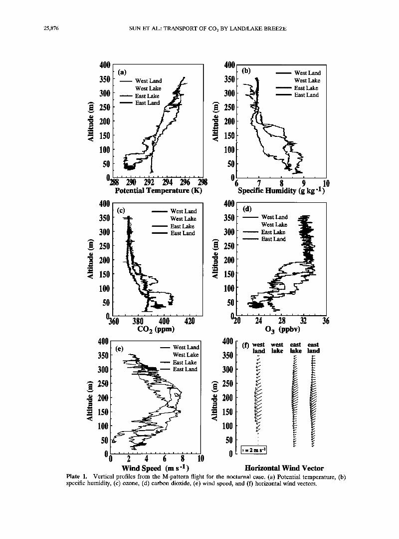
Four vertical profiles are generated from the M-flight pat- tern: one over the eastern part of Candle Lake (leg 3, Figure 2), one over the western part of Candle Lake (leg 2, Figure 2), and two over the surrounding land (legs 3 and 4, Figure 2). The wind was generally from the east-northeast, with a low-level jet at about 150 m (Plate lf). A typical stable nocturnal boundary layer is found over the land east of the lake ("east land," Plate la). Here the potential temperature increases rapidly up to 200 m and then increases slowly with height above 200 m.
The potential temperature over the land west of the lake shows two well-mixed layers imbedded in the nocturnal stable boundary layer, one in the lowest 75 m and another one at 125 m ("west land," Plate la). The two shallow mixed layers are characterized by nearly height-independent potential tem-
perature, mixing ratio of ozone and carbon dioxide, and spe- cific humidity. These elevated mixed layers occur with the strongest wind shear found in the observational domain. Kelvin-Helmholtz instability (KHI) has been observed in strongly sheared and statically stable flows [Browning and Watkins, 1970; Browning, 1971]. Turbulent layers due to the shear-generated KHI are thinner in more strongly stratified flow [Muschinski, 1997]. The two thin mixed layers west of the lake, therefore, could be caused by KHI.
The overlying residual layer above the nocturnal surface inversion is well defined in terms of height-independent carbon dioxide and ozone but not so well defined in terms of moisture
and potential temperature, where the latter is apparently in- fluenced by clear air radiative cooling. Future studies of the nocturnal boundary layer would benefit from measurements of carbon dioxide, which serves as a more defined passive tracer compared to potential temperature.
The potential temperature over the lake is independent of height (Plate 1) up to 220 m ("west lake" and "east lake," Plate la). This well-mixed layer is distinctly different from the typical stable nocturnal boundary layer over the land east of the lake. The mixed layer over the lake was well sampled at the four flight levels. Flight levels at 17 and 67 m were in the lower part of the mixed layer, flight level at 167 m was in the upper part, and the highest flight level at 330 m was immediately above the mixed layer.
Because of the complicated vertical structure over the land west of the lake, the sounding flight over the land east of the lake is chosen to represent the land sounding for the lake and land comparison in the fuiluwing sections. 3.2. Horizontal Pressure Gradient
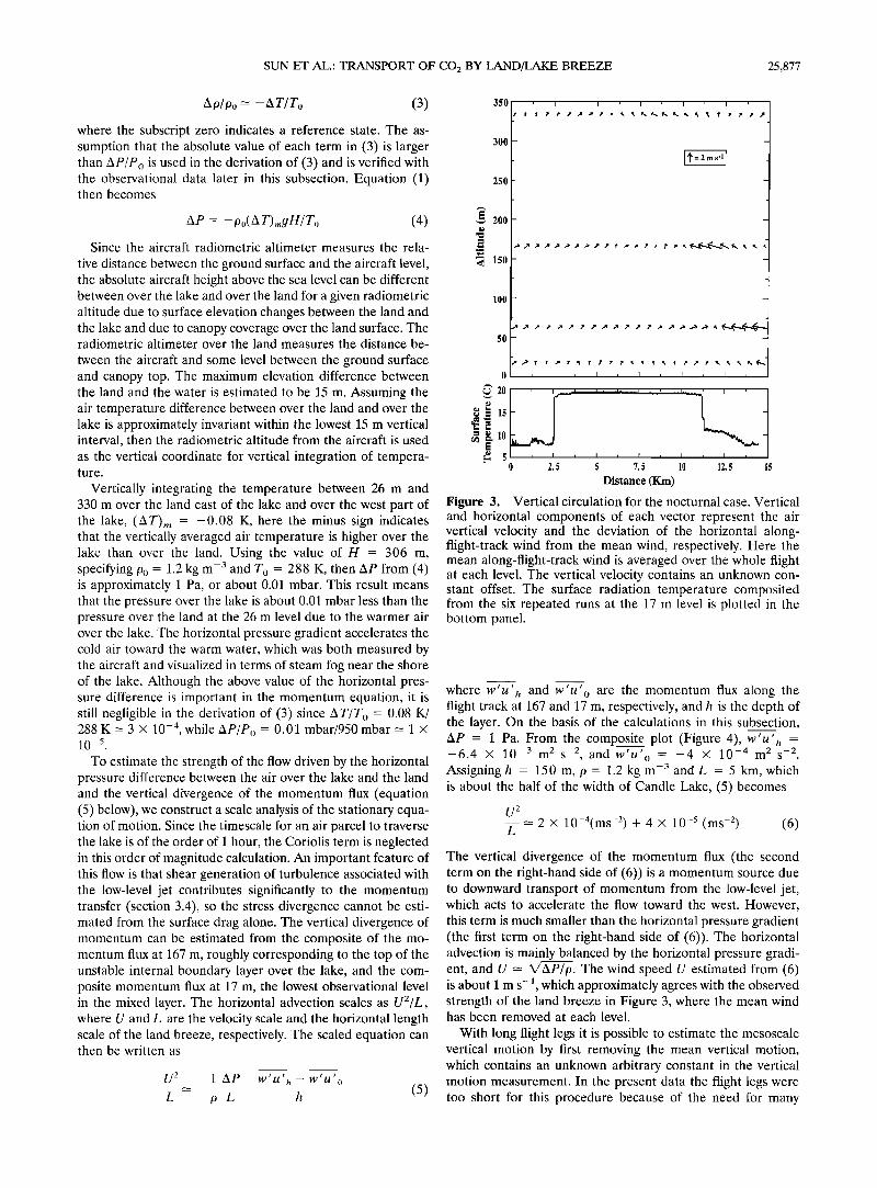
The evening of July 19 was clear with weak winds, which facilitates strengthening of the land-lake temperature contrast. On the basis of the boat measurements the lake surface tem-
perature varies from 20.1øC at the lakeshore to 18.2øC in the center, where the water is deep. By early morning of July 20, the surface radiation temperature composited from the six repeated legs at the 17 m flight level indicates that the land surface has cooled to about 11.5øC less than the water surface
temperature, as shown in Figure 3. The lake temperature mea- sured from the composite surface radiation temperature agrees well with the water temperature measured from the boat.
The warm air over the lake and cool air over the land surface
correspond to greater hydrostatic pressure at the land surface compared to the water surface. This pressure difference can be expressed in terms of the difference between the vertically integrated temperature profiles. To derive this expression, we begin with the horizontal difference of the hydrostatic relation- ships between over the land and over the water, which can be written as
AP = Pland- Plake: (Ap),•gg (1)
Here P, 9, g are the pressure, density, and the gravity con- stant, respectively; zX represents the horizontal difference be- tween the lake and the land; and subscript m represents quan- tities averaged over the depth of the well-mixed layer over the lake, H. Using the ideal gas law,
P=•pT (2)
where T and R are the air temperature and the gas constant, respectively; horizontal variations of (2) are approximated as
25,876 SUN ET AL.: TRANSPORT OF CO2 BY LAND/LAKE BREEZE
4O0 (a)
350 , West Land West Lake
•--- East Lake • ..... East Land
lOO
5o
0288 ' 2• ' 262 ' •/}4 ' 2•6 ' 298 Potential Temperature (K)
400
300
250
200
150
350
300
250
200
150
100•
50
ø3,
400
350
300
250 200
'• 150 100
50
(c) West Land
West Lake
East Lake East Land
;(• ' '3•0' ' '460' ' '4•0' CO 2 (ppm)
(e) ---- West Land • West Lake
• ........ East Lake Land
Wind Speed (m s-1 )
400
350
300
250
200 150
100
5O
0
40O
350
300
250
200
150 lOO
(b) West Land West Lake
East Lake
East Land
Specific Itumidity (g kg-1)
50
(d) ,, West Land
West Lake
----- East Lake
...... East Land
020' ' '2'4' ' 'i8' ' '3•' ' '36 0 3 (ppbv)
400 west west east east 350 (f) land lake l•ake land 300 250 • 200 •
5o '•
Horizontal Wind Vector
Plate 1. Vertical profiles from the M-pattern flight for the nocturnal case. (a) Potential temperature, (b) specific humidity, (c) ozone, (d) carbon dioxide, (e) wind speed, and (f) horizontal wind vectors.
SUN ET AL.' TRANSPORT OF CO2 BY LAND/LAKE BREEZE 25,877
A9/9o ----- -AT/To (3)
where the subscript zero indicates a reference state. The as- sumption that the absolute value of each term in (3) is larger than AP/P o is used in the derivation of (3) and is verified with the observational data later in this subsection. Equation (1) then becomes
zip = - po( A T),,gH/ To (4)
Since the aircraft radiometric altimeter measures the rela-
tive distance between the ground surface and the aircraft level, the absolute aircraft height above the sea level can be different between over the lake and over the land for a given radiometric altitude due to surface elevation changes between the land and the lake and due to canopy coverage over the land surface. The radiometric altimeter over the land measures the distance be-
tween the aircraft and some level between the ground surface and canopy top. The maximum elevation difference between the land and the water is estimated to be 15 m. Assuming the air temperature difference between over the land and over the lake is approximately invariant within the lowest 15 m vertical interval, then the radiometric altitude from the aircraft is used as the vertical coordinate for vertical integration of tempera- ture.
Vertically integrating the temperature between 26 m and 330 m over the land east of the lake and over the west part of the lake, (AT),• = -0.08 K, here the minus sign indicates that the vertically averaged air temperature is higher over the lake than over the land. Using the value of H = 306 m, specifying Po = 1.2 kg m -3 and To = 288 K, then Ap from (4) is approximately 1 Pa, or about 0.01 mbar. This result means that the pressure over the lake is about 0.01 mbar less than the pressure over the land at the 26 m level due to the warmer air over the lake. The horizontal pressure gradient accelerates the cold air toward the warm water, which was both measured by the aircraft and visualized in terms of steam fog near the shore of the lake. Although the above value of the horizontal pres- sure difference is important in the momentum equation, it is still negligible in the derivation of (3) since AT/T o = 0.08 K/ 288 K = 3 x 10 -4, while AP/P o -- 0.01 mbar/950 mbar - 1 x 10--s
To estimate the strength of the flow driven by the horizontal pressure difference between the air over the lake and the land and the vertical divergence of the momentum flux (equation (5) below), we construct a scale analysis of the stationary equa- tion of motion. Since the timescale for an air parcel to traverse the lake is of the order of 1 hour, the Coriolis term is neglected in this order of magnitude calculation. An important feature of this flow is that shear generation of turbulence associated with the low-level jet contributes significantly to the momentum transfer (section 3.4), so the stress divergence cannot be esti- mated from the surface drag alone. The vertical divergence of momentum can be estimated from the composite of the mo- mentum flux at 167 m, roughly corresponding to the top of the unstable internal boundary layer over the lake, and the com- posite momentum flux at 17 m, the lowest observational level in the mixed layer. The horizontal advection scales as U2/L, where U and L are the velocity scale and the horizontal length scale of the land breeze, respectively. The scaled equation can then be written as
U 2 1 AP w'u'•,- w'u'o L p L h
350
300
250
200
•5o
lOO
o
•' 20
•= 15
•=2ms'l{
, t , I , I , I , I ,
I '
, I , I T I I I
0 2. 5 5 7. 5 10 12. 5
Distance (Km)
Figure 3. Vertical circulation for the nocturnal case. Vertical and horizontal components of each vector represent the air vertical velocity and the deviation of the horizontal along- flight-track wind from the mean wind, respectively. Here the mean along-flight-track wind is averaged over the whole flight at each level. The vertical velocity contains an unknown con- stant offset. The surface radiation temperature composited from the six repeated runs at the 17 m level is plotted in the bottom panel.
where w'u' h and w'u' o are the momentum flux along the flight track at 167 and 17 m, respectively, and h is the depth of the layer. On the basis of the calculations in this subsection, AP - 1 Pa. From the composite plot (Figure 4) w'u' = , h
-6.4 x 10 -3 m 2 s -2, and w'u' o = -4 x 10 -4 m 2 s -2 Assigning h - 150 m, 9 = 1.2 kg m -3 and L - 5 km, which is about the half of the width of Candle Lake, (5) becomes
U 2 - 2 x 10⁻⁴(ms -2) + 4 X 10 -5 (ms -2) (6) L
The vertical divergence of the momentum flux (the second term on the right-hand side of (6)) is a momentum source due to downward transport of momentum from the low-level jet, which acts to accelerate the flow toward the west. However, this term is much smaller than the horizontal pressure gradient (the first term on the right-hand side of (6)). The horizontal advection is mainly balanced by the horizontal pressure gradi- ent, and U -• X/AP/p. The wind speed U estimated from (6) is about 1 m s-• which approximately agrees with the observed strength of the land breeze in Figure 3, where the mean wind has been removed at each level.
With long flight legs it is possible to estimate the mesoscale vertical motion by first removing the mean vertical motion, which contains an unknown arbitrary constant in the vertical motion measurement. In the present data the flight legs were too short for this procedure because of the need for many
25,878 SUN ET AL.' TRANSPORT OF CO•_ BY LAND/LAKE BREEZE
(a)
. , . , . , ß , , 0.06 0.04 3•3 m ' 0.02 0.04
0 .•._.•_•/•t•'-• 0.02 -0.02 .......... ' 0
-0.04 , • . , . , . , . I . -0.02
] , , , , . . 0.06
0.04, 1•7 rn • 0.02 0.04
-o.o2 ; -0.04 , , , -: -' ' ß '- .02
0.04 ß , ß , ß , ß , ß , 67 m ,, 0.02 ;., ,-.,,.
0 .. t• -0.02 " ...... '• ..... ""
-0.04 , I , ! , I m t . • .
0.02 ' i7 m 0
-0.02
-0.04
20
15
10
I , I m I ß I . I
0 2.5 5 7.5 10 12.5 15
Distance (Km )
0.06 0.04
0.02 0 '•'
-0.02
ß 0.06
0.04
0.02
0
ß -0.02
4
0
• 20
•= 15
• 5 0 2.5 5 7.5 10 12.5 15
Distance (Km)
(c)
• i i ß i ß i ß i ' 0.3 33
o: o 1 0 i i I I , I , m m ß ß
0.3 11•7 ' ' ' ' ' ' ' ' ' ' '
o: o
0 , I , I , I , t ß • ß I ,
• I ß i ß I ß I ß I ß i ß 0.3 7
0.2 • 0.1
0 , I , I , I , I , t . I .
buoyancy generation
(d) ..... shear generation 0.002 . , . , . , . , .
.001 1 3•3 -0.001
-0.002 ' ' '
0.002/ ß , . • ß , . • . , ß 0.001 • 167 m ,•'T .,.
-0.001 -0.002' ' ' ' ' ' ' ' • ' ' ' o.oo2.7, ' ' ' ' ' ' ' ' ' m 0.001
-o.ool -0.002 0.002
0.001
0
-0.001 -0.002
zo
15
10 5
2.5 5 7.5 10 12.5 15 0 2 4 6 8 10 12 14
Distance (Kin) Distance (Km)
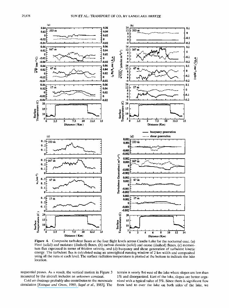
Figure 4. Composite turbulent fluxes at the four flight levels across Candle Lake for the nocturnal case. (a) Heat (solid) and moisture (dashed) fluxes, (b) carbon dioxide (solid) and ozone (dashed) fluxes, (c) momen- tum flux expressed in terms of friction velocity, and (d) buoyancy and shear generation of turbulent kinetic energy. The turbulent flux is calculated using an unweighted running window of 2 km width and composited using all the runs at each level. The surface radiation temperature is plotted at the bottom to indicate the lake location.
sequential passes. As a result, the vertical motion in Figure 3 measured by the aircraft includes an unknown constant.
Cold air drainage probably also contributes to the mesoscale circulation [Estoque and Gross, 1981; Segal et al., 1983]. The
terrain is nearly flat west of the lake where slopes are less than 1% and disorganized. East of the lake, slopes are better orga- nized with a typical value of 5%. Since there is significant flow from land to over the lake on both sides of the lake, we
SUN ET AL.: TRANSPORT OF CO2 BY LAND/LAKE BREEZE 25,879
(a) 460.
440.
• 420.
• 4OO.
380.
360, 105.45
11 105.25
Longitude (deg) 105.: 53.75
,85
i3.8
Latitude (deg)
53.9
I I I I
105.45 105.4 105.35 1053 105.25
Longitude {deg)
53.9 /-53.85
538 Latitude (deg) .os.s
11
i ) 53.9 /--53.85 / Latitude (deg)
•I• ?53.8 t t • • J /- 53.75
105.45 105.4 105.35 105.3 105.25 105.2 105.15
Longitude (deg)
(b) 410
400
390
380
370
360
350 I , I r I , I ,
2 4 6 8
Distance (km)
53.95
53.9
53.85
53.8
53.75
Candle Lake
53.7 ' • ' • ' t ' • ' • '-105.15 ß 105.45 - 105.4 - 105.35 - 105.3 - 105.25 -105.2
Longitude
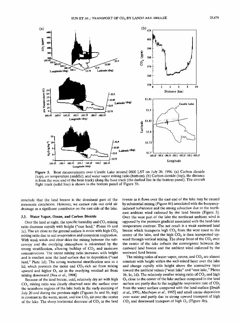
Figure 5. Boat measurements over Candle Lake around 0600 LST on July 20, 1996. (a) Carbon dioxide (top), air temperature (middle), and water vapor mixing ratio (bottom). (b) Carbon dioxide (top), the distance is from the west end of the boat track) along the boat track (the dashed line in the bottom panel). The aircraft flight track (solid line) is shown in the bottom panel of Figure 5b.
conclude that the land breeze is the dominant part of the mesoscale circulation. However, we cannot rule out cold air drainage as a significant contributor on the east side of the lake.
3.3. Water Vapor, Ozone, and Carbon Dioxide
Over the land at night, the specific humidity and CO2 mixing ratio decrease rapidly with height ("east land," Plates lb and lc). The air close to the ground surface is moist with high CO2 mixing ratio due to soil evaporation and ecosystem respiration. With weak winds and clear skies the mixing between the sub- canopy and the overlying atmosphere is minimized by the strong stratification, allowing buildup of CO2 and moisture concentrations. The ozone mixing ratio increases with height and is smallest near the land surface due to deposition ("east land," Plate l d). The strong nocturnal stratification acts as a lid, which prevents the moist and CO2-rich air from mixing upward and higher 03 air in the overlying residual air from mixing downward [Neu et al., 1994].
Because of the land breeze, cold, relatively dry air with high CO2 mixing ratio was clearly observed near the surface over the nearshore regions of the lake both in the early morning of July 20 and during the previous night (Figures 5a and 5b, top) in contrast to the warm, moist, and low CO2 air over the center of the lake. The sharp horizontal decrease of CO2 in the land
breeze as it flows over the east end of the lake may be caused by substantial mixing (Figure 4b) associated with the buoyancy- induced turbulence and the strong advection due to the north- east ambient wind enforced by the land breeze (Figure 3). Over the west part of the lake the northeast ambient wind is opposed by the pressure gradient associated with the land-lake temperature contrast. The net result is a weak eastward land breeze which transports high CO2 from the west coast to the center of the lake, and the high CO2 is then transported up- ward through vertical mixing. The sharp front of the CO2 over the center of the lake reflects the convergence between the eastward land breeze and the ambient wind enforced by the westward land breeze.
The mixing ratios of water vapor, ozone, and CO2 are almost constant with height within the well-mixed layer over the lake and change rapidly with height above the convective layer toward the ambient values ("west lake" and "east lake," Plates lb, lc, ld). The relatively smaller mixing ratio of CO2 and high 0 3 close to the center of the lake surface compared to the land surface are partly due to the negligible respiration rate of CO2 from the water surface compared with the land surface [Smith et al., 1991; Maclntyre et al., 1995] and small ozone deposition over water and partly due to strong upward transport of high CO2 and downward transport of high O3 (Figure 4b).
25,880 SUN ET AL.: TRANSPORT OF CO2 BY LAND/LAKE BREEZE
Upward fluxes of CO2 and water vapor and downward fluxes of 03 are found at all the flight levels within the mixed layer over the lake (Figures 4a and 4b). The strongest upward trans- port of CO2 and water vapor and downward transport of 03 are found at the 167 m flight level where strong turbulence is generated by mean shear. The fluxes at 330 m are very small associated with very weak turbulence in the stratified flow above the convective layer. The vertically integrated CO2 con- centration appears to be greater in the air over the lake com- pared to the air over the land in spite of the fact that the land surface is the CO2 source. The greater CO2 over the lake is due to the upward transport of high CO2 air originally advected by the land breeze. The lake in this case acts as a chimney to transport CO2-rich air to higher levels.
Because of large evaporation over the lake surface, the wa- ter vapor concentration is higher over the lake than over the land below the top of the convective layer over the lake, which is about 220 m. Because of advection by the easterly wind, the air over the eastern part of the lake is strongly influenced by the drier, high CO2 and low 03 air over the land east of the lake especially in the upper part of the mixed layer where the easterly low-level jet is strong (Plates l e and If).
Comparison between the 1700 LST sounding on July 19 and the 0500 LST sounding on July 20 at 2 km SW of Candle Lake indicates that the air between 500 m and 2 km is stabilized and
becomes drier during the night. These changes could reflect the downward sinking motion around the lake required to compensate for the upward motion over the lake.
3.4. Turbulent Kinetic Energy
Within the convective layer over the lake, the turbulent momentum transport is small at the lower levels and large at the upper levels in marked contrast to the usual convectively driven internal boundary layer. The maximum turbulent mo- mentum transport is at the 167 m level, which coincides with wind maximum at 150 m within the vertical resolution of the
data (dashed lines in Figure 4d). The composite sensible heat flux near the surface is about 0.01 K ms -• or less, then de- creases with height, reverses sign, and reaches a value of about -0.02 K ms-• at 167 m (solid lines, Figure 4a). In other words, the sensible heat flux is upward in the lower part of the internal boundary layer and downward in the upper part of the internal boundary layer. The upward transport of the sensible heat flux is caused by the advection of cold air over the warm water, and the downward sensible heat flux is caused by the entrainment of warm air from above the mixed layer over the lake. The entrainment can also be seen from the large upward CO2 flux and downward ozone flux at 167 m (Figure 4b) due to the vertical variation of the mean CO2 and ozone with height across the top of the mixed layer (Plates lc and ld).
While the buoyancy generation of turbulence is significant in the lower part of the internal boundary layer (solid lines, Fig- ure 4d), shear generation of turbulence dominates the turbu- lence energy budget in the upper part of the internal boundary layer and probably drives most of entrainment, as shown sche- matically in Figure 1. Such strong shear generation does not occur over land where the low-level jet is embedded within the surface inversion layer, so the Richardson number is relatively large over land. However, over the lake the low-level jet is within the upper part of the internal boundary layer where the vertical potential temperature gradient is small, leading to small Richardson numbers over the lake. The decreased Rich-
ardson number triggers the shear instability which generates
the turbulence. This shear-generated turbulence leads to strong entrainment and downward heat flux. As a result, the buoyancy destruction of turbulence in the upper part of the internal boundary layer appears to exceed the buoyancy gen- eration of turbulence in the lower part of the internal boundary layer. As a consequence, the elevated shear generation is cru- cial for maintenance of the strong entrainment.
4. Midday Case The daytime lake breeze over Candle Lake has been studied
by Sun et al. [1997] based on the data collected during BOREAS 94. Additional flight levels and vertical sounding flights were made over Candle Lake and over the surrounding land surface during BOREAS 96. The detailed difference of the vertical structure between over the land and over the lake
is studied in this section.
4.1. Horizontal Pressure Difference
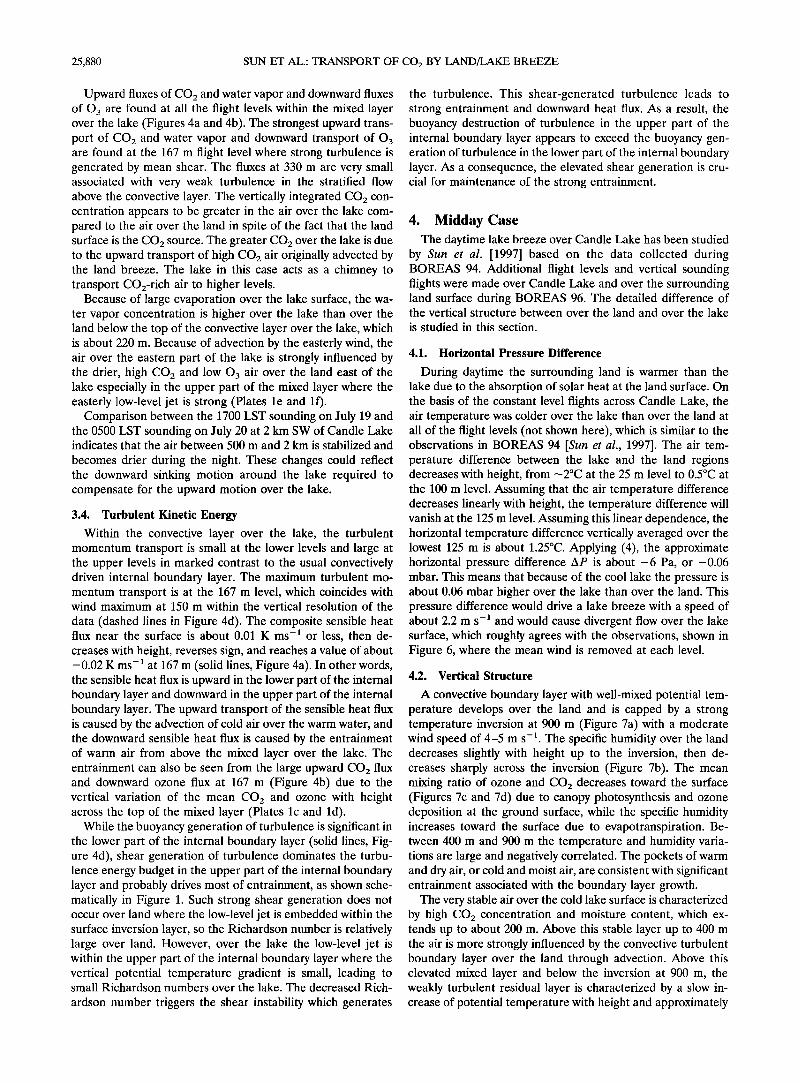
During daytime the surrounding land is warmer than the lake due to the absorption of solar heat at the land surface. On the basis of the constant level flights across Candle Lake, the air temperature was colder over the lake than over the land at all of the flight levels (not shown here), which is similar to the observations in BOREAS 94 [Sun et al., 1997]. The air tem- perature difference between the lake and the land regions decreases with height, from ---2øC at the 25 m level to 0.5øC at the 100 m level. Assuming that the air temperature difference decreases linearly with height, the temperature difference will vanish at the 125 m level. Assuming this linear dependence, the horizontal temperature difference vertically averaged over the lowest 125 m is about 1.25øC. Applying (4), the approximate horizontal pressure difference AP is about -6 Pa, or -0.06 mbar. This means that because of the cool lake the pressure is about 0.06 mbar higher over the lake than over the land. This pressure difference would drive a lake breeze with a speed of about 2.2 m s -1 and would cause divergent flow over the lake surface, which roughly agrees with the observations, shown in Figure 6, where the mean wind is removed at each level.
4.2. Vertical Structure
A convective boundary layer with well-mixed potential tem- perature develops over the land and is capped by a strong temperature inversion at 900 m (Figure 7a) with a moderate wind speed of 4-5 m s -•. The specific humidity over the land decreases slightly with height up to the inversion, then de- creases sharply across the inversion (Figure 7b). The mean mixing ratio of ozone and CO2 decreases toward the surface (Figures 7c and 7d) due to canopy photosynthesis and ozone deposition at the ground surface, while the specific humidity increases toward the surface due to evapotranspiration. Be- tween 400 m and 900 m the temperature and humidity varia- tions are large and negatively correlated. The pockets of warm and dry air, or cold and moist air, are consistent with significant entrainment associated with the boundary layer growth.
The very stable air over the cold lake surface is characterized by high CO2 concentration and moisture content, which ex- tends up to about 200 m. Above this stable layer up to 400 m the air is more strongly influenced by the convective turbulent boundary layer over the land through advection. Above this elevated mixed layer and below the inversion at 900 m, the weakly turbulent residual layer is characterized by a slow in- crease of potential temperature with height and approximately
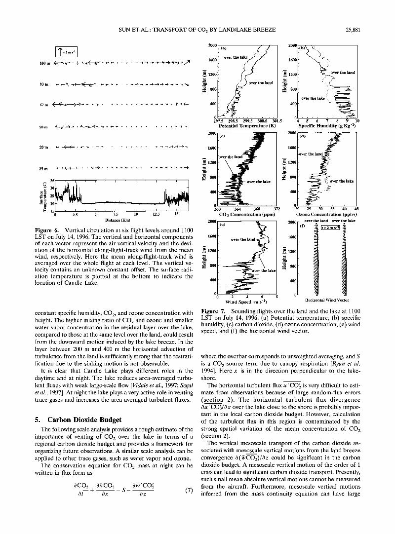
SUN ET AL.: TRANSPORT OF CO 2 BY LAND/LAKE BREEZE 25,881
• 25
[" 15 0 2.5 5 7.5 10 12.5 15
Distance (Kin)
Figure 6. Vertical circulation at six flight levels around 1100 LST on July 14, 1996. The vertical and horizontal components of each vector represent the air vertical velocity and the devi- ation of the horizontal along-flight-track wind from the mean wind, respectively. Here the mean along-flight-track wind is averaged over the whole flight at each level. The vertical ve- locity contains an unknown constant offset. The surface radi- ation temperature is plotted at the bottom to indicate the location of Candle Lake.
constant specific humidity, CO2, and ozone concentration with height. The higher mixing ratio of CO2 and ozone and smaller water vapor concentration in the residual layer over the lake, compared to those at the same level over the land, could result from the downward motion induced by the lake breeze. In the layer between 200 m and 400 m the horizontal advection of turbulence from the land is sufficiently strong that the restrati- fication due to the sinking motion is not observable.
It is clear that Candle Lake plays different roles in the daytime and at night. The lake reduces area-averaged turbu- lent fluxes with weak large-scale flow [Vidale et al., 1997; Segal et al., 1997]. At night the lake plays a very active role in venting trace gases and increases the area-averaged turbulent fluxes.
5. Carbon Dioxide Budget The following scale analysis provides a rough estimate of the
importance of venting of CO2 over the lake in terms of a regional carbon dioxide budget and provides a framework for organizing future observations. A similar scale analysis can be applied to other trace gases, such as water vapor and ozone.
The conservation equation for CO2 mass at night can be written in flux form as
0CO2 0•CO2 Ow'CO5 + --: S- (7) Ot Ox Oz
2000 (a) 1600 over the la•;•
_• 1200 ?5 over the land
.......... 297.5 298.5 299.5 300.5 301.5
Potential Temperature (K) 2000
1600
12oo
800
400
0 360
2000
1600
1200
800
40O
(c)
364 368 372
CO 2 Concentration (ppm)
(e)
over the land
2O0O
1600
•.•1200
800
400
0 4
200
160
,•120
80
40
200,
160,
,•120,
80
40
2 4 6 8
Wind Speed {m s 'l)
(b)
'• i• .•ver the land
over the lake i. $ 6 7 8 9 10
Specific Humidity (g Kg '1)
r the land
2•.11i•½•ver the lake _
20 25 30 35 40 45
Ozone Concentration (ppbv) over the land over the lake
(f) It= 2 rn s-ll •
_
Horizontal Wind Vector
Figure 7. Sounding flights over the land and the lake at 1100 LST on July 14, 1996. (a) Potential temperature, (b) specific humidity, (c) carbon dioxide, (d) ozone concentration, (e) wind speed, and (f) the horizontal wind vector.
where the overbar corresponds to unweighted averaging, and S is a CO: source term due to canopy respiration [Ryan et al. 1994]. Here x is in the direction perpendicular to the lake- shore.
The horizontal turbulent flux u'CO• is very difficult to esti- mate from observations because of large random-flux errors (section 2). The horizontal turbulent flux divergence Ou'COS/Ox over the lake close to the shore is probably impor- tant in the local carbon dioxide budget. However, calculation of the turbulent flux in this region is contaminated by the strong spatial variation of the mean concentration of CO: (section 2).
The vertical mesoscale transport of the carbon dioxide as- sociated with mesoscale vertical motions from the land breeze
convergence O(½CO2)/Oz could be significant in the carbon dioxide budget. A mesoscale vertical motion of the order of 1 cm/s can lead to significant carbon dioxide transport. Presently, such small mean absolute vertical motions cannot be measured
from the aircraft. Furthermore, mesoscale vertical motions inferred from the mass continuity equation can have large
25,882 SUN ET AL.: TRANSPORT OF CO 2 BY LAND/LAKE BREEZE
errors due to uncertainty of the convergence of the mesoscale horizontal motion over the lake.
In derivation of (7) both the horizontal divergence of the horizontal turbulent flux of CO2 and the vertical transport of the CO2 by the mean vertical motion are ignored. Integrating (7) vertically from the ground surface to some level z, (7) becomes
• 0CO2 f• 0•CO2 Ot dz + Ox fc fc
--dz
z = Sdz + [w'CO2]s•c - [w'CO•]z fc
(8)
The first and second terms on the left-hand side are normally referred to as the "storage term" and the advection term, respectively. The terms on the right-hand side are the source term, the turbulent flux due to respiration from the ground surface and the turbulent transport of carbon dioxide at the observational height z, respectively. The sum of the first two terms on the right-hand side are sometimes collectively re- ferred to as the "net ecosystem CO2" [Grace et al., 1996] or "net ecosystem exchange" [Fan et al., 1990].
5.1. Horizontal Transport of Carbon Dioxide
To apply (8) to the aircraft observations, we horizontally integrate (8) separately for the land area and the lake region. For the purpose of scale analysis, we assume that the influence of the land breeze extends inland a distance equal to about the half of the lake width. The exact horizontal extent of the land
breeze could not be determined from the data. Integrating from the land interior (x = 0), where the horizontal transport of CO2 can be neglected, to the shore line (x = L), (8) horizontally integrated over the land becomes
z StOrland 3- [•CO2]x=L dz fc
f0 L L -- Sland 3- [W t CO•]sf cdx - [w t CO•] z dx
where
(9)
Sland • Sdz dx (•o)
StOrland = •0 œ ffc 0CO2 Ot dz dx
A similar budget can be written over the water by integrating from the shore x = L to the center of the lake x = 2L
i z IL2L StOrlake -- [•CO2]x= L dz = - [w' CO•]z dx fc
(•2)
where
The CO 2 source term between the surface and the level z is limited to canopy effects and is neglected over the lake. The direct turbulent flux of carbon dioxide from the lake surface is
considered to be small [Smith et al., 1991; Maclntyre et al., 1995] and is also neglected. The discussion on the magnitude of the turbulent flux of carbon dioxide from water surfaces is
beyond the scope of this paper due to lack of measurements of partial pressure of carbon dioxide in the lake water. However, the respiration from the lake is thought to be small since Candle Lake is relatively clean with little algae or plant activity. The horizontal transport of CO2 at the center of the lake has been neglected by assuming symmetry.
The CO2 mixing ratio is assumed to be almost independent of height in the early evening at about 1800 LST [Jarvis et al., 1997] due to the daytime horizontal advection of convectively mixed air from over the land. For our calculation of the storage term the CO2 mixing ratio at the top of the nocturnal boundary layer measured at around 0600 LST is assumed to be this constant value, equal to 371 ppm (Plate 1). Therefore the change of the CO2 mixing ratio within the convective boundary layer in the 12 hour period between 1800 LST and 0600 LST, is the difference between 371 ppm and 385 ppm, where the latter is the CO2 mixing ratio within the convective boundary at 0600 LST. Choosing z in the above equations to be 17 m, which is the flight level closest to tower measurement levels, assigning L = 5 km, using the CO2 turbulent flux measurement at 17 m to be 3/•mol m -2 s -1 (Figure 4) and the average air density in the mixed layer over the lake, 1.14 kg m -3, the advection term in (12) is estimated to be
•s z IL 2 L -- [•CO2]x= L dg = --StOrlake -- [W' CO•]z dx fc
= 833 (/•mol m -1 s -•) - 15000 (/•mol m -1 s -1) (14) It is clear that the advection term is mainly balanced by the upward turbulent transport of CO2 flux above the lake. This result strongly suggests that the lake acts as a CO2 chimney (Figure 1). That is, the CO2 storage near the lake surface is small so that most of the horizontally advected CO2 from the land respiration is transported upward over the lake by vertical mixing and mesoscale circulations.
The total upward transport of CO2 actually consists of two parts, one part is associated with the buoyancy-driven turbu- lent motion in the lower part of the boundary layer and shear- generated turbulence in the upper part of the boundary layer, the other part is associated with the mean upward vertical motion due to the land breeze convergence (mesoscale flux). The latter cannot be adequately measured, as discussed above. However, the vertical transport of CO2 due to the upward mean vertical motion associated with the land breeze conver-
gence should strengthen the chimney effect over the lake. On the basis of the above analysis the respiration of the
ecosystem over the land surface, which is the sum of the CO2 source term and the CO2 turbulent flux from the land surface, can be estimated from (9) as
•0 L Sland 3- [W t CO•]sfc dx
StOrlake•f2Lf z 0CO2 ot dL d sfc
az ax (•3) •0 L IL 2L • StOrland + [w'CO•] z dx + [w'CO•]z dx (•5)
SUN ET AL.: TRANSPORT OF CO2 BY LAND/LAKE BREEZE 25,883
Equation (15) indicates that the respiration of the ecosystem is approximately the sum of the observed turbulent flux of CO2 above the forest, the storage term between the land surface and the top of the forest, and the CO2 turbulent flux over the lake, which is an approximation of the horizontal transport of CO2 below the flux-measurement level.
On the basis of the averages over the two land segments (section 2) the CO2 turbulent flux at 17 m averages about 0.8 p•mol m -2 s-• although the flight leg over the land was only about 2 km and the random flux sampling errors are large. The CO2 flux at about 27 m over the old black spruce (OBS) site, which is about 12 km east of Candle Lake, was about 0.2/•mol m -2 s-1 around 0600 LST (J. Massheder, personal communi- cation, 1998). The smaller CO 2 turbulent flux is associated with the weaker wind at OBS compared to the land adjacent to the lake where the wind is augmented by the land breeze. The averaged CO2 turbulent flux at 17 m over the water surface, about 3 /•mol m -2 s -1, seems to be substantially larger than the CO2 turbulent flux above the canopy over the land. There- fore the chimney effect (last term in (15)) is large, implying that the horizontal transport of CO2 must play an important role in the carbon dioxide budget.
5.2. Regional Carbon Dioxide Respiration
The lakes affect the total computed vertical turbulent flux of carbon dioxide over the BOREAS region in two ways. The lakes can induce land breezes which transport CO2 horizon- tally and decreases the total CO2 turbulent flux through the top of the forest. The regional CO2 balance, based on the sum of tower CO2 flux measurement and the CO2 storage within can- opies over the land alone, will miss substantial CO2 vented vertically over water bodies at night. This effect could be im- portant in regions with numerous lakes and ponds such as the BOREAS area. As a second effect, the lake respiration is normally much less than the land surface respiration. Replac- ing the lake respiration rate with the land respiration in the regional carbon dioxide balance would lead to overestimation of the CO 2 flux.
Neglecting the flux of carbon dioxide from the water sur- faces but including the role of the lakes in terms of induced horizontal transport, the area-averaged CO 2 respiration of the ecosystem over a region with a total area coverage of A, in- cluding a total lake coverage of a, can be derived using (8) as
(I z R --A S dz + [w' CO•]stc fc
= (A-a)Iw'CO•z+ht+ AC02 At Az , (16)
where
f0 z 0•CO2 ht -- Ox dz. (17)
For simplicity, each term within the brackets in (16) is assumed invariant in the region. The term w'CO} z represents the CO2 flux measured at the top of the forest, ht represent the hori- zontal transport of CO:, and Az ACO:/At is the CO2 storage term over land, i.e., the mean CO2 increase within the layer from the ground surface to the observational height at level z.
In other words, the respirated CO2 of the ecosystem from the region R is either mixed upward through the canopy, trans- ported horizontally over the lake, or stored within the canopy below the observation level.
If we ignore the effect of the lakes in the horizontal trans- port of CO2 but consider the area coverage of the lakes a, the regional CO 2 respiration rate would be
R•: (A-a)[w'CO•+ ACO2 In this case, the regional CO2 respiration rate would be un- derestimated by
R• - R = -(A - a) ht (19)
Here we assume the horizontal transport of CO2 is positive since it represents the respiration vented over the lakes. The negative sign in (19) means R• underestimates R.
If we ignore both the effect of the lakes in transporting CO2 and the existence of the lakes by assuming that the respiration is equal to the land value everywhere, then the regional CO 2 respiration rate would be
ACO2 ] w'CO+ (20)
In this case, the difference between (20) and (16) would be
ACO2 R:- R - -A ht + a w'CO•z + ht + A• Az (21)
Equation (21) indicates that if the area coverage of the water is small such that the second term on the right-hand side is smaller than the first term on the right-hand side in (21), the regional CO2 respiration rate would be underestimated due to the neglect of the effect of the lakes on the horizontal transport of CO2. However, if the area coverage of the lakes is large such that the second term is larger than the first term on the right- hand side of (21), then the regional CO,_ respiration rate would be overestimated due to the replacement of low CO2 respira- tion rate over the lakes by the high CO2 respiration rate over the land.
6. Summary The aircraft data indicate formation of a well-defined land
breeze generated by a horizontal pressure gradient due to cooling over the land surface and upward heat flux over the warm lake. As the cool nocturnal land breeze flows over the
warmer Candle Lake, a convective internal boundary layer develops. Substantial turbulent mixing is generated in the in- ternal boundary layer by the upward surface buoyancy flux in the lower part of the internal boundary layer and by shear associated with a nocturnal low-level jet in the upper part of the internal boundary layer. The low-level jet does not gener- ate significant turbulence over the land due to strong stratifi- cation but generates significant turbulence over the lake due to reduced stratification by buoyancy flux from the lake surface. The low-level jet is not eliminated by convective mixing over the lake since it is maintained by advection from the land area.
The land breeze leads to substantial vertical transport of trace gases such as CO:, water vapor, and ozone through vertical turbulent mixing and local mesoscale motion. Part of the CO2 respirated from the land surface is advected horizon-
25,884 SUN ET AL.: TRANSPORT OF CO2 BY LAND/LAKE BREEZE
tally over the lake. As a result of horizontal convergence of CO2 over the lake and subsequent vertical transport by the turbulence and land breeze circulation, the vertically inte- grated CO2 over the lake is larger than that over the land, in spite of the fact that the respiration from the lake is thought to be negligible.
The observations also indicate that the lake plays quite dif- ferent roles between the daytime and the nighttime. In the daytime, flow of warm air over the relatively cool lake produces strong stratification which suppresses turbulent mixing. There- fore the effect of the lake reduces the area-averaged vertical fluxes [Sun et al., 1997]. On the other hand, the lake breeze may induce mesoscale convective systems over the surrounding land with weak wind conditions, which is clearly demonstrated by Vidale et al. [1997] based on BOREAS 94 data.
The potential importance of the land breeze on the regional CO2 budget is examined in section 5. The horizontal transport of CO2 from the land is approximately balanced by upward transport of CO2 over the lake. This result suggests that the horizontal transport of CO2 cannot be neglected in the CO2 budget over the land adjacent to lakes and can be estimated from the upward turbulent transport of CO2 over the lake. Nocturnal vertical venting of CO2 could also occur in regions of convergence of drainage flows or random nocturnal mean- dering flow. Over forests, colder surface locations, such as clearings, could produce divergent flow which transports the respirated CO2 horizontally. The CO2 would then be vented vertically over warmer surfaces such as moist locations. Such circulations would be weaker and less organized compared to the land breeze circulation of the present study, although cold air drainage flow could have augmented the land breeze cir- culation at the east side of Candle Lake. In general, surface heterogeneity provides not only the thermal contrast to gen- erate horizontal motions but also generates nonuniform hori- zontal distributions of mass and energy.
Although this study provides unprecedented flux sampling of spatial variations of turbulent transport of carbon dioxide in a land breeze circulations system, the mesoscale transport of carbon dioxide associated with the land breeze cannot be
quantitatively determined due to sampling difficulties of me- soscale scale motion from aircraft. The rising motion over the lake, inferred from the land breeze convergence, would aug- ment the vertical turbulent transport of CO2.
The above conclusions on the flow structure over Candle
Lake are based on one case study. Further observations are needed to include a variety of conditions.
Acknowledgments. The authors would like to thank the Twin Otter group for flying early in the morning to make this unique data set available and Dave Dow from Agriculture and Agri-Food Canada for assembling the CO2 analyzer package used on the boat. The discus- sions with Ken Davis and Don Lenschow and the reviewer comments
are greatly appreciated. Computer assistance from David Son and Jia Li are gratefully acknowledged. Jielun Sun and Larry Mahrt were supported by NASA grant NAG 5-2300, NSF grant ATM-9417959, and by grant DAAH04-96-10037 from the Army Research Office. Funding for Twin Otter operations in BOREAS was provided by the National Research Council of Canada, Agriculture and Agri-Food Canada, the Atmospheric Environment Service of Canada, and the Natural Sciences and Engineering Research Council of Canada. The National Center for Atmospheric Research is sponsored by the Na- tional Science Foundation.
References
Bacci, P., C. Giraud, L. Longhetto, and R. Richiardone, Acoustic sounding of land and sea breezes, Boundary Layer Meteorol., 28, 187-192, 1984.
Baldocchi, D. D., R. Valentini, S. Running, W. Oechel, and R. Dahl- man, Strategies for measuring and modelling carbon dioxide and water vapour fluxes over terrestrial ecosystems, Global Change Biol., 2, 159-168, 1996.
Brost, R. A., and J. C. Wyngaard, A model study of the stably stratified planetary boundary layer, J. Atmos. Sci., 35, 1427-1440, 1978.
Browning, K. A., Structure of the atmosphere in the vicinity of large- amplitude Kelvin-Helmholtz billows, Q. J. R. Meteorol. Soc., 97, 283-299, 1971.
Browning, K. A., and C. D. Watkins, Observations of clear air turbu- lence by high power radar, Nature, 227, 260-263, 1970.
Caughey, S. J., J. C. Wyngaard, and J. C. Kaimal, Turbulence in the evolving stable boundary layer, J. Atmos. Sci., 36, 1041-1052, 1979.
Estoque, M. A., and J. M. Gross, Further studies of a lake breeze, II, Theoretical study, Mort. Weather Rev., 109, 619-634, 1981.
Fan, S. M., S.C. Wofsy, P.S. Balkin, and D. J. Jabob, Atmosphere- biosphere exchange of CO2 and 03 in the central Amazon forest, J. Geophys. Res., 95, 16,851-16,864, 1990.
Garratt, J. R., The internal boundary layer--A review, Boundary Layer Meteorol., 50, 171-203, 1990.
Geiger, R., The Climate Near the Ground, Harvard Univ. Press, Cam- bridge, Mass., 1959.
Goulden, M. L., J. W. Munger, S. M. Fan, and B.C. Daube, Measure- ments of carbon sequestration by long-term eddy covariance: Meth- ods and a critical evaluation of accuracy, Global Change Biol., 2, 169-182, 1996.
Grace, J., Y. Malhi, J. Lloyd, J. MacIntyre, A. C. Mirand, P. Meir, and H. S. Miranda, The use of eddy covariance to infer the net carbon dioxide uptake of Brazilian rain forest, Global Change Biol., 2, 209- 217, 1996.
Greco, S., and D. Baldocchi, Seasonal variations of CO2 and water vapor exchange rates over a temperature deciduous forest, Global Change Biol., 2, 183-197, 1996.
Hollinger, D. Y., F. M. Kelliher, J. N. Byers, J. E. Hunt, T. M. Mc- Seveny, and P. L. Weir, Carbon dioxide exchange between an un- disturbed old-growth temperate forest and the atmosphere, Ecology, 75, 134-150, 1994.
Jarvis, P. G., J. M. Massheder, S. E. Hale, J. B. Moncrieff, M. Ray- ment, and S. L. Scott, Seasonal variation of carbon dioxide, water vapor, and energy exchanges of a boreal spruce forest, J. Geophys. Res., 102, 28,953-28,966, 1997.
Lavigne, M. B., et al., Comparing nocturnal eddy covariance measure- ments to estimates of ecosystem respiration made by scaling cham- ber measurements at six coniferous boreal sites, J. Geophys. Res., 102, 28,799-28,985, 1997.
Lee, X., On micrometeorological observations of surface-air exchange over tall vegetation, Agric. For. Meteorol., 91, 39-49, 1998.
Lee, X., T. A. Black, G. den Hartog, H. H. Neumann, Z. Nesic, and J. Olejnik, Carbon dioxide exchange and nocturnal processes over a mixed deciduous forest, Agric. For. Meteorol., 81, 13-29, 1996.
MacIntyre, S., R. Wanninkhof, and J.P. Chanton, Trace gas exchange across the air-water interface in freshwater and coastal marine en-
vironments, in Biogenic Trace Gases: Measuring Emissions From Soil and Water, edited by P. A. Matson and R. C. Harris, Blackwell Sci., Cambridge, Mass., 1995.
Moncrieff, J. B., Y. Malhi, and R. Leuning, The propagation of errors in long-term measurements of land-atmosphere fluxes, Global Change Biol., 2, 231-240, 1996.
Muschinski, A., Turbulence and gravity waves in the vicinity of a midtropospheric warm front: A case study using VHF echo-intensity measurements and radiosonde data, Radio Sci., 32, 1161-1178, 1997.
Neu, U., T. K•inzle, and H. Wanner, On the relation between ozone storage in the residual layer and the daily variation in near surface ozone concentration--A case study, Boundary Layer Meteorol., 69, 221-247, 1994.
Ryan, M. G., S. Linder, J. M. Vose, and R. M. Hubbard, Dark respi- ration of pines, Ecol. Bull., 43, 50-63, 1994.
Segal, M., R. W. Arritt, J. Shen, C. Anderson, and M. Leuthold, On the clearing of cumulus clouds downwind from lakes, Mort. Weather Rev., 125, 639-646, 1997.
Segal, M., Y. Mahrer, and R. A. Pielke, A study of meteorological
SUN ET AL.: TRANSPORT OF CO 2 BY LAND/LAKE BREEZE 25,885
patterns associated with a lake confined by mountains--The Dead Sea case, Q. J. R. Meteorol. Soc., 109, 549-564, 1983.
Sellers, P., et al., The Boreal Ecosystem-Atmosphere Study (BOREAS): An overview and early results from the 1994 field year, Bull. Am. Meteorol. Soc., 76, 1549-1577, 1995.
Shuttleworth, W. J., et al. Observations of radiation exchange above and below Amazonian forest, Q. J. R. Meteorol. Soc., 110, 1163-1169, 1984.
Smith, S. D., R. J. Anderson, E. P. Jones, R. L. Desjardins, R. M. Moore, O. Hertzman, and B. D. Johnson, A new measurement of CO2 eddy flux in the nearshore atmospheric surface layer, J. Geo- phys. Res., 96, 8881-8887, 1991.
Sun, Jielun, and L. Mahrt, Spatial distribution of surface fluxes esti- mated from remotely sensed variables, J. Appl. Meteorol., 33, 1341- 1353, 1994.
Sun, J., et al., Lake-induced atmospheric circulations during BOREAS, J. Geophys. Res., 102, 29,155-29,166, 1997.
Vidale, P. L., R. A. Pielke, A. Barr, and L. T. Steyaert, Case study of modeling of turbulent and mesoscale fluxes over the BOREAS re- gion, J. Geophys. Res., 102, 29,167-29,188, 1997.
Wofsy, S.C., R. C. Harriss, and W. A. Kaplan, Carbon dioxide in the atmosphere over the Amazon Basin, J. Geophys. Res., 93, 1377-1387, 1988.
Yoshino, M. M., Climate in a Small Area, 549 pp., Univ. of Tokyo Press, 1975.
Zhong, S., and E. S. Takle, An observational study of sea and land breeze circulation in an area of complex coastal heating, J. Appl. Meteorol., 31, 1426-1438, 1992.
R. Desjardins, Eastern Cereal and Oilseed Research Centre, Agri- culture and Agri-Food Canada, Ottawa, Ontario, K1A 0C6, Canada.
I. MacPherson, Flight Research Laboratory, National Research Council, Ottawa, Ontario, K1A OR6, Canada.
L. Mahrt, COAS, Oregon State University, Corvallis, OR 97331. J. Sun, MMM/National Center for Atmospheric Research, P.O. Box
3000, Boulder, CO 80307-3000. (e-mail: [email protected])
(Received April 9, 1998; revised July 20, 1998; accepted July 20, 1998.)