TOMBS, LANDSCAPES AND SETTLEMENT IN THE TAGUS HILL-COUNTRY
11
From the Origins: The Prehistory of the Inner Tagus Region Edited by P. Bueno Ramirez E. Cerrillo Cuenca A. Gonzalez Cordero BAR International Series 2219 2011
Transcript of TOMBS, LANDSCAPES AND SETTLEMENT IN THE TAGUS HILL-COUNTRY

From the Origins: The Prehistory of the Inner Tagus Region
Edited by
P. Bueno Ramirez E. Cerrillo Cuenca
A. Gonzalez Cordero
BAR International Series 2219 2011
Published by Archaeopress Publishers of British Archaeological Reports Gordon House 276 Banbury Road Oxford OX2 7ED England [email protected] www.archaeopress.com BAR S2219 From the Origins: The Prehistory of the Inner Tagus Region © Archaeopress and the individual authors 2011 ISBN 978 1 4073 0777 0 Printed in England by Blenheim Colour Ltd All BAR titles are available from: Hadrian Books Ltd 122 Banbury Road Oxford OX2 7BP England www.hadrianbooks.co.uk The current BAR catalogue with details of all titles in print, prices and means of payment is available free from Hadrian Books or may be downloaded from www.archaeopress.com
83
TOMBS, LANDSCAPES AND SETTLEMENT IN THE TAGUS HILL-COUNTRY
Chris SCARRE Durham University, UK
Luiz OOSTERBEEK Instituto Politécnico de Tomar, Portugal
Charles FRENCH University of Cambridge, UK
Abstract: The role of Neolithic monuments in the establishment of farming communities has long been the focus of considerable debate. The use of megalithic slabs taken from visible rock outcrops will in many cases have provided a direct link with the local landscape. The schist orthostats of the Anta da Lajinha near Mação, for example, were derived from the pillar-like outcrops that traverse the nearby hillsides. The visual link between megalithic chamber and natural outcrop will have served to anchor the tomb within its setting. Recent excavations at Lajinha and neighbouring Cabeço dos Pendentes indicate that the megalithic structures of these tombs were not entirely hidden within a mound or cairn. A similar conclusion had already been suggested by the excavation of Anta 1 de Val da Laje, in the Zêzere valley. Thus the relationship between tomb and outcrop would have been externally visible. Palaeoenvironmental studies in the surrounding valleys suggest that this cannot have been a heavily cultivated or densely settled region and lead us to consider alternative scenarios. On the one hand, these tombs may have been built by local mobile pastoral communities, but it is also possible that this relatively rugged terrain was visited for burial by populations settled in more distant fertile zones such as the Tagus valley.
Resumen: El papel que jugaron los monumentos neolíticos en el establecimiento de las comunidades ganaderas ha sido objeto de un prolongado debate. El uso de ortostatos megalíticos extraídos de afloramientos naturales en muchos casos podría haber sido el vínculo directo con el paisaje más inmediato. Por ejemplo, los ortostatos de pizarra del Anta da Lajinha, cerca de Mação, se extrajeron de los afloramientos que surgen en las elevaciones próximas. El vínculo visual entre la cámaras megalíticas y el afloramiento natural habría servido para reforzar la relación entre la tumba y su entorno. Las recientes excavaciones de Lajinha y los monumentos próximos de Cabeço dos Pendentes indican que la estructura megalítica de estos sepulcros no se encerraba por completo dentro de su túmulo. A una conclusion similar hemos llegado con la excavación del Anta 1 de Val da Laje, en el valle del Zêzere. De este modo, la relación entre la tumba y el afloramiento era externamente visible. Los estudios de tipo paleoambiental realizados en los valles próximos apuntan a que estas tierras no podrían haberse cultivado de forma intensiva ni tampoco debieron soportar una ocupación muy densa, lo que nos lleva a considerar otros escenarios alternativos. De un lado estos sepulcros podrían haber sido construidos por comunidades locales de pastores itinerantes, pero también es possible que este terreno relativamente escarpado fuera visitado para realizar los enterramientos por las poblaciones asentadas en zonas más fértiles y distantes, como el valle del Tajo.
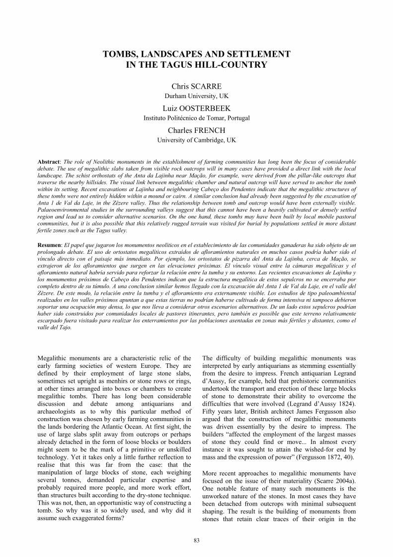
Megalithic monuments are a characteristic relic of the early farming societies of western Europe. They are defined by their employment of large stone slabs, sometimes set upright as menhirs or stone rows or rings, at other times arranged into boxes or chambers to create megalithic tombs. There has long been considerable discussion and debate among antiquarians and archaeologists as to why this particular method of construction was chosen by early farming communities in the lands bordering the Atlantic Ocean. At first sight, the use of large slabs split away from outcrops or perhaps already detached in the form of loose blocks or boulders might seem to be the mark of a primitive or unskilled technology. Yet it takes only a little further reflection to realise that this was far from the case: that the manipulation of large blocks of stone, each weighing several tonnes, demanded particular expertise and probably required more people, and more work effort, than structures built according to the dry-stone technique. This was not, then, an opportunistic way of constructing a tomb. So why was it so widely used, and why did it assume such exaggerated forms?
The difficulty of building megalithic monuments was interpreted by early antiquarians as stemming essentially from the desire to impress. French antiquarian Legrand d’Aussy, for example, held that prehistoric communities undertook the transport and erection of these large blocks of stone to demonstrate their ability to overcome the difficulties that were involved (Legrand d’Aussy 1824). Fifty years later, British architect James Fergusson also argued that the construction of megalithic monuments was driven essentially by the desire to impress. The builders “affected the employment of the largest masses of stone they could find or move... In almost every instance it was sought to attain the wished-for end by mass and the expression of power” (Fergusson 1872, 40).
More recent approaches to megalithic monuments have focused on the issue of their materiality (Scarre 2004a). One notable feature of many such monuments is the unworked nature of the stones. In most cases they have been detached from outcrops with minimal subsequent shaping. The result is the building of monuments from stones that retain clear traces of their origin in the

FROM THE ORIGINS: THE PREHISTORY OF INNER TAGUS DRAINAGE
84
colours, shapes and textures of the blocks; traces that were not usually smoothed away by pounding, grinding or chiselling of the blocks.
The frequent use of unworked blocks in the construction of many megalithic monuments creates a close link between monument and stone source. This has been followed up in recent years by a series of studies that have examined in detail just how the stones were used. Among the key questions that have been addressed are whether particular outcrops, or particular shapes and sizes of stones were preferred, and how the individual megalithic blocks were positioned in the construction of these monuments (Bradley & Phillips 2008; Cummings 2002; Jones 1999; Kalb 1996; Mens 2008; Scarre 2002, 2004b; Tilley 1996, 124-5; Trevarthen 2000). This work has succeeded in demonstrating that the choice of stones was not random, and that where, for instance, different kinds of stone were combined in a single monument those stones were arranged in patterned ways that reflected their different appearance or origins. Hence it is clear that the sources of the stones were in themselves held to be significant by the communities that built megalithic tombs.
The sources of the megalithic blocks would indeed have been visible features of the landscape, in the form of outcrops, cliffs or boulder fields. A recurrent feature of megalithic monuments is that the stones were taken from surface exposures of various kinds, and were never quarried from deep within the bedrock (Scarre 2009). This suggests that the concept of megalithic monuments may have been connected directly to pre-existing landscape beliefs; that is to say, the notion that particular locales were associated with power, and were inhabited by supernatural beings or had supernatural agency. African ethnographers have observed a distinction between ‘places of power’ and ‘shrines of the land’. The former are “permanent features of the landscape regarded as inherently sacred or as the loci of spiritual power” and typically include “mountains, rock faces, caves, pools, waterfalls, rapids, dense forests and large trees” all of which “seem to have the potential to engage the human imagination and become imbued with sacred authority” (Colson 1997). ‘Shrines of the land’, by contrast, are human constructs, built to venerate ancestors or the founders of lineages. They include megalithic standing stones (menhirs), which may represent ‘land gods’ (Mather 2003). Thus in northern Ghana, the shrine of the land god Akasong in the settlement of Zorse was represented by a large stone set in the ground at the foot of an enormous baobab tree. This was placed in front of the compound established by the founder of the settlement, and this founder was buried next to the land god (Mather 2003).
The issue here is whether megalithic monuments may in some sense relate to a ‘primordial’ set of landscape beliefs that were transformed and elaborated once agro-pastoral communities became established. It is clear both from ethnography and archaeology that hunter-gatherer communities are entirely capable of building impressive
monuments. One of the earliest may be the Mesolithic alignment discovered in 1966 on the site of the Stonehenge car park; a row of massive timber posts dating most probably to the 8th millennium BC (Cleal et al. 1995). More recent examples include the megalithic constructions known as inuksuit set up by the indigenous people of Baffin Island in the Canadian Arctic (Hallendy 2000). Thus we must conclude that the scarcity of pre-Neolithic monuments in western Europe derives from a different set of cultural practices and beliefs rather than from any inherent inability on the part of Mesolithic communities to create elaborate structures.
The relationship of megalithic monuments to the establishment of early farming communities remains crucial to the understanding of these monuments. Crop cultivation, and to a lesser extent stock rearing, will have resulted in radical transformations of landscape that must surely have been accompanied by ideological shifts. Some 20 years ago, Hodder sought to encapsulate the change in the contrast of ‘domus’ and ‘agrios’, the domestic and the wild, that structured farming societies in ways unknown to their hunter-gatherer forebears (Hodder 1990). It is possible to envisage the construction of megalithic monuments in relation to that transformation, as an overt intervention in the landscape comparable in concept to the clearance of natural vegetation to make way for the introduction of exotic cultivated plants and domesticated animals.
A key question, however, is whether these monuments were indeed built within ‘domesticated’ landscapes. In many areas of western Europe it is clear that the construction of the first monuments followed the inception of the Neolithic (in terms of pottery and, probably, domesticates) after an interval of a few centuries. In Cantabria, for example, the first megalithic monuments are probably to be dated to the late 5th millennium BC, several centuries after the Mesolithic-Neolithic transition (Arias et al. 2006). This is a pattern that is mirrored in Britain, Brittany and southern Scandinavia. Hence major monuments belong in many areas to what might be termed a ‘consolidation’ phase that followed several centuries after the introduction of pottery and domesticates. Yet it is not inevitably the case that the landscapes in which they were built had been extensively cleared of trees, nor that they were intensively cultivated. The context is particularly unclear in areas of rough or mountainous terrain that may not have been attractive to early cereal cultivators and where pastoralism may have been a major component in Neolithic subsistence economies.
MEGALITHIC TOMBS IN THE TAGUS HILL COUNTRY
The Beira Baixa region north of the River Tagus is one area where megalithic tombs were built in hilly or mountainous terrain. A project was launched here in 2006 by the Universities of Durham and Cambridge in conjunction with the Instituto Politécnico de Tomar and

C. SCARRE, L. OOSTERBEE & C. FRENCH: TOMBS, LANDSCAPES AND SETTLEMENT IN THE TAGUS HILL-COUNTRY
85
Fig. 1. Megalithic tombs and standing stones in the middle valley of the River Tagus. Inset shows locations of sites mentioned in the text
the Museu de Arte Pré-Histórica de Mação. The focus was the surviving megalithic tombs of the concelho of Mação and a key aim was to establish whether these tombs had been built in cleared or forested landscapes. The concelho extends geographically from the floodplain of the River Tagus in the south to the mountainous terrain around Cardigos and Amendoa in the north. Aside from one tomb in the extreme south – the Anta da Foz de Rio Frio, overlooking the River Tagus – the remaining tombs for which records exist are all in the northern part of the concelho, in what may be called the ‘Tagus hill-country’.
There are two older sources of information for these monuments. The Monografia de Cardigos by the local priest Dom Henrique da Silva Louro, published in 1939, lists 5 tombs; whereas the Monumentos Históricos do Concelho de Mação of 1970, by former museum curator Maria Amélia Horta Pereira, adds a sixth. Of these six tombs, however, two had already been destroyed before 1939, and a third is doubtful and likely to result from a confusion with natural rock outcrops and boulders. That left only three tombs extant, two of which were excavated between 2006 and 2008 (Fig. 1).

FROM THE ORIGINS: THE PREHISTORY OF INNER TAGUS DRAINAGE
86
Fig. 2. Anta da Lajinha: structures excavated in 2006-2008
The first and more important of these is the Anta da Lajinha, a small chambered tomb situated on a hilltop overlooking a deeply incised stream valley. The location had been carefully chosen by the builders to enhance the prominence of the monument, with relatively steep approaches from all directions, although to the south the ground fell away and then rose again to a taller ridge which blocked more distant visibility on that side. Hence the tomb was very clearly situated within the valley basin and did not offer views across the wider landscape. Two further observations must be made about its location. The first is that, despite its prominent position, it was difficult to find when first we visited it owing to local tree cover. Might that also have been the case in the past, or does the choice of such a hilltop site in itself justify the assumption that the tomb was intended to be seen, and that tree cover must have been correspondingly slight? The second observation is the low agricultural potential of the surrounding terrain, which is dominated by steep-sided hills with narrow valley floors. This is certainly not prime arable territory and unless the landscape has changed significantly in the interim the nearest potential farmland of any great extent would have been several kilometres distant, although very small fields could have been present in the adjacent narrow-bottomed valleys.
The Anta da Lajinha consists of a megalithic chamber, with a short passage opening towards the east, enclosed within a roughly circular earthen mound some 10 metres in diameter (Fig. 2). A key objective of our project was the study of the prehistoric soils and environment contemporary with the construction of the monument, and a trench was excavated through the western side of the mound with the aim of examining the buried Neolithic land surface. That aim was only partially realised. The buried soil that was encountered comprised a 10 cm deposit of silty loam, corresponding to the truncated B-horizon (subsoil) of an original acidic brown forest earth. In character and composition it was almost identical to the make-up of the mound material immediately above. This suggests that the mound was created simply by scraping together earth from the surrounding area; and the thinness of the soil cover beyond the edge of the mound may be the long-term consequence of this process as well as subsequent soil erosion.
The mound itself was fairly homogeneous and almost stone-free, but around its outer edge a series of medium-sized stones had been laid. These appeared to mark the limit of the mound but were placed on its surface, not

C. SCARRE, L. OOSTERBEE & C. FRENCH: TOMBS, LANDSCAPES AND SETTLEMENT IN THE TAGUS HILL-COUNTRY
87
vertically in the manner of a kerb built to retain it. The chaotic arrangement of the stones within this band suggested it had suffered significant disturbance, perhaps from tree roots and other vegetation, but in one or two places the stones appeared to have been placed on end, and there was the suggestion that they were framing voids. While it is impossible to be certain, this would be consistent with the presence of a ring of small timber posts, probably not of any great height since they were not bedded to a significant depth. The presence of timber elements within megalithic monuments is well documen-ted although clear traces only very rarely survive. Given the forested environments in which many megalithic monuments were built, timber elements may have been much more common than reported instances suggest.
The chamber of the Anta da Lajinha was in a ruinous condition. The capstone is lost, along with one entire orthostat and large parts of four others. Only the two orthostats at the back of the chamber survive in situ, and the surface of the mound around the chamber is littered with fragments of the characteristic blue/grey schist of which the orthostats are formed. This is different from the cobble-like schist of the local bedrock, which is incapable of providing large stone slabs. Silva Louro in 1939 reported that there were 8 orthostats, although the capstone was already missing. When Horta Pereira visited in 1967, only two of those survived, the rest having been pulled up and left lying on the surface of the mound or taken away. That was very much the condition in which the monument stood when excavations began in 2006. It was also clear that the chamber had been ‘excavated’ by person or persons unknown, and we were able to define the edges and extent of the disturbed area; but apart from small fragments of pottery and a handful of flint flakes, no significant artefactual material survived within the chamber, and the acidity of the soil meant that no human or animal bone was preserved.
It was possible, however, to reconstruct the original form of the chamber, with contiguous pairs of orthostats forming the northern, western and southern sides of the chamber, and a single slab either side of the entrance on the east. Although the resulting plan was roughly rectangular, we concluded from the evidence of the excavation and from old photographs that the ends of the orthostats rested against each other in the ‘house of cards’ fashion typical of megalithic chambers in the region.
Given the damage to which the site had been subjected, the absence of the capstone was not surprising. It would have been the first element to be removed by stone-robbers seeking easy sources of material for buildings or bridges. Small bridges with megalithic slabs survive spanning the stream that flows through the valley immediately to the north of the tomb, although the slabs may have been taken directly from outcrops rather than from destroyed prehistoric monuments. It should be noted, however, that among the megalithic tombs on the southern side of the Tagus, at its junction with the Rio Sever, only a single tomb retains its capstone. Here it has been proposed that the difficulty of finding sufficiently
large slabs of schist for chamber capstones led to an alternative arrangement whereby they were roofed by smaller slabs of schist supported by timber beams (Oliveira 2008, 120). A similar practice has been suggested for the chambered tombs to the east of Lajinha, in the area of Rosmaninhal, where again schist is one of the primary materials (Cardoso 2008, 106). The same practice may have been employed at Lajinha.
The entrance arrangements are unclear. Horta Pereira described the Anta da Lajinha as a ‘cripta, sem galeria’ (Horta Pereira 1970, 79), but a short passage or at least a portico appears to be represented by a large schist block in situ on the southern side, against which rested another large block clearly damaged and displaced. It seems likely that there was a matching orthostat on the northern side. Beyond this extending away from the chamber was spread a layer of small and medium-sized schist slabs, which represented an entrance passage of some kind. This structure had not been megalithic, and may not have been roofed; indeed it could have been simply a pair of low retaining walls flanking an approach. Whatever its original form, the discovery of four conjoining fragments of one single slab dispersed in separate locations along its length indicated that it had been intentionally destroyed and the individual slabs broken up, presumably when the monument was put out of use.
Regional parallels suggest that the ‘passages’ attached to megalithic chambers may in some cases have been symbolic rather than functional. In the Rosmaninhal area east of Lajinha, the tombs of Couto da Espanhola 2, Amieiro 2 and Anta do Poço do Chibo had long, low passages over 8m in length which could not have been used for the introduction of new bodies, though in other cases (e.g. Amieiro 3) the passage was sufficiently tall to have allowed access (Cardoso 2008, 106). The same has been suggested for the tombs around the mouth of the Rio Sever, where it has been observed that “[t]aking into account the average passage height it is clear that most passages are symbolic constructions which do not provide access for people” (Oliveira 2008, 121). It remains open to question, however, whether these passages were roofed or covered over in any way; there was no evidence of a covering at the Anta da Lajinha.
The passage grave of Anta 1 de Val da Laje (Drewett et al. 1992; Oosterbeek et al. 1992) further to the west in the Zêzere valley was erected as a pentagonal chamber accessed through a short passage about 2 metres long and 80 cm high. The Anta da Foz do Rio Frio likewise had a passage of sufficient height to allow human access. Hence, whereas these sites too lacked a full covering mound and conform to the dominant regional pattern in which the megalithic chambers remained visible externally, the long and low passages seen in Anta da Lajinha and in the limestone monument of Anta 1 do Rego da Murta in the Zêzere basin do not seem to be a universal feature.
Our second excavation concerned the tomb known as Cabeço dos Pendentes, 11,5 kilometres to the south of

FROM THE ORIGINS: THE PREHISTORY OF INNER TAGUS DRAINAGE
88
Lajinha and in a very different setting. The site is located on a low rise on the southern side of a broad valley with extensive views in three directions; only on the south is visibility restricted by the steep rocky ridge of the Serra d’Amendoa. The valley contains the headwaters of the River Pracana, which flows eastwards to join the Ocreza which then discharges into the Tagus 2 kilometres to the south. The lower reaches of the Ocreza are now well known for their rock art, but despite intensive survey in 2006 no rock art was discovered higher up the Pracana valley. Nor, with one possible exception, were any surface scatters identified that might indicate Neolithic or Chalcolithic settlement sites. The survey work did, however, lead to the rediscovery of the site of the chambered tomb of Cabeço dos Pendentes.
According to Silva Louro, the site takes its name ‘pendentes’ from the leaning character of the stones; but in 1939 these had ‘recently’ been removed for reuse in local buildings (Silva Louro 1939, 14). The author does however report a number of finds among the disturbed material from the chamber, including an engraved schist plaque now on display in the museum at Mação.
If the Anta da Lajinha was severely damaged, Cabeço dos Pendentes was almost entirely destroyed. It also proved to be something of an enigma. The form was that of a low mound, in which a central hollow some 4 metres across marked the location of the chamber. Through careful excavation of the interior of the hollow it proved possible to identify the positions of a number of the former orthostats. These had left traces in the form of shallow indentations, generally only a few millimetres in depth, filled by dark humic earth (Fig. 3).
Our main purpose in excavating the site had however been to continue the palaeoenvironmental work undertaken at Lajinha, and it was hoped that excavation through the mound at Cabeço dos Pendentes would reveal a buried Neolithic soil horizon. It was therefore surprising to discover that the supposed ‘mound’ was nothing of the kind, but a natural knoll. The central hollow was in fact a pit which had been dug to receive the chamber. Furthermore, the floor of the hollow on which the missing orthostats had left their shallow impressions was not the natural ground surface but an artificial deposit of earth some 30 cms in depth. There can be no ambiguity about this, but the conclusions are rather striking. There never was an enclosing or covering mound at Cabeço dos Pendentes. Instead, the builders had taken advantage of a low natural hillock, in which they had dug an oval pit. They had filled the base of this pit with some of the material they had removed. Their reasons for that are unclear but they may simply have wished to create a level surface. It was on this artificial surface that they had constructed their megalithic tomb.
CONCLUSIONS
The Anta da Lajinha and Cabeço does Pendentes, like other tombs in the region, cannot claim to be ‘spectacu-
lar’ megalithic sites, especially in their current degraded condition. The excavations conducted in 2006-2008 do connect directly, however, with the general questions about the character and symbolism of megalithic monuments, and their social and economic context, that were set out in the introduction to this paper.
In first place there is the issue of visibility. The concept of a ‘monument’ implies something that is substantial and prominent, and megalithic monuments achieve this through their size, and in many cases also through their location. Lajinha and Pendentes are located on hilltops that provide visibility from a distance. Anta 1 de Val da Laje and Anta da Foz do Rio Frio are also located in naturally prominent positions, overlooking their surrounding areas. At Val da Laje this prominence was further enhanced by scraping earth together to compensate for the sloping topography, widening the natural platform on which the tomb was built.
The present tree cover around Lajinha reminds us however that vegetation must be taken into account. It has already been noted that the relict soil discovered beneath the mound at Lajinha was a brown forest earth, which implies that the landscape was stable and well drained and did at one time carry some tree cover. In order to determine more directly whether the Anta da Lajinha was built within a forested or a cleared landscape, a series of trenches was opened in the nearby valley floors (the Bostelim valley to the northwest and the upper & middle Pracana valley to the south). The aim was to determine the sequence of accumulation on the valley floors, which would relate directly to the erosion of soil consequent upon the loss of vegetation from the surrounding hill slopes. The results of this work suggest that the bulk of the sediment in the valley floors is of recent origin. In the Bostelim valley, some 80 cms of sediment had accumulated above a 19th century wall; and in the Pracana, 1,35 m above a charcoal horizon dated c.AD 400. Thus deforestation and erosion appear to have been a relatively recent process. It is probable, however, that these steep hillsides were never able to support thick organic soils or dense wooded vegetation. The megalithic monuments are hence unlikely to have been hidden among dense stands of trees. The study of pollen from other Neolithic sites in the region supports this interpretation, suggesting a landscape dominated by shrub vegetation and low trees (Cruz et al. 1998).
The second issue concerns visibility of a different kind. One of the surprising discoveries at Cabeço dos Pendentes was the absence of evidence for an enclosing mound around the former megalithic chamber. The orthostats (and capstone, had there been one) must have been left visible. At Lajinha, part of the mound does survive, to a height of 80 cms against the back of the two surviving orthostats. Whether the mound was ever tall enough to have completely covered the chamber is however open to question. For that, it would have needed to be two or three times its present size and volume. Thus the upper part of the megalithic structure may have been left visible here as well. Whether megalithic tomb

C. SCARRE, L. OOSTERBEE & C. FRENCH: TOMBS, LANDSCAPES AND SETTLEMENT IN THE TAGUS HILL-COUNTRY
89
Fig. 3. Cabeço dos Pendentes: plan and photograph showing impressions of former orthostats. Photo: Chris Scarre
chambers were universally covered by mounds is a question that has been much debated since the 19th century, but recent excavations in many regions of western Europe have demonstrated that some of these internal structures must have remained visible to a greater or lesser degree. For Lajinha, this observation has
implications for the selection and origin of the megalithic slabs. The schist bedrock on which the tomb is built is of a fractured, cobble-like character, incapable of yielding large blocks. In the surrounding landscape, however, and especially to the east of the site, rows of pillar-like outcrops traverse the hill slopes. These are identical to the

FROM THE ORIGINS: THE PREHISTORY OF INNER TAGUS DRAINAGE
90
material of the Lajinha orthostats, and are deeply fissured in a way that would have facilitated the removal of individual plate-like slabs. No systematic geological survey was undertaken, but the closest of these outcrops appear to be 200 m east of Lajinha. If the chamber orthostats were left visible externally, there would have been an immediate visual connection between the tomb and these peculiar natural pillars even without entering the confines of the chamber itself. We cannot know what myths or stories were attached to these outcrops, but a strong case can be made that they had a special symbolic importance, and that the builders of Lajinha drew upon that significance.
In the Zêzere valley, too, the sources of the megalithic blocks were local outcrops: less than 50 metres away in the case of Vale da Laje (gneiss), and under 200 metres at Rego da Murta (limestone). Here again, there would have been a direct visual connection between the megalithic chambers and their source outcrops.
A final comment concerns the wider geographical setting of the megalithic tombs in the northern part of the Mação concelho, and their relationship to regional demographic patterns. It has sometimes been argued that megalithic tombs were the burial places of local prehistoric communities. In British archaeology, it became common in the 1970s to overlay Thiessen polygons on tomb distributions and to postulate that each of them marked the territory of an individual farming community. Such an approach is highly problematic. We may nonetheless ask whether the tombs of Lajinha and Pendentes are likely to have been built by local sedentary communities or whether they related to a more fluid and larger-scale occupation of the landscape. Our palaeoenvironmental work has shown that there would have been little land attractive to arable agriculture in the local area, still less since alluviation had not yet formed the fertile valley floors. In many of the upland areas of Iberia, emphasis has been placed on pastoral rather than arable activity during the later prehistoric period. This suggests more mobile communities and larger territories. But on what scale? The absence of megalithic tombs in the area between the Pracana valley and the Tagus might suggest that it was communities from the Tagus who periodically – perhaps seasonally – visited the hilly interior and buried their dead there, in an area remote from their everyday world. The presence of “areas for the dead” has been previously been suggested, on the grounds that clusters of Neolithic burials (megaliths and caves) are located in areas without traces of settlement sites (Oosterbeek 1995, 1997). In the case of Lajinha and Pendentes, however, it is important to be aware that these tombs lie at the edge of a much broader distribution, which extends into the neighbouring concelho of Proença-a-Nova where the Leisner inventory (Leisner 1998) records the presence or former presence of almost 100 tombs (Leisner 1998, 100-102). There are many more tombs further to the east, for example at the confluence of the Tagus with the Rio Sever (Oliveira 2008) or around Rosmaninhal, Malpica de Tejo and Montforte da Beira (Cardoso 2008). Conversely, there are very few to the west. Are we here
on the western edge of a social and cultural world that extended south across the Tagus into the northern Alentejo, and east across the modern frontier into Spanish Extremadura? Identifying and interpreting these broader-scale patterns is a key challenge for future research on the Neolithic settlement of the middle Tagus valley and the hill country to either side.
Acknowledgements
Excavations at the Anta da Lajinha and Cabeço dos Pendentes were funded by British Academy Larger Research Grant LRG-42469 “Megalithic monuments and landscapes of the Upper Tagus Valley, Portugal”. Palaeoenvironmental investigations were directed by Dr Charly French (University of Cambridge) in conjunction with Professor Marco Madella (CSIC, Spain) and Dr William Fletcher (Université de Bordeaux III). Logistical and field support from the Instituto Politécnico de Tomar and the Museu de Arte Pré-Histórica de Mação is gratefully acknowledged.
References
ARIAS, P., ARMENDARIZ, A. & TEIRA, L.C. 2006: The megalithic complex in Cantabrian Spain, in The Atlantic Megaliths, ed. A.A. Rodríguez Casal. Oxford: Archaeopress, 11-29.
BRADLEY, R. & PHILLIPS, T. 2008: Display, disclosure and concealment: the organization of raw materials in the chambered tombs of Bohuslän. Oxford Journal of Archaeology 27, 1-13.
CARDOSO, J.L. 2008: The megalithic tombs of southern Beira interior, Portugal: recent contributions, in Graphical Markers and Megalith Builders in the International Tagus, Iberian Peninsula, eds. P. Bueno Ramírez, R. Barroso Bermejo & R. de Balbín Behrmann. Oxford: Archaeopress, 103-15.
CLEAL, R.M.J., WALKER K.E. & MONTAGUE, R. 1995: Stonehenge in its Landscape. Twentieth-century excavations. London: English Heritage.
COLSON, E. 1997: Places of power and shrines of the land. Paideuma 43, 47-57.
CUMMINGS, V. 2002: Experiencing texture and transformation in the British Neolithic. Oxford Journal of Archaeology 21, 249-61.
CRUZ, A.R., OOSTERBEEK, L. & REIS R.P. (eds.) 1998: Quaternário e Pré-História do Alto Ribatejo (Portugal). ARKEOS 4. Tomar: Centro Europeu de Investigação da Pré-História do Alto Ribatejo.
DANIEL, G. 1958: The Megalith Builders of Western Europe. London: Hutchinson.
DREWETT, P., OOSTERBEEK, L., CRUZ, A.R. & FÉLIX, P. 1992: Anta 1 de Val da Laje 1989/90. The excavation of a passage grave at Tomar (Portugal). Bulletin of the Institute of Archaeology London 28, 133-148.

C. SCARRE, L. OOSTERBEE & C. FRENCH: TOMBS, LANDSCAPES AND SETTLEMENT IN THE TAGUS HILL-COUNTRY
91
FERGUSSON, J. 1872: Rude Stone Monuments in All Countries; their Ages and Uses. London: John Murray.
HALLENDY, N. 2000. Inuksuit. Silent messengers of the Arctic. Vancouver: Douglas & McIntyre.
HODDER, I. 1990: The Domestication of Europe. Oxford: Blackwell.
HORTA PEREIRA, M.A. 1970: Monumentos Históricos do Concelho de Mação. Mação: Câmara Municipal de Mação.
JONES, A. 1999: Local colour: megalithic architecture and colour symbolism in Neolithic Britain. Oxford Journal of Archaeology 18, 339-50.
KALB, P. 1996: Megalith-building, stone transport and territorial markers: evidence from the Vale de Rodrigo, Évora, south Portugal. Antiquity 70, 683- 5.
LEGRAND D’AUSSY, P. 1824: Des Sépultures Nationales, et particulièrement celles des Rois de France. Paris: Esnaux.
LEISNER, V. 1998: Die Megalithgräber der Iberischen Halbinsel: Der Westen. 4. Lieferung, ed. P. Kalb. Berlin & New York: Walter de Gruyter.
MATHER, C. 2003: Shrines and the domestication of landscape. Journal of Anthropological Research 59, 23-45.
MENS, E. 2008: Refitting megaliths in western France. Antiquity 82, 25-36.
OLIVEIRA, J. de, 2008: The tombs of the Neolithic artist-shepherds of the Tagus Valley and the megalithic monuments of the mouth of the River Sever, in Graphical Markers and Megalith Builders in the International Tagus, Iberian Peninsula, eds. P. Bueno Ramírez, R. Barroso Bermejo & R. de Balbín Behrmann. Oxford: Archaeopress, 117-27.
OOSTERBEEK, L., CRUZ, A.R. & FÉLIX, P. 1992: Anta 1 de Val da Laje: notícia de 3 anos de escavações (1989-91). Boletim Cultural da Câmara Municipal de Tomar 16, 31-49.
OOSTERBEEK, L. 1995: Megalitismo e necropolizaçao no Alto Ribatejo: o IIIº milénio. O Megalitismo no Centro de Portugal. Actas do Seminário. Mangualde: Centro de Estudos Pré-Históricos da Beira Alta, 137-49.
OOSTERBEEK, L. 1997: Echoes from the East: late prehistory of the North Ribatejo, ARKEOS 2. Tomar: Centro Europeu de Investigação da Pré-História do Alto Ribatejo.
SCARRE, C. 2002: A place of special meaning: interpreting prehistoric monuments through landscape, in Inscribed Landscapes: marking and making place, eds. B. David & M. Wilson. Honolulu: University of Hawaii Press, 154-75.
SCARRE, C. 2004a: Displaying the stones: the materiality of 'megalithic' monuments, in Rethinking materiality. The engagement of mind with the material world, eds. E. DeMarrais, C. Gosden & C. Renfrew. Cambridge: McDonald Institute for Archaeological Research, 141-52.
SCARRE, C. 2004b: Choosing stones, remembering places: geology and intention in the megalithic monuments of western Europe, in Soils, Stones and Symbols. Cultural perceptions of the mineral world, eds. N. Boivin & M.A. Owoc. London: UCL Press, 187-202.
SCARRE, C. 2009: Stony ground: outcrops, rocks and quarries in the creation of megalithic monuments, in Megalithic Quarrying. Sourcing, extracting and manipulating the stones ed. C. Scarre. Oxford: Archaeopress, 3-20.
SILVA LOURO, H. de, 1939: Monografia de Cardigos. Cucujãis: Escola Tipica das Missões.
TILLEY, C. 1996: An Ethnography of the Neolithic. Early prehistoric societies in southern Scandinavia. Cambridge: Cambridge University Press.
TREVARTHEN, D. 2000: Illuminating the monuments: observation and speculation on the structure and function of the cairns at Balnuaran of Clava. Cambridge Archaeological Journal 10, 295-315.