The universal geography : earth and its inhabitants
614
^- ,.«m^. ^m^ .P« * -»rfC^
-
Upload
khangminh22 -
Category
Documents
-
view
0 -
download
0
Transcript of The universal geography : earth and its inhabitants

^-
,.«m^. ^m^.P«
* -»rfC^

IE UNIVERSITY

4 n ^»


J>F THE .
UNIVERSITY of ILLINOIS,
>

. .^ _-^' ^<^-^.^^^^.^>'
TYPES AND COSTUMES—GROUP OF ZEIBEKS.

THE EARTH AND ITS INHABITANTS
THE
UNIVERSAL GEOGRAPHY
By ELISEE RECLUS SfS.
EDITED
By A. H. KEANE, B.A.MF.MB. OF' COUNCIL, ANTHROP. INSTITUTE; COR. MEMB. ITALIAN ANTHROP. SOC. ; PROFESSOR OF
HINDUSTANI, UNU'ERSITY COL. LONDON; AUTHOR OF "ASIA," ETC.
VOL. IX.
SOUTH-WESTERN ASIA
ILLUSTRATED BY KUMEEOUS ENGRAVINGS AND MAES
LONDON
J. .S. VIRTUE & CO., Limited, 294, CITY ROAD

Loxnox ;
pnrxTED nv j. s. viutue an
CITY ROAD.

^p
.A
CONTENTS.
CHAP. PAGEI. General Survey............... i
II. Afghanistan IB
Afghan Highlands, p. 19. River Systems, p. 26. Climitte, Flora and l'aun;i, p. 31.
Inhabitants, p. 33.
Topography, p. 46.
III. BALUCHIST.iN . . ............. 5S
Highlands, p. 60. River Systems, p. 03. Climate, Flora and Fauna, p. 65. Inhabi-
tants, p. 66.
Topography, p. 70.
IV. Pehsia 7.5
Historic Retrospect, p. 75. Mountain Systems, p. 78. The Caspian Coastlands, p. 86.
The Western Highlands, p. 91. The Central Deserts, p. 93. Hydrographic Systems,
p. 95. Climate, Flora, Fauna, p. 101. Inhabitants, p. 104. Topography, p. 117. Social
Condition, Administration, Prospects, p. 151.
V. Asiatic Turkey ............... 162
Lazistan, Armenia, and Kurdistan, p. 163. Ai-menian Highlands, p. 165. Kurdistan High-
lands, p. 167. Lake Van, p. 168. Climate, Flora, and Fauna, p. 169. Inhabitants:
Lazes, Armenians, Kurds, p. 171. The Kizil-Bashes, Yezidis, and Nestorians, p. 177.
Topography of Armenia and Kurdistan, p. 180.
VI Lower Kurdistan, Mesopotamia, Irak-Arabi 192
Historic Retrospect, p. 193. North Mesopotamian Orographic System, p. 196. TheTigris Basin, p. 199. The Euphrates Basin, p. 201. The Shat-el-Arab and EuphratesDelta, p. 211. Climate, Fauna, and Flora of Mesopotamia, p. 213. Inhabitants—TheArabs and Kurda, p. 214. Topography of the Tigris Basin, p. 218. Topography of the
Euphrates Basin, p. 230.
Vll. Asia Mi.vor 241
General Survey, p. 242. Anatolian Mountain Systems, p. 245. The Anti-Taurus andCilician Taurus, p. 247. Isaurian and Lycian Taurus, p. 250. West AnatoUan Coastlandsand Islands, p. 254. North Anatolian Ranges, p. 200. The AnatoUan Water Systems:The Yeshil-Irmak, Kizil-Irmak, and Sakaria, p. 262. Eiverj flowing to the ^gean, p. 266.I,acustrine Basins and Rivers flowing to Ihe Mediterranean, p. 273. Climate, Flora, andFauna, p. 278. Inhabitants : Yuruks and Turks, p. 283. The Anatolian Greeks, p. 290.Topography, p. 294. Prospects of .\natolia, p. 313.

iv CONTENTS.
cBAP. '*<";
VIII. CvPKUs 344
Mountains and Rivers, p. 346. Climate, Flura, and Faun, p. 347. Inhabitants, p. 348.
Topocjraphy, p. 349.
IX. Syru, Faiestine, Sinai 354
Historic Ketrospect, p. 354. Mountain Ranges : Libanon and Anti-Libanon, p. 356.
Hermon, Hills of Galilee, Mount Carmel, p. 359. Trans-Jordan Uplands, p. 362. Sinai
Highlands, p. 363. Rivers of Syria and Palestine, p. 367. The Jordan and Dead Sea,
p. 370. Climate, Flora, and Fauna, p. 374. Inhabitants of Syria and Palestine, p. 376.
The Ansarieh, Druzes, and Maronites, p. 377. The Melkites and Jews, p. 380. Topo-
graphy of Syria, p. 382. Topography of Palestine, p. 409.
X. Arabia -130
Historic Retrospect, p. 430. General Survej', p. 433. Mountain Systems, p. 435. The
Hejaz and Assir Uplands, p. 437. The Yemen Highlands, p. 438. Hadramaut and South
Coast, p. 439. The Oman Highlands, p. 441. The Central Ranges and Harras, p. 443.
The Northern Steppes and Deserts, p. 446. The Southern Desert, p. 449. Climate of
Arabia, p. 450. The Persian Gulf, p. 454. The Red Sea, p. 456. Flora of Arabia, p. 462.
Fauna, p. 464. Inhabitants ; the Bedouins, 467. The Wahabites, p. 471.
Topography, p. 472.
Statistical Tables

LIST OF ILLUSTRATIONS.
MAPS PRINTED IN COLOUES.
PAGE
1. Assyria and Chaldea 1
2. Teheran and Demavend .... 129
3. Asiatic Greece 290
4. PaJestine— Northern Sectiqn
5. Palestine—Southern Section
6. Peninsular of Sinai
352
352
363
PLATES.
Types and Costumes—Group of Zeibeka Frontisi
Baalhek—Ruins of the Two Temples Tofacepage
Kandahar ....View taken from the Paiwar Pass
Tiie Amir Sher Ali, Prince Abdallah Y.an, and
Durani Chiefs . .
Kelat-i-Nadir—Arghavan-Shah Gorge .
Types and Costumes— Group of Haz;irehs
Hamadan and Mount Elvend—View taken
fi-om the South-east
Bridge of Dizful
A Bdluch Mendicant
Fortress of Veramin
Hamadan, Ruined Mosquo of
century .
Bandar-Abbas .
Types and Costumes—Kurdish
Town and Citadel of VanThe Euphrates at Birejik
Types and Costumes—Arabs of Bagd id
Uoueral View of Sinope .
tlie fourteenth
Gentlemen
The Bosphorus—View taken opposite Arnaut-
Koi, near the Asiatic Side To face page
Turkish Batteries at the Black Sea entrance of
the Bosphorus .....Cypresses in the Cemetery of Scutari
Brussa—General View ....Gulf of Smyrna—General View of Kara-Tash
and Gioz-Tepe
Smyrna—View taken from Mount Pagiis
Ephesus—Ruins of the Aqueduct and Citadel
Isle of Rhodes—Lindos Bay .
Mount Hermon—View taken from Easheya
Lake and City of Tiberias
Druze Princess and Lady of the Libanon
Aleppo—General View ....Ruins of Palmyra—The Colonnade .
Jerusalem—Omar's llosque
Jaffa—General View ....Aden—Steamer Point ....Cisterns of Aden .....Mecca—Court of the Kaaba
307
309
311
323
326
329
338
359
372
379
383
405
417
425
L1S1 OF ILLUSTEATIOXS.
ILLUSTRATIONS IN TEXT.
of
SOUTH-WESTERN ASIA.
Ethnical Divisions of Hither Asia
Asiatic Origin of various cultivated
Plants
Density of the Population of Hither Asia
Central Point of the Old WorldCentre of Gravity for the Populations
the Old World ....Religions of Hither Asia .
Marsha Pass, North of KandahakItineraries of Afghanistan
The Eastern Hindu-Kush .
The Western Hindu-Kush
The Sefid-Koh of East Afghanis'.an .
The Kabul River—View taken ni
CUZEROAO, SUAKDEH VaLLEY
The Hamun Basin ....The Gomul Pass ....Populations of Afghanistan
Darah NurKabul and Neighhoiirhood
Kelat-i-Ghilzai.....Kandahar......Herat
Routes of the chief E.\pIorers of Ualiic
Stan
Passes in North Baluchistan
East Mekran Seaboai'd
Inhabitants of Baluchistan
Kalat and Neighbourhood
General View of Kalat .
Kachi-Gandava Oasis
Routes of the Chief Explorers of Persia
since Marco Polo ....Mountains and Passes of Astrabad
Demavend — Views taken from tui
North-West ....Savalan
Khu2istan Border Range .
Lake Urmiah .....liakes Niris and Nargis
Faunas of Persia ....Kurdish Cavalry.
Inhabitants of Persia
Persian Types and Costumes—NoblemanDervish, and Mendicant
Noble Persian LadyYezd and Neighbourhood .
Tower OF Meimandan on the routeDami.han to Meshed .
Meshed and Kelat-i-Nadir
6
8

I,rST OF ILLL'STRATIOXS.
sr B;ig.iaJ . . . . . . . 2-J8
58. Aiutub and Birejik 231
59. Orfa 232
90. Okfa—MosauE AND Fountain of Abra-
ham 233
91. The Mound of Babil .23692. Babylon 237
93. Old Cities of Chaldea . . . .2399t. Old Provinces of Asia Minor . . . 245
9-5. The Bulgar-dagh 249
96. Mount Arga;us 2-31
97. The Chimsra of Lycia .... 253
98. Nisyros 256
99. T.MOLUs Valley, Plain of Sardis . . 258
100. Mytilene •. 259
101. Dbltaof the Kizil-Irmak . . . .263102. Lake of Sabanja 265
103. Nicea and Ghcmlik . .... 267
104. The Tuzla-Su Valley . . . .268105. Smyrna Channel 269
106. Falls of Pambuk-K.adeh, or Tamruk . 272
107. Plains of the Lower Meander . . . 274
108. Lake of Egherdir 275
1(19. Mouths of the Seihun and Jihun . . 277
110. VilLiges of various Nationalities in the
Dardanelles District .... 285
HI. Turkish Woman OF Brvssa . . . 288
112. Inhabitants of Anatolia .... 293
113. Amasia—View taken from the South-east 296
114. Amasia 297
115. Samsun 298
116. Sinope 300
117. Erekli 302
118. Remains of the Temple of Augustusand Rome at Anctra .... 303
119. Asiatic Suburbs of Constantinople . . 306
120. Street View, Scutari .... 307
121. Environs op Scutari—Turkish Ladies
Abroad 308
122. Ismid 309
123. Brussa 310
124. To.MB of Mahomet II. in the GreenMosque at Brussa . . . .312
125. Syzicus and Artaki Peninsular . . 313
126. TheTroad 314
127. HiSSARLIK (IlION)—ViEW TAKEN FRO.M
THE Mendereh ..... 316
128. Pergamus—Ruins OF THE Basilica . . 317
129. Pergamus 318
130. Phocea 320
131. Sardes—Columns of the Temple of
Ctbele 321
132. Mount Sipylus 322
133. Smyrna 324
134. Isthmus of Vurlah 325
135. Strait of Chios or Chesmeh . . .326136. Chio—View taken after the Earth-
quake OF 1881 328
137. Ephesus 330
138. Ephesus—Prison of St. Paul . . 331
139. Strait of Tigani or Samos . . .332140. Vathy 333
no. PAQR141. Miletus and Didynia .... 334
142. Budrun and Kos 335
143. Pout of Rhodes 337
144. Rhodes 3:f8
145. Valley of the Xanthus . . . .339146. Chief Itineraries of Lj'cia . . . 340
147. Elmalu 341
14S. Albistan and Murash .... 342
149. Railways opened and projected in Asia
Minor 344
150. C)-pru3 346
151. Nicosia 349
152. Larnaka and Famagusta .... 350
153. Kerynia....... 351
154. Limassol and Akrotiri Peninsular . . 352
155. Passes of the Amanus .... 35?
156. Beirut Hills 357
157. The French Road 358
158. Jebel Sufa 360
159. The Zerin Depression .... 361
160. Peninsular of Sinai—Ain-el-Hudekah 363
161. Mount Serbal 364
162. Mount Sinai ...... 365
163. Convent OF Sinai 366
164. Lake Yamuneh and Nahr-Ibi ihiui . . 368
165. Gorge of the Xahr-el-Leitani . . .369166. Sources of the Jordan .... 370
167. Lake Huleh 371
168. Dead Sea 373
169. Landscape in the Sinai Pexinsulak—View taken at Raphldim . . . 375
170. Inhabitants of Syria .... 378
171. Horns . .
'
384
172. The Ancient Tomb op D.ana . 387
173. Antiochia and Suedieh .... 388
174. Latakieh 389
175. Ruad and Tostosa 390
176. k.4lat-el-h0san 391
177. Madgah Castle 392
178. TripoU 393
179. Beirut 395
180. Sidon 397
181. TjT-e 398
182. Damascus—Viewt.aken from the Chris-
tian Quarter 401
183. Damascus 402
184. Jebel Hauran and Bosra.... 406
1 S 5. Petra and the Arabah Depression . .409186. Lake Tiberias 410
187. Jericho -411
1 88. Nazareth and Mount Tabor . 412
189. Akka and Kaifa 413
190. Nablus 416
191. Remains of the Antonia Fortress,
Jerusalem 418
192. Jerusalem 420
193. Rock of Masada 422
194. Masada 424
195. Jaffa 425
196. Tor 427
197. Itineraries of the Chief E.^plorers of
Arabia 432
198. The Mascat Highlands . . .441

LIST OP ILLUSTRATIONS.
199. Masandam Peninsular ....200. Sandstone Hills near Meshakek .
201. View of a Fulj in the Northern Nefud202. Bab-el-Mandeb
203. Guriah Island, Gulf of Akatah204. Coral Banks in the Central Basin of the
Red Sea 461205. Types and Costvmes—Group op Arab
Women 470
PAGE
442
445
449
4.57
459
206. Derreyeh . .... . . 471207. Koveit 47320s. Mascat 474209. Aden
! 476210. Sana ....... 477211. Hodeidah and Loheiyeh .... 478212. Mecca and Jeddah 479213. Medina 432
hi

aWituI: CI ILLU\>Jia.

ASSYRIA AND CHALDEA
=81Rov;mdi7.
J<imi'oud
-/
^
^, ^.Sharkal \'
•AllinlMopruBa.'ji^n
SiniJf ini iiikIi
zj ,/ / B o k a /P T.Touz KliourmatU
TekritJ ' ^ ^"A/>om//'irapoi
A D J O U k J< t
9cmifKapou./.olidb
iIoK\ nn
Samara* XeK-Mak^,.
•o , Kliamkm'« •Kizil Uobit
• Sei ij>oul
Ku. ind ,
lOUP ^--.T
j/>'Bakoubah
^IX E J. I M -?/^Hit vv _^ /
- '' ) y Xv^ ^ ' ' r s / .••••' -^^'e'* ' ; GadhimMadhim 1, < .-' (^
Feloudjaii'* V" BAGDAD' -V <
-'-s SRLZUCIA. ::jWadailKCTESlPHONI Xt
X.'
£? \ \/|pSe ^; /? .-< 7- 7- ^
A'
Kerbela*
% ; •; BABYLON• HiU«.h
^
Bips Nimroud
~~"'
^ ShatPa
{ Is afcr
:3. 000.000-T5S
V : R.T U E & C ? I

THE UNIVERSAL GEOGEAPHY.
SOUTH-WESTERN ASIA.
CHAPTER I.
GENERAL SURVEY.
HETHER the first Aryan hearths were kindled on the Bactrian
plains, in the valleys of the Hindu-Kush or of the Caucasus, or on
the steppes of Scythia, the attention of the European student is
stUl directed by the oldest historic records chiefly to Egypt and
Western Asia. Peering back ia thought through the mist of ages,
we see the now luminous lands of the West wrapped still in darkness, while a
dazzling light is shed over the regions east of the Mediterranean—the Nile valley,
the Ionian shores and isles, the Syrian coast, the Mesopotamian plains, and Iranian
plateaux. The origiu of our culture remaias unrevealed, but in South-Western
Asia must be sought the first germs of the civilisation which has grown up from
age to age, until it has become the common patrimony of the peo2:)les of Europe
and the New World. For is it not here that the Hellenic myths have placed the
first Olympian seats of the gods ? And is it not here also that Jewish, Christian,
and Mussulman legend has planted the " tree of life," beneath whose shade the
first man and the universal mother awoke ? In Chaldea, amid the hills of the
Indian Caucasus, iu the oases of Irania, has been sought the terrestrial paradise
;
while the remaias of the ark in which the Noachian family found refuge from the
overflowiag waters are still fabled to lie stranded on the Armenian Masis (Ararat),
the Nizir of Kurdistan, the Persian Demavend, or some other lofty peak of Hither

2 SOUTH-WESTEEN ASIA.
Asia. Later on, the Christians spreading westwards and the Mohammedans over-
nmning the east, multiplied endlessly the number of mountains " witnesses of
the Deluge." Such witnesses may be found in the Pyrenees, in Roussillon, and
Andorra, even in Afghanistan, the Siah-Posh country, and the " Throne of
Solomon," overlooking the plains of the Indus.
At the dawn of history, properly so called, the first definite events are referred
to the south-western lands of Asia and to Egypt, which, east of the Nile, was
regarded by the ancients, and especially by Herodotus, as belonging to the Asiatic
world. Here the national groups began to be classified under the names of Sem,
Cham, and Japhet ;perhaps also, according to many Orientalists, under those of
Simier and Accad, a contrast which reappears later on in the opposition of Persian
and Mede, of Iran and Turan. The various peoples between the Central Asiatic
plateaux, the isles of the Mediterranean, and the African deserts, are numbered
according to their races, usages, and industries, while on the Babylonian cylinders
and prisms are inscribed ethnological and geographical documents of the highest
importance. One of the oldest myths relates the dispersion of the peoples at the
foot of the Tower of Babel ; but despite the " confusion " of tongues, Chaldean
history begins to follow the career of each nation, recording its growth, wars, and
conquests.
The geographical form of Hither Asia—an expression comprising the whole of
the Asia of the ancients as far as the Indus—sufficiently accounts for the pre-
rogatives of this region as the cradle of early culture. Not only is it situated
near the geometric centre of the lands forming the ancient world, but it at the
same time offers the easiest highways of communication between the three con-
tinents and the great marine basins. The Nile valley is separated only by a strip
of sand from those of the Syrian seaboard, while between the European and
Asiatic shores there flows an arm of the sea narrower than many a river. From
the Indian Ocean to the Mediterranean, Hither Asia presents two natural routes
—
the Isthmus of Suez and the Mesopotamian plain, which is by far the more
important in the history of civilisation, and which commimicates through several
openings with the Syrian seaports. The roads leading also from the Upper
Euphrates down to the Euxine may be said to connect the Indian Ocean at once
with the Mediterranean and with the lands facing the North Atlantic inlets, for
the main axis of the highlands forming the European water-parting between the
Alps and Balkans terminates on the Black Sea coast, while the Bessarabian low-
lands east of the Carpathians lead, by easy transitions, to the northern slopes of
the continent.
A large portion of Hither Asia consists of elevated tablelands, some standing
even at a height of over 6,000 feet. But the seaboard is everjnivhere indented by
deep gulfs and marine inlets. The Indian Ocean penetrates far inland between
Mekran and Oman, forming beyond the Strait of Ormuz the inland sea known as
the Persian Gulf, On the opposite side of Arabia the Red Sea fills a surprisingly
regular depression in the crust of the earth, terminating on either side of the
Sinai peninsula in secondary basins, also noted for their remarkable sjTnmetry.

GENERAL SURVEY. 8
The Mediterranean, flowing by Cyprus, describes a series of bays along the south
coast of Asia Minor, and by a thousand channels and ramifications carves the east
side of the ^gean into a second Greece, with its countless islands, peninsulas, and
headlands. Another basin, which may be described rather as a vast lake—the Sea
of Marmora, or Propontis of the ancients—connects the Archipelago with the
Euxine, which flows eastwards to the foot of the Caucasus and Armenian high-
lands. Lastly, the circle of marine waters round the West Asiatic seaboard is
completed by the closed basin of the Caspian. Account must also be taken of
lakes Urmiah, Yan, and others, often large enough to present the aspect of oceanic
gulfs. Here and there old marine inlets have been replaced by extensive plains,
the most remarkable of which is the vast Mesopotamian valley, forming a con-
tinuation of the Persian Gulf towards Alexandretta Bay, and dividing the whole
of Mohammedan Asia into two distinct halves—Arabia, with the coast ranges of
Syria and Palestine on the south, the highlands of Asia Minor and the Iranian
plateaux on the north and east.
Thanks to this disposition of the surrounding waters and inland plains. Hither
Asia, centre of the Old World, is, at the same time, almost a peninsular region,
and thus easily became, during the course of history, a common point of imion for
peoples of diverse origin and usages. Nowhere else have the rival races of the
globe had more civilised representatives, sharply contrasting one with the other,
than in this region. The North Asiatic hordes, now confused together under the
collective name of Uralo-Altaic races, had penetrated into the uplands far south of
the Oxus, assumed limit of Iran and Turan, and the struggle between these two
ethnical elements has here been continued throughout historic times. It is even
still maintained between the Persian and Turkoman, whUe the Mongol invasions
are recalled by the presence of many populations, notably the Hazarahs and
Aimaks, south of the Hindu-Kush. Other ethnical elements belonging, if not to
the black race, at least to that of the Kushites, a Negroid stock allied to the
Ethiopian, were also diversely represented in these regions. Some trace of their
presence on the plateaux of Susiana may be detected in the processions of captives
figured on the bas-reliefs of Nineveh. Nimrod, the " mighty hunter before the
Lord," is the legendarj- ancestor of these mythical peoples.
The facility of conmnmication between the two shores of the Red Sea had also
at all times brought about a mingling of the Arab and African races. Neverthe-
less, the Negro element proper appears never to have had any relative importance
in the history of the West Asiatic peoples. The preponderating influence, enjoyed
at first by the " Turanians " and Kushites, passed eventually to the Semites in the
south and to the Aryans in the north. The whole of Arabia, as far as the
Euphrates, is the domain of the former, while the latter prevail numerically on the
Iranian plateaux, the Armenain highlands, and certain parts of Asia Minor.
In the general historic movement Hither Asia preceded Europe ; but it was
precisely in this direction that civilisation progressed. The commercial and intel-
lectual axis of the Old World followed the direction from south-east to north-
west. Hence the zone of greatest vitality in the history of nations stretches frord
B 2

4 SOUTH-WESTERN ASIA.
India and Mesopotamia through Ionia, the Mediterranean peninsula, and France,
to the British Isles. Before Europe fonned part of the civilised world, commercial
intercourse naturally found its chief centre in the regions of the Asiatic seaboard.
The legend of the Argonauts and the Golden Fleece commemorates the relations
formerly established between the Caucasian highlanders and the Hellenic seafaring
populations. But history speaks more clearly of the great marts that flourished on
the shores of Syria, and of the services rendered to civilisation by the Phoenicians,
not only by exploring the coast of West Europe and conducting caravans across
Fig. 1.
—
Ethnical Divisions of Hither Asia.
Scale 1 : 45,000,000.
ES3 EI3 iia lIiIO SMITurks, Tatars. TuxkomanB. Hezareh and others. Kirghiz. Georgians and others. Brahui.
Caucasians. Drayidians.
da ^ ^ '
Arabs and Bedouins. Syrians and others. Egyptians. Nubians and others.
the natural lines of communication between the Indian Ocean and Mediterranean,
but still more by spreading abroad a knowledge of the phonetic alphabet derived
from the Egyptian hieroglyphics. Continually meeting with strangers speaking a
thousand different tongues, the Phoenicians must have been struck especially by
the great diversity of sounds which could be reproduced only by employing the
Wgns used by the Egyptians to express ideas as well as the sounds of the corre-
sponding words. Separating the most available symbols from the ideographic
sense, the Phoenicians applied them exclusively to the reproduction of sound, thus
emancipating the mind from the primitive symbolism, and imparting to written

GENERAL SURVEY. 5
characters a purely phonetic value. Their geographical discoveries, their distant
voyages round Europe and Africa, their inland travels up the great rivers and
across portages, their traffic in metals, -woven goods, pottery, manufactured wares
of all sorts since discovered by archaeologists in so many lands, prepared the tribes
of the western forests for a higher culture by developing trade and mutual inter-
course among them. To the Phoenicians especially are we indebted for the work
of prehistoric transition, without which the European world could never have
entered on its historic career. To the civilised peoples of the future they
bequeathed, in the alphabetical system of writing, the true germs of progress from
a chaos of hostile elements to a common hmnanity, and their work in this respect
is justly sjTnbolised by the travels of the Tyrian Hercules, conqueror of the world.
Five or six centuries after the Phoenicians, the Hellenes dwelling on the coast
of Asia Minor also took a large share in the discovery of the western regions.
Their colonies were scattered along the Mediterranean shores as far as the Atlantic
seaboard. As traders they introduced methods of exchange unknown even to
the Phoenicians ; they developed a true coinage, whereas the dealers of Tyre and
Sidon were still confined to a cumbrous system of barter. But how many other
discoveries of a higher order than those associated with commercial pursuits are
due to those Asiatic Greeks, precursors of Europeans in nearly all branches of
himian knowledge ? Miletus, metropoKs of so many colonies, was, twenty-five
centuries ago, the chief centre of geographical studies. Here Thales taught the
first principles of the subject, and here the earliest-known charts were planned by
Anaximander, Hecatffius, and Aristagoras. The neighbouring town of Hali-
carnassus gave birth to Herodotus, " father of history and geography," the first
comparative ethnographist, a charming writer, artless in his style, but always a
shrewd observer, just and accurate in his conclusions, impartial enough to love the
" barbarians " themselves while still assigning the first place to the Greeks, and
especially to the Athenians. And how many other scarcely less illustrious names
are the proud boast of that glorious land towards which we turn to hail the dawn
of our intellectual life, and whence comes the distant echo of those Homeric songs
irradiating the first essays of our forefathers on the path of human progress ?
The name of Asia, or Asiadis, seems to have been originally restricted to a
simple provonce of Lydia, and afterwards gradually extended, first to the whole of
the Anatolian peninsula, and then to all the continent, advancing, so to say, in the
footsteps of the early explorers. Slowly it dawned on the Greeks how small was
their Hellenic world east of the ^gean compared with the great Asiatic mainland.
Nevertheless the expression Asia Minor sums up accurately enough the historic
part played by the peninsula projecting between the Euxine and Cj^rian waters
;
for those nations that failed to cross the Caucasus in their westward march were
thrown together at this extremity of the continent in a space confined on three
sides by the sea. Pressing one on the other, nations and tribes of diverse origin
were unable always to preserve their distinctive traits, and many became so
mingled together that it is no longer possible to recognise with certainty their
ethnical elements. But in the vast laboratory of humanity nothing is ever lost

6 SOUTH-WESTEEN ASIA.
utterly, and the genius of the various constituent races is still reflected ia the
history of Asia Minor and in its influence on European culture. The northern
tribes, commonly grouped under the general name of "Turanians," and often
regarded as inferior to those classed as " Aryans," do not appear to have played a
less important part in the common work of progress than their neighbours. From
them was acquired a knowledge of iron and the other metals,* and to them also we
are doubtless indebted for most of our domestic animals. At any rate, in the lands
occupied at the dawn of history by the Turanians, zoologists now seek the centre of
dispersion of those animals which have become the chief companions of man. In
the valleys of the Tigris and Euphrates, at the foot of Ararat, on the slopes of the
Caucasus, or on the Iranian plateaux, were grouped together the wild precursors of
Fig. 2.
—
Asiatic Origin or various cultivated Plants.
Scale 1 : 26,000,000.
the domestic dog, of the ox, goat, sheep, pig, perhaps also of the camel. Of the
two primitive equine species one is supposed to have represented the " Arj^an," the
other the " Turanian " horse.
From Hither Asia also probably came most of the more useful cultivated plants,
such as the olive, the plum, almond, vine, and perhaps the peach ; flax, lucern, bean,
pea, and above all wheat, barley, and oats.t If such be the case, may not the old
legend be right in placing the cradle of civilised man in the same region ? For
what can the condition of the human animal have been before he knew how to
cultivate the nourishing cereal symbolised by the Greeks imder the form of the
goddess-daughter of Demeter, now black and of awful mien, reigning over the
• Eawlinson, " The Five Great Monarchies "; Maspero, " Histoire Ancienne des Peuples de 1' Orient."
t Alphonse de Candolle, " Geographie Botanique Raisonuee."

GENERAL SUEVEY. 7
shades of the dead, now fair and radiant, cl•o^vned with bluebells by the sparkling
stream ?
The northern races also took a noteworthy share in the moral develojoment of
the peoples occupying the vast Anatolian quadrilateral. Their genius is revealed
in the religions of the East, especially in the practice of magic analogous to the
Shamanistic rites of the Samoyedes and Tunguses. From them came also those
divinities which, as belonging to inferior peoples, were by the Greeks banished to
the lower regions. Such were the himdi-ed-armed monsters, the deformed beings
who tear up the ores from the bowels of the earth and forge the metals in its
echoing caverns swayed by Vulcan, the lame god, butt of Olympian wit and
laughter. Like the Chaldeans, whose venerable astronomic system survives in the
signs of the zodiac and in our duodecimal divisions and week of seven days, the
Semitic or Semitised peoples of Asia Minor took also a twofold part in the develop-
ment of nations, influencing them both by their commercial intercoui'se and religious
ideas. In the Hellenic world the social groups assumed above all a civic character,
whereas in Phrygia and the neighbouring states they formed so many " congrega-
tions," in which the priest held sway in the name of the gods, and in which the
temple alwaj's occupied the centre of the city. Those subtle eastern cults, which
were associated especially with the worship of death, identified with life by the
resurrection ever springing from the sacrifice, were even threatening to prevail
over the joyous rites of Greece, when Christianity, traditionally attributed to a
Semitic source, but already penetrated by Iranian elements and anticipated by the
Alexandrian neo-Platonic philosophy, spread rapidly over the western world. In
this religious revolution, which laid the temples of the gods in ruins, it was,
perhaps, Asia Minor that took the largest share. It was Paul, a Cilician Jew, but
already a Greek in temperament, that became the most zealous apostle of the new
doctrine, preaching it no longer to the narrow circle of the children of Israel, but
to the vast multitude of the Gentiles. From the earliest time of his propaganda
the " Seven Churches of Asia " were the chief centres of proselytism, and when
the now established religion of Christ formulated its dogma in precise terms, it was
in the Anatolian city of Nicsea that were proclaimed the articles of faith still
repeated in every Christian community. Then came, some centuries later on, the
monotheism of the Arabian prophet, and it was in the Anatolian peninsula that
were fought the great battles which sealed the triumph of the Crescent over the
Cross in the Euxine basin.
And the lands which were the scene of all these great events have again lapsed
into the silence of death. These regions, legendary cradle of mankind and historic
source of our culture ; this hallowed spot, where, towards the dawn of history, the
poet reveals to us men and gods doing battle under the walls of Ilium ; these
renowned cities, Babylon and Nineveh, Ecbatana and Susa, Baalbek and Palmyra,
Antiochia and Damascus, which shine with such effulgence in the past, what are
they now compared with the western lands formerly held by a few painted
barbarians, now crowded with vast multitudes, conquerors of the ancient solitudes ?
Within a brief three thousand years what an amazing contrast !Then the

8 SOUTH-WESTERN ASIA.
Euphrates valley, succeeding to that of the Nile, formed the centre of the western
world, while Europe was the region of Cimmerian darkness, an unknown wilderness.
Now the focus of light has moved westwards, and the East has become wrapped in
gloom.
In the number of its inhabitants, known only approximately. Hither Asia has
fallen quite as low as in the relative importance of its culture. The region
stretching from the coast of Makran to the ^gean Sea has a superficial area equal
Fig. 3.
—
Density of the Popllatiox of Hither Asia
Scale 1 : 45,000,000.
nInhabitants per Square Mile.
1 to 5. 6 to 10. 10 to 20. 20 to 50. 50 to 100. 100 and upwards
Each square represents a population of 30,000 inhabitants.
—^_^^_^^_.^^_^^^^.^_ 1,200 Miles.
to about three-fourths of the European continent ; but its population is probably
ten times smaller, and, so far from increasing, seems to be actually diminishing.
What are the causes of this decadence, which inspires so many eloquent pages to
the hi.storian and moralist ? Are they to be sought exclusively in the intestine
wars and foreign invasions by which these lands have been so frequently
wasted ? But since the time of Attila, how many exterminators have overrun
Europe in all directions ! It must, however, be confessed that in WeBtern Asia
the area of cultivation was relatively less extensive, and far more exposed to

GENERAL SURVEY. 9
inroads ttan the European countries bordering on the Mediterranean and Atlantic.
Between Persia and Asia Minor the habitable zone formed merely a narrow-
isthmus, like that connecting Egypt and Syria. Torn by incessant internal strife,
the peoples of Iran, Mesopotamia, Syria, and Asia Minor were also exposed to the
attacks of their southern and northern neighbours, the Arabs on the one hand,
the Uralo-Altaic nomads on the other. These enemies, being protected by the
wilderness, were unconquerable, and always ready to seize the favourable oppor-
tunity in order to fall upon the settled districts, massacre the inhabitants, or
carry them off into slavery. Several times during the historic period the
spontaneous cultui-es of "Western Asia were in this way mown down like the grass
of the fields, and by none more frequently than by the ancestors of the Tui-k, who
now rules over all the land west of Iran. And how few of these peoples have
found within themselves sufficient elements of regeneration to recover their national
independence ! The masses have remained in a state of shameful thraldom,
consumed by vice as by a moral leprosj'.
To explain the disappearance of the populations, an argument has also been
drawn from the assumed exhaustion of the soil, which formerly yielded abundant
crops of cereals. The lands on the plateaux and slopes which are not exposed to
periodical floodings, Kke the plains watered by the Tigris and Euphrates, are
certainly, in course of time, deprived of their chemical elements, and thus gradually
become improductive. The very works that were formerly most beneficial are now
often injurious. Ruined buildings redden the soil with the dust of their crumbling
brick walls, and the choked-up canals spread their sluggish waters over the plains.
The arable lands are thus on the one hand invaded by the desert, while on the other
fever and death are propagated by the ever-increasing marshy tracts.
But whatever weight be assigned to these causes of decay, another must be
sought in the gradual di-ying up of the land. Although everywhere surrounded by
marine waters, the climate of Hither Asia is as thoroughly continental as the heart
of the continent. Before meeting on the Iranian plateaux and Babylonian plains,
the prevailing northern and southern winds have been deprived of all their
moisture in their passage across thousands of miles of arid land. Hence the
equatorial and north-east polar currents, which meet in Western Asia, are amongst
the driest on the globe. Their track across Asia and Africa is indicated bj' the
great desert zones of the Gobi and Sahara, while Persia, and especially Arabia,
have their own sandy or stony wastes. These regions would be altogether
uninhabitable but for the slight quantity of moisture, partly, however, arrested by
the coast ranges, which is borne inland by the monsoons attracted from the sea by
the rarefied atmosphere of the heated soil. Such is the dearth of rimning waters
that in the whole of Arabia there is not a single perennial stream ; while from
Karachi to Teheran, a distance of nearly a thousand miles in a straight line, the
traveller meets with no river more than two feet deep. The rainfall is insufficient
to support a rich spontaneous vegetation anywhere except along the southern shores
of the Caspian and Euxine, where the northern winds traverse two marine basins
before reaching the coast, and here and there on the Mediterranean, where the raia-

10 SOUTH-WESTEEN ASIA.
bearing clouds are deflected towards the seaboard. The whole of Hither Asia,
fifteen times larger than France, probably sends seawards a liquid mass but slightly-
greater than that of the French rivers.
Although always less favoured in this respect than Western Europe, there are
many iudications that in former times Hither Asia was more abundantly watered
than at present. The descriptions of the old writers do not, on the whole, convey
an idea of such a lack of flowing waters as now exists. Even the nomads, dwelling
in the midst of rocks and sands on the skirt of the desert, could scarcelj' now
regard Canaan as " a land flowing with milk and honey." Many formerly fertile
regions also have lost their forests, their arable lands, even their grassy tracts and
brushwood. How could the great marts of the Ionian seaboard have acquired such
importance if, behind the narrow zone of the coast region, there was not found a
reserve of vital force in the plateaus sufficiently watered to support a much larger
population than is now jDOssible ? And the cities of the wilderness—Palmyra and
Baalbek, wealthy enough to build simiptuous temples, whose ruins stiU excite the
wonder of the traveller—could scarcely have attained such splendour- had they not
been surrounded by more extensive oases, sufficient to supply abundant provisions
to their inhabitants and the multitude of strangers visiting them. Modern explora-
tion has revealed in Asiatic Turkey, Persia, and Baluchistan vast spaces, formerly
thickly peopled, which have been changed to deserts. Cities have been partly
swallowed up in the encroaching sands ; navigable rivers have been reduced to
shallow streams, inaccessible to the smallest craft ; the site of ancient lakes is often
indicated onlj' by swamps or saline efflorescences.
But notwithstanding the desiccation of the land, Hither Asia cannot fail to
recover much of its former importance. The position to which it owed its prepon-
derating share in the work of civilisation lost its value when the great highways
of trade were deflected westwards. But the direct lines are resuming all their
importance in international relations, and the main overland route from Europe to
India is tending more and more in the direction of the Euphrates vallej' and the
Iranian jjlateaux. Thus Western Asia again claims the advantages of its position
as the geographic centre of the Old World. The exact centre of the irregular
figure formed by the three continents of Europe, Asia, and Africa is not far
removed from the plains where stood the famous cities of Persia and Assyria. It
lies at the south-west angle of the Caspian, so that the tower of Babel really stands
where the legend placed it, on the confines of three worlds. Eastwards Asia
stretches away to the ocean where " the sun rises;
" on the south the parched
Arabian peninsula announces the neighbourhood of Africa ; while on the north-
west Anatolia lies at the threshold of Europe. Through the Suez Canal, separating
it from Africa, Hither Asia has again become for maritime trade the centre of
gravity of the continental group ; through the jimction of the future railway
systems it wiU also, sooner or later, become the central emporium of the Old
World. According to the approximate estimates of the number of inhabitants of
the eastern hemisphere, the centre of population would at present coincide with
the south-western region of the Tibetan plateau—that is, with an almost unin-

BAALBEK-EUINS OF THE TiV u TiilPLEb.

UNlVthSnYoflLUNUlS,

GENERAL SURVEY. 11
habited land. But the rapid increase of Europeans -is deflecting the point of
equilibrium more and more to the -west, towards the passes of the Hindu-Kush,
which are historically so important as highways of conimimication between the two
halves of the Aryan world.
Doubtless the assimilation of Hither Asia to the West in respect of its trade,
industries, and general culture must prove a work of time and great difficulty.
Nor can the material civilisation iatroduced from Eui-ope fail to be affected by the
genius of the East, in appearance so pliant, in reality so tenacious. The Asiatic
will never slavishly accept the lessons of the foreigner. He modifies all he touches,
and, to their cost, the Greeks and Eomans abeady discovered what it meant to live
Fig. 4.
—
Central Point of the Old ^VoRLD.
Scale 1 : 200,000,000.
Central Point without the islands. Central Point with the islands.
— 3,600 Ililes.
in the midst of those Oriental populations. Instead of plajong the part of civilisers,
they were themselves subdued by the manners and religions of the lands where they
dwelt, and were fain to propagate them in the West. But at present, however
original be their national characteristics, the Asiatic Greeks, the Armenians, and
Syrians are being more and more attracted by the contemporary scientific movement.
And what neglected resources, what undeveloped treasures, do not these peoples still
possess ! The reaction of civilising influences towards the East, which has already
assimilated Himgary, the Danubian Principalities, Greece, and Russia, and which
has already renewed the aspect of many Syrian or Greek cities in Western Asia
itself, must necessarily spread towards the Euphrates and Iranian tableland,

12 SOUTH-WESTERN ASIA.
Once before, during the Crusades, the conquest of the East was attempted by
the European nations. For nearly two hundred years—^from the end of the tenth
to the end of the twelfth century—an almost incessant movement of warlike
migrations was directed from Europe agaiust Asia. On the battle-field fell
hundreds of thousands, attracted more by a love of conquest and plunder than
by proselytising zeal. Millions of warriors, of captives, or retainers perished in
the camp or on the march;yet after two centuries of massacres and pestilence the
Crusaders had to abandon the East without retaining a single citadel on the main-
land. Nevertheless, their efforts had the result of delaying the faU of the Byzan-
tine Empire, by carrying far beyond the Bosphorus the scene of the struggle
Fig. 6.
—
Centre of Gravity for the Popdlations of the Old World.
Scale 1 : 200,000,000.
lon^Uudeof G
between the two rival religions. The commercial populations of the Mediter-
ranean, whether Christian or Moslem, were also brought into closer contact, while
the Italian traders became familiar with all the highways of Hither Asia, gradually
acquiring more wealth by peaceful means than the Crusaders had obtained by the
sword. Certainly the political ascendency of Europe could not have failed to
increase rapidly in the East even, despite the fall of Constantinople, had not the
circumnavigation of Africa, and especially the discovery of the New "World,
attracted the spirit of enterprise to other fields, and transferred to the Iberian
peniasula the commercial pre-eminence hitherto enjoyed by Italy. The dis-
coveries of Colimibus obliged Europe, so to say, to turn to the rightabout, thus

GENERAL SURVEY. 13
giving to the Eastern peoples a respite of three hundred years in the hereditary-
struggle which may be said to have begun in mythical times by the Argonautic
expedition and the Trojan war.
At present the pressure of the "West is felt more strongly than ever, although
the religious fervour of the days of the Crusaders has been nearly eliminated from
the "Eastern Question." If the Western nations cared now to recover Jerusalem,
the only difficulty would be, not the conquest, but the appointment of guardians
from amongst the rival Protestant, Catholic, or Greek claimants to the possession
of the Holy Sepulchre. The partition of the Mohammedan world has, in fact,
already begun, not only in European Turkey, but throughout the whole of "Western
Asia. Not satisfied with the occupation of the Trans-Caucasian valleys of the Kur
and Rion, Russia has seized the most formidable strongholds in the Armenian
highlands, and now holds the passes enabling her to hurl her armies at pleasure
on Constantinople, Aleppo, or Bagdad. Beyond the Caspian they have also
occupied more than one position whence they might easily assail the A-ital strategic
points of Persia ; while the conquest of the Turkoman oases places them at the very
entrance of the highway to India through the Heri-rud valley.
Their English rivals for the political hegemony of Asia have on their part
strengthened their outposts by the occupation of Cj'prus, which commands at once
the Anatolian and Syrian seaboards, close to the great bend of the Euphrates and
to the regions directly threatened by the Russians in Armenia. At the entrance
of the Red Sea, on the main route of steam navigation, they also hold the citadel
of Aden, while a few subventions distributed among the tribal chiefs render
them predominant over all the populations along the seaboard. In many inland
cities of Persia, Anatolia, and Irak Arabi, the British consuls are moreover far more
the masters than the provincial governors themselves. Amongst the Maronites
and Druses of the Syrian ranges the suzerainty of France has been often admitted,
often disputed, according to the oscUlation of political rivalries. Jerusalem itself
has been placed, through the embassies, under the joint control of aU. the European
powers, each enjoying in its turn a preponderating voice according to the influences
prevailing for the moment in the Golden Horn.
The two religions that took their rise in Palestine are now represented in
Hither Asia only by a few relatively unimportant communities. The Jews are
nowhere numerous except in Jerusalem and some of the surrounding towns, while
the Christian congregations flourish chiefly in the shadow of the Holy Sepulchre
and some other venerated spots. Elsewhere they are almost exclusively confined
to the Lebanon, and to the Hellenic and Armenian districts of Asia Minor. Most
of the inhabitants of Asiatic Turkej', and nearly the whole of the popidation in
the other regions of Hither Asia, are followers of the Prophet. Arabia, where
stand the holy cities of Islam, and whence the faith was propagated over the
rest of the world, is still the true centre of Mohammedanism, and here dwell its
zealous apostles. But notwithstanding their religious fervour, a uniform creed
has failed to give political cohesion to this section of the continent. The
Pan-Islamitic coalition, of which so much has recently been heard, can never be a

u SOUTH-WESTEEN ASIA.
source of anxiety to the European powers contending for supremacy in the East.
The zealous Wahabite sect, which professes scrupulous observance of the Prophet's
teaching, is numerous only in the interior of Arabia, where it is shut off from all
contact with the outer world. On the other hand, most of ilohammedan Asia is
divided between the Turkish Sunnites and Persian Shiahs, who mutually detest
each other, and who often regard the Giaour himself as less impure than a
member of the rival sect. In many places religious indifference is universal, and
most of the Bedouins have never known any god except their lance, with which
they fall at times even on the pilgrims returning from Mecca. Amongst the
Fig. 6.
—
Religions of Hither Asia.
Scale 1 : 45,000,000.
, . M l
I
nin i
1
'-)^^
'I i..'.l.l.l.M.'.'.l pi 1,1,1 U.l 1,1K'AvV^.l'J ^'i'''''!ii t=-=Z=---^^^ 11U£J LL..J L J BMia imm ^^ fc#M Bgaj
Sunnites. ShutLs. \\'Hlialiitis. Inures. Ansarieb. Greeks. Armenians, yestoriana. Maronitea^
other Religions.
Kaiiis. Partis. Buddhists. Hindus. Jews.
^_^^_^^^__^^^.^^^_^____ 1,200 Miles.
majority of the Turks themselves the faith has lost its active force, degenerating
into a dreary fatalism, forerunner of death. If conversions to Christianity are
all but unknown, this resistance must be attributed not to their religious con\-ictions
so much as to long political rivalry, to traditional hatred, and to the thousand
contrasts presented by different social usages and habits of thought.
But apart from this lack of political and moral cohesion, the geographical
condition of the land itself must always prevent its inhabitants from combining
successfully against the European powers. By vast deserts and waterless wastes
these Asiatic regions are divided into distinct sections, without any means of
intercommunication except by the high seas, which are controlled by the fleets of

GENERAL SURVEY. 15
the "West. Even by its two chief rivers, the Euphrates and Tigris, Western Asia
is, so to say, divided from the strategic standpoint into two parts, connected only
by a narrow mountainous isthmus between the head of the fluvial navigation and
Russian Caucasia. Politicallj', Pan-Islamism is far less formidable in the land of
its birth than in India, where fifty million Mohammedans are united by a common
worship and a common patriotic sentiment, or even in Africa, where unknown
multitudes are massed geographically together, and still animated by the fiery
spirit of proselytism.

CHAPTER II.
AFGHANISTAN.
Kafiristan, Kabul, Herat, Kandahar.
HROUGrH the East Afghan uplands, limited northwards by the
snowy Hindu-Kush or Indian Caucasus, Hither Asia reaches the
Great Pamir, or " roof of the world," which forms the orographic
centre of the continent, and the converging-point of the Anglo-
Indian, Chinese, and Russian Empires. Here the plateau, above
which rise some of the highest peaks on the globe, exceeds in altitude the loftiest
Pyrenean crests;yet a little farther west lie the passes that have at all times been
the most frequented between the Turkestan depression and the Indus valley.
Hence the extreme military importance of Afghanistan, and the still greater part
it has played in the history of trade and migrations.
Although the early migratory movements of the Aryans across the mountains
are mentioned neither in tradition nor in legend, nevertheless the close resem-
blance, amounting almost to identity, in the religious rites and ceremonies, in
the languages and civilisations, of the peoples dwelling on the banks of the " seven
rivers" of Irania and the "seven rivers " of India, leave no doubt that the passes
between the two regions were well known and frequented from the remotest times.
The expeditions of Alexander, followed by the establishment of the Graeco-
Bactrian states, stretching probably into the heart of India, again connected the two
extremities of the Aryan world through these defiles of the Hindu-Kush. Later
on the same passes were chosen by the Buddhist missionaries to bring India into
relation with the regions of North Asia and the far East. The colossal images
carved ages ago on the rocks at Bamian have been witnesses of many a warlike,
religious, or commercial expedition by which the course of human events has
been largely influenced. The same highways have been traversed by Mongols,
Turks, and Persians ; and now Russians and English, encamped on the Oxus or
behind the fortified lines of Peshawar, await, in the popular belief, the signal to
renew the secular struggle for empire.
At this point the plateau separating the Indus valley from the Turkestan
slopes scarcely exceeds 180 miles. Kabul, already thrice seized by the British,

. :.,.;;Y
THE
JiMvUoiiUf ILLINOIS.

>=^^gSBl tj^.

AFGHANISTAN. 17
stands within some sixty miles from the highest pass leading to what may now be
called the Russian slope. English guns and Muscovite envoys have already
crossed this very pass of Bamian. Towards the north-west of Afghanistan the
mountain barrier disappears altogether between Merv and Herat, where no serious
obstacle stands in the way of military expeditions. In a few days a gang of
European " navvies " might now complete the carriage route leading from the
Caspian to Kandahar.*
Afghanistan may altogether be regarded as a laud of transition. It is the
Roh or highland region mentioned by the old writers as comprised between Iran,
Turan, and Hind. Forming the eastern continuation of the Iranian plateau, it
separates one from the other the two centres of civilisation in the Indus and
Euphrates valleys, and its chief importance is consequently due to the routes
traversing it between these two regions. Its cities, standing either in fertile
valleys, in the midst of oases, or at the entrance of mountain gorges, are mentioned
in history mainh- on account of their strategic value, and of the advantages they
afford to armies marching to the conquest or defence of distant territories. Hence
the expression " key of India," so often applied to Herat, to Kandahar, Grhazni, or
Kabul. " Since the remotest times," wrote Akbar's historiographer, Abu '1 Fazel,
in 1602, "Kabul and Kandahar are regarded as the gates of Hindustan ; one opens
the road from Iran, the other from Turan, and if these points be well guarded,
the vast empire of India is sheltered from foreign invasion."
Yet, notwithstanding the military expeditions that have so frequently tra-
versed the land, and despite the labom-s of numerous explorers, such as the two
Conollys, Lord, Forbes, Burnes, and others, Afghanistan cannot yet be called a
well-known region. Several routes carefully laid down by Government surveys
have long remained sealed documents, while the valuable charts accompanying
them have become mildewed in the portfolios of the India Office. The districts
lying at a distance from the strategic routes have remained imexplored, and most
of the travellers who have recently penetrated into the coimtry have followed in
the wake of the military expeditions. The direct route from Kabul, through the
Hezareh territory to Herat, has not yet been traversed by any European. Mac-
Gregor, who last attempted to penetrate in this direction from Persia, was dis-
owned by the pusillanimous British authorities, and compelled by the Amir to
retrace his steps. At the same time the isolated masses and ridges everywhere
intersecting the base of the plateau transform many districts into a labyrinth of
mountain gorges and valleys, rendered still more inaccessible by their savage
denizens. Apart from the various routes between Kabul, Kandahar, and certain
regions bordering on India, the surface of the country is only roughly sketched on
our maps from the itineraries of European explorers, and the points astronomicalh'
determined by them, chiefly towards the Persian and Indian frontiers.
Nor are there any accurate returns of the popidation, the only census ever
taken having been made bj' Nadir Shah for the purpose of determining the taxa-
tion and military conscription. On the basis of this rough calculation, the various
• Lessar, Rawlinson, Marvin, " The Russians at Merv and Herat."
VOL. IX. C

18SOUTH-WESTERN ASIA.
tribes are stlU estimated at so many hundred or so many thousand families,
notwithstanding all the wars, crossings, and migrations that have taken place

THE AFGHANISTAN HIGHLANDS. 19
during the last hundred and fifty j'ears. Present estimates range from three to
five millions and upwards for Afghanistan proper.
Afghan Highlands.
Disregarding the irregidarities of its political frontier, Afghanistan may be
described as a plane inclining to the south-west from the north-east corner of
Kafiristan to the marshy depression into which are discharged the waters of the
Hilmend. The upper borders of the plateau are enclosed by two lofty barriers ; on
the north the Hindu-Kush, with its western continuation, sometimes designated by
the classic name of the Parapomisus ; on the east the Sulaiman-dagh, with a
number of secondary chains. Within these two frontier ranges the ridges and
-Itineraries of Afghanibtan.
Scale 1 : 13,000,000.
3,300 to 6,600 6,600 to 13,200 13,200 andFeet. Feet. upwards.—^^-^^^^^—^-^^—^ 30O Miles,
intermediate river valleys intersecting the plateau run in various directions, but
mainly follow the general tilt of the land from north-east to south-west.
Of all the Afghan ranges, the loftiest and most regidar is the Hindu-Koh, or,
" Mountain of the Hindus," better known as the Hindu-Kush, or "Hindu kiUer,"
probably in allusion to the mortality of the traders who risk their lives amidst its
snows in order to retail their wares to the Tajiks and Uzbegs of Tiirkestan. To
the same range modern writers have applied the expression " Indian Caucasus,"
whereas by the Greeks it was called the " Caucasus " simply, regarding it as a
continuation of the Ponto-Caspian ranges.

20 SOUTII-"RTi:STEEN ASIA.
Althougli forming a south-western continuation of the Karakorum range, the
Hindu-Kush is separated from that system by a profound gap to the north of the
Upper Yasin valley. The gorge traversed by the Mastuj, a tributary of the
Chitral, leads by easy stages across the pastures to the broad, grassy Baroghil Pass,
where the inhabitants of the upper Oxus graze their cattle. According to the
" Mollah," or native explorer, who crossed this part of the parting-line in 1874,
this pass is only 12,000 feet high ; and Bidduli^h tells us that at this point the great
divide between the Indus and Oxus basins might easily be crossed in a wheeled
waggon. The highest Rummits occur farther south in a chain which runs from the
western extremity of the Karakorum in a south-west direction between the Mastuj
Fig. 9.
—
The Eastern Hixdu-Kush.
Scale 1 : 1,250,000.
^*5!^if-^~S^
^..:/Pv3l!tf^!^^ .-r-J^ >.. E -a.X
E f.
and the rivers flowing to the Qilgit and the Indus. This lateral ridge, sometimes
known as the " Labor i Mountains," from a central pass of that name, rises at
certain points to elevations of 19,200, 19,700, and even 22,800 feet.
Towards the west and south-west 'the Hindu-Kush gradually increases in eleva-
tion, attaining an altitude of over 25,000 feet in the Tirich-mir, a rival of the
Karakorum giants. But even here the range is crossed by the practicable Nuksan
Pass at a height of 16,000 feet ; and farther west by two others, the Khartaza and
Dora, of which the latter appears to be the easiest, with an estimated altitude of
16,000 feet. Beyond these peaks the water-parting between the streams flowing
south through Kafiristan and north to the Badakshan and Kunduz, has not yet been
visited by Europeans. But we know that the Kafirs of the southern slopes drive

THE AFGHANISTAN HIGHLANDS. 21
their herds to the northern pastures, so that here also the main range presents no
impassable barriers. "West of the Anjumau Pass, the better-known section, which
describes a crescent about 120 miles long, with its converse side facing north-west-
wards, is broken by some twenty gaps varying in height from 11,000 to 15,000
feet, and sometimes accessible even to caravans of camels. Amongst those
mentioned in history are the Kawak, immediately west of Anjuman, probably used
bj' Alexander, and crossed by the pilgrim H'wen-tsang on his return to China, as
well as by the English travellers, Wood and Lord, on theii- return to India ; the
Thai, crossed by Tamerlane ; the Shibr, east of Bamian, the most frequently men-
tioned in Sultan Baber's memoirs ; the Kuchan, about the middle of the crescent,
probably the most frequented at present. The peak which rises above this pass
to an absolute height of nearly 20,000 feet, and which is more specially known
as the Hindu-Koh or Hindu-Kush, is visible both from Kunduz on the north and
from Kabid on the south. Nowhere else does the chain present a more imposing
aspect, being here completely encircled on the north by the valleys of the Surgh-ab
and Inder-ab, whose junction forms the Kunduz or Ak-Serai, and on the south by
those of the Ghorband and Panjir, both of which flow to the Kabvl River. The
northern slope presents an almost perfectly regular outline, forming an inclined
rampart, black at the base, white at the summit, streaked by the horizontal snow-
line, varying with the seasons. Southwards the contrast is perhaps still more
striking between the rugged hills and the magnificent vegetation of the valleys,
including as many as fifty species of the tulip.
The vast triangular space comprised between the Hindu-Kush and the Lahori
chain is almost entirely occupied by mountain ranges falling gradually towards
the south-west. Although European explorers have failed to penetrate into much of
this territory, they have succeeded in measm-ing from a distance a large nimiber of
peaks ranging from 14,000 to 16,000 feet in height. Some of the crests within 2-4
miles of the Kabul Eiver still retain an elevation of 10,000 feet, while their spurs,
scored by erosive action, are continued southwards to the Sefid-Koh, forming a suc-
cession of wild gorges and ravines between the Kabul plain and the Peshawar basin.
Some 60 miles south-west of the Anjuman Pass these rugged highlands are broken at
short intervals by three profound fissures, through which the three rivers Panjir,
Parwan, and Ghorband escape to the Kabul. Farther on the main range is con-
tinued by the Paghman chain, the first barrier which travellers have to cross on
the direct route between Kabul and the Bamian Pass. After reaching the Unah
or Honai Pass, about 5,000 feet high, this stony but far from difiicult highway
descends into the Hilmend valley, beyond which it winds up the Hajikak and Irak
slopes. In 1839 and 1840 the English carried their field artillery without much
difficulty over the Irak Pass.
The preference given to the Unah Pass as the ordinary caravan route explains
the position of the Afghan capital in the narrow basin which it now occupies. As
a city of war and commerce, it was necessarily founded in the immediate vicinity of
the main route followed by caravans and armies. When the main highway crossed
the Ghorband Pass, the capital stood at the outlet of three valleys, converging

22 SOUTH-WESTEEN ASIA.
towards the Daman-i-Koh plain, where all the paths are united from the eighteen
practicable passes of the Hindu-Kush. Here doubtless also stood " Alexandria ad
Caucasum," the city built by the Macedonian conqueror to guard the point where
the routes diverge towards Bactriana. No better site could have been chosen, either
for its strategic and commercial importance, or for the fertile soil, abimdant water,
and natural beauty of the surrounding district. Although standing at a mean
elevation of 6,500 feet above the sea, the plain, the largest in the whole of north-
east Afghanistan, lies in the same latitude as Cyprus, Crete, and Tangier. Hence
it enjoys a temperate climate, with a vegetation corresponding to that of Southern
Europe. Here the open spaces are shaded by the plantain ; the apricot and other
fruit-trees cluster round the villages ; the miilberry and vine clothe the lower
terraced slopes of the hills;
grassy tracts, varied with tobacco and corn-fields,
and the vivid colours of the garden-plots contrast pleasantly with the brown or
yellowish hues of the rocky escarpments and the glittering peaks of the Hindu-Kush
bounding the northern horizon.
East of the Daman-i-Koh, at the foot of the heights of Kohistan, and at no
great distance from the Panjir River, lies the little desert of E,eig Rawan, or
" Moving Sands." Here the silicious particles blown about by the winds and
falling into the rocky fissures of the ground produce a sound resembling the
distant beat of the drum, accompanied by an aerial music like that of the seolian
harp. Hence the legends of armies swallowed up in the sands, whose martial
strains continue to echo beneath the surface.
"West of the passes leading to Bactriana, the great divide, here aboiit 120 miles
broad, consists of steep parallel chains running mainly east and west. These
highlands, held by the Hezareh tribes of Mongol stock, are still almost an
unknown land, overshadowed, as it were, by the mighty Koh-i-Baba, which rises in
isolated majesty north of the Upper Hilmend valley, to an extreme height of
17,800 feet. Another peak in the centre of the system also attains an elevation of
over 16,000 feet, and there may be other snowy crests still farther west ; for these
highlands, apparently the Parapomisus of the ancients, are known between the
sources of the Murgh-ab and the course of the Upper Heri-rud, by the local name
of Sefid-Koh, or " White Mountains." Ferrier, who traversed them in the middle
of July, expressly states that the elevated peaks are snow-clad throughout the
year. Northwards they are flanked by another chain, also running east and west,
the Tirband-i-Turkestan, southern rampart of the Oxus plains.
But as it advances westwards the Sefid-Koh falls gradually to the Mazret-i-Baba
(Karrel-i-Baba) Pass, which is crossed by the Maimeneh route north-east of Herat,
and which is free from snow from the end of April to December.* Farther on
nothing remains except the low Barkhut ridge, falling to about 1,000 feet at the
Cheshmeh-sebz and Khombu Passes on the route between Herat and the Mui-gh-ab
plain.
The Upper Heri-rud valley is skirted southwards by the Siah-Koh, or " Black
Mountains," which also run from the Koh-i-Baba east and west parallel with the
* Grodekov, "Bulletin of the Paris Geographical Society," August, 1880.

THE AFGHANISTAN HIGHLANDS. m
Sefid-Koh. South of Herat this range forms the continental water-parting, and is
crossed at an elevation of nearly 6,500 feet bj' the direct route between Herat and
the Hilmend basin. Its western continuation forms a junction with the Khorassan
uplands at the pyramidal Siang-i-Tokhter, whilst on the south the territory of Gur
—
that is, "highlands"—is scored by countless river valleys running mainly in a
south-westerly direction towards the desert. But about the centre of this almost
unknown rugged region rises the Chalap-dalan, which from its form and the
multitude of hot springs welling at its foot appears to be of volcanic origin, and
which is said by Ferrier to be " one of the highest on the globe." In the middle
of July he saw it still covered with snow, below which its grassy and wooded
Fig. 10.—The Western- Hindi'-Kvsh.
Scale 1 : 2,300,000.
lower slopes occupied a vast space studded with villages and nomad encampments.
This appears to be one of the richest mineral regions of Afghanistan, containing
unworked mines of gold, silver, copper, lead, iron, sulphur, coal, besides rubies and
emeralds.
Besides the western Sefid-Koh, another sj^stem bearing the same name and far
better known in the military history of Asia, occupies the north-eastern section of
Afghanistan south of the Kabul River valley. Under its Afghan name of Spin-
ghur, also meaning " White Moimtains," the main range rims east and west for a
distance of 120 miles at a nearly uniform elevation of considerably over 12,000
feet. The culminating peak, which has preserved its Sanskrit name of Sikaram,
attains a height of 15, -500 feet, and this is flanked eastwards by the Keraira,

21 SOUTH-WESTERN ASIA.
almost rivalling it in altitude and majesty. Despite its name, the Sefid-Koh is not
snow-clad throughout the year, nothing remaining from August to January but a
few white streaks, except perhaps in some of the gorges sheltered from sun and
wind. These imposing highlands, which everywhere abound in the grandest
scenery, have been traversed in all directions by British officers and explorers, who
ascended six of the highest summits in 1879. The Sefid-Koh lies on the British
side of the " scientific frontier " recently laid down, but subsequently abandoned to
the Afghan tribes. But the sites of future encampments and health resorts are
marked on the charts in the neighbourhood of the passes, near the running waters
and wooded slopes.
At its western extremity the Sefid-Koh projects northwards a number of spurs,
radiating like the ribs of a fan in the direction of the Hindu-Kush system, from
which they are separated only by the gorges of the Kabul River. Of these spurs
the loftiest is the Karkacha ridge, terminating near the river in the Siah-Koh, or
" Black Mountain," which is so called by contrast with the snowy peaks of the
main range. The Karkacha is crossed by the pass of like name (8,000 feet), and
farther north by the less elevated Jagdalak Pass, near Gandamak, names ever
memorable in the annals of Anglo-Afghan warfare. The Lataband, Ilaft-Kotal,
Khirrd-Kabul and other passes over the more westerly spurs are all alike equally
associated with the triumphs or disasters of the British arms during their three
invasions of Afghanistan. The route skirting the southern foot of the Sefid-Koh
has also acquired great strategic importance, and during the last war the Paiwar-
Kotal, south of Sikaram peak, and Shutar-gardan ("camel's neck") at the south-
west corner of the Sefid-Koh, became familiar sounds.
At the eastern extremity of the main range the most famous pass is the
Khaibar, which, to avoid the gorges of the Kabul River, bends south and west of
Mount Tartara (6,850 feet), and rejoins the river over against Lalpura, 40 miles
above the plain. The overhanging cliffs on either side are crowned with forts,
some in ruins, some still standing ; and other monuments, such as topes and tombs,
attest the former presence of peaceful as well as warlike elements ; for the
Buddhist missionaries had freqiiented this route long before it was followed by
Mahmud the Ghaznevide, Baber, Akbar, Nadir Shah, Ahmed Shah, and the British
generals. Here Akbar constructed a waggon-road ; but Alexander and the first
conquerors of India appear to have passed north of the Kabul River through the
Yusuf-zai territory.
The southern ramifications of the Sefid-Koh may be regarded as collectively
forming the outer scarps of the Afghan tableland. Each of the successive terraces
is separated from the previous by a border chain less elevated above its western
than above its eastern base. Hence in ascending from the banks of the Indus to
the grassy inner steppes, the traveller passes through a series of steep slopes,
separated from each other by terraces of varying width. The chain usually Ivnown
as the western Sulaiman-dagh is the loftiest, if not in its isolated peaks, which
have not yet been surveyed, at all events in the mean altitude of its crest. South
of the Shutar-gardan Pass, separating it from the Sefid-Koh, it runs mainly in the

THE AFGmmiSTAN HIGHLANDS. 25
direction of Baluchistan, where it forms the outer wall of the plateau west of the
Kachi-Gandava deserts. The western Sulaiman-dagh thus constitutes the parting-
line between the waters flowing east to the Indus, and west to the inland basins of
the tableland. It also forms a political frontier between the western tribes, who
recognise the Amir's authority and those to the east, who still enjoy a certain
independence, and pay the taxes onlj^ when they cross the border with their flocks.
On most maps another central Sulaiman chain is traced from Mount Sikarara
in the Sefid-Koh southwards bej'ond the Paiwar-Kotal ; but it does not ajopear to
form a continuously regular range, natives who have traversed the coimtry speak-
ing only of a rugged plateau without any well-defined mountain system. Still
farther east the various ridges, exclusive of the detached groups projecting
towards the Indus, are all comprised under the general name of the Eastern
Sulaiman-dagh, or Mihtar Sulaiman. Although cut into numerous sections by the
Km-am, Tochi, Gomiil, Zhob, and other streams rising in the western ranges, they
Fig. 11.
—
The Skfid-Koii of East Afghanistan'.
Scale 1 : 2,400,000.
none the less constitute a remarkably uniform orographic system. Wooded slopes
are rare on the scarps facing the Indus valle}', which in the glare of the sun glow
like a furnace, while the heat reflected by their white, red, or yellowish rocky walls
becomes at times quite intolerable.
The various lateral sandstone or limestone chains run in nearly parallel lines
either north and south or north-east and south-west, and all slope gently west-
wards, but fall abruptly towards the Indus. South of the Gomul Pass there are
seven of these parallel ridges, and still farther south as many as twelve have been
reckoned near the Suri River. The higher western ranges visible above the others
from the Indus valley are sometimes by the Afghans called the Koh-i-Siah (Siah-
Koh), or " Black Mountains," while the lower part of the system is designated by the
name of Koh-i-Surkh (Sui-kh Xoh), or " Red Mountains." At intervals the ranges
are pierced by darahs, or gorges, between whose vertical waUs intermittent torrents
rush down during the rainy season. The Eastern Sulaiman-dagh cubninates with

2R SOUTH-WESTEEN ASIA.
the Pirgul peak (11,800); but the most famous group is the Takht-i-Sulaiman, or
" Throne of Solomon," whose twin peaks are visible from the plains. The northern
and most elevated (estimated at from 11,000 to 11,400 feet) is one of the many
spots where Noah's ark is supposed to have rested, while a niche cut in the rock
represents the " throne " whence Solomon contemplated the vast abyss of the
universe. Towards the southern extremity of the Sulaiman-dagh occurs the wooded
and weU-watered Borai valley, which, thanks to its easy incline, seems destined
one day to become the chief route from Multan to the Afghan plateau.
West of the border range the section of the plateau comprised between the
northern and eastern highlands is intersected by no ridges rising more than 2,000
or 2,500 feet above the surrounding countsy. Except at their junctions, these
ridges run uniformly north-east and south-west, falling gradually towards their
southern extremity. The most important between the Hilmend and Tarnak Rivers
is the Gul-Koh, or " Blue Mountain," so named from the flowers covering its
slopes. North of Ghazni the Sher-dahan Pass, leading to the Logar valley and
Kabul, still maintains an elevation of 9,000 feet, whereas the crests overlooking the
plain of Kandahar nowhere reach a height of 6,500 feet.
South of the Kandahar plain other chains connected with the main range of the
western Sulaiman-dagh rise to a considerable elevation, forming towards Baluchistan
a double barrier, which the English still hold as their most advanced outpost since
their withdrawal from Kandahar. The Khwaja Amran, or northern ridge, is
crossed by the famous Khojak Pass at an elevation of 7,600 feet. Although this
route has been usually followed by the British armies, the line of the future
railway to Kandahar has been traced through the far less elevated Gwaja Pass,
beyond which the hUls merge in the Shorawak territory, west of the farthest point
surveyed by the English oflacers. The ridge running south of the Khwaja Amran,
although higher, presents more practicable passes. Here the Takatu, with its twin
peaks, attains an altitude of over 12,000 feet. Between the two ranges stretches the
fertile Pashang basin, wrongly called the Pishin valley, a district of great strategic
importance, traversed by the brackish Kakar Lora, the official frontier towards
Baluchistan.
Afghan River Systems.
All the Afghan rivers, except those rising in the Hindu-Kush and eastern
Sefid-Koh, flow to closed basins, or else run dry in the sands before reaching their
natural seaward outlets. Nearly all the waters of the north-east highlands are
collected by the Kabul River, whose volume is probably equal to that of all the
other Afghan streams together. The Kophes, Kophen, or Kabul, whose valley has
been followed by all the conquerors of India, rises at the foot of the Paghman
hills, and below the city whence it takes its modern name is joined by the more
copious Logar, fed partly by the torrents flowing from the Ghazni hills. Farther
down comes the Panjir, formed by all the streams which the snows of the Hindu-
Kush send to the Daman-i-Koh plain. Below this confluence the main stream

THE KABUL RIVER. 27
receives on both its banks smaller contributions from the Nangnahar uplands on
the south and the Lakhman or Lamghan district on the north. A few miles below
Jalalabad the Kabul is probably doubled in volimie by the Kunar, which rises at the
Baroghy. Pass, under the name of Mastuj, and takes the appellation of Chitral and
Kamah. As in Kashmir and the Himalaj-as, the torrents in this highland region
ai'e crossed by frail bridges of the willow and twining plants ; but large rivers, such
as the Kunar and Swat, are traversed by means of inflated skins, as in the Panjab.
Fig. 12.
—
The Kabul Eitek—View taken neak Cuzeegao, Shardeh Valley.
The last Important stream joining the Kabul is the Swat, with its tributary the
Panjkora, often called the Landi Sind, or " Little Indus," to distinguish it from
the Abu Sind, or " Great Indus." In the British province of Peshawar both
streams mingle their waters, and after irrigating the whole of the Peshawar plain,
the Kabul seems scarcely inferior in volume to the Indus at its confluence with
that river above Attock.
South of the Sefid-Koh the Kuram is the only perennial stream flowing east to

29 SOUTH-WESTERN ASIA.
the Indus. All the rest, rising on the Sulaiman slopes, either run out in the .sands
or are exhausted in irrigating the land before reaching their natural outlet. Thus
the GoniTil, with a basin, according to Walker, 13,000 square miles in extent, and
which sometimes spreads out to a width of 10 miles on the plains, remains without
a drop of water during the drj^ season. In Afghan Turkestan, the rivers of the
Khulni, Balkh, Siripul, and Maimeneh districts also run out before reaching the
Oxus. In the same way the Jlurgh-ab is used up in the irrigation canals of the
Merv oasis; while the Heri-rud, or " river of Herat," rising between the Sefid and
Siah-Koh, after a longer course westwards to the Persian highlands, ultimately
disappears in the Turkestan sands under the name of the Tejen (Tejend). Ferrier
was informed by the natives that before the end of the last century its lower
course lay much farther to the right, in the direction of the Murgh-ab ; but in any
case it fails at present to reach the dried-up lacustrine depression which, according
to Lassar, stands at a lower level than the Caspian.
The only closed basin comprised entirely within Afghan territory is that of the
Ghazni, which has an area of about 7,000 square miles. Rising on the southern
slope of the hills which send most of their drainage through the Chintz, Logar, and
Kabul to the Indus, the Ghazni, after receiving numerous small tributaries, flows
beyond the Band-i-Sultan, or " Sultan's Dyke " raised by Mahmud the Ghaznevide,
first south and then south-west, in the direction of the afiluents of the HiLmend.
But during its progress across the arid plains of the Ghilzai nomads it generally
diminishes in volume, and at an elevation of 7,000 feet loses itself in the highland
lake Ab-Istada. This " sleeping water," as its name is interpreted, has a depth of
less than 14 feet in the centre, and is so brackish that the freshwater fish of the
Ghazni perish on reaching the lake, which is said to have overflowed in 1878 into
the Hilmend basin.
The salient features of Lake Ab-Istada are reproduced on a vaster scale by the
Hamun basin, which, besides about half of Afghanistan, embraces a considerable
portion of Persia and Baluchistan, with a total area of perhaps 200,000 square miles.
The Hilmend, which is the main artery of this hydrographic system, has a
course of over 600 miles, and is the most copious Asiatic river between the Indus
and Tigris. By the Great Moghids it was regarded as the moat dug by nature's
hand round Kandahar, bidwark of their empire towards the west. Other streams,
also some hundreds of miles in length, such as the Rud-i-Sabzawar (Harut-rud), the
Farah-rud and Kash-rud, drain to the Hamxm depression, although during the dry
season their course is marked only by the tamarinds, mimosas, and dwarf palms
fringing their banks. At other times they form broad impetuous watercourses,
flooding the plains and stopping all caravan trafiic for weeks together.
The Hilmend (Hclmand), which rises 36 miles west of Kabid, between the
Paghman and Koh-i-Baba, flows first for a long way at an elevation of 11,500 feet
through a little-known highland region. After skirting the grassy Zamindwar
Hills, it sweeps into the plains, a broad majestic stream 3,000 feet wide at high-
water, and with a mean width of over 1,000 feet. Here it receives during the
floods its chief affluent, the Argand-ab, swollen by the Tarnak, Arghesan, and

THE SISTAN HAMUN. 29
Dora, whose converging waters near Kandahar give to that city such paramount
commercial and strategic importance. But at ordinary times these streams,
exhausted bj' irrigation works, send but feeble supplies to the Argand-ab, which,
15 miles from its confluence, is arrested by the " Dyke of Timur," a dam by which
all its waters are diverted and distributed over the plain. The Hilmend also sends
its overflow through a network of canals to the Germsil, or "Hot lands," a fertile
tract bordering its banks at a mean distance of about a mile. The remains of
former embankments attest the care with which its inhabitants, at one time far
more numerous than at present, regulated the discharge of the Hilmend, whose
very name, reproduced under the Greek foi-m of ArjTnanthus, is said to mean
" embanked river."
The Sistax Depression.
The lower part of Sistan (Seistan), figured on most maps as a lake, or at least
a swamp, is, for the most part, simply a waterless plain. Far from presenting any
obstacle to intercommunication, it is more easily traversed even than the surround-
ing lands, which are intersected by irrigation canals, strewn with boulders, or
covered with dunes. Such an easily accessible region could never constitute any-
thing more than a conventional frontier, and Persia has now seized the most
fertile tracts east of the pretended lake. Here pass the most frequented routes,
along which the depression is recognised only by the freshness of the vegetation,
interrupted, however, at several points by white patches of saline efilorescence
and moving sands. But northwards stretches the Naizar, a sea of stimted reeds,
yeUow in the dry season, but while tender affording pasture to the cattle of the
nomads.
South of this tract the limits of an old lacustrine basin are indicated here and
there by argUlaceous banks, still washed by the overflowing waters during the floods.
In the midst of the basin rises a solitary bluif, the Koh-i-Kwaja, or Castle of
Rustem, which Nadir Shah besieged in vain. But north of the marshy district
stand several other rocky heights, which, like the Koh-i-Kwaja, are of basaltic
formation.
South-east of the Sistan depression stretches the Zirreh (God-i-Zirreh), another
dried-up basin covered with a saline efilorescence. All the streams flowing from
Baluchistan in this direction are completely evaporated on emerging from the
hills, and recently Colonel MacGregor skirted the Zirreh for two days and a half
without finding a solitary pool of brackish water.*
In its widest extent the Sistan depression develops a crescent 240 miles long,
parallel with the course of the Lower Hilmend, and at an elevation variously
estimated at from 1,200 to 1,500 feet above the sea. Here is consequently the
lowest ascertained level in Afghanistan.
The present lakes, known to the Persians by the name of Hamun—that is,
" expanses "—are nothing but lateral expansions of the rivers that reach the low
* " Wanderings in Baluchistan," 1882.

30 SOUTH-WESTERN ASIA.
and level region of Sistan. On their maps recent travellers show us two such
basins, one to the west formed by the Harut-rud and Farah-rud, the other to the
east, fed by the Kash-rud and Hilraend, both incessantly fluctuating with the
lower course of the streams contributing to their formation. During the floods
Fig. 13.—The Hami-n Basix.
Scale 1 : 1,800,000.
iGft
these streams send down much alluvial matter, which is deposited in the lowest
parts of the depressions. But at other times the streams, failing to reach the
lakes, take advantage of the least apertures along their banks to flood the plains.
The shifting of their course is further facilitated by the irrigation canals excavated
on both sides of their beds. Along the Hilmend some of these canals, receiving

CLIMATE OF AFGHANISTAN. 31
most of the current, become each in its turn the main stream, and again disappear
between the dunes lining their banks. The local hydrography has thus for ages
never ceased to change, as attested by the descriptions of the oldest -nriters and
most recent explorers. The shiftings of the Hilmend, and consequent displacements
of the Hamim, take place within an area upwards of 90 miles in length, and at
least 50 miles wide.* In this area traces everywhere occur of the old beds of the
Hilmend. Before 1830 it flowed west, and then formed a " hamun " near the
Koh-i-Kwaja eminence. But after a great inundation it forsook this channel, and
turned northwards to an outlet 60 miles north-west of the previous basin. These
changes also necessitate modifications in the system of canalisation. Towns and
vUlages thus frequently become displaced and few other regions present so manyruins, mostly however mere heaps of rubbish, without any remains of monumental
structures.
A solitary species of fish, by Goldsmid called a barbel, inhabits the Sistan
waters, which are frequented by such countless flocks of geese, ducks, and swans
that the sun becomes eclipsed when they rise on the wing. One of these flights
seen by Khanikov formed a compact square mass considerably over half a mile on
all four sides. The natives pretend that they can foretell the level of the next
floods by the height at which these birds buUd their nests above the water.
Climate—Flora—Fauna.
Afghanistan is, on the whole, a badly-watered region, and enjoys a rainfall far
inferior to that of 'V\^estem Europe. The plateaux limited eastwards by the
Sulaiman-dagh are comprised with India in the range of the south-west trade-
winds. But the atmospheric currents which discharge such copious downpours
along the Malabar coast derive their moisture from the Indian Ocean, whereas
Baluchistan and Afghanistan are exposed rather to dry continental breezes blowing
from equatorial Afi-ica along the north-west seaboard, and crossing in their course
only two arms of the sea, the Gulfs of Aden and Oman. The humidity acquired
by deflections to the Indian Ocean is reserved almost exclusively for the lofty
Koh-i-Baba, Hindu-Kush, and the two Sefid-Kohs in the north and east.
Thus, despite its proximity to the sea, the Afghan plateau comes within the zone
of continental climates, along the track of the winds blowing from the Upper Nile
and Arabia. Hence many of its solitudes present the same appearance as those of
Persia, which are also exposed to dry winds. Like aU lands affected by a conti-
nental climate, Afghanistan is subject to great and sudden changes of temperature.
On the bare rocky or argillaceous elevated plateaux the transitions are very severe,
not only from season to season, but even from night to day. Thus snow falls occasion-
ally even at Kandahar ; and in the Herat district, of Ahmed Shah's army as many as
18,000 men are said to have perished of cold in a single night. On the other hand,
although Ghazni stands at an altitude of 7,800 feet, its temperatui-e is reported to
base reached 130° F. in the shade—a heat all the more intolerable that it had been

32 SOUTH-WESTERN ASIA.
preceded by a cool night. Hence to Ghazni, as to Aden, Mascat, Bu.sbir, Sbikarpur
and other eastern cities, the well-known saying has been applied :" Since thou
hast made this furnace, what need, Allah, hadst thou to make hell ? " Still
more oppressive is the heat when the sands of the desert are raised and sent
whirling before the wind over the face of the land. Afghanistan is one of those
regions which are most frequently exposed to these frightful sandstorms ; while in
Sistan the wayfarer has been stifled by the fiery midday blast, which here at times
resembles the African simoon.
The violent changes of temperature have also the efEect of stimulating evapora-
tion, partly through the intense heat, partly through radiation into the rarefied
atmosphere. Thus is further diminished the scanty supply of water, which the
Afghan and Persian cultivators are obliged to economise by the skilfully-constructed
khariz, Jcarez, kanat, or underground aqueducts, made in imitation of the rivers
which flow in the galleries of the limestone rocks. In every badly-watered district
of Afghanistan villages and hamlets are met whose names recall these indis-
pensable works. Some, such as that of Ghazni, are from 20 to 25 miles long, and
receive countless underground tributaries flowing from reservoirs at depths of 150
and even 300 feet and upwards. Vertical shafts simk at certain intervals enable
the people to descend in order to clear out the canals and strengthen their walls.
The rubbish accvtmulated in heaps at these openings marks from a distance on the
slopes of the hills the couj'se of the subterranean rivulets.
The dearth of water and the sudden transitions from cold to great heat, combined
with the elevation of the land, tend to imiDoverish the Afghan flora. Even com-
pared with the parched hiUs of the Panjab, many districts in the Sulaiman high-
lands and on the plateaux appear destitute of verdure. In some places nothing is
visible except the bare rock, with perhaps a little herbage in the hollows, fed by
the moisture oozing amid the scattered boulders. The hamlets are elsewhere sur-
roimded by a few dwarf palms, olive, and fruit-trees, while the streams are fringed
with the cj'press, willow, and poplar. Throughout more than half of the country
vegetation is represented only by some green patches amid the white, gray, or
reddish waste of argillaceous clays and rocks. So great is the contrast between
the naked slopes and the oases at the foot of the hiUs that the marauding tribes
look on it as a sort of "providential" arrangement. "Others," they say, "have
the fertile lands, but we have the strength," that is, to plimder them.
But the lack of variety in the vegetation and the absence of a rich foliage are
at all events balanced by the excellent flavour and quality of most fruits and
cereals, such as the walnut, apricot, peach, plum, almond and several kinds of
corn. The pomegranates of Kandahar are pronounced by Ferrier to be the finest
in the world ; the wild vine of Kohistan yields a delicious grape to a height of over
6,000 feet on the slopes facing southwards ; and the walnut, here a forest tree,
attains colossal proportions, especially in the Upper Xuram valley, where the trunk
sometimes exceeds fifteen or sixteen feet in girth.
Vegetation is natm-ally most vigorous in the well-watered region of the north-
east. In the upland valleys of the Ilindu-Eush and Lahori, as well as on the

LiBRASyOF THE
nNIVERSlTY of ILLINOIS.


INHABITANTS OF AFGHANISTAN. 33
Sefid-Koh slopes, the goat browses on the tender sprouts down to a height of
7,000 feet. , The plantains growing on the terraces near the Paiwar Pass have a
circumference of over 33 feet. The oak is elsewhere followed higher up suc-
cessively by the deodar, yew, juniper and various species of conifers, one of which
flourishes on the Sefid-Koh at an altitude of 11,000 feet. Farther up nothing is
met except the stunted junipers and birch, which are succeeded by herbage and
the carex as far as the snow-line. In the Sulaiman-dagh the shrubs are of the
Himalayan species, whereas the herbaceous plants are allied to those of the west
;
but in other respects both the Himalayan and Afghan floras have much in common
with those of Europe. The date-palm grows onlj' in Sistan, and the myrtle a little
farther north in the Anardereh district.
Nor is the Afghan fauna remarkable for many characteristic types. The
lower valleys near the Panjab are infested by the leopard, hyena, and jackal of the
plains, while the Hindu-Kush regions, like the Karakorum, Himalaya, and Trans-
Himalaya, have maiulj' a Tibetan faima, including the chamois, various species of
wild goat, the black and brown bear, wolf, and fox. The wild boar has his lair
amid the rush-grown swamps of the Hamxm ; the rat-kangaroo, which hibernates
from September to April, is met in multitudes on all the stony wastes ; while the
gazelle and wild ass abound on the southern plains, as well as in the neighbo\u"ing
solitudes of Sistan and Khorassan. In the seventeenth century the rhinoceros
still survived in the forests above Peshawar, where it afforded sport to Akbar and
Jahanghir. Elphinstone and Raverty speak of lions still to be seen in the hot
valleys, although observed by no naturalist, and Blandford questions even the
presence of the lion. The dromedary and camel of Sistan are famous for their
strength, speed, and endurance ; and ui some hilly districts, notably amongst the
Char-Aimaks, these animals, useless as beasts of burden, are reared solely for their
hair, used in the weaving of the tent canvas. The sheep of the Zamiudwar and
Aimak districts yield perhaps the finest wool in Asia. But the Herat horse is
inferior to the Tui-koman, while elsewhere almost the only equine species met with
is the zabu, an ungainly, short-legged animal used exclusively as a beast of burden.
Inhabitants of Afghanistan.
The name given by the people themselves to the region comprised between the
Indus and Persia is not Afghanistan but Pukhtun-Kwa, or " Land of the Pakh-
tana," or Afghans.* In India the Pakhtanah are collectively known as Rohilla, or
*' highlanders," and more commonly as Pathans, obviously from the native namePukhtun. The term "Afghan" is perhaps derived from the Sanskrit Acvaka(Assaka), that is, " horsemen," a title due to their mounted bands sweeping across
the plains of the Indus. According to a local tradition they claim a Jewish origin,
regarding Saul as their ancestor. But no serious importance can be attached to
such pretensions, common enough in a region where every other chief traces his
* Pidiituii, Fushtun, pi. Pakhtanah, Pashtana, according to the dialects, is the collective national name.The language is Pukhtu or Pushtu.
VOL. IX. D

34 SOUTH-WESTERN ASIA.
genealogy back to Alexander, and wliere whole tribes boast of their descent from
the mythical Persian heroes Rustem or Jemshid, or from Mohammed, the prophet of
Allah. Doubtless amongst the Afghans, as well as among.st the Tajiks and other
Iranians, men are frequently met distinguished by the eagle eye, aquiline nose,
thick lips, and bush}- beard of the typical Semitic trader. But this is not very
surprising in a country lying on the main route of wars and invasions between
India and Hither Asia—a country where the races have been incessantly inter-
mingled through migrations, conquests, and tribal warfare. The earliest records
show us the Afghans as a group of highland clans on the west frontier of India;
but by gradually encroaching on the surrounding districts, eastwards as far as the
Ganges basin, westwards to Sistan, these clans became united with divers other
peoples, imposing on them their own name and speech. Dorn and Lassen have
identified the Pukhu nation with the Paktiyces of Scylax, quoted by Herodotus,
a people who dwelt west of the Indus basin towards the south-east of Persia. This
term is not mentioned by the historians of Alexander, although the national names
of many Afghan tribes have been recognised in the nomenclatui'e of the Sanskrit
poems.
The Pukhtu language is a member of the Aryan family, and the Semitic words
foimd in its vocabulary are derived not from the Hebrew but from the Arabic,
since the conversion of the natives to Mohammedanism. The current alphabet is
also the Arabic, which is so iU-suited for the transcription of the soimds of an
Arj'an language. In this family philologists have not yet determined the exact
position of Pukhtu, some deriving it from the Zend, others, with Trump, regarding
it rather as intermediate between the Persian and Indian branches, but approaching
nearer to the latter. Harsh and guttural, " as if the cold winds blowing from the
Hindu-Kush compelled the people to speak with half-closed lips," this language is
regarded as one of the least agreeable in the East—" a language of hell," according
to a saj-ing groundlessly attributed to Mohammed. The national literature is not
so poor as had till recently been supposed. It comprises heroic poems and love
songs, some of which have been collected by Raverty, besides some theological,
legal, and even grammatical writings. The sciences are taught in Persian, and the
authors most highly appreciated are the poets of Iran. The Pakhtanah are
extremely fond of singing and music, and amongst them the Hindu traders always
find a ready sale for their flutes.
Most of the Afghan tribes are noted for their robust frames and muscular
energy. The men are vigorous and well made, with long head, prominent cheek-
bones, large nose, very thick lower lip, bushy eyebrows, coarse hair, and beard
nearly always black. The fair or chestnut type is found ahnost exclusively amid
the Kafiristan highlanders, who are of a different stock. But the western tribes
towards the Persian frontier have a lighter or more olive complexion than those in
the eastern uplands, whose dark brown colour resembles that of their Rajput neigh-
bours. Compared with the Persians the Afghans are rude, almost coarse, and
careless of outward show. But they are skilful artisans, hospitable, generous, and
even truthful, at least in peaceful times, when not inspired by the evil passions

INHABITANTS OF AFGHANISTAN. 35
stirred up by war—cruelty, revenge, stratagem, and love of pillage. "The man who
shuts his door to the stranger is no Afghan," says the national proverb. The
women are generally much respected, and manage the household with intelligence
and firmness. " Go to India for wealth, to Kashmir for pleasure, but to the
Afghans for a wife," says an Oriental proverb. Temperate and discreet, and ever
eager for enterprise, the Pukhtvm readily sacrifices comfort for work ; but he does
not put up his freedom for a price, like the Persian and Hindu. While absolutely
resigned to inevitable misfortunes, he resists oppression energetically, except,
perhaps, at court, where prevail the capricious and cruel habits of despotic power.
Most English travellers complain of the extreme bad faith of the Afghans. But it
should be remembered that Europeans enter the land generally as conquerors, so
that their very presence is regarded as an insult. Hence it is not surprising that
in their weakness they have recourse to every sort of ruse and stratagem against the
hated invader. And when their hatred is once roused, they certainly yield to it
with passion and j)erseverance. " God shield you from the vengeance of the
elephant, cobra, and Afghan," is a saying cm-rent amongst the Mohammedan
Hindus.
The various tribes, all claiming some patriarchal forefather, form so many
separate little commonwealths, each again divided into clans and septs (^zai or
khel\ some of which consist of but a few families. All these groups have the
same organisation. The smallest clan, the most insignificant khel, has its chief,
usually chosen for his birth, while each tribal grouj) is governed by a khan, mostly
appoiated by the Amir of Afghanistan, but also at times chosen by the tribe. His
authority is not absolute, all weighty matters being decided by the Jirga, or
assembly of headmen, which alone in its collective cajiacity can confer on the khan
the necessary sanction for his acts. In these gatherings of the elders the tribe
seldom fails to recognise the true sovereign power, for the old communal spirit still
survives. Ahmed Shah himself, conqueror of India and absolute master of millions
beyond the frontiers, in his own country was only the first chief amongst others his
equals by right. Nevertheless the balance of power oscillates greatly according to
the thousand vicissitudes of personal rivalries, feuds, and wars, by which the country
is continually harassed. Hence the occasional appointment of a dictator, entrusted
with supreme control during critical times, but who, the danger past, withdraws
to private life, laying aside all prerogatives over the other members of the tribe.
Frequently, also, temporary combinations are formed amongst several tribes, when
the united jirgas constitute themselves a national convention for carrying on war
or concluding peace. But whether swayed by amir, khan, or jirga, the Afghan
stiU fancies himself free. "We are all equal," they are constantly assuring the
English traveller, and on his boasting his monarchical institutions, " we prefer our
dissensions," they reply. " Let our blood flow, if needs be, but we will have no
master." And if local feuds are frequent, the tribes at a distance from the largo
cities escape, on the other hand, not only from a system of imlimited oppression,
but also from the general revolutions which decimate the inhabitants of some other
Asiatic lands subject to capricious autocrats.
n 9

86 SOUTH-WESTERN ASIA.
Few of the tribes have ever had any slaves, for the Afghan considers it a crime
to " sell men." He may kill, but will not degrade them.
The custom of hereditary vengeance still survives, and certain tribes are always
at war, not for any definite interests, but for the " price of blood." Recourse,
however, is often had to mediation ; the jirga interferes, and occasionally a khel is
chosen to arbitrate between two hostile groups, in which case the guilty side
is usually sentenced to surrender one or more marriageable women to the family of
the offended tribe. This is one of the chief causes of the mixture of blood observed
amongst the various Afghan communities. Crossings are also occasioned by the
rites of hospitality. Strange families are generously welcomed into the clan ; lands
are shared amongst them, and their chief is admitted to the tribal council, although
these guests may still continue to govern themselves by their own usages. Besides
such specially-favoured strangers, there are others, the " hamsoyeh," or " neigh-
bours," who are regarded as the " clients " of the tribe, and who, as a ride, are not
admitted to the ownership of the land they cultivate. But in the course of one or
two generations even these generally become fused in the friendly tribe. On the
other hand, the clans themselves may become broken into hostile factions through
some private wrong or public difference. The postfix zai, or " son," attached to
so many tribal names, does not necessarily imply real descent, and is now often
merely a distinctive sign without any definite value. Thus during the boisterous
days preceding the last British invasion, the Kabuli people were divided into
Cavagnari-zais, favourable to an English alliance, and Yakub-zais, who sided with
the amir Yakub against the foreigner. Common interests also frequently group
the tribes of one district against those of another, irrespective altogether of ethnical
affinities. Thus the Logari, or people of Logar, whether Ghilzais or Tajiks, will
combine against other Ghilzais and Tajiks of the Laghman territory.
The contradictory statements of travellers, caused by the complexity and
shiftings of the tribal names, prevent any strict classification of the khels according
to common descent. The official tables published by the English envoys and by
the Russian staff have merely a remote resemblance to each other. Still a general
classification may be attempted, such as that published by Professor Keane in a
recent issue of Nature* According to all wi-iters, of the 400 different khels the
dominating tribe is that of the Duraui, of which the present reigning family is a
member, and which comprises perhaps a fifth of the whole population south of the
Hindu-Kush. At the beginning of the last century this tribe was called Avdali
(Abdali) ; but Ahmed Shah having, on the death of Nadir Shah, assumed the title
of Durr-i-diiran ("Pearl of the Age"), his people have since been known as
Durani. Their territory comprises most of South Afghanistan, all the middle
Hibnend valley between the Ghilzai country and Sistan, the plain of Kandahar,
Zamindawar, and the hills about Farah. In this tribe the pastors are very
numerous, and are all nomads, possessing at least two camping-grounds, the
Kishlak, or winter station of the plains, and the Ailak, or siuumer station on the
hiUs. Proud of their relationship with the royal fanulj^ the Dui-ani—and especially
* "Afghan Ethnology," by A. H. Keane, in Naliire, Jan. 20, 18S0.

THE GHILZAIS AND YU3UF-ZAIS. 87
the Popalzai, Ahmed Shah's clan, and the Barakzai, that of the reigning amir
and of most of the Government functionaries—have shown themselves less jealous
of their republican institutions than the other Afghan tribes.
North-east of Kandahar the upland valleys and plateaux limited eastwards by
the Sidaiman-dagh belong to the Ghilzais or Ghiljis, called also Mattai, who form
a group of about fifty clans, all claiming a Tatar origin. They are supposed to be
the Khilji or Khalaji of Arab ASTiters, and to have migrated from the west about
the tenth century. They soon embraced the Moslem faith, without, however,
abandoning certain practices of the ancient Christian worship which they are
traditionally said to have adopted at a still earlier period. Although keeping aloof
from the other tribes, they now speak the common Pukhtu language, and differ in
no respect from the ordinary Afghan physical type and usages. Hence, whatever
their origin, they have now become entirely assimilated to the other Pakhtanah,
amongst whom they are generally distinguished bj^ their noble bearing and regular
features. They were formerly the most powerful tribe in the coimtry ; but they
fell to the second position aj^parently through the exhaustion caused by the
foreign wars carried on during the early part of the last century, when they con-
quered Persia and laid Ispahan in ruins. Amongst them the republican spirit has
been preserved much better than amongst the Durani. Every clan, almost every
family, is independently administered, seldom interfering in the affairs of the
neighbouring communities. Peace is also generally maintained between the clans,
except during times of general disturbance, such as that caused by the conscrip-
tions for the amir's armies. The Ghilzais are extremely hosj^itable, and maintain
in every clan a special fimctionary charged with the entertainment of strangers.
Their largest branch are the Sulaiman-khels, who comprise numerous nomad clans
in the Sulaiman hills. The southern shepherds are obliged periodically to foUow
their flocks down to the neighbouring plain of Kandahar, and they thus become
reluctant tributaries to the Durani. Those of Kabul, mingling with the various
races attracted to the capital by trade, wars, and intrigues, have mostly lost their
national characteristics ; but it was they who took the chief part in the destruction
of the British forces during the retreat through the Khaibar Pass in 1842.
The north-eastern tribes, occupjdng the Kabul River basin and surrounding
heights, are sometimes classed together as Bardurani, a collective name imposed on
them by Ahmed Shah, but never recognised by the clans themselves. Here the
largest group are the Yusiif-zais, or " Sons of Joseph," who are settled chiefly in
the northern valleys, but some of whom also occupy the hiUs about Peshawar.
According to Elphinstone, they nimiber as many as 700,000 altogether, and Raverty
credits them with 100,000 " swordsmen." Like the Ghilzais, they are grouped in
a multiplicity of clans, but their national customs have been much modified by
their repeated incursions into the rich plains of India, by their habit of taking
service under foreign princes, and by their intercom-se with the traders of all races
constantly passing through their territory. Intestine feuds are very frequent
amongst them, thanks, as they say, to the dying blessing of one of their saints
:
" You will always be free, but never united." Like the old Jews, the Yusuf-zais,

83 SOUTH-WESTERX ASIA.
Mahomed-zais, Swati, and other neighbouring tribes redistribute their lands at
interrals of ten, twenty, or thirty years, the occupiers changing domicile in order
to take possession of the fresh lots assigned to them. Whoever objects to his
share or wrangles about its limits is expelled from the tribe, losing at once land,
wife, children, and civil rights. This custom, which recalls the old communal
system of tenure, does not prevent their fields from being well tilled, although in
many districts the introduction of slave labour has caused a great decline of
agricultural and other industries. Various clans reduced to captivity, as well as
the prisoners of war formerly brought back from India, have been distributed
amongst the Yusuf-zai and Swati tribes, and these falcers, as they are called, are
occasionally allowed to trade in the villages, or to ply some personal occupation,
for which they pay a tax to the owners besides the tribal impost.
The Swati, so named from the river valley where they occupy numerous large
villages, greatly resemble the Yusui-zais, from whom they are, however, distin-
guished by sundry practices. Thus the dead are buried in the fallow lands about to
be reclaimed, and when the husbandman comes along with his plough, he cries out
:
" Get up ! get up ! here comes the plough !" Then if the bodies get ploughed
up and the mangled remains strewn over the ground, it does not matter, because
" the dead have gone to holy Mecca." South of the Swati dwell the Momands on
the banks of the Kabul Hiver, near the Afridi clans, who hold the eastern Sefid-
Koh valleys, and who accept a subvention from the British Government to keep the
roads ojjen between Peshawar and Kohat. West of them are the less vv-arlike Shinwari,
on the trade route to Kabul, against whom the amir had to send an expedition in
1883. StiU farther west and south-west the parallel Sulaiman ranges and valleys
are occupied by semi-independent clans, whose allegiance oscillates between the
amir and the British raj, according to the vicissitudes of wars and migrations.
Thus the Bangashes, formerly of the middle Kuram (Kurmah) valley, have moved
down towards Kohat, and are now mostly under the jurisdiction of the English, to
whom they supply nmnerous mercenaries. Their old lands have been occupied bj--
the Shiah-Turi, who are also seeking the protection of the Indian Empire against
the fanaticism of theu- Sunnite neighbours.
But most of the tribes reject all political allegiance as soon as the foreign
troops have quitted their hills. Such are the Jaji of the Upper Kuram vaUey,
deadly enemies of the Turi and British alike, and unfortimately divided also
amongst themselves by hereditary feuds, or " exchanges," as they call them. The
quarrel begins nearly always between the father-in-law and son-in-law, and is
caused by the latter attempting to abduct the betrothed instead of paying the heavy
price set on her by her friends. Then blood is sure to flow, for the father must
either kill the ravisher or fall at his hands. Nor have the Mangals, Khosti, and
other turbulent neighbours of the Jaji miich greater respect for human life.
The numerous Waziri-khels have their camping-grounds on the outer terraces
of the Sulaiman-dagh south of the Bannu River. Although claiming political in-
dependence, they may be regarded as having been definitely brought within the
British system, thanks to the yearly migration of large numbers to the plains of

THE WAZIEI AXD LOHANI. 39
the Indus. Amongst them are the fierce and daring Mahsuds of the Shaktu valley,
who were, so to say, discovered during the late Afghan war. They fight with
short sword and buckler, and use the sling with great skill. But notwithstanding
their warlike spirit, the TVazii-i open their territory for the passage of caravans of
the Povindahs, or " Runners," belonging mainly to the great trading tribe of the
Lohani, but also including many Ghilzais, Kharoti, and Nasars. To protect them-
selves, however, from possible attack, the Povindahs are organised in bands of
hundreds and even thousands, strong enough to open the way with their swords
should the tax offered to the local chiefs not be deemed sufiicient. In summer
these martial traders encamp on the Ghazni plateaux, descending in autumn
towards the Indus through the Gomul, Gwhalari, or some other mountain pass, and
Fig. 14.—The Gomul Pass.
Scale 1 : 1,600.000.
returning the following April. Some of the Lohani merchants trade regularly
between Bokhara and Central India, indemnifying themselves for their innumerable
risks and hardships by exorbitant charges for their wares. On crossing the Indus
they leave wives, children, and aged in the Derajat camping-grounds, with the
flocks and their arms, no longer needed in traversing British India. Little
bannerets and pikes planted on the mounds by the wayside recall the memory of
those that have perished en route. Their yearly exchanges with India alone are
estimated at about £1,500,000. About 12,000 traders, with their convoys of camels,
pass annually down the Gomul route, and many of the Povindahs now seek
employment on the public works in India.

40 SOUTH-WESTERN ASIA.
Towards the Baluch frontier various formerly independent and turbulent clans
have recently been reduced or partly reconciled to the rule of the English, who
here maintain the "scientific frontier" between Kandahar and Kwatah (Quettah).
Thus the Pishins and Tari (Tarim) of the Khojah-Amran range have become
vassals of the Indian Empire, and now derive their chief wealth from their dealings
with the British encampments. Manj' of the inhabitants of these valleys, although
pure Afghans, call themselves Seids (Sayads), claiming descent from the Arabs,
and even from the Prophet. As horse-dealers they are known throughout India,
and in their district Hindustani is current. The neighbouring Kakars, notwith-
standing their evil repute for brigandage, are really amongst the most peaceful
nomads in Afghanistan. At the approach of warlike expeditions they move away
to other pastures, and give a hospitable reception to the Hindu, Povindah, and other
traders, through whom they thus maintain their intercourse with the outer world.
Their nomad Nasar neighbours, like the Banjari of India and European gipsies,
have no fixed abodes, nor even any regular winter and summer camping-groimds.
Although forming the majority of the inhabitants, the Afghans often escape
the notice of travellers, because they dwell mostly away from the towns on the
lands inherited from their forefathers. The people met by strangers in Kabul,
Ghazni, Kandahar, and Herat are chiefly the Tajiks, who are scattered throughout
the whole of Afghanistan, except in the grazing districts. In most respects they
resemble the Tajiks of Central Asia, and like them are descended from the old
political masters of the land, variously intermingled with Turks, Uzbegs, Arabs,
and other races. Both at Kabul and Bokhara they are known as Parsivan, that is,
Parsi-zeban, " of Persian tongue," and the term " Sarte " is also applied to them in
common with other settled communities. In Afghanistan they represent the
Industrial and commercial life of the nation, and in the towns they have kept alive
a knowledge of letters, thereby preventing the Afghans from relapsing into utter
barbarism. In the west some cultivate but few own the land, most of these
peasants being subject to Afghan masters. The Kohistani of the Daman-i-Koh and
valleys di-aining to the Panjhir may be regarded as forming a distinct class from
the Tajiks, whom however they resemble in their intelligence and industry, though
not in their peacefid habits.
Next to the Tajiks the chief civic elements are the Hindki and Kizil-Bashes.
The Hindki or Hindus are nearly all traders or money-lenders, and in their hands
is soon swallowed iip the produce of Afghan labour and pliuider. The Kizil-
Bashes, or " Red Heads," of Turkoman origin, came from Persia during the time of
Nadir Shah, and have since kept aloof from the surrounding populations. Most of
those settled especially at Kabul are attached to the court and higher functionaries
as secretaries, inspectors, and employes of all sorts. Trained to servUity towards
their masters, and to truculence towards the masses, they have acquired the vices of
their class, and are accused of insolence, ostentation, cruelty, and perfidy. The
Red Heads of the Herat district, being engaged in trade and industrj% are exempt
from these charges.
The moimtainous region north and east of Kohistan and west of the Swati

THE SIAH-POSH KAPIRS. 41
territory is inhabited by aborigines stigmatised as Kafirs, that is " infidels," because
most of them have hitherto refused to embrace the Mohammedan faith, but more
commonly known as "Siah-Posh," that is, "Black Clad," from the black goat-
skins foiTuerly worn by them. These Hiudu-Kush tribes have succeeded iu main-
taming their independence, thanks to the inaccessible nature of the land, which is
skirted west and south by the historic routes of Bactriana and Hindustan. The
whole of the rugged uplands comprised between the Hindu-Kush, the Kabul River,
and Indian frontier have a population of 500,000 ; but the Kafirs proper can
15.—PoPULATIOXS OF Afohaxistan.
Scale 1 : 11,000,000.
i£ ^ „,.,__
!!!!!!l!l!!i!!!i!i!!!i!i !!!i!!!aii!!liliSi!!lill!il!!!!iii!i!B
of Greenw-ch
R^\..:J f!-''l-!--1
iJurani. Ghilzai. Kakars and "Waziri. Tribes of the Tari and Tajikand Kafirs,tribes of the North-East. Pi&hin. tribes ofSouth-East. Iranian Race.
Dardes. Hi dus.
Afghans.
Jaluches. Tarkomana.EZ] EDAimaks. Hezarehs.
Mongols.
SOO Allies.
scarcely number more than 150,000. But no modern explorers have hitherto
penetrated far into the heart of the country. When Wood visited Badakshan in
1840 he met a few Kafirs, who invited him to visit their territory, which he wouldfind flowing with vdne and honey. But he was unable to accept the invitation,
and a similar offer had again to be declined by Biddulph in 1878. Hence these
tribes are known only through the few of them that have been seen beyond their
own domain either as traders, shepherds, or slaves in Kabid. During the war of
1879 an excursion was made to the north of Jalalabad by Major Tanner, who

42 SOUTH-WESTEEN ASIA.
penetrated with a small escort into the Darah Nur district, and visited the
Chugani Tillages of Aret and Shulut. But he brought back little further informa-
tion regarding the Kafirs, whom Yule and Rawlinson suppose to be Aryan Hindus
driyen ages ago into the highland region by them called Wamastan. According to
Trump, who has seen a few of them, the Siah-Posh differ in no respect from the
northern Hindus, while other observers describe the Kafir as of all Asiatic tj^es that
which approaches nearest to the European. Fair hair and blue eyes are common
enough, although brown or light chestnut hair and grey eyes predominate, while
the complexion is not darker than that of the average European. Some have
regarded them as perhaps descended from the Macedonians left in the moimtains
by Alexander ; but before their relations with the English they had never heard
of " Sikender," and most of them now call themselves the " brothers " of the English
conquerors of India. More than one writer has suggested the policy of taktug
them as allies, raising a corps amongst their tribes, and building forts in their
country, thereby outflanking the Afghans, and thus definitel}- ensuring British
supremacy in Kabul. On the other hand, fiatriotic Russians have suggested that
the " Black Clad " may just as likely be brothers of the Slavs as of the British,
and have already begun to regard them as the future outpost of Russia on the road
to India.
But the Kafij's themselves possess no political unity, being split up into eighteen
hostile clans in a chronic state of intertribal warfare, suspended onlj' dm-ing the
harvest. They also come frequently into collision with their Mohammedan neigh-
bours, who seek to take them alive, a Kafir slave being generally regarded as
worth two of any other race. The Kafirs, on their part, give no quarter, for in
their eyes no glory is comparable to that of a slayer of men, and those only can aspire
to the dignity of bahadur or surumnali who have struck off four heads with their
own hand. The woman whose husband has killed many Mussulmans decks her hair
with cowries, or wears a red ribbon round her neck. The unhappy wretches who
have had no chance of striking off a head or two are obliged to eat apart. Yet
disputes rarely arise amongst members of the same clan, and when they come to
blows the antagonists must strip for the fight, throw awaj- their arms, and after the
scuiHe make it up in the presence of all the village.
A frequent cause of border warfare is the obligation of seeking a wife outside
the clan, the members of which are all regarded as brothers and sisters. While
the "infidels" are away wife-hunting, the Mohammedans penetrate into the
district in order to buy or take by force victims destined for the harems of the
chiefs, the Siah-Posh women being the "Circassians" of Afghanistan. A clan
subject to the ruler of Chitral is obliged to send him a yearly tribute of honey and
butter, woven goods, costly vases, and cattle, besides a number of young women and
children of both sexes. In general these " brothers of the English " show very
little respect for their women, on whom falls all the household and field labour,
and who in many districts are yoked together with the oxen. In most of the tribes
polygamy is permitted, forbidden in others, and altogether there areJew countries
where wars, slavery, religious influences, and interminglings have brought about a

THE SIAH-POSH KAFIRS. 43
greater variety of social usages. Amongst the Siah-Posh seeu by Biddiilph the
conjugal tie is very lax, whereas elsewhere the mere suspicion of infidelity on the
part of a young woman wiU set the whole village in uproar. The culpits are com-
pelled, imder pain of death, to acknowledge their guilt, their dwellings are burnt,
and they themselves banished for ever. The very road they have taken to escape
is held as polluted, and the elders of the community offer jjropitiatory sacrifices on
the banks of the first stream crossed by the fugitives. Amongst the tribes of the
interior property is as much respected as the family reputation. An object lost by
a Kafir will remain for years on the spot where it fell, and even the assassin will
scrupulously restore to their friends the property of his victims. Couriers also may
fearlessly traverse the land, prox'ided their letters are carried on the point of a
wreathed stake.
The dialects current amongst the various gali or tribes differ so much one from
the other that the natives of remote districts are unable to converse together.
All, however, belong to the common Aryan stock, and seem more nearly related to
the Sanskrit than to any other branch. The native cults belong also to the group
of Yedic religions. Some of the local deities, such as Imbra (Indi-a), recall those
of the Hindu pantheon, while the sacrifices resemble the holocausts formerly
celebrated on the banks of the " Seven Rivers." Like the Hindus, the Kafirs offer
a vague worship to the Supreme Being, but their homage is addressed chiefly to
countless divinities represented by stocks and stones, animals, or rudely-carved
images, after the manner of the famous Yishnu at Jagganath. To these sujDplica-
tions are addi-essed for rain or fine weather, against sickness, famine, and war.
Certain practices seem to have been borrowed from the Guebres. Thus fire is
carefully kept alive and guarded from all impurities. The snake, in common with
so many mythologies, is highly venerated, and regarded as the guardian of hidden
treasures. To kiU him would be sure to bring down some disaster on the land ;
but, on the other hand, a stranger daring to violate one of their sanctuaries would
be instantly hurled from the nearest precipice.
The Siah-Posh recognise some of the neighbovu'ing Mohammedan tribes as
their kinsmen. They are aware that their territory was formerlj' far more
extensive than at present, and that they have been gradually driven from the plains
towards the perennial snows, thereby losing not onlj' much wealth but also their
civilisation, for " our forefathers," say they, "could read and write like the
Hindu pundits." Amongst the surrounding Mussulmans many Kafir usages are
still observed, as, for instance, the use of benches instead of squatting Turkish or
Persian fashion on the ground, wine-drinking, and the vigesimal system of notation.
The women of these Moslem tribes also go abroad imveiled, and take part in all
outdoor occupations. Amongst these half-Afghanised peoples are the Safi, or
"Pure," and the Chugani of the Darah Nur ("Yalley of Noah") and lower
Kimar River, who are often called jS^imshah, that is, "Half and Half." Theyintermarry both with the Afghans and Kafirs, and generally endeavour to keep on
good terms with all their neighbours. Through them the Chitrali carry on a
considerable export trade ia fine cattle, hounds, and sheep, thereby acquiring much
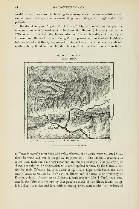
44 SOUTH-WESTERN ASIA.
wealth, which they spend in building large many-storied houses embellished with
elegant wood carvings, and in surrounding their villages with high and strong
palisades.
Besides these pure Aryan " Black Clads," Afghanistan is also occupied bj'
numerous jDeople of Mongol stock. Such are the Hczareh (Hazarah), that is, the
"Thousand," who hold the Koh-i-Baba and Siah-Koh valleys of the Upper
Hilmend and Heri-rud basins. Being thus in possession of most of the highlands
between Kabul and Herat, they compel armies and caravans to make a great detour
southwards by Kandahar and Farah. In a straight line the distance from Kabul
16.
—
Dak4h Nur.
Scale 1 : 750,000.
to Herat is scarcely more than 360 miles, whereas the historic route followed at aU
times by trade and war is longer by fully one-half. The Hezareh, doubtless so
called from their countless segmentations, are unquestionably of Mongol origin, as
shown not only by the designation of Moghel apjDlied to them by the GhUzais, but
also by their Kalmuck features, small oblique eyes, high cheek-bones, flat face,
scanty beard, as well as by their own traditions and the unanimous testimony of
Eastern writers. According to Akbar's historiographer, Abu '1 Fazil, they were
sent in the thirteenth century by Mangu-Khan south of the Hindu-Kush, though
it is difEcult to understand how, without any apparent contact with the Persians, all

THE HEZAEEHS AND AIMAKS. 45
except a single tribe have exchanged their Tatar mother-tongue for a pure Iranian
dialect, affected only by a few Turki words borrowed from their Turkoman neigh-
boxirs. Eawlinson supposes that they were settled from the remotest times in the
country, where they were brought into close relations with the Persians at the time
when the civilising influences of Iran were most active. Numerous ruins of cities
spoken of by the natives certainly imply a far higher culture than that now existing
in this region.
Except those to the north of the western Sefid-Koh, scarcely any of the Hezareh
tribes are nomads, all dwelling in permanent villages of small thatched houses half
buried in the grovmd. But while taking to fixed abodes, they have preserved
many of their Mongol usages, such as horseracing, at which they are scarcely less
skilled than the Khalkas of the Gobi steppes. Although endowed with sufficient
poetic genius to make their amatory declarations generally in extemporised verse,
they are far inferior in culture to the Afghans and Tajiks, to whom their artless
and vmcouth ways are a constant source of ridicule. ^Nevertheless, by these neigh-
bours they are also dreaded as sorcerers, capable by a single glance of bm-ning up
the liver in the bodies of their enemies. In theii- exuberant hospitalitj' thej' have
retained the old custom of accommodating the passing stranger with their women,
who in other respects enjoy a large share of freedom. They manage the household
and overlook field operations, and in time of war take part in the tribal councils,
even joining in the fray on horseback. No family matters are transacted without
the advice of the women, against whom the hand of man is never raised.
The national government is monarchical, the wealthiest tribe, which takes the
title of Ser Xhane ("Head of the House "), being considered by all the others as
forming a privileged class. Each commim.ity obeys its own beg or sultan, who
administers justice, imposes the fines, condemns to prison, and even to death. These
kinglets are often at war among themselves ; at other times forming temporary
confederacies either to plunder a powerful neighbour or resist the tax-gatherers
sent among them by the amir of Kabul. Thus the political map of the country
is incessant!}' shifting with the vicissitudes of war, the interest or caprice of rulers.
Towards the border lands the race has been considerably modified bj' crossings, and
amongst the Hezarehs many are now met with Afghan featm-es, while, on the other
hand, some Ghilzais might be taken for Kalmidis. In recent times the Hezarehs
have begun to migrate in large numbers to India, where they obtaia emplojinent
on the public works. Thousands also have become enslaved to the surroimding
Afghan communities.
The Hezarehs are all of the Shiah sect, whereas their Aimak neighbours and
kinsmen are zealous Sunnites. Of these Aimaks, that is, "Hordes," several,
especially ia the Herat uplands, still speak Mongol dialects, and the chief tribe
bears the strictly Mongol name of Kipchak. Theu- domaiu comprises the hiUy
pasture lands of the Ghur district south of the Hezarehs, the highland valleys
encircling the Herat basin, and the northern slopes of the Parapomisus facing the
Turkestan lowlands. The Taimuri, one of the Char Aimak, or " Four Hordes,"
have also settled west of Herat in Persian territory Most of the Aimaks stiU

46 SOUTH-^raSTEEN ASIA.
rlwoU in the unhi, or tents, which are grouf)ed irregularly round some defensive
tower occupied by the chief, and which are made either of grey felt or black skins.
The settled villages in their country are inhabited almost exclusively by Tajiks.
Brave as the Hezarehs, and like them ruled by despotic chiefs, the Aimaks are even
more dreaded on account of their ferocity. Elphinstone tells us how after the
fight they quaff the blood of the slain ; and according to Ferrier the girls of some
tribes cannot wed until they have taken part with the men in some warlike expedition.
The Jemshidis, whose 5,000 families encamp under plaited reed tents in the upper
Murgh-ab valley, are by some writers classed with the Aimaks, although their
regidar features and Persian speech leave little doubt as to their Aryan descent.
But through incessant war and migrations, combined with camp life, they have
acquired the manners and character of their Turkoman neighbours. Like them
they are marauders, and lose no opportimity of falling on passing caravans. But
these raids are not always successful, and since the beginning of the present
century their numbers have been much reduced. In the neighbourhood of Herat
dwell their kinsmen, the nomad Persian Firiz-Kui, removed hither by Tamerlane
from the Firuz-Koh district at the southern foot of Demavcnd.
To this motley assembly of races and peoples at jiresent inhabiting Afghan
territory must be added a few Jewish and Armenian money-lenders ; some
Abyssinians, Kalmuks, Arabs, Lezzhians, and Kurds, slaves or adventurers fighting
under the amir's flag ; many Turkoman, Baluch, and Brahui nomads encamped
on the frontiers, whence they make freqiient raids into the interior. Thus all the
peoples of Western Asia are represented in a land where so few Europeans have
penetrated, except in the wake of the British invading hosts.
Topography.
In the south-eastern regions between the Hindu-Kush and Kabul River all the
Kafirs, Dards, Afghans and other highlanders dwell in small towns or villages,
usually situated in fertile alluvial valleys or on the slopes facing southwards and
sheltered from the icy northern blasts. As in the Alps, the Hindu-Kush towns
consist mostlj' of a number of hamlets relieved by no monuments except their
turreted forts and religious edifices, often surrounded by extensive ruins. The Swat
valley still contains one well-preserved structure of this sort, surmounted by an oval
cupola 90 feet high and encircled by a series of niches in ten stories. The Skankar-
dar, as this sanctuary is called, seems to recall the worship of Shankar, one of the
Sanskrit names of Siva. Within their walled enclosures each of the fortified Swat
villages of Tarrnah and Cliahil contains about 1,000 families. In another formerly
resided the venerable Akhund, who, though posessed of little political power, was
supposed in Northern India to be an all-iDowerful prophet, a standing menace to
British rule, capable at any moment of hurling against it tens of thousands of
fanatical Wahabites. Tall and Kalkot, in the Upper Panjkora valley, have each a
population of 1,500 families of Bushkars, a branch of the Dard nation. Lower
down the same river stands Miankalai, capital of the petty Afghan state of Jundul.

TOPOGEArHY—K.VBUL. 47
In the Kunar Rirer valley are the relatively important towns of Mustuj,
picturesquely situated at an elevation of 7,600 feet, at the junction of the Yasin
and Upper Oxus roads, and Chitral or Chitlal, capital of the most powerful state on
the southern slope of the Hindu-Kush. Here resides the mihtar or hadshaJi, who
rules over some 200,000 Dard and Kafir tribes, some exempt from imposts, others
compelled to supply slaves even of their own kindred. He is himself tributary to
the maharaja of Kashmir, to whom he sends a j'early convoy of horses, hounds, and
falcons. Further down are Asmar, Shiyar, Serai, and Kunar, the last two governed
by Afghan chiefs. Kunar gives its name to the lower course of the Chitral River,
whose sands are here washed for gold.
The villages of Kafiristan are unknown even by name, while those of the upper
Panjir and Ghorband valleys are insignificant hamlets. But within 12 miles of
the confluence of the streams, and at the foot of the Paghman range, stands Charikar,
probably occui^ying the site of Alexandria, which was here built by the Mace-
donian conqueror to guard the highland routes converging on the lowlands. The
neighbouring plain takes the name of Bagram, supposed to be a corruption of
Vigrama, that is, " chief town," a term long applied to the capital of the Daman-
i-Koh district. The town, also traditionally known as Shehr-Tunan, or "Greek
city," was still standing at the time of the Mongol invasion, and amidst its ruins
Masson picked up about 60,000 Bactrian coins, rings, and other objects, nearly all
in copper. South of Charikar the crest of a wooded hill is crowned by the
picturesque town of Istalif, whose mild climate, sparkling streams, shady
plantations, orchards, and gardens render it the pleasantest place in the whole
of Afghanistan.
Kabul, present capital of the state, is the " oldest city of all," say the natives,
and according to the local legend here fell the devil when he was cast out of
heaven. The inhabitants also proudly point to the " tomb of Cain," thus carrying
back to the beginning of the world the bloodstained annals of this turbulent
region. In any case the city was certainly in existence at the time of the
Macedonian expedition, and is mentioned by the old writers first \mder the name of
Ortospana, or " "White Camp," * and afterwards by that of Cnbura (Ptolemy).
On the south-eastern road leading to India stand the remains of the Sm-kh-Minar
("Red Minaret), and of "Alexander's Pillar," structures betrajang evidence of
Greek or Graeco-Bactrian style. At the end of the fifteenth century Baber, whoknew no spot comparable to the "paradise of Kabul," made it the capital of his
vast empire, and amid the gardens of the south-west is still seen the white marble
enclosure, carved with arabesques and covered with inscriptions, which was raised
to the memory of this emperor. Timur, son of Ahmed Shah, also chose Kabul as
his residence, and since then the city has for over a century held its position as
capital of the kingdom. But apart from its official importance, it occupies a site
which could not fail to make it a great emporiimi of trade, for it stands on the
historic route between India and Bactriana, in the midst of fertile plains offerino-
every resource to caravans after their toilsome journeys across the snowy Hindu-
•Eawlinson, in "Jour. Geographical Soc," 1843.

48 SOUTH-WESTERN ASIA.
Kush. Thanks to its altitude of over 6,000 feet above the sea, it enjoys as
temperate a climate as European cities lying 10 degrees farther north, and its
fruits are famous throughout the East for their exquisite flavour.
Kabul covers a space of about 2 miles on the south bank of the river to
which it gives its name, and which 10 miles lower down is more than doubled
in volume by its junction with the Logar. West of the defiles just above the city
there stretches a vast triangular basin of well-cultivated plains, shaded with
poplars and willows, and encii'cled by bare rocky hills. Eastwards a projection is
crowned with the military quarter of the Bala-Hissar, or "High Fortress,"
partially destroyed by the English in 1880. Within the enclosure stand the
amir's palace and gardens, and the city itself is intersected in all directions
Fig. 17.
—
Kabul and Neighbourhood.
Scale 1 : 260,000.
by walls, di\'iding it into distinct plots like the cells of a honeycomb. But
these inner lines have in many places been demolished, and the breaches are
connected by a whole labyrinth of narrow winding lanes, the intricacies of which
were increased by the ruins of about 1,000 houses destroyed by the earthquake
of 1874. Many of the inhabitants have since then withdrawn to the suburbs,
which stretch north-west and north along both sides of the stream. In order to
overawe the city, the English in 1880 occupied the heights of Sherpur [Behmaru),
which rise on the north-east to an elevation of 800 feet, and which Shere Ali had
already chosen as the site of fresh fortifications. Shcrpui- has the advantage over
Bala-Hissar of standing isolated in the midst of the plains, and of not being
commanded by any neighbouring hills. About 6 miles east of Bala-Hissar are the

TOrOGEAPHY—GUAZNI. 49
ruins of au older city kao\vn by the name of Barjam or Bagvami, that is, " Capital,"'
and Kabul itself seems to have formerly stood on the banks of the Logar.
On the route between Kabul and Peshawar the chief intermediate station is
Jalalabad, which stands at a height of scarcely 1,800 feet below the gorges by
which the Kabul Eiver pierces the Siah-Koh range, and in the centre of the
Nangnahar basin sheltered on all sides from the winds. Hence the heat is often
oppressive at this threshold of the Iranian plateau ; but the fertile plain is in many
places shaded by leafy trees. In winter the population is greatly increased by the
shepherds returning from the surrounding pasture-lands. Beyond this point
the only place of any note is Lalpura, at the Afghan entrance of the Khaibar Pass,
which is guarded at the other end by the British fortress of Jamrud.
South of the Sefid-Koh most of the " towns " on the eastern slopes of the
Sidaiman-dagh are mere aggregates of mud huts surrounded by walls of the same
material. Such are Kuram, capital of the district of like name, and in the Tochi
vallej' the old but deca3'ed Shehr or S/iar/i, that is, " city " in a pre-eminent sense,
which still exports a remarkably strong and hardy breed of horses. Kaniguram
and Makin, farther north, are the chief centres of population in the Waziri territory.
West of the SiUaiman-dagh no towns are met till we reach Ghazni, the chief
place on the military route between Kabul and Kandahar, and in the eleventh cen-
tury capital of an empire stretching from the plains of Delhi to the shores of the
Euxine. Yet the residence of Mahmud, the "Ghaznevide" conqueror of India,
presents few of the advantages required by an imperial metropolis. Lying at an
elevation of 7,800 feet above the sea, in a region exposed to fierce gales, sultry in
summer, extremely cojd ip winter, Ghazni is also destitute of cojjious streams and
fertile plains. "I have often asked mj'self," says Sultan Baber, "how the
princes who reigned over Hindustan and Khorassan came to fix the seat of their
government in such a wretched country." Hence it is not surprising that when
it ceased to be a ro3'al residence Ghazni soon lost most of its population, although
stiU preserving its importance as a formidable stronghold between Kabul and Kan-
dahar. It stands at the foot of a long gj'psum ridge, with here and there j)atches of
vegetation, and at its highest point crowned with a citadel, whose walls are flanked
with bastions and towers. Like that of Kabul, this citadel, which was stormed by
Lord Keane in the first Afghan war, takes also the name of Bala-Hissar. Although
never a very large place, the ruins of old Ghazni stretch for a considerable distance
to the north of the present city. Here doubtless stood Mahmud' s " Heavenly
Spouse," the marble and granite mosque built by him to commemorate his
conquests. To this mosque belonged probably the two graceful minarets em-
bellished with Kufic inscriptions now Ipng on an artificial platform in the district.
Ghazni takes the title of " Second Medina " from the great number of
illustrious persons whose tombs it formerly contained. That of the Ghaznevide
is still seen in the old town, but it has no longer the sandalwood gates brought
hither by Mahmud from Somnath in Kattyawar, and by the British removed to
Delhi in 1842. Doubts, however, have been entertained as to the identity or
antiquity of these gates. -
VOL. IX. E

50 SOUTH-WESTERN ASIA.
Gliazul is peopled by Ilezarelis aud Ghilzais ; but Kclat-i-Ghilzui, that is,
" Castle of the Ghilzais," the only other stronghold between Kabul aud Kandahar,
is inhabited almost exclusively by members of this tribe. It is rather a fortress
than a town, its irregular lines, barracks and magazines crowning an isolated
eminence on the stony plateau which separates the Argand-ab from the Tarnak
valley. At its foot are scattered the villages of the peasantry, besides the palace,
bazaar, and other buildings, which might form the nucleus of a city. Numerous
ruins are strewn over the cultivated and weU-watered plain, while the heights are
crowned with the remains of tombs, forts, and signal towers, attesting the former
Fig. 18.
—
Kelat-i-Ghilzai.
Scale 1 : 45,000.
taf&reenw.ct.
strategic importance of Kelat-i-Ghilzai. During the late war it was the chief centre
of General Roberts's operations on his famous march from Kabul to Kandahar.
Like so many Asiatic towns, Kandahar or KJiand, a term identified by some
etymologists with an ancient "Alexandria," by others with a still more ancient
Hindu " Ghandara," has several times shifted its position. The city of Arachosia
(in Sanskrit Harakicati) lay more to the south-east, where now stands the ruined
station of 0/aii Rabat, or Shahr-i-Toltak, in the midst of the Ai-gand-ab solitudes.
To this place succeeded " Old Kandahar," which has not yet completely disap-
peared. About 3 miles from the modern enclosure the hills are skirted by solid
ramparts, the remains of a Bala-IIissar, which was formerly one of the strongest

TOPOGEAPHY—K2\.NDAHAn. 51
places in Afghanistan, and which held out for eleven months against Nadir Shah.
Another Kandahar, founded by Nadir himself, enjoyed a brief existence of a few
years during the last century, and its well-preserved walls still stand at about 3
miles to the south of the present city, which was built by Ahmed Shah, founder of
the present dynasty. He chose it as the royal residence, and the finest edifice
within the waUs is the domed mosque standing over his tomb, the resort of thousands
Fig. 19.
—
Kaxd.ih.^k.
Scile 1 ; lOO.OftO.
of blue pigeons. No one better than the conqueror could appreciate the extreme
strategic importance of Kandahar, the " key of India." Lying on the semicirciilar
route between Kabul and Herat, commanding the outlet of the Argand-ab and
Tamak valleys, as well as the defiles of the ranges separating India from the Hil-
mend basin, it has the further advantage of being surrounded by a fertile region,
which might supply abimdant provisions to armies on the march. On the south and
south-west it is unassailable, being protected in this direction by vast desei't tracts.
E 2

52 SOUTH-WESTERN ASIA.
The quadrilateral of Kandahar stands at a height of 3,o00 feet above the sea on
a plain sloping gently towards the south-east in the direction of the Tarnak River.
The irrigating waters which supply the city, and which convert the surrounding
district into a vast garden, are drawn from the Argand-ab, and skirt the foot of
the advanced spurs of the Gul-Koh, which is here pierced by the profound Baba-
Wali Pass. Here was fought the battle by which General Roberts raised the siege
of Kandahar in 1880. The city walls, though flanked by over fifty towers, and
supported northwards by a citadel, are in a bad state of repair ; but the interior
presents a favoui-able contrast with Kabul, its well-kept streets generally running
at right angles, while the whole space within the enclosure is divided by two main
avenues into four nearly equal quarters, approached from the north through the
citadel, and on the other sides by three gateways. At the junction of the avenues
stands the bazaar, surmounted by a fine cupola, and thronged with a busy crowd of
buyers and sellers. The eastern section of the avenues leading to the Kabul gate is
occupied chiefly by cloth merchants, while that leading west to the Herat gate is
alive with the incessant din of workers in copper and blacksmiths. The dyers,
potters, and fruit-vendors are grouped along the southern avenue terminating at the
Shikarpur gate, and the road to the citadel is lined with large warehouses well
stocked with English and Russian goods. The dealers in the bazaar belong to
every race in Western Asia ; but the great bulk of the inhabitants are members of
the Durani tribe.
Recently Kandahar lay within the " scientific frontier" of the Indian Empire;
but consequently upon a change of Government in England it was restored to the
amir in 1882. Here was to have terminated the Shikarpur railway, first section of
the transcontinental line between India and Asia Minor. But although the works
have been temporarily suspended, the portion of the railway already completed from
the Indus to Sibi, at the foot of the Bolan Pass, is continued up to the plateau by
routes practicable for artillery, and the present military frontier station has been
fixed at Chaman, within tliree days' marcb of Kandahar. From this encampment,
which is flanked by spurs of the Khoja-Amrau, the British forces guard the
eastern extremity of the main military route traversing Aighanistan from the
south-east to north-west. Any further advance could scarcely stop short of Kushk-
i-Nakud, memorable for the defeat of General Burrows in 1880, or even of the
fortress of Ghirisk, which commands tbe passage of the Hilmend and the Zamin-
dawar valleys. The numerous ruined fortifications scattered about this spot attest
the great importance attributed at all times to this strategic point. It might
also be foimd necessary to secure Farah, a stronghold standing at the south-west
angle of the northern highlands and of the great military highway near the fertile
plains of Sistan. Then there is Sistan itself, whose chief stronghold. Lash, stands
on an eminence surrounded by valleys, impregnable to any but the heaviest modern
artillery. Nor could Sibzaicar or Sebzwar be neglected. This fortress, which holds
the Aimaks in check, and which has replaced the ancient Isfezar, is the last
strategic point south of Herat, and prophets of ill-omen have already named it as
the probable site of future collision between the great rivals for empire in Central

TOPOGEAPHY—HERAT. 53
Asia. To tlie south-west tlie Tajik village of Anardereh stands near the Persian
frontier, at the foot of a hill rent throughout its entire length hj a cleft nowhere
more than 20 inches wide, and caused, says the local legend, by a stroke of the
sword of Ali.
Herat, which fi-om its strategic importance has been called the "Gate of
India," and from its vast agricultural and industrial resources the " Pearl of
Khorassan," is one of the oldest, and at times has been one of the most populous,
cities in the world. It is clearly identified with the Aria which was a large place
in the days of Alexander, and which, according to the Persian historians, was in
the twelfth centuiy the " queen," and the " illustrious," containing 444,000
inhabited houses, 12,000 shops, 6,000 public baths and caravansaries. In the next
century it was captured after a six months' siege by Jenghiz-Khan, who butchered
its inhabitants to the number of 1,600,000, forty persons alone escaping the sword of
the ruthless Mongols. Such is the vital importance of its position, that it has been
fifty times attacked and levelled to the groimd, each time again rising from its
ruins. Lying on the Perso-Afghan frontier, it has never ceased to be a subject
of contention between these conterminous states, and if, despite its geographical
dependence on Persia, it now belongs to the Amir of Kabul, its Persian-speaking
inhabitants have to thank England, which has twice interfered and compelled the
Shah either to raise the siege or surrender the prize. At present the political
equilibriimi has changed. Russia has become the most powerful neighbour of
Herat, and her engineers are surveying the ground with the view of making it
the future terminus of their Trans-Caspian railway system. Lessar has recently
shown that the Heri-rud forms the natural approach from the Turkestan depression
to the Iranian plateau, and this route, ah-eady traversed more than once by
Turkoman and Mongol, is henceforth open to the Russian.
Situated about 2,600 feet above sea level, Herat occupies the centre of an
extremely productive plain traversed east and west by the Heri-rud, and skirted on
both sides by hills, which diminish in height towards the west. Amidst the
clumps of conifers are here and there detected piles of ruins, tombs, and other
remains, recalling the prosperous days when Herat covered an area ten times
larger than at present, and when a dog " could bound from roof to roof all the way
from the citadel to the villages on the plain." The enclosui'e of the modern city,
forming a quadrilateral with its longest side rimning from east to west, is not so
much a rampart in the strict sense of the word as a huge irregular moimd, with a
mean height of 80 feet, and separated by a deep ditch from the plain. On the
north side stands the citadel of Ekhtiar-eddin, a solid structure commanded within
1,000 yards by an enormous eminence said to have been raised by K"adir-Shah. Like
Kandahar, Herat is divided into four quarters by two transverse streets, whose
point of intersection, till recently surmounted by a dome, has become the centre
of the bazaar. The local craftsmen have retained their reputation for the
manufacture of sword-blades, carpets and cotton goods ; but at present the bazaar
is chiefly stocked with English and Russian wares. The population, which varies
enormously with the political vicissitudes of the country, was reduced to 7,000

54 SOUTH-WESTERN ASIA.
in 1838, and when most of its Shiah inhabitants had quitted the city to escape
the persecution of its Afghan masters. A considerable proportion of the citizens
represent ancient families who have fallen with the place itself from their former
greatness. Amongst them Ferrier met descendants of Jenghiz-Khan, Tamerlane,
and Nadir-Shah.
Most of the palaces, caravansaries, mosques, and other public buildings form
picturesque ruins in the suburbs, where a solitary tower, a broken arch, or a
crimibUng wall still covered with lovely enamelled porcelain blend their softened
tints here and there with the foliage of the shady plantain. The district is noted
for its healthy climate and balmy atmosphere, due to the northern breezes which
prevail during the hot summer months. " Bring together the soil of Ispahan, the
air of Herat, and the waters of the Kharezm, and there man will live for ever,"
Fig. 20.—Herat.
Scale 1 : 1,300,000.
L of I
says an Iranian proverb. Nor need Herat envy the waters of the Kharezm itself,
for those of the Heri-rud, " clear as a pearl," are amongst the purest in Asia ; and,
thanks to the nine main channels and their countless ramifications fed by the
neighbouring river, Herat has become the " City of a hundred thousand Gardens."
Here are grown seventeen varieties of the vine, and many species of melons, apricots,
and other frmts, all renowned throughout Irania for their exquisite flavour. In
these gardens the public help themselves, and pay the reckoning according to the
difference of their weight on entering and leaving. Beyond the watered tracts the
plains yield the ink or assafoetida of the Afghans, abhorrent to the European sense
of smell, but which supplies a dainty dish to the Iranians.
Above Herat are a few groups of houses that may still be called towns. Such
is Kuriikh, capital of the Jemshidi territory, on the route to Maimench, noted for
its hot springs, of which as many as eighteen bubble up within the town-walls.

TOPOGEArHY—OHURIAN. 55
111 the Heri-rud valley west of Herat the ruiued cities of Ohurian and Kusan
owe all their importance to their position near the political frontier of Persia.
According to Kanikov, Ghurian was in 1820 a larger place than Herat itself. Now
it is little more than a pictiu-esque fort, surrounded by hovels in the midst of a
splendid district, where the neglected banks of the Heri-rud are fringed in many
places bj' groves and even forests of large trees. Here the hare, partridge,
pheasant, and grouse are met in vast multitudes, while larger animals, such as the
deer, wild boar, and wild ass, frequent the surrounding thickets. Thiis has nature
again taken possession of this formerly populous and highly cultivated region of
Afghan Khorassan. The same desolation has fallen on the hilly districts of the
Hezarehs and Aimaks, which abound in the ruins of ancient cities, but where
nothing is now seen except miserable hamlets. Zerni, or Glmr, capital of the
country, has almost ceased to exist. Here Ferrier tells us he met a few Guebres,
a statement which has been questioned by most subsequent writers.
Trade—I>-DrsTRiES
—
Administration.
Owing to its sparse population, the conflicts of hostile tribes and races, the
absence of large towns, roads and bridges, Afghanistan holds a low place even
amongst Asiatic countries as an agricultural and industrial region. Certain
valleys and a few oases on the plains are doubtless carefully cultivated, while the
system of underground channels, dams, and irrigating riUs bears evidence to the
labour sustained for centuries by whole communities. In the agricultural districts
also, where the land is parcelled out amongst small holders, independent of factors
or middlemen, the soil is remarkably productive, and has frequently met the
demands of invading hosts without being completely exhausted. But in ordinary
times wheat, the staple national food, and the other products of the land, suffice
only for the local demand, leaving little for export except some dried fruits, corn,
and medicinal gums. Yet the temperate plateaux and cool upland valleys ought
to yield abundant supplies to the Hindu populations, with whom scarcely any
traffic is maintained. Nor do the industries of the Tajiks in Kabul and the other
Afghan cities contribute much towards the export trade. Hence the Povindahs
import from India and elsewhere far more than they are able to offer in exchange
for the wares purchased by them from the English, Russians, Bokhariots, and
Hindus. The Anglo-Indian Government, while withdrawing from Kabid and
Kandahar, has at the same time suspended the works which were intended to
connect those cities with the peninsular railway system, the two main lines towards
the plateau terminating at present at the eastern entrance of the Khaibar and
Bolan passes. Bridges, viaducts, cuttings, embankments, tunnels, everything was
suddenly and senselessly abandoned after upwards of £520,000 had been
expended on these indispensable works. But while the British lines have thus
been interrupted by a Liberal Government, those of the Russians are steadily
advancing in the opposite direction, from the Caspian, through the Turkoman oases,
towards the Afghan frontier. And thus arises the question, which of the two

5G SOUTH-WESTEEX ASIA.
great powers, compelled by the very force of events to contend for supremacy
in Central Asia, will be the first to secure by the locomotive the commercial pos-
session of Afghanistan. The advantage must certainly lie with those who shall
take the lead in placing the inhabitants of the plateau in easy communication
with the rest of the world.
Afghanistan is not likely long to maintain any real political independence, to
preserve which its inhabitants should possess a common patriotic sentiment and
confidence in their destinies. But Afghan, Hezareh, Tajik, Kizil-bash, Kafir are
aU so many antagonistic elements, while the many tribes of the ruling race itself
lack all political cohesion. Most former wars possessed little more than a special
interest for the different clans, whose chiefs were struggling from time to time for
the foremost rank. The Ghilzais, Kafirs, "Waziris, Yusuf-zais, Lohani, do not
regard themselves as the subjects of the amir or of his great Barakzai chiefs. They
supply provisions, guides, and convoys to the stranger without feeling that they
thereby incur the charge of treason ; their only fatherland is the tract held by their
respective clans. And as regards the central Government itself, all the inhabitants
of the country have for the last half-century grown iip under the idea that the real
sovereignty lies ultimately with the English or the Russians. European travellers
in the country are incessantly besieged with questions touching the rivalry of the
two great conquering powers and the probable issue of the pending conflict.
Such also is the universal topic of discussion in the bazaars, where the news-
messengers play the same part as the political press elsewhere.
The Afghans themselves seem generally inclined to believe in the future
supremacy of Russia. "However disagreeable the confession, there can be no doubt,"
says MacGregor, " that in their eyes the prestige lies with the Russians, whomthey regard as the next conquerors of India." Doubtless they have not yet
obtained a footing in Afghanistan, but all their expeditions in Central Asia
invariably end in conquest, which is never followed by retreat. The English, on
their part, have thrice invaded Afghanistan, but at what a price P and with what
results ? In 1842, after three years' occupation, the Anglo-Indian garrisons,
some 13,000 strong, perished almost to a man in their attempt to withdraw from
Kabul. Three persons alone escaped from the greatest disaster ever suffered bj'
the British army. In the last war also the serious defeat of Kushk-i-Nakud had
to be repaired ; and although on this occasion they quitted the country of their
own accord, the popular report, rapidly spread from tribe to tribe, represented
them as fugitives. Their attitude fully justifies the saying attributed to
Aimed Shah in speaking of his Afghan kingdom, " Beware of my bee-hives
;
the bees are there, but not the honey." To avoid diplomatic difl5culties, and
for other motives of "high state policy," the British Government not only
sacrifices blood, treasure, and prestige by withdrawing when it might easily remain,
but seldom even allows its o^-n subjects to explore the country in times of peace.
Even in the far west, on the route between Farah and Herat, caravansaries are met
at intervals, formerly erected by the English, but which they dare not now makeuse of. In 1840 their advanced posts stood to the north of the Bamian Pass,


LIBRARYOF THE
UNIVERSITY of ILLINOIS.

GOYEENMENT OF AFGHANISTAN. 57
whence the Eussian van might now he visihle, and their guns obstruct the bed of
the torrents flowing down to the Oxus. Unless wiser counsels are adopted, the
Afghan view of the situation cannot fail to be realised.
The present amir, former guest of the Russians, now a British pensioner,
represents in his person the political state of the laud for which the two rival
powers are contending. His kingdom is far more extensive than seems consistent
with his real weakness, for its limits have been arbitrarily laid down by the two
protecting states. North of the Hindu-Kush, Koh-i-Baba, and Siah-Koh, the high-
lands and plains stretching to the Oxus belong geographically rather to Eussian
Turkestan than to Afghanistan proper, to which they are poKticaUy attached. On
the southern frontier also many tribes pay the taxes only on compulsion, while the
three rival cities of Kabul, Kandahar, and Herat themselves form part of one state
only in virtue of an "Asiatic equilibrium" temi^orarily guaranteed by the two
paramoimt powers in Central Asia.
Like other Eastern sovereigns, the amir is in theory an autocrat ; but practi-
cally his power is limited not only by the Shariat, or " way of the faithfiil," that
is, by the religious and civil traditions of Islam, but also even more decidedly by
the privileges of the sirdars and republican tribes. At once absolute master of the
Tajiks, head of the Durani, and suzerain of the other tribes, he commands, advises,
or solicits according to the respective attitudes of these sections of the community.
Certain offices are hereditary in many families, and these could be interfered with
onlv at the risk of a general insurrection. A large number of clans receive
neither his magistrates nor his tax-gatherers, but administer their own affairs, tax
themselves, and send to the amir the amount of tribute settled by custom. Thus
limited, the royal power is transmitted if not from father to son in the order of
primogeniture, at least in the same family. Formerly the sovereign was elected
by the sirdars or great chiefs ; now the English Government exercises the right
of nomination as well as that of control by the presence of an ofiicial resident at
the Court of Kabul. But for motives of prudence this dangerous office is entrusted
to a native.
When he ruled over the Peshawar district and aU the eastern Daman-i-Koh
between the Indus and the Sulaiman-dagh, the amir was a wealthy potentate,
with a revenue exceeding £2,000,000. In those days the plains supplied him
with money, the plateau with men. But now that all his resources are derived
from the latter, his yearly income has fallen to little more than £600,000. Hence
the Court has been compelled to economise, more especially since the ordinary
revenue has been absorbed almost entirely by the army. Although most of the
troops are raised amongst tribes boimd to military service in lieu of tribute, and
although provisions are mostly supplied gratuitously in the garrison towns, large
sums are still spent, especially in the purchase of war materials. In 1879, at the
time of the rupture with England, the amir had in his arsenals 379 guns and
50,000 rifles procured in English workshops or manufactiired in the country. The
troops are drilled in English, chiefly by deserters from the British army.
The various provinces are administered by a Lanhim and commanded by a

58 SOUTH-AVESTERN ASIA.
military sirdar. But both functions are frequently exercised by the same
official, especially if he be a member of the Durani tribe. In the nomad districts
his principal duty is to collect the taxes and settle disputes, the Kazi, who accom-
panies him, delivering judgments and fixing the fines.
The Afghan provinces proper, determined mainly by the relief of the land, are
comprised in the subjoined table :
—
I. Kabul—Kabul, Upper Kabul, and Logar River valleys, Daman-i-Koh.
Ghorband, Upper Ghorband, and Panjir valleys.
Laghman, Kabul riverain tracts between the capital and Jalalabad.
Safi and Tagao, Hindu-Kush valleys between the Daman-i-Koh and Kafiristan.
Jalalabad, Lower Kabul River valle)-.
Ghazni, Ghazni River basin, and surronndins hills.
II. Kandahar—Kandahar, eastern Durani territory.
Kelat-i-Ghilzai, Tarnak valley, Gul-Koh.
Ghirisk.
Farah, Farah-rud basin.
III. SlSTAN
—
Lash, Shakansur.
IV. Herat—Herat, Middle Heri-rud basin.
Kan-ukh, Upper Heri-rud basin, Obeh.
Ghurian, Lower Heri-rud.
Sibzawar, Ardrashkan basin.
Shahband, Aimak territory.
V. Hezareh Territout.
VI. Kafirtstan—Mastuj, Kaskar or Chitral, Kunar, Bushkar.
Panjkora (Jundul), Dir, Bajaur.
Note.—Attached to Afghanistan are also the khanates of Turkestan south of the Oxus, although
geographically comprised within the region of which the Russian city of Tashkend has become the
political centre. These are the states of Wakhan, Badakshan, Kuiiduz, Balkh, Andkhoi, Sliibirkau
Ak-Cha, Saripul, Meimeneh, Gurzivan, Darzab, for which see Vol. VI.

CHAPTER III.
BALTJCHISTAN.
HE land of the Baluches has scarcely retained a shado'w of political
independence, and is now practically a province of the Indian
Empire. Kachi-Gandava, its most fertile and relatively most
populous division, belongs geographically to the region of the
plains, and here the English have long maintained military canton-
ments. Kwatah (Quetta) also, the chief stronghold on the plateau, is held by a
British garrison, commanding on one hand the Afghan city of Kandahar, on the
other the Baluch capital of Kalat. In Kalat itseK the advice of the English^ resi-
dent, representing the Indian viceroy, is always followed by the sovereign.
Along the coast the small seaports, peopled mainly by sailors and traders, subject
to the direct jurisdiction of England, are veritable Hindu colonies ; while the
telegraph stations on the same seaboard are guarded by troops in the p\iy of the
Calcutta Government.
Several English officers, notably Colonel MacGregor, have been sent to survey
the roadsteads along the coast and the strategic routes leading inland to the
Afghan plateaux. Nevertheless, miich of the land still remains to be explored,
consisting, however, chiefly of bleak highlands, sandy wastes, rocky or saline
argillaceous tracts. Thus the region, mostly a wilderness, covering a space of
about 30,000 square miles, and stretching from the Hiknend southwards to the
Washati or Koh-i-Sabz and Sianeh-Koh ranges, is regarded as a worthless and
ownerless land. While Hughes assigns it to the Afghan amir as being naturally
included in the Hamun basin, on most maps it is represented as belonging to the
Khan of Kalat. The official map prepared in 1872 by Goldsmid on the banks of
the Hilmend marks the common frontier of Persia, Afghanistan, and Baluchistan
at the Koh-Malak-i-Siah, or " Mountain of the Black King," west of the Hamun,
and from this point the Baluch border is traced directly to the great bend of the
Hibnend below Eudbar. This would give an area of over 100,000 square miles to
Baluchistan; yet, according to the most liberal estimates, this vast region has
scarcely the population of a second-rate town. Even including the pro\ince of

CO SOUTH-WESTEEN ASIA.
Kachi-Gandava, which belongs ethuicall}^ aud geogi-aphically to India, the whole
state contains less than 500,000 inhabitants.
The Baluchistan ITighi.ands.
The khanate attains its greatest altitude towards the south-east frontier of
Afghanistan, where it probably cidminates in the double-crested Takatu, north of
Kwatah, and where other peaks in the Chihil-Tan range appear to rise nearly as
high. A few points in the Koh-i-Muran, or " Snake Mountains," which lie more
to the south between Mastang and Kalat, are also said by Cook to rival the Takatu,
Fig. 21.
—
Routes of the chief Exploreks of Baluchistan.
Scale 1 : 9,000,000.
Railways Completed. Projected.
. 240 Miles.
all these, as well as the Kaliiiat peak north of the projected line of railway,
attaining an elevation of 12,000 feet or thereabouts. All the Brahui ranges,
which form the eastern scarp of the plateau above the Kachi-Gandava plain, run
in remarkably regular parallel lines in the direction from north-north-east to
south-south-west. Carved into terraces of unequal size, shaped like pyramids, or
bristling with sharp peaks, these rugged limestone hills are mostly destitute of
vegetation, a few juniper forests alone blending their pale green with the blue and
rosy tints of the rocks bathed in the light of the sun. According to the hours of
the da)^ with their shifting lights and shades, the hills appear on the horizon like a
scarcely vi.sible pink or violet veil, a transparent luminous vapour, or glowing

TUE BALUCHISTAN HIGHLANDS. fil
cones of molten red lava. Between the parallel chains, the basins forineily fillod
"with lacustrine waters have all been emptied by their mountain emissaries. Yet
some of these sequestered dells, with their grassy swards and clumps of trees,
remotel}' resemble fresh AljDine valleys ; while others are like fragments of the
desert enclosed in an amphitheatre of hills. Such is the Dasht-i-Bedaidat, or
"Desolate Plain," separated from Kwatah by the Madar or "Dead Man range,"
which is traversed by the main route from India through the Bolau Pass. This
dismal waste is exposed in winter to tremendous snowstorms, in summer to the
still more dreaded whirlwinds, driving the hot sand in eddies across the plain, and
often swallowing up the belated wayfarer.
Like most limestone systems, the parallel Brahui chains are broken at intervals
by deep transverse fissures, through which the perennial or intermittent torrents
rush from terrace to terrace, do^-n to the plains. Many of these gorges present
a series of zigzag lines, disposed at sharp angles with almost geometrical symmetrj-.
Tin recently they formed the only route from the plain to the plateau, although
practicable only in the dry season, or when the water was low enough to leave a
footing on either side. As many as eleven roads of this sort, some not yet explored
by Eui'opeans, connect the Kalat uplands with Kachi-Gandava. Of these the easiest
is that of Milon or Mula, which rises gradually from the Gandava oasis to the
Jalawan tableland. But, owing to the great length, it has at all times been less
frequented than the famous Bolan Pass, which runs from the northern extremitj' of
Kachi-Gandava up to the Dasht-i-Bedaulat, and which the British engineers have
converted into a fine carriage road, accessible to artillery. But the Bolan itself has
now been abandoned by most travellers, who generally proceed by the new Line of
railway from Shikarpur to Sibi, at the foot of the hiU, and thence follow the Harnai
valley to Kwatah.
The loftiest section of the Brahui highlands is occupied bj- Kalat, capital of the
khanate. As shown by the coiu'se of the streams radiating in all directions from
this water-parting, the traveller must descend from the plateau of Kalat, whatever
route he may take. Kalat stands at an altitude of 6,800 feet, which is rivalled by
but few crests in the highlands stretching south of the Brahui hUls. The parallel
chains, which begin bej'ond the Mula Pass, and run neai'ly due north and south,
form a well-marked natural limit between the Baluch uplands and the plains of
Sind, thanks, however, to their arid character rather than to their absolute elevation.
These Khirtar or Hala Mountains in fact scarcely rise more than a few hundred
feet above the plateau stretching westwards. One peak alone ajjpears to exceed
7,000 feet above the sea, while most of the crests attain an altitude of little more
than 5,000 or 6,000 feet.
West of the Khirtar range the Baluch plateau falls gradually towards the
Ai-abian Sea. Here a spur from the Kalat highlands projecting southwards forms
the water-parting between the Meshkid basin and the region draining southwards to
the sea. This southern plateau is broken into three main sections of parallel chains
running chiefly east and west and increasing in altitude landwards. Thus we
ascend from the southernmost section, which is scarcelv 200 feet above the sea, to

62 SOUTII-AMSSTEEN ASIA.
a central terrace 2,000 feet higli, and thence to a third attaining an elevation
of 4,000 feet. Most of the intervening ranges are pierced by ravines or broad
openings, so that the whole country is intersected in all directions by natural
routes accessible to caravans.
Parallel with the inland ranges runs the Baluch seaboard, better known
by the name of Mekran, which has been cut by the action of the waves into
numerous steep headlands from 300 to 400 feet high, following in uniform
succession and separated from each other by sandy bays with regularly curved
beaches. Thus the peninsulas of Gwadar and Omara projecting seawards between
Fiij. 22.
—
Passes in North Baluchistax.
Scale 1 : 900,000.
Railways Completed.
semicircular inlets of smooth water present an analogous appearance to the
promontory of Giens and other headlands, connected only by a few sandy strips with
the mainland. But the whole coast of Meki-an seems to have been considerably
upheaved since the formation of these promontories, for they stand at present
at a much higher level than the intermediate strands.
Notwithstanding its numerous inlets, the Baluch seaboard nowhere offers any
convenient havens for large vessels. The water shoals everywhere so gradually
that men-of-war are xmable to approach nearer than 2 or 3 miles of the coast,
where no landing could be attempted during the prevalence of the south-west
THE BALUCHISTAN COAST. 63
monsoon, from March to September. But when de^jths of 140 or 150 feet are
reached, the plummet often sinks abruptly 400 or 500 fathoms into the abyss
of the Indian Ocean.
Like the islands of Ramri and Chcduba in British Burma, the Mekran coast
presents abundant traces of igneous action, betraj-ed by nimierous thermal waters
and as many as eighteen mud volcanoes, forming in many places prominent features
in the landscape. In the province of Las, bordering on India, seven of these
cones, running close to the shore, are regarded by the Hindus as so many fragments
of the goddess Durga, and from the bubbling mud of these volcanoes the devout
pilgrims cast their horoscopes. Near the For or Puri River, west of the port of
Fig. 23.
—
East Mekr.vn SEAiio.\i:n.
Scale 1 : 1,150,000.
E Of&r
320 Feet andupwards.
__ 30 Miles.
Somniani, another rises in the middle of the plain to the height of 400 feet,
terminating with a crater 460 feet in circumference. This is the Raj RamChander, or Chander Kups, which, like all the others, ejects mud and salt water.
River Systems.
Baluchistan is one of the most arid regions in Asia, notwithstanding its
exposure to the south-west monsoons, which discharge much of their moisture
especially at the north-east corner of the plateau, where the land attains its
greatest elevation. Here there is a considerable rain during the summer months.

6-4 SOUTH-WESTEEN ASIA.
when some of the closed basins, as well as the valleys confined between the pai-allel
ranges, are occasionally converted into temporary lakes. But the trade-winds
reaching the Mekran seaboard have already lost much of their moisture in their
passage across the South Arabian deserts. Hence the Hindu peasantry in the
Baluch oasis have been obliged, like those of the other part of Irania, to construct
karezes, or underground conduits in some of the most fertile valleys. But
the Baluchi natives, being unable to keep these channels in repair, depend for
their supplies altogether on the waters of the nudi, or intermittent streams. Yet
from its general appearance the land seems to have formerly been much more
copiously irrigated. Traces of inundations, and even of permanent flooded basins,
are visible in valleys which are now completely destitute of water, and wells
sunk near the shore prove that there is still a large supply below the surface.
The Baluch rivers falling into the Arabian Sea flow mostly in narrow beds
direct to the coast, and even in the rainy districts send down but little water.
The Dasht, or " Eiver of the Plain," which reaches the sea close to the Persian
frontier, has a larger volmne than the other coast streams, because in its upper
course it follows one of the depressions between the parallel coast ranges, thus
developing a basin of considei-able extent. Yet for half the year it fails to reach
the sea, and at this period the bar at its mouth remains exposed. The most
copious river in Baluchistan is the Meshkid, most of whose headstreams rise in
the Persian district of Sarhad, and flow first south-east in the direction of the
Arabian Sea. But on entering Baluchistan they converge in a common channel
south of the Sianeh-Koh, and thence flow east to the Rakshan, which drains
the Panjgur district. The \mited stream then trends northwards through the
gorges separating the Sianeh-Koh from the Koh-i-Sabz, beyond which it takes a
north-westerly course to the closed basin, where it runs out in the swamps and
sands. But this basin never sends its overflow farther north to the great depression
of Sistan, as still represented on many modern maps. The Hamun, or marsh, to
which the Meshkid sends its waters in the rainy season, occupies the central
position of the Charan desert between the 28° and 29° north latitude, and from
MacGregor's recent exploration it appears that this Hamun is completely cut off
from that of Sistan by a lofty range of hills. During the floods it forms an
extensive freshwater basin, but at other times it becomes a shallow reservoir
of saline or brackish water. Parts of the surrounding plain are naturally fertile,
although little cultivated, but the surface is elsewhere covered with a saline
efflorescence several inches thick, which yields an abundant supply of salt to the
surrounding districts. West of the Hamun-el-Mashkid the natives report the
existence of the Kindi or Talah, another swamp, which receives the northern
drainage of the basin. In north-east Baluchistan also the Lora, or river of
Sharawak, flows to a third hamun in the middle of the desert.
According to MacGregor the Kharan desert is much more accessible than
many of the sandy wastes in Persia, Arabia, and Africa. It is well known to
the caravans, which can always rely after a day's march at least on a well of
brackish water and a little fodder for the camels. But there are certain districts

CLIMATE OF BALUCHISTAN. G5
carefully avoided by travellers, who would inevitably perish if overtaken by the
terrible " simoon," a hot pestilential wind before which the dunes di-ive like ocean
billows. At times also the air, although perfectly stiU, is filled with suffocating
clouds of dust, a phenomenon attributed by the natives to the action of the solar
rays on the fine particles of sand. Towards the east Pottinger traversed for five
days a region of dunes with a mean height of 15 to 20 feet, all moving west
and east, iinder the influence of the prevailing winds, and consisting of a fine
reddish dust. Camels coming from the Meshkid across the sea of sands glide on
their knees gently down the slopes facing eastwards. North of the Meshkid
Hamun, MacGregor saw a large number of dunes of a different character, all
moving north and south, some rising 60 feet above the plain and developing
perfectly regular crescents, capacious enough to embrace a whole regiment between
their two horns. Towards the Afghan frontier the sands take mainly a north-
easterly direction, so that the various forms and disposition of these dunes, like
those of the Thar desert in India, may perhaps be to some extent caused by the
various oscillations of the ground.
Owing to the relief of the land, the cKmate of Baluchistan presents within a
relatively limited extent the most surprising contrasts. In the argillaceous and
rocky basins of the coast streams, as well as on the Kachi-Gandava plain at the
foot of the Brahui Hills, many districts are popularly compared to the lower
regions ; while on the bleak plateaux, at elevations of 6,000 feet and upwards, the
traveller is exposed to keen northern blasts, and often runs the risk of being
swallowed up in the winter snows. A similar contrast is naturally presented by
the vegetation, which, however, is everywhere characterised by the almost total
absence of forest growths. The slopes are sometimes clothed with various species
of the jvmiper, and with the happuer (^zizip/uis Jujuha^, which j'ields a useful
building-timber. In the valleys the hamlets are surrounded by a few mulberries,
tamarinds, or plantains, while the brooks are fringed with willows. Most of the
fruit-trees indigenous to "West Asia, such as the peach, apricot, pear, apple, plum,
pomegranate, almond, walnut, fig, and vine, besides the mango and date, flourish in
the more favoured districts. In the hot lands the most common plant is the pish
{^chamcerops rifchiana'), a species of dwarf pahn, whose trailing roots spread out 15
or 16 feet along the ground. To the Baluch it is as serviceable as is the bamboo to
the Hindu, supplj-ing him with food, and materials for cordage, tinder, sandals, and
excellent matting.
At corresponding altitudes the Baluch fauna, which was little known before the
exploration of St. John, differs in no respect from those of the Afghan plateaux,
of the Hilmend depression and plains of India. But the lion, now so rare even in
India, has disappeared altogether, while the leopard is very common. The hyena,
wolf, wild boar, and a species of black bear that lives on roots, are also met.
GazeUes frequent the skirt of the desert, and herds of wild asses are able to pass
the whole day in solitudes entirely destitute of water and vegetation. Peculiar to
Baluchistan are the nectarinia, a beautiful bird resplendent in all the coloui-s of the
rainbow, and the tirosmastix lizard, which at a distance looks like a rabbit, and to
VOL. IX. F

66 SOUTH-WESTERN ASIA.
which the Persians give the name of " goat-sucker," believing that he bleats like a
kid in order to atti-act and milk the she-goat. The Mekran coast teems with fish,
and St. John derives this name from the Arabic Mohi-Khoran, that is, " Fish-
eaters." The inhabitants of this seaboard certainly deserve this title of ichfhyophagi
already given to them by the Greeks of Alexander's expedition.
Inhabitants.—Baluches—Brahuis.
The Baluches, whose name is applied to the khanate of Kalat as well as to the
whole of south-east Persia, are not the dominant people of the country. The race,
in fact, seems to be most numerouslj^ represented beyond the khanate—in Persia, in
the Indian province of Sind, and in Rajastan, to which the Baluches emigrate in
large numbers from their bleak and barren highlands. They are usually grouped
with the Aryan stock, and are regarded as closely related to the Persians, being
descended from the natives converted to Islam at the time df the Abassides. Some,
however, do not appear to belong to this stock, and, to judge from their features,
the tribes on the Afghan frontier have much Mongol blood, being often indis-
tinguishable from the Kirghiz nomads. Unanimous tradition traces other Baluches,
as well as some Brahuis, to Syria and Arabia, from which they are supposed to
have migrated either about the time of the Prophet or much later. Several Arab
tribes of the Damascus and Aleppo districts are said to bear the same name as
some of the Baluch clans ia Mekran and Kachi-Gandava, whom they also greatly
resemble in appearance. Except on the plateaux, nearly all are of a deep brown
complexion, with high brows, long face, piercing glance, abimdant hair and beard.
But notwithstanding these and other traits, including a decided taste for brigandage,
which they have in common with the Bedouin, all speak a language akin to modern
Persian, but the pronimciation of which differs greatly from that of the polished
Iranians. Religious expressions are borrowed from the Ai-abic, and those of trade
and the industries from the Hindu dialects.
With the exception of a few hostile Shiah tribes on the Persian frontier, all the
Baluches are Mohammedans of the Sunni sect. Like the Afghans, they are divided
into a large number of khels, which occasionally change both name and residence.
Hence the tribal nomenclature differs with almost every writer, although the great
natural divisions correspond mainly with the geographical areas. The Baluches
of the uplands are collectively known as Nharui, and those of the Kachi-Gandava
lowlands as Rinds, and Maghsi or Moghasi. The latter, however, have become so
intermingled with foreign elements that they may be regarded as forming a distinct
ethnical group, now speaking Jatki, a Sind dialect current amongst the Jat
peasantry. Much diversity also prevails in their dwellings, some tribes living in
ghedans, or black felt tents, others in huts, and even in a kind of mud forts.
In several parts of the plateau many tribes form an intermediate link between
the Baluch and Brahui races, the latter of whom are found in the purest state in
the central provinces of Sarawan and Jhalawan. According to Masson, these'
Brahuis penetrated from the west, as apparently indicated by their name of

IXHABITANTS OF BALUCHISTAN. 67
Barolii-i, which has been interpreted, " Ai-rivals from the "West." Yet their central
position on the plateau would seem to imply that they are the true aborigines, or
at least the oldest inhabitants of this section of the Iranian tableland. They are
probably the descendants of the Gedrosians met here by Alexander, and their
national speech, although affected by numerous Persian and some Pushtu and
Hindu elements, would seem to be fimdamentally connected rather with the
Dravidian family of the Dekkan, and more particularly with the Gond group of
the Central Indian highlands. Judging from their language, which, however,
possesses no written monument, the Brahuis would therefore appear to be a
detached fragment of the old Dravidian people who, before the arrival of the
Aryans, occupied the whole of India and a portion of Irania, and who, by some
ethnologists, have been affiliated to the Uralo-Altaic stock. Broken into separate
groups by the intruding Aryans, they may have thus remained for ages isolated
from each other in the Baluch and Yindhyan highlands.
This assxmiption of the philologists is to some extent justified by the physical
appearance of the Brahuis, who differ greatly from the Persians and Arabs, and
whose features are much flatter and roimder than those of the Baluches, with more
thick-set frames, larger bones, and shorter figures. They are also of much darker
colour, and amongst them persons of fair complexion are never found, as amongst
the Baluches. TYhile no less hospitable than the other inhabitants of the plateau,
they are more truthful, less cruel, revengeful, and avaricious. At the same time
they are very industrious, and seldom interrupt their ordinar}' pui'suits to engage
in tribal warfare, readily allowing themselves to be persuaded by their women to
peacefully settle their differences. The women themselves are much respected,
and the death of one of them in a local feud would be regarded by both sides as a
public calamity. Some freedom is also allowed to the youth of both sexes in the
choice of their partners for life, and in this matter a simple promise on the part of
either family interested is regarded as permanently blading. Even should the
young man die before the marriage, his place is unmediatelj' taken by a younger
brother. In the Brahui country ckedas or mounds are erected over the graves of
the dead by the waj-side, and chaps, or rings of stones, commemorate the marriages
and other important events among the nomad tribes.
As in Afghanistan and Turkestan, the great majority of the iahabitants of the
towns and villages are Tajiks, here cnmmnnly known as Dehvars or Dekhans, that
is, "Peasants." They speak Persian, and in physique differ in no respect from
their kindred elsewhere. They are a peaceful, industrious people, who have had
much to endure from the conquering races, and who ask for nothing except to be
allowed tranquilly to pursue their iadustrial and agricultui-al occupations. The
Tajiks have maintained the purity of their blood in most provinces, alliances with
the women of the intruding tribes being interdicted by custom. Near the coast,
and especially in the province of Las, bordering on Sind, the industries and culti-
vation of the land are chiefly in the hands of the Numri or Lumri, akin to the Jats
of Hindustan. Like the Baluches, the Numri are divided into a great number of
khels, caused by differences of pursuits and locality, but all evidently belonging to
V 2

68 SOUTH-WESTEEN ASIA.
the same ethnical stock, and speaking dialects of the same Jatki language. They
hold an intermediate position between the Iranians and Hindus, betraying even in
their religious observances some remarkable transitions between the two races.
Thus by some tribes Mohammed is venerated as the tenth incarnation of Vishnu,
while others combine Brahmanical rites with the precepts of the Koran. In the
Fig. 24.—IxHABiT-iNTS OP Baluchist.in.
Scale 1 : 7,800,000.
Aryans.
Dehvarsand Baluches. Afghans. Metoani. Hindus. Kurds. Tariand Kakai's. BrahuiTajiks. Jats. Pishin.
18 Miles.
large towns a considerable portion of the inhabitants also belong to the Hindu race
properly so called, and nearly the whole trade of the coimtry is in the hands of the
Baniahs from Gujarat and Bombay, or of the Multani, Shikarpuri, and Marwarimerchants from Sind and Rajputana.
Other ethnical elements in Baluchistan are the Kakar and Tari Afghan tribes
on the north-east frontier, some Arab communities on the Mekran coast, a few

IXHABITANTS OF BALUCHISTAN. 69
Kurdish adventurers from West Irania, and some Negro or Mulatto slaves imported
from Ma scat. Here are also the Luri nomads, who speak a peculiar language, and
who diifer in no respect from the gipsies of the Danube in Europe. They roam
about as stroUing minstrels with their dancing bears and monkeys, and every tribe
has its "king," besides its fortune-tellers, who know all the secrets of the magic
art, and predict the future bj' chiromancy, by the combination of numerals, and
Fig. 25.
—
Kalat A^'D Neighbovkhood.
Scale 1 : 340,000.
L . of Ljreqnwic>i 6B-50
the disposition of the figures formed by the sand on vibrating plates. By means
of these jDractices the Lui'i are said to frequently insinuate themselves into the
household in order to rob or kidnap the children ; for these Baluch nomads,
like their European brethren, are popularly accused of all manner of crimes and
malignant influences.
The English, who are the paramoxmt race, are represented by a mere handful of

70 SOrTII-WESTERN ASIA.
officials aud others in the territory of their vassal, the Khau of Kalut. But their
subjects of other races, especially Hindus, are numerous in all the trading centres.
ToPOGRAniY
—
Ad^iixistratiox.
Several of the Baluch pro^^nccs are inhabited exclusively bj- nomads, and in
these districts the so-called " towns " are mere groups of tents. Towns and villages
Fig. 26.—Gexeral View of Kalat.
with fixed residences are found only in the eastern and southern divisions. The
Afghan frontier is guarded by Kwatali [Quetta, Kot, Shal, 8hal-kot), the chief
British stronghold, which lies on the route leading from Shikarpur to Kandahar,
and which is garrisoned by a detachment from the Anglo-Indian armj'. It stands
in a basin, which belonged formerly to Afghanistan, and which is at present
scarcely 18 miles from the stream forming the official frontier of Baluchistan.
Here converge the two routes from India, through the Bolan and Chapar Passes, as

TOPOGEAPHY OP BALUCHISTAN.- 71
well as those runuing north from the capital of the khanate, and over the Khojak
Pass south from Kandahar. Some old towers still standing here and there at the
entrance of the gorges attest the imjjortance attached at all times to this strategic
position on the threshold of Afghanistan, Baluchistan, and India. Under the
shelter of the Kot or Kiccita/i, ihat is, "Citadel," a considerable town of about 1,000
houses has sprung wp, inhabited chiefly by Afghans, Brahuis, and Hindus. Lying
5,600 feet above the sea level, in the midst of extensive grassy plains, and enjoying
a temperate cHmate, corresponding to that of Western Europe, Kwatah offers special
advantages as a British health resort and military cantonment. Mastang, the chief
station on the road to Kalat, to these advantages adds that of a very fertile and
well-watered district, j-ielding excellent grapes and other produce in abundance.
Kalat, that is, the " Castle," has become the largest place in Baluchistan since
its selection as the seat of government. Its position at the highest point of the
plateau enables it to command all the routes to India, to the coast, to Afghanistan,
and Persia. But Kalat lies at the extremity of a rocky mountain range, where it
is exposed to the full fury of the northern gales. Here the ground remains covered
with snow for two months in the year, and corn ripens later than in the British
Isles, although standing 25 degrees nearer to the equator. The surrounding
gardens are watered by a copioiis stream of pure water, which rises near the royal
necropolis on a plain draining north-westwards to the Lora Eiver of Pishin. In
the neighbourhood are the shapeless ruins of three other considerable towns, which
bear witness to the great importance attached from the remotest times to this region
of the plateau.
South-east of Kalat begins another river valley, whose waters di-ain through the
Mula gorge towards the Indus, but are not copious enough to reach that stream.
In the neighbourhood of some ruins near the head of the vaUey the face of the rock
bears an inscriiDtion in Greek. The modern town of Zehr or Ze/iri, encircled by
mud enclosures, and built, like Kalat, of half-baked bricks, gives its name to one of the
side valleys of the Mula and to the Brahui tribe inhabiting it. This is the chief
place met by travellers on the route to India. At the issue of the gorge, where
the waters of the torrent are distributed in irrigating rills over the suiTounding
gardens, lies Ganclava, which has acquired some importance both as the capital of
the province of Kachi-Gandava, as a British military cantonment, and as the
winter residence of the khan. Formerly the most populous place on the plain was
Bayh, or " the Garden," which lies north-east of Gandava in an oasis of palms on
the western verge of the desert. Bagh enjoyed a monopoly of the sulphur mines
situated in the neighbouring hills not far from the town of Clwram. North of the
plain are Dadur and Sihi, the present terminal stations of the railway from the
Indus to the Afghan plateau.
Through this railway Kalat and the whole of Baluchistan already enjoy direct
communication with the coast at Karachi. The shorter route from Kalat to
Sonmiani has been abandoned owing to the great scarcity of water along the road.
Throughout the whole descent of about 330 miles there are only six springs copious
enough to supply the caravans without being exhausted. Khozaar, one of these

72 SOUTH-'W'ESTEEN ASIA.
stations, with a small British garrison commanding the Mula Pass, lies at an alti-
tude of 4,000 feet, in the midst of gardens and palm-groves. But the antimony
and lead mines near Sekran, farther to the west, are no longer worked. Yast ruins,
heaps of rubbish, and the remains of towers known as ghar-bastas, or " palaces of
the infidel," show that the district must have been formerly much better watered,
as it certainly was far more densely peopled than at present. One of these ruined
Fig. 27.
—
Kachi-Gandava Oasis.
Scale I : 440,000.
E. Df&reenwIcK 67"50
cities, to the north-west of Bcia, still preserves its ancient name of Shehr-i-Rogan.
It crowns the summit of a conglomerate cliff, at whose foot flows an affluent of the
Pujali, the Arabis of the Greek navigators.
Sonmiaiii, the seaport of the province of Las, and at one time of the whole of
East Baluchistan, has been completely eclipsed by Karachi, which enjoys the
decided advantage of lying nearer to the Indus delta. Possessing no artificial

TOPOGEAPHY OF BALUCHISTAN. 73
shelter, the harbour of Somniani, with a depth of about 16 feet, is exposed to the
full fury of the south-west monsoon. It is also badly supplied with water from
wells, which, although sunk in the sands above the level of the tide, soon become
brackish. This part of the khanate is connected with India both commercially
and by the origin and religion of a large number of its inhabitants. On a
mountain near the river Aghor or Hiughol, in the west of the province, stands the
famous temple of HinglaJ, still frequented by thousands of Hindu pilgrims. Here
animals are sacrificed to the goddess Kali, and the devotees never fail to visit the
islet of Ashtola, or SatacUp, between the ports of Ormara and Pasni, whose rugged
crest is crowned bj- a highly-venerated sanctuary. Ashtola was the " Enchanted
Island " of Xearcbus.
The seaports of Somniani, with its two harboiu-s, and Pasni, with its telegraph
station, are mere groups of huts built of matting suspended on poles. But Giaidar,
capital of Baluch Mekran, is regarded by the neighbouring half-savage tribes as
quite a magnificent city, famous far and wide for its sumptuous edifices. It
occupies a picturesque position on the strip of sand connecting a rocky islet with
the fantastic Mehdi Hills, where its mat houses are grouped roimd a square fort of
somewhat imposing appearance. The chief industry of Gwadar is fishing, in which
hundreds of small craft are employed, besides some thu-tj- larger vessels engaged in
the export trade to Mascat, Karachi, Bombay, and Malabar. The British mail-
steamers touch twice a month at this place, which thus enjoys dii'ect communica-
tion with the ci^•ilised world. Its chief imports are cotton and other woven goods,
timber, rice, sugar, taken in exchange for wool, raw cotton, butter, dates from the
interior, besides large quantities of salt fish and sharks' fins for the Chinese market.
On the flank of the hill overlooking Gwadar are the remains of a vast reservoir
constructed by the Portuguese.
Kej is often mentioned as the chief town of Baluch Mekran ; but no such
place exists, Kej really consisting of a group of oases, each with its separate village.
Such " towns," as Tamp, Mand, Nigor, Sami, Dasht, Parom, and Panjiir, are also
mere collections of hamlets scattered over the oases. The gardens of Panjui-,
watered by imderground galleries (karez) attributed to supernatural agency, yield
as many as seventeen varieties of dates.
The khan belongs to the Kambarani branch of the Brahuis, who claim Arab
descent, and refuse to iatermarrv with the other tribes. Residing alternately at
Kalat and Gandava, the khan enjoys a nominal authority over a vast territory
;
but he is really one of the least powerfid of all the vassals of the Indian Empire,
and he is so poor that his chief source of revenue is the pension granted him by his
protectors. According to the treaty of 1841 tie binds himself to be alwaj^s guided
by the coimsels of the British Resident at his court, to allow English garrisons in
every suitable town in Baluchistan, to lend his assistance whenever called upon,
and lastly to accept the annual subsidy, which constitutes him a simple functionary
of the paramoimt State. Since then diplomatic relations have been disturbed, but
on the other hand good services have been rewarded, and the subsidy advanced
from £5,000 to £10,000. The alliance with England has also helped to consolidate

74 SOUTH-WESTERN ASIA.
the authorit}' of tbe klian over the feudal chiefs, whose claims to independent
rights are comijletely ignored by the British Government. The khan alone is
recognised, made responsible for the general tranquillity, and when necessary
assisted in his efforts to reduce unruly tribes and restless chiefs. Next to the
khan the foremost state dignitaries are always the two great Brahui sardars of
Jhalawan and Sarawan. The hereditary vizier belongs to the Dehvar or Tajik
section of the community, which, by the regular pajnnent of the taxes, contributes
abnost exclusively to the support of the State. In Mekran most of the local tribes
are practically independent of the central power, and the Port of Gwadar, pledged
to the Sultan of Mascat, is governed by one of his officers. The khan disposes of
an armed force of about 3,000 men, while the j-early revenue scarcely amoimts to
£40,000.
Excludiiig the desert wastes and the districts claimed b}' Persia, the political
divisions of Baluchistan proper are as under :—
Provinces.

CHAPTEE IV.
HE term Persia, or Farsistan, is at present locally applied only to a
small province in the kingdom. The natives still call theii" country
by the old name of Iran, which, however, is also used geographically
to designate the whole region of plateaux comprised between the
Eujjhrates and Indus basins. From the historic standpoint, Iran
has even a wider application in contrast with the term Turan, in this sense
embracing all the cultured peoples of more or less pure Iranian blood scattered
over the plateau and the Turkestan lowlands, where they form the fixed agricul-
tui'al and industrial element in the midst of the half-savage nomad intruders from
the north. In the historic evolution of Hither Asia, Iran thus represents the
traditions of labour and intellectual cultm-e ; it recalls a long succession of
powerful nations engaged from age to age in an incessant struggle with countless
barbarous hordes. Conscious and proud of their antiquity as a polished race, the
Persians look scornfullv on the surroimding populations, less cultured or more
recently reclaimed from barbarism than themselves. Whatever progress even the
Western peoples may have made in science, art, and the industries, they none the
less consider themselves as vastly superior in hereditary nobility to these later
arrivals on the scene. It must in any case be allowed that Iran has played no
slight part in the common work of humanity. In order to trace their languages to
their source, the peoples of Aryan speech turn necessarily to the plateau where
flourished the Zend and other Persian tongues, at all times the pre-eminently
cultured idioms for the surrounding popiilations. Even in our days Afghans and
Baluches aUke affect the Persian speech when desirous of courtiag the esteem of
their audience. Even in India Persian letters long struggled for the supremacy
with Sanskrit and neo-Sanskritic tongues ; and Hindustani, so widely diffused
throughout the peninsula, is still overcharged with Persian elements introduced by
the Iranian conquerors.
In the religious evolution of the West Asiatic and Eurojjean peoples, a para-
mount influence was also exercised by the land of Zoroaster. In the sacred
writings of the ancient Persians the conflict between the two principles is set forth

76 SOUTH-WESTEEN ASIA.
with the greatest fulness, and from them the later beliefs have borrowed their
degrading teachings on the everlasting struggle between "good" and "evil,"
surrounded by their respective hosts of angels and demons. Dui'iug the first
developments of Christianitj' the action of Persia is betraj^ed in the rise of
numerous Gnostic sects, the indelible trace of whose theories still tinges the
doctrines of modern Christendom. The cult known specially by the name of
"Persian " has now scarcely any adherents in the country itself, and flourishing
communities of " Parsis " survive only in India. But while embracing Islam, the
Iranians imparted a fresh form to the conquering religion. They became Shiahs,
thus breaking the unity of Mohammedanism, which elsewhere, in Turkey, Arabia,
Afghanistan, India, Turkestan, is almost exclusively Sunnite. Since the birth of
the Shiah sect, the movement of religious life has continued in Persia, and con-
temjDorary European pantheism is associated more closely than is generally
supposed with the Asiatic ideas of the universal godhead, which have nowhere
found more fervent interpreters than among the Persian jjoets. Every philosophic
concept, every fresh dogma, finds in Persia eloquent champions or zealous apostles.
Iran has thus ever been one of the chief centres of inspiration for the religious
world.
Yet a land which has jDlayed such a prominent part in the historj' of Asia and
the West represents numerically but a small fraction of humanity. Even including
Turks, K\irds, Baluches, and Arabs, the whole population of Iran cannot exceed
ten millions. The estimates usually made by travellers and the best-informed
local functionaries range from seven to eight millions ; that is, five times less than
France absolutely, and fifteen times less relatively to the respective areas of the
two countries. Although various writers speak of fifty millions in the empire of
Darius, Iran seems not even in the most flourishing times to have been very densely
peopled. Much of the country is a complete desert, where the sands, hard marl, and
saline tracts, although formerly less extensive than at present, encroached in one
direction on the arable lands, which were on the other hemmed in by the rocky
scarps of the highlands. It was from the conquered peoples of the surrounding
plains that the Persian monarchs mainly drew those prodigious armies of several
hundred thousand men with which they overran Scythia, Egypt, Asia Minor,
Thrace, and Northern Hellas. But however weak they may have been in point of
numbers, the ancient Persians still enjoyed all the advantages ensured to them by
the geographical position of the land.
Historically the Iranian plateau forms a region of ti'ansition for the various
races moving westwards. Here the Asiatic continent is, by the Caspian Sea and
Persian Gulf, limited north and south to a space scarcely 400 miles wide. This
narrow isthmus is further reduced by the low-lying and unhealthy coast-lands and
almost inaccessible highlands to a tract not more than 300 miles wide reallj'
available for the movements of migrating peoples between the two great sections
of the continent. The xmknown Scythian steppes north of the Ilyrcanian Sea
served only as camping-grounds for barbarous nomads cut off from all intercourse
with civilised peoples. Hence history properly so called could find a fitting scene

lEAN AND TUEAN. 77
nowhere beyond the narrow plateau comprised between the Elburz and Susiana
llountains. Here was the natural meeting-place of peoples of diverse speech,
cultures, and religions ; here consequently were developed the new ideas inspired by
the contact and intermingling of these conflicting elements. Throughout the
historic period peoples of " Turanian " origin have at all times foxmd themselves in
juxtaposition with the Aryan races on the Iranian plateau. These two great
Central Asiatic stocks were here represented formerly by the Medes and Persians,
who in modern times have been respectively succeeded by the Turki and Farsi
ethnical groups. Thus have been perpetuated in this region open warfare,
internecine strife, provincial and local rivalries, and this very incessant conflict has
doubtless largely contributed to the Iranian doctrine of the eternal struggle between
the two priaciples of good and evil. But all these hostile elements, while
bequeathing to each successive generation an inheritance of endless discord, have
at least intermingled their blood and genius, as is well attested by their history,
religions, and literature. In this Iranian laboratory the migrating tribes thus
became rapidly modified, and issued forth endowed with a new intellectual life,
some descending the Euphrates valley to Syria and Egypt, some through Asia
Minor and across the iaterveniag waters to Southern Europe, or else through the
various " gates " of the Caucasus into the northern plains of Sarmatia. Persia in
this way became the great centre of disjDersion along the three main historic high-
ways diverging towards Xorth Africa, South Europe, and the regions draining to
the Baltic and German Ocean.
Formerly almost unassailable in the centre of the vast continental political
systems, Persia has long ceased to enjoy the advantages of this geographical
position. The Arabian Sea, which had hitherto guarded the approaches from the
south, now on the contrary invites foreign aggression. On the north the Caspian
waters, no longer stretching away to unknown solitudes, are girdled round by
military highways and chains of Slavonic settlements, while the ports and routes of
the opposite shores are connected by regidar lines of steamers. Thus Persia, which
2,000 years ago enjoyed perfect immunity from attack on her northern and southern
flanks, is now exposed in these directions to the encroachments of the two great
Asiatic powers whose capitals are seated on the Thames and Neva. Between these
rivals for supremacy, the political independence of Iran has become little more than
nominal. The Russians, who had temporarily seized the west Caspian seaboard so
early as 1725, have since 1828 wrested from Persia all her Trans-Caucasian
provinces, and by a recent treaty the hitherto imdetermined frontier towards
Turkestan has been modified to their advantage. The island of Ashuradeh,
held by them at the south-east corner of the Caspian, is an advanced military post
whence the Cossacks might in a few days present themselves before the residence of
the Shah.
And if the Caspian has become a Russian, the Persian Gulf has become an
" English " lake, where the practical supremacy of the British consuls is never
challenged. The headland of Jask, at the entrance of the Gulf, is even already
occupied by a Sepoy garrison, while a simple naval demonstration would suffice at

7S SOUTH-WESTEEX ASIA.
once to dejDrive the Persian Government of all its maritime customs. In recent
years the " King of kings " has been fain, at the pleasure of England, to renounce
his designs on Herat, and to allow a " rectification " of his frontiers in Sistan. In
the interior British and Russian officers are alike received as masters. They are
permitted quietly to survey the land, prepare charts, collect for strategic purposes all
needful information, which is kept mostly sealed up in the military archives of the
two empires. Although Persia has heen frequently visited since the days of
Marco Polo, and although the travels of Jonas Hanway, Thevenot, and Chardin
Fig. 28.
—
Routes of the Chief Explobeus of Persia since Makco Polo.
Scale 1 : 18,000,000.

NOETn PERSIAN HIGHLANDS. 79
the Caspian and Turkestan depressions, westwards from tlie Mesopotaniian plains,
elsewhere from the Persian Gulf and Sea of Oman. Within these outer ramparts
the surface is largely covered with extensive sand}', argillaceous, or saline waters
depressed towards the centre. Hence the population has been concentrated chiefly
on the outskirts, in the north, west, and south-west, in the valleys supplying
sufficient water for irrigating purposes. The inhabitants thus nowhere present
a compact mass, but are distributed in two distinct columns converging between the
Caspian and Upper Tigris vallej' in the province of Aderbeijan.
The North-Eastern Highlands.
Notwithstanding the intermediate flooded cavity of the Caspian, the north-
eastern scarp towards Turkestan really forms the regular continuation of the
Caucasus. The existence of a connecting axis between the two systems is clearly
indicated by the Apsheron peninsula, b}' the submarine banks and islets terminating
at the Krasnovodsk headland, lastly by the two ridges of the Great and Little
Balkan, running directly to the " Turkoman Caucasus," which under the divers
names of the Kuran-dagh, Kopet-dagh, Gulistan Hills, and Kara-dagh, stretch
south-eastwards to the Heri-rud valley. Beyond this point the moimtains, which
take first an easterly then a north-easterly direction, belong to the Parapomisus
system. Thanks to the exjolorations of the Russian surveyors commissioned to lay
down the new frontier, the whole of this region of the Turkoman Caucasus has
begun to be better known in its topographical details. The large chart of the
lower Atrek region jDublished some years ago is now being extended on the same
scale to the Turkoman Daman-i-Koh ("Skirt of the Hills") as far as Sarakhs and
Merv.
By the boimdary treaty of 1882 some fertile valleys draining to the Atrek, with
extensive grazing-lands and magnificent oak forests, have been restored to Persia.
But in return for this concession the Shah surrenders to Russia his claims to
the suzerainty of Merv, the " Key of India," as well as some of the Kopet-dagh
valleys west of Askhabad, and south of Geok-tepe. Here the Russians have
absorbed the whole of the southern declivity as far as the water-parting, and have
thus acquired complete control over the streams irrigating the oases of their new
Turkoman subjects.
Special importance is imparted to this border range by the presence of springs
and running waters, which evaporate in the sandy plain at a short distance from the
hills. The Persian inhabitants of the uplands are the natural owners of these
streams, which they utilise in the irrigation of their fields. But in this dry and
sultry climate the water seldom suffices for the wants of all the riverain populations,
so that those dwelling along the upper and lower course of the rivers necessarily
become hostile to each other. During the flourishing periods of the Persian
monarchy the whole of the Atok, or Daman-i-Koh—that is, the fertile zone at the
northern foot of the hills—was held by the Iranians, who drove the Turkomans
into the desert, and guarded the arable lands from their attacks by a chain of

80 SOUTH-WESTERN ASIA.
walled towns and strongholds. But whenever these formidable nomads succeeded in
breaking through, they avenged themselves by the capture or slaughter of those
who had deprived them of the fertilising waters and of all the arable or grassy
tracts. Before the advent of the Eussians the border-lands knew no respite from
the Turkoman marauders, while traditional hatred was intensified by differences of
race, religion, and customs, and kept alive by the unequal distribution of the waters.
Now the frontier-line between these antagonistic elements has been laid down by
Russia, which has assigned some of the rivers to the Turkomans, and forbidden the
Persians to enlarge their cultivated riverain lands, or increase the number of their
irrigating canals. But seasons of drought cannot be prevented, and then the
old animosities may easily be revived in a region where the very conditions of exist-
ence seem to constitute an obstacle to the perfect harmony of the conterminous
populations.
In its eastern section the border chain, whose upper slojDes are covered with
juniper, maintains a tolerably uniform elevation, ranging from 8,000 to 10,000 feet.
Projecting towards the plain are several lofty spurs, the most remarkable of which
is the famous Kelat-i-Nadir, or "Nadir's Fort," so named from Nadir Shah, who
had made it one of his chief strongholds. It consists of a limestone rock running
about 20 miles east and west, with a mean breadth of 6 miles, and rising 1,000 or
1,200 feet sheer from the plain. A torrent rising in the southern highlands
penetrates through a fissure into the interior, where it is distributed in irrigating
canals over the fertile plots filling the cavities of the plateau. In ordinary seasons
enough water remains to return to the bed of the stream and escape to the plains
through a gorge traversing the rocky mass from south to north. The atmosjjhere
of the district is at times rendered very insalubrious by the marshy soil at its outlet.
The two gates traversed by the stream, as well as three other breaches opened in
the surrounding ramparts, are all carefully fortified, and the culminatiug-poiut
towards the west is crowned by a dilapidated citadel, amid whose ruins a small
village has sprimg up. From the old fortified palace of Nadir an extensive view is
commanded of the grey Turkoman plains, while southwards the horizon is bounded
by the long chain of the Kara-dagh, or "Black Mountains," which are continued
westwards by the Hazar Masjid, or " Thousand Mosques." The highest peak,
which gives its name to this range, is broken into a multitude of pointed eminences,
compared by the fervid imagination of the pilgrims from Meshed to gigantic
minarets.
North-west of Kelat-i-Nadir the main range throws off other elevated spurs,
enclosing the rich and productive basin of Dereghez, or the " Tamarind Valley,"
whose exuberant vegetation rivals that of the Caspian seaboard in the provinces of
Ghilan and Mazanderan. Askhabad, standing at the foot of these advanced hills,
forms the present tei-minus of the railway constructed by the Russians during the
late Turkoman war, which is doubtless destiaed in the near future to be continued
round the foot of the hills to Afghanistan. The Russian engineers have also
projected a line through one of the Dereghez valleys, and across the main range
south-eastwards to Meshed. A short distance beyond the Garm-ab Pass, both

V(UO Kj
KELAT-I-XADIll-^UlGUAVAN-SUAn GUKOE.

UNlVERsff/ilUNOlS.

THE KHOEASSAN HIGELANDS. 81
slopes of the water-parting are included within the new Russian frontier, which
here descends into the valley of the Sambar, across its tributary, the Chambir, and
along the parting-line between the Sambar and Atrek basins, to the confluence
of these rivers. In this region the hills fall gradually towards the Caspian, so
that the Iranian plateau is easilj- reached by travellers following the numerous
valleys between the divergent mountain ranges.
The Atrek, chief affluent of the Caspian on its Asiatic side, gives its name
to the whole basin comprised between the Kopet-dagh and Iranian tableland. The
main stream, which has a total length of not less than 300 miles, reaches an.
elevated plain near Kuchan (4,500 feet), which forms the water-parting between the
Caspian and Heri-rud declivities. Here we have a striking illustration of the fact
that the dividing lines of water systems do not always coincide with the crests
of main ranges. In this region of North Persia the horizon is everywhere limited
by lofty chains, while the drainage westwards to the Caspian and eastwards to the
Herat Eiver is determined by scarcely perceptible differences of level on the surface
of the land. As in so many other cases, the perennial head-stream, although not
the largest, is regarded by the natives as the true source of the Upper Atrek.
This spring, known by the name of the Kara Kazan, or " Black Cauldron," forms
a basin about 150 feet broad, in which the slightly thermal waters well up through
a thousand vertical channels and remain in a constant state of agitation.
The hUls south of the Atrek valley, although falling to a lower mean altitude,
are dominated by several peaks higher than any of the summits in the Kopet-dagh
system. Thus one of the crests visible to the west of Meshed appears to attain an
elevation of over 11,000 feet ; the Shah-Jehan, near the water-parting between the
Atrek and Kashef-rud, is said to be about the same height, while the Ala-dagh and
Kurkud, south-west and west of Bujnm-d, rise to 12,500 and 12,700 feet respectively.
All these north-eastern chains run mainly parallel to the Kopet-dagh, that is,
aorth-west and south-east ; but they present a less imiform aspect, and are broken
by a greater number of fissures than the border range. Yet they are less accessible
to travellers, owing to a greater lack of water, and consequent scanty vegetation.
The rains brought by the polar and equatorial winds being both alike intercepted by
the border chains, but little moistiu'e remains for the uplands Ij'ing within the
outer barriers of the Iranian plateau.
The north-eastern highlands vary greatly in breadth, those lying between the
Astrabad and Shah-rud plains in the west being scarcely 25 miles wide, while in the
east the orographic system broadens out in a vast semicircle sweeping roimd
between the great desert and Afghanistan. Here as many as twelve lateral ranges,
nearly all following the normal south-easterly direction of the Persian Moimtains,
are crossed by the route from Meshed to Sistan over passes varying from 3,000
to upwards of 6,000 feet in height above the sea. On the other hand, the inter-
mediate depressions between the parallel ridges are often mere sandy wastes,
rendering the approach from Afghanistan equally difficult whether the route follows
the valleys or the crests of the hiUs.
The mountains whose wooded slopes skirt the southern shores of the Caspian
VOL. IX. G

82 SOUTH-WESTERN ASIA.
are commonly called the Elburz range, although this term belongs properly to an
isolated mass rising to the north-west of Teheran. This is the ancient Alborj, the
" first mountain whence sprang all others," the centre of the seven " symmetrical
divisions of the earth, corresponding to the seven heavens of the planets and the
seven circles of hell, the glittering peak that pierces the sky, the source of streams
and cradle of mortals."
All these uplands between the Caspian and the jDlateau consist, not of a single
range, but of several distinct masses connected together by secondary ridges. The
Shah-Kuh ("King's Mount "), the first of these masses to the east, is one of the
highest of the system. Its rugged crest, contrasting with the rounded or flat
summits of the other Elburz mountains, rises immediately to the west of the grassy
heights separating the plains of Astrabad from those of Shah-rud. It is traversed
by one of the most frequented historic routes between Iran and Turan, which
crosses the Chalchanlyan Pass at an elevation of 8,700 feet, above which the highest
peaks attain an absolute altitude of 13,500 feet. The northern cavities remain
thi-oughout the year filled with masses of snow, and the village of Shahkuh-Bala,
lying probably at an elevation of 8,000 feet, is supposed to be the highest group of
habitations in Persia. Deposits of coal and salt are found in the limestone and
sandstone rocks of the Shah-Kuh and neighbouring hills.
More frequented than the Chalchanlyan is the Shamsherbur or " Sword-hewn "
Pass, which skirts the west side of the Shah-Kuh, thereby shortening by one day
the journey from Teheran to the province of Astrabad. It takes its name from
the popular belief that it was hewn out of the mountain by the sword of Ali ; and
few other passes look more like the work of man. At the culminating-point it is
flanked for a. space of 450 feet by two pillar-shaped rocks, whose polished walls,
standing about 20 feet apart and from 20 to 30 feet high, are completely detached
from the side of the mouiatain. Although Napier may be wi'ong in identifying it
with the " Caspian Gates " of the Greek writers, this natui-al gallery is certainly
one of the oldest routes of Media, and the sacred character of the whole district is
attested by various still-remembered local legends. Near the village of Astana, at
the jimction of several routes south-west of the joass, a rock bearing the impress of
a human foot was formerly attributed to the gods, but is now regarded by devout
Shiahs as a mark of All's presence. The spot, however, is carefully guarded from
the prjdng eyes of sceptics, more numerous in Persia than elsewhere in the
Mohammedan world. In the vicinity is the Cheshmeh-i-Ali, or " Fountain of Ali,"
probably the most copious spring in the whole of Persia, with a flow, according to
Napier, of about 75 cubic feet per second. Round about Astana this perennial
stream has created a smiling oasis in the midst of the desolate yellowish rocky
scenery so characteristic of the southern slopes of the Elburz highlands. To its
waters are attributed mysterious virtues, which, while purifying the soul, act also
efiicaciously especially in the treatment of cutaneous affections.
Beyond the Shamsherbur Pass, the main range is regularly continued under the
special names of Hazarjar and Savad-Kuh towards the south-west, everjT^^here
presenting to the Caspian steep richly-wooded slopes, but falling down to the


LiSRARY

THE EL15UEZ EANGE. 83
tableland through a series of rocky or grassy terraces, destitute of timber, except in
a few depressions watered by perennial springs. The Tilar or Talar, the most
copious river in this part of Mazanderan, receives its first affluents not from the
northern but from the southern slopes, rising on the Khiug plateau at an altitude
of 9,500 feet, and after collecting a large number of head-streams, forcing its way
through a gorge in the Elburz range northwards to the Caspian. This defile is
flanked on the east side by the Nezwar, a lofty peak rising to a height of 13,200
feet, and almost completelj^ surroimded by affluents of the Talar. The approach to
the pass near the village of Firuz-Kuh was formerly defended by some forts now
in ruins, and attributed, like so manj' other structui-es in the East, to the Macedonian
Fig. 29.
—
Mountains and Pas.sbs of Astrabad.
Scale 1 : 1,600,000.
3'2 Feet and npwards.
3 J JIUes.
conqueror. This section of the Elburz is separated from the arid plains of the
interior by the Samnan, a parallel but far less elevated range, consisting to a
large extent of conglomerates and rolled detritus. From this range a spur now
known as the Sirdara chain projects far into the plain across the main highway,
and is surmounted by a pass probably identical with the " Caspian Gates " of the
ancients. The ruins of numerous fortifications attest the great importance at all
times attached to this defile, which avoids a long round through the saline wastes
of the south or over the rugged northern highlands.
The Demavend volcano, culminating-jDoint of the Elburz, above which it towers
to an absolute height of over 18,000 feet, does not belong geologically to the
same orographic system. It consists exclusively of eruptive rocks and ashes,
G 2

84 SOUTH-WESTERN ASIA.
whereas all the surrounding hills are sedimentary formations, whose limestone and
sandstone strata have not been at all disturbed by the appearance of the higher
cone. East of the volcano, however, an enormous crevasse serves roughly to
indicate the line of separation between the igneous matter ejected from the crater
and the sedimentary layers, which at several points crop out above the volcanic
scoriae and lavas. The central cone is inclined a little towards the west, as if its
eastern base had been tilted up, while the peak is encircled by the semicircular
remains of an older crater, like another Somma attached to a higher A^esuvius. The
altitude of this giant of the Elburz and loftiest cone in Persia has been diversely
estimated by Kotshy, the first who after Aucher Eloy reached the crater, at from
13,000 to 15,500 feet, by Thomson, Lemm, and others at upwards of 20,000, and
lastly at 18,700 feet by Ivashintzov, who took accurate trigonometrical surveys of
the mountain. It is visible even by moonlight from Teheran, and from the foot of
the Kashan hills beyond the desert. Although there appear to have been no
eruptions diu'ing the historic period, columns of smoke frequently ascend from the
fissures, and especiaUj' from the Dud-i-Kuh, or " Smoky Peak " on the south side.
The copious thermal springs which well up round about the cone appear to be
formed by the melting snows oozing out through the surroimding igneous deposits,
and emitting sulphurous odours injurious to vegetation, but credited by the natives
with healing properties. Copious ferruginous and other mineral waters also flow
from the slope of Demavend, which seems to have been still active when the old
lakes of the Iranian plateau had already been filled with alluvia.
According to the local legends, Demavend, or Divband, that is, " Dwelling of
the Divs or Genii," has been the scene of all the events veiled under the foiTU of
myths. Here, say the Persian Mohammedans, Noah's ark was stranded; here
dwelt Jemshid and Rustem, heroes of the national epics ; here was kindled the bon-
fire of Feridun, vanquisher of the giant Zohak ; here the monster himself is
entombed, and the smoke of the mountain is the breath of his nostrils ; here also
is chained down the Persian Prometheus, Yasid ben Jigad, whose liver is eternally
devoured by a gigantic bii-d. The caverns of the volcanoes are full of treasures
guarded by snakes, which, however, do not prevent the natives from iitilising the
sulphur deposited in the crater and surrounding cavities. Many engaged in this
industry perish in the sudden storms, which raise dense clouds of snow and ashes
mingled with suffocating sulphurous exhalations. From the crater, which is
filled with ice, the eye in clear weather sweeps over a vast horizon 50,000 miles in
extent, embracing the blue waters of the Caspian, the surrounding highlands, and
the Iranian tableland studded with the dim outlines of towns and green oases.
North-west of Demavend the Elburz takes a north-westerly trend parallel with
the Caspian, but graduallj' drawmg nearer to the coast. Here the Tochal rises to
an absolute height of 13,000 feet above the plain of Teheran, while several passes
stand at an elevation of over 8,000 feet. One of the peaks north-west of Teheran,
although not the highest, is specially designated by the name of Elburz, and
another, forming the culmiuating-point of the north Persian Alps, is one of those
" thrones of Solomon " (Takht-i-Sulaiman) which are found in every Moham-

MOUNT DEMAVEND. 85
medan laud. It seems to attain an altitude of over 14,600 feet, and still sparkles
Bii»' iialjiia. aiHlBcfc liriisl&S'i^l la t^l
in the July sun with the glint of its winter snows. But there are no traces of old

86 SOUTH-T\^STERN ASIA.
or recent glaciers, nor is there apparently any evidence of a glacial period in
Persia, which nevertheless retains so many indications of a remote epoch of snows
and abimdant raias. A little to the south-east of the Takht-i-Sulaiman stands the
frowning Alamut, or " Eagle's Eyrie," chief stronghold of the " Old Man of the
Mountain," the theocratic king of the "Assassins," that is, of fanatics maddened
by "hashish." After a long siege this place was cajJtui-ed by the Mongols in
1270, and with it fell the hundi'ed other castles of the sect. But the religion of those
so-called Ismaili still sui-vives, and the direct descendant of the " Old Man of the
Mountain" is a peaceful citizen of Bombay, depending' for his support on the
voluntary contributions of his followers.
Beyond the Takht-i-Sulaiman the main range is continued at a lower elevation
by the grassy Saman hills, which are pierced by the copious Sefid-rud, or " ^Vhite
River," flowing from the Kurdistan highlands to the Caspian. West of the Heri-
rud, this is the only stream that makes its way through the northern scarp of the
plateau—a geographical phenomenon no less remarkable than that of the local
climate. All travellers speak of the terrible northern wind which in summer
penetrates from the Caspian through the Sefid-rud gorge to the tableland, continu-
ally increasing in violence until it acquires the force of a hurricane at the
entrance of the gorge, where the river is crossed by the Menjhil bridge. Such is
its intensity at this point, that the very animals refuse to cross the bridge for fear
of being swept into the torrent beneath. The gale itself admits of a very obvious
explanation. During the hot smnmer days the valleys sheltered from the north
wind by the Elburz range become intensely hot, their rarefied atmosjDhere thus
attracting the denser Caspian currents, which rush up the Sefid-Koh defile to the
plateau. In winter, on the contrary, the colder winds of the uplands are drawn
through the same opening down to the lower temperature of the Caspian.
The Elburz orographic sj'stem is usually supposed to terminate at the Sefid-
Koh, beyond which the highlands sweej)ing round the Baj^ of Enzeli to the Russo-
Persian frontier form a continuation of the Talish uplands, whose first eminences
rise above the Mugan steppe in Trans-Caucasia. Here the crests of the hills
approach to within 12 miles of the coast, and at many points they present the
aspect of steep escarpments above the Caspian waters. Nevertheless the Ader-
beijan plateau may be reached through several openings, and the chain is crossed
at an elevation of 6,600 feet by two roads rimning respectively from the Russian
station of Astara, and the small seaport of Kerganrud. Between these two sides of
the Talish range the contrast is very abrupt ; on the one hand steep declivities
clothed with forest trees down to the water's edge, on the other the gently
undulating slope of a plateau almost destitute of vegetation.
The Caspian Seaboard and North-'Western Uplands.
The narrow strip of coast-lands between the hiUs and the Caspian forming the
two provinces of Ghilan and Mazanderan differs so much in appearance, soil, climate,
and products from the rest of Persia that it should be considered rather as a

MAZANDEEAN AND GHILAN. 87
geographical dependence of Caucasia tlian a portion of Iran, to which it is
politically attached. So great is the contrast between the southern plateau and
the fertile valleys north of the Elbui-z Mountains, that in this sharp opposition
many writers have sought one of the chief sources of the dualism lying at the root
of the old Persian religion. But if in the abundance of its rimning waters, its
vigorous and gorgeous vegetation and productive soil, Mazanderan represents an
earthly Eden compared with the dreary southern wastes, it is also constituted a
land of evil by the wild beasts infesting its forests, the clouds of mosquitoes
darkening the heavens, and especially the pestilential atmosphere of its marshy
tracts. Hence this lovely region was in the popular fancy the home of baneful
spirits ; and " If you wish to die," says a local proverb, " go to Ghilan." Mazan-
deran also came to be regarded as a maleficent land in contrast with the
encircling uplands, because these were the abode of the "heroes" and mythical
conquerors of Persian poetry, whereas the unprotected coastlands were occuj)ied by
tributary and enslaved popidations. A low-ljdng strip of territory stretching some
350 miles round the shores of the Caspian, with a mean breadth of scarcely 10 or
12 miles, was necessarily at the mercy of the surrounding highlanders, who swept
down suddenly from the hUls and easily carried off the accumulating wealth of the
rich trading-places lying at their feet.
For its exuberant vegetation Mazanderan is mainly indebted to the moisture-
bearing northern winds blowing inland from the Caspian. According to the
approximate estimates of recent observers, the rainfall on the northern slopes of
the Elburz is about five times heavier than on those facing southwards. The
vapour-charged clouds rising from the sea are generally arrested by the crests of
the encircling ranges, and the water here discharged retui'ns in numerous torrents
and streams to the Caspian. Owing to this unequal distribution of the rainfall, the
most marked contrast is presented by the northern and southern declivities of the
Persian Alps. The latter rise in regidar terraces above the plateau, while the
former are everywhere furrowed by deep gorges, whose detritus has been distri-
buted in the form of allu\'ia and gravel over the intervening narrow belt of
low-lying coastlands. Every advanced spur is continued seawards bj^ parallel lines
of headlands, each marking the entrance of some river valley, with its side
branches and a complete network of torrents, streams, and irrigating canals.
Hence, although lying north of the thirty-sixth parallel, the Mazanderan seaboard
is characterised by a semi-tropical vegetation, fully as rich as that of Southern
Europe. The steppes and deserts stretching north of the Caspian are succeeded
southwards by a rich Italian landscape, where flourish the almond, fig, pomegranate,
orange, and citron. The hills are clothed with box and cypress groves, while the
higher grounds are covered to an altitude of over 6,000 feet with forests of beech,
ash, oak, and other European trees. The low-lying cultivated tracts are also
extremely fertile, and in the language of Strabo, " The grain here falling from the
ear suflices to raise a fresh crop, the trees serve as hives for the bees, and distil
honey from their leaves."
Mazanderan thus continues to be the garden of Persia, supplying the neigh-

88 SOUTH-WESTEEN ASIA.
bouring capital with rice, wheat, fruits, raw silk, with fuel from its forests, and fish
from the Caspian. Hence the jealous care with which the Persian sovereigns have
guarded this rich province from the raids of the Turkoman marauders holding the
Atrek and Gurgen valleys south-east of the Caspian. Easily defended on its
western flank, where the spurs of the moimtains advance close to the sea, the
Mazanderan plain broadens out on the opjiosite side towards the valley of the
Gurgen, that is, the " Wolf River," which gave its name to the Hyrcania of the
ancients.* Hence this approach had to be protected by towers and ramparts
running from the foot of the hills to the coast. It was this barrier that arrested
the advance of the mythical Yajuj and Majuj tribes, that is, the " Gog and
Magog " of the mediaeval Arab writers. But in historic times it has more than
once been broken through, and the present population of Mazanderan includes a
large number of agriculturists descended from Turkoman nomads.
Although within 20 miles of the shore the Caspian reveals depths of 300 to
400 fathoms, the Mazanderan coast is completely destitute of good harbours. The
alluvia washed down by the moimtain torrents is distributed along the seaboard,
which here almost everywhere develops straight lines or slight curves. The only
important seaward projection is formed by the deposits of the Sefid-rud, which
advance at least 15 miles beyond the normal coast-line. Thus is formed the
extensive inlet which receives the western branch of the delta, and which is
known as the Murd-ab, or " Dead Water." Although 160 square miles in extent,
it is so shallow that it is navigable only in a few narrow channels, while the bar at
Enzeli is inaccessible to vessels drawing more than 2 feet. The swampy reed-
grown tracts stretching far beyond the limits of the lagoon give their name to the
province of Ghilan, that is, " the Marshes." Owing to the annual floodings of the
Sefid-rud, its banks have been considerably raised, and according to a local tradi-
tion the town of Langherud, now lying some miles inland, was still a seaport on
the Caspian so recently as the middle of the last century. Anchors are even said
to have been dug up in the neighbourhood.
Corresponding with the Mm-d-ab in the west is Astrabad Bay at the south-east
corner of the Caspian, which, however, is much deeper, and accessible in fine
weather through several channels to vessels drawing from 12 to 1-4 feet. It
is separated from the open sea by a tongue of land, which gradually narrows east-
wards, where it terminates in three islets, of which the largest, Ashuradeh, has
been chosen by the Russians as a naval station. Nearly the whole of the
surrounding coast is covered with thickets well stocked with game. Astrabad Bay
presents on the whole the appearance rather of a flooded district than of a natural
inlet of the sea, a view that is confirmed by analogous cases of submersion at several
points along the Caspian seaboard, and especially at Baku and Gumish-tejje, close
to Ashuradeh. On the other hand evident traces of upheaval, or at least of a former
higher level, can be detected along the coast, dating, perhajis, from the time when
* The roots hijrc and ouri/ (wolf) are identical in old Aryan, and are explained by the Latin gurges.
For the interchange of /; and y compare Latin homo with Gothic giima =: »«ih, as in the English bridegroom.—Editor.

MOUXT SAVALAX. 89
the Caspian was still conuected with the Euxiae. High above the present sea level
the old beach is fringed in some places by the stems of trees half buried in the
soU, all belonging to the same species stiU flourishing on the neighbouring
uplands. The fossil shells are also identical with those now inhabiting the
surrounding waters, although no trace can be discovered of the cardiaceas at present
so common in the Caspian.
West of the Talish hiUs stands the almost isolated Savalan volcano, whose
highest cone, attaining an elevation of over 14,000 feet, is almost constantly-
covered with snow. Although abundant hot springs well up at its base, no trace
of a crater has been discovered, nor does it appear to have been the scene of igneous
disturbances during historic times. It is completely detached from the surrounding
Fig. 31.—Satalan'.
Scale 1 : ISO.OOO.
mountains on all sides except the west, where it is connected by a chain of hQls
with the Kara-dagh ("Black Mountains"), whose crests develop a semicircle
south of the gorges of the Aras River, and terminate in Armenia at Ararat. The
Kara-dagh thus forms the north-west border-range of the Iranian plateau. But it
cannot be regarded as a natural limit, for the Xorth Persian, South Trans-Caucasian,
and Turkish Armenian highlands constitute collectively a single orographic
system, connecting the Iranian with the Anatolian ranges. This is the upland
region to which Carl Hitter has applied the general designation of " Medic
Isthmus," a region of rugged plateaux, whose lowest depression, flooded by Lake
Urmiah, stiU maintains an elevation of 4,400 feet above sea level.
In north-west Persia the culminating-point is Mount Sehend (11,800 feet).

90 SOUTH-WESTEEX ASIA.
which at its base has a circumference of 90 miles, and which plunges its roots deep
into the basin of Lake Urmiah. Consisting chiefly of trachytes, limestones, schists,
sandstones, and conglomerates, Sehend abounds with mineral waters of all kinds,
hot and cold, acidulated, ferruginous, sulphurous, while the saline streams flowing
from the west slope to Lake Urmiah tend to increase the quantity of salt contained
in the waters of that basin. A deep cavern in the moiintain emits carbonic acid in
such abundance that animals penetrating into this fissure perish inevitably. The
entrance is encumbered with heaps of bones, and according to the local tradition it
takes the name of Iskanderiah, or " Alexander's Grotto," because the Macedonian
conqueror concealed his treasures in its poisonous atmosphere. On the east side
the rocks contain rich copper and argentiferous lead ores.
South of Savalan the triangular region comprised between Elburz and the west
Persian border-chains is occupied by various mountain masses and ridges forming
a transition between the two orographic systems. Of these the most imposing is
the famous Kaflan-Kuh, at once a climatic and historical frontier, which runs
nearly parallel with the Elburz, joining it at its south-east extremity, while on the
other three sides completely limited by the long bend described by the KizU-Uzen
before effecting a junction with the Shah-rud above the Menjhil Gorge. North of
this parting-line the climate is moist and the grassy steppe well watered by
perennial streams ; south of it the air is much drier, the land more arid. On one
side the population is chiefly of Turki, on the other of Iranian, stock. Ilence, not-
withstanding its moderate elevation compared with the Elburz, Kurdish, and
Armenian highlands, the Kaflan-Kuh is regarded as forming part of the continental
diaphragm, and in any case it really belongs to the orographic system which forms
the water-parting between the Caspian and the Persian desert. It consists of marls
partly disturbed, and even changed to a sort of porcelain, by volcanic eruptions of
porphyry. The lofty Khamseh ridge, which stretches southwards between the
Elburz and the Shah-rud valley, abounds in minerals, and one of the spurs crossed
by the road from Sultanieh to Kasvin forms a solid mass of ferruginous ores with a
very high percentage of metal.
The Kurdistan mountains, some of whose peaks are nearly as high as the
Sehend, are connected with the Tendurek cone over against Ararat, and like it are
partly of volcanic origin. In this upland district a crater has been opened whence
the lavas have flowed in a broad stream over the sands and gravels of the valley of
the Sehnas, a north-west afiluent of Lake Urmiah. Here the river flows at some
points between basaltic cliffs over 300 feet high. The upper crests seem, like the
Sehend, to consist mostly of trachitic porphyries. All these west Persian highlands
rim with surprising imiformity north-west and south-east, with a somewhat more
southerly trend than the Great Caucasus and North Khorassan ranges. Most of the
chains consist of tertiary limestones and chalks, whereas the spurs advancing
towards the Tigris are mainly more recent nummulitic and sandstone formations.
The West Persian frontier highlands are sometimes collectively known as the
Zagros Mountains, although this Greek appellation appKes properly only to the
range skirting the Mcsopotamian plains and separated by the Kerkha river-valley

LIBRAKVOF THE
'IVERS/Ty of ILLINOIS.


THE WEST PERSIAN HIGHLANDS. 91
from tlie more easterly Luristan and Khuzistan systems. They are fissured ' at
intervals by broad tengs, or gorges, occurring not in the lower chalk and nummu-
litic ranges, but in the more elevated sections, so that they are evidently due rather
to fractures in the crust of the earth than to slow erosive action. From the large
number of these defiles, through which the routes ascend in a succession of terraces
Fig. 32.
—
Khuzistan Boeder Range.
Scale 1 : 1,600,000.
from the Mesopotamian plains to the Iranian plateau, the whole region takes the
name of Tengsir, or " Land of Gorges."
The "Western Highxaxds axd Great Deserts.
The general elevation of the West Persian highlands, as determined by the
English surveyors appointed to lay down the Turko-Persian frontier-line, was
found to be greater than had hitherto been supposed. Amongst the most
conspicuous peaks is the famous Elvend, the Eevand of Iranian mj-thology, a mass
of quartz and granite rising to a height of 11,000 feet south of Hamadan, which
city itself stands some 6,000 feet above sea level. Elvend is covered with snow for
eight months in the year. Mount Alijuk also, south of Ispahan, is said to have an

92 SOUTH-WESTEEN ASIA.
elevation of 14,000 feet, but all these highlands appear to culminate in the Kuh-Dinar, which runs north of Shiraz parallel with the Persian Gulf, and which from
the sea near Bushir is visible for a distance of over 120 miles, towerin» above the
intervening ranges, themselves exceeding 9,000 or 10,000 feet. Accordiuo- to
Saint John some of its j^eaks are at least 3,000 feet higher than had been supposed,
and the Kuh-i-Dena, the colossus of these highlands, is believed considerably to
exceed 17,000 feet, being thus second to Demavend alone in the whole of Hither
Asia west of the Hindu-Kush. But some of the lower ranges of the Tengsir
region are even of more difficult access than the giants of the plateau. At certain
points they present vertical waUs 1,500 or 1,600 feet high, thus forming the so-
caUed dis, or natural strongholds, which can be reduced only by hunger.
Yezdijerd, the last of Persia's native sovereigns, held out for some time in one of
these rocky citadels against the Arabs.
The violent disturbances by which the northern ranges were deflected jjarallel
with the Persian Gulf, and with its former northern extension now filled by the
alluvia of the Tigris and Euphrates, have also given to the Laristan system a
direction mainly parallel with the Strait of Ormuz. Here the Jebel-Bukun, north-
east of Bandar Abbas, attains an altitude of 10,700 feet. But while the coast
ranges generally run east and west, the neighbouring island of Kishm is disposed
in the direction from south-west to north-east. The other islands on the east side
of the Persian Gidf are mere fragments of coast ranges partly submerged, and
following the normal direction of the Persian orographic system from north-west to
south-east.
For a distance of 1,100 miles from the banks of the Kizil-Uzen in Azerbeijan
to the Bampusht uplands in Baluchistan, this direction is mainly followed by a
chain of mountains, which in some places assume quite an Alpine character. The
Garghish and Darbish, south-west and south-east of Kashan, are both over 11,500
feet high ; while the snowy Shir-Kuh, south of Yezd, exceeds this elevation by
nearly 2,000 feet. According to Saint-John, various summits in the Jamal-Baris,
or " Cold Mountains," as well as the basalt Kuh-i-Hazar, south and south-west of
Kirman, all rise to heights of 13,500 feet and ujjwards, while the Kuh-i-Berg on the
Baluch frontier still maintains an altitude of 8,000 feet. In this little-known
south-east corner of Persia names such as Sefid-Kuh (" White Mountains "), Sarhad
(" Cold Region "), Kuhistan (" The Highlands "), all imply the presence of
ranges of considerable elevation. Here also the volcanic cones of Naushadur and
Basman, besides some other less elevated volcanoes in Narmashir, stand close to the
edge of a former marine basin now filled with the sands of the desert. And it is
noteworthy that the prolongation of the main Iranian axis through the Sehend
woidd terminate in the extreme north-west in the corresponding igneous mass of
Ararat. Along the south coast, both in the Persian Gulf and Arabian Sea, traces
of oscillation have been discovered which are also probably associated with Plutonic
phenomena. In Persian and Baluch Mekran numerous eminences occur which
are found to be the craters of now extinct mud volcanoes.
The small isolated groups rising in the midst of the sands and clays of tlie

THE PERSIAN DESERTS. 93
desert on the plateau also follow the general direction of the Persian mountain
system, although the trap and trachitic Siah-Kuh ("Black Mountain"), some 90
miles from Teheran, runs exceptionally rather east and west. Like Elburz,
although to a less extent, the Siah-Kuh, which scarcely exceeds 5,000 feet,
presents a remarkable contrast between its northern and southern declivities. The
latter are bare and parched, while the former are overgrown with brushwood,
which in the eyes of the siuTounding nomads seem like magnificent forests.
The vast triangular region enclosed by the border ranges is little more than a
sandy, argillaceous, stony, or saline desert studded here and there with a few oases.
" In order to form a correct idea of the more 2:)opulous parts of Khorassan, we should
fanc}%" remarks llacGregor, "a small green circle round every village indicated on
the map, and shade all the rest in brown." These waste spaces, encircled on all
sides by mountains, were certainly a marine basin at the time when the volcanoes
rising above the northern edge of the plain were still active. The regular strata
observed by Filippi on the banks of the Ahvar south-east of Sultanieh show that
the basin was not completely filled in till comparatively recent times. Here the
layers of sand, pebbles, and clay clothed with vegetable hmnus rest on heaps of
debris containing pottery, incised bones, fragments of charcoal, and other remains
of himian industry. These deposits may be traced for a distance of over 40 miles,
a sufficient proof that there can here be no question of recent disturbance and
redistribution of the soil. Hence the present surface of this Iranian depression
has been formed since the surrounding slopes were inhabited by man, whose
pottery has been swept by the rimning waters down to the jjlain. These remains,
carried down probably during a cold epoch, corresponding to the Alj)ine glacial
period, contributed to completely fill up the Persian Mediterranean. Throughout
the whole of the Iranian plateau, as well as in Afghanistan and Baluchistan, vast
quantities of sand and argillaceous dust have been gradually accumulated by the
weathering of the surrounding uplands, combined with the action of rain and
running waters distributing the detritus over large spaces and filling up all the
depressions on the plains. But although resembling in appearance the " yellow
earth " of China, this detritus is now imsuitable for cultivation owing to the
absence of irrigating streams. The inland sea itself could never have been diied
up but for the excessive evaporation. "With a more copious rainfall it might
have been permanently maintained, while slowly raising its bed by the sedimen-
tary deposits from the encircling hills, through which it must have ultimately
found some outlet seawards.
In the south-eastern deserts the prevailing element is sand, disposed by the
winds in ever-shifting dunes, by which caravan routes are effaced, arable tracts
continually encroached upon, the very villages and towns themselves threatened
with destruction. Some places have even already been invaded, and their inhabi-
tants compelled to migrate to new homes. Elsewhere the sands themselves have
been swept away, leaving nothing but the hard rocky surface, or perhaps extensive
gravel tracts, like the beds of dried-up torrents. Thus within a single day the
caravans will often traverse districts of very different aspect—strips of clay and

94 SOUTH-WESTEEN ASIA.
sand alternating with gravel and stony wastes. A wilderness to the north-west of
Sistan has been well named the Dash-i-Na-iunmed, or " Plain of Despond," and
east of it, on the Afghan frontier, stands the famous Reig Rawan, an isolated
blufp, noted for the music of the surrounding sands, which at times is heard a
mile off.
But the most formidable desert in Persia is the Lut or Loth, as it is called by
the people of Khorassan, a name associated by some with the Lot of Holy Writ,
but by others more correctly explained to mean any wilderness or waterless tract.
The ground of this dreary waste is almost everywhere formed by a compact layer
of coarse sand bound together with salt, and covered with a lighter sand, which is
olown about by every wind. Lying between the Kirman and South Khorassan
highlands, the Lut is completely uninhabited, and possesses so few wells that
caravans in its narrowest part have to provide themselves with suiEcient water to
last three days and four nights. The Gobi and Kizil-Kmn themselves are
fertile regions compared with this "Persian Sahara," which in the tenth century
Istakhri already described as the most dismal solitude in aU the lands subject to
Islam. Seen from some of the siirrounding heights it presents the appearance of
a pale red mass of incandescent metal stretching away beyond the horizon,
the fierce glare of its cloudless skies nowhere relieved by a flitting shadow from
dawn to sunset. Yet it is at least in one respect somewhat less desolating than
many of the Turkestan steppes. The outline of its horizon nowhere presents
the form of a perfect circle, the monotonous prospect being here and there broken
by bluish or violet hiUs, floating like light clouds in the liquid atmosphere, and
serving as landmarks to the wayfarer.
The deeper parts of the Persian basins are generally occupied by saline marshes,
known in the north as hevirs, in the south as kcfihs or ka/ahs. Of these the
most extensive is that stretching across the sandy desert, north of the Tebbes
Mountains. Another, extending from the Kuh-i-Siah range towards Kashan, is
said to have a circumference of 45 miles, while its real size is perhaps doubled by
the mirage. Other large kev-irs, the remains of dried-up lakes, are scattered over
the valleys of Kirman, which, like the moimtain ranges, have a normal direction
from north-west to south-east. Most of these basins present a very ii-regular
surface, being broken at various points by small hollows, presenting considerable
diiEculty to camel traffic. But round the edge of the true.kevirs quagmires are
of rare occurrence. In winter the moist earth is black and uneven, as if turned
up by the plough, but in summer it is covered with a saline film, beneath which
the treacherous soil remains soft and swampy for a long time. At its lowest point
the kevir north of Yezd stands probably at a height of 2,000 feet above sea level
;
but towards tlie south-east it falls gradually lower and lower, sinlving at Dihi-Seif,
north-east of Kirman, to 1,250 feet, and at its lowest point, according to Khanikov,
its absolute elevation scarcely exceeds 400 or 500 feet.


wiffW'^f'ff^fi'n'i^'

THE KAEUN EIVEE. 95
Hydrography and Climate of Persia.
It is difficult to form even an approximate estimate of the seaward drainage to
the Caspian, Persian Gulf, and Arabian Sea compared with the extent of these
inland basins. The respective areas have even been modified during past geolo-
gical epochs. Rivers formerly copious enough to reach the coast are now lost in
some inland swamp, while a number of now landlocked lakes at one time dis-
charged their overflow to the surrounding mariae basins. Similar changes are
stni going on from season to season, and most of the streams reaching the sea
during the floods are absorbed in the sands at low water. But even including
these intermittent tributaries in the outward drainage system, its whole area cannot
be estimated at more than one-third, leaving to that of the closed basins about two-
thirds of the "West Iranian plateau.*
The short streams flowing from the Elburz range to the Caspian can alone
compare in size with those of Western Europe. The Atrek and Gui-gen reach the
coast through a sluggish and shallow current, while the Sefid-rud, although more
copious, is quite unsuited for navigation. The Jerrahi, Hindiyan (Zohreh),
Shems-i-Arab, and other affluents of the Persian Gulf are mere wadies fordable
throughout the year, and in summer separated by a strip of sand from the sea.
Nevertheless Persia possesses one really navigable river in the Karun or Kuran,
which is formed by the united torrents of Xorthern Susiana and Southern Luristan.
Little, however, of this stream goes directly to the Persian Gulf, from which it is
mainly diverted by an artificial canal to the Shat-el-Arab. It has thus become a
mere tributary of the great ilesopotamian artery, like the Diyala and Kerkha,
which join the Tigris higher up. StiU the Karun should be the natural highway
for merchandise forwarded by the Persian Gulf to the plateau, for it is nearly four
feet deep throughout the year, and accessible to steamers for a distance of 150
miles from its mouth. The only obstacle to its navigation is a ledge of rocks near
the old fortress of Ahwaz, where the valley is contracted by fantastic sandstone
hnis some 300 feet high, which at a distance look like structures raised by the
hand of man. Here the river enters a gorge, in which it descends through a
series of rapids between the projecting rocks all disposed parallel with the main
axis of the Persian orographic system. Estcourt ascended the Karim. to this point
in a steamer in 1836, and six years afterwards the obstacle was surmoim^ted by
Selby, who penetrated within a mile and a half of Shuster. StiU greater facilities
for navigation are afforded by the Ab-i-Gargar canal, which runs west of the main
stream between Shuster and the confluence of the Dizful. For two months in the
year the Dizful itself is accessible to small craft as far as the town of like name,
so that a whole network of water highways might be developed in this region,
* Persiaii areas of drainage according to Saint John :
—
Sqnare Miles.
To the Indian Ocean 130,000
„ Caspian 100,000
„ Hamun Basin 40,000
„ Lake Urmiah 20,000
Kivers and other depressions ...... 320,000

96 SOUTH-WESTERN ASIA.
especially if the Ahwaz rapids were avoided bj- constructing an abeady projected
canal less than two miles in length. According to M. Dieidafoy, Shuster might be
reached by steamers of 600 tons biirden and 120 horse-power merely by restoring
the dam and locks at Ahwaz.
The streams flowing to the inland basins are relatively even far less copious
than those draining seawards. This is evident from the state of the innumerable
depressions on the plateau whose moisture is evaporated in the dry season, or else
lost in the mud of the saline marshes. A watercourse descending from the KhuzMoimtains to the south of the Lut desert traverses the whole length of the
solitudes, but within the memory of man it has never been flooded. Even in rainy
years the water never rises above the arable tracts, although its bed is deeply
excavated by the long and constant action of an old current.
At present the rainfall, everywhere very light except on the northern slopes of
the Elburz, scarcely exceeds a yearly average of 10 inches, falling in Central Persia
and on the Baluch frontier to about 5 inches. This scarcitj' of moisture is due, as
in the regions tying farther east, to the atmospheric currents, which are mainly
continental. The two great marine basins of the Indian Ocean and Mediterranean
lie respectively on the south-east and west, whereas the prevailing winds come
either from the south-west across the African and Arabian sands, or else from the
north-east across the Asiatic mainland from the polar regions to the Tiu'kestan
steppes. This last is the dreaded wind of "a hundred and twenty days," which
blows, especially in Sistan, with such violence that the trees are unable to take root
in the ground. To this breezy region has been attributed the invention of the
windmill.
The atmosphere of the plateau is thus extremely drj-, the relative proportion of
humidit}' ranging in the cidtivated parts of Kirman from 16 to 20 per cent., and
faUing in the desert of Lut to 11 '2 j)er cent., the lowest that has yet been recorded
on the surface of the globe. Even in West Persia the air is so dry in summer and
autumn that metal objects exposed on the terraces at night retain their lustre
for months together. To this deficiency of moisture must be attributed the
extreme variation of temperature between day and night. In the month of July
the glass has risen from 56° F. before sunrise to 133° in the sim at eight o'clock
in the morning. At times the air becomes darkened by " dry fogs," during which
neither dust nor dew is precipitated. Little dust whirlwinds are of daily occurrence.
They spring up between nine and eleven o'clock in the morning, according to
the heat of the sun, and graduall}^ increase in number and volume till two o'clock
in the afternoon. Sometimes also dense clouds of sand are formed, boimding
the horizon like a solid wall. The summer heat is often as intense as in the African
Sahara, and near Meshed stores of stearine and sulphate of soda have been liquefied,
impljong a temperature of 131° F. To the sultry region of the Lut desert,
Khanikov attributes the southern deflection of the isothermal lines throughout
Northern Persia ; and to the same source of heat may perhaps be due the almost
tropical character of the vegetation in Mazanderan compared with that of the other
Caspian coast-lands. The pestilential dry wind, kuowii as the hadeh simun, which

LAKE UEMIAH. 97
occasional!}- blows from the desert to the coast about Bandar-Abbas, is muchdreaded by travellers, who report that its victims turn rapidly blue, and soon
perish.
To supply the want of a sufficient rainfall, the peasantry have developed
a sj'stem of underground kanats or kaiiofs (irrigating canals), which, like those of
Afghanistan, are excavated with imerring instinct and maintained with jealous
care. But even with this resource, cultivation is scarcely possible beyond the
upland valleys, for there are no summer rains, moisture falling as a rule only
in winter and spring. Hence in summer no water can be had except in the Alpine
regions, where the deep springs are fed by the melting snows. Lower down the
soil is completely dried up by the twofold action of the solar heat and kanat
drainage. Except in the higher valleys, how little this dreary, parched-up land
corresponds with the ideal descriptions of the national poets, Hafiz and Sadi
!
Long joiu'neys must be made across the plateau and down to the intervening
depressions before we meet with those spicy groves, rosy bowers, and purling
brooks echoing with the song of the nightingale, which on the whole are rather
the dream of the poet seeking in fancy what nature denied him. The famous
Band-Emir, described in eastern and western poetry as a noble stream flowing
beneath the cool shade of a rich vegetation, is merely a canal diverted by a damfrom the little river which waters the plain of Persepolis. So precious is water
in this arid region that an ordinary reservoir becomes a limpid lake encircled by
picturesque cliffs and umbrageous slopes.
The only lake reallj- deserving the name is the Dariacha (" Little Sea "), better
known as the Lake of Urmiah, Maragha, or Armenistan, at the west foot of the
Sehend, in the extreme north-west, and already within the region of the Armenian
uplands. Here a delightful and ever-varying prospect is presented by the islands
and headlands and surrounding hiUs, plunging their roots deep into the water, by
the wooded shores and distant view of snowy Ararat. Yet, compared with the
Alpine lakes of Central Europe, Urmiah is a mere lagoon, nowhere exceeding 45
feet, and with an average depth of probably not more than 15 or 16 feet. Hence,
although covering an area of about 1,600 square miles, its volimie is six or eight
times inferior to that of Geneva, which is relatively so much smaller in size. Off
the town of Urmiah the basin falls from the west to the east shore through a
succession of five perfectly regular plateaux, while at other points the marshy banks
stretch far inland through saline flats, scarcely rising a few inches above the
surface. Towards the south is a group of about fifty islets, of which three are large
enough to be cultivated or laid out in pastures. The water is more saHne and
richer in iodine than that of the Dead Sea itself. Swimmers cannot dive in it, and
their bodies become immediately covered with a coating of salt, which sparkles in
the sun like diamond- dust. WTien the -n-ind blows, large sheets of saline foam are
developed on the surface, and along the shore salt has been deposited in slabs
several inches thick, and extending in some places for a distance of three or four
miles. Wherever the shore is easily accessible, the natives have established
salines like those of the Mediterranean, although they prefer in general the
VOL. IX. H

98 SOUTH-WESTERN ASIA.
mineral salt of the neighbouring hills, which is much purer and more easily
worked. No fishes or molluscs live in the lake, which, however, teems with a
particular species of small Crustacea, distinguished by a thin tail, and serving as food
to the flocks of swans and other birds frequenting the lake. Here are also some
species of insects not found elsewhere, and a special saline flora developed on the
surrounding mud renders the shore almost everywhere unapproachable. These
Fig. 33.
—
Lake Uumiah.
Scale 1 : 1,600,000.
Marandf3
y . ^f_
"^tE . of Gr
blackish or dark-green tracts, sometimes shining with a metallic lustre, stretch
a long way below the surface of the water, and contain magnesia and iron, beside
a large proportion of organic remains. The oUy residue of this decomposed matter
imparts such consistency to the liquid surface that even under the action of high
winds it fails to rise into rolling waves, but breaks sluggishly against the beach.
Near the Selraas valley, on the north-west side of the lake, and near the village
of Dihkergan in the south-east, are the famous " marble springs," -^N'hose deposits

LAKE ITEMIAH. 99
have supplied materials for some of the finest buildings in Persia and Western
Asia. This " marble of Tabriz " is generally of a j'ellowish, pink, or milk-white
colour, and sparkles like quartz. It often forms concretions like stalactites, and
its reins of oxides impart to it the most deKcate tints. It was probably deposited
at a time when the springs had a much higher temperature than the present, which
scarcely exceeds 65'^ F. The precipitates now consist of very thin snow-white
layers, in other respects exactly resembling the marble of the neighbourhood.
The level of Lake Urmiah has frequently changed. According to the local
tradition it was formerly much higher than at present, while on the other hand
there was a time when it had shrimk to considerably lower dimensions. These
oscillations are attributed by the natives to a prodigious monster who dwells at the
bottom, and passes his time in alternately di'inking and disgorging the waters of
Urmiah. Its former higher level is in any case shown by the old water-marks on
the rocks high up above the present surface, and bj' the headlands, such as that of
Shah-i-Kuh towards the north-west in the direction of Tabriz, which at one time
were islands in the middle of the lake.
At present the lacustrine level is sinking, a cii'cimistance explained by the
spread of cultivation, which necessarily absorbs a larger quantity of water for
irrigating pm-poses. The whole basin, as far as the sources of its farthest affluents,
exceeds 20,000 square miles, and the rainfall within this area, even estimating it at
no more than 10 inches j'early, represents a total mass of at least 350 million cubic
feet, or about half of the whole volume collected in the lake itself. According to
the extent of the outflow, as regulated by the requirements of the surrounding
cultivated lands, the contours of the lake must change all the more rapidly that the
water is spread in shallow masses over a wider area. The area of Lago Maggiore,
notwithstanding its great depth, changes as much as 16 square miles between the
dry and wet seasons. Some idea may thus be formed of the great alterations
presented by the surface of Lake Urmiah, a large portion of which is little better
than a flooded swamp. Such a basin evidently affords little scope for navigation,
and the transport of merchandise and passengers is usually effected by means of
rafts. In 1838 an uncle of the Shah had himself appointed grand admit-al of the
lake, and to secure a monopoly of its navigation forthwith caused aU the craft
belonging to private persons to be seized and destroyed.
Of the numerous feeders of the lake the most important is the Jaghatu, which
comes from the south, and one branch of which, the Saruk, receives a poi'tion of its
supplies from a large well on a Limestone eminence known as the Takht-i-Sulaiman,
or "Throne of Solomon." The hill itself, which is of oval shape and about 150
feet high, has evidently been gradually formed by the water, which precipitates
layers of travatine at the orifice. Other petrifications caused by the irrigating rills
derived from the main stream have sprung up here and there rmmd about the
Throne of Solomon. One of these has the form of a dragon, and is traditionally
supposed to have been a monster changed into stone by the son of David. Mineral
and thermal springs, acidulated, sidphurous, and calcareous, bubble up on all sides
roimd about these eminences.
h2

100 SOUTH-WESTERN ASIA.
In Southern Persia the only body of water which may be regarded as a lake,
if not for the depth at least for the extent of its flooded basin, is Lake Niris or
Bakhtegan, which receives the discharge of the Band-Emir Canal. It stretches
south-east of the ancient Persepolis, between two ranges of parallel hills, for a
distance of about 60 miles, broken into several secondary basins by islands and
headlands, all ramifying in tortuous channels among the side valleys, and uniting
through two straits in a second reservoir, the Tasht or IS'argis Ipng at the other
side of the northern hiUs. The whole group is continued in the direction of
Persepolis northwards to the plain of Merv. Its waters are saline like those of the
Deriah-i-Nemek, a smaller basin lying parallel to it in the valley of Shiraz, and
blocks of salt, like the floes of the polar seas, may be occasionally seen floating on its
Fig. 34.
—
Lakes Niris and Nargis.
Scale I : 1,400,000.
E.of Gr^-..J^LJ.
surface towards the end of summer. The surrounding limestone hills mirrored in
its blue water, the ruins crowning the cliffs along the shore, the tamarinds and
willows of the riverain valleys, the flocks of flamingoes and other aquatic birds
giving animation to the scene, impart a great charm to the landscape of Niris,
which, however, is in reality nothing more than an area of permanent inundation.
For himdreds of yards from the shore it is scarcely more than 2 feet deep, and
the mud when disturbed emits a suffocating odour. It is noteworthy that no
mention is made by the old writers of this lake, which nevertheless lies in one of
the most famous and commerical regions of the ancient world. It is first aUuded
to by Ibu Haukal in the tenth century, and from that time forth it is spoken of
by all geographers. It is probable that formerly, when the district was covered

FLOEA AXD FAUXA OF PERSIA. 101
witli cities and land under cultiyation, the water flowing from the mountain gorges
was used up to the last drop, so that none was left to settle in lagoons on the now
flooded plains.
Flora axd Fauna.
As a land of transition between Eastern Asia and the western world, Persia
naturally partakes of the flora and fauna belonging to the surrounding lands.
Hence according to the altitude, dryness, and special climatic conditions of its
various provinces, it exhibits the plants and animals characteristic of Turkestan,
Caucasia, Afghanistan, or Arabia. Persia is thus everywhere a region of contrasts,
where the forests of Ghilan and Slazanderan, with their leafy foliage, creeping
plants, and flowery glades are suddenly succeeded by the saline plateaiix producing
nothing but a little grey brushwood. E\en the fertile regions themselves offer the
greatest differences in the aspect of their vegetation, for all these productive lands
are exclusively highland countries, where the various vegetable zones overlap each
other, or follow in quick succession, according to the relief and latitude. All the
higher siramiits are like so many islands inhabited by polar species, while the
great diversity of altitude strews the land with isolated floras, rendering any broad
generalizations extremely hazardous. In the north wheat is cultivated to a height
of 9,000 feet on the slopes of the hills, and the flats in the neighbourhood of Lake
Urmiah are occupied by rice grounds at an elevation of over 4,000 feet above the
sea. In this part of Azerbeijan the fig grows only in sheltered spots, whereas the
vine flourishes on the slopes of Elvend up to 7,500 feet. On the other hand, the
magnolia and camellia, which resist the damp climate of the British Isles, are not
found in Persia under the corresponding latitudes. The palm is cultivated only in
the lower valleys of the border ranges, and in the south-east of the plateau as far
north as Tebbes. But it is again met on the shores of the Caspian, and, according
to a local tradition, the Mazanderan coast-lands were within comparatively recent
times overgrown with pabns, which have since yielded to other vegetable species.
Excluding the Caspian seaboard as belonging to a distinct vegetable region, the
Persian flora is on the whole much poorer than that of Trans-Caucasia and West
Europe, and the local saying that " In Fars you cannot take a single step without
crushing a flower," must be regarded as a poetical exaggeration.
So little does the Persian faima differ from that of the conterminous lands,
that it might almost be supposed to have migrated in modern times to the plateau.
The real explanation lies doubtless in the more recent drying up of the land.
From the frontier upland regions, which were first upheaved, the various species
gradually spread towards the centre, according as the waters subsided. The West
Iranian mountains, plateaux, and solitudes, like those of Afghanistan, have their
herds of wUd asses and gazelles, their leopards, wild boars, bears, wolves, and foxes.
In the same way Iranian Baluchistan corresponds to that of Kelat, while the West
Persian frontier has on its outer slopes the fauna of Mesopotamia, that of Kurdistan
in its valleys, and that of the plateaux on its rocky heights and in its kevirs.
Lastly, the well-watered regions of the north-west, the Azerbeijan plains and

102 SOUTH-WESTERN ASIA.
especially the northern slojjes of the Elburz, belong to the animal as well as to
the veo-etable zones of Armenia and Trans-Caucasia. The summits of isolated
mountains, such as Sehend and Savalan, have not only a Caucasian flora, but also
several animal species, notably various kinds of butterflies, which do not elsewhere
occur south of the Aras.
According to a local tradition, which may, perhaps, rest on a foundation of truth,
the Mazanderan forests were formerly peopled by elephants, which were exter-
Fig. 35.—Faunas of Persia.
Scale 1 : 18,000,000.
mj\ C.-' j
Caspian Wooded Area of the I'eisiau Persian tiulf andArea. Border Range. Mesopotamia. Baluch Area.
minated by the national hero, Rustem. In its climate, flora and fauna, as well
as in many popidar customs, this low-lying valley resembles the Indus valley.
The wild ox, hvmted by the Assyrian kings in the Kiu-distan highlands, has dis-
appeared ; but the maneless lion, a less powerful animal than his African congener,
has held his groimd in the valleys of the border ranges between the Iranian plateau
and the Tigris plains. He is also frequently met west of the Shiraz Mountains
in the oak forests, where he preys on the wild boar. The tiger also infests the

FAUNA OF PEESIA. 103
forests of IMazanderaii . The chamois is very common on the highlands, where
he ranges from an altitude of 1,500 feet on the Bushir hills to 13,000 feet on
Elbvirz. The rat, said to have originated in Persia, has disappeared from the

104 SOUTH-WESTEEN ASIA.
plateau, and is now found only on the Caspian seaboard, wliere it has been
reimported by the shipping. Altogether the Persian fauna is poor in the number
of species, although the reptiles, esj^ecially lizards of quite an African tj'pe,
are represented by a great many varieties. Owing to the intennittent character
of the surface streams, fish are found chiefly in the underground canals, where
they have adapted themselves to the dark surroundings by the gradual loss of
sight. Snails and other land molluscs are nowhere to be found, doubtless owing to
the general aridity of the land.
Amongst domestic animals there is at least one fine breed of horses. In
the towns bordering on Turkestan those of Arab origin have acquired a surprising
resemblance to the English racehorse, combined with imrivalled powers of endurance.
The Kurd breed, smaller than that of Khorassan, is more elegant and not less
fiery. In many parts of Fars it is customary to give the horses little pigs for
companions, and the closest friendship springs up between these two animals.
The camels of Khorassan and Sistan are highly esteemed, the finer specimens
carrying loads of 625 poimds weight, while the ordinary camel-load varies from
125 to 190 pounds. The sheep, like those of the steppe regions, are of the
fat-tailed species. In some districts they acquire an extraordinary development,
and yield a wool of the finest quality. Of dogs there is one very ugly species,
noted, however, for his remarkable watchfulness and sagacity. The Persians have
also a very handsome breed of greyhoimds, swifter than the European varieties,
and several species of falcons are still trained for the chase.
Inhabitants of Persia.
Like the flora and fauna, peoples of different origin have become intermingled
in the Iranian lands, some of whom still preserve their national characteristics,
while others have blended in a new t}'pe. The chief ethnical elements are the
Iranians, properly so called, the Turco-Tatars, the Kurds, and Arabs.
The bulk of the population is concentrated in the southern region, between
Kirman and Kermanshah, where one of the provinces even bears the name
of Fars or Farsistan; that is, "Land of the Farsi " or Persians. But for the
whole race the collective name is Irani. Amongst the peoples of the earth the
Persians are, on the whole, one of those that approach nearest to the type of beauty
as vmderstood by Europeans. Of symmetrical figure, graceful and pliant, with
broad chest and noble carriage, they have, for the most part, regular oval features
enframed in a setting of black curly hair. But baldness is very common, caused
doubtless by the habit of wearing high head-dresses of hair or wool. The eyes,
mostly brown, except in Fars, are large, with perfectly round eyebrows, long
curved lashes, slightly aquiline nose, well-shaped mouth, dense wavy and silky beard.
The children, especially grouped together in the schoolroom, present a charming
sight, with their black curly heads, large browu eyes, and animated expression.
The form of the skull occupies an intermediate position between those of the
Semites and Afghans. But if we take as typical Persians the Guebres of Yezd,

INHABITANTS OF PERSIA
.
105
five crania of whom have been studied by Baer, tbe Iranian head would appear
to be distinguished by considerable brain capacity. "V^Tiile very dolichocephalic,
with index No. 70, it is lower than the Semitic but higher than the Turanian, and
flattened on the upper surface. In the Darabgherd relief, which represents the
triumph of Sapor over Valerian, in the year 260 of the new era, both Persians and
Fig. 3; —Inhabitants op Persia.
Scale 1 : 10,000,000.
Sebzevar^^^^^-^^
C'df Greenwich 50
MM CilB HDl HDD
Turks and Turtmenians. IMongols. Arabs.
12 Miles.
Eomans are figured bareheaded, and in the case of the former all these character-
istics are plainly marked. Hands and feet are small and flexible, and although the
average height scarcely exceeds 5 feet, the troops are capable of making long
forced marches without apparent fatigue. Formerly tatooing was generally
practised by the women, who embellished the chin, neck, chest, and stomach with

106 SOUTH-WESTEEN ASIA.
Fig. 38.-PERSIAN- TvrES and Costumes-Nobleman, Dervish, and Mendicant.
various artistic designs. But the practice survives now chiefly amongst thepeasantry of Kirman and Persian Bahichistan. In some districts the depraved

THE PEESIANS. 107
taste of earth-eating still prevails, as does also the habit of blood-letting at every
new moon, whence the cadaverous look of the inhabitants, which has earned for
certain localities the reputation of being insalubrious.
The Persian tj-pe seems to have been best preserved in the eastern and central
regions and upland valleys, which have been less exposed to invasion than the
fertile western districts and oases. Thus the Kahrud highlanders between Kashan
and Ispahan still betray the haughty expression of the contemporaries of Cyrus,
and speak a dialect supposed to be closely related to the old Pehlvi. This language,
which was cm-rent in Iran before the Arab conquest, appears to have held its
groimd in some other remote districts, while the race has been almost everywhere
modified by mixtui-e, especially with Chaldean, Kurd, Semite, and Turki elements.
Under the successors of Alexander, and during the sway of the Arsacides, the
people were exposed to Greek or Hellenised influences, and later on, under the Arab
rule, Semitic blood penetrated to the lowest layers of the Iranian populations. For
thousands of years pure or mixed Negroes, Abyssinians, and Somali have entered
Persia either as slaves or traders, and certain districts of Susiana were perhaps at
one time occupied by peoples of dark or negroid complexion and origin. The
Turkomans and other Tatar tribes have also had a considerable share in the gradual
modification of the old Iranian stock, which has been fxu'ther improved by the
thousands of Georgian and Circassian female slaves introduced dm-ing the three
hundred j^ears preceding the conquest of Georgia by the Russians at the beginning
of the present centmy. On the other hand, the Pei'sians themselves have spread
far beyond the limits of their original home. Under the name of Tats and Talishes
they are found to the number of about 120,000 in Trans-Caucasia, while they
constitute the basis of the sedentary population in Khorassan, Afghanistan, and
Trans-Oxiana, where they are variously known as Sarts, Tajiks, and Parsivans.
The Persians are not only physically but also intellectually one of the foremost
races of mankind. Their quick wit, shrewdness, poetic fancy, and excellent
memory excite the admiration of Europeans, while to these very qualities must
perhaps be attributed a certain lack of perseverance and application. Readily
grasping a subject, they seem careless of prosecuting it fui-ther. Heirs of an
ancient cultiire, and fully conscious of their intellectual superiority over the
surrounding races, the modern Iranians unfortunately yield to them in prowess.
Hence in the local wars and revolutions the initiative has constantly been taken by
Arabs, Kurds, Turks, Turkomans, Afghans, or Baluches, and the state itself is
ruled by a sovereign of foreign origin, successor of other conquering dynasties.
Deprived of that freedom by which alone the national culture and vitality might
be revived, the Iranians are fain to live in the past, sedulously cherishing the old
traditions of urbanity and refinement, no less rigid observers of ceremony than the
Chinese themselves. Even in remote rural villages the stranger is almost invari-
ably welcomed with courtesy, and in no other country is " the art of rising and
sitting down " more punctiliously observed. Trained to jealously watch over his
own emotions and their muscular expression, the adult Persian presents a striking
contrast to the children of his race, who are usually fuU of animation and buoyant

108 SOUTH-WESTERN ASIA.
Fig. 39.—NoKLE Persun Lady.

THE IRANIAN TURKI TRIBES. 109
Turks are the official administrators and almost exclusive military element, the
Persians monopolise the industries, control all business relations, constitute, in a
word, the civilised section of the nation. Compared physically with the Iranians,
the Tui'co-Tatars have a rounder head, less oval face, less expressive features,
smaller eyes, more massive jaws. In general they are also taller and more
muscular, heavier and more awkward in their movements. They are at the same
time less wily, and thus often allow the property of the plundered Persian to
revert to its rightful owners. But while despising the old rulers of the land,
they are always ready to make common cause with them against their Osmanli
kinsmen ; for they are far more alienated by sectarian hatred from the AnatoKan
Turk than by racial difference from their Persian fellow-subjects of the common
Shiah faith. Their speech differs somewhat from that of the Osmanli, and is much
more harshly pronounced, although the Anatolian and Iranian Turks are still
mutually intelligible. The latter also understand and even speak Persian, which,
since the middle of the present century, has again become the Court language.
Of all the Iranian Turki tribes the first rank is now taken by the Kajars, of
whom the reigning dynasty is a branch. But the Afshars, whom they have
succeeded, and from whom Nadir-Shah was sprung, are still by far the most
nimierous. At the beginning of this century their various clans comprised
altogether as many as 88,000 families; and of other Turki tribes probably the most
powerful at present are the Kara-geuzly of Hamadan, and the Shah-seven of
Ardelil. The latter enjoy the privilege of supplj^ing the Shah with his himdred
"gholams" or bodj-guard. The Turki element is naturallj^ most numerous in the
northern and north-western provinces, conterminous with the land of their origin.
In Azerbeijan it comprises nearly the whole of the rural population, and numerous
Tatar communities are also found in the central provinces. The Kashkai horde,
dating from the time of Jenghiz-Khan, have penetrated to the neighbourhood of
Shiraz, Forg, and Tarun in the south-west, where they are said to be numerous
enough to supply an army of 30,000 horsemen.
In the east Iranian uplands the Tatar element is represented by those Turko-
man tribes that have maintained an incessant warfare against the settled peoples
of the plateau since the remotest historic times. Before the recent reduction of
the Tekkes by Russia, Persians and Turkomans were continually struggling for
the pastures of the border ranges, and especially for the upper course of the
streams feeding the irrigation canals. In these contests the former were generally
worsted, and gradually acquired such a dread of the nomads that in recent times
they had almost ceased to resist them openly. The usual resource of the peasantry
were the towers of refuge, thousands of which had been erected all over the frontier
districts. The marauders might have even permanently occupied the uplands but
for their nomad tastes attracting them continually to the open plains fringing the
desert. Nevertheless some of their tribes remained here and there in possession
of the conquered lands, where they either continued their wandering lives, shifting
their camping-grounds with the seasons, or else established agricultural village
communities. In Mazanderan, on the northern slopes of Elburz, in the riverain

110 SOUTH-WESTERN ASIA.
districts south of the Atrek and in Khorassan as far as the limits of the desert,
numerous hamlets and encampments are met still occupied by the Turkoman
descendants of the former steppe nomads. At present the same movement continues,
but under a more pacific form, for the Khivan and Bokhara slave-markets are
now closed, frontier warfare has ceased ; the towers of refuge, replaced by Russian
outposts, are crumbling to ruins.
The Kurdish populations of the western and north-western highlands are
ethnicallj' distinct from the Turkomans, whom they resemble in their warlike
spirit and habits. Occupying in Persia, Eussian Trans-Caucasia, and Turkish
Armenia most of the frontier uplands, they are politically broken into detached
sections, the most numerous and imited of which are foimd in Turkish territorj'.
Here is the rallying-point of the whole race, those tribes only excepted which have
been forcibly transplanted by the Iranian Government to the Persian Gulf, to the
Kopet-dagh border ranges, and even to Mekran, in the midst of the Baluches on
the south-east frontier. To the same ethnical group belong the Luri, who give
their name to the province of Luristan, comprising the valleys of the Upper Kerkha
basin. In speech they differ little from the Kurds, with whom, however, they
would deem it an insult to be confounded, and to whom they apply the collective
name of Lek. The chief Luri tribe, in some respects the most important in all
Persia, are the Feili of the Upper Karim basin above Shaster and Dizful, where,
according to Mourier, they comprise 100,000 tents under a thoroughly feudal
system of government.
The national type and usages have also been well preserved by the Bakht)-ari,
that is, the " Fortimate" or "Brave," who occupy parts of Luristan and Susiana,
and who are by some writers regarded as genuine Kurds, although now speaking
Persian dialects. According to Duhousset, commander of a Bakhtyari regiment,
they are the most brachycephalous of all Iranian races. Thickset, robust, and
muscular like the Kurds, they are distinguished bj^ their brown complexion, black
wavy hair, thick eyebrows, large aquiline nose, square chin, prominent cheek-bones,
bearing altogether a marked resemblance to the figures represented on the coins of
the Sassanides. They camp in summer on the pastures assigned to them by usage
or usurped by force, and in winter occupy small villages on the plain or lower
slopes of the hills. Their two great divisions—Haft Leng, or " Seven Feet," and
Chatar Leng, or " Four Feet,"—are divided into numerous tirhas or clans, family
groups governed by patriarchal chiefs with the assistance of a council of elders.
Some of the clans are regarded as specially ennobled, either through the genealogj'
of their chiefs or by their wealth and heroic deeds. Others, occupying a j)Osition
of vassalage or subjection to the more powerful tribes, are traditionally supposed
to be of inferior Turki or Persian origin. Till recently the Bakhtyari were
much dreaded as brigands and plunderers of caravans. Hence travellers from
Shiraz or Ispahan to the Lower Euphrates basin carefully avoid their territory,
although Mackenzie, who lately ventured amongst them, was well received and
provided for.*
* " Proceedings of the Roj-al Geographical Society," March, 1883.

-' ""-n.M-roMLUNGiS.

A BALTJCH MENDICANT.

THE IRANIAN AEABS AND ARMENIANS. Ill
The Arab and Baluch tribes are found concentrated chiefly in the districts
bordering respectively on their native lands. Thus the Arab tribes, who claim to
have originally migrated from Nejd, have their camping-grounds in the south-
west, and especially in the part of the Karun plain which from them has received
the name of Arabistan. So also the Persian Baluches dwell in the south-eastern
province, which at one time formed part of Baluchistan, and which still retains that
name. Floj-er describes them as in general taller and more robust than those of
the Khanate of Kelat, and many of their clans claim membership with the family
of the Rinds, or " Brave," dwelling on the Indian frontiers. In some districts
they are no less dreaded than were the Tm-komans recently in Khorassan. Mounted
on their swift camels, which cover as many as 90 miles a day, they have at
times penetrated to the neighbourhood of Kirman and Yezd ; but, unlUve the
Tui'komans, these marauders never kill their victims.
Amongst the nomad tribes, estimated at a fourth, and even a third, of the whole
population of the plateau, there are many who claim Arab descent, although now
completely assimilated in speech and appearance to the Iranians. Such are the
" Arabs " of the Yeramin district to the south-east of Teheran, who speak the local
Persian dialect, and who cannot be distinguished physically from their neighbours.
All the nomads, of whatever race, are comprised under the collective name of
Iliats, or " families." Their numbers increase and diminish with the political
vicissitudes of the country, and when a province suffers from the rapacity of its
governor, or from any other cause, the Shehr-nishin, or " town Iliats," abandon
their settlements, and resume their wandering life as Sahara-nishin, or " desert
Iliats." But the Kauli, Lull or Karachi, as the Gipsies of Persia are variously
called, undergo no change. Adapting themselves to all religions without believing
in any, they closely resemble their European congeners in their tastes and pursuits.
Forgers, tinkers, fortune-tellers, tramps, horse-dealers, robbers, or state couriers,
they comprise altogether some 15,000 families, encamped here and there on the
outskirts of the large towns. With them may be grouped the Luti, strolling
minstrels, conjurers, owners of dancing-bears, and the like, although the term is
commonly applied to any tribes associated together for the purpose of robbing or
raiding.
The Armenians, formerlj' very numerous, are now represented in Persia only
by a few small communities. Most of those at one time settled in the northern
districts of Azerbeijan, to the number of some 40,000 or 50,000, withdrew in 1828
to Russian Armenia, where half of them perished of cold and hunger. Not
more than 2,500 families remained in Azerbeijan, and beyond this province
the chief Armenian settlement is that of IsjDahan, whither 12,000 families were
removed under great hardships by Shah Abbas in 1605. Here they fl^ourished
for a time, but were afterwards reduced to the greatest straits by the rapacity of
the local governors. Of late years the Armenians in Persia are regarded almost as
Russian subjects, and thus enjoy the special protection of the powerful Muscovite
ambassador at the Court of Teheran. Many are nevertheless still driven by
poverty to seek their fortimes in Trans-Caucasia, India, Constantinople, and even in

112 .South-western asia.
China and Java. The Armenian patriarch of Ispahan, when questioned by
Polak, estimated his scattered flock at about 20,000 altogether.
Still less numerous are the Persian Jews, who are greatly despised, and confined
in the towns to a ghetto or separate quarter, as was formerly the case in Europe.
Like their European brethren they offer two distinct types, one with handsome
regular features, black eyes, and high brow, the other with broad faces, large
nose, and crisp hair. All speak a Persian dialect with a peculiar accent and mixed
with archaic expressions. As in Europe, they show a love of finery even in their
pursuits, being generally embroiderers, silk-weavers, or jewellers. But amongst
them are also found the best phj'sicians and nearly all the musicians of Persia.
The European colony consists of a few adventurers and traders, besides the
suites of the envoys, and such specialists as teachers, physicians, artisans, or military
men employed by the Government. All look on themselves as visitors, and by the
natives are shunned as strangers. Hence few settle in the country, although manyPolish deserters from the Russian army have become Mussulmans, and are now
classed as Iranians.
The old Zoroastrian religion is now practised by a mere handful of Persians,
and in a very different form from that which must have prevailed when the
doctrines of the Zend-Avesta were first promulgated. The Zardushti, or Parsis,
have their chief communities beyond Persia, in Bombay and the neighbouring
towns. In Persia itself they form a compact body only in the district of Yezd, or
Yezdan, that is, " City of Light," and even there they number little over 8,000.
Yet down to the tenth century every village had its temple, its priests, and sacred
writings. But since that time the "altars of fire " erected on the crests of the hills
have all been destroyed," except that of Taft, near Yezd. The Guebres, however,
still enjoy the privilege of burying their dead according to the old rites, and some
isolated eminence near all their communities is crowned by a dakhmeh, or " Tower
of Silence," where the bodies are exposed to the fowls of the air. The Guebres
would have long ago been exterminated as detested idolators but for a letter of the
Caliph Ali promising them his protection. But this document does not exempt
them from the special tax extorted from the " infidel," and their numbers have
till recently been constantly reduced hy the practice of kidnapping their female
children and bringing them up in the Mohammedan faith. Even now the wealthy
Guebre merchants are permitted to ride only on asses, and compelled to dismount
whenever they meet a Mussulman. They are also obliged to wear some special
marks or colours, by which the populace may be able to conveniently abuse them
without the risk of attacking the " true believers." Nevertheless, the condition of
the fire -worshippers has been greatly improved since the middle of the present
century, thanks mainly to the national spirit of the Indian Parsis, who help their
Iranian co-religionists with money, and have on several occasions induced the
British Government to interfere on their behalf. Some few influential Persians
have begim to show sympathy for a community which has remained faithful
for so many ages to the old traditions of the land. Amongst the more recent
sects some have also endeavoured to bring about a revival of the Zoroastrian cult.

THE GUEBEES. 113
whicli in the " Shah-nameli," the great national epic of Firclusi, seems even to be
celebrated in terms of scarcely disguised irony towards the Moslem innovation.
" Our fathers also worshipped God," he sings. " The Arabs turn in prayer towards
a stone ; they turned towards the bright-coloured fire." The old religion is still
Fig. 40.
—
Yezd and Neighbourhood.
ScTle 1 : 1,800,000.

11-1 SOUTH-WESTEBX ASIA.
The Guebres of Yezd aud Kirmau take a leading jjart in the trade with ludia,
and ill all their dealings are favourably distinguished from the Persians by their
honesty and truthfulness. Most of them, however, are veiy superstitious, allowing
themselves to be blindly led by their mobeds, or priests, who repeat iu Pehlvi
prayers aud formvdas uuiutelligible even to themselves. Religion has degenerated
to an intricate ceremonial, the attention of the ministers beiug exclusively occupied
with outward forms, attitude, arrangement of the sacred homa, and of the vessels
contaiuiug the juice of this diviae plant (sarcostema vimi)utlis\ incense vases,
mortars for poimding the ingredients of the traditional sweetmeats, and the like.
The old dualistic faith itself has been gradually transformed to a monotheism,
differing from that of the surrounding Mussulmans only in its outward form. In
order to stand well with their neighbours the fire-worshippers now pretend that
Zerdusht (Zoroaster), author of their sacred writings, is the same person that Jews,
Christians, and Mohammedans recognise under the name of Abraham. A kind of
schism has lately sprung ujj between the Persian and Indian Parsis, which, however,
is due not to any question of dogma, but to some purely material poiats. Owing
to their long separation, the two groups no longer keep the same calendar, and
pronounce differently certaiu formulas of the common ritual. But in other respects
their social usages remain much tbe same. Both expose their dead to the birds
of the air, and amongst both commimities unions with closely-related kindi-ed
continue to be contracted without any ajjparent deterioration of the race.
Nine-tenths of the inhabitants of Persia belong officially to the Shiah sect, a
form of Mohammedanism which the nation may be said to have adopted in a spirit
of patriotic reaction agaiast the Arab and Turki Sunnites. AVIiile imposing their
religion on the people, the conquering Arabs, or " eaters of lizards," as they are
contemptuously called, failed to conciliate the friendship of the vanquished.
Half a century had scarcely elapsed since the overthrow of the Sassanides dynasty
before the political reaction began to be felt. The Persians showed greater
zeal than the Arabs themselves for the maintenance of the Caliphate in Mo-
hammed's family, a feeling due to the fact that his nephew and son-in-law,
AH, had married his son Hussein to the daughter of the Persian king Yezijerd,
last of the Sassanides. Thus was united in the family of Ali tbe blood of the
Prophet with that of tbe hereditary Persian sovereigns. But by tbe massacre
of the imfortunate caliph in the mosque of Kufa, and of his sons Hussein and
Hassan at Kerbela, both lines were simidtaneously extinguished. Great was the
grief of the Persian Mohammedans at this deplorable event, a grief much intensi-
fied by the atrocious details of the sanguinary di-ama. These details soon passed
into legend, and became a source of strife between the two empires, two hostile
forces perjjetuating the everlasting struggle between the two princi^jlcs of the
old Mazdean dualism.- Ali was placed on the same level as Mohammed by his
partisans, who made him the icali, or lieutenant, of Allah himself. In the eyes of
many Shiah sectaries Ali is the true successor of Ormuzd, while the Ali-Allahi
(Nosairi or Naseri), who include not only Iranians, but also some Turks, and
perhaps even some fragments of Jewish tribes and Nestorians, draw no distinction

THE SHIAH SECT. 115
between Allah and AH, the last and most perfect of his thousand earthly incarna-
tions. There are also some sects devoted to the special worship of the twelve
imams, the descendants of the venerated caliph. On the other hand, Omar is
regarded as a sort of Satan, to be cursed by all true believers. Every year a
special day is set apart to celebrate the death of Omar, and pilgrims flock in
thousands to the supposed shrine of his mui-derer at Kashan.
The Shiah sect gradually embraced the whole population of Persia, although it
did not become the State religion till the beginning of the sixteenth centmy, at the
succession of the Sefvide dynasty. It is still spreading, both in Afghanistan and
amongst the Trans-Caucasian Tatars, and gives proof of its vitality by the develop-
ment of a national Hteratm-e, which has grown up independently of priestly
influence. Formerly Ali and his sons were commemorated only by prayer, lamen-
tations, funeral processions, accompanied by those voluntary tortures which render the
Shiah ceremonies such a harrowing spectacle to onlookers. The jjersons of the drama
—Ali, Hussein, Hassan, the women and children massacred at Kerbela—figured in
these representations merely as dumb witnesses of the tragedy. But they have
now become actors, and the tazie/i, like the mediaeval " mysteries," are now real
dramatic pieces, into which the authors, for the most part unknown, have intro-
duced monologues, dialogues, unforeseen incidents, departing even from the legend
in order to enhance the interest of the situation. Theatrical companies, mostly
natives of Ispahan, who of all Persians are credited with the finest voices and
purest accent, have been formed to give representations in all the large towns.
Other scenes, besides the Kerbela tragedy, have even been exhibited, and thus is
slowly being developed a national drama. The families of the Se//eds, all claiming
descent from the prophet, who form at least a fiftieth jiart of the whole Persian
jDopulation, take a special part in the management of the tazieh.
Besides these political dissensions, many doctrinal and ceremonial differences
have gradually widened the schism between the two great divisions of Islam. In
Persia the old caste of the magi has undergone a slow reformation ; the sacerdotal
hierarchy has assumed a much more definite form than amongst the Sunnites, and
the Koran, elsewhere freely interpreted by the faithful, is in Persia read and
commented on only by the MoUahs. Images, held in horror by the Sunnites, give
no offence to a Shiah, and a picture of the prophet Ali may be seen in almost every
house in the coimtry. Hence in some respects the Shiah sect indicates a return to
the pre-Mohammedan religions, and the charge brought against it by the Sunnites
of still clinging to the Zoroastrian cult would seem to be not altogether groundless.
On the other hand, most Persians secretly entertain sentiments very different
from those of the official religion. The metaphysical speculations, to which all are
prone, have brought about a great variety of beliefs, and the same individual will
often pass successively from one system to another. Conflicting of)inions are thus
mutually neutralised, and great religious movements become abnost impossible.
Although the clergy reserve to themselves the right of interpreting the sacred
writings, every Persian fancies himself a theologian, and fearlessly approaches the
most abstract subjects, even at the risk of heresy. All, however, are held to be
I 2

116 SOUTH-WESTEEN ASIA.
justified in concealing their inmost convictions, and outwardly jjrofessing a faith
they inwardly reject. The ^^Titings of the sectaries, like those of so luanj- medieval
philosophers, have two perfectly distinct meanings, the official or orthodox, and the
hidden or mystic, the key of which is held by the disciples, and discussed in the
secret conventicles. In refined circles the most pre^alent doctrine is that of the
Sufis, who disregard the Mussulman practices, and whose high-priest is Shemseddin,
better known by the name of Hafiz. This delightful poet, who flourished in the
fourteenth century, proclaimed in exquisite verse the superiority of human morals
to all mystic formulas and to all hope of reward. By constantly repeating these
verses and the words of then- own great writers, the Sufis give expression to their
religious indeijendeuce, which for some is the merest scepticism and for others is
allied to metaphysical speculations. Most of the Sufis would be classed in Europe
with the pantheists, believing as they do in the intimate imion of all things with
God, consequently recognising their own divinity, and regarding themselves as the
centre of all things. Certain cynical Mollahs suggest that Sufi doctors recommend
the intoxication of hashish or opium, because in the attendant visions all objects
become commingled or transformed, all outliaes fade away, and the dreamer is again
merged in the primeval wave of universal divinity. The Persians are mostly only
too prone to seek this ecstatic state in the intoxicating effects of narcotics or
alcoholic drinks, eagerly degrading themselves in their desire to contemplate the
universal godhead in their own hallucinations.
But during the present century society has been most deeply moved by the sect
of the Babists, who have not limited their action to religious pro8elyti8m, but by
invading the field of politics have been the cause of sanguinary civil strife. To
their theological views, in which a great part was played by the theory of numbers
and jDoints regarded as divine manifestations, the disciples of Mirza Ali Moham-
med, better known by the name of Bab, or " Gate," superadded the ideal of a new
social system realised in theii' own commimities. They recognised no method of
government beyond benevolence, mutual affection, courtesy, even in serious cases
tolerating no remedy except the appeal to an umpire. In the education of children
the rod was laid aside, and even during study hours no check was put on their
play, laughter, or on " anything conducive to their happiness." Bab condemns
polygamy, divorce, the veil ; he advises the faithful to be solicitous for the welfare
of their women, to consult their pleasure and tastes, and refuse them no finery
becoming their personal appearance. Hence the women eagerly adopted Babism,
and amongst its apostles no one has left a greater name for devotion, zeal, and
eloquence than the fair Zerrin Taj, or " Golden Crown," surnamed also Gurret-ul-
Ain, or " Consolation of the Eyes." By several European writers the Babi have
been wrongly classed with the Communist sects. But although Bab did not recom-
mend a communitj^ of goods, he exhorted the wealthy to regard themselves as trustees
for the substance of the poor, and to share their superabimdance with the needy.
When his doctrines were first formulated, neither he nor his followers had any
thought of acquiring civil power. But they were di-iven to revolt by the
persecutions of the priests, alarmed for the stability of their status. After the

TOPOGEArHT—MESHED. 117
sanguinary struggles of 184S all the BabI of Mazanderan were put to the sword,
the city of Zenjan delivered up to fire and massacre, and Bab himself put to death.
Some of those who had escaped having attempted to revenge themselves on the
person of the Shah, an order was issued for the extermination of all still professing
the doctrines of Ali Mohammed. The captives were then distributed amongst
the State officials, who vied with each other in giving proof of their loyalty by the
refinement of the tortures inflicted on their wretched ^•ictims. Some were hacked
to pieces with knives, some slowly flayed or dissected piecemeal, some bound hand
and foot with iron fetters and scourged to death. Women and children moved
about amid the executioners, stuck all over with bui-ning torches, and so consimied.
Above the silence of the awe-stricken multitude nothing was heard but the shouts
of the tortui-ers and the song, growing fainter and fainter, of the tortured, " Yerily
we came from God, and unto Him we return."
Nevertheless these butcheries do not appear to have entirely suppressed Babism,
which is commonly believed to be more flom-ishiug than ever, and all the more
formidable that its operations are now conducted in secret. In Persia it has no
recognised heads, although amongst its followers are some of the high-priests of
the State religion, who correspond freely with Bab's successor, now resident in
Asiatic Turkey. But whatever real power he may possess, it is none the less
certain that Persia is now passing through a critical period of her social life.
Many inward changes indicating a fresh development of the national genius seem
to be imminent at the very moment that the ever-increasing pressure from without
threatens to deprive her of the last semblance of political autonomy.
Topography.
In proportion to the whole population, the m-ban element is far more
considerable in Iran than in Cis-gangetic India. The relative area covered by the
large towns is also, as a rule, much greater than in Europe. The houses are low
and surrounded by coui-ts and other structures, whUe the palaces of the nobles
occupy extensive quarters, where the stranger may easily lose his way m a
labyrinth of courts and passages. Yet these buildings seldom last long, every
fresh proprietor allowing his predecessor's residence to fall in ruins, either through
love of change or perhaps to avoid the misfortimes by which he may have been
overtaken. Fresh edifices are thus raised by the side of the old palaces, and the
city continues to grow in size if not in population. Hence the crumbling ruins,
often covering large spaces, have been wrongly appealed to by many travellers as a
proof that the country was formerly much more densely peopled than at present.
Few cities occupy a less advantageous position than Meshed, present capital of
Khorassan, and the largest place in north-east Persia. To the tomb of the imam
Reza, one of All's disciples, it is mainly indebted for its present importance. Meshed
the " holy " having been a mere village before the remains of that " saint " began
to attract pUgrims in thousands to his shrine. Lj-ing 3,100 feet above the level of
the sea, in a dry and very moderately fertile plain some six miles south of the

118 SOUTH-AVESTEEN ASIA.
Kasliaf-rud, a western trihutar}' of the Herat River, it enjoys easj* communication
only witli tlie Ujiper Atrek basin, running north-west between the parallel Kopet-
dagh and Ala-dagh ranges. To reach any other part of Khorassan loft)' mountains
must be crossed, on the west towards Nishapur and Damghan, on the south and
south-east towards Turbat-Haidiri, Turbat-Sheikh-i-Jami, and Herat, on the north-
east and north towards Sarakhs and Kelat-i-Nadir. But the highways followed by
the pilgrims have become trade routes ; the hundred thousand faithful who j'early
visit the imam's shrine have brought commerce in their wake, and Meshed has
succeeded Herat as the commercial metroijolis of Khorassan. Under Nadir-Shah
it was for a short time capital of the whole emj^ire.
The only interesting monument in the holy city is the mosque, whose golden
cupola rises above Reza's tomb nearly in the geometrical centre of the place. NoEuropean has hitherto succeeded in penetrating undisguised into this building, which
in the eyes of the faithful would be polluted by his presence. The precincts,
however, serve as a place of refuge for criminals, and this convenient sanctuary has
contributed not a little to the enlargement of the city. All pilgrims visiting the
shrine receive twice a day for a week a plate of pilaw at the expense of the imam's
establishment, that is, of the five hundred priests who live on the contributions and
endowments of the mosque. The library attached to it contains nearly three
thousand works, including some of great value. The Khiaban, or central avenue,
running for about two miles east and west between the Herat and Kuchan gates, is
divided by the m.osque into two sections, planted with shady trees, lined by
numerous shops, and watered by a running stream, which, however, is little better
than an open sewer. Within the ramparts are vast spaces occupied by cemeteries,
whither are brought from distances of 300 miles the bodies of devout Mussulmans
anxious to ascend into heaven in company with the imam Reza. Some gardens
are also comprised within the enclosures, beyond which are other cultivated grounds,
not, however, sufiicient for the support of the inhabitants, who depend for their
supplies mainly on the caravans. In exchange these take carpets, arms, metal work,
and vases of "black stone," a species of steatite jaelded by the neighbouring
quarries. Amongst the inhabitants of Meshed are a few hundred Jews, who were
compelled in 1835 to purchase their lives bj' conversion to Islam, but who are
merely nominal Mohammedans, still cherishing the old faith in secret.
The plain stretching north-west of Meshed and draining to the Heri-rud is
dotted over with Kurdish villages, fortified against the attacks of the Turkoman
marauders. In this region, which is one of the granaries of Persia, and noted for
its excellent breed of camels, are also situated the towns of Kasimahad and Radkan,
the latter near the marshes about the sources of the Kashaf-rud. North of
Kasimabad stand the ruins of the famoiis city of Tus, where Harun-ar-Rashid died,
and where, in 940, was born the poet Firdusi, author of the "Shah-nameh." The
little shrine which tiU the beginning of the present century stiU marked the site
of his tomb has since disappeared.
The towns Ipng on the northern slope of the mountains north of Meshed have
hitherto been prevented from flourishing by the incessant border warfare with the

TOrOGRAPnY—MESHED. 119
Fig. 41-—Tower of Meimandan on the Eoi-TE from Pamohan to Meshed.
LorZ^fet^Jjg
Tuvkcnan raiders. But since the pacitication of this
-»--Y;.-";;^;,*^
Tekkes, Mokammcdabad, Lutfabad, and other places on the fertile slopes of

120 SOUTH-WESTEEN ASIA.
Deregliez (" Tamarind Valley "), cannot fail to become important centres of trade
between Persia and the Caspian basin. But how many ruined cities are shown over
these productive regions, formerly cultivated by the industrious inhabitants of
Margiana ! From the spurs of the mountains projecting Into the Tejen valley, the
horizon appears in many places fringed with the countless remains of walls and
ramparts quivering in the mirage. Here and there whole towns with their streets,
squares, and citadels, have remained in almost as perfect a state of preservation as
when they were first abandoned. But their only denizens are now the prowling
leopard and jackal. One of these phantom cities is Khivahad, peopled by Nadir-
Shah with captives from Khiva and Bokhara, but where no native would now
dare to take up his abode. The Turkomans who cultivate the surrounding lands,
all dwell in the plain of the Tejen, some 16 or 18 miles farther north. Khusru-
tepe, or the " Hill of Khosroes," a much more ancient place, lying to the east of
Lutfabad, is shunned in the same way, notwithstanding the efforts of the Khan of
Dereghez to found a Tiu-koman settlement within its enclosures. Some of these
places have had to be abandoned owing to the shifting of the rivers. Such was
Abiverd, which still figm-es on most maps, although it has been long replaced by
Kalik, towards which now flows the copious river Lain-su. Various ruins desig-
nated by the name of Kailich, Kalisa, or Kalisi, a term wrongly identified with
ecelesia, or " church," arc commonly supposed to attest the existence of ancient
Nestorian communities in this region. But this word would appear in most cases
to be simply the Persian Kalasa, a well, and especially the watering-places main-
tained at intervals in the desert, for the use of caravans and pilgrims to Mecca.*
A ruined tower near Mohammedahad, present capital of the Dereghez district,
marks the site of the tent where was born the famous Turkoman conqueror, Nadir-
Shah. He gives his name to Kidat-i-Nadir, or " The Castle of Nadir," which
stands on the almost impregnable plateau commanding the Tejen valley, between
Mohammedahad and Sarakhs. Kelat is the chief military station of the district,
and here the Persian Government maintains a strong garrison. But the most
jealously defended strategic point on the north-east frontier is the town of Sarakhs,
which stands on the Heri-rud (Tejen) at its entrance to the Turkoman territory.
Even more than Merv, Sarakhs may be regarded as the gate of India ; for from
this point access might be most easily obtained to the Herat valley between Persia
and Afghanistan. Hence, according to MacGregor, Sarakhs must one day become
the bulwark of British India or the point of attack for Russia. Its present
population consists of Persian troops, Jewish traders, and a few Turkoman residents.
The surrounding district is little cultivated, although it might easily be converted
into a vast cornfield by means of irrigating canals from the Tejen, and by the water
which is found everywhere by sinking wells to a depth of 18 or 20 feet.
South of Meshed the only to\vn in the Henri-rud basin is Turbat-Sheikh-i-Jami,
which lies on the Jam, near the Afghan frontier. TurukJi and Sherifabad, situated
farther west, derive some importance from their position at the junction of the
pilgrim routes converging from the west, south, and east, on ileshed. In this
* A. H. Keane, in Xaturc, for Feb. 15, 18S3.

TOrOGEAPHY-NISHArUE. 121
district are tlie salt liills of Kafir-Kalali, wheuce tke surrounding region derives its
supplies. North-west of the Sherifabad Pass, that of Dahrud connects the Meshed
with the Nishapur valley. Owing to the snows the ascent is difficult, and some-
times blocked altogether in winter. But from these uplands, which attaia an
elevation of probably 10,000 feet, the road leads south-westwards down to one of
the most fertile and picturesque regions in the whole of Persia. Here the villages
Fig. -12.
—
JIesheu and KELAT-i-N.\Dm.
Scale 1 : 1,200,000.
disappear beneath the dense foliage of the fruit-trees, ever)^ valley has its splashing
streams, waterfalls flash between the fissures of the rocks, the path winds amid
flowery meads. Accustomed to the shifting dunes, sandy or saline wastes, and
swamps of the Kevir, the traveller asks in amazement whether this can stiU be the
same region of East Persia, elsewhere so arid and destitute of vegetation. Nishcqna;
the Nisaya or Nisoa blessed by Ormuzd, the birthplace of the Dionysos of Greek
legend, one of the Iranian " paradises," and present capital of this district,

122 SOUTH-WESTERN ASIA.
certainlj' offers far greater advaatages than Meshed as the metropolis of East Iran.
By Ibn Hankal it is mentioned with Herat, Merv, and Balkh, as one of the four
capitals of Khorassan ; and Yakut, who had traversed the whole Mohammedan
world, could find no place worthy to be compared with it. Before the Mongol
invasion it was described as the most flourishing and populous city in the world,
and its destruction was spoken of as the greatest calamity that had ever befallen
Islam. At present Nishapur is still a lifeless place, notwithstanding the fertility
of the surrounding j^lains, which yield excellent fruits, cereals, cotton, and other
produce. The Binalud hills, separating it from Meshed, abound in gold, silver,
copper, tin, lead, and iron ores, besides saltpetre, marbles, and several varieties of
choice malachite and turquoises.
Sebzeicar occupies a narrow valley between two salt deserts west of K^ishapur
on the Teheran route. It is separated by a lofty range from the flourishing town
of SuUanahad, which lies in a well-watered and productive district surrounded by
extensive pasture-lands said to be occiqDied by some 8,000 Nomad Baluch families.
Another commercial centre in this region is Turhat-i-Hardari (^Turhat-Isakhan^,
which lies in a secluded mountain valley 4,500 feet above the sea, on the route
between Meshed and KIrman. South-east of it is the town of Ehaf, near the
Afghan frontier, which derives some importance from its position as capital of the
Taimuri Aimaks. Of the few noteworthy places in the arid and less populous
region of Southern Khorassan, the most frequented by the caravans are Bajistan,
lying to the south of Sultanabad, Kakli, famous for its embroidered silk fabrics, and
Tm, former capital of the district of Tun and Tebbes. Tun, traditionally said at
one time to have possessed " two thousand mosques and two thousand tanks," has
been succeeded as the administrative centre by Tchhcs, which Is situated much farther
west, almost in the midst of the wilderness, at one of the lowest points of the
plateau. Although without industries and inhabited by a wretched fanatical
population, Tebbes is important as the last station on the western verge of the hiEy
Khorassan region for caravans crossing the great desert in the direction of Yezd
and Ispahan. Here the traveller finds at least pure water and a grateful shade,
while theneighbouring district yields dates, tobacco, opium, and assafoetlda for export.
Kain, ancient capital of Kain or Kuhistan, a region stretching from Tun east-
wards to Afghanistan, lies on the confines of the wilderness, which in this direction
reaches to Farah beyond the frontier. Kain, whose ramparts and 8,000 houses are
mostly ia ruins, has been succeeded by the present capital, Birjand (^Mihrjan), one
of the busiest places in East Persia. But the so-called " Birjand " carpets, famous
throughout West Irania, are woven almost exclusively in the village of Daraks/i,
50 miles to the north-east, by artisans originally from Herat. Nih, in the neigh-
bourhood of Sistan, is noted for its copious hot springs, which, like fresh water, are
drawn off to the underground galleries for irrigation purposes. But the neigh-
bouring lead and copper mines, once extensively worked, are now abandoned. That
this region was formerly far more civilised and prosperous than at present is also
evident from the ruins scattered over Sistan, the ancient Sej estan, along the routes from
Nih to the Hllmcnd. This birthplace of the legendary Rustem was mainly the scene

TOrOGRAPHT—KUCHAX—SHIRWAN. 1 23
of the heroic history of Iran, and even since those remote epochs the Sistani have
more than once influenced the destinies of Persia. Nasirahad, the present capital,
lies nearlj' midway between the Hamun depression and the Hilmend. It had been
preceded by Sahuha, whose citadel still crowns one of the thi-ee eminences whence
this place takes the name of the " Three HiUs." Here the fertile frontier district,
watered by canals from the Hilmend, is defended by Kalah-nrin (" New Castle"),
one of the best-constructed and picturesque strongholds in Persia.
The north-west corner of Khorassan, comprising the valley of the Atrek,
belongs to the Caspian basin. Near the low water-parting between the Atrek and
Kashaf-rud lies the city of Kabushan, or Kuchan, at an elevation of 4,200 feet
above sea level. Thanks to this position, it enjoys a mild climate, in which the
grafie ripens ; but the district is exposed to violent earthquakes, by which Kuchan
has been frequently laid in ruins. Nevertheless it is still a flourishing place,
doing a large traffic in horses, wool, and agricultural produce. Owing to its
position near the water-parting, it is also an important strategical place, where the
Government maintains a garrison and permanent encampment. Two miles to the
north-east is shown the hill where Nadir-Shah was killed while besieging the
revolted city.
Farther do-svn the Atrek valley follow the picturesque towns of Skirwan and
Biijnurd, the latter lying on a southern affluent of the main stream, and noted for
its delicate silk fabrics. TV^est of this place there are no important towns either in
the Atrek basin or in the Upper Gurgeu vallej% which are inhabited oul}^ by
nomad jDopidatious. But the south-east corner of the Caspian, a position of great
natural and historical importance, is occupied by Astrahad, at the converging-
point of all the main routes between Iran and Turan. Astrahad also enjoys the
local advantages derived from its fertile and well-watered surroundings, and its
proximity to one of the least dangerous seaports of the Caspian, In this district
the chief ethnical element is the Kajar Turkoman tribe, of which the present
roj^al family of Persia is a member. The old palace of the khans in the centre of
the town still serves as the residence of the provincial authorities ; but Astrahad
itself is a mere aggregate of hovels encircled by crumbling walls and infested by
packs of jackals and half-savage dogs. Its industries are restricted to felt, carpets,
and soap made of sesame oil ; but the neighbouring districts, watered by the
Kara-su and the Gurgen, yield abundant crops, pomegranates, and other fruits of
prime quality. The outport for this produce is Kenar-Oaz (^Bandar- Gas, or simply
(?«s), which lies some 24 miles west of Astrabad and south-east of the Russian
island of Ashm-adeh. From this jjlace the Armenian traders export considerable
quantities of cotton and boxwood from the neighbouring hills.
Besides its defensive works, the j)laLu of Astrabad is studded with numerous
sepulchral moimds and other structures, the most remarkable of which are those of
Gumish-tepe, or the " Silver Hill," near the mouth of the Gurgen. Gumish-tepe,
so-named from the silver coins often picked up among its debris, is regarded by
the local population as the work of Alexander. In any case it forms a link in a
series of important military works, being connected with the Karasuli moimd by

124 SOUTH-WESTERN ASIA.
the Kizil-Alan, or " Red Wall," which is continued as far as Bujmird by a triple
line of ramparts, indicated by a series of eminences along the water-parting between
the Gurgen and Atrek. These earthworks, which during the Middle Ages served
as the Persian line of defence against the formidable Yajuj and Majuj hordes,
have a total length of over 300 miles. They run by the old city of Gurgen,
terminating towards the Caspian in a number of causeways carried over the inter-
vening marshes. Here the village of Gumish-tepe is one of the few permanent
encampments of the Yoniud Turkomans, who own about a hundred smacks, and
Fig. 43.—KrsHAN and Souuce of the Atrek.
Scale 1 : 1,800,000.

TOPOGEAPHY—BAEFRUSH—EESHT. 125
are still inbabitatle ; but the surroimding- gardens and thickets are unrivalled in
Persia for the -wealth and variety of their vegetation. Sari, -which lies farther
-west in the district -n-atered by the Tcjen, is also a decayed place, whose popidation
has fallen from over 30,000 at the beginning of the century to little more than
7,000. Sari is a very old place, which D'Anville and Eennell haA'e endeavoured to
identify -with the ancient Zadi-a-Karta, the largest city in Hyrcania, -n'here the
army of Alexander stopped to sacrifice to the gods. Feridun, the legendary hero
of Persia, is supposed to lie buried under a mosque which stands on the site of a
temple of fire, while a ruined tower in the vicinity is said to have formed part of
the tomb of his two sons. Like Ashref, Sari is surroxmded by a vast garden, and
the neighbouring plains covered with midberrj', cotton, rice, and sugar plantations.
Its outjoort on the Caspian is Farah-abad, at the mouth of the Tejen, whose
inhabitants are chiefly occupied with fishing and the preparation of caviare. In
the time of Pietro della Yalle (1618), Farah-abad (Ferhabad), which Shah-Abbas
had recently foimded, was the chief city in Mazanderan, with several streets a
league in length, and a superficial area equal to, if not greater than, that of Eomc
or Constantinople.
Bar/rush (^Bar/crush or Bar-furuf/i^ is a much more modern place than the
neighbom'ing Sari. Three centuries ago it was a mere "VTllage ; but thanks to its
healthy position and greater facilities of communication with Teheran over the
Elburz Passes, it has gradually become the most important city of Persia on the
Caspian seaboard. Its bazaar is one of the best stocked in the East, and its seaport
of Meshed-i-Ser, at the mouth of the river Balul, is the busiest place along the
whole coast, not-withstanding its difficult approaches. The staple export is raw
cotton shipped by the Armenian traders in exchange for Russian wares. AU-ahad,
lying south-east of Barfrush, is the agricultm-al centre of the sm-rounding sugar,
cotton, and rice-gro-wing districts. South-west of the same place is the small town
of Sheikh-Tabrisi, memorable for the massacre of its Babi defenders, not one of
whom sur-dved.
Like Sari, Amul or Amol is an historic place, which in the time of Yacut ranked
as the first city in Tabaristan, as Mazanderan was then called. And, although it
has lost its famous carpet and cotton industries, Amid still remains the great
mart for the agricultiu'al produce of the whole region between Elburz and the
Casjjiau. Here terminates the carriage road that has been constructed from the
capital through the Lar valley, east of Demavend, down to the Mazanderan
plains. From this point to the Sefid-rud Delta, a distance of some 150 mUes, the
strip of open country between the hills and the coast is too narrow for the develop-
ment of any large centres of population. Towards its western extremity are the
copious sidphur-springs kno-wn as Ab-i-Germ, or "Hot Waters," and farther on
large quantities of hard asphalte are collected and worked into jewellery.
In the districts of Ghilan, east of the Sefid-rud, the chief places are Lengherud
and Lahijan. Eesht, the largest city in this province, lies west of the river in an
imhealthy swampy district crossed by the main route from the plateaux to the
"Dead "Water," or Gulf of Enzeli. From this seaport Eesht receives large

12G SOUTn-A\TiSTEEN ASIA.
quantities of caviare, reed mats, and ornamental birds' feathers, and through ihc
same place it exports raw silks, cocoons, carpets, and other local produce. The
trade of Resht is chiefly in the hands of Russian Armenians and Jews,
although Hindu Baniahs, and even Povindahs from Afghanistan, have heen met in
its streets, together with European merchants. In the neighbouring lagoon of the
Murd-ab, or "Dead Water," over two million perch {litciojjerca^ have been taken
in a year, and as many as 300,000 carp {cijpri)itis cephallus) in a single day. Enzeli,
one of the worst anchorages in the Caspian, lies about 18 miles north-west of
Resht, facing the bar over which the sea communicates with the shallow lagoon.
The difficulties of transport across this lagoon and the dangerous roadstead are the
great obstacles to the development of the local trade, which would be increased
fourfold by the construction of a navigable canal connecting Resht with a good
artificial seaport. But the commercial question is affected by political considera-
tions, for the Persian Government naturally fears to excite the cixpidity of Russia
by fully develoj^ing the natural resources of the Caspian seaboard. Nevertheless,
the time cannot be very remote when effect must be given to some of the
nimierous projects for connecting Resht with Teheran by a railway running from
the Ghilan coast, through the Sefid-rud valley, up to the Iranian plateau. As
soon as the Russian lines are connected with those of Trans-Caucasia, a further
continuation of the system in the direction of Persia will become a primary
necessity of international traffic.
At present the route from the coast to the interior does not follow the natural
opening of the Sefid-rud valley, but ascends in abrupt inclines to the heights
flanking its western edge. Here the town of Rudbar, or Rudbar of the Olives, as it
is often called, covers a space of at least 3 miles in a plain thickly planted with
fruit-trees, and especially with olives. The latter, which flourish in no other part
of Persia, are employed chiefly in the manufactiu'e of soap. Higher up the bridge
of Mcnjhil, just below the confluence of the Shah-rud and Kizil-uzen, which unite
to form the Sefid-rud, is taken as the limit of the two provinces of Ghilun and
Irak-Ajemi. The southern approach of the routes, descending beyond the hills down
to the Ashabad plains, is guarded by Sharud, whose position thus secures to it some
strategic and commercial importance. Some 4 miles to the north is Bostani, which,
like Shahrud, is surrounded by forests of apricot, fig, mulberry, and apple trees.
On the neighboui-ing upland pastures are bred some of the finest horses in Persia.
Bamghan, lying to the south-west of Shahrud, and like that place one of the chief
stations between Meshed and Teheran, was formerly a very large city, whose ruins
still cover a vast space. But among them no traces have yet been discovered of
ancient monuments, although Damghan (Damaghan) is usually identified with the
old Parthian capital, to which the Greeks had given the title of Hecatonpt/los, or
the " City of the Himdred Gates." In any case Damghan shares with Shahrud
the advantage of standing at the converging-point of numerous routes from the
Elburz highlands and Iranian plateau. And if no ancient buildings are here found,
tradition at least speaks of a " Silver City," said to have flourished in the neigh-
bourhood. The prosjierity of Damghan was due chiefly to tlie irrigating waters.

OF THEUNIVERSlTy Of ILLINOIS.


TOPOGEAPnY—TEHEEAN. 127
derived tliroiigh undergroimd galleries from the Elburz range, and Yacut describes
as one of the finest monuments he had ever seen the reservoir supplying Damghan,
the one hundred and twenty villages and tobacco-fields of the surroimding district.
Seinnan, which lies also on the Teheran route, although strategically less impor-
tant than the " City of the Hundred Gates," is equally populous, while its mosques,
caravanserais, public baths, and other buildings are in a better state of repair.
From this point to Teheran there is no other large town on the main highway, the
vital importance of which is attested by numerous forts, artificial mounds, and
other defensive works scattered along the route. In the popular belief, all the
topes in this region are the remains of towers formerly raised by the fire-worshippers,
hence still known as Ghebr-abad, or " Dwellings of the Ghebrs." Most of them
have been used as entrenched camps, and the bonfires kindled on their summits
often served to flash the tidings of warlike movements across the salt desert.
Of the ancient Vermnin, whose name survives in that of the surrounding
district, nothing now remains except a ruined fortress, a few country residences,
and a fine m.osque dating from the fourteenth century. Yet Veramin preceded
Teheran as capital of Persia, and the neighbouring village of Aiican-i-Kaif still
guards the western approach to the pass, which by most historians has been
identified as the famous " Caspian Gate."
Teheran, the present capital of the Shah's dominions, although situated on the
verge of the desert, does not occuj)y such an inconvenient geographical position as
is generally supposed. It lies nearly in the centre of the great crescent formed by
the Elburz range south of the Caspian, and it thus commands both the eastern
and western provinces. It also communicates by easy passes over the Elburz
range north-eastwards with Mazanderan and Astrabad, north-westwards with
Ghilan, and over the older capitals, Shiraz and Ispahan, it possesses the further
advantage of presenting a strategical front to Russia, that is, the power from whomPersia has most to fear. Lastly, standing at an altitude of 3,860 feet above the
sea, it enjoys a relatively temperate climate with the convenience of cool, healthy
retreats during summer on the southern slo^^es of the neighbouring Elbm-z Mountains.
Teheran, or rather Tihran, the " Pure," is a modern city, heir to the Rhai of
the Arabs, which had itself succeeded the older capital, Raghes. The walls of
Rhai, with a circumference of over 21 nules, are still visible in the plain stretching
to the south of Teheran. But with the exception of two towers, nothing nowremains within the enclosure, which has been converted into a cultivated tract,
where the plough occasionally tm-ns up a few gold and silver coins. Repeatedly
captured and destroyed, Rhai never recovered from its overthrow by the Mongo-lians in the thirteenth century, when its surviving inhabitants were transferred to
Teheran, which at that time was regarded as a northern dependence of the capital.
But the religious sanctuary, as so often happens, continued to be maintaiaed in the
fallen city, which was traditionally said to be the birthplace of Zoroaster. An old
suburb of Rhai, containing the tomb of the martyr Shah Abdul Azim, has become
a small town of that name, with bazaaj-s, baths, and shady avenues converging on
the mosque containing the imam's shrine.

128 SOUTH-WESTEEN ASIA.
The present fortifications of Teheran, modelled on those of Paris, but built of a
less dui-able material, already show numerous signs of decay, and although capable
of resisting a local insurrection, thej' could offer no serious obstacle to modern
artillery. A second enclosure has recently been planned and partly constructed,
which is intended to include all the suburbs, thus doubling the official extent of the
citj', although the space contained within the old walls is still far from being built
Fig. 41.
—
Teheran.
Scale 1 : 225,000.
E . of Gr<,en.v.ct.
over. The approach to Teheran presents no domes, towers, or other striking
objects, but the gates with their fine pointed archways, columns, and elegant
enamelled porcelain decorations, show that amid the general decadence the Persian
race has at least preserved its artistic taste and originality. Within the walls two
distinct influences are everywhere apparent : the old conservative spirit, and the
mania for imitating everj'thing Euroj^ean. The grand bazaar resembles those of
other Eastern cities, while the neighbom-hood of the palace is akeady laid out with


LONDON, J. S. VIRTU E &C° LIMITE
to 80n 80tDS20 32
Scale

I DEMAVEND
,,P
f
If S JS A
.f....<-^
.K'^"'^'
^,re(
^<yi
(runiu'h tepe
Favakhabad
Ashoui- adp ^ "t R 4 />
„f ,4.ttra/>axi ^1
MT n/iJLtrE.v/)
><'iiKive,nd^
' rirou/.kouh
^amnan^
)i j\i"adan
35°
'54°
10 £40 to leoo 1600 & Tipmkraa
1,650,000


TEHERAN. 129
shops aud houses in the western taste. Elsewhere the whole place is maiiilj^ a
labyrinth of narrow, crooked streets, obstructed by heaps of rubbish, full of deep
ruts and pitfalls, cleansed only by dogs and jackals. Still the aristocratic quarters
have their boulevard planted with trees, lighted by gas, and enlivened by elegant
equipages. The neighbourhood, especially towards the north, is well irrigated by
underground channels from the hills, aud covered with cultivated fields and
FiV. 45,
—
Tf,het!\x—View take:j ox the Kasovi Eovte.
gardens. In summer the wealthy classes migrate in this direction towards the
northern heights, which are covered with villages and coimtrj^ seats, known by the
collective name of Shemiran or Shimran. Here the Court retires to the roj-al j)alace
of Niaveran, and removes later on to the banks of the Lar at the foot of Demavend,
some 6,000 feet above sea level. In this pleasant retreat both English and Russian
embassies have a simimer village, where the authority of the Queen and Czar
is alone recognised. The inhabitants of Gul/iak, the British village, being exempt
VOL. IX. K

130 SOUTH-WESTERN ASIA.
from taxation, are in a very prosperous state, and here is a little colony of Guebres
largely employed as gardeners.
Teheran is now connected bj' a fine carriage-road, 90 miles long, with Kasvin,
which was itself at one time a capital city, and which has again acquired some
importance from the reTival of trade between Persia and Caucasia. One of the
chief stations on the same north-western route is Sultanieh, which preceded Ispahan
as metropolis of the State, but which is now little more than a heap of ruins.
Beyond it, in the same direction, lies Zenjan, the last town in Irak-Ajemi where
Persian is still spoken. It is replaced on the northern side of the Kaflan-kuh
range by Turki, which is the current speech of Mianeh, a wretched place on a head-
stream of the Sefid-rud, dreaded by all travellers and infested by the argas Persica,
a venomous insect whose bite, harmless to the natives, has occasionally proved
fatal to strangers. Here died the illustrious French traveller Thevenot, in the
year 1667. A little to the north-west lies the large village of Turkmanchai,
celebrated for the treaty of 1828, by which Persia ceded to Russia the districts of
Erivan and Xakhichevan, as well as the absolute possession of the Caspian Sea.
Tabriz (Tebriz, Tauris\ capital of Azerbeijan, and till recently the most
populous city in Persia, is the ancient Kandsag of the Armenians, which was
founded at the end of the fourth century of the new era. It lies in the basin of
Lake Urmiah, in the middle of a plain dominated southwards by the lofty Sehend
volcano. The city is surrounded by thousands of well-watered gardens ; and
although the enclosures are scarcely 11 miles in circiunference, it was described in
1675 by Chardin as one of the great cities of the world, with 300 caravanserais,
230 mosques, a bazaar containing- 15,000 stalls, and a total popiilation of 550,000.
But since then it has been wasted, not only by fire and the sword, but also by five
disastrous earthquakes, by which 70,000 persons are said to have perished in 1727
and 40,000 in. 1780. To these causes is due the scarcity of fine monuments,
notwithstanding the antiquity of Tabriz, the wealth of its merchants, the power
and influence of its former rulers, the gi-eat beauty of the marbles, porphyries,
lavas, and other materials available for building purposes. The citadel, a massive
quadrangle 80 feet high, is the most imposing structure, since the almost total
destruction in 1780 of the famous " Blue Mosque," a marvel of Eastern architecture
and decorative art, of which nothing now remains except a few broken shafts and
the fragments of a gateway.
The commercial importance of Tabriz, combined with its vicinity to the Russian
frontier, has caused it to be chosen as the residence of the heir to the throne.
Lying at the north-west corner of the empire, near the Russian and Turkish frontiers,
it has naturally become a great international entrepot, where Armenian and even
European traders have settled in considerable numbers. The foreign exchanges
were estimated by Frazer at about £1,000,000 in 1832, and the vast bazaar is always
well stocked with English, Russian, and other European wares. Although very
cold in winter, the surrounding district yields all the produce of the temperate zone,
including almonds, apricots, and other fruits of prime quality. The baths of Lala,
near the flourishing village of Sirdanid, are much frequented by the inhabitants,

TJEMIAH—MIAEACtITA. 131
who also resort iu summer to the shady villages and mineral waters of the Sehend
slopes.
Ahnr, Ij'ing in the Araxis valley to the north-east of Tabriz, is noted chiefly
for its rich iron mines, while equally productive cojjper mines are found in the
neighbourhood of Ardchil, which is situated in the same basin close to the Russian
frontier. North of this place, on the route to Caucasia, lies the ancient city of
Marand, where the tomb of Noah's wife is shown by Christians and Mohammedans
alike. "West of it lies the fortified town of Klioi, close to the Turkish frontier,
noted especially for its mulberries. On the main route running from Khoi north-
westwards to Erzerum and Trebizond, the only noteworthy place within the Persian
Fig. 46.
—
Takht-i-Svlaiman.
Scale 1 : 18,000.
frontier is Malm, which stands at the foot of a hill pierced bj' a ya^\^liug cavern
over 600 feet broad.
Another grotto, traditionally said to have been occupied by Zoroaster, is found
near the city of Urmiah (Urmij), which lies in a highly-cultivated and thickly-
peopled plain sloping down to the great lake of like name. From the station of
Seir, founded by the American missionaries in 1831, a delightfid view is commanded
of this wooded plain with its " three hundred villages," inhabited chiefly by
Nestorian Chaldeans, amongst whom Protestantism has made considerable progress
in recent years. All these frontier towns carry on a large contraband trade across
the borders with the adjacent Russian and Turkish provinces.
Maragha, which is pleasantly situated on the southern slopes of Sehend, was
famous in medireval times for its scientific establishments. Here lived during the
second half of the thirteenth centurj^ the famous astronomer Nassir-Eddin, for
whom the Mongol khan Hidagu built an observatory, which soon attracted students
K '2

132 SOUTH-WESTEEN ASIA.
from all quarters. South-west of this point formerly stood a flourishing city, whose
ruins still encircle the lakelet of Tahht-i-Sulahnan. Here are the remains of a
<^reat fire-temple, which, with the neighbouring buildings, have been identified by
Hawlinson with the ruins of the Median capital Ecbafaiia. A modern legend has
converted this place into the "Throne of Solomon," and in the north-east another
hill is known as the Takht-i-Balkhis, where the Queen of Saba is supposed to have
Fig. 47.
—
Hamadan and Mount Elvend.
Scale 1 : 545,000.
IffHAMAMK
E. ofGreenw.ck
reigned. In this district are some cimeiform inscriptions, and an " inscribed
stone " invoked by the Kurds as a sort of living magician.
Hamadan, the ancient Ecbatana or Agbatana, and the Hagmatana of the
cuneiform inscriptions, appears at the verj^ dawn of history as already a great city.
As the capital of an empire it was favourably situated at a time when the centre of
gravity of Irania was moving westwards. Lying about midway between the
Caspian and Persian Gulf, on the very border of the Median and Persian frontiers,
it commanded the water-parting of the two basins, and all the passes leading over
the border range into Mesopotamia and Babylonia. But of the ancient Ecbatana
nothing now remains except heaps of ruins, amid which archtcologists seek in vain

HAMADAN. 133
for the site of tlie famous citadel where the Median sovereigus deposited their
treasures, and where Alexander accumulated such prodigious quantities of plimder.
Nevertheless the past greatness of Ecbatana is still recalled by the Takht-Ardeshir,
or "Throne of Artaxerxes," a terraced eminence near the hiU which was formerly
crowned by the central fortifications. Not far from the city are seen the remains
of a lion carved out of a resonant block, and by the inhabitants regarded as a super-
natural guardian of the city against cold and famine. A comparatively modern
cupola is also held in great honour by the local Jews, who believe it to be the shrine
of Esther and Mordecai. The Jewish commimity at Hamadan is the largest in
Persia, comprising as many as one thousand families, but living in great misery.
Fiff. 48.
—
The T?r,soNANT Lion of Hamapan.
^ cHknis
" Beaten, despised, and oppressed, cursed even by slaves and children, they yet
manage to exist, earning their living as musicians, dancers, singers, jewellers, sUver
and gold smiths, midwives, makers and sellers of wines and spirits. Whenanything very hlthy is to be done a Jew is sent for." * The celebrated Bokhariot
physician Avicenna (Ibn Sina) lies buried in Hamadan. An abundance of good
water is obtained from the springs and wells sunk to dejjths of over 300 feet at the
foot of Elvend. But the proximity of this snowy peak, combined with the great
altitude of the place (5,000 feet above sea level), and its northern aspect, render its
climate excessively cold in winter. In siunmer, however, it is one of the most-
* Dr. C. J. Wills, "The Land of the Lion and Sun," page "4.

134 ' SOUTH-AVESTEEN ASIA.
agreeable residences in Persia, and the neighbouring vineyards 3-ield an excellent
red \\rine like Bordeaux, and a white compared by Bellew with Moselle. Except
leather-dressing, harness-making, carpet-weaving and dyeing, there are no local
industries, but a considerable trade is carried on with Mesopotamia, and the bazaars
are well supplied with wares of all kinds. Hamadan may be regarded as the
capital of the western Turkomans, whose camping-grounds are dotted over the
surrounding plains and valleys.
East of these pasture-lands, and on the very skirt of the desert, stands the holy
city of Kum {Ko)n'), whose gilded dome surmounts the shrine of Fatinia, sister of
the imam Reza. Hither the Persian women flock in thousands to obtain fecimdity,
domestic happiness, and beauty. Roimd about the central shrine are scattered
" four hundred and forty-four " tombs of lesser saints, beyond which stretches a
vast necropolis, occupied by the faithful who have had the happiness to die or be
transported after death to the holy city. Next to Meshed, Kum ranks as the most
venerated place of pilgrimage in Persia, although its reiDutation seems to have
somewhat waned since the time of Chardin. Its trade and industries have also
fallen oif, and it is now little more than a vast ruin, resembling a city of the dead
rather than the abode of the living.
Kashan, on the contrary, which occupies a central position in Irak-Ajemi, on
the great highway between Teheran and Ispahan, is a very flourishing place,
supplied with good water from the neighbouring hills, and surrounded by j)roductive
gardens, orchards, and cultivated tracts. But Kashan is chiefly famous as an
industrial centre. Here has been jDreserved the art of decorating mural surfaces
with painted mosaics, and here arc produced the finest velvets and brocades in
Persia, besides porcelain, jewellery, cloth of gold and silver, and other costly wares.
From its position Kashan promises to become the centre of the future railway
system of Persia. It already possesses the finest highways, next to those of Teheran,
and some of the sumptuous caravanserais along these routes are maintained with
the same care as in the days of their founder. Shah Abbas. From the same period
dates the Band-i-Kuh-rud, or " Dyke of the Mountain Torrent," one of the grandest
works of general utility in Persia.
The caravan road running from Hamadan directly to Ispahan along the eastern
foot of the border ranges is much less frequented than the main route from
Teheran through Kashan to Ispahan. Till recently it was infested by the Bakh-
tyari marauders, who were kept in awe by the stronghold of Sultanabad, itself a
mere collection of wretched hovels, but the centre of one of the great carpet-
weaving districts of Persia. The neighbouring hills j-ield an abundant supply
of manna (geizingebin^, a sweet substance secreted by a worm which lives on the
foliage of a species of tamarind. On the route running from Sultanabad south-east-
wards to IsjDahan follow the towns of Khumcin, surrounded by vast ruins ; Gnlpaigan,
still supplied with water by a kanot excavated under Ilarun-ar-Rashid ; Khonsar,
straggling for a space of 6 miles along both sides of the road ; Tihran and Nejefahad,
with their cotton and tobacco plantations, beyond which a magnificent avenue of
plane-trees leads to the historic citj- of Ispahan.

|Blll!l!lil!lllilllllliilll!lll!lllimillllllll!illllli:lllllllli:i«illlillii ,:.

LIBRARVOF THE
UNIVERSITY of ILLINOIS,

ISPAHAN. 135
But Ispahan (Isfahan, Isfahun) is uo longer "Half of the AVorld," as it was
formerly styled, in allusion to its superb edifices, teeming industries, and loveh'
surroundings. Most of the space within the enclosures, some 22 miles in circum-
ference, is uninhabited, and the fox and jackal have their dens amid the ruins of
its finest palaces, mosques, and bazaars. Yet Ispahan recovered from the blow-
inflicted on it by Tamerlane, who raised a pyramid of 70,000 heads of its slaughtered
citizens, and in the seventeenth century it again became one of the great cities of
the world during the reign of Shah Abbas. At that time it contained over 32,000
houses, with a population variously estimated from 600,000 to 1,100,000, including
the suburbs. In this entrepot of the Central Asiatic trade the great houses of
England and Holland had their agents, and the Armenians possessed rich factories
in the suburb of Julfa, so named from the ruined city on the banks of the Arras.
Fig. 49.
—
Ispahan and Envikons.
Scale 1 : 1,100,000.
The local industries were imrivalled throughout Irania, and the taste and skill of
the native artists are stiU attested by the buildings dating from that period. But
Ispahan was completelj' ruined by the subsequent disasters attending its siege and
capture by the Afghans, the protracted civil wars of the eighteenth century, and
the displacement of the capital on the accession of the Kajar djTiasty. Yet
although the slow work of revival has been frequently interrupted by famine, its
bazaars are again beginning to show signs of renewed trade, while its numerous
looms continue to produce cottons, silks, and carpets in large quantities. Nor has
its wealthy corporation of painters greatly degenerated since the time when
thousands of artists were emploj-ed in decorating the palaces of Shah Abbas. But
it must be confessed that the modern art of Ispahan is less pure, less elegant and
noble than that of the Seljuk and Mongol epochs from the eleventh to the thirteenth

136 SOUTH-WESTEEN ASIA.
century. Most of tlie pleasiirc-grouiuls haw been changed to plantations or
kitchen-gardens, and the riui-
ning -waters, formerly distri-
buted in fountains and other
ornamental works, are now
confined to irrigating canals
in the midst of vegetable and
tobacco fields. But the superb
avenue, nearly 3 miles long,
leading to the Zendeh-rud, or
"River of Life," and crossing
it with a noble bridge of thirty-
four arches sui-mounted by an
open gallery, still survives as
the chief glory of Ispahan.
This bridge connects the city
with the suburb of Julfa,
which is still inhabited by the
descendants of the Armenians
who migrated hither early in
the seventeenth centuiy. In
this metropolis of the orthodox
Armenians of Persia, India, and
the extreme East, they number
not more than six hundred
families ; but in the Feridun
valley, to the north-west, seve-
ral villages are exclusively
occupied by Armenians. Some
of these communities, origin-
ally from Georgia, have em-
braced the Mohammedan reli-
gion, but continue to speak the
Georgian language. Ispahan
is also the chief centre of the
Jewish nationality in Persia.
Here the Jews are more nume-
rous than in anj^ other city
except Hamadan, and in the
bazaar himdi-eds of stalls be-
long to them.
The district of Ispahan is
the best watered and most productive on the Iranian plateau. Standing at
ation of 4,750 feet, it enjoys a temperate climate suitable for the cultivation
iiiiiiiiipni
one of
an elev

SHIEAZ. 137
of sub-tropical plants, and here are successfully grown tobacco, opium, cotton,
wine, vegetables of all sorts, and especially melons, said to be the best in Persia.
Amid the cultivated grounds are scattered numerous ruins, bamlets, shrines, and
picturesque pigeon-towers circular in form, from 20 to 27 feet high and sometimes
60 feet in diameter. Dr. Wills tells us tbat be has counted cells for seven thousand
one himdred pairs in a single tower, but that most of those near Ispahan are now
in ruins. Amongst the mosques of the neighbourhood the most remarkable is
that of Koladun, noted for its two " shaking minarets," whose vibratory motion
is attributed by the natives to the virtue of a saint buried under the intervening
dome. But it is really caused by the wooden frame to which are attached the
lightly-constructed towers, which are thus made to turn easily on an inner axis.
A similar phenomenon is observed in a mosque at Bostam.*
Although smaller than Ispahan, Shiraz is the capital of Farsistan, that is, of
Persia in a pre-eminent sense, and its inhabitants are abnost exclusively of Iranian
stock. Shiraz is, moreover, the heir to the imperial capitals which succeeded each
other in this region, and one of which was the world-famed Persepolis. Renowned
for their wit, intelligence, and purity of speech, the Shirazi regard themselves
as the representatives of the national culture, and impatiently submit to the
sway of the Tm-koman Kajar dynasty. Bab Ali-Mohammed, whose vaticinations
endangered that dynasty, was a native of Shiraz, and in this place were gathered
his first followers. In order to curb the unridy spirit of the people of Pars, the
Persian Government garrisons their towns with Turki troops, national animosity
thus helping to keep them in subjection.
If less shad}', the vegetation of Shiraz presents a more southern aspect than
that of Ispahan. Descending to the plain by the Persepolis route, or from the
north-east, the traveller is suddenly arrested by the sight of the city with its
avenues of cypresses, pleasant gardens, and glittering domes, enclosed by a back-
ground of snowy mountains. Although still at an altitude of 4,500 feet, Shiraz,
compared with those of the plateau, is already a southern city, and for the Iranians
here begins the region of "hot lands." The transition from one zone to the other
is indicated by the palm-trees dotted over the plain. While Ispahan lies on the
eastern slope of the border ranges, Shiraz is situated in the Ccelo-Persis, or
"Hollow Persia," of the ancients, that is, in one of the intermediate depressions
between two parallel chains of the system, and its waters flow to a small basin with
no seaward outlet. Towards the Persian Gulf it is completely defended by the
regularly-disposed crests of the Tengsir, which might be easily held by a few
regiments of resolute troops. But however favoured in many respects, Shiraz
has many disadvantages, amongst which the most serious are a malarious climate
in summer and frequent earthquakes of a violent character. In that of 1855 half
the houses were overthrown, and ten thousand persons buried beneath their nuns.
Shiraz is at present little more than a large village, with a circuit of less than
4 miles, and no conspicuous buUdings except its mosques. Its industries are
restricted to jewellery, chiefly carried on by the Jews, exquisite marqueterie work
* J. Diculafoy, " Tour du Monde," 18S3.

188 SOUTH-WESTERN ASIA.
in wood and ivory, rosewater of prime quality, and some trade. The local wine is
bad, and even the nectar so lauded by the native poets, which comes from a dis-
trict 30 miles off, is a heady perfumed drink at first disagreeable to the European
palate. A small export trade is sujjported by the tobacco and other produce of
the district ; but as a station for goods in transit Shiraz occupies an exceptional
position at the converging-point of the routes from the Persian Gulf. Unfortu-
Fil;-. 51.—.SmilAZ AND Peesepolis.
Scale 1 : 750,000.
"~^^ '' ' 1!^̂.
L . of oreenwich
nately all these routes are difiicult and in bad repair, so that traders show a
preference for other roads, such as those of Kermanshah and Tabriz.
Of the three most famous Persian poets, Haflz, Sadi, and Firdusi, the first two
were natives of Shiraz, through which no Pei^sian passes without visiting their
tombs. On the marble slab which for five hundred years has covered the remains
of Hafiz are inscribed two of his odes in gold letters. Kear it was buried Eich, the
famous explorer of Kurdistan. The monmnent of Sadi, author of the " Gulistan,"
lies farther off, near the ^^llage of Sadii/cli, so named from this delightful poet,

PEESEPOLIS. 139
tliau whom " no nightiugale ever warbled sweeter notes in tlie garden of know-
ledge." Near the tomb is a yawning chasm of artificial origin over 670 feet deep.
The learned are unanimous in fixing the site of the ancient Pcrsejjolis 'and
Istalihr, which lies on the Ispahan route some 30 miles north-east of Shiraz. Here
begins a chain of grey marble hills, which is continued south-eastwards along the
now marshy Merv-Dasht plain, through which the Band-Emir winds its way to
Lake Neris. A dam surmounted by a bridge of thirteen arches retains the waters
of this river, deflecting them to the innumerable channels of the plain, above
which rise the three isolated rocks of Istakhr. Here stood the famous city of
Persejjolis, where is still to be seen the finest ruin in Persia, a group of walls and
columns locally known as the " Throne of Jemshid." From the cuneiform
inscriptions engraved on the walls it appears that of the six palaces the largest
was that of Xerxes, " king of kings, son of King Darius, the Achemenide." But
to judge from the unfinished state of the carvings and inscriptions, the builder
would seem to have left his work incomplete. According to tradition it was
destroyed by fire, no traces of which, however, can be detected on the marble
surface, smoother and clearer, said Herbert in the seventeenth century, than any
steel mirror. The faces of the winged bulls and all representations of the humanfigure have been effaced by Mohammedan iconoclasts, and although walls have
also been overthrown and columns broken by the hand of time, the building still
presents an imposing appearance. The square terrace on which it stands is still
approached by a double flight of black marble steps, but of the seventy-two
original shafts twelve only now survive with their capitals. Some of the sculp-
tures and many details suggest Egyjjtian influences ; but the graceful elegance of
the whole attests the close relationshij) which at that time existed between
Persian and Greek art. The architects of the palace of Xerxes had certainly seen
the Hellenic temples of Ionia and the mommients of Lydia. At the foot of the
neighbouring Naksh-i-Rustem hill are several bas-reliefs representing various
events of the Sassanides dynast3^ Of these the most remarkable is that of King
Sapor generouslj' extending his hand to the vanquished Emperor Valerian.
According to most archaeologists the tomb of Cyrus lies near the village of
Meshed-i-Murghah, some 36 miles north-east of Persepolis. On this spot a large
city certainly stood in the time of that monarch, whose image is carved on a piUar
with the legend, " I Cyrus, king, the Achemenide !" A tomb, said by the natives
to be that of Solomon's mother, and now bearing an Arabic inscription, is supposed
by most travellers to be the monument of Cyrus, although it is still doubtful
whether the plain of Meshed-i-Murghab be the ancient Pasargadcs, with which
most archaeologists have till recently identified it ; for the inscription places this
holy city much farther east in the jDrovince of Kirman, and not in an open plain
but on the top of a hill.
Darah (Darabjerd), lying 120 miles south-east of Shiraz, near the source of a
stream flowing intermittently to the Persian Gulf, has also been identified with
Pasargadcs, although no remains associated with the name of Cyrus have been
found there. Nevertheless it is a very old place, and Firdusi makes it the scene

140 SOTJTH-WESTEBN ASIA.
of many events in his mythical ejiic poem. Its name is said to mean " Enclosure
of Darab or Darius," and a neighbouring rock is embellished with a bas-relief of
Valerian at the feet of SajJor, a subject which is met in so manj* other parts of
Persia. Another ancient moniunent in the yicinity of Darab is an imdergroimd
rock-temple with smooth walls unadorned by anj' carvings or statues. North of
Darab lies the town of Niris, which gives its name to the largest lake in Far-
sistan, and which was recently one of the chief centres of the Babist sect.
In Northern Farsistan, that is, on the plateau beyond the hiUy district, the
only large towns are Ababdeh, midway between Shiraz and Ispahan, and Kumisheh,
60 miles nearer to the latter place. Ababdeh is noted for wood-carvings, boxes,
desks, chessmen, and the like, which compete even in North Persia with similar
fig. 52.
—
Valerian at the Feet of Sapok—Bas-beliep of the Royal Tomks at Naksh-i-Eustem,
XEAR PeRSEPOLIS.
objects imported from Europe. North-west of Ababdeh an isolated crag is
crowned with the almost inaccessible stronghold of Yczdik/iasf, which can be
approached only by an old drawbridge. In the hilly region skirting the desert
between Kashan and Yezd the most important places are Nahi, a chief centre of
the pottery industry, Kiipa, one of the most flom-ishing towns on the plateau,
Agda, Ardakan, and Maibiif.
Yezd, which communicates with the rest of Persia only by caravan routes
across the rocky or sandy plateaux, is a city of the desert, whose oasis, planted
chiefly with midberries, is everywhere surrounded by the wilderness. At some
points the moving sands reach the very gates of the city, threatening to swaUow
up whole quarters, just as they have already destroyed the first city of Yezd,

TEZD—KIEMAN. 141
called also Askizar, whose ruius are still visible on the route to Kashan, 10 miles to
the north-west. But notwithstanding its isolated jJosition on the plateau near the
geometrical centre of Persia, Yezd is still a flourishing place, with numerous silk-
weaving, si3uining, dyeing, and other industries. The cocoons supplied by the
surrounding oasis are insufficient for the local factories, and raw silk has to be
imported from Ghilan, Khorassan, and even Herat. A large export trade is
carried on beyond the frontiers with Mecca and other Arab cities, through Mascat,
and even indirectly with China, to which a yearly increasing quantit)' of oiDium is
forwarded. This trade is almost entirely in the hands of a Guebre community, one
of whose wealthy merchants owns as many as one thousand camels. The local
population consists lai;gely of Seyids, who claim descent from the prophet, and
Yezd has been called the " City of Worship)," a title which the inhabitants
endeavour to justify by their extreme intolerance towards their Parsi brethren.
Along the south-eastern caravan route no towns or even villages occur till we
reach Bahrainahad, which is distant 120 miles from Yezd, and which owes its
prosperity to its position in a fertile district at the junction of several highways.
Opium and cotton are cultivated in the neighbourhood, and farther north some rich
lead mines are worked near Baghabad on the northern slope of the Nugat hQls.
Kirman, or Kerman, capital of one of the great provinces of Persia, has
preserved the name of the Carmanes or Germanes mentioned by the old writers;
but, like Yezd, it has shifted its position. The remains of a vast city stretch away
to the south ; other ruins are visible towards the west, while on the north side the
suburb occujDied bj- the Guebres was almost entirely destroj'ed at the end of the last
century. The jjresent Kirman fiUs an irregular square enclosure about 1,200 vards
on all sides at the western foot of an eminence crowned by a ruined citadel.
Standing at an elevation of over 6,500 feet, its climate is thoroughly continental—very
cold in winter, oppressively hot in summer. The 12,000 Guebre families formerly
settled in the district have been reduced by persecution and compulsor}'^ conversions
to a small community of scarcely 1,500 souls. Kirman has also lost the reputation
which it enjoyed in the time of Marco Polo for the manufacture of arms; but it
still continues to produce fine embroidery work and carjDets, besides shawls, inferior
in softness to those of Kashmir, but fully equal to them in delicacy of texture and
design. In their preparation use is made of kark, or the do^Ti of goats, and this
kark is exported to Amritsar, where it is mixed with the pashm of Tibet in
manufacturing the fabrics for which that place is famous.
Kirman is the last station in the south-east to which the European postal
system extends. Beyond this point the venturesome traveller, passing from oasis
to oasis, is excluded from all communication with the civilised world until he
reaches the Baluchistan coast. The pojoulation itseK consists almost exclusively of
Baluch nomads, whose " towns " are merely places of refuge against marauders.
Yet there is no lack of fertile tracts in the valleys, which Marco Polo foimd covered
with towns, villages, and pleasure-houses. Some of the slopes even still present
the spectacle, now rare in Persia, of extensive woodlands, and towards the south-
east occur some really picturesque spots, such as the district surrounding the fine

142 south-western ASlA.
mosque of Mahan (^Malnin^, and that of Raijin (^liai/itm), a largo village lying in
the midst of vinej'ards and walnut-groves.
The largest place in east- Kirman is Bam, which, like so man}' other Persian
towns, has shifted its site in recent times. It lies within the Gei-msir or " hot
zone," the oranges, citrons, and palms of the surroimding oasis imparting to it a
southern aspect. But the desert soon resumes its sway, and from the station of liigan
to Bampitr, for a distance of ahout 120 miles, many ruins but no inhabited houses
are met. Bampur itself, although the capital of Persian Baluchistan, is a mere
group of about a hundred thatched huts crowded together at the foot of an artificial
eminence crowned by a crumbling citadel. Here are neither baths, school, nor
mosque, scarcely even any cultivated lands, although the surrounding plain is very
fertile and well watered by the river Bampur.
Bampur is still distant 180 miles from the station of Mcshkid, through which
runs the official frontier between Persia and the territory of the Khan of Kalat.
But in the whole of this extensive region there are no towns, or even hamlets,
beyond a few camping-grounds and forts, and even of these many are in ruins.
Jalk, the "Desolate," which figures on the maps as the capital of a vast district, is
merely a group of fortlets surrounded by cultivated ground and date-groves. Onthe western portion of the Mekran coast, politically included in Persia, the open
ports of Khobar (Chaobar) and JasJi have acquired some importance as stations of
the telegrajDh system connecting London with Calcutta through Caucasia and
Persia.
Topography of South-west Ir.\xia.
At the headland of Ras-el-Kuh, 30 miles west of Jask, the coast-line trends
northwards parallel with the Arabian peninsula of Cape Masandam, with which it
forms the straits of Ormuz, connecting the Persian Gulf with the Sea of Oman.
Here is situated the once famous port of Gamhrun, or Komron, since the time of
Shah Abbas known as Bandar-Abbas, where was formerly concentrated the whole
foreign trade of Persia. But its relative importance has been much diminished,
partly by the difficult}' of the routes leading over the intervening highlands to
Shiraz, partly by the excessive heat and imhealthy climate of the seaboard, but
especially by the disjalacement of the capital northwards. Shiraz now communi-
cates with the rest of the world through Bushir ; Ispahan and Hamadan transact
their business chiefly oveidand with Bagdad, and the whole of northern Persia
effects its exchanges with Europe through Tabriz or Enzeli. Thus the trade of
Bandar-Abbas is now restricted mainly to Yezd and Kirman. Its so-called port is
merely an open roadstead partly sheltered by the islands of Kishm, Larek, and
Ormuz, and affording anchorage in 7 fathoms of water within a mile and a half of
the coast. It is regularly visited by steamers, which take in cargoes of opium,
dates, fish, the silks of Yezd, and carpets from Kirman. During the sultry summer
heats, all who are not compelled to remain in the town retire to the neighbouring
village of Sunt, or to the largo oasis of Miiiah, some 50 miles farther east, noted


ORMUZ. 143
for its excellent dates, mangoes, pomegranates, almonds, oranges, and other fruits.
Minab and the surromiding district of Maghistan do a considerable export trade in
dates, cotton, and henneh tbrougb. Bandar-Abbas, whose exchanges amoimted in
1877 to a total value of £514,000.
In the time of Marco Polo the city of Hormos, or Omnia, then situated on the
mainland, was the centre of a vast trade with every part of the East, receiving,
especially from India, rich cargoes of spices, precious stones, pearls, ivory, silks, and
cloth of gold. The site of the old city, still partly covered -n-ith ruins, has been
Fig. 53.
—
Okmuz axd Bandar-Abbas.
Scile 1 : 600,000.
discovered on the banks of the Minab some 6 miles south-west of the fort nowstanding in the centre of the oasis. After its destruction by the Mongols, Ormuzwas rebuilt on a little island of almost circidar form within 4 miles of the coast.
It was captured by Albuquerque at the beginning of the sixteenth century, andsoon became a great mart for the trade of the Portuguese with the East. The city
stood on the side of the island facing the mainland, where is stiU found a little
village with a Portuguese fortress in a good state of repair. Palaces and churches
were scattered over the island, whose highest summit (6-50 feet) was crowned by

144 SOUTH-WESTEEN ASIA.
the chapel of Nostra Senhora de la Penha. Now the place exports nothing but
some salt-fish, ochre, and salt, collected after the rains from the salt-hills of the
interior.
The large island of Kishm, or Tawilah, which stretches west of Omiuz parallel
with the Persian coast, seems to have at one time formed part of the mainland,
from which it is separated onlj' by a navigable channel from 2 to 6 miles wide, 60
long, and nowhere less than 20 feet deep. There is good anchorage at Left, in the
middle of the channel ; but notwithstanding its excellent position between two seas,
and close to Arabia and Persia, this rocky and arid island exports nothing except
some fruits, salt, and sulphur. At its western extremity the English founded the
military station of Bamlnh (Bassadore), to command the entrance of the Persian
Gulf ; but the jilace had to be abandoned owing to the want of water and the
intolerable summer heats. During this season most of the natives themselves seek
a refuge amid the groves of llinab, and the sulf)hur and salt mines are worked by
the Arabs only for five months in the year.
Henjam, which is separated by a channel li mile wide from the southern jDoint
of Kishnu, had also been designated as a future station of the British navy ; but
the project had to be given up for the same reasons that led to the abandonment of
Kishm. Yet this island was at one time densely peopled. Thousands of stone
houses, besides nimierous cisterns faced with an indestructible cement, are scattered
over the dejiressions, while the remains of cultivated terrace-lands are still visible
on the slopes. At the northern extremity stand the ruins of a large city with two
mosques. But at present the population is reduced to two hundi'ed Arab families,
originally from Sharjah on the Oman coast, now occupied chiefly with the pearl
fishery off the south side. In the interior the rocks consist largely of salt, streaked
in yellow, red, and green by the presence of foreign elements.
Linjah, the first station for steamers entering the Persian Gulf, is a straggling
village 2 or 3 miles long, commanded on the north by a hiU 4,000 feet high. The
anchorage is better than at Bandar-Abbas, and the jDort owns about one himdred
and fifty craft, some of which are engaged in the pearl fishery. West of Linjah
the village of Cliarak marks the site of Siraf, a large and flourishing place in the
ninth century. But it lost all its trade after its capture by the Arab chief of Kais,
a small island 20 miles to the south-west, which gradually became the centre of the
trade and shipping of the Persian Gidf . The ruins of a large Arab city are still
visible on the north side of Kais, where the English founded a now abandoned
military station in the present century. Beyond Charak the small harbours of
Bandar-Nnkhl, Bandar-Bisaitin, and Bandar-Koncjun, are visited only by Arab
fishing-smacks.
The south-western seaboard of Persia is known only through the reports of
travellers who have traversed one or other of the routes between Shiraz and
Bandar-Abbas. The northern route, crossing at considerable elevations the crests
of the transverse ridges, passes through Darab, Forg, and Tarun, while the southern
runs through Jarun (Yarun) to Lcir, ancient capital of Laristan. This State
stretched formerly along the whole of the coast region, from the Bahrein Islands in

BUSHIR—SILVrUE, 145
the Persian Gulf to the islet of Diu on the west coast of India. In the sixteenth
century the silver coins of Lar, shaped like a date-stone, were the chief currency
throughout Persia. But after seizing the maritime routes, Shah Abbas overthrew
the kingdom of Laristan, whose capital has even ceased to be a provincial chief
town. Nevertheless it still maintains a considerable local trade, and claims to
produce the finest camels and dates in Persia. It contains no monuments of its
past greatness ; but Fivuzahad, a group of villages lying midway between Shiraz
and the coast, abounds in rock carvings representing battle scenes, and a neigh-
bouring headland is crowned by a ruined temple dating from pre-Mohammedan
times.
Bushir, or Bandar-Bushir, the present terminus on the Persian Gulf of the most
frequented highway on the Iranian plateau, dates only from the time of Nadir Shah,
who founded a naval station on this site, the nearest on the coast to Shiraz. Bushir,
that is, Abu-Shahr, or " Father of Cities," had been preceded by Rishchr, another
commercial centre, whose position is still marked by a ruined Portuguese fort.
But nearly the whole of the maritime trade of Persia is now concentrated at Bushir,
which nevertheless offers none of the conditions indispensable to a good harbour.
It lies at the northern extremity of a long island, now connected with the main-
land, north of which stretches a semicircular bay obstructed by islets and sand-
banks, and scarcely 4 feet deep at low water. Large vessels anchor 5 or 6 miles
off the port, while smaller craft are able to round the headland and penetrate east
of the city to a basin over 20 feet deep in some places. The exports consist of
wine, tobacco, and especially opium for the Chinese market, taken in exchange for
sugar from Batavia and European wares of all sorts. The total value of the
exchanges was estimated in 1880 at about £720,000, jaelding a revenue of £2-1,000.
On the route connecting Bushir and Barasjan with Shiraz the chief station is
Kazerun, which stands at an altitude of 2,950 feet, in one of the intervening
valleys between the parallel Tengsir ranges. Here begins Irania proper, both as
regards climate and population, the lower coast region of Dashtistan being con-
sidered by the Persians as already forming part of Arabia. Kazerun, formerly
a flourishing place, is now a mere village surrounded by ruins, and noted only for
its tobacco and horses. Some 18 miles farther north lie the extensive ruins of
Shapur or Sapor, former residence of the Sassanides. The surrounding district is
described by Ouseley as one of the "paradises of Asia," and nowhere else in
Persia are there found so many rock carvings. On the eminence crowned by the
acropolis, and on the face of the rocks encircling the valley, the great deeds of
Sapor, his hunting-parties, victories, and solemn audiences, are described in a
whole series of rich bas-reliefs, which acquire additional interest from the types
and costumes of Pomans, Arabs, Persians, and Hindus, all faithfully reproduced
in these monumental records.
Other ancient remains, sculptured rocks, fire-altars, citadels, are scattered
over the Tengsir district in the south-east towards Firiizabad, and in the north-
east towards Ram Hormuz and Bahahan (^Behehaii). In some localities the strong-
holds suggest a social state analogous to the mediaeval feudalism of the West.
VOL. IX. L

146 SOUTH-WESTEPvN ASLV.
Every rocky eminence is still crowned with the ruins of these crumbling castles,
which are mostly associated in the local legends with the memory of the goddess
Anahid.
In the northern region watered by the head-streams of the Little Zab and
Diyalah, and included in the relatively unimj^ortant province of Ardilan, the only
noteworthy places are the picturesque town of Bana, perched on a wooded height
between two cultivated glens, and the modern city of Senna {Sihnah\ residence
of a governor of the Iranian Kurds, and surrounded by numerous Nestorian
fig. 34.—BrsiiiD.
Scale 1 : 400,000.
(Chaldean) communities and nomad Ali-AUahi tribes. Here the Mohammedan
popvilation of the slopes draining to the Mesopotamian basin is exclusively Sunnite,
the border chain forming a distinct parting-line between the two religious sects of
Persia and Turkey.
Kongaver (GhenjaveA, one of the first stations on the historic route from
Ecbatana through the valley of the Kerkha (Kerkhara or Kara-Su) down to
Babylonia, lies in a fertile and well-watered plain at the foot of an eminence
bearing a marked resemblance to the Acroj)olis of Athens. Here also stood

XEHAVEND—BEHISTITN. H7
a fortified citadel, which was originally a temple dedicated to Anahid, the Persian
Artemis, hut now a crumhliug mass of picturesque ruins. In the middle of
the jjlain stands an isolated mound, possihly of artificial origin, which is also
covered with ancient remains, supposed to be those of a temple of the sun. Below
Kongaver, the waters flowing from Mount Elvend effect a junction with the
Gamas-ah, in whose upper Talley lies Nehavend, the " City of Noah," famous
in the annals of Islam for the " victory of victories " here gained by the Caliph
Omar over Tezdijerd, last of the Sassanides. Below the confluence the main
stream enters a gloomy defile, at the northern extremity of which stands the hill
and village of Binufun, which have become famous in the history of Eastern
archaeology. No monument has been more useful than the rock inscriptions
Fig. .5.5.
—
Kehmansh.-\h.
Scale 1 : 800,000.
discovered at this spot, which have contributed so much to the decijDherment of the
Persian and AssjTian cuneiform writings. Thanks to the labours of Grotefend,
Rawlinson, and Burnouf, a revolution in the study of ancient history has been
effected at Bisutim, analogous to that which followed the discovery of Sanskrit and
Zend in the last century.
The rock of Bisutun, or Behistun, the ancient BagJiistnn, rises to a vertical
height of 1,500 feet above the surrounding pastures. At its foot springs a copious
sparkling stream, above which the surface is covered with bas-reliefs almost
effaced, not so much by time as by the monarchs who caused their triumphs to be
successively carved over the previous sculptures. Other figures still higher
up are accompanied by some inscriptions now almost illegible. But the famous
table, which has been studied with so much care, still exists almost intact. For a
L 2

148 SOUTH-'^TiSTEEN ASIA.
space of about 150 feet horizontally by 100 in height the surface has been
smoothed and polished, and here Xing Darius, son of Hystaspes, has caused
some thousand lines to be inscribed, relating in Persian, Median, and Assyrian
his victory over Babylon and the vows made by him on his return. At the foot of
the rocks are visible the remains of a terrace by which visitors were enabled
to approach the monument; but no trace can now be seen of the sculptures
mentioned by Ctesias, and by him attributed to Semiramis.
The same escarpments which bear the Bisutun inscriptions are continued
westwards, and north-east of Kermanshah take the name of Tak-i-Bostan, or " Roof
of the Gardens," a name recalling the hanging gardens that have been attributed
to a legendary princess. Immediately above the plain two chambers have been
hewn out of the rock, and these date from the Sassanide epoch, as is evident from
the style of the sculptures, and the Pehlvi inscriptions deciphered by Silvester de
Sacy. The hunting-scenes on the walls are executed with a vigour and purity of
style imapi^roached by any similar works of ancient Persia. They are obviously
due to the Greek artists living at the Court of the Sassanides.
Kermaiishah, which lies in a fertile plain a few miles from Tak-i-Bostan, was a
very small place at the end of the last century. But since then it has become one
of the first cities in Persia, as capital of the Kurdistan province, which has been
raised almost to a State within the State by Ali-Mirza, son of the Shah Fat'h-Ali.
At that time officers from every European nation, and amongst them the
illustrious Rawlinson, father of modern Persian geography and history, resided
at Kermanshah, where they founded arsenals and factories of small-arms. Artisans
were also attracted from Persia, Turkey, and Armenia ; but since those flourishing
times the city has again diminished in population and prosperity. In the vicinity
is the camping-ground of the Susmani, which tribe supplies most of the dancing-
girls in Persia.
Farther on, the great historical route between Irania and Mesopotamia leaves
the Kerkha on the south, and rims direct to Kirind, rallj'ing-point of several
Kurdish tribes. Beyond this place the road traverses a hilly district, gradually
ascending to the crest of the Zagros chain, the natural parting-line between
the Iranian plateau and the Mesopotamian plains. Throughout its lower course
from Kermanshah to the Euphrates the Kerkha flows bj^ no large town, and
in the whole basin the only place of any consequence is Khorramahad, which
occupies a romantic position on the torrent of like name. Above it rises an
isolated rocky eminence, which is encircled by a double rampart, and crowned by
a fine palace, gardens, and extensive reservoir.
West of this point runs a line of ruined cities parallel with the border range
between the plateau and Mesopotamian lowlands. Amongst these are Sirwan, on
a western affluent of the Kerkha, Biidbar, at the junction of the Kerka and Kirind,
and farther south Seimara/i, or Shehr-i-Khusru, that is, "City of Chosroes," whose
site is still marked by the remains of a vast palace known as the " Throne of
Chosroes." But of all the ruins of this region none are more famous than those of
Susa i^Shuz), whence the whole country often takes the name of Susiana. This

8USA. 149
reno^-ned old capital was conveniently situated on the river Dizful, a tributary of
the Karun, not far from its junction with the Kerkha. The intervening plain,
some 9 miles broad, is intersected by numerous irrigating rills derived from both
rivers, and by the Shapur or Shahwer, a navigable natural channel, which runs
from above Susa south-east to the Karun. The grassy mounds marking the site
of the ancient city occupy a space some 6 or 7 miles in circumference, and are
Fig. 56. SUUSTER AND B.VXD-I-KlK.
Scale 1 : 530,000.
commanded by a square platform over half a mile on all sides, on which formerly
stood the citadel. North-west of this terrace is an artificial eminence 165 feet
high, marking the spot where the strongest ramparts of the acropolis had been
constructed. But beyond a few scattered capitals, broken shafts, and carved
blocks, nothing survives to attest the ancient splendour of Susa. The plan,
however, has been traced of the great palace begun by Darius, finished by

150 SOUTH-WESTERN ASIA.
Artaxerxes Mnenon, and resembling the " Throne of Jemshid " at Persepolis.
The black slab bearing a bilingual inscription in hieroglyphics and cuneiform
characters, and by the natives regarded as a talisman or protector of the country,
has unfortunately been destroyed.
The river Dizful, chief affluent of the Karun, rises in one of the longitudinal
upland valleys between the parallel border ranges, flows south-east towards
Burujird, and after successively piercing aU the rocky ridges of Laristan, enters
the plains at Dizful. Such is the rugged character of this region that the solitary
track connecting Burujird with Dizful is not everywhere accessible to pack
animals. Dizful, which lies in the vicinity of Susa, may be regarded as the heir
of that great citj'. The river is intermittently navigable to this point by small
Fig. 57.
—
The Dam op Ahwaz.
Scale 1 : 21,0»J.
r~

SnUSTER-lSIOIIAMMEEAII. 151
fertile plains on a river which, ii not easily navigable, is at least accessible to
small vessels. It also marks the western terminus of the route which must sooner
or later run across the Bakhtyari country in the direction of Ispahan. The
h3'draulic works needed to make Shuster a riverain port are very slight compared
with those executed in the third century of the new era by King Sapor, possibly
under the direction of his imperial prisoner. Valerian. One of the old embank-
ments still bears the name of Band-i-Kaisar, or " The Emperor's Dyke." At a
sudden bend of the river above the city a cutting was made in the sandstone cliff
on the left bank, and the canal thus formed has gradually taken, under the name
of the Gerger, the aspect of a natural stream, with its windings, its alluvial
deposits, and oscillations of level. Its two branches, which are again united below
the cutting, enclose an island converted by the irrigating works into a vast
garden. Most of these extensive undertakings have remained in good condition
for fifteen hundred years, and attest a knowledge of hydraulics far beyond the
capacity of the modern Persian engineers.
At Band-i-kir the Karun is joined by the Gerger and Dizful (Ab-i-Diz), and
the united stream flows thence south to the Shat-el-Arab. Ahtcaz, near the reefs
and remains of a dyke which present the only obstacle to the navigation of the
Lower Karun, is now a mere village, lost amid the ruins and tombs of an ancient
city. But lower down it has been supplanted by the town of Mohammerah, which
stands on a tongue of land between the Karun and Euj^hrates. This riverain port
has the advantage of lying nearer to the Persian Gulf than Bassorah, and, more-
over, communicates with the sea through the Bamushir Channel, which lies
entirely within Persian territory, and which formed the chief arm of the Karun
before that river joined the Shat-el-Arab.
Social State.—Trade.—Indistries.—Administration.
No people can be said to excel the Persians in natural intelligence and shrewd-
ness, in mental capacity and artistic skill;yet their present influence over the
rest of Asia is scarcely perceptible. To ages long past must be referred the origin
of those intellectual movements which introduced Persian ideas into the religions
and philosophies of the West, and which enabled the language, literature, and
industries of Irania to play so great a part in India and throughout the whole
Mussulman world. But since then the pure Persian stock has been reduced in
numbers relatively to the other inhabitants of the Iranian plateau, India, and
Hither Asia. Even since the beginning of the present century, while the
population of Caucasia has increased considerably, that of Persia has been still
fiu'ther diminished by civil wars, pestilence, famine, Baluch, Kurd, and Turkoman
invasions. Although there are fewer disorders than in "West Europe, epidemics
are always of a deadly character, Persia in this respect resembling mediaeval
Eui-ope. Leprosy still exists in the Khamseh district between Kasvin and Tabriz;
in Liiristan nearly all the inhabitants except the negro slaves suffer from the
" Aleppo button " or the " Medina worm," and in Dardistan at least every third

152 SOUTH-WESTEEN ASIA.
person is aifected by ophthalmia. The country is frequently wasted by pestilence,
which seems generally to originate in the Azerbeijan highlands. It first attacks
the nomad Kurdish tribes, passing from them to the settled communities, and
spreading thence southwards, invariably towards the river mouths. But no
calamity is more dreaded than famine, which rages chiefly in the large towns and
in the insufficiently watered districts of the plateau.
Besides these evils, the almost total absence of international highways has
naturally tended to diminish the influence of Persia over the surrounding popula-
Fig. 58.
—
Range of the Plaoue in Kuudistan.
Scale 1 : 1,400,000.
tions. The whole region comprised between Tabriz and Barapur, between Shuster
and Meshed, might be suddenly effaced without in the least affecting the general
movement of the peoples between East and West Asia. The great migrations
which formerly j)assed along this route from continent to continent have been
entirely arrested. The expeditions and conquests of Nadir Shah, followed by the
advance and final retreat of the Afghans, are the last events that recall the ancient
importance of Irania as a land of transition between the eastern and western

AGRICULTURE. 153
peoples. So far from occupying this position, it is at present itself hemmed in, so
to say, between two new routes, a northern opened up by the Russians across the
Kirghiz and Tm-koman steppes, and the southern oceanic highway, now regularly
followed by the deep-sea and coasting steamers.
The agricultural element represents scarcely two-thirds of the whole population,
while the land actually under cultivation is certainly less than one-fifth of the
empire. This restricted space is moreover almost exclusively in the hands not of
the peasantry but of large proprietors. Vast tracts form part of the royal domain,
and are tilled by a class little removed from the condition of mere serfs. Other
lands of still greater extent, but mostly lying fallow, have lapsed, either through
confiscation or conquest, to the Crown, which usually cedes them temporarily to
Court favourites or creditors. Amongst the great landowners must also be included
the mosques, schools, and religious foundations of all sorts, whose possessions
expand from year to year, not only through legacies, but also through secret
concert -with public functionaries, who avoid the total sequestration of their estates
by bequeathing them to the Church in return for a fixed life annuity. The whole
country was threatening to become a vast wakuf, or " mortmain," when Nadir-
Shah deprived the mosques of a large portion of their immovable property. But
the evil has since then become as bad as ever, and the question now arises whether
a similar measure of spoliation may not soon be again called for for the public
good. The private estates of any size are usually rented to farmers, who receive
the water for irrigation, the seed, and stock in exchange for two-thirds or three-
fourths of the produce. But when the conditions become oppressive beyond
further endm-ance, the tenants will occasionally conclude the contract by firing
their huts, felling the timber thej' have planted, and removing elsewhere in search
of some less cruel taskmaster. According to Stack, no trace remains of the com-
munal system still survi^Tng in India, although he speaks of village communities
which annually allot the neighbouring sabra or plain according to the nmnber of
available ploughs, each plough—that is, each head of a family—receiving a share.
Agricultural property is subject to a fixed impost of one-fifth, which is vigor-
ously exacted under all circumstances. When the country is ravaged by locusts,
or the crops destroyed by long droughts, utter ruin overtakes the peasant unable to
pay the taxes. Then arise those mdespread famines which sweep away whole
communities, and convert flourishing cities into wildernesses. Dry winters, leaving
the hillsides bare or without a thick mantle of snow, are followed by hot summers,
during which the moimtain torrents become exhausted and the imderground
galleries remain \vithout water. Nevertheless some provinces, especially in the
north-west and on the Caspian seaboard, are favoured by a sufficiently copious rain-
fall to render them independent of artificial irrigation. But here as elsewhere
agriculture is still in a rudimentary state, field operations being carried on with the
most primitive implements, although much skiU is shown in the use of the hoe,
with which the gardens and orchards are carefully cultivated.
Cereals are the staple crop in the western provinces from Tabriz to Hamadan
and Kermanshah, which in good years yield sufficient corn to support a small

154 SOUTH-WESTEEN ASLA..
export trade to Mesopotamia aud Caucasia. But owing to the difficulties of trans-
port, most of the suijerfluous grain remains unsold. When Napier visited Ihe
province of Ardilan, about 80,000 tons of wheat thus remained undisposed of in the
Kennaushah district alone. Besides wheat, rice grown onlj^ in the Caspian
provinces, and a species of millet used for a coarse kind of bread, barley is the
only cereal cultivated, and this, in the absence of oats, is reserved exclusively for the
horses. All the Eurojsean vegetables are known in Persia, and some, such as
onions and cucumbers, are consumed to an enormous extent. Fruits also constitute
one of the chief resources of the country. The melons and pistachio-nuts are of
prime quality, and the vine, which grows in the upland valleys from 2,000 to 6,000
feet above sea level, yields excellent raisins, which, under the name of /t-ishinis/i, are
exported to Russia and India. Apricots and other fruits, dried or preserved, are
also forwarded in yearly increasing quantities to Russia. The apple, pear, jDlum,
and cherry are inferior to the European varieties ; but the j)each is highly esteemed,
and was supposed to have originated in Irania until M. de CandoUe showed that
China was more probably its true home.
Amongst the industrial plants a foremost rank is taken by the mulberry, cidti-
vated both for its fruit and as food for the silkworm. The raw material is partly
used in the factories of Tabriz, Kashan, and Yezd, and partly exported through
Trans-Caucasia to Europe. But since the silkworm disease fii-st appeared in the
province of Ghilan in 1864, the crop has been reduced to a third. Flax is little
cultivated, and hemp used only in the preparation of hashish. But cotton is
extensively grown throughout the western provinces, and as far north as Azerbeijan,
where the temperature is too low for the American varieties. The southern dis-
tricts, and especially Laristan, yield henna, and a fine quality of tobacco, since the
Crimean War well known throughout the East. But in recent times no industry
has been developed so rapidly as that of opium, which is grown especially in
Yezd and Ispahan, and which already threatens to become a formidable rival of
the Indian narcotic in the Chinese market.* Nearly all Persians have acquired the
habit of taking a little every day, and even give it to their horses. But it is seldom
taken in excess, as is too often the case with hashish. While the cultivation of the
poppy is extending, that of the sugar-cane is diminishing, the plantations at
Ahwaz, Shapur, and other cities in the Karun basin and on the rivers of Farsistan,
having already disappeared. Persia, where the art of refining sugar seems to
have been invented in the tenth centurj^, now imports this product from France
and Java.
The nomad element is relatively more numerous than before the Mohammedan
invasion. With the Arab conquest came many powerful tribes, which retained on
the plateau their wandering habits. Then other hordes of Tui-ks, Turkomans,
Kurds, and Baluches were attracted by the local troubles, and the territory
occupied by them was constantly enlarged at the exj)ense of the cultivated lands.
The displacement of whole communities from one province to another caused manj'
* Exports of opium from the Persian Gulf in 1872, 872 chests, value £71,000 ; in 1880, 7,700 chests,
value £847,000.

IXDU8TEIES—TRADE. 155
families to adopt nomad habits who had for generations led a sedentary life. The
tyranny and exactions of the provincial rulers also drove many to become
marauders, rovers, or mendicants. On the whole these nomads contribute nothing
to the national resources, except as stock-breeders. Their flocks are numerous
enough to sujd^jI}' the wants of the whole nation, which lives almost exclusively on
mutton. They also yield considerable quantities of wool, while from the goats is
obtained the soft fleece used in the manufacture of the exquisite Kirmanian shawls.
Camel-hair, which in spring falls off in large tufts, is also collected for the prepara-
tion of felts. The nomads own few horses, but many mules and asses, used chiefly
as pack-animals. They leave all the industries to the women, who weave mats,
coarse carpets, and rugs for the surrounding markets.
For many ages the industrial processes have undergone but little change, and real
attempts to introduce factories like those of the West have completely failed. But
the growing taste for European wares is gradually causing the native industries to
disappear. At present the Russian dealers are the chief gainers b}' this displacement.
Till the middle of the present centurj^ the bazaars were stocked mainly with
English goods ; but Russian competition has already monopolised the trade of the
northern provinces, leaving to the British dealers only a narrow zone round about
Bushir. As in Afghanistan and Asia Minor, the commercial as well as the
political predominance of the Russians is becoming daily more evident, and the
geographical conditions are so favourable to them that their British rivals can
scarcely hope to recover the lost ground. The Russian domain is conterminous
with that of Persia, all along the line from Trans-Caucasia round the Caspian sea-
board to the Turkestan steppes, while the approaches to the plateau from the north,
through Tabriz, Reshd, Barfrush, and Astrabad, are much easier than those open to
the English from the ports of the Persian Gulf. Here the rugged track leading
from Bushir up to Shiraz is carried over no less than six difficult passes.
The invasion of the native markets by foreign wares has brought about, if not
the ruin, at least the decadence of the national industries. Certainly Persia no
longer possesses so many skilful artisans as at the time when Chardin visited the
bazaars of Ispahan, and the finer qualities of earthenware have almost totally
disappeared from the manufacturing centres. Nevertheless some of the old trades
still flom-ish, and the traditions of the local schools of art have nowhere been
entirely forgotten. Great skill is shown in damascene work, and the wrought steel
and copper articles, chased with the graver, or embellished with silver, continue to
excite the admiration of foreigners. Admirably-tempered swords are produced in
Khorassan, and the arsenals imder European management turn out excellent small-
arms and even rifles. Inventors of the narghili, the Persians, and especially the
natives of Ispahan and Shiraz, still make the best kalians, which they enrich with
gold and silver chased work encrusted with precious stones. Although nearly all
the cotton stuffs, whether plain or printed, come from Eui-ope, many still jDrefer the
stout kerbas or kalemkars embellished with hand-printed flowers and arabesques.
Nor have the coarse woollen fabrics of the Turkomans and Kurds been completely
driven from the field by the German and Polish cloths. The local felts ornamented

156 SOUTH-W^STEEN ASL\.
with figures and inscriptions also continue to be unrivalled. The brocades and
velvets of Kashau, as well as certain silk fabrics of Yezd, are highly esteemed, while
the carpets of Kirman are universally celebrated for their combined solidity
and lightness of texture, exquisite design, and harmony of colour. In this branch
the native craftsmen have nothing to learn from Euroj)eans, who, on the contrary,
copy their work without attaining equally the varietj' and graceful sj'mmetry of their
figures. Unfortimately weaving is carried on in Yezd, Kashan, and Kirman vmder
extremely unhealthy conditions. Owing to the excessive dryness of the air, the
artisans are obliged to work in undergroimd places, where the elasticity of the
threads is preserved by the moisture produced by vessels kept constantly full of
water. They are also very badly paid, those of Yezd receiving on an average not
more than sevenpence a day. A shawl worth £40 will occupy three hands for a
whole year, and their earnings will amount to scarcely £16 altogether.
The capital being situated near the Caspian, and receiving most of its supplies
from that basin and Trans-Caucasia, nearly all the nimierous new routes recently
projected have reference to the north-western region between Teheran and the
Russian frontier. But the formal concessions for railways have all been cancelled,
partly no doubt owing to the fear of future iuvasions. As soon, however, as the
Trans- Caucasian system has been completed and connected with that of European
Russia, it will be impossible any longer to prevent the locomotive from penetrating
southwards into the Iranian plateau. The physical obstacles are no doubt serious,
and some elevated passes will have to be surmounted in order to reach Teheran.
But modern engineers have elsewhere overcome far greater diflB.cidties, and the
plateau once gained, it will be easy to extend the system to all the more important
cities of Irania. It might be possible even to continue it to British India across
settled districts throughout its whole course. Stations like Shah-rud, Nishapur,
Herat, Farah, Kandahar would supply a local trafiic such as would be totally
lacking to any line running farther north through the steppes and sands of Asiatic
Russia.
Another line has been proposed to run from Bagdad up the Diyalah river valley
to Khanikin, on the Turko-Persian frontier, and thence through the Holwan valley,
the old " royal route" of Alexander. But the costly nature of the works required
to carry the rails across the border ranges and up the slopes of the plateau must
for a long time prevent the execution of this scheme. "What is here more m-gently
needed is the conversion of the present mountain-tracts into carriage-roads running
from Bagdad to Hamadan by the already mentioned " royal route," from Shuster to
Ispahan, from Bushir and Bandar-Abbas through Shiraz to Kirman. " But," say
the natives, " the Europeans would have no roads if they had horses like ours,"
and so nothing is done to improve the local lines of communication. The only
route hitherto opened for wheeled trafiic is that running from Teheran to Kasvin,
along the line of the Russian telegraph-lines.
The whole trade of the country is carried on by caravans, which radiate from
the cities of the interior to Erzerum, Bagdad, and other marts beyond the frontier.
In the west goods are transported by mules across the rugged border chain, but

TE.VDE.—HIGinVAYS. 157
camels are chiefly employed on the tracts traversing the relativel}' level plateau
and eastern districts. The convoys often consist of several hundred pack-animals
following in single file the lead of some well-trained horse, and, o\ving to the great
heat, marching usually at night. Journeys of 18 to 20 miles are thus performed
by the light of the stars, and along the sixteen main routes known as " the Sliah's
highways," stations are established at regular intervals for the service of the post
and the accommodation of men and beasts in vast caravanserais. Nearly all these
Fig. 59.
—
Routes and Teleokafh-lixes in Persia.
Scale 1 : 15,000,000.
V ". t*2>llkha7lov5l<
Railways.Projected railways.Postal routes.
' Principal caravan routes.•— - Telegraphs.^^ Navigable rivers.
structures, some of which are not lacking in architectural pretensions, date from
the time of Shah Abbas. But since then they have never been repaired, and they
are now often rendered inaccessible by heaps of refuse. Most of the bridges
erected by the same sovereign have become too dangerous for use, and the paved
causeways here and there crossing the quagmires are also carefully avoided. But
time is of little value in Persia, and if the roads are difEcult it costs little to travel
at a slow pace. The route between Teheran and Reshd, the most frequented in
the country, usually takes about seven days, although only 180 niUes long. The

158 ftOUTII-AMilSTERX ASIA.
journey from Teheran to Busliir occupies one month, to Bandar-Abbas forty days,
to the Bahich frontier bej-ond Bampur two months.
The foreign trade of Persia is estimated altogether at some £6,000,000. A fixed
impost of five per cent, is levied on all goods imported and exported. But to this tax,
the only one imposed on foreigners, octroi and excise dues are added for the natives.
By this eccentric fiscal arrangement the European traders are " protected " against
their Persian competitors. In the interior the commercial relations are expanding
from year to year, as attested by the steady increase of the telegraphic business.
Beside the Anglo-Indian system, which crosses Persian territory from Tabriz to
Bushir, the Government has laid down a network of wires between all the large
cities, the total mileage amoimting in 1881 to over 3,000 miles. Most of the heads
of the telegraph-offices are members of the royal familj'.
Public morality necessarily stands on a low level in a country where divorce is
so frequent that temporary unions for periods of twenty-five days and even less are
regularly sanctioned by the mollahs. Few women reach their twenty-fourth year
without having had two or three husbands. The least liable to be divorced are
those who before marriage were related to their husbands. These command the
whole household, and exercise considerable influence even beyond the family circle.
Slavery still exists, and the Arabs of Mascat continue to import negroes and
Somalis, whom they sell to the highest bidder. Baluch and Turkoman captives
are the only whites that are reduced to slaverj'. At the same time slaves are
generally treated as members of the family, and are commonly addressed as bacha
or " childi'en." They may even become proprietors, although all they may acquire
belongs legally to their owners.
Elementary instruction is more developed than in certain European countries.
To nearly all the mosques is attached a school, where the children learn at least to
I'epeat passages from the Xoran and strojihes from the national poets. The poetic
taste has thus been so far cultivated that all Persians take pleasure in the recitation
of the compositions of Hafiz or Firdusi. Many are themselves skilled versifiers,
and capable of composing treatises on scientific or theological subjects. " The ink
of the learned is more precious than the blood of martyrs," say the natives with
the Prophet. Nevertheless the printing-press, introduced into Tabriz in the begin-
ning of this century, is still little used. Manuscripts are usually reproduced by the
lithographic process, which is best adapted to the graceful form of the Persian
characters. There are also a few periodicals in Tabriz, Teheran, and Isjjahan ; but
being under the direct control of the Government, these journals are far from
constituting a " fourth estate."
Notwithstanding the decadence of tlie Iranian monarchy in territorial extent,
population, commercial and industrial activity, the sovereign has abated none of
his ofiicial claims to supremacy. The language that he addresses to his subjects
recalls the haughty tone adopted by Artaxerxes or Darius when commemorating
their triumphs in rock inscriptions addressed to their coimtless subjects. What
are the " majesties " of Europe, the " kings by the grace of God," compared with
such a title as " King of kings, exalted like the planet Saturn, Pole of the Universe,

ADMIXISTRATIOX. lf,9
^Vell of Science, Footpath of Heaven, Sublime Sovereign whose standard is the sun,
whose splendour is that of the firmament, Monarch of armies numerous as the
stars " ? Amongst the rulers of men who is more legitimate than the " emanation
of Grod himself " ? Every Persian subject repeats the lines of Sadi, " The vice
approved by the prince becomes a virtue. To seek counsel opposed to his is to
wash one's hands in one's own blood." But the Shah's omnipotence is already a
thing of the past. In the eyes of his own people he is a sovereign only de facto,
not de jure, for he is not a descendant of Ali, and such alone have any right to the
Iranian throne. The grandiloquent titles possessed by the khan of the obscure
Turki-Kajar tribe, who became Shah of Persia, have not prevented his power from
becoming seriously limited. His last conflict with a European power occurred in
1857, when the English lauded a small force at Bushir, and bombarded Moham-merah. Since then in his foreign policy he has been fain to conform to the advice
of the ministers resident at his Court. He has especially to attend to the counsel of
the Piussian ambassador, the maintenance of his power depending largelj^ on the
will of his powerful neighbour. Since the murder of the envoy Griboj-edov at
Teheran in 1829, the kingdom is being gradually but surely transformed into a
Russian province. Without incurring the cost or responsibilities of conquest, the
new masters of the country enjoy all the advantages of their undoubted political
supremacy.
Even iu the administration of the interior the royal power is limited by the
precepts of the Koran, by custom, by the influence of the mushtehid, and other
ecclesiastical functionaries. The Shah has even to take account of a certain public
opinion, and still more of the unfavoui-able criticisms of the European press. But
the Crown is assisted by no representative body. The ministers chosen by the Shah,
whose number and rank he modifies at pleasure, are mere servants whom he loads
with honours or causes to be strangled according to the whim of the moment. The
principal wazirs are those of foreign affairs, of the interior, finance, justice, war,
religion.
The administrative regime resembles that of the ancient satrapies. The
provinces are ruled b}^ the hakims or governors, "pillars and props of the State,"
who are mostly chosen from the royal family and reside at Teheran, being repre-
sented on the spot by secondary wazirs. Their power, flowing directly from the
royal authority, is without appeal, and comprises the right of life, torture and
death. " The king smiles only to show his lion-teeth " is a proverb quoted bvChardin, and recent instances are not lacking of wretched victims of the imi^ei-ial
wrath being bricked up alive, torn to pieces with the lash, or burnt to death at a
slow fire. Imprisonment, owing to the cost of maintenance, is a punishment
seldom resorted to, and in any case the doors of all gaols are thrown open on the
great feast of the new year. The district governors, as well as the police mao-is-
trates in the towns, are absolute in their respective jurisdictions. As in other
Mussulman countries, jurisprudence and religion are confounded together. Thesheikhs-el-Islam sit as judges in the provincial capitals, and appoint the secondary
judges and magistrates in their several circuits. Nevertheless, in all the villages

160 SOUTH-^\'ESTEEN ASL\.
and in many towns are found the rudiments of a judicial system, and even of a
popular representation. All traders elect the sjTidic, who is charged with the
defence of the communal interests before the judges and governors, but who is also
held resjDonsible for disturbances arising within his jurisdiction. He is required to
make compensation for all loss or damage to property. Hence, having a personal
interest in the preservation of order, the police is much better organised than in
Asiatic Turkey. The rural populations are not armed, and their disputes seldom
lead to serious outbreaks. The nomads have a separate administration, but, like
the provinces, they form strictly monarchical groups. The ilkhani, or tribal chief,
depends directly on the Shah or on the provincial governor, takes, like the latter,
the title of " Pillar of the State," and is the sole lord and master of the community
for whose good conduct he makes himself responsible.
The army is composed chiefly of Turki and Turkoman elements drawai from the
north-west provinces, where the warlike spirit is much more developed than in
the lands occupied by the Iranians proper. Troops of formidable cavalry are also
furnished by the Kashkai chiefs, the Bakhtyari ilkhanis, and the sheikhs of
Arabistan. All the large iliat groups are required to equip a fat)/, that is, a body
of 800 horse, for the frontier service. Christians and Guebres are exempt from
military duties, as are also the natives of Kashan, who bear a traditional reputation
for cowardice. Altogether, the army, being of a different race from the bulk of
the people, shows itself only too ready to treat them as conquered rebels, and has
often recovered the arrears of pay by plundering them. Till 1875 the soldiers
were enlisted for their whole life, returning to their homes only on temporary
leave ; but according to the official documents, the service is now reduced to twelve
years, and the recruits are raised by ballot, with the privilege of finding substi-
tutes. But these reforms exist only on paper, and the old system still prevails.
The nizam, or regulars, are equipped and disciplined in the European waj' under
foreign instructors, formerly English, French, and Austrians, now chiefly Russians
and Austro-Hungarians. With the exception of a few squadrons of cavalry
dressed as Cossacks, the troops wear the Austrian uniform. According to the
ofiicial returns they comprise 77 battalions of infantry, 79 regiments of cavalry,
20 of artillery, and 1 battalion of pioneers, numbering altogether 100,000 men,
with 200 guns. But there are probably not more than 50,000 effectives, some
10,000 of whom form a special body of gendarmerie and police. The navy is
reduced to a few custom-house boats and a royal yacht commanded by an admiral.
In virtue of sundry treaties, the Caspian is now exclusively a " Eussian lake," while
the British navy is supreme in the Persian Gulf.
Persia is one of the few States which have no public debt. The Crown even
possesses a well-fiUed treasury, said to contain about £4,000,000 in the precious
metals and gems, or twice t annual receipts, which are estimated at from
£1,800,000 to £2,000,000. The .to main sources of revenue are the land-tax, fixed
at one-fifth of the produce besides supplementary charges, and the customs, farmed
out for sums varying from £200,000 to £240,000. The Government also imposes
at pleasure additional taxes, either throughout the empire or in special districts.

ADlSnNISTEATION OP PEESIA. IGl
thus enabling the jJi'ovinciul rulers to indulge in the most oj)pressive measures, and
often involving whole communities in ruin. On the arrival or departure of a hakim,
the mimicipalities are further called upon to contribute towards his travelling
expenses. But the sheep and oxen formerly sacrificed at his approach are nowreplaced by presents of money, costly fabrics, horses, and mules. Lastly, to their
official salary the higher officials add the so-called mokatel, or supplementary
honorarium exacted from his subordinates.
The gold, silver, and copper coinage, made of ingots imported from Russia, is
minted in most of the large cities, as far east as Sikohah in Sistan. The gold and
silver pieces bear the name of the reigning shah, Nasr-ed-din Kajar, and
occasionally even his effigy, notwithstanding the precepts of the Koran. Formerly
the tomans were of pure gold ; now they contain a large proportion of alloy, and
are mostly so worn that traders will acceiDt them only by weight. Since 1879 the
French monetary system has been officially introduced, and the toman now consists
of ten krans (francs), subdivided into ten doubles [shai, shaghis), the other
divisions being the same as in France.
A table of the provinces, governments, and chief towns, with their approximate
jDopulatious, will be foimd iu the appendix. The limits of the governments,
districts, and buluks (cantons) are frequently modified according to the favour
enjoj'ed by the royal princes and others entrusted with the administration of the
land, their revenues increasing and diminishing with the extent of their several
jurisdictions.

CHAPTER V.
ASIATIC TURKEY.
S in European Turkey, the portion of Western Asia subject to the
sultan of Constantinople forms a dismembered, political region,
the remnant of an emf)ire still kept together mainly through the
sufferance of the great European powers. In the north-east the
frontier has recently been rectified to the advantage of Russia,
which has seized on the strategic points about the main water-partings. The very
routes are already planned by which her armies are to descend the Euphrates, and
add the Armenian and Kurdish territories to her other conquests. England, also,
unable directly to prevent these political encroachments, has sought compensation
in the island of Cyprus, whence the course of events may at least be observed, if
not controlled. Even the Greeks of the Anatolian seaboard have begun to reassert
the old Hellenic autonomy, by the constitution of the principality of Samos, under
the official suzerainty of the Porte.
While the Turkish empire in Asia is thus thi-eatened, either by foreign powers
on the frontiers, or by its own subjects on the coast, it is fast losing its cohesion
in the interior, through the conflict of its discordant national elements. Greek
and Turk, Laz and Kurd, Armenian, Maronite, Druse and Ansarieh, have begun
that restless agitation which anticipates and hastens the final rupture of the ties
still binding them together in one political sj'stem. The various provinces of the
empire are, moreover, separated by intervening deserts or wasted lands ; and in the
south long journeys must be made across the wilderness, in order to reach the
Euphrates from the cultivated valleys of the Lebanon. Since the Roman epoch
the waste spaces have increased in extent. Round about Palmja-a and other
ancient cities nothing is now to be seen except scattered nomad camping-grounds.
Even since the beginning of the present century, many cultivated tracts have
become depopulated, either by famine, emigration, or the frequent conscriptions
of soldiers seldom destined to revisit their homes.
Hence, whatever be the official administrative divisions, it will be convenient
to treat as distinct lands the various countries of Asiatic Turkey, which present a
certain imity in their geographical outlines, their history, and ethnical relations.
One of these natural regions is formed by the closed basin of Lake Van, with the

TUEKIsn AEMEXIAX HIGHLANDS. KiS
Kurdish and Armenian highlands between Trans-Caucasia and the Upper
Euphrates. The Mesopotamian plain, formerly the seat of powerful empires and
of many famous cities, also constitutes a well-defined geographical and historical
land. The same is true of the Anatolian peninsula, whose seaboard, fringed with
islands and islets, develops a vast zone of cultivated lowlands round about the
thinly-peopled inland region of plateaux and saline steppes. Cyprus, now
constituting a portion of the prodigious British empire, must also be studied apart,
presenting as it does a distinctlj' original culture, intermediate between those of
Greece and Phoenicia. Lastly, the long hilly district of SjTia and Palestine,
skirted on one side by the Mediterranean, on the other by the desert, forms a
separate physical region, whose inhabitants have played a leading part in the
history of the world by their discoveries, commercial enterprise, and diffusion
of ideas. There remain the Turkish possessions on the Arabian seaboard, which
are best considered in connection with the peninsula with which they form a
geographical whole.
LAZISTAX, ARIIENIA, AXD KURDISTAN.
(Black Sea Coast—Basins of Lake Vax anp the Upper Euphrates.)
Although the present political limits of Asiatic Turkey no longer correspond
with its natural frontiers, Moimt Ararat forms at least a convenient comer-stone at
the converging point of the Russian, "Turkish, and Persian territories. From the
depression between the Great and Little Ararat, where the three empires meet, the
Turkish frontier follows for 90 miles to the west the water-parting between the
Aras and Euphrates basins. This is confessedl}'^ a temporary arrangement, and to
judge from past experiences, fresh wars must sooner or later be followed by fresh
annexations to the Russian empire. Elburz, giant of the Caucasus, may repeat to
Tandurek, Bingol-dagh and Argseus what it formerly said to Kazbek, in the lines of
Lermontov :" Tremble ! Peering towards the icy north, I behold sights of ill-
omen ! From Ural to Danube the clash of arms ; brazen batteries moving forward
with sinister rumblings ; smoking fuses ready for battle !
West of Ararat, the green plain of the Echmiadzin basin is skirted by a
rugged volcanic chain, some of whose cones, such as the Chinghil and Perli-dagh,
exceed 10,000 feet, or about 5,000 above the plain. But the range falls gradually
towards the west and south-west, again rising towards the water-parting, and with
other converging ridges forming the Bingol-dagh, or " Mountain of the Thousand
Lakes" (11,500 feet), whose winter and spring snows feed the streams radiating in
all directions, east to the Aras, north and south to the Kara-su and Murad, the
two main branches of the Upper Euphrates. Beyond this point the chief crest of
these highlands runs for 150 miles westwards parallel with the Euxine seaboard.
Here an opening is at last made for the Kara-su, which trends abruptly south-east
to join the other branch of the Euphrates.
The Bingol-dag is connected with the Erzerum Moimtains by a lofty ridge
running north, and forming an irregular water-parting east of the sources of the
Kara-su. Along this line passes the great military highwaj' between Erzerum and
m2

164 S0UTH-TM3STEEX ASIA.
Ears. Here the culminating point is the Palandoken (10,450 feet) ; but farther
west a still greater altitude is attained by several summits of the Perli-dagh,
which is skirted by the iirst great bend of the Kara-su. North of the Erzerum
basin the Bingol is rivalled by the Ghiaur-dagh, another great centre of streams
radiating in various directions. Such are the Tortum-su, which, after forming one
of the finest waterfalls in the Old "World, flows through deep lava gorges with walls
1,000 feet high, to the Choruk and Black Sea ; several head-streams of the Aras
and Kiira, belonging to the Caspian basin, and lastly, the main source of the
Euphrates, which flows to the Persian Gulf. The latter is associated with many
local Armenian le'gends, and is regarded as sacred even by the Tui-ks, who believe
Fig. 60.
—
Routes of the Chief Explorers op Armenia.
Scale 1 : 6,600,000.
Elbistin
6tf<?^-.•'.'*'°'*'' '''""'*'''''
"%
E. ofGreenwlct.
that while ordinary sins are washed awaj' by the healing waters of the Euphrates,
they prove fatal to those pursued by the wrath of Allah. After its junction with
numerous other mountain torrents, the sacred stream descends into the Erzerum
basin, where the extensive Sazlik swamps become flooded dui-ing the melting of
the snows in spring. These swamps are probably the remains of an old lake
formerly filling the Erzerum basin, although Radde failed, after a long search, to
find any species of lacustrine molusc in its bed.
The hills encircling this basin are largely of igneous origin, as is evident from
the regular cones rising here and there above the crest. At the very gates of
Erzerum is a crater formerly filled with water, which has escaped through a deep

LAZISTAN IIIGin.ANDS. 165
gorge northwards to the Kara-su marshes. But the highest and most remarkable
of these volcanoes is the Sishehik of the Ghiaur-dagh range, which rises to the
north-west of Erzermn, 3,960 feet above the plain, and to an absolute elevation of
10,550 feet. From the centre of the crater, which resembles Vesuvius in shape,
but greatly exceeds it in size, there S23rings a cone of black and brown scoriae,
round which runs a grassj' zone covered with flowers in spring.
The Lazistan and Kurdistan Mountains.
The Kara-su Valley is skirted on the north by a chain of hills running mainly
parallel with the Black Sea, and merging westwards in the Sivas plateau. This is
the Paryandi-es of the ancients, now better known as the Kop-dagh, from a peak
Fig. 61.—Bingol-Daoh.
Scale 1 : 150,000.
of that name rising 13,000 feet above the great highway between Erzerum and
Trebizond. The pass crossed by this route, the most remarkable engineering work
in Turkey, is 9,000 feet high, or about the same altitude as the Stelvio of the
Central Alps. North of it is the Churuk Valley, which, with that of the Kharshut,
or Gumish-Kaneh River, forms a surprisingly regular semicircular depression.
From the port of Batimi, near the mouth of the Churuk, to Tireboli, at the mouth of
the Kharshut, the road runs along a vast avenue of peaks, and rises nowhere
higher than the pass (6,330 feet) between the soui-ces of the two rivers, near the

160 SOUTH-WESTERN ASIA.
village of Yavug. The vast creseeut enclosed by these two streams is occupied bj'
the Pontine Alps, a lofty range culminating with the Khachkar peak, about 12,000
feet. In these Lazistan highlands the paths are blocked by snow for six months
in the year. " The birds themselves," say the natives, " are unable to fly over the
hills in winter."
The mountains coasting the Euxine, west of the Kharshut, towards the Kizil-
irmak, although less elevated than the Pontine Alps, are still high enough to
render the coniTnunications very arduous. The)' project lofty headlands at intervals
seawards, one of which still bears the name of Yasun-burun, that is. Cape Jason,
from the navigator of Greek legend. Numerous traces of old glaciers and
moraines are visible in the upland valleys of the Pontine Alps, whose lavas,
pori^hyries, and other eruptive rocks have been everywhere scored by the ice-streams.
In this region the glacial period seems to have been preceded by the igneous
activity, the only surviving indications of which are the frequent earthquakes and
numerous hot springs at the foot and on the slope of the hills. According to
Strecker, the Kolat-dagh (9,600 feet), rising above the main range over 30 miles
south of Trebizond, is the Mount Theckes whence Xenophon's ten thousand first
sighted the sea on their retreat from Babylonia. But this peak is scarcely accessible
to an army on the march, while the descent on the north side is altogether imprac-
ticable. But south of it, and close to the route which the Greeks must have followed,
there stands a hill 8,000 feet high, whence the Euxine is perfectlj' visible. On its
highest point stands a monument of porphyry blocks some 30 feet high, surrounded
by some truncated cones, which according to Briot, were erected by the Greeks to
commemorate their arrival at the coast.
The vast labyrinth of the Anti-Caucasus, or Armenian AIjds, comprises not
only the region between the Kura basin, Black Sea, and Upper Euphrates, but
also the extensive basin of Lake Yan, south of Ararat, and the surrounding districts
as far as the Persian frontier. Throughout the whole of this region the mean
elevation of the land is very great. Even the lacustrine depression of Lake Dalik-
gol, south of the Perli-dagh, stands at an altitude of 7,o00 feet, whence its
overflow is discharged to a tributary of the Aras. South of it flows the JIurad,
or Southern Euphrates, in a narrow rocky bed over 6,500 feet above sea level.
Northwards this rugged upland region is bounded by the twia peaks of Ararat,
southwards by the less elevated Ala-dagh, whence flow the highest head-streams
of the Euphrates, at an elevation of 11,700 feet. Due east of this point stands the
still loftier Tandurek (11,850 feet), known also as the Simderlik-dagh, Khur, or
Khori, which of all the Armenian volcanoes still preserves the most numerous
traces of the former plutonic forces. The chief crater, over 3,000 yards in
circumference and 380 deep, is now flooded by a small Alpine lake. But smoke
still escapes from its flanks, and on the eastern slope is a cavern emitting vajjours at
a temperature of 265° F. Here is heard a continuous booming, which resembles
the sound of distant artillery, and which, during one of the Russo-Turkish frontier
wars, caused an alarm ia the two hostile armies encamped in the neighbourhood.
At the north-west foot of the Tandurek well up the copious sulphur springs of

lOJEDISTAN HIGHLANDS. 167
Diyadin, covering the ground with their many-colom-ed incrustations, and forming
a thermal stream, which descends through a series of smoking cascades down to
the icy waters of the Murad. Farther down the Murad itself disappears in a
basalt underground channel, which is continued by a deep canon between two
vertical rocky walls.
The Tandurek is connected north-westwards with the Perli-dagh by a ridge,
which is crossed by the route from Erzerum to Tabriz, and which would appear
to form the true natural frontier between Turkey and Persia. But the eastern
valley, watered by Lake BaHk with its emissary of like name, is at present included
within the limits of the Ottoman empire. The range running east of Tandurek
over against Ararat also forms a natui-al frontier, both slopes of which are
occupied by semi-independent Kurdish tribes between the two conterminous
states. Eastwards this range projects a few short spurs, terminating with abrupt
headlands towards Lake TJrmiah. But in the direction of Lake Van several
branches stretch for a long way westwards, gradually merging in the plateau,
which has here a mean altitude of over 6,000 feet, while some of the peaks on the
main range itself rise to an absolute height of 10,000 feet. The same elevation
appears to be attained, if not exceeded, by the Hakkiari hills, which sweep round
to the south along the southern shore of Lake Van. The circuit of mountains
enclosing this lacustrine basin is completed on the north and north-west by
another range, culminating with the extinct volcanic peak of Seiban, or Sapan,
(about 12,000 feet), which, according to Tozer, is covered with snow for ten months
in the year. This majestic cone, formerly supposed to rival Demavend in height,
and associated with Ararat in the Armenian legends connected with the Noachian
deluge, commands a magnificent prospect of the northern highlands, sweeping
rovmd in a vast curve of 180 miles from Ararat to Bingol-dagh. Southwards is
visible the side crater flooded by the Aghir-gol, or " Still Lake," beyond which
stretches the basin of Van itself, with its inlets, bays, marshes, and encircling hills.
At the west foot of Sapan lies the freshwater lakelet of Nazik, on the water-
jDartiug between Van and the Euphrates, to both of which it sends emissaries.
The last southern terraces of the Armenian plateau terminate above the
Mesopotamian plains in a line of rugged cliffs scored by deep river gorges, but
forming in their normal direction a regular north-western continuation of the
Luristan border range. Immediately west of Lake Van rises the vast crater of the
.Nimrud-dagh composed entirely of scoriae, the south side of which is indented by
an elliptic bay, section of another volcano 'now partly submerged. The whole
of Upper Armenia is an igneous region, still subject to frequent earthquakes.
Lake Van.
Lake Van, the Tosp of the Armenians, whence its classic name of Thospitis,
stands at an altitude of 5,400 feet; that is, 1,100 feet higher than Urmiah. It has
an estimated area of 1,470 square miles, or somewhat less than its Azerbeijan
neighbour, which, however, it considerably exceeds in depth, and consequently also

1G8 SOUTn-"«'ESTEEN ASIA.
in volume. On the east side, within 2 miles of the town of Van, the soundings give
80 feet of water, while the bed of the lake sinks to far greater depths along its
southern shore. The great bay, however, which penetrates some 3G miles north-
eastwards, forms a shallow expanse, where in spring the mountain torrents develoj)
extensive alluvial deltas. According to a local tradition, this inlet was formerly a
fertile plain watered by two streams which continued their winding course south-
westwards to Bitlis. In any case, the data collected by Jaubert, Loftus, Strecker,
Fig. 62.
—
Lake Van—Tadwan Bay and Mount Nimrud.
and others, leave no doubt regarding the great changes of level undergone by this
inland sea. Between 1838 and 1840 it rose from 10 to 13 feet, and a similar rising
seems to have occurred early in the seventeenth century, the waters again subsiding
after a few years. Several of the islets along the coast have at times been flooded,
and old promontories have been transformed to islands constantly diminishing in
extent. The highway skirting the north side has in the same way steadily
receded farther inland. The town of Arjish, on the north-east bay, has almost

LAKE VAX. 169
entirely disappeared ; while Adeljivas, on the north coast, is now threatened by the
rising waters. On the east side also the lake is advancing towards Van, which has
itself already replaced a more ancient city of that name. The village of IskeUa
has been partly abandoned, and the boatmen moor their craft to trunks of trees
which now stand far from the shore. To these constant invasions are perhaps to be
attributed the local traditions regarding lai-ge cities formerly swallowed up by the
lake. What is the explanation of a phenomenon, the very opposite of what is
observed in nearly all the other Asiatic lacustrine basins ? Unless it be due to some
local atmospheric currents attracting to this region more rain-bearing clouds than
elsewhere, the reason given by the inhabitants themselves must be accepted.
According to their statements the underground passages, through which copious
streams formerly escaped to the head waters of the Tigris, have been partly effaced,
and the reservoir receiving more supplies than can now be carried off bj' evapora-
tion and subterranean emissaries, must continue to rise until an equilibrium is
established, or until the excess is discharged south-westwards to the torrent of
Bitlis. It is also stated that the neighbouring nomads have rolled a huge block to
the head of one of the underground outlets, and since then the lake has been
graduallj- but steadily rising. The lakelet of Erchek, east of Van, is also expanding,
a circumstance which would seem to point rather at a change of the local climatic
conditions. Erchek also resembles Van in its saline properties, but contains,
according to Millingen, a strong proportion of arsenic.
Van itself is far too brackish to be potable b}- man or beast. But being still
less saKne than Urmiah, it contains a more developed fauna. At the mouths
of the streams considerable captures are made of a species of fish wrongly identi-
fied by Joubert with the anchovy of the Black Sea. As shown by the naturalist
DejTolle, it is a blay (Ci/prinus Tarachi^, which appears to avoid the more saline
waters, and shows itself near the surface only in the spring, from March to May,
when the fresh supplies from the melting snows are spread over the heavier salt
layers found at lower dej^ths. The saline deposits round the shores both of Van
and Erchek, consist in even proportions of carbonate and sidphate of soda, utilised
in the manufacture of soap, which is exported as far as Syria.
Boats are rare on Lake Van, although Fanshawe Tozer recently crossed it in a
fishing-smack, accompanied by a flotilla of five others, and a steamer was launched
on its waters by the American missionaries in 1879.
Climate—Flora—Fauna.
The very existence of Van, Urmiah, Gokcha, and of the numerous smaller
lacustrine basins on the Akhaltzikh plateau, between Ears and Tiflis, is sufficient
proof that the climate of the Armenian uplands is far more humid than that
of Persia. The whole of Lazistan and the hilly region comprised by the ancients
under the name of Pontus, lie, in fact, within the influence of the western and
north-western winds, which bring from the Euxine an abundant supply of rain
during the summer storms, and of snow durins' winter. Althoug-h the rainfall

170 S0UTH-T\T2STEEN ASIA.
is less copious than on the southern slojjes of the Caucasus, where the annual
discharge exceeds 75 inches in MingreKa and Imeria, it amounts to at least half that
average in some of tlie more favoured valleys of Lazistan. In the absence of
accurate returns, the mean yearly discharge may be approximately estimated at
about 20 inches for the whole of the Armenian uplands.
On the other hand certain districts, such as the Olti plateau, shut off by lofty
ranges froniyrthe rain-bearing clouds, have seldom sufficient moisture for agricul-
tural purposes. Hence, as on the Caspian slojJe of Trans-Caucasia, the brooks have
here to be collected in reservoir's, and dispersed in a thousand channels over the
arable lauds. But notwithstanding the barrier of the Pontine Alps, most of
Southern Armenia is exposed to the influence of the moist winds, which blow from
the Euxine across the Sivas plateau into the fimnel-shaped upland valleys facing
westwards. They prevail chiefly in winter, when they clothe with a thick mantle
of snow the amjjhitheatre of hiUs about the head-waters of the Euphrates. In
summer they are succeeded by the dry northern and eastern breezes from the great
polar current, which traverse the Asiatic continent and melt the Al^jiue snows. Asupply of moisture is also yielded by the south-western winds from the Mediter-
ranean, to which are due the soft, hazj^ outlines of the hills, and the delicate tints
of the landscape, conspicuous even in clear weather. On the northern slopes the
suj)erabundant humidity from the Euxine is sufficient to develop rivers, such as the
Choruk and Kharchut, whose volume is out of proportion with the extent of their
basin. Enough remains even for the southern slope, where it feeds the Euphrates
and Tigris, whose united stream in the Shat-el-Arab exceeds all other rivers
between the Indus and the Danube. The Euphrates may thus be regarded as a
great emissary of the Black Sea, whose evaporated waters are precipitated through
this perennial channel into the Persian Gulf.
On the shores of the Euxine a tolerably mild temperature prevails throughout
the year. Here the glass seldom falls 10° F. below freezing point, while the
moderating influence of the sea prevents the summer heats from exceeding 77° F.
But the Turkish Armenian uplands, lying beyond this influence, are subject to
extreme vicissitudes of heat and cold. There is scarcely any spring at Erzerum,
where the winter snows rapidly melting, suddenly change the torrents into large
rivers. Extended observations are still needed to form a just estimate of this
climate, as compared with that of other countries in Europe and Asia, whose
meteorological conditions are already determined. But differences of no less than
60° F. have been recorded between dawn and noon, while the glass seems to
oscillate between the extremes of 13° F. and 112° F. of absolute cold and heat.
The vegetation, retarded by the winter and spring frosts, is stimulated by the early
summer heats, when all nature bursts suddenly into full bloom. Wheat is
developed from sprout to ear within the space of two months ; but it would soon
be burnt up by the fierce midsummer sun, were it not sujiplied with sufficient
moisture by artificial irrigation. This cereal is cultivated to an altitude of 6,000,
and barley up to 7,000, feet ; but at these extreme heights the crops are threatened
by the sudden retuin of frost in the early autumn. On the whole, agricidtural

FLOEA AND FAUNA OF TURKISH .ARMENIA. 171
operations are coti fined to lower limits on the Armenian highlands than on the
more northerly Georgian slopes of Caucasia. This is due probably to the form
of the Armenian ranges, which give access through numerous openings to
the northern winds, against which the Great Caucasus presents an unbroken
barrier.
In the neighbourhood of the Black Sea, the vegetation resembles that of Miu-
grelia, but presents fewer species and a less varied display of bright colours.
Lazistan, say the natives, is the land of fruits, while Armenia is supposed to be the
original home of the vine, pear, and many other species. In the Trebizond district,
the hills are clothed from base to summit with a rich vegetable humus, which
supports a varied growth of garden plants, orchards, grassy tracts, evergreen and
other trees. The towns .and villages on the coast are surrounded by citron and
olive groves, which are succeeded higher up by the walnut, oak, and chestnut.
Bej'ond these comes the zone of scarlet rhododendrons and azaleas, to the latter of
which has been attributed the poisonous action of the honey that intoxicated or
demented the Greek soldiers of Xenophon's expedition.
Further inland the Ai-menian highlands are mostly destitute of arborescent
vegetation. Nothing is seen but bare rocks and pastures, in a region which might
be covered with timber. Hence animals and even birds are rare, most of the slopes
being occupied hj nomad pastors, with their flocks of fat-tailed sheep, guarded by
half wild collies, which are often more dangerous than bears or wolves. There is
also a good breed of horses, extremely gentle yet full of spirit, but inferior in
strength to the Turkoman and in graceful action to the Persian species. But the
chief resource of the whole of this region is the sheep, of which as many as forty
millions are said to be found between Ai-arat and the Persian Gulf. At the begin-
ning of the centm-y Jaubert estimated at 1,500,000 the number sent annually to
Constantinople from the Armenian uj)lands. Aleppo, Damascus, and even Beirut,
are supplied with mutton from Armenia and Kurdistan, and during their
campaigns the Tui-kish armies largely depend for their provisions on the region of
the Upper Euphrates.
Inhabitants—The Lazes and Armenians.
The inhabitants of Lazistan, Turkish Armenia, and Kurdistan, estimated
altogether at upwards of two millions, belong mainly to the same ethnical groups
as the populations of Trans-Caucasia. Here the political frontier forms no ethno-
graphic parting-line. On both sides dwell peoples of Georgian stock ; the Turkish
Erzerum, like the Russian Erivan, belongs to the Armenian domain ; Kurdish
nomad pastors frequent the shores of lake Van as well as those of lake Gokcha.
At every fresh Russian conquest, migrations, forced or voluntary, have taken place
between the conterminous states. Between 1828 and 1830 over 100,000 Armenians
passed from Tui-key and Persia into Russian territory, where they received the
lands of the Tui-ki and Kurdish immigrants into the Hohammedan countries.
Since 1877 similar shiftings of the populations have taken place between Turkish

172 .SOUTH-'R'ESTEEX ASL\.
Armenia and the provinces annexed to Russian Trans-Caucasia. The Turks of
Ardahan and Kars have retired to Erzerum and Sivas, those of Artvin to the Van
I^lateau, the lands thus left vacant heing occupied by Ai-menians from the Upper
Chorukh, from the Erzerum and Van districts. In this readjustment of the popu-
lations, the Ottoman empire has on the whole benefitted most. The Mussulmans
almost unanimously flee from their new Russian masters, whereas many Turkish
Armenians prefer the misrule of the pashas to the meddlesome interference of the
Muscovite administration. Thus the chief result of the Russian invasions has been
to transform Armenia into another Turkestan.
Nevertheless these displacements, which have been constantly accompanied by
a frightful mortality caused by famine, fever, homesickness, and hardships of every
sort, are still far from having produced an ethnological grouping coincident with
the conventional political frontier. In case of fresh conflicts with the Porte, Russia
naturally derives great diplomatic and military advantages from the presence of
kindred communities in the conterminous provinces. On behalf of her Trans-
Caucasian Georgian subjects, she acquires a right or pretext for interfering in the
affairs of their Laz brethern in the Trebizond district. As mistress of the Kurdish
pastors, she may claim the prerogative of maintaining order amongst these restless
nomads on both sides of the frontier. But esj)ecially as possessor of the holy city
of Echmiadzin, and guardian of the Armenian Christians, she may feel called upon
to insist upon those administrative reforms which British influence has hitherto
been jDowerless to introduce into Turkish Armenia. In European Turkey, Russia
has successfully interfered on behalf of the Bulgarians, and obtained for them an
autonomous territory stretching nearly to the Gulf of Salonica. In the same way,
when the occasion serves, she will be ready armed with a pretext for intervention
in favour of the Armenian commmiities scattered over Western Asia from Erzerum
to the Gulf of Alexandretta, over against Cyj^rus, England's new acquisition in the
East. England herself can scarcely expect to offer an efficacious guarantee against
farther Muscovite encroachments on the present limits of the Ottoman empire.
She can no longer control the course of events in these regions, and the refusal
or neglect of the Turk to introduce the much needed reforms will merelj^ serve as
an excuse for withdrawing from her new "Protectorate."
It is sad to reflect that such a rich land, one of the fairest, and formerly one of
the most productive in the temperate zone, is now so little utilised by man. The
population, which cannot be estimated at more than ten or twelve to the square mile,
seems to be even diminishing. Yet the dominant Turki race, although still mostly
in the tribal state, possesses many sterling qualities, which ought to secure it a con-
siderable part in the common work of human progress. Laborious, long-suffering^
persevering, the western Turkoman unweariedly returns to field labours interrupted
by invasions. Conscious of the renown of their forefathers, the Kara-Koyunli and
the Ak-Koyunli—that is, the " Black " and "AVhite Shepherds "—preserve a feeling
of national cohesion unknown to most of their neighbours. Hence the facilitj' with
which they absorb fresh ethnical elements, such as Lazes, Circassians, and Kurds,
who gradually become assimilated to the ruling race, especially In those districts

TIIE LAZES AND AEMENL\N8. 173
where nomad habits have given phiee to agricultural pursuits. For Turkey the
true source of regeneration lies rather in these vigorous Turkoman peasant com-
munities than in political alliances or " European capital."
The Lazes of the seaboard and the Ajars of the coast ranges between Batum
and Trebizond, are Mohammedans of Georgian stock, endowed with the same fine
phj-sical qualities as their Trans-Caucasian kinsmen. Their speech is closely allied
to that current on the Mingrelian lowlands, but affected by Turki and Greek
elements. At the same time, the migratory habits and difierent religious and
political institutions 'of the Lazes, cause their dialect to diverge more and more
from that of the Russian Georgians, and become more assimilated to the Turkish,
which has even already displaced it in some districts on the Upper Chorukh river.
These moimtaineers are a hardy, industrious race, fond of adventure, formerly
much addicted to piracy on the Euxine waters. They are now chiefly occupied
with fishing, agricultiu'e, and the transport of merchandise, while thousands seek
employment as porters, copjjersmiths and tide-waiters in Constantinople. In
Lazistan proper, which reaches westwards to Cape Kemer, the inhabitants are
almost exclusively of Laz stock. But beyond this point, in the direction of
Trebizond and Platana, Laz commimities become gradually less numerous, and
more interspersed with Greek and Turkish populations. Next to them the most
important ethnical elements are the Cherkesses, Abkhasians, and other refugees
from the Caucasus, about 6,000 of whom are annually moving westwards. The
Armenians have only a small group of villages about Kopi, on the frontier of the
Batum district, and the Greek colony is reduced to a few isolated families in the
towns along the coast. In certain inland villages, especially at Jivislik, on the
road from Trebizond to Gumish-kaneh, there occurs an intermediate class of
" Mezzo-mezzos," in the morning speaking Turkish and visiting the mosques,
in the evening conversing in Greek and celebrating Christian rites. These half-
caste Hellenes and Lazes have by some been identified with the Macrones, who^
according to Herodotus, practised circimicision, and who may have consequently
been regarded as a sort of Mussulmans before the Moslem conquest.
Although nowhere in Trans-Caucasia or Asiatic Turkey forming a compact
national community, the Haikans (Ai-menians) form the dominant population on the
southern slope of the Chorukh Valley, as weU as on the main branches of the
Upper Euphrates. They are also in exclusive possession of some upland valleys in
the Jihun basin, Asia MiQor, where the traditions of the old Armenian empire
are still best preserved. The total number of Armenians in the provinces left to
Turkey has been variously estimated, according to the political bias of the writers,
at from 500,000 to 2,000,000 or 3,000,000. They may approximately be calculated
at some 700,000 or 800,000—that is to say, about one third of the whole Armenian
nation. In Erzerum, as in Constantinople, they are distinguished from the Tiu-ks by
their greater love of instruction and industrious habits. In the vilayet of Van they
have almost a complete monopolj' of the local trades. They readily migrate, and thou-
sands are now settled in Constantinople, and the other cities of European and Asiatic
Turkey, where they find emploj-ment especially as builders, artisans, and carriers.

174 SOUTII-WKSTEEX ASIA.
The Kurds.
While the centre of gi'avity of the Armenian nationality now lies at the foot of
Mount Ararat within Russian territory, the Kurds are concentrated chiefly on the
Van plateau, whence their numerous tribes radiate over a vast extent of coxmtry.
Including in this group the Luri and Bakhtyari of the Persian border ranges, and
the various nomads removed by the Persian sovereigns to Khorassan and the
Baluch frontier, their domain is fomid to stretch for about 600 miles from the
neighbourhood of Haraadan to Aintab, with a mean breadth of 150 miles. But the
few tribes scattered amongst the Armenians, Georgians, and Tatars of Russian
Trans-Caucasia, have little cohesion with the Persian and Turkish divisions of the
family. The majority recognise the sovereignty of the Porte, although various
communities, especially in the Dersim highlands, south-west of Erzerum, stiU form
petty semi-independent states. Elsewhere also, and notably in the basin of the
Great Zab, they constitute a compact nationality, powerful enough to aspire to
political autonomjr in the Turko-Persian border lands. Attempts have even been
made to found a common league or confederacy of all the Kurdish tribes, which,
however aggressive towards other races, seldom quarrel amongst themselves.
Scattered over such a vast range, the Kurds naturally present considerable
diversity of phj^sical types. In some respects they even form distinct ethnical
groups, some being affected by Turkoman or Tatar, others by Armenian or
Persian elements. Certain tribes, regarded as of pure Armenian stock, are
supposed to be descended from old Christian communities converted to Islam.
Nearly all the Turkish soldiers stationed in the Kurdish highlands intermarry with
the natives, whereby the physical appearance becoraes stiU farther modified.
Some are noted for their coarse and even ugly features, while others rival the finest
Cherkesses in grace and sjonmetry of form. Those of the Urmiah and Van basins,
who are regarded as the descendants of the Kudraha, mentioned in the Persepolis
inscriptions (the Kardukhi and Gordyans of Greek writers), are of middle size and
thick- set, with a haughty expression; while those of the Persian frontier have
generally a receding brow, wide eyebrows, long lashes, large moi;th, projecting
chin, pointed aquiline nose. Many, especially of the Persian tribes, dye their bushy
beards and hair red or black, although naturally light hair and even blue eyes are
far from rare. Five skulls measured by Duhousset are strongly brachycephalic,
thus presenting a marked contrast to the East Persian, Afghan, and Hindu crania.
But no general conclusion can be drawn from such partial measurements, still less
from the vague comparisons made by the American missionaries with the Red-
skins of the New World.
The children are veiy prett}', and the features of the women, who never go
veiled, distinguished by great regularity, large eyes, aquiline nose, robust figure,
deep black hair, well harmonising with a slightly brown or swarthy complexion.
Unfortimately they are too often disfigured, like their Hindu sisters, by the gold
ring passed through the nostrils. Both sexes are fond of finery, bright-coloured,
costly robes, high head-dresses, enveloped by the men in gorgeous turbans. The


TYPES AND COSTIBIES—KXJEDISH GENTLEMEN.

THE KURDS 175
Kurd completes his costume by an arsenal of small-arms—revolvers, knives and
yatagans—attached to the girdle, rifle swung to a shoulder-belt, a long lance
decorated with ribbons and carried in the hand. But this is mere parade, most of
such encumbrances beuig dispensed with in actual combat.
Most explorers and missionaries that have resided any time amongst them
have recognised two well defined castes, descended probably from distinct
ethnical stocks, and known as the Kermani or Assireta—that is, nobles—and
guran, or peasants. The latter, fom- or five times more numerous that the former
in South Kurdistan, are regarded, not without reason, as the descendants of a
conquered and enslaved race. Like other serfs attached to the soil, they are
63.—PorVLATIONS OF TUKKISH ARMENIA.
Scale 1 : 6,000,000
known in Turkey as raya, or riots. In certain districts they are compelled to
till the land for masters who claim over them the right of life and death.
Under no circmnstances can they rise to the rank of warriors, biit, like cattle,
change their owners according to the vicissitudes of battle. On the other hand,
the military, or noble caste, would be dishonoured by agricultural labour. Besides
stock-breeding, their only occupation is pillage and warfare, either on their own
account or as mercenaries. The tj'pe is inferior to that of the Gurans, being
marked by angidar features, small sunken ej'es, heavy figui-es. Amongst them
are also found a few Chinghianehs, or gipsies, differing in no respect from those
of Europe ; and the Tere-Kamehs, who occupy about a himdred villages near the

176 SOUTII-WESTEEN ASIA.
Persian frontier, and who, owing to their Turki speech, are regarded as of
Tatar descent.
Like the race itself, the Km-dish language presents a great diversity of form,
although the common structure is essentially Iranic. The vocabulary has been
enriched in the east by Persian, in the west by Arabic and Turkish words, in
some district even by Syriac and Russian terms. The Zaza, current at Mush and
Palu, presents certain analogies with the Ossetian of the Caucasus ; and,
according to Lereh, there are altogether five distinct dialects, one of which, the
Kermanji, is spoken by all the tribes west of Mossul. All these idioms are harsh,
sounding like a series of explosions, yet less affected by sibilants and gutturals
than most of those current amongst the surrounding peoples. To the national
literature, consisting of a few songs in praise of their heroes and wild mountain
scenery, the American missionaries have added a translation of the Bible and a few
religious works. Having no distinct writing system, the Kurds employ the
Arabic as modified by their Persian neighbours, and the lettered classes usually
exchange the rude national speech for the more cultured Turkish or Persian.
Neither Baluch, Bedouin, nor Apache has developed the marauding instinct
to a higher degree than have the warlike Kurd tribes. The chief, whose moun-
tain fastness commands like an eyrie the entrance of the gorges, entertains a
band of freebooters, who scour the surrounding highwa3^s, and sweep the plunder
into his inaccessible den. Armed robbery is regarded as the most honourable of
deeds ; but smuggling, which might be so easily carried on in an upland region
on the confines of three empires, is held in contempt. Advantage, however, is
taken of the conterminous frontiers, in order to organise excursions now against
one, now against another of the neighbouring states, and when pursued rapidly
retire across the border. It is to avoid these dangerous hereditary foes of their
race and religion that so many Armenian communities have forsaken their homes
and withdrawn to Russian territory. In many districts of the j)lateau, a chronic
state of blockade is kept up against whole towns and groups of villages, where
the inhabitants live in constant dread of the marauders. The di-astic measures,
such as impaling and the stake, taken against them, instead of striking terror
into these brigand tribes, have often the effect of stimulating them to frightful
reprisals. Suppressed in one place, the incessant struggle breaks out in another,
at times compelling the Turkish Government to fit out costly military expeditions.
According to Polak, there is one Kurdish sect which strictly forbids the plunder
of the living, in consequence of which these sectaries first scrupulously murder
their victims before rifling them. Nevertheless, under ordinary circiunstances,
human life is respected, and clothes and provisions are even occasionally left to
the poor in the villages plimdered. Bloodshed is avoided except in the case of
personal or hereditary feuds, when the laws of vendetta may be enforced in the
mosque itself. The chiefs, to whom all yield blind obedience, keep open table,
and return in banquets the jDresents exacted and the products of their plundering
raids. The stranger al.so is well received when he presents himself as a guest.
Notwithstanding their warlike habits and marauding propensities, the Kurds

THE KIZIL-BASIIES. 177
are on the whole more honest and trustworthj^ than the surrounding races. In
general they respect their women, who enjoy far greater freedom than their
Turkish and Persian sisters. But the incessant toil to which they are condemned
renders their existence so burdensome that mothers are said frequently to make
away with their female offspring, in order to save them from their hard lot. But,
unlike the Circassians, whom the}' resemble in so many other respects, they have
never been accustomed to sell them to the piirveyors of the Turkish harems.
Notwithstanding their many sterling qualities, the Kurds are threathened with
extinction in many districts in Persia and Turkej^ where they are diminishing
in numbers, and here and there merging in the surrounding populations. The
serfs, who constitute the bulk of the nation, have no interest in maintaining the
relations binding them to the warlike caste, which on its part is condemned to
exhaustion by its very mode of existence—a perpetual warfare against all their
neighbours. Religious animositj- contributes to the work of destruction, at least
in Persia, where three-fourths of the Kurds are zealous Sunnites, and consequently
regarded by the Iranian Shiahs as heretics deserving the worst of fates.
The Kizil-Bashes, Yezidis, axd Nestouiaxs.
In this land of transition, where the remnants of so manj^ peoples have
become amalgamated, traces have survived of the most varied forms of worship.
A Kurdish community in the sanjak of Sert, has even been mentioned as pro-
fessing no religion. Amongst the tribes on the Armenian and Kurdistan plateaux
there exist not only members of every Mohammedan and Christian sect, but also
unconscious heirs of the old Persian Mazdeism. The Kizil-Bashes, or " Red
Heads," a term applied in Afghanistan and other eastern countries to peoples of
Persian stock, are for the most part Kurds. Of 400,000 of these sectaries not
more than 15,000 are of Turkoman descent, while two or three tribes call them-
selves Arabs. The Red Heads, who are centred chiefly in the middle Euphrates
basin, on the banks of the Ghermili and Upper Kizil-irmak, are included by the
Mussulmans among the Christian sects, because they drink wine, allow their
women to go unveiled, and practice the rites of baptism and communion. They
are also accused, rightly or wrongly, of celebrating nocturnal feasts or orgies, in
which unbridled licentiousness prevails. Hence the term Terah Sonderan, or
" Extinguishers of Lights," bj^ which they are commonly known. Their religious
chief resides in the Dersim district, near the river Murad.
Other detested sectaries are the so-called " Devil Worshippers." These
Yezidi, or Shemsieh Kurds, although they number scarcely 50,000 souls altogether,
are scattered over a very wide area. Their chief settlement is in the Sinjar hills,
north of the Mesopotamian plain, but they are also found on the Van and
Erzerum plateaux, in Persia and in Trans-Caucasia, near the east bank of Lake
Gokcha. One of their colonies is even said to have penetrated westwards to the
Bosphorus, over against Constantinople. Hated by all their neighbours, persecuted
and reduced by famine and epidemics even more than by the sword, they
VOL. IX. N

178 SOUTII-WESTEEN ASIA.
have nevertheless contrived to survive from age to age, with nothing to sustain
them except their faith, and the memory of their trials and afHictions. They
pretend that their great saint, Sheikh Adi, wrote a code of doctrine, the so-called
Aswat, or " Black " Book. But the assertion is unsupported by any documentary
evidence. The autonomous Sinjar Yezidis, half-caste Kurds and Arabs, were
mostl}' exterminated in 1838, when those who had taken refuge in the caves were
smoked to death, and their women sold into slavery. Since then no Yezidi com-
mimity has maintained its political independence.
The accounts given by travellers of the different Yezidi tribes vary so greatly
that these sectaries have been referred to several distinct origins. Those residing
near the Armenians seem to belong to that ethnical group, and extant documents
mention a village in the Van district where the sect was founded in the ninth
century. In Sinjar, on the contrary, they are traced to an Arab source, and their
cult associated with Islam. In Persia again they are regarded as Guebres. Yet
they are connected with the Mussulman world by their very title of Yezidi, derived
from Yezid, the detested caliph, grandson of the prophet, and murderer of Hussein.
Lastly, the Kurds confound them with the Christian sects of the lowlands,
attributing to all alike every conceivable abomination. The ceremonies vary with
every district. Some baptise their children and make the sign of the cross
;
others practice circumcision, which is prohibited elsewhere ; in one place polygamy
prevails, in another all are strict monogamists ; formerly blue was chiefly worn;
now this colour is held in horror, and replaced by white.
But the common bond of imion between all the Yezidis, is the worship of the
melek Taus, their peacock or phoenix king. Lord of Life, Holy Ghost, Fire and
Light, represented under the form of a bird with a cock's head, perched on a
chandelier. His "prime minister" is Lucifer, the morning star, still venerated
notwithstanding his fall. Having themselves fallen, by what right, they argue,
could they curse the fallen angel ? And as they themselves hope for salvation
through the divine favour, why may not Lucifer also resume his rank as chief of
the heavenly hosts ? The prophets Moses, Mohammed, Jesus Christ, may them-
selves have been his incarnations ; possibly he has already returned to heaven, in
order again, as supreme minister, to execute the decrees of the divine legislator.
They are struck with horror when they hear the archangel's name blasphemed
by Moslem or Christian ; and the sentence of death is said to be pronounced
against those amongst them who take the name of " Satan." Those who hear it
are bound to kill, first the blasphemer, then themselves. They scrupulously comply
with the orders of their priests, and many make the pilgrimage to the shrine of
Sheikh Adi, on the route to Amadiah, north of Mossul. Their pope, or Sheikh-
Khan, resides at Baadli ; but the sanctuary is in the village of Lalest, where lived
a prophet, the " Mohammed " of the Yezidi. Here are performed the great
ceremonies, and here the holy effigy of the melek Taus is exposed to the veneration
of the faithful. Travellers, and even Christian missionaries amongst them, unani-
mously represent the Yezidi as far superior, morallj', to their Nestorian or Gregorian,
Shiah or Sxmnite neighbours. They are perfectly honest, showing a scrupidous

THE NESTOEIANS. 179
regard for the propert}- of others. They are also extremely courteous to sti-angers,
kind to each other, faithful to the marriage vow, and of industrious habits. The
songs sung by them while tilling the land, or during the evening rest from labour,
consist either of fragments of epic poems celebrating the great deeds of their
forefathers, love ditties fidl of sentiment, or else plaiative appeals for redress.
" The jackal preys only on carrion ; but the pasha drinks the blood of our youth.
He severs the young man from his betrothed. Cursed be whosoever two loving
hearts sever. Cursed be the ruler to pity a stranger. Its dead the grave gives
not up, but the angel of doom our cry will hear !
"
Of the Christian sects surviving in Kiirdistan, the most important is that of
the so-called Nestorians, a title, however, which they reject, calling themselves
Fig. 6-1.
—
Catholic and Protestant Missions amongst the Nestobxans and Chaldeans.
Scale 1 I 5,600,000.
Shardevar >^ujda'
C. of GreenwicK
Catholic Missions. Protestant {American) Missions.
"Messianic Nazarenes," "Syrian Nazarenes," or simplj' " Nazarenes." Their
language is an Aramean dialect derived directly from the Syriac ; hence the
surprising facUity with which they learn Hebrew, which the missionaries have
introduced iato their schools. Numbering, perhaps, 200,000 altogether, they are
scattered, like the Yezidi, over a vast territory ; and to them probably belonged
the now extinct Nestorians of China, as well as the Nassareni-Moplahs of the
Malabar coast, whose liturgical language is the Syriac, and who recognise as
their head the Babylonian patriarch residing in Mossul. Their diffusion to such
remote regions doubtless preceded the occupation of Mesopotamia by the Moham-
N 2

180 SOUTH-WESTERN ASL\.
medans, who did not invade the Julamerk highlands between lakes Van and
Urraiah, where the Nestorians had their strongholds and most important communi-
ties. But in 1843 their villages were overrun by the surrounding Mussulman
Kurds, who massacred the men taken in arms, carried the women into captivity,
and brought up the young in the Mohammedan faith.
At present the Porte has no more loyal subjects than the surviving Christians of
Julamerk, who, like the neighbouring Kurds, are divided into two classes, the
assireta, or nobles, and the peasants, little better than slaves. They are governed by
a sacerdotal hierarchy, imder the patriarchate of a priest-king known as " MarShimun," or "Lord Simon." The Nestorians trouble themselves little with the
theological subtleties on the human and divine nature of Christ which gave rise to
the schism of Nestorius. But ceremonial diiferences have sufficed to create secular
hatreds between them and the other religious sects. The Chaldeans of Mesopo-
tamia and Zagros, who are settled mostly in the Diarbekir district and north of
Bagdad, have been united at least officially to the Church of Rome since the six-
teenth century. Nevertheless they retain various old rites, and celibacy is
restricted to the higher orders of the clergy. Recently, however, some of the
Catholic missionaries have been endeavouring gradually to assimilate the Chaldean
to the Latin ritual. On the other hand, the Nestorians, who remained faithful to
the old Nazarene cult of Syria, have since 1831 been brought chiefly under the
influence of the American missionaries. These Protestant evangelisers maintain
about sixty stations in the country, contribute to the support of the native clergy
and schools, and have more than once protected their highland congregations from
the Turks and Kurds.
Topography.
There are comparatively few towns in these upland regions, which have been so
frequently wasted by pillage, famine, and military expeditions. Half the popula-
tion still leads a semi-nomad existence between the winter and summer pastures,
residing during the heats in felt tents 15 to 20 feet high, for the rest of the year
in hovels half bm-ied in the ground, with grass-grown roofs rendering them almost
indistinguishable from the surrounding land. Some of the powerful Kurdish chiefs
possess large stone houses, but always so disposed as to keep in view the horses who
form their main pride and delight.
West of Batum and the Chorukh delta, recently ceded to Russia, no town of
any consequence occurs for a distance of over 90 miles along the coast. Atina, an
old Greek colony, formerly known by the name of Athens, consists of a few
scattered houses, and in the neighbourhood some mural remains mark the site of Eski-
Tirabzon, or Old Trebizond. "West of Atina follow the open roadsteads of Rizeh,
Of, and Simnench, beyond which comes the famous cit}' of Trebizond, the Trapezos
of the Greeks, founded some 2,600 j'ears ago by a colony from Sinope. Trebizond
was the capital of Pontus, and in the thirteenth century became the metropolis of
the emjoire which was founded by Alexis Comnenus, and which for over 250 years

TEEBIZOND. 181
arrested the progress of Islam. Although now merely a provincial capital, it pre-
serves a certain importance as the outlet of Persia on the Black Sea. Notwith-
standing its imsheltered anchorage, it has at all times been the port where
passengers and goods are landed for the Iranian plateau, and where the produce of
Persia is shipped for the West. The route, carried southwards over the rugged
intervening highlands, is essentially a historic highway, the shortest and easiest
between the Euxine and North Persia by the Bayazid Pass and the plain of Erzerum.
The section between Trebizond and Erzermn now forms a fine carriage-road 200
miles long, accessible even to artillery. But the Trans-Caucasian railway from
Batum and Poti through Tiflis to Baku, which must sooner or later be continued
round the Casjjian seaboard to Persia, is already threatening to deprive Trebizond
Fig. 65.
—
Trebizond.
Scale 1 : 215,000.
4lj'.„;Pli^srli
VREBlZo'Nr
I?,. ..y^'n'y^'
,5 L cfGre.n
76 to 152 162 Feet andFeet
.
upwards.
3 llile?.
of most of its trade. Nevertheless the imports and exports were still valued in
1881, at £1,733,000 and £1,000,000 respectively ; and since the interdict imposed
by the Russian Government on the Caucasian transit trade, the French sugars and
English woven goods intended for the Persian market have again been diverted to
the old route over the Armenian plateau.
Of the old ramparts, built in form of a trapezium, whence the name of the city,
the lines are stiU marked by several ivy-clad towers and a ruined castle on the
coast. The modern quarter of Ghiaur-Meidan, lying beyond the walls on a cliff
east of the town, is occupied by Armenians, Greeks and the Eui'opean merchants
settled in the place. Here is also a considerable Persian colony, which supplies
nearly all the local artisans. In an enormous cave on the Kolat-dagh hills south of
Trebizond is the famous Panagia of Sumelas, the Miriam ana, or " Mother Mary,"
annually visited by 8,000 or 10,000 Greeks in the month of August. Even the

182 S0UTH-"^T:STEEN ASIA.
Turkish women flock in large numbers to the shrine to implore her intercession
against fever or sterility. She can dispel all calamities, but is especially potent
against locusts, whence the title of " Panagia of the Locusts," by which she is
known from Paj)hlagonia to Cappadocia. To the monastery belong extensive
domains along the Euxine seaboard between Trebizond and Constantinople.
West of Trebizond other Greek names recall the days when Hellenic influence
predominated on the coast of Pontus. Tireholi, or Tarabulus, is one of the
nimierous Tripolis or " Three Cities," whose walls afforded a refuge to people of
threefold origin. It has the advantage over Trebizond of lying at the mouth of a
considerable stream, the Kharshut, which, however, flows through gorges too
narrow to allow of a road being opened along its course. Farther on is the little
seaport of Kiresun, the old Greek settlement of Kerasos, so named from the
Armenian keraz, cherry, whole forests of which tree formerly encircled the town.
But the staple exports at present are filberts, of which 3,500 tons, valued at £60,000,
were shipped for Russia and other places in 1881.
Between Trebizond and Erzerum the chief station is Baibitrt, which lies at the
foot of the Kop-dagh on the eastern head-stream of the Chorukh. Like most other
uj)land towns in Turkish Armenia, it is little more than a collection of hovels and
ruins, commanded by a strong citadel dating from the Seljuk period. In the
neighbourhood is a still finer castle, the Ghenis-kaleh, built by the old Genoese
traders on the highway to Persia. The silver mines in the vicinity, as well as those
of Gurmish-khaneh, lying further west in the upper Kharshut basin, are no longer
worked, having been partly flooded since the middle of the present century, when
they were the most productive in the Ottoman empire. The copper mine situated
some 12 miles to the south-east of Baiburt, at one time employed 500 hands,
and its deepest shaft descended 1,300 feet into the ground. The whole A'alley of
Chorukh is strewn with the ruins of castles, churches, and towns. Yet the entire
district might be changed to a vast garden, like the lateral valley of Tortuni, which
supplies Erzerum with fruits and vegetables. In the neighbourhood stand the
church and monastery of Ecek VunJc, the most remarkable monument of Georgian
art.
Erzerum retains some of its former importance as the most advanced bulwark of
Turkey towards Russia, and as the converging point of the caravans crossing the
Armenian highlands, or radiating from this point towards Trebizond and Batimi,
Sivas and Diarbekir, Bagdad, Teheran, and Tiflis. The transit trade between the
Euxine and Persia has greatly diminished since the completion of the Trans-Cauca-
sian railway from the Black Sea to the Ca.spian ; and after the Russian invasions of
1829 and 1877, the most skilful and industrious Armenian artisans, notably the
workers in metal, left the city in the wake of the conquerors. Thus deprived at
once of its trade and industries, and threatened with further aggression and politi-
cal changes, Erzerum has in recent times suffered greater losses than most other
Turkish towns. It is also avoided by strangers, owing to its excessively severe
winter climate. Lying at an altitude of 6,500 feet above the sea, in a treeless,
marshy plain, its streets are blocked by snow for more than half the year. But during

EEZERUM. 183
the summer months it presents a more inviting aspect, with its amphitheatre of
mountains and snowy cones, the grassy slopes of the lower hills, and the cultivated
tracts of its fertile and well watered allu\-ial plain.
The isolated hiU crowned for centuries by the citadel of Erzerum, explains the
choice made of this spot for strategical purposes. The ancient Armenian trading
city of Arzen stood farther east. The fort of Tlieodosiopolis, erected at the begin-
ning of the fifth centm-y above the city of Gariu [Karin), also took the name of
Arzen, or Arzcn-er-Rum, that is, " Arzen of the Romans " (Byzantine Greeks),
whence the modern Erzerum. Few places have been subject to more frequent
Fig. 66.
—
Erzerum.
Scale 1 : D4n,nnn,
assaults than this stronghold, which was successively taken and retaken by the
Persian Sassanides, by the Arabs, Mongols, Tiu-ks, and Russians, belonging in turn
to every nation except the people in whose territory it stands. According to the
^•icissitudes of war, the population has fluctuated enormously. Before the siege of
1829, Erzerum is said to have contained 130,000 inhabitants, who were reduced
the following year to 15,000. Its only striking monuments are the pictui-esque
gray basalt citadel, and the mosque of the "Two Minarets," covered in the Persian
style with enamelled porcelain. With the exception of leather-dressing, and some
metal works, the local industries have almost disappeared, and the neighbouring

18i SOUTH-WESTERN ASLA..
mines are now closed. Yet this is the traditional home of the first workers in
metal, those Tibarenians and Chal3^bes, who forged arms, and bronze and iron
instruments, at a time when their neighbours were still in the stone age.
West of Erzerum, the main route follows the banks of the Kara-su (Upper
Euphrates) down to the hot springs of Ilija, the most frequented in Armenia, and
across several populous basins alternating with narrow gorges. But for a distance
of 120 miles no town of any size occurs, till the ancient city of Erzenjan, or
ErziiHjan (Erez), is reached, which lies in a fertile plan watered by several small
tributaries of the Euphrates. Even before the Christian era, Erez was famous as
the sanctuary of the Armenian goddess, Anahid (Anaitis), who became successively
the Artemis of the Greeks, the Roman Diana, and the Panagia of the Christians,
when the old temple was transformed to a church of the Madonna. Before the
rise of Erzerum, Erzenjan was the chief city of the Haik country, whence the
Armenians take their national name of Ha'ikans ; and even when visited by Marco
Polo it was still a large place, where were produced the finest "bouquerans"
(muslins ?) in the world. But it was overthrown by an earthquake in 1667, when
half of the inhabitants perished in the ruins. Lying at an elevation of 4,500 feet,
it enjoys a milder climate than Erzerum, and on its fertile plain are successfully
cultivated the vine, melon, and other fruits of the temperate zone.
Below Erzenjan, a bluff overhanging the Euphrates, before it plunges into the
profound gorges lower down, is crowned by the walled city of Kemakh, where the
kings of Armenia at the beginning of the Christian era had their finest temples,
their treasury, state prison, and tombs. But a still more remarkable place is Eghin
or Akin, which stands on the right bank of the Kara-su (Euphrates) above the con-
fluence of the Chalta-chai. Here the river is deflected from its westerly course
towards the Mediterranean, and begins to describe the series of bends through
which it escapes from the Armenian highlands to Mesopotamia. In this romantic
region Eghin occupies one of the finest sites in Western Asia, and has become a
favourite retreat for the Armenian traders who have made their fortunes in Con-
stantinople and in the cities of the lowlands. In the tributary Chalta-chai valley
the chief place is Divrig or Divrujhi, which is supposed to stand on the site of the
Nicopolis, or " City of Victory," founded to commemorate the triumph of Pompey
over Mithridates. Goitre is very prevalent in these highlands, and especially in the
Eghin district.
East of Erzerum the main route to Persia crosses the easy pass of Deceh-boinu,
leading from the Euphrates to the Aras basin, and formerly fortified to protect the
city against the Russians. Here is also the old fortress of Hassan-kaleh, now a
mere collection of hovels at the foot of a hiU crowned by the ruins of a fort wrongly
attributed to the Genoese. Below Hassan-kaleh the route bifurcates near the
Trans-Caucasian frontier, one branch running north-east along the course of the
Aras to the town of K/iorasmn, and thence to Kars, the othtr winding up to the
Deli-baba Pass and down to the vaUey of the Upper Murad, or Eastern Euphrates.
Here are Topra-kaleh, almost entirely abandoned since the first Russian invasion
;
Uvh-KUma, or the " Three Churches," a much frequented place of pilgrimage;

BAYAZID. 185
aud Dii/adin, at the foot of an ancient fortress at the junction of the head-waters of
the Murad. Near Diyadin, now merely a ruined caravan station, formerly stood
the great city of Zahrawan, destroyed by the Persians in the middle of the fourth
century, when it is said to have contained about 80,000 inhabitants, of whom 50,000
were Jews.
Bayazid, which lies south of the main route to Persia, and of the water-parting
between the Euphrates and TJrmiah basins, replaced the old Armenian city of
Pakovan, founded in the first century of the new era. The present town, which is
named after its founder, Sultan Bayazid I., forms one of the most picturesque
groups of ruins in "Western Asia. The steep slopes are covered with an amphi-
theatre of buildings, above which rise a half-ruined palace and a graceful minaret,
commanded by a strong citadel. StiU higher up a red marble crag streaked in
white forms, with a snowy crest, a suitable background to this romantic scene. The
palace, built by a Persian architect, was, till recently, the finest in the Turkish
Fig. C7.—UiTER MuRAD Valley.
Scale 1 : 250,000.
empire. Porticoes, colonnades, and walls are entirely constructed of the rich red
marble from the neighbouring hill ; the interlaced arabesque and foliated sculptures
display marvellous taste and delicacy, combined with a sobriety of judgment rare
amongst Persian artists. The mosque has been degraded to a barrack ; the
neighbouring buildings have been rent, and a large portion of the city levelled to
the ground, by earthquakes ; but the graceful minaret still maintains its equilibrium.
Convalescent fever patients were formerly sent from Erivan to enjoy the benefit of
the pure air of Bayazid.
South and south-west of the old lacustrine basin, where the Murad is joined by
the Sharian-chai from the Pasia plateau, the course of the Upper Euphrates has
not yet been entirely explored, although traversed by numerous travellers. No
great caravan route runs in the direction of this upland river valley, which is
inhabited by fierce and formidable Kurdish tribes. Amongst the few centres of
population in this wild region, the most noteworthy are Melezgherd (^Manazgherd),

186 SOUTH-WESTERN ASIA.
which sujjplies a great part of Armenia with salt from the Tuzla-su, or "Salt
River," and Mush, capital of the Pashalik, watered by the Murad. Mush lies not
on the river itself, but on an extensive lateral plain at the issue of a rockj' goi'gc
commanded by mountains, on which the snow lies for six months in the year. But
lying 1,600 feet lower do\vn than Erzerum, it enjoys a milder climate, in which
fruit-trees and even the vine are cultivated. The ruined citadel was formerly the
residence of those Mamigonians who were governed by jJrinces from Jenasdan
—
Fig. 68
—
Bayazid—the MosauE and the Ruined Qdaeteb.
that is, China—during the first centuries of the vulgar era. In the Mush district
were born two illustrious Armenians : Mezrop, inventor of the Hai'kan alphabet,
and Moses, the historian.
After Its junction with the Kara-su, which flows from a "fathomless" crater
in the plain of Mush, the Murad plunges into a deep gorge, forming a cataract,
from the sound of whose roaring waters the neighbouring village of Gurgur, or
Kurkur, takes its name. Although already very cojDious, the river is not yet

GUEGUR—PALU. 187
navigable below this point. Dashing against its rocky walls, the current here
recoils in swift eddies, or descends in rapids over the reefs. At certain points the
hills running athwart its course confine it to a very narrow bed between vertical
walls or abrupt escarpments rising several hundred yards above the stream. Near
the village of Akrahli, the Murad is only some twenty paces broad, and assumes the
Fig. 69.—CoNFLUEN-CE OF THE TwO EUPHRATES.
Scale 1 : &40,000.
'''•'-^a^^'
"
.o^'""''
i)j«''V«H
^%W'.0?' If. I , % . <^-y; ,i%«M - .'
, t(, - <^ *^
"1
'':mM
character of a regular river only after passing the town of Palu. But the attempts
made to navigate it, from this place to the confluence of the two Euphrates, have
hitherto proved imsuccessful. The current, which at Pain is still 2,880 feet above
sea-level, is too swift for ordinary craft, which are here replaced by the kelleks, or
rafts made of thin planks boimd together with ropes and supported by inflated
iins. Six of these floats will carry four men over the eddies and rapids.

188 SOUTH-WESTERN ASL\.
The last bridge across the river above Hilleh is at Palu, which is commanded by a
jjicturesque citadel, traditionally attributed to the hands of genii. In the neigh-
bourhood is a cuneiform rock inscription, and the district yields the best wine in
Armenia. A little farther south are the important iron-works of Sivan-madeii,
where the hills and valleys are strewn with rich blocks of black ferriferous ore.
Near Sivan-maden the water-parting between the Tigris and Murad Kes within half
a mile of the latter river, whose chief northern affluent is the Mezur-su. Near the
junction is the wretched hamlet of Mazgherd, in which Taylor recognises the
Iranian Hormuz-ghere, or " City of Hormuz." Here formerly stood a fire-temple,
whose remains, visible at a vast distance, are still venerated by the neighbouring
Kizil-bash and Armenian communities.
Below the confluence of the Murad and Kara-su, the main stream is still locally
known as the Mm-ad, a name said to be derived from the numerous forts erected on
the surrounding hills by Mm-ad I. The term Frat (Euphrates) borne by the
Kara-su, is not usually extended to the united waters till they reach the plain. Nolarge town has sprung up at the confluence, and Kyehan-maden, which stands on
the left bank a little lower down, evidently owes its origin to the recently
abandoned argentiferous lead mines of the vicinity. The cliffs here at intervals
confining the stream to a narrow bed, also prevent the formation of roads, so that
all the caravan routes, towns, and strongholds, lie higher uj) on the plateaux and in
the lateral valleys. In the triangular space formed by the two Euphrates, the
chief place is Chemech-gadzak, the ancient HierapoUs, which is enclosed on three
sides by sandstone rocks, full of formerly inhabited caverns. On the western
f>lateaux Arabkir, or "Arab Conquest," lies 2 miles south of Eski-shehr ("Old
Town") in a depression encircled by black basalt scarps. This gloomy upland
recess has been converted into a smiling garden by its industrious inhabitants,
whose weavers import spim cotton from England for the local looms.
The peninsular district limited north by the Miu-ad, west and south by the
great bend of the Euphrates, is commanded by the fortified city of Kharput
{Karherd^, which overlooks a fertile and well cultivated plain, yielding all the
fruits of the temperate zone. In the middle of this plain stands the town of
Mezereh, known also as "New Kharput." The "Armenian CoUege" foimded at
Kharput by the American missionaries, has become the chief centre of public
instruction for the whole of Armenia and Kurdistan.
In the south-eastern section of the Armenian plateaux, the largest place is Van,
which gives its name to the neighbouring lake. It stands about 2 miles from the
east bank in a level plain, surrounded on the north, east and south by bare lime-
stone hills. The city proper is enclosed on three sides by broad ditches, and a
double rampart of crenelled walls flanked by towers. But the outer city, that of
the Baghlar or " gardens," is far more extensive, stretching a long way across the
fertile plain, which has given rise to the saying, " Van in this, heaven in the
next world !" In summer nearly the whole pojmlatiou leaves the inner town for
the suburban district, whose glories are mostly concealed by high walls from the
passing traveller. The wine of the local vintages is light and very pleasant to the


[ mmamsmmm

SEMIEAMGHERD. 189
taste. The native women weave a species of goat-hair waterproof moire antique,
highly esteemed even in Constantinople. The walled town, like so many other
places in Kurdistan and Persia, is sometimes known as Shemiram or Semiram. In
this case, however, there is historical evidence to show that, before taking the
name of Van, from an Armenian king, its second founder, it was specially
designated by the title of Scmiramghcrd, or " City of Semiramis." The historian,
Moses of Khorene, who saw the magnificent palaces attributed to the famous queen,
states that she brought from Assyria sixty architects and 42,000 workmen, who
were emploj^ed for five years in the construction of those palaces and gardens which
became one of the " wonders of the world." Here Semiramis chose her svmimer
residence in order to enjoj' the pure air of the highlands. Although no trace
Fig. 70.
—
Lake Van.
Scale 1 : 1,500,000.
E . ofGreen cK 40 £0
remains of the Assyrian buildings, the rock of Van, which towers in isolated
majesty above the terraced houses clustering at its foot, offers none the less an
inexhaustible mine of wealth to the archaeologist. This huge mass of nummulitic
limestone, which is 2,000 feet long and about 100 high, comprises three main
sections, all containing numerous galleries, flights of steps, crypts, and inscriptions.
At all elevations the lines of cuneiform characters are visible on the bare rocky
walls. Schultz, who was afterwards assassinated in Kurdistan, was the first to
study them by means of a telescope erected on the top of a minaret. Rubbings
were subsequentlj' taken by Deyrolle, by means of ropes and ladders suspended in
mid-air. One of the inscriptions, which, like that of Bisutun, is trilingual, relates
almost in the same words the great deeds of Xerxes, son of Darius. But other far
more ancient writings had long defied all efforts to interpret them, till they yielded

190 SOUTH-WESTERN ASIA.
up their secret to the patient labour of Professor Sayce and M. Guyard. Their
texts, composed in Old Armenian, are no longer a mystery, and the events here
recorded in marble archives will gradually be revealed b'y these imperishable
documents. But in the Van district there are other rock inscriptions, which still
await an interpreter, for the attempt made by Sayce to find a key for their solution
in the Georgian language of Trans-Caucasia cannot yet be regarded as entirely
successful.
Topra-lxaleh, another Assyrian stronghold, south-west of Yan, has been recently
explored by MM. Chantre and Barry. From the fortifications, which form three
distinct systems of basalt walls and towers, a view is commanded of the vast
Fig 71.
—
Town and Citadel op Van.
amphitheatre of hills, and of the lake, in whose blue waters is mirrored the snow-
capped cone of Seiban-dagh. Farther on, the town of Akhlat occupies a point on
the lake, where the route to Mush and the Euphrates begins to ascend towards
Lake Mazik. But little now remains of this formerly populous city, whose ruins
are scattered amidst the surromiding gardens, and whose tombs are still to be seen
hollowed out of the surroimding sandstone rocks. East of Van the town of Ercliek
overlooks the southern shore of Lake Erchek or Ertesh, beyond which nms the
border range between the two empires. Here the " Cut-throat Pass," familiar to
the marauding Kurds, leads down to the military station of Kotitr, which belonged
formerly to Turkey, but which, by the Treaty of Berlin, has been ceded to Persia,

KOTUR—YEDDI-KII,LIS!^A. 191
together with a territory some 500 square miles in extent. The last Turkish
valley in this direction is the lovely plain of Abaga, which begins at the southern
foot of the Bayazid Mountains.
From Van is visible towards the south-west the hiUy islet of Aldamar, which
was formerly a peninsula, but is now about 2^ miles from the shore. To the
Armenian kings, who long resided here, is due the church, dating from the
tenth century, which stands in the middle of the island. It is the finest and
richest in Turkish Armenia, and its patriarchs at one time claimed equal rank
with those of Echmiadzin. In a river valley south of Van is another famous
monastery, that of Yeddi-Kilissa, or the "Seven Churches," where young
Armenians of good famUies are educated in a college, modelled, like the normal
school of Yan, on the training establishments of the West. The Armenians of
this district are great travellers, thousands annually seeking emplojrment in
Constantinople and the cities along the Euxine seaboard, or visiting Bagdad,
Aleppo, Vienna, Paris. The total number of emigrants was estimated at upwards
of 30,000 in 1837, when the return movement averaged about 3,000

CHAPTER YI.
TIGRIS AND EUPHRATES BASINS.
Lower Kubdistan, Mesopotamia, Irak-Arabi.
HE section of Western Asia watered by the two great rivers
Euphrates and Tigris, is one of those regions which differ most
from the surrounding lands in their phj'sical aspect and historic
evohition. Nowhere else do the outward conditions show more
clearly how the destinies of nations harmonise with their sur-
roundings. The civilisation of Chaldea and the • Assp-ian empire find their
explanation in the Tigris and Euphrates alone. And as the name of Egypt
conjures up the image of the Nile, at first pent up between two deserts, and then
broadening out in an alluvial delta, so are the great arteries of the rich Mesopo-
tamian plains at once suggested by the words Babylon and Nineveh. The
importance of the part played in history by the peoples dwelling between Taurus
and the Persian Grulf was not due to any special ethnical qualities, for the nations
that have been developed in this region were composed of the most heterogeneous
elements. But Chaldea and Assyria were indebted for their long pre-eminence
in the history of the old world precisely to this intermingling of races in an
environment favourable for their fusion, as well as for their social and intellectual
develojjment.
The Iranian plateau, which skirts the plains of the Tigris on the east, is
disposed like a transverse barrier, whence the rimning waters flow down to the
lowlands. Mesopotamia itself forms a sort of emissary for the populations of the
neighbouring uplands, who found easy access to the Tigris through its numerous
lateral valleys. In the same way the inhabitants of the Armenian and Taurus
highlands on the north and north-west, as well as those of the Mediterranean
coast ranges, were all attracted towards the plains watered by the two great rivers.
To all these imTnigrants from the surrounding plateaux it offered a vast and
productive lowland region, where all the discordant ethnical elements could be
blended in one homogeneous nationality.

IIISTOEIC EETEOSPEC'T. 193
Historic Eetrospect.
As a historic highway, the united Euphrates-Tigris Valley occupied a position
of supreme importance in the Old "World. Here passes the route connecting the
lines of coast navigation between India and the Mediterranean seaboard. The
vaUey which continues across Western Asia the transverse fissure of the Persian
Gulf, penetrates in a north-westerly direction towards the Mediterranean. Here
it communicates through a breach in the intervening ranges with the Lower
Orontes Yalley, thus continuing the natural depression from sea to sea. Hence
from the first rise of navigation the Euphrates naturally became the main high-
way between East and West, offering in this respect analogous advantages to
those of the Nile Valley. Babylonia thus became the natural rival of Egypt for
the trade of the world, and the powerful rulers of both regions have ever aimed
at the conquest or sujjpression of the competing route. During one epoch at least,
Mesopotamia appears to have acquired the ascendency, and two thousand five
hundred years ago Nabuchodonozor, already master of Teredon, on the Persian
Gulf, occupied Tyre on the Mediterranean, in order to secure possession of the
whole route. The Euphrates thus becoming the chief commercial highway of the
world, acquired even greater importance than the Red Sea and Nile Valley. But
the Persian conquerors, familiar with the overland routes across the plateaus, and
without experience of maritime affairs, arrested the movement between India and
Mesopotamia.
Alexander, in his turn, fully alive to the value of the great lines of communi-
cation which fell into his hands as master both of Persia and Egypt, endeavoured
to restore the Euphrates route. He removed the defensive works erected by the
Persians, revived the port of Teredon, built fleets, and formed a basin at Babylon
large enough to refit as many as one thousand vessels. Hence, not only during
the Greek rule, but even after the time of the Seleucides, the Euphrates remained
the chief line of trafiic between East and West. Under the Arab caliphs, the
Mesopotamian markets again acquired a prominent position in the trade of the
world. And although this revival was followed by the silence of the wilderness
under the Turkish rule, the first sj'mptoms of returning prosjjerity seem to be
already visible. The ebb of civilisation has set in towards the lands whence came
the flow. Athens, Smyrna, and Alexandria have acquired new life, and Babylon
will also rise from her ruins.
Including the whole historic period, Mesopotamia is one of those regions
which have enjoj'ed the longest culture. When the Medes and Persians inherited
the Assyrian sway, thousands of years had already elapsed since the Chaldean,
Elamite, Babylonian, and Ninivite dynasties had succeeded each other, and since
their institutions, religions, and languages, had accomplished their evolution on
the Mesopotamian plains. The riverain populations of the twin streams dated
their legendarj^ history from the time of the great inundation which gave rise to
the myth of the biblical deluge, and even their authentic annals begin over four
thousand one hundred years ago. But before that now definitely fixed date, how
VOL. IX. O

194 SOUTU-'U'ESTEEN ASLV.
many generations must Lave elapsed to bring about tbe thorough fusion of
Scythian, Iranian, Semite, and the other ethnical elements which gave birth to a
culture marked by such uniformity in its religious, social and political aspects.
Recent research even tends to show that the science of the Chinese, hitherto
regarded as of spontaneous growth in Eastern Asia, derived its first inspirations
from the banks of the Euphrates.* The magic of Babylon is found still practised
by the Siberian Tunguses.
Such was the pre-eminence of Chaldean civilisation that the sui-rounding
peoples placed between the two rivers the legendary land where the first men
lived a life of innocence and pleasure. Like other nations, those of the Euphrates
basin reserved their special veneration for the region whence came their arts and
sciences, and in their eyes this region became glorified as a land of bliss, a
" Paradise," or an "Eden," where death was unknown, where no tempting serpent
had yet penetrated. As the Iranians turned their gaze tov/ards the Elburz
valleys, the Hindus towards the " Seven Rivers " overshadowed by Meru, so the
Hebrews, of Mesopotamian origin, kept their eyes fixed on the land of great
rivers, and their " paradise " was watered by the Tigris, Euphrates, and the not
yet identified Pison and Gihon. Travellers ascending the Shat-el-Arab are still
shown the site of paradise, where grow the palms of Korna at the confluence of the
waters. Endless are the theories of archaeologists and biblical interpreters
regarding the exact position of the garden of happiness as described in the Jewi.sh
writings. But may it not be simply identified with the arable zone irrigated by
the two rivers and their canals, beyond which lay the sandy wilderness ? In the
cuneiform inscriptions Babylonia is always represented by the names of the four
streams, Tigris, Euphrates, Sumapi, and TJkni, probably the same as those of
Genesis. The word Eden, or Gan-Eden, would itself appear to be identical with
that of Gan-Duni, one of the names applied to the land of Babylon, consecrated to
the god Duni or Dunia.t Since the discovery of the Zend and Sanskrit literatures,
the name of "terrestrial paradise," localised by the legend in Aram Naharain,
that is, " Syria of the Two Rivers," has become a floating expression aiDplicable to
Kashmir, Bactriana, or any other fertile region of Hither Asia.
Chaldea, towards which those western dreamers turn their eyes who still
believe in a golden age of the past, could not fail to exercise a vital influence on
the religion of the peoples civilised by them. The sacred writings of the Jews,
accepted by Christendom, embody numerous passages transcribed from the
Chaldean books, and even fragments in the Babylonian dialect. The legends
associated with the lives of the Patriarchs, the Flood, the Tower of Babel, and
confusion of tongues, are identical in both literatures ; while the cosmogony of
Genesis differs little from that preserved in the surviving text of Berosus. But
to the west Chaldea also bequeathed its secular science, its knowledge of the stars
and their movements, the art of dividing time according to the revolutions of the
heavens. She taught the western peoples how to weigh and measure accurately,
* Lenormant ; Fritz Hommel ; Lepsius ; Terrien de la Couperie.
t H. Eawlinson, " Notes on the Site of the Terrestrial Paradise."

IIISTOEIC EETEOSPECT. 195
besides a thousand primary notions in astronomy and geometry, traces of which
survive in modern nomenclature. In commerce the Chaldeans were probably the
first to emplo}^ orders for payment indelibly inscribed on brick tablets, an inven-
tion which passed from Babylon to Persia, and thence through the Arabs to
Europe.* Their influence made itself also felt in the arts and literatures of the
peoples inhabiting the whole of the Euphrates basin, mainly, however, thi-ough
Fig. 72.
—
Mounds in the Tioeis Valley, Sovth of Selevcia.
Scale 1 : 425,000.
the indirect action on the one hand of the Jews and Phoenicians, on the other of
the Hittites, Cypriots, and Phrygians.
In no region of Hither Asia is the ground strewn with more numerous ruins
than in Mesopotamia. For vast spaces the soil is in some places mixed with
fragments of bricks and earthenware. The so called tells or mounds of rubbish
are dotted in hundreds and thousands over the plains, while a few remains of
towers and crumbHng walls mark the sites of large cities, the very names of manj'
* Lenormant.
o 2

196 SOUTII-^VESTEEX ASIA.
of which are now unknown. But, like the neighbouring nation.s, those of the two
rivers have fallen from their former pre-eminence in consequence of the gradual
westerly movement of civilisation towards the Mediterranean seaboard, and thence
to Western Europe. Consisting of traders and agriculturists scattered over a
plain exposed on all sides to the incursions of barbaric hordes, they were even less
able to defend themselves than their neighbours. Their great cities were sacked
and razed to the ground, and the population reduced to scarcely five millions in a
region as large as France, and far more fertile wherever artificial irrigation is
possible. And even of these more than one half are nomads, whose tents are
pitched on the verge of the desert.
North Mesopotamian Orographic System.
Of Mesopotamia the natural limits are the advanced spurs of the Persian and
Kurdistan border ranges on the east and north, and on the north-west the Tauric
• uplands, which have a normal south-westerly direction towards the Mediterranean,
where they terminate in bold headlands. But within this vast amphitheatre of
highlands, and even within the space enclosed by the twin rivers, the plains are
intersected by several independent ridges, separated by profound fissures from the
surrounding orographic systems of Kurdistan and the Taurus.
The Karaja-dagh, south of the narrow rocky isthmus which rises between the
sources of the western Tigris, and the sudden bend of the Euphrates at Telek, runs
in the direction from north to south, thus forming the chord of the vast arc
described by the Armenian border ranges. It is separated by a pass 2,600 feet
high from the Mehrab-dagh, an advanced spur of the Taurus, occupying the
extreme angle of the interfluvial region. The Karaja-dagh is a huge mass of
black basalt some 3,600 feet high, deeply scored by the beds of mountain torrents,
such as the Karaja-chai, which flows from the north-eastern slopes to the Tigris
below Diarbekir. Near the confluence it is joined by the Kuchuk-chai, another
stream, whose right bank is skirted by a vertical basalt wall 230 feet high.
Farther west the Karaja hills merge in the Nimrud-dagh (" Nunrod Moun-
tains ") and other ridges ramifying towards the EujDhrates, and rising at some
points to a height 2,600 feet, or some 1,500 feet above the level of the lower
plains. But in their western section these uplands assume mainly the aspect of
plateaux. Such is the Kara-seka, a limestone table with a mean elevation of
2,400 feet, interrupted at intervals by crevasses, which terminate in circular
cavities forming reservoirs for a little water during the rainy season.
Towards the east the Karaja-dagh is separated from the Mardin uplands by a
wide fissure some 2,500 feet deep, which presents an easy route for travellers
proceeding from Diarbekir to the steppes skirted by the river Khabur. A com-
plete geological contrast is offered by the two sides of the gorge, which is skirted
on the west by steep basalt cliffs, on the east by chalk and limestone formations,
but the crests attain on both sides the same extreme altitude of about 5,000 feet,
and are occasionally streaked with snow down to the end of AjDril. The Mardin

NORTH MESOPOT^yvnAN OROGRAPHIC SYSTEM. 197
Hills, the Masios of the ancients, are crossed by numerous passes about 3,300 feet
high, leading from the Euphrates to the Tigris basin, while towards the west they
are separated by a broad valley from the less elevated dolomitic Tur-Abdin mass,
which is contuiued in the direction of the Tigris by the basalt Hamka-dagh and
Elim-dagh. The Tur-Abdin crests are mostly treeless, and in many places destitute
even of herbage. But the plain at the foot of the southern escarpment, being well
watered by the mountain torrents distributed in a thousand channels, has been
converted into an extensive garden, as crowded with villages as the best cultivated
regions in Europe. Here the mounds formerly crowned by temples and defensive
works are now generally encircled by poplars.
In this district the water-parting lies much nearer to the Tigris than to the
Fig. 73.
—
The Mardin Hills.
Scale 1 : 1,750,000.
N.sib.nruT
L , of Greenwich
Artificial Moiinds.
Euphrates. It merges southwards in the Kara-chok and Butman heights, which
skirt the Tigris, and cause its bed to deflect eastwards. The Butman ridge itself
is connected at its eastern extremity with the Sinjar, or Singali Hills, a low but
conspicuous chain, penetrating south-westwards far into the steppes of central
Mesopotamia. From the river banks nothing is here visible except the rocky
escarpments of these Sinjar HiUs, which stretch through the Jebel Akhdal, and
Jebel Aziz, beyond the Euphrates westwards to the Jebel Amur, Jebel Euak, and
Anti-Lebanon.* Although rarely visited, the Sinjar supports a considerable
population, thanks to the rains which feed the brooks on its slopes. The plains
stretching thence westwards to the Euphrates were ia the ninth century the
* Aime Bhmt, " Among the Bedouins of the Euphi-ates."

198 SOUTH-WESTEEN ASIA.
scene of a great scientific event. Here was mea.sured a degree of the meridian by
a group of Arab astronomers, who foimd that the degree was 56| Arab miles long.
The precise value of this mile has not been determined ; but in the calculation
there appears to have been an error, according to some of one-tenth, to others of
one-fiftieth only, in excess.
South of the Sinjar, the Mesopotamian plains are broken only bv low mounds,
nearly all artificial, and by rocky tables eroded by intermittent streams. But
east of the Tigris the land rises everywhere to lofty ranges intersected by the
tributaries of the river. These highlands, which belong geologically to the Iranian
system, rim north-west and south-east, parallel with the Persian border ranges
whose snowy peaks are vi.sible fi'om the Bagdad lowlands. North-east of ilossul
Fig. 74.
—
Source of the Western Tigris.
Scale 1 : 600,000.
,.u-*
/^^^^^'^'vf
the more irregular uplands converge at several points in mountain masses with
numerous peaks exceeding 13,000 feet in altitude. Such is the Tura Jelu, east of
the Great Zab, which, according to Layard, has an elevation of over 14,000 feet.
The main ridge, crossed at great intervals by a few passes, and overlooking the
villages and camping-grounds of the Hakkari Kurds, runs from the lakes south of
Lake Van to the Persian border chains between the sources of the two Zabs. In
this north-eastern corner of Mesopotamia the Kurd domain is limited by the
sandstone Jebel Hamrin, an almost geometrical square mass, furrowed by no less
regular river gorges. All the highlands skirting the Mesopotamian plains are
known to the Persians by the collective name of Pusht-i-kuh, an expression which
occurs on many maps, but which belongs to no range in particular. It simply
means the " mountains beyond."

THE TIGRIS BASm. 199
The Tigris Basin.
The Tigris, the shortest of the two rivers whose united waters flow through
the Shat-el-Arab to the Persian Gulf, rises in the neighbom-hood of the Euphrates.
The chief sources spring from the Utch-gol or " Three Lakes," near the Sivan
mines, within half a mile of the deep gorge traversed by the Murad ; and the
united stream flows south-west towards the Euphrates. But it is intercepted by
another watercourse, also rising near the Euphrates, by which it is deflected south-
wards. This is the Dijleh, which is regarded as the main branch of the Tigris,
and which at first traverses the peninsular region formed by the windings of the
Euphrates round three sides of the upland Kharput plain. Rising within a few
miles of one of these sharp bends, the Dijleh begins by seeking an outlet from the
vast circuit thus described by the rival stream. The Goljuk, Goljik, or Golenjik,
a brackish lakelet, here occupies a dej)ression in the plateau some 200 yards higher
up, whence emissaries flow both to the Tigris and the Euphrates. At least the
level of the Goljuk was recently raised by a series of wet seasons so high that its
surplus waters found an outlet at its south-east end towards the Tigris. A cutting
has even been undertaken to regulate the discharge, and convert the lake into
a constant afiluent of the river.* Thus have the two streams been made to inter-
mingle their waters, as if to confirm the accoimts of the old writers.
On reaching the Diarbekir plains, the Shat or " River," as the Tigris is here
designated, is rapidly swollen by the contributions received from the northern
highlands. The Batman-su, one of the largest of these, resembles the main stream
in the impetuosity of its current, and like it, takes its rise near the Upper Euphrates
on the southern slope of the Mush hills. Lower down comes the Arzen-su, and
the Bohan-su, -n-ith its romantic afiluent, the Bitlis, from the heights skirting the
south-west corner of the Van basin.
Below the junction of the two Shats, that is, the Dijleh or Western, and
Botan, or Eastern Tigris, the main stream, already developed to one half of its
full volume, turns south-eastwards to a rugged region where it flows for a space of
about 40 miles through a series of profound limestone and basalt gorges. Beyond
this point it merges on an open alluvial plain, but soon plunges again into a series
of wild and inaccessible ravines. Here also the tracks leave the river banks,
making long detours over the hills to avoid both the main stream and the lower
course of the tributaries, all of which flow through gorges 45 or 50 feet deep.
Throughout the series of defiles, which begin at the Botan-su confluence and
terminate above Mossul, the Tigris maintains the normal direction parallel with the
border ranges of the Iranian plateau, which it preserves to its junction with the
Euphrates. Throughout its whole course it receives large afiluents only on its left
bank, the drainage on the opposite side being almost exclusively to the Euphrates.
But some of these atflueuts themselves occupy basins of considerable extent. Such
is the Great Zab (Zarb-el-Kebir), whose head-streams drain the whole region com-
prised between Lakes Yan and Urmiah. The Little Zab (Zarb Saghir) also sends
*Fansliawe Tuzer, "Tmkisli Annunia, and Eastern Asia Minor."

200 SOUTH-WESTERN ASIA.
down a copious flood, some of which comes from beyond the Persian border. The
Dij'alah also, which joins the Tigris below Bagdad, receives numerous feeders from
Persia, where they take their rise in the parallel depressions of the frontier ranges.
Like the Tigris itself, the tributaries have to pierce a series of parallel mountain
barriers before escaping from their old lacustrine cavities down to the Meso-
potamian plain. On issuing from the upland Kui-distan valleys, the Great Zab
flows east of Mossul through masses of conglomerate, in a broad bed in some places
over half a mile from bank to bank. The Little Zab also reaches the Tigris
through a succession of mountain gorges. South-east of a so-called " Gate of the
Tigris," a fissure from 160 to 230 feet deep affords an outlet for the waters of the
Diyalah across the red sandstone formations of the Hamrin. Here the water
collects during the rainy season in a temporary lake on the Kizil-robat plain above
the ravine. The Adhim, another aifluent of the Tigris, flowing from the Pir
Omar Gudrun, a holy mountain 8,300 feet high, forms a permanent morass above
the Demir-kapu or " Iron Gate," by which it is separated from the alluvial plains
of Mesopotamia.
Below all its tributaries the Tigris overflows its banks at several points, and
sends eastwards the sluggish Hadd, which forms a junction with the Kerkha of
Luristan. In winter the whole plain stretching from the Lower Tigris to the
advanced spurs of the Persian highlands is converted into an inland sea, often
ironically called the " Umm-el-Bak," or "Mosquito Sea." In summer there still
remains a network of winding channels, navigable by boats for nearly 100 miles
between the Tigris and Kerkha.
At its junction with the Euphrates at Korna, the Tigris, contrary to the state-
ment of Strabo, is the more copious of the two rivers.* Between its source and
mouth at the confluence, it has a total length of about 1,200 miles, or one half that
of the Euphrates, while the extent of its basin is also much less. But instead of
wiuding through the desert, like the Euphrates after leaving the Taurus highlands,
the Tigris continues to skirt the western escarpments of the Iranian plateau,
whence it receives numerous feeders along its whole course. Rising many himdred
feet above the Euphrates Valley, and pursuing a less winding, but more precipitous
course towards the Persian Gulf, it has a very swift current, whence its old Persian
name of Tigris, or " Arrow," which has replaced the Assyrian Hiddekel (Idiklat),
still surviving in the Armenian Dikla and Arabic Dijleh. Owing to its greater
velocity, it also loses less water by evaporation, and develops fewer stagnant pools
and swamps along its banks than does the Euphrates. It is ascended as far as
Bagdad by steamers of light draft, which might even penetrate to Tekrit, 600 miles
from the sea. From that point to Mossul it is open only to small boats, and thence
to Diarbekir the only craft found on its waters are the kelleks, or rafts formed of
planks with inflated sheepskin floats. De Moltke and Miihlbach were the first
Europeans to descend its stream on these frail craft, and thus explore the grand
defiles through which the Tigris escapes to the plains.
• Mean discharge of the Tigris at Bagdad, 163,000 cuhic fee t per second ; of the Euphrates at Uit,
72,000 cuhic feet.

THE EUPHRATES BASIN". 201
The Euphrates Basin.
Below the junction of its two head-streams, the Murad and Frat, or Kara-su,
the Euphrates has already received most of the supplies that it discharges at the
Tigris confluence. The head-streams have each an average width of about 350
feet, with a depth of nearlj- 4 feet, and a velocity of 10 feet per second. During
the floods, that is, from the middle of March to the end of Maj-, it usually rises
some 15 or 20 feet, and occasionally much higher. Before leaving the hilly region,
the main stream still receives a few tributaries about the point where it describes
the great bend west of the last spurs of the Taurus. Here the drainage of the
Armenian highlands had formerly been collected in a lacustrine basin, whose old
beach is stiU ^•isible on the surrounding escarpments, and the alluvial deposits from
which have enriched the Jlalatia plains. Few districts in Hither Asia have a
more productive soil than this depression, which, however, is also one of the
unhealthiest in Asiatic Turkey. Of the streams here joining the Euphrates from
the western slopes the most copious is the Tokma-su, the Melas of the ancients,
whose farthest sources are intermingled on the water-parting with those of the
Jihun or CiUcian Pyramus, which flows to the Mediterranean. The fertile
Tokma-Euphrates plain lies exactly mid-way between Constantinople and Bagdad,
and thus forms a central resting-place on this main route of the empire. Other
historic highways also traverse the same basin, which forms the natural converging
point between Armenia, SjTia, Asia Miaor, and the lower Euphrates. Forming the
western continuation of the Upper Tigris Valley, it also offered the easiest line of
commimication for caravans and armies proceeding from Persia to the Ionian sea-
board. Scidptured cxmeiform inscriptions on a rock overlooking the Euphrates,
where It was crossed by the main route, record the great deeds of some now for-
gotten Persian conqueror, whose name still remains undeciphered.
In the Malatia basin the Euphrates, still at an elevation of 2,800 feet above the
sea, is separated from the lowland plains by the barrier of the Taurus. Turning-
first eastwards along the northern foot of the hills, it soon bends south-eastwards
between rocky escarpments over 1,650 feet high. Here begin the " cataracts," to
which the Turks have given the name of the " Forty Gorges." For a space of 90
miles some three hundred rapids follow in such close proximity, that in many
places after escaping from one the boatman hears the roar of the waters rushing
over the next. At times the floating ice collecting about these rocky ledges
presents a temporary bridge to the riverain populations. The dangers attending
the navigation of this section of the stream vary with the height of the water,
which sometimes flows in one sheet down an inclined plane, sometimes in cascades
from ledge to ledge. Eight and left the stream is joined by foaming mountain
torrents, whose ravines often afford glimpses of the upper terraces, here clothed with
a grassy sward shaded by widespreading walnut-trees.
One of the most dangerous of the cataracts is the first of the series on leaving
the Malatia plain, where there is a fall of 16 in a space of 180 feet. Other formid-
able rapids follow near Telek, at the point where the Euphrates, turning abruptly

202 SOUTH-WESTEEN ASIA.
to the south and south-west, flows beneath the plateau on which the western Tigris
takes its rise some 1,300 feet higher up. Here the sulphur-charged waters, issuing
from a fissure in the rock, are revealed at a distance by the wreaths of vapoui- rising
above them. Lower down the stream is contracted by a projecting bluff from a
mean width of 650 to about 40 feet. This defile is known as the Geik-tash, or
" Stag's Leap," and one of the last of the series has been well named the Gerger
(Gurgur, Kharkar), that is, the "Roarer." Nevertheless the cataracts have been
rim more than once, as in 1838 and 1839 by Von Moltke, at that time employed
by the Turkish Government to survey the ground, and study the means of trans-
porting military supplies along this route. On the first occasion he passed through
safely ; but in the second trip, undertaken during the floods, he escaped with
difficulty from the rapids at Telek.
On issuing from the gorges of the Armenian Taurus, the Euphrates skirts this
range first on the east and then on the south, receiving from its slopes nirmerous
torrents, and stiU forming a few rapids above the village of Kantara. Here the
valley continues to be confined especially on the right side by chalk or limestone clifEs
300 or 400 feet high. But from their summit a view is already commanded of the
open Mesopotamian plains and the great river winding away between its sandy
banks westwards. For the Euphrates in this part of its course is still flowing
towards the Mediterranean, to which it approaches within 95 miles at the last bend
between Rum-Kalah and Birejik. At this important historical spot converge the
natural highways between the sea and the river. The very name of Rura-Kalah,
or "Castle of the Romans," indicates the importance attached by the Romans or
Bj'zantines to this part of the river valley, known to the ancients as the Zeugma,
the yoke or link between east and west. Higher up, the stream had been bridged
at various times, and in 1836 Lynch discovered some remains, which seemed to be
connected with these works. Lower down the chief crossing for caravans is at Bir
or Birejik, where as many as five thousand camels have at times been detained
waiting for the ferry-boats. As far as Balis, 90 miles still farther down, the
Euphrates continues to run nearly parallel with the Mediterranean ; but here it at
last bends to the south-east, henceforth flowing obliquely across the Mesopotamian
plains to the Persian Gulf.
The level plains on both sides are diversified by moderately elevated cliffs,
especially along the right bank, where the erosive action of the stream is most felt.
Here and there the hills terminate in bluffs overlooking and even contracting the
bed of the river. Thus the Euphrates below Deir is deflected by the Jebel Abyad
(White Mountain), westward to the gorge where it is joined by the Khabur.
Below Anah, and as far as Hit, the limestone cliffs skirting its course approach so
near that no space is left for houses or gardens. Villages, such as Hadidha, El-L^z,
Jebah, and others, are either excavated in the rock itself, or else occupy the rocky
islets in mid-stream, built like strongholds above the level of the summer floods,
which here rise some 24 feet above the winter low-water mark.
Navigable throughout a portion of the year, at least for steamers of light draft,
the Euphrates from Birejik to the sea has a fall of scarcely more than 8 inclies in

iiT r
Mi^iliSHM^:? «li! .
'

LIBRARY.lu- THE
'ILLINOIS.

THE EUPHRATES BASIN. 203
the mile. Hence it flows very gently, especially in the dry season between the end
of autumn and beginning of winter. Like the Nile, it also diminishes continually
in volume throughout its whole course across the Mesof)otamian plains below
Birejik. At Hadidha it is fordable even for the villagers, and for camels at many
other points, where the depth scarcely exceeds 5 feet. It is doubtless joined on
both banks by a few affluents, such as the Sajur from the Tauric range, the Nahr-
Fig. 75.
—
Cakavan on the Banks of the Euphrates.
Balik from the TJrfa hills, the Khabur frona the Tur-Abdin heights. But with the
exception of the last-mentioned, the torrents reaching the middle Euphrates send
down a considerable volimie only during the rainy season. The other tributaries
are mere wadies, dry throughout most of the year, and when flooded mostly used
up in irrigating the surrounding fields. Several of these intermittent streams are
thus completely absorbed by the reservoirs, or else are lost in the marshes. Such is
the Wad-Ali, which rises near Palmyra, and which although fully 180 miles long,

204 SOUTH-WESTERN ASIA.
presents generally the appearance of a dry watercourse. Such also are the Gharra
and Hauran, whose broad beds, winding between high cliffs, are little better than
quagmires even in summer. But all these wadies of the Syrian desert are vastly
exceeded in extent by the Er-Rumen or El-Nej, which rises within some 30 miles
of the coast of Madian, and after describing a great bend southwards into the heart
Fig. 76.
—
Windings of the Middle Euphrates.
Scale 1 : 123,000.
Jit I' f ^=^-t
^**»"« '"isW,,
E. cfG^ _^-E(3
of Arabia, falls ultimately into the Lower Euphrates after a course of at least 1,200
miles. This " waterless river " attests the great changes of climate that have
occurred since the time when the rains were copious enough to develop such a
mighty watercoui'se across the eastern slope of Arabia. If account be taken of all
the ephemeral streams flowing from the centre of the Arabian peninsida towards
Mesopotamia, the basin of the Euphrates and Tigris, usually estimated at nearly

THE EUPHEATES BASIN. 205
200,000 square miles, •will have to be increased by fully a thii'd. The mouths of
the wadies are at times dangerous to pass, even when their dry beds seem perfectly
level. During the great heats the ground becomes fissured by wide and deep
crevasses, which the first raias, charged with fine sand, cover with minute particles
of silicate no thicker than a sheet of paper. The space enclosed by the Kubeissieh
and Mohanimedieh wadies, which join the main stream from the western steppes
immediately below the town of Hit, is occupied by vast layers of a bituminous soil
covered with clay and gypsum. Countless grey eminences, dotted over the plain
like the tents of a camping-ground, discharge from their bases smoking streams of
asphalt with a mean temperatm-e of from 75° to 85° F. The viscous fluid winds
sluggishly over the surface towards the Euphrates.
At the point where the western artery approaches nearest to the Tigris, and
where the twin rivers run parallel, at a mean distance of 20 miles, the Euphrates
flows at an elevation of about 16 feet higher than the Tigris, and consequently
supplies the irrigation canals of the intervening plain. It appears at some former
time to have even joined the Tigris, the slope between the two being vmiform and
interrupted by no intermediate heights. But the constant erosions in its right
bank, and the accimiulation of alluvia on its left, caused the two channels gradually
to diverge, although stUl connected by lateral streams. The volimie of the
Euphrates thus continues constantly to diminish, and much of its waters also
escapes through the iU-kept embankments to the surroimding plains, where they
develop reedy marshes of vast extent. Above Babylon its course has been
repeatedly shifted, now to the right now to the left, sometimes spontaneousl)', more
frequently at the pleasure of Nitocris, Cyrus, Alexander, or other conquerors.
During the epoch of the Seleucides, the main channel still flowed east of a slight
elevation directly south-west of Bagdad, and winded through the plain within 15
miles of the Tigris. Along this old bed are found nearly all the heaps of refuse
marking the sites of former cities, no ruins of which have been discovered on the
banks of the present channel. Some 50 miles south of the original bifurcation
begins the branch known as the Hiudieh Canal, said to have been so named from an
Indian nawab by whom it was repaired in the last centiuy, although it appears to
have existed under other names at a former period, when many cuttings were made
to regulate the discharge. At present the Hiudieh Canal diverts nearly half of
the main stream westwards to the vast " sea " of Nejef. In this marshy reservoir
much is lost by evaporation on its emerging to rejoin the river lower down. Owing
to all these ramifications, it has become diflaciilt to recognise the branch which ought
to bear the name of Euphrates, which amid the Lamlim swamps is scarcely 250 feet
wide from bank to bank. In the dry season it shrinks to 14 or 15 feet, with a
depth of scared}' 2 feet, and when descending this channel Kemball and Bewsher
had often to di-ag their boat through the mud and reeds at places where thirty
years previously Chesney's steamers had found from 15 to 20 feet of water.
Farther down the Euphrates resumes its normal proportions, thanks to the
Hindieh branch and to the riverain canals, as well as to the Tigris itself, which, by
a remarkable phenomenon, after receiving the overflow of the Euphrates, becomes

200 SOUTH-'U'ESTEriN ASIA.
in its turn a tributary of its rival. The canali.sation system is, however, ever}'-
where so defective that many channels, instead of ramifying into secondary rills
and cuttings, become lost in vast pestiferous morasses. During the floods the
dykes above Bagdad often give way, isolating the city from the eastern uplands for
months together bj' a broad sheet of water dotted over with solitary eminences,
where the riverain populations take refuge. The inundations are now no longer
Fig. 77.
—
The Euphrates aud Lake Nejef.
Scale 1 : 875,000.
[.ofG
controlled by all those lateral canals, which communicated with inland reservoirs,
and thus protected the lower plains while harbouring the superfluous waters for the
dry season. The eastern afiluents of the Tigris, having a greater incline, are more
suitable for irrigating pui'poses than the main stream. To the waters of the
Khalis, a branch of the Diyalah, the plains of Bagdad are indebted for their
exuberant vegetation. Here have for the first time been successfully introduced
the improved European methods of irrigation.

THE EUPIIEATES BASIN. 207
Efforts have at all times been made to established a sort of mystic contrast
between the two great Mesopotamian arteries. In the marriage of the converging
streams, the Euphrates thus represents the male, the Tigris the female element.
Several miles below the confluence, the difference is still perceptible between the
two currents in the Shat-el-Arab. The less copious and more sluggish Euphrates
sends down a warmer, more limpid, and regular stream, depositing its alluvia in the
riverain marshes, while the Tigris keeps its sedimentary matter much longer in
solution. Korna, where the confluence takes place, forms the southern extremity of
the vast oval peninsula of Mesopotamia, the Jezireh or " Island " of the Arabs, the
Aram Neherain of the Chaldeans and Egyptians in the Tutmes and Ramses epochs.
Fig. 78.
—
Confluence of the Euphrates and Tigris.
Scale 1 : 230,000.
£.!r,iMi,/ik^
.__!? LI! ( ^ '
Hamid ill Ojarr.h
E. af&n.
This insular region begins properly speaking at the Telek bend, where the
Euphrates rapids are separated only by a narrow rocky barrier from the sources of
the Tigris. But from the geographical, climatic, social, and historical standpoints,
the true Mesopotamia is simply the plain in which are intermingled the irrigation
canals derived from both rivers. Northwards this fertile tract is limited by a
rampart running from the Tigris near the Samara bend, south-west towards the
western extremity of the Saklaviyah Canal. This "rampart of Nemrod," as it is
called, had a mean height of from 36 to 50 feet, and was flanked by towers at
intervals of 160 feet ; but in many places nothing remains of these works except
shapeless heaps of rubbish.

208 SOUTH-WESTEEN ASIA.
The Euphrates is little used for na^agation, although since 1836 steamers have
plied on its waters below Birejik. At various epochs since the time of Alexander
it was utilised by the Greeks, and as many as 1,100 vessels were collected on this
great highway of Western Asia. In peaceful times the middle Euphrates is
accessible for eight months in the year to boats 40 feet long, drawing 3 feet, andcarrying cargoes of fifteen tons. Since 1563, when the Venetian trader, Cesare
Federigo, sailed from Birejik down to Feluja, riverain port of Bagdad, European
travellers have frequently followed this route from the Mediterranean to the cities
of Mesopotamia. Before the introduction of steam the chief obstacle was the
Fig. 79.—Bo.\Ts oy the Euphrates.
difficulty of stemming the current. Hence most of the boats, after the downward
trip, were taken to pieces and sold for timber or fuel, the boatmen returning by
land, as in the time of Herodotus. The scarcity of wood on the Armenian and
Tauric uplands contributes to render this traffic very expensive, and on the Lower
Euphrates, below Hit and its asphalt springs, wickerwork craft are used, made of
tamarind twigs stuffed with straw and covered on both sides with a coating of
asphalt, which is found to be perfectly waterproof. Hundreds of such boats may
at times be seen spinning round with the stream, and laden with cargoes for the
caravans awaiting them along the banks. But since the expeditious of Chesney
and other British officers, the Euphrates has been sufficiently surveyed to organise

TIIE EUniEATES BASIN. 209
a regular service of steamers throughout its lower coiu'se during the rainy season.
But the towns that have succeeded Babylon and the other great cities of antiquity
are not large enough to encourage such undertakings. From time to time a
Turkish vessel ascends above Hillah, as far as Anah. But the small importance of
the river as a navigable highway may be judged from the fact that nearly the
whole trade of Anah with Bagdad is carried on, not by water, but by the land
route running across the desert eastwards to Tekrit, on the Tigris.
There is authentic record of the prodigious fertility of the Babylonian soil, when
the fluvial stream was skilfidly distributed over the riverain plains. Herodotus,
who had visited the Nile delta, declined to describe the vegetation on the banks of
the Eujjhrates, lest his accoimt might be suspected of exaggeration. Even after
the devastation caused by so many invasions, and especially by the destruction of
the Assyrian works of canalisation, the harried southern section of Mesopotamia,
so different from the arid northern steppes, continued to retain its exuberant
fertility. It yielded a vast revenue to the first caliphs without the oppressive
taxation which afterwards depopidated the land and caused the desert to encroach
on the arable tracts. From a statistical report, made by order of Omar, it appears
that certain districts, known as the Sawad, or "Black Lands," not more than
2,750,000 acres in extent, furnished a yearly income of no less than £3,400,000 to
the public treasury. Although greatly reduced, the yield is even now so
considerable that one asks in amazement how so much can be drawn from the land
under the present rudimentary system of cultivation. The Arab peasant selects
his plot—some " khor," or marshj^ strip, with little but mud and reeds in the
centre. Here he sows his barley, without clearing the ground or any preliminary,
except, perhaps, scratching the sm-face with a hooked stick. Then the cattle are
let loose to graze on the first sprouts of corn, after which nothing is done till
harvest-time. Four months after the Ajjril sowing the crop is ready for the sickle,
each grain yielding several hundredfold.*
So much water is still drawn off by the somewhat primitive methods of irriga-
tion, that the river becomes considerably reduced in certain parts of its com-se.
Most of the peasantry water their fields by means of a contrivance which
alternately raises and lowers an inflated goatskin. In more flourishing districts
wheels are employed to raise the water to the stone aqueducts built on the summit
of the cliS. Elsewhere the water is drawn directly from the river by means of
channels regidated at the issue by a system of sluices. Such is all that survives of
the colossal hydi-aidic works described by Herodotus, when the lateral reservoir
suppljong the network of rills was vast enough to receive for several days the
whole stream of the Euphrates without overflowing. The canal, attributed to
Nebuchodonosor, which ramified parallel with the river from Hit to the sea, was
no less than 480 nules long; it has never been surpassed by any similar work,
even in modern times.
The old canals, whose remains are still visible along the riverain tracts, were
of two kinds. Some, such as the Nahr-el-Melek or " Roj-al Stream," which ran
* Baillie Fraser, "Travels in Mesopotamia."

210 SOUTH-WESTERN ASIA.
transversely with the Euphrates to the Tigris at Seleucia, were excavated to a
sufficient depth to allow the current to flow at aU seasons and scour its hed by erosive
action. These were navigable. Others, used exclusively for irrigation pm'j)oses,
were flushed only during the floods, that is, precisely at the time when vegetation
was most vigorous. But these rills were continually silting, and the muddredged annually from their beds and deposited along both sides, gradually formed
embankments risiag from 20 to 24 feet above the surrounding plains. Some are
still to be- seen exceeding 33 feet in height. Eventually the labour of maintaining
such works became excessive, and fresh canals were dug, thus gradually covering
the plain with a succession of lofty dykes. In many places the horizon is bounded
by five or six of these parallel walls, which at a distance look like the lines of
Fig. -Caxals or Mesopotamia West of Bagdad.
Scale 1 : 500,000.
entrenched camps. Nothing would be easier than to restore these old canals by
clearing out the sand and mud now obstructing them. Some partial repairs have
already been effected, as in the Saklaviyah canal, which was navigated in July,
1838, by a steamer down to the Tigris at Eagdad. Since then some other
Babylonian canals have been restored. But the modem irrigating riUs mostly
lack the magnificent proportions of the older works, which ranged from 60 to
250 feet wide; nor are they provided with any of those paved or cemented
reservoirs, a few of which are still to be seen here and there in the interior of the
land. The Arab and other riverain i^opulations still, however, imderstand the
art of constructing the fluvial embankments, using tamarind branches and reeds
to make their fascines, which being elastic, offer greater resistance than stone.
The mud lodging in the interstices also contributes to their solidity.

THE SIIAT-EL-^iEAB AND EUPHRATES DELTA. 211
The Shat-el-Arab and Euphrates Delta.
A few miles below the confluence, the Shat-el-Ai-ab is joined on its left bank
by a considerable tributary, the Kerkha, flowing from the Luristan highlands
mainly through Persian territory. About 500 or 600 j-ards wide, with a depth of
from 20 to 35 feet, the Shat-el-Arab ranks among the great rivers of Asia,
although it cannot be compared with such mighty streams as the Yangtze, Ganges,
or Brahmaputra. It is even far inferior to the Danube, which, while rivalling the
Euphrates in length, flows through a more humid region. Barnes estimates the mean
discharge of the Shat-el-Arab at about 234,000 cubic feet per second. As the
Persian Gulf has an average depth of some 250 feet, it would take the Shat about
Fig. 81.
—
Mouths op the Shat-el-Arab.
Scale 1 : 2,700,000.
£ . SfGre
seventy years to IlU this cavity, were it to be dried up by any natural convulsion.
The argillaceous particles held ia suspense are deposited at the mouth of the river,
where they have developed a crescent-shaped bar with scarcely more than 15 feet
at low-water. Large steamers are thus obliged to wait for the tide, which usually
rises about 10 feet, or else force the bar by steam pressui-e. The alluvia, which
are continually encroaching on the guli, during the sixty years from 1793 to 1853
advanced, according to Eawliuson, some 3,500 yards, or at the annual rate of about
60 yards. The whole delta appears to have thus pushed seawards about 90 miles
altogether dm-ing the last 3,000 years. The plains of marine formation stretch,
on the other hand, northwards to the vicinity of Babylon, where their origin is
revealed by mj-riads of fossil shells belonging to the same species as those nowliving in the Persian Gulf. But while gradually gaining on the oceanic domain,

212 S0UTn-WE8TERN ASIA.
the river itself is continually shifting its course to the right and to the left, thus
displacing its bed from year to year and from age to age. There was a time
when the Tigris, the EujDhrates, the Karun, and even the Korkha, reached the sea
in independent channels. The twin rivers, united in their middle course, flowed
lower down in separate but parallel streams to the coast. The cuneiform inscrip-
tions mention an expedition undertaken by Sennacherib against the country of
Elam, in which he had to face the dangers of the sea in order to pass from the
mouth of one to that of the other river. The old independent channel of the
Euphrates, the PaUacopas of the Greeks, now known as the Jahri-zadeh, lies
some 12 miles west of the Shat-el-Arab. Although frequently called the
" Waterless River," it is, nevertheless, still flushed by a branch of tlie Euphrates
for eight months in the year.* But the " Abdallah mouth," or embouchure of
the Pallacopas, has been gradually obliterated by the marine current which skirts
the Persian Gulf, flowing east and west from the Persian to the Arabian coast.
The present estuary is also subject to displacements, and since the construction of
the first charts of the British Admiralty, it has shifted eastwards, thus approach-
ing the old mouth of the Karim. This Persian river, which formerly found its
way independently to the sea, is now connected with the Shat-el-Arab by the
Haifar, an artificial canal excavated 24 miles below Bassorah. The original
channel of the Karun stiU exists under the name of Bamishir, and offers to the
Persians a separate commercial route, of which, however, they make no use, in
order not to have the trouble of cleansing and keeping open the passage.
The Shat and Bamishir mouths, the now forsaken channels, the upper water-
courses, the Intermittently flooded depressions, and the shallow, muddy shores, form
altogether a sort of debatable region between the land and sea, which may be
compared with the Gangetic Sanderbans. But the impenetrable thickets of tangled
stems and branches characteristic of the Indian delta are here represented only by
patches of reeds strewn over the flooded plain. Even these disappear at high-water,
when travellers, after crossing the bar and ascending the Shat, might still fancy
themselves on the high seas. Nothing is now visible except the feathery crests of
the palm groves shovdng in mid-air like flocks of birds on the northern horizon.
The saline spaces rising above high-water mark are clothed with alkaline plants,
while the tracts exposed to periodical fresh-water floodings bear the marisciis ehitm,
whose fibrous roots become so closely matted together that the whole surface is
completely protected from further erosions. The shallow muddj^ waters skirting
the reedy zone harbour myriads of gurnards, which, by burrowing in the mud,
gradually raise the soil, and thus promote the encroachments of vegetation.
The fauna of the Shat-el-Arab is partly marine. Sharks ascend with the tide
as far as Bassorah, and even higher up, both in the Tigris and Euphrates. They
also penetrate into the Karun, whose waters, flowing from the Khuzistan highlands,
are much fresher than those of the Mesopotamian rivers. Within a few hundred
yards the temperature differs by some 14 degrees Fahr. These sharks have been
met as high up as the dam at Ahwaz, and even in the vicinity of Shuster.
* Carl Ritter, " Asien," vol. xi.

CLIM.VTE, FAUNA, AND FLORA OF MESOPOTAMLi. 213
Climate, Fauna, and Flora of Mesopotamia.
Along the banks of both rivers, and in the steppes as far as the Sinjar and
Mardia Hills, the summer heats are almost unbearable. In winter the cold is also
acutely felt, especially in the open plains, where the stagnant waters freeze at night.
"Wlien the keen north wind sweeps down from the uplands, the Ai-ab horsemen fall
prostrate on the ground, and the camels, nimibed with cold, are unable to continue
their march. The Mesopotamian region, which is indebted exclusively to its two
rivers for its remarkable geographical individualitj', thus forms climatically a zone
of transition, in which the meteorological phenomena of the surrounding lands
become intermingled, and in which are met the faunas and floras of diverse regions.
While the northern districts are occuj)ied by the advanced spurs of the Kurdistan
highlands and by the first buttresses of the Iranian plateau, the vast interfluvial tracts
form argillaceous or rocky stejjpes, where the vegetation fi-inging the right bank
of the Euj)hrates is hemmed in bj^ the sands of the desert, or by the saline
efflorescences of dried-up morasses. On the one hand, the mountain slopes are
carpeted in sj^ring with flowers of every hue, and here the gazelle finds a shelter
in the tall grasses. On the other, the arid soil yields little but a stimted growth of
scrub, infested by wild beasts prowling nightly round the Bedouin's tent. Between
Bagdad and Mardia no trees are to be seen, except in the cultivated depressions or
on the summit of the hills. Nevertheless even the northern steppes contain some
extremelj^ fertile tracts, where millions of human beings might be supported by
utilising the waters of the torrents and of the great rivers. In spring, hounds
pursuing the game across the steppe return yellow ^^dth the pollen of the prairie
flowers. The vast plain, green from Februarj' to Maj% yellow for the rest of the
year, is connected by its mugworts with the Hussian zone, by its mimosas with the
Sahara, by its grasses with the Mediterranean basin. Most botanists have confirmed
the statement made two thousand three hundred j^ears ago by Berosus, that
MesojDotamia is pre-eminently the land of cei-eals. Here was probably kneaded the
first loaf; and in 1807 Olivier here discovered wheat, barley, and spelt, growing
spontaneously in ground unsuitable for cultivation. Since then the same species
have been found by several botanists in the region of the middle Euphrates.
As we proceed northwards and eastwards, we traverse ia Mesopotamia a
succession of distiact zones, separated from each other by irregidar lines. The
palm reaches northwards no farther than the southern foot of the Sinjar hills. Onthe Euphrates the last great palm-grove is that of Anah ; at Tekrit on the Tigris
are to be seen the two last date-trees, pioneers of the lower Mesopotamian forests.
Thej^ mark the natural limit of the Arab domain, which is succeeded farther north
by the olive of Kurdistan and Armenia. Cotton grows on the plain of Diarbekir,
but nowhere beyond that point. Higher up the villages are siu'rounded by fruit-
trees, such as the apple, pear, and apricot, common to Europe, although indigenous
in Western Asia. But the cherry, so characteristic of North Armenia and the
Eusine seaboard, is nowhere to be seen.
Down to the middle of the present centurj', the lion still roamed as far as the

'214 SOUTH-WESTERN ASL\.
neiglibourliood of the Mardin Hills ; but he has disappeared from the banks of the
middle Tigris above the Kerkha marshes. The elephant and wild-ox, hunted by
the Assyrian monarehs romid about Niniveh, have here been extinct for at least
two thousand five hundred years. The wild-ass has also vanished, and the pelican,
till recently so common along the Euphrates, also threatens soon to disappear. In
the steppe the most common animal is the jerboa, whose burrowings render the
ground in certain places very dangerous for horses. The Euphrates has preserved
a few remnants of a fauna distinct from that of the steppe. The great river has its
own vegetation, its birds and wild beasts. Here are met the partridge, the francolin,
the magpie, duck, goose, and other fowls, which are never seen stra^dng far from
the banks of the stream. The ibis comafa, an Abysinian bird, builds on the Birejik
heights, but apparently nowhere else in the Euphrates Valley. He is protected by
the inhabitants of Birejik, who regard him as the patron of their city. The beaver
has held his ground along the middle Euphrates, and the riverain marshes are
inhabited by the trionix euphratica, a peculiar species of tortoise about three feet
long. Chesney's statement, that crocodiles infest the stream where it approaches
nearest to Syria, has been questioned by some zoologists.
Inhabitants of Mesopotamia—The Arabs and Kurds.
At all times, from the very beginning of recorded history, the population of
Mesopotamia has been of a mixed character. The Iranians of the northern and
eastern uplands, the Semites of the south and west, have met on the plains of the
Tigris and Euphrates, where new peoples have been developed, differing from the
original stocks, and distinguished, like the alloys of two or more metals, by special
qualities. Assyrians and Chaldeans had their peculiar genius, contrasting with
those of their Persian, Medic, Arab, Syrian, and Jewish neighbours, who have
outlived them. Losing their political sujjremacj^ they were either exterminated,
or else absorbed in the victorious races, forfeiting name, speech, and the very
consciousness of their nationality. Nevertheless, there still survives amongst the
Kurds a tribe bearing the name of Aissor, which claims direct descent from the
Assyrians. Over the ruins of the Babylonian and Ninivite cidtures the primitive
elements were enabled to resume the ascendant, and at present Mesopotamia is
parcelled out like a conquered land between the ethnical domains of the lowland
Arabs and highland Kurds and Turkomans. In the middle of the seventeenth
century, when the Turlcish empire was engaged in warfare with Austria, the
Shammar or Shomer Arabs of Nejd, talung advantage of the absence of the
Turkish garrisons, seized some of the towns along the banks of the Euphrates, and
overran the plains as far as the Mardin Hills. The Anazeh, another Arab tribe,
followed in their wake, eager to share the spoils of conquest, and after a pro-
tracted and sanguinary struggle, the whole region stretching from the Syrian
highlands to the Iranian escarpments became divided between the two great tribes
and their allies. The Anazeh remained supreme in the north-western steppes as
far as the gates of Aleppo ; the Shummars prevailed in the rest of Mesopotamia.

IXILIBIT.^^TS OF MESOPOTAMIA—THE AE.U3S .\XD KURDS. 215
"War, in the strict sense of the term, has ceased between the two rivals, but peace
has never been concluded, and incursions are still frequent into the respective
territories.*
Since the Crimean war the Tiu-ks have retaken the riverain cities ;military
stations have been established along the caravan routes, and some tribes have even
abandoned the nomad life and become settled agriculturists. Thus the powerful
Montefiks, that is, " United," formerl)- numbering at least thii-ty thousand tents,
now consist of fellahin dwelling in houses on the lower Euphrates and Tigris.
The Beni-Laam, comprising four thousand families, the Battars, Zigrits, Abu-
Mohammeds, Shabs of the lower Karun, the last-mentioned largely mixed with
Iranian elements, also form agricultiu-al Arab communities in the neighbourhood of
the large towns. But the change has been effected not so much by force as through
the growing spirit of trade. The attempts made by the Tm-kish Government to
compel them by force of arms to adopt a sedentary life have always failed. Those
pass most readily fi-om the nomad to the settled state who are engaged in buffalo
and sheep-farming, while horsemen accustomed to the use of the lance can rarely be
induced to leave the desert. Certain tribes have taken to living under reed huts in
the midst of the marshes. Such are the Khozails and Madans, whom no conquerors
have ever dared to pursue into their swampy domain. Other Arab clans, such as
the Zobeirs, are engaged exclusively as boatmen on the lower Euphrates and
Tigris. Mesopotamia boasts of no finer men than these robust watermen, none of
whom can aspire to the honour of matrimony imtil they have made the trip at
least three times from the Shat-el-Arab to the Tigris at Bagdad.
The Kurds of the advanced spurs belong, like those of Persia and Armenia,
probably to different races, although now assimilated in habits and pursuits. The
majority are Mohammedans, but the Nestorians are also numerously represented,
especially in the valley of the Great Zab, roimd about Julamerk. The Chaldeans
have wealthier communities in the Mossul district than on the Urmiah plateau
;
the Suriyam, or Jacobite Christians, number about thirty thousand in the Tur-Abdin
Mountains at Midat and the convent of Der Amer. The ruins of seventy large
monasteries attest the important position formerly held by this sect. In Upper
Mesopotamia the Shemsieh, Yezidi, or " Devil Worshippers," have also found a
refuge in the Sinjar Hills, where they long enjoyed abnost complete autonomy.
Other peculiar sects, remnants of the persecuted Gnostics, have also maintained
themselves in the remote mountain retreats of Upper Mesopotamia. Mention is
made of a highland community in the Mardin district supposed to be descended
from the sun worshippers di-iven out of Harran, the city of Abraham. Threatened
with death by the Caliph Al-Mamun, because they had no "book" like the Jews
and Christians, they were compelled to conform officially to one of the tolerated
religions. Most of them thus became attached outwardly to the Christian
Jacobites, who occupied with them some sis.ty villages in the Mardin and Tor
* Anazet and allied tribes : 30,000 tents, or 120,000 souls.
Shammars „ 28,300 „ 112,000 „
—Anne Blunt, "The Bedouins of the Euphrates."

21(5 SOUTH-WESTEEN ASIA.
IMountains. With a claaractcristicallj' Oriental powei* of simulation, they regularly
perform the ceremonies prescribed by the patriarch ; but they still secretly invoke
the sun, the moon, all the host of stars, and regulate their lives according to the
conjunctions of the planets and magic incantations.
The Sabiaxs—Moiiamjiedan SEfTs.
On the Euphrates and in the Karun Valley there are other Gnostic Christians,
who are also said to have preserved some practices associated with star-worship.
These are the Haraniks, or Sabians (not Sabfcans), so named from one of their
prophets, who call themselves Mandayeh, or " Disciples of the Word," and who are
by the Catholic missionaries usually spoken of as " Christians of St. John the
Baptist," whom they claim as the founder of their religion. The Sabians appear
to have been formerly very numerous, forming in the Bassora district alone as
many as thirty-six groups, some of whom comprised two thousand families. But
in 1875 there were only about one thousand on the banks of the Tigris, and eight
thousand in the whole of Mesopotamia. On the Euphrates their chief village is
Suk-esh-Shiok in the Montefik territory. Before the middle of the present century
all the Sabian priests in the Bassora district had been carried off bj' the plague, and
their successors practised the outward rites alone, amongst which the most important
is the frequent baptism of the faithful, a preliminary condition of the remission of
sins. The Sabians are not permitted to dwell far from a " Jordan," or river, most of
their ceremonies, including marriage itself, being celebrated in the running waters.
They worship] the cross, because the world being divided into four quarters, is itself
the cross in a pre-eminent sense. Their religion, hostile sister of Judaism, Christi-
anity, and Islam, is based on the Gnostic idea of the two principles formerly
preached by their theologians and philosophers, at a time when the Sabians also had
their period of literary activity. Like the Christians, Jews, and Mussulmans, they
have their "Treasure" or Bible, called also the "Book of Adam," although posterior
to Mohammed, and composed in a distinct Semitic dialect. This language, however,
has no currency beyond the sacred writings, the Sabians now speaking Arabic,
like the other inhabitants of the country. Polygamy is not prohibited, but they
can marry only within the community itself. In civil life they are distinguislied
from the Moliammedans only b}^ their greater honesty, the practice of wliich is
indispensable for all compelled to earn the respect, in order to secure the tolerance,
of their neighbours.
Like Christianity, Mohammedanism has given birth to a groat number of sects in
this region, where so many religious traditions have become intermingled. AU the
Eastern sects have their representatives in Mesopotamia. Here the Wahabis of
Arabia have their jealously guarded communities ; here the Babi of Persia hold
their secret conventicles ; hero thousands of Mussulmans call themselves the
disciples of the Akhund, the humble and poor priest of the Swat Valley in Afghan-
istan. Amongst the Montufiks and other Arabs of the lower Euphrates and Shat-
el-Arab, there are also said to exist some adherents of the religious brotherhood of

THE S.VBIAKS—MOHAMMEDAN SECTS. 217
tlie Senusij-a, wliicli Lad its origin in Algeria, where it caused serious eniLarrass-
nient to the French. Besides the persecuted sects, which are obliged publicly to
simulate some tolerated religion, while practising their own in secret, there are
villages in which two worships are held in honoiu'. The inhabitants of Mossui,
Moslem and Christian alike, have the same patron saint, Jerjis, or George. In many
ilesopotamian districts, and notabl}- at Orfa, the Mussulman women bring their
Fig. 82.—DiARBEKiB
—
Bkidge over the Tigris.
offerings to " Our Lady " in order to obtain children. If their prayers are heard,
they never fail to resort to the church to return thanks, scrupulously following
the Christian practice on these occasions. On the other hand, there are many
Bedouins who would have some difficulty in stating to what religion they really
belong. They fear the evil eye, and conjure it by gestures, Kke the Neapolitans,
but they recognise no form of prayer, and are Mohammedans only in name.
In the towns, the Arab population, intermingled with Turkish and Chaldean

218 SOUTH-TVESTEEN ASLA.
.
elements, professes the Sunnite dogma. Nevertheless Babylonia contains, next to
Mecca, the most venerated shrines of the Shiahs. Such are Kerbela, with the tomb
of Hussein, and Nejef, where stands the domed mosque of Ali. Faithful Shiahs,
fortunate enough to live and die in these holy jjlaces, have naught to fear in the
after life, and will be held unanswerable even for the evil deeds committed here
below. Hence thousands of Persians and hundreds of wealthy Hindus have settled
either in Bagdad or in Ghadim, near the sacred tombs, and even in Nejef and
Kerbela. Very numerous also are the rich Iranians who, not having the
happiness to live in the venerated places, seek after death to have their remains
here deposited. The transport of the bodies to Kerbela and Nejef, although at
times prohibited, has remained one of the chief sources of traffic between Persia
and Asiatic Tui'kej^. According to a recent statistical report, the number yearly
conveyed across the frontier averages about 4,000. But in 1874, after the famine
and great ensuing mortality, as many as 12,202 were registered. Several Arab
tribes, carried away by the force of example, have also acquired the habit of
consigning their dead to the holy Shiah cities, which have been gradually trans-
formed to vast cemeteries. Owing to the decomposed state of the bodies brought
from a distance, and to the absence of proper sanitary measures, Irak-Arabi has
become a chief focus of the plague in Asia. Of the forty last epidemics, as many
as twenty-two either had their origin here or were disseminated through this
region.
Topography of the Tigris Basix.
In the upper basin of the Western Tigris, the highest place above sea level is
the mining city of Khapur (Maden-Khapur'^, standing at an altitude of 3,450 feet,
and 830 above the torrent. The neighbouring Mount Magharat j'ields an abun-
dance of copper ore, which is partly smelted on the spot, but mostly exported to
the industrial cities of Asiatic Turkey, such as Diarbekir, Erzerum, and Trebizond.
Till recently, most of the copper utensils used throughout the East, from Con-
stantinople to Ispahan, came from the workshops of Maden-Khapur. At the
beginning of the present century, about four hmidred tons of ores were annually
sent down from the Upper Tigris to Bagdad ; but since then the yield of copper
has greatly fallen off. The argentiferous lead mines are little worked, and those
of the precious metals are entirely neglected. A bluff overlooking the torrent
south-west of Khapur is crowned by the town of Arghana, which from the neigh-
bouring mines also takes the name of Maden
—
Arghana-Madcn, or " Arghana of
the Mines."
Diarbekir or Biarhckr, that is, the "Bekr country," so-named from the Arab
clan, Bekr, which conquered it in the seventh century, is the ancient Amid
(Amida^, and is still often called Kara-Amid, or " Black Amid," from the colour
of the basalt used in its construction. Standing at an altitude of 2,000 feet above
sea level, with a climate like that of South France, Diarbekir occupies a peculiarly
happy position at the northern extremity of Mesopotamia, at the converging point
of the chief routes between the Euphrates and Tigris basins, as well as of the

TOPOGEArHY OF THE TIGRIS BASIN. 219
Turkish, Armenian, Kui-d, and Arab etlinical domains. It has the fui'ther advan-
tage of commanding a vast alluvial plain of great fertility, a plain vfhich has at
aU times been the " granarj' " of "Western Asia. Hence the great importance
enjoyed by Diarbekii- ia former times, when its inhabitants were counted by
hundreds of thousands. During manj' a protracted siege, more victims feU. beneath
its ^yalls than there are now residents iu the whole place. The old basalt ram-
parts, flanked with round towers stiU in good repair, have a circuit of 5 miles,
sweeping round from a quadrangular citadel in ruins to a ten-arched bridge, the
last structure of the kind now crossing the Tigris. Within the walls the city is
gloomy, dull, damp, and unhealthy, with narrow, muddy streets, the widest of
which scarcely exceeds 12 feet. This thoroughfare runs through the bazaar,
which is well stocked -n-ith European and local wares, the latter including copper
utensils, filigree jewellery, woollen, silk, and cotton fabrics. The bazaar is always
crowded with a motley gathering of Kurds, Armenians, Turks and Turkomans,
Chaldeans, Nestorians, Jacobites, Yezidis, Jews, Syrians, and Greeks, besides many
Bulgarians recently banished to this place by the Tiirkish Government. Nearly
half of the inhabitants are Christians, whose churches rival the Mohammedan
mosques in number and size.
The valleys of the Upper Tigris and its affluents aboimd in ruins, and the
modern towns themselves stand mostly on the site of ancient cities. Of the older
structures, the finest remains are those of a bridge, whose broken arches rise 80
feet above the main stream, near its junction with the Batman-su. North-east of
Diarbekir, and on a tributary of the Batman, lies Maya-Farkein (JFarkehi), the
Marti/ropolis of the Byzantines, where are still to be seen the imposing ruins of
the monument raised in the fifth century over the remains of several thousand
Christians massacred by Sapor, King of Persia. Farther east, the Batman is
crossed by a Persian bridge with pointed arches 165 feet high. The picturesque
town of JETiizK (K/iuzu, K/tazu), stands on the ruins of an ancient castle near an
Armenian church yearly visited by numerous pilgrims from Syria, Armenia, and
Russia. Sert, or Saert, also stands on ruins supposed by d'Anville and others to
be those of Tigranocerta. The polished surface of the rocks in several places in
this district bear Armenian inscriptions in the cuneiform character.
But next to Diarbekir, the largest town in the Upper Tigris basin is BiiUs,
which occupies a delightfid position 8,000 feet above the sea near the south-west
corner of Lake Van. Near it is an ancient fortress commanding the junction of
the main stream with the Bitlis-su, a mountain torrent formed by the mineral,
thermal, and other rivxdcts flowing fi-om the Nimrud-dagh. Bitlis, which is partly
inhabited by Armenians, has some weaving and dyeing industries, and enjoys a
considerable trade as the chief station between the Upper Murad and Tigris
valleys.
The ancient city of Jezireh-ibn-Oiner, or " Island of Omar's Son," lying below
the Tigris gorge on an island formed by the river and an artificial canal, despite
its Mussulman name, was often the centre of non-Mohammedan communities. In
the fourteenth century it contained a large Jewish colony, whose schools produced

220 SOUTH-WESTEEN ASIA'.
some famous rabbis. About the beginning of the present century the Yezidis had
made it one of their chief strongholds, but when the phice was stormed by the
Turks nearly all of them were jjut to the sword, and Jczireh has since been
occupied by the Kurds. In the neighbourhood grows a shrub resembling the
cytisus, which is sometimes covered by thousands of cocoons belonging to a wild
species of silkworm. From these cocoons the women of the district manufacture
a very durable sillien fabric. Lower down is the decayed city of Enki-Mossul, or
" Old Mossul," occupying a chalk terrace on the right bank of the Tigris.
Mossul itself is a relatively modern place, for it is first mentioned in Moham-
medan times. But it stands on the groimd which must have been formerly
occupied by the western suburb of Niuiveh, on the right banli of the river. Like
Birejik on the Euphrates, it lies on the natural highway leading from the
Mediterranean along the southern foot of the Kurdistan hills eastwards to the
" royal route " through Zagros to the Iranian plateau. Even caravans from
Alejopo to Bagdad pass through Mossul, in order to avoid the territory occupied by
the marauding Anazeh tribes. According to an old writer quoted by de Guignes,
" Damascus is the gate of the West, Nishaj)ur the gate of the East, and JIossul
the high road from East to West." Although much decaj'cd, like the other cities
of the Tigris, Mossul still presents a fine ajopearance, its houses developing a vast
amphitheatre within an enclosure 6 miles in circuit, on the slope of the Jebel-
Jubilah, an eastern spur of the Sinjar range. The summit of the hiU is occupied
by the dwellings and gardens of the better classes, while lower down those of the
artisans and poor are crowded round the bazaars, baths, and mosques. Bej'ond the
walls, the city stretches southwards through the suburb of Mahalch, in front of
which the Kurds stop and take their rafts to jjieces. The public buildings, mostly
in bad taste, are noted chiefly for the beauty of their materials, amongst others
the so-called " marble of Mossul," an alabaster brought from the quarries of
Mehluh-dagh, on the east side of the plain. Instead of exporting its delicate
muslins to the whole world, as in the time of the caliphs, Mossul now imports
nearly all its woven goods, the local industries being mainly restricted to tanning
and filigree work. But some trade is done in gall-nuts, cereals, and other produce
from Kurdistan.
At its narrowest jjoint, some 560 feet broad, the Tigris is crossed by a bridge
of boats, which is continued across the plain subject to floodings by an embank-
ment winding amidst the fluvial channels. About a mile and a quarter from
Mossul, the east side of the river is skirted by an extensive level terrace limited on
all sides by ravines now choked with refuse. On this plateau stood Niniveh. Bythe Hasser-chai, a small afiluent of the Tigris, it is divided into two halves, each
with a circuit of over 5 miles. A square mound 60 feet high, pierced in all
directions by galleries, stands in the northern section immediately above the
Ilasscr-chai. This is the far-famed Kuyunjik hill, a huge mass of bricks estimated
at fourteen and a half million tons weight. The southern qiuxrter is commanded
towards the middle of its western scarp by the Yunes-Pcgamber, or Nebi-Yunas,
another mound so named in memory of the prophet Jonah, \^•llOln Mohammedans

TOrOGEArilY OF THE TIGRIS BASIN. 221
aud Christiaus alike believe to be bm-ied there. A third less extensive heap of
detritus marks the south-west angle of the terrace. But the whole place, exclu-
sive of the suburbs, which probably stretched beyond the enclosures along the river
and highways, represents about one-eighth of the area of Paris. The multitudes
spoken of in the Book of Jonah could scarcely have been packed together within
such narrow limits.
It had long been known that under the momids facing Mossul lay concealed
many curious vestiges of the ancient Assyrian capital. Travellers had detected
the remains of buildings and sculptures, and had brought away inscribed stones,
cylinders, and other small objects. But the first explorations were made in 1843,
imder the direction of Botta, French consul at Mossul. Since then a new world of
Fig. 83. JIOSSUL AND NiNIVEH.
Scale 1 : 77,000,000.
3S\
art has here been brought to light, a new science has been created, unfolding the
annals of Assyria, revealing the ceremonies and feasts of its people. But much
still remains to be discovered. Even the Kuyunjik mound, examined especially by
the English archaeologists Layard, Loftus, and Smith, is far from being exhausted.
The rough plans, however, have been detenniued of the two palaces here discovered,
which have yielded the colossal blocks, weighing from thirty to forty tons, now in
the British Museum, besides the stUl more valuable libraries composed entirely of
brick tablets, each forming, as it were, the page of a book. The mound of Jonah,
protected from profane hands by the Mussulman tombs and houses covering its
slopes, remained vmtouched till 1879. Here Mr. Hormuzd Rassam has recently
discovered the remains of the palace of Sennacherib.

222 SOUTH-WESTEEN ASIA.
But amidst all the debris of Assyrian cities, the most carefully studied ruins are
those of Khormhad, or Khos-rohat, lying some 12 miles north-east of Mossul,
far bej'ond the limits of Niniveh. Here -was the " Versailles of some Assyrian
Louis XIV." The city scarcely covered much more than an area of one square mile;
but its enclosure is well preserved, and the palace, methodically explored by Botta
and his successor, Place, is more thoroughly known in all its details than any other
Mesopotamian edifice. It was built between the years 705 and 722 of the old era,
under the reign of Sargon, whose bas-reliefs and inscriptions, covering a surface of
more than a mile in extent, commemorate the hitherto forgotten glory and power
of that monarch. Some idea of the j^rodigious labour represented by this " City of
Sargon " (Hisr-Sargon, or Dur-Saryukin), from the fact that the outer walls were
no less than 80 feet thick and 100 feet high. Near the i^alace stood the Zirjiirat,
or storied tower, perhaps an observatory, resembling the royal tombs of Eg}i5t in
its pyramidal form. One of the most remarkable finds of Place was an iron
magazine, containing over one hundred and sixty tons of all kinds of instruments.
East of Koyunjik are the mounds of KaramUs, and of the other Chaldean
villages, the most famous of which, some 18 miles south of Mossul, bears the
legendary name of Nimrud. It is now known that this hillock stands on the site
of Calash, the first caj)ital of Assyria, founded nearly thirty-two centm-ies ago by
Salmanazar I. Later on it continued to be a large city, even after the royal
residence had been removed to Niniveh. It occupied a convenient position near
the confluence of the Tigris and Great Zab, and amongst its monuments con-
spicuous was the palace of Assur-Nazirpal, dating from the ninth century of the
old era. The sculptures here collected are the masterpieces of Assyrian art, and
the " black " obelisk is the most precious epigraphic monument of the empire. On
the Balawat mound, 9 miles north-east of Calash, Bassam discovered the famous
bronze gates now in the British Miiseum, which are covered with sculptures and
inscriptions commemorating the great deeds performed by Assur-Nazirpal 2,750
years ago.
Many other mounds still harbour unknown treasures. All the cities of the
plains had their temple and palace, and the valleys of the Khabur and Great Zab
contain numerous remains of structures built by the Assj^rian kings, who spent half
their time in the upland wooded region pursuing the chase. Some of the most
remarkable sculptures in Upper Mesopotamia are carved on a rock overlooking the
Dulap riATilet near Maltai, 50 miles north of Mossul. Still more curious colossal
figures were cut in relief on a limestone wall in the narrow Bavian Valley,
separated by the Meklub hills from the plain of Mossul.
At present the Great Zab basin is one of the most dangerous regions in Asia,
being held by the fiercest of all the highland Kiu'dish tribes, who have been least
affected by the influence of the Tiu'ldsh and Arab Mohammedans settled on the
plains. Here were also situated the mountain fastnesses of the marauding Nestorian
tribes, who so long defied the power of the pashas. No record occurs of any
Assyrian, Persian, or Greek conquerors who ever dared to penetrate into this
dreaded region. All skirted it either on the north or south, in order to reach the

TOrOGEAPHY OF THE TIGRIS BASIN. 223
Persian tableland, or descended into the plains of tlie Tigris. Schulz, the first
European traveller who ventured into this district, in 1829, perished, with all his
companions. The Kiirdish chiefs, formerly independent but now subject to Turkey
thanks to their mutual jealousies, reside during a portion of the year in fortresses
siuTOunded by a few houses. In winter, on the return of the tribes from their
Fig. 84.
—
Calash, and Confluence of Tigris and Great Zab.
Scale 1 : 445,000.
k\/Vf-fJlF'^
L-!.iS-m\ ^ I^(CALASH) ,, /S'^
1$
^s ^

224 SOUTH-WESTEEN ASL\.
the great mineral wcalfh said by the missionaries to be contained in the surrounding
hills is entirely neglected.
South of the Ilakkari countrj', the town of Amadiah, lying on a slope near the
Great Zab and Khabur water-parting, was long a chief emporium of the highland
Eurds, who here assembled to effect theii- exchanges with the Mesopotamian dealers.
A Jewish colony, comprising nearly half the population, recalls that period of corn-
Fig. 85.— Hakkaki Kcrd Tkibf.s, Great Zab Valley.
Scale 1 : 1,000,000.
sasg':™-' ''?3|py;»*j^
>, Amadiah ,
': r.« ^/ ,'«
r o 01
-^^;t('R
ICheTkh Ad. V
mercial activity. These Kurdistan Jews readily contract alliances with the Turks,
and have thus become gradually assimilated to the surrounding populations, from
whom they dilfer little in appearance and usages. South of Amadiah stands the
little temple of Sliclkh Adi, with its graven serpent, symbol of the fallen angel.
Round about are disposed the altars which on the great feasts arc lit up with fires
of naphtha and bitumen. El Kouli, another religious centre, and residence of the

TOPOGEAPHY OF THE TIGRIS BASIN. 225
Chaldean jjatriarch, stands at the foot of a hill, which is honeycombed with
grottoes, old dwellings, and tombs, and crowned with the monastery of Rahbaii
Ormiis.
Revandoz (^RowaiuJiz), ly''^o between profound lateral gorges of the Great Zab
above the issue of the ravine, is a large place, whose inhabitants are crowded
together within its narrow ramparts. Here are closel}^ packed over one thousand
houses, each with two or three families and even more. During the summer
months the whole population, men, women, children, dogs, and poultry, pass their
time mostly on the flat roofs stre\vn with foliage. Revandoz is visited by the
Mossul dealers, who here barter their European wares for gall-nuts and some other
local produce.
The chief market of the Kui'ds occuping the basins of both Zabs is Arbil
(^Erbil^, the Arhela of the Greeks, which lies at an elevation of 1,430 feet beyond
the mountain region, on a pleasant undulating plain opening westwards to the
Great Zab and Tigris, southwards to the Ijittle Zab Valley. It stands exactly on
the ethnological frontier between the Arab and Kurd domain, but is little more
than a ruin, compared with its former greatness. The remains of the ancient
enclosure may still be traced, and the old town occupies one of those artificial
mounds, which are so numerous in this region. The explorations recently begun
have already revealed vaults and galleries probably of Assyrian origin. Farther
west extend the conglomerate Dehii'-dagh Hills, pierced by ancient irrigation
canals, which descend towards the ShemamHk plain between Erbil and the Great
Zab. At Gaugamela, where this river escapes from its last gorge between the
Dehir and Arka HiUs, was fought the so-called battle of Arbela, which threw open
the Persian highway to the Macedonians.
In the Little Zab basin the only town is Altin-Kiopru ("Bridge of Gold,") a
small place commanding the caravan route between the Erbil plain and the valley
of the Adhim or Diyalah. It occupies an extremely picturesque position on a
conglomerate island, steep and rugged above, sloping gently down to a sandy
point at its lower extremity. The river is here crossed by a lofty pointed bridge,
from whose parapets a fine view is commanded of the town and surrounding
country. A little farther to the south-west begins the Khaza-chai Valley,
occupied by Kerkiik, the largest place in Lower Kurdistan. Kerkuk consists in
reality of three distinct towns—the fortress crowning an artificial moimd 130 feet
high ; the lower quarter, forming a semicircle round the foot of the citadel, and the
mahaleh, or suburb, whose houses and gardens line the right bank of the stream.
Here resides a dervish sheikh, spiritual head of fifty thousand murids (" dis-
ciples,") dispersed over various parts of Mesopotamia. Here are also some much-
frequented thermal waters and copious saline springs, and rich alabaster quarries
in the neighbouring hills. A little to the north lies a famous igneous district,
like the Phlegrean Fields of Italy, where was worshipped the goddess Anahit.
From its imderground rumblings this land 'of fire has received the name of Baba
Gurgur, or " Father Grumble." The naphtha of Kerkur is forwarded to Bagdad
and every part of Mesopotamia. Supplies are also drawn from the bituminous
VOL. IX. Q

226 SOUTH-WESTERN ASIA.
springs of Tuz-Khiirmapli, farther south, and of Kifri or Sulahieh, a small place on
a tributarj' of the Di3-alah.
Below the confluence of the Tigris and Great Zab, the main stream is lined
with ruins, indicated from a distance by the telk or heaps of refuse, now clothed
with grass and brushwood. Near one of these heaps, the highest in Mesopotamia
above Bagdad, stands the village of Kaleh-Sliaryliat on the site of the ancient
Assur, which preceded Niniveh, and gave its name to the Assyrian empire. In
Fig. 86.—Kehkuk.
Scale 1 : 45,000.
the midst of the wilderness the Shammar nomads pitch their tents on the ruins of
another ancient capital, whose very name of El Hatr or Hatra, seems to have
meant " City " or " Residence," in a pre-eminent sense. On the banks of the
Tartar, a streamlet flowing from the Sinjar valleys, stand the perfectly circular
walls of a temple of the sun facing eastwards. This richly sculptured edifice
dates from the period of the Sassanides ; but it stands on far more ancient
foundations, some fragments of which recall the Chaldean ejioch.


Ti'PES AND COSTUMES-ARABS OF BAGDAD.

TOPOQEArilY OF THE TIGRIS BASIN. 227
Ou the Tigris the scattered groups of modem dwellings are usually indicated
from afar by the encircling belts of verdure. Between Mossul and Bagdad the
only oasis containing a large population is that of Tekrit, which is situated below
the fattha or cutting of the Hamriu. Here may be seen the black naphtha
springs welling up from the bed of the river, and covering the yellow waters with
their iridescent bubbles. The low houses of Tekrit are commanded by a vast
ruined castle, birthplace ef Saladin. Along the left bank of the Tigris follow in
succession one of the many EsJd Bagdad or " Old Bagdads," on the site of an
unknown city, and Samara, now a small village, but in the ninth century capital
of the empire of the caliphs. Near this spot are the remains of an earthen rampart
known to the Arabs as " Nimrud's Wall," possibly a fragment of the " Medio
Wall " which formerly guarded the plains of Lower Mesopotamia from the
incursions of the northern barbarians.
Bagdad (Baghdad^, which bears the official title of Dar-es-Salani or " Abode of
Peace," stands on the site of an ancient city, whose name Oppert interprets by the
Persian word bagadata or " God-given." But of this place nothing but ruins
remained when Bagdad was rebuilt by Abu-JafPar-al-Mansur, in the second half of
the eight century. It lies in one of those regions where the converging historic
routes necessarily give rise to large cities. Here the Tigris approaches so near to
the Euphrates as to form with it and the connecting canals a common hydro-
graphic S3'stem. Here also the Tigris is itself joined by the Diyalah, which offers
the best approach through the iatervening border ranges to the Iranian tableland.
But the very importance of Bagdad attracted the invaders, and few other cities
have been more frequently levelled with the ground. Remains of galleries are
still found below the surface, whose bricks are inscribed with the name of
Nabuchodonosor. But the very vestiges have disappeared of the palace occupied
by the renowned Harun-ar-Rashid, contemporary of Charlemagne. Of this
floiu-ishing epoch Bagdad preserves nothing but the rifled tomb of Zobeid,
favourite wife of Harun.
The city founded by Ali-Mansur stood on the right bank ; but it continued to
grow beyond its too narrow enclosures, gradually overflowing to the other side
through suburbs and gardens, which have since become the true city. The old
quarter, now sunk to a mere suburb, has lost its very name, and is now called
Karshiaka, and inhabited chiefly by Arabs of the Agheil tribe. At the narrowest
point of the river both banks are connected by two bridges of boats, each some
730 feet long. Formerly Bagdad spread over the surrounding plains, where it
formed an agglomeration of forty distinct groups, connected by lines of houses
skirting the highways. At present it no longer fills the rectangular space
enclosed by the ramparts, half of which is covered with ruins. Several quarters
consist of wretched tumble-down hovels little better than those of the country
villages. Nevertheless, taken as a whole Bagdad is one of the most prosperous
cities in Turkey. As an emporium and station for the transit trade, it receives the
produce and costly wares of the whole of Hither Asia, and the eight English and
Turkish steamers now plying between Bassora and Bagdad no longer suffice for
Q 2

228 SOUTn-TVlSSTEEX ASIA.
the riverain traffic in corn, wool, and gall-nuts. To the export trade the local
industries contribute largely ; the dates, fruits, and vegetables of the surrounding
gardens are famous throughout the East, and the native breeds of horses, and white
asses speckled with henna, command the highest prices. Besides the Moslem
colleges and the Catholic and Protestant missionary schools, Bagdad possesses a
technical institution for the metal, textile, paper, chemical, and other industries.
It even pays some attention to hygienic matters, and a fine " peojjle's garden,"
Fig. 87.
—
Bagdad.
Scale 1 : 70,000.
t . of Gree.w^ck
watered by steam hydraulic works, has been laid out on the left bank of the Tigris.
Thanks to the improved sanitary arrangements, the plague, which carried off or
dispersed three-fourths of the population in 1831, and again committed serious
ravages in 1849 and 1877, is continuously diminishing in virulence. Bagdad is
also better protected than formerly from inundations by means of a lofty dyke
constructed round the town walls. But the "Bagdad date," another form of the
" Aleppo button," attacks nearly all the native and foreign residents.

TOPOGR-U:'HY OF THE TIGRIS BASIN. 229
The Tui'ks have remained strangers in Bagdad as well as elsewhere in Meso-
potamia, where they are chiefly represented by the ofiicial and military classes.
The city is essentially Arab, as much in speech and usages as in the patriotic
feeling of the people. Yet the Jews form at least one-fourth of the urban
population, being thus numerous enough to preserve the use of the Hebrew tongue,
which they speak as well as Arabic. Most oi the Iranians, including many of the
Babi sect, are settled beyond the walls at Ghaclim, Khatimaim, or Imam-Jfiisa, 3
miles north-west of the upper bridge over the Tigris. Above the houses of
Ghadim rise the six minarets of the mosque containing the tomb of the Shiah
martyr, Musa-ibn-Jaffar. Bagdad boasts of no monument comparable to this Shia
sanctuary, which is ajjproached by zealous pilgrims on all-fours, by fashionable
worshippers in the comfortable carriages of the tramway. Over against Ghadim
stands Madhim, another place of pilgrimage on the right bank, visited by the
" orthodox " Sunnites.
The Ghadim horse-railway forms the first section of a system of lines destined
some day to connect Bagdad with Kerbela, Nejef, and Ililleh southwards, and north-
wards with Kli(inil;iii or Khancihln, on the Persian frontier. From forty to fifty
thousand Iranian pilgrims pass yearly through this place to the Shiah sanctuaries
below Bagdad. Due north of Khanikin, ia the fertile Diyalah basin, the modern
city of Suleimanieh, dating only from 1788, occupies a strong strategical position
in the heart of the mountains at the foot of the snowy Avroman, where it guards
the Persian frontier and serves as a market for the suiTOunding Kurdish tribes.
In the same Diyalah Valley the large village of Bakuha lies some 30 miles north
of Bagdad near the ruins of Dastag/ienl, another "Eski Bagdad," which has not
yet been explored.
The plain round about Bagdad is dotted over with numerous fclk, one of which,
the Tell Mohammed, stands at the very gates of the city. Another, 18 miles
farther west, bearing the name of Kasr-Nimrud, or " Palace of Nimrod," is one of
the highest in Chaldea, toweriag over 130 feet above the plain. Like the other
mounds in this region, it consists of sun-dried bricks alternating with layers of
reeds. Other barrows above Bagdad fringe the left bank of the river, like a long
line of military outposts ; and below the Diyalah confluence heaps of bricks and
earthenware mark the sites of the Madain or " Two Cities," ancient caj)itals facing
each other on either side of the Tigris. Of Seleucia, the city on the right bank,
so-named in honour of the sovereign who built it after the destruction of Babylon,
not a single monument survives, and the traces of its square enclosures are
scarcely to be recognised. A portion of this old Syrian capital has been swept
away by the erosions of the stream, while fi-esh land has been added on the left
side to the peninsula where stood Ctesiphon, capital of the Parthians. Of the city
itself little remains except bricks and potsherds; but the palace of Chosioes
Nui'shivan, dating from the sixth century of the new era, still lifts its colossal
gateway over 100 feet above the plain. This Tak-i-Kesra (Tak-Kosru), or Arch
of Chosroes, leads to a nave 160 feet long, grouped round which is a structure
several stories high, laid out in apartments of small size. The ornaments and

230 SOUTH-"\VESTEEN' ASIA.
sculptures have disappeared, but the majestic archway, the only pre-Mohammedau
Persian monument in Lower Mesopotamia, is all the more imposing in its naked
grandeur. Beneath this vault the Arab victors on the fatal field of Kaderia found
the throne, cro^^^l, girdle, and standard of the Persian monarch.
Below Aladain many other hillocks recall the existence of vanished cities, while
the still inhabited villages gradually give place to nomad camping-grounds. Onthe route, some 480 miles long, traversed by the steamers between Bagdad and
Bassorah, there are only four stations, one alone of which, Kut-el-Amara, founded
in 1860, has become a market for hundreds of tribes. Here and there is seen
some domed shrine, such as the " Tomb of Esau," and near the Euphrates jimction
that of Esdras, the latter equally venerated by Jew, Christian, and Moslem. The
Shat-el-Hai canal, which branches from the Tigris at Kut-el-Amara, flowing
thence southwards to the Euphrates, waters a cidtivated and populous district,
containing the remains of some of the oldest cities in Chaldea. Here lies Tello, or
Tell Loll, the Sirtella (Sirbida) of archa3ologists, where the explorations of M. de
Sarzec suddenly revealed a remarkable period of art antecedent to the Niniveh
and Babylonian epochs. At that time writing had not yet acquired its cuneiform
aspect, and each character still showed the vague outlines of the object represented
imder its hieroglyphic form. The monuments of Tello, sculj)tured in hard stone
possibly brought from Egypt, there being none in the country, have been removed
to the Louvre.,
T0P0GR.\PHY OF THE EUPHRATES BasIN.
The Euphrates, a less copious stream than the Tigris, farther removed from the
fertile upland valleys, and hemmed in on its right bank by the wilderness, has
consequently far fewer cities above Babylonia proper. Although its course marks
the great diagonal line between the Mediterranean and Persian Gulf, it is a lifeless
artery compared with its eastern rival. But formerly it was not so. From the
issue of the gorges down to Susiana, the Tigris was lined by all the great Assyrian
cities. But in Lower Mesopotamia, south of the Medic wall, nearly all the towns
stood either on the Euphrates or else in its vicinity. The contrast between the
Assyrian and Babylonian empires thus corresponds to that of the two rivers
themselves.
From the confluence of its two great headstreams down to the issue of the
Tauric gorges, the Euphrates has nothing to show except a few insignificant
hamlets. But in the lateral basin of the Tokma-su are situated the two capitals,
Malatia and Azhuzu, between which nearly the whole urban population formerly
migrated with the seasons. Malatia, the Melitene of the Romans, was resorted to
in winter, but quitted in summer for the more elevated and breezy Azbuzu. At
present this movement has mainly ceased, most of the inhabitants having
definitely settled in Azbuzu, a delightful place, where every house has its fountain,
garden, or grove. Guritii and Derendah, the two chief places in the Upper Tokma
Valley, are also mostly abandoned in summer, when the population removes to the
surrounding: districts.

TOrOGEAPHY OF TlIE EUrUEATES BASIN. 231
Samosata, former capital of Comagena and birthplace of Lucian, is now a
ruined hamlet, less important than the small town of Surerek, which lies in a
lateral vaUey on the route to Diarbekir. In this neighboui-hood have recently
been discovered the sumptuous sepulchral monuments of the kings of Comagena,
ornamented with colossal statues over 50 feet high. The natives regard this
structure as the tomb of Nimrod, legendary hero of Mesopotamia, whence the
name of Nimrud-dagh that they have given to the surroimding hills.
Below Samosata follow the Turkish town of Behesni and Rum-Kaleh, or
" Castle of the Romans," former residence of the Armenian Catholicos. Here the
Euphrates was at one time crossed by the great caravan route which has now been
deflected southwards to Bir (^Bir-al-Birat or Birejik'), where, according to the
Greek legend, Bacchus threw the first bridge over the river on his march to the
Fig. 88.—AiNTAB AND B1RE.TIK.
Scale 1 : 720,000.
[. ofGreenu.ch 57-50-
Artificial Mounds.
conquest of India. An i.solated bluff on the left bank is crowned with the
picturesque ruins of a vast fortress, which formerly guarded the passage of the
river at this point. Bir is inhabited chiefly by Turks, with au Armenian colony
engaged in the transit trade, and near the citadel numerous Kurdish families,
burrowing amidst the ruins and in the caves of the limestone rocks. In the
district much barley is grown, and towards the west lies the moimd of Ballds,
where were foimd some fine Roman mosaics and paintings.
The main highway from Bir to Alexandi-etta traverses the small town of Nizih
and its olive groves, where the Turkish defeat in 1839 placed Asia Minor at the
mercy of the Egj-ptian army under Ibrahim-Pasha, and led to the European
intervention. The chief place in this region is Aintah, which develops an
amphitheatre along the northern slopes overlooking the Sajur VaUey. Between

232 SOUTn-WESTEEN ASIA.
the town and river stands an artificial mound covered with the ruins of a nowabandoned fortress. Aintab, which is inhabited chiefly by Turkomans, has few
industries, but does a large transit trade, as the chief station between Birejik and
the coast. Towards the south-west an artificial canal continued by a tunnel 8:50
feet long, runs from the Sajur to the headwaters of the Gok-su, flowing southwards
to the i^lains of Aleppo. This cutting, which dates from the thirteenth centurj',
and which has been recently restored, thus connects the Euphrates basin with the
closed depression of which Aleppo occupies the lowest level., Roman ruins are nume-
rous in this district, which for four hundred years formed the frontier of the empire.
Fig. 89.—Orfa.
Scale 1 : 50,000.
On the right bank of the Euphrates, near the Sajur confluence, stand the remains
of the temple of Jarahis (Jerablus), which till recently was supposed to have been
that of the ancient Europus. But the explorations of Conder and Henderson
have placed it beyond doubt that these are the ruins of Karkhoiiitsh, the long
sought for capital of the mysterious Hittite nation. The sculjjtures, carved in the
basalt and limestone rocks, while recalling those of Assj'ria, present some original
features. The inscriptions appear to be in hierogl}'j)hic characters, that have not
yet been deciphered. South of the Sajur, common limit of the Arabic and
Turkish languages, lies the ruined city of J](iii/Iti/c(\ the lU'cseut Maiiihij, which was

TOPOGRAPHY OF TIIE EUPIIEATES BASIN. 233
one of tlie nmuerous Hierapolis formerly consecrated to the sun and to the " Great
Goddess." It bears also the name of Magog.
East of Birejik the first great caravan station on the route to Mossul, is Orfa
(Urfa), the ancient Bohas and the Edessa of the crusaders. Standing on the west
bank of the Kara-chai, which flows through the Nahr-Belik to the Euphrates,
Orfa is flanked hj the advanced spurs of the Top-dagh, and its castle, erected bj'
Justinian, rises above a steep bluff completely isolated b}' moats cut 40 feet
through the live rock. A triangular rampart strengthened wdth square towers
separates the town from the wooded and fertile district watered by the Kara-chai.
From the citadel, on the west, a view is afforded of the city, with its domes and
minarets, and the vine-clad slopes of the surrounding hills. A spring, the ancient
Fi^. 90.—OiiF.v
—
Mosque axd Fovxtain' of AEu.iH.iM.
Callirhoe, still wells up at the foot of the castle, and overflows into a sacred tank,
in which are mirrored the walls of a mosque consecrated to the jj^^triarch
Abraham, the Khalil, or " Friend of God." Two columns, traditionally attributed
to the father of Israel, stand near the citadel, and the surrounding cliffs are pierced
bj^ at least two hundred caves, ancient tombs converted into modern dwellings.
In the city are some mediaeval remains, including fragments of the palace occujjied
\>j the princes of Courtenay, riders of Edessa during the Crusades. The buildings
of Orfa are constructed of alternate layers of limestone and basalt, jjroduciug a
very pleasant effect. The industries are restricted mainly to weaving and
earthenware, but there is a large transit trade, and considerable quantities of
wheat are now exported. Hundreds of half-sedentary Bedouins and Kurds ijitch
234 SOUTII-WESTEEN ASIA.
their tents in the neighbourhood, and are employed by the French Consul on the
extensive plantations of Mejeri-Khan, which, besides cereals, yield sesame, hemp,
and cotton.
All the cities of Upper Mesopotamia are associated with religious events.
South of Orfa, sacred to the memory of Abraham, Harran, the ancient Charrce, is
mentioned in Genesis as having been the residence of the same patriarch, and here
star-worship long held its groimd. Farther east Mardin is famous as a centre of
the sectaries driven into the mountains first by the orthodox Christians, and then
by the Mussulmans. Nearly half of the population belongs to various Christian
sects—Chaldeans, Syrians, Jacobites, Armenians, besides the more recent Catholic
and Protestant converts, who do not live in separate quarters. Mardin is thus a
city of mosques and churches, colleges and schools. It is picturesquely situated
3,950 feet above the sea, on a crevassed limestone crag crowned with a white
fortress reputed to be impregnable. Some 15 miles to the south-east, the main
route towards Nisibin and Mossul passes the issue of a gorge formerly defended by
the Byzantine city of Bara. The crenelled towers, flights of steps, galleries, and
colonnades, hewn in the live rock, have been preserved intact ; but the crowds that
once swarmed about the portals and temples of this great underground city are
now represented hj a few Turkoman families crouching here and there amid the
caves and piles of refuse.
Farther east Ke Midi/at, metropolis of the Jacobites, and the far-famed Nisibin
(Nisibis), residence of Tigranes, a Roman bulwark against the Parthians, a "second
Antioch," said to have at one time contained several hundred thousand inhabitants.
Its site is now marked only by the columns of a temple, and a bridge thrown by the
Romans across the Jakhjakh, a foamiug torrent rushing headlong down to the
Khabur. In the Khabur basin to the south-west of Mardin, Sachau thought he
had discovered the long sought for site of Tigranocerfes in the Tell Ermett, or
"Armenian Hills" near the village of Bunaisir. But no ruins have here been
found. Ras-et-tin, in the same valley, was till recently the centre of Chechenz
settlers from Caucasia, but most of these refugees from the Russians have been
massacred by the Arabs, or driven to enlist in the Turkish police service. At the
foot of the now almost desert plain runs the broken range of the Sinjar Hills,
whose chief town Siiigaa, the Siagali of the Kurds and Beled of the Arabs, is the
princijjal market of the Yezidis. In the Jebel-Aziz, west of this range, rimiour
speaks of a " bottomless chasm," where the Yezidis make their yearly offerings of
gems, gold, and silver, to the devil.
On the banks of the Euphrates the ruined cities, all marked by mounds crowned
with citadels, are more numerous than the still inhabited places, which are them-
selves mostly mere remnants of larger towns. Balis is reduced to a dilajjidated
castle standing on a chalk cliff, where the river trends south-eastwards to the Persian
Gulf. Thnpsacus has disappeared, and Rakka, just above the Bclik confluence,
successor of the Greek cities of Nikcphorion, Kallinikon and Leoiitopo/is, has jjre-
served nothing but a few fragments of the palace here built by Harun-ar-Rashid
when he made it his capital. On the neighbouring Teffin plains were fought the

TOPOGEArilY OP THE EUPHRATES BASIN. 235
sanguinary battles between the armies of Ali and Moavieh, which decided the order
of succession in the caliphate at the cost of 70,000 lives.
Zelibi, the ancient Zenohia, perched on a crag on the caravan route between
Palmyra and Persia, still shows a few scattered remnants of its alabaster monuments.
The route is now guarded by the garrison town of Deir (^Dcr^, the " Convent,"
which lies 240 miles below Birejik by water. The bridge connecting it with a
large and fertile island in the Euphrates was swept away by the floods in 1882.
Farther down, the Greek city of Kirkesion, till recently supposed to be the
Karkhemish of the Hittites, has given place to the wretched hamlet of Buseirah,
south of which a steep rock overlooking the little town of Mayadini is crowned by
the superb ruins of the castle of Rahaba, supposed to be the biblical Rehoboth.
Anah, the ancient Anetho, is a unique town in Western Asia, resembling those
straggling places on the Ceylon and Malabar coasts, where an endless line of houses
fringes the shaded highways. It extends some five miles along the west bank of
the Euphrates, through a marvellous oasis of palm-groves, vineyards, figs, oranges,
pomegranates, sugar and cotton plantations. Anah is the capital and chief market
of the Bedouins who have their camping-grounds on the plains between Syria and
the Euphrates. On the opposite side lies Ravah, starting-point of the caravans
proceeding to Tekrit on the Tigris.
Farther down follow Hadihah-el-Uz, Jibbah, and Hit, the last-named famous
for its asjihalte springs. Hit is also an imjDortant station of the transit trade
between the two rivers, but here the chief riverain port is Felujah, terminus of the
shortest route from Bagdad to the Euphrates. Near it are the fertile lalains of
Saklaviyah, where are bred tens of thousands of camels and Arab horses, famous
throughout the East. These grazing-grounds are continued southwards to the
marshy tracts bordering the Euphrates in ancient Babylonia.
" Great Babylon " itself is now nothing more than a plain dotted over with
mounds and heaps of biicks, the remains of former palaces and temples. The
space enclosed within the walls, 14 miles both ways, or some 200 square miles
altogether, is now mainly a wilderness, although south of it lies Hilleh-et-Feidah,
or " Hilleh the Vast," one of the chief inhabited cities of Lower Mesopotamia.
Shaded with date-groves, surrounded by magnificent gardens, laid out with fine
streets well kept and lined with rich bazaars, Hilleh skirts the right bank of the
Euphrates, communicating with a suburb on the opposite side by means of a
bridge of boats 660 feet long.
The huge mound lying nearest to Bagdad, and specially known as Babil
(" Gate of God "), or Mujelibch (" The Overthrown "), has for two thousand years
supplied the bricks used in building all the surroimding cities. Even now whole
families, belonging mostly to the Babili tribe, who claim direct descent from the
ancient Babylonians, are exclusively employed in quarrying these materials. But
on the west side of the river the highest mound is the Kasr, or " Palace," which
dates from Nabuchodonosor, and which has a circuit of no less than 1,650 yards.
Farther south, and on the same side, the Amran moimd probably marks the site of
the hanging gardens. During the epoch subsequent to the death of Alexander,

230 SOUTH-AVESTEEN ASLV.
tliis hillock served as a necroijolis, doubtless owing to the advantages presented by
the vaulted galleries supporting the upper platforms. Still farther south the date-
grove encircling the village of Jumjumah conceals all that remains of the market-
place of Babylon, whence have been exhumed over three thousand tablets re\ealing
the financial history of the Chaldean metropolis. On the right bank, at Hilleh,
which, according to Oppert, was the industrial quarter, mounds are of rare occur-
Fig. 91.
—
The Mound or Babil.
rence, and all vestiges have vanished of the palace here erected by Semiramis over
against the Kasr of Nabuchodonosor. The complete disappearance of the monu-
ments west of Babylon must be attributed to the fluvial erosions which have taken
place chiefly on the right bank. Extensive strips of soil have been swept away
with all their contents, and replaced by fresh alluvial matter. Nevertheless one
famous monument still stands towards the south-west, on the site of the ancient
Borsippa, near the marshes, here stretching at some distance paiallel with the

TOPOGEAPHY OF THE EUPHRATES BASIN. 237
right bank of the river. This is none other than the Birs-Nimrud, or " Tower of
Babel " itself, traditionally supposed to be the oldest structure in the world, which
was to have reached the heavens, but the progress of which was arrested by the
" confusion of tongues." Yet this vast heap of earthenware has hitherto yielded
no remains anterior to Nabuchodonosor, whose name alone is found inscribed on
its brick tablets. According to Rich, it is 140 feet high, exclusive of a broken
wall raising its total height to 175 feet, although Strabo gives it an elevation of
one stadium, or 660 feet. As far as can be judged from its present aspect, the
Fig. 92.—Bahylon.
Scale 1 : 376,000.
!ri3 En^ EZ3 ^Palm-groves. Tilled lands. Pasture. Marshes.
The double square of dotted lines marks the site of the old -walls.
—^^^_^.^_^_^_ 6 ISIiles.
west side was a vertical waU, while on the east side it formed a series of terraces
disposed at equal intervals. Long a puzzle to archteologists, this structure is now
known to have been the "Tower of the Seven Spheres," a zigurat or observatorj^
like that of Khorsabad.
It is not likely that either Babylon or any of the other ruined cities of lower
Chaldea will yield any monumental sculptures or stone records, such as those of the
Assyrian cities. Being an entirely alluvial region. South Mesopotamia offered no
materials to the builders, except its reeds and scrub, its mud and asjihalt, looselj'
worked up for the Arab hovels, more carefullj' cast in moulds for durable struc-

238 SOITTH-WESTERN ASIA.
tures. The stone required for the statues of gods and kings had to be brought from
the Iranian border ranges, from the shores of Arabia, or even from Eg}'pt. But if
the ruins of Babylon contain few monuments or sculptures in stone, they abound in
brick tablets of vast antiquity, carrying the records of mankind back many
centuries nearer to the origin of human cidture. On a canal north of Babel stood
the twin cities of Sippar and Aglimleh, which flourished some forty centuries ago,
when the extinct Alikad and Samar nations were struggling for empire. In the
same district are the Ahu-Huhha mounds, with the remains of the temjjle of the
sun, where dwelt Xisuthrus, king of the Chaldeans. The marshy and often
flooded region of the lower Euphrates south of Babel is dotted over with the
mounds of the ancient Erekh ( UruhX the Orhhe of the Greeks, and Warka of the
Arabs. This was the city of " books," containing the oldest library in Chaldea,
and here hopes are entertained of some day discovering the whole poetic legend of
Isdubar, some fragments only of which have yet been foimd. The history of the
Deluge, recorded originally on the bricks of Niniveh, has also been procured in
duplicate at Erekh. This place is surrounded by vast cemeteries, extending for
many miles in some directions. The dead were doubtless sent from all parts of
Mesopotamia to be buried here, just as they are still sent from Persia to Kerbela.
In the early Chaldean epochs, other great cities stretched farther south of Babylon.
Such was Ur, a flourishing place four thousand years ago, of which nothing now
remains except an imposing mound, the Mugheir or "Bitumen " of the Arabs, so
named from the material used in cementing its brick edifices.
Babylon, heir of all these venerable cities, jireserves the prestige conferred by
long ages of culture and power. The Bedouin approaches its mighty remains
with awe. The Jews, recalling the " Halls of Bab^'lon," where their fathers wept,
look on the place of their captivity as a second fatherland. Here was the seat of a
famous school, whence came the learned Rabbi Hillel, whose teachings were enrolled
in the Talmud, and here was also the birthplace of the Kabbala. At the time of the
journey of Benjamin of Tudelas, in the twelfth century, as many as twenty thousand
Jews were settled within the enclosures of ancient Babylon. AU the money-
lenders of Ililleh are stiU Jews, and they also hold in mortgage most of the
surromiding lands and houses. Soiith of the ruins lies their colony of Kifil,
grouped round a tomb believed by them to be that of theii- prophet Ezekiel. To
this venerated shrine flock Jewish pilgrims from all quarters, and as many as
twenty thousand have at times been encanijDed on the plain round about the
village.
The memories of great Babylon may possibl}' ha\e also intensified the fervour
of the Shiah pilgrims, who gather from the extremities of Persia, from India and
the Caucasus, at the holy cities of Kerbela and Nejef. The former, lying north-
west of Babylon, west of Tuerij, on the Hindieh, is sruTounded by swamps and
stagnant waters caused by the overflow of the great canal which rims from the
Euphrates to the Nejef lagoon. Kerbela is encircled by avenues of palms, which
partly shelter it from the malaria of the neighbouring marshes. But in the very
heart of the city, which is also known as Meshed-Hussein, stands the cemetery
;

TOPOGEAPHY OF THE EUPHEATES BASIN. 289
or rather the whole place is one vast necropolis. The very houses serve as graves,
and earth extracted from them to make room for the dead is retailed in talismanic
cakes to the pilgrims. The inhabitants themselves, amongst whom are some
thousand Hindus, are chiefly occupied in burying the dead brought hither from all
parts of the Shiah world, even from Bombay itself on board the English steamers.
Thiis the living are ever in contact with the dead, especially in the month of
February, when the faithful come to lament over the murder of Hussein. In
March they pass on to Nejef, or Meshed-Ali, the city of the " Martyr AH," beneath
whose lofty mosque with its gilded domes the bodies are deposited in a vast three-
storied crypt, taking precedence according to the price paid by their heirs. A group
of hovels a little to the east of Nejef is all that remains of Ktifa, which was at one
Fig. 93.
—
Old Cities of Chalde.\.
Scale 1 : 5,425,000.
time capital of the caliphate, and which is said to have been as large as Babylon
itself. But this renowned city of letters and art is now known only by those
beautiful inscriptions in " Kufic letters " which embellish all the palaces and
mosques of the great architectural epoch of Islam. Pilgrims proceeding to the
shrine of Ali avoid this place, which they regard as accm'sed, because here stands
the roofless and dilapidated mosque the scene of All's murder. Of Hirci also, another
great city, nothing is left but ruins. Near Kerbela is the village of El-Kadder,
the ancient Kadesia, where was fought the battle which put an end to the national
monarchy of Persia. In 1801 the Wahabites seized and plundered Kerbela.
Below Babylon the formerly populous banks of the Euphrates are not j'et quite
deserted. One of the routes to Nejef traverses the village of Divanieh on the right

240 SOUTH-"W^STEEN ASIA.
side, which is here fringed with rice-grounds. Lower down on the same side lie
Samara, at the mouth of the Shenafich canal, and Nazrieh, a modern place near the
junction of the Euphrates and Shat-el-IIai. The latter is inhabited by Arabs of
the Montefik tribe, as is also Suk-esh-S/iiok/i, which is situated near the niar.shes,
and which is said to have formerly contained as many as 70,000 inhabitants.
This is the only place where the Sabians have a church.
At the confluence of the two rivers stands Korna, traditionally supposed to be
the " City of Paradise," where maj'^ still be seen the " tree of the knowledge of
good and evil." But little trade is here done, the chief port on the Shat-el-Arab
lying lower down at Bassonih (Basra/iX about midway between Korna and the sea.
When Bagdad was one of the great cities of the world, Bassorah, which at that
time stood farther west, on a canal communicating with the main stream, was the
busiest port in the East, and contained many hundi'ed thousand inhabitants. But
partly through inundations, partly through the silting of the canals, it lost all its
trade, and of the old town nothing remains except a heap of bricks near the little
towns of Zoheir, and Jelel-Sinan, the latter of which has been identified with the
Teredon of Nabuchodonosor and Alexander. The new town of Bassorah, dating ai
least from the sixteenth century, lies nearly 2 miles west of the Shat-el-Arab, on a
canal at the mouth of which the English have established their dockyards and
warehouses. The Turkish arsenal lies 3 miles higher up, at the busy little town of
Maaghil. Hundreds of millions of date-palms, noted for their exquisite flavour,
flourish in the moist district of Bassorah, the plantations stretching along the right
bank of the Shat for some 36 miles, and at some points extending 6 miles inland.
On the oj)posite or Persian side, nothing is seen except a few clumps of neglected
date-trees, and the striking contrast between the two riverain tracts has been
appealed to as a proof of the superiority of the Turkish over the Persian adminis-
tration. But the plantations on the Ottoman side belong almost exclusively to the
Arabs of the port of Koveit, who form a sort of independent commonwealth.
Since the opening of the Suez Canal, the value of the Bassorah dates, of which
there are said to be seventy varieties, has increased sixfold;yet even before this
event the yearly export averaged about £80,000. Cereals also are here grown in
such quantities that, to save the cost of tran.sport, wheat is used as fodder and even
as fuel.
At the mouth of the Shat-el-Arab lies the seaport of Fao, residence of the
riverain pilots, the custom house oflicers and officials connected with the semaphore
and telegraph services. The annual traffic at this place exceeds 500,000 tons.
On the opposite side the Persian riverain port of Mohanimerah lies higher up, at
the junction of the Shat with the canal flowing from the Karun.

CHxVrTER VII.
ASIA MINOR.
HE terms Asia Minor and Anatolia, now used synonjTiiously, are of
Byzantine origin ; but their meaning Las gradually been modified
during the coui'se of centuries. But about the beginning of the
fifth centui-y of the new era, the expression Asia Minor was already
appKed to the peninsula comprised between the Cj'prus waters, the
Euxine, and the course of the Halys, to distinguish it from the rest of the continent,
the " Greater Asia," as it was then called. In the same way Anatolia, at first
designating a small portion of the Asiatic peninsula, and, imder Suleiman the
Magnificent, the ofiicial name of a particular province, at last acquired a general
meaning, replacing the term Rum or Romania, which custom had attributed to
the Byzantine provinces exposed to the invasions of the Osmanli. The Turks
themselves use the Greek term under the modified forms of Anadoli or Anadolu, as
synonymous with the western expressions, the " East " and the " Levant."
Both terms are now employed in a sufficiently definite sense, being applied to a
clearly defined physical region, whose extreme south-eastern angle is marked by
the Gulf of Iskanderun (Alexandretta), which penetrates far inland between Cilicia
and Syria. The natural frontier at the neck of the peninsula is indicated by the
moimtain range forming the northern continuation of the Syrian crests, and con-
stituting the water-parting between the Jihim (Pyramis) and the Euphrates basin.
But towards the north-east corner the frontier line becomes somewhat vague, where
the Pontine Alps run parallel with the Euxine. Here a purely conventional
geographical frontier has been traced from the Sivas plateau to the Yasun head-
land, across the valley of the Ghermili, a tributary of the Yeshil-irmak. Within
these limits the peninsula covers an area about equal to that of France, but with
scarcely one-fifth of its population.
Yet Anatolia might well sustain as many inhabitants as the richest lands in
Europe. Doubtless most of the surface is occupied by elevated tablelands and
moimtains, the mean altitude being scarcely less than 3,500 feet. But millions
might be easily sujaported in the exuberant valley of the Meander and other plains
facing the Archipelago. Even on the uplands of the interior, multitudes might be
VOL. IX. R

242 SOUTII-'SVESTERN AS^IA.
siistained wliorc nothing now is .scon but the tents of nomad pa.slois, and where (he
surface is stiewft ^\itli cities in ruins. Here the great altitude is balanced by the
lower latitude, and on the slopes facing southwards the climate is almost tropical.
General Survey.
Asia Minor enjoys a special advantage in the remarkable dcvelojDment of its
seaboard compared with its total area. Eastwards, both on the Euxine and Mediter-
ranean, the coast describes long semicircular undulations, which towards the south-
west corners are replaced by deep inlets. Here the great projections themselves
ramify into smaller headlands in a sea studded with covmtless islands and islets.
Thus the coast-line between the Dardanelles and Rhodes is at least four times, and
including the shores of all the inhabited islands, fully ten times longer than the
distance as the bird flies.
At the same time the western section of Asia Minor affords a striking instance
of the arbitrary character of conventional divisions. Certainly the islands,
peninsiJas, and river valleys, right up to the mountains and plateaux of the interior,
nowhere present an Asiatic aspect ; they belong geographically as well as histori-
cally not to Asia but to Europe. On both sides of the intervening waters the
climate corresponds ; the seaboard has the same appearance and formation;popula-
tions of the same race have here settled over against each other, and have taken
part in a common historic movement. So far from separating Hellas from Anatolia,
the ^gean Sea has on the contrary cemented their union bj' affording free scope
for mutual intercourse from island to island, from shore to shore. As in the days
of Herodotus, Athens and Smyrna, on either side of the archipelago, have remained
Greek cities, spite of conquests and repeated barbaric invasions advancing at first
from east to west, later on reacting from the west to the east.
Nevertheless, a remarkable contrast is presented by the two Greek domains.
While the Peloponesus, as indicated by its very name, is rather an island than a
peninsula, and continental Greece itself an almost exclusively maritime land,
separated by lofty ranges from the northern mainland, the richly diversified
Ionian coastlands form on the contrary a natural dependence of the inland plateaux.
The commimications between the seaboard and uplands are doubtless rendered
difficult by the intervening boghaz or rugged hills, which often approach close to
the shore. In certain places also the river vallej's on the Ionian coast are rendered
almost inaccessible to each other by the encircling ridges, so that the Hellenes
were long enabled here to preserve their original autonomy and culture on the very
flank of powerful Asiatic monarchies, from which they were separated only by a
few miles of rocky hills. But it is none the less certain that in a general way
continuous intercourse, an uninterrupted exchange of commodities, ideas, and even
family ties, was from remote times established between the maritime and inland
pro\-inces of Anatolia. Herein consists the original character of the work
accomplished in the history of human progress by the inhabitants of the peninsula,
a region Avhich may be described as consisting of two lands incapsulatcd one in the

GENEE.IL SrEVEY. 243
other—a section of the Asiatic mainhind, so to say, do\ctailcd in a detached strip
of the European seaboaid.
As a highway for the eastern peoples moving westwards, Asia Minor forms the
natural continuation of the Armenian plateaux and " Medic Strait." But at this
extremity of Asia, a time necessarily arrived when the further western movement
of the Asiatic peoples was arrested. In the north-west alone, where the marine
waters are contracted in the BosjDhorus and Hellespont to the proportions of a
river, the migrations from one continent to the other could be effected under easy
conditions. Elsewhere the relations between Europe and Asia, impeded by
extensive maritime tracts, were carried on, not by the displacement of the masses,
but rather by the action of war and commerce. At the same time a decided
contrast between the populations of the peninsula was brought about by the
physical and climatic differences existing between the elevated inland plateaux and
the low-ljong maritime region. Thus was developed in Anatolia itself the zone
of transition between the inhabitants of the two continents, between lonians on
the one hand, and Lj-dians or Phrygians on the other. Here also the genius of the
maritime Hellenes accomplished that marvellous fusion of all the elements of the
arts, sciences, and general culture brought from Chaldea, Assyria, Persia, the
Semitic world, and even indirectly from remote Egypt itself. They gave
practical effect to all these foreign materials, transmitting tbe new inheritance to
theif kinsmen in the archipelago and on the coasts of continental Greece.
Anatolia has been likened to a hand extended by Asia to Europe. But this hand
would have failed to impart its benefits but for the HeUeues acting as intermedi-
aries between the two continents.
In few other regions of the globe has more history, in the language of Curtis,
been condensed within a narrower area. Rival populations were irresistibly
attracted to a seaboard presenting so many physical advantages—a delightful
cHmate, a coast diversified by endless inlets and headlands, rich alluvial plains
yielding in abundance all kinds of plants useful to man. On the one hand, the
inhabitants of the plateaux and inlaind valleys sought to retain possession of the
riverain vallej's giving access to the ^gean Sea ; on the other, the seafaring
peoples, traders or pirates, endeavoured to gain a footing on such inviting territorJ^
After long vicissitudes of sanguinary struggles and wholesale extermination,
commemorated in the old myths and poems, the issue was decided in favour of
the more active and energetic maritime tribes. Greeks of diverse stocks, Leleges,
lonians, Dorians, seized the most convenient seaports, and the towns founded bj'
them rose to great power and influence. They became the true cradle of "Western
culture, for from these centres were diffused those combined elements of the various
Egyptian, Syrian, Persian, and Indian ci\'ilisations, those artistic and scientific
impulses by which the European world is still vivified. Here the Homerides sang
the oldest songs of Mediterranean literature ; here Ionian art attained the acme of
its grace and splendour ; here their sages enunciated those problems on the
constitution of the universe which are still discussed by modern philosophy ; and it
was in Miletus, a renowned Anatolian city, that over two thousand four hundred

244 S0UTH-'\\T3STEEN ASLV.
years ago the fii'st charts were engraved on bronze plates by Anaxiniander, Hecataeus,
Aristagoras. Yet full justice is rarely done to these Asiatic Hellenes. Just as for
many centuries Greece itself was viewed through a Roman atmosphere, so by a
natural law of perspective Hellenic Anatolia is still contemplated, overshadowed, as
it were, by continental Greece. Now, however, the discoveries of archaeology
have shown that Asiatic Greece not only took the lead in point of time, but was
never surpassed by her European sister in the works of art. " Ionian culture,"
writes Perrot, " was the sjiringtide of Greek culture. To her the world is indebted
for epic and lyric poetry, the firstlings of Hellenic genius." Asia Minor was the
birthplace of Homer, of Thales, of Heraclitus, Pythagoras, and Herodotus. And
while the full blaze of science and letters seems in European Greece to be mainly
centred in Athetis, it was diffused on the Asiatic side throughout many centres,
such as Pergamus, Smyrna, Ephesus, Miletus, Halicarnassus.
But how profound the difference between the Ionia of those days and the
modern Turkish province of Anadoli ! So striking is the contrast, that the name
of Asia Minor conjures up the memory of its glorious past, without a thought for
its present state of decay. The tongue refuses almost to name its cities and
provinces by their contemporary designations, and the mind loves to stUI think of
them as they existed two thousand years ago. Nevertheless, it would be unfair
merely to echo the current charges against the Osmanli, as if they alone were to
blame for the decadence of Anatolia. As ChihachefE remarks, its Turkish
conquerors succeeded to an already ruined inheritance, ruined by the repeated
devastating wars and massacres that followed each other from the arrival of the
Romans dovni to the Crusades and the Mongol incursions. Some of the changes
that have ensued must also, perhaps, be attributed to climatic conditions and to
a bad treatment of the soil. Of timber-growing lands, few have suffered more than
Asia Minor from reckless waste. Many old records speak of forests covering
extensive tracts, where nothing is now to be seen but arid solitudes or stunted
scrub. The extremes of temperature between the seasons have certainly been
intensified by the disappearance of the woodlands. To the same cause are due the
prolonged droughts and the sudden inundations in the riverain valleys. Less
subject to control than formerly, the running waters have developed vast morasses,
poisoning the atmosphere and almost depopulating whole districts. In certain
low-l3'ing tracts the villages standing on the sites of once flourishing cities are
altogether uninhabitable in summer. In some of the most dangerous parts, the
malarious exhalations arc felt even at altitudes of 6,000 feet. And besides the
devastations of miasmatic endemics, the country has also been frequently ravaged
by frightfid epidemics, which have spread thence westwards to the seaports of Italy,
France, and Spain.
But despite the present deplorable condition of Anatolia, sjTnptoms are not
lacking of a brighter future. The work of European culture is no longer
restricted to the peopling of new worlds across the Atlantic and at the Antipodes.
It has also begun to re-act on the eastern lands whence came the first elements of
its civilisation. The work of geographical exploration has already been all but

ANATOLIAN MOUNTAIN SYSTEMS. 245
accomplished along all the main lines of communication across Anatolia, and this
general survey is now being complemented by more detailed and accurate local
research. From the seaboard the progress of discovery is moving inland, where a
rich field of exploration awaits the archajologist in the numerous artificial mounds,
piles of refuse, sepulchral monuments, broken shafts, dismantled strongholds, half-
buried cities, strewn over the plateaux.
Anatolian Mountain Systems.
The Anatolian rectangle may, roughly speaking, be described as a plane
inclined towards the Black Sea. All the more elevated lands and main ranges are
Fig. 9i.
—
Old Provimces op Asia Mi.vob.
Scale 1 : 11,000,000.
BlDiNl
Names and limits of the Vilayets.
lVbia
Names and limits of the Old Provinces.
ISO Miles.
massed in the southern section of the peninsula, along the Mediterranean seaboard.
The northern slopes of these uplands merge imperceptibly in the central plateaux,
which are themselves furrowed in every direction by river valleys, gradually
broadening out and draining to the Euxine. But in the extreme north, where the
coast-line advances in a vast convex curve into the sea, independent and almost
isolated masses rise between the Kizil-irmak and Sakaria river basins, sldrting on
its northern edge an extensive central plain, whose deeper parts are still flooded by
the remains of an inland sea. The ranges which foUow at some distance the
line of the southern shore, and which are broken into ii-regidar chains and moun-
tain masses, are mainly disposed in the form of a crescent, with its convex side
facing the Mediterranean, and thus corresponding to the northern curve turned

246 SOUTH-M^STEEN ASIA.
towards the Euxine. This southern orographic system takes the collective name
of the Taurus.
But like that of the Caucasus, this appellation of Taurus was one of those
vague terms apjilied by the ancients to different and often far removed ranges.
The term Davr or Davri, still occurring throughout the whole of the peninsula, is
merely a modified form of the same word. But according to the most accepted
usage, by Taurus was understood the whole system of crests running from the
western headlands of Anatolia to the xmknown regions of the extreme east, and
forming the diaphragm of the continent. At present the name is still aiDplied in
a general way to several distinct chains of Hither Asia, each, however, carefully
distinguished bj' some secondary local designation. Thus the Armenian Taurus
comprises collectively the whole of the south-western Armenian highlands which
are pierced by the Euphrates on its way to the Mesopotamian plains. The Cilician
Taurus forms in the same way the angular rampart rising above the valley of the
Seihun in the south-east corner of Asia Minor, and this again is followed from
east to west by the Isaurian, Pisidian, and Lycian Taurus. The local Turkish
names, whose sense is more defined, are applied to distinct highland groujjs.
In the regions of Upper Armenia and Pontus, Ij'ing north of the Murad, the
continental axis is formed by the Pontine ranges skii-ting the Black Sea, whereas
in Anatolia it trends southwards to the Mediterranean. But both systems are
connected b}' a transverse ridge running north-east and south-west, in the same
direction as all the hills, valleys, and coast lines in this part of Asia Minor. The
first link between the Pontine and Cilician Alps is the Karabel-dagh, which rims
from the great bend of the Euphrates at Eghin to the head-streams of the Kizil-
irmak. It attains at one point an absolute elevation of 5,800 feet ; but relativclj^
to the surroimding plateaux, which have a mean altitude of 5,000 feet, it presents
the appearance of a very moderately elevated chain of hills. With it begins the
system of the Anti-Taurus, which develops a series of parallel barriers running in
a south-westerly direction, and standing out all the more boldly that their base
has been profoundly eroded by the Seihun and its tributaries. Besides, these
rocky walls, intersected at intervals by narrow difiicult passes, really increase in
altitude as they advance southwards. The Khauzin-dagh (" Wild Boar Moun-
tain"), and Bimbogha-dagh (" Mountain of the Thousand Bulls "), and some other
peaks, remain snow-clad till the mouth of July, while many rockj^ gorges develop
perennial snow-fields. One of the Kozan-dagh crests rises to a height of 9,350
feet, and another in the Kermez-dagh chain, east of the river Seihun, attains an
elevation of 10,650 feet. The copious rainfall on this southern portion of the
Anti-Taurus, as compared with the rolling plateaiix farther north, fosters a much
richer vegetation, in which extensive woodlands are interspersed with grassy and
flowery slopes. Some of the valleys draining to the Seihun thus present a
striking contrast in the variety of their plants and their brilliant verdui-e to the
impoverished flora of the central Anatolian regions.

THE ANTI-TAUEUS AND CILICIAN TAURUS. 247
The Anti-Taurus and Cilician Taurus.
The various broken ridges, wliich follow each other in a general south-westerly
direction, with a slight convexity towards the west, bear no collective local
designation. Nor can the term Anti-Taurus applied to the system hy geographers
be justified, for it does not stand like a rival over against the Cilician Taurus, but
both of these highlands belong to the same orographic system, interrupted only by
a slight intervening fault. The Anti-Taurus forms a continuation of the Cilician
mountaius, in the same way that in the P3'renees the Mediterranean forms a
continuation of the Atlantic section, from which it is separated only by the Aran
Valley. In the Tauric sj'stem the breach is formed by the valley of the Zamantia-
su, the most copious western affluent of the Seihun. To the west rise the Ala-dagh
crests, forming the northern extremity of the Cilician Taurus; eastwards the
Ghadin-bali and Kozan-dagh form the southern termination of the Anti-Taurus,
although the Kaleh-dagh, the Khanzir-dagh, and several other chains regarded as
belonging to this section of the Tauric highlands, are continued to the west of the
Zamantia-su. Farther east the Kermcz-dagh merges through the Borut group
(8,000 feet) in other parallel ramparts, as regularl)^ disposed as those of the Anti-
Taurus, but rimning in a different direction, from west to east. These constitute the
Armenian Taurus, which deflects the Euphrates for some distance eastwards, before
allowing its waters to escape through a series of deep gorges southwards. On the
south the Ghiaur-dagh, or " Mountain of Unbelievers," so named from the Greeks
and Armenians inhabiting its valleys, forms the south-eastern barrier of Asia
Miuor, which is here clearly marked by the deep valley of the Ak-su, flowing to
the Jihun. The Ghiaur-dagh, which runs north-east and south-west, is connected
by a transverse ridge with the Syrian Amanus range. Interrupted by profound
depressions, it reappears on the Gulf of Alexandretta, where it develops the two
headlands of Jebel Nui' and Jebel Missis. These hills are skirted southwards by
the Jihun, beyond the broad alluvial plain of which they are continued by a
number of heights, formerly islets in the gulf, but now connected by swampy
tracts with the mainland, and terminating abruptly in the steep promontory of
Kara-tash, or the " Blackrock."
The Cilician Taurus, properly so called, begins with the majestic Ala-dagh,
which culminates iu the Apish-Kardagh, over 11,000 feet high. But here the
crests are so entangled in a labyrinth of other transverse or parallel ridges, that a
clear idea of the main axis, with its snowy peaks, can be formed oul}' by surveying
it from some commanding summit at a distance. And although forming the south-
eastern scarp of the Anatolian plateau, these lofty uplands nowhere form a true
water-parting. Two rivers rising on the uplands north of them force their way
through the Ala-dagh on their course to the Seihun, which is itself formed by all
the streams issuing from the parallel valleys of the Anti-Taurus. The two gorges
traversed by the Goklu-su and Chekid-su are absolutely impracticable, so that the
range has here to be crossed by dangerous jDasses, one of which in the old itineraries is
named the Kai-ghah-Kermez, " Impassable bj' the Raven." The only route bj' which

248 S0UTH-'\^^3STE^tN ASIA.
artillery could penetrate from the coast to the interior of Anatolia ascends the river
Cydnus north of Tarsus, beyond which it plunges into the lateral gorge of the
Gulek-boghaz, thereby turning the escapments skirting the west side of the Chekid-
su ravine.
The Pylac, or " Cilician Gates," as this passage is called, have an altitude of
3,200 feet, and were at all times of vital strategic importance. Here terminates the
diagonal line running from the Bosphorus across Asia Minor to the Gulf of
Alexandi-etta, and this route must be taken by military expeditions advancing from
Constantinople towards the Syrian coast, or towards the great bend of the Euphrates
where it enters Mesoj)otamia. No highway is more famous in the annals of war-
fare than this narrow defile, where converge all the routes of the peninsula. Even
before the days of Xerxes and AJexander it had been forced by many invading
hosts, and since then it has been frequently used down to recent times. In 1836
Ibrahim-Pasha, victorious at Nizib, strongly fortified the Gulek-boghaz to bar the
road against the Turkish armies. All the paths crossing the crest were also ren-
dered impassable by artificial works, and the whole of the Cilician Taurus was
converted into an impregnable citadel. Some remains of the formidable Egyptian
lines are stiU. visible, as well as some older works constructed by the Genoese and
Armenians. Above the route traversing the Gulek-boghaz, may be distinctly seen
the remains of an ancient road cut in the live rock either by the Assyrians or the
Persians. At the narrowest point of the defile stands a ruined altar with two
votive tablets, the inscriptions on which have been effaced, as has also the flight of
steps leading up to the gates, which were closed in time of war. At present the
Cilician Gates have lost their strategic value, but retain their commercial impor-
tance, notwithstanding the charges imposed by the inland custom-houses on every
camel-load. All the gorges intersecting the Taurus range present a meteorological
phenomenon analogous to that observed in the Sefid-rud ravine between the Iranian
plateau and the Caspian lowlands. A fierce wind here constanth' prevails, blowing
alternately up and down the narrow valle}^s according to the diurnal oscillations of
temperature.
The whole of the western section of the Cilician Taurus, terminating eastwards
at the Chekid-su Valley, is specially known as the Bulgar-dagh. This is the range
visible from the sea along the northern horizon, and pointed out to travellers as the
" Taurus " in a pre-eminent sense. And it certainly is one of the loftiest Anatolian
chains, as well as one of those which, in their bold outlines, jagged crests, and rich
vegetation, most resemble the west European liighlands. But the culminating
peaks of the Bulgar-dagh are rather more elevated than those of the PjTcnees, and
they are also disposed parallel to a marine shore, where the white groujjs of houses
are seen nestling amidst dense tufts of the feathery palm. The highest point of
the Bulgar-dagh, 11,650 feet, or some 300 feet higher than Maladetta in the
Pyrenees, is locally known by the name of Metdesis. It was first ascended in 1836
by the engineer Russeger, who from its summit enjoyed a sujjerb prosjject,
embracing all the chief jjeaks of the range, and the chaos of uplands limiting the
north-eastern horizon. Here the mountains present an endless variety of form and

THE .-VXTI-TAUEUS AND CILICIAN TAUEUS. 249
colour, ten-aces, p3-ramids, needles, some red or j'ellow, others grey or black, and
ever shifting with the shifting lights. In these spurs of the Bulgar-dagh are
situated the rich argentiferous lead mines of the Bulgar-maden, beyond -which rise
the Ala-dagh and Anti-Taurus. To the north are faintly mirrored the great lakes
of the plateau, above which sparkle the eternal snows of Arjish, culminating point
of the peninsula. Southwards the view commands the slope of the whole range,
with its advanced spurs and ramparts, beyond which are visible the shores of
Syria as far as Latakieh, and in the midst of the blue waters the faint outlines of
the Cyprus hills in the hazy distance.
Notwithstanding its southern position and complete exposure to the solar rays,
the Bulgar-dagh remains wrapped for several months in a snowy mantle, while its
Fig. 95.
—
The Bulgar-bagh.
Scale 1 : 240,000.
^^om^^s^w^m
L- o^ (jreenv\
higher gorges are sometimes completely blocked throughout the j'ear. A small
glacier was even supposed to exist on the slopes of Moimt Chuban-huj'u, near the
Metdesis peak. But the massess of transparent bluish ice here discovered are due
to a copious spring, by which the snow is melted, and the water soon again frozen
to ice during the cold nights.
Seawards the Cilician Taurus presents a much more imposing appearance than
towards the interior, where its absolute height is lessened by the mean altitude of
the plateau, which considerably exceeds 3,000 feet, and which is connected by
numerous transverse ridges with the Bulgar-dagh and Ala-dagh. An interrupted
series of mountains follows successively between the Taurus and the Hassan-dagh,
which latter groups, however, belong to a different geological system. They form
part of the extensive volcanic region, which at one time displayed intense igneous

250 SOUTH-^TSSTEEN ASIA.
activity on the shores of the ancient inland sea occui^ying the centre of the peninsula.
This plutonic mass culminates towards the north-east in the mighty Erjish (Arjeh),
the Argaeus of the ancients, which is the highest peak in Anatolia, as was already
known to Strabo, who was born some distance to the north of the volcano. Accord-
ing to Chihacheff, the southern edge of the crater is 12,800 feet high, and above it
some vertical rocky walls rise some 300 feet higher. But the report cm-rent in
Strabo's time, that both the Euxine and "Sea of Issus" were visible from its
summit, has no foundation in fact. Southwards the Mediterranean is concealed by
the intervening Bulgar-dagh and Ala-dagh, while towards the north-east the vague
outlines of the Pontine highlands are scarcely visible in the clearest weather.*
Mount Aro.t.us—The Isaurian and Lycian Taurus.
Mount Arga3us rests on a very lofty jjcdiment. Even the northern plain of
Kaisarieh, the lowest of all the surrounding lands, has an elevation of over 3,300
feet, whilst a depression separating the central mass from another volcanic group
towards the west exceeds 5,000 feet. The mountain properly so called is encircled
by spurs, cones, and lava streams, giving to the whole group a total area of about
450 square miles. The southern ascent, chosen by Hamilton, the first to scale the
cone in modern times, passes successively over broad tracts disposed iu a series of
terraces roimd the highest cone, which is 2,G50 feet high, and scored by deep
crevasses and divergent ravines describing a pendant necklace of white snow round
the crater, and descending in long streaks amid the reddish scoriae. On these
furrowed heights the least change of temperature during the night suffices to arrest
the progress of the snowy masses, which with the morning sun become again dis-
engaged, and then continue to rush down the slopes, bounding from crag to crag,
across the crevasses. When the snows begin to melt in spring, the danger from
this cause becomes so great that the ascent has to be made at night " before the
moimtain is awake." In summer the snow disappears altogether from the southern
slopes ; but some remauis throughout the year in the deejD crater, where it even
forms real glaciers.
In the time of Strabo the cone was not yet quite extinct. Its slopes were covered
with forests, which have since disaj)j)eared ; but the surrounding plain was
" undermined by a subterranean fire," frequently emitting flames, and so late as
the fifth century Claudian still .sjjeaks of the " burning summits " of Arga>us.
Chihacheff refers to the coins found in the neighbourhood of Kaisarieh representing
the crater in a state of eruption ; and although in modern times no trace has been
observed of vapour or carbonic acid springs, the scoriai, lava-streams, and craters
everywhere j)resent the appearance of recent cooling. The Ali-dagh to the north-
east, the Sevri-dagh to the south-west, and hundreds of other eminences dotted over
this igneous region, have preserved their craters. Of these the highest, next to
Argceus, are those of the Hassan-dagh, which attain an elevation of nearl}' 10,000
feet. They are connected towards the south-east with the scarcely less elevated
* Altitude of Mount Arg.x'us, according to Hnuiilton, 13,'JOOfeet; Cooper, 13,300; Tozer, 13,350.

MOUNT AEG^US—THE ISAUEIAN AND LYCIAN TAURUS. 251
Yeshil-dagh, wliose vertical walls and basalt colonnades rise abruptlj^ above the
plains. Towards the south-west the volcanic range merges in the Karaja-dagh,
which extends for 120 miles beyond Argaeus. One of the craters of this range,
visible in a saline lakelet five miles south-east of Karabunar, presents the probably
unique appearance of an oval bowl, with the rim gradually rising towards the east,
where it terminates in a vertical spout.
West of the Cilician Taurus the whole seaboard between the gulfs of Taurus and
Fig. 96.
—
Mount Argteu.s.
Scale 1 : 540,000.
55-;Cr E . of Gere«nV,a, .
Adalia is occupied by a labyrinth of highlands known as the Isaurian Taurus.
Here geogi-aphers have not yet succeeded in positively identifying the Cragus,
Imbarus, or Andricus of the ancients, names which were applied especially to the
peaks visible from the coast, whatever might be their importance relatively to the
more elevated summits of the interior. In this region the chief group is that of
the Gok-kuh, or " Celestial Mountain," whose highest crests attain an altitude of
10,000 feet. Most of the ridges connected with it are disposed in the direction

252 SOUTH-^^TiSTEEN ASIA.
from north-west to south-east, parallel with those skirting the east side of the Gulf
of Adalia. None, cxceiit the Gok-kuh, exceed 5,000 feet;
yet, despite their
moderate elevation, the Anatolian seaboard nowhere presents a more rugged aspect
than on the coast of Cilicia Trachfca, as this district was named in opposition to the
low-lying shores of Cilicia Campestris, stretching along the foot of the Bidgar-
dagh towards the Gulf of Alexandretta. Headlands of schists, conglomerates,
limestone, or white marble follow almost uninterruptedly around the convex coast-
line over against Cyprus. Coming westwards the first of these headlands, some of
which rise in vertical cliffs 600 or 700 feet above the waves, is the superb promon-
tory of Manavat (" Cavalier Point "), almost detached from the mainland, and thiis
forming a natural stronghold, which has been further strengthened by defensive
works and ditches cut in the live rock. A few miles farther east is Provencal Isle,
another marble rock completely surrounded by water, and also crowned with a
fortress standing amidst the debris of houses and chapels. These remains of
military and religious structures, as well as the names of the cape and island still
current along the coast, recall the presence of European Christians in the district.
The two Cilician rocks were amongst the fortresses ceded by Leo, King of Armenia,
to the jjope about the end of the twelfth century, and here the knights of Saint
John of Jerusalem established a refuge for liberated Christian slaves. The other
headlands west of Cavalier Point, if less interesting historically, are none the less
picturesque. Cape Kizliman, which is attached to the mainland by a low isthmus,
consists of perfectly regular strata with the most varied and brilliant tints—red,
violet, brown, yellow, and deep blue. Farther on. Cape Anamur marks the
southernmost point of Asia Minor.
North of the Trachaean highlands, the isolated Kara-dagh, or "Black Moun-
tains," rise like an island amidst the uniform plams of Konieh. This group lies on
the prolonged axis of the chains, which stretch north-westwards for some 120 miles
beyond Konieh. The eastern rampart, skirting the Central Anatolian depression
on the west, is broken by nimierous breaches, and has a mean altitude of scarcely
more than 800 or 900 feet above the plateau. But at its north-western extremity
it terminates in the Emir-dagh and Keshir-dagh, which attain a somewhat greater
elevation, and which afford abimdant pasturage during the summer heats. The
western section, known as the Sultan-dagh, possibly on account of its greater
height, forms a lofty range towards the east ; but west and north it merges in
many places with the hilly tableland, where rise the Ghediz-chai, Meander, and
other streams flowing to the iEgean Sea.
South-west of the Sultan-dagh, the hills gradually increase in height as they
advance seawards. In Pisidia, where the Boz-burun, or " Grey Head," falls little
short of 10,000 feet, they run north and south ; but in Lycia they are mainly
disposed north-east and south-west. In the Lycian Taurus the Ak-dagh, or
" White Mountain," attains an altitude of 10,250 feet, and is almost rivalled by the
Suzuz-dagh facing it on the east, and possibly surpassed by the Bei-dagh east of
Elmalu, which is said to have an elevation of 10,500 feet. Next to Metdesis, the
Ak-dagh and Bei-dagh are the loftiest summits in the Tauric sj-stcm, and from

MOUNT ARGiEUS—THE ISAUELVN AND LYC'L\N TAURUS. 253
their greater viciuity to the sea they present a still more imposing appearance.
The northern slopes of the Lycian Taui-us are covered or flecked with snow
throughout the year. To their white crests many of the uplands in this part of
Asia Minor are indebted for their designation halt, a term almost identical with the
Fig. 97.
—
The Cuim.era of Lycia.
Scale 1 : 450,000.
160 Feet andupwards.
—^ 72 Miles.
Slav word for ichife, which is also applied to snowy summits. But the general
appellation of Taurus has also been preserved in the local nomenclatm-es ; and the
chain beginning at the southern extremity of lake Egherdir and forming the main
axis of all the branches ramifying towards the Lycian coast, still bears the name of
Davras or Dauras (Taurus).

254 8()UTII-WKSTEli\ ASIA.
On the east coast of Lycia the wooded aud fissured Takh-t;du, the Solyma of
the ancients, rises to a height of 7,300 feet. On the southern slope of this
majestic peak lies the famous Chimacra, which burns night and day, and which has
given rise to so many fables. The Yanar, or Yanar-tash, source of the everlasting
fires, wells up from a fissui-e about 3 feet deep, above which stand the remains of a
temple. The flame is perfectly smokeless, aud a few yards off the serpentine rock
whence rises the mj'sterious fire, has a temperature no higher than that of the
surrounding soil. Plants flourish in the immediate neighbourhood, which is
watered by a shadd sti'eam. The shepherds of the district often prepare their food
in the Chimsera, which, however, according to the legend, refuses to cook stolen
aliments. Another fissure resembling the Yauar is now extinct, nor has any escape
of gas been observed on the spot. This district, where undergromid rumblings are
said to be occasionally heard, was formerly known by the name of Moimt Phronix,
and one of the neighbouring villages still bears the designation of Phineka.
Eagles and vidtures incessantly hover above the flaming rock, a circumstance
which may possibly have inspired the legend of the phoenix springing eternally
from its ashes.
Like those of Cilician Trachaea, the Lycian promontories mostly terminate
abruptly in white limestone headlands, contrasting vividly with their dark pine
forests. The seaboard, indented by numerous inlets, presents in its peninsular
formation a forecast of the insular groups on the west coast. Here a Greek or
Italian nomenclature begins to prevail. Thus Castel Orizzo (Castel Rosso), the
largest island on the coast, probably takes its Italian name from the reddish tints
of its rocks. The promontory and islets of Chelidan (Chelidonia) at the south-east
corner of Lycia, are so called by the Greeks from the swallows frequenting them;
and farther on the harbour of " Port Genovese " occurs on the east side. In the
straits winding between the CheKdan islands, the currents, which set steadily from
Syria along the Anatolian shores westwards, are more rapid than elsewhere in the
Levant. After striking the cliffs of Adalia, which project like a huge barrier
across their course, they are deflected to the left, escaping with great impetuosity
through the Chelidan channels to the high seas. At certain points the stream
attains a velocity of nearly three nules an hour. Amongst the other curiosities of
this archipelago is a freshwater brook in the islet of Grambusa, apparently far too
copious to be maintained bj^ the rainfaU on such a small area. Hence the conjec-
ture that it flows in an underground channel from the mainland, although the
intervening strait is no less than 170 feet deep.
The West Anatolian Coastlands and Islands.
The western section of the Anatolian plateau does not fall uniformly towards
the ^gean seaboard, whose numerous indentations find their counterpart along the
face of the escarpment, even stUl more complicated by lateral ramifications like
those of the Norwegian fiords. The uplands are thus frayed, so to say, like the
ravelled edge of a textile fabric, the main axes being disposed mostly in parallel

THE WEST ANATOLIAN COASTLANDS AND ISLANDS. 255
lines falling in successive terraces seawards. Detached from these by jjrofound
fissiires are other ridges, which in their turn are interrupted by broad, verdant
depressions connecting together the fertile plains on either side. Farther on the
ranges reappear, projecting as peninsulas far into the ^gean, where they terminate
in precipitous headlands. But the mainland vanishes only to emerge again in hilly
islands, which are themselves continued by lower insular groups, gradually dying
away in stiU smaller islets and reefs. The continental uplands and insular masses
thus belong to the same fonuation, so that with a change of sea level new islands
would either be developed farther inland, or else the archipelagos become con-
verted into promontories jDrojecting seawards.
This broken section of the plateau, which develops towards the south-west an
intricate highland system, begins with the majestic Baba-dagh, or Cadmus of the
ancients. It rises to a height of 10,200 feet, and is skirted eastwards by a depres-
sion connecting the basin of the Meander, which flows to the .^gean, with that of
the Duluman-chai, draining to the Sea of Rhodes. South of the Baba-dagh, the
Boz-dagh, or " Gray Range," falls gradually to heights of 3,000 and 2,000 feet, and
even less, so that the spurs projecting from the south-west corner of Anatolia far
into the sea have a very moderate elevation, although still presenting an endless
v-ariety of bold and fantastic forms. Here the insular eminences are higher than
those of the mainland, ilount Attairos, in Rhodes, attaining upwards of 4,000 feet,
and exceeding Mount Lastos in Karpathos only by some 60 feet. From this
culminating point a clear view is afforded of the eastern extremity of Crete, which
is connected with Anatolia by a submarine bank 1,000 to 1,200 feet deep, with
abysses of from 6,500 to 7,000 feet on either side. North of Rhodes another
headland is continued by the islet of Symi, while the long hilly strip terminating
at Cape Krio reappears at Nisyros, whose pyramidal cone rises to a height of 2,300
feet. Farther on the peninsida of Halicarnassus is separated only by narrow rocky
channels from Kos and the Kalynmos and Leros ins\ilar groups. It is noteworthy
that Nisyros, the only still active volcano in Asia Minor, stands exactly at the
corner of the peninsula, between the ^gean and the deep basin of the East
Mediterranean Sea. At present the only visible indications of igneous activity,
are the clouds of smoke with a temperature of over 220° F., the jets of vapour,
and crystallised sulphur deposits. The underground energies are stimulated
during the rainj- season, when the bottom of the crater is converted mto a sulphu-
rous lake with the temperature of boUing water. This crater is used as a sort of
refinery by the people engaged in the sulphur trade. According to a Greek legend,
Nisyros was a fragment of the island of Kos, hurled by a god into the sea. In
reality the surrounding lands have been largely formed by the matter cast up by
Nisyros during its former explosions. Thus the islet of Yali, lying between Kos
and NisjTos, consists of such volcanic tulfa alternating with travertine aboimding
in fossils. According to M. Gorceix, this islet has undergone continual changes of
level, continued down to the present time, thus attesting the uninterrupted play of
the subterranean forces in the neighbouring volcano. In this part of the Mediter-
ranean the tides are verj- perceptible, risiag about one foot in the Gulf of Symi.

256 SOUTH-WESTERN ASIA.
The same Baba-dagh group, whence radiate the south-western spurs of the
peninsula, also projects westwards a branch interrupted at intervals by deep
valleys. Above the crest rise several peaks considerably over 3,000 feet high, and
towards the western extremity the Besh-Parmak, or " Five Fingers," attains an
elevation of 4,570 feet. North of the Meander Valley, the range projecting west-
wards from the plateaux is much more regular than the Baba-dagh system. Known
by various local names, but generally spoken of by the Greeks by its old appella-
tion of Misoghis, this chain extends uninterruptedly for a distance of S-l miles
Fig. 98.—NisYRos.
Scale 1 : 230,000.
E,. of Gre
640 Feet and upwards.
^—^—m^m^^,^^^ 6 Miles.
from the Meander gorge near Buladan, to the Scala Nova promontories in the
gulf of Ephesus. The highest crests, whose mean height scarcely exceeds 3,000
feet, follow in regular succession from east to west, without any intermediate
depressions. Yet the whole range presents the most varied outlines, thanks to
the terraces of conglomerate skirting its base at an altitude of from 300 to 450
feet, and cut into cubic and pyramidal figures by the mountain torrents. Here the
cultivated terraced tracts and the dense foliage of the valleys present a striking
contrast to the red tints of the detritus swept down and deposited by the torrents
as alluvia in the Meander Valley. All these crumbling rocks are evidently the

THE WEST ANATOLIAN COASTLANDS AND ISLANDS. 257
remains of sedimentary formations, deposited during an older geological epoch,
when the Anatolian seaboard was more deeply submerged than at present.
Towards its western extremity, the Misoghis range falls as low as 800 feet at
one point, where it is pierced by a tunnel on the railway, running from Symrna up
the Meander Valley. This depression separates the main chain from the Gumish-
dagh, or "Silver Mountain," which abounds in deposits of emery and other
minerals. Southwards the Lower Meander is skirted by groups of hiLls facing the
Besh-Parmak escarpments, beyond which the jagged crests of the Samsun-dagh,
the Mycale of the ancients, are seen stretching east and west. Here the Asiatic
seaboard of the ^gean Sea culminates in the rocky pyramid of Rapana, which rises
to a height of 4,180 feet about the centre of this range. Immediately to the west
is a somewhat less elevated but more venerated peak, on which stands a ruined
shrine dedicated to the prophet Eliah, who has replaced Apollo-Melkarth as the
tutelar genius of the Ionian Greeks. Over against it lies the island of Samos,
terminating westwards in the still loftier peak of Kerki (5,900 feet), beyond which
are visible the summits of Nikaria (over 3,000 feet), and towards the south-west
Patmos and other islets are dimly seen, now like deep shadows, now like luminous
vapour floating on the purple waters. The strait separating Samos from the
mainland is less than a mile and a half wide, and even this is divided by a rocky
islet into two channels. From the town of Samos is visible the last promontory of
the mainland, which has retained its old name of Mycale, changed by trans-
position of syllables to Camilla or Camello.
North of the Misoghis chain is developed another of the same elevation, the
Tmolus of the ancients, terminating immediately to the east of Smyrna, and
forming jointly with the Misoghis a vast semi-circle round the valley of the
Caj'ster. West of this valley the hills break into independent groups, which were
formerly separated by broad straits from the moimtains of the interior. The
Alaman-dagh, the Gallesion of the ancients, has preserved its insular aspect, the
verdure clothing its spurs and penetrating into its gorges serving to define its out-
lines as sharply as might the marine waters themselves. Differing from nearly all
the other Ionian chains, which run normally east and west, the Alaman-dagh is
disposed in the direction from north to south, as is also the more westerly ridge,
which crosses the Smyrnian peninsula, terminating with the twin peaks of the Two
Brothers, whose wooded slopes overlook the entrance of the roadstead. Farther on
another and loftier chain follows the same direction from Cape Karaka to the
Mimas or Kara-burun promontory. Chio, the nearest island to this part of the
coast, also runs north and south, differing in this respect from all the other islands
of the Ionian Ai'chipelago. Chio culminates northwards with Mount Saint Elias
(4,220 feet), which occasionally remains covered with snow for a few days, or even
weeks in winter, whence perhaps the name of the island (Jihion, snow).
The rocks of Chio belong to various geological epochs, and the underground
forces are still at work producing fresh formations. Igneous rocks, such as serpen-
tine, porphyries, trachytes, occur in several places, as well as in the neighbouring
Erythrean peninsula, for the two parallel ridges, here separated by a marine
VOL. ix. s

258 SOUTH-WESTERN ASIA.
channel scarcely 80 feet deep, are comprised within the same area of volcanic
disturbance. This district of Ionia, one of the richest in thermal springs, is also
one of those that have suffered most from subterranean con\'ulsions.
During the second half of this century, the town of Ohio was destroj-ed by a
tremendous earthquake seldom exceeded in violence, and the island was again
shaken in October, 1883, when the sjjrings were dried up or replaced by others.
90.
—
Tmolt-s Valley, Plain or Sardis.
several villages and parts of towns overthrown, and over 50,000 people rendered
houseless.
The chain, connected by a low depression with Mount Tmolus, and bending
westwards round the north side of Smyrna harbour, is famous in legend and
history as the Sipylos of King Tantalus ; and over against the city stands the " Seat
of Pelops," where reigned the chief of the family that gave its name to the Pelopon-
nesus. The old writers speak of frightful earthquakes, which destroyed the cities

THE "W^ST ANATOLLiN COASTLANDS AND ISLANDS. 259
and " devoured " Sipylos. No trace can now be detected of these convulsions ; but
all the western section of the range, that is, the Yamanlar-dagh of the Turks
consists of eruptive rocks. The Manissa-dagh, or " Mountain of Magnesia," as the
western part of Sipylos is called, is formed of chalk cliffs, which on the north side
terminate abruptly in lofty walls diversely coloured, pierced by caves, and broken
by faults, which seem to traverse the mountain in its entire thickness. East of the
Manissa-dagh the northern slope of Tmolus, here known as the Boz-dagh, or " Grey
Mountain," is skirted by the plain of Sardis, watered by the Hermus.
The hills facing Tmolus north of the Alashehr Valley are partly of volcanic
Fig. 100.—JIytilene.
Scale 1 : 490,000.
330 to 1,000 1,600 Feet andFeet. upwards.
origin, and one of the plains enclosed by them is the Katakekaumene, or " Burnt
Land " of the Greeks. Here the volcanic Kard DevHt, or " Black Inkbottle,"
which rises to a height of about 500 feet above the Kula plain, is entirely composed
of ashes and blackish scoriaj, which crumble beneath the feet. West of it follow
two other cones at intervals of 6 or 7 miles, both of which, like the Kara Devlit,
have discharged streams of lava towards the Hermus Yallej'. Of these the
westernmost, known as the Kaplan Alan, or " Tiger's Cave," presents a tei-minal
crater about half a mile ia circumference. Besides these comparatively modern
volcanoes, which are probably of the same age as those of Auvergne, there are
several others, which can now be distinguished only in outline, and which are

260 SOUTH-WESTEEN ASIA.
clothed with the same vegetation as the surrounding districts. Others again, of a
still more remote epoch, are dotted over the marble and schistose plateaux.
The Murad-dagh, which forms a westei'n continuation of the Emir-dagh of the
central plateau, may be regarded as the nucleus whence diverge the chief ranges
and rivers in the north-west of the peninsula. Here the ileander, Hermus, and
Thymbrius take their rise, and here the lofty Murad range, which exceeds 6,500
feet in height, merges westwards in the At-dagh, or " "WTiite Mountain," which
has an elevation of 8,120 feet. Farther on this system is continued by the
Demirji-dagh, with its southern spurs, one of which is the superb trachytic Kaj'ajik,
rising vertically above the surrounding valleys. The Hassan-dagh, by which the
main range is continued to the east and south-east, sweeps round towards Mount
Sipylos, as if to enclose the Hermus Valley. Its gorges, formerly crossed only bj-
rugged tracks, are now traversed by the railway between Smyrna and Magnesia.
Most of the other chains connected with the Demirji generally stretch away in a
succession of gently rolling hills towards the sea of Marmora. But Syenitic
Madara-dagh, over against Mytelene, consists largely of huge blocks piled up in
fantastic shapes, and presenting all the transitions between the solid rock and
disintegrated sands. Mytelene itself, which is separated by the Gulf of Edremid
from the high seas, also bristles with peaks, amongst which is an " OljTnpus,"
whose summit is occasionally covered with snow. This large Anatolian island
evidently belongs to two different orographic systems, its west side forming part of
the Troad, while the east rims parallel to the shores of Mysia. To this double forma-
tion Mytelene is indebted for its peculiar fan-like shape, giving access southwai'ds
to circular marine inlets.
Ida and Olympus—North Anatolian Ranges.
The mountains of the Troad have their chief nucleus at its southern extremity,
immediately north of the Gulf of Edremid, where rise the wooded heights of the
Kaz-dagh, the Ida or Gargara of the ancients. These two names, however, must
be applied in their poetic sense to other more central mountains of the Troad.
At least from the topmost crest of the Kaz-dagh, 5,880 feet high according to
Schmidt, and surrounded by other peaks scarcely less elevated, the plain of Ilion is
not visible. Hence from this point Zeus could have been described as contemplating
the struggles of Trojan and Greek on the banks of the Scamander. For the present
Hellenes Ida is a sacred mountain, as it had been in pagan times. Near the
summit are seen the remains of cells and shrines, and on the feast of the prophet
Elias the surrounding peasantry spend the night on the peak, in order to kneel in
worship as soon as the sun appears above the horizon. Doubtless the ceremony has
little changed since the old poets celebrated the glorious crest lit up by the ruddj^
dawn, and diffusing a divine effulgence over the land.
Ida is still clothed with the magnificent forests to which it owes its name.
But on most of the advanced spurs, such as the Kara-dagh and Karali-dagh,
nothing now remains except scrub and brushwood. Nevertheless, the upland

IDA AND OLYMrUS-NOETH ANATOLIAN RANGES. 261
pastures have here and there preserved their clumps of pines, nowhere dense
enough to arrest the view. Lower down, the Mendereh mnds through the Trojan
plain, stretching away to the Hellespont, beyond which spreads the glittering sea
with its islands—Tenedos, Lemnos, Imbros, Samothrace—supported in the back-
ground by the triangular headland of Mount Athos, The last hills of the Ida
system, comprised between Besika Bay and the entrance of the Dardanelles, form
an isolated barrier skirting the coast, and limited southwards by the mouth of the
Scamander, towards the north by the delta of the Mendereh, the Simois of Homer.
At this point Tenedos, with its bare hills, forms, with a few other islets less
destitute of vegetation, a small archipelago off the Trojan coast.
The south side of the Sea of Marmora, is also skirted by a small orographic
system, separated from the southern hills by alluvial and tertiary formations, which
mark the direction of an ancient strait flowing between the Euxine and -^gean.
The peninsula of Cyzicum, connected by a narrow strip with the mainland, is also
commanded by an eminence known as the Kopu-dagh, while the Marmora group,
so named from its marble cliffs, consists of upheaved rocks. East of the Propontis
is the peninsula lying between the gulfs of Ghemlik and Ismid, which has also its
insular mass, whose chief summit, the Samanlu-dagh, rises to a height 2,730 feet,
terminating westwards in the imposing headland of Boz-burun. This headland is
of volcanic formation, like several other promontories stretching along the coast
between the Guli of Ismid and the Black Sea.
Olympus, whose hazy outlines are visible from Constantinople on the southern
horizon, is connected only by irregular spurs with the inland Murad-dagh high-
lands. It consists of an almost isolated mass of gneiss and granite, interspersed
along its slopes with diorite and marble. Although easily ascended, even on
horseback, the actual height of the Kechish or central peak is still unknown. But
it can scarcely be less than 8,000 feet, thus taking the first rank amongst the
mountains of Northern Anatolia. * "West of the Galatian Olympus, this is the
first that has received the name of Olympus, and amongst the fifteen or twenty
other peaks so named this has been chosen by the popular tradition as the chief
abode of the gods. Facing Bithynia on the north, Mysia on the south side, it
towers in isolated grandeur between these two provinces, commanding a vast
horizon from the Euxine waters to the isles of Marmora and the Thracian shores.
South-eastwards it is continued by a narrow regular crest, which branches off
fui'ther on in parallel ridges. Eastwards other less elevated eminences stretch
away towards the valley of the Sakaria, which flows in a narrow bed between
vertical or steeply inclined walls, rising to a moderate height above the surrounding
plateau. The highlands, properly so called, reappear east of the Sakaria and of
the steppe region occupying the centre of Anatolia.
The various ranges intersecting the plateau between the Sakaria, Kizil-irmak,
and Yeshil-irmak basins, consist mainly of relatively slightly elevated crests,
disposed in the direction from south-west to north-east. Few of them exceed
• Height of Olympus, according to Kiepert, 6,280 feet; Peterinann, 6,420; Stebnitzkiy, 8,100; Mar-
mont, 7,490 ; Fritsch, 7,060.

262 SOUTII-^^'ESTEEN ASIA.
6,000 feet, and several are merely rolling hills covered with pastures, but probably
destined one day to receive a large sedentary population. For the soil is naturally
fertile, and the atmosphere remarkably pure. Of the ranges in this region, the
highest is the Ala-dagh, whose culminating peaks exceed 8,000 feet. It consists
of five parallel chains, sloi^ing gently down to the surrounding plateau. The Ilkas-
dagh, south of Kastamuni, and the Elma-dagh, south of Angora, also exceed 6,500
feet. West of Sivas a range formed of parallel ridges running south-west and
north-east, takes the name of Ak-dagh, or " White Mountains," from its winter
snows. Chihacheff assigns a height of 7,400 feet to its loftiest peaks. It is
continued north-eastwards by the Yildiz-dagh, or " Star Range," which falls to
about 3,000 feet. But farther on the hills again rise to a considerable altitude,
merging at last in the Pontine system. A lofty ridge skirts the coast north of the
deep valley of the Lycus, or GrhermOi. Sienites and porphyries, here and there
underlying sedimentary rocks, are the prevailing formations in these ranges, which
are pierced in many places by lava streams. North of Shabin Karahissar, the
Kazan-Kaza volcano rises to an elevation of over 8,300 feet. This coast range
probably abounds more than any other Anatolian mountains in iron, copper, and
argentiferous lead ores. Here, according to the legend, were invented the hammer
and anvil.
The Anatolian Water Systems—The Yeshil-irmak, Kizil-irmak and
Sakaria.
The Anatolian plateau being roughly inclined towards the north-west, its
main drainage necessarily follows the same direction. Thus the running waters
of more than half of the peninsula flow to the Euxine, through the basins of the
two Irmaks and Sakaria. But there stiU remain extensive central depressions,
where the rainfall is collected in saline lakes. In former times, when the climate
was more moist than at present, these now landlocked basins probably discharged
their overflow seawards. But the old freshwater lakes have been transformed to
salt lagoons by the gradual dessication of the land and the excess of evaporation
over the rainfaU.
In north-east Anatolia the largest river basin is that of the YeshQ-irmak, the
ancient Iris, which receives nearly all its feeders from the western spurs of the
Anti-Caucasus. The TosanH-su, which, owing to its direction, is regarded as the
main stream, has its source in the valley of the Kos-dagh, whose southern slope
gives rise to the Kizil-irmak, the largest river in Asia Minor. It flows first west-
wards, then trends north and south-east, receiving at Amasia the discharge of Lake
Ladik-gol, now a small sheet of water, but which in the time of Strabo covered a
vast area. Of the two streams, the Lycus, the Kelkit or Ghermili of the Turks, is
the most copious, rising far to the east of the Tosanli about the meridian of
Trebizond. Below the confluence the main stream receives no more afiluents, and
after piercing a rockj^ barrier, by which its course was formerly arrested, it spreads
out in an extensive alluvial delta, which has already encroached some hundi-ed
square miles on the Euxine.

THE ANATOLIAN WATEE SA'STEMS. 268
Immediately east of the Yeisliil-irmak flows the Termeh, the Thermodoii of the
Greeks, a far more copious stream than might be expected from the limited extent
of its basin. Its iipper valley was formerly associated with the legend of the
Amazons, a legend which even still survives in the local traditions. One of the
ridges pierced by the Termeh is continued westwards beyond the Iris under the
name of Mason-dagh, or " Amazon Mountains."
The Eizil-irmak, or " Red River " of the Turks, and Halys of the ancients,
roughly describes a vast concentric curve with the Yeshil-irmak, or "Green River."
The length of its course between its soiu'ce in the Kos-dagh and its delta, is at least
fivefold the direct distance between these two points. Its upper bed is at times
completely dry in summer, and even lower down it is fordable in manj' places as far
Fig. 101.
—
Delta of the Kizil-Irmak.
Scale 1 : 650,000.
to 80 Feet. 80 Feet and upwards
-.-^^^^ 12 Miles.
as the neighbourhood of the delta. The excess of evaporation over the rainfall in
its basin gives it a brackish taste fully justifying its Greek appellation. In the
Sivas plain it traverses beds of pure salt, whence the natives of Western Armenia
derive their usual supply. Like the Yeshil, the Red River ramifies at its mouth
into a number of branches, which have largely gained on the waters of the Euxine.
The old geographers, following the examj)le of Herodotus, often took the Halj's as
the natural limit of Asia Minor, calling the vast region beyond its delta Trans-
halj'sian Asia. The choice of this boundary is explained by the military importance
of three considerable streams—Thermodon, Iris, and Halys—following at short
intervals like the moats of a citadel.
Although the longest of all Anatolian rivers, the Kizil-irmak is less copious

264 SOUTII-WESTEEX ASIA.
than the Sakaria, the Sagaris or Sagarias of the ancients. Like the two Irmaks,
the Sakaria pursues a very meandering course of about 360 miles in the normal
direction from east to west. On the plains it has frequently shifted its bed, and in
the Byzantine annals mention is made of extensive hj'draulic works undertaken to
regulate its current. Several projects of canalisation have also been recently
presented to the Turkish Government, one of which, prepared by French engineers
in 1870, proposed to render the river completely na'sngable throughout the j^ear for
150 miles from its mouth by a system of locks, cuttings, and lateral canals.
Pending the execution of these plans, the Sakaria remains unnavigable, except for
very light boats and rafts, on which timber and charcoal are floated down for
Constantinople. The projected railway schemes have also hitherto remained in
abeyance, but will no doubt sooner or later be realised, for the Sakaria route forms
an important link in the shortest overland highway between England and India.
The lacustrine region of Central Anatolia seems to have formerly formed part
of the Sakaria basin, at least for the greater part of its extent. Here the largest
sheet of water is the Tuz-gol, or "Salt Lake," which is at least 60 miles long
north-west and south-east, and nowhere less than 3 or 4 miles wide. It covers a total
area of over 400 square miles, but in summer its mean depth is probably less than
7 feet. Towards the centre are seen the traces of a dyke over 7 miles long,
constructed by a sultan for military purposes, and here the water is nowhere much
more than 3 feet deep. During the dry season its outlines could scarcely be
recognised but for the plants growing along the shore, beyond which an unbroken
deposit of salt stretches for many miles in some directions. In winter the whole
depression is flooded, but even then the surface is covered by a saline crust from 2
inches to 6 or 7 feet in thickness, and generally solid enough to support a man on
horseback. According to PhiHpps, the water of the Tuz-gol is heavier and more
saline than that of the Dead Sea, containing over thirty-two per cent of salt, with a
specific weight of 1'240.
West of the Tuz-gol the plain is studded with nimierous ponds, tarns, salt pools,
swamps, and rivulets, which evaporate in siunmer, and which besides salt, often
contain sulphates of magnesia and soda. The temporary lakes stretching to the
south and west are also charged with bitter magnesia salts, without any admixture
of chloride of sodium. Such phenomena are common enough in closed basins, and
are due to the different chemical constituents of the soil traversed by the streams.
The drier parts of the steppe are clothed with an aromatic herb, which cattle
eagerly devoui-, and which yields a perfumed oil, pronounced by Moltke to be as
pleasant as essence of roses.
Beside the steppe lakes, evidently the remains of an older and more extensive
basin which drained northwards through the Sakaria, there are other reservoirs,
which although now occuj)ying distinct cavities in almost closed cirques, appear to
have belonged to the system of seaward drainage. Traces of old commimications
are indicated at several places by channels and ravines still showing the marks of
running water. To the same marine basin of Central Anatolia apparently also
belonged the reservoirs scattered over the depression Ipng between the Emir-dagh

TUE ANATOLLVN WATER SYSTEMS. 265
and Sultan-dagh, and which are alternately flooded basins and simiile meres
surrounded by saline incrustations.
In its lower course, the Sakaria receives the overflow of a lake, which though of
small size is very remarkable as the remains apparently of a channel, through which
the Euxine commxinicated with the iEgean before the opening of the Bosphorus
farther west. This lake, the Sophon of the ancients, and present Sabanja, stands
100 feet above sea level, and has a depth of over 120 feet. Yet it is a mere
remnant of a former inland sea, as shown by the surrounding soil, which consists of
fine sedimentary matter, wafted by the slightest breeze into dense clouds of dust.
The lake seems even now marked out as the natural port of a navigable strait.
Fig. 102.—L.1KE OF Sabanja.
Scale 1 : 630,000.
"li'^iH
which might easilj^ be constructed or restored between the Sea of Marmora and the
Euxin e by the Gidf of Ismid and the lower course of the Sakaria. Such a project
was proposed to Trajan by Pliny the yoxmger, and traces, still visible in his time,
attested that the enterprise had already been undertaken by Mithridates, Xerxes, or
some other sovereign. It was again resumed at various epochs since the time of
Solomon the Magnificent, but always unsuccessfully. According to several careful
surveys, the intervening ridge is about 135 feet, so that the relative level of land
and sea has been modified at least to this extent since the closing of the Sabanja
strait, an event probably coincident with the opening of the Bosfihorous. Along
the Euxine coast old beaches are still visible at various points and at different

266 SOUTH-WESTERN ASIA.
heights up to 100 feet, covered with shells exclusively of the same species as those
now inhabiting the surrounding waters. There are few more interesting regions
than the.se shifting straits and isthmuses between Europe and Asia ; but their
geological history is still but imperfectly known. The regime of the current and
counter-current between the Euxiae and Sea of Marmora is not even j^et accurately
determined ; nor has it been ascertained with certainty whether the two basins do
not present some difference of level. The waters of the Euxine, setting from the
shores of EurojDean Turkey towards the Bosphorus, are not all able to escape
through this narrow outlet. A portion of the stream is thus deflected to the left
along the Anatolian seaboard at a mean velocity of nearly 2 miles per hour, and the
current is felt as far east as Siaope. At the foot of the Ineboli lighthouse, where it
attains a speed of about 2^ miles, the existence of regular tides in the Black Sea
were for the first time determined. On the neighbouring shores of the Bosphorus
they vary with the winds from 4 to 5 inches. But at Ineboli the tidal wave rushes
in the form of a bore for over a mile up the rivulet.
Like that of Sabanja, the Lake of Isnik, or Nicea, is a freshwater basin com-
municating through an emissary with the sea. Westwards the Gulf of Grhemlik
penetrates far inland, as if to effect a junction with the lake, which was itself no
doubt at one time a marine inlet. It lies within 7 miles of the coast, and the
difference of level is only 100 feet. Towards the southwest another lacustrine
basin, which has preserved its Greek name of Apollonia under the form of
Abolonta or Abolumia, covers about the same area as the Lake of Nicea, and like it
seems to have been much larger down to comparatively modern times. It com-
mimicates westwards with the rapid river Susurlu-chai, nearl}' opposite the con-
fluence of another stream, emissary of Lake Maniyas, the ancient Miletopolites or
Aphanites. This basin, which is about the same size as that of Apollonia, also
stands at a slight level above the sea. It forms the last western link in a chain of
lakes running parallel with the southern shores of the Sea of Marmora, and
apparently representing an ancient "Propontis" between the .3<lgean and the
Euxine. Of the four chief lakes in this chain, ApoUonia is the most utilised for
navigation, the riverain Greek population carrjn'ng on a local traffic with small
craft which maintain the communications from village to village.
The Granicus, Scamaxder, Meander, and other Rivers flowing to the
^GEAN.
West of the Susurlu-chai and of Lake Maniyas, the small basin of the Koja-chai,
the ancient Granicus, is partly fed by the waters of Mount Ida. Like the neigh-
bouring streams, the Koja, which separates the Trojan uplands from the rest of
Anatolia, becomes a river properly so called only during the heavy rains and
melting of the winter snows. Famous amongst these mountain streams is the
Menendereh, immortalised in the Homeric songs, although it is still doubtful
whether it is to be identified with the Siinois or the Scamander. According to
most historians and archaeologists, the Mendereh is the Simois, although Schliemann,

EIVEES FLOWING TO THE .q^GEAN. 267
the illustrious explorer of the Hissarlik ruins, makes it the Xanthus, in accordance
with the etj-mology of the present name. The aspect of the land shows that the
plain of Troy is one of those Anatolian districts that have undergone most change
during the historic period. The hills themselves have been but slightly modified
by erosions and weathering ; but the intervening plain, formerly partly covered
with reservoirs, is now di-ied up. A line of dunes connecting the Eren-koi hills
with the Kum-Kaleh headland, has served to retain the alluvia and detritus washed
down to the plain by the Mendereh and other streams. These waters are no longer
accessible to the smallest craft, and Kalafat, where boats were formerly built, is
now an inland agricultural hamlet. At present the alluvia of the Menendereh are
borne seawards and carried by the Hellespont far into the iEgean. Formerly the
Fig. 103.'—NiCEA AND Ghemlik.
Scale 1 : 735,000.
-Jfei'T-SIWi'EFr . « :JW**4:KtftO*S» JJ^*.
\ 0*Cr
to 160 Feet. 160 Feet and upwards.
. 12 MUes.
Bunarbachi, identified by most travellers with the Homeric Scamander, drained to
the Menendereh through a series of marshy lagoons. But its waters have been
diverted to the sea near Tenedos by means of a cutting which now connects the
Bunarbachi basin with Besika Bay. Thus the little rocky headland of Sigajus, with
its funeral mounds, has been converted into an island.
Amongst the torrents or rivulets flowing from Moimt Ida and the neighboui'ing
hiUs to the iEgean, the Tuzla-su, or " Salt Stream," is remarkable for the fantastic
form of its valley. After piercing the snowy heights, it rims parallel with the Guli
of Edremid, thus reaching the ..Sllgean north of the Baba-kaleh headland. But
instead of flowing directlj- to the sea, it skirts an intervening rocky barrier for a
distance of 60 miles. The white cllSs at the outlet of its valley are streaked in
blue, red, and yellow, and disintegrated by a multitude of little saline springs

268 SOUTH-WESTERN ASIA.
intersecting the plain in all directions, at a temperature of from 140^ to 160^ F., and
flowing through a common thermal channel to the Tuzla-su. A vast quantity of
salt might be derived from this source, which, however, according to Chihacheff,
scarcely j'ields eighteen or twenty tons yearly.
Southwards follow the Madara-chai, Khoja-chai, and Bakyr-chai successively
;
but here the first really copious stream is the Ghediz-chai, the ancient Hermus,
fertiliser of the Lydian plains. Rising near the town of Ghediz, whence its name,
it escapes from the hills through a series of gorges down to the old lacustrine plain
of Sardis. The brackish little upland lake of Mermereh, north of this plain, is
perhaps a remnant of the inland sea which once flooded the Lydian district, and
which escaped through the Menemen defile between the Sipylos and the Hassan-
dagh. Beyond the gorges the Ghediz, with its abundant sedimentary matter, has
Fig. 104.—The Tuzla-Su Valley.
Scale 1 : 77S,000.
L* 'of breenwtch
to 80 Feet. 80 to 160 Feet. 160 to 320 Feet.
^^_^_^^^^^^_ 12 Miles.
never ceased to encroach on the gulf, gradually filling up all the space, some
hundred square miles in extent, stretching south of Menemen between the western
promontories of the Sipylos and the Phocaean HUls. Pliny mentions Cape Levke
(Leuke) as having thus become attached to the mainland ; and this headland, the
Tres-tepeh of the Turks, now lies nearly 3 miles inland, being separated from the
Gulf of Smyrna by shallow fishing lagoons.
Ramifying into several branches, the Ghediz-chai delta still continues to
advance somewhat irregularly seawards. Formerly it spread chiefly towards the
west in the direction of the Phocoean Hills ; but the mouths of the delta are nowextending southwards, in a way that threatens to block the entrance of the port of
Smyrna. During the floods the sea is turbid with alluvia for a great distance from
the mouth of the river, while farther east the harbour has lost all the limpid

EI'S'EES FLOWING TO THE ^GEAN. 269
clearness of the ^gean waters. The time may even be calculated when the
passage will be entirely closed. Before the chief mouth of the delta there is still a
channel over 1 mile wide, with a depth varying from 60 to 120 feet ; but eastwards
it narrows to a width of about 1J:0 feet between a fortified point on the south, and
a sandbank on the north side, where the depth, now about 60 feet, is yearly
diminishing by fi-om 8 to 10 feet. The channel has occasionally been suddenly
scoured by storms; but after these passing interruptions, the silting process is
resumed at a rate that will probably reduce the whole harbour to a mean depth of
about 40 feet towards the year 2,000. Then deep sea navigation will become
difficult and even impossible, imless meantime the lower Hermus be again diverted
Fig. 10.5.
—
Smyrna Channel.
Scale 1 : 155,000.
6 to 32 Feet. 32 to 80 Feet. 80 to 160 Feet. 160 Feet andupwards.
^^_____-^—_ 2i Miles.
through its old bed towards PhocDca, so as to carry its alluvia westwards to the
outer gulf.
The same silting process, possibly aided by a gradual upheaval of the coast, is
characteristic of the other streams flowing farther south to the ^gean. While the
port of Smyrna alone is threatened by the Ghediz, the Cayster, the ancient " Swan
River" and modern Kuchuk-Mendereh, or "Little Mendereh," has long since
choked the harbours of Ephesus, and the Great Meander has converted that of
Miletus into an inland lake. Nowhere else are the fluvial deposits encroaching so
rapidly on the sea, due regard being had to the insignificant discharge of these
streams compared, with that of such rivers as the Nile, Rhone, or Po. Thus,
although the Little Meander has a course of scarcely more than 75 miles, in a basin
only 1,200 square miles in extent, and although its average rainfall is one-fifth less

270 SOUTH-WESTERN ASIA.
than that of France, it has sent down sufEcient matter to fill the ports of Ephesus
and the estuary, which, according to Leo the Deacon, was still open in the twelth
century. Hence the coast-line must have advanced nearly 5 miles since that time,
a rate of progress which has led to the conclusion that such changes must have
been at least accelerated by oscillations of level along the Ionian seaboard.
The Buyuk Mendereh, or " Great Meander," is in any case one of the most
copious of Anatolian streams. From source to mouth it has a total length of some
230 miles, while some of its affluents are 60 miles long, and the whole basin, about
9,500 square miles in extent, with a mean discharge of over 7,000 cubic feet per
second, judging at least from the average local rainfall. It rises in the lakelet of
Hoirau, which lies at an altitude of about 3,000 feet on the plateau. After twice
disappearing in the cavities of the limestone formations about the town of DineVr,
it escapes from the hills to an extensive jjlain, formerlj' a lacustrine basin, where
its waters are concealed by the dense sedge lining its banks for miles. On leaving
this plain the Meander, doubled in volmne by the Banas-chai, forces its way
through narrow gorges down to the magnificent lowlands stretching thence to the
coast. During the floods it assumes formidable proportions, eating away its banks,
opening new channels, forming or sweeping away islands. In its lower course it is
joined by the scarcely less copious Choruk-su, the ancient Lycus, which in the time
of Herodotus appears to have flowed at one point through a tunnel over half a mile
long, formed by calcareous incrustations from the himdreds of limewater springs
fringing both sides of its bed. The tunnel has disappeared, and the Ak-su, or
" White River," which had contributed most to its formation, has been deflected
farther up. Trees falling into the Ak-su, and even the wheels of mills erected on
its banks, soon become petrified.
The hill commanding the Meander and Choruk confluence is flanked for some
miles along its base by a regular two-storied terrace, rising about 300 feet above
the plain. This terrace, whose sparkling milk-white cascades are visible 18 miles
off, has been entirely formed by the deposits of petrifying springs. Most travellers
give it the name of Pambuk-Kaleh, or Pambuk-Kalessi, or " Cotton Castle,"
doubtless from the whitish fluffy looking masses precipitated by the waters. But
the local name is Tambuk, which is certainly the Hierapolis of the Greeks. On the
ujjper platform, over half a mile long, there well up numerous and extremely
copious thermal springs, all slightly ferruginous and acidulous to the taste, all
yielding carbonic acid, and varying in temperature from 98"^ to 206° F. The ground
is covered by thick layers of travertine deposited by these springs, traces of whose
shifting beds are everywhere visible. All these phenomena produced a vivid
impression on the ancients, and Strabo tells us that the Hierapolis waters became so
rapidly solidified that when diverted into new channels these were presently
converted into a monolithic block. The cavern which in his time was said fo emit
deadly carbonic acid vajjours, seems to have disappeared.
But the ancients do not mention the real marvel of Tambidc, the rim of whose
upper terrace is everywhere scored by sparkling cascades. Even where these are
not fully dcveloi^ed or have ceased to flow, the neighbouring walls formed by the

I
EIVEES FLOWING TO THE .EGEAX. 271
concretions of other streamlets look at a distance like so many rushing waterfalls.
Of the six larger stony cataracts, one especially strikes the spectator by its vast
size. This is the southern cliif lying immediately below the ruins of the ancient
Hierapolis. Altogether these calcareous deposits of Tambuk are amongst the most
remarkable formations of the kind in the whole world. Nowhere else does the slow
and constant work of dripping or trickling water present more marvellous effects.
In a cavity of the upper terrace several springs are collected in one pool over 10
feet deep, studded viith broken white marble friezes and shafts, the remains of an
ancient portico. A thermal brook, escaping from this lakelet, traverses the
plateau, penetrating beneath the vaults of a palace, whose walls it has covered
with a coating over 30 feet thick. Farther on it is joined by another thermal
rivulet, the united stream falling from stage to stage over the brink of the preci-
pice. Although the actual discharge is probably not much more than twelve
gallons per second, seen from below the cascade, blending with its sparkling stony
walls, presents the appearance of a mighty river. The illusion is heightened in
winter, in spring, and diu'ing the summer mornings by the vapours rising above
the tepid waters, and forming a misty veil, which seems to half conceal the fall of
some tumidtuous Niagara. Even when the deception is dissipated by a nearer
view, the glint of these glittering incrustations irresistibly suggests the presence
of a vast glacier, or river suddenly congealed as it falls. Like the Alpine ice, the
travertine of Hierapolis blends with its natural whiteness the lovely tints of a
delicate blue, here and there interspersed with the green and rosy hues of marble
and alabaster. Thus to the magnificent proportions of this marvellous amphi-
theatre are added the exquisite details of its dazzling white or softly tinted rocks.
In its fall the water gradually cooling spreads in gentle folds, the last of which is
precipitated as a snowy border. Each successive stage is thus fashioned like a
rounded bowl, below which follow other " fonts " with polished rim, the water still
falling from step to step of these " Neptimian stairs." But in its course it
everywhere flings an embroidered mantle of wa^•y pattern over the rocky surface
of the cliff, leaving no spot miarra3-ed -n-ith scidptured arabesques.
Below the confluence of the petrif3'ing waters from Tambuk and neighbouring
heights, the Meander continues its course across the broad plain, where it describes
those peculiar curves which are known by its name. At the same time these
" meanderings," although remarkable enough, are far inierior to those of some other
rivers, such as the Seine, Lot, Forth, and Mississippi. Its windings are on the
whole of a local character, without any of those bold sweeps, by which the KizQ-
irmak and Sakaria are distinguished. To these might, with far more justice, be
applied the language of the Greek historian, who spoke of the Meander as on its
course flowing back towards its source.
On the other hand the Meander is speciallj' noteworthy for its extraordinary
encroachments seawards, which during the last twenty three centuries, have been
exceeded by no other river of the same volume. To explain the phenomenon
recourse has naturally been had to the usual hypothesis of upheaval, which however
in this case has not yet been determined by any direct observations. Of the old Gulf

272 SOUTH-"^"ESTEEN ASIA.
of Latmos, on which sfond tlir ininitime city of Miletus, and which stretched
northwards to tlic loot uf the hUl crowned hy the temple of Priene, nothing
remains except the small reservoir of lake Kapikeren Denizi or Akis-chai, whose

THE MEAXHER. 273
west side now lies over 10 miles in a straight line from the coast. The former
island of Lade, west of Miletus and north of the present course of the Meander, is
now a mere protuberance in the midst of the inland marshes. The space thus
gained on the sea in two thousand three hundred years, may be estimated at 130
square miles, giving a mean yearly advance of about 40 feet. Assuming that in
this region of comparatively recent alluvial formation the sea itseli was only 60
or 70 feet deep, and allowing a mean rise of some 30 feet through the alluvia of
the Meander, the total quantity of matter deposited in this period would be about
350,000,000,000 cubic feet, or 17;500 cubic feet daily. This is certainly no extraor-
dinary proportion, for even the Brenta, whose discharge has been most carefully
studied, with an inferior volume deposits eight times as much in the Chioggia
lagoon. But the deposits of the Meander probably greatly exceed the assumed
ratio, for according to Chihacheff, lake Alds-chai now stands at an elevation of 96
feet above sea level. But however this be, the Meander delta is one of those in
which are combined all the elements of transformation—gulfs filled in, islands
attached to the land, cities swallowed up in the sands. From the peaks of the
Samsun-dagh overlooking the plain, a varied prospect is commanded of all these
secular changes, a white streak at the foot of a green hiU in the distance marking
the site of Palatia, all that now remains of the once-famous Miletus.
Lacustrine Basins and Rivers draining to the Mediterranean—TheSeihun and Jihun.
On the Anatolian slope draining southwards, the first lake which discharges to
the Mediterranean appears, like the Akis-chai, to form part of a marine inlet
closed bj^ recent alluvia, and gradually raised to its present level of 96 feet above
the sea. This is the Kojez-liman, or Caunus of the ancients, which even in the
time of Strabo was already cut off from the coast. Hence at least eighteen or
nineteen centuries have elapsed since the old gulf has become a lake. But the
coast-line has changed, for the town, which then stood close to the sea, now lies 5
miles inland. Another proof of change is a sarcophagus, which, after having been
submerged to a third of its height, now stands once more on dry land. This
Lycian coast is the only part of the Anatolian seaboard where corals (^cladmora
c(Fspifosa') build extensive reefs. Red coral also grows in the shallows, but its
branches are too small to repaj' the trouble of fishing it.
On the south-west coast of Lycia, the harbour of Patara has also been trans-
formed to a lake, or rather a morass. But a far more important change has taken
place in Pamphj-Ha, on the north side of the gulf of Adalia. Here the extensive
lake of Cj'pria, of which Strabo speaks, has been replaced by marshy and scrubby
tracts, and lagoons separated from the sea by a strip of yellow sand. Chihacheff
estimates at about 160 square miles the surface of the Pamphylian lacustrine basin,
which now forms part of the mainland. Besides the fluvial alluvia, this reservoir
has been filled in hy the deposits from innumerable calcareous springs, like those
of Tambuk. Near Adalia the face of the cliffs has evidently advanced at least
VOL. IX. T

274 souT^-A^^:sTEI{N asia.
1,000 feet, thanks to these accumulated inci'ustations. The streams that have
covered the land with layers of travertine are incessantly shifting their beds,
sometimes even disappearing altogether under natural galleries in the porous soil.
Thus the hj'drographic system becomes modified from age to age, so that it is no
longer possible to reconcile the old accounts with the present conditions. The
Cataracts spoken of by Strabo as a large river rushing impetuously over a pre-
cipitous rock has ceased to exist, having i^robably ramified into a nmuber of
surface or subterranean branches.
The Ak-su, or " White River," which furrows the western plains of this stony
basin, rises in the hills to the west of Lake Egherdir, which may possibly com-
municate with it through an undergroimd channel. Although less extensive than
the great Lycaonian Salt Lake, that of Eghidir is much deeper, and probably the
107.
—
Plains of the Lower Meandeh.
Scale 1 : 650,000.
E.ofGreen„,ch
Secoud topresent time.
Utoa-JO 32U Feet andFeet. upwards.
most voluminous in Asia Minor. It is divided by a transverse ridge into two
sections, the southernmost of which resembles an Alpine lake. Encircled by steep
wooded escarpments, and studded with islets where the white hamlets glitter amid
clusters of poplars, it presents at every step an endless change of scenery. Very
different are the two reservoirs of Buldar and Churidc-su, lying farther west, and
with their low monotonous beaches presenting for the most part the aspect of
dreary marshes or lagoons.
Amongst the closed basins of Asia Minor must also be included the Beishehr-
gol, or Kereli, the Karalitis of the Greeks, which, although smaller in extent,
probably contains a larger volume than the great Salt Lake. Most of the nmnerous
torrents flowing from the neighbouring hills disappear in the crevasses of the soil
before reaching this reservoir, which is fed chiefly by springs welling up in the

LAKES EGHEEDLR AND BEISIIEHR GOL. 275
lacustrine cavity itself, or flowing from fissures in the encircling rocks. Miagling
with the unwholesome waters of the lake, these springs thus become lost to the
riverain populations, who are obliged to sink wells in the immediate neighbourhood
of this fresh-water but unpalatable reservoir.
The Beishehr-gol, which according to Chihacheff stands 3,800 feet above sea
level, discharges its overflow through an emissary flowing from its southern
extremity to a depression lying some 50 feet lower down. This depression was tdl
Fig. lOS.
—
Lake of Eghekdir.
Scale 1 : 750,000.
[ afGr^-n ^^ i -3
recently flooded by lake Soghlu, which had a mean depth of 20 to 25 feet, with an
area of about 70 square mdes, and a volume of over 35 billions cubic feet. Yet
this vast body of water disappeared towards the middle of the present century,
having probably forced its way through some hitherto obstructed imdergroimd
gallery seawards. The alluvial tracts developed ia the lacustrine basin have since
been converted into productive lands by the local peasantry, who, according to a
traditional custom, became proprietors of the reclaimed soil by jielding half of the
t2

276 SOUTH-WESTERN ASL\.
first and a tenth of subsequent crops to the Government. The other small lakes of
Lycia, in the Elmalu basin and neighbouring plains, also discharge their overflow
through subterranean channels excavated in the limestone rocks. The Avlan-
Oghlu, south of Elmalu, is fed by a rapid stream some 30 feet broad and 6 or 7
deep, and its emissary, after plunging into a deep crevasse, reappears in the form of
copious springs near the village of Phineka, not far from the coast. According to
a tradition mentioned by Hamilton, the valley now flooded by Lake Eghedir was dry
land eight hundred years ago, when the obstruction of some subterranean passage
caused the waters to accumulate in the depression.
East of this depression some other now closed lacustrine basins appear to have
formerly drained to the Mediterranean. Such is the Kara-bunar, or " Black
Fountain," which is encircled by volcanic cones and lava streams. South of it the
shallow lagoon of Eregli stretches for some 60 miles parallel with the northern base
of the Bulgar-dagh. This extensive basin is studded with reservoirs, some always
saline, others filled in winter by small freshwater afiluents, but again slightly
brackish in summer. Ei'egli still drains to the Mediterranean through a rivulet,
which in spring is swollen to considerable proportions by the melting snows. At
this season both Eregli and Kara-bunar, as well as all the low-lying marshy tracts,
are converted into a vast inland sea 60 miles broad, and stretching westwards to the
gates of Konieh.
In classic times both the Castros, or modern Ak-su, and the neighbouring
Eurymedon, or Kopro-su, were navigable at their mouth. Now they are closed to
small craft ; while the Malas, or Manavgat, is navigable by sailing vessels, although
not spoken of by the old writers as accessible to shipping. On the other hand, the
Calycadnus (Ermerek, or Gok-su) although the most copious coast stream west of
Cilicia Campestris, is too rapid to have ever been navigable. Farther east the
Tarsus-chai, or " River of Tarsus," in Cilicia proper, is the famous Cydnus of the
ancients. At its source, one of the most copious in Asia Minor, countless rivulets
springing from a crevassed rock are collected in a common basin, whence the
Cydnus descends through wild gorges and romantic cascades down to the fertile
plain of Tarsus. Farther on it winds through a series of swamps, remnants of an
old lake, to the coast a little west of the Seihim. Like so many other Anatolian
streams, it has frequently shifted its bed, and since the end of the sixteenth century
has been deflected to the east of Tarsus, which formerly stood on its banks.
But the pre-eminently wandering streams are the East Cilician Sarus and
I'yramus, the Seihun (Sihun, Sihan, Saran) and Jihun (Jihan) of the Turks and
Arabs. The Sarus, which is the longest and most copious, flows from the highlands
north-east of Mount Argscus, and collects all the streams traversing the parallel
depressions of the Anti-Taurus. On the west it is joined by other torrents which,
descending from the central plateau, pierce the Taurus through gorges even more
inaccessible than the Cilician Gates. The Pyramus rises in the upland region,
forming the water-parting between its basin and that of the Euphrates. But
hitherto Strabo is the only traveller who describes its source, and he also speaks in
remarkably precise terms of the gorge through which it escapes to the plains.

TEE SEinUN AND JIHUN. 277
" The prominences of one wall correspond exactly with the depressions of the other,
so that if brought together they would fit into each other. Towards the centre of
the gorge the fissure is so contracted that a dog or a hare could clear it at a bound." *
In its lower course the Pyramus collects all the torrents from the hilly district
stretching east of the Anti-Taurus ; but these uplands, being less exposed to the
raiu-bearing winds than those of west Cilicia, receive a smaller quantity of water.
Hence, notwithstanding the greater extent of its basin, the Jihun is much inferior
in volume to the Seihun. According to the engineers who have surveyed the land
for the iDrojected railway between Mersina and Adana, its discharge is scarcely
Fig. 109.
—
Mouths of the Seihun and Jihun.
Scale 1 : 1,280,000.
^j^:^
80 to 160 Feet. 160 Feet andupwards.
more than a third of that of the western stream.t Nevertheless it is navigable in
its lower course for over 60 miles from its mouth.
Throughout the historic period both rivers have never ceased to wander over
the alluvial plains which they have developed west of the Gulf of Alexandretta.
At present their mouths are separated by a space of 43 miles as the bird flies.
But from the old records it apjiears that their currents were often intermingled in
a common estuary. During the last twenty-three centuries as many as seven great
changes have taken place. Three times they have flowed together in a common
* Book XII., chap. 4.
t The Cilician rivers :
—
Cydnus (Tarsus-chai)
Sarus (Seihun)
Pyramus (Jihun)
270
270
Area of Basin(square miles).
660
9,000
9,650
Mean dischargeper second(cubic feet).
700
8,750
3,300

27R 80UTII-WESTERX ASIA.
channel, four times independently to the sea ; and even now a slight lateral cutting
would suffice again to unite them. During these shiftings over the plain, they
have continued to advance with their alluvia incessantly seawards. The Chukur-
ova plain, and most of the tract stretching for over 60 miles between Tarsus and
Sis alonf the east foot of the Taurus, are their creation. The Kara-tash, or " Black-
rock " headland, which serves as a southern barrier to the sedimentary matter
washed down from the interior, is an old island, which has thus become connected
with the mainland. " In the same way," says an oracle quoted by Strabo, " the time
will come when the silver waters of the Pyramus will reach the sacred shores of
Cyprus." The muddy tracts about both mouths are still a sort of debatable
territory between land and sea. Flora and faima suggest the recent ascendency of
the marine waters, which teem with fish, and which are frequented by myriads of
aquatic birds, such as the pelican, swan, goose, and duck. The surrounding sands
are also the resort of turtles of gigantic size.
Climate, Flora, axd Fauna.
Regarded as a whole, Asia Minor is colder than the European peninsulas imder
the same latitude, and is subject to greater extremes of temperature. The contrast
is due to their relative positions, Spain, Italy, France, and Greece being protected
from the polar winds by the Pyrenees, Alps, and Balkans, whereas Anatolia is
partly exposed to these currents sweeping unimpeded across the Russian steppes
and the Euxine. The section of the Anatolian seaboard washed by the Euxine
waters itself sujjplies a striking exam2:)le of the climatic effects produced by
sheltering mountain-ranges. Thus the western coast zone, comprised between
Constantinople and Sinope, is exposed to keen winter blasts and sultry summer
heats, while farther east this " Byzantine " climate becomes continually modified
towards the north-east, where the lofty barrier of the Caucasus intercepts the arctic
winds blowing towards Anatolia. Here the extremes of annual temperature are
less marked, and plants which avoid the bleak west coast flourish on the banks of
the more sheltered eastern streams. The olive and orange begin to be met in the
neighbourhood of towns and villages, while the hill-sides are clothed with magnifi-
cent pine forests. According to Koch, the Choruk Valley is the original home of
thejnnca, so characteristic of the Mediterranean botanical zone.
The western shores of Asia Minor, washed by the ^Egean, are intersected by
isothermal lines slightly divergent from the parallels of latitude. Here the mean
temperatiu'e is somewhat lower than on the opposite coast of Greece, and the
climatic changes are also generally more abrupt and irregular. The normal direc-
tion of the winds is at the same time endlessly modified by the islands fringing
the seaboard, and by the numerous indentations along the Ionian coast. Every
headland, every channel, so to say, has its special atmospheric currents, while at
the entrance of the marine inlets a struggle takes place between the winds of
different temperature sweeping down from the interior and blowing inland from

CUM.\TE, FLOEA, AND FAUNA. 279
the sea. The fudden gusts aud squalls due to this cause render certain waters
absolutely unnavigable in winter, while the vicissitudes of temperature prevent the
vegetation from assuming a sub-tropical character. The chamaerops palm and date
do not grow spontaneously in west Anatolia, and clusters of palms are met on the
coast no farther north than Patmos, hence called Pabnosa.
Being well sheltered by the various sections of the Taurus, the southern zone
of Asia Minor natui-ally enjoys a far warmer cKmate than other parts of the
peninsula. Within an equal distance there are few regions presenting a greater
difference of mean temperature than the coasts of Tarsus and Sinope. On the
Cilician coast the pleasantest season comprises the last two months of the year,
separated from the summer heats by the so-called kassim, a short autumnal
interval which usually lasts about eight days. During this period the atmosphere
becomes cleansed from all impurities by violent storms accompanied by heavy
downpours and haU, and the inhabitants are now able to descend from their
summer encampments down to the plains.
The upland valleys and plateaux of the interior offer the greatest diversity of
climate, according to the altitude aud aspect of the land, and the thousand con-
trasts presented by its relief. But a common feature of the whole region com-
prised within the encircling ranges is its scanty rainfall. Little moisture is
brought to the Anatolian plateaux by the clouds, while the coastlands themselves
receive less rain than western Eurojje. Although Asia Minor has an area about
equal to that of France, the collective discharge of all its rivers can scarcely be
estimated at more than 70,000 cubic feet per second, or about one-thii'd of the
united volume of the French streams. Contrasted with the Pontine region, which
enjoys a considerable rainfall during the summer months, the peninsular region
belongs to the sub-tropical zone, which is marked by comparatively diy summers.
Thus even at Smyrna, notwithstanding its exposui'e to the moist sea-breezes, the
fall during the months of June, July, and August, is only two inches, or less than
the fifteenth part of the average annual discharge. But in certain inland districts
the blue sky remains at times unflecked by a single cloud for six or seven months
together. While the coast climate may on the whole be compared with that of
southern France, the inland plateaux present meteorological conditions analogous to
those of the Turkestan steppes.*
In Anatolia malaria has long been endemic. In shifting their beds all the
rivers have strewn the plains with meres and stagnant waters, while so many
swamps have been formed by inmidations or the retreat of the sea that large tracts
on the plains and uplands are constantly wrapped in a pestiferous atmosphere.
There can be no doubt that since the floui-ishing period of Ionian culture the
climate has greatly changed for the worse. The deterioration is attested by the
ruins of ancient cities, such as Miletus, lying in districts now no longer inhabitable.
There was a time when the rivers were confined to their beds, and when the
vapoiu'S were arrested by the trees fringing their banks. But so ruthless has been
* Mean probable temperature of Asia Minor: winter, 40° F. ; summer, 72° F. ; average, 5-4° F.
Climate of Smyrna : extremes, 40°—103° F. ; mean, 65° F. ; rainfall, 24 inches.

280 SOUTH-•U^STEEX ASIA.
the destruction of timber in the greater part of the peninsula, that the contami-
nated air of the plains and valleys is freely wafted over the uplands. The natives
show great skill in selecting the sites of their summer camping-grounds amongst
the hills, where they are sheltered by crests or headlands from the effluvia of the
low-lying marshy lands. In some districts, the villages on the plains are com-
pletely abandoned during the hot season, when oflacials, peasants, thieves, and
mendicants migrate bodily to the upland yailas or encampments. In the open
districts these are composed of tents or stone cabins ; in the wooded regions of north
Anatolia, of log-huts, like the Russian izbas. Several of these temporary villages,
standing mostly on the ruins of old towns, are important markets, visited by
traders from the coast for the purchase of butter, cheese, cattle, and other agricul-
tural produce.
On the inland plateaux, the scanty vegetation flourishes chiefly in the spring.
It presents a marked contrast to the varied flora of the surrounding coastlands,
where are successively represented all the botanical zones of the neighbouring
lands. Thus the rich vegetation of the Pontus forms a transition to that of
Mingrelia, while in the Troad are found all the plants of Macedonia and Thrace,
side by side with many Asiatic tj^pes. The two lonias of Anatolia and Europe
have in the same way exchanged their characteristic sjjecies across the islands of the
..^ilgean Sea, while in Cilicia many Syrian and even Egyptian specimens have
become acclimatised. Thus in the history of its flora, as well as ia that of its
inhabitants, the peninsula forms a land of transition between the three continents
of Europe, Asia, and Africa. The Mediterranean vegetation is represented chiefly
by evergreen shrubs, such as the laurel, arbutus, and myrtle, which on the slopes of
the Anatolian hiUs acquire an extraordinary development. The oak also is here
found in greater variety than in any other part of the world, offering as many as
fifty-two species altogether, of which twenty-six occur nowhere else.
The most extensive Anatolian forest is the Agach-deniz, or " Sea of Trees,"
which covers the BoU Hills to the east of the Sakaria Valley. All the northern
slopes of the ranges running parallel with the Euxine are richly wooded, while
forest tracts are also met in the intervening valleys and river gorges. The Agach-
deniz supplies timber for building jDurposes and masts for the Turkish navy ; but in
general, forestry is still in a rudimentary state. In the inland districts lying off
the main roiites little use is made of the timber except for fuel, and in Caria this is
often obtained bj' the destructive process of firing the woodlands.
The terraced disposition of the vegetable zone on the slopes of the encircling
ranges is nowhere better seen than along the southern face of the Cilician Taurus.
The subtropical belt of pabn-groves and garden-plots enclosed by hedges of aloes
leads to the caduceous forest timber clothing the lower hiUs. Farther up come the
conifers—at first the sombre pine and many species of juniper, then Cilician spruce
and cedars. Nowhere else in Anatolia or Syria, not even on the Lebanon itself, are
to be found such magnificent cedar-groves as those which girdle the Bulgar-dagh
escarpments to an altitude of 6,000 feet and ujDwards. Here grow several millions
of these glorious evergreens, disposed in clusters towering above the pines, firs, and

CLIMATE, FAUNA, AND PLOEA. 281
juuiijers. But here also the fires kiudlecl by the improvident natives, often
wrap the hill-sides in a sheet of flame, destroying thousands of trees in a few
hours. Beyond the forest zone follows the brushwood corresponding to the
upland pastures of Alpine Europe. On the Cilician Taurus grassy slopes are rare,
except along the line of running waters, and to the very foot of the arid or snow-
flecked crags the ground is overgrown with woody plants and lovely evergreen
shrubs. At an elevation where the European highlands present nothing but
monotonous gray surfaces, the heights are carpeted with stretches of bright-coloured
flowers, imparting to these silent uplands a diversity of aspect of which the western
Alps can give no idea. The north-eastern Pontine ranges present a much greater
resemblance with those of Central Europe, but they are far more diversified, some
of the pastures yielding as many as two hundred species of Alpine plants.
The presence of foreign varieties has been found associated with the settlements
of immigrants from distant lauds. Thus amid the ruins of strongholds erected by
the Genoese, or the Knights of Rhodes, along the headlands and islands of the
southern seaboard, flourish the soapwort and other European plants, sprung from
those brought hither by the western settlers some six or seven hundred years ago.
Garden-plots and orchards also occur, where according to the local tradition, the
walnut, apple, cherry, and other fruit-trees, were planted by the Genoese. On the
other hand, Europe has during recent times been indebted to Anatolia for a far
greater number of specimens. Diu-ing the sixteenth century the western botanic
gardens were little more than nursery-grounds, for acclimatising the evergreen oak,
the agnus castus, eastern juniper, white and black midberry, viburnum tinus,
sumach, and other Levantine varieties.
Little effort has hitherto been made to repair former waste by fresh plantations.
The attempts made in this direction have hitherto been chiefly limited to the few
trees that have, so to say, become the inseparable companions of man—the plantain,
associated with his repose, his prayers, his pastimes, and whole domestic life ; and
the cypress, which watches over his grave. Nowhere else are these plants more
venerated than in Anatolia, where they are almost regarded as sacred objects of
worship.
The wholesale destruction of tunber has been followed by the disappearance of
numerous animal species. Thus the lion, which survived down to the time of the
Crusades, is now no longer met, except, perhaps, in the more inaccessible gorges of
the Lycian Taurus. Here also the Turks speak of the presence of another large
feline variety, to which they give the name of kaplan, and which may perhaps be
a leopard or a panther, like the variety that still infests the Tmolus highlands.
Nor is the hyena completely extirpated, and the night is still everywhere alive with
the bowlings of the jackals, with which the village pariah dogs keep concert. In
the eastern districts the jackal is rarer than in the centre and on the Ionian coast,
and it has been partly replaced by the brown and the black wolf. The fox is also
less frequent than in southern Europe, and the carnivora are altogether mainly
represented by the various species of half-savage dogs that prowl about the streets
of all the large towns. They are rarely if ever attacked by hydrophobia, although

282 SOUTH-WESTEEN ASIA.
in the neighbourhood of Smyrna a few cases are reported of deaths following the
bite of mad dogs, wolves and jackals. Against this malady the peasantry use a
decoction of bitter roots.
The larger Eurojiean game is also found in Anatolia, where the wild-boar is very
common in some districts. The deer and roebuck are met in herds, and the gazelle,
unknown in Europe, frequents the lowland plains of Cilicia, while other species of
antelope probably inhabit the plateaux. The segagra, or wild-goat, still sxu-vives in
the Cilician Taui-us and the Anti-Taurus, near the regions where the goat appears
as a domestic animal in ancient times. So striking is the resemblance between the
two in size, outward form, and shape of the horns, that it is probable the tame
variety has sprung from the wild stock. The upland steppes are also frequented
b}^ the wild-sheep, a species of mufflon supposed to be the prototype of the European
shee2J. Thus Asia Minor, the original home of so many vegetable species, would
appear to have also yielded two of our most valued domestic animals. On the other
hand, it may be doubted whether the Angora goat, so remarkable for the delicacy of
its silken, glossy down, is of Anatolian origin. It is mentioned by none of the old
writers, who nevertheless describe all the sheep whose wool was used ia the
manufacture of fine woven fabrics. Hence the introduction of the Angora goat is
attributed by Chihacheff to the Turkish immigrants in the eleventh or twelfth
centuries. This writer is inclined to trace these tribes and their flocks back to the
vaUey of the Bukhtarma, a tributary of the Irtish, in the Altai Moimtains. Here
is also found a species of cat, more remarkable even than that of Angora,
distinguished like the native goat for its silky fleece, and apparently indicating
analogous climatic conditions. But however this be, the Angora goat is at present
limited to a district about 16,000 square nules in extent, and even here it floui-ishes
only on the plateaux and in the valleys lying between the altitudes of 2,000 and
5,000 feet above the sea. The flocks number altogether from 400,000 to 500,000
goats, which are extremely difiicult to acclimatise elsewhere, the least change of
locality causing a corresponding deterioration in the quality of the fleece. Of the
ovine family, the most ordinary variety is the haramanli, or fat-tailed sheep, which
prevails also in Syria, on the Asiatic steppes, and even in Southern Russia. The
open plateaux and steppes are the proper domain of the sheep, the goat being
confined to the escarpments of the encircling ranges. The steppes themselves are
everywhere undermiued by the galleries of the burrowing jerboa.
Horned cattle were never very numerous in Asia Minor, although the south-
western regions are said to be frequented by a few zebus, with a hmup and short
movable horns, like those of the Indian variety. But the most common bo\'ine
species is the buffalo, which is everywhere found along the river banks and on the
marshy lands fringing the peninsula. It is even said to roam wild, or else to have
lapsed into the savage state, in the swampy tracts formed by the shifting beds of
the Seihun and Jihim, and perhaps in some other districts. The only variety of
camel is the one-humped species, which is utilised as a pack animal, bearing loads
of 250 lbs. even over the mountain passes and escarpments. The caravans, consist-
ing of from seven to nine camels tied together by a string, are usually headed by a

INHABITANTS OF ASIA MINOR. 283
small ass, whose rider's legs almost touch the groimd. The Anatolian camel
nowhere betrays that antipathy for the equine species which it manifests else-
where ; it associates peaceably with the horse, and has even been seen yoked
tog-ether with the ass.
The immigration of the camel, jDrobably dating from the twelfth century, is one
of the most striking signs of the territorial and political changes that have taken
place in Asia Minor. For this animal symbolises the substitution of Oriental
culture for the civilisation of the Mediterranean races. Even the present race of
Anatolian horses seems to be mostly a cross on eastern stock. Like the Turkoman
variety, it has long legs and a comparatively large head, while the tail resembles
that of the Persian breed. It is an active, hardy animal, distinguished, especially
in the eastern provinces, for its graceful form, but nowhere very numerous. As a
beast of burden it yields not only to the camel, but also to the ass, the latter a
small debased variety far inferior to the superb donkeys of Syria and Egypt, and
to the wild si^ecies, a few specimens of which are said still to survive in the
wooded districts of Eastern Anatolia. The mide, said by a tradition recorded
in the Iliad to have been first bred in the peninsula, is still employed by the
Anatolians, and preferred even to the horse, both for mounting and as a pack
animal.
One of the most characteristic features of the Anatolian landscape is the stork,
which in some villages is more numerous than the people themselves. At the time
of the yearly migrations to the winter quarters in Egypt, they collect in flocks of
25,000 or 30,000 on the borders of the marshy tracts, where they take wing for the
flight across the Mediterranean. Like the crows, magpies, and swallows, they
prove valued allies to the husbandman when the locusts settle in vast multitudes
on the land. But a stiU more welcome friend is the smarmar {turdus roseus), a
pink thrush with black wings, which falls furiously on the destructive insects,
killing them not only for food, but for the mere pleasure of exterminating them.
On one occasion the French engineer, M. Amat, saw the inhabitants of a whole
village coming out, volimtarily giving up their houses to these carnivorous birds
during the breeding season.
Inhabitants of Asia Minor.
The inhabitants of Asia Minor are of very diverse origin. Forming the western
extremity of the continent, the peninsula became the natural converging point of
all the warlike, nomad, or trading peoples migrating westwards. The southern
districts were formerly occupied by Semitic tribes, whose speech seems to have
prevailed even in the interior. In the south-west they appear to have become
intermingled with a dark race, possibly Kushites. In the eastern provinces the
chief ethnical elements were allied to the Iranians, and spoke dialects akin to the
Zend, while others represented those immigrants from the North collectively
grouped as " Turanians." In the west opposite streams of migration poured in
across the Bosphorus and Hellespont. Here the Thracians maintained the com-

284 SOUTH-WESTERN ASIA.
inercial and social relations between the European and Asiatic lauds encircling tlie
Propontis, while a constant intercourse was kept up by the Hellenes between the
opposite shores of the iEgean Sea. Numerous contingents arrived even from the
remotest parts of Europe, amongst them the Gauls (Galatians), who for centuries
maintained a separate national existence in Western Asia. But at no period did
the peninsula belong to a single homogeneous people, one in sjjeech and culture,
lonians, Leleges, Carians, Phrygians, Paphlagonians, Lycians, and Cilicians, one
and all sought each to preserve their own autonomy. Many isolated cities, after
securing their individual independence, rose to power and splendour; but no
political unity was ever achieved by the confederation of these places. Such
uniformity as finally existed was the result rather of foreign conquests, and was
effected by reducing the inhabitants to a state of political thraldom.
In this vast ethnical crucible most of the old nationalities have lost their very
names, and the traditions of their racial origin. Where are now the Chalybes, who
taught their neighbours the art of smelting and forging ii-on ? Where are the
Galatians, brethren of the Western Gauls, who gave their name to one of the great
Anatolian provinces? These, in common with most of the peoples originally
occupying the inland plateaux, have become gradually fused with the surrounding
populations. The Greeks in the west, the Kurds and Armenians in the east, are
the only communities that can trace their origin back to the dawn of history. And
even amongst those calling themselves Greeks there are many belonging to the
older stocks, although now assimilated in speech and religion to the dominant race
on the Ionian seaboard.
The Yuruks and Turks.
In the interior the bulk of the people are now of Turki stock. On these
plateaux with their saline lakes the immigrants from the Aral and Balkash steppes
fomid a new and congenial home, where they could continue to lead the same
pastoral life as heretofore. Amongst these intruders there are many whose social
usages have undergone little change since their arrival, living witnesses of a
general culture that has ceased to exist in the regions of the globe regarded as
civilised. Thus the Yuruks, sprung from the earliest Tm-ki immigrant tribes, and
belonging to the horde of the " Black Sheep," which also included the Seljucides,
are still nomads, migrating with their flocks twice a year between their summer and
winter camping-groimds. Some possess real houses, like the civilised Turks, but
most of them still dwell in black goat-hair tents or huts made of branches,
approached on all fours, and nearly always full of smoke. The Yuruks are
Mohammedans in name only, and their women go unveiled, even raising their heads
when appealed to by the passing wayfarer for mUk or water. The cabins are
usually disposed in a circle with an opening towards the open space, where the
tribal interests are discussed in common. Each encampment forms a world apart,
which neither invites the stranger nor yet refuses hospitality when asked. The
Yuruk tribes scattered over Asia Minor are reckoned by the hundi-ed ; in the
province of Brussa alone there are over thirty, subdivided into clans without any

THE YUEUKS AND TURKS. 285
geographical coliesiou. They are commonly spoken of under the generic name of
"Turcomans," a somewhat vague term, here applied indifferently to nomadshepherds of all races, and not necessarily implying identity of origin with the
Central Asiatic Turkomans. Nevertheless several writers draw a distinction between
Yuruk and Turcoman, regarding the former as tent-dwellers without fixed abode,
Fij;. 110.
—
Villages of variovs Nationalities in the Dakdanelles Distkict.
SoaJe 1 : 300.000.
[ of breenv. ch ?6 PO
C Perron
80 to 160 Feet.
the latter as already half settled, chiefly on the central plateaux and easternupland.s. At the same time the transition from one to the other habit of life is farmore common than is generally supposed. In Anatolia, as in Persia, the increaseor diminution of the agricultural element is a question not so much of race as ofpublic security. The Turcomans especially pass readily from the nomad to the

286 SOUTH-WESTERN ASIA.
settled state in peacefiil times, when the camping-grounds soon give place to
permanent hamlets. Even the Chingani, or Gipsies, tramps, horsedealers, tinkers,
who are very numerous in Anatolia, and who usually camp on the outskirts of the
towns, are often confoimded with the Yuruks under the general designation of
Turkomans. In Lj-cia, where they reside in permanent villages, the Gipsies are
chiefly stock-breeders.
In the same region villages and encampments often belong to totally different
nationalities—Greeks in one place, Cherkesses in another, elsewhere Turks or
Yuruks. In the towns also every race has its separate quarter, so that no general
ethnological map could convey a complete idea of all these intermingled yet distinct
populations. Even where the people belong to the same stock, they are frequently
split up mto tribes living apart and at times hostile to each other. Certain Afshar
or Turkoman hordes prowling about the Turkish villages differ from the residents
only in their habits of life and traditions of independence. They constitute distinct
communities, who seek to distinguish themselves from their neighbours by their
arms and costumes. Conspicuous amongst them are the Zeibeks of the Misoghis
highlands, descendants of one of the first intruding Turki tribes, who have kept
alive the memory of their ancestral glories, and who still endeavour to impose by
the sjjlendour of their attire. Thanks to this love of finery and of sumptuous arms,
these tall and athletic Tatars have unjustty earned the reputation of dangerous
brigands. At the same time they are certainly a warlike people, with traditions of
honour, full of pride, and, as the name implies, each "a prince imto himself."
They fancy the whole world is theirs by right, and the Turkish Government has
in vain endeavoured to assimilate them to the rest of the population by interdicting
the use of their national costimie. Other means have been adopted to enforce
submission ; nearly all the yoimg ;nen have been pressed into the service, and
thousands perished on the Bulgarian battlefields during the late Russo-Turkish war.
" Turk," in the ordinary language, is a term applied indiscriminately to all
sedentary Mohammedans in Asia Minor, whatever be their origin. Thus the
numerous Albanians sent against their will to serve in the peninsula are regarded
as Turks, although through their Pelasgian forefathers really akin to the Greeks.
The Mussulman Bosniaks and Bulgarians, who since the recent wars have migrated
in thousands across the Bosphorus, are also called Turks, although belonging to the
same race as the Serbs, Croatians, and Russians who drove them out. The Nogai
Tatars, from the Crimea, are more entitled to this name, being really of the same
stock and speech as their Osmanli rulers. The term is applied also to the officials,
the offspring of Georgian or Circassian women, and more remotely descended from
all the nations whose captives have for ages peopled the harems. Lastly, amongst
the Osmanli are also grouped the descendants of the Arabs and negroes formerly
imported by the slave-dealers from every part of Africa. In many Anatolian
towns a great part of the population shows traces of negro blood, while whole
villages in the Jebel- Missis, near Adana, are inhabited by blacks. The Kurds, how-
ever, notwithstanding their common Mohammedan faith, present such a marked
contrast to the Osmanli in their features and social usages, that to them the term

THE YURUKS AND TURKS. 287
Turk is never applied. Like those of the Zagros and Upper Tigris and Euphrates
basins, they are for the most part evidently of Iranian origin, although amongst
the Anatolian Kurds the Kizil-bashes are very numerous.
The Turks, properly so called, that is, the Turkoman section of the community
which has adopted a settled life and embraced the Mussulman faith, are seen to
much greater advantage in AnatoHa than in European Turkey. They are generally
of a swarth)' complexion, with black hair and eyes, slightly prominent cheek-bones,
great muscular power, but bad address, a heavy slow gait, rendered more ungainly
by too ample garments. They lack the grace and activity of the Iranians, but
thanks to their frugal and temperate habits, they are a remarkably healthy race,
subject to few maladies. Most of them may be described as "flat-heads," the
occiput being compressed by the position of the infant in the cradle. On the
Asiatic side of the Bosphorus, especially round about Olympus, where they are
less mixed than elsewhere, the Osmanli still preserve all their natural qualities.
Here they feel themselves more at home than in Thrace, in the midst of Greek,
Bidgarian, Albanian, and so many other foreign elements. When imcorruptod by
the enjoyment of authority, or not debased by oppression, the Turk certainly
contrasts favourably with most other peoples. His very honesty, truth, and
uprightness have made him a subject of ridicule and compassion in. the eyes of his
Greek, Syrian, Persian, and Armenian neighbours. Possessing the sentiment of
solidarity to a high degree, he willingly shares with his comrades, but seldom asks
in return. "Whatever may be said to the contrary, the " bakshish " nuisance is a
greater evil in Southern Europe than in the East outside the large towns, where
the Levantine element prevails. What traveller, however haughty and suspicious,
has failed to be deeply moved by the hearty welcome always awaiting hiin in the
Anatolian Turkish villages? At sight of the traveller, the head of the family
hastens to help him dismount, receives him with a pleasant smile, spreads the most
costly carpet in his honour, invites him to rest and refresh himself. Respectful,
but with the dignity of one who respects himself, he spares the stranger all
indiscreet questions, and essentiallj'' tolerant himself, especially avoids all religious
discussion. Different in this respect from the disputatious Persian, he is satisfied
with his own belief, and leaves others to their conscience and their God.
In the family the Turk is never false to the true spirit of kindness and justice.
Despite the latitude of the Koran and the example of the pashas, monogamy is the
rule among the Asiatic Osmanli, and whole cities, such as Phocaea, are mentioned
in which not a single case of polygamy occurs. No doubt in the rural districts a
second wife is taken in order to have an extra assistant, while in some manufactur-
ing towns employers seek to increase the number of hands by this means. But
under all circumstances, the Turks are far more faithful to the marriage ties than
are some western comimmities. Absolute mistress in her home, the wife is always
treated with kindness, and the children, however young, are already considered as
equals b)'' right. The natural kindliness of the Turks is nearly always extended
to the domestic animals, and in many districts the asses are still allowed two days
of rest in the week.

288 SOUTH-WESTERN ASIA.
Although descendants of the conquering race, amongst whom are chiefly
selected the Government officials, the Turks are themselves no less oppressed than
the other nationalities of the empire, while in the embassies they find no one to
Y>\ead in their favour. The taxes, usually farmed out to Armenians, who have
become the worst oppressors of the land, weigh heavily on the unfortunate
O.smanli, burdened as they are by so many other charges. To passing officials and
Fis?. 111.—TinKisu WoM.^N OF Bki-ss.*.
troops the villagers are bound to supjjly all requisites freely, and this enforced
hospitality often impoverishes them as much as downright plunder itself.
When the approach of functionaries or military is announced, the inhabitants
leave their dwellings and take refuge in the woods or mountain gorges. The con-
scription also falls exclusively on the Turks, and by a people amongst whom the
family sentiment is so highly developed, this blood-tax is naturally held in special
abhorrence. During the period of conquest the Osmanli moved forward in clans
and families, old and young, wives and sisters, following the warriors to the battle-
iield, conquerors or vanquished all sharing the same lot. But now the conscription
carries ofE the young men not merely for a few months, or four or five years, as in
Western Europe, but for a long period, and often for their whole life. The con-

TIIE YUEUKS AND TUEKS. 289
scripts, most!}- married for two or three years, hare thus to part from parents, wife,
and children, and all the family ties become suddenly broken, perhaps for ever.
"Weakened and threatened in their national existence by the systematic blows
of this enforced military service, endowed also with the fatal gift of resignation,
the Turks are exposed to the greatest danger in the vital competition -with a race
possessed of a more enterprising spirit. They cannot contend successfully with the
Greeks, who by pacific means are avenging themselves for the war of extermina-
tion of which Cydonia and Chio have preserved the traces. In the struggle the
Tui'ks are hea^-ily handicapped, being mostly ignorant and artless, and speaking
their mother-tongue alone ; whereas the Greeks are clever, full of subterfuge, and
acquainted with' several languages. Without being lazy, the Turk disHlces hurry.
" Haste," he says, " is the devil's;patience is God's." He cannot dispense with
his kief, a vague dream in which he Lives the life of plants, free from the effort to
thiak or will. His very excellences tell against him. Honest and faithful to his
pledged word, he will work to the end of his days in order to discharge a debt, a
quality of which the money-lender takes advantage to offer him long and ruinous
credits. " If you wish to succeed," says an Anatolian commercial axiom, " trust
the Christian to one-tenth, the Mussulman to tenfold his income." Thus trusted,
the Turk no longer possesses anything he can call his own. All the products of
his toil are destined for the usurer, into whose hands will successively pass his
costly carpets, his crops, his live-stock, his very land. Nearly all the local
industries except weaving and saddlery have alreadj' been monopolised by others.
Deprived of aU share in the seaborne traffic and in the industrial arts, he is being
graduaUj' driven from the seaboard to the interior, where he lapses to the nomad
life of his forefathers. If agriculture is stiU left to him, it is only that he may tiU
his own land as a hireling. Presently nothing wiU remain open to him except the
guidance of caravans or a purely pastoral existence. The Osmanli have been
almost completely driven from the islands of the Ionian coast, while in the large
maritime cities, where they were till lately the dominant element, they are now
reduced to the second rank. In Smj-rna itself, the great mart of their peninsular
empire, they seem rather tolerated than obeyed. Even in certain inland towns
Hellenic already counterpoise Tm-kish influences. The movement seems as irresis-
tible as the surging tides, and the Osmanli are themselves as fully conscious of it as
are the Greeks. Long since the simmions to withdraw from Europe has been issued
not only against the ruling Osmanli, but also against the mass of the Turkish nation,
and we know that the cruel mandate has ah'eady been to a great extent realised.
By hundreds of thousands the emigrants have taken refuge in Anatolia from Greek
Thessaly, from Macedonia, Thrace, and Bulgaria, and these fugitives are a mere
fragment of the victims that have had to quit theii- paternal homes. The exodus
continues, and wiU doubtless cease only when the whole of lower Rimielia shall
have again become European in speech, habits, and usages. And now the Turks
are threatened in Asia itself. The ominous cry " To the steppes !" has been raised,
and one asks in terror must this mandate also be realised ? Is there no possible
means of reconciliation between the conflicting elements ? Is the unitv of civiHsa-

290 SOUTH-WESTEEN ASIA.
tion to be had only by the sacrifice of whole populations, and those above all which
are most distinguished bj- the highest moral qualities—uprightness, truth, manliness,
courage, and tolerance
!
The Anatolian Greeks.
The Greeks, those children of oppressed riots, who already regard themselves as
the future masters of the peninsula, are probably to a large extent descendants of
the lonians and other maritime Hellenes. Still they cannot on the whole lay
claim to any great purity of blood. The fusion has been complete between them
and the various peoples who penetrated into the petty Ionian states, and who later
on became Hellenised imder Byzantine influences. The distinctive mark of Greek
nationality as constituted in Asia Minor is neither race nor even speech, but
religion in its outward forms. The limits of the nation, which may be estimated at
about one million altogether, coincide with those of the orthodox communities.
As in the island of Ohio and in the Erythrean peninsula, many villages are
inhabited by Osmanli, descendants of fugitives from the Peloponnesus, and speak-
ing Greek exclusively. So also a large niunber of Greek communities usually
converse in Tm-kish, and even write their ancient language with Tui-kish characters.
Several villages in the Hermus and Cayster valleys have only revived the Greek
tongue since the establishment of schools. Farther inland also numerous Greek
populations are met withiu a few hours of the seaport who know Turkish alone.
On the other hand there exist Hellenic communities which have scarcely been
modified for the last two thousand years. Such are the inhabitants of Karpathos,
Rhodes, of some other neighbouring islands, and of some valleys on the Carian
coast, where the old Dorian idiom has left a large number of words. In the islands
of the archipelago vestiges survive of customs anterior even to Hellenism itself.
Thus in the interior of Cos and Mitylene the daughters alone inherit from their
parents, and from them come the offers of marriage. "When the eldest daughter
has selected her husband, the father gives up his house to the couple.
At the neck of the peninsula on the Armenian frontier there survive some
Greek communities which have resisted the influence of their Kurd, Armenian, and
Osmanli neighbours, and which speak the old Hellenic language full of archaic
forms that have disappeared from the Greek current on the Ionian seaboard.
Thus Pharash (Pharaza), perched on a bluff overlooking the Zamantia-su on the
border of Cappadocia and Cilicia, has preserved its Greek nationality in the midst
of the surroimding Turkoman population. Proud of their primitive speech, the
Pharaziots claim Peloponesian descent, and it may at all events be admitted that
Hellenic colonists have here become intermingled with the descendants of the
ancient Cappadocians, who had early adopted Greek civilisation. Eut unless
fostered by the spread of education, the Greek language must soon disappear from
the eastern provinces of the peninsula. In some of the former Grcek-sjieaking
villages, the national songs are now remembered only by the old, and in manyfamilies the rising generation has ceased to sj)eak the language of Homer. Some

ASIATIC GREECE
ST A OF V4«A/^*^J
^•V
A oLfbiMoki '
Eski Slamboul° ^ ^ j- 11 .r
GemblL
7 1/ ^4,Afi£E>««a
Afytiiirve 6-'
Cap Karabetunuji -c^x^ -\
^^
v<i
•"^ ^^<
Pklatia
GO
Asiropala^
fHallenniassns
)
. ^ RHODES
.•r
Bejtha
OtoieOf^ 16tHo320 SSOla^b'O 9eOto2eOO leoo & ajnmrds
LONDON. J. S. VIRTU E c* C -' LIMITED


THE ANATOLLAJS" GREEKS. 291
communities have even adopted Islam since the beginning of the present century,
and similar conversions seem to have taken place during the time of the first
Mohammedan invasions. The Afshars of Cappadocia, differing so greatly from
those of Persia, are by some ethnologists suspected of being descended from the
formerly Hellenised aborigines. Although spealdng the same language as the
other Mussulmans, thej- betray a marked resemblance to the ancient Greeks in their
habits and customs. Now, however, the decadence of Hellenism in the inland
villages seems to have reached its extreme limits. Those who have preserved the
name of Greeks have also preserved the proud consciousness of their real or supposed
origin, and the recently established direct relations with their western kindred
will henceforth uphold them in the struggle for independent existence.
In any case the rcA^ival and expansion of the Greek national sentiment along
the coastlands, has been so rapid that a rough calculation might almost be made
of the time when the ancient Asiatic Hellas wiU be recovered as far as the central
plateaux by the gradual and peaceful substitution of one race for the other.
Although religion is the outward token of this ethnical movement, proselytism is
not it chief leverage. The Anatolian Greeks are, in fact, seldom, distinguished by
their religious fervour ; the clergy have but slight influence over them, and except
in the villages, are rarely consulted on the secular affairs of the commimity. The
true bond of union between the scattered Hellenic groups is patriotism. They feel
their kinship with their brethren wherever settled on the Mediterranean seaboard,
and apart from conventional political divisions, their eyes are turned rather towards
Athens than Constantinople. At the same time, they see the fatherland not in any
given city, but in the rising tide of Hellenism, surging up amidst the islands of the
archipelago, and advancing along the encircling shores at so many points between
Alexandria and Odessa. AH the AnatoKan Hellenes are animated by the " great
idea," and all understand how it is best to be reaKsed. No other race is more alive
to the value of education in this respect, and their zeal for the instruction of the
rising generation rivals that of the Armenians themselves. In every village the
chief business of Kfe is the schools, in the prosperity of which the wealthy classes
take the deepest interest. On one point aU. are agreed, that is, the paramount
importance of fostering the national sentiment and the pride of race in the young.
All students are taught ancient Greek, and read the classic writers in whose pages
are reflected the greatness and the glory that made their forefathers the teachers
of mankind. All study modern history, and especially the heroic deeds performed
by their race during the war of independence. Under the passive eye of their
Turkish rulers, they inspire themselves with the thought of the day when these
riders must withdraw, and thus is their political emancipation being slowly and
peacefully accomplished. To endow and support the schools, rightly- regarded as
the hope of the future, no sacrifice is grudged. Many private persons buUd colleges
in their lifetime, while the sacred cause of education is never forgotten in the
testaments of all patriots.
Thanks to this general spread of culture, the Greeks have already wrested from
the Turks many industries and all the liberal professions. In the towns they are

292 SOUTH-WESTEEN ASIA.
the physicians, lawyers, and teachers ; and as journalists or interpreters they have
become the exclusive channel of information for Europeans. To their nationality
everywhere belong the most skilful craftsmen, and a single visit to their dwellings
suflSces to show that they have not lost the inheritance of perfect rhythm and pro-
portion bequeathed to them by their ancestors. Despite many centuries of
barbarism and oppression, they still produce works which might serve as models for
European artisans. In their houses the woodwork, floors, wainscoting, and ceilings
are fitted with a marvellous nicety, while the eye is delighted by the taste displayed
in the ornamentation and disposition of colours. In the port of Smyrna the boats
of the humblest oarsman are masterpieces of solid building, graceful outline, and
happy adjustment of all the gear and rigging. The only fear is, lest through love
of change the imitation of western models beguile them from a purer standard, and
induce them to copy objects of foreign woi-kmanship far inferior to their own. In
the Anatolian towns most of the Greeks already dress in the European fashion,
ashamed of the rich and elegant national costume which lends so much grace and
dignity to the carriage.
The Osmanli rulers are also threatened by the very ubiquity of the Greek
element. Seafarer and traveller, as in the days of Herodotus, the versatile Greek
is stiU everywhere to be found, his restless activity rendering him a match for ten
sedentary Turks, who never quit the natal home except to breathe the purer air of
the uplands in their summer camping-grounds. Amongst the Asiatic Greeks are
a large nimiber from Peloponesus, the European mainland and islands, while
multitudes pass over from Anatolia to reside with their western brethren. Thanks
to these frequent visits and the consequent family alliances, thanks also to the
falsification of passports facilitated by the venal Turkish ofiicials, many Ionian
Greeks find little difficulty in making themselves legally subjects of Greece.
Supplied with the documents exempting him and his from direct Tiu'kish control,
he returns to his Asiatic birthplace a proud citizen of the Hellenic State. Thus it
happens that in Smyrna and the other Anatolian seaports the Greek consul finds
himself enjoying jurisdiction over whole communities. In Turkish territory itself
are in this way developed Hellenic colonies, possessing all the priceless advantages
of political independence combined with the superiority derived from personal
enterprise.
Amongst the Europeans migrating to Asia Minor there are many who are con-
nected by the bond of religion with the Greek world, and who gradually become
absorbed in it. Such are the Bulgarians and Wallachians, who soon learn the
Greek language, and who in the second generation mostly adopt Greek habits of
life. To these are added a number of Cossack fishing communities settled in the
Kizil-Irmak and Yeshil-Irmak deltas, near Lake ^Maniyas and on the lower Caj-ster,
m the neighbourhood of Ephosus. Like those of the Danube, these Cossacks are
" Old Believers," who towards the end of the last century fled hither from the
persecutions of the Russian Government.
But during the last few decades the stream of immigration has been swollen
chiefly by the Cherkesses, a collective name under which are comprised all refugees

TIIE ANATOLLiN GREEKS. 293
of Caucasian origin. Fearing to render them too independent in the Pontine or
Taurus uplands, which would have been more congenial homes for these highlanders,
the Turkish authorities have grouped them in scattered cantonments, mostly on
lands taken by enforced purchase from the Turks and Hellenes. Here they
naturally came to be regarded as intruders and brigands, the more so that they
kept aloof from the surrounding populations, and found it difficult all at once to
lay aside their old marauding habits. Thus all combined against them, especially
in the Greek %-iEages, and in many districts standing feuds, accompanied by much
bloodshed, have since prevailed amongst these antagonistic elements. When a
Cherkess strays into hostile territory he disappears suddenly, and no questions are
112.—IXHABITASTS OP AxATOLIA.
Scale 1 : 11,000,000.
"^ ^ "--^ ".. -
'J;
C, Cossacks.Y, Yuruks.
CZ]Greeks. Bul^rians.
Af, AfsharaNeg, Negroes.
asked. Nevertheless Cherkess communities have already been developed which,
possessing sufficient land and live-stock, live in peace with their neighbours, and
gradually adapt themselves to the new en^^ronment. Some of the Caucasian settle-
ments in the upper Meander Valley might serve as models for the surrounding
Osmanli, such is the care they take in tilling the land and keeping the irrigation
works in repair. Of all these immigrants the Abkhasians have given least cause of
complaint to the natives.
Formerly most of the Anatolian trade was in the hands of foreigners, nearly all
Catholics of the Latin rite settled in Smyrna and the other seaports, and collec-
tively kno-n-u as " Levantines." Before the revival of the Greek nationality they

294 SOUTH-"S^^:STEEN ARIA.
were the exclusive commercial agents between the Turks and the West of Europe.
But the increasing activity of the Hellenes, combined with the facilities afforded
for direct intercourse by steam navigation, has greatly diminished the influence of
the Levantines. Settled for several generations in the peninsula, they are mostly a
mixed race, speaking their several national languages indifferently, but always
appealing to their consuls, and enjoying exemption from Turkish jurisdiction.
Amongst them are nearly always chosen the consular agents and the official
employes of the foreign representatives. Sooner or later they wiU doubtless
disappear as a distinct class, and even long before them will also vanish the lingua
franca, which has been developed by the commercial relations of the Levantines
with the other inhabitants of the seaboard. This jargon, consisting of a few
hundred words placed side by side without any inflections, was mainly Italian, but
also comprised some Provencal, Spanish, and French terms, as weU as a few local
Greek and Turkish words connected with trade. But this crude form of speech has
already almost ceased to exist, having been replaced by an Italian dialect and by
French. In course of extinction is also the " Spaniol," another Levantine jargon
introduced by the Jewish refugees from Spain—a barbarous or archaic Spanish
mixed with a number of Hebrew expressions. Education is gradually substituting
cultured languages for all these crude forms of speech, and in many parts of
Anatolia French, often spoken with remarkable purity, has already become the real
lingua franca of trade and social intercourse.
TOPOGKAPHY.
From the very relief of the land, its inhabitants have necessarily been con-
centrated along the seaboard. Here are situated the great majority of the towns
and large villages, and, as in the Iberian peninsula, with which AnatoHa presents
so many points of resemblance, the population diminishes in density towards the
interior. Nevertheless the central plateaux, like those of Spain, contain a number
of important places, serving as indispensable stations along the great trade routes
crossing the peninsula from shore to shore. The water-parting between the Euxine
and Mediterranean corresponds almost exactly with two distinct styles of archi-
tecture. The pitched roofs covered with tiles characteristic of the north are every-
where succeeded southwards by terraces of beaten earth or shingle, independently
of the climatic conditions.
West of Cape Jason, regarded as the eastern limit of the Anatolian Pontine
coast, the town of Unieh serves- as the outpost of the rich Janik district, whose
quarries yield fine red and white limestone blocks, besides the jasper of which
were perhaps made the vases that Mithridates delighted to show his guests. The
limestone hills of the interior are covered with a yellow argillaceous clay containing
ferruginous ores, which are smelted and forged by the natives, possible descendants
of the ancient Chalybes. The iron, refined with charcoal, is of excellent quality,
and is bought up by the Turkish Government for use in the arsenals. On the

TOIvAT—AMASIA—C^SAEEA—SINOPE. 295
same coast are the small ports of Fa/isa, Orlu, and Vona-Uman, the last of which
offers the best anchorage along the whole Anatolian seaboard of the Euxine.
In the rugged u^jper valley of the Ghermili, chief affluent of the Ycshil-Irmak,
the most important place is Kara-Jiksar, or " Black Castle," distinguished from so
many other towns of like name by the s^Decial designation of Sheb-Khaneh {^Shahanah,
Shabin^, so called from its alum mines. The produce of these works is conveyed
over the Gumbet-dagh to the port of Keramn, from which place a carriage-road
has been traced, but not yet executed, to the quays of Tireboli. In the Ghermili
Valley is also situated the ancient city of Niksar (Neo-Csesarea), the Cabira of
Strabo, which lies about 30 miles from the confluence of the two main forks of the
Iris, 1,600 feet above sea level.
TOKAT AmASIA CvESAREA—SiNOPE.
Tokat, capital of the Upper Iris (Tosanli-su) basin, is one of the greater inland
cities of Asia Minor, and a chief station on the highway between Constantinople
and Upper Mesopotamia. Its suburbs and gardens stretch far along the side
vaUej^s, and 7 miles higher up stand the ruins of the sumptuous Comana 2^ontica,
where a Bj^zantine bridge crosses the Iris. The wretched earth or adobe hovels, of
which Tokat largely consists, might easily be replaced by marble houses with the
admirable building material from the neighbouring hills. On one of these stand
the picturesque ruins of a Byzantine castle, while its sides are pierced by natural
and artificial caves, which probably served formerly as a necropolis. The busy
copper foundry of Tokat is supplied with ores from the Koben-Maden mines beyond
Sivas, and its household utensils of this material are exported to Egypt, Persia, and
Turkestan. The pears and apples from the surrounding gardens have a finer
flavour even than those of Angora.
On the verge of the fertile Kaz-ova plain below Tokat stands the large village
of Turkhal, commanded by a completely isolated pyramidal rock, which presents a
curiously striking likeness to an Assj'rian temple, and which is still crowned by a
ruined fortress. On a plain watered by a tributary of the Iris south-west of
Turkhal lies the town of Zilleh, the ancient Zela, whose citadel is also perched on
an isolated eminence, on which formerly stood a famous temple of the goddess
Anahit, regarded by the old Persian monarchs as the most sacred shrine of the
national divinities. The numerous pilgrims at one time attracted to this spot have
been succeeded by traders from all quarters. Zilleh has thus become one of the
chief Anatolian market-towns. On the route leading north to Amasia lies the
battlefield where Caesar overthrew Pharnaces, king of Pontus, an event rendered
memorable by his laconic description :" I came, I saw, and conquered."
Amasia, birthplace of Strabo, fills a narrow basin traversed by the Iris, just
above its confluence with the Tersakan-su. East and west rise the lofty crags tha
shelter the city from the solar rays for several hours in the day. The less
precipitous east heights are partly laid out in terraces, planted with vineyards and
studded with houses. Those on the opposite side, at whose base are still visible

296 SOUTH-WESTERN ASIA.
remnants of the palace of the Pontine kings, present an almost vertical flank,
;iiiiiiiiiiiiiiiia,;iiiii[!iiiiwiiiiiistiiii;iiaMiaiiiiii«L. i i\aimm^^m'mk.'i
topped by the citadel described by Strabo. The present fortress is ahnost entirely
of Byzantine and Turkish erection ; but there still remain two fine Hellenic towers,

TOKAT—AMASIA—C^SAEEA—55IXOPE
.
297
besides galleries cut in tlie rock auci leading to a secret spring in the interior. Onthe face of the bluff are shown five royal tombs, standing out sharply against the
grey ground of the rock.
This old metropolis of Pontus has preserved no other remains except a few
fragments of sculptured marbles used in building the piers of one of its bridges.
But it boasts of a handsome mosque, fine fountains, quaint houses, large irrigating
mills, and streets that may almost be called clean, thanks to the white vultures that
act as industrious scavengers. There are also some local industries, such as silk-
carding and cloth-weaving, chiefly carried on by the Greeks and Armenians, who
Fig. lU.—Amasia.
Scile 1 : lOO.OOfl.
constitute about one-fourth of the population. Nevertheless Amasia, the " Oxford
of Anatolia," is a stronghold of Turkish fanaticism, containing some 2,000
Mohammedan students, who are distributed in eighteen medreseh or colleges,
supported by revenues derived from lands, houses, and shops.
Along the lower Iris follow the towns of Chorum, Mersifun (^Mersiwcui), and at the
head of the delta Charshamla, a mere group of houses scattered along both banks
of the muddy stream. Nearly midway between the two deltas of the Iris and
Kizil-Irmak lies the modern port of Samsun, which has succeeded to the ancient
Amasiis of the Greeks, rather more than a mile farther north. The present town.

298 SOT'TII-WTSSTEEN ASIA.
with its narrow dirty streets, has nothing to show except its roadstead, comprised
between the two vast semicircles of the fluvial alluvia. Since the middle of the
present century its trade has much imj^roved, especially with Russia, and in
Fig. 115.
—
Samscn.
Scale 1 : 1,760,000.
LofG,
Otol6Feet.

TOK.\T—AMASIA—C^.SAEEA—SIXOPE. 299
times, Sivas is one of the most flourishing jDlaces in Central Anatolia, thanks to its
convenient position at the converging point of the chief caravan routes between the
Euxine, the Euphrates, and Mediterranean. The Armenians, who constitute a
fifth of the population, have here several schools, and in the neighbourhood a much
venerated chm-ch and a wealthy monastery. On the south side, near the village of
V/ash, are some very productive salines worked by the Government.
Kaisarieh, the ancient Csesarea and capital of Cappadocia, occupies an old
lacustrine basin, south of the Kizil-Irmak Valley, sheltered from the southern rays
by the gigantic Argaeus, and traversed by a small affluent of the Red River.
Nothing now remains of the lake except a swampy tract flooded in winter, when
the overflow is discharged through the Kara-su, which also receives the drainage
of Ctesarea itself. The ravine through which these waters escape is undoubtedly
the outlet said by Strabo to have been dammed up in order to convert the plain into
an inland sea. Of the ancient Caesarea (ilazaca), which lay nearer to Argaeus than
the modern city, nothing survives except a few shapeless piles, while a more recent
mediaeval town overthrown by earthquakes is now a heap of ruins. The present
Caesarea, where the Greeks and Armenians form over one-third of the population,
has lost some of its transit trade since the development of steam navigation along
the seaboard. The chief place in the district is Everek, an exclusively Christian
town at the southern foot of Argaeus. Many of the surroimding villages are
inhabited hj Greeks, who for the most part now speak nothing but Turkish.
The main route running from Caesarea westwards to the Bosphorus passes by
the towns of Injeh-sti, Urgub, and Nem Shehr (^Nev Skehr"), the last of which is one
of the richest and largest places in the interior. About half of the population are
Greeks, who have monopolised nearly the whole of the local trade. Urgub and the
neighbovu'ing village of JJch-hissar, or the " Three Castles," lie in one of the most
remarkable districts of Asia Minor, famous alike for its natural and archaeological
curiosities. Here the groimd, consisting of a layer of hard stone, rests like a slab
on strata of tiiffa, which are easily eroded by the action of water. The surface
itself has in course of ages been weathered by sun, winds, and rains into a network
of ravines, fissm'es, and barrancas. Some of the hills thus carved out of the tuffa
have preserved their capitals of hard stone, like the argillaceous obelisks met in
some of the valleys of erosion in the Alps. Others, rising to heights of from 30 to
300 feet, have lost their terminal block, and present the appearance of a vast
encampment covered with thousands of tents. Most of these grej- or reddish cones,
encircled at their base with a zone of verdure, are pierced by openings giving
access to interior recesses, the habitations of men, pigeons, or the dead. Some of
the caves are simple square or roimd excavations, while others are approached by
scxdptured vestibules or colonnades, and decorated with paintings. "\Yhole com-
munities might be accommodated in these crj-pts, which were excavated in pre-
historic times, and undoubtedlj- inhabited by the aborigines of the country.
At the point where the Kizil-Ii-mak sweeps round from the north to the south-
east, the town of Kalejih, standing on the left bank, commands the route here
crossing the river from Angora through Yuzgat to Sivas. Yiizgaf, which lies almost

800 SOUTH-'^'ESTEEN ASIA.
in the geometrical centre of the great curve of the Kizil-Irmak, between Sivas and
the Euxine, is of modern origin, dating only from the middle of the eighteenth
century. It stands at an altitude of 5,950 feet, and would scarcely be inhabited in
the cold season had it not been chosen as the civil and military centre of a large
district.
This region was undoubtedly at one time more thickly peoi^led than at present,
for it contains the ruins of numerous cities which appear to have been very
flourishing, and which were adorned with sumptuous monuments. Some 2-4 miles
north-west of Yuzgat, and near the village of Bo(jhaz-Koi, are seen the ruins of a
vast temple. The surrounding rocks are covered with bas-reliefs, representing
solemn processions ; and according to Tericr, the city that occupied this site was the
Pteria, destroyed by Croesus over two thousand four hundred years ago ; while
Fig. 116.—SiNOPE.
Scale 1 : 450,000.
\ . ^fLi.r..-nw,ct,
I Feet and upw.ards.
— 6 Miles.
Hamilton identifies it with the Tavium, which Strabo describes as having at one
time been a very commercial place. No less remarkable are the ruins of Oyi(k,
lying 24 miles farther north near the pyramidal trachytic rock of Kara-hissar.
Here the old palace gateway is guarded by two gigantic animals, with the heads of
women, body and feet of lions, and in style resembling the Egyptian sphinxes.
Other sculptures, amongst which the two-headed eagle, revived by some modern
empires, recall the hunting scenes and battle-pieces figured on the Persian and
Assyrian monuments.
Chang vi, and Iskelih, lying in fertile river valleys tributary to the Kizil-Irniak,
are considerable places ; but the middle and lower courses of the main stream are
almost destitute of towns. One of the most important is Osniaiijik, standing on the


Hi l.nl 1M.1iiiiiiiililuiultailillltikta

HEEACLEA—ANCYRA-SCUTARI—BEUSSA. 801
right bank at the head of an old stone bridge with fifteen arches, crossed by the
direct route between Constantinople and Amasia. Lower down follow the
manufacturing town of Kastamuni, one of the chief stations on the road from
Constantinople to Samsun, Tash-Kbpri, or " Stone Bridge," which has replaced the
ancient PonipeiopoUs, Vhir-kopri, lying in a valley, and Bafra, the chief mart of the
delta. The tobacco grown in this moist and fertile region is shipped for Constan-
tinople at the little port of Kunjaz or Kumjiugaz on the east side of the delta.
The ancient Assyrian city of Sinope, colonised twenty-seven centuries ago by
the Milesians, lies near the northernmost headland of Anatolia, on an almost insular
limestone rock covered here and there with trachytes and volcanic tufPas. The
absence of commimications with the interior almost severs it from the mainland, so
that it maj' be regarded as a sort of island, owing its importance entirely to its
maritime advantages. A narrow sandy isthmus connects the hilly peninsula with
the mainland, and the cliffs overlooking this neck of land afford an attractive view
of Sinope with its two roadsteads and surroimding district. But except a few
fragments of sculptures and inscriptions built into its Byzantine walls, Sinope has
preserved no remains of the monuments erected here when it was a free Greek city,
birthplace of Diogenes the Cynic, or later on in the time of Mithridates, who was
also a native of this place. Although unsheltered by any pier or breakwater, the
southern and more frequented harbour affords perfectly safe anchorage even
against the dangerous west winds. The Turkish Govermnent has rebuilt the
arsenal and dock destroyed when the squadron at anchor in the harbour was burnt
by the Russians at the beginning of the Crimean war in 1853. The local trade is
limited to the export of wood and fruits.*
West of Cape Syrias (Injeh-burnu), western limit of the olive, as already
remarked by Xenophon, the rocky headlands enclose a few small havens, such as
the old Greek colony of Iiteboli, Sesamyus, Amasfris (AmasraX where are still
Aasible the remains of a hanging garden supported on nineteen colossal arches
;
Bartaii, also of Greek origin, lying over 2 miles inland on the ancient Parthenius,
navigable to this point by vessels drawing 7 feet. The Filias (Billaeus), a more
copious stream than that of Bartan, but obstructed by a bar at its mouth, waters
the gardens of the two important towns of £ast and West Bolt. The former,
specially known as Zafaran-Boli, from the saffron here largely cultivated and
exported chiefly to SjTia and Egypt, lies in a large and fertile basin traversed by
the Sughanli-su, an affluent of the FUias. The latter, the ancient Bithynium,
stands at an altitude of 2,860 feet amidst the hills crossed by the route from Erekli
to Angora. It is commanded by a ruined citadel perched on a lofty bluff, whence
stretch southwards the long wooded ridges of the Ala-dagh, or Galatian Oljonpus.
On the western headland, overlooking the mouth of the Filias, are scattered the
ruins of the city of Tium, the " Pearl of the Euxine," whose ivy-clad walls and
gates, amphitheatres, temples, tombs, and aqueducts, now lie half bm-ied amid the
foliage of forest trees.
* Shipping of Sinope (1880), 113,000 tons.

802 SOUTK-WESTEEN ASIA.
Heraclea, Axcyra, Scutari, Brussa.
Erekli, the aucient Ilcraclca, or " Port of Hercules," althougli much decaj-ed, is
still one of the most charming towns on the coast. Lying at the issue of a verdant
glen on a creek sheltered by a headland from the north wind, it is enclosed by old
walls hidden here and there by clumps of trees, and encircled by beech-clad hills
stretching away beyond the horizon. Erekli seems destined to become one of the
chief ports on the Euxine, as soon as the resom-ces of the coimtry shall be properly
developed. The neighboui'ing coalfields, feebly worked since the Crimean war,
Fig. 117.—Erekli.
Scale 1 : 12,500.
stretch east and west for a distance of at least 70 or 80 miles, with a mean breadth
of 6 miles, and contain beds 12 or 14 feet thick. A few remains of the ancient
Heraclea still survive within the modern enclosure, and amid the rocks of the
northern headland is shown the cave of Acherousia, where Hercules descended to
shackle Cerberus and vanquish death. In the hilly and wooded district stretching
southwards to the Ala-dagh lies the town of JJskub, the ancient Frum {Prusias ad
Hi/pium), where may be seen the remains of a Greek threatre, and some long and
curious uicriptions.
Alx-scrai, or the " White Palace," capital of the almost desert region of which the
Great Salt Lake occupies the chief depression, is inhabited exclusively by Turks,

IIEKACLEA—ANCYEA—SCUTAEI—BlIUSSA. 303
and produces little except the saltpetre collected under the walls after the rains.
Towards the south the spurs of the Hassan-dagh are covered with the remains of
cyclopean structures, citadels, tombs, and temples, dating from the times anterior
to the Macedonian conquest. Viran-shehr, the " Deserted City," is supposed by
Hamilton to be the Nazianziim known in ecclesiastical history as the birthplace of
Saint Gregory.
The lacustrine basin enclosed by the Emir-dagh and Sultan-dagh is much more
thickly peopled than the saline Lycaonian steppes, and here are found the impor-
IIS.
—
Remains of the Temi'LE of Avovstis and Rome
tant towns of Ihjiin, Ak-s/ic/ir, Buhadin, Afium-];ara-liismr, the last named a large
and industrious place producing morocco-leather, carpets, and woollen fabrics. It
is one of the chief stations on the route from the Bosphorus to Syria, and is
probably destined to form the junction of the two lines from Constantinople and
SmjTna on the future railway to India. Beyond the northern hills lies the ancient
JSsIci-Iiara-Mssar, which contains some of the finest sculptured marbles in Asia
Minor, tombs, baths, and columns, the materials for which were supplied from the
neighbouring quarries.

304 SOUTII-^VESTEEN ASIA.
The region about the head waters of the Sakaria abounds in ruins, but is now
but thinly peopled. The debris strewn over an extensive plain at Herrjnn-kakh
are supposed by Hamilton to mark the site of Amorium, while in the broken shafts
and friezes at Bala-hissar Texier recognises the remains of Pessinus, where the
Gauls (Galatians) erected a temple to Cybele. The old Greek and Galatian cities
have been succeeded by Serri-hissar, which stands nearly 3,500 feet above the
sea, at the south foot of a precipitous granite crag sheltering it from the northern
winds.
The Enguri-su, or eastern branch of the Sakaria, waters the plains of the famous
Ungiirieh or Angora, the ancient Galatian capital, which became the chief centre
of western civilisation in the interior of Anatolia. The modern town is an unin-
teresting place standing on a jjlateau over 3,000 feet above sea level, which is
here intersected by low monotonous hills. But Angora, the Ancyra of the Greeks
and Romans, contains the remains of a fine temple dedicated to Augustus and
E-ome, now enclosed within the precincts of the Haji Beirami mosque. Here is to
be seen the precious "Ancyra Monument," a bilingual inscription in which
Augustus iu his seventy-sL^th year relates his great deeds, his conquests, and the
buildings erected by him. The Latin text and Greek translation of this important
historical document were not critically determined till 1861. The walls and gates
of Angora are to a large extent constructed with the fragments of Roman edifices,
temples, colonnades, and amphitheatres. A lion in good style is embedded in a
Turkish fountain near the modern gates, and in a gorge one day's march towards
the south-west MM. Perrot and Guillaime have discovered a Hittite monument,
representing two large figures wearing tiaras and pointing with the right hand
towards the west. Above these sculptures rise the cj'clopean walls of a fortress
locally known as the Giaur-kciJeh, or " the Infidels' Castle."
About a third of the population of Angora are Roman Catholic Armenians, who
have forgotten their mother-tongue and speak Turkish exclusively. They are
distinguished from those of Constantinople by a more lively temperament and less
reserve towards strangers. The type also is less swarthy and coarse, many being
characterised by light hair, blue eyes, oval faces, and a European phj^siognomy,
whence Perrot's suggestion that they may possibly be a mixed race, partly
descended from the old Galatian conquerors. Even the Galatian Mohammedans,
the mildest and most genial in Anatolia, would seem to have a dash of Gaulish
blood in their veins, although at least eighteen centuries have passed since the
complete fusion of the Keltic element in the Anatolian population. The statement
of Saint Jerome is often repeated that in his time—that is, in the fourth century of
the new era—the language current in Ancyra was the same as that of the people of
Treves on the Rhine. But for three centuries Greek had already superseded
Galatian names, a sufficient proof that the Gaulish idiom had disappeared at this
epoch. In Galatia no Keltic inscriptions or monuments have ever been found in
any way recalling the remote western home of the invaders. During the last
century the trade of Angora was chiefiy in the hands of EngHsh, French, and
Dutch merchants ; but it is now monopolised by Greek immigrants from Kaisarieh,


HERACLEA—ANCYEA—SCUTARI—BRUSSA. 305
who buy up for the English market the delicate fleece of the Angora goats. They
also forward other local produce, especially wax, and the yeUow Chekeri berry
{^rhamnus alaternus), which yields a beautiful green dye.
On the Upper Pursak (Pursadu), western branch of the Sakaria, the chief
place is Kiui(njch, which rivals Angora in size, while enjoying greater commercial
advantages through its proximity to Brussa and Constantinople, and to its position
on the maiu route across Anatolia. Lying 3,100 feet above the sea, on a fertile
plain, apparently the bed of an old lake, Kiutayeh is commanded by one of the best-
preserved Byzantine fortresses in Asia Minor. No other remains have sm-vived of
the ancient Cotymum, a name preserved under the modern Turkish form of Kiutayeh.
Eski Shekr, or the " Old Town," the old Lorylceum, is frequently mentioned in
the early Turkish records, and here a great victory was gained by the Crusaders
under Godfrey de Bouillon. It has some frequented mineral waters, but its chief
imj^ortance is due to the deposits of meerschaum in the district, of which valuable
commoditj^ it has hitherto enjoyed a monopoly. It is forwarded to Paris, NewYork, San Francisco, but chiefly to Vienna, for the manufacture of pipes and cigar-
holders. The beds, which are worked mainly by Persian miners, have already
betrayed sjTnptoms of exhaustion, although the yearly export has steadily increased
from 3,000 chests in 1850, to 11,000, valued at £160,000 to £200,000, in 1881.
In the lower Sakaria basin the chief places are Ayash and Bei-bazar, noted for
their pears ; Nalli-khan ; Mudurlu (^Modzeni^, commanding the route from Eski
Shehr to Boli over the Ala-dagh ; Sogul {^Shugsliat^, which contains the tomb of
Ottoman, founder of the Othman empire ; Bilelijik ; Lefkeli, the ancient Leime, at
the junction of the Gok-su and Sakaria ; Ada-bazar, a flourishing place near the
rivulet through which Lake Sabanja discharges to the Sakaria. The magnificent
bridge, 890 feet long, here thrown across the old channel of the Sakaria, is still in a
perfect state of preservation. But the stream having shifted its course, it now
crosses nothing but swampy ground, which has been so raised by alluvial deposits
that the spring of the arches is comi^letely concealed. The fruit-growing district
of Sabanja jaelded in 1880 over 6,250,000 lbs. of apples and pears for the Con-
stantinople market.
The towns and villages on the Asiatic side of the Bosphorus are mere suburbs
of the Turkish capital. The peninsula at the extremity of which it stands belongs
geologically to Asia, for its consists of the same formations, the promontories and
inlets along the coast corresponding exactly on both sides of the strait. The true
geological limit is indicated some 18 miles to the west of the Bosphorus, where
the Devonian rocks of the Anatolian system develop a line of cliffs above the
more recent Tertiary and Quaternary formations. But from the historic standpoint
the possessions of both shores of the Bosphorus belongs to Europe, at least since
the foundation of Byzantium. The fortifications, hai-bours, mosques, cemeteries,
promenades, fishing hamlets, smnmer retreats, and even the very towns are mere
dependencies of the neighbouring metropolis. At the Black Sea entrance of the
Bosphorus the Anatolian lighthouse corresponds to the Rumeli on the opposite side,
and hostile Russian fleets attempting to force the passage would be exposed to the
VOL. IX. x

306 SOUTH-WESTERN ASIA.
cross fire of European and Asiatic batteries. The narrowest parts of the strait are
guarded by the two Genoese towers of Anadoli-kavak, and Rumeli-kavak, while
the pleasant towns of Bujiik-dereh and Therapia, with their marble palaces, plan-
Fig. 119.
—
Asiatic Suburbs of CoNSXANTisorLE.
Sciile 1 : 78,000.
I . of Greene,ch QO'
to 64 Feet. (!4 to IGO Feet. 160 to 320 Feet. 320 and upwards.^—^———^^^^ 3,300 Yards.
tain-groves, and shady gardens are reflected on the east side by the white colon-
nades, cupolas, minarets and verdant glens of Beikos, Injir-koi, Chibuklu, and other
Asiatic villages. The centre of the passage, guarded on the west by the strong


HEEACLEA—ANCYEA—SCUTAEI—BEUSSA. 807
towers of Rumeli-liissar, bxiilt by Mahomet II., is defended at the opposite point by
those of Anadoli-hissar, dating from the same conqueror.
Just south of the Anatolian Castle, the valley of the " Sweet "Waters " marks
x2

808 SOUTH-WESTERN ASIA.
the limits of the Asiatic suburbs of Constantinople
—
Kandili, Vnni-Iioi, Kuleli,
Clte)i(jel-koi, Beiler-hcij, Istavros, Kuz-gunjuk, and Scutari ( Ushudar^, which stretch
about 6 miles iu a continuous line along the east side of the Bosjjhorus. They
jointly contain upwards of ten thousand inhabitants, grouped iu Turkish, Greek, and
Armenian quarters according to their several nationalities. More than half of the
whole number are concentrated in Scutari, which lies over against the Golden Horn,
and here the Turldsh element greatly prevails. Uumiadful of the Greek origin of
the ancient CItrysopolis, the Osmauli have come to look on Scutari as a holy city.
For them it is the extreme promontory of the fatherland, and when di'iven from
Stambid, hither must they withdi-aw, say their prophets. On the brow of the hill
Fig. 121.—^ENvmoNS op Scutari—Turkish Ladies Abroad.
in the background stand the great cypress trees overshadowing perhaps some
millions of their dead, their dust mingling with that of other millions of Byzantines,
Thracians, and still earlier settlers. Hitherto the Ottoman town has been little
modified by European ianovations. Many quarters have preserved their original
character ; the fountains with their arabesque carvings, the sculptured tombstones,
the two-storied wooden houses with their projecting gables, the steep winding
streets and shady plantains, remain unchanged. From Mount Bulgurlu, overlooking
the town, a superb panorama is commanded of Constautiuoj)le, the Bosphorus, and
Propontis.
South-east of Scutari the line of suburbs is continued by huge barracks and


HEEACLEA—ANC^YEA—SCUTARI—BEUSSA. 309
cemeteries as far as the headland of Kadi-koi, the ancient Chalcedonia. Here has
already begun the European invasion that is gradually changing the aspect of the
place. The resident population is chiefly Greek, with a few hundred merchants,
mostly English, from Constantinople. On the plain separating Kadi-koi from the
great cemetery of Scutari were formerly assembled the armies of the padishahs
for their Asiatic expeditions. Here, close to the " largest barracks in the world,"
now stands the Haidar Pasha terminus of the railway which skirts the north side
of the Gulf of Ismid, and which is destined one day to be continued through Syria
and Babylonia to India. It touches at the little ports of Mal-iepeh, Kortal, Pendik,
and reaches Ghabize (G/ii/bissa,) where Hannibal died, and where a hillock shaded
by three cj'presses is said to preserve the ashes of the great captain.
Ismid (^Is/cimid^, the ancient Nicomedia, "built by a son of Neptune," and
Fig. 122.
—
Ismid.
Scale 1 : 136,000.
E . of GreenwlcV.
32 to 80 Feet. 80 and upwards.
3,300 Yards.
which Diocletian wished to make the imperial capital, is admirably situated at the
extremitj' of the gulf of like name on the advanced spurs of a loft}' hill facing
southwards. The town, with its docks and harbour, is commanded by a modern
imperial kiosk and a fine old Greek acropolis flanked with Roman and Byzantine
towers. Nicomedia may be regarded geographically as the real port of the Sakaria
River, from which it is separated only by a low eminence west of Lake Sabanja.
But notwithstanding its convenient position at the converging point of all the inland
routes, its trade is limited to the exportation of some wood and corn.
An analogous position is occupied by GheniUk, at the eastern extremity of a
gulf which penetrates far inland, and communicates with the Sakaria Valley by the
depression of the lake of Niccea. The latter place, now called Isnik, is reduced to
a wretched village, lost within its double Roman enclosure, and almost completely

810 SOUTH-WESTERN ASIA.
deserted during the unhealtliy season. Yet from a distance Nicaea, " City of
Victory," residence of the Bithynian kings and birthplace of Hipparchus, still
looks like a large metropolis, so well preserved are its lofty walls and massive
flanking towers. But within the ramparts all is desolation. Scarcely a vestige
Fig. 123.—Brussa.
Scale 1 : 330,000.
-''Wloud
ri:8"5 L, of Grfp ^ CI
80 and upwards.
- G Miles.
remains of its Roman monuments ; the very mosques are in ruins, and the only
noteworthy object i.s a small Greek church containing a coarse painting of the
Nicsean Council, which in 325 embodied in its " Creed " nearly all the articles of
faith comprised in the "SjTubol of the Apostles." Nicaja was also a famous place
during the Crusades. In 1096 the Christian army lost 20,000 men in the neigh-


HEEACLEA—ANCYEA—SCUTARI—BEUSSA. 811
bouring defiles, and the next year took the town by means of a flotilla transported
overland to the Lake of Isnik.
Bnissa, capital of the vilayet of Hiidavendighiar, is one of the great as well as
one of the most picturesque cities of Anatolia. Divided into several distinct
quarters, separated from each other by shady glens and running waters, its red-
roofed houses, gilded domes, and white minarets present a charming picture, seen
from the fertile plain of the Ulfer-chai. Immediately above the city rise the
densely wooded slopes of Olympus, which is girdled with successive zones of the
chestnut, walnut, hornbeam, oak, and various species of conifers. Brussa, which
retains in a slightly modified form the name of Prusium given to it by its founder,
Prusias, king of Bithynia, preserves no remains of the Roman epoch. But
notwithstanding the frequent earthquakes by which its buildings have been
shattered, it still retains some precious monuments of the time when it was the
capital of the Ottoman empire. Here Orkhan the " Victorious " received the title
of padishah of the Osmanli, who had captured it in 1328, and here the Ottoman
Turks first felt the consciousness of the strength, which made them a great power
in the world. But after succeeding Ycni-sher as residence of the sultans, it was in
its turn replaced first by Adrianople and finally by Constantinople as the imperial
capital. Nevertheless it still remains a venerated city, where the faithfid come to
worship at the shrines of Osman, Mahomet II., and the other early sovereigns of
the empire. Amongst its " three hundred and sixty-five " mosques, several are
noted for the richness and beauty of their enamelled j)orcelains, and one of them,
the Yeshil Jami, or " Green Mosque," has been restored bj' a French artist in the
original stjde of Persian art. Brussa is the centre of a considerable trade, and has
some flourishing industries, especially flour-mills and sericulture. But since 1865
the silkworms have suffered so much from parasites that the production of the raw
material in the province of Hudavendighiar has been diminished by two-thirds, and
the mean annual value of the crop has fallen from £1,250,000, and even
£2,000,000, to £400,000. The forty-five spinning-mills now work almost exclu-
sively for the Lj^ons market, and the foreign commercial relations of Brussa are
carried on solely with France, through Armenian, Greek, and Turkish houses.
The permanent European colony at Brussa is temporarily increased in May and
September by visitors to the medicinal waters of Chehirjeh, which are very copious
and present a great variety of composition, with temperatures ranging from 92° to
208° F. During the summer heats the wealthy classes and visitors retire to the
villas scattered over the slopes of Ol3rmpus, or else resort to Mudania, Arnaut-koi,
and other marine waterin g-jjlaces. Mudania, the chief oiitport of Brussa, has an
open roadstead, exposed especially to the north-east gales, when the shipping takes
refuge in the port of Ghemlik. Since 1875 Brussa has been connected with
Mudania by a railway 25 miles long, but which has never yet been opened to the
public. The rusty locomotives, rails and sleepers carried o£E by the peasantry,
roadway ploughed up by the rains, are emblematic of the solicitude displayed by
the Turkish authorities for the public weal.
In the fertile valley of the Susurlu-chai, which yields rich crops of opium.

312 SOUTH-WESTEEN ASIA.
hemp, and tobacco, there are several flourishing places, such as Siman, near the
ancient Ancyra of Phrygia; Bogadich (^Bognditm); Balikesri (^Bnlnk-hissar^, a much-
frequented market-town ; MuaUch, at the junction of the Susurlu with the
emissaries from Lakes Manyas and Abullion ; ApoUonia (AbulHon) a fishing town on
an island in the lake of like name.
Little now remains of the sumptuous city of Cj'zicus, which occupied an
admirable position on the south side of a hilly island now transformed to a peninsula,
with two sheltered harbours facing the Hellespont and the Bosphorus. The strait
has been completely filled up, and the two bridges which in Strabo's time connected
Fig. 124.—TdMp OF ;\r.\iioMET II. IN THE Ctrebn MosauE AT BmssA.
the island with the mainland, have given place to an isthmus about 1,200 3'ards
broad. At present the eastern port has been replaced by that of Pandermos
(Panormos), a small Turkish, Greek, and Armenian town regularly visited by the
steamers from Constantinople. The western port has been succeeded by Edek, the
ancient Artake, which is surrounded bj^ vineyards yielding the best wines in
Anatolia. Facing it on the mainland stands the large village of Aidinjik, where
are seen numerous inscriptions found amongst the ruins of Cyzicus. In the
neighbourhood are the marble quarries whence came the material used in facing
the granite buildings of the city.

TEOY—PERGAMUS—S.iEDES—SJIYEXA. 313
Troy, Pergamus, Sardes, Smyrxa.
On the mainland stretching west of the Gulf of Erdek and of the Marmora
islets, the only important place is Bigha, which lies some 12 miles inland, at the
point where the Koja-chai (Granicus) escapes from the hills, and where Alexander
gained his decisive victory over the Persians. Nor is the Asiatic side of the
Hellespont much more densely peopled. Here Lamsaki, the ancient Lampsacus,
whither Themistocles withdrew when exiled from Athens, is now a mere hamlet
buried amid the surrounding olive-groves and vineyards. Of Ahydoa the very
ruins have disappeared, or have been replaced by the barracks and batteries
Fisj. 125.—Svzicvs AND Artaki Penixsula.
Scale 1 : 400,000.
7 "'r?"
^''
E . af Green .%^;ch' g/'O
80 to 160 Feet. 160 and upwards.
6 Miles.
defending the entrance of the strait. The Castle of the Dardanelles, central point
of all these fortifications, stands on the southern side at the mouth of the Chinarlik,
the ancient Rodius. Kaleh-Sultanieh, as the Castle of the Dardanelles is officially
called, maj' be regarded as the port of entry of Constantinople, where all vessels
are obliged to cast anchor before passing on to the capital. This place also takes
the name of Chanak-Kalessi, or " Castle of the Potteries," from the local glazed
earthenware, noted for its eccentric forms. The surrounding hills abound in
metalliferous deposits, of which the Government has mostly retained the monopoly.
On a headland south of Kaleh-Sultanieh are seen the regular lines of the
acropolis of the ancient Dardanus, whose broken marbles strew the surrounding

314 SOUTH-WESTERN ASIA.
slopes. Farther on the large Greek village of Eren-koi {Ughelmez), perched on a
terrace planted with walnut and oak-trees, affords a distant idew of the Trojan plain
and conic moxmds crowning the surrounding hills. The valley and a rivulet supposed
bj^ SchKemann to be the Simois, separates the Eren-koi heights from a chain of
hills, the last of which, overlooking the marshy plain of the Mendereh, is the
famous terrace of Hissarlik, or the " Fortalice," identified by most archaeologists
Fig. 126.—The Troad.
Scale 1 : 160,000.
' J
L, .<b^een
160 and upwards
3 Miles.
with New Ilion. Contrary to the opinion of Strabo, Schliemann regards it as the
Homeric Ilion. Hence the natural tendency shown by the illustrious explorer to
exaggerate the value of the discoveries which have resulted from the enormous
labour undergone by him on this spot.
Here the solid rock is covered with remains disposed in regular laj'ers, which
date apparently from six different epochs, and which have a total thickness of
52 feet. Below the upper layer, belonging to the historic Greek period, a very

TROY—rERGAMUS—SARDES—SMYENA. 315
tliin stratum containing vases of Lydian origin is followed by two strata, where
the houses, of mean appearance, had been built of small stones joined together with
mud, and plastered inside with clay. Beneath these is supposed to lie the Troij of
the Iliad, a burnt city whose ashes contained a thousand objects attesting the
Hellenic origin of the Trojans and their special worship of Athene. Lastly comes
the lowest stratum, indicating the settlement of a people anterior even to legend.
Judging from the form of the objects found in the ruins, the burning of Troy took
place some thirty-six centuries ago, during the pure copper age, when the deities
were represented with animal faces. Nevertheless the Hissarlik terrace, about
200 acres in extent, is much too confined to have ever afforded space for a large
and strongly fortified city. It is also destitute of water beyond a little moisture
oozing out at the foot of the cliff in rainy weather. According to Lechevalier and
Forchhammer, the site of the ancient Ilion is to be sought rather on the Bunarhnc/ii
hill, south of the alluvial plain, which is strewn with shattered blocks, and which
commands the west bank of the Mendereh with impregnable escarpments 330 feet
high. The hovels of the present Bunarbachi stand on the north side, which slopes
gently down to the plain, and at the foot of the cliff lie the " forty springs," which
are collected in two rivulets flowing to a common channel regarded by Lechevalier as
the true Scaraander of the Iliad. Here no extensive excavations have yet been
made, and the remains of buildings hitherto discovered do not belong to the proto-
Hellenic period.
There exists a third Troy, built by Alexander the Great, on a heacUand of the
.^ilgean facing the grey clifi's of Tenedos. This place was also long regarded as the
residence of Priam, and its present name of Eshi-Slambul, or Old Constantinople,
illustrates the delusion which everywhere in this district conjured up a great city
dating from the dawn of history. Alexandria Troas certainly presents some impos-
ing ruins, fragments of ramparts, remains of baths, palaces, temples, and aqueducts.
The quarries of a neighbouring granite hill contain columns resembling those
brought to light at Bunarbachi and Hissarlik, and in one of them is a monolith over 36
feet in length. At present the inhabitants of the Troad are concentrated chiefly at
the very extremity of the continent, in the isolated space limited on one side by the
Mendereh, on the other by the Besika channel. Here the southern cliff is crowned
by the large Greek village of Neo-lchori (Yeni-koi), while on the north side the
ancient Sigmmi has been succeeded by Ycni-shehr, or "New Town," at the
extremity of the cliffs. Still farther north the low point separating the mouth of
the Mendereh from the ^gean is occupied by the fortress and small town of Kum-kaleh. The whole plain is covered with extensive cemeteries and sepulchral mounds,
which with some trach5'te cones heljj to break the monotony of the uniform slopes
and crests. The mounds traditionally associated with the names of Achilles,
Patroclus, Antilochus, Ajax and Hector, have probably no connection with these
Homeric heroes, for the objects extracted from them date only from the Mace-
donian and imperial times. Ujek-tepe, the highest of the artifical eminences
standing on the plateau on the east side of Besika Bay, was formerly consecrated
to the Prophet Elias, and was annually visited by Greek pilgrims from the surround-

816 SOUTH-WESTERN ASL\.
ing districts. But since the ground has been desecrated by Schliemann's excava-
tions, the religious feasts have been discontinued, and the devotees have ceased to
visit the spot.
Baba-kaleh, at the south-western extremity of the Troad, rises in picturesque
terraces along the steep slope of the headland. A little farther east stands the
ancient to'wn of Assus, described by Leake as the j^erfect ideal of a Greek city,
when speaking of the amphitheatre of its well preserved trachyte walls. Edremid
(^Adrami/tfi^, on the alluvial j)lain skirted northwards by the spurs of j\Iount Ida, is
still a popidous place, although its harbour has been completely choked by the
alluvia of the torrents converging from all parts towards the neighbouring bay.
On this coast the chief trading place is Cydonia, the Aivali of the Turks, which
Fig. 127.—HissAKHK (Ilion)—View t.\ken tkom the Mendekeh.
stands on a bay separated bj' the archipelago of the " Hundred Isles " from the
Gidf of Edremid, and connected through its harbour with the isolated town of
Moskhinisia. After its destruction by the Turks in 1821 this place long remained
imoccupied ; but it has been rebuilt by other Greek settlers, and is once more
distinguished for its enterprise and commercial activity. Nowhere else in Asia
Minor is the contrast more striking between the two rival races. Some 9 miles
south-east of Aivali recentlj^ stood the Turkish town of Ayasmat, whose inhabitants
massacred their Aivaliot neighbours in 1821, and usurped their vineyards and
olive-groves. Now Aj^asmat is reduced to about twenty wretched hovels on the
edge of a vast necropolis, while the Greeks of Aivali have increased threefold, and
repurchased their old landed property. The harbour having silted up, thej' have

TROY—PEEGAMUS—SAEDES—SJdTENA. 317
excavated a channel over 12 feet deep, affording access to the vessels which here
take in cargoes of oil, wine, and grapes.
i'>l
Mytilini, which carries on a large trade with Aivali and the other ports on the

818 SOUTH-MrESTERN ASIA.
mainland, lies on the west side of Mytiliui, or Lesbos, the famous island that gave
birth to Sappho, Alcseus, Terpander, Arion. The town is pleasantly situated under
the shelter of a low hill crowned with irregular mediaeval fortifications, which seem
to have been constructed rather with a view to effect, so artistically disposed are
the walls and ramparts amid the surrounding vegetation. The delicately tinted
houses rise in a series of terraces along the slojDe, and are succeeded higher up by
extensive olive-groves. In Mj^ilini, tiU recently called Castro, from its castle, are
concentrated over a third of the inhabitants of Lesbos, nearly all Greeks, noted for
their commercial enterprise. The harbour is tmfortunately accessible only to light
Fig. 129.
—
Peeg.vmus.
Scale 1 : 30,000.
E of Greenock
craft, and although Lesbos possesses the two really fine havens of Kalloni and the
Olives, these lie off the main highway of vessels plying between the Gulfs of
Smyrna and Edi-emid. Besides a Roman aqueduct at Mytilini, the remains of
temples and citadels are scattered over various parts of the island.
In the fertile valley of the Bakir (Caicus), the chief places are KirJiayach, in a
district which grows the best cotton in Anatolia ; Soma, a centre of the corn trade,
and Berguma, the ancient Pergamus, on the Boklujeh (Selinus), formerly one of
the great cities of Asiatic Greece. Built in prehistoric times by the mythical
Pergamus, son of Andromache, it became in the Macedonian era the capital of a
kingdom, which the dynasty of Attains bequeathed to the Romans. From this

TROY—PEEGAMTS—SAEDES—SMYENA. 319
period date the temple known as the " Basilica," and the remains of many other
fine monuments. Over 1,000 feet above the plain rises the steep hill crowned by
the acropolis, north-east of which a stadium, a theatre, and an amphitheatre mark
the site of the Asklepeion, a watering-place famous in the Greek world for its
salubrious air and its copious thermal springs. Pergamus also boasts of prehistoric
monvuuents, galleries cut in the live rock, and four tombs, one of which is supposed
to mark the grave of the founder of the city, and his mother, Andromache.
Until 1878 Pergamus had jaelded but few antiqtdties of much importance.
But since then, the German Government having obtained pel-mission from the
Porte to make a complete exploration of the acropolis, the upper terrace has been
subjected to a thorough survey under the direction of Conze and other archiBologists.
About half of the ground, covering a space of 20 acres, has been carefully examined,
and the plan of the buildings crowning the hill is henceforth clearly determined.
On the south stood an altar over 130 feet on all sides, surrounded by colonnades
;
towards the centre of the acropolis the temple of Minerva Polias rose above the
edge of the western escarpment, and several other structures were grouped round
this sanctuary of the tutelar deity of the city. Farther on, at the culminating
point of the hill, the Romans had erected an Augusteum, while the northern
promontory terminated with a temple of Julia. Round the altar and temple of
Minerva were found the most precious bas-reliefs, which with those of Olj'mpia
have become the glory of the Berlin Museum. About two hundred statues and
sculptured pedestals of the best period were recovered from the ruins, besides an
admirable frieze some 330 feet long, representing a battle of the giants, the last
struggle of the Titans against the gods. In the whole range of Greek art there
is no heroic subject treated with greater variety of invention combined with a
m.ore powerful grasp of the predominant idea and skilful execution. These Titans
are supposed to symbolize the Gauls (Galatians), overthrown near Pergamus in the
year 168 B.C. Another scarcely less interesting discovery was that of a Greek
house two thousand years old, with all its compartments and mural paintiags com-
plete. Henceforth the name of Pergamus takes the same position in the history of
art that it hitherto occupied in the history of the sciences, thanks to its illustrious
citizens, such as Galen, and to the precious manuscripts written on the skins fii'st
prepared here, and hence caMeA pergamena, whence our vforA. parchment.
A road 17 miles long, constructed by Humann, explorer of the ruins, leads from
Pergamus to its new port of Dikli, ab-eady a flourishing Greek town, the rise of
which has seriously affected the trade of Chaiidarlik on the north side of the gulf
of like name. On the opposite side the hamlet of Lamurt-koi marks the site of
the ancient Cumes (^Ci/me^, mother of the Italian Cumes, where Yirgil places one
of the entrances to the lower regions. Farther on the Greeks have founded the
settlement of Yenijeh-Fokia, or " New Phoc«a," on a part of the coast exposed to
the north winds.
Karaja-Fokia, or simply Fokia (^Fuges, Fogkrieh^ is the famous Phociea, whose
daring navigators founded Marseilles and so many other colonies. Its harbour,
sheltered on the north and north-west by the little Peristerides archipelago, was

820 SOUTH-WESTERN ASIA.
formerly defended by a citadel, whose ruins still cover the crest of a neigbouring
headland. The modern town, inhabited almost exclusively by Greeks, is grouped
round the beach, whence are visible the remains of an old acropolis overlooking
the modern seaport of Varia, the Haji-Liinan of the Turks. The trade of Phocsoa
Fig. 130.—Phocea.
Scale 1 : 70,000.
L , 0^ breenW'Ch
to 32 Feet. 32 to 80 Feet. 80 to 160 Feet. 160 and upwai-Js.
^^—^^——^.^^——^^ 3,;i00 Miles.
is at present restricted to the export of salt, enormous heaps of which are piled up
on the quays.
Ghediz, which gives its modern name to the valley of the Hermus, is a small

TROY—PEEGAMUS—SAEDES—SMYENA. 321
place standing on a creek commanded by the snowy crests of tlie Muvad-dagh and
Ak-dagh. It is probably the Cadi of the ancient Greeks, and occupies a position
somewhat analogous to those of Bcmirji, Gordis, and Ak-hissat; in the upper valleys
at the southern foot of the hills skirting the northern edge of the Hermus basin.
Ak-hissar, the ancient Thijatira, has preserved nothing but a few sculptured frag-
ments of its old temples and palaces. It is now eclipsed by Mcrmerefi, which
stands on a hill on the north side of the lake of the same name.
JTiila, lying in the " burnt " region south of the Hermus, is noted for its rugs
and other woven goods, and is also an agricultural centre for the opium and other
Fisr. 131.
—
Sakdes—Columns of the Temple of Cybele.
produce forwarded to Smyrna by the Hermus Valley railway. The present
terminus of this important line is Ala-shehr, the ancient Philadelpliia, founded by
Attains Philadelphus, king of Pergamus. Although frequently overthrown by
earthquakes, Philadelphia, which lies at the foot of a spur of the Tmolus (Boz-dagh),
in the valle}' of the Cogamus (Sari Kiz-chai), a tributary of the Hermus, still
preserves the remains of several temples, of a stadium, a theatre, and of the city
and acropolis walls. It was one of the " Seven Churches " mentioned in the
Apocalypse, but no ruins have been discovered dating from the first period of
Christianity. It was the last Anatolian city captured by the Tm-ks, against whomit held out till the year 1390. At present its Greek inhabitants are increasing
rapidly and developing an active local trade.
VOL. IX. V

322 SOUTn-WESTEEN ASIA.
Sardcs (Sardin, Sart), former capital of Lydia, is now a mere roadside railway
station surrounded by a few sheds and hovels. It stands on the famous Pactolus,
a rivulet flowing from Mount Tmolus to the left bank of the Hermus, and here
crossed by a jjlank. The gold-dust washed down from the surrounding conglo-
merate and red argillaceous hills was used to strike the first known coins, and
earned for the Pactolus a reputation for inexhaustible wealth. At present the
native Greek and Turkish shepherds do not find it worth their while to wash the
sands for the precious metal. Although a great part of the groimd occupied by
the old city has been covered by the alluvia brought down by the torrents from
the spurs of Tmolus, the remains are still visible of some ancient monuments. Of
these the first is the temple of " Cybole," probably a sanctuary dedicated by
Fig. 132.
—
Mount Sipylus.
Scale 1 : 700,000.
£, of Green vch 7 111
32 Feet and upwaids.
——— 18 Miles.
Alexander to Jupiter Olympius, of which two lofty columns are still standing.
Since the place was visited ia 1699 by Chishull, the door and six columns, with
their architraves, have all disappeared ; but a systematic exploration would pro-
bably yield many precious sculjjtures from the renowned city of Croesus. Farther
north the numerous sepulchral barrows in the neighbourhood of Lake G3'ges
(Mermereh) form quite a necropolis, known as the Bin Bir Tcjie/i, or the " Thousand
and One Mounds." Of these the largest, traditionally assigned to Alyattes,
father of CrcDsus, is no less than 1,200 j'ards in circumference, but the explorations
here recently made have only served to show that it had already been rifled by
former treasure-seekers.
The modern town of Durgutli, lying west of Sardes, and better known by the
name of Casmba, stands at the foot of the hills in an extremely fertile plain watered

uf ILLINOIS.

'
p #-7 II'

MAGNESIA—SMYRNA-CHIO. 323
by numerous streamlets flowing nortli to the left bank of the Ilermus. Here
terminates the easiest route, leading from Smyrna over the Boz-dagh, down to the
Ilermus valley. Before the opening of the railway which sweeps round the west
foot of Mount Sipylus, all the traffic with the coast followed this route, which
nowhere rises much more than 600 feet above sea level. Here are still visible
numerous traces of an ancient highway, and in the neighbourhood of the road
descending to the Hermus Valley a gray limestone cliff shows the bas-relief
described by Herodotus as a figui-e of Sesostris, and now known as the Nymphi
monument, so called from the neighbouring village of Ninfi or NIf, the site of an
ancient nj-mpheum. The rock has been much weathered, and many details of the
armour and costume can no longer be recognised. Nevertheless it seems certain
that this bas-relief never bore any hieroglyphic inscription, while its style has
nothing in common with Egyptian art. Wliether of Lydian, or possibly of Hittite
origin, it betrays evidences of Assyrian influence. Conspicuous also in other pre-
HeUenic bas-reliefs of Asia Minor. In 1875 the vestiges of a second " Sesostris"
were discovered by Humanu on a rock in the same valley.
Magnesia—Smyrna—Ohio.
The modern Manissa (^Manscr^, the old Mat/nesia, either of the Hermus or of
Mount Sijjj'lus, occupies a sujjerb position at the foot of the steep cliffs separating
it from the Gulf of Smyrna. But by the side of the picturesque Turkish quarter,
which still retains its original aspect, a Greek Magnesia has recently sprung up,
which threatens soon to outstrip its sleepy rival. About 5 miles to the east a
recess in a rocky wall contains a somewhat decayed colossal statue, which has been
identified by some with the Niobe of Homer, by others with the Cybele, mother of
the gods, spoken of by Pausanias. In any case it seems to be one of the first
tentative efforts of Hellenic statuary. The scientific term "magnetism " is derived
from Magnesia, which was formerly noted for its rocks veined with loadstone.
Below Magnesia the only town in the Hermus Valley is Menemen, which lies at
the point where the river escapes from the gorges and enters its alluvial plain. It
may be regarded as an advanced suburb of Smyrna, the Ismir of the Turks, the
great emporimn of Asia Minor, which lies at the eastern extremity of the gidf of
like name, where it covers a large space rising gently southwards along the foot of
Mount Pagus, still crowned with the ruins of an ancient acropolis. But its position,
much inferior to that of many other less vamited Ionian towns, presents little to
relieve the dull monotony of its general aspect, esccjjt when approached from the
south. Here a good view is commanded of the Turkish quarter, spreading out with
its domes, and minarets, and cjqjress groves between the hiUs and the gulf.
Next to Constantinople, Smyrna is the most populous, and next to Athens the
most influential, city of the Hellenic world. In the port little is seen but European
shipping, and all the quarters skirting the quays belong to the " Infidel." Here
everything bears the stamp of Western enterprise. The quays paved with lava-
blocks from Vesuvius, the English trams, Austrian carriages, houses built in the

824 SOUTH-WESTERN ASIA.
French taste ; bricks, marbles, piles, timber, and other materials have all been
imported from bcj'ond the seas. The stranger scarcely knows any other Smyrna
excejDt that of the Greeks and Franks, whence the Turks have been driven to the
slopes of Mount Pagus. Here they occupy a labj-rinth of wretched wooden houses,
which would never be purified but for the fires which occasionally break out and
Fig. 133.—Smyrna.
Scale 1 : 3S,000.
L. of G
•«ViV* Cenieterii
32 to 64 Feet. 64 Feet and upwards.
1,100 Yards.
make great gaps in their midst. Judging from the state of public instruction,
there can be no doubt that the Greeks are rapidlj^ acquiring the supremacy over
their political rulers. Their college, which has long been protected by British
influence from the jealous interference of the Turkish Government, occupies a whole
quarter, and is still spreading. It possesses a constantlj^ accumulating collection

M.\GNESIA—SliklYENA—C'HIO
.
325
134.
—
Isthmus op Vurlah.
Scale 1 : 400,000.•
of antiquities, and a large library of priceless value at this threshliold of Asiatic
ignorance. The Armenians are also zealous in the cause of public instruction, and
even the hitherto despised Jews are gradually rising in the general estimation,
thanks to the energy they display in the education of their children. Many have
substituted French for Si^anish as the current language of social intercourse.*
The local industries are unimportant, and even the so-called " Smyrna " carpets
come from the interior. Nothing
is produced in the city and suburbs,
except some coarse cottons, wicker-
work, ribbons, and light silken
fabrics interwoven with gold
thread. The chief comestible is
halra, a paste made of sesame-
flour and honey, highly appre-
ciated by Eastern communities
condemned to frequent abstinence
from flesh. Most of the exports
consist of industrial and agricul-
tural produce brought from the
interior by the railways, which at
the end of 1883 had a total length
of 340 miles. These products-
—
grapes, figs, cereals, oils, cotton,
tobacco, opium, hides, dressed
skins, carpets, and rugs—are ex-
changed for English cotton and
linen goods, German cloth, Lyon-
ese silks, brocades, hardware, and
other manufactures of all sorts.
The trade of Smyrna with Europe
is increasing rajjidh", having risen
from about £3,000,000 in 1816
to i28,500,000 in 1882.
Of the summer retreats and
health resorts in the neighbour-
hood of Smyrna, the chief are
Burnabat, Hajilar, Bunar-bashi,
Kakhija, all situated amongst the
hills and valleys stretching east
from the gulf. But amid aU
these new centres of population, where is the site of the ancient Smyrna, and
* Approximate population of the "nations" in Smyrna: subject Greeks, 90,000 ; Hellenic citizens,30,000; Turks, 40,000; Jews, 15,000; Armenians, 9,000; Levantines and foreigners, 8,000; Tola192,000.
OtoSO

326 SOUTH-WESTERN ASIA.
where are we to look for the Meles, on whose banks Ilomer is supposed to have
been born ? The old traditions had placed this streamlet under the walls of
Sraj-rna, and with each successive displacement of the city the name of the river
was transferred to a new watercourse. Accepting this tradition, most travellers
identify the Meles with the rivulet at present flowing to the north-east of the town
Fig. 135.
—
Strait of Chios or Chesmeh.
, Scale 1 : 460,000
/j^:"
QB'SO E , of Gneenw^h
under the " Caravan " bridge, while others think that the true Meles was either
the Kara-biinar, more commonly known as "Diana's Bath," or the torrent entering
the roadstead at the north-east corner of the gulf.
Like the city of Ilomer, the ancient Clazomencs, birthplace of Anaxagoras, has
almost entirelj'' disappeared. It stood on an island in the outer gulf, which has
now been converted into a quaranfine station for sliippiiig arriving from infected


MAGNESIA—SMYBNA—CHIO. 327
seaports. A causewa}', now razed to the level of the water, had been constructed
by Alexander, connecting the island with the mainland, at the point where now
stands the small seaport of Scala, the outlet of the trade of Vurlah, which lies in a
rich wine-growing country some 3 miles farther inland. On the south coast of the
isthmus, to which Vurlah gives its name, the two towns of Sevri-hissav and Sigajik
have also become important agricultural centres. About Ij mile south of Sig-ajilc
stand the imposing ruins of the Ionian city of Teos, birthplace of Anacreon.
Within the ramparts, nearly 4 miles in circuit, may still be distinguished the
remains of temples, of a theatre, and of the shrine of Dionj'sus, to whom the place
was dedicated. On the same coast, but farther south-east, a few shapeless heaps
mark the site of Lehedos ; while almost every trace of Claros and Colophon has
disappeared. This district, formerlj^ thickly peopled and noted for a famous breed
of horses, is now a wilderness, frequented only in winter by a few nomad pastors.
During Gi'eek and Roman times Lebedos was much visited by strangers, for the
sake of the neighbouring thermal waters, which are still utilised. Few regions are
richer in hot springs than this peninsular district projecting between the Gulfs of
Smyrna and Scala Nova. The most frequented are those of Chcsmeh ,.Sii the western
extremity over against Ohio, and near the ruins of Enjthrea. Chesmeh, that is,
the " Foimtain," in a pre-eminent sense, is memorable for the naval battle in which
the Ottoman fleet was destroj-ed by the Russians in 1770. The high temperature
of the springs in this district is attributed to the undergromid forces, which are
still active in the whole peninsular and adjacent islands. By the terrific earthquake
of October, 1883, over six thousand houses were demolished in Chesmeh, Latzafa,
Rifra, and Re'is-dereh.
The dilapidated appearance of the town of Ch'w, which stretches for some miles
along the east coast of the island of like name, still bears witness to the disastrous
effects of the earthquake of 1881, when the whole place was nearly destroyed,
burying over 5,800 victims beneath its ruins. But such is the enterprise of its
inhabitants, that they ai'e already recovering from the calamity, as they had
previously survived the still more frightful catastrophe of 1822, when, during the
war of independence, 25,000 Chiots were massacred by the Turks, 45,000 carried off
as slaves to Smyrna and Constantinople, and 15,000 driven to take refuge in the
islands and mainland of Greece. Of 100,000 souls at that time inhabiting the
island of Chio, not more than 2,000 survived to repeople this "Paradise of the
Archipelago." The town of Chio, or Castro, as it is called, from the neighbouring
Genoese castle, occupies a convenient position on the main route of vessels coasting
the west side of Asia Minor. It thus serves as the advanced outport of Smyrna
towards Athens and the West. It is continued north and soiith through the
extensive suburbs of Vrontndos, the shipping quarter, and Campos, the resort of its
wealthy merchants. The Chiots have at aU times been famous for their trading
instincts, and their Greek kindred, jealous of their enterprising spirit, pretend that
they are the descendants of an old Jewish or Phoenician colony. Nor can it be
denied that the women esjDeciallj^ betray a certain Semitic expression in the nobility
and regidarity of their features. Like the Jews, they keep aloof from strangers.

328 SOUTH-WESTERN ASIA.
and even from the Hellenes of the ncighbouriug islands, intermarrying only
amongst themselves, and manifesting the same clannish spirit in all their business
relations. Although the island is not naturall}' very fertile, except in the glens
and lowlands, its industrious inhabitants raise enormous quantities of fruits of all
kinds, annually exporting from thirty-five to forty millions of oranges, forty to
fifty millions of lemons, one hundred and twenty-five to one hundred and fifty
million poimds of mastic, besides large quantities of raisins, grapes, figs, and other
produce. A remarkable phenomenon of the local vegetation is the olive, which
bears fruit only every two years, while the lentiscus or mastic-tree, elsewhere almost
unproductive, here yields in abundance the precious gimi or resin used in the
Fig. 136.
—
Chio—View taken after the EAiiTHauAKE op 1881.
preparation of mastic. The only ancient monument still preserved in the island is
a seat carved in the rock, about 5 miles north of Castro, supported by rude images
either of lions or sphinxes. The Turks keep a garrison in the citadel, but take
little part in the government of the island, which, like most others in the archi-
pelago, is administered by an almost autonomous body of patricians.
Ephesus—MiLExrs
—
IIalicarnassus.
South of the Smyrna hills the valley of the Cayster, or "Little Meander,"
terminating in the Ephesus marshes, comprises the little territory in ancient times
specially designated by the name of Asia. It is still one of the most densely


EPHESUS—MILETUS—H.U:.IC.\ENASSUS. 320
peopled tracts of xVnatoHa, comprising liimdreds of villages, and the three important
Turkish towns of Oedernish, Tireh (^Tltijm^, and Baindir, which export to SmjTna
the grapes, olives, figs, cereals, and other produces of the surrounding districts.
West of Tireh, which is connected with the Smyrna railway system, lies the
extensive chiflic of Manliat, presented by the Sultan to the French poet Lamartine,
but never cultivated by him.
The city of Ephesus, at the issue of the Cayster Valley, has ceased to exist. Its
now fever-stricken marshy plain is strewn with superb ruins, but entirely depopu-
lated, except at the wretched hamlet of Ayasuluk, overshadowed by the broken
arches of a Eoman aqueduct. Originally comprising three distinct towns, Ephesus
at one time covered a large space, its ramparts enclosing the steep slopes of the
Koressos ridge as well as the isolated Moimt Pion (Prion), while another bluff
farther east was crowned by Hellenic buildings since replaced by a Turkish castle,
former residence of the Ayasuluk sultans. This extensive area of about 2\ miles
east and west is thickly strewn with magnificent remains, still attesting the power
and splendour of the " Eye of Asia," capital of the Ionian confederation, religious
metropolis of the Hellenic world, consecrated to the di-ead goddess, " Mother of
Nature," and " Soiu'ce of all things," who imder the triple title of Anahid, Artemis,
and Diana, rided at once over Europe and Asia. After eight years of incessant
laboiu', the archseologist Wood at last discovered, in 1871, the foundations of the
Artemision, the great temple of Ephesus, lying over twenty feet below the surface
close to the mosque of Ayasuluk, which itself stands on the site of a Christian
church. The prodigious building, four times larger than the Parthenon, may now
be reconstructed in imagination, with its rows of fluted and richly sculj)tured
columns, with its groups of statuary and altars, whose fretted marbles stiU afforded
glimpses of the neighboming groves and wooded slopes. Some idea of this
"seventh wonder of the world" may even be had from the admirable fragments
removed to the British Museum. The remains Ijong on the siirface had been
partly utilised both for the construction of the aqueduct and, later on, for that of
the mosque, an original and remarkable specimen of Tiu-ko-Persian art, which is
embellished with verses from the Koran, disposed in marvellous arabesque designs.
The foundations exposed on the slopes of Pion and Koressos also reveal the
amaziug wealth of sumptuous edifices grouped within the walls of Ephesus.
Conspicuous amongst these was the theatre, which seated over twenty-five thousand
spectators,* and which was followed by an uninterrupted line of temples reaching
all the way to the harbour. The avenues were lined by thousands of statues, the
materials for which were extracted from the vast quarries of Mount Pion.
As in all religions cities, every stone in Ephesus had its legend, while every
prominent site on the surrounding hills was noted for some miraculous event. The
Christians themselves, heirs of the Hellenic traditions, came to regard Ephesus as
one of their holy places. Here were the "Prison of Saint Paul," the tomb of
Mary Magdalene, or the cave where the "Seven Sleepers" slimibered with their
* Wood, "Discoveries at Ephesus." Falkner and other explorers had estimated the numher of
seats at .56,000.

330 SOrTH-WESTERN ASL\.
faithful dog for two hundred years. Tradition also places at Ephesus the residence
of the Apostle John, the " holy theologian," whence the name of the hamlet of
Haghios Theohfjos, corrupted by the Turks into Aj'asuluk. According to Heraclitus,
the most illustrious Greek born in Ephesus was ApeUes, of whom no work sm-vives
to justify his reputation in the eyes of posterity.
The two harbours formerly possessed by EjDhesus have been completely filled in,
and are now replaced by the port of " New Ephesus," better known by its Italian
name of Scala Nova. Formerly much frequented, this place has fallen into decay
since the opening of the Meander Valley railway, by which the produce of the
whole district is forwarded direct to Smyrna. West of it, near the ruins of Ncapolis,
lies the Greek town of Chcnujli, said to be the Panionium where the delegates of
Fig. 137.—Ei'HESus.
Scale 1 : 90,000.
E. ffGr
) Feet and upwards.
2 J MUes.
all the Ionian cities came to deliberate on the interests of the cinifodoi-ation.
Facing it is the island of Samos, of whose old capital nothing remains except a
single column of the Ilereion, the most venerated sanctuary of Hera in the whole
of Asiatic Ionia. On its site now stands the little town of Tigani, or the "Shovel,"
so named from the shape of its port on the Strait of Samos, separating it from the
Mycale peninsula. The surrounding plain is strewn with shapeless ruins, and
under the hill of the acropolis near Khora has recently been discovered the double
subterranean gallery, about 4,000 feet long, which suj)plied ancient Samos with
water. This gallery is now being cleared out, and Tigani will soon receive an
abundant stream of j)urc water thi'ough a tunnel excavated some two thousand
four hundred years ago.

EriIESUS—MTLKTUS—IIAIJCARNASSUS. 331
Yttthij, present caj)i(al of the Saraos jirincipalitj', lies on the opposite side of the
island, at the head of an inlet opening towards the north-west, and accessible for
large vessels right up to the new quays. The town consists of three distinct
quarters, the old Palaio-Kastron beyond the steep hill to the south, the city projier
on the northern spurs, and Knchitni, the new district grouped round the harbour.
Vathy does a large export trade in fruits, wine, and other produce. It is connected
by a broad carriage-way with Tigani, on the east side of the island, which is rapidly
becoming transformed by the spread of agriculture and gardening. The inhabi-
tants enjoy an almost complete autonomy, being administered by a number of
Fig. 138.
—
Ephesus—Prison of St. Paul.
patricians under a prince nominated by the Porte, to which it pays a nominal yearly
tribute of £1,900. It flies its own flag, and, thanks to the industry and frugal
habits of the people, it is rapidly increasing in population and material prosperity.
Thousands migrate yearly to Smyrna in search of emj)loyment, and the same
movement is going on in the neighbouring islands of Nikaria and Patmos, the last
of which has lost nearly half of its jiopulation since the middle of the centuiy.
JD/iu'ir, at the head of the fertile Meander Valley, lies on the very threshold of
the central plateaux, and, as the destined terminus of the Smyrna-Meander railway,
must soon become the central mart for Phrygia and Pisidia. Uchak, lying on one
of the headstreams of the Meander, in a district which grows the best opium in

332 SOUTH-WESTERN ASIA.
Anatolia, is noted for the so-called " Smyrna cai'i^ets," of which the yearly export
to England, France, and the United States is estimated at about £80,000. The
cotton stuffs known in the market as alajas are chiefly woven by the women in the
neighbouring Musstilman town of Eadi-koi, in the Lj-cus basin, between Saral-koi
and Dcnizli. About one thousand looms are employed at this place, and in order
to increase the number of hands, nearly all the Turks of Kadi-koi take the four
lawful wives permitted by the Koran.
Benizli, at the east foot of the Baba-dagh, has never recovered from the
disastrous effects of the earthquake by which it was overthrown in the middle of
the last century. North of it lie the imposing remains of Lnodkea, one of the
" Seven Churches of Asia," whose aqueduct, temjjles, and two theatres are now
Fig. 139.
—
Strait of Tigani or Samos.
Scale 1 ; 200,000.
to 80 Feet. 80 to 160 Feet. 160 Feet .ind upwards.
6 Miles.
collectively known as Eski Hissar, or " Old Castle." Here ai-e al.so found some
traces of Colossus, at the village of Khonas, of Aphrodisias at Geira, and especially
of HierajJoUs, whose magnificent theatre is one of the best-preserved monuments
of the time of Hadrian. On the opposite or northern side of the Meander Valley,
Nazli is the chief centre of the so-called "Smyrna figs," whole forests of which are
here cultivated for the export trade to the west. But the most important place in
this region is Aidin-Guzel-Hissar, or simply Aidin, which gives its name to the
vilayet of which Smyrna is the capital. Its yellow, green, and blue houses stretch
for some miles at the foot and along the slope of the hills skirting the north side of
the middle ISIeander Valley. Of its 32,000 inhabitants in 1883, 23,000 were Turks,
6,500 Greeks, 1,800 Jews aud 1,000 Armenians. Here stood the ancient city of

EPIIESUS—MII.ETUS—IIALICAENASSUS. 333
Trullen, whose ruins have for centuries supplied their building materials to the
inhabitants of Aidin.
In the lower Meander Vallej' the onlj' place of note is Soliia, which has acquired
some importance from its liquorice factories, and from the neighbouring lignite and
emery mines. In this district are found some of the most precious remains of
Fig. 140.—Vathy.
Scale 1 : 60,000.
ancient art. The village of Samsun marks the site of Priene, whose temple of
Minerva Polias was a masterpiece of Ionian architecture. At the wretched vdlao-e
of Palatia, some 12 miles farther south, stood Sliletus, the renowned birthplace of
Thales and Anaximander, of which little now survives except the remains of a
theatre, the largest in Asia Minor. Myonte, on a bend of the Meander, north-east

334 SOUTH-WESTERN ASIA.
of Miletus, has completely disapijeared ; but Heraclea, at the head of the old Gulf
of Latmos, has preserved its agora, and at Didi/ma [Hieronda) are seen the ruins
Fig. 141.—MiLETCS AND DlIJVMA.
Scale 1 : 170,000.
L . o'f Lreenwch 27° eo'
160 Feetand upwards.
of the sanctuary of Apollo Brauchides, the largest and one of the most remarkable
in Anatolia. This temple was connected with the nearest port by a road 23 miles
long, lined with seated statues recallmg the Egyptian style.

EPHESUS—MILETUS—UALIOARNASSUS. 335
Tlie suiiiU Sari-chai, or " Yellow Eiver " basin, also abounds iu autiquitics.
Near the town which has given its name to the Gulf of Mendelia, the ancient
Enromus shows the remains of a fine Corinthian temple ; every house in Melassa
{Mi/kiHa) has been built of materials taken from old palaces, temples, and mauso-
leums ; the tombs and cj'clopean waUs of lassiis, near Asiii-kaleh, north of the mouth
of the Sari-chai, have been iitilised iu the construction of a Venetian fortress, facing
Canjanda on the opjDosite side of the Gulf of ]\rendelia. From this point an easy
pass leads down to ITalicaniassiis, now Biidriiii, birthplace of Herodotus, on a deep
Fig. 142.—BUDKUN AND Kos
Scale 1 : 3.80,000.
'fir
=^Sfj:-: a'' /Cj J
to 640Feet.

336 SOUTII-AVESTEEN ASIA.
from which Mehemot AH drew the materials for some of his Egj'ptian palaces. At
present the chief mart of south-east Anatolia is Kos, at the eastern extremity of
the island of like name, one of the richest in the archipelago. It exports excellent
wines, onions, sesame, and supplies the Alexandrian mai-ket with grapes, lemons,
almonds, pomegranates, and other fruits. Like Halicarnassus, Kos is commanded
by a fortress erected by the knights of St. John. Here still flourishes a secular
plantain 63 feet in circumference, beneath whose shade Hijjpocrates is traditionally
said to have administered advice to his patients. Lying near the Nisyros volcano,
Kos abounds in thermal springs, and its fertile soil is due to the igneous matter
formerly ejected by that now extinct crater. Of Kal}Tnnos, Astropalaa, SjTni,
and the other rocky islets in these waters, the chief resource are their sponge
Fig. 142.
—
Pexixsilar of C'nidvs.
Scale 1 : 700,000.
'^^^^^
1,280 Feetand upwards.
12 Miles.
fisheries, in which Symi alone employs over one hundred and sixtj' vessels of all
sizes. All the Symiots are skilful divers, plunging fearlessly into deep waters
infested by sharks.
Rhodes—Iconium—Mersina.
Rhodes, the " Land of Roses," or rather of " Pomegranates," as appears from the
old coins, is one of the largest islands in the archipelago, where in some respects it
occupies an exceptionally favourable position. Sheltered from the north-east winds
by the Lycian highlands, unexposed to direct northern gales, while in summer
enjoying cool marine breezes, its fertile valleys have the advantage of a more
equable climate than any of the other Sporades. Rhodes is the " Bride of Helios,"

RHODES—ICONIUM—lSIEESrNA. 337
the " Abode of the Heliades," a land free alilic from sunless daj's and leafless trees.
Lying at the south-west extremity of the peninsula, it forms a converging xooint of
all the marine highways in the Levant, whence the suvjDrising extent of its com-
Fis:. 143.
—
Port of Rhodes.
mercial relations in former times. In the third and second centuries of the old era
the Rhodians were " the first navigators in the world." Heirs of the Phoenicians,
who had i^lanted colonies in the island, they founded trading settlements as far
west as the Iberian peninsular, where their presence is stiU recalled by the town of
VOL. IX. Z

338 SOUTH-WESTEEN ASL\.
Rosas, and tlie Rlioda Mountains in tlie Pyrenees. Thej^ carried on a brisk trade
with kSiuopc, wliicli supfilicd tliem with corn from the Crimea, with slaves and fish,
and the free nayigatiou of the Eosphorus was at all times secured to their shipping
by theii- friendly relations with Byzantium. The position of Rhodes was also one
of vital importance strategically, and when driven from the mainland, the knights
of St. John showed their sagacity in establishing their chief stronghold on a point
of great natural strength at the northern extremity of the island. Here they
stemmed the tide of Moslem invasion for over two hundred years, and in 1522,
after a heroic resistance, at last capitidated to the forces of Solimau the Magnificent.
Fig. Hi.—Rhodes.
Scale 1 : 43,000.
[ afGre.n....^
8 to 160 Feet. 160 to 640 Feet. 640 Feet and upwards.
-_-^.^___^^_ 1,100 Tarda.
The town still retains somewhat the aspect of a feudal city, although the church of
St. John, the palace of the Grand Masters, and some other medieeval monuments
were unfortunately destroyed by an explosion in 1856. Its three harbours have
also been nearly obliterated, the central alone being still accessible to ordinary
craft, but exposed to the dangerous north-east gales. On the east coast stands the
now deserted jjort of Lindos, near the old Phcenician town of Caniiros, where
thousands of curious earthenware objects have been found.
Facing Rhodes on the mainland is the noble harbour of Mah-i, large enough to
receive all the shipping of the Mediterranean. But Makri itself is a mere village


EHODES—ICOXIUM—MEESIXA. 339
on the site of the ancient Tclmcssus, of which important remains still sui'vive.
Some remarkable debris of Lycian architecture have also been foimd at Xanthos,
which formerh' crowned an isolated hill on the alluvial plain watered by the
CEren-chai or Xanthus River. The tombs and bas-reliefs collected in 1836 by
Fellows in this district now fill one of the rooms in the British Museum. Since
Fig. 145.
—
Valley or the XAXTHVii
Scale 1 : 630,000.
160 to 320 Feet. 320 Feet and upwards.
12 Miles.
that time dozens of old towns full of curious remains have been explored in the
river valleys and along the coast of Lycia. Such are Finara, now Minara, on a
western affluent of the Xanthus ; Tlos, near the left bank of the same river ; Patara,
to the west of Kalemaki Bay ; Phellus and Anti-PhcUus farther east ; and in the
Dembra-chai YaUey Giol-hachi, whose ancient name has not been determined.
z 2

340 SOUTH-WESTEEN ASIA.
The numerous Lycian inscrijjtions on the rocks and tombs of this region, although
written in a character resembling the archaic Greek, have not j-et been completely
decij)here(i.
Of modern Lycian towns the most flom'ishiug is Elmahi, in the closed basin of
Lake Avian-gol, which lies near the geometrical centre of the semicircle described
by the Lycian seaboard between the Gulfs of Maki-i and Adalia. Elmalu is
inhabited chiefly by Greeks and Armenians, with a Turkish quarter overlooked by
a graceful mosque. It does a considerable export trade in naorocco leather, skins,
fruits, and dyes, chiefly through the seaport of Phenika in Lycia, and Adalia,
probablj' the Atfalea, the city of Attains Philadelphus, present capital of Pamphylia.
Fig. 14(i.
—
Chief Itineraries of Lycia.
Scale 1 : 800,000.
E of Grecnu i^ l-
-Schontiom. D. & S.—Daniell & Spratt. B. & lf.—Beiinaorf& Niemann. Toh.—Tchihatoheff. F.—Fellows.—^^^—_^.^_—_ 30 Miles.
Lying in a rich agricultural district, Adalia carries on a considerable traffic, esj^eci-
ally with Egypt. It is the natural outlet of the closed basins limited northwards
by the Sultan-dagh, where are situated some industrial towns, such as Buhhtr, the
ancient Polydorion, on the right bank of Lake Biddur ; I-sbarta, formerly Paris, on
a rich plain watered by the headstreams of the Ak-su ; Aghlasan, near the extensive
ruins of Sagalassus, at one time one of the strongest places in Asia Minor ; Eghedir,
the Greek Akrotiri, occupying a picturesque position at the southern extremity of
the lake of like name ; Bei-shehr, on a stream flowing to lake Soghla-gol.
Konieh, the ancient Iconium, capital of Lycaonia, is strongly situated at the foot
of the hills overlooking the plains south of the Great Salt Lake, on the main route
between Syria and Constantinople. It is a decayed place, interesting only for its
mediteval and ancient remains, amongst which the mosques dating from the Seljuk

RHODES—ICOXK'M- MEESrNTA. 841
period are specially remarkable for their exquisite arabesques and enamel work.
Zilkh, Ij'ing to the north-west, is entirely inhabited by the Greek descendants of
the old Hellenic pojnilation expelled by the Turks from Iconiimi. In the region
stretching west of this point, where Davis has i-eccntly discovered some Hittitc
inscriptions, are Karaman, formerly capital of Karamania ; Eregli, Kftra-hunar, and
Nigdeh, near Ti/ana, birthplace of Apollonius, recently discovered bj- Hamilton.
Mersina, the chief seaport of Cilicia, has been partly built with the broken
marble blocks of an older Greek city. Some miles to the west other remains
indicate the position of Soli, where was spoken the barbarous Greek dialect whence
incorrect expressions take the name of " solecisms." Farther on stand the Roman

842 POUTH-T\Ti;STEEN ASU.
chiefly of votive figures, and the Dumilc-tash, a huge square block of masonry
nearly 300 feet long and about 2G feet high, the date and pui-pose of which have
not been determined. A portion of the trade of Tarsus has passed to Adana, which
is the natural outport of the Seihun and Jihun basins, and which occupies a vital
Fig-. 148.—ALiiiST.uf AND Mauash
Scale 1 . 450,000.
,-JS:
I r
.^MflBASH
t.. ofb.een.v.cr,
position at the southern terminus of the historic route leading from the Upper
Euphrates to the coast of CiHcia. The Seihun is also navigable to the quays of the
city, which has a large export trade with Cyprus and Sp-ia, and which is soon to
bo connected with Mersina by a narrow railway 36 miles long.

FUTUEE TEOSPECTS OF .VXATOLLV. 343
In the Ujijoer Seihun Yalley Sfir or Sarfere/i, near the new town of Azizieh,
marks the site of the ancient Komana, or Sierapolis, whose temples, theatres,
gymnasia, and other remains date from the Graoco-Roman period, although mostly
of an Eg}-})tian rather than of a classical type. Albistan, sometimes Icaown as El
Bostan, or "The Garden," is the chief jilace on the Upper Jihun. It lies in a
fertile well-watered plain cultivated by members of the Armenian Confederacy,
consisting of six small republican communities, which from a remote time have
maintained a semi-independent position in the neighbouring upland Zeitun Yalley.
Marash, also near the confluence of the Jihun and Aksu, is largelj^ inhabited by
industrious Armenians occupied with cotton-weaving and the preparation of cloth of
gold and silver. The governor of the vilayet removes during the simimer heats fi-om
Adana to this health-resort. Sis, in the same district, was a royal Armenian residence
from 1182 to 1374, and is stiU the seat of a patriarch, whom the Turkish Government
has set up as a sort of rival to the Catholicos of Echmiadzin in Russian Armenia.
Future Prospects of Axatolia.
Geographically, ethnologically, and historically a land of transition between
Eui'oije and Asia, Anatolia presents in its social and political condition a twofold
movement of decay and progress, the prelude of inevitable revolutions. The Greek
element is advancing, the Turkish receding ; the seaboard cities are flourishing,
those of the interior falling to ruins. Modern industry finds a genial home in
Smj'rna in close proximity to the camping-groimd of nomad tribes, as destitute of
material comforts as the Kirghiz of Central Asia ; certain coastlands are as highly
cultivated as the plains of Western Europe, while elsewhere whole districts are a
prey to the brigand. Large landed estates are being developed, reducing entire
popidations to a state of disguised serfdom, and extensive tracts are at times wasted
by frightful famines, such as those of 1874 and 1878. ^Nevertheless trade, the index
of agricultm-al and industrial activity, is j'carly increasing. The exportation of
madder and raw silks has no doubt fallen off ; but cotton, opium, and dried fruits
have more than compensated the loss. At present Smyrna alone carries on a larger
foreign trade than the whole of Anatolia at the beginning of the century.
Hence the balance seems decidedly to point at a general revival, which must
tend to soften the sharp contrast now prevailing between the coast districts and the
central plateaus. The locomotive is already beginning to compete with the
160,000 camels engaged in the peninsular caravan trade, and as soon as the interior
is opened up bj^ more accessible highways, the prosperity of the maritime regions
must overflow to the steppes now occupied chiefly by a few Yuruk nomad tribes.
In the gradual work of transformation, to Smj'rna rather than to Constanti-
nople belongs the initiative. The railway which has its terminus at Scutari
does not yet penetrate even into the Sakaria Yalley, whereas the capital of Asiatic
Ionia already possesses a network of lines extending eastwards into the Hermus,
Cayster, and Meander basins, and creeping gradually iip to the central plateaux.
At the same time these lines, however useful in developing the local industries, can

344 SOUTH-WESTEEN ASIA.
have but a secondary importance in the future trade of the world. The great
diagonal trunk line destined to connect India with Europe must necessarily pass
through Constantinople. The English, hoM'ever, although masters of India, arc
not interested in the construction of this direct line, M'hich would be conunandod by
the batteries of the Bosphorus. Its completion would also have the immediate
consequence of giving the Central European states the advantage in their coiruner-
cial relations with the East. Hence the route preferred by Great Britain is that
which, starting from some Mediterranean port facing Cj^rus, woidd have its
terminus on the Persian Gulf, that is, a basin commanded hj her fleets. In any
case, the commercial and industrial conquest of Anatolia is pregnant with
Fig. 149.
—
Railways opened akd projected in As a Minor.
Scale 1 : 11,000,000.
[ , of l>reenn ^h
fr^h n
K .Ron eh ^fj ^jg^,
jfl-i+na
n
AleF'pa
to 3,320 Feet. 3,320 to 6,640 Feet. 6,640 Feet and upwards.
Railways. Railways conceded. Railw.ay.s projected. Roads projected.
~—.^—^^—^^~^—— 240 Miles.
consequences affecting the political equilibrium of the woi'ld. In an administrative
sense its unity maybe regarded as already secured. The Sultan's authority is more
firmly established than ever. Everywhere the vassal or semi-independent princi-
palities of the dereheij, or " Chiefs of the Vallej^s," have been sup^Dressed and the
organization of all the vilayets is uniform, although the inhabitants are ^ 'U far
from being fused in one nationality. Every town in Anatolia has at least four or
five, often as many as twelve or fourteen " nations," each of which maintains
relations with its fellow-countrymen or coreligionists in the provinces. Is it too
much to hope that all these conflicting elements may be moulded into one nation,
without the violent scenes of slaughter and disorder attending the " renovation" of
European Turkey under Russian auspices ?

CHAPTER VIII.
CYPRUS.
lYPRUS, having a total area of three thousand eight hundred square
miles, is the largest island in the Mediterranean next to Sicily and
Sardinia. It belongs geographically to Asia Minor, from which it
is separated by far shallower waters than those flowing between it
and the Syrian coast. Its hills also run in the same direction as
those of Cilicia. In its flora and fauna, however, it is allied rather to North Syria,
while historically it is connected at once with both regions. Through the archi-
pelago it was also brought within the sphere of Hellenic influences, and the religion,
industries, and arts of the ancient Cypriots bear abundant traces of these various
elements. But the people were sufiiciently cidtured to impart an original
character to the germs derived from the surrounding lands. Easily accessible to
the seafaring populations of Sidon and Crete, Cyprus was still too isolated to
become a simple dependence of any of the neighbouring nations. From the earliest
times its inhabitants appear as a people distinct from the other Hellenes. They
possess a special dialect showing Kolian afl3.nities, and even a peculiar m-iting
system of a syllabic type, apparently related rather to that of the Hittites than to
the Phoenician, unless it is to be traced to a cuneiform source.
Politically also Cyprus often enjoyed a certain autonomy, and although subject
successivelj' to Egypt and Persia, it was never completely reduced by the great
continental empires. Under Alexander it formed part of the Macedonian world,
passing thence into the power of Rome and Byzantium. After the fall of
Constantinople it became a separate kingdom, and for two hundred and fifty years
it was ruled by the Lusignan family. From them it passed to the Venetians, who,
after an occupation of a century, surrendered it in 1571 to the Turks. Since then it
has continued to form officially a part of the Ottoman empire, although since 1878
it is "administered " by England. For a great naval jjower the position of Cj-prus
is of great strategical importance, Ij'ing as it does at the entrance of a bay whence
it commands both the Anatolian and Syrian coasts, while its eastern extremity is
directed towards the vital point of Hither Asia, that is, the great bend of the
Euphrates, where all the main routes converge from Syria, Armenia, the Euxine,

46 SOUTH-WESTERN ASIA.
and Persian Gulf. But ttc island is still too destitute of resources to be otlierwise
a valuable acquisition, and for many years must remain a burden on the iinperia
revenue. Eoads, harbours, dockyards, fortresses, and arsenals have all to be
restored, and the topographical survey has only just been begun.
Mor.XTAIXS AND RiVERS.
The chief mountain mass of the Olympus, now more generally Imown as the
Troodos, attains in the south-west an altitude of about G,600 feet, and is streaked \vith
Fig. 150.—CYi'iirs.
Scale 1 ; 2,800,000.
Depths.
OtoGoO 650 to 1,600 1,600 to 3,200Feet. Feet. 3,200 Feet. Feet and
upwards.
to 320 320 to 1,600 1,600 to 3,200Feet. Feet. 3,200 Feet. Feet and
lipwai'ds.
CO Miles.
snow for the greater part of the year. East of the culminating point other peaks,
such as the " Two Brother.s," and " Makheras," rise to heights of 4,000 and 5,000
feet, while the headland of Stavro Vuno (Santa Croce), although only 2,300 feet
high, owing to its isolated position on the most frequented part of the coast, was
long regarded as the true " Olympus." Here formerly stood a famous temple of
Venus, since replaced by a Benedictine monastery. The eruptive rocks of this
system, bursting through the Tertiary limestones and marls at their base, have
variously modified the lower strata, and on both sides are foimd mineral deposits,
especially copper, which bears the name of the Island. Iron mines also occur here
and there, but lilce those of copper, all have long been abandoned.

CLIJiLVTE—FLOEA AND FAUNA. 347
The northern part of the island, terminating north-eastwards in the long
peninsular of Karpasos, the " Ox-tail " of the ancients, is completely filled by a
range of mountains quite distinct from the south-western highlands. Cj'prus, in
fact consists geologically of two islands, sej^arated by an old marine channel now
forming the plain of Mesaria (Mcsorea), the Makaria, or " Happy " of the ancients.
The northern chain forms a crescent nearly 100 miles long, but very narrow, and
running close to the coast. It cidminates towards the western extremity in Mount
Elias, about 3,400 feet, falling to 2,000 feet in the Kantara peak at the neck of the
Karpasos peninsular. To the whole range Gaudry has given the name of Cerines,
from the town at the northern issue of the only carriage-road crossing it. This
pass might easily be held by a handful of resolute men against a whole army.
The Pedias, the largest river in Cyprus, flows from Olympus for over 60 miles
north-eastwards to the Gulf of Famagusta. But notwithstanding its numerous
affluents it is not a perennial stream, being almost completely dry in siunmer. The
few lakes also are mere saline lagoons without any outflow, mostly old bays or
inlets now separated by sandj^ strips from the sea, such as those of Larnaka and
Limassol, which annually yield from twenty five to thirty thousand tons of salt.
For agricultural purposes the perennial springs at the foot of the hills or in the
upland valleys are of more impotance than the so-called " rivers," and many towns
owe their origin to .such sources of supply. They are less abimdant in the central
highlands than in the northern coast range, where all take their rise between the
altitudes of 500 and 700 feet. To explain their existence in such a comparatively
arid region the natives suppose that they flow from the Cilician highlands in
submarine channels across the intervening strait at a depth of over 1,000 feet
below the surface of the Mediterranean. From this source is fed the canal, 9 miles
long, which supplies Larnaka.
Climate—Flora axd Faixa.
Owing to its position between the Syrian and CUician hills, the climate of
Cyprus is continental rather than maritime. In winter it is exposed to the cold
winds from the Anatolian plateaux, causing snow to fall even on the plains. The
rainfall is abundant, especially during the three last months of the year, when the
rivers overflow their banks and often interrupt the commimications. But the
change is very sudden from winter to siunmer, when the sky remains cloudless for
months together, vegetation becomes bui-nt up, and the temperature rises at
Larnaka to 90° F. in August. Dm-ing this season malaria about the lagoon
districts on the coast is very prevalent, and the plaias to the foot of the hills are
wrapj)ed in dangerous exhalations. At times the winds from the mainland waft
across the sea swarms of locusts (stauronatus crmiatus), which settle on the northern
coastlands and devour all green things. Till the middle of the present century the
island was wasted by this scourge about once every two years, but since then
precautions have been taken, by which the evil has been greatly abated.
The local flora is very rich, comprising over one thousand phanerogamous

848 SOUTH-WESTEEN ASL\.
species, and iuclucTing nearly all the plants of Crete and the archipelago, as well as
many others belonging to the neighbouring continent. But there are only four
indigenous, amongst which is the " aldcr-leafed oak." The most common forest-
tree is the Caramanian pine ; and the cj'press, which takes its name from the island,
still grows wild in the eastern districts. The kopher, from which according to
some authorities Cj'prus has been named, seems to be either the lawsonia, from
whose leaves hennah is extracted, or the cidua creticus, which flourishes between
the altitudes of 2,000 and 5,000 feet, and which distils the ladanum balsam, an
odoriferous resin highly esteemed by the ancients.
Wild animals have almost entirely disappeared. The oris cyprius, or Cj'prian
mouflon, is still met in the rocky uplands ; wild cats are numerous in the forests,
and the wild boar and venomous snakes infest the plains. The western districts
about Cape Epiphani are said to be frequented by horses, asses, and oxen which
have reverted to the wild state. Since the British occupation game is protected by
a tax on himtina-.
IXHABITAXTS.
The inhabitants of Cyprus comprise the most diverse elements—Greeks, Turks,
Syrians, Arabs, and others—from the surrounding lands. They are grouped not so
much according to race as according to speech, and especially religion. The
Greeks, constituting four-fifths of the population, are all Cj'priots speaking the
peculiar local Hellenic dialect and conforming to the rites of the orthodox Church.
All Mohammedans, even those of Cypriot speech, are classed as Turks ; and the so-
called Linobambaki form an intermediate group, outwardly Moslem, but who
baptise their children, and in the family circle call themselves Christians. As else-
where in the Levant, the Greeks constitute the active element, although by their
Hellenic kindred regarded as of a somewhat dull and passive type. The Cypriots
have never taken part in the patriotic movement of the other islanders, preferring
to live peacefullj', and yielding read)- obedience to their successive Mohammedan
and Christian rulers.
Formerly the Maronites were numerous in the northern districts, where they
founded several settlements on the slopes of the coast range, and especially' in the
KarjDasos peninsiila ; but the great majority have gradually been assimilated to
the Hellenes, while others have become Mohammedans. But a Maronite com-
munity of about 500 souls still survives in the Kormakiti promontory, at the
western extremity of the Cerines range. A few thousand negro slaves, introduced
at various times, have merged in the Moslem population, while the Armenians,
Levantines, Jews, and Europeans of every nation who have immigrated since the
British occupation, remain mostly speculators rather than colonists. But they
have hitherto done little to increase the resources of the island. Agriculture and
the industries are in the same rudimentary state as imder Turkish rule, and niue-
tenths of the soil still remains unfilled. Cotton, sugar, dates, wine, and other
produce have greatly fallen off since the Lusignau and Venetian epochs. The

TOPOGE.VPHY OF CYPETJS. 349
whole island, to an altitude of -1,000 feet, might be converted into a vast vineyard
yielding magnificent ^"intages, whereas the present annual production never exceeds
550,000, and sometimes falls to 350,000, gallons. Next to wine, cereals, and olives,
the chief agricultural product is the carob-bean partlj^ exported to Russia and
parti}- used in the local distilleries. The whole annual trade of the island varies at
present from about £420,000 to £600,000.
Fig. 1.51.
—
^Nicosia.
Scale 1 : 55,000.
Topography of Cyprus.
Lcvhosia, or Nicosia, capital of Cyprus, is strongly situated on a slight eminence
in the Mesorea plain, at about equal distances from Morfu bay in the west and
Famagusta and Larnaka in the east. It thus forms the natural centre of the two
maritime zones, and also com-
municates easily with the north
coast thi'ough the pass over the
Cerines range. Its Venetian
wall, a regular polygon about 3
miles in circuit, and flanked h\
eleven bastions, is still in a good
state of repair, but the English
garrison is encamped on the
.slopes of the neighbouring Mount
Macliwra, above the fever zone.
The village of Bali, where for-
merly stood the country seat of
the Lusignan kings, marks the
site of the ancient Idaiium, which
has }-ielded some Cj-priot inscrip-
tions, besides the famous bronze
tablet now in the Paris National
Library, and the bilingual Phoe-
nician and Cypriot monument
w'hich gave George Smith the key to the local dialect. Here also M. de Cesnola
explored over fifteen thousand tombs of the vast necropolis, which yielded a mag-
nificent collection, now in the New York Metropolitan Museum. Other treasures
have been recovered from Afhieno, farther west, where stood the temple of
Aphrodite Golgia, in former times \'isited by pilgrims from every quarter.
The harbour of Kerijnia {^Ghirneh or Cerines), the northern seaport of Nicosia,
is now a mere creek some 10 or 12 feet deep, overlooked by the picturesque castle
of the Lusignan sovereigns. Other Lusignan strongholds crown the neighbouring
heights, and some of the rocks near the ancient Lapef/ios and the modern convent
of Akteroperitid have been excavated within and without, so as to form gigantic
towers with inner galleries and terraced palaces.
During the Hellenic period, the chief port on the east coast was Salamis,
1,100 Yards.

50 SOUTH-WESTEEN ASIA.
whence the Yenetians drew the blocks of stone used in erecting the formidable
ramparts of Famagusta, the ancient Amakhosfos, that is, Amta Khadasta, the " Great
Goddess " of the Assyrians, some 5 miles farther south. The citadel of Fama-
gusta is little more than a picturesque ruin ; but the town walls are as uitact as on
the day when, in 1571, the Venetians capitulated to the Turk. The harbour has
silted up ; but north of it stretches a roadstead over a mile long, sheltered from the
east by a chain of reefs and sandbanks rimning parallel with the coast. This
Fig. 1.52.
—
Laexaka axd Famagusta.
Scale 1 : 600,000.
^CTJ^^'s
.')
V \ I
.^
-^1
5i5'50
to 32 Feet. 32 to 320 Feet. 320 Feet and upwards— 12 Miles.
anchorage, which has a mean depth of 50 feet, is probably destined to become in
British hands a second Malta in the Levant.
Larnaha, which at present almost monopolises the foreign trade of the island,*
consists of two distinct towns, the Marina, or new quarter, fringing the beach, and
the old quarter, over half a mile farther inland. Southwards stretch the extensive
lagoons or salines, which yield a large and almost inexhaustible supply of salt.
The old Greek port has ahuost completely disappeared, and the shipping now
anchors in the roadstead. Mariaa stands on the site of the old Phoenician town of
Kittini, or Eition {^Citiuni), where was found the precious Assyrian bas-relief of
* Shipping of Larnaka, about 200,000 tons yearly ; exchanges, £600,000.

TOrOGEAPHY OP CYI'EUS. 351
King Sargou II. For centuries Kittini was regarded as a Syrian city, wlicncc
Zeno, a native of this place, is spoken of b}' Cicero as a "Phccniciau."
Limisiio, or Limassol, on the semicircuhir beach terminating southwards at Cape
Gatto, ranks as the second seaport in the isLmd. Its exjjorts consist chiefly of salt,
graj)es, raisins, brandy, and the famous Kolossi wiae, of a total yearly A'alue of
about £160,000. Pa/wo-Limisso, about 8 miles farther east, stands on the site of
Amathos, or Amatlwna', the Pha'uician llamath, where Astarte and Melkart were
Fig. 163.—Kerynia.
worshipped with hiunan sacrifices. The ancient Curium, \juig on a rockj^ emiaence
west of the Akrotiri headland, almost unknown till the. year 1870, has since then
yielded the most intrinsically valuable as well as the most artistic treasures in the
whole island. Here Cesnola has found a perfect storehouse of costly Assyrian,
EgyjDtian, Phconician, and Greek objects, some imported by traders, others evidently
fabricated on the spot. Yet still more extensive treasures had formerly been
accumidated in the district of Faphos, on the south-west coast. Of the ancient

352 SOUTH-WESTEEN ASIA.
temple of Venus, which stood on a lofty eminence visible far seawards, little remains
but a few fragments. But the surface is in some jDlaces strewn with scidptured
blocks, broken walls, tombs, and imderground openings. The village of Bafa
(Papho) on the coast is even still visited by the Cypriot women, and although the
sea-foam is no longer consecrated to Venus, the sea itself ranks ^vith St. George and
St. Lazarus as a chief patron of the island.
In virtue of the treaty concluded in 1878, England undertakes the exclusive
administration of Cyprus, handing over to the Porte a yearly sum of about £90,000.
The revenue varies from £100,000 to £200,000, and in 1882 the expenditure
amomited to £300,000. The English commissioner has full powers, although
Fig. 151—LiMASSOL AND Akrotiei Pexixsllak.
Scale 1 : 290,000.
OtoSOFeet.


PALESTI]>fE_]^0{
-TT 'Tlin ofJERUSALEM
irahredl *
To,


PALESTIJN^E_ ^
TeU. KahwxnJokaeam. ^"^ *^
Itaiaret
Scale of £ji£lis}i Statute Miles

UTHEUF SECTIOT^.

CHAPTER IX.
SYRIA, PALESTINE, SINAI.
HE narrow zone of habitable land skirting the eastern Mediterranean
seaboard between the Gulf of Alexandretta and Egypt, forms a well-
limited geographical region. East of the Aleppo basin the
frontier is di.stinctly marked by the course of the Euphrates, and
east of the Dead Sea an arid mountain barrier merges southwards
in an almost uninhabited wilderness, terminating in a regular triangle between the
two gulfs of Akabah and Suez. But the whole region, which stretches from the
Amanus to Sinai for about 600 miles north and south, with a mean breadth of 90
miles, is itself divided into several sections, differing in their relief, climate, and
historic evolution. Such are in the north the basin of the Orontes, in the centre the
Jordan Valley and conterminous lands, in the south the Sinai peninsular.
Historic Retrospect.
A great role in the history of mankind has been played by the sections compris-
ing Syria and Palestine, which lie between the sea and the desert, and which are
traversed by the natural routes connecting the Nile and Mesopotamian basins. In
remote ages, when these regions enjoyed a more abundant rainfall, more easy and
direct communications may have existed between the Persian Gulf and the Nile
delta. But throughout historic times the space lying between the Lower Euphrates
and the Trans-Jordan highlands has been a wilderness intersected only by inter-
mittent streams and inhabited exclusively by nomad tribes. A semicircle of
arable tracts and towns sweeps round the sands and steppes fi'om Bagdad to
Damascus, and this direction has been followed by all the great movements of the
surrounding peoples.
The importance of the Syrian coast as an overland route was soon enhanced by
its commercial supremacy on the high seas. From the remotest times the
Phoenicians appear as great navigators, a fact which has tended to obscure their
essentially agricultural character. Yet Canaan is described as a land " flowing in
milk and honey," and it was to find markets for their superfluous produce that the
Tyrians and Sidonians turned their attention to navigation. Their grandest
VOL. IX. A A

354 SOUTH-WESTEEN ASIA.
architectural remains are monolithic wine and oil-presses, cisterns, millstones,
reservoirs for water, oil, or corn hewn out of the live rock. Later on came the
great hj'draulic works, artificial harbours and breakwaters, of which scarcely a
vestige is now to be seen. The form of the coast, where once flourished the famous
cities of Tyre, Sidon, Berytus, Byblos, Aradus, has been modified by the silting
sands, or possibly by changes of level. Nevertheless, after a lapse of three thousand
years some of these Phoenician seaports have again become busy commercial
centres.
Their maritime supremacy once established, the Phoonicians soon monopolised
the carrying trade of the East. The Mesopotamian nations necessarily forwarded
their wares through the Syrian ports, and Egypt herself, possessing no timber for
the construction of vessels, was fain to effect its exchanges by means of her
Phoenician neighbours. The merchants of Tyre and Sidon jealously preserved the
magnificent cedar forests which supplied them with building materials. They also
carefully preserved the secrets of their distant discoveries, and the true source of
the metals, amber, ivory supplied by them to the eastern potentates long remained
unknown to the ancients. On the other hand, by disseminating a knowledge of
letters, they constantly enlarged the circle of civilisation of which they were the
centre. Even the tribes of Israel, although confined to the interior, contributed by
their migrations to the diffusion of cultm-e throughoiit the narrow zone of the
Syrian seaboard. Reaching Palestine from Egypt, and transplanted thence to
Babylonia and the Iranian uplands, the Jews reflect in their genius the
characteristics of the peoples amongst whom they sojourned. As traders settled in
every part of the Mediterranean world, they participated in the commercial inheri-
tance of Tyre and Sidon. In the same way Gra^co-Iloman influences have been
superimposed on those of Egypt, Chaldaja Persia, and Arabia ; and although the
geometrical centre of Europe, Asia, and Africa lies beyond the limits of this region,
no other land of transition is more important in the historic evolution of the
Mediterranean peoples than the highway whose chief stations are Damascus and
Jerusalem.
In the history of religious thought Jerusalem takes a pre-eminent position.
Towards Golgotha the Christian turns to worship a crucified God ; the country
formerly inhabited by the twelve tribes is a " Holy Land ;
" Nazareth and
Bethlehem, Lake Tiberias and Mount Tabor, the Pool of Sichem and Momit Olivet
are in their eyes the most hallowed spots on earth. Here they seek the origin of
their cult, and here they look forward to the appearance of that " New Jerusalem"
in which human suffering shall cease to be. Yet the Christian system, which had
never taken firm root in the land of its birth, rapidly disappeared before the
advance of Islam, and the protracted efforts of the crusaders to rescue the Holy
Ijand from the grasp of the " Infidel " ended in failure.
Ijike the other provinces of Asiatic Turkey, Syria is a land covered with ruins,
on whose sites no new and flourishing cities have arisen. The wilderness has
encroached on the arable zone, and even the most frequented highwaj's have now
to traverse many solitudes. Nevertheless a great jiart of this region has been

HISTORIC EETEOSrECT. 355
completely explored from the geographical standpoint. The whole of Palestine,
for a space of 6,000 square miles this side Jordan, has been trigonometrically
surveyed, and the vrork of the English cartographists is now being extended to the
land of Moab east of that river. Three-fourths of the old names occurring in the
Bible, in Josephus, and the Talmud have been identified, and most even of the
Canaanite terms j)receding the Israelitish settlement have been recovered. Bymeans of the Karnak hieroglyphics Mariette has been enabled to map out the land
of Canaan at the period of the battle of Meghiddo, fought over 3,700 years ago.
Fig. 1-55.
—
Passes of the A«.\xvs.
Scale 1 : 260,000.
L. ofG.
160 Feet andupwards.
In the north the Libanon has also been carefully studied bj- the French expedition
of 1860 and 1862, and the surveys are advancing along the lines of the projected
railway towards the Euphrates.
With the exception of a few vallej's in the Libanon, no part of Syria can be
said to be adequately peopled, regard being had to the fertility of the soil. Thewhole population of the region stretching from Cilicia to Sinai, which three
thousand 3-ears ago supported at least ten million inhabitants, seems at present
scarcely to exceed a million and a half.

356 SOUTII-A\i:STEEX ASIA.
MoixTAiN Ranges.
The Akraa-dagh (Amanus) range, which rises immediately south of Alexandretta
Bay, may in many respects be regarded as forming part of the Anatolian orographic
system. It is attached to the Ghiaur-dagh by a hilly plateau containing the
Ghiaur-gol, or " Lake of the Infidel," and its mean direction is north-east and south-
west, parallel with the Cilician Taurus and the Anti-Taurus. Its highest peaks
scarcely exceed 6,500 feet, but its seaward slopes are very steep, and the coast
route is carried over precipitous spurs forming headlands along the seaboard. At
Portella, north of Alexandretta, the remains of a white marble gateway at the
entrance of a defile, enlarged to a carriage-road by Justinian, are locally known as
the " Pillars of Jonah," this being the spot where, according to the local legend, the
Prophet was cast ashore by the " great fish." Farther south the rugged Amanus
and its southern continuation, the Jebel Musa, are avoided by the main route, which
runs directly through the Beilan Pass, or " Syrian Gates," down to the plains of
Antiochia. This extensive tract, through which the Orontes winds seawards, is the
true portal of Syria, whose geographical limits are here clearly marked by the
river, the Lake of Antiochia, and its eastern affluents.
South of Antiochia the Ausarieh hills culminate in the pyramidal Jebel-Akra,
or Casius (5,900 feet), at the mouth of the Orontes. This was one of the sacred
mountains of the Phoenicians, and for the Greeks another Olympus, whence Jove
contemplated the advancing dawn in the east, while the western world was still
wrapped in gloom. Southwards the gently undulating chalky crests of the
Ansarieh range fall in many places to a height of 3,000 feet, but are everj'where of
difficult access, owing to the countless gorges intersecting them in all directions.
Eastwards they are separated by the Orontes from the hills fringing the desert,
while their southern extremity is skirted by the Nahr-el-Kebir, rising like the
Orontes on the eastern slope of Libanon.
The LiiiANox ami Anti-Lihanox.
South of the Nahr-el-Kebir Valley begins the lofty coast range of the Libanon,
which runs uniformlj^ north-east and south-west, parallel with the Jebel-esh-Shark,
or Anti-Libauon, from which it is separated by the intervening plains of Coele-
Syria. The long unbroken crest of Libanon, blue in summer, silvery white in
winter and spring, presents an imposing aspect seawards, the atmospheric vapours
lending to the distant hills an aerial transparency and softness, to which solidity is
added by their bold outlines and rugged slojDes. A near view is less pleasing, the
long barrier presenting in its entire length of some 90 miles nothing but yellow
treeless summits and monotonous valleys. In the extreme south the vallej's are
more fertile and better tilled, and here the traveller occasionally meets a few
picturesque landscapes, especially in spring, when the higher elevations are still
glittering with a pink or white glint in the solar rays.
The Libanon highlands consist mainlj'^ of dolomites, coarse limestones, marbles,

THE LIBAXOX AND AXTI-LIBAXOX. 857
sandstones, and marls, pierced at innumerable points, without being disturbed, by
protruding basalts. The cliffs are broken by profound crevasses running mostly
north and south, or east and west, and breaking the system into a nimiber of distinct
groups. This disposition of the ujilands explains the relative independence main-
tained by theii- inhabitants. In the very midst of a ^lussulman laud the Libanon
highlanders have for centuries preserved their national religion almost vmmodified.
Nor had they any mineral treasures to temj)t the greed of foreign conquerors.
Libanon is in Hebrew sjTionymous with "Milk," that is, the "White Moun-
tains," although nowhere reaching the zone of permanent snows. The loftiest
peak at the northern extremity scarcelj' exceeds 10,600 feet, and not more than
Fig;. 156.
—
Beirut Hills.
Scale 1 : 300,000.
^^•ffV^
160 Feetand upwards.
- C miles.
three others rise to 10,000 feet. The great carriage road constructed by a French
company between Beirut and Damascus attains 6,000 feet, and the mean elevation
is slightly inferior to that of the Pyrenees. But the higher temperature explains
the relatively small extent of the snowfields and the present absence of glaciers.
The limestone rocks are pierced by caverns, some running for miles into the heart
of the mountain, and containing animal remains as well as traces of humanhabitations. The slopes facing eastwards are far more arid and destitute of springs
than the opposite side, which receives a considerable aniount of moisture from the
Mediterranean. Here the climate and vegetable zones are distinguished by special
names. Thus the coast region, the Canaan of the Hebrews, is known as the Sahil,

358 SOUTH-WTESTERX ASIA.
a narrow fertile strip, where stood the great trading cities of Phoenicia. Above it
stretches the Wusut or middle zone, less densely peoj)led but still studded with
villages, and yielding crops of tobacco, cereals, and potatoes. The Wusut, which
in some places is clothed with conifers and other forest-trees, is succeeded about the
altitude of 4,000 feet by the Jurd, a barren upland region exposed to fierce gales
and avalanches. Cultivated tracts occur in the sheltered dells and basins as high
as 6,500 feet, and here and there occur clumps of gnarled oak, the turpentine-tree,
wild pear, and juniper often attaining a gigantic size. In this upper region grow
the famous cedars, at an altitude of over 6,500 feet near a pass south of the Jebel-
Makmal. Formerly a glacier descending from the surrounding height filled a
Fig. 15".
—
The Fkench Road.
Scale 1 : 1,800,000.
L. o, o... ...h
OtoSOFeet.


HEEMON—HILLS OF G.VLILEE—MOUNT CAEIMEL. 359
be estimated at about 3,000 feet. It is strewn with marshes, remnants of an old
lake, which formerly flooded the space between Libanon and Anti-Libanon.
The Anti-Libanon presents on the whole a remarkable analogy to the parallel
western range. Composed of the same limestone rocks, covered with the same red
soil of glacial origin, it is equally arid and bare in its northern section, iequally
varied with fertile tracts southwards. The Sheikh-el-Jebel, its highest point, also
faces the culminating point of the Libanon ; and although its mean altitude is about
1,000 feet less,* it is distinguished even by more picturesque outlines, bolder crests,
more savage gorges, more vivid tints, and striking contrasts. In the eastern range,
however, it is not the cedar or pine, but the pojjlar, which enriches every hamlet in
this otherwise almost treeless region: Eastwards the Anti-Libanon falls in
terraces towards the desert, and in the south it is intersected by the deep valley of
the Barada. Just below this point the range is crossed at an elevation of 4,330
feet by the French route connecting Damascus with the coast at Beirut.
Hermox—Hills of Galilee—Mount Carjiel.
The broad oj^ening utilised by this route separates Anti-Libanon from Mount
Hermon, which may almost be regarded as its southern prolongation. Like
Libanon, Hermon is a holy mountain, where Christian shrines have everj'where
replaced the old pagan sanctuaries, Elias, Jonah, or Saint George thus succeeding
to the Baal, Adonis, or Eliun of the ancient Semite peoples. The mountain itself
was a god, and all the temples of the surrounding district are found to face its chief
summit, which rises in three peaks 9,400 feet above the Mediterranean. Of all the
Syrian mountains, Hermon is the most densely wooded, groves and even small strips
of forest clothing its basalt slopes. Some 60 miles south-east of Hermon stands the
volcanic Jebel-Hauran, whose highest crest has an elevation of 6,170 feet. Its
main axis runs nearly due south and north, terminating in this direction in rugged
escarpments surmounted by the Tell-abu-Tumeis (5,320 feet). Within a space of
6 miles are grouped four other extinct cones, whence formerly flowed the vast lava
streams of the Argob north-westwards, in the direction of Damascus. The thick-
ness of the molten masses overlying the marls and limestones, the Leja, as this
district is now called, has been estimated at 600 or 700 feet.
The Safa, or " Naked Mountain," is another group of extinct volcanoes, lying
on the shore of the old lacustrine basin which skirted the east side of the Syrian
uplands. The dreary and savage region covered with the black lavas ejected from
these cones well deserves the name of Trachonitis, or the " Rugged," given to it by
the ancients. It seems to have midergone little or no change since the time when
the burning masses cooled down into all sorts of strange and fantastic forms. In
its widest extent the Safa covers an area of some 500 square miles, its cones rising
1,500 to 2,000 feet above the surrounding plains, and 3,500 above sea level. Some
* Chief Scmmits of the Libanon and Anti-Libanon :
—
Timarun . . 10,600 feet
Muskiyah . . . 10,2.50 ,,
Zahr-el-Kazib . . . 10,130 „
Sheikh-el-Jebel . . . 8,900 feet.
Halimat-el-Kabu . . . 8, .350 ,,
El-Akhyar .... 7,830 „

360 SOUTH-WESTERN ASIA.
clayey tracts, where a little moisture is collected during rainy seasons, limit the
base of this burnt-up region north-westwards in the direction of Damascus, and in
the south-east towards the equator ; but elsewhere most of the surrounding districts
are covered with lavas and scoriae. Such is the desert of Kra, which towards the
south-west separates Safa from Hauran. Still farther south stretches the desert of
Harra, or the " Burnt Land," a circular plain of impalpable sands accmnulated
roimd a lofty central black crag. So fine are the sands of this dreaded region, that
according to the Bedouins, horses, camels, and other animals sink in it, as if it were
Fig. 158.
—
Jebel Safa.
Scale 1 : 1,340,000.
T Jt 3r s ^
•-^tl
5 ^ ^ --^^^^^-jiv;;
•'>C \
J&f*'^
f^AMn
^1 ShtjthS.ralt
i A, /•t\
5reo E , of Greenwich
a liquid mass. After heavy rains the surface becomes a paste too weak to bear the
weight of a camel.
The lower Leontes, or Nahr-Kasimiyeh, forms the southern limit of the
Libanon proper, although the Palestine highlands stretching thence southwards
between the headwaters of the Jordan and the coast may be regarded as belonging
to the same orographic system. But in this confused labyrinth of Galilean hills
and valleys it is difficult to discover any regular order, except perhaps in the east,
where the ridge skirting the depression of the Upper Jordan runs in the same axis
as the Libanon. From this ridge several others branch off, mainly in the direction
from east to west, and are themselves connected by secondary lateral chains. The
Jebel-Jarmuk (;3,9o0 feet), forming the culminating point of the Galilean high-
lands, rises north-west of Safed on the water-parting between the Jordan and the
Mediterranean. But here the most venerated peak is Tabor (Jebel-Tor), a nearlj'

HEEM(1X—HILI.S OF G.AJ.n.EE—MOUNT CAEMEL. 861
isolated mass rising to a height of scarcely 1,900 feet south of Nazareth. Its
position on the edge of the great plain of Esdraelon, traversed by the Nahr-el-
Mukattah and its affluents, formerly imparted a certain strategic importance to
Tabor, on which are still seen the remains of mediceval fortifications, themselves
preceded by stUl older Roman and Jewish works. A legend dating from the fourth
century transfers the scene of the Transfiguration from Hermon to Tabor, on
which three churches and three monasteries were erected in the sixth century in
honour of the three tents, which Peter here joroposed to pitch for Jesus, Moses and
Elias.
South of Galilee the hills are almost comjjletely interrupted by the broad and
Fig. 159.
—
The Zerin Depression-.
Scale 1 : 1,190,000.
;^^ ..^.^fR^-^ - p*: -i:-Ts^er »«s'r.3!«a!"J»^^
E.-of Cree . ^h
Below the level of the Mediterranean.
fertile plain of Merj-ibn-Amir (Meghiddo, Esdraelon, or Jezrael), stretching south-
east and north-west, with an average width of 15 miles, and sloping very gently
towards the Mediterranean. The fall is much more precipitous towards the Jordan,
where the Zerin depression, some -400 feet above the sea, has been selected as the
most convenient point through which to cut the canal, by which some eccentric
English engineers propose to connect the Gulf of Acra with that of Akaba in the
Red Sea. Dividing Palestine into two distinct sections, and commanding both
slopes of the country, Esdraelon was formerly a great battlefield between tribes or
armies. Here Jews and Canaanites, Saracens and Crusaders, frequently met in
deadly strife, and here, according to the expounders of Revelations, is to be fought

362 SOUTH-WESTERN ASIA.
the final battle of Armagheddon, which is to secure the empire of the world to the
Hebrews.
The semi-elliptical Bay of Acra is limited southwards by the headland of Mount
Carmel, which forms the seaward extremity of the Jebel-Mar-Elias. This range,
consisting maialy of limestones, is the most regular in Palestine, running due
north-west and south-east from the coast to the low pass separating it from the
Samarian uplands. Eastwards it falls abruptly down to the Esdraelon plain, and
slopes gently to the Mediterranean, maintaining throughout a mean elevation of 1,000
or 1,200 feet. It cidminates in the centre with Mount Carmel proper (1,830 feet),
that is, the " Orchard," so named from the flowering shrubs and fruit-ti-ees clothing
its upper slopes. The more rugged headland was formerly the seat of an oracle
visited by Pythagoras and consulted by Vesjjasian. Here, according to the Jewish
tradition, took place that contest between Elias and the prophets of Baal which
symbolises the everlasting warfare between the local gods of Syria and Palestine.
Above the " Cave of Elias " now stands a sumptuous convent of recent date.
G II,BOA
—
Trans-Jordan Uplands.
South-east of Carmel the Jebel-Fokuah, that is, the hills of Gilboa, form the
commencement of the central range of Palestine, which runs mainly parallel with
the Jordan and Mediterranean. Consisting of chalk cliffs interrupted here and
there by eruptive basalts, it presents monotonous unpicturesque outlines, but
encloses some extremely fertile valleys. Its axis, which here forms the water-
parting, runs twice as near the Jordan as the Mediterranean, its geographical
position thus explaining the incessant antagonism between the western lowlands,
with their civilised population, and the uplands occupied by the rude inhabitants of
Judaea. In these uplands the crests have a mean altitude of 2,000 to 2,500
feet, while Ebal and Garizim, the two famous peaks overlooking the plain of Sichem,
exceed 3,000 feet, and the whole system culminates in the Tell-Asur, rising north of
Jerusalem to a height of nearly 3,400 feet. Farther south the hiUs gradually fall in
the direction of the Sinai peninsular, where they merge in the rugged plateau of
Badiet-et-Tih.
Like those of Palestine proper, the Trans-Jordan highlands consist of a
crevassed tableland from 2,500 to 3,000 feet high, seldom presenting the aspect
of a distinct range. East of the Upper Jordan the plateaux of Jaulan (Gaulanitis),
have the appearance of hills only along their western escarpments, which fall in
terraces down to Lakes Huleh and Tiberias. These uplands are broken into xmequal
sections by the channels of the Yarmuk and its atHueuts in the north, and south-
wards by the Jabok torrent and the Mojib (Anion), draining to the Dead Sea.
East of the Ghor, properly so-called, that is, the Jordan Valley between Lake
Tiberias and the Dead Sea, the Jebel-Ajlun, or heights of Galaad, present towards
the river a series of fertile terraces covered here and there with groves of oak and
other forest-trees, and in the depressions yielding in wet seasons rich crops of
excellent cereals. East of the Dead Sea the escarpments are more abrupt, and


PENINSULA OF SINAI
MED I T E H n A N E A JW^
( Pop( Said
or XoAoMenxaZeh ^^i
= of fillT'iira.•'"""n^K"
* KaiilAr'i^iif^itt^ Sands
/ .... -MaKada jf' , ,.--iKinnilia ,* >«,
'-'Ralirf^''*^ Beerseba
%V-f'b',? «. V
7" / A 1..
''j^ ah
< ,' ^^ ^
*#

THE SINAI HIGHLANDS. 363
vegetation becomes rarer on the slopes and plateaux of El-Belka, or Tjand of Moab
and Ammon, as this region is more generally called. On the whole the Trans-
Jordan highlands are more elevated than those of Palestine. The Jebel-Osha, or
Mount Osea, nearly opposite the Tell-Asur, has a height of 3,520 feet, and a summit
in Moab 3,900 feet, while farther south the hills skirting the Wed-Arabah and
merging in the Midian uplands rise to 4,000 feet. Of all the Trans-Jordan peaks
Fig. IGO.—rENiNsuLAR or Sinai—AiN-EL-irri>ERAu.
the most famous, although not the highest, is the Jebel-Neba, traditionally supposed
to be the Mount Nebo whence Moses comtemplated the promised land.
The Sinai Highlands.
The Sinaitic orographic system is clearly separated from that of Palestine, the
uplands of Arabia Petrsea consisting mainly of irregular masses from 1,500 to 2,000
feet high, broken by broad ravines into distinct groups. The region lying between

364 SOUTH-WESTERN ASLV.
the Suez Canal and the Arabah depression forms, roughly sjieakiug, a plane inclined
towards the Mediterranean, and terminating abrujjtly southwards in the Jebel-et-
Tih, which consists of two ranges converging at a right angle, and facing in the
same direction as the Ras-Mohammed at the apex of the triangular peninsular.
Some of the summits in the Jebel-el-Tih are over 8,000 feet high, and the whole
Fig. 161.
—
Mount Seiiual.
Scale 1 : 55,000.
chain is separated from the southern 23lateau of Arabia Petrasa b}* the broad beds
of the Wad-el-Ain, Ain-el-Huderah, Wad-Nesb, Wady-Feiran, and other mostly
dry watercourses draining east to the Gulf of Akabah, west to that of Suez.
The hills skirting the Red Sea, west of the Jebel-et-Tih, consist of monotonous
chalk masses, whicli are replaced in the south by the arid granite, gneiss, and
porph3'ry highlands of Sinai proper. Many of these formations abound in iron

THE SIXAI HICtHT,AXDS. 365
and copper ores, and in turquoises, which arc difficult to work, owing to the lack of
fuel and of means of transport. Yet the copper heds in the Magarah Valley are
often visited by the Bedouins in search of the tiirqxioise, which is supposed to
dispel evil influences, to procure the favour of princes, to ensure victory, or
dissipate dreams of ill omen. From the earliest historic times the Egyptians drew
their supplies of copper and mineral dyes from Magarah, and here the polished
walls of porphjTy bear well-preserved hieroglyphic inscriptions, which are supposed
to be the very oldest written documents in the world. In these rocky archives are
Fig. 162.—Mount Sinai.
Scile 1 : 65,000.
'%f0i^\^\\^47^>m^~^^
i. o-f Ue
1'
recorded the names of Snefi'u, first of the Pharaohs, Shufu (Cheops), builder of the
Great Pyramid, Ramses II., father of Menephta, during whose reign the Israelites
escaped from Egj'pt. The written history of the Pharaohs thus comprises a period
of over fifteen hundred years ; and in the neighbouring Wed-Mokattab the rocks
are covered with innumerable graffiti or " scribblings," mostly in a Syrian dialect
mixed with Arabic terms, and dating apparently from the last century of the old
and first of the new era.
The mountains which at present bear the collective name of Sinai, form a
confused group of heights rising above a still more entangled network of wadies.

366 SOUTH-WESTERN ASIA.
which seen from above presents the appearance of a storm-tossed sea. The Jebel-
Katheriu, highest and central point of the system, occupies very nearly the
geometrical centre of the peninsular. North-westwards it throws off the Jebel-
Serbal ridge, terminating at the AVady-Feiran, while another range falls gradually
southwards to the Ras-Mohammed. The whole eastern slope is also filled with a
labyrinth of eminences commanded by the Jebel-Farani and Abu-Mesul groups.
But in the south-west the highlands present the form of a regular sierra skirting
the shingly El-Gaat plain, which appears to be an upheaved marine bed. It falls
from about 1,000 feet at the foot of the hills uniformly to the present coast, and
Fig. 163 — Congest <ji Sinai
the slope is continued under the Gulf of Suez, which in the middle of the channel
has a mean depth of about 240 feet.
Most explorers have accepted the hypothesis of Lepsius, who regards the Serbal,
or " Baal's Peak," 6,820 feet, rather than the central summit, as the true Sinai of
Scripture. The veneration in which this region was formerly held is abundantly
attested by the ruins of churches and monasteries at its northern base, by the
remains of Pharan Phoinikon, or " Pharan of the Palms," and the thousand
inscriptions left by generations of pilgrims in the Mokattab Valley. But the tradi-
tion changed after the time of Justinian, when a fortress was erected near the
Jebel-Katharin, and a new monastery sprang up in the neighbourhood. The Arabs,

Bm:ES OF SYELA. .\ND PALESTINE. 367
who formerly offered sacrifices at this spot, have no tradition identifying Serbal
with the " Throne of Allah," or the " Seat of Moses." Their veneration is directed
more to the less elevated Jebel-Monneija in the north-east, which they regard as the
summit on which Moses conversed with God. Notwithstanding its extremely
rugged aspect, 8erbal has been several times ascended since the time of Burkhardt.
It is pierced in some places by natural caverns, which were formerly occupied by
hermits, and which the faithful even regarded as excavated by the recluses.
The Jebel-Katharin, highest point of the Sinaitic group (8,650 feet), rises
above the winter snowline, and from its summits a panoramic view is commanded
of the surrounding heights and wadies, of both gulfs, and even of the distant
African highlands. East of it rises the nearly isolated Um-Alowi, possibly the
ancient Jebel-Elohim, or " Moimtain of God," and the southern view is broken by
the Um-Shomer, only a few feet lower than the Jebel-Katharin itself. Still farther
south stands the Jebel-Thebt, and to the north the Jebel-Musa, or " Mountain of
Moses " (7,470 feet), which the monks of the neighbouring convent regard as the
mountain where was promulgated the Hebrew Law. Between this and the twin
peak of Ras-Safsafeh stands the wealthy convent of St. Catharine (5,100 feet),
whose revenues are derived from palm-groves scattered over the peninsular, and
from large estates in Crete and Cyprus. The community, which claims the pro-
tection of a pretended finnan from Mohammed, formerly possessed some valuable
manuscripts, which are now in St. Petersburg.
Rivers of Syria and Palestine.
The Syrian hydrographic system is mainly determined bj' the long depression
of the Bekaa, which lies between the parallel Libanon and Anti-Libanon ranges,
and which has a northern and southern slope. In one direction flow the waters of
the Orontes to the Gulf of Alexandretta, in the other those of the Jordan through
two successive lakes to the Dead Sea. The permanent and intermittent streams
east and west of this depression have not the space required to develop basins of
any considerable size. Those to the west reach the Mediterranean as soon as they
escape from the mountain gorges, while those flowing eastwards run dry in the
sands of the desert. Of these the largest is the Barada, and of the Mediterranean
affluents the most voluminous next to the Orontes is the Leitani, and both rise in
the same region as the Orontes and Jordan. The Sjaian water system thus presents
the form of a cross, in which the Orontes and Jordan constitute the trunk, the
Iveitani and Barada the arms, all radiating from the moderately elevated water-
parting of the Bekaa between the Libanon and Anti-Libanon. Near the point of
intersection lies the small closed basin of the Kefr-kuk, which is regarded by the
natives as one of the sources of the Jordan.
The Orontes, which is locally known as the Nahr-el-Asi, rises on the west slope
of the Anti-Libanon, a little to north of Baalbek, and its upper course has to over-
come many obstructions, causing its waters to collect in lakes or swamps. Above
Horus it thus developes a large basin, which covers an area of over 20 square miles,

368 SOUTH-AVESTEEX ASIA.
thanks to an old Roman dam raising its level over 10 feet. Farther down it also
expands below Hamah into riverain marshes, the remains of another lake formed
by an embankment near Apamea (Kalat-el-]\Iedik). Even in its lower course,
between Antiochia and the coast, the Orontes falls in rapids over the remains of an
ancient rocky barrier, which formerly caused it to fill a large lacustrine basin, now
an undulating plain with a central depression still known as the Ak-Deniz, or
" White Sea." This marshy and sedgy tract, the haunt of myriads of waterfowl,
stretches north-east of Antiochia to the southern foot of Amanus, and is fed by the
Nahr-Afrin, the Kara-su, and a few other streams.
The space between the Orontes and Eujjhrates systems is a region of closed basins,
such as those of the Koveik (Kwaik), flowing southwards to Aleppo from near
1G4.
—
Lake Yamvneh and Naur-Ibkahim.
Scale 1 : 400,000.
E.bfG
160 Feet andupwards.
, 6 Miles.
Aintab, and the parallel Nahr-ed-Dahab, which expands into the great Sebk/in, or
saline lagoon of Jabul. The river of Damascus, the ancient Chrysorhoas, or
" Golden Stream," also loses itself in marshes. Formed by two headstreams rising
east and west of the Jebel-Zebdani in the Anti-Libanon range, it escapes from the
hills through deep ravines down to the plains, where it joins a more copious stream
flowing from the fathomless lakelet of El-Fijeh. Formerly the pure waters of this
basin were conveyed by an aqueduct to Damascus. At present they join the more
turbid Chrysorhoas, and after ramifying into numerous irrigation canals the waters
are again collected in a common system of marshy tracts or lagoons. After a
succession of wet seasons the Barada and its canals, as well as the Pharphar or
Nahr-el-Arwad from Mount Hermon, spread out into a series of meres or " lakes,"
described by Oriental poetic fancy as " blue sapphires set in emerald rings," but in

EIVEES OF SYELi AND PALESTINE. 369
reality dreary plains occasionallj' flooded, but usually quite dry, and here and there
covered with a saline efflorescence.
On the west slope of Libanon the streams are partl)^ fed by the iiuderground
waters collected in the cavities of the mountain limestones. Thus above its jxmction
with the Nahr-el-Arus, the Nahr-el-Kebir receives the intermittent Nahr-Sebti,
the "Sabbatic River" of Josephus, which is supposed to be drj^ for six days, and
to flow only on the seventh, which falls, according to the Jews on Saturday,
according to the Mohammedans on Fridaj'. But its channel is generally flooded
every third day. Farther south the Nahr-Kadisha, or " Holy River," receives
similar supjilies from the highest peaks of Libanon, while the more copious I^ahr-
Fig. 16o.
—
Gorge of the Nahr-el-Leitaxi.
. Scale 1 : 450,000.
"^'":^^
teZr<rieh
'^^^
E. of&n
- 0>^
160 Feet andupwards.
Ibrahim flows for a long distance below the surface. Its headstream rises on the
eastern slope in a lakelet near the village of Yaniimeh, and after winding through
a series of subterranean fissures, reappears intermittently on the western slope
about 4,000 feet above sea level. After emerging from the Afka cavern, the
Nahr-Ibrahim, or Adonis of the ancients, enters the Mediterranean about 4 miles
south of Jebail (Byblos).
The Leitani or Leontes, next to the Nahr-cl-Asi the largest flowing into the
Mediterranean, rises north of Baalbek, within a few hundred yards of the farthest
headstreams of the Orontes. But its first permanent feeder springs fi-om a gorge
in the Anti-Libanon some 15 miles to the south of Baalbek. And after receiving a
thousand rivulets from both ranges, the Leitani at present trends at a sharp
VOL. IX. B B

370 SOUTH-WESTERN ASIA.
angle -westwards to the coast, but it seems to have formerly continued its southern
course to the Upper Jordan basin above Lake Huleh. A precipitous bluff on the
left bank above the bend is crowned by the superb mediaeval Castle of Beaufort
(Kalat-esh-Shukif), below which the river takes the name of Leitani of Nahr-
Kasimiyeh, or "River of Separation." It discharges on an average about 5,000 cubic
feet per minute into the Mediterranean, at a point a little over 4 miles north of Tyre.
The Jordan and Dead Sea.
The Jordan, that is, the " Eiver " in a pre-eminent sense, differs from all other
streams in the depth of its valley relatively to the ocean level. Throughout nearly
the whole of its course between the " Waters of Merom " and the Dead Sea, it
Fig. 166.—Sources of the Joedan.
ilSoale t : 125,000.
2J Miles.
flows in the Ghor depression, which is everywhere lower than the ileditcrranean,
the difference in the southern portion of the valley being scarcely less than 1,300
feet. The Ghor may be regarded as a continuation of the Bekaa, although at the
point of junction west of Hermon the direction of the longitudinal valley is
changed from north-east and south-west to due north and south. Like the other
Syrian rivers, the Jordan is assumed to take its rise where it becomes a permanent
stream. Hence, although occasionally sending down a considerable volume, the
upper torrents springing in the Wady-et-Teim, an advanced valley of Mount
Hermon, are not regarded as belonging to the Jordan s}'stem. The true source is
a copious perennial spring near Hasbeya, whence the Nahr-el-Hasbani, or western
Jordan, flows southwards in a deep and narrow gorge in the surrounding lavas.
Some 15 miles farther south the Tell-el-Kadi bluff gives rise to an extremely

THE JORDAN AND DEAD SEA. 371
copious spring, whicli 'w'hen joined by another from above, becomes the Nahr-el-
Leddan, or Central Jordan, about the northern limit of Palestine proper. For Tell-
el-Kadi appears to be the eminence on which formerly stood the city of Dan, on the
very border of the " Promised Land," and Leddan is doubtless a modified form of
Fig. 167.
—
Lake Huleh.
Scale 1 : 160,000.
~^s.
•
*>.-,'&Mki.^-- -ai"-'
E. JSf Lreer. c
Below the level of the Mediterranean.
,^_^__^^^_^^___ 3 Miles.
Ed-Dan, or "River of Dan." Lastly, a third and stiU more famous, although less
copious Jordan, rises more to the east in the Banias gorge, whence it flows south-
westwards in a channel whose banks are fringed with the oleander and strewn
with ruins. Here a chapel of St. George has succeeded a temple of Augustu.s,
which had been itself preceded by an older sanctuary.
bb2

372 SOUTH-WESTEEN ASIA.
The three headstreams uniting in a common channel about 5 miles below Tell-
cl-KacIi, continue their winding course southwards to a broad valley, where they
soon disappear in a forest of joapyrus reeds, merging farther on in the shallow basin of
the " Waters of Merom," now known as the Bahr-el-Huleh. According to the
English survey, this basin is only 6 or 7 feet above the Mediterranean ; but beyond
this point the decline is so rapid that at Lake Tiberias, 24 miles farther south, the
river is already 690 feet below the Mediterranean, while the lacustrine cavity itself
is 830 feet deeper still, although its mean depth is not more than 135 feet. This
ancient Sea of Galilee, or Genezareth, co^ers a space of about 700 square miles, but
was formerly far more extensive, as is evident from the old shingl)^ beaches left by
the subsiding waters on the surrounding terraced lands. The highest of these
beaches corresponds with the level of the Mediterranean, with which it appears to have
at one time communicated through the Esdraelon plain. Since its severance from
the sea, Tiberias has become a fresh-water basin, while of its fauna many represent
intermediate s^iecies between those of fi-esh and saline waters. As in the days of
the iishers of jSTazareth, the riverain pojjulation still capture large quantities of fish,
although but few boats are now seen on the lake.
About 6 miles below Tiberias the Jordan is crossed by a solitary bridge, beyond
which it continues its imiform descent through the Ghor depression down to the
Dead Sea. In this section of its course, about 63 miles altogether, there is a total
fall of 660 feet, evenly distributed over the whole distance. But before reaching
the lake it expands into sluggish shallows fordable at a little distance above its
mouth, through which it discharges a volume roughly estimated at from 1,000 to
2,350 cubic feet per second.
The Dead Sea, so named by the early Christians in probable allusion to the
biblical legend of cities engulfed in its depths, deserves the title from the arid
and lifeless aspect of its shores, its heavy waters, and dreary surroundings. Its
area may be estimated at about 370 square miles, its level at 1,310 feet below the
Mediterranean, and its greatest depth, near the north-east coast, at 1,330 feet.
Since the middle of the present century its level has risen, and the mean depth is
now about 1,100 feet north of the Lisan peninsiilar, a small rocky ridge connected
by a tongue of sand with the Moab coast. The circular gulf south of this promon-
tory is nowhere more than 14 feet deep, and the whole volume of the lake is
probably about 120,000,000,000 cubic j'ards, or about twice that of Geneva ; but,
like Tiberias, it was formerly of far greater extent. Round the whole basin stretch
at various altitudes shingly terraces, which are evidently old beaches, and which
contain the shells of species still living in the Mediterranean. On the west side no
less than nine such terraces occur, the chief of which, consisting partly of
bituminous strata, forms a continuation of the Ghor Valley, while the highest
corresponds exactly with the level of the Mediterranean. A study of these beaches
naturally suggests the idea that the Dead Sea, together with Lake Tiberias and the
whole of the Ghor depression, formed at one time a marine gulf connected with the
Mediterranean through the Strait of Esdraelon. But the southern depression
continuing the Ghor Valley towards the Red Sea does not appear to have ever com-


THE JOEDAN AND DEjVD SEA. 373
Fig. I6S.—Dead Sea.
Scale 1 : POO.OOO.
municated with the Gulf of Aliabah, from ^yhich it i.s scjjarated by a ridge 800 feet
above sea level.
Even about the mouth of the Jordan the water of the Dead Sea is fully one-
sixth heavier than fresh-water.* It supports the human body, leaves a slight
saline coating on objects plimged into it,
deposits crystals on the shore, and has so
nearly reached the point of satiu'atiou that
it scarcely dissolves the base of a salt hill
skirting the south-east coast. But the Dead
Sea is distinguished even less by its great
abundance of salt than by its extreme rich-
ness in chloride and bromide of magnesium,
which has been attributed to the almost
complete absence of all the fishes and other
animals inhabiting its affluents. The crus-
taceans and insects carried down by the
Jordan perish on reaching the lake, which,
unlike marine basins, is quite destitute of
iodine and 2)hosj)horous. On the other hand,
it abounds in bituminous substances, whence
its ancient name of the " Lacus AsiDhaltites."
The large masses of bitumen, however,
spoken of by the ancients as floating on the
surface are now rarely seen. The naphtha
springs which probably exist at the bottom
seem to indicate geological formations anala-
gous to those of the bituminous districts in
West Persia and Mesopotamia. But there
are no traces of recent volcanic action, or
of anything to justify the hypothesis of an
eruption which some four thousand years
ago destroyed Sodom, Gomorrha, and three
other cities in the district. The sites of the
cities themselves have also been sought for
in vain. Nor are the fruits fair to behold,
bitter to taste, pecidiar to this basin ; some,
like the ilex, belonging to the flora of Asia
Minor, others to those of Yemen and Nubia.
The Arish, whose lower course forms the
fi'ontier between the Turkish province of
Sj-ria and the Khedive's possessions, is represented on the maps as draining a
basin some 10,000 square miles in extent. In reality it is a mere system of mostly
* Mean specific weight of sea-water : 1,027 ; of the Eed Sea, 1,033 ; of the Dead Sea at the surface :
1,162; on the beach: 1,256.

374 SOUTH-WESTEEN ASIA.
dry watercourses, where there is abundant evidence of extensive erosive action in
former geological times. Far more important than these occasionally flushed
wadies are the permanent springs, such as those of Ain-Musa, or the " Fountains of
Moses," which have their source near the coast, some 12 miles east of Suez. These
wells, which according to the legend were formerly saline, but rendered sweet by
the leader of Israel, are slightly thermal, and support a rich vegetation in the
surrounding gardens and palm-groves.
Climate.—Floka and Fauna.
In 8}- rid and Palestine a great diversity of climate is caused by the longitudinal
form of the land, stretching across nine degrees of latitude, and stiU more by the
differences of relief, rising in the Libanon 10,000 feet above, in the Ghor depres-
sion sinking 1,300 feet below, the Mediterranean. While the Syrian desert and
Sinai resemble the Sahara in their extremes of temperature, certain sheltered valleys
facing the Mediterranean enjoy a marine climate varj'ing little from month to
month.* The isothermal lines run nowhere normally east and west, but follow
rather the mountain ranges, which are disposed north and south, parallel with the
coast. In the Ghor they develop concentric ovals corresjjonding with the outlines
of the escarpments, and the temperature is six degrees higher on the shores of the
Dead Sea than on the Jerusalem plateau.
In Syria there are only two seasons, summer and winter, the latter rainy, the
former almost absolutely dry. Snow rarely falls, although in 1753 most of
Palestine was covered with snow, and the cold was so intense that people were frozen
to death in the neighbourhood of Nazareth. The west and south-west winds are
the chief cloud-bearers, while the di-eaded shurlmyeh, or sii'occo, blowing from the
southern and south-eastern deserts, burns up the vegetation. Notwithstanding the
abundance of winter rains, the land becomes parched in the early summer, when
all spontaneous vegetation disappears except prickly shrubs and trees. Nor is
there any vegetable humus properly so called in Palestine, where even the most
fertile soil is merely so much sand or clay mixed with disintegrated limestone.
The general aspect of the land, which once " flowed with milk and honey,"
seems to show that it formerly enjoyed a more himiid climate than at present.
The old writers describe Palestine as mostly covered with forests, which have since
entirely disappeared, except near the coast and on some slopes exposed to the moist
winds. The arable lands were also much more extensive, reaching far into the
surrounding deserts, where the traces still remain of old plantations. But if the
atmosphere, as elsewhere in Western Asia, has become drici', the general salubrity
of the country has at least remained \mimpaired. Drainage is facilitated by the
slope of the ground, and fever-stricken marshes are small in extent, except in the
neighbourhood of Antiochia and a few other spots.
The SjTian flora, like the climate, has undergone a few modifications. Dates
• Mean winter temperature at Jerusalem, 47° Fah. Summer, 76°. Rainfall, 36 inches.
,, „ „ Beirut 64° Fah. „ 81°. „ 22 „

CLIMATE.—FLORA ANT) FAUNA. 375
are now rare in the Jericho oasis, the banana is no longer cultivated on the
banks of lake Genezareth, and the cedars of Libanon have been mostly replaced by
the pimis bruttia. The forest vegetation has retained its primitive aspect only in
some districts of the Anianus, where the groves of oak, beech, cedar, and pine
resemble those of the Cilician Taurus. The fauna also has been slightly changed.
Most of the domestic animals are inferior in size to those of Asia Minor and
Europe. The boar and jackal still sui-vivc, but the lion has disappeared, and the
Landscape ix the Sinai Pesinsvlau.—View takex at EArinrnM.
panther and ounce have become rare ui the Libanon and Anti-Libanon. The
Syrian bear is now confined to the Jebel-esh-Sheikh and some other northern
uplands, and the crocodile, whose presence in this region had been doubted, still
lingers in the Nahr-Zerka, south of Carmel, the " Flumen Crocodiluni " of Pliny,
and in the Nahr-el-Falek on the coast of Samaria. The Syrian variety is much
smaller than the monster of the African rivers, seldom exceeding five feet in
length. The Ghor depression resembles Africa no less in its fauna than its

376 SOUTH-WESTERN ASIA.
climate, and the fifty-eight sfiecies of birds commou to that continent and Palestine
are found almost exclusively in the Jordan and Dead Sea basin.
Inhabitants of Syria and Palestine.
The so-called " Arab " population of Syria is Arab in speech alone, and really
descends from the old inhabitants of the countrJ^ So far from being exterminated
by the Mussulman conquerors, they were left in possession of their lands and
houses, subject only to the tribute. Although not compelled to become Moham-
medans, the majority accepted the new faith, just as under the Byzantine regime
they had accepted Christianity. But beneath these outward forms the Syrian fellah
still clings to the old heathen rites, and as in the days when the Hebrew prophets
hurled their maledictions against the worshipjDers of the " high places," they have
still their fetish in every large tree and rocky eminence. The holy places, the
makam or " stations," like the makom cursed by the law of Moses, are surmoimted
by small white cupolas sheltering the tombs of sheikhs or prophets. But these very
" nebi," mostly named from the district, are probably the old local divinities, and
like them are frequently associated in couples. The ceremonial is the same as it
was three thousand years ago. The lamb is still slaughtered at the shrine ; the holy
rock or lintel of the tomb is still anointed with henneh ; the elders of the vUlage
perform their solemn dances at the " station," rags and shreds of cloth are attached
to every bush, bonfires are kiadled on the siu'rouuding hill-tops.
The ancient Canaanitish people also raised megalithic doLnens, menhirs, and
stone circles, which are no longer met in Judtoa, where they were demolished by
the zealous observers of the law. But a few are still visible in Galilee and near
Tyre, while many hundreds are still standing both in Moab and the Sinaitic
peninsular. They are stiU regarded as altars by the Arabs, who worship the
rising sun at these spots.
Like those of Anatolia, the inhabitants of Palestine consist of two distinct
elements, the wandering Bedouins and the fellahin settled in villages and the
outskirts of the towns. The former are diminishing in Palestine proper, where a
few are found only in the Plain of Sharon, between Carmel and Jaffa. Beyond the
Jordan, where they are still numerous, the chief Bedouin tribes are the Adwan
(11,000), and the more powerful but less numerous Beni-Sakhr, or " Sons of the
Rocks." In the Sinaitic peninsidar, the Towarah, as they are collectively called,
umnber about 8,000, and are supposed to be descended from the Amalekites.
Their women, like those of the Awans, tattoo the lower lip in blue, and trace a few
geometrical figures on the face. Amongst the Bedouins, who appear to be of
diverse origin, some gipsies are also foimd wandering imder the name of Nauri.
The Palestine fellahin, generally called Kufars or " Villagers," are despised bj-
the Arabs on account of their rude speech and servile character. Yet they are
mostly well made, and the women of Narazeth and Bethlehem are renowned for
their beauty, which rightly or wrongly is attributed to a mixture of Euroiiean
elements. In some districts women taken in adultery are still stoned, and leprosy

THE ANSAEIEH—DEUZES AND MAEONITES. 377
prevails amongst tlie riu-al classes as it did thousands of years ago. The ui-ban
population, although of a somewhat heterogeneous type, is distinguished by certain
characteristic traits—regidar features but rather too broad, well-shaped nose,
almond eyes, slightly prominent lips, animated expression. They are universally
described as an extremely intelligent and highly gifted people, worthy of their
Phoenician ancestors, and after long ages of servitude still full of national life and
energJ^ They show a natural capacity, especially for trade, and numbers of Syrian
merchants are settled in JIarseilles, Liverpool, Manchester, and even in America
and Scandina\-ia. Their chief defects are a disregard for truth, expressed in the
national saying, " Lying is the salt of man," and an intolerable vanity and self-
sufficiency. Every town, however, is distinguished by special characteristics,
indicated or exaggerated by such local sayings as, " Halehi, cheleli ; Shnmi,
shumi!" "Aleppo folk slaves, Damascus all knaves!" Owing to their constant
commercial relations with Mecca, the people of Damascus are the most Arab of all
Syrians, and here Ai-abic is spoken in its greatest pmity, although the old Syriac
still sm-vives in the district.
The Ansakieh—Druzes and Maronites.
The highlauders along the north coast between the Gulf of Alexaudretta and
the Nahr-el-Kebir, known as Nosairi ("Little Christians"), or more properly
Ansarieh, are variously estimated at from 120,000 to 180,000. They are shepherds
on the hills, labourers on the plains, but all keep aloof from their neighbours,
although thejr now speak Arabic, and in the towns call themselves j\lohaimuedans
to escape persecution. But in secret they practice a special cult, the " mystery of
the gods," supposed to have been orally revealed, and consisting of a Manichasan
form of Christianity based on Sabaism. But the different as/iair, or tribes, do not
all profess the same dogmas, whence the contradictory statements of writers who
describe their practices. Most of them are said to worship a " Quintinary," or
deity of five persons, and prostrate themselves before trees, and especially before
the " two princes of the bees," that is, the sun and moon. Women are held to be
essentially impure, for " God," they say, " created the demons with the sins of man,
but woman with the sias of the demons." Hence she is viler than the devil himself,
and has not even the right to pray. The practice of deforming children's heads by
bandages is very common amongst the Ansarieh, many of whom are distingiushed
by their light hair and blue eyes.
The Druzes, numbering probably about 100,000, occupy the south Libanon
valleys and Hermon, but are gradually moving eastwards to the Hauran iiplands.
Here they verge on the steppe, where they have contracted alliances with the
Anazeh and Shammar Bedouins. While still nominally subject to Turkey, they
enjoy in this remote region a certain immunity from the oppression of the pashas,
possess good arable lands and pastures, abundance of water, and a healthy climate,
while the ruins of ancient cities supply them with the materials required to erect
their dwellings. Like the Ansarieh, they call themselves Mohammedans, but are

378 SOUTH-WESTERN ASIA.
Fig. 170.
—
Ikh.\1)ITAnts oi- Svki.i.
Scale 1 : 5,550,000.
justly disowned by all orthodox Miissulmaus. The "Ed-Deruz," or followers of
the jirophet Mohammed Ed-Derazi, profess an extremely intricate system, in which
metaphy.sical subtleties are blended with Shiah doctrines and older Gnostic and
Mazdian reminiscences. The sect was founded by a Persian sage about the middle
of the tenth century, while Hamza,
another Iranian teacher, subse-
quently modified and codified its
doctrines. The Drazes regard them-
selves as " Unitarians," and their
fundamental dogma is certainly the
unity of God, but a imity often em-
bodied in human form. One of these
divine incarnations was Ali ; ano-
ther the terrible Caliph Hakim,
whose folly and cruelties are still
legendary among the Mussulmans,
and the last was Hamza, the " Cen-
tre of the Circle." He was the
light of which Mohammed was the
shade, for the birth of every dis-
ciple of evil is balanced by a disciple
of good. And thus goes on the
everlasting struggle between the two
principles, a ceaseless warfare, in
which the Druzes and the countless
followers of " Gog and Magog " re-
present the host of the Lord. The
number of soiils having been fixed
from all eternity, they pass endlessly
from body to body, renewing the
contest in each successive existence.
"The soul is like a fluid poured
out from vessel to vessel;
" its
destiny is pre-ordained, and the con-
tract between God and the elect is
deposited in one of the Egyptian
pyramids. On the Last Day Hakim
will entrust his sword to Hamza,
that he may achieve the triumph
of the true religion, and distribute rewards and penalties. Much of this doctrine
is esoteric, veiled from the profane by formulas, signs, and numbers, the key to which
is held only by the okkal, or " initiated." Sentence of death is pronounced against
anyone revealing the mysterious rites, which are celebrated before a sacred calf set
up on the "high places."
Jews Druses
^ njioSyrians Ai'abs
^ ill IM iSi OIIIl
Ansarieh Melouali lemailiatis Turcomans Turksor Hashi- Kurdsshim
.^^-...^-^—.^^^ 60 Mile;
Maronites
Greeks


.-^1)
DEUZE PRINCESS AND LADY OF THE LIBANOX.

THE ANSAEIEH—DEUZES AND MAEONITES. 379
The first moral precepts inculcated to the Druzes are truth and brotherhood,
all owing one to another the natural duty of veracity and acts of good-wiU. The
same obligation does not exist towards strangers, who may even be justly killed, if
their death be necessary for the national cause. Nevertheless the Druzes are
distinguished above all their neighbours for great uprightness, dignity of manners,
lasting friendships, and unaffected speech. They are generally very frugal, dressed
with taste but without display, discreet of tongue, and courteous, saluting each
other with the title of skeikh. Being the elect of the Lord, they consider it a point
of honour to be better than others. Nowhere in the East are women more respected
by the men, who concede to them equal rights in marriage and tenure of property.
In instruction they are generally even superior, nearly all being able at least to
read and write, and forming part of the initiated class. Monogamy is strictly
observed, and the family is restricted by custom to four and two children for the
wealthy and poor respectively. The political influence of the Druzes greatly
exceeds the limits of the tribe, and such is their valour that in equal combat they
hold victory over any foe as a foregone conclusion. Amongst the subjects of
their emirs are peasants of various sects, all of whom are treated with great
tolerance.
One of these non-Chiistian sects are the Jletuali, who live in Tyre and
Sidon, in Coele-SjTia and surrounding valleys, and who are everywhere noted for
their extreme exclusiveness. They are Shiahs, who, like the Iranian Mussulmans,
have a special veneration for the Caliph AH, ranking him with or even above
Mohammed himself. On all their wanderings they carry about a handful of
Persian soil, would regard themselves as polluted by contact with a heretic, whether
Sunni or Christian, and break the vessel used by a stranger.
Farther north, in the hills between Horns and Tripoli, dwell the IsmaQians or
Bathenians, a sect that has preserved the traditions of the Hashishim, or
"Assassins," the Seyids of the "Old Man of the Mountain," enthroned in his
stronghold of Alamut in the heart of the Elburz range. Like those of Kurdistan
and Armenia, the Syrian highlands have long been a refuge for persecuted
religions. On the open plains and plateaux imity of faith prevails, while diversity
of worship is fostered by the inequalities of the relief in hiUy districts.
The Maronites, who notwithstanding the original difference of their rites and
dogmas, are now attached to the Latin Chui'ch, are one of the chief Christian
commimities protected by the physical character of their mountain homes. Firmly
consolidated in one nationality, they are concentrated mainly along the western
slope of Libanon, between the Nahr-el-Kelb, which reaches the coast a little north
of Beirut, and the Nahr-el-Barid, which flows from the northern spur of Libanon.
Some of their groups reside also in the Ansarieh coimtrj^, in the cities of the plain,
where they find support in the r'atholic commimities, and lastly in Cyprus, where
a few of the old Maronite settlers still sur'sdved. So named from the patriarch
Maron, founder of their Church in the seventh century, they became later on the
natural allies of the Crusaders against Islam, and their doctrines thus became
gradually assimilated to that of the strangers whom they followed to the battlefield.

360 SOUTH-WESTEEN ASIA.
In 1215 they recognised papal authoi-ity, and from that time they have been
considered as under the special protection of the Western Catholics. Some of their
families even bear European names, pointing at a probable intermingling of Frank
elements duiing the time of the crusades. They show with pride two letters from
Louis XIV. and Louis XV., promising them the constant aid of France, and during
the i^resent century they have always regarded themselves as the " French of the
Libanon." Hence the extreme importance taken by the " Maronite Question " in
the diplomatic contests in the East. In virtue of the treaties, the pasha of the
Libanon must bo a Christian, and as France protects the Maronites, the English
extend their patronage to the Druzes. Then the local feuds fomented by foreign
residents and by the Turkish authorities, glad to divide and rule, broke out into
open war and massacre. In 1860 thirteen thousand Christians were butchered in
the Libanon and neighbouring districts, and although the Druzes were accused of
these wholesale atrocities, the chief perpeti-ators were the regular and irregular
Turkish troops. Attracted to the spot by the heaps of slain, the ounces, hyaenas,
and wolves resumed possession of the land, which remained a prey to chaos till
tranquility was restored by French intervention.
Amongst the Maronites the clergy are very powerful. Over a fourth of the
soil belongs to the Church ; at least 200 convents of monks and nuns, usually
disposed in couples side by side, are scattered over the Libanon valleys. The
priests marry, but if left widowers cannot take a second wife. The)' are elected by
the monks, as are also the bishops, who in their turn nominate the batnik, or
patriarch, under reserve of papal approval. Mass is said in Syriac, a language
understood neither by the clergy nor the people. A great many Maronites learn
French and speak it fluently, but seldom study the literature, theia- ambition being
iisually limited to the offices of dragoman (interpreter) or corresponding clerk.
Those engaged in trade display little enterprise, generally confining themselves to
local or retail business. The mass of the people remain tillers of the land, without
energy or higher inspirations. Foreign artists, mostly Greeks, erect and decorate
their buildings ; what they themselves build is heavy and tasteless, although the
Maronite art of mediseval times has left a few original edifices adorned with fresco
paintings. The Yuk Mikail weavers also manufacture some fine silken fabrics,
and the local goldsmiths, who have preserved the old Phoenician and Greek
processes, make jewellery of a highly artistic type.
The Melkites .vnd Jews.
Other miited Catholics of pure Arab stock are settled in the neighbourhood of
the desert south and west of Damascus. Immigrants from Yemen long before the
Christian era, and subsequently reinforced by colonists from Hejaz and Nejd, these
"Arab Arabs," as they call themselves, were converted to Christianity towards the
end of the fourth centurj-, and then came to be called " Greeks." After the Arab
conquest, some preserved their religion, while others accepted the supremacy of the
pope, who permitted them to keep their own hierarchy, and in their liturgy to

THE MELKITES AND JEWS. 381
substitute the Arabic for tlie Greek language. They are called " United Greeks,"
although in no way connected with the Hellenes, and also Melkites, or " Royal,"
while their spiritual head, resident in Damascus, takes the title of Patriarch of
Autiochia, Alexandria, and Jerusalem. Of all Asiatic Christians the Melkite
Arabs are the most respected. Their valour is unquestioned, their natural
intelligence has been developed bj' instruction, they speak their mother tongue
with rare purity and elegance, and through their enterprising spirit they enjoy an
influence out of all proportion with their nvunbers, which cannot be estimated at
more than 100,000.
The Jews are now strangers in the land which belonged to their forefathers,
and which they still consider as their original home. Poland and Galicia are the
present centres of Judaism, and of 6,000,000 Hebrews scattered over the world,
scarcely 40,000 are settled in the Holy Land. In Damascus alone they form a
community which seems to be descended directly from an ancient colony. Till
recently all the others were " Maugrabines " or " Spanioles," that is, descendants
of the Jews expelled from Spain by the Inquisition. But since, the middle of the
present century, these have been largely reinforced by the so-called Ashkinazim, or
Jews of East Europe. According to the Talmudic tradition, accepted by the
German Jews, the Messiah «'ill set up his throne at Safed. Hence the new
arrivals have settled chiefly at the foot of that volcano. Tiberias also, where the
Messiah is to be born again, has attracted numerous colonists, while some thousands
of others have grouped themselves round the Temple of Jerusalem. The movement
has been stimidated by the late persecutions in East Europe, and several agricultural
colonies have recently been founded, especially on the Esdraelon plain, under the
shadow of Carmel. Some English ^philanthropists have also endeavoured to obtain
for them the rich lands of Gilead, beyond the Jordan. Unfortunately all these
attempts were at first attended by disastrous consequences. The imhappy refugees
were decimated hj famine, sickness, and hardships of all sorts, and in many places
the immigrants were dispersed or sent back by the Turkish Government. Never-
theless the movement must certainly tend to improve the social status of the
Hebrew element in Palestine. The Sephardim or Spanioles, recently condemned
to wear a black turban, are distinguished by their handsome features and dignified
bearing, but being less enterprising and instructed than the Ashkinazim, they
seem fated to become the proletariate of the nation.
Transformed to a battlefield for the various Christian sects, who claim the
exclusive possession of the Holy Sepidchre, Palestine has in recent times not only
received numerous missionaries, but also several colonies of European agriculturists.
Of these the most flourishing are the Suabian Protestants settled near Jaffa and at
Khaifa, at the foot of Mount Carmel. These colonists belong to the sect of the
"Templars," who await the coming of the Messiah, and hope to be the first to
answer his summons on the Day of Judgment. After many vicissitudes, their
establishments, supported by the voluntary contributions forwarded by the mother
coimtry, have acquired some importance as industrial and trading centres for all
the surrounding districts. They are gradually losing their religious character and

382 SOUTH-WESTEEN ASIA.
laying aside their communistic ideas, and several of tlie colonists have alreadj'
begun to accumidate property on their ovra account. Some Greek and European
specidators are also obtaining extensive concessions in the more fertile districts, and
one of them has bought up half of the plain of Esdraelon with about twenty
villages. The land is thus changing hands to the great injury of the feUahin, and
the old communes, in which everyone had at least a virtual right to the soil, have
already ceased to exist. The rural districts are becoming impoverished and the
villages depopidated, while foreign settlements are increasing in the towns. The
land is also frequently wasted by famines, when the peasantry are driven to
consume wild herbs and the mallow-seed cooked in oil or milk.
Topography of Syria.
The Amanus highlands are one of those regions on the Mediterranean seaboard
where the popiilation has most diminished. Here the ancient city of Issus, where
Alexander gained a memorable victory over the Persians, has ceased to exist, and
can no longer be identified. Iskanderun or Alexandretta, that is, the "Little
Alexandria," is nearly abandoned during the summer months, when the miasma
from the surrounding marshes is especially fatal to Europeans. The latter then
retire to the picturesque town of Beilan, which lies 1,600 feet above the sea in the
neighbouring hills. Notwithstanding the sudden gusts that sweep down from these
hills, the port of Alexandretta is one of the safest on the Syrian coast, and is also
the most conveniently situated to become the future terminus of the projected
railway between the Mediterranean and Euphrates basin. It is at present the chief
outport for the cereals and other agricultural produce from the fertile region
comprised between the Taurus, the Euphrates, and Orontes. Caravans of ten
thousand camels are constantly on the road between Aleppo and Alexandretta, and
the exports were estimated in 1882 at over £1,240,000.
Aleppo.—Homs.—Hamah.
Aleppo or Haleh, the chief caravan station between the Gulf of Alexandretta
and the Euphrates, is one of the great cities of Asiatic Turkey. It stands at the
converging point of several trade routes, and has also the advantage of abimdant
water from the river Koveik, which irrigates an extensive cultivated district noted
for its pistachio-nuts. Aleppo, the ancient Berea, which Itself succeeded to a still
more ancient Khalebon or Khalebo, a name preserved in that of the present cltj^, was
at all times an important commercial mart. Before the discovery of the Cape of
Good Hope and of the sea route to India, it was one of the most flourishing
emporiums in the world. It had a very large population, even down to the year
1822, when over half its Inhabitants perished iu an earthquake of almost unprece-
dented violence. From that disaster it never quite recovered, and even declined in
prosperity after the opening of the Suez Canal, by which it was deprived of a


'^ T

ALEPPO—HOMS—HAMAH. 383
portion of its traffic. Although two-thirds of its citizens are Mohammedans of
Arabic speech, the population is otherwise of a very motley description, including
Armenians and other Christians, Jews, Ansariehs, and Druzes, who are numerous,
especially in the outskirts, while hundreds of Circassians, expelled from Bulgaria,
have also found a refuge here.
The city properly so called, enclosed within ramparts three miles in circum-
ference, is intersected by narrow streets, some of which are completely roofed in by
the projecting upper storeys of the opposite houses. In the centre of the most
closely built quarter stands an artificial eminence about 200 feet high, whose steep
slopes are faced with a regular coating of huge blocks. On this mound stood the
citadel which held out against the Crusaders in 1124. Although since then ruined
by the ravages of time and earthquakes, the fortress still presents an imposing
appearance, with its broad square towers, posterns, flanking-turrets, and bastions.
As a stronghold it has been replaced by the fortified barracks erected beyond the
walls by Ibrahim Pasha, which afford accommodation for as many as ten thousand
men. In medical records this Sjrrian city is well known for the cutaneous eruption
known as the " Aleppo Button." This distemper, however, from which few of the
inhabitants escape, and which even attacks the dogs and cats, is not peculiar to
Aleppo, but also prevails in Orfa, Bagdad, and many other places, especially in the
south of Persia.
In the upper Orontes basin the chief place is the ancient Emessa, a name
surviving in its modern form of Horns. Like Aleppo, it owes its origin to trade,
for here converge the natural highways following the course of the Orontes, and
connecting the Mediterranean transversely with the Palmyra oasis and the
Euphrates through the Nahr-el-Kebir Valley. The breach formed by this river
between the Amanus and Libanon ranges marks the line that must be followed by
the future railway destined to run from the coast at Tripoli to the Euphrates basin.
At present over ten thousand camels pass along this route to Tripoli during the
month of August, after the harvest. Horns, like Aleppo and most other Svrian
towns between the hills and the Euphrates, is commanded by an artificial mound
surmounted by old and crumbling fortifications. Even of its mediasval structures
but few traces now remain, while of those dating from pagan times nothing but
fragments have been preserved. Not a vestige is now to be seen of the sumptuous
temple consecrated to the sun, whose priests ranked as kings, taking their seat with
Heliogabalus on the imperial throne. At the beginning of the present centmy
Homs was a very small place, but has since then acquired considerable importance
as an industrial centre. Besides the silks interwoven with gold threads for which
it was always noted, it now produces coarse cottons and other fabrics retailed
throughout Syria and amongst the Bedouins of the desert. The raw silks from the
Ansarieh highlands no longer sufficing for the local demand, it imports this produce
from distant lands, exporting its manxifactured goods especially to Egypt, Arabia,
and Asia Minor. In 1883 its four thousand looms employed as many as twelve
thousand hands, and yielded about £240,000 worth of textile fabrics. LjTng on
the verge of the SjTian desert, Homs is crowded with Bedouins during market-

884 SOUTH-WESTEEN ASIA.
Fig. 171.—IIoMs.
Scale 1 : 380,000.
days, and the Ai-ab tribes encamped in the vicinity have recentlj' been reinforced
by some Circassian immigrants.
South-west of Homs and above the lake traversed by the Orontes, Lieut.
Conder has discovered on the isolated eminence of Tell-Nebi-Mendeh some
extensive ruins, -n-hich he identifies with Kfidesh, the " Holy City " of the ancient
Hittites, where in the year 1301 of the old era Ramses II. gained the great victory
represented in the Ramesseum of Thebe-s. A miU near the mound still boars the
name of Kadesh ; but the marbles of the old temples and sarcophagi have lately
been broken up and employed in the construction of some sugar works. In the
neighboui-hood is a deep chasm, the source of a copious spring, and, according to a
local Mohammedan tradition,
the spot whence the waters of
the Deluge burst forth Asquare eminence on the edge
of the lake is known as
" Noah's Ark."
Hamah, standing on both
sides of the Orontes some 28
miles to the north of Homs,
is also a venerable city. Its
very name differs but little
from that which it bore some
four thousand years ago, when
the Israelites entered the
Promised Land. Seen from
the neighbouring heights, it
seems divided into several
quarters by the gardens and
orchards, forming broad ver-
dant spaces between its groups
of white houses. From the
banks of the Orontes it presents
a still more striking appearance,
with its green terraces and the enormoiis wheels of its chain-pumps, some of which
have diameters of over 70 feet. The great depth of the channel through which
the Nahr-el-Asi flows has necessitated the emploJ^llent of these heavj- liydraulic
works to raise the water to the level of the siirromiding gardens. Even so irriga-
tion is so difficult and expensive, that the riverain population mostly restrict
themselves to the cultivation of the so-called zhors, or " narrows," that is, the strip
of land fringing the stream at the foot of the cliffs. These alluvial tracts, which
average about a third of a mile in width, and which are extremelj^ fertile, yield
abimdant crops of cott'-'i, sesame, onions, and all kinds of vegetables. The arable
lands on the upper plain as far as the desert grow barley and wheat of prime
quality, and these cereals are largely exported. The industries of Hamah, much
E of Gr.enw,ch

ANTIOCHIA—ELTAD—TRIPOLI. 385
inferior to those of Horns, are limited mainly to silk and cotton fabrics, employing
about three thousand weavers, and representing an annual 3-ield of £40,000.
Hamah has become famous in the history of ej^igraphy, thanks to the inscrip-
tions discovered by Burckhardt in 1812 on some basalt blocks built into the walls
of the bazaar, and now preserved in the museum of Constantinople. Subsequent
discoveries made in various parts of Syria and Asia Minor have showTi that these
hitherto undeciphered hieroglyphical writings were due to the Hittite people,
whose sacred city was situated farther south, near Lake Kades. The two recently
dismantled towns of Mnssiad and Kadmus, standing on spurs of the Ansarj'ch
range south-west of Hamah, are the religious centres of the sect of the " Assassins."
North of Hamah the population is thinly scattered over the Orontes Yallej^, where
unhealthj' swamps alternate mth rugged and almost inaccessible gorges. The
Aleppo highways run east of the hills skirting the river on a slightly undulating
plateau at an altitude of from 1,150 to 1,300 feet. Here several caravan stations
in the midst of corn-fields have grown into considerable centres of population.
Such are Maarah-en-Noaman, Serniin, Riha, and Edlip or Idlip, which last is a
flourishing place surrounded by rich arable lands, and possessing some large soap
and weaving factories. This part of Syria is especially noted for its numerous
remains of Christian architecture, dating from the first centuries of the new era.
El-Barah, lying in the heart of the hills south-east of Riha, may be compared to
Pompeii, so admirably preserved are its churches, villas, tombs, and other structui-es.
In some of the dwellings the windows, floors, and ceilings of the apartments are
almost intact ; the inscriptions are perfectly legible, and the doors, formed of a
single slab, still turn on their hinges. At Dana, on the road between Aleppo and
Antiochia, may be seen the finest Roman tomb in Syria, the date of which, 324 A.n.,
has been deciphered by ISI. de Vogue.
In the vast triangular space comprised between Aleppo, Hamah, and Antiochia
are found the remains, if not of "three hundred and sixty-five cities," as asserted
by the Arabs, at least of over a hundred Christian towns dating from the fourth to
the seventh century, and still almost intact. But for the earthquakes, which have
here and there rent the walls and caused the roofs to fall in, nothing would be
missing except the woodwork carried off by the builders of more recent cities.
The removal of the basalts and other hard materials, drawn from the quarries of
the district, would have been too troublesome and expensive.
Antiochia—Ruad—Tripoli.
Below the great gorge of the Orontes, and beyond the point where it sweeps
round the Jebel-Kosseir, the gate of inner Syria was formerly guarded by the
mighty citj' of Antiochia, which for a time ranked next to Rome and Alexandria
as the largest metropolis in the world. Its site had been admirably chosen, near
the north-east corner of the Mediterranean, where the GuP of Cilicia penetrates
farthest inland, and at the converging point of three grei^i national highways.
One of these runs obliquely across Anatolia to the Bosphorus ; another follows the
VOL. IX. c c

886 SOUTH-WESTERN ASL\.
Sj-rian and Palestine seaboard to Egj^pt and Arabia, while the third reaches the
Mesopotamian plains through the valley of the Euphrates, which here describes a
vast curve in the direction of the Mediterranean. Thus nature itself points out
this spot as a great centre of trade and intercourse between the surrounding peoples.
Hence at two distinct epochs, during the first centuries of the new era, and at the
time of the Crusades, Antiochia became one of the most commercial emporiums in
the world. In those days the Syrian capital became the chief mart for the costly
products of India, and here thousands of artisans were employed in the manufacture
of the rich textiles known throughout the West as Antiochia cloth.
But the district was a great focus of underground disturbances, and few cities
have suffered more from disastrous earthquakes. Probably the most terrific on
record occurred in the year llo a.d., when as many as 260,000 human beings are
said to have been crushed beneath her ruined edifices. The city was again over-
whelmed in 583, when the survivors were unable to recognise their dwellings amid
the universal chaos, and even during the present century it was half destroyed in
1822 and again in 1872. It suffered also from nimierous sieges, such as that of
1098, when it fell into the power of Bohemond. Thus the capital of the Seleucides
has preserved few traces of its ancient splendour, and even the ramparts raised by
the Norman Crusaders were partially destroyed by the Eg3'ptian trooi^s of Ibrahim
Pasha, who used the materials in the construction of their barracks. The walls,
formerly flanked by three hundred towers, follow the left bank of the Orontes, and
then ascend the slope of the southern hills, where stood a formidable citadel. But
the vast quadrilateral thus described is now a city of the dead, where everything
has crumbled to dust. The flanking-towers, however, are still known by the names
they bore at the time of the Crusades, names which thus serve to commemorate the
great part played by Antiochia in ecclesiastical history. Here was born St. John
Chrysostom, and this was the seat of one of the four great patriarchs of the Greek
Church.
The present town of Anfakich, lying on the banks of the Orontes at the north-
west corner of the enclosure, is almost lost amid the surrounding gardens and
orchards. Seen from the encircling hiUs, it presents the aspect of one of those
Eastern cemeteries where every grave has its cypress, as here every house has its
mulberry, plantain, or fig-tree. Antakieh is gradually recovering some of its former
importance as a centre of the export trade and of the soap industry. Some
companies have also been recently formed for bringing under cultivation the
surrounding plains, where the most remarkable monument is the still almost intact
embankment constructed hj Justinian, west of the citadel, across the deep ra'vane of
the Onopnietes.
"West of Antiochia the Orontes Valley, broadening out in one place, hemmed in
in another between steep rocky walls, elsewhere ramifying into lateral verdant
dales watered by sparkling rividets, presents everywhere a charming prospect.
Here the hamlet of Beit-el-Ma marks the site of the ancient Daphne, where stood
the temples of Apollo and other pagan deities. The hills enclosing the valle}' on
the north are kno^vn by the name of Jebel-Seiman, or ]Mount Saint Simeon, and

ANTIOCHIA—EUAD—TBIPOLI. 387
the memory of the famous " Stylites," or " Christian fakir," as he has been called,
is perpetuated all over the district. The column, 30 cubits high, on which he lived
and died, stands to the north of Antiochia near the ruins of Kalat-Seman, or
" Simeon's Castle."
The present port of Antiochia is the pleasant little village of Suedich, which
lies on the southern slopes and at the foot of a hill skirted on the south by the
mouth of the Orontes. Here the Arab craft is able to approach the shore some 6
Fig. 172.
—
The Ancient Tomb of Dana.
miles to the south of the now choked-up harbour of Seleucia. The roadstead south
of the Ras-el-Khanzir headland has the advantage of lying near the Orontes, and
would become the natural outport of this fertile basin but for its exposed position
on the coast. At the foot of the limestone promontory bounding the low-lying
plain of the Orontes on the north, the ancients had excavated an artificial harbour,
the disjointed blocks of which are still visible on the beach at Seleucia. This little
harbour might again be cleared out, but it would be inadequate for modern shipping,
and long piers would have to be rim out for half a mile seawards. Even then the

388 SOUTII-WESTEEN ASIA.
approaches would be dangerous, and the projected port will probably be constructed
at Suedieh, near the river-mouth, and connected with Antiochia by a railway, the
concession for which has already been granted. The hill at Seleucia is honey-
combed with graves, and one of the roads leading to the interior is carried across
Fig. 173.
—
Aktiochia and Suedieh.
Scale 1 : 360,000.
640 Feet andupwards.
the clifp through a series of cuttings and tunnels. This is one of the grandest
works of the kind executed by the ancients.
When the inhabitants of Antiochia were reckoned by the hundred thousand,
the chief port was not in the exposed basin of Seleucia, but at Laodicea, which lay

ANTIOCHIA—EUAD—TRIPOLI. 389
some 60 miles farther south near a little gulf indented with numerous inlets. One
of these, since partly filled in, was spacious and deep enough to receive a large
number of vessels, which were sheltered by breakwaters and reefs from the surf.
Notwithstanding the difficulties of communication with the interior across the
Ansarieh hills, the ancient Laodicea, now called Latakieh, is one of the outports of
Fig. 174.
—
Latakieh.
Scale 1 : 170,000.
toSOFeet.

390 SOUTH-WESTEEX ASIA.
carried over a pass iu the Arnanus range at an elevation of 1,650 feet, and cross the
Orontes at the flourishing town of Esh-Shugr.
About midway between Latakieh and Tripoli lies the reef or islet of Ruad, the
ancient AracJ, or Arcad, which is about half a mile long, over a quarter wide, and
crowded with houses. Some four thousand years ago this rock ruled an extensive
kingdom, stretching on the
Fig. 175.—EuAD AND ToKTosA. Ansarieh mainland beyondScale 1 : 125.000.
^j^^ j^qj^ j^^^^ ^ ^^^ Orontes
Valley. While somany other
royal capitals have disap-
peared, Arad still exists ; but
although scarcely less popu-
lous than in the days of its
splendour, its only industry
is sponge-fishing, and its
only monuments are the re-
mains of its Phoenician
walls, which consist of huge
blocks resting on foimda-
tions cut in the live rock.
Formerly the town outgrew
its narrow enclosures, and
spread far and wide on the
opposite coast, where its
ruins may still be traced
uninterruptedly for a dis-
tance of 9 miles. The north-
ern quarter took the title of
Antnradits, which became
celebrated iu mediaeval times
under the name of Tortosa, on
the mainland. This strong-
hold successfully resisted
Saladin in the year 1188,
and was the last place sur-
rendered by the Crusaders
in 1291, when they with-
drew to Cyprus. The for-
midable fortress and walls of Tortosa are built of large blocks, which no doubt
belonged to older Phoenician monuments. Mamthus, the modern Amrit, one of
the southern quarters of the continental Ruad, contains a monument which is
supposed to be the most ancient in the land of Canaan, and which is the only
extant Semitic temple stiU easily recognised. El-Maabed, or the "Sanctuary,"
as this building is rightlv designated by the natives, rises in the form of a cube
OtolSFeet.

ANTIOCHIA—EUAD—TRIPOLI. 391
above a square court cut iu tlie rock, aud formerly flooded with the waters of a
sacred reservoii-, ou which floated au " ark " like that of the Israelites.
Other Phoenician remains are strewn over the Aradite plain, while the highways
are commanded by formidable citadels crowning the heights, such as Sajita, or
" White Castle," the possession of which was often contested by Crusaders and
Saracens. One of the terraces in this hilly region bears the colossal remains of
Hosn-SuUman, whose enclosures are the best preserved in Syria. Like the
" August Sanctuary " of Jerusalem, this was a harain, comprising a temple conse-
crated to Baotecetian Jupiter. Here is also the stronghold of Kalet-el-Hosn, the
Krah of the Crusaders, which commands the fords of the Nahr-el-Kebir west of
Homs. North of Tortosa the coast-route was guarded by the castle of Margat, the
Fig. 176.
—
Kalat-el-Hosan.
modern Margab, which was held by the Franks from 1140 to 1285. All these
castles were mostly built by European craftsmen, and nearly all the stonecutters'
marks are in Roman letters.
Tarahulus, or Tripoli, one of those " triple cities " which occur in so manj'
parts of the Old World, is at once the seaport of North Libanon and the emporium
of Homs and Hamah on the Upper Orontes. In the Phcsnician period it was the
common mart of the three cities of Tj^re, Sidon, and Arad, whence a title which at
present it deserves on other grounds. For it really consists of three distinct
quarters : the castle of Sanjal (Saint Giles), former residence of the Counts of
Tripoli, standing on a hill above the winding valley of the Nahr-Kadisha ; the
upper town, the " Pilgrim's Moimt " of the Crusaders, which occupies the most
advanced terrace of the spurs of Libanon on the left bank of the river ; lastly the

392 SOUTH-WESTEEN ASIA.
" Marina," or El-Mina, lying over 2 miles to the north-west on a narrow peninsular,
I 'I7i
where some remains may still be seen of mediaoval fortifications. Some reefs lying
a third of a mile from the coast are all that now remains of the Bakar, or break-

ANTIOCHIA—BUAD—TRIPOLI. 893
water, which formerly sheltered the port from the fierce western and northern
gales. Being broken through at Aarious points, these works are no longer able to
protect the anchorage, where shipwrecks often take place when northern winds
prevail. During the Crusades Tripoli, at that time held by the people of Provence
and Languedoc, was the chief centre of trade between Syria and the West ; besides
four thousand silk and camelot, or camels' hair, looms, it had a flourishing glass
Fig. 178.—Tripoli.
Scale 1 : 85,000.
E. c=fbreer.-.,c^
industry, and here was the chief emporium for the costlj- produce of the East. Fromthis point the sugar-cane was transplanted to Sicily, whence it spread to Andalusia
and the Xew World. And although the Crusaders began their occupation by
burning its library, Triijoli also became a great school of learning, where Arabs,
Xestorians, and Jacobites taught philosojjhy, medicine, and histoiy even to the
Westerns. At present it has no university, but as a trading place it is rapidly
increasing. From Homs and Hamah it annually imports about twenty thousand

894 SOUTH-"V\"ESTEEN ASIA.
tons of merchandise by the caravan route, which may sooner or later be replaced by
a railway to Aleppo crossing the coast-range at an elevation of 1,100 feet. To
Europe and the Levant it forwards raw silks, coarse woven goods, delicious oranges,
tobacco, soap, and the famous wines of the El-Marj district. The finest sponges on
the SjTian coast are taken at Triijoli and the little port of Batrun to the south-west,
and this industry is yearly growing in importance. Originally established by the
Greeks of the archipelago, it is now mainly in the hands of the Syrian fishers, who
have become as skilful as their masters, and who have the advantage of residing on
the spot. They now employ over three hundred boats, and the yield increased from
£24,000 in 1874 to £160,000 in 1880.
Batrun, the ancient Botri/s, is now a mere fishing hamlet, while Jehail, the
Gebal of the Hebrews and Byhlos of the Greeks, occupies but a small portion of
the square enclosure constructed by the Crusaders. Byblos, the " Holy City,"
dedicated to the worship of the goddess Baalat, and birthplace of the god Tammuz,
the Adonis of the Greeks, is one of the oldest cities in the world, claiming a
higher antiquity even than Tyre and Sidon. But all its pagan monuments having
been systematically destroyed by the Christians, it has little now to show but its
mediaeval ruins and the vast necropolis hewn out of the live rock in the surrounding
hills. Here is also to be seen the old channel cut in the cliff to deflect to Byblos
the waters of the sacred river of Adonis, the Nahr-Ibrahim of the Arabs. The
district yields a choice tobacco, which is sent to Latakieh, and there jjrepared for
the market. Farther south the fertile Maronite valleys of the Kesruan forward a
portion of their produce through the bay of Juni. Jebail itself has no harbour
beyond a little basin less than three acres in extent, and badly protected by a
dilapidated breakwater from the winds and sui-f.
Beirut—Sidox—Tyre.
Beirut, the most commercial and largest citj^ on the S3'rian coast, and which
presents a magnificent panoroma, almost rivalling those of Naples and Constanti-
nople, is also a very ancient place. For the Phoenician Berytus, founded by the
god El on the same day as Byblos, claimed to be the first that "Time," created
with it, beheld on the face of the earth. But the " Root of Life," the " Nourisher
of Cities," the "Primitive Queen of the "World," as its titles ran, stood in
Phoenician and Roman times more to the east, near the river now known as the
Nahr-Beirut, moving gradually westwards in the direction of the most conspicuous
headland north of Mount Carmel The coast itself is so badly sheltered that vessels
lying at anchor in the roadstead frequently suffer during stormy weather. The
city, which is unenclosed, skirts the beech for some miles, and spreads inland along
the advanced spurs of the hills, which are themselves covered with hundreds of
viUas surrounded with gardens and palm-groves. On the west the plantations are
encroached upon by dunes of red sand, which stretch southwards to the magnificent
pine-forest which is the pride of Beirut, and from which the city probably takes
its name.

BEIEUT—SIDON—TYRE. 395
Like Smyrna, Beirut has already assumed a European asj^ect. It has a
considerable colony of foreigners from the west, whose speech and dress have been
adopted by thousands of Levantines, Greeks, and even Syrians, settled here. About
half of the population consists of Christians of various sects—Maronites and Latins,
United Armenians, Orthodox and Catholic Greeks, Protestants of every denomina-
tion. In the streets elegant equipages are intermingled with convoys of camels
;
on the " French " route, which winds in easy gradients up the escarpments of the
hiUs, carts and diligences are seen in strange contrast with the pack-mules and
asses plodding along the dusty side-paths. Being the outport of Damascus, Beirut
receives all the produce of the villages strewn in hundreds over the terraces of
Libanon—the " golden wine," the fruits, the wools, raw silks, and cocoons, of the
thrifty rural population. The import trade has also greatly increased of late years.
Fig. 179.—Beirut.
Scale 1 : 90,000.
E.ofGre.. .
and the exchanges now amount to considerablj^ over £2,000,000 annuallj'. The
shipping, which exceeds 350,000 tons, is about equally divided amongst the
mercantile navies of Great Britain, France, and Austria. Owing to the increased
size of the vessels now frequenting Beirut, a new harbour has become indispen-
sable. According to the plan proposed by M. de Perthuis, a large portion of the
present shore with its rocky creeks and reefs would be cleared and dredged and
protected by breakwaters, by which accommodation would be afforded to a shipping
of about 200,000 tons annually.
European influence is apparent as much in the schools as in the trade of Beirut.
Famous during the Roman epoch for its university of jurisprudence, it is no less so
now for its educational establishments founded by the various religious commimities
and supported by subsidies from abroad. Two of these institutions, provided

396 S0UTH-\NT:STEEN ASIA.
with observatories, museums, workshops, and printing-offices, claim the title of
university, and are connected with schools of medicine. The American College
stands outside the city on the western headland commanding the roadstead, while
the vast establishment of the Jesuits lies in the heart of the town. Nearly every-
thing is modern in Beirut, and of its old monuments nothing is now to be seen
except fragments of pavements, columns, sarcophagi, and in the gorge near the
mouth of the Nahr-el-Kelb, numerous bas-reliefs and inscriptions of all epochs.
A portion of this stream is now brought to Beirut by a recently constructed
aqueduct, and traces have been discovered of another channel, which had been
carried across the bay on a double or triple row of arches. The modern hydraulic
works on the right bank of the Nahr-el-Kelb brought to light in 1878 some
interesting cuneiform inscriptions enumerating the provinces subject to Nabucho-
donosor. East of the city, on a spur of the Libanon enclosed by the deep valley of
the Nahr, the hamlet of Beir-el-Kalah marks the site of a large temple dating
from the Grseco-Roman period. It had evidently been erected on the stiU older
foundations of a Phoenician sanctuary, whose enclosures may be recognised by
their huge blocks, several yards high, mingled with the more recent masonry.
Beir-el-Kamar, capital of the Druze country, but now inhabited b}^ Christians,
lies in the heart of the mountains on a lofty terrace about 3,000 feet above the sea.
From this elevated position it commands the course of the Nahr-el-Kadi, or Nahr-
el-Damur, which falls iato the Mediterranean between Beirut and Saida. The
" Convent of the Moon," as its name implies, doubtless in reference to a church of
the Virgin, so often symbolized by the crescent, is not so much a town as a group
of villages and hamlets scattered over the terraces above those astonishing hanging
gardens, which are here supported by masonry built into the side of the hill. The
women of Delr-el-Kamar are mostly occupied -svith weaving those robes of brocaded
silk which the Druze chiefs are fond of paradiug on state occasions. Farther
south and -on the opposite side of the ravine, a steep crag is crowned with the
Beit-ed-Din (^Bheddhi), the palace of the famous Druze prince Beshir, who
maintained an almost indej)endent position till the arrival of Ibraham Pasha and
his Egj^ptians in 1839. This building, now occupied by the Governor of the
lilbanon, is a most remarkable Moorish edifice, noted for its graceful arcades,
elegant domes, and varied structures jjiled in terraces one above the other, each
with its turrets, galleries, and gardens.
South of Beirut follow two cities which, due regard being paid to the difference
between former and present times, certainly played a vast part ia the commerce of
the Old World. But both alike, Sidon (^Saidda') and Tyre (^Sur"), are now reduced
to very modest projtortions. Sidon, confined within dilapidated ramparts, has no
longer even a harbour accessible to anything larger than the local Arab craft.
The northern basin has silted up, although if cleared out it would form a sort of
natural dock, enclosed on two sides by rocks and reefs, and in the north-east by a
bridge with nine jwlnted arches connecting the j)Icturesque Kalat-el-Bahr, or
" Sea Castle," with the mainland. This basin communicates through a now almost
filled-up channel with the southern port, which is too exposed to afford safe

BEIRUT—SIDON—TYEE. 397
Fig. 180.—SiDON.
Scale 1 : 23,000.
anchorage to the shipping. The modern town, inhabited by Maronites, Greeks,
Metualis, Levantines, and Sunnite Mussubnans, is largely built of materials drawn
from the old city. A small museum stands near the beach on the northern
harbour, which even so recently as the seventeenth century was the entrepot of
trade with France and Spain. Although there are no monuments dating from the
time when Sidon was the
metropolis of the vast colonial
empire of the Phoenicians,
it at least still remains the
"Flowery City" of former
times. No other Syrian town,
except perhajDS Damascus, is
encircled by more beautiful
gardens, none produces more
choice fruits or lovely flowers.
The mean annual yield of its
gardens is estimated at from
£250 to £300 an acre, and its
orange trade now rivals that
of Jaffa itself.
In the necropolis stretch-
ing south-eastwards along the
foot of the limestone cliffs,
are foimd the most remarkable
monuments of ancient Sidon.
Such are the walls, caves, and
sarcophagi, besides the tomb
of King Eshmimazar, in the
purest Egyptian style, but
with a precious Phoenician
inscription. This important
historical monument has lately
been transferred to the Louvre.
In the immediate neighbour-
hood of the town, the beach,
rimning north and south, is
everywhere encumbered with
huge heaps of shells left by
the manufacturers of the pui-ple dye which at one time constituted the most
famous and lucrative branch of Sidonian industry. One of these mounds, composed
exclusively of the murex trunculus, used for dyeing coarse materials, is no less than
400 feet long, with an average height of 26 to 28 feet. Others, which are very
numerous, consist of the debris of the murex hrandaris and purpura hemastoma,
used only in dyeing more costly fabrics. A town lying on a fine sandy beach to
0tol6Feet.

398 SOUTH-WESTERN ASIA.
the north of Sidon had taken the name of Porphyrion, that is, the " Purple City,"
from its extensive dye-works. Here, according to the local Jewish and Mussulman
tradition, the prophet Jonas was cast ashore, whence the name of Khan-Nebi-
Tunas given to the neighbouring village. When their vast maritime trade began
to decline, the Sidonians turned their attention to the industrial arts, and soon
became the most renowned craftsmen in the world. "Skilled in aU things,"
according to the Homeric ex-
Fig. 181.—Tyue.pression, they became as famous
Scale 1 : &4,0CiO. „, n ji -tras were aiterwards the Vene-
tians for their glass-works
which were situated at Sarepta,
a three hours' journey to the
south near the modern village
of Sarfend.
Tyre, the " daughter " and
rival of Sidon, is a still more
decayed place, where it is diffi-
cult to recognise the great city
supposed to have been founded
bj' Baal himself. At present
it occupies only a smaU portion
of the rocky islet which held
out for ten 3'ears against the
Assyrians under Salmanasar
and Suryakin, for thirteen
against Nabuchodonosor, and
arrested the progress of Alex-
ander for seven months. West
of the islet, to which the citj'
was probably indebted for its
name of Tyre, that is, the
" Rock," some debris, visible
beneath the transparent waters,
appear to be the remains of an
ancient town built on a terraced
embankment, and either swept
away in a storm or swallowed
in some local subsidence of the land. Over half a mile to the north is seen a
reef formerly connected with Tyre by a dyke, of which every vestige has dis-
appeared ; and the same fate has overtaken the pier or breakwater which towards
the south connected other islets in a continuous rampart stretching in the direction
of the Ras-el-Abiad, or " "White Point." But the causeway constructed by
Alexander to connect the island with the mainland still exists, its preservation
being due to the sands brought by the winds and currents to consolidate it on

B^LILBEK—DAJJLiSCUS. 399
both sides. This causeway has thus gro\vii into an isthmus 2,000 feet broad at its
narrowest part, above which the sands have here and there formed low dunes or hills.
Beyond some graves, which have mostly fallen in, nothing is to be seen of
Paleo- Tyre, the continental city that stretched for a distance of 7 miles north and
south between the mouth of the Orontes and the copious springs of Ras-el-Ain.
One of the tombs in this district is associated in the local traditions with the name
of Hiram, the renowned royal builder, whose memory still presides at the gatherings
of the " masons " who have imdertaken to reconstitute the world. The same tradi-
tions attribute to Solomon some old reservoirs still filled with the abundant
overflow of the Ras-el-Ain springs, which are thence distributed in a thousand
channels over the plain, and which formerlj' supplied a now ruined aqueduct
running northwards in the direction of the Maashuk moimd. Here it ramified
into two branches, one of which penetrated to the insular city, while the other was
carried northwards to the neighbouring coast-stream.
Although small, the present Tyre, inhabited by Sunnites, Metualis, Jews, and
Greeks of both rites, still enjoys a certain prosperity, thanks to its export trade in
cotton and tobacco, shipped in the modern port, which is a mere inlet of the old
northern harbour. The excavations undertaken in 1874 amid the ruins of the
ancient cathedral in search of Frederick Barbarossa's tomb, brought to light some
magnificent single and double columns in granite and Egyjjtian syenite.
The valley of the Leontes, or Kasimiyeh, the products of which are cxjjorted
through Tyre, has no towns in its lower reaches. No centres of population occur,
even along its upper course, until we reach the Bekaa depression and the region
lying beyond the sources of the Leitani. Here the largest and most industrious
place is Zahleh, inhabited by Syrian and Greek Christians, and built in amphi-
theatrical form on the slopes of a hill intersected by the precipitous bed of a
mountain torrent. Its name recalls a " landslip," during which it descended from
the higher level of the escarpments rising northwards in the direction of the Jebel-
Sannin. Zahleh is surrounded by vineyards, and all the rividets in the neigh-
bouring plain are fringed with poplars. Forming an important intermediate
station between Beirut and Damascus, it is inhabited chiefly by muleteers and
leaders of caravans, who enjoy a universal reputation for their trustworthiness.
Baalbek—Damascus.
Baalbek is not, as might be supposed from many popular descriptions, the
simple debris of a ruined temple standing in the midst of the wilderness. It is
rather a small town with its Arab khan, a hotel, and a telegraph station for
European travellers. A wall nearly 2 miles in circumference encloses several
hundred houses, inhabited, as elsewhere in Syria, by members of various religious
sects. Although its decadence is sufficiently explained by wars and misgovernment,
it is nevertheless surprising that a larger population and a more active trade have
not been maintained in a city so happily situated in this favoured region of Ccele-
Sj^ria, on the scarcely perceptible waterparting between the Leitani and Orontes

400 SOUTII-WESTEEN ASIA.
basins. Nor can there be any doubt that Baalbek must sooner or later again take
its place among the foremost cities of Syria. The old terraced lands visible on the
surrounding slopes await only the tiller's hand to bloom and blossom again. Aportion of the plain has already been bought up by European .speculators, who here
cultivate cereals, beans, cotton, and the vine. Baalbek will soon be connected
with the ]\Iediterranean by a carriage-road branching from the main route between
Beirut and Damascus.
The ruined monuments which are the glory of the " City of the Sun," lie
towards the west. Here a circular dilapidated temple occupies an isolated position
on the plain, beyond which are grouped together all the other edifices—Temple of
the Sun, Temple of Jupiter, propylse, cyclopean walls—collectively forming "perhaps
the finest group of buildings in the world." * Yet what still remains is but little
compared with what has been overthro'^^^^ by earthquakes or the hand of man.
The shafts lying scattered about are more numerous than those still standing with
their Corinthian capitals and entablatures against the blue sky. These, however,
are of imi^osing magnitude, and their fine proportions, the great height of the
columns and wealth of sculpture are specially noteworthy. But in the presence of
the cyclopean walls the observer is struck with amazement at the enormous blocks
which the hand of man has here been able to manipulate. These masses are
imrivalled in Asia for their vast dimensions, so vast that it is difiicult to understand
how they could have been placed in position even by thousands of workmen aided
by every mechanical appliance. Built into the walls are huge monoliths fully 71
feet long, and several yards broad and deep, and amongst them are some estimated
at over 10,000 cubic feet in bulk, and weighing not less than 800 tons.t A single
stone still lying in the quarry over half a mile off, which was doubtless intended to
support the inner colonnade, is 15,000 cubic feet in bulk, and weighs upwards of
1,000 tons, while a defective obelisk cast aside in another quarry is over 98 feet
long. The largest menhir in Britanny weighs no more than 250 tons, less than
one-fourth of the largest Baalbek monolith, which is exceeded in Europe only by
the Anteguera dolmen with a bulk of 33,000 cubic feet. The erratic boulder
supporting the equestrian statue of Peter the Great in St. Petersburg weighs about
1,500 tons. Compared with these gigantic blocks, worked with such simple
mechanical contrivances as ropes, levers, and rollers, how insignificant appear even
the huge masses of concrete piled up on our modern breakwaters.
Damascus, whose strategical and commercial position is analogous to that of
Baalbek, has not declined like the city of Coele-Syria. Formerly inferior to
Antiochia alone, it is now the first city in Syria, and in the whole of Asiatic
Turkey it is exceeded in population only by Smyrna. Hence its title of " Esh-
Sham," or " Syria," as if the whole province were here concentrated. It stands in
an extremely fertile and abundantly watered plain, directly facing the depression
separating the Hermon from Anti-Libanon. Through the Bekaa it thus commands
all the northern and central positions through the Orontes and Leontes Valleys
* Loret, " Tour du Monde."
t Steppe, " Munich GeogTaphical Society."

15AALBEK—D.\M^\.SCUS. 4(11
respective^. " Damascus is the e)'e of the East," said the Emperor Julian. But
besides commanding the seaboard and counecting it coiumerciallj' with the Mesopo-
tamiau plains, Damascus occupies a completely independent position, rendering it
VOL. IX. D D

402 SOUTH-WESTERN ASL\.
self-suj)j)ortiug, even were its communications with the sea entirel}' interrupted.
During the wars of the Crusades, it was vainly attacked by the Franks, who were
admitted into the place only for a few years in the character of allies. It was the
residence of Salah-ed-Din (Saladin) and Melek-ed-Dhaher-Bibars, the two most
renowned ojjponents of the Crusaders, whose tombs are still shown in the neighbour-
hood of the great mosque. At this time Damascus was a famous centre of learning,
celebrated esj)ecially for its school of medicine.
Esh-Sham claims to be the oldest place in the world, and in any case it already
figures in the list on the walls of Karnak amongst the cities reduced by Thotmes III.
nearly three thousand eight hundred years ago. According to the Arab legend,
the red soil of the surrounding plain su25plied the " virgin earth " from which the
Fig. 183.—Damascus.
Scale 1 : 120,000.
E cf-Gr
first man was made, and which is still suj^posed to possess miraculous medicinal
virtues. Other traditions associate the neighbouring gardens with the Paradise of
Genesis, and point out where was shed the blood of Abel, or where Noah's Ark was
built. The house of Abraham is also confidently shown, and the local Jews gather
every Sabbath in the synagogue erected over the tomb of Elias.
But, however important in the history of the Jewish and Mohammedan religions,
Damascus is not less so in the early records of Christianity. Here Paul was
converted to the new faith, and began the mission to the Gentiles which was
destined to have such far-reaching consequences for mankind. No less than two
places are pointed out as the precise spot where the vision took place which
suddenly transformed the fiery persecutor into a zealous ajjostle. One of the manycaves of the "Seven Sleepers " is also to be seen on the slope of the neighboui'ing

B.i.U.BEK—DAMASCUS. 403
mountain. Damascus even shares in the sanctity of Mecca and Medina, for at this
place the largest caravan of pilgrims yearly assembles to \'isit the holy places.
Thousands of the faithful accompany the sacred camel, bearer of the Sultan's gifts
for the Kaaba.
The sight of Damascus is one of the marvels of the East. From the hUls
commanding it on the north and west, it appears white and rose tinted in the
midst of the surrounding masses of verdm-e. The subm'bs, stretching away_ amid
the garden-plots, are here and there hidden from the view by clumps of forest-
trees, while the clear waters of pond or reservoir sparkle beneath the clusters of
feathery palm. But on penetrating into the tortuous streets the contrast is all the
more depressing. As in other Oriental cities, even the finest houses present a
cheerful asj^ect only in the interior, where they are disposed round flowing waters
and flower-beds. The city, properly so called, is of oval form, with the main axis
running west and east, and occupied in the north-west corner with a square citadel.
It is traversed in its entire length by the " Straight Street," a thoroughfare which
has replaced a superb avenue of columns erected during the Roman period. This
is still the centre of trafiic, full of life and movement, but leaving the adjoining
side streets almost deserted. At night the various quarters are separated from each
other by gateways, which convert them into so many distinct towns. Northwards
the El-Amara suburb stretches along the opposite bank of the chief branch of the
Barada, while the Meidan, a much larger quarter, extends for over a mile along the
southern highway leading to Mecca.
The chief edifice in Damascus is the " great mosque," originally a Roman
basilica, some of whose columns still remain, either in detached groups or built into
the walls of the mosque and adjacent bazaars. Although the Christians have only
of late years obtained permission to enter this building, they hold it in great venera-
tion, for it was formerly their cathedral, and stiU contains, as they suppose, the
remains of some of their saints, amongst others those of John and Zacharias. One
of its three minarets is even called the " Tower of Jesus," and here, according to the
local belief, the Son of Man will appear on the last day to judge the quick and the
dead. These lofty minarets, dating from the time of the Ommiades, and famous in
the history of architecture, served as the models of the Giralda in Seville, of the
belfry of Saint Mark's in Venice, and of the Torrazzo in Cremona.
As a commercial centre, Damascus is as indispensable for Central as is Aleppo
for Northern Syria. It sends everj^ year five or six caravans to Bagdad, while
others are equipped for Bii-ejik, Rakka, Bassora, Nejd, and other parts of Arabia.
But of the wares thus distributed throughout the East few are of local manufacture.
Of these the most important are some highly esteemed silken fabrics, gold filigree
work, and saddlery. Since the visit of Tamerlane, who butchered nearly all the
inhabitants, Damascus has ceased to produce the highly tempered blades so famous
during the first centuries of the Arab rule, and these objects are now more frequently
seen in the bazaars of Cairo than in those of the Syrian city. But in the palaces
of Damascus and Aleppo are still preserved perhaps the finest old Chinese ceramics,
imported during mediaeval times by the Bokhara dealers. In these articles Syria is
D D 2

404 SOUTH-WESTEEN ASIA.
said to be richer than the Middle Kingdom itself. The essence of roses, at one
time so highly appreciated, is no longer prejiared on the banks of the Barada, and
the southern slopes of the Balkans, and the Fayum district in Egypt, now remain
unrivalled in the production of the costly attar.
The various trades and professions are distributed in Damascus amongst the
religious communities, which here mostly represent so many distinct nationalities.
The Jews, different in their origin from the " Spanioles " of the coast towns and
from the German and Russian Hebrews who have recently immigrated into
Palestine, are the direct descendants of the Beni-Israel of the Promised Land. The
Christians, three times more numerous, possess no common bond of imion, and
during the massacres of 1860 they mostly allowed themselves to be butchered
imresistingly. On that occasion the so-caUed Arab " Greeks " alone fought hard for
their lives. At present, notwithstanding much smouldering fanaticism, the foreigners
yearly visiting the place to the number of several hundreds, have nothing to fear
from the populace, and move freely about in the bazaars and suburbs. *
Salahiyeh, a long suburb winding up the advanced slopes of the Jebel Kasiura,
north of the plains, may be regarded as a distinct town separated fi-om Damascus
by a space of nearly 2 miles. Rising above the vapours which at times hang over
the humid plain, Salahiyeh enjoys a more healthy climate than the lowland city.
Here the chief schools were formerly established, and here most of the Europeans
at present reside, while others retire to Biidaii, which lies more in the hills on the
slope of one of the chief summits of Anti-Libanon, whence a magnificent prospect
is commanded of the marvellous plain. All that the earth contains of pleasure or
beauty the Arab imagines summed up in the one magic term, El-Guta, as he calls
the vast garden encircling Damascus. According to the natives, the irrigating
waters here ramify into seven streams and three hundred and sixty five- canals,
diffusing fertility over thirty thousand gardens. Thanks to this abundance of water,
and to the diversified climate caused by the neighbourhood of cool mountains and
burniug deserts, the most varied floras are found here concentrated in charming
contrast. The oak and walnut flourish by the side of the olive and cypress, while
the apple overshadowing the fragrant rose-bush is itself sheltered b}' the tall palm.
Of all the fruits cultivated in these productive gardens, the most highly prized are
the plums.
Palmyra—Philadelphia—Petra.
The village of Harran-el-Awamid, lying east of Damascus, not far from the
great Bahr-el-Ateibeh marsh, is said to have formerly been an important city, bj'
biblical commentators identified with that in which Abraham dwelt.f But still
farther east, in the midst of the Hamad wilderness, must be sought the grand ruins
of antiquity. Tadmor, a chief station in the desert between Damascus aud the
* Approximate population of Damascus, according to religions : Sunnite Mussulmans, 125,000
;
Metualis, 4,000 ; Greek Christians, 7,000 ; United Greeks, 7,000 ;Syrian and other Christians, 3,000 ;
Jews, 6,000; Sundries, 8,000. Total, 160,000.
t Mrs. Beke, "Jacob's Flight."

i

i

PALMYRA—PHILADEIiPHIA—PETEA. 405
Euphrates, has preserved the name by which it was known when first mentioned
in history, at the time of Hiram and Solomon. The alternative designation of
Palmyra, unknowTi to the natives, is itself merely the Latin translation of Tadmor,
" City of Palms." But as a city it no longer exists, and the wretched hamlet which
has succeeded it is concealed within the ruins of a temple, the entrance of which is
now closed at night against the marauding Bedouin. Yet even so late as the twelfth
century, when visited by the traveller Benjamin of Tudela, it still contained a
considerable population, including two thousand Jewish merchants.
The city of Zenobia is no longer anything more than a narrow oasis approached
through the dry beds of wadys. The traveller is even obliged to make a provision
of water while crossing the intervening wastes. It would be impossible to under-
stand the amazing development of Palmyra during the period when its empire was
spread over Syria, Asia Minor, and Mesopotamia, imless we suppose that it was
supplied with copious springs, and its plains watered by a considerable stream.
Ptolemy tells us, in fact, that a river comparable to the Chrysorrhoas (Barada) of
Damascus flowed by its temples, and down to the tenth and eleventh centuries
mention continually occurs of the running waters, the fields and orchards of
Palmyra. Even in the middle of the last century the English traveller, Wood, saw
two small rivulets at Tadmor ; but the water had become so sulphurous that it
could not be drunk until it had settled down. At present a solitary streamlet
flowing south of the city soon runs dry at the foot of the chalk cliffs. The soil has
evidently become dryer ; the desert has encroached on the oasis, and Palmyra for a
time disappeared altogether. After a search of thirteen years some English
explorers again brought it to light in 1691, and for many years afterwards it
continued to be of difficult access across the trackless desert.
Palmyra was a city of colonnades, and even still, although most of the buildings
have been overthrown by earthquakes, the horizon seems bounded on all sides by
lines of pillars. Of the four hundred which originally adorned the Temple of the
Sun, as man}' as fifty are still erect ; and of the one thousand five himdred which
formed the grand central avenue rimning for four thousand feet between the palaces,
one himdred and fifty have been preserved in position. But not one of the statues
remains which stood ujjon pedestals attached to the shafts. On the numerous tombs a
large number of inscriptions have been found in the Aramean language, which differs
little from modern Syriac ; some are bilingual, in Greek and the Palmyrene dialect.
In the Trans-Jordan region south of Damascus aU the old cities have either
fallen to ruins or sunk like Tadmor to mere hamlets. Yet at one time towns were
coimted by the hundred in this district, which is now occupied chiefly by Bedouin
encampments and some recently foimded settlements of the Druzes from Libanon.
In many places columns, triumphal arches, and tombs like those of Palmyra break
the monotonj' of the view, and here monuments dating from the first centuries of
Christendom are scarcely less numerous than in North SjTia itself. West of the
Hauran abandoned cities and groups of fine buildings with carved stone doors and
windows, and here and there even with roofs still standing, follow in quick succession.
El-Musmiyeh, Shakka, and Slnihba, are mere ruins ; Kanavat and Sueideh are small

406 SOUTH-AAT.STEEX ASIA.
villages surrounded by siunptuous remains. Here the vine has ceased to he culti-
vated, but the surrounding slopes are still girdled with the terraces where it entwined
its tendrils amongst the branches of fruit-trees. Farther on Basra, the Bostra of
the Romans, lying at the south-west angle of the Hauran highlands, on a wady
flowing through the Yarmuk to the Jordan, presents the aspect of a metropolis,
thanks to its massive Arab citadel, imposing ramparts, and mosques. A theatre,
triumphal arches, arena, porticoes, and jjalatial remains are grouped within the
now almost uninhabited enclosures, where a few UTetched Bedouin hovels are over-
Fig. 18-1.
—
.Tebel Haurax and Bosra.
Scale 1 : 500,000.
I . Shouhb
L ^ -«:
ii'
TelJ ll^ar-%
56- 50' E , of Gr-eenw.ch
shadowed by the ruins of a superb cathedral. West of Bosra, and not far from
Derat, the ancient Edrei, an extensive underground city cut in the live rock, has
been explored by Wetzstein. Beyond it, on the plateau overlooking the east bank
of the Jordan, Umm-Keis (^Mkeis^, the ancient Gadara, still preserves the remains of
one of those " straight avenues" or colonnades which arc met in so many Syrian
cities, dating from the first century of the Christian era, between Pompeiopolis and
Tadmor. Of all these cities of the wilderness, Jerash, the Gerasa of the Romans,
lying north of the upper valley of the Jabock torrent, has next to Palmyra best

P.VL^IYEA—PHILADELPIIIA—PETEA. 407
preserved these avenues, -n-ith the surrounding forum and outbuildings. Here the
main avenue, intersected at intervals by other streets also lined with colonnades and
statues, is nearly three-quarters of a mile long, and it is still fringed with over two-
hundred vertical or inclined pillars.
JE-s-Salf, the chief modern to-mi in the Trans-Jordan region, was also probably
an ancient place, the Ramofh-GaJaad of the Hebrews. This capital of the Belka
district and residence of a Turkish military commander lies on the southern slopes
of the Jebel-Osha, whence it commands the whole .surrounding coimtrj'.
The ruins of Amman, Ijang near the sources of the Jabock torrent, recall the
ancient kingdom of the Ammonites, hereditary enemies of the Hebrews. Here
stood their capital of Rabbath-Amman, which by the Romans was re-named
Philadeljyhia. Few strongholds occupy a more formidable position than this
ancient Ammonite citadel, perched on a crag isolated on all sides except the north-
west, where the hand of man had completed the work of nature. South of the
castle stretched the city properlj' so called, and on the opposite side of an interven-
ing wady are still visible the semicircular rows of steps belonging to one of the
largest and best-preserved theatres anywhere erected by the Romans. The
surrounding hollows have become the camping-ground of some wretched Cherkess
families, removed by the authorities to this district, whose climate diifers so greatly
from that of their Caucasian homes.
Of Hesban, the ancient Heshon of the Amorites, who were so often in arms
against the Hebrews, nothing now remains except shapeless ruins. But farther
east in the same district of the plateau stood the city of Zisa, famous for its large
reservoirs and ensilage pits. Near this spot, on the route of the Mussulman
pilgrims, Tristram has discovered the sumptuous remains of an isolated palace which
the Arabs have named Mashifa, but the builders of which are unknown. The
surprisingly rich scidptures of the facade, more varied even than those of the
Alhambra, are attributed by Fergusson to the Sassanides. The edifice is supposed
to have been erected at the beginning of the seventh century by Chosroes, after one
of his victorious expeditions into Syria and Egj-pt. *
Mashita lies at no great distance from the sources of the Z;iin-Merka, a deep
wadj' which in the neighboiu-hood of the Dead Sea receives the hot sidphm-ous
waters of the Callirhoe, so named by Herod. The vaj)oury cascades of this pleasant
stream sparkle amidst the surrounding oleander-bushes, beyond which they are
collected in a single channel shaded by the palm. The concretions precipitated by
the water have developed a series of terraces along the face of the cliff, one of
which, containing the petrified trunks of pabns, is no less than 160 feet thick.
A special local flora flourishes in the vicinity of these springs, whose temperatiu'e
varies from 180° to 190° F. The thermal stream has forced its way by erosion
round a basalt barrier formerly blocking the valley.
Eahbath-Moab, the present Rabba, ancient capital of the Moabites, is far less
rich in antiquities than the rival Rabbath of the Ammonites. But several other
cities of the Moab country have j-ielded many treasures to the archfeologist. The
* Tristram, "Land of Jfoab."

408 S;OUTH-WESTERN ASIA.
most remarkable discovery made in this region is the famous stone, or pillar of
Mesa, king of Moab, which was found in the middle of the vast ruins of Dhibaii,
a town situated to the north of the Arnon torrent. Fortunately saved from
destruction by M. Clermont-Ganueau, but not intact, this precious monument,
which is now in the Louvre, bore an inscription of thirty-four lines in a dialect
differing little from the Hebrew, and engraved in characters resembling the
Phoenician tj'pe. The language spoken by Mesa some two thousand eight hundred
years ago bears witness to a perfect parity of ideas and usages between the iloabites
and their Israelitish neighbours. The inscription on this stone reads like a chapter
in Judges, only the name of Jehovah is replaced by that of the god Kamosh.
South of Rabbath-Moab the most considerable place is Kerak, which lies near a
wady flowing to the Dead Sea on a steep rock encircled by a rampart. At the
southern extremity of this rock, which is isolated by a deep cutting from the
plateau, stands one of the strongest citadels erected by the Crusaders during their
wars with the " Infidel." Here also stood the still more massive castle of !Moab,
mentioned in the Bible under the name of Kir-Hareseth, or " City of the Hill."
Kerak held out against Saladin, and again in 1844 against Ibrahim Pasha. Beyond
it stretches the red land of Idumsea, or Edom, where all the cities are in ruins,
and not a single inhabited town is now to be seen. The Christian inhabitants of
Kerak themselves differ little from the Bedouins of the wilderness, and like them
dwell chiefly in tents.
Petra, which, under the name of SeJah, was capital of this region from the very
dawn of history, is the city of " Stone " in a pre-eminent sense. Discovered, so to
say, by the traveller Burckhardt in the year 1812, this city lies in the Wady Musa
(Wady of Moses), a sort of cirque enclosed on all sides by rocks and mountains.
East and west the heights rise abruptly from the ground ; towards the north the
horizon is bounded by a continuous ridge furrowed by deep ravines, while the
slopes fall more gently southwards, although even in this direction the basin is
closed in by a steep sandstone wall. Access is gained to this basin by a gorge a
few yards broad, a mere fissure in the rocks rising from 280 to over 300 feet on
either side, and even at noon admitting but a few rays of crepuscular light. The
defile is still crossed by a Roman archway, resembling those by modern engineers
thrown across deep raQway cuttings. West of Petra another gorge receives the
intermittent waters of the wady, whence they are carried either to a bottomless
abj^ss, as the Arabs assert, or more probably deflected to the Arabah depression, as
indicated by the relief of the land. But no modern explorer has hitherto penetrated
to the extremity of the valley, which is overgrown by a dense mass of oleander-
bushes.
An isolated column, tombs, and the remains of other biiildings, are scattered
about the cirque and its approaches. But the most remarkable monuments are
those cut in the rock itself. To the Syria of the Roman epoch Petra stands in
the same artistic relation that Ellora and Ajanta do to the India of Buddhist times.
Temples with their colonnades and facades are let into the red cliff, while the face
of the rock is everywhere carved into palaces or tombs, superimposed one above

TOPOGRAPHY OF PALESTIXE. 409
another. From the earliest recorded times the inhabitants of the district were
" Horim," that is to say, Troglodj'tes, whose first rude grottoes, shapeless caverns
hollowed out of the hillside, have been transformed to architectural galleries
decorated with statues and bas-reliefs. Then the whole population perished or
disappeared, and the city of the wilderness became a vast necropolis, which has not
Fig. 185.
—
Petra and the Arabah Depression-.
Scale 1 : 300,000.
K^'^ }
T^>^
E. cf !,...»- . rh
yet been entirely explored. West of Petra rises the crest of Mount Hor, venerated
alike by Christian, Jew, and Mussulman as the tomb of the high-priest Aaron.
TopoGR.\PHY OF Palestine.
The valley of the Jordan is relatively well peopled only in its northern section,
where the running waters flow in abundance, where the slopes of the hills are
clothed with verdure, and wbere the summer heats are tempered by the elevation
of the land. Here Easheya and Hasbeya, standing on cultivated terraces in the
hilly and fertile region of the Wady-et-Teim, forming the western slope of Mount
Ilermon, almost deserve the name of towns. But few traces now remain of Banias,
the city of the " god Pan," the ancient Cwsarea, famous for its proud citadel at
the verj' source of the Jordan, above the chasm into which were hurled the victims
immolated at the sacrificial altar.
Far less densely peopled than the Upper Jordan Yallej', the basin of Lake

410 SOUTH-"V\'ESTEEN ASIA.
Galileo has now onlj- a single centre of urban jJopulation. Tnharii/eli, the ancient
Tiben'cix, lying on the west side of the lake, is now a mere fcH or mound, overgrown
with brushwood. TeU-Hum, another hillock at the north-west corner of the
lacustrine lake, is supposed to indicate the site of Kapharnaum. For the Hebrews
Fig. 186.—Lake Tiberias.
Scale 1 : 280,000.
Safad'^fe 3^' -^ 'Jtfe
J Je
t . O-fbrsenw.chJ±-^
Below the level of the Mediterranean.
n Miles.
Tabariyeh is a sacred spot, whose Rabbinical school, famous throughout mediaeval
times, had succeeded to that of Jerusalem. The town, where is still shown the tombof the great doctor and expoimder of Holy Writ, Maimonides, is now people chiefly
by Jews of Spanish and Russian descent, who here await the coming of the Messiah.

EMMAUS—JERICHO—AKKA
.
411
Safed, lying at the foot and on the slopes of a fortified hill near a wady flowing
to Lake Tiberias, has also attracted a Jewish population, animated by the same
expectation of a future liberator. To them the tremblings of the ground, frequent
in this volcanic district, seem to be so many " signs " heralding the advent of their
king. These underground disturbances have often been very disastrous, and in
1837 the whole Jewish quarter, built in amphitheatrical form on a steep incline,
was overthrown, burying four thousand persons in the ruins of its houses, which
Fig. 187.—jEEICHOi
Scale 1 : 140,000.
55*50 E. of Green vvitV.
were swept, with the accompanying landslip, like an avalanche down the precipitous
declivity.
Emmaus—Jericho—Akka.
The thermal springs of the ancient Emmaus {Hammam Suleiman and HnwmamIbrahim), lying at a short distance from Tabaryieh, are much frequented. The
undulating tract stretching west of them near the village of Rattin was the battle-
field where Saladin gained the decisive victory which in 1187 secured to him the
possession of Jerusalem. South of the hills of Tiberias in the fertile valley of the
Wady-Jabul, one of the " Gates of Paradise," is situated the hamlet of Bcisan, the
ancient city of Bdh-san, which held out against the Hebrew invaders and preserved
its local cult for centuries. During the Roman period it was known as ScythopoUs,
a name doubtless due to a colony of " Scythians " who had settled here.
In the Ghor, or deep fissure of the Jordan between Lake Tiberias and the Dead

412 SOUTH-"«'ESTEEN ASIA.
Sea, there are no towns. RiJia (^Erilia^, standing on the site of the Jericho of
Herod's time, which lay some distance to the east of the older Jericho destroyed
by the Israelites on entering the land of Canaan, is now a mere group of hovels.
The famous city, which after the Babylonian captivity became the second city in
Judaea, which was the school of the prophets, and later on the residence of Herod I.,
l^crished with the destruction of the irrigation canals derived from the Jordan, and
the copious spring of Elishah, or the Sultan (Ani-es-Sultan). It is no longer the
" City of Palms," and has ceased to export the caryopcs, or "date-nuts," of which
it had once a monopoly. "When it lost its date-groves, its sugar-cane plantations,
and rose-gardens, Jericho also lost its inhabitants. But the population would
doubtless return were the old system of irrigation works restored. Notwithstanding
the pestilential fevers which now prevail, and which have proved fatal to many
Fig. 188.
—
Nazaketh and Movxt Tabor.
Scale 1 : 120,000.
55'QS E .of Greeny.. cK
explorers of the Holy Land,* it still continues to be one of the most frequented
places in Palestine. Whole caravans of pilgrims, mostly Russians of the Orthodox
Greek Church, flock hither to bathe in the holy waters of Jordan, and worship at
the many hallowed spots in the district. Some devout Abyssinians also come to
perform their forty days' fast in the grottoes of a neighbouring hill, in imitation of
the fast of the Saviour in the wilderness. Hence the appellation of the " Forty
Hays " given to this rugged crag. Yarious tropical birds have settled in the
valley of Jericho, and here are also now seen various plants of the Torrid zone
from Sudan and the Sahara.
The land of Galilee, divided by its numerous mountain ranges into a labyrinth
of secluded valleys, is almost destitute of towns. Nazareth, or Eii-Nacira, is its chief
city, bej-ond ihc highland region, facing southwards in the direction o£ the plain
• Lieut. R. Conder, "Tent-work in Palestine."

EiliLUTS-JEEICHO—AKKA. 413
of Esdraelon. In any case it is indebted for most of its population to the hallowed
memories awakened by its name. So recently as the begianing of the last century
it was merely a wi-etched Mussulman village, which since then has gradually grown
into a considerable town, thanks to the immigration of Christian settlers. Churches,,
convents, asj'lxmis, and schools of all " denominations " have sprung up in the two
Latin and Greek quarters, while the Mohammedans have been compelled to remove
towards the cidtivated grounds in the south-east. Nazareth is one of the few cities
Fig. ISO.
—
Akka and Kaifa.
Scale 1 : 200,000.
0to32Feet.

414 SOUTH-WESTEEN ASIA.
masters of the sea, and to this jjositiou it is indebted for its essentially military
associations. The Hebrews never succeeded in capturing this Phcenician stronghold.
During the Crusades it was repeatedly taken and retaken by the Christians and
Mussulmans, and as the head-quarters of the military orders it acquired considerable
importance. The knights of St. John even bequeathed their name to a place
which they were finally expelled from in the year 1291. In 1799 Bonaparte
besieged it in vain, and his fortunes suffered a first serious check under its walls,
defended by a British fleet in the roadstead. Since then Akka has had to endure
other assaults from Tiu-ks, Egj'ptians, and English, and in 1840 it was almost
demolished by a British squadi-on. But fresh defensive works have since sprung
up, as if to challenge fresh assailants.
The port of Akka, which in the hands of the Crusaders enjoyed a large trade,
. is now almost deserted. The harbour has silted up, and the few vessels which here
ship cereals, fruits, and other local produce are obliged to anchor off the coast.
Khaifa, lying at the foot of Carmel at the opposite side of the bay, has become a
much busier jDlace since the an-ival of the three hundred Suabian "Templars"
who have formed a flourishing colony in this district. Khaifa, which is now
regularly visited by the Levantine steamers, is the outport of the plain of Esdraelon
as far as Nazareth and the wealthy town of Jeiiin. In this plain one of the most
important places is Lejini, the ancient Legio of the Romans, possibly the Meghiddo
where was fought the great battle between the Egyptians and Hittites. Khaifa
has been mentioned as a probable central terminus of the future railway system of
Syria and Palestine. From this point it is proposed to construct one main line
along the Upper Jordan valley to Damascus, while another is intended to be
carried by easy gradients up to the plateau of Judaea.
Nablits—Samaria.
In the mountainous region of Samaria, south of the plain of Esdraelon, is situated
the rich town of Nablus or Naplus, the ancient Sichem. Formerly the religious
rival of Jerusalem, this place occupies a far more convenient position than the holy
city of the Jews and Christians. Lying 1,900 feet above the sea, precisely at the
water-parting line between the valleys draining west to the Mediterranean and
east to the Jordan, abounding in copious springs, and surrounded with grassy
plains, productive gardens and orchards, Sichem is one of those cities which, thanks
to their situation and natm-al advantages, never fail to recover from every fresh
disaster. Old as history itself, it nevertheless retains the name of Neapolis, or " New
Town," given to it by Vespasian, and is thus one of the few places whose classic
designation still survives. Above it rise two famous mountains—Garizim on the
south, on whose precipitous summit the Levites, clothed in sumptuous robes,
stretched their arms to implore blessings on the multitude ; Ebal on the north, where
were gathei'ed rival sacrificial priests, calling down maledictions on the opposite
faction. And in this struggle, which recalls the everlasting warfare between
Ormuzd and Ahriman, how often the invokers of curses seemed to triumph ! How

NABLUS—SAMAEIA
.
415
often the temple of Gariziin was overthrown, and its orthodox defenders put to the
edge of the sword ! On the " holy mountain," Jupiter, the Mother of God, and
Allah were successively worshipped;yet the older cvlt, which seemed swept away
for ever, never failed to reaj^pear. With a tenacity absolutely without precedent,
the little sect has survived all these passing changes, and still holds together,
faithfullj' preserving its primeval doctrines and traditions. Like the Jewish,
Christian, and Mohammedan religions, it possesses its " bible," a manuscript of the
Pentateuch and some other venerable documents, interesting alike to Hebrew and
Christian dogmatists. Nimibering altogether about one hundi-ed and sixty souls,*
these Samaritans of Nablus are distinguished by a special costimie, a striking
feature of which is their red turban. They carefully purify themselves from all
Fig. 190.—Nablus.
Scale 1 : 86,000.
L nfb..
impure contact, rigorously observe the prescriptions of their law, abstain from all
manual labour on the Sabbath, and still offer sacrifices on Garizim according to the
rites ordained in Leviticus and Deuteronomy. Like the Jews, they also await a
Messiah, who shall one day descend on the holy mountain to resuscitate and lead
the just into everlasting bliss.
Samaria, which although a less hallowed spot than Sichem, was nevertheless for
a time the capital of the kingdom of the Samaritans, has lost its old name, and is
now known by its Greek appellation of Sebaste, or Sehastiyeh, as it is pronounced by
the natives. It certainly no longer deserves the title of the " August City ; " but
although now an obscure village, it still preserves the remains of one of those
* In 1881 the community consisted of 98 men and 62 women (Conder, " Reports, Palestine Explora-
tion Fund," July, 1881.

416 SOUTH-WESTEEX A8IA.
" straight avenues " so common in the old cities beyond the Jordan. The direction
of its colonnaded thoroughfare is even indicated bj' a few shafts still standing in
their original position. Lying some thirty miles to the north-west of Sichem,
Samaria, which is also surrounded by fertile j^lains, had the advantage of standing
in an open country, with more easy access to the seaboard. Here its outport was
another Sebaste, better known under the name of Casarea (Kaisariyeli) also
conferred on it in honour of the Emperor Augustus. At this jjlace the coast is
fringed with dunes and indented with rock}'^ inlets, one of which, provided with
piers and breakwaters, became under Herod the busiest port along the whole
seaboard of Palestine.
After the destruction of Jerusalem by Titus, Caesarea was for some time the
capital of Judaea, and the feasts celebrated on the occasion of its elevation to this
rank were ushered in by the butchery of many thousand Jews in the arena.
Repeatedly taken and retaken during the various wars by which Syria was
subsequently wasted, Caesarea was finally ruined at the end of the thirteenth
century. At present it is scarcely visited except by the Arabs, who come hither
in quest of the dressed stones required for the modern buildings of Jaffa, Ramleh,
and Beirut. The enclosure, at one time occupied by the knights of St. John of
Jerusalem, had been given by the Sultan to the Emperor of Germany.
Jervsalem.
In spite of its name, Jerusalem, the " Heir of Peace," owed its origin to its
strategical position on a rock admitting of easy defence, and itself commanding
the water-parting of South Judtea between the Jlediterranean and Dead Sea basins.
Wrested by Kmg David from the Jebusites, the old fortress was converted into a
powerful capital, which during the reign of Solomon soon became probably the
most populous city in the whole of Palestine and Syria. But a few years after
this epoch the " City of David" was fain to open its gates to the Egyptian hosts.
Later on it was successively occupied by the Philistines, Arabs, and again by the
Egyptians. Then came the Assyrians, by whom its temple was destroyed and its
walls razed to the ground. After the Babylonian captivity the Jews rebuilt the
"House of God," but they never recovered their political independence, and their
city fell an easy f)rey to each passing conqueror. It was even seized by the
Parthians at a time when, already subject to Rome, it was ruled by a vassal of the
empire.
Full of confidence in the prophecies which foretold the advent of a Saviour,
heir to the throne of David, the Jews dared nevertheless to rise against Rome.
Taking refuge in Jerusalem, at that time protected by a triple line of ramparts,
they defended themselves with desperate valour. But famine, pestilence, incendiary
fires, and fratricidal strife were the allies of the Roman captain, Titus. Tower
after tower crumbled under the blows of his battering-rams;quarter after quarter
was stormed by his veteran legions ; the iron circle was dra\\Ti still closer rouiul
the doomed city of Zion. Deserters to the Roman camp were crucified before its


PALESTINE. 417
walls, captives butchered or thrown to the flames, the bravest grew pale at horrors
unspeakable daily perpetrated within and beyond the ramparts, and when the last
stronghold fell, of half a mUlion souls, scarcely a few thousand deluded wretches
had survived " to make a Roman holiday."
After another destructive siege rebuilt by Hadi-ian, but henceforth interdicted
to the children of Israel, Jerusalem was still reserved for fresh woes, of which the
most terrible was that inflicted on it by the ruthless Crusaders in the year of grace
1099. At that time it was an Arab and Mussidman city. But as soon as they
had hewn a bloodj^ way to the Holy Sepulchre, the champions of Christendom,
scarcely gi^'ing themselves breathing-time to utter a prayer of thanksgiving, began
a wholesale massacre, in which sixty thousand Mohammedans were butchered.
After the days of the Crusades, the capital of Palestine dwindled to the proportions
of a small town ; but although still captui-ed and recaptured more than once, it has
ceased to be the sport of rival nationalities and religions. The religious wranglings
are doubtless still carried on round about the " holy places," but only in the form
of diplomatic intrigues. Yet even recently the conflicting interests of Greek and
Latin converts supplied a pretext for the Crimean war.
El-Kods (Kuds), that is, the " Holy City," as it is called by the Arabs, lies
nearly 2,650 feet above sea level, on a plateau which slopes gently southwards, and
which is enclosed on three sides by deep ravines. On the east side rims the
Wed-en-Nar, or " Vallej' of Fire," occasionally flushed by the waters of Kedron,
a tributary of the Dead Sea. The Caves of Siloam are grouped in this valley,
which is identical with that of Josaphat, between Jerusalem and Mount Olivet.
"West and south flows the torrent of Hinnom or Gehenna, so called from the chasm,
a symbol of the lower regions, in which its waters disappear. Bej'ond this ravine
the plateau is enclosed by other ridges preventing a distant view of the city.
Previous to the recent spread of the subui-bs along the converging routes, the first
appearance of El-Kods was very striking. At the tiu-n of a hill it burst suddenly
on the view amid its pale green olive-groves and the irregidar polygon of its walls,
flanked with towers and a midtitude of cupolas. Jerusalem is pre-eminently the
city of cupolas, which constitute its real beauty. In Upper Judaea timber is so
scarce that a style of architecture naturally prevailed in which stone became the
chief element. Above the irregular buildings and winding streets of the city the
majestic dome of the so-called Mosque of Omar rises in the centre of the Haram-
esh-Sherif, or "Sacred Enclosui-e," supported at the north-east angle by the lofty
Antonia tower.
Here formerly stood the temple of Solomon, to which worshippers "went up "
from all the tribes of Israel. To this first sanctuary succeeded those of Nehemiah
and Herod, which in their turn were followed by a temple of Jupiter, a church
dedicated to the Virgin, and lastly the famous " Cupola of the Rock " (Kubbet-es-
Sakhra), erected at the end of the seventh century. This monument, remarkable
for its extreme simplicity, is nevertheless one of the most graceful and harmonious
in Asiatic Turkey. It forms a vast hexagon pierced by seven pointed windows in
each of its facades, which are themselves embellished with marbles and enamelled
VOL. IX. E E

418 S0UTn-T\T5STEEX ASIA.
porcelain tiles. In the centre of the building is inscribed a circular nave with two
concentric colonnades, above wliicli rises the light structure of the dome, resting on
a wall decorated externally with verses from the Koran in bright letters on an
Fig. 191.^Remains of the Antonia Fokthess, Jerusalem.
enamelled azure ground. In the interior the fine proportions of the edifice are
interrupted only towards the centre, where the regular pavement is suddenly
broken by a projecting rock, the famous Saklira, which has been identified with
the summit of Mount Moriah. On this spot the sacrificing priests immolated the

JERUSALEM. 419
victims, whose blood flowed through underground passages down to the torrent of
Kedron. From Sakhra, sujjposed to be the foundation of the universe and source
of the four rivers of Paradise, Mohammed took his heavenward flight.
Some other mosques and diverse monuments resting on old foundations are
comprised within the space, some thirty-five acres in extent, which is surrounded
by the quadrilateral wall of the sacred enclosure. Recent excavations have brought
to light a great part of the substructures, notably the underground galleries, where
hundreds of Jews took refuge after the capture of the Temjile by the Romans
under Titus. These vaulted galleries formed part of the gigantic works undertaken
to transform to a level platform the summit crowned by the Temple. In some
places the original foundations were discovered at 100, and even 125 feet, below the
present surface. Before the Crimean war the Christians, who are now freely
exploring the old sites in every direction, were rigorously excluded from the
sacred enclosure. Even still the entrance to this district is interdicted to the
Jews, who gather every Friday at the jjlace of " wailing " beyond the western
wall to recite the lamentations of Jeremiah, and at least touch the outer walls
which bar their access to the " Holy of Holies." For centuries after the
rebuilding of Jerusalem by Hadrian th^ city was closed to them, and during the
Christian rule before the Mohammedan conquest under Omar, they were fain to
purchase at a heavy price the permission to assemble once a year and weep over
their desecrated temple. During the last century the number of Jews resident in
the city was limited to three hundred.
The religious monuments of the Christians are grouped in the north-west part
of Jerusalem, between the gates of Bethlehem and Damascus, where formerly
stood a temijle of Venus. Here a multiplicity of buildings of everj' age and style
mark nearly all the venerated places which diverse traditions, some recent, some
dating from the Crusades or from the time of Constantino, indicate as the scenes of
the chief events in the Passion. Churches, chapels, crj'pts, originally distinct
buildings, form a labj-rinth of naves and galleries belonging to various Christian
sects. With the excej^tion of the Protestants, all the great religious confessions
represented in Palestine have their allotted share in the land on which the
eventful drama was enacted. The chief nave, where a pillar standing within a
white marble ring marks the " centre of the world," belongs to the Orthodox
Greeks. The Franciscans have a church all to themselves, but the Hall of Calvarj^
is divided into two chapels, one of which is assigned to the Latins, the other to the
Greeks. The crj^pt of St. Helena is claimed by the Christians of Abyssinia, but not
exclusively, for the Annenians have the right of access, while one of the side
chapels is set apart for the Latins. Copts and Jacobite Syrians assemble for
worship in a particular recess, and the so-called Stone of Holy Unction remains
the common jjroperty of all the faithful, Latins and Greeks, Armenians and Copts
alike. Lastl}^ in their quality as suzerains and arbiters, the Turks themselves
retain a station for general superintendence at the main entrance.
The "Rotunda," in the centre of which stands the Holy Sepulchre, is a modern
structure, erected at the joint expense of Turkey, as sovereign power, of France
E E 2

420 SOUTH-WESTEEX ASIA.
and Russia as reijresenting the two rival orthodoxies of the Christian world. The
little shrine built over the grave is the work of the Greeks, who on Easter eve
assemble round the tomb to await the coming of the "sacred fire," which an
" angel " hands to the bishop through a chink in the wall. On the appearance of
this flame the faithful hasten to light their wax tapers at the bishop's candle;
hymns and prayers resound on all sides, imfortimately mingled at times with the
Fig. 192.
—
Jerusalem.
Scale 1 : 25,000.
EstofGr
"^^ ''
shrieks and groans of the woimded and d}ing, crushed or trampled underfoot in
the rush. In the year 1834 over four hundred bodies remained heaped up on the
pavement of the Rotunda, and similar catastrophes have since been prevented only
by the intervention of the Mussulman guard, under the command of a colonel
wielding the kurbash* An old custom requii'es the faithful to pass the flame
rapidly over their faces, imder the belief that it will scorch none but the mcked.
* Conder, "Tent-work in Palestine."

JERUSALEM. 421
Formerly they brought liuen cloths, the creases of which they caused to be singed
by the sacred flame. These were then set apart to serve as shrouds at their burial.
Not far from the Holy Sepulchre stand the gateway and pointed arches of the
Hospital of St. John of Jerusalem, formerly the headquarters of the knights of the
" seven nations "—Provence, Auvergne, France, Italy, Aragon, England, German}^
Since 1869 the last alone is represented in the palace of the Order. Like France
and Russia, Germanj' has also claimed an allotment in the vicinity of the holj^
places, where a church and schools have been erected, and the imperial banner
hoisted. The Russians have installed themselves beyond the walls near the Gate
of Damascus, on the highest part of the plateau, which commands the city, and
against which the attacks of assailants were at all times chiefly directed. Here
they have built their religious quarter, the structures of which are at once monas-
teries and barracks.
In every part of the city and environs are seen religious foundations and schools
belonging to Greeks, Latins, and sects of every Protestant denomination. The
subsidies sent from Europe and the New World in support of these establishments
have sufiiced almost to rebuild the city and double its area. As in the time of the
Jewish domination, Jerusalem is thus still a city of priests and ministers, who
under other names live at the expense of distant communities. Its only industry
is the manufacture of soap, and its trade is of a purely local character. The Jews,
who since the middle of the present century have become the most nimierous
element, are for the most part the so-called Ashkiaazim, immigrants from Eastern
Europe supported by the hahiha, that is, the contributions forwarded to Jerusalem
by the Israelites scattered over the whole world. But they still retain the old
passion for the huckstering trade, daily purchasing wares of all kinds from passing
caravans and hawking them through the streets of the city.*
From Mount Olivet, on a crest of which stands the Mosque of the Ascension, a
view is commanded of a great part of Palestine, in one direction as far as the
heights of Samaria and plateaux of Gilead, in another sweeping over the profound
chasm of the Dead Sea, awaj^ to the summits of Moab and Idvmiaea. Westwards
the Mediterranean is hidden by the eminences in the near distance ; but at the
foot of Olivet stretches the Valley of Josajjhat with its countless tombstones, the
first, according to the Jewish legend, which are to deliver up their dead at the sound
of the trumpet on the last day.
In the neighbouring district the most remarkable ancient monuments are the
sepulchral crypts, especially the so-called tombs of the " Judges," and those of the
" Kings," where were foimd some remarkable sarcophagi now in the Louvre.
Everywhere are seen religious structures, each with its local legend, and all visited
by Greek and Latin pilgrims. In the environs the most interesting convent is
that of Mar-Saba, or " Saint Saba," an ancient retreat of the Essenes, perched on a
limestone crag overhanging the torrent of Kedron. Near the walls of the convent
a solitary palm indicates a small garden-plot ; but elsewhere the bare white rock
* Approximate population of Jerusalem in 18S1 : Jews, 15,000; Mussulmans, 7,000; Chiistians of
all denominations, 8,000. Total, 30,000.

422 SOUTH-\VESTEEN ASIA.
and gloomy crevasse are unrelieved by a single tree or tuft of herbage. Rebuilt
at the expense of Russia, this monastery of j\Iar-Saba has become one of the
wealthiest in Palestine. Yet it is none the less a place of exile for monks guilty
of misdemeanour or suspected of heresy.
Bethlehem.—Jaffa.—Gaza.
Bethlehem, the " House of Bread," lies 5 miles south of Jerusalem in the midst
of hills covered M'ith vineyards or olive-groves. Its population consists mostly of
Latins, who support themselves by the sale of sacred objects, such as medals,
Fig. 103.—KocK OF Masada.
rosaries, chaplets, crosses of all kinds, and the very dust of the holy places. Like
the church of the Holy Sepulchre in Jerusalem, the group of churches and convents
in Bethlehem forms an irregular collection of structures without any architectural
symmetry, belonging to diverse religious communities. To one gallerj' or flight of
steps Greeks alone are admitted ; others are open only to Latins, others again to
Armenians. The chief nave, forming the basilica of the Nativity, a fine edifice
dating from the first half of the fourth century, is the common property of the
Greeks and Armenians, the Catholics being allowed access only to the choir.
Beneath the church is a grotto paved in marble and ramifying in various directions,

BETHLEHEM—JAFFA—GAZA. 423
where the faithful gather to worship at the fissure in the rock indicated by tradi-
tion as the birthplace of the Redeemer.
South of Judfea, and on the same tableland as Jerusalem and Bethlehem, the
last considerable town in the direction of the wilderness is Hebron, the city of
El-KIialil, or the " Friend of God," so named, like Orfa, in memory of Abraham.
According to a local legend accejjted by many mediaeval Christians, but vehemently
contested by the Damascene Arabs, it was near Abraham's grave in the neighbour-
hood of Hebron, and not in the territory of Damascus, that the red earth was taken
.to fashion the first man. Formerly pilgrims flocked in large numbers to Hebron,
in order to contemplate this cradle of the human race and collect a handful of the
mould from which they supposed themselves sprung. Here the " holy place " is
the mosque of Abraham, which lies east of the El-Khalil torrent, high above the
semicircidar group of houses forming the chief quarter of the town. This mosque,
which is partly hewn out of the rock, was previously a church, and at a somewhat
earlier date a sjTiagogue. Various buildings have succeeded each other within
the outer enclosures, but these enclosm-es, built of huge blocks, appear themselves
to be of great age, some archaeologists assigning them an existence of three
thousand years.
Beneath the mosque is a double cavern, which, according to a venerable tradi-
tion, was the cave of Macpelah, where Abraham, Sarah, Isaac, Rebecca, Jacob, and
Leah were " gathered to their fathers." Till recently the mosque was opened only
to the Mohammedans, who, however, themselves never visit the grottoes. Probably
since the time of the Crusades they have remained imdisturbed, excej^t perhaps in
the year 1834, when the people of Hebron, besieged by Ibrahim Pasha, hid their
most precious objects imder the mosque.
The El-Khalil torrent flows south-west in the direction of Bcer-Sabah, the last
village iu Palestine on the verge of the desert, beyond which it loses itself in a
wady draining to the Mediterranean. Immediately to the east of Hebron, which lies
on the liae of water-parting at a higher elevation than Jeru.salem, other river gorges
rua in the direction of the Dead Sea. In this direction the frontiers of Palestine
were formerly guarded against marauders by the fortress of Masadn, which Herod
had converted into an impregnable stronghold, apparently in order to serve as a
place of refuge in case of danger. This rock, now known by the name of Sebbeh
is a limestone table of oval shape, almost inaccessible everywhere except on the west
side, where it is connected by a narrow ridge with the inner plateau. After the
fall of Jerusalem about a thousand Jews, imder the leadership of Eleazer, threw
themselves into this fastness, whence they defied the power of the Romans, who laid
regular siege to the place. They encircled the base of the rock with a ditch, which
still exists, raised a broad platform over against the western ridge as a site for
their camp, and threw a pontoon across the ravine separating them from the
citadel. The first lines were soon carried, but after the last assault was delivered,
not a single defender showed himself behind the walls. Preferring the voluntary
death of freemen to a shameful death at the hands of the enemy, all had immolated
themselves. When the Romans peneti-ated into the fortress they foimd only two

424 .south-"s\t:steen asia.
women and five children alive. Such was the last episode of Jewish inde-
pendence.
Jerusalem is connected with the coast by a carriage route about 36 miles long,
along which a telegraph line has now been laid. The road itself is intended ere
long to be replaced by a railway which, although long traced on the maps, has
not yet been begim. The work will in any case be costl}', owing to the rugged
nature of the ground and the steep inclines, which will average from 65 to 75 feet
Fig. 194.—Masada.
Scale 1 : 90,000.
--^Xf^rHij, STT
V
^. -.'•^•'W^ -^^^
F. ,ofGreen>v.h
per mile. At the western foot of the hills, on the coast plain near the ancient
3Iadin, birthplace of the Machabees, the two towns of Ludd and Ramkh are
surrounded by fertile tracts. But as indicated by the name of Ramleh, here begin
the sands, which reach to the vicinity of Jaffa, broken only by a few small oases in
the neighbourhood of the villages or of reservoirs fed by the wadies.
Jaffa, or Yafa, that is, " The Hill," lies on an eminence in an oasis some 4
square miles in extent and fringed north and south by ranges of shifting dunes.


i'7ii'i il
L f i It' \iL. 1*
'%r^>l,if V/*i
i7 y^«.-^

BETHLEHEM—JAFFA—GAZA. 425
Its gardens receive a siifEcient supply of water through the canals derived from
intermittent streams and wells which act as reservoirs for the rains. Here the
almond, apricot, peach, mulberry, and other southern plants yield excellent fruits.
The banana and sugar-cane are also cultivated ; but most of the garden-plots,
bordered with gigantic nopals, are planted with oranges and citrons, whose produce
is exported even to the west of Europe. Since the middle of the present century
the gardens of Jaffa have increased fourfold in extent, and in 1880 contained seven
Fig. 19.5.—Jaffa.
Scale 1 : 22,000.
j
(_^mnge Groves.| |
to Iti Keet. 16 Feet aud upward.s
_^__^^.^^^^_^—^— 1,100 Yards.
hundred and sixty-five thousand orange trees, which yielded a crop of thirty million
oranges.
Although it has been the outport of Jerusalem and of all South Judaea from the
very dawn of history, Jaffa, the ancient Joppe, affords but indifferent shelter to
shipping. The old basin, choked by the sands brought by the marine currents,
and probably upheaved by undergroimd agencies, now lies high and dry amid the
gardens stretching north of the hill on which the town is buUt. The coast extends
in an almost imbroken straight line north and south, constantly exposed to a heavy
surf much infested by sharks. Here, according to the legend mentioned by Plinj-
and Josephus, stood the rock to which Andromeda was chained. Facing the town
is a chain of reefs about 1,000 feet long, which forms a sort of breakwater, affording
some shelter to a little haven accessible to craft drawing from 8 to 10 feet. But

426 SOUTH-'VVESTEEN ASIA.
larger vessels and the steamers plying along this seaboard anchor half a mile off,
always ready to set sail whenever the winds freshen and threaten to drive them
ashore.
In these waters the sea is nearly always rough, and when the dangerous north-
west gales prevail, the steamers are unable to call at Jaffa, but continue their route
north or south, landing their merchandise at Khaifa or Port-Said. Nevertheless the
local trade with Jerusalem, already about one hmidred and fifty thousand tons
annually, and the passenger traffic, exceeding eighty thousand persons, are steadily
increasing from year to year. Hence the creation of an artificial harbour in deep
water seems to be urgently called for. According to one project, such a harbour,
with a northern and a southern entrance protected by a breakwater 1,200 feet long,
might be constructed beyond the chain of reefs, affording for shipping a clear
space of over eight acres, with a depth of not less than 26 feet. The extensive
tracts which might easily be reclaimed from the rocks and sea would at the same
time afford room for a further extension of the town, at present confined within
far too narrow enclosures.
The trade of Jaffa, which is exclusively in the hands of the native Christians
and foreigners, consists chiefly in cereals, oranges, citrons, and other produce of
the soil. The export of these articles might easily be doubled by constructing an
aqueduct to deflect southwards the copious Nahr-el-Aujeh stream, "which at present
flows nearlj' 4 miles north of the town, and from which sufficient water might be
obtained to irrigate the intervening arid plain.* Thus might be again brought
under cultivation the whole coast of Sharon, famous in Biblical records for its
" roses," which, however, are supposed to have been the narcissus, at one time
growing in profusion amid these gray sands, t The Wurtemberg colony of Sarona
settled in this district, and nxmibering about two himdred and fifty j)ersons, has already
created a smiling oasis in the desert. The Israelitish Alliance also possesses in the
neighbourhood of Jaffa an agricultural institute, where hundreds of Jewish youths
learn the art of gardening. Some large olive-trees planted in symmetrical rows near
the town belonged formerly to a sort of model farm established here by Colbert.
South of Jaffa most of the old PhUistiae strongholds have been replaced by
wretched hamlets. Askalon, the " Betrothed of Syria," which notwithstanding
incessant wars and sieges continued to remain a large place down to the time of
the Crusades, is now completely abandoned. Of its buildings nothing is to be seen
except shapeless ruins and its semicirciilar ramparts, which terminate north and
south at the steep escarpments of a cliff wasted by the Mediterranean waters. The
space thus enclosed is entirely occupied by gardens, where the inhabitants of the
neighbouring village of Jurah still cultivate the species of garlic to which the
ancient city was indebted for its name of A&calonhun, or eschalot.
South of the Philistine territory the venerable cit}' of Gaza (Ghazzeh), already
almost on the verge of the desert, is the southernmost to\\'n of Palestine in this
direction. Mentioned in the Egyptian records nearly four thousand years ago,
* Trade of Jaffa in 1878: exports, £6,000,000 ; imports, £3,000,000. Total, £9,000,000.
t Conder, "Palestine Exploration Fund," January, 1878.

BETHLEHEM—JAFFA—GAZA. 127
Gaza still remains a considerable place, thanks to its position on the high road
between Palestine and Egypt, that is, between Asia and Africa. During the early
period of the Byzantine empire it was noted for its schools, to which the Arabs
flocked from great distances in order to study the Hellenic culture and philosophy.
At present it is not so much a city as an aggregate of villages and gardens disposed
in an irregular circle round a large mound flat on the top, which seems to be partly
Fig. 196.—Ton.
Scale 1 ; 300,000.
[ . of .G
composed of debris. Here stand the governor's residence and the chief mosque,
originally a church dating from the twelfth centurj^
The site of Gaza has frequently been displaced, moving eastwards before the
shifting dunes of the desert. In this district the struggle is incessant between the
peasant and the encroaching sands, which surge up round the fruit-trees, and
which, forming hillocks from 40 to 50 feet high, often swallow up houses,
gardens, and orchards together. Under the sands in many places west of the city

428 SOUTH-WESTERN ASIA.
the remains have been found of old buildings, potsherds, and other refuse, and even
Roman statues of fine workmanship. The ancient " Marina " has also been almost
completelj^ obliterated by the same cause. Few vessels care to venture near this
surf-beaten coast, which shoals very gradually. Hence the trade of the district is
conducted entirely by the overland route with Egypt, between the frontier of which
and Jerusalem Gaza lies about midway. In the peninsular of Sinai there are
absolutely no towns. Suez, the port of the western gulf of the Red Sea, lies on the
African or Egyptian side of the maritime canal. Nakhl, in the desert of Tih, is
nothing more than a militar)' outpost and rendezvous for caravans. In the Sinai
wilderness the Pharan of the " Dates " has been replaced by a Bedouin camping-
ground, while another Pharan, at the mouth of the Wadi-Pheiran, has disappeared
altogether. The outport of the peninsular on the Gulf of Suez is Tor, which lies
half hidden from the view by a cluster of palms behind a neighbouring headland.
This place has been chosen by the international sanitary commission as a quarantine
station for the vessels bringing jjilgrims back from Jeddah. Akahah, at the head
of the eastern gulf, to which it gives its name, consists of a fortress commanding
the tents of a few Arab fishers interspersed amid clumps of dune palms. Near this
spot formerly stood the commercial city of Elath, which survived till the time of
the Crusades, and which for a period of fifty j'ears was held by the Christian kings
of Jerusalem. Some three thousand years ago the seaport of Elath was Ezion-
Ghebir, the emporium where the Phoenicians shipped for Solomon the gold, the
costly fabrics and produce of India. Later on, when the sumptuous city of Petra
was being hewn out of the rocks in the Idumsean Mountains, and when the nimaerous
towns of Decapolis were flourishing in the land of Moab and Ammon, the Gulf of
Akabah was also constantly visited by commercial fleets. At that time the rocky
islet of Guriah, lying near the extremity of the gulf, was a military station of
considerable importance. Should the valley of the Jordan be repeopled, and its
highways extended southwards along the Arabah depression, these waters cannot
fail to become once more animated by the presence of trading vessels.
Administrative Divisions of Asiatic Turkfa".
Like those of European Tiu'key, the vast Asiatic possessions of the Sultan are
divided into vilayets or provinces, which are again subdivided into saiijaks or
"banners." Besides these general administrative departments, there are certain
so-called mutaserifiks, which possess a special importance either from the strategic
standpoint or in consequence of the diplomatic intervention of the European powers.
The limits of the various provinces and circles in Asiatic Turkey have undergone
frequent changes, according to the vicissitudes of foreign wars and internal revolu-
tions. The governments of the pashas have also occasionally been enlarged or
diminished as the result of court intrigues and the favour enjoyed by them with
the Sultan. In any case these administrative di'sasions are far from corresponding
with their natural outlines. The islands of the archipelagoes adjacent to the
Asiatic seaboard form a part of the same vilayet as those lying nearer to the

ADMINISTRATIVE DIVISIONS OF ASIATIC TURKEY. 429
European coast. So also the vilayet of Bagdad comprises on the west side of the
Persian Gulf an extensive strip of the peninsular of Arabia. Lastly, the whole of
the Sinai peninsular, assigned politically to Egypt, although forming a physical
continuation of the Syi-ian coastlands, is limited on the east side by a purely con-
ventional line dra^^^l geometrically across wadies, plains, and mountain ranges.
In the appendix will be found a table of the administrative divisions of Asiatic
Turkey, with their ajjproximate population and chief towns.

CHAPTER X.
Araiua.
HE vast peninsular of Arabia, nearlj' one-tliii-d as large as the
European continent, occupies the very centre of the Old World.
Attached, so to say, to the mainland by the mountain ranges con-
necting Sinai with Taurus, it may be said to fonn a land of transi-
tion between Asia and Afi'ica. In its outlines, the disposition of
its highlands, and its climatic conditions, it is mainly an African region ; bj' the
tilt of the land, draining to the Euphrates, and by its contiguitj' of over six hundred
miles to that basin, it forms a geographical division of Asia.
But while thus in some respects connected with both continents, Arabia really
constitutes a world apart. It is traversed by none of the great historic highwaj's,
which on the contrary everywhere avoid it. The chief route between Asia and
Africa, which has in all ages been followed by the ebb and flow of military and
commercial movements, follows the Syrian seaboard, passing thence to the north of
the Sinai Peninsular. Skirted on one side by this international highway, and sur-
rounded on the three other sides by the Indian Ocean and its two great inlets, the
Red Sea and Persian Gulf, the peninsular has not inaptly been called Jezireh-el-Arab,
or " Island of the Arabs." In spite of the intervening waters, most real islands
depend far more than does Arabia on the adjacent continents.
Historic Retrospect.
Being thus almost secluded from the rest of the world, little of the peninsular
was known to the ancients beyond the border lands and coast districts. The
conquerors mentioned in historj' never penetrated far into the interior. The only
military expedition undertaken by Rome, which was conducted by ^lius Gallus in
the year 22 of the old era, was mainly confined to the more thickly inhabited region
which Ptolemy designates by the name of Arabia Felix. This geograjiher himself
was acquainted only through the ref)orts of caravans with the routes and commer-
cial stations lying at a distance from the seaboard. Since the Hejira, and down to
the middle of the last century, all the information received in Europe regarding

HISTORIC RETROSPECT. 431
Central Arabia was due to the pilgrims to the hob' cities of Mecca and Medina.
Although their sovereign bears the title of " Head of the Faithful," the Turks have
never occupied more than narrow strips of the Arabian seaboard, on the west along
the lied Sea, on the east on the coast of the Persian Gulf. The Egyptian armies,
however, commanded by a vassal of the Turkish empire, succeeded during the years
1810-1820 in advancing victoriouslj' into the Wahabite territory in the heart of
the peninsular. But none of the southern regions were visited by them. Thus no
other coimtry has been less permanently affected by military expeditions than
Arabia. Throughout the whole course of history, hundreds of native tribes have
kept entirely aloof from foreign contact.
But although well j)rotected from invasions bj^ the waterless deserts surrounding
them, the Arabs are not altogether secluded from the rest of the world. Accustomed
to traverse the sandj'^ wastes, familiar with the routes and wells of the desert, they
find it far easier to quit their domain than do strangers to enter it. Ancient history'
speaks of the triumphant incursions of the Hyksos into the Nile delta. And with
what irresistible fury the Arab descendants of those warlike shepherds again burst
upon the surrounding peoples in their twofold capacity of propagandists and
conquerors ! The pent-up energy of these obscure tribes, accumulated from age to
age, was suddenly revealed to the world with an intensity superior even to that of
the Greeks when they overran Asia under Alexander. It was an explosion that
has been quaintly compared to that of the rarely flowering aloe, which vegetates
silently for many generations, and then suddenly bursts into a glorious bloom,
dazzling the sight with its brilliant effulgence. Egypt, Syria, Babylonia, Persia,
Asia Minor, North Africa, Sicilj', Spain, many regions washed by the Indian Ocean,
became, so to say, Arab lands, where the old cultures were either swept away or
stimulated into new life.
Neither their intense religious fervour, nor the strength acquired from self-
abnegation, suffices to explain the amazing success of the Arabs, which was also
largely due to the favourable disposition of the peoples themselves. In many
countries thej' appeared, not as oppressors but as liberators. More just than the
old rulers, even more tolerant in spite of their fiery zeal, they attracted millions to
their cause. In less than a century the number of those who claimed kinship with
the Arabs, from the banks of the Guadalquivir to the Sunda Islands, had probably
increased tenfold. Heirs of the arts and sciences bequeathed to them by the ener-
vated Byzantines, the Arabs saved them from the risk of perishing, and caused
them again to flourish. They fanned into a fresh flame the embers which were
slowly dying out under the fatal influences of Oriental monasticism. Thus not-
withstanding their geographical isolation, the Arabs have played a considerable
part in the collective work of humanity. Yet the great service rendered by these
" Semites" to Europe itself, by abridging the long night of the dark ages, has been
too often overlooked by certain " Aryan " writers, ever reluctant to recognise any
merits in " alien " races.

432 SOUTH-WESTEEN ASU.
Progress of Geographical Discovery.
During the epoch when the Arabs were the dominant nation in "NYestern Asia
and the Mediterranean basin, their geographers took more interest in the new lands
conquered by the sword of Islam than in the regions of the peninsular whence the
disciples of the Prophet had gone forth to overrun the world. Nevertheless they
at least described the routes followed by the pilgrims to the holy cities of Mecca and
Fig. 197.
—
Itinekakies of the Chief Explorers of Arabia.
Scale 1 : 3,000,000.
Route of the Pilgrims.
. 600 Miles.
Medina ; and even on the east of Arabia they added some valuable details to the
information left us by Ptolemy and the other writers of antiquity.
But the geographical exploration of the country by Europeans was only begun
in the year 1762 mth the journey of Carsten Niebuhr to Yemen. The holj places
of the neighboui'ing districts were afterwards visited bj' Seetzen, Burckhardt, Ali-
Bey, Chedufau, Taiuisier, Ferret and Galiuier, some of whom penetrated into the
interior of the peninsular. In 1819 it was traversed by Sadlier in its entire breadth
from the Persian Gulf to the Red Sea. Later on Fulgence Tresnel and Arnaud
explored more particularly the west coast and the southern districts, while Wredepenetrated into parts of the Hadramaut wilderness where no subsequent traveller
has followed in his footsteps. Wellsted studied the interior of Oman, and Walliii,

GEXEEAL SURVEY OF THE PENINSULAR. 433
like Sadlier, crossed the peninsular from coast to coast, passing through the Jebel-
Shammar country in the very heart of the central plateau.
In more recent times Palgrave took a diagonal course from the north-west to
the south-east, passing in the year 1862 from the Mediterranean to the Persian
Gulf across the interior of Xejed. Two years later on, Guarmani passed from
Jerusalem to Kasim, and Doughty wandered for some time over the same northern
deserts. Still more recently Captain and Lady Blunt traversed the northern regions
from Damascus to Bagdad through Jebel-Shammar, and they were soon after
followed by Huber, who also made some important discoveries in the northern and
western districts, penetrating in one direction as far as Kasim. Thus the various
tracks of explorers cross and overlap each other throughout the whole of North
Arabia, whUe the south-eastern regions still remain almost imvisited. The best
known provinces are those which lie within reach of the seaports, especially the
territory of Arabia Felix in the proximity of Aden, Jloka, and Hodeidah. This
countrj' has been traversed from west to east by M. Halevj', who has brought back
copies of hundi-eds of Himyarite inscriptions sculptured on the surrounding rocks
and monuments.
Gexeeai. Survey of the Peninsilar.
Externally Arabia nearly everywhere presents uniform massive outlines of
almost geometrical regularity. By the side of the monotonous African continent,
the peninsular seems even still more monotonous. The west coast, from the Gulf of
Akabah to the Strait of Bab-el-Maudeb, forms nearly a straight line, while that of
the south-east, facing SomaH-land and the Indian Ocean, is scarcely more diversified,
being broken at intervals only by a few elongated curves, and presenting in its
entire development a slight convexity towards the sea. Beyond the abrupt head-
land of Ras-el-Hadd, the coast trends north-westwards, as if about to take a course
parallel with the axis of the Red Sea, and thus transform the whole peninsular into
a vast quadrilateral. But at Cape Masandam the coast line is suddenly interrupted,
a barrier of islands and islets here limiting the Gulf of Oman, and apparently
forming the true continental seaboard.
The Persian Gulf, properly so-called, is nothing more than a shallow basin with
its inlets and promontories interrupting the uniform outlines of the peninsular. In
former geological epochs before the creation of the alluvial Mesopotamian plains,
the almost closed sea, which receives the waters of the Tigris and Euphrates,
formed a parting line at least double its present extent between Arabia and Irania.
At that time its waters washed the eastern foot of the Syrian hills, and in the
direction of Asia Minor, as well as towards Egj'pt, the Arabian peninsular was
attached only by a narrow isthmus to the mainland.
Viewed as a whole, Arabia presents in the interior a relief scarcely less regular
than its outlines. The coast of the Red Sea is skirted bj- a border chain and some
parallel ridges forming a southern continuation of the Moabite and Idumaean
highlands, and constituting the main water-parting of the land sloping broadlj-
VOL. IX. F F

434 S0UTH-'V\T3STEEN ASIA.
westwards in the direction of the Euphrates and Persian Gulf. The south coast is
also fringed by a border range, whose spurs project here and there beyond the
normal line of the seaboard. Farther east the coast is also skirted bj- hills from
the Ras-el-Hadd to Cape Masandam. Towards the sea the whole peninsular is thus,
as it were, enclosed by a regular rampart, which at several points exceeds 6,500
feet in height.
The centre of this vast enclosure is occupied by a hilly region, which is connected
by several ridges with the western coast range. This is the so-called Nejed, or
" Upland " region, north of which the land falls towards the plains of the
Euphrates. On the opposite side it is separated from the southern highlands by
somewhat less elevated tracts, almost absolute desert wastes throughout their whole
extent.
The Tehama, or " Hot Lands," as the narrow strips are called which stretch
between the border ranges and the sea, form a distinct torrid zone answering to
the Ghermsir of Persia and the Mexican Tierra Caliente. But this term, Tehama,
is applied in a more restricted sense, especially to the coastlands between the Red
Sea and the Madian and Yemen highlands.
An approximate estimate only can be formed of the superficial extent of the
peninsular, based mainly on the surveys of the seaboard so far as they have been
completed. But even here several points remain still unexplored. Towards the
north Arabia has no natural limits at all beyond the zone of cultivated lands
following the course of the Euphrates. Here the steppes, occupied or infested by
the nomad Bedouins, stretch right up to the region traversed hj the great historical
highway between Antiochia and Babylon. In this direction it is impossible even
to lay down any rigid political frontier line ; for the nomads shift their camping-
grounds in the Hamad or Badiet-el-Arab according to the abvmdance or scarcity of
water, the richness or exhaustion of the pastures, the feuds or friendships of
neighbouring tribes. The Sinai peninsular and land of Madian are also usually
regarded as forming part of Arabia, but these regions are now included politically
in Egypt, of which they form integral sections in official reports and statistical
returns.
It is thus obvious that the geographical expression, Arabia, is differently
interpreted bj^ different authors. Hence also the discrepancies, amounting to
many thousand square miles, presented by the various published estimates of its
total area. Deducting the territories now subject to Turkey, Behm and Wagner
give it a superficies of rather more than a million square miles. But the whole
region bounded by the Gulf of Akabah, the Idumoean highlands, the Trans-Jordan
uplands, and the Euphrates Valley has an absolute area estimated by Engelhardt at
not less than 1,2-10,000, and, including the Sinai peninsular, 1,262,620 square miles.
Over this vast space the pojjulation is verj' thinly scattered. As far as can be
judged from the various summary calculations of travellers, it cannot be estimated
at more than six millions for the whole of the peninsidar, which would thus appear
to be forty times less densely peopled than France.

MOUNTAIN SYSTEMS.. 435
Mountain Systems.
The Idumfran highlands, cidrainating with Mount Hor, traditional grave of
Aaron, are continued sovithwards, first along the east side of the Gulf of Akabah,
and then along the coast of the Red Sea, but without forming a regular or
unbroken mountain range. Detached masses, some little more than huge crags,
others real chains, follow successively in the neighbourhood of the seaboard.
Some of these are completely isolated by broad wadies many hundred yards wide,
while others are connected by rocky ridges with the main range, which skirts the
coast at distances varjang from 30 to 60 miles. To this main range, which forms
the eastern limit of the Egyptian possessions, the term Jebel-el-Shafah, or " Lip
Mountain," has been applied.
But the natural limit of the whole land of Midian north of Hejaz is indicated
by the depression traversed by the pilgrim route between Damascus and Mecca.
This track, marked by a long line of wells, separates the Harra district, with its
extensive lava streams, from the sandstones of Hismah forming the edge of the
plateau, and from the granite and porphyry ranges fringing the Madian coast.
Another route, followed by the jjilgrims from Egj'pt, passes along the western
slope of the hills, at certain points approaching close to the sea, but elsewhere
crossing the projecting headlands at some distance from the coast. East of the
Gulf of Akabah it recedes over 30 miles from the shore in order to avoid the
rugged peninsular which projects like a huge barrier at the entrance of the gulf,
and which is continued seawards by numerous islets encircled with coral reefs.
The large island of Tiran, belonging to this little archipelago, is recognised at a
great distance by its triple crest.
The heights, which rise either in isolated masses or continuous ridges near the
Madian coast, take the special name of Jebel-et-Tehamah, that is, the " Moimtains
of the Hot Lauds." They are perfectly distinct from and higher than the parallel
chain of the Jebel-el-Shafah, to which Burton has applied the Indian title of the
" Ghats." Moimt Arnub, which belongs to this system and which terminates
eastwards in a vertical wall 1,000 feet high, apj)ears, according to the English
Admiralty chart, to have an elevation of 6,430 feet. Farther south Mounts Harb
and Dibbagh both exceed 6,600 feet, while on the marine charts 9,000 feet are
assigned to the huge granitic mass of Mount Shar, which is about 18 miles long,
and everywhere surrounded by sandy wadies. The altitude, however, is reduced
b}' Wellsted and Burton to 6,650 feet at the utmost.
This Tehama range is no less irregidar in the geological formation and colour
of its rocks than in the form and elevation of its peaks. Some of its crests, of
volcanic origin, seem to be connected by eruptive crevasses with the volcanoes of
the Harra district, lying on the opposite side of the border chain. Most of the
summits are of granite or porphyry. But the whole series of secondary rocks is
represented, including even the contemporary corals which are continually
enlarging the coast, blocking up old seaports, and creating new ones. Veins of
white quartz standing out in relief beyond the weathered escarpments streak the
F F 2

436 SOUTH-AATJSTEEN ASIA.
hills either in parallel lines or geometrical patterns, their dazzling brightness
presenting a striking contrast with the pink, yellow, blue, gray, or blackish tints of
the surrounding rocks.
The Madian hills like those of Sinai and Afghanistan, have also their " musical
sands." Not far from Mount Arnub, and at the foot of a spur of the Shar range,
the old pilgrims' route is skirted by the so-called Goz-el-Hannan, or " Mounds of
Wailing," which when approached by the "faithfid" seem to emit a jDlaintive
music like that of the wind playing on an ^oKan harp. From time out of mind the
Arabs have been accustomed to sacrifice lambs at the foot of these harmonious hiUs.
To the diversity of the Madian rocks corresponds that of their mineral deposits.
This is one of the richest regions in the world in ores of all kinds, and the heaps of
scoriaj met here and there show that its mines were extensively worked by the
ancients. Here Burton and his fellow exjilorers discovered three hills containing
laro-e masses of pure sulphur. Several mountains are full of ferruginous ores,
easily recognised at a distance by the colour of the rocks. The beds of nearly all
the wadies are also strewn with layers of granulated metal deposited by the running
waters. In north Madian most of the metalliferous lodes contain copper and
silver, while in the south silver and gold prevail. Plans for resuming mining
operations in this district have been prepared, and railways and landing-stations
projected. Nothing is wanting except the formation of companies with working
capital, which doubtless woidd be forthcoming were British protection extended to
the land of Madian. The chief obstacle to these imdertakings is the absence of
water, which, as on the Peruvian coast, would certainly have to be obtained by
machinery from the sea.
The Egyptian possessions are separated from the Turkish province of Hejaz by
the Hams, a wady some miles broad, which rises on the Kheibar plateau, and which
has been crossed near its source by the traveller Huber. Like Tehama and Nejed,
this term Hejaz has no precise geographical signification, and has been applied both
by native and European writers to regions differing great!}- from each other.
Literally it means the land of " separation," either because its mountains separate
the coastlands from the plateaux of the interior, or because it is situated between
Syria and Yemen, or possibly also because it is separated by its hills and mountain
ranges into a multitude of distinct valleys.
The Hejaz and Assir Uplands.
At present the term Hejaz, coinciding with the political division, is applied to
the whole of the western region comprised between Madian and Yemen north and
south, and from the E,ed Sea inland to the somewhat vague limits in the interior,
where the jurisdiction of the Great Sherif of Mecca ceases. In other respects the
relief of the land is much the same in Hejaz as in the northern province of
Madian. Here also we have the same detached masses rising above the low-lying
coast zone of the Tehamah, and rimning parallel with the main water-parting, but
interrupted by numerous depressions. None of the .summits, however, attain an

THE HEJAZ AND ASSIK UPLANDS. 48?
elevation of 6,500 feet, the highest being the Rodwa peak, which, according to the
British Admiralty charts, is only 6,000 feet high.
In Hejaz, as in Madian, the granitic formations as well as those of secondary
origin are frequently interrupted by lava streams. As in so many other parts of
the wilderness, here also is heard the "music of the sands." When passing by
one of those singing dunes in the district south-east of the seaport of Yambo, the
traveller Fulgence Fresnel was assured by the Bedouins that the mysterious sounds
were the waitings of the unfaithful spirits confined in the hills till the Day of
Judgment.
In some regions of the Hejaz the escarpments of the plateau fall so gently that
the land can scarcely be described as mountainous. Thus the route from the coast
at Yambo leads inland to Medina without crossing any ranges properly so called.
Mecca is of still more easy access, but this place lies on the west slope of the main
water-parting in the plain, which inclines towards the seaport of Jeddah. The true
water-parting of the peninsular, known in this district by the name of Jebel-Kora,
rises to the east of the holy city. It consists of a ridge of granite, porphyry, and
other primitive rocks, whose seaward spurs are composed of sedimentary layers,
ranging in height from l,o00 to 3,000 feet. According to the botanist Schimper,
the main range of the Jebel-Kora is stiU over 5,300 feet at the pass crossed by the
rugged track leading from Mecca to the fortified town of Taif, on the eastern slope
of the water-parting. Farther north the chain faUs gradually, but towards the
south it again rises, and in the lofty Gurned or Beni-Sufyan peak, visible on the
south-east horizon, it is said to attain an altitude of no less than 8,300 feet.* In
these elevated highlands the traveller might almost fancy himself transported to
the Alpine regions of Central Europe or the Balkan peninsular. In the deep
gorges the rush of running waters is heard amid the granite boulders, the cliffs
are carpeted with a green, flowery sward, the houses are overshadowed b}- leafy
fruit-trees ; surprise is caused by the apparation of dusty caravans traversing
a charming landscape, which seems intended by nature as the secluded home of
Arcadian shepherds and their flocks.
To the uplands of the southern section of Hejaz, whose seaboard is specially
kno'wn by the name of Tehamah, the general designation of Assir is usually applied.
Here also the crests are of granite interspersed with sandstones and limestones, and
varied here and there with eruptive basalts. Viewed as a whole, these highlands
form a southern continuation of the long coast range, but they appear to be even
more elevated than those of north Hejaz. During the winter season they are
frequentl}- snow-clad, and even in the month of April Dr. Chedufau, who accom-
panied the Eg)-ptian army of invasion, saw the streams on the higher grounds
fringed with glittering icicles. Two passes alone were found practicable by the
forces of Mehemet-Aii, aU the other gaps in the hiUs being accessible only to the
tribes on both slopes, accustomed to scale Alpine heights. The Assir territory,
which is protected in its southern districts by the most rugged escarpments, is
inhabited by the Assir tribes, who give their name to the whole region, and who
* Schimper and Burekhardt.

438 SOUTH-WESTERN ASIA.
till lately maiutuiued their independence. The ujjlund valleys occupied by them
form but a small section of the highland country designated on the majis by the
name of Assir.
The Yemex Highi,axds.
Yemen may in a general way be described as the triangular region at the south-
west extremity of Arabia which is bounded on the west by the Red Sea, on the
south by the Gulf of Aden, and on the north-east by the hills sloping towards the
wilderness. This extensive tract, which corresponds to the Arabia FeKx of the
ancients, is almost entirely occujDied by a hilly plateau, above which rises distinct
mountain ranges mainly disposed parallel with the Red Sea, and thus forming
a prolongation of the Hejaz uplands. Here the granite, trachite, and other rocky
summits attain considerable elevations, although theii- cubninating point cannot
yet be determined with any certainty. During his journey from Aden to Sana,
Benzo Manzoni successively traversed several passes over 6,500 feet high, and
above these the Naldl-Lessel towered 1,100 feet stiU higher towards the south of
Sana, capital of Yemen. It thus appears that the main commercial route in this
region runs at a higher elevation than that of Mount S. Bernard and the greater
part of the carriage-roads over the Alps.
The Jewish esjjlorer Shapira, who, like Halev}', visited his co-religionists in
Yemen, assigns an altitude of no less than 11,100 feet to the Kau-Keban moun-
tains, lying north of Sana. Numerous towns in this region stand at heights of over
6,500 feet above sea level, and Sana itself, the largest of them, is said to have an
altitude of considerably over 7,000 feet, that is, more than that of any Alpine
village in Central Europe.
Like those of Assir, the Yemen highlands penetrate into a climatic zone totally
different from that of the plains, and many of their upland plateaux, shaded Avith
large trees or clothed with bright verdure, recall the scenery of the Italian moun-
tain ranges. In hundreds of valleys the slopes are laid out in cultivated terraces,
forming vast amphitheatres of rich vegetation. In this mountainous region the
very conditions of soil and climate render a nomad life almost impossible. Inhabited
by settled communities, who lived on the products of agriculture, and traded in
some of the most precious commodities in Asia, Arabia FeHx was for that verj^
reason necessarily exposed to the attacks of foreign potentates. Invasion was at
the same time facilitated by the division of the laud into a large number of petty
states, often at feud with each other. Thus it happened that while the inhabitants
of the lowland plains were able to preserve their independence for long ages, those
occupying rugged mountain fastnesses became enslaved to foreign conquerors.
Over one thousand nine hundred years ago the Roman legionaries of Augustus
overran the whole country from the slopes of the Red Sea to Hadramaut on the
declivity facing the Indian Ocean.
At present Yemen is merely a Turkish province held by strong garrisons.
Since the year 1889 the English have also been in possession of Aden, its best

LIBRARYOF THE
iVERSlTy of ILLINOIS


THE YEMEN HIGHLANDS. 439
seaport, thus securing the profits of the whole trade of south-west Arabia without
the trouble and responsibilitj' of conquest. Several petty sultans in the interior
have doubtless preserved the title, rank, and outward show of indejjendent princes ;
but having accepted pensions from the English, they are in reality mere vassals of
the British EmjDire.
Although no longer possessing a single active volcano, the Arabian peninsular
was formerly one of the great centres of igneous activity. Several crests, composed
entirely of eruptive rocks, are found beyond the Yemen highlands in the low-lying
Tehama both of the Red Sea and Gulf of Aden. For its boldest headlands and
deepest inlets the mainland itself is indebted to igneous disturbances in the
immediate vicinity of the seaboard. One of these volcanic headlands, thrown up
from a crevasse on the coast, is the Jebel-Shamshan (1,140 feet), which shelters
the town of Aden, and which is connected by a narrow strip with the continent. Alike origin is assigned to the Jebel-Hassan, which projects farther west beyond the
normal coastline, which is recognised at a distance by the " Ass's Ears," as its two
peaks are called by seafarers in those waters. In the same way the " saddle-back"
of the Jebel-Khan rises above a neighbouring promontory, beyond which appears
the imposing mass of the Jebel-Kharaz (2,730 feet), which is separated from the
sea by sandbanks. Of volcanic origin is also the peninsular rock which forms the
south-west extremit}' of Arabia between the Red Sea and Indian Ocean, on the east
side of the Strait of Bab-el-Mandeb. Lastly the island of Perim, whence the
English command the entrance of the Red Sea, is a mere mass of reddish scoriae
disposed in seraicircidar form round a central crater.
Hadramavt and South Coast.
The southern section of the peninsular is of a monotonous character, both in its
general aspect, and in the relief of the sui-face. The zone of coastlands is almost
everywhere rather low and studded with volcanic hillocks, beyond which it rises in
a series of terraces to a limestone range running at a mean distance of 90 miles
from the coast, and at an approximate altitude of over 3,000 feet. Beyond this
chain the land falls down to an extensive central plain known by the name of Jof.
But even here the monotonous landscape is broken by a few lofty masses, such as
the Yafia mountains, which form the southern termination of the Yemen orographic
system, and which are continued eastwards parallel with the coast and with some
lateral ridges. One of the summits of the Jebel-Faddhli, 75 miles north-east of
Aden, attains a height of 5,530 feet ; and farther on the hills lying near the coast
are probably exceeded in altitude by the Jebel-Kern and Jebel-Aulaki, which stand
on a plateau at a mean elevation of about 3,000 feet. The Tsahura and Kaur-
Saiban peak, north-west of Makalla, are stated by Yon Wrede to have a height of
even 8,000 feet.*
A deep valley traversed by the intermittent "\Yady Hajar or Mossileh takes its
origin on the east slope of Yemen, whence it runs across the whole mountainous
* Reise in ' Hadrumaut."

440 south-"\vp:stebn asia.
region of the south, reaching the coast near the Ras-el-Kelb headland, over 240
miles from Aden. The hills skirting the east side of this depression belong to two
distinct formations. Those in the west, characterised by round or conic siunmits,
nearly everywhere easily ascended, consist of quartz, gneiss, and shales, in many
places clothed with herbage and brushwood. The eastern heights, formed of lime-
stones and sandstones disposed in regular layers, present a totally different aspect.
Along the wadies which fall seawards at a uniform incline of about one in eighty
yards, the hills are disposed like the tents of a military encampment, at heights
ranging from 350 to 500 feet. This first line is succeeded by a second, four or five
times higher, every ambas or crest of which has the appearance of a truncated cone.
Everywhere these little terraced hills correspond with each other, evidently consti-
tuting all that now remains of a once continuous plateau cut into uniform fragments
by the erosive action of torrential downpours. The work of disintegration proceeds
from year to year; the sandstones become weathered under the influence of the
elements until nothing remains except the harder framework, on which not a blade
of grass can grow. One of these ranges consists of twenty-two hills so imiformly
shajjed and differing so little from each other, that Miles and Munziger christened
them the " Twenty-two Brothers." In this region the only arable tracts are the alluvia
deposited at the foot of the hills along the banks of the wadies. These longitudinal
oases are interrupted at intervals by masses of gravel washed down from the side
ravines. Analogous formations are presented by certain valleys in the lower Alps.
Beyond the Ras-Fartak headland, which faces Cape Guardafui (Ras-Asir) on
the African mainland, and which presents a formidable apj)earance at the entrance
of the Gulf of Aden, the coast of Arabia falls gradually eastwards in a series of
broad semicircular bays. Here the two coast ranges known as the Jebel-Kamar
and Jebel-Sabhan still raise their rugged peaks over 3,000 feet above the sea ; but
the border chains are everywhere broken by broad depressions, through which the
sandy deserts of the interior become intermingled with the shingly beach. As is
usually the case along low-lying shores, the marine bed itself shoals very gradually
in front of these desert plains. At the foot of the lofty Jebel-Sabhan depths of
6,000 or 7,000 feet are met within four miles of the coast, whereas the Kurian-
Murian bay, which is encircled by low-lying terraces, scarcely exceeds 300 feet for
30 miles seawards. Here the true coastline is formed by the three islets, the rocks,
reefs, and the granitic island of Hullaniyah, which stretch east and west across the
bay. South of this coastline the bed of the ocean falls so abruptly that within a
few miles of Hullaniyah (1,700 feet) the plummet records depths of over 10,000
feet. Towards the north-east the large island of Masirah (Mosera), which stretches
for a distance of 42 mUes parallel with the coast, can scarcely be distinguished
from the neighbouring mainland. None but the lighest craft venture to navigate
the intervening channel, which is everywhere obstructed with dangerous sandbanks.
But the highlands begin again at the Ras-el-Hadd, the easternmost cape of the
peninsular, where the seaboard trends suddenly towards the north-west. Here the
Oman plateau corresponds with that of Yemen at the opposite extremitj', and if
less extensive, it is certainly as high, possibly even higher, than that upland region.

THE OMAN HIGHLANDS. 441
When the whole peuinsular comes to be trigonometrically surveyed, its culminating
point will jji'obably be found not in the south-western but lq the south-eastern
highlands.
From the Ras-el-Hadd to the Ras-ilasandam, terminal headland commanding
the entrance of the Persian Gulf, the mountains rise almost everywhere sheer
above the deep waters. Here no space is left for an intervening Tehamah, or low-
l}Tng coastland, except west of Mascat, where an extensive baj' is fringed by the
plains of Batna or El-Batinah. The Oman mountains present a strikiag contrast
with those of Yemen, both in their utterl}' barren aspect and the rugged character
of theii" slopes. Compared with the Mascat hills, those of Sinai itself are " a
garden," says the botanist Aucher Eloy. Their limestones, slate, and serpentine
Fig. 198.
—
The Masc,\t Highlaxhs.
Scale 1 : 3,750,000.
E lofGreenwick 58
6,400 Feet andupwards.
walls, gray, brown, green, or red, stand out vividly in the glare of a trophical sun,
lighting up the vai'ied forms and tints of their sharp outlines, prominences,
anfractuosities, and the thousand details of their stratified or crystalline veins.
The Oman Highl.\xds.
Speaking generally, the Oman highlands may be said to consist of an advanced
range skirting the coast from the Ras-el-Hadd to Mascat, then of a transverse ridge
running westwards from the Mascat heights, and of a third chain, which bends
round to the north-west and north, terminating in the basalt headlands of the Ras-
Masandam. All these ranges really belong to the same orographic system, whose

44-2 SOUTH-WESTKEN ASIA.
convex and concave curves, compKcated with the manj- irregularities of the lateral
spurs, are developed mainly parallel Avith the seacoast. South of Mascat the hills
have a mean altitude of about 3,000 feet ; but even here one of the sunamits at the
intersection of the transverse chain is said to be 5,500 feet high. This is the
Jebel-Fatlah, or Kariet of the Admiralty charts. West of it the main range
exceeds 6,500 feet at many points, while one peak, visible from the sea, towers to
an estimated height of over 10,000 feet. This is the highest summit so far recorded
—Masandam Peninsular.
Scale 1 : 720,000.
L . nt bre»n„,ch
to 160 Feet. 160 to 320 Feet. 320 Feet aupw;irda,
. 18 Miles.
in the Oman uplands. The town of Shirazi, at their southern foot, stands at an
elevation of 6,250 feet above the sea. In winter these highlands are covered with
snow; but what strikes the Arabs even more than the temporary snows are the
permanent grassy slopes of the Oman ranges. Hence the title of Jebel-Akhdar, or
" Green Mountains," given both to the highest crest and to the whole system. Yet
the prospect commanded by these summits embraces but few verdant tracts, except
on the cultivated terraces watered by numerous irrigating canals.
A superb termination to the last Arabian highlands is formed bv the narro\\-

I
THE CENTKAL RANGES AND HAEEAS. 443
peninsular which at the entrance of the Persian Gulf projects in a series of sharp
needles towards the Iranian coast. At the extremity of the promontor^y, which in
the Jebel-el-Harim attains an extreme height of 6,850 feet, the prevailing basalt
and phouolitic rocks are indented in the form of a stag's antlers. Deep inlets
ramify amidst the cliffs, while the Ras-Masandam, the most advanced headland, is
severed in two by a profound fissure, which forms a gloomy channel winding
between vertical walls 1,000 feet high, and accessible to large vessels, although
scarcely more than a stone's throw wide.
In all ages this bold promontory, which separates the sheltered waters of the
Persian Gulf from the dreaded abysses of the Indian Ocean, has been regarded by
mariners as a sacred spot. The most advanced cliff of Cape Masandam is the
"Rock of Salvation" or of " Welcome," above which hover the protecting spirits
of sea and air. When he launches on the boundless deep, the Arab navigator offers
a sacrifice to this rock, and on his return presents it his thanksoffering. The
Hindu also strews the waves with flowers and cocoanuts in honoiu- of the local
deities, or else sends adrift a model of his vessel with its variegated sails and little
cargo of rice. The omen is favourable if the tiny craft reaches the shore in safety;
otherwise daubers of all kinds are imminent, and prudence enjoins a return to port.
The Central Ranges and Harras.
The mountains traversing the centre of the peninsidar across the Nejed plateau
are connected westwards with the Red Sea coast ranges, northwards with the
IdumEean highlands. They may be said to begin west of the Euphrates deserts
with the craters and lava streams of the Harra, or " Burnt Land," which stretches
south of the Jebel-Hauran. Owing to the stony nature of the sod, rendering it
inaccessible to pack animals, the Harra has hitherto remained unexplored nearly
throughout its whole extent. Nevertheless this chaotic region is traversed by
some narrow tracks winding along the beds of its tortuous wadies. These tracks
have e\-idently been formerly cleared by the shepherds in order to facilitate the
passage of their flocks along the grassy hollows.
The rocks of the Harra are in man}' places disposed so symmetrically that they
seem distributed in geometrical figures by the frequent vibrations of the soil.
They might almost be said to have even been arranged according to their size and
outlines. In one place all the large blocks seem grouped intentionally together ; in
another all the smaller stones ; elsewhere disintegrated earth or ashes. The stones
are not disposed in heaps, but cover the surface with a single layer of contiguous
fragments, as if some enormous slab of stone had suddenly been broken into pieces
of various size and shape. Here and there occur the so-called ha, that is to say,
perfectly bare tracts, where the hard ground, baked as it were by the sun, is fissured
and cut into pentagons and hexagons like the crystalline columnar basalts. Not a
blade of grass sprouts amid these blackened squares, but the interstices of the
geometrical pattern are tUled with detritus of all kinds drifting before the winds.

444 SOUTH-WESTERN' ASIA.
Here the lundscajic almost presents the appearance of so much tuUc thrown over
the face of the desert.
In some places the scattered blocks acquire an aspect of remarkable regidarity
from the contrast of their various tints. The south side of these blocks, turned
towards the burning sun, becomes perfectly smooth and polished ; while the opposite
sides, exposed to the northern winds, are usually clothed in a mantle of grayish lichen.
The traveller journeying southwards from Damascus sees nothing before him except
dull grey rocks, which on retracing his steps everywhere present a dazzling
ajjpearance to his gaze. Hence in these solitudes of Hana nothing is easier than
to determine the pioiuts of the compass.
East of the land of Madian stretches another Harra, also of volcanic origin, but
known only to the Arabs. From this region come the basalt mortars and millstones
employed by the natives of the neighbouring coastlands. Yakut's " Geographical
Dictionary " makes mention of no less than twenty-eight "harras" between the
Jebel-Hauran and Bab-el-Mandeb. But the " Harra of Fire," which stretches
north-east of Medina near the town of Kheibar, is the only one that is stated to
have shown signs of activity during the historic period. According to an old
tradition it was in eruption six hxmdred years before the time of Mohammed, and
again ejected molten lavas under the caliphate of Omar. The sacred moimtain of
Ohod forms part of this volcanic system.
The English explorer, Beke, searching for the true Sinai of Scripture, thinks he
has discovered it amongst the volcanic cones of one of the Arabian Harras. By its
action he supposes might be explained the cloud of smoke during the day and flame
at night by which the Israelites were guided across the wilderness. Most of the
craters which under a different climate might have become lacustrine basins, are
here occasionallj' tilled with soft muddy bogs. But the moisture soon evajjorates,
leaving nothing but slip)pery argillaceous layers very difficult to traverse.
The tracts crossing the " Burnt Lands " can be recognised only by a slight
polish produced on the stony surface by the passage of caravans for himdi-eds or
thousands of years. In some places, however, the rock is so hard that no impression
has been made upon it by the traffic, and here the proper route is indicated only by
the droppings of the camels flattened and plastered to the rock by the Bedouins.
The Habir district, traversed by Huber, resembles the Safa of Syria in its general
igneous aspect. It presents the appearance of a mass of molten iron dotted ovei"
with enormous bubbles, some still intact, others cracked and sharp as glass at the
line of breakage. In some places the circular striae of lava produce the effect as if
they had been churned up from underground cauldrons.*
The Jebel-Aja, northernmost range in Nejed, branches fi'om the nucleus of hiUs
where is situated the " Harra of Fire." The Nejed plateau itself is already from
3,500 to 4,000 feet above sea level, whereas the relative height of the various ridges
intersecting it averages not more than 1,800 or 2,000 feet. According to Blunt, the
loftiest crests scarcely exceed 6,000 feet of absolute elevation. Their spurs consist
of 3-ellow or red stratified sandstones, which become blackened under atmospheric
• Buckingham, "Travels in Mesopotamia."

THE CENTEMj ranges AND HAREAS. 445
infliieuces. Seen from the plains, many of these rocky harriers seem completely
black, and it is no longer possible to distinguish the Aramaean and Arabic inscrip-
tions, the figures of camels, wild goats, and other animals engraved on the surface
by ancient explorers.
South of these spurs stretches the Jebel-Shammar (Shomer), properly so called,
whose pink granite rocks have preserved their brightness, blending in exquisite
Fio;. 200.— Sandstone Hills near Meskakeh.
harmony with the afterglows of the setting sun. The crimson veins of some of
these rocks, say the Arabs, are the blood of Cain still flowing from the face of the
mountain. Above the Hail oasis the granite chain abruptly terminates, and beyond
this point it is continued eastward by no other hills. But southwards rises the
parallel Jebel-Shelma range, which skirts the northern edge of the Kasim plateau.
In the Shelma mountains Huber has determined the jiresence of some extinct
craters, and one very rugged mass still bears the name of Gehenna, or "Hell."

446 SOUTH-WESTEEX ASIA.
A depression partly filled in willi drifting sands, and according to Blunt varying
in altitude from 4,000 to 5,000 feet, limits the northern escarpments of the Nejed,
separating it from the Jebel-Toweik, another group of uplands, to which the term
Nejed is more specially reserved. Toweik, that is, the " Wreath," is probably
indebted for this name to its crescent shape. It develops a vast semicircle, whose
northern extremity lies parallel with the coast of the Persian Gulf, sweeping from
that point round to the south and south-west, where it merges in the plateau east
of the Mecca highlands. By Palgrave the mean elevation of the whole range above
the surrounding plains is estimated at from 1,000 to 2,000 feet. Yet its outlines
present an imposing aspect, everywhere terminating in rugged cliffs, which rise
abruptly above the desert. In the endless labyrinth of their glens and valleys, the
escarpments also spring mostly sheer from the ground.
Consisting almost exclusively of limestone formations, the Toweik highlands
look like a vast group of pyramids, each built up in two or three sections. The
upper terrace is generally level, except where in one or two places granite nuclei
pierce through the limestone layers. In spring the higher, and still more the
lower sections, are carpeted with herbage. Here and there large trees are seen in
the more humid districts of the plateau, and the Sedier (Sidr), that is, the northern
province of Nejed, is even indebted for its name to a plant in appearance resembling
the oak. Towards the east the sandy terrace forming the pedestal of Nejed termi-
nates above the coastlands of the Persian Gulf in steep cliffs, which may be
regarded as the true continental escarpment.
The Northern Steppes an'D Deserts.
The region, upwards of 200,000 square miles in extent, which occupies the whole
neck of the Arabian peninsular between the Trans-Jordan highlands in the north,
those of Idiunsea and Harra in the west, the Jebel-Shammar in the south, and the
Mesopotamian plains in the east and north-east, forms the so-called Hamad, known
also as the Badiet-el-Arab, or Badiet-esh-Sham, that is, the "Arab " or the "Syrian
"Wilderness." This is the dreaded Shol, which the riverain population of the
Euphrates climb the cliffs of their valley to contemplate, but into which they never
venture to penetrate. Yet a large portion of this tract is a true steppe, where the
Bedouins find abundance of pasture for their flocks. Some districts, however, even
apart from those of igneous origin, are entirely covered with stones. In one place
we see nothing but pebbles like those of the seashore ; in another fragments of
granite, sandstone, flint, limestone, pounded together as in a mortar ; elsewhere sands
rolling away in vast billows separated by Intervening shingly salt-marshes. Some
portions of the plateau also present the appearance of regular tables surmounted by
cones and prisms, the remains of a disintegrated upper plateau. Such formations
are true hamadas, like those of the western Sahara.
These solitary wastes, which are crossed along the track of springs and wells
from Bagdad to Damascus by the British and Turkish Government couriers, are the
formidable region which, in the earlj^ wars of Islam, Khaled traversed at the head

NORTHEEN STEPPES AND DESERTS. 447
of 9,000 men. Xo similar march was ever made before ; none has ever since been
attempted. After following the Wady-Sirhan depression, Khaled, avoiding the
Hauran highlands, at that time held by a Byzantine army, plunged boldly into the
desert, and advanced directly on Tadmor. For five days the only drink of men and
horses was a little camel's milli, or the water contained in the stomachs of the
slaughtered camels. Yet the army reached the Tadmor oasis safely, and being soon
after joined bv the army of Svria, the imited forces overthrew the numerous
Byzantine hosts.*
North, east, and south of the Jebel-Shammar and of Nejed all is desert. The
sand penetrates even between the two plateaux like a strait between two islands.
These sandy tracts, which skirt the hiUs, and which may be crossed without danger
from oasis to oasis, are the so-called Nefiuh, branches of the great desert stretching
south-eastwards between Nejed, Hadramaut, and Oman, and occupjTng nearly one-
fom-th of the whole peninsular. Of these Nefuds the best known is that traversed
by Palgrave, Pelly, Guarmani, Doughty, by the caravans of Wilfrid Blunt and
Huber. Nevertheless the various accounts of travellers differ greatly, which is
doubtless largely due to the different seasons of the j'ear, when the journeys were
made. Palgrave crossed it in twelve days towards the end of July, during the
torrid season. The Blunts travelled in the middle of January, and being better
provided with food and water, they covered the ground from station to station in
half the time. Yet even they narrowly escaped with their lives on the sixth day.
The northern edge of the desert Is a stony waste like an abandoned seashore,
and here a few dunes of white sand fringe the beach of what looks like an ancient
sea. Other tracts at the foot of the Nejed hills are composed of granitic gravels
known by the name of bathn. But the Nefud, properly so called, consists exclusively
of a coarse-grained red sand, almost crimson after heavj' rains or in the humidity
of the morning dews. Under the mid-day sun, when the traveller feels the first
chills of fever creeping over him, when he looks half-blinded around for some spot
on which his wearied eyes may rest with relief, he seems to be wading through a
sea of fire and blood, veritable waves of flame tossed about by the winds. On the
surface of the Nefud the rolling sands, which in some places reach a height of over
300 feet, seemed to Blunt to have no particular direction, but to be strewn in
disorder over the wilderness. Palgrave compares them to long ocean billows, such
as those regular heavy swells developed under the influence of the trade winds.
According to this observer their normal direction would seem to be from north to
south. He even attempts to explain this parallel disposition of the dunes,
attributing them not to the action of the atmospheric cirrrents, but to the rotatory
motion of the earth. Revolving round its axis from west to east the rigid crust of
the planet meets with a certain resistance from the shifting layers of sand resting
on the surface. As in the equatorial zone, this movement of the globe is retarded
by the oceanic waters, which thus give the first impulse to the marine currents, so
in the Arabian deserts the sands travelling with a retarded rotatory motion become
slowly but gradual!}' shifted from east to west.
* William Muir, " Annals of the Early Cahlipate."
I

448 SOUTH-"\VESTEEN ARIA.
Anotlier remarkable and hitherto iincxphiined phcnomeuoii of the desert are the
so-called fulj described by Palgrave, Blunt, and Huber, and which are found in
large numbers in the Nefud. These curiously sjinmetrical hollows penetrate in
some places through the whole thickness of the surface sands down to the hard
rocks or argillaceous beds on which they rest. Palgrave speaks of some 800 feet
deep ; but of those explored by Blunt none exceeded 230 feet, while Huber
observed one 265 feet in vertical height, at the bottom of which three wells had
been sunk. These chasms vary no less in breadth than in dejith, ranging in this
respect from a few dozen to several hundred yards. Their normal form is that of
a regular cirque with uniformly inclined slopes, and their general appearance is
that of the traces left by the shoes of some gigantic horse bounding over the
wilderness. All have their convex side facing westwards or north-westwards,
with a ravine on the east side caused by the erosive action of hea^-y trojDical
downpours. Within the cirques the sloping sides are not uniform, those turned
towards the south being usually more precipitous than those facing the east. Acrescent-shaped dune is generally heaped uj) by the wind to heights of from 10 to
over 30 feet above the edge, sloping gently towards the desert, but very abruptly,
on the side of the hollow. From time to time the sand}' mass falls in, and it seems
remarkable that all the fidj have not been gradually filled by these " sand-slips."
So far from this being the case, most of them have still an open space at the
bottom, while their slopes are overgrown with brushwood, a sure indication of the
extreme slowness with which their contours are modified.
From the top of a rocky bluff projecting like a pyramid above the sands. Blunt
commanded an extensive view of a whole series of fulj, whose normal direction
seemed to be from east to west, but developing a serpentine ciirve analogous to that
of the wadies. In fact their origin may probably be due to the action of running
waters in the depressions. The streamlets, flushed by the heavy rains disappearing
in these chasms, wash down the sands into the fissures of the ground. In some
cavities traces are even visible of ancient lakes. Such is the cirque, 16 square
miles in extent, in which is situated the village of Jobba on the southern edge of
the Nefud near the first spurs of the Jebel-Shammar. The depth of this basin is at
least 200, according to Palgrave 400 feet, below the level of the plain. Huber
regards its concentric sides simply as channels furrowed by heavy rains In the more
friable layers of sandstone.
The northern Nefud is entirely destitute neither of vegetable nor of animal life.
The ground is in some places overgrown with the ghada, a species of euphorbia,
whose branches are often intertwined with the tendrils of the yerta, a kind of
liana resembling the vine. Even the sands support a savoury pastui-age, generally
to the exclusion of all other vegetation. In the spring the nomads di-Ive their
flocks to these parts of the desert, where they remain some seasons for weeks
together, their only drink being the milk of their camels. Doubtless the bleached
bones of men and animals scattered along the caravan tracks between the oases, are
silent witnesses to the dangers besetting the routes across the desert. But the
Arab none the less loves the wilderness passionately. Here he feels himself free

TIIE DAHXA, OE SOUTHERN DESERT. 44'J
and happy ; here the soiil becomes most deeply centred in itself ; here it enters
into the most complete possession of all its moral forces. Hence it is not perhaps
surprising that most of the eastern religions have been revealed to their fovmders
in the wilderness. " The more arid the land, the more man becomes absorbed in
himself," is a very old sapng. Even European travellers are as profoundly affected
Fig. 201.
—
View of a Fulj in thk Northern Nefud.
as the Arabs themselves by the impressions of desert nature. When they return
to lands cut up into a thousand sections by enclosed estates and town walls, they
feel, like the Bedouins, a sentiment of weariness and depression.
The Dahxa, or Southern Desert.
But into the frightful " red desert " of the Dahna, which stretches south of
Nejed towards the Hadramaut coa.st, no man dares to venture. In this region the
VOL. IX.

450 SOUTH-WESTEEN ASIA.
maps still show a wide expanse absolutely destitute of all geographical nomenclature.
Future exploration may possibly reveal a few oases on the skirts of this ocean of
sandy dunes. Where it was approached by Wrede north of Hadramaut, El-Akhaf,
as the desert is here called, showed not the slightest trace of vegetation. From
the plateau which rises 1,000 feet above the dreary waste, nothing meets the eye
except wave after wave on this trackless sea of interminable sands. Nowhere can
a trace be detected of vegetation ; not a bird is seen to hover above those lifeless
wastes.
Amid the boundless ocean of the Dahna desert are found those formidable
abysses known as the Bahr-el-Safi, or " Sea of Safi," from a probably legendary
king, who was here swallowed up with his whole army. The Bedouins pretend
that vast treasures lie buried at the bottom of these chasms guarded by protecting
genii. Hence they make no attempt to recover these riches, and in their excm-sions
on the edge of the desert they carefully avoid the haimted abysses, which may be
easily, recognised at a distance by the dazzling whiteness of the sands, contrasting
sharply with the yellow tints of the surrounding dunes. Wrede had to approach
the spot alone. At the edge of the stony chasm his stick sank in the white sand
as in water ; a stone weighing over two pounds attached to a string about 400 feet
long also disappeared, and five minutes afterwards the string itself had been
entirely swallowed up. The Bedouins, blanched with terror, assisted from a
distance at this interview with the invisible spirits.
The remarkable fluidity of these Balir-el-Safi sands can be explained only by
the presence of underground streams, lakes, or other liquid bodies, as naphtha or
petroleum. The petroleum springs flowing on the slopes of the neighbouring cliffs
may possibly be the source of such subterranean lacustrine basins. It is more
probable, however, that below the sandy surface flow running waters revealed at
intervals by the wells where the fine dust is heaped up by action of the winds.
According to the reports of the Bedouins the line of chasms winds for a journey of
eight days along the skirt of the desert.
Climate of Araiua.
The Arabian peninsular is comprised within the zone of south-west monsoons.
Except in the region approaching the Mediterranean, all the moisture it receives is
brought by these trade winds. But having first to traverse, or at least to skirt, the
African continent, they have already discharged most of the himiidity obtained
from the equatorial seas before reaching Arabia. Hence the quantity discharged
on the peninsular is insufficient to cover it with vegetation. The lofty highlands
alone, penetrating into the upper atmospheric currents, arrest the passing clouds,
and receive a certain quantity of rain, which feeds intermittent torrents, and in some
places permanent springs and rivulets. On the low-lying plains the limit of the
arable zones conincides with the last streamlets supplied by the moisture pre-
cipitated as rain or snow on the uplands.
Sometimes the first breath of the monsoon, towards the end of March or

CLIMATE OP AEABIA. 451
beginning of April, is accompanied by a few beavy showers, eagerly welcomed by
the peasantry. But the torrential rains coincide more iisually with the period of
great heats. The normal season of summer storms varies greatly in the different
parts of the peninsular, according to latitude, the relief of the land, its proximity to
the Mediterranean or Indian Ocean, the deviations or variations produced in the
atmospheric currents.
In the Yemen highlands the heav}' rains fall usually in the normal tropical
season, that is to say, at the end of the month of June and in July. During this
season the rock of Aden occasionally receives a rainfall of from six to seven inches;
but it may happen that no moistiire is precipitated. During the three years from
1869 to 1872, the cisterns of Aden were filled only once. In Hejaz the rains are
expected generally in December, at Mascat and in the Oman highlands in December
and January. The average rainfall is sufficiently abundant in the inhabited parts
of South Arabia, as far as the sixth parallel of latitude. Hence the prayers for
rain, which constitute such an important feature in the ordinary cult of the northern
tribes, form no part of the ritual in the southern regions.
But whether copious or not, the zone of highlands on which the moisture is
discharged is not sufficiently extensive to send down regular streams to the coast,
at least through surface watercourses. On the western slope not a single river
flows throughout the whole year across the Tehama to the Red Sea. All, without
exception, are misyals (^masih, masilahs), analogous to the lialiwa. Jr^imari and millahs
of India. The water is speedily exhausted in the riverain arable lands, and even to
irrigate the surrounding fields it is often far from sufficient. Frequently whole
communities await the fertilising waters for weeks and months ; the anxious gaze is
fixed on the cloudless skies, the winds are consulted, and every atmospheric
phenomenon carefully observed ; business is suspended, and tribal warfare itself
arrested. Crowds assemble to scrutinise the cloud gathering on the horizon, and
when it bursts, when the freshets rush down through the mountain gorges, flooding
the sandy beds of the wadies on the plains, the advancing waters are escorted by
the multitude and everywhere hailed with songs and shouts of joy.
But a part onlj^ of the rainwater is available on the lowlands for agricultural
purposes. Wherever the sands and gravels of the desert begin, there the streams
disapjjear. Some, however, again well up in the depressions of the ground, where
they develop small oases, when the water has not become too saline in its under-
ground channels. Some is even collected in permanent or temporary lakes,
flooding the argillaceous cavities. When the water of these basins evaporates,
some of them remain encrusted with white saline efflorescences, while those where the
water had been fresh present a hard brown surface, broken into symmetrical fissures.
But even at a slight distance the glare of the solar rays seems still to be reflected as
on a liquid or burnished ground. Nowhere else is the mirage of still waters pro-
duced more frequentlj', and the illusion is rendered more complete by occurring in
places where water might naturally be expected, that is, in the basins of evaporated
lakes. The effect might be compared to the fanciful conception in "Alice in
Wonderland," where the smile of the cat remains after the cat has disappeared.
G G 2

452 SOUTH-WESTEEX ASIA.
Althougli quite as scarce in Arabia as in Persia and Afglianistan, the water-
supply is husbanded with far less skill in the peninsular than in those regions.
Except in some of the Oman upland valleys, in certain parts of Nejed, and the
districts about the holy cities, the peasantry do not understand the art of intercept-
ing the streams as they issue from the hills, and conducting them to the ciiltivated
tracts by a system of underground canals with wells sunk at regular intervals.
But on the other hand, in most parts of Arabia the people have constructed the so-
called birkefs, or dressed stone reservoirs, and have almost everywhere sunk deep
wells. Of these the most remarkable are those which Zobeida, wife of Harun-ar-
Rashid, caused to be excavated in the live rock on the pilgrims' route between
Mecca and Bagdad. Some are fully 230 feet deeji, but most of them are now
waterless, with perhaps a little mud at the bottom.*
In Oman the area of the oases in the upland valleys has been enlarged by means
of the so-called felfj, which resemble the kanats of the Persians, and which were
probably constructed under their direction during the course of the last century.
These felej, which are geuerallj- communal propert}', are kept in a constant state of
good repair, and where exposed to the incursions of marauding tribes, are defended
by regular lines of fortifications. Every spring is thus commanded by a fort in a
region where it is more important to protect the water-supply than the villages
themselves.
The development of the felej system throughout the peninsular might easily
double the sedentary population. The wadies now intermittently flushed during
the tropical rains might become fringed with cultivated tracts and centres of
population, and a partial restoration might be effected of the old watercourses or
dried ujd rivers, some of which, like the Wed-Ermek or Rumma, traversed the
peninsular in its entire breadth, reaching the left bank of the Euphrates above the
Tigris confluence. There can be no doubt that some rivers rising in the Nejed
uplands still flow below the surface as far as the Persian Gulf. Along the whole
of the west side of this basin springs of fresh water bubble up in the marine depths,
and the island of Bahrein is to a large extent indebted for its vegetation, and
consequently for its population, to its copious streams, whose true source is on the
mainland. In many places the divers descend to the bottom of the shallow strait
separating Bahrein from the peninsular in order to fill their skins with the fresh
water flowing from the fissures of the rocks. In the island of Moharek also, the
women and young girls balancing pitchers on their heads wade some 50 or 60 j^ards
into the sea in order to draw their supplies of fresh water from a neighbouring
rocky islet. On the coast of the mainland nearlj^ all the springs are thermal, and
a large number sulphurous, a circumstance attributed hj Palgrave to the igneous
forces not yet extinct in this region. In many places the hot springs have their
rise in the midst of ashes and lavas. Near most of these springs stand small
eminences, formed probably by the sands cast up from the surroimding depths.
Arabia is one of the hot regions of the globe. The thermometric equator
being deflected towards the northern hemisphere by the heat developed in the
• Ilulicr, " Bulletin of the French Geographical Society. 1884."

CLIMATE OF AEABIA. 458
Dahna sands, skirts the southern shores of the peninsular. Aden, ilakallah, and
Mascat are amongst the districts described as "hells" by Europeans, who have
more than once fallen victims to sunstroke merely by exposing themselves for a
moment to the solar rays reflected from the white walls of these towns.
In the island Aden the mean winter temperature is higher than that of siimmer
in Europe. Even in the month of April, and during perfectly calm weather, the
glass not unfrequently rises to 104° F. in the shade at Mascat, and in the Tehama
west of the Assir highlands it often records 107° F. But in midsummer, and when
the wind blows from the desert, the heat becomes far more intense, exceeding 120° F.
in man)' places. After five years of constant observation, Stanley estimates the
average temperature of Jeddah as high as 88° F. by day and 83° F. by night.
Wetzstein even assures us that the rocks themselves are frequently rent bj' the fierce
solar rays. According to Huber, on the plains of Central Arabia the mean tempera-
ture of the springs, which can scarcely differ much from that of the atmosphere,
vai-ies from about 83° to 85° F. Even the natives suffer much from the sultry
climate of Arabia, where the coastlands are quite as unhealthy as those on the
Iranian side of the Persian Gidf. Here the inhabitants are subject to rickets, and
ailments of all sorts, especiallj' ojjhthalmia and blindness. Full}' one-tenth of the
population on the coast of Oman, we are told by Kejjpel, is either bleareyed or
stone blind. But on the other hand, certain regions in the interior of the peninsular
are amongst the most salubrious on the globe. Such especially are the plateaux
of Nejed, where the oppressive heats of the deserts and Tehamah lowlands are
greatly mitigated by the greater mean altitude of the land. The granite and sand-
stone ranges of the interior being exposed to breezes from every quarter, and even
to the influence of the polar atmospheric currents, there is here a regular succession
of alternating temperatures from da)- to night. Living under conditions so favour-
able to the fidl development of the physical forces, the inhabitants of Nejed are a
robust, vigorous race, of a swarthy complexion, and noted especially for their clear
and resolute glance. At corresponding altitudes and temperatures the cities of
Yemen are far less salubrious than those of Nejed. The air, heavy with marine
vapours, circulates less freely than on the central tablelands. Arrested on one side
bj- the Abyssinian, on the other by the Arabian highlands, it fijids no escape from
the Gulf of Aden and Strait of Bab-el-Mandeb. Hence fevers are very pevalent
not only on the low-lying coastlands, but even in the upland valleys of Yemen.
Although comprised within the meteorological range of the south-west monsoons,
Arabia in other respects enjoys- a great diversity of breezes, caused mainly by the
encircling waters, which cause the regular atmospheric currents to deviate from
theii- normal course. The Gulf of Aden and Sea of Socotora on the south and
south-east, the Red Sea on the west, the GuK of Oman and Persian Gulf on the
east and north-east, lastly the Mediterranean on the north-west, constitute so manylaboratories for the formation of secondary winds, which modify the primitive
currents of the trade-winds. Following the shiftings of the centres of heat, which
are found sometimes on the mainland, sometimes on the sea, the local breezes
become incessantly modified along the coasts, increasing, retarding, neutralising, or

454 SOUTH-WESTERN ASIA.
even changiug the course of the general cui-rents. These currents themselves often
become com^jletely modified by the character of the regions over which they pass.
Thus in one place humidity is brought by the southern, in another by the northern
winds. So with the pestiferous sheluk, or dry simoon, which blows from the east
for the inhabitants of Yemen, from the west for those of Bagdad. In the Nefuds
westerly gales prevail, as is evident from the form of the sand dunes, and from the
generally easterly inclination of all vegetation.
But in the meteorological conditions of the jieninsular, the essential point is the
deflection of the south-west monsoon to the south-east. The great aerial movements
are directed mainly along the two parallel mountain systems, between which are
enclosed the two lateral inlets of the Red Sea in the west and the Persian Gulf in
the east. After penetrating through the straits of Oman and Bab-el-Mandeb, the
normal direction of the monsoon is altered, causing it to ascend the two inlets along
the line of their main axis. In the same way the winds blowing from the Iranian
plateaux and from the Moabite or Madian highlands, are engulfed in these marine
depressions, which they henceforth follow to their outlets in the Indian Ocean.
Thus is produced a regular alternation of ascending and descending trade-winds, by
which navigation is greatly facilitated.
But although the highwaj-s to the ocean were thus from the first clearly
indicated by nature herself, it required none the less great daring to penetrate
through the " gates " or straits into the stormy high seas, where the swift and
shifting marine currents seemed to be controlled by no fixed laws. Yet the
mariners of Oman, of Hadi-amaut and Yemen, imdaimted by these perils, became at
one time the great carriers for all the trading popidations along the shores of the
Indian Ocean, from Mozambique to the Sunda Islands. They even long contended
with the Portuguese for the empire of these regions. During the early days of
Islam, the Arabs also enjoyed a large share in the commerce of the Mediterranean,
whence the number of Arabic terms discovered by Kremer in the language of
European seafaring nations.
Ti£E Persian Gulf.
Although resembling each other in their meteorological conditions and in the
high temperature of their water, the two great inland seas of the peninsular difier
greatly in other respects. The Persian Gidf is entitled to be regarded as a sea
only on account of its extent, which is estimated at 100,000 square miles. But it
is very shallow, averaging, probably, not more than 200 feet in depth. Supposing
the present level and other physical conditions remain unchanged, the time might
be approximately calculated when this marine basin must be completely filled up
by the alluvia brought down by the Shat-el-Arab, just as the northern section of
the gulf has already been filled up and converted into the plains of Mesojiiotamia.
The liquid mass is far too inconsiderable to be affected by the general currents of
:the Indian Ocean. In the sea of Oman at the entrance of the gidf, the marine
corresjjond to the atmospheric currents, one penetrating through the Strait of

THE PERSIAN GULE. 455
Ormuz during- the prevalence of the southern monsoon from May to September,
another setting steadily in the opposite direction towards the Indian Ocean for the
rest of the year, that is, during the season of the northern winds. In the gulf
itself it has been foimd impossible to determine any order or system in the
oscillations of the streams, which appear to be quite superficial and liable to be
modified by every fresh breeze.
These shallow waters are interspersed with a large number of islands, of which
those on the west differ greatly in their physical aspects from those on the east side
of the gulf. The latter, lying near a steep coast, are themselves mountainous,
rising abruptly above a sea free of reefs, whereas those on the Arab seaboard are
low and sandy, like the adjacent mainland. The extensive semicircular bay
comprised between the Has Masandam headland and Katar Pomt is studded with
these islets, to which the district is perhaps indebted for its Arabic name, Bahr-el-
Benat, or " Sea of Daughters." West of Katar the Gulf of Bahrein is also
obstructed with numerous islands, islets, and sandbanks scarcely rising above the
surface. One of these, the largest Arab island in the Persian Gulf, bears the name
of Bahrein, or the " Two Seas," derived, doubtless, from the two large bays
stretching east and west of the Katar peninsular. Oppert identifies Bahrein with
the Tylos or Tilvun of the ancients, one of the sacred places where, before the time
of written history, Chaldean civilisation had its origin. From Tylos came that
" fish god " who in the Babylonian myth bore the ark of the human race over the
deluge.
Both the Persian Gulf and Sea of Oman are amongst the marine basins which
most abomid in animal life. Such is the multitude of fishes, that no perceptible
impi'ession is made on their numbers by the thousands of Arab smacks constantly
busy in these teeming waters. Large nets cast in depths of 200 fathoms, and
requiring thirty to forty hands to work, capture vast quantities, which when dried
in the sun serve with date-paste as the staple of food for all the surrounding Arab
popidations. Reduced by this simple process to the appearance of bits of sticks,
the produce of these jjroductive fishing-grounds is forwarded to the interior of the
peninsidar, to India, Zanzibar, and other parts of the east coast of Africa. The fry,
which it would be difiicult to export, is either returned to the sea or used to manure
the Mascat gardens and the cultivated districts of Batina.
According to the statements of Alexander's admiral, Nearchus, whales were also
formerly very common in the Sea of Oman. The ichthyophagi, or " fish-eaters," of
the Makran coast are said to have built their houses with the bones of this cetacean,
which has now become very scarce. But the halwnoptera Indica, probably the
largest stUl existing marine animal, attaining a length of 90 feet,* is still met by
mariners in these waters. Here also microscoj)ic life is so exuberant that some-
times for thousands of square miles the coloxir of the sea is changed to a milky or
a blood-red hue. At night it is all aglow with j)hosphorescence, and in many jalaces
the track of vessels is marked for miles and miles by a luminous streak, like a fiery
dragon ploughing the deep. These weird effects are regarded by the Wahabites as
• Blyth, " Journal of the Asiatic Society of Bengal, 1859."

456 SOUTH-WESTERX ASIA.
flashes from the lower regions, while the seafaring populations take them for the
gems of the sirens, which sparkle only in the water, but become tarnished or
evaporate when exposed to the air.
In the Bahrein Sea, and generally along all the west side of the Persian Gulf,
pearl-fishing is the chief occupation of the maritime pojjulations from May to
October. Although not so white as those of Cejdon and Japan, the pearls found in
the Arabian seas are larger and of more regular form. Thej' also long retain their
golden tint, whereas those of Ceylon rapidly lose their brightness, especiallj' in
warm climates. The Bahrein pearls are also more esteemed for the medical virtues
attributed by the Arabs and Persians to these secretions of the oyster. Nor has the
supply begun to fail in the Persian Gulf, as it has in so many other places. In
the Bahrein archipelago alone the industry gives employment to about fifty
thousand hands, while secondary stations are established in the neighbourhood of
the marine beds along the whole coast from Koveit, near the mouths of the Shat-el-
Arab, almost to the entrance of the gulf.
By long established use, the pearls belong to the whole maritime population,
who have alone the right to dive and collect the oysters in the fishing-grounds.
Nevertheless most of the profits are secured beforehand by the Hindu and Arab
money-lenders, who by extortionate charges have reduced the unfortimate natives
engaged in the industry to little better than galley-slaves. The profits are supposed
to be equally regulated between the owners of the boats, the divers, and the crews.
But even before the division takes place all these shares are seized by the usurers,
leaving but a sorry pittance to the " toilers in the deep." Of these there are
altogether about seventy thousand, v/ith six thousand smacks, while the yearlj' value
of the fisheries is estimated at £500,000, or scarcely more than £7 per head.*
The grounds are still worked in a very primitive manner. The divers, weighted
by a stone attached to their feet, their nostrils closed with a horny clasp, their ears
plugged with wax, descend in depths of from 30 to 60 and even 100 feet, returning
in fifty or sixty seconds with as many oysters as they can scrape together. They
will repeat this dangerous descent usually seven or eight times a day, exposed all
the time to the attacks of sharks and swordfishes, to whom on an average about
thirty fall victims every year. The finest pearls and most iridescent mother-of-
pearl are found chieflj^ in the neighbourhood of the already-mentioned springs.
By the natives the origin of the gems themselves is attributed to the particles of
matter contained in the fresh water, hence productive returns are anticipated
especially after heavy rains.
The Red Se.\.
This extensive basin, which reckoning in a straight line from the port of Suez
to the Strait of Bab-el-Mandeb, separates Arabia from Abyssinia and Egypt for a
distance of 1,300 miles, is fully entitled from its great depth to the name " sea."
Forming a vast fissure between the two converging continents, it jircscuts in its
* Grattan Geary, " Througli Asiatic Turkey."

THE RED SEA. 457
central section a continuous cavity considerably over 3,000 feet deep, and at two
points, under the twenty-third and twentieth parallels of latitude, the plummet sinks
into abysses of over 6,600 feet.
OfE the coast of Lith a depth has even been recorded of no less than 7,600 feet.
Of the two gulfs into which the basin ramifies to the right and left of the Sinai
peninsular, that of Suez, although preserving its main axis, has not the true cha-
racter of the fissure. It nowhere exceeds 220 feet, with an average depth of pro-
bably not more than 160 feet. Hence it can only be regarded as a lateral trough
merely due to erosive action. The true continuation of the Red Sea is the Gulf of
Akabah, where depths of some hundred fathoms have been measured within close
proximity to the coast. In the central parts of this cavity Moresby determined
Fig. 202
—
Bab-el-Mandeb.
Scale 1 : 685,000.
) to 160 Feet. 160 to 320 Feet. 320 Feet and
12 Miles.
soundings of over 1,650 feet in the year 1833. It seems evident that the Red Sea,
the Gulf of Akabah, and the Ghor depression now traversed by the Jordan and
flooded by the Dead Sea, have aU the same geological origin. They must be
regarded as longitudinal crevasses forming so many sections of a vast fissure about
1,800 miles long. The inner basins would be at once converted into so manj'
" Dead Seas " were the bed of the Gulf of Akabah or of the Strait of Bab-el-Mandeb
to be upheaved above sea level, just as that of Arabah in Idumsea has already been
ujjheaved.
Southwards the long fissure of the Red Sea proper terminates not far from
Moka, in the Hanish or Jebel-Zukur archipelago, which forms a sort of bar, with
458 80UTn-WKSTKi;X ASIA.
scarcely 300 feet of water in its deepest parts. But at its entrance the Strait ot
Bab-el-Mandeb being scoured by tbe marine currents of the Indian Ocean, is no
less than 650 feet deep in some places.
As in the Persian Gulf, these marine currents correspond in the Red Sea with
the atmospheric movements. During the prevalence of the regular sununer monsoon
the waters from the Indian Ocean penetrate northwards through the Strait of
Bab-el-Maudeb. But when the northern gales resiune the preponderance, during
the winter months, the currents set steadily southwards, and the Bed Sea then
becomes a sort of marine affluent of the Gulf of Aden. The difference of .sea level
along the shores of Abyssinia and Arabia is about 2 feet, according to the direction
of the trade-winds. But besides these general movements and surface undulations
caused by local breezes, there appears to be a general displacement of the waters in
the direction from south to north. Being destitute of a single perennial affluent,
and lying under almost cloudless skies, the Red Sea receives but slight contributions
of fresh water, and may be regarded as a vast marine basin affected only by
evaporation. All the water supplied by rain and the wadies would form a scarcely
perceptible liquid layer, if distributed evenly over its surface, whereas the quantity
converted by heat into vapour would be sufficient sensibly to lower its level, were
the loss not replaced by currents from the Indian Ocean.
In his " Marine Geography," Maury estimated at about 24 feet the liquid mass
yearly evaporated on the surface of the Red Sea. Since the experiments made bj'
Salles on large basins, this estimate of the American hydrograjjher is known to
have been far too high. But even reducing the annual loss bj' evaj)oration to not
more than 3 feet, this would suffice to completely exhaust the waters of the Red
Sea in the course of a few generations. Allowing a mean depth of 1,300 feet for
the whole depression, four centuries would suffice to evaporate its liquid contents,
and long before the end of this period the saline waters, reaching the point of
saturation, woidd eveiywhere be hemmed in by crystalline cliffs. Hence the
constant loss caused by evaporation must be made good by currents setting in from
the Indian Ocean through the two channels of Bab-el-JIandeb. The yearly
quantity thus received represents a volmne equal to that of a river such as the
Ganges. But the surface waters of the Red Sea being driven by the prevailing
northern winds for half the year southwards in the direction of the ocean,
compensation must be effected by a corresponding increase in the submarine
current setting towards the inland basin. But however swift this current maj' be,
it must lose a portion of its contents by evaporation, causing a corresponding-
increase in its saline density. From Aden to Suez the proportion of salt in the
Red Sea increases gradually from rather more than thirty in the south, to forty-one
and even forty- three parts in one thousand in the extreme north.
Since the Red Sea has been placed by the Suez Canal in communication with
the Mediterranean, exchanges also take place between the Gulf of Suez and the
basin of the Bitter Lakes. This basin, which had been almost completely exhausted
by evaporation, has already been replenished by the Red Sea, which has supplied
it ^vith over 31,500,000,000 cubic feet, together with its flora and fauna. By the

THK EED SEA. 459
oscillations of ebb and flow the canal itself is being constantly renewed from the
same soui-ce. At full tide, which is not felt at Port Said, the level of the Red Sea
at Suez is over three feet higher than that of the Mediterranean, at the opposite
extremity of the canal. The difference of level is on an average 32 inches for the
Gulf of Suez, but much less for that of Akabah.
Eui-opean travellers proceeding to India through the canal and Red Sea much
dread the high temperature of this basin during the summer months. The few
days occupied in the passage are severely felt when the atmosphere is calm, and
stOI more when the parched desert winds prevail. Amongst the various hj'potheses
Fig. 203.—GuRiAH Island, Gulf of Akabah.
'^<-
advanced to exjjlain the origin of the ej)ithet " Red " from remote times api^lied to
this sea, one of the most plausible is that which assigns to the term the meaning of
" Torrid." The " Erythraean " Sea of the ancients was far more extensive than
the present basin bearing that name. It comprised all the marine gidfs washing
the shores of the southern peninsulars of the Asiatic continent, thus answering to
om- Indian Ocean, or to all the tropical waters known to antiquity. The ruddy
skies reflected in these waters, the dazzKng glare of the rocks and mountains
surrounding them, the glowing atmosphere pervading these regions, may possibly
have earned for the Indian Ocean, and especially for its north-western inlet, the
title of " Red Sea." But according to most modern commentator.?, the appellation

460 SOUTll-WESTELX ASIA.
is to be referred rather to the Punt, or " red " race of men, who dwelt on both
sides of the gulf, that is, iu Africa and Arabia, whose descendants migrating
northwards became the Phoenicians of the Mediterranean seaboard. But it must be
confessed that no phenomenon peculiar to the Red Sea seems sufficient to explain a
name it has borne from the remotest times.
This basin is diversified with nmnerous islands, which are groujied in archipela-
goes along its eastern and western shores. Amongst those on the Asiatic side there
are some evidently belonging geologically to the Arabian peninsular. Such are
Hasani, north of Yambo, Disan, and Karam, in the Loheiyah archipelago. But
others of different origin rise far from the coast in the deepest parts of the basin.
Thus the Jebel-Teir, which lies west of Loheiyah in the very middle of the central
cavity, forms a cone of lavas and volcanic ashes, whose base is from 700 to 800 feet
below the surface, above which its summit attains an altitude of over 900 feet.
Teir is the only still active volcano in the Arabian waters. In 1883 it was the scene
of a violent eruption of vapours, such as are often discharged from Sti'omboli. AUthe other insular volcanoes in the southern part of the gulf, Jebel-Zebair, Jebel-
Zukur (2,000 feet), the Great and Little Hanish, the crater of Perim between the
two channels of Bab-el-Mandeb, are cooled massess of red and black lavas.
But the lofty islands, whether of volcanic or sedimentary origin, are rare in
comparison with the number of low-lying rocks of coral formation. ]!searly one-
third of the Red Sea is obstructed with these relatively more recent islets or reefs,
visible from a distance by the white line of encircling siu-f. Along the Arabian
coast the chain of coral banks is almost continuous from Loheij'ah Bay to the
entrance of the Gulf of Akabah, being interrujDted at intervals only by deep inlets
facing the mouths of the wadies. The fresh water, and possibly the impurities
brought down from the interior by these intermittent streams, prevent the growth
of the rock-building polypes. On the African side the sheh, or coral barrier,
although less continuous, advances in some places farther seawards than on the
opposite coast. In the latitude of Massawah, moie than half the sea is filled with
reefs, between which the main na\agable channel is contracted to a width of about
60 miles. In this endless labyrinth of straits and passages navigation is extremely
dangerous, not so much to large steamers, which keep to the deep central highway,
as to the Arab craft which hug the shore, and are obliged to cast anchor during
the night. In spite of all their skill and foresight, the ablest pilots run the risk of
running aground in the midst of this perpetually shifting maze of intricate
channels.
Few marine basins present a more marvellous spectacle than that revealed on
the bed of the Red Sea through depths of 60, 80, and even 100 feet of water trans-
parent as crystal. Here are seen the submarine " fields " of zoophytes with their
myriads of tendrils, ribbons, buds, and flowers, some irregidar, others developing
geometrical patterns, all radiant with the loveliest tints of diamond, ruby, and
sapphire, an infinite world of endless form and colour. In the midst of these
plant-like animals flourish numerous algae, and himdreds of other vegetable species,
by which the dangers of navigation are much increased. For the waves pass with-

THE KED SEA. 461
out breaking through this dense vegetation, gradually losing their force, and
leaving no surf to indicate the presence of reefs.
At the change of the monsoons, especially in the months of October and
November, mj-riads of fishes of every species are cast up dead on the beach at
Perira and Aden. To prevent the atmosphere from being poisoned, all the
inhabitants are obliged to lend a hand in burjong these heaps of putrescent
Fig. 204.—CoKAL Banks in- the Central Ba.sin of the Red Sea.
Scale 1 : 6,500,000.
animal remains. This wholesale mortalit}^ is attributed by the natives to the
presence of some venomous description of milt, while King regards it as the effect
of electric phenomena caused by the changes of the seasons.* Myriads of
organisms perishing beneath the incessantly renewed laj^ers of successive organ-
isms suffice to feed the springs of oily consistency which ooze out along the coast.
Here, also, a certain degree of upheaval is evidently going on beneath the surface,
for the level of innumerable coral islets stands at present several feet above the
actual level of the .sea. (Jn this point the testimony of all travellers since the time
* " Geograpliical Magazine, 1877."

462 SOUTII-"\AT.STEP.X ASIA.
of Niebulir is unanimous. All have noted old coral banks and marine beds now
connected with the mainland. Certain islets have become lagoons closed to
navigation, while some old islets have been transformed to peninsulars. On the
east coast of Arabia, near the Strait of Oman, the contrary phenomenon of subsi-
dence seems probably to be at work.
Flora of Arabia.
In contrast with the extreme richness of the marine is the relatively
monotonous character of the peninsular land flora. The northern section of
Arabia lying between Iduma'a and the Euphrates is comprised within the zone of
steppe vegetation. This region is almost entirely destitute of forest-trees, while
the small woody plants and the grasses flourish only during the spring months.
Towards the end of May all nature resumes its uniform dry and dreary aspect ; all
plants except the mugwort and mimosa become withered and assume the uniform
tint of the surrounding soil.
South of the Syrian steppes Central Arabia comes within the desert zone,
equally poor in vegetable species. Nevertheless trees are not wholly absent, and
numerous varieties of the date-palm are found in all the oases. In the Nefud
itself are several large plants, such as the gadha, with white trunk and greyish
foliage ; the talh, with round leaves growing sjDaringly on its prickly branches ; the
bright green nehaa ; the sidr, a species of acacia, every branch of which resembles
a tuft of delicate feathers. In the valleys and on the sandy plains grows the ithel,
a species of larch peculiar to Arabia ; and the sands of the Hamad yield an abun-
dance of the chema, a variety of the truffle.
Certain districts of the desert are absolutely bare, without shrubs, or herbage, or
vegetation of any kind beyond the simple lichens adhering to rocky surfaces.
Even in the region of the Tehama along the coast the flora is extremely poor. The
peninsular of Aden has yielded only ninety-five species, of which about'one-third are
peculiar to Arabia. While the vegetation presents on the whole the characteristics
of the desert, various plants indicate a transition from the flora of the Sahara to
that of Sudan and India.
The region whose flora most resembles that of Sudan is the upland tract lying
between the inland deserts on the one hand, and the Red Sea, Indian Ocean, and
Gulf of Oman on the other. The highlands of Assir, Yemen, and Iladramaut may
be regarded as belonging to the same zone as the opposite moimtains of Abyssinia
and Somaliland. In its vegetation as well as in its fauna, its ethnical relations,
and historic evolution, Yemen is rather an African than an Asiatic region. Here
the true geographical limits are formed not so much by the depression of the Red
Sea as by the line of the great desert. The forests of the south-western uplands
consist chiefly of diverse species of acacia, nearly all more or less gummiferous.
Euphorbiaccso and succident plants are also very common, and amongst the hitherto
undetermined species the botanist Hildcbrandt mentions a tj^e intermediate
between the boxwood of Madagascar and that of the Balearic Islands.

FLOEA OF AEADIA. 463
A valuable plant in the domestic econonij^ of the inhabitants of Yemen is the
liat (^catha, or cclasfrus ccUdis^, a shrub whoso buds and young leaves have a more
stimulating effect than tea itself on the nervous system. It is even said to possess
to some extent the intoxicating properties of hashish. From remote times the
South Arabian highlands have been famous as the land of drugs and aromatic
essences. Hence came the cassia and the senna, still known in commerce by the
name of "Alexandrian senna." Myrrh, also, a gum secreted by the bark of the
balsam {^hahamodcndron^, is one of the products of South Arabia and the Somali
coast, formerly mentioned with pearls and frankincense amongst the precious
commodities by which the Phaniician traders were attracted to the shores of the
Red Sea. At present this produce comes chiefly from Bombay. The plant which
yields the olihanum, or incense, also grows on the Iladi-amaut coast ranges, although
said to have originated in the African hills on the opposite side of the Gulf of Aden.
The gum secreted by the Arabian plant is of inferior quality to that of the African
species, and is collected, not by the Arabs themselves, but by the Somali people,
who understand the art of tajDping the plant, for the produce of which they find
a market in Makalla and the other southern seaports.
On the plateaux and highlands the settled populations cultivate the useful
plants of the temperate zone, such as wheat, maize, barley, millet, lentils, the vine
and European fruits, besides various dyewoods. Cotton and tobacco are also among
the economic products of Arabia ; but the sugar-cane, formerly widely cultivated
in the south of the peninsular, is now found only in gardens. On the lowlands the
chief alimentary plant is the date, of which, according to an Arab writer quoted by
Burckhardt, as many as a hundred and thirty varieties are found in Ilejaz alone.
" Honour the date-tree," said Mohammed, " for it is your mother." Arabia should
probably be regarded as the original home of the phoenix, a tree diffused by the
Pha?nicians throughout the Mediterranean lands, after they had themselves
introduced it into Syria at the time of their migration northwards.
On the other hand the coffee, regarded as the most characteristic plant of the
peninsular, is really of African origin. Before the fifteenth century of the new era
no native or foreign writer mentions it among the products of Arabia. Nor does it
appear in the trade of the world until the time of the Portuguese expeditions to the
Indian Ocean. But it is then ah'eady spoken of as the most precious berry of
Arabia Felix, and it was universally supposed to flourish in the districts about
Moka, from which seaport it was shijjped for Euroj)e. The researches of modern
botanists show that the coffee-plant does not grow wild in Arabia, and that it is
indigenous in the African region of Kaffa, whose name it still bears. The peninsular
was, however, the first country to systematically cultivate this shrub, which has
taken so great a part in the trade of the world, in its economic history, and even,
according to certain panegyrists, in its intellectual and moral development. To
extend coffee-plantations, European wars have been imdertaken, vast territories have
been conquered in the New World, in Africa, and in the Sunda Islands ; millions of
slaves have been captured and transjjorted to the new plantations ; a revolution has
been accomplished, entailing consequences incalculable in their complexity, in which

464 SOUTII-WESTEP.X ASIA.
good and evil are intermingled, in wliicli frauds, warfaie, oppression, wholesale
massacres go hand in hand with commercial enterprise, with the increase of know-
ledge, the intercourse of the remotest peoples and continents.
At present Arabia takes but a small share in a trade which received its first
impulse from this region. Scarcely a fifteenth part of the coffee consumed in the
whole world comes from the Yemen highlands.* Farther east the shrub grows in
Hadramaut nowhere beyond the Jebel-Yaiia. Nevertheless the Yemen berry,
which the Arabs take as a decoction, not as an infusion, as in Europe, is still of
prime quality, probably exceeded in aroma onlj^ by that of the Yungas district, in
Bolivia. The Arab plantations, which are carefully cidtivated, lie bet-neen the
altitudes of 1,300 and 4,500 feet, in broad terraces along the slopes of the hills, each
with a reservoir feeding innumerable irrigation rills. The plant grows to a height
of 35 or 40 feet, and yields about five-and-twenty yearly crops before it is exhausted.
Always in blossom, always in fruit, the plantations present the most varied effects
of colour, in which the snow-white flower and coral berries blend their lovelj^ tints
with the delicate ever-shifting green of the foliage. It is a delightful spectacle,
animated by the presence of myriads of brilliant butterflies and bright-feathered
birds, the whole presenting a striking contrast to the changeless monotony of the
blue canopj- above.
Fauna of Arabia.
To the povertj' in vegetable species corresponds that of the animal kingdom in
the peninsular. Where plants are deficient, animals cannot be numerous, and on
the skirts of the deserts wild beasts can scarcely find a lair in the midst of those
vast open spaces, easily traversed bj^ the Arab horse in all directions. Nevertheless
the lion, panther, leopard, hyena and fox, are still met, and, as in Asia Minor, jackals
prowl in packs around the nightly encampments. The wild goat and ibex dwell
in the sandy and rocky regions, while a large species of antelope, here called a
" wild-cow," has its home in the Nejed hills. Gazelles are also numerous in the
solitudes, even where no water is found, whence the popular belief that they never
drink.
During the first half of the nineteeth century, the wild-ass and ostrich still
frequented the Hamad wilderness, and they still survive farther south in the plains
surrounding the Nejed plateaux. In Yemen the fauna, like the flora, resembles
that of the African highlands on the opposite coast. Thus several species of
monkeys occur as far north as the Jebel-Kora, east of Mecca. Along the shores
and inlets, where fish abound, birds of prey such as the eagle, vulture, and falcon,
are also numerous, while the weaver-bird, turtle-dove and pheasant, find a cover in
• Yield of coffee in the various parts of the world, according to Neumann-Spallart :
—
Metric MetricQuintals.
;Quintals.
Brazil in 1880 2,600,000]
Haiti in 1879 232,000
Java in 1879 1,128,800i
Other West India isles in 1879 . . 332,000
Ceylon in 1879 330,000 i Other parts of the world . 250,000
Venzeulain 1879 .... 276,000 ' Arabia 30,000

THE CiMEL. 465
the thickets of the interior. Some of the islands in the Persian Gulf, frequented
by myriads of water-fowl, contain deposits of guano, like the groups of islets off the
Peruvian coast.
The Arabian fauna also includes reptiles, such as the cobra, lizards, scorpions,
poisonous spiders. According to the j)opular belief current in Persia and Babj'-
lonia, the Oman territory and the districts above the Nefuds and " Eed Desert " are
the original home of those prodigious clouds of locusts, those "hosts of the Lord,"
which are borne on the breeze to all the surrounding lands. Those of the Iranian
Ghermsir coastlands come from the Arabian Tehamas. During the prevalence of
the south winds from these districts, the rigging of vessels anchored in the port of
Bushir is sometimes covered with these rapacious insects. A ship traversing the
Strait of Ormuz, on board of which was the traveller Bruce, was suddenly enveloped
in a cloud of locusts from Arabia, which in a short time devoured all the sails and
cordage, obliging the captain to stay his course. The locusts are in their turn
readily consumed by the Arab Bedouins.
The Camei,.
Although possessing no elephants and but few oxen, Arabia is perhaps the first
country in the world for its riding, racing, and pack animals. The camel has not
been found in the wild state in the peninsular, as in the steppes of Central Asia.
But if the original stock has disajapeared, Nejed, often described as the " Mother of
Camels," at least possesses the most numerous varieties of this inseparable com-
panion of the Bedouin. From Oman come the swiftest, from the Hadramaut high-
lands the most intelligent di-omedaries. Every province has its special breed, whose
superior qualities are the boast of the natives.
According to the Arab legend, the camel and date were created by Allah with
the same earth as Adam. In the terrestrial paradise they dwelt with the first man,
and will accompany him to the future world, a belief symbolised in the old custom
of allowing a camel to perish of hunger at its master's grave. Since the time of
Mohammed this cruel practice is no longer observed, while this quadruped continues
to be the intimate associate of the Arab throughout life, admitted to his feasts, and
even to his religious ceremonies. From the back of a camel Mohammed proclaimed
his laws, and the pilgrims gathered in thousands at the foot of Mount Arafat are
still addressed by the preacher from the same living pulpit. The first mosque was
built on the spot where the prophet's she-camel lay down after the flight ; the
cupola of Meshed-Ali (Nejef) marks the place where the mortal spoils of Ali were
removed from his faithful bearer ; from the back of a camel Mohammed ascended
into heaven. At its bii-th the foal is fondled as an infant, and "A child is born to
us," cry all the members of the family. It is treated with affectionate care, charms
are htmg roim^d its neck to scare the evil eye ; it is never beaten, but encouraged by
words and song to make its iii'st steps. Later on it becomes the constant associate
of its owner, who holds long communings with it, protects it from insult, and takes
as a personal affront any abusive language addressed to his mute comjjanion. Like
VOL. IX. H H

466 SOUTH-WESTERN ASLV.
any other member of the family or the clan, the faithful animal may become a cause
of blood-feud, for " the blood of the camel demands the blood of man " nVcUsted).
As many as six himdred names and epithets, or even a thousand, as Chardin
assures us, are required to describe and glorifj^ the camel. Thus does the Ai'ab of
the wilderness endeavour to express his sense of gratitude to an animal, but for
whom he could not hope to escape from his foes and maintain his proud indepen-
dence amid his sandy wastes. Without the camel he must have long since bowed
his neck to a foreign yoke, sharing the fate of those despised fellahin who guide
or draw the plough on the banks of the Nile and Orontes.
The Arab is said to be satisfied with little ; but all that he owns must be of the
choicest quality. His dates, his perfumes, his coffee, are the best in the world. So
with his domestic animals, which are in some respects the finest and the most
attached to man. The dog, like the camel, is a member of the tribe, of the clan
and family, whose lot he shares with a boundless devotion. The Arab ass also, and
especially the Hasa breed, is a noble beast, whose name conveys no sense of scorn,
as in the West. For here, while preserving its marvellous frugality, patience, and
tenacity, the ass has lost the fine proportions, graceful carriage, and proud spirit,
by which he is still distinguished in the peninsular.
The Horse.
But the most characteristic domestic animal is the horse, whose superiority over
all others, except the English throughbred, is imiversally recognised. In the
Nefuds and steppes adjacent to Syria and the Euphrates are found tbe most shapely
steeds, the most mettlesome and enduring, and at the same time tbe gentlest and
most submissive to the rider's hand or voice. But these choice breeds need abun-
dance of rich pastures and water, hence are found only in very few parts of the
peninsular. While jjreservang the pm-it}^ of their blood, thanks to their complete
isolation, they nevertheless gradually degenerate in Nejed and in the southern
provinces. In the Hasa territory they are not much larger than ponies, but never-
theless " little lions " in fire and courage.
The true home of the Arab horse are the grassy northern tracts, those vast plains
resembling the pampas of the Argentine States. Here the race has been fully
developed from the earliest times, for here it found a suitable climate and nourish-
ment, combined with the essential condition of boundless space. But in this region,
bordering on the great historic highways, the breed has also been exposed to
numerous crossings. On the old bas-reliefs of the Chaldean monuments are seen
animals, apparently of " Turanian " race, which differed greatly from the Arab
type, and which seemed to have been chiefly used as beasts of burden. These were
the progenitors of the heavy pack-animals stLU found in the amphitheatre of hills
encircling the Mesopotamian plains, animals which in the eyes of the Bedouins are
unworthy of the name of horse.
In north Arabia most of the tribes watch with sedulous care over the purity of
their stock. Tlie Montefiks alone and the other Lower Mesopotamian communities

THE IIOK.SK. 167
have been induced by a love of gain to cross their animals with those of Persia and
Turkestan, in order to obtain horses of a larger size, for which high prices are
obtained from the Indian dealers. The thoroughbred Arab, such as we see him,
especially amongst the Anazeh tribes, is of much smaller stature than his English
congener. The head is larger, the mouth more delicate, the eye at once larger and
softer, the back shorter, the muscles more prominent, the legs slimmer. A marked
characteristic of the breed is the tail, which at fidl speed always stands out
horizontally. These animals would certainly be distanced on the racecourse by the
English thorougbreds and their European offspring. But size for size they would
jDrobablj' compete successfully, and on long journeys would also have the advantage,
thanks to their greater staying powers and frugal habits. They " live on air,"
says the poet. Reared in the family, as the constant playmates of the children,
treated with invariable kindness and affection by their masters, they have developed
a gentle disposition which nothing can ruffle. Such vices as jibbing or rearing to
throw their rider are unknown ; and full of confidence in their guides, they shirk
no obstacle, and boldly face any danger.
Unfortunately this admirable race is threatened with extinction. Faultless
specimens become daily rarer, and in some communities have already entirely
disappeared. This is due mainly to the incessant intertribal warfare, usually
terminating in wholesale razzias and the hasty sale of the captured animals to the
first bidders. But the very superstitions associated with the traditions regarding
their purity of blood are also a potent cause of degeneracy. In the eyes of the
Arab unsullied or at least unquestioned lineage has more value than beauty or
perfections. To be prized the animal must belong to the khamsa, that is to one of
the five liehihtH breeds, which are traditionally sprung from the prophet's five
favoui-ite mares. Below these there are sixteen other races noble enough to require
the birth of every foal to be regularly attested in the presence of witnesses.
Henceforth the animal bears round his neck a little pouch containing the authentic
proofs of his origin. On this point there is no question of fraud in Arabia, where
the genealogy of a horse is too sacred a thing to be tampered with bj' the lowest cheat.
Outside the five first and sixteen secondarj' breeds, all horses are classed as kadisk,
that is, " unknown." However shapely or perfect in other respects, they are held
in no esteem ; nor would any native faithful to his traditions ever consent to cross
his " blue-blood " stock with any of these " beasts without a pedigree." The
consequence is that the pure breed is gradually dying out, and even the most
powerful sheikhs already find the greatest difficulty in keeping up their studs.
At the time of Palgrave's journey in 1862, the finest stock was found at Riad,
among the Ibn Sauds, rulers of Nejid ; but in 1878 the Blunts found the emirs of
Hail, in the Jebel-Shammer, the largest owners of horses in the peninsular.
Inhabitaxts of Arabia.
The Arab is as jealous of his own as of his horses' racial purity. Simple in his
habits and speech, he is none the less proud of the " blue blood " which flows in
H 11 2

468 SOUTH-WESTERN ASIA.
his veins from a period anterior to all written records. He has never submitted to
a foreign yoke, and for many thousand years his forefathers have roamed freely
over the boundless solitudes of the interior. To this noble race of pastors, who
believe themselves to be the firstborn of men, belongs the tiine-honom-ed title of
Bedouin, a term so misunderstood and despised in the West. The Bedouins are
the Arabs in a pre-eminent sense, the "People of the Plains," the " Saracens," if
at least the primitive meaning of this term, be " Men of the Sahara " or desert.
The true Bedouins are mostly of middle size, shapely and very thin, but active and
much stronger than might be supposed from their slim figures. Very dark, or of
an ashy grey complexion, they are noted for their regular oval features, high
forehead and black piercing eye, which, however, acquires a somewhat sinister
glance from the habit of knitting the brow when peering into the distant horizon.
As in Persia, close alliances are the rule, so that in polite conversation "cousin"
comes to be synonymous with " spouse." The Bedouins rapidly age, being " grey-
beards " in their fortieth, and seldom reaching their sixtieth, year. But if their
life is short it is rarely broken by ailments. From infancy accustomed to lie on
the hard groimd, to endure the mid-day sim, to dispense with long sleep or
abundant nourishment, eating but once a day, and never tasting strong drinks,
beyond the slightly stimulating lehben, or " sour milk," they enjoy uniform good
health, free from most of the maladies common in the West. " I am the son of
patience " says a native heroic poem, and endurance is certainly the cardinal
virtue of the Bedouin. He faces hunger and thirst, heat and cold, great hardships
or long journeys without complaint. Ailing or wounded, he withdraws to a corner
and suffers in silence, ready alike for death or recovery. Gentle towards women
and children, he reserves his wrath for the strong, although in war or marauding
expeditions seldom guilty of wanton cruelty. According to the prescriptive right
sanctioned from time immemorial in the wilderness, every tribe can lift its hand
against its neighbour ; but custom requires pillage to be as free as may be from
bloodshed. Even slaughter on the battlefield must sooner or later be paid by the
tar, or vendetta, and has given rise to intertribal feuds that have lasted for ages.
The capital failing of the Bedouin is not cruelty but greed. He loves the "shining
pieces," silver more than gold, but he loves them as a child delights in glittering
toys. But for all his avarice he places the duties of hospitality above personal
gain, for " Silver lost is found, honour lost is lost." The guest is sacred in the
Arab camping-ground, and the foe himseK is welcome once he has touched the
tent-rope.
The Bedouin recognises no master, not even the clan or tribe itself. He clings
to his kindred only because he shares with them conmion joys, interests, and
honour. So close is this feeling of clanship that, although at first rejecting his
doctrine, most of Mohammed's people refused to forsake him, and with one
exception condemned themselves to voluntary exile for two years. A\Tien differ-
ences arise on important affairs the two parties agree to separate in a friendly way,
and thus the tribes become subdivided into endless groups, intermingling and
clashing like the waves of the sea. Some clans formerly living in the Nejed are

IXHABIT.\JS^TS OF AEABLV. 469
now eucainijed on the upper Euphrates, and two groups of the same family become
sej^arated by hundreds of miles. Every tribe has its sheikh, usually distinguished
by illustrious lineage, but otherwise enjoying no hereditary claims. Elected by
his equals, he is deposed by them when he ceases to please. Besides the duties of
hospitality, his special function is to decide disputes ia concert with the elders.
But though he may advise and arbitrate, his decisions lack the force of law, relying
rather on custom and jDublic opinion than on penal sanction. Certain sheikhs,
combining a noble pedigree with wealth and upheld by strong alliances, enjoy
considerable authority so long as thej' understand how to identifj' their interests
with those of the tribe, which never forgets or abdicates its primordial rights.
The sedentary Arabs, who occupy all the arable tracts roimd the coast and on
the skirt of the Mesopotamian steppes, are naturally diverse in origin and diversely
intermingled with foreign elements. Although grouped ia one nationality by their
common speech, there can be no doubt that the primitive stock has been largely
modified by Persians and Hindus in the east, by Somali, Abyssiniaus, and negroes
in the south and west. In these regions the purest type is found in Upper Yemenand Hadramaut, where dwell the Arab-Ariba, the " Arabs of the Arabs," so named
in opposition to the Ismaelites, or Musta-Ariba, that is, "assimilated or mixed
Arabs " of the northern regions. Local tradition and history recognise in the
south-west the presence of an ethnical type different from that of the nomads of
the interior. Known in legend and genealogical myths by diverse names, it is now
grouped under the collective designation of the Hymiarites, the Homerites of the
Greeks, that is, the " Red Men," supposed to be the Pimt or Pima ancestors of the
Phoenicians. From the remotest times the Hymiarites or Sabftans of Arabia Felix
were a civilised people acquainted with the art of letters and maintaining constant
intercourse with Abyssinia and India. The rocks of Yemen and Hadramaut bear
inscriptions anterior to the Christian epoch, which have recently been copied by
Arnaud, Maltzan, and Halevy. Thanks to these daring explorers, a new branch of
archaeology has been founded, carrying the historic retrospect some centuries
farther back than heretofore. The Hymiarites themselves have ceased to exist as
a distinct nationality, their cultxire having been absorbed in that of the Mussulman
Arabs. But there are stiU some tribes in Hadi-amaut, such as the "Deibir," or
" "Wolves," who claim descent from the old stock. The Sabfean speech, inter-
mediate between the Arab and Ab}-ssinian, also survives in a dialect still current
in the Mahra district, where the natives are described as of an almost white
complexion.
All Arabs alike now call themselves Mohammedans, the last tribes who had
maintained their old p)agan rites having been reduced by the Wahabites at the
beginning of the present century. This old polytheism consisted chiefly in the
worship of the stars rejjresented by idols, three hundred and sixty of which were
set up round the black stone of Mecca. This simple cult is reflected in that of the
Mussidmans themselves, whose Koi'an, or sacred book, admits in a modified form the
Jewish and early Christian records, saints, and miracles, but is otherwise mainly
composed of more or less contradictory precepts. The essence of the system is a

470 SOUTH-WESTERN ASIA.
strict monotlieism, represented by (he old local deity, Allat or Allah, victorious over
the neighbouring gods, just as the Jewish Yahveh had triumphed over Baal,
Kamosh, and the other divinities of the Canaanitish tribes. The wor.ship of the

THE WAHABITES. 471
one God, the right granted to the faithful of eushiviiig or exterininatiug their
enemies, an absolute claim to the wealth of this world, and the comfortable assur-
ance of inheriting that of the future life, make up the sum and substance of Islam.
The sudden triumiDh of Mohammed's followers, the vast plunder acquired in their
first camjjaigns, seemed to confirm these promises, and naturally attracted converts
from everj' quarter. Thanks to its simple teaching, Mohammedanism was readily
accepted, even by independent jDeojDles, and still continues to spread in Africa, India,
and China.
The "Wahabites.
But the fervour of the early times is now met onl}' amongst a few fanatical
communities, such as that which takes its name from its founder, Mohammed Ibn
Fig. 206.
—
Derreyeh.
Scale 1 : 100,000.
T<1 •-'
r^;int[t
E.. of Greenw.ch '45'97
Abd-el-Wahab, a native of Nejed, who began his preaching between the years
1740 and 1750. Banished by his o\^^l people, he took refuge with Saud, sheikh of
an Anazeh tribe, who became the champion of the " New Islam." Their aim, how-
ever, was not so much to found a new sect as to revive the former simplicity of
faith and purity of life. They condemned the pomp of ceremonies, sumptuous
mosques, tobacco-smoking ; they rejected the pretensions of the mollahs, denounced
all prayers addressed to Allah through the Prophet or other intercessors, and under-
took to resume the holy war against the infidel. The religious reform became com-

472 SOUTH-WESTERN ASIA.
plicated Ly a social revolution. Multitudes of fugitives or outcasts from other
tribes rallied round the new apostle, and towards the middle of the last century-
most of Ncjed, with its capital, Derreyeh, had been converted by the sword to the
Wahabite doctrines. Then the circle of their conquests was extended beyond the
central plateaux to Kerbela, which was pillaged of its vast treasures in 1801, and
in 1803 and 1804 to Mecca and Medina. But their predominance in the peninsular
lasted scarcely more than ten years. The Sultan, fearing for his prestige as the
heir of the caliphs, found it necessary to re-establish his authority in the holy cities,
and the Egyptian forces, after recovering the Hejaz in 1813, occupied the "Wahabite
capital in 1817.
Since that time their power has gradually waned, and at present the chief central
state is that of Jebel-Shammar, whose capital is Hail. Nevertheless the Wahabite
propaganda has been continued beyond the limits of Arabia, and especially in India,
and they are probably now more nimierous, although politically weaker, than ever.
In the peninsidar itself a large part of the population has remained indifferent to the
movement. Here the religion of the nomads is summed up in the formula " God
is God." But to Allah, for them an impersonal entity, they neither pray nor
return acts of thanksgiving. Traces even of the old Sabaeism seem still to linger
amongst them, and various tribes are said to prostrate themselves before the rising
Sim. At the same time the Bedouins are amongst the least superstitious of peoples.
They trouble themselves little with the mystic sense of mmibers, waste no time in
the interpretation of dreams, and if they occasionally wear charms, they seem to be
ashamed of the practice. Beyond a vague idea of metempsychosis, they entertain
few metaphysical speculations regarding a future state, and seek for a moral
sanction, not so much in the idea of rewards and punishments beyond the grave, as
in the general opinion of the tribe on good and evU. But this opinion is far more
severe than in European societies. Abuse of confidence, petty thefts, and fraudu-
lent dealings are unknown. No Bedouin wiU ever betray the trust reposed in him
by a friend ; strict honesty in aU business matters Is the nile even among the
marauding tribes.
TOPOGUAPHY OF ArABIA.
On the north-east Arabian coastlands forming the present Turkish province of
El-Hasa, the chief places are Koveif, which may be regarded as the natural outport
of the Euphrates basin, and Fao, at the mouth of the Shat-el-Arab. Kovelt occupies
a position analogous to that of Alexandria, Venice, and Marseilles, lying like those
cities at some distance from the fluvial basin. Its trade, especially with Bombay
and the Malabar coast, is yearly Increasing, and It Is usually spoken of as the future
terminus of the Euphrates Yalley railway, although Ijang to the west of the Shat-
el-Arab. Farther south are the ports of El-Kafif, near the Bahrein Islands, and
Akir {Arjhir, OJceir), outport of ffqf/iqf [Ilofhuf), capital of Hasa, which lies some
60 miles Inland in a district jdeldlng probably the best dates In Arabia. Abimdant
thermal springs occur both here and in the neighbouring io^^nl of Miibarrcz.
Menamah, capital of Bahrein, occupies the north end of the island over against

TOPOQHAPHY OP AEABIA. 473
Moharch ou an adjacent islet. As centre of the pearl fisheries, Menamah is visited
during the season by numerous traders, especially from India, and the port owns
over one thousand five himdred boats engaged in this industry. The Sheikh of
Bahrein, one of the richest potentates in the East, is head of the sixteen clans of
the Attabi tribe, who number fifty thousand skilled agriculturists, and who have
converted the island into an extensive garden, yielding good crops of wheat, lucerne,
onions, and other vegetables, besides dates.
A headland crowned by a fortress completely conceals Mascat, capital of Oman,
from vessels approaching from the south. The city is encircled by a crescent of
bare red igneous rocks, at both extremities of which stand two formidable-looking
Fig. 207.—KovEiT.
Scale 1 : 350,000.
29:-
z ^ ^ 3r
E, ofGr
otoieFeet-

474 S0UTH-\\T;STEIIX ASIA.
contested the supremacy of the Indian Ocean with the Portuguese, all came from
Oman. Later on the country was reduced by Nadir Shah ; but after the withdrawal
of the Persian garrisons an independent state was established, stretching for over
1,800 miles along the coast from the Katar peninsular in the Persian Gulf to
Mirbat Bay, in the Arabian Sea. Till the middle of the present century it also
included the adjacent islands on the Iranian coast, as well as the seaports of
Baluchistan and East Africa as far as Zanzibar. Its fleet was the most powerful in
the Indian Ocean, but was unable to suppress the pirates infesting the Persian Gulf
Fig. 208.—Mascat.
Scale 1 : 2r)0.rifio.
[.ofU-.n. '^--SO'
otoieFeet.

ADEN—SANA. 475
place, whose weavers, goldsmiths, braziers, and blacksmiths are the most skilful iu
the whole of Arabia. Unfortunately it has no harbour, and its export trade has
been eclipsed by that of Sharjah (^Sharkali^, on the west side of the peninsular, which
partly closes the entrance of the Persian Gulf. Here also there are some flourishing
industries, including excellent carpets, cotton goods, and delicate gold and silver
filigree work.
Few Europeans have visited Bireimnh, Nesicah, MinnaJi, and the other towns in
the interior of Oman. Beni-Abu-AU, in the Jailan district, recalls the defeat of a
small British force, which was retrieved by the expedition of 18'21. Sur, the
seaport of this district, a little west of the Ras-el-Hadd promontory, is said to take
its name from the Syrians formerly settled in Oman. To this state also belongs the
port of Mirhai, nearly opposite the island of Socotora. Farther inland are the ruins
of the ancient city of Dhofar (^Dofar^, which was formerly a populous place, but
which has now been replaced by the more westerly towns of SuJi-el-Baz/r, Shehr,
and esj)ecially MahalJa, in the Hadramaut and Mahrah territories. Makalla serves
as the mart of three rich valleys hitherto visited by Wrede alone, and by him
described as perhaps the most densely peopled districts in the whole of Arabia.
Towns of six thousand inhabitants and upwards are here reckoned by the dozen, and
in some places streets and gardens follow in succession for days together. Here
Tarim, capital of a petty state, lies 120 miles north of Makalla at the junction of
the Rashiyeh and Kasr, which jointly form the Wady-Mossileh. Shiham, another
capital, is situated in the Wady-Kasr Valley some 25 miles south-west of Tarim,
and higher up the same valley is studded with several large towns, such as Haitra,
Beda, and Amid. Near Meshed- Ali, in the Haura district, stand the famous " forty
tombs," sepulchral chambers covered with Hymiaritic inscriptions. In West
Hadramaut the chief places are Hahban, Yeshbum and Nisab, noted for its salt-
mines, in the interior, and Bir-Ali, Megdcha, and Shugm on the coast.
Adex.—Saxa.
The British town of Aden, now the most populous in Arabia, lies on an islet
connected by a strip of sand with the mainland. Its admirable j)osition at the foot
of a natural fortress, easy of defence, near two deep and well-sheltered harbours,
naturally attracted the attention of the English, who in 1839 purchased the place
from the Sultan of Lahej for a pension of a few hundred dollars. Since then the
small village has again become a flourishing city, like its predecessor, the ancient
Adana, in the time of the Phoenicians and again before the discovery of the sea-
route to India. At present it consists of two distinct quarters, the " Marina," or
Steamer Point, near the west port, where the steamers touch, and where whole fleets
might find good anchorage, and the city proper, on the slojje of the Jebel-Shamshan,
an extinct volcano overlooking the east port. The latter is sheltered by the islet of
Sirah, now connected with the mainland, and fortifications recalling those of Gibraltar
have been constructed in the very crater of the volcano. But the most remarkable
monuments are the vast reservoirs excavated in the side of the hill and fed bv an

476 SOUTH-^VESTEEX ASL\..
aqueduct from the interior. These cisterns have a capacity of 40,000 tons, but are
often dry, and then the city is sujiplied by distilled seawater. The Arabs, former
masters of the district, are now in a minority in Aden, where the chief elements are
Indians, both Banyas and Mussulmans, and Somalis from the opposite coast. In
winter ten thousand of these Africans are settled in the place, which they furnish
with sheep, suet, butter, timber, in return for woven goods and tobacco. In 1880
the exchanges amounted altogether to £'2,200,000, of which £1,600,000 were imports
and £600,000 exports. Some Jews, Parsis, and Europeans also reside in Aden,
which depends administratively on the Bombay Presidency. With the territory
of the surrounding Arab sultans, it forms a ^-ital link in the vast chain of British
strongholds encircling the globe. The district officially annexed to the colony
includes the small oasis of Shelkh-Othman north of the peninsular. Close to the
entrance of the Red Sea, over against the English island of Perim, lies the almost
Fig. 209.—Aden.
Scale 1 : 425,000.
L .. QT breenwicK
circular islet of ShciJch-Said, which has been proposed as a quarantine station for
pilgrims proceeding to Mecca.
Sana, capital of the Turkish vilayet of Yemen, and one of the largest cities in
Arabia, stands at an altitude of no less than 7,100 feet above sea level, an altitude
higher than that of any European town. Well laid out, with broad clean streets,
public and private gardens open to the public, Sana contrasts favourably with the
wealthiest cities in the East. Some of its edifices are also built in a fine style of
architecture, combining the rich sculpture of the Rajputana monuments with the
noble outlines of those of Florence. Some of its fifty mosques are of great size, and
one of them rivals the Kaaba itseK in sanctity even in the eyes of the orthodox
JMussulmans of Yemen.
As a strategical position commanding the whole of south-west Arabia, and
enjoying easy communication with several towns on the coast, Sana is much


ADEN—SANA. 477
better situated than was March (^Mariaba^, the ancient Saba, metropolis of the
Sabseans. This place was, so to say, re-discovered in 1843 by Arnaud, and it has
recently been again visited by Halevy. It lies in the Jof depression, on a wady
draining towards Hadramaut, but of its monuments little now remains except a
circular enclosure and a ruined building locally known as the " Palace of Balkis,"
according to the legend residence of the Queen of Saba, Solomon's friend and ally.
Numerous inscription found here and in the neighbouring ruins of Medinet-en-
Nebas, or " City of Bronze," have enabled archaeologists partly to recover the history
and mj-thology of the Sabseans. West of Mareb are seen the remains of the
stupendous dyke, which notwithstanding its enormous thickness (175 paces at the
Fig. 210.—Sana.
Scale 1 : 460,000.
[. of G.een.vVU
Fortications in ru Ruins and refuse. Mosques.
_ 1,100 Yards.
base), was swept away by the floods early in the second century of the new era,
thereby suddenly changing the destinies of the whole region, and reducing the
Mareb district to a wilderness.
Molici, on the Red Sea, has lost the monopolj' of the coffee trade, which has to a
large extent been transferred to Aden. Within its enclosures there are at present
more ruins than houses, while Hodeidah, lying farther north, has become a flourish-
ing Turkish settlement, notwithstanding its imhealthy climate. It is the outport
of Sana, Manasha, and the other large towns in Upper Yemen. Ghatefka and
Loheiyah are also busy seaports. Owing to its malarious climate, Mihail, former
capital of the Assir territory, has been abandoned in favour of Epha, standing on a
spur of the main range 2,800 feet above the sea.

178 SOUTH-WESTERN ASLA..
Mecca.
Mecca, the " holy city " for perhaps two hundred millions of human beings, towards
which Mohammedans of all sects and nations turn in the hour of prayer, is a place
Fig. 211.—HoDElDAII AND LoHEIYAH.
Scale 1 : 1,000,000
L . 6*^ ureenivich
320 Feetnd upwards.
of small extent, with but few inhabitants except during the three months of pilgrim-
age following the fast of Ramadan. In spite of its inconvenient situation, it has
become the capital of Arabia and metropolis of Islam, thanks to the " black stone
here venerated long belore the appearance of the Prophet. It lies in the midst of


MECCA. 479
bare hills and saud}' wastes, in a valley—or rathov the bed of a dried up wady—with
a slight southern fall. This watercourse is occasionally flooded by freshets, which
in 1861 swept away one third of the city, which mostly follows the direction of the
wady. But all the streets, spacious enough to admit the multitude of pilgrims,
converge on the central square occupied by the Mesjid-el-Haram, or " Holy
mosque."
This building, destitute of all beauty, is a mere aggregate of low structures
with cupolas and minarets forming a sort of arcade along the side of an extensive
inner court. In the centre of the court stands the Kaaba, or " Cube," a quadran-
gular block some 40 feet high with a silver door, through which the pilgrims are
allowed access thrice a year. In the outer wall near the door is enframed the
Fig. 212.
—
Mecca and Jeddah.
Scale 1 : 2,000,000.
MECCA Ns«!!*.
H A /i A A7 ''
4,^^-^!
E. of GreenwlcK 59* 20
/^_AAj^5f
EZ]
famous black stone, an aerolite, the broken fragments of which are kept together
by a silver hoop. This is the holy stone supposed to have been given by an angel to
Ishmael, father of the Arabs, and which will one day be endowed with speech to
bear witness in favour of aU those by whom it has been kissed with pure lips.
Above the building floats a black silk awning, the gift of the Turkish Sultan. At
the four corners stand four shrines, belonging respectively to the four orthodox
Sunnite sects, the Shafites of Syria and Mesopotamia ; the Hanafites of Bokhara,
Baluchistan, Afghanistan, and Turkey ; the Malekites from Africa, and the
Hanbalites, mostly of Arab stock. In one of the shrines flows the copious Zemzem,
the sacred fountain which suddenly sprang up for Agar and Ishmael when they
were wandering in the wilderness. Its somewhat brackish waters are believed to be

480 SOUTH-WESTERN ASIA.
efEcious against all evils, although when analysed bj^ Frankland thej' were found to
be thoroughly polluted by organic matter. During the season a throng of six
thousand or eight thousand pilgrims is constantly assembled at the Kaaba from
every jDart of the Moslem world. The total number of visitors varies greatty from
j'ear to year, according to the political state of the peninsular and surrounding
lands. In the thirteenth century the last caravan of the Abassides consisted of
120,000 camels, and a whole army of troops, traders and attendants. During the
Wahabite wars the pilgrimages were at times almost entirely interrupted ; but smce
then the yearly average exceeds one hundred thousand devotees, mostly as zealous
for their worldly as for their spiritual welfare. Hence during the season Mecca is
changed into a vast bazaar, trade and barter invading the very precincts of the
temple itself. Yet the "infidel" is still jealously excluded from the holy places,
which during the present century have been visited only by Badia, Burckhardt,
Maltzan, Burton, and one or two other Europeans.
Pilgrims cannot claim the title of " haji " unless they also visit the holy Mount
Arafat, which lies some 20 miles to the north-east of Mecca. This granite
eminence, which rises scarcely more than 200 feet above the surrounding plain, is
probably indebted for its traditional sanctity to the perennial stream flowing from
a fissure in the rock, and partly supplying Mecca with water. In 1882 as many
as seventy thousand pilgrims visited this spot, where Adam is supposed to have
received the first formula of prayer from the angels. But the whole district of
Hedud-el-Haram, of which Mecca occupies the centre, is a hol}^ land, stretching
from the fortress of Talf, in the east, westwards to Jcddah on the Red Sea. As the
port of debarkation for the great bidk of the pilgrims, of whom sixty thousand
landed here in 1881, Jeddah has become the wealthiest place on the Red Sea. Its
pojDidation, essentially of a cosmopolitan character, includes two thousand Indians,
a large nimiber of Nubians,. some Chinese, Malays, and even Dayaks from Borneo.
But all, depending for their existence on the piety of the haji, are natiu-ally of a
fanatical character. The trade of Jeddah averages about £5,000,000 yearl}^
In the neighbom-hood of Jeddah is the famous tomb of the Mother of Mankind,
of which Captain Burton gives us the following characteristic description :
—
" Outside the waUs of Jeddah lies no less a personage than Sittna Hawwa, the
mother of mankind.
" The boy Mohammed and I mounting asses one evening, issued through the
Meccan gate, and turned towards the north-east, over a sandy plain. After half-
an-hour's ride, amongst dirty huts and tattered coffee-hovels, we reached the
enceinte, and foimd the door closed. Presently a man came i-unning with might
from the town ; he was followed by two others ; and it struck me at the time that
they applied the key with peculiar emprcssement, and made inordinately low
congees as we entered the enclosure of whitewashed walls.
" The Mother is supposed to lie, like a Moslemah, fronting the Kaaba, with
her feet northwards, her head southwards, and her right cheek propped by her
right hand. Whitewashed and conspicuous to the voyager and traveller from afar,
is a diminutive dome, with an opening to the west ; it is furnished as such places

MEDINA—ELrUD. 481
usually are in El-Hejaz. TJuder it, and iu the centre, is a square stone, planted
ui^right, and fancifully carved, to represent the omphalic region of the human
frame. This, as well as the dome, is called El-Surrah, or, the navel. The cicerone
directed me to kiss this manner of hieroglyph, which I did, thinking the while
that, under the circumstances, the salutation was quite uncalled-for.
" Haviug prayed here and at the head, where a few young trees grew, we
walked along the side of the two parallel dwarf walls which define the outlines of
the body. They are about six paces apart, and, between them, upon Eve's neck
are two tombs, occupied, I was told, by "Csman Pasha and his son, who repaired
the Mother's sepulchre.
" I could not help remarking to the boy Mohammed that, if our first parent
measured a hundred and twenty paces from head to waist, and eighty from waist
to heel, she must have presented much the appearance of a duck. To this the
youth replied flippantly, that he thanked his stars the Mother was underground,
otherwise that men would lose their senses with fright."
Medixa.—ElAD.
Mcdinat-en-Nchi, that is, the " City of the Prophet," or simply Medina, the
" City," in a superlative sense, is second to Mecca alone in sanctity. Although it
does not confer the title of haji on those visiting it, " a prayer made in its mosque
is worth a thousand elsewhere." As many as a hundi'ed titles, replacing the old
and ni-omened name of Tatieb, attest the high rank enjoyed by Medina amongst
the cities of Arabia. Like Mecca, it occupies the centre of a Hedud-el-Haram, or
sacred territory, about 120 square miles in extent, within which " crime is inter-
dicted," where " it is unlawful to himt or slay any animals except the infidel."
Most of the pilgrims to Medina are Moghrabines, i.e. " "Westerns," from Africa,
who, besides the Prophet's tomb, come to venerate that of the Iman Malek-Ibn-
Anes, founder of the Malakite sect, to which they nearly all belong.
Medina lies on the east slope of the border range between the Tehama and the
central plateau, a little to the south of the famous Mount Ohod, which is one day
to be removed to heaven, as the scene of the victory gained by Mohammed over his
enemies. East and west rise some other crests, including that of Aira, where the
Prophet almost perished of thirst, and which is consequently destined to be cast
into hell. The surrounding plain is dotted over with clumps of palms wherever
sufiicient water can be obtained for irrigation purposes from the wells. Yet at this
elevation of probably 3,000 feet the temperature is so low that, according to a
saying attributed to Mohammed, " the man who can patiently endure the cold of
Medina and the heat of Mecca deserves a reward in heaven." The city, which is
much smaller than Mecca, forms an oval encircled by walls, with a strong citadel
at their north-west extremity. "West and south stretch extensive suburbs and
gardens, which are often flooded by a wady flowing towards the south-west. In
Medina there are no remarkable monuments, even the famous El-Haram mosque,
which contains the tomb of the Prophet, being a very unpretending structure.
VOL. IX. I I

482 SOUTH-WESTERN ASIA.
Here are also preserved the remains of Abu-Bekr, of Omar, and some other illus-
trious saints of Islam.
The port of Medina on the Red Sea is Yambo, commonly called Tambwa-el-
Bahr, or " Yambo-on-Sea," to distinguish it from Yambwa-el-Nakhl, or " Yambo of
the Palms," which lies in an oasis about 20 miles from the coast. North of this
point the only seaport visited by shipping is El- Wej, which lies within the Egj'ptian
frontier-line. North-west of the great Nefud, the Jof depression, which di-ains to
Fig. 213.—Medina.
Scale 1 : 13,000.
the Wady-Sirhan, contains the fortified towns of Jof and Mcskakch, the latter a
political dependence of the emir of North Nejed. Hail, residence of this potentate,
stands about 3,500 feet above the sea in a valley enclosed on the north by the
Jebcl-Aja, or " Sapphire Mountains." Within the walls is a vast fortified palace,
which with its annexes forms a distinct quarter of itseli. Hail is the chief station
of the Persian pilgrims, midway between the two cities of Nejef and Mecca.
In the Nejed proper, said by Palgrave to contain more large towns than any

MEDINA—EIAD. 483
other part of Arabia, the chief places are Kefar, in the Upper Kasim hills ; Ems, in
Lower Kasim ; Oneizah, in the Wed-el-Ermek Valley, midway between the Red
Sea and Persian Gidi ; Shakra, capital of Woshem ; Beria or Derreyeh, former
capital of the Wahabites, and before its capture by the Egyptians in 1817 the
largest city in the peninsular. Riad, the present capital, is a strongly fortified
place, with massive walls flanked by lofty towers and commanded by a citadel,
residence of the emir. Manfuhah, a few miles south of Riad, is nearly as large as
the capital, and Hke it surrounded by extensive gardens and palm-groves. Khar/ah,
the chief place in the Aflaj district south-west of Riad, is a small town, half of
whose inhabitants are negroes. Kalat-el-Bisha, Soleyel, and the other cities in the
Wady-Dowasii- and Kora districts, between the Wahabite State and Mecca, are
known only by report. Kalat-el-Bisha, which lies on the eastern slope of the
Assir range, appears to be a place of some importance.
Prospects of Akabia.—The Caliphate.—Ulema.—Sheikh-ul-Islam.—Beyond Hadramaut and the Mahra country stretch the still untrodden sands
of the Dahna wilderness. This apparently uninhabited desert region constitutes,
with the Red Sea coastlands, the true limits of Arabia properly so called. But
even so defined, spKt up as it is into numerous petty states, and encroached upon
fi-om every quarter by foreign conquerors, the peninsular has long lost all prospects
of political cohesion. It even lacks the social imity which in pre-Mohammedan
times it enjoyed in virtue of the national games and the oral competitions for
poetic honours, to which representatives from every tribe periodically flocked in
large numbers. Except their rich and vigorous Semitic speech, which has almost
completely absorbed the southern Hymiaritic dialects, the inhabitants of the
peninsular have really very little in common. All are doubtless at least nominal
Mohammedans. But the Bedouins are at heart stiU pagans, mainly worshippers
of the " Day-god," Hke their forefathers before the appearance of the Prophet.
Others, such as the Wahabites, differ greatly in their religious views and practices
from the populations of Yemen and the "holy places," with whom they hold
little intercourse. The traditions, usages, and aspirations of the settled and
nomad elements are also divergent at many points. WMle the Bedouins of the
steppe lands care for little except their pastures, domestic animals, and indepen-
dence, the agricultui-al communities of Yemen and the other arable regions have
acquired a taste for trade and the industries, and are willing to accept a foreign
yoke in return for the advantages derived from mutual association. Hence these
" dwellers in houses " are regarded with feelings of contempt by the free chUdi'en
of the desert, and these two great sections of the people really constitute two
distinct nationalities, quite incapable of combining together in the common interests.
A consolidated Arabia must therefore remain the dream of a few enthusiastic
champions of the national rights, or a convenient pretext for agitation readily
availed of by less disinterested politicians. With the power of England firmly
planted along the southern seaboard, and that of the Turks encroaching from the
1 I 2

484 SOUTH-WESTERN ASDV.
north and west, the (ll\-ided xVrab race has but faint prospects of achie\'ing its
political independence in our times.
It is also to be borne in mind that by her very religion Arabia, like all other
Mohammedan countries, is condemned to a state of stagnation if not of actual
retrogression. As Sir William Muir cogently remarks, " Some, indeed, dream of
an Islam in the future, rationalised and regenerate. All this has been tried
already and has miserably failed. The Koran has so incrusted the religion in a
hard unpelding casement of ordinances and social laws, that if the shell be broken
the life is gone. A rationalistic Islam would be Islam no longer. The contrast
between our own faith and Islam is most remarkable. There are in our Scriptures
living germs of truth, which accord with civil and religious liberty, and will
expand with advancing civilisation. In Islam it is just the reverse. The Koran
has no such teaching as with us has abolished polj'gamy, slaverj^ and arbitrary
divorce, and has elevated woman to her proper place. As a reformer, Mohaumicd
did advance his people to a certain point, but as a prophet he left them fixed
immovably at that point for all time to come. The tree is of artificial planting.
Instead of containing within itself the germ of growth and adaptation to the
various requirements of time and clime and circiunstance, expanding with the
genial sunshine and rain from heaven, it remains the same forced and stunted
thing as when first planted some twelve centuries ago."*
Since that time the caliphate itself, that is, the spiritual headship of Islam, has
passed from the Arab to the Osmanli Tui-k. As the successor and vicar of the
Prophet on earth, the " caliph " now unites in the person of the sultan the
sacredness of a pontiff with the authority of a temporal sovereign. The former
quality, however, is recognised only by the Sunnis, one of the two great sects into
which Mohammedanism is divided. The schismatic Shiahs, who include the
Persians, a portion of the Kurds, the Syrian Metualis, and a few Indian Mussulmans,
hold on the contrary that the succession expired with Hassan, the son of Ali, since
whom Ommiades, Abbassides, Fahmites, and Ottomans have all alike been usurpers
of the title.
Next in sacredness to the caliph ranks the sheriff of Mecca ; but the veneration
in which he is held by both Sunnis and Shiahs results from his descent from what
may be called the Levitical tribe of the Koreish and his hereditary governorship
of the holy city, rather than from any priestly character.
At a long remove in veneration below these two half-sacred chiefs of the faith
come the Ulema, a body of doctors who expound the Koran and furnish both
ministers to the mosques and dispensers of the law. The authority attaching to
this great corps in the person of its chief, the Sheikh-ul-Islam, is the only check
on the absolute despotism of the sovereign. The institution, which is perhaps the
greatest obstacle to the regeneration of the Turkish empii-e, dates from the ninth
century, when a special order of ulema, or " learned men," was gradually developed
specially devoted to the study and exposition of the Koran, commentaries and
traditions of Islam. In course of time this privileged body naturally acquired
* " Rede Lecture," Cambridge, 1881.

ULEiLl—SHEIKH-UL-ISLAM. 485
great influence, and even arrogated to itself the attributes of a quasi-priesthood.
Like the "Western Christian clergy of the same period, they exercised an influence
paramount in some respects to that of the sovereign himself. When the caliphs
sank to the position of mere pontiffs, and the secular power passed into the hands
of secular princes, the high prerogatives of the ulema were still respected, and
more than once the grand mufti overawed the sultan himself. Submissive when
the sovereign was strong, and dominant when he was weak, they managed to retain
their influence through all the revolutions of Ottoman history, at every period of
which they have been the constant enemies of reform. Hence it may be confi-
dently anticipated that any attempts to introduce such administrative improvements
as are contemplated by the late Anglo-Tm-kish Convention will be persistently
opposed by this powerful body.*
* J. C. MoCoan, " Our New Protectorate," ii. p. 173 et seq.

APPENDIX.
STATISTICAL TABLES.
WESTEEN ASIA.
APPROXIMATE AREA AND POPULATION.Area in square miles. Population.
Asiatic Tm-key, Samos, Cj'prus .... 760,000 16,360,000
Arabia, Aden 1,000,000 3,725,000
Persia 660,000 7,6.55,000
Afghanistan, exclusive of Afghan Turkestan . . 255,000 4,200,000
Baluchistan 110,000 350,000
Total 2,785,000 32,290,000
AFGHANISTAN.
APPROXIMATE POPULATION ACCORDING TO RACES.Afghans :
—
Burani 700,000
Ghilzai '
400,000
Yusuf-Zai, Swati, and others in the north-east . . . 600,000
Waziri, and others in the east ...... 200,000
Kakars, and others in the south-east ..... 200,000
Total 2,100,000
Iranians :
—
Tajiks and Parsirans 600,000
Kohistani 200,000
Sistani 60,000
Jemahidi and Firuz-Kuhi 50,000
Total 800,000
Siah-Posh Kafirs 150,000
Chugani, Chitrali, Dards, &o 300,000( Hazarahs 300,000
MongolsI Taimuri and Kipchaks 300,000
Turks and Turkomans 100,000
Hindki, Kizil-Bashes, Kurds, Arabs, and others . . . 150,000
Total 1,300,000
Grand Total 4,200,000

APPENDIX. 487
CHIEF TOWNS OF AFGHANISTAN AND DARDISTAN.
ApohaxisTAN :
—
Population.
Kabul 75,000
Kandahar 60,000
Herat 50,000
Ghdzni
Istalif .
Charikar
Kanijuram
Makin .
8,000
5,000
5,000
5,000
4,000

488 APPENDIX.
Provinces.
Shal .
Kalat
Kachi-Gandava
Sarawan
Jhalawan
Las
Mekran
ADMINISTRATIVE DITISIONS.
Capitals.
Kwatah (Quettah)
Kalat .
GandavaSarawan
KhozdarBela
Gwadar
.
Sarawan, Nushki, Kharan, Mushki.
Khozdar, Sahrab, Wadd, Kolwah.
Mekran, Dasht, Kej, Panjgur.
PEESIA.
660,000 8q. miles | Population 7,055,000
AREAS OF DRAINAGE
To the Indian Ocean
To the Ai-al and Caspian
To Lake Sistan
To Lake Urmiah .
To the Central Depressions
Total
Sqiiare Miles.
150,000
110,000
50,000
20,000
330,000
660,000
CHIEF TOWNS.
Jhokassan and Sistan :
—

APPENDIX. 489
Chief Towns—continued.
ArdakanShahrud
Gulpaigan
Bostam
.
Nain .
Maibut
Taft .
KlEMAN :
—
KirmanBahramabadSaidabad
Rayin .
Mahun.
8,000
8,000
8,000
5,000
5,000
5.000
41,000
10,000
8,000
6,000
5,000
NehavendBam
Abdilan :
—
Kenuanshali
Senna .
Kirind
.
Bana .
LnRisTAN :
—
Khorramabad
Khuzistan :
—
Dizful .
MohammerahShuster
Bebehan
Population.
5,000
2,.500
30,000
8,000
6,000
3,000
5,000
25,000
10,000
8,000
4,500
Shiah Mohammedans .
Sunnite MohammedansArmenians .
RELIGIONS OF PERSIA.
. 6,860,000I
Nestorians .
700,000 Jews .
43,000 I Guebres (Parsis)
23,000
19,000
8,000
REVENUE.Income . . £2,350,000 | Expenditure . . £2,200,000 | Debt
Average Imports .
TRADE.
£2,750,000I
Average Exports £1,800,000
Teheran to KumKum to Ispahan
Ispahan to YezdYezd to KirmanKirman to BamBam to BampurBampur to GwadarBushahr to Shiraz
DISTANCES.Uliles.

490 APPENDIX.
ASIATIC TUEKEY.
760,000 sq. miles | Population 16,300,000
POPULATION OF TURKISH ARMENIA.
Turks and Turkomans

APPENDIX. 491
Admimstrative Divisioxa
—
coutinucd.
ViLiyets and Mntaserifliks.

192

APPENDIX. 498
EdremidBaindir
CEilemish
Biiladau
Yenije-Fokia
Ghediz
Fokia .
MenemenScala NovaSokia .
Sighajik
Sen-i-Hissar
DikeU .
Kadi-Koi
Tenedos
Mytilini
Chio .
Samos .
Ikaria .
Patmos
Leros .
Kaljinnos
KosNisyros
Symi .
Telos .
Kliodes
Karpathos
Archipelago :
—
CHo .
Mytilini
KaljTimoB
KosKhodes
Samos
.
Symi .
Tenedos
Ikaria .
Telos .
Chief TownPopulation.
8,000
8,000
8,000
8,000
8,000
7,500
7,000
7,000
7,000
7,000
5,000
4,000
4,000
4,000
Population of Islands.
7,000
60,000
70,000
6,000
40,000
7,000
3,000
3,000
16,000
25,000
2,500
7,000
1,000
27,000
5,000
5,000
Population of Chief Towns.
26,000
20,000
1.5,000
11,000
11,000
7,000
7,000
3,000
1,000
600
South Anatolia:—Adana .
Konieh
Istarta
MarashAdalia
.
Buldur
Tarsus
Population.
45,000
40,000
30,000
24,000
13,000
12,500
12,000
Elmalu
Hajin .
KaramanNiddeh
Mersina
Egherdir
Sis .
EregU .
ZiUeh .
Albistan
North Syria :
—
Aleppo
HamahHorns (Emessa)
Antiochia
Edlip .
Latakieh
Alexandretta
KiUis .
Elba .
Ruad .
South Stria and Libanon :-
Damascus .
Beirut....Tripoli
ZaUet.Sidon ....Deir-el-Kamar
Jebail . . .
Tj-re ....Baalbek
Es-Salt
Behai'reb
Kerak....Batrun
Palestine :
—
Jerusalem .
Gaza .
HebronNaplus (Sichem)
Jaffa .
Nazareth
Safed .
Khaifa
Bethlehem .
Akka (Acre)
HasbeyaLudd .
Tiberias
EamlehJenin .
Rasheya
Population.
10,000
10,000
7,500
6,000
6,000
5,000
5,000
5,000
4,000
3,000
64,000
40,000
30,000
22,000
20,000
14,000
10,000
9,000
3,000
2,500
170,000
80,000
24,000
13,000
9,500
8,000
8,000
5,000
4,500
4,000
3,000
3,000
2,000
30,000
18,000
17,500
13,000
12,000
8,000
8,000
6,000
5,500
5,000
4,000
4,000
3,500
3,500
3,000
3,000
POPULATION OF STRIA AND PALESTINE ACCORDING TO RELIGIONS.
MussulmansSunnites .
. Metuali .
Druzes
Ansarieh
Orthodox Greeks .
650,000
40,000
120,000
150,000
100,000

494 APPEXDIX
PoruLATioM OF Syria and Palestine according to Eeligiosb—continued.
r Maronites 200,000
Latin Catholics Melkitcs 80,000' United Syrians and others .... 40,000
Armenians 20,000
Jews and Samaritans 40,000
Protestants 10,000
PEINCIPALITY OF SAMOS.
21.3 sq. miles | Population . 40,000
REVENUE.
£120,000I
Expenditure. £117,000
Land under crops
Olive Groves
AGRICULTURAL RETURNS.
16,000 acres
13,000 „
Vineyards
Orchards
7,300 acres
980 „
CYPEUS.
. 3,670 sq. miles | Population (1881) 235,540
ADMINISTRATIVE DIVISIONS.
Provinces. Districts.
iLevkosiaOriniKythrasa
Lamaka Larnaka
f Limisso• \ Episcopi
(Famagosta
.
IMesorea
( Karpaso
Limisso
Papho
Kerynia
Districts.
PaphoAvdimuKilaniKukliaKhrysokoKeryniaMorfuLevka
Population (1881)_
Levkosia (Nikosia)
Larnaka .
Limassol
.
Morfu
CHIEF TOWNS.
11,556
7,827
5.994
3,000
AEABIA.
Area . . . 1,000,000 sq. miles | Population.... 3,725,000
ADMINISTRATIVE DIVISIONS.
Independent Arabia.Probable
States or Kegions. Tribes or Provinces. Population.
.Anazeh 120,000
Tj „ /o T, M i lioala 300,000El-Hamad (Synan Desert) i "<»
»
>
^ •^ '\ Shammar 112,000
Other groups 100,000
'Wed-Jof 12,000
Kheibar 25,000
Jebel-Shammar . . ; Teima 12,000
Jehel-Shammar 162,000
^ Upper Kasim 35,000

APPENDIX. 495
Administrative Divisions—continued.
States or Regions.Probable
Population.
30,000
30,000
50,000
VKora .
KovEiT ..... Koveit
/ Katar
Tribes or ProTioces.
/ Lower Kasim ....Woshem ......Sedeir
Ared 1.5,000
Aflaj 25,000
Harik 20,000
Wed Dowasir 20,000
. . . . . 6,000
30,000
100,000
80,000
25,000
30,000
65,000
Sharjah ......Kus-el-Jebel .....Dahirah ......Batnah ......Jebel-Akhdar 400,000
Mascat 100,000
Sur 70,000
Jailan 90,000
South Coast 10,000
Makra 40,000
Hadramaut 300,000
Beled-Beni-Issa 160,000
Beled-el-Hajar 100,000
Beled-el-Jof 60,000
Beled-Yafya 100,000
VNejran " 50,000
TUEKISH ARABIA.
El-Hasa 250,000
Bahrein 75,000
Yemen 380,000
Assir 165,000
Hejaz 240,000
Madian 20,000
Aden ".
Vassal States .
BRITISH ARABIA.
35,200
35,000
CHIEF TOWNS.
Mecca
.
MenamahAden .
Mascat
Sana .
Hofhof
Riad .
Oneizah
ManfohahKoveit
Terini .
Shibani
JeddahMedina
HaU .
Bereidah
Shakrah
Mubarrez
ToweimMejmaaMattrah
45,000
40,000
35,000
30,000
28,500
25,000
25,000
20,000
20,000
20,000
20,000
20,000
17,000
16,000
15,000
15,000
15,000
15,000
14,000
12,000
10,000
YeshbumMobarek
AmranLoheiyah
Kafar .
Kharfah
Haura.Taif .
MenasbaYamboMakalla
El-Katif
Labej .
Moka .
Hodeidah
HabbanKheibar
Nisab .
Teima .
10,000
10,000
10,000
10,000
8,000
8,000
8,000
8,000
8,000
7,500
7,000
6,000
5,000
5,000
5,000
3,000
3,000
2,500
2,000
1,500

496 APPENDIX.
APPROXIMATE POPULATION OF ASIATIC TURKEY AND ARABIA ACCORDING TORACES AND RELIGIONS.
Mohammedans
Christians
Turks ....Arabs ....Syrians ....Kurds ....Circassians and Abkhasiana
Yuruk Turkomans .
Lazis ....Metuali ....Greeks ....S)-rians ....Armenians
Maronites
Nestorians
Druses ....Ansarich....Jews and Samaritans
Kizil-Bash
Y'ezides ....Ishmaelites
Protestants
10,000,000
4,000,000
600,000
1,300,000
400,000
210,000
200,000
40,000
2,000,000
100,000
600,000
200,000
200,000
120,000
150,000
100,000
50,000
10,000
6,000
25,000
Total 20,810,000

INDEX.
Ababdeh, UOAbdaH, 36
Ab-Iatada, Lake, 28Abolonta, Lake, 266AbuBekr, 482Abullion, 312Abu-Mohammed, 215Abydos, 313Ada-baair, 305Adalia, 340Adana, 341Adma (Arabia), 475Aden, 438, 475Adhim, Eiver, 200Adonis, River, 369Adwan, 376^gean Sea, 254, 255Afghanistan, 16
Afghans, 33Afium-Kara-Hissar, 302Aflai, 482Afshar, Persia, 109
Cappadocia, 291Agacb-deniz, 280Agdah, 140Aghadeh, 23SAgbir, 472Aghlasan, 340
Ahar, 131
Ahwaz, 95, 151
Aidin-Guzel-Hissar, 332Aidinjik, 312Aimaks, 45Ain-el-Huderah, 364Ain-es-Sultan, 412Ain-Musa, 374Aiiitab, 231Aira, 481Aivali, 316Akabah, 428
Gulf of, 433, 457Ak-dagh, Lycia, 252
Mysia, 260Cappadocia, 262
Ak-deniz, 368Ak-Hissar, 321Akhlat, 190Akin, 184
Akir, 472Akis-chai, 272Akka, 413Akma-dagh, 356Akra Bay, 362Akrotiri, 340Ak-serai, 21, 302Ak-su, 270, 274, 276
VOL. IX
Aktamar, 191
Ala-dagh, Armenia, 1G6
Bithynia, 262Cilicia, 247
Alaman-dagh, 257Alamut, 86
Ala-Shehr, 321
Albistan, 343Aleppo, 382Alexandretta, 353, 382Alexandria, Troas, 315Ali-abad, 125
AU-dagh, 81, 250
Alijuk, Mount, 91
Altin-Kiopru, 225Amadia, 224Amanus Mountains, 356
Amasia, 295Amathos, 351Amid, 218Amid (Arabia) 475Amida, 218Amman, 407Amul, 125Amran, 235Amrit, 390Anadoli-Kavak, 306Anah, 209, 235Anamur, 252Anardereb, 53Anatolia, 241Anazeh tribe, 211
Angora, 303Anjuman, 21
Ansarieh, 377Ansarieh Blouutains, 356
Antakieh, 385Antaradus, 390Anti-Caucaaiis, 266Anti-Libanon, 359Antiochia, 385Antiphellus, 339Anti-Taurus. 246, 247Apamea, 368Aphrodisias, 332Apollonia, 266, 312
Lake, 266Arabah Depression, 364Arabia, 430Arabia Petrasa, 364Arabia Felix, 430, 438Arabkir, 188Arabs, 111, 376, 469Arad, 390Arafat, Mount, 465, 480Ararat, 163
K K
Arbil, 225Ardakan, 140Ardebil, 131
Arjish, 168
Mount, 249, 2o0
Aret, 42
Ai-gand-ab, 28
Argffius, Mount, 250
Arghana, 218Arghesan, River, 23
Arish, 373Armenia, 163Armenians, 171, 171
Arnub, Mount, 435
Arzen, 183Ashkinazim, 381Ashref, 124
Ashur-adeh, 77, 8S
Ashtola, 73Asia Minor, 241Asin-Kalek, 335Askalon, 426Askhabad, 80Assii-, 436, 437Assur, 226Assyrians, 214Astrabad, 123
Gulf of, 88Athieno, 349Atina, 180
Atrek, River, 81
Attabi, 473Attairos, Mount, 255Avlan-Oghlu Lake, 276
A}-ash, 305Ayasmat, 316Aya-suluk, 329Azbuzu, 230
Baalbek, 399Baba-dagh, 255Baba-Gurgur, 186, 202Babahan, 145
Baba-Kaleh, 267, 316Babel, 2
Bab-el-Mandeb, 433, 453, 457
Babi, 116BabU, 235Babylon, 235Babylonia, 194Bafa, 362Bafra, 300Bagdad, 227
Vilayet, 208
Baghabad, 141
Bagram, 47

4'J8 IXUEX.
Bagrami, 4!)
Bahramabad, HIBahrein Island, 453Bahr-el-Huleh, 372Bahr-el-Safi, 45UBaiburt, 182Baindir, 329Bajistan, 122BakhtjMri, 110
Bakyr-chai, 268Bakuba, 229Bala-Hisaar, 48, 303Balikesri, 312Balik-gbl, 107BaUs, 234Bal-kiz, 231
Balkis, 477Baluches, 66, HIBaluchistan, 59Bam, 142Bambyce, 232Bamian, 16
Bamusliir, 151
Bampur, 142Bana, 146Banas-chai, 270Bandar-Abbas, 142Bandar-Xakhl, 144Bandar-Bisaitin, 144Bandar-Kongun, 144Band-Emir, 100, 139Band-i-Kir, 151
Banias, 409Banyas, 476Barada, Eiver, 367Barduiani, 37Barfrush, 125Barka, 474Baroghil, 20Bartan, 301
Basiduli, 144Bassora, 240Batman-3U, 219Batna, 441Batnah, 474Batrun, 394Battar, 215Bayazid, 185Beda, 475Bedouins, 376, 468Bea-Sebah, 423Behesni, 231Behistun, 147Bei-bazar, 305Bei-dagh, 252Beilan, 382Beilan Pass, 356Beiler-bey, 308Beirut, 394Beisan, 411Bei-shohr, 340Beishehr-gol, 274Beit-el-Ma, 386Bekaa, 358Bela, 72Btni-Abu-AU, 475Beni-Laam, 215Beni-Sakhr, 376Beni-Sufyan, Mount. 437Berut Mountains, 247Bethlehem, 422Besh-Parmak, 256Bheddin, 396Bigha, 313Bilehjik, 305Bimbogha-dagh, 246Binalud Mountains, 122
Bin-bir-Tepe, 322Bingiil-dagh, 163Bir-Ali, 475Bir, or Birejik, 202, 231
Birjand, 122
Bireimah, 475Birs-Nimrud, 237Bisutun, 147
Bithynium, 301
Bitlis, 219River, 219
Black Sea, 170, 171, 266Bogadich, 312Boghaz-Koi, 299Bolan Pass, 61
Boh, 301Bosphorus, 305Bosra, 406Bostan, 343Botan-su, 199Botrys, 394Boz-burun, 252, 261Boz-dagh, 255Brahui, 66Brahui Mountains, 00, 01, 65Brussa, 311Budnn, 404Budrun, 335Bujnurd, 123
Buldur, Lake, 274Polydorion, 340
Bulgar-dagh, 248Bulgar-maden, 249Bulvadin, 302Bunarbashi, 267, 325Bumabat, 325Buriljird, 150Bushir, 145Butmau Moimtains, 197Buyuk-Meudereh, 270Byblos, 394
Cadmus, 255Cassarea, 298, 409Calash, 222Callirhoe, 407Camilla, 257Campos, 327Canaan, 353Carmel, Mount, 362Caryanda, 335Caspian, 77Cassaba, 322Castellorizzo Island, 254Castro, 318, 327Cataractes River, 274Cavaliere Point, 252Cayster River, 269, 328Cerines Mountains, 347ChahU, 46Chalap-dalan, Mount, 23Chaldasa, 1
Chaldiieans,180, 215Chalchanlyan, 82Chalybes, 294Chaman, 52Chandarlik, 319
Gulf, 319Changli, 330Changri, 300Charikar, 47Charsharaba, 297Chekid-su, 247Chekiyeh, 311Chelidan Isles, 254Chemesh-gadzak, 188Chengel-koi, 308
Cherkesses, 286, 292Chesmeh, 22, 327Chesmeh-i-AIi, 82Chimsera, 254Chinese, 480Chinghil Mount, 163Chio, 257, 327Chitlal, 47Chitral, 20, 26, 4 7
Choruk River, 164, 270Chorum, 71, 297Chrysorhoes River, 368Chugani, 42, 286Chukur-ova, 278Churuk-su, 274Cihcia, 247Ciliciau Gates, 248Claros, 327Clazomenes, 326Cnidua, 335Coele-Syria, 356, 358Colophon, 327Colossus, 332Comana, 295Constantinople, 304, 305Cos, sec Kos,Ctesiphon, 229Cydnus, 276Cydonia, 316Cyprus, 345Cypriots, 348Cyzicus, 261, 312
Dadur, 71
Dahna, 449Dali, 349Dariian-i-Koh, 22, 79Damascus, 400Daraghan, 118, 126Dan, 371Dana, 385Dara, 234Darab, 144Darabjerd, 139Dara-Nur, 43Darbish, Mount, 92Dardanus, 313Dardanelles, 313Dards, 46Dariacha, Lake, 97Dasht River, 64Dasht-i-Bedaulat, 61
Dasht-i-Naummed, 94Davri, 246Dayaks, 480Dead Sea, 372Dehvar or Dekkan, 67Deibir, 469Deir, 235Deir-el-Kamar, 396Demavend, Mount, 1, 83Demirji-dagh, 260Denizli 332Der.at, 400Dcreghez, 80. 120
Derendah, 230
Derreyeh, 472, 482Deria," 482Dhafar, 475Dhiban, 408Diarbekir, 218Dibbagh, Mount, 435Dihi-Seif, 94Dihkeran, 98Dijleh River, 199, 200Dikeli, 319Diiieir, 331

INDEX. 499
Disan Island, 460
Divanieh, 239
Divrig, 184Divadiii, 185
Diyalah, 146, 200Dizful, loO
River, 95
Pofar, 475Dora, 20
Druzes, 377Durani, 37
Ebal, Mount, 362Ecbatana, 132
Edessa, 233Edlip, 385Edrei, 406Edremid, 2G0, 316Egherdir, 340
Egherdir, Lake, 274
Eghin, 184EkMiar-Eddio, 53Elath, 428El-Burah, 385El-Batinah, 474El-Belka, 363Elburz, Mount, 82
El-Fijeh, Lake, 368El-Gaah, 366El-Haram, 481El-Hadhr, 226El-Hasa, 472El-Kadder, 239El-Katif, 472El-Khalil, 423EI-Kosh, 224Elma-da-h, 262El-Marj,"394Elmalu, 340El-Mina, 392El-Uz, 202Elvend, Mount, 91
El-Wej, 204, 482Eme3^a, 383Emir-dagh, 252Emmaus, 411
Enguri-su, 303Enzeli, 125
Epha, 477Ephesua, 329ErbU, 225Erchek, 190
Erchek, Lake, 169Eregli, 341
Lake, 276Erehk, 238Erekli, 301
Eren-Koi, 267, 314Ermerek-su, 276Er-Rumen, 204Ertesh, 190
Erzenjan, 184
Erzeiuni, 182Esdraelon, 361Esh-Shugr, 390Eskishehi-, 188, 30oEs-Salt, 407Euphrates, 201Euromus, 335Eurymedon, 276Evek-Varek, 1S2
Everek, 299
Fajra, 474Falisa, 295Famagusta, 347, 350Fao, 240, 472
Farah, 52Farah-abad, 125Farah-rud, 2SFai-3, Farsistan, 104
Farkein, 218FeUi, 110Felujah, 235Filias River, 301Firuzabad, 145Firuz-kuh, 46Firuz-kuhi, 46Fokia, 319Forg, 144Fulj, 448
Gadhim, 229Galatians, 284Galilee, 360Galilee, Sea, 372Gambrun, 142Gandauiak, 24Gandava, 25, 59Garghish Mount, 92Garin, 183Garizim, 415
Mount, 414Gaugamela, 225Gaz, 123Gaza, 426Geira, 332Genezareth, Lake, 372Germsil, 29Germsir, 465Ghadim, 218Ghalefka, 477Ghazni, 17, 49
River, 28Ghediz, 320Ghediz-chai, 268Ghemlik, 261, 309, 311Ghenjaver, 146Ghermili River, 241Ghiaur-dagh, 164, 247, 356Ghilan, 86Ghilzai, 37Ghirisk. 52Ghor, 362, 370Ghurian, 55Gilboa, 362Gibl-bachi, 339God-i-Zirreh, 29GSk-kuh, 251Gok-su, 276Gomorrha, 373Gomul, 25, 28Gordiz, 321Grambus;), 254Great Zab River, 199Graniuus River, 266Great Pamir, 16
Greeks, 289, 290Guebrs, 104, 1 12Gulhek, 129Gul-koh, 26Gulpaighan. 134Gumish-dagh, 257Gumish-kaneh, 165, 1S2
Gumish-tepe, 123Gur, 23Guriah Island, 459Gurgur, 186, 202Gurned, 417Gurun, 230Gwadar, 62, 73Gyges,- Lake, 322
Habban, 475
Habir, 444Hadd River, 200Hadidha, 203Hadramaut, 432, 439Haikans, see Arnieuiana.
HaU, 482Hajar, 439Hakkiari Mountains, 167Hala Mountains, 61
HaUcarnassus, 335Halys River, 263Hamad, 446Hamadan, 132Hamah, 384Hamath, 351
Hamman Suleiman, 411Hamun, 29Hanafltes, 479Haubalites, 479Hanish Isles, 457, 460Hauran, 359, 443Harb, Mount, 435Harra, 360, 435, 443Harran, 234Hasa, 472Hasani Isle, 460Hasbeya, 409Hassan- dagh, 249, 260Hassan-Kaleh, 184Hasser-chai, 220Hattin, 411Haura, 475Hazur-jar Mountains, 82Hazdr-Masjid, 80Hebron, 423Hejaz, 436Hedud-el-Haram, 480Hellenes, 5, 290Henjam, 144Heraklea, 301, 334Herat, 17, 63Hergan-Kaleh, 303Heri-rud, 28, 120Hemion Mountains, 359Hermus River, 2G9Hesban, 407Hezareh, 22, 44Hierapolis, 188, 233, 270Hilleh, 235Hilmend River, 28Hindieh Canal, 205Hindki, 40Hindu-Kush, 1, 19
Hisr-Sargon, 222Hissarlik, 314Hit, 235Hodeidah, 477Hofhof, 472Homerites, 469Horns, 383Hor, Mount, 435Hosn-Suliman, 391HuUaniyah, 440Huleh, Lake, 370, 372Huzu, 219Hymiaiites, 469
lassus, 335Ibn-Sauds, 467Icnnium, 340Ida, 260Idalium, 349Idumeea, 435Iliats, 111Ilgun, 302Ilion, 315Ilkas-dagh, 262

600 INDEX.
Indian Caucasus, 1
Injeh-su, 299Ineljoli, 301Ionia, 24 1
Irak, Mount, 21
Irak-Arabi, 13
Iran, 75Iranians, 76Iris River, 262Isbarta, 340Iskanderun, 382Iskelib, 300Ismaelites, 379Ismid, 261, 264, 309Isnik, 309
Lake, 266Ispahan, 134Istalif, 47Istakhr, 139
Jabul, Lake, 36SJaffa, 424Jagdalak, 24Jaghatu Kiver, 99Jahri-Zadeh, 212Jailan, 475Jaji, 38Jalalabad, 49
Jalk, 142
Jamrud, 49Janik, 294Jaulan, 362Jarun, 144Jask, 17, 142Jebel-Abyad, 2
Jebel-Aja, 444Ajlun, 362Akbdal, 197Akhdar, 442Aulaki, 439Aziz, 197Biikum, 92
esh-Shark, 356Faddhli, 439Farani, 366Fatlah, 442Hamrin, 198
Harb, 435Hauran, 359, 443Harini, 443Hassan, 439Jarmuk, 360Kasiun, 404Katherin, 367Kaur-Saiban, 439Kern, 439Khan, 439Kharaz, 439Kora, 437Makmal, 358
Mar-Elias, 362Missis, 247Monneija, 366
Musa, 366, 367
Neba, 363Nur, 247Osha, 363Selma, 445Seman, 386
Shafah, 435Shamshan, 439, 475Shammer, 472Tehamah, 435Tib, 364Toweik, 446Tor, 360Teahiira, 439
Jebel-Zebair, 460Zebdanl, 368Zukur, 457, 400
Jeddiih, 480Jemshidi, 46Jenin, 414Jerabis, 232Jerash, 406Jericho, 412Jerusalem, 416Jews, 380Jezireh, 207Jezireh-ibn-Omer, 210Jezrael, 361
Jihun, River, 276, 342Joba, 448Jof, 439, 482Joppe, 425Jordan River, 370Josaphat Valley, 421Julamerk, 180, 223Jumjumah, 236Juni Bay, 394Jurd, 358Jurah, 426
Kaaba, 472Kabul, 17, 47
River, 26Kabushan, 231
Kachi-Gandava, 25, 59
Kadesh, 384Kades, Lake, 385Kadi-Koi, 309, 332Kadmus, 385Kafirs, 41Kafir-Kalah Mountains, 120
Kaflan-Kuh, 90Kain, 122Kais Island, 144
Kaisarieh, 298, 416Kajars, 109Ka'kars, 68Kakar Lora, 26Kakk, 120Kakluja, 325Kalafat, 267Kalah-nau, 123Kalat, 71
Kalat-esh-Shufik, 370Kalat-el-Bisha, 482
el-Hosn, 391Kalat-Seman, 387Kaleh-Diz, 150Kalehjik, 299Kaleh Sharghat, 226Kaleh-Sultauieh, 313Kalisa, 120Kalipat, 60Kalkot, 46Kallinikon, 234Kalloni, 318Kallymnos, 255, 336Kandahar, 17, 60Kandili, 308Kaniguram, 49Kantara, 347Kanzir-dagh, 246Kaphamaum, 410Kapikeren-Donizi, 272Kaplan-alan, 258Karabel-dagh, 246Kara-bunar, 276, 326, 341
dagh, 80, 89, 252, 260devlit, 258hissar, 295
Karaja-dagh, 196, 251
Karali-dagh, 260Karalitis, 274Karaman Island, 400Kara-seka, 196
su, 163. 201tash, 247, 278
Karkacha, 24
Karkemish, 232Karin, 183Kanm River, 95Karpasos, 347Karpathos, 255Kashan, 134Kashkai, 109Kash-rud, 28Kasim, 445Kasimabad, 118Kasr River, 475Kasr-Nimrud, 229Kastamun-i, 300Kasvin, 130Katakekaumene, 258Katar, 453, 474Kau-Keban, Mount, 438Kauli, 111
Kawak, 21
Kazan-kaya, 262Kaz-dagh, 260Kazerun, 145Kedron, 417Kefar, 482Kej, 73
Kelat-i-Ghilzai, 50Kelat-i-Nadir, 80, 120Kelkit, 262Kemakh, 184Kenar-Gaz, 123Keraii'a, IMount, 23Kerak, 408Kerassun, 295Kerkuk, 225Kerbela, 238Kerkha River, 90, 146, 200Kerki, Mount, 257Kennan, 141
Kermanshah, 148Kermez-dagh, 246Kerynla, 349Keshir-dagh, 252Koshchich, 261Khabur, 196Khaf, 122Khaibar, 24Khaifa, 414lOialis, 206Khamseh lloimtains, 90, 151
Khanakin, 229
Khapur, 218Kharan Descs-t, 64Kharfah, 482Kharoti, 39
Kharpiit, 188
Kharshut, 165
Khartaza, 20
Khaza-chai, 225Khirtar Mountains, 61
Khivabad, 120Khobar, 142Khoi, 131
Khonas, 332Khonsar, 134
Khora, 330Khorassan, 93, 184
Ivliorramabad, 148Khorsabad, 223Khozail, 215Khozdar, 71

INDEX. 601
Khur, 166Khurd-Katul, 24
Khusrou-tepe, 120Kifri, 226Kii-esun, 182Kirind, 148Kirkagaeh, 318Kirkesion, 235Kirman, 141
Kishm Island, 92, 144Kittim, 350Kiutayeh, 305Kizil-bashes, 40, 177Kizil-irmak, 263Kizil-rotat, 200Kizliman, 252Koh-i-Baba, 22Koh-i-Kwaja, 29, 31
Koh-i-Muian, 60Koh-i-Sabz, 59, 64Koh-i-Surkh, 25Kohistan, 22Kohistani. 40Koh-Malah-i-Siah. 59Koh-Panj-Augusht, 26Koja-chai, 266, 313Kojez-liman, 273Kolat-dagh, 166, 181Komron, 142
Komana, 343,
Kongaver, 146Konieh, 340Kop-dagh, 165Kophfes, River, 26Kopro-8u, 276Kora, 482Korna, 207Kos, 255, 336Ko3-dagh. 262Koveit, 240, 472Kozan-dagh, 246Kra, 360Krio, 255Kuchan, 123Kufa, 239Kufar, 376Kuh-i-Dena, 92Kuh-i-Hazar, 92
Kula, 258, 321Kuleli, 308Kum, 134Kumisheh, 140Kum-Kaleh, 267, 315
Kunar, 47Kunar, River, 27Kunjaz, 300Kupa, 140Kuram, 49Kuram River, 27, 95
Kurds, ilO, 174Kusan, 55Kushk-i-Nakud, 52
Kushan, 21
Kushites, 3
Kus-gunjuk, 308Kut-cl-Amara, 230Kuyunjik, 220Kwaiah-Amran, 26
Kwa'tah, 70
Kyeban-Maden, 188
Lade Islands, 273Ladik-g(.l, 262Lahej, 475Lahijan, 125Lahori Jloiintains, 20Lain-su, 120
Lalpura, 49Lamlun Marshes, 205'
Lamurt-koi, 319Lamsaki (Lampsacus), 313Langherud, 88Laodicea, 332, 388Lar, 144Larek, 142Larnaka, 347, 350Lastos, Mount, 255Latakieh, 388Latmos, Gulf, 272Latzata, 327Lazes, 173Lebedos, 327Lefke, 305Leitani River, 369Leja, 359Lejim, 414Lengherud, 125Leontes, River, 360, 369LeontopoUs, 234Leros, 255Lesbos Island, 318Levantines, 293Levke, 268Levkosia, 349Libanon, 356Limassol 350Lindos, 338Linjah, 144Lisan, 372Litb, 457^Logar, River, 26Loheiyah, 477Lohani, 39
Lora, River, 64Lowa, 474Ludd, 424Luri, 69, 110, 174
Luftabad, 119
Lut or Loth Desert, 94
Lycia, 254Lycaonia, 340Lycus, River, 262
Maarnh-eh-hoaman, 385Madain, 229Machsera, 349Madan, 215Madara-dagh, 260Madeu-Khapur, 218
Madhim, 229Madian, 434, 436Magarah, 365
Magharat, Mount, 218Magnesia, 32:i
Mahan (Mahun), 142
Mahra, 469Mahsuds, 39Maibut, 140
MakaUa, 475Makheras, Mount, 316
Makin, 49
Maku, 131
Makri, 338Malays, 480Malatia, 201, 230Malekites, 380, 479Maltai, 222
Mal-tepe, 309Manasha, 477Manavgat, 252, 276IMandayeh, 216Manfuhah, 482Mangals, 38
Manissa, 323
Maniasa-dagh, 258Manyas, Lake, 266Marash, 343Maragha, 131
JLirand, 131
Mardin, 234Mountains, 196
Mareb, 477Margat, 391
Mariaba, 477Marmora Archipelago, 261
Sea of, 261Maronites, 379MartjTopolis. 219Mascat, 441, 473Mashita, 407Masirah Island, 440Masis, Mount, 1
Mason-dagh, 263Massiad, 385Mastuj, 20, 27, 47Mayadim, 235Maya-Farkein, 219Slazaca, 299Mazanderan, 86Mazgherd, 188Mazret-i-Baba, 22
Meander River, 269Mecca, 478Medes, 108Medina, 480Medinet-en-Nebas, 477Mc'gdeha, 475Meghiddo, 361Mehrab-dagh, 196Mekran, 62Melas, 276Slelassa, 335Meles River, 326Melezgherd, 185Melkites, 380Menamah, 472Mendelia, Gulf of, 335Mendereh River, 266Menemen, 323Menjhil, 126Merinereh Lake, 268
Town, 321
Merom, Lake, 371
Mersifun (Mersiwan), 297Mersiua, 341
Mesjid-el-Haram, 479Meshed, 117Meshed-Ali, 239, 475Meshed-i-Murghab, 139
Me&hed-i-Ser, 125
Meshkid, U2Meshkid, River, 61, 64Meskakeh, 482Mesopotamia, 192
Mesorea, 349Metdesis Mountains, 248Metuah, 379Mezereh, 188Mianeh, 130Miankalai, 46Midyat, 234Mihail, 477Miletus, 333Minab (Minao), 142Minara, 339Minnah, 475Mirbat, 475Mirbat Bay, 475Misoghis Mountains, 256, 257Moab, 363Moghrabines, 480

502 INDEX.
Mohammeualiad, 119
Mohammerah, 161, 240
Moharek, 472Mojib, 36-2
Moka, 477Momunds, 3S
Montefiks, 216, 46C
Morfu Bay, 349
Mossul, 220
llubarrez, 472Mudania, 311
Mula, 67
Murad River, 163
Murd-ab, 88, 126
Murgh-ab River, 22, 28
Musta-Ariba, 469
Mush, 186Mycale, 2-37
Myonte, 333Mytilini Island, 260
Town, 317
Nab!u3, 414Nahr-el-Arwa, 368
Nahr-Afrin, 368
Nahr-el-Arus, 369
Nahr-el-Asi, 367, 369
Nahr-el-Dahab, 368Nahr-el-Kadi, 396Nahr-el-Kebir, 369Nabr-el-Kelb, 396
Nahr-el-Leddan, 371
Nahr-el-Leitani, 369
Nahi--el-Mukattah, 361
Nahr-lbrabim, 369
Nahr-Kadiaha, 369Nahr-Kasimiveh, 360
Nahr-Sebti, 369
Nahr-Zerka, 37o
Nain, 140
Naizar, 29
KakW, 144, 428Nakil-Lessal, 438Nalli-Khan, 30oNangnu liar, 27
Nasar, 39
Nasirabad, 123
Nauri, 376
Nazareth, 412Nazik, Lake, 167
Nebo, Mount, 363Nefud, 447Nehavend, 147Nejed, 434Nejef, 205, 238Nejffabad, 134Nem-shehr, 299Neo-Khori, 316Nestorians. 179Neswah, 475Nicasa, 266, 309
Nicomedia, 309Kigdeh, 341Nicosia, 349Nikaria Mountains, 257Niksar, 295
Nimshah, 43Nimrud-dagh, 196Ninfi, 323Niniveh, 220Niris, 100
Luke, 100
Nisab, 475Nishapur, 120Nisib. 231Nisibin, 234Nisyros, 255
Nisyros Island, 255Nosairi, 114, 377Nubians, 480Numri, 67
Nuskan, 20Nymplii, 323
Oedemish, 329Of, 180Ohod, 481Okeir, 472OUvet, Mount, 421Olympus, Brussa, 261
Troodos, 346Oman, 473Oman Mountains, 441
Omar, 482Oneizah, 482Orfa, 233Ormuz, 2, 142, 143Orontes, River, 367Osmanjik, 300Oyuk, 300
Pactolus 322Paghman Mountains, 21
Paiwar-Kotal, 24, 25, 33Palfeo-Limisso, 350Palaio-Kastro, 331
Palandbken, Mount, 164Palatia, 333Paleo-Tyr, 399Palestine, 353Pallatopas, 212Palmyra, 405Palu, 187Pambuk-Kaleh, 270PamphyUa, 273Pandermoe, 312Panjir River, 26Panjkora, 27Panormoa, 312PaphoB, 351Parsis, 108, 112, 476Parapomisus, 22
Parsivan, 107Paryadi'es Mountains, 165Pashang, 26
Patara, 273, 339Patmos, 257, 331Pedins, R.ver, 347Peigamus, 318Perim Island, 439, 460Peristerides Islands, 319Perli-dagh, 163Persepolis, 139Persia, 75Persian Gulf, 454Persians, 104Peshawar, 16
Petra, 408Pharan, 366, 428Pharash, 290Pharaziotes, 290Pharphar, River, 368
Phellus, 339Pheiiika, 340Philadelphia, 321, 407Phinika, 276Phoca^a, 319Phconicians, 5, 469Pinara, 339
Pion, Mount, 329
Pirgul, Mount, 26
Pishin, 26Pompeiopolis, 300, 341
Porphyrion, 398
Povindahs, 39
Prion, Mount, 329Provencal Island, 252Prusium, 311
Pukhtun-Khwa, 33
Puna, 469Punt, 469Pui-sak River, 305Pusht-1-Kuh, 198
Pyramus River, 276
Quetta, 70
Rabba, 407Rabbath-Ammon, 407Rabbath-Moab, 407
Kadkan, 118
Rahaba, 235Raj-Ram-Chander, 63
Rakka, 234Ramleh, 424Rapana Mountains, 257R«s-el-Abiad, 398Ras-el-Ain, 399
Hadd, 433, 440Kelb, 439Ivhauzir, 387
Ras-Tartak, 440Rasheya, 409Rashiyeh, 475Ras-Masandam, 433Eas-Mohammed, 30 4
Rass, 482Ravah, 235
Kayin, Riyum, 142
Red Sea, 456Reig-Rawan, 22, 93Resht, 125
Red Desert, 465Revandoz, 225Ehai, 127Rhodes, 336Riad, 482Rigan, 142
Riha, 385, 412Rishebr, 145
Ritra, 327Kizeh, 180
Rodwa, Mount, 437Rowandiz, 225
Ruad, 390Rudbar, 126, 148Rudi-Sabzawar, 28
Rum-Kalah, 231
Saba, 477Sabanja Lake, 264Sabians, 216Sabasans, 469Sadiyeh, 138_Safa Mountains, 359
Safed, 411Safita, 391Safsafeh, 367Sagaris, 264Saida, 396Saint Eliah, 257
John of Acre, 4 1
3
Sakaria River, 264Sakhra, 418Saklavivah, 207Sabihiyeh, 225, 404
Samanlu-dagh, 201Samara, 227
Samaria, 415Samava, 240
Samnan Mountains, 86

INDEX. 503
Samos, 331
Samosata, 231
Samaun, 297, 333
Samsun-diigh, 257
Sana, 476Sapan Mount, 167
Hapor, 145
SappMre Mount, 482
Saracens, 46S
Sar, 343Sarai-koi, 333
Sarakhs, 12U
Sardis, 322
Sarepta, 398
Sarfend, 398
Sarhad, 92
Sari, 125
Sari-chai, 335, 321,
Sartereh, 343
Salts, 107
Sarad-Kuh, 82
Sarus River, 276
Savalan Mount, 89
Sazlik, 164Seala Nova, 327, 330
. Scamander Kiver, 266
Scutari, 308Sebzewar, 122
Sebaste, 415Sedeir (Sidr), 446
Sefid-Koh, 22, 23
Sefid-rud, SO
Sehend, Mount, 89
Seiban, Mount, 167
Seibun, River, 276
Seimarah, 148
Sekuha, 123
Sekran, 72
Selah, 408
Seleucia, Mesopotamia, 229
Syria, 387
Semites, 107
Semnan, 127
Senna, 146
Serbal, Mount, 366
Sermin, 385
Sert, 219
Sesamyus, 301
Sevri-dagh, 250
Sevri-hissar, 303, 327
Shab, 215Shabin-Kara-hissar, 295
Shafites, 479Shah-Jehan, 81
Shah-Kuh, 82
Shah-Kuh-bala, 82
Shah-rud, 81, 126
Shab-seven, 109
Shakra, 482Sbamsherbur, 82
Shammar, 214
Sbankar-dar, 46
Sbapur, 145
Shar, Mount, 435
Sharjab, Sbarkah, 475
Sbaron, 376
Sbat-el-Arab, 211, 240
Sbehr, 49, 475Sbehr-i-Eogan, 72
Sheikb-el-Jebel, 359
Sbeikh-Othman, 476
Sbeikb-Said, 476
Sheikb-Tabrisi, 125
Sbemiran, 129, 189
Sbemsieh, 177Sber-dahan, 26
bkerpur, 48
Shibam, 475Sbibr, 21
Shiahs, 14, 114
Shinaz, 474Shiraz, 137
Shir-Kuh, 92
Shirwan, 123
Shugra, 475Shulut, 42Shuster, 150
Sbutar-gardan, 24
Siah-Koh, 22, 24, 25
Siah-Kuh, 93
Siah-Posh, 2, 41
Sibi, 71
Sibzawar, 52
Sidon, 396Sichem, 414Sighajik, 327
Sihun, River, 276, 312
Sikaram, Mount, 23, 24
Siloam, 417Siman, 312
Simois, River, 266
Sinai Peninsular, 353, 363
Mount, 366
Singali, Singar Mount, 197
Sinope, 300
Sippar, 238Sipylus, Mount, 258
Siraf, 144
Sirah Island, 475
Sirdarud, 130
Sirwan, 148
Sirhan River, 482
Sis, 343Sistan, 29, 122
Sivas, 297Smyrna, 323_
Socotora^ 475Sodom, 373Soghlu, Lake, 275
Soham, 474Sohar, 474Sokia, 333
Soleyel, 482SoU, 341
1Soma, 318Somalis, 476Sonmiani, 71, 72
Spanioles, 381
Soveid, 474Spin-gbui-, Mount, 23
Stavro-Vuno, 346
Steamer Point, 475
Suedieh, 387
Suez, 428Sueideh, 405Suk-esb-Sbiok, 216, 240
Suk-el-Baair, 475Sulaiman-dagh, 19. 25
Suleimanieb, 229
Sultanabad, 122, 134
Sultan-dagb, 252
Sultanieb, 136
Sunnites, 14
Suri River, 25
Surkh-kob, 25
Suru, 142
Sur, 475Sur (Tyre), 398
Surjaan, 215
Susa, 148Susurlu-chai, 266
Suverek, 231
Suzuz-dagh, 252
Swat, 27
Swati, 38
Symi, 255Island, 255
Gulf, 255Syrias, Cape, 301
Syria, 353
Syrians, 376
Tabariyeh, 410Tabor, Mount, 360
'J'abriz, 130Tadmor, 404Taif, 480Taimuri, 45
Tajiks, 19, 40, 107
Takatu, 26, 60
Takht-i-Sulaiman, 132
Takbt-i-Sulaiman,Mount, 26,84,
Takht-i-Balkbis, 132
Tak-i-Bostan, 148
Talish Moimtains, 89
Tall, 46Tambuk, 270Tandurek, Mount, 90, 166
Tarabulus, 182, 391
Tari, Tarim, 68, 475
Tarnak River, 28
Tarun, 144
Tarrnab, 46
Tarsus, 341
Tarsus-cbai, 276, 341
Tash-Kbpri, 300
Tasht, 100
Tats, 107
Taurus Mountains, 246
CiKcian, 246, 247
Isaurian, 246, 251
Lycian, 246, 252
Tebbes, 94, 122
Tehama, 434, 435Teheran, 127
Tejen River, 120
Tekrit, 209, 227
Tell-Abu-Tumeis, 359
Tell-Assur, 362TeU-el-Kadi, 371
TeU-Ermen, 234
Tell-Hum, 410Tell-Mohammed, 229
Tell-Nebi-JIendeb, 384
TeU-Loh, 230Telmessua, 339
Tenedos, 261
Tengsir, 91
Teos, 327Tere-Kameb, 175
Termeh River, 263
Thai, 21
Tbyra, 329Tiberias, 410
Lake, 372Tigani, 330Tigranocertes, 234
Tigris, 199
Tilar, River, 83
Tiran Island, 435
Tihran, 134Tirband-i-Turkestan, 22
Tireboli, 182
Tirieb-niir Mount, 20
Tium, 301
Tlos, 339Tmolus Mount, 257
Tochal, 84
Tokat, 295
[
Tokma-su, 201
I
Topra-Kaleh, 184, 190

504 INDEX.
Tor, 428Tortosa, 390
Tortiim-su, 164
To3anli-8u, 262
Tralles, 333Trachonitis, 359
Trans-Jordan, 362
Trebizond, 180
Tripoli, 182, 391
Troad, 316
Troodos, 346
Troy, 315
Tuerij, 238 .
Tunguses, 7
Turanians, 3
Tun, 122
Tura-jelu, 198Turbat-Sheikh-i-Jami, 12U
Turbat-1-Haidan, 122
Tnri, 38
Turkhal, 295Turkmanchai, 130
Turkomans, 283
Turks, 109, 172, 286
Turkey in Asia, 162
Tuz-gol, 264Tuz-khurmapli, 226Tuzla-su, 267
Tvana, 341Tyre, 5, 396, 398
Uchak, 831Uch-gol, 199Uch-Kilissa, 184
Ueh-hissar, 299Ujek-tepe, 313
Ulash, 298Um-Alowi, 367Unim-Keis, 406
Unah, 21
Unieh, 294Ur, 238
tJrfa, 233Urgub, 299Urmiah, 131
Lake, 97
Uakub, 302
Van, 188Lake, 167
Vani-Koi, 308
Varia, 320Vathy, 331
Veramin, 127
Viran-shehr, 302
Vizir-Kopri, 300
Vona Liman, 295
Vrontados, 327Vurlah, 327
Wad-Ali, 203
Wady Dowasir, 482
Feiran, 364Hajar, 439Kasr, 475Mossileh, 473Musa, 408Sirhan, 482
Wahabites, 14, 471
Warka, 238Waziri, 38
Wed-el-Ei-mek, 452, 482"Wed-Mokattab, 363Wej, 482AYoshem, 482"Wusut, 358
Xanthos, 267, 339
Yafia Mountains, 439Yali Island, 255Yambwa-el-Bahr, 482
Yambwa-el-Nakhl, 482Yambo, 482Yamuneh, Lake, 369
Yarmuk River, 362
Yasun-buriin, 166
Yatreb, 480Yemen, 438Yeni-shehr, 311, 315
Yenij-Fokia, 319Yeshbum, 475Yeshil-dagh, 251Yeshil-Irmak, 262
Yezd, 140
Yezdikhast, 140
Yezides, 177, 213Yildiz-dagh, 262Yuruks, 284Yusuf-Zai, 37
. Yuzgat, 299
Zab Eiver, 199Zafaran-boli, 301
Zagros Mountains, 90
Zahleh, 399
Zahrawan, 183
Zain-Merka, 407Zamantia-su, 247Zamindawar, 28
Zanzibar, 474Zaza, 176Zehr, Zehri, 71
Zelibi, 235Zemzem, 479Zendeh-rud, 136Zenjan, 130Zen'obia, 235Zerin, 367Zemi, 55Zigurat, 222Zigi-it, 215Zilleh, 295, 341
Zirreh, 29
Ziza, 407Zobeir, 215, 240Zohreh, River, 95
THP, K^n.