The Undisclosed Location Disclosed: Continuity of Government Sites as Recent Past Resources
7
Vol. 1 No. 3 Summer 2010 PROVIDENCE TAKES A CLOSER LOOK AT ITS RECENT PAST THERE’S MORE TO PROVIDENCE RHODE ISLAND THAN ITS 18TH AND 19TH CENTURY HISTORY AND THE PROVIDENCE PRESERVATION SOCIETY IS READY TO SHOW IT INDIANA’S MATRIARCH OF MODERNISM: AVRIEL SHULL CREATING A NEW IMAGE: MODERN BRANCH BANKS IN PHOENIX ARIZONA ENDANGERED: CORPUS CHRISTI MEMORIAL COLISEUM PLUS: AGING MODERNISM THE UNDISCLOSED LOCATION DISCLOSED: CONTINUITY OF GOVERNMENT SITES AS RECENT PAST RESOURCES
-
Upload
independent -
Category
Documents
-
view
3 -
download
0
Transcript of The Undisclosed Location Disclosed: Continuity of Government Sites as Recent Past Resources
Vol. 1 No. 3 Summer 2010
PROVIDENCE TAKES A CLOSER LOOK AT ITS RECENT PAST THERE’S MORE TO PROVIDENCE RHODE ISLAND THAN ITS 18TH AND 19TH CENTURY HISTORY AND THE PROVIDENCE PRESERVATION SOCIETY IS READY TO SHOW IT
INDIANA’S MATRIARCH OF MODERNISM: AVRIEL SHULL
CREATING A NEW IMAGE: MODERN BRANCH BANKS IN PHOENIX ARIZONA
ENDANGERED: CORPUS CHRISTI MEMORIAL COLISEUM
PLUS:
AGING MODERNISM
THE UNDISCLOSED LOCATION DISCLOSED: CONTINUITY OF GOVERNMENT SITES AS RECENT PAST RESOURCES

RPPN BULLETIN SUMMER 2010 3
In 2004 the State of Maryland was both project
proponent and regulatory reviewer in the Section 106
consultations tied to the construction of a proposed
telecommunications tower at Lamb’s Knoll, a
mountaintop ridge that straddles Washington and
Frederick counties west of Frederick. A Federal
Communications Commission licensee, the State was
required to identify historic properties, evaluate their
significance under the National Register Criteria for
Evaluation, and determine whether the proposed
project would adversely affect properties listed in or
eligible for listing in the National Register of Historic
Places. Properties likely affected Lamb’s Knoll included
the Appalachian Trail, a 1920s fire observation tower
turned telecommunications tower, and a Cold War-era
army facility.
Maryland’s agency for emergency telecommunications
infrastructure retained a cultural resource
management firm to conduct the Section 106
compliance studies. The firm’s initial 2003 report
noted the presence of nearby nineteenth century
farmstead and surrounding Civil War battle sites, but
there was no mention of the twentieth century
resources. The Maryland Historical Trust (the state
historic preservation office) reviewed the 2003 report
and concurred with its authors that no historic
properties would be affected by construction of the
proposed tower. Located less than 500 feet from the
proposed tower site and rising approximately 100 feet
above the mountaintop, the former Cold War facility
was notably absent from all discussions turning on
historic preservation and the proposed tower. Hidden
in plain sight and visible from miles around, the Lamb’s
Knoll facility is one of a handful of former continuity of
government sites built in Maryland, Pennsylvania,
Virginia, West Virginia, and Washington, D.C., that
were designed to house large numbers of federal
officials in underground bunkers while the exposed
concrete towers that housed sophisticated radio
equipment kept communications open among the
survivors, the military, and civilian populations.
The
Undisclosed
Location
Disclosed Continuity of
Government Sites as
Recent Past Resources
by David S. Rotenstein

www.recentpast.org 4
The article stems from my involvement in that 2004
project. I was retained by a coalition of environmental
groups including the Harpers Ferry Conservancy and
the National Trust for Historic Preservation to evaluate
the historic properties the groups believed that the
State’s consultant failed to identify in the initial round
of Section 106 consultation. Between 2001 and 2008 I
did many Section 106 projects for FCC licensees and I
had been working on histories of postwar
telecommunications networks. By the time I had been
brought into the Lamb’s Knoll project I was sensitive to
the historical significance embodied in
telecommunications facilities like the repurposed fire
lookout tower and the Cold War facility.
Aided by an active Internet community devoted to
Cold War communications sites, especially Virginia
resident Albert LaFrance’s copiously illustrated “A
Secret Landscape: America’s Cold War Infrastructure”
website and Cold War Communications listserve, I
began to find the cracks in the top secret cloak that
enshrouds the Lamb’s Knoll facility and its sister sites
throughout the Mid-Atlantic. LaFrance’s Secret
Landscape site includes declassified document scans,
articles from popular and trade publications, and first-
person accounts from the engineers and others who
built, maintained, and operated private and public-
sector Cold War communications networks. Although
the Lamb’s Knoll project ended in 2004 when the FCC
determined that the State of Maryland’s proposed
tower would not adversely affect historic properties,
my interest in the Cold War sites continued and in
early 2010 I was able to conduct an oral history
interview with a former army sergeant who spent two
years assigned to one of the facilities. This article
presents a brief overview of the facilities and the
challenges they and other top secret military and
national intelligence sites pose to preserving the
recent past.
PRESIDENTIAL EMERGENCY FACILITIES
When terrorists struck the morning of September 11,
2001, Vice President Richard Cheney was whisked
from his Washington office to a secure “undisclosed
location.” Cheney’s undisclosed location is rumored to
have been a Cold War era facility buried deep beneath
Raven Rock Mountain near the Pennsylvania-Maryland
border. Located east of Waynesboro, Pennsylvania,
the Raven Rock Military Complex is also known as Site
R and it was designed as the Alternate Joint
Communications Center (AJCC) where senior military
officials were to be taken in the event of a nuclear
attack. Site R was among the first relocation facilities
built in the 1950s and early 1960s as federal planners
conceived of and realized a Federal Relocation Arc
extending outwards from Washington where key
documents and people could be sheltered during and
after a nuclear exchange.
The Federal Relocation Arc included above and bel0w-
ground sites located within a 300-mile radius of the
nation’s capital. Sites included existing buildings like
the Greenbrier Hotel and college campuses
throughout the region. The sites were administered
through the Executive branch’s White House Military
Office. Communications personnel were attached to
the White House Communications Agency (WHCA).
The Presidential Emergency Sites were “literally holes
in the ground, deep enough to withstand a nuclear
blast, and outfitted with elaborate communications
equipment,” recounted former White House Military
Office Director W.L. Gulley. According to Gulley, funds
to support the sites wound their way through a
circuitous route in the Defense Department.
“Authorization to spend the money, although it was
allocated to the Army, was given to the Navy—
specifically, the Chesapeake Division, Navy Engineers—
who did know what the fund was for.” All oversight for
these facilities originated in the White House Military
Office.
(opposite page) CORKSCREW TOWER SITE. Photograph courtesy of
Paul Rosa, Harpers Ferry Conservancy.
RPPN BULLETIN SUMMER 2010 5
The sites in the Arc, key to ensuring open lines of
communications, were built in a network that relied
upon line-of-sight microwave technology, i.e., each
transmitter and receiver had to have an unobstructed
line-of-sight between its nearest neighbor for the
network to be viable. These microwave hops were
usually no more than fifty miles apart. “I’m assuming
that when they did their studies they knew specifically
where the main terminals were going to be and they
looked for locations that they had line of sight to,”
explained John Cross, a retired Army sergeant who was
assigned to WHCA. And they were all, you know,
within probably maybe forty miles of each other.”
According to John Cross and other former government
employees there were 75 Presidential Emergency
Facilities among the 90 or s0 Federal Relocation Arc
sites. Only a handful of the properties was designed as
a key communications node in the continuity of
government microwave network. The sites were
known by their locations, i.e., Raven Rock or Lamb’s
Knoll; and, they each had codenames, all of which
began with the letter “C.” (see chart on opposite page)
Each of the sites included a 100-foot cylindrical tower,
two-thirds of which was solidly built to house
transmitters and receivers, supply rooms, and quarters
for the skeleton staff which oversaw the facilities
around the clock. The upper portions of the towers
held parabolic antennas aimed towards the next
facility in the network. These antennas were shielded
by radio frequency—transparent plexiglass that
protected the antennas from the elements and
concealed them from view while enabling radio waves
to pass through. The towers were connected to
elaborate underground bunker complexes and entry to
the facilities was through massive blast doors.
Because the towers were highly visible yet top secret,
no official explanation of their functions were ever
released. Locals near the Lamb’s Knoll site speculated
that the tower was a missile silo. Cannonball, where
Cross was stationed, and Camp David’s Cactus site
were believed to be water tanks. “People around
Mercersburg thought it was a water tower,” Cross
recalled. “We used to buy water from the City of
Mercersburg and we had a water tanker that we’d
haul water back up to the mountaintop so they saw
that and they saw, you know, the water tanker and
they just figured that they were getting better water
pressured that way.” During Soviet Premier Nikita
Khrushchev’s 1959 visit to Camp David with President
Dwight D. Eisenhower, the Cactus facility’s tower
sported an observation deck and signage to reinforce
the perception that the structure was in fact a water
tower.
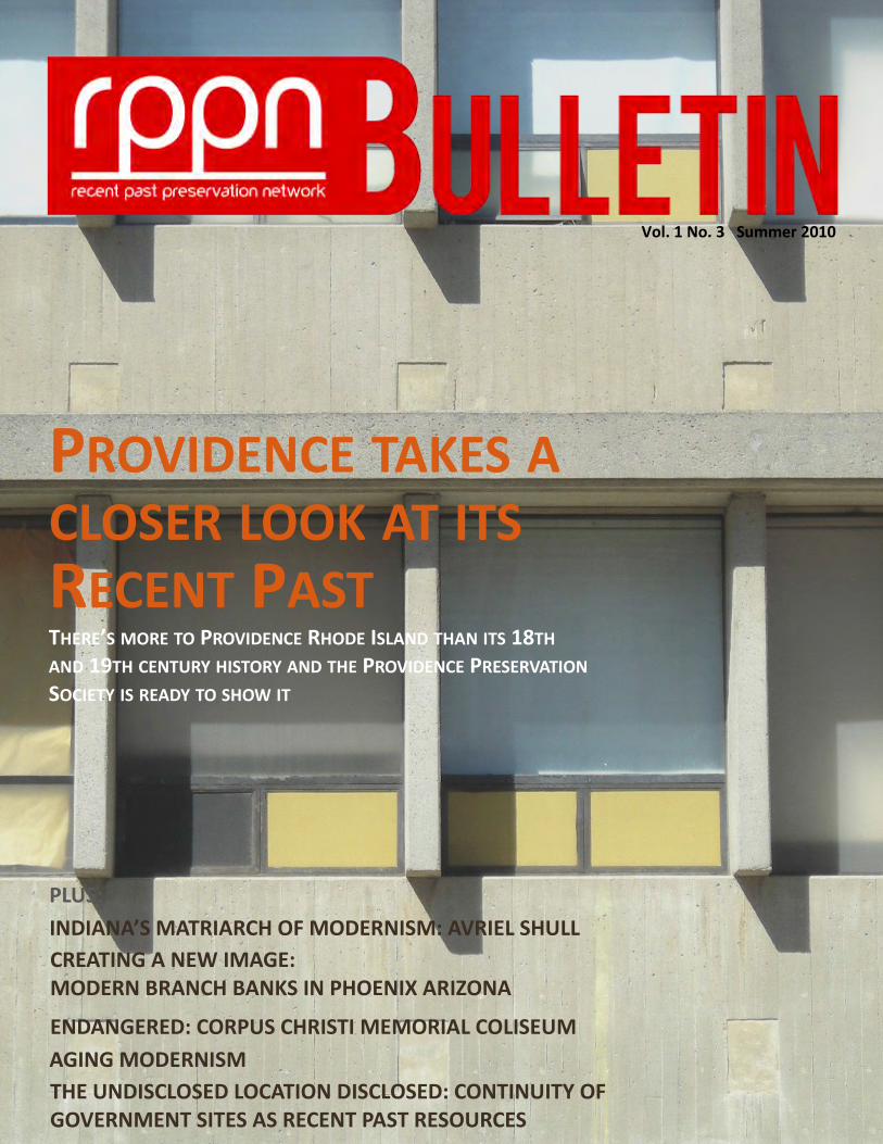
CANNONBALL TOWER SITE, MERCERSBURG, PENNSYLVANIA.
Photograph provided by John Cross.
(opposite page) LOCATION OF PRESIDENTIAL EMERGENCY
FACILITIES.

www.recentpast.org 6
THE UNDISCLOSED LOCATION DISCLOSED
Presidential Emergency Facility Sites
Site Code Name Other Name Location
Crown The White House Washington, D.C.
Cartwheel Fort Reno Washington, D.C.
Crystal Mt. Weather Berryville, Virginia
Corkscrew Lamb’s Knoll Frederick County, Maryland
Cowpuncher Martinsburg Roundtop Summit, Virginia
Cannonball Cross Mountain Mercersburg, Pennsylvania
Cactus Camp David Thurmont, Maryland
Creed Site R (Raven Rock) Waynesboro, Pennsylvania
RPPN BULLETIN SUMMER 2010 7
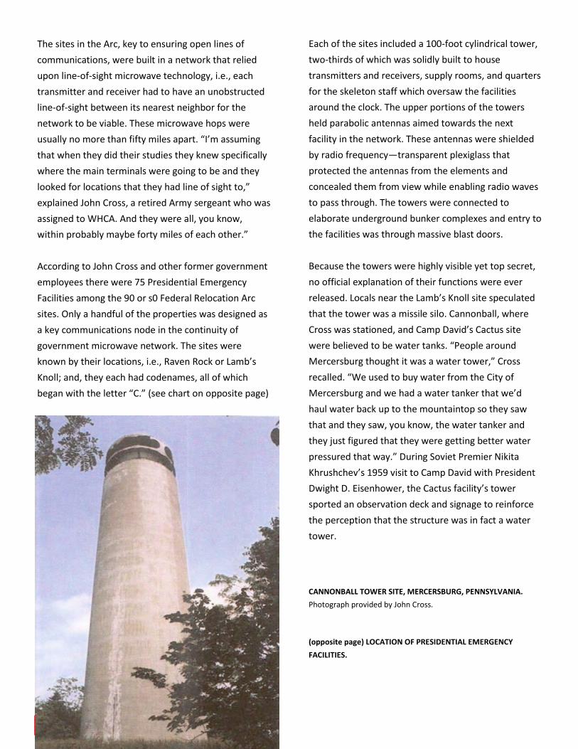
(top) CARTWHEEL SITE, FORT RENO PARK, WASHINGTON, D.C.
The Cartwheel tower is the leftmost structure. The two masonry
buildings on the right are historic water towers. Photograph by
David S. Rotenstein, 2010.
(middle) CARTWHEEL SITE. Close-up of concealed antenna decks.
Photograph by David S. Rotenstein, 2010.
(bottom) CANNONBALL TOWER. Cross-section drawn by John
Cross.
The Cartwheel site is located among early twentieth
century water towers in Washington’s Fort Reno Park:
“Radar and other sound-sensitive antennas, dishes,
and horns were installed atop a new brick tower at
Reno—the one that does not hold water. The
underground communications center reportedly links
the White House with other large centers in the
Middle Atlantic states.”
Since the facilities were top secret, few detailed
descriptions of their interiors have surfaced. John
Cross never photographed Cannonball or the other
facilities he visited while assigned to WHCA. Cross has
prepared several line drawings illustrating the interiors
of Cannonball, Cactus, and Cartwheel. According to
Cold War communications enthusiasts, the concrete
towers were designed to deflect the force of a nuclear
blast. Cross explains their construction,
“Well it was solid concrete. You know the air system
was filtered so that if anything did happen all the air
intake would be shut down and you had a filtration
system. Everything was I guess primarily engineered
you know with the concrete. Now you know there was
always some possible problems with the antenna
decks where we had spare microwave dishes that
could be put in temporarily if anything happened that,
you know, a blast would be close enough to tear off
some of the dishes. We had spare dishes that we could
put in in a fairly short period of time, that we could
replace them. But the structure itself with concrete
was really about the biggest thing.”
www.recentpast.org 8
David S. Rotenstein has a Ph.D. in Folklore and Folklife from the
University of Pennsylvania and a B.A. in Anthropology from
Georgia State University and is a historical consultant in Silver
Spring, Maryland. Dr. Rotenstein is a former Montgomery County
Historic Preservation Commission chairman and serves on a Zoning
Advisory Panel consulting on a revision to the County’s zoning
code. Publications in history include articles on
telecommunications history, cultural tourism, and the leather and
livestock industries and has written 13 Historic American
Engineering Record and Historic American Building Survey reports
as well as a number of regional and state encyclopedia articles.
Teaching experience includes the University of Pennsylvania,
Carnegie Mellon University, Montgomery College, and the National
Preservation Institute. Twenty-five years experience in National
Historic Preservation Act (Section 106) compliance and public
history in public– and private-sector positions.
THE UNDISCLOSED LOCATION DISCLOSED
By the early 1970s the Presidential Emergency
Facilities were being decommissioned. Cross recalls
closing down Cannonball in 1970 shortly after
significant upgrades were installed. Changes in
communications technology and continuity of
government plans obviated the 1950s facilities. Most
were transferred from Army control to other agencies.
Corkscrew (Lamb’s Knoll) and Cartwheel (Fort Reno)
were acquired by the Federal Aviation Administration
and their towers remain in use. Mt. Weather remains a
top secret facility and Cannonball was abandoned and
sold, its tower exposed to the elements and vandals.
The towers at Cactus (Camp David) and Site R have
been demolished.
Each of the remaining Presidential Emergency Facility
may at some point become part of a Section 106 case
in which the property’s eligibility for listing in the
National Register of Historic Places must be evaluated.
Recent Past properties, especially those tied to military
and intelligence infrastructure present unique
challenges stemming from a lack of understanding of
recent past resources, biases against properties of
such recent vintage, and the added layer of secrecy
inherent in such properties. In the Lamb’s Knoll Section
106 consultation from 2004, the State of Maryland’s
consultant wrote that the Presidential Emergency
Facility could not be evaluated for listing in the
National Register because of its top secret status. The
Maryland Historical Trust agreed:
“Constructed circa 1962, the U.S. Army Facility was
evaluated against Criteria Consideration G for
Exceptional important and subsequently
recommended as ineligible since the history of the
facility and photographs are unobtainable due to
security concerns. Until such time that the facility is no
longer to-secret and the significance can be examined
more thoroughly, the Trust concurs that the Lambs
Knoll U.S. Army Facility is ineligible for the National
Register.”
As the federal agency responsible for complying with
Section 106, the FCC issued comments that reinforced
the State of Maryland’s. “The MDSHPO *Maryland
Historical Trust] further advises that it is not possible
to determine if the Federal Facility is eligible given the
secrecy surrounding that property and its mission,”
wrote the FCC in its final opinion issued in July 2004.
Sites like Cartwheel, Corkscrew, and Cannonball were
critical continuity of government sites during the Cold
War. Their highly visible towers became part of an
industrial landscape defined by telecommunications
infrastructure essential to the information-based third
industrial revolution. Beyond their highly functional
roles in the ubiquitous military industrial complex,
they also were places where people worked and lived
daily. “I had a lot of fun, you know, even though it was
a job, I had a lot of fun.” recalled John Cross during our
twenty-first century interview using Skype. “You know,
the funny thing about it, I worked with people that
were both at Crystal and Cadre and Cartwheel for
years after we closed down those sites. But we never
discussed what went on at those locations.” As historic
preservation practice matures and greater significance
is attached to recent past resources, perhaps more
may be known about these sites, their roles in
American and global culture, and the people who built
them and worked there.