The Taravilla lake and tufa deposits (Central Iberian Range, Spain) as palaeohydrological and...
22
This article was published in an Elsevier journal. The attached copy is furnished to the author for non-commercial research and education use, including for instruction at the author’s institution, sharing with colleagues and providing to institution administration. Other uses, including reproduction and distribution, or selling or licensing copies, or posting to personal, institutional or third party websites are prohibited. In most cases authors are permitted to post their version of the article (e.g. in Word or Tex form) to their personal website or institutional repository. Authors requiring further information regarding Elsevier’s archiving and manuscript policies are encouraged to visit: http://www.elsevier.com/copyright
Transcript of The Taravilla lake and tufa deposits (Central Iberian Range, Spain) as palaeohydrological and...
This article was published in an Elsevier journal. The attached copyis furnished to the author for non-commercial research and
education use, including for instruction at the author’s institution,sharing with colleagues and providing to institution administration.
Other uses, including reproduction and distribution, or selling orlicensing copies, or posting to personal, institutional or third party
websites are prohibited.
In most cases authors are permitted to post their version of thearticle (e.g. in Word or Tex form) to their personal website orinstitutional repository. Authors requiring further information
regarding Elsevier’s archiving and manuscript policies areencouraged to visit:
http://www.elsevier.com/copyright

Author's personal copy
The Taravilla lake and tufa deposits (Central Iberian Range, Spain)as palaeohydrological and palaeoclimatic indicators
B.L. Valero Garcés a,⁎, A. Moreno a, A. Navas b, P. Mata c, J. Machín b,A. Delgado Huertas d, P. González Sampériz a, A. Schwalb e,
M. Morellón a, Hai Cheng f, R.L. Edwards f
a Instituto Pirenaico de Ecología (CSIC), Apdo 202, E-50080 Zaragoza, Spainb Estación Experimental de Aula Dei (CSIC), Apdo 202, E-50080 Zaragoza, Spain
c Facultad de Ciencias del Mar, Universidad de Cadiz, Puerto Real, E-11510 Cadiz, Spaind Estación Experimental del Zaidín (CSIC), Prof. Albareda 1, E-18008 Granada, Spain
e Institüt für Umweltgeologie, Technische Universität Braunschweig, Pockelsstrasse 3, D-38106 Braunschweig, Germanyf Department of Geology and Geophysics, University of Minnesota, Minneapolis, MN-55455, USA
Received 2 October 2005; accepted 28 February 2007
Abstract
Lacustrine and tufa deposits from Laguna de Taravilla (Iberian Range, Guadalajara province, Spain, 40°39′ N, 1°59′W, 1100 ma.s.l.) have been analyzed using sedimentological, mineralogical, geochemical and palynological techniques. A preliminarychronological framework is presented, based on U/Th, 14C AMS, 210Pb and 137Cs analyses. The lacustrine–tufa system developedin a hanging tributary valley of the Upper Tajo River and is composed of a large perched springline tufa build-up, and a barrage tufadam that impounds Laguna de Taravilla. The Taravilla tufa stable-isotope compositions are similar to other examples in central andsouthern Spain and they plot in the same field as other lowland European stream tufas. These values are coherent with the range ofisotopic compositions measured in the Taravilla spring and lake water. Several sediment cores retrieved from the Laguna deTaravilla have been dated with 14C AMS and analyzed using a multiproxy approach including magnetic properties, sedimentology,geochemistry, stable isotopes, palynology and ostracode assemblages. Sedimentary facies analyses show the dominance of clasticdepositional processes in the lacustrine depositional system and suggest the potential of the sequences as palaeoflood records.Sands and coarse silts reflect periods of increased alluvial activity of the inlet. The dominance of clastic depositional processes andthe input of detrital carbonate hinder the use of lake mud stable-isotope compositions as environmental indicators. Phases ofincreased tufa growth occurred during the Late Pleistocene (Last Glacial to Interglacial transition from oxygen isotopic stage 6 to 5)and during the Late Glacial and Early Holocene. Although the Taravilla chronology does not allow a detailed analysis of floodfrequency, the reconstructed evolution is coherent with the palaeoflood history of the Tajo River for the last 2000 years, particularlywith an increase during the last 500 years. The increase in flood frequency coincides with other evidence of wetter and colderclimate and environmental change in Central Spain and in Europe during the Little Ice Age.© 2007 Elsevier B.V. All rights reserved.
Keywords: Holocene; lake; palaeoclimate; karstic; tufa; stable isotope; Spain, Mediterranean
Available online at www.sciencedirect.com
Palaeogeography, Palaeoclimatology, Palaeoecology 259 (2008) 136–156www.elsevier.com/locate/palaeo
⁎ Corresponding author.E-mail address: [email protected] (B.L. Valero Garcés).
0031-0182/$ - see front matter © 2007 Elsevier B.V. All rights reserved.doi:10.1016/j.palaeo.2007.10.004
Author's personal copy
1. Introduction
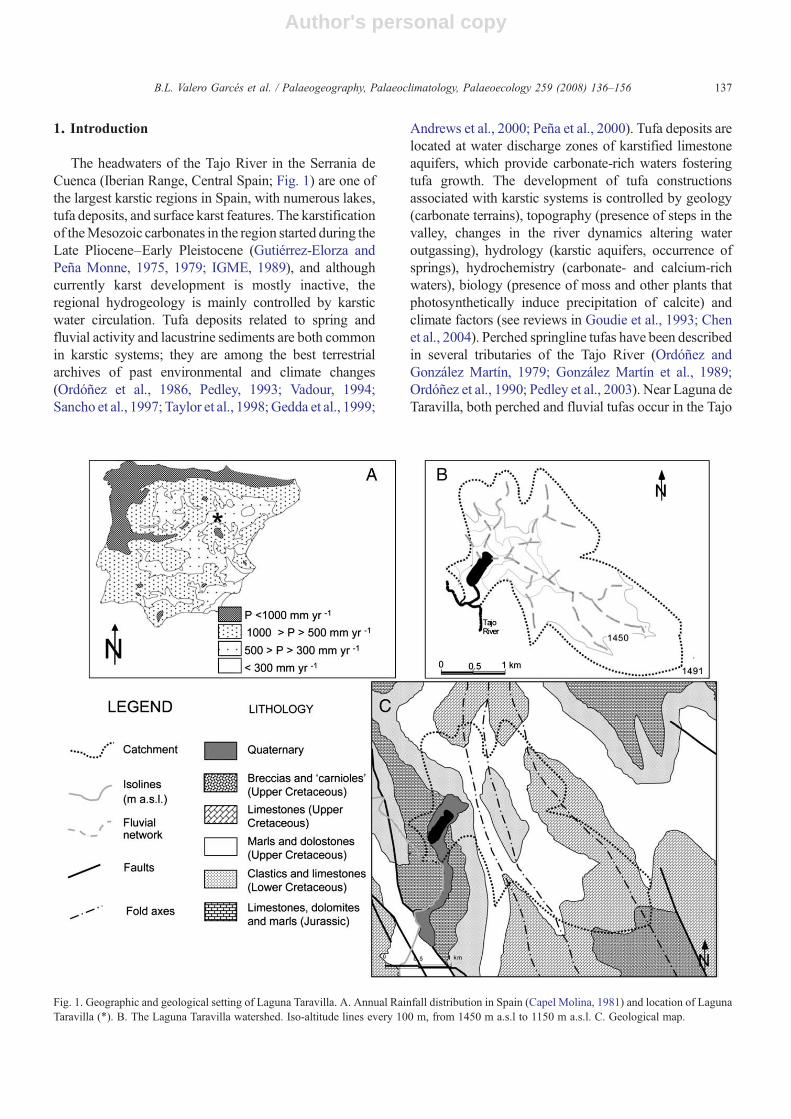
The headwaters of the Tajo River in the Serrania deCuenca (Iberian Range, Central Spain; Fig. 1) are one ofthe largest karstic regions in Spain, with numerous lakes,tufa deposits, and surface karst features. The karstificationof theMesozoic carbonates in the region started during theLate Pliocene–Early Pleistocene (Gutiérrez-Elorza andPeña Monne, 1975, 1979; IGME, 1989), and althoughcurrently karst development is mostly inactive, theregional hydrogeology is mainly controlled by karsticwater circulation. Tufa deposits related to spring andfluvial activity and lacustrine sediments are both commonin karstic systems; they are among the best terrestrialarchives of past environmental and climate changes(Ordóñez et al., 1986, Pedley, 1993; Vadour, 1994;Sancho et al., 1997; Taylor et al., 1998; Gedda et al., 1999;
Andrews et al., 2000; Peña et al., 2000). Tufa deposits arelocated at water discharge zones of karstified limestoneaquifers, which provide carbonate-rich waters fosteringtufa growth. The development of tufa constructionsassociated with karstic systems is controlled by geology(carbonate terrains), topography (presence of steps in thevalley, changes in the river dynamics altering wateroutgassing), hydrology (karstic aquifers, occurrence ofsprings), hydrochemistry (carbonate- and calcium-richwaters), biology (presence of moss and other plants thatphotosynthetically induce precipitation of calcite) andclimate factors (see reviews in Goudie et al., 1993; Chenet al., 2004). Perched springline tufas have been describedin several tributaries of the Tajo River (Ordóñez andGonzález Martín, 1979; González Martín et al., 1989;Ordóñez et al., 1990; Pedley et al., 2003). Near Laguna deTaravilla, both perched and fluvial tufas occur in the Tajo
Fig. 1. Geographic and geological setting of Laguna Taravilla. A. Annual Rainfall distribution in Spain (Capel Molina, 1981) and location of LagunaTaravilla (⁎). B. The Laguna Taravilla watershed. Iso-altitude lines every 100 m, from 1450 m a.s.l to 1150 m a.s.l. C. Geological map.
137B.L. Valero Garcés et al. / Palaeogeography, Palaeoclimatology, Palaeoecology 259 (2008) 136–156

Author's personal copy
River valley (Guerrero Domínguez and González Martín,2000). Ecological and hydrological surveys and studies ofshort sediment cores from the “torcas” (sinkhole lakes) ofCañada del Hoyo (Cuenca) have also shown the highsensitivity of the karstic systems to limnological, anthro-pogenic and climate changes (Miracle et al., 1992;Rodrigo et al., 1993; Burjachs, 1996; Mezquita andMiracle, 1997; Juliá et al., 1998).
In this paper we analyze the Taravilla karstic and tufasystem (40°39′ N, 1°59′W, 1100 m a.s.l.) and explore itspotential and shortcomings as an environmental andclimatic archive. The system contains examples of threeof the four end members of the continuum of depositionalbedforms and environments of tufa formation proposedby Pedley (1990) and Ford and Pedley (1996): fluvialbarrage, lacustrine and perched springline tufas. A fluvialbarrage tufa, consisting of a 30-m-high and 100-m-longarcuate dam, impounds the Laguna de Taravilla within arelatively narrow hanging valley (a tributary of the TajoRiver). A perched springline tufa system occurs on thesouthern slope of the tributary valley.
2. Study site
2.1. Physical setting
The Upper Tajo River valley is located in the Serraniade Cuenca, in the Western Branch of the Iberian Range(Fig. 1). The regional geology is dominated by Mesozoic(Jurassic and Cretaceous) carbonate formations overlyingclastic Triassic formations folded and fractured during theAlpine orogeny.Most relief is structurally controlled, with
crests, cuestas and flat-topped hills. Some flat areas areinterpreted as remains of a palaeorelief developed by theMiddle Pliocene (IGME, 1989). Karstification of theCretaceous carbonate formations started during the LatePliocene but is currently mostly inactive (Gutiérrez-Elorza and Peña Monne, 1975, 1979). Surface karsticmorphologies are common, as are sinkholes, dolines, andpoljes. The TajoRiver excavated deep gorges in theUpperCretaceous dolomite formations during the Quaternary.Clastic slope accumulations related to intense periglacialactivity during the last glacial period are common alongcliffs. In the Taravilla area, tufa deposits occur along theTajo River valley floor, on several slopes, and associatedwith springs (IGME, 1989; Guerrero Domínguez andGonzález Martín, 2000). The regional hydrogeology isessentially karstic. The Upper Cretaceous carbonateformations constitute the main regional aquifer; mostsprings are located at the contact with the underlying lesspermeable Jurassic formations, as is the case with theTaravilla spring that feeds the lake and the tufa structures.Laguna deTaravilla and the tufa build-ups occur in a smallhanging tributary valley of the Tajo River located in anarea where the underlying Jurassic formations crop outalong dominant NNW-SSE tectonic faults (Fig. 1).
The regional climate is of Mediterranean type withstrong continental influence; winter temperatures are low(average December and January temperature lower than0 °C), summers are relatively warm (average Augusttemperature 20 °C). Average annual rainfall is about560 mm, although inter-annual variability is large. Mayand June are the wetter months, and July and August thedriest. Rainfall is controlled by the westerlies, associated
Fig. 2. A. General sketch of the location of the springline perched tufa, the barrage tufa and the Laguna Taravilla. B. Photograph of the Laguna deTaravilla and the tufa deposits.
138 B.L. Valero Garcés et al. / Palaeogeography, Palaeoclimatology, Palaeoecology 259 (2008) 136–156
Author's personal copy
with cold fronts during the spring, and by some rainshadow effects due to the location on the eastern slope ofthe Iberian Range. During the summer the sub-tropicalAzores anticyclone blocks moisture transport from thewest. Almost 75% of the area is forested, and thevegetation corresponds to the supra-Mediterranean sub-humid type (Peinado-Lorca and Martínez-Parras, 1987).Pine is dominant (more than half of the total area of theUpper Tajo River Natural Park), but there are also somepatches of Juniperus thurifera, Quercus rotundifoliaand Quercus faginea.
2.2. Limnology and hydrology
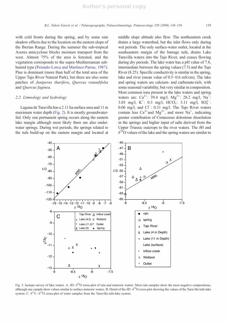
Laguna de Taravilla has a 2.11 ha surface area and 11mmaximum water depth (Fig. 2). It is mostly groundwater-fed. Only one permanent spring occurs along the easternlake margin although most likely there are also under-water springs. During wet periods, the springs related tothe tufa build-up on the eastern margin and located at
middle slope altitude also flow. The northeastern creekdrains a large watershed, but the inlet flows only duringwet periods. The only surface-water outlet, located at thesoutheastern margin of the barrage tufa, drains LakeTaravilla waters into the Tajo River, and ceases flowingduring dry periods. The lake water has a pH value of 7.8,intermediate between the spring values (7.5) and the TajoRiver (8.25). Specific conductivity is similar in the spring,lake and river (mean value of 0.5–0.6 mS/cm). The lakeand spring waters are calcium- and carbonate-rich, withsome seasonal variability, but very similar in composition.Most common ions present in the lake waters and springwaters are: Ca2+: 39.4 mg/l, Mg2+: 28.2 mg/l, Na+:3.03 mg/l, K+: 0.3 mg/l, HCO3
−: 3.11 mg/l, SO42−:
0.06 mg/l, and Cl−: 0.31 mg/l. The Tajo River waterscontain less Ca2+and Mg2+, and more Na+, indicatinggreater contribution of Cretaceous dolostone dissolutionin the springs and higher input of salts derived from theUpper Triassic outcrops to the river waters. The δH andδ18O values of the lake and the springwaters are similar to
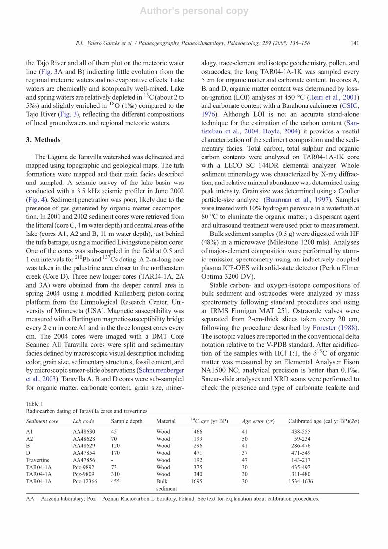
Fig. 3. Isotope survey of lake waters. A. δD–δ18O cross-plot of rain and meteoric waters. Most rain samples show the most negative compositions,although one sample show values similar to surface meteoric waters. B. Detail of the δD–δ18O cross-plot showing the values of the Taravilla tufa-lakesystem. C. δ13C–δ18O cross-plot of water samples from the Taravilla tufa-lake system.
139B.L. Valero Garcés et al. / Palaeogeography, Palaeoclimatology, Palaeoecology 259 (2008) 136–156

Author's personal copy
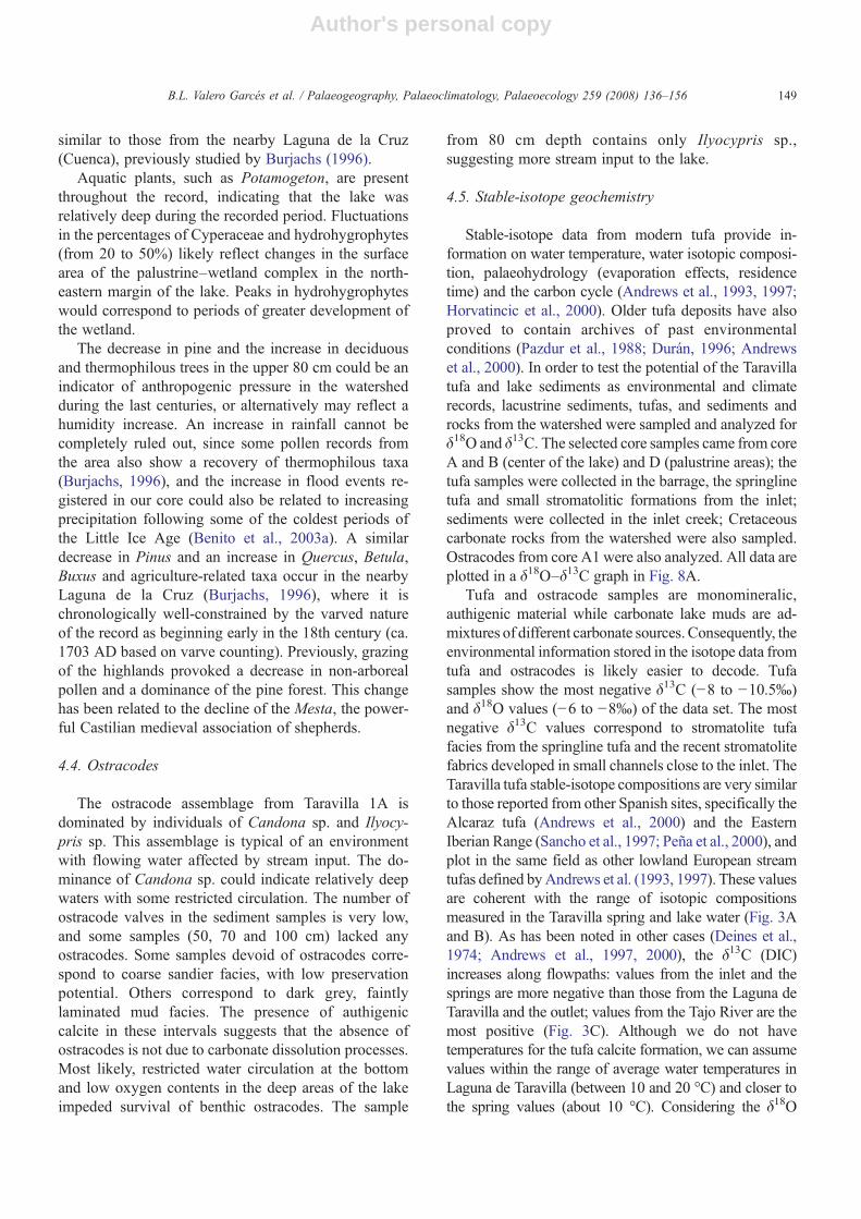
Fig.4.
Bathymetricmap
andseismic
profilesfrom
theLagunaTaravilla.
140 B.L. Valero Garcés et al. / Palaeogeography, Palaeoclimatology, Palaeoecology 259 (2008) 136–156
Author's personal copy
the Tajo River and all of them plot on the meteoric waterline (Fig. 3A and B) indicating little evolution from theregional meteoric waters and no evaporative effects. Lakewaters are chemically and isotopically well-mixed. Lakeand springwaters are relatively depleted in 13C (about 2 to5‰) and slightly enriched in 18O (1‰) compared to theTajo River (Fig. 3), reflecting the different compositionsof local groundwaters and regional meteoric waters.
3. Methods
The Laguna de Taravilla watershed was delineated andmapped using topographic and geological maps. The tufaformations were mapped and their main facies describedand sampled. A seismic survey of the lake basin wasconducted with a 3.5 kHz seismic profiler in June 2002(Fig. 4). Sediment penetration was poor, likely due to thepresence of gas generated by organic matter decomposi-tion. In 2001 and 2002 sediment cores were retrieved fromthe littoral (coreC, 4mwater depth) and central areas of thelake (cores A1, A2 and B, 11 m water depth), just behindthe tufa barrage, using amodified Livingstone piston corer.One of the cores was sub-sampled in the field at 0.5 and1 cm intervals for 210Pb and 137Cs dating. A 2-m-long corewas taken in the palustrine area closer to the northeasterncreek (Core D). Three new longer cores (TAR04-1A, 2Aand 3A) were obtained from the deeper central area inspring 2004 using a modified Kullenberg piston-coringplatform from the Limnological Research Center, Uni-versity of Minnesota (USA). Magnetic susceptibility wasmeasured with a Bartingtonmagnetic-susceptibility bridgeevery 2 cm in core A1 and in the three longest cores everycm. The 2004 cores were imaged with a DMT CoreScanner. All Taravilla cores were split and sedimentaryfacies defined bymacroscopic visual description includingcolor, grain size, sedimentary structures, fossil content, andbymicroscopic smear-slide observations (Schnurrenbergeret al., 2003). Taravilla A, B and D cores were sub-sampledfor organic matter, carbonate content, grain size, miner-
alogy, trace-element and isotope geochemistry, pollen, andostracodes; the long TAR04-1A-1K was sampled every5 cm for organic matter and carbonate content. In cores A,B, and D, organic matter content was determined by loss-on-ignition (LOI) analyses at 450 °C (Heiri et al., 2001)and carbonate content with a Barahona calcimeter (CSIC,1976). Although LOI is not an accurate stand-alonetechnique for the estimation of the carbon content (San-tisteban et al., 2004; Boyle, 2004) it provides a usefulcharacterization of the sediment composition and the sedi-mentary facies. Total carbon, total sulphur and organiccarbon contents were analyzed on TAR04-1A-1K corewith a LECO SC 144DR elemental analyzer. Wholesediment mineralogy was characterized by X-ray diffrac-tion, and relativemineral abundance was determined usingpeak intensity. Grain size was determined using a Coulterparticle-size analyzer (Buurman et al., 1997). Sampleswere treatedwith 10% hydrogen peroxide in a waterbath at80 °C to eliminate the organic matter; a dispersant agentand ultrasound treatment were used prior to measurement.
Bulk sediment samples (0.5 g) were digested with HF(48%) in a microwave (Milestone 1200 mls). Analysesof major-element composition were performed by atom-ic emission spectrometry using an inductively coupledplasma ICP-OES with solid-state detector (Perkin ElmerOptima 3200 DV).
Stable carbon- and oxygen-isotope compositions ofbulk sediment and ostracodes were analyzed by massspectrometry following standard procedures and usingan IRMS Finnigan MAT 251. Ostracode valves wereseparated from 2-cm-thick slices taken every 20 cm,following the procedure described by Forester (1988).The isotopic values are reported in the conventional deltanotation relative to the V-PDB standard. After acidifica-tion of the samples with HCl 1:1, the δ13C of organicmatter was measured by an Elemental Analyser FisonNA1500 NC; analytical precision is better than 0.1‰.Smear-slide analyses and XRD scans were performed tocheck the presence and type of carbonate (calcite and
Table 1Radiocarbon dating of Taravilla cores and travertines
Sediment core Lab code Sample depth Material 14C age (yr BP) Age error (yr) Calibrated age (cal yr BP)(2σ)
A1 AA48630 45 Wood 466 41 438-555A2 AA48628 70 Wood 199 50 59-234B AA48629 120 Wood 296 41 286-476D AA47854 170 Wood 471 37 471-549Travertine AA47856 - Wood 192 47 143-217TAR04-1A Poz-9892 73 Wood 375 30 435-497TAR04-1A Poz-9809 310 Wood 340 30 311-480TAR04-1A Poz-12366 455 Bulk
sediment1695 30 1534-1636
AA = Arizona laboratory; Poz = Poznan Radiocarbon Laboratory, Poland. See text for explanation about calibration procedures.
141B.L. Valero Garcés et al. / Palaeogeography, Palaeoclimatology, Palaeoecology 259 (2008) 136–156

Author's personal copy
Fig. 5. Sedimentary facies and units, magnetic susceptibility, sediment composition indicators, selected geochemical profiles (values in ppm), stable-isotope compositions, pollen and 14C AMS datesfrom cores A, B and C.
142B.L.Valero
Garcés
etal.
/Palaeogeography,
Palaeoclim
atology,Palaeoecology
259(2008)
136–156

Author's personal copy
dolomite) in the sediments. Pollen grains and sporeswere sampled every 10 cm in core B and extracted in thelaboratory by the classic chemical method (Moore et al.,1991) using Thoulet dense liquid (2.0) for palynomorphconcentration and Lycopodium clavatum spore tablets tocalculate pollen concentration (Stockmarr, 1971).
The chronology for the lake sequence is constrained by8 AMS 14C ages from several cores (Table 1) analyzed atthe Arizona Dating Facility (USA) and the PoznanRadiocarbon Laboratory (Poland), and by 210Pb and137Cs dating in the core TAR-A1 performed at the St.Croix Watershed Research Station (Science Museum ofMinnesota) (Fig. 5). All cores were correlated usingsedimentary facies, grain size, and organic matter profiles(Figs. 6 and 7). The chronology for the tufa deposits isderived from uranium–thorium disequilibrium analysesperformed at the Minnesota Isotope Laboratory (Table 2).
4. Results
4.1. Chronology
Total 210Pb activities in core A1 are low (rangebetween 0.87 and 1.7 pCi/g), and fluctuate irregularlywith no clear down-core trend (Fig. 5). Preliminary
constant rate of supply (c.r.s). modeling of the Taravilla210Pb data, assuming that the lowermost 7 samples(below 13.5 cm) with a mean 210Pb activity of 1.0 pCi/grepresent supported 210Pb, gives a ca. 1950 age for theupper 10 cm. Measurable radio-cesium was found atonly one depth interval (8–8.5 cm, 0.427 pCi/g) out ofthe nine analyzed between the core top and 77 cm. Assuggested by the 210Pb results, high sedimentation ratesand subsequent dilution of the atmospheric 137Cs signalis the most likely explanation for this pattern of non-detection. The presence of 137Cs at 8–8.5 cm precludesthe alternative explanation: a depositional hiatus duringthe last half-century. Assuming that the detection of137Cs at 8–8.5 cm represented the 1963 peak inatmospheric nuclear testing, it would match the 210Pbchronology. However, this could be largely a coin-cidence because more than a single measurement areneeded to define the 137Cs peak, and the 210Pbchronological model is not very reliable. However,taking the 210Pb and 137Cs data in consideration, bothindicate high sedimentation rates over the last century,with a mean sedimentation rate of at least 1.5 mm/yr or0.1–0.2 g/cm2 yr during the last half-century.
The radiocarbon chronology of the longest core(TAR04-1A-1K) is based on three 14C AMS ages, two
Fig. 6. Sedimentary facies and units, TIC, TOC, magnetic susceptibility and 14C AMS ages from core TAR04-1A-1K.
143B.L. Valero Garcés et al. / Palaeogeography, Palaeoclimatology, Palaeoecology 259 (2008) 136–156

Author's personal copy
Fig. 7. Stratigraphic correlation among all the cores. Correlation is based on sedimentary facies and magnetic susceptibility for the longer cores. Vertical scale in cm.
144B.L.Valero
Garcés
etal.
/Palaeogeography,
Palaeoclim
atology,Palaeoecology
259(2008)
136–156

Author's personal copy
of them from wood remains and the lower one from bulkorganic matter. Four more ages from cores A1, A2, Band D help to constrain the age of the upper part of thesequence (Table 1). The Taravilla record spans the last1600 years. Sedimentation rates are about 4 mm/yr forcores A2 and B. The age in core A1 (466±41 14C yr BPat 45 cm) does not fit with the composite chronologicalmodel for all cores; the inferred sedimentation rate is toosmall (1 mm/yr) compared with cores A2 and B (about4 mm/yr), and also smaller than the estimated 210Pb and137Cs sedimentation rates from the same core (about1.5–2 mm/yr). A possible explanation is that the age ofthe sample does not correspond with the age of thesediment, because old wood was reworked from thecatchment and incorporated into the sediment. Thisinterpretation is favored by the sandy nature of the layerin which the wood was sampled. The young age of thesample at 260 cm in core TAR04-1A-1K (340±30 14Cyr BP) is likely caused by contamination with youngercarbon. This age has not been included in our chrono-logical model. In spite of the chronological uncertain-ties, the five AMS ages indicate that the lowersedimentary unit (about 2 m of laminated carbonatemud and silt, see below) was deposited between the 4thand 16th century AD, and the upper 4 m of the sequencedeposited during the last 500 years. Although reworkingof the dated sample in core D cannot be completelyruled out, the age also shows a comparable high sedi-mentation rate in the palustrine areas.
Preliminary U/Th dating suggests that the main phaseof construction of the Taravilla perched springline tufawasaround 139.7±3.1 kyr (Table 2). The dated sample was astromatolitic, well-lithified, non-porous, pure carbonate,
with very low detrital Th contamination. We consider thisage to be reliable, as the correction for initial 230Th issmall. Two out of the five samples from the barrage damhad relatively high 232Th levels, requiring large initial230Th corrections and therefore unreliable ages. The otherthree samples with lower 232Th levels provided uncor-rected 230Th ages of 22.7±8.4, 18.5±0.7 and 15.9±0.6 kyr. These uncorrected ages can be considered upperlimits to the true age.Our best estimates of the true ages arethe corrected ages of 8.8±5.2 kyr for the top of the barrageand 7.1±4.6 kyr for the middle. Taking all the ages anduncertainties into consideration (Table 2), it seems that theconstruction of the barrage occurred between the LateGlacial and early Holocene. Vegetal remains within thetufa in themiddle area of the barrage provided anAMSageof 192±47 14C yr BP, indicating that tufa production hasremained active in historical times.
4.2. Sedimentology
4.2.1. Perched springline tufasThe perched springline tufa of Taravilla is a
composite build-up developed on the eastern slope ofthe valley, covering a large area (approx. 500 m long, upto 35 m high, and almost 200 m wide at the top) betweenthe NE inflow creek and the SE outlet of the Laguna deTaravilla (Fig. 2). The tufa build-up has the wedge-shaped, terraced, downslope-facing lobate profile typi-cal of these systems. Two main terrace levels can bedistinguished (Fig. 2). The upper surface of the upperterrace is rather flat; frontal areas towards the lake andclose to the outlet are steep; the lower terrace is gentlyconvex. The length of the build-up and the variety of
Table 2230Th dating results
Tufa Sample 238U 232Th δ234U⁎ 230Th/232Th 230Th/238U 230Th Age(ka)
230Th Age(Ka)
δ234UInitial⁎⁎
(ppb) (ppb) (measured) (activity) (activity) (uncorrected) (corrected) (corrected)
Barrage Top,massive
239.2±0.7 752±10 66.3±4.0 5.5±0.2 1.043±0.036
Barrage Top,laminated
126.8±0.3 54.2±0.5 323.2±2.9 8.0±0.3 0.2078±0.0074 18.5±0.7 8.8±5.2 331±6
Barrage Middle,laminated
110.7±0.3 42.7±0.3 321.6±3.9 7.7±0.3 0.1798±0.0059 15.9±0.6 7.1±4.6 328±6
Barrage Base,massive
266±1 639±16 63.9±3.7 4.7±0.3 0.682±0.040 110±11 11+61/-11 66±13
Barrage Base,laminated
164.4±0.7 97.4±0.9 256.7±3.9 6.6±0.2 0.2376±0.0079 22.7±8.4 8.2+7.6/-8.2 263±7
Springlineperched tufa
Stromatolite 88.9±0.2 16.46±0.09 267.3±1.7 85.8±0.8 0.9626±0.0082 143.7±2.4 139.7±3.1 397±4
The error is 2σ error. λ230=9.1577×10⁻⁶ y−1, λ234=2.8263×10
−6 y−1, λ238=1.55125×10⁻¹⁰ y−1. ⁎δ234U=([234U/238U]activity−1)×1000. ⁎⁎δ234Uinitial
was calculated based on 230Th age (T), i.e., δ234Uinitial=δ234Umeasured×e
λ234×T. Corrected 230Th ages assume the initial 230Th/232Th atomic ratio of 4.4±2.2×10⁻⁶. Those are the values for a material at secular equilibrium, with the crustal 232Th/238U value of 3.8. The errors are arbitrarily assumed to be 50%.
145B.L. Valero Garcés et al. / Palaeogeography, Palaeoclimatology, Palaeoecology 259 (2008) 136–156

Author's personal copy
facies and morphologies present reflect the complexityand composite nature of the deposits, with coalescenceof adjacent springs and changing distribution throughtime. Currently, the tufa build-up is mostly extinct. Thesprings located at higher altitude in the valley slope areusually inactive, and only during particularly wetperiods feed the tufa and the lake. The main activespring feeding the lake is located in the same area, atlower altitude, suggesting that the origin of the mainpoint-sourced water is tectonically controlled.
Meter-scale terraces and step topography occur inthis formation. The facies are very diverse as is com-monly the case in such formations (Ford and Pedley,1996; Martín-Algarra et al., 2003; Ordoñez et al., 2005).In the distal parts of the tufa lobe well-cementedbryophyte phytoherm framestones (Ford and Pedley,1996) with inclined internal fabrics alternate with sub-horizontal tufa laminites developed in the shallowflights of pools behind the phytoherms steps. Finelylaminated cascade facies are developed at the lobemargins. They are interpreted as fast-growing moss-curtain facies. Finely laminated stromatolite facies, withsub-horizontal and inclined fabrics are common.Primary cavities also occur. The lobe-top terracesshow flat to slightly convex surfaces and no pool-faciesdevelopment. The distal slope facies are not well-developed, indicating reduced erosion of the phyto-herms lobes. However, these facies could be covered bylittoral vegetation or even submerged under the lake.The tufa build-ups are well preserved because of thewell-lithified fabrics and early cementation that makesthem resistant to erosion and compaction. Intra-clastictufa breccias recording periodic erosion are present, butnot very common. In the distal areas, oncoid faciesoccur in some channels within the tufa build-up and alsoin the creek close to the lake.
Preliminary U/Th dating suggests that the onset ofconstruction of the Taravilla perched springline tufa isaround 139.7±3.1 kyr. It seems likely that the depositshigher in the valley are older than those lower down theslope, as is the case in other examples in the TajuñaRiver (González Martín et al., 1989). Variations inwater-table level and spring discharge lead to episodesof construction alternating with inactive phases andsome dismantling. Falling groundwater elevations havelikely resulted in the progressive downslope develop-ment of the Taravilla perched springline deposits.
4.2.2. Barrage (dam) depositsA downstream-facing barrage is developed across the
valley and holds back the Laguna de Taravilla. Thebarrage is 175 m long, about 75 m wide at the top and up
to 275 m wide at the bottom, and about 30 m high. Thebarrage is very broad in the direction of flow with a widecrest and a large ramp-like buttress of inclined tabularbedded tufa on the downstream face. This morphologycorresponds to the principal barrage type as defined byPedley et al. (1996). The maximum growth of thestructure in the flow direction also suggests somesimilarities with phytoherm framestone progradingwedges described in slope and fluvial settings (GuerreroDomínguez and González Martín, 2000). The dominantfabrics in the barrage surface are phytoherms (both mossframework and stromatolitic) with some detrital tufa.Currently, tufa formation is only active along the outletthat connects Laguna deTaravillawith the Tajo River. Theoutlet becomes dry during the summer but overflowsduring wet seasons, completely flooding the barrage andspilling over the crest. The downstream side of the barrageis still well preserved and only locally has been partiallytrenched and undercut. There are no marginal stromato-litic terraces associated with the barrage as occur in someof the Ruidera barrage systems (Ordoñez et al., 2005).
The barrage tufa started to develop near the thalwegknick point of the small tributary creek feeding into theTajo River. Changes in the Tajo River dynamics mayhave been responsible for the onset of tufa deposition.As it has been shown in other Tajo River tributaries(Huertapelayo and Puente de San Pedro; GonzálezAmuchastegui and González, 1993; González Amu-chastegui, 1998), the lowering of the Tajo River baselevel due to increased incision created a hangingtributary valley and generated a waterfall, which wasconducive to tufa development. Primary barrages suchas the Taravilla example show prominent downstreamprogradation during their development. Five sampleswere dated with U/Th but because of relatively high232Th levels the uncorrected ages can only be con-sidered upper bounds on the true age and the correctedages have substantial error. Taking into account all ages,it seems that the construction of the barrage occurredbetween the Late Glacial to early Holocene (Table 2).
4.2.3. Lacustrine sedimentsBehind the tufa barrage, a small lake developed, the
Laguna de Taravilla. The lake does not have stromatolite-dominated lake margin constructions (lacustrine tufas)typical of other tufa-lacustrine settings. Two maindepositional environments are distinguished in theLaguna de Taravilla: lacustrine and palustrine (Fig. 2A).The lacustrine depositional environment comprises anarrow littoral zone, very steep margins and a flat lakebottom. Thick aquatic vegetation overhangs at the edge ofthe lake, and some of the submerged plants are coated
146 B.L. Valero Garcés et al. / Palaeogeography, Palaeoclimatology, Palaeoecology 259 (2008) 136–156

Author's personal copy
with carbonate, but no tufa deposition occurs in the littoralzone. The bottom of the lake is colonized by Charavulgaris (Molina, 1996). The thickness of the sedimentaryfill in the Laguna de Taravilla is unknown, due to the poorsignal penetration of the seismic survey (Fig. 4). Theseismic survey shows the very steep SW margin of thelake at the barrage and a gentler NE margin connectingwith the palustrine areas (seismic profiles A and B). Thetufa barrage facies show some sub-horizontal seismicreflectors and other seismically massive areas lackingreflectors. The northeastern margin of the basin showsseveral wedge-shaped morphologies and cross-cuttingreflectors that could be interpreted as progradingsedimentary units (seismic profile C). Only the upperpart of the sedimentary infill shows well-defined parallelreflectors continuous across the basin. Below 3–4 m, thereflectors loose their continuity and the penetration is verypoor. Six cores allowed the description and interpretationof the sedimentary infilling of the Laguna de Taravilla.
4.2.4. Core faciesThe Taravilla sedimentary record is composed of
decimeter-bedded, massive to faintly laminated, brown-ish grey, carbonate sediments with variable amounts oforganic remains and several intercalated carbonate sandylayers. Five main sedimentary facies have been identi-fied after integration of visual description, microscopicobservations and sediment composition (Table 3). Facies1, 2 and 3 are massive to faintly laminated carbonatemud, silt and sand with variable organic matter, carbo-nate and silicate contents. The carbonate fractions ofthese facies are mostly composed of calcite and dolomitegrains and crystals. Calcite has multiple origins, clasticand authigenic. Clastic calcite itself has two sources, theCretaceous rocks and the tufa build-ups. The authigenicfraction is composed of euhedral 10–15 μm long crystalsand charophyte remains. Dolomite is only detrital,derived from the dolomitic Upper Cretaceous forma-tions. Grain size ranges from sand-size rounded grainsand euhedral crystals, to crystals several hundreds mi-crons long. Clay minerals and quartz are also transportedfrom the watershed (the middle Cretaceous clastic unit).Organic matter in the coarser facies (coarse silts andsands) is mostly composed of macrorests derived fromthe wetland and the watershed. Aquatic, amorphousorganic matter is more common in the finer, darkerfacies. Coarse, sandy facies contain abundant carbonateclasts, derived from the tufa build-ups and from dolomiteformations, and large macrorests, derived from the wet-land and the watershed (wood, aquatic plants). Dolomitecontent is an indicator of clastic input into the Laguna deTaravilla, marking intervals of decreased input (top
20 cm, 75–100 cm in core 1A) and higher input (55–75 cm).
Facies 1 is interpreted as coarser deposition duringflood episodes reaching the center of the lake. At the topof most cores, a distinctive millimeter-thick reddishcoarse silt and sand layer occurs. Massive, lighter greysilt andmud (facies 2) represents deposition in the Lagunade Taravilla during periods of less strong alluvialinfluence and free lake basin circulation. Darker, massiveto faintly laminated fine silt and mud (facies 3) represents
Table 3Sedimentary facies in the Laguna Taravilla cores
Facies Description and depositionalenvironment
Lacustrine faciesFacies 1: Massive,dark grey silty-sandto coarse sand
Cm- to dm-thick beds, massive tofaintly laminated, fining upwardtextures; abundant plant macrorest.Depositional subenvironment:Flood deposits reaching the innerareas of the lake.
Facies 2: Massiveto faintly laminatedlight grey carbonatesilt
Cm- to dm-thick layers, massive,variable amount of carbonate andorganic matterDepositional subenvironment:Deposition in the middle of the lakeduring open water circulation periods
Facies 3: Massiveto faintly laminated,dark grey carbonatesilt and mud
Cm to dm-thick layers, faintlylaminated, relatively higher organicmatter and lower carbonate content.Relatively high magneticsusceptibility.Depositional subenvironment:Deposition in the middle of thelake during periods of morerestricted water circulation.
Facies 4: Gastropodand charophyte-richcoarse silt and mud
Cm- thick layers with abundantfossils and calcified Chara remains.Depositional subenvironment:Littoral lacustrine
Facies 5: Laminatedlight gray-yellowishsilt
Cm-thick layers, laminated,dominant carbonate compositionRelatively low magneticsusceptibility.Depositional subenvironment:middle of the lake, low energydominant oxic bottom conditions
Palustrine faciesFacies 6: Massive,gravel, sand and silt
Dm-thick fining upward sequencesDepositional subenvironment:Alluvial-deltaic
Facies 7: Massive, darkbrown, organic-rich,peaty carbonate-rich silt
Dm- thick beds alternating withsome thin peat layers.Depositional subenvironment:Palustrine
147B.L. Valero Garcés et al. / Palaeogeography, Palaeoclimatology, Palaeoecology 259 (2008) 136–156

Author's personal copy
deposition during periods of lower energy, less fluvialinfluence, restricted water mixing, and episodic occur-rence of anoxic bottom conditions. Most of the clasticmaterial transported into the lake is carbonate, so facies 1has the highest carbonate and dolomite content and,consequently, lower magnetic-susceptibility values.Finer, darker facies have higher clay mineral and quartzcontent and also higher magnetic-susceptibility values.These three facies are arranged in decimeter- to meter-thick fining-upward sequences. Chemical indicatorsreflect mineralogical composition: higher Mg values incoarser facies with more dolomite, higher iron in finerfacies with more clays (Fig. 5). Iron and aluminum areusually good indicators of soil erosion in the watershed(Boyle, 2001), and the increasing trend in iron in core Bcould reflect increasing erosion from the watershed.However, this trend is not parallel with a similar trend inaluminum, which suggests that the iron record may beinfluenced by redox changes in the lake.
Facies 4 only occurs in core C, located at 4 m waterdepth behind the barrage tufa and is characterized by theabundance of gastropods, mollusk and charophyteremains. Massive to faintly laminated, dark grey,organic-rich (up to 10% organic matter) carbonate siltsalternate with massive, grey silts with more abundantgastropods and mollusks. These sediments representreworking and redeposition of the charophyte meadowsand other carbonate-encrusted littoral formations.
Facies 5 is composed of finely laminated, light grey,fine carbonate silt and mud. Facies 5 sediments haverelatively lower carbonate content and intermediate valuesof magnetic susceptibility. Sandy layers are absent. Facies5 represents deposition in a lower energy environment,with less alluvial influence, as denoted by lamination andlack of sandy intervals. This facies only appears in thelowest interval in the longest cores, alternating withcentimeter- to decimeter-thick layers of facies 3 (unit 4).
The Laguna de Taravilla record has been divided intofour sedimentological units (Figs. 6 and 7). The basalunit 4 is composed of laminated sediments (facies 5 andfacies 3). Unit 3 is characterized by the dominance ofdarker carbonate silts in thick layers (facies 3). Unit 2encompasses a thick fining-upward sequence composedof sands and silts. The top unit 1 is characterized by analternation of decimeter-thick layers of facies 1, 2, and 3.
4.2.5. The palustrine environmentMore than half of the surface area of the Taravilla
basin is occupied by a palustrine, wetland environment(Fig. 2). The area is covered with thick vegetation and isflooded seasonally when spring discharge increases andthe ephemeral inlet becomes active. The surface is
covered with detrital tufa facies, particularly in the areasclose to the inlet, where mixed deposits composed ofmaterial derived from slope wash of previous tufas andalluvial material from the Cretaceous outcrops in thewatershed occur.
4.2.6. Core faciesThe almost 2-m-long core D is composed of coarse
clastic facies at the base (facies 6), topped by organic-rich silts with some peat intercalation towards the top(facies 7). Clastic facies 6 is composed of gravels andsilts, arranged in fining-upward sequences. Gravel bedsup to 25 cm thick are composed of Cretaceous rockfragments and tufa clasts with a carbonate and quartzsandy matrix. Coarse silts contain abundant plantremains. Facies 6 represents deposition in an alluvial-deltaic setting related to increased creek activity. Theupper part of the core is composed of massive, organic-rich silts with some thin peat intercalations (facies 7).Deposition of this facies reflects lower energy environ-ments in a wetland setting. Deposition of the thickestand coarser gravel layer in core D (dated as 471±37 14Cyr BP) could correlate with deposition of the thickestand coarser sand layer in the middle of the lake (unit 2).The dating uncertainty in core TAR04-1A-1K impedes adefinitive time-correlation. The onset of wetland devel-opment occurred in the last few centuries (Fig. 7).
4.3. Pollen
Pollen data from core B reflect a vegetation covertypical of the Mediterranean mountain areas, with littlevariation during recent centuries (Fig. 5). The mainarboreal component is Pinus (60–80%). Juniperus andQuercus faginea-pubescens type values range between10 and 20% and Quercus ilex-coccifera type up to 10%.The pollen assemblages reflect a regional forest mostlycomposed of pine, with some deciduous oaks on thenorthern slopes, evergreen oaks and junipers on thesunny aspects, and mesophylous taxa (Corylus, Alnus,Betula, Salix, Ulmus, Tilia, Fagus, Populus) in theriver and creek valleys. Buxus is the main shrubcomponent (up to 20%) in the Taravilla palynologicalsequence. Pollen indicators of human activity are fre-quent and varied (Cichorioideae, Asteroideae, Artemi-sia, Centaurea, Rumex, Plantago, Chenopodiacee,Brassicacee,…). The presence of Cerealia type in thismountain lake reflects the importance of winter cerealfarming in the region. Olea and Juglans also areindicative of regional crops. The presence of Asphode-lus could suggest frequent forest fires, either wild ofhuman-induced. In general, the pollen assemblages are
148 B.L. Valero Garcés et al. / Palaeogeography, Palaeoclimatology, Palaeoecology 259 (2008) 136–156
Author's personal copy
similar to those from the nearby Laguna de la Cruz(Cuenca), previously studied by Burjachs (1996).
Aquatic plants, such as Potamogeton, are presentthroughout the record, indicating that the lake wasrelatively deep during the recorded period. Fluctuationsin the percentages of Cyperaceae and hydrohygrophytes(from 20 to 50%) likely reflect changes in the surfacearea of the palustrine–wetland complex in the north-eastern margin of the lake. Peaks in hydrohygrophyteswould correspond to periods of greater development ofthe wetland.
The decrease in pine and the increase in deciduousand thermophilous trees in the upper 80 cm could be anindicator of anthropogenic pressure in the watershedduring the last centuries, or alternatively may reflect ahumidity increase. An increase in rainfall cannot becompletely ruled out, since some pollen records fromthe area also show a recovery of thermophilous taxa(Burjachs, 1996), and the increase in flood events re-gistered in our core could also be related to increasingprecipitation following some of the coldest periods ofthe Little Ice Age (Benito et al., 2003a). A similardecrease in Pinus and an increase in Quercus, Betula,Buxus and agriculture-related taxa occur in the nearbyLaguna de la Cruz (Burjachs, 1996), where it ischronologically well-constrained by the varved natureof the record as beginning early in the 18th century (ca.1703 AD based on varve counting). Previously, grazingof the highlands provoked a decrease in non-arborealpollen and a dominance of the pine forest. This changehas been related to the decline of the Mesta, the power-ful Castilian medieval association of shepherds.
4.4. Ostracodes
The ostracode assemblage from Taravilla 1A isdominated by individuals of Candona sp. and Ilyocy-pris sp. This assemblage is typical of an environmentwith flowing water affected by stream input. The do-minance of Candona sp. could indicate relatively deepwaters with some restricted circulation. The number ofostracode valves in the sediment samples is very low,and some samples (50, 70 and 100 cm) lacked anyostracodes. Some samples devoid of ostracodes corre-spond to coarse sandier facies, with low preservationpotential. Others correspond to dark grey, faintlylaminated mud facies. The presence of authigeniccalcite in these intervals suggests that the absence ofostracodes is not due to carbonate dissolution processes.Most likely, restricted water circulation at the bottomand low oxygen contents in the deep areas of the lakeimpeded survival of benthic ostracodes. The sample
from 80 cm depth contains only Ilyocypris sp.,suggesting more stream input to the lake.
4.5. Stable-isotope geochemistry
Stable-isotope data from modern tufa provide in-formation on water temperature, water isotopic composi-tion, palaeohydrology (evaporation effects, residencetime) and the carbon cycle (Andrews et al., 1993, 1997;Horvatincic et al., 2000). Older tufa deposits have alsoproved to contain archives of past environmentalconditions (Pazdur et al., 1988; Durán, 1996; Andrewset al., 2000). In order to test the potential of the Taravillatufa and lake sediments as environmental and climaterecords, lacustrine sediments, tufas, and sediments androcks from the watershed were sampled and analyzed forδ18O and δ13C. The selected core samples came from coreA and B (center of the lake) and D (palustrine areas); thetufa samples were collected in the barrage, the springlinetufa and small stromatolitic formations from the inlet;sediments were collected in the inlet creek; Cretaceouscarbonate rocks from the watershed were also sampled.Ostracodes from core A1 were also analyzed. All data areplotted in a δ18O–δ13C graph in Fig. 8A.
Tufa and ostracode samples are monomineralic,authigenic material while carbonate lake muds are ad-mixtures of different carbonate sources. Consequently, theenvironmental information stored in the isotope data fromtufa and ostracodes is likely easier to decode. Tufasamples show the most negative δ13C (−8 to −10.5‰)and δ18O values (−6 to −8‰) of the data set. The mostnegative δ13C values correspond to stromatolite tufafacies from the springline tufa and the recent stromatolitefabrics developed in small channels close to the inlet. TheTaravilla tufa stable-isotope compositions are very similarto those reported from other Spanish sites, specifically theAlcaraz tufa (Andrews et al., 2000) and the EasternIberian Range (Sancho et al., 1997; Peña et al., 2000), andplot in the same field as other lowland European streamtufas defined byAndrews et al. (1993, 1997). These valuesare coherent with the range of isotopic compositionsmeasured in the Taravilla spring and lake water (Fig. 3Aand B). As has been noted in other cases (Deines et al.,1974; Andrews et al., 1997, 2000), the δ13C (DIC)increases along flowpaths: values from the inlet and thesprings are more negative than those from the Laguna deTaravilla and the outlet; values from the Tajo River are themost positive (Fig. 3C). Although we do not havetemperatures for the tufa calcite formation, we can assumevalues within the range of average water temperatures inLaguna de Taravilla (between 10 and 20 °C) and closer tothe spring values (about 10 °C). Considering the δ18O
149B.L. Valero Garcés et al. / Palaeogeography, Palaeoclimatology, Palaeoecology 259 (2008) 136–156

Author's personal copy
range for calcite tufa isotopic compositions (−6 to −8‰,Fig. 8A), the δ18O range forwaters (−7.7 to−8.7‰, Fig. 3)and the isotopic fractionation equation for the systemcalcite-water (O'Neil et al., 1969), a temperature rangebetween 5 and 18 °C is obtained. Consequently, conditionsbetween tufa waters and calcite precipitates seem to beclose to near-equilibrium.
Ostracode values from core A2 show a similar δ13Crange, although with some even more negative values,
and generally higher δ18O values than tufa samples. Therange in both isotopes shows near-equilibrium and en-riched composition compared to that calculated from themeasured δ13C DIC (−11 to −13‰) and the δ18O (−7.7to −8.7‰) in lake waters (Fig. 3). Vital effects canexplain the δ18O enrichment in ostracode valves (around+2.5‰, von Grafenstein et al., 1999; Xia et al., 1997;Keatings et al., 2002). Additionally, lake effectsassociated with preferential degassing, exchange with
Fig. 8. A. Cross-plot of oxygen and carbon stable-isotope values from all samples. The fields and the Alcaraz isotope values are from Andrews et al.(1997): 1. Alpine streams in unwooded areas and Alpine lakes; 2. UK lakes; 3. Lowland European streams and wooded Alpine streams. B. Cross-plotof carbon isotope values of bulk carbonates and organic matter.
150 B.L. Valero Garcés et al. / Palaeogeography, Palaeoclimatology, Palaeoecology 259 (2008) 136–156

Author's personal copy
the atmosphere, lower temperatures and evaporativeeffects can also contribute to this enrichment. Down-core fluctuations in core A2 (Fig. 5) show little variationand no preferential trend, suggesting no large hydro-logical or limnological changes during recent centuries.
The carbon- and oxygen-isotope compositions of thelake sediment samples plot in a field between the tufaand the watershed carbonate values (Fig. 8A). Both theδ18O and the δ13C range are large (−2 to −10‰ and−3.5 to −9‰, respectively). Compositions group bycore location. Samples from core A1 and A2 show thelargest range, and the most nearly-linear distribution.The values from both cores are similar, as expected,since both cores were retrieved in the same area andshow similar stratigraphy. Samples from core B plottoward the more positive end of the range, and samplesfrom core D plot generally towards the more negativeend of the distribution.
The isotope records from cores A1 and A2 showparallel δ18O and the δ13C curves with similar trends:low and relatively decreasing values at the base, re-latively higher in the middle and decreasing at the top(Fig. 5). The more detailed sampling interval used incore A1 allows comparison with other proxies. Thesimilarities between the isotope curves and the dolomitecontent curve is striking, and demonstrate that the iso-tope values of the bulk carbonate samples are controlledby the mixing of different carbonate minerals. Threedifferent sources contribute to the bulk carbonate in theLaguna de Taravilla sediments: one with heavier isotopecompositions (dolomite from Cretaceous formations),and two with more negative isotope values (calcite fromthe springline tufa structure, and bio-induced calcitegenerated in the lake by charophytes). Isotope composi-tions of samples with lower clastic content (lowerdolomite) such as those at the bottom and top of coreA2, show compositions similar to ostracode calcite fromthe same levels (Figs. 5 and 8A). Core B shows gene-rally heavier values than A1 and A2, but with a similartrend of higher values related to more clastic facies, anddecreasing values at the top. Core D values are generallymore negative, also correlating with a lower dolomitecontent of the cores (Figs. 5 and 8A).
The δ13C values of organic matter show a large range(−19 to −31‰), with the more positive values in thesediments from the creeks in the watershed and from theCretaceous rocks, and the more negative in tufas andsome lacustrine sediment samples (Fig. 8A). A cross-plot δ13C (carbonate)–δ13C (OM) shows three maingroups (Fig. 8B): travertine and tufa with the mostnegative values, the lacustrine sediments with δ13C(OM) lower than −25‰ and δ13C (carbonate) between
−4 and −8‰, and the sediments and rocks from thewatershed with higher values. This distribution mayreflect the different main organisms associated to thetufa (mosses, littoral) and lake (aquatic) subenviron-ments. Modern terrestrial and littoral (Phragmites,reeds) plants have more negative δ13C (OM) values(−28.9‰) than aquatic (−24 to −25‰), and lacustrinealgal material (−20‰).
5. Discussion
5.1. Chronology of the tufa formation
Available ages suggest two main phases of tufaformation in the Taravilla system: Late Pleistocene (around140 kyr) and Late Glacial to Early Holocene. The mostimportant episodes of tufa formation in Spain are associatedwith warmer and wetter conditions than the current climate(Vadour, 1994; Pedley et al., 2003; Sancho et al., 1997;Martín-Algarra et al., 2003; Ordoñez et al., 2005). In mostcases described from Spain, those phases correspond to thewarmer and more humid interglacial stages. Tufas havedeveloped in theTajoRiver and its tributaries from the earlyPleistocene through the late Holocene and there are severalcurrently active systems. In the Cifuentes River, a tributaryof the Tajo River, paludal tufas have been dated as91,900 yr BP (Gárgoles de Abajo deposits) andN350,000 yr BP (Ruguilla deposits) with U/Th series(Ordóñez et al., 1990). In another location in the Tajo Riverheadwaters, periods of tufa development are also associatedwith interglacial periods (Ordóñez et al., 1990). Only a fewkilometers from Taravilla, in the Peralejos de las Truchasarea, Guerrero Domínguez and González Martín (2000)described two tufa structures occurring in the Tajo Rivervalley. Although there is no absolute dating, the tufa build-ups located 25–30 m above the modern river valley arecovered by periglacial slope deposits, ascribed to the LastGlacial Maximum (González et al., 1999). These Pleisto-cene tufa build-ups along the Tajo River correspond to thelarge tufa build-up on the southeastern slope of the Lagunade Taravilla. The bottom of the Tajo River valley isoccupied by a series of younger tufa structures, more than20m thick and 500m long that are described as phytohermframestone prograding wedges. These structures areHolocene in age and likely correlate with the developmentof the barrage that closes the Laguna de Taravilla.
Other sites in the central areas of the IberianRange showsimilar chronologies for their main tufa constructionphases. In the Ruidera National Park (Guadiana watershed,south of Taravilla) two periods of tufa formation aredistinguished (Ordoñez et al., 2005): a) Late Pleistocene,with three phases (250–190, 130–90, and 40–30 kyr BP)
151B.L. Valero Garcés et al. / Palaeogeography, Palaeoclimatology, Palaeoecology 259 (2008) 136–156

Author's personal copy
that seem to correlate with the interglacial periods ofoxygen-isotope stages (OIS) 7, 5 and 3, and b) Late Glacial(around 16,500 yr BP), continuing into the Holocene (7.3–6.8 kyr BP and 4.6 kyr BP) but slowed today, though stillactive. At the southern end of the Iberian Range, in theSierra de Alcaraz, most tufa growth occurred during thePleistocene and themiddle to late Holocene (6000–2700 yrBP) (Taylor et al., 1998; González Martín et al., 2000).Detrital deposition during the period 2700–500 yr BP isrelated to anthropogenic brushwood clearance. During thelast 500 years fluvial erosion and trenching reflects a newdynamic induced by more extensive agricultural andforestry practices and water-power mill uses (GonzálezMartín et al., 2000).
The occurrence of twomain phases of tufa constructionhas been described fromother sites in the IberianRange. IntheMijaresRiver (Eastern IberianRange) the oldest fluvialtufa structure is Late Pleistocene in age (from 200,000 to50,000 yr BP) and reaches up to 120 m in thickness, andthe younger one is Holocene in age (10,000–5000 yr BP)and 35 m in thickness (Peña et al., 2000). In theGuadalaviar River, not far from the TajoRiver headwaters,the highest growth of tufa occurred during the earlyHolocene (6800–7300 yr BP) and transition to the lateHolocene (4600 yr BP) (Sancho et al., 1997). Further eastin the Iberian Range (Puertos de Beceite, MatarrañaRiver), three episodes of tufa growth have been docu-mented (Martínez-Tudela et al., 1986): 7200–8000, 4000–4900 and 2600–3000 yr BP). In the northern end of theIberian Range, tufa also started to accumulate in the earlyHolocene (Llanos et al., 1998).
Maximum tufa development in the Mediterraneanregion has been related to the last interglacial (Henninget al., 1983). Tufa deposition in Mediterranean riversseems to be restricted to warm periods, while cold –andarid– Pleistocene and Holocene phases seem to correlatewith periods of decreased or no activity (Soligo et al.,2002; Ordoñez et al., 2005). Three periods of maximumtravertine and speleothem deposition in Spain have beenidentified: around 250,000 yr BP (OIS 7), last interglacial(OIS 5) and Late Glacial/Holocene (Durán, 1996, Torres,1996). The Taravilla tufa system records the two lastphases of increased tufa activity. Dry periods usuallyresult in weakening and karstification of the barrage anddeposition of detrital tufas. In a European context, rates oftufa formation were high in early and middle Holocenetime and declined markedly thereafter (Pazdur et al.,1988; Goudie et al., 1993). Deforestation acting throughinduced changes in hydrological river regimes, soil andbiological activity has been considered the most likelymechanism to explain the widespread nature of tufa de-cline in Europe.
5.2. Environmental, climate and palaeohydrologicalrecord
The short cores of the Taravilla lacustrine record onlycover the last 500 yr, and the longest cores retrieved in2004 span the record back to 1700 yr ago (Fig. 7). Thesedimentological, compositional and magnetic data pro-vide a detailed reconstruction of the depositionalevolution of the lake for the last 1700 yrs. The isotope,pollen and ostracode data from the short cores allow amore detailed reconstruction of the last 500 yr.
Facies analyses show that clastic depositional pro-cesses are dominant in karstic Laguna de Taravilla. TheLaguna de Taravilla is sensitive to precipitation as theoutlet becomes inactive during dry periods and over-flows during wet seasons, and the inlet is only activeduring intense floods and rainy seasons. On the otherhand, the location of the lake at the Tajo Riverheadwaters should archive some information on thepalaeohydrological changes in the watershed. Thefining-upward sequences in the Taravilla sedimentaryrecord are indicators of periods of increased alluvialactivity of the inlet, implying more intense floods in thebasin. Facies changes and carbonate content of the sedi-ments are palaeoflood proxies, because most of thecarbonate occurring in the sediments is transported intothe basin during floods. Magnetic-susceptibility valuesare lower in these flood-related, coarse, carbonate-richsediments (Figs. 6 and 7) leading to correlation withclastic facies. Four main periods of depositional dyna-mics are distinguished in the record:
a) During deposition of unit 4, at least ten mainsequences composed of alternating darker and lightercarbonate silt occur. Absence of sandy layers sug-gests that sediment delivery to the lake was res-tricted, either by a more vegetated watershed orbecause of lower flood discharges. Although there isno change in the cyclicity in the upper part of unit 4,there is an increase in carbonate content that couldindicate higher sediment availability in the watershed.
b) Flood events marked by coarse, carbonate-rich facieswere less frequent, and deposition was dominated bydarker, organic-rich carbonate mud and silt duringdeposition of unit 3. During this period, organicproductivity in the lake increased (Fig. 6). Floodintensity and frequency were lower.
c) The largest flood recorded in the Laguna de Taravilladelivered almost 1 m of sediments to the center of thelake (base of unit 2). Relatively organic-rich mudwas deposited on top of this flood deposit withoutany indication of more floods in the upper part of unit
152 B.L. Valero Garcés et al. / Palaeogeography, Palaeoclimatology, Palaeoecology 259 (2008) 136–156
Author's personal copy
2. This large flood is likely related to the gravel–sand–silt unit from core D (Fig. 7).
d) Unit 1 shows renewed flood activity, although noneof the intensity of that seen in unit 2.
The palaeoflood hydrology of the Tajo River has beenreconstructed in detail from slackwater deposits andpalaeostage indicators in the central part of the catchment(Benito et al., 1996, 2003a,b). The record shows clustersof floods during the early Holocene (9.5–6.7 kyr), almostno floods during the middle Holocene, a reactivation after1200 14C yr BP, and an increase during the last 500 years.The highest-energy floods during the last 2000 yrsoccurred in the following periods: 1200 to 950 14C yrBP (AD 785–1205), ca. 410 14C yr BP (AD 1450–1500),and 170 to 80 14C yr BP (AD 1670–1950). The recordmay be biased due to the post-flood erosion of some of themiddle Holocene deposits and increased availability ofinformation on most recent flood events (Benito et al.,2003a,b). Because of the large size of the watershed, yearswith extreme flood occurrences are related to anomalouswetter conditions, and westerly-dominated circulation,with the Azores high at lower latitudes and a low indexzonal circulation over the Atlantic. A connection of theflood frequency with secular solar activity variation andlow NAO index has been proposed by Vaquero (2004).Periods of increased flood magnitude and/or frequencyare related to increased winter precipitation. During thelate Holocene, the flood record is sparse, likely due topost-flood erosion of the sediments, although there areindications of large floods during the last 3000 yr.Extensive deforestation occurring in central Spain after2500 yr BP (Gil García et al., 1993; García-Antón et al.,1997; Ruiz-Zapata et al., 1999; Franco et al., 2005) mayhave affected peak discharges.
The available chronology of the Taravilla cores doesnot allow a detailed analysis of flood frequency duringthe last 1700 yr. Moreover, the flood history in theheadwaters where Taravilla is located could be differentfrom that in the middle reaches of the river, due to thedifferent fluvial dynamics and timing of the maximumrainfalls (early spring in Taravilla). However, some si-milarities can be drawn. The increase in floods during thelast 500 yrs (AD 1650 to 1950) in the Tajo River (Benitoet al., 2003a) corresponds to the increase in floodfrequency in the upper units 2 and 1 in the Taravillarecord, which also represents deposition during the last500 years. The period of low flood frequency and mag-nitude between 950 and 410 14C yr (AD 1205–1450) iscoherent with deposition of unit 3. One of the largestfloods, also documented by historical sources, occurredbetween 1150 and 1200 AD (Benito et al., 1996; 2003b).
Because of the stratigraphic location of unit 2, it isunlikely that the main flood recorded in Taravillacorresponds to the main flood in the central reaches ofthe Tajo River. It is more likely that the increase infrequency and intensity of floods between 1200 and 95014C yr BP corresponds to the upper part of unit 4. Thebase of the core corresponds to another period of reducedflood intensity between 1200 and 1700 14C yr BP.
The increase in flood frequency during the last500 years coincides with other evidences of wetter andcolder climate and environmental change in CentralSpain and in Europe during the Little Ice Age (15th to19th century: Porter, 1986; Grove, 1988; Pfister et al.,1998; Pfister and Brázdil, 1999, Starkel, 1991).Documentary records suggest that periods of increasedflood frequency correspond to the initial and final statesof the main climatic fluctuations (MWP, LIA), periodsof adjustment for the hydrological system (Benito et al.,2003a). Changes in land-use – including deforestationfor grazing (Stevenson et al., 1991; Davis, 1994;Burjachs, 1996; Juliá et al., 1998; Stevenson, 2000;González-Sampériz and Sopena, 2002) – could havehelped to increase flood intensity and frequency duringrecent centuries. An increase in lake level and the de-velopment of meromixis occurred in the nearby La CruzLake during the Little Ice Age (Juliá et al., 1998), whichhas been interpreted as a result of the combined effectsof woodland clearance, agricultural expansion to thedetriment of nomadic livestock and transhumance(Mesta), and colder climatic phases. The sedimentsequence from the large littoral zone to the northeast ofthe lake (core D) also shows evidences of lake surfacearea increase after the 15th century, which could becorrelated with the end of the Medieval Warm Period.The growth of littoral vegetation at the mouth of the inletcould have prevented the coarser sandy sediments toreach the center of the lake during the last century.
6. Conclusions
The combined study of the tufa formations and thelake sediments from the Taravilla system providesuseful palaeoenvironmental and palaeohydrological in-formation, in spite of the chronological uncertainties andthe complex interpretation of some of the proxies. Twomain periods of tufa formation are present in Taravilla.The perched springline tufa located in the eastern mar-gin of the hanging valley is the oldest, and although itcould have been active earlier, the main phase seems tobe around 140 kyr BP, during the transition from glacialOIS 6 to the last interglacial OIS 5. The barrage tufa thatholds Laguna de Taravilla developed later and is
153B.L. Valero Garcés et al. / Palaeogeography, Palaeoclimatology, Palaeoecology 259 (2008) 136–156
Author's personal copy
associated with a Late Glacial to Early Holocene phaseof tufa activity. These two phases of maximum tufagrowth have been detected and dated in several othertufa systems in Spain and in the Mediterranean region.
Deposition in Laguna de Taravilla has been mostlydominated by clastic processes during the last 2000 years.A detailed sedimentary facies analyses combined withphysical properties (magnetic susceptibility), TOC, TIC,grain size and geochemical composition allowed thereconstruction of changes in sediment input from thewatershed and the limnological history of the lake.Fining-upward sequences and sands and coarse siltsreflect periods of increased alluvial activity of the inlet andpulses of sediment delivery. Four sedimentary units areidentified from base to top: i) unit 4 is characterized bylow intensity floods, and an increasing trend in the num-ber and intensity of the floods towards the top; ii) unit 3represents a period of decreased flood frequency andintensity; iii) unit 2 encompasses the largest flood in thelast 2000 years of the Taravilla record, which deliveredmore than 1 m of sediment to the center of the lake; iv)unit 1 shows an increase in flood frequency during recentcenturies. Although the Taravilla chronology does notallow a detail analysis of flood frequency, the recon-structed evolution is coherent with the palaeoflood historyof the Tajo River, particularly with an increase during thelast 500 years. The increase in flood frequency coincideswith other evidence of wetter and colder climate andenvironmental change in Central Spain and in Europeduring the Little Ice Age. Pollen data show an increase inthermophilous taxa during the last centuries, which islikely related to decreasing grazing pressure in the regionafter medieval times. The progradation of the palustrinearea in the Taravilla basin and the progressive coloniza-tion by littoral vegetation is related to the large clasticinput from the inlet during the last 500 years.
The stable-isotope values of the Holocene andPleistocene Taravilla tufa are similar to those publishedfrom other Spanish sites and those of lowland Europeanstreams and wooded Alpine streams as defined byAndrews et al. (2000). The isotopic compositions arecoherent with the range of isotopic compositionsmeasured in the modern Taravilla spring and lakewater. The dominance of clastic depositional processesand the input of detrital carbonate from Cretaceousformations hinder the use of lake mud stable-isotopiccompositions as environmental indicators.
Acknowledgements
Financial support for research at Laguna de Taravillawas provided by the Spanish Inter-Ministry Commis-
sion of Science and Technology (CICYT), through theprojects IBERARID (REN 2000-1136) “Arid periods inthe Mediterranean areas of the Iberian Peninsula sincethe last glacial maximum: chronology, characterizationand palaeoclimate implications”, LIMNOCLIBER(REN2003-09130-C02-02) “Climate and hydrologicalvariability in the Iberian Peninsula since the Last GlacialMaximum: high-resolution analyses of lacustrine coresand its implications for the climate change” andIBERLIMNO (CGL2004-20236-E), “High resolutionlacustrine records of climate variability in Spain”. P.González-Sampériz and A. Moreno have benefited froma CSIC-ESF research contract (I3P postdoctoral pro-gram). We thank the Director and the staff of the“Parque Natural del Alto Tajo” for their help duringfieldwork and also for access to unpublished data.Daniel Ariztegui (Geneva University, Switzerland) andMichael Schnellmann (ETH Zürich, Switzerland) per-formed the seismic survey on the lake. Dirk Verschuren(Universiteit Gent, Belgium) helped to retrieve andsample the 2001–2002 cores. We are most grateful toDoug Schnurrenberger, Anders Noren and MarkShapley (LRC, University of Minnesota, USA) for the2004 coring expedition. We also are thankful to MarkShapley for his comments and suggestions to an earlyversion of the manuscript. M. Pedley and J. Andrews areacknowledged for their criticism and suggestions thatimproved the manuscript.
References
Andrews, J.E., Riding, R., Dennis, P.F., 1993. Stable isotopiccompositions of Recent freshwater cyanobaterial carbonates fromthe British Isles: local and regional environmental controls.Sedimentology 40, 303–314.
Andrews, J.E., Riding, R., Dennis, P.F., 1997. The stable isotoperecord of environmental and climate signals in modern terrestrialmicrobial carbonates from Europe. Palaeogeography, Palaeocli-matology, Palaeoecology 129, 171–189.
Andrews, J.E., Pedley, M., Dennis, P.F., 2000. Palaeoenvironmentalrecords in Holocene Spanish tufas: a stable isotope approach insearch of reliable climatic archives. Sedimentology 47, 961–978.
Benito, G., Machado, M.J., Pérez-González, A., 1996. Climate changeand flood sensitivity in Spain. In: Branson, J., Brown, A.G.,Gregory, K.J. (Eds.), Global Continental Changes: the Context ofPalaeohydrology. Geological Society of London Special Publica-tion, vol. 115, pp. 85–98.
Benito, G., Díez-Herrero, A., Fernández de Villalta, M., 2003a.Magnitude and frequency of flooding in the Tagus Basin (CentralSpain) over the last millennium. Climate Change 58, 171–192.
Benito, G., Sopeña, A., Sánchez-Moya, Y., Machado, M.J., Pérez-González, A., 2003b. Palaeoflood record of the Tagus River(Central Spain) during the Late Pleistocene and Holocene.Quaternary Science Reviews 22, 1737–1756.
Boyle, J., 2001. Inorganic geochemical methods in palaeolimnology.In: Last, W.M., Smol, J.P. (Eds.), Tracking environmental change
154 B.L. Valero Garcés et al. / Palaeogeography, Palaeoclimatology, Palaeoecology 259 (2008) 136–156

Author's personal copy
using lake sediments. Physical and geochemical methods. KluwerAcademic Publishers, Dordrecht, The Netherlands, pp. 83–141.
Boyle, J., 2004. A comparison of two methods for estimating the organicmatter content of sediments. Journal of Paleolimnology 31, 125–127.
Burjachs, F., 1996. La secuencia palinológica de la Cruz (Cuenca,España). Estudios Palinológicos, pp. 31–36.
Buurman, P., Pape, Th., Muggler, C.C., 1997. Laser grain-sizedetermination in soil genetic studies: I. Practical problems. SoilScience 162, 211–218.
Capel Molina, J.J., 1981. Los climas de España, Oikos-Tau, Barcelona,Spain.
Chen, J., Zhang, D.D., Wang, S., Xiao, T., Huang, R., 2004. Factorscontrolling tufa deposition in natural waters at waterfall sites.Sedimentary Geology 166, 353–366.
CSIC, 1976. Comisión de métodos analíticos. Anales de Edafología yAgrobiología 35, 813–814.
Davis, B.A.S., 1994. Paleolimnology and Holocene environmentalchange from endorheic lakes in the Ebro Basin, north–east Spain.Ph.D. Thesis, University of Newcastle upon Tyne, UK.
Deines, P., Langmuir, D., Harmon, R.S., 1974. Stable carbon isotoperatios and the existence of a gas phase in the evolution ofcarbonate groundwaters. Geochimica et Cosmochimica Acta 38,1147–1164.
Durán, J.J., 1996. Los sistemas kársticos de la provincia de Málaga ysu evolución: Contribución al conocimiento paleoclimático delCuaternario en el Mediterráneo occidental. PhD Thesis, Complu-tense University of Madrid, Spain.
Ford, T.D., Pedley, H.M., 1996. A review of tufa and travertinedeposits of the World. Earth-Science Reviews 41, 117–175.
Forester, R.M., 1988. Non marine calcareous microfossil samplepreparation and data acquisition procedures. United StatesGeological Survey Technical Procedure HP-78 RI, pp. 1–9.
Franco, F., García-Antón, M., Maldonado, J., Morla, C., Sainz-Ollero,H., 2005. Ancient pine forest on inland dunes in the Spanishnorthern Meseta. Quaternary Research 63, 1–14.
García-Antón, M., Franco, F., Maldonado, J., Morla, C., Sainz-Ollero, H.,1997. New data concerning the evolution of the vegetation in LilloPinewood (León, Spain). Journal of Biogeography 26, 929–934.
Gedda, B., Lemdahl, G., Gaillard, M.J., 1999. Late glacial and EarlyHolocene environments inferred from a tufa deposit at Fyledalen,Sweden. Geologiska Föreningens i Stockholm Förhandlingar 121,33–41.
Gil García, M.J., Tomas, R., Ruiz-Zapata, B., 1993. Paleovégétationpendant le Quaternaire recent dans le Puerto de Morcuera “Col deMorcuera” (Système Central, Espagne). Quaternaire 4 (1), 31–37.
González, J.A., Asensio, I., Fernández, A., García, R., GonzálezAmuchastegui, M.J., Guerrero, L., Rubio, V., 1999. Acumula-ciones de origen frío en el modelado de los paisajes de la RamaCastellana del Sistema Ibérico y de la Submeseta Sur. Actas IVReunión Int. Permafrost Ass. Teruel.
González Amuchastegui, M.J., 1998. Geomorfología y etapas dekarstificación en la Rama Castellana del Sistema Ibérico. EstudiosGeográficos 59 (232), 423–441.
González Amuchastegui, M.J., González, J.A., 1993. Estudio geo-morfológico de las acumulacioens travertínicas y tobáceas del AltoValle del Tajo (Peñalen-Huertapelayo). II Reunión del Cuaternarioen España y Portugal. ITGE-AEQUA, vol. 1, pp. 99–109.
González Martín, J.A., García del Cura, M.A., Ordóñez, S., 1989.Formaciones tobáceas en los valles de Tajuña y Tajo, Excursión C-4. Reunión de Cuaternario Ibérico, Madrid 25–29 de Septiembrede 1989. Assoc. Española Estudio del Cuaternario (AEQUA) —Grupo Trabalho Portugies Estudo do Cuaternario (GTPEQ). 39 pp.
González Martín, J.A., Ordóñez, S., Fernández, A., García del Cura,M.A., 2000. Acumulaciones tobáceas holocenas en la Sierra deAlcaraz (Albacete, España). Geotemas 1 (3), 369–373.
González-Sampériz, P., Sopena, M.C., 2002. Recent Holocenepalaeoenvironmental evolution in the Central Ebro Basin (NESpain). Quaternary International 93–94, 177–190.
Goudie, A.S., Viles, H.A., Pentecost, A., 1993. The Late-Holocenetufa decline in Europe. The Holocene 3, 181–186.
Grove, J.M., 1988. The Little Ice Age. Methuen, London. 498 pp.Guerrero Domínguez, L., González Martín, J.A., 2000. Características
geomorfológicas del modelo de construcción tobáceo del Alto Tajoen su fondo de valle (Peralejos de las Truchas-Guadalajara).Geotemas 1 (3), 375–378.
Gutiérrez-Elorza, M., Peña Monne, J.L., 1975. Karst y periglaciarismoen la Sierra de Javalambre (provincia de Teruel). BoletínGeológico y Minero 561–572.
Gutiérrez-Elorza, M., Peña Monne, J.L., 1979. El karst de Villar delCobo (Sierra de Albarracín). Estudios Geológicos IGME 35,651–654.
Heiri, O., Lotter, A.F., Lemcke, G., 2001. Loss on ignition as a methodfor estimating organic and carbonate content in sediments:reproducibility and comparability of results. Journal of Paleolim-nology 25, 101–110.
Henning, G.J., Grün, R., Brunnacker, K., 1983. Speleothems,travertines and paleoclimates. Quaternary Research 20, 1–29.
Horvatincic, N., Calic, R., Geyh, M.A., 2000. Interglacial growth oftufa in Croatia. Quaternary Research 53, 185–195.
IGME, 1989. Peralejos de las Truchas. Mapa Geológico de España,Escala 1: 50.000, hoja 539. 69 páginas, 1 mapa.
Juliá, R., Burjachs, F., Dasí, M.J., Mezquita, F., Miracle, M.R., Roca,J.R., Seret, G., Vicente, E., 1998. Meromixis origin and recenttrophic evolution in the Spanish mountain lake La Cruz. AquaticScience 60, 279–299.
Keatings, K.W., Heaton, T.H.E., Holmes, J.A., 2002. Carbon andoxygen isotope fractionation in non-marine ostracods: results froma ‘natural culture’ environment. Geochimica et CosmochimicaActa 66, 1701–1711.
Llanos, H., Quinif, Y., Abalos, B., 1998. Evolución geodinámicareciente de la Sierra de Cantabria (Álava) en base a la datación U/Th de carbonatos continentales de las cuencas de los ríos Inglares yEbro. Boletín Geológico y Minero 109–1, 3–12.
Martín-Algarra, A., Martín-Martín, M., Andreo, B., Juliá, R.,González-Gómez, C., 2003. Sedimentary patterns in perchedspring travertines near Granada (Spain) as indicators of thepaleohydrological and paleoclimatological evolution of a karstmassif. Sedimentary Geology 161, 217–228.
Martínez-Tudela, A., Cuenca, F., Santisteban, C., Grun, R., Hentzsch, B.,1986. Los travertinos del Rio Matarraña Beceite (Teruel) comoindicadores paleoclimáticos del Cuaternario. In: López-Vera (Ed.),Quaternary Climate in Western Mediterranean, Madrid, pp. 307–324.
Mezquita, F., Miracle, M.R., 1997. Chydorid assemblages in thesedimentary sequence of Lake La Cruz (Spain) subject to waterlevel changes. Hydrobiologia 360, 277–285.
Miracle, M.R., Vicente, E., Pedrós-Alió, C., 1992. Biological studies ofSpanish meromictic and stratified karstic lakes. Limnetica 8, 59–77.
Molina, J.A., 1996. Sobre la vegetación de los humedales de la PenínsulaIbérica. (1. Phragmiti-Magnocaricetea). Lazaroa 16, 27–88.
Moore, P., Webb, J.A., Collinson, A., 1991. An illustrated guide topollen analysis. Hodder and Stroughton, London. 216 pp.
O’Neil, J.R., Clayton, R.N., Mayeda, T.K., 1969. Oxygen isotopefractionation in divalent metal carbonates. Journal of ChemicalPhysics 51, 5547–5558.
155B.L. Valero Garcés et al. / Palaeogeography, Palaeoclimatology, Palaeoecology 259 (2008) 136–156
Author's personal copy
Ordóñez, S., González Martín, J.A., 1979. Formaciones tobáceas delvalle del Río Tajuña entre Brihuega y Masegoso (Provincia deGuadalajara). Estudios Geológicos, Instituto de InvestigacionesGeológicas "Lucas Mallada" 35, 205–212.
Ordóñez, S., González Martín, J.A., Fernández, A., García del Cura,M.A., 1986. Sedimentación carbonática actual y paraactual en lasLagunas de Ruidera. Revista de Materiales y Procesos Geológicos4, 229–255.
Ordóñez, S., GonzálezMartín, J.A., Fernández, A., García del Cura, M.A.,1990. Datación radiogénica (U234/U238 y Th230/U234) de los sistemastravertínicos del Alto Tajo (Guadalajara). Geogaceta 8, 53–56.
Ordoñez, S., González-Martín, J.A., García del Cura,M.A., Pedley, H.M.,2005. Temperate and semi-arid tufas in the Pleistocene to Recentfluvial barrage system in the Mediterranean area: The Ruidera LakesNatural Park (central Spain). Geomorphology 69, 332–350.
Pazdur, A., Pazdur, M.F., Starkel, L., Szulc, J., 1988. Stable isotopes ofHolocene calcareous tufa in southern Poland as palaeoclimaticindicators. Quaternary Research 30, 177–189.
Pedley, M., 1990. Classification and environmental models of coolfreshwater tufas. Sedimentary Geology 68, 143–154.
Pedley, M., 1993. Sedimentology of the Late Quaternary barrage tufasin the Wye and Lathkill valleys, north Derbyshire. Proceedings ofthe Yorkshire Geological Society 49, 197–206.
Pedley, H.M., Andrews, J.E., Ordóñez, S., García del Cura, M.A.,González Martín, J.A., Taylor, D.M., 1996. Does climate controlthe morphological fabric of freshwater carbonates? A comparativestudy of Holocene barrage tufas from Spain and Britain.Palaeogeography, Palaeoclimatology, Palaeoecology 121,239–257.
Pedley, H.M., GonzálezMartín, J.A., Ordóñez, S., García del Cura,M.A.,2003. Sedimentology of Quaternary perched spring line and paludaltufas: criteria for recognition, with examples from GuadalajaraProvince, Spain. Sedimentology 50, 23–44.
Peinado-Lorca, M., Martínez-Parras, J.M., 1987. La vegetación deEspaña. Universidad de Alcalá de Henares, pp. 165–196.
Peña, J.L., Sancho, C., Lozano, M.V., 2000. Climatic and tectonicsignificance of late Pleistocene and Holocene tufa deposits in theMijares River Canyon, Eastern Iberian Range, Northeast Spain.Earth Surface Processes and Landforms 25, 1403–1418.
Pfister, C., Brázdil, R., 1999. Climatic variability in sixteenth-centuryEurope and its social dimension: a synthesis. ClimateChange 43, 5–53.
Pfister, C., Schwarz-Zanetti, G., Wegmann, M., Luterbacher, J., 1998.Winter air temperature variations in Western Europe during theEarly and High Middle Ages (AD 750–1300). The Holocene 8,535–552.
Porter, S.C., 1986. Pattern and forcing of Northern Hemisphere glaciervariations during the Last Millennium. Quaternary Research 28,27–48.
Rodrigo, M.A., Vicente, E., Miracle, M.R., 1993. Short-term calciteprecipitation in the karstic meromictic lake La Cruz (Cuenca,Spain). Verhandlungen Internationale Vereinigung für Limnologie25, 711–719.
Ruiz-Zapata, B., Dorado Valiño, M., Gil García, M.J., ValdeolmillosRodríguez, A. (Eds.), 1999. IBER. Ministerio de Educación yCiencia, Universidad de Alcalá, Madrid. 144 pp.
Sancho, C., Peña, J.L., Meléndez, A., 1997. Controls on Holocene andpresent-day travertine formation in the Guadalaviar River (IberianChain, NE Spain). Zeitschrift für Geomorphologie 41, 289–307.
Santisteban, J.I., Mediavilla, R., López-Pamo, E., Dabrio, C.J., Ruiz-Zapata, M.B., Gil García, M.J., Castaño, S., Martínez-Alfaro, P.E.,2004. Loss on ignition: a qualitative or quantitative method fororganic matter and carbonate mineral content in sediments. Journalof Paleolimnology 32, 287–299.
Schnurrenberger, D., Russel, J., Kelts, K., 2003. Classification oflacustrine sediments based on sedimentary components. Journal ofPaleolimnology 29, 141–154.
Soligo, M., Tuccimei, P., Barberi, R., Delitala, M.C., Miccadei, E.,Taddeuci, A., 2002. U/Th dating of freshwater travertine fromMiddle Velino Valley (Central Italy): paleoclimatic and geologicalimplications. Palaeogeography, Palaeoclimatology, Palaeoecology184, 147–161.
Starkel, L., 1991. Fluvial environments as a source of information onclimatic changes and human impact in Europe. In: Frenzel, B.,Pons, A., Glaser, B. (Eds.), Evaluation of Climate Proxy Data inRelation to the European Holocene. G. Fischer Verlag, Stuttgart.
Stevenson, A., 2000. The Holocene forest history of the MontesUniversales, Teruel, Spain. The Holocene 10, 603–610.
Stevenson, A., Macklin, M., Benavente, J., Navarro, C., Passmore, D.,Davis, B.A.S., 1991. Cambios ambientales durante el Holoceno enel Valle del Ebro: sus implicaciones arqueológicas. Cuaternario yGeomorfología 5, 149–164.
Stockmarr, J., 1971. Tablets with spores used in absolute pollenanalysis. Pollen et Spores 13, 614–621.
Taylor, D.M.T., Pedley, H.M., Davies, P., Wright, M.W., 1998. Pollenand mollusc records for environmental change in central Spainduring the Mid- and Late Holocene. The Holocene 8, 605–612.
Torres, T., 1996. Aportaciones al conocimiento de la evolucionpaleoclimática y paleoambiental en la peninsula Ibérica durante losdos últimos millones de años a partir del estudio de travertinos yespeleotemas. Empresa Nacional de Recursos Radioactivos, S.A.Technical Publications, vol. 3/96. 118 pp.
Vadour, J., 1994. Évolution Holocène des vallée dans le MidiMéditeranee Français. Géographie Physique et Quaternaire 48,315–326.
Vaquero, J.M., 2004. Solar signal in the number of floods recorded forthe Tagus River Basin over the Last Millennium. Comment on“Magnitude and frequency in the Tagus Basin (Central Spain) overthe last millennium” by G. Benito et al., 2003. Climatic Change 66,23–26.
von Grafenstein, U., Erlernkeuser, H., Trimborn, P., 1999. Oxygen andcarbon isotopes in modern fresh-water ostracod valves: assessingvital offsets and autoecological effects of interest for palaeoclimatestudies. Palaeogeography, Palaeoclimatology, Palaeoecology 148,133–152.
Xia, J., Engstrom, D.R., Ito, E., 1997. Geochemistry of ostracodecalcite: Part 2. The effects of water chemistry and seasonaltemperature variation on Candona rawsoni. Geochimica etCosmochimica Acta 61, 383–391.
156 B.L. Valero Garcés et al. / Palaeogeography, Palaeoclimatology, Palaeoecology 259 (2008) 136–156