the socialist republic of vietnam - JICA
183
THE SOCIALIST REPUBLIC OF VIETNAM MINISTRY OF AGRICULTURE AND RURAL DEVELOPMENT BEN TRE PEOPLE’S COMMITTEE THE SOCIALIST REPUBLIC OF VIETNAM THE PREPARATORY SURVEY FOR BEN TRE WATER MANAGEMENT PROJECT FINAL REPORT OCTOBER 2016 JAPAN INTERNATIONAL COOPERATION AGENCY SANYU CONSULTANTS INC. CTI ENGINEERING INTERNATIONAL CO., LTD. NEWJEC INC.
-
Upload
khangminh22 -
Category
Documents
-
view
3 -
download
0
Transcript of the socialist republic of vietnam - JICA
THE SOCIALIST REPUBLIC OF VIETNAM
MINISTRY OF AGRICULTURE AND RURAL DEVELOPMENT BEN TRE PEOPLE’S COMMITTEE
THE SOCIALIST REPUBLIC OF VIETNAM
THE PREPARATORY SURVEY FOR
BEN TRE WATER MANAGEMENT PROJECT
FINAL REPORT
OCTOBER 2016
JAPAN INTERNATIONAL COOPERATION AGENCY
SANYU CONSULTANTS INC. CTI ENGINEERING INTERNATIONAL CO., LTD.
NEWJEC INC.


EXECUTIVE SUMMARY


Executive Summary
JICA
1
1. RATIONAL AND OBJECTIVES OF THE PROJECT
The Mekong Delta is considered vulnerable against climate change, due to damages caused by sea level rise, such as severe flooding in the rainy season and saline intrusion in the dry season. Particularly, damages of saline water intrusion in Ben Tre Province as results of sea level rise are serious, and it is envisaged that fruit production will be also seriously affected, in addition to paddy production, by a high level of salinity. According to the report of the former JICA study on “the Project for Climate Change Adaptation for Sustainable Agriculture and Rural Development Coastal Mekong Delta” in April 2013 (JICA Study (2013)), the estimated costs of damages in Ben Tre Province is the highest among the seven coastal provinces.
This preparatory survey aims at developing an implementation plan of a Japanese ODA loan project, through examining project outline, costs, implementation setup, organizational capacity, operation and maintenance (O&M) arrangements, environmental and social considerations, and others. The targeted Ben Tre Water Management Project (project) aims at contributing to an improvement on the livelihoods of the people of Ben Tre Province in Southern Vietnam where severe loss in agriculture caused by saline intrusion has been recorded. To do so, the project will construct structures and facilities to control saline intrusion, which allow the Ben Tre people to provide water with lower salinity to their farming plots, hence, an improvement on the productivity of their produce. With such improved productivity, the Ben Tre people could better adapt to Climate Change impacts and enhance rural and regional development.
The counterpart organizations of the survey are the Central Project Office (CPO) under the Ministry of Agriculture and Rural Development (MARD) and the Department of Agriculture and Rural Development (DARD) under the Ben Tre Provincial People’s Committee (PPC). DARD arranged a focal person for the survey team. The survey was conducted from August 2015 to June 2016. The major components of the survey were: simulation of saline water intrusion, based on sea level rise projections under climate change; social and environmental impact assessment including the consultation through stakeholder consultation meetings, the in-situ geological and topographic survey coupled with laboratory test, the field investigation on agriculture, basic design of construction works and other related studies.
Although primary industries (agriculture, forestry and fishery sectors) have only an 18% share of the GDP in Vietnam, they account in Ben Tre Province for approximately 44% of the provincial GDP, followed by tertiary industries with 36% and secondary industries with 22%. This means that primary industries in the Ben Tre Province play a key role for poverty reduction and further economic growth.
Today in Vietnam there are programs and plans to promote agricultural and rural development. The National Target Program for New Rural Development (NTP-NRD) is a nationwide rural development program, which is under the implementation. There are 2 key policies at the provincial level: 1) The Ben Tre Social and Economic Development Plan (BT-SEDP) and 2) The Ben Tre Agricultural Development Plan. The project aims at contributing to agricultural and rural development by addressing sline water intrusion, and therefore, it is consistent with the existing program and plans, and it can complement them.
2. SURVEY AREA
2.1. The Ben Tre Province is located between Tien Giang Province to the North and the Vinh Long and Tra Vinh Provinces to the southwest. The total population is estimated as 1.26 million; About 60% of the population lives in North Ben Tre, and the remaining 40% lives in South Ben Tre . The total farmland in Ben Tre is 137,224 ha, and the project benefits approximately 80% of the total farmland (110,442 ha). The beneficiaries of the project are assumed to be 207,275 households in total.
2.2. GDP in Ben Tre Province of 2014 was VND 90,095 billion (USD 4,097 million) and GDP per

Preparatory survey for Ben Tre Water Management Project
MARD/People’s Committee
2
capita was VND 71 million (USD 3,246). The GDP per capita in Ben Tre is approximately 1.6 times higher than that of the national average. This is the 9th position among the 12 provinces in the Mekong Delta Region. The GDP growth of manufacturing and communications in Ben Tre show nearly 100% development; while, agriculture-forestry-fishery and wholesale show less than 20% development (between 2010 and 2014 at constant 2010 prices).
2.3. The Mekong Delta is located in the tropical monsoon region, which is usually featured with hot and humid climate. The average temperature ranges approximately from 25C° to 30C°. The rainy season starts in May and ends in November. The monthly rainfall in the rainy season fluctuates year by year. In 2014, the rainfall amount was low in May, October and November in comparison with the average monthly rainfall of the same months between 2010 and 2014. The annual rainfall amount between 2011 and 2014 was at around 1,400mm.
2.4. Ben Tre Province has dense canal networks with about 6,000km in total extension. Canals are connected to one of the main rivers, and their average length is about 1-2km. There are more than 60 canals having over 50m of width. The freight transportation volume by the inland waterway in Ben Tre is larger than the volume by road. Yet, the number of passengers by the inland waterway transportation has been decreasing gradually. In the project area, there is seen riverbank erosion, and the project shall deal with the riverbank erosion in the vicinities of the construction sites of the proposed sluice gates.
2.5. The Southern Regional Hydro-Meteorological Station (SRHMS), Ben Tre Irrigation Works Exploitation One-Member Limited Liability Company (IWEC) and the Department of Natural Resources and Environment of Ben Tre Province (DONRE) measure the salinity in canal water in the province during the dry season: SRHMS observes salinity with 5 stations in the Ben Tre Province, the Ben Tre Hydro-Meteorological Station (BTHMS) issues a salinity forecast every 10 days and IWEC observes salinity at the 20 existing sluices once a day during the dry season. According to the report issued by DARD, damages of saline water intrusion have been observed since 1998. DONRE also measures surface water and ground water quality. There are 54 sampling points for water quality measurement. According to its monitoring report, 54% of the measurement points have recorded the worst ever level of water pollution to an extent which requires purification measures.
2.6. The water supply in the Ben Tre Province is managed and provided by two agencies: the Ben Tre Water Supply One-member Limited Liability Company (WSC) and the Center of Rural Water and Environment Sanitation (CRWES) Ben Tre Province. WSC operates 2 water-pumping stations designed with the water supply capacity of 52,800 m3/day, and it provided water supply services to 59,684 customers in 2015. CRWES operates 42 water supply plants and provide the water amount of 1,583 m3/h to 51,383 households in rural areas. Saline water intrusion has caused serious problems for water supply both in urban and rural areas. This is because salt water enters into the boreholes and the intake points of fresh water. As a result, taking water from these boreholes and intake points has been forced to stop.
2.7. DARD has formulated a water management plan targeted for the year 2020 including the construction of structural measures against flood, high tide, and seawater intrusion, such as dykes, sluice gates and canals. DARD plans to complete construction of all the necessary sluice gates along canals to prevent saline intrusion, before the project completes. IWEC has the direct authority for irrigation structure in Ben Tre Province and O&M of water management structures. During the construction period of the sluice gates, a joint management committee would be established at different administrative levels to control and manage construction works for irrigation facilities. The decision on to which level the committee would be established will be made in consideration of the scale of construction works and their costs.
2.8. In terms of land use, there are 4 major crops in the Ben Tre Province: fruits, coconut, paddy and brackish aquaculture (typically shrimp). In the upper streams of the province, perennial plants and

Executive Summary
JICA
3
ornamental plants are prevalent. On the other hand, paddy is predominant in the downstream areas. Coconut and aquaculture have an increasing trend between 2010 and 2014; while the share of paddy has decreased 6 percent from 36% to 30% in the same period. Paddy is no longer the most popular crop in the province. In fact, the field survey revealed that farmers had been attracted to coconuts more than paddy, due to their high market prices and relatively high tolerance to saline water.
2.9. There are 5 major cropping patterns: 1) the intensive cropping of paddy, which is common in the midstream to downstream areas of Ben Tre, 2) two times of cropping of paddy, sometimes combined with freshwater aquaculture during the dry season, 3) combination of one-time cultivation of paddy and brackish aquaculture, 4) brackish aquaculture in coastal areas and 5) cultivation of perennial crops such as coconut trees and fruit trees throughout the year. These cropping patters feature diversified farming and frequent changes in commodities. Farmers practice with a mixture of various types of crop production and cattle raising. They also pursue market trends and do not hesitate to change the land use or cropping pattern.
2.10. The coastal areas of Ben Tre Province are characterized by brackish aquaculture, especially shrimp cultivation. Brackish shrimp culture accounts for 80% of the aquaculture area. Brackish aquaculture is seen as a “high-risk and high-return” commodity in the Mekong Delta Region, because of the experience of the unknown disease pandemics in the past. Brackish water is fully accessible outside of the dyke; yet, fresh water is also necessary to regulate saline water concentration in shrimp ponds. The use of groundwater is strictly prohibited due to the risk of land subsidence; therefore, aquaculture households secure water from rain or from canal, where available.
2.11. A large percentage of agricultural produce is exported to the international market, especially aquaculture products, coconuts and some particular types of fruits. By contrast, rice is consumed almost everywhere in the region. The prices of rice and coconut oil have stable trend, the price of orange, however, has seasonal fluctuation every year and also reflects the effect of bad weather. Shrimp producers have enjoyed a high-value season in the past few years (2013-2015) after a terrible outbreak of disease in 2012; yet, the price fell at the end of 2015 again.
2.12. An average yield of paddy is 4.86 ton/ha, and the highest average yield of paddy is 5.39 ton/ha in the summer-autumn season; whereas the lowest average yield is 4.27 ton/ha in the autumn-winter season. The net income of paddy per season per ha is VND 10,679,000 (USD 481) at financial values. As for fruits production, the net income per ha is about VND 69,102,000 (USD 3,116) from coconut production per year and VND 69,871,000 (USD 3,150) from the production of other fruits. On an average of all types of shrimp culture, the net income is estimated at approximately VND 89,610,000 per household (USD 4,040).
2.13. In Ben Tre Province, the poverty rate of the rural area is nearly 2 times higher than the urban area all the time, but both areas have reduced their poverty rate in the past 10 years to about 30% of the rate of the year 2005. In addition, monthly average income per capita has more than tripled between 2006 and 2014. Yet, it has increased more than four times in the same period in the whole nation. It is, therefore, concluded that Ben Tre Province is developing but behind the pace of the whole nation. Saline intrusion is one of the urgent issues to be addressed in Ben Tre, but at the same time, farmers in Ben Tre are highly business-oriented and flexible to pursue higher market prices. These potentials indicate that development of agriculture and aquaculture is a key strategy for further development.
2.14. In light of climate change and sea level rise, the central and local agencies of the government as well as international donors and NGOs are implementing various projects in the Ben Tre Province. There are 2 projects under implementation: Adaptation to Climate Change in the Mekong Delta in Ben Tre and Tra Vinh Provinces implemented by the International Fund for Agricultural Development (IFAD) and The Response and Adaptation to Disasters and Climate Change implemented by Oxfam.

Preparatory survey for Ben Tre Water Management Project
MARD/People’s Committee
4
In addition, the World Bank (WB) is preparing the project called The Mekong Delta Integrated Climate Resilience and Sustainable Livelihoods Project. The Ben Tre Water Management Project and these three projects can produce synergy effect. Like the Ben Tre Water Management Project does, both the projects supported by IFAD and WB also have a component of the installation and operation of surface water monitoring system. It is important for the Ben Tre Water Management Project to continue communicating with these two projects aiming at avoiding unnecessary duplications and assuring the coordination and complementarity among the three projects.
3. ENVIRONMENTAL AND SOCIAL CONSIDERATIONS
3.1. Environmental Consideration
Possible Environmental Impacts and the Mitigation Measures Environmental
Items
Possible Adverse Impacts Main Mitigation Measures
Air Pollution It might be possible that the use of construction vehicles bring about the emissions of dust and air pollutants. The project also includes access roads connecting to existing roads, resulting in the slight increase in dust and exhaust gas emissions. However, the air impacts will be within the permissible range.
- Vehicles carrying demolition and construction materials must have waterproof covering tarps to prevent the emission of air pollution sources - Sprinkling water in the demolition areas and the transport roads to diminish dust - Controlling the quality of vehicles and machinery and periodically maintaining them for limiting excessive exhaust emissions.
Water Pollution
Wastewater discharge and surface water runoff from construction sites may carry organic, sediment loads that deteriorate surface/groundwater sources. It is predicted that the closure of sluice gates might create water stagnancy, then accumulation of wastes and water pollution, if no countermeasures taken.
- Prohibiting defecation and disposal of wastes into the river. - Installing toilets at construction sites with temporary wastewater treatment system (septic tanks) -Raising awareness of local residents in environmental protection; and setting policies to discourage the release of untreated wastewater and wastes into the canals/rivers. The gates will not remain closed through the dry season. The gates will be opened or closed depending on the salinity and water quality situations. This will be preventing measures for possible water pollution.
Wastes
Through the construction phase different types of waste such as construction wastes, excavation materials, felled vegetation, and possible oil spills, will be generated. Wastes from domestic, agricultural sources could be also trapped when gates are closed, if no countermeasures are taken.
- Demolition and construction wastes are gathered and segregated into sources. - Spilled materials have to be collected and treated just like other wastes.
Noise and Vibration
Noise of construction machinery may affect residents living near construction sites. The increase in traffic volume will be limited and therefore, it will not cause noise problem at residential areas.
- Anti-noise equipment should be installed for the machinery such as generator, air compressor, etc. - Construction vehicles and machinery should be inactive from 6pm to 6am.
Ecosystems The project is anticipated to have some certain impacts on ecosystems, mainly by discharging industrial wastes. Closing sluice gates in the dry season, may interrupt the movement of migratory fishes, thus may affect their recruitment and survival.
- Prohibiting illegal wastes disposal and leakage of materials to rivers /canals. - The revetment method will be applied to both sides of the river, where vegetation will be cut down for the construction of sluice gates, in order to prevent soil runoff which might have impact on the ecosystem.. - Installing auxiliary structures (fishway) to facilitate the fish migration in the An Hoa Sluice Gate, Ben Tre Sluice Gate, Vam Nuoc Trong Sluice Gate, and Vam Thom Sluice Gate. - Only closing the sluice gates when necessary in the
dry season, keeping the gates open at maximum in sensitive period (e.g. breeding season).
Hydrology There is a possibility that the project would exert impacts on hydrological regimes in the construction and operation phases, including narrowing and reducing river flow through the gates, while increasing water flow in other areas.
This project has mitigation measures of revetment of riverbanks and riverbed protection in all areas to be hydrologically affected by the construction and operation of proposed sluice gates operations
In addition, the following items are proposed for the environmental monitoring by project phase.
Executive Summary
JICA
5
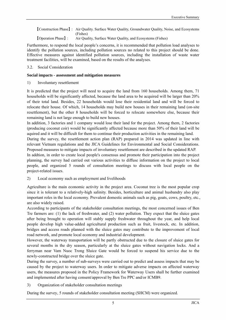
【Construction Phase】: Air Quality. Surface Water Quality, Groundwater Quality, Noise, and Ecosystems (Fishes) 【Operation Phase】: Air Quality, Surface Water Quality, and Ecosystems (Fishes)
Furthermore, to respond the local people’s concerns, it is recommended that pollution load analyses to identify the pollution sources, including pollution sources no related to this project should be done. Effective measures against identified pollution sources, including the installation of waste water treatment facilities, will be examined, based on the results of the analyses.
3.2. Social Consideration
Social impacts - assessment and mitigation measures
1) Involuntary resettlement
It is predicted that the project will need to acquire the land from 160 households. Among them, 71 households will be significantly affected, because the land area to be acquired will be larger than 20% of their total land. Besides, 22 households would lose their residential land and will be forced to relocate their house. Of which, 14 households may build new houses in their remaining land (on-site resettlement), but the other 8 households will be forced to relocate somewhere else, because their remaining land is not large enough to build new houses. In addition, 3 factories and 1 company would lose their land for the project. Among them, 2 factories (producing coconut coir) would be significantly affected because more than 50% of their land will be aquired and it will be difficult for them to continue their production activities in the remaining land. During the survey, the resettlement action plan (RAP) prepared in 2014 was updated in line with relevant Vietnam regulations and the JICA Guidelines for Environmental and Social Considerations. Proposed measures to mitigate impacts of involuntary resettlement are described in the updated RAP. In addtion, in order to create local people's consensus and promote their participation into the project planning, the survey had carried out various activities to diffuse information on the project to local people, and organized 5 rounds of consultation meetings to discuss with local people on the project-related issues.
2) Local economy such as employment and livelihoods
Agriculture is the main economic activity in the project area. Coconut tree is the most popular crop since it is tolerant to a relatively-high salinity. Besides, horticulture and animal husbandry also play important roles in the local economy. Prevalent domestic animals such as pig, goats, cows, poultry, etc., are also widely raised. According to participants of the stakeholder consultation meetings, the most concerned issues of Ben Tre farmers are: (1) the lack of freshwater, and (2) water pollution. They expect that the sluice gates after being brought to operation will stably supply freshwater throughout the year, and help local people develop high value-added agricultural production such as fruit, livestock, etc. In addition, bridges and access roads planned with the sluice gates may contribute to the improvement of local road network, and promote local economy and industrial development. However, the waterway transportation will be partly obstructed due to the closure of sluice gates for several months in the dry season, particularly at the sluice gates without navigation locks. And a ferryman near Vam Nuoc Trong Sluice Gate would be forced to suspend his service due to the newly-constructed bridge over the sluice gate. During the survey, a number of sub-surveys were carried out to predict and assess impacts that may be caused by the project to waterway users. In order to mitigate adverse impacts on affected waterway users, the measures proposed in the Policy Framework for Waterway Users shall be further examined and implemented after having consent/approval by Ben Tre PPC and/or ICMB9.
3) Organization of stakeholder consultation meetings
During the survey, 5 rounds of stakeholder consultation meeting (SHCM) were organized.

Preparatory survey for Ben Tre Water Management Project
MARD/People’s Committee
6
The First SHCM was organized in Ben Tre City to discuss with participants from Ben Tre Province PC, DARD, DONRE, and to-be-affected city/districts, etc., about the SHCM organization plan, the selection of communes where SHCM will be organized, and the methods to select the persons to be invited to the SHCMs in the communes.
The Second SHCMs were organized in the 20 selected communes to discuss with local residents and representatives from local agencies, local mass organizations, etc., about the project plan, estimated significant impacts, plan and schedule of environmental and social surveys, etc.
The Third SHCMs were organized again in the 20 selected communes, with almost the same participants as those of the Second SHCMs. During these meetings, the agricultural development vision, the draft of the land use plan, the proposed water distribution plan, etc., were explained to the participants.
The Fourth SHCM was held in Ben Tre City with participants from Ben Tre PPC (DARD, DONRE, etc.), to-be-affected city/districts, and representatives from selected communes. This SHCM had aims to explain the results of the Third SHCMs, and discuss with participants on the finalization of the draft land use plan, water distribution plan, etc.
The Fifth SHCMs were organized again in the 20 selected communes, with almost the same participants as those of the Second SHCMs, to discuss with participants about the results of environmental and social surveys, the contents of the draft Environment Impact Assessment (EIA) report, proposed impact mitigation measures, environmental management plan (EMP), etc. In addition, in these meetings, participants were consulted about the finalized land use plan, water distribution plan, anticipated impacts of water pollution, etc.
4. CONCLUSION AND RECOMMENDATIONS
4.1 Conclusion
Based on the results of various analysis mentioned in the previous chapters, this survey concludes that the implementation of the project would be the most appropriate comprehensive approach in coping with unforeseeable circumstances for the agriculture and rural development, and the Government of Vietnam should, therefore, embark on commencement of project implementation.
4.2 Recommendations
1) Taking into account the seriousness of saline water intrusion, the Project should be implemented as early as possible. Especially, Chu Cuu and Cai Quao sluice gates’ construction should be prioritized.
2) Stainless steel should be selected as material for the sluice gates and advanced technology on thick-soft foundation should be applied for their construction. To reduce future maintenance costs may facilitate the prioritization of budget allocation to the gate operation for securing freshwater supply and keeping appropriate water quality.
3) Human resource development is the most important issue of the project to attain controlling and managing their water resources by their own hands. In order that the local officers can develop their capacity in tackling against and/or coping with various unforeseeable circumstances under climate change and dry season water resource development/use in upstream countries of the Mekong River basin, on the Job Training (OJT) in tandem with financial cooperation is indispensable. JICA has been providing such a comprehensive support backed by accumulated experience and know-how.
4) Information sharing with stakeholders will be the base of activities for the integrated surface water management in Ben Tre. The establishment of an inter-active communication system between governmental organizations and peoples in communes is essential and it is highly recommended to support the establishment process through the technical cooperation scheme.

Executive Summary
JICA
7
5) Since ‘Ben Tre water management project’ is a project with sluice gate operation oriented as aforementioned, those existing sluice gates should be also included into the systematic sluice gate operation. Thus, the construction of the new sluice gates in three (3) candidate canals in South Ben Tre and the rehabilitation of existing gates with the installation of intentional operation system shall be combined together to form a subsequent candidate project.
6) After the commencement of the sluice gate operation, the trend in cargo and passenger transportation should be monitored carefully, so that such trend can be considered into relevant development plans to be developed for Ben Tre.


i
TABLE OF CONTENTS COMPOSITION OF THE REPORT
MAIN REPORT, EN, VN, JP Versions LOCATION MAP OF THE PROJECT AREA EXECUTIVE SUMMARY CONTENTS LIST OF TABLES LIST OF FIGURES ABBREVIATION AND ACRONYM
CHAPTER 1 RATIONALE AND OBJECTIVES OF THE PROJECT ...................... 1
1.1 RATIONALE OF THE PROJECT ....................................................................................... 1 1.2 OBJECTIVES OF THE PROJECT AND THE SURVEY.................................................. 2 1.3 SCHEDULE OF THE SURVEY ........................................................................................... 2 1.4 IMPLEMENTATION ARRANGEMENT OF THE SURVEY ........................................... 2 1.5 AGRICULTURAL AND RURAL DEVELOPMENT ......................................................... 4
1.5.1 ROLES OF AGRICULTURAL SECTOR .......................................................................... 4
1.5.2 AGRICULTURAL DEVELOPMENT PLANS/SCENARIOS IN THE NATIONAL CONTEXT ... 4
1.5.3 AGRICULTURAL DEVELOPMENT PLANS/SCENARIOS OF BEN TRE PROVINCE ........... 5
CHAPTER 2 SURVEY AREA ......................................................................................... 9
2.1 SPATIAL SETTINGS, DEMOGRAPHY, AND ECONOMY ............................................. 9
2.1.1 SPATIAL SETTINGS ................................................................................................... 9
2.1.2 AREA, POPULATION AND BENEFICIARIES ................................................................. 9
2.1.3 EMPLOYMENT AND ECONOMY ............................................................................... 11
2.2 METEOROLOGY ............................................................................................................... 13 2.3 WATER RESOURCES, WATER SUPPLY SYSTEMS, AND
FLOOD PROTECTION ...................................................................................................... 14
2.3.1 WATER WAY NETWORK AND BANK EROSION ........................................................ 14
2.3.2 SURFACE WATER AND QUALITY ............................................................................ 18
2.3.3 GROUND WATER AND QUALITY ............................................................................. 24
2.3.4 WATER SUPPLY AND CONTROL SYSTEMS ............................................................... 25
2.3.5 FLOOD AND FLOOD CONTROL SYSTEMS ................................................................ 32
2.3.6 ISSUES AND POTENTIALS FOR FUTURE DEVELOPMENT .......................................... 35
2.4 FARM AND FARMERS ECONOMY ................................................................................ 37
2.4.1 AGRICULTURAL AND AQUACULTURE LAND USE ................................................... 38
2.4.2 CROPPING PATTERNS AND FARMING SYSTEMS ....................................................... 41
2.4.3 AQUACULTURE ...................................................................................................... 43
2.4.4 MARKETING .......................................................................................................... 43
2.4.5 FARM ECONOMY BY MAJOR CROPS ....................................................................... 46
2.4.6 FARMERS ECONOMY: INCOME AND ITS DISTRIBUTION .......................................... 49
2.4.7 ISSUES AND POTENTIAL FOR FUTURE DEVELOPMENT ............................................ 52
2.5 ACTIVITIES OF INTERNATIONAL DONORS/NGOS AND VIETNAM GOVERNMENT .............................................................................................. 53
2.5.1 INTERNATIONAL DONORS AND NGOS ................................................................... 53

ii
2.5.2 VIETNAM GOVERNMENT AND LOCAL NGOS ......................................................... 59
2.5.3 LESSONS FROM THE PAST PROJECTS ...................................................................... 60
CHAPTER 3 ENVIRONMENTAL AND SOCIAL CONSIDERATIONS ................ 63
3.1 OVERVIEWS OF PROJECT COMPONENTS RELEVANT TO ENVIRONMENTAL AND SOCIAL CONSIDERATIONS ................. 63
3.1.1 BACKGROUND OF THE SURVEY .............................................................................. 63
3.1.2 RELEVANT TO THE MASTER PLAN ......................................................................... 63
3.1.3 OBJECTIVES OF THE SURVEY .................................................................................. 63
3.1.4 TARGET AREA OF THE SURVEY ............................................................................... 63
3.2 CURRENT ENVIRONMENTAL AND SOCIAL SITUATIONS RELEVANT TO THE PROJECT ....................................................................................... 64
3.2.1 ENVIRONMENTAL SITUATIONS ............................................................................... 64
3.2.2 SOCIAL SITUATIONS ............................................................................................... 76
3.3 LEGAL AND INSTITUTIONAL FRAMEWORK IN VIETNAM RELEVANT TO ENVIRONMENTAL AND SOCIAL CONSIDERATIONS ................. 80
3.3.1 LEGAL AND INSTITUTIONAL FRAMEWORK IN VIETNAM RELEVANT TO
ENVIRONMENTAL AND SOCIAL CONSIDERATIONS ................................................. 80
3.3.2 GAP ANALYSIS WITH JICA ENVIRONMENTAL GUIDELINES .................................... 89
3.3.3 GAP ANALYSIS BETWEEN JICA GUIDELINES AND VIETNAM LEGAL FRAMEWORK ON INVOLUNTARY RESETTLEMENT. ....................... 94
3.3.4 ORGANIZATION IN VIETNAM RELEVANT TO ENVIRONMENTAL AND SOCIAL CONSIDERATIONS .......................... 97
3.4 ALTERNATIVE ANALYSIS AND SCOPING ................................................................ 100
3.4.1 ALTERATIVE ANALYSIS ........................................................................................ 100
3.4.2 SCOPING .............................................................................................................. 114
3.4.3 TOR OF THIS ENVIRONMENTAL AND SOCIAL CONSIDERATIONS .......................... 117
3.5 ENVIRONMENTAL AND SOCIAL SURVEY RESULTS AND IMPACT EVALUATION .................................................................................................................... 120
3.5.1 ENVIRONMENTAL SURVEY RESULTS AND IMPACT EVALUATION ........................... 120
3.5.2 SOCIAL SURVEY RESULTS AND IMPACT EVALUATION ........................................... 131
3.6 MITIGATION MEASURES AND ENVIRONMENTAL MANAGEMENT/ MONITORING PLAN ....................................................................................................... 140
3.6.1 MITIGATION MEASURES FOR ENVIRONMENTAL IMPACTS .................................... 140
3.6.2 MITIGATION MEASURES FOR SOCIAL IMPACTS .................................................... 142
3.7 ENVIRONMENTAL MANAGEMENT/MONITORING PLAN ................................... 146
3.7.1 PROPOSED ENVIRONMENTAL AND SOCIAL MANAGEMENT PLAN ......................... 146
3.7.2 PROPOSED ENVIRONMENTAL MONITORING PLAN ............................................... 147
3.7.3 PROPOSED SOCIAL ENVIRONMENTAL MONITORING PLAN ................................... 148
3.8 STAKEHOLDER CONSULTATION MEETINGS (SHCM) ......................................... 149
CHAPTER 4 CONCLUSION AND RECOMMENDATIONS ................................. 157
4.1 CONCLUSION ................................................................................................................... 157 4.2 RECOMMENDATIONS .................................................................................................... 158

iii
LIST OF TABLES Table 1.2.1 Features and Functions of Proposed Sluice gates ........................................................ 2 Table 1.3.1 Overall survey Schedule with Major Components ...................................................... 2 Table 1.4.1 Implementation Arrangement for the survey ............................................................... 3 Table 1.5.1 Outline of National Target Program for New Rural Development .............................. 5 Table 1.5.2 Outline of Social Economic Development Plan ........................................................... 6 Table 1.5.3 Outline of Ben Tre Agricultural Development Plan ..................................................... 7 Table 1.5.4 Major Indicators of Ben Tre Agricultural Development Plan ...................................... 8 Table 2.1.1 Area and Population of the Project Area .................................................................... 10 Table 2.1.2 Area and Population of the Project Area .................................................................... 10 Table 2.3.1 Types of Erosion observed in and around Ben Tre Province ..................................... 16 Table 2.3.2 Change of Discharge in Future with Climate Change by MRC ................................. 19 Table 2.3.3 Salinity Observation System in Ben Tre Province ..................................................... 20 Table 2.3.4 Damage by Saline water intrusion ............................................................................. 21 Table 2.3.5 Damage by Saline water intrusion and Drought (2016 QE) ...................................... 22 Table 2.3.6 Example of Gate Operation Rule(Mo Cay Nam District) ..................................... 23 Table 2.3.7 List of Wells ............................................................................................................... 24 Table 2.3.8 Water Price in Ben Tre (unit: Dong/ m3)) .................................................................. 26 Table 2.3.9 Situation of Flood and High Tide Disaster ................................................................. 32 Table 2.3.10 Observation System in Ben Tre Province ................................................................ 33 Table 2.3.11 Role of Organizations Related to Water Management Structure .............................. 34 Table 2.3.12 Non-Structural Measures for Flood.......................................................................... 35 Table 2.4.1 Planted Area of Agriculture and Aquaculture ............................................................ 39 Table 2.4.2 Planted Area of Fruits ................................................................................................. 40 Table 2.4.3 Major Factors of Change in Planted Area of Fruits ................................................... 40 Table 2.4.4 Planted Area of Paddy ................................................................................................ 41 Table 2.4.5 Major Cropping Pattern in Ben Tre Province ............................................................. 42 Table 2.4.6 Marketing Destinations of Major Commodities ......................................................... 44 Table 2.4.7 Average Net Income of Paddy Cultivation per Hectare at 2015 Current Price .......... 47 Table 2.4.8 Average Net Income of Paddy Cultivation per Household at 2015 Current Price ..... 47 Table 2.4.9 Average Net Income of Fruits Production at 2015 Current Price .............................. 48 Table 2.4.10 Average Net Income of Shrimp Culture at 2015 Current Price ................................ 49 Table 2.4.11 Poverty Rate of Ben Tre Province by Urban and Rural ........................................... 50 Table 2.4.12 Poverty Rate of Ben Tre Province by District .......................................................... 50 Table 2.4.13 Monthly Average Income per Capita at Current Prices by Residence ..................... 51 Table 2.4.14 Monthly Average Income per Capita by Income Source and Region (2014) ........... 51 Table 2.4.15 Major Issues in Agriculture and Aquaculture ........................................................... 52 Table 2.4.16 Remarkable Potential in Agriculture and Aquaculture ............................................. 53 Table 2.5.1 Summary of the On-going & Forthcoming Projects with
Support from donors and NGOs.............................................................................. 57 Table 2.5.2 Sources of lessons learnt ............................................................................................ 60 Table 2.5.3 Lessons learnt by previous related projects
relevant to construction projects and technical cooperation projects ...................... 61 Table 3.1.1 Details of Sluice Gates in the Target Area .................................................................. 64 Table 3.2.1 Monthly Rainfall in Ben Tre Province (year 2005 to year 2014) (unit: mm) ............ 65 Table 3.2.2 Water Quality Index(WQI) based on Each Water Quality Parameter ........................ 66 Table 3.2.3 Recent Total Land Changes of Ben Tre Province ...................................................... 68 Table 3.2.4 Natural Protected Areas in Ben Tre Province ............................................................. 71 Table 3.2.5 Recent Air Quality Conditions in Ben Tre Province .................................................. 74 Table 3.2.6 Surface areas and populations of districts/city of Ben Tre Province .......................... 76 Table 3.2.7 Current land use situation (as of Jun 1, 2014) (unit: ha) ............................................ 76 Table 3.2.8 Change in Land Area of Fruit Tree Cultivation by Years (unit: ha) ........................... 77 Table 3.2.9 Change in Fruit Production by Years (unit: ton) ........................................................ 77 Table 3.2.10 Tendency of paddy production (unit: ton) ................................................................ 77 Table 3.2.11 Tendency of Paddy Field Area (unit: ha) .................................................................. 78 Table 3.2.12 Tendency of fishery production (Unit: million ton) ................................................. 78

iv
Table 3.2.13 Change in Area for Fishery Production by Years (unit: ha) ..................................... 78 Table 3.2.14 Change in Area of Several Aquaculture Methods (unit: ha) .................................... 79 Table 3.2.15 Change in Area for Freshwater, Brackish Water, and
Saline Water Aquaculture (unit: ha) ........................................................................ 79 Table 3.2.16 Change in Shrimp Production in the Districts by Year (unit: ton) ........................... 79 Table 3.2.17 Change in number of employees by main enterprises/agencies ............................... 79 Table 3.2.18 Number of registered cases of waterborne diseases in Ben Tre Province ................ 80 Table 3.3.1 Main Laws and Regulations on Environmental Protection in Vietnam ..................... 80 Table 3.3.2 List of International Environmental Conventions/ Agreements/ Treaties
signed by Vietnam ................................................................................................... 82 Table 3.3.3 Laws and regulations relating to
land use right, land acquisition, etc. in Vietnam ..................................................... 87 Table 3.3.4 Decisions recently issued by Ben Tre Province PC on
land price, property price, and land acquisition in the province territory ............... 87 Table 3.3.5 Gaps between JICA Environmental and Social Considerations Guidelines and
Vietnam Legal Framework for EIA ........................................................................ 90 Table 3.3.6 Policy gaps between JICA Guidelines and Vietnamese Country System on
land acquisition and resettlement ............................................................................ 94 Table 3.3.7 Procedure of Compensation, Support and Resettlement ............................................ 99 Table 3.4.1 Summary of Comparison Results of the Alternatives .............................................. 101 Table 3.4.2 Summary of the Evaluation Results of the Alternatives .......................................... 103 Table 3.4.3 Summary of Comparison Results of
the Water Level/Salinity Monitoring Systems for the Option 3 ............................ 108 Table 3.4.4 Scoping Results of This Project ............................................................................... 114 Table 3.4.5 TOR for Environmental and Social Considerations ................................................ 118 Table 3.5.1 Evaluation by Scoping and Environmental survey Results ...................................... 120 Table 3.5.2 Noise Power Level of Main Heavy Construction Machines .................................... 122 Table 3.5.3 Predicted Noise Levels by a Bulldoser at Each Point .............................................. 122 Table 3.5.4 Estimated Traffic Volume in the proposed 8 Sluice Gates ....................................... 123 Table 3.5.5 Salt tolerance of the mangroves in the survey Area, and
coasts in Ben Tre Province .................................................................................... 126 Table 3.5.6 Vegetation areas need to be cleared for the sluice gates construction ...................... 127 Table 3.5.7 Migration Categories focused on importance of migration
between brackish water and freshwater ................................................................ 128 Table 3.5.8 Scope of land acquisition and resettlement .............................................................. 131 Table 3.5.9 Severity of Impacts on Productive Land .................................................................. 131 Table 3.5.10 Impact on houses .................................................................................................... 132 Table 3.5.11 Estimated number of vulnerable households to be affected ................................... 133 Table 3.5.12 Agriculture in the affected communes ................................................................... 134 Table 3.5.13 Most concerned issues of local residents ............................................................... 135 Table 3.5.14. Evaluation based on Scoping and survey Findings (Social consideration) ............. 138 Table 3.6.1 Mitigation Measures for Possible Adverse Environmental Impacts ........................ 140 Table 3.6.2 Major items of RAP ................................................................................................. 142 Table 3.7.1 Proposed Environmental Monitoring Plan ............................................................... 147 Table 3.7.2 Social impact monitoring plan ................................................................................. 148 Table 3.8.1 Schedule and Number of Participants in the First SHCMs ...................................... 149 Table 3.8.2 The 3rd SHCM organization schedule and number of participants by sex .............. 151 Table 3.8.3 Participants of 3rd SHCM by Occupation (unit: persons) ....................................... 152 Table 3.8.4 Result of Stakeholders Analysis in the 3rd SHCMs ................................................. 154 Table 3.8.5 Ranking the Needs and Concerns of Local People .................................................. 155 Table 3.8.6 The 5th SHCMs organization schedule and number of participants by sex ............. 156

v
LIST OF FIGURES Figure 1.4.1 Implementation Arrangement for the Preparatory survey .......................................... 3 Figure 1.5.1 GDP Share by Industries (Left; Vietnam National GDP, Right; Ben Tre Province
GDP) ......................................................................................................................... 4 Figure 2.1.1 Administration Boundary of District (Left) and Topographic Condition (Right) of
Ben Tre ...................................................................................................................... 9 Figure 2.1.2 Project Area and Beneficiary Area ........................................................................... 11 Figure 2.1.3 Workforce Share (%) among Several Sectors In Ben Tre ........................................ 11 Figure 2.1.4 GDP Growth Percentage 2010-2014 (constant price 2010: X-axis), GDP Share (2014:
Bubble Size), and correlation coefficient (R2) between poverty rate and GDP development (Y-axis) In Ben Tre (1) ....................................................................... 12
Figure 2.1.5 GDP Growth Percentage 2010-2014 (constant price 2010: X-axis), GDP Share (2014: Bubble Size), and correlation coefficient (R2) between poverty rate and GDP development (Y-axis) In Ben Tre (2) ....................................................................... 12
Figure 2.2.1 Monthly Average Temperature and precipitation (Left) and Monthly Rainfall Year (Right) in Ben Tre (2010-2014) .............................................................................. 13
Figure 2.3.1 Canal Network in Ben Tre Province ......................................................................... 14 Figure 2.3.2 Transition of Cargo Transportation Amount ............................................................. 15 Figure 2.3.3 Transition of Cargo Transportation Traffic .......................................................... 15 Figure 2.3.4 Transition of Number of Passenger .......................................................................... 15 Figure 2.3.5 Transition of Traffic of Passenger ............................................................................ 15 Figure 2.3.6 Observed Bank Erosion (Left: Cai Quao Right: Vam Thom) .............................. 16 Figure 2.3.7 Bank Erosion Condition in Ben Tre Province .......................................................... 17 Figure 2.3.8 Distribution of Maximum Velocity (Calculated with Existing Condition) ............... 17 Figure 2.3.9 Permitted area for Dredging ..................................................................................... 18 Figure 2.3.10 River Discharge ...................................................................................................... 19 Figure 2.3.11 Location of Saline Monitoring Station in Ben Tre Province and Surrounding Area
by SRHMS .............................................................................................................. 20 Figure 2.3.12 Salinity Concentration Meter used at Son Doc 2 Sluice ......................................... 21 Figure 2.3.13 Salinity Distribution by Depth in An Hoa District in Ben Tre Province ................ 22 Figure 2.3.14 Observed Water Quality at 54 Points in Ben Tre Province ..................................... 23 Figure 2.3.15 Location of Wells/ Boreholes .................................................................................... 24 Figure 2.3.16 Salinity of Groundwater Observed in Ben Tre City and Chau Thanh District ....... 25 Figure 2.3.17 Location Map of Water Supply Plant and Water Supply Area in Ben Tre .............. 26 Figure 2.3.18 Change of Number of Customers of Water Supply Company by Users ................. 27 Figure 2.3.19 Change of Production of Water Supply Company by Users ................................... 27 Figure 2.3.20 Damage to Water Supply Plant from Saline water intrusion .................................. 28 Figure 2.3.21 Salinity of Raw Water at the Son Dong Water Supply Plant .................................. 28 Figure 2.3.22 Salinity in the Upstream of Ben Tre during Dry Season (Left: 2010, Right: 2011)29 Figure 2.3.23 Location Map of Water Supply Plant in Rural Area by CRWES ........................... 29 Figure 2.3.24 Change of Saline water intrusion Area in Ben Tre Province .................................. 30 Figure 2.3.25 Water Shortage Situation in Dry Season in Ben Tre Province ............................... 30 Figure 2.3.26 Extension Plan of Intake and Pipeline for Rural Water Supply in South Ben Tre .. 31 Figure 2.3.27 Location Map of Industrial Zone in Ben Tre Province ........................................... 31 Figure 2.3.28 Draft Updating Ben Tre Province Water Management Plan ................................... 34 Figure 2.3.29 Expenditure of DARD from 2012 to 2014 ............................................................. 35 Figure 2.3.30 Example of Lock to Prevent Saltwater Intrusion .................................................... 36 Figure 2.3.31 An Example of Lock Operation to Prevent Saltwater Intrusion ............................. 37 Figure 2.4.1 Current Land Use Map (2013) .................................................................................. 38 Figure 2.4.2 Trend of the Proportion in the Area of Agriculture and Aquaculure ........................ 39 Figure 2.4.3 Trend of the Planted Area of Major Fruits ................................................................ 40 Figure 2.4.4 Trend in Planted Area of Paddy ................................................................................ 41 Figure 2.4.5 Trend in Standardized International Price of Major Commodities ........................... 46 Figure 2.4.6 Trend of Poverty Rate in Ben Tre ............................................................................. 49 Figure 2.5.1 Locations of Support from Donors and NGOs in Ben Tre Province ........................ 54 Figure 2.5.2 Organizational Structure of DARD .......................................................................... 59

vi
Figure 3.2.1 Water Quality Situations in Ben Tre Province of Dry Season in 2014 ..................... 67 Figure 3.2.2 Recent River Bank Erosion Situations in Ben Tre Province .................................... 69 Figure 3.2.3 Nature Reserves within Ben Tre Province ................................................................ 70 Figure 3.2.4 Mangrove Distribution Areas within Ben Tre Province ........................................... 72 Figure 3.2.5 Air Quality Sampling Points in Ben Tre Province of Dry Season in 2014 ............... 75 Figure 3.3.1 Procedure for Preparation, Appraisal and Approval of EIA in Vietnam ................... 86 Figure 3.3.2 Present Organization Chart of Vietnam Environmental Agency (VEA) .................. 98 Figure 3.5.1 Nyoa Palm with Present Vegetation (near Proposed Vam Nuoc Trong Sluice
Gate) .................................................................................................................. 126 Figure 3.5.2 Mangrove Apple with Present Vegetation (near Proposed Tan Phu Sluice Gate) 126 Figure 3.5.3 Common water hyacinths with Present Vegetation (near Proposed Tan Phu Sluice
Gate) ................................................................................................................... 126 Figure 3.5.4 Coconuts Fruits Garden (near Proposed Tan Phu Sluice Gate) ........................... 126 Figure 3.7.1 Proposed Management Organization Framework for Environmental and Social
Monitoring............................................................................................................. 146
vii
ACRONYMS AND ABBREVIATIONS ADB Asian Development Bank ASS Acid Slate Soil AusAID Australian Aid B/C Benefit - Cost Ratio BOD Biochemical Oxygen Demand B-SWAMP The Preparatory survey for Ben Tre Water Management Project (This survey) BTHMS Ben Tre Hydro-meteorological Station CC Climate Change CMD Construction Management Department, MARD CMD-DARD Construction Management Division, DARD CPC Commune People’s Committee CPO Central Project Office, MARD / CRWES Center of Rural Water & Environment Sanitation, Ben Tre Province DANIDA Danish International Development Agency DARD Department of Agriculture and Rural Development, Ben Tre Province D-DARD Division of Agriculture and Rural Development (under District People’s
Committees) DO Dissolved Oxygen DOF Department of Finance, Ben Tre Province DONRE Department of Natural Resources and Environment, Ben Tre Province DPC District People’s Committee DPI Department of Planning and Investment, Ben Tre Province DWR Directorate of Water Resources, MARD E/A Executing Agency EIA Environmental Impact Assessment EIRR Economic Internal Rate of Return E/N Exchange of Notes ENPV Economic Net Present Value ESMT Environmental and Social Monitoring Task Force FACOD Center for Transferring of Technology-Services and Community Development for
Vietnamese Agriculture – Fisheries FAO Food and Agriculture Organization of the United Nations GOJ Government of Japan GOV Government of the Socialist Republic of Viet Nam ICB International Competitive Bidding ICMB Hydraulic Project Investment and Construction Management Board / ICD International Cooperation Department, MARD Ic/R Inception Report IFAD International Fund for Agricultural Development IFPD Irrigation and Flood Prevention Division, DARD IRR Internal Rate of Return IUCN International Union for Conservation of Nature IWAMUs Integrated Water Management Units IWEC Ben Tre Irrigation Works Exploitation One-Member Limited Liability Company JICA Japan International Cooperation Agency JICA Study (2013) JICA Project for Climate Change Adaptation for Sustainable Agriculture and Rural
Development in the Coastal Mekong Delta (2013) L/A Loan Agreement LCB Local Competitive Bidding MARD Ministry of Agriculture and Rural Development MOF Ministry of Finance MONRE Ministry of Natural Resources and Environment MPI Ministry of Planning and Investment MRC Mekong River Commission NGO Non-Governmental Organization NPV Net Present Value NTP-NRD National Target Programme on New Rural Development O&M Operation and Maintenance

viii
ODA Official Development Assistance OJT On-the-Job Training PDM Project Design Matrix PIC Project Implementation Committee PMB Program Management Board for Agriculture and Rural Development, DARD PMU Project Management Unit PO Project Owner PPC Provincial Peoples’ Committee (of Ben Tre, unless specified) RADCC Response and Adaptation to Disasters and Climate Change RAP Resettlement Action Plan SCF Standard Conversion Factor SHCM Stakeholder Consultation Meeting / SIWRP Southern Institute of Water Resources Planning SIWRR Southern Institute of Water Resources Research SMS Short Message Service SRHMS Southern Regional Hydro-meteorological Station VEA Vietnam Environment Administration WB World Bank WSC Ben Tre Water Supply One-member Limited Liability Company UNIT CONVERSATION
1 mau = 1 hectare
1 cong= 0.1hetare
VIETNAMISE FISCAL YEAR January 1 to December 31
CURRENCY EQUIVALENTS [Designated by JICA as of October 2016] US$ 1.00 = VND 21,957 US$ 1.00 = JPY 100.606. VND 1.00 = JPY 0.004582

Final Report
MARD/People’s Committee 1
CHAPTER 1 RATIONALE AND OBJECTIVES OF THE PROJECT
Submitted herewith is the Draft Final Report compiled according to the Minutes of Discussion (MD) on the Mission for the Japan International Cooperation Agency (JICA) ‘Preparatory survey for the Ben Tre Water Management Project’ (the Project) in the Socialist Republic of Vietnam agreed and signed between the Ministry of Agriculture and Rural Development (MARD) and coupled with the Ben Tre Province People’s Committee (PPC) and Japan International Cooperation Agency (JICA) on February 6th, 2015. The Draft Final Report describes the issues that the JICA survey team has undertaken since the inception of the Project up to the June, 2016. The issues incorporated in the report among others are results of preliminary saline water intrusion situation analysis of the Project area, environmental and social considerations, institutional setup of the project implementation, a part of structural design, project components coupled with cost estimation, etc.
1.1 RATIONALE OF THE PROJECT
The Mekong Delta is known as the Rice Bowl of Vietnam, producing more than half of the total rice paddy production of the country. Not only the rice, but also plenty of other products, such as fruits, coconuts, and vegetables, are also produced in the delta. However, the Mekong Delta is considered to be vulnerable against climate change, such as severe flooding in the rainy season and saline water intrusion in the dry season, which have been caused by a sea level rise. The sea rise measurement shows an average of approximately 15 cm during the recorded period of about 30 years, from 1982 until now in coastal areas. Therefore, the areas of Mekong River tributaries are constantly facing saline water intrusion, particularly in the dry season.
The residents in Ben Tre rely on water from the aforementioned river tributaries for domestic and irrigation purposes. Estuaries of these tributaries are located at the southeast parts of Ben Tre; this is why this area is one of the most affected areas by saline water intrusion in Vietnam under the climate change phenomena. Brine damage by saline instruction will widely and seriously spread into Ben Tre Province; the high level of salinity is expected and it will cause serious damages at not only the paddy fields in the central areas, but also the fruit farms widely developed in the upstream areas. In fact, the damage cost was estimated as the highest among 7 coastal provinces based on the saline water intrusion simulation reported in the former JICA study on ‘the Project for Climate Change Adaptation for Sustainable Agriculture and Rural Development in the Coastal Mekong Delta’ in April 2013 (JICA Study (2013).
Under the such circumstances, the Vietnamese government has established ‘Ben Tre Province Water Management Plan for 2020’, which is the policy for preventing saline intrusion mainly composed of structural measures represented by sluice gate construction. Based on the plan, series of sluice gates have been constructed from the downstream side. The Ba Lai sluice gate construction was implemented in 2002, which is located at Ba Lai River; one of the main tributaries of the Mekong River. The Vietnamese government plans not to stop sluice gate construction and has capacity to incur budget for small scale sluice gate but there will be difficulty to arrange budget for large scale sluice gate construction. This is because the Vietnamese government requested JICA a technical assistance for large scale sluice gate project plan formulation. A series of discussions and meetings were made among MARD, PPC, and JICA. As the results of the discussions and meetings, it was agreed in February 2015 to carry out a preparatory survey for the purpose of examination on the development plan of sluice gates and related structures against the impact of climate change. With this background, the Preparatory survey for the Ben Tre Water Management Project in the Socialist Republic of Vietnam was commenced at the beginning of August, 2015.
Preparatory Survey for Ben Tre Water Management Project
JICA
2
1.2 OBJECTIVES OF THE PROJECT AND THE SURVEY
This preparatory survey aims at formulating a project plan for the Japanese Official Development Assistance (ODA) Loan. The survey examines the objective, outline, costs, implementation, organization, operation-and-maintenance organization, environmental and social consideration, and others.
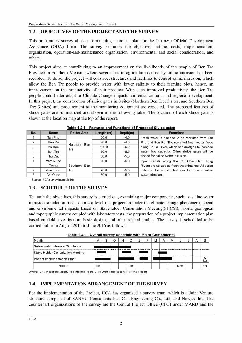
This project aims at contributing to an improvement on the livelihoods of the people of Ben Tre Province in Southern Vietnam where severe loss in agriculture caused by saline intrusion has been recorded. To do so, the project will construct structures and facilities to control saline intrusion, which allow the Ben Tre people to provide water with lower salinity to their farming plots, hence, an improvement on the productivity of their produce. With such improved productivity, the Ben Tre people could better adapt to Climate Change impacts and enhance rural and regional development. In this project, the construction of sluice gates in 8 sites (Northern Ben Tre: 5 sites, and Southern Ben Tre: 3 sites) and procurement of the monitoring equipment are expected. The proposed features of sluice gates are summarized and shown in the following table. The location of each sluice gate is shown at the location map at the top of the report.
Table 1.2.1 Features and Functions of Proposed Sluice gates No. Name Polder Area Length (m) Depth(m) Functions
1 Tan Phu
Northern Ben Tre
20.0 -4.0 Fresh water is planned to be recruited from Tan Phu and Ben Ro. The recruited fresh water flows along Ba Lai River, which had dredged to increase water flow capacity. Other sluice gates will be closed for saline water intrusion.
2 Ben Ro 20.0 -4.0
3 An Hoa 120.0 -6.0
4 Ben Tre 70.0 -5.5
5 Thu Cuu 60.0 -5.0
1 Vam Nuoc Trong Southern Ben
Tre
90.0 -6.0 Open canals along the Co Chien/Ham Long Rivers are utilized as fresh water intakes. All sluice gates to be constructed aim to prevent saline water intrusion.
2 Vam Thom 70.0 -5.5
3 Cai Quao 60.0 -5.0
Source: JICA survey team (2016)
1.3 SCHEDULE OF THE SURVEY
To attain the objectives, this survey is carried out, examining major components, such as: saline water intrusion simulation based on a sea level rise projection under the climate change phenomena, social and environmental impacts based on Stakeholder Consultation Meeting(SHCM), in-situ geological and topographic survey coupled with laboratory tests, the preparation of a project implementation plan based on field investigation, basic design, and other related studies. The survey is scheduled to be carried out from August 2015 to June 2016 as follows:
Table 1.3.1 Overall survey Schedule with Major Components
Month A S O N D J F M A M J J A S
Saline water intrusion Simulation
Stake Holder Consultation Meeting
Project Implementation Plan
Report IcR ITR DFR FR
Where; IC/R: Inception Report, ITR: Interim Report, DFR: Draft Final Report, FR: Final Report
1.4 IMPLEMENTATION ARRANGEMENT OF THE SURVEY
For the implementation of the Project, JICA has organized a survey team, which is a Joint Venture structure composed of SANYU Consultants Inc, CTI Engineering Co., Ltd, and Newjec Inc. The counterpart organizations of the survey are the Central Project Office (CPO) under MARD and the

Final Report
MARD/People’s Committee 3
Department of Agriculture and Rural Development under PPC. DARD arranged a focal person for the survey team. Figure 1.4.1below shows the implementation arrangement of the survey.
Figure 1.4.1 Implementation Arrangement for the Preparatory survey
Source: JICA survey team (2015)
A comprehensive approach is employee for the survey such as primary and secondary data and information collection, review of plans and designs available, field surveys, and planning and analysis for formulating the project components in the Ben Tre islets. The data and information collection are conducted, aside from relevant offices, at different communes within the beneficiary areas, which are hydrologically to be enclosed by dikes and sluice gates.
Following the data and information collection, data processing and project formulation are conducted to establish a feasible project plan for the Ben Tre islets. The project plan composed of the agricultural development plan, design of sluice gates, cost estimation, environmental and social impact consideration, and feasibility examination for the main and sub components. Implementation arrangements for these surveys are summarized in Table 1.4.1.
Table 1.4.1 Implementation Arrangement for the survey Items of survey Data and Information Source and Data / Information
Irrigations Systems & Diagrams Existing Situation, Route DARD, DONRE, District Offices, Field survey
Project Plan Present and Past Activities DARD, Water Companies, Field survey
Cropping Pattern Farming Activities, Future Plans DARD, SIWRP, Field survey
Price and Cost Unit Price, Price Escalation Rate DARD, Statistics, Field survey
Sewage Treatment Materials, Contamination Source DONRE, Field survey
Site Condition Geology and Topography Field survey
Construction Methods Type of Structure, Materials DARD, Statistics, Interviews
Environmental and Social Consideration
Reserved Area, Resettlement, Public Opinions, Environmental Impact
DONRE, Field survey (including SHCM, Fish Catch survey, Water Quality survey, RAP preparation)
Source: JICA survey team (2016)
This survey also includes examination on implementation structures of the project for efficient and prompt project implementation to mitigate saline water intrusion damage and recover from low productivity of farm product in the beneficiary areas.
Ben Tre Province Peoples
Committee (PPC)
Ministry of Agriculture and Rural Development
(MARD)
JICA Vietnam
Office
・ International Department ・ District PC ・ Commune PC ・ DONRE ・ Can Tho University ・ Other Institutions as required
JICA survey team Focal Person
JICA Headquarter
Central Project Office
(CPO)
Department of
Agriculture and Rural
Other Related Organizations

Preparatory Survey for Ben Tre Water Management Project
JICA
4
1.5 AGRICULTURAL AND RURAL DEVELOPMENT
1.5.1 ROLES OF AGRICULTURAL SECTOR
Tertiary industries (service sector) and secondary industries (manufacturing/construction sectors) in Vietnam share more than two thirds of the gross domestic production (GDP) in 2014 while primary industries (agriculture, forestry, and fishery sectors) have only an 18% share of the GDP; however, primary industries can maintain 46.3% of the total workforce in Vietnam. Thus, the development of primary industries in Vietnam has important key roles for poverty reduction and improvement of labor productivity.
Figure 1.5.1 GDP Share by Industries (Left; Vietnam National GDP, Right; Ben Tre Province GDP)
Source: Statistical Year Book Ben Tre 2014, Ben Tre Statistical Office (2015), Statistical Year Book of Vietnam 2014, General Statistics
Office (2015)
The Ben Tre Province shows different features in comparison with the national GDP. Primary industries share about 44% of the provincial GDP followed by tertiary industries with a 36% share and secondary industries with a 22% share of the provincial GDP. 10% of the labor force stays in the urban area while the remaining 90% of the labor force stays in the rural area in the Ben Tre Province. Thus, primary industries play the role of an engine for economic development in the Ben Tre Province in comparison with the national level.
1.5.2 AGRICULTURAL DEVELOPMENT PLANS/SCENARIOS IN THE NATIONAL CONTEXT
There is an over-arching program established in Vietnam to enhance rural development: the National Target Program for New Rural Development (NTP-NRD). It has the target year of 2020.
1) National Target Program for New Rural Development (NTP-NRD)
There is a nationwide rural development program, which has the target period from 2010 to 2020. This program aims at ‘New Rural Development (NRD)’ equipped with socio-economic infrastructures and good governance of political systems. NRD is an umbrella program on socio-economic development at community level, incorporating other programs under it. Budget is planned from four (4) sources: funding from the state is 40%, loans/credit from the government is 30%, funding from the economic sector is 20%, and the contribution by the community is 10%. The NRD is composed of 11 components such as “new rural planning,” “socio-economic infrastructure development,” “rural economic restructure and development,” and “clean water supply.” It covers all of the 19 rural criteria, while other programs may cover some of them. The following table summarizes NTP-NRD.
Agriculture, Forestry, Fischery18%
Industry, Constructio
n33%
Services36%
Others13%
Vientam Country
Agriculture, Forestry, Fischery44%
Industry, Constructio
n21%
Services31%
Others4%
Ben Tre Province

Final Report
MARD/People’s Committee 5
Table 1.5.1 Outline of National Target Program for New Rural Development Item Description
Name National Targeted Program on New Rural Development (NTP on NRD)
Target Period 2010-2020
Organization Ministry of Construction and MARD
Budget Funds from the state 40%, loans/credit from government 30%, funds from economic sectors 20%, contribution by community 10%
Target Area Whole nation at community level
Objectives/ Targets
1) To build new rural communities with modern socio-economic infrastructure, rational economic structure, and forms of production organizations to link agriculture sector with rapid development of industries and services.
2) Socioeconomic infrastructure modernized – Cultural characteristics preserved, intellectual standard of people improved;
3) Ensure Eco-environment green, clean, beautiful; 4) Increase quality of political system operation: Good governance 5) 20% of all communes achieve the full new rural criteria by 2015 6) 50% of all communes achieve the full new rural criteria by 2020
Description NRD program is an umbrella program on socio-economic development at community level, incorporating other programs under it. NRD is composed of 11 components such as “new rural planning,” “socio-economic infrastructure development,” “rural economic restructure and development,” and “clean water supply.” It covers all of 19 rural criteria, while other program may cover some of them.
Relevance to the Project
- Apply science and technologies particularly biotechnologies (hybrid): new varieties of rice such as saline-tolerant ones can be applied.
- “Community-based Top-down approach” ensures the participation of farmers; stake holder consultation meeting can be applied for this approach.
- Government's Decree No. 106/2008/ND-CP of September 19, 2008 describes about canal and road construction project in order to support inland aquaculture development.
- Government's Decree No. 41/2010/ND-CP of April 12. 2010 stipulates commercial credit for agricultural and rural development.
Source: 1) PPT material by the Department of Cooperatives and Rural Development (year unknown)/ 2) Government Decision No.
800/QD-TTg (June 4, 2010) on NTP-NRD/ 3) Government Decision No. 491/QD-TTg (September 16, 2009) on set of criteria on new rural
development.
Note: Criteria for New Rural Development are: 1) Planning and implementation of planning; 2) communications and information; 3) irrigation, 4)
electricity, 5) schools, 6) cultural facilities and infrastructure; 7) rural markets, 8) post, 9) residential houses, 10) income, 11) household poverty;
12) labor structure; 13) type of production organizations; 14) education, 15) health care, 16) cultural lives, 17) environment, 18) system of
social organization and strong political system, and 19) security and social order.
1.5.3 AGRICULTURAL DEVELOPMENT PLANS/SCENARIOS OF BEN TRE PROVINCE
As far as agricultural development is concerned at the provincial level, there are two main government policies: the Ben Tre Social and Economic Development Plan (BT-SEDP) and the Ben Tre Agricultural Development Plan.
1) Ben Tre Social and Economic Development Plan
The Social and Economic Development Plan (SEDP) is formulated at the province level by DARD, which is then reviewed and approved by PPC and Central Peoples’ Committee. Outline of this plan is summarized in Table 1.5.2. It is noted that intensive paddy cultivation is no longer promoted, considering the risk of saline intrusion and relatively lower economic value of paddy.

Preparatory Survey for Ben Tre Water Management Project
JICA
6
Table 1.5.2 Outline of Social Economic Development Plan Item Description
Name Five-year socio-economic development plan of Agriculture and Rural development in the 2016 - 2020 period
Target Period 2011-2016, and Vision to 2020
Organization Ben Tre Peoples’ Committee, DARD
Budget - No information for year 2016-2020 - For year 2011-2015, total investment capital for agriculture and rural development was
VND 2,075,051 billion, including central budget (1,827,324 B), investment credit capital (68,648 B), foreign investment (143,779 B) and Lottery ticket fund (35,300 B)
Target Area Ben Tre Province
Objectives/ Targets
1) Continue to build up and improve the provincial main product such as agriculture and aquaculture products, in order to increase productivity, quality, performance result, competitiveness.
2) Change land use for agricultural restructuring to about 173,600 ha (123,500ha for agriculture,7,833 ha for forestry, 41,300 ha for aquaculture and 900 ha for salt farm)
3) Improve extension operation (management method and implementation) to carry out the agricultural restructuring.
4) Manage the natural resources usage to reduce the negative effect on environment; improve risk management, proactive prevent disaster and cope with climate change
Description This plan is about agricultural restructuring, rural trades, human resource development and others. To realize the agricultural restructuring in the said period, specific target of the land area is set by the type of commodities such as aquaculture, crops, and livestock.
Generally, increase of productive area of each commodity is targeted, except for 2-3 times intensive cultivation of paddy which is prospected to decrease without compromising the total production. For workforce, the higher level employees are trained have a management experience.
Others are trained to catch up with farming technology except who are working for private economic sectors. In order to develop the rural trade, not only transportation infrastructure but also linkage with tourism activities such as eco- tourism are planned. As well as consideration for economic development, the SEDP is considered for climate change and sea level rise.
Relevance to the Project
- Support farmers using land and water resource, and ensure the environment hygiene on 3 ecosystem: drinking water, brackish water and salt water.
- Construction of irrigation systems is planned as a solution for agricultural restructuring - To make investment in multi-function irrigation, including domestic water, scale up the
internal irrigation models in Cho Lach district - Manage the natural resources usage to limit the negative effects on environment; improve
risk management, proactive prevent disaster and cope with climate change
Source: DARD Ben Tre (2014)
2) Ben Tre Agricultural Development Plan
The Ben Tre Agricultural Development Plan was formulated originally in 2011 and revised in 2015, targeting the agricultural restructuring during 2013-2015 with a vision toward 2020. Outline of this plan is summarized in Table 1.5.3 and the indicators targeted in this plan are shown in Table 1.5.4.

Final Report
MARD/People’s Committee 7
Table 1.5.3 Outline of Ben Tre Agricultural Development Plan Item Description
Name Plan to implement the project for agricultural restructuring toward increasing of added values and sustainable development in Ben Tre Province for the period 2013-2015 and until 2020
Target Period 2013-2015, and vision to 2020
Organization Ben Tre Peoples’ Committee, DARD
Budget VND 13,228,291 million Central (9,661,451), Provincial (1,794,615), PC (656,444) and Others (1,115,782)
Target Area Ben Tre Province
Objectives/ Targets
5) Rural per capita income of VND 29 million in 2015 and VND 42 million in 2020 through agricultural restructuring
6) Number of communes meeting new rural area criteria reaches 20% (25 communes) in 2015 and 50% (62) in 2020.
7) Maintain an average agricultural production growth rate of 3.5%-4% during 2011-2015 and 4%-5% during 2016-2020 through quality improvement, application of new technologies, and value addition.
8) Increase forest coverage to 56% in 2015 and 63% in 2020 for proactive prevention of natural calamities and response to climate changes
Description To realize the agricultural structuring in the said period, specific target of the land area is set by the type of commodities such as aquaculture, crops, and livestock. Generally, increase of productive area of each commodity is targeted, except for 2-3 times intensive cultivation of paddy which is prospected to decrease without compromising the total production. In summary, change of land use is planned at a large scale from intensive paddy cultivation to the others or inefficient model to efficient model.
Relevance to the Project
- Response to climate changes is of the primary objectives of the plan - Construction of irrigation systems is planned as a solution for agricultural restructuring - To make investment in multi-function irrigation, including domestic water, scale up the
internal irrigation models in Cho Lach district - Post-investment activities to enhance performance in irrigation operation is focused
Source: DARD Ben Tre (2014), revised in 2015

Preparatory Survey for Ben Tre Water Management Project
JICA
8
Nor
th B
en T
reSo
uth
Ben
Tre
Are
a
2015
2020
Ba Tri
Giong Trom
Ben Tre
Binh Dai
Chau Thanh
Thanh Phu
Mo Cay Nam
Mo Cay Bac
Cho Lach
A: UpperB: MiddleC: Coastal
Stab
ilizi
ng a
nd e
xplo
iting
the
aqua
cultu
re a
rea,
incl
udin
g ke
y pr
oduc
ts o
f Asi
antig
er s
hrim
p, w
hite
-leg
shr
imp,
cla
m, p
anga
sius
and
gia
nt ri
ver p
raw
n
Tota
l cul
ture
are
a(In
tens
ive
and
sem
i-in
tens
ive
cultu
re)
46,0
00ha
(7,0
00ha
)47
,000
ha(1
0,00
0ha)
XX
C
Expa
ndin
g in
tens
ive
and
sem
i-in
tens
ive
salt-
wat
er s
hrim
p fa
rmin
g ar
ea o
utsi
deth
e dy
keX
XX
XX
C to
B
Gre
en P
omel
o5,
372h
a1,
000
220
690
540
1,04
5A
to B
Ram
buta
n5,
557h
a1,
739
1,77
2A
Dur
ian
1,85
6ha
632
1,06
0A
Man
gost
een
1,66
5ha
304
775
ALo
ngan
4,12
3ha
1,31
6C
(B)
Tota
l18
,573
ha1,
000
220
1,31
63,
365
540
4,65
2
FruitTree
Focu
s on
five
key
pro
duct
s: g
reen
pom
elo,
dur
ian,
ram
buta
n, lo
ngan
and
man
gost
een
Frui
t tre
e ar
ea o
f fiv
e ke
ypr
oduc
ts18
,573
ha29
,300
ha30
,000
haX
XX
XX
XX
A to
B
Dev
elop
ing
the
coco
nut a
rea,
focu
sing
on
inte
nsiv
e fa
rmin
g w
ith p
rodu
ctio
nan
d pr
oces
sing
mod
elC
ocon
ut a
rea
67,3
82ha
64,5
00ha
65,5
00ha
XX
XX
B to
A
Coc
onut
dev
elop
men
t pro
gram
with
Dep
artm
ent o
f Ind
ustr
y an
d Tr
ade
(201
3-20
16):
reha
bilit
atio
n of
inef
ficie
nt c
ocon
ut a
rea
Coc
oa m
ixed
in th
eco
conu
t are
a7,
000h
a10
,000
haX
XB
Red
ucin
g th
e ar
ea o
f 2-3
sea
son
inte
nsiv
e ric
e cu
ltiva
tion
area
(pro
babl
yin
clud
e th
e ro
tatio
n be
twee
n ric
e an
d ot
hers
)2-
3 ric
e cu
ltiva
tion
area
(acc
umul
ated
are
a)18
,900
ha(5
5,00
0ha)
16,5
00ha
(48,
000h
a)X
XX
XC
to B
to a
quac
ultu
ring
XX
XC
to fr
uit t
ree
XX
XA
to s
ugar
cane
XX
Cto
coc
onut
and
gra
ss fo
ran
imal
hus
band
ry, e
tc.
XA
Mai
ntai
ning
the
pig
herd
with
con
vers
ions
from
sm
all-
scal
e an
d sc
atte
red
one
to h
usba
ndry
farm
, fam
ily fa
rms
and
coop
erat
ive
grou
psN
umbe
r of p
igs
(hea
d)46
8,23
6h45
0,00
0h60
0,00
0hX
XX
B
Stud
ying
con
ditio
ns fo
r env
ironm
enta
l pol
lutio
n m
anag
emet
n an
d tr
eatm
ent.
90%
of p
ig fa
rmin
g ho
useh
old
have
ow
n w
aste
trea
tmen
t sys
tem
by
2020
Dev
elop
ing
the
catt
le h
eard
, by
impl
emen
ting
the
proj
ect o
n ar
tific
ial
inse
min
atio
nN
umbe
r of c
attle
(hea
d)15
8,83
8h20
0,00
0h25
0,00
0h
Scal
ing
up th
e m
odel
of c
oope
rativ
e gr
oups
for b
reed
ing
cow
and
bee
f as
tode
velo
p "B
en T
re C
ow"
XX
XX
C to
B
Dev
elop
ing
gras
s pl
antin
g ar
ea fr
om in
effic
ient
rice
land
and
inte
rcro
ppin
g in
the
gard
ens
XX
XX
C to
B
Scal
ing
up th
e m
odel
for c
attle
bre
edin
g w
ith th
e fa
rm, f
amily
farm
, and
coop
erat
ive
grou
p m
odel
sX
XX
XC
to B
Forest
Incr
easi
ng th
e fo
rest
cov
erag
e ar
ea w
ith n
ew fo
rest
pla
ntat
ion,
incl
udin
gpr
even
tativ
e, s
peci
aliz
ed a
nd p
rodu
ctio
n fo
rest
Fore
st a
rea
Nat
ural
: 1,0
44ha
Plan
ted:
3,0
52ha
Tota
l: 4,
096h
a4,
400h
a5,
000h
a
Sour
ce: B
en T
re A
gric
ultu
ral D
evel
opm
ent P
lan
(201
4) o
r "Pl
an to
Impl
emen
t the
Pro
ject
for A
gric
ultu
ral R
estr
uctu
ring
tow
ards
Incr
easi
ng o
f Add
ed V
alue
s an
d Su
stai
nabl
e D
evel
opm
ent i
n Be
n Tr
e pr
ovin
ce fo
r Per
iod
2013
-201
5 an
d un
til 2
020"
Not
e: "
Pres
ent"
val
ue d
oes
not n
eces
saril
y re
pres
ent e
xact
ly th
e sa
me
indi
cato
r tar
gete
d. F
or e
xam
ple,
pre
sent
val
ue o
f the
pad
dy a
rea
show
s th
e en
tire
area
pla
nted
, whi
le ta
rget
val
ue o
nly
show
s th
e ar
ea w
ith 2
-3 s
easo
n pe
r yea
r cul
tivat
ion
mod
el.
Targ
et
6,00
0ha
Con
vert
ing
the
rice
land
are
a in
inef
ficie
nt a
reas
to o
ther
cro
ps
Paddy Pig
Dev
elop
men
t of 1
2,00
0ha
of c
lean
and
saf
e sp
ecia
l fru
it tr
ees
(GA
P)
Crop ProductionAquaculture
1,20
00ha
Category
Dir
ecti
onPr
esen
t as
Ref
eren
ce*1
(201
4)In
dica
tor
Cattle
Sprin
g: 1
8,07
2ha
Autu
mn
19,2
76ha
Win
ter:
29,2
46ha
Tota
l: 66
,594
ha
47,0
65ha
(12,
952h
a)
CoconutTrees
Tab
le 1
.5.4
M
ajo
r In
dic
ato
rs o
f B
en T
re A
gri
cult
ura
l Dev
elo
pm
ent
Pla
n

Final Report
MARD/People’s Committee 9
CHAPTER 2 SURVEY AREA
2.1 SPATIAL SETTINGS, DEMOGRAPHY, AND ECONOMY
2.1.1 SPATIAL SETTINGS
The Ben Tre Province is located between the Tien Giang Province to the north and the Vinh Long and Tra Vinh Provinces to the southwest. The Province has a large-scale alluvial fan demarcated by the Tien River in the north and by the Co Chien River in the south, and the alluvial fan is composed of two islets, the North Ben Tre and the South Ben Tre, which are demarcated by the Ham Luong River. The Project area extends from 9 degrees, 47 minutes, 27 seconds to 10 degrees, 20 minutes, 1 second in its north latitude (60 km) and 105 degrees, 55 minutes, 35 seconds to 106 degrees, 47 minutes, 32 seconds in the east latitude (95 km).
The topographical feature in the project area is rather low in altitude, similar to other regions of the Mekong Delta. It is generally very flat with a popular altitude ranging from only 0.5m to 1.5m (accounting for about three-quarters natural land area) and gradually lowers from the northwest to the southeast direction. The whole project area has an average altitude ranging from 0.5m to 0.75m only, which is very susceptible to the rise in sea level now taking place due to climate change.
Figure 2.1.1 Administration Boundary of District (Left) and Topographic Condition (Right) of Ben Tre Source: JICA survey team (2015) for Left, Southern Institute of Water Resource Planning (2014) for Right
The highest terrain belongs to the Chau Thanh district area. West of Binh Dai, the Giong Trom and Cho Lac districts have high altitudes with their average altitude ranging from 1.25 to 1.50 m. On the other hand, the coastal area has altitudes ranging from 0.75-1.25m. In particular, some places are very hollow; some parts of the Binh Dai, Ba Tri, and Thanh Phu districts have altitudes ranging only between 0.30 and 0.50m where waterlogging takes place very often in the rainy season.
2.1.2 AREA, POPULATION AND BENEFICIARIES
1) Area and Population
The population density of Ben Tre is at the 5th position among the Mekong delta provinces, being as much as 535 persons per km2. The total population in the Ben Tre Province is estimated at about 1.26 million; North Ben Tre shares about 60% of it and South Ben Tre shares the remaining 40% of the total population. Ben Tre city has a large population in a narrow area, which results in a high population density, being as much as 1,698 persons per km2. The two coastal districts, Binh Dai in the North Ben Tre and Thanh Phu in the South Ben Tre, rank the lowest and second lowest in population density with a bit over 300 persons per km2, while the Ba Tri district has 522 persons per km2, a slightly lower population density than the Ben Tre city average of 535 persons per km2.

Preparatory Survey for Ben Tre Water Management Project
JICA
10
Paddy production and shrimp farming are dominant in the Ba Tri district; there are some residential houses near irrigation canals in the paddy cultivation areas while such houses are rare in the shrimp farm areas. Domestic use water is available along the irrigation canals, so that people in this district can keep their residences along the irrigation canals. The Chau Thanh district has the second biggest population density after Ben Tre city, which is located at the most upstream side in North Ben Tre, and fruit production is dominant.
Table 2.1.1 Area and Population of the Project Area
District/ Region Area, km2 Population (2014) Pop. Density Persons/km2
North Ben Tre Islet
Ben Tre City 71.1 120,749 1,698
Chau Thanh District 225.1 164,037 729
Giong Trom District 313.2 167,203 534
Binh Dai District 421.5 130,998 311
Ba Tri District 358.4 187,161 522
North Ben Tre Islet 1389.3 770148 554
South Ben Tre Islet
Cho Lach District 167.6 109,387 653
South Mo Cay District 222.1 145,966 657
North Mo Cay District 158.2 109,151 690
Thanh Phu District 422.7 127,553 302
South Ben Tre Islet 970.6 492057 507
Ben Tre Province 2,359.8 1,262,205 535
Total Mekong Delta 40,576.0 17,517,600 432
Whole Country 330,967.0 90,728,900 274
Source: Source:Statistical Year Book Ben Tre 2014, Ben Tre Statistical Office (2015), Statistical Year Book of Vietnam 2014, General Statistics
Office (2015)
2) Beneficiaries
The project will lower saline content in water during the dry season, and such water will be supplied to as much as 110,442 ha out of total 137,224 ha of farmland in Ben Tre, which means about 80% of farmland will be benefited by the project. As the agriculture subsector shares 51.55% of the total workforce as described in the following section, it can calculate that about 80% of the agriculture workforce will be benefited by the project. Other beneficiary will be customer households of domestic water supply systems; a total of 207,275 households will obtain benefit from the project.
Beneficiary areas include all the districts and city excluding Cho Lach, which are: Ben Tre, Giong Trom, Binh Dai, Ba Tri, South Mo Cay, North Mo Cay, and Thanh Phu. Although intake points are located, no particular beneficiary areas are expected in Cho Lach district.
Table 2.1.2 Area and Population of the Project Area Items Beneficiary Total Figure Remarks
1) Project Area - 204,270 ha The Area of Ben Tre
2) Beneficiary Area (Farmland) 110,442 ha 137,224 ha Simulation results (54% of Ben Tre)
3) Beneficiary Farmers (people) 523,676 people 650,667 people Total Population X 51.55% X 80%
4) Beneficiary Farmers (HH) 149,622 HH 185,900 HH 3.50 p/HH in rural area, JICA (2013)
5) Rural Domestic Water Users(HH) 103,577 HH Interview to WSC.
6) Rural Domestic Water Users (people) 362,520 people 3.50 p/HH in rural area, JICA (2013)
7) Urban Domestic Water Users (HH) 57,653 HH Interview to WSC.
8) Urban Domestic Water Users (people) 194,291 people 3.37 p/HH in urban area, JICA (2013)
9) Estimated Beneficiary HH 207,275 HH = 4) + 7)
10) Estimated Beneficiary Population 717,967 people = 5) + 9)
Source: Source:Statistical Year Book Ben Tre 2014, Ben Tre Water Supply One-member Limited Liability Company (WSC.), JICA survey team
(2016)
Note: duplication between beneficiary farmers and urban domestic water users has not yet been officially adjusted

Final Report
MARD/People’s Committee 11
Figure 2.1.2 Project Area and Beneficiary Area Source: JICA survey team (2016), DARD
2.1.3 EMPLOYMENT AND ECONOMY
The total GDP of the Ben Tre Province in 2014 was VND 90,095 billion (USD 4,097 million) and GDP per capita is VND 71 million /person (USD 3,246/person)1 while the national GDP per capita is VND 43 million /person (USD 1,974 /person) 2. The GDP per capita in Ben Tre is about 1.6 times higher than that of the national average while it keeps the 9th position among 12 Mekong delta provinces.
The primary industry keeps the top share with 44% of GDP among all industries in Ben Tre as aforementioned contributing to the creation of job opportunities for 60% of workable peoples in Ben Tre.
Figure 2.1.3 Workforce Share (%) among Several Sectors In Ben Tre Source: Statistical Year Book Ben Tre 2014, Ben Tre Statistical Office (2015)
1 Statistical Yearbook, Ben Tre 2014 (the year 2014 prediction). 2 Statistical Year Book of Vietnam, 2014 (the year 2014 prediction)
Agriculture, 51.55%
Forestry, 0.04%Fishery, 8.17%
Salt, 0.54%
Industrial, 10.76%
Construction, 4.81%
Trading, 10.72%
Transportation, 1.93%
Other services, 9.59%
Others, 1.89%
Cho Lach
Mo Cay Nam
Mo Cay Bac
Thanh Phu
Ba Tri
Giong Trom
Ben Tre
Binh Dai
Chau Thanh

Preparatory Survey for Ben Tre Water Management Project
JICA
12
The recent trend of industry development shows a different face of industrial structure in Ben Tre. The horizontal axis of the following figure shows GDP development percentages of sub-sectors at constant 2010 prices from 2010 to 2014. The sizes of bubbles in the figure show the sub-sector’s share in GDP. The GDP growths of manufacturing and communications show nearly 100% development from 2010 while agriculture-forestry-fishery and wholesale show less than 20% development.
The vertical axis indicates a correlation coefficient (R2) between poverty rate and GDP development. If the GDP of the sub-sector increases, the poverty rate may decrease. It is noted that cause and effect are not quite sure between the sub-sector’s GDP development and poverty reduction. Except for wholesale, most subsectors' GDP development may have some direct and/or indirect influences against poverty reduction.
Figure 2.1.4 GDP Growth Percentage 2010-2014 (constant price 2010: X-axis), GDP Share (2014: Bubble
Size), and correlation coefficient (R2) between poverty rate and GDP development (Y-axis) In Ben Tre (1) Source: Statistical Year Book Ben Tre 2014, Ben Tre Statistical Office (2015)
Among sub-sectors in the primary sector, the same figure is developed as shown in the following figure.
Figure 2.1.5 GDP Growth Percentage 2010-2014 (constant price 2010: X-axis), GDP Share (2014: Bubble
Size), and correlation coefficient (R2) between poverty rate and GDP development (Y-axis) In Ben Tre (2) Source: Statistical Year Book Ben Tre 2014, Ben Tre Statistical Office (2015)
Looking at the x-axis, the livestock subsectors such as the raising of chickens, pigs, and cattle has been developing with a 70-100% growth percentage during the past 5 years. Vegetable and bean production
Cereal
Vegetable & beans
fruit
Perennial industrial crop
Cattle
Pig
Duck
ChickenEgg
Fish catch
Aquaculture
Forest
‐0.8
‐0.6
‐0.4
‐0.2
0
0.2
0.4
0.6
0.8
1
1.2
‐20.0% 0.0% 20.0% 40.0% 60.0% 80.0% 100.0%Correlation Co
efficien
t between
poverty rate red
uction an
d GDP
developmen
t (R
2 )
GDP Development (%) since 2010

Final Report
MARD/People’s Committee 13
also shows a strong development trend. Perennial industrial crops, forests, and fruit show low development; these subsectors require continuous land use. This is why rapid developments are difficult for these sectors without expanding planting areas. Cereal production during the last 5 years has declined; this may be due to saline intrusion in Ben Tre.
Regarding the correlation coefficient (R2) between the poverty rate and GDP development, vegetable and bean production, pig and cattle husbandry, aquaculture, and fishing show high value in comparison with others. Among these economic activates, aquaculture and fish-catching will not be affected so much by saline intrusion while vegetable and bean production, as well as pig and cattle raising will be seriously affected by saline intrusion. In fact, many farmers during the dry season of 2015-2016 purchased drinking water for their pigs and cattle according to the field interview by the survey team. The activates for vegetable and bean production as well as pig and cattle raising will require more freshwater in the future in Ben Tre
2.2 METEOROLOGY
The Mekong Delta is located in the tropical monsoon region, which is usually represented as a hot and humid climate. Some meteorological information is available from data observed by the Ben Tre meteorological observatory located at latitude 10o 15’ N, longitude 106o 23’ E. Figure 2.2.1shows the monthly average temperature and precipitation, which were observed for 5 years, from 2010 to 2014.
The average temperature ranges approximately from 25o to 30o. The latest data indicate that the average annual temperature is calculated at 27.1 degrees Celsius; the lowest monthly average is 24.1 degrees Celsius in January and the highest is 29.2 degrees Celsius in May. As shown in the following figure, it remains at high temperatures of over 25o and does not change throughout the year. November is the month that has nearly the same value of annual average temperature: about 27o.
The rainy season starts from May and ends in November, a total of 7 months. Such a seasonal rainfall pattern forms distinct dry and rainy seasons. February is the lowest rainfall month in a year; the dry season has a total of 5 months, starting from December and ending in April. It is noteworthy that monthly rainfall in the rainy season shows severe fluctuation yearly; the peak month changes year after year, and its value fluctuates much. In the rainy season, it’s rainy for a very short time in the afternoons -- like a squall. Rainfall in 2014 showed a low value in May, October, and November in comparison with the average rainfall, while rainfall in June, July, and August showed a bit higher than the average. Annual rainfall from 2011-2014 was at around 1,400 mm/year.
Figure 2.2.1 Monthly Average Temperature and precipitation (Left) and Monthly Rainfall Year (Right) in
Ben Tre (2010-2014) Source:Statistical Year Book Ben Tre 2014(Left), BTHMS(Right)

Preparatory Survey for Ben Tre Water Management Project
JICA
14
2.3 WATER RESOURCES, WATER SUPPLY SYSTEMS, AND FLOOD PROTECTION
2.3.1 WATER WAY NETWORK AND BANK EROSION
1) Outline of Canal Network
The Ben Tre Province is located downstream from the Mekong Delta, facing the East Sea. The province has dense canal networks of about 6,000 km in total extension. The canal networks include the following main rivers.
Co Chien River:Extension 82km Ham Luong River:Extension 71km Ba Lai River:Extension 59km Tien River:Extension 83km
Such canal networks enable convenient transportation, the presence of various fish and other aquatic creatures, and freshwater supply to farmland. However, saline water from the East Sea intrudes into the aforementioned rivers. After this saline water intrusion into the rivers, saline water also intrudes into canals in the Ben Tre Province.
There are complicated irrigation networks in the Ben Tre Province. Canals connect to one of the main rivers, showing an average of about a 1-2 km extension. There are more than 60 canals having more than 50 m of width.
Figure 2.3.1 Canal Network in Ben Tre Province Source: Data provided by SIWRP (2015)
2) Water Transportation Condition
There are two types of transports in the Mekong delta maritime area, one being transportation by water,
Co Chien river :Extension 82 ㎞
Tien river
:Extension 83 ㎞
Ba Lai river
:Extension 59 ㎞
Ham Luong river
:Extension 71 ㎞

Final Report
MARD/People’s Committee 15
while the other is transportation by road. According to “JICA Project for Climate Change Adaptation for Sustainable Agriculture and Rural Development in the Coastal Mekong Delta (2013)”, the transportation by water in the Mekong delta is much different from transport in other regions in Vietnam. The transportation by waterway in the Mekong delta is about 70% while other regions show less than 30% of it in statistical data without air transport in 2009. This region was developed with water transport on a natural channel primitively, and colonial government and the Vietnamese government have continued to develop artificial channels. The government also develops road networks, however transport by water still covers the main part.
Figure 2.3.2 Transition of Cargo Transportation Amount Source:Statistical Year Book Ben Tre 2014, Ben Tre Statistical Office (2015)
Figure 2.3.3 Transition of Cargo Transportation Traffic 3 Source:Statistical Year Book Ben Tre 2014, Ben Tre Statistical Office (2015)
Figure 2.3.4 Transition of Number of Passenger Source:Statistical Year Book Ben Tre 2014, Ben Tre Statistical Office (2015)
Figure 2.3.5 Transition of Traffic of Passenger Source:Statistical Year Book Ben Tre 2014, Ben Tre Statistical Office (2015)
Trends of cargo transportation in Ben Tre in recent years show increasing tendencies; the cargo transportation is mainly composed of two (2) methods; one is by an inland waterway while the other is by road. The freight transportation amount by the inland waterway in the Ben Tre Province shows more than the amount by road. Road freight transportation has been abruptly increasing from 2012 and is almost half of the total freight volume of 2014. However, the inland waterway still has important roles in freight transportation in Ben Tre.
Regarding passengers, road transportation is dominant in Ben Tre in comparison with inland waterway transportation. The number of passengers by the inland waterway transportation has been decreasing
3Traffic: Sum total of cargo amount(ton)or number of passenger multiplied by distance (kilometer)

Preparatory Survey for Ben Tre Water Management Project
JICA
16
gradually. Bridge construction in the Mekong delta may have made an impact on a tendency of the decreasing of passenger numbers. Contrarily, there is much sailing of sightseeing boats because the Ben Tre Province is a tourist spot. The waterway is still in an important position in this area.
3) River Bank Erosion
a) Types of Erosion
Riverbank erosion and sediment deposition are regarded as homeostatic phenomena caused by river force; this is because those natural phenomena are unavoidable in the project area. The project cannot protect all riverbanks from erosion in and around Ben Tre, so that the project shall deal with the riverbank erosions only at and vicinity of the sluice gates to be constructed. In general, some protection works such as riverbank revetment and bed protection are required and provided at up-and-down-streams of sluice gate. It is considered that there are predominantly three types of riverbank erosion in and around the project area; it is summarized in the following table.
Table 2.3.1 Types of Erosion observed in and around Ben Tre Province Erosion Types Causes of Erosion in and around Ben Tre
Lateral Erosion The river flow force flashes soils away from the river banks.
Erosion by Ship-generated Wave The ship-generated wave flashes soils away from the river banks.
Erosion due to Dredging Due to over dredging at river bed, river banks are collapsed,
Source: JICA survey team (2016)
According to the ‘River Bank Erosion Report’ produced by the Rural Development Division in DARD, it is reported that there is some bank erosion in canals, including the proposed construction site of eight (8) sluice gates. The JICA survey team has confirmed bank erosion in An Hoa, Vam Nuoc Trong, Vam Thom, and Cai Quao among eight (8) sites surveyed during a field survey in August 2015.
Figure 2.3.6 Observed Bank Erosion (Left: Cai Quao Right: Vam Thom) Source:JICA survey team (2016)
b) Lateral Erosion
An engineer in charge of riverbank erosion of DARD considers that cause of this riverbank erosion is lateral erosion by running water, not seepage failure. Figure 2.3.7 shows the condition of riverbank erosion in the ‘River Bank Erosion Report’. There are huge bank erosions -- more than 7m in a year -- shown by red-colored lines. In the vicinities of An Hoa, Ben Tre, and Vam Nuoc Trong, the red colored lines can be seen. According to this report, more than a total of 10 ha of residential area was lost and a total of 1,122 households had to evacuate from the bank areas due to bank erosion from 1990 to 2011 in the Ben Tre Province. In addition, it is estimated that 8,928 households will be affected until 2020.

Final Report
MARD/People’s Committee 17
Figure 2.3.7 Bank Erosion Condition in Ben Tre Province Source:DARD Rural Development Division (2011)
Figure 2.3.8 Distribution of Maximum Velocity (Calculated with Existing Condition)
Source:JICA survey team (2016)
Figure 2.3.8 shows calculated maximum flow velocity in the dry season which was obtained from computer simulation developed under this survey. Maximum flow velocity of the Ben Tre Province is about 3 m/s according to the results. Locations of the maximum flow velocity shown in Figure 2.3.8 mostly corresponds to the severe erosion areas shown in Figure 2.3.7. It means that high flow verbosity is the major cause of lateral erosion in and around Ben Tre as the Engineer’s comment aforementioned.
Vam Nuoc Trong
Vam Thom

Preparatory Survey for Ben Tre Water Management Project
JICA
18
The current velocity around the proposed sluice gates is at most about 2 m/s. This results indicate that revetment works can be applied to prevent riverbank erosion in the lower reaches and the upper reaches of the sluice gates.
c) Ship-generated Waves and Effect of Dredging
Ship-generated waves and effect of dredging are also considered as causes of riverbank erosion. The riverbank in the Arakawa lower reaches undergoes the influence of ships generating waves in Japan4. An experiment is being conducted to reduce the effect of ship-generated waves by using Yoshi vegetation planted along the riverbank. (However, this experiment is to protect against erosion along with keeping the natural bank.) High density of waterway transportation in Ben Tre will also cause riverbank erosion and it can be also mitigated by the same method as aforementioned. It's possible to prevent riverbank erosion caused by ship-generated waves by installing revetment works.
There are some sand mines to collect sands for construction in the Ben Tre Province. The sand mining may affect bank erosion and the foundation of the sluice gate. Figure 2.3.9 shows the permitted area on sand dredging. Three areas are identified which correspond to high erosion area ‘7m/year’ shown in Figure 2.3.9. Note that there is a sand mining area near the Thu Cuu sluice gate. Because the river width around the gate is about 500m at Ham Luong River, the sand mining will not affect this sluice gate in case of mining in the center of the river. Ordinary protection works can prevent bank erosion at the Thu Cuu sluice.
Figure 2.3.9 Permitted area for Dredging Source:Ben Tre DONRE Website http://113.163.94.8:8084/gisbt/
2.3.2 SURFACE WATER AND QUALITY
1) River Discharge
The Southern Regional Hydro-Meteorological Station (SRHMS) under Ministry of Natural Resources and Environment (MONRE) observes hydrological data like water level and discharge.
4 Flood Hydraulics and River Design p355. Dr. Shoji Fukuoka. Morikita Publishing Co., Ltd. (2005)
Legend Dredging area New Sluice Gate
THU CUU Sluice Gate
Severe Erosion Areas more than 7m.year

Final Report
MARD/People’s Committee 19
a) Discharge Condition
The Mekong river discharge increases in the rainy season (May-October) and decreases in the dry season (November -April). Figure 2.3.10 shows the discharge in Kratie, Cambodia and in My Thuan in the upper stream of the Ben Tre Province. My Thuan shows less discharge than Kratie because there are many river tributaries before My Thuan and water intake works along the Mekong River. The peak discharge in My Thuan, usually in October, is about 15,000 m3/s while bottom discharge mostly in during a typical year.
Furthermore, the discharge of the Mekong River is estimated to change in the future. Flow forecast until 2050 by the Mekong River commission (MRC) is indicated in Table 2.3.2.
Figure 2.3.10 River Discharge
Source:Data provided by SIWRP (2015)
Table 2.3.2 Change of Discharge in Future with Climate Change by MRC Water Resources
Development in Basin Flow in Dry season Flow in Rainy Season
Not developed The discharge is the increased tendency until the end of March compared with average discharge in 1991-2000.
The discharge after April is equal to in 1991-2000 mostly.
The predicted discharge until the middle of September is the mostly same as average discharge in 1991-2000.
The discharge will increase since peak of rainy season of middle of September to beginning or middle term of dry season.
Developed The dry season lowest discharge in Kratie (April-May) doubles compared with 1991-2000. (2,000m3/s →4000m3/s)
The discharge in dry season will decrease compared with average discharge in 1991-2000.
Source:Mekong River Commission
2) Salinity
a) Observation Agency
The SRHMS, Ben Tre Irrigation Works Exploitation One-Member Limited Liability Company (IWEC) and Department of Natural Resources and environment (DONRE) measure the salinity as a regular observance during the dry season (See Table 2.3.3). There is not any automatic salinity gauge. Other governmental institutes and organizations also observe salinity as needed; such organizations are: SIWRP (Southern Institute of Water Resources Planning) and SIWRR (Southern Institute of Water Resources Research).
According to Adaptation in the Mekong Delta (AMD) in the Ben Tre and Tra Vinh Provinces, projects by International Fund for Agricultural Development (IFAD) and PPC, AMD will install less than 30 telemeter salinity gauges in Ben Tre.

Preparatory Survey for Ben Tre Water Management Project
JICA
20
Table 2.3.3 Salinity Observation System in Ben Tre Province
Category Item Number
of station
Recording Method
Data Transfer Method
Data Center
Organization Purpose Problems for Gate Operation
Water Quality Salinity Concentration
5 Manual 2 times/ day in dry season
Telephone
Regional Center of HMS in HCMC
Ben Tre Hydro- Meteorological Service, MONRE
Observation and alert
Lack of immediate data transfer
Water Quality Salinity Concentration
20 Manual 1 time/ day in dry season
Telephone No IWEC Gate operation
----
Water Quality Salinity Concentration
54 Manual 2 times/ year
no no DONRE Monitoring water pollution
Lack of immediate data transfer
Source:JICA survey team (2016)
SRHMS observes salinity concentration along the main river channels of Mekong River. There are five (5) stations in Ben Tre Province and one (1) station in the Vinh Long Province just upstream from the Ben Tre Province (see Figure 2.3.11).
Figure 2.3.11 Location of Saline Monitoring Station in Ben Tre Province and Surrounding Area by SRHMS
Source:JICA survey team (2016)
Ben Tre Hydro-Meteorological Station (BTHMS) under SRHMS issues a salinity forecast every 10 days during the dry season. The period of forecast is 10 days. The forecast result is disseminated to the following organizations by e-mail or facsimile:
1. Provincial Office 2. Steering Committee for Flood and Storm Prevention and Search and Rescue 3. DARD 4. Steering Committee for Flood and Storm Prevention 5. Provincial Television and Radio Station 6. Agriculture and Rural Development Division of Districts and City 7. Irrigation Works Exploitation Company 8. DONRE 9. Forecasting Division of Southern Regional for Hydro-Meteorological Station (SRHMS) 10. Forecast Management Division of Central Hydro-Meteorological Center 11. Archive

Final Report
MARD/People’s Committee 21
IWEC observes salinity concentration at twenty (20) existing sluices once a day during the dry season. IWEC measures salinity at the riverside and the landside of the sluice. IWEC uses a handheld type salinity concentration meter as shown in Figure 2.3.12.
Figure 2.3.12 Salinity Concentration Meter used at Son Doc 2 Sluice
Source: JICA survey team (2016)
b) Salinity and Saline Damage
Negative influence from saline water intrusion is intensifying in the Mekong delta. The Irrigation and Flood Prevention Division (IFPD) in DARD has been issuing ‘a damage report’ since 1993, which says that damage by saline water intrusion became obvious after 1998. Saline water intrusion damages fishing industries and domestic non-commercial water as well as farming. Recently, there was saline damage around the proposed Ben Tre sluice gate construction site in December 2014 and the saline content was recorded as high as more than 4%. The major damages in the past are summarized in the following table. The saline damage has been recorded constantly, and it has been increasing in the last ten years. The immense damage has been recorded once every hundred years approximately between 2015 and 2016,. The definitive value of the damage between 2015 and 2016 will be expected to increase than preliminary estimation in 2016.
Table 2.3.4 Damage by Saline water intrusion
Year Affected Area Damage Cost Shortage of Domestic
(ha) (VND billion) water (household) 1998 33,631 119
1999 40,669 67
2000 Saline damage was not reported. 2001 Saline damage was not reported. 2002 20,292 20 50,000 2003 Saline damage was not reported. 2004 9,671 12 16,131 2005 53,395 570 112,093 2006 0.08 4,000 2007 450
2008 Saline damage was not reported. 2009 Saline damage was not reported. 2010 33,924 197
2011 10,063 560
2012 Saline damage was not reported. 2013 13,078 80 84,900 2014 Saline damage was not reported. 2015* 29,000 1,500 83,000
* Damage report is compiled data around February - July every year. In order to calculate include preceding record of dry season, the latest report is compiled as 2015. Data of 2015 shows a preliminary estimation from DARD irrigation division in Aug 2016.(not confirmed)
Source:Damage Report (1993-2014) by Irrigation and Flood Prevention Division.

Preparatory Survey for Ben Tre Water Management Project
JICA
22
A preliminary estimation of damage as of April 2016 in a newspaper is shown in Figure 2.3.55.
Table 2.3.5 Damage by Saline water intrusion and Drought (2016 QE)
Year Affected Area
Total Damage VND 5,572 billion Damaged Houses by shortage of daily life water 338,849 HHDamaged Farm Area (Rice and others) 260,000 haDamaged Fruit Farm and Industrial Area 160,000 haDamaged Aquaculture Pond 4,500 ha
Source: VNEXPRESS 17, Apr 2016
Note: There are about 90km saline intrusion from sea shore to inland area; MARD offered VND 1,000 billion aid to PM for the damage.
A hydraulic type of saline water intrusion in the Mekong Delta was confirmed in a JICA Study (2013). According to P6-6 of the main report of the JICA Study (2013), there is no salt wedge phenomenon in the Ben Tre Province, while there is an intensive mixing phenomenon of saline water intrusion.
Figure 2.3.13 Salinity Distribution by Depth in An Hoa District in Ben Tre Province
Source:JICA Project for Climate Change Adaptation for Sustainable Agriculture and Rural Development in the Coastal Mekong Delta (2013)
c) Gate Operation
Irrigation and Drainage Company under Ben Tre PPC has been delegated roles for the observation of salinity (within and without gates) and gate operation to neighboring farmers. Seventy-seven (77) sluices are managed and operated by IWEC in Ben Tre Province. Sluice gate operation schedules are prepared by the IWEC by District. Irrigation and Drainage Companies established gate operation rules. There is a watering day, a drainage day, and a closed day, which are each based on the lunar calendar in the operation rule. Open and close operation is decided with consideration for the sluice gate roles, the season, lunar age, and salinity. In the case of the open day, it basically opens twice per day during high tide or low tide. An example of a gate operation rule is shown in Table 2.3.6.
5 20160417. VNEXPRESS Hạn, mặn gây thiệt hại gần 5.600 tỷ đồng (only Vietnamese)
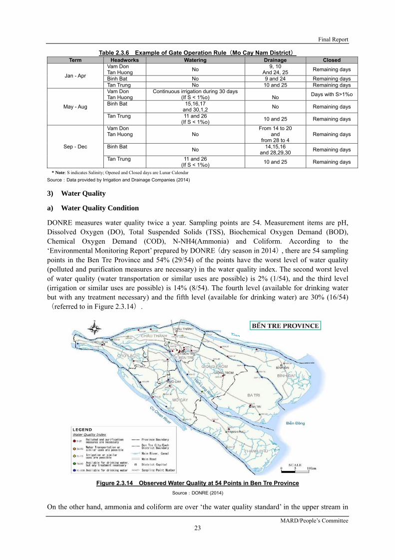
Final Report
MARD/People’s Committee 23
Table 2.3.6 Example of Gate Operation Rule(Mo Cay Nam District) Term Headworks Watering Drainage Closed
Jan - Apr
Vam Don Tan Huong
No 9, 10
And 24, 25 Remaining days
Binh Bat No 9 and 24 Remaining days Tan Trung No 10 and 25 Remaining days
May - Aug
Vam Don Tan Huong
Continuous irrigation during 30 days (If S < 1%o)
No
Days with S>1%o
Binh Bat 15,16,17 and 30,1,2
No Remaining days
Tan Trung 11 and 26 (If S < 1%o)
10 and 25 Remaining days
Sep - Dec
Vam Don Tan Huong No
From 14 to 20 and
from 28 to 4 Remaining days
Binh Bat No
14,15,16 and 28,29,30
Remaining days
Tan Trung 11 and 26 (If S < 1%o)
10 and 25 Remaining days
* Note: S indicates Salinity; Opened and Closed days are Lunar Calendar
Source:Data provided by Irrigation and Drainage Companies (2014)
3) Water Quality
a) Water Quality Condition
DONRE measures water quality twice a year. Sampling points are 54. Measurement items are pH, Dissolved Oxygen (DO), Total Suspended Solids (TSS), Biochemical Oxygen Demand (BOD), Chemical Oxygen Demand (COD), N-NH4(Ammonia) and Coliform. According to the ‘Environmental Monitoring Report’ prepared by DONRE(dry season in 2014), there are 54 sampling points in the Ben Tre Province and 54% (29/54) of the points have the worst level of water quality (polluted and purification measures are necessary) in the water quality index. The second worst level of water quality (water transportation or similar uses are possible) is 2% (1/54), and the third level (irrigation or similar uses are possible) is 14% (8/54). The fourth level (available for drinking water but with any treatment necessary) and the fifth level (available for drinking water) are 30% (16/54)(referred to in Figure 2.3.14).
Figure 2.3.14 Observed Water Quality at 54 Points in Ben Tre Province
Source:DONRE (2014)
On the other hand, ammonia and coliform are over ‘the water quality standard’ in the upper stream in

Preparatory Survey for Ben Tre Water Management Project
JICA
24
the dry season. Causes include absence of a sewage plant, growth of population in the upper stream, and the growth of stock farming (pigs, etc.).
2.3.3 GROUND WATER AND QUALITY
In Ben Tre Province, the groundwater data is obtained and processed by Ben Tre Water Supply One-member Limited Liability Company (WSC) and DONRE.
WSC had measured groundwater quality at boreholes, which were usually utilized as water sources for the Huu Dinh Water Supply/ Purification Plant owned by WSC. Those boreholes were distributed in the Chau Thanh District and Ben Tre City as shown in the following figure and table.
Figure 2.3.15 Location of Wells/ Boreholes Source: JICA survey team (2016)
Table 2.3.7 List of Wells
No. Name of
wells Depth
(m) Water level (m)
Salinity 2005 (mg/l)
Salinity 2010 (mg/l)
Salinity 2014 (mg/l)
1 71-BD 417.5 -
2 S54 465.3 -
3 G1 458.0 3.0 152 260 270
4 G3 315.0 3.15 95 160 380
5 G5 307.0 2.0 89 180 220
6 G7 316.0 3.0 101 300 500
7 G8 320.0 3.0 214 400 420
8 G9 316.0 2.3 174 340 400
9 G10 310.0 2.5 131 270 290
10 G11 318.0 3.0 202 600 630
11 G12 311.0 2.5 302 2,700 *1
12 G13 305.0 2.8 320 400 *2
13 71-8A 437.5 -
14 21-8B 457.5 -
Source: Ben Tre Water Supply One-member Limited Liability Company
Note *1: Stopped exploitation from 2006 because salinity was too high
*2: Stopped exploitation from 2009 because of no-water to pump

Final Report
MARD/People’s Committee 25
In recent years, salinity observed from most of the boreholes exceeds 300 mg/l, a stipulated value in the Vietnam water supply standard. The following figure shows the yearly change of salinity content of the groundwater in Ben Tre City and in the Chau Thanh District.
Figure 2.3.16 Salinity of Groundwater Observed in Ben Tre City and Chau Thanh District Source: JICA survey team (2016)
DONRE measured groundwater quality and quantity at boreholes to assess groundwater potential for domestic and aquaculture water supply in Ben Tre Province from 2010 to 2020. In that report, they concluded as follows;
“About the quality of underground water, generally in the distribution area of light fresh water, it can be used to supply water for drinking and living after treatment of the problems of full hardness, total Fe (iron), and exceeded standard limit of SO4
2- (sulfate ion) and Cd (cadmium). In the distribution areas of brackish to saline, it almost meet the standard for aquaculture, these parameters which do not meet the standard limit are NH4
+ (ammonium ion), Cd (cadmium), Phenol, pH (n1
3 aquifer). These data suggest that light fresh groundwater potential in Ben Tre is not rich compared to other provinces in the Mekong Delta, but still is an important source to meet the individual needs of water supply in small and medium scale. Brackish to saline water potential is plentiful, which meet the needs of exploitation and service of aquaculture sector.”
2.3.4 WATER SUPPLY AND CONTROL SYSTEMS
1) Organization Related to Water Supply
The Water supply in the Ben Tre Province is conducted by two organizations, namely, the WSC and the ‘Center of Rural Water and Environment Sanitation (CRWES) Ben Tre Province’. The former is responsible for the water supply in the urban area and the surrounding area of Ben Tre City, and the latter is under Ben Tre DARD and responsible for the water supply in the rural area.
2) Water Supply in Urban Area
The water supply area covered by WSC is shown in the following Figure 2.3.17, and four (4) water supply plants are being operated, namely, Son Dong, Huu Dinh, Cho Lach, and Luong Quoi. There are two (2) water-pumping stations to take and send water to the water supply plants. The designed water
0
100
200
300
400
500
600
700
800
900
1000
2004 2005 2006 2007 2008 2009 2010 2011 2012 2013 2014 2015
Salinity (m
g/l)
Year
71‐BD
S54
G1
G3
G5
G7
G8
G9
G10
G11
G12
G13
71‐8A
21‐8B
Standard300mg/l

Preparatory Survey for Ben Tre Water Management Project
JICA
26
supply capacity is 52,800m3/ day in total.
Figure 2.3.17 Location Map of Water Supply Plant and Water Supply Area in Ben Tre
Source: JICA survey team (2016)
There are different water prices categorized by purposes and areas as shown in the table below.
Table 2.3.8 Water Price in Ben Tre (unit: Dong/ m3))
No. Purpose
Cho Lach and Giong Trom district (except the communes in sub-region IV
of Giong Trom district)
Ben Tre city, Chau Thanh district, industrial zones and communes-belong to sub-region IV of Giong Trom district
1 Living of residential 7,000 8,000
2 Public purpose, business, and administrative offices
7,200 8,200
3 Material production activities 7,500 8,500
4 Business service activities 8,000 9,000
Source: Ben Tre Water Supply One-member Limited Liability Company
As for the water supply results from 2005 to September 2015, especially under contract, the number of customers has doubled from 22,015 to 59,684 as shown in Figure 2.3.18. This shows that most of the supply is for living purposes. As for the production of supplied water from 2005 to 2014, the total volume has doubled from 6.2 million m3 to 11.8 million m3, and not only the water supply for living, but also the water supply for produce and business and organization is increasing as shown in Figure 2.3.19.

Final Report
MARD/People’s Committee 27
Figure 2.3.18 Change of Number of Customers of Water Supply Company by Users Source: Ben Tre Water Supply One-member Limited Liability Company
Figure 2.3.19 Change of Production of Water Supply Company by Users Source: Ben Tre Water Supply One-member Limited Liability Company
3) Issues Caused by Saline water intrusion for Water Supply in Urban Area
Saline water intrusion into rivers has caused serious issues in the water supply for urban areas, canals, and boreholes/wells. In the Huu Dinh Water Supply Plant, the main water source, which was a borehole (as aforementioned in the groundwater section), salt water has entered into those boreholes resulting in being forced to stop taking water from those boreholes. Currently, the Ba Lai River is only one water resource to be treated and supplied. Consequently, although the designed water supply capacity is 10,500 m3/day, the actual water supply capacity stays at only 3,500 m3/day.
Moreover, in Luong Quoi, source water taken from a canal shows very high salinity concentration. Therefore, metal parts such as pipes and screens have been damaged and deteriorated by corrosion faster than the usual estimation for such.
0
10,000
20,000
30,000
40,000
50,000
60,000
70,000
Num
ber of Cu
stomors
Year
ORGANIZATION
BUSINESS
PRODUCE
LIVING
0
2,000,000
4,000,000
6,000,000
8,000,000
10,000,000
12,000,000
14,000,000
2005
2006
2007
2008
2009
2010
2011
2012
2013
2014
TO 9/2015
Production (cubic m
eters)
Year
ORGANIZATION
BUSINESS
PRODUCE
LIVING

Preparatory Survey for Ben Tre Water Management Project
JICA
28
Valve with corrosion Pipe material is changed to corrosion resistant material
Figure 2.3.20 Damage to Water Supply Plant from Saline water intrusion Source: JICA survey team (2016)
The water source of the Son Dong Water Supply Plant is the surface water of an adjacent canal. From March to May in the dry season, saline water intrusion into the canal results in water intake being stopped. Figure 2.3.21 shows a change of salinity of raw water (source water) at the Son Dong Water Supply Plant by year. It shows that the high saline content period in raw water as more than 300 mg/l continued for a long time, especially in 2004, 2005, 2010, 2011 and 2013.
Figure 2.3.21 Salinity of Raw Water at the Son Dong Water Supply Plant Source: Ben Tre Water Supply One-member Limited Liability Company
4) Countermeasures to Saline Water Intrusion
As a countermeasure to saline water intrusion, the Cai Co Pumping Station is planning to take 47,000m3/day of water from the Ben Ro Canal that connects to the Ham Luong River; this plan is now under implementation. It will be able to provide water in the amount of 15,000 m3/day to the An Hiep Water Supply Plant and 32,000 m3/day to the Son Dong Water Supply Plant. This construction work will finish, and the water supply plant will be in operation by early 2016.
On the other hand, for the determination of a new water source encountering saline water intrusion, WSC has started to measure salinity at upstream four (4) points, namely, the Ben Ro Canal, the Tan Phu Canal, the Tan Phu Ferry on the Tien River, and the Cho Lach Station on the Tien River from 2010. As a result, the salinity at the Ben Ro Canal has some high periods, around 250 mg/l, as shown in Figure 2.3.22. Therefore, if fresh water is taken at the Ben Ro Sluice gate, the gate should be
0
500
1000
1500
2000
2500
3000
3500
1‐Feb
8‐Feb
15‐Feb
22‐Feb
1‐M
ar
8‐M
ar
15‐M
ar
22‐M
ar
29‐M
ar
5‐Apr
12‐Apr
19‐Apr
26‐Apr
3‐M
ay
10‐M
ay
17‐M
ay
24‐M
ay
31‐M
ay
Salinity (m
g/l)
Date
2004
2005
2006
2007
2008
2009
2010
2011
2012
2013
2014
2015

Final Report
MARD/People’s Committee 29
operated while monitoring salinity during the dry season.
Figure 2.3.22 Salinity in the Upstream of Ben Tre during Dry Season (Left: 2010, Right: 2011) Source: Ben Tre Water Supply One-member Limited Liability Company
5) Water Supply in Rural Area
Figure 2.3.23 Location Map of Water Supply Plant in Rural Area by CRWES Source: Prepared by JICA survey team based on the data from Center of Rural Water and Environment Sanitation Ben Tre Province
The Center of Rural Water and Environmental Sanitation under DARD is in charge of the water supply in the rural area of the Ben Tre Province. The Center is implementing a national campaign entitled, “Treated Water and Rural Environmental Sanitation” (NTP3), and it is in the stage of 2016-2020 of a short-term plan. The Center owns and operates forty-two (42) water supply plants and provides water in the amount of 1,583 m3/h to 51,383 households in a rural area as shown in Figure 2.3.23. Seventy-two (72) water supply plants supply the treated water to more than 80,000 rural households with a total capacity of 2,624 m3/h.

Preparatory Survey for Ben Tre Water Management Project
JICA
30
6) Saline Water Intrusion Problems in Rural Water Supply
In the Binh Dai District in North Ben Tre, the Ba Lai River is the main source of the rural water supply, but saline water intrusion into the Ba Lai River occurs during the dry season upstream from the Ba Lai Barrage. As a result, fresh water cannot be taken from the river. In the Chau Thanh District, fresh water cannot be taken from rivers and canals because of saline water intrusion during the dry season, too.
In South Ben Tre, the saline water intrusion area has been moving north. Currently, water is taken from water intake and supply plants in the middle of South Ben Tre and sent through pipes, but salt water has already reached to the intake point.
Figure 2.3.24 Change of Saline water intrusion Area in Ben Tre Province Source: Prepared by JICA survey team based on the data from Center of Rural Water and Environment Sanitation Ben Tre Province
Groundwater use is not so dominant in the Ben Tre Province while surface water comprises the majority of the water resource. Fresh water available from surface water in the dry season is getting worse so that people’s selection of options will be quite limited, such as, surface water, groundwater, and stored rainwater during the rainy season.
This well derives from an unsafe water source with wild weeds, and is also going to be dried up
Rural people prepare fresh water for dry season
Figure 2.3.25 Water Shortage Situation in Dry Season in Ben Tre Province Source: Center of Rural Water and Environment Sanitation Ben Tre Province

Final Report
MARD/People’s Committee 31
7) Countermeasures to Saline Water Intrusion
The Center supposes that the Vam Thom and Vam Nuoc Trong Sluice gates will stop saline water intrusion to their water intakes, but they are also considering that because salt water reaches north to the current intake points during the heavy saline water intrusion season, the intake point and pipeline should be extended to the north area as shown in Figure 2.3.26.
Figure 2.3.26 Extension Plan of Intake and Pipeline for Rural Water Supply in South Ben Tre Source: Center of Rural Water and Environment Sanitation Ben Tre Province
8) Industrial Zone and Industrial Water Use
In the Ben Tre Province, seven (7) industrial zones were planned to be established at An Hiep, Giao Long, Giao Hoa, Thanh Tan, Phu Thuan, Phuoc Long, and Thanh Thoi as shown in Figure 2.3.27. However, only three industrial zones were actually opened and operated, namely, the An Hiep, Giao Long, and Giao Hoa Industrial Zones in the Chau Thanh District.
Figure 2.3.27 Location Map of Industrial Zone in Ben Tre Province Source: Ben Tre Industrial Zone Authority
Proposed Water Intake Area
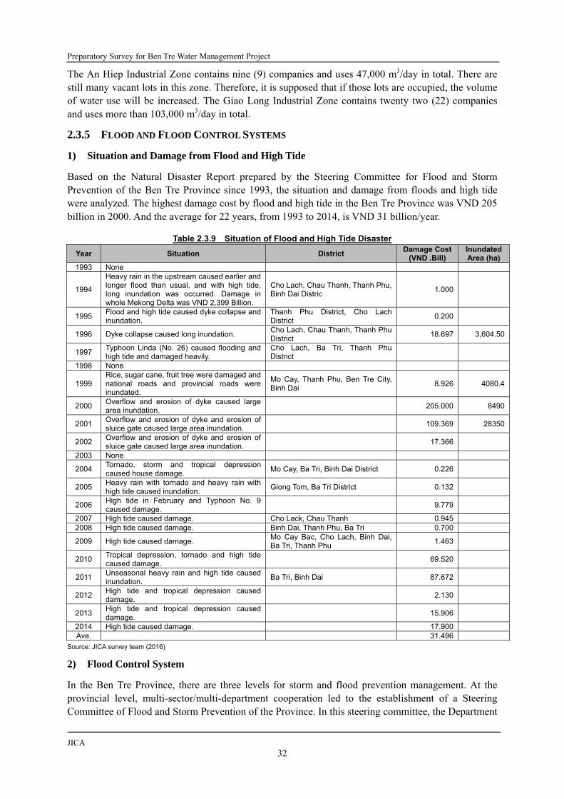
Preparatory Survey for Ben Tre Water Management Project
JICA
32
The An Hiep Industrial Zone contains nine (9) companies and uses 47,000 m3/day in total. There are still many vacant lots in this zone. Therefore, it is supposed that if those lots are occupied, the volume of water use will be increased. The Giao Long Industrial Zone contains twenty two (22) companies and uses more than 103,000 m3/day in total.
2.3.5 FLOOD AND FLOOD CONTROL SYSTEMS
1) Situation and Damage from Flood and High Tide
Based on the Natural Disaster Report prepared by the Steering Committee for Flood and Storm Prevention of the Ben Tre Province since 1993, the situation and damage from floods and high tide were analyzed. The highest damage cost by flood and high tide in the Ben Tre Province was VND 205 billion in 2000. And the average for 22 years, from 1993 to 2014, is VND 31 billion/year.
Table 2.3.9 Situation of Flood and High Tide Disaster
Year Situation District Damage Cost
(VND .Bill) Inundated Area (ha)
1993 None
1994
Heavy rain in the upstream caused earlier and longer flood than usual, and with high tide, long inundation was occurred. Damage in whole Mekong Delta was VND 2,399 Billion.
Cho Lach, Chau Thanh, Thanh Phu, Binh Dai Distric
1.000
1995 Flood and high tide caused dyke collapse and inundation.
Thanh Phu District, Cho Lach District
0.200
1996 Dyke collapse caused long inundation. Cho Lach, Chau Thanh, Thanh Phu District
18.697 3,604.50
1997 Typhoon Linda (No. 26) caused flooding and high tide and damaged heavily.
Cho Lach, Ba Tri, Thanh Phu District
1998 None
1999 Rice, sugar cane, fruit tree were damaged and national roads and provincial roads were inundated.
Mo Cay, Thanh Phu, Ben Tre City, Binh Dai
8.926 4080.4
2000 Overflow and erosion of dyke caused large area inundation.
205.000 8490
2001 Overflow and erosion of dyke and erosion of sluice gate caused large area inundation.
109.369 28350
2002 Overflow and erosion of dyke and erosion of sluice gate caused large area inundation.
17.366
2003 None
2004 Tornado, storm and tropical depression caused house damage.
Mo Cay, Ba Tri, Binh Dai District 0.226
2005 Heavy rain with tornado and heavy rain with high tide caused inundation.
Giong Tom, Ba Tri District 0.132
2006 High tide in February and Typhoon No. 9 caused damage.
9.779
2007 High tide caused damage. Cho Lack, Chau Thanh 0.945 2008 High tide caused damage. Binh Dai, Thanh Phu, Ba Tri 0.700
2009 High tide caused damage. Mo Cay Bac, Cho Lach, Binh Dai, Ba Tri, Thanh Phu
1.463
2010 Tropical depression, tornado and high tide caused damage.
69.520
2011 Unseasonal heavy rain and high tide caused inundation.
Ba Tri, Binh Dai 87.672
2012 High tide and tropical depression caused damage.
2.130
2013 High tide and tropical depression caused damage.
15.906
2014 High tide caused damage. 17.900 Ave. 31.496
Source: JICA survey team (2016)
2) Flood Control System
In the Ben Tre Province, there are three levels for storm and flood prevention management. At the provincial level, multi-sector/multi-department cooperation led to the establishment of a Steering Committee of Flood and Storm Prevention of the Province. In this steering committee, the Department

Final Report
MARD/People’s Committee 33
of Agriculture and Rural Development is supposed to have the main responsibility for storm and flood prevention. Then, the Department gave the main work to the Division of Irrigation and Storm-Flood Prevention. The secretariat of this committee was established in the Division of Irrigation and Storm and Flood Protection. The district and communal levels shared the same organizational structure.
The Division has four (4) subdivisions, namely, the Administration office, the Dike and Natural Disaster Prevention Management office, the Water and Irrigation System Management office, and the Sea Dike Management branch. They perform different tasks as assigned by DARD.
3) Meteorology, Hydrology, and Salinity Observation
In the Ben Tre Province, there is one (1) meteorological station, five (5) hydrological stations, and twenty-one (21) salinity stations. There are several organizations, which join the weather observing process. The observed data will be given to the district government to transfer to the people.
Table 2.3.10 Observation System in Ben Tre Province
Category Item Number of station
Recording Data
Transfer Data
Center Organization Purpose
Problems for Gate Operation
Meteorological
Rainfall and others
1 Automatic Automatic
Regional Center of HMS in HCMC
Ben Tre Hydro- Meteorological Service, MONRE
Observation and alert
Lack of immediate data transfer
Hydrolo gical
Water Level
5 Self-recording
Telephone
Regional Center of HMS in HCMC
Ben Tre Hydro- Meteorological Service, MONRE
Observation and alert
Lack of immediate data transfer
Water Quality
Salinity Concentration
5 Manual Daily in dry season
Telephone
Regional Center of HMS in HCMC
Ben Tre Hydro- Meteorological Service, MONRE
Observation and alert
Lack of immediate data transfer
Water Quality
Salinity Concentration
16 Manual Daily in dry season
Telephone No IWEC Gate operation
----
Water Quality
54 Manual A few times/year
no no DONRE Monitoring water pollution
Lack of immediate data transfer
Source: JICA survey team (2016)
4) Water Management Plan and Structural Measures
DARD has formulated a water management plan targeted for the year 2020; components of this plan include flood, high tide, drought, and seawater intrusion, especially as structural measures such as dykes, sluice gates, and canals. However, some information, such as construction status and size of structures, were already changed. The updated plan is shown in the following figure. In the figure, each black color dot indicates a sluice gate of construction completion while a red color shows a proposed sluice gate to be constructed. A blue color dot mainly along the Tien River means a sluice gate under construction. DARD plans to complete construction of all necessary sluice gates for saline water intrusion purpose before completion of the project.

Preparatory Survey for Ben Tre Water Management Project
JICA
34
Figure 2.3.28 Draft Updating Ben Tre Province Water Management Plan Source: JICA survey team (2016)
Water Management Structures in Vietnam are categorized into two; one is a dyke and the other is a flood control system. The dyke is composed of sea dyke, river dyke, and the inland waterway/canal dyke. The flood control system is composed of sluice gates and locks. Responsibilities of those structures in planning, construction, and operation and maintenance are summarized as follows.
Table 2.3.11 Role of Organizations Related to Water Management Structure Structures location Planning Construction Operation & Maintenance
Main tributaries of Mekong River
MARD/DARD MARD/ DARD DARD
1st and 2nd Level Canals Irrigation Management Board of DARD
Irrigation Management Board of DARD
IWEC of PPC
3rd Level and lower Canals PPC/DARD PPC/DARD District and Commune Peoples’ Committee
Sea dyke MARD/DARD MARD/ DARD DARD
Source: JICA survey team (2016)
IWEC has the direct authority over every irrigation structure in the Ben Tre Province. The Division of Irrigation and Storm-Flood Prevention only has the authority over inspecting and managing some activities of this company. During the construction period, a joint management committee would usually be established at different governmental levels to control and manage construction works of irrigation facilities, for which the committee level in the government depends on the scale of construction volume and cost.
5) Budget and Expenditure
Investment and expenditure in irrigation purpose of the whole DARD from 2012 to 2014 were around VND 250-400 billion as shown in Figure 2.3.29.

Final Report
MARD/People’s Committee 35
Figure 2.3.29 Expenditure of DARD from 2012 to 2014
Source: Ben Tre DARD
The IWEC conducts maintenance and operation works for water management structures, such as dredging and widening of canals and repairing embankments/dykes and sluice gates. In 2014, eleven (11) canals were dredged, six (6) embankments/dykes were repaired, and two (2) sluice gates were repaired; the costs allocated to those works were VND 11 Billion, VND 14 Billion, and VND 0.7 Billion respectively.
However, the budget for dredging and repair in the DARD is usually not enough, and it is difficult to expect which canal, dyke, or sluice gate will require repairing. Therefore, DARD cannot establish a detailed dredging and repair plan. There is a basic procedure for canal dredging, dyke repairing, and sluice gate rehabilitation where the commune at the site shall firstly send requests to the concerned district and DARD, and then DARD shall respond to the requests one by one. However, since the budget is usually not enough to fulfill all requests, some dredging and repairs may be postponed until the next year or later.
6) Non-structural Measures
Ben Tre Province takes non-structural measures against flood at the various levels; the levels and respective activities shown in the following table.
Table 2.3.12 Non-Structural Measures for Flood Level Actor/member Action
Province Chairperson of People’s Committee and the head of concerned departments/ agencies
Steering Committee for Flood and Storm Prevention, Search and Rescue was established
At the beginning of every rainy season, the committee is held in order to review the work in the last year and to build a program for the next year
Departments and districts/ communes
Permanent Office On duty 24 hours/day during the storm/ rainy season (June 1 to November 30) for monitoring and providing direct and timely advice to the leaders
Residents Border Guards Propaganda campaigns to raise awareness of people abouthe damages of natural disasters
Fishermen Communication by the radio transeivers NGO Red Cross Society Hold the training for quick response to seach and rescue
Source: JICA survey team (2016)
2.3.6 ISSUES AND POTENTIALS FOR FUTURE DEVELOPMENT
1) Necessity of Navigation Lock
The number of vessels at the point of eight (8) planned sluice gates was not yet studied. The feasibility

Preparatory Survey for Ben Tre Water Management Project
JICA
36
study conducted by the Vietnamese side planned for navigation locks to be installed at the An Hoa, Ben Tre, Mo Cay Bac, and Mo Cay Nam Sluice gates, while the rest of them, the Thu Cuu, Tan Phu, Ben Ro, and Cai Quao Sluice gates were not planned to have installed navigation locks. The reason is that vessels can use detour canals even if these four (4) sluice gates cannot pass vessels.
However, if in the future, not only these eight (8) sluice gates, but also other sluice gates planned by the Vietnamese Government are constructed, there will be no detour canals. Therefore, considering such a future canal situation, the BWMP project shall consider the installation of navigation locks.
2) Prevention of Saltwater Intrusion Caused by Ship Traffic
When a ship passes through a lock, saline water intrudes into upstream (landside) from downstream (riverside). To prevent this, in the case of the Nagaragawa Estuary Barrage in Japan, desalination pumps were provided. While water is being let in to adjust the water level within the lock, the pumps are operated to reduce the salt concentration in the lock and prevent saltwater from intruding into the upstream.
Figure 2.3.30 Example of Lock to Prevent Saltwater Intrusion Source: Information of Nagaragawa Estuary Barrage, Japan Water Agency

Final Report
MARD/People’s Committee 37
Figure 2.3.31 An Example of Lock Operation to Prevent Saltwater Intrusion Source: Information of Nagaragawa Estuary Barrage, Japan Water Agency
3) Water Level and Salinity Observation
Different organizations have separately collected hydrological data including water level and saline content in Ben Tre. IWEC observes salinity at some sluice gates of two (2) sides, namely the riverside and the inland side. Hydro-Meteorological Service under MONRE observes water level and saline contents along the Mekong River. Ben Tre DONRE is the responsible organization for observation of meteorology, hydrology, and water quality; however, in actuality, they observe water quality only. Moreover, water quality is observed not continuously, but a few times a year at the same points.
As just described, three (3) organizations observe salinity and its related data, but they do not share the observed data with other organizations immediately. Therefore, for the sake of adequate and effective operation of the sluice gate, the current situation shall be revised and changed. Otherwise, the IWEC cannot obtain any useful data for gate operation immediately, which other organizations have observed.
2.4 FARM AND FARMERS ECONOMY
Agriculture in the Ben Tre Province is quite diversified by the strategic combinations of coconut tree, fruit trees, paddy, and aquaculture, depending on specific agro-ecological condition of each area. Especially, as the topography of the area is pronouncedly flat and the type of soil is generally alluvial sediment, the deciding factor of the agro-ecological condition is the availability of water in terms of the amount related to the occurrence of flooding during the rainy season, and salinity affected by saline intrusion especially during the dry season. Farmers strategically decide the farming system based on such a condition. One of those diversified farming systems is repeated production of paddy: two to three times of paddy productions a year. This sub-chapter discusses the agriculture in the Project area.
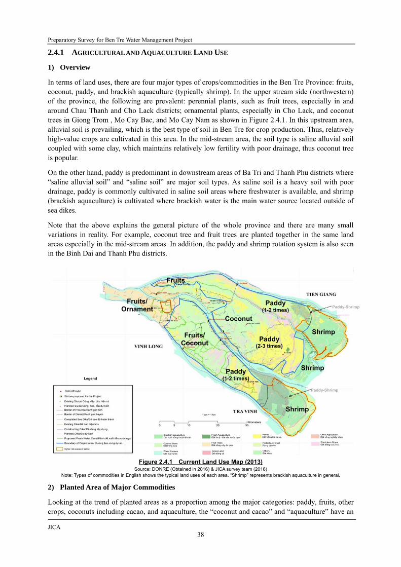
Preparatory Survey for Ben Tre Water Management Project
JICA
38
2.4.1 AGRICULTURAL AND AQUACULTURE LAND USE
1) Overview
In terms of land uses, there are four major types of crops/commodities in the Ben Tre Province: fruits, coconut, paddy, and brackish aquaculture (typically shrimp). In the upper stream side (northwestern) of the province, the following are prevalent: perennial plants, such as fruit trees, especially in and around Chau Thanh and Cho Lack districts; ornamental plants, especially in Cho Lack, and coconut trees in Giong Trom , Mo Cay Bac, and Mo Cay Nam as shown in Figure 2.4.1. In this upstream area, alluvial soil is prevailing, which is the best type of soil in Ben Tre for crop production. Thus, relatively high-value crops are cultivated in this area. In the mid-stream area, the soil type is saline alluvial soil coupled with some clay, which maintains relatively low fertility with poor drainage, thus coconut tree is popular.
On the other hand, paddy is predominant in downstream areas of Ba Tri and Thanh Phu districts where “saline alluvial soil” and “saline soil” are major soil types. As saline soil is a heavy soil with poor drainage, paddy is commonly cultivated in saline soil areas where freshwater is available, and shrimp (brackish aquaculture) is cultivated where brackish water is the main water source located outside of sea dikes.
Note that the above explains the general picture of the whole province and there are many small variations in reality. For example, coconut tree and fruit trees are planted together in the same land areas especially in the mid-stream areas. In addition, the paddy and shrimp rotation system is also seen in the Binh Dai and Thanh Phu districts.
Figure 2.4.1 Current Land Use Map (2013) Source: DONRE (Obtained in 2016) & JICA survey team (2016)
Note: Types of commodities in English shows the typical land uses of each area. “Shrimp” represents brackish aquaculture in general.
2) Planted Area of Major Commodities
Looking at the trend of planted areas as a proportion among the major categories: paddy, fruits, other crops, coconuts including cacao, and aquaculture, the “coconut and cacao” and “aquaculture” have an
Fruits
Fruits/ Coconut
Coconut
Paddy (2-3 times)
Paddy (1-2 times)
Shrimp
Shrimp
Shrimp
Fruits/ Ornament
l
Paddy (1-2 times)
Paddy-Shrimp
Paddy-Shrimp
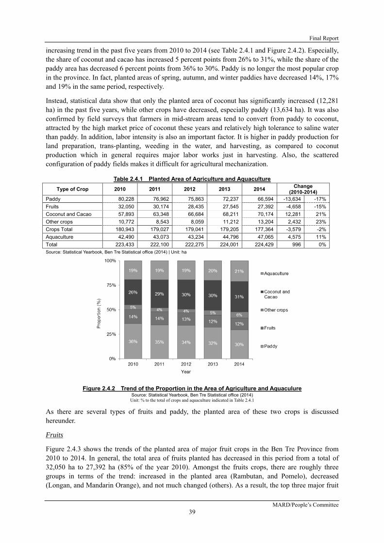
Final Report
MARD/People’s Committee 39
increasing trend in the past five years from 2010 to 2014 (see Table 2.4.1 and Figure 2.4.2). Especially, the share of coconut and cacao has increased 5 percent points from 26% to 31%, while the share of the paddy area has decreased 6 percent points from 36% to 30%. Paddy is no longer the most popular crop in the province. In fact, planted areas of spring, autumn, and winter paddies have decreased 14%, 17% and 19% in the same period, respectively.
Instead, statistical data show that only the planted area of coconut has significantly increased (12,281 ha) in the past five years, while other crops have decreased, especially paddy (13,634 ha). It was also confirmed by field surveys that farmers in mid-stream areas tend to convert from paddy to coconut, attracted by the high market price of coconut these years and relatively high tolerance to saline water than paddy. In addition, labor intensity is also an important factor. It is higher in paddy production for land preparation, trans-planting, weeding in the water, and harvesting, as compared to coconut production which in general requires major labor works just in harvesting. Also, the scattered configuration of paddy fields makes it difficult for agricultural mechanization.
Table 2.4.1 Planted Area of Agriculture and Aquaculture
Type of Crop 2010 2011 2012 2013 2014 Change
(2010-2014) Paddy 80,228 76,962 75,863 72,237 66,594 -13,634 -17%
Fruits 32,050 30,174 28,435 27,545 27,392 -4,658 -15%
Coconut and Cacao 57,893 63,348 66,684 68,211 70,174 12,281 21%
Other crops 10,772 8,543 8,059 11,212 13,204 2,432 23%
Crops Total 180,943 179,027 179,041 179,205 177,364 -3,579 -2%
Aquaculture 42,490 43,073 43,234 44,796 47,065 4,575 11%
Total 223,433 222,100 222,275 224,001 224,429 996 0%
Source: Statistical Yearbook, Ben Tre Statistical office (2014) | Unit: ha
Figure 2.4.2 Trend of the Proportion in the Area of Agriculture and Aquaculure Source: Statistical Yearbook, Ben Tre Statistical office (2014)
Unit: % to the total of crops and aquaculture indicated in Table 2.4.1
As there are several types of fruits and paddy, the planted area of these two crops is discussed hereunder.
Fruits
Figure 2.4.3 shows the trends of the planted area of major fruit crops in the Ben Tre Province from 2010 to 2014. In general, the total area of fruits planted has decreased in this period from a total of 32,050 ha to 27,392 ha (85% of the year 2010). Amongst the fruits crops, there are roughly three groups in terms of the trend: increased in the planted area (Rambutan, and Pomelo), decreased (Longan, and Mandarin Orange), and not much changed (others). As a result, the top three major fruit

Preparatory Survey for Ben Tre Water Management Project
JICA
40
crops have changed from Longan (19% of the total area planted), Orange (14%), and Pomelo (14%) in 2010 to Rambutan (20%), Pomelo (20%) and Longan (15%) as shown in Table 2.4.2 below.
Figure 2.4.3 Trend of the Planted Area of Major Fruits Source: Statistical Yearbook, Ben Tre Statistical office (2014)
Table 2.4.2 Planted Area of Fruits
Type of Fruits 2010 2011 2012 2013 2014 % to 2010
Rambutan 3,941 12% 5,010 5,428 5,437 5,557 20% 141%
Pomelo 4,422 14% 4,144 4,528 4,754 5,372 20% 121%
Longan 6,249 19% 5,360 4,884 4,609 4,123 15% 66%
Banana 2,527 8% 2,664 2,401 2,387 2,076 8% 82%
Orange 4,631 14% 3,141 2,634 2,007 1,993 7% 43%
Lemon 1,903 6% 1,572 1,459 1,828 1,897 7% 100%
Durian 1,860 6% 1,848 1,843 1,780 1,856 7% 100%
Mangosteen 2,219 7% 2,230 1,937 1,670 1,665 6% 75%
Mango 1,328 4% 1,077 761 687 650 2% 49%
Other Fruits 2,970 9% 3,128 2,560 2,386 2,203 8% 74%
Fruits 32,050 100% 30,174 28,435 27,545 27,392 100% 85%
Trend in % 100% 94% 89% 86% 85%
Source: Statistical Yearbook, Ben Tre Statistical office (2014) | Unit: ha
Note: “Proportion (%)” is for the year 2014 and “% to 2010” is also for the planted area in 2014.
Major contributing factors to the decrease in the planted area of fruit trees are not clear. According to DARD, a decrease in the total planted area of fruit attributes to conversion from Longan to fresh-type Coconut trees. As discussed, fruit trees and coconut trees are planted widely in the alluvial soil zone in up- to mid-stream areas. Therefore, some kinds of fruit are converted to more attractive coconut. In terms of the change in the planted area of each fruit type, disease, and profitability are the major factors. Here is a summary:
Table 2.4.3 Major Factors of Change in Planted Area of Fruits
Type of Fruits Decrease/ Increase Major Factor of Increase/ Decrease in Planted Area
Rambutan Increase - International market is active
Pomelo Increase - International market is active; - Currently pomelo is very popular and expected to still increase
Longan Decrease- It depends heavily on the exportation to China; demand has decreased due to recession- Epidemic of severe disease - Converted to pomelo (pomelo boom)
Orange Decrease- Plunge of market price since 2010- Epidemic of severe disease; it is still on the way to recover from disease - Farmers are still willing to continue, provided that saline concentration is well controlled.
Mangosteen Decrease
- Rambutan, Durian, and Mangosteen are usually cultivated in the same area, having a trade-off relationship. As Rambutan is getting more popularity, then planted area of mangosteen has decreased.
- Epidemic of disease (warm and fungi)Mango Decrease - Disease (Colletotrichum gloeosporioides and Plocacderus ruficornis)
Other Fruits - Market factors and disease in general (Banana, Lemon, Durian, and others)
Source: Agriculture and Fishery Extension Center, DARD Ben Tre (2016)

Final Report
MARD/People’s Committee 41
Paddy
Table 2.4.4 and Figure 2.4.4 demonstrate the planted area of paddy by the cropping season in the past 10 years from 2005 to 2014. The total planted area of paddy has significantly decreased (21% in 10 years), for which spring, autumn and winter paddy all have decreased. Particularly, the decrease in winter paddy is significant: a total of 8,418 ha of decrease in the 10 years. This result implies two things: the cultivation area of paddy itself is decreased, and the cropping pattern has changed from three times per year to one to two times per year in certain size of areas. Once again, a large area of paddy area is now shifted to a coconut tree area as shown in Table 2.4.1.It is expected that this trend will still continue with the background of climate change and better profitability of coconut production.
Table 2.4.4 Planted Area of Paddy
Source: Statistical Yearbook, Ben Tre Statistical office (2014)
2.4.2 CROPPING PATTERNS AND FARMING SYSTEMS
Cropping patterns and farming systems in Ben Tre are quite diversified. Among all, major cropping patterns are illustrated as Table 2.4.5. As shown in the table, there are five major cropping patterns in Ben Tre Province, each one may also have some variations. The first cropping pattern is the intensive cropping of paddy, which is common in the midstream to downstream areas of Ben Tre, except for the coastal areas. Yet, three-times-per-year cropping is losing popularity due to the high risk of saline concentration. Thus, since 2016, it is recommended by DARD to shift this pattern to two-times-per-year cropping of paddy plus some short-term crops during the dry season, such as vegetable and grass for cattle raising.
The second pattern is two times of cropping of paddy, sometimes combined with freshwater aquaculture during the dry season, which is enabled by reserved freshwater during the rainy season. Two times of cropping of paddy is suitable, especially where irrigation systems are not well developed. This cropping pattern is popular in the Upper Than Phu and Upper Binh Dai districts.
The third cropping pattern is the combination of one-time cultivation of paddy and brackish aquaculture. In fact, this type of cropping pattern only appears in the area where brackish water comes in during dry season, with which farmers have substantially no choice but going into this pattern. As to practice this cropping pattern, leaching of salinity of the field is required for a certain period of time at the beginning of rainy season, which makes it difficult to control the cropping season. Also, productivity cannot be high as compared with three cropping of paddy. One variation is to cultivate freshwater fish in the same field with paddy, which can be managed with a local variety of paddy which is tolerant to disease and thus does not require much application of fertilizer and chemicals.
Figure 2.4.4 Trend in Planted Area of PaddySource: Statistical Yearbook, Ben Tre Statistical office (2014)Unit: ha | Note: Minimum figure is not zero.
Year Spring Autumn Winter Total2005 21,844 23,996 37,664 83,5042006 20,735 25,424 35,674 81,8332007 20,675 24,232 34,825 79,7322008 20,619 24,545 34,093 79,2572009 21,130 24,159 35,765 81,0542010 21,063 23,243 35,922 80,2282011 20,245 23,138 33,579 76,9622012 20,019 22,234 33,610 75,8632013 18,973 20,118 33,146 72,2372014 18,072 19,276 29,246 66,594
Average 20,338 23,037 34,352 77,726Ratio 26% 30% 44% 100%
-3,772 -4,720 -8,418 -16,910-18% -20% -23% -21%
Change*(2005-2014)

Preparatory Survey for Ben Tre Water Management Project
JICA
42
This pattern can be found in lower Than Phu and lower Binh Dai. Note that brackish aquaculture often starts at the end of the dry season as the cultivation of Autumn-Winter paddy with the local variety extending to the middle of the dry season.
The fourth pattern is brackish aquaculture in coastal areas, outside of dikes, of Binh Dai, Ba Tri and Thanh Phu districts. One pattern of this is to conduct two times of shrimp culture per year with white leg shrimp, which requires a relatively shorter growing period (3-4 months). Cultivation of Giant Tiger Shrimp is recommended to be managed only one time per year as to reduce the risk of disease.
The fifth pattern is the cultivation of perennial crops: fruit trees and coconut trees throughout the year. Fruit cultivation is popular upstream of Ben Tre, such as at Chau Tanh and Cho Lach whereas coconut cultivation is more in the midstream of Ben Tre. Yet, fruit trees and coconut trees are often mixed in the same agricultural fields for diversification.
Table 2.4.5 Major Cropping Pattern in Ben Tre Province
Source: Agriculture and Fishery Extension Center, DARD Ben Tre (2016) Note
* For SA paddy, acid tolerance is preferred as it is cultivated at the beginning of rainy season when acidity tends to be slightly high. * For AW paddy, occurrence of warm is not severer than SA paddy; however, it is cloudy, thus, about same level of yield as SA paddy is expected. * The crop yield is based on dried paddy (15% in moisture) * For repeated cultivation of shrimp, at least one month of furrow period should be made. * Fresh water aquaculture can be managed with local variety of paddy, as it does not require so much application of fertilizer and pesticide. * Fresh water aquaculture can be managed even during dry season when saline concentration is high if enough amount of fresh water can be
secured during rainy season. * Nowadays, two times of shrimp culture is gaining more popularity (roughly 80% of extensive brackish aquaculture). * In terms of brackish shrimp culture alone, 10,700 ha are intensive and semi-intensive (30%), 25,000 ha is extensive (70%) in 2015.
In terms of cropping patterns and farming systems in the area, two major features among all should be emphasized.
- Diversified Farming: diversified farming systems feature the agriculture, aquaculture, and livestock sectors of the Ben Tre Province. Except for the highly industrialized shrimp culture, farmer households mix various types of commodities, typically crop production and cattle raising, and/or crop production and aquaculture. Especially in mid- to down-stream areas of Ben Tre, each farmer household raises a few head of cattle, for which paddy straw is fed, and the cattle manure is used as fertilizer for paddy in return. Another outstanding system is the mixture of paddy and freshwater aquaculture in the same field, by which the limited resource of land is fully utilized. The combination of coconuts and fruits should also be noted, with which farmer households can diversify the income sources.

Final Report
MARD/People’s Committee 43
- Frequent Change of Commodities: farmers in the Ben Tre Province are business-oriented. Pursuing the market trend, they do not hesitate to change the land use or cropping pattern. For instance, sugarcane was quite popular during the early 2000s; however, once the market price had become depreciated, then, they changed sugarcane to other crops like coconut tree. As such, types of fruits are being frequently changed. Thus, it can be concluded that the Ben Tre farmers are quite motivated by business-oriented farming.
2.4.3 AQUACULTURE
The coastal areas of the Ben Tre Province are characterized by brackish aquaculture, especially shrimp (Penaeus monodon, or so-called Giant Tiger Shrimp) cultivation under the condition with abundant saline water. In fact, shrimp culture shares more than 80% of the aquaculture area (Ben Tre Statistical Yearbook 2015). In the areas, various types of cultivation systems are in operation, for example, the cultivation of mollusks such as clams (Meretrix spp) and blood cockles (Anadara sp) are also popular.
Brackish shrimp culture, which shares 80% of the aquaculture area, is divided into two major categories: intensive and extensive, and those may further be divided into four: intensive, semi-intensive, improved extensive, and extensive. In Ben Tre, extensive and improved extensive aquaculture shares 72%, intensive aquaculture shares about 27%, and semi-intensive shares less than 1% in terms of the area cultivated (same source).
As shown in Table 2.4.5, shrimp is cultivated one to two times per year. As for Giant Tiger Shrimp, which requires as long as five to six months for production, one time per year cultivation is recommended due to high risk of disease concurred by continued cultivation. On the other hand, White Leg Shrimp (Litopenaeus vannamei), which requires only about three months to grow, can be managed two times per year. Today, Giant Tiger Shrimp is given more popularity, fetching a better market price.
During 2012-2013, the brackish aquaculture sector had once experienced a hard-hit failure of the business due to the pandemic of the then unknown disease, which is now identified as “Early Mortality Syndrome (EMS) or Acute Hepatopancreatic Necrosis Syndrome (EMS/AHPNS). Due to that bad experience, brackish aquaculture is now seen as a “high-risk and high-return” commodity in the Mekong Delta.
In terms of water use in brackish aquaculture, as it is managed outside of a dike, brackish water is fully accessible throughout the year. On the other hand, to regulate the saline concentration of a shrimp pond, freshwater is also required. There are three possible options for that: reserve rainwater in a pond, acquire freshwater from a canal when available, and pump up groundwater. Today, use of groundwater is strictly prohibited due to the risk of land subsistence. In most cases, therefore, aquaculture households secure water from rain or from canal where available.
2.4.4 MARKETING
There are four major primary commodities in Ben Tre: fruits, coconut, paddy, and aquaculture products. This sub-section of the report briefly explains how these commodities are being distributed. Firstly, major destinations of each commodity are summarized in Table 2.4.6, which is followed by some background information of each commodity. In general, a large percentage of agricultural produce is exported to the international market, especially aquaculture products, coconuts and some particular types of fruits. On the other hand, paddy is consumed almost everywhere in the region notwithstanding the fact that Vietnam is one of major exporting countries of paddy.

Preparatory Survey for Ben Tre Water Management Project
JICA
44
Table 2.4.6 Marketing Destinations of Major Commodities
Commodity Distribution
Local Other
Province Export
Fruit Longan 5% 35% 60% Rambutan 5% 45% 50% Pomelo 5% 85% 10% Mangostine 5% 95% 0% Durian 5% 95% 0%Coconut 10% 0% 90%Paddy 100% 0% 0%Aquaculture Fresh catfish 0% 0% 100% Brackish Shrimp 10% 0% 90% Clam 15% 0% 85%
Source: Ben Tre DARD (2016) Note: It is a rough estimate by the officer at commercial division of DARD.
1) Fruits
There are five major fruits produced in the Ben Tre Province: longan, rambutan, pomelo, mangostine, and durian. In terms of the destination of these fruits, a high percentage of produce is exported as longan (60%) and rambutan (50%), while other fruits are sold mostly for other provinces: 85% for pomelo, 95% for mangostine, and 95% for Durian. In fact, the Ben Tre Province is given credit for its high quality fruits in the nation.
As for the marketing, there are no major wholesale markets in the province, but middlemen take charge of the roles of collection from individual farmers and transportation to bigger-scale middlemen and supermarkets. As the farmers are not very organized as a group, the middleman’s function as a collector is important. In general, a large-scale wholesale market is not functioning much in the Mekong Delta area. For example, there used to be a wholesale fruit market in Caibe in the Tieng Gian province but was closed as it was not well functioning.
There are five big enterprises of pomelo marketing in Ba Tri and Mo Cay and two to three major enterprises for rambutan and longan in Cho Lach and Chau Thanh. The latter enterprises collect produce from middlemen and do packaging for exporting to China, with a lower standard, and also to Europe, Australia, and the USA, with a higher standard.
The most promising type of fruit is currently “daxanh”, a variety of pomelo; it is currently the most profitable fruit among all. Vietnam is leading the international pomelo market with its high quality and its reputation in general. As the share of export to the international market is still 10%, the government sees pomelo as still having a high potential for marketing.
2) Coconut
The Ben Tre Province is referred to as the “kingdom of coconut” due to its large production area of coconuts. Coconut is marketed with about 20 kinds of products, such as candy, jerry, oil, milk, fiber, flesh, skin powder, wine, and whole coconut. Processing of coconut is practiced in the Ben Tre Province; more than 10 big processing companies are in operation. Although 525,813 tons of coconuts were produced in Ben Tre in 2014, Ben Tre still imports coconut from other provinces for processing. With this background, the planted area of coconut has increased from 51,560ha to 67,382ha in the past four years from 2010 to 2014. Now, the coconut sector is thriving, with a Thailand company invested in coconut production and processing in Ben Tre with which new processing technologies are introduced, for example.
In terms of marketing of coconut, about 90% are exported (Table 2.4.11). From exportation to other countries, including European countries and the USA, output value is estimated to reach about US

Final Report
MARD/People’s Committee 45
$200 million/year. In fact, the destination of the exportation of coconut alone reaches about 75 countries and territories as compared to 105 countries and territories for all commodities exported from Vietnam. As for whole coconut exportation, the fresh type is mostly exported to Korea, the USA, and a little to Japan, and the dry type to China and Korea.
3) Paddy
In Ben Tre, the most popular variety is “OC10,” which is a desirable variety for making noodles. Accordingly, the exportation of paddy from the Ben Tre Province to other countries is virtually zero. However, there are two major exporting companies located in Ben Tre that purchase paddy from other provinces instead. Cultivated areas of paddy are experiencing a decreasing trend in the Ben Tre Province, from 80,228ha in 2010 to 66,594ha in 2014. Production is decreasing due to three major reasons: weather condition, low economic value, difficulty in farm mechanization due to small-scale paddy fields scattered about.
4) Aquaculture Products
In terms of aquaculture, freshwater catfish is marketed almost 100% for exportation to Europe and the USA. As for brackish-water shrimp, about 90% is exported and the remaining 10% is consumed locally. There are no major processing factories of shrimp in Ben Tre. Thus, fresh shrimp is transferred to other provinces like Bac Lieu, Soc Trang, and Can Tho for processing and exportation.
In addition, clam is now gaining high popularity in the international market because the Ben Tre Province obtained a quality control certificate of the Marine Stewardship Council (MSC); only the two provinces of Ben Tre and Tien Gian maintain the MSC certificate for clam. There are four processing companies of clam in Ben Tre, which even purchase clam from other provinces located in the northern part of Vietnam.
Like the marketing of fruits, marketing through the wholesale market does not exist in aquaculture products. In the past, there was one wholesale shrimp market in the Binh Dai district; however, it was closed, as it was not used so much.
5) Price Trend
As for the price of major commodities, data on the farm-gate price or local market price are not available. Thus, to gain some implications of the trend, international market prices are analyzed. Figure 2.4.6 shows the standardized price of coconut oil, shrimp, orange and rice: the average price of each commodity is zero and standard deviation one. As shown in the figure, the price of rice has a relatively stable trend, except for in 2008, the year of the food-supply crisis when the price had hiked up extremely due to harvest failure that happened internationally.
As for the coconut oil, the price has also been stable, within the range of -1 to 1 standard deviation, except for in 2011 when crop failure happened in Thailand, a major producing country, due to crop disease6. The orange crops, on the other hand, have seasonal fluctuation every year and also reflect the effect of bad weather, like in 2008. Shrimp producers had enjoyed a high-value season in the past few years (2013-2015) after a terrible outbreak in and around 2012. However, it seems to be the end of the honeymoon period; the standardized price has fallen at the end of 2015 once again.
6 http://www.telegraph.co.uk/foodanddrink/8541371/Coconut-milk-crisis-as-supermarkets-run-dry.html

Preparatory Survey for Ben Tre Water Management Project
JICA
46
Figure 2.4.5 Trend in Standardized International Price of Major Commodities Source: Prepared by JICA survey team (2016) based on information at
http://www.indexmundi.com/commodities/?commodity=coconut-oil&months=120&commodity=rice
5) Way Forward
In essence, established markets are readily available for all of the major commodities produced in Ben Tre, which are connected to international markets. The high ratio of exportation may imply a relatively huge demand of these commodities. Making the best use of these opportunities, producers’ concern then is how to stabilize the production of these commodities rather than penetrating the market.
2.4.5 FARM ECONOMY BY MAJOR CROPS
The farm economy of major crops became available through the household questionnaire survey conducted in the Master Plan Study in 2011. Thus, the availed data has been converted to the 2015 current price using the inflation rate. The sample size of the questionnaire survey data was 118,100, and 281 households were for paddy, fruits, and shrimp respectively. These results were then compared with the standard farm budget that Ben Tre DARD maintains and then confirmed that net income of each commodity is at the same level with the Ben Tre standard today. The following explains the farm economy of major crops at 2015’s current price.
1) Paddy
As shown in Table 2.4.7, the average size of the area harvested per season per farmer was 0.74 ha. The size of the paddy field does not change much by the cropping season (0.73ha to 0.76ha). In this size of the paddy field, an average of 4.86 ton/ha of paddy were harvested, in which the highest yield was marked during the Summer-Autumn season (5.39 ton/ha), while the lowest was during the Autumn-Winter season (4.27 ton/ha). The yield level is generally consistent with the latest data for the entire province, where the average yield of paddy was 4.79 ton/ha in 2014 (Statistical Yearbook 2014, Ben Tre Statistical Office 2015).
The estimated net income from paddy cultivation per season is also summarized in the table. With the gross cash incomes and the total cost of production, the net income per season per hectare is VND 10,679,000 (USD481) at a financial value of VND 16,030,000 (USD723) at an economic value. According to another reference, the net profit with the financial value was VND 7,661,070/ha in Autumn-Winter (AW) and VND 9,488,830/ha in Summer-Autumn (SA) at 2015’s current price. This result was based on an average yield of 4.34 ton/ha and 4.70 ton/ha respectively, and thus the yield of the SA paddy in the Master Plan Study (5.39 ton/ha) may have been overestimated.

Final Report
MARD/People’s Committee 47
Table 2.4.7 Average Net Income of Paddy Cultivation per Hectare at 2015 Current Price
Source: Questionnaire Household survey, JICA Study Team for the Master Plan Study (2011)
Inflation rate (2011-2014); The World Bank (http://data.worldbank.org/indicator/FP.CPI.TOTL.ZG)
Inflation rate (2015 estimate); Asian Development Bank (http://www.adb.org/countries/viet-nam/economy)
Exchange rate: JICA (October 2015)
Note: Income was estimated as a weighted average, not by the horizontal calculation in the table.
Date were adjusted to 2015 current price with
SS (Spring-Summer) Paddy was excluded from the data as it has only one valid sample
Total average was estimated based on the weighted average of all the valid data, not the average of above figures
Financial: Based on the amounts that were sold out. Economic: Based on the amounts that were produced.
Table 2.4.8 Average Net Income of Paddy Cultivation per Household at 2015 Current Price
Source: Questionnaire Household survey, JICA Study Team for the Master Plan Study (2011)
Note: Based on the source, an average number of cropping is 2.76 times per year, thus 2.05 ha/ household/ year.
For other conditions for the estimates, see the note in Table 2.4.7.
Table 2.4.8 estimates the net income from paddy cultivation per year per average farmer household engaged in paddy farming. As shown in the table where a typical average farmer cultivates a total area of 2.04ha by an average of 2.76 cultivations per year, the farmer generates net incomes of VND 21,785,000 (USD982) and VND 32,701,000 (USD1,474) in financial and economic terms respectively. This is the current situation of the area, if not significantly changed in the farming condition.
To be sure, if a farmer’s household can manage three (3) times of paddy cropping per year, an estimated net income should be VND 23,707,000 (USD1,069) and VND 35,587,000 (USD1,604) in the same manner as above. It suggests that if freshwater is maintained and any other factors are satisfied, US$130 per household can be secured. On the other hand, if farmers can manage only two (2) times per year, they will lose about USD400.
2) Fruits and Coconuts
In general, it is difficult to estimate the profitability of fruit production because of highly fluctuated market prices during the year or over the years. For example, the price of coconuts has fluctuated
YieldGross Cash
Income(Financial)
Gross CashIncome
(Economic)Total Cost
Total NetIncome
(Financial)
Total NetIncome
(Economic)(ton/ha) (VND/ha) (VND/ha) (VND/ha) (VND/ha) (VND/ha)
SA Paddy 5.39 35,591,000 39,973,000 21,820,000 13,771,000 18,153,000
AW Paddy 4.27 28,749,000 35,106,000 21,551,000 7198000 13,556,000
WS Paddy 4.79 31,835,000 37,318,000 21,298,000 10537000 16,020,000
32,250,000 37,601,000 21,571,000 10,679,000 16,030,000
US$1,454 US$1,695 US$973 US$481 US$723
Exchange Rate as of Oct 2015 (VND/US$) 22,180
Inflation Rate from 2011-2015 22.16%
Average 4.86
CroppingSeason
AreaHarvested
Gross CashIncome
(Financial)
Gross CashIncome
(Economic)Total Cost
Total NetIncome
(Financial)
Total NetIncome
(Economic)(ha) (VND/ha) (VND/ha) (VND/ha) (VND/ha) (VND/ha)
32,250,000 37,601,000 21,571,000 10,679,000 16,030,000
US$1,454 US$1,695 US$973 US$481 US$723
65,790,000 76,706,000 44,005,000 21,785,000 32,701,000
US$2,966 US$3,458 US$1,984 US$982 US$1,474
71,595,000 83,474,000 47,888,000 23,707,000 35,587,000
US$3,228 US$3,763 US$2,159 US$1,069 US$1,604
47,730,000 55,649,000 31,925,000 15,805,000 23,724,000
US$2,152 US$2,509 US$1,439 US$713 US$1,070
Per Householdper Year
(2.00 times)1.48
Category
Per Hectareper Season
1.00
Per Householdper Year
(2.76 times)2.04
Per Householdper Year
(3.00 times)2.22

Preparatory Survey for Ben Tre Water Management Project
JICA
48
within the range between VND 2,000/fruit recorded in June 2012 up to VND 12,000/ fruit recorded in October 2011, which is about six times the difference according to the Department of Finance (DOF) of the Ben Tre Province (2015). Thus, data on the profitability of fruit production must be treated as just a reference.
On that condition, the farm economy of fruits is discussed based on the household questionnaire survey conducted during the Master Plan Study. As per household, farmers can generate a net income of VND 33,169,000/household (USD1,495/household) from coconut production per year, and 16,070,000VND/household (USD725/household) from other fruits. This difference is caused mainly by the size of the area planted, which is 0.48 ha/household for coconuts and 0.23 ha/household for other fruits.
As per hectare, the net income is about VND 69,102,000/ha (USD3,116/ha) from coconut production per year and VND 69,871,000/ha (USD3,150/ha) from the production of other fruits. The profitability of both types of crops resulted in about the same level, but it is usually said that the net income of other fruits are usually higher than coconuts. It was probably caused by the high price of coconuts in 2011. To be sure, another reference shows that an average net profit in economic value ranges from VND 50 to 70 million/ha (2011), which is about VND 60-85 million/ha at 2015 current price. Thus, this result can be reliable enough.
Table 2.4.9 Average Net Income of Fruits Production at 2015 Current Price
Source: Questionnaire Household survey, JICA Study Team for the Master Plan Study (2011)
Note: For other conditions for the estimates, see the note in Table 2.4.7.
3) Shrimp
An estimation of the profitability in shrimp culture is also challenging as the production of shrimp is exposed to a high risk of disease in addition to the fluctuation of the price being largely affected by the international market trend. With this background, referable figures were availed by the household survey of the Master Plan Study. As per conversion to 2015’s current price, the most profitable types of shrimp culture are semi-intensive cultures among four types of shrimp culture: extensive, extensive (shrimp-paddy system: SP), semi-extensive, and semi-intensive. During the study, a survey on intensive shrimp culture was not possible due to the need to respect the privacy of the business owners.
As per net income per household, the extensive culture (SP), VND 47,271,000/household, is much lower than the extensive culture, VND 137,360,000/household because of the limited size of the area under that system. Since shrimp culture needs to be prepared after the harvest of the paddy during the previous season in that system, farmers may not be able to manage such a large size of the area. On an average of all types of shrimp culture, the net income is estimated at about VND 89,610,000 /household, which is USD 4,040/household.
In terms of the net income per hectare, an average income is VND 44,860,000/ha (USD2,023/ha), which is composed of a minimum of VND 31,820,000/ha (USD1,435/ha) for extensive culture (SP) to
Per Household (VND/Household) Per Hectare (VND/ha)Gross Income
Cost of Production
Net IncomeGross Income
Cost of Production
Net Income
38,174,000 5,005,000 33,169,000 79,529,000 10,426,000 69,102,000
US$1,721 US$226 US$1,495 US$3,586 US$470 US$3,116
20,428,000 4,357,000 16,070,000 88,815,000 18,946,000 69,871,000
US$921 US$196 US$725 US$4,004 US$854 US$3,150
Exchange Rate as of Oct 2015 (VND/US$) 22,180
Inflation Rate from 2011-2015 22.16%
0.23
Coconut
Other fruits
CropArea per
Household (ha)
0.48

Final Report
MARD/People’s Committee 49
VND 63,561,000/ha (USD2,866/ha) for semi-intensive culture.
Table 2.4.10 Average Net Income of Shrimp Culture at 2015 Current Price
Source: Questionnaire Household survey, JICA Study Team for the Master Plan Study (2011)
Note: For other conditions for the estimates, see the note in Table 2.4.7.
2.4.6 FARMERS ECONOMY: INCOME AND ITS DISTRIBUTION
1) Trend of Poverty Rate
In the Ben Tre Province, the poverty rate has been reducing during the past decade as shown in Table 2.4.11; it has reduced from 20.02% in 2005 to 6.48% in 2014 (Table 2.4.11). The poverty rate of the rural area is nearly two (2) times higher than the urban area all the time, but both areas have reduced the same percentage of their poverty rate in the past 10 years, that is, about 30% of the year 2005. It generally supports the idea that the livelihood disparity between the urban area and the rural area has not been expanded, while both areas have performed positive economic development. One of the reasons that enabled this parallel development is that the industries sector is not much developed and, as a result, the income level in urban areas is still low as compared to the other areas (see Table 2.4.14)
Figure 2.4.6 Trend of Poverty Rate in Ben Tre Source:Statistical Year Book Ben Tre 2014, Ben Tre Statistical Office (2015)
Net Inome per Household (VND/HH) Net Inome per Hectare (VND/ha)
Gross Income
Total Cost Net IncomeGross Income
Total Cost
Extensive 228,509,000 91,149,000 137,360,000 3.8 59,797,000 23,852,000 35,946,000 US$1,621
Extensive (SP) 66,213,000 18,942,000 47,271,000 1.5 44,571,000 12,751,000 31,820,000 US$1,435
Semi Extensive 172,353,000 72,307,000 100,046,000 1.9 90,143,000 37,817,000 52,326,000 US$2,359
Semi Intensive 206,587,000 100,835,000 105,752,000 1.7 124,166,000 60,605,000 63,561,000 US$2,866
158,537,000 68,927,000 89,610,000 79,365,000 34,505,000 44,860,000 US$2,023
US$7,148 US$3,108 US$4,040 US$3,578 US$1,556 US$2,023
Exchange Rate as of Oct 2015 (VND/US$) 22,180
Inflation Rate from 2011-2015 22.16%
Area of Shrimp (ha/HH)
2.0
Net IncomeCategory
Average

Preparatory Survey for Ben Tre Water Management Project
JICA
50
Table 2.4.11 Poverty Rate of Ben Tre Province by Urban and Rural
Year Total Urban Rural Rural/
Urban P. Rate Trend P. Rate Trend P. Rate Trend
2005 20.02 100% 12.75 100% 21.88 100% 1.72
2006 17.74 89% 11.23 88% 18.55 85% 1.65
2007 13.05 65% 6.20 49% 13.36 61% 2.15
2008 11.58 58% 6.97 55% 12.60 58% 1.81
2009 10.15 51% 6.12 48% 10.57 48% 1.73
2010 15.58 78% 7.93 62% 16.43 75% 2.07
2011 12.63 63% 6.78 53% 13.29 61% 1.96
2012 10.65 53% 5.86 46% 11.19 51% 1.91
2013 8.59 43% 4.88 38% 9.00 41% 1.84
Source:Statistical Year Book Ben Tre 2014, Ben Tre Statistical Office (2015) | Unit: %
Note: “Trend” shows the yearly trend from 2005 as 100%
The poverty rate of each district in 2014 is shown in Table 2.4.12. It ranges from 1.3% in Ben Tre City to 10.86% in the Thanh Phu district, resulting in an average of a 6.48% poverty rate in the whole province. Comparing the poverty rate of each district with the provincial average, there are four (4) districts which are found to have more than the provincial average: North Mo Cay (1.21 times larger), Binh Dai (1.15 times), Ba Tri (1.38 times), and Thanh Phu (1.60 times). The worst three (3) districts are coastal districts, which generally maintain aquaculture on the coastal part of the districts and paddy-oriented farming systems inland.
As shrimp culture has had good business in the past few years, a relatively negative poverty rate in these districts is likely to attribute some part to the suppressed production of paddy at the inland part of the districts due to saline water intrusion.
For example, the Than Phu district, which has shown the worst poverty rate, is located at the coastal area of South Ben Tre, characterized in its land uses by intensive and intermitted shrimp culture, paddy-shrimp system, and paddy. According to DARD Ben Tre, the Thanh Phu district faces a lack of freshwater in the middle part of the district due to the stagnation of water flow during the dry season caused by the angulation of the topography. As a result, farmers can choose only the paddy-shrimp system, which may not be so promising as they need to remove the salinity at the beginning of the paddy season every year.
In Ba Tri, for another example, the saline water intrusion problem has been a typical problem during the dry season from January to April. Also, in the Binh Dai district, approximately 2,000 ha of current paddy areas are expected to decrease by half for converting to coconut plantations and shrimp culture due to the high saline level for paddy cultivation. Binh Dai also has a large area of the shrimp-paddy system, which is not a promising system due to the rather complicated operation required.
Table 2.4.12 Poverty Rate of Ben Tre Province by District
District Total Urban Rural Compare
to Province
Ben Tre City 1.30 0.84 1.85 0.27
Chau Thanh 4.02 2.10 4.07 0.60
Cho Lach 5.05 4.74 5.08 0.75
South Mo Cay 5.75 7.29 5.62 0.83
North Mo Cay 8.24 0.00 8.24 1.21
Giong Trom 5.92 6.24 5.90 0.87
Bihn Dai 7.74 6.46 7.83 1.15
Ba Tri 9.23 6.42 9.40 1.38
Than Phu 10.86 10.99 10.85 1.60
Whole Province 6.48 3.72 6.79 1.00
Source: Statistical Year Book Ben Tre 2014, Ben Tre Statistical Office (2015) | Unit: %

Final Report
MARD/People’s Committee 51
On the other hand, North Mo Cay is the only district worse than the provincial average among the inland districts. North Mo Cay is widely characterized by the mixed cultivation of coconut trees and orchards in its land uses. According to the DARD office of North Mo Cay, it is difficult to conclude the reason behind this, but the higher poverty rate usually attributes to the higher ratio of the population engaged in farm labor.
2) Income Level
Table 2.4.13 summarizes the monthly average income per capita at current price by residence. In the past eight (8) years, from 2006 to 2014, the average per capita monthly income has more than tripled from VND 612,000/capita/month to VND 1,930,000/capita/month. Although the income level is about 50% higher in the urban area, both urban and rural areas have experienced similar increments of more than triple (326% of 2006 in the urban area and 315% in the rural area).
Yet, looking at the increase of income in the whole nation, it has increased more than four times in the same period from VND 636,000/capita/month to VND 2,640,000/capita/month. Thus, it is concluded that the increase of income is in a good trend but not to the level of whole nation. Probably, it may attribute to the difference of population structures between the province and the whole nation. While the ratio of urban population and rural population of the province is about 1:9, that of the whole nation is about 1:2. It is anticipated that the high dependency in the rural sector is a reason for the delay in economic development.
Table 2.4.13 Monthly Average Income per Capita at Current Prices by Residence
Year Whole Province By Residence
Whole Nation Mekong Delta Urban Rural
2006 612 100% 807 100% 591 100% 636 100% 628 100%
2008 872 142% 1,116 138% 845 143% 995 156% 940 150%
2010 1,200 196% 1,833 227% 1,127 191% 1,387 218% 1,247 199%
2012 1,580 258% 2,205 273% 1,517 257% 2,000 314% 1,797 286%
2014 1,930 315% 2,633 326% 1,859 315% 2,640 415% 2,326 370%
Source: Statistical Year Book Ben Tre 2014, Ben Tre Statistical Office (2015) | Unit: VND Thousand
Statistical Yearbook of Vietnam 2014, General Statistics Office (2015) | Unit: VND Thousand for whole nation and Mekong Delta
To make sure, Table 2.4.14 indicates the monthly average income per capita at the current price by income source and region. As shown in the table, the average income per capita in Ben Tre is lower than the average of the whole nation from all the income sources except for “agriculture, forestry and fishing,” which is 38% higher than the whole nation. Particularly, income from “salary, wage” is only 52% of the whole nation. From the fact that the ratio of the rural population is much higher in the Ben Tre Province, it can be said that a higher dependency on agriculture, forestry, and fishing is a contributing factor to lower income as compared to the average of the whole nation.
Table 2.4.14 Monthly Average Income per Capita by Income Source and Region (2014) Income Source Whole Nation Mekong Delta Ben Tre
Salary, wage 1,238 778 644
100% 63% 52%
Agriculture forestry and fishing 484 682 670
100% 141% 138%
Non-agriculture forestry and fishing 591 527 410
100% 89% 69%
Others 327 339 206
100% 104% 63%
Total 2,640 2,326 1,930
100% 88% 73%
Source: Statistical Yearbook of Vietnam 2014, General Statistics Office (2015) | Unit: VND Thousand
Note: percentage shows the significance of the income as compared to the whole nation, which is taken as 100%
As a conclusion of this subsection, the Ben Tre Province is developing but behind the pace of the

Preparatory Survey for Ben Tre Water Management Project
JICA
52
whole nation. Since this province depends heavily on agriculture and aquaculture, improvement of these sectors is a key strategy for further development against forthcoming climate change.
2.4.7 ISSUES AND POTENTIAL FOR FUTURE DEVELOPMENT
1) Issues
In Ben Tre, the first and foremost issue in agriculture and in the aquaculture sector is foreseeable saline intrusion. In 2016, severer drought occurred and thus saline intrusion became worse in the Mekong Delta.7 Likewise, saline intrusion is the central issue today. Acid Sulfate Soil (ASS) is also a common issue in the Mekong Delta; however, it is an issue mainly in the upstream provinces of the Mekong Delta. Flood or inundation is also an issue particularly very upstream of the province where excessive water comes and thus drainage of water becomes difficult, causing inundation in the farming areas.
Pest and disease are the classic but considerable issues in agriculture and aquaculture. The pandemic of shrimp disease once caused a disastrous damage in the shrimp culture sector, and it is always an issue for fruit cultivation as fruits are susceptible agricultural commodities. Associated with all these issues, lower productivity of agricultural produce is the resulted issue. In fact, the yield of paddy in the Ben Tre Province (4.72 t/ha in the past five years from 2010 to 2014) has been only about 80% of that of Tien Giang (5.65 t/ha in the same period)8, a neighboring province to the north.
In addition, fluctuation of market price is quite influential as the agricultural production in Ben Tre is more for selling than home consumption, which even extends to oversea exportation.
Table 2.4.15 Major Issues in Agriculture and Aquaculture
Issue Remarks
Saline intrusion It affects a large area of farmland and is expected to get worse due to sea level rise in the future.
Acid Sulfate Soil (ASS) Acid Sulfate Soil (ASS) (pH < 4,5) is a major problem in and around upper Mekong River delta, such as Kieng Gian, and Can Tho, which is estimated about 1,600,000 ha. In Ben Tre, an estimated land area categorized as ASS soil is 3,134 ha (1.3% of total land area). ASS area is quite limited but found in lower area where it is difficult to drain water such as: An Phước (Châu Thành); Phú Long(Bình Đại); Minh Đức(Mỏ Cày); Tân Xuân, Bảo Thạnh (Ba Tri); Châu Bình, Châu Hòa (Giồng Trôm); and Bình Thạnh ( Thạnh Phú). Although some part of province is categorized as ASS area, such areas have been renovated quite well and as a result varieties of high-value crops such as citrus and other fruit trees are already being cultivated (Source: Agriculture and Fishery Extension Center, DARD Ben Tre 2016).
Flood/ inundation During rainy season, flooded water comes into the inland area of very upstream areas of Ben Tre Province, which cause some damages on crop production coupled with excessive water from rain. But the area affected is quite small.
Pest and disease Shrimp culture is always associated with high risk of disease. Also, fruits cultivation is exposed to particular types of diseases by fruit type. In the former case, all the shrimps in the affected pond need to be killed, resulting in a huge amount of economic loss. In the latter case, farmers sometimes need to change the type of fruit. High cost of pesticides and fungicides is also an issue associated with pest and disease.
Market price Fluctuation of market price is, first of all, big as most of agricultural commodities are for exportation. As the land area for such commodities are large in Ben Tre, then, impact of that fluctuation is large.
Source: JICA survey team (2016)
2) Potential
In terms of potential in agriculture and aquaculture development in Ben Tre, the following should be noted. As shown in Table 2.4.16, business-oriented farmers themselves are the first and foremost feature of the Ben Tre Province. As discussed in 2.4.2, farmers in the area easily change their crops,
7 http://english.vietnamnet.vn/fms/environment/152955/drought--saline-encroachment-continue-in-mekong-delta--mekong-river- commission.html http://english.vietnamnet.vn/fms/business/154155/vn-s-rice-supply-may-decrease-due-to-drought-and-saline-intrusion.html 8 Statistical Yearbook 2014 of Ben Tre and Tien Gian (2015) respectively.

Final Report
MARD/People’s Committee 53
pursuing higher market prices; thus higher flexibility can be expected. Also, integrated farming/diversified farming is a key feature of the agriculture and aquaculture in the area. Diversification of income source makes the economic activities more stable.
Furthermore, the type of shrimp culture is relatively eco-friendly. The majority (70%) of shrimp culture in the Ben Tre Province is an extensive culture, which is regarded as having less environmental impact. Therefore, even shrimp culture can be a sustainable measure, in a relative term. Lastly, limited risk of flood enables farmers or any stakeholders to focus on disaster management during the dry season, which can lead to drought and saline intrusion.
Table 2.4.16 Remarkable Potential in Agriculture and Aquaculture
Potential Remarks
Business-oriented farmers:
Farmers in Ben Tre Province are highly oriented to business in agriculture and aquaculture. By pursuing the chance of high profit, they can easily change the type of fruits or type of commodity. It implies flexibility of changing cropping pattern with regard to market potential as well as production risk.
Integrated farming systems
Many farmer households, especially in the downstream part of Ben Tre Province, conduct an integrated farming, composed of paddy cultivation, fish culture, and cattle raising, which enable farmers to do income diversification and eco-cycling. For example, residual products of paddy cultivation, rice straw, can be used as cattle feed. Potential of this model is seen high as more demand on meat is expected along with the urbanization.
Ecologically preferable shrimp culture:
Roughly 70% of the cultivation system of shrimp in Ben Tre is extensive culture. Environmental impact of extensive culture is much lower than intensive culture. Thus, shrimp culture model in Ben Tre as a whole is not a typical “high-risk-high-return” kind of business model.
Limited risk of flood: Although there are some areas that are exposed to some risk of flood or inundation during rainy season, majority of the province is free from the risk of flood. It suggests that, as the disaster management, stakeholders can focus almost only on saline intrusion and a lack of water during dry season.
Source: JICA survey team (2016)
2.5 ACTIVITIES OF INTERNATIONAL DONORS/NGOS AND VIETNAM GOVERNMENT
In light of Climate Change (CC) and Sea Level Rise, the central and local agencies of the Government of the Socialist Republic of Viet Nam (GOV) are implementing various projects in the Ben Tre Province, in order to protect or improve on people’s livelihood in their changing environment. There are several donors and non-governmental organizations (NGOs) supporting and complementing such government efforts by providing financial and technical support.
2.5.1 INTERNATIONAL DONORS AND NGOS
The two (2) projects to respond to CC are currently under implementation in the Ben Tre Province with support from IFAD and Oxfam, an international non-governmental organization, with financing from New Zealand’s Government, respectively 9 . Meanwhile, the World Bank (WB) has been preparing another project, which will cover Ben Tre Province, once it comes under implementation. The WB project is awaiting the approval by its Board of Directors, planned for June 10, 2016.
The existence of on-going or forthcoming projects that may undermine effect and impact of the Ben Tre Water Management Project, thus far, is not confirmed. To the contrary, each of the three projects mentioned above and the Ben Tre Water Management Project may complement each other and create a synergy for the agricultural development and an improvement on living standards of the residents of the province. However, there is a possibility of overlapping among these projects, including the Ben Tre Water Management Project, and therefore it is important for the Ben Tre Water Management Project to keep exchanging regularly any progress and updates with these projects. Figure 2.5.1 below shows the locations of project sites in the Ben Tre Province of the projects to respond to CC under the
9 The projects implemented in Ben Tre Province with support from DANIDA and ICUN, which the Interim Report issued in December 2015 refers, have been already concluded and therefore they are not mentioned in this Draft Final Report.

Preparatory Survey for Ben Tre Water Management Project
JICA
54
implementation with support from donors and NGOs. In the following, more details of each of the three projects are explained, while the outline of each project is compiled in Table 2.5.1.
1) Project supported by IFAD
The project with support from IFAD, “Adaptation to Climate Change in the Mekong Delta in Ben Tre and Tra Vinh Provinces” (AMD) has the establishment and operationalization of the automated monitoring system of water quality under one of its components, just as the Ben Tre Water Management Project does. To avoid unnecessary overlapping and to seek a complementarity, the information exchange between the AMD Ben Tre team and the B-SWAMP team has taken place in several occasions, and it was confirmed that the willingness of the AMD Ben Tre in working closely with the Ben Tre Water Management Project to ensure the coordination between the two (2) projects.
As of May 2016, the AMD Ben Tre is about to start defining details of this sub-component, while the recommendations by the B-SWAMP for the water level and quality monitoring system for the Ben Tre Water Management Project have been already consolidated through consultation with primary stakeholders. In terms of the designing and planning, the Ben Tre Water Management Project is going ahead, however, it seems that AMD Ben Tre will install and start to operate its monitoring system earlier than the Ben Tre Water Management Project does.
In order to facilitate the creation of complementarity and coordination between the two (2) projects, the B-SWAMP has developed a draft memorandum on the installation, operation and maintenance of the water monitoring systems between the AMD Ben Tre and the Ben Tre Water Management Project as proposal. The proposal was shared with both the projects for their consideration, modification and finalization.
Figure 2.5.1 Locations of Support from Donors and NGOs in Ben Tre Province
Source: JICA survey team (2016)
Under another component, the AMD Ben Tre has supported the thirty (30) selected communes in the

Final Report
MARD/People’s Committee 55
Ben Tre Province in the development of the Socio-Economic Development Plan (SEDP) for the next 5 years (2016-2020) for their own communes. Subsequently, the construction of a small-scale infrastructure for Climate Change Adaptation will get started in those communes, drawing from the developed SEDP 2016-2020. There is a possibility that some communes will select those works that could benefit from the availability of freshwater through the year as an effect of the Ben Tre Water Management Project, such as the upgrading or rehabilitation of the existing irrigation systems at the commune field level. Thus, there is a possibility for both projects to create synergy for the lives of the Ben Tre people.
2) Project Supported by Oxfam
The Response and Adaptation to Disasters and Climate Change (RADCC) that has been supported by Oxfam with financing from the New Zealand Government has been supporting the residents of the selected fifteen (15) communes in the coastal three (3) districts in the Ben Tre Province. The project has facilitated the residents to develop and implement the Socio-Economic Development Plan for the period 2016-2020 in their communes, and to improve their livelihoods by providing necessary equipment, agricultural inputs (including goats and cows), water tanks, and connection to the water plant. Almost half of the 15 communes fall into the coverage areas of the Ben Tre Water Management Project and may directly benefit from the effect of the construction and operation of sluice gates: availability of freshwater through the year. In addition, the information on the salinity of water and the recommendations for land-use and agricultural practices, which will be made available to the residents through the Technical Assistance components, may also contribute to improvement on the livelihoods of the RADCC participants.
3) Project to be Supported by World Bank
The Mekong Delta Integrated Climate Resilience and Sustainable Livelihoods Project has been under the preparation by the WB in conjunction with the GoV at the central (MARD, MONRE and Ministry of Planning and Investment: MPI) and provincial levels. It is also important for the JICA3 Project to keep exchanging information with this project to ensure that both the projects can complement each other by avoiding unnecessary overlapping, especially for the surface water level and quality monitoring system.
Just like the AMD supported by IFAD, this project also has a plan to establish regional automatic monitoring systems of surface water, groundwater and river and shoreline erosion. In addition, the project plans to establish a national data center of Mekong Delta Region with integrated database on natural resources and environment, including the monitoring data of water flow, volume and salinity. However, since this project is still at the appraisal stage, and further details will be determined only when the project actually get started.
The project also considers the implementation of two (2) sub-projects for Ba Tri and Thanh Phu Districts of Ben Tre Province have been proposed, and the actual preparation for the Ba Tri sub-project is underway prior to that for the Than Phu Sub-projects.
According to the proposal submitted to the WB, the objective of this sub-project is to “complete the Ba Tri sea dyke to prevent saltwater intrusion caused by the tides, creating favorable infrastructure for stable production and sustainable socio-economic development, environmental protection of the coastal ecosystem, adapt to rising sea levels and adverse impacts of climate change.” As for the component of structure works, the construction of nine (9) sluice gates through the sea dike is proposed, and as for the non-structural component, mangrove replantation, promotion of the importance of natural disaster preparedness, and coastal environmental protection are proposed. It is possible that some part of Ba Tri can benefit not only form this project but also from the operation of the sluice gates installed by the JICA3 Project, and thus, there is a possibility of synergy effect.

Preparatory Survey for Ben Tre Water Management Project
JICA
56
Meanwhile, the Thanh Phu sub-project has the following three (3) objectives:
Invest into some structure works for water regulation to serve agricultural production and domestic use in Cu Lao Minh.
Develop the trees and livestock as mono cropping, especially species of high economic value that are suitable with ecological condition of each sub-zone in the project area.
Build capacity and technical skills for the farmers in agricultural production to better cope with risks in case of force majeure.
To contribute to the achievement of the first objective, the dredging of irrigation canals system for freshwater from Cho Lach to Thanh Phu was included into the proposal. If this work is carried out, it will improve the effect of the sluice gates to be constructed by the Ben Tre Water Management Project in South Ben Tre.

Final Report
MARD/People’s Committee 57
PR
OJE
CT
SIT
ES
OR
TAR
GE
TS
IN B
EN
TR
E
30 s
elec
ted
com
mun
ities
in
the
Pro
vinc
e
15 s
elec
ted
com
mun
es
in B
inh
Dai
, B
a T
ri an
d T
hanh
Phu
D
istr
icts
CO
ST
S
FU
ND
ED
BY
DO
NO
R/N
GO
(US
D m
illio
n )
34
4
PE
RIO
D
2014
-202
0
(6 y
ears
)
2012
-201
7
(5 y
ears
)
IMP
LE
ME
NT
ING
AG
EN
CY
B
en T
re a
nd T
ra V
inh
Pro
vinc
ial P
eopl
e’s
Com
mitt
ees
P
roje
ct S
teer
ing
Com
mitt
ees
at th
e pr
ovin
cial
leve
l
Pro
ject
Coo
rdin
atio
n U
nits
at t
he p
rovi
ncia
l le
vel
C
limat
e C
hang
e C
oord
inat
ion
Offi
ce a
nd
Pro
vinc
ial C
limat
e C
hang
e S
tee
ring
C
omm
ittee
Dep
artm
ent
of
A
gric
ultu
re
and
Rur
al
Dev
elop
men
t o
f B
en T
re P
rovi
nce
(D
AR
D)
MA
JOR
CO
MP
ON
EN
TS
Com
pone
nt 1
: Bui
ldin
g A
dapt
ive
Cap
acity
1.
1.
Clim
ate
Cha
nge
Kno
wle
dge
Enh
ance
men
t 1.
2.
Clim
ate
Info
rmed
P
lann
ing
Com
pone
nt 2
: In
vest
ing
in
Sus
tain
able
Liv
elih
oods
2.
1.
Rur
al F
inan
ce fo
r R
esili
ent L
ivel
ihoo
ds
2.2.
In
vest
ing
in C
limat
e C
hang
e A
dapt
atio
n
to
str
engt
hen
the
cap
acity
an
d re
sour
ces
to lo
cal
offic
ials
and
the
com
mun
ity
in d
isas
ter
risk
redu
ctio
n an
d ad
apta
tion
to c
limat
e ch
ange
to im
prov
e pr
odu
ctio
n an
d in
com
es fo
r th
e p
oor
thro
ugh
livel
ihoo
d m
odel
s to
ada
pt to
clim
ate
chan
ge
and
voca
tiona
l tra
inin
g
to im
prov
e th
e q
ualit
y of
dr
inki
ng w
ater
an
d sa
nita
tion
for
the
poor
.
OB
JEC
TIV
E
The
str
engt
hene
d ad
aptiv
e ca
paci
ties
of ta
rget
co
mm
uniti
es a
nd in
stitu
tions
to
bet
ter
cont
end
with
clim
ate
chan
ge a
nd in
cre
ase
inco
me
thro
ugh
par
ticip
atio
n in
ad
aptiv
e ec
onom
ic a
ctiv
ities
.
To in
crea
se th
e re
silie
nce
and
adap
tive
capa
city
of p
oor
peop
le a
nd lo
cal a
utho
ritie
s to
di
sast
er a
nd c
limat
e ri
sks
in
coas
tal c
omm
uniti
es in
the
Mek
ong
Del
ta
PR
OJE
CT
NA
ME
Ada
ptat
ion
to C
limat
e C
hang
e in
the
Mek
ong
Del
ta in
Ben
Tre
and
T
ra V
inh
Pro
vinc
es
(AM
D)
Res
pons
e an
d A
dapt
atio
n to
Dis
aste
rs
and
Clim
ate
Cha
nge
(RA
DC
C)
DO
NO
R/
NG
O
IFA
D
Oxf
am
+
New
Z
eala
nd
G
ove
rn-
men
t
Tab
le 2
.5.1
S
um
mar
y o
f th
e O
n-g
oin
g &
Fo
rth
com
ing
Pro
ject
s w
ith
Su
pp
ort
fro
m d
on
ors
an
d N
GO
s

Preparatory Survey for Ben Tre Water Management Project
JICA
58
P
RO
JEC
T
SIT
ES
OR
TAR
GE
TS
IN
BE
N T
RE
The
sub
-pro
ject
s un
der
the
Com
pone
nt 3
ar
e un
der
the
prep
arat
ion
to b
e
impl
emen
ted
in
Tha
nh P
hu a
nd
Ba
Tri
Dis
tric
ts,
Ben
Tre
P
rovi
nce
CO
ST
S
FU
ND
ED
BY
DO
NO
R/N
GO
(US
D m
illio
n)
Tota
l E
stim
ated
C
osts
: 387
(
GO
V: 7
7,
WB
: 310
)
PE
RIO
D
2016
-
IMP
LE
ME
NT
ING
AG
EN
CY
E
/A: M
AR
D in
clo
se
colla
bora
tion
with
MO
NR
E
and
MP
I
Pro
ject
Ste
erin
g C
omm
ittee
: com
pris
ed o
f re
pres
enta
tives
fro
m
MO
NR
E, M
AR
D (
incl
udin
g its
tech
nica
l dep
artm
ents
),
MO
F, M
PI,
OO
G,
SB
V a
nd
PP
Cs,
and
cha
ired
by a
M
AR
D V
ice
Min
iste
r
MA
JOR
CO
MP
ON
EN
TS
C
ompo
nent
1: E
nhan
cing
M
onito
ring,
Ana
lytic
s, a
nd
Info
rmat
ion
Sys
tem
s
Incl
ud
ing
th
e es
tab
lish
me
nt
of
the
su
rfac
e w
ate
r m
on
ito
rin
g
syst
em
in M
eko
ng
Del
ta R
eg
ion
an
d t
he
co
ns
tru
ctio
n a
nd
o
per
atio
n o
f th
e d
ata
cen
ter
for
the
reg
ion
E
stim
ated
Cos
ts fo
r th
e co
mpo
nent
: US
D 6
1.3
mill
ion
C
ompo
nent
2: M
anag
ing
Flo
ods
in th
e U
pper
Del
ta
C
ompo
nent
3: A
dapt
ing
to S
alin
ity
Tra
nsiti
ons
in th
e D
elta
Est
uar
In
clu
din
g
the
su
b-p
roje
cts
p
rop
ose
d f
or
Ba
Tri
an
d T
ha
nh
P
hu
D
istr
icts
o
f B
en
T
re
Pro
vin
ce
Est
imat
ed
Cos
ts
for
the
com
pone
nt: U
SD
109
.1 m
illio
n
Com
pone
nt 4
: Pro
tect
ing
Coa
stal
A
reas
in th
e D
elta
Pen
insu
la
C
ompo
nent
5: P
roje
ct
Man
agem
ent a
nd
Impl
emen
tatio
n
Sup
port
y
OB
JEC
TIV
E
To e
nha
nce
tool
s fo
r cl
imat
e-sm
art p
lann
ing
and
im
prov
e cl
imat
e re
silie
nce
of
land
and
wat
er
man
agem
ent
prac
tices
in s
elec
ted
prov
ince
s of
the
Mek
ong
Del
ta in
V
ietn
am.
PR
OJE
CT
NA
ME
Mek
ong
Del
ta
Inte
grat
ed C
limat
e R
esili
ence
and
S
usta
inab
le
Live
lihoo
ds
Pro
ject
DO
NO
R/
NG
O
WB
(a
t th
e ap
pra
isal
st
age
)
Source: JIC
A survey team
(2016)

Final Report
MARD/People’s Committee 59
2.5.2 VIETNAM GOVERNMENT AND LOCAL NGOS
At the central level, MARD, as part of its mandate, is in charge of the implementation of rural infrastructure programs, including hydraulic works, assigned by the Government. There are different ministerial apparatuses (Directorates, Departments, Offices and Boards), which play their own roles for MARD to fulfill such mandates.
The Hydraulic Project Investment and Construction Management Board No. 10 (ICMB 10) is one of the 10 ICMBs under MARD spread over the country, as agencies for the management of the preparation and implementation of hydraulic projects. The ICMB 10 locates in Can Tho City, has a branch office in Vinh Long City, Vinh Long Province. Its jurisdiction consists of the following 13 provinces in the Mekong Delta: Long An, Tien Giang, Dong Thap, An Giang, Kien Giang, Hau Giang, Vinh Long, Ben Tre, Tra Vinh, Soc Trang, Bac Lieu, Ca Mau Provinces and Can Tho City.
The ICMB 10 has been the Project Owner (PO) for the North Ben Tre Irrigation Project – Stage 1, which has the following 4 different objectives:
to complete a closed system of a dyke along Tien River and Ham Luong River together with Ba Tre, Binh Dai Sea Dyke in order to prevent saline water,
to retain freshwater for 139,000 ha of natural land area in North Ben Tre, to actively take freshwater to wash alum for 100,000 hectare of agriculture land area, and to control salinity for 20,100 hectare of aquaculture in Binh Dai and Ba Tri province.
In order to achieve these objectives, several sluice gates are being constructed, and the total amount of budget managed by ICMB 10 is VND 1,006 billion.
At the provincial level, the Department of Agriculture and Rural Development (DARD) is in charge of the development of rural infrastructure, including the hydraulic works. The Construction Management Division (CMD-DARD) has the mandate to supervise and appraise the preparation and implementation of such projects, and the Program Management Board for Agriculture and Rural Development (PMB) takes care of the procurement and contract management of consultants and contractors. Figure 2.5.2 shows the organizational structure of DARD. DARD spent VND 200 billion in 2012, VND 367 billion in 2013, and VND 230 billion in 2014 to invest in the irrigation system in the Province.
Figure 2.5.2 Organizational Structure of DARD Source: JICA survey team (2015)

Preparatory Survey for Ben Tre Water Management Project
JICA
60
IWEC, according to its mandate, will be the agency, which is responsible for the Operation and Maintenance (O&M) of all eight (8) sluice gates to be constructed under the BWMP. The company is in charge of the O&M and the upgrading and rehabilitation of the 1st and 2nd level canals in the Ben Tre Province and is responsible for the operation of all the existing sluice gates in the Province.
Since the abolishment of the irrigation user’s fee in 2008, the company has remained without its own revenue, and the budget allocated by the PPC has been the only funding source for the company to cover all its expenditure in investment, activities and administration. Twenty (20) dredging and repairing works were undertaken by the IWEC in 2014. The total cost of the works was nearly VND 26 billion, and the amounts of allocated and executed capital budget during the last three (3) years (in 2012, 2013 and 2014) have remained at the same level. It is understandable that the IWEC has the capacity to manage the implementation of a similar number and scale of works per year.
Except for the Ben Tre Town, the remaining eight (8) districts in the province have the Departments of Agriculture and Rural Development (D-DARD), responsible for construction works, agricultural extension works, training for farmers, research, etc. under the District People’s Committee (DPC). The amount of capital and activity budget vary from District to District; however, the last three (3) years have seen an increase in their annual budget in most of the D-DARDs. They have been engaged in improving upon the irrigation facilities at the commune level under NTP-NRD 2010-2015; the central government allocates an earmarked budget for those activities. The local NGOs, especially associations at the commune level have been actively participating in those projects, which are under preparation or implementation in their communes.
2.5.3 LESSONS FROM THE PAST PROJECTS
In order to attain the ultimate objective of the Ben Tre Water Management Project, “achieving the agricultural development and improvement of the people’s livelihood in the Ben Tre Province”, the B-SWAMP team recommends implementing the Ben Tre Water Management Project in tandem with a technical cooperation project. (For a detailed explanation of the technical cooperation project, see section 3.5 below.)
In this section, lessons learnt from the already implemented related projects, which may be relevant to the design and implementation of the Ben Tre Water Management Project and technical cooperation projects, are consolidated. Lessons were drawn from the documents of various projects, and actually they are a mixture of lessons learned earlier and reflected into the design of the reference projects, and lessons actually learnt through the implementation of the reference projects.
Table 2.5.2 shows the list of projects and studies whose documents were reviewed to draw lessons and further information on each of the projects. The lessons drawn were classified in to three (3) categories: lessons relevant only to construction project (Ben Tre Water Management Project), those relevant only to technical cooperation projects, and those relevant to both. Table 2.5.3 illustrate those classified lessons. Those lessons for the planning stage have been taken into account by B-SWAMP members to write up this report and it is expected that other lessons for the preparation, implementation and monitoring stages will be also reflected.
Table 2.5.2 Sources of lessons learnt
DPs/NGOs Programs, Projects or Studies whose reports or documents are consulted
ADB Phuoc Hoa Water Resources Project
Preparing the Greater Mekong Sub region Flood and Drought Risk Management and Mitigation Project Rural
Infrastructure Sector Project
Strengthening Water Management and Irrigation System Rehabilitation Project
Aus AID North Vam Nao Flood Control Project in An Giang Province
DANIDA Climate Change Adaptation Pilots in Quang Nam and Ben Tre Provinces
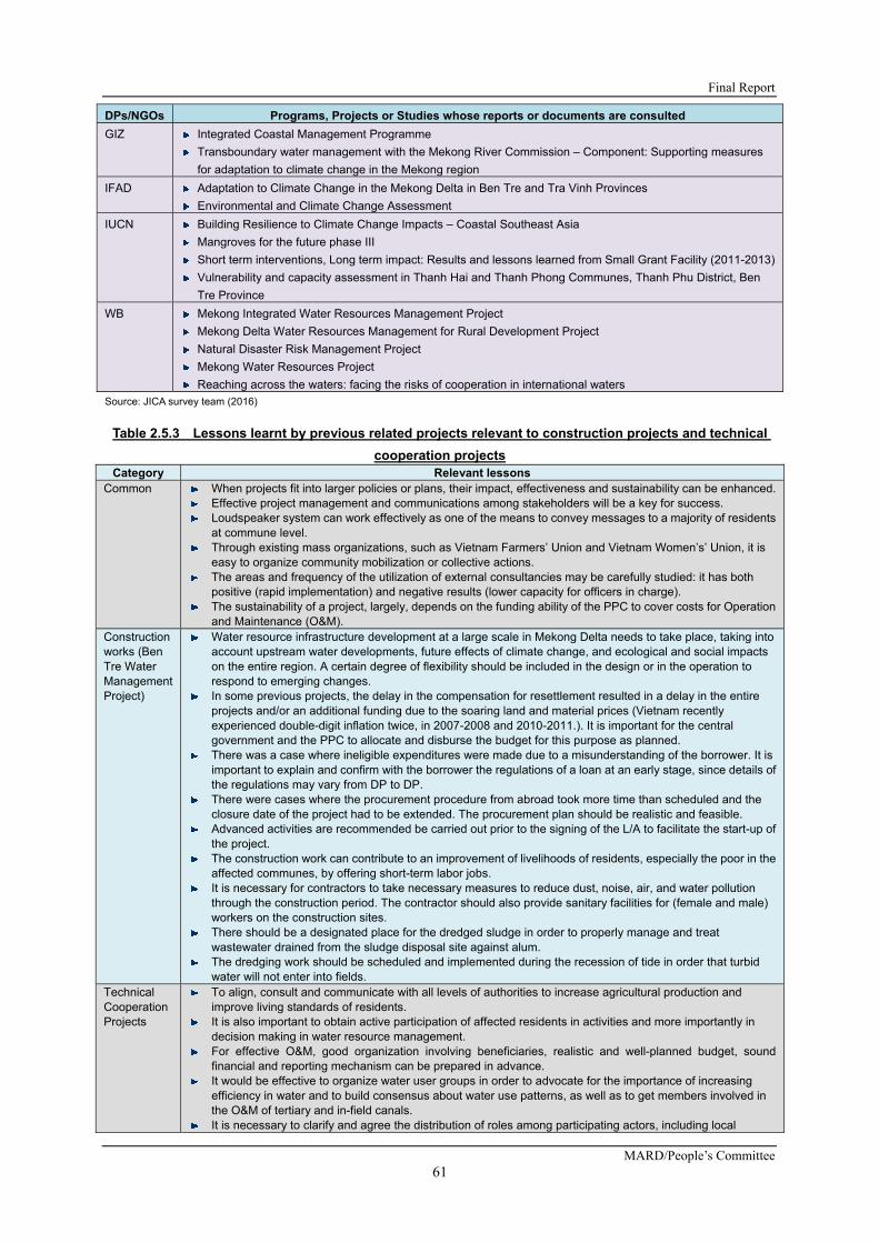
Final Report
MARD/People’s Committee 61
DPs/NGOs Programs, Projects or Studies whose reports or documents are consulted
GIZ Integrated Coastal Management Programme
Transboundary water management with the Mekong River Commission – Component: Supporting measures
for adaptation to climate change in the Mekong region
IFAD Adaptation to Climate Change in the Mekong Delta in Ben Tre and Tra Vinh Provinces
Environmental and Climate Change Assessment
IUCN Building Resilience to Climate Change Impacts – Coastal Southeast Asia
Mangroves for the future phase III
Short term interventions, Long term impact: Results and lessons learned from Small Grant Facility (2011-2013)
Vulnerability and capacity assessment in Thanh Hai and Thanh Phong Communes, Thanh Phu District, Ben
Tre Province
WB Mekong Integrated Water Resources Management Project
Mekong Delta Water Resources Management for Rural Development Project
Natural Disaster Risk Management Project
Mekong Water Resources Project
Reaching across the waters: facing the risks of cooperation in international waters
Source: JICA survey team (2016)
Table 2.5.3 Lessons learnt by previous related projects relevant to construction projects and technical
cooperation projects Category Relevant lessons
Common When projects fit into larger policies or plans, their impact, effectiveness and sustainability can be enhanced. Effective project management and communications among stakeholders will be a key for success. Loudspeaker system can work effectively as one of the means to convey messages to a majority of residents
at commune level. Through existing mass organizations, such as Vietnam Farmers’ Union and Vietnam Women’s’ Union, it is
easy to organize community mobilization or collective actions. The areas and frequency of the utilization of external consultancies may be carefully studied: it has both
positive (rapid implementation) and negative results (lower capacity for officers in charge). The sustainability of a project, largely, depends on the funding ability of the PPC to cover costs for Operation
and Maintenance (O&M). Construction works (Ben Tre Water Management Project)
Water resource infrastructure development at a large scale in Mekong Delta needs to take place, taking into account upstream water developments, future effects of climate change, and ecological and social impacts on the entire region. A certain degree of flexibility should be included in the design or in the operation to respond to emerging changes.
In some previous projects, the delay in the compensation for resettlement resulted in a delay in the entire projects and/or an additional funding due to the soaring land and material prices (Vietnam recently experienced double-digit inflation twice, in 2007-2008 and 2010-2011.). It is important for the central government and the PPC to allocate and disburse the budget for this purpose as planned.
There was a case where ineligible expenditures were made due to a misunderstanding of the borrower. It is important to explain and confirm with the borrower the regulations of a loan at an early stage, since details of the regulations may vary from DP to DP.
There were cases where the procurement procedure from abroad took more time than scheduled and the closure date of the project had to be extended. The procurement plan should be realistic and feasible.
Advanced activities are recommended be carried out prior to the signing of the L/A to facilitate the start-up of the project.
The construction work can contribute to an improvement of livelihoods of residents, especially the poor in the affected communes, by offering short-term labor jobs.
It is necessary for contractors to take necessary measures to reduce dust, noise, air, and water pollution through the construction period. The contractor should also provide sanitary facilities for (female and male) workers on the construction sites.
There should be a designated place for the dredged sludge in order to properly manage and treat wastewater drained from the sludge disposal site against alum.
The dredging work should be scheduled and implemented during the recession of tide in order that turbid water will not enter into fields.
Technical Cooperation Projects
To align, consult and communicate with all levels of authorities to increase agricultural production and improve living standards of residents.
It is also important to obtain active participation of affected residents in activities and more importantly in decision making in water resource management.
For effective O&M, good organization involving beneficiaries, realistic and well-planned budget, sound financial and reporting mechanism can be prepared in advance.
It would be effective to organize water user groups in order to advocate for the importance of increasing efficiency in water and to build consensus about water use patterns, as well as to get members involved in the O&M of tertiary and in-field canals.
It is necessary to clarify and agree the distribution of roles among participating actors, including local

Preparatory Survey for Ben Tre Water Management Project
JICA
62
Category Relevant lessons government officers and beneficiary residents. Capacity development for such officers and residents in accordance with the roles assigned would be important.
During the construction works, it is necessary to keep posting the affected communities and residents the information on schedules and progress of works.
Community people can also supervise progress and quality of construction works, if there is a mechanism to listen to their voices (feedback) in place.
A peer education or knowledge sharing from one resident to another, especially the “Farmer to Farmer” approach can work at the commune and village levels.
Knowledge of climate change processes, impacts and adaptation measures needs to be strengthened by on-the-job training at local levels.
Private sector could play an important role in agricultural development. To establish a win-win relationship between private sector and smallholders would be the key. Smallholders could buy products or service from the private sector, meanwhile, the private sector could provide smallholders with technology, knowledge, skills, market information, and supply/value chains.
There is the possibility of increased water pollution with chemical elements due to enhanced agricultural production: appropriate mitigation measures should be considered and taken.
Source: JICA survey team (2016)

Final Report
MARD/People’s Committee 63
CHAPTER 3 ENVIRONMENTAL AND SOCIAL CONSIDERATIONS
3.1 OVERVIEWS OF PROJECT COMPONENTS RELEVANT TO ENVIRONMENTAL AND SOCIAL CONSIDERATIONS
3.1.1 BACKGROUND OF THE SURVEY
Ben Tre Province is located at the east side of the Mekong Delta; the total area is 2,360 km2; with a total population of 1.26 million; and thus, the population density is 532 persons/ km2. The population density of Ben Tre Province is the fifth highest in the Mekong Delta. The Ben Tre area is of polder area bordered by three (3) big Mekong tributaries namely Tien, Ham Luong and Co Chien. The residents access these tributaries for domestic use and irrigation. This area is one of the most affected areas by saline water intrusion in Vietnam. Ben Tre Province is expected to be affected by high level of saline water that could affect not only paddy production, but also fruit production. In fact, the damage cost was estimated as the highest among seven (7) coastal provinces based on the salinity introduction simulation.
3.1.2 RELEVANT TO THE MASTER PLAN
This Project was prepared based on the Master Plan of “The project for climate change adaptation for sustainable agriculture and rural development in the coastal Mekong Delta in Vietnam”, which was completed in April 2013.
In addition, this Project was selected and proposed as an optimal option which combines structural and non-structural measures, mainly due to a lesser option for resettlement and land acquisition based on the comparison with other options.
3.1.3 OBJECTIVES OF THE SURVEY
This preparatory survey (hereinafter referred to as “the survey”) aims at formulating a project plan for the Japanese ODA loan. The survey examines the objective, outline, costs, implementation organization, O&M organization, environmental and social considerations, and others.
This project aims at contributing to an improvement on the livelihoods of the people of Ben Tre Province in Southern Vietnam where severe loss in agriculture caused by saline intrusion has been recorded. To do so, the project will construct structures and facilities to control saline intrusion, which allow the Ben Tre people to provide water with lower salinity to their farming plots, hence, an improvement on the productivity of their produce. With such improved productivity, the Ben Tre people could better adapt to Climate Change impacts and enhance rural and regional development. This objective will be achieved by the construction of sluice gates at eight (8) sites (Northern Ben Tre: five (5) sites, and Southern Ben Tre: three (3) sites) and procurement of the monitoring equipment.
3.1.4 TARGET AREA OF THE SURVEY
The survey area is in Ben Tre Province. In addition, other provinces (Tien Giang, Tra Vinh, Soc Trang, Bac Lieu, Ca Mau, and Kien Giang) are also included within the scope of the survey in case of the review on the current status of implementing the agriculture development plan according to the impact of climate change.
In the Project, the construction of sluice gates is planned at eight (8) sites in Ben Tre Province (refer to Table 3.1.1). In the northern part of Ben Tre, fresh water is to be diverted from the gates at Tan Phu and Ben Ro. Other gates (An Hoa, Ben Tre, and Thu Cuu) are closed during the dry season to prevent saline water intrusion. The dredging of canals has been already completed for the portion from Tan Phu and Ben Ro; thus, these canals provide enough capacity to deliver the water right after the construction of the sluice gates.

Preparatory Survey for Ben Tre Water Management Project
JICA
64
Table 3.1.1 Details of Sluice Gates in the Target Area No. Name Polder Area Length (m) Depth(m) Remarks
1 Tan Phu Northern Ben Tre 20.0 -4.0 The fresh water will be secured from Tan Phu and Ben Ro and closed other gate to protect saline water intrusion. Dredging is complied.
2 Ben Ro Northern Ben Tre 20.0 -4.0
3 An Hoa Northern Ben Tre 120.0 -6.0
4 Ben Tre Northern Ben Tre 70.0 -5.5
5 Thu Cuu Northern Ben Tre 60.0 -5.0
6 Vam Nuoc Trong Southern Ben Tre 90.0 -6.0 Open canals along the Co Chien/Ham Long Rivers are utilized as fresh water intakes. All sluice gates to be constructed aim to prevent saline water intrusion.
7 Vam Thom Southern Ben Tre 70.0 -5.5
8 Cai Quao Southern Ben Tre 60.0 -5.0
Source:JICA survey team from F/S of Vietnam
1) Rising Sea Level by Climate Change
There are water level stations in the East Sea at Vung Tau, West Sea at Rach Gia, and the inland areas at Can Tho. The record period is from 1982 to 2011 for Vung Tau, Rach Gia, and Can Tho, covering a period of about 30 years. The three (3) stations show a continuous increasing trend. The sea level rise at Can Tho station arrives at an average of approximately 4 cm over the record period of about 30 years.
On the other hand, the sea level rise at Vung Tau and Rach Gia stations had an average of approximately 15 cm over the same period. This means that the sea levels for both the eastern and western seas have been increasing with an average sea level rise of approximately 5 cm per decade.
2) Production Loss by Saline Water Intrusion
As for the forecasted agricultural production loss to be caused by temperature rise and other factors as of the year 2050, the expected loss in fruit production is the most significant, although the loss of shrimp culture was not concerned in the source (JICA 2012). According to JICA study (2012), it was difficult to estimate the loss of shrimp culture in the dry season because of the following reasons: 1) Shrimp farmer start their own business when their capital is ready regardless of the government’s plan, 2) Salinity content for shrimp is higher than agricultural products, 3) Shrimp farmers access ground water individually, 4) The type of shrimp culture/cropping pattern (areas, variety and others) is changing dramatically due to occurrence of virus diseases and market price of shrimp and others.
On the other hand, water salinity levels play an important role in shrimp culture. The best-fit range for black tiger shrimp is 18-25 PPT. It is affected when salinity content changes through the contamination of either high saline water more than that level or freshwater.
Regarding what is called non-structural measures, it has been studied since the M/P stage which preceded this Study. In light of the result, the possibility of non-structural measures was studied in examining the alternatives of this Study. Having discussed SHM and so on, it was studied how to proceed with the non-structural measures including its implementation mechanism.
3.2 CURRENT ENVIRONMENTAL AND SOCIAL SITUATIONS RELEVANT TO THE PROJECT
3.2.1 ENVIRONMENTAL SITUATIONS
1) Meteorology
The Mekong Delta Region, including the survey Area of Ben Tre Province, belongs to the tropical monsoon climate, which does not vary in temperature and is hot and humid throughout the year.
Air temperature in Ben Tre Province is relatively high, as compared to other parts of Vietnam. The

Final Report
MARD/People’s Committee 65
highest monthly average air temperature is 29.2℃ in May, 2014, and the lowest monthly average air temperature is 24.1℃ in January, 2014.
Table 3.2.1 shows monthly average rainfall in Ben Tre Province in recent years.
Table 3.2.1 Monthly Rainfall in Ben Tre Province (year 2005 to year 2014) (unit: mm) Year Jan. Feb. Mar. Apr. May June July Aug. Sep. Oct. Nov. Dec.
2005 - - 0.4 3.9 85.1 94.8 299.2 216.0 209.4 366.2 366.2 156.0
2006 0.5 0.0 21.3 105.5 190.8 275.4 160.3 249.2 456.9 151.1 151.1 69.5
2007 7.3 0.0 0.0 13.6 380.4 192.7 154.8 207.8 231.3 144.1 144.1 0.2
2008 2.4 4.5 20.6 160.8 171.6 134.8 179.4 272.8 339.4 284.3 284.3 25.1
2009 0.0 4.8 1.4 52.9 236.2 99.2 203.3 173.6 250.2 215.3 215.3 0.8
2010 53.9 - 0.0 8.8 49.1 183.7 333.5 301.5 301.5 388.9 388.9 33.1
2011 3.8 - 61.6 27.5 231.1 310.6 119.0 100.8 217.9 177.9 177.9 2.3
2012 0.0 7.3 41.4 76.6 205.1 170.6 249.8 102.8 417.4 171.6 171.6 10.1
2013 80.8 1.5 0.0 51.4 159.5 159.3 78.7 193.7 183.0 290.0 290.0 8.7
2014 5.6 ‐ 0.0 36.7 77.1 292.4 226.4 279.0 259.8 98.8 89.6 94.4Source:Hydrological and Meteorological Center in Ben Tre Province
The climate of Ben Tre Province is divided into two distinct seasons corresponding to the two forms of the monsoon: the rainy season from May to November and the dry season from December to April. During the rainy season, rainfall accounts for 80 to 85% of the annual rainfall, while during the dry season, rainfall accounts for about 15 to 20% only. The total yearly rainfall volume varied in recent years: from 1,430 mm to 2,041mm.
The average humidity is 82.0% during the rainy season and 79.2% during the dry season. The wettest month is August with the averaged humidity of 82.5%; while the driest months are March and April with 74.1% as the average. In terms of evaporation, the maximum evapotranspiration is recoded from December to April as 3.3 mm per day. For the remaining months, while the humidity is still high, the evapotranspiration is approximately 2.3 mm per day.
Through the year, there are also two wind seasons. During the winter monsoon season from December to April, the wind direction is mainly east - northeast. The averaged wind speed is from 2.4 m per second to 4.5 m per second. The summer wind occurs from May to November in the direction of west – southwest. The averaged wind speed is approximately from 2.2 m per second to 4.2 m per second.
2) River System
Ben Tre Province is located in the lower Mekong Basin, bordering the East Sea. Ben Tre has a vast river network with a total length of 6,000 km, of which the Co Chien River is 82km, the Ham Luong River is 71 km, the Ba Lai River is 59 km, and the My Tho River is 83 km, in addition to other rivers.
The river system creates favorable waterways, rich aquatic resources and watering for crops. However, it interferes with the water supply in the dry season, when the tide from the East Sea puts salt deep into the canals during the wind season. Also, Ben Tre has a network of rivers, streams, and canals connecting local together, which is forming a communication network and convenient irrigation system. On average along the main river, about 1 to 2 km is a canal. Ben Tre has hundreds of rivers and canals, while there are more than 60 rivers and canals which widths are more than 50 m wide.
The water levels downstream are affected by tidal variation much more than upstream, although the water levels in the rivers or canals in Ben Tre Province as well as in the whole Mekong River differ point by point in general. The water level variation of the downstream is twice or more than twice of the upstream ones.
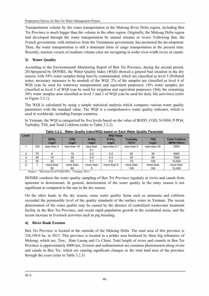
Preparatory Survey for Ben Tre Water Management Project
JICA
66
Transportation volume by the water transportation in the Mekong River Delta region, including Ben Tre Province is much bigger than the volume in the other region. Originally, the Mekong Delta region had developed through the water transportation by natural streams or rivers. Following that, the French government, with initiatives from the Vietnamese government, has promoted the development. Then, the water transportation is still a dominant form of cargo transportation at the present time. Recently, tourism vessels of medium volume class are navigating in wider river-width rivers or canals.
3) Water Quality
According to the Environmental Monitoring Report of Ben Tre Province, during the second period, 2014prepared by DONRE, the Water Quality Index (WQI) showed a general bad situation in the dry season, with 54% water samples being heavily contaminated, which are classified as level 5 (Polluted water, necessary measures to be needed) of the WQI. 2% of the samples are classified as level 4 of WQI (can be used for waterway transportation and equivalent purposes); 14% water samples are classified as level 3 of WQI (can be used for irrigation and equivalent purposes). Only the remaining 30% water samples area classified as level 1 and 2 of WQI (can be used for daily life activities) (refer to Figure 3.2.1).
The WQI is calculated by using a simple statistical analysis which compares various water quality parameters with the standard value. The WQI is a comprehensive water quality indicator, which is used in worldwide, including Europe countries.
In Vietnam, the WQI is categorized by five levels based on the value of BOD5, COD, N-NH4, P-PO4, Turbidity, TSS, and Total Coliform (refer to Table 3.2.2).
Table 3.2.2 Water Quality Index(WQI) based on Each Water Quality Parameter Level WQI Value
BOD5
(mg/l) COD
(mg/l) N-NH4
(mg/l)P-PO4
(mg/l) Turbidity (NTU)
TSS (mg/l)
Total Coliform(MPN/100ml)
1 100 less than 4 less than 10 less than 0.1
less than 0.1 less than 5 less than 20 2500
2 75 6 15 0.2 0.2 20 30 5000 3 50 15 30 0.5 0.3 30 50 7500 4 25 25 50 0.1 0.5 70 100 10,000 5 1 more than
50 more than
80 more than
5 more than 6 more than
100 more than
100 more than
10,000 Source:“Decision No.879/QD-IDU、Vietnam, 2011“
DONRE conducts the water quality sampling of Ben Tre Province regularly at rivers and canals from upstream to downstream. In general, deterioration of the water quality in the rainy season is not significant as compared to the one in the dry season.
On the other hand, in the dry season, some water quality items such as ammonia and coliform exceeded the permissible level of the quality standards of the surface water in Vietnam. The recent deterioration of the water quality may be caused by the absence of centralized wastewater treatment facility in the Ben Tre Province, and recent rapid population growth in the residential areas, and the recent increase in livestock activities such as pig breeding.
4) River Bank Erosion
Ben Tre Province is located at the eastside of the Mekong Delta. The total area of this province is 236,199.0 ha. in 2015. This province is located in a polder area bordered by three big tributaries of Mekong, which are, Tien、Ham Luong and Co Chien. Total length of rivers and cannels in Ben Tre Province is approximately 6000 km. Erosion and sedimentation are common phenomenon along rivers and canals in Ben Tre, which are causing significant changes in the total land area of the province through the years (refer to Table 3.2.3)

Final Report
MARD/People’s Committee 67
Fig
ure
3.2
.1
Wat
er Q
ual
ity
Sit
uat
ion
s in
Ben
Tre
Pro
vin
ce o
f D
ry S
eas
on
in 2
014
Sou
rce:
Env
ironm
enta
l Mon
itorin
g R
epor
t of
Ben
Tre
Pro
vinc
e, s
econ
d pe
riod,
201
4 by
DO
NR
E

Preparatory Survey for Ben Tre Water Management Project
JICA
68
Table 3.2.3 Recent Total Land Changes of Ben Tre Province Year 2006 2007 2008 2011 2012 2013
Total Land Area (ha)
236,019.7 236,020.0 236,020.0 236,062.0 235,766.0 235,981.0
Source:Environmental Status Report of Ben Tre Province 2011-2015, Environmental Monitoring Center
According to hearings with governmental officials of the Rural Development Division of DARD and field reconnaissance in August 2015, severe riverbank erosion was addressed in some riverbanks, including at the proposed eight (8) sluice gate sites installed along the rivers and canals in Ben Tre Province. Of the eight (8) sluice gate points, severe erosion points were identified at four sites including An Hoa, Mo Cay Bac, Mo Cay Nam, and Cai Quao sites.
Figure 3.2.2 shows the progress of the recent riverbank erosion in Ben Tre Province reported in “Main Report of Resident Resettlement Plan of Ben Tre Province for Natural Disaster, period 2011 to 2015 and to 2020” prepared by the Rural Development Division of DARD in 2011. According to the report, riverbank erosion is progressing with the eroded area of more than 7 m per year in many river sites in Ben Tre Province.
Furthermore, in Ben Tre Province, more than 10 ha of residential areas including the gardens had been lost due to the bank erosion and a total of 1,122 households had to be resettled due to the riverbank erosions between 1990 and 2011. Also, more than 8,928 households will be affected by the bank erosion until 2010.
5) Soil Contamination
According to the Environmental Monitoring Report of Ben Tre Province prepared by DONRE in 2011, the soils in Ben Tre Province has sampled at total of 11 points to assess the current condition of soil contamination during the first period (rainy season) and second period (dry season) in 2011.
The sampled data indicated that pH values are low and it may influence plant growth. On the other hand, the Cl- concentrations of the soils are within the tolerable range for the plants growth, even though the concentrations varies between the dry season and the rainy season. Therefore, it was concluded that the salinity levels would not cause significant adverse impacts to the plants in this year. The sampled soils contain heavy metal such as Fe, Cu, Pb, Zn, however the concentration values of these heavy metals do not exceed the values stipulated in Vietnamese standards. Therefore, it was also concluded that the heavy metal concentrations would not cause any adverse impacts on the human health.
6) Natural Protected Areas
Within Ben Tre Province, there are three natural protected areas. The characteristics and the location so f each protected area are shown in Figure 3.2.2 and Figure 3.2.3, respectively.

Final Report
MARD/People’s Committee 69
Fig
ure
3.2
.2
Rec
ent
Riv
er B
ank
Ero
sio
n S
itu
atio
ns
in B
en T
re P
rovi
nce
Sou
rce:
Mai
n R
epor
t of
Res
iden
t Res
ettle
men
t P
lan
of B
en T
re P
rovi
nce
for
Nat
ural
Dis
aste
r, pe
riod
2011
to
2015
and
to 2
020
by D
AR
D
Vam
Tho
m
Vam
Nuo
c T
ron
g

Preparatory Survey for Ben Tre Water Management Project
JICA
70
Fig
ure
3.2
.3
Nat
ure
Res
erv
es w
ith
in B
en T
re P
rovi
nce
S
ourc
e:F
ore
stry
Div
isio
n of
DA
RD

Final Report
MARD/People’s Committee 71
Table 3.2.4 Natural Protected Areas in Ben Tre Province Name of Natural Protected Area
Designation Authority Characteristics Location/Areas Than Phu Nature Reserve Ben Tre Province People’s Committee of Thanh Phu District
- Mangrove forest (Rhizophora apiculate is dominant) and vast tidal flats area.
- The area includes aquaculture areas.
- The only forest protection area which is officially authorized within in Ben Tre Province.
- Located in Thanh Phu District (more than 25 km from the closest proposed sluice gate site)
- Total area is 6,276 ha (core zone: 2,584 ha, buffer zone: 3,692 ha).
- Designated in order to preserve the biodiversity of wetlant ecosystem,
Van Ho Bird Sanctuary Ben Tre Province People’s Committee of Ba Tri District
- Many birds ( Egretta gazretta, Nycticorax nycticorax) live on the trees such as acacia.
- The habitat of various mammals such as Bat (Pteropisvanpyrus), civer (Viverra indica), squired (Callosciurus pygerythrus).
- At present, the area is managed by Tan My Commune.
- Located in Ba Tri District (more than 35 km from the closest proposed sluice gate site)
- Total area is 65 ha. - The area was once a tourist
destination until year 2005, but for the protection of the birds and ecosystem, the tourists are prohibited from entering..
- Designated in order to protect inhabitation of birds.
Bao Thuan Protection Forest Ben Tre Province People’s Committee of Ba Tri District
- Mangrove forest (Rhizophora apiculate is dominant) and tidal flats area.
- It is presumed that diverse fish species live in, but specific species have not yet been identified.
- Located in Ba Tri District (more than 35 km from the closest proposed sluice gate site).
- Mangroves densely grow as windbreak.
- Designated in order to formulate a green belt of coastal conservation forests
Source:JICA survey team (2016)
7) Ecosystems
Within Ben Tre Province, including the survey Area, the following species could be addressed as a feature of the present ecosystems
a) Mangroves
In this report, based on the definition of a biology dictionary, “mangrove species” means a base unit of biological classification such as Nipa Palm, Mangrove Apple and etc. “Mangrove forest” means a collective term of trees comprising forests along river mouths and sea shores in salinity waters and brackish waters (intertidal zones) in the tropical and subtropical zones. In case of “mangrove”, it means a vegetation including mangrove species and others.
Sixteen mangrove species were confirmed within Ben Tre Province. Almost all types of the mangrove species densely grow in the coastal areas only. On the other hand, there are two types of mangrove species, which grow less dense and patch-wisely with other vegetation, covering the area within 1 to 2 m width banks of the main rivers. These rivers include the Cau Gai River, the Ba Lai River, the Ham Luong River, and the Co Chien River, and their tributaries in northern and middle areas of Ben Tre Province, where the survey was conducted (refer to Figure 3.2.4).
It is considered that mangrove species with vegetation could prevent the riverbank from the worsening of the erosion in the rivers and canals within the targeted survey Area. The aforementioned two types of mangrove species are Nipa Palm (Nipa fruiticans) and Mangrove Apple (Sonneratia caseolaris), which grow broadly in Southeast Asia and the pacific island regions. These species are not protected species, and they are not registered in the International Union for Conservation of Nature (IUCN) Red List. Therefore, within Ben Tre Province, there is no area where mangroves should be protected. In addition, no laws or regulations in Vietnam that prohibits the cutting of mangroves.
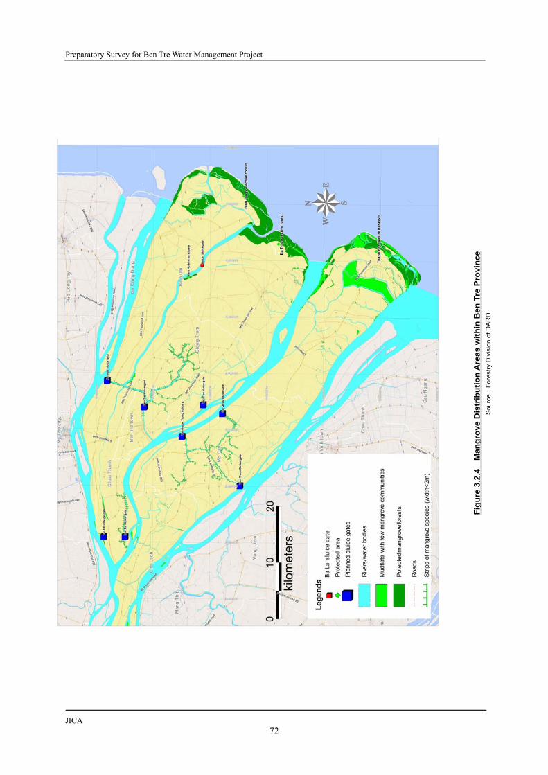
Preparatory Survey for Ben Tre Water Management Project
JICA
72
Fig
ure
3.2
.4
Man
gro
ve D
istr
ibu
tio
n A
rea
s w
ith
in B
en T
re P
rovi
nce
S
ourc
e:F
ore
stry
Div
isio
n of
DA
RD

Final Report
MARD/People’s Committee 73
b) Fishes
The Mekong River within the Mekong Delta has rich and unique fish diversity. It is reported that there are fish species which live in fresh water, brackish water, and seawater under a certain range of the salinity, and also migratory fish species which live in fresh water, brackish water, and seawater in the Mekong Delta. The former fish (freshwater fish, brackish water fish, and sea fish) lives in each spawning area throughout their lifetime; therefore, it is considered that the population of these kinds of fish will not be affected by the operation of the sluice gates which will be constructed by this project.
On the other hand, it is reported that the migratory fish species may enter the waterway and spawn in the dry season when the gates are closed. Among the fish species which migrate from the Mekong River to freshwater in the survey area, some of them area registered as rare species in in the latest IUCN Red List published in 2011. It is also reported that the migration of these fish species may have triggered by the water level rising in the Mekong River at the beginning of the rainy season.
c) Birds
As described in the previous section, the Van Ho Bird Sanctuary protects birds and other species near Ba Lai weir in the survey area.
It has a unique ecosystem consisting of birds, fish species, reptiles, and insects, mangrove species etc. However, the numbers of the species have been reduced to approximately 30 species. The main bird species are egret and heron, which are not be registered as protected species in the Vietnam’s Red Data Book as well as IUCN’s Red List and nest on acacia trees and prey within the protected areas and its surrounding areas.
8) Air Quality
Table 3.2.5 shows the recent air quality conditions in Ben Tre Province. Figure 3.2.5 shows the location of the air quality sampling points. According to the data collected in the dry season of 2014 by DONRE, almost all the air quality parameters such as CO, NO2, dust, and PM10 meet each latest Vietnamese Standard (QCVN 05:2013/BTNMT).
As for the parameters which exceed the standard, the most exceed slightly and the parameters are Dust (average 24 hour) and PM10. The sampling point where those parameters exceed substantially is only the southern part of Ben Tre city (KK-09).

Preparatory Survey for Ben Tre Water Management Project
JICA
74
Table 3.2.5 Recent Air Quality Conditions in Ben Tre Province Sapling Point Total Dust
(mg/m3) PM10
(mg/m3) CO
(mg/m3) NO2
(mg/m3) Nearest sampling
point from the Proposed Sluice
Gate
Distance to nearest
Sluice Gate (km)
KK-01 0.24 0.15 6.24 0.102
KK-02 0.27 0.17 7.35 0.118
KK-03 0.21 0.11 3.42 0.062
KK-05 0.23 0.14 5.04 0.072
KK-06 0.26 0.14 5.34 0.096
KK-09 0.41 0.21 4.65 0.068 Ben Tre 0.17
KK-11 0.21 0.10 2.57 0.043
KK-12 0.17 0.09 2.74 0.032
KK-15 0.19 0.06 2.16 0.052 Thu Cuu 10.65
KK-16 0.25 0.12 3.56 0.078
KK-17 0.23 0.14 3.32 0.075
KK-18 0.18 0.08 2.04 0.041
KK-19 0.15 0.04 1.74 0.045 Tan Phu 9.36
KK-20 0.20 0.07 2.93 0.057 Vam Nuoc Trong 8.47
KK-21 0.28 0.15 4.34 0.095 Cai Quao 5.61
KK-22 0.17 0.06 1.85 0.042
KK-24 0.21 0.09 2.44 0.067 Ben Ro 9.73
KK-26 0.23 0.12 4.36 0.103 An Hoa 6.29
KK-28 0.14 0.03 0.42 0.030 Vam Thom 2.99
KK-31 0.28 0.16 6.25 0.108 Vietnamese Standard (Average 1 hour) 0.30 - 30.00 0.200 Vietnamese Standard (Average 24 hour) 0.20 0.15 - 0.100
Source:Environmental Monitoring Report of Ben Tre Province, second period, 2014 by DONRE

Final Report
MARD/People’s Committee 75
Fig
ure
3.2
.5
Air
Qu
alit
y S
amp
ling
Po
ints
in B
en T
re P
rovi
nce
of
Dry
Sea
son
in 2
014
Sou
rce:
Env
ironm
enta
l Mon
itorin
g R
epor
t of
Ben
Tre
Pro
vinc
e, s
econ
d pe
riod,
201
4 by
DO
NR
E

Preparatory Survey for Ben Tre Water Management Project
JICA
76
3.2.2 SOCIAL SITUATIONS
1) Administrative Areas and Population
The Ben Tre Province consists of 8 districts and 164 communes. Table 3.2.6 shows the surface areas, populations, and density of the districts belonging to Ben Tre Province.
Table 3.2.6 Surface areas and populations of districts/city of Ben Tre Province
No. District/city Surface area (km2)Population in 2014
(pers.)
Population density
(pers./km2)
1 Ben Tre City 71.1 120,749 1,698
2 Chau Thanh 225.1 164,037 729
3 Cho Lach 167.6 109,387 653
4 Mo Cay Nam 222.1 145,966 657
5 Mo Cay Bac 158.2 109,151 690
6 Giong Trom 313.2 167,203 534
7 Binh Dai 421.5 130,998 311
8 Ba Tri 358.4 187,161 522
9 Thanh Phu 422.7 127,553 302
Total 2,359.9 1,262,205 535
Source: Statistical Year Book Ben Tre 2014, Ben Tre Statistical Office (2015)
2) Ethnic People
Majority of residents in Ben Tre Province are Kinh people. However, there are minority groups including Chinese, Muong, Tay, Khmer, and Cham ethnic people living in Giong Trom District (Thach Phu Dong Commune), Chau Thanh District (Phu Duc Commune, Tien Long Commune), and Binh Dai District (Long Dinh Commune). The people of the minority groups are living together with Kinh people, and use Vietnamese language in daily life. Significant difference in custom is not observed between the majority group and the minority groups.
3) Land Use Situation
Table 3.2.7 shows current land use situation of Ben Tre Province. Agriculture land occupies a large portion of total land (about 61%). Among them, a large part of land is used for cultivating fruit trees. Only a relatively small part of land is used for paddy.
Table 3.2.7 Current land use situation (as of Jun 1, 2014) (unit: ha)
No. District/city Agriculture
land Forest land
Land for
special use
Residential
land
1 Ben Tre City 5,082 - 649 507
2 Chau Thanh 16,444 - 934 1,072
3 Cho Lach 10,563 - 366 653
4 Mo Cay Nam 16,865 - 735 1,046
5 Mo Cay Bac 12,988 - 428 751
6 Giong Trom 24,617 - 1,268 1,130
7 Binh Dai 15,308 2,854 1,936 849
8 Ba Tri 21,515 1,531 2,728 1,006
9 Thanh Phu 20,599 2,670 1,583 715
Total 143,981 7,055 10,627 7,729
Source: Statistical Year Book Ben Tre 2014, Ben Tre Statistical Office (2015)
4) Agricultural Products
Among agricultural products of the Ben Tre Province, fruits (such as coconut, orange, longan, grapefruit, durian, and rambutan), cacao and sugarcane are widely known. Coconut trees are widely

Final Report
MARD/People’s Committee 77
cultivated in Ben Tre Province because of their ability to recover from the damage by seawater. A large part of land in the northern part of the province is used for cultivating orange, longan, and grapefruit, etc. since there is relatively rich freshwater during all seasons
Table 3.2.8 and Table 3.2.9 show the change in cultivated land area and fruit production in the province during the period from 2010 to 2014. The land area and production of orange, mango, longan, and cacao are gradually decreasing, while those of grapefruit, rambutan, and coconut trees are likely to increase continuously.
Table 3.2.8 Change in Land Area of Fruit Tree Cultivation by Years (unit: ha) Fruit Name 2010 2011 2012 2013 2014
Orange 4,631 3,142 2,634 2,007 1,993
Lemon 1,903 1,572 1,459 1,828 1,897
Grapefruit 4,422 4,144 4,528 4,754 5,372
Banana 2,527 2,664 2,401 2,387 2,076
Mango 1,328 1,077 761 687 650
Longan 6,249 5,360 4,884 4,609 4,123
Rambutan 3,941 5,010 5,428 5,437 5,557
Coconut 51,560 55,870 58,441 63,000 67,382
Cacao (grown in coconut garden) 6,333 7,478 8,243 5,211 2,792
Source: Statistical Year Book Ben Tre 2014, Ben Tre Statistical Office (2015)
Table 3.2.9 Change in Fruit Production by Years (unit: ton) Fruit Name 2010 2011 2012 2013 2014
Orange 35,568 22,929 20,171 14,907 15,463
Lemon 20,959 16,314 14,444 16,499 19,325
Grapefruit 33,921 35,997 38,650 35,312 41,051
Banana 36,879 41,568 38,189 40,283 33,618
Mango 10,186 8,557 6,228 5,527 5,526
Longan 62,032 50,523 39,999 42,612 39,459
Rambutan 67,602 84,322 85,640 96,919 109,800
Coconut 420,172 427,862 470,342 493,205 525,813
Cacao (grown in coconut garden) 21,636 26,939 29,987 20,631 14,964
Source: Statistical Year Book Ben Tre 2014, Ben Tre Statistical Office (2015)
On the other hand, there is a downward tendency in paddy cultivation. As shown in Table 3.2.10 and Table 3.2.11, paddy production is decreasing year by year.
Table 3.2.10 Tendency of paddy production (unit: ton)
Year/crop 2005 2006 2007 2008 2009 2010 2011 2012 2013 2014
Winter-spring 96,436 104,178 112,609 118,262 124,170 121,194 105,646 115,601 96,257 105,000
Summer-autumn 90,272 86,447 97,089 103,409 96,320 90,977 107,659 105,209 87,864 82,484
Autumn-winter 154,683 141,839 95,085 139,446 142,200 154,639 148,863 154,192 147,368 131,415
Total 343,396 334,470 306,790 363,125 364,699 368,820 364,179 377,014 333,502 320,913
Source: Statistical Year Book Ben Tre 2014, Ben Tre Statistical Office (2015)

Preparatory Survey for Ben Tre Water Management Project
JICA
78
Table 3.2.11 Tendency of Paddy Field Area (unit: ha)
No. District/city 2010 2011 2012 2013 2014
1 Ben Tre City 1,286 1,099 975 817 653
2 Chau Thanh 4,255 4,058 3,396 2,586 1,877
3 Cho Lach 36 26 19 14 6
4 Mo Cay Nam 568 515 410 308 267
5 Mo Cay Bac 1,416 1,163 981 689 363
6 Giong Trom 11,980 11,692 11,550 10,643 9,225
7 Binh Dai 6,180 5,816 5,345 4,521 4,212
8 Ba Tri 39,332 37,703 39,292 39,178 37,998
9 Thanh Phu 15,175 14,890 13,895 13,481 11,993
Total 80,228 76,962 75,863 72,237 66,594
Source: Statistical Year Book Ben Tre 2014, Ben Tre Statistical Office (2015)
5) Fishery
Fishery production is constantly increasing since 2005. Particularly, in 2010 and 2011, there was significant increase of 51% in fishery production (see Table 3.2.12)
Table 3.2.12 Tendency of fishery production (Unit: million ton)
2005 2006 2007 2008 2009 2010 2011 2012 2013 2014
Capture fishery 994 1,060 1,172 1,398 1,795 3,502 5,261 7,492 7,496 7,429
Aquaculture 2,169 2,687 3,179 3,724 3,963 5,199 7,889 7,991 9,818 11,163
Total 3,163 3,747 4,351 5,122 5,758 8,701 13,150 15,483 17,314 18,592
Ratio - 18% 16% 18% 12% 51% 51% 18% 12% 7%
Source: Statistical Year Book Ben Tre 2014, Ben Tre Statistical Office (2015)
Table 3.2.13 shows the change in land area for fish/shrimp aquaculture production in Ben Tre Province since 2010. A large part of the coastal area in the east of the province is being used for shrimp aquaculture with saline water. There was a boom in shrimp aquaculture since 2000. Many farmers have stopped paddy cultivation and changed their paddy fields into shrimp ponds. If the breeding goes well, shrimp aquaculture can provide farmers with high profit.
However, investment cost for shrimp aquaculture is high, and it is usually accompanied with high risks of shrimp disease. There are many reports about the farmers having heavy debt due to the unsuccessful shrimp aquaculture because the shrimp dies under the water polluted caused by the extensive use of industrial foods and chemicals. Recently, in order to avoid this high risk, the farmers attempt to cultivate paddy in combination with shrimp aquaculture. With this cultivation model, a lot of land may be used in rotation for paddy cultivation in the rainy season, and for extensive shrimp cultivation with saline water in the dry season.
Table 3.2.13 Change in Area for Fishery Production by Years (unit: ha)
2010 2011 2012 2013 2014 Shrimp cultivation land 33,231 33,565 33,153 36,337 38,891 Fish cultivation land 4,083 4,243 4,686 4,059 4,081 Other cultivation lands 5,176 5,265 5,396 4,400 4,094 Total 42,490 43,073 43,235 44,796 47,066
Source: Statistical Year Book Ben Tre 2014, Ben Tre Statistical Office (2015)
Table 3.2.14 shows the area change in several fishery aquaculture methods in the recent years. The area for intensive aquaculture was significantly extended from 6,332 ha in 2012 to 10,521 ha in 2013. On the other hand, as shown in Table 3.2.15, there was not significant change in the areas for freshwater aquaculture and saline water aquaculture, but the areas for brackish water aquaculture were significantly extended since 2013.

Final Report
MARD/People’s Committee 79
Table 3.2.14 Change in Area of Several Aquaculture Methods (unit: ha)
2010 2011 2012 2013 2014 Area for intensive aquaculture 6,648 6,918 6,332 10,521 12,681Area for semi-intensive aquaculture 450 236 345 271Area for extensive aquaculture and improved aquaculture
35,842 35,705 36,666 33,930 34,113
Total 42,490 43,073 43,234 44,796 47,065
Source: Statistical Year Book Ben Tre 2014, Ben Tre Statistical Office (2015)
Table 3.2.15 Change in Area for Freshwater, Brackish Water, and Saline Water Aquaculture (unit: ha)
2010 2011 2012 2013 2014 Area for freshwater aquaculture 6,524 6,103 6,500 5,374 5,568Area for brackish water aquaculture 31,893 32,833 32,398 35,583 37,884Area for saline water aquaculture 4,072 4,137 4,337 3,839 3,613Total 42,489 43,073 43,235 44,796 47,065
Source: Statistical Year Book Ben Tre 2014, Ben Tre Statistical Office (2015)
As shown in Table 3.2.16, there was a significant increase in shrimp production in the three coastal provinces of Binh Dai, Ba Tri, and Thanh Phu during 2013. The high price of shrimp in the market and the successfully implemented measures to prevent shrimp disease are considered as the main factors leading to this increase in shrimp production in this year.
Table 3.2.16 Change in Shrimp Production in the Districts by Year (unit: ton)
2010 2011 2012 2013 2014
1 Ben Tre City 16 25 30 46 24
2 Chau Thanh 129 123 120 102 114
3 Cho Lach 3 3 2 - -
4 Mo Cay Nam 367 275 249 97 224
5 Mo Cay Bac 179 190 110 35 53
6 Giong Trom 216 254 172 427 925
7 Binh Dai 16,410 21,894 19,234 30,454 26,068
8 Ba Tri 5,251 8,080 8,759 12,022 10,428
9 Thanh Phu 6,636 7,493 7,120 10,406 18,110
Total 29,207 38,337 35,796 53,589 55,946
Source: Statistical Year Book Ben Tre 2014, Ben Tre Statistical Office (2015)
6) Number of employees by main business entities/administrative agencies
Table 3.2.17 shows the change in number of employees by main business entities/administrative agencies in Ben Tre Province.
Table 3.2.17 Change in number of employees by main enterprises/agencies
(Unit: pers)
Business activities 2009 2010 2011 2012 2013
Agriculture, forestry, and fishery 6,048 3,756 4,543 4,454 4,362
Mining, quarrying 69 78 142 143 85
Manufacturing 17,421 18,228 26,828 30,926 37,899
Electricity, gas, steam and air conditioning supply
215 216 986 956 191
Water supply, sewerage, waste management and remediation activities
437 455 450 481 543
Construction 3,898 4,234 4,983 5,384 5,669
Wholesale and retail trade, repair of motore vehicles and motorcyles
5,489 5,795 6,372 6,335 5,887
Transportation and storage 935 823 727 786 492
Accomodation 174 159 292 434 461
Food and beverage service activities 241 293 220 268 250
Telecommunication 8 8 608 538 722
Financial, banking and insurance activities
121 115 170 204 211

Preparatory Survey for Ben Tre Water Management Project
JICA
80
Business activities 2009 2010 2011 2012 2013
Real estate activities 12 15 73 62 73
Professional, scientific and technical activities
407 446 579 615 676
Administrative and support service activities
758 807 717 709 778
Education 13 10 8 6 35
Human health and social work activities 20 21 137 160 170
Art, entertainment and recreation 118 111 82 124 150
Other service activities 5 30 17 23 27
Total 36,389 35,600 47,934 52,608 58,681
Source: Statistical Year Book Ben Tre 2014, Ben Tre Statistical Office (2015)
7) Literacy Rate and Basic Education Facilities
According to website of the General Statistics Office of Vietnam, the literacy rate among people with more than 15-year old in Ben Tre Province in the first months of 2014 is 95.1%. It slightly exceeds the national average literacy rate (94.7%). However, according to website of Ben Tre Province People Committee, this rate is 99.3% for people with age of 15~35, and 98.3% for people with age of higher than 36.
The number of basic educational facilities in the province are as followings: 174 kindergartens (schooling rates: 8.7% for children with age of 0~2, 75.1% for children with age of 3~5); 190 elementary schools (schooling rate: 100% for children with age of 6); 133 junior high schools (schooling rate: 96.3%) (source: http://www.bentre.gov.vn/)
8) Waterborne Diseases
Table 3.2.18 shows the number of registered waterborne diseases in Ben Tre Province. Number of diarrhea cases (which is considered as a typical water-related disease) is still considerable high.
Table 3.2.18 Number of registered cases of waterborne diseases in Ben Tre Province Waterborne diseases 2012 2013 2014
Cholera 0 0 0 Typhoid fever 15 16 5 Dysntery syndrome 22 - - Shigellosis 222 165 276 Amebiasis 57 136 15 Diarrhea 14,028 13,535 12,029 Dengue 879 711 685
Source: Ben Tre Preventive Healthcare Center
3.3 LEGAL AND INSTITUTIONAL FRAMEWORK IN VIETNAM RELEVANT TO ENVIRONMENTAL AND SOCIAL CONSIDERATIONS
3.3.1 LEGAL AND INSTITUTIONAL FRAMEWORK IN VIETNAM RELEVANT TO
ENVIRONMENTAL AND SOCIAL CONSIDERATIONS
1) Legal Framework in Vietnam Relevant to EIA
Table 3.3.1 lists the main laws and regulations on environmental protection in Vietnam.
Table 3.3.1 Main Laws and Regulations on Environmental Protection in Vietnam
Date of Issue Code/Number Title 2000/08/08 Circular No.
10/2000/TT-BXD Guiding the formulation of EIA report for a construction project
2002/06/26 Decision No. 82/2002/QD-TTg
Establishment, Mandate and Operations of the Vietnam Environment Protection Fund
2002/07/16 Decision No. 53/2002/QD- BKHCNMT
Promulgating the Organization and Operation Charter of Vietnam Environmental Protection Fund (expired)

Final Report
MARD/People’s Committee 81
Date of Issue Code/Number Title 2002/08/09 Decision No. 62/2002/QD-
BKHCNMT Promulgating the Regulation on the Protection of the Environment in Industrial Parks
2002/11/11 Decree No. 91/2002/ND-CP
Prescribing the Functions, Tasks, Powers and Organizational Structure of the Ministry of Natural Resources and Environment
2003/04/02 Decision No. 45/QD-TTg
Establishment of provincial Department of Natural Resources and Environment.
2003/05/08 Decision No. 600/2003/QD-BTNMT
Specifying mandates, responsibilities; powers and organizational structure of the Department of Water Resources Management
2003/06/23 Decision No. 782/2003/QD-BTNMT
Promulgating the Charter on organization and operation of Vietnam Environment Protection Fund
2005/12/12 Order No. 29/2005/L-CTN Law on Environmental Protection
2005/12/12 Decision No. 328/2005/QD-TTg
Approving the state plan on environmental pollution control till 2010
2006/06/23 Decree No. 65/2006/ND-CP
Organization and Operation of the Natural Resources and Environment Inspectorate
2006/08/09 Decree No. 80/2006/ND-CP
Providing detailed guidelines for Implementation of a Number of Articles of the Law on Environmental Protection
2006/08/09 Decree No. 81/2006/ND-CP
Sanctioning of Administrative Violation in the Domain of Environmental Protection
2006/09/08 Circular No. 13/2006/TT-BTNMT
Stipulation of organizations and operation of the assessment board for reports on Strategic Environmental Assessment (SEA) and EIA
2006/09/09 Circular No. 08/2006/TT-BTNMT
Guiding the preparation of Strategic Environmental Assessment, Environmental Impact Assessment and Environmental Protection Commitment
2006/11/22 Decree No. 140/2006/ND-CP
Providing for the Environmental Protection at Stages of Elaboration, Evaluation, Approval and Implementation of Development Strategies, Planning, Plans, Programs and Projects
2007/08/27 Circular No. 06/TT-BKH
On environmental protection in appraising and approving programs and projects
2007/08/27 Decision No. 1281/QD-BTNMT
Authorizing directors of departments to review and approve the EIA reports
2007/11/26 Decision No. 19/2007/QD-BTNMT
Promulgating the Regulation on the conditions for and provision of the service of appraising environmental impact assessment reports
2008/02/28 Decree No. 21/2008/ND-CP
Amending and supplementing a number of articles of the Government’s Decree No. 80/2006/ND-CP of August 9, 2006, detailing and guiding the implementation of a number of articles of the Law on Environmental Protection (Note *)
2008/07/15 Circular No. 03/2008/TTLT-BTNMT- BNV
Guiding the functions, tasks, powers and organizations of the natural resources and environment related specialized units under the people’s committees at all levels
2008/09/15 Decree No. 102/2008/ND-CP
On the collection, management, exploitation and use of natural resources and environmental data
2008/09/18 Circular No. 04/2008/TT-BTNMT
Guiding the formulation and approval or certification of environmental protection schemes and the examination and inspection of implementation of environmental protection schemes
2008/09/30 Decision No. 132/2008/QD-TTg
On function, tasks, responsibilities, and organization structure of Vietnam Environmental Protection Administration under MONRE
2008/12/08 Circular No. 05/2008/TT-BTNMT
Replace Circular 08/2006/TT-BTNMT on Guiding the preparation of Strategic Environmental Assessment, Environmental Impact Assessment and Environmental Protection Commitment
2009/11/16 Circular No. 25/2009/TT-BTNMT
On the promulgation of National Technical Regulations on Environment.
Circular No. 39/2010/TT-BTNMT
National Technical Regulations on Environment.
Circular No. 09/2010/TT-BTNMT
On environmental protection in developing transport infrastructure
2010/03/18 Circular No. 08/2010/TT-BTNMT
Stipulation on the preparation of national environmental report, sectorial environmental situation report, and provincial environmental status report
2010/04/06 Circular No. 09/2010/TT-BGTVT
Stipulation on environmental protection for transportation infrastructure development projects
2011/04/14 Circular No. 12/2011/TT-BTNMT
On management codes of harmful wastes

Preparatory Survey for Ben Tre Water Management Project
JICA
82
Date of Issue Code/Number Title 2011/04/18 Decree No.
29/2011/ND-CP Stipulation on strategic environmental assessment (SEA), environmental impact assessment (EIA), and environmental protection commitment (EPC) (Replaced by Decree 18/2015/ND-CP)
2011/07/18 Circular No. 26/2011/TT-BTNMT
Guiding in detail numbers of articles of Decree No. 29/2011/ND-CP dated 18 April 2011 on strategic environmental assessment (SEA), environmental impact assessment (EIA) and environment protection commitment (EPC).
2012/03/16 Circular No. 01/2012/TT-BTNMT Replaces Circular No. 04/2008/TT-BTNMT
Regulation on setting-up, assessment, approval, inspection and certification of the implementation of detailed environmental protection project; setting-up and registration of simple environmental protection project
2013/11/14 Decree No. 179/2013/ND-CP
Decree on the sanction of administrative violations in the domain of environmental protection
2014/03/25 Decision No.25/2014/QD-TTg
Stipulation on function, responsibility, right, and organization structure of Vietnam Environmental Administration (VEA)
2014/04/29 Decree No. 35/2014/ND-CP (came into effect on 15 June 2014)
Amending and supplementing a number of articles of the Government’s Decree No. 29/2011/ND-CP of stipulation on strategic environmental assessment (SEA), environmental impact assessment (EIA), and environmental protection commitment (EPC). (Replaced by Decree 18/2015/ND-CP))
2014/05/05 Circular No. 22/2014/TT-BTNMT
Providing regulations and guidelines on the implementation of Decree No. 35/2014/ND-CP dated 29 April 2014 amending and supplementing a number of articles of Decree No.29/2011/ND-CP dated 18 April 2011 providing for the strategic environmental assessments, environmental impact assessments and environmental protection commitments
2014/06/23 Law No.55/2014/QH13 Law on Environmental Protection (2nd revision) (Note*)
2014/08/28 Circular No.50/2014/TTLT-BTNMT-BNV
On function, responsibility, right, and organization structure of agency in charge of natural resources and environment in provinces, cities, districts.
2015/01/06 Decree No.03/2015/ND-CP Stipulations on confirmation of damages to environment
2015/02/14 Decree No.18/2015/ND-CP Stipulations on environmental protection master plan, strategic environmental assessment, environmental impact assessment, and environmental protection plan. (Note *)
2015/02/14 Decree No.19/2015/ND-CP Stipulations on the implementation of several articles of Environmental Protection Law. (Note *)
2015/05/29 Circular No.27/ 2015/TT-BTNMT
Providing guidance on a number of articles of Law on Environmental Protection 2014 and Decree 18/2015/ND-CP on strategic environmental assessment, environmental impact assessment, and environmental protection plan. (Note *)
Source: MONRE, Vietnam
Note *: Law or regulation which should be especially considered for the EIA of the Project.
In addition, the Vietnamese government has signed 32 international environmental conventions/ agreements/ treaties up to date, and additional six (6) international environmental conventions/ agreements/ treaties are under review (refer to the document “Register of International Treaties and Other Agreements in the Field of the Environment”, published by UNEP in 2005, and the website of the Vietnam Environmental Protection Agency). Table 3.3.2 lists the main international conventions/ agreements/ treaties related to environmental protection, which Vietnamese government has signed.
Table 3.3.2 List of International Environmental Conventions/ Agreements/ Treaties signed by Vietnam
No. Name Effective Date in
Vietnam Management
Body
1. Cartagena Protocol on Biosafety 2004Ac VEPA,
MONRE
2. Kyoto Protocol on Climate Change 2002R GDMH,
MONRE
3. Stockholm Convention on Persistent Organic Pollutants (POPs) 05/2001R VEPA,
MONRE
4. UN’s International Declaration on Cleaner Production 22/9/1999 MPI
5. UN Convention to Combat Desertification 23/11/1998Ac MARD

Final Report
MARD/People’s Committee 83
No. Name Effective Date in
Vietnam Management
Body
6. Basel Convention on the Control of Trans boundary Movements of Hazardous Wastes and their Disposal
13/03/1995Ac VEPA,
MONRE
7. Agreement on Cooperation for the Sustainable Development of the Mekong River Basin
1995S MFA
8. United Nations Convention on the Law of the Sea (UNCLOS) 25/07/1994R MFA
9. Vienna convention for the protection of the ozone layer including the Montreal Protocol on Substances that Deplete the Ozone Layer
26/01/94Ac GDMH
10. United Nations framework Convention on Climate Change 16/11/1994R MONRE
11. Convention on Biological Diversity (CBD) 16/11/1994R VEPA,
MONRE
12. Convention on International Trade in Endangered Species of Wild Fauna and Flora (CITES)
20/01/1994R MARD
13. MARPOL International Convention for the Prevention of Pollution from Ships
29/08/1991S VNMB, MOT
14. Convention on Wetlands of International Importance especially as Waterfowl Habitat (Ramsar)
20/9/1988 MONRE,
MARD
15. Convention Concerning the Protection of the World Cultural and Natural Heritage
10/10/1987At MOCI
16. Convention on the Conservation of Migratory Species of Wild Animals (CMS)
Under
discussion
17. Convention on the Prohibition of the Development, Production, Stockpiling and Use of Chemical Weapons and on their Destruction
1998R NP
18. Agreement on the Network of Aquaculture Centers in Asia and the Pacific 1989 MONRE
19. Agreement for the Establishment of the Asia-Pacific Fishery Commission 1995At MOF
20. Agreement on the Conservation of Nature and Natural Resources Under
discussion
Source: MONRE, Vietnam
Note: DMH: General Department of Meteorology and Hydrology, MOF: Ministry of Fisheries, VNMB: Vietnam Marine Bureau, MFA: Ministry of
Foreign Affairs, MOT: Ministry of Trade, MONRE: Ministry of Natural Resources and Environment, MARD: Ministry of Agriculture and
Rural Development, MPI: Ministry of Planning and Investment, MOH: Ministry of Health, MOST: Ministry of Sciences and Technologies,
MOT: Ministry of Transportation, MOCI: Ministry of Culture and Information (now the Ministry of Culture, Sport and Tourism), NP: National
President.;
S: Signed, R: Ratified, At: Accepted, Ap: Approved, Ac: Accession
2) Law on Environmental Protection
In Vietnam, the Law on Environmental Protection (LEP) is the over-arching law as well as the most comprehensive legal base in terms of environmental protection. Its first version was approved in 1993, and it was first amended in 2005, and then in 2014. The Law on Environmental Protection amended in 2014 (hereinafter referred to as “LEP amended in 2014”) was passed on 23 June 2014 by the XIIIth National Assembly (with law code 55/2014/QH13), and became effective on 1 January 2015.
In addition, the Vietnamese government has also issued Decree No. 18/2015/ND-CP and then Decree No. 19/2015/ND-CP to provide instruction and guidance for the implementation of the LEP.
On 29 May 2015, MONRE issued Circular No. 27/2015/TT-BTNMT to provide the detailed guidance for the implementation of the new Law on Environmental Protection (Point c, Clause 1, Article 32); and Decree No. 18/2015/ND-CP (Clause 5 of Article 8, Clause 7 of Article 12, Clause 4 and Clause 6 of Article 14, Clause 2 of Article 16, Clause 4 of Article 17, Clause 5 of Article 19 and Clause 4 of Article 21).

Preparatory Survey for Ben Tre Water Management Project
JICA
84
Circular No. 27/2015/TT-BTNMT has the following contents::
Chapter I GENERAL PROVISIONS Article 1. Scope Article 2. Regulated entities
Chapter II STRATEGIC ENVIRONMENTAL ASSESSMENT Article 3. Implementation of SEA Article 4. SEA report appraisal Article 5. Receiving opinions of appraisal, and reporting result of appraisal of SEA report
Chapter III ENVIRONMENTAL IMPACT ASSESSMENT (EIA) Article 6. Application for appraisal of the EIA report Article 7. Consultation during the implementation of EIA Article 8. Appraisal of the EIA report Article 9. Approval for the EIA report Article 10. Responsibility of the project owner after obtaining the approval of the EIA report Article 11. Authorizing the management board of the industrial parks to assess and approve the
EIA report Chapter IV INSPECTION AND CERTIFICATION OF ENVIRONMENTAL PROTECTION
WORKS SERVING THE OPERATION PHASE Article 12. Report on performance of the environmental protection works serving the operation
phase Article 13. Inspection of the environmental protection works serving the operation phase Article 14. Working rules of the inspectorate Article 15. Responsibility and entitlement of inspectorate members Article 16. Contents and format of the record of inspection result of the environmental protection
works serving the operation phase Article 17. Issuance of the certificate of completion of the environmental protection works.
Chapter V SEA REPORT APPRAISAL COUNCIL AND EIA REPORT APPRAISAL COUNCIL Article 18. Composition and working rules of the SEA report appraisal council and EIA report
appraisal council Article 19. Conditions and criteria for titles of the appraisal council Article 20. Responsibility of the appraisal council member Article 21. Entitlement of the appraisal council member Article 22. Responsibility and entitlement of the chairman, the vice chairman and the critic
members of the appraisal council Article 23. Responsibility and entitlement of Secretary Article 24. Responsibility and entitlement of the council member who is the representative of
Department of Natural Resources and Environment in the appraisal council established by ministries or ministerial-level agencies
Article 25. Responsibility of the standing appraisal agency Article 26. Conditions for holding the official meeting of the appraisal council Article 27. Consultation with Department of Natural Resources and Environment in case of
absence of its representative in the appraisal council established by ministries or ministerial-level agencies
Article 28. Delegates attending meetings of the appraisal council Article 29. Contents and procedures for the official meeting of the appraisal council Article 30. Contents of the conclusion of the appraisal council Article 31. Format and contents of the minutes of the official meeting of the appraisal council
Chapter VI THE ENVIRONMENT PROTECTION PLAN Article 32. Responsibility for certification of registration of the environment protection plan Article 33. Dossier on registration of the environment protection plan Article 34. Certification of registration of the environment protection plan Article 35. Implementation of the environment protection plan

Final Report
MARD/People’s Committee 85
Chapter VII AGENCIES OBLIGATORY TO IMPLEMENTATION Article 36. Transitional provision Article 37. Agencies obligatory to the implementation of the circular Article 38. Effect
Source: MONRE, Vietnam
It is expected that MONRE will issue other circulars to provide further guidance on the implementation of LEP and Decree 18/2015/ND-CP. However, the procedure to prepare, apply, appraise, and approve EIA reports may not be different from the current procedure as shown in Figure 3.3.1
For this Project, the EIA was re-prepared because of the change of the Project scope. As a result of the confirmation with related local institutions, the EIA of this Project is going to be revised by a local project implementing institution referring to the result of the environmental and social consideration survey of this JICA preparatory study.

Preparatory Survey for Ben Tre Water Management Project
JICA
86
Figure 3.3.1 Procedure for Preparation, Appraisal and Approval of EIA in Vietnam Source: MONRE, Vietnam

Final Report
MARD/People’s Committee 87
3) Legal Framework in Vietnam Relevant to Land Acquisition and Resettlement
The Land law (issued in 1993 and revised in 2003 and in 2013) is the over-arching law that regulates issues on land administration, in general, and land acquisition, in particular. As shown in Table 3.3.3, there are many laws and regulations relating to the issues of land acquisition for development projects. In addition, each People’s Committee of local province/city has to stipulate its own regulations to govern issues of land acquisition in its own territory. Table 3.3.4 shows the decisions issued by the Ben Tre Province PC on land prices, property prices, and compensation, support and resettlement when the land in Ben Tre Province is acquired by the state.
Table 3.3.3 Laws and regulations relating to land use right, land acquisition, etc. in Vietnam Date of issuance Title and content
20/04/2007 Ordinance 34/2007/PLUBTVQH11 (issued by National Assembly) on the exercise of democracy at commune/ward/town level, regulating issues need to be public to people, including information on “the projects, investments and priorities, implementation progress, compensation plan, support for site clearance, resettlement related to projects/work in commune, etc.”
11/112009 Decree 105/2009/ND-CP (issued by Central Government) stipulating penalties for administrative violations in land issues
16/11/2012 Decision 52/2012/QD-TTg (issued by Prime Minister) stipulating policy on support for job creation and vocational training to labors whose agricultural land is acquired
23/04/2013 Decree 38/2013/ND-CP (issued by Central Government) on management and use of ODA sources and other concessionary loan
29/11/2013 Law on Land 45/2013/QH13, passed by National Assembly, comprehensive stipulations on land management.
09/01/2014 Circular 01/2014/TT-BKHDT guiding a number of articles of Decree 38/2013/ND-CP.
15/05/2014 Decree 43/2014/ND-CP (issued by Central Government) detailing a number of articles of the Law on Land 2013 (in replace to Decree 181/2004/ND-CP, Decree 17/2006/ND-CP, Decree 84/2007/ND-CP, Decree 69/2009/ND-CP, and Decree 88/2009/ND-CP)
15/05/2014 Decree 44/2014/ND-CP (issued by Central Government) on regulations on land price (in replace to Decree 188/2004/ND-CP and Decree 123/2007/ND-CP)
15/05/2014 Decree 45/2014/ND-CP (issued by Central Government) on the collection of land use charge.
15/05/2014 Decree 46/2014/ND-CP (issued by Central Government) on the collection of land rent and water surface rent.
15/05/2014 Decree 47/2014/ND-CP (issued by Central Government) regulations on compensation, support, and resettlement upon land expropriation by the State (in replace to Decree 197/2004/ND-CP).
30/06/2014 Circular 30/2014/TT-BTNMT (issued by MONRE) on land pricing method, compilation of and adjustment to land price lists, determination of specific land prices and consultancy on land pricing.
30/06/2014 Circular 37/2014/TT-BTNMT (issued by MONRE) detailed stipulation on compensation, supports, and resettlement upon land expropriation by the State.
27/01/2015 Circular 02/2015/TT-BTNMT (issued by MONRE) detailed stipulations on a number articles of Decree 43/2014/ND-CP and Decree 44/2014/ND-CP.
Source:JICA survey team (2016)
Table 3.3.4 Decisions recently issued by Ben Tre Province PC on land price, property price, and land
acquisition in the province territory Date of issuance Title and content
19/11/2013 Decision No 43/2013/QĐ-UBND on land price in Ben Tre Province in 2013
09/11/2013 Decision No 40/2013/QĐ-UBND on unit price of house, new constructive architecture in Ben Tre Province.
31/12/2014 Decision No 40/2014/QĐ-UBND on compensation, support and resettlement when land acquisition by the State locating in Ben Tre Province.
Source:JICA survey team (2016)
a) Land Law (2013)
The Land Law of 2013 prescribes the legal frameworks of land use rights, powers and responsibilities of the state in managing land throughout the country. As stipulated in the Land Law, lands may be allocated to land users who have legal land use rights, and these rights can be transferred to others. The State has the right to appropriate land for the projects with national or public interest, including

Preparatory Survey for Ben Tre Water Management Project
JICA
88
ODA projects. Such land acquisition (land recovery) concepts are elaborated in Chapter 6 of the Land Law 2013.
It is critical that the new Land Law address prevailing gaps and shortcomings, yet also create a more favorable enabling environment for the more effective, equitable, and environmentally sustainable management of scarce land resources. In comparison with the 2003 Land Law, the new Land Law has 14 chapters with 212 articles, with an increase of 7 chapters and 66 articles. The new Land Law (revised) puts forth clearer and more specific regulations on the right of the state, as a representative of the whole people, of land ownership and responsibility over land. New regulations on state management over land are also added.
The state will have the authority to acquire land of people or organizations for the purpose of national security, defense, socio-economic development, public benefit projects or in cases where land is not being used in accordance with land-use certificates. Law and regulations clearly define the specific circumstances in which the state must acquire land (as adopted in the constitution).
The revised issues include the responsibility and authority of state-owned agencies in the area of land; the acquisition, assignment, hiring, and transfer of land use purpose, and granting of land use right certificates; price of land, land use fee, land hiring, compensation; and the right and responsibility of land users.
Regulations on land in the agricultural sector continue to be completed in detail in the decrees guiding to implement the Land Law. The regulations work to lengthen the time for the assignment of agricultural land within families and individuals; encouraging the hire of land use rights to reserve land for increasing agricultural and rural industrialization and modernization; strictly managing land use for rice planting and forestland to ensure national food security and environmental protection.
The Law also includes regulations to increase people’s participation in land planning and use, solutions to compensation, support and resettlement to make land management more transparent and open to the public, contributing to prevent wrongdoing, corruption, waste, and reducing complaints on land. The Law has added new regulations on information systems, monitoring systems, ensuring openness and transparency. The Land Law also mentions land evaluation, pricing, and its publication.
According to Article 33 of the Land Law, a People's Committee at provincial level shall establish a land price framework and price list (tariffs) every 5 years starting in 2015 based on the price framework provided by Ministry of Natural Resources and Environment. However, Article 114 provides the list of cases using land price table and according to that, compensation for land acquisition is not covered by the 5 years’ updating price system. Based on Provision 4 of Article 114, unit price of compensation for land acquisition belongs to special cases and are determined by independent evaluating method.
In addition to compensation for land and structures, the Land Law stipulated principles of compensation for the damage to assets and the damage incurred due to stopped production and business when the state recovers land in Article 88, and compensation for plants and livestock in Article 90.
For special cases of compensation, assistance and resettlement, Clause 2 of Article 87 stipulated that: "For projects using loans from international or foreign organizations for which Vietnam has committed to a policy framework for compensation, support and resettlement, that framework policy shall apply."
b) Decree No. 43/2014/ND-CP
This Decree covers and describes some specific articles of the Land Law as shown below:

Final Report
MARD/People’s Committee 89
The system of land management office, Land use plan, Land acquisition, land distribution, land lease, change of land purpose, Land registration, land use right, ownership of properties on the land, Land use framework, and Land management and administrative procedures
c) Decree No. 44/2014/ND-CP
The Decree defines the determination of land price based on the Land Law as shown below:
Land price determination method; such as the sales comparison approach, income approach, and discount cash flow method, etc.,
The land price framework managed by MONRE is the basis for the land price tariff determined by a People's Committee at the provincial level, and
Consultancy services for land price determination.
However, this land pricing system is not applicable to land acquisition by the state based on e), 4, of Article 114 of the Land Law, where "Specific land price" are defined. Based on this regulation under the new Land Law (2013), the most important function of this decree in terms of resettlement is Section 3: Specific Land Price in Chapter 2, which shows the measures for evaluating and calculating compensation amounts.
d) JICA’s Policy on Involuntary Resettlement
The policy provisions on involuntary resettlement of JICA are shown in the JICA Guidelines for Environmental and Social Considerations. Item 3 of Article 2.6 in this guideline describes, “JICA confirms that projects do not deviate significantly from the World Bank’s Safeguard Policies”. Therefore, the main documents relevant to the land acquisition and resettlement of the Project are:
JICA Guidelines for Environmental and Social Considerations (2010), The World Bank's Safeguard Policies (Operational Policy / Bank Policy 4.12 and its Annex in
particular), and Involuntary Resettlement Sourcebook (the World Bank).
e) Policy Gap
Policy gaps related to land acquisition and resettlement were analyzed by comparing the JICA Guidelines for Environmental and Social Considerations and the Vietnamese legal system (see Table 3.3.5 below for the result of the gap analysis). Referring to past projects in Vietnam, key gaps or notable points were discussed.
As stipulated in Clause 2, Article 87 of the Land Law, the Project is one of the special cases and committed policies between Government of Vietnam (GOV) and development partners, JICA Guidelines for Environmental and Social Considerations, in this case, shall apply principally. It is also confirmed as "in case there is gap between Vietnamese regulations and the JICA’s involuntary resettlement Policy, legal basis which assure that the JICA’s Involuntary Resettlement Policy shall take precedence if necessary."
3.3.2 GAP ANALYSIS WITH JICA ENVIRONMENTAL GUIDELINES
Table 3.3.5 shows the gaps between JICA Guidelines for Environmental and Social Considerations and relevant Vietnam legal framework for EIA.

Preparatory Survey for Ben Tre Water Management Project
JICA
90
Table 3.3.5 Gaps between JICA Environmental and Social Considerations Guidelines and Vietnam Legal
Framework for EIA JICA Guidelines Vietnam Regulations on EIA Measures to fulfil gaps
Underlying principles
1. Environmental impacts that may be caused by projects must be assessed and examined in the earliest possible planning stage. Alternatives or mitigation measures to avoid or minimize adverse impacts must be examined and incorporated into the project plan.
According to the new Law on Environmental Protection, implementation of strategic environment assessment (SEA) is required before stage of F/S, for general strategy and planning for socio-economic development of keys regions, centrally governed cities, industrial zones, etc. Only for the project which causes significant impacts (as listed up in Appendix II of Decree 18/2015/ND -CP), implementation of EIA is required during F/S stage.
In this Preparatory survey, the environmental assessment is carried out based on the framework of EIA report stated in JICA Guidelines for Environmental and Social Considerations (JICA Guidelines) and World Bank Operational Policy (OP).
2. Such examinations must be endeavored to include an analysis of environmental and social costs and benefits in the most quantitative terms possible, as well as a qualitative analysis; these must be conducted in close harmony with the economic, financial, institutional, social, and technical analyses of projects.
There is no particular provision on this item in the legal framework on EIA in Vietnam.
Analysis of alternatives and mitigation measures is carried out in quantitative terms as much as possible.
3. The findings of the examination of environmental and social considerations must include alternatives and mitigation measures, and must be recorded as separate documents or as a part of other documents. EIA reports must be produced for projects in which there is a reasonable expectation of particularly large adverse environmental impacts.
A project that may cause significant adverse environmental impacts should prepare an EIA report as stipulated in the new Law on Environmental Protection (Article 19) and Decree 18/2015/ND-CP.
In this Preparatory survey, an EIA report is prepared based on both legal frameworks on EIA in Vietnam and in conformity with requirements of JICA Guidelines.
4. For projects that have a particularly high potential for adverse impacts or that are highly contentious, a committee of experts may be formed so that JICA may seek their opinions, in order to increase accountability.
There is no particular provision on this item in the legal framework on EIA in Vietnam.
The Study Team intends to monitor and confirm the accountability of the project activities, during its implementation process, through the local stakeholder consultation meetings and other on-site studies. If it observes any identified critical problem, then proper solutions will be examined.
Examination of Measures
1. Multiple alternatives must be examined in order to avoid or minimize adverse impacts and to choose better project options in terms of environmental and social considerations. In the examination of measures, priority is to be given to avoidance of environmental impacts; when this is not possible, minimization and reduction of impacts must be considered next. Compensation measures must be examined only when impacts cannot be avoided by any of the aforementioned measures.
Examination of alternatives on the project location was stipulated in Circular 26/2011/ TT-BTNMT. However, such examination is not mentioned in the recently- issued Circular 27/2015/TT-BTNMT.
In the Preparatory survey, several alternatives including zero-option are examined.
2.Appropriate follow-up plans and systems, such as monitoring plans and environmental management plans, must be prepared; the costs of implementing such plans and systems, and the financial methods to fund such costs, must be determined. Plans for
The structure and content of and EIA report are stated in detail in Appendix 2.3 of Circular 27/2015/TT-BTNMT issued by MONRE on May 29, 2015. According to this Circular, an environmental management plan and an
In the Preparatory survey, an environmental management plan and an environmental monitoring plan are prepared and described in the EIA report in conformity with Vietnam regulations on EIA.

Final Report
MARD/People’s Committee 91
JICA Guidelines Vietnam Regulations on EIA Measures to fulfil gaps
projects with particularly large potential adverse impacts must be accompanied by detailed environmental management plans.
environmental monitoring program should be described in detail in Chapter 5 of an EIA report.
Scope of Impacts to be assessed.
1. The impacts to be assessed with regard to environmental and social considerations include impacts on human health and safety, as well as on the natural environment, that are transmitted through air, water, soil, waste, accidents, water usage, climate change, ecosystems, fauna and flora, including trans-boundary or global scale impacts. These also include social impacts, including migration of population and involuntary resettlement, local economy such as employment and livelihood, utilization of land and local resources, social institutions such as social capital and local decision-making institutions. It also includes existing social infrastructures and services, vulnerable social groups such as poor and indigenous peoples, equality of benefits and losses and equality in the development process, gender, children’s rights, cultural heritage, local conflicts of interest, infectious diseases such as HIV/AIDS, and working conditions including occupational safety.
According to Appendix 2.3 of Circular 27/2015/TT-BTNMT (stipulating in detail a number of articles of Law on Environmental Protection and Decree 18/2015/ND-CP), impacts in pre-construction phase, construction phase, and operation phase should be anticipated and assessed. In pre-construction phase, the suitability of the project location should be assessed. In construction phase and operation phase, all project activities should be identified and impacts caused by these activities should be anticipated and assessed while taking into considerations the source of impact, subject of impact, extent of impact, occurrence frequency of impact, recovering possibility, etc. Major impacts, which need to be assessed as listed in Appendix 2.3 of Circular 27/2015/TT-BTNMT are: (1) impacts to natural environment; (2) impacts to biodiversity; (3) impacts to public health; and (4) impacts to climate change.
It can say that in Vietnam, stipulations on impact assessment for items such as natural environment and pollution are relatively well prepared. There are many detailed provisions, technical specifications, standards, etc. relating to ambient air, water quality, noise, vibration, soil pollution, etc. However, it can say that stipulations on assessment of impacts to social environment of the communities around the project area are not properly mentioned. Under this situation, the following environmental factors will be particularly considered by the JICA Survey Team during the Preparatory survey: (1) local economy (employment, livelihood, etc.); (2) utilization of land, etc.; (3) local resources, social institutions, (4) vulnerable social groups (the poor); (5) equality of benefits and losses; (6) gender, children’s rights; and (7) local conflicts of interest.
2. In addition to the direct and immediate impacts of projects, their derivative, secondary, and cumulative impacts as well as the impacts of projects that are indivisible from the project are also to be examined and assessed to a reasonable extent. It is also desirable that the impacts that can occur at any time throughout the project cycle should be considered throughout the life cycle of the project.
There is no particular provision on this item in the legal framework on EIA in Vietnam.
In addition to the direct and immediate impacts of the project, the derivative, secondary and cumulative impacts as well as the impacts of projects that are indivisible from the project will be also examined and assessed in this Preparatory survey.
Compliance with Laws, Standards, and Plans
1. Projects must comply with the laws, ordinances, and standards related to environmental and social considerations established by the governments that have jurisdiction over project sites (including both national and local governments). They must also conform to the environmental and social consideration policies and plans of the governments that have such jurisdiction.
According to Appendix 2.3 of Circular 27/2015/TT-BTNMT, all laws and regulations that form the basis of the EIA study should be listed up in the preface of an EIA report.
The Preparatory survey is planned in conformity with the Law on Environmental Protection and other regulations, technical specifications, standards, etc., on EIA in Vietnam.
2. Projects, in principle, must be undertaken outside of protected areas that are specifically designated by laws or ordinances for the conservation of nature or cultural heritage (excluding projects whose primary objectives are to promote the protection or restoration of such areas). Projects are also not to impose significant adverse impacts on designated conservation areas.
Any project that requires using the land of national parks, wildlife sanctuary, world heritage sites, biosphere reserved, historic -cultural sites, or national scenic beauties should prepare an EIA report as stipulated in Appendix II of Decree 18/2015/ ND-CP. Development project in these areas/sites is not strictly forbidden, but an EIA report should be prepared and approved.
There is no designated protected area or historic-cultural heritage within the project area.

Preparatory Survey for Ben Tre Water Management Project
JICA
92
JICA Guidelines Vietnam Regulations on EIA Measures to fulfil gaps
Social Acceptability
1. Projects must be adequately coordinated so that they are accepted in a manner that is socially appropriate to the country and locality in which they are planned. For projects with a potentially large environmental impact, sufficient consultations with local stakeholders, such as local residents, must be conducted via disclosure of information at an early stage, at which time alternatives for project plans may be examined. The outcome of such consultations must be incorporated into the contents of project plans.
According to Decree 18/2015/ ND-CP (Article 12), consultation with affected people is carried out through the following methods: (1) Consultation with the People’s Committee of communes (commune PCs) where the project is carried out, and with organizations or community under the direct impact of the project; (2) Consultation with the community under the direct impact of the project, in the form of community meeting co-chaired by project owner and the commune PC where the project is carried out together with the participation of representatives of Vietnamese Fatherland Front of communes, socio-political organizations, socio-professional organizations, neighborhoods, villages convened by the commune PC. All opinions of delegates attending the meeting must be sufficiently and honestly stated in the meeting minutes.
In Vietnam, the requirement of carrying out consultation meeting with the project-affected community during the EIA implementation is stipulated by law. However, there is no clear provision which states that project-affected people should be invited to the consultation meetings. The concept of “local stakeholders” is not commonly recognized in Vietnam. In addition, the main objective of the consultation in the communes is just to check whether the communes agree with the project or not. In this Preparatory survey, the following efforts will be paid, aiming to improve local residents’ awareness about the project and promote their participation into the project activities. This includes (1) Printing and distribution of a leaflet introducing the outline of the project; (2) Carrying out a socio-economic survey (household survey); (3) Organization of a number of local stakeholder consultation meetings subject directly to project-affected people.
2. Appropriate consideration must be given to vulnerable social groups, such as women, children, the elderly, the poor and ethnic minorities, and all members of which are susceptible to environmental and social impacts and may have little access to decision-making processes within society.
There is no particular provision on this item in the legal framework on EIA in Vietnam.
Comments, requests, etc., of vulnerable social groups are collected through the SHCMs, socio-economic surveys (household surveys), etc., and are reflected in RAP and other plans prepared during the project implementation.
Ecosystem and Biota
1. Projects must not involve significant conversion or significant degradation of critical natural habitats and critical forests.
An EIA report should be prepared and approved by competent authority for any project that requires deforestation, change in forest land uses, and change in paddy land uses, as stipulated in Appendix II of Decree 18/2015/ ND-CP.
The Preparatory survey is planned to assess the impacts taking into account of critical natural habitats and critical forests.
2. Illegal logging of forests must be avoided. Project proponents etc. are encouraged to obtain certification by forest certification systems as a way to ensure the prevention of illegal logging.
Activities that cause damages to natural resources and illegal exploitation of natural resources are prohibited (Article 7 of Law on Environmental Protection).
The project will have permission from competent agency to cut down the mangroves, if needs.
Indigenous Peoples
1. Any adverse impacts that a project may have on indigenous peoples are to be avoided when feasible by exploring all viable alternatives. When, after such an examination, avoidance is proved unfeasible, effective measures must be taken to minimize impacts and to compensate indigenous peoples for their losses.
There is no particular provision on indigenous peoples in legal framework on EIA in Vietnam.
Indigenous peoples are not observed in the project area.
2. When projects may have adverse impacts on indigenous peoples, all of their rights in relation to land and resources must be respected in accordance with the spirit of
- ditto - - ditto -

Final Report
MARD/People’s Committee 93
JICA Guidelines Vietnam Regulations on EIA Measures to fulfil gaps
relevant international declarations and treaties, including the United Nations Declaration on the Rights of Indigenous Peoples. Efforts must be made to obtain the consent of indigenous peoples in a process of free, prior, and informed consultation.
3. Measures for the affected indigenous peoples must be prepared as an indigenous peoples plan (which may constitute a part of other documents for environmental and social consideration) and must be made public in compliance with the relevant laws and ordinances of the host country. In preparing the indigenous peoples plan, consultations must be made with the affected indigenous peoples based on sufficient information made available to them in advance. When consultations are held, it is desirable that explanations be given in a form, manner, and language that are understandable to the people concerned. It is desirable that the indigenous peoples plan include the elements laid out in the World Bank Safeguard Policy, OP4.10, Annex B.
- ditto - - ditto -
Monitoring
1. After projects begin, project proponents etc. monitor whether any unforeseeable situations occur and whether the performance and effectiveness of mitigation measures are consistent with the assessment’s prediction. They then take appropriate measures based on the results of such monitoring.
Article 22 of the Law on Environmental Protection stipulates that a chapter on environmental management plan and environmental monitoring program should be prepared as a part of the EIA report.
There is no gap between JICA Guidelines and Vietnam regulations on EIA about the need to formulate the environmental monitoring plan.
2. In cases where sufficient monitoring is deemed essential for appropriate environmental and social considerations, such as projects for which mitigation measures should be implemented while monitoring their effectiveness, project proponents etc. must ensure that project plans include feasible monitoring plans.
- ditto - In the stage of F/S or D/D of the project, the environmental management plan (EMP) and the environmental monitoring plan (EMoP) should be updated taking into account of the latest situations.
3. Project proponents etc. should make efforts to make the results of the monitoring process available to local project stakeholders.
In Decree 18/2015/ND-CP (Article 16), there is a statement saying: “(... after obtained the EIA approval), the project owner should make an environmental management plan (EMP) on the basis of plan for environmental management and monitoring suggested in the EIA report, and posted it at the premises of the commune PC where the consultation is taken place when implementing EIA.” However, in the legal framework on impact assessment in Vietnam, there is no provision on the project owner’s obligation to publicize results of monitoring process, and the procedure to settle complaints raised by the public on environmental issues relating to the project.
JICA will discuss with the project proponent about the framework to disclose results of environmental monitoring.
4. When third parties point out, in concrete terms, that environmental and social considerations are not being fully
In actuality, when local residents find out that impacts of water pollution, noise, etc., are intolerable, they can do is
In the construction phase, it needs to establish and enforce a system that can appropriately disclose information

Preparatory Survey for Ben Tre Water Management Project
JICA
94
JICA Guidelines Vietnam Regulations on EIA Measures to fulfil gaps
undertaken, forums for discussion and examination of countermeasures are established based on sufficient information disclosure, including stakeholders’ participation in relevant projects. Project proponents etc. should make efforts to reach an agreement on procedures to be adopted with a view to resolving problems.
sending the complaints to the head of residential block. However, it is very rare for the complaints to be forwarded to the contractors and properly treated by the contractors.
on monitoring results to local residents, and can get local residents’ participation into the tasks to monitor the obligation of contractors.
Source: JICA Guideline, Vietnam Regulations on EIA, arranged by JICA survey team (2016)
3.3.3 GAP ANALYSIS BETWEEN JICA GUIDELINES AND VIETNAM LEGAL FRAMEWORK ON
INVOLUNTARY RESETTLEMENT.
Policy gaps related to land acquisition and resettlement were analyzed by comparing the JICA Guidelines for Environmental and Social Considerations and the Vietnamese legal system (see Table 3.3.54.3.6 below for the result of the gap analysis). Referring to past projects in Vietnam, key gaps or notable points were discussed.
Table 3.3.6 Policy gaps between JICA Guidelines and Vietnamese Country System on land acquisition
and resettlement
No.
JICA Guidelines for
Environmental and Social
Considerations with
World Bank Safeguard Policy
Vietnamese Law & Regulations Countermeasures for filling gaps
1. Involuntary resettlement and
loss of means of livelihood are
to be avoided when feasible by
exploring all viable alternatives.
N/A Based on the JICA Environmental
Guidelines, land acquisition and
resettlement shall be avoided and/or
minimized during the process to
decide locations of the sluice gates,
to plan their structures, and to
discuss about any issues related to
resettlement.
2. When population displacement
is unavoidable, effective
measures to minimize impact
and to compensate for losses
should be taken.
N/A
3. People who must be resettled
involuntarily and people whose
means of livelihood will be
hindered or lost must be
sufficiently compensated and
supported, so that they can
improve or at least restore their
standard of living, income
opportunities and production
levels to pre-project levels.
Clause 2 of Article 85 of the Land Law
stipulates that "in the concentrated
resettlement areas, infrastructure must be
developed synchronously, ensuring
construction standards and regulations and
conformity with the conditions, customs and
practices of each region and area".
RAP secures "improve or at least
restore their standard of living,
income opportunities and production
levels to pre-project levels" by using
appropriate entitlement matrix.
4. Compensation must be based
on the full replacement cost as
much as possible.
[Land] Clause 2 of Article 74 of the Land
Law states that "the compensation must be
made for the land area which is actually
used and does not exceed the agricultural
land allocation quota prescribed in Article
129 (e.g. Not exceeding 02 hectares for
each type of land).
[Structures] Clause 1 and Clause 3 of
Article 89 of the Land Law specifies that
"the compensation amount is equivalent to
the value of new construction facilities with
equivalent technical standards prescribed
Replacement Cost Survey (RCS)
had been conducted in 2014, and
was confirmed again during the
Proparatory Survey based on the
standard of the JICA Environmental
Guidelines. The result is compared
with the government's official unit
price for determining validity. The
result shall be respected for future
CAR Plan in Vietnamese domestic
procedures. If there are cases
stipulated in Clause 2 of Article 77
or Clause 2 of Article 89 of the Land

Final Report
MARD/People’s Committee 95
No.
JICA Guidelines for
Environmental and Social
Considerations with
World Bank Safeguard Policy
Vietnamese Law & Regulations Countermeasures for filling gaps
by specialized law". However, the case of
Clause 2, PAPs except the cases illustrated
in Clause 1 does not mention clearly
"compensation by replacement cost".
In addition, business/production loss and
other properties such as plants and
livestock are stipulated in the Land Law,
however, it is not clearly mentioned
"compensation by replacement cost".
Law, compensation and assistance
should be given by using concept of
the JICA Environmental Guidelines.
5. Compensation and other kinds
of assistance must be provided
prior to displacement.
Clause 1 of Article 93 of the Land Law
stipulated that "Within 30 days after the
decision on the land recovery by a
competent state agency takes effect,
agencies and organizations in charge of
compensation shall pay compensation and
support to people whose land is recovered."
Based on the JICA Environmental
Guidelines, compensation,
assistance, and relocation site have
to be done and prepared prior to
displacement.
6. For projects that entail
large-scale involuntary
resettlement, resettlement
action plans must be prepared
and made available to the
public.
Article 67 of the Land Law states that: "(...
on land recovery for national defense or
security purpose; or for socio-economic
development in the national or public
interest), competent state agencies shall
notify the land users about the land
recovery before undertaking the surveys on
affected land/properties... and making of
plans for compensation, support and
resettlement."
However, the Public Investment Law
stipulates that: "... before issuing the
notification on land acquisition, the project
investment policy (including Pre-F/S)
should be approved."
There is no system to prepare resettlement
action plan at the time of pre-feasibility
study or environmental review by
development partners.
It is anticipated that large-scale
involuntary resettlement is not
happened by the Project. Therefore,
in the Project, the preparation of
RAP is not required. However, the
Preparatory Survey Team had
provided supports to the Vietnam
counterpart agencies in developing
the Compensation, Supports and
Resettlement with sufficient
adherence to the JICA
Environmental Guidelines.
7. In preparing a resettlement
action plan, consultations must
be held with the affected people
and their communities based
on sufficient information made
available to them in advance.
Article 69 of the Land Law specifies public
consultation at planning and
implementation stage as followings:
"The organization in charge of
compensation and ground clearance shall
make the plan for compensation, support
and resettlement and coordinate with the
commune-level People’s Committee in the
locality to conduct consultations on the
plans for compensation, support and
resettlement in the forms of meetings with
land users living in the recovered area,
posting up the plan for compensation,
support and resettlement at offices of the
commune-level People’s Committee and at
common public places of the residential
Not required
8. When consultations are held,
explanations must be given in a
form, manner, and language
that are understandable to the
affected people
Based on the JICA Environmental
Guidelines, consultations have to be
implemented in understandable
language
9. Appropriate participation of
affected people must be
promoted in planning,
implementation, and monitoring
of resettlement action plans.
Based on the JICA Environmental
Guidelines, in case of the Category
A projects, stakeholder meetings
are organized at least two times, at
the time of the draft scoping and at

Preparatory Survey for Ben Tre Water Management Project
JICA
96
No.
JICA Guidelines for
Environmental and Social
Considerations with
World Bank Safeguard Policy
Vietnamese Law & Regulations Countermeasures for filling gaps
areas of which land is recovered.
The consultation results must be recorded
in minutes which are certified by
representatives of the commune-level
People’s Committee and Vietnam
Fatherland Front, and users of recovered
land."
the time of draft reporting,
supplemented by focus group
meetings as parts of public
participation in planning stage. In
addition to above mentioned
meetings, the RAP proposed
promotion of public participation in
monitoring stage as well as
implementation stage.
10. Appropriate and accessible
grievance mechanisms must be
established for the affected
people and their communities.
Article 204 (Chapter 13) of the Land Law
stipulated that: "Land users and people who
have land use-related rights and obligations
are entitled to lodge complaints about, or
file lawsuits against, administrative
decisions or administrative acts in land
management."
During the Preparatory Survey, a
Grievance Redress Mechanism was
prepared, based on the JICA
Environmental Guidelines, and was
included in the RAP.
In general, the Commune PCs or
the District PCs take role as the first
places for people to address
complaints of file lawsuits. If the
complaints/lawsuits cannot be
settled at these levels, people can
address it at the higher
administrative levels.
11. Affected people are to be
identified and recorded as early
as possible in order to establish
their eligibility through an initial
baseline survey (including
population census that serves
as an eligibility cut-off date,
asset inventory, and
socioeconomic survey),
preferably at the project
identification stage, to prevent a
subsequent influx of
encroachers of others who wish
to take advance of such
benefits.
After project approval by the Government
followed by the decision of land acquisition
by the People's Committee, a detailed
measurement survey (DMS) is
implemented.
Based on the JICA Environmental
Guidelines, the cut-off date is
explained at the 1st time
stakeholder meetings organized in
the stage of Preparatory Survey.
After conducting the detailed
measurement survey (DMS) during
the detailed design (DD), the
information on affected households
and properties will be updated and
finalized.
12. Eligibility of benefits includes,
the PAPs who have formal legal
rights to land (including
customary and traditional land
rights recognized under law),
the PAPs who don't have formal
legal rights to land at the time of
census but have a claim to
such land or assets and the
PAPs who have no
recognizable legal right to the
land they are occupying.
Article 82 of the Land Law stipulates that
illegal land use can be recovered by the
State without compensation.
Clause 2 of Article 92 of the Land Law
stipulates illegal land attached assets can
be acquired without compensation.
Clause 2 of Article 77 of the Land Law, the
Government does not compensate land
users who violate land legislation,
elaborated in Article 64 of the Land Law,
and owners of illegally established land
attached assets, and unregistered land
users of agricultural land after 1 July 2004.
Article 88 and 92 of the Land Law does not
allow compensation for non-legitimate
owner of the land attached assists.
Based on the JICA Environmental
Guidelines, appropriate entitlements
are discussed in the RAP for both
formal and informal cases. In
principle, both formal and informal
settlers are eligible for
compensation and other conditions,
including assistances, rights to
relocate to the resettlement site, etc.
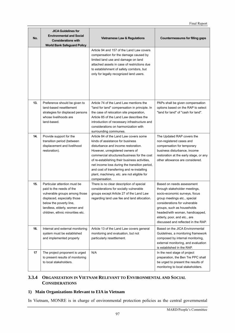
Final Report
MARD/People’s Committee 97
No.
JICA Guidelines for
Environmental and Social
Considerations with
World Bank Safeguard Policy
Vietnamese Law & Regulations Countermeasures for filling gaps
Article 94 and 157 of the Land Law covers
compensation for the damage caused by
limited land use and damage on land
attached assets in case of restrictions due
to establishment of safety corridors, but
only for legally recognized land users.
13. Preference should be given to
land-based resettlement
strategies for displaced persons
whose livelihoods are
land-based.
Article 74 of the Land Law mentions the
"land for land" compensation in principle. In
the case of relocation site preparation,
Article 85 of the Land Law describes the
introduction of necessary infrastructure and
considerations on harmonization with
surrounding communes.
PAPs shall be given compensation
options based on the RAP to select
"land for land" of "cash for land".
14. Provide support for the
transition period (between
displacement and livelihood
restoration).
Article 84 of the Land Law covers some
kinds of assistance for business
disturbance and income restoration.
However, unregistered owners of
commercial structures/business for the cost
of re-establishing their business activities,
net income loss during the transition period,
and cost of transferring and re-installing
plant, machinery, etc. are not eligible for
compensation.
The Updated RAP covers the
non-registered cases and
compensation for temporary
business disturbance, income
restoration at the early stage, or any
other allowance are considered.
15. Particular attention must be
paid to the needs of the
vulnerable groups among those
displaced, especially those
below the poverty line,
landless, elderly, women and
children, ethnic minorities etc.
There is no clear description of special
considerations for socially vulnerable
groups except Article 27 of the Land Law
regarding land use fee and land allocation.
Based on needs assessment
through stakeholder meetings,
socio-economic surveys, focus
group meetings etc., special
considerations for vulnerable
groups, such as households
headed/with woman, handicapped,
elderly, poor, and etc., are
discussed and reflected in the RAP.
16. Internal and external monitoring
system must be established
and implemented properly
Article 13 of the Land Law covers general
monitoring and evaluation, but not
particularly resettlement.
Based on the JICA Environmental
Guidelines, a monitoring framework
composed by internal monitoring,
external monitoring, and evaluation
is established in the RAP.
17 The project proponent is urged
to present results of monitoring
to local stakeholders.
N/A In the next stage of project
preparation, the Ben Tre PPC shall
be urged to present the results of
monitoring to local stakeholders.
3.3.4 ORGANIZATION IN VIETNAM RELEVANT TO ENVIRONMENTAL AND SOCIAL
CONSIDERATIONS
1) Main Organizations Relevant to EIA in Vietnam
In Vietnam, MONRE is in charge of environmental protection policies as the central governmental

Preparatory Survey for Ben Tre Water Management Project
JICA
98
agency. Under the MONRE, Vietnam Environmental Protection Administration (VEPA) was recently in charge of policies formulation for environmental protection, monitoring of the Environmental Law and compliance situations with relevant standards, as well as instruction to regional and local relevant divisions and agencies. Furthermore, VEPA integrated with EIA Division in 2008, in order to expand the authorities and human resources of environmental policies, and restructured as Vietnam Environmental Administration (VEA). Figure 3.3.2 shows present organization chart of VEA.
Figure 3.3.2 Present Organization Chart of Vietnam Environmental Agency (VEA) Source:MONRE, VIETNAM
In terms of the local situations for environmental policy measures and EIA approvals, the Department of Science, Technology, and Environment (DOSTE) was restructured in 2002 by the reform of the central government and the regional/local governments, and DONRE was established under the People’s Committee of the province or central direct jurisdiction.
Main role of the DONRE are as follows:
Issue of permission for factory operation, Environmental monitoring of water and air quality, Environmental inspection to factories, treatment and disposal facilities, and Exposure for illegal activities in terms of environmental protection.
In terms of evaluation and approval of the EIA report, the MONRE approves the large-scale projects; the DONRE in the project area approves other projects based on Appendix II of Decree No. 18/2015/ND-CP.
2) Main Organizations Relevant to Land Acquisition and Resettlement
According to Article 23 of the Lan Law 2013, responsibilities for management land are assigned as following:
The Government shall perform the unified state management over land nationwide, The Ministry of Natural Resources and Environment shall take responsibility before the
Government for the unified state management over land, Related ministries and ministerial-level agencies shall, within the scope of their respective
tasks and powers, assist the Government in performing the state management over land, and People’s Committees at all levels shall perform the state management over land in their
localities according to their competence prescribed in this Law.
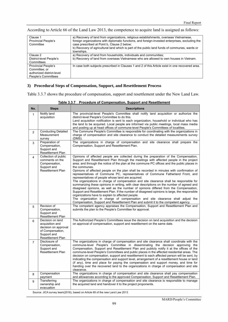
Final Report
MARD/People’s Committee 99
According to Article 66 of the Land Law 2013, the competence to acquire land is assigned as follows:
Clause 1 Provincial People’s Committee
a) Recovery of land from organizations, religious establishments, overseas Vietnamese, foreign organizations with diplomatic functions, and foreign-invested enterprises, excluding the case prescribed at Point b, Clause 2 below; b) Recovery of agricultural land which is part of the public land funds of communes, wards or townships.
Clause 2 District-level People’s Committees
a) Recovery of land from households, individuals and communities; b) Recovery of land from overseas Vietnamese who are allowed to own houses in Vietnam.
Provincial People’s Committee; or authorized district-level People’s Committees
In case both subjects prescribed in Clauses 1 and 2 of this Article exist in one recovered area.
3) Procedural Steps of Compensation, Support, and Resettlement Process
Table 3.3.7 shows the procedure of compensation, support and resettlement under the New Land Law.
Table 3.3.7 Procedure of Compensation, Support and Resettlement
No. Steps Descriptions
1 Notify land acquisition
The provincial-level People's Committee shall notify land acquisition or authorize the district-level People's Committee to do this. Land acquisition notification is sent to each organization, household or individual who has the land to be acquired. Local people are informed via public meetings, local mass media and posting up at head offices of commune-level People's Committees of localities.
2 Conducting Detailed Measurement survey
The Commune People's Committee is responsible for coordinating with the organizations in charge of compensation and site clearance to conduct the detailed measurements survey (DMS).
3 Preparation of Compensation, Support and Resettlement Plan
The organizations in charge of compensation and site clearance shall prepare the Compensation, Support and Resettlement Plan.
4 Collection of public comments on the Compensation, Support and Resettlement Plan
Opinions of affected people are collected during the preparation of the Compensation, Support and Resettlement Plan through the meetings with affected people in the project area; and through the notice of the plan at the commune PC offices and the public places in the communes. Opinions of affected people on the plan shall be recorded in minutes with confirmation of representatives of Commune PC, representatives of Commune Fatherland Front, and representatives of people whose land are acquired. The organizations in charge of compensation and site clearance shall be responsible for summarizing these opinions in writing, with clear descriptions on the number of agreed and disagreed opinions, as well as the number of opinions differed from the Compensation, Support and Resettlement Plan. If the number of disagreed opinions is large, the responsible organizations have to explain to affected people. The organization in charge of compensation and site clearance shall adjust the Compensation, Support and Resettlement Plan and submit it to the competent agency.
5 Revision of Compensation, Support and Resettlement Plan
The competent agency appraises the Compensation, Support and Resettlement Plan and submits the plan to the People’s Committee for approval.
6 Decision on land acquisition and decision on approval of Compensation, Support and Resettlement Plan
The Authorized People’s Committees issue the decision on land acquisition and the decision on approval of compensation, support and resettlement on the same date.
7 Disclosure of Compensation, Support and Resettlement Plan
The organizations in charge of compensation and site clearance shall coordinate with the commune-level People's Committee in disseminating the decision approving the Compensation, Support and Resettlement Plan and publicly notify it at the offices of the commune-level People's Committees and public places in the affected residential areas. The decision on compensation, support and resettlement to each affected person will be sent, by indicating the compensation and support level, arrangement of a resettlement house or land (if any), time and place for paying the compensation and support money, and time for handing over the recovered land to the organizations in charge of compensation and site clearance.
8 Compensation payment
The organizations in charge of compensation and site clearance shall pay compensation and allowances according to the approved Compensation, Support and Resettlement Plan.
9 Transferring ownership and evacuation
The organizations in charge of compensation and site clearance is responsible to manage the acquired land and handover it to the project proponents.
Source: JICA survey team(2016), based on Article 69 of the new Land Law 2013

Preparatory Survey for Ben Tre Water Management Project
JICA
100
3.4 ALTERNATIVE ANALYSIS AND SCOPING
3.4.1 ALTERATIVE ANALYSIS
1) Basic Ideas
As described at the previous section, this Project was prepared based on the Master Plan of “The project for climate change adaptation for sustainable agriculture and rural development in the coastal Mekong Delta in Viet Nam”, which was completed in April 2013.
An alternative analysis was conducted based on quantitative assumptions from economic feasibility, technical feasibility, and environmental and social impacts aspects as well as considerations on the Master Plan, in order to select an optimal option from plural options. The basic ideas for the alternative analysis are as follows:
As for basic measures for salt intrusion relevant to climate change, there are two ideas; one is a soft measure, which a land use plan should be adapted to salt intrusion; the other one is construction and operation of sluice gates to prevent salt intrusion physically. It could be considered as a realistic feasible option based on these two basic ideas.
Within the latter idea (construction of sluice gates), there are two options; one is the construction of large-scale sluice gates in the Mekong River to prevent salt intrusion for more broad target areas; the other one is the construction of middle-scale sluice gates in the tributaries or canals of the Mekong River to prevent salt intrusion. The following focus points were considered for the abovementioned each alternative option: To mitigate damages of agricultural products by predicting salt intrusion relevant to climate
change To minimize damages of agricultural products by predicting fluctuation of river water
volume in Mekong River due to dam development in the upstream To minimize adverse environmental and social impacts in the project areas and the
surroundings during the construction, operation, and maintenance phases of the project.
In the case of the zero option, it is assumed that it could not be adapted to predict sea level rise relevant to climate change and predict the fluctuation of river water volume in the Mekong River due to dam development in the upstream, although it will not cause any impacts on the present natural and social environments. Particular in river water volume in the Mekong River, the prediction of the water volume is very difficult mainly due to human activities in the upstream countries and the countermeasures are limited. It is predicted that the lost profits in the future, as per the above situation, will be very large.
In the case of the soft option, which is adapted to a land use plan flexibly, it is necessary to place quick measures on a yearly basis for saline water intrusion relevant to climate change and water volume fluctuation of the Mekong River. However, this is not a realistically feasible option, although it could be considered as a theoretic plan. The farming plan of each farmhouse will lack consistency and it is very difficult to secure costs, technology, and market relevant to change of land use. It will not cause significant adverse natural impacts even that the natural conditions are unchanged and it could be adaptable. However, this option is not adaptable to future impacts relevant to climate change and water volume fluctuation of the Mekong River, mainly due to human activities in the upstream countries. In addition, this option will be very difficult to secure stable livelihood of the residents.
The option for the large-scale sluice gates is the construction of sluice gates in the main stream (such as the old Balai River) of the Mekong River. In the Ben Tre Province, large-scale sluice gates will be constructed at two sites in the branches within the province to prevent salt intrusion by closing off the gates during the dry season. If these gates are closed, the impacts will affect in not only the Ben Tre

Final Report
MARD/People’s Committee 101
Province, but also the Tien Giang province, the Vinh Long province, and the Dong Thap province, as well as water level within Cambodia (Tonle Sap Lake). If the habitat area of the migrated fishes includes the Mekong Delta area, the significant impacts on the ecosystems, including mangrove are assumed.
In case of the option of the middle-scale sluice gates construction, it is assumed that the impacts will be confined within the Ben Tre Province. It is possible to control the saline contents within the province by enclosing it with small and middle-scale sluice gates, consisting of sandbank within the Mekong River. It may be easy to prepare a land use plan for sea level rise relevant to climate change and fluctuation of river water volume in the Mekong River. However, it is expected that the natural environment could be conserved, although ecosystems of mangroves, wetland areas, and agriculture fields may be partially disturbed.
2) Summary of Each Alternative
Table 3.4.1 summarized the comparison results of the alternatives at present survey phase. At this phase, a middle-scale sluice gates construction was proposed.
Table 3.4.1 Summary of Comparison Results of the Alternatives
Alternatives Comparison Summary
Option 0
Zero Option
It could not be adapted to predicting sea level rise relevant to climate change and river water volume fluctuation in the Mekong River due to water resources development in the upstream, although it will not cause any impacts on present natural/social environments. Particular in river water volume in the Mekong River, the prediction of water volume is very difficult due to human activities in the upstream and the countermeasures are limited. The lost profits in the future will be very large.
Option 1
Soft Option
(Flexible
preparation of
land use plan)
It is necessary to conduct quick measure on a yearly basis for salt intrusion relevant to climate change and water volume fluctuation of the Mekong River. The farming plan of each farmhouse will lack consistency. It could be adaptable for the present situations, but it will not be adaptable to future impacts relevant to climate change and water volume fluctuation of the Mekong River. Therefore, it will be very difficult to secure stable livelihood of the residents.
Option 2
Large-scale
sluice gates
construction
Large-scale sluice gates will be constructed at two sites in the branches of the Mekong River within the Ben Tre Province to prevent salt intrusion by closingoff the gates during the dry season. If these gates are closed, the impacts will affect not only the Ben Tre Province, but also in the Tien Giang province, the Vinh Long province, and the Dong Thap province, as well as water level within Cambodia ( The Tonle Sap Lake). If the migrated fish habitat area includes the Mekong Delta area, significant impacts on the ecosystems, including mangroves are assumed..
Option 3
Middle-scale
sluice gates
construction
It is assumed that identical impacts will occur within the Ben Tre Province. It is possible to control the saline contents within the province by enclosing it with small/ middle-scale sluice gates in the province, consisting of sandbanks off the Mekong River. It may be easy to prepare a land use plan for sea level rise relevant to climate change and fluctuation of river water volume in the Mekong River. However, it is expected that natural environments could be conserved, although the ecosystems of mangrove species, wetland areas, and agriculture fields may partially disturbed.
Source: JICA survey team (2016)

Preparatory Survey for Ben Tre Water Management Project
JICA
102
3) Comprehensive Evaluation
Table 3.4.2 summarized detailed comparison results of the alternatives based on environmental items. In this comparison study as well, the Option 3: Middle-scale sluice gates construction is the most preferable.
The reason why the Option 1: Soft Option (Flexible preparation of land use plan) cannot be adapted is it is judged realistically inapplicable as the impacts on socio-economic activities and community development in the project area is too extensive. For example, it is unrealistic to change crops every year according to the change of salt water uprush.
The reason why the Option 3 is judged as the best option is it is more flexible compared to Option 1 to adapt to the salt water uprush by climate change and the water use situation of countries along the Mekong River. Regarding the Option 2: Large-scale sluice gates construction, it is judged flexible to adapt the salt water uprush. However, it is inferior to Option 3 because it gives substantial negative impacts on the natural environment including the countries along the river by closing the main stream.

Final Report
MARD/People’s Committee 103
Tab
le 3
.4.2
S
um
mar
y o
f th
e E
valu
atio
n R
esu
lts
of
the
Alt
ern
ativ
es

Preparatory Survey for Ben Tre Water Management Project
JICA 104
Impa
ct o
n W
ater
Q
ualit
y △
◎
△
○
The
stat
us q
uo i
s m
aint
aine
d th
us n
o im
pact
s ar
e ex
pect
ed.
How
ever
, it
is
impo
ssib
le t
o ta
ke m
itiga
tion
mea
sure
s on
the
wat
er c
onta
min
atio
n ca
used
by
the
adju
stm
ent
of
the
wat
er
leve
l by
sl
uice
gat
es o
pera
tion.
No
impa
cts
are
expe
cted
as
the
land
is
used
acc
ordi
ng to
the
natu
ral c
ondi
tions
. A
lthou
gh te
mpo
raril
y, th
ere
is a
con
cern
of
wat
er c
onta
min
atio
n on
a w
ide
scal
e as
a
resu
lt of
the
cons
truct
ion
of s
luic
e ga
tes.
Alth
ough
tem
pora
rily,
ther
e is
a c
once
rn o
f w
ater
con
tam
inat
ion
at t
he c
onst
ruct
ion
site
s as
a r
esul
t of
the
con
stru
ctio
n of
sl
uice
ga
tes.
W
ater
co
ntam
inat
ion
conc
erne
d du
ring
the
dry
seas
on c
an b
e m
itiga
ted
by
finel
y tu
ned
oper
atio
n of
sl
uice
gat
es.
Impa
ct
by
Clim
ate
Cha
nge
X
X
X
○
At
pres
ent,
ther
e is
no
si
gnifi
cant
im
pact
. B
ut in
the
fut
ure.
It
is a
ssum
ed
that
si
gnifi
cant
ad
vers
e im
pact
s on
m
any
agric
ultu
ral
prod
ucts
due
to
sea
leve
l ris
e re
leva
nt to
clim
ate
chan
ge a
nd
seve
re s
alt i
ntru
sion
.
At
pres
ent,
ther
e is
no
sign
ifica
nt im
pact
. B
ut
in
the
futu
re.
It is
as
sum
ed
that
si
gnifi
cant
ad
vers
e im
pact
s on
m
any
agric
ultu
ral p
rodu
cts
due
to s
ea le
vel r
ise
rele
vant
to c
limat
e ch
ange
and
sev
ere
salt
intru
sion
bec
ause
onl
y fle
xibl
e pr
epar
atio
n of
lan
d us
e pl
an i
s no
t ad
apta
ble
to t
he
issu
es.
It is
ass
umed
tha
t th
e im
pact
s w
ill a
ffect
th
e w
ater
lev
el i
n C
ambo
dia
and
mor
e th
an
17
mill
ion
pers
ons
in
the
who
le
Mek
ong
Del
ta w
ill b
e af
fect
ed d
ue to
clo
se
the
gate
s in
mai
n st
ream
of M
ekon
g R
iver
.
As
prev
entin
g fro
m s
alt
intru
sion
dur
ing
dry
seas
on a
t de
nse
salin
e co
nten
t ar
ea
and
adap
ting
wat
er v
olum
e flu
ctua
tion
of
Mek
ong
Riv
er
by
mid
dle-
scal
e sl
uice
ga
tes
cons
truct
ion
and
wat
er in
take
fro
m
upst
ream
with
in B
en T
re P
rovi
nce,
few
ad
vers
e im
pact
s on
th
e so
cial
en
viro
nmen
t du
e to
st
able
w
ater
re
sour
ces
supp
ly.
Med
ium
-term
im
pact
s to
the
Pro
ject
by
wat
er
use
man
agem
ent o
f th
e M
akon
g R
iver
Cou
ntrie
s
X
△
X
○
It is
ass
umed
tha
t si
gnifi
cant
neg
ativ
e im
pact
s on
the
agric
ultu
ral p
rodu
cts
due
to n
o re
spon
se f
or a
dapt
atio
n on
the
w
ater
re
sour
ces
man
agem
ent
in
the
upst
ream
cou
ntrie
s.
It is
as
sum
ed
that
m
ediu
m
nega
tive
impa
cts
on t
he a
gric
ultu
ral
prod
ucts
due
to
lim
ited
mea
sure
s su
ch a
s re
visi
ng t
he
land
use
pla
n in
the
proj
ect a
rea.
This
im
plem
enta
tion
of
this
op
tion
is
diffi
cult
to c
ondu
ct. B
ecau
se, t
his
optio
n is
ne
ed t
o co
nsen
sus
for
wat
er r
esou
rces
m
anag
emen
t am
ong
all t
he M
akon
g R
iver
co
untri
es, i
nclu
ding
Cam
bodi
a
It co
uld
be
expe
cted
th
at
prop
er
adap
tatio
n fo
r wat
er re
sour
ces
chan
ges
in
the
upst
ream
cou
ntrie
s by
mon
itorin
g of
sa
lt in
trusi
on a
nd th
e ga
te o
pera
tion.
Riv
er
Tran
spor
tatio
n/
Gen
eral
Tr
ansp
orta
tion
◎
◎
X
○
No
impa
ct.
No
impa
ct.
It
will
cau
se s
igni
fican
t im
pact
s on
up
and
dow
n riv
er
trans
porta
tion,
in
pa
rticu
lar
mid
dle/
larg
e ca
rgo
ship
tra
nspo
rtatio
n on
M
ekon
g R
iver
, al
thou
gh a
n ac
cess
roa
d an
d a
ship
way
on/
with
the
slu
ice
gate
s w
ill b
e co
nstru
cted
.
It w
ill
caus
e so
me
impa
cts
on
river
tra
nspo
rtatio
n, i
n pa
rticu
lar
smal
l/mid
dle
carg
o sh
ip
trans
porta
tion
betw
een
Ben
Tr
e P
rovi
nce
and
the
othe
r pr
ovin
ces
on
the
river
s, a
lthou
gh a
n ac
cess
roa
d an
d a
ship
way
on/
with
the
slu
ice
gate
s w
ill b
e co
nstru
cted
.

Final Report
MARD/People’s Committee 105

Preparatory Survey for Ben Tre Water Management Project
JICA 106
Proj
ect C
osts
◎
○
X
△
Not
ne
cess
ary
for
cost
s of
la
nd
acqu
isiti
on a
nd c
onst
ruct
ion.
N
eces
sary
for
ini
tial
and
O&M
cos
ts o
f w
ater
qua
lity
mon
itorin
g. B
ut t
he p
roje
ct
cost
s w
ill be
low
sig
nific
antly
com
pare
d w
ith
proj
ect
cost
s of
sl
uice
ga
tes
cons
truct
ion.
Hug
e pr
ojec
t cos
ts a
re n
eces
sary
. Pr
ojec
t in
vest
men
t co
sts
will
be l
imite
d du
e to
m
iddl
e-sc
ale
slui
ce
gate
co
nstru
ctio
n co
mpa
red
with
ot
her
alte
rnat
ives
.
O&M
Cos
ts
◎
○
X △
Not
nec
essa
ry fo
r O&M
cos
ts
Slig
ht
O&M
co
sts
of
the
faci
litie
s ar
e ne
cess
ary
due
to
no
faci
litie
s co
nstru
ctio
n.
Nec
essa
ry f
or m
any
O&M
cos
ts o
f tw
o la
rge-
scal
e sl
uice
gat
es.
Nec
essa
ry fo
r med
ium
leve
l O&M
cos
ts o
f ei
ght m
iddl
e-sc
ale
slui
ce g
ates
Tota
l Sco
re
16
17
11
23
Not
e: ◎
mea
ns 3
poi
nt; ○
mea
ns 2
poi
nt, △
mea
ns 1
poi
nt; X
mea
ns 0
poi
nt.

Final Report
MARD/People’s Committee 107
Based on the results of the comparison of alternatives summarized in Table 3.4.2 above, a further detailed analysis on alternatives for the monitoring and operation system for the sluice gates in case of the Option 3 was done, and the results of such an analysis were shown in Table 3.4.3 below.
The construction of meddle-scale sluice gates in Ben Tre Province will result in creating two relatively large polder areas in Ben Tre Province by closing canals with the constructed gates. The areas having risks of damage by saline water intrusion vary every year depending on the water level of Mekong River in the dry season. To prevent the polder areas from saline water intrusion, it is important to operate sluice gates systematically, and not to operate each gate individually. In order to smoothly manage the process from the monitoring of water levels and the salinity in water to the operation of sluice gates, it is indispensable to establish and apply a comprehensive gate operation system comprising of the following three sequential components: 1) Monitoring (Continuous monitoring of water levels and quality of Mekong River and inland canals); 2) Data processing (Determination of the gate operation in accordance with monitoring data); 3) Systematic Operation (Operation of each gate with systematic procedures).
The option recommended is a mixture of measures with hardware and software; the construction of structure will be essential for the gate operation system and gate operation requires appropriate human resources development coupled with systematic operation software.
The monitoring equipment will be installed at various points in Ben Tre Province; the data processing equipment in the data center and the operation equipment at each gate. Not only what to be installed but also how to be operated will form part of the determining factors of the gate operation system. Therefore, it is necessary to fully examine the gate operation equipment together with the operating system/structure prior to the construction of sluice gates.

Preparatory Survey for Ben Tre Water Management Project
JICA 108
Ta
ble
3.4
.3
Su
mm
ary
of
Co
mp
aris
on
Res
ult
s o
f th
e W
ater
Lev
el/S
alin
ity
Mo
nit
ori
ng
Sys
tem
s fo
r th
e O
pti
on
3
Alt
ern
ati
ves
Op
tio
n 3
(Ba
sic
Co
nc
ep
t)O
pti
on
3-0
: Z
ero
Op
tio
n(M
an
ua
l Ob
se
rva
tio
n)
Op
tio
n 3
-A:
Au
tom
ati
c O
bs
erv
ati
on
at
18
Po
ints
alo
ng
th
e R
ive
rs
Op
tio
n 3
-B:
Au
tom
ati
c O
bs
erv
ati
on
at
48
Po
ints
in t
he
Are
a
Op
tio
n 3
-C:
Au
tom
ati
c O
bs
erv
ati
on
at
48
Po
ints
wit
h A
uto
ma
tic
Ga
teO
pe
rati
on
Su
mm
ary
an
dO
bje
ctiv
es
of
Alte
rna
tive
s
To
pre
ven
tfr
om
sa
line
intr
us
ion
an
dto
ad
ap
tw
ate
rvo
lum
eflu
ctu
atio
no
fM
eko
ng
Riv
er
by
me
diu
ms
cale
slu
ice
ga
tes
con
str
uct
ion
an
dw
ate
rin
take
fro
mu
ps
tre
am
with
inB
en
Tre
pro
vin
ce.
No
ad
diti
on
al
mo
nito
rin
gs
yste
ma
nd
de
vice
sa
rere
qu
ire
d.
Co
nve
ntio
na
lm
an
ua
lo
bs
erv
atio
no
fw
ate
rle
vel
an
ds
alin
ityw
illb
eca
rrie
do
ut
at
8s
luic
eg
ate
sp
roje
cts
iteto
be
ne
wly
con
str
uct
ed
.C
urr
en
tm
on
itori
ng
sys
tem
isu
tiliz
ed
an
dit
can
con
trib
ute
min
imiz
ing
the
pro
ject
cos
ta
mo
ng
the
alte
rna
tive
s.
Re
al
time
ob
se
rva
tion
isn
ot
ava
ilab
le.
Mo
nito
rin
gs
tatio
ns
will
be
ins
talle
da
tto
tal1
8p
oin
tsw
ithre
gu
lar
inte
rva
la
lon
gth
e4
ma
jor
trib
uta
rie
so
fM
eko
ng
Riv
er.
Ea
chm
on
itori
ng
sta
tion
will
be
eq
uip
pe
dw
itha
uto
ma
tico
bs
erv
atio
ns
yste
mo
fw
ate
rle
vel
an
ds
alin
ity;
the
ob
se
rve
dd
ata
will
be
tra
ns
ferr
ed
toa
da
tace
nte
ra
nd
slu
ice
ga
tes
will
be
ma
nu
ally
op
era
ted
ba
se
do
nre
su
ltso
fd
ata
pro
ces
sin
g.
Re
lay
sta
tion
is n
ot r
eq
uir
ed
.R
ea
ltim
es
alin
ein
tru
sio
nm
on
itori
ng
will
be
ava
ilab
lea
tth
em
ajo
rtr
ibu
tari
es
of
Me
kon
gR
ive
r;th
ep
roce
ss
ed
da
taca
nb
eu
se
da
sa
refe
ren
cefo
rs
luic
eg
ate
so
pe
ratio
n.
Mo
nito
rin
gs
tatio
ns
will
be
ins
talle
da
tto
tal
49
po
ints
inB
en
Tre
.E
ach
mo
nito
rin
gs
tatio
nw
illb
ee
qu
ipp
ed
with
au
tom
atic
ob
se
rva
tion
sys
tem
of
wa
ter
leve
la
nd
sa
linity
.M
an
ua
lo
bs
erv
atio
nw
illb
ea
lso
con
du
cte
d.
Th
eo
bs
erv
ed
da
taw
illb
etr
an
sfe
rre
dto
ad
ata
cen
ter
an
ds
luic
eg
ate
sw
illb
em
an
ua
llyo
pe
rate
db
as
ed
on
res
ults
of
da
tap
roce
ss
ing
.R
ela
ys
tatio
nis
no
t re
qu
ire
d.
Wa
ter
leve
la
nd
sa
linity
will
be
ob
se
rve
da
tin
sid
ea
nd
ou
tsid
eo
fs
luic
eg
ate
s;
de
taile
ds
alin
ein
tru
sio
nco
nd
itio
na
nd
wa
ter
volu
me
ins
ide
of
can
als
can
be
gra
sp
ed
inre
al
time
.A
pp
rop
ria
tea
nd
time
lyg
ate
op
era
tion
can
be
carr
ied
ou
t.S
om
em
isco
nd
uct
of
ga
teo
pe
ratio
nca
na
lso
be
wa
tch
ed
ou
t in
re
al t
ime
.
Mo
nito
rin
gs
tatio
ns
will
be
ins
talle
da
tto
tal
49
po
ints
inB
en
Tre
.E
ach
mo
nito
rin
gs
tatio
nw
illb
ee
qu
ipp
ed
with
au
tom
atic
ob
se
rva
tion
sys
tem
of
wa
ter
leve
la
nd
sa
linity
.M
an
ua
lo
bs
erv
atio
nw
illb
ea
lso
con
du
cte
d.
Th
eo
bs
erv
ed
da
taw
illb
etr
an
sfe
rre
dto
ad
ata
cen
ter
an
ds
luic
eg
ate
sw
illb
eo
pe
rate
dw
ithre
mo
teo
pe
ratio
ns
yste
mb
as
ed
on
res
ults
of
da
tap
roce
ss
ing
.In
sta
llatio
no
fre
lay
sta
tion
sis
req
uir
ed
.A
uto
ma
ticre
mo
teo
pe
ratio
ns
yste
mca
na
void
hu
ma
ne
rro
rss
uch
as
de
lay
of
wa
ter
leve
l/
sa
linity
ob
se
rva
tion
an
dm
isco
nd
uct
of g
ate
op
era
tion
.
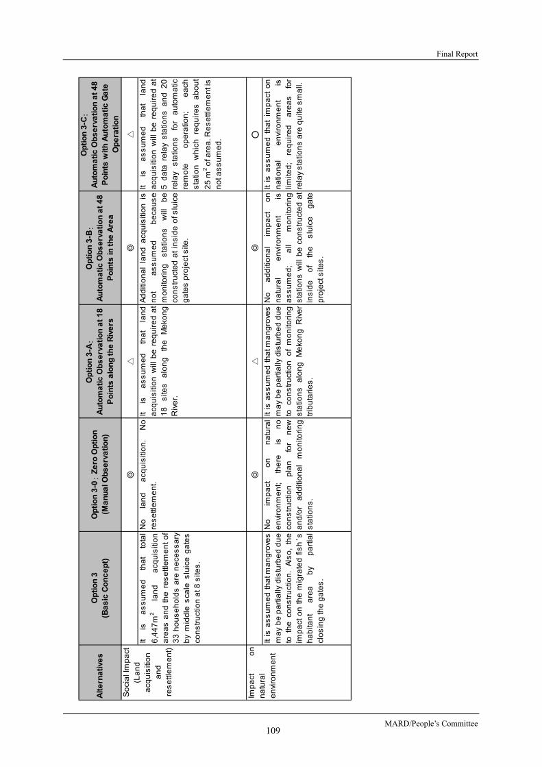
Final Report
MARD/People’s Committee 109
Alt
ern
ati
ves
Op
tio
n 3
(Ba
sic
Co
nc
ep
t)O
pti
on
3-0
: Z
ero
Op
tio
n(M
an
ua
l Ob
se
rva
tio
n)
Op
tio
n 3
-A:
Au
tom
ati
c O
bs
erv
ati
on
at
18
Po
ints
alo
ng
th
e R
ive
rs
Op
tio
n 3
-B:
Au
tom
ati
c O
bs
erv
ati
on
at
48
Po
ints
in t
he
Are
a
Op
tio
n 3
-C:
Au
tom
ati
c O
bs
erv
ati
on
at
48
Po
ints
wit
h A
uto
ma
tic
Ga
teO
pe
rati
on
◎△
◎△
Itis
as
su
me
dth
at
tota
l
6,4
47
m2
lan
da
cqu
isiti
on
are
as
an
dth
ere
se
ttle
me
nt
of
33
ho
us
eh
old
sa
ren
ece
ss
ary
by
mid
dle
sca
les
luic
eg
ate
sco
ns
tru
ctio
n a
t 8 s
ites
.
No
lan
da
cqu
isiti
on
.N
ore
se
ttle
me
nt.
Itis
as
su
me
dth
at
lan
da
cqu
isiti
on
will
be
req
uir
ed
at
18
site
sa
lon
gth
eM
eko
ng
Riv
er.
Ad
diti
on
al
lan
da
cqu
isiti
on
isn
ot
as
su
me
db
eca
us
em
on
itori
ng
sta
tion
sw
illb
eco
ns
tru
cte
da
tin
sid
eo
fslu
ice
ga
tes
pro
ject
site
.
Itis
as
su
me
dth
at
lan
da
cqu
isiti
on
will
be
req
uir
ed
at
5d
ata
rela
ys
tatio
ns
an
d2
0re
lay
sta
tion
sfo
ra
uto
ma
ticre
mo
teo
pe
ratio
n;
ea
chs
tatio
nw
hic
hre
qu
ire
sa
bo
ut
25
m2 o
f are
a. R
es
ettl
em
en
t is
no
t as
su
me
d.
◎△
◎○
Itis
as
su
me
dth
atm
an
gro
ves
ma
yb
ep
art
ially
dis
turb
ed
du
eto
the
con
str
uct
ion
.A
lso
,th
eim
pa
cto
nth
em
igra
ted
fish
’sh
ab
itan
ta
rea
by
pa
rtia
lcl
os
ing
the
ga
tes
.
No
imp
act
on
na
tura
le
nvi
ron
me
nt;
the
reis
no
con
str
uct
ion
pla
nfo
rn
ew
an
d/o
ra
dd
itio
na
lm
on
itori
ng
sta
tion
s.
Itis
as
su
me
dth
atm
an
gro
ves
ma
yb
ep
art
ially
dis
turb
ed
du
eto
con
str
uct
ion
of
mo
nito
rin
gs
tatio
ns
alo
ng
Me
kon
gR
ive
rtr
ibu
tari
es
.
No
ad
diti
on
al
imp
act
on
na
tura
le
nvi
ron
me
nt
isa
ss
um
ed
;a
llm
on
itori
ng
sta
tion
sw
illb
eco
ns
tru
cte
da
tin
sid
eo
fth
es
luic
eg
ate
pro
ject
site
s.
Itis
as
su
me
dth
at
imp
act
on
na
tion
al
en
viro
nm
en
tis
limite
d;
req
uir
ed
are
as
for
rela
y s
tatio
ns
are
qu
ite s
ma
ll.
So
cia
l Im
pa
ct(L
an
da
cqu
isiti
on
an
dre
se
ttle
me
nt)
Imp
act
on
na
tura
le
nvi
ron
me
nt
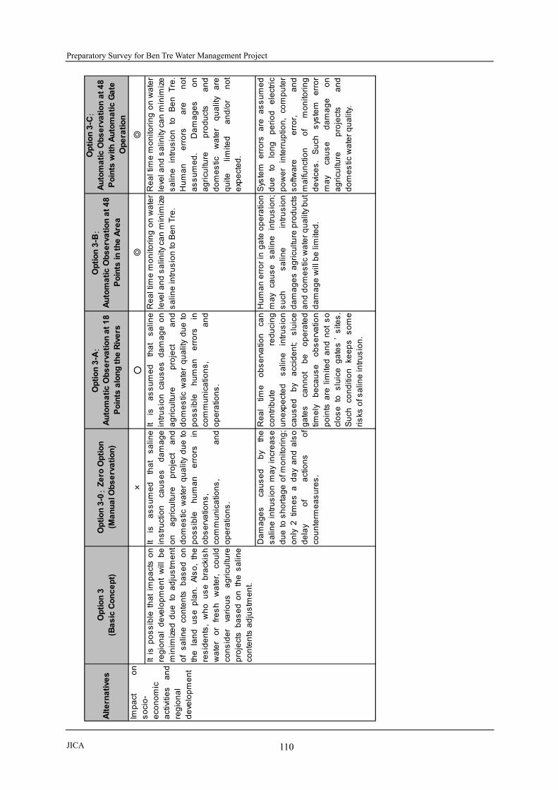
Preparatory Survey for Ben Tre Water Management Project
JICA 110
A
lte
rna
tive
sO
pti
on
3(B
as
ic C
on
ce
pt)
Op
tio
n 3
-0:
Ze
ro O
pti
on
(Ma
nu
al O
bs
erv
ati
on
)
Op
tio
n 3
-A:
Au
tom
ati
c O
bs
erv
ati
on
at
18
Po
ints
alo
ng
th
e R
ive
rs
Op
tio
n 3
-B:
Au
tom
ati
c O
bs
erv
ati
on
at
48
Po
ints
in t
he
Are
a
Op
tio
n 3
-C:
Au
tom
ati
c O
bs
erv
ati
on
at
48
Po
ints
wit
h A
uto
ma
tic
Ga
teO
pe
rati
on
×○
◎◎
Itis
as
su
me
dth
at
sa
line
ins
tru
ctio
nca
us
es
da
ma
ge
on
ag
ricu
lture
pro
ject
an
dd
om
es
ticw
ate
rq
ua
lity
du
eto
po
ss
ible
hu
ma
ne
rro
rsin
ob
se
rva
tion
s,
com
mu
nic
atio
ns
,a
nd
op
era
tion
s.
Itis
as
su
me
dth
at
sa
line
intr
us
ion
cau
se
sd
am
ag
eo
na
gri
cultu
rep
roje
cta
nd
do
me
stic
wa
ter
qu
alit
yd
ue
top
os
sib
leh
um
an
err
ors
inco
mm
un
ica
tion
s,
an
do
pe
ratio
ns
.
Re
alt
ime
mo
nito
rin
go
nw
ate
rle
vel a
nd
sa
linity
ca
n m
inim
ize
sa
line
intr
us
ion
to B
en
Tre
.
Re
alt
ime
mo
nito
rin
go
nw
ate
rle
vel a
nd
sa
linity
ca
n m
inim
ize
sa
line
intr
us
ion
toB
en
Tre
.H
um
an
err
ors
are
no
ta
ss
um
ed
.D
am
ag
es
on
ag
ricu
lture
pro
du
cts
an
dd
om
es
ticw
ate
rq
ua
lity
are
qu
itelim
ited
an
d/o
rn
ot
exp
ect
ed
.
Da
ma
ge
sca
us
ed
by
the
sa
line
intr
us
ion
ma
yin
cre
as
ed
ue
tos
ho
rta
ge
ofm
on
itori
ng
;o
nly
2tim
es
ad
ay
an
da
lso
de
lay
of
act
ion
so
fco
un
term
ea
su
res
.
Re
al
time
ob
se
rva
tion
can
con
trib
ute
red
uci
ng
un
exp
ect
ed
sa
line
intr
us
ion
cau
se
db
ya
ccid
en
t;s
luic
eg
ate
sca
nn
ot
be
op
era
ted
time
lyb
eca
us
eo
bs
erv
atio
np
oin
tsa
relim
ited
an
dn
ot
so
clo
se
tos
luic
eg
ate
s’
site
s.
Su
chco
nd
itio
nke
ep
ss
om
eri
sks
of s
alin
e in
tru
sio
n.
Hu
ma
ne
rro
rin
ga
teo
pe
ratio
nm
ay
cau
se
sa
line
intr
us
ion
;s
uch
sa
line
intr
us
ion
da
ma
ge
sa
gri
cultu
rep
rod
uct
sa
nd
do
me
stic
wa
ter
qu
alit
y b
ut
da
ma
ge
will
be
lim
ited
.
Sys
tem
err
ors
are
as
su
me
dd
ue
tolo
ng
pe
rio
de
lect
ric
po
we
rin
terr
up
tion
,co
mp
ute
rs
oftw
are
err
or,
an
dm
alfu
nct
ion
of
mo
nito
rin
gd
evi
ces
.S
uch
sys
tem
err
or
ma
yca
us
ed
am
ag
eo
na
gri
cultu
rep
roje
cts
an
dd
om
es
tic w
ate
r q
ua
lity.
Imp
act
on
so
cio
-e
con
om
ica
ctiv
itie
sa
nd
reg
ion
al
de
velo
pm
en
t
Itis
po
ss
ible
tha
tim
pa
cts
on
reg
ion
al
de
velo
pm
en
tw
illb
em
inim
ize
dd
ue
toa
dju
stm
en
to
fs
alin
eco
nte
nts
ba
se
do
nth
ela
nd
us
ep
lan
.A
lso
,th
ere
sid
en
ts,
wh
ou
se
bra
ckis
hw
ate
ro
rfr
es
hw
ate
r,co
uld
con
sid
er
vari
ou
sa
gri
cultu
rep
roje
cts
ba
se
do
nth
es
alin
eco
nte
nts
ad
jus
tme
nt.

Final Report
MARD/People’s Committee 111
Alt
ern
ati
ves
Op
tio
n 3
(Ba
sic
Co
nc
ep
t)O
pti
on
3-0
: Z
ero
Op
tio
n(M
an
ua
l Ob
se
rva
tio
n)
Op
tio
n 3
-A:
Au
tom
ati
c O
bs
erv
ati
on
at
18
Po
ints
alo
ng
th
e R
ive
rs
Op
tio
n 3
-B:
Au
tom
ati
c O
bs
erv
ati
on
at
48
Po
ints
in t
he
Are
a
Op
tio
n 3
-C:
Au
tom
ati
c O
bs
erv
ati
on
at
48
Po
ints
wit
h A
uto
ma
tic
Ga
teO
pe
rati
on
◎○
△×
Co
st
for
me
diu
m-
sca
led
slu
ice
ga
tes
con
str
uct
ion
pro
ject
isn
ee
de
d.
Co
mp
ari
ng
too
the
ra
ltern
ativ
es
,in
ves
tme
nt
cos
tis
limite
da
nd
rela
tive
ly lo
w.
Itn
ee
ds
toin
sta
lle
qu
ipm
en
tto
me
as
ure
sa
linity
at
8s
luic
eg
ate
s.
Ho
we
ver,
initi
al
cos
tis
the
low
es
t,co
mp
ari
ng
too
the
ra
ltern
ativ
es
.
Itn
ee
ds
cos
tto
con
str
uct
18
au
tom
atic
mo
nito
rin
gs
tatio
ns
an
d o
ne
da
ta c
en
ter.
Itn
ee
ds
cos
tto
con
str
uct
49
au
tom
atic
mo
nito
rin
gs
tatio
ns
an
d o
ne
da
ta c
en
ter.
Itn
ee
ds
cos
tto
con
str
uct
49
au
tom
atic
mo
nito
rin
g s
tatio
ns
,o
ne
da
tace
nte
r,a
nd
da
tare
lay
sta
tion
s.
Me
diu
m c
os
t fo
r o
pe
ratio
n a
nd
ma
inte
na
nce
of8
slu
ice
ga
tes
is n
ee
de
d.
Co
st
wo
uld
be
the
low
es
tb
eca
us
eit
on
lyn
ee
ds
top
ay
cos
tfo
ru
pd
atin
gm
ea
su
rem
en
te
qu
ipm
en
ta
nd
for
pe
rso
nn
el c
os
t.
Itn
ee
ds
cos
tto
up
da
tee
qu
ipm
en
ta
nd
pe
rso
nn
el
cos
t fo
r 1
8 m
on
itori
ng
sta
tion
sa
nd
on
e d
ata
ce
nte
r.
Itn
ee
ds
cos
tto
up
da
tee
qu
ipm
en
ta
nd
pe
rso
nn
el
cos
t fo
r 4
9 m
on
itori
ng
sta
tion
sa
nd
on
e d
ata
ce
nte
r.
Itn
ee
ds
cos
tto
up
da
tee
qu
ipm
en
ta
nd
pe
rso
nn
el
cos
tfo
r4
9m
on
itori
ng
sta
tion
s,
on
ed
ata
cen
ter,
an
dd
ata
re
lay
sta
tion
s.
Pro
ject
co
st
an
d o
pe
ratio
na
nd
ma
inte
na
nce
cos
t

Preparatory Survey for Ben Tre Water Management Project
JICA 112
Alt
ern
ati
ves
Op
tio
n 3
(Ba
sic
Co
nc
ep
t)O
pti
on
3-0
: Z
ero
Op
tio
n(M
an
ua
l Ob
se
rva
tio
n)
Op
tio
n 3
-A:
Au
tom
ati
c O
bs
erv
ati
on
at
18
Po
ints
alo
ng
th
e R
ive
rs
Op
tio
n 3
-B:
Au
tom
ati
c O
bs
erv
ati
on
at
48
Po
ints
in t
he
Are
a
Op
tio
n 3
-C:
Au
tom
ati
c O
bs
erv
ati
on
at
48
Po
ints
wit
h A
uto
ma
tic
Ga
teO
pe
rati
on
×△
○◎
Sa
linity
can
no
tb
em
ea
su
red
au
tom
atic
ally
inre
al-
time
,an
dth
ere
fore
,th
es
luic
eg
ate
sw
hic
hca
nn
ot
be
op
era
ted
pro
mp
tly.
Co
nve
ntio
na
lty
pe
so
fs
luic
eg
ate
ss
ha
llb
ea
do
pte
dto
this
alte
rna
tive
su
cha
ss
win
gg
ate
,ta
inte
rg
ate
an
d s
o o
n.
Ga
tes
are
clo
se
d/o
pe
ne
dd
ep
en
din
go
nth
etid
es
,th
ere
fore
itis
diff
icu
ltto
be
act
ive
lyo
pe
rate
d,
an
dca
nn
ot
be
flexi
bly
op
era
ted
top
reve
nt
sa
line
intr
us
ion
.
Itca
no
bs
erv
eth
es
alin
itie
sin
rea
l-tim
efo
ra
wid
ea
rea
,th
ere
fore
,s
lide
ga
tes
can
be
ad
op
ted
ina
dd
itio
nto
the
sw
ing
ga
tes
, ta
inte
r g
ate
s, e
tc.
Itca
nn
ot
pre
cis
ely
me
as
ure
the
sa
liniti
es
at
the
site
sa
rou
nd
the
slu
ice
ga
tes
,th
ere
fore
the
ga
tes
ma
y n
ot b
ecl
os
ed
/op
en
ed
pro
mp
tlyin
time
,a
nd
itca
nn
ot
ap
pro
pri
ate
lyp
reve
nt
sa
line
intr
us
ion
, eve
n in
ca
se
of s
lide
ga
tes
.
Itca
no
bs
erv
es
alin
itie
sin
rea
l-tim
ea
tth
es
ites
aro
un
dth
ep
lan
ne
ds
luic
eg
ate
s;
the
refo
res
lide
ga
tes
isa
pp
rop
ria
teg
ate
typ
ew
hic
hca
ne
na
ble
the
ga
teo
pe
ratio
nin
corr
es
po
nd
en
ceto
sa
liniti
es
ob
se
rve
d.
Th
ed
ata
cen
ter
can
ob
tain
da
tao
nth
es
alin
itie
so
bs
erv
ed
at
the
ga
tes
inre
al-
time
,th
ere
fore
,th
eg
ate
sca
nb
ep
rom
ptly
clo
se
d/o
pe
ne
din
res
po
ns
eto
the
situ
atio
na
tth
es
ite.
Co
un
term
ea
su
res
can
be
take
nb
eca
us
eo
fre
al
time
ob
se
rva
tion
eve
nw
he
nth
eg
ate
clo
sin
g/o
pe
nin
gis
ob
livio
us
.
Itca
no
bs
erv
es
alin
itie
sin
rea
l-tim
ea
tth
es
ites
aro
un
dth
ep
lan
ne
ds
luic
eg
ate
s;
the
refo
res
lide
ga
teis
ap
pro
pri
ate
ga
tety
pe
wh
ich
can
en
ab
leth
eg
ate
op
era
tion
inco
rre
sp
on
de
nce
tos
alin
itie
s o
bs
erv
ed
.
Th
ed
ata
cen
ter
can
ob
tain
da
tao
nth
es
alin
itie
so
bs
erv
ed
at
the
ga
tes
inre
al-
time
,th
ere
fore
,th
eg
ate
sca
nb
ea
uto
ma
tica
llycl
os
ed
/op
en
ed
,a
nd
can
effe
ctiv
ely
red
uce
da
ma
ge
cau
se
d b
y s
alin
e in
tru
sio
n.
Te
chn
ica
lis
su
es
on
the
ga
te s
tru
ctu
re

Final Report
MARD/People’s Committee 113
Alt
ern
ati
ves
Op
tio
n 3
(Ba
sic
Co
nc
ep
t)O
pti
on
3-0
: Z
ero
Op
tio
n(M
an
ua
l Ob
se
rva
tio
n)
Op
tio
n 3
-A:
Au
tom
ati
c O
bs
erv
ati
on
at
18
Po
ints
alo
ng
th
e R
ive
rs
Op
tio
n 3
-B:
Au
tom
ati
c O
bs
erv
ati
on
at
48
Po
ints
in t
he
Are
a
Op
tio
n 3
-C:
Au
tom
ati
c O
bs
erv
ati
on
at
48
Po
ints
wit
h A
uto
ma
tic
Ga
teO
pe
rati
on
×△
○○
Sa
liniti
es
are
me
as
ure
db
yth
es
taff
on
cea
da
y,a
nd
itta
kes
lon
gtim
eto
clo
se
/op
en
the
ga
tes
.T
he
refo
re,
itis
diff
icu
ltto
pro
mp
tlycl
os
e/o
pe
nth
eg
ate
sfo
rth
ew
ate
rwa
yu
se
rsto
pa
ss
thro
ug
hth
eg
ate
s w
he
n it
is n
ece
ss
ary
.
Itis
po
ss
ible
too
bs
erv
eth
es
alin
itie
sin
aw
ide
are
ao
fB
en
Tre
Pro
vin
ce.
Ho
we
ver,
itis
diff
icu
lt to
ob
tain
info
rma
tion
on
the
act
ua
lsitu
atio
na
tea
chs
luic
eg
ate
site
,a
nd
the
refo
re,
itis
diff
icu
ltto
res
po
nd
pro
mp
tlyto
the
ne
ed
of
wa
terw
ay
us
ers
ton
avi
ga
teth
rou
gh
the
ga
tes
.
Itis
po
ss
ible
too
bs
erv
eth
es
alin
itie
sa
tth
es
ites
aro
un
de
ach
slu
ice
ga
te,
an
dth
ere
fore
,it
can
flexi
bly
res
po
nd
toth
en
ee
do
fw
ate
rwa
yu
se
rs,
an
dca
nm
itig
ate
so
cia
lim
pa
cts
cau
se
d b
y th
e p
roje
ct.
Itis
po
ss
ible
too
bs
erv
eth
es
alin
itie
sa
tth
es
ites
aro
un
de
ach
slu
ice
ga
te,
an
dth
ere
fore
,it
can
flexi
bly
res
po
nd
toth
en
ee
do
fw
ate
rwa
yu
se
rs,
an
dca
nm
itig
ate
so
cia
lim
pa
cts
cau
se
d b
y th
e p
roje
ct.
×△
○◎
Co
mp
ari
ng
too
the
ra
ltern
ativ
es
,th
eg
ate
sca
nn
ot
be
fre
qu
en
tlycl
os
ed
/o
pe
ne
d;
the
refo
re,
itw
ou
ldca
us
eim
pa
cts
of
po
llute
dw
ate
rs
tag
na
ncy
,a
nd
hin
de
rth
em
ove
me
nt
of
imm
igra
nt
fish
es
.
Ga
teo
pe
nin
g/c
los
ing
fre
qu
en
cyis
low
er
tha
nth
ato
fA
ltern
ativ
e-3
-Ba
nd
Alte
rna
tive
3-C
;th
ere
fore
,it
wo
uld
cau
se
imp
act
so
fp
ollu
ted
wa
ter
sta
gn
an
cy,
an
dh
ind
er
the
mo
vem
en
to
fim
mig
ran
tfis
he
s.
Ga
teo
pe
nin
g/c
los
ing
fre
qu
en
cyis
hig
he
rth
an
tha
to
fA
ltern
ativ
e3
-0a
nd
Alte
rna
tive
3-A
,th
ere
fore
,im
pa
cts
of
po
llute
dw
ate
rs
tag
na
ncy
,a
nd
imp
act
sto
the
mo
vem
en
to
fim
mig
ran
tfis
he
s w
ou
ld b
e m
inim
ize
d.
Ga
teo
pe
nin
g/c
los
ing
fre
qu
en
cyis
hig
he
rth
an
tha
to
f Alte
rna
tive
3-0
, Alte
rna
tive
3-
Aa
nd
Alte
rna
tive
3-B
;th
ere
fore
,im
pa
cts
of
po
llute
dw
ate
rs
tag
na
ncy
,a
nd
imp
act
sto
the
mo
vem
en
to
fim
mig
ran
tfis
he
sw
ou
ldb
eth
em
inim
ize
d th
e b
es
t.
9 p
oin
ts9
po
ints
16
po
ints
14
po
ints
Imp
act
so
nn
atu
ral
en
viro
nm
en
tca
us
ed
by
the
ga
teo
pe
ratio
n
Sco
re a
ccu
mu
late
d
◎:
3poi
nts,
○:
2 po
ints
, △:
1 po
int, ×
:0
poin
t
Imp
act
sto
wa
terw
ay
us
ers

Preparatory Survey for Ben Tre Water Management Project
JICA 114
3.4.2 SCOPING
Table 3.4.4 shows the scoping results based on the understandings in this survey stage.
Table 3.4.4 Scoping Results of This Project
Classifica
tion No
Items
Impacted
Impact Assessment
Reasons for Evaluation Const-
ruction
Phase
Operati
on
Phase Pollution 1 Air Pollution
B- C
【The Construction Phase】 It is assumed that construction vehicles for the site
preparation may cause dust, especially in dry season. The air quality may be slightly deteriorated temporarily.
It is assumed that construction machines for the site preparation/access road development may generate emission gases, especially in the dry season. The air quality may be slightly deteriorated temporarily.
【The Operation Phase】 A small-scale access road will be constructed at each
proposed sluice gate. The vehicles on the road will generate emission gases. There is a possibility that slight air pollution may occur due to the transportation of the vehicles.
2 Water Pollution
B- B-
【The Construction Phase】 It is assumed that polluted water may be generated by the
sluice gate construction. The surface water may be slightly deteriorated temporarily in the water bodies near each sluice gate site.
It is assumed that polluted water may generate at borrowing pits or rock quarry sites due to sediment discharge by heavy rainfall, if the borrowing pit or quarry site is not properly managed.
There is a possibility that the water quality may be deteriorate temporally by dredging activities near by the sluice gates.
【The Operation Phase】 It is assumed that water quality deterioration or eutrophication
may occur in the partial river or canal section of urban areas during the dry season due to a decrease of water volume by closing the gates.
There is a possibility that water quality at embankment sites may deteriorate temporally due to soil erosion by heavy rain or flood.
There is a possibility that water pollution may occur in borrowing pits or rock quarry site due to sediment discharge by heavy rainfall, if the borrowing pit or quarry site is not properly managed.
3 Wastes
B- B-
【The Construction Phase】 It is assumed that construction wastes and municipal wastes
at construction offices will be generated. 【The Operation Phase】 There is a possibility that wastes sedimentation will occur due
to the closing of the sluice gates.
4 Soil Contamination D D
【The Construction Phase/The Operation Phase】 Soil contamination is not assured because materials, which
will cause soil contamination, are not used in both phases.
5 Noise/Vibration
B- D
【The Construction Phase】 It is assumed that construction noise due to construction
activities will be temporally generated. 【The Operation Phase】 It is not assumed noise/vibration issues are generated by
sluice gates operation.
6 Land Subsidence
C C
【The Construction Phase】 There is a possibility that small-scale land subsidence will be
occurs in some sites relevant to embankment construction. 【The Operation Phase】 There is a possibility that small-scale land subsidence will be
occurs in soft ground sites relevant to embankment.

Final Report
MARD/People’s Committee 115
Classifica
tion No
Items
Impacted
Impact Assessment
Reasons for Evaluation Const-
ruction
Phase
Operati
on
Phase
7 Offensive Odor
D D
【The Construction Phase/ The Operation Phase】 It is not assumed offensive odor because materials, which will
cause offensive odor, will not be used in both phases.
8 Bottom Sediment
B- B-
【The Construction Phase】 It is assumed that demolition, excavation and construction
wastes hold high sediment load.at the construction sites may cause additional sedimentation in the rivers/canals.
【The Operation Phase】 There is a possibility that possible soil erosion may cause
additional sedimentation in the rivers/canals, if inappropriate design, construction, or maintenance are conducted.
Natural Environment
9 Protected Area
C C
【The Construction Phase/ The Operation Phase】 Three protected areas are designated within Ben Tre
Province. However, the nearest protected area is located in more than 25 km from the proposed sluice gate construction site. Therefore, the adverse impacts on the protected areas are not assumed. However, it is necessary to confirm the habitat areas of the fauna in the protected areas as further survey.
10 Ecosystem
B- B-
【The Construction Phase】 It is assumed that small-scale alteration of ecosystem due to
partial cutting of mangrove species by sluice gates construction will occur.
There is a possibility that adverse impacts will occur on the habitat areas of fishes or aquatic organism in the rivers/canals.
【The Operation Phase】 There is a possibility that adverse impacts will occur on the
fishes, which was migrated through the proposed sluice gates sites.
11 Hydrology
B- B-
【The Construction Phase】 There is a possibility that present hydrology will change
temporally or partially by the sluice gates construction. 【The Operation Phase】 There is a possibility that present hydrology may change
partially due to the operation of the sluice gates.
12 Geography/Geology
D D
【The Construction Phase】 Any impacts on geography or geology are not assumed
because the construction is not large-scale, which will not cause geography or geology alteration.
【The Operation Phase】 It does not assume any impacts on geography or geology,
because the main project activity is the operation of sluice gates.
Social Environment
13 Involuntary resettlement
B- D
【The Pre-construction Phase】 Nine (09) households would be relocated to make land for construction of the 8 sluice gates. (In addition, other 24 households would lose their agriculture or residential land for the Project but would not have to relocate.) 【The Construction Phase】 Temporary lease of land and additional small scale resettlement would be required for the construction yards. 【The Operation phase】 Additional land acquisition and resettlement is not expected.
14 The poor
B- B-
【The Construction Phase/The Operation Phase】 Some of the poor people who will loose their own land for living and/production would be seriously affected by resettlement and may lose their business opportunity if appropriate compensation and supports are not provided.
15 Indigenous and ethnic people D D
【The Construction Phase/The Operation Phase】 It is observed that indigenous and ethnic people do not reside around the Project area.
16 Local economy B± B± 【The Construction Phase】

Preparatory Survey for Ben Tre Water Management Project
JICA 116
Classifica
tion No
Items
Impacted
Impact Assessment
Reasons for Evaluation Const-
ruction
Phase
Operati
on
Phase such as employment and livelihood
Local residents may have the opportunity to work as construction workers at the Project sites. Activities of ferrymen, boats transporting goods, fish boats on the rivers near the sluice gates would be impeded during the construction period. 【The Operation Phase】 Development of a high value-added agricultural production such as fruit tree cultivation, livestock, etc., would be enabled when fresh water is constantly supplied throughout the year. Access roads planned on the sluice gates may contribute to the improvement of local road network, and promotion of local economy and industry development. Some areas may not have enough saline water for shrimp aquaculture. Ferrymen who are carrying out business near the sluice gates may lose their existing means of livelihood due to the development of the roads on the sluice gates. Activities of ferrymen, goods transporting boats, fishing boats, etc. would be impeded by the newly constructed sluice gates.
17 Land use and utilization of local resources
B- B±
【The Construction Phase】 Some lots of agricultural land around the sluice gates would be lost by the Project. 【The Operation Phase】 The expansion of land for cultivation of fruit trees, vegetables are expected due to the stable supply of fresh water. Land for shrimp aquaculture would be reduced due to the lack of saline water. Local resources would be efficiently utilized because of the development of local road network.
18 Water usage
B- B±
【The Construction Phase】 Irrigation water would be temporarily affected due to the polluted water generated from the construction sites. 【The Operation Phase】 With the proper operation of the sluice gates, the river water quality and water flow can be adjusted to suit the needs of local residents. Saline water may be insufficient for shrimp aquaculture in some areas.
19 Existing social infrastructure and service
B- B±
【The Construction Phase】 Transportation on the rivers may be temporarily impeded during the construction of the sluice gates. 【The Operation Phase】 Local residents will be able to easily access public facilities in the area due to the road network development associated with the sluice gates construction. On the other hand, the existing service by the ferrymen may be suspended. Transportation on the river may be obstructed by the appearance of the sluice gates.
20 Social capital, local organizations such as decision-making authorities
D D
【The Construction Phase/The Operation Phase】 Impacts on social capital, local organization, etc. are not expected.
21 Misdistribution of benefits and damage
C B-
【The Pre-construction phase/ The Construction Phase】 Residents residing near the sluice gate construction sites would be directly affected by noise, water pollution, etc. 【The Operation Phase】 Residents living near the sluice gates may be directly benefitted in terms of reduction of travel time. Farmers who are using freshwater would earn more benefits from the Project than farmers who are using saline water. There would be conflict on the need of water supply between

Final Report
MARD/People’s Committee 117
Classifica
tion No
Items
Impacted
Impact Assessment
Reasons for Evaluation Const-
ruction
Phase
Operati
on
Phase farmers who want to have freshwater and the ones who want to have saline water for shrimp aquaculture.
22 Local conflicts of interest
D B-
【The Construction Phase】 Conflicts of interest between local residents during The Construction Phase are not expected. 【The Operation Phase】 There would be conflict on the need of water supply and water treatment between farmers who are using freshwater and the ones who are using saline water.
23 Cultural, historical heritage
D D 【The Construction Phase/ The Operation Phase】 No cultural or historical heritage is observed around the construction sites of the sluice gates.
24
Landscape
D D
【The Construction Phase/ The Operation Phase】 Landscape that needs to be preserved is not observed around the construction sites of the sluice gates. And the appearance of the sluice gates would not cause impact to the surrounding landscape.
25
Gender
D D
【The Construction Phase/The Operation Phase】 Impacts on gender issues that require particular consideration are not expected during both the construction phase and the operation phase. Gender discrimination is not identified even when the contractors employ local residents to work as construction workers during the construction phase.
26 Children’s rights
D B+
【The Construction Phase】 Impact on children’s rights that require particular consideration is not expected. 【The Operation Phase】 The students may be easier to go to the schools with the use of the access roads to be constructed on the sluice gates.
27 Infectious diseases such as HIV/AIDS
B- D
【The Construction Phase】 The risk of spread of infectious diseases such as HIV/AIDS may be increased due to the construction workers from outsides. 【The Operation Phase】 Travel on land may be improved, but the risk of spread of infectious diseases is not expected.
28 Working environment (including work safety) B- D
【The Construction Phase】 Construction workers’ health may be affected by air pollution generated from the construction works, if the working environment is not appropriately improved. 【The Operation Phase】 Impact on working environment that requires particular consideration during the operation phase is not expected.
29 Accidents
B- C
【The Construction Phase】 There would be the risk of occurrence of accidents during construction, if working safety is not appropriately improved. Accidents on the rivers would occur near the construction sites of the sluice gates. 【The Operation Phase】 Traffic accident may increase due to the increased traffic volume and vehicle speed.
Others 30 Transboundary impacts, global warming
C D
【The Construction Phase】 Greenhouse gases would be generated by construction works. 【The Operation Phase】 Significant generation of greenhouse gases is not expected.
Source: JICA survey team (2016)
Note: A: Significant impacts may cause
B: Medium-scale impacts may cause
C: Impacts are unknown
D: No impact will be cause
3.4.3 TOR OF THIS ENVIRONMENTAL AND SOCIAL CONSIDERATIONS
In this survey, main surveys for environmental and social considerations are reviewing and revision of

Preparatory Survey for Ben Tre Water Management Project
JICA 118
the EIA survey, which was conducted by Vietnam’s side. Also, additional survey will be conducted based on the scoping results, which were described in previous section.
Table 3.4.5 shows the TOR for environmental and social considerations based on these understandings.
Table 3.4.5 TOR for Environmental and Social Considerations
Classification
Items
Impacted
Impact Assessment
survey Items
Construct
-ion Phase
Operation
Phase survey Methods
Pollution Air Pollution
B- C
- Air quality items
- Air quality standards
- Impacts on air quality
by construction and
operation activities
- Existing documents reviews
- Confirmation (Hearing) of
construction contents/methods,
and construction vehicles
- Similar case studies
Water
Pollution
B- B-
- Water quality items
- Surface water quality
standards
- Impacts on water
quality by construction
and operation activities
- Existing documents reviews
- Confirmation (Hearing) of
construction contents/methods,
- Similar case studies
- For water quality simulation,
MIKE-11 model will be applied
(water quality targets will be the
surface water quality standards
in Vietnam)
Wastes
B- B-
-Wastes disposal
methods at construction
sites and the
surroundings
- Wastes sedimentation
situations in the canals
at operation phase
- Hearings to the relevant
persons.
- Field reconnaissance
- Similar case studies
Noise/Vibrati
on
B- D
- Present noise level
- Noise permission
levels
- Locations of the
houses/public facilities
- Power level of heavy
construction
machines/vehicles
- Confirmation (Hearing) of
construction contents/methods
-- Sampling of background
noise data at the houses/public
facilities located in construction
sites
- Noise forecasts by
Land
subsidence C C
- Characteristics of
ground and geology at
construction sites
- Confirmation (Hearing) of
construction contents/methods
-- Similar case studies
Bottom
Sediment B- B-
- Characteristics of
geography and soil of
the bottom sediments
- Intensity of rainfall
- Confirmation (Hearing) of
construction contents/methods
-- Similar case studies
Natural
Environment
Protected
Area C C
- Characteristics of
habitats of the migratory
species in the protected
area
- Review of existing documents
- Hearings to local natural
environmental experts
- Similar case studies
Ecosystem
B- B-
- Characteristics of the
ecosystem in the
rivers/canals
- Habitat
characteristics/areas
of rare species
- Review of existing documents
- Hearings to local natural
environmental experts
- Field reconnaissance
- Similar case studies
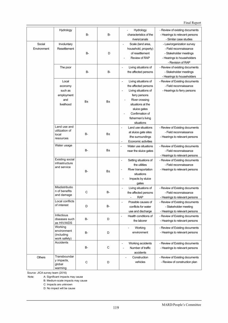
Final Report
MARD/People’s Committee 119
Hydrology
B- B-
- Hydrology
characteristics of the
rivers/canals
- Review of existing documents
- Hearings to relevant persons
- Similar case studies
Social
Environment
Involuntary
Resettlement
B- D
- Scale (land area,
household, property)
of resettlement
- Review of RAP
- Law/organization survey
- Field reconnaissance
- Stakeholder meetings
- Hearings to householders
- Revision of RAP
The poor
B- B-
- Living situations of
the affected persons
- Review of existing documents
- Stakeholder meetings
- Hearings to householders
Local
economy
such as
employment
and
livelihood B± B±
- Living situations of
the affected persons
- Living situations of
ferry persons
- River crossing
situations at the
sluice gates
- Confirmation of
fishermen’s living
situations
- Review of Existing documents
- Field reconnaissance
- Hearings to ferry persons
Land use and utilization of local resources
B- B±
- Land use situations
at sluice gate sites
/the surroundings
- Economic activities
- Review of Existing documents
- Field reconnaissance
- Hearings to relevant persons
Water usage
B- B± - Water use situations
near the sluice gates
- Review of Existing documents
- Field reconnaissance
- Hearings to relevant persons Existing social infrastructure and service
B- B±
- Setting situations of
the utilities
- River transportation
situations
- Impacts by sluice
gates
- Review of Existing documents
- Field reconnaissance
- Hearings to relevant persons
Misdistribution of benefits and damage
C B- - Living situations of
the affected persons
- RAP
- Review of Existing documents
- Field reconnaissance
- Hearings to relevant persons Local conflicts of interest D B-
- Possible causes of
conflicts for water
use and discharge
- Review of Existing documents
- Stakeholder meeting
- Hearings to relevant persons Infectious diseases such as HIV/AIDS
B- D - Health conditions of
the laborer
- Review of Existing documents
- Hearings to relevant persons
Working environment (including work safety)
B- D
- Working
environment
- Review of Existing documents
- Hearings to relevant persons
Accidents
B- C - Working accidents
- Number of traffic
accidents
- Review of Existing documents
- Hearings to relevant persons
Others
Transboundary impacts, global warming
C D
- Construction
vehicles
- Review of Existing documents
- Review of construction plan
Source: JICA survey team (2016)
Note: A: Significant impacts may cause
B: Medium-scale impacts may cause
C: Impacts are unknown
D: No impact will be cause

Preparatory Survey for Ben Tre Water Management Project
JICA 120
In term of the alternative analysis of the TOR, it was conducted by comparative analyses with the following indicators for this Project:
Social impacts (Land acquisition and resettlement)
Impacts on natural environments
Impacts on climate change
River transportation
Impacts on regional development
Project costs
Operation and maintenance costs
Resilience for changes of livelihood means of the residents with salinity intrusion
Flexibilities of annual environmental changes
3.5 ENVIRONMENTAL AND SOCIAL SURVEY RESULTS AND IMPACT EVALUATION
3.5.1 ENVIRONMENTAL SURVEY RESULTS AND IMPACT EVALUATION
1) Scoping and Environmental survey Results
Table 3.5.1 shows the scoping results and the environmental survey results for pollution and natural environmental items:
Table 3.5.1 Evaluation by Scoping and Environmental survey Results
Classification No. Items
Impacted
Impact
Assessment at
Scoping
Impact
Assessment based
on survey Findings
Evaluation Reasons
Pre- and
Mid
Const-
ruction
Operation Pre-
and Mid
Const-
ruction
Operation
Pollution 1
Air Pollution B- B- B- B- It may be expected that the use of
construction vehicles bring about the
emissions of dust and air pollutants.
The project also includes access
roads connecting to existing roads,
resulting in the slight increase in dust
and exhaust gas emissions. However,
the air impacts will be within the
permissible range.
2 Water
Pollution
B- B- B- B- Wastewater discharge and surface
water runoff from construction sites
may carry organic, sediment loads
that deteriorate surface/groundwater
sources. It is predicted that the closure
of sluice gates might create water
stagnancy, and accumulation of both
wastes and water pollution, if no
countermeasures are taken.
3 Wastes
B- B- B- B- The construction phase is reported to
generate many waste types such as
construction wastes, excavation
materials, felled vegetation, and
possible oil spills. Wastes from

Final Report
MARD/People’s Committee 121
domestic, agricultural sources could
be also trapped when closing gates, if
no countermeasures are taken.
4 Noise and
Vibration
B- C B- D Noise that are generated by
construction machineries may affect
residential areas near construction
sites. The increase in traffic volume
will not affect noise at residential areas
because the expected volume is small
scale.
5 Land
Subsidence
C C D D According to the assessment on the
construction methods and geology of
the characteristics, the construction
and the sluice gates operation will not
cause any land subsidence.
6 Bottom
Sediment
B- B- B- B- Demolition, excavation and
construction wastes hold high
sediment load. Also, the closure of
sluice gates induces water stagnation,
thus deposition of sediments is likely
to increase and accumulation of
wastewaters may be deteriorate
bottom sediments.
It is a possibility that a temporal water
turbidity will be generated due to
sediment discharge, and a temporal
negative impacts on the bottom
sediment.
Natural
Environment
7. Protected Area C C D D The construction and the operation
activities will not cause any impacts on
the protected areas due to the location
of the protected areas.
8 Ecosystem B- B-
B- B-
The Project is anticipated to have
some certain impacts on ecosystems,
mainly by clearance of vegetation,
altering hydrology, and pollution.
Closing sluice gates are reported to
interrupt the movement of migratory
fishes, thus affecting their recruitment
and survival.
The Project is anticipated to have
some negative impacts temporarily on
benthos and so on due to the temporal
occurrence of turbidity by the
sediment outflow from the construction
of the revetment and bed protection.
9 Hydrology B- B-
B- B-
It is expected that the Project would
exert impacts on hydrological regimes
in The Construction phase and the
operation phase, including narrowing
and reducing river flow by the
construction of the gates, while
increasing water flow in other areas. Source: JICA survey team (2016)
Note: A: Significant impacts may cause
B: Medium-scale impacts may cause
C: Impacts are unknown
D: No impact will be cause

Preparatory Survey for Ben Tre Water Management Project
JICA 122
2) Main Forecasts for Possible Adverse Environmental Impacts
a) Noise
Noise will be emitted from construction sites during the site preparation and the construction activities by utilization of heavy construction machines and the movement of construction vehicles. Noise during The Construction phase will primarily be contributed by heavy construction machineries to the local residential areas near each sluice gate construction site. Noise power levels for different types of heavy construction machinery, which will generate high noises by the construction activities, are shown in Table 3.5.2.
Table 3.5.2 Noise Power Level of Main Heavy Construction Machines
Equipment Sound Level at Operator (unit: dB (A))
Average Range
Bulldoser 93.0 - Paving and machine 87.7 87.0 – 88.5 Land scraper, compactor 86.5 80.0 – 93.0 Puller 86.5 77.0 – 96.0 Concrete mixer 81.5 75.0 – 88.0 Moving crane 81.5 76.0 – 87.0 Air compressor 81.0 75.0 – 87.0
Source:Cited from “North Ben Tre Irrigation Project (Ben Tre Water Management Project) – Environmental Impact Assessment Report”,2014
The impacts of construction noises in the sites are predicted using the following formula for calculation of noise prediction for a stationary source.
LA,i = LWA,i – 20 log10 Ri + Δcor., i
Where,
LA,I : Noise level at a distance Ri from the noise source at A characteristics [dB (A)]
LWA,I : Noise power level of a construction machine at A characteristics [dB (A)]
Ri : Distance from the noise source [m]
Δcor., i : Correction factors depended on conditions of attenuation [dB (A)] Note: There was no available data for the above correction factors in Vietnam, therefore, the
Δcor., iis adopted as 0 dB (A).
For the prediction of the noise levels, it is calculated for the worst case scenario using the following conditions:
- Maximum noise power level of the bulldozer is assumed for the noise impact forecast as the worst case;
- The noise forecast levels are assumed at points, which are the nearest residential house yard from each proposed sluice gate construction site.
The prediction results of the noise levels at each point is shown in Table 3.5.3.
Table 3.5.3 Predicted Noise Levels by a Bulldoser at Each Point
Proposed Sluice Gates
Approximate distance from each
construction site [ m ]
Predicted Noise Level
[dB (A) ]
Noise Level Limits for Normal Area*1 in Vietnam*2[dB (A) ] Day time
(6 am – 9 pm) Night time
(9 pm – 6 am) An Hoa 9.5 73.44
70.0
55.0
Ben Ro 43.2 60.30 Ben Tre 20.4 66.80 Cai Quao 32.2 62.84 Tan Phu 21.3 66.44 Thu Cuu 30.5 63.32 Vam Nuoc Trong 19.7 67.12 Vam Thom 14.4 69.84
Source: Additional surveys by JICA survey team (2016) Note *1: Normal Area includes residential area, hospital, and school Note *2: National Technical Regulation 26/2010/BTNMT in Vietnam
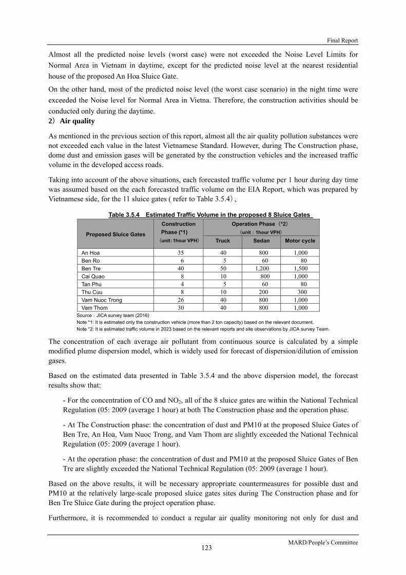
Final Report
MARD/People’s Committee 123
Almost all the predicted noise levels (worst case) were not exceeded the Noise Level Limits for
Normal Area in Vietnam in daytime, except for the predicted noise level at the nearest residential
house of the proposed An Hoa Sluice Gate.
On the other hand, most of the predicted noise level (the worst case scenario) in the night time were
exceeded the Noise level for Normal Area in Vietna. Therefore, the construction activities should be
conducted only during the daytime. 2)Air quality
As mentioned in the previous section of this report, almost all the air quality pollution substances were not exceeded each value in the latest Vietnamese Standard. However, during The Construction phase, dome dust and emission gases will be generated by the construction vehicles and the increased traffic volume in the developed access roads.
Taking into account of the above situations, each forecasted traffic volume per 1 hour during day time was assumed based on the each forecasted traffic volume on the EIA Report, which was prepared by Vietnamese side, for the 11 sluice gates ( refer to Table 3.5.4)、
Table 3.5.4 Estimated Traffic Volume in the proposed 8 Sluice Gates
Proposed Sluice Gates
Construction
Phase (*1)
(unit:1hour VPH)
Operation Phase(*2)
(unit:1hour VPH)
Truck Sedan Motor cycle
An Hoa 35 40 800 1,000 Ben Ro 6 5 60 80 Ben Tre 40 50 1,200 1,500 Cai Quao 8 10 800 1,000 Tan Phu 4 5 60 80 Thu Cuu 8 10 200 300 Vam Nuoc Trong 26 40 800 1,000 Vam Thom 30 40 800 1,000
Source:JICA survey team (2016)
Note *1: It is estimated only the construction vehicle (more than 2 ton capacity) based on the relevant document。
Note *2: It is estimated traffic volume in 2023 based on the relevant reports and site observations by JICA survey Team.
The concentration of each average air pollutant from continuous source is calculated by a simple modified plume dispersion model, which is widely used for forecast of dispersion/dilution of emission gases.
Based on the estimated data presented in Table 3.5.4 and the above dispersion model, the forecast results show that:
- For the concentration of CO and NO2, all of the 8 sluice gates are within the National Technical Regulation (05: 2009 (average 1 hour) at both The Construction phase and the operation phase.
- At The Construction phase: the concentration of dust and PM10 at the proposed Sluice Gates of Ben Tre, An Hoa, Vam Nuoc Trong, and Vam Thom are slightly exceeded the National Technical Regulation (05: 2009 (average 1 hour).
- At the operation phase: the concentration of dust and PM10 at the proposed Sluice Gates of Ben Tre are slightly exceeded the National Technical Regulation (05: 2009 (average 1 hour).
Based on the above results, it will be necessary appropriate countermeasures for possible dust and PM10 at the relatively large-scale proposed sluice gates sites during The Construction phase and for Ben Tre Sluice Gate during the project operation phase.
Furthermore, it is recommended to conduct a regular air quality monitoring not only for dust and

Preparatory Survey for Ben Tre Water Management Project
JICA 124
PM10, but also for basic air quality items in urban area, where air pollution will be generate in Ben Tre Province.
3) Water Quality
As described at the previous section, the water quality deterioration in the rainy season is not significant
comparing with the data in the dry season as a whole. On the other hand, some water quality items such as
ammonia and coliform in the dry season exceeded the permissible level of the surface water quality standards in
Vietnam.
The recent water quality deterioration may cause the absence of centralized wastewater treatment facility in Ben
Tre Province, and recent rapid population growth in the residential areas, and the recent increase in livestock
activities such as pig breeding. According to the interview survey at the district committee who is controlling the
sewage treatment at the subject area and field surveys at the households and a large livestock farm in the
concentrated residential areas, septic tanks which disposing are installed at the domestic miscellaneous
wastewater a lot of household in the concentrated residential areas, however removing of the sludge is and the
much domestic miscellaneous wastewater flow into the river/channel without treatment.
In the dry season, the water quality survey was conducted between January and May, 2016, the survey results
show that at the point of the downstream including Balai Sluice Gate during nitrogen level causing the
eutrophication exceeded the permissible level of the surface water quality standards in Vietnam drastically
whereas the data exceeded permissible level slightly at downstream of Ben Tre City. On the other hand,
phosphorous level, another cause of the eutrophication, did not exceed the permissible level of the surface water
quality standards in Vietnam at all the points.
This Project is composed of the construction of small and middle scale sluice gates at the 8 points of the river/
channel from upstream to downstream. In consideration of the above mentioned water quality status and its
causes, water pollution including the eutrophication are concerned at a part of section of upstream decreasing
water level in construction and operation phase. It is not expected that water quality get worse after the
implementation of this Project because water volume at upstream will be controlled by the operation of sluice
gates based on the data of water quality and salinity concentration at the upper stream or downstream of the
sluice gates installed by this Project.
The points of sluice gates planning on this Project and its neighboring areas, except Ben Tre luice Gate are
located at the rural area, unused area without building such as residences and factories or district that small scale
fruits cultivated land is located at both riverside. Therefore, possible water pollution is concerned and the flow
control operating water gate considering water quality at downstream is important to prevent water pollution in
construction and operation phase. Furthermore, in consideration of increasing population in the future, it can be
said that installing the facility disposing the domestic miscellaneous wastewater adequately and operating that
facility efficiently are required in future.
Therefore, in terms of wastewater and sewage among sluice gates, while the impact against water quality by
implementation of this Project is hardly expected, installing the facility disposing waste water adequately at large
scale livestock (pig, chicken) farm, which is expected that being increasing in future, and administrative
instruction are important to prevent possible water pollution.
4) Hydrology and Riverbank Erosion
As described at the previous section, flow condition of river and channel change temporarily and partially during the construction phase and the operation phase, there is a possibility that the planned sluice gates may influence the flow condition of the rivers/channels. While there are some points that flow down width become narrower and flow become smaller, there is a possibility that the flow become larger at the other points.

Final Report
MARD/People’s Committee 125
However, measures which do revetment construction and riverbed protection construction to the both banks and the riverbed are considered in the all range expected the hydraulics impact by the operating sluice gates of this Project. And it is expected that the impact to the hydrometeor become temporarily and small scale during the construction phase.
Further, it can be said that hydrology is hardly influenced by the sluice gates in the rainy season because all the sluice gates proposed on this Project keep open during the rainy season. In addition, it can be said that that controlling hydrology of river/channel adequately become possible since this Project includes not only constructing but also operating open and close all the gate, and working adequately based on the data of salinity concentration and water quality through real time data such as flow at the river/channel.
For the riverbank erosion, it is one of the most important issues in Ben Tre Province as described at previous section. According to a staff of Rural Development Division in charge of riverbank erosion, the cause of the riverbank erosion is lateral erosion by running water, not seepage failure.
Other opinions implied some causes that a ship-run generates water wave; dredging work degrades the riverbed. On the other hand, there is also a part of sediment deposition conversely. Riverbank erosion and sediment deposition are regarded as homeostatic phenomenon caused by river force.
It is not confirmed that construction of the proposed sluice gates will cause any favorable or negative impacts on the present riverbank erosion. In this Project, the river protection measures will be conducted all of the riverbank at the construction sites. Therefore, the Project will not cause significant riverbank erosion.
However, it is necessary that the above Rural Development Division in charge of riverbank erosion should conduct more frequency regular monitoring for riverbank erosion, and conduct effective countermeasures for the riverbank erosion, based on the erosion situations in the sites..
5) Ecosystems
Mangroves
At present, small amount of mangrove clusters, which consist only two non-endangered species: Nypa palm (Nypa fruticans) and mangrove apple (Sonneratia caseolaris), still remain along rivers and cannels, including the river banks of all the proposed sluice gates in inland of Ben Tre Province. Other founded vegetation was common water hyacinths (Eichhornia crassipes) and domestic crops and fruits trees, including domestic banana, coconut, jackfruit, durian, and rose apple (see Figure 3.5.1 and Figure 3.5.4).

Preparatory Survey for Ben Tre Water Management Project
JICA 126
Figure 3.5.1 Nyoa Palm with Present Vegetation (near Proposed Vam Nuoc Trong Sluice Gate)
source:JICA survey team (2016)
Figure 3.5.2 Mangrove Apple with Present Vegetation (near Proposed Tan Phu Sluice Gate)
source:JICA survey team (2016)
Figure 3.5.3 Common water hyacinths with Present Vegetation (near Proposed Tan Phu Sluice Gate)
source:JICA survey team (2016)
Figure 3.5.4 Coconuts Fruits Garden (near Proposed Tan Phu Sluice Gate)
source:JICA survey team (2016)
Table 3.5.5 shows salt tolerance of the mangrove species in the survey Area and coasts in Ben Tre Province.
Table 3.5.5 Salt Tolerance of the Mangroves in the Survey Area, and Coasts in Ben Tre Province Species of mangrove English name Japanese name Salt tolerant Source
Nypa fruticans Nipa palm Nippayashi 10 ‰ [1]
Sonnneratia caseolaris Mangrove Apple - 35 ‰ [2]
Sonnneratia alba - Hamazakuro 35 ‰ [3]
Avicennia marina Grey Mangrove Hirugidamashi 35 ‰ < [4] Source: [1] Ellison, J., Koedam, N.E., Wang, Y., Primavera, J., Jin Eong, O., Wan-Hong Yong, J. & Ngoc Nam, V. 2010. [2] Kathiresan, K., Salmo III, S.G., Fernando, E.S., Peras, J.R., Sukardjo, S., Miyagi, T., Ellison, J., Koedam,
N.E., Wang, Y., Primavera, J., Jin Eong, O., Wan-Hong Yong, J. & Ngoc Nam, V. 2010. [3] Ball, M. C. and Pidsley S. M., 1995, Growth Responses to Salinity in Relation to Distribution of Two
Mangrove Species, Sonneratia alba and S. lanceolata, in Northern Australia, Functional Ecology, Published by: British Ecological Society, DOI: 10.2307/2390093, Stable URL: http://www.jstor.org/stable/2390093
[4] Aziz, I. and Khan M. A, 2000, Physiological adaptions of Avicenia marina to seawater concentrations in the Indus Delta, Pakistan, Pakistan Journal of Botany ,32)1):151-169
In all the eight proposed sites, remain mangrove forests are few, low in density, scattered, fragmented, only form a thin strips near the water body. The mangrove clusters in Tan Phu, Thu Cuu and Cai Quao is relative bigger than the other sites, but the strips are still less than 2 m in width. Current conditions are the results of development history and population pressure.
The mangroves found in near the sluice gate construction sites are common species, which have not be protected by Vietnamese or international laws, has not been listed in Vietnamese Red Data book (2007). In addition, these species have been listed as Least Concern by IUCN. Table 3.5.6 shows vegetation areas that need to be cleared for the sluice gates construction.

Final Report
MARD/People’s Committee 127
Table 3.5.6 Vegetation Areas need to be cleared for the Sluice Gates Construction
Source:JICA survey team (2016)
According to the Provincial Department of Forestry in Ben Tre, the remaining mangroves along the river near the sluice gates construction sites have not been considered as forest. These mangroves are not considered as a habitat and/or feeding ground of aquatic creatures according to relevant materials and site visits. This means that the mangroves currently do not have an important ecological role .
The ecological important role of mangroves here means a coastal protection function against natural disasters such as typhoons, a cultivation function of fishery resources and a function to preserve a landscape. The reason why those roles/ functions are judged absent in the sluice gates construction sites and their surrounding river banks is these all river bank vegetation is mixed with very small-size clusters of mangrove species and others. Each cluster of mixed vegetation is approx.. 2m width at a maximum and approx.. 3m length at a maximum and located discontinuously in low density.
On the other hand, river bank vegetation has an ecological function as a hiding/ resting ground for fish species. However, the scale of the target river bank vegetation is very small and the impacts on these functions by cutting trees is anticipated minor.
As a result of above, it is expected that habitat’s cutting including remaining mangrove species at the entire proposed construction site of sluice gates or surrounding area of each sluice gate site cause few impacts on natural environment. Furthermore, these mangrove species are used as a kind of wood of roof but impacts on social economic and culture of local residences by cutting above volume are few because these species are abundance and growing speed is very fast.
However, it is proposed to conduct a fish capture survey as an environmental monitoring parameter during the detailed design phase in order to verify the impacts on the ecological function of the river bank vegetation.
Apart from the above, there are opinions that habitats along riverside including mangrove species restrain the progress of riverbank erosion. But these characteristic is not only ecological function mangrove species has and it can be said that there is a possibility that general habitats mixing another species restrain the progress of riverbank erosion partially. This Project’s designing includes revetment construction and streambed protection construction between both riverside around upper and downstream of the proposed sluice gates and riverside expected hydrology impacts due to operation of sluice gates.
As the result, clearance of some remain mangrove clusters at all of the proposed sluice gate construction sites are completely legal in Vietnamese laws or international regulations. The clearance of remain mangrove have few foreseen environmental impacts. Those clusters currently do not play
Proposed SluiceGates
Estimatevegetationclearance
(ha)
Approximateclearance area
cover bymangrovespecies
(%)
Approximateclearance
areacover by
Nypa palm(Nypa
fruticans) (%)
Approximateclearance
areacover by
mangroveapple
(Sonneratiacaseolaris) (%)
Approximateclearance
areacover by
mangrovespecies
(ha)
Approximateclearance
areacover by
Nypa palm(Nypa
fruticans)(ha)
Approximateclearance
areacover by
mangroveapple
(Sonneratiacaseolaris)
(ha)An Hoa 0.98 40 30 10 0.39 0.30 0.10Thu Cuu 0.40 30 25 5 0.12 0.10 0.02Ben Tre 0.75 80 20 60 0.60 0.15 0.45Tan Phu 0.40 30 5 25 0.12 0.02 0.10Ben Ro 0.37 30 10 20 0.11 0.04 0.07Cai Quao 0.19 70 60 10 0.13 0.11 0.02Vam Nuoc Trong 0.84 30 25 5 0.25 0.21 0.04Vam Thom 0.36 50 10 40 0.18 0.04 0.14
total 4.29 1.91 0.96 0.95

Preparatory Survey for Ben Tre Water Management Project
JICA 128
significant ecological roles as they do not provide either roosting site or foraging site for fauna.
Fishes
As mentioned in section 4.2.1 of this report, there are some vulnerable species live in the survey Area.
The followings impact analyses based on the fish catch surveys and interview surveys to the local fishermen/aquaculture farmers, and the local fish sellers in the survey Area conducted from August 2015 to May 2016.
a) Findings from The Fish Catch survey
The fish catch survey was regularly conducted by Vietnamese side at 20 sampling points until August, 2015, which were covered local EIA for 11 sluice gates including 8 sluice gates of this Project. In this survey, catch surveys taking over Vietnamese surveys were conducted twice a month at the 20 points as sub-contracted surveys.
In 253 species fish observed on the sub-contracted surveys, fish which could live in only freshwater were 128 species, whose main habitats is freshwater and which don’t migrate. There is a high possibility that these species become main fish fauna in upstream by opening and closings. Also, there is a high possibility that these species become main fish fauna in downstream of sluice gates after construction by opening and closing of the sluice gates in dry season. In the same way, fish which could live in only seawater were 72 species and there is a high possibility that these species become main fish fauna in downstream of sluice gates after construction by opening and shutting of sluice gates in dry season.
Classified species as more than Near Threatened (NT) category on IUCN Red List, 6th rarest species from extinct species; extinct risk is small at present but there are factors sliding to upper rank of an endangered species, ware observed 9 species. In these species, it is thought that 3 species, Carcharhinus leucas, Himantura walga and Epinephelus coioides, can spend their whole life in seawater and 5 species, Tenualosa thibaudeaui, Hypophthalmichthys molitrix, Clarias microcephalus, Pangasius krempfi, and Boesemania microlepis, can spend their whole life in fresh water and impact by changing waters environment is relatively not significant.
Table 3.5.7 shows the observed species of field surveys focused on “importance of migration between brackish water and fresh water on life cycle”.
Table 3.5.7 Migration Categories Focused on Importance of Migration between Brackish Aater and Freshwater
Division Contents A: species requiring migration between fresh water and seawater (species concerned about ascension and descension)
A-1 They grow up in brackish water and seawater and ascension and lay eggs in fresh water (ascended migration)
A-2 They grow up in fresh water and lay eggs in brackish water and seawater. (descended migration)
A-3 They grow up and lay eggs in fresh water and live in brackish water and seawater on a period after hatching.(both side migration)
B: species whose main habitats are fresh water, brackish water or seawater but the other waters are also available.
B-1 They live mainly in fresh water but can migrate to brackish water and seawater
B-2 They live mainly in brackish water but can migrate to fresh waterB-3 They live mainly in seawater but can migrate to fresh water and
brackish water. Sources:
1) Fishbase: a global information system on fishes. FishBase, 2000. 2) Rainboth, W. J. (1996). Fishes of the cambodian mekong. Food & Agriculture Org.. 3) Panikkar, N. K. (1967). Osmotic behaviour of shrimps and prawns in relation to their biology and culture. FAO. 4) Short, J. W. (2004). A revision of Australian river prawns, Macrobrachium (Crustacea: Decapoda: Palaemonidae).
Hydrobiologia, 525(1-3), 1-100. 5) Aneykutty, J., Deepthi, G. N., & Lakshmi Devi, P. (2013). Habitat ecology and food and feeding of the herring bow crab Varuna
litterata (Fabricius, 1798) of Cochin backwaters, Kerala, India.
Table 3.5.7 shows the observed species of field surveys focused on “importance of migration between

Final Report
MARD/People’s Committee 129
brackish water and fresh water on life cycle”..
The followings are expected impacts to fish migration by the construction of the sluice gates: - 2 species, Pisodonophis boro and Coilia lindmani, were confirmed as ascended migration type
species, which laid eggs in fresh water and descend to brackish water and seawater. If these species access the objective waters as a spawning ground, ascend in fresh water to lay eggs and descend of young fish to the river in brackish water or fresh water after laying eggs are prevented. An gonadal index of Coilia lindmani is 3, which is relatively high, there is a high possibility that it access upstream of the sluice gates as a spawning ground.
- 7 species, Anguilla marmorata, Anodontostoma chacunda, Chelon subvirdis, Ellochelon vaigiensis, Moolgarda cunnesius, Paramugil parmatus, Lates calcarifer and Terapon jarbua, were confirmed as species which laid eggs in seawater and ascend to brackish water and fresh water to grow up. On this species, running down of adult fish to the river to lay eggs and running up of young fish to the upper stream are prevented. However, 6 species except Anguilla marmorata can live after construction of sluice gates if brackish water environment is exist because these species migrate between brackish water and sea water.
- Glossogobius aureus was confirmed as a both side migratory fish which laid eggs in fresh water, descend to brackish water and seawater after hatching and spent a period life of young fish then running up to the river again. Regarding this specie, there is possibility that running dawn to brackish water and seawater on a period of young fish and ascend in fresh water are prevented by construction of sluice gates and it cannot live in upstream of the sluice gates. By the way, this specie is only one proved as a both side migration type by existing knowledges.
- Migration of Palaemonoidea shrimp which has life cycle of ascended migration type such as Macrobrachium mammillodactylus, Macrobrachium rosenbergii and Macrobrachium mirabile are prevented by the construction of sluice gates and there is possibility that ascension to upstream of sluice gates get difficult.
It is considered that mitigation measures against the abovementioned expected impacts are operating open and shut of proposed sluice gates in the dry season with considering above mentioned migratory characteristics and installing fishway mitigating migratory block as an incidental facility of sluice gates with considering construction points of the sluice gates.
For any mitigation measures of the abovementioned migratory fishes, operating open and close of the proposed sluice gates in the dry season with considering above mentioned migratory characteristics and installing fishway mitigating migratory block as an incidental facility of sluice gates with considering construction points of the sluice gates. Regarding the effectiveness of the fishway to be installed, from the detailed design phase as an environmental monitoring parameter, the species captured near the sluice gates shall be continuously verified in cooperation with local fishermen in order to collect information necessary for designing effective fishway. In addition, based on the judgment at the point of the detailed design, in the operation phase, it is proposed to monitor in collaboration with local fishermen whether the fish actually passes the installed fishway considering the switching of the sluice gates.
b) Findings from The Interview survey for The Local Fishermen/ Aquaculture Farmers, and
the Local Fish Sellers
An interview survey for the local fishermen/aquaculture farmers, and the local fish sellers were carried out from the beginning of February to the middle of March 2016.
Forty fish sellers at the study sites, 83 aquaculture farmers (37 households (HHs) at the brackish-water study sites, 46 HHs at the freshwater-water study sites), and 166 fishing households (35 HHs at the study sites around the 8 proposal sluice gates, 63 HHs at the sites at 8 proposal sluice gate, 68 HHs at the coastal sites) were interviewed.
Based on this survey results, the livelihoods of the fisheries households might be affected due to any possible loss of their fishing ground, resulting in reducing their income from fishing activities. The
Preparatory Survey for Ben Tre Water Management Project
JICA 130
income sources of the fish sellers might be affected, because most the fish suppliers are from the local fishers. On the other hand, the fresh water resources coming from the project operation are considered by the local fishers and the local fish sellers as other options for their livelihoods such as agricultural faming, orchards, and aquaculture. Therefore, the most of them appreciate the supply of freshwater resource for their living by this Project.
The followings are additional findings for considering the countermeasures for the possible negative impacts:
- Besides fishing activity, most households of the fishers are involved in several activities such as orchards (41% of households surveyed), rearing of livestock (36%), wage labour (not fish related, 23%), aquaculture 16%) and rice farming (11%).
- Most of aquaculture households have land areas for farming, and the average land area per household is 1.2ha, in which aquaculture accounted for 53% of total land areas and followed by orchards (30%) and rice farming (9%).
- Fish sellers were mainly female and about 61% of them are retailers, followed by whole sellers (34%) and fishers (5%), of which 82% are professional sellers.
Birds and avian fauna
As described in the previous section, there is “Vam Ho Bird Sanctuary” in Ben Tre Province in order to protect birds. In this sanctuary, inhabiting of 30 species birds was reported at present. These are general species without migratory birds such as Little egret (Egretta garzetta), Intermediate egret (Mesophoyx intermedia), and species registered in Vietnamese Red date Book or IUCN Red List were not confirmed. Furthermore, though the field survey in the sites was not continuous, the feed of these birds are insects including harmful one in sanctuary and small fish so that there is few impact due to construction and operation of the sluice gates.
Among the eight planned sluicegate sites, birds were only observed at Cai Quao site and An Hoa site The only two observed bird species were the White collared kingfisher (Todirhamphus chloris) and the yellowed vented bulbul (Pycnonotus goiavier), which are common and wide spread species. No evidence of endangered or concerned bird species has been found in all the sluice gates construction sites and adjacent areas.
Therefore, there are few impacts on the avian fauna, which habitat in the natural protected areas, where is located in more than 35km from the closest proposed sluice gate due to construction and operation of the sluice gates.
Other fauna
Most diverse and abundant fauna in Ben Tre Province is obviously insects. It was reported that thousands insects ware live in Ben Tre Province and some species were worth economically such as weaver ant (Oecophylla smaragdina). For example, Oecophylla smaragdina which lives around South East Asia and Oceania builds big colony usually and move between trees because it feeds harmful insects of fruit tree. Bee larva lives in tree trunk of coconuts.
As another fauna, reptiles live near the construction areas of the sluice gates and bats and squirrels live in the coastal area in Ben Tre Province except the construction sites of the sluice gates. These fauna’s habitats are not large, thus impacts on these habitats due to construction and operation of the sluice gates are not expected.

Final Report
MARD/People’s Committee 131
3.5.2 SOCIAL SURVEY RESULTS AND IMPACT EVALUATION
1) Involuntary Resettlement
During the Preparation survey, the following surveys had been carried out for updating Resettlement Action Plan (RAP) prepared by CPO in 2014: (a) socio-economic survey (SES), (b) inventory of loss (IOL), and (c) replacement cost survey. The results of the surveys are summarized in the Draft Updated RAP.
Table 3.5.8 shows the scope of land acquisition and resettlement, according to the inventory of loss survey.
Table 3.5.8 Scope of Land Acquisition and Resettlement
No. Sluice gate Commune District Land acquisition (m2) Resettlement
(HH)
1 Bến Tre
Nhơn Thạnh Tp. Bến Tre
12,351 0
2 Phú Hưng 15,009 5
3 An Hóa
Long Định Bình Đại 25,600 3
4 Giao Hòa
Châu Thành
15,500 0
5 Bến Rớ
Tiên Long 12,729 1
6 Tân Phú 4,935 0
Tân Phú 5,496 0
7 Phú Đức 8,842 0
8 Thu Cửu
Phước Long Giồng Trôm
4,244 0
9 Thạnh Phú Đông 4,200 2
10 Mỏ Cày Bắc
Tân Thành Bình Mỏ Cày Bắc 13,126 3
11 Định Thủy Mỏ Cày Nam 9,830 3
12 Mỏ Cày Nam
Khánh Thạnh Tân Mỏ Cày Bắc 18,140 1
13 Thành Thới B Mỏ Cày Nam
14,445 3
14 Cái Quao Bình Khánh Đông 8,485 1
TOTAL 172,932 22
Source: Drawings on compensation boundary plan of the 8 sluice gates and the IOL
A total number of 160 affected households (AHs) will lose productive land. In which, 89 households (HHs) are lightly affected with less than 20% of their productive landholdings to be acquired (Table 3.5.9).
The number of households who would lose 20% or more of their productive lands is 71 HHs. These households are defined by the Project as severely AHs.
Table 3.5.9 Severity of Impacts on Productive Land
No. District/ Commune Total no.
of AHs
AHs by severity of impacts
<20% 20% -
30%
More than
30%-70%
More than
70% 100%
I. Tp. Bến Tre
1 Nhơn Thạnh 14 7 2 5 0 0
2 Phú Hưng 1 0 0 1 0 0
II.Bình Đại
3 Long Định 12 3 5 3 1 0
III. Châu Thành

Preparatory Survey for Ben Tre Water Management Project
JICA 132
No. District/ Commune Total no.
of AHs
AHs by severity of impacts
<20% 20% -
30%
More than
30%-70%
More than
70% 100%
4 Giao Hòa 19 9 1 9 0 0
5 Tiên Long 14 9 2 3 0 0
6 Tân Phú 11 6 2 3 0 0
7 Phú Đức 11 6 2 1 2 0
IV. Giồng Trôm
8 Phước Long 5 5 0 0 0 0
9 Thạnh Phú Đông 7 4 3 0 0 0
V. Mỏ Cày Bắc
10 Tân Thành Bình 15 8 0 7 0 0
11 Khánh Thạnh Tân 8 5 0 3 0 0
VI. Mỏ Cày Nam
12 Định Thủy 17 9 3 3 2 0
13 Thành Thới B 17 11 3 3 0 0
14 Bình Khánh Đông 9 7 0 1 1 0
TOTAL 160 89 23 42 6 0
Scale (%) 100 55.6 14.4 26.3 3.8 0
Source: IOL for the RAP preparation
All 160 households (100% of AHs) whose productive land will be acquired mentioned that they have land use right certificates (LURCs) over their affected land.
In the project-affected area, 30 houses in 10 communes will be affected. 23 of them are fourth-grade-dwelling type with the similar characteristics – tiled roof or corrugated iron roof, brick wall, concrete foundation. The other seven (7) houses are temporary houses.
Table 3.5.10 Impact on Houses
No. Commune
No. of affected house No. of house with
usable remains
No. of house
unusable remains
Total affected house area
(m2) TOTAL 4th grade
house Temporary
house
1 Phú Hưng 6 6 0 3 3 534.7
2 Long Định 4 4 0 0 4 545
3 Phước Long 1 0 1 0 1 120
4 Thạnh Phú Đông 3 1 2 0 3 280.0
5 Khánh Thạnh Tân 2 1 1 0 2 320.0
6 Thành Thới B 5 5 0 3 2 861.0
7 Bình Khánh Đông 1 0 1 0 1 120.0
8 Định Thủy 4 3 1 1 3 380.0
9 Tiên Long 1 1 0 0 1 120.0
10 Tân Thành Bình 3 3 0 1 2 245.0
TOTAL 30 24 6 8 22 3,525.7
Source: IOL for the RAP preparation
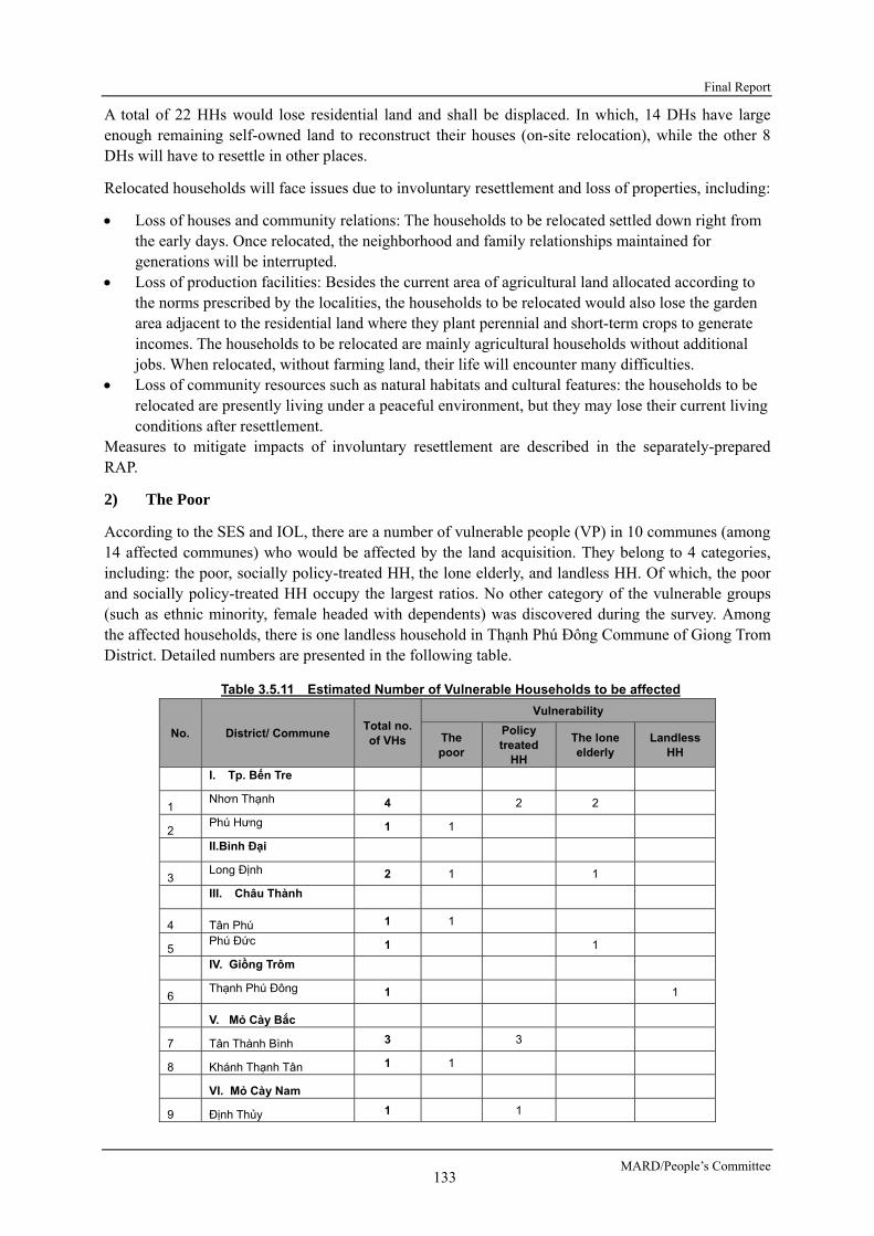
Final Report
MARD/People’s Committee 133
A total of 22 HHs would lose residential land and shall be displaced. In which, 14 DHs have large enough remaining self-owned land to reconstruct their houses (on-site relocation), while the other 8 DHs will have to resettle in other places.
Relocated households will face issues due to involuntary resettlement and loss of properties, including:
Loss of houses and community relations: The households to be relocated settled down right from the early days. Once relocated, the neighborhood and family relationships maintained for generations will be interrupted.
Loss of production facilities: Besides the current area of agricultural land allocated according to the norms prescribed by the localities, the households to be relocated would also lose the garden area adjacent to the residential land where they plant perennial and short-term crops to generate incomes. The households to be relocated are mainly agricultural households without additional jobs. When relocated, without farming land, their life will encounter many difficulties.
Loss of community resources such as natural habitats and cultural features: the households to be relocated are presently living under a peaceful environment, but they may lose their current living conditions after resettlement.
Measures to mitigate impacts of involuntary resettlement are described in the separately-prepared RAP.
2) The Poor
According to the SES and IOL, there are a number of vulnerable people (VP) in 10 communes (among 14 affected communes) who would be affected by the land acquisition. They belong to 4 categories, including: the poor, socially policy-treated HH, the lone elderly, and landless HH. Of which, the poor and socially policy-treated HH occupy the largest ratios. No other category of the vulnerable groups (such as ethnic minority, female headed with dependents) was discovered during the survey. Among the affected households, there is one landless household in Thạnh Phú Đông Commune of Giong Trom District. Detailed numbers are presented in the following table.
Table 3.5.11 Estimated Number of Vulnerable Households to be affected
No. District/ Commune Total no. of VHs
Vulnerability
The poor
Policy treated
HH
The lone elderly
Landless HH
I. Tp. Bến Tre
1 Nhơn Thạnh 4 2 2
2 Phú Hưng 1 1
II.Bình Đại
3 Long Định 2 1 1
III. Châu Thành
4 Tân Phú 1 1
5 Phú Đức 1 1
IV. Giồng Trôm
6 Thạnh Phú Đông 1 1
V. Mỏ Cày Bắc
7 Tân Thành Bình 3 3
8 Khánh Thạnh Tân 1 1
VI. Mỏ Cày Nam
9 Định Thủy 1 1

Preparatory Survey for Ben Tre Water Management Project
JICA 134
No. District/ Commune Total no. of VHs
Vulnerability
The poor
Policy treated
HH
The lone elderly
Landless HH
10 Bình Khánh Đông 1 1
TOTAL 16 5 6 4 1
Scale (%) 100 31.25 37.50 25.00 6.25
Source: SES for the RAP preparation
These households would face difficulty in restoring their living and livelihood after resettlement. Therefore, they should be provided with special assistants as described in RAP.
3) Local Economy such as Employment and Livelihood
- Positive impacts to local economy
Agriculture constitutes the largest share of the economy of affected communes. The most popular crop type is coconut, which is grown in large scale in all communes. There are some communes where its land is almost dominated by coconut gardens, namely Phu Duc, Phuoc Long, Thanh Phu Dong, Thanh Thoi B, and Dinh Thuy. In contrast, fruit gardens (excluding coconut) make up the majority of the agricultural area in some communes like Tien Long and Tan Phu. The most popular fruit crops are pomelo, durian, rambutan, mango and longan. Paddy cultivation is diminished significantly in most communes, except Long Dinh and Phu Hung. In some areas, farmers also grow some different crops in coconut garden, including cacao, banana and some fruits. In general, the diversity of crops reflects the impact of saline intrusion on local agriculture, as most of fruit species are not saline water-tolerant, leading to the predominance of coconut in a large number of communes.
Besides horticulture, husbandry also plays an important role in local economy. The most prevalent domestic animal is pig, with more than 124 thousands of individuals in total. It is followed by the population of goats and cows of which herd sizes vary from a few to more than thousands (in Khanh Thanh Tan, Tien Long, Phu Hung, and Tan Phu). Poultry is also widely raised, accounting for more than 360 thousand of chicken, ducks and birds in 14 communes. In addition, there is also small areas dedicated for aquaculture, which are either freshwater (for fish and freshwater prawn) or brackish (for shrimp). The largest aquaculture area belongs to Tan Phu Commune (89 ha) and Thanh Phu Dong Commune (88 ha).
Table 3.5.12 Agriculture in the affected communes
No Commune
Farm area (ha) Husbandry (thousands)
Aqua-cultu
re (ha)Rice
Annual
crops (excl.
rice)
CoconutCacao
(mixed)Fruits Pig Cow Goat Poultry
1 Nhon Thanh - 387,55 - 297.5 1.30 0.116 0 13.00 24.0
2 Phu Hung 97.6 26.0 338.0 - 42.0 1.20 1.209 0 15.00 7.1
3 Long Dinh 158.6 21.5 96.8 - 333.9 2.12 0.206 0.237 18.63 2.2
4 Giao Hoa 22.4 9.2 194.4 - 145.4 0.97 0.075 0.286 4.59 13.1
5 Tien Long - - 142.6 - 789.4 0.93 0.009 1.193 26.46 75.0
6 Tan Phu - - 90.9 - 1078.0 1.36 0.087 1.240 23.03 89.4
7 Phu Duc - - 110.1 - - 1.12 0.020 1.250 5.43 75.0
8 Binh Khanh
Dong - - 676.9 31.0 28.0 19.52 0.237 0.411 20.03
9 Thanh Thoi B - - 847.0 27.4 - 40.60 0.772 0 48.36 15.0
10 Dinh Thuy - - 1112.1 33.2 79.0 18.50 0.112 0 75.00 23.3

Final Report
MARD/People’s Committee 135
No Commune
Farm area (ha) Husbandry (thousands)
Aqua-cultu
re (ha)Rice
Annual
crops (excl.
rice)
CoconutCacao
(mixed)Fruits Pig Cow Goat Poultry
11 Tan Thanh
Binh 26.1 32.5 1195.6 - 122.2 10.18 0.374 0.684 62.39 61.4
12 Khanh Thanh
Tan 20.0 83.4 679.3 - 135.6 18.60 2.350 0 22.50 27.8
13 Phuoc Long - - 1118.3 - 85.7 4.48 0.074 1.252 25.74 39.7
14 Thanh Phu
Dong - - 1058.0 - - 4.00 0 1.582 0.67 88.7
Source: Annual socio-economic reports provided by CPCs, 2015
According to participants in the stakeholder consultation meetings in the communes, the most concerned issues of the farmers in the Ben Tre Province are as following (Table 3.5.13).
Table 3.5.13 Most concerned issues of local residents
No. Concerns of stakeholders
Stakeholders
Local
authority
Rice
farmer
Coconut
farmer
Fruit
farmerHusbandry
Aquacul-
ture farmer Others
1 Lack of freshwater causing low agricultural productivity **** **** **** **** **** ** **
2 Sluice-gate operation schedule **** *** *** *** *** *** **
3 Water pollution due to industrial/ agricultural discharge **** **** **** **** **** **** **
4 Water logging due to closure of sluice-gate **** *** *** *** ** * *
5 Develop irrigation canals *** ** ** ** * * *
6 Capital support *** *** *** *** *** *** *
7 Technical supports to change livelihood activities ** ** ** ** ** *** **
8 Market of agricultural products * ** ** ** ** ** *
9 Detail plan of brackish and freshwater areas ** ** ** * * ** NA
10 Control pest and disease ** ** ** ** ** NA NA
11 Impact of the project on fishery resource *** NA NA NA * **** **
Source: JICA survey team(2016)
It can say that the lack of freshwater is the most concerned issue among the farmers in the Ben Tre Province. The sluice gates system planned under the B-SWAMP project would help constantly supply freshwater to the area throughout the year, thus help provincial people develop high value-added agricultural production such as fruit tree cultivation, livestock, etc. In addition, the bridge and access roads planned together with the sluice gates may contribute to the improvement of local road network, and promote local economy and industry development.
- Adverse impacts to local economy
The project shall need to acquire some lots of agricultural land for construction of sluice gates and roads. Particularly, three coconut coir manufacturing enterprises (two in Phu Hung commune, one in Thanh Thoi B commune), and one construction and trade company of Phu Hung commune would be affected by land acquisition for the Project. Of which, one coconut coir production enterprise and the construction and trade company are slightly affected as their acquired areas are less than 20%. The other two coir production enterprises are considerably affected with the percentage of land to be acquired is higher than 50%. These two enterprises may be difficult to continue their operation since the remaining areas are insufficient to sustain their business.

Preparatory Survey for Ben Tre Water Management Project
JICA 136
In addition, a part of local fishermen and fish sellers may be affected by the project. According to the interview survey to these fishermen and fish sellers carried out in February and March 2016, income of the local fishermen and fish sellers whose livelihood depends on catching fisheries would be reduced to some extent due to the operation of the sluice gates. Presently, according to fishermen (98 persons interviewed by the Survey Team) who are carrying out catching fisheries around the planned sluice gates, due to the exceeded catching, outlawful catching, water pollution, etc., the quantity of caught fishes is decreasing year by year, and it becomes hard to catch the shrimps, crabs with high market value. In the future, when the planned sluice gates are brung into operation, these gates would be closed during the dry seasons, and it would cause the additional change in fish catch, due to the change of river ecosystem, water salinity, water quality, and the tides and water flows in the areas inside the gates. On the other hand, it is said that a large number of fishermen are also earning incomes from fruit cultivation, livestock, part time labor, aquaculture, rice cultivation, etc., beside fish catching. In actuallity, a fishman household usually has a land lot of about 3,500 m2. About a half of this land area is using for fruit cultivation. A large number of interviewed fishermen said that they expect the Project will be soon implemented, because they think it would help supply freshwater stably throughout the year that is necessary for their daily life, livestock, orchard, etc. A part of fishermen said that they can change the fishing ground and continue their fish catching. Besides, they expect that they can improve their livelihood by concentrate efforts into fruit cultivation, livestock, etc. with the use of freshwater to be supplied as a result of the Project. However, local authorities such as DARD should make further efforts to help fishermen who needs to change livelihood by providing them with know-how and technical assistance for fruit cultivation, stock raising, etc.
Based on the above, most of the local fishermen are doing fishing activities in the variety of the waterbodies, and has each alternative fishing ground. It is difficult to think that this sluice gates construction and their operations of this project will cause direct significant adverse impacts on the earning incomes of the local fishermen. Also, as it is described the above, most of the local fishermen have alternative earning incomes except for the fisheries. It is difficult to think that actual main source of the earning incomes of the local fisherman is came from the local fisheries.
Therefore, it could be said that this Project will not cause significant adverse impacts on the local fishermen. Monitoring on the local fishermen will be conducted during the period of the project implementation stage; if some adverse impact on the local fishermen’s household is identified as a result of the monitoring, formulation of mitigation measures such as compensation and/or assistance shall be recommended to the Ben Tre PPC.
- Impedance of waterway transportation
The newly constructed sluice gates might impede a number of goods transporting boats, fishing boats, etc. One ferryman who is carrying out transportation service between two banks of the Vam Nuoc Trong River near the Vam Nuoc Trong Sluice Gate may lose his means of livelihood due to the development of the road on the sluice gates.
During the Preparation survey, a number of surveys were carried out to predict and assess impacts that may be caused by the project to the boats/ships which are frequently using the waterways where the sluice gates are planned.
4) Land Use and Utilization of Local Resources
In the construction phase, some lots of agricultural land around the sluice gates would be acquired to make land for the sluice gates and access roads.
In the operation phase, land for cultivation of fruit trees, vegetables would be expanded due to the stable supply of freshwater. Local resources would be efficiently utilized because of the development

Final Report
MARD/People’s Committee 137
of local road network.
According to results of the consultation meetings, focus group meetings, and field surveys, the lack of saline water for shrimp aquaculture in downstream of the rivers is considered not serious even in the operation phase of the project. Therefore, adverse impacts to shrimp aquaculture due to the lack of saline water in the operation phase are not expected. However, measures to control polluted water in the operation phase should be carefully prepared and implemented.
5) Water Usage
In the construction phase, the river water near the construction sites would be temporarily polluted. Residents living near the construction sites would have to treat river water before using it for livestock. Proper construction method should be applied to control polluted water from construction works.
In the operation phase, with the proper operation of the sluice gates, the river water quality and water flow may be adjusted to suit the needs of water usage of local residents.
6) Existing Social Infrastructure and Service
The areas around the planned sluice gates are almost being used for agricultural production with no specified public facilities (such as electric poles, water supply pipes, communication cables, etc.). However, transportation on the rivers may be temporarily impeded during the construction of the sluice gates.
In the operation phase, the road network development associated with the sluice gates construction would provide the local residents with the easy access to the public facilities in the area. On the other hand, the existing ferry service near the planned Vam Nuoc Trong Sluice Gate may be suspended. And transportation on the river may be obstructed by the appearance of the sluice gates.
7) Misdistribution of Benefits and Damage
It is expected that the Project will bring benefits widely to the residents of the Ben Tre Province. Misdistribution of benefits is not confirmed. Possibility of occurrence of damage concentratedly to a specific social group such as women, children, poor people, vulnerable people, etc., is not observed.
During the construction period, residents residing near the sluice gate construction sites would be directly affected by noise, water pollution, etc. However, these impacts are predicted insignificant since the construction are small scale, and the areas around the planned sluice gates are mostly agricultural land.
In the operation phase, residents living near the sluice gates may be directly benefited in terms of reduction of travel time with the use of improved road network associated with the sluice gates.
8) Local Conflicts of Interest
According to results of the consultation meetings in the communes, the focus group meetings, and the field surveys, it is concluded that possibility of occurrence of conflict between farmers who need freshwater for paddy cultivation and the ones who need saline water for shrimp aquaculture is not predicted, even in the operation phase of the project.
In actuality, it is observed that local residents are working close together in carrying out water management in the community. Brackish water is used for shrimp aquaculture mostly in the districts near the seashore (i.e. Binh Dai District, Ba Tri District and Thanh Phu District), where cultivation which needs freshwater such as rice, vegetable, fruit tree, etc., is not suitable. However, the farmers in some areas of these districts may try to cultivate rice in a part of his/her land during/after the rainy season. In this case, the farmers actually discuss together and make consensus on the water

Preparatory Survey for Ben Tre Water Management Project
JICA 138
management roles, schedule to close/open the sluice gates, etc. Trouble may happen between farmers when there is farmer who does not observe these roles or when there is leakage of brackish water into the paddy fields or orchards due to technical accident of the sluice gate or when the sluice gate is stuck by trashes, or other unusual things.
9) Infectious Diseases such as HIV/AIDS
In the construction phase, the risk of spread of infectious diseases such as HIV/AIDS may be increased, if without proper management of workers came from outside. In addition, construction workers may breach the local security and order, if without good propaganda and management.
In the operation phase, travel on land may be improved, but the risk of spread of infectious diseases is not expected.
10) Working Environment (Including Work Safety)
In the construction phase, human health and safety, both within the construction workforce and among the residents living around the planned sluice gates, may be issues for concern. Management plan of construction sites, construction yard, worker camps, etc. should be carefully examined in the EMP.
11) Accidents
Construction of the sluice gates will potentially cause technical incidents, leading to the works collapse, especially when installing the scaffolds and constructing the abutments. Once happening, incident will cause not only threat to workers' lives but also serious consequences to boats, ships, etc. passing the construction sites.
In the operation phase, risk of boat/ship collision may be increased due to the limited width of navigation clearance at the sluice gates, and the concentration of many boats/ships at the navigation locks when the main sluice gates are closed during the dry seasons. Proper operation of the navigation locks at the sluice gates of Vam Thom (Mo Cay Nam), Vam Nuoc Trong (Mo Cay Bac), Ben Tre, and An Hoa are particularly required to prevent vessel collision accidents at these sites.
Table 3.5.14 shows the results of social impact assessment based on scoping and survey findings.
Table 3.5.14. Evaluation based on Scoping and survey Findings (Social consideration)
Classifica-
tion No.
Items of
Impact
Impact
Assessment at
Scoping
Impact
Assessment
based on
survey
Findings Evaluation Reasons
Pre- and
Mid
Const-
ruction
Opera-
tion
Pre-
and Mid
Const-
ruction
Opera-
tion
Social Environment
13 Involuntary resettle- ment
B- D B- D
【The Pre-construction Phase】 A total of 22 HHs would lose residential land and shall be displaced. Of which, 14 DHs have large enough remaining self-owned land to reconstruct their houses (on-site relocation), while the other 8 DHs will have to resettle in other places. 【The Construction Phase】 Temporary lease of land and additional small scale resettlement would be required for the construction yards. 【The Operation Phase】 Additional land acquisition and resettlement is not expected.
14 The poor
B- B- B- B-
【The Construction Phase/ The Operation Phase】 Five poor HHs would lose their own land for living and/production. These HHs would be seriously affected by resettlement and may lose their business opportunity and should be provided with appropriate

Final Report
MARD/People’s Committee 139
Classifica-
tion No.
Items of
Impact
Impact
Assessment at
Scoping
Impact
Assessment
based on
survey
Findings Evaluation Reasons
Pre- and
Mid
Const-
ruction
Opera-
tion
Pre-
and Mid
Const-
ruction
Opera-
tion
compensation and supports to restore their living and livelihood. 16 Local
economy such as employ- ment and livelihood
B± B± B± B±
【Construction phase】 Local residents may have the opportunity to work as construction workers on the Project. Activities of ferrymen, boats transporting goods, fish boats on the rivers near the sluice gates would be impeded during the construction period. 【Operation phase】 Development of high value-added agricultural production such as fruit tree cultivation, livestock, etc., would be enabled when fresh water is constantly supplied throughout the year. Access roads planned on the sluice gates may contribute to the improvement of local road network, and promotion of local economy and industry development. One ferryman who are carrying out business near the Vam Nuoc Trong (Mo Cay Bac) Sluice Gate would lose his existing mean of livelihood due to the development of the road on the sluice gate. A number of waterway users (goods transporting boats, fishing boats, etc.) would be impeded by the newly constructed sluice gates.
17 Land use and utilization of local resources
B- B± B- B+
【Construction phase】 Some lots of agricultural land around the sluice gates would be lost by the Project. 【Operation phase】 The expansion of land for cultivation of fruit trees, vegetables are expected due to the stable supply of fresh water. The lack of saline water for shrimp aquaculture in the river downstream is assessed insignificant. Local resources would be efficiently utilized due to the development of local road network.
18 Water usage
B- B± B- B+
【Construction phase】 Irrigation water would be temporarily affected due to the polluted water generated from the construction sites. 【Operation phase】 With the proper operation of the sluice gates, the river water quality and water flow can be adjusted to suit the needs of local residents.
19 Existing social infra-structure and service
B- B± B- B±
【Construction phase】 The transportation on the rivers may be temporarily impeded during the construction of the sluice gates. 【Operation phase】 Local residents will be able to easily access public facilities in the area due to the road network development associated with the sluice gates construction. On the other hand, the existing service by the ferryman near Vam Nuoc Trong Sluice Gate would be suspended. The transportation on the river may be obstructed by the appearance of the sluice gates.
21 Misdistribu-tion of benefits and damage
C B- B- D
【Pre-construction phase/Construction phase】 Residents residing near the sluice gate construction sites would be directly affected by noise, water pollution, etc. 【Operation phase】 Residents living near the sluice gates may be directly benefitted in terms of reduction of travel time. Conflict on the need of water supply and water treatment between farmers is assessed insignificant.
22 Local conflicts of interest
D B- D D
【Construction phase】 Conflicts of interest between local residents during construction phase are not expected. 【Operation phase】

Preparatory Survey for Ben Tre Water Management Project
JICA 140
Classifica-
tion No.
Items of
Impact
Impact
Assessment at
Scoping
Impact
Assessment
based on
survey
Findings Evaluation Reasons
Pre- and
Mid
Const-
ruction
Opera-
tion
Pre-
and Mid
Const-
ruction
Opera-
tion
Possibility of occurrence of conflict between farmers who need freshwater for paddy cultivation and the ones who need saline water for shrimp aquaculture is not predicted.
27 Infectious diseases such as HIV/AIDS
B- D B- D
【Construction phase】 The risk of spread of infectious diseases such as HIV/AIDS may be increased due to the construction workers from outsides. 【Operation phase】 Travel on land may be improved, but the risk of spread of infectious diseases is not expected.
28 Working environ- ment (including work safety)
B- D B- D
【Construction phase】 Construction workers’ health may be affected by air pollution generated from the construction works, if the working environment is not appropriately improved. 【Operation phase】 Impact on working environment that requires particular consideration during the operation phase is not expected.
29 Accidents
B- C B- B-
【Construction phase】 There would be the risk of occurrence of accidents during construction, if working safety is not appropriately improved. Accidents on the rivers would occur near the construction sites of the sluice gates. 【Operation phase】 Risk of boat/ship collision may be increased due to the limited width of navigation clearance at the sluice gates, and the concentration of many boats/ships at the navigation locks when the main sluice gates are closed during the dry seasons
3.6 MITIGATION MEASURES AND ENVIRONMENTAL MANAGEMENT/ MONITORING PLAN
3.6.1 MITIGATION MEASURES FOR ENVIRONMENTAL IMPACTS
Table 3.6.1 shows mitigation measures for possible adverse environmental impacts.
Table 3.6.1 Mitigation Measures for Possible Adverse Environmental Impacts
Impacts Mitigation measures Implementingorganization
Responsible organization
Overall cost per year
(1,000 VND)Construction Phase Air pollution -Vehicles carrying demolition and construction materials
must have waterproof covering tarps to prevent emission. Covering tarps – included in construction cost -Sprinkling water in the demolition area and the transport roads to diminish dust. Water sprinkling cost 10,000 VND/m3 x 2 m3/site/day x 8 sites x 100 day/year = 16 million/year - Controlling the quality of vehicles and machinery and periodically maintaining them for limiting excessive exhaust emissions. -All trucks and motorized construction equipment have to meet the criteria set by Vietnam Register (VR).
Construction Unit
ICMB9
16,000
Water pollution - Prohibiting defecation and disposal of wastes into the river. - Installing toilets at construction sites with temporary wastewater treatment system (septic tanks). Mobile toilets 2 toilet/site x 8 sites x 15 million VND/toilet = 240 million VND
Construction Unit
ICMB9
240,000
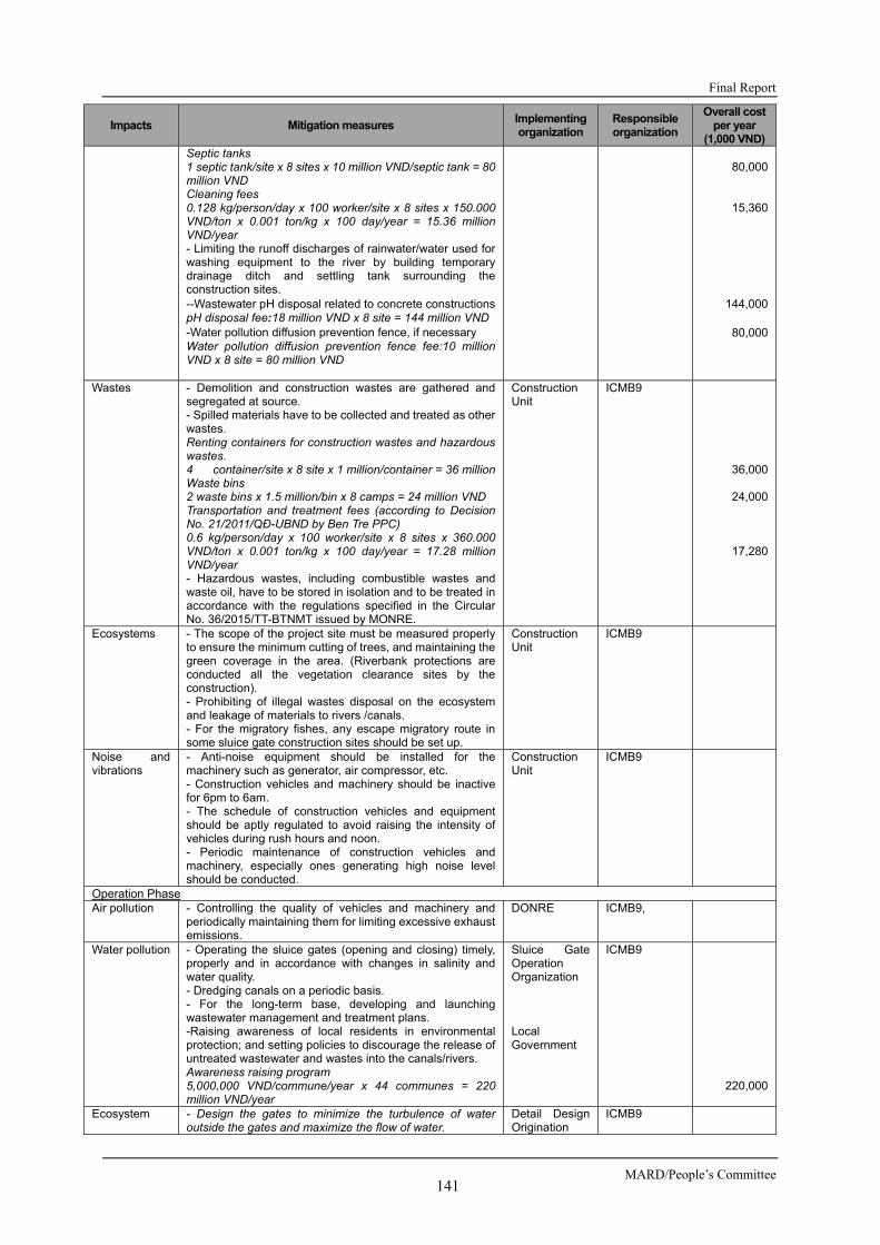
Final Report
MARD/People’s Committee 141
Impacts Mitigation measures Implementingorganization
Responsible organization
Overall cost per year
(1,000 VND)Septic tanks 1 septic tank/site x 8 sites x 10 million VND/septic tank = 80 million VND Cleaning fees 0.128 kg/person/day x 100 worker/site x 8 sites x 150.000 VND/ton x 0.001 ton/kg x 100 day/year = 15.36 million VND/year - Limiting the runoff discharges of rainwater/water used for washing equipment to the river by building temporary drainage ditch and settling tank surrounding the construction sites. --Wastewater pH disposal related to concrete constructionspH disposal fee:18 million VND x 8 site = 144 million VND -Water pollution diffusion prevention fence, if necessary Water pollution diffusion prevention fence fee:10 million VND x 8 site = 80 million VND
80,000
15,360
144,000
80,000
Wastes - Demolition and construction wastes are gathered and segregated at source. - Spilled materials have to be collected and treated as other wastes. Renting containers for construction wastes and hazardous wastes. 4 container/site x 8 site x 1 million/container = 36 millionWaste bins 2 waste bins x 1.5 million/bin x 8 camps = 24 million VND Transportation and treatment fees (according to Decision No. 21/2011/QĐ-UBND by Ben Tre PPC) 0.6 kg/person/day x 100 worker/site x 8 sites x 360.000 VND/ton x 0.001 ton/kg x 100 day/year = 17.28 million VND/year - Hazardous wastes, including combustible wastes and waste oil, have to be stored in isolation and to be treated in accordance with the regulations specified in the Circular No. 36/2015/TT-BTNMT issued by MONRE.
Construction Unit
ICMB9
36,000
24,000
17,280
Ecosystems - The scope of the project site must be measured properly to ensure the minimum cutting of trees, and maintaining the green coverage in the area. (Riverbank protections are conducted all the vegetation clearance sites by the construction). - Prohibiting of illegal wastes disposal on the ecosystem and leakage of materials to rivers /canals. - For the migratory fishes, any escape migratory route in some sluice gate construction sites should be set up.
Construction Unit
ICMB9
Noise and vibrations
- Anti-noise equipment should be installed for the machinery such as generator, air compressor, etc. - Construction vehicles and machinery should be inactive for 6pm to 6am. - The schedule of construction vehicles and equipment should be aptly regulated to avoid raising the intensity of vehicles during rush hours and noon. - Periodic maintenance of construction vehicles and machinery, especially ones generating high noise level should be conducted.
Construction Unit
ICMB9
Operation Phase Air pollution - Controlling the quality of vehicles and machinery and
periodically maintaining them for limiting excessive exhaust emissions.
DONRE ICMB9,
Water pollution - Operating the sluice gates (opening and closing) timely, properly and in accordance with changes in salinity and water quality. - Dredging canals on a periodic basis. - For the long-term base, developing and launching wastewater management and treatment plans. -Raising awareness of local residents in environmental protection; and setting policies to discourage the release of untreated wastewater and wastes into the canals/rivers. Awareness raising program 5,000,000 VND/commune/year x 44 communes = 220 million VND/year
Sluice Gate Operation Organization Local Government
ICMB9 220,000
Ecosystem - Design the gates to minimize the turbulence of water outside the gates and maximize the flow of water.
Detail Design Origination
ICMB9
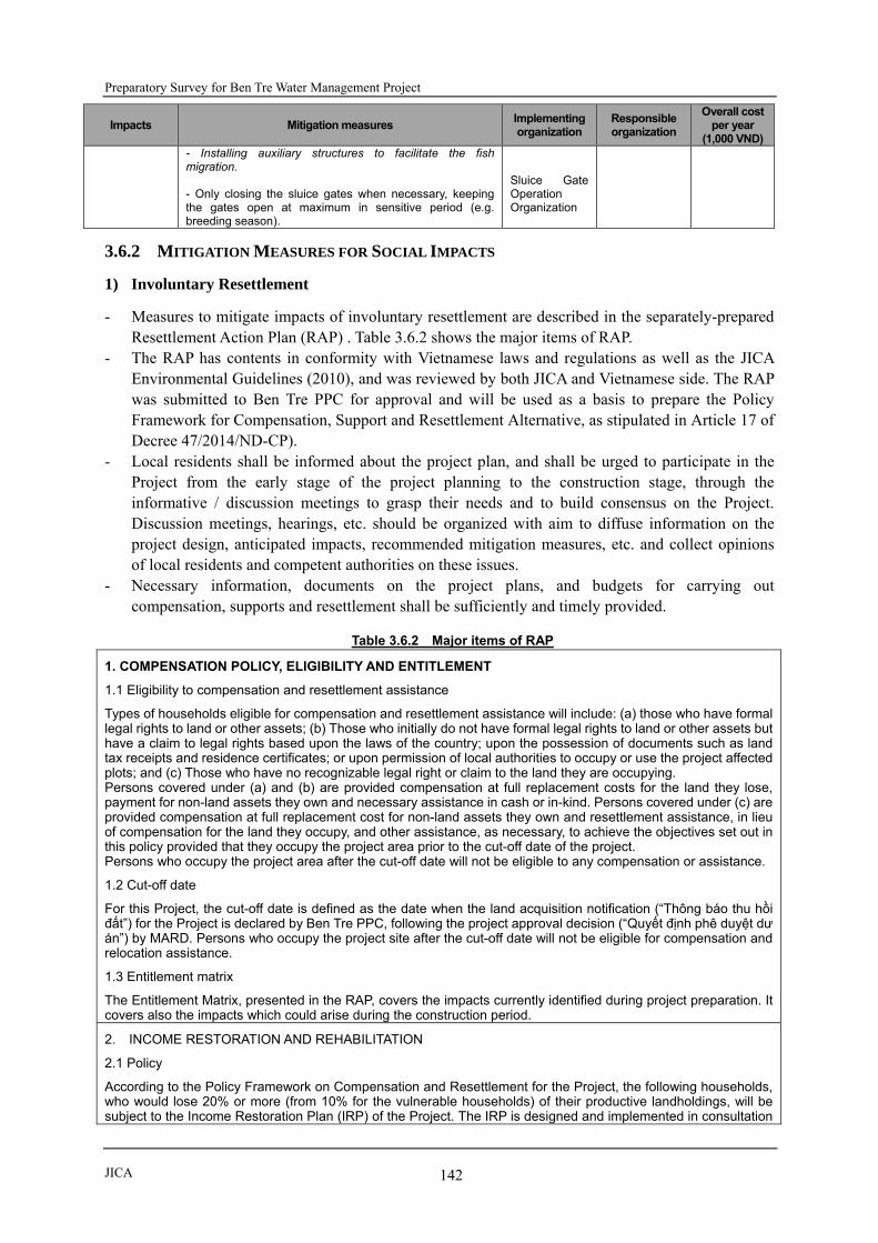
Preparatory Survey for Ben Tre Water Management Project
JICA 142
Impacts Mitigation measures Implementingorganization
Responsible organization
Overall cost per year
(1,000 VND)- Installing auxiliary structures to facilitate the fish migration. - Only closing the sluice gates when necessary, keeping the gates open at maximum in sensitive period (e.g. breeding season).
Sluice Gate Operation Organization
3.6.2 MITIGATION MEASURES FOR SOCIAL IMPACTS
1) Involuntary Resettlement
- Measures to mitigate impacts of involuntary resettlement are described in the separately-prepared Resettlement Action Plan (RAP) . Table 3.6.2 shows the major items of RAP.
- The RAP has contents in conformity with Vietnamese laws and regulations as well as the JICA Environmental Guidelines (2010), and was reviewed by both JICA and Vietnamese side. The RAP was submitted to Ben Tre PPC for approval and will be used as a basis to prepare the Policy Framework for Compensation, Support and Resettlement Alternative, as stipulated in Article 17 of Decree 47/2014/ND-CP).
- Local residents shall be informed about the project plan, and shall be urged to participate in the Project from the early stage of the project planning to the construction stage, through the informative / discussion meetings to grasp their needs and to build consensus on the Project. Discussion meetings, hearings, etc. should be organized with aim to diffuse information on the project design, anticipated impacts, recommended mitigation measures, etc. and collect opinions of local residents and competent authorities on these issues.
- Necessary information, documents on the project plans, and budgets for carrying out compensation, supports and resettlement shall be sufficiently and timely provided.
Table 3.6.2 Major items of RAP
1. COMPENSATION POLICY, ELIGIBILITY AND ENTITLEMENT
1.1 Eligibility to compensation and resettlement assistance
Types of households eligible for compensation and resettlement assistance will include: (a) those who have formal legal rights to land or other assets; (b) Those who initially do not have formal legal rights to land or other assets but have a claim to legal rights based upon the laws of the country; upon the possession of documents such as land tax receipts and residence certificates; or upon permission of local authorities to occupy or use the project affected plots; and (c) Those who have no recognizable legal right or claim to the land they are occupying. Persons covered under (a) and (b) are provided compensation at full replacement costs for the land they lose, payment for non-land assets they own and necessary assistance in cash or in-kind. Persons covered under (c) are provided compensation at full replacement cost for non-land assets they own and resettlement assistance, in lieu of compensation for the land they occupy, and other assistance, as necessary, to achieve the objectives set out in this policy provided that they occupy the project area prior to the cut-off date of the project. Persons who occupy the project area after the cut-off date will not be eligible to any compensation or assistance.
1.2 Cut-off date
For this Project, the cut-off date is defined as the date when the land acquisition notification (“Thông báo thu hồi đất”) for the Project is declared by Ben Tre PPC, following the project approval decision (“Quyết định phê duyệt dư án”) by MARD. Persons who occupy the project site after the cut-off date will not be eligible for compensation and relocation assistance.
1.3 Entitlement matrix
The Entitlement Matrix, presented in the RAP, covers the impacts currently identified during project preparation. It covers also the impacts which could arise during the construction period.
2. INCOME RESTORATION AND REHABILITATION
2.1 Policy
According to the Policy Framework on Compensation and Resettlement for the Project, the following households, who would lose 20% or more (from 10% for the vulnerable households) of their productive landholdings, will be subject to the Income Restoration Plan (IRP) of the Project. The IRP is designed and implemented in consultation

Final Report
MARD/People’s Committee 143
with those affected during the project implementation.Number of AHs given participation into the IRP
PAPs Displaced households
HHs losing ≥ 20% productive land
Vulnerable households
Total
Number 22 71 16 109
2.2 Income Restoration Plan
During the SES & FGMs, the PAPs were asked to raise their needs on the income restoration. The following table presents the need assessment of the PAPs as a result. Needs assessment of the PAPs for income restoration
PAP Impact Recommended solution Need
Farmer
Losing income from garden and husbandry because of productive land shortage
Increase productive benefit on the remaining land
Concessional loans for new investment Technical training
Remaining land is no longer larger enough and unfeasible to keep cultivation
To buy alternative productive land
Compensation at full market price for the lost land area
Productive land is fragmented into small pieces
To acquire small plots of remaining land at full market price
Vocational training, job introduction
Resettled business HH
Losing familiar customer after resettlement
Positioned business after resettlement
Resettlement near the existing location
Small industry enterprise and worker
Remaining area after land acquisition is no longer larger enough and unfeasible to keep working
To revise the design of the sluice gates to avoid or minimize land acquisition of the enterprise (in Thanh Thoi B commune)
The IRP will focus on different activities to: (i) provide supports and appropriate technique to PAPs whose remaining agricultural land is still viable for implementing agricultural extension, (ii) organize training courses which are suitable to PAPs’ capacity; provide supplementary trainings, consultations, allowance and other supports to participants attending the courses as well as services for creating and introducing jobs to trainees after being trained; and (iii) provide technical advice, pilot models on small business/services and other training courses, study tours on efficient economic enterprises.
3. RESETTLEMENT ARRANGEMENT
3.1 Entitlement for resettlement
The degree of impact on affected residential land with houses thereon may be any of these two possibilities: (i) the remaining unaffected portion of the residential land is sufficient for the AHs to reconstruct their house thereat; or (ii) the entire residential land is acquired or the remaining unaffected area is not sufficient for the household to reconstruct their house and, thus, they have to move to a new place either through an arrangement with the DCSCC or by themselves (self-resettlement). 3.2 Consultation with the DPs on resettlement preferences During the SES and IOL, each resettling households was consulted on their relocation preferences. As a result, among 22 households to be resettled of the project, 9 households expressed intention to resettle on their remaining lands (on-site relocation), and other 8 households expressed intention to receive adequate compensation and allowance for self-relocation with appropriate legislative support from local government. The other 5 households whose remaining land is sufficient to reconstruct their house but it is likely difficult to maintain agriculture have not made decision yet. These households said that they will wait for obtaining further information from the detailed design of the sluice gates and will make decision at that phase. Resettlement preferences of the DHs
No. Commune Total HHs to be resettled
PreferenceOn-site resettlement
Self-resettlement
Not yet decided
Phú Hưng 5 2 0 3 Long Định 3 1 1 1 Khánh Thạnh Tân 1 1 0 0 Bình Khánh Đông 1 0 1 0 Thạnh Phú Đông 2 0 2 0 Tân Thành Bình 3 0 3 0 Thành Thới B 3 1 1 1 Định Thủy 3 3 0 0 Tiên Long 1 1 0 0 TOTAL 22 9 8 5
Most of resettled households said that they have lived in the affected areas for a long time. Therefore, they do not

Preparatory Survey for Ben Tre Water Management Project
JICA 144
want to relocate outside the commune because it will impact on their existing socio-economic settings and relations. Considering to above resettled households’ preferences on their relocation and the fact of that low number of resettled households whose remaining land are not sufficient to rebuild their house, no new resettlement site needs to be developed for this project.
2) The Poor
There are 16 vulnerable households among 160 HHs who would lose land for the Project, according to the results of the socio-economic survey. Number of households which are identified as “poor” 10 is 5 HHs. Measures to mitigate impacts to these vulnerable households, including the poor households are described in the separately-prepared RAP. Special support policies for the poor are as following: - For relocated poor and other vulnerable HHs, the Project will provide special assistance to ensure
that they are able to move and re-establish their living at the new sites. - Relocated poor people, who has 20% or more of their productive land to be affected, or the
affected land is smaller than 20% of the productive land but the remaining land is rendered unviable: will be received the special support according to the regulation of Ben Tre PPC.
- The landless household (in Thạnh Phú Đông Commune of Giong Trom District) affected by the Project should be assisted to have an apartment that they can rent or buy in installment.
- Others
3) Local Economy such as Employment and Livelihood
In the construction phase, the contractors shall be urged to employ local residents to work as construction workers especially for simple works. And proper construction method and construction schedule shall be carefully considered so as the construction works will not cause serious impedance to the waterway transportation.
In the operation phase, in order to mitigate adverse impacts to affected waterway users, the measures proposed in the Policy Framework for Waterway Users shall be further examined and implemented after having consent/approval by Ben Tre PPC and/or ICMB9.
4) Land Use and Utilization of Local Resources
Measures to mitigate impacts to residents who will lose land for the project are described in the separately-prepared RAP. These measures should be examined and implemented during the pre-construction phase and the construction phase.
In addition, according to the participants in the stakeholder consultation meetings in the communes, the full use of existing land resource is expected. A great number of participants expressed that they need to improve knowledge about advanced technologies on agricultural production, such as improved breeds for increasing production. Additionally, diversification of agricultural activities suitable to local conditions, development of secondary and tertiary industries, especially processing industries are considered necessary in order to modernize local economy. Pig husbandry, freshwater aquaculture, and fruit garden (particular green pomelo and coconut) are considered the most suitable agricultural productions in the locality because they are dominant in Ben Tre and the PAPs have much experience about its cultivation.
In addition, in order to help local residents in choosing the optimized cultivation that is suitable to the salinity of water in their area, a draft land use plan was made during the Preparatory Survey. Adequacy of crops to salinity, stakeholders’ needs, and market potential were taken into consideration during the formulation of this draft land use plan. This land use plan is a temporal plan with some predicted 10 In Vietnam, a household is assessed “poor” when the average income is: (1) under VND 400,000 per capita per month or VND 4,800,000 per capita per year (roughly USD $19 per capita per month) in rural areas, and (2) under VND 500,000 per capita per month or VND 6,000,000 per capita per year (roughly USD $24 per capita per month) in urban areas.

Final Report
MARD/People’s Committee 145
conditions of sea level rise, Mekong River discharge, construction of sluices, market trend, and so on. Therefore, it should be updated by the local government of the Ben Tre Province once in a while based on the latest data and information. In this Preparatory Survey, a technical cooperation project attached to the loan assistance project is proposed with aim to strengthen officers concerned in responsible agencies of Ben Tre Province to carry out the simulation analysis, land use planning, monitoring of saline concentration, and operation and management of sluices.
5) Water Usage
In the construction phase, proper construction method and water quality management measures describe in the environmental management plan (EMP) should be implemented to control polluted water generated from construction works.
In addition, the Water Resources Management Committee should be established (as recommended in Section 13.1) and its capacity should be strengthened to properly and efficiently manage the precious freshwater resources in the Ben Tre Province. The proper operation of the sluice gates system in a whole (including the existing sluice gates and the newly-constructed ones) should be examined and implemented in order to meet the needs of freshwater widely among residents.
6) Existing Social Infrastructure and Service
In the construction phase, construction method and construction plan should be carefully prepared to avoid serious impedance to ships/boats which need to pass through the construction sites. Information on the blockage of the rivers or on the limited navigation due to the sluice gate construction should be disseminated widely to waterway users, in order to make them easily prepare the plan to shift the navigation route to the other waterways.
In addition, measures described in the Policy Framework for waterway users affected by the Project shall be further examined in detail and shall be duly implemented after having consent/approval by Ben Tre PPC and/or ICMB9.
7) Misdistribution of Benefits and Damage
In the pre-construction phase and the construction phase, measures to mitigate impacts of land acquisition and resettlement as described in RAP should be duly implemented. And measures described in the EIA Report to mitigate impacts of air pollution, water pollution, noise, etc., during construction period shall be duly implemented.
8) Infectious Diseases such as HIV/AIDS
In the construction phase, contractors should cooperate with local mass organizations such as Vietnam Fatherland Front, Women's Union, etc., to provide workers with knowledge about social evils, prostitution, epidemics in the area, etc.
In addition, in order to mitigate impacts caused by the concentration of workers from outside, contractors should be urged to hire local residents (both women and men) as much as possible to work as workers for the Project. For some works requiring qualified performers, the contractor will choose among the local workers and equip them with new skills so that they can meet job’s requirements.
9) Working Environment (Including Work Safety)
During the construction period, contractors shall:
- Provide construction workers with sufficient personal protection equipment (PPE) such as hard hats, earpiece, safety shoes, and others;
- Provide workers with seminars on safety issues for local residents;

Preparatory Survey for Ben Tre Water Management Project
JICA 146
- Provide construction workers with proper living condition (such as clean water, electric power, etc.) and health care during construction.
- Install warning signs where the potential dangers are present;
- Assign staffs near the sites to ensure safety where construction vehicles are crowded.
10) Accidents
In the construction phase, a proper construction method and a construction plan, including measures to mitigate traffic congestion on local road networks and on rivers, etc. should be carefully prepared. Beacon buoys should be installed for warning and signaling the construction and navigation on the rivers. Warning devices, marine delineators, marker posts, signboards, etc. should be installed in upstream and downstream of the construction sites.
In the operation phase, proper operation of the navigation locks associated with the sluice gates of Vam Thom (Mo Cay Nam), Vam Nuoc Trong (Mo Cay Bac), Ben Tre, and An Hoa are particularly required to prevent vessel collision accidents at these sites.
3.7 ENVIRONMENTAL MANAGEMENT/MONITORING PLAN
3.7.1 PROPOSED ENVIRONMENTAL AND SOCIAL MANAGEMENT PLAN
The management organizations system for the environmental and social monitoring in this Project is proposed based on the present roles and functions, as well as the realities of the relevant agencies (refer to Figure 3.7.1)
Figure 3.7.1 Proposed Management Organization Framework for Environmental and Social Monitoring
Source: JICA survey team (2016)
An Environmental and Social Monitoring Taskforce (ESMT) will be established by ICMB9 and the proposed Integrated Water Management Units (IWMUs) of the Ben Tre Province, for implementing environmental and social monitoring activities during the construction and operation phases of the Project . The EMST should have the following functions:
Conduct related documentations –standard operation procedures for Environmental Management Plans and other related records;

Final Report
MARD/People’s Committee 147
Design/plan regular environmental and social monitoring activities during the construction phase and the operation phase of the Project following the environmental and social monitoring criteria provided by the JICA survey team;
Mobilize local consultants to conduct regular environmental and social monitoring activities during the construction phase and the operation phase of the Project;
Receive and review technical reports from local consultants; and
Provide regular reports on environmental and social monitoring activities for the Integrated Water Management Units (IWMUs) of Ben Tre Province and ICMB9.
The IWMUs is the proposed integrated committee for managing surface water quality and water volume within the Ben Tre Province, in collaboration with relevant governmental agencies and the water use stakeholders.
3.7.2 PROPOSED ENVIRONMENTAL MONITORING PLAN
The following environmental monitoring plan, which is shown in Table 3.7.1. could be proposed as essential monitoring activities, in order to confirm the possible environmental impacts situations related to the project.
Table 3.7.1 Proposed Environmental Monitoring Plan Environmental
Items Items/Parameters Sampling Points/
Frequency Implementing Organization
ResponsibleAgency
Construction Phase Air TSP
PM10 CO, NOx SOx
8 points/ 2 times per month
Local Contractor (Local Consultant Team)
ICMB9
Surface water pH TSS BOD5 NO3
- (in N) PO4
3- (in P) Coliform
8 points/ 2 times per month
Local Contractor (Local Consultant Team)
ICMB9
Ground water pH TDS NH4+
8 points/ 2 times per month
Local Contractor (Local Consultant Team)
ICMB9
Noise Noise Leve ( dB(A))
8 points/ 1 times per month
Local Contractor (Local Consultant Team)
ICMB9
Ecosystem Fish catch survey
16 points/ 2 times per month
Local Contractor (Local Consultant Team)
ICMB9
Operation Phase Air TSP
PM10 CO, NOx SOx
8 points/ 2 times per month
Local Consultant Team
ICMB9
Surface water pH TSS BOD5 NO3
- (in N) PO4
3- (in P) Coliform
8 points/ 2 times per month
Local Consultant Team
ICMB9
Ecosystem Fish catch survey
16 points/ 2 times per month
Local Consultant Team
ICMB9
Regarding the riverbank erosion, it is recommended that the Rural Development Section of DARD should conduct more detailed regular monitoring activities for river erosions in the rivers/canals, although there is no evidence that this Project may affect favorably or adversely impacts to the present riverbank erosions.

Preparatory Survey for Ben Tre Water Management Project
JICA 148
3.7.3 PROPOSED SOCIAL ENVIRONMENTAL MONITORING PLAN
Monitoring plan summarized in Table 3.7.2 shall be implemented to monitor and confirm the social impacts caused by the project, and performance of relevant impact mitigation measures.
Table 3.7.2 Social impact monitoring plan
No Monitoring items Construction phase Operation phase
1 Involuntary resettlement
Monitoring plan is described in the separately-prepared RAP.
-
2 The poor Monitoring plan is described in the separately-prepared RAP.
Monitoring plan is described in the separately-prepared RAP.
3 Local economy such as employ- ment and livelihood
Monitoring plan is described in the separately-prepared RAP.
Monitoring plan is described in the separately-prepared RAP.
4 Land use and utilization of local resources
Monitoring plan is described in the separately-prepared RAP.
-
5 Water usage Monitoring plan for surface water quality is described in Section 13.2.
-
6 Existing social infra- structure and service
1) Monitoring site Around the sluice gates 2) Monitoring frequency Periodic monitoring by PMU 3) Monitoring method Check report made by contractors on the operational conditions, performance and maintenance of the safety facilities around the construction sites. Carry out field confirmation survey.
1) Monitoring site Accident prevention equipment installed around the sluice gates 2) Monitoring frequency Monthly monitoring by DOT 3) Monitoring method Check complaints raised by residents. Carry out field survey to inspect the operational conditions, performance of the acident prevention equipment.
7 Misdistribution of benefits and damage
Monitoring plan for noise, surface water quality is described in Section 13.2.
8 Infectious diseases such as HIV/AIDS
1) Monitoring site Construction yards and worker camps 2) Monitoring frequency Periodic monitoring by environmental supervisors 3) Monitoring method Check reports made by contractor site-managers. Carry out field confirmation survey. Check information provided by local Women Union, Fatherland Front.
-
9 Working environ- ment (including work safety)
1) Monitoring site Construction sites and worker camps 2) Monitoring frequency Periodic monitoring by environmental supervisors 3) Monitoring method Check reports made by contractor site-managers. Carry out field confirmation survey.
-
10 Accidents 1) Monitoring site Construction sites (on land and on water) 2) Monitoring frequency Periodic monitoring by environmental supervisors 3) Monitoring method Check reports made by contractor site-managers. Carry out field confirmation survey.
1) Monitoring site Safety (accident prevention) equipment installed around the sluice gates 2) Monitoring frequency Monthly monitoring by DOT 3) Monitoring method Check monthly reports made by operators of the gates Check complaints raised by local residents.Carry out field survey to confirm performance and operational conditions of the safety equipment.
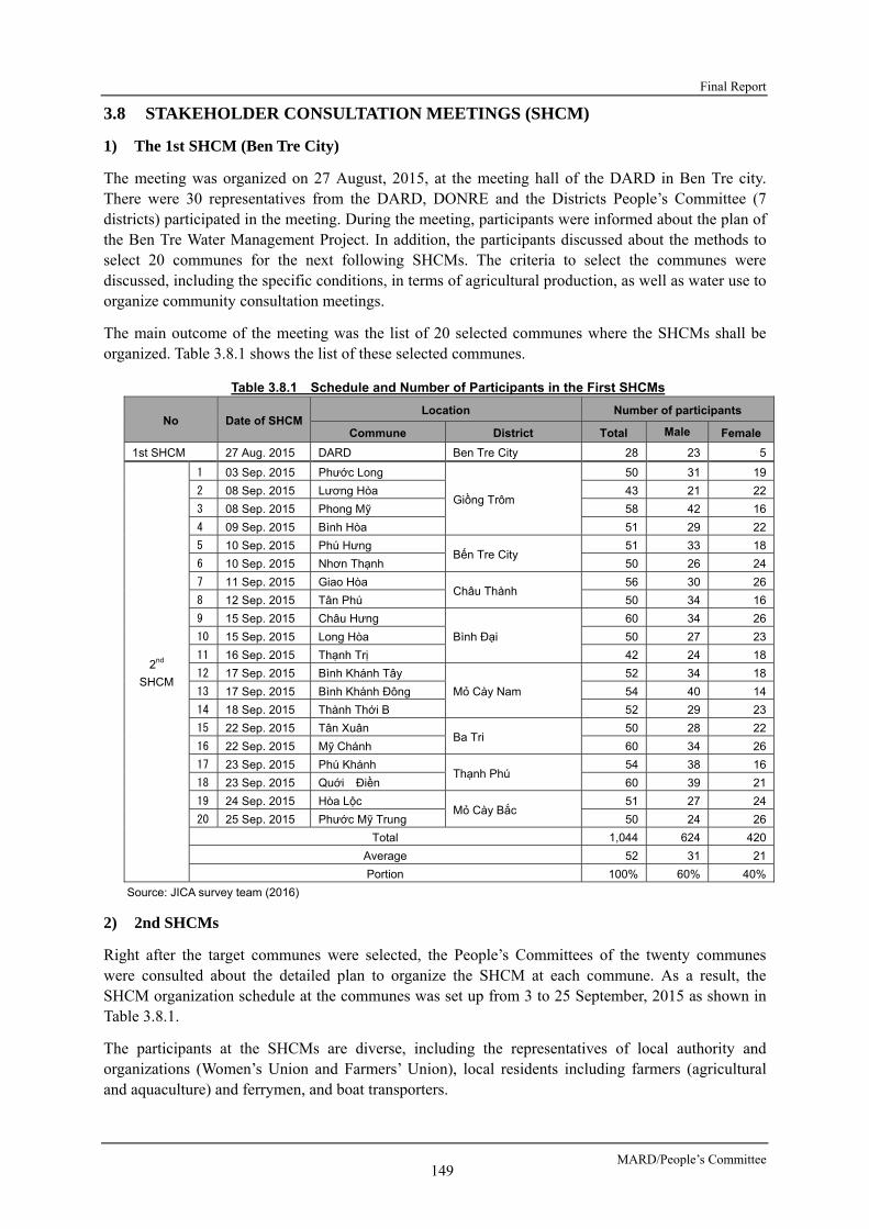
Final Report
MARD/People’s Committee 149
3.8 STAKEHOLDER CONSULTATION MEETINGS (SHCM)
1) The 1st SHCM (Ben Tre City)
The meeting was organized on 27 August, 2015, at the meeting hall of the DARD in Ben Tre city. There were 30 representatives from the DARD, DONRE and the Districts People’s Committee (7 districts) participated in the meeting. During the meeting, participants were informed about the plan of the Ben Tre Water Management Project. In addition, the participants discussed about the methods to select 20 communes for the next following SHCMs. The criteria to select the communes were discussed, including the specific conditions, in terms of agricultural production, as well as water use to organize community consultation meetings.
The main outcome of the meeting was the list of 20 selected communes where the SHCMs shall be organized. Table 3.8.1 shows the list of these selected communes.
Table 3.8.1 Schedule and Number of Participants in the First SHCMs
No Date of SHCM Location Number of participants
Commune District Total Male Female
1st SHCM 27 Aug. 2015 DARD Ben Tre City 28 23 5
2nd
SHCM
1 03 Sep. 2015 Phước Long
Giồng Trôm
50 31 19
2 08 Sep. 2015 Lương Hòa 43 21 22
3 08 Sep. 2015 Phong Mỹ 58 42 16
4 09 Sep. 2015 Bình Hòa 51 29 22
5 10 Sep. 2015 Phú Hưng Bến Tre City
51 33 18
6 10 Sep. 2015 Nhơn Thạnh 50 26 24
7 11 Sep. 2015 Giao Hòa Châu Thành
56 30 26
8 12 Sep. 2015 Tân Phú 50 34 16
9 15 Sep. 2015 Châu Hưng
Bình Đại
60 34 26
10 15 Sep. 2015 Long Hòa 50 27 23
11 16 Sep. 2015 Thạnh Trị 42 24 18
12 17 Sep. 2015 Bình Khánh Tây
Mỏ Cày Nam
52 34 18
13 17 Sep. 2015 Bình Khánh Đông 54 40 14
14 18 Sep. 2015 Thành Thới B 52 29 23
15 22 Sep. 2015 Tân Xuân Ba Tri
50 28 22
16 22 Sep. 2015 Mỹ Chánh 60 34 26
17 23 Sep. 2015 Phú Khánh Thạnh Phú
54 38 16
18 23 Sep. 2015 Quới Điền 60 39 21
19 24 Sep. 2015 Hòa Lộc Mỏ Cày Bắc
51 27 24
20 25 Sep. 2015 Phước Mỹ Trung 50 24 26
Total 1,044 624 420
Average 52 31 21
Portion 100% 60% 40%
Source: JICA survey team (2016)
2) 2nd SHCMs
Right after the target communes were selected, the People’s Committees of the twenty communes were consulted about the detailed plan to organize the SHCM at each commune. As a result, the SHCM organization schedule at the communes was set up from 3 to 25 September, 2015 as shown in Table 3.8.1.
The participants at the SHCMs are diverse, including the representatives of local authority and organizations (Women’s Union and Farmers’ Union), local residents including farmers (agricultural and aquaculture) and ferrymen, and boat transporters.

Preparatory Survey for Ben Tre Water Management Project
JICA 150
During these SHCMs, the general information on the Ben Tre Water Management Project was presented. The information consists of the rationale/background of the Project (impacts of climate change, transboundary/regional/local impacts, etc.) and basic information on the project design such as locations of the sluice gates. Expected environmental and social impacts to the localities were also presented.
The main opinions raised by the participants are as follows: - The sluice gate construction project would contribute to the improvement of local residents’ life
and livelihood, by reducing damages caused by saline intrusion, and providing stable freshwater supply to the locality. Therefore, we expect that the Project will be implemented soon.
- In the construction phase, impacts such as polluted water, noise, etc. may be generated from the construction sites, and adversely affect fruit trees, and residents’ life. We expect that proper measures shall be carried out to mitigate these impacts.
- We want to know whether our land, and our houses will be affected by the Project or not. People who have to relocate to other places need to be informed about the resettlement plan as early as possible.
- There are many boats providing services such as transportation of people, goods, agricultural products, etc. on the rivers. These boat operators should be informed as early as possible about the Project, so as they can make plan to change the route to other rivers in a timely manner.
- Many residents want to cultivate citrus fruit trees in combination with aquaculture using freshwater. We want to have the instructions and supports from the relevant entities about this combined cultivation method.
- Plan to construct sluice gates on other canals around the commune should also be considered in order to efficiently prevent damages caused by saline water to the locality. We want to know if such plan is being considered or not.

Final Report
MARD/People’s Committee 151
3) 3rd SHCMs
The Third Round of SHCMs was held from 23 November to 4 December 2015 at the selected 20 communes to consult with the local communities and authorities on how changes in water salinity would affect local economic activities, domestic uses of water, etc.
Table 3.8.2 shows the organization schedule of the 3rd SHCM and number of participants by sex.
Table 3.8.2 The 3rd SHCM organization schedule and number of participants by sex
No. Organization day Organization place Number of participants
Commune District Total Mele Female 1
23 Nov. 2015 Phú Hưng
Bến Tre City 47 30 17
2 Nhơn Thạnh 53 27 24 3
24 Nov. 2015 Phước Long
Giồng Trôm
60 45 15 4 Lương Hòa 48 40 8 5
25 Nov. 2015 Phong Mỹ 58 31 27
6 Bình Hòa 43 25 18 7
26 Nov. 2015 Hòa Lộc
Mỏ Cày Nam 57 32 25
8 Phước Mỹ Trung 50 28 22 9
27 Nov. 2015 Bình Khánh Tây
Mỏ Cày Bắc 50 31 19
10 Bình Khánh Đông 54 41 13 11
30 Nov. 2015 Thành Thới B 59 33 26
12 Giao Hòa Châu Thành
56 34 22 13
01 Dec. 2015 Tân Phú 39 23 16
14 Phú Khánh Thạnh Phú
53 40 13 15
02 Dec. 2015 Quới Điền 52 44 8
16 Tân Xuân Ba Tri
48 30 18 17
03 Dec. 2015 Mỹ Chánh 59 37 22
18 Châu Hưng Bình Đại
64 34 30 19
04 Dec. 2015 Long Hòa 44 23 21
20 Thạnh Trị 55 33 22 Total (pers) 1049 661 386 Total (%) 100% 63% 37%
Source: JICA survey team (2016)
Table 3.8.3 shows the number of participants in these meetings by occupation comparing with commune population by their occupation.

Preparatory Survey for Ben Tre Water Management Project
JICA 152
No.
C
omm
une
Por
tion
(nu
mb
er o
f p
arti
cipa
nts
in
SH
CM
/ to
tal
pop
ula
tion
in t
he
com
mu
ne)
Agr
icu
ltu
re
Aq
uac
ul-
tu
re
Fis
her
- m
en
Wat
erw
ay
tran
s-
por
tati
on
Tra
de/
Ser
vice
H
H
Loc
al
auth
orit
y/
orga
niza
- ti
on
Oth
er
(vul
nera
ble
peop
le)[
1]
Tot
al
Ric
e/
Veg
etab
le
Fru
it t
ree
Hus
ban
d-
ry
Coc
onu
t tr
ee
1 P
hú Hưn
g a)
Tot
al in
com
mun
e b)
Tot
al in
SH
CM
16
0
16
5 0
0 1
0 7
2 47
c)
Por
tion
(=
b/a,
%)
2 N
hơn
Thạ
nh
a) T
otal
in c
omm
une
b) T
otal
in S
HC
M
0 14
1
23
0 0
0 0
10
5 53
c)
Por
tion
(=
b/a,
%)
3 P
hước
L
ong
a) T
otal
in c
omm
une
b) T
otal
in S
HC
M
0 10
0
38
0 0
0 0
12
0 60
c)
Por
tion
(=
b/a,
%)
4 P
hong
Mỹ
a) T
otal
in c
omm
une
b) T
otal
in S
HC
M
9 5
12
16
0 0
0 0
6 0
48
c) P
orti
on (
=b/
a, %
)
5 Lươ
ng
Hòa
a) T
otal
in c
omm
une
b) T
otal
in S
HC
M
3 16
0
23
0 0
0 3
12
1 58
c)
Por
tion
(=
b/a,
%)
6 B
ình
Hòa
a)
Tot
al in
com
mun
e b)
Tot
al in
SH
CM
0
31
8 0
0 0
0 0
4 0
43
c) P
orti
on (
=b/
a, %
)
7 H
òa Lộc
a)
Tot
al in
com
mun
e b)
Tot
al in
SH
CM
0
0 28
18
0
0 0
0 11
0
57
c) P
orti
on (
=b/
a, %
)
8 P
hước
Mỹ
Tru
ng
a) T
otal
in c
omm
une
b) T
otal
in S
HC
M
1 4
22
10
0 0
0 3
10
0 50
c)
Por
tion
(=
b/a,
%)
9 B
ình
Khá
nh
Tây
a) T
otal
in c
omm
une
b) T
otal
in S
HC
M
3 5
30
0 0
0 0
2 10
0
50
c) P
orti
on (
=b/
a, %
)
10
Bìn
h K
hánh
Đ
ông
a) T
otal
in c
omm
une
b) T
otal
in S
HC
M
3 6
30
0 0
0 0
2 9
0 50
c)
Por
tion
(=
b/a,
%)
11
Thà
nh
Thớ
i B
a) T
otal
in c
omm
une
b) T
otal
in S
HC
M
0 0
18
24
0 2
0 3
12
0 59
c)
Por
tion
(=
b/a,
%)
Tab
le 3
.8.3
P
arti
cip
ants
of
3rd
SH
CM
by
Occ
up
atio
n (
un
it:
per
son
s)

Final Report
MARD/People’s Committee 153
12
Gia
o H
òa
a) T
otal
in c
omm
une
b) T
otal
in S
HC
M
0 15
0
25
0 0
0 2
12
2 56
c)
Por
tion
(=b/
a, %
)
13
Tân
Phú
a)
Tot
al in
com
mun
e
b)
Tot
al in
SH
CM
0
21
0 10
0
0 0
0 8
0 39
c)
Por
tion
(=b/
a, %
)
14
Phú
K
hánh
a) T
otal
in c
omm
une
b) T
otal
in S
HC
M
13
0 5
20
1 1
0 0
11
2 53
c)
Por
tion
(=b/
a, %
)
15
Quớ
i Điề
n a)
Tot
al in
com
mun
e
b)
Tot
al in
SH
CM
5
0 23
8
2 0
0 5
8 1
52
c) P
ortio
n (=
b/a,
%)
16
Tân
Xuâ
n a)
Tot
al in
com
mun
e
b)
Tot
al in
SH
CM
22
0
13
0 0
0 2
1 10
0
48
c) P
ortio
n (=
b/a,
%)
17
Mỹ
Chá
nh
a) T
otal
in c
omm
une
b) T
otal
in S
HC
M
30
0 8
0 0
0 3
3 13
2
59
c) P
ortio
n (=
b/a,
%)
18
Châ
u Hưn
g
a) T
otal
in c
omm
une
b) T
otal
in S
HC
M
21
0 0
26
0 0
0 3
14
0 64
c)
Por
tion
(=b/
a, %
)
19
Lon
g H
òa
a) T
otal
in c
omm
une
b) T
otal
in S
HC
M
7 18
7
2 0
0 1
0 9
0 44
c)
Por
tion
(=b/
a, %
)
20
Thạ
nh T
rị
a) T
otal
in c
omm
une
b) T
otal
in S
HC
M
0 2
9 3
24
0 0
0 15
2
55
c) P
ortio
n (=
b/a,
%)
[1]V
ulne
rabl
e pe
rson
s w
ho a
re e
lder
ly, p
oor
or d
isab
le
Sou
rce:
JIC
A s
urve
y te
am (
2016
)
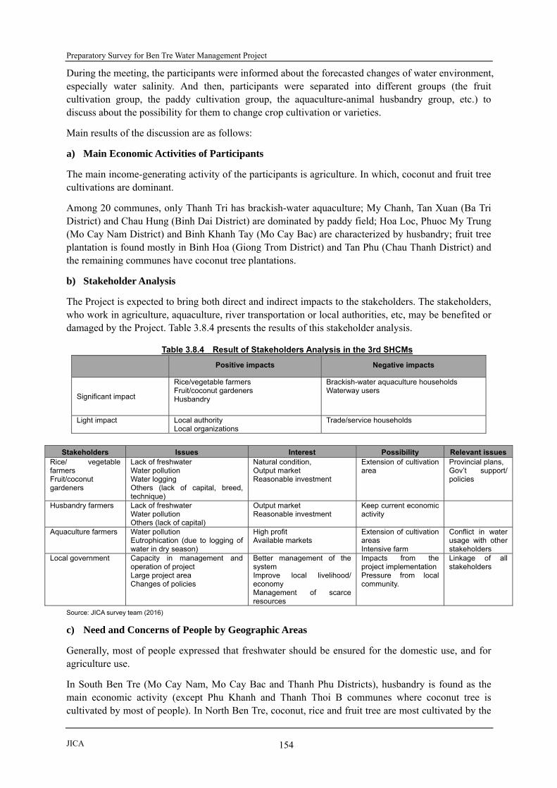
Preparatory Survey for Ben Tre Water Management Project
JICA 154
During the meeting, the participants were informed about the forecasted changes of water environment, especially water salinity. And then, participants were separated into different groups (the fruit cultivation group, the paddy cultivation group, the aquaculture-animal husbandry group, etc.) to discuss about the possibility for them to change crop cultivation or varieties.
Main results of the discussion are as follows:
a) Main Economic Activities of Participants
The main income-generating activity of the participants is agriculture. In which, coconut and fruit tree cultivations are dominant.
Among 20 communes, only Thanh Tri has brackish-water aquaculture; My Chanh, Tan Xuan (Ba Tri District) and Chau Hung (Binh Dai District) are dominated by paddy field; Hoa Loc, Phuoc My Trung (Mo Cay Nam District) and Binh Khanh Tay (Mo Cay Bac) are characterized by husbandry; fruit tree plantation is found mostly in Binh Hoa (Giong Trom District) and Tan Phu (Chau Thanh District) and the remaining communes have coconut tree plantations.
b) Stakeholder Analysis
The Project is expected to bring both direct and indirect impacts to the stakeholders. The stakeholders, who work in agriculture, aquaculture, river transportation or local authorities, etc, may be benefited or damaged by the Project. Table 3.8.4 presents the results of this stakeholder analysis.
Table 3.8.4 Result of Stakeholders Analysis in the 3rd SHCMs
Positive impacts Negative impacts
Significant impact
Rice/vegetable farmers Fruit/coconut gardeners Husbandry
Brackish-water aquaculture households Waterway users
Light impact
Local authority Local organizations
Trade/service households
Stakeholders Issues Interest Possibility Relevant issues
Rice/ vegetable farmers Fruit/coconut gardeners
Lack of freshwater Water pollution Water logging Others (lack of capital, breed, technique)
Natural condition, Output market Reasonable investment
Extension of cultivation area
Provincial plans, Gov’t support/ policies
Husbandry farmers
Lack of freshwater Water pollution Others (lack of capital)
Output market Reasonable investment
Keep current economic activity
Aquaculture farmers Water pollution Eutrophication (due to logging of water in dry season)
High profit Available markets
Extension of cultivation areas Intensive farm
Conflict in water usage with other stakeholders
Local government Capacity in management and operation of project Large project area Changes of policies
Better management of the system Improve local livelihood/ economy Management of scarce resources
Impacts from the project implementation Pressure from local community.
Linkage of all stakeholders
Source: JICA survey team (2016)
c) Need and Concerns of People by Geographic Areas
Generally, most of people expressed that freshwater should be ensured for the domestic use, and for agriculture use.
In South Ben Tre (Mo Cay Nam, Mo Cay Bac and Thanh Phu Districts), husbandry is found as the main economic activity (except Phu Khanh and Thanh Thoi B communes where coconut tree is cultivated by most of people). In North Ben Tre, coconut, rice and fruit tree are most cultivated by the

Final Report
MARD/People’s Committee 155
local people (except Thanh Tri commune where brackish water extensive shrimp culture is dominant).
There is not much conflict between rice/vegetable/fruit farmers and shrimp farmers in the project areas. Beside the freshwater needs, the local people also presented other needs for development of agricultural activities, such as capital, technique, and new varieties, etc.
During the meetings, participants were asked to rank their demand/need as well as their concerns upon their current income-generating activities. As a result, participants came from North Ben Tre presented diversified needs and concerns, while participants from South Ben Tre showed only several needs and concerns. Although people in both regions expressed their needs of freshwater for domestic uses, the people in North Ben Tre said that their most concern issue is “water shortage”, whereas those in South Ben Tre said that their most concern issue is “water pollution”.
Table 3.8.5 Ranking the Needs and Concerns of Local People
No. Location /
Items
Important agricultural productions ranked by participants of the consultation meetings
1st 2nd 3rd 4th 5th
I North Ben Tre Type of cultivation Coconut tree Fruit tree Rice/vegetable Husbandry Aquaculture
Demand/Need Freshwater Market of outputs
Capital Breed/ Varieties Cultivation technique
Concern Lack of freshwater
Water pollution Sluice-gate operation
Disease (in agriculture)
Difficulty in waterway transportation
II South Ben Tre
Type of cultivation Husbandry Coconut tree Fruit tree/ vegetable
Demand/Need Freshwater Capital Breed/ varieties Cultivation technique
Others
Concern Water pollution Lack of freshwater
Sluice-gate operation
Difficulty in waterway transportation
Source: JICA survey team (2016)
d) Suggestion of Stakeholders
After the group discussion, participants were asked whether they want to change their current income-generation activities if they are provided with freshwater throughout the year (i.e. in case that the Project is implemented), and how they will deal with freshwater shortage (if the Project is not implemented).
As a result, a large number of participants said that they want to keep their existing cultivation activities (no change) even in case of the project implementation. However, a small number of participants in the meetings in North Ben Tre (Thanh Tri: 28.6%, Chau Hung: 27.3%, Long Hoa: 20%, and Quoi Dien: 10%) said that they want to change their current cultivation. Regarding the reason of this change, these people said that they think surface water in the area may be polluted and their agricultural production would be decreased.
4) 4th SHCMs
The 4th SHCM was held in Ben Tre City on 28 March, 2016. There were 62 participants at the meeting, of which 3 participants from ICMB9, 8 participants from PPC, 11 participants from 8 city/districts (i.e. Ben Tre, Binh Dai, Ba Tri, Thanh Phu, Giong Trom, Mo Cay Nam, Mo Cay Bac, and Chau Thanh), and 40 participants from 20 selected communes.
Main objective of the meeting is to discuss following items: (1) results of the 3rd SHCMs, (2) land use plan, (3) water management plan, (4) surface water pollution issue, (5) environmental impacts, (6) impacts of land acquisition and other social impacts.
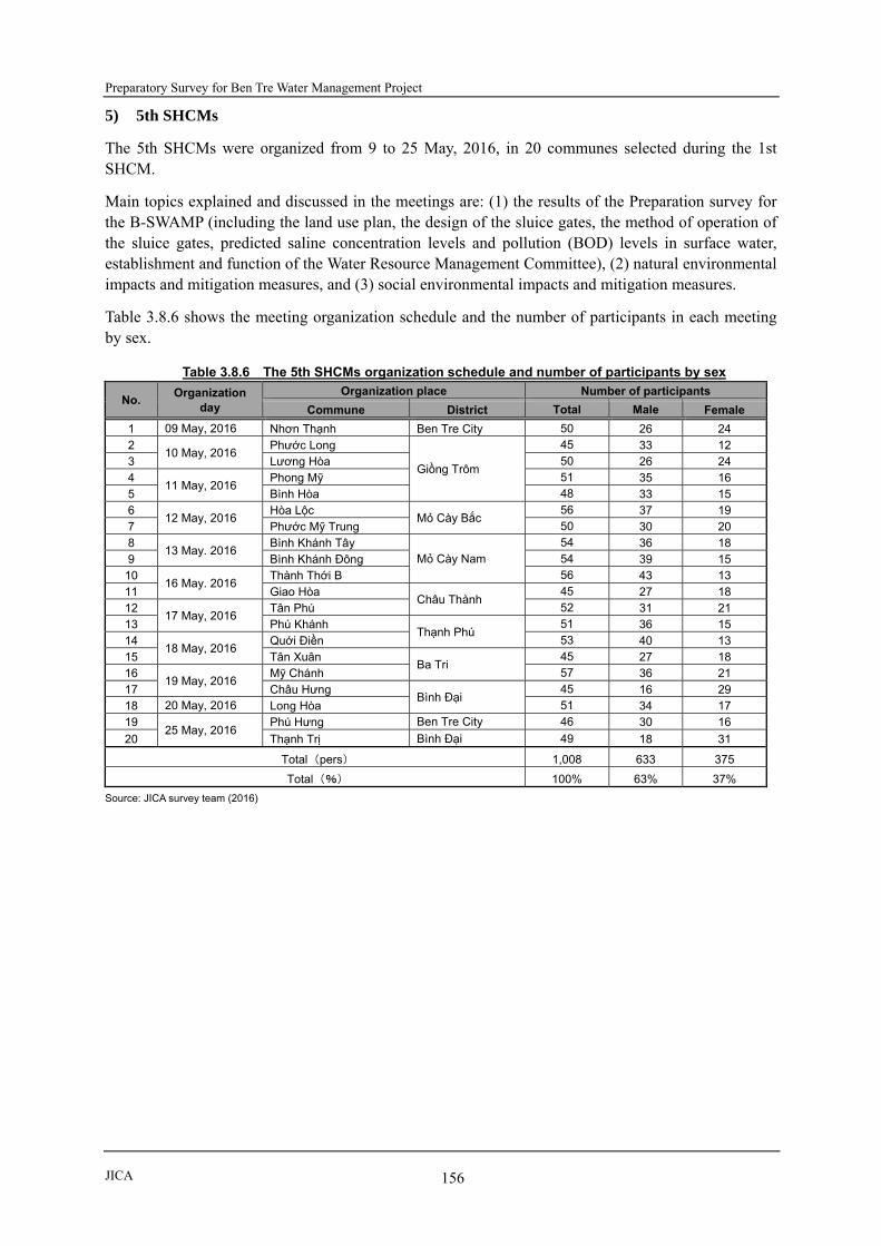
Preparatory Survey for Ben Tre Water Management Project
JICA 156
5) 5th SHCMs
The 5th SHCMs were organized from 9 to 25 May, 2016, in 20 communes selected during the 1st SHCM.
Main topics explained and discussed in the meetings are: (1) the results of the Preparation survey for the B-SWAMP (including the land use plan, the design of the sluice gates, the method of operation of the sluice gates, predicted saline concentration levels and pollution (BOD) levels in surface water, establishment and function of the Water Resource Management Committee), (2) natural environmental impacts and mitigation measures, and (3) social environmental impacts and mitigation measures.
Table 3.8.6 shows the meeting organization schedule and the number of participants in each meeting by sex.
Table 3.8.6 The 5th SHCMs organization schedule and number of participants by sex
No. Organization
day
Organization place Number of participants
Commune District Total Male Female
1 09 May, 2016 Nhơn Thạnh Ben Tre City 50 26 24 2
10 May, 2016 Phước Long
Giồng Trôm
45 33 12 3 Lương Hòa 50 26 24 4
11 May, 2016 Phong Mỹ 51 35 16
5 Bình Hòa 48 33 15 6
12 May, 2016 Hòa Lộc
Mỏ Cày Bắc 56 37 19
7 Phước Mỹ Trung 50 30 20 8
13 May. 2016 Bình Khánh Tây
Mỏ Cày Nam 54 36 18
9 Bình Khánh Đông 54 39 15 10
16 May. 2016 Thành Thới B 56 43 13
11 Giao Hòa Châu Thành
45 27 18 12
17 May, 2016 Tân Phú 52 31 21
13 Phú Khánh Thạnh Phú
51 36 15 14
18 May, 2016 Quới Điền 53 40 13
15 Tân Xuân Ba Tri
45 27 18 16
19 May, 2016 Mỹ Chánh 57 36 21
17 Châu Hưng Bình Đại
45 16 29 18 20 May, 2016 Long Hòa 51 34 17 19
25 May, 2016 Phú Hưng Ben Tre City 46 30 16
20 Thạnh Trị Bình Đại 49 18 31
Total (pers) 1,008 633 375
Total (%) 100% 63% 37%
Source: JICA survey team (2016)

Final Report
MARD/People’s Committee 157
CHAPTER 4 CONCLUSION AND RECOMMENDATIONS
4.1 CONCLUSION
Taking into account the points outlined below, this Preparatory survey concludes that the implementation of the Water Management Project in Ben Tre Province would be the most appropriate comprehensive approach in coping with unforeseeable circumstances in and around Ben Tre islets located at the estuary of the Mekong River, especially for the primary sectors and for rural development. The Government of Vietnam should therefore embark on commencement of project implementation recommended by the JICA preparatory survey.
1) On the evaluation of the project, the survey concludes that the project can be judged as feasible from the technical, environmental and social consideration, as well as economical viewpoints.
2) Since the agriculture sector constitutes about 50% of the workforce, development of the agriculture sector can significantly contribute in improving the livelihood of farmers in Ben Tre Province. Irrigation demand for agriculture sector requires a total of 97% of the entire freshwater demand in Ben Tre in dry season. This estimate of the irrigation demand highly depends on farmland use, which has to be planned and revised by the DARD staff taking into consideration crop production benefit and available freshwater volume.
3) Crop production benefit and available freshwater volume will always change and these are unforeseeable items from a regular and routine view point. Crop production benefit depends not only on domestic market but also on international market. The market trend is a variable that cannot be controlled by farmers or officials in Ben Tre Province. Hence, this information shall always be updated. Freshwater availability will change as a result of balance between sea level rise caused by climate change and discharges of the Mekong River. Predictions for the rise in the sea level depends on the scenario of climate change under global warming and this will be revised based on global industrial development.
4) The project shall always adjust prediction of Mekong River discharge since: a) a series of hydropower dam construction and operation in China will be conducted without any information sharing with the downstream countries of the Mekong River basin including Vietnam; and b) hydropower dam reservoir operation usually reduces flood water discharge of the downstream areas in the rainy season but increases the discharge in the dry season. However, if the increased discharge in dry season is utilized for irrigation in the upstream countries (i.e. increase of irrigation areas and irrigation demand), such increased irrigation demand in a draught year will not decrease. Consequently, the discharge flowing into Mekong Delta in a draught year may seriously decrease.
5) Closed sluice gate during dry season will cause water deterioration in the Ben Tre islets, which the activities aim at keeping freshwater for irrigation and domestic purposes. Opening and closing sluice gates during certain periods in dry season can decrease water deterioration by flushing polluted water out from Ben Tre islets but it may cause saline water intrusion into the islets and reduction of available freshwater reserve in canals in Ben Tre. An appropriate sluice gate operating rules should be established based on monitoring of the freshwater’s saline contents, water levels, and some indicators for water quality.
6) A sluice gate operation alone cannot control and manage water quality, demand and pollution after the start of project operation. An integrated and comprehensive approach to water management will be able to support such water quality control and water use in the Ben Tre islets. Involvement of many organizations and groups will be required for effective control and management. A management unit to be formulated (an integrated surface water management unit) will be the main

Preparatory Survey for Ben Tre Water Management Project
JICA 158
body to handle those activities of the organizations and groups aforementioned.
7) Real-time and/or in-time sharing of information on water quality and saline contents was required from the stakeholders during ‘stakeholder consultation meetings’ held in several communes. The sharing of information can be implemented under the integrated surface water management unit previously described. The proposed activities of the integrated surface water management unit can contribute to the reduction of water pollution at different levels – such as households, work areas, and farms – as well as securing freshwater for irrigation or domestic uses during dry season.
4.2 RECOMMENDATIONS
During the process of conducting this preparatory survey for the Water Management Project, the JICA survey team encountered a number of issues that led to the recommendations presented below. However, as are cases with continuous processes from now on, the recommendations set forth are by no means exhaustive and may need to be changed or modified, depending upon the prevailing conditions at the time the project is to be implemented. Nevertheless, it is believed that the ones covered here constitute a broader spectrum on which people in the Ben Tre Province will be able to collectively attain control and management of the required freshwater resource:
1) Project implementation should be carried out as early as possible, especially the construction of sluice gate along the downstream areas of the Ham Luong River. Saline water intrusion in 2015-2016 dry season was severe at the areas along the Ham Luong River that a lot of farmers in Ben Tre were not able to harvest agricultural products and had to purchase freshwater for livestock. A total of 30,000 ha of farmland was reportedly damaged and 100,000 households suffered from domestic water during the 2015-2016 dry season. This led Ben Tre PPC to request the MARD to immediately allocate budget for construction of Chu Cuu sluice gate located along the Ham Luong River in North Ben Tre and suggested to exclude Chu Cuu sluice gate from the list of ‘Ben Tre Water Management Project’ to be financed by JICA. The Cai Quao sluice gate is planned at the opposite river side of Chu Cuu sluice gate and saline water intrusion situation in the same period was the same as surrounding areas of Chu Cuu. Thus, it is recommended that Chu Cuu and Cai Quao sluice gates’ construction should be implemented as early as possible and other sluice gates should follow as part of project implementation under JICA financial assistance.
2) In case of early implementation of the construction of the aforementioned two (2) sluice gates’ construction, technical level to be applied to the projects should be carefully considered. Geological Foundation conditions of those two (2) sluice gates are quite similar and they have very thick-soft foundation at each project site with about 100m thickness or more. Advanced technology on thick-soft foundation should be applied not only for the two (2) sluice gates but also to the other two (2) sluice gates. This excludes the Tan Phu and Ben Ro sluice gates which are relatively smaller-scale facilities among the eight (8) sluice gates. Appropriate quality of materials for the sluice gates should also be considered – one which has anticorrosive effect – to ensure that project benefits will be for a longer term. Use of stainless steel is highly recommended to the project so that in the future, the budget shall mainly be used for sluice gate operation instead of maintenance. Capacity development on sluice gate operation will further play quite important roles in Ben Tre Province in the future. Thus, more budget shall be allocated to operating sluice gates to secure freshwater supply and maintain appropriate water quality.
3) Implementation of technical cooperation for ‘Integrated Surface Water Management’ is highly recommended and it should begin before completion of sluice gate construction. On the Job Training (OJT) is inevitable for the technical cooperation because seminars and manuals developed under the technical cooperation will not suffice on its own. While it’s important to introduce advanced technologies, it’s equally necessary to develop human resources to tackle and

Final Report
MARD/People’s Committee 159
cope with various unforeseeable circumstances – such as the changing climate and varying degrees of water resource development/use in upstream countries of the Mekong River basin. JICA has the distinct advantage among donors for both financing the project budget and applying technical cooperation because of its financial capacity and established expertise in conducting OJT. Construction of sluice gates can be financed by any donor who can allocate the necessary budget. However, JICA’s leverage is that JICA can conduct the technical cooperation with focus on OJT and capacity building while at the same time providing financial assistance to build infrastructure requirements. Systematic sluice gate operation is the main objective of this Water Management Project. As such, the construction of sluice gate is merely one of the tools to ensure effective and sustainable surface water management in the Ben Tre islets. Human resource development is the most important issue of the project for the farmers and stakeholders to collectively attain control and management of the required freshwater resource.
4) Information sharing with stakeholders will be the basis of activities for the integrated surface water management in Ben Tre. Information on saline contents and water quality shall be shared not only with project operation/monitoring organizations but also with farmers/women’s groups and other related projects to be assisted by other donors. Disclosure of necessary information is the first step to guide the project towards the right direction, formulated with participation of the related stakeholders. Establishing an open and transparent communication system between governmental organizations and people in the communes is essential and highly recommended in order to avoid one-way communication. During the survey, transparency on information sharing has been committed by the Ben Tre PPC. It is believed that all information to be shared will be secured during project operation and management. In line with transparency on information sharing, requests raised from stakeholders shall be managed with established rules and regulations under the surface water management unit. A request (installation of navigation lock and fish-way at Cai Quao Sluice) made by a commune during the survey period shall also be managed by the same procedures. If necessary, the request aforementioned shall be examined in the detailed design stage.
5) Since ‘Ben Tre Water Management Project’ is a project with sluice gate operation oriented as aforementioned, systematic sluice gate operation shall be performed not only by the eight (8) sluices to be constructed but also by the existing sluice gates to be operated within the system. The opening and closing mechanism of the existing sluice gate in Ben Tre is usually automatic with the use of water level differences between the sea side and the canal side. Intentional sluice gate operation system shall be adopted for the project instead of automatic operation mechanism to secure freshwater recruitment, reserve water in canals, and drain deteriorated water out from the islets. For this, an additional project implementation is recommended after this project to install, either by rehabilitation and/or replacement, sluice gates with intentional operation system instead of the existing sluice gate. In addition, there are three (3) candidate canals in South Ben Tre where sluice gates are to be newly-installed. Those works shall be combined together and can be a future candidate project after this project.
6) Trend of distribution and transportation shall be considered in Ben Tre for creating development plans for all sectors. Cargo transportation by waterway in the seven (7) coastal provinces of Mekong Delta constitutes an average of 70% while that of the Ben Tre Province is 50%. The trend of cargo transportation by waterways has been decreasing in recent years and 90% of passengers use inland transportation instead. While the operation of sluice gates will contribute in securing freshwater, it will limit waterway transportation. On the other hand, bridges above the sluices will help develop inland transportation. As such, it is recommended that the distribution system in Ben Tre be examined carefully after commencement of sluice gate operation and be reflected into formulation of development plan for each sector of Ben Tre Province.