Limuru - JICA
118
Kamirithu Polytechn ic Kamandura Prima ry School U- Turn VUP / PUP / CUP Kamandura PCEA Ch urch T r uck bay T r uck bay CUP CUP Limuru Central Limuru K iambu L imuru A104 B3 C62 B3;A104 A104 Na iro b i- Nakuru Road L imuru Road L in k Road E ldore t- Ma laba Road E ldore t- Ma laba Road 1+000 2+000 1+000 0+000 570 000 570 000 570 500 570 500 571 000 571 000 9 874 500 9 874 500 9 875 000 9 875 000 9 875 500 9 875 500 9 876 000 9 876 000 9 876 500 9 876 500 Boundaries and measurements shown on this document must not be used for engineering or land survey delineation. A land register analysis conducted by a land surveyor was not undertaken. Bioph ys ica l En viron men t Wa t e r cour se Segmen t 1 - Dua llin g of A8 Hig h way Sec tion 1 - Riron i Na ivasha She t 1 - 1 2022-01-25 Nairobi-Nakuru-Mau Summit Highway Project - Rift Valley Highway Limited Environmental and Social Impact Assessment Preparation: C. Abdel-Malek Drawing: A. Monnard Validation : G. Pothier 201_10312_00_WD_016_Atlas_A8_Section1_220125.mxd Sources : ESRI World Imagery Open Street Map, hydrography and roads American Red Cross, Administrative boundaries, 2019 Protected Planet, Ramsar and World Heritage Site, 2020-12 Bird Life International, IBA et KBA, 2020-12 WGS84, TM 36 SE (EPSG 32766) 0 55 110 m Adminis tra tive L imits Coun t y ( Nakuru) ( Gi lg i l) Sub- Coun t y (Murindat) Wa r d Proj ec t Compon en ts K i lom e t r i c poi n t ( 1 kmi n t e r v a l) K i lom e t r i c poi n t ( 100 m i n t e r v a l) Segment 1 : Dualling of A8 Highway (Rironi - Mau Summit) 1 - R i r on i Na i v asha Segment 2 : Strengthening of A8-South Highway (Rironi - Naivasha) 5 - R i r on i Ma i Mah i u Human En viron men t Sensitives Sites Re li g i o us I ns t i t ut i on School I ns t i t ut i on F lo o d i ng a r ea Point of Interest Dr i nki ng Wa t e r or Wa t e r We ll Worship Centers Ch r i s t i an U tility Exis ting Utilities Lamp Pos t C i t y ( Nj oro) T ran sporta tion Ne tw ork P r i ma r y Te r t i a r y , Res i den t i a l or Unc las i f i ed Fo ot way , Pa t h or T r ack S truc tura l Projec t E lements Unde r pas Fo ot Ov e r br i dge Noi s e Ba r r i e r * Noi s e Be r m* Se r v i c e Lane T r uc k Bay UNDERPASS VUP = Veh i c ule Unde r pas PUP = Pedes tr i an Unde r pas CUP = Ca t le Unde r pas RUP = Ra i lway Unde r pas WLC = Wi ld L i f e Cr os i ng OVERPASS VOP = Veh i cule Ov e r pas ROP = Ra i lway Ov e r pas FOB = Foot Ove r br i dge * I llus tra ted f urth e r f rom th e road f or be te r legib ility
-
Upload
khangminh22 -
Category
Documents
-
view
1 -
download
0
Transcript of Limuru - JICA

ACK Ch urch
Ng en ia Hig h Sc
h ool
Kamirith u Polytech n ic
Kaman duraPrimary Sch ool
U -Turn VU P/PU P/CU P
Kaman dura PCEA Ch urch
Truck bay
Truck b ay
CU P
CU PLimuru Central
LimuruKiambu
Limuru
A104
B3
C62
B3;A104
A104
Nairobi-Nakuru Road
Limuru Road
Lin k Road
Eldoret-Malaba Road
Eldoret-Malaba Road
1+0002+000
1+000
0+000
570 000
570 000
570 500
570 500
571 000
571 000
9 874 5009 874 500
9 875 000
9 875 000
9 875 500
9 875 500
9 876 000
9 876 000
9 876 500
9 876 500
Boundaries and measurements shown on this document must not be used for engineering or land survey delineation. A land register analysis conducted by a land surveyor was not undertaken.
Bioph ysical En viron men tWaterco urse
Seg men t 1 - Duallin g of A8 Hig h w aySection 1 - Riron i – Naivash aSh eet 1-1
2022-01-25
Nairobi-Nakuru-Mau Summit Highway Project - Rift Valley Highway LimitedEnvironmental and Social Impact Assessment
Preparation: C. Abdel-MalekDrawing: A. MonnardValidation : G. Pothier201_10312_00_WD_016_Atlas_A8_Section1_220125.mxd
Sources :ESRI World ImageryOpen Street Map, hydrography and roadsAmerican Red Cross, Administrative boundaries, 2019Protected Planet, Ramsar and World Heritage Site, 2020-12Bird Life International, IBA et KBA, 2020-12
WGS84, TM 36 SE (EPSG 32766)
0 55 110 m
Admin istrative LimitsCo unty(Nakuru)
(Gilgil)Sub -Co unty(Murindat)Ward
Project Compon en tsKilo m etric p o int (1 km interval)Kilo m etric p o int (100 minterval)
Segment 1 : Dualling of A8 Highway(Rironi - Mau Summit)
1 - Riro ni – NaivashaSegment 2 : Strengthening of A8-SouthHighway (Rironi - Naivasha)
5 - Riro ni – Mai Mahiu
Human En viron men tSensitives Sites
Religio us Institutio n
Scho o l Institutio n
Flo o ding areaPoint of Interest
Drinking Water o r Water WellWorship Centers
Christian
U tilityExistin g U tilities
Lam p Po st
City(Njoro)
Tran sportation Netw orkPrim aryTertiary, Residential o rUnclassifiedFo o tway, Path o r Track
Structural Project Elemen ts
Underpass
Fo o t Overb ridge
No ise Barrier *No ise Berm *Service LaneTruck Bay
UNDERPASSVUP = Vehicule UnderpassPUP = Pedestrian UnderpassCUP = Catle UnderpassRUP = Railway UnderpassWLC = Wild Life Cro ssing
OVERPASSVOP = Vehicule OverpassROP = Railway OverpassFOB = Fo o t Overb ridge
* Illustrated furth er from th e road for better leg ibility

ACK Church
Mang uo S wam p
Kam irithu DAM
Kam irithu Polyte
chnic
PUP/CUPU-Turn VOP/POP
Maridadi Bist
ro
Kwam bira
Truck bay
Truck bay
Bus bay
CUP
BibirioniLimuru CentralLimuruKiam bu
A104
Nairobi-Nakuru Road
Kiam bu Road
Mutarakwa-Lim uru Road
3+000
2+000
4+000
570 000
570 000
570 500
570 500
9 876 500
9 877 000
9 877 000
9 877 500
9 877 500
9 878 000
9 878 000
9 878 500
9 878 500
Boundaries and measurements shown on this document must not be used for engineering or land survey delineation. A land register analysis conducted by a land surveyor was not undertaken.
Biophysical Environm e ntWate rcours eWate rbody
S e g m e nt 1 - Dualling of A8 Hig hwayS ection 1 - Rironi – NaivashaS he e t 1-2
2022-01-25
Nairobi-Nakuru-Mau Summit Highway Project - Rift Valley Highway LimitedEnvironmental and Social Impact Assessment
Preparation: C. Abdel-MalekDrawing: A. MonnardValidation : G. Pothier201_10312_00_WD_016_Atlas_A8_Section1_220125.mxd
Sources :ESRI World ImageryOpen Street Map, hydrography and roadsAmerican Red Cross, Administrative boundaries, 2019Protected Planet, Ramsar and World Heritage Site, 2020-12Bird Life International, IBA et KBA, 2020-12
WGS84, TM 36 SE (EPSG 32766)
0 55 110m
Adm inistrative Lim itsCounty(Nakuru)
(Gilgil)Sub-County(Murindat)Ward
Proje ct Com pone ntsKilome tric point (1 km inte rval)Kilome tric point (100 minte rval)
Segment 1 : Dualling of A8 Highway(Rironi - Mau Summit)
1 - Riro n i – Naivasha
Hum an Environm e ntSensitives Sites
Infrastructure
Re ligio us In stitutio n
Scho ol In stitutio n
Se n sitive SiteFlo o ding are a
Point of InterestDrin king Wate r o r Wate r We ll
UtilityExisting Utilitie s
Lamp Po st
City(Njoro)
Transportation Ne tw orkPrimarySe co n daryTe rtiary, Re side n tial o rUnclas sifie dFo otway, Path o r Track
S tructural Proje ct Ele m e nts
Ove rpas s
Unde rpas sRun-o ff Wate r Tre atme ntEquipme ntBus BaySe rvice Lan eTruck Bay
UNDERPASSVUP = Ve hicule Unde rpas sPUP = Pe de strian Unde rpas sCUP = Catle Unde rpas sRUP = Railway Unde rpas sWLC = Wild Life Cro s sin g
OVERPASSVOP = Ve hicule Ove rpas sROP = Railway Ove rpas sFOB = Fo o t Ove rbridge
* Illustrate d furthe r from the road for be tte r le g ibility

Bibirion i water pipes system
Bibirion i/Ng ararig aSh oppin g area
PU P/CU P
U -Turn VU P/PU P
VU P/PU P/CU P
CLIMBING LANE
Bibirioni
Limuru Central
LimuruKiambu
A104Nairobi-Na
kuru Road
Man guo Ro
ad
5+000
4+000 6+000
570 000
570 000
570 500
570 500
9 878 500
9 878 500
9 879 000
9 879 000
9 879 500
9 879 500
9 880 000
9 880 000
9 880 500
9 880 500
Boundaries and measurements shown on this document must not be used for engineering or land survey delineation. A land register analysis conducted by a land surveyor was not undertaken.
Bioph ysical En viron men tWaterc ourse
Seg men t 1 - Duallin g of A8 Hig h w aySection 1 - Riron i – Naivash aSh eet 1-3
2022-01-26
Nairobi-Nakuru-Mau Summit Highway Project - Rift Valley Highway LimitedEnvironmental and Social Impact Assessment
Preparation: C. Abdel-MalekDrawing: A. MonnardValidation : G. Pothier201_10312_00_WD_016_Atlas_A8_Section1_220126.mxd
Sources :ESRI World ImageryOpen Street Map, hydrography and roadsAmerican Red Cross, Administrative boundaries, 2019Protected Planet, Ramsar and World Heritage Site, 2020-12Bird Life International, IBA et KBA, 2020-12
WGS84, TM 36 SE (EPSG 32766)
0 55 110 m
Admin istrative LimitsCounty(Nakuru)
(Gilgil)Sub-County(Murindat)Ward
Project Compon en tsKilom etric p oint (1 km interval)Kilom etric p oint (100 minterval)
Segment 1 : Dualling of A8 Highway(Rironi - Mau Summit)
1 - Rironi – Naivasha
Human En viron men tSensitives Sites
Farm ing activities
Infrastruc ture
Market and shop p ing area
Point of InterestDrinking Water or Water Well
City(Njoro)
Tran sportation Netw orkPrim aryTertiary, Residential orUn c lassifiedFootway, Path or Trac k
Structural Project Elemen ts
Underp ass
Clim bing Lane *Service Lane
UNDERPASSVUP = Vehic ule Underp assPUP = Pedestrian Underp assCUP = Catle Underp assRUP = Railway Underp assWLC = Wild Life Crossing
OVERPASSVOP = Vehic ule Overp assROP = Railway Overp assFOB = Foot Overbridge
* Illustrated furth er from th e road for better leg ibility

Bibirion i/Ng ararig aSh oppin g areaPU P/CU P
PU P/CU P
VOP/POP
U -Turn VU P/PU P
CLIMBING LANE
Bus bay
Bus bayBibirioniLimuruKiambu
BibirioniLimuru
A104Nairobi
-Nakuru Road
7+000
6+000
8+000
569 500
569 500
570 000
570 000
570 500
9 880 500 9 881 000
9 881 000
9 881 500
9 881 500
9 882 000
9 882 000 9 882 500
9 882 500
Boundaries and measurements shown on this document must not be used for engineering or land survey delineation. A land register analysis conducted by a land surveyor was not undertaken.
Bioph ysical En viron men tWaterc ourse
Seg men t 1 - Duallin g of A8 Hig h w aySection 1 - Riron i – Naivash aSh eet 1-4
2022-01-25
Nairobi-Nakuru-Mau Summit Highway Project - Rift Valley Highway LimitedEnvironmental and Social Impact Assessment
Preparation: C. Abdel-MalekDrawing: A. MonnardValidation : G. Pothier201_10312_00_WD_016_Atlas_A8_Section1_220125.mxd
Sources :ESRI World ImageryOpen Street Map, hydrography and roadsAmerican Red Cross, Administrative boundaries, 2019Protected Planet, Ramsar and World Heritage Site, 2020-12Bird Life International, IBA et KBA, 2020-12
WGS84, TM 36 SE (EPSG 32766)
0 55 110 m
Admin istrative LimitsCounty(Nakuru)
(Gilgil)Sub-County(Murindat)Ward
Project Compon en tsKilom etric p oint (1 km interval)Kilom etric p oint (100 minterval)
Segment 1 : Dualling of A8 Highway(Rironi - Mau Summit)
1 - Rironi – Naivasha
Human En viron men tSensitives Sites
Market and shop p ing area
Point of InterestDrinking Water or Water Well
U tilityExistin g U tilities
Lam p Post
City(Njoro)
Tran sportation Netw orkPrim aryTertiary, Residential orUn c lassified
Structural Project Elemen ts
Overp ass
Underp ass
Clim bing Lane *Bus BayService Lane
UNDERPASSVUP = Vehic ule Underp assPUP = Pedestrian Underp assCUP = Catle Underp assRUP = Railway Underp assWLC = Wild Life Crossing
OVERPASSVOP = Vehic ule Overp assROP = Railway Overp assFOB = Foot Overbridge
* Illustrated furth er from th e road for better leg ibility

Niam bari Mark e t
PUP/CUP
U-Turn VOP/POP
LIGHTING URBAN
LIGHTING URBAN
Truck b ay
Truck b ay
Bus b ay
Bus b ay
Bus b ay
Lari/kirengaLari
Lari/kirenga
Bibirioni
Lari
Limuru
Kiam bu
Upland s
A104
C65
C65
Nairobi-Nak uru R oad
Upland Lane
Upland -Githunguri Road
Kik uyu Escarpm e nt fore st9+000
8+000
10+000
570 000 570 000
570 500
9 882 500
9 882 500
9 883 000
9 883 000
9 883 500
9 883 500
9 884 000
9 884 000
Boundaries and measurements shown on this document must not be used for engineering or land survey delineation. A land register analysis conducted by a land surveyor was not undertaken.
Biophysical Environm e ntWaterco urse
Se gm e nt 1 - Dualling of A8 HighwaySection 1 - R ironi – NaivashaShe e t 1-5
2022-01-25
Nairobi-Nakuru-Mau Summit Highway Project - Rift Valley Highway LimitedEnvironmental and Social Impact Assessment
Preparation: C. Abdel-MalekDrawing: A. MonnardValidation : G. Pothier201_10312_00_WD_016_Atlas_A8_Section1_220125.mxd
Sources :ESRI World ImageryOpen Street Map, hydrography and roadsAmerican Red Cross, Administrative boundaries, 2019Protected Planet, Ramsar and World Heritage Site, 2020-12Bird Life International, IBA et KBA, 2020-12
WGS84, TM 36 SE (EPSG 32766)
0 55 110 m
Ad m inistrative Lim itsCo unty(Nak uru)
(Gilgil)Sub -Co unty(Murindat)Ward
Proje ct Com pone ntsKilo m etric p o int (1 km interval)Kilo m etric p o int (100 minterval)
Segment 1 : Dualling of A8 Highway(Rironi - Mau Summit)
1 - Riro ni – Naivasha
Hum an Environm e ntSensitives Sites
Market and sho p p ing area
Point of InterestDrinking Water o r Water WellWo rship Building o r Area
Landuse (OSM)Residential
Protected AreasIm p o rtant Bird Area (IBA)and Key Bio divesity Area(KBA)
City(Njoro)
Transportation Ne tworkPrim arySeco ndaryTertiary, Residential o rUnclassified
Structural Project Ele m e nts
Overpass
Underpass
Lighting Urb an *Bus BayService LaneTruck Bay
UNDERPASSVUP = Vehicule UnderpassPUP = Pedestrian UnderpassCUP = Catle UnderpassRUP = Railway UnderpassWLC = Wild Life Cro ssing
OVERPASSVOP = Vehicule OverpassROP = Railway OverpassFOB = Fo o t Overb ridge
* Illustrate d furthe r from the road for be tte r le gibility

PUP/CUPTruc k bay
Truc k bay
Bus bay Bus bayUnderpas sPUP / CUP
Bus bay Bus bay
Lari/kirengaLari
Kiam bu KFS Kik uyu
A104
Nairobi-Nak uru Road
Old Hig hw ay
11+000
10+00012+000
569 000
569 000
569 500
569 500
570 000
570 000
9 884 500
9 884 500
9 885 000
9 885 000
9 885 500
9 885 500
9 886 000
9 886 000
Boundaries and measurements shown on this document must not be used for engineering or land survey delineation. A land register analysis conducted by a land surveyor was not undertaken.
Bioph ysical Environm entWaterc o urs e
S eg m ent 1 - Dualling of A8 Hig h w ayS ection 1 - Rironi – Naivash aS h eet 1-6
2022-01-25
Nairobi-Nakuru-Mau Summit Highway Project - Rift Valley Highway LimitedEnvironmental and Social Impact Assessment
Preparation: C. Abdel-MalekDrawing: A. MonnardValidation : G. Pothier201_10312_00_WD_016_Atlas_A8_Section1_220125.mxd
Sources :ESRI World ImageryOpen Street Map, hydrography and roadsAmerican Red Cross, Administrative boundaries, 2019Protected Planet, Ramsar and World Heritage Site, 2020-12Bird Life International, IBA et KBA, 2020-12
WGS84, TM 36 SE (EPSG 32766)
0 55 110 m
Adm inistrative Lim itsCo unty(Nak uru)
(Gilgil)Sub-Co unty(Murindat)Ward
Project Com ponentsKilo m etric p o int (1 km interval)Kilo m etric p o int (100 minterval)
Segment 1 : Dualling of A8 Highway(Rironi - Mau Summit)
1 - Riro ni – NaivashaQuarries considered
Rejec ted
Hum an Environm entFlo o ding area
Point of InterestDrinking Water o r Water Well
Existing UtilitiesPo wer Trans m is s io n Line
City(Njoro)
Transportation Netw orkrailwayPrim aryTertiary, Residential o rUnc las s ifiedAc tual Intersec tio n, Weir o rTurning Circ le
S tructural Project Elem ents
Underpas s
Lighting Urban *Bus BayService LaneTruc k Bay
UNDERPASSVUP = Vehic ule Underpas sPUP = Pedes trian Underpas sCUP = Catle Underpas sRUP = Railway Underpas sWLC = Wild Life Cro s s ing
OVERPASSVOP = Vehic ule Overpas sROP = Railway Overpas sFOB = Fo o t Overbridge
* Illustrated further from the road for better leg ibility
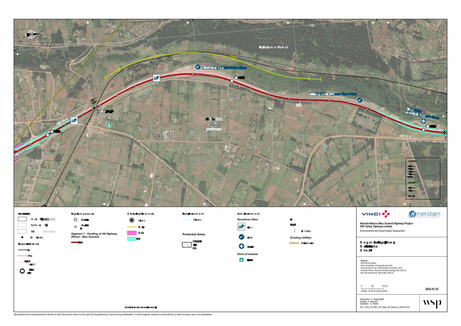
Maasai Vie w Point-Curio S hop
Mai Mahiu Long onot Vie w Point
Rift Valle y Vie w Point-Curio S hop
PUP/CUP
RUP/PUP
Bus bay
Underpas s
RUP/PUP
CLIMBING LANE
Bus bay
Lari/kirengaLari
Kiam buA104
Nairobi-Nakuru Road
Old Hig hway
Kikuyu Escarpm e nt fore st
13+000
12+00014+000
569 000569 000
569 500
569 500
9 886 500
9 886 500
9 887 000
9 887 000
9 887 500
9 887 500
9 888 000
9 888 000
Boundaries and measurements shown on this document must not be used for engineering or land survey delineation. A land register analysis conducted by a land surveyor was not undertaken.
Biophysical Environm e ntWaterco urs e
S e g m e nt 1 - Dualling of A8 Hig hwayS ection 1 - Rironi – NaivashaS he e t 1-7
2022-01-25
Nairobi-Nakuru-Mau Summit Highway Project - Rift Valley Highway LimitedEnvironmental and Social Impact Assessment
Preparation: C. Abdel-MalekDrawing: A. MonnardValidation : G. Pothier201_10312_00_WD_016_Atlas_A8_Section1_220125.mxd
Sources :ESRI World ImageryOpen Street Map, hydrography and roadsAmerican Red Cross, Administrative boundaries, 2019Protected Planet, Ramsar and World Heritage Site, 2020-12Bird Life International, IBA et KBA, 2020-12
WGS84, TM 36 SE (EPSG 32766)
0 55 110 m
Adm inistrative Lim itsCo unty(Nakuru)
(Gilgil)Sub -Co unty(Murindat)Ward
Proje ct Com pone ntsKilo m etric p o int (1 km interval)Kilo m etric p o int (100 minterval)
Segment 1 : Dualling of A8 Highway(Rironi - Mau Summit)
1 - Riro ni – Naivasha
Hum an Environm e ntSensitives Sites
Accident Sp o t
View p o int
View p o int and to uris tic sites
Point of InterestDrinking Water o r Water Well
UtilityExisting Utilitie s
Telco m Mas t
Existing UtilitiesPo wer Trans m is s io n Line
Protected AreasIm p o rtant Bird Area (IBA)and Key Bio divesity Area(KBA)
City(Njoro)
Transportation Ne tw orkrailwayPrim aryTertiary, Residential o rUnclas s ifiedActual Intersectio n, Weir o rTurning Circle
S tructural Proje ct Ele m e nts
Underpas s
Clim b ing Lane *Bus BayService Lane
UNDERPASSVUP = Vehicule Underpas sPUP = Pedes trian Underpas sCUP = Catle Underpas sRUP = Railway Underpas sWLC = Wild Life Cro s s ing
OVERPASSVOP = Vehicule Overpas sROP = Railway Overpas sFOB = Fo o t Overb ridge
* Illustrate d furthe r from the road for be tte r le g ibility

Lari Hospital
Kiren g a Polytech n ic
Kiren g a Primary Sch ool
African In lan d Ch urch (AIC)
Rift Valley View Poin t-Curio Sh op
AIPCA
PU PPU P/CU P U -Turn VU P/PU P
AIPCA
An g lican
Ch urch M
atathia
Bus bay
Bus bay
Bus bay
Bus bay
Kijabe
LariKiambu
A104Nairobi-Nakuru Road
Nairobi Road
Old Hig h w ay
Kikuyu Escarpmen t forest
15+00014+00016+000
569 000 569 500569 500
570 000
570 0009 888 000
9 888 000
9 888 500
9 888 500
9 889 000
9 889 000
9 889 500
9 889 500
9 890 000
Boundaries and measurements shown on this document must not be used for engineering or land survey delineation. A land register analysis conducted by a land surveyor was not undertaken.
Bioph ysical En viron men tWatercourse
Seg men t 1 - Duallin g of A8 Hig h w aySection 1 - Riron i – Naivash aSh eet 1-8
2022-01-25
Nairobi-Nakuru-Mau Summit Highway Project - Rift Valley Highway LimitedEnvironmental and Social Impact Assessment
Preparation: C. Abdel-MalekDrawing: A. MonnardValidation : G. Pothier201_10312_00_WD_016_Atlas_A8_Section1_220125.mxd
Sources :ESRI World ImageryOpen Street Map, hydrography and roadsAmerican Red Cross, Administrative boundaries, 2019Protected Planet, Ramsar and World Heritage Site, 2020-12Bird Life International, IBA et KBA, 2020-12
WGS84, TM 36 SE (EPSG 32766)
0 55 110 m
Admin istrative LimitsCounty(Nakuru)
(Gilgil)Sub-County(Murindat)Ward
Project Compon en tsKilom etric point (1 km interval)Kilom etric point (100 minterval)
Segment 1 : Dualling of A8 Highway(Rironi - Mau Summit)
1 - Riron i – Naivasha
Human En viron men tSensitives Sites
Health Facilities
Religious In stitution
School In stitution
View poin t an d touristic sites
Point of InterestDrin king Water or Water Well
ProtectedIm portan t Bird Area (IBA)an d Key Biod ivesity Area(KBA)
City(Njoro)
Tran sportation Netw orkrailwayPrim aryTertiary, Resid ential orUnclas sifiedFootway, Path or Track
Structural Project Elemen ts
Un d erpas s
Bus BayService Lane
UNDERPASSVUP = Vehicule Un d erpas sPUP = Ped estrian Un d erpas sCUP = Catle Un d erpas sRUP = Railway Un d erpas sWLC = Wild Life Cros sing
OVERPASSVOP = Vehicule Overpas sROP = Railway Overpas sFOB = Foot Overbrid ge
* Illustrated furth er from th e road for better leg ibility

Kim e nd e Mark e t
Kim e nd e Prim ary School
Kim e nd e Se cond ary School
Full Gospe l Church Kim e nd e
Bathi Prim ary and Se cond ary Schools
PCEA church Baptist Church
Full Gospe l ChurchOld Catholic Church
Orthod ox Church MatathiaSt Joseph Catholic Church Matathia
PUP/CUP
VUP/PUP
PCEA church Baptist Church
Full Gospe l ChurchOld Catholic Church
Orthod ox Church Matathia
LIGHTING URBAN
LIGHTING URBAN
Truck b ay
Truck b ay
Kijabe
Kijabe
Lari/kirengaLariKiam bu
Kik uyu Escarpm e ntFore st R e se rve
Kim e nd e
A104
D402
Nairobi R oad
Nairobi-Nak uru R oadNairob
i - Nak uru R oa
d
Kim end e M
atathia Gitithia
Gatund u-Kinare R oad
Nairobi R oad
17+000
16+000
18+000
569 500
569 500
570 000
570 000
570 500
570 500
9 890 000
9 890 000
9 890 500
9 890 500
9 891 000 9 891 500
9 891 500 9 892 000
9 892 000
Boundaries and measurements shown on this document must not be used for engineering or land survey delineation. A land register analysis conducted by a land surveyor was not undertaken.
Biophysical Environm e ntWaterco urse
Se gm e nt 1 - Dualling of A8 HighwaySection 1 - R ironi – NaivashaShe e t 1-9
2022-01-25
Nairobi-Nakuru-Mau Summit Highway Project - Rift Valley Highway LimitedEnvironmental and Social Impact Assessment
Preparation: C. Abdel-MalekDrawing: A. MonnardValidation : G. Pothier201_10312_00_WD_016_Atlas_A8_Section1_220125.mxd
Sources :ESRI World ImageryOpen Street Map, hydrography and roadsAmerican Red Cross, Administrative boundaries, 2019Protected Planet, Ramsar and World Heritage Site, 2020-12Bird Life International, IBA et KBA, 2020-12
WGS84, TM 36 SE (EPSG 32766)
0 55 110 m
Ad m inistrative Lim itsCo unty(Nak uru)
(Gilgil)Sub -Co unty(Murindat)Ward
Proje ct Com pone ntsKilo m etric p o int (1 km interval)Kilo m etric p o int (100 minterval)
Segment 1 : Dualling of A8 Highway(Rironi - Mau Summit)
1 - Riro ni – Naivasha
Hum an Environm e ntSensitives Sites
Accident Sp o t
Market and sho p p ing area
Religio us Institutio n
Scho o l Institutio n
Flo o ding areaLanduse (OSM)
Allo tm entsResidential
ProtectedNational Le ve l
Fo rest Reserve
City(Njoro)
Transportation Ne tworkrailwayPrim aryTertiary, Residential o rUnclassifiedFo o tway, Path o r Track
Structural Project Ele m e nts
Underpass
Lighting Urb an *Service LaneTruck Bay
UNDERPASSVUP = Vehicule UnderpassPUP = Pedestrian UnderpassCUP = Catle UnderpassRUP = Railway UnderpassWLC = Wild Life Cro ssing
OVERPASSVOP = Vehicule OverpassROP = Railway OverpassFOB = Fo o t Overb ridge
* Illustrate d furthe r from the road for be tte r le gibility

Magina Prim ary and S econdary S chool
PUP/CUP
VUP/PUP/CUP
Magina Polytechnic
LIGHTING URBAN
LIGHTING URBAN
LIGHTING
URBAN
CLIMBING LANE
Bus b ay
Bus b ay
KijabeLari
Kiam bu
Kikuyu Escarpm e ntFore st Re se rve
A104
Nairobi - Nakuru Road
Nairobi Road
Bathi River
Kikuyu Escarpm e nt fore st
19+000
18+000
20+000
569 500
569 500
570 000
570 000
9 892 000
9 892 000
9 892 500
9 892 500
9 893 000
9 893 000
9 893 500
9 893 500
9 894 000
9 894 000
Boundaries and measurements shown on this document must not be used for engineering or land survey delineation. A land register analysis conducted by a land surveyor was not undertaken.
Biophysical Environm e ntWaterco urseWaterb o dy
S e g m e nt 1 - Dualling of A8 Hig hwayS ection 1 - Rironi – NaivashaS he e t 1-10
2022-01-25
Nairobi-Nakuru-Mau Summit Highway Project - Rift Valley Highway LimitedEnvironmental and Social Impact Assessment
Preparation: C. Abdel-MalekDrawing: A. MonnardValidation : G. Pothier201_10312_00_WD_016_Atlas_A8_Section1_220125.mxd
Sources :ESRI World ImageryOpen Street Map, hydrography and roadsAmerican Red Cross, Administrative boundaries, 2019Protected Planet, Ramsar and World Heritage Site, 2020-12Bird Life International, IBA et KBA, 2020-12
WGS84, TM 36 SE (EPSG 32766)
0 55 110 m
Adm inistrative Lim itsCo unty(Nakuru)
(Gilgil)Sub -Co unty(Murindat)Ward
Proje ct Com pone ntsKilo m etric p o int (1 km interval)Kilo m etric p o int (100 minterval)
Segment 1 : Dualling of A8 Highway(Rironi - Mau Summit)
1 - Riro ni – Naivasha
Hum an Environm e ntSensitives Sites
Accident Sp o t
Scho o l Institutio n
Flo o ding areaPoint of Interest
Scho o l, Co llege o rKindergarrdenWo rship Building o r Area
Landuse (OSM)Allo tm entsResidential
ProtectedNational Le ve l
Fo rest ReserveIm p o rtant Bird Area (IBA)and Key Bio divesity Area(KBA)
City(Njoro)
Transportation Ne tw orkrailwayPrim aryTertiary, Residential o rUnclassified
S tructural Proje ct Ele m e nts
Underpass
Lighting Urb an *Clim b ing Lane *Bus BayService Lane
UNDERPASSVUP = Vehicule UnderpassPUP = Pedestrian UnderpassCUP = Catle UnderpassRUP = Railway UnderpassWLC = Wild Life Cro ssing
OVERPASSVOP = Vehicule OverpassROP = Railway OverpassFOB = Fo o t Overb ridge
* Illustrate d furthe r from the road for be tte r le g ibility

Magina Marke t area
Kag o Prim ary School
Magina Dispe nsary (Kag o)
Magina Prim ary and
Secondary School
PUP/CUP
U-T urn VOP/POP
Magina Site
Magina Ce m e te ryMagina Polytechnic
takinya_com m unity_nurse ry
CLIMBING LANE
LIGHTING URBAN
LIGHTING URBAN
LIGHTING URBA
N
CLIMBING LANE
Kijabe
Kinale
Lari
Kiam bu Kijabe
Kiam bu
A104
Nairobi - Nakuru Road
Kijabe Hospital Link RoadBathi River
Kikuyu Escarpm e nt fore st
21+000
20+000
22+000
569 000
569 000
569 500
569 500
570 000
570 000
9 894 000
9 894 000
9 894 500
9 894 500
9 895 000
9 895 000
9 895 500
9 895 500
Boundaries and measurements shown on this document must not be used for engineering or land survey delineation. A land register analysis conducted by a land surveyor was not undertaken.
Biophysical Environm e ntWaterco urseWaterb o dy
Se g m e nt 1 - Dualling of A8 Hig hwaySection 1 - Rironi – NaivashaShe e t 1-11
2022-01-25
Nairobi-Nakuru-Mau Summit Highway Project - Rift Valley Highway LimitedEnvironmental and Social Impact Assessment
Preparation: C. Abdel-MalekDrawing: A. MonnardValidation : G. Pothier201_10312_00_WD_016_Atlas_A8_Section1_220125.mxd
Sources :ESRI World ImageryOpen Street Map, hydrography and roadsAmerican Red Cross, Administrative boundaries, 2019Protected Planet, Ramsar and World Heritage Site, 2020-12Bird Life International, IBA et KBA, 2020-12
WGS84, TM 36 SE (EPSG 32766)
0 55 110 m
Adm inistrative Lim itsCo unty(Nakuru)
(Gilgil)Sub -Co unty(Murindat)Ward
Proje ct Com pone ntsKilo m etric p o int (1 km interval)Kilo m etric p o int (100 minterval)
Segment 1 : Dualling of A8 Highway(Rironi - Mau Summit)
1 - Riro ni – Naivasha
Hum an Environm e ntSensitives Sites
Accident Sp o t
Health Facilities
Market and sho p p ing area
Scho o l Institutio n
Point of InterestScho o l, Co llege o rKindergarrdenGraveyardPark, Picnic Site o rPlaygro undWo rship Building o r Area
Landuse (OSM)Allo tm ents
ProtectedIm p o rtant Bird Area (IBA)and Key Bio divesity Area(KBA)
City(Njoro)
T ransportation Ne tw orkPrim aryTertiary, Residential o rUnclassifiedFo o tway, Path o r Track
Structural Proje ct Ele m e nts
Underpass
Lighting Urb an *Clim b ing Lane *Service Lane
UNDERPASSVUP = Vehicule UnderpassPUP = Pedestrian UnderpassCUP = Catle UnderpassRUP = Railway UnderpassWLC = Wild Life Cro ssing
OVERPASSVOP = Vehicule OverpassROP = Railway OverpassFOB = Fo o t Overb ridge
* Illustrate d furthe r from the road for be tte r le g ibility

PUP/CUPU-Turn VOP/POP
LIGHTING URBAN
LIGHTING URBAN
Bus bay
Bus bay
Kinale
Kijabe
Kinale
LariKiam bu
Kijabe
Kikuyu Escarpm e ntFore st Re se rve
A104Nairobi - Nakuru Road
Kijabe Road
Kijabe Top Road
Bathi River
Kikuyu Escarpm e nt fore st
23+000
22+00024+000
568 000
568 000
568 500
568 500
569 000
569 000
569 500
569 500
9 895 5009 895 500
9 896 000
9 896 000
9 896 500
9 896 500
9 897 000
9 897 000 9 897 500
Boundaries and measurements shown on this document must not be used for engineering or land survey delineation. A land register analysis conducted by a land surveyor was not undertaken.
Biophysical Environm e ntWaterc ourse
S e g m e nt 1 - Dualling of A8 Hig hwayS ection 1 - Rironi – NaivashaS he e t 1-12
2022-01-25
Nairobi-Nakuru-Mau Summit Highway Project - Rift Valley Highway LimitedEnvironmental and Social Impact Assessment
Preparation: C. Abdel-MalekDrawing: A. MonnardValidation : G. Pothier201_10312_00_WD_016_Atlas_A8_Section1_220125.mxd
Sources :ESRI World ImageryOpen Street Map, hydrography and roadsAmerican Red Cross, Administrative boundaries, 2019Protected Planet, Ramsar and World Heritage Site, 2020-12Bird Life International, IBA et KBA, 2020-12
WGS84, TM 36 SE (EPSG 32766)
0 55 110 m
Adm inistrative Lim itsCounty(Nakuru)
(Gilgil)Sub-County(Murindat)Ward
Proje ct Com pone ntsKilom etric p oint (1 km interval)Kilom etric p oint (100 minterval)
Segment 1 : Dualling of A8 Highway(Rironi - Mau Summit)
1 - Rironi – Naivasha
Hum an Environm e ntSensitives Sites
Farm ing activities
ProtectedNational Le ve l
Forest ReserveIm p ortant Bird Area (IBA)and Key Biodivesity Area(KBA)
City(Njoro)
Transportation Ne tw orkPrim aryTertiary, Residential orUn c lassifiedFootway, Path or Trac k
S tructural Proje ct Ele m e nts
Overp ass
Underp ass
Lighting Urban *Bus BayService Lane
Wildlife CrossingCanop y Bridge (exact loc ationto be validated)
Underp ass
UNDERPASSVUP = Vehic ule Underp assPUP = Pedestrian Underp assCUP = Catle Underp assRUP = Railway Underp assWLC = Wild Life Crossing
OVERPASSVOP = Vehic ule Overp assROP = Railway Overp assFOB = Foot Overbridge
* Illustrate d furthe r from the road for be tte r le g ibility

AIC Karik o Ch urch
PUP/CUPBus bay
Bus bay
Bus bay Bus bay
Kinale
Kijabe
LariKiam bu
Kik uyu Escarpm entForest Reserve
A104
D398
Nairobi - Nak uru Road
Kijabe Road
Gatundu-Kinare Road
Bathi River
Kik uyu Escarpm ent forest
Kinang op g rasslands
25+00024+000
26+000
567 500
567 500
568 000
568 000
568 500
568 500
9 897 500
9 897 500
9 898 000
9 898 000
9 898 500
9 898 500
9 899 000
9 899 000
Boundaries and measurements shown on this document must not be used for engineering or land survey delineation. A land register analysis conducted by a land surveyor was not undertaken.
Bioph ysical Environm entWate rcours e
S eg m ent 1 - Dualling of A8 Hig h w ayS ection 1 - Rironi – Naivash aS h eet 1-13
2022-01-25
Nairobi-Nakuru-Mau Summit Highway Project - Rift Valley Highway LimitedEnvironmental and Social Impact Assessment
Preparation: C. Abdel-MalekDrawing: A. MonnardValidation : G. Pothier201_10312_00_WD_016_Atlas_A8_Section1_220125.mxd
Sources :ESRI World ImageryOpen Street Map, hydrography and roadsAmerican Red Cross, Administrative boundaries, 2019Protected Planet, Ramsar and World Heritage Site, 2020-12Bird Life International, IBA et KBA, 2020-12
WGS84, TM 36 SE (EPSG 32766)
0 55 110m
Adm inistrative Lim itsCoun ty(Nak uru)
(Gilgil)Sub-Coun ty(Murindat)Ward
Project Com ponentsKilome tric poin t (1 km in te rval)Kilome tric poin t (100 min te rval)
Segment 1 : Dualling of A8 Highway(Rironi - Mau Summit)
1 - Riro n i – Naivasha
Hum anSensitives Sites
Re ligio us In s titutio n
Landuse (OSM)Fo re s t
Protected AreasNational Level
Fore s t Re s e rveImpo rtan t Bird Are a (IBA)and Ke y Biodive s ity Are a(KBA)
City(Njoro)
Transportation Netw orkPrimaryTe rtiary, Re s ide n tial orUnclas s ifie dFo o tway, Path or Track
S tructural Project Elem ents
Unde rpas s
Bus BaySe rvice Lan e
Wildlife CrossingCan o py Bridge (e xact locatio nto be validate d)
Unde rpas s
UNDERPASSVUP = Ve hicule Unde rpas sPUP = Pe de s trian Unde rpas sCUP = Catle Unde rpas sRUP = Railway Unde rpas sWLC = Wild Life Cro s s in g
OVERPASSVOP = Ve hicule Ove rpas sROP = Railway Ove rpas sFOB = Fo o t Ove rbridge
* Illustrated further from the road for better leg ibility

AIC Ka riko Church
CUPBus bay
Bus bay
Bus bayKinaleLariKia mbu
Kikuyu Esca rpmen tForest Reserve
A104 Na irobi - Na kuru Roa d
Kikuyu Esca rpmen t forest
Kin a n gop gra ssla n ds
27+000
26+000
28+000
566 500
566 500
567 000
567 000
567 500
567 500
568 000
568 000
9 899 0009 899 000
9 899 500
9 899 500
9 900 000
9 900 000
9 900 500
9 900 500 9 901 000
9 901 000
Boundaries and measurements shown on this document must not be used for engineering or land survey delineation. A land register analysis conducted by a land surveyor was not undertaken.
Biophysica l En viron men tWate rcours e
Segmen t 1 - Dua llin g of A8 Highw a ySection 1 - Riron i – Na iva shaSheet 1-14
2022-01-25
Nairobi-Nakuru-Mau Summit Highway Project - Rift Valley Highway LimitedEnvironmental and Social Impact Assessment
Preparation: C. Abdel-MalekDrawing: A. MonnardValidation : G. Pothier201_10312_00_WD_016_Atlas_A8_Section1_220125.mxd
Sources :ESRI World ImageryOpen Street Map, hydrography and roadsAmerican Red Cross, Administrative boundaries, 2019Protected Planet, Ramsar and World Heritage Site, 2020-12Bird Life International, IBA et KBA, 2020-12
WGS84, TM 36 SE (EPSG 32766)
0 55 110m
Admin istra tive LimitsCoun ty(Na kuru)
(Gilgil)Sub-Coun ty(Murindat)Ward
Project Compon en tsKilome tric poin t (1 km in te rval)Kilome tric poin t (100 min te rval)
Segment 1 : Dualling of A8 Highway(Rironi - Mau Summit)
1 - Riro n i – Naivasha
Huma nEn viron men tLanduse (OSM)
Fo re s tProtected AreasNa tion a l Level
Fore s t Re s e rveImpo rtan t Bird Are a (IBA)and Ke y Biodive s ity Are a(KBA)
City(Njoro)
Tra n sporta tion NetworkPrimaryTe rtiary, Re s ide n tial orUnclas s ifie dFo o tway, Path or Track
Structura l Project Elemen ts
Unde rpas s
Bus BaySe rvice Lan e
Wildlife CrossingCan o py Bridge (e xact locatio nto be validate d)
UNDERPASSVUP = Ve hicule Unde rpas sPUP = Pe de s trian Unde rpas sCUP = Catle Unde rpas sRUP = Railway Unde rpas sWLC = Wild Life Cro s s in g
OVERPASSVOP = Ve hicule Ove rpas sROP = Railway Ove rpas sFOB = Fo o t Ove rbridge
* Illustra ted further from the roa d for better legibility

So ko Mjinga Market
St-Ch risto ph er Prim ary Sch o o lSt-Ch risto ph er Seco ndary Sch o o l
CU P
CU P
PU P/CU PLIGHTING URBAN
LIGHTING URBAN
Bus b ay
Bus b ay
Bus b ay
Bus b ay
KinaleMagumuLari
Kinangop
Kiam bu
Nyandarua
Lo gistic Center and Magum u Market Develo pm ent
Kikuyu Escarpm entFo rest Reserve
A104Nairo bi - Nakuru Ro ad
Kikuyu Escarpm ent fo rest
Kinango p grasslands
Kinango p grasslands
29+000
28+00030+000
565 000
565 000
565 500
565 500
566 000
566 000
566 500
566 500
9 900 5009 900 500
9 901 0009 901 000
9 901 500
9 901 500 9 902 000
9 902 000
Boundaries and measurements shown on this document must not be used for engineering or land survey delineation. A land register analysis conducted by a land surveyor was not undertaken.
Bio ph ysical Enviro nm entWaterco urse
Segm ent 1 - Dualling o f A8 High waySectio n 1 - Riro ni – Naivash aSh eet 1-15
2022-01-26
Nairobi-Nakuru-Mau Summit Highway Project - Rift Valley Highway LimitedEnvironmental and Social Impact Assessment
Preparation: C. Abdel-MalekDrawing: A. MonnardValidation : G. Pothier201_10312_00_WD_016_Atlas_A8_Section1_220126.mxd
Sources :ESRI World ImageryOpen Street Map, hydrography and roadsAmerican Red Cross, Administrative boundaries, 2019Protected Planet, Ramsar and World Heritage Site, 2020-12Bird Life International, IBA et KBA, 2020-12
WGS84, TM 36 SE (EPSG 32766)
0 55 110 m
Adm inistrative Lim itsCo unty(Nakuru)
(Gilgil)Sub -Co unty(Murindat)Ward
Pro ject Co m po nentsKilo m etric p o int (1 km interval)Kilo m etric p o int (100 minterval)
Segment 1 : Dualling of A8 Highway(Rironi - Mau Summit)
1 - Riro ni – Naivasha
Hum an Enviro nm entSensitives Sites
Accident Sp o t
Market and sho p p ing area
Scho o l Institutio n
Flo o ding areaFuture Develo p m ents
U tilityExisting U tilities
Lam p Po stLanduse (OSM)
Fo rest
ProtectedNatio nal Level
Fo rest ReserveIm p o rtant Bird Area (IBA)and Key Bio divesity Area(KBA)
City(Njo ro )
Transpo rtatio n Netw o rkPrim aryTertiary, Residential o rUnclassified
Structural Pro ject Elem ents
Underpass
Lighting Urb an *Bus BayService LaneTruck Bay
Wildlife CrossingCano py Bridge (exact lo catio nto b e validated)
UNDERPASSVUP = Vehicule UnderpassPUP = Pedestrian UnderpassCUP = Catle UnderpassRUP = Railway UnderpassWLC = Wild Life Cro ssing
OVERPASSVOP = Vehicule OverpassROP = Railway OverpassFOB = Fo o t Overb ridge
* Illustrated furth er fro m th e ro ad fo r better legibility

Dam
Sok o Mpya Mark et
St-Christophe r Se cond ary School
PUP/CUP U-Turn VOP/POP
Fly-Ove r Stage
LIGHTING URBAN
Bus b ay
Bus b ay
LIGHTING UR
BAN
Magumu
KinangopNyand arua
MagumuKinangopNyand arua
Magumu
KinangopNyand arua
Logistic Ce nte r and Magum u Mark et De ve lopm e nt
Kik uyu Escarpm e ntFore st R e se rve
A104
C68
Nairobi - Nak uru R oad
Thik a-Gatura R oad
Kinangop grassland s
Kik uyu Escarpm e nt fore st
31+000
30+000 32+000
563 000
563 000
563 500
563 500
564 000
564 000
564 500
564 500
565 000
565 000
9 901 5009 901 500 9 902 000
9 902 000
9 902 500
9 903 000
Boundaries and measurements shown on this document must not be used for engineering or land survey delineation. A land register analysis conducted by a land surveyor was not undertaken.
Biophysical Environm e ntWaterco urseWaterb o dy
Se gm e nt 1 - Dualling of A8 HighwaySection 1 - R ironi – NaivashaShe e t 1-16
2022-01-26
Nairobi-Nakuru-Mau Summit Highway Project - Rift Valley Highway LimitedEnvironmental and Social Impact Assessment
Preparation: C. Abdel-MalekDrawing: A. MonnardValidation : G. Pothier201_10312_00_WD_016_Atlas_A8_Section1_220126.mxd
Sources :ESRI World ImageryOpen Street Map, hydrography and roadsAmerican Red Cross, Administrative boundaries, 2019Protected Planet, Ramsar and World Heritage Site, 2020-12Bird Life International, IBA et KBA, 2020-12
WGS84, TM 36 SE (EPSG 32766)
0 55 110 m
Ad m inistrative Lim itsCo unty(Nak uru)
(Gilgil)Sub -Co unty(Murindat)Ward
Proje ct Com pone ntsKilo m etric p o int (1 km interval)Kilo m etric p o int (100 minterval)
Segment 1 : Dualling of A8 Highway(Rironi - Mau Summit)
1 - Riro ni – Naivasha
Hum an Environm e ntSensitives Sites
Accident Sp o t
Infrastructure
Market and sho p p ing area
Flo o ding areaFuture Develo p m ents
UtilityExisting Utilitie s
Lam p Po stLanduse (OSM)
Fo rest
Protected AreasNational Le ve l
Fo rest ReserveIm p o rtant Bird Area (IBA)and Key Bio divesity Area(KBA)
City(Njoro)
Transportation NetworkPrim arySeco ndaryTertiary, Residential o rUnclassified
Structural Project Ele m e nts
Overpass
Underpass
Fo o t Overb ridge
Lighting Urb an *Bus BayService Lane
UNDERPASSVUP = Vehicule UnderpassPUP = Pedestrian UnderpassCUP = Catle UnderpassRUP = Railway UnderpassWLC = Wild Life Cro ssing
OVERPASSVOP = Vehicule OverpassROP = Railway OverpassFOB = Fo o t Overb ridge
* Illustrate d furthe r from the road for bette r le gibility

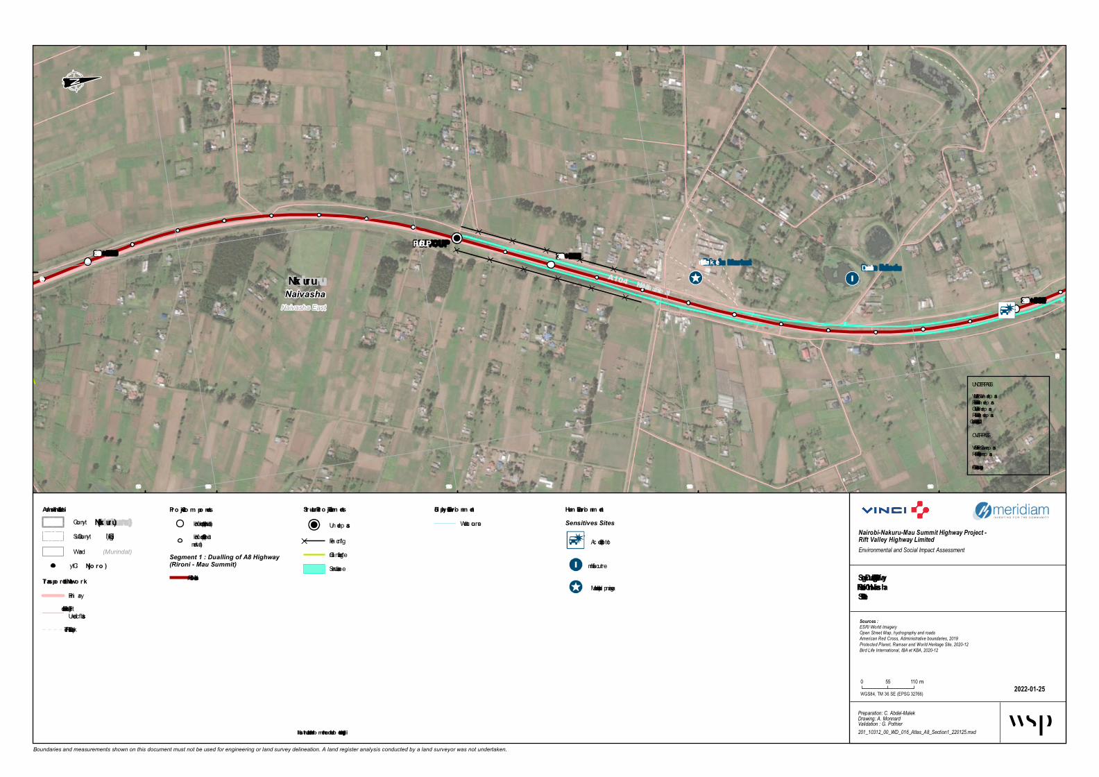
Vie w Point Kobil
PCEA St-John Church
Vision in Christ ChurchPCEA St-John Fly-Ove r Acad e m y
PUP/CUP
U-Turn VOP/POP
Fly-Ove r Stage
Bus b ay
Bus b ay
LIGHTING U
RBAN
LIGHTING U
RBAN
CLIMBING LANE
Magumu Naivasha EastKinangop Naivasha Nyand arua Nak uru
Naivasha East
Magumu
Naivasha
Kinangop
Nak uru
Nyand arua
A104
Nairobi - Nak uru R oad
Kinangop grassland s
33+000
32+00034+000
561 500
561 500
562 000
562 000
562 500
562 500
563 000
563 000
9 902 5009 902 500
9 903 000
9 903 500
9 903 500 9 904 000
9 904 000
Boundaries and measurements shown on this document must not be used for engineering or land survey delineation. A land register analysis conducted by a land surveyor was not undertaken.
Biophysical Environm e ntWaterco urse
Se gm e nt 1 - Dualling of A8 HighwaySection 1 - R ironi – NaivashaShe e t 1-17
2022-01-25
Nairobi-Nakuru-Mau Summit Highway Project - Rift Valley Highway LimitedEnvironmental and Social Impact Assessment
Preparation: C. Abdel-MalekDrawing: A. MonnardValidation : G. Pothier201_10312_00_WD_016_Atlas_A8_Section1_220125.mxd
Sources :ESRI World ImageryOpen Street Map, hydrography and roadsAmerican Red Cross, Administrative boundaries, 2019Protected Planet, Ramsar and World Heritage Site, 2020-12Bird Life International, IBA et KBA, 2020-12
WGS84, TM 36 SE (EPSG 32766)
0 55 110 m
Ad m inistrative Lim itsCo unty(Nak uru)
(Gilgil)Sub -Co unty(Murindat)Ward
Proje ct Com pone ntsKilo m etric p o int (1 km interval)Kilo m etric p o int (100 minterval)
Segment 1 : Dualling of A8 Highway(Rironi - Mau Summit)
1 - Riro ni – Naivasha
Hum an Environm e ntSensitives Sites
Accident Sp o t
Religio us Institutio n
Scho o l Institutio n
View p o int
Flo o ding areaPoint of Interest
Archaeo lo gical, Attractio n,Mo num ent o r Viewp o intTo ilet
UtilityExisting Utilitie s
Lam p Po stBuildingsProtected Areas
Im p o rtant Bird Area (IBA)and Key Bio divesity Area(KBA)
City(Njoro)
Transportation Ne tworkPrim arySeco ndaryTertiary, Residential o rUnclassifiedFo o tway, Path o r Track
Structural Project Ele m e nts
Overpass
Underpass
Lighting Urb an *Clim b ing Lane *Bus BayService Lane
UNDERPASSVUP = Vehicule UnderpassPUP = Pedestrian UnderpassCUP = Catle UnderpassRUP = Railway UnderpassWLC = Wild Life Cro ssing
OVERPASSVOP = Vehicule OverpassROP = Railway OverpassFOB = Fo o t Overb ridge
* Illustrate d furthe r from the road for be tte r le gibility

U-Turn VUP/PUPBus bay
Bus bay
CLIMBING LA
NE
CLIMBING LANENaivasha EastNaivasha Na kuru
Naivasha East
Magumu
Naivasha
Kinangop
Na kuru
Nya n da rua
A104
D394Na irobi - Na k uru Roa d
Kin a n gop gra ssla n ds
35+000
34+00036+000
560 500
560 500
561 000
561 000
561 500
561 500
9 904 000 9 904 500
9 904 500
9 905 000
9 905 000
9 905 500
9 905 500 9 906 000
9 906 000
Boundaries and measurements shown on this document must not be used for engineering or land survey delineation. A land register analysis conducted by a land surveyor was not undertaken.
Biop hysica l En viron men tWaterc ourse
Segmen t 1 - Dua llin g of A8 Highw a ySection 1 - Riron i – Na iva shaSheet 1-18
2022-01-25
Nairobi-Nakuru-Mau Summit Highway Project - Rift Valley Highway LimitedEnvironmental and Social Impact Assessment
Preparation: C. Abdel-MalekDrawing: A. MonnardValidation : G. Pothier201_10312_00_WD_016_Atlas_A8_Section1_220125.mxd
Sources :ESRI World ImageryOpen Street Map, hydrography and roadsAmerican Red Cross, Administrative boundaries, 2019Protected Planet, Ramsar and World Heritage Site, 2020-12Bird Life International, IBA et KBA, 2020-12
WGS84, TM 36 SE (EPSG 32766)
0 55 110 m
Admin istra tive LimitsCounty(Na k uru)
(Gilgil)Sub-County(Murindat)Ward
Project Comp on en tsKilom etric p oint (1 km interval)Kilom etric p oint (100 minterval)
Segment 1 : Dualling of A8 Highway(Rironi - Mau Summit)
1 - Rironi – Naivasha
Huma n En viron men tSensitives Sites
Ac c ident Sp ot
ProtectedIm p ortant Bird Area (IBA)and Key Biodivesity Area(KBA)
City(Njoro)
Tra n sp orta tion NetworkPrim aryTertiary, Residential orUn c lassified
Structura l Project Elemen ts
Underp ass
Clim bing Lane *Bus BayService Lane
UNDERPASSVUP = Vehic ule Underp assPUP = Pedestrian Underp assCUP = Catle Underp assRUP = Railway Underp assWLC = Wild Life Crossing
OVERPASSVOP = Vehic ule Overp assROP = Railway Overp assFOB = Foot Overbridge
* Illustra ted further from the roa d for better legibility
Dam IhinduIhindu Market
PUP/CUP
Naivasha EastNaivasha Nakuru A104 Nairo b i - Nakuru Ro ad
37+00036+000
38+000
561 000
561 000
561 500
561 500
9 906 000
9 906 000
9 906 500
9 906 500
9 907 000
9 907 000
9 907 500
9 907 500
Boundaries and measurements shown on this document must not be used for engineering or land survey delineation. A land register analysis conducted by a land surveyor was not undertaken.
Bio physical Enviro nm entWaterc ourse
Segm ent 1 - Dualling o f A8 HighwaySectio n 1 - Riro ni – NaivashaSheet 1-19
2022-01-25
Nairobi-Nakuru-Mau Summit Highway Project - Rift Valley Highway LimitedEnvironmental and Social Impact Assessment
Preparation: C. Abdel-MalekDrawing: A. MonnardValidation : G. Pothier201_10312_00_WD_016_Atlas_A8_Section1_220125.mxd
Sources :ESRI World ImageryOpen Street Map, hydrography and roadsAmerican Red Cross, Administrative boundaries, 2019Protected Planet, Ramsar and World Heritage Site, 2020-12Bird Life International, IBA et KBA, 2020-12
WGS84, TM 36 SE (EPSG 32766)
0 55 110 m
Adm inistrative Lim itsCounty(Nakuru)
(Gilgil)Sub-County(Murindat)Ward
Pro ject Co m po nentsKilom etric p oint (1 km interval)Kilom etric p oint (100 minterval)
Segment 1 : Dualling of A8 Highway(Rironi - Mau Summit)
1 - Rironi – Naivasha
Hum an Enviro nm entSensitives Sites
Ac c ident Sp ot
Infrastruc ture
Market and shop p ing area
City(Njo ro )
Transpo rtatio n Netwo rkPrim aryTertiary, Residential orUn c lassifiedFootway, Path or Trac k
Structural Pro ject Elem ents
Underp ass
Fen c ing *Clim bing Lane *Service Lane
UNDERPASSVUP = Vehic ule Underp assPUP = Pedestrian Underp assCUP = Catle Underp assRUP = Railway Underp assWLC = Wild Life Crossing
OVERPASSVOP = Vehic ule Overp assROP = Railway Overp assFOB = Foot Overbridge
* Illustrated further fro m the ro ad fo r b etter legib ility

Dam Ihindu
Munyu Church
CLIMBING LANE
Naivasha EastNaivasha Nak uru
A104
Nairo b i - Nak uru Ro ad
39+000
38+000
40+000
560 000
560 000
560 500
560 500
561 000
561 000
561 500
561 500
9 907 500
9 908 000
9 908 000
9 908 500 9 909 000
9 909 000 9 909 500
9 909 500
Boundaries and measurements shown on this document must not be used for engineering or land survey delineation. A land register analysis conducted by a land surveyor was not undertaken.
Bio physical Enviro nm entWaterc ourse
Segm ent 1 - Dualling o f A8 HighwaySectio n 1 - Riro ni – NaivashaSheet 1-20
2022-01-25
Nairobi-Nakuru-Mau Summit Highway Project - Rift Valley Highway LimitedEnvironmental and Social Impact Assessment
Preparation: C. Abdel-MalekDrawing: A. MonnardValidation : G. Pothier201_10312_00_WD_016_Atlas_A8_Section1_220125.mxd
Sources :ESRI World ImageryOpen Street Map, hydrography and roadsAmerican Red Cross, Administrative boundaries, 2019Protected Planet, Ramsar and World Heritage Site, 2020-12Bird Life International, IBA et KBA, 2020-12
WGS84, TM 36 SE (EPSG 32766)
0 55 110 m
Adm inistrative Lim itsCounty(Nak uru)
(Gilgil)Sub-County(Murindat)Ward
Pro ject Co m po nentsKilom etric p oint (1 km interval)Kilom etric p oint (100 minterval)
Segment 1 : Dualling of A8 Highway(Rironi - Mau Summit)
1 - Rironi – Naivasha
Hum an Enviro nm entSensitives Sites
Ac c ident Sp ot
Religious InstitutionCity(Njo ro )
Transpo rtatio n Netw o rkPrim aryTertiary, Residential orUn c lassifiedFootway, Path or Trac k
Structural Pro jectElem ents
Clim bing Lane *Service Lane
UNDERPASSVUP = Vehic ule Underp assPUP = Pedestrian Underp assCUP = Catle Underp assRUP = Railway Underp assWLC = Wild Life Crossing
OVERPASSVOP = Vehic ule Overp assROP = Railway Overp assFOB = Foot Overbridge
* Illustrated further fro m the ro ad fo r b etter legib ility

PCEA ChurchFPFK Church
Kinungi Marke t area Kinung i Secondary School
Victory World Outre ach Church
U-T urn VOP/POP
Overpa ssU-TurnVOP/POP Bus ba y
Bus ba y
Truck ba y
Truck ba y
LIGHTING URBAN
LIGHTING URBAN
LIGHTING URBAN
CLIMBING LANE
A104Nairobi - Nakuru Road
41+00040+000
42+000
559 000
559 000
559 500
559 500560 000
560 500
560 500
9 909 5009 909 500
9 910 000 9 910 500
9 910 500 9 911 000
Boundaries and measurements shown on this document must not be used for engineering or land survey delineation. A land register analysis conducted by a land surveyor was not undertaken.
Biophysical Environm e ntWa tercourse
Se g m e nt 1 - Dualling of A8 Hig hwaySection 1 - Rironi – NaivashaShe e t 1-21
2022-01-25
Nairobi-Nakuru-Mau Summit Highway Project - Rift Valley Highway LimitedEnvironmental and Social Impact Assessment
Preparation: C. Abdel-MalekDrawing: A. MonnardValidation : G. Pothier201_10312_00_WD_016_Atlas_A8_Section1_220125.mxd
Sources :ESRI World ImageryOpen Street Map, hydrography and roadsAmerican Red Cross, Administrative boundaries, 2019Protected Planet, Ramsar and World Heritage Site, 2020-12Bird Life International, IBA et KBA, 2020-12
WGS84, TM 36 SE (EPSG 32766)
0 55 110m
Adm inistrative Lim itsCoun ty(Nakuru)
(Gilgil)Sub-Coun ty(Murindat)Wa rd
Proje ct Com pone ntsKilo metric po in t (1 km in terva l)Kilo metric po in t (100 min terva l)
Segment 1 : Dualling of A8 Highway(Rironi - Mau Summit)
1 - Riro n i – Na iva sha
Hum an Environm e ntSensitives Sites
Ma rket a n d sho ppin g a rea
Religio us In stitutio n
Existing UtilitiesPo wer Tra n smissio n Lin e
City(Njoro)
T ransportation Ne tw orkPrima ryTertia ry, Residen tia l o rUn cla ssifiedFo o twa y, Pa th o r Tra ck
Structural Proje ctEle m e nts
Overpa ss
Lightin g Urba n *Climbin g La n e *Bus Ba yService La n eTruck Ba y
UNDERPASSVUP = Vehicule Un derpa ssPUP = Pedestria n Un derpa ssCUP = Ca tle Un derpa ssRUP = Ra ilwa y Un derpa ssWLC = Wild Life Cro ssin g
OVERPASSVOP = Vehicule Overpa ssROP = Ra ilwa y Overpa ssFOB = Fo o t Overbridge
* Illustrate d furthe r from the road for be tte r le g ibility

PCEA Church
Ke nya Pipe Factory
Kinungi Mark e t area Kinungi S e cond ary S chool
Victory World Outre ach Church
U-Turn VOP/POP
Kisa Ad ve nturesOverpa ssU-TurnVOP/POP Bus ba y
Bus ba y
Truck ba y
Truck ba y
LIGHTING URBAN
LIGHTING URBAN
LIGHTING URBAN
LIGHTING URBAN
CLIMBING LANE
Hells Gate
Naivasha East
Naivasha Nak uru
Naivasha East
Kinungi
A104 Nairobi - Nak uru Road43+00042+000 44+000
557 500
557 500
558 000
558 000
558 500
558 500
559 000
559 000
559 500
559 500
9 911 0009 911 000
9 911 500
9 911 500
9 912 000
9 912 000 9 912 500
9 912 500
Boundaries and measurements shown on this document must not be used for engineering or land survey delineation. A land register analysis conducted by a land surveyor was not undertaken.
Biophysical Environm e ntWa tercourse
S e gm e nt 1 - Dualling of A8 HighwayS ection 1 - Rironi – NaivashaS he e t 1-22
2022-01-25
Nairobi-Nakuru-Mau Summit Highway Project - Rift Valley Highway LimitedEnvironmental and Social Impact Assessment
Preparation: C. Abdel-MalekDrawing: A. MonnardValidation : G. Pothier201_10312_00_WD_016_Atlas_A8_Section1_220125.mxd
Sources :ESRI World ImageryOpen Street Map, hydrography and roadsAmerican Red Cross, Administrative boundaries, 2019Protected Planet, Ramsar and World Heritage Site, 2020-12Bird Life International, IBA et KBA, 2020-12
WGS84, TM 36 SE (EPSG 32766)
0 55 110m
Ad m inistrative Lim itsCoun ty(Nak uru)
(Gilgil)Sub-Coun ty(Murindat)Wa rd
Proje ct Com pone ntsKilo metric po in t (1 km in terva l)Kilo metric po in t (100 min terva l)
Segment 1 : Dualling of A8 Highway(Rironi - Mau Summit)
1 - Riro n i – Na iva sha
Hum an Environm e ntSensitives Sites
Acciden t Spot
In dustry
Ma rket a n d sho ppin g a rea
Religio us In stitutio n
Scho o l In stitutio n
Point of InterestCa mp Site
UtilityExisting Utilitie s
La mp Po stPylo n
Existing UtilitiesPo wer Tra n smissio n Lin eBuildin gs
City(Njoro)
Transportation Ne tworkPrima ryTertia ry, Residen tia l o rUn cla ssified
S tructural ProjectRun -o ff Wa ter Trea tmen tEq uipmen tLightin g Urba n *Climbin g La n e *Bus Ba yService La n eTruck Ba y
Wildlife Crossing
Wa terwa y Cro ssin g
UNDERPASSVUP = Vehicule Un derpa ssPUP = Pedestria n Un derpa ssCUP = Ca tle Un derpa ssRUP = Ra ilwa y Un derpa ssWLC = Wild Life Cro ssin g
OVERPASSVOP = Vehicule Overpa ssROP = Ra ilwa y Overpa ssFOB = Fo o t Overbridge
* Illustrate d furthe r from the road for be tte r le gibility

Ken ya Pipe Factory
PUP/CUPKisa Adven ture
s
CLIMBING LANE
Hells Gate
Naivasha East
Naivasha Nakuru
A104 Nairobi - Nakuru Road
45+00044+000
46+000
556 500
556 500
557 000
557 000
557 500
558 000
558 000
9 912 500
9 913 000
9 913 500
9 913 500
9 914 000
9 914 500
9 914 500
Boundaries and measurements shown on this document must not be used for engineering or land survey delineation. A land register analysis conducted by a land surveyor was not undertaken.
Bioph ysical En viron men tWatercourse
Seg men t 1 - Duallin g of A8 Hig h w aySection 1 - Riron i – Naivash aSh eet 1-23
2022-01-25
Nairobi-Nakuru-Mau Summit Highway Project - Rift Valley Highway LimitedEnvironmental and Social Impact Assessment
Preparation: C. Abdel-MalekDrawing: A. MonnardValidation : G. Pothier201_10312_00_WD_016_Atlas_A8_Section1_220125.mxd
Sources :ESRI World ImageryOpen Street Map, hydrography and roadsAmerican Red Cross, Administrative boundaries, 2019Protected Planet, Ramsar and World Heritage Site, 2020-12Bird Life International, IBA et KBA, 2020-12
WGS84, TM 36 SE (EPSG 32766)
0 55 110 m
Admin istrative LimitsCounty(Nakuru)
(Gilgil)Sub-County(Murindat)Ward
Project Compon en tsKilom etric p oint (1 km interval)Kilom etric p oint (100 minterval)
Segment 1 : Dualling of A8 Highway(Rironi - Mau Summit)
1 - Rironi – Naivasha
HumanEn viron men tSensitives Sites
Industry
BuildingsCity(Njoro)
T ran sportation Netw orkPrim aryTertiary, Residential orUn c lassifiedFootway, Path or Track
Structural Project Elemen ts
Underp assRun-off Water Treatm entEq uip m entClim bing Lane *Service Lane
UNDERPASSVUP = Vehic ule Underp assPUP = Pedestrian Underp assCUP = Catle Underp assRUP = Railway Underp assWLC = Wild Life Crossing
OVERPASSVOP = Vehic ule Overp assROP = Railway Overp assFOB = Foot Overbridge
* Illustrated furth er from th e road for better leg ibility

PUP/CUP
U-Turn VUP/PUP
CLIMBING LANE
Hells Gate
Naivasha East
Naivasha Na kuru
A104Na irobi - Na
kuru Roa d
47+000
46+00048+000
555 000
555 000
555 500
555 500
556 000
556 000
556 500
556 500
557 000
557 000
9 914 0009 914 000
9 914 5009 914 500
9 915 000
9 915 000
9 915 500
9 915 500
Boundaries and measurements shown on this document must not be used for engineering or land survey delineation. A land register analysis conducted by a land surveyor was not undertaken.
Biop hysica l En viron men tWaterc ourse
Segmen t 1 - Dua llin g of A8 Highw a ySection 1 - Riron i – Na iva shaSheet 1-24
2022-01-25
Nairobi-Nakuru-Mau Summit Highway Project - Rift Valley Highway LimitedEnvironmental and Social Impact Assessment
Preparation: C. Abdel-MalekDrawing: A. MonnardValidation : G. Pothier201_10312_00_WD_016_Atlas_A8_Section1_220125.mxd
Sources :ESRI World ImageryOpen Street Map, hydrography and roadsAmerican Red Cross, Administrative boundaries, 2019Protected Planet, Ramsar and World Heritage Site, 2020-12Bird Life International, IBA et KBA, 2020-12
WGS84, TM 36 SE (EPSG 32766)
0 55 110 m
Admin istra tive LimitsCounty(Na kuru)
(Gilgil)Sub-County(Murindat)Ward
Project Comp on en tsKilom etric p oint (1 km interval)Kilom etric p oint (100 minterval)
Segment 1 : Dualling of A8 Highway(Rironi - Mau Summit)
1 - Rironi – Naivasha
Huma n En viron men tSensitives Sites
Ac c ident Sp ot
UtilityExistin g Utilities
Lam p PostExisting Utilities
Power Transm ission LineBuildings
City(Njoro)
Tra n sp orta tion NetworkPrim aryTertiary, Residential orUn c lassifiedFootway, Path or Trac k
Structura l Project Elemen ts
Underp ass
Clim bing Lane *Service Lane
UNDERPASSVUP = Vehic ule Underp assPUP = Pedestrian Underp assCUP = Catle Underp assRUP = Railway Underp assWLC = Wild Life Crossing
OVERPASSVOP = Vehic ule Overp assROP = Railway Overp assFOB = Foot Overbridge
* Illustra ted further from the roa d for better legibility

Karai Prim ary Sch ool
Karai Full Gospel Ch urch
VUP/PUP/CUPU-T urn VUP/PUP
Naivasha East
Hells Gate
Lake ViewNaivasha Nak uru
A104Nairobi - Nak uru Road
49+00048+000
50+000
553 500
553 500
554 000
554 000
554 500
554 500
555 000
555 000
9 915 0009 915 000
9 915 500
9 915 500 9 916 000
9 916 000
Boundaries and measurements shown on this document must not be used for engineering or land survey delineation. A land register analysis conducted by a land surveyor was not undertaken.
Bioph ysical Environm entWate rcours e
Seg m ent 1 - Dualling of A8 Hig h w aySection 1 - Rironi – NaivashaSheet 1-25
2022-01-25
Nairobi-Nakuru-Mau Summit Highway Project - Rift Valley Highway LimitedEnvironmental and Social Impact Assessment
Preparation: C. Abdel-MalekDrawing: A. MonnardValidation : G. Pothier201_10312_00_WD_016_Atlas_A8_Section1_220125.mxd
Sources :ESRI World ImageryOpen Street Map, hydrography and roadsAmerican Red Cross, Administrative boundaries, 2019Protected Planet, Ramsar and World Heritage Site, 2020-12Bird Life International, IBA et KBA, 2020-12
WGS84, TM 36 SE (EPSG 32766)
0 55 110m
Adm inistrative Lim itsCoun ty (Nak uru)
(Gilgil)Sub-Coun ty(Murindat)Ward
Project Com ponentsKilome tric poin t (1 km in te rval)Kilome tric poin t (100 min te rval)
Segment 1 : Dualling of A8 Highway(Rironi - Mau Summit)
1 - Riro n i – Naivasha
Hum an Environm entSensitives Sites
Accide n t Spo t
Re ligio us In s titutio n
Scho ol In s titutio n
Sto p Ove r
UtilityExisting Utilities
Lamp Po s t
City (Njoro)
T ransportation Netw orkPrimaryTe rtiary, Re s ide n tial orUnclas s ifie dFo o tway, Path or Track
Structural Project Elem ents
Unde rpas s
Se rvice Lan e
UNDERPASSVUP = Ve hicule Unde rpas sPUP = Pe de s trian Unde rpas sCUP = Catle Unde rpas sRUP = Railway Unde rpas sWLC = Wild Life Cro s s in g
OVERPASSVOP = Ve hicule Ove rpas sROP = Railway Ove rpas sFOB = Fo o t Ove rbridge
* Illustrated further from the road for better leg ibility

Sanel Center
Vic tor Ch apel
Karai Full Gospel Ch urc
h
East Valley Hospital Nursery
Sh opping Mall und er c onstruc tion
FOB
FOBVUP /P UP /CUP
L.R. Naivash a/Maraig ush u Bloc k 15/97 (Wang urum o)
LIGHTING URBAN
LIGHTING URBAN
LIGHTING URBAN
LIGHTING URBAN
Bus b ay
Bus b ay
Lake View
Lake View
Naivasha East
Naivasha Nakuru
Lake View
NaivashaNakuru
A104 Nairob i - Nakuru Road51+000
50+000 52+000
551 500
551 500
552 000
552 000
552 500
552 500
553 000
553 000
553 500
553 500
9 916 0009 916 000
9 916 500 9 917 000
9 917 000
9 917 500
9 917 500
Boundaries and measurements shown on this document must not be used for engineering or land survey delineation. A land register analysis conducted by a land surveyor was not undertaken.
Bioph ysic al Environm entWaterco urse
Seg m ent 1 - Dualling of A8 Hig h waySec tion 1 - Rironi – Naivash aSh eet 1-26
2022-01-25
Nairobi-Nakuru-Mau Summit Highway Project - Rift Valley Highway LimitedEnvironmental and Social Impact Assessment
Preparation: C. Abdel-MalekDrawing: A. MonnardValidation : G. Pothier201_10312_00_WD_016_Atlas_A8_Section1_220125.mxd
Sources :ESRI World ImageryOpen Street Map, hydrography and roadsAmerican Red Cross, Administrative boundaries, 2019Protected Planet, Ramsar and World Heritage Site, 2020-12Bird Life International, IBA et KBA, 2020-12
WGS84, TM 36 SE (EPSG 32766)
0 55 110 m
Ad m inistrative Lim itsCo unty(Nakuru)
(Gilgil)Sub -Co unty(Murindat)Ward
P rojec t Com ponentsKilo m etric p o int (1 km interval)Kilo m etric p o int (100 minterval)
Segment 1 : Dualling of A8 Highway(Rironi - Mau Summit)
1 - Riro ni – Naivasha
Hum an Environm entSensitives Sites
Accident Sp o t
Health Facilities
Market and sho p p ing area
Religio us Institutio n
Sto p Over
Point of InterestPark, Picnic Site o rPlaygro und
UtilityExisting Utilities
Lam p Po st
City(Njoro)
Transportation NetworkPrim aryTertiary, Residential o rUnclassifiedFo o tway, Path o r Track
Struc tural P rojec t Elem ents
Underpass
Fo o t Overb ridge
Lighting Urb an *Service Lane
UNDERPASSVUP = Vehicule UnderpassPUP = Pedestrian UnderpassCUP = Catle UnderpassRUP = Railway UnderpassWLC = Wild Life Cro ssing
OVERPASSVOP = Vehicule OverpassROP = Railway OverpassFOB = Fo o t Overb ridge
* Illustrated furth er from th e road for b etter leg ib ility

Sane l Ce nte r
Victor Chape l
East Valle y Hospital Nurse ry
FOB PUP/CUP
U-T urn VOP/POP
Layole bridhe
LIGHTING URBAN
LIGHTING URBAN
LIGHTING URBAN
LIGHTING URBAN
LIGHTING URBANBus bay
Bus bay Naivasha East
Lake View
Viwandani
Naivasha Nakuru
Lake ViewNaivasha East
Naivasha Wildlife Sanctuary National
Naivasha Wildlife Sanctuary National
A104
C67
C67
Nairobi - Nakuru RoadKe nyatta Ave
nue53+000
52+000
54+000
550 500
550 500
551 000
551 000
551 500
551 500
552 000
552 000
9 917 0009 917 000
9 917 500 9 918 000
9 918 000
9 918 500
9 918 500
9 919 000
Boundaries and measurements shown on this document must not be used for engineering or land survey delineation. A land register analysis conducted by a land surveyor was not undertaken.
Biophysical Environm e ntWaterc ourse
Se g m e nt 1 - Dualling of A8 Hig hwaySection 1 - Rironi – NaivashaShe e t 1-27
2022-01-25
Nairobi-Nakuru-Mau Summit Highway Project - Rift Valley Highway LimitedEnvironmental and Social Impact Assessment
Preparation: C. Abdel-MalekDrawing: A. MonnardValidation : G. Pothier201_10312_00_WD_016_Atlas_A8_Section1_220125.mxd
Sources :ESRI World ImageryOpen Street Map, hydrography and roadsAmerican Red Cross, Administrative boundaries, 2019Protected Planet, Ramsar and World Heritage Site, 2020-12Bird Life International, IBA et KBA, 2020-12
WGS84, TM 36 SE (EPSG 32766)
0 55 110 m
Adm inistrative Lim itsCounty(Nakuru)
(Gilgil)Sub-County(Murindat)Ward
Proje ct Com pone ntsKilom etric p oint (1 km interval)Kilom etric p oint (100 minterval)
Segment 1 : Dualling of A8 Highway(Rironi - Mau Summit)
1 - Rironi – Naivasha
Hum an Environm e ntSensitives Sites
Ac c ident Sp ot
Health Facilities
UtilityExisting Utilitie s
Lam p PostPylon
Existing UtilitiesPower Transm ission LineBuildings
Landuse (OSM)Residential
Protected Areas
National San c tuaryCity(Njoro)
T ransportation Netw orkPrim arySecondaryTertiary, Residential orUn c lassifiedFootway, Path or Trac k
Structural Proje ct Ele m e nts
Overp ass
Underp ass
Foot Overbridge
Lighting Urban *Bus BayService LaneTruck Bay
Wildlife Crossing
Underp ass
UNDERPASSVUP = Vehic ule Underp assPUP = Pedestrian Underp assCUP = Catle Underp assRUP = Railway Underp assWLC = Wild Life Crossing
OVERPASSVOP = Vehic ule Overp assROP = Railway Overp assFOB = Foot Overbridge
* Illustrated furthe r from the road for bette r le gibility

GECK Church
Hig hway Medical Clinic
Se m ita Girls Hig h School
Naivasha Hig hway Prim ary
Christian Church
Inte rnational
PUP/CUP
U-T urn VOP/POP
Layole bridhe
LIGHTING URBAN
Bus bay
Bus bayViwandani
Viwandani
Lake View
Naivasha East
Naivasha Nakuru
Naivasha Wildlife Sanctuary National
Naivasha Wildlife Sanctuary National
Naivasha Wildlife Sanctuary National
Naivasha Ce m e te ry
A104
C67
Nairobi - Nakuru Road
Ke nyatta Ave nu
e
55+000
54+000
56+000
549 500
549 500
550 000
550 000
550 500
550 500
551 000
551 000
9 919 0009 919 000
9 919 500
9 919 500 9 920 000 9 920 500
9 920 500
Boundaries and measurements shown on this document must not be used for engineering or land survey delineation. A land register analysis conducted by a land surveyor was not undertaken.
Biophysical Environm e ntWaterc ourse
Se g m e nt 1 - Dualling of A8 Hig hwaySection 1 - Rironi – NaivashaShe e t 1-28
2022-01-26
Nairobi-Nakuru-Mau Summit Highway Project - Rift Valley Highway LimitedEnvironmental and Social Impact Assessment
Preparation: C. Abdel-MalekDrawing: A. MonnardValidation : G. Pothier201_10312_00_WD_016_Atlas_A8_Section1_220126.mxd
Sources :ESRI World ImageryOpen Street Map, hydrography and roadsAmerican Red Cross, Administrative boundaries, 2019Protected Planet, Ramsar and World Heritage Site, 2020-12Bird Life International, IBA et KBA, 2020-12
WGS84, TM 36 SE (EPSG 32766)
0 55 110 m
Adm inistrative Lim itsCounty(Nakuru)
(Gilgil)Sub-County(Murindat)Ward
Proje ct Com pone ntsKilom etric p oint (1 km interval)Kilom etric p oint (100 minterval)
Segment 1 : Dualling of A8 Highway(Rironi - Mau Summit)
1 - Rironi – Naivasha
Hum an Environm e ntSensitives Sites
Health Facilities
School Institution
Flooding areaSensitive Site
UtilityExisting Utilitie s
Lam p PostPylon
Existing UtilitiesPower Transm ission LineBuildings
Landuse (OSM)Residential
Protected Areas
National San c tuaryCity(Njoro)
T ransportation Ne tw orkPrim arySecondaryTertiary, Residential orUn c lassifiedFootway, Path or Trac k
Structural Proje ct Ele m e nts
Underp ass
Lighting Urban *Bus BayService Lane
UNDERPASSVUP = Vehic ule Underp assPUP = Pedestrian Underp assCUP = Catle Underp assRUP = Railway Underp assWLC = Wild Life Crossing
OVERPASSVOP = Vehic ule Overp assROP = Railway Overp assFOB = Foot Overbridge
* Illustrate d furthe r from the road for be tte r le g ibility
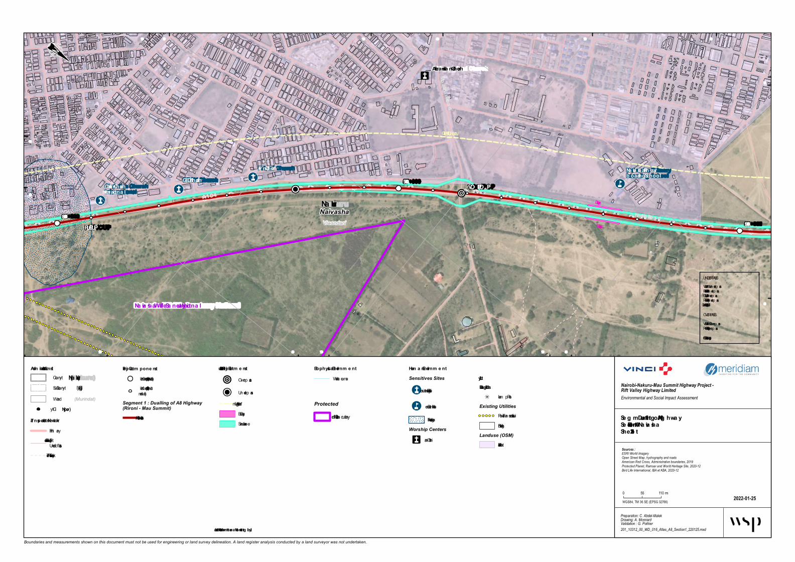
Hyg rote chGECK Church
Frie nd Church
Flower Farm Pa
rk
Buffa lo Ma ll N
a ivasha
Hig hwa y Medica l Clinic
Se m ita Girls Hig h School
Christia n Church Inte rna tiona l
Na iva sha Prim ary b oa rding School
Ja m ia Mosque
St. Fra ncis X avier
Africa n Inla nd Church
Na iva sha Hindu Te m ple
VO P/PO P
PUP/CUP
St. Fra ncis X avier
Socie ty superm arket
Mim osa Bookshop a nd stationers
LIGHTING URBAN
LIGHTING URBAN
LIGHTING URBAN
LIGHTING URBAN
Bus bay
Bus bay
Bus bay
Bus bay
ViwandaniNaivasha Nakuru
Na ivasha Wildlife Sa nctuary Nationa l
A104
Na irob i - Nakuru Road
Mb aria Ka niu Road
57+000
56+00058+000
548 000
548 000
548 500
548 500
549 000
549 000
549 500
549 500550 000
9 920 5009 920 500
9 921 000
9 921 000
9 921 500
9 921 500 9 922 000
Boundaries and measurements shown on this document must not be used for engineering or land survey delineation. A land register analysis conducted by a land surveyor was not undertaken.
Biophysica l Environm e ntWaterc ourse
Se g m e nt 1 - Dua lling of A8 Hig hwa ySe ction 1 - Rironi – Na ivashaShe e t 1-29
2022-01-25
Nairobi-Nakuru-Mau Summit Highway Project - Rift Valley Highway LimitedEnvironmental and Social Impact Assessment
Preparation: C. Abdel-MalekDrawing: A. MonnardValidation : G. Pothier201_10312_00_WD_016_Atlas_A8_Section1_220125.mxd
Sources :ESRI World ImageryOpen Street Map, hydrography and roadsAmerican Red Cross, Administrative boundaries, 2019Protected Planet, Ramsar and World Heritage Site, 2020-12Bird Life International, IBA et KBA, 2020-12
WGS84, TM 36 SE (EPSG 32766)
0 55 110 m
Adm inistrative Lim itsCounty(Nakuru)
(Gilgil)Sub-County(Murindat)Ward
Proje ct Com pone ntsKilom etric p oint (1 km interval)Kilom etric p oint (100 minterval)
Segment 1 : Dualling of A8 Highway(Rironi - Mau Summit)
1 - Rironi – Naivasha
Hum a n Environm e ntSensitives Sites
Religious Institution
Sc hool Institution
Flooding areaWorship Centers
Christian
UtilityExisting Utilities
Lam p PostExisting Utilities
Power Transm ission LineBuildings
Landuse (OSM)Residential
Protected
National San c tuaryCity(Njoro)
Tra nsporta tion NetworkPrim aryTertiary, Residential orUn c lassifiedFootway, Path or Trac k
Structura l Proje ct Ele m e nts
Overp ass
Underp ass
Lighting Urban *Bus BayService Lane
UNDERPASSVUP = Vehic ule Underp assPUP = Pedestrian Underp assCUP = Catle Underp assRUP = Railway Underp assWLC = Wild Life Crossing
OVERPASSVOP = Vehic ule Overp assROP = Railway Overp assFOB = Foot Overbridge
* Illustrated further from the road for b e tter le g ib ility

Hyg rotech
Flow e r Farm Park
Mane ra Prim ary S chool
Buffalo Mall NaivashaNaivasha Prim ary boarding S chool
U-Turn VOP/POP
LIGHTING URBAN
LIGHTING URBAN
LIGHTING URBAN
Bus bay
Bus bayB u s b a y s h e l t e rViwandani
Malewa West
Naivasha
Gilgil
Nakuru
A104
C88
Nairobi - Nakuru Road
Old Nairobi-Nakuru Road
Moi S outh Lake Road
Moi South Lake Road
Lake Naivasha
58+000
57+000
59+000
60+000
546 500
546 500
547 000
547 000
547 500
547 500
548 000
548 000
548 500
548 500
9 922 000
9 922 5009 922 500
9 923 000 9 923 500
9 923 500
Boundaries and measurements shown on this document must not be used for engineering or land survey delineation. A land register analysis conducted by a land surveyor was not undertaken.
Biophysical Environm e ntW atercourse
S e g m e nt 1 - Dualling of A8 Hig hwayS ection 1 - Rironi – NaivashaS he e t 2-1
2022-01-25
Nairobi-Nakuru-Mau Summit Highway Project - Rift Valley Highway LimitedEnvironmental and Social Impact Assessment
Preparation: C. Abdel-MalekDrawing: A. MonnardValidation : G. Pothier201_10312_00_WD_016_Atlas_A8_Section1_220125.mxd
Sources :ESRI World ImageryOpen Street Map, hydrography and roadsAmerican Red Cross, Administrative boundaries, 2019Protected Planet, Ramsar and World Heritage Site, 2020-12Bird Life International, IBA et KBA, 2020-12
WGS84, TM 36 SE (EPSG 32766)
0 55 110 m
Adm inistrative Lim itsCounty(Nakuru)
(Gilgil)Sub-County(Murindat)W ard
Proje ct Com pone ntsKilom etric point (1 km in terval)Kilom etric point (100 min terval)
Segment 1 : Dualling of A8 Highway(Rironi - Mau Summit)
1 - Riron i – Naivasha2 - Naivasha – Elem entaitaRoad
Segment 2 : Strengthening ofA8-South Highway (Rironi -Naivasha)
6 - Mai Mah iu - Naivasha
Hum an Environm e ntSensitives Sites
Accident Spot
Farm in g activities
Industry
Market an d shopping area
Flooding area
UtilityExisting Utilitie s
Lam p PostBuildings
Landuse (OSM)Farm landResidential
ProtectedIm portan t Bird Area (IBA)and Key Biodivesity Area(KBA)
City(Njoro)
Transportation Ne tw orkrailwayPrim arySecondaryTertiary, Residential orUnclassifiedFootway, Path or Track
S tructural Proje ct Ele m e nts
OverpassRun-off W ater Treatm entEquipm entLightin g Urban *Service LaneService Lane
Wildlife Crossing
W aterway Crossin g
UNDERPASSVUP = Veh icule UnderpassPUP = Pedestrian UnderpassCUP = Catle UnderpassRUP = Railway UnderpassW LC = W ild Life Crossin g
OVERPASSVOP = Veh icule OverpassROP = Railway OverpassFOB = Foot Overbridge
* Illustrate d furthe r from the road for be tte r le g ibility

PU P/CU P
Truck bay
Truck bay Bus bay
Viwandani
Malewa West
Naivasha
Gilgil
Nakuru
A104Nairo bi-Nakuru Ro ad
Old Nairo bi-Nakuru Ro ad
Lake Naivash a
61+00060+000 62+000
545 000
545 000
545 500
545 500
546 000
546 000
546 500
546 500
547 000
547 000
9 923 0009 923 000
9 924 000
9 924 500
9 924 500
Boundaries and measurements shown on this document must not be used for engineering or land survey delineation. A land register analysis conducted by a land surveyor was not undertaken.
Bio ph ysical Enviro nm entWatercourse
Segm ent 1 - Dualling o f A8 High waySectio n 2 - Naivash a – Elem entaita Ro adSh eet 2-2
2022-01-25
Nairobi-Nakuru-Mau Summit Highway Project - Rift Valley Highway LimitedEnvironmental and Social Impact Assessment
Preparation: C. Abdel-MalekDrawing: A. MonnardValidation : G. Pothier201_10312_00_WD_016_Atlas_A8_Section2_220125.mxd
Sources :ESRI World ImageryOpen Street Map, hydrography and roadsAmerican Red Cross, Administrative boundaries, 2019Protected Planet, Ramsar and World Heritage Site, 2020-12Bird Life International, IBA et KBA, 2020-12
WGS84, TM 36 SE (EPSG 32766)
0 55 110 m
Adm inistrative Lim itsCounty(Nakuru)
(Gilgil)Sub-County(Murindat)Ward
Pro ject Co m po nentsKilom etric point (1 km interval)Kilom etric point (100 minterval)
Segment 1 : Dualling of A8 Highway(Rironi - Mau Summit)
2 - Naivasha – Elem entaitaRoad
Hum an Enviro nm entFlood ing areaBuild ings
Landuse (OSM)Farm lan d
Protected AreasIm portan t Bird Area (IBA)an d Key Biod ivesity Area(KBA)
City(Njo ro )
Transpo rtatio n Netw o rkrailwayPrim aryTertiary, Resid ential orUnclassifiedFootway, Path or TrackActual Intersection, Weir orTurn ing Circle
Structural Pro ject Elem ents
Un d erpass
Run-off Water Treatm entEq uipm entBus BayService LaneTruck Bay
UNDERPASSVUP = Vehicule Un d erpassPUP = Ped estrian Un d erpassCUP = Catle Un d erpassRUP = Railway Un d erpassWLC = Wild Life Crossing
OVERPASSVOP = Vehicule OverpassROP = Railway OverpassFOB = Foot Overbrid ge
* Illustrated furth er fro m th e ro ad fo r better legibility

PUP/CUPTruck b ay
Truck b ay Bus b ay
Bus b ayBus b ay
Bus b ay
Bus b ay
Viwandani
Malewa West
Naivasha
Gilgil
Na kuru
Viwandani
Naivasha
A104 Na irobi-Na kuru Roa d
La ke Na iva sha
MARULA Con serva n cy
MARULA Con serva n cy
63+000
62+00064+000
543 500
543 500
544 000
544 000
544 500
544 500
545 000
545 000
9 924 0009 924 000
9 924 5009 924 500
9 925 000
9 925 000 9 925 500
9 925 500
Boundaries and measurements shown on this document must not be used for engineering or land survey delineation. A land register analysis conducted by a land surveyor was not undertaken.
Biop hysica l En viron men tWaterco urse
Segmen t 1 - Dua llin g of A8 Highw a ySection 2 - Na iva sha – Elemen ta ita Roa dSheet 2-3
2022-01-25
Nairobi-Nakuru-Mau Summit Highway Project - Rift Valley Highway LimitedEnvironmental and Social Impact Assessment
Preparation: C. Abdel-MalekDrawing: A. MonnardValidation : G. Pothier201_10312_00_WD_016_Atlas_A8_Section2_220125.mxd
Sources :ESRI World ImageryOpen Street Map, hydrography and roadsAmerican Red Cross, Administrative boundaries, 2019Protected Planet, Ramsar and World Heritage Site, 2020-12Bird Life International, IBA et KBA, 2020-12
WGS84, TM 36 SE (EPSG 32766)
0 55 110m
Admin istra tive LimitsCo unty(Na k uru)
(Gilgil)Sub -Co unty(Murindat)Ward
Project Comp on en tsKilo metric p o int (1 km interval)Kilo metric p o int (100 minterval)
Segment 1 : Dualling of A8 Highway(Rironi - Mau Summit)
2 - Naivasha – ElementaitaRo ad
Huma n En viron men tSensitives Sites
Accident Sp o t
Landuse (OSM)Farmland
Protected AreasIn tern a tion a l Level
Ramsar Site, Wetland o fInternatio nal Imp o rtance
Priva te LevelPrivateCo nservancy/Mixed-useEstateImp o rtant Bird Area (IBA)and Key Bio divesity Area(KBA)
City(Njoro)
Tra n sp orta tion NetworkrailwayPrimaryTertiary, Residential o rUnclassifiedFo o tway, Path o r TrackActual Intersectio n, Weir o rTurning Circle
Structura l Project Elemen ts
Underpass
Run-o ff Water TreatmentEquipmentBus BayService LaneTruck Bay
UNDERPASSVUP = Vehicule Underp assPUP = Pedestrian Underp assCUP = Catle Underp assRUP = Railway Underp assWLC = Wild Life Cro ssing
OVERPASSVOP = Vehicule Overp assROP = Railway Overp assFOB = Fo o t Overb ridge
* Illustra ted further from the roa d for better legibility
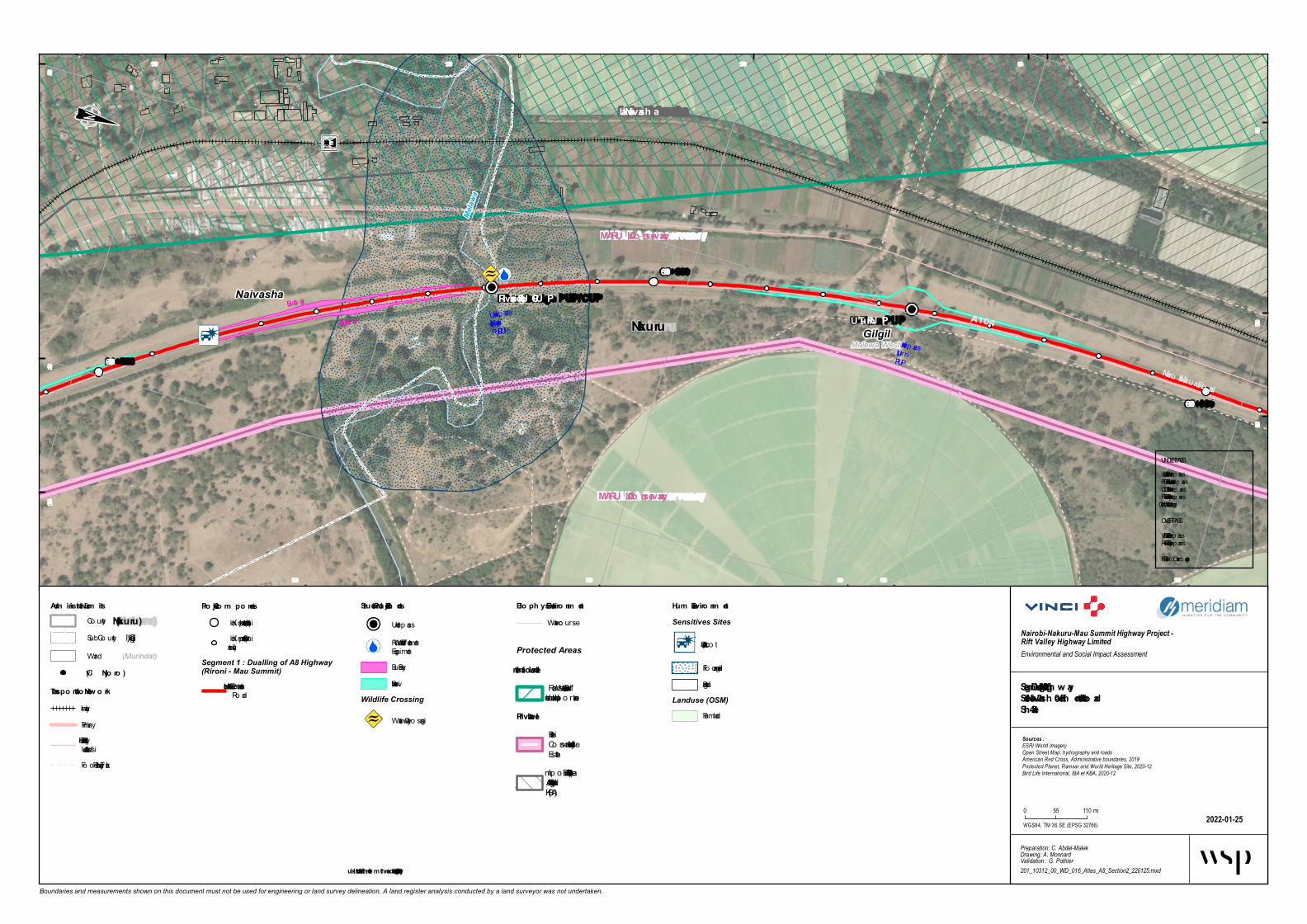
U -Turn PU PRiver bridge PU P/CU P
UnderpassRiver b ridgePUP/CUP
UnderpassU-turnPUP
Bus bay
Bus b ayBus b ay
Malewa West
Viwandani
Gilgil
Naivasha
Nakuru A104
Nairo bi-Nakuru Ro ad
Melaw
a
Lake Naivash a
MARU LA Co nservancy
MARU LA Co nservancy
65+000
64+000
66+000
542 500
542 500
543 000
543 000
543 500
543 500
9 925 5009 925 5009 926 000
9 926 000
9 926 500
9 926 500 9 927 000 9 927 500
9 927 500
Boundaries and measurements shown on this document must not be used for engineering or land survey delineation. A land register analysis conducted by a land surveyor was not undertaken.
Bio ph ysical Enviro nm entWaterco urse
Segm ent 1 - Dualling o f A8 High waySectio n 2 - Naivash a – Elem entaita Ro adSh eet 2-4
2022-01-25
Nairobi-Nakuru-Mau Summit Highway Project - Rift Valley Highway LimitedEnvironmental and Social Impact Assessment
Preparation: C. Abdel-MalekDrawing: A. MonnardValidation : G. Pothier201_10312_00_WD_016_Atlas_A8_Section2_220125.mxd
Sources :ESRI World ImageryOpen Street Map, hydrography and roadsAmerican Red Cross, Administrative boundaries, 2019Protected Planet, Ramsar and World Heritage Site, 2020-12Bird Life International, IBA et KBA, 2020-12
WGS84, TM 36 SE (EPSG 32766)
0 55 110m
Adm inistrative Lim itsCo unty(Nakuru)
(Gilgil)Sub -Co unty(Murindat)Ward
Pro ject Co m po nentsKilo metric p o int (1 km interval)Kilo metric p o int (100 minterval)
Segment 1 : Dualling of A8 Highway(Rironi - Mau Summit)
2 - Naivasha – ElementaitaRo ad
Hum an Enviro nm entSensitives Sites
Accident Sp o t
Flo o ding areaBuildings
Landuse (OSM)Farmland
Protected AreasInternatio nal Level
Ramsar Site, Wetland o fInternatio nal Imp o rtance
Private LevelPrivateCo nservancy/Mixed-useEstateImp o rtant Bird Area (IBA)and Key Bio divesity Area(KBA)
City(Njo ro )
Transpo rtatio n Netw o rkrailwayPrimaryTertiary, Residential o rUnclassifiedFo o tway, Path o r Track
Structural Pro ject Elem ents
UnderpassRun-o ff Water TreatmentEquipmentBus BayService Lane
Wildlife Crossing
Waterway Cro ssing
UNDERPASSVUP = Vehicule Underp assPUP = Pedestrian Underp assCUP = Catle Underp assRUP = Railway Underp assWLC = Wild Life Cro ssing
OVERPASSVOP = Vehicule Overp assROP = Railway Overp assFOB = Fo o t Overb ridge
* Illustrated furth er fro m th e ro ad fo r better legibility

PU P/CU P
Malewa WestGilgilNakuru
A104 Nairo bi-Nakuru Ro ad
Lake Naivash a
MARU LA Co nservancy
MARU LA Co nservancy
67+00066+00068+000
542 500542 500
543 000
543 000
543 500
543 500
9 927 500
9 928 000
9 928 000
9 928 500
9 928 500
9 929 000
9 929 000
9 929 500
9 929 500
Boundaries and measurements shown on this document must not be used for engineering or land survey delineation. A land register analysis conducted by a land surveyor was not undertaken.
Bio ph ysical Enviro nm entWaterco urs e
Segm ent 1 - Dualling o f A8 High waySectio n 2 - Naivash a – Elem entaita Ro adSh eet 2-5
2022-01-25
Nairobi-Nakuru-Mau Summit Highway Project - Rift Valley Highway LimitedEnvironmental and Social Impact Assessment
Preparation: C. Abdel-MalekDrawing: A. MonnardValidation : G. Pothier201_10312_00_WD_016_Atlas_A8_Section2_220125.mxd
Sources :ESRI World ImageryOpen Street Map, hydrography and roadsAmerican Red Cross, Administrative boundaries, 2019Protected Planet, Ramsar and World Heritage Site, 2020-12Bird Life International, IBA et KBA, 2020-12
WGS84, TM 36 SE (EPSG 32766)
0 55 110m
Adm inistrative Lim itsCo unty(Nakuru)
(Gilgil)Sub -Co unty(Murindat)Ward
Pro ject Co m po nentsKilo metric p o int (1 km interval)Kilo metric p o int (100 minterval)
Segment 1 : Dualling of A8 Highway(Rironi - Mau Summit)
2 - Naivas ha – ElementaitaRo ad
Hum anEnviro nm ent
BuildingsLanduse (OSM)
FarmlandProtected AreasInternatio nal Level
Ramsar Site, Wetland o fInternatio nal Imp o rtance
Private LevelPrivateCo nservancy/Mixed-useEs tateImp o rtant Bird Area (IBA)and Key Bio divesity Area(KBA)
City(Njo ro )
Transpo rtatio n Netw o rkrailwayPrimaryTertiary, Residential o rUnclas s ifiedFo o tway, Path o r TrackActual Intersectio n, Weir o rTurning Circle
Structural Pro ject Elem ents
Underpas s
Service Lane
UNDERPASSVUP = Vehicule Underpas sPUP = Pedes trian Underpas sCUP = Catle Underpas sRUP = Railway Underpas sWLC = Wild Life Cro s s ing
OVERPASSVOP = Vehicule Overpas sROP = Railway Overpas sFOB = Fo o t Overb ridge
* Illustrated furth er fro m th e ro ad fo r better legibility

PU P/CU P
Truck b ayBus b ay
Truck b ayBus b ay
Malewa WestMbaruk/eburuGilgil
NakuruA104
Nairo bi-Nakuru Ro adMo i No rth Lake Ro ad
Lake Naivash a
MARU LA Co nservancy
MARU LA Co nservancy
69+000
68+000
70+000
542 500
542 500
543 000
543 000
543 500
543 500
9 929 500
9 929 500
9 930 000
9 930 000
9 930 500
9 930 500
9 931 000
9 931 000 9 931 500
9 931 500
Boundaries and measurements shown on this document must not be used for engineering or land survey delineation. A land register analysis conducted by a land surveyor was not undertaken.
Bio ph ysical Enviro nm entWaterco urs e
Segm ent 1 - Dualling o f A8 High waySectio n 2 - Naivash a – Elem entaita Ro adSh eet 2-6
2022-01-25
Nairobi-Nakuru-Mau Summit Highway Project - Rift Valley Highway LimitedEnvironmental and Social Impact Assessment
Preparation: C. Abdel-MalekDrawing: A. MonnardValidation : G. Pothier201_10312_00_WD_016_Atlas_A8_Section2_220125.mxd
Sources :ESRI World ImageryOpen Street Map, hydrography and roadsAmerican Red Cross, Administrative boundaries, 2019Protected Planet, Ramsar and World Heritage Site, 2020-12Bird Life International, IBA et KBA, 2020-12
WGS84, TM 36 SE (EPSG 32766)
0 55 110m
Adm inistrative Lim itsCo unty(Nakuru)
(Gilgil)Sub -Co unty(Murindat)Ward
Pro ject Co m po nentsKilo metric p o int (1 km interval)Kilo metric p o int (100 minterval)
Segment 1 : Dualling of A8 Highway(Rironi - Mau Summit)
2 - Naivas ha – ElementaitaRo ad
Hum anEnviro nm ent
BuildingsLanduse (OSM)
FarmlandProtected AreasPrivate Level
PrivateCo nservancy/Mixed-useEs tateImp o rtant Bird Area (IBA)and Key Bio divesity Area(KBA)
City(Njo ro )
Transpo rtatio n Netw o rkrailwayPrimaryTertiary, Residential o rUnclas s ifiedFo o tway, Path o r TrackActual Intersectio n, Weir o rTurning Circle
Structural Pro ject Elem ents
Underpas s
Bus BayService LaneTruck Bay
Wildlife Crossing
Underpas s
UNDERPASSVUP = Vehicule Underpas sPUP = Pedes trian Underpas sCUP = Catle Underpas sRUP = Railway Underpas sWLC = Wild Life Cro s s ing
OVERPASSVOP = Vehicule Overpas sROP = Railway Overpas sFOB = Fo o t Overb ridge
* Illustrated furth er fro m th e ro ad fo r better legibility

PUP/CUP
PUP/CUP
CLIMBING LANE
Mbaruk/eburu
Mbaruk/eburuGilgilNa kuru
A104
Na irobi-Na kuru Roa dMARULA Con serva n cy
71+000
70+000 72+000
542 000
542 000
542 500
542 500
543 000
543 000
9 931 500 9 932 000
9 932 000
9 932 500
9 932 500
9 933 000
9 933 000
Boundaries and measurements shown on this document must not be used for engineering or land survey delineation. A land register analysis conducted by a land surveyor was not undertaken.
Biop hysica l En viron men tWa terco urse
Segmen t 1 - Dua llin g of A8 Highw a ySection 2 - Na iva sha – Elemen ta ita Roa dSheet 2-7
2022-01-25
Nairobi-Nakuru-Mau Summit Highway Project - Rift Valley Highway LimitedEnvironmental and Social Impact Assessment
Preparation: C. Abdel-MalekDrawing: A. MonnardValidation : G. Pothier201_10312_00_WD_016_Atlas_A8_Section2_220125.mxd
Sources :ESRI World ImageryOpen Street Map, hydrography and roadsAmerican Red Cross, Administrative boundaries, 2019Protected Planet, Ramsar and World Heritage Site, 2020-12Bird Life International, IBA et KBA, 2020-12
WGS84, TM 36 SE (EPSG 32766)
0 55 110m
Admin istra tive LimitsCo un ty(Na k uru)
(Gilgil)Sub-Co un ty(Murindat)Wa rd
Project Comp on en tsKilo metric po in t (1 km in terva l)Kilo metric po in t (100 min terva l)
Segment 1 : Dualling of A8 Highway(Rironi - Mau Summit)
2 - Na iva sha – Elemen ta itaRo a d
Huma nEn viron men tLanduse (OSM)
Fa rmla n dProtected AreasPriva te Level
Priva teCo n serva n cy/Mixed-useEsta te
City(Njoro)
Tra n sp orta tion Networkra ilwa yPrima ryTertia ry, Residen tia l o rUn cla ssifiedFo o twa y, Pa th o r Tra ck
Structura l Project Elemen ts
Un derpa ss
Climbin g La n e *Wildlife Crossing
Un derpa ss
UNDERPASSVUP = Vehicule Un derpa ssPUP = Pedestria n Un derpa ssCUP = Ca tle Un derpa ssRUP = Ra ilwa y Un derpa ssWLC = Wild Life Cro ssin g
OVERPASSVOP = Vehicule Overpa ssROP = Ra ilwa y Overpa ssFOB = Fo o t Overbridge
* Illustra ted further from the roa d for better legibility

PU P/CU P
U -Turn VOP/POP
Bus ba y
Bus ba y
CLIMBING LANE
CLIMBING LANE
Mbaruk/eburu
Malewa West
GilgilNakuru
Mbaruk/eburu
A104 Nairobi-Nakuru RoadMARU LA Con servan cy 73+000
72+00074+000
541 500
541 500
542 000
542 000
542 500
542 500
9 933 500
9 933 500
9 934 000
9 934 000
9 934 500
9 934 500
9 935 000
9 935 000
Boundaries and measurements shown on this document must not be used for engineering or land survey delineation. A land register analysis conducted by a land surveyor was not undertaken.
Bioph ysical En viron men tWa terco urse
Seg men t 1 - Duallin g of A8 Hig h w aySection 2 - Naivash a – Elemen taita RoadSh eet 2-8
2022-01-25
Nairobi-Nakuru-Mau Summit Highway Project - Rift Valley Highway LimitedEnvironmental and Social Impact Assessment
Preparation: C. Abdel-MalekDrawing: A. MonnardValidation : G. Pothier201_10312_00_WD_016_Atlas_A8_Section2_220125.mxd
Sources :ESRI World ImageryOpen Street Map, hydrography and roadsAmerican Red Cross, Administrative boundaries, 2019Protected Planet, Ramsar and World Heritage Site, 2020-12Bird Life International, IBA et KBA, 2020-12
WGS84, TM 36 SE (EPSG 32766)
0 55 110m
Admin istrative LimitsCo un ty(Nakuru)
(Gilgil)Sub-Co un ty(Murindat)Wa rd
Project Compon en tsKilo metric po in t (1 km in terva l)Kilo metric po in t (100 min terva l)
Segment 1 : Dualling of A8 Highway(Rironi - Mau Summit)
2 - Na iva sha – Elemen ta itaRo a d
Human En viron men t
Protected AreasPrivate Level
Priva teCo n serva n cy/Mixed-useEsta te
City(Njoro)
Tran sportation Netw orkPrima ryTertia ry, Residen tia l o rUn cla ssifiedFo o twa y, Pa th o r Tra ck
Structural Project Elemen ts
Overpa ss
Un derpa ss
Climbin g La n e *Bus Ba yService La n e
Wildlife Crossing
Un derpa ss
UNDERPASSVUP = Vehicule Un derpa ssPUP = Pedestria n Un derpa ssCUP = Ca tle Un derpa ssRUP = Ra ilwa y Un derpa ssWLC = Wild Life Cro ssin g
OVERPASSVOP = Vehicule Overpa ssROP = Ra ilwa y Overpa ssFOB = Fo o t Overbridge
* Illustrated furth er from th e road for better leg ibility
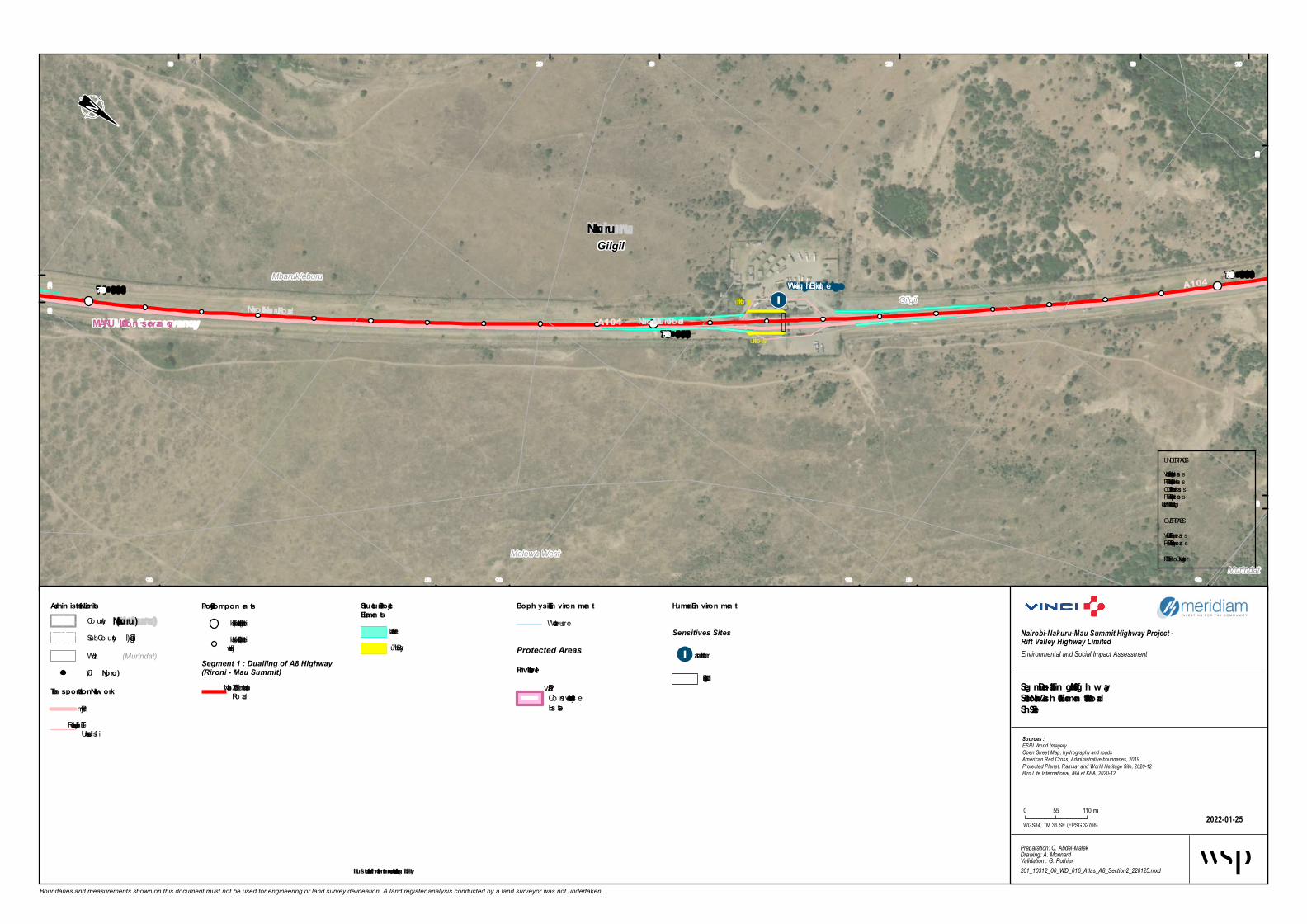
Weig h Bridg e
PU P/CU PPU P/CU P
Truck b ay
Truck b ay Gilgil
Mbaruk/eburu
Malewa WestMurindat
GilgilNakuru
A104
A104
Nairobi-Nakuru RoadNairobi-Nakuru Road
MARU LA Con servan cy75+000
74+00076+000
540 000
540 000
540 500
540 500
541 000
541 000
541 500
541 500
9 935 000
9 935 500
9 935 500
9 936 000
9 936 000
9 936 500
9 936 500 9 937 000
Boundaries and measurements shown on this document must not be used for engineering or land survey delineation. A land register analysis conducted by a land surveyor was not undertaken.
Bioph ysical En viron men tWaterco urs e
Seg men t 1 - Duallin g of A8 Hig h w aySection 2 - Naivash a – Elemen taita RoadSh eet 2-9
2022-01-25
Nairobi-Nakuru-Mau Summit Highway Project - Rift Valley Highway LimitedEnvironmental and Social Impact Assessment
Preparation: C. Abdel-MalekDrawing: A. MonnardValidation : G. Pothier201_10312_00_WD_016_Atlas_A8_Section2_220125.mxd
Sources :ESRI World ImageryOpen Street Map, hydrography and roadsAmerican Red Cross, Administrative boundaries, 2019Protected Planet, Ramsar and World Heritage Site, 2020-12Bird Life International, IBA et KBA, 2020-12
WGS84, TM 36 SE (EPSG 32766)
0 55 110m
Admin istrative LimitsCo unty(Nakuru)
(Gilgil)Sub -Co unty(Murindat)Ward
Project Compon en tsKilo metric p o int (1 km interval)Kilo metric p o int (100 minterval)
Segment 1 : Dualling of A8 Highway(Rironi - Mau Summit)
2 - Naivas ha – ElementaitaRo ad
Human En viron men t
Sensitives Sites
Infras tructure
Buildings
Protected AreasPrivate Level
PrivateCo nservancy/Mixed-useEs tate
City(Njoro)
Tran sportation Netw orkPrimaryTertiary, Residential o rUnclas s ified
Structural ProjectElemen ts
Service LaneTruck Bay
UNDERPASSVUP = Vehicule Underpas sPUP = Pedes trian Underpas sCUP = Catle Underpas sRUP = Railway Underpas sWLC = Wild Life Cro s s ing
OVERPASSVOP = Vehicule Overpas sROP = Railway Overpas sFOB = Fo o t Overb ridge
* Illustrated furth er from th e road for better leg ibility
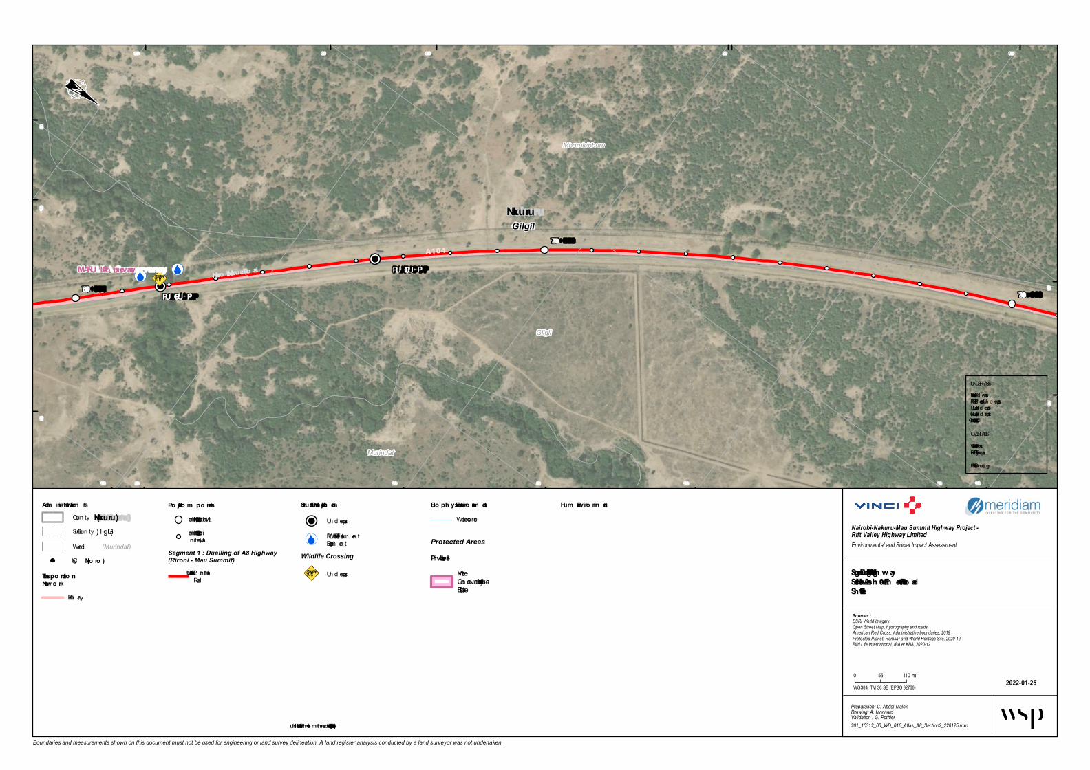
PU P/CU P
PU P/CU P
Gilgil
Mbaruk/eburu
Murindat
Nakuru
Murindat
Gilgil
Mbaruk/eburu
Murindat
Gilgil
A104
Nairo bi-Nakuru Ro adMARU LA Co nservancy
77+000
76+000 78+000
539 000
539 000
539 500
539 500
540 000
540 000
540 500
540 500
9 936 5009 936 500
9 937 000
9 937 000 9 937 500
9 938 000
9 938 000 9 938 500
9 938 500
Boundaries and measurements shown on this document must not be used for engineering or land survey delineation. A land register analysis conducted by a land surveyor was not undertaken.
Bio ph ysical Enviro nm entWatercourse
Segm ent 1 - Dualling o f A8 High waySectio n 2 - Naivash a – Elem entaita Ro adSh eet 2-10
2022-01-25
Nairobi-Nakuru-Mau Summit Highway Project - Rift Valley Highway LimitedEnvironmental and Social Impact Assessment
Preparation: C. Abdel-MalekDrawing: A. MonnardValidation : G. Pothier201_10312_00_WD_016_Atlas_A8_Section2_220125.mxd
Sources :ESRI World ImageryOpen Street Map, hydrography and roadsAmerican Red Cross, Administrative boundaries, 2019Protected Planet, Ramsar and World Heritage Site, 2020-12Bird Life International, IBA et KBA, 2020-12
WGS84, TM 36 SE (EPSG 32766)
0 55 110 m
Adm inistrative Lim itsCoun ty(Nakuru)
(Gilgil)Sub-Coun ty(Murindat)Ward
Pro ject Co m po nentsKilom etric poin t (1 km in terval)Kilom etric poin t (100 min terval)
Segment 1 : Dualling of A8 Highway(Rironi - Mau Summit)
2 - Naivasha – Elem en taitaRoad
Hum an Enviro nm ent
Protected AreasPrivate Level
PrivateConservan cy/Mixed -useEstate
City(Njo ro )
Transpo rtatio nNetw o rk
Prim ary
Structural Pro ject Elem ents
Un d erpassRun-off Water Treatm en tEquipm en t
Wildlife Crossing
Un d erpass
UNDERPASSVUP = Vehicule Un d erpassPUP = Ped estrian Un d erpassCUP = Catle Un d erpassRUP = Railway Un d erpassWLC = Wild Life Crossing
OVERPASSVOP = Vehicule OverpassROP = Railway OverpassFOB = Foot Overbrid ge
* Illustrated furth er fro m th e ro ad fo r better legibility

ROP
U -Turn VOP/POP
Gilgil
Mbaruk/eburu
GilgilNakuru
A104Nairobi-Nakuru Road
MARU LA Con servan cy
79+000
78+000 80+000
538 000
538 000
538 500
538 500
539 000
539 000
539 500
539 500
9 938 000
9 939 000
9 939 000
9 939 500
9 939 500 9 940 000
9 940 000
Boundaries and measurements shown on this document must not be used for engineering or land survey delineation. A land register analysis conducted by a land surveyor was not undertaken.
Bioph ysical En viron men tWaterc ourse
Seg men t 1 - Duallin g of A8 Hig h w aySection 2 - Naivash a – Elemen taita RoadSh eet 2-11
2022-01-25
Nairobi-Nakuru-Mau Summit Highway Project - Rift Valley Highway LimitedEnvironmental and Social Impact Assessment
Preparation: C. Abdel-MalekDrawing: A. MonnardValidation : G. Pothier201_10312_00_WD_016_Atlas_A8_Section2_220125.mxd
Sources :ESRI World ImageryOpen Street Map, hydrography and roadsAmerican Red Cross, Administrative boundaries, 2019Protected Planet, Ramsar and World Heritage Site, 2020-12Bird Life International, IBA et KBA, 2020-12
WGS84, TM 36 SE (EPSG 32766)
0 55 110 m
Admin istrative LimitsCounty(Nakuru)
(Gilgil)Sub-County(Murindat)Ward
Project Compon en tsKilom etric p oint (1 km interval)Kilom etric p oint (100 minterval)
Segment 1 : Dualling of A8 Highway(Rironi - Mau Summit)
2 - Naivasha – Elem entaitaRoad
Human En viron men tSensitives Sites
Ac c ident Sp ot
U tilityExistin g U tilities
Pylon
Power Transm ission Line
Protected AreasPrivate Level
PrivateConservancy/Mixed-useEstate
City(Njoro)
Tran sportation Netw orkrailwayPrim aryTertiary, Residential orUnc lassified
Structural ProjectElemen ts
Overp ass
Service Lane
UNDERPASSVUP = Vehic ule Underp assPUP = Pedestrian Underp assCUP = Catle Underp assRUP = Railway Underp assWLC = Wild Life Crossing
OVERPASSVOP = Vehic ule Overp assROP = Railway Overp assFOB = Foot Overbridge
* Illustrated furth er from th e road for better leg ibility

ROP
PUP/CUP
U-T urn VOP/POP
Bus bayTruc k bay
Truc k bay
Gilgil
Mbaruk/eburu
GilgilNak uru
A104
Nairobi-Nak uru Road
MARULA Conservancy
81+000
80+000
82+000
536 500
536 500
537 000
537 000
537 500
537 500
538 000
538 000
9 940 000 9 940 500 9 941 000
9 941 000 9 941 500
9 941 500
Boundaries and measurements shown on this document must not be used for engineering or land survey delineation. A land register analysis conducted by a land surveyor was not undertaken.
Bioph ysical Environm entWaterc ourse
Seg m ent 1 - Dualling of A8 Hig h w aySection 2 - Naivash a – Elem entaita RoadSheet 2-12
2022-01-25
Nairobi-Nakuru-Mau Summit Highway Project - Rift Valley Highway LimitedEnvironmental and Social Impact Assessment
Preparation: C. Abdel-MalekDrawing: A. MonnardValidation : G. Pothier201_10312_00_WD_016_Atlas_A8_Section2_220125.mxd
Sources :ESRI World ImageryOpen Street Map, hydrography and roadsAmerican Red Cross, Administrative boundaries, 2019Protected Planet, Ramsar and World Heritage Site, 2020-12Bird Life International, IBA et KBA, 2020-12
WGS84, TM 36 SE (EPSG 32766)
0 55 110 m
Adm inistrative Lim itsCounty(Nak uru)
(Gilgil)Sub-County(Murindat)Ward
Project Com ponentsKilom etric p oint (1 km interval)Kilom etric p oint (100 minterval)
Segment 1 : Dualling of A8 Highway(Rironi - Mau Summit)
2 - Naivasha – Elem entaitaRoad
Hum an Environm entSensitives Sites
Ac c ident Sp ot
UtilityExisting Utilities
PylonPower Transm ission Line
Protected AreasPrivate Level
PrivateConservancy/Mixed-useEstate
City(Njoro)
T ransportation Netw orkrailwayPrim arySecondaryTertiary, Residential orUnc lassified
Structural Project Elem ents
Overp ass
Underp ass
Bus BayService LaneTruck Bay
UNDERPASSVUP = Vehic ule Underp assPUP = Pedestrian Underp assCUP = Catle Underp assRUP = Railway Underp assWLC = Wild Life Crossing
OVERPASSVOP = Vehic ule Overp assROP = Railway Overp assFOB = Foot Overbridge
* Illustrated further from the road for better leg ibility

Bus bayTruc k bay
Truc k bay
Gilgil
Mbaruk/eburu
GilgilNakuru
A104
A4
Nairobi-Nakuru Road
Gilgil Town Road
MARU LA Conservancy83+000
82+000
84+000
535 500
535 500
536 000
536 000
536 500
536 500
537 000
537 000
9 941 500 9 942 000
9 942 000
9 942 500
9 942 500
9 943 000
9 943 000 9 943 500
9 943 500
Boundaries and measurements shown on this document must not be used for engineering or land survey delineation. A land register analysis conducted by a land surveyor was not undertaken.
Bioph ysical Environm entWaterc ourse
Segm ent 1 - Dualling of A8 High waySection 2 - Naivash a – Elem entaita RoadSh eet 2-13
2022-01-25
Nairobi-Nakuru-Mau Summit Highway Project - Rift Valley Highway LimitedEnvironmental and Social Impact Assessment
Preparation: C. Abdel-MalekDrawing: A. MonnardValidation : G. Pothier201_10312_00_WD_016_Atlas_A8_Section2_220125.mxd
Sources :ESRI World ImageryOpen Street Map, hydrography and roadsAmerican Red Cross, Administrative boundaries, 2019Protected Planet, Ramsar and World Heritage Site, 2020-12Bird Life International, IBA et KBA, 2020-12
WGS84, TM 36 SE (EPSG 32766)
0 55 110 m
Adm inistrative Lim itsCounty(Nakuru)
(Gilgil)Sub-County(Murindat)Ward
Project Com ponentsKilom etric p oint (1 km interval)Kilom etric p oint (100 minterval)
Segment 1 : Dualling of A8 Highway(Rironi - Mau Summit)
2 - Naivasha – Elem entaitaRoad
Hum an Environm ent
Protected AreasPrivate Level
PrivateConservancy/Mixed-useEstate
City(Njoro)
Transportation NetworkPrim aryTertiary, Residential orUnc lassifiedFootway, Path or Trac k
Structural ProjectElem ents
Bus BayService LaneTruck Bay
UNDERPASSVUP = Vehic ule Underp assPUP = Pedestrian Underp assCUP = Catle Underp assRUP = Railway Underp assWLC = Wild Life Crossing
OVERPASSVOP = Vehic ule Overp assROP = Railway Overp assFOB = Foot Overbridge
* Illustrated furth er from th e road for better legibility

Com boni Polytech nic
Gilg il Hig h w ay Prim ary
Gilg il T ow nsh ip Special UnitGilg il T ow nsh ip Prim ary Sch ool
U-T urn VOP/POP
CUP/PUP
LIGHTING URBAN
LIGHTING URBAN
Bus bay
Bus bay
Gilgil
Mbaruk/eburu
Mbaruk/eburu
GilgilNak uru
A104
C77
Eburru Road
Nairobi-Nak uru Road
Gilgil-Nyah ururu RoadMARULA Conservancy
85+00084+000
86+000
534 500
534 500
535 000
535 000
535 500
535 500
536 000
536 000
9 943 0009 943 000
9 943 500
9 943 500
9 944 000
9 944 000
9 944 500
9 944 500 9 945 000
9 945 000
Boundaries and measurements shown on this document must not be used for engineering or land survey delineation. A land register analysis conducted by a land surveyor was not undertaken.
Bioph ysical Environm entW atercourse
Seg m ent 1 - Dualling of A8 Hig h w aySection 2 - Naivasha – Elem entaita RoadSheet 2-14
2022-01-25
Nairobi-Nakuru-Mau Summit Highway Project - Rift Valley Highway LimitedEnvironmental and Social Impact Assessment
Preparation: C. Abdel-MalekDrawing: A. MonnardValidation : G. Pothier201_10312_00_WD_016_Atlas_A8_Section2_220125.mxd
Sources :ESRI World ImageryOpen Street Map, hydrography and roadsAmerican Red Cross, Administrative boundaries, 2019Protected Planet, Ramsar and World Heritage Site, 2020-12Bird Life International, IBA et KBA, 2020-12
WGS84, TM 36 SE (EPSG 32766)
0 55 110 m
Adm inistrative Lim itsCoun ty(Nak uru)
(Gilgil)Sub-Coun ty(Murindat)W ard
Project Com ponentsKilom etric p oin t (1 km in terval)Kilom etric p oin t (100 min terval)
Segment 1 : Dualling of A8 Highway(Rironi - Mau Summit)
2 - Naivasha – Elem en taitaRoad
Hum an Environm entSensitives Sites
School In stitution
Flooding areaUtilityExisting Utilities
Lam p Post
Protected AreasPrivate Level
PrivateCon servan cy/Mixed-useEstate
City(Njoro)
T ransportation Netw orkPrim arySecondaryTertiary, Residen tial orUnclassifiedFootway, Path or Track
Structural Project Elem ents
Overp ass
Underp ass
Ligh tin g Urban *Clim bin g Lane *Bus BayService Lane
UNDERPASSVUP = Veh icule Underp assPUP = Pedestrian Underp assCUP = Catle Underp assRUP = Railway Underp assW LC = W ild Life Crossin g
OVERPASSVOP = Veh icule Overp assROP = Railway Overp assFOB = Foot Overbridge
* Illustrated further from the road for better leg ibility

Koelel Hig h Sch ool
U-T urn VOP/POP CLIMBING LANEBus b ay
Bus b ay
Mbaruk/eburu
Gilgil
Mbaruk/eburu
GilgilNak uru
Mbaruk/eburu
A104
Nairobi-Nak uru Ro
ad
Eburru Road
87+000
86+00088+000
533 500
533 500
534 000
534 000
534 500
534 500
535 000
535 000
9 944 500
9 945 000
9 945 500
9 945 500
9 946 000
9 946 000
9 946 500
Boundaries and measurements shown on this document must not be used for engineering or land survey delineation. A land register analysis conducted by a land surveyor was not undertaken.
Bioph ysical Environm entWaterco urse
Seg m ent 1 - Dualling of A8 Hig h w aySection 2 - Naivash a – Elem entaita RoadSheet 2-15
2022-01-25
Nairobi-Nakuru-Mau Summit Highway Project - Rift Valley Highway LimitedEnvironmental and Social Impact Assessment
Preparation: C. Abdel-MalekDrawing: A. MonnardValidation : G. Pothier201_10312_00_WD_016_Atlas_A8_Section2_220125.mxd
Sources :ESRI World ImageryOpen Street Map, hydrography and roadsAmerican Red Cross, Administrative boundaries, 2019Protected Planet, Ramsar and World Heritage Site, 2020-12Bird Life International, IBA et KBA, 2020-12
WGS84, TM 36 SE (EPSG 32766)
0 55 110 m
Adm inistrative Lim itsCo unty(Nak uru)
(Gilgil)Sub -Co unty(Murindat)Ward
Project Com ponentsKilo m etric p o int (1 km interval)Kilo m etric p o int (100 minterval)
Segment 1 : Dualling of A8 Highway(Rironi - Mau Summit)
2 - Naivasha – Elem entaitaRo ad
Hum an Environm entSensitives Sites
Accident Sp o t
Scho o l Institutio nCity(Njoro)
T ransportation Netw orkPrim aryTertiary, Residential o rUnclassified
Structural Project Elem entsRun-o ff Water Treatm entEquip m entLighting Urb an *Clim b ing Lane *Service Lane
UNDERPASSVUP = Vehicule UnderpassPUP = Pedestrian UnderpassCUP = Catle UnderpassRUP = Railway UnderpassWLC = Wild Life Cro ssing
OVERPASSVOP = Vehicule OverpassROP = Railway OverpassFOB = Fo o t Overb ridge
* Illustrated further from the road for better leg ibility

AIC Kik opey
Trinity Ch urch
Murindu Hig h w ay Primary S ch ool
FOB Truck b ayTruck b ay
LIGHTING URBAN
LIGHTING URBAN
Bus b ay
Bus b ay
Gilgil
Mbaruk/eburu
GilgilNak uru
Kik opey Roadside S tation Project
Kik opeyA104
D321
Nairobi-Nak uru Road
89+00088+000
90+000
532 000
532 000
532 500533 000
533 000
533 500
533 500
9 946 5009 946 500
9 947 000
9 947 000
9 947 500
9 947 500 9 948 000
9 948 000
Boundaries and measurements shown on this document must not be used for engineering or land survey delineation. A land register analysis conducted by a land surveyor was not undertaken.
Bioph ysical EnvironmentWaterco urse
S eg ment 1 - Dualling of A8 Hig h w ayS ection 2 - Naivash a – Elementaita RoadS h eet 2-16
2022-01-25
Nairobi-Nakuru-Mau Summit Highway Project - Rift Valley Highway LimitedEnvironmental and Social Impact Assessment
Preparation: C. Abdel-MalekDrawing: A. MonnardValidation : G. Pothier201_10312_00_WD_016_Atlas_A8_Section2_220125.mxd
Sources :ESRI World ImageryOpen Street Map, hydrography and roadsAmerican Red Cross, Administrative boundaries, 2019Protected Planet, Ramsar and World Heritage Site, 2020-12Bird Life International, IBA et KBA, 2020-12
WGS84, TM 36 SE (EPSG 32766)
0 55 110 m
Administrative LimitsCo unty(Nak uru)
(Gilgil)Sub -Co unty(Murindat)Ward
Project ComponentsKilo m etric p o int (1 km interval)Kilo m etric p o int (100 minterval)
Segment 1 : Dualling of A8 Highway(Rironi - Mau Summit)
2 - Naivasha – Elem entaitaRo ad
HumanSensitives Sites
Gas Statio n
Religio us
Flo o ding areaFuture
UtilityExisting Utilities
Lam p Po stLanduse (OSM)
Retail
City(Njoro)
Transportation Netw orkPrim aryTertiary, Residential o rUnclassified
S tructural Project Elements
Fo o t Overb ridge
Run-o ff Water Treatm entEquip m entLighting Urb an *Bus BayService LaneTruck Bay
UNDERPASSVUP = Vehicule UnderpassPUP = Pedestrian UnderpassCUP = Catle UnderpassRUP = Railway UnderpassWLC = Wild Life Cro ssing
OVERPASSVOP = Vehicule OverpassROP = Railway OverpassFOB = Fo o t Overb ridge
* Illustrated further from the road for better leg ibility

AIC Kikopey
T rin ity Ch urch
Karian dusi Preh istoric Site
FOB
FOB PUP/CUP
PUP/CUP
Truck b ay
CLIMBING LANE
GilgilGilgilNakuru
A104Nairobi-Nakuru Road 91+00090+000
92+000
531 000
531 000
531 500
531 500
532 000
532 000
532 500
532 500
9 947 500
9 948 000 9 948 500
9 948 500
9 949 000
9 949 000 9 949 500
9 949 500
Boundaries and measurements shown on this document must not be used for engineering or land survey delineation. A land register analysis conducted by a land surveyor was not undertaken.
Bioph ysical En viron men tWaterco urse
Seg men t 1 - Duallin g of A8 Hig h w aySection 2 - Naivash a – Elemen taita RoadSh eet 2-17
2022-01-25
Nairobi-Nakuru-Mau Summit Highway Project - Rift Valley Highway LimitedEnvironmental and Social Impact Assessment
Preparation: C. Abdel-MalekDrawing: A. MonnardValidation : G. Pothier201_10312_00_WD_016_Atlas_A8_Section2_220125.mxd
Sources :ESRI World ImageryOpen Street Map, hydrography and roadsAmerican Red Cross, Administrative boundaries, 2019Protected Planet, Ramsar and World Heritage Site, 2020-12Bird Life International, IBA et KBA, 2020-12
WGS84, TM 36 SE (EPSG 32766)
0 55 110 m
Admin istrative LimitsCo unty(Nakuru)
(Gilgil)Sub -Co unty(Murindat)Ward
Project Compon en tsKilo m etric p o int (1 km interval)Kilo m etric p o int (100 minterval)
Segment 1 : Dualling of A8 Highway(Rironi - Mau Summit)
2 - Naivasha – Elem entaitaRo ad
Human En viron men tSensitives Sites
Cultural and heritage site
Religio us Institutio n
Flo o ding areaUtilityExistin g Utilities
Telco m Mast
City(Njoro)
T ran sportation Netw orkPrim aryTertiary, Residential o rUnclassifiedFo o tway, Path o r Track
Structural Project Elemen ts
Underpass
Fo o t Overb ridge
Run-o ff Water Treatm entEquip m entLighting Urb an *Clim b ing Lane *Service Lane
Wildlife Crossing
Underpass
UNDERPASSVUP = Vehicule UnderpassPUP = Pedestrian UnderpassCUP = Catle UnderpassRUP = Railway UnderpassWLC = Wild Life Cro ssing
OVERPASSVOP = Vehicule OverpassROP = Railway OverpassFOB = Fo o t Overb ridge
* Illustrated furth er from th e road for better leg ibility

Diatomite Min in g In dustry
Karian dusi Preh istoric
Site
PU P/CU P
U -Turn VOP/POP Bus bay
Bus bay
GilgilGilgilNakuru
A104Nairobi-Na
kuru Road
93+000
92+000 94+000
530 000
530 000
530 500
530 500
531 000
531 000
9 949 5009 949 500
9 950 000
9 950 000
9 950 500
9 950 500
9 951 000
9 951 000
Boundaries and measurements shown on this document must not be used for engineering or land survey delineation. A land register analysis conducted by a land surveyor was not undertaken.
Bioph ysical En viron men tWatercourse
Seg men t 1 - Duallin g of A8 Hig h waySection 2 - Naivash a – Elemen taita RoadSh eet 2-18
2022-01-25
Nairobi-Nakuru-Mau Summit Highway Project - Rift Valley Highway LimitedEnvironmental and Social Impact Assessment
Preparation: C. Abdel-MalekDrawing: A. MonnardValidation : G. Pothier201_10312_00_WD_016_Atlas_A8_Section2_220125.mxd
Sources :ESRI World ImageryOpen Street Map, hydrography and roadsAmerican Red Cross, Administrative boundaries, 2019Protected Planet, Ramsar and World Heritage Site, 2020-12Bird Life International, IBA et KBA, 2020-12
WGS84, TM 36 SE (EPSG 32766)
0 55 110 m
Admin istrative LimitsCounty(Nakuru)
(Gilgil)Sub-County(Murindat)Ward
Project Compon en tsKilom etric point (1 km interval)Kilom etric point (100 minterval)
Segment 1 : Dualling of A8 Highway(Rironi - Mau Summit)
2 - Naivasha – Elem entaitaRoad
HumanEn viron men tSensitives Sites
In d ustry
City(Njoro)
Tran sportation NetworkPrim arySecon d aryTertiary, Resid ential orUnclassified
Structural Project Elemen ts
Overpass
Un d erpassRun-off Water Treatm entEq uipm entBus BayService Lane
Wildlife Crossing
Un d erpass
UNDERPASSVUP = Vehicule Un d erpassPUP = Ped estrian Un d erpassCUP = Catle Un d erpassRUP = Railway Un d erpassWLC = Wild Life Crossing
OVERPASSVOP = Vehicule OverpassROP = Railway OverpassFOB = Foot Overbrid ge
* Illustrated furth er from th e road for better leg ibility

Truck b ay
CLIMBING LANE
GilgilGilgilNakuru
A104
Nairobi-Nakuru Road
95+000
94+000 96+000
529 000
529 000
529 500
530 000
530 000
9 951 0009 951 000
9 951 500
9 951 500
9 952 000
9 952 000
9 952 500
9 952 500 9 953 000
9 953 000
Boundaries and measurements shown on this document must not be used for engineering or land survey delineation. A land register analysis conducted by a land surveyor was not undertaken.
Biophysical En viron m entWaterco urse
Segm ent 1 - Dualling of A8 HighwaySection 2 - Naivasha – Elem entaita RoadSheet 2-19
2022-01-25
Nairobi-Nakuru-Mau Summit Highway Project - Rift Valley Highway LimitedEnvironmental and Social Impact Assessment
Preparation: C. Abdel-MalekDrawing: A. MonnardValidation : G. Pothier201_10312_00_WD_016_Atlas_A8_Section2_220125.mxd
Sources :ESRI World ImageryOpen Street Map, hydrography and roadsAmerican Red Cross, Administrative boundaries, 2019Protected Planet, Ramsar and World Heritage Site, 2020-12Bird Life International, IBA et KBA, 2020-12
WGS84, TM 36 SE (EPSG 32766)
0 55 110 m
Ad m inistrative Lim itsCo unty(Nakuru)
(Gilgil)Sub -Co unty(Murindat)Ward
Project Com pon entsKilo m etric p o int (1 km interval)Kilo m etric p o int (100 minterval)
Segment 1 : Dualling of A8 Highway(Rironi - Mau Summit)
2 - Naivasha – Elem entaitaRo ad
Hum an En viron m ent
City(Njoro)
Transportation Netw orkPrim aryTertiary, Residential o rUnclassifiedFo o tway, Path o r Track
Structural ProjectElem ents
Lighting Urb an *Clim b ing Lane *Service Lane
UNDERPASSVUP = Vehicule UnderpassPUP = Pedestrian UnderpassCUP = Catle UnderpassRUP = Railway UnderpassWLC = Wild Life Cro ssing
OVERPASSVOP = Vehicule OverpassROP = Railway OverpassFOB = Fo o t Overb ridge
* Illustrated further from the road for better legibility

St-Marys Hospital
St-Joseph Hospital
Re d e e m e d Gospel Ch urc h
FOB
P UP /CUP
Truck ba y
Truck ba y
Bus ba y
LIGHTING URBAN
LIGHTING URBAN
CLIMBING LANE
Bus ba y
Bus ba y
Ele m e nteita -Gre e nfie ld
GilgilGilgilNakuru
GilgilA104 Nairobi-Nakuru Road97+000
96+000
98+000
528 000
528 000
528 500
528 500
529 000
529 000
9 953 000 9 953 500
9 953 500 9 954 000
9 954 500
9 954 500
Boundaries and measurements shown on this document must not be used for engineering or land survey delineation. A land register analysis conducted by a land surveyor was not undertaken.
Bioph ysical Environm e ntWa terco urse
Segm e nt 1 - Dualling of A8 High waySec tion 2 - Naivash a – Ele m e ntaita RoadSh e e t 2-20
2022-01-25
Nairobi-Nakuru-Mau Summit Highway Project - Rift Valley Highway LimitedEnvironmental and Social Impact Assessment
Preparation: C. Abdel-MalekDrawing: A. MonnardValidation : G. Pothier201_10312_00_WD_016_Atlas_A8_Section2_220125.mxd
Sources :ESRI World ImageryOpen Street Map, hydrography and roadsAmerican Red Cross, Administrative boundaries, 2019Protected Planet, Ramsar and World Heritage Site, 2020-12Bird Life International, IBA et KBA, 2020-12
WGS84, TM 36 SE (EPSG 32766)
0 55 110m
Ad m inistrative Lim itsCo un ty(Nakuru)
(Gilgil)Sub-Co un ty(Murindat)Wa rd
P roje c t Com pone ntsKilo metric po in t (1 km in terva l)Kilo metric po in t (100 min terva l)
Segment 1 : Dualling of A8 Highway(Rironi - Mau Summit)
2 - Na iva sha – Elemen ta itaRo a d
Quarries c onsid e re d
Reta in ed
Hum an Environm e ntSensitives Sites
Fa rmin g a ctivities
Hea lth Fa cilities
Religio us In stitutio n
City(Njoro)
Transportation NetworkPrima ryTertia ry, Residen tia l orUn cla ssifiedFo o twa y, Pa th or Tra ck
Struc tural P roje c t Elem e nts
Un derpa ss
Fo o t Overbridge
Lightin g Urba n *Climbin g La n e *Bus Ba yService La n eTruck Ba y
UNDERPASSVUP = Vehicule Un derpa ssPUP = Pedestria n Un derpa ssCUP = Ca tle Un derpa ssRUP = Ra ilwa y Un derpa ssWLC = Wild Life Cro ssin g
OVERPASSVOP = Vehicule Overpa ssROP = Ra ilwa y Overpa ssFOB = Fo o t Overbridge
* Illustrate d furth e r from th e road for bette r legibility
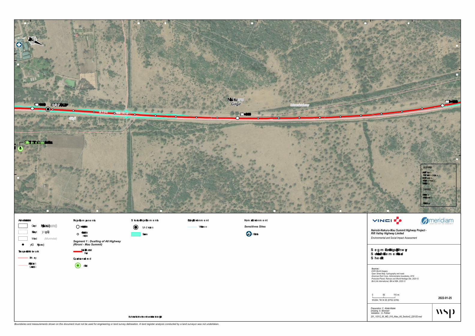
S t-Joseph Hospital
PUP/CUP U-Turn VOP/P
OP
Ele m e nte ita -Gre e nfie ld
Mbaruk/eburu
Gilgil
GilgilNakuru
Q98 Ele m e nte ita
A104 Nairobi-Nakuru Road 99+000
98+000 100+000
527 000
527 000
527 500
527 500
528 000
528 000
528 500
528 500
9 954 500 9 955 000
9 955 000
9 955 500
9 955 500
9 956 000
9 956 000 9 956 500
9 956 500
Boundaries and measurements shown on this document must not be used for engineering or land survey delineation. A land register analysis conducted by a land surveyor was not undertaken.
Biophysical Environm e ntWatercourse
S e g m e nt 1 - Dualling of A8 Hig hwayS ection 2 - Naivasha – Ele m e ntaita RoadS he e t 2-21
2022-01-25
Nairobi-Nakuru-Mau Summit Highway Project - Rift Valley Highway LimitedEnvironmental and Social Impact Assessment
Preparation: C. Abdel-MalekDrawing: A. MonnardValidation : G. Pothier201_10312_00_WD_016_Atlas_A8_Section2_220125.mxd
Sources :ESRI World ImageryOpen Street Map, hydrography and roadsAmerican Red Cross, Administrative boundaries, 2019Protected Planet, Ramsar and World Heritage Site, 2020-12Bird Life International, IBA et KBA, 2020-12
WGS84, TM 36 SE (EPSG 32766)
0 55 110 m
Adm inistrative Lim itsCounty (Nakuru)
(Gilgil)Sub-County(Murindat)Ward
Proje ct Com pone ntsKilom etric point (1 km interval)Kilom etric point (100 minterval)
Segment 1 : Dualling of A8 Highway(Rironi - Mau Summit)
2 - Naivasha – Elem entaitaRoad
Quarrie s conside red
Retained
Hum an Environm e ntSensitives Sites
Health Facilities
City (Njoro)
Transportation Ne tw orkPrim aryTertiary, Resid ential orUnclas sified
S tructural Proje ct Ele m e nts
Un d erpas s
Service Lane
UNDERPASSVUP = Vehicule Un d erpas sPUP = Ped estrian Un d erpas sCUP = Catle Un d erpas sRUP = Railway Un d erpas sWLC = Wild Life Cros sing
OVERPASSVOP = Vehicule Overpas sROP = Railway Overpas sFOB = Foot Overbrid ge
* Illustrate d furthe r from the road for be tte r le g ibility

Soysambu Con servan cymain g ate
PUP/CUP
U-Turn V OP/POP
Truc k bay
Truc k bayMbaruk/eburu
GilgilNakuru
A104
Mbaruk Road
Nairobi-Nakuru Road
Mbaruk Road
SOYSAMBU Con servan cy101+000
100+000 102+000
526 000
526 000
526 500
526 500
527 000
527 000
527 500
527 500
9 956 5009 956 500
9 957 000
9 957 000
9 957 500
9 957 500 9 958 000
9 958 000
Boundaries and measurements shown on this document must not be used for engineering or land survey delineation. A land register analysis conducted by a land surveyor was not undertaken.
Bioph ysical En viron men tWaterc ourse
Seg men t 1 - Duallin g of A8 Hig h w aySection 2 - Naivash a – Elemen taita RoadSh eet 2-22
2022-01-25
Nairobi-Nakuru-Mau Summit Highway Project - Rift Valley Highway LimitedEnvironmental and Social Impact Assessment
Preparation: C. Abdel-MalekDrawing: A. MonnardValidation : G. Pothier201_10312_00_WD_016_Atlas_A8_Section2_220125.mxd
Sources :ESRI World ImageryOpen Street Map, hydrography and roadsAmerican Red Cross, Administrative boundaries, 2019Protected Planet, Ramsar and World Heritage Site, 2020-12Bird Life International, IBA et KBA, 2020-12
WGS84, TM 36 SE (EPSG 32766)
0 55 110 m
Admin istrative LimitsCounty(Nakuru)
(Gilgil)Sub-County(Murindat)Ward
Project Compon en tsKilom etric p oint (1 km interval)Kilom etric p oint (100 minterval)
Segment 1 : Dualling of A8 Highway(Rironi - Mau Summit)
2 - Naivasha – Elem entaitaRoad
Human En viron men tSensitives Sites
Sensitive SiteProtected AreasPrivate Level
PrivateConservancy/Mixed-useEstate
City(Njoro)
Tran sportation Netw orkPrim aryTertiary, Residential orUnc lassifiedFootway, Path or Trac k
Structural Project Elemen ts
Overp ass
Underp ass
Service LaneTruck Bay
UNDERPASSVUP = Vehic ule Underp assPUP = Pedestrian Underp assCUP = Catle Underp assRUP = Railway Underp assWLC = Wild Life Crossing
OVERPASSVOP = Vehic ule Overp assROP = Railway Overp assFOB = Foot Overbridge
* Illustrated furth er from th e road for better leg ibility

PUP/CUP Truc k bay
Truc k bay
Mbaruk/eburuGilgilNak uru
Future De ve lopm e nt - Kingd om City 2Kingd om City De ve lopm e nt Area
A104
Nairobi-Nak uru R oad
Mbaruk R oad
SOYSAMBU Conse rvancy 103+000
102+000 104+000
524 000
524 000
524 500
524 500
525 000
525 000
525 500
525 500
526 000
526 000
9 957 500
9 958 000
9 958 500
9 958 500 9 959 000
9 959 000
9 959 500
Boundaries and measurements shown on this document must not be used for engineering or land survey delineation. A land register analysis conducted by a land surveyor was not undertaken.
Biophysical Environm e ntWaterc ourse
Se gm e nt 1 - Dualling of A8 HighwaySection 2 - Naivasha – Ele m e ntaita R oadShe e t 2-23
2022-01-25
Nairobi-Nakuru-Mau Summit Highway Project - Rift Valley Highway LimitedEnvironmental and Social Impact Assessment
Preparation: C. Abdel-MalekDrawing: A. MonnardValidation : G. Pothier201_10312_00_WD_016_Atlas_A8_Section2_220125.mxd
Sources :ESRI World ImageryOpen Street Map, hydrography and roadsAmerican Red Cross, Administrative boundaries, 2019Protected Planet, Ramsar and World Heritage Site, 2020-12Bird Life International, IBA et KBA, 2020-12
WGS84, TM 36 SE (EPSG 32766)
0 55 110 m
Ad m inistrative Lim itsCounty(Nak uru)
(Gilgil)Sub-County(Murindat)Ward
Proje ct Com pone ntsKilom etric p oint (1 km interval)Kilom etric p oint (100 minterval)
Segment 1 : Dualling of A8 Highway(Rironi - Mau Summit)
2 - Naivasha – Elem entaitaRoad
Hum an Environm e ntSensitive SiteFuture Develop m ents
Protected AreasPrivate Le ve l
PrivateConservancy/Mixed-useEstate
City(Njoro)
Transportation Ne tworkPrim aryTertiary, Residential orUnc lassified
Structural ProjectEle m e nts
Service Lane
UNDERPASSVUP = Vehic ule Underp assPUP = Pedestrian Underp assCUP = Catle Underp assRUP = Railway Underp assWLC = Wild Life Crossing
OVERPASSVOP = Vehic ule Overp assROP = Railway Overp assFOB = Foot Overbridge
* Illustrate d furthe r from the road for be tte r le gibility

Laikipia Unive rs
ity
PUP/CUP
PUP/CUP
Mbaruk/eburuGilgilNakuru
Future De ve lopm e nt - Kingdom City 1Future De ve lopm e nt - Kingdom City 2
Kingdom City EntranceKing dom City De ve lopm e nt Area
A104 Nairobi-Nakuru Road
S OYS AMBU Conse rvancy105+000
104+000
106+000
522 500
522 500
523 000
523 000
523 500
523 500
524 000
524 000
524 500
524 500
9 959 0009 959 000
9 959 500
9 960 000
9 960 000
9 960 500
9 960 500
Boundaries and measurements shown on this document must not be used for engineering or land survey delineation. A land register analysis conducted by a land surveyor was not undertaken.
Biophysical Environm e ntWatercours e
S e g m e nt 1 - Dualling of A8 Hig hwayS ection 2 - Naivasha – Ele m e ntaita RoadS he e t 2-24
2022-01-25
Nairobi-Nakuru-Mau Summit Highway Project - Rift Valley Highway LimitedEnvironmental and Social Impact Assessment
Preparation: C. Abdel-MalekDrawing: A. MonnardValidation : G. Pothier201_10312_00_WD_016_Atlas_A8_Section2_220125.mxd
Sources :ESRI World ImageryOpen Street Map, hydrography and roadsAmerican Red Cross, Administrative boundaries, 2019Protected Planet, Ramsar and World Heritage Site, 2020-12Bird Life International, IBA et KBA, 2020-12
WGS84, TM 36 SE (EPSG 32766)
0 55 110 m
Adm inistrative Lim itsCounty(Nakuru)
(Gilgil)Sub-County(Murindat)Ward
Proje ct Com pone ntsKilom etric p oint (1 km interval)Kilom etric p oint (100 minterval)
Segment 1 : Dualling of A8 Highway(Rironi - Mau Summit)
2 - Naivas ha – Elem entaitaRoad
Hum an Environm e ntSensitives Sites
Kingdom City EntranceSensitive SiteFuture Develop m ents
Protected AreasPrivate Le ve l
PrivateConservancy/Mixed-useEs tate
City(Njoro)
Transportation Ne tw orkPrim aryTertiary, Residential orUnc las s ified
S tructural Proje ct Ele m e nts
Underp as s
Run-off Water Treatm entEq uip m ent
Wildlife Crossing
Underp as s
UNDERPASSVUP = Vehic ule Underp as sPUP = Pedes trian Underp as sCUP = Catle Underp as sRUP = Railway Underp as sWLC = Wild Life Cros s ing
OVERPASSVOP = Vehic ule Overp as sROP = Railway Overp as sFOB = Foot Overbridge
* Illustrate d furthe r from the road for be tte r le g ibility

PCEA Church
Laikipia University
PUP/CUP
U-T urn VOP/POP
CUP/PUPBus b ay
Bus b ay
Mbaruk/eburuGilgilNakuru
Future De ve lopm e nt - Kingdom City 1King dom City De ve lopm e nt Area
A104 Nairobi-Nakuru RoadSOYSAMBU Conse rvancy
107+000
106+000 108+000
521 000
521 000
521 500
521 500
522 000
522 000
522 500
522 500
9 960 0009 960 000
9 960 500
9 961 000
9 961 000
9 961 500
Boundaries and measurements shown on this document must not be used for engineering or land survey delineation. A land register analysis conducted by a land surveyor was not undertaken.
Biophysical Environm e ntWaterco urse
Se g m e nt 1 - Dualling of A8 Hig hwaySection 2 - Naivasha – Ele m e ntaita RoadShe e t 2-25
2022-01-25
Nairobi-Nakuru-Mau Summit Highway Project - Rift Valley Highway LimitedEnvironmental and Social Impact Assessment
Preparation: C. Abdel-MalekDrawing: A. MonnardValidation : G. Pothier201_10312_00_WD_016_Atlas_A8_Section2_220125.mxd
Sources :ESRI World ImageryOpen Street Map, hydrography and roadsAmerican Red Cross, Administrative boundaries, 2019Protected Planet, Ramsar and World Heritage Site, 2020-12Bird Life International, IBA et KBA, 2020-12
WGS84, TM 36 SE (EPSG 32766)
0 55 110m
Adm inistrative Lim itsCo unty(Nakuru)
(Gilgil)Sub -Co unty(Murindat)Ward
Proje ct Com pone ntsKilo metric p o int (1 km interval)Kilo metric p o int (100 minterval)
Segment 1 : Dualling of A8 Highway(Rironi - Mau Summit)
2 - Naivasha – ElementaitaRo ad
Hum an Environm e ntSensitives Sites
Accident Sp o t
Scho o l Institutio n
Sensitive SiteFuture Develo p ments
Protected AreasPrivate Le ve l
PrivateCo nservancy/Mixed-useEstate
City(Njoro)
T ransportation Ne tw orkPrimaryTertiary, Residential o rUnclassified
Structural Proje ct Ele m e nts
Overpass
Underpass
Run-o ff Water TreatmentEquipmentBus BayService Lane
Wildlife Crossing
Underpass
UNDERPASSVUP = Vehicule Underp assPUP = Pedestrian Underp assCUP = Catle Underp assRUP = Railway Underp assWLC = Wild Life Cro ssing
OVERPASSVOP = Vehicule Overp assROP = Railway Overp assFOB = Fo o t Overb ridge
* Illustrated furthe r from the road for be tte r le gibility

PCEA Ch urch
Sh iners Boys Hig h Sch ool
Kiung ururia Secondary Sch ool
Green StedInternational Sch ool
FOB
PUP/CUP
CUP/PUP
Bus b ay
Truck b ay
Truck b ay Bus b ay
Bus b ayMbaruk/eburu
GilgilNak uru
A104Nairobi-Nak uru Road
SOYSAMBU Conservancy
109+000
108+000
110+000
519 000
519 000
519 500
519 500
520 000
520 000
520 500
520 500
521 000
521 000
9 960 500
9 961 0009 961 000
9 961 500
9 961 500
9 962 000
9 962 000
Boundaries and measurements shown on this document must not be used for engineering or land survey delineation. A land register analysis conducted by a land surveyor was not undertaken.
Bioph ysical Environm entWaterco urs e
Seg m ent 1 - Dualling of A8 Hig h w aySection 2 - Naivasha – Elem entaita RoadSheet 2-26
2022-01-25
Nairobi-Nakuru-Mau Summit Highway Project - Rift Valley Highway LimitedEnvironmental and Social Impact Assessment
Preparation: C. Abdel-MalekDrawing: A. MonnardValidation : G. Pothier201_10312_00_WD_016_Atlas_A8_Section2_220125.mxd
Sources :ESRI World ImageryOpen Street Map, hydrography and roadsAmerican Red Cross, Administrative boundaries, 2019Protected Planet, Ramsar and World Heritage Site, 2020-12Bird Life International, IBA et KBA, 2020-12
WGS84, TM 36 SE (EPSG 32766)
0 55 110m
Adm inistrative Lim itsCo unty(Nak uru)
(Gilgil)Sub -Co unty(Murindat)Ward
Project Com ponentsKilo metric p o int (1 km interval)Kilo metric p o int (100 minterval)
Segment 1 : Dualling of A8 Highway(Rironi - Mau Summit)
2 - Naivas ha – ElementaitaRo ad
Hum an Environm entSensitives Sites
Accident Sp o t
Religio us Ins titutio n
Scho o l Ins titutio n
Buildings
Protected AreasPrivate Level
PrivateCo nservancy/Mixed-useEs tate
City(Njoro)
T ransportation Netw orkPrimaryTertiary, Residential o rUnclas s ified
Structural Project Elem ents
Underpas s
Bus BayService LaneTruck Bay
UNDERPASSVUP = Vehicule Underpas sPUP = Pedes trian Underpas sCUP = Catle Underpas sRUP = Railway Underpas sWLC = Wild Life Cro s s ing
OVERPASSVOP = Vehicule Overpas sROP = Railway Overpas sFOB = Fo o t Overb ridge
* Illustrated further from the road for better leg ibility

Lockw ood Girls Hig h Sch ool
Green Sted
In tern ation al S
ch ool
FOB
PUP/CUP
Bus bay
Bus bay
Mbaruk/eburuGilgilNakuru
A104Nairobi-Nakuru Road
111+000
110+000112+000
517 500
517 500
518 000
518 000
518 500
518 500
519 000
519 000
9 962 0009 962 000
9 962 500
9 962 500
9 963 000
9 963 000 9 963 500
9 963 500
Boundaries and measurements shown on this document must not be used for engineering or land survey delineation. A land register analysis conducted by a land surveyor was not undertaken.
Bioph ysical En viron men tWatercourse
Seg men t 1 - Duallin g of A8 Hig h w aySection 2 - Naivash a – Elemen taita RoadSh eet 2-27
2022-01-25
Nairobi-Nakuru-Mau Summit Highway Project - Rift Valley Highway LimitedEnvironmental and Social Impact Assessment
Preparation: C. Abdel-MalekDrawing: A. MonnardValidation : G. Pothier201_10312_00_WD_016_Atlas_A8_Section2_220125.mxd
Sources :ESRI World ImageryOpen Street Map, hydrography and roadsAmerican Red Cross, Administrative boundaries, 2019Protected Planet, Ramsar and World Heritage Site, 2020-12Bird Life International, IBA et KBA, 2020-12
WGS84, TM 36 SE (EPSG 32766)
0 55 110 m
Admin istrative LimitsCounty (Nakuru)
(Gilgil)Sub-County(Murindat)Ward
Project Compon en tsKilom etric point (1 km interval)Kilom etric point (100 minterval)
Segment 1 : Dualling of A8 Highway(Rironi - Mau Summit)
2 - Naivasha – Elem entaitaRoad
Human En viron men tSensitives Sites
Accid ent Spot
School In stitution
Flood ing areaBuild ings
City (Njoro)
T ran sportation Netw orkPrim aryTertiary, Resid ential orUnclas sified
Structural Project Elemen ts
Un d erpas s
Foot Overbrid ge
Bus BayService Lane
UNDERPASSVUP = Vehicule Un d erpas sPUP = Ped estrian Un d erpas sCUP = Catle Un d erpas sRUP = Railway Un d erpas sWLC = Wild Life Cros sing
OVERPASSVOP = Vehicule Overpas sROP = Railway Overpas sFOB = Foot Overbrid ge
* Illustrated furth er from th e road for better leg ibility

P EFA Ch urc h
Barnab as area
Th e Lord 's Vic tory Ch urc h
Crown Village Sh opping Cente r
st. Joh ns Cath olic Ch urc h
FOB
P UP /CUPBus ba y
Bus ba y
Mbaruk/eburu
Nakuru East
Gilgil
Nakuru East
Nakuru
A104Nairob i-Nakuru Road 113+000
112+000
114+000
516 000
516 000
516 500
516 500
517 000
517 000
517 500
517 500
518 000
518 000
9 963 000 9 963 5009 963 500
9 964 000
9 964 000 9 964 500
9 964 500
9 965 000
9 965 000
Boundaries and measurements shown on this document must not be used for engineering or land survey delineation. A land register analysis conducted by a land surveyor was not undertaken.
Bioph ysic al Environm e ntWa tercourse
Segm e nt 1 - Dualling of A8 High waySec tion 2 - Naivash a – Ele m e ntaita RoadSh e e t 2-28
2022-01-25
Nairobi-Nakuru-Mau Summit Highway Project - Rift Valley Highway LimitedEnvironmental and Social Impact Assessment
Preparation: C. Abdel-MalekDrawing: A. MonnardValidation : G. Pothier201_10312_00_WD_016_Atlas_A8_Section2_220125.mxd
Sources :ESRI World ImageryOpen Street Map, hydrography and roadsAmerican Red Cross, Administrative boundaries, 2019Protected Planet, Ramsar and World Heritage Site, 2020-12Bird Life International, IBA et KBA, 2020-12
WGS84, TM 36 SE (EPSG 32766)
0 55 110 m
Ad m inistrative Lim itsCoun ty(Nakuru)
(Gilgil)Sub-Coun ty(Murindat)Wa rd
P roje c t Com pone ntsKilom etric poin t (1 km in terva l)Kilom etric poin t (100 min terva l)
Segment 1 : Dualling of A8 Highway(Rironi - Mau Summit)
2 - Na iva sha – Elem en ta itaRoa d3 - Elem en ta ita Roa d – NjoroTurn off (Na kuru Town)
Hum an Environm e ntSensitives Sites
Acciden t Spot
Ma rket a n d shopping a rea
Religious In stitution
Sen sitive SiteFlooding a rea
Protected Areas
City(Njoro)
Transportation NetworkPrim a ryTertia ry, Residen tia l orUncla ssified
Struc tural P roje c t Elem e nts
Access to Truck Pa rk
Foot Overbridge
Lightin g Urba n *Bus Ba yService La ne
UNDERPASSVUP = Vehicule Underpa ssPUP = Pedestria n Underpa ssCUP = Ca tle Underpa ssRUP = Ra ilwa y Underpa ssWLC = Wild Life Crossin g
OVERPASSVOP = Vehicule Overpa ssROP = Ra ilwa y Overpa ssFOB = Foot Overbridge
* Illustrate d furth e r from th e road for b e tte r legib ility
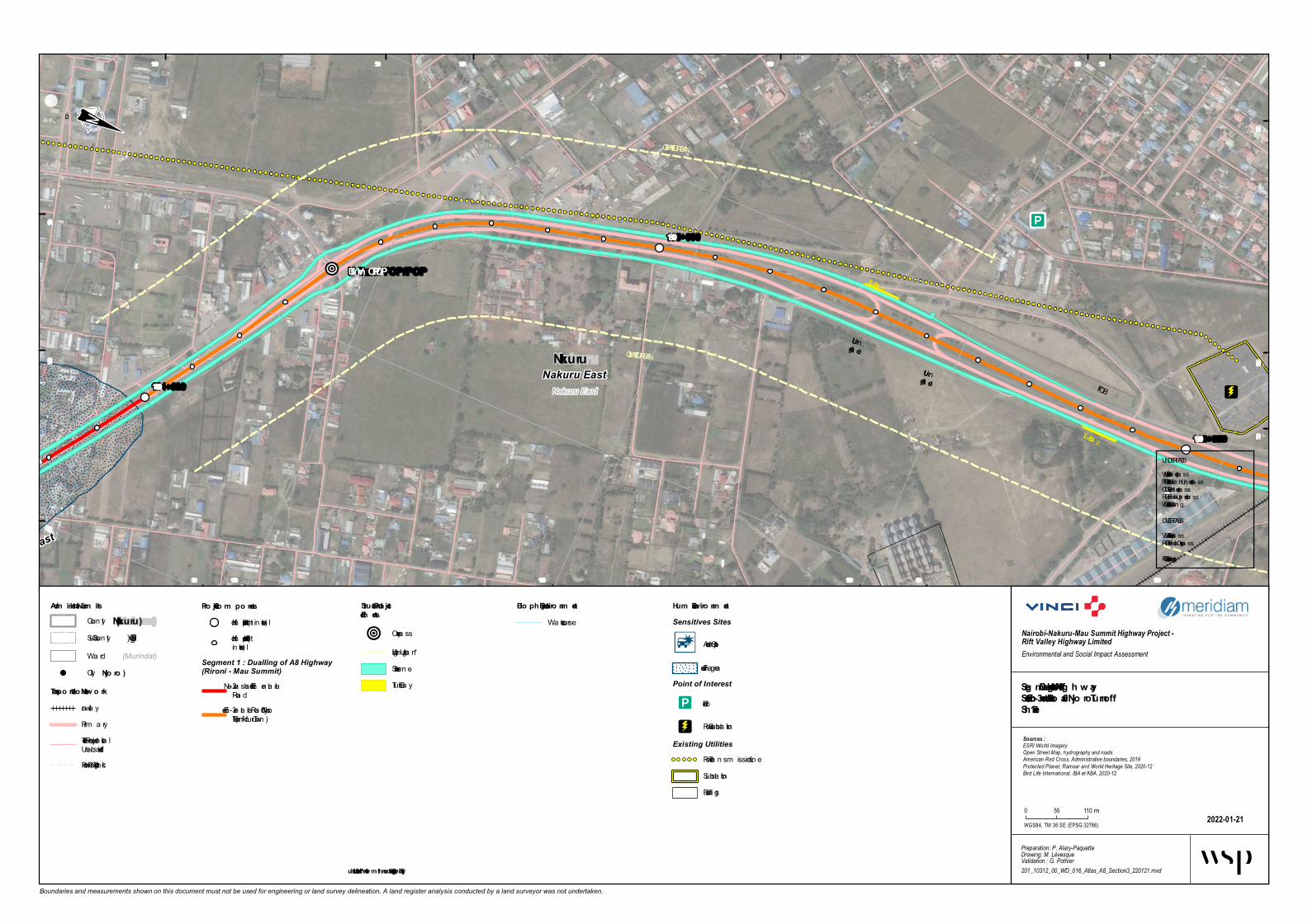
Th e Lo rd's
V ictory Ch
urchCro w
n V illag e
Sh o pping
Center
RUP
U-Turn V OP/POP
FOB
Truck ba y
Truck ba y
U-turnAt gra deU-turnAt gra de
LIGHTING URBAN
LIGHTING URBANB u s b a y s h e l t e rNakuru East
Nakuru East
Nakuru EastNakuru East Nakuru
115+000
114+000
116+000
515 000
515 000
515 500
515 500
516 000
516 000
516 500
516 500
9 964 5009 964 500
9 965 000
9 965 000
9 965 500
9 965 500
9 966 000
9 966 000 9 966 500
9 966 500
Boundaries and measurements shown on this document must not be used for engineering or land survey delineation. A land register analysis conducted by a land surveyor was not undertaken.
Bio ph ysical Enviro nm entWa tercourse
Seg m ent 1 - Dualling o f A8 Hig h w aySectio n 3 - Elem entaita Ro ad – Njo ro Turno ffSh eet 3-1
2022-01-21
Nairobi-Nakuru-Mau Summit Highway Project - Rift Valley Highway LimitedEnvironmental and Social Impact Assessment
Preparation: P. Alary-PaquetteDrawing: M. LévesqueValidation : G. Pothier201_10312_00_WD_016_Atlas_A8_Section3_220121.mxd
Sources :ESRI World ImageryOpen Street Map, hydrography and roadsAmerican Red Cross, Administrative boundaries, 2019Protected Planet, Ramsar and World Heritage Site, 2020-12Bird Life International, IBA et KBA, 2020-12
WGS84, TM 36 SE (EPSG 32766)
0 55 110 m
Adm inistrative Lim itsCoun ty(Nakuru)
(Gilgil)Sub-Coun ty(Murindat)Wa rd
Pro ject Co m po nentsKilom etric poin t (1 km in terva l)Kilom etric poin t (100 min terva l)
Segment 1 : Dualling of A8 Highway(Rironi - Mau Summit)
2 - Na iva sha – Elem en ta itaRoa d3 - Elem en ta ita Roa d – NjoroTurnoff (Na kuru Town)
Hum an Enviro nm entSensitives Sites
Acciden t Spot
Flooding a reaPoint of Interest
Police
Power Substa tionExisting Utilities
Power Tra n sm ission LineSubsta tionBuildings
City(Njo ro )
Transpo rtatio n Netw o rkra ilwa yPrim a ryTertia ry, Residen tia l orUncla ssifiedFootwa y, Pa th or Tra ck
Structural Pro jectElem ents
Overpa ss
Lightin g Urba n *Service La neTruck Ba y
UNDERPASSVUP = Vehicule Underpa ssPUP = Pedestria n Underpa ssCUP = Ca tle Underpa ssRUP = Ra ilwa y Underpa ssWLC = Wild Life Crossin g
OVERPASSVOP = Vehicule Overpa ssROP = Ra ilwa y Overpa ssFOB = Foot Overbridge
* Illustrated furth er fro m th e ro ad fo r better leg ibility

CIT AM
FOB
RUP
FOB
Truck b ay
Bus b ayBus b ay
U-turnAt grade
LIGHTING UR
BANB u s b a y s h e l t e rNakuru East
Menengai
Nakuru East Nakuru
117+000
116+000
118+000
514 000
514 000
514 500
514 500
515 000
515 000
515 500
515 500
9 966 000 9 966 5009 966 500
9 967 000
9 967 000 9 967 500
9 967 500
9 968 000
9 968 000
Boundaries and measurements shown on this document must not be used for engineering or land survey delineation. A land register analysis conducted by a land surveyor was not undertaken.
Bioph ysical EnvironmentWatercourse
Seg ment 1 - Dualling of A8 Hig h w aySection 3 - Elementaita Road – Njoro T urnoffSh eet 3-2
2022-01-21
Nairobi-Nakuru-Mau Summit Highway Project - Rift Valley Highway LimitedEnvironmental and Social Impact Assessment
Preparation: P. Alary-PaquetteDrawing: M. LévesqueValidation : G. Pothier201_10312_00_WD_016_Atlas_A8_Section3_220121.mxd
Sources :ESRI World ImageryOpen Street Map, hydrography and roadsAmerican Red Cross, Administrative boundaries, 2019Protected Planet, Ramsar and World Heritage Site, 2020-12Bird Life International, IBA et KBA, 2020-12
WGS84, TM 36 SE (EPSG 32766)
0 55 110m
Administrative LimitsCoun ty(Nakuru)
(Gilgil)Sub -Coun ty(Murindat)Ward
Project ComponentsKilometric poin t (1 km in terval)Kilometric poin t (100 min terval)
Segment 1 : Dualling of A8 Highway(Rironi - Mau Summit)
3 - Elemen taita Road – NjoroTurn o ff (Nakuru Town )
Human EnvironmentSensitives Sites
Acciden t Spo t
Point of Interest
Po lice
Worship CentersChristian
Power Sub statio nExisting Utilities
Power Tran smissio n Lin eSub statio nBuildin gs
City(Njoro)
T ransportation Netw orkrailwayPrimarySeco n daryTertiary, Residen tial orUn classified
Structural Project Elements
Un derpass
Fo o t Overb ridge
Lightin g Urb an *Bus BayService Lan eTruck Bay
UNDERPASSVUP = Vehicule Un derpassPUP = Pedestrian Un derpassCUP = Catle Un derpassRUP = Railway Un derpassWLC = Wild Life Cro ssin g
OVERPASSVOP = Vehicule OverpassROP = Railway OverpassFOB = Fo o t Overb ridge
* Illustrated furth er from th e road for better leg ibility

P AGK Church
Sita Com plex
Fre e area m arke t
Me dihe al hospital
P CEA Lane t Church
Shre e JalaranAradhana Te m
ple
P CEA Lane t
FOBBus ba y
Bus ba y
LIGHTING URBAN
LIGHTING URBANB u s b a y s h e l t e rMenengai
Nakuru East
Nakuru East Nakuru
119+000118+000 120+000
512 000
512 000
512 500
512 500
513 000
513 000
513 500
513 500
514 000
514 000
9 967 000 9 967 5009 967 500
9 968 000 9 968 500
9 968 500
Boundaries and measurements shown on this document must not be used for engineering or land survey delineation. A land register analysis conducted by a land surveyor was not undertaken.
Biophysical Environm e ntWa tercourse
Se g m e nt 1 - Dualling of A8 Hig hwaySection 3 - Ele m e ntaita Road – Njoro TurnoffShe e t 3-3
2022-01-26
Nairobi-Nakuru-Mau Summit Highway Project - Rift Valley Highway LimitedEnvironmental and Social Impact Assessment
Preparation: P. Alary-PaquetteDrawing: M. LévesqueValidation : G. Pothier201_10312_00_WD_016_Atlas_A8_Section3_220126.mxd
Sources :ESRI World ImageryOpen Street Map, hydrography and roadsAmerican Red Cross, Administrative boundaries, 2019Protected Planet, Ramsar and World Heritage Site, 2020-12Bird Life International, IBA et KBA, 2020-12
WGS84, TM 36 SE (EPSG 32766)
0 55 110 m
Adm inistrative Lim itsCounty(Nakuru)
(Gilgil)Sub-County(Murindat)Wa rd
P roje ct Com pone ntsKilom etric point (1 km in terva l)Kilom etric point (100 min terva l)
Segment 1 : Dualling of A8 Highway(Rironi - Mau Summit)
3 - Elem enta ita Roa d – NjoroTurn off (Na kuru Town)
Hum an Environm e ntSensitives Sites
Accident Spot
Ma rket a n d shopping a rea
Religious In stitution
Buildings
City(Njoro)
Transportation Ne tw orkra ilwa yPrim a ryTertia ry, Residentia l orUncla ssifiedActua l Intersection, Weir orTurn in g Circle
Structural P roje ct
Foot Overbridge
Lightin g Urba n *Bus Ba yService La ne
UNDERPASSVUP = Vehicule Underpa ssPUP = Pedestria n Underpa ssCUP = Ca tle Underpa ssRUP = Ra ilwa y Underpa ssWLC = Wild Life Crossin g
OVERPASSVOP = Vehicule Overpa ssROP = Ra ilwa y Overpa ssFOB = Foot Overbridge
* Illustrate d furthe r from the road for be tte r le gibility

Medihe al hospital
Lore to Girls Hig h School
St Monica Catholic Church
Shre e JalaranAradhana Te m ple
P.C.E.A Ne e m a
FOB
Truck b ay
Truck b ay
LIGHTING URBANB u s b a y s h e l t e rMenengai
Biashara
Nakuru East
Barut
Nakuru East
Nakuru West
Nak uru
Menengai
121+000
120+000 122+000
510 500
510 500
511 000
511 000
511 500
511 500
512 000
512 000
9 968 0009 968 000
9 968 500
9 968 500
9 969 000
9 969 000
Boundaries and measurements shown on this document must not be used for engineering or land survey delineation. A land register analysis conducted by a land surveyor was not undertaken.
Biophysical Environm e ntWatercourse
Se g m e nt 1 - Dualling of A8 Hig hwaySection 3 - Ele m e ntaita R oad – Njoro TurnoffShe e t 3-4
2022-01-26
Nairobi-Nakuru-Mau Summit Highway Project - Rift Valley Highway LimitedEnvironmental and Social Impact Assessment
Preparation: P. Alary-PaquetteDrawing: M. LévesqueValidation : G. Pothier201_10312_00_WD_016_Atlas_A8_Section3_220126.mxd
Sources :ESRI World ImageryOpen Street Map, hydrography and roadsAmerican Red Cross, Administrative boundaries, 2019Protected Planet, Ramsar and World Heritage Site, 2020-12Bird Life International, IBA et KBA, 2020-12
WGS84, TM 36 SE (EPSG 32766)
0 55 110m
Adm inistrative Lim itsCoun ty(Nak uru)
(Gilgil)Sub -Coun ty(Murindat)Ward
Proje ct Com pone ntsKilometric poin t (1 km in terval)Kilometric poin t (100 min terval)
Segment 1 : Dualling of A8 Highway(Rironi - Mau Summit)
3 - Elemen taita Road – NjoroTurn off (Nakuru Town )
Hum an Environm e ntSensitives Sites
Health Facilities
Religio us In stitutio n
Scho o l In stitutio n
UtilityExisting Utilitie s
Lamp Po stWorship Buildin g or AreaBuildin gs
Landuse (OSM)Residen tial
Protected Areas
National Le velForest ReserveWorld Heritage Site (n atural ormixed)Importan t Bird Area (IBA) an dKey Biodivesity Area (KBA)
City(Njoro)
Transportation Ne tw orkrailwayPrimaryTertiary, Residen tial orUn classifiedActual In tersectio n , Weir orTurn in g Circle
Structural Proje ct
At-grade cro ssin g
Fo o t Overb ridge
Speed b umps
Lightin g Urb an *Bus BayService Lan eTruck Bay
UNDERPASSVUP = Vehicule Un derpassPUP = Pedestrian Un derpassCUP = Catle Un derpassRUP = Railway Un derpassWLC = Wild Life Cro ssin g
OVERPASSVOP = Vehicule OverpassROP = Railway OverpassFOB = Fo o t Overb ridge
* Illustrate d furthe r from the road for be tte r le gibility
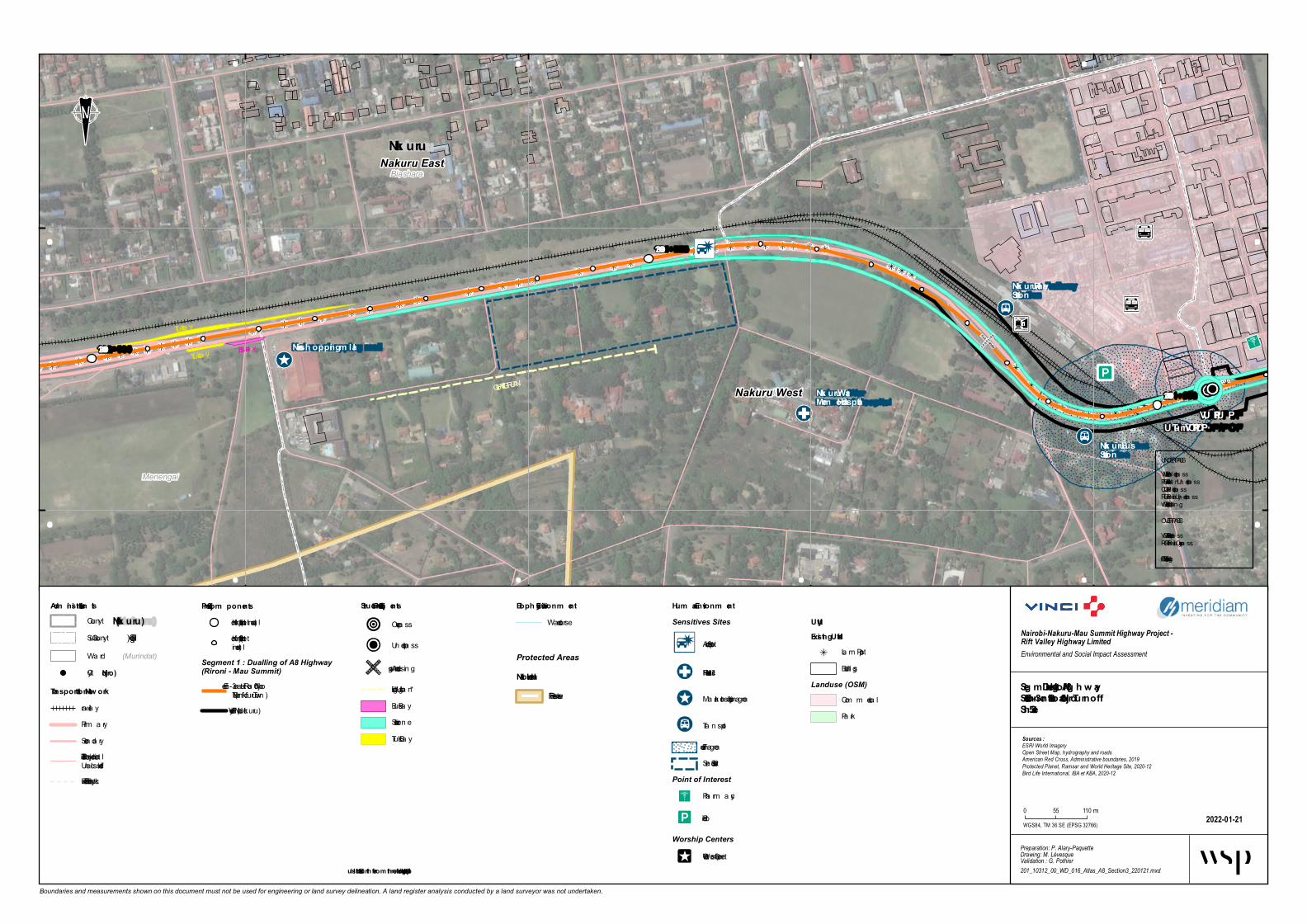
Nak uru Bus Station
Naivas sh opping m all
Nak uru Railway Station
Nak uru War Mem orial Hospital
VU P/PU PU -Turn VOP/POP
Truck ba y
Truck ba y
LIGHTING URBAN
Bus ba yBus bay shelter London
Biashara
Menengai
Nakuru West
Nakuru East Nak uru
123+000
122+000
124+000
508 500
508 500
509 000
509 000
509 500
509 500
510 000
510 000
9 968 500
9 968 500
9 969 000
9 969 000
Boundaries and measurements shown on this document must not be used for engineering or land survey delineation. A land register analysis conducted by a land surveyor was not undertaken.
Bioph ysical Environm entWa tercourse
Seg m ent 1 - Dualling of A8 Hig h w aySection 3 - Elem entaita Road – Njoro TurnoffSheet 3-5
2022-01-21
Nairobi-Nakuru-Mau Summit Highway Project - Rift Valley Highway LimitedEnvironmental and Social Impact Assessment
Preparation: P. Alary-PaquetteDrawing: M. LévesqueValidation : G. Pothier201_10312_00_WD_016_Atlas_A8_Section3_220121.mxd
Sources :ESRI World ImageryOpen Street Map, hydrography and roadsAmerican Red Cross, Administrative boundaries, 2019Protected Planet, Ramsar and World Heritage Site, 2020-12Bird Life International, IBA et KBA, 2020-12
WGS84, TM 36 SE (EPSG 32766)
0 55 110 m
Adm inistrative Lim itsCounty(Nak uru)
(Gilgil)Sub-County(Murindat)Wa rd
Project Com ponentsKilom etric point (1 km in terva l)Kilom etric point (100 min terva l)
Segment 1 : Dualling of A8 Highway(Rironi - Mau Summit)
3 - Elem en ta ita Roa d – NjoroTurnoff (Na kuru Town)Flyover Via duct (Na kuru)
Hum an Environm entSensitives Sites
Accident Spot
Hea lth Fa cilities
Ma rket a nd shopping a rea
Tra n sport
Flooding a reaSen sitive Site
Point of InterestPha rm a cy
Police
Worship CentersOther Worship Center
U tilityExisting U tilities
La m p PostBuildings
Landuse (OSM)Com m ercia lPa rk
Protected AreasNational Level
Forest Reserve
City(Njoro)
Transportation Netw orkra ilwa yPrim a rySeconda ryTertia ry, Residentia l orUncla ssifiedFootwa y, Pa th or Tra ck
Structural Project Elem ents
Overpa ss
Underpa ss
At-gra de crossin g
Lighting Urba n *Bus Ba yService La neTruck Ba y
UNDERPASSVUP = Vehicule Underpa ssPUP = Pedestria n Underpa ssCUP = Ca tle Underpa ssRUP = Ra ilwa y Underpa ssWLC = Wild Life Crossin g
OVERPASSVOP = Vehicule Overpa ssROP = Ra ilwa y Overpa ssFOB = Foot Overbridge
* Illustrated furth er from the road for better leg ibility

Egerton University
Nakuru Bus Station
Nakuru R ailway Station
Nairob i Wom an's h ospital
Crater SDA Church
Holy Basilica Catholic Church
VUP/PUPVUP/PUP VOP/POPU-Turn VOP/POPB u s b a y s h e l t e rLondon
Biashara Shaabab
Nakuru West
Nakuru East Nakuru
County Assem b ly of NakuruJom o Kenyatta Unive rsity of Agric ulture and Te c h nology
125+000
124+000126+000
506 500
506 500
507 000
507 000
507 500
507 500
508 000
508 000
508 500508 500
9 968 000
9 968 000
9 968 500
9 968 500
9 969 000
9 969 000
Boundaries and measurements shown on this document must not be used for engineering or land survey delineation. A land register analysis conducted by a land surveyor was not undertaken.
Bioph ysical Environm e ntWatercourse
Segm e nt 1 - Dualling of A8 High waySec tion 3 - Ele m e ntaita R oad – Njoro TurnoffSh e e t 3-6
2022-01-21
Nairobi-Nakuru-Mau Summit Highway Project - Rift Valley Highway LimitedEnvironmental and Social Impact Assessment
Preparation: P. Alary-PaquetteDrawing: M. LévesqueValidation : G. Pothier201_10312_00_WD_016_Atlas_A8_Section3_220121.mxd
Sources :ESRI World ImageryOpen Street Map, hydrography and roadsAmerican Red Cross, Administrative boundaries, 2019Protected Planet, Ramsar and World Heritage Site, 2020-12Bird Life International, IBA et KBA, 2020-12
WGS84, TM 36 SE (EPSG 32766)
0 55 110m
Ad m inistrative Lim itsCoun ty(Nakuru)
(Gilgil)Sub -Coun ty(Murindat)Ward
Proje c t Com pone ntsKilometric poin t (1 km in terval)Kilometric poin t (100 min terval)
Segment 1 : Dualling of A8 Highway(Rironi - Mau Summit)
3 - Elemen taita Road – NjoroTurn o ff (Nakuru Town )Flyo ver Viaduct (Nakuru)
Hum an Environm e ntSensitives Sites
Acciden t Spo t
Health Facilities
Scho ol In stitutio n
Flo o din g areaPoint of Interest
Archaeological, Attractio n ,Mo n umen t or Viewpoin tPharmacy
Police
To ilet
UtilityExisting Utilities
Lamp Po stBuildin gs
Landuse (OSM)CommercialFo restPark
City(Njoro)
Transportation NetworkrailwayPrimarySeco n daryTertiary, Residen tial orUn classifiedFo o tway, Path or TrackActual In tersectio n , Weir orTurn in g Circle
Struc tural Proje c t Elem e nts
Overpass
Un derpass
At-grade cro ssin g
Service Lan e
UNDERPASSVUP = Vehicule Un derpassPUP = Pedestrian Un derpassCUP = Catle Un derpassRUP = Railway Un derpassWLC = Wild Life Cro ssin g
OVERPASSVOP = Vehicule OverpassROP = Railway OverpassFOB = Fo o t Overb ridge
* Illustrate d furth e r from th e road for b e tte r legib ility

Shabab m arke t area
Eg e rton Unive rsity
Nakuru We st Prim ary School
VUP/PUP
U-T urn VOP/POPBus bay
Bus bayB u s b a y s h e l t e rLondon
Shaabab
Kapkures
Nakuru West Nakuru
Eve ready Industrie s
Shopping Mall unde r construction
127+000
126+000
128+000
504 500
504 500
505 000
505 000
505 500
505 500
506 000
506 000
506 500
506 500
9 968 000
9 968 000
9 968 500
9 968 500
Boundaries and measurements shown on this document must not be used for engineering or land survey delineation. A land register analysis conducted by a land surveyor was not undertaken.
Biophysical Environm e ntWaterc o urse
Se g m e nt 1 - Dualling of A8 Hig hwaySection 3 - Ele m e ntaita Road – Njoro T urnoffShe e t 3-7
2022-01-21
Nairobi-Nakuru-Mau Summit Highway Project - Rift Valley Highway LimitedEnvironmental and Social Impact Assessment
Preparation: P. Alary-PaquetteDrawing: M. LévesqueValidation : G. Pothier201_10312_00_WD_016_Atlas_A8_Section3_220121.mxd
Sources :ESRI World ImageryOpen Street Map, hydrography and roadsAmerican Red Cross, Administrative boundaries, 2019Protected Planet, Ramsar and World Heritage Site, 2020-12Bird Life International, IBA et KBA, 2020-12
WGS84, TM 36 SE (EPSG 32766)
0 55 110m
Adm inistrative Lim itsCo unty(Nakuru)
(Gilgil)Sub-Co unty(Murindat)Ward
Proje ct Com pone ntsKilo metric p o int (1 km interval)Kilo metric p o int (100 minterval)
Segment 1 : Dualling of A8 Highway(Rironi - Mau Summit)
3 - Elementaita Ro ad – Njo roTurno ff (Nak uru To wn)Flyo ver Viaduc t (Nakuru)
Hum an Environm e ntSensitives Sites
Market and sho p p ing area
Scho o l Institutio n
Future DevelopmentsSho p p ing Mall underc o nstruc tio n
UtilityExisting Utilitie s
Lamp Po stExisting Utilities
Po wer Transmissio n LineBuildings
City(Njoro)
T ransportation Ne tw orkrailwayPrimaryTertiary, Residential o rUnc lassifiedFo o tway, Path o r Trac kAc tual Intersec tio n, Weir o rTurning Circ le
Structural Proje ct Ele m e nts
Overpass
Underpass
At-grade cro ssing
Fo o t Overbridge
Bus BayService Lane
UNDERPASSVUP = Vehic ule UnderpassPUP = Pedestrian UnderpassCUP = Catle UnderpassRUP = Railway UnderpassWLC = Wild Life Cro ssing
OVERPASSVOP = Vehic ule OverpassROP = Railway OverpassFOB = Fo o t Overbridge
* Illustrated furthe r from the road for be tte r le g ibility

Njoro T urn Off
Kenya Power Substation
Ag riculture T ech nolog y Developm ent Center
FOBU-T urn VOP/POP
U-T urn VOP/PO
PBus b ay
Bus b ayB u s b a y s h e l t e rKapkures
London
Kapkures Mosop
Menengai West
Nakuru West
Rongai
Nak uru
Power Substation
129+000128+000130+000
503 000
503 000
503 500
503 500
504 000
504 000504 500
9 968 0009 968 000
9 968 5009 968 500
9 969 000
9 969 000
9 969 500
Boundaries and measurements shown on this document must not be used for engineering or land survey delineation. A land register analysis conducted by a land surveyor was not undertaken.
Bioph ysical Environm entWatercourse
Seg m ent 1 - Dualling of A8 Hig h w aySection 3 - Elem entaita Road – Njoro T urnoffSheet 3-8
2022-01-21
Nairobi-Nakuru-Mau Summit Highway Project - Rift Valley Highway LimitedEnvironmental and Social Impact Assessment
Preparation: P. Alary-PaquetteDrawing: M. LévesqueValidation : G. Pothier201_10312_00_WD_016_Atlas_A8_Section3_220121.mxd
Sources :ESRI World ImageryOpen Street Map, hydrography and roadsAmerican Red Cross, Administrative boundaries, 2019Protected Planet, Ramsar and World Heritage Site, 2020-12Bird Life International, IBA et KBA, 2020-12
WGS84, TM 36 SE (EPSG 32766)
0 55 110m
Adm inistrative Lim itsCoun ty(Nak uru)
(Gilgil)Sub -Coun ty(Murindat)Ward
Project Com ponentsKilometric poin t (1 km in terval)Kilometric poin t (100 min terval)
Segment 1 : Dualling of A8 Highway(Rironi - Mau Summit)
3 - Elemen taita Road – NjoroTurn o ff (Nakuru To w n )4 - Njoro Turn off – MauSummit
Hum an Environm entSensitives Sites
Gas Statio n
Po wer Sub statio n
Scho ol In stitutio n
Sen sitive Site
UtilityExisting Utilities
Lamp Po stPo wer Sub statio n
Existing UtilitiesPo wer Tran smissio n Lin ePipelin e cro ssin gSub statio nBuildin gs
Landuse (OSM)Farmlan dResiden tial
City(Njoro)
T ransportation Netw orkrailwayPrimarySeco n daryTertiary, Residen tial orUn classified
Structural ProjectElem ents
Overpass
Bus b ay shelter
Pedestrian facility
Service Lan e
UNDERPASSVUP = Vehicule Un derpassPUP = Pedestrian Un derpassCUP = Catle Un derpassRUP = Railway Un derpassWLC = Wild Life Cro ssin g
OVERPASSVOP = Vehicule OverpassROP = Railway OverpassFOB = Fo o t Overb ridge
* Illustrated furth er from the road for better leg ibility

501 000
501 000
501 500
501 500
502 000
502 000
502 500
502 500
503 000
503 000
9 969 0009 969 000
9 969 5009 969 500
9 970 000
9 970 000
Boundaries and measurements shown on this document must not be used for engineering or land survey delineation. A land register analysis conducted by a land surveyor was not undertaken.
Biophysical En viron m entWa tercourse
Segm ent 1 - Dualling of A8 HighwaySection 4 - Njoro Turnoff – Mau Sum m itSheet 4-1
2022-01-21
Nairobi-Nakuru-Mau Summit Highway Project - Rift Valley Highway LimitedEnvironmental and Social Impact Assessment
Preparation: C. Abdel-MalekDrawing: A. MonnardValidation : G. Pothier201_10312_00_WD_016_Atlas_A8_Section4_220121.mxd
Sources :ESRI World ImageryOpen Street Map, hydrography and roadsAmerican Red Cross, Administrative boundaries, 2019Protected Planet, Ramsar and World Heritage Site, 2020-12Bird Life International, IBA et KBA, 2020-12
WGS84, TM 36 SE (EPSG 32766)
0 55 110 m
Ad m inistrative Lim itsCounty(Nakuru)
(Gilgil)Sub-County(Murindat)Wa rd
Project Com ponentsKilom etric point (1 km in terva l)Kilom etric point (100 min terva l)
Segment 1 : Dualling of A8 Highway(Rironi - Mau Summit)
4 - Njoro Turnoff – Ma uSum m it
Hum an En viron m entSensitives Sites
Accident Spot
Infra structure
Accident ZoneFlooding a rea
Point of Interest
Police
Existing UtilitiesPower Tra n sm ission Line
City(Njoro)
Transportation Networkra ilwa yPrim a ryTertia ry, Residentia l orUncla ssifiedFootwa y, Pa th or Tra ckActua l Intersection, Weir orTurn in g Circle
Structural Project Elem ents
Foot Overbridge
Noise Ba rrier *Noise Berm *Clim bin g La ne *Bus Ba yService La ne
UNDERPASSVUP = Vehicule Underpa ssPUP = Pedestria n Underpa ssCUP = Ca tle Underpa ssRUP = Ra ilwa y Underpa ssWLC = Wild Life Crossin g
OVERPASSVOP = Vehicule Overpa ssROP = Ra ilwa y Overpa ssFOB = Foot Overbridge
* Illustrated further from the road for better legibility

499 500
499 500
500 000
500 000
500 500
500 500
501 000
501 000
9 970 0009 970 000
9 970 500
9 970 500
9 971 000
9 971 000 9 971 500
9 971 500
Boundaries and measurements shown on this document must not be used for engineering or land survey delineation. A land register analysis conducted by a land surveyor was not undertaken.
Bio physical En viro n men tWa tercourse
Segmen t 1 - Duallin g o f A8 HighwaySectio n 4 - Njo ro Turn o ff – Mau SummitSheet 4-2
2022-01-21
Nairobi-Nakuru-Mau Summit Highway Project - Rift Valley Highway LimitedEnvironmental and Social Impact Assessment
Preparation: C. Abdel-MalekDrawing: A. MonnardValidation : G. Pothier201_10312_00_WD_016_Atlas_A8_Section4_220121.mxd
Sources :ESRI World ImageryOpen Street Map, hydrography and roadsAmerican Red Cross, Administrative boundaries, 2019Protected Planet, Ramsar and World Heritage Site, 2020-12Bird Life International, IBA et KBA, 2020-12
WGS84, TM 36 SE (EPSG 32766)
0 55 110 m
Admin istrative LimitsCounty(Nakuru)
(Gilgil)Sub-County(Murindat)Wa rd
Pro ject Co mp o n en tsKilom etric point (1 km in terva l)Kilom etric point (100 min terva l)
Segment 1 : Dualling of A8 Highway(Rironi - Mau Summit)
4 - Njoro Turnoff – Ma uSum m it
Human En viro n men tSensitives Sites
Infra structure
Religious In stitution
Accident Zone
Existing UtilitiesPower Tra n sm ission Line
City(Njo ro )
Tran sp o rtatio n Netw o rkra ilwa yPrim a ryTertia ry, Residentia l orUncla ssifiedFootwa y, Pa th or Tra ckActua l Intersection, Weir orTurn in g Circle
Structural Pro ject Elemen ts
Underpa ss
Noise Ba rrier *Clim bin g La ne *Bus Ba yService La ne
UNDERPASSVUP = Vehicule Underpa ssPUP = Pedestria n Underpa ssCUP = Ca tle Underpa ssRUP = Ra ilwa y Underpa ssWLC = Wild Life Crossin g
OVERPASSVOP = Vehicule Overpa ssROP = Ra ilwa y Overpa ssFOB = Foot Overbridge
* Illustrated further fro m the ro ad fo r better legibility

497 500
497 500
498 000
498 000
498 500
498 500
499 000
499 000
499 500
499 500
9 971 0009 971 000
9 971 500
9 971 500
9 972 000
9 972 000
Boundaries and measurements shown on this document must not be used for engineering or land survey delineation. A land register analysis conducted by a land surveyor was not undertaken.
Biophys ical En viro n m e n tWa tercourse
Se gm e n t 1 - Duallin g of A8 HighwaySe ctio n 4 - Njoro Turn o ff – Mau Sum m itShe e t 4-3
2022-01-21
Nairobi-Nakuru-Mau Summit Highway Project - Rift Valley Highway LimitedEnvironmental and Social Impact Assessment
Preparation: C. Abdel-MalekDrawing: A. MonnardValidation : G. Pothier201_10312_00_WD_016_Atlas_A8_Section4_220121.mxd
Sources :ESRI World ImageryOpen Street Map, hydrography and roadsAmerican Red Cross, Administrative boundaries, 2019Protected Planet, Ramsar and World Heritage Site, 2020-12Bird Life International, IBA et KBA, 2020-12
WGS84, TM 36 SE (EPSG 32766)
0 55 110 m
Adm in is trative Lim itsCounty(Nakuru)
(Gilgil)Sub-County(Murindat)Wa rd
Proje ct Co m po n e n tsKilom etric point (1 km in terva l)Kilom etric point (100 min terva l)
Segment 1 : Dualling of A8 Highway(Rironi - Mau Summit)
4 - Njoro Turnoff – Ma uSum m it
Hum an En viro n m e n tSensitives Sites
Public In stitution
Religious In stitution
School In stitution
Sen sitive Site
Accident ZoneWorship Centers
Christia n
Existing UtilitiesPower Tra n sm ission LinePipeline crossin g
City(Njoro)
Tran sportatio n Ne tw o rkPrim a ryTertia ry, Residentia l orUncla ssifiedFootwa y, Pa th or Tra ck
Structural Proje ctEle m e n ts
Overpa ss
Clim bin g La ne *Bus Ba yService La neTruck Ba y
UNDERPASSVUP = Vehicule Underpa ssPUP = Pedestria n Underpa ssCUP = Ca tle Underpa ssRUP = Ra ilwa y Underpa ssWLC = Wild Life Crossin g
OVERPASSVOP = Vehicule Overpa ssROP = Ra ilwa y Overpa ssFOB = Foot Overbridge
* Illustrated furthe r fro m the road for be tte r le gibility
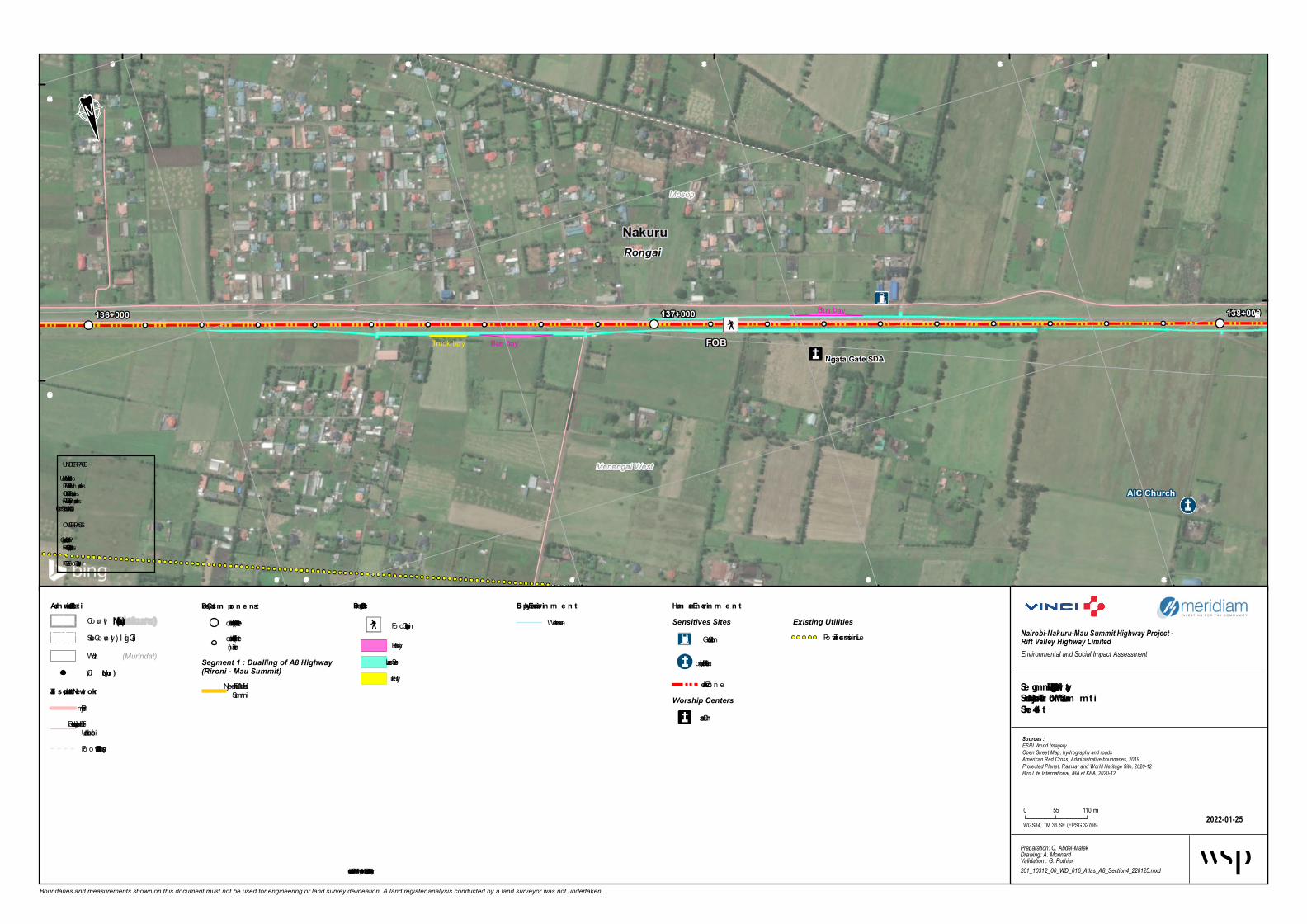
496 000
496 000
496 500
496 500
497 000
497 000
497 500
497 500
9 971 500
9 972 0009 972 000
9 972 500
9 972 500
Boundaries and measurements shown on this document must not be used for engineering or land survey delineation. A land register analysis conducted by a land surveyor was not undertaken.
Biophysical En viro n m e n tWatercourse
Se gm e n t 1 - Duallin g of A8 HighwaySe ctio n 4 - Njoro Turn o ff – Mau Sum m itShe e t 4-4
2022-01-25
Nairobi-Nakuru-Mau Summit Highway Project - Rift Valley Highway LimitedEnvironmental and Social Impact Assessment
Preparation: C. Abdel-MalekDrawing: A. MonnardValidation : G. Pothier201_10312_00_WD_016_Atlas_A8_Section4_220125.mxd
Sources :ESRI World ImageryOpen Street Map, hydrography and roadsAmerican Red Cross, Administrative boundaries, 2019Protected Planet, Ramsar and World Heritage Site, 2020-12Bird Life International, IBA et KBA, 2020-12
WGS84, TM 36 SE (EPSG 32766)
0 55 110m
Adm in istrative Lim itsCoun ty(Nakuru)
(Gilgil)Sub -Coun ty(Murindat)Ward
Proje ct Co m po n e n tsKilometric poin t (1 km in terval)Kilometric poin t (100 min terval)
Segment 1 : Dualling of A8 Highway(Rironi - Mau Summit)
4 - Njo ro Turn off – MauSummit
Hum an En viro n m e n tSensitives Sites
Gas Statio n
Religio us In stitutio n
Acciden t Zo n eWorship Centers
Christian
Existing UtilitiesPo wer Tran smissio n Lin e
City(Njoro)
Tran sportatio n Ne tw o rkPrimaryTertiary, Residen tial orUn classifiedFo o tway, Path or Track
Structural Proje ct
Fo o t Overb ridge
Bus BayService Lan eTruck Bay
UNDERPASSVUP = Vehicule Un derpassPUP = Pedestrian Un derpassCUP = Catle Un derpassRUP = Railway Un derpassWLC = Wild Life Cro ssin g
OVERPASSVOP = Vehicule OverpassROP = Railway OverpassFOB = Fo o t Overb ridge
* Illustrate d furthe r fro m the road for be tte r le gibility

494 000
494 000
494 500
494 500
495 000
495 000
495 500
495 500
9 972 500
9 972 500
9 973 000
9 973 000
Boundaries and measurements shown on this document must not be used for engineering or land survey delineation. A land register analysis conducted by a land surveyor was not undertaken.
Biophys ical En viro n m e n tWa tercourse
Se gm e n t 1 - Duallin g of A8 HighwaySe ctio n 4 - Njoro Turn o ff – Mau Sum m itShe e t 4-5
2022-01-21
Nairobi-Nakuru-Mau Summit Highway Project - Rift Valley Highway LimitedEnvironmental and Social Impact Assessment
Preparation: C. Abdel-MalekDrawing: A. MonnardValidation : G. Pothier201_10312_00_WD_016_Atlas_A8_Section4_220121.mxd
Sources :ESRI World ImageryOpen Street Map, hydrography and roadsAmerican Red Cross, Administrative boundaries, 2019Protected Planet, Ramsar and World Heritage Site, 2020-12Bird Life International, IBA et KBA, 2020-12
WGS84, TM 36 SE (EPSG 32766)
0 55 110 m
Adm in is trative Lim itsCounty(Nakuru)
(Gilgil)Sub-County(Murindat)Wa rd
Proje ct Co m po n e n tsKilom etric point (1 km in terva l)Kilom etric point (100 min terva l)
Segment 1 : Dualling of A8 Highway(Rironi - Mau Summit)
4 - Njoro Turnoff – Ma uSum m it
Hum an En viro n m e n tSensitives Sites
Ga s Sta tion
Industry
Religious In stitution
School In stitution
Accident ZoneFlooding a rea
City(Njoro)
Tran sportatio n Ne tw o rkPrim a ryTertia ry, Residentia l orUncla ssified
Structural Proje ct Ele m e n ts
Foot Overbridge
Noise Berm *Service La ne
UNDERPASSVUP = Vehicule Underpa ssPUP = Pedestria n Underpa ssCUP = Ca tle Underpa ssRUP = Ra ilwa y Underpa ssWLC = Wild Life Crossin g
OVERPASSVOP = Vehicule Overpa ssROP = Ra ilwa y Overpa ssFOB = Foot Overbridge
* Illustrated furthe r fro m the road for be tte r le gibility

492 000
492 000
492 500
492 500
493 000
493 000
493 500
493 500
9 972 5009 972 500
9 973 000
9 973 000
9 973 500
9 973 500
Boundaries and measurements shown on this document must not be used for engineering or land survey delineation. A land register analysis conducted by a land surveyor was not undertaken.
Biophysical En viron m entWa tercourse
Segm ent 1 - Dualling of A8 HighwaySection 4 - Njoro Turnoff – Mau Sum m itSheet 4-6
2022-01-21
Nairobi-Nakuru-Mau Summit Highway Project - Rift Valley Highway LimitedEnvironmental and Social Impact Assessment
Preparation: C. Abdel-MalekDrawing: A. MonnardValidation : G. Pothier201_10312_00_WD_016_Atlas_A8_Section4_220121.mxd
Sources :ESRI World ImageryOpen Street Map, hydrography and roadsAmerican Red Cross, Administrative boundaries, 2019Protected Planet, Ramsar and World Heritage Site, 2020-12Bird Life International, IBA et KBA, 2020-12
WGS84, TM 36 SE (EPSG 32766)
0 55 110 m
Ad m inistrative Lim itsCounty(Nakuru)
(Gilgil)Sub-County(Murindat)Wa rd
Project Com ponentsKilom etric point (1 km in terva l)Kilom etric point (100 min terva l)
Segment 1 : Dualling of A8 Highway(Rironi - Mau Summit)
4 - Njoro Turnoff – Ma uSum m it
Hum an En viron m entSensitives Sites
Accident Spot
Religious In stitution
School In stitution
Sen sitive SiteAccident ZoneFlooding a rea
City(Njoro)
Transportation NetworkPrim a ryTertia ry, Residentia l orUncla ssified
Structural Project Elem ents
Underpa ss
Noise Ba rrier *Noise Berm *Bus Ba yService La neTruck Ba y
UNDERPASSVUP = Vehicule Underpa ssPUP = Pedestria n Underpa ssCUP = Ca tle Underpa ssRUP = Ra ilwa y Underpa ssWLC = Wild Life Crossin g
OVERPASSVOP = Vehicule Overpa ssROP = Ra ilwa y Overpa ssFOB = Foot Overbridge
* Illustrated further from the road for better legibility
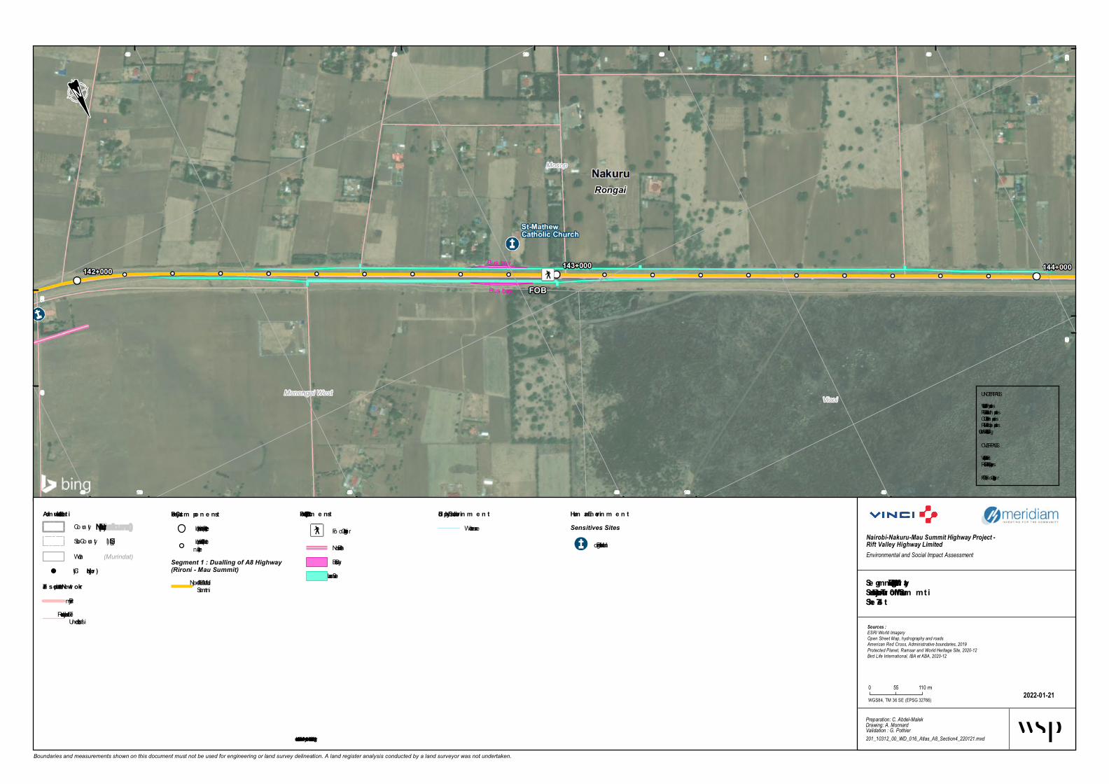
490 000
490 000
490 500
490 500
491 000
491 000
491 500
491 500
492 000
492 000
9 973 0009 973 000
9 973 500
9 973 500
9 974 000
Boundaries and measurements shown on this document must not be used for engineering or land survey delineation. A land register analysis conducted by a land surveyor was not undertaken.
Biophys ical En viro n m e n tWatercourse
Se gm e n t 1 - Duallin g of A8 HighwaySe ctio n 4 - Njoro Turn o ff – Mau Sum m itShe e t 4-7
2022-01-21
Nairobi-Nakuru-Mau Summit Highway Project - Rift Valley Highway LimitedEnvironmental and Social Impact Assessment
Preparation: C. Abdel-MalekDrawing: A. MonnardValidation : G. Pothier201_10312_00_WD_016_Atlas_A8_Section4_220121.mxd
Sources :ESRI World ImageryOpen Street Map, hydrography and roadsAmerican Red Cross, Administrative boundaries, 2019Protected Planet, Ramsar and World Heritage Site, 2020-12Bird Life International, IBA et KBA, 2020-12
WGS84, TM 36 SE (EPSG 32766)
0 55 110m
Adm in is trative Lim itsCoun ty(Nakuru)
(Gilgil)Sub -Coun ty(Murindat)Ward
Proje ct Co m po n e n tsKilometric poin t (1 km in terval)Kilometric poin t (100 min terval)
Segment 1 : Dualling of A8 Highway(Rironi - Mau Summit)
4 - Njoro Turn off – MauSummit
Hum an En viro n m e n tSensitives Sites
Religio us In stitutio n
City(Njoro)
Tran sportatio n Ne tw o rkPrimaryTertiary, Residen tial orUn classified
Structural Proje ct Ele m e n ts
Fo o t Overb ridge
Noise Berm *Bus BayService Lan e
UNDERPASSVUP = Vehicule Un derpassPUP = Pedestrian Un derpassCUP = Catle Un derpassRUP = Railway Un derpassWLC = Wild Life Cro ssin g
OVERPASSVOP = Vehicule OverpassROP = Railway OverpassFOB = Fo o t Overb ridge
* Illustrated furthe r fro m the road for be tte r le gibility

Acacia Grasslan d Academy Primary
U -Turn VOP/POP Bus bay
Bus bayB u s b a y s h e l t e rVisoi
Mosop
Rongai Nakuru
145+000144+000 146+000
488 000
488 000
488 500
488 500
489 000
489 000
489 500
489 500
490 000
490 000
9 973 5009 973 500
9 974 0009 974 000
9 974 500 9 975 000
9 975 000
Boundaries and measurements shown on this document must not be used for engineering or land survey delineation. A land register analysis conducted by a land surveyor was not undertaken.
Bioph ysical En viron men tWaterc o urse
Seg men t 1 - Duallin g of A8 Hig h w aySection 4 - Njoro Turn off – Mau SummitSh eet 4-8
2022-01-25
Nairobi-Nakuru-Mau Summit Highway Project - Rift Valley Highway LimitedEnvironmental and Social Impact Assessment
Preparation: C. Abdel-MalekDrawing: A. MonnardValidation : G. Pothier201_10312_00_WD_016_Atlas_A8_Section4_220125.mxd
Sources :ESRI World ImageryOpen Street Map, hydrography and roadsAmerican Red Cross, Administrative boundaries, 2019Protected Planet, Ramsar and World Heritage Site, 2020-12Bird Life International, IBA et KBA, 2020-12
WGS84, TM 36 SE (EPSG 32766)
0 55 110m
Admin istrative LimitsCo unty (Nakuru)
(Gilgil)Sub-Co unty(Murindat)Ward
Project Compon en tsKilo metric p o int (1 km interval)Kilo metric p o int (100 minterval)
Segment 1 : Dualling of A8 Highway(Rironi - Mau Summit)
4 - Njo ro Turno ff – MauSummit
Human En viron men tSensitives Sites
Ac c ident Sp o t
Sc ho o l Institutio n
Buildings
City (Njoro)
Tran sportation Netw orkPrimaryTertiary, Residential o rUnc lassified
Structural ProjectElemen ts
U-turn
Bus BayService Lane
UNDERPASSVUP = Vehic ule UnderpassPUP = Pedestrian UnderpassCUP = Catle UnderpassRUP = Railway UnderpassWLC = Wild Life Cro ssing
OVERPASSVOP = Vehic ule OverpassROP = Railway OverpassFOB = Fo o t Overbridge
* Illustrated furth er from th e road for better leg ibility

486 500
486 500
487 000
487 000
487 500
487 500
488 000
488 000
9 974 5009 974 500
9 975 0009 975 000
9 975 500
9 975 500
9 976 000
Boundaries and measurements shown on this document must not be used for engineering or land survey delineation. A land register analysis conducted by a land surveyor was not undertaken.
Bio physical En viro n men tWaterc o urse
Segmen t 1 - Duallin g o f A8 HighwaySectio n 4 - Njo ro Turn o ff – Mau SummitSheet 4-9
2022-01-21
Nairobi-Nakuru-Mau Summit Highway Project - Rift Valley Highway LimitedEnvironmental and Social Impact Assessment
Preparation: C. Abdel-MalekDrawing: A. MonnardValidation : G. Pothier201_10312_00_WD_016_Atlas_A8_Section4_220121.mxd
Sources :ESRI World ImageryOpen Street Map, hydrography and roadsAmerican Red Cross, Administrative boundaries, 2019Protected Planet, Ramsar and World Heritage Site, 2020-12Bird Life International, IBA et KBA, 2020-12
WGS84, TM 36 SE (EPSG 32766)
0 55 110m
Admin istrative LimitsCo unty (Nakuru)
(Gilgil)Sub-Co unty(Murindat)Ward
Pro ject Co mp o n en tsKilo metric p o int (1 km interval)Kilo metric p o int (100 minterval)
Segment 1 : Dualling of A8 Highway(Rironi - Mau Summit)
4 - Njo ro Turno ff – MauSummit
Human En viro n men tSensitives Sites
Industry
City (Njo ro )
Tran sp o rtatio n Netw o rkPrimaryTertiary, Residential o rUnc lassified
Structural Pro ject Elemen ts
Fo o t Overbridge
Bus BayService Lane
UNDERPASSVUP = Vehic ule UnderpassPUP = Pedestrian UnderpassCUP = Catle UnderpassRUP = Railway UnderpassWLC = Wild Life Cro ssing
OVERPASSVOP = Vehic ule OverpassROP = Railway OverpassFOB = Fo o t Overbridge
* Illustrated further fro m the ro ad fo r better legibility

484 500
484 500
485 000
485 000
485 500
485 500
486 000
486 000
486 500
486 500
9 975 5009 975 500
9 976 0009 976 000
9 976 500
9 976 500
Boundaries and measurements shown on this document must not be used for engineering or land survey delineation. A land register analysis conducted by a land surveyor was not undertaken.
Bio physical En viro n men tWaterc o urseWaterbo dy
Segmen t 1 - Duallin g o f A8 HighwaySectio n 4 - Njo ro Turn o ff – Mau SummitSheet 4-10
2022-01-21
Nairobi-Nakuru-Mau Summit Highway Project - Rift Valley Highway LimitedEnvironmental and Social Impact Assessment
Preparation: C. Abdel-MalekDrawing: A. MonnardValidation : G. Pothier201_10312_00_WD_016_Atlas_A8_Section4_220121.mxd
Sources :ESRI World ImageryOpen Street Map, hydrography and roadsAmerican Red Cross, Administrative boundaries, 2019Protected Planet, Ramsar and World Heritage Site, 2020-12Bird Life International, IBA et KBA, 2020-12
WGS84, TM 36 SE (EPSG 32766)
0 55 110m
Admin istrative LimitsCo unty(Nakuru)
(Gilgil)Sub-Co unty(Murindat)Ward
Pro ject Co mp o n en tsKilo metric p o int (1 km interval)Kilo metric p o int (100 minterval)
Segment 1 : Dualling of A8 Highway(Rironi - Mau Summit)
4 - Njo ro Turno ff – MauSummit
Human En viro n men tSensitives Sites
Religio us Institutio n
Sc ho o l Institutio n
Flo o ding areaCity(Njo ro )
Tran sp o rtatio n Netw o rkPrimaryTertiary, Residential o rUnc lassified
Structural Pro ject Elemen ts
UnderpassRun-o ff Water TreatmentEquip mentBus BayService Lane
UNDERPASSVUP = Vehicule UnderpassPUP = Pedestrian UnderpassCUP = Catle UnderpassRUP = Railway UnderpassWLC = Wild Life Cro ssing
OVERPASSVOP = Vehicule OverpassROP = Railway OverpassFOB = Fo o t Overbridge
* Illustrated further fro m the ro ad fo r better legibility
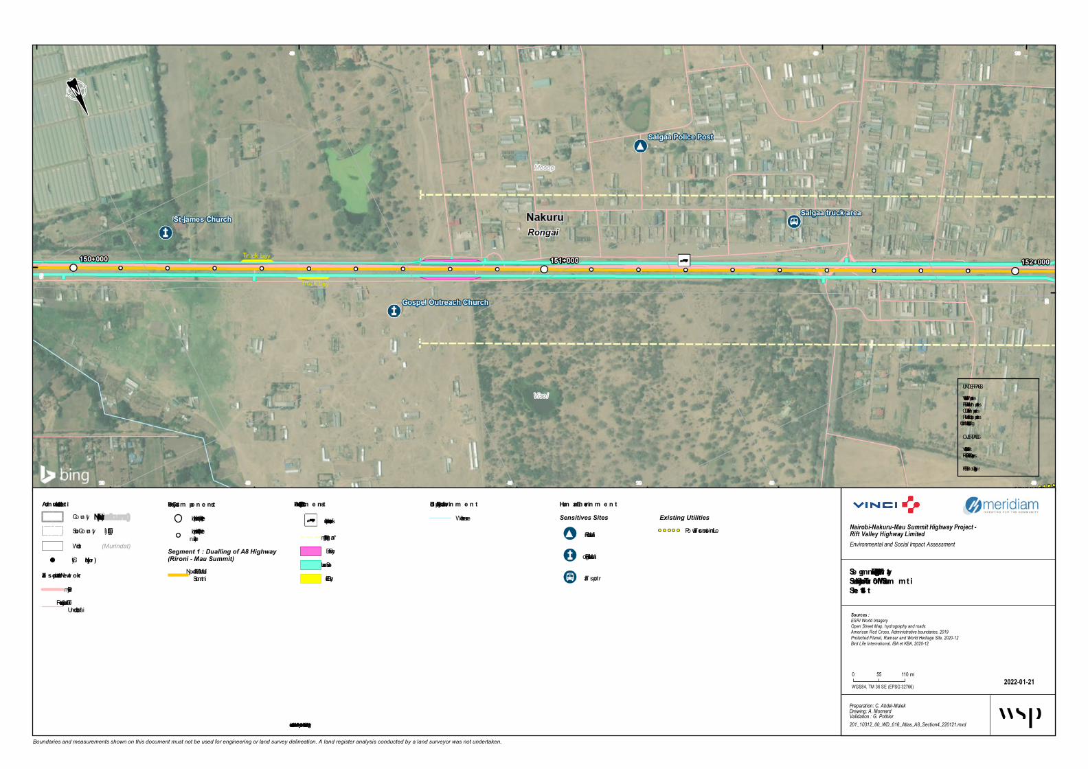
483 000
483 000
483 500
483 500
484 000
484 000484 500
9 976 5009 976 500
9 977 000
9 977 000 9 977 500
9 977 500
Boundaries and measurements shown on this document must not be used for engineering or land survey delineation. A land register analysis conducted by a land surveyor was not undertaken.
Biophys ical En viro n m e n tWatercourse
Se gm e n t 1 - Duallin g of A8 HighwaySe ctio n 4 - Njoro Turn o ff – Mau Sum m itShe e t 4-11
2022-01-21
Nairobi-Nakuru-Mau Summit Highway Project - Rift Valley Highway LimitedEnvironmental and Social Impact Assessment
Preparation: C. Abdel-MalekDrawing: A. MonnardValidation : G. Pothier201_10312_00_WD_016_Atlas_A8_Section4_220121.mxd
Sources :ESRI World ImageryOpen Street Map, hydrography and roadsAmerican Red Cross, Administrative boundaries, 2019Protected Planet, Ramsar and World Heritage Site, 2020-12Bird Life International, IBA et KBA, 2020-12
WGS84, TM 36 SE (EPSG 32766)
0 55 110m
Adm in is trative Lim itsCoun ty(Nakuru)
(Gilgil)Sub -Coun ty(Murindat)Ward
Proje ct Co m po n e n tsKilometric poin t (1 km in terval)Kilometric poin t (100 min terval)
Segment 1 : Dualling of A8 Highway(Rironi - Mau Summit)
4 - Njoro Turn off – MauSummit
Hum an En viro n m e n tSensitives Sites
Pub lic In stitutio n
Religio us In stitutio n
Tran sport
Existing UtilitiesPo wer Tran smissio n Lin e
City(Njoro)
Tran sportatio n Ne tw o rkPrimaryTertiary, Residen tial orUn classified
Structural Proje ct Ele m e n ts
Access to future truck park
Lightin g Urb an *Bus BayService Lan eTruck Bay
UNDERPASSVUP = Vehicule Un derpassPUP = Pedestrian Un derpassCUP = Catle Un derpassRUP = Railway Un derpassWLC = Wild Life Cro ssin g
OVERPASSVOP = Vehicule OverpassROP = Railway OverpassFOB = Fo o t Overb ridge
* Illustrated furthe r fro m the road for be tte r le gibility

481 000481 500
481 500
482 000
482 000
482 500
482 500
483 000
483 000
9 977 000
9 977 5009 977 500
9 978 000
9 978 000
9 978 500
Boundaries and measurements shown on this document must not be used for engineering or land survey delineation. A land register analysis conducted by a land surveyor was not undertaken.
Biophysical En viro n m e n tWa tercourse
Se gm e n t 1 - Duallin g of A8 HighwaySe ctio n 4 - Njoro Turn o ff – Mau Sum m itShe e t 4-12
2022-01-25
Nairobi-Nakuru-Mau Summit Highway Project - Rift Valley Highway LimitedEnvironmental and Social Impact Assessment
Preparation: C. Abdel-MalekDrawing: A. MonnardValidation : G. Pothier201_10312_00_WD_016_Atlas_A8_Section4_220125.mxd
Sources :ESRI World ImageryOpen Street Map, hydrography and roadsAmerican Red Cross, Administrative boundaries, 2019Protected Planet, Ramsar and World Heritage Site, 2020-12Bird Life International, IBA et KBA, 2020-12
WGS84, TM 36 SE (EPSG 32766)
0 55 110 m
Adm in istrative Lim itsCounty(Nakuru)
(Gilgil)Sub-County(Murindat)Wa rd
Proje ct Co m po n e n tsKilom etric point (1 km in terva l)Kilom etric point (100 min terva l)
Segment 1 : Dualling of A8 Highway(Rironi - Mau Summit)
4 - Njoro Turnoff – Ma uSum m it
Hum an En viro n m e n tSensitives Sites
Accident Spot
Fa rm in g a ctivities
Ga s Sta tion
School In stitution
Stop Over
Accident Zone
Existing UtilitiesPower Tra n sm ission Line
City(Njoro)
Tran sportatio n Ne tw o rkPrim a ryTertia ry, Residentia l orUncla ssified
Structural Proje ct
Overpa ss
Underpa ss
Pedestria n fa cility
Run-off Wa ter Trea tm entEquipm entLightin g Urba n *Bus Ba yService La ne
Wildlife Crossing
Wa terwa y Crossing
UNDERPASSVUP = Vehicule Underpa ssPUP = Pedestria n Underpa ssCUP = Ca tle Underpa ssRUP = Ra ilwa y Underpa ssWLC = Wild Life Crossin g
OVERPASSVOP = Vehicule Overpa ssROP = Ra ilwa y Overpa ssFOB = Foot Overbridge
* Illustrate d furthe r fro m the road for be tte r le gibility
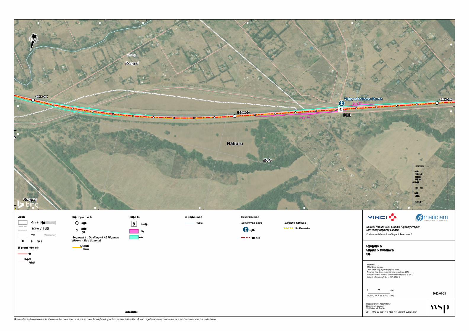
479 000
479 000
479 500
479 500
480 000
480 000
480 500
480 500
481 000481 000
9 977 500
9 977 500
9 978 000
9 978 0009 978 500
Boundaries and measurements shown on this document must not be used for engineering or land survey delineation. A land register analysis conducted by a land surveyor was not undertaken.
Bio physical En viro n men tWatercourse
Segmen t 1 - Duallin g o f A8 HighwaySectio n 4 - Njo ro Turn o ff – Mau SummitSheet 4-13
2022-01-21
Nairobi-Nakuru-Mau Summit Highway Project - Rift Valley Highway LimitedEnvironmental and Social Impact Assessment
Preparation: C. Abdel-MalekDrawing: A. MonnardValidation : G. Pothier201_10312_00_WD_016_Atlas_A8_Section4_220121.mxd
Sources :ESRI World ImageryOpen Street Map, hydrography and roadsAmerican Red Cross, Administrative boundaries, 2019Protected Planet, Ramsar and World Heritage Site, 2020-12Bird Life International, IBA et KBA, 2020-12
WGS84, TM 36 SE (EPSG 32766)
0 55 110m
Admin istrative LimitsCoun ty(Nakuru)
(Gilgil)Sub -Coun ty(Murindat)Ward
Pro ject Co mp o n en tsKilometric poin t (1 km in terval)Kilometric poin t (100 min terval)
Segment 1 : Dualling of A8 Highway(Rironi - Mau Summit)
4 - Njoro Turn off – MauSummit
Human En viro n men tSensitives Sites
Religio us In stitutio n
Acciden t Zo n e
Existing UtilitiesPo wer Tran smissio n Lin e
City(Njo ro )
Tran sp o rtatio n Netw o rkPrimaryTertiary, Residen tial orUn classified
Structural Pro ject Elemen ts
Fo o t Overb ridge
Bus BayService Lan e
UNDERPASSVUP = Vehicule Un derpassPUP = Pedestrian Un derpassCUP = Catle Un derpassRUP = Railway Un derpassWLC = Wild Life Cro ssin g
OVERPASSVOP = Vehicule OverpassROP = Railway OverpassFOB = Fo o t Overb ridge
* Illustrated further fro m the ro ad fo r better legibility

477 000
477 000
477 500
477 500
478 000
478 000
478 500
478 500
479 0009 977 500
9 977 500
9 978 000
9 978 000
Boundaries and measurements shown on this document must not be used for engineering or land survey delineation. A land register analysis conducted by a land surveyor was not undertaken.
Bio p hysical Enviro nmentWatercourse
Seg ment 1 - Du alling o f A8 Hig hwaySectio n 4 - Njo ro Tu rno ff – Mau Su mmitSheet 4-14
2022-01-21
Nairobi-Nakuru-Mau Summit Highway Project - Rift Valley Highway LimitedEnvironmental and Social Impact Assessment
Preparation: C. Abdel-MalekDrawing: A. MonnardValidation : G. Pothier201_10312_00_WD_016_Atlas_A8_Section4_220121.mxd
Sources :ESRI World ImageryOpen Street Map, hydrography and roadsAmerican Red Cross, Administrative boundaries, 2019Protected Planet, Ramsar and World Heritage Site, 2020-12Bird Life International, IBA et KBA, 2020-12
WGS84, TM 36 SE (EPSG 32766)
0 55 110m
Administrative LimitsCoun ty(Naku ru )
(Gilgil)Sub -Coun ty(Murindat)Ward
Pro ject Co mp o nentsKilometric poin t (1 km in terval)Kilometric poin t (100 min terval)
Segment 1 : Dualling of A8 Highway(Rironi - Mau Summit)
4 - Njoro Turn off – MauSummit
Hu man Enviro nmentSensitives Sites
In dustry
Acciden t Zo n eCity(Njo ro )
Transp o rtatio n Netwo rkPrimaryTertiary, Residen tial orUn classified
Stru ctu ral Pro jectElements
Service Lan e
UNDERPASSVUP = Vehicule Un derpassPUP = Pedestrian Un derpassCUP = Catle Un derpassRUP = Railway Un derpassWLC = Wild Life Cro ssin g
OVERPASSVOP = Vehicule OverpassROP = Railway OverpassFOB = Fo o t Overb ridge
* Illu strated fu rther fro m the ro ad fo r better leg ibility

476 000
476 000
476 500
476 500
477 000
477 000
477 500
477 500
478 000
478 000
9 977 000
9 977 000
9 977 500
9 977 500
Boundaries and measurements shown on this document must not be used for engineering or land survey delineation. A land register analysis conducted by a land surveyor was not undertaken.
Bio physical En viro n men tWatercourse
Segmen t 1 - Duallin g o f A8 HighwaySectio n 4 - Njo ro Turn o ff – Mau SummitSheet 4-15
2022-01-21
Nairobi-Nakuru-Mau Summit Highway Project - Rift Valley Highway LimitedEnvironmental and Social Impact Assessment
Preparation: C. Abdel-MalekDrawing: A. MonnardValidation : G. Pothier201_10312_00_WD_016_Atlas_A8_Section4_220121.mxd
Sources :ESRI World ImageryOpen Street Map, hydrography and roadsAmerican Red Cross, Administrative boundaries, 2019Protected Planet, Ramsar and World Heritage Site, 2020-12Bird Life International, IBA et KBA, 2020-12
WGS84, TM 36 SE (EPSG 32766)
0 55 110m
Admin istrative LimitsCoun ty(Nakuru)
(Gilgil)Sub -Coun ty(Murindat)Ward
Pro ject Co mp o n en tsKilometric poin t (1 km in terval)Kilometric poin t (100 min terval)
Segment 1 : Dualling of A8 Highway(Rironi - Mau Summit)
4 - Njo ro Turn o ff – MauSummit
Human En viro n men tSensitives Sites
Health Facilities
Acciden t Zo n eFlo o din g area
City(Njo ro )
Tran sp o rtatio n Netw o rkPrimaryTertiary, Residen tial o rUn classified
Structural Pro ject Elemen ts
OverpassRun -o ff Water Treatmen tEquipmen tBus BayService Lan eTruck Bay
UNDERPASSVUP = Vehicule Un derpassPUP = Pedestrian Un derpassCUP = Catle Un derpassRUP = Railway Un derpassWLC = Wild Life Cro ssin g
OVERPASSVOP = Vehicule OverpassROP = Railway OverpassFOB = Fo o t Overb ridge
* Illustrated further fro m the ro ad fo r better legibility

475 000
475 000
475 500
475 500
476 000476 000
476 500476 500
9 975 500
9 975 500
9 976 000
9 976 000
9 976 500
9 976 500
9 977 0009 977 500
9 977 500
Boundaries and measurements shown on this document must not be used for engineering or land survey delineation. A land register analysis conducted by a land surveyor was not undertaken.
Biophys ical En viro n m e n tWatercourse
Se gm e n t 1 - Duallin g of A8 HighwaySe ctio n 4 - Njoro Turn o ff – Mau Sum m itShe e t 4-16
2022-01-21
Nairobi-Nakuru-Mau Summit Highway Project - Rift Valley Highway LimitedEnvironmental and Social Impact Assessment
Preparation: C. Abdel-MalekDrawing: A. MonnardValidation : G. Pothier201_10312_00_WD_016_Atlas_A8_Section4_220121.mxd
Sources :ESRI World ImageryOpen Street Map, hydrography and roadsAmerican Red Cross, Administrative boundaries, 2019Protected Planet, Ramsar and World Heritage Site, 2020-12Bird Life International, IBA et KBA, 2020-12
WGS84, TM 36 SE (EPSG 32766)
0 55 110 m
Adm in is trative Lim itsCounty(Nakuru)
(Gilgil)Sub-County(Murindat)Ward
Proje ct Co m po n e n tsKilom etric point (1 km interval)Kilom etric point (100 minterval)
Segment 1 : Dualling of A8 Highway(Rironi - Mau Summit)
4 - Njoro Turnoff – MauSum m it
Quarrie s co n s ide re d
Rejected
Hum an En viro n m e n tSensitives Sites
Farm ing activities
Health Facilities
School Institution
Accident Z oneFlooding area
Point of InterestSchool, College orKindergarrdenToiletBuildings
City(Njoro)
Tran sportatio n Ne tw o rkPrim aryTertiary, Residential orUnclassified
Structural Proje ct Ele m e n ts
Overpass
UnderpassRun-off Water Treatm entEquipm entClim bing Lane *Service LaneTruck Bay
UNDERPASSVUP = Veh icule UnderpassPUP = Pedestrian UnderpassCUP = Catle UnderpassRUP = Railway UnderpassWLC = Wild Life Crossing
OVERPASSVOP = Veh icule OverpassROP = Railway OverpassFOB = Foot Overbridge
* Illustrated furthe r fro m the road for be tte r le gibility

474 500
474 500
475 000
475 000
475 500
475 500
476 000476 000
9 975 000
9 975 000
9 975 500
9 975 500
9 976 000
9 976 0009 976 500
Boundaries and measurements shown on this document must not be used for engineering or land survey delineation. A land register analysis conducted by a land surveyor was not undertaken.
Bio physical En viro n men tWa tercourse
Segmen t 1 - Duallin g o f A8 HighwaySectio n 4 - Njo ro Turn o ff – Mau SummitSheet 4-17
2022-01-21
Nairobi-Nakuru-Mau Summit Highway Project - Rift Valley Highway LimitedEnvironmental and Social Impact Assessment
Preparation: C. Abdel-MalekDrawing: A. MonnardValidation : G. Pothier201_10312_00_WD_016_Atlas_A8_Section4_220121.mxd
Sources :ESRI World ImageryOpen Street Map, hydrography and roadsAmerican Red Cross, Administrative boundaries, 2019Protected Planet, Ramsar and World Heritage Site, 2020-12Bird Life International, IBA et KBA, 2020-12
WGS84, TM 36 SE (EPSG 32766)
0 55 110 m
Admin istrative LimitsCounty(Nakuru)
(Gilgil)Sub-County(Murindat)Wa rd
Pro ject Co mp o n en tsKilom etric point (1 km in terva l)Kilom etric point (100 min terva l)
Segment 1 : Dualling of A8 Highway(Rironi - Mau Summit)
4 - Njoro Turnoff – Ma uSum m it
Human En viro n men tSensitives Sites
Fa rm in g a ctivities
Public In stitution
School In stitution
Accident ZoneSen sitive SiteBuildings
City(Njo ro )
Tran sp o rtatio n Netw o rkPrim a ryTertia ry, Residentia l orUncla ssified
Structural Pro ject Elemen ts
Underpa ss
Lighting Urba n *Clim bin g La ne *Bus Ba yService La ne
UNDERPASSVUP = Vehicule Underpa ssPUP = Pedestria n Underpa ssCUP = Ca tle Underpa ssRUP = Ra ilwa y Underpa ssWLC = Wild Life Crossin g
OVERPASSVOP = Vehicule Overpa ssROP = Ra ilwa y Overpa ssFOB = Foot Overbridge
* Illustrated further fro m the ro ad fo r better legibility

Bus ba y
Bus ba y
CLIMBING LANEB u s b a y s h e l t e rCUP
Molo
Mumberes/Maji Mazuri
Molo
Koibatek
Nak uru
Baringo
163+000162+000
164+000
472 500
472 500
473 000
473 000
473 500
473 500
474 000
474 000
474 5009 975 000
9 975 000
9 975 500
Boundaries and measurements shown on this document must not be used for engineering or land survey delineation. A land register analysis conducted by a land surveyor was not undertaken.
Bio physical Enviro nm entWa tercourse
Segm ent 1 - Dualling o f A8 HighwaySectio n 4 - Njo ro Turno ff – Mau Sum m itSheet 4-18
2022-01-25
Nairobi-Nakuru-Mau Summit Highway Project - Rift Valley Highway LimitedEnvironmental and Social Impact Assessment
Preparation: C. Abdel-MalekDrawing: A. MonnardValidation : G. Pothier201_10312_00_WD_016_Atlas_A8_Section4_220125.mxd
Sources :ESRI World ImageryOpen Street Map, hydrography and roadsAmerican Red Cross, Administrative boundaries, 2019Protected Planet, Ramsar and World Heritage Site, 2020-12Bird Life International, IBA et KBA, 2020-12
WGS84, TM 36 SE (EPSG 32766)
0 55 110 m
Adm inistrative Lim itsCounty(Nak uru)
(Gilgil)Sub-County(Murindat)Wa rd
Pro ject Co m po nentsKilom etric point (1 km in terva l)Kilom etric point (100 min terva l)
Segment 1 : Dualling of A8 Highway(Rironi - Mau Summit)
4 - Njoro Turnoff – Ma uSum m it
Hum an Enviro nm entSensitives Sites
Accident Spot
Accident ZoneSen sitive SiteBuildings
Landuse (OSM)Forest
Protected AreasNatio nal Level
Forest Reserve
City(Njo ro )
Transpo rtatio n Netw o rkPrim a ryTertia ry, Residentia l orUncla ssified
Structural Pro ject
Underpa ss
Clim bin g La ne *Bus Ba yService La ne
Wildlife CrossingCa nopy Bridges (exa ctloca tion to be va lida ted)
UNDERPASSVUP = Vehicule Underpa ssPUP = Pedestria n Underpa ssCUP = Ca tle Underpa ssRUP = Ra ilwa y Underpa ssWLC = Wild Life Crossin g
OVERPASSVOP = Vehicule Overpa ssROP = Ra ilwa y Overpa ssFOB = Foot Overbridge
* Illustrated further fro m the ro ad fo r b etter legib ility

471 000
471 000
471 500
471 500
472 000
472 000
472 500
472 500
9 975 000
9 975 500
9 975 500
9 976 000
Boundaries and measurements shown on this document must not be used for engineering or land survey delineation. A land register analysis conducted by a land surveyor was not undertaken.
Biop hysic al Environm entWa tercourse
Segm ent 1 - Dualling of A8 HighwaySec tion 4 - Njoro Turnoff – Mau Sum m itSheet 4-19
2022-01-21
Nairobi-Nakuru-Mau Summit Highway Project - Rift Valley Highway LimitedEnvironmental and Social Impact Assessment
Preparation: C. Abdel-MalekDrawing: A. MonnardValidation : G. Pothier201_10312_00_WD_016_Atlas_A8_Section4_220121.mxd
Sources :ESRI World ImageryOpen Street Map, hydrography and roadsAmerican Red Cross, Administrative boundaries, 2019Protected Planet, Ramsar and World Heritage Site, 2020-12Bird Life International, IBA et KBA, 2020-12
WGS84, TM 36 SE (EPSG 32766)
0 55 110 m
Adm inistrative Lim itsCounty(Nak uru)
(Gilgil)Sub-County(Murindat)Wa rd
Projec t Com p onentsKilom etric point (1 km in terva l)Kilom etric point (100 min terva l)
Segment 1 : Dualling of A8 Highway(Rironi - Mau Summit)
4 - Njoro Turnoff – Ma uSum m it
Quarries c onsidered
Rejected
Hum an Environm entSensitives Sites
Accident Spot
School In stitution
Accident ZoneFlooding a rea
UtilityExisting Utilities
La m p PostLanduse (OSM)
Forest
Protected AreasNational Level
Forest Reserve
City(Njoro)
Transp ortation NetworkPrim a ryTertia ry, Residentia l orUncla ssified
Struc tural Projec t Elem ents
Underpa ss
Lighting Urba n *Clim bin g La ne *Bus Ba yService La neTruck Ba y
Wildlife CrossingCa nopy Bridges (exa ctloca tion to be va lida ted)
UNDERPASSVUP = Vehicule Underpa ssPUP = Pedestria n Underpa ssCUP = Ca tle Underpa ssRUP = Ra ilwa y Underpa ssWLC = Wild Life Crossin g
OVERPASSVOP = Vehicule Overpa ssROP = Ra ilwa y Overpa ssFOB = Foot Overbridge
* Illustrated further from the road for better legibility

469 000
469 000
469 500
469 500
470 000
470 000
470 500
470 500
471 000
471 000
9 975 5009 975 500
9 976 000
9 976 000
9 976 500
9 977 000
9 977 000
Boundaries and measurements shown on this document must not be used for engineering or land survey delineation. A land register analysis conducted by a land surveyor was not undertaken.
Biophysical En viron m entWatercourse
Segm ent 1 - Dualling of A8 HighwaySection 4 - Njoro Turnoff – Mau Sum m itSheet 4-20
2022-01-21
Nairobi-Nakuru-Mau Summit Highway Project - Rift Valley Highway LimitedEnvironmental and Social Impact Assessment
Preparation: C. Abdel-MalekDrawing: A. MonnardValidation : G. Pothier201_10312_00_WD_016_Atlas_A8_Section4_220121.mxd
Sources :ESRI World ImageryOpen Street Map, hydrography and roadsAmerican Red Cross, Administrative boundaries, 2019Protected Planet, Ramsar and World Heritage Site, 2020-12Bird Life International, IBA et KBA, 2020-12
WGS84, TM 36 SE (EPSG 32766)
0 55 110m
Ad m inistrative Lim itsCoun ty(Nakuru)
(Gilgil)Sub -Coun ty(Murindat)Ward
Project Com ponentsKilometric poin t (1 km in terval)Kilometric poin t (100 min terval)
Segment 1 : Dualling of A8 Highway(Rironi - Mau Summit)
4 - Njoro Turn off – MauSummit
Hum an En viron m entSensitives Sites
Acciden t Spo t
Acciden t Zo n eFlo o din g area
UtilityExisting Utilities
Lamp Po stLanduse (OSM)
Fo rest
Protected AreasNational Level
Forest Reserve
City(Njoro)
Transportation NetworkPrimarySeco n daryTertiary, Residen tial orUn classified
Structural Project Elem ents
Overpass
Lightin g Urb an *Bus BayService Lan e
Wildlife CrossingCan o py Bridges (exactlo catio n to b e validated)
Un derpass
UNDERPASSVUP = Vehicule Un derpassPUP = Pedestrian Un derpassCUP = Catle Un derpassRUP = Railway Un derpassWLC = Wild Life Cro ssin g
OVERPASSVOP = Vehicule OverpassROP = Railway OverpassFOB = Fo o t Overb ridge
* Illustrated further from the road for better legibility

FOBB u s b a y s h e l t e rCLIMBING LAN
E
Kamara
Mumberes/Maji Mazuri
Kuresoi North
Koibatek
Nak uru
Baringo
169+000
168+000
170+000
468 500
468 500
469 000
469 000
469 500
469 500
9 977 000
9 977 500
9 977 500
9 978 000
9 978 000
9 978 500
9 978 500 9 979 000
9 979 000
Boundaries and measurements shown on this document must not be used for engineering or land survey delineation. A land register analysis conducted by a land surveyor was not undertaken.
Bio physical Enviro nm entWa tercourse
Segm ent 1 - Dualling o f A8 HighwaySectio n 4 - Njo ro Turno ff – Mau Sum m itSheet 4-21
2022-01-27
Nairobi-Nakuru-Mau Summit Highway Project - Rift Valley Highway LimitedEnvironmental and Social Impact Assessment
Preparation: C. Abdel-MalekDrawing: A. MonnardValidation : G. Pothier201_10312_00_WD_016_Atlas_A8_Section4_220127.mxd
Sources :ESRI World ImageryOpen Street Map, hydrography and roadsAmerican Red Cross, Administrative boundaries, 2019Protected Planet, Ramsar and World Heritage Site, 2020-12Bird Life International, IBA et KBA, 2020-12
WGS84, TM 36 SE (EPSG 32766)
0 55 110 m
Adm inistrative Lim itsCounty(Nak uru)
(Gilgil)Sub-County(Murindat)Wa rd
Pro ject Co m po nentsKilom etric point (1 km in terva l)Kilom etric point (100 min terva l)
Segment 1 : Dualling of A8 Highway(Rironi - Mau Summit)
4 - Njoro Turnoff – Ma uSum m it
Hum an Enviro nm entSensitives Sites
Accident Spot
Accident ZoneLanduse (OSM)
Forest
ProtectedNatio nal Level
Forest Reserve
City(Njo ro )
Transpo rtatio n Netw o rkPrim a ryTertia ry, Residentia l orUncla ssified
Structural Pro ject Elem ents
Foot Overbridge
Run-off Wa ter Trea tm entEquipm entClim bin g La ne *Service La ne
UNDERPASSVUP = Vehicule Underpa ssPUP = Pedestria n Underpa ssCUP = Ca tle Underpa ssRUP = Ra ilwa y Underpa ssWLC = Wild Life Crossin g
OVERPASSVOP = Vehicule Overpa ssROP = Ra ilwa y Overpa ssFOB = Foot Overbridge
* Illustrated further fro m the ro ad fo r b etter legib ility
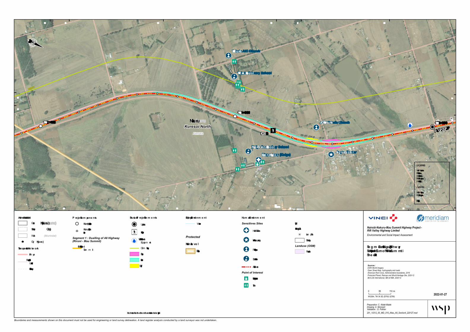
SDA Church
Jog oo Ce nte r
Tabain AIC Church
AGC Tabain Church
Dispe nsary (Koig e)
Tabain P rim ary School
Koig e Secondary School
FOB P UP /CUP
CLIMBING LANEB u s b a y s h e l t e rCLIMB
ING LANE
KamaraKuresoi North Nakuru
171+000
170+000 172+000
467 500
467 500
468 000468 500
468 500
9 978 5009 978 500
9 979 000
9 979 000
9 979 500
9 979 500
9 980 000
9 980 000 9 980 500
9 980 500
Boundaries and measurements shown on this document must not be used for engineering or land survey delineation. A land register analysis conducted by a land surveyor was not undertaken.
Biophysical Environm e ntWatercourse
Se g m e nt 1 - Dualling of A8 Hig hwaySection 4 - Njoro Turnoff – Mau Sum m itShe e t 4-22
2022-01-27
Nairobi-Nakuru-Mau Summit Highway Project - Rift Valley Highway LimitedEnvironmental and Social Impact Assessment
Preparation: C. Abdel-MalekDrawing: A. MonnardValidation : G. Pothier201_10312_00_WD_016_Atlas_A8_Section4_220127.mxd
Sources :ESRI World ImageryOpen Street Map, hydrography and roadsAmerican Red Cross, Administrative boundaries, 2019Protected Planet, Ramsar and World Heritage Site, 2020-12Bird Life International, IBA et KBA, 2020-12
WGS84, TM 36 SE (EPSG 32766)
0 55 110 m
Adm inistrative Lim itsCounty(Nakuru)
(Gilgil)Sub-County(Murindat)Ward
P roje ct Com pone ntsKilom etric point (1 km interval)Kilom etric point (100 minterval)
Segment 1 : Dualling of A8 Highway(Rironi - Mau Summit)
4 - Njoro Turnoff – MauSum m it
Hum an Environm e ntSensitives Sites
Health Facilities
Market and shopping area
Religious Institution
School Institution
Accident Z onePoint of Interest
Drinking Water or Water Well
Toilet
UtilityExisting Utilitie s
Lam p PostBuildings
Landuse (OSM)Residential
ProtectedNational Le ve l
Forest Reserve
City(Njoro)
Transportation Ne tw orkPrim aryTertiary, Residential orUnclassifiedFootway, Path or Track
Structural P roje ct Ele m e nts
Underpass
Foot Overbridge
Run-off Water Treatm entEquipm entClim bing Lane *Bus BayService LaneTruck Bay
UNDERPASSVUP = Veh icule UnderpassPUP = Pedestrian UnderpassCUP = Catle UnderpassRUP = Railway UnderpassWLC = Wild Life Crossing
OVERPASSVOP = Veh icule OverpassROP = Railway OverpassFOB = Foot Overbridge
* Illustrate d furthe r from the road for be tte r le g ibility

466 500
466 500
467 000
467 000
467 500
467 500
468 000
468 000
9 980 5009 980 500
9 981 000
9 981 000
9 981 500
9 982 000
9 982 000
Boundaries and measurements shown on this document must not be used for engineering or land survey delineation. A land register analysis conducted by a land surveyor was not undertaken.
Biop hysic al Environm entWa tercourse
Segm ent 1 - Dualling of A8 HighwaySec tion 4 - Njoro Turnoff – Mau Sum m itSheet 4-23
2022-01-27
Nairobi-Nakuru-Mau Summit Highway Project - Rift Valley Highway LimitedEnvironmental and Social Impact Assessment
Preparation: C. Abdel-MalekDrawing: A. MonnardValidation : G. Pothier201_10312_00_WD_016_Atlas_A8_Section4_220127.mxd
Sources :ESRI World ImageryOpen Street Map, hydrography and roadsAmerican Red Cross, Administrative boundaries, 2019Protected Planet, Ramsar and World Heritage Site, 2020-12Bird Life International, IBA et KBA, 2020-12
WGS84, TM 36 SE (EPSG 32766)
0 55 110 m
Adm inistrative Lim itsCounty(Nak uru)
(Gilgil)Sub-County(Murindat)Wa rd
Projec t Com p onentsKilom etric point (1 km in terva l)Kilom etric point (100 min terva l)
Segment 1 : Dualling of A8 Highway(Rironi - Mau Summit)
4 - Njoro Turnoff – Ma uSum m it
Hum an Environm entSensitives Sites
Ma rket a n d shopping a rea
Public In stitution
Religious In stitution
Accident ZoneFlooding a rea
Future DevelopmentsKa ronga Ma rket undercon struction
UtilityExisting Utilities
La m p PostPipeline crossin g
City(Njoro)
Transp ortation NetworkPrim a ryTertia ry, Residentia l orUncla ssified
Struc tural Projec t Elem ents
Underpa ss
Foot Overbridge
Clim bin g La ne *Service La ne
UNDERPASSVUP = Vehicule Underpa ssPUP = Pedestria n Underpa ssCUP = Ca tle Underpa ssRUP = Ra ilwa y Underpa ssWLC = Wild Life Crossin g
OVERPASSVOP = Vehicule Overpa ssROP = Ra ilwa y Overpa ssFOB = Foot Overbridge
* Illustrated further from the road for better legibility

Ward Office
T otal Center
T otal Dispensary
Mau Summit Police Post
St T imothy
AGC Mau Summit
Mau summitinterch ang e mosque
FOBB u s b a y s h e l t e rKamaraKuresoi North Nak uru
174+000
465 000
465 000
465 500
465 500
466 000
466 000
466 500
466 500
9 981 5009 981 500
9 982 000
9 982 000
9 982 500
9 982 500 9 983 000
9 983 000
Boundaries and measurements shown on this document must not be used for engineering or land survey delineation. A land register analysis conducted by a land surveyor was not undertaken.
Bioph ysical EnvironmentWatercourseWetlan d
Seg ment 1 - Dualling of A8 Hig h w aySection 4 - Njoro T urnoff – Mau SummitSheet 4-24
2022-01-26
Nairobi-Nakuru-Mau Summit Highway Project - Rift Valley Highway LimitedEnvironmental and Social Impact Assessment
Preparation: C. Abdel-MalekDrawing: A. MonnardValidation : G. Pothier201_10312_00_WD_016_Atlas_A8_Section4_220126.mxd
Sources :ESRI World ImageryOpen Street Map, hydrography and roadsAmerican Red Cross, Administrative boundaries, 2019Protected Planet, Ramsar and World Heritage Site, 2020-12Bird Life International, IBA et KBA, 2020-12
WGS84, TM 36 SE (EPSG 32766)
0 55 110m
Administrative LimitsCoun ty(Nak uru)
(Gilgil)Sub -Coun ty(Murindat)Ward
Project ComponentsKilometric poin t (1 km in terval)Kilometric poin t (100 min terval)
Segment 1 : Dualling of A8 Highway(Rironi - Mau Summit)
4 - Njo ro Turn o ff – MauSummit
Human EnvironmentSensitives Sites
Pub lic In stitutio n
Sen sitive Site
Acciden t Zo n eFlo o din g area
Worship CentersChristian
Muslim
UtilityExisting Utilities
Lamp Po stBuildin gs
Landuse (OSM)CommercialFarmlan dFo restScrub
Protected AreasCity(Njoro)
T ransportation Netw orkPrimaryTertiary, Residen tial o rUn classifiedFo otway, Path o r Track
Structural Project Elements
Un derpass
Bus b ay shelter
Fo ot Overb ridge
Roun d ab out
Run -o ff Water Treatmen tEquipmen tService Lan e
UNDERPASSVUP = Vehicule Un derpassPUP = Pedestrian Un derpassCUP = Catle Un derpassRUP = Railway Un derpassWLC = Wild Life Cro ssin g
OVERPASSVOP = Vehicule OverpassROP = Railway OverpassFOB = Fo o t Overb ridge
* Illustrated further from the road for better leg ibility

Ngenia High Sch o o l
Kam irith u Po lytech nic
Kam anduraPrim ary Sch o o l
U-Turn V UP/PUP/CUPKam andura PCEA Ch urch
Truck b ay
Truck bay
CUP
CUP
Limuru Central
LimuruKiam bu
B3
A104
B3;A
104
C62
A104
Kam andura-Maai Mah iu
-Naro k Ro ad
Nairo bi-Nakuru Ro ad
Link Ro ad
Eldo ret-Malaba Ro ad
Eldo ret-Malaba Ro ad2+000
1+000
0+000
1+000
569 500
569 500
570 000
570 000
570 500
570 500
9 874 5009 874 500
9 875 000
9 875 000
9 875 500
9 875 500 9 876 000
9 876 000
Boundaries and measurements shown on this document must not be used for engineering or land survey delineation. A land register analysis conducted by a land surveyor was not undertaken.
Bio ph ysical Enviro nm entWaterco urse
Segm ent 2 - Strength ening o f A8-So uth High waySectio n 5 - Riro ni – Mai Mah iuSh eet 5-1
2022-01-21
Nairobi-Nakuru-Mau Summit Highway Project - Rift Valley Highway LimitedEnvironmental and Social Impact Assessment
Preparation: C. Abdel-MalekDrawing: A. MonnardValidation : G. Pothier201_10312_00_WD_016_Atlas_A8South_Section5_220121.mxd
Sources :ESRI World ImageryOpen Street Map, hydrography and roadsAmerican Red Cross, Administrative boundaries, 2019Protected Planet, Ramsar and World Heritage Site, 2020-12Bird Life International, IBA et KBA, 2020-12
WGS84, TM 36 SE (EPSG 32766)
0 55 110 m
Adm inistrative Lim itsCo unty(Nakuru)
(Gilgil)Sub -Co unty(Murindat)Ward
Pro ject Co m po nentsKilo m etric p o int (1 km interval)Kilo m etric p o int (100 minterval)
Segment 1 : Dualling of A8 Highway(Rironi - Mau Summit)
1 - Riro ni – NaivashaSegment 2 : Strengthening of A8-SouthHighway (Rironi - Naivasha)
5 - Riro ni – Mai Mahiu
Hum an Enviro nm entSensitives Sites
Scho o l Institutio n
Flo o ding areaPoint of Interest
Drinking Water o r Water WellWorship Centers
Christian
UtilityExisting Utilities
Lam p Po st
City(Njo ro )
Transpo rtatio n Netw o rkPrim aryTertiary, Residential o rUnclassifiedFo o tway, Path o r Track
Structural Pro ject Elem ents
Underpass
At-grade cro ssing
Fo o t Overb ridge
No ise Barrier *No ise Berm *Service LaneBus BayTruck Bay
UNDERPASSVUP = Vehicule UnderpassPUP = Pedestrian UnderpassCUP = Catle UnderpassRUP = Railway UnderpassWLC = Wild Life Cro ssing
OVERPASSVOP = Vehicule OverpassROP = Railway OverpassFOB = Fo o t Overb ridge
* Illustrated furth er fro m th e ro ad fo r better legibility

Ngen ia High School Muta ra k w a Police Post
Prin cess Resort Ba r a n d Resta ura n t
B3
B32
Ka ma n dura -Ma a i Ma hiu-Na rok Roa d
Da goretti Roa d
Muta ra k w a -Limuru Roa d
Kik uyu Esca rpmen t forest
4+000
3+000
2+000
568 000
568 000
568 500
568 500
569 000
569 000
569 500
569 500
9 875 5009 875 500
9 876 0009 876 000
9 876 500
9 876 500
9 877 000
9 877 500
Boundaries and measurements shown on this document must not be used for engineering or land survey delineation. A land register analysis conducted by a land surveyor was not undertaken.
Biophysica l En viron men tWaterc ourse
Segmen t 2 - Stren gthen in g of A8-South Highw a ySection 5 - Riron i – Ma i Ma hiuSheet 5-2
2022-01-21
Nairobi-Nakuru-Mau Summit Highway Project - Rift Valley Highway LimitedEnvironmental and Social Impact Assessment
Preparation: C. Abdel-MalekDrawing: A. MonnardValidation : G. Pothier201_10312_00_WD_016_Atlas_A8South_Section5_220121.mxd
Sources :ESRI World ImageryOpen Street Map, hydrography and roadsAmerican Red Cross, Administrative boundaries, 2019Protected Planet, Ramsar and World Heritage Site, 2020-12Bird Life International, IBA et KBA, 2020-12
WGS84, TM 36 SE (EPSG 32766)
0 55 110 m
Admin istra tive LimitsCounty(Na k uru)
(Gilgil)Sub-County(Murindat)Ward
Project Compon en tsKilom etric p oint (1 km interval)Kilom etric p oint (100 minterval)
Segment 2 : Strengthening of A8-SouthHighway (Rironi - Naivasha)
5 - Rironi – Mai Mahiu
Huma n En viron men tFlooding area
Point of Interest
Polic e
UtilityExistin g Utilities
Lam p PostLanduse (OSM)
Forest
Protected Areas
Im p ortant Bird Area (IBA)and Key Biodivesity Area(KBA)
City(Njoro)
Tra n sporta tion NetworkPrim arySecondaryTertiary, Residential orUnc lassifiedFootway, Path or Trac k
Structura l Project Elemen ts
UNDERPASSVUP = Vehic ule Underp assPUP = Pedestrian Underp assCUP = Catle Underp assRUP = Railway Underp assWLC = Wild Life Crossing
OVERPASSVOP = Vehic ule Overp assROP = Railway Overp assFOB = Foot Overbridge
* Illustra ted further from the roa d for better legibility

Kik uyu Esca rpmen tForest ReserveB3 Ka ma n dura -Ma a i Ma hiu-Na rok Roa dKik uyu Esca rpmen t forest
6+000
5+000
4+000
567 000
567 000567 500
567 500
568 000
568 000
568 500
568 500
9 877 000
9 877 500
9 877 500
9 878 000
9 878 000
9 878 500
9 878 500
9 879 000
Boundaries and measurements shown on this document must not be used for engineering or land survey delineation. A land register analysis conducted by a land surveyor was not undertaken.
Biophysica l En viron men tWaterc ourse
Segmen t 2 - Stren gthen in g of A8-South Highw a ySection 5 - Riron i – Ma i Ma hiuSheet 5-3
2022-01-21
Nairobi-Nakuru-Mau Summit Highway Project - Rift Valley Highway LimitedEnvironmental and Social Impact Assessment
Preparation: C. Abdel-MalekDrawing: A. MonnardValidation : G. Pothier201_10312_00_WD_016_Atlas_A8South_Section5_220121.mxd
Sources :ESRI World ImageryOpen Street Map, hydrography and roadsAmerican Red Cross, Administrative boundaries, 2019Protected Planet, Ramsar and World Heritage Site, 2020-12Bird Life International, IBA et KBA, 2020-12
WGS84, TM 36 SE (EPSG 32766)
0 55 110 m
Admin istra tive LimitsCounty(Na k uru)
(Gilgil)Sub-County(Murindat)Ward
Project Compon en tsKilom etric p oint (1 km interval)Kilom etric p oint (100 minterval)
Segment 2 : Strengthening of A8-SouthHighway (Rironi - Naivasha)
5 - Rironi – Mai Mahiu
Huma nEn viron men tUtilityExistin g Utilities
Lam p PostLanduse (OSM)
Forest
Protected AreasNa tion a l Level
Forest ReserveIm p ortant Bird Area (IBA)and Key Biodivesity Area(KBA)
City(Njoro)
Tra n sporta tion NetworkPrim aryTertiary, Residential orUnc lassifiedFootway, Path or Trac k
Structura l Project Elemen ts
UNDERPASSVUP = Vehic ule Underp assPUP = Pedestrian Underp assCUP = Catle Underp assRUP = Railway Underp assWLC = Wild Life Crossing
OVERPASSVOP = Vehic ule Overp assROP = Railway Overp assFOB = Foot Overbridge
* Illustra ted further from the roa d for better legibility

Truc k bay
Truc k bayKik uyu Escarpm entFo rest Reserve
B3Kam andura-Maai Mahiu-Naro k Ro adKik uyu Escarpm ent fo rest 8+0006+000
7+000
566 500566 500
567 000
567 000
567 500
567 500
9 879 000 9 879 500
9 879 500
9 880 000
9 880 000
9 880 500
9 880 500 9 881 000
9 881 000
Boundaries and measurements shown on this document must not be used for engineering or land survey delineation. A land register analysis conducted by a land surveyor was not undertaken.
Bio physical Enviro nm entWaterc ourse
Segm ent 2 - Strengthening o f A8-So uth HighwaySectio n 5 - Riro ni – Mai MahiuSheet 5-4
2022-01-21
Nairobi-Nakuru-Mau Summit Highway Project - Rift Valley Highway LimitedEnvironmental and Social Impact Assessment
Preparation: C. Abdel-MalekDrawing: A. MonnardValidation : G. Pothier201_10312_00_WD_016_Atlas_A8South_Section5_220121.mxd
Sources :ESRI World ImageryOpen Street Map, hydrography and roadsAmerican Red Cross, Administrative boundaries, 2019Protected Planet, Ramsar and World Heritage Site, 2020-12Bird Life International, IBA et KBA, 2020-12
WGS84, TM 36 SE (EPSG 32766)
0 55 110 m
Adm inistrative Lim itsCounty(Nak uru)
(Gilgil)Sub-County(Murindat)Ward
Pro ject Co m po nentsKilom etric p oint (1 km interval)Kilom etric p oint (100 minterval)
Segment 2 : Strengthening of A8-SouthHighway (Rironi - Naivasha)
5 - Rironi – Mai Mahiu
Hum anEnviro nm entLanduse (OSM)
ForestProtected AreasNatio nal Level
Forest ReserveIm p ortant Bird Area (IBA)and Key Biodivesity Area(KBA)
City(Njo ro )
Transpo rtatio n Netw o rkPrim aryTertiary, Residential orUnc lassifiedFootway, Path or Trac k
Structural Pro ject Elem entsTruck Bay
UNDERPASSVUP = Vehic ule Underp assPUP = Pedestrian Underp assCUP = Catle Underp assRUP = Railway Underp assWLC = Wild Life Crossing
OVERPASSVOP = Vehic ule Overp assROP = Railway Overp assFOB = Foot Overbridge
* Illustrated further fro m the ro ad fo r b etter legib ility

Liberty_Great Rift V alleyV iew point
3rd World V iew point
Rift V alleyV iew pointKik uyu Escarpment
Forest ReserveB3
Kamandura-Maai Mah iu-Narok Road
Kik uyu Escarpment forest
9+000
8+00010+000
566 500566 500
567 000
567 000
567 500
567 500
9 881 000
9 881 500
9 881 500
9 882 000
9 882 000
9 882 500
9 882 500
9 883 000
9 883 000
Boundaries and measurements shown on this document must not be used for engineering or land survey delineation. A land register analysis conducted by a land surveyor was not undertaken.
Bioph ysical EnvironmentWaterc ourse
Seg ment 2 - Streng th ening of A8-South Hig h w aySection 5 - Rironi – Mai Mah iuSheet 5-5
2022-02-01
Nairobi-Nakuru-Mau Summit Highway Project - Rift Valley Highway LimitedEnvironmental and Social Impact Assessment
Preparation: C. Abdel-MalekDrawing: A. MonnardValidation : G. Pothier201_10312_00_WD_016_Atlas_A8South_Section5_220201.mxd
Sources :ESRI World ImageryOpen Street Map, hydrography and roadsAmerican Red Cross, Administrative boundaries, 2019Protected Planet, Ramsar and World Heritage Site, 2020-12Bird Life International, IBA et KBA, 2020-12
WGS84, TM 36 SE (EPSG 32766)
0 55 110 m
Administrative LimitsCounty(Nak uru)
(Gilgil)Sub-County(Murindat)Ward
Project ComponentsKilom etric p oint (1 km interval)Kilom etric p oint (100 minterval)
Segment 2 : Strengthening of A8-SouthHighway (Rironi - Naivasha)
5 - Rironi – Mai Mahiu
Human EnvironmentSensitives Sites
Ac c ident Sp ot
Point of InterestArc haeological, Attrac tion,Monum ent or Viewp oint
Landuse (OSM)Forest
ProtectedNational Level
Forest ReserveIm p ortant Bird Area (IBA)and Key Biodivesity Area(KBA)
City(Njoro)
Transportation Netw orkPrim aryTertiary, Residential orUnc lassified
Structural Project Elements
UNDERPASSVUP = Vehic ule Underp assPUP = Pedestrian Underp assCUP = Catle Underp assRUP = Railway Underp assWLC = Wild Life Crossing
OVERPASSVOP = Vehic ule Overp assROP = Railway Overp assFOB = Foot Overbridge
* Illustrated further from the road for better leg ibility

3rd World View pointRift Valley
View point
Great Rift ValleyView point
Moran View point
Kik uyu EscarpmentForest Reserve
B3 Kamandura-Maai Mah iu-Narok Road
Kik uyu Escarpment forest
12+000
11+000
10+000
567 000
567 000
9 883 000
9 883 000
9 883 500
9 883 500
9 884 000
9 884 000
9 884 500
9 884 500
Boundaries and measurements shown on this document must not be used for engineering or land survey delineation. A land register analysis conducted by a land surveyor was not undertaken.
Bioph ysical EnvironmentWaterc ourse
Seg ment 2 - Streng th ening of A8-South Hig h w aySection 5 - Rironi – Mai Mah iuSheet 5-6
2022-02-01
Nairobi-Nakuru-Mau Summit Highway Project - Rift Valley Highway LimitedEnvironmental and Social Impact Assessment
Preparation: C. Abdel-MalekDrawing: A. MonnardValidation : G. Pothier201_10312_00_WD_016_Atlas_A8South_Section5_220201.mxd
Sources :ESRI World ImageryOpen Street Map, hydrography and roadsAmerican Red Cross, Administrative boundaries, 2019Protected Planet, Ramsar and World Heritage Site, 2020-12Bird Life International, IBA et KBA, 2020-12
WGS84, TM 36 SE (EPSG 32766)
0 55 110 m
Administrative LimitsCounty(Nak uru)
(Gilgil)Sub-County(Murindat)Ward
Project ComponentsKilom etric p oint (1 km interval)Kilom etric p oint (100 minterval)
Segment 2 : Strengthening of A8-SouthHighway (Rironi - Naivasha)
5 - Rironi – Mai Mahiu
Human EnvironmentPoint of Interest
Arc haeological, Attrac tion,Monum ent or Viewp oint
Landuse (OSM)Forest
ProtectedNational Level
Forest ReserveIm p ortant Bird Area (IBA)and Key Biodivesity Area(KBA)
City(Njoro)
T ransportation Netw orkPrim aryTertiary, Residential orUnc lassified
Structural Project Elements
UNDERPASSVUP = Vehic ule Underp assPUP = Pedestrian Underp assCUP = Catle Underp assRUP = Railway Underp assWLC = Wild Life Crossing
OVERPASSVOP = Vehic ule Overp assROP = Railway Overp assFOB = Foot Overbridge
* Illustrated further from the road for better leg ibility

Kik uyu Esca rpmen tForest Reserve
B3
Ka ma n dura -Ma a i Ma hiu-Na rok Roa dKik uyu Esca rpmen t forest
14+000
13+000
12+000
567 000
567 000
9 885 000
9 885 000
9 885 500
9 885 500
9 886 000
9 886 000
9 886 500
9 886 500
Boundaries and measurements shown on this document must not be used for engineering or land survey delineation. A land register analysis conducted by a land surveyor was not undertaken.
Biophysica l En viron men tWate rcourse
Segmen t 2 - Stren gthen in g of A8-South Highw a ySection 5 - Riron i – Ma i Ma hiuSheet 5-7
2022-01-21
Nairobi-Nakuru-Mau Summit Highway Project - Rift Valley Highway LimitedEnvironmental and Social Impact Assessment
Preparation: C. Abdel-MalekDrawing: A. MonnardValidation : G. Pothier201_10312_00_WD_016_Atlas_A8South_Section5_220121.mxd
Sources :ESRI World ImageryOpen Street Map, hydrography and roadsAmerican Red Cross, Administrative boundaries, 2019Protected Planet, Ramsar and World Heritage Site, 2020-12Bird Life International, IBA et KBA, 2020-12
WGS84, TM 36 SE (EPSG 32766)
0 55 110m
Admin istra tive LimitsCoun ty (Na k uru)
(Gilgil)Sub-Coun ty(Murindat)Ward
Project Compon en tsKilome tric poin t (1 km in te rval)Kilome tric poin t (100 min te rval)
Segment 2 : Strengthening of A8-SouthHighway (Rironi - Naivasha)
5 - Riro n i – Mai Mahiu
Huma nEn viron men tLanduse (OSM)
Fo re stProtected AreasNa tion a l Level
Fore st Re se rveImpo rtan t Bird Are a (IBA)and Ke y Biodive sity Are a(KBA)
City (Njoro)
Tra n sporta tionNetwork
Primary
Structura l Project Elemen ts
At-grade crossing
UNDERPASSVUP = Ve hicule Unde rpassPUP = Pe de strian Unde rpassCUP = Catle Unde rpassRUP = Railway Unde rpassWLC = Wild Life Crossing
OVERPASSVOP = Ve hicule Ove rpassROP = Railway Ove rpassFOB = Fo o t Ove rbridge
* Illustra ted further from the roa d for better legibility

Truc k bayTruc k bay
Kikuyu Escarpm entForest Reserve
B3
Kam andura-Maai Mah iu-Narok Road Old Kijabe Hospital Road
Kikuyu Escarpm ent forest
16+000
15+000
14+000
566 500
566 500
567 000
567 000
567 500
567 500
9 886 500
9 887 000
9 887 000
9 887 500
9 887 500
9 888 000
9 888 000
9 888 500
9 888 500
Boundaries and measurements shown on this document must not be used for engineering or land survey delineation. A land register analysis conducted by a land surveyor was not undertaken.
Bioph ysical Environm entWaterc ourse
Segm ent 2 - Strength ening of A8-South High waySection 5 - Rironi – Mai Mah iuSh eet 5-8
2022-01-21
Nairobi-Nakuru-Mau Summit Highway Project - Rift Valley Highway LimitedEnvironmental and Social Impact Assessment
Preparation: C. Abdel-MalekDrawing: A. MonnardValidation : G. Pothier201_10312_00_WD_016_Atlas_A8South_Section5_220121.mxd
Sources :ESRI World ImageryOpen Street Map, hydrography and roadsAmerican Red Cross, Administrative boundaries, 2019Protected Planet, Ramsar and World Heritage Site, 2020-12Bird Life International, IBA et KBA, 2020-12
WGS84, TM 36 SE (EPSG 32766)
0 55 110 m
Adm inistrative Lim itsCounty(Nakuru)
(Gilgil)Sub-County(Murindat)Ward
Project Com ponentsKilom etric p oint (1 km interval)Kilom etric p oint (100 minterval)
Segment 2 : Strengthening of A8-SouthHighway (Rironi - Naivasha)
5 - Rironi – Mai Mahiu
Hum an Environm entU tilityExisting U tilities
Pylon
Existing UtilitiesPower Transm ission Line
Landuse (OSM)Forest
Protected AreasNational Level
Forest ReserveIm p ortant Bird Area (IBA)and Key Biodivesity Area(KBA)
City(Njoro)
Transportation NetworkPrim aryTertiary, Residential orUnc lassified
Structural Project Elem ents
At-grade c rossing
Truck Bay
UNDERPASSVUP = Vehic ule Underp assPUP = Pedestrian Underp assCUP = Catle Underp assRUP = Railway Underp assWLC = Wild Life Crossing
OVERPASSVOP = Vehic ule Overp assROP = Railway Overp assFOB = Foot Overbridge
* Illustrated furth er from th e road for better legibility

Ma i Ma hiu Ca tholic Church (Herita ge)
CUP
Kikuyu Esca rpmen tForest Reserve
B3
Old Kija be Hospita l Roa d
Kikuyu Esca rpmen t forest
18+000
17+000
16+000
566 500
566 500
567 000
567 000
567 500
567 500
9 888 5009 888 500
9 889 000
9 889 000
9 889 500
9 889 500
9 890 000
9 890 000 9 890 500
Boundaries and measurements shown on this document must not be used for engineering or land survey delineation. A land register analysis conducted by a land surveyor was not undertaken.
Biophysica l En viron men tWaterc ourse
Segmen t 2 - Stren gthen in g of A8-South Highw a ySection 5 - Riron i – Ma i Ma hiuSheet 5-9
2022-01-21
Nairobi-Nakuru-Mau Summit Highway Project - Rift Valley Highway LimitedEnvironmental and Social Impact Assessment
Preparation: C. Abdel-MalekDrawing: A. MonnardValidation : G. Pothier201_10312_00_WD_016_Atlas_A8South_Section5_220121.mxd
Sources :ESRI World ImageryOpen Street Map, hydrography and roadsAmerican Red Cross, Administrative boundaries, 2019Protected Planet, Ramsar and World Heritage Site, 2020-12Bird Life International, IBA et KBA, 2020-12
WGS84, TM 36 SE (EPSG 32766)
0 55 110 m
Admin istra tive LimitsCounty(Na kuru)
(Gilgil)Sub-County(Murindat)Ward
Project Compon en tsKilom etric p oint (1 km interval)Kilom etric p oint (100 minterval)
Segment 2 : Strengthening of A8-SouthHighway (Rironi - Naivasha)
5 - Rironi – Mai Mahiu
Huma n En viron men tSensitives Sites
Ac c ident Sp ot
Religious Institution
Landuse (OSM)Forest
Protected AreasNa tion a l Level
Forest ReserveIm p ortant Bird Area (IBA)and Key Biodivesity Area(KBA)
City(Njoro)
Tra n sporta tion NetworkPrim aryTertiary, Residential orUnc lassified
Structura l Project Elemen ts
Underp ass
At-grade c rossing
UNDERPASSVUP = Vehic ule Underp assPUP = Pedestrian Underp assCUP = Catle Underp assRUP = Railway Underp assWLC = Wild Life Crossing
OVERPASSVOP = Vehic ule Overp assROP = Railway Overp assFOB = Foot Overbridge
* Illustra ted further from the roa d for better legibility
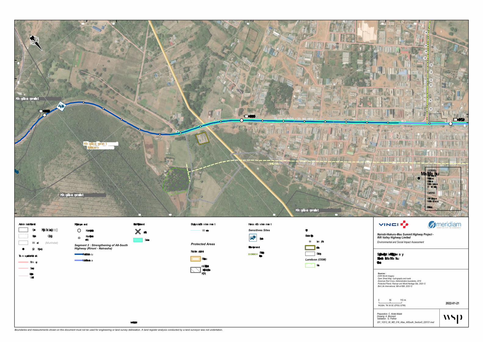
Ma i Ma hiu Ma rket Mosque (to va lida te)
Ma i Ma hiu Ca tholic Church
(Herita ge)LIGHTING URBAN
CUPFOB
Kikuyu Esca rpmen tForest Reserve
Ma i Ma hiu
B3 C88Ka ma n dura -Ma a i Ma hiu-Na rok Roa d
Kaplong-Na rok-Ma ai Road
Kikuyu Esca rpmen t forest
Kikuyu Esca rpmen t forest
Kikuyu Esca rpmen t forest
20+00019+000
18+000
565 000
565 000
565 500
565 500
566 000
566 000
566 500
566 500
9 890 0009 890 000
9 891 000
9 891 000 9 891 500
Boundaries and measurements shown on this document must not be used for engineering or land survey delineation. A land register analysis conducted by a land surveyor was not undertaken.
Biophysica l En viron men tW atercourse
Segmen t 2 - Stren gthen in g of A8-South Highw a ySection 5 - Riron i – Ma i Ma hiuSheet 5-10
2022-01-21
Nairobi-Nakuru-Mau Summit Highway Project - Rift Valley Highway LimitedEnvironmental and Social Impact Assessment
Preparation: C. Abdel-MalekDrawing: A. MonnardValidation : G. Pothier201_10312_00_WD_016_Atlas_A8South_Section5_220121.mxd
Sources :ESRI World ImageryOpen Street Map, hydrography and roadsAmerican Red Cross, Administrative boundaries, 2019Protected Planet, Ramsar and World Heritage Site, 2020-12Bird Life International, IBA et KBA, 2020-12
WGS84, TM 36 SE (EPSG 32766)
0 55 110 m
Admin istra tive LimitsCounty (Na kuru)
(Gilgil)Sub-County(Murindat)W ard
Project Compon en tsKilom etric point (1 km interval)Kilom etric point (100 minterval)
Segment 2 : Strengthening of A8-SouthHighway (Rironi - Naivasha)
5 - Rironi – Mai Mah iu6 - Mai Mah iu - Naivasha
Huma n En viron men tSensitives Sites
Accident Spot
Future Developmen tsB7 Road redesign andreconstruction Project
UtilityExistin g Utilities
Lam p PostSubstationBuildings
Landuse (OSM)Forest
Protected AreasNa tion a l Level
Forest ReserveIm portant Bird Area (IBA)and Key Biodivesity Area(KBA)
City (Njoro)
Tra n sporta tion NetworkPrim arySecondaryTertiary, Residential orUnclassified
Structura l Project Elemen ts
At-grade crossing
Service Lane
UNDERPASSVUP = Veh icule UnderpassPUP = Pedestrian UnderpassCUP = Catle UnderpassRUP = Railway UnderpassW LC = W ild Life Crossing
OVERPASSVOP = Veh icule OverpassROP = Railway OverpassFOB = Foot Overbridge
* Illustra ted further from the roa d for better legibility

Mai Mahiu Market
Ngeya Primary School
Mosque (to validate)
BUS BAY
BUS BAY
BUS BAY
TRUCK BAY
TRUCK BAY
LIGHTING URBAN
FOBC88
Old Naivasha Road
Kijab
e Roa
d
21+000
20+00022+000
Mai Mahiu
Murindat
Naivasha Nakuru
Gilgil
563 500
563 5
00
564 000
564 000
564 500
564 500
565 0
00
565 000
9 891 5009 8
91 50
09 892 000
9 892 000 9 892 500
9 892
500
9 893 000
9 893
000
Boundaries and measurements shown on this document must not be used for engineering or land survey delineation. A land register analysis conducted by a land surveyor was not undertaken.
Biophysical EnvironmentWatercourse
Segment 2 - Strengthening of A8-South HighwaySection 6 - Mai Mahiu - NaivashaSheet 6-1
2022-01-21
Nairobi-Nakuru-Mau Summit Highway Project - Rift Valley Highway LimitedEnvironmental and Social Impact Assessment
Preparation: C. Abdel-MalekDrawing: A. MonnardValidation : G. Pothier201_10312_00_WD_016_Atlas_A8South_Section6_220121.mxd
Sources :ESRI World ImageryOpen Street Map, hydrography and roadsAmerican Red Cross, Administrative boundaries, 2019Protected Planet, Ramsar and World Heritage Site, 2020-12Bird Life International, IBA et KBA, 2020-12
WGS84, TM 36 SE (EPSG 32766)
0 55 110 m
Administrative LimitsCounty (Nakuru)
(Gilgil)Sub-County(Murindat)Ward
Project ComponentsKilometric point (1 km interval)Kilometric point (100 minterval)
Segment 2 : Strengthening ofA8-South Highway (Rironi -Naivasha)
6 - Mai Mahiu - Naivasha
Human EnvironmentSensitives Sites
Accident Spot
Market and shopping area
Religious Institution
School Institution
Flooding areaUtilityExisting Utilities
Lamp PostBuildings
City (Njoro)
Transportation NetworkSecondaryTertiary, Residential orUnclassifiedFootway, Path or Track
Structural Project Elements
Underpass
At-grade crossing
Foot Overbridge
Run-off Water TreatmentEquipmentBus BayService LaneTruck Bay
UNDERPASSVUP = Vehicule UnderpassPUP = Pedestrian UnderpassCUP = Catle UnderpassRUP = Railway UnderpassWLC = Wild Life Crossing
OVERPASSVOP = Vehicule OverpassROP = Railway OverpassFOB = Foot Overbridge
* Illustrated further from the road for better legibility

BUS BAY
BUS BAYC88Old Naivasha Road 24+000
23+000
22+000Mai MahiuNaivasha Nakuru
562 000
562 0
00
562 500
562 500
563 000
563 000
563 5
00
563 500
9 892 5009 8
92 50
09 8
93 00
09 893 500
9 893 500 9 894 000
9 894
000
Boundaries and measurements shown on this document must not be used for engineering or land survey delineation. A land register analysis conducted by a land surveyor was not undertaken.
Biophysical EnvironmentWatercourse
Segment 2 - Strengthening of A8-South HighwaySection 6 - Mai Mahiu - NaivashaSheet 6-2
2022-01-21
Nairobi-Nakuru-Mau Summit Highway Project - Rift Valley Highway LimitedEnvironmental and Social Impact Assessment
Preparation: C. Abdel-MalekDrawing: A. MonnardValidation : G. Pothier201_10312_00_WD_016_Atlas_A8South_Section6_220121.mxd
Sources :ESRI World ImageryOpen Street Map, hydrography and roadsAmerican Red Cross, Administrative boundaries, 2019Protected Planet, Ramsar and World Heritage Site, 2020-12Bird Life International, IBA et KBA, 2020-12
WGS84, TM 36 SE (EPSG 32766)
0 55 110 m
Administrative LimitsCounty (Nakuru)
(Gilgil)Sub-County(Murindat)Ward
Project ComponentsKilometric point (1 km interval)Kilometric point (100 minterval)
Segment 2 : Strengthening ofA8-South Highway (Rironi -Naivasha)
6 - Mai Mahiu - Naivasha
Human EnvironmentFlooding area Future Developments
Naivasha ICD-LongonotRailway Line Project
City (Njoro)
Transportation NetworkSecondaryTertiary, Residential orUnclassified
Structural Project
UNDERPASSVUP = Vehicule UnderpassPUP = Pedestrian UnderpassCUP = Catle UnderpassRUP = Railway UnderpassWLC = Wild Life Crossing
OVERPASSVOP = Vehicule OverpassROP = Railway OverpassFOB = Foot Overbridge
* Illustrated further from the road for better legibility

Church ACK Church
AIC Church
Mararo Village
Mai Mahiu Primary School
Mai Mahiu Secondary School
BUS BAYBUS BAY
BUS BAY
BUS BAYBUS BAY
BUS BAY
FOB
C88Old Naivasha Road
Kiajbe Town Road
25+00024+000
26+00026+000
Mai MahiuNaivasha
Nakuru
560 500
560 5
00
561 000
561 000
561 500
561 500
562 0
00
562 000
9 894 0009 8
94 00
09 894 500
9 894 500
9 895 000
9 895 000 9 895 500
9 895
500
Boundaries and measurements shown on this document must not be used for engineering or land survey delineation. A land register analysis conducted by a land surveyor was not undertaken.
Biophysical EnvironmentWatercourse
Segment 2 - Strengthening of A8-South HighwaySection 6 - Mai Mahiu - NaivashaSheet 6-3
2022-01-21
Nairobi-Nakuru-Mau Summit Highway Project - Rift Valley Highway LimitedEnvironmental and Social Impact Assessment
Preparation: C. Abdel-MalekDrawing: A. MonnardValidation : G. Pothier201_10312_00_WD_016_Atlas_A8South_Section6_220121.mxd
Sources :ESRI World ImageryOpen Street Map, hydrography and roadsAmerican Red Cross, Administrative boundaries, 2019Protected Planet, Ramsar and World Heritage Site, 2020-12Bird Life International, IBA et KBA, 2020-12
WGS84, TM 36 SE (EPSG 32766)
0 55 110 m
Administrative LimitsCounty (Nakuru)
(Gilgil)Sub-County(Murindat)Ward
Project ComponentsKilometric point (1 km interval)Kilometric point (100 minterval)
Segment 2 : Strengthening ofA8-South Highway (Rironi -Naivasha)
6 - Mai Mahiu - Naivasha
Human EnvironmentSensitives Sites
Accident Spot
Religious Institution
Sensitive Site
Future DevelopmentsNaivasha ICD-LongonotRailway Line Project
UtilityExisting Utilities
PylonExisting Utilities
Power Transmission Line
City (Njoro)
Transportation NetworkSecondaryTertiary, Residential orUnclassified
Structural Project
Foot Overbridge
Bus Bay
UNDERPASSVUP = Vehicule UnderpassPUP = Pedestrian UnderpassCUP = Catle UnderpassRUP = Railway UnderpassWLC = Wild Life Crossing
OVERPASSVOP = Vehicule OverpassROP = Railway OverpassFOB = Foot Overbridge
* Illustrated further from the road for better legibility

BUS BAY BUS BAY
BUS BAY BUS BAY
BUS BAY TRUCK BAY
TRUCK BAY
Jikaze
C88Old Naivasha Road 28+00027+00026+00026+000Mai MahiuNaivasha
Nakuru
559 500
559 5
00
560 000
560 000
560 5
00
560 500
561 0
00
561 000
9 895 5009 8
95 50
09 896 000
9 896 000
9 896 500
9 897 000
9 897
000
Boundaries and measurements shown on this document must not be used for engineering or land survey delineation. A land register analysis conducted by a land surveyor was not undertaken.
Biophysical EnvironmentWatercourse
Segment 2 - Strengthening of A8-South HighwaySection 6 - Mai Mahiu - NaivashaSheet 6-4
2022-01-21
Nairobi-Nakuru-Mau Summit Highway Project - Rift Valley Highway LimitedEnvironmental and Social Impact Assessment
Preparation: C. Abdel-MalekDrawing: A. MonnardValidation : G. Pothier201_10312_00_WD_016_Atlas_A8South_Section6_220121.mxd
Sources :ESRI World ImageryOpen Street Map, hydrography and roadsAmerican Red Cross, Administrative boundaries, 2019Protected Planet, Ramsar and World Heritage Site, 2020-12Bird Life International, IBA et KBA, 2020-12
WGS84, TM 36 SE (EPSG 32766)
0 55 110 m
Administrative LimitsCounty (Nakuru)
(Gilgil)Sub-County(Murindat)Ward
Project ComponentsKilometric point (1 km interval)Kilometric point (100 minterval)
Segment 2 : Strengthening ofA8-South Highway (Rironi -Naivasha)
6 - Mai Mahiu - Naivasha
Human EnvironmentSensitives Sites
Accident Spot
Future DevelopmentsNaivasha ICD-LongonotRailway Line Project
UtilityExisting Utilities
PylonExisting Utilities
Power Transmission Line
City (Njoro)
Transportation NetworkSecondaryTertiary, Residential orUnclassified
Structural Project ElementsBus BayTruck Bay
UNDERPASSVUP = Vehicule UnderpassPUP = Pedestrian UnderpassCUP = Catle UnderpassRUP = Railway UnderpassWLC = Wild Life Crossing
OVERPASSVOP = Vehicule OverpassROP = Railway OverpassFOB = Foot Overbridge
* Illustrated further from the road for better legibility

TRUCK BAY
TRUCK BAYC88Old Naivasha Road 30+000
29+00028+000Mai Mahiu
Naivasha Nakuru
558 000
558 0
00
558 500
558 500
559 000
559 000
559 5
00
559 500
9 897 000 9 897 500
9 897 500 9 898 000 9 898 500
9 898
500
Boundaries and measurements shown on this document must not be used for engineering or land survey delineation. A land register analysis conducted by a land surveyor was not undertaken.
Biophysical EnvironmentWatercourse
Segment 2 - Strengthening of A8-South HighwaySection 6 - Mai Mahiu - NaivashaSheet 6-5
2022-01-21
Nairobi-Nakuru-Mau Summit Highway Project - Rift Valley Highway LimitedEnvironmental and Social Impact Assessment
Preparation: C. Abdel-MalekDrawing: A. MonnardValidation : G. Pothier201_10312_00_WD_016_Atlas_A8South_Section6_220121.mxd
Sources :ESRI World ImageryOpen Street Map, hydrography and roadsAmerican Red Cross, Administrative boundaries, 2019Protected Planet, Ramsar and World Heritage Site, 2020-12Bird Life International, IBA et KBA, 2020-12
WGS84, TM 36 SE (EPSG 32766)
0 55 110 m
Administrative LimitsCounty (Nakuru)
(Gilgil)Sub-County(Murindat)Ward
Project ComponentsKilometric point (1 km interval)Kilometric point (100 minterval)
Segment 2 : Strengthening ofA8-South Highway (Rironi -Naivasha)
6 - Mai Mahiu - Naivasha
Human EnvironmentUtilityExisting Utilities
PylonExisting Utilities
Power Transmission LineCity (Njoro)
Transportation NetworkSecondaryTertiary, Residential orUnclassified
Structural ProjectTruck Bay
UNDERPASSVUP = Vehicule UnderpassPUP = Pedestrian UnderpassCUP = Catle UnderpassRUP = Railway UnderpassWLC = Wild Life Crossing
OVERPASSVOP = Vehicule OverpassROP = Railway OverpassFOB = Foot Overbridge
* Illustrated further from the road for better legibility

Corner Stone Preparatory Academy
Bus bay
Bus bay
C88Old Naivasha Road 32+00031+00030+000Mai Mahiu
Naivasha Nakuru
557 000
557 0
00
557 500
557 500
558 0
00
558 000
558 5
00
558 500
9 898 5009 8
98 50
09 899 000
9 899 000
9 899 500
9 899 500 9 900 000
9 900
000
9 900 500
9 900
500
Boundaries and measurements shown on this document must not be used for engineering or land survey delineation. A land register analysis conducted by a land surveyor was not undertaken.
Biophysical EnvironmentWatercourse
Segment 2 - Strengthening of A8-South HighwaySection 6 - Mai Mahiu - NaivashaSheet 6-6
2022-01-21
Nairobi-Nakuru-Mau Summit Highway Project - Rift Valley Highway LimitedEnvironmental and Social Impact Assessment
Preparation: C. Abdel-MalekDrawing: A. MonnardValidation : G. Pothier201_10312_00_WD_016_Atlas_A8South_Section6_220121.mxd
Sources :ESRI World ImageryOpen Street Map, hydrography and roadsAmerican Red Cross, Administrative boundaries, 2019Protected Planet, Ramsar and World Heritage Site, 2020-12Bird Life International, IBA et KBA, 2020-12
WGS84, TM 36 SE (EPSG 32766)
0 55 110 m
Administrative LimitsCounty (Nakuru)
(Gilgil)Sub-County(Murindat)Ward
Project ComponentsKilometric point (1 km interval)Kilometric point (100 minterval)
Segment 2 : Strengthening ofA8-South Highway (Rironi -Naivasha)
6 - Mai Mahiu - Naivasha
Human EnvironmentSensitives Sites
School Institution
Future DevelopmentsNaivasha ICD-LongonotRailway Line Project
City (Njoro)
Transportation NetworkSecondaryTertiary, Residential orUnclassified
Structural Project
At-grade crossing
Bus Bay
UNDERPASSVUP = Vehicule UnderpassPUP = Pedestrian UnderpassCUP = Catle UnderpassRUP = Railway UnderpassWLC = Wild Life Crossing
OVERPASSVOP = Vehicule OverpassROP = Railway OverpassFOB = Foot Overbridge
* Illustrated further from the road for better legibility

Longonot Market
RUPBus bay
Bus bay
C88Old Naivasha RoadMt Longonot hiking Trail
34+00033+00032+000
Mai Mahiu
Naivasha
Nakuru
555 500
555 5
00
556 000
556 0
00
556 500
556 500
557 0
00
557 000
9 900
000
9 900 500
9 900 500
9 901 000
9 901 000
9 901 500
9 901 500 9 902 000
9 902
000
Boundaries and measurements shown on this document must not be used for engineering or land survey delineation. A land register analysis conducted by a land surveyor was not undertaken.
Biophysical EnvironmentWatercourse
Segment 2 - Strengthening of A8-South HighwaySection 6 - Mai Mahiu - NaivashaSheet 6-7
2022-01-21
Nairobi-Nakuru-Mau Summit Highway Project - Rift Valley Highway LimitedEnvironmental and Social Impact Assessment
Preparation: C. Abdel-MalekDrawing: A. MonnardValidation : G. Pothier201_10312_00_WD_016_Atlas_A8South_Section6_220121.mxd
Sources :ESRI World ImageryOpen Street Map, hydrography and roadsAmerican Red Cross, Administrative boundaries, 2019Protected Planet, Ramsar and World Heritage Site, 2020-12Bird Life International, IBA et KBA, 2020-12
WGS84, TM 36 SE (EPSG 32766)
0 55 110 m
Administrative LimitsCounty (Nakuru)
(Gilgil)Sub-County(Murindat)Ward
Project ComponentsKilometric point (1 km interval)Kilometric point (100 minterval)
Segment 2 : Strengthening ofA8-South Highway (Rironi -Naivasha)
6 - Mai Mahiu - Naivasha
Human EnvironmentFlooding area Future Developments
Naivasha ICD-LongonotRailway Line Project
City (Njoro)
Transportation NetworkrailwaySecondaryTertiary, Residential orUnclassified
Structural Project Elements
Underpass
At-grade crossing
Service Lane
UNDERPASSVUP = Vehicule UnderpassPUP = Pedestrian UnderpassCUP = Catle UnderpassRUP = Railway UnderpassWLC = Wild Life Crossing
OVERPASSVOP = Vehicule OverpassROP = Railway OverpassFOB = Foot Overbridge
* Illustrated further from the road for better legibility

Longonot Market
Longonot Dipensary
Longonot Primary School
Longonot Secondary SchoolRUP
Truck bay
Truck bay
LIGHTING URBAN
Longonot
C88 Old Naivasha Road
Mt Longonot hiking Trail
36+00035+000
34+000
Mai MahiuNaivasha Nakuru
554 000
554 0
00
554 500
554 500
555 000
555 000
555 500
555 500
556 0
00
556 000
9 901 5009 9
01 50
09 902 000
9 902
000
9 902 500
9 902 500 9 903 000
9 903
000
Boundaries and measurements shown on this document must not be used for engineering or land survey delineation. A land register analysis conducted by a land surveyor was not undertaken.
Biophysical EnvironmentWatercourse
Segment 2 - Strengthening of A8-South HighwaySection 6 - Mai Mahiu - NaivashaSheet 6-8
2022-01-21
Nairobi-Nakuru-Mau Summit Highway Project - Rift Valley Highway LimitedEnvironmental and Social Impact Assessment
Preparation: C. Abdel-MalekDrawing: A. MonnardValidation : G. Pothier201_10312_00_WD_016_Atlas_A8South_Section6_220121.mxd
Sources :ESRI World ImageryOpen Street Map, hydrography and roadsAmerican Red Cross, Administrative boundaries, 2019Protected Planet, Ramsar and World Heritage Site, 2020-12Bird Life International, IBA et KBA, 2020-12
WGS84, TM 36 SE (EPSG 32766)
0 55 110 m
Administrative LimitsCounty (Nakuru)
(Gilgil)Sub-County(Murindat)Ward
Project ComponentsKilometric point (1 km interval)Kilometric point (100 minterval)
Segment 2 : Strengthening ofA8-South Highway (Rironi -Naivasha)
6 - Mai Mahiu - Naivasha
Human EnvironmentSensitives Sites
Accident Spot
Health Facilities
Market and shopping area
School Institution
Future DevelopmentsNaivasha ICD-LongonotRailway Line ProjectBuildings
Landuse (OSM)Farmyard
City (Njoro)
Transportation NetworkrailwaySecondaryTertiary, Residential orUnclassified
Structural Project Elements
Underpass
At-grade crossing
Foot Overbridge
Service LaneTruck Bay
UNDERPASSVUP = Vehicule UnderpassPUP = Pedestrian UnderpassCUP = Catle UnderpassRUP = Railway UnderpassWLC = Wild Life Crossing
OVERPASSVOP = Vehicule OverpassROP = Railway OverpassFOB = Foot Overbridge
* Illustrated further from the road for better legibility

Bus bay Bus bay
Bus bay
Bus bay
C88
D394
Old Naivasha Road
38+000
37+000
36+000Mai Mahiu
Hells GateNaivasha Nakuru
553 000
553 0
00
553 500
553 5
00
554 0
00
554 000
554 5
00
554 500
9 903 0009 9
03 00
0
9 903 500
9 904 000
9 904 000
9 904 500
9 904 500 9 905 000
Boundaries and measurements shown on this document must not be used for engineering or land survey delineation. A land register analysis conducted by a land surveyor was not undertaken.
Biophysical EnvironmentWatercourse
Segment 2 - Strengthening of A8-South HighwaySection 6 - Mai Mahiu - NaivashaSheet 6-9
2022-01-21
Nairobi-Nakuru-Mau Summit Highway Project - Rift Valley Highway LimitedEnvironmental and Social Impact Assessment
Preparation: C. Abdel-MalekDrawing: A. MonnardValidation : G. Pothier201_10312_00_WD_016_Atlas_A8South_Section6_220121.mxd
Sources :ESRI World ImageryOpen Street Map, hydrography and roadsAmerican Red Cross, Administrative boundaries, 2019Protected Planet, Ramsar and World Heritage Site, 2020-12Bird Life International, IBA et KBA, 2020-12
WGS84, TM 36 SE (EPSG 32766)
0 55 110 m
Administrative LimitsCounty (Nakuru)
(Gilgil)Sub-County(Murindat)Ward
Project ComponentsKilometric point (1 km interval)Kilometric point (100 minterval)
Segment 2 : Strengthening ofA8-South Highway (Rironi -Naivasha)
6 - Mai Mahiu - Naivasha
Human Environment
City (Njoro)
Transportation NetworkSecondaryTertiary, Residential orUnclassified
StructuralProjectElements
Bus Bay
UNDERPASSVUP = Vehicule UnderpassPUP = Pedestrian UnderpassCUP = Catle UnderpassRUP = Railway UnderpassWLC = Wild Life Crossing
OVERPASSVOP = Vehicule OverpassROP = Railway OverpassFOB = Foot Overbridge
* Illustrated further from the road for better legibility

Bus bayC88Old Naivasha Road 40+000
39+000
38+000Hells Gate
Mai Mahiu
Naivasha Nakuru
552 500
552 5
00
553 000
553 0
00
553 5
00
553 500
9 905 000 9 905 500
9 905 500
9 906 000
9 906 000
9 906 500
9 907 000
9 907
000
Boundaries and measurements shown on this document must not be used for engineering or land survey delineation. A land register analysis conducted by a land surveyor was not undertaken.
Biophysical EnvironmentWatercourse
Segment 2 - Strengthening of A8-South HighwaySection 6 - Mai Mahiu - NaivashaSheet 6-10
2022-01-21
Nairobi-Nakuru-Mau Summit Highway Project - Rift Valley Highway LimitedEnvironmental and Social Impact Assessment
Preparation: C. Abdel-MalekDrawing: A. MonnardValidation : G. Pothier201_10312_00_WD_016_Atlas_A8South_Section6_220121.mxd
Sources :ESRI World ImageryOpen Street Map, hydrography and roadsAmerican Red Cross, Administrative boundaries, 2019Protected Planet, Ramsar and World Heritage Site, 2020-12Bird Life International, IBA et KBA, 2020-12
WGS84, TM 36 SE (EPSG 32766)
0 55 110 m
Administrative LimitsCounty (Nakuru)
(Gilgil)Sub-County(Murindat)Ward
Project ComponentsKilometric point (1 km interval)Kilometric point (100 minterval)
Segment 2 : Strengthening ofA8-South Highway (Rironi -Naivasha)
6 - Mai Mahiu - Naivasha
Human
City (Njoro)
TransportationNetwork
Secondary
Structural Project
UNDERPASSVUP = Vehicule UnderpassPUP = Pedestrian UnderpassCUP = Catle UnderpassRUP = Railway UnderpassWLC = Wild Life Crossing
OVERPASSVOP = Vehicule OverpassROP = Railway OverpassFOB = Foot Overbridge
* Illustrated further from the road for better legibility

Truck bay
Truck bay
C88Old Naivasha Road 42+00041+00040+000Hells GateNaivasha Nakuru
552 000
552 0
00
552 50055
3 000
553 000
9 907 000
9 907 000
9 907 500
9 907 500
9 908 000
9 908 000
9 908 500
9 908 500
Boundaries and measurements shown on this document must not be used for engineering or land survey delineation. A land register analysis conducted by a land surveyor was not undertaken.
Biophysical EnvironmentWatercourse
Segment 2 - Strengthening of A8-South HighwaySection 6 - Mai Mahiu - NaivashaSheet 6-11
2022-01-21
Nairobi-Nakuru-Mau Summit Highway Project - Rift Valley Highway LimitedEnvironmental and Social Impact Assessment
Preparation: C. Abdel-MalekDrawing: A. MonnardValidation : G. Pothier201_10312_00_WD_016_Atlas_A8South_Section6_220121.mxd
Sources :ESRI World ImageryOpen Street Map, hydrography and roadsAmerican Red Cross, Administrative boundaries, 2019Protected Planet, Ramsar and World Heritage Site, 2020-12Bird Life International, IBA et KBA, 2020-12
WGS84, TM 36 SE (EPSG 32766)
0 55 110 m
Administrative LimitsCounty (Nakuru)
(Gilgil)Sub-County(Murindat)Ward
Project ComponentsKilometric point (1 km interval)Kilometric point (100 minterval)
Segment 2 : Strengthening ofA8-South Highway (Rironi -Naivasha)
6 - Mai Mahiu - Naivasha
Human
City (Njoro)
Transportation NetworkSecondaryTertiary, Residential orUnclassifiedFootway, Path or Track
Structural Project ElementsTruck Bay
UNDERPASSVUP = Vehicule UnderpassPUP = Pedestrian UnderpassCUP = Catle UnderpassRUP = Railway UnderpassWLC = Wild Life Crossing
OVERPASSVOP = Vehicule OverpassROP = Railway OverpassFOB = Foot Overbridge
* Illustrated further from the road for better legibility

Truck bay
Truck bayBus bay
Bus bay
C88Old Naivasha Road 44+00042+000 43+000Hells Gate
Naivasha Nakuru
551 500
551 5
00
552 0
00
552 0
00
552 5
00
552 500
9 909 000
9 909 000
9 909 500
9 909 500
9 910 000
9 910 000
9 910 500
9 910 500
Boundaries and measurements shown on this document must not be used for engineering or land survey delineation. A land register analysis conducted by a land surveyor was not undertaken.
Biophysical EnvironmentWatercourse
Segment 2 - Strengthening of A8-South HighwaySection 6 - Mai Mahiu - NaivashaSheet 6-12
2022-01-21
Nairobi-Nakuru-Mau Summit Highway Project - Rift Valley Highway LimitedEnvironmental and Social Impact Assessment
Preparation: C. Abdel-MalekDrawing: A. MonnardValidation : G. Pothier201_10312_00_WD_016_Atlas_A8South_Section6_220121.mxd
Sources :ESRI World ImageryOpen Street Map, hydrography and roadsAmerican Red Cross, Administrative boundaries, 2019Protected Planet, Ramsar and World Heritage Site, 2020-12Bird Life International, IBA et KBA, 2020-12
WGS84, TM 36 SE (EPSG 32766)
0 55 110 m
Administrative LimitsCounty (Nakuru)
(Gilgil)Sub-County(Murindat)Ward
Project ComponentsKilometric point (1 km interval)Kilometric point (100 minterval)
Segment 2 : Strengthening ofA8-South Highway (Rironi -Naivasha)
6 - Mai Mahiu - Naivasha
HumanExisting Utilities
Power Transmission
City (Njoro)
Transportation NetworkSecondaryTertiary, Residential orUnclassifiedFootway, Path or Track
Structural ProjectBus BayTruck Bay
UNDERPASSVUP = Vehicule UnderpassPUP = Pedestrian UnderpassCUP = Catle UnderpassRUP = Railway UnderpassWLC = Wild Life Crossing
OVERPASSVOP = Vehicule OverpassROP = Railway OverpassFOB = Foot Overbridge
* Illustrated further from the road for better legibility

Bus bay
Power SubstationPower Substation
C88
Old Naivasha Road 46+00045+000
44+000
Hells GateNaivasha Nakuru
551 000
551 0
00
551 5
00
551 5
00
552 0
00
552 000
9 910 5009 9
10 50
09 911 000
9 911 000
9 911 500
9 911 500
9 912 000
9 912 000 9 912 500
9 912
500
Boundaries and measurements shown on this document must not be used for engineering or land survey delineation. A land register analysis conducted by a land surveyor was not undertaken.
Biophysical EnvironmentWatercourse
Segment 2 - Strengthening of A8-South HighwaySection 6 - Mai Mahiu - NaivashaSheet 6-13
2022-01-21
Nairobi-Nakuru-Mau Summit Highway Project - Rift Valley Highway LimitedEnvironmental and Social Impact Assessment
Preparation: C. Abdel-MalekDrawing: A. MonnardValidation : G. Pothier201_10312_00_WD_016_Atlas_A8South_Section6_220121.mxd
Sources :ESRI World ImageryOpen Street Map, hydrography and roadsAmerican Red Cross, Administrative boundaries, 2019Protected Planet, Ramsar and World Heritage Site, 2020-12Bird Life International, IBA et KBA, 2020-12
WGS84, TM 36 SE (EPSG 32766)
0 55 110 m
Administrative LimitsCounty (Nakuru)
(Gilgil)Sub-County(Murindat)Ward
Project ComponentsKilometric point (1 km interval)Kilometric point (100 minterval)
Segment 2 : Strengthening ofA8-South Highway (Rironi -Naivasha)
6 - Mai Mahiu - Naivasha
Human EnvironmentUtilityExisting Utilities
Pylon
Power SubstationExisting Utilities
Power Transmission LineSubstationBuildings
City (Njoro)
Transportation NetworkrailwaySecondaryTertiary, Residential orUnclassifiedFootway, Path or TrackActual Intersection, Weir orTurning Circle
StructuralProjectElements
Bus Bay
UNDERPASSVUP = Vehicule UnderpassPUP = Pedestrian UnderpassCUP = Catle UnderpassRUP = Railway UnderpassWLC = Wild Life Crossing
OVERPASSVOP = Vehicule OverpassROP = Railway OverpassFOB = Foot Overbridge
* Illustrated further from the road for better legibility

Munyu
Bus bay
Bus bay
Bus bayBus bay
Bus bay
Bus bayTruck bay
Truck bay
C88 Old Naivasha Road
48+000
47+000
46+000Hells Gate
Lake View
Naivasha Nakuru
550 000
550 0
00
550 500
550 5
00
551 0
00
551 000
551 5
00
551 500
9 912 5009 9
12 50
09 913 000
9 913 000
9 913 500
9 913 500
9 914 000
9 914 000 9 914 500
9 914
500
Boundaries and measurements shown on this document must not be used for engineering or land survey delineation. A land register analysis conducted by a land surveyor was not undertaken.
Biophysical EnvironmentWatercourse
Segment 2 - Strengthening of A8-South HighwaySection 6 - Mai Mahiu - NaivashaSheet 6-14
2022-01-21
Nairobi-Nakuru-Mau Summit Highway Project - Rift Valley Highway LimitedEnvironmental and Social Impact Assessment
Preparation: C. Abdel-MalekDrawing: A. MonnardValidation : G. Pothier201_10312_00_WD_016_Atlas_A8South_Section6_220121.mxd
Sources :ESRI World ImageryOpen Street Map, hydrography and roadsAmerican Red Cross, Administrative boundaries, 2019Protected Planet, Ramsar and World Heritage Site, 2020-12Bird Life International, IBA et KBA, 2020-12
WGS84, TM 36 SE (EPSG 32766)
0 55 110 m
Administrative LimitsCounty (Nakuru)
(Gilgil)Sub-County(Murindat)Ward
Project ComponentsKilometric point (1 km interval)Kilometric point (100 minterval)
Segment 2 : Strengthening ofA8-South Highway (Rironi -Naivasha)
6 - Mai Mahiu - Naivasha
Human EnvironmentExisting Utilities
Power Transmission Line
City (Njoro)
Transportation NetworkrailwaySecondaryTertiary, Residential orUnclassifiedFootway, Path or TrackActual Intersection, Weir orTurning Circle
Structural ProjectBus BayTruck Bay
UNDERPASSVUP = Vehicule UnderpassPUP = Pedestrian UnderpassCUP = Catle UnderpassRUP = Railway UnderpassWLC = Wild Life Crossing
OVERPASSVOP = Vehicule OverpassROP = Railway OverpassFOB = Foot Overbridge
* Illustrated further from the road for better legibility

PCEA Mirera
RUPBus bay
Bus bay
Bus bay
Bus bay
Truck bay
Truck bay
Bus bay
C88Old Naivasha Road
Old Naivasha Road
49+000
48+000
50+000
Lake View
Hells Gate
Naivasha Nakuru
549 500
549 5
00
550 0
00
550 000
550 5
00
550 500
9 914 500
9 914 500
9 915 000
9 915 000
9 915 500
9 915 500
9 916 000
9 916 000
Boundaries and measurements shown on this document must not be used for engineering or land survey delineation. A land register analysis conducted by a land surveyor was not undertaken.
Biophysical EnvironmentWatercourse
Segment 2 - Strengthening of A8-South HighwaySection 6 - Mai Mahiu - NaivashaSheet 6-15
2022-01-21
Nairobi-Nakuru-Mau Summit Highway Project - Rift Valley Highway LimitedEnvironmental and Social Impact Assessment
Preparation: C. Abdel-MalekDrawing: A. MonnardValidation : G. Pothier201_10312_00_WD_016_Atlas_A8South_Section6_220121.mxd
Sources :ESRI World ImageryOpen Street Map, hydrography and roadsAmerican Red Cross, Administrative boundaries, 2019Protected Planet, Ramsar and World Heritage Site, 2020-12Bird Life International, IBA et KBA, 2020-12
WGS84, TM 36 SE (EPSG 32766)
0 55 110 m
Administrative LimitsCounty (Nakuru)
(Gilgil)Sub-County(Murindat)Ward
Project ComponentsKilometric point (1 km interval)Kilometric point (100 minterval)
Segment 2 : Strengthening ofA8-South Highway (Rironi -Naivasha)
6 - Mai Mahiu - Naivasha
Human EnvironmentSensitives Sites
Accident Spot
Worship CentersChristian
Buildings
City (Njoro)
Transportation NetworkrailwaySecondaryTertiary, Residential orUnclassifiedFootway, Path or TrackActual Intersection, Weir orTurning Circle
Structural Project Elements
Underpass
Bus BayTruck Bay
UNDERPASSVUP = Vehicule UnderpassPUP = Pedestrian UnderpassCUP = Catle UnderpassRUP = Railway UnderpassWLC = Wild Life Crossing
OVERPASSVOP = Vehicule OverpassROP = Railway OverpassFOB = Foot Overbridge
* Illustrated further from the road for better legibility

Masada Hotel
Chambai Safari
Kiboko Luxury Camp
Yellow green hotelFina Gardens Resort
Bus bay
Bus bay
Bus bay
Naivasha National Wildlife Sanctuary
Naivasha National Wildlife Sanctuary
C88
D 323
Old Naivasha Road
Moi S Lake Road
Moi South Lake Road
South Lake Road
52+00051+00050+000
Hells Gate
Lake View Naivasha East
Naivasha Nakuru
548 500
548 5
00
549 000
549 0
00
549 5
00
549 500
9 916 0009 9
16 00
09 916 500
9 916 500
9 917 000
9 917 000
9 917 500
9 917 500 9 918 000
9 918
000
Boundaries and measurements shown on this document must not be used for engineering or land survey delineation. A land register analysis conducted by a land surveyor was not undertaken.
BiophysicalWatercourse
Segment 2 - Strengthening of A8-South HighwaySection 6 - Mai Mahiu - NaivashaSheet 6-16
2022-01-26
Nairobi-Nakuru-Mau Summit Highway Project - Rift Valley Highway LimitedEnvironmental and Social Impact Assessment
Preparation: C. Abdel-MalekDrawing: A. MonnardValidation : G. Pothier201_10312_00_WD_016_Atlas_A8South_Section6_220126.mxd
Sources :ESRI World ImageryOpen Street Map, hydrography and roadsAmerican Red Cross, Administrative boundaries, 2019Protected Planet, Ramsar and World Heritage Site, 2020-12Bird Life International, IBA et KBA, 2020-12
WGS84, TM 36 SE (EPSG 32766)
0 55 110 m
Administrative LimitsCounty (Nakuru)
(Gilgil)Sub-County(Murindat)Ward
Project ComponentsKilometric point (1 km interval)Kilometric point (100 minterval)
Segment 2 : Strengthening ofA8-South Highway (Rironi -Naivasha)
6 - Mai Mahiu - Naivasha
Human EnvironmentSensitives Sites
Accident Spot
Flooding areaPoint of Interest
Tower (communication orother)Buildings
Landuse (OSM)Forest
Protected
NationalCity (Njoro)
Transportation NetworkrailwaySecondaryTertiary, Residential orUnclassifiedFootway, Path or Track
Structural Project Elements
At-grade crossing
Bus BayWildlife Crossing
Landbridge
UNDERPASSVUP = Vehicule UnderpassPUP = Pedestrian UnderpassCUP = Catle UnderpassRUP = Railway UnderpassWLC = Wild Life Crossing
OVERPASSVOP = Vehicule OverpassROP = Railway OverpassFOB = Foot Overbridge
* Illustrated further from the road for better legibility

Panorama Park Hotel
Lake View Primary School
RUP
Aloepark
Zebra and giraffe free safari
Bus bay
Bus bay
Bus bay
Naivasha National Wildlife Sanctuary
Naivasha National Wildlife Sanctuary
C88Moi South Lake Road
Mama N
gina Road
Taph
e Gue
st Re
sort
Road
53+000
52+00054+000Lake View
Hells Gate
Naivasha East
Naivasha Nakuru
548 000
548 0
00
548 5
00
548 5
00
549 0
00
549 000
9 918 000 9 918 500
9 918 500
9 919 000
9 919 000
9 919 500
9 919 500 9 920 000
9 920
000
Boundaries and measurements shown on this document must not be used for engineering or land survey delineation. A land register analysis conducted by a land surveyor was not undertaken.
BiophysicalWatercourse
Segment 2 - Strengthening of A8-South HighwaySection 6 - Mai Mahiu - NaivashaSheet 6-17
2022-01-26
Nairobi-Nakuru-Mau Summit Highway Project - Rift Valley Highway LimitedEnvironmental and Social Impact Assessment
Preparation: C. Abdel-MalekDrawing: A. MonnardValidation : G. Pothier201_10312_00_WD_016_Atlas_A8South_Section6_220126.mxd
Sources :ESRI World ImageryOpen Street Map, hydrography and roadsAmerican Red Cross, Administrative boundaries, 2019Protected Planet, Ramsar and World Heritage Site, 2020-12Bird Life International, IBA et KBA, 2020-12
WGS84, TM 36 SE (EPSG 32766)
0 55 110 m
Administrative LimitsCounty (Nakuru)
(Gilgil)Sub-County(Murindat)Ward
Project ComponentsKilometric point (1 km interval)Kilometric point (100 minterval)
Segment 2 : Strengthening ofA8-South Highway (Rironi -Naivasha)
6 - Mai Mahiu - Naivasha
Human EnvironmentSensitives Sites
Accident Spot
School Institution
View point and touristic sites
Flooding areaPoint of Interest
Archaeological, Attraction,Monument or Viewpoint
UtilityExisting Utilities
Lamp PostBuildings
Landuse (OSM)ForestResidential
ProtectedInternational
Ramsar Site, Wetland ofInternational ImportanceNational
City (Njoro)
Transportation NetworkrailwaySecondaryTertiary, Residential orUnclassifiedFootway, Path or TrackActual Intersection, Weir orTurning Circle
Structural Project Elements
Underpass
At-grade crossing
Bus Bay
UNDERPASSVUP = Vehicule UnderpassPUP = Pedestrian UnderpassCUP = Catle UnderpassRUP = Railway UnderpassWLC = Wild Life Crossing
OVERPASSVOP = Vehicule OverpassROP = Railway OverpassFOB = Foot Overbridge
* Illustrated further from the road for better legibility
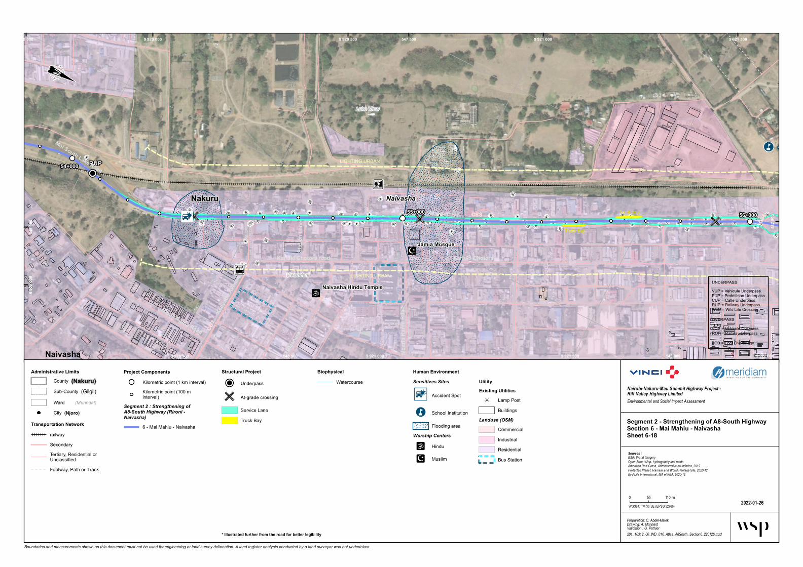
Panorama Park Hotel
Manera Primary School
Naivasha Primary
boarding School
Jamia Mosque
St. Francis Xavier
African Inland Church
Naivasha Hindu Temple
RUP
VOP/POP
St. Francis Xavier
Society supermarketMimosa Bookshop and stationers
Truck bay
Truck bay
LIGHTING URBAN
LIGHTING URBAN
LIGHTING URBAN
LIGHTING URBAN
Bus bay
Bus bay
Naivasha
C88C6
7
C88Moi Avenue
Kariuki Chotora
Mama Ngina Road
Kariuki Chotora road
Keny
atta A
venue
Biash
ara Ro
ad
Mbari
a Kan
iu Ro
ad
Stati
on La
ne
Moi South Lake Road
56+00055+000
54+000
Lake View
Viwandani
Naivasha Nakuru
547 500
547 5
00
548 000
548 000
548 5
00
548 500
9 920 0009 9
20 00
09 920 500
9 920 500
9 921 000
9 921 000
9 921 500
9 921 500 9 922 000
9 922
000
Boundaries and measurements shown on this document must not be used for engineering or land survey delineation. A land register analysis conducted by a land surveyor was not undertaken.
BiophysicalWatercourse
Segment 2 - Strengthening of A8-South HighwaySection 6 - Mai Mahiu - NaivashaSheet 6-18
2022-01-26
Nairobi-Nakuru-Mau Summit Highway Project - Rift Valley Highway LimitedEnvironmental and Social Impact Assessment
Preparation: C. Abdel-MalekDrawing: A. MonnardValidation : G. Pothier201_10312_00_WD_016_Atlas_A8South_Section6_220126.mxd
Sources :ESRI World ImageryOpen Street Map, hydrography and roadsAmerican Red Cross, Administrative boundaries, 2019Protected Planet, Ramsar and World Heritage Site, 2020-12Bird Life International, IBA et KBA, 2020-12
WGS84, TM 36 SE (EPSG 32766)
0 55 110 m
Administrative LimitsCounty (Nakuru)
(Gilgil)Sub-County(Murindat)Ward
Project ComponentsKilometric point (1 km interval)Kilometric point (100 minterval)
Segment 2 : Strengthening ofA8-South Highway (Rironi -Naivasha)
6 - Mai Mahiu - Naivasha
Human EnvironmentSensitives Sites
Accident Spot
School Institution
Flooding areaWorship Centers
Hindu
Muslim
UtilityExisting Utilities
Lamp PostBuildings
Landuse (OSM)CommercialIndustrialResidentialBus Station
City (Njoro)
Transportation NetworkrailwaySecondaryTertiary, Residential orUnclassifiedFootway, Path or Track
Structural Project
Underpass
At-grade crossing
Service LaneTruck Bay
UNDERPASSVUP = Vehicule UnderpassPUP = Pedestrian UnderpassCUP = Catle UnderpassRUP = Railway UnderpassWLC = Wild Life Crossing
OVERPASSVOP = Vehicule OverpassROP = Railway OverpassFOB = Foot Overbridge
* Illustrated further from the road for better legibility
Hygr
otech
Flowe
r Farm
Park
Manera Primary School
Buffa
lo Ma
ll Naiv
asha
Naiva
sha Pri
mary
board
ingSc
hool
U-Tu
rn VO
P/POP
Truck bay
LIGHTING URBAN
LIGHTING URBAN
LIGHTING URBAN
Bus bayB u s b a y s h e l t e rA1
04
C88
C88
C88
C88
Nairo
bi - N
akuru
Road
Kariuki C
hotora
Moi Avenue
Old Nairo
bi-Naku
ru Road
Moi South Lake Road
Moi Avenue Moi South Lake Road
Moi Avenue
59+000
56+00057+000ViwandaniLake View
Naivasha
Nakuru
547 00054
7 000
547 50054
7 500
548 000
548 0
00
548 500
548 5
00
9 921
500
9 921 500
9 922 000
9 922 000
9 922 500
9 922 500
9 923 000
9 923 000
9 923 500
9 923
500
Boundaries and measurements shown on this document must not be used for engineering or land survey delineation. A land register analysis conducted by a land surveyor was not undertaken.
BiophysicalW atercourse
Segment 2 - Strengthening of A8-South HighwaySection 6 - Mai Mahiu - NaivashaSheet 6-19
2022-01-26
Nairobi-Nakuru-Mau Summit Highway Project - Rift Valley Highway LimitedEnvironmental and Social Impact Assessment
Preparation: C. Abdel-MalekDrawing: A. MonnardValidation : G. Pothier201_10312_00_WD_016_Atlas_A8South_Section6_220126.mxd
Sources :ESRI World ImageryOpen Street Map, hydrography and roadsAmerican Red Cross, Administrative boundaries, 2019Protected Planet, Ramsar and World Heritage Site, 2020-12Bird Life International, IBA et KBA, 2020-12
WGS84, TM 36 SE (EPSG 32766)
0 55 110 m
Administrative LimitsCoun ty (Nakuru)
(Gilgil)Sub-Coun ty(Murindat)W ard
Project ComponentsKilom etric poin t (1 km in terval)Kilom etric poin t (100 min terval)
Segment 1 : Dualling of A8 Highway(Rironi - Mau Summit)
1 - Riron i – Naivasha2 - Naivasha – Elem en taitaRoad
Segment 2 : Strengthening ofA8-South Highway (Rironi -Naivasha)
6 - Mai Mah iu - Naivasha
Human EnvironmentSensitives Sites
Industry
Market an d shopping area
School In stitution
UtilityExisting Utilities
Lam p PostBuildings
Landuse (OSM)Farm landIndustrialResiden tial
City (Njoro)
Transportation NetworkrailwayPrim arySecondaryTertiary, Residen tial orUnclassifiedFootway, Path or Track
Structural Project
Overpass
At-grade crossin g
Ligh tin g Urban *Service LaneService LaneTruck Bay
UNDERPASSVUP = Veh icule UnderpassPUP = Pedestrian UnderpassCUP = Catle UnderpassRUP = Railway UnderpassW LC = W ild Life Crossin g
OVERPASSVOP = Veh icule OverpassROP = Railway OverpassFOB = Foot Overbridge
* Illustrated further from the road for better legibility