The Sky's Not The Limit
112
The Sky's Not The Limit HOW LOWER-INCOME CITIES CAN LEVERAGE DRONES
-
Upload
khangminh22 -
Category
Documents
-
view
1 -
download
0
Transcript of The Sky's Not The Limit

The Sky's Not The LimitHOW LOWER-INCOME CITIES CAN LEVERAGE DRONES


©
Zipl
ine

♦ AcknowledgementsThe Sky’s Not The Limit: How Lower-Income Cities Can Leverage Drones is a product of the UNDP Global Centre for Technology, Innovation and Sustainable Development, based in Singapore.
This report was developed under the guidance of Riad Meddeb, and authored by Calum Handforth and Genevieve Ding. It benefitted significantly from insights from the following individuals and organisations: Bornlove Ntikha (Swoop Aero), Brent Hoade (Disaster Relief Australia), Dania Montenegro (Panama Flying Lab), Deogratius Kiggudde (HOT Uganda), Digna Mushi (Open Skies Fellow), Dumisani Kaliati (Micromek), Edward Anderson (World Bank), Professor Liu Hao (JARUS), Harrison Wolf (Zipline), Ivan Gayton (HOT), Izzat Othman (Area 57 Drone Living Lab), Kevin Kochersberger (African Drone and Data Academy), Khadija Abdulla (Open Skies Fellow), Matthew Walsh (ReefScan), Miro Banovic (Foodpanda), Narayan Iyer (UNDP), Patrick Meier (WeRobotics), Pontus Westerberg (UN-Habitat), Rebecca Lehman (Drone Deploy), Robin Thevathasan (Association of Aerospace Industries Singapore (AAIS)), Romeo Durscher (Auterion), Shane Sumner (ICAO), Sia Kheng Yok (AAIS), Simon Whalley (Skyports), Sonja Betschart (WeRobotics), Stephen Mather (OpenDroneMap), Tiamiyou Radji (Senegal Flying Lab), Tinah Mutabazi (Uganda Flying Lab), Uttam Pudasaini (Nepal Flying Lab), the Global Research and Consulting Group, Nanyang Technological University (NTU) Chapter (Chew Jie Ying Perlyn, Megan Sim Li Xuan, Jiang Zixing, Adithya Venkatadri Hulagadri, Gillian Lam Yan Rong, Lo Chik Him Ho Yan Lin) and the UNDP Global Centre team (Elba Fuster Figuerola, Gandhar Desai, Priyadarshini, Martha Chukwu, and Weijing Ye). Although grateful for all of these contributions, the content of this report solely represents the perspectives of the UNDP Global Centre.
We thank Rec Design for their design and layout expertise.
Cover photo credit: Flying Labs Tanzania (with drone added by design team).
Suggested citation:
UNDP, The Sky’s Not The Limit: How Lower-Income Cities Can Leverage Drones (Singapore: UNDP Global Centre for Technology, Innovation and Sustainable Development, 2022)
© UNDP, 2022.
Some rights reserved. The Sky’s Not The Limit is available under the Creative Commons Attribution-Non-Commercial-ShareAlike 3.0 IGO licence (CC BY-NC-SA 3.0 IGO; https://creativecommons.org/licenses/by-nc-sa/3.0/igo/legalcode).
The views expressed in this publication are those of the author(s) and do not necessarily represent those of the United Nations, including UNDP, or their Member States.
UNDP is the leading United Nations organisation fighting to end the injustice of poverty, inequality, and climate change. Working with our broad network of experts and partners in 170 countries, we help nations to build integrated, lasting solutions for people and planet.
Learn more at undp.org or follow at @UNDP
The UNDP Global Centre for Technology, Innovation and Sustainable Development is a joint initiative by the Government of Singapore and UNDP which aims at identifying and co-creating technological solutions for sustainable development. The UNDP Global Centre curates partnerships, identifies solutions and connects partners and innovations with UNDP’s Global Policy Network and development partners.
Learn more at sgtechcentre.undp.org or follow at @UNDPtech

♦ Contents
Foreword 6
Executive Summary 8
Context 10
What are Uncrewed Aerial Vehicles? 16
Aircraft Types and Classifications
UAV Technology and Solutions
Limitations
Implementing UAVs in cities 24
Building the UAV Infrastructure
Shaping the UAV environment in a city
Innovative business models
Putting it into Practice 94
Improving urban mobility
Enabling data-driven local government
Enhancing Environmental and Public Health
Looking Forward 108

♦ ForewordUncrewed aerial vehicles – UAVs, colloquially known as ‘drones’ – have rapidly moved from recreational devices to professional tools. They are a less-recognised component of the Fourth Industrial Revolution, have the potential to play a crucial role in the digital economy, are shaping new opportunities and markets around the world, and could be important assets for sustainable development.
Lower-income cities, and countries, are already engaging with UAV innovations, products, and services. UAVs are improving urban planning in Buenos Aires, supporting waste management efforts in Lusaka, redefining delivery and logistics across Ghana and Rwanda, regulating traffic flow in Jakarta, and shaping innovation ecosystems in Kuala Lumpur. From major metropolises, to the city centres of Small Island Developing States, UAVs are improving urban lives and livelihoods.
In developing this handbook, it is clear that UAVs are key tools in the context of the Sustainable Development Goals (SDGs). As discussed in the report, UAVs can play an important role in delivering urban use-cases across all 17 SDGs. However, UAVs may yet also be essential in achieving sustainable urban development more broadly. They could support city administrators to redefine physical and digital infrastructure investment, and public-private collaboration. They may also provide city residents with an accessible entry-point to the potential afforded by the Fourth Industrial Revolution. UAVs could also demonstrate the value and importance of local and community-ownership of technology and innovation.
Similarly, the learning and outcomes of urban UAV deployments in lower-income cities could extend well beyond the city – including shaping initiatives in rural settings, informing national policy regarding privacy and ethics, and even delivering UAV services to remote and rural populations from the city itself. Just as exciting, urban UAV efforts in lower-income cities could also drive broader benefits. UAV leadership in lower-income cities could catalyse South-South collaboration, and locally-led Southern innovation - whilst the UAV explorations, implementations, and successes of lower-income cities may yet inform the policy, operational, regulatory, and other UAV priorities and considerations of the Global North.
There are very few emerging technologies that are positioned to accelerate the global innovation leadership of lower-income cities – whilst also having the potential to improve the lives and livelihoods of the urban residents and citizens within these cities. We hope that this handbook can support cities on this exciting journey.
RIAD MEDDEB Director (ad interim)
UNDP Global Centre for Technology, Innovation, and
Sustainable Development
6

©
Zipl
ine
The
Sky’
s N
ot T
he L
imit
H
OW
LO
WER
-IN
CO
ME
CIT
IES
CA
N
LEV
ERA
GE
UN
CR
EWED
AER
IAL
VEH
ICLE
S8
♦ Executive SummaryUncrewed aerial vehicles – UAVs, often known as drones - have garnered significant interest amongst city administrations as potential tools for public and private service delivery, and for numerous other urban use-cases. However, these discussions and explorations have often focused on higher-income cities: from New York, to London and Barcelona, Tokyo and Singapore. This handbook aims to guide city officials in lower-income cities in exploring and implementing UAV services and solutions.
Globally, the urban UAV sector is still in its infancy. It remains defined by pilots, testbeds and trials, and government-funded initiatives. This provides lower-income cities with a considerable opportunity to leverage this emerging technology. Drawing on their numerous assets – including less technical and physical legacy, often tech-savvy and agile governance processes, and their talented and entrepreneurial residents – officials in these cities can position their cities as leaders in global urban UAV explorations. The pressures of urbanisation are also demanding new ways of engaging with the urban space.
UAVs have had a strong following amongst consumers and hobbyists for some time, with much of this activity also happening in many lower-income cities. This handbook moves beyond these recreational use-cases: it sets out the key priorities, considerations, policies, and interventions that cities need to engage with in order to drive larger-scale, professional, and sustainable UAV initiatives that achieve key urban objectives. This includes the potential ‘business models’ that cities may need to explore to shape investments in UAVs and related infrastructure. We call all of these components the urban UAV ‘stack’.
The insights collated in this report are founded on industry and broader expertise of urban UAV use-cases, including those operating in high- and lower-income cities. In particular:
× Local champions in the city administration are needed. As noted above, most cities are already engaging with the UAV space. Individual entrepreneurs and smaller enterprises are likely already operating – successfully, with a wide-range of clients – within your city. Identify, engage with, and showcase this community. Within the city administration, ensure that this expertise has the appropriate visibility – particularly at senior levels – so policymakers and other officials are aware that UAVs are a relevant and accessible tool in their urban toolkit.

The
Sky’
s N
ot T
he L
imit
H
OW
LO
WER
-IN
CO
ME
CIT
IES
CA
N
LEV
ERA
GE
UN
CR
EWED
AER
IAL
VEH
ICLE
S
9
× UAVs are not created equally. The composition of UAV design elements affect the aircraft’s flight range, level of autonomy, and potential uses and applications. It is likely that cities will see a range of different UAVs operating in their skies – with UAV selection likely to be highly-context specific, and driven by local needs and realities.
× Cities will need to consider the extent of proportional regulation, and other engagement, with the UAV sector. This will include balancing innovation with essential protection of lives and livelihoods – and ensuring that UAVs do not disrupt the enjoyment of the city. This will require agile governance structures. Similarly, some regulatory competence will be held at a national level – providing cities with an opportunity to demonstrate leadership in exploring and applying innovation.
× Moving beyond ‘business-as-usual’ and engaging with the potential of UAVs in cities will require investment by the city, and expansive partnerships across the public, private, and civil society sectors. Considerable digital, physical, flight, and community infrastructure will be needed in the coming years – however much of this will not be UAV-specific, but also used for other aspects of the digital economy. Similarly, cities will also need to avoid dependence on technology and be led by use-cases where UAVs can add meaningful value.
× Recognising that the private sector is leading UAV development and deployment in many countries. However, cities must proactively engage with the UAV space, including setting out clear roles and responsibilities for both the public and private sector (and recognising institutional capacities). This is particularly important in ensuring that the activity in urban skies does not negatively impact on city residents, and the need to protect non-discriminatory access to crucial public infrastructure.
The urban potential of UAVs, particularly for lower-income cities, is considerable. Beyond refining public and private service delivery, UAVs could also accelerate broader sustainable development. From improving how cities leverage private sector innovation and collaboration, to shaping improvements in public contracting, and building digital and technical skills across the population. Lower-income cities should also recognise the worldwide infancy of all cities – both high- and low-income – in exploring the urban role of UAVs. These tools could provide an opportunity for lower-income cities to demonstrate global innovation leadership, and to shape the standards and potential of a key part of the Fourth Industrial Revolution.

♦ ContextToday, more than half of humanity live in cities. By 2030, this number is expected to increase by 20%.1 Much of the urban expansion in the next decade is likely to take place in lower- and middle- income countries.2 Urbanisation is a powerful force of economic and human development and, if effectively managed, provides an opportunity to shape liveable and inclusive urban spaces. However, its unprecedented speed and scale are putting cities around the world under strain – and providing opportunities for technology to mitigate or tackle these challenges.
1 See: https://population.un.org/wup/2 World Urbanization Prospects, 2018: https://population.un.org/wup/Publications/Files/
WUP2018-Report.pdf
©
Food
pand
a

The
Sky’
s N
ot T
he L
imit
H
OW
LO
WER
-IN
CO
ME
CIT
IES
CA
N
LEV
ERA
GE
UN
CR
EWED
AER
IAL
VEH
ICLE
S
11
In particular, rapid urbanisation has left cities struggling to meet the needs of their surging populations. Unplanned urban sprawls are growing, infrastructure and services risk being overburdened, and quality of life is decreasing. However, at the same time, spending power, digital literacy, and connectivity penetration – while uneven across regions and demographic groups – have been improving. Cities around the world have also invested in foundational information and communications technology (ICT) infrastructures, and are increasingly leading their country’s digital transformation journey. Cities are leveraging the potential of digital, data, and innovation to improve lives and livelihoods.
As cities become increasingly complex and dynamic urban environments, smart solutions could enhance governments’ capacity to provide responsive public infrastructure and services that meet the demands of urbanisation. For example, disruptive technologies like the Internet of Things (IoT) and Artificial Intelligence (AI) have increased the availability and quality of data to inform public service delivery: from traffic and transport management, to environmental health monitoring, and security and emergency responses. These insights enable city administrators to make better decisions, and when made publicly available, increase citizen participation in governance.
While much of cities’ digital transformation has been taking place at street-level, there is a unique opportunity for cities to elevate the liveability, sustainability, and productivity of their cities – to the skies. Uncrewed Aerial Vehicles (UAVs, or more colloquially, drones) have significant potential across a wide range of urban uses – as well as driving broader priorities, such as the Fourth Industrial Revolution.3 Their mobility and agility have the potential to provide cities with an exciting, potentially cost-effective, and cutting-edge opportunity to leapfrog traditional infrastructure development and accelerate achievement of the Sustainable Development Goals (SDGs).
In international development, UAVs have played an important role in humanitarian action with applications ranging from open mapping, conflict monitoring, and disaster damage assessment, to last-mile and on-demand delivery of essential supplies to vulnerable groups living in remote areas.4 In parallel, applications in an urban – and ‘smart city’ contexts – are starting to be explored. However, these explorations have focused on higher-income cities. Specifically, UAVs have the potential to re-shape logistics and other systems in a wide range of industries and applications, such as: urban planning, infrastructure and public utilities maintenance, public goods and e-commerce delivery, freight and logistics optimisation, and public safety and security monitoring.
3 World Economic Forum ‘Advanced Drone Operations Toolkit: Accelerating the Drone Revolution’ - https://www3.weforum.org/docs/WEF_Advanced_Drone_Operations_Toolkit.pdf
4 Reliefweb ‘Drones in Humanitarian Action: A guide to the use of airborne systems in humanitarian crises’ - https://reliefweb.int/sites/reliefweb.int/files/resources/Drones%20in%20Humanitarian%20Action.pdf

The
Sky’
s N
ot T
he L
imit
H
OW
LO
WER
-IN
CO
ME
CIT
IES
CA
N
LEV
ERA
GE
UN
CR
EWED
AER
IAL
VEH
ICLE
S12
It is essential that lower-income cities are also shaping these explorations. There is also considerable potential for such cities to also lead these efforts. Many lower- and middle-income cities have the benefit of less legacy infrastructure, agile and engaged leadership, and real innovation imperatives.
UAVs also present an exciting entry point for these cities to further engage with emerging technologies. This could catalyse the development of an innovation ecosystem that could accelerate digital and digital economy transformation. In this regard, building local capacity in UAV technology and usage could support broader smart city transformation and digital inclusion priorities.
Delivering on the promise of UAVs will depend on a number of factors, which are explored in this handbook. In particular, cities will have to play a steering role in building enabling infrastructure (including governance models) and shaping new modes of operations around this new technology. The capacity of UAVs to fly autonomously and beyond operators’ visual line of sight – while adhering to privacy, safety, and security risks - will also depend on city governance frameworks that could simultaneously enable UAV innovation and enforce oversight. At the same time, investments in innovation ecosystems and local capacity building will be key to cities’ ability to leverage the full potential of UAVs to transform the lives and livelihoods of citizens.
“ While much of cities’ digital transformation has been taking place at street-level, there is a unique opportunity for cities to elevate the liveability, sustainability, and productivity of their cities – to the skies. UAVs have significant potential across a wide range of urban uses – as well as driving broader priorities, such as the Fourth Industrial Revolution. Their mobility and agility have the potential to provide cities with an exciting, potentially cost-effective, and cutting-edge opportunity to leapfrog traditional infrastructure development and accelerate achievement of the SDGs.

©
Zipl
ine

The
Sky’
s N
ot T
he L
imit
H
OW
LO
WER
-IN
CO
ME
CIT
IES
CA
N
LEV
ERA
GE
UN
CR
EWED
AER
IAL
VEH
ICLE
S14
INDUSTRY, INNOVATION AND INFRASTRUCTURE
UAVs support local industries, aid with infrastructure inspections and upgrades, increase eciency, and are environmentally cleaner alternatives to industrial processes
DECENT WORK AND ECONOMIC GROUTH
Increased public engagement with UAVs serve as an entry point into the wider digital economy, innovation, and economic growth
AFFORDABLE AND CLEAN ENERGY
UAVs are energy-ecient alternatives to heavy industry, especially in the construction and inspection of urban infrastructure
CLEAN WATER AND SANITATION
UAVs monitor the health and quality of waste and sanitation systems a�ordably and eciently
GENDER EQUALITY
New opportunities in the emerging UAV economy empower women, unhindered by histories of systemic exclusion in traditional industries
QUALITY EDUCATION
UAVs foster engagement with and interest in technology from a younger age, serving as an entry point into STEM education
LIFE BELOW WATER
Aerial surveys inform recovery e�orts for marine litter from anthropogenic activities nearcoastal urban centres
CLIMATE ACTION
Aerial mapping and UAV data collection inform climate action, awareness, and warning measures in cities
RESPONSIBLE CONSUMPTION AND PRODUCTION
UAVs improve supply chain functioning through just-in-time delivery
LIFE ON LAND
UAVs map endangered urban ecosystems, and monitor urban wildlife health with little disturbance
PEACE, JUSTICE AND STRONG INSTITUTIONS
UAVs facilitate open data and public project accountability
PARTNERSHIPS FOR THE GOALS
The UAV industry catalyses partnerships for sustainable and scalable UAV deployment
NO POVERTY
Aerial mapping informal urban settlements inform redistributive e�orts and equitable economic policy
ZERO HUNGER
Smart urban farming e�orts benefit from aerial crop health imaging, spraying, and irrigation, particularly in vertical farms
GOOD HEALTH AND WELL-BEING
UAV networks between hospitals deliver essential health-care products and services, such as vaccines
SUSTAINABLE CITIES AND COMMUNITIES
Aerial urban mapping of disaster risk and human settlements could inform resilient built environment planning
REDUCED INEQUALITIES
UAVs deliver internet connectivity to marginalised communities, improving digital inclusion, visibility, and access
UAVs could play a role in achieving each of the 17 Sustainable Development Goals

The
Sky’
s N
ot T
he L
imit
H
OW
LO
WER
-IN
CO
ME
CIT
IES
CA
N
LEV
ERA
GE
UN
CR
EWED
AER
IAL
VEH
ICLE
S
15
INDUSTRY, INNOVATION AND INFRASTRUCTURE
UAVs support local industries, aid with infrastructure inspections and upgrades, increase eciency, and are environmentally cleaner alternatives to industrial processes
DECENT WORK AND ECONOMIC GROUTH
Increased public engagement with UAVs serve as an entry point into the wider digital economy, innovation, and economic growth
AFFORDABLE AND CLEAN ENERGY
UAVs are energy-ecient alternatives to heavy industry, especially in the construction and inspection of urban infrastructure
CLEAN WATER AND SANITATION
UAVs monitor the health and quality of waste and sanitation systems a�ordably and eciently
GENDER EQUALITY
New opportunities in the emerging UAV economy empower women, unhindered by histories of systemic exclusion in traditional industries
QUALITY EDUCATION
UAVs foster engagement with and interest in technology from a younger age, serving as an entry point into STEM education
LIFE BELOW WATER
Aerial surveys inform recovery e�orts for marine litter from anthropogenic activities nearcoastal urban centres
CLIMATE ACTION
Aerial mapping and UAV data collection inform climate action, awareness, and warning measures in cities
RESPONSIBLE CONSUMPTION AND PRODUCTION
UAVs improve supply chain functioning through just-in-time delivery
LIFE ON LAND
UAVs map endangered urban ecosystems, and monitor urban wildlife health with little disturbance
PEACE, JUSTICE AND STRONG INSTITUTIONS
UAVs facilitate open data and public project accountability
PARTNERSHIPS FOR THE GOALS
The UAV industry catalyses partnerships for sustainable and scalable UAV deployment
NO POVERTY
Aerial mapping informal urban settlements inform redistributive e�orts and equitable economic policy
ZERO HUNGER
Smart urban farming e�orts benefit from aerial crop health imaging, spraying, and irrigation, particularly in vertical farms
GOOD HEALTH AND WELL-BEING
UAV networks between hospitals deliver essential health-care products and services, such as vaccines
SUSTAINABLE CITIES AND COMMUNITIES
Aerial urban mapping of disaster risk and human settlements could inform resilient built environment planning
REDUCED INEQUALITIES
UAVs deliver internet connectivity to marginalised communities, improving digital inclusion, visibility, and access
UAVs could play a role in achieving each of the 17 Sustainable Development Goals

♦ What are Uncrewed Aerial Vehicles?An uncrewed aerial vehicle (UAV) is an aircraft that is flown without an on-board human pilot – whether partially autonomous, controlled by a remote pilot, or fully autonomous. The latter would have a route defined by software and physical or other markers. They have a significant history in the consumer sector, and in other contexts. However, UAVs – also colloquially known as drones – are now used across a number of industries, sectors, and settings.
©
Flyi
ng L
abs
Sier
ra L
eone


The
Sky’
s N
ot T
he L
imit
H
OW
LO
WER
-IN
CO
ME
CIT
IES
CA
N
LEV
ERA
GE
UN
CR
EWED
AER
IAL
VEH
ICLE
S18
· AIRCRAFT TYPES AND CLASSIFICATIONS
UAVs are electric flying vehicles5 that range in size and weight, speed, flight altitude, level of autonomy, and operational role. Each of these attributes are driven by a number of factors – including the UAV’s physical structure (such as the design and material of its wings, propellers, and fuselage) and its flight control hardware (for example, sensors, autopilot and navigation systems, as well as batteries and power motor).
The composition of these design elements affect the aircraft’s flight range, level of autonomy, and application. On the adjacent page is a high-level overview of the main types of UAV, however there is significant nuance within and across these types – and selection will be highly-context specific6. For example, payload weight is not necessarily determined by the technical configuration: there are multi-rotor and hybrid UAVs that are smaller vehicles - which cannot carry large payloads. Conversely, larger vehicles with the same rotor or wing-setup can carry heavier payloads. The size of the vehicle is often the main determinant. Similarly, the size of the payload may decrease the flight time rather than increase it.
“ Advancements in technologies now allow UAVs to be equipped with a growing range of payloads – whether cameras, sensors, or cargo – to collect different types of data or to perform a variety of functions. Technology developments have also catalysed an exciting open-source and non-proprietary UAV market.
5 Although the majority of UAVs are electric, larger craft may use combustion engines – or even hydrogen power.
6 Generally, many factors will determine the suitability of either one or more UAV platforms to complete the mission (e.g. Maximum Take Off Mass (MTOM), configuration, payload weight, weather, distance, price, etc.).

Fixed-wing aircraft
Earlier generations of UAVs had a similar design to crewed airplanes, with two fixed-wings and the ability for solely-horizontal flight. This design is still found in more modern UAVs, as it enables heavier cargo or payloads to be carried – and long distance to be covered. Fixed-wing UAVs can be especially suitable for larger mapping projects or delivery of goods over longer distances. Most fly on autopilot following predetermined flight paths, with the pilot monitoring flight process and making necessary adjustments through a ground control station. However, the design of fixed-wing UAVs often limits operations to horizontal landing and take-off, thereby requiring larger, open spaces to operate. This can be challenging in densely populated cities.
Multi-rotor aircraft
Multi-rotor UAVs are distinguished by their propellor, or rotary wing design (like a helicopter), which enables vertical take-off and landing (VTOL) capabilities. They typically also have improved flight controls that allow for automatic stabilisation, making them more conducive for autonomous operations, and particularly suitable for fleet operations and real-time or on-demand aerial data acquisition activities. However, while they are more space efficient and agile compared to fixed-wing UAVs, they are more energy intensive, and cover comparatively shorter distances (although, often with heavier payloads).
Hybrid aircraft
More recently, the sector has seen the introduction of ‘hybrid UAVs’. These feature both fixed-wings and rotors, which equips them with the agility of VTOL capabilities and the endurance of horizontal flights. This combination can increase payload weight and flight time and distance.

The
Sky’
s N
ot T
he L
imit
H
OW
LO
WER
-IN
CO
ME
CIT
IES
CA
N
LEV
ERA
GE
UN
CR
EWED
AER
IAL
VEH
ICLE
S20
In addition, advancements in technologies now allow UAVs to be equipped with a growing range of payloads – whether cameras, sensors, or cargo – to collect different types of data or to perform a variety of functions. Numerous redundancy and safety options are also being introduced to many UAV aircraft – such as ballistic parachutes. Similarly, technology developments have also catalysed an exciting open-source and non-proprietary UAV market7.
While these design features broadly differentiate UAVs based on application context and suitability, at present, there is no single or standardised classification of UAV types. Rather, to operationalise UAV regulations, some countries base their definition on size or weight range (and corresponding speed and flight altitude) – whilst others choose to focus on the UAV’s degree of autonomy and operational risks. An under-considered area, is selecting aircraft based on social implications or public perception – particularly in areas, or amongst communities, where UAVs are a new or uncertain concept8.
7 See: https://droneanalyst.com/2021/05/30/rise-of-open-source-drones8 See: https://www.ncbi.nlm.nih.gov/pmc/articles/PMC4623858/ - ‘The likelihood that drones cause fear
or alarm among those on the ground may be influenced by their material characteristics (R. Lamprey, pers comm.)’
© Flying Labs Bangladesh
The
Sky’
s N
ot T
he L
imit
H
OW
LO
WER
-IN
CO
ME
CIT
IES
CA
N
LEV
ERA
GE
UN
CR
EWED
AER
IAL
VEH
ICLE
S
21
These characteristics can be used to guide principles of proportionality when evaluating safety and security hazards, and to shape appropriate regulation. For example, the United States’ Federal Aviation Administration (FAA), groups UAVs into four categories based on size, speed, exposed propellers that could cause harm to human beings, and the ability to broadcast identification and location information of the UAV whilst flying. The FAA uses these categories to determine whether UAVs are suitable to fly above people, moving vehicles, and operate at night. 9 A classification system – that allows operators (including manufacturers) and regulators to apply clear criteria to determine the acceptable level of risk and ensure proposed operations meet risk mitigation protocols – is crucial in ensuring that UAV solutions can be applied sustainably and at scale.
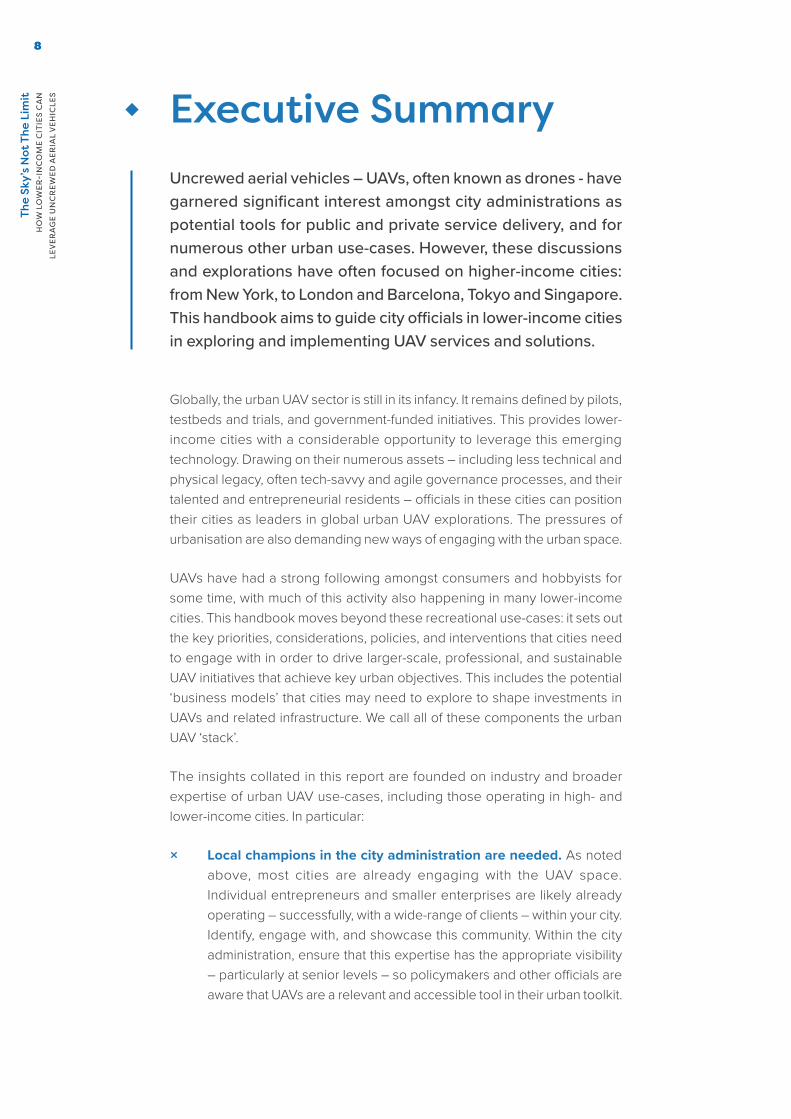
Commercially manufactured UAVs can be grouped into three different designs, differentiated by their wing structure and associated functions10:
Design and Maneuverability
Typical operating range and coverage
Examples of existing models
FIXED-WING Two-wing design for horizontal take-off and landing
Around 50km/h for up to 2 hours (on gasoline or batteries)
Up to 25kg payload capacity
eBee by senseFly
Zip by Zipline (using catapult launch mechanism)
MULTI-ROTOR Rotor-wing design (1-8 propellers) for vertical take-off and landing
Around 7km/h for up to 40 minutes (on lithium polymer batteries)
2-5kg payload capacity
Matternet ONE
Phantom by DJI
Yuneec H520E
HYBRID Wings and rotors for horizontal and vertical take-off and landing
Around 100km/h for up to 3.5 hours (on gasoline or batteries)
Up to 10kg payload capacity
Tron by Quantum Systems
Vayu
Wingtra
Wingcopter 198
9 FAA ‘Executive Summary Final Rule on Operation of Small Unmanned Aircraft Systems Over People’ - https://www.faa.gov/sites/faa.gov/files/2021-08/OOP_Executive_Summary.pdf
10 See also this more comprehensive (although older) overview: https://uav-guidelines.openaerialmap.org/pages/05-choosing-the-right-uav/

The
Sky’
s N
ot T
he L
imit
H
OW
LO
WER
-IN
CO
ME
CIT
IES
CA
N
LEV
ERA
GE
UN
CR
EWED
AER
IAL
VEH
ICLE
S22
· UAV TECHNOLOGY AND SOLUTIONS
UAVs are the aircraft component of a broader Uncrewed Aircraft System (UAS)11, which also comprises control stations, communication and data links, and flight systems.12
This integrated architecture, when combined with other emerging technologies like Artificial Intelligence, computer vision, and remote sensing, enables UAVs to operate at a high level of automation. This more advanced functionality can include collecting:
× Visual data: enabling continuous monitoring of urban infrastructure – including roads, buildings, and mobile phone towers – to ensure successful functioning. Systems to manage traffic conditions and inform predictive road maintenance.
× Thermal data: to identify hotspots during an active fire to help first responders focus their efforts.
× Geospatial data: providing high-resolution aerial mapping and geospatial data collection of dense urban clusters to inform city planning and development – leveraging RGB and/or Light detection and ranging (LiDAR)
× Multispectral (and hyperspectral) data: allowing city officials to monitor eco-diversity and environmental health for precision agriculture and natural resource management.
These applications highlight the potential to integrate UAV technologies and solutions into city operations as part of broader ‘smart city’ plans and strategies. They offer the potential for operational efficiencies in logistics and supply chain management, risk reduction in hazardous situations, and greater precision in analytics for informed decision making and predictive service delivery.
11 UAS emphasises other configurable elements other than the aircraft (UAV) that are required during flight operations
12 Drone Technology: Types, Payloads, Applications, Frequency Spectrum Issues and Future Developments - https://papers.ssrn.com/sol3/papers.cfm?abstract_id=3047760

The
Sky’
s N
ot T
he L
imit
H
OW
LO
WER
-IN
CO
ME
CIT
IES
CA
N
LEV
ERA
GE
UN
CR
EWED
AER
IAL
VEH
ICLE
S
23
· LIMITATIONS
UAV technologies, and the broader sector, have rapidly improved in quality (including flight-range and functionality), affordability, and accessibility in recent years – and continue to do so. However, as with all technologies, they are not panaceas and UAVs will not be feasible at scale in many cities. This may be due to challenges concerning a lack of suitable space for UAV infrastructure, and use-cases where UAVs may not be the most appropriate or useful solution. With regard to the latter, there are a number of alternative technologies for many UAV use-cases depending on local budget, context, and other considerations. For example, remote-sensing or geospatial data collection using traditional aircraft, or satellite data, may be more suitable in some contexts and for some requirements compared to UAV deployments. That said, the UAV sector continues to evolve, and often UAVs can play a valuable role in combination with these and other methods and technologies.
© Sala Lewis

♦ Implementing UAVs in citiesEven in higher-income cities, large-scale UAV explorations are still in their infancy. However, this provides an opportunity for lower-income cities to become global leaders in shaping city processes and infrastructure to leverage the potential of UAVs. Achieving this will require three components: building the digital, physical, and innovation infrastructure needed for UAVs (including leveraging existing infrastructure that is used for broader functions); shaping a UAV ecosystem (including ensuring community buy-in, and positive public perception of UAV initiatives); and developing sustainable financing and other opportunities to embed UAVs within the city. We call this the UAV ‘Urban Stack’.
©
Food
pand
a
Building the UAV infrastructure
Flight infrastructure
Innovation infrastructure
Digital infrastructure
Shaping the UAV environment
Putting it into practice
Business models
Physical infrastructure
Shaping regulations
Managing and using data
Citizen-centric
Building partnerships

The
Sky’
s N
ot T
he L
imit
H
OW
LO
WER
-IN
CO
ME
CIT
IES
CA
N
LEV
ERA
GE
UN
CR
EWED
AER
IAL
VEH
ICLE
S26
· BUILDING THE UAV INFRASTRUCTURE
UAVs do not operate in isolation. For UAVs to take literal flight, they need to be supported by an ancillary system of digital (including data and ICT) architectures, UAV-specific flight systems, physical infrastructure, as well as innovation networks between government, academia, private sector, and civil society stakeholders. These infrastructural components are integral parts of the UAV ecosystem – and broader digital economy. Recognising the latter point, much of this infrastructure is not UAV-specific and instead catalyses a wide-range of different functions, use-cases, and products and services.
Digital infrastructure is foundational to UAV operations. Cities need to invest in strong connectivity networks to ensure the reliability of UAV command and control – and data architectures to enable data storage and processing to support the industry’s services for and within the city. This requires close collaboration between public and private sector actors.
Investments in physical assets that could enable UAVs to take-off and land, (un)load, dock, and charge are also important. This should consider the urban planning and zoning priorities of cities – and explore potential models of integration with existing logistics and transport networks, as well as with the city’s built environment. The rationalisation of UAV-specific physical infrastructure will be crucial in accelerating the commercialisation and scaled deployment of UAVs.
Safe and successful UAV flights depend on effective urban airspace management. In this regard, flight infrastructure around air traffic control and management could enhance the oversight capacity of cities – and ensure equitable access to public airspace. Critical to this is the development of Uncrewed Aircraft Traffic Management (UTM) Systems that could facilitate the harmonisation of UAVs with existing manned aircrafts. UTM could streamline cities’ flight authorisation process by serving as a single digital application for UAV licenses, flight planning, maintenance logs, and more.
Finally, UAVs are important components, and catalysts, of a broader urban innovation ecosystem. Cities will have to create, shape, and scale local capacity building networks that could enable innovation throughout the UAV value-chain – from research and development, to testing, and commercialisation. This includes investments in local manufacturing assets as well as incubation spaces.

ConnectivityWired and wireless connectivity networks, and radio infrastructure
InnovationInnovation partners (academia, business interest groups, startups), 3D printing and fabrication labs, digital marketplace, test sites
Physical assetsDroneports, command points, distribution centres, energy facilities
Flight operations management Uncrewed tra�c management (communication and authorisation), addressing solutions, flight planning, autopilot software
Data processingData storage and analytics platforms, open data bases, cloud infrastructureStakeholders
City administrators, national government, regulators, UAV local and international operators, third-party operators, development organisations, civil society organisations, academia
Aircraft hardwareFixed-wing, multi-rotor, hybrid

©
Zipl
ine

The
Sky’
s N
ot T
he L
imit
H
OW
LO
WER
-IN
CO
ME
CIT
IES
CA
N
LEV
ERA
GE
UN
CR
EWED
AER
IAL
VEH
ICLE
S
29
Digital Infrastructure
Digital infrastructure is the foundation of the digital economy, enabling a wide range of opportunities within a city. UAV applications require this underlying digital infrastructure for all of their operations. Shaping digital infrastructure in many cities also often requires close collaboration between the public and private sectors.
Importantly, though, the below digital infrastructure components are not solely the preserve of UAV deployments or stakeholders. Many of these foundations, for example 4G connectivity, are essential infrastructure for various other important aspects of urban digital transformation. Digital infrastructure is therefore much more cross-cutting than the UAV ‘physical infrastructure’ priorities and investments set out in the next section.
In the context of UAV deployments in cities, digital infrastructure includes a number of key components.
× Connectivity: radio, wireless – particularly 4G (and even 5G) – and wired infrastructure. The latter includes fibre-optic connectivity to provide the backhaul needed for wireless networks to operate. Internet-of-Things technologies, including LoRa and ‘edge’ communications, are also needed for particular UAV use-cases.
× Addressing system: navigation and precision landing systems technologies such as GPS – or other commercial or open-source approaches (recognising that GPS may not be accurate enough for precision landing requirements) – to enable UAV tracking, guide flight paths, and enable the delivery of goods and services.
× Data processing: data architecture, which may include physical data assets and centres, or data management resources such as cloud services.
UAVs, and the broader ecosystem, cannot function without digital infrastructure. At present, inadequate connectivity, including the availability and accessibility of communication networks and navigation systems, is a particular barrier in many cities to the future effective urban air traffic management that could facilitate the integration of UAVs into city operations and enterprise workflows13. In addition, the value proposition of UAV applications are often based on insights derived from analytics of payload data. As the UAV industry matures, data processing – the transmission and translation of payload data into actionable insights – will depend on the availability of data and digital architectures, including Infrastructure as a Service (IaaS) and data platforms.
13 Huawei ‘Connected Drones: A New Perspective On The Digital Economy’ - https://www.gsma.com/iot/wp-content/uploads/2017/06/connected_drones_a_new_perspective_on_the_digital_economy_en.pdf

The
Sky’
s N
ot T
he L
imit
H
OW
LO
WER
-IN
CO
ME
CIT
IES
CA
N
LEV
ERA
GE
UN
CR
EWED
AER
IAL
VEH
ICLE
S30
More specifically, wired and wireless connectivity (and other technologies) are essential in enabling pilots and other operators to control and manage UAV operations. This includes Uncrewed Traffic Management systems and more sophisticated UAV operations. This connectivity needs to be sufficiently robust and high-quality. Currently, UAV operations – command and control – use private radio networks, and not commercial wireless technologies (such as 4G, LTE, and 5G). However, for future scaled operations within cities, wireless lower-latency communications may be crucial in improving the ability of pilots to make mid-flight course corrections (including in an emergency situation). However, regardless of technology, the underlying connectivity needs to be reliable in order to avoid any loss of control or communication with the UAV.
As discussed later in this handbook, UAVs will play a crucial role in logistics and other service delivery within a city. Many of these operations could also be automated in the future. However, to ensure that the UAV – and its payload – arrives safely at its destination, authoritative and accurate addressing systems are needed. Around 50% of city streets in Sub-Saharan Africa have no names or addresses.14 In the Middle East, it is estimated that incorrect addresses and last-mile delivery failure could cost the logistics and e-commerce industry over $7 billion.15 Leveraging local digital data to geocode city streets could be a critical enabler of foundational addressing systems and services.
14 World Bank ‘Street Addressing and the Management of Cities’ - https://documents1.worldbank.org/curated/en/573071468142795481/pdf/329230Street0Addressing01not0external1.pdf
15 The impact of inaccurate addresses in the Middle East - https://min.news/en/tech/37c4cb5de3580f5e7a657d118c0f0c48.html
© Flying Labs Côte d’Ivoire

The
Sky’
s N
ot T
he L
imit
H
OW
LO
WER
-IN
CO
ME
CIT
IES
CA
N
LEV
ERA
GE
UN
CR
EWED
AER
IAL
VEH
ICLE
S
31
These challenges reflect a larger development priority of modernising or building digital infrastructure (including ICT, navigation, and data architectures) in lower-income cities that extends beyond driving UAV deployments. Many cities often lack reliable and comprehensive connectivity, or the data and ICT infrastructure for complex data handling. For example, UAV data processing is increasingly being explored through AI-based software. These tools often require higher-end computers, or need to be delivered via online cloud services. These technologies are not always accessible or affordable for local UAV operators.
Case Study: KPN & TEOCO’s Beyond-visual line-of-sight Platform
Reliable connectivity is crucial for real time command and control of UAVs. A single interface for flight management could also be an important tool for cities to oversee fleets of UAVs manufactured and deployed by various operators. To support the development of more sophisticated UAV-enabled services, connectivity, digital, and data technologies are increasingly intersecting.
Dutch mobile telecom operator, KPN, and American telecom software solutions provider, TEOCO are developing a UAV management platform that could share mobile network information, connectivity data, and analytics across different domains of the broader UAV ecosystem.16 It is envisioned as an integrated end-to-end system that links cellular networks with traffic management systems to guide more advanced beyond visual-line-of-sight operations, from command and control to the use of real-time data to support UAV-enabled services. Preparatory steps are being implemented on 4G and LTE networks, with future plans to transition to 5G connectivity.
16 GSMA Internet of Things Case Study: Beyond Visual Line Of Sight Platform by KPN and TEOCO - https://www.gsma.com/iot/wp-content/uploads/2020/03/Drones-KPN-TEOCO-Case-Study-final.pdf

©
Flyi
ng L
abs
Nep
al

The
Sky’
s N
ot T
he L
imit
H
OW
LO
WER
-IN
CO
ME
CIT
IES
CA
N
LEV
ERA
GE
UN
CR
EWED
AER
IAL
VEH
ICLE
S
33
Considerations for cities
× Map connectivity gaps and opportunities: ‘not-spots’ and other connectivity issues exist in all cities, and can pose real limitations to the extent and success of UAV operations. Cities should map the extent of wired and wireless connectivity across the city, including disaggregating this data – where possible – by gender and other key demographics. When considering areas to deploy connectivity infrastructure, the city should look to rationalise this wherever possible – for example, siting wireless masts alongside drone-ports and ensuring fibre-connectivity to these locations. Incorporating ‘Dig Once’ policies can also be valuable.
× Identify broader connectivity opportunities: for example, working with central government on experimental spectrum allocations in order to explore UAV use-cases in the city. This could see a shift in spectrum management away from technology- and sector-specific licenses to allow network providers more flexibility in allocating spectrum rights based on value use. 17 In this regard, cities should work with UAV operators and network providers to define standards around integrating communications modules in UAV devices that meet cellular network requirements. These modules should also enable reliable communications between UAVs and traffic management systems.
× Be cautious with proprietary addressing solutions: there are a number of geolocation technologies and addressing solutions available to cities and UAV innovators. However, when selecting an appropriate system to use, city administrators have to be cautious of vendor lock-in or proprietary approaches that could constrain operations or future innovations. In particular, these approaches should be able to integrate with the products and services developed by the UAV sector – and other public sector actors
× Look at the whole digital value chain: a particular opportunity in the UAV data collection space relates to high fidelity imagery and elevation models. Significant effort is expended in ensuring that local pilots are trained and certified. However, often comparatively little thought is given to the full value-chain: from manufacture through to data delivery. For example, many development models focus on the collection of data, but not the processing of data to create highly valuable outputs that can then inform land tenure mapping processes, hydrological modelling, etc. City – and national – governments should look to shape policies and
17 Huawei ‘Connected Drones: A New Perspective On The Digital Economy’ - https://www.gsma.com/iot/wp-content/uploads/2017/06/connected_drones_a_new_perspective_on_the_digital_economy_en.pdf

The
Sky’
s N
ot T
he L
imit
H
OW
LO
WER
-IN
CO
ME
CIT
IES
CA
N
LEV
ERA
GE
UN
CR
EWED
AER
IAL
VEH
ICLE
S34
drive outcomes that expand across the value-chain18 – including into the data processing space. Solely focusing on pilots, airspace integration, and associated policy – although important foundations for UAVs – risks missing broader inclusion and local economic opportunities.
× Consider crowdsourcing to improve address data: using UAVs for urban mapping could be a way towards improving addressing and geolocation systems. This could include leveraging existing open-source initiatives such as OpenDroneMap, which enables UAV image processing, visualisation, and analysis. At the same time, crowdsourcing and community microtasking approaches that gamify local mapping processes could be especially valuable. These have already seen some success in Nairobi, where citizens geo-tag their front door via an app to support address verification.19 This has helped e-commerce and logistics companies in the city reduce the cost of delivery by 20% and 40%, respectively.20
× Consider ways to improve digital infrastructure: UAV operations, and other elements of the digital economy, can be resource-intensive. Whilst particular UAV use-cases – such as mapping – result in large volumes of geospatial and other data. The digital infrastructure available to the city may be lacking, or require costly upgrading and investment. Cloud services could provide a more agile and cost-efficient approach for lower- and middle- income cities to engage with the data- and digital-potential of UAVs. However, city explorations of cloud will need to be guided by local and national regulations (including in the context of issues such as data portability and data sovereignty), and often require strong connectivity infrastructure.
× Enhance data capabilities in the city: post-flight data processing and analytics require intensive technical and capital investments that are often overlooked in UAV data collection operations. For example, UAV data collection projects often do not budget for post-flight data processing, and leave data management to other organisations. In this regard, investments in technical training – in statistics, geographic information system, and data management – is especially important.
18 See, for example, the work of entrepreneur Abdoulaziz Kountché in designing and creating UAVs in Niger: https://www.africanews.com/2021/04/09/niger-drone-company-takes-off-in-sahel//
19 Addressing the Issue: How to Deliver on Physical Addresses for the Poor - https://dai-global-digital.com/addressing-the-issue-how-to-deliver-on-physical-addresses-for-the-poor.html
20 Kenyan smart addressing startup OkHi launches in Nigeria with funding from Interswitch - https://disrupt-africa.com/2020/12/10/kenyan-smart-addressing-startup-okhi-launches-in-nigeria-with-funding-from-interswitch/
The
Sky’
s N
ot T
he L
imit
H
OW
LO
WER
-IN
CO
ME
CIT
IES
CA
N
LEV
ERA
GE
UN
CR
EWED
AER
IAL
VEH
ICLE
S
35
Physical Infrastructure
UAVs are not just about the skies – they require a wide-range of physical and terrestrial infrastructure for safe and useful operation. Each element of this infrastructure should consider the city’s existing built environment, air and land logistics and transport infrastructure, and potential modes of integration. In parallel, cities might also have to define the role of public ownership – and explore new investment and operational models with the private sector.
The global UAV transport and logistics market, currently worth $11 billion, could expand by 62% in the next five years.21 Shaping this growth, though, will require investments in physical assets that can drive the scaled deployment of UAV technologies. At present, improvements in UAV technologies presents considerable opportunities to integrate UAV solutions into the day-to-day operations of a city, but the absence of ground infrastructure is a barrier to the commercialisation and scaled deployment of UAVs.22 Physical infrastructure therefore provides the literal launchpad for UAVs in cities – including supporting the sustainability and scalability of UAV operations. It includes a number of key components:
× Command points: ground control stations – or ‘virtual cockpits’ – to command and manage fleets of UAV in flight and monitor live video from a UAV’s camera.
× Droneports: areas for UAV take-off and landing – which could include runways, vertiports (for rotor- or hyrid-aircraft), docks for the (un)loading of payloads, as well as spaces for UAV maintenance, and storage.
× Distribution centres: a network of smaller droneports (sometimes known as ‘vertistops’ or ‘vertiports’) with one or two landing pads, or multi-modal facilities (also known as ‘vertihubs’), providing infrastructure for last-mile delivery.23
× Energy facilities: power infrastructure such as battery storage and disposal facilities, as well as charging and refuel stations.
21 See Markets and Markets, Drone Package Delivery Market - https://www.marketsandmarkets.com/Market-Reports/drone-package-delivery-market-10580366.html
22 Deloitte, Infrastructure barriers to the elevated future of mobility - https://www2.deloitte.com/us/en/insights/focus/future-of-mobility/infrastructure-barriers-to-urban-air-mobility-with-VTOL.html
23 Deloitte, Infrastructure barriers to the elevated future of mobility - https://www2.deloitte.com/us/en/insights/focus/future-of-mobility/infrastructure-barriers-to-urban-air-mobility-with-VTOL.html

The
Sky’
s N
ot T
he L
imit
H
OW
LO
WER
-IN
CO
ME
CIT
IES
CA
N
LEV
ERA
GE
UN
CR
EWED
AER
IAL
VEH
ICLE
S36
For UAVs to meet the transport and logistics needs of a city, flights have to be routinely deployed, and – potentially – with a significant degree of autonomy. This requires a high level of efficiency and reliability in UAV logistics and workflow management. Ground infrastructure is foundational to this as it acts as the literal base station for UAV operations (via ground control stations), organises the logistics of UAV operations (including storage of aircraft and components), and enables the creation of flight networks to the very last mile. This includes the role of distributed networks of droneports within a city.
In addition, sustainable UAV operations in any city will require integration into existing infrastructure, workflows, and processes. For example, combining smaller droneports with existing delivery distribution centres to enable seamless transfer of cargo between UAVs and other logistics channels – such as vehicles and bicycles – for last-mile delivery. The energy requirements for UAV operations, from battery charging to ground control power solutions, may also demand rationalisation of power infrastructure.
Physical infrastructure could also extend to the broader enablers of UAV operations in a city. However, some of these aspects may not be within the control of a city administration. This includes physical and electronic licencing of UAV aircraft and their operators, customs and import processes for UAV equipment, and related regulations such as e-waste and ‘right-to-repair’ requirements.
Case Study: Abu Dhabi’s UAV network
In Abu Dhabi, US UAV operator, Matternet, in collaboration with the Department of Health, and EAU logistics company, SkyGo, plans to install 40 drone ports in the city for UAV medical deliveries.24 This network of physical assets is envisioned to enable UAVs with pre-approved beyond-visual line-of-sight flight routes will be able to autonomously deliver critical medical products to various collection points – with last-mile delivery to medical centres performed through more traditional transportation.
24 Matternet and SkyGo partner with Abu Dhabi DoH for the world’s first city-wide medical drone network - https://www.suasnews.com/2021/09/matternet-and-skygo-partner-with-abu-dhabi-doh-for-the-worlds-first-city-wide-medical-drone-network/

©
Zipl
ine

The
Sky’
s N
ot T
he L
imit
H
OW
LO
WER
-IN
CO
ME
CIT
IES
CA
N
LEV
ERA
GE
UN
CR
EWED
AER
IAL
VEH
ICLE
S38
Considerations for cities
× Consider a blended approach: cities will have to decide if it would be more viable and valuable to build new UAV ground infrastructure or retrofit existing physical structures for the specific needs of UAV operations. Due to the smaller size and VTOL capabilities of some UAVs, the spatial composition of UAV ground infrastructure could be simpler and more flexible than other transport or logistics infrastructure. This means city planners could be more creative in integrating UAV ground infrastructure into the existing built environment, such as building vertiports on top of residential builds, parking lots, and along highways.25 In parallel, cities should also consider opportunities to connect any such new infrastructure with existing transport or distribution hubs for more seamless operations. This could be particularly valuable for last-mile deliveries in cities.
× Identify the role of the city in infrastructure provision: infrastructure development is expensive; a vertiport can cost between $2 to $200 million.26 At present, early investments in UAV ground infrastructure such as vertiports are being led by private capital including being driven by international UAV operators for commercial and private use. These investments could be a financially sustainable and efficient model for infrastructure development and operation, especially in the context of stretched city budgets. However, they could also result in duplication, inefficiencies, and crowd-out smaller-scale and local UAV operators. City administrators will have to consider what aspects of UAV operations comprise public infrastructure – and how to ensure UAV infrastructures are deployed most effectively. These aspects are explored in more detail in the ‘Business Models’ section of this handbook.
× Prioritise cross-sector collaboration: developing physical infrastructure that is useful for the UAV industry, while supporting other urban priorities, will require extensive collaboration between public and private sectors in design and implementation. This includes cross-sector policy planning between different city functions and beyond. For example, insights from the national aviation authority on flight corridors that could enable the safe integration of UAVs into a city’s air space, engagement with the local transport department on integration into a city’s urban mobility system, and leveraging the expertise of urban planners regarding city zoning and planning regulations. This discussion should also include a diverse range of private sector actors, such as local and international players, UAV operators, as well as third-party providers in telecommunications and data services.
25 International Transport Forum, Ready for Take-Off? Integrating Drones into the Transport System - https://www.itf-oecd.org/sites/default/files/docs/take-off-integrating-drones-transport-system.pdf
26 Air-mobility solutions: What they’ll need to take off - https://www.mckinsey.com/industries/travel-logistics-and-infrastructure/our-insights/air-mobility-solutions-what-theyll-need-to-take-off

The
Sky’
s N
ot T
he L
imit
H
OW
LO
WER
-IN
CO
ME
CIT
IES
CA
N
LEV
ERA
GE
UN
CR
EWED
AER
IAL
VEH
ICLE
S
39
× Identify opportunities for ‘future-proofing’: power, digital infrastructure, and other services required by droneports are also needed for broader public service delivery – and by other city stakeholders. City administrators play an important role in identifying opportunities to rationalise and future-proof this infrastructure – for example, using droneports to site or co-locate this infrastructure. This could allow the city to consider using droneports to host electric vehicle charging stations, or other priority assets, to add greater value to the city. This could also be an important revenue consideration for the city, providing an opportunity to lease parts of droneports to non-UAV service providers.
× Consider renewable energy sources: cities should be mindful of the environmental impact of UAV operations. While the global renewable energy sector is actively exploring the potential of UAVs to carry out inspection and maintenance activities across solar and wind farms, advancements in powering UAVs with renewable energy sources remain in their infancy. Cities could play a leading role in improving the sustainability of the UAV sector. This includes efforts in efficiently connecting drone ports to power distribution grids, building small wind turbines in vertihubs, or installing solar panels on the roof or facades of vertistops.
© Zipline

The
Sky’
s N
ot T
he L
imit
H
OW
LO
WER
-IN
CO
ME
CIT
IES
CA
N
LEV
ERA
GE
UN
CR
EWED
AER
IAL
VEH
ICLE
S40
Flight Infrastructure
Some of the most complex considerations relating to UAV operations in cities centre around ensuring safe and successful flights. In particular, flight planning and air traffic control and management. These technical and digital components verify the registration and traceability of UAVs, prevent collisions or mid-air conflicts, enable peer-to-peer deliveries, inform operations through providing real-time information on weather patterns or emergency restrictions, and enhance the oversight capacity of regulators to ensure the success and safety of UAV operations.
As private sector actors explore new technologies and operating models in UAV flight management, cities will also have to ensure that flight infrastructure prioritises interoperability and equitable access to public airspace during deployment. Flight infrastructure comprises of a number of flight planning and management digital services that include:
× Uncrewed Aircraft Systems Traffic Management system (UTM): facilitates the harmonised integration of UAVs into different segments of airspace. It allocates airspace and optimises route planning to prevent collisions. In addition, it can support the implementation of a single digital application for UAV registration, automated approval, and verification of UAV flight location to enhance regulatory enforcement capacity.
× Geofencing: delineated areas recognised by UAV software, to prevent UAVs entering the location. If attempting to take-off within a geofenced area, the UAV will not function.
× Autopilot software: obtains data from UAV sensors or control motors to ensure UAV flight stability, as well as facilitating ground control and communication.
× Remote identification systems: associates UAVs with pilots or operating companies, enabling regulators, enforcement agencies, or other relevant stakeholders to register and trace UAVs in order for successful airspace management27.
× Authorisation process: database and information management system verifying pilot training certification records, UAV license, maintenance logs, and insurance provisions. This could be connected with incident reporting systems, geoinformation services, or high-performance radar systems to detect and communicate aircraft location. These functionalities enable UTMs to serve as a single digital application for UAV regulatory oversight and compliance.
27 See, for example, EASA’s ‘UAS flight authorisation request form’: https://www.easa.europa.eu/downloads/111305/en

The
Sky’
s N
ot T
he L
imit
H
OW
LO
WER
-IN
CO
ME
CIT
IES
CA
N
LEV
ERA
GE
UN
CR
EWED
AER
IAL
VEH
ICLE
S
41
As the UAV market matures and offers more on-demand services, cities will face increasing pressure to efficiently and equitably allocate limited urban air spaces, as well as facilitate the safe harmonisation of UAVs with manned aviation. Reducing the risk of collision or mid-air conflict as air traffic increases, especially in densely populated urban areas, will require robust and reliable flight infrastructures to enable UAV identification, authorisation, and communication at scale. Many of these efforts will be led by national aviation authorities, but increasing localisation in many countries could also see cities playing a greater role.
UTM and autopilot technologies increase the predictability and consistency of UAV air traffic management – and will be crucial in building public and regulatory confidence in more sophisticated beyond visual-line-of-sight, multiple aircraft per pilot, and autonomous operations that could generate greater social and economic impact. While UTM technologies could generate estimated global revenues of $1.3 billion in 2029, they are, at present, the least developed market segment in the broader UAV industry, representing less than 1% of the market.28
28 Huawei ‘Connected Drones: A New Perspective On The Digital Economy’ - https://www.gsma.com/iot/wp-content/uploads/2017/06/connected_drones_a_new_perspective_on_the_digital_economy_en.pdf
© Zipline

The
Sky’
s N
ot T
he L
imit
H
OW
LO
WER
-IN
CO
ME
CIT
IES
CA
N
LEV
ERA
GE
UN
CR
EWED
AER
IAL
VEH
ICLE
S42
At the same time, many countries also lack a common method to register and identify UAVs, thereby constraining regulators’ ability to recognise and trace unauthorised UAVs. UAV registration and remote identification are foundational building blocks of UTM, ensuring air space management is transparent and accountable. 29 As private sector actors explore new technologies and operating models in UAV flight management, cities have to ensure fair market access to public airspace – and play a steering role in setting industry standards around performance requirements, technical interoperability, and more broadly, flight data governance.
Case Study: Singapore
Singapore has demonstrated a working UTM system. Its capabilities support a remote ID system, flight authorisation, preventing conflict between UAVs, conformance monitoring (ensuring that the UAV follows the path agreed with regulators), and real-time alerts of flight location.
The design of the UTM prioritises localising international best practices around UTM standards to the built environment and digital infrastructure of Singapore. This includes ensuring relevance to the local context, such as Singapore’s connectivity system (in particular, the LTE signal strength required to support reliable UAV command and control) and studying flight performances in urban topographies (including the presence of high-rise buildings and fast-changing weather events).30
The UTM was developed in close collaboration with the private sector – including drawing on the 2018 Future Flight Consortium, which brought together industry and academic experts, as well as the Civil Aviation Authority and Ministry of Transport to develop a uniquely urban UAV airspace management system.31 It demonstrates the value of establishing cross-sector consortia in designing and implementing commercially relevant flight infrastructure that meets the regulatory requirements and national priorities of a country.
29 International Transport Forum, Ready for Take-Off? Integrating Drones into the Transport System -https://www.itf-oecd.org/sites/default/files/docs/take-off-integrating-drones-transport-system.pdf
30 Singapore Completes, Demonstrates Working UTM System - https://insideunmannedsystems.com/singapore-completes-demonstrates-working-utm-system/
31 3 Year Singapore UTM Trial Just Ended, And Here’s What Happened - https://www.thedronegirl.com/2021/03/26/singapore-utm-trial/
The
Sky’
s N
ot T
he L
imit
H
OW
LO
WER
-IN
CO
ME
CIT
IES
CA
N
LEV
ERA
GE
UN
CR
EWED
AER
IAL
VEH
ICLE
S
43
Considerations for cities
× Ensure compatibility of UTM with existing aviation management systems: to effectively govern the air space of a city, and minimise the burden placed on existing aviation oversight mechanisms, UTM solutions should be compatible with existing (manned) air traffic control systems, and have technical capabilities that could support the enforcement of policies and regulations. Similarly, regulators may need to engage with proportional or risk-based regulation – recognising that regulating UAVs at the same level as passenger aircraft may stifle innovation. In addition, UTM systems should also be founded upon national UAV registration databases to support remote registration and tracking of UAVs.32
× Protect key urban assets and responsibilities: shaping useful and sustainable flight infrastructure is a sizeable undertaking, and will require considerable partnership with the private sector. This includes leveraging the knowledge and expertise of UAV operators and other stakeholders. However, the city administration should also recognise and protect its assets. In particular, avoiding ‘selling’ exclusive access to air corridors to single companies or other approaches that risk de facto monopolies. Air corridors should remain the preserve of the city administration.
× Coordinate industry collaboration and innovation in UTM development: a high-performing UTM system will need to interact with and draw information from a range of open and proprietary digital sources (such as weather, navigation and GIS systems, as well as autopilot and flight planning software) managed by operators from different sectors.33 A UTM also has to connect with government databases and information systems such as geolocation and addressing, as well as UAV registration and licensing systems. Connecting these interacting layers requires high technical and organisational capabilities. The private sector often has greater practical and technical expertise concerning UTM development and deployment, and could be a valuable resource for full UTM integration and implementation. In this regard, regulators and city administrators should play a steering role in facilitating industry consortia and private-public partnerships in exploring these possibilities.
× Regulate for technical interoperability: managing fleets of UAVs – produced and operated by various manufacturers and service providers – for integrated city operations requires interoperable command systems that are accessible to various public institutions, different UAV operators, as well as a variety of third-party service providers within the broader UAV ecosystem. At present, the UTM market is nascent, and led by private sector players. Explorations in this field
32 International Transport Forum, Ready for Take-Off? Integrating Drones into the Transport System -https://www.itf-oecd.org/sites/default/files/docs/take-off-integrating-drones-transport-system.pdf
33 Deloitte, Infrastructure barriers to the elevated future of mobility - https://www2.deloitte.com/us/en/insights/focus/future-of-mobility/infrastructure-barriers-to-urban-air-mobility-with-VTOL.html

The
Sky’
s N
ot T
he L
imit
H
OW
LO
WER
-IN
CO
ME
CIT
IES
CA
N
LEV
ERA
GE
UN
CR
EWED
AER
IAL
VEH
ICLE
S44
are largely limited to private sector or other pilot projects commissioned by government actors as proofs-of-concept, proprietary UTM systems designed by UAV operators with control systems specific to their aircrafts, or UTM operators offering flight management services. This has led to a duplication of UTM systems that may not be conducive to effective airspace integration – and risks a situation combining commercialised public airspaces with inadequate regulatory oversight. In this regard, regulators and city policymakers should play a steering role in building industry consensus around interoperable and open standards for UTM design and implementation. Cities could consider performance-based requirements that measure technical capabilities of proposed UTM solutions in a technology-agnostic manner. 34
× Establish appropriate mechanisms for UTM data governance: a UTM system generates, stores, and exchanges large volumes of data – and becomes more reliable and useful as it layers digital functions and data sources. The proliferation of UAV-related data could create a UAV data economy that provides unique market opportunities – but also risks. In particular, uneven data distribution – or monopoly – by a few private sector actors could result in unfair competition.35 Therefore, regulators should set out clear data-focused and other roles and responsibilities in UTM system management,36 including air navigation service operators, UAV operators, and data processing and analytics service providers.37 This could be guided by open data practices for transparency, as well as foundational data protection regulations through the data life cycle – from collection, to storage, exchange, analytics, and disposal.
× Leverage technology to geofence key urban assets: cities could set up geofencing to protect sensitive areas (for example, military sites or government buildings) and key urban infrastructure (such as utilities, aircraft landing areas, or densely populated built environments). Geofencing systems prevent UAVs from entering or leaving restricted airspaces. The International Civil Aviation Organisation (ICAO) recommends that local authorities develop a common set of standards and processes for airspace restrictions – and openly publish such restrictions on dedicated websites or mobile applications.38 The former includes considerations such as the integration of temporary restrictions into permanent geofenced areas, as well as requirements for validating or authorising restricted areas. Cities should also be cautious of creating too many restricted areas that could create airspace congestion for both crewed and uncrewed aircrafts.
34 The need to define an appropriate set of UAS requirements for base UAS Traffic Management capabilities - https://nuair.org/2021/02/04/establishing-and-validating-performance-requirements-for-utm/
35 International Transport Forum, Ready for Take-Off? Integrating Drones into the Transport System -https://www.itf-oecd.org/sites/default/files/docs/take-off-integrating-drones-transport-system.pdf
36 This should also extend to discussions with national authorities with regard to the risks of regulatory capture.37 We are ALL ONE in the Sky – Aviation partners agree joint principles for safe integration of drones - https://www.
canso.org/we-are-all-one-sky-aviation-partners-agree-joint-principles-safe-integration-drones38 ICAO, Unmanned Aircraft Systems Traffic Management (UTM): A Common Framework with Core Principles for
Global Harmonization - https://www.icao.int/safety/UA/Documents/UTM-Framework.en.alltext.pdf

©
Zipl
ine

The
Sky’
s N
ot T
he L
imit
H
OW
LO
WER
-IN
CO
ME
CIT
IES
CA
N
LEV
ERA
GE
UN
CR
EWED
AER
IAL
VEH
ICLE
S46
Innovation Infrastructure
UAVs are more than a tool for service delivery. They are important components, and catalysts, of a broader urban innovation system – one founded on cross-sector collaboration and local capacity building. Cities play a crucial role in creating, shaping, and scaling these networks and platforms to drive knowledge and capital, and building skills and expertise. The UAV innovation ecosystem also integrates with thematic and broader initiatives – from makerspaces with 3D-printing technology that can produce UAV components, through to incubators focusing on areas of relevance to the UAV sector (such as civictech).
Innovation infrastructure builds local expertise and capacity throughout the UAV value-chain – from research and development, to testing, and commercialisation. This ecosystem includes key components such as:
× Partnership networks: collaboration between business interest groups, public-private consortia, international and local partnerships, as well as local universities and research institutions.
× Local manufacturing assets: 3D-fabrication labs (‘fablabs’), makerspace communities, and SME and digital marketplaces to accelerate deployment and commercialisation.
× Technology demonstrators: testbeds, technology hubs, incubation spaces, as well as accelerators to develop viable business models and shape regulations.
× Open contracting: providing transparency and inclusivity in city administration procurement, to enable smaller UAV enterprises to provide products and services. This can be an opportunity to provide a platform for local companies and to drive local manufacturing and ownership.
New products and processes are founded on innovation. Supporting the development, implementation, and commercialisation of UAV solutions is a key catalyst to the creation of a dynamic domestic urban and national market for UAV products and services. Similarly, these services could also extend to rural areas. Ensuring these outcomes requires investing in local capacity building programmes. This also includes shaping individual and institutional behaviours. For example, developing consumer interest and readiness for this new technology requires effective framing and communication of UAVs as a ‘service’ – and concerted effort from the private sector to help governments and organisations identify opportunities to integrate UAV solutions into existing processes and workflows.

The
Sky’
s N
ot T
he L
imit
H
OW
LO
WER
-IN
CO
ME
CIT
IES
CA
N
LEV
ERA
GE
UN
CR
EWED
AER
IAL
VEH
ICLE
S
47
Importantly, city officials should make significant efforts to identify, map, and engage with the local UAV community. In many cities around the world, UAVs are already being actively explored – or even being leveraged for impressive and highly-professional outcomes. This includes a growing and vibrant private sector ecosystem in cities, with local SMEs and other enterprises delivering UAV products and services to a wide-range of clients. In recognising these assets, city officials should also build on these strong foundations – and engage with this community to identify where the city administration can best add value.
Cities also need to balance international and local innovation. The entry of international UAV operators into the local urban space in low- and middle-income countries could embed best practice – and shape locally-relevant (and replicable) UAV business models. However, it also risks crowding-out, or stifling, local UAV innovation. Cities must commit to building local expertise, and ensuring that the competitive advantage of more mature players in emerging markets does not risk hollowing-out a sector with considerable scope for local actors. Open contracting processes are useful in monitoring procurement activities, and ensuring that local companies are not disadvantaged. Enabling local efforts is an opportunity to shape partnerships with local innovators, local universities, engineering departments, and civil society organisations to ensure that technical solutions can be designed and manufactured locally or nationally.
© Zipline

The
Sky’
s N
ot T
he L
imit
H
OW
LO
WER
-IN
CO
ME
CIT
IES
CA
N
LEV
ERA
GE
UN
CR
EWED
AER
IAL
VEH
ICLE
S48
In this regard, it is important to empower the local community with opportunities to develop specialised expertise throughout the UAV delivery pipeline. This includes investing in incubators, 3D-printing and other fabrication labs, and makerspace communities to help local startups and SMEs develop UAV products, skills, and business models. This could also extend to shaping more local UAV supply chains – including finding opportunities for local UAV manufacture and repair. At the same time, partnerships between regulators, local universities and research institutions, international enterprises and development organisations – and civil society organisations – is especially important in co-developing open standards for UAV technologies that could support local UAV operational requirements and industry needs.
Cities can also lead the shaping of UAV products and services through developing local testbed and trials programmes. These demonstrate the applicability and reliability of new UAV products and services, as well as inform and refine UAV regulation. More broadly, providing digital skills development in formal and vocational education institutions and supporting MSMEs’ digital adoption will be necessary to catalyse the broader UAV innovation ecosystem. In this regard, cities could work with the local (and national) education department to design special curriculum or education models that localise STEM education, particularly in data analytics and robotics. City-led business support programmes for MSMEs’ could also explore the role of digital – such as helping microenterprises develop an online presence or digitalise work processes.
© Flying Labs Peru

The
Sky’
s N
ot T
he L
imit
H
OW
LO
WER
-IN
CO
ME
CIT
IES
CA
N
LEV
ERA
GE
UN
CR
EWED
AER
IAL
VEH
ICLE
S
49
Case study: Flying Labs Network
Flying Labs are locally-owned and -operated knowledge hubs based in 30+ countries in Africa, Asia and Latin America.39 Flying Labs are co-created by WeRobotics and local organizations to strengthen local expertise in emerging technologies by localising the use of UAVs, data, and AI for social good applications – based on priority areas identified by the local community. Their holistic capacity building approach includes initiatives such as:
1. Hands-on training, mentorship, and sharing of knowledge, technical, and human capital resources with entrepreneurs and local organisations
2. Planning and implementation of pilot projects with international and domestic partners to demonstrate proof-of-concept
3. Technology demonstrations (including knowledge-sharing events) for government, private sector, and civil society stakeholders
4. ‘Drone as a service’ business development and incubation programmes for local MSMEs
5. Community engagement and advocacy
This bottom-up and community-centred approach has been highly effective in building local innovation ecosystems that are guided by the UAV needs and priorities of local cities.
39 See: https://flyinglabs.org/

The
Sky’
s N
ot T
he L
imit
H
OW
LO
WER
-IN
CO
ME
CIT
IES
CA
N
LEV
ERA
GE
UN
CR
EWED
AER
IAL
VEH
ICLE
S50
Considerations for cities
× Identify testbed and trial opportunities: cities could develop UAV testbeds based on a thematic priority (including, logistics, waste management, or infrastructure inspection), a particular technology (such as beyond-visual line-of-sight, or UTM solutions in an urban setting40), or a discrete location (for example, within a technology hub, testing over water at ports, or in industrial settings). This more directed approach could help the commercialisation of R&D and development of business models in priority sectors of the economy. For example, Singapore has a dedicated Maritime Drone Estate to test UAV technologies for maritime applications such as remote ship inspections and shore-to-ship deliveries.41 This is part of a broader national strategy to strengthen Singapore’s position as a international maritime centre, through the use of more emerging technologies to build port capabilities.
× Reduce the barriers-to-entry for local UAV operators: cities should aim to source products and services from the local community, including those offered by UAV operators. Improving procurement processes will be an important step in achieving this. For example, the Open Contracting Data Standards support cities in improving the effectiveness of local procurement. Establishing a ‘digital marketplace’ could be beneficial. The UK has a central, online procurement platform for digital projects in the public sector. This has enhanced the public sector’s access to specialised digital services, reduced barriers to entry for SMEs to offer their products and services, and driven improved transparency and accountability in government procurement. Similarly, working with national regulators to shape inclusive technical standards and regulation42, affordable certification routes (including ensuring that certification and permission to operate for both pilots and airframes is always accessible to small local actors, both in terms of cost and complexity), and even subsidisation of drone and data processing cost can be valuable interventions.
× Build a collaborative culture of learning: a successful innovation ecosystem is a community that works together to develop new products and services for the benefit of society and the economy – including formal testbeds, but also less formal experimentation platforms and spaces for entrepreneurs. Cities play a crucial role in shaping the foundations and structures of an innovation ecosystem – including
40 For example, exploring different UTM technologies and approaches.41 Launch of Singapore’s Maritime Drone Estate as Test Bed for Drone Technologies - https://www.mpa.
gov.sg/web/portal/home/media-centre/news-releases/detail/fcb27660-2879-47dc-aad1-fa4af9d59ea942 Early UAV explorations in Zanzibar and Dar es Salaam, and Kerala state, were able to benefit from
supportive regulatory requirements.

The
Sky’
s N
ot T
he L
imit
H
OW
LO
WER
-IN
CO
ME
CIT
IES
CA
N
LEV
ERA
GE
UN
CR
EWED
AER
IAL
VEH
ICLE
S
51
community-building platforms, such as makerspaces, networking events, test sites, workshops43, and incubators. These all help to facilitate networks of technology, knowledge, and capital transfer. Learning should be at the heart of these networks. Cities should support technology demonstrations and prototyping of products, business models, and regulations through the above testbeds – and other platforms. This is an iterative process, and as new solutions are tested and deployed, stakeholders involved in the process should commit to documenting and sharing what works (and does not work).
× Engage with national government to drive open data: increasing the availability and accessibility of UAV-generated and related data could help local operators to develop more sophisticated and relevant UAV products and services. In this regard, standards around the storage, transmission, and use of UAV data are important. This includes foundational digital economy legislation around data protection and privacy, cybersecurity, as well as standards around the free use and distribution of UAV data – especially in the sharing of maintenance data and open standardisation of UAV software.
× Advocate for more relevant import regulation: several low- and middle- income countries have seen successes in prototyping domestically manufactured and low-cost UAVs that meet the UAV needs and priorities of their cities. However, regulatory barriers to importing UAVs and components that could be used to build UAVs locally can constrain the growth of local UAV industries. In particular, high import tariffs and complicated customs processes present significant barriers-to-entry for local operators, and could create unfair competition in the market. Cities advocating for clear, proportionate, and useful regulations can have significant impact in this space.
× Support the development of inclusive local standards: currently, standards – in UAV aircraft licensing, pilot certification, and manufacturing – are largely absent in national legislation or adapted from and benchmarked against manned aviation systems. These are often not fit for the purpose of UAVs in cities – and present significant barriers to smaller-scale local UAV manufacturers and operators. To address this, city administrators need to demonstrate leadership in informing standards that can drive urban deployments of UAVs. This includes efforts to demonstrate the relevance of international best practices around standard setting – which could also facilitate national, regional and international harmonisation as the industry matures. In addition, cities could also demonstrate to regulators the potential for more dynamic regulation – adapted to UAV deployments, use-cases, and risk-levels.
43 For example, the African Drone Forum Symposium in Kigali – which combined flying competitions, a sandbox showcase, regulators’ summit, business challenges, and training and scholarship programmes. It also focused on challenges unique to the geography of Rwanda.

The
Sky’
s N
ot T
he L
imit
H
OW
LO
WER
-IN
CO
ME
CIT
IES
CA
N
LEV
ERA
GE
UN
CR
EWED
AER
IAL
VEH
ICLE
S52
· SHAPING THE UAV ENVIRONMENT IN A CITY
As a new service and delivery channel, UAVs operate across traditional sectoral boundaries. They also present exciting opportunities for cities to define new ways of working and consider new solutions to longstanding urbanisation challenges – with multiplier effects to accelerate their digital transformation journeys. However, the promise of UAVs also poses risks. Shaping an enabling and sustainable environment to scale UAV operations should not come at the expense of the rights of citizens – including in the context of privacy, safety, and security risks.
Cities have to build public confidence in UAV solutions, strengthen local expertise to develop UAV processes and workflows, and ensure that UAV developments are not technology-led, but citizen-centred44. This should be founded on a clear governance system for UAV operations that is guided by local priorities and needs – and identify where this new technology could yield the greatest impact. In addition, to support the growth of the UAV industry, cities have to set standards and support the development of processes and systems along the data value chain – to receive, store, and analyse post-flight data. This is crucial in building useful by-products and services from UAV data.
While there is no ‘correct’ way to deploy and govern UAVs to meet the unique challenges of urbanisation, these modular components are important enablers of a dynamic and inclusive UAV ecosystem. As cities around the world explore UAVs from various starting points, capabilities, and priorities, building partnerships is especially important. Cities will have to work closely with the private sector, civil society organisations, and others involved in research, development, and management of UAVs to facilitate broader technology, knowledge, and capital transfer.
44 See, for example, learning from Project Wing trials in Australia: https://www.abc.net.au/news/2018-11-09/noise-from-drone-delivery-service-divides-canberra-residents/10484044

©
Cal
um H
andf
orth

The
Sky’
s N
ot T
he L
imit
H
OW
LO
WER
-IN
CO
ME
CIT
IES
CA
N
LEV
ERA
GE
UN
CR
EWED
AER
IAL
VEH
ICLE
S54
Making it citizen-centric
Ultimately, technology is a tool; cities’ greatest asset are their people – and the SDGs are fundamentally about lives and livelihoods. UAV developments, therefore, like any technology, should be citizen-centred, steered towards improving citizen’s urban experiences, and founded on local requirements. These elements can harness the energy of entrepreneurs, shape local economies around local UAV solutions and improve public confidence in UAV solutions. In the longer term, strengthening local expertise to develop UAV processes and workflows that could support local and national development priorities will be crucial to delivering UAVs’ full potential.
A public survey conducted by PwC in 2019 on public perception of UAVs in the UK reveals a clear disparity in attitudes towards UAVs between businesses and the wider public.45 While 43% of business leaders surveyed are confident that their industry could benefit from UAV solution, 35% believe UAV solutions are not adopted in their industry due to negative public perception surrounding misuse, privacy, and safety issues. Broader concerns were highlighted in a separate survey led by Nesta.
Top public concerns on use of UAVs
Source: Nesta’s public survey on UAV public perception (2017)46
45 Building Trust in Drones: The importance of education, accountability and reward - https://www.pwc.co.uk/issues/intelligent-digital/drones-and-trust.html
46 Drones in our cities by 2020, predict a quarter of people - rising to half by 2024: https://www.nesta.org.uk/press-release/drones-in-our-cities-by-2020-predict-a-quarter-of-people-rising-to-half-by-2024/
100%
90%
80%
70%
60%
50%
40%
30%
20%
10%
0%Terrorism Spying Drug
deliveryPersonal
safetyHacking Noise
pollutionReplacing
jobs
77%73% 71% 69% 67%
62%55%

The
Sky’
s N
ot T
he L
imit
H
OW
LO
WER
-IN
CO
ME
CIT
IES
CA
N
LEV
ERA
GE
UN
CR
EWED
AER
IAL
VEH
ICLE
S
55
Delivering on the promise of UAVs requires strong public support – and alignment in objectives and priorities between industry, government, and civil society stakeholders. Without early and direct engagement with public concerns around UAV misuse, privacy, and safety risks, community resistance could be a serious barrier to the scalability and sustainability of UAV solutions. Community engagement campaigns that demonstrate to the public the social good applications of UAVs, as well as accountability mechanisms on the ethical use of UAVs, will be crucial to increasing public confidence – and ensuring that the realities of citizen needs are a priority for UAV deployment. These considerations may even extend to the selection of UAV equipment:
“ Fixed wing devices are often very quiet and fly at several hundred metres altitude, meaning that they may not be noticed from the ground at all (although this might have ethical consequences...). They are also superficially similar in appearance to traditional piloted fixed wing aircraft. By contrast, rotary wing devices tend to be noisy, fly at low altitude and look nothing like previous aircraft, apart from a superficial similarity to helicopters. It seems likely that fixed wing drones will be less obtrusive and more easily acceptable to those on the ground, whereas rotary wing drones will be noticed and might cause alarm to those not expecting to see them…47
Highlighting the livelihood opportunities of UAVs is also important, and can drive positive engagement with communities48. In many cities, UAVs are an engaging and dynamic entry point to broader developments in emerging technologies, and have seen successes in getting young people interested in science, technology, engineering, and mathematics (STEM). In this regard, building local capacity in UAV technology could support broader local and national digitalisation and digital inclusion priorities. In practice, this requires strong commitment by the city administration to mapping such opportunities, driving skills development, and supporting investment in the broader innovation ecosystem.
47 The social implications of using drones for biodiversity conservation - https://www.ncbi.nlm.nih.gov/pmc/articles/PMC4623858/
48 See, for example, the WeRobotics ‘Community Engagement Online Course’: https://werobotics.org/community-engagement-online-course/

The
Sky’
s N
ot T
he L
imit
H
OW
LO
WER
-IN
CO
ME
CIT
IES
CA
N
LEV
ERA
GE
UN
CR
EWED
AER
IAL
VEH
ICLE
S56
Case study: Panama Flying Labs
In 2021, Panama Flying Labs launched a children’s picture book series on UAV applications for social good that are based on real-world projects in Panama, Senegal, and Nepal.49 The book was written by local UAV experts based on their experiences on the ground and features characters and landscapes that are representative and illustrative of the local context. The familiarity of these stories that stand for local voices, challenges, and solutions makes a new and alien technology seem more approachable to the local community. It also inspires and empowers younger children to see themselves as champions of local knowledge, expertise, and leadership. This engaging approach builds public awareness and confidence on the opportunities of UAVs. It also boosts young children’s interest in STEM, and have multiplier effects on local innovation capacity in the long run.
49 Yes, We’re Launching a Children’s Picture Book Series on Local Expertise & Drones! - https://blog.werobotics.org/2021/09/14/yes-were-launching-a-childrens-picture-book-series-on-local-expertise-drones/
© Flying Labs Panama

The
Sky’
s N
ot T
he L
imit
H
OW
LO
WER
-IN
CO
ME
CIT
IES
CA
N
LEV
ERA
GE
UN
CR
EWED
AER
IAL
VEH
ICLE
S
57
Considerations for cities
× Prioritise community ownership of technology: familiarity with UAVs often correlates with positive perception of the technology, however, public awareness of UAV’s service applications beyond entertainment purposes remains low.50 An effective way to change the public discourse on UAVs from unfamiliarity to opportunity is to demonstrate to local communities the potential impact of UAV solutions on the economy and society through ‘exemplar’ pilot projects. Exposure is important to community buy-in, and the implementation of local UAV projects should actively seek opportunities to involve civil society stakeholders in co-designing and co-owning solutions that would be most useful to them. Similarly, building on existing familiarity with UAVs is also important51.
× Co-design ethical frameworks with the community: UAVs could malfunction, be hijacked, or misused for criminal activities – and, controversially, enhance the surveillance capacity of governments. These factors pose risks to personal privacy and public safety. A common framework around the ethics of various UAV operations promotes accountability, and is key to addressing public concerns around UAV misuse, privacy, and safety risks. Sector- or application-specific ‘codes of conduct’, such as the Humanitarian UAV Code of Conduct 52, builds consensus between civil society53, industry, and government stakeholders on the safe, coordinated, and effective use of specific UAV solutions for social good. This process should be open and emphasise transparency in information disclosure, and take into consideration data protection, community engagement, as well as ethical deployment protocols.
50 Understanding the public perception of drones - https://www.nesta.org.uk/blog/public-perception-of-drones/
51 Recognising, for example, the growing informal urban usage of UAVs – from neighbourhood toilet paper delivery by UAVs during the COVID-19 pandemic, to sky ‘sign-writing’ using UAVs, and leveraging UAVs for personal video storytelling in disaster and other contexts.
52 Humanitarian UAV/Drone Missions: Towards Best Practices - https://humanitariandronecode.files.wordpress.com/2018/12/werobotics-humanitarian-uav-2f-drone-missions_-towards-best-practices-1.pdf
53 Co-designed frameworks and other ethical tools may have more impact or uptake if a civil society collective takes ownership. Similarly, recognising the role of hobbyists in shaping technology usage and transfer is important. See: https://smallwarsjournal.com/jrnl/art/rockets-radio-and-rna-the-role-of-hobbyists-in-driving-innovation

The
Sky’
s N
ot T
he L
imit
H
OW
LO
WER
-IN
CO
ME
CIT
IES
CA
N
LEV
ERA
GE
UN
CR
EWED
AER
IAL
VEH
ICLE
S58
× Demonstrate value: UAVs, as with all technology, should be tools to tackle urban challenges – or to improve urban lives and livelihoods (including providing opportunities for income). The city should highlight the above impact of exemplar and other projects in the areas that matter to citizens. This also includes supporting UAV efforts to improve individual lives. This can drive an attitude shift within society, where local community members – especially young people – begin to see UAVs as more than ‘toys’, and to proactively identify how and where UAV interventions could make a meaningful change to their community. Such programmes also provide potential skills and career support for young people – including beyond UAV usage. For example, once engaged in the sector, they are exposed to (a non-exhaustive list): aerodynamics, mechatronics, embedded control systems (both hardware and software), programming, networking, radio operation, coordination (including engaging with air traffic control), photography and videography, image processing, photogrammetry and point cloud processing, GIS raster image processing, and many other specialised and transferable skills.
× Align city-level capacity building programmes with national standards: cities need to play a leading role in anticipating the emerging needs of the UAV and broader digital economy labour market – and align with national regulatory requirements around UAV licensing. This includes efforts in standard setting around UAV curriculum, training, and testing, which could provide critical guidance in aligning capacity building programmes with performance standards set by national regulators. The African Drone and Data Academy (ADDA), a UNICEF-sponsored institution operated by Virginia Tech in partnership with the Malawi University of Science and Technology could be a useful model of reference for cities.54 ADDA’s core curriculum was designed with the national regulator; and in consideration of the lack of UAV pilots in the country, prioritised practical training and testing components. This ensured that successful graduates of the programme would be able to attain a UAV pilot license and begin flying a UAV aircraft immediately upon graduation. City administrators could work with national regulators to adapt such national- level initiatives to a city-level, and to ensure locally-led certification of national and international standards.
54 ADDA offers a 10-week UAV logistics and planning (including design and local manufacturing of low-cost UAVs), data and analytics (including GIS and remote sensing), and entrepreneurship skills training course to young people from across the continent. Graduates who complete the curriculum, practical training, and testing are issued a UAV pilot license by the Malawi government – and can leverage upon their local expertise to start UAV businesses that are responsive to the continent’s development needs. See: https://www.unicef.org/innovation/AfricanDroneAcademy

The
Sky’
s N
ot T
he L
imit
H
OW
LO
WER
-IN
CO
ME
CIT
IES
CA
N
LEV
ERA
GE
UN
CR
EWED
AER
IAL
VEH
ICLE
S
59
Building partnerships
Building a dynamic and sustainable urban UAV sector is no easy feat. From infrastructure development, to commercialising innovation, and supply chain management, neither the public nor private sector can develop and deploy UAV solutions alone. As emerging technologies like UAVs engage with traditional city responsibilities – from public goods and infrastructure, to service delivery – city administrations will need to work closely with the private sector, civil society organisations, and others involved in research, development, and management of UAVs.
Development actors can also play a useful role in this partnership ecosystem, providing important capital and programmatic support. Reflecting the aerial nature of UAVs, each of these partnerships and collaborations could extend beyond city and other geographic boundaries. Cities will need to be strategic and proactive in convening a wide range of actors. This role could include:
× Steering: convening these actors and coordinating the UAV-specific efforts of various stakeholders towards broader alignment with city and national level development and digitalisation roadmaps. For example, through mapping exercises, multistakeholder consortia, and cross-sector collaboration spaces (for example, hosting technology hubs in local universities).
× Enabling: cities could also serve as ‘launch customers’ to demonstrate to the public the commercial viability and social impact of UAV technologies – and work with the private sector to develop new and sustainable business models (discussed in the ‘Innovative Business Models’ section) to incorporate UAV in core service delivery. In parallel, city administrators should engage with academia, civil society organisations, and other partners to ensure that UAVs are trusted by citizens.
× Guiding and enforcement: providing consultation and other mechanisms to align UAV efforts in the ecosystem with urban and other city priorities. This could include in the context of key city responsibilities such as planning and zoning practices and enforcement. In addition, cities may need to harmonise or localise activities across the UAV value chain – from manufacturing, to UAV flight management, and data processing.

The
Sky’
s N
ot T
he L
imit
H
OW
LO
WER
-IN
CO
ME
CIT
IES
CA
N
LEV
ERA
GE
UN
CR
EWED
AER
IAL
VEH
ICLE
S60
Reflecting the reality that UAV legislation and regulations will often be the responsibility of national actors, cities – the testbeds and marketplaces for many UAV deployments – will also play a key role in informing national and industry standards. This could include with regard to technical and broader interoperability and ensuring fair market competition, especially for local UAV providers. Urban UAV deployments could also inform broader national legislation – for example, in the context of existing (or emerging) digital economy regulations around connectivity, e-waste, right-to-repair, and data protection.
Case Study: Zanzibar
In 2015, Zanzibar’s Commission for Lands worked with the State University of Zanzibar and the World Bank to map 80% of Zanzibar’s land using low-cost UAVs. This work also enabled open sharing of the collected data for evidence-based and consultative urban planning.
A collaborative, micro-tasking approach was utilised to train local university students and government surveyors to deploy UAVs, and label and reference geodata locally, in the community, district by district. Centralised data storage, sharing, and processing systems were developed in the local university – and provided it with the opportunity to build capacity and position itself as a regional centre of excellence in machine learning and geodata.
Critical to the success of the mapping initiative is its collaborative and capacity building approach, which leveraged the local government’s leadership in open data (through the state’s Open Data for Resilience Initiative), the local university’s human capital and technology resources, as well as the World Bank’s capital and knowledge assets. This partnership ecosystem successfully built local expertise in UAV deployment and data processing, as well as useful products (such as land registration and tax systems) for the local government.

The
Sky’
s N
ot T
he L
imit
H
OW
LO
WER
-IN
CO
ME
CIT
IES
CA
N
LEV
ERA
GE
UN
CR
EWED
AER
IAL
VEH
ICLE
S
61
Considerations for cities
× Conduct landscape mapping of your emerging UAV industry: this mapping exercise should identify the role and resources of current actors from cross-cutting sectors, as well as how they could work together to catalyse a UAV innovation ecosystem. This includes identifying assets, barriers, and opportunities such as investment gaps and financing methods, institutional mechanisms for innovation (for example, ‘tech hubs’, incubators, and R&D facilities), and pain-points encountered by each actor and sector.
× Identify the ‘value add’ of the administration: building on the above landscape analysis, explore how the city – and administration – can play the most effective role in an emerging UAV ecosystem. This could include a blended approach based on the roles outlined above, as well as more targeted interventions. The latter could include matchmaking services for companies to work with academia (and other) stakeholders, working to attract local and international investors, and (especially for SMEs) exploring pathways for companies to integrate UAV technologies into existing workflows.
© Flying Labs South Africa

The
Sky’
s N
ot T
he L
imit
H
OW
LO
WER
-IN
CO
ME
CIT
IES
CA
N
LEV
ERA
GE
UN
CR
EWED
AER
IAL
VEH
ICLE
S62
× Drive best practice and open standards: while city administrators cannot affect changes in areas that are national responsibilities, they can advocate, support, and provide evidence to national governments to future proof emerging regulations – and lead standard setting in UAV manufacturing and deployment. An open approach is also especially important to increase collaboration and prevent duplication of efforts. Cities may advocate for the need to consider open standards, open data, and open-source software with regard to the design and deployment of UAV solutions. Using open-source software – like Humanitarian OpenStreetMap Team (HOT)’s OpenAerialMap,55 OpenDroneMap56, and the World Bank’s Geonode57 – to process and share data is a low-cost solution that could boost the local and broader innovation ecosystem and mitigate challenges around acceptance58. For example, the OpenDroneMap community is building sustainable solutions for collecting, processing, analyzing and displaying aerial data while supporting the communities built around them59.
× Leverage collective intelligence: this approach prioritises citizen engagement and mobilises the innovations, contributions, and knowledge of local communities and organisations to understand and solve problems in a collaborative manner.60 Citizen-generated and non-traditional data could be a valuable resource in informing how UAVs should be used in a city – and prevents a technology-first approach in UAV deployment. In practice, this could involve crowdsourcing of ideas or data for innovation, crowd financing of community UAV projects, and micro-tasking for communities to share the labour of labelling large datasets collected by UAVs. Cities should play a coordinating role in helping actors on the ground work more collaboratively – and openly. This includes working with local universities to build local expertise in practical problem solving, the private sector to facilitate access to data and cloud services, as well as development partners on standards around open data and knowledge exchange.61
55 OpenAerialMap is a set of tools for searching, sharing, and using openly licensed satellite and UAV imagery that made available through the Humanitarian OpenStreetMap Team (HOT)’s Open Imagery Network (OIN). See: https://openaerialmap.org/about/
56 OpenDroneMap is an open-source toolkit for processing drone imagery. See: https://www.opendronemap.org/
57 Geonode is an open-source initiative by the World Bank for geospatial data sharing and management. See: https://puma.worldbank.org/about/
58 The social implications of using drones for biodiversity conservation - https://www.ncbi.nlm.nih.gov/pmc/articles/PMC4623858/#CR59
59 See: https://www.opendronemap.org/60 Solving public problems with collective intelligence - https://www.nesta.org.uk/blog/solving-public-
problems-collective-intelligence/61 Collective Intelligence for Sustainable Development: Getting Smarter Together - https://smartertogether.
earth/sites/default/files/2021-05/UNDP_CI_Report_1_052021.pdf

The
Sky’
s N
ot T
he L
imit
H
OW
LO
WER
-IN
CO
ME
CIT
IES
CA
N
LEV
ERA
GE
UN
CR
EWED
AER
IAL
VEH
ICLE
S
63
× Identify positive digital dividends: collaboration should not be an end in itself. Rather, meaningful collaborations are formed with clearly defined problems and goals in mind – and scope to extend beyond these priorities. This means that partnerships, like projects, should be result-oriented, and assessed in terms of value, gaps, and new opportunities. This is an iterative process, and cities should incorporate measurements and outcomes in partnership building processes. Such mechanisms for collective learning allow cities to track progress and identify ‘positive deviants’ with significantly better outcomes as benchmarks or models for continuous improvement.62 As impact measurement could be cost- and time- intensive, especially for lower-income cities, administrators could leverage Lean Data or related approaches to focus on indicators and data streams most relevant to the priorities of cities.63
62 Data Powered Positive Deviance for Sustainable Development - https://acceleratorlabs.undp.org/content/acceleratorlabs/en/home/blogs/Data-PositiveDeviance-Sustainable-Development-UNDP-AcceleratorLabs-GIZ-DataScience-DataforGood-UN.html
63 The Power of Lean Data - https://ssir.org/articles/entry/the_power_of_lean_data
© Flying Labs Sierra Leone

The
Sky’
s N
ot T
he L
imit
H
OW
LO
WER
-IN
CO
ME
CIT
IES
CA
N
LEV
ERA
GE
UN
CR
EWED
AER
IAL
VEH
ICLE
S64
Shaping regulations
UAVs may not fit existing regulatory frameworks. Currently, many local and national governments around the world also lack a clear governance system for UAV operations, and have oversight mechanisms that may not cater to UAVs.64 Many of these efforts are also being driven by national and international bodies65 – with the voices of city administrations often lacking.
UAVs are a key aspect of broader initiatives such as the Fourth Industrial Revolution, and the broader digital economy. They offer cities opportunities to drive innovation, new models of service delivery, upskill young people, and achieve broader social outcomes. However, without certification standards and regulatory approval mechanisms that harmonise UAVs’ integration with existing aviation and city operations, UAVs could present safety and security concerns. As with regulating most emerging technologies, balancing risk while enabling innovation and inclusion is a crucial but challenging priority that local and national governments around the world are grappling with.
For UAVs in particular, effective regulations may need to be responsive to technical innovations in this space – and enable beyond-visual line-of-sight (BVLOS) operations, autonomous and multiple aircraft per operator operations, and operations over people and populated areas.66 All of these components may be needed for scalable and sustainable urban UAV operations. While regulations are primarily a national responsibility, city administrators play an important role in their interpretation and implementation at a local level. Specific to the latter, cities will need to build regulatory enforcement capacity. This could include exploring innovative models of policy governance that are performance- or risk-based, as well as considering the potential of digital to optimise city-level regulatory performance. In parallel, cities could also set standards that consider and define what UAVs could mean for their city. This could be explored through local, needs-specific regulatory sandboxes.
64 The Global Drone Regulations Database is the “most up-to-date and comprehensive openly available database on drone regulations” arounds the world. See: https://www.droneregulations.info
65 See, for example, EASA Opinion 01/2020 - High-level regulatory framework for the U-space: https://www.easa.europa.eu/document-library/opinions/opinion-012020 and ICAO’s ‘Asia/Pacific Regional Guidance For The Regulation And Safe Operation Of Unmanned Aircraft Systems Within National Airspace’: https://www.icao.int/APAC/Documents/edocs/Asia%20Pacific%20Regional%20Guidance%20for%20the%20Regulation%20and%20Safe%20Operation%20of%20UAS%20in%20National%20Airspace.pdf
66 World Economic Forum ‘Advanced Drone Operations Toolkit: Accelerating the Drone Revolution’ - https://www3.weforum.org/docs/WEF_Advanced_Drone_Operations_Toolkit.pdf

©
Flyi
ng L
abs
Japa
n

The
Sky’
s N
ot T
he L
imit
H
OW
LO
WER
-IN
CO
ME
CIT
IES
CA
N
LEV
ERA
GE
UN
CR
EWED
AER
IAL
VEH
ICLE
S66
Case Study: Zipline in Rwanda
In Rwanda, the government passed a national performance-based regulation in 2018, shortening the time required for UAV certification of operators. Instead, with each type of mission, UAV operators are requested to demonstrate how they will comply with preestablished expectations of safety and risk management, after which access to airspace is granted. This agile form of regulation accelerates permission to fly in airspace and, hence, technology usage and adoption Beyond leading to an increase in operations in the broader UAV ecosystem, this enabled beyond-visual line-of-sight UAV operations by American UAV delivery startup, Zipline, for national scale medical UAV delivery to reach 95% coverage in the country.
However, with the regulatory flexibility afforded to Zipline, they are also subject to a higher level of contract reliability (as required for higher risk operations, especially in public service delivery), and need to meet additional compliance protocols such as regular on-site audits and certified training for pilots. In this context, enforcement of performance-based regulation is critical, and places additional demands (in terms of capital, human, and technical resources) on regulators.
Considerations for cities
× Identify the role of the city: city administrators should identify the role they play in enforcing national regulations – and the space they have to make enabling laws at a local level. For example, in the US, while the Federal Aviation Administration prescribes national regulations on UAV registration, local authorities are recommended to make provisions on operational requirements within the city limits – such as flight path and altitude, geofencing, and training requirements – that are responsive to city needs and context. Local laws on land use, zoning, and privacy are also regulatory areas in which city administrators could guide the safe and sustainable deployment of UAVs in their cities – and ensure that the growth of the UAV industry aligns with urban development priorities. In addition, cities could work with the private sector to identity pain-points in the UAV industry’s compliance with regulations, and seek to reduce local administrative burdens on UAV operators.

The
Sky’
s N
ot T
he L
imit
H
OW
LO
WER
-IN
CO
ME
CIT
IES
CA
N
LEV
ERA
GE
UN
CR
EWED
AER
IAL
VEH
ICLE
S
67
× Consider performance- and/or risk-based regulations: many countries, most notably, the UK, are encouraging local authorities to move towards more agile and resource-efficient risk-based regulatory enforcement.67 This approach could be worth exploring in the context of UAV deployments. It could allow cities to define performance objectives to be met and offer certification to UAV operators that can demonstrate evidence of processes – such as redundancies, operational training, system reliability – that meet the threshold of safety set by regulators. In practice, this could see regulators developing a standardised concept of different types of UAV operations categorised by risk levels.68 This systematic approach could draw from existing frameworks such as the Specific Operational Risk Assessment (SORA) developed by the international UAV organisation, Joint Authorities for the Rulemaking of Unmanned Systems (JARUS).69
67 UK Government Statutory guidance: Regulators’ Code - https://www.gov.uk/government/publications/regulators-code
68 The US’ Federal Aviation Administration classifies UAVs into four categories based on size, speed, exposed propellers that could cause harm to human beings, and the presence of remote ID and broadcast modules – with differentiated security protocols for each category of UAVs when flying over people and moving vehicles: https://www.faa.gov/sites/faa.gov/files/2021-08/OOP_Executive_Summary.pdf
69 ECA, Specific Operations Risk Assessment (SORA) - https://www.eurocockpit.be/positions-publications/specific-operations-risk-assessment-sora-0
© Zipline

The
Sky’
s N
ot T
he L
imit
H
OW
LO
WER
-IN
CO
ME
CIT
IES
CA
N
LEV
ERA
GE
UN
CR
EWED
AER
IAL
VEH
ICLE
S68
Case Study: Malaysia’s Area 57 Live Drone Lab
In 2021, as part of Malaysia’s National Technology and Innovation Sandbox (NTIS), Area 57, a dedicated drone hub, was set up within Technology Park Malaysia (TPM). Area 57 seeks to be a one stop shop that supports the domestic drone development lifecycle from design and manufacturing, testing and certification, to service and maintenance – under one roof. It has storage facilities, runway, flying areas and runways, design and simulation labs, as well as manufacturing facilitates.
Housing testsites in a technology park under a broader regulatory sandbox is an effective way to develop an innovation ecosystem. This allows for the government to support the development of new technologies throughout the innovation pipeline – from providing technical and infrastructure for R&D, developing business models to accelerate commercialization, clarifying regulations, and connecting participants with funding opportunities and partners. This holistic approach supports the growth of a local UAV industry – and provide an opportunity for regulators to prototype regulatory frameworks that allow new market entrants to thrive.
× Identify opportunities for testbeds and regulatory sandboxes: the presence of responsive regulatory frameworks with reduced barriers to entry – and designated areas to test such frameworks in a real-life environment70 – provides the industry and city an opportunity to demonstrate new technologies to regulators. This enhances regulatory expertise and facilitates the commercialization of R&D efforts. In lower- and middle-income countries these initiatives can shape an important dialogue between cities, regulators, and industry to drive emerging digital economy efforts.71 Regulatory sandboxes and testbeds, however, are not a panacea. In practice, without complementary operational and capacity building services after participants exit a sandbox, it is difficult for both regulators and participants to move beyond the pilot phase and develop products and regulations that are useful. In this regard, focusing on sustainability is important. This could include cities supporting programmes focused on innovation and entrepreneurship – such as accelerators and incubators, as well as providing access to funding opportunities.
70 See, for example, in the UK: https://www.caa.co.uk/our-work/innovation/regulatory-challenges-for-innovation-in-aviation/
71 World Bank, Global Experiences from Regulatory Sandboxes - https://openknowledge.worldbank.org/bitstream/handle/10986/34789/Global-Experiences-from-Regulatory-Sandboxes.pdf?sequence=1&isAllowed=y
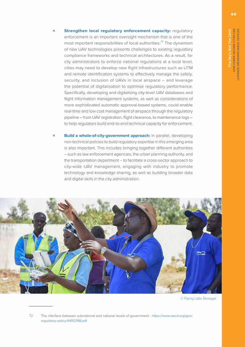
The
Sky’
s N
ot T
he L
imit
H
OW
LO
WER
-IN
CO
ME
CIT
IES
CA
N
LEV
ERA
GE
UN
CR
EWED
AER
IAL
VEH
ICLE
S
69
× Strengthen local regulatory enforcement capacity: regulatory enforcement is an important oversight mechanism that is one of the most important responsibilities of local authorities.72 The dynamism of new UAV technologies presents challenges to existing regulatory compliance frameworks and technical architectures. As a result, for city administrators to enforce national regulations at a local level, cities may need to develop new flight infrastructures such as UTM and remote identification systems to effectively manage the safety, security, and inclusion of UAVs in local airspace – and leverage the potential of digitalisation to optimise regulatory performance. Specifically, developing and digitalising city-level UAV databases and flight information management systems, as well as considerations of more sophisticated automatic approval-based systems, could enable real-time and low cost management of airspace through the regulatory pipeline – from UAV registration, flight clearance, to maintenance logs – to help regulators build end-to-end technical capacity for enforcement.
× Build a whole-of-city-government approach: in parallel, developing non-technical policies to build regulatory expertise in this emerging area is also important. This includes bringing together different authorities – such as law enforcement agencies, the urban planning authority, and the transportation department – to facilitate a cross-sector approach to city-wide UAV management, engaging with industry to promote technology and knowledge sharing, as well as building broader data and digital skills in the city administration.
72 The interface between subnational and national levels of government - https://www.oecd.org/gov/regulatory-policy/44912198.pdf
© Flying Labs Senegal

The
Sky’
s N
ot T
he L
imit
H
OW
LO
WER
-IN
CO
ME
CIT
IES
CA
N
LEV
ERA
GE
UN
CR
EWED
AER
IAL
VEH
ICLE
S70
Case Study: Nepal Flying Labs
In 2020, Nepal Flying Labs took advantage of low air-traffic during COVID-19 lockdown to conduct aerial mapping of several urban municipalities in Kathmandu Valley. The collected geospatial data was processed and developed into open data portals – with special functionality adapted for the needs of various government offices, so that the urban maps could be used by the municipality for more efficient administration and public service delivery. Specifically, the geospatial data was overlayed with statistical information to produce five by-products:
× Open municipality infrastructure data: inventory of public utilities and buildings for urban construction permit management
× Open public projects: inventory of all public projects currently undertaken and their operational status for open procurement and greater accountability in public financial management
× Open tourism data: inventory of blue and green infrastructure to inform sustainable tourism
× Open demographic portal: population census with geospatial database on household locations for localised addressing system
× Open knowledge hub: open data portal that serves as a digital library
These projects are symbiotic, and together, provide an exciting potential model of a holistic data platform constructed from baseline UAV data.

©
Food
pand
a

The
Sky’
s N
ot T
he L
imit
H
OW
LO
WER
-IN
CO
ME
CIT
IES
CA
N
LEV
ERA
GE
UN
CR
EWED
AER
IAL
VEH
ICLE
S72
Supporting the Data Lifecycle
UAVs have the potential to collect more, and more granular, data that could support city administrations, the private sector, and other development partners in decision-making. Broader and ancillary efforts in building processes and systems along the data value chain – to receive, store, and analyse post-flight data – will be crucial in maximizing the value of this data.
Investments in data processes remain a gap in many lower- and middle-income cities and countries.73 This translates into an information gap between developed and developing countries – risking inequalities in the global digital economy. More broadly, a digital divide could exclude low- and middle-income countries from shaping or developing technologies that instead will be led by higher-income countries.74
UAV operations in the context of geospatial data collection can provide a cost- and time-efficient approach to enhance the statistical capacity of governments. In particular, UAVs are powerful tools for the mapping of urban settlements. However, most UAV mapping projects lack continuity past the image capturing stage. Without post-flight data processing, baseline geospatial data cannot be utilised to inform policymaking or decision-making. Geospatial data is often most useful when different datasets can be overlayed to produce timely, relevant, and applicable information.
For example, geospatial data from UAV urban mapping projects, when overlayed with household survey and demographic statistics for integrated analysis, provides city administrators with a visualisation of local progress towards city and national development priorities by geography and time. This urban map, annotated with the population census, could then be used to create functional government products such as tax revenue collection systems.
73 World Development Report 2021: Data For Better Lives - https://www.worldbank.org/en/publication/wdr2021
74 G20 Insights ‘Leveraging the Digital Transformation for Development: A Global South Strategy for the Data-driven Economy’ - https://www.g20-insights.org/policy_briefs/leveraging-the-digital-transformation-for-development-a-global-south-strategy-for-the-data-driven-economy/

The
Sky’
s N
ot T
he L
imit
H
OW
LO
WER
-IN
CO
ME
CIT
IES
CA
N
LEV
ERA
GE
UN
CR
EWED
AER
IAL
VEH
ICLE
S
73
This second stage – data processing and analysis – requires significant technical and organisational capacity. An entire ecosystem supportive of this process – from flight planning and operations, to data collection and processing, and the presence of data and digital infrastructure – may need to develop. Data processing will become increasingly important as cities explore more advanced UAV operations that require real-time analytics and autonomous operations. In the next five years, data-related services – data collection (13%), analytics (17%), and management (20%) – are projected to comprise half of the drone market size globally.75 Such efforts must adhere to best practice, particularly with regard to data privacy and the broader data lifecycle (including archiving and deletion of data).
75 Huawei ‘Connected Drones: A New Perspective On The Digital Economy’ - https://www.gsma.com/iot/wp-content/uploads/2017/06/connected_drones_a_new_perspective_on_the_digital_economy_en.pdf
© Zipline

The
Sky’
s N
ot T
he L
imit
H
OW
LO
WER
-IN
CO
ME
CIT
IES
CA
N
LEV
ERA
GE
UN
CR
EWED
AER
IAL
VEH
ICLE
S74
· INNOVATIVE BUSINESS MODELS
How could, and should, cities engage with UAV innovators? UAVs have the potential to increase economic activity in cities, optimise existing workflows, and generate new sources of revenue and value creation. However, achieving these benefits will require investment from city administrations. Similarly, city administrations will need to also engage with the UAV sector for product and service delivery.
It is estimated that the physical infrastructure required for UAV deployment in a global city such as New York or London would require an initial investment of $35 to $45 million, and an annual running cost of $110 to $130 million.76 Operators and end users may need to cover costs equivalent to 15 to 25% of the value chain, whilst less profitable enterprises could increase the investment required by cities. Bridging this investment gap and developing a sustainable business model can be a challenge for cities as – regardless of partnership opportunities - UAV initiatives will require some level of investment from the city administration. However, very few cities around the world appear to have yet raised sustainable and longer-term funding for dedicated UAV infrastructure.
76 Going vertical: How emerging technologies will power a new value chain - https://www.mckinsey.com/industries/aerospace-and-defense/our-insights/future-air-mobility-blog/going-vertical-how-emerging-technologies-will-power-a-new-value-chain
© Zipline

The
Sky’
s N
ot T
he L
imit
H
OW
LO
WER
-IN
CO
ME
CIT
IES
CA
N
LEV
ERA
GE
UN
CR
EWED
AER
IAL
VEH
ICLE
S
75
UAV Business Models for Cities
Cities will have to develop a technical and operational concept that is fit for the local context and purpose. This may include building new digital and physical infrastructure77, which will be accompanied by initial and ongoing costs. However, there is also scope for the city administration to leverage UAV operations as an important source of revenue (see overleaf). Any approach should explore the scope to cost-share infrastructure development and management, and the potential to catalyse the urban UAV market.
This section sets out a range of potential ‘business models’ that discuss the role of the city administration, and the potential investment and effort required from the public sector. Currently, there is no fully-functioning urban UAV infrastructure operating at scale in any city. However, this area is attracting growing interest. This includes in the context of standards development78, urban design (recognising that tall buildings in cities can create a ‘wind tunnel’ effect that constrains UAV operations), and land and asset ownership – including airspace rights and permissions. Any new business models will need to engage with a wide-range of considerations, practicalities, and broader requirements (see diagram, below79).
77 See the UK’s Connected Places Catapult ‘Droneport Design and Development Framework’: https://cp.catapult.org.uk/news/droneport-design-and-development-framework/
78 The ISO standard relating to ‘Operation of vertiports for unmanned aircraft (UA)’ is still ‘under development’: https://www.iso.org/standard/80606.html
79 Berrone, P., and Ricart, J. E. (2017), ‘La economía colaborativa en las ciudades’ [Collaborative economy in cities], Harvard Deusto Business Review, No. 265, March 2017, pp 50 – 64.
New business models
Urbanisticplanning andinfrastructure
Policies,legislation and
regulation
New appliedtechnologies
and innovaion
Changesin people’s
behavior and theirpreferences

The
Sky’
s N
ot T
he L
imit
H
OW
LO
WER
-IN
CO
ME
CIT
IES
CA
N
LEV
ERA
GE
UN
CR
EWED
AER
IAL
VEH
ICLE
S76
Potential costs and revenue opportunities associated with urban UAV deployments
There are several business models that could make UAV development and deployment more commercially viable for cities. The table on the right page sets out a high-level comparison, however the relevance of each business model will vary depending on the local city context and need. It is likely that many cities will not own dedicated UAV fleets, or retain specialised staff with dedicated flight skills. Instead, technical and broader awareness of UAV flight operations will likely be a significant asset in order to intelligently procure from external UAV organisations. The proposed business models (with the exception of aspects of the ‘Capital Expenditure’ model), reflect this hypothesis.
© Zipline
Non recurring (Capital Expenditure): initial investment in UTM, drone ports, or UAV fleets.
Recurring (Operating Expenditure): power, sta� and training, UAV and infrastructure maintenance, flight and data processing software, UTM services.
TOTAL COST OF
OPERATION
Public duties: flight authorization, certificates and accreditations, UTM user charges, taxes.
Leveraging public asset: hiring or usage fees for publicly-funded droneports. POTENTIAL
REVENUEOPPORTUNITIES

The
Sky’
s N
ot T
he L
imit
H
OW
LO
WER
-IN
CO
ME
CIT
IES
CA
N
LEV
ERA
GE
UN
CR
EWED
AER
IAL
VEH
ICLE
S
77
Identifying Suitable Business Models
When choosing a business model, cities should identify where UAVs can add value to existing services or provide new capabilities and revenues. This should also consider the capital, knowledge, and technology investment required, its viability for the public sector, feasibility to scale beyond pilot, or replicate in another city, and finally, its desirability in meeting broader city and national development priorities.
It is unlikely that a single business model would be suitable for the local context or address all the urban development priorities of a city. City administrators may, therefore, likely have to explore several of the business models in parallel. This could include aligning with non-UAV projects and programmes to make deployment more feasible and reduce the initial investment risk. Similarly, the usefulness of each approach will also be driven by the local UAV context – including frequency of flights, and budget of operations, compatibility with the operational environment (for example, urban topography and weather patterns), as well as compliance with the space restrictions of cities (including zoning requirements and urban development priorities).
BUSINESS AS USUAL
City Investment
▼ Low ▼ Low
▼ Low▼ Low
▼ Low
▲ High
▲ High
▲ High
▲ High
▲ High▲ High▲ High
▲ High▲ High▲ High
▲ High
▲ High▲ High
▲ High
● Medium
● Medium● Medium
● Medium● Medium
● Medium● Medium
● Medium● Medium● Medium
● Medium
Viability Scalability Replicability Desirability
CAPITAL EXPENDITURE
PPP (TRADITIONAL)
PPP (INNOVATIVE)
SUBSCRIPTION-BASED
PLATFORM

The
Sky’
s N
ot T
he L
imit
H
OW
LO
WER
-IN
CO
ME
CIT
IES
CA
N
LEV
ERA
GE
UN
CR
EWED
AER
IAL
VEH
ICLE
S78
Model 1: ‘BUSINESS AS USUAL’
This is the current approach taken by many cities, where the private sector is spearheading investments in UAV technologies, infrastructure, and service delivery channels in the absence of government market intervention. UAV operators are already working with third-party service providers in the telecommunications, logistics, and cloud computing and analytics sector to develop end-to-end service approaches. In this model, various private sector actors work independently or collaboratively to secure finance, build drone ports and UTMs, and design and deploy technical and operational modules for UAV operations. In some countries with a more mature UAV market, the public sector establishes performance-based standards and ensure compliance for UAV projects in infrastructure development and service delivery.80
City Investment ▼ Low
In this approach, the investment of the city is low. Lower- and middle-income cities could create enabling regulations to encourage more mature and international private sector actors to enter the emerging local market and catalyse a domestic industry. Without sufficient competition or regulatory oversight, however, an over-reliance on private sector investment risks crowding out innovation from smaller-scale local operators – and could undermine a city’s preference for UAV services to develop as a public good, aligned with urban development priorities. In this regard, cities could use zoning and urban planning tools to guide the private sector’s investments but may not always be able to ensure this equity.
Viability ▲ High
This approach is highly viable for most cities, as it can require little-to-no investment or intervention by the city administration. It relies on private-sector investment in distribution centres that provide a ‘base’ for UAV operations. It could also lead to benefits across the private sector, by stimulating competition amongst UAV service providers. This could have multiplier effects on the broader digital economy. However, this lack of commitment can limit the ability of the city administration to shape UAV operations and offerings. Reliance on more formal (particularly regulatory) tools may be needed.
80 International Transport Forum, Ready for Take-Off? Integrating Drones into the Transport System -https://www.itf-oecd.org/sites/default/files/docs/take-off-integrating-drones-transport-system.pdf

The
Sky’
s N
ot T
he L
imit
H
OW
LO
WER
-IN
CO
ME
CIT
IES
CA
N
LEV
ERA
GE
UN
CR
EWED
AER
IAL
VEH
ICLE
S
79
Scalability ▲ High
This is a traditional deployment model for operators in various industries, and scales effectively in dense addressable markets. Therefore, it is an approach that could be suitable for UAV operations across a city – and beyond discrete pilots. However, the city administration may not be able to coordinate or manage pan-city UAV deployments due to its more limited engagement. This could create issues with community engagement, or conflicts between service providers.
Replicability ▲ High
Similarly, this approach can easily be replicated across cities as it is one currently being explored – whether formally, or passively – by city administrations around the world. However, there is risk of private sector activity being concentrated in certain cities where the return on investments appears higher.
Desirability ▼ Low
Technical and other advancements in the UAV industry are currently heavily reliant on private sector capital, technology, and knowledge. However, without early and directed intervention by cities, in the longer-term, this model risks market concentration by more mature players, creating discriminatory access and legacy systems that could constrain domestic innovation. Without proper city planning and guidance, private sector led development could undermine public sector priorities for equitable access and citizen-led development of UAV services and products.
© Foodpanda

The
Sky’
s N
ot T
he L
imit
H
OW
LO
WER
-IN
CO
ME
CIT
IES
CA
N
LEV
ERA
GE
UN
CR
EWED
AER
IAL
VEH
ICLE
S80
Model 2: CAPITAL EXPENDITURE MODEL
The Capital Expenditure model adopts a similar single actor approach as the ‘Business as Usual’ model – except the city retains public ownership and management of UAV developments. This is the same setup as that employed in direct public provision initiatives. This includes investment in infrastructure (for example, physical assets, flight architecture, or UAV fleets), as well as operation and management (such as coordinating logistics, training, and service deployment). These functions could be held by a new UAV department or taskforce within the city administration, managed by an existing specific city department(s) or through a public-interest corporation or other entity with majority control by the city administration.
City Investment ▲ High
In this model, the city retains full control – and risks – over UAV technical and operation development, including financing new assets, and may even serve as a UAV service provider. A city may want to deploy this model to govern UAV products and services as a public good, or bridge gaps in specific urban geographic or thematic areas that are not strategically viable for the private sector. However, it requires extensive initial capital investments, operating expenditure, and technical expertise that may be beyond the capacities of the public sector alone.
Viability ▼ Low
Very few cities will have the budget, or funding, to commit to building UAV infrastructure at scale. Even fewer cities will have the opportunity to recoup their investment, or even achieve a reasonable profit. The lack of market competition could also result in inefficiencies in service delivery. More importantly, cities will have to consider if there is a local need for UAV services – or else, they could be diverting key resources from other public investment.
Scalability ● Medium
This model offers the potential for scale within a city, as it provides the underlying infrastructure for UAV operations. Such a city-led approach in this emerging sector could be beneficial in driving common technical standards and service interoperability, conducive for scaled commercialisation. However, in practice, constraints in capital, technology, and knowledge resources could limit the quality and range of services cities are able to provide.

The
Sky’
s N
ot T
he L
imit
H
OW
LO
WER
-IN
CO
ME
CIT
IES
CA
N
LEV
ERA
GE
UN
CR
EWED
AER
IAL
VEH
ICLE
S
81
Replicability ▼ Low
In theory, public-led UAV infrastructure and operating investments could be tailored to urban planning priorities – and potentially be replicated within a municipality to connect drone ports and services between cities for municipal UAV flights. However, execution of this is a significant challenge – and likely unfeasible without private sector involvement. Similarly, few cities will be able to afford to build similar UAV infrastructure.
Desirability ● Medium
This model has advantage in steering UAV developments towards public priorities, including social and urban development goals. Lower- and middle- income cities have less legacy infrastructure, and could be more agile in incorporating UAV infrastructure and service deployment considerations in their city master plans. However, delivering on this model is very capital intensive and likely requires multi-year commitment. Cities will have to develop specialised expertise in design and deployment, as well as ensure strong political buy-in and policy continuity.
© Flying Labs Senegal

The
Sky’
s N
ot T
he L
imit
H
OW
LO
WER
-IN
CO
ME
CIT
IES
CA
N
LEV
ERA
GE
UN
CR
EWED
AER
IAL
VEH
ICLE
S82
Model 3: PUBLIC-PRIVATE PARTNERSHIPS MODEL (TRADITIONAL)
This model moves beyond the private or public sector as a single actor in UAV infrastructure and service provision. Public-Private Partnerships (PPPs) combine private sector capital, technology, and knowledge expertise, as well as public assets (such as public sector facilitation or funding) to jointly deliver on the technical and operational aspects of UAV deployment. In this model, cities could utilise a range of cost-sharing and revenue-sharing approaches to mitigate risks and optimise performance. In the context of UAV infrastructure, this could include joint ventures (shared ownership and revenue), public outsourcing (government owned and private sector operated), or incentive-based models that provides a more balanced investment approach for cities.
City Investment ● Medium
PPPs are not just a means of financing, they leverage the innovation and agility of the private sector to deliver efficiencies in infrastructure and service delivery. This collaborative approach can reduces capital and other costs for the city administration. For this partnership to be sustainable, cities will have to clearly delineate costs and responsibilities, including setting standards on performance. More broadly, enabling and enforcing legal frameworks around the business environment, as well as a level of predictability in UAV policies – will be necessary to provide investors with the confidence to work with cities. In this regard, cities should have a long-term vision for UAV-related PPPs that is aligned with urban development and planning priorities.
Viability ● Medium
Building UAV infrastructure in 74 cities around the world could cost an estimated $32 billion, but could produce global revenues of more than $244 billion.81 Considering the significant capital expenditure required – and the potentially profitable market opportunities – there is strong incentives for the public and private sector to jointly develop and deploy UAV services. The success of PPPs in this area, however, will depend on the institutional capacity
81 NEXA Completes Landmark Urban Air Mobility Study, Focuses on Infrastructure - https://evtol.news/news/nexa-completes-landmark-urban-air-mobility-study-focuses-on-infrastructure

The
Sky’
s N
ot T
he L
imit
H
OW
LO
WER
-IN
CO
ME
CIT
IES
CA
N
LEV
ERA
GE
UN
CR
EWED
AER
IAL
VEH
ICLE
S
83
(including investment planning and budgeting processes) of cities to monitor private sector performance and enforce contract requirements.82
Scalability ● Medium
This could be considerable, as UAV operations will need to function across the city in order to drive a return on investment. In addition, private sector entities – and their funders – will likely look to invest in a longer-term, and scale, roadmap. From the city perspective, scalability will depend on the level of private involvement and funding commitment (including ownership). This could be tailored to meet the specific requirements of a particular local context or priority.
Replicability ● Medium
This model could be replicated in other markets, although it may require alignment with broader policy efforts or initiatives to be commercially viable, such as city-level procurement frameworks and processes, including, regulation, funding or subsidies. However, it may not be an option available to every city. In particular, those with a smaller population or service potential that may not be deemed commercially-sustainable.
Desirability ● Medium
PPPs can be desirable for cities. They can stimulate the economy, increase efficiency and productivity, and provide new market opportunities – whilst ensuring long-term sustainability and commercial viability. To maximise these benefits, cities need to ensure that the interest of the private sector is aligned with the local community. Contract governance and performance management is crucial – and city administrators have to ensure that standards for key performance indicators are met. Arbitration processes to resolve disagreements and enforce contracts are also important. In the case of working with a consortium of sector stakeholders, cities will have to clearly delineate the roles of responsibilities of various stakeholders to prevent conflicts or challenges
82 World Bank ‘Municipal Public-Private Partnership Framework’ - https://ppp.worldbank.org/public-private-partnership/sites/ppp.worldbank.org/files/2020-02/World%20Bank_Municipal%20PPP_Executive%20Summary_Content-1.pdf
The
Sky’
s N
ot T
he L
imit
H
OW
LO
WER
-IN
CO
ME
CIT
IES
CA
N
LEV
ERA
GE
UN
CR
EWED
AER
IAL
VEH
ICLE
S84
Model 4: PUBLIC-PRIVATE PARTNERSHIPS MODEL (INNOVATIVE)
This model builds upon the traditional model of PPP delivery, with cross-sector collaboration and infrastructure rationalisation at its core. It addresses not only UAV-specific infrastructure and service components, but also alternative value capture opportunities through third-party services that could generate additional income for cities. Cities could co-deliver UAV infrastructure – including droneports – in collaboration with the private sector. However, they could leverage this infrastructure to provide efficiencies for city operations and to raise additional sources of revenue. This revenue could include flight fees (calculated via a ‘rate card’), rental or other business rates charged to businesses to operate at the droneport, and wider opportunities – such as charging to host electric vehicle infrastructure.
City Investment ▲ High
This model requires a leading role by the city, but also offers potential for significant benefits. This approach would require the city to use its policy and service abilities to create a powerful ‘node’ for its digital economy. This would include siting high-quality connectivity and energy infrastructure at the droneport – to drive operations, but as a hub for these services for other use-cases. ‘Dig Once’ policies could guide cross-sector collaboration in the rollout of infrastructure, especially in installing digital infrastructure alongside traditional infrastructure.83 Energy infrastructure could drive electric vehicle or fleet operations. ‘Dark Kitchens’ or other supply chain innovations could also be hosted, at a cost. If revenue-raising is feasible, the city could achieve a successful return on investment.
Viability ● Medium
Operators in other industries are already seeking blended approaches to explore additional revenue opportunities in infrastructure investment and service provision. For example, airports generate around 40% of their revenue from non-aeronautical activities (for example, concessions, rent and parking).84 Smart cities around the world are also revitalising ‘dead assets’ with value-added services to generate additional revenue (for example, equipping
83 WEF G20 Smart Cities Alliance: Dig Once ‘Model Policy’ - https://globalsmartcitiesalliance.org/?p=80684 Airport Economics Report, 2019 - https://store.aci.aero/product/airport-economics-report-2019/

The
Sky’
s N
ot T
he L
imit
H
OW
LO
WER
-IN
CO
ME
CIT
IES
CA
N
LEV
ERA
GE
UN
CR
EWED
AER
IAL
VEH
ICLE
S
85
streetlights with sensors to collect data).85 Cities, could similarly capitalise on unused capacity within the built environment when developing UAV-specific infrastructure – and leverage the fibre, power, industrial capability of UAV hubs to co-host non-UAV service providers in a broader innovation park.
Scalability ▲ High
The model emphasises cross-sector value-chain development and integration that is conducive to scaled deployment. It has significant potential to be combined with a range of other approaches to accelerate the commercialisation of UAV services across the city. Cities could consider working with logistics, connectivity, and energy providers on infrastructure and service components, as well as the community on innovation spaces and community public assets for last-mile distribution.
Replicability ● Medium
This approach could be applied in a significant number of lower-income cities, but the private sector might have a preference for particular cities with strong foundational infrastructure. However, lower-income cities with less legacy infrastructure could ‘leapfrog’ their more developed counterparts. The replicability of this model will also depend on the institutional capacity of city administrators to coordinate private sector developments in an integrated manner, in line with broader city master plan.
Desirability ▲ High
Although the capital and planning costs could be higher than traditional PPP approaches, this model has the potential to futureproof infrastructure development, offer significant revenue potential through third-party service generation, and has multiplier effects on the broader innovation ecosystem. In addition, it provides the city with greater leverage than a ‘traditional’ PPP approach – which, in some cases, can result in asymmetries between the public and private sectors (particularly with regard to financial outlay).
85 WEF Inspiring Future Cities and Urban Services: Shaping the Future of Urban Development and Services Initiative - https://www3.weforum.org/docs/WEF_Urban-Services.pdf

The
Sky’
s N
ot T
he L
imit
H
OW
LO
WER
-IN
CO
ME
CIT
IES
CA
N
LEV
ERA
GE
UN
CR
EWED
AER
IAL
VEH
ICLE
S86
Model 5: SUBSCRIPTION MODEL
This model does not require capital investments from cities. Instead, cities could enter into a framework agreement with UAV operators for on-demand UAV services. This could take the form of a fee-for-usage basis or subscription model, and range from the procurement of private drone fleets or proprietary UAV-related software for public sector-managed operations, or service contracts for application specific UAV deployment. It could be an efficient, low-risk, and cost-effective way for cities to explore integrating UAVs into their workflow processes.
City Investment ▼ Low
This use case-based, on-demand model is especially suitable for cities looking to pilot projects and demonstrate proof-of-concept and impact before making further capital investments. It may also be suitable for cities seeking to leverage UAVs for particular priorities. The private sector assumes responsibility for capital investment, operations, maintenance, as well as training. Cities will have to exercise caution in their procurement processes to prevent vendor lock-in – and seek to build UAV-related skills and technical capacity within the public sector to avoid an over-reliance on private sector actors for public service delivery.
Viability ▲ High
The viability of this approach is high, recognising that this is solely a procurement relationship – a process familiar to many cities. The potential of this model will largely be constrained by these processes – if not functioning, or not functioning well. It also could prove valuable in facilitating the creation of a local UAV-as-a-service industry. Cities could facilitate this by developing local partners – and not discount SMEs or emerging actors in procurement processes.86
Scalability ▲ High
Scalability is high given this approach could be tailored towards specific applications fit for the purpose of various city operations. Cities could decide
86 Three ways to partner with cities and municipalities to mobilize private capital for infrastructure: A look at Latin America - https://ppp.worldbank.org/public-private-partnership/subnational-and-municipal/three-ways-partner-cities-and-municipalities-mobilize-private-capital-infrastructure-look-latin-america

The
Sky’
s N
ot T
he L
imit
H
OW
LO
WER
-IN
CO
ME
CIT
IES
CA
N
LEV
ERA
GE
UN
CR
EWED
AER
IAL
VEH
ICLE
S
87
on the level of investment and contract commitment. For example, department specific use during particular periods or for particular needs (such as crowd control or traffic management during holiday seasons), or pool together use cases from various public sectors for more routine and scaled operations. SMEs could also leverage this model through business cooperatives.
Replicability ▲ High
This is a particularly risk-averse models for cities. It provides operational flexibility while reducing fixed costs to a minimum for cities to systematically replicate UAV services within different sectors. Cities are able to demonstrate the impact of UAVs whilst building capacity to effectively govern this emerging industry – including shaping regulations and partnerships within the broader innovation ecosystem
Desirability ▲ High
The flexibility and cost-efficiency of this approach is highly desirable for lower- and middle-income countries – and serves as an entry-point for cities to consider the role of UAVs in broader urban public services. Cities are able to deploy pilots to shape best practices and consolidate learnings before adopting more ambitious and expansive models.
© Foodpanda

The
Sky’
s N
ot T
he L
imit
H
OW
LO
WER
-IN
CO
ME
CIT
IES
CA
N
LEV
ERA
GE
UN
CR
EWED
AER
IAL
VEH
ICLE
S88
Model 6: PLATFORM MODEL
UAV data-related services, from collection, to storage, processing, and analytics, are forecasted to constitute half of the global UAV market in 2022.87 This workload is expected to be enabled and driven by innovations in connectivity and other services. As the UAV industry will increasingly deliver insights based on data and analytics as a service, new areas of value capture will centre around a data economy. Cities need to explore more innovative business models to leverage these new market opportunities. This could include government marketplaces that connect public sector actors with trusted UAV operators, or government-facilitated peer-to-peer models that manages UAV data (including setting standards for collection, distribution, and storage).
City Investment ● Medium
In lower- and middle-income cities, city administrators will have to play a steering role in catalysing this platform approach – and supporting private and public sector actors in identifying the opportunities of UAV services. This will require strong institutional capacity in working with a consortium of private and public sector actors, as well as expertise to design and develop the operational and technical aspects of UAV platforms. Leveraging the resources of the private sector (including telecommunications, logistics, and cloud services providers) will be important. Cities could explore opportunities to combine these platforms with the procurement framework to derive new revenue streams – for example, through accrediting UAV service providers for public contracts.
Viability ● Medium
UAV operators and third-party service providers in more mature markets are already offering bundled services combining applications with data-based insights. Lower- and middle-income cities could play a critical role in coordinating the efforts of local operators, specifically, in combining distinct processes into integrated services. This could catalyse the broader digital economy, especially more complex Infrastructure-as-a-Service components, but would require strong coordination.
87 Huawei ‘Connected Drones: A New Perspective On The Digital Economy’ - https://www.gsma.com/iot/wp-content/uploads/2017/06/connected_drones_a_new_perspective_on_the_digital_economy_en.pdf

The
Sky’
s N
ot T
he L
imit
H
OW
LO
WER
-IN
CO
ME
CIT
IES
CA
N
LEV
ERA
GE
UN
CR
EWED
AER
IAL
VEH
ICLE
S
89
Scalability ▲ High
Platform offerings could be highly scalable after deployment – if cities are able to successfully onboard potential service providers, then the model would easily transition to be delivered across the city. In an emerging industry in lower-income cities, this scalability may need targeted support – such as subsidies or training – to help SMEs to participate. Cities may need to act as a ‘first customer’ to demonstrate the viability of the platform.
Replicability ▲ High
This model is highly replicable given its less capital-intensive nature. Cities who have successfully implemented such an approach could also consider making the technical components open source to encourage other cities within the district, region, or country to do the same - thereby leveraging economies of scale as well as the creation of a larger market for local operators.
Desirability ▲ High
The model can also have broad multiplier effects, such as helping to support local businesses in their digitalisation journey and building the technical skills of local populations. However, it requires strong digital infrastructure and some functional digital literacy across the business population, that may be a challenge for some lower- and middle- income cities.
© Chris Morgan

The
Sky’
s N
ot T
he L
imit
H
OW
LO
WER
-IN
CO
ME
CIT
IES
CA
N
LEV
ERA
GE
UN
CR
EWED
AER
IAL
VEH
ICLE
S90
Proxy business models
As cities around the world explore financing and operating models in the context of an emerging service and sector, they may look to proxy business models in more mature industries as a reference:
× Airport and air navigation services: best practices on transparency, non-discriminatory access, and cost-relatedness are detailed in the ICAO’s Policies on Charges for Airports and Air Navigation Services.88 Cities need to take into consideration the potential to unbundle different aspects of the UAV ‘urban stack’, for regulation and revenue potential.
× Geographic Information Systems (GIS): the Surat Municipality in India worked with a private sector partner to develop and implement a municipal web-based GIS application and database for city administrators in the municipality. The private sector partner was responsible for the technical and operational design, testing, installation, training, as well as three years of post-implementation support and maintenance to the municipal city councils.89
× e-Government services: Bangalore One, the city’s single window e-government portal was developed by a private sector consortium and implemented in 15 citizen service centres in different parts of Bangalore. The city reached a service level agreement with the consortium to pay service charges for services rendered on a transaction basis.90
× Fibre network: the City of Westminster, in Maryland, built a city-wide municipal fibre broadband network and leased it to operators on an open-access basis to compete for customers on the same network.91 In Singapore, a consortium of private partners receive financial support from the government to design, build, and operate the Next Generation Nationwide Broadband Network.92
× Renewable energy: in Gandhinagar, the capital of India’s fifth largest state, Gujarat, two companies successfully bidded for a 25 year public contract to design, finance, install, and maintain roof-top solar panels on government buildings and private residences in Gandhinagar. The private developers developed a business model that recovered their capital investment and operating costs by selling the power generated to retail providers for distribution to end-users.93
88 ICAO’s Policies on Charges for Airports and Air Navigation Services - https://www.icao.int/publications/Documents/9082_8ed_en.pdf
89 See: https://www.thegpsc.org/sites/gpsc/files/project_summaries_part_1_0_0.pdf90 Presentation on Bangalore One project: https://aphrdi.ap.gov.in/documents/Trainings@APHRDI/2017/1_jan/Best%20
Practices/kumudavalli.pdf91 Institute for Local Self Reliance ‘Successful Strategies for Broadband Public-Private Partnerships’ - https://ilsr.org/wp-
content/uploads/downloads/2016/08/PPP-Report-2016-1.pdf92 See: https://www.itu.int/net/wsis/stocktaking/docs/activities/1291981845/Towards%20a%20Next%20Generation%20
Connected%20Nation_Singapore.pdf93 Case Study of Gandhinagar Roof Top Solar PV Program - https://www.researchgate.net/publication/280094237_Case_
Study_of_Gandhinagar_Roof_Top_Solar_PV_Program

©
Flyi
ng L
abs
Sene
gal

The
Sky’
s N
ot T
he L
imit
H
OW
LO
WER
-IN
CO
ME
CIT
IES
CA
N
LEV
ERA
GE
UN
CR
EWED
AER
IAL
VEH
ICLE
S92
Broader considerations
× Be citizen-centric: as discussed earlier in this report, citizens and communities are essential partners in useful and sustainable UAV deployments. Focusing on their needs, and aspirations, is crucial. However, business models should also be founded on citizens. This includes ensuring data protection, privacy, inclusion, and shaping other necessary protections. Civil society organisations are important actors in this context. This includes their role in guiding and safeguarding futureproofed regulation and protection, to guard against political changes that could see UAVs misused in the context of political changes, increased surveillance, or authoritarian shifts.
× Take a holistic approach: no single business model will solve all deployment or urban challenges. Cities should take a comprehensive approach, and be agile in deploying a combination of solutions and models. This should take into consideration the city’s institutional capacity – and alignment with wider efforts around national and city-level development priorities. Cities may also have to work with national government on funding and regulations, and leverage pilot projects as an opportunity to engage the community and build local capacity in the private sector.
× Ensure non-discriminatory access to public infrastructure: cities will have to decide which components of the UAV ecosystem are a public good (if at all) – and minimise private sector- led developments, especially in vertical integration of operations, that could create anti-competitive environments or exclusive ownership. For example, cities (and national regulators) may have to consider the value of unbundling fleet management (for example, UAV operations) from the provision of infrastructure (for example, droneports), as is established practice in the manned aviation industry.94
× Avoid dependence on technology: building on the above, cities must avoid the risk of relying on technology – particularly for critical public services and other essential functions. UAVs, as with any other type of technology, are not a panacea. They are tools in the urban policymaker toolkit. Any UAV explorations should consider alternative technologies and approaches, whilst those projects and programmes that leverage UAVs should seek to minimise broader risks. This includes avoiding reliance on private-sector and proprietary technologies, and protecting the position of the city administration with regard to ownership of technology and other assets.
94 International Transport Forum, Ready for Take-Off? Integrating Drones into the Transport System - https://www.itf-oecd.org/sites/default/files/docs/take-off-integrating-drones-transport-system.pdf

The
Sky’
s N
ot T
he L
imit
H
OW
LO
WER
-IN
CO
ME
CIT
IES
CA
N
LEV
ERA
GE
UN
CR
EWED
AER
IAL
VEH
ICLE
S
93
× Prioritise open procurement: regardless of approach, procurement from the private sector will be required. The city should ensure effective and transparent procurement systems are in place. This includes adhering to best practice, such as the use of Open Contracting Data Standards. Procurement that is transparent and outcome-based, with specificity to risks or performance, will be crucial in helping the private sector develop standards, and the public sector in identifying UAV solutions that could best fit their needs. It will also provide confidence to the local UAV market. Cities could also consider playing a central role in setting accreditation standards and issuing certification for operations that meet UAV performance requirements. This could increase the competitiveness of the local industry, and provide cities with a new revenue stream.
© Editha Mwanyika

♦ Putting it into PracticeCities around the world are leveraging technology and innovation – from smart sensors and GIS, to Internet of Things, and Big Data analytics – to deliver better and more inclusive public services. Jakarta, Kuala Lumpur, Da Nang, Rio de Janeiro, Medellin, Kigali, Tel Aviv, and more have already invested – in varying degrees – in integrated urban management systems that allow city administrators to monitor and augment various city operations. This includes applications in transport and traffic monitoring, emergency incident response, and environmental public health and climate-disaster risk evaluation. In some cities, these data and insights are made publicly available on open e-government portals to enhance citizen participation and government accountability.
©
Zipl
ine


Environmental healthAir pollution monitoring, flood and disaster risk modeling, and post-disaster rapid assessment for urban climate resilience.
ConnectivityProvision of cellular network and ICT infrastructure maintenance to enhance network connectivity.
GovernmentUrban mapping, public project monitoring, and land registration systems for data-driven governance.
Safety and securitySupporting first responders for incident management, but also being used to prevent crime or other incidents.
Emergency responseFirst aid delivery, medical logistics optimisation, and fire rapid assessment for public safety.
Transport and logisticsParcel delivery and tra c management to enhance urban mobility.
EntertainmentAdvertisement aircrafts, UAV airshow, and tourism promotion to digitalise the creative industry.
InfrastructurePower and pipeline inspection; construction monitoring, and bridge maintenance to optimise infrastructural asset life cycle management.
InnovationUAV marketplace, 3D fabrication labs, and incubators to catalyse the digital economy.
There is an opportunity to integrate UAVs into these public service value chains to further optimise city operations, especially as the monitoring, data collection, and delivery capabilities of UAVs mature and allow for more autonomous completion of mundane or hazardous tasks. In addition, there is scope to leverage UAVs for new and diverse forms of service delivery to amplify the role of city administrations in improving the lives and livelihoods of their residents. This will also extend to the broader role of the city (for example, leveraging UAVs to deliver immersive performance experiences at city or cultural events).
Specifically, an integrated urban UAV system could support smart city development across nine pillars:

Environmental healthAir pollution monitoring, flood and disaster risk modeling, and post-disaster rapid assessment for urban climate resilience.
ConnectivityProvision of cellular network and ICT infrastructure maintenance to enhance network connectivity.
GovernmentUrban mapping, public project monitoring, and land registration systems for data-driven governance.
Safety and securitySupporting first responders for incident management, but also being used to prevent crime or other incidents.
Emergency responseFirst aid delivery, medical logistics optimisation, and fire rapid assessment for public safety.
Transport and logisticsParcel delivery and tra c management to enhance urban mobility.
EntertainmentAdvertisement aircrafts, UAV airshow, and tourism promotion to digitalise the creative industry.
InfrastructurePower and pipeline inspection; construction monitoring, and bridge maintenance to optimise infrastructural asset life cycle management.
InnovationUAV marketplace, 3D fabrication labs, and incubators to catalyse the digital economy.
This wide-range of potential use-cases can be grouped into three initial priorities. UAVs could improve urban mobility, in a context of cities’ increasingly strained transport and logistics needs arising from rapid urbanisation. They could also enable data-driven policymaking in the administration, supporting cities in becoming more effective, transparent, accountable, and responsive to citizen needs. Finally, as climate change threatens $4 trillion worth of urban assets by 2030 UAVs could play an important role in improving the urban environment and public health.

The
Sky’
s N
ot T
he L
imit
H
OW
LO
WER
-IN
CO
ME
CIT
IES
CA
N
LEV
ERA
GE
UN
CR
EWED
AER
IAL
VEH
ICLE
S98
· IMPROVING URBAN MOBILITY
In Nairobi, traffic congestion potentially costs the local economy almost $1 billion a year in lost productivity95 – whilst traffic jams cost the city of Jakarta around $5 billion annually.96 With cities around the world experiencing rapid urbanisation leading to congestion and other challenges, there is a need to provide sustainable transport and logistics solutions that can also reduce vehicular traffic. Similarly, in countries with dispersed populations, UAVs can reduce the need for longer-distance travel to collect essential goods.
As urban environments become increasingly complex and dynamic, cities are exploring new technologies and innovative approaches to address transport and logistics challenges. For example, smart sensors are increasingly integrated into cities’ built environment to perform real-time monitoring of city operations and inform incident response. At the same time, the platform economy is driving new models of product and service delivery.
In this context, UAVs provide new opportunities for cities to digitalise – and possibly, automate – logistics and supply chain management for streamlined operations. As transport networks in the sky, UAVs could be deployed for the delivery of commercial and essential goods. This could also drive broader positive multiplier effects, including increasing support for pedestrianisation (as fewer deliveries will need to be transported via road). In addition, UAVs could play a role in monitoring traditional traffic conditions – building on current roles of delivering live footage of accident or congestion hotspots to aid city officials in urban traffic management. They could also support first responders in emergency situations.
95 See: https://www.bloomberg.com/news/articles/2019-09-24/traffic-jams-in-kenya-s-capital-bleed-1-billion-from-economy
96 See: https://www.clc.gov.sg/docs/default-source/articles/tackling-jakarta-s-traffic.pdf

The
Sky’
s N
ot T
he L
imit
H
OW
LO
WER
-IN
CO
ME
CIT
IES
CA
N
LEV
ERA
GE
UN
CR
EWED
AER
IAL
VEH
ICLE
S
99
Applications
× Traffic management: UAVs could support in managing urban traffic congestion. Real-time traffic monitoring using UAVs could inform intelligent syncing of traffic signals to promote route adjustments and ease congestion on stressed routes, as well as inform predictive maintenance or repair of transport utilities before breakdowns cause delays. In Jakarta, UAVs were deployed prior to Eid celebrations in 2015 to monitor traffic as large numbers of people left the city to celebrate the end of Ramadan with their families in surrounding areas.97 This live video feed was streamed to the city’s central control centre for real-time traffic analytics that optimised traffic management strategies during this congested period. More recently, in 2021, the Indian city of Bhopal connected UAV camera feeds to the police department’s central city surveillance control room to monitor traffic flow in busy market and commercial areas in real-time.98
× Parcel delivery: UAVs could perform regular delivery of essential goods and connect first- and last-mile delivery for more efficient enterprise workflow and supply chain management – in both private and public sectors. For example, Islamabad launched a food delivery pilot with Foodpanda in 2021 to connect restaurants in the city centre with the urban outskirts.99 In Lugano, UAVs operated by Swiss Post and UAV logistics platform, Matternet started connecting hospitals and medical labs in 2018 through a network of UAVs that delivers pathology sample, blood products, and medical equipment in the city. Avoiding transport gridlock could optimise medical logistics and enhance health care services – and support other innovative healthcare models such as telehealth.
× Emergency response: the agility and automated possibilities of UAVs provide them with significant potential in emergency situations. In 2017, Germany’s Dortmund Fire Department and Deutsche Telekom demonstrated a proof-of-concept that uses automated UAV surveillance technology to enhance the situational awareness of firefighters when responding to fire rescue missions.100 An emergency UAV network reporting to the city’s central control unit could provide real-time information prior to first-responder arrival to provide rapid initial assessment and ongoing monitoring of medical (delivery of defibrillators), fire (thermal sensors to locate fire hotspots), and security emergencies (crime monitoring and search and rescue).
97 See: https://www.businesstimes.com.sg/technology/drones-and-phones-to-tackle-indonesian-holiday-road-chaos
98 See: https://timesofindia.indiatimes.com/city/bhopal/bhopal-cops-get-wings-use-drones-to-manage-traffic-at-busy-spots/articleshow/88288931.cms
99 See: https://nation.com.pk/13-Nov-2021/foodpanda-launches-pilot-project-for-food-delivery-by-pandafly-drones
100 See: https://www.telekom.com/en/company/details/drones-connected-fire-service-drone-502988

©
Edith
a M
wan
yika

The
Sky’
s N
ot T
he L
imit
H
OW
LO
WER
-IN
CO
ME
CIT
IES
CA
N
LEV
ERA
GE
UN
CR
EWED
AER
IAL
VEH
ICLE
S
101
· ENABLING DATA-DRIVEN LOCAL GOVERNMENT
Data is fundamental to policymaking, public service delivery, and government effectiveness.101 It encourages transparency, accountability, and participative decision making – and ensures that city administrations are responding to resident needs. However, resources for data collection and analytics are often scarce in lower- and middle- income cities, leaving administrations with crucial data gaps that can constrain service delivery and development.102
Data is important for all aspect of the city administration, but one area in which data could make a significant impact in lower- and middle- income cities is in ensuring that urban planning and public service delivery are responsive to the needs of informal settlements and their residents. Close to 40% of the world’s urban expansion is estimated to be in informal settlements, as a result of inefficient spatial planning, socioeconomic inequalities, and inequitable access to public infrastructure and services. 103 UAVs provide a lower-cost and potentially more efficient way for governments to map informal settlements for their formal inclusion in national statistics databases – and policy planning.
In addition, the increased granularity of UAV geospatial data, when overlayed with other public data, could improve urban planning and facilitate the digitalisation of public sector-specific information management systems to support public service delivery. More broadly, as city governments increase their investments in infrastructure and public services to meet urbanisation needs, UAVs operations that monitor and evaluate the implementation of public projects could increase accountability and improve public financial management.
101 OECD ‘The Path to Becoming a Data-Driven Public Sector’ - https://www.oecd-ilibrary.org/sites/059814a7-en/index.html?itemId=/content/publication/059814a7-en
102 World Development Report 2021: Data For Better Lives - https://www.worldbank.org/en/publication/wdr2021
103 Rapid urbanisation: opportunities and challenges to improve the well-being of societies - http://hdr.undp.org/en/content/rapid-urbanisation-opportunities-and-challenges-improve-well-being-societies#:~:text=It%20is%20estimated%20that%20nearly,economic%20disparities%20and%20unsanitary%20conditions.&text=In%20order%20to%20accommodate%20this,is%20required%20by%202030%20alone

The
Sky’
s N
ot T
he L
imit
H
OW
LO
WER
-IN
CO
ME
CIT
IES
CA
N
LEV
ERA
GE
UN
CR
EWED
AER
IAL
VEH
ICLE
S102
Applications
× Urban mapping of informal settlements: the precarity faced by informal residents is often inadequately addressed due to their exclusion from government data, including administrative maps, population censuses, and more specific national statistics collection processes.104 Without representation of informal settlers in formal data processes, the ability of governments to understand the needs of this growing urban population is seriously constrained, making inclusive development a challenge. In Dar es Salaam, where more than 70% of the urban population live in unplanned settlements with lack of access to durable housing, as well as water and sanitation, a detailed mapping of the city was conducted using UAVs. This aimed to create inclusive urban maps and digital terrain models that could guide flood and related public health risk analysis.105 The completed urban maps were also used to inform public health management, with hospitals overlaying maps with health data to geocode and identify disease hotspots.106
× Land inventory for tax management: geospatial data collected by UAVs can be overlayed with other public data, such as national statistical data, to develop more sophisticated government services and products to enhance a city’s administrative capacity. This includes the development of tax collection and land registration systems that are responsive to demographic changes over time and space. These are two public services that are often inadequately delivered and underutilised in lower- and middle- income countries – and are areas in which UAV technology can make a difference. For example, in India, many cities are only achieving 35 to 40% tax collection efficiency.107 This figure is even lower in many countries in Sub-Saharan Africa. The region’s tax revenues are low, averaging around 15% of GDP – significantly below the OECD average of 24%.108 In the outskirts of Kinshasa, capital of the Democratic Republic of Congo, UAV mapping was conducted in 2019 as part of plans to digitalise land registry services and secure land rights for vulnerable communities.109 In India, a pilot project used UAVs to map more than 90% of villages across the country. This data was used to document residential properties and land rights, with plans to use this inventory to guide national tax management. However, challenges encountered have reaffirmed the importance of community engagement110.
104 ARISE Consortium - https://www.ariseconsortium.org/the-challenge/105 Using senseFly drones for urban mapping and flood prevention in Dar es Salaam - https://www.sensefly.com/app/
uploads/2017/11/using_senseFly_drones_urban_mapping_flood_prevention_dar_es_salaam.pdf106 See: https://www.bbc.com/news/business-46801668107 World Bank ‘Property Taxation in India: Issues Impacting Revenue Performance and Suggestions for Reform’ - https://
openknowledge.worldbank.org/bitstream/handle/10986/33655/Property-Taxation-in-India-Issues-Impacting-Revenue-Performance-and-Suggestions-for-Reform.pdf?sequence=1&isAllowed=y
108 Better tax collection can help tackle rising debt in Africa and the challenge of development finance - https://www.brookings.edu/blog/africa-in-focus/2018/10/22/better-tax-collection-can-help-tackle-rising-debt-in-africa-and-the-challenge-of-development-finance/
109 Drones for Land Clarification and the Empowerment of Women - https://www.citiesalliance.org/drones-land-clarification-and-empowerment-women
110 Drones To Resolve Rural Land Disputes: A Modi Govt Plan Spawns New Quarrels - https://article-14.com/post/drones-to-resolve-rural-land-disputes-a-modi-govt-plan-spawns-new-quarrels--6166419de1d06
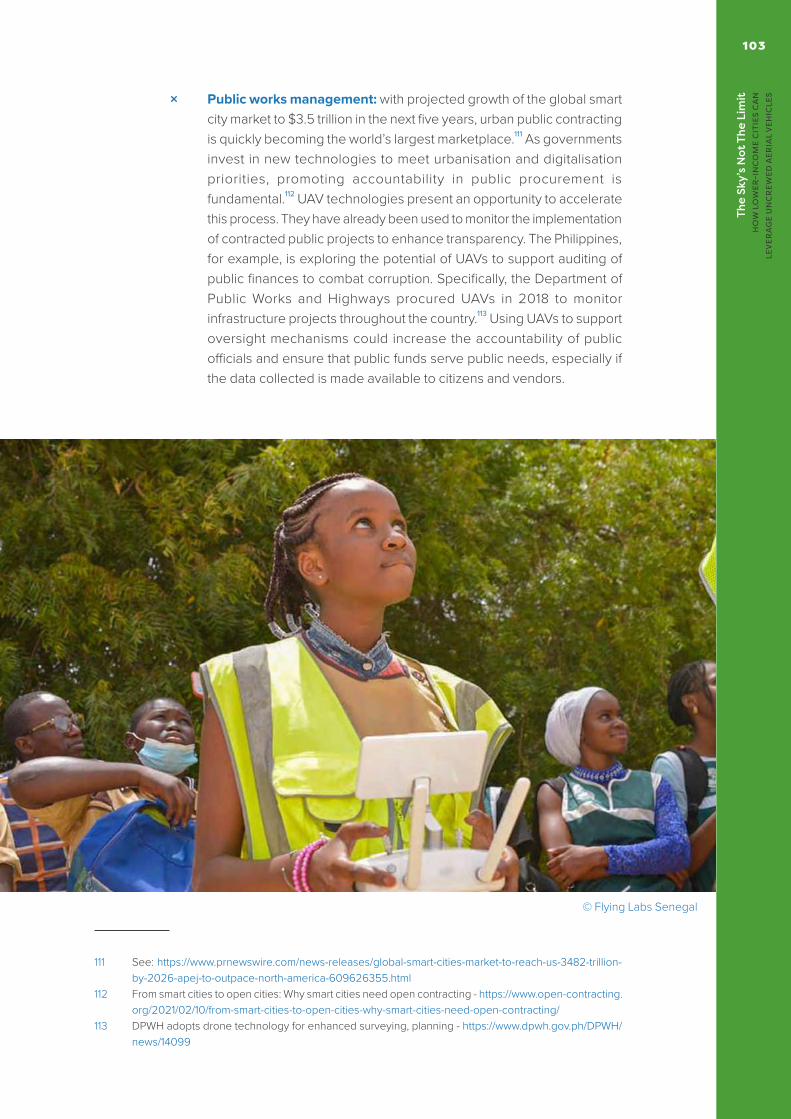
The
Sky’
s N
ot T
he L
imit
H
OW
LO
WER
-IN
CO
ME
CIT
IES
CA
N
LEV
ERA
GE
UN
CR
EWED
AER
IAL
VEH
ICLE
S
103
× Public works management: with projected growth of the global smart city market to $3.5 trillion in the next five years, urban public contracting is quickly becoming the world’s largest marketplace.111 As governments invest in new technologies to meet urbanisation and digitalisation priorities, promoting accountability in public procurement is fundamental.112 UAV technologies present an opportunity to accelerate this process. They have already been used to monitor the implementation of contracted public projects to enhance transparency. The Philippines, for example, is exploring the potential of UAVs to support auditing of public finances to combat corruption. Specifically, the Department of Public Works and Highways procured UAVs in 2018 to monitor infrastructure projects throughout the country.113 Using UAVs to support oversight mechanisms could increase the accountability of public officials and ensure that public funds serve public needs, especially if the data collected is made available to citizens and vendors.
111 See: https://www.prnewswire.com/news-releases/global-smart-cities-market-to-reach-us-3482-trillion-by-2026-apej-to-outpace-north-america-609626355.html
112 From smart cities to open cities: Why smart cities need open contracting - https://www.open-contracting.org/2021/02/10/from-smart-cities-to-open-cities-why-smart-cities-need-open-contracting/
113 DPWH adopts drone technology for enhanced surveying, planning - https://www.dpwh.gov.ph/DPWH/news/14099
© Flying Labs Senegal

©
Zipl
ine

The
Sky’
s N
ot T
he L
imit
H
OW
LO
WER
-IN
CO
ME
CIT
IES
CA
N
LEV
ERA
GE
UN
CR
EWED
AER
IAL
VEH
ICLE
S
105
· ENHANCING ENVIRONMENTAL AND PUBLIC HEALTH
Unsustainable human activity and environmental degradation has significantly altered the natural environment at a rapid and unprecedented pace – increasing climate vulnerability, undermining economic gains, and hindering broader social and economic development. Cities around the world are increasingly experiencing this devastation. In particular, cities experiencing rapid urbanisation often face environmental health challenges such as air and noise pollution, inadequate waste management, soil and water contamination from industrial activities, as well as poor sanitary systems in unplanned settlements.
These are hazards of urban mismanagement, and cause public health challenges in and of themselves. However, these challenges can be exacerbated when amplified by changing climate conditions. In recent years, climate-related disasters, such as floods, heatwaves, and landslides, have been increasingly prevalent in cities (and are even becoming seasonal in certain regions), claiming and displacing lives, and destroying businesses.
The convergence of changing climate conditions and environmental and public health challenges experienced by cities requires governments to futureproof the built environment against disaster risk. UAVs could be a critical foundation of this approach. The monitoring capabilities of UAVs could regulate illegal dumping and more broadly, optimise city waste management. Rapid aerial assessments could also facilitate climate-resilient urban planning that mitigates flood risk. Finally, UAVs could be a critical resource along the disaster management value chain, from prediction and preparedness, to response, and recovery.

The
Sky’
s N
ot T
he L
imit
H
OW
LO
WER
-IN
CO
ME
CIT
IES
CA
N
LEV
ERA
GE
UN
CR
EWED
AER
IAL
VEH
ICLE
S106
Applications
× Waste management: effective waste management system is a key environmental and public health priority that could be optimised with UAV technology. In Lusaka, UAVs were used to monitor waste overspills, verify waste categorisation, and audit the storage capacity of the capital’s largest waste disposal site in 2021, which is surrounded by an informal settlement.114 The UAV data collected were processed by Zambia Flying Labs and shared via two products for the city council: a landfill inventory and 3D model of the site. These informed the city council’s understanding of the effects of informal encroachment around the waste site on its operations, as well as city waste management plans. In addition, UAVs also have the potential to regulate illegal dumping and open burning of waste.
× Flood risk mitigation: inefficient management of urbanisation can accelerate and amplify the devastating effects of climate-related disasters, and more broadly, lead to public health challenges. For example, seasonal storms present flood risks to cities, but become especially devastating when worsened by poor waste management and drainage systems – and also pose public health and sanitation risks. In this context, UAV mapping of city terrains and the built environment could support climate-resilient urban planning, and present an opportunity towards more proactive and predictive disaster risk reduction strategies. In Indonesia, UAVs supported the Bulungan district government’s nature-based approach to flood risk management. Specifically, UAVs were used in 2017 to map the densely populated local river basin to inform natural resource management of forest areas that could serve as a natural buffer against flood events.115
× Biodiversity conservation: monitoring, and protecting, biodiversity can be resource-intensive – and on-the-ground efforts can even risk causing damage to fragile ecosystems and habitats. UAVs are increasingly being used to monitor or map biodiversity hotspots (or not-spots) without disturbing the natural environment. For example, the the Sea Turtle Group of the Comcáac people, in El Desemboque de los Seris, used UAVs as part of their efforts to save sea turtles – including building flying skills within the local community116. UAVs are also used to alert authorities
114 Partnerships and New Technology Catalyze Progress on Critical Waste Management Project in Zambia - https://blog.werobotics.org/2021/07/27/partnerships-new-technology-catalyze-progress-on-critical-waste-management-project-in-zambia/
115 Reducing flood risk in Indonesia: drones to map and secure green infrastructure - https://www.iucn.nl/en/story/reducing-flood-risk-in-indonesia-drones-to-map-and-secure-green-infrastructure/
116 See: https://news.mongabay.com/2022/02/indigenous-comcaac-turtle-group-saves-sea-turtles-in-mexicos-gulf-of-california/

The
Sky’
s N
ot T
he L
imit
H
OW
LO
WER
-IN
CO
ME
CIT
IES
CA
N
LEV
ERA
GE
UN
CR
EWED
AER
IAL
VEH
ICLE
S
107
to poaching activities, have been used to support reforestation efforts and, more controversially, to cull invasive species. Although these use-cases have focused on rural biodiversity efforts, there is scope to apply similar approaches to support urban biodiversity conservation.
× Open UAV data for climate resilience urban planning: Small Island Development States (SIDS), countries most affected by fast-changing weather conditions and particularly vulnerable to climate risks such as typhoons and hurricanes - could benefit the most from UAV applications in disaster-risk management. To mitigate the housing vulnerability of Caribbean countries to hurricane damage, the World Bank’s Global Program for Resilient Housing supported Saint Lucia and Sint Maarten’s disaster recovery efforts by using UAVs to map rooftop damage and monitor the progress of reconstruction efforts.117 The data was processed using machine learning to identify the condition and material of rooftops – and produce a database that could be used for climate resilience planning. In a similar approach, the Humanitarian OpenStreetMap Team developed a Pacific Drone Imagery Dashboard that collates UAV and satellite images of the Pacific islands and make them openly available for use by various stakeholders for disaster management.118
117 World Bank Global Program for Resilient Housing - https://www.worldbank.org/en/topic/disasterriskmanagement/brief/global-program-for-resilient-housing
118 UAV Imagery For Disaster Response: Pacific Drone Imagery Dashboard (PACDID) - https://www.hotosm.org/projects/uav-imagery-for-disaster-response-pacific-drone-imagery-dashboard-pacdid
© Flying Labs Cameroon
https://www.worldbank.org/en/topic/disasterriskmanagement/brief/global-program-for-resilient-housing

♦ Looking ForwardUAVs are already flying above lower-income cities around the world. Cities, the private sector, and civil society are exploring how UAVs can drive improvements in public and private service delivery; and how they could support emergency response, improve public and environmental health, and guide numerous other urban use-cases. UAVs have the potential to positively impact on the lives and livelihoods of city residents, and offer an exciting augmentation to the terrestrial urban realm.
©
Zipl
ine

The
Sky’
s N
ot T
he L
imit
H
OW
LO
WER
-IN
CO
ME
CIT
IES
CA
N
LEV
ERA
GE
UN
CR
EWED
AER
IAL
VEH
ICLE
S
109
However, no city – regardless of income level – has established a fully-functioning and scaled approach to integrating UAVs, nor has any city truly leveraged UAVs to achieve key urban objectives. Although the sector is expanding rapidly, both in terms of technology and use-cases – cities are largely still focused on ad hoc pilots, trials, and experimentations. This report aims to provide cities with a framework to implement UAVs in a more strategic, systematic, and holistic fashion.
UAVs offer real potential for cities and residents. This includes in the context of UAV products and services, but also much more widely. UAVs offer an exciting entry-point to the Fourth Industrial Revolution for many cities and individuals, and they have increased the accessibility and relevance of numerous transferable skills and products – from GIS, to 3D printing. Cities must engage with this broader potential, and prioritise locally-led innovation and exploration. UAVs also provide an opportunity for lower-income cities to shape the global standards of this emerging sector, whilst the UAV explorations of cities in the Global South may yet inform policy and operational practices in cities across the Global North.
UAV efforts are being led by the private sector in many countries and cities around the world. This is understandable, recognising the research and development and commercial interests involved. However, cities must engage with the private sector in these explorations – and this includes identifying suitable investment and collaboration opportunities to maximise the potential benefit that UAVs could offer. Cities should also mitigate broader risks that can sometimes arise in private sector-led and technology explorations. From avoiding proprietary technologies, to ensuring that global UAV actors do not crowd-out local innovators.
This report highlights that UAVs could be an important asset to cities: from generating revenue through the above collaborations, to leveraging UAV aircraft to improve the functioning of the city – and the welfare of its residents. The central message, however, is the importance of cities being proactive in engaging with UAVs – as with all other innovation. Cities must set out clear structures, processes, and protections to ensure that urban spaces and citizens do not become subordinate to UAV technologies or services. UAVs must not impinge on the quality and enjoyment of the urban space. Cities provide homes and prosperity to billions of people, and UAVs can amplify this positive role. But cities are much more than testbeds: UAVs must add meaningful value to cities and residents.

♦ The UNDP Global Centre for Technology, Innovation, and Sustainable DevelopmentThe UNDP Global Centre is a collaboration between the Government of Singapore and UNDP. It is a hub for knowledge and policy relating to sustainable development, with the emphasis on connecting top policy-makers, practitioners, thinktanks, business and other relevant stakeholders for learning and sharing of best practices on the themes of technology, innovation and partnerships for sustainable development. In addition, the UNDP Global Centre is a platform to study and showcase successful examples of innovation and partnerships to achieve sustainable development. As part of this mandate, the UNDP Global Centre team is keen to work with local governments around the world in order to explore the potential of UAV deployments in lower-income cities. Please get in touch to discuss your work: [email protected]
© F
oodp
anda


United Nations Development Programme
www.undp.org
© UNDP 2022