The Sierra Madre Mountain Range: Global Relevance, Local ...
463
The Sierra Madre Mountain Range: Global Relevance, Local Realities Ploeg, J. van der; Bernardo, E.C.; Masipiqueña, A.B. Citation Ploeg, J. van der, Bernardo, E. C., & Masipiqueña, A. B. (2003). The Sierra Madre Mountain Range: Global Relevance, Local Realities. Tuguegarao City: Golden Press. Retrieved from https://hdl.handle.net/1887/13052 Version: Not Applicable (or Unknown) License: Leiden University Non-exclusive license Downloaded from: https://hdl.handle.net/1887/13052 Note: To cite this publication please use the final published version (if applicable).
-
Upload
khangminh22 -
Category
Documents
-
view
0 -
download
0
Transcript of The Sierra Madre Mountain Range: Global Relevance, Local ...

The Sierra Madre Mountain Range: Global Relevance, LocalRealitiesPloeg, J. van der; Bernardo, E.C.; Masipiqueña, A.B.
CitationPloeg, J. van der, Bernardo, E. C., & Masipiqueña, A. B. (2003). The Sierra MadreMountain Range: Global Relevance, Local Realities. Tuguegarao City: GoldenPress. Retrieved from https://hdl.handle.net/1887/13052 Version: Not Applicable (or Unknown)License: Leiden University Non-exclusive licenseDownloaded from: https://hdl.handle.net/1887/13052 Note: To cite this publication please use the final published version (if applicable).

The Sierra Madre Mountain Range:
Global Relevance, Local Realities
van der Ploeg,Masipiqueña& Bernardo
THE CAGAYAN VALLEY PROGRAM ON ENVIRONMENT ANDDEVELOPMENT
The Cagayan Valley Program on Environment and Development (CVPED) isthe research and education partnership of the Isabela State University (ISU) andLeiden University, the Netherlands. Since 1989, the interdisciplinary andintercultural program has contributed to a better understanding of the social andenvironmental changes in the Cagayan Valley, strengthened research capacitiesin Region 02, and provided the necessary scientific input to government,development agencies, grassroots organizations, and conservation groups forthe sustainable management of the natural resources of the Sierra Madre MountainRange.
Cagayan Valley Program on Environment and DevelopmentIsabela State University
Cabagan Campus3328 Isabela
The Philippines
www.cvped.org Printed byGOLDEN PRESS
Tuguegarao City
Cover.pmd 8/15/2008, 9:47 AM1

THE SIERRA MADRE MOUNTAIN RANGE:GLOBAL RELEVANCE, LOCAL REALITIES
Papers presented at the4th regional conference on environment and development
Edited by
Jan van der PloegEileen C. Bernardo
Andres B. Masipiquena
CVPED
2003

ii
DISCLAIMER
The views and opinions expressed in this publication do not necessarily reflectthose of CVPED or cooperating institutions.

iii
TABLE OF CONTENTS
List of figures ............................................................................................................ vii
List of tables .............................................................................................................. ix
Acknowledgments .................................................................................................... xii
Preface.The last great forest .................................................................................................xiiiLorenzo Ma. Jose Tan
Introduction.The Sierra Madre Mountain Range:global relevance, local realities ................................................................................ xvJan van der Ploeg, Eileen C. Bernardo& Andres B. Masipiqueña
Part one. Ecosystems, endemism, and extinction: improving protected areamanagement
1. Saving the hottest of the hotspots: the Sierra Madrebiodiversity corridor strategy ........................................................................ 3Artemio Antolin
2. Conserving the Philippine crocodile in the Northern Sierra Madre:the results of three years research and conservation action ......................... 17Merlijn van Weerd & Alfredo Alex G. General
3. Research and conservation of humpback whales and othercetacean species in the Babuyan Islands, Northern Luzon .......................... 34Jo Marie V. Acebes & Lissa Aireen R. Lesaca
4. Resource inventory of Schizostachyum lumampao in thebuffer zones of the Northern Sierra Madre Natural Park ............................ 43Ma. Visitacion D. Guingab
5. Flying foxes of Northern Sierra Madre Natural Park .................................. 54Merlijn van Weerd, Jessie P. Guerrero, Bernard A. Tarun& Dominic G. Rodriguez
6. Coastal birds of the Northern Sierra Madre Natural Park ........................... 63Merlijn van Weerd, Jessie P. Guerrero, Bernard A. Tarun& Dominic G. Rodriguez

iv
7. Ethnobotany study of the Agta communities in theNorthern Sierra Madre Natural Park ........................................................... 75Hubert G. Garcia & Juan R. Acay Jr.
8. Assessing the effects of land use change for biodiversity ........................... 88Koen P. Overmars, Peter H. Verburg, Wouter T. de Groot& Tom Veldkamp
Part two. Land, logging, and livelihoods: a transition to sustainable land use
9. Upland food production systems in the Sierra Madre:realities and prospects ............................................................................... 103Mercedes D. Masipiqueña
10. Coping strategies of rural farm households in selectedupland sites in Region 02 ...........................................................................119Jovy S. Mendez-Servitillo
11. Investments in land quality: evidence from an econometricmodel of households in the Philippine forest fringe .................................. 125Marino R. Romero
12. Material flow accounting of upland villages in theSierra Madre Mountain Range .................................................................. 144Orlando Balderama & Liesbeth Denis
13. Corn and beyond: an exploration of sustainability,indebtedness, and future land use of the Sierra Madre forest fringe ......... 161Marieke Hobbes & Wouter T. de Groot
14. Indigenous agroforestry practices of Ifugao farmersat Pamungyuen, Quirino: their impact on biodiversity ............................. 174Oscar P. Cardenas
15. From natural biodiversity to agrobiodiversity: rainforestsand natural systems as models in the design ofsustainable species-rich agroecosystems ................................................... 185Anneke C. J. Boerwinkel & Denyse J. Snelder
Part three. Guardians, greed, and governance: an evaluation of co-managementapproaches
16. Indigenous peoples and tropical rainforest management:global discourses, local dilemmas ............................................................. 209Gerard Persoon, Tessa Minter & Perla Visorro

v
17. The Agta foragers in the Northern Sierra Madre Natural Park:ancestral domains in theory and practice .................................................. 241Delia S. Magaña
18. Community-based forest management for indigenouspeoples: strengths and pitfalls ................................................................... 258Dante M. Aquino
19. The effect of institutional partnership on community-based forestmanagement in Region 02: the case of VIBANARA ................................ 276Florence Z. Tarun-Acay
20. Operationalizing the Isabela multi-sectoral forest protectioncommittee: lessons, issues, and challenges ............................................... 285Roger Z. Guzman
21. Local government responses to agricultural landconversion in the Cagayan Valley ............................................................. 294Milagros A. Rimando
Part four. People, parks, and poverty: integrating conservation anddevelopment
22. Livelihoods and biodiversity conservation ................................................ 309Marcelino V. Dalmacio
23. Local realities in the Sierra Madre Mountain Range:the case of Maconacon .............................................................................. 318Eric D. Buduan
24. Interventions in the non-timber forest products sector:success or deadlock? The case study of rattan in Cameroon .................... 325Louis Defo
25. Ecotourism in the Northern Sierra Madre Natural Park:potentials and realities ............................................................................... 336Sophie Elixhauser, Denyse J. Snelder, Tessa Minter & Gerard Persoon
26. Ecotourism as a potential strategy for the integration ofconservation and development in theNorthern Sierra Madre Natural Park? ....................................................... 353Jan van der Ploeg & Jouel B. Taggueg
27. Species suitability assessment: an alternative approachto species selection in reforestation ........................................................... 370Tomas C. Reyes

vi
Part five. Forests, frontiers, and the future: building a ecological conscience
28. Thünian land use theory, visions of nature, and thefuture of the Sierra Madre forest ............................................................... 381Wouter T. de Groot
29. Of ducks, desire, and discovery channel: emergingenvironmentalism in the Sierra Madre Mountain Range .......................... 409Jan van der Ploeg
30. Environmental conservation: what schools can do ................................... 428Eileen C. Bernardo
31. Lessons learned in raising public awareness on biodiversityconservation in the Northern Sierra Madre Natural Park .......................... 444Mary Ann B. Leones & Arne Jensen
List of contributors ................................................................................................ 453
List of abbreviations .............................................................................................. 461

vii
LIST OF FIGURES
0.1 The Sierra Madre Mountain Range. ............................................................. xv2.1 Philippine crocodile locations in the Northern Sierra Madre. ...................... 234.1 Schematic lay out of sample plots along a transect line. .............................. 444.2 The natural occurrence of buho. ................................................................... 505.1 Base map of the Northern Sierra Madre Natural Park with
the two flying fox roost sites. ........................................................................ 576.1 Major wetlands of the Northern Sierra Madre Natural Park. ........................ 656.2 The number of water bird species and the total number of water birds in
Honeymoon Island reef-flat in different months in 2000. ............................. 688.1 The role of land use change modeling within studies
aiming at improved land use planning. ......................................................... 928.2 Location of restricted areas on Sibuyan Island. ............................................ 948.3 Forest area at the start of stimulation and at the end of stimulation for three
different scenarios on Sibuyan Island. .......................................................... 9510.1 Schematic diagram showing conceptual framework of the study. .............. 12110.2 Budget allocation of the respondents. ......................................................... 12213.1 Map of the SEAtrans research area. ............................................................ 16313.2 Corn area of sixteen households and yields of one cropping
in Dy Abra. ................................................................................................. 16513.3 Corn area of households and fertilizer application
in one cropping in Dy Abra. ....................................................................... 16613.4 The amount of fertilizer application and yields of
one cropping in Dy Abra. ............................................................................ 16615.1 Mixed plantation of fruit trees including mango, banana,
citrus species, and multipurpose trees such as coconutin a home garden in Moldero ...................................................................... 196
15.2 Mixed vegetable cropping in home garden in Dy Abra. ............................. 19716.1 Who are the indigenous peoples of the Philippines? .................................. 23317.1 Agta groups in the Northern Sierra Madre Natural Park. ........................... 24621.1 Model for the Local Government Unit’s role in the
regulation of agricultural land conversion. ................................................. 29622.1 The poverty and deforestation cycle. .......................................................... 31124.1 The rattan production to consumption system in Cameroon ...................... 32825.1 Bird watching in the Northern Sierra Madre Natural Park. ........................ 34225.2 Environmental education at the Gibbon Rehabilitation
Project in Khao Phra Thaew Non-Hunting Area. ....................................... 34525.3 Experience life with the Stone Age people in Siberut National Park. ............. 34726.1 Top ecotourism spots in the Northern Sierra Madre Natural Park. ............. 36027.1 Framework of a GIS-aided species suitability
assessment and location. ............................................................................. 37328.1 Thünian land use zonation of a hypothetical region ................................... 38428.2 The people-nature relationship in the four zones. ....................................... 38528.3 The expansion phase. .................................................................................. 388
viii
28.4 Vision of nature in the expansion phase. .................................................... 38928.5 The intensification phase: nature defeated.................................................. 39228.6 The early urban phase: nature newly sought. .............................................. 39728.7 The urban phase: nature forgotten or nature newly found? ........................ 40229.1 Moving frontiers, changing attitudes. ......................................................... 41229.2 Species and their relative attention in nature
conservation policies in the Netherlands. ................................................... 42029.3 The proportion of threatened birds occupying
different habitats in the Philippines. ........................................................... 42231.1 Process flow of the communication campaign. .......................................... 44531.2 Awareness and education operational framework. ..................................... 446

ix
LIST OF TABLES
2.1 Population of Philippine crocodile in presentlyidentified locations per age group ................................................................ 21
2.2 Results of latest survey (March 2002) in selected sites. ............................... 222.3 The general characteristic of Lake Dunoy, Disulap River,
and Dinang Creek. ........................................................................................ 242.4 Physical characteristics of Lake Dunoy, Disulap River,
and Dinang Creek in the period of January to March 2001. ........................ 244.1 The current status of Schizostachyum lumamapao in four study sites. ........ 495.1 GPS position of flying fox roost sites in the Northern
Sierra Madre Natural Park. .......................................................................... 585.2 Population estimates of flying foxes in roost sites
in different years. .......................................................................................... 585.3 Date, location, habitat, and bio-metric measurement
of captured flying foxes. ............................................................................... 596.1 Survey dates and locations. .......................................................................... 666.2 GPS position of survey locations. ................................................................ 666.3 Number of water bird species and total water birds
in different migration periods and months. .................................................. 676.4 All coastal bird species, the months, habitat, and migration
period in which they are observed, abundance,and conservation status. ................................................................................ 68
6.5 Details of observation of species with a conservationstatus or of special interest. .......................................................................... 71
8.1 Aggregation Index (AI) and Average Patch Parameterper Area Ratio (PAC) for Sibuyan Islandin different CLUES-S scenarios. .................................................................. 97
9.1 Percent land area by slope and elevation categoriesin Cagayan Valley. ...................................................................................... 104
9.2 Year when farm lots were established by respondentupland farmers. ........................................................................................... 105
9.3 Method of land acquisition by migrant settlers. ......................................... 1079.4 Seasonal crop rotation followed by upland households
in Bolos Point, Gattaran, Cagayan. ............................................................ 1099.5 Surface area of different forest quality class in
Northern Sierra Madre (1950 to 1990). ...................................................... 11110.1 Distribution of respondents in the three study areas
(Villa Ventura, Salindingan, and Balete). ................................................... 12111.1 Descriptive statistics of model variables. ................................................... 13111.2 Investments in land quality logit results. .................................................... 13412.1 Annual water consumption for the three villages. ...................................... 15312.2 Animal and human biomass. ...................................................................... 15412.3 Biomass extraction. .................................................................................... 15512.4 Weight of wood stock. ................................................................................ 155
x
12.5 Agricultural inputs. .................................................................................... 15612.6 Stock timeline of wood biomass in 1996 to 2001. ..................................... 15612.7 Material stocks. .......................................................................................... 15712.8 Finished goods. ........................................................................................... 15712.9 Energy use per sector. ................................................................................. 15813.1 Areas of corn land, yield (one cropping),
fertilizer use of sixteen households in Dy-Abra. ........................................ 16413.2 Cost benefits of four variants of growing corn. .......................................... 16814.1 Characteristics of indigenous agroforestry practices in the area. ............... 17614.2 Pests and diseases. ...................................................................................... 17914.3 Socioeconomic factors related to agroforestry. .......................................... 17914.4 Diversity of tree species in the woodlots or muyong. ................................. 18114.5 Diversity of tree species in the home gardens or minuyongan. .................. 18214.6 Diversity of tree species in newly developed shifting cultivation areas. .... 18314.7 Impact of indigenous agroforestry practices on
biodiversity conservation. .......................................................................... 18315.1 Number of species for each stratum grouped
according to the main local use in the homegardens in Moldero and Dy-Abra. .............................................................. 195
15.2 Chemical properties of topsoil (0 to 10 cm) in home gardens and in thesurrounding farm land in Moldero and Dy-Abra. ...................................... 198
15.3 Constraints in home garden production mentioned byrespondents in Moldero and Dy-Abra. ....................................................... 201
16.1 Indigenous peoples in international policy guidelines. .............................. 21616.2 Indigenous peoples’ status in four Southeast Asian countries. .................. 22917.1 Agta population in the NSMNP based on 1998 census. ............................. 24319.1 Land and population data of the four CBFM barangays
of VIBANARA........................................................................................... 27919.2 Vegetative cover VIBANARA. .................................................................. 27921.1 Areas converted in the province of Region 02, 1989 to 2001. ................... 29721.2 Number of conversions in Region 02. ........................................................ 29821.3 New uses of converted lands. ..................................................................... 29921.4 New uses of lands, in number of lots. ........................................................ 29921.5 Status of Comprehensive Land Use Plans of the Local
Government Units. ..................................................................................... 30021.6 Land use tools used in the municipalities and cities. ................................. 30121.7 Ordinances passed by the Local Government Units. .................................. 30121.8 Internal organization of Local Government Units. ..................................... 30221.9 Agencies coordinated with for land conversion matters. ........................... 30222.1 Species diversity of major ecosystem in the Philippines. ........................... 30922.2 Forest cover of the Philippines, 1935 to 2000. ........................................... 31022.3 List of priority protected areas under CPPAP and NIPAP. ......................... 31122.4 Population growth in the uplands. .............................................................. 31223.1 Profile of the Agta of Maconacon. ............................................................. 32023.2 Profile of Maconacon people’s organizations assisted by NSMNP-CP. ..... 32224.1 Major outside interventions in the rattan sector in Cameroon. .................. 329

xi
25.1 Comparative summary of the major factors determining the relativeattractiveness of the three protected areas:the Northern Sierra Madre Natural Park in thePhilippines, the Khao Phra Thaew Non-HuntingArea in Thailand, and the Siberut National Park in Indonesia. .................. 348
25.2 A qualitative assessment of the potential and present levelof attraction of the Northern Sierra Madre Natural Parkin the Philippines, the Khao Phra ThaewNon-Hunting Area in Thailand, and theSiberut National Park in Indonesia. ............................................................ 349
26.1 Characteristics of actors in ecotourism. ..................................................... 35426.2 A systematic test for community-based enterprise strategies. .................... 36529.1 An historic overview of hallmark events in conservation,
major policies breakthroughs, and the establishment ofimportant environmentalist groups in the United States. ........................... 414
29.2 An historic overview of hallmark events in conservation,major policies breakthroughs, and the establishment ofimportant environmentalist groups in the Netherlands. ............................. 415
29.3 An historic overview of hallmark events in conservation,major policies breakthroughs, and the establishment ofimportant environmentalist groups in theSierra Madre Mountain Range. .................................................................. 419

xii
ACKNOWLEDGMENTS
This book is the final output of the fourth regional conference on environment anddevelopment “the Sierra Madre Mountain Range: global relevance, local realities”,which was hosted by the Isabela State University (ISU) in Cabagan in May 2002.The organization of the conference and consequent publication of these proceedingswould not have been possible without the generous financial contributions of PlanPhilippines Northern Sierra Madre Natural Park Conservation Project (NSMNP-CP), Conservation International-Philippines (CI), NGOs for Integrated ProtectedAreas Inc. (NIPA), the Cagayan Valley Program on Environment and Development(CVPED), and the Department of Environment and Natural Resources (DENR).

xiii
PREFACE
THE LAST GREAT FOREST
Jose Ma. Lorenzo Tan
Let us compare the Philippines to the human body. And let us compare the forests to askin. If you scrape your knee or suffer a cut, what will happen? The wound will healitself; the skin would restore itself, but a scar. But what if you lose 90 percent of yourskin? Could you live? Doctors would probably have to put skin graft on you and placeyou under intensive care, just to keep you alive. Even if you live, your body would beone massive scar. Your appearance would change, your limbs would lose their flexibility,both on the surface and internally. You will never be the same. Let us make that analogyof our rainforests. In 1900, the Philippines had 21 million ha of this skin left. Todayonly 3 million ha of forests are left. And out of that, barely 800,000 ha are primaryforests. In one century, our country has lost 62 percent of its skin. And out of theremaining 38 percent, 34 percent is scar. Only 4 percent is original. Can there be noeffect on the body?
In the El Niño of 1997, Region 02 was the only part of the Philippines that didnot suffer a rainfall deficit due to its forests. Region 02 made its own weather. Thatyear Cagayan Valley produced 30 percent of the national palay harvest. Nationally, therice lands of Region 02 are probably the most productive in the country. Why? Water.When talking about development in the Cagayan Valley, it is intimately linked to water.It is also clear that Cagayan Valley has water because of Luzon’s last forest. The singlemajor existing asset of the Cagayan Valley is, therefore, that forest, the largest protectedforest block in the country, 10 percent of the remaining primary old growth forest inthe Philippines, one-fourth of the country’s undisturbed lowland rainforest.
Often, it is asked what the economic value of that forest is. How can it contributeto regional development? How can that forest create wealth? Let me put a very simpleformula. Forest equals water. Water equals rice. Rice equals development. The NorthernSierra Madre creates wealth so to speak. The forest is creating water, and by creatingwater, it creates wealth. Left alone, it will continue to create weather and provide waterto the rice fields of the Cagayan Valley. Rice, not lumber, will bring development toRegion 02. This will only happen, however, if the Sierra Madre forest remains. Strictlyprotected and conserved, this forest is the greatest economic asset of the Cagayan Valley.
However, with each tree that we cut, we are stripping off a little more skin.Whenever logging is allowed, there are tradeoffs. We are trading off long-termsustainability for short-term gains. We are trading off rice production for narrafloorboards. We are trading off the future of a greater majority of the people for theprofits of a few loggers and sawmills. Each time we allow logging to take place, we cutaway the forest’s ability to create wealth. And each peso earned by loggers today, ishundreds of pesos lost by rice farmers and vegetable farmers today and in the future.The Northern Sierra Madre Natural Park is protected not only because it is a globallyimportant mountain range with twelve major habitat sites, with over seventy globally

xiv
threatened or near-threatened wildlife species; the Northern Sierra Madre Natural Parkis protected because it generates weather, water, wealth for 98 percent of the populationof Isabela, not to mention the benefit it brings to Cagayan, Nueva Vizcaya, NuevaEcija, and Quezon.
Together, all Filipinos face great problems. We are still not self-sufficient inrice, a global freshwater crisis looms. We have consumed more than 60 percent of ourforest in the last hundred years. As climate change is altering weather patterns, foodproduction will be a problem in many regions of the Philippines. And the Philippinepopulation will double in this lifetime. But these challenges can also be opportunities.What must be done?
We must agree that people come first. We must agree that the welfare andlivelihood of the majority have precedent. And with 98 percent of the population ofIsabela lives outside the forest, and benefits of the water resources of the park, theirneeds must be given priority. We must agree that food security through rice productionis Cagayan Valley’s priority. Rice production needs water. We must agree therefore,that the Northern Sierra Madre Natural Park is the major source of water, is also itsgreatest single productive natural and economic asset. We must agree that this assetmust therefore, be strictly protected. We must agree that logging in Isabela is anenvironmental crime, because it threatens the continued viability of this forest to producewater, which the greater majority of people in Isabela need to create wealth and fosterdevelopment. The timber trade, running counter to the long-term economic prospectsof this region, therefore, is tantamount to economic sabotage.
We must agree that strict protection and conservation of the park is inextricablylinked to the future economic development of the Cagayan Valley. This is no need tobalance off the conservation with development here. The choice is so clear: a continuedsupply of rice food and water versus a limited supply of timber, long-term versus short-term. The development of the Cagayan Valley depends on the continued presence andviability of the Northern Sierra Madre Natural Park. There is no concession.
We must agree, finally, that the conservation of biodiversity is essential to keepthis great economic asset healthy and alive. Without this complex network of life, thisforest will not survive. And if the forest collapses, so does the water supply, so doesrice production and agriculture, and so do we. If we conserve biodiversity, we can savethis last great forest. If we can save this park, we save ourselves. Globally and locally,that is the reality.

xv
INTRODUCTION
THE SIERRA MADRE MOUNTAIN RANGE:GLOBAL RELEVANCE, LOCAL REALITIES
Jan van der Ploeg, Eileen C. Bernardo & Andres B. Masipiqueña
From reefs to rainforests and from mangroves to mountains, the Sierra Madre MountainRange is widely considered to be one of the most ecologically valuable areas in theworld. It is also one of the most threatened.
The ecosystems of the Sierra Madre go through a process of unprecedentedhuman-induced environmental change. Unsustainable resource exploitation, changesin land use, infrastructure development, and political neglect have far reachingconsequences for people and nature in the Sierra Madre Mountain Range. The likelihoodof loosing a significant part of the region’s biodiversity has led to growing global andlocal concerns. Different groups, institutions, and organizations are now activelychallenging the powerful forces that drive the widespread destruction of the naturalresources in the “hottest of the hotspots.”
Figure 0.1: The Sierra Madre Mountain Range (Source: Swedish spot satellite map 1987, ForestManagement Bureau, produced by Conservation International Philippines for the Sierra Madrebiodiversity corridor program)

xvi
This book aims to contribute to the efforts to safeguard the Sierra Madre, bydocumenting, analyzing, and evaluating the results of four years of research,conservation, and development activities. Centered on the theme “the Sierra MadreMountain Range: global relevance, local realities”, it brings together a set ofinterdisciplinary and problem-oriented studies that examine the socioeconomic,institutional, and ecological changes in the Sierra Madre.
This book is based on the premise that many of the environmental problemswe’re facing are similar everywhere around the globe. So are its solutions. Nevertheless,this is above all a local book, largely depending on the expertise of local scholarsconcerned about local problems and searching for local solutions. This book is dividedinto five parts that each deals, in its own way, with the questions of global relevanceand local reality.
The first part “ecosystems, endemism, and extinction: improving protected areamanagement”, highlights the global importance of the Northern Sierra Madre NaturalPark and explores the local challenges conservationists face protecting it (Chapter 1).An exceptional large number of globally threatened terrestrial vertebrates can be foundin the park; sixty-three species face extinction in the medium-term future, making it aglobal priority for biodiversity conservation. However, global efforts to conservebiodiversity have to address local realities in order to succeed. The different chaptershighlight the importance of applied research in protected area management. Successfulconservation requires a continuous dialogue among scientists, policy makers, and localpeople (Chapters 2 & 3). To improve sustainable management we need in-depth andlong term studies on ecosystem structures and processes (Chapters 4, 5 & 6) andindigenous knowledge (Chapter 7), and a better understanding of the effects of landuse on biodiversity (Chapters 8).
As corporate logging largely stopped in the 1990s, the conversion of forest toagricultural land by impoverished immigrants became the biggest threat to the SierraMadre. The second part of this book “land, logging, and livelihoods: a transition tosustainable land use” describes the agricultural expansion in the last frontier of Luzon(Chapter 9). Perhaps surprisingly, the general tone of this part is not pessimistic. Onthe contrary, it documents how local people react to poverty and degradation (Chapter10) and documents how farmers slowly shift from unsustainable to sustainable landuse even in the face of, or due to, resource scarcity (Chapter 11). A better quantitativeunderstanding of these transition processes (Chapter 12) enables us to develop possibleland use scenarios for the Sierra Madre (Chapter 13). The development of diversifiedand multifunctional land use systems, which maintain the structure and function ofnatural ecosystems, sustain productivity, benefit people, and conserve biodiversity, offersthe best hope for sustainable rural development and environmental protection in theSierra Madre (Chapters 14 & 15).
The Philippines has gained international recognition and respect as a countrygiving high priority to community-based natural resource management. Progressiveand innovative approaches, such as the devolution and decentralization of power, thegranting of ancestral rights to indigenous peoples, and integrated social forestry, areactively pursued as strategies to sustainable development. The question remains howsuccessful the shift from the “top-down” to the “bottom-up” approach has been in theSierra Madre. In part three “guardians, greed, and governance: an evaluation of co-

xvii
management approaches” the results of these participatory approaches are assessed.The Philippines has, compared to other countries in Southeast Asia, much achieved inthe institutionalization of co-management approaches (Chapter 16). However, therhetoric of participatory strategies is rarely matched with equivalent action at the locallevel. The implementation of community-based forest management, for example, haslargely been a failure (Chapter 17): “it created more problems than solutions” (Chapter18). These hard conclusions should, however, not be taken as a plea for a return to amore top down centralized approach. On the contrary, one of the persistent structuralproblems has been the use of a narrow, technocratic, and a-political approach toparticipation (Chapter 19). The solution is not to turn back to the blueprint approachbut to ensure that local stakeholders are truly sharing responsibility, goals, ownership,and benefits (Chapters 20 & 21).
The best way to protect a resource is to make it useful to those destroying it; orso it is argued. Part four “people, parks, and poverty: integrating conservation anddevelopment” starts with the fundamental question how protected areas can, at thesame time, mitigate biodiversity loss and strengthen local (alternative) livelihoodopportunities (Chapters 22 & 23). The sustainable exploitation of non-timber forestproducts (Chapter 24), the development of ecotourism facilities (Chapters 25 & 26),and sustainable forestry (Chapter 27) might prove to be key elements in linkingbiodiversity conservation with rural development. However, the conclusions of thesepapers are forcing us to reconsider some of the assumptions underlying the integratedconservation and development approach. Addressing the twin challenge ofenvironmental degradation and poverty in the Sierra Madre will require shared goals,differentiated responsibilities, adequate assessments, well-defined priority setting,innovative solutions, multiple strategies, real benefits, painful choices, enforced laws,and the active participation of the stakeholders at the global and local levels.
Mobilizing broad support for biodiversity conservation in society is probablythe biggest challenge for the environmental movement in the Sierra Madre. In partfive, “forests, frontiers, and the future: building an ecological conscience” we investigatethe ways in which global concerns about biodiversity can become more embedded onthe local level. An encouraging change arises because the Philippines is not exactly arich country, but also no longer a poor one. A conservation movement is stirring amongthe new middle classes and is beginning to win some battles; not on utilitarian arguments,as one might suspect from the discussion in part four, but based on the intrinsic valueof nature (Chapters 28 & 29). The people of Sierra Madre, through environmentaleducation (Chapter 30) and information campaigns (Chapter 31) become more andmore aware of the global importance of their locality. The future of the Sierra Madredepends on the successful translation of global concerns into local action.
There are some specific themes that run through the different parts of this bookbut deserve specific attention. First, it becomes clear that the management of the NorthernSierra Madre Natural Park cannot be seen in isolation from structural socioeconomicand political issues. An effective management plan requires an integrated approachdealing with the driving forces underlying social and environmental change:demography, economic development, human development, technology, culture, andgovernance. Second, there is a growing awareness of the extent of illegal forest activities,and of the immense economic, social, and environmental costs that these incur. Unless

xviii
corruption, nepotism, and power abuse are actively being tackled by governmentagencies efforts to safeguard the Sierra Madre will prove to be futile. Finally, and morehopeful, the devolution of power to the Local Government Units (LGU) has been anew and unsuspected incentive for biodiversity conservation. New local alliances havebeen formed with remarkable success.
Altering the driving forces of socioeconomic and environmental changeultimately depends on local action. The future of the Sierra Madre Mountain Rangedepends on local solutions; solutions that are, in their success or failure, of globalrelevance.

1
CHAPTER ONE SAVING THE HOTTEST OF THE HOTSPOTS: THE SIERRA MADRE BIODIVERSITY CORRIDOR STRATEGY Artemio T. Antolin ABSTRACT The Philippines, despite its size of only about 300,780 km2, is one of the seventeen mega-diversity countries in the world. It is also one of the “hottest of the hotspots” based on the global hotspot analysis (Mittermeier et al. 1998). This conclusion was based on levels of endemism (the numbers of animal and plant species not found anywhere else in the world), extent of lost of the original forest cover, and the intensity of threats and current rates of destruction. Across the archipelago the most valuable biodiversity areas are threatened consistently by the pressures of economic development attributed by: (1) extractive industries, such as mining, timber, and fisheries, (2) infrastructure and real estate development, and (3) conversion of land for agriculture. Out of the 22 percent forest cover left in 1999, less than 3 percent or approximately 800,000 ha comprised the remaining primary forest throughout the country. 50 percent, or approximately 400,000 ha, is still found in the Sierra Madre Mountain Range. These remnants of primary forests are currently surrounded by fragmented and severely degraded ecosystems of varying quality attributed mainly to direct human impact as well as extractive and development activities. The Sierra Madre Mountain Range still constitutes the largest contiguous block of remaining primary forests in the Philippines, and deserves regional, national, and global attention. In response to the current situation, the Philippine government formulated and approved the National Biodiversity Strategy and Action Plan in 1996, however, its implementation was constrained by several factors, such as limited financial resources to scale up the implementation of conservation programs and projects, limited appreciation of the government natural resource management strategy, and poor enforcement for natural resource policy. All of these contributed the further fragmentation of the remaining important biodiversity areas. Thus emerged the Sierra Madre biodiversity corridor strategy spearheaded by Conservation International (CI) in collaboration with the Department of Environment and Natural Resources (DENR). INTRODUCTION The Philippines, with more than seven thousand islands and despite of its size of about 300,780 km2, is one of the seventeen mega-diversity countries in the world (Mittermeier et al. 1997). Its archipelagic character, rich geological history, and tropical climate have contributed to the exceptionally diverse biota. The Philippines is probably the most biologically diverse country in the world, in terms of unique terrestrial and marine plant and animal species per unit area (Oliver & Heaney 1997). The country has more endemic species than some larger mega-diversity centers in the world. There are more than 1,137 terrestrial vertebrates species in the Philippines; including 576 bird species (34 percent endemic), 204 mammal species (54 percent endemic), 101 amphibian species (78 percent endemic), and 258 reptile species (66 percent endemic). Also the invertebrate diversity in the Philippines is high, with butterflies alone accounting for 895 species, 39 percent of which are endemic, the second-highest number of endemics in the world after Indonesia. There are an estimated ten thousand to thirteen

2
thousand plant species, of which more than half are endemic. Its rainforests have the highest level of endemism in the Indo-Malayan realm on a per unit basis. With a coastline of 22,450 km and an estimated 27,000 km2 of coral reefs, the country has one of the richest concentrations of marine life in the world. More than five hundred of the eight hundred known coral species worldwide occur here. There are fifty-four species of mangrove plants and some two thousand five hundred species of reef fish, making the Philippines one of the world’s richest countries in concentration of marine life (CI 2002).
Not withstanding this outstanding biological characteristics, the Philippines is regarded as one of the highest priority countries in the world for conservation concern because of the high rate of deforestation and habitat loss, and inadequacies in conservation measures (Oliver & Heaney 1997). The 2000 IUCN Red List of Threatened Species includes 193 threatened species (critically endangered, endangered and vulnerable) in the Philippines (Hilton Taylor 2000).
The burgeoning population of the country (its 2.3 population growth rate is among the highest growth rates in Southeast Asia) and consequently high demand for forest products has placed tremendous pressure on forest resources. From 70 percent forest cover in the 1900s, forest cover has dwindled to only 22 percent by 1999 (DENR 1999). By the end of the nineteenth century, primary forest cover is estimated at less than 5 percent of the total land area. The wholesale destruction of forest cover in the recent past can be attributed to several factors including the unabated exploitation of timber resources by legitimate as well as illegitimate loggers and the influx of upland migrants that converted substantial portion of the forest areas into upland agriculture. In order to arrest this alarming state of the country’s biodiversity and in response to the global call to protect the environment, the government adopted the National Integrated Protected Area System NIPAS) law to address this seemingly unmanageable situation. The NIPAS law of 1992 provides for the establishment and management of protected areas, forest reserves, watershed reservations and other reserves to include the old growth forest to be classified as protection forest. The law created mechanisms to involve local stakeholders for the protection and conservation of protected areas, such as: (1) the creation of Protected Area Management Board (PAMB) as the local policy making body of protected areas, (2) the permanency of protected area boundaries, (3) the establishment and management of buffer zones, (4) the possibility of an integrated trust fund, recognition of ancestral land and rights over them, and (5) safeguards against outright energy exploitation. However, the NIPAS law is not sufficient in conserving the remaining forest in the country. This is so because the establishment of protected areas around the country has been limited to certain ecologically sensitive areas because it entails huge amount of financial resources to run a large number of protected areas in the country. THE SIERRA MADRE BIODIVERSITY CORRIDOR Out of the 22 percent forest cover left in the Philippines in 1999, less than 3 percent, or about eight ha comprised the remaining primary forest through out the country. Statistics show, that 40 percent of that cover can be found in the Sierra Madre Mountain Range (DENR 1999). The Sierra Madre Mountain Range is in the heart of what is called the “greater Luzon biogeographic region”, and is considered the backbone of Luzon. This paper will also refers to it as the Sierra Madre biodiversity corridor.
The corridor has a land area of approximately 1.4 million ha spanning three regions (Region 02, 03 and 04), and is embraced by nine provinces (Cagayan, Isabela, Nueva Vizcaya, Quirino, Nueva Ecija, Aurora, Bulacan, Rizal, and Quezon). Such enormous geographic coverage encompasses perhaps the greatest number of protected areas in the country; all in all sixty-eight, including national parks, watershed forest reserves, natural monuments, marine reserves, protected landscapes and seascapes.

3
The Northern Sierra Madre Natural Park (NSMNP) is the largest in this region and in the country, with 359,486 ha both terrestrial and coastal areas. Apart from its diverse flora and fauna, the corridor is also known as the home of Indigenous People (IP) like the Agta or Dumagat, the Kalinga, and the Ilongots or Bugkalot.
CI-Philippines and DENR, with significant support from USAID, conducted a National Biodiversity Conservation Priority Setting Workshop in December 2000 to compile up-to-date biological information. This will also facilitate consensus building on biodiversity priorities at the regional and national levels by researchers, academics, NGOs, government agencies, and other key stakeholders. The results of the workshop confirmed that Sierra Madre biodiversity corridor constitutes the largest contiguous remaining primary forests in the Philippines, and deserves regional, national and global attention. Likewise, it identifies twenty-three priority conservation sites in the corridor, with nine sites in the category of extremely high priority (critical, or extremely high priority) and ten sites with a very high priority (Ecosystem Profile 2001). The biological importance of the corridor is not only due to the remaining intact forest in the central part of the Mountain Range, but also to the high plant diversity, with more than three thousand five hundred species recorded in the area. This represents about 45 percent of species recorded in the country. The highest number of endemic plant species is found in the corridor, with 58 percent endemism. Generic endemism is also high, with 68 percent of endemic genera found in the corridor. The number of threatened plant species in the IUCN Red List is 106, which is 42 percent of the total threatened species of Philippine flora (Ecosystem Profile 2001). As to the faunal diversity and endemism and the number of threatened species within the corridor, it has the highest species of birds in Luzon, accounting for at least 80 percent of all resident breeding birds on Luzon. The diversity of other taxonomic groups in the area is only partially documented but species diversity generally is high. Result of studies conducted shows that there are thirty-eight species of mammals, forty species of reptiles and seventeen species of amphibians. Records further show that there are twelve endemic amphibians (more than 70 percent), including Luzon endemics as the Luzon forest frog (Platymantis luzonensis) and the pygmy frog (Platymantis pygmaeus). Endemism of birds is more than 41 percent (eighty-four species, or 83 percent of all endemic birds recorded in Luzon) including Luzon endemics such as the Whiskered Pitta (Pitta kochi), Golden-crowned Babbler (Stachyris dennistouni) and Luzon Water-Redstart (Rhyacornis luzoniensis). Endemic mammals accounts for more than 55 percent (21 species), of all mammals found in Luzon, including Luzon endemics such as the Northern Luzon giant cloud rat (Phloeomys pallidus), the Luzon pygmy fruit bat (Otopteropus cartilagonodus), and the Northern Sierra Madre shrew-mouse (Archboldomys musseri). For reptiles, endemism is at least 40 percent (16 species), and includes the Philippine crocodile (Crocodylus mindorensis) and the Gray’s monitor lizard (Varanus olivaceus) (Ecosystem Profile 2001). With regard to the overall conservation status, at least twenty-eight faunal species are threatened: seventeen birds, including the critically endangered Philippine Eagle (Pithecophaga jefferyi), five mammals, including the endangered Golden-crowned flying fox (Acerodon jubatus), and six reptiles, including the critically endangered Philippine crocodile. At least twenty-one (75 percent) of these threatened species are endemics (Ecosystem Profile 2001). THE CORRIDOR CONCEPT

4
Conservation of biodiversity can be pursued through the establishment and development of protected areas. Several protected areas and national parks have been created in the country. Some have already been covered by a Presidential proclamation, few have congressional approval, and some are on the process to be proclaimed. These areas also vary in terms of management. The most advanced are the ten sites included as the Conservation of Priority Protected Area Project (CPPAP) that receive substantial assistance from the World Bank. However, these protected areas were established in fragments, thus, leaving unmanaged portions of the whole forest ecosystem. Since, these protected areas are surrounded by human activities, pressures are expected that provide further fragmentation of the remaining forest stands that furthers extinction of endangered species.
The biodiversity corridor is a new concept but is fast gaining popularity as a conservation tool. Under this concept, landscape patterns and landscape processes, which are trans-boundary in nature, are maintained to insure the conservation of biodiversity. This is attained by maintaining a mosaic of functional protected area systems and compatible land uses. This interconnected network of protected area systems and other biodiversity compatible management systems and land uses, provides a comprehensive resolution to stop further fragmentation trends of the remaining forest stands in the entire biogeographic zone, thus effectively addressing conservation concerns like species migration range, which may have not been effectively addressed by establishing a single, albeit large, protected area like the NSMNP. THREATS TO THE SIERRA MADRE The threats to the Sierra Madre biodiversity corridor are complex and interlinked by destructive resource utilization, development related activities and population pressure (from high rates of natural birth and in-migration). These threats are compounded by the Philippine government plan to open economic growth centers in the region that will result to the opening of the industrial zones in nearby areas (for example the Cagayan Special Economic Zone Authority in the north and the Pacific Coast City in the south). These proposed industrial growth centers will put pressure on the biodiversity resources of the nearby areas as a result of urban settlements due to the influx of workers in these areas.
Based on the threat analysis conducted, there are eight major threats that will greatly affect the conservation of the biodiversity of the corridor if no conservation measure to be in-placed to mitigate its long-term impact. The threats are described below including how these threats impacted on biodiversity conservation.
First, small-scale logging operations in the Sierra Madre received the most attention from the government due to the Community-Based Forest Management (CBFM) approach being the flagship program for forest resources management in the country. Throughout the corridor, the aggregate area covered by CBFM is about 423,000 ha, of which 193,000 ha are under Community-based Forest Management Agreements (CBFMA) and 230,000 ha are under Certificates of Ancestral Domain Claim (CADC). It is projected that a lot more areas will be released for these uses as the government pushes for community and People’s Organization (PO) participation. The current operations of CBFM projects reveal some grave issues of poor implementation, lack of financial capital, as well as the danger of infusing the traditional culture of logging among CBFM project operators. Based on past experiences, these issues indeed predispose the recurrence of lapses that will contribute to the continuing degradation of forest resources eventually subverting the goals and objectives of the CBFM program. Considering the extent of CBFMA as

5
well as CADC areas lining the western and eastern slopes of the Sierra Madre from Cagayan to Quezon provinces, the aggregate damage to biodiversity resources to occur will be great if these current weaknesses of implementation will not be addressed.
Second, small-scale agriculture is one of a major cause of forest destruction in the Sierra Madre. This activity is inseparable from unscrupulous commercial logging operations which allowed forest occupants inside many logged-over concessions to cover whatever damage resulting from over-cutting of areas and from poorly implemented logging activities. In 1989, the number of migrant households that occupied forestlands in Region 02 totaled about 25,000 (CI 2001). Using 2.25 ha as the average cultivated parcel for every household, the total area of cultivated forestlands was 56,250 ha. Using a fallow of three years, each household at a time maintains three parcels of land to support basic family food requirements. This would indicate that in 1989, forest cultivators maintained over 150,000 ha in the fragile slopes of the Sierra Madre. The same happened in Aurora, Nueva Ecija, Bulacan and Quezon provinces. Poorly regulated, upland cultivation contributes heavily to degrading forestlands and leads to great biodiversity loss.
Third, small-scale marine fishing is predominant in the 550 km coastline of the Cagayan Valley from Sta. Ana, Cagayan to Gen. Nakar, Quezon. Estimates show that in Region 02 about thirty-one thousand fisher folks engage in subsistence coastal fishing activities most of whom use destructive fishing methods such as dynamite fishing, cyanide poisoning, and unregulated fishing activities in the municipal waters. Most fishing waters in the Pacific Ocean are traditional fishing grounds of the indigenous Agta or Dumagat. On the Pacific coast, there are illegal fishing activities of Taiwanese fishermen reported by local communities and this encroachment contributes to increasing competition for fishing grounds. Effort to develop coastal resource management strategies and programs would provide opportunities for arresting further damage to marine and fishery resources.
Fourth, large-scale logging operations had in the past contributed to severe degradation of forestlands through conversion of old-growth dipterocarp forests into logged over areas at an average rate of 21,536 ha annually in Cagayan Valley. Confiscation reports of the DENR show a substantial increase in the illegal cutting particularly on narra (Pterocarpus indicus) due to the demand for wood as a result of the lucrative furniture trade in the province of Isabela. As of 1998, the remaining two concessions holding Timber License Agreements (TLA) cover a total area of 678.75 km2. This is in addition to the two existing Industrial Forest Management Agreements (IFMA), and one Private Land Timber Permit (PLTP) in Isabela, Aurora, and Quezon. While only five commercial logging companies are currently operating in the Sierra Madre, there are indications that operational lapses are causing great damage to the forestlands and biodiversity resources. General failure to adopt prescribed harvesting methods and poorly planned road construction and development further aggravate the rate of species loss in these concession areas.
Fifth, mining claims of various investment modes in the Sierra Madre cover an aggregate area of 811,541 ha. At present there are: (1) thirty-two exploration permit applications covering 333,989 ha, (2) eight financial technical assistance agreements covering 311,000 ha, (3) several mineral production sharing agreements of 16,000 ha, and (5) several sand and gravel projects covering 352 ha. These claims, which are shown to cover large areas on the ground, will constitute potential threats that may damage forestlands and biodiversity resources if their respective applications are granted. Fortunately, many applications have already been withdrawn due to the absence of required legal documents to support final endorsement. Few of the mining agreements and permits granted are prepared to kick off operation. There is a continuing resistance from local communities considering the fact that permit

6
approval might initially bypass many basic procedural requirements including necessary community endorsement at the local level, or be the result of politically motivated support provided by local government officials.
Sixth, poor governance is identified to be a major factor adversely affecting the implementation of even the most technically viable projects. Community-based resource management projects such as those under CBFMAs and CADCs usually become vulnerable and suffer most from revealed weaknesses and the shortfalls of poor governance. The weak support systems provided under the local government code has led to a lack of clarity about the authority and function of Local Government Units (LGU). Incentives granted to local implementers of projects have been assessed to have perverse effects that contradict the very purpose for which these incentives were created. To aggravate the situation, there exists a prevalence of poorly informed planners, decision makers and managers who most likely make poor decisions whenever alternative strategies or programs are presented for evaluation and approval. This condition even prevails in regional planning and decision-making when major programs of government are presented for review and approval.
Seventh, there are many proposed road development projects that have potential impacts to the natural resources and biodiversity of the Sierra Madre region. The patterns of location show at least four roads crossing the backbone of the mountain range and at least two trans-highways traversing the long stretch of the Sierra Madre. While most of the roads will cut through already existing but abandoned logging roads, there are still potential threats that go with their development. The expected roads will be vectors of in-migration of upland cultivators that will take advantage of the easier access provided by the roads. This opportunity will also promote the establishment of new settlements along road routes, thus increasing the pressure on adjacent biodiversity resources resulting from increased population in these new settlements. Finally, two proposed industrial estate development projects that would occupy the end sections of the Sierra Madre biodiversity corridor: (1) the Cagayan Special Economic Zone in the north, and (2) the Pacific Coast City in the south. By their very nature, intensive development projects are perceived to be a threat to biodiversity. Further imminent threats to biodiversity and the environment is expected to occur when these economic zones become managed by groups who merely pay lip service to conserve and protect the valuable resources of the region. The most direct impact of these projects will be the dislocation of many local farming communities who will join the ranks of those who may be forced to invade open access areas in adjacent forestlands. This will have grave implications for the increasing pressure on the use of natural and biodiversity resources in the Sierra Madre. THE SIERRA MADRE BIODIVERSITY CORRIDOR A corridor is very recent concept introduced as an approach to biodiversity conservation. It is therefore important to understand how the concept works to attain its very objective. Experiences from corridor implementation policies in other countries that point three important features will be considered in crafting the design and implementation plan. First, it would foster a participatory formulation of a vision and specific goals for regional development and landscape management. Environmental goals would include representation of representative ecosystems in areas large enough to ensure their long-term viability. Second, it would allow for flexibility in achieving those goals, thus decreasing the scope for conflict among stakeholders. Third, it would set up incentives to land holders to realize the vision of regional development and landscape management.

7
Planning and implementation of the Sierra Madre biodiversity corridor The corridor planning and implementation support framework is essential in the overall establishment of the Sierra Madre biodiversity corridor. The framework is the blueprint of the implementation strategy to establish the corridor. It is crafted through the analysis of the various existing secondary information available (socioeconomic data, biological data and spatial information, land use maps, and vegetation cover maps) from various agencies and institutions. This analysis will provide baseline information for planning the various actions to be done.
To refine the framework, primary data collection is to be conducted to generate data gaps. CI has established methodologies by which primary data collection can be done like the application of the Rapid Assessment of Conservation Economics for socioeconomic data, Rapid Assessment Program for biological data, and validating spatial information to develop a land cover change detection map, and vegetation classification. To achieve the essence of participatory processes in establishing the framework, the following five activities should be set up: Participatory planning and implementation
Establishment of a participatory corridor planning and implementation process to generate vital information is needed. It is also at this stage to cultivate support from various sectors. Consultations and leveling off sessions with key stakeholders will take place to ensure that there is total participation in the process and information exchange. In this way knowledge and opinion of all parties are fairly represented. Result of the analysis will be the basis for the development of appropriate actions to be carried out in the corridor. Alongside, a local coordinating unit at the provincial level will be created to serve as coordinating body and planning arena to establish the information management and exchange mechanism. The corridor design workshop is the final stage that all stakeholders will interact and validate the information generated to finalize the corridor framework. Capacity building
Building the capacity of stakeholders in corridor information analysis in necessary to ensure sustainability and acceptability of the corridor approach as the new biodiversity conservation strategy. This capacity building initiative can be done by involving stakeholders even at the preliminary activities of establishing the corridor (community profiling, community planning, analysis of secondary data on socio-economic and available biological data, threat analysis, development of an integrated corridor information system, development of conservation awareness raising activities, and the design of the corridor learning system). The stakeholder participation in these activities will enhance their capacity to implement similar activities and utilize results in decision-making. Available biological data, spatial and socioeconomic information is collected, analyzed and integrated into the corridor GIS-based information system. Government agencies, LGUs, NGOs, and other relevant institutions will ask to share data for analysis. Data gaps identified from preliminary analysis is enhanced through primary data collection.

8
Development of an integrated corridor information system
Experience in the past show, that most of the failures of development and conservation initiatives was attributed by the inability of stakeholders to hold on a common agenda to optimize the use of resources to produce better result. Conflict of programs and projects in one working area by agencies and other institutions is often time resulted to stiff competition and animosity. Based on these lessons, an integrated corridor information system for the corridor is developed and shared among stakeholders. The system is developed in consultations and participation of all stakeholders through the local coordinating unit created at the provincial level. The specific activities undertaken include: (1) analysis of secondary data, (2) collection of primary data based on the data gaps determined from the preliminary data analysis, (3) updating and integration of new information, (4) development of a unified information system, (5) establishment of protocol for receiving and managing updated information, (6) capacity building in information management, (7) data base development and maintenance, and (8) integration of all the data into the GIS information system.
Corridor awareness campaign program
Stakeholder mindset is focused on the existing government strategy of managing the natural resources as mandated by the NIPAS law. The flesh of corridor establishment is the capacity of the stakeholders to understand biodiversity conservation issues. Thus, intensive awareness campaign is necessary to promote the corridor concept for biodiversity conservation, facilitate community involvement, and get leverage for government decision making and legal enforcement processes. A corridor communication strategy shall be developed through the active participation of local communities as they are considered the backbone of real biodiversity conservation. Awareness campaign will also revolve towards advocacy to reform irrelevant and ineffective environmental policies, and to create public opinion to secure cooperation and active participation to biodiversity conservation in a larger scale. To attain these objectives, the following are the activities to be undertaken: (1) designing of a communication strategy with the active participation of stakeholders particularly the media, (2) consultations and leveling workshops targeting all levels of stakeholders, (3) development of information and communications materials, (4) field surveys to generate community participation, and (5) community and local government outreach and consultative meetings.
Corridor learning system
The establishment of the corridor learning system for the Sierra Madre biodiversity corridor is as important as the other component attain biodiversity conservation. The learning system will provide updates on the progress of program implementation and measure the effectiveness of planning and management decisions. The learning system will provide not only a way to assess if objectives are met but also feedback to modify strategies in case of unwanted results. The establishment of the system includes the following activities: (1) generation of baseline information, (2) development of monitoring and evaluation guidelines, (3) development of information rich indicators relevant across the corridor, (4) development of a strategy for responsive and adaptive management based on indicators, and (5) building monitoring and evaluation capacity for local institutions, communities, and protected area

9
personnel. Participatory process is the overall consideration for the development and implementation of the corridor learning system. Improving management in protected areas Creation and expansion of protected areas and improving the management using biological indicators is the second highest priority objective for the establishment of the Sierra Madre biodiversity corridor. A biological corridor is an element of the landscape, that is often long and narrow that joins two or more larger patches of habitat that allows movement of individuals between patches and provide long-term stability of the population. Under the Philippine context, a biological corridor can be the creation and expansion of protected areas and improving the management of established protected areas to include the management and operation of other conservation compatible management units like CBFM and CADC. Creating protected areas or establishing conservation friendly management units in the open access areas will put the Sierra Madre range into a solid block of biodiversity conservation area.
To attain this objective, the existing open access areas in the Sierra Madre range are seriously evaluated to determine what appropriate management system to put in place in specific area as prescribe under existing environmental and natural resource management policies. This activity may define the management system in a particular area acceptable by government and local stakeholders. Improving the management of the fully established protected areas and other legally recognized management units (CBFM and CADC areas) is as important as protected area establishment. These areas are to be developed as core areas for connectivity to establish the corridor. The following three activities are designed to augment the range of existing and future conservation and development interventions, and to integrate current activities and resources of relevant institutions into the corridor approach.
Strengthening the legally established protected areas in the Sierra Madre
This activity is designed to increase scientific information and analysis and build local capacity to collect, analyze and utilize information for decision making and conflict resolution. This can be done by improving project management and increasing accessible base line data for land use zoning recommendations and improvements in biodiversity monitoring.
1. Baseline biological information through the rapid assessment program will be carried out to document unstudied areas and update the secondary information from previously studied areas. Local biologist will be trained to serve as local expert pool to create local scientific rapid biological assessment unit. Major regional development program is assessed within or outside the protected area particularly those that perceived to have great influence in the overall conservation and protection initiatives. This assessment will enhance existing socioeconomic and biological information that can be used to refine and update the corridor design framework. Scientific baseline information building is continuing process as part of the corridor establishment.
2. Local capacity building is one of the main activities to be undertaken by
providing local stakeholders technical trainings such as: (1) information

10
management, (2) field research, biodiversity, and project monitoring, and (3) analytical skills. The target participants of the training exercises are local DENR personnel to include protected area staff, LGUs, POs, and local communities living within and adjacent the project areas. Other related capacity building activities include: (1) training of local coordinating units members created per province, and (2) training of local community planning and information groups. These trainings will particularly focus on the use of information system and monitoring techniques, participatory economic analysis, and exploring opportunities for long-term financial sustainability of projects.
3. Stakeholder conflict resolution will assess the existing policy framework of
projects, build stakeholder awareness, and facilitate conflict resolution by disseminating information to all relevant stakeholders. Specific activities planned to implement include: (1) community and stakeholder consultations, (2) assessment of policy framework including land tenure regulations for new settlement and indigenous land claims, (3) needs assessment for conflict resolution strategy, exploration of solutions of overlapping jurisdiction through participatory process, and (4) stakeholder workshops to discuss issues, disseminate information and build consensus on project management planning and implementation.
4. Awareness campaigns and advocacy are implemented collaboratively with government agencies, and civil society groups. Training of local awareness campaign pool and personnel of government agencies and local government units is trained to spearhead the local awareness campaign and advocacy works. These groups are tapped to lead advocacy works to push policy reforms and monitoring development projects that affects biodiversity conservation. Part of the advocacy work is participation of the group in the evaluation of Environmental Impact Assessment (EIA) and monitoring of environmental compliance of companies engage in extractive projects like mining, logging, and road development.
Management of open access areas
Open access areas remains as the priority target of forest speculators of land ownership, and extractive industries like logging and mining. Currently, these open access areas within the existing forestlands left unprotected after the expiration or cancellation of timber permits issued in these areas. To prevent the further destruction of these areas, it is necessary to establish an appropriate management system in these areas to insure long-term conservation and protection.
The preparatory activities to be undertaken include: (1) the assessment of legal, political, institutional and other constraints to park declaration or establishment of appropriate management system, (2) stakeholders consultations to generate interest and assess issues, (3) identification of critical information needs, (4) massive information and education campaign, (5) resource basic inventory or initial biological survey, (6) development of management plan, and (7) development and implementation of communication strategy to push for the creation and declaration of the new management systems.

11
Local stakeholder incentives and rehabilitation of degraded areas to promote habitat
connectivity
The total participation of the local communities in biodiversity conservation is very critical. Because of their proximity in the area, they are very strategic to provide the necessary efforts to protect and develop their surrounding areas. However, the same groups are very vulnerable to contribute to the destruction of biodiversity if their needs to survive will not be attended
Through the rapid assessment of conservation economics, appropriate interventions and incentives are identified. Based on the economic study, the stakeholder is taught to packaged project proposals to secure fund assistance from local and international funding institutions. Ecosystems rehabilitation activities will also be conducted to connect open areas, thus, improving the vegetative cover for wildlife habitat. This can be done through active involvement of local government units, private sector and government particularly on areas proclaimed as critical watersheds. Development of core nuclei protected areas
The intention of establishing a biodiversity corridor is to connect fragmented forest into one single solid block of forest as conservation area by connecting different management systems. Right now the current conservation strategy in the Sierra Madre is to establish protected areas, CBFMs, and CADCs, in specific block of forest depending of its importance to attain the objectives of government programs. However, these strategy leave substantial portion unmanaged. Thus, there is a need to put in place a management system in these open access areas to be managed by the local communities. An important consideration for establishing a corridor is because wildlife recognizes no boundary, thus, the need to build a single block of conservation area through the networks of appropriate management systems.
Laying the foundation
The legally established protected areas and other management units within the Sierra Madre are considered as core areas to promote connectivity. Conservation opportunities are explored to connect these areas through expansion and creation of new protected areas and other management systems, implementation of new zoning regulations, enforcement of national laws, improved management techniques, implement targeted research and technical support. This includes: (1) stakeholder assessment and institution functional analysis, (2) initial outreach and networking with stakeholder groups and institutions, and (3) consultation with government agencies to set new zoning standards for areas within the corridor. Explore conservation linkages
Current activities of stakeholders within the existing management systems are evaluated to explore options to link these management areas. All activities of the current programs and projects are to be integrated in the corridor design and implementation for a unified direction to meet conservation goals and objectives. The local coordinating units for every province serve as the conduit of engaging stakeholders to pursue conservation and development works. The specific activities to

12
support conservation connectivity are the following: (1) initial stakeholder networking, (2) outreach and partnership development, (3) initial spatial information collection and assessment, (4) preparation of information demonstrating where relevant economic advantages of conservation to advance conservation interest, assessment of legal, policy, regulatory and financial framework, and the design of possible policy interventions. Connecting core nuclei to establish the Sierra Madre biodiversity corridor
The last stage for the corridor establishment is to work for the connectivity of the different compatible networks of management units legally established within the corridor. The NSMNP is linked to the different management units in Cagayan, southern Isabela, northern Aurora and Quirino, while the Aurora Memorial National Park that is also the most advanced in the south is link to all management units in Nueva Vizcaya, Nueva Ecija, Bulacan, Rizal and Quezon. Activities for connectivity are carried out at corridor level. This augments the various activities being undertaken by stakeholders in the different management units. Continuation of the collection of biological data
The biological surveys initially conducted within the corridor area provide biological and social data to identify priority areas of connection, assess and monitor corridor success, and build local capacity to continue surveying and monitoring biodiversity. The corridor scale activities to be conducted include: (1) assessment of the distribution and overlap of species between management units, (2) identification of priority areas for corridor activities, (3) assessment of the impact of local human population on biodiversity, (4) identification of indicators to monitor corridor success and collection of biological and social data on the biodiversity for priority setting, (5) training of local scientists in survey methodologies, and (6) assessment of the degree of habitat degradation and economic potential for non protected areas.
Development of corridor-wide economic and policy interventions
The economic analysis of threats in the corridor is used to design policy interventions that are attractive to stakeholders and key decision makers. This will alter the negative decision making environment across the corridor, instead to increase the economic attractiveness of conservation. An assessment of stakeholder incentives serves as the basis for assessing the performance of alternative policies and regulations. The economic related activities to be carried out include: (1) assessment of the structure and size of economic incentives for different stakeholders, (2) assessment of the impact of alternative policies and regulations on incentives, (3) redesigning policies and interventions which maximize benefits for stakeholders in order to maximize political and social support while achieving the biodiversity corridor conservation objectives, and (4) analysis of information to maximize negative impacts. Development and implementation of monitoring and evaluation systems
A monitoring and evaluation system is developed to track down the impact of the different management interventions on biodiversity. There will be two levels of

13
monitoring and evaluation: a project level and a community level. The project level monitoring and evaluation will cover the over all performance in the corridor area vis-
a-vis the impact of the different interventions to biodiversity conservation. In the community level, the performance will be evaluated based on the management plans of the different management units and the community development plans of the POs. The LGUs and the community planning and information group of the POs are trained as community monitors.
CONCLUSION The arrest of the rapid loss of the Philippine biodiversity is still far from over. Despite of the Philippine government’s efforts to mobilize the public to support the protection of the Philippine biodiversity through CBFM, it seems that ecosystem fragmentation still continues. These existing programs provided us an idea to design a new approach to address this problem.
Balancing the interest in biodiversity for public interest require a new breed of ecosystem management approach. The incentive driving biodiversity loss must be addressed by considering the entire ecosystem and social systems. Thus, corridor approach was designed to address this condition. The implementation of the corridor as a new strategy for biodiversity conservation is still new. Though there’s a widespread acceptance of the corridor strategy by the stakeholders based on the initial implementation of the Sierra Madre biodiversity corridor, its sustainability as a management approach is still to be tested.

14
REFERENCES Conservation International. 2002. 2002 Annual plan executive summary. Conservation
International Philippines, Quezon City. DENR. 1999. Philippines Forestry Statistics, DENR, Diliman, Quezon City Ecosystem Profile. 2001. Sierra Madre, Palawan, & Eastern Mindanao Biodiversity
Corridors of the Philippines Hotspot
Hilton-Taylor, C. (Compiler). 2000. 2000 IUCN Red list of Threatened Species. IUCN,
Gland and Cambridge. Mittermeier, R.A., P. Robles Gil, & C.G. Mittermeier. 1997. Megadiversity: Earth’s
biologically wealthiest nations. Conservation International, Prado Norte. Mittermeier, R.A., N. Myers, J.B. Thomsen, G.A.B. da Fonseca, & S. Olivieri. 1998.
Biodiversity hotspots and major tropical wilderness areas: Approaches to setting conservation priorities. In Conservation Biology, 1998, 12 (3).
Oliver, W.O. & Heaney, L.R. (1997). Biodiversity and conservation in the Philippines. In
Philippine Red Data Book. Wildlife Conservation Society of the Philippines, Bookmark, Manila.

15
CHAPTER TWO CONSERVING THE PHILIPPINE CROCODILE IN THE NORTHERN SIERRA MADRE: THE RESULTS OF THREE YEARS RESEARCH AND CONSERVATION ACTION Merlijn van Weerd & Alfredo Alex G. General ABSTRACT On 17 March 1999, the Northern Sierra Madre Natural Park-Conservation Project (NSMNP-CP) was informed by the chairman of the Linglingay Association, Mr. Vicente Anog, that a fisherman (Samuel Francisco) accidentally caught a crocodile hatchling in Disulap River, a remote place in the municipality of San Mariano near the periphery of the Northern Sierra Madre Natural Park (NSMNP). The team immediately proceeded to San Isidro to confirm the validity of the information... and, indeed, there was one. Face to face with the fisherman and surrounded by his neighbors, the importance of wildlife conservation was thoroughly explained. The fisherman, probably convinced of the need for wildlife conservation or simply put with his back to the wall, decided to hand-over the crocodile to the NSMNP-CP. The hatchling was brought to the NSMNP-CP project management office on the Isabela State University (ISU) Cabagan campus for identification, documentation, and rehabilitation purposes. This surprise was followed by the retrieval of two more crocodiles by the same team in 1999. Mayor Jesus C. Miranda of San Mariano retrieved another crocodile from captivity in February 2000. These retrieved crocodiles are now thriving in a pen managed by a rice-farmer in San Mariano with assistance from the NSMNP-CP. Since the construction of the pen in 2000, many visitors have looked upon these crocodiles and for most of them it was a revelation to hear that the species they were seeing is the most severely threatened crocodile species in the world: the Philippine crocodile. Since that hot day in March 1999 much has changed. Wild populations of Crocodylus mindorensis have been found, breeding has been observed and the natural habitat of the species has been described. The local population near remaining crocodile locations has been informed on the status of this species and the need to conserve it. They have been consulted on the best way to do this and on ways in which this would be acceptable for all. Local legislation has passed the municipal council of San Mariano to protect the crocodiles and a crocodile sanctuary, the first in the Philippines, was established. This paper presents a summary of the now available data and the results of the conservation efforts so far. INTRODUCTION Crocodiles in the Philippines
There are two species of crocodiles in the Philippines, the estuarine crocodile (Crocodylus porosus) and the Philippine crocodile (Crocodylus mindorensis). The Philippine crocodile is an endemic species, it occurs only in the Philippines. The estuarine crocodile is widespread from Northern Australia to India and although it is threatened in the Philippines it is still common in several of other countries.
The Philippine crocodile is a small crocodile living in inland lakes and the headwaters of rivers. The estuarine crocodile lives in brackish water, sea, and lower river systems. The Philippine crocodile can reach a maximum length of about 2.5 m

16
while the estuarine crocodile can grow up to 6 m. Apart from size and habitat, the best identification characteristic is the presence of enlarged scales in the neck of the Philippine crocodile. The estuarine crocodile has a smooth neck.
Status and conservation of the Philippine crocodile
The Philippine crocodile is a critically endangered endemic species. It is listed in the IUCN Red List (2000) as critically endangered (a continuing declining population of fragmented sub-populations in declining areas of occupancy, and/or an adult population less 250, and/or a population decline bigger than 80 percent in three generations). Philippine crocodiles are protected under Philippine law (WCSP 1997). International trade in Philippine crocodiles is banned under the Appendix 1 of the Convention on International Trade in Endangered Species of Wild Fauna and Flora (CITES) (CITES 1998). The wild population was estimated at one thousand individuals in 1982 (Ross 1982) and at one hundred individuals in 1993 with Mindanao and possibly the Sulu archipelago as the last remaining stronghold of the species (Ross 1998). That was before the rediscovery of the species in Luzon. Because of the continuing adverse security situation in these areas, there is little hope for effective conservation of the Philippine crocodile in Mindanao and Sulu. The discovery of the Philippine crocodile in the Sierra Madre, however, offers new possibilities for conservation and survival of the species in the wild. Conservation initiatives In 2000, the Philippine Crocodile Recovery Team was created. Its members include officials of the Department of Environment and Natural Resources (DENR), the Director of the Palawan Wildlife Rescue and Conservation Center (PWRCC), which is a captive breeding facility for C. mindorensis, and several persons that are professionally involved with C. mindorensis conservation or captive breeding. The recovery team prepared a national recovery plan for the Philippine crocodile (Banks 2000). The primary goals of this recovery plan are to re-establish viable wild populations of C. mindorensis and to ensure its long-time survival. The IUCN/SSC Crocodile Specialist Group recommended in 1998 that captive breeding is the best chance for the species’ survival (Ross 1998). A large number of C. mindorensis have been bred in the PWRCC but so far no crocodiles have been reintroduced to the wild. It must be noted that both the IUCN Crocodile Action Plan (Ross 1998) and the Philippine Crocodile Recovery Plan (Banks 2000) do not include the here presented information on C. mindorensis in the Sierra Madre as these data have only been gathered during the last two years. A new priority in C. mindorensis conservation might now be the identification and study of other sites in Northern Luzon and conservation and recovery of these wild populations.
Upon the discovery of C. mindorensis in the Sierra Madre, the NSMNP-CP prepared a short-term conservation plan in collaboration with the Local Government Unit (LGU) of San Mariano and the Protected Area Superintendent (PASu) of the NSMNP (Plan-Philippines 2000; van Weerd et al. 2000b). This conservation plan will be discussed below. METHODS

17
Interviews were carried out in all settlements of the NSMNP to gather secondary information on current and historic presence of crocodiles. Information on current presence was checked in the field, often by hiring the informant as guide and visiting the sites he or she mentioned. Day light track searches were carried out along riverbanks as well as night surveys using strong flashlights. Of crocodiles observed, size was estimated and individuals were placed in the following categories: (1) hatchling (very small crocodiles up to 0.3 m), (2) juvenile and sub-adult (0.3 to 1.5 m), and (3) adult (bigger than 1.5 m). Night surveys were repeated and the maximum number of one night was taken as population count. Secondary information on crocodile numbers that could not be confirmed in the field, or of sites that could not be visited, was categorized as “estimated” if the information was given by several independent informants and sounded reliable.
Habitat was mapped and described following a standard protocol. The results presented here are just a summary of the main habitat characteristics. For details see Oppenheimer (2000) and Oudejans (2001). PHILIPPINE CROCODILE DISTRIBUTION AND POPULATION SIZE IN THE NORTHERN SIERRA MADRE Crocodiles in the Northern Sierra Madre
In 1999, the presence of C. mindorensis was confirmed in the Northern Sierra Madre, Northeast Luzon (van Weerd 2000). This area was previously identified as a probable C. mindorensis location based on secondary information (Ross 1982) but hard evidence was lacking. Since the discovery in 1999, a number of crocodile surveys have been carried out in the Northern Sierra Madre by the NSMNP-CP. Two of these surveys were conducted together with co-workers of PWRCC. Two in-depth studies were carried out by Dutch MSc. students under the framework of the Cagayan Valley Program on Environment and Development (CVPED). The data presented in this paper is a summary of the results of these studies (Pontillas, 2000; Van Weerd 2000a; Van Weerd et al. 2000a; Tarun 2000; Van Weerd 2000b; Tarun 2001; Van Weerd et al. 2001; Oppenheimer 2001; Oudejans 2002; Tarun & Guerrero, 2002).
Estuarine crocodiles are still present in coastal wetlands on the Eastern side of the Sierra Madre, though in small numbers (NORDECO & DENR 1998; Oppenheimer 2001; Van Weerd 2001). However, C. mindorensis was also observed near and even in the ocean. One specimen was captured leading to a positive identification (van Weerd 2000) and another adult C. mindorensis was caught by fishermen in a mangrove area in May 2001 and photographed. Within the municipality of San Mariano there are several locations with confirmed Philippine crocodile presence. The total population ranges from at least thirty-eight confirmed individuals (Tarun & Guerrero 2002) to an estimated seventy-seven based on secondary information (Oppenheimer 2001), and probably more than one hundred in a larger area including the Cordillera part of Cagayan Valley (Oudejans 2002). Table 1 shows the confirmed and estimated population size per age class in the various locations. Table 2 gives the latest survey results (March 2002) in a limited number of locations. Map 1 shows the locations with confirmed or suspected Philippine crocodile presence in and around the NSMNP. There are two distinct sub-populations: (1) Dicatian Lake and surrounding rivers in Divilacan, and (2) Pinacanauan de Ilagan River and its tributaries and lakes in San Mariano and Ilagan.

18
Table 1: Population size of Philippine crocodile in presently identified locations per age group. Based on surveys in 1999 to 2001 (Oppenheimer 2001; Oudejans 2002; Van Weerd et al. 2001).
Location Hatchling Juvenile Adult Total
Conf Est Conf Est Conf Est Conf Est
Cagayan Valley side 1. Abuan River 8 0 2 10 2. Kamalaklakan 1 2 1 2 3. Pagsungayan 2 * 4. Lake Dungsog 1 1 1 5. Lake Dunoy 2 3 2 3 6. Disulap River 8 2 2 12 12 7. Disabungan River 1 2 1 2 8. Dinang creek 6 11 2 17 30 * 9. Ilaguen River > 4 4
Sub-total Cagayan Valley side 14 14 6 34 66 Pacific Ocean side
10. Lake Dicatian 10 * 11. Dibol 1
(+ 1 dead) 1 1
12. Divilacan (1 dead) Sub-total Coastal side 1
(+2 dead) 1
(+ 2 dead) 11
Total 14 14 7 (+ 2 dead)
35 (+ 2 dead)
77
Conf = Confirmed (crocodiles have been sighted), Est = Estimated (based on secondary information). * = All age classes The latest confirmed population at four sites in San Mariano (Lake Dungsog, Lake Dunoy, Disulap River, and Dinang Creek) is thirty-eight individuals (Tarun & Guerrero 2002). Twenty-six hatchlings, six juveniles and six adults were observed (see Table 2). C mindorensis has now been confirmed breeding in three sites: Lake Dunoy, Disulap River (in 2000) and Dinang Creek. Table 2: Results of latest survey (March 2002) in selected sites. The location numbers follow Table 1. Other sites shown in Table 1 were not visited. (Tarun & Guerrero 2002)
Location Hatchling Juvenile, Sub-
adult
Adult Total
Conf Conf Conf Conf
Cagayan Valley side 4. Lake Dungsog 1 1 5. Lake Dunoy 12 2 14 6. Disulap River 1 1 8. Dinang Creek 14 6 2 22
Sub-total Valley side 26 6 6 38 At several other locations in San Mariano, crocodiles have been observed but these are probably not breeding areas because hatchlings were never observed. Two locations in and near San Mariano remain to be surveyed: Abuan River and the upper

19
stream of Ilaguen River. Informants consequently mention these two locations as inhabited by crocodiles. Dicatian Lake and surrounding creeks in the coastal municipalities of Maconacon and Divilacan are confirmed as C. mindorensis locations (Oppenheimer 2001) although reliable population estimates are lacking. Fishermen caught two adult Philippine crocodiles in the Pacific Ocean at the mouth of creeks in this area. Both crocodiles died. In addition, five hatchlings and one juvenile C. mindorensis were retrieved from captivity. Two hatchlings were released in Disulap river, one hatchling died and the other three retrieved crocodiles are being kept by the community of San Jose in a specially build pen until they can be released in the wild safely. Oudejans (2002) identified several other locations outside the coverage area of the NSMNP-CP with possible C. mindorensis populations. These are Magat River with an estimated total of ten crocodiles and Siagot River with another ten crocodiles. These locations were not yet visited to confirm the presence of crocodiles. Based on the here presented results it seems fair to estimate the total population size of C.
mindorensis in the Northern Sierra Madre and Cagayan Valley at one hundred individuals (all age classes).
The fact that new crocodile locations are being identified during each survey in new areas, and the fact that Philippine crocodiles are easily overlooked, leads to the conclusion that C. mindorensis might very well still occur in low numbers in many locations in North Luzon.

20
#
#
#
#
#
#
#
#
#
ILA G AN
PA LA N AN
CA BA G AN
TU MA U IN I
MA CO N AC O N
DIV IL AC A N
DIN A PIG U E
SA N MA R IAN O
SA N PA BL O
Map 1: Philippine crocodile locations in the Northern Sierra Madre. Numbers correspond with location numbers in Tables 1 and 2.
San Pablo
Cabagan
Dinapigue
Divilacan
Maconacon
San Mariano
Tumauini
Palanan
Ilagan
3 2 4
8
9
1
12
5
6
7
11
10

21
Habitat Detailed habitat characterization studies were carried out in Lake Dunoy, Disulap River and Dinang creek in January to March 2001 (Oppenheimer 2001). Table 3 and 4 summarize the findings. Table 3: The general characteristics of Dunoy, Diwagden and Dinang
Location Wetland
Type
Size Turbidity Flow Banks Human activity
Lake Dunoy
Lake 100 x 50 m Clear, vegetated
Stagnant Not steep, dense vegetation of shrub and trees
Kaingin farming, rice paddies nearby. No fishing.
Disulap River
River Average width: 24 m
Clear Rapid Cliffs and pebble beaches, cliffs forested
Few cultivated fields, moderate fishing, and hunting activities
Dinang Creek
Creek Average width: 7 m
Turbid Nearly stagnant
Steep clay banks, small strip of shrub
Cultivated all along creek. Creek used by carabaos. No fishing
Table 4: Physical characteristics of Dunoy, Diwakden and Dinang in the period January to March 2001.
Location (N) Temp (°C) pH Flow velocity (m/s)
Dunoy (11) 23.0 - 25.0 4.34 - 6.09 0 Disulap (21) 22.5 - 25.0 6.85 - 7.25 0.01 - 0.67 Dinang (20) 24.0 - 29.0 6.49 - 7.74 0.02 - 1.55
The variation in habitat characteristics between the sites is striking. C. mindorensis
occurs in small lakes, fast streaming rivers and stagnant creeks. The water temperature varied from 22.5 ºC to 29 ºC during the study period and is likely to vary much more during the coldest month when a mountain rain fed creek like Disulap River is much colder than a stagnant lowland lake. pH varied from acid (4.34) to slightly basic (7.74). Riverbank substrate and vegetation varied from cliffs with pebble beaches to clay banks with shrub and secondary forest vegetation. Dinang Creek is surrounded by cultivated fields with a very high disturbance level from cultivating farmers and bathing carabaos. Disulap River is much less disturbed. None of the locations is really secluded or undisturbed. C. mindorensis is found in both fresh and sea water environments though the occurrence in the sea has to be studied further and is based on two accidental catches by fishermen in coastal waters. It seems that C. mindorensis is much more of a generalist than a specialist and does not totally depend on undisturbed freshwater habitats. Why then is the species so rare? Threats
In the municipality of San Mariano, Isabela, the decline of the crocodile population is thought to be linked with poaching and destruction of crocodile habitat such as illegal fishing, kaingin making up to the edge of the creeks and riverbanks, and deforestation.

22
Many areas where crocodiles historically occurred show these human activities. However, in Dinang Creek this theory seems to be debunked as both sides of the creek are intensively cultivated (rice and corn), grasses and brush along the riverbanks are burned, and fishing activities are regular occurrences. Dinang Creek might just hold the right formula for co-existence between man and crocodiles and merits further studies. Most respondents of interviews on the reasons of decline of C. mindorensis in San Mariano do mention that hunting decimated the former crocodile populations, notably commercial hunting during the 1960s by crocodile hunters from Mindanao (Oudejans 2001). During the period March 1999 to March 2002, several incidents in which crocodiles were captured or killed were reported. Two adult Philippine crocodiles were accidentally caught by fishermen in the coastal waters of Isabela and died after being kept tied to ropes for weeks. The DENR, responsible for the release or confiscation of captured Red List species, was not able to convince the fishermen to release the crocodiles and did not enforce the law. Several juvenile crocodiles were caught in San Mariano and sold as pet. They could not be retrieved, as the source did not want to disclose the names of clients. At least one adult crocodile was killed in Dinang creek out of fear or ignorance. One juvenile crocodile was caught in Ilaguen River and kept as pet. It seems that killing and capturing of crocodiles is the main reason for the continuing decline of C. mindorensis in North Luzon, and probably the Philippines as a whole. Habitat alteration and food competition might play a role as well but probably less then hunting. Currently the remaining population of C. mindorensis in the Northern Sierra Madre is also threatened by fragmentation and by being too small. Stochastic effects (flashfloods, extreme droughts, reduced chances to find a mating partner) and genetic effects (inbreeding) become large threats in very small populations.
Because of its shy nature and small size, the Philippine crocodile offers no real danger to humans. Indeed, in all locations where crocodiles are found in San Mariano, they share the river and natural resources with humans living nearby. There are no reported fatal attacks of Philippine crocodiles on humans from direct sources. All stories about crocodile attacks are “hear-say” and could refer to attacks by the estuarine crocodiles, which is believed to have been present in Cagayan River until fairly recently (Oudejans 2002). In the San Mariano area all crocodiles present are Philippine crocodiles. Acceptance of co-habitation with crocodiles and sharing of freshwater habitats might therefore be easier to achieve compared to areas where crocodiles pose a danger to people. Fighting ignorance by providing information and winning the support of the local farmers, fishermen and hunters is of utmost importance for a successful conservation program.

23
CONSERVATION OF THE PHILIPPINE CROCODILE IN SAN MARIANO In San Mariano, C. mindorensis is mainly found outside the NSMNP and its buffer-zone. A conventional conservation program based on minimizing people-crocodile interactions and totally protecting natural crocodile habitats can therefore not be employed. Removing people from the crocodile inhabited areas is, in our time, no longer a socially acceptable option and would not be accepted by the local population and local government. It would also work counter-productive as local inhabitants would start to see the crocodiles as a threat to their livelihood and law enforcement in protected areas in the Philippines is currently generally lacking.
Therefore, any long term conservation and protection program for C.
mindorensis will have to employ a co-management approach wherein all stakeholders and key players (local residents, local governments, government institutions, the academe and NGOs) are in agreement as to how the program will run, each having its own specific tasks and responsibilities. Resources have to be pooled and maximized in order to increase the chances for success and sustainability. A long-term program should definitely include mitigating measures to lessen the impact of anthropogenic factors, which will always be present at various intensities but it should also include benefits for affected local communities to solicit their active support and compensate for any adverse impact. After the discovery of C. mindorensis in San Mariano in 1999, a short-term conservation plan was prepared and executed by the NSMNP-CP and the Local Government Unit (LGU) of San Mariano from July 2000 to May 2002. The main goal was to establish crocodile sanctuaries, which would be accepted and actively managed by the local communities. The conservation plan was drafted by the NSMNP-CP but revised with inputs from local communities who formally accepted the final version. The proposal was also presented to the Protected Area Management Board (PAMB), which is the multi-sectoral body responsible for decisions about the NSMNP, and was subsequently approved. The objectives of this conservation plan were the following:
1. Generating data on Philippine crocodile distribution, population size, basic ecology and threats in the Northern Sierra Madre.
2. Increasing the awareness among the local population with regards to the status
and need of protection of the Philippine crocodile.
3. Involving the local population in co-management of the Philippine crocodile and establishment of community declared crocodile sanctuaries.
4. Involving all stakeholders in planning and writing of a long-term action plan
for the conservation of the Philippine crocodile in the Northern Sierra Madre and securing funding for the execution of a long-term conservation plan.
To increase the support of local communities an integrated conservation and development approach was used with attention and budget for the provision of alternative livelihood options to target communities. Activities conducted leading towards co-management and sanctuary establishment
The reasoning was that if there is going to be a long-term conservation program for the Philippine crocodile, the first step is to educate the people about its natural history,

24
its conservation status, the need for its conservation, the economic benefit that would come in line with its conservation and ecotourism, and the utmost need for the active involvement of local people in the conservation and protection activities. The following six elements are of crucial importance for the conservation of Philippine crocodile, its habitat, and the NSMNP. Information, Education, Communication (IEC)
Thorough information and dissemination campaigns were conducted with the objective of educating the people on the nature and status of the Philippine crocodile and its possible imminent extinction, if conservation and protection efforts are not implemented the soonest possible time. Support from the communities was harnessed during several public consultations and commitment to form into a Bantay Sanktuwaryo (a community patrol unit to actively protect the crocodile sanctuary) was given an assurance by the community residents.
Through close collaboration of the San Mariano field office, IEC, and fauna teams of NSMNP-CP, five awareness sessions were held in sitio San Isidro, Disulap and barangay San Jose, San Mariano. Posters, produced by the NSMNP-CP, were used during these sessions, which were left behind in the community for the barangay residents to further read and see.
The IEC team also designed and produced two thousand flyers in Tagalog, as well as colored posters (one thousand in English and one thousand in Tagalog), which were distributed to the NSMNP-CP covered barangays. Extra copies were also given to the people’s organizations (PO) for distribution to people passing by their barangays. Ordinances approved by the LGU were translated into Ilocano and Tagalog, and reproduced and distributed to the local residents in NSMNP-CP covered barangays. The Philippine crocodile has been featured several times in the Tagalog newsletter that the project is distributing among local communities and in radio broadcasts on popular local radio stations. A comic album on environmental issues was produced and distributed by the NSMNP-CP featured a story on the Philippine crocodile. C. mindorensis is one of the topics of the community theater groups (Dalaw Turo) that were established in the Sierra Madre by the NSMNP-CP and DENR.
Community dialogues and public consultations After the IEC sessions and the positive feedback from the local residents, the NSMNP-CP Fauna Team drafted a proposal for the Philippine crocodile conservation program. The draft proposal was discussed with the community residents of San Isidro and San Jose during meetings and informal discussions. The project was sensitive to the suggestions of the local residents on how best to go about the conservation program. The need to regulate human activities within the proposed sanctuary and the need to form a Bantay Sanktuwaryo were discussed. Both got the approval of the local residents. However, human activities to be regulated within the proposed sanctuary were thoroughly deliberated with the local residents in order to get their feedback if the proposed regulated activities would or would not drastically affect their way of life. Suggestions were then made in order to balance the need of the local residents to have transportation access and some fishing activities within the proposed sanctuary. This resulted in well-defined areas within the sanctuary itself where regulations became site-specific.

25
Several public consultations were also organized to discuss in detail the contents of the draft proposal and, again, to gather feedbacks from the local residents and the LGU. After the public consultation sessions, attendees were given survey forms wherein they could signify whether they were in support of the Philippine crocodile conservation program or not. The proposal got an overwhelming support both in San Isidro and San Jose. Lobbying for local government support When the first retrieved hatchling was identified as the Philippine crocodile, the LGU of San Mariano was informed and provided with an orientation on the need for its conservation. The LGU responded immediately and passed the very first ordinance in support for Philippine crocodile conservation.
The following ordinances and resolutions were passed and approved by the Sangguniang Bayan of the Municipality of San Mariano, Isabela:
1. Ordinance No. 99-025: an ordinance prohibiting the collection and annihilation of the Philippine crocodiles.
2. Ordinance No. 2000-002: an ordinance prohibiting the catching, hunting,
collecting, or killing of the Philippine crocodile for any pets, sports, collection or personal consumption. This ordinance also declared the Philippine crocodile as the wildlife flagship species of the municipality.
3. Resolution No. 2000-133: a resolution earnestly requesting the NSMNP-CP
and DENR to put up a crocodile rescue center in the municipality.
4. Ordinance No. 2001–17: an ordinance declaring the identified areas in sitio San Isidro, Disulap and parts of barangay San Jose, municipality of San Mariano, as Philippine crocodile sanctuary.

26
Co-management of the crocodile pen
In January 2000, a pen was constructed in the lot of Mr. Fernando Domingo of San Jose, San Mariano for the crocodiles retrieved from captivity. The lot owner and members of his family now accept visitors, orient them about the Philippine crocodiles and the rules visitors have to follow (no unnecessary disturbance, throwing of rocks, poking, feeding, etc.), manage the feeding and cleaning of the pen, ensure continuous water supply inside the pen, and maintain a logbook for visitors. The barangay council of San Jose assumed the responsibility of providing security to the crocodile pen, just in case it will be needed. The NSMNP-CP, on the other hand, provides minimal financial support for the feeding, in case there is scarcity of food and there is a need to supplement it with shrimps and chicken. The fate of the Philippine crocodiles in the pen will be decided in line with the long-term conservation program, which is now being drafted (June 2002). One option is to release the crocodiles in the crocodile sanctuary of Disulap River; another is to keep them in the pen as part of an environmental education center in San Jose about the Philippine crocodile. Protection and co-management of crocodile habitats inside and outside the NSMNP The NSMNP-CP contributed to the design of an environmental management plan for the NSMNP. This plan includes crocodile habitat management zones in identified crocodile areas within park boundaries. These zones are totally protected and cannot be used for any development purposes (DENR 2000). Outside the park, crocodile habitats can only be protected with full consent of local communities and LGUs. Disulap River, the first wetland to be confirmed as the habitat of the Philippine crocodile in the Northern Sierra Madre, was also the first to be declared a Philippine crocodile sanctuary by the LGU of San Mariano. Disulap River was subjected to several studies and reconnaissance activities; nesting sites were identified, population estimates were conducted, and portions frequented by crocodiles were also identified. Based on these results a portion of Disulap River was declared as the Philippine crocodile sanctuary wherein human activities are regulated. The households situated near the sanctuary were given orientations on crocodiles, the need for community support to ensure its protection, and the option to avail themselves of livelihood support from the project, in return for their commitment and active involvement in the crocodile conservation program.
The Sanguniang Bayan of San Mariano held a committee hearing wherein all the queries on the proposed ordinance to declare a sanctuary were explained and clarified. Public consultations were then conducted by the LGU with two municipal councilors spearheading the activity, together with the NSMNP-CP. The draft copy of the ordinance was discussed and the map of the proposed sanctuary was shown to the local stakeholders. Getting an overwhelming support from the community residents living near the sanctuary, the said ordinance was finally passed and approved by the Sangguniang Bayan of San Mariano on 7 September 2001. In collaboration with the LGU of San Mariano billboards have been produced and installed along the sanctuary to provide information about the sanctuary and the Philippine crocodile. A community protection group will be set up to protect and control the sanctuary. Alternative livelihood support is being provided to local residents that are affected by the establishment of the sanctuary by the NSMNP-CP.

27
Disulap River was also selected as one of the Biodiversity Monitoring System (BMS) sites, which is the official monitoring system for protected areas in the Philippines. The NSMNP-CP assisted DENR with the development of a crocodile monitoring protocol and the establishment of the BMS in Disulap River. Long-term conservation of the Philippine crocodile in the Northern Sierra Madre The IEC campaigns, the meetings and consultations, and finally the declaration of the Disulap River Philippine crocodile sanctuary are a first step in the direction of a long-term conservation strategy for C. mindorensis in the Northern Sierra Madre. The lessons learned are very useful for a continuation of a co-management approach to implement this strategy and show that it is possible to win community support for the conservation of threatened species, even if these are crocodiles. The real success can only be measured in crocodiles. The monitoring system, which has been set up, should provide this information. In May 2002, just before the regional conference for which this paper was written, a workshop was held in Cabagan and San Mariano, Isabela, to design a long-term conservation plan for C. mindorensis in Northeast Luzon. Stakeholders present included local residents, LGUs, regional and national DENR officials, the Director of the PWRCC and the members of the Philippine Crocodile Recovery Team as well as members of the IUCN Crocodile Specialist Group. The output of this workshop will be a five-year plan, based on the inputs of all stakeholders present, with a comprehensive integrated co-management strategy for development and conservation of crocodile sites and nearby communities in San Mariano. A co-management group is to oversee the implementation of this plan with funding initially coming from the Royal Netherlands Embassy (RNE) through the NSMNP-CP. A research proposal was prepared earlier by the CVPED in collaboration with the NSMNP-CP. The aim of this proposal was to get funding for the involvement of local students of the ISU in crocodile research activities and to extend crocodile surveys in Northeast Luzon beyond the coverage area of the NSMNP-CP. This proposal, the Community-based Research, Observance & Conservation (CROC) project (CVPED 2002), won the British Petroleum (BP) Conservation Program gold award in April 2002 and research activities funded by this program are currently ongoing (June 2002). Research activities will have to continue during the coming years with a strong collaboration between the DENR, the PWRCC, CVPED, ISU and the NSMNP-CP. Development of a long-term research strategy by these partners was part of the crocodile workshop of May 2002.
The best incentive for the stakeholders to make the conservation and research plan work was the observation of a juvenile crocodile, in full view on the bank of Dinang creek, during the field visit of the workshop. If this juvenile will once breed in San Mariano depends especially on the people of San Mariano. There is certainly hope that it will. ACKNOWLEDGEMENTS A large number of people were involved in gathering the data which is presented here. The most valuable contributions were made by Bernard Tarun, Dominic Rodriguez, Jessie Guerrero, Yaron Oppenheimer, Petra Oudejans, Mario Sotto Jr. and Mario Sotto Sr. IEC materials and strategy were designed by Gwen van Boven and the IEC campaigns were conducted by Gwen van Boven, Nito Nemenes and Ar-En Favie. The

28
entire San Mariano field team provided indispensable support to the fieldwork and community consultations, most notably Ruel Lazaro, Ronnie Balbas and Maritess Gatan. The mayor of San Mariano Jesus Miranda and the environmental officer Jerome Miranda were fine partners in the design and implementation of the conservation plan. Resti Antolin and PASu William Savella were, among many others, important partners from the DENR. Residents and officials from barangays Disulap and San Jose contributed greatly to the success of the initial conservation program and always welcomed us warmly in their homes. Vicente Anog from San Isidro has to be mentioned specifically for his hospitality and inspirational visions of a green and prosperous future for his sitio San Isidro. Finally we thank all our colleagues at the NSMNP-CP for their professional assistance and friendship and Vic Magno, Dr Roberto Araño and John Acay for their unlimited support and guidance. Merlijn would also like to thank the Center of Environmental Science of the University of Leiden for providing a workspace and support in the preparation for the regional conference and the Philippine crocodile workshop, and Jan van der Ploeg and Tessa Minter for sharing their home, food and thoughts during these events. REFERENCES Banks, C. 2000. National recovery plan for the Philippine crocodile, Crocodylus
mindorensis. 2000 - 2006. Department of Environment and Natural Resources & the Royal Melbourne Zoological Gardens, Manila and Victoria.
CITES. 1998. Checklist of CITES species. CITES secretariat/World Conservation Monitoring Center.
CVPED. 2002. CROC: Community-based Research, Observance & Conservation. A
proposal for a research project aimed at contributing to the conservation of
the Philippine crocodile Crocodylus mindorensis in Northern Luzon, the
Philippines. Cagayan Program on Environment and Development. Cabagan, Isabela, the Philippines.
Hilton-Taylor, C. (Compiler). 2000. 2000 IUCN Red list of Threatened Species. IUCN,
Gland and Cambridge. Municipality of San Mariano. 2001. Ordinance No. 01-17: An ordinance declaring the
identified area in Sitio San Isidro, Disulap and parts of Barangay San Jose, this municipality as Philippine crocodile sanctuary. San Mariano.
. 2000a. Ordinance 2000-02: An ordinance prohibiting the catching, hunting,
collecting or killing of Crocodylus mindorensis for pets, sports, collection or
personal consumption. San Mariano. . 2000b. Resolution No. 2000-133: A resolution earnestly requesting PLAN
International and the DENR to put up a crocodile rescue center in San
Mariano, Isabela. San Mariano. . 1999. Ordinance No. 99-025: Identifying San Mariano, Isabela, as an area
wherein Crocodylus mindorensis is an endangered species and prohibiting the
collection and annihilation of such. San Mariano. NORDECO & DENR. 1998. Technical report. Integrating conservation and
development
in protected area management in the Northern Sierra Madre Natural Park, the
Philippines. NORDECO and DENR, Manila. Oppenheimer, Y. 2001. Crocodylus mindorensis, research on population dynamics
and
ecology. Environment and Development Report, CML, Leiden.

29
Oudejans, P. 2002. The Philippine crocodile Crocodylus mindorensis: A study on
factors
determining distribution and population size in the Northern Sierra Madre,
Northern Luzon, the Philippines. Environment and Development Report, CML, Leiden.
Plan-Philippines NSMNP-CP. 2000. An integrated conservation & development
project
for freshwater Philippine crocodile Crocodylus mindorensis at San Mariano,
Isabela. Project document produced for DENR-PASU and the Local Government of San Mariano. Plan-Philippines NSMNP-CP, Cabagan.
Pontillas, Frederick. 2000. New breeding sites for the Philippine crocodile. Crocodile Specialist Group Newsletter, Vol. 19: No. 2. IUCN SSC/CSG.
Ross, C. 1982. Philippine crocodile project. Final report. Smithsonian Institute and World Wildlife Fund, Washington.
Ross, J.P. 1998. Crocodiles, status survey and conservation action plan. 2nd edition. IUCN/SSC Crocodile Specialist Group, IUCN, Gland and Cambridge.
Tarun, B. 2001. Field report: Philippine crocodile survey: Upper Disulap river,
Kamalaklakan creek, Catalangan River and Lake Dunoy, municipality of San
Mariano, Isabela. January/February 2001. Project document produced for DENR-PASU and the Local Government of San Mariano. Plan-Philippines NSMNP-CP. Cabagan.
. 2000. Field report; Philippine crocodile reconnaissance survey, sitio
Lumalug,
barangay Cadsalan. December 2000. Project document produced for DENR-PASU and the Local Government of San Mariano. Plan-Philippines NSMNP-CP, Cabagan.
& J. Guerrero. 2002. Results of the Philippine crocodile Crocodylus
mindorensis
survey of March 2002 in San Mariano, Isabela province, North-eastern Luzon,
the Philippines. Plan-Philippines NSMNP-CP, Cabagan. , D. Rodriguez & J. Guerrero. 2001. Report on Philippine crocodile
consultation
Sitio Diwakden, San Jose and Sitio Ditabuni, Disulap, municipality of San
Mariano, Isabela. September 2001. Project document produced for DENR-PASU and the Local Government of San Mariano. Plan-Philippines NSMNP-CP, Cabagan.
Van Weerd, M. 2001. Report on Estuarine crocodile Crocodylus porosus in the Blos
river estuary, Reina Mercedes, Maconacon. Project document produced for DENR- PASU, Plan-Philippines NSMNP-CP, Cabagan.
. 2000a. Philippine crocodile survey results and research plan 2000. Project document produced for DENR-PASU, Plan-Philippines NSMNP-CP,
Cabagan. . 2000b. Update on Philippine crocodile occurrence in the Northern Sierra
Madre
Natural Park. Crocodile Specialist Group Newsletter Vol. 19: No. 4. IUCN SSC/CSG.
, D. Rodriguez, J. Guerrero & B. Tarun. 2001. Update on Philippine crocodile
distribution and population size in the Northern Sierra Madre and the
proposed Philippine crocodile sanctuary in Disulap River, barangays San
Jose and Disulap, San Mariano, Isabela. Project document produced for DENR-PASU and the Local Government of San Mariano, Plan-Philippines NSMNP-CP, Cabagan.

30
, D. Rodriguez, J. Guerrero & B. Tarun. 2000a. Report of mapping and
interview
survey Disulap river, San Mariano, Isabela. Project document produced for DENR/PASU by Plan-Philippines/ NSMNP-CP. Cabagan.
, A. General & G. van Boven. 2000b. Update on Philippine crocodile
conservation in the Northern Sierra Madre Natural Park. Crocodile Specialist Group Newsletter Vol. 19: No. 4. IUCN SSC/CSG.
Wildlife Conservation Society of the Philippines (WCSP). 1997. Philippine red data
book. Bookmark, Manila.

31
CHAPTER THREE RESEARCH AND CONSERVATION OF HUMPBACK WHALES AND OTHER CETACEAN SPECIES IN THE BABUYAN ISLANDS, NORTHERN LUZON Jo Marie V. Acebes & Lissa Aireen R. Lesaca ABSTRACT In 1999, the Babuyan Islands were verified as a breeding ground for humpback whales. Categorized as vulnerable by the IUCN Red List, the discovery of these whales in this area is significant in establishing the current status of the population in the western North Pacific. WWF-Philippines aims to: (1) determine the minimum abundance, distribution and migratory origins of humpback whales in the area, (2) develop and implement an Information, Education, Communication (IEC) campaign on marine mammals for the coastal communities of Calayan, Claveria, Sta. Ana and Aparri, and (3) recommend steps in the protection of the humpback whales through an initial conservation plan. Vessel surveys conducted from 1999 to 2002 indicate that eleven species of cetaceans occur in these waters. The abundance of these cetaceans exemplifies the high marine biodiversity in the region. Humpback whales migrate in these waters to mate, give birth and nurse their young. Thirty individual whales have been photo-identified and seven have been found to match with whales photographed in Japan. Participatory planning is necessary to develop a conservation strategy for humpback whales in the Babuyan Islands. A preliminary conservation management and planning workshop was conducted in October 2001, which was attended by multi-sectoral representatives from the four municipalities, regional agencies, and other partner NGOs. As part of the IEC program, youth assemblies, and consultation and validation workshops were organized in four municipalities. These activities aim to increase the awareness of local people regarding the biology of marine mammals and their significance to marine biodiversity conservation, and to elicit local knowledge on environmental issues in the area. BACKGROUND The humpback whale (Megaptera novaeangliae) is one of the several species of marine mammals confirmed to be present in Philippine waters (Leatherwood et al. 1992). It is listed as vulnerable by the IUCN Red List (Hilton-Taylor 2000). In the Philippines, this species is protected under the Fisheries Administrative Order No. 185-1, No. 208 and Republic Act No. 9147, otherwise known as the Wildlife Resources Conservation and Protection Act. The waters surrounding the Babuyan Islands have been identified as a breeding ground for the humpback whales (Yaptinchay 1999). Being verified only in 1999, nothing much is known about the population. Reconnaissance surveys have been done but due to lack of funding, limited research has been accomplished. There is a need to know the identity of the population, characterize their Philippine habitat, determine the seasonality of their presence, abundance and distribution, and identify threats. The information gathered will be essential in any conservation effort to be implemented in the area.
In 2000, the humpback whale research and conservation project was undertaken. The project has three main objectives:

32
1. To estimate the minimum abundance and migratory characteristics of humpback whales in the area based on catalogued photographs of individual animals.
2. To develop and implement an IEC program on marine mammals for the
coastal communities of the Babuyan Islands, Claveria, and Aparri. 3. To recommend further steps in the protection of the humpback whales through
an initial conservation plan (Acebes et al. 2001). RESEARCH The project aims to determine the minimum abundance and migratory characteristics of humpback whales primarily through the conduct of photographic identification studies. Photo-identification allows repeat sighting of individual whales and would lead to accurate counts, and determination of migration routes and other behavior patterns. In addition, other techniques such as humpback song recordings and biopsy samplings were also used. Song and genetic analysis will also aid in determining the whales’ migratory origins.
Data gathered by WWF researchers during the first year of research in 2000 is insufficient to be able to determine the migratory origins, abundance and distribution of the whales. The initial photo identification study yielded very limited fluke photographs. The photographs obtained were generally unsatisfactory for comparison to other fluke photos in existing humpback whale catalogues in the North Pacific. In 2001 and 2002, a more intensive photo-identification study was conducted (Acebes 2001; Acebes 2002).
Methods
The study area was the Babuyan Islands located at 121° 36‘ 00” longitude and 19° 18’ 00” latitude. It consists of five main islands: Calayan, Camiguin, Dalupiri, Fuga, and Babuyan Claro. The study was extended to include Palaui Island, a small island on the Northeast point of Luzon due to its proximity to the Babuyan Islands.
Boat surveys were conducted during the months of March until May using a predetermined transect line covering the waters around the five islands and Palaui Island. Each line was traversed using an 11 m double-engine outrigger survey boat with a 3 m high platform. Observers from this platform used the naked eye and binoculars to locate whales visually. Upon sighting, species was identified and location was marked using a handheld GPS. The animals were approached using an 8 m motorized outrigger boat. From this boat, photographs of the underside of the flukes of humpback whales were taken. The location, companions and behavior of the whales were also noted. High-quality photographs were compared based on the degree of pigmentation, natural markings and pattern of the trailing edges of the fluke. Individuals were assigned identification numbers. Fluke photos were then compared with the collection of fluke photos from Ogasawara and Okinawa, Japan. An omni-directional hydrophone was used to detect and record humpback singing. Surface times of the singers were also noted. Skin samples were taken opportunistically using a crossbow and biopsy darts. A kitchen sieve attached to a 3 m long PVC pipe was also used to scoop up sloughed skin from the whale’s dive “footprint”. Skin samples were carefully transferred to properly labeled vials

33
containing saturated salt solution and 20 percent dimethyl sulfoxide. Environmental parameters were measured at predetermined waypoints and points of cetacean sightings. Salinity was measured using a hand refractometer. Sea surface temperature was taken using a laboratory thermometer and turbidity was measured using a secchi disc.
Accomplishments
From 2000 to 2002, a total of 6,061 km have been traversed. The most commonly sighted are humpback whales, with a total of 154 sightings documented. Vessel transect surveys indicate that there is a significant number of humpback whales that migrate to these waters every year. Whales were observed in the following social groups: lone adult, mother-calf pairs, two adults, mother-calf-escort, and surface-active mating group of three or four individuals. A total of thirty individuals have been photo-identified. Fluke photographs have been compared with the fluke catalogue of humpback whales seen in Ogasawara and Okinawa, Japan. To date, seven matches have been found. This indicates that the whales are moving between these two breeding grounds, Philippines and Japan. A total of 143 minutes of humpback songs have been recorded and are still pending for analysis. Four biopsy samples have also been taken. Other species of cetaceans that have been identified are: sperm whales (Physeter macrocephalus), short-finned pilot whale (Globicephala macrorhynchus), false-killer whale (Pseudorca crassidens), melon-headed whale (Peponocephala
electra), dwarf sperm whale (Kogia sima), long-snouted spinner dolphin (Stenella
longirostris), spotted dolphin (Stenella attenuata), bottlenose dolphin (Tursiops sp.), Fraser’s dolphin (Lagenodelphis hosei), and rough-toothed dolphin (Steno
bredanensis). The abundance of cetacean species that occur in this area exemplifies the high marine biodiversity in the region. INFORMATION EDUCATION CAMPAIGN IEC is an integral component of the project. It aims to promote and raise awareness and understanding among the local stakeholders regarding concepts on biological diversity, emphasizing the marine mammals’ (whales and dolphins) role in the web of life.
The specific objectives of the IEC component are to: (1) present and inform local stakeholders about the goals of the WWF-Philippines project, (2) conduct consultations and workshops with local officials and agencies of the municipalities and barangays, and (3) to conduct school and community extension activities that focus on the significance of biological diversity found in their particular area (Acebes et al. 2001). From the initial phase to the present, the project implemented IEC support activities to involve the local community in the pursuit of environmental conservation with emphasis on the humpback whales and its ecologically significant habitat, the waters of the Babuyan Islands. The project also aims to institutionalize marine mammal research through the establishment of a volunteer program. This program targets students, young researchers and professionals to participate in the research of humpback whales in the islands. The project also aims to establish a partnership with the local academe through research and capacity building.

34
Methods
The project team strengthened its presence in the area by presenting and informing local stakeholders on WWF-Philippines’ goals and objectives as a non-government conservation organization. Results of the research for the year were feed backed to the stakeholders as part of the IEC process.
The IEC plan of action of the project’s first year of implementation, was divided into four levels of strategies: (1) consultation and coordination activities (2) community and school extension activities, (3) multi-media approach and collaborations, and (4) skills enhancement workshops for staff and volunteers. Formal and non-formal methods of communication were implemented, from coordination work to consultation activities, targeting various audiences such as local government officials, fishermen, school children, and the youth. Collaborations and partnerships were also sought within the regional offices of Cagayan Province, Region 02. WWF collaborated with the Department of Environment and Natural Resources (DENR), the Department of Agriculture-Bureau of Fisheries and Aquatic Resources (DA-BFAR), the Department of Tourism (DOT), and the provincial government. Interviews, consultation workshops on the barangay and municipal level, focus group discussions, youth assemblies, and school visits were organized as part of the project’s intervention in the project target municipalities, namely: Aparri, Calayan, Claveria and Sta. Ana. Information dissemination is an important aspect of the project. In order to achieve this, various methods were used. Fact sheets and posters were produced and distributed in key municipalities of Cagayan Province. Radio plugs relaying information on humpback whales and various activities of the project were aired in the local radio stations, reaching households as far north as Calayan Island. Billboards were also designed for installation at strategic sites in the target municipalities. Other informal strategies employed were unstructured interviews and community immersions by participating in local activities or festivities.
Accomplishments
Whales and dolphins posters and project fact sheets distributed to various stakeholders in Cagayan province facilitated the dissemination of information regarding marine mammals and the conservation efforts initiated by WWF-Philippines in the region. Radio plugs aired in Aparri and Tuguegarao provided information regarding the project’s on-going activities in area. At present informational billboards have been installed in Aparri and Sta. Ana. These boards provide information not only about the humpback whales but also about Philippine laws governing marine mammals.
Community visitations and workshops conducted in barangays in Aparri, Claveria and Sta. Ana were geared towards gathering initial information on various natural resources available, environmental issues and programs existing per municipality. This also paved the way for establishing future collaborative activities. This was also essential in getting the initial feedback or impression of the community on the initiatives of the project. To establish linkage with key agencies in Region 02, a consultation workshop with the DOT, DA-BFAR, and the DENR was conducted in Tuguegarao City in 2000.

35
From 2000 to 2001, youth assemblies have been conducted in twenty-one schools in Claveria, Aparri, Sta. Ana and Calayan with 1,470 elementary and high school students participating. These assemblies include lectures on marine mammals and basic biology of humpback whales. An interactive environmental game was also used to demonstrate the concept of the “web of life”. A special session was conducted for 120 marine biology and fisheries college students of Cagayan State University (CSU) in Aparri, discussing marine mammals as well as national and global environmental conservation.
In 2002, new IEC activities were implemented such as the ecological art activity for the youth. Thirty-five students from Camiguin participated in this activity and were able to use basic drawing techniques in expressing their insights on marine mammal species. Project L.I.F.E. (Learning Interdependently for the Environment), a mobile educational van toured twenty-nine schools in the coastal municipalities of Sta. Ana, Aparri, and Claveria. Its main objectives were to increase the awareness and knowledge of the Filipino youth on environmental conservation and resource protection by producing and presenting interactive and multi-media presentations, and to harness the interest and support of the local residents on conservation issues. This project is a van fully equipped with audio-visual and training materials that feature nature conservation issues relating to forests, climate change, and fisheries. A series of videos were also presented, targeting different student levels.
In May 2002, a Memorandum of Understanding was signed between WWF-Philippines and CSU formally stating concerted efforts and responsibilities of the two institutions, specifically towards the goal of conservation. This will strengthen linkages with the academe, as there will be an exchange of information, resources and trainings as well as passing of technical knowledge to students and faculty. CSU will be involved in WWF-Philippines’ volunteer program through the participation of selected students in the conduct of the research in the islands. Reports of stranded whales and dolphins are not uncommon in Cagayan. In the effort to educate the people on marine mammals and expand the national marine mammal stranding response network, a training was conducted in June 2002 for stakeholders in Cagayan Province. As a result, forty-six participants were trained and a stranding network for Cagayan Province was formed. With the consensus of the participants present, the BFAR regional fisheries training center in Aparri was established as the coordinating office for the Cagayan marine mammal stranding network. DEVELOPMENT OF AN INITIAL CONSERVATION PLAN Participatory planning is necessary to develop a conservation strategy for humpbacks in the Babuyan Islands. The project aims to develop an initial conservation plan for the humpback whales through a preliminary conservation-planning workshop represented by various stakeholders.
Methods
In preparation for the formulation of an initial conservation plan, municipal profiles and other relevant secondary data were gathered. This information is vital to the eco-profiling of the target sites. A preliminary conservation-planning workshop was designed in order to gather the identified stakeholders. The workshop was divided

36
into two parts: (1) gathering of local knowledge on resources and its use, and (2) prioritization and action planning. The workshop had the following objectives:
1. To come-up with substantial information on how the stakeholders of the target municipalities perceive their natural resources, how they utilize it and what time of the year are these resources being utilized.
2. To get a better understanding of the various conservation-related programs
that each municipality is presently undertaking.
3. To secure from the stakeholders specific issues that need to be prioritized and their specific plan of action to address the said issues.
4. For the municipal and regional agencies to come-up with action plans where
conservation of humpback whales could be incorporated among existing government and NGO interventions.
To ensure the necessary feedback of the results of the preliminary conservation-planning workshop to the stakeholders, a series of community validation and consultation workshops were organized at the barangay level for the local communities of Aparri, Sta. Ana, Claveria and Calayan. This activity not only aims to present the results of the planning workshop but also to facilitate the discussion of additional recommendations for environmental conservation. Resource profiling was also conducted in order to have a baseline data of natural resources available in the area for future ecological planning use.
Accomplishments
Multi-sectoral representatives from the four municipalities-Aparri, Sta. Ana, Claveria and Calayan, regional agencies, other partner NGOs and municipal and provincial officials participated in the preliminary conservation-planning workshop. There were a total of 55 participants, coming from CSU, Local Government Units (LGU), the police (PNP), the coastguard, the Philippine Navy and other regional government agencies from Region 02, such as the DENR, and BFAR. Other NGOs were also present, namely Plan Philippines Northern Sierra Madre Natural Park Conservation Project (NSMNP-CP), and Conservation International (CI). All have contributed to the success of the planning workshop by sharing inputs on conservation measures to apply to the Babuyan Islands. Significant results were noted and objectives of the planning workshop were met. With this, WWF aims to gain the “buy-in” and support of all stakeholders. The roles and commitments of various key stakeholders in pursuit of conservation were further defined and validated during this workshop. It is now the responsibility of WWF to ensure that the results of the planning workshop will be re-validated at the community level. The municipalities expressed their commitment to the conservation of the humpback whales and its environs by means of providing logistical, administrative and IEC support. From May to June 2002, results from this workshop were validated at the community level in the municipalities of Aparri, Claveria, Sta. Ana and Calayan. Pertinent information such as resources available, its seasonality and use, environmental issues that beset the municipality, and lastly, conservation-related programs present in their area were gathered. Information revealed that the Babuyan Islands are endowed with abundant marine and aquatic resources. This data will be

37
relayed to concerned agencies for reference as well as push for its immediate action and implementation. OTHER SIGNIFICANT FINDINGS Direct threats to humpback whales have not been documented. However, interviews reveal that direct catch of dolphins for use as shark bait is practiced in Sta. Ana and Aparri. It is also evident that the Babuyan Channel is subjected to degradation by human activities such as destructive fishing methods (dynamite and cyanide fishing), pollution and intrusion of foreign commercial fishing vessels.
Local communities are very receptive and willing to participate in conservation activities in collaboration with WWF-Philippines. Each municipality expressed their full support to the conservation of humpback whales, particularly on IEC and advocacy work, for which they aim to conduct IEC at the community level, in close coordination with other agencies. Other forms of support include, formation of “Bantay Balyena” groups within the barangay, initiation and implementation of laws to address illegal methods of fishing, as well as push for the inception of resolution and ordinances for conserving humpback whales.
Consultative meetings with line agencies and other NGOs in Region 02 brought about collaborative effort in several key activities. Representatives from the DENR and DA-BFAR assisted in conducting consultation workshops and youth assemblies. They acted as resource persons who discussed concepts on biodiversity conservation and fishery laws, respectively. WWF-Philippines was also able to solicit the support of another NGO in the area, Plan Philippines, in conducting a reconnaissance vessel and aerial survey along the coastline of the Northern Sierra Madre National Park. These collaborative efforts between WWF, government line agencies and NGOs are important venues to enrich each other’s knowledge on conservation on different levels and areas in the ecosystem. These partners shared their expertise and significant experiences in the field. This is a clear demonstration that conservation endeavors are best pursued by cooperation among government, non-government entities and the community. With community validation workshops held at the community level, information gathered showed that at the municipal level, each municipality implements their own conservation-related programs, catered to the needs and issues within their area. For instance, in Claveria, they have a major program, called the Coastal Resources Environmental Management (CREMA), which is successfully implementing its enforcement, management and IEC components. This has become an example that may be also be implemented in other municipalities. The project has taken on a task to initiate the designing of an appropriate conservation plan for the humpback whales by understanding a species that until recently, has not been previously studied in our region and whose territorial boundaries we cannot easily define because of its migratory nature. This exemplifies the need for a collaborative research effort among international, national and local scientists. Steps should be taken not only to establish links with whale experts abroad but also encourage the collaboration of researchers in government agencies, NGOs and the academe. This will facilitate a more comprehensive and accurate data collection and analysis on the biodiversity resources in the region. This presents an opportunity to enhance the knowledge and capacity of the local scientific community as well as the fishermen in coastal communities. Trainings on cetacean biology and data collection techniques and marine mammal stranding response will not only arm the people with the necessary scientific knowledge but hopefully, it will give them a

38
better understanding of the importance of these species to the whole life support system. NEXT STEPS For the next phase of the project it is recommended to continue the cetacean vessel surveys around the Babuyan Islands. This will entail monitoring of the humpback whale population wintering in the area through photo-identification. To describe population structure of these whales it is recommended that more dedicated behavior, vocalization and genetic studies be conducted. Reconnaissance surveys will be extended to the Batanes Islands and Pacific coast of Maconacon, where there have been reported sightings of humpback whales (Van Lavieren 2001; Tan 1995). It is also pertinent that an oceanographic study be conducted as part of the physical characterization of the waters on the Babuyan and Balintang Channels. The project also aims to initiate an eco-regional approach to the conservation of humpback whales of the western North Pacific. Collaborative research with organizations or institutions working in nearby humpback breeding areas is imperative.
There is a need to address the threats to the natural environment and to the livelihood of the communities in the Babuyan Islands and adjacent coastal communities of Cagayan. Their rich coastal biodiversity must be sustained to ensure that the present and future generations continue to derive benefits from its coastal resources. The pressing task ahead is the establishment of a coastal resource management program in Northern Cagayan that intricately links economic incentives to the conservation of the coastal resources of Cagayan. A participatory coastal resource assessment and preliminary ecological profiling will be conducted to gather baseline information on the flora and fauna and ecosystem interactions that will be essential to the formulation of a coastal resource management plan. REFERENCES Acebes, J.M.V. 2002. Occurrence of humpback whales (Megaptera novaeangliae) and
other cetaceans in the Babuyan Islands, Northern Luzon, Philippines. Paper submitted to the convention on migratory species; second international conference on the marine mammals of Southeast Asia, 22-23 July 2002, Dumaguete City.
. 2001. Photographic identification of humpback whales (Megaptera
novaeangliae) in the Babuyan Islands, Northern Luzon, Philippines. Paper presented at the 14th conference on the biology of marine mammals, November 28 to December 3, Vancouver.
, L.R. Lesaca & A.A. Yaptinchay. 2001 Humpback whale (Megaptera novaeangliae) research and conservation project in the Babuyan Islands,
Philippines. Unpublished report submitted to WWF-Philippines. Hilton-Taylor C. (Compiler). 2000. 2000 IUCN Red List of Threatened Species. IUCN,
Gland and Cambridge. Leatherwood S., M.L.L. Dolar, C.J. Wood, L.V. Aragones & C.L. Hill. 1992. Marine
mammal species confirmed from Philippine waters. In Siliman Journal No. 36(1): 65-75.
Tan, J.M.L. 1995. A field guide to whales and dolphins of the Philippines. Bookmark Inc., Makati City.
Van Lavieren, H. 2001. Marine mammals and endangered species survey report:

39
Northern Sierra Madre Natural Park. Plan Philippines NSMNP-CP, Cabagan. Yaptinchay A.A. 1999. New humpback whale wintering ground in the Philippines. Paper
presented at the 13th conference on the biology of marine mammals, November 28 to December 3, Maui.

40
CHAPTER FOUR RESOURCE INVENTORY SCHIZOSTACHYUM LUMAMPAO (BLANCO) MERR. IN THE BUFFER ZONES OF THE NORTHERN SIERRA MADRE NATURAL PARK, NORTHEAST LUZON Ma. Visitacion D. Guingab ABSTRACT A resource inventory of Schizostachyum lumampao (Blanco) Merr. was conducted in the buffer zones of Northern Sierra Madre Natural Park (NSMNP), Northeast Luzon, to determine its current status in the region and to evaluate its sustainability. The result of this study shows a decreasing population of Schizostachyum lumampao in Isabela Province. The extent of area covered by this species from thousands of ha in early 1900s has gradually decreased to hundreds of ha in the year 2000. In terms of quantity or number of culms per ha, the survey showed an average of 8,800 culms per ha in 825 ha of natural buho stand. Several localities have been identified as extraction sites of buho in Isabela Province. In San Mariano, four barangays were identified namely, Dibuluan, Macayucayu, Dicamay, and Cadsalan, while in Cabagan, Masipi East was identified. These areas are the specific location sources of commercially sold bamboos. On the other hand, Tupa in San Pablo, and Antagan in Tumauini, were also identified as location sources of buho but are not sold commercially. In general, Masipi East, Cabagan has the largest tract of buho among four study sites. Agricultural encroachment on the forest and use of unsustainable traditional farming methods by the kaingineros are the major threats to the availability and sustainability of buho in all areas studied. Efforts towards conservation and sustainable management of this species through information dissemination and policy formulation should be done in order to save the remaining resource. INTRODUCTION The NSMNP possesses one of the country’s remaining primary forest blocks and one of the ten priority areas for the National Integrated Protected Area System (NIPAS) in the Philippines. The mountain ranges located on the eastern boundary of the region contain numerous species of flora and fauna as well as critical watersheds. It contains one of the highest numbers of endemic species in the world. The area is extremely diverse. The forests sustain the daily living requirements of its indigenous hunters, the Dumagats or Agta. It is also in this area where many communities live on a marginalized and impoverished existence, thus placing much pressure on the remaining and already critical resource base. The conservation of the biological resource in the area has now become the focus of concern because of the alarming rate of forest destruction.
One of the initiatives to arrest the continuous degradation of the Sierra Madre Mountain Range was the declaration of the total logging ban in 1992. With this, however, the rate of extraction of non-timber forest products (NTFP) has increased because the local people and wood-based industry considered extraction of these products their fall back livelihood. By far, bamboo is among the most important NTFP used by local communities in the manufacture of cradle to housing components. The demand for this material has increased far beyond its availability causing depletion of resources. One of the primary activities today is to conduct

41
resource inventory of the biological resources to determine the levels of extraction that will make the operation optimally sustainable. Schizostachyum lumampao, the only endemic erect bamboo species in the buffer zones of the NSMNP utilized commercially by upland communities, is being threatened of overexploitation and by expansion of agriculture in the secondary forest. Although it is claimed that commercial extraction of this species can provide an important incentive to prevent expansion of other ecologically less sustainable land uses in tropical rainforest, it is thought that current extraction rates are not sustainable. To date, there has been no formal inventory of this species within the buffer zones of the natural park, thus, very little is known of its current exploitable stand.
The resource inventory of Schizostachyum lumampao, commonly known as buho, in the buffer zones of the NSMNP aims to (1) determine the current status of this species, (2) identify specific location sources in the residual forest park, and (3) evaluate the sustainability of utilization in the region. METHODOLOGY Resource inventory was done in four selected sites of the NSMNP. The selection of study sites was based on the following criteria: (1) the site is within the buffer zone of the nature park, and (2) the presence of a community utilizing the resource. The inventory was accomplished by establishing transect lines where buho were sampled at fixed intervals along a transect line using the stratified systematic sampling method (Gilbertson et al. 1989). Each transect line, which is equivalent to one ha is consists of ten sample plots. Sampling interval is 100 m and the sample size is 10 x 10 m (Figure 1).

42
Figure 1: Schematic layout of sample plots along a transect line
100 m
1000 m
10 m
10 m
DESCRIPTION OF THE RESEARCH AREA The Philippine archipelago, situated in the western part of the Pacific is consists of 7,100 islands and covers an area of 300,000 square kilometers. The Philippines is divided into three major regions, Luzon, Visayas, and Mindanao. The study area is located on the Northeast part of Luzon, more specifically the Sierra Madre Mountain Range. It is situated in four different localities of the Isabela Province namely: (1) San Vicente, San Pablo, (2) Masipi East, Cabagan, (3) Antagan, Tumauini, and (4) Cadsalan, San Mariano. These areas are part of the residual forest zone that stretches from north to south along the foot of the Sierra Madre Mountain Range. The climate is characterized by not very pronounced seasons, relatively dry from December to April and wet during the rest of the year. Rainfall varies from 1600 mm in the valley areas to 4400 mm in the mountainous areas, with an annual average of 2600 mm.
The temperature in the region ranges from a low of 17°C from November to February to a high of 35°C from April to June with May as the warmest and January the coldest month. A high relative humidity prevails in the region ranging between 70 percent and 90 percent, with an annual mean of 76 percent. During the Southwest monsoon season, tropical storms are common, averaging twelve per year, particularly between May and November.
Man has altered most of the original vegetation in the region. Only the dipterocarp tropical rainforests still cover considerable areas of the Sierra Madre Mountain Range. Mossy forests, ultra basic forests, and mangrove forests are found to a lesser extent. The most important land uses are kaingin farming in the uplands while rainfed corn and irrigated rice dominates the agricultural setting in the lowlands. Because of the growing population pressure and a lack of suitable agricultural lands, many people are forced to migrate to marginal upland areas (Maus & Schieferli, 1989).

43
ECOLOGICAL PROPERTIES OF SCHIZOSTACHYUM LUMAMPAO Description Schizostachyum lumampao (Blanco) Merr., commonly known as buho, is an erect perennial grass that belongs to the family Graminae. It is endemic to the Philippines. It has a woody stem or culm arising from rhizomes. The culms are cylindrical with a series of nodes and internodes. The culm is thin-walled. The internodes are separated from each other by the septa at the nodes. The culms consist of small branches with thorns. The culm diameter is 5 to 9 cm and height of about 10 m. Buho culms grow in clumps. Growth, development, and habitat Buho occurs extensively in some forests in Luzon. Several groves can be found in the Sierra Madre Mountain Range, the Caraballo Mountains in eastern Pangasinan, La Union, Ilocos provinces, Zambales, Bataan, and in Camarines.
Young shoots emerge during the wet or rainy season and develop to their full height in four to six months, but it takes one to two years to become mature (Dransfield et al. 1995). Espiloy (1991), however, recommends cutting only poles of three years. Buho plantation established from seedlings can be harvested in five years (The Committee for Bamboo 1984). The maturity of the culms can be recognized by the shedding of leaves and, by the appearance of numerous yellowish leaves at the base towards the tip (Azucena et al. 1997). A healthy clump produces several young shoots annually up to about 10 percent of the number of mature culms (Dransfield 1995). The young shoots that emerge from the ground have the diameter at which the bamboo culm will remain throughout its life. The length that a shoot reaches in its growth year is also its final length. Most bamboo species of the genus Schizostachyum flower continuously (Dransfield 1995). This is true to buho after three years of my observation, which is also confirmed by some buho gatherers. Individual clumps produce flowers all year round, after which the flowering culm dies but the rhizomes continue to live. Buho reproduce naturally by seed dispersion with man, animals, birds, wind, or water as agents. Natural stands may continuously sustain its productivity as long as over-cutting and burning are avoided. Removing the spines and cutting the harvestable and over-mature culms close to the ground will increase the emergence of shoots. Factors affecting growth and distribution Several factors affect the growth and distribution of buho:
1. Latitude: conditions in the Philippines, located at 4°30’ and 21°20’ north of the Equator favor the growth of Schizostachyum.
2. Altitude and temperature: buho grows in the hill dipterocarp forest at medium
altitude up to 1,500 meters (Kusters 1999) and temperature at an average of 28 to 32°C (Dransfield 1995).

44
3. Rainfall: moisture has been found to be the most important factor that affects the growth of bamboos. It has been observed that rainfall influences the rate of shoot growth. During the dry season when soil moisture is low bamboo adapt by shedding their leaves to reduce transpiration. At the onset of the rainy season, buds emerge and after several weeks the crown is again full of leaves. Bamboos retain their green leaves the whole year round where there is sufficient moisture, such as along river and creeks. According to Dransfield (1995) buho grows best at annual rainfall of 1,900 mm.
4. Soil: buho can thrive in many soils including rocky soils, but they grow best in
well drained sandy-loam and clay-loam soils derived from river alluvium or from underlying rocks. They require the good drainage and aeration that loam soils provide. A soil pH of about 5.0 to 6.5 is most suitable for bamboos.
Utilization Buho is a versatile commodity that supports many major industries in the Philippines such as the housing and construction industries, handicraft industry, fishing industry, tobacco industry, banana industry, and the pulp and paper industry. The species is chiefly utilized in making the building matting known as sawale. It is also used for making baskets, fences, fish corrals, fish poles, flutes, and for many other purposes. RESULTS AND DISCUSSION Extraction sites of buho in the region Buho occurs extensively in some forests in Luzon. It dominates logged-over forest areas but not always exclusive. It is found in several areas of the Cagayan Valley in the secondary forests at medium altitudes up to 1,500 meters. Several groves can be found in the buffer zones of the NSMNP, which is the major source of buho in Isabela and Quirino Provinces. Several localities have been identified as extraction sites of buho in Isabela Province. In San Mariano, at least four barangays were identified namely, Dibuluan, Macayucayu, Dicamay, and Cadsalan. These areas are the specific location sources of commercially sold bamboos. But lately, only Dicamay was identified as the main source of buho since they are getting scarce in other areas mentioned above. Dicamay is the most accessible area because buho can easily be transported by the riverbank. Buho gathered from Dicamay are commercially sold in several towns of Isabela in the South to the province of Quirino, further South of Isabela. Bamboos extracted from Dibuluan, Macayucayu, and Cadsalan sites are not commercially sold but are utilized for house construction and other uses by the inhabitants of the community that surrounds them. Some of these areas are already owned by private individuals and are therefore protected for their own consumption.
On the other hand, four extraction sites were also identified in Masipi East, Cabagan. These are sitios Magamian, Maracadig, Siete, and Calaw. All four are important gathering sites and are now under pressure from gatherers. Bamboos extracted from these areas supply the needs of communities both in the upland and the lowland North of Isabela. These are utilized for house construction and props in drying tobacco, which is the major crop in the lowland.
In the case of Antagan, Tumauini, and San Vicente, San Pablo, only one for each area was identified as buho extraction site. These are the sitios Amuki and Tupa.

45
In both sites buho stands are decreasing. According to the inhabitants of the communities nearby, buho have been previously gathered for commercial purposes but as the resource is diminishing lately, only few gatherers sold their buho in the upland but it does not reach the lowland. The current status of buho In 1910, there were 200,000 ha of existing bamboo forests in the Philippines (The Committee for Bamboo 1984). The Bureau of Forest Development (now Department of Environment and Natural Resources) reported in 1978 that there were only 7,924 ha of bamboo forests left, the stocking rate of which was unknown. If a natural bamboo stand has an average of 9,000 culms per hectare (but it can be as high as 25,000 in dense stands) as reported by Dransfield (1995), this means that there were about 71,316,000 culms of bamboo in 1978. However, the same agency reports that as of 1979, only 1.7 million bamboo culms, roughly about 80,000 clumps remained throughout the country. Very few data is available on the current status of buho in the Philippines particularly in the Cagayan Valley. Brown (1951) cited Medina who surveyed two tracts of buho containing 1,750 ha in Limay, Bataan. The survey showed an average of 8,983 culms per hectare. In the province of Isabela, Kusters (1999) measured ten plots equivalent to 1 ha track of buho stand. The survey indicated an average of 11,190 culms per ha. The area covered by buho was estimated to 400 ha, which means that there are 4,476,000 buho culms (about 128,000 clumps) in that area alone.
The result of this study shows a decreasing population of buho in Isabela. The extent of area covered by this species from early 1900s has gradually decreased in the year 2000. However, in terms of quantity or number of culms per hectare, the data fall within the normal average range of 9,000 to 25,000 culms per ha based on Dransfield (1995). In San Mariano site alone, which is the major source of commercial bamboo, the large tracks of buho stand in 1960s to 1970s are gone because of agricultural expansion. Today, the area has approximately 10 ha of buho stand sporadically scattered as small emerging clumps remnants of fire from kaingin or shifting cultivation. It was thought that in the 1970s (personal communication with kaingineros), hundreds of ha of buho abound in the study area although there is no exact figure available.
San Pablo and Tumauini sites have an approximately 10 ha each of natural buho stand also sporadically scattered in the residual and secondary forest of the Sierra Madre Mountain Range. According to the people living in the communities above, there were once large tracts of buho in these areas but now few stands remain. These areas have now become agricultural areas. Masipi East has the largest tracts of buho stand approximately estimated at about 800 ha. This is the only area where buho seemed to be sustainable. But still gatherers commented that buho is also gradually decreasing. The major source of buho commercially sold in the North of Isabela comes from this site while those in the south come from San Mariano site. Table 1 shows the current status of buho in four study sites. Masipi East has the highest number of culms per ha of 9,590, of which 69 percent is harvestable. The area is estimated to be 800 ha, which means that there are about 7,672,000 culms and 5,293,680 are harvestable. Antagan was the second highest in number of culms per ha, with an average of 9,440 but has a low percentage of harvestable poles (44 percent). San Mariano site has the third highest number of culms per hectare with an average of 8,640 but has the lowest percentage of harvestable poles (27 percent). On

46
the other hand, San Pablo site has the lowest number of culms per hectare of only 7,550 but is the highest in terms of percent harvestable poles (82 percent). Table 1: The current status of Schizostachyum lumampao in four study sites
Site Area
(ha)
Average
number of
clumps per
ha.
Average
number of
culms per
clumps
Average
number
of culms
per ha.
Average
number of
harvestable
poles per ha
Percentage
harvestable
San Vicente, San Pablo
5 180 41.94 7550 6140 81.86
Masipi East, Cabagan
800 250 40.00 9590 6230 69.00
Antagan, Tumauini
10 310 30.45 9440 4200 44.49
Cadsalan, San Mariano
10 270 32.00 8640 2370 27.43
In general, Masipi East, Cabagan, has the largest tract of buho among four study sites. Although bamboo is said to be decreasing in this area it can still support the needs of the people both in the upland and lowland communities. On the other hand, the extent of buho in other sites is decreasing, although the number of poles falls within the average density per ha. If continuous burning and clearing for agriculture will not be stopped, soon buho will no longer be found in those areas. Sustainability of buho in the residual forest of Sierra Madre Occurrence and availability of buho
Buho can be seen growing along creeks under the canopy of residual trees in the secondary forest. At lower altitudes between 200 to 600 m above sea level, buho stands are dense but as you enter deeply into the virgin forest at higher altitude, you can hardly see buho growing. This confirms the finding of Kusters (1999) that the occurrence of buho stand is getting less the farther one enters the forest. According to him, the amount of buho occurring naturally in the residual forests seems to be oppositely proportional with the tree crown cover as shown in the diagram below (Figure 2). Figure 2: The natural occurrence of buho (Source Kusters 1999)
Extraction site
Amount of buho
Secondary forest Virgin forest

47
Buho in Masipi East forms a dense bamboo forest nearly occupying exclusively large areas. But several areas have been converted into agricultural farms as new migrants enter the forest. The demand for large amounts of buho in the area during summer from March to April has a relationship with season of harvesting tobacco since they are used as props for drying tobacco in the lowlands. In the case of San Mariano, San Pablo, and Tumauini, cutting is minimal since buho is only utilized for local consumption. Availability of buho in the above areas would not have been a problem if not for kaingin farming. Hundreds of ha of natural buho stand can still be found along the buffer zones of the NSMNP but the extent of the area covered by buho as mentioned earlier is decreasing. The major cause in the dwindling of bamboo population in the study sites is due to continuous expansion of agricultural land. The shifting cultivators have been blamed to be the culprit in the dwindling of bamboo as they continually expand their upland farms. The reason why they do this is because they do not own a land in the lowlands and the government in which they are a part of it owns the forest. One kainginero said: “If I don't clear this land for agriculture then my family will starve to death.” Quantity of cutting
The quantity of cutting does not affect the availability and sustainability of buho because cutting is selective. Generally, gatherers choose only culms that are matured and straight while immature ones are left for the next year harvest. In this way, the natural stands continuously sustain its productivity. The reason why cutting is selective to matured culms is because immature ones are easily attacked by insects and are not marketable. Besides that, cutting the matured culms will increase the emergence of shoots while leaving the undesirable matured culms to maintain the productivity of the clump (Dransfield 1995; Varmah & Bahadur 1980). One thing more, although most of the households in San Vicente, Antagan, and Cadsalan extract buho, not all of them are sellers. The majority of them cut bamboo for their own consumption while only few of them sell buho seasonally as additional source of income during summer or dry months. In the case of Masipi East, the majority of the inhabitants near the extraction site gather buho, which is sold in the lowland. This, however, does not affect the availability of buho in the area because they cut selectively as mentioned above. Gathering of bamboo also in this area is controlled by a peoples’ organization. Major threats affecting the sustainability of the resource
The inhabitants of the Sierra Madre Mountain Range are fully aware of the role of bamboo, both as an important resource for house construction and other uses, and as a source of income during summer. But they are not fully aware of its ecological importance if in the near future the species become extinct as slash-and-burn farming is continuously practiced from generation to another. Several threats to the sustainability of the bamboo resource in the area were recognized. The most important of these were: agricultural encroachment on the forest, use of unsustainable traditional farming methods, and overexploitation. Among these, overexploitation was not regarded as a major threat to the sustainability of buho, taking into account the amount of buho culms left after cutting (as the inventory was conducted after the cutting season), which falls within the normal average number of culm per ha. Likewise, the selective cutting done by the cutters of leaving
48
immature culms for the next harvesting season (usually takes after one year) and not cutting all the matured culms indicates a sustainable management of the natural stock of buho. On the other hand, agricultural encroachment on the forest and use of unsustainable traditional farming methods by the shifting cultivators were regarded as the major threats to the sustainability of buho. There are five distinct phases of slash-and-burn farming by kaingineros in all areas studied. This is composed of the following: (1) selection of site, (2) cutting and clearing, (3) burning, (4) planting, and (5) fallowing. The kainginero selects his area dependent on the fertility of the land. The farmers prefer to select the buho areas because they said that the soil is more fertile than the other areas. Cutting and clearing follows in preparation for burning. The farmers generally do not maintain one kaingin farm but continuously extend their clearings as much as they can. Burning was done to eliminate grasses and other vegetation that were not removed during cutting. The traditional farming method of clearing the land by burning sometimes has caused the spreading of forest fire, which invites more migrants to enter the forest. Planting with crops like banana, rice, corn, and root crops follows. Fallow periods are short, one to three years, due to the demand for more food as population increases.

49
SUMMARY AND CONCLUSION Schizostachyum lumampao is in danger of depletion attributed to anthropogenic causes primarily the continuous conversion of forestland into other land-uses particularly agriculture. The land use conversion is a result of the gradual processes of forest encroachment. In the case of kaingin farming, the newly cleared area is used for crop cultivation for few years and left to fallow for several years. With increasing population density and need for crops, the fallow period is shortened resulting to reduced soil fertility and increased erosion and therefore, looking for more forest land to clear. If present situation on unsustainable traditional farming methods by the kaingineros is continuously done, buho may soon become enlisted as rare and endangered species in the near future.
It was mentioned earlier that commercial extraction of NTFP could provide an important incentive to prevent expansion of other ecologically less sustainable land uses in tropical rainforest. This also prevents timber poaching, as extraction of NTFP can be a source of livelihood to local community. The depletion of NTFP products like buho in the buffer zones of the NSMNP would further create bigger problems in the future, as the local community will resort to cutting of trees.
With this scenario, environmental awareness among the local population is urgently needed to arrest the further depletion of the forest resources in the NSMNP. Efforts towards conservation and sustainable management of buho through information dissemination and policy formulation should be done in order to save the remaining resource. ACKNOWLEDGEMENTS This study would not have been made possible without the financial assistance of the NAGAO Natural Environment Foundation in Japan. REFERENCES Azucena, W.W. & Rivaca-Caminade, Jr. 1997. Sustainable livelihood options for the
Philippines, an information kit. Upland Ecosystem, DENR, Diliman, Quezon City.
Brown, W.H. 1951. Useful Plants of the Philippines. Volume 1. Bureau of Printing. Manila
Dransfield, S. & E.A.Widjaja. 1995. Plant resources of South East Asia, No 7:
Bamboos.
Backhuys Publishers, Leiden. Espiloy, Z.B. 1991. Effect of age on the physico-mechanical properties of Philippine
bamboo. In Bamboo in Asia and the Pacific. Proceedings of the fourth International Bamboo Workshop, Chiang Mai, Thailand. Nov. 27-30, 1991.pp 180-188.
Gilbertson, D.D., M. Kent & F.B. Pyatt. 1989. Practical ecology for geography,
survey,
mapping and data analysis. London. Kusters, K. 1999. A case study of bamboo utilization in the context of deforestation in
the
Sierra Madre community. Environment and development student report, CML, Leiden University, Leiden.
Maus, J. & E. Schieferli. 1989. Environmental problems in Northeast Luzon.

50
Environment and development student report, No. 12. CML, Leiden University, Leiden.
The Committee for Bamboo. 1984. The Philippines recommends for bamboo. Tech. Bull.
No. 53. Philippine Council for Agriculture and Resources Research and Development. Los Baños, Laguna.
Varmah, N.C. & K.N. Bahadur. 1980. Country report and status of research on bamboo
in India. In Bamboo research in Asia. Proceedings conference May 28-30, 1980 pp 19-46. Singapore.

51
CHAPTER FIVE FLYING FOXES OF THE NORTHERN SIERRA MADRE NATURAL PARK, NORTHEAST LUZON Merlijn van Weerd, Jessie P. Guerrero, Bernard A. Tarun & Dominic G. Rodriguez ABSTRACT Giant fruit bats are spectacular animals that are popularly called flying foxes. Flying foxes are important pollinators and seed dispersers and are considered keystone species. Most flying fox species are threatened because of over-hunting and habitat destruction. Three species can be found in the Northern Sierra Madre Natural Park (NSMNP): the Mottle-winged flying fox (Pteropus leucopterus), the Large flying fox
(Pteropus vampyrus), and the Golden-crowned flying fox (Acerodon jubatus). P.
leucopterus and A. jubatus are endemic to the Philippines and both are classified as endangered in the IUCN Red List 2000. A. jubatus and P. vampyrus live in roost sites that historically could number hundreds of thousands of animals. Two roost sites are located within the NSMNP: one in Divilacan with an estimated number of one hundred twenty thousand bats, and the other in Dinapigue with an estimated twenty-five thousand. Both roost sites are situated in ultra basic forest near the Pacific Ocean. Hunting pressure is moderate in Divilacan and very high in Dinapigue. The roost site in Dinapigue was deserted in April 2002 but the periodic transfer of bats to other roost sites is being observed in Divilacan and in other countries as well. Still, it seems that the Dinapigue roost site needs additional protection measures. The role of the flying foxes within the ecosystems of the NSMNP should be studied further. Flying foxes, if hunted on a sustainable level, offer additional protein and cash for local hunters. The roost site at Divilacan could become an ecotourism destination. INTRODUCTION Flying foxes are fruit bats belonging to the family Pteropodidae. Formally, all species within the genus Pteropus are called flying foxes, including the smaller species within this group (Nowak 1999). Giant fruit bats (including species of the genus Acerodon), with a wingspan of more than a meter, are also often called flying foxes. In this paper “flying fox” refers to these giant fruit bats.
Some flying fox species roost in colonies that can reach up to hundreds of thousands, and in historical times millions, of individuals. Other species are solitary (Nowak 1999). Fruit bats are important seed dispersers and pollinators (Kalko et al. 1996; Marshall 1983; Banack 1998) and are often identified as key stone species, species that play a pivotal role in maintaining ecosystem health (Power et al. 1996; Cox et al. 1991). Most flying fox species are nocturnal (Nowak 1999) and are capable of making foraging flights of many kilometers (Shilton et al. 1999). One can imagine the impact of thousands of giant fruit bats feeding on fruit each night and dispersing the seeds over a wide area.
Habitat loss and especially hunting threaten many flying fox species (Mickleburgh et al. 2002; Mohd-Azlan et al. 2001). Traditionally, flying foxes were an important food source on many Indo-Pacific islands (Mickleburgh et al. 1992; Wiles et al. 1997). Possibly as a result of the introduction and spread of guns, harvesting of flying foxes is now no longer sustainable in many areas, especially on

52
smaller islands (Brooke & Tschapka 2002; Mickleburgh et al. 1992) and flying foxes are now also commercially harvested (Wiles et al. 1997).
Twenty-five species of fruit bats are now known from the Philippines of which the following are giant fruit bats: (1) the Golden-crowned flying fox (Acerodon
jubatus) which is endemic to the Philippines and widespread, (2) the Palawan flying fox (Acerodon leucotis) which is endemic to the Palawan faunal region, (3) the Ryuku flying fox (Pteropus dasymallus) which occurs only on the Batanes and Babuyan islands (and on Taiwan and the Ryuku islands), (4) the Mottle-winged flying fox (Pteropus leucopterus) which is endemic to the Luzon faunal region and Dinagat, (5) the Philippine gray flying fox (Pteropus speciosus) which is only found in Mindanao and the Sulu sea islands, and (6) the Large flying fox (Pteropus vampyrus) which occurs from Indochina to the Lesser Sundas and is widespread in the Philippines. A new species was recently found on Mindoro: the Mindoro pallid flying fox Pteropus
sp. (Heaney et al. 1998; Ingle & Heaney 1992). Of these seven species, four species are endemic to the Philippines or a faunal region within the Philippines (and the Philippine gray flying fox only occurs on two Indonesian islands in the Sulu sea outside the Philippines). Six of the seven species are threatened (Hilton-Taylor 2000). A. jubatus and P. vampyrus formerly occurred in huge colonies but these are now greatly reduced in size with the largest reported roost sites of A. jubatus numbering five thousand individuals or less (Heaney et al. 1998). Within the NSMNP, two of these species have been observed before: A. jubatus and P. vampyrus, while P. leucopterus was found outside park boundaries but in similar habitat (NORDECO & DENR 1998). A roost site at Divilacan was estimated to have a minimum of seventy thousand flying foxes (several species) in 1997 and another roost site was reported in 1986 from Blos River, Maconacon (NORDECO & DENR 1998).
We carried out fauna surveys in the NSMNP as part of a program to gather more baseline data on biodiversity in the park by the Northern Sierra Madre Natural Park-Conservation Project (NSMNP-CP). This project, funded by the Dutch government and implemented by Plan Philippines, started in 1996 and its main goal is to assist in biodiversity conservation in the NSMNP. Bat surveys, including the identification and counting of flying fox roost sites, were part of the fauna survey program. The results of the flying fox surveys are presented here. For a description of the NSMNP and the physical environment of Northern Luzon, we refer to other publications such as NORDECO & DENR (1998), and Van den Top (1998).

53
METHODOLOGY Interviews were conducted in all municipalities of the NSMNP to gather information on the presence and utilization of flying foxes. Information on roost sites was checked in the field. Local guides were hired, usually hunters that knew the field sites well or who hunted flying foxes. It was tried to count and identify bats within roost sites in roost trees with the aim to determine species ratios, average bat numbers per tree and the total number of roost trees in a roost site but this proved to be impossible because bats took off with even slight disturbances in the roost. Species could be identified but reliable species ratios could not be established. Threats to the roost sites were identified with the help of interviews and observations in the field.
Total counts of dispersing bats were conducted from a distance of several kilometers with the help of a 20x60 telescope. Bats started to disperse just before sunset and on clear days could be counted up to one hour later. The total number of bats visible within the telescope view was counted or estimated and one individual bat was followed when entering the view till leaving the view. This approximates following the entire group within that view. Then a new individual was followed and the visible group size was estimated again. One person counted and followed the bats while another wrote down the estimated numbers per passing individual. A third observer tried to count dispersing bats with the help of binoculars independently to serve as check at several occasions. The roost site at Divilacan was counted in May 2000 and the roost site in Dinapigue in August 2000. These counts were repeated over several days with different observers and the average of all counts was taken as estimation of the total number of bats. Counts were repeated in April 2002 in co-operation with the Department of Environment and Natural Resources (DENR) and two biologists (Sam Stier and Tammy Mildenstein) but at this time the bats at Divilacan dispersed in multiple directions and could not be counted while the roost site at Dinapigue had disappeared altogether.
During other fauna surveys mist nets were used to determine bat diversity and abundance in a variety of habitats. During several of these occasions, P. leucopterus was mist-netted. P. leucopterus is solitary and does not occur in roost sites. In this paper we also report on these catches. RESULTS We observed three species of giant fruit bats in the park: the Mottle-winged flying fox, the Large flying fox (orange & black morphs) and the Golden-crowned flying fox. Populations of these species declined in the past years in the Philippines due to habitat destruction and over-hunting (Heaney et al. 1998). The endemic P.
leucopterus and A. jubatus are both categorized as Endangered on the IUCN Red List 2000 (Hilton-Taylor 2000).
Two roost sites of Giant fruit bats were identified in the NSMNP. The largest is located in barangay Dilakit, Divilacan, and a smaller one in barangay Nangayuman, Dinapigue. Additional roost sites are reported from the southern part of San Mariano, but this is still subject for confirmation. In January 2002, a new roost site was reported from Cabagan, just West of Cagayan River but this site apparently has disappeared again in March 2002. The roost site near Blos River, Maconacon seems to be deserted. Figure 1 shows the location of the roost sites in the NSMNP.

54
Figure 1: Base map of the NSMNP with the two flying fox roost sites
Divilacan roost site In May 2000, the number of flying foxes in the Divilacan roost site was estimated at 120,000. We only counted 20,000 to 30,000 individuals in April 2002 in Divilacan, but our estimation was considered rough and dirty because the bats dispersed in all directions that were not all visible during counting. We tried to determine the species ratio by counting all individual bats per species in a representative number of trees within the Divilacan roost site. Although a sound proportion could not be determined, P. vampyrus is much more abundant than A. jubatus.
B A S E M A P N O R T H E R N S I E R R A M A D R E N A T U R A L P A R K
1 2 2 0 0 ' o 1 2 1
5 5 ' o 1 2 2
1 0 ' o 1 2 2
0 5 ' o o 1 2 2
1 5 ' 1 2 2
2 0 ' o 1 2 2
3 0 ' o 1 2 2
2 5 ' o 1 2 2
3 5 ' o 1 2 1
5 0 ' o
1 2 2 3 5 ' o 1 2 2
2 5 ' o 1 2 2
3 0 ' o 1 2 2
2 0 ' o 1 2 2
1 5 ' o o 1 2 2
0 5 ' o 1 2 2
1 0 ' o 1 2 1
5 5 ' 1 2 2
0 0 ' o
1 7 3 0 ' o
1 7 2 0 ' o
1 7 2 5 ' o
1 7 1 5 ' o
1 7 1 0 ' o
1 7 0 0 ' o
1 7 0 5 ' o
1 6 5 0 ' o
1 6 5 5 ' o
1 6 4 0 ' o
1 6 4 5 ' o
1 6 3 5 ' o
1 7
2 5 ' o
1 7
3 0 ' o
1 7 1 5 ' o
1 7
2 0 ' o
1 7 0 5 ' o
1 7
1 0 ' o
1 6 5 5 ' o
1 7 0 0 ' o
1 6
4 5 ' o
1 6
5 0 ' o
1 6
3 5 ' o
1 6
4 0 ' o
N O T I C E : N O T I N G
E R R O R
O N T H I S M A P A R E R E Q U E S T E D
T O N O T I F Y
P L A N I N T E R N A T I O N A L , N S M N P - C P ,
C A B A G A N ,
I S A B E L A
N 5 0 5 1 0 K i l o m e t e r s S C A L E
1 : 5 0 0 , 0 0 0
# # # #
# Y
# Y
# Y
# Y
# Y
# Y
# Y
# Y
# Y
# #
# #
# #
# #
#
# #
#
# # #
# # #
# #
# #
# #
#
# #
#
# # #
# #
# # # # # # #
#
# #
#
# #
# #
#
# #
# #
# # # #
#
#
# #
# # # #
# # #
# #
# # #
# # # #
# #
#
#
#
# # # #
#
#
#
#
#
P R E P A R E D & P R I N T E D
B Y :
P L A N
I n t e r n a t i o n a l
P h i l i p p i n e s
N O R T H E R N
S I E R R A
M A D R E
N A T U R A L
P A R K
C O N S E R V A T I O N
P R O J E C T
E I C
B l d g . ,
I S U
C a m p u s ,
G a r i t a
S L o p e s ,
C a b a g a n ,
I s a b e l a
3 3 2 8
T R A N S V E R S E
M E R C A T O R
C L A R K E
1 8 6 6
T E C H N I C A L L Y
I N T E G R A T E D
U S I N G
A r c V i e w
V e r .
3 a
D A T E
P R E P A R E D
: N o v e m b e r
2 0 0 0
D A T E
P R I N T E D
: F e b r u a r y
2 0 0 1
P A L A N A N
S A N M A R I A N O
T U M A U I N I
I L A G A N
S A N P A B L O
C A B A G A N
D I V I L A C A N
M A C O N A C O N
D I N A P I G U E
o 1 2 1 5 0 ' o 1 2 1
4 5 '
1 2 1 4 5 ' o
1 6 3 0 ' o 1 6
3 0 ' o
S i g g u d T u p a F u l u b i a n o
B a l u n g i n g M a g a m i a n
M i n u r i
G a r i t a M a s i p i
E a s t
M a s i p i W e s t
B a l a s i g C u m a b a o
M a l a p i n g D y A b r a
A n t a g a n C a l i g a y a n
C a p e l l a n
M i n a b a n g A n d a y a n S t a .
V i c t o r i a
M a r a n a i C a d u S a b l a n
R a n g a y a n L u p i g u e
L a g i s B i g a o
D i s u s u a n
L i b e r t a d
D i b u l u a n S a n
I s i d r o
S a n J o s e
C a s a l a D e l
P i l a r
B u y a s a n D i n u m a n L u z m a t m
A y u d D i m a l u a d e B u c a l
N o r t e
B u c a l S u r
D e g u m a s e d D i b u l o
D i d i a n B i s a g
V i l l a R o b l e s
S t a . J a c i n t a
D i c a d i a o n D i m a t i c a n
C e n t r o W e s t D i m a s a r i
A l o m a n a y D i m a p n a t
C u l a s i S a n
I s i d r o
M a l i g a y a D i a l a w y a o D i m a s a r i D i m a l i k o l i k o C e n t r o
E a s t
M a r i k i t
C a r a n g l a n
D i g i d a s
D i g o l l o r i n
R e i n a M e r c e d e s
C a n a d a m
A p l a y a M i n a n g a
E l e o n o r L i t a M a l a s i n D i a n a
D i c a t i a n D i m a p u l a D i l a r i t
D i c a m b a n g a n S a p i n i t
D i t a r u m
D i p u d o D i m a s a l a n s a n
D i b u l o s B i c o b i a n
T a g b a k
M a p o f t h e P h i l i p p i n e s
N o r t h e r n S i e r r a
M a d r e
N a t u r a l P a r k
L E G E N D : N S M N P
W a t e r A r e a
N S M N P L a n d A r e a
P L A N O f f i c e
P r o j e c t M a n a g e m e n t
O f f i c e F i e l d
S t a t i o n S u b - o f f i c e
N S M N P B u f f e r Z o n e
M u n i c i p a l B o u n d a r i e s
# N o n - P L A N ( S i t i o / B a r a n g a y ) # P L A N
c o v e r e d ( S i t i o / B a r a n g a y ) M a j o r
R i v e r s
# Y M u n i c i p a l i t i e s
Divilacan roost site
Dinapigue roost rite

55
The Divilacan roost site is located in ultra basic forest and bordered by mangrove forest. The average height of trees is 10 m. The site is bordered by rivers and creeks that might be helpful for the bats as reference point for navigation. The exact location of the roost site is variable within an area of about 10 km2. Sometimes all bats are together in one roost near the ocean but at other times there are several smaller roosts apart from each other or the roost site is situated further away from the ocean. According to local hunters the flying foxes avoid predators by changing roost site from time to time, especially Reticulated Python and White-bellied Sea-eagle. Brahminy Kites were also observed hunting over the roost. But perhaps the hunters themselves are the most prolific predator in the area.
In May 2000, bats dispersed in one direction, all flying North over Divilacan and following the coastline along the Sierra Madre Mountain Range. Bats could be seen flying high over Maconacon, located about 20 km North of the roost site. In October 2001, large numbers of flying fox were encountered in mangrove forest at Dimasalansan Bay, located about 5 km Southeast from the roost site. At that time many mangrove trees were fruiting. In April 2002, flying foxes dispersed in all directions from the roost site.
Minimal hunting in the roost site was observed. According to the barangay captain of Dilakit, Divilacan, only five hunters are active in the area. They visit the roost site once every three months. Bats are sold at the market of Divilacan for PhP. 90 per head. Dinapigue roost site The size of the roost at Nangayuman, Dinapigue was estimated at 25,000 individuals in August 2000. No species ratio could be determined but all specimens that were shown to us by hunters who were active in the area were P. vampyrus. The site is also located in ultra basic forest near the Pacific Ocean. According to interview respondents, the population size decreases due to over-hunting. The villagers, Agta and other upland dwellers, are active in hunting using shotgun and improvised match gun. Based on the information gathered and actual observation, one shot kills at least ten heads. Price of flying fox in Dinapigue range between PhP. 90 to 150 per head. The existing roost site in Nangayuman is heavily disturbed. According to Agta informants, the flying foxes sometimes transfer to Dilasag, Aurora. In April 2002 the roost site was deserted. Table 1 gives the GPS positions of the roost sites. Table 2 gives the population estimates of different years.

56
Table 1: GPS positions of Flying fox roost sites in the NSMNP
Description Latitude Longitude
Roost site 1 Divilacan N 17º 19’ 24.4” E 122º 19’ 24.2” Roost site 2 Divilacan N 17º 18’ 48.8” E 122º 19’ 05.9” Roost site Nangayuman, Dinapigue N 16º 39’ 37.21” E 122º 19’ 55.74”
Table 2: Population estimates of flying foxes in roost sites in different years
Agency Location Estimated population Date
1. NORDECO Divilacan 70,000 1997 2. NSMNP-CP Divilacan 120,000 May 2000 3. NSMNP-CP & DENR & Stier and Mildenstein
Divilacan 30,000 April 2002
4. NSMNP-CP Dinapigue 25,000 May 2000 5. NSMNP-CP & DENR & Stier and Mildenstein
Dinapigue Roost site deserted, presumably transferred to Aurora province
April 2002
Pteropus leucopterus
The Mottled-winged flying fox was caught four times in mist net surveys: three times in Dinapigue (in ultra basic and lowland Dipterocarp forest) and once in Palanan (in degraded lowland forest). This endangered species does not occur in roost sites. P.
leucopterus is endemic to the Luzon faunal region and Dinagat but is poorly known. It is moderately common on Catanduanes in primary montane forest and its presence in lowland forest was confirmed as well (Heaney et al. 1998). We did not catch it in montane forest in the NSMNP during our surveys there but only in ultra basic and degraded lowland forest. Table 3 gives biometric measurements of specimen that were shot by hunters or caught in mist-nets (bats caught in mist-nets were identified, measured and released). Table 3: Date, location, habitat and bio-metric measurements (in g. and mm.) of captured flying foxes.
Date Location/habitat Species Sex Age Body
mass
Body
length
Hind
foot
Fore
arm
Ear
14 Oct 2000
Nangayuman Dinapigue Ultra basic forest
Pteropus
vampyrus
M Ad. 800 144 24.6 195 36.9
17 Oct 2000
Nangayuman Dinapigue Ultra basic forest
Pteropus
leucopterus
M Ad.
365 192 65.1 138.2 29.1
17 Oct 2000
Nangayuman Dinapigue Ultra basic forest
Pteropus
leucopterus
M Ad. 400 219 36.4 141 27.5
21 Oct 2000
Dicatian, Dinapigue Disturbed lowland forest
Pteropus
leucopterus
M Ad. 360 193 49.2 138.3 26.4
24 April 2001
Villa Robles, Palanan Disturbed lowland forest
Pteropus
leucopterus
M Ad. 400 199 37.8 140.4 23.3
2 May 2002
Nangayuman, Dinapigue Ultra basic forest
Pteropus
leucopterus
F Ad. 400 250 43.26 157 23
DISCUSSION The roost site in Divilacan is the largest remaining roost site of flying foxes in the Philippines while the newly discovered roost site in Dinapigue is the second largest

57
(compared to the information on roost sites in Heaney et al. 1998). Divilacan is a mixed species roost site with P. vampyrus and the endemic endangered A. jubatus. Although the species ratio could not be determined, P. vampyrus was much more abundant than A. jubatus. The roost site in Dinapigue could also consist of these two species but only P. vampyrus was found with local hunters that shot bats at random within the roost. More study is needed in these roost sites, especially on the species ratio and the status of A. jubatus within the NSMNP. There is no doubt that the roost site in Divilacan is extremely important for the conservation of A. jubatus.
The flying foxes in Dinapigue frequently transfer to other roost sites, as far away as Aurora province. Transfer of roost sites also occurs in Divilacan but the flying foxes remain in an area of about 50 km2. Transferring of roost sites and seasonal migration is reported for other species as well: flying foxes migrate in Australia in response to seasonal changes in food supply (Parry-Jones 2001; Vardon et al. 2001), and flying foxes in American Samoa transferred to areas that were inaccessible for hunters as a reaction to hunting (Brooke et al. 2000; Craig et al. 1994). Other species change roost sites frequently to lower ecto-parasite levels and predator detection (Lewis 1995).
It seems that roost site infidelity in Divilacan can mainly be explained by predator or parasite avoidance, since escaping from hunters would require transferring much further away. The roost site in Dinapigue however could well be disturbed by too much hunting and there is a risk that flying foxes will permanently transfer to other sites. This would be regrettable because the Dinapigue roost site is situated within the NSMNP and is, at least on paper, totally protected. Conservation of this site could in the future be much easier, when park management and conservation programs have been strengthened, compared to a site outside the protected area. Both roost sites could be protected by local legislation in addition to the protection offered (but currently not enforced) by the DENR. Sustainable hunting mechanisms could be introduced in Dinapigue, comparable to what is happening in Divilacan (hunting only once per three months) if our information is correct. Municipal ordinances in combination with awareness raising campaigns and public consultations can be successful in the protection of threatened species and establishment of local protected areas (see van Weerd & General, this volume). The Mottle-winged flying fox was mist-netted five times in ultra basic and degraded lowland forest at various locations. This very poorly known, endangered, Luzon endemic, seems to be uncommon but widespread in the NSMNP. No specific conservation measures are proposed except a total ban on hunting of this species. The republic act that formally established the NSMNP prohibits the hunting of all IUCN Red list and CITES (Convention on International Trade of Endangered Species) species (Republic of the Philippines 2001). All flying fox species occurring in the park are listed by CITES (Heaney et al. 1998) so in fact hunting of all flying foxes in the NSMNP is prohibited
The importance of flying foxes as pollinators and seed dispersers in the NSMNP must not be understated. The 120,000 individuals in Divilacan probably have a huge impact on the dispersal of certain tree and plant species. More studies are needed to determine diet and feeding ranges of flying foxes in the Sierra Madre. Sustainable hunting of flying foxes adds to the belly and wallet of local hunters. In addition, the roost sites could offer a viable ecotourism destination. The roost site in Divilacan can easily be approached by boat from Divilacan and Maconacon and is near Honeymoon Island. To see the bats disperse in the evening sun from a boat in the mangrove forest at Dilakit is an unforgettable sight. REFERENCES

58
Banack, S.A. 1998. Diet selection and resource use by flying foxes (genus Pteropus). In
Ecology 79 (6). Brooke A.P., C. Solek & A. Tualaulelei. 2000. Roosting behaviour of colonial and
solitary flying foxes in American Samoa (Chiroptera, Pteropodidae). In Biotropica 32 (2).
Cox P.A., T. Elmqvist, E.D. Pierson & W.E. Rainey. 1991. Flying foxes as strong interactors in South-Pacific island ecosystems; a conservation hypothesis. In Conservation Biology 5 (4).
Craig P., P. Trail & T.E. Morrell. 1994. The decline of fruit bats in American-Samoa due
to hurricanes and over-hunting. In Biological Conservation 69 (3). Hilton-Taylor, C. (compiler). 2000. 2000 IUCN Red list of threatened species. IUCN,
Gland and Cambridge. Heaney, L.R., D.S. Balete, M. L Dolar, A.C. Alcala, A.T.L. Dans, P.C. Gonzales, N.R.
Ingle, M.V. Lepiten, W.L.R. Oliver, P.S. Ong, E.A Rickart, B.R. Tabaranza Jr. & R.C.B. Utzurrum. 1998. A synopsis of the mammalian fauna of the
Philippine Islands. Fieldiana Zoology New Series No. 88. Field Museum of Natural History, Chicago.
Ingle, N.R. & L.R. Heaney.1992. A key to the bats of the Philippine Islands. Fieldiana Zoology New Series No. 69. Field Museum of Natural History, Chicago,
USA. Kalko, E.K.V., E.A. Herre & C.O. Handley Jr. 1996. Relation of fig fruit characteristics
to fruit-eating bats in the New and Old World tropics. In Journal of
biogeography 23 (4). Lewis S.E. 1995. Roost fidelity of bats; A review. In Journal of Mammalogy 76 (2). Marchall, A.G. 1983. Bats, flowers and fruit: Evolutionary relationships in the Old World
(Megachiroptera, Pteropodidae). In Biological Journal. Linnean Society 20 (1): 115-135.
Mickleburgh S.P., A.M. Hutson & P.A. Racey. 2002. A review of the global conservation
status of bats. In Oryx 36 (1). Mohd-Azlan J., A. Zubaid & T.H. Kunz. 2001. Distribution, relative abundance, and
conservation status of the large flying fox, Pteropus vampyrus, in peninsular Malaysia: A preliminary assessment. In Acta Chiropterologica 3 (2).
NORDECO & DENR 1998. Technical Report. Integrating conservation and
development
in protected area management in the Northern Sierra Madre Natural Park, the
Philippines. NORDECO & DENR, Manila. Nowak, R.M. 1999. Walker's mammals of the world. 6th edition, Vol. 1. The John
Hopkins University Press, Baltimore. Parry-Jones K.A., & M.L.Augee. 2001. Factors affecting the occupation of a colony site
in Sydney, New South Wales, by the Grey-headed Flying-fox Pteropus poliocephalus (Pteropodidae). In Austral Ecology 26 (1).
Power M.E., D. Tilman, J.A. Estes, B.A. Menge, W.J. Bond, L.S. Mills, G. Daily, J.C. Castilla, J. Lubchenco & R.T. Paine. 1996. Challenges in the quest for keystones: Identifying keystone species is difficult but essential to understanding how loss of species will affect ecosystems. In BioScience 46(8).

59
Shilton L.A., J.D. Altringham, S.G. Compton & R.J. Whittaker. 1999. Old World fruit
bats can be long-distance seed dispersers through extended retention of viable
seeds in the gut. Proceedings of the Royal Society of London series Biological Sciences 266 (1416).
Van den Top, G.M. 1998. The social dynamics of deforestation in the Sierra Madre,
Philippines. PhD thesis, Leiden University. Leiden. Vardon M.J., P.S. Brocklehurst, J.C.Z. Woinarski, R.B. Cunningham, C.F. Donnelly &
C.R. Tidemann. 2001. Seasonal habitat use by flying foxes, Pteropus alecto and P-scapulatus (Megachiroptera), in monsoonal Australia. In Journal of
Zoology 253. Wiles G.J., J. Engbring & D. Otobed. 1997. Abundance, biology, and human exploitation
of bats in the Palau Islands. In Journal of Zoology 241.

60
CHAPTER SIX COASTAL BIRDS OF THE NORTHERN SIERRA MADRE NATURAL PARK, LUZON
Merlijn van Weerd, Jessie P. Guerrero, Bernard A. Tarun & Dominic G. Rodriguez ABSTRACT Most coastal water birds found in the Philippines are migratory species that breed in the northern Palearctic and spend the winter in tropical regions. Migratory water birds depend on wetlands along their migration routes and in their over-wintering areas. Wetlands are their main foraging areas. The wetlands and water birds of the Northern Sierra Madre Natural Park (NSMNP) had never been surveyed extensively. We report in this paper on the results of coastal bird surveys conducted in the NSMNP from 1999 to 2002. The coastal wetlands support more species and numbers of water birds during the southward and midwinter periods than during the northward migration period. The coastal zone of the park does not qualify as a wetland of international importance for water birds under the criteria of the RAMSAR convention because of the relatively low numbers of water birds in the area. Water bird species diversity however is very high. The number of threatened and near-threatened water birds found in the NSMNP, five, is the highest of any protected area in the Philippines. Several species were observed that are very rare in the Philippines and several species observed are new records for (Northern) Luzon. INTRODUCTION
Many water bird species are migratory, breeding in the temperate zones of the Northern and Southern hemispheres and spending the winter periods in warmer countries (Hayman et al. 1986). The quality of breeding areas, staging areas (where birds increase their fat supplies needed for migration), and over-wintering areas are all of great importance for the survival of migratory birds (Davis 1994). Wetland areas are extremely vulnerable to human interventions; small changes can have tremendous impact on water-level, water chemistry and quality, flora and fauna. Wetlands are among the most productive ecosystems in the world and have great economic interest to people (Hollis et al. 1988). Increasingly, human interventions alter wetland areas (UNEP 1999; WCMC 2000). The rapid disappearance of wetland areas and the consequences for the millions of migratory birds caught early attention of conservation organisations and governments. The Convention on Wetlands of International Importance Especially as Waterfowl Habitat (RAMSAR convention) of 1971 urges contracting parties to conserve wetland areas that are important for water birds (Davis 1994). The Republic of the Philippines is a RAMSAR member (DENR & UNEP 1997).
Most coastal water birds in the Philippines are migratory and breed in arctic and sub-arctic areas of the northern hemisphere (Kennedy et al. 2000; Hayman et al. 1986). Of the coastal waders (shorebirds) only three of fifty species recorded in the Philippines are residents. There has not been much research on wetlands or migratory birds in the Philippines (Dickinson et al. 1991; Mallari et al. 2001). The birds along the Eastern coastline of Northern Luzon have never been studied extensively before (Dickinson et al. 1991; Mallari et al. 2001; NORDECO & DENR 1998).

61
METHODS Coastal areas were surveyed during several periods from 1999 to 2002. Table 1 shows the periods and the locations that were covered. The emphasis was placed on reef-flat areas because these proved to offer the most important habitats for migratory birds. Reef-flats were surveyed during the southward migration (September and October), midwinter (January and February) and northward migration (March and April) periods. In 2000, Honeymoon island reef-flat was surveyed during all migration periods and at the end of May to count over-summering birds. During two surveys, mangrove areas were included as well. Coastal rivers, beaches and the open sea were opportunistically surveyed. The surveys of February 2001 and February 2002 were conducted within the framework of the Asian Waterfowl Census, which is coordinated by Wetlands International. At reef-flats, water birds were counted at low tide or at roost sites. A 20x60 spotting scope was used to identify and count all species and birds present. Smaller reef-flats were surveyed from one vantage point. Larger ones by surveying clearly defined adjacent areas (for example between two large rocks). Transferring between vantage points overseeing these adjacent areas was done by walking on the side of the reef-flat without disturbing birds.
Birds were identified and counted by one observer while the other observer noted the observations. Both observers, the authors, are well acquainted with the birds of the Philippines. In case of doubt, or “special” observations (new species for the area, rare species), both observers identified the species. It was tried to document these “special” observations using video or photo cameras. Reef-flats were counted form left to right to avoid double counting. Birds flying counter to count direction were included, birds flying the same direction as count direction were excluded. Generally reef-flats were counted twice, once at low tide and once at roost sites. The maximum number counted of a species during one of these counts is used here. Mangrove areas were surveyed from a small moving speedboat, coursing through the canals during high tide. Palanan River was surveyed by moving outrigger boat from the estuary up to the village of Didian. The Blos River estuary was surveyed on foot. During travel over sea between survey locations, sea birds were opportunistically observed, identified and counted.
Field guides used for identification were Kennedy et al. (2000), Sonobe et al. (1993), and Hayman et al. (1986). The importance or novelty of observations was assessed using NORDECO & DENR (1998), Dickinson et al. (1991), Collar et al. (1999), Mallari et al. (2001) and Hilton-Taylor (2000). RESULTS
Figure 1 shows the location of the major wetlands of the NSMNP.

62
Figure 1 Major wetlands of the NSMNP
MAJOR WETLANDS AND RI V ERSNORTHERN SIERRA MADRE NATURAL PARK
122 0 0'o121 55'o
122 1 0'o122 05'o o122 1 5' 122 20'o 122 30'o122 2 5'o 122 35'o
17 35'
o
17
35'
o
122 3 5'o122 25'o 122 30'o
122 20'o122 15'oo122 05' o122 1 0'o121 55' 122 00'
o
17
30'
o1
7 20
'o
17
25'
o1
7 10
'o
17
15'
o1
7 00
'o
17
05'
o1
6 50
'o
16
55'
o1
6 40
'o
16
45'
o1
6 35
'o
17 25'
o17 30
'o
17 15'
o17 20
'o
17 05'
o17 10
'o
16 55'
o17 00
'o
16 45'
o16 50
'o
16 35'
o16 40
'o
Map of the Philippines
Nor thern S ierr a MadreNatural Par k
NOTIC E: NOTI NG ERROR ON THIS MAP ARE REQUESTED TO NOTI FY PLAN IN TERNA TION AL,N SMN P-CP, CA BAGAN, ISA BELA
N
5 0 5 10 Kilo meters
SCALE 1:500,000
#Y
#Y
#Y
#Y
#Y
#Y
PREPARED & PRINTED BY: PLAN International Philippines NORTHERN SIERRA MADRE NATURAL PARK
CONSERVATION PROJECT EIC Bldg. , ISU Campus, Garita SLopes,
Cabagan, I sabela 3328 TRANSVERSE MERCATOR CLARKE 1866
TECHNICALLY INTEGRATED USING ArcView Ver. 3a DATE PREPARED : November 2000
DATE PRINTED : February 2001
PALANAN
SAN MARIANO
TUMAUI NI
ILAGAN
SAN PABLO
CABAGAN
DI VI LACAN
MACONACON
DI NAPI GUE
Pinacanauan de
San Pablo River
Pinacanauan de
Tumauini River
Bintacan River
Abuan River
Catalangan River
Disa b
ungan R
iver
Ilaguen R
iver
Dim
atatno R
iver
Pin
acanaua
n d
e
Pal
anan
Riv
er
Dimapnat River
Dilacnadinam River
Disukad River
Di vi
laca
n R
iver
Oway Riv er
Dikatayan River
NSMNP Marine AreaNSMNP Land Area
NSMNP 5Km Buffer Zone
Rivers/Creeks#Y Municipality
Coral Reef
Sea Grass
Mangrove
LEGEND:

63
Not all reef-flats could be visited at each survey period because of adverse weather conditions. Honeymoon island reef-flat is the only reef-flat that was always surveyed. Table 1 gives the schedule of surveys and the survey locations. Table 2 gives the GPS positions of the survey locations. Table 1: Survey dates and locations
Dates Locations
20 to 28 October 1999
Reef-flat: Diaduan, Maconacon, Dipudo, Honeymoon, Bicobian, Didadungan Mangrove: Dimasalansan, Culasi, Maligaya River: Palanan River from Centro up to Didian
23 to 24 February 2000
Reef-flat: Dipudo, Honeymoon
21 March to 1 April 2000
Reef-flat: Diaduan, Maconacon, Dipudo, Honeymoon, Bicobian River: Palanan River, estuary to Palanan centro
23 May 2000 Reef-flat: Honeymoon 7 to 20 September 2000
Reef-flat: Diaduan, Maconacon, Dicatian, Dipudo, Honeymoon, Bicobian, San Isidro Mangrove: Dimasalansan, Culasi
31 January to 4 February 2001
Reef-flat Diaduan, Maconacon, Dipudo, Honeymoon, San Isidro
31 January to 5 February 2002
Reef-flat: Diaduan, Blos Point, Maconacon, Dibol, Dicatian, Divilacan, Dipudo, Honeymoon, San Isidro River: Blos River estuary
Table 2: GPS positions of survey locations
Location Latitude Longitude
Diaduan reef-flat 17°.32’08” 122°11”23’ Blos point reef-flat 17°31'13" 122°11'41" Maconacon reef-flat 17°22’42” 122°11’42” Dibol reef-flat 17°21'49" 122°15'20″ Dicatian reef-flat 17°20'44" 122°17'15" Dipudo Island reef-flat 17°21’21” 122°22’08” Honeymoon Island reef-flat 17°21’00” 122°23’34” Bicobian reef-flat 17°14’53” 122°25’06” San Isidro reef-flat 17°08'17" 122°30'25" Didadungan reef-flat 16°58'40" 122°28'02″ Mangrove Dimasalansan 17°19'45″ 122°20'08″ Mangrove Maligaya 17°06’52” 122°28’15” Blos River 17°30'58″ 122°11'30″
On the reef-flats, the highest number of birds and species was observed during the southward migration in September and October, and during the midwinter period in February. During the northward migration in March and April species diversity and abundance of water birds was much less.
Honeymoon island reef-flat was surveyed in all periods in 2000, including the end of May when migratory birds are supposed to be at their breeding grounds in northern regions. The results confirm the higher species diversity during southward migration and midwinter periods. Species diversity was lower during the northward migration period but the total number of water birds was high. This was mainly due to one large flock (170) of migrating Grey-tailed Tattler (Heteroscelus brevipes). The survey at the end of May 2000 yielded eight migratory species. Overstaying

64
individuals of several species spend the Palearctic summer along the coast of the NSMNP.
Table 3 gives the totals of species and water birds at all reef-flats and at Honeymoon island in different months and migration periods. Figure 2 shows the changes in the number of species and water birds on Honeymoon Island reef-flat in different months in 2000. Table 3: Numbers of water bird species and total number of water birds in different migration periods and months, all reef-flat counts combined and Honeymoon island reef-flat only.
Southward
migration
Midwinter Northward
migration
Summer
Location, number of species,
number of birds Oct 99 Sept 00 Feb
00 1
Feb 01
Feb
02
March/
April 00
May
2000
All Reef-flats number of species
26 35 18 28 24 22 8
All Reef-flats number of water birds
522 1270 245 1439 1546 595 26
Honeymoon reef-flat number of species
14 14 15 11 13 9 8
Honeymoon reef-flat number of water birds
73 219 154 284 101 266 26
1 Only Honeymoon and Dipudo island reef-flats surveyed
Figure 1: The number of water bird species and the total number of water birds on Honeymoon Island reef-flat in different months in 2000. February is the mid-winter period, March the northward migration period, May the summer period and September the southward migration period.
The species diversity found in all coastal wetlands combined was very high with sixty-four wetland species. This includes raptors that hunt in wetlands, wetland rails and kingfishers (these are usually not included as coastal bird species). Without these species groups, fifty-four coastal water bird species were observed. The mangrove areas are important for herons and egrets (Ardeidae). Ten species of herons and egrets were observed in mangrove forest although in low numbers. Table 4 gives a list of all water bird species observed, the months, habitats, migration periods and abundance in which they were observed, their status and conservation status.
0
50
100
150
200
250
300
feb-00 mar-00 may-00 sep-00
Month
No
of
bir
ds
0
2
4
6
8
10
12
14
16N
o o
f sp
ecie
s
No of water-birds
No of species

65
Table 4: All coastal bird species, the months, habitat and migration period in which they were observed, abundance, status and conservation status. Habitat Code: Reef-flat = 1 Mangrove = 2 Coastal river = 3 Open Sea = 4;
Migration period: Southward migration (Sept/Oct) = 1, Midwinter (Feb) = 2, Northward migration
(end Mar/Apr) = 3, Summer (end May) = 4;
Status (Kennedy et al. 2000): Migratory = M, Resident = Res; Abundance: Rare = R: observed once,
Uncommon = UC: 2-5 observations, Fairly common = FC: 5-10 observations < 50 ind, Common =
C: > 5 observations > 50 ind; Conservation status: (Hilton-Taylor 2000): Near-threatened = NT,
Vulnerable = Vu
English Name Scientific Name Months
Observed
Habitat Abundance Migration
Period
Status Cons.
Status
Streaked Shearwater
Calonectris
leucomelas
3 4 R 3 M
Wedge-tailed Shearwater
Puffinus pacificus 10 4 R 1 M
Brown Booby Sula leocogaster 3 4 R 3 Res Great-billed Heron
Ardea sumatrana 10 2 R 1 Res
Grey Heron Ardea cinera 9,10,2 1,2,3 UC 1,2 M Purple Heron Ardea purpurea 2 1 R 2 Res Little Egret Egretta garzetta 2,3,4,9,10 1,2,3 C 1,2,3 M Eastern Reef Egret
Egretta sacra 2,4,9,10 1 FC 1,2,3 Res
Intermediate egret
Egretta intermedia 2,3,4,9,10 1,2,3 FC 1,2,3 M
Great Egret Egretta alba 2,3,9,10 1,2,3 FC 1,2,3 M Chinese Egret Egretta eulophotus 2 1 R 2 M Vul Cattle Egret Bubulcus ibis 2,9,10 1,2,3 C 1,2 Res Chinese Pond-Heron
Ardeola bacchus 9 2 R 1 M
Little Heron Butorides striatus 2,3,9,10 1,2,3 FC 1,2,3 Res Black-crowned Night-Heron
Nycticorax
nycticorax
9 2 R 1 M
Great Bittern Botaurus stellaris 9 2 R 1 M Cinnamon Bittern
Ixobrychus
cinnamomeus
2 3 R2 2 Res
Barred Rail Gallillarus
torquatus
2 3 R2 2 Res
White-breasted Waterhen
Amaurornis
phoenicurus
2 3 R2 2 Res
Philippine Duck Anas luzonica 2,3,9,10 1,2,3 UC 1,3,2 Res Vul Baer's Pochard Aythya baeri 10 4 R 1 M Vul Osprey Pandion haliaetus 2, 3, 10 3 UC 1,2,3 M White-bellied Sea Eagle
Haliaeetus
leucogster
2,3, 9, 10 3 FC 1,2,3 Res
Grey-headed Fish Eagle
Ichtyophaga
ichthyaetus
10 3 R2 1 Res
Brahminy Kite Haliastur indus 10 2 R2 3 Res Grey Plover Pluvialis
squatarola
2,3,4,9,10 1 C 1,2,3 M
Asian Golden Plover
Pluvialis fulva 2,3,9,10 1 UC 1,2,3 M
Little Ringed Plover
Charadrius dubius 2,3,4,9,10 1,2 UC 1,2,3 Res
Kentish Plover Charadrius
alexandrinus
2,3,4,9,10 1 C 1,2,3 M
Malaysian Plover
Charadrius peronii 2,3,4,9,10 1 UC 1,2,3 Res NT
Lesser Sand Charadrius 2,3,4,5,9,10 1 C 1,2,3,4 M

66
English Name Scientific Name Months
Observed
Habitat Abundance Migration
Period
Status Cons.
Status
Plover mongolus
Greater Sand Plover
Charadrius
leschenaultii
2,3,9 1 FC 1,2,3 M
Eurasian Curlew
Numenius arquata 10 1 R 1 M
Whimbrel Numenius phaeopus 2,3,5,9,10 1,2 C 1,2,3,4 M Black-winged Stilt
Himantopus
himantopus
9 1 R 1 M
Bar-tailed Godwit
Limosa lapponica 2,3,9,10 FC 1,2,3 M
Common Redshank
Tringa totanus 9,10 1 UC 1 M
Marsh Sandpiper
Tringa stagnatilis 10 3 R 3 M
Common Greenshank
Tringa nebularia 2,3,9,10 1,3 C 1,2,3 M
Terek Sandpiper
Xenus cinereus 2,9 1 UC 1,2 M
Common Sandpiper
Actitis hypoleucos 2,3,9,10 1 FC 1,2,3 M
Grey-tailed Tattler
Heteroscelus
brevipes
2,3,5,9,10 1,2,3 C 1,2,3,4 M
Ruddy Turnstone
Arenaria interpres 2,3,4,5,9,10 1 C 1,2,3,4 M
Asian Dowitcher
Limnodromus
semipalmatus
9 1 R 1 M NT
Swinshoe's Snipe
Gallinago megala 9 1 R2 1 M
Great Knot Calidris
tenuirostris
2,3,5,9,10 1 UC 1,2,3,4 M
Sanderling Calidris alba 5 1 R 4 M Rufous-necked Stint
Calidris ruficollis 2,3,5,9,10 1 FC 1,2,3,4 M
Sharp-tailed Sandpiper
Calidris acuminata 9 1 R 1 M
Broad-billed Sandpiper
Limicola falcinellus 2 1 R 2 M
Curlew Sandpiper
Calidris ferruginea 5 1 R 3,4 M
Red-necked Phalarope
Phalaaropus
lobatus
3 4 R1 3 M
Oriental Pratincole
Glareola
maldivarum
3 3 R2 3 Res
Black-headed Gull
Larus ridibundus 2,10 1,4 R 1,2 M
Black-tailed Gull
Larus crassirostris 2 1,4 R 2 M
Gull-billed Tern Gelochelidon
nilotica
9 1 R 1 1 M
Black-naped Tern
Sterna sumatrana 3,10 2,4 UC 1 Res
Great crested Tern
Sterna bergii 3 4 R 3 Res
Common Tern Sterna hirundo 9 1 R 1 1 M Little Tern Sterna albifrons 9 1 UC 1 Res Brown Noddy Anous stolidus 5 4 R 4 Res White-throated Kingfisher
Halcyon smyrnensis 9 2 R2 3 Res
White-Collared Kingfisher
Halcyon chloris 2,9,10 1,2 FC 1,2 Res
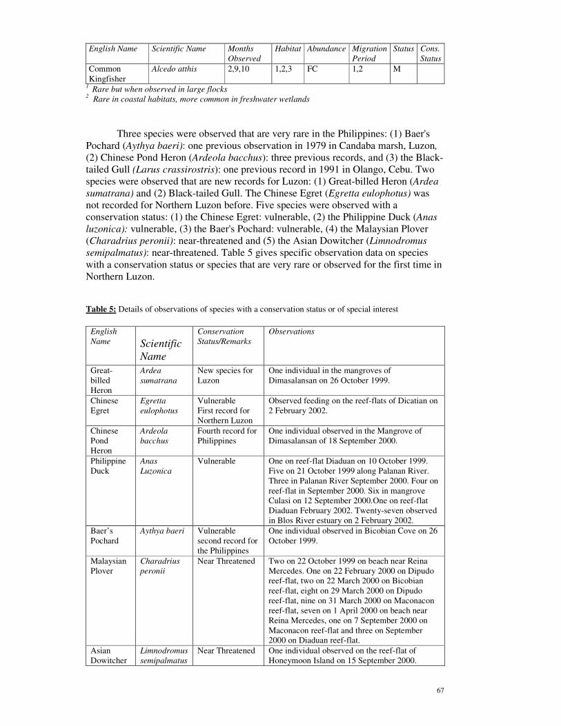
67
English Name Scientific Name Months
Observed
Habitat Abundance Migration
Period
Status Cons.
Status
Common Kingfisher
Alcedo atthis 2,9,10 1,2,3 FC 1,2 M
1 Rare but when observed in large flocks
2 Rare in coastal habitats, more common in freshwater wetlands
Three species were observed that are very rare in the Philippines: (1) Baer's
Pochard (Aythya baeri): one previous observation in 1979 in Candaba marsh, Luzon, (2) Chinese Pond Heron (Ardeola bacchus): three previous records, and (3) the Black-tailed Gull (Larus crassirostris): one previous record in 1991 in Olango, Cebu. Two species were observed that are new records for Luzon: (1) Great-billed Heron (Ardea
sumatrana) and (2) Black-tailed Gull. The Chinese Egret (Egretta eulophotus) was not recorded for Northern Luzon before. Five species were observed with a conservation status: (1) the Chinese Egret: vulnerable, (2) the Philippine Duck (Anas
luzonica): vulnerable, (3) the Baer's Pochard: vulnerable, (4) the Malaysian Plover (Charadrius peronii): near-threatened and (5) the Asian Dowitcher (Limnodromus
semipalmatus): near-threatened. Table 5 gives specific observation data on species with a conservation status or species that are very rare or observed for the first time in Northern Luzon.
Table 5: Details of observations of species with a conservation status or of special interest
English
Name Scientific
Name
Conservation
Status/Remarks
Observations
Great-billed Heron
Ardea
sumatrana
New species for Luzon
One individual in the mangroves of Dimasalansan on 26 October 1999.
Chinese Egret
Egretta
eulophotus
Vulnerable First record for Northern Luzon
Observed feeding on the reef-flats of Dicatian on 2 February 2002.
Chinese Pond Heron
Ardeola
bacchus
Fourth record for Philippines
One individual observed in the Mangrove of Dimasalansan of 18 September 2000.
Philippine Duck
Anas
Luzonica
Vulnerable One on reef-flat Diaduan on 10 October 1999. Five on 21 October 1999 along Palanan River. Three in Palanan River September 2000. Four on reef-flat in September 2000. Six in mangrove Culasi on 12 September 2000.One on reef-flat Diaduan February 2002. Twenty-seven observed in Blos River estuary on 2 February 2002.
Baer’s Pochard
Aythya baeri Vulnerable second record for the Philippines
One individual observed in Bicobian Cove on 26 October 1999.
Malaysian Plover
Charadrius
peronii
Near Threatened Two on 22 October 1999 on beach near Reina Mercedes. One on 22 February 2000 on Dipudo reef-flat, two on 22 March 2000 on Bicobian reef-flat, eight on 29 March 2000 on Dipudo reef-flat, nine on 31 March 2000 on Maconacon reef-flat, seven on 1 April 2000 on beach near Reina Mercedes, one on 7 September 2000 on Maconacon reef-flat and three on September 2000 on Diaduan reef-flat.
Asian Dowitcher
Limnodromus
semipalmatus
Near Threatened One individual observed on the reef-flat of Honeymoon Island on 15 September 2000.

68
Black-tailed Gull
Larus
crassirostris
First record for Luzon, second record for the Philippines
Five individuals: three adults and two juvenile. near the mouth of Palanan River on 1 February 2001.One individual on the Maconacon reef-flat on 5 February 2001.
DISCUSSION
The RAMSAR criteria to qualify as a wetland of international importance are: an area has to support more than thirty thousand waterfowl at least one period of the year or 1 percent of the total (regional) population of at least one species (Davis 1994).The coastal wetlands of the NSMNP do not qualify as a wetland of international importance according to these criteria. However, species diversity is very high. Fifty-four coastal water bird species were observed which is 57 percent of all ninety-four coastal water bird species of Luzon (Kennedy et al. 2000). Twenty-eight of the thirty-nine wader species of Luzon were observed (72 percent).
On the reef-flats, the highest number of birds and species can be observed during the southward migration and during the midwinter period. The coastal area of the NSMNP seems less important as a staging area during the northward migration in March and April. Overstaying individuals of several species spend the northern hemisphere summer along the coast of the NSMNP. Five species were observed with a conservation status. None of the recently identified Important Bird Areas (IBA) of the Philippines has so many recent observations of threatened wetland bird species (Mallari et al. 2001). This could also be due to a lack of wetland surveys elsewhere in the country but it shows the importance of the NSMNP for coastal wetland birds. There are eight threatened and near-threatened coastal wetland species that occur in the Philippines. NORDECO & DENR (1998) included Spoon-billed Sandpiper (Euronorhynchus pygmeus) and Beech Thickknee (Esacus magnirostris) in their list of birds of the NSMNP. We did not observe these species but with their inclusion the total of coastal wetland birds with a conservation status in the NSMNP arrives at seven, which is 88 percent of all coastal wetland birds with a conservation status in the Philippines. The coastal areas of the NSMNP are protected by the government. However, several threats might influence the suitability of the area for coastal birds. Reef-flats are heavily exploited by indigenous and migrant people that search for invertebrates and fish every low tide period possibly competing for food resources with coastal birds. Coastal birds are not or hardly being hunted in the area except for the endemic Philippine Duck, which is threatened by over-hunting throughout its range (Collar et al. 1999). The reef-flat of Maconacon is being polluted by domestic waste and sewage. The mangrove areas are exploited and some are being cut but with the current protected status of the coastal wetlands of the NSMNP this has become less of a threat. A new management plan for the NSMNP is in preparation (status May 2002) and coastal management and protection plans will be part of it. The here presented data serves as an input to this management plan. ACKNOWLEDGEMENTS Rizaldy Siggayo and Rey Catabui of the DENR - Protected Area Superintendent Unit of the NSMNP participated in the survey of February 2001. Claudio Gacia of the DENR/PASU and Resti Antolin and Mina Labugen of the DENR/PAWD participated in the survey of February 2002. We thank our colleagues at the NSMNP-CP for the assistance they gave to make the water bird surveys possible, especially area

69
managers Artem Antolin and Sonny Martirez, Eric Buduan and the marine team. PASu William Savella facilitated the participation of counterpart staff from his office. REFERENCES
Collar, NN.J., N.A.D. Mallari & B.R. Tabaranza Jr. 1999. Threatened birds of the
Philippines. Haribon Foundation and Birdlife International. Bookmark. Manila.
Davis, T.J. (ed.) 1994. The Ramsar Convention manual: a guide to the convention on
wetlands of international importance especially as waterfowl habitat. Ramsar Convention Bureau. Gland.
DENR & UNEP. 1997. Philippine biodiversity: an assessment and action plan. Bookmark. Manila.
Dickinson, E.C., R.S. Kennedy & K.C. Parkes. 1991. The birds of the Philippines. An
annotated checklist. B.O.U. Check-list No. 12. British Ornithologists' Union. Henry Ling Ltd, Dorset Press. Dorchester.
Kennedy, R.S., P.C. Gonzales, E.C. Dickinson, H.C. Miranda, Jr. & T.H. Fisher. 2000. A
guide to the birds of the Philippines. Oxford University Press. Oxford. Hayman, P., J. Marchant & T. Prater. 1986. Shorebirds: an identification guide to the
waders of the world. Christopher Helm, A & C Black Publishers. London. Hilton - Taylor, C. (Compiler). 2000. 2000 IUCN Red list of threatened species. IUCN,
Gland and Cambridge.Hollis, G.E., M.M. Holland, E. Maltby & J.S. Larson. 1988. Wise use of Wetlands. In
Nature and resources 24. Mallari, N.A.D., B.R. Tabaranza Jr. & M.J. Crosby. 2001. Key conservation sites in
the
Philippines. Bookmark. Manila. PASU / DENR. 2000. Management plan for the Northern Sierra Madre Natural Park.
PASU/DENR NSMNP, Palanan.Sonobe, K. & S. Usui. 1993. A field guide to
the water birds of Asia. Wild bird society of Japan. Kodansha International. Tokyo, Japan.
UNEP (United Nations Environmental Program). 1999. Global Environment Outlook
2000. Earthscan Publications Limited. London, UK. WCMC (World Conservation Monitoring Centre). 2000. Global biodiversity: Earth's
living resources in the 21st century. World Conservation Press. Cambridge, UK. Weerd, M. van, D.G. Rodriguez & R. Siggayo. 2001. Results waterfowl census.
Northern Sierra Madre Natural Park, Isabela Province, Luzon, the
Philippines. February 1-5, February 12, 2001. Report for DENR/PASU and the Asian Waterfowl Bureau. Plan-Philippines NSMNP-CP, Cabagan.

70
CHAPTER SEVEN ETHNOBOTANY STUDY OF THE AGTA COMMUNITIES IN THE NORTHERN SIERRA MADRE NATURAL PARK Hubert G. Garcia & Juan R. Acay Jr. ABSTRACT The ethnobotany study conducted among the major Agta bands in the Northern Sierra Madre Natural Park (NSMNP) is done in coherence with the objective of Northern Sierra Madre Natural Park-Conservation Project (NSMNP-CP) to generate, among others, adequate information on the park’s resources and the utilization of these resources, to serve as inputs for management and protection of the NSMNP. It also complements the effort of documenting the ethnographic profile of the Agta as indigenous cultural group living inside the park. Field data gathering was conducted in December 1999 until May 2000 covering a total of fourteen sites of Agta bands, seven of which are in the western side of the park (all located in San Mariano) and seven sites distributed among the Agta bands in Maconacon, Divilacan, Palanan and Dinapigue. Data shows a total of fifteen categories of major usages of plants: (1) agricultural input, (2) body accessories, (3) construction materials, (4) materials used in the fabrication of weapons and for defense purposes, (5) dyeing materials, (6) food source, (7) fuel wood, (8) fumigatory and masticatory, (9) household materials, (10) inputs in handicrafts making, (11) hunting and fishing equipment, (12) technological instruments and devices, (13) source of medicine, (14) commercial and trade plants, and (15) plants used for special functions. At least 301 plant species are documented as being utilized by the Agta, some of which are still in the identification process. The study further shows that majority of the plants documented are for medicinal purposes and as source of food. Compared to these two categories, the other categories are only secondary yet important components of the Agta traditional utilization of plants. The study also noted that Agta have maintained their indigenous methods or processes involved in the utilization of these plants (which can be generally considered as sustainable, except for illegal extractive ones like timber poaching where some Agta are being involved). The study also discussed the economic values to the Agta of some of the plants they utilize. An initial analysis focusing on the processes of plant utilization and the utilization pattern of plants by the Agta is also tackled in the study. More thorough studies on this aspect are recommended with full cognizance about complying the requirements of the Indigenous Peoples Rights Act (IPRA). INTRODUCTION It is an understatement that the NSMNP in the province of Isabela is one of the richest parks in the Philippines. Its diverse ecosystems alone speak for the high level of biological diversity that could be found inside the park. For the past years, several studies have confirmed that there are numerous interesting habitats and species of plants and animals inside the park, some of which were previously unknown to have existed in this side of the country. However, due to various internal and external pressures exerted on the natural resources for the past years, the rich biological diversity of the park is under continuous threat triggering concerted efforts to conserve and protect its resources. Among the interesting and important features of the park is the presence of indigenous peoples (IP), particularly the Agta

71
communities, which have for many years inhabited the area. These Agta communities have co-existed with the park’s natural environment with which their way of life is very much associated. The generation of knowledge on the traditional resource utilization of the Agta communities is considered as an important activity for the NSMNP-CP that should provide additional information for park management and protection. This information should also enrich the body of knowledge about the Agta as a particular sector among the different park stakeholders whose interests as IP have to be incorporated in the formulation of any policy or future program affecting them. In the last quarter of 1999 until May of 2000, an ethnobotanical study was conducted among the major Agta bands residing inside the NSMNP. The main objective is to document plant utilization and practices of these indigenous groups. STUDY OBJECTIVES AND DESIGN This study was conducted with the general objective of documenting the relationship of plants and Agta communities within the park. Specifically, the study has three objectives, which are: (1) to document plant utilization of Agta communities in the park, (2) to relate plant usage of the Agta with biodiversity conservation of the park, and (3) to create an information-base on ethnobotany for NSMNP.
The whole process of the study could be categorized into two major activities: (1) field-based primary data gathering, and (2) office work. Fieldwork was carried out in fourteen selected study sites from December 1999 until May 2000. Office work, mainly on data encoding and analysis including specimens processing and identification, was carried out at the project management office of Plan Philippines NSMNP-CP and at the Isabela State University (ISU) herbarium. Study sites Fourteen study sites in the park were selected. Site selection was based mainly on the presence of major Agta bands settlement. Given the aim of the study which is to document the plant utilization of Agta bands, the study sites selected are considered to represent the Agta of the NSMNP since these are the major settlement areas as documented by the ethnographic study conducted earlier by NSMNP-CP (Magaña 2000). The study sites are spread among the different barangays of five municipalities: (1) San Mariano, (2) Palanan, (3) Divilacan, (4) Maconacon, and (5) Dinapigue. The fourteen study sites are the sitios of Ahesa, Ayod, Canadam, Dialinawan, Dibigo, Dibulo, Digud, Dimatayatayad, Dipagsanghan, Divisoria, Diwakden, Dunoy, Kameresetan and Sapinit. Semi-structured interviews To document botanical observations, a plant documentation sheet is used while a semi-structured questionnaire guided the documentation of plant utilization. Agta band elders, leaders and their hunters-gatherers served as key informant group during the focused group interaction as they are the most knowledgeable among the members of the bands regarding plants and plant utilization. This activity is usually conducted in the Agta settlements followed by actual observation and collection of plant

72
specimens in the Agta band’s collection areas. Informants also served as field guides as well as assistants during the collection of plant specimens and mapping in the field. Specimens collection and plant documentation The collection, processing, and documentation of specimens was done using standard methods employed in taxonomic work. With the assistance of members of the Agta band, plant specimens were collected, described and initially identified on site using the plant documentation sheet. Photo-documentation of the plant specimens was also conducted on site as aid during in the identification of plants in the herbarium. Processing of voucher specimens were carried out in the herbarium of Environmental Information Center (EIC) in ISU Cabagan. Mapping Among the major activities done in the field was defining the boundaries of each of the study sites. Boundary delineation was conducted mainly by providing the Agta bands with maps and allowing them to describe and delineate the different areas where they usually gather plants. Final mapping activities were later done in the Geographic Information System (GIS) unit of NSMNP-CP. Limitations of the study Ethnobotany is such a broad discipline that a wide variety of options on how to conduct the study in terms of depth and scope are always available to researchers. This study, and building on the information results of the ethnographic study of NSMNP-CP, focused more on the general uses and importance of plants to Agta communities. It provides general information through a descriptive analysis of human-plant relationships in the NSMNP. Plant identification is a major constraint for lack of fertile specimens of some plant species since the period of field research was not the flowering or fruiting season for these particular plants. At best, their identification is based on local names to the Agta. PLANT UTILIZATION Agta bands utilize plants inside and within the peripheries of the NSMNP for many different purposes or reasons and are grouped into fifteen major categories of plant usages, using as guide the categories suggested by Barbosa (1995). These fifteen major categories are: (1) herbal medicine, (2) food, (3) construction materials, (4) inputs for handicrafts making, (5) fuel wood, (6) agricultural input, (7) dyeing materials, (8) traditional instruments and devices, (9) body accessories, (10) fumigatory and masticatory, (11) fabrication of weapons and defense purposes, (12) household materials, (13) hunting and fishing equipment, (14) special purpose, and (15) commercial and trade plants. Some species are even reported by the Agta to have multiple uses to them.
At least 301 plant species are documented with the following distributions: 117 trees, 61 vines, 33 herbs, 30 palms and rattans, 15 shrubs, 15 ferns, 10 grasses, 4 Pandanus, 4 fungi or mushrooms, and 12 unclassified species. The complete listing of

73
these species may be obtained upon request through the Protected Area Superintendent (PASu) of NSMNP. These usages are described in the following sections. Annex 1 provides an overview of the plans used by the Agta in the NSMNP. Agta herbal medicine Collected data show that Agta communities gather plants mainly for medicinal purposes. Traditional knowledge on the medicinal value of plants inside the forest resulted to the identification of many species used to sustain physiological needs as well as cure a wide variety of ailments experienced by the Agta in NSMNP.
Respondents disclosed that there are at least 144 plant species considered to be of medicinal importance to Agta communities for treating various ailments or for medical related reasons such as insect or animal bites, body aches, body energizers (postnatal recovery, child care), eye and ear care, fever and flu, lung-related (coughs and colds), malaria, skin disorders, gastrointestinal related sicknesses (stomachache, loose bowel movement, ulcer), dental care, and bone fractures.
The Agta’s knowledge on herbal medicine is distinguishable not only on the number of ailments that they are known to cure but also of the number of processes of preparing traditional medicines from plants. The traditional preparation of herbal medicines comes with specific rituals and traditions that at times, it is believed that without these rituals those medicines would not be effective. However, while many non-Agta or lowlanders believe that such processes are basically a quack, many herbal scientists recognize that it is from such practices where modern pharmaceutical knowledge originated.

74
The tapal type of herbal medicines
Tapal is a common Filipino word that literally means “to place, to put, or to fasten into”. It is popularly believed by the Agta that the manner by which they cure ailments is by placing leaves or other plant parts mixed with sacred oils on certain parts of the patient’s body. It is noteworthy though that in the practice of tapal, it seems that the medicinal value of the plant is on the physical state of the plant part as it is placed on the patient’s body. For example, of plants that are heated first before they are placed on the body, Agta relate that the warm soothing effect makes some plants effective in curing ailments. Plant decoctions
With the preparation of the right quantity of the required part or parts of the medicinal plant, a pot and fire, one can already produce herbal medicines. It is usually done by chopping the desired plant part into small pieces when gathered fresh or crushing it into bits when it is dried and then placing it on a pot with a desired amount of water. The solution in the pot is then made to boil afterwards. The chopping or crushing is necessary in order to increase the surface area of the plant part and thus ensuring that more of the desired plant properties are dissolved in water when boiling. Of course the whole idea is for the patient to drink the juice that would be produced from the process of decoction. Plant concoctions
This process of preparing medicinal plants is basically similar to the previous process. The only difference is on the quantity of medicinal plants utilized in the preparation of one herbal medicine. While the previous process require only one specific plant to be processed, concoctions usually need a combination of two or more plants in the preparation of an herbal medicine. Usually, too, Agta specify that in the preparation of some medicines, only the combination of certain parts of some plants, for example the concoction of the roots of one plant, the leaves of another and fruits of still another plant is the only combination of preparing some herbal medicines. Unless done so, they believe that it would not be effective. Plant extracts
Plant extracts are basically sap from specific plant parts applied on the affected areas of the body. The extracted plant sap is usually used by the Agta on external complications, such as wounds and different types of animal bites. The application of plant extracts on affected body parts is mainly characterized by squeezing the sap into the body part in the manner of a dropper. Sap extraction is carried out depending on the plant part being utilized. For thick and sturdy parts such as the barks, roots and stems, Agta usually subject it first to heat in order to soften its fibers. Afterwards, pounding of hard objects such as stone crushes it. In this manner, plant sap is easier to extract. In the case of leaves and shoots, however, it is usually just crushed by bare hands or chewed. Usually, small amount of water is added on the plant part while it is being squeezed on the body part. Plant extracts are also used as liniment in curing some common ailments such as stomachache, colds and cough. In this type of

75
medicine, the extracted plant sap is not dripped but is rather applied or massaged on the body.
Syrups
Plant syrups are basically sap extracted from plants. However, unlike the previous medicinal process described, the extracted plant sap is used internally (swallowed by the patient just like that of a commercially produced syrup). Interestingly, sap is usually extracted by chewing of the plant part. In this manner, the patient directly swallows the sap. Medicinal beverages
Another process of medicinal plant preparation that requires the extraction of plant sap is the preparation of medicinal drinks. Sap extraction again follows the processes described earlier. The extracted juice from the selected plant is usually diluted in a glass of water together with extracted sap from other plants. The whole process and the resulting medicine can be generally likened to the preparation of lemonades or any other similar beverages. Food medicines
This type of medicine is one of the interesting aspects of Agta herbal medicine. Although taken up as food, plants under this category are more valued by Agta for their medicinal importance. In fact the term “food medicines” is adopted here in an effort to describe this particular unique medicine. Specifically, it has been observed that most of the plant types described as food medicines are wild root crops belonging to the Dioscoreaceae, or yam, family. Interestingly, these plants are known as cure for stomach related problems such as stomachache and ulcer. No unique process of preparing such medicines has been observed though. Rhizomes of these plants are just roasted by the Agta before it is eaten. In other cases, it is eaten raw. Medicines made out of burnt plant parts
The most important component in the preparation of this type of medicine is the ash produced from burned plants. Two types of medicine are made out of burned plant parts. The first type is the ash itself, which is used externally by rubbing it on the affected body part. Agta believe that this type of medicine is effective against insect and snakebites. The other type uses the ash of burned plant parts as ingredient in the preparation of special type of beverage. It is made into a drink by dissolving the ash into a glass of water. The solution produced in this process is usually given as drinks to patient suffering from stomachache. Medicinal baths
Another traditional medicinal process documented is the use of plants to cleanse affected areas of the body. Particularly, the process is very similar to a hot bath given to person with ailment or fever. The plant part to be used in bathing the patient is

76
cooked by decocting it in a pot of boiling water. The resulting decoction is diluted in a basin of water, which is then used in bathing or cleansing the patient's body. The same process is also administered to wounds and at times rheumatism. The decoction produced from specific plants is used to clean or disinfect wounds. In this manner, however, the decoction is no longer diluted in water. Instead, wounds are just washed by the decoction itself. Sudorific and antipyretic medicine
The last documented type of medicine is mainly used for persons with fever. This type is used to lower down the body temperature of those suffering from fever. However, the process or the type of medicine itself is again a unique type. It also follows the process of decocting plant parts but it is neither taken up internally nor externally. It seems that the most important component of the medicine is the steam or the heat emitted by the concoction. Particularly, Agta described that this type of medicine induces sweating of the person with fever. This is made possible by placing the pot with the hot decoction near the person for him/her to feel the steam coming from the pot. Sources of food Plants, which were identified as a food source, are the other major category of plants based on the number of species documented. Of the total number of ethnobotanically important plant species to Agta communities, at least 109 plants are recorded as being valued by Agta for their food sources. A total of four subcategories under food plants were identified based on the above-mentioned classification. Foremost among these is the subcategory of fruit producing plants with a total of sixty species listed under it. Plants valued by Agta as vegetable comes second with twenty-nine documented species followed by sixteen plants identified as root crops, and lastly four species used into processed food.

77
Fruit trees
The Agta know most of the fruit producing plants in the forest. There is no regularity in terms of harvesting of fruits as most are growing in the wild. Agta disclosed that the fruits of most of the identified edible fruits are considered only as additional source of food when they are traveling inside the forests, usually during hunting. Only few plants such as rattan fruits, wild rambutans (Nephelium sp.), varieties of pili (Canarium) are considered major fruit trees. While most fruits are eaten the usual way, that is, eaten fresh and ripe, some fruits are boiled or cooked first before they are eaten. Some of the plant species which fruits are boiled first before eaten are pili fruits, minapu (Anisoptera aurea), wild rambutans (Nephelium sp.), bihubo (Diplodiscus paniculatus), and the suka and bunghe (both Gnetum species). Plants yielding vegetable products
Young shoots are the most common sources of vegetables. For palms, it is the shoots that are gathered and used as vegetable and usually cooked as main ingredient in cooking stews. It has also been a practice that shoots are roasted or eaten raw. Aside from young shoots, fruits are also used as vegetable. In such cases, the main purpose is to use fruits or young leaves in flavoring dishes. Usually, such plant parts are used as souring ingredient in cooking stews and other dishes. Root crops Wild yams are an important part of the Agta diet. The Agta also gathers other wild root crops, but these are considered minor ones because of the variability in terms of their taste. While most of the wild yam species taste more or less similar to ube or cassava, others are said to have a bitter taste such that it is eaten only when the better-tasting root crops are not available. Plants processed into food
Food plants are not only source of edible materials that could be eaten raw or cooked. Agta also practice using plants as ingredient in the production of other food products such as flour and vinegar. Flour and vinegar are locally made, utilizing some of the plants found in the NSMNP. The palm heart of the species agal (Caryota sp.), kalawako (Palmae sp.), and lipune (Palmae sp.) are the main sources of traditionally homemade flour. The main process of flour production is characterized by the extraction of the starchy sap of the palm shoots, which become the main ingredient of flour. As food by the Agta, the flour is sliced into small pieces and coated with lard and sugar (when available) and fried in oil. To produce vinegar Agta use the fruits of tumadam (Palmae sp.). The common practice is to soak the crushed fruits in clean water until vinegar is produced from the solution. Plants used as construction materials One of the main uses of plants in NSMNP to Agta communities is for construction purposes. Traditional construction materials are products derived from plants used mainly for constructing Agta houses. A total of twenty-five plant species is recorded

78
for this purpose. The palm family seems to be the most common source of construction materials since it dominates the list of plants that produces construction materials.
Although the plants under this category are regarded as construction materials, only a number of trees are actually identified as source of unprocessed wood. The usual uses of wood are for posts, beams, and trusses of permanent Agta residences. Some are used in the construction of paddled boats. The rest of the species identified as source of construction materials are non-timber forest products that are used mainly in the fabrication of ropes and house roofs and walls.
For rattans, the outer portion of the pole is scraped out and sliced into thin pieces (normally termed as rattan split in the market) until it becomes flexible enough to be used as cordage usually in thatching house roofs and walls.
Palms are the most commonly used plants in thatching roofs of traditional Agta lean-to. The Agta lean-to is a movable rectangular roof structure with roof made usually of palm leaves attached to small-sized pole frames and used to temporarily shelter the nomadic Agta families. Plants used for handicraft Eleven plant species are documented as being gathered for handicraft making. Agta possesses the skill of making baskets and mats for household use as well as for trade in the local market. Pandanus and palm species are the common sources of weaving materials. Most commonly used, is a Pandanus species locally identified as bidiyu? The leaves of bidiyu are long, thick and durable, which when properly seasoned are very good material in mat weaving. The leaves sliced into width according to the weaver’s preference are sun dried for one to two days. The dried leaves are then woven into mats or baskets.
Palm species are used mainly in basket making. The stem or the poles gathered from rattan species are sliced or split longitudinally into smaller pieces in the same manner as producing cordage. The sliced part, usually the outer and more durable portion of the pole, is the material used in basket weaving. Fuel wood Although many species of plants inside the NSMNP are potential source of fuel wood, the Agta have particularly identified only eleven plant species used for such purpose. Agta gather the stems, branches and twigs of these as fuel wood due to their common characteristic of being easily combustible. Plants used for agricultural purposes One of the interesting information shared by the Agta is their usage of plants for agricultural purposes. Plants are used particularly for the protection of rice fields from farm pests such as insects and rats. A total of seven plant species is recorded for this purpose.
The usual practice in the utilization of these plants is positioning the plant parts around the rice fields such that rats and harmful insects would be driven away. According to the Agta, the common characteristic of the plants utilized as agricultural input is the odor it exude, which repel insect or rat attack. The plant gisgis (Syzygium

79
sp.), however, is differentiated from these plants, but is still categorized as agricultural input since its stem is usually used as dibble stick in planting rice and corn. Plants used as dyeing material Five plant species are documented as being used by the Agta in concocting dyes. Saggit or narra (Pterocarpus indicus), bangkodu (Morinda citrifolia) and palali (Dillenia philippinensis) are reported as valuable for the red color it exudes. Appadit (Antidesma tomentosa), on the other hand, exudes a black color. Processing of these plants in order to produce dyes is usually characterized by concocting the plant part identified as main source of dye. For example, the wood of narra is the main source of the dye. It is chopped into small pieces to increase the surface area of the wood and then boiled in water. The red solution is used usually in decorating handicrafts such as hats, mats and baskets. Fruits of appadit, on the other hand, are the dye itself and are therefore not concocted like the other species. Its fruit sap is black and is directly applied to color bracelets, necklaces, and other body adornments. Materials for fabrication of traditional instruments or devices Instruments or devices in this discussion are defined as those that are used by Agta for their own recreational purposes such as musical instruments and toys. Most of the plants described, numbering to five species, are used in the fabrication of an instrument resembling the guitar. The procedure of the fabrication of this guitar is mainly characterized by using ordinary strings or the stem of dappig (Bauhinia sp.) as the guitar string, and an extracted portion of the stem of gulo-gulo (Palmae sp.), or anaw (Palmae sp.) as the base where the string and other important guitar parts are attached. Aside from fabricating guitars, Agta also utilize other plants in producing toys. For instance, by inserting a nail on the fruit of tibig (Ficus sp.), a spinning top is readily made.

80
Plants used for body accessories There are also plants in NSMNP used by Agta for body adornment. Four plant species recorded under this category are mainly used for the production of their traditional clothing and bracelets, earrings, and necklaces. Clothes are produced from the processed bark of bedbed (Ficus sp.). It is made possible by pounding the bark until it is soft enough to be used as clothes and even as blanket. Bracelet and necklace making is seemingly simple. All an Agta needs is the fruit of the grass amugo (Coix
lachryma) and fibers extracted from the stem of ponti (Heliconia sp.). Fruits of amugo are the main components of the bracelet or necklace while ponti fibers serve as the string used in sewing the fruits into necklaces or bracelets. Plants used as fumigatory or masticatory A total of seven plant species is recorded for being used as fumigatory and masticatory. Some of the plants inside the park are useable to Agta as substitute for commercial cigarettes especially when Agta are traversing the forest. Dried leaves are gathered and crushed into small pieces. Crushed leaves are rolled into any type of paper and smoked as cigarette. Masticates are common and well loved especially by adults and the elderly. The most common combination of masticates is the combination of lime, bunga (Areca sp.), and litlit (Piper sp.). The seeds of dried bunga and the leaves of litlit are chewed together with lime producing a taste that is well loved by the Agta. In the absence of litlit, the leaves of anupol, or lumot, (Poikilospermum cf. acuminatum) are a good substitute. The fruits of nga-nga (Areca
sp.) is a substitute for bunga. Plants used for defense and weapons The definition or notion of Agta for defense is the individual’s protection against any form of harm. Fifteen plant species identified under this category are used mainly in rituals and other customs that borders to the supernatural beliefs of the Agta. The said plants are those that are sources of talismans and amulets that Agta believe would protect them from harm induced by people with knowledge on kulam (the local term for witchcraft), as well as from playful and dangerous “supernatural inhabitants of the forest”. Kulam is classified mainly as ailments and is believed to be caused by supernatural causes. Local shamans using various plants and rituals usually administer the treatment of such cases. Some of the plants, however, are used in the fabrication of weapons and other equipment for defense or for hunting wildlife such as bows and arrows. Plants used for household materials Fifteen plant species under this category are used for many different purposes. The basis for classification of these plants into one category is there similarity in which they are used as household materials. Agta use large leaves of some plants as substitute for plates and for wrapping foods. Agta also have knowledge on what plants to use as substitute for cooking pots. They have disclosed that these plants possess a particular part that is fire tolerant and useable as cooking pot. One plant species, identified as saleng (Canarium sp.), is used as a lamp in Agta shelters. By rolling its leaves into a bundle, it could already provide the lighting need to an Agta household.

81
It is said that the resins from its leaves are responsible for its combustible property. Agta also particularly identified the plant they call malaklak (undetermined sp.) as the source of wood from which to make a mortar for rice milling because of its hard and straight stem. Plants used for hunting and fishing Plants identified by Agta for fishing are those with sap that can temporarily immobilize or paralyze fish. Two plant species were particularly identified for such purpose, namely pagutot (Derris cf. cumingii) and sagisa (Aralia cf. scandens). Traditional fishing with the employment of these plants is characterized by crushing of the bark or stem of these plants before placing the crushed stem or bark in the water of the fishing area. The crushing of the plant parts is to hasten the mixing of the sap with the water. Some Agta practice placing soil or mud over these crushed plant parts in order to better submerge it in water.
In hunting, plants are used in rituals conducted in connection with hunting activities. Plants are used in producing materials that are applied on the Agta's body in order to “increase” the chances or luck of hunters in finding game. Some plants are even used in order to make hunting dogs more aggressive or efficient in hunting. Five plant species are identified in this category. Some plants for making hunting equipment such as bow and arrow are under the defense and weapons category. Plants used for special purposes Agta use plants in a way that does not fit in the categories earlier described. It is therefore categorized as plant that serves special purposes. The usages of these plants are mainly related to their traditional beliefs or customs. Seven plant species are listed in this category. Some plants, for example, are sources of amulets or good-luck charms. There are even plants (particularly bitahek (Archidedendron clypearia) and butahe (Leguminosae sp.) of which the Agta said that the fruiting or flowering of these plants indicate a forthcoming storm or bad weather. Commercial and trade plants Some plants in the NSMNP are gathered by the Agta to sell in the local market. Ten plant species are gathered for their market value. The most important plant collected and sold by Agta in the market is rattan, for its pole, fruit, and its shoots. The vine nito (Lygodium circinnatum) and the bidiyu (Pandanus sp.) leaves are used in making hats and baskets. Some Agta are also engaged in the collection of almaciga (Agathis
philippeninsis) resins and narra timber. CONCLUSION Plants have been and always will be an important part of Agta communities. It has been one of the basic foundations that shaped their culture and it is every way manifested in the very rich knowledge they possess on the flora of the NSMNP. To an Agta, the flora of NSMNP is not only one component of the forest, but is life itself. It has provided them for generations with food and medicine, and has helped in the survival of their culture and society. This paper describes the richness of the Agta

82
traditional knowledge with regards to plant utilization. This knowledge is one that has been known for many generations and has been founded on the needs and strengthened by experiences of many Agta that roamed around the NSMNP.
Agta have many uses for the plants of the Sierra Madre. This study has been able to record that Agta are utilizing plants mainly for fifteen major reasons foremost of which is medicinal purposes. Medicinal plants are used to cure variety of body disorders such as stomach related ailments, body pains, skin disorders, animal bites, fever, flu, lung problems, and malaria. The preparation of medicine in the treatment of health problems is done through several traditional processes. The most common process of medicinal preparation is the use of tapal. Brewing plant parts into beverages and syrups is another process of preparing medicines made out of plants. Other types of traditional preparation of medicines include plant sap extraction and the application of liniment-type of medicines made out of these extracts.
Food is another major reason why Agta gather plants from the park and its peripheries. Agta are particularly knowledgeable on many wild plants capable of producing edible fruits, which they eat usually only when inside or traversing the forest. They also utilize the extracts of some plants in the production of other food products such as flour and vinegar.
The flora of NSMNP is important to the Agta because it provides them of their other needs particularly in the construction of their houses, agricultural practices, production of handicrafts sold in the market, cooking and food preparation, fabrication of traditional instruments or devices, hunting and fishing activities, and many other needs. This would show that, for ages, the flora of NSMNP had addressed the most basic needs of the Agta. Without it, it is utterly impossible for them to survive as a cultural community. This study has proven that an unbreakable cord exists between the Agta and the plants of NSMNP. The results showed a lot of information, although basic and elementary, on things that have not been thought of before. The completion of the study is one big step towards better understanding of the resources found in the park. However, much is still to be studied particularly on the dynamics of human-plant relations, as well as numerous other aspects that could be looked upon. This ethnobotanical study on the Agta of NSMNP is expected to have opened a whole new aspect of understanding about the Agta as an indigenous cultural community and as an important stakeholder in the management of the NSMNP. More importantly, with more studies conducted along this line, a deeper and better understanding of the Agta would equip park stakeholders on how to effectively conserve and protect the resources found in the park. REFERENCES Barbosa, A. C. 1995, Conducting research on ethnobotany in the Philippines: A
guide. ASEAN-NZ Inter-Institutional Linkages Programme, Philippines National Library, Manila. Magaña, D.S. 1998. Final anthropological report on the Agta in the Northern Sierra
Madre Natural Park. Plan International, NSMNP-CP, Cabagan.

83
CHAPTER EIGHT ASSESSING THE EFFECTS OF LAND USE CHANGE FOR BIODIVERSITY Koen P. Overmars, Peter H. Verburg, Wouter T. de Groot & Tom Veldkamp
ABSTRACT Land use is a determining factor in many environmental processes like biodiversity, erosion and flooding at the watershed level, and processes such as climate change at the global level. This paper focuses on the influence of land use change on biodiversity. Land use change is an important driver of biodiversity change. Land use influences biodiversity directly through habitat loss and fragmentation, but also indirectly through climate change. Land use change research within the CLUE (Conversion of Land Use and its Effects) modelling framework focuses on the spatial dimensions of land use change for different scenario conditions. Scenarios can include economic and demographic developments, but also more specific, management related conditions such as agricultural management practices or nature reserves. For these scenario conditions land use changes and their spatial distribution can be modelled and visualized. An example of CLUE is given for a case study for Sibuyan Island, the Philippines. Land use as such is not normative and therefore cannot be used to evaluate the consequences of different scenarios for biodiversity. To come to a normative criterion, an assessment of the impact of land use change on the functioning of biodiversity has to be made, so that a distinction can be made between more and less desirable options. To make the link between biodiversity and land use change, information about the biodiversity in different land use types, which form the different habitats, is necessary. In addition, the relation between the size of a habitat and biodiversity is important, as well as the effects of fragmentation of habitats. CLUE can provide these biodiversity relevant characteristics of land use. If these relations are clear, land use change, modelled by a model like CLUE, can be translated into its effects on biodiversity and scenarios can be evaluated. Land use management can be optimized to have less negative impact on biodiversity. In this way a region can be evaluated in an integrated manner with respect to biodiversity instead of focusing on protected areas only. GENERAL INTRODUCTION Land use and land cover is central to many environmental and development issues like biodiversity, access to natural resources, erosion, flooding, food security, water and radiation budgets, trace gas emissions and carbon cycling and rural and urban development. Changes of land use (and land cover) can have great impact on these resources, so the understanding of land use changes is of great importance in our attempts to manage them.
Land use change is driven by a variety of bio-geophysical and socio-economic factors, its understanding involves many disciplines of research. With that the causes and effects of land use change operate at many different scales and organizational levels. Hence, land use change is a very complex process. One way to deal with complex processes is to develop models to study the processes. In land use change research a variety of models exist, originating form various disciplines that all cover different aspects of the complex process of land use change.
84
After the understanding of the land use change processes an important step to come to an optimal land use planning is to make an assessment of the land use change effects on environment and development processes. Land use as such cannot be expressed normatively and policy makers need measures to be able to compare and choose between different scenarios.
In this paper the CLUE modelling framework (Veldkamp et al. 1996; Verburg et al. 1999a, Verburg et al. 2002a) is briefly described and used to illustrate the possibilities of land use change modelling with an example of an application of the model in the Philippines. A prototype of an assessment of the effects of land use change for biodiversity is presented and illustrated with an example. CLUE MODELLING FRAMEWORK The CLUE methodology is an example of a geographical approach to land use modelling. The CLUE modelling framework is based on theories about the functioning of the land use system derived from landscape ecology (Holling 1992; Levin 1992; Turner et al. 1992). Natural ecosystems have large correspondences in structure, function and change with land use systems and the social systems underlying changes in land use. Social systems and agro-ecosystems are, just like natural ecosystems, complex adaptive systems, which can be described by theories and methodologies developed in ecology (Holling et al. 1996).
The CLUE methodology is made up of two parts. The first part aims at establishing relations between land use and factors determining the location of certain land use types, and takes scale dependencies into account explicitly in a multi-scale analysis of these locational factors. The second part aims at dynamic modelling, which is driven by near future scenarios that are developed studying driving factors of land use change like population growth, economical growth, changing policies. Multi-scale analysis of locational factors of land use change The multi-scale analysis of the locational factors of land use change is based on the analysis of spatial patterns of the actual land use. Except for areas with minimal human influence, the patterns reflect the result of a long history of land use change and contain, therefore, valuable information about the relation between land use and its locational factors. Because it is assumed that the relations between land use and locational factors are extremely complex due to scale dependencies, interconnections and feedbacks empirical relations between land use and its supposed determining factors are used to explain the observed pattern of land use, for example through regression analysis. Another characteristic of the approach is that no a priori levels of analysis (for example landscape or regional level) are superimposed. Instead, the analysis is repeated at a selection of artificial resolutions, imposed by the gridded data structure. The results of the multi-scale analysis are of interest by themselves and can be subjected to extensive interpretation. However, they can also directly be used for the dynamic modelling of near-future land use changes. Dynamic modelling The CLUE modelling framework uses the derived multi-scale relations between land use change and its locational factors as a direct input for modelling. Scenarios of near future demands for the land use types, calculated for the study area as a whole, are

85
used as the moderator for land use changes. The modelling approach has the following characteristics:
1. All simulations are made in a spatially explicit way so that the geographical pattern of land use change is resulting. The spatial resolution of the simulations is dependent on the extent of the study area and the resolution of data available for that study area.
2. Allocation of land use changes is based on the dynamic simulation of
competition between different land use types. Competitive advantage is based on the ‘local’ and “regional” suitability of the location and the national level demand for land use type related products (for example food demand or demand for residential area).
3. The “local” and “regional” suitability for the different land use types is
determined by quantified relations between land use and a large number of locational factors derived in the multi-scale analysis described above.
4. Different scenarios of developments in land use can be simulated. At the
national level scenarios include different developments of agricultural demands that can be determined on the basis of developments of consumption patterns, demographic characteristics, land use policies and export volumes. At the sub-national level different restrictions towards the allocation of land use change can be implemented, e.g., the protection of nature reserves or land allocation restrictions in areas susceptible to land degradation.
The CLUE model was first developed for, and applied to, Costa Rica (Veldkamp et al. 1996). Current applications are those for Ecuador (De Koning et al. 1999), Central America (Kok et al. 2001), China (Verburg et al. 1999b) and Indonesia (Verburg et al. 1999c). The allocation algorithm of the CLUE model has been validated successfully in a number of cases (de Koning et al. 1999; Verburg et al. 1999c; Kok et al. 2001). The validations were made through the simulation of historic, documented land use changes. However, any land use change scenario and model has a high, inherent, uncertainty due to the complexity of the system addressed. Therefore, results of land use change models should never be treated as predictions for future land use but rather as explorations of the potential dynamics of the land use system.
The latest development in modelling within the CLUE modelling framework is CLUE-S (Verburg et al. 2002a), which is a dynamic, spatially explicit, land use change model for the regional scale. The model is specifically developed for the analysis of land use in small regions, like a watershed or province, at a fine spatial resolution. Within CLUE-S a high-resolution grid is used in which land use is defined by the most dominant land use type within the pixel. In the applications of the CLUE model at the national or continental level land use is represented by designating the relative cover of each land use type in each pixel. Because of the use of dominant cells the relations between land use and its driving factors are evaluated using stepwise logistic regression. In the other CLUE applications ordinary stepwise regression is used. Another development in CLUE-S is the use of decision rules. These decision rules include conversion elasticities, representing the conversion costs of certain land use types, fixed land use sequences, and land use policies (Verburg et al. 2002a). ASSESSING THE EFFECTS OF LAND USE CHANGE FOR BIODIVERSITY

86
The goal of this section is to present how a land use change model like CLUE-S can contribute to the assessment of biodiversity change resulting from environmental change. Land use change affects biodiversity in many different ways, for example directly through habitat loss and fragmentation of habitat, and indirectly through off site effects and climate change. To assess the changes of biodiversity as a result of land use changes, simulated land use changes should represent land use patterns in such a way that these aspects can be derived. Therefore, the model should be spatially explicit, incorporate systems dynamics and express interconnectivity. The models based on the CLUE modelling framework (Veldkamp et al. 1996; Verburg et al. 1999a, Verburg 2002a), which are described in the previous section, can deal with these processes. With that, CLUE enables to explore the spatial properties of land use or land cover types, which are the habitats for flora and fauna, for different scenarios. For different scenarios near future changes can be evaluated on their effects on biodiversity. Other applications that directly use spatially explicit information on land use change in relation to biodiversity are for example Lebel et al. (1998) and Van der Meer et al. (1998).
The procedure to assess the effects of land use changes for environmental and developmental issues within the CLUE modelling framework can be divided in three parts (Figure 1). In the first part different scenarios for plausible, near future land use changes are simulated, leading to different, spatially explicit land use change trajectories. The second part deals with how land use changes can be translated to environmental and development effects for the different scenarios. In the last part the different scenarios are evaluated and the implications for land use planning can be assessed. The second part will be discussed in the following paragraph for the case of biodiversity.
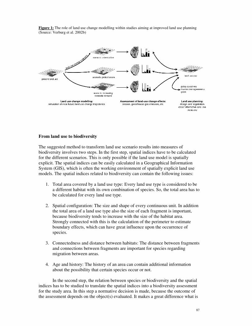
87
Figure 1: The role of land use change modelling within studies aiming at improved land use planning (Source: Verburg et al. 2002b)
From land use to biodiversity The suggested method to transform land use scenario results into measures of biodiversity involves two steps. In the first step, spatial indices have to be calculated for the different scenarios. This is only possible if the land use model is spatially explicit. The spatial indices can be easily calculated in a Geographical Information System (GIS), which is often the working environment of spatially explicit land use models. The spatial indices related to biodiversity can contain the following issues:
1. Total area covered by a land use type: Every land use type is considered to be a different habitat with its own combination of species. So, the total area has to be calculated for every land use type.
2. Spatial configuration: The size and shape of every continuous unit. In addition
the total area of a land use type also the size of each fragment is important, because biodiversity tends to increase with the size of the habitat area. Strongly connected with this is the calculation of the perimeter to estimate boundary effects, which can have great influence upon the occurrence of species.
3. Connectedness and distance between habitats: The distance between fragments
and connections between fragments are important for species regarding migration between areas.
4. Age and history: The history of an area can contain additional information
about the possibility that certain species occur or not.
In the second step, the relation between species or biodiversity and the spatial indices has to be studied to translate the spatial indices into a biodiversity assessment for the study area. In this step a normative decision is made, because the outcome of the assessment depends on the object(s) evaluated. It makes a great difference what is

88
considered in the biodiversity assessment; biodiversity of flora and fauna as a whole or the occurrence of one species? It makes a great difference if the biodiversity assessment is focused on a crocodile, a butterfly, an endangered orchid or biodiversity as a whole.
The following characteristics can be used to make the translation from spatial indices to biodiversity: (1) habitat characteristics for different species, (2) biodiversity in different habitats, (3) biodiversity in relation to size of habitats, (4) edge effects, (5) possibility of migration between patches, (6) influence of corridors, (7) influence of time. AN APPLICATION FOR SIBUYAN ISLAND, ROMBLON PROVINCE, PHILIPPINES The CLUE-S model is applied to the island Sibuyan in the province of Romblon, Philippines. The island measures 28 km east to west at its widest point and 24 km north to south, with a land area of approximately 456 km2 surrounded by deep water. The island is characterized by its steep mountain slopes, which are covered with forest canopy. The land surrounding the high mountain slopes gently to the sea and is used for natural and plantation forest and agricultural, mining and residential activities. The island is believed to be completely covered by forest until the 1940s. From then on the forest has been cleared from the foot slopes. Highest on the foot slopes are the grassland derived from deforestation, used for pastures. They are regularly burnt to stimulate new grass growth. Rice paddies are common at low-lying land. Most cleared areas are however used for coconut plantation. The island is surrounded by some mangrove forests, sandy beaches and coral reefs. The CLUE-S model was used to simulate three different scenarios for Sibuyan for twenty years (1997 to 2019). The grid size is 100 by 100 m. Scenarios
Scenario 1: Baseline
The aggregated demand for land use change is assumed to continue the recent trends: agricultural expansion and deforestation, both through kaingin (shifting cultivation) and wood extraction (conversion of primary or secondary forest to grassland). These processes are reflected in calculations of the demand for land use types by linear extrapolations of the developments of the past twenty years, leading to increases in rice area, coconut plantations, shifting cultivation and grassland while decreases occur in mangrove, primary and secondary forests. In this scenario no spatial policies or restrictions are included. All changes are allocated based on the preferences for locations as determined by the location factors, the existing land use pattern and competition between land use types.
Scenario 2: Spatial policies
This scenario has the same demand as the baseline scenario. However, we have now restricted the possibilities for allocation of land use change by a number of spatial policies. The major restriction to land use change is the establishment of the Mt. Guiting-Guiting Natural Park. This area covers about 15,000 hectares, approximately one third of the island and was proclaimed a protected area in 1996. The National Integrated Protected Areas Programme (NIPAS), a joint program of the Department

89
of Environment and Natural Resources (DENR) and the European Union (EU), support the sustainable management of the area. NGOs support the protection of the natural park by implementing livelihood-oriented projects. In the protected area it is assumed that no new agricultural use or deforestation (either primary or secondary forest) may occur. In addition to the Mt Guiting-Guiting Natural Park, land use conversions were assumed to be impossible in lands classified as institutional land according to the cadastral maps. In the buffer zone of the protected area, another 10,000 hectares, we have assumed that, although deforestation is still possible for wood extraction, no permanent agricultural practices area allowed. It is assumed that shifting cultivation will still continue in this zone. Figure 2 shows the delineation of the different spatial policies. Figure 2: Location of restricted areas
Scenario 3: Sustainable agricultural development
This scenario simulates the potential spatial configuration of land use in case of successful implementation of the protected area and associated livelihood programs. These livelihood programs aim at sustained use of forest resources and income generation through intensification of permanent agriculture outside the park and buffer zone area. Therefore, another development of the land demand is assumed in this scenario. The assumptions include: protection of the remaining mangrove area, expansion of the coconut and rice areas (similar to scenarios 1 and 2), a 50 percent decrease in area of kaingin during the twenty year simulation period, a small increase in primary forest area as a consequence of the protection and re-growth of secondary forest, a two-third decrease in grassland caused by less logging and kaingin and the protection of secondary forest areas. It is assumed that new agricultural activities, including kaingin, are now completely banned from the buffer zone. Modelling results For all scenarios, the model predicts the further development along the foot slopes of the mountains especially in the west and the north. Especially the coconut plantations

90
expand towards the northern part of the island. The northwest part consists of very steep slopes, too steep for coconut, but some patches of grassland are developing. New rice paddies will develop especially in the southwestern coastal plain. Figure 3 shows the remaining forest (primary and secondary) for the three scenarios. Figure 3: Forest area (black) at the start of simulation (1999) and at the end of the simulation for three different scenarios.
1999 2019
scenario 1
2019
scenario 3
2019
scenario 2
Scenario 1, without protection of the Natural Park and buffer zone, causes a lot of forest fragmentation. At different locations pieces of secondary and primary forest are cut for kaingin farming or for wood extraction. In the other scenarios this fragmentation is much less due to strict protection of the natural park. However, in scenario 2 the buffer zone is still heavily influenced by deforestation. For scenario 1 and 2 the total remaining forest area is similar. The differences in spatial pattern due to the policies are clearly visible. Good protection of the natural park clearly makes sense to keep a larger, undisturbed core area with forest. Scenario 3 assumes less demand for wood extraction and shifting cultivation, leading to a larger remaining forest area. The concentration of all activities outside natural park and buffer zone leads to a more intensive use of the lowlands, where almost all forest is expected to disappear. Spatial indices for biodiversity The simulations for Sibuyan Island presented above have shown that the impact of land use change on forest can be very different for different trajectories of change. Policy intervention and spatially specific measures can cause different patterns in forest fragmentation, even when the total deforested area is the same. Different spatial patterns have a different impact on biodiversity. The differences in forest pattern shown in Figure 3 are self-explanatory. However, it is also possible to quantify forest

91
fragmentation by spatial indices. In this study we have used the APACK package to calculate two different indices for the simulated forest patterns (Mladenoff & DeZonia 2002). The Average Patch Perimeter/Area ratio (PAC) reports the average corrected perimeter to area ratio for all patches present in the input map. PAC results are always greater than or equal to 1.0. PAC equals 1.0 for patches that are perfect circles, 1.1 for patches that are perfect squares, and can be arbitrarily large for patches that are extremely long and skinny.
The Aggregation index (AI) is used to quantify the spatial pattern of the forest area (He et al. 2002). AI equals 1.0 when the forest is completely aggregated into a single, square patch. It reports numbers closer to 0 when each patch is narrow in one direction and long in another.
Table 1 gives the results for the forest pattern in 1999 and the results of the three scenarios. The aggregation index decreases for scenarios 1 and 2, due to fragmentation of the forest in the buffer zone and the protected area. In scenario 3 the aggregation index increases relative to 1999, due to the concentration of agricultural activities in the lowlands and secondary re-growth on grasslands and kaingin fields within the buffer zone and Mt Guiting-Guiting Natural Park. For all three scenarios the PAC decreases, mainly due to the deforestation in the lowlands that cause the high PAC value for 1999.
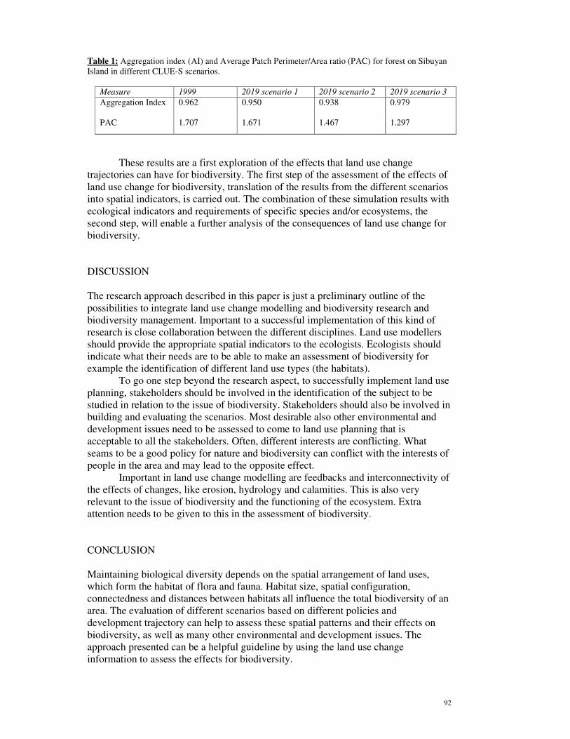
92
Table 1: Aggregation index (AI) and Average Patch Perimeter/Area ratio (PAC) for forest on Sibuyan Island in different CLUE-S scenarios.
Measure 1999 2019 scenario 1 2019 scenario 2 2019 scenario 3
Aggregation Index
0.962 0.950 0.938 0.979
PAC 1.707 1.671 1.467 1.297
These results are a first exploration of the effects that land use change
trajectories can have for biodiversity. The first step of the assessment of the effects of land use change for biodiversity, translation of the results from the different scenarios into spatial indicators, is carried out. The combination of these simulation results with ecological indicators and requirements of specific species and/or ecosystems, the second step, will enable a further analysis of the consequences of land use change for biodiversity. DISCUSSION The research approach described in this paper is just a preliminary outline of the possibilities to integrate land use change modelling and biodiversity research and biodiversity management. Important to a successful implementation of this kind of research is close collaboration between the different disciplines. Land use modellers should provide the appropriate spatial indicators to the ecologists. Ecologists should indicate what their needs are to be able to make an assessment of biodiversity for example the identification of different land use types (the habitats).
To go one step beyond the research aspect, to successfully implement land use planning, stakeholders should be involved in the identification of the subject to be studied in relation to the issue of biodiversity. Stakeholders should also be involved in building and evaluating the scenarios. Most desirable also other environmental and development issues need to be assessed to come to land use planning that is acceptable to all the stakeholders. Often, different interests are conflicting. What seams to be a good policy for nature and biodiversity can conflict with the interests of people in the area and may lead to the opposite effect.
Important in land use change modelling are feedbacks and interconnectivity of the effects of changes, like erosion, hydrology and calamities. This is also very relevant to the issue of biodiversity and the functioning of the ecosystem. Extra attention needs to be given to this in the assessment of biodiversity. CONCLUSION Maintaining biological diversity depends on the spatial arrangement of land uses, which form the habitat of flora and fauna. Habitat size, spatial configuration, connectedness and distances between habitats all influence the total biodiversity of an area. The evaluation of different scenarios based on different policies and development trajectory can help to assess these spatial patterns and their effects on biodiversity, as well as many other environmental and development issues. The approach presented can be a helpful guideline by using the land use change information to assess the effects for biodiversity.

93
Close cooperation between disciplines is necessary to be able to combine the information supplied by land use modellers and ecologists. The issues relevant for actors and stakeholders at different organizational levels in land use and natural resource management need to be addressed in the evaluation procedure. In this way spatial modelling can improve land use planning and inform policymaking concerning natural resource management. REFERENCES De Koning, G.H.J., P.H. Verburg, A. Veldkamp & L.O. Fresco. 1999. Multi-scale
modelling of land use change dynamics for Ecuador. In Agricultural Systems, 61: 77-93.
He, H.S., B.E. DeZonia & D.J. Mladenoff. 2000. An aggregation index (AI) to quantify
spatial patterns of landscapes. In Landscape Ecology, 15: 591-601. Holling, C.S. 1992. Cross-scale morphology, geometry, and dynamics of ecosystems. In
Ecological Monographs, 62: 447-502. Holling, C.S. & S. Sanderson. 1996. Dynamics of (dis)harmony in ecological and social
systems. In Rights to nature: ecological, economic, cultural, and political
principles of institutions for the environment edited by S. Hanna, C. Folke, KG. Mäler, A. Jansson. Island Press, Washington.
Kok, K., A. Farrow, A. Veldkamp & P.H. Verburg. 2001. A method and application of
multi-scale validation in spatial land use models. In Agriculture, Ecosystems
and Environment, 85: 223-238. Lebel, L. & D. Murdiyarso. 1998. Modelling global change impacts on tropical
landscapes and biodiversity. Bogor, BIOTROP-GCTE/Impacts Centre for Southeast Asia (IC-SEA). IC-SEA Report No.5.
Levin, S.A. 1992. The problem of pattern and scale in ecology. In Ecology, 73: 1943- 1967.
Mladenoff, D.J. & B.E. DeZonia. 2002. APACK 2.22 users's guide. Madison, WI, USA,Department of Forest Ecology and Management, University of Wisconsin-Madison.
Turner, M.G. & R.H. Gardner. 1992. Quantitative methods in landscape ecology: An introduction. In Quantitative methods in landscape ecology edited by M.G. Turner & R.H. Gardner. Springer Verlag, New York.
Van der Meer, J., M. van Noordwijk, J. Anderson, C. Ong & I. Perfecto 1998. Global change and multi-species agroecosystems: concepts and issues. In Agriculture,
Ecosystems and Environment, 67: 1-22. Veldkamp, A. & L.O. Fresco. 1996. CLUE-CR: an integrated multi-scale model to
simulate land use change scenarios in Costa Rica. In Ecological Modelling, 91: 231-248.
Verburg, P.H., A. Veldkamp, G.H.J. de Koning, K. Kok & J. Bouma. 1999a. A spatial explicit allocation procedure for modelling the pattern of land use change based upon actual land use. In Ecological Modelling, 116: 45-61.
Verburg, P.H., A. Veldkamp & L.O. Fresco, 1999b. Simulation of changes in the spatial
pattern of land use in China. In Applied Geography 19: 211-233. Verburg, P.H., A. Veldkamp & J. Bouma. 1999c. Land use change under conditions of

94
high population pressure: the case of Java. In Global Environmental Change 9: 303-312.
Verburg, P.H., W. Soepboer, R. Limpiada, V. Espaldon, S.A. Mastura & A. Veldkamp.
2002a. Modelling the spatial dynamics of regional land use: The CLUE-S model. In Environmental Management, 30.
Verburg, P.H., W.T. de Groot, & A. Veldkamp 2002b. Methodology for multi-scale land
use change modelling: concepts and challenges. In Land use and climate
change edited by A. Dolman & A. Verhagen. Kluwer Academic Publishers. ACKNOWLEDGEMENTS We would like to acknowledge the Foundation for the Advancement of Tropical Research of the Netherlands Organization for Scientific Research (WOTRO-NWO) for financial support of the research described in this paper. The findings presented in this paper are results from the project "Integrating macro modelling and actor-oriented research in studying the dynamics of land use change in North-East Luzon, Philippines" which is a joint undertaking of the Center for Environmental Science of Leiden University and the Laboratory of Soil Science and Geology, Wageningen University, the Netherlands.

95
CHAPTER NINE UPLAND FOOD PRODUCTION SYSTEMS IN THE SIERRA MADRE: REALITIES AND PROSPECTS Mercedes D. Masipiqueña ABSTRACT The uplands of the Sierra Madre Mountain Range have become increasingly important over the years being the last frontier for agricultural expansion in Northeast Luzon. As in many tropical areas the expansion of agriculture, mainly subsistence agriculture, is leading to a variety of both global as well as numerous local changes. In particular, the evolving landscape of upland agriculture in the Sierra Madre Mountain Range during the last decades is posing real challenges. The changes in farming systems, the cash crop economy, destruction of vital food endowing ecosystems, and weak conservation efforts may all lead to biodiversity loss in the Sierra Madre. Critical questions arise about the interrelationships between subsistence agriculture and food production, natural resources, wildlife, and the needs of upland communities. The paper reviews the prevailing realities of undertaking subsistence agriculture within the heterogeneous environment of the highlands of the Sierra Madre. It also considers the existing technological opportunities and other strategies in order to address the low level of uncertainty about the future of sloping food systems and the environment to one of greater certainty and ability to predict risks and interactions. INTRODUCTION The management of upland agriculture is becoming an important concern in the Philippines both to sustain food production and to arrest degradation of the environment. Critical questions are now being posed regarding the continuing pressure of doing agriculture, mainly slash-and-burn agriculture in the uplands, constituting the fragile environment of the marginal steep terrain classified as hilly to mountainous or lands identified as mountain zones including tableland and high plateau. One of the most serious concerns of the interaction between agriculture and forest points to shifting cultivation. With this activity, the deterioration and clearing of natural forest areas have been rapidly progressing. Beyond the issue of providing food from this activity are concerns that continued destruction of tropical forests and species that survive only on these environments will contribute to undesirable climatic changes, further complicating agricultural production and biodiversity. These are already bringing about some economic and environmental problems not only at the local level but also on the global scale.
The center of the debate surrounding slash-and-burn agriculture and food systems relates not only on its ecological destructiveness, but also on competition for resources and views on how they are used locally. Because agriculture is influenced by the environmental conditions and arable land is limited, food production may not increase sufficiently to meet the demand of a rapidly increasing population. Locally, the uplands support millions of people, most of them at the subsistence level. More often, the overriding goal of these low-income households in the upland is simply to produce their own food or earn enough for a living.
This paper examines the special circumstances of upland agriculture in the

96
Sierra Madre, where upland areas are significant segment both in resource and human terms. Data were gathered from field visits and discussions from respondents and key informants coming from following selected sites, namely: (1) Bolos Point, Gattaran, Cagayan, (2) Puerta, Cabagan, Isabela, (3) Sapinit, Divilacan, Isabela and (3) Maddela, Quirino. There were no rigid criteria followed in selecting the sites except that the communities are dispersed in the Sierra Madre and are known to establish slash-and-burn farms at different slope categories. EVOLVING AGRICULTURAL LANDSCAPES IN THE SIERRA MADRE MOUNTAIN RANGE The physical environment As reported, more than half of the country’s total land area of 30 million ha has slopes steeper than 18 percent, collectively called the uplands. These are broken down into 11.2 million ha of steep (slope of 30 percent to 50 percent) and very steep (slope more than 50 percent), and 5.2 million ha of rolling to moderately steep slope (18 percent to 30 percent). Reports indicate that 41 percent of farming activity is carried out on steep hilly land (Maglinao et al. 1996).
In Cagayan Valley, the uplands occupy about 1.9 million ha equivalent to about 72.7 percent of the total land area in the region (Table 1). This is due to the dominance of the mountains of the Northern Sierra Madre in the landscape of Northeast Luzon straddling the four provinces of the Cagayan Valley region. The Sierra Madre forms a vast and rare swath of rugged mountains that stretch from its western ridges to the ocean in the east.

97
Table 1: Percent land area by slope and elevation categories in Cagayan Valley
Slope category Description Percent of total
Less than 8 percent slope Lowland 25.46
8 to 18 percent slope (Less than 100 m elevation)
Upland 16.91
More than 18 percent (Less than 500 m elevation)
Hilly land
15.52
More than 500 m elevation Highland 40.40
Miscellaneous land type 1.71 Total 100.00
The uplands are positioned topographically in the higher elevations. The main landforms are dominated by a number of cuestas, or inclined plateaus, with gentler slopes facing West and steep slopes facing East. Along the ridges of the cuestas cut several creeks that have formed flat to rolling terraces. Dros (1999) described the land formation of the hilly, mountainous areas as of marine-volcanic physiography. The steep slopes, fragile soils and torrential rainfall render these lands suited only for forestry, agroforestry, and low-input agricultural practices.
The steepness of slopes and remoteness of most areas have until recently been barriers to exploitation. But at present time, only remnants of the natural habitat exist in much of the region and they may not survive for long given the current trends in encroachment and deforestation. Ethnicity and migration Historically, these timber-rich landscapes in the region attracted both the loggers and small-scale farmers to exert enormous pressure on these lands in quest to produce food, fuel wood, and timber. Movement to upland areas continued for the last four decades. Highest rate of migration occurred in municipalities with logging concessions. Major sites include the Gattaran to Baggao, the Peñablanca to San Mariano, and the Maconacon to Dinapigue corridors As gathered, the establishment of farm areas from the selected sites ranged from the 1960s up to the turn of the century (Table 2). It appeared that forest conversion to agricultural land had been sharply accelerated in the late 1970s and has been stable since then.

98
Table 2: Year when farm lots were established by respondent upland farmers (n=59).
Year Number of times mentioned Fraction of respondents
(percentage)
1960s 10 16.95 1970s 29 49.15
1980s 11 18.64 1990s 8 13.55
2000 1 1.69
Generally, the Ilocanos, and Isneg from Kalinga-Apayao, together with the local Itawis and Ibanags, dominate the Sierra Madre in Cagayan. The mountains in Isabela, especially in the remotest areas, are dominated by the Tinguians from Abra, followed closely by the Ifugaos, Ilocanos, Ibanags, Visayans and Tagalogs. The Quirino upland areas are dominated by the Ilocanos, Igorots, Ifugaos, Bugkalots, Gaddangs, and other indigenous groups from Nueva Vizcaya. Notwithstanding the presence of the indigenous varied Agta groups, who were forced in the hinterlands with the coming of the migrant settlers.
The mechanics of migration to the uplands of the Sierra Madre appeared to follow two general patterns. The first constitute the role of one or more male household heads that speculate first and return with his household members. The second was through subsequent communications between relatives and friends like chain migration (Masipiqueña 1993). Shifting cultivators can be labeled as (1) the “true pioneers” (those that were first to come), (2) the “informed pioneers” (those who followed), and (3) the incipient slash-and-burners forming the mass migrants (Moonen 2000). The so-called pioneers reserved forestland through plain clearing an abante (expansion) and those that followed move to look for “free lands” and make abante in the same way their fathers did.
There was a certain local selectivity among the land speculators, mainly among family members and kinsmen only. Land ownership become synonymous with clan membership, family ties and for the indigenous groups who came earlier claim lands according to their ancestral ownership. Upland land endowments Land use types vary widely among these groups of migrant settlers. The indigenous mountain settlers from the Cordillera like the Tinguians and the Ifugaos tend to be territorial, forming compact villages as settlement outside from their farm areas. These have been observed in Dy-Abra, Sapinit, Divilacan, and even in the remote sitios in Maddela, Quirino. Whereas the lowland groups like the Ilocanos, and Ibanag tend to form clusters isolated from each other and far in between as observed in Bolos Point, Gattaran and in most upland areas on western slopes. The indigenous groups like the Agta were forced in innermost, upstream areas.
Across the upland region of the Sierra Madre, land endowments and farming systems vary dramatically from village to village. While the lowland agriculture is dominated largely by paddy rice production, upland land endowments are more varied. Paddy land, dry land, sloping land, backyard garden plots, and forestland may all be part of a single household's land endowment. Some upland households have access to paddy land while some may have none at all. Others only have small plots and some with big claims reaching up to a hundred hectares. This led households to diversify their farm types according to the terrain, soil, water source, size, site

99
resources and accessibility. This striking diversity in land endowments within small village areas and the variability in socioeconomic and marketing conditions across the uplands as a whole limit the area for which particular technical recommendations are appropriate.
Others who are wealthier or have influence open up forestlands for perennial crop production or cattle grazing or simply to establish a land claim (Snelder 1996). These land use types are generally found in the more relatively accessible sloping areas that are closed to the lowlands and nearest to roads. However, with increasing rate of land encroachment, land use changes have advanced to areas at increasing elevations and more remote locations that are difficult to access including steep slopes. As in other upland areas in the country, there was a dynamic land-use transition in the Sierra Madre from fallow rotation, to permanent open-field and perennial crop systems. UPLAND AGRICULTURE; FARMING SYSTEMS Shifting cultivation; slash-and-burn farming Traditionally, slash-and-burn farming formed the backbone of the shifting cultivator's subsistence economy. In time, the systems provided a sustainable base of subsistence for indigenous forest inhabitants, and their patchy effects had little impact on forest ecosystem stability. With the coming of the migrant settlers, integral slash-and-burn has also been adopted, described aptly by Conklin (1957), as the traditional, year-round, largely self-contained and ritually sanctioned way of life. Kaingins (small forest areas ranging from less than one ha to slightly over a ha) are cleared to establish a claim.
Upland farmers choose a site for kaingin based on their own site-specific characteristics and needs. A farmer considers slope, water, distance, and on-site resources as very important factors. Slope is often mentioned as important in the decision to make permanent fields and wet-rice terraces (Moonen 2000). Farmers knew how to assess the soil quality, but more often their choices do not depend very much on the outcome of their assessment. Once the decision has been reached, the selection of a site to make kaingin seems rather non-responsive to the steepness of the slope. Consequently, the slope-gradient within one kaingin and between kaingin can vary considerably.
Analysis of data indicated that the main method of land acquisition involved the clearing of logged-over areas (38 percent) (Table 3). This collaborates with earlier reports that shifting cultivators tend to follow the logging activities. A few claimed that they cleared secondary, good growth forest, felled them and sold the logs when possible. Other methods of land acquisition included inheritance, which is a common practice among the Ifugaos, and through lending or purchase, especially by the Ilocanos from Ifugaos. Awarding of land claims through Certificates of Stewardship Contracts (CSC) only bolstered land claims and not as true source of ownership. Table 3. Method of land acquisition by migrant settlers (n=59).
Method Number of times mentioned Fraction of respondents
(percentage)
Clearing of secondary forests 11 18.64 Clearing of logged-over areas 23 38.98
Inheritance 13 22.03

100
Purchase 12 20.33
Clearing sequence The slash-and-burn type of cultivation actually varies among farmers depending on land and slope suitability, labor intensity, and season. Moonen (2000) observed that clearing a kaingin is mostly an undifferentiated process: removing all vegetation at the same time regardless of the size of the trees. Actually, activities of clearing the forest may be characterized in any of the following: (1) clearing and burning of small forested areas (with healthy standing trees), (2) cutting of trees but surrounding areas left with some vegetation, (3) clearing after logging (roots and stumps of felled trees removed), (4) regular burning in lower slopes or forest edges, (5) burning of debris just before the next rainy season starts.
These activities come at different stages. Ifugaos called the first stage of clearing as aguma, and mun-uma or agpasirok by the Ilocanos. The first burn is known as puror in Ilocano and hunul in Ifugao. The word agpukan is understood to refer to the cutting of large trees with a chainsaw or axe and the word agtibag to refer to cutting of both big and small trees. Aquino (2001) mentioned that among Bugkalots, trees are not totally cut but was just loped or pollarded.
Incidentally, ethnic farmers use different names for their fields or different kinds of slash-and-burn arable land types such as baker or uma, palompang, ublag, or sip-sip. Baker is a piece of forestland that is opened and cleared for the very first time and used for only one cropping period. This is synonymous with uma or any kaingin area planted for the first time with upland rice and various companion crops like beans and root crops. Usually, this farming lasts for two years. Perennial crops like fruit trees are established a little later in some portions and this phase may last up to four years.
After the first cropping pattern of annual crops and a fallow period is inserted, then the field is called palompong or ublag. The field now remained unproductive for at least four years where grasses, shrubs and some trees start to regenerate. When the land is used again after a second clearing, or for longer period of time, the field is called sip-sip. As long as a farmer does not make a sip-sip repeatedly, and leaves the kaingin to rest for at least three years, cogon may not take over. In here follows a second uma, fruit combinations, and a second ublag (Dros, 1999).
When long fallow periods are no longer possible because of land limitation, and because of the establishment plowed farms centered on annual crops, semi-permanent fields begin to sprout among the settlers. Thus, besides expansion of kaingin areas, some people have to intensify their fields, some turning them into permanent fields (bangkag) and others into irrigated rice fields (talon) when water source is available.
Over time, there has been a tendency towards intensification of land use and permanent upland cultivation. Slash-and-burn agriculture or shifting cultivation as an upland farming system may become a thing of the past in most areas in the Sierra Madre as many have been replaced by permanent agriculture. Large and rapidly expanding portions of the upland landscape are being converted to areas that are permanently farmed, the process referred to as agricultural transition (Romero 2000). Exemptions though exist among Ifugao farmers, who after staying with their cleared farms and already quite productive choose to sell these lands or the rights to the land to other migrant farmers and speculate in other areas for another cycle of clearing.
101
Crop rotation and seasonal planting Historically, the upland farmer has depended on the growing of two or more crops simultaneously or in sequence on the same field in a year. He has thrived with this system, using farm operations based on family or manual labor. A large portion of his produce is for family consumption, the rest sold to nearby markets. Main crops would either be rice, upland rice, or corn depending on farm types. Growing rice is considered a food security measure not only because it is a staple food, but also one gain prominence in the village if he owns more rice. Corn is another opportunity among farmers to show security in their household. Secondary crops would include beans, especially mungbeans, stringbeans, and other vegetables that can augment food supply and cash sources. Sometimes, farmers regard planting of beans and peanut as risky due to changes in rainfall pattern but still preferred by farmers because they are easy to handle and less bulky. Planting of tobacco, especially in lower terrain, declined during the last decade because of the lack of buyers. Through generations of farming, the upland farmer has come up with traditional farming systems proven productive under his own conditions. Farmers have their own set of rules in the choice of cropping patterns. There are specific cropping patterns that farmers prefer depending upon certain land characteristics such as slope, elevation, water and market opportunities. They do regard sufficiency of moisture, drainage and soil fertility as important. Table 4 illustrates a prevailing cropping pattern followed by the upland farmers in Bolos Point. The area has extensive fallow around the rice fields and a relatively long rainfall period.

102
Table 4: Seasonal crop rotation followed by upland households in Bolos Point, Gattaran, Cagayan.
Crops Month
Jan. Feb. March April May Jun. Jul. Aug. Sept. Oct. Nov. Dec. Upland Rice Corn Root crops
Cassava Gabi Ube Tugi Ababira
Beans Vegetables
Squash Eggplant Gourd Okra
Banana
In Maddela, Quirino, some farmers raise two corn crops at medium elevation
with medium-textured soils. Bananas were planted in dry soil at high elevation. Apparently, the distance of homes from the field also influences the choice of crops: farmers residing near the fields grow two crops of rice. Farmers with relatively small farms cultivate their land rather intensively. Overall, in terms of crop production, the upland environment is considered less stable because of a more restricted growing season, smaller area planted, and greater drought stress. Upland rice-based cropping systems It has been pointed out that provided enough water is available, rice is nearly always the first choice of upland farmers. Upland rice fields are typically small and located in many settings such as in isolated pockets surrounded by irrigated wetland fields, or along steep slopes of recently cleared forest. For the former, water can be sourced from creeks and rivers and for the latter as rainfed. Rice is direct seeded in non-flooded, well-drained soil on level to steeply sloping fields.
Given that rice is the major crop, it is likewise the first choice on terraces. Farmers adopting rice terracing have their own traditional technology in terms of maintaining the right water regimes to stabilize the terraces and in using their own native varieties with characteristics not found in improved varieties such as suitability for processing into traditional foods.
Since rice does not tolerate drought well, upland rice is highly seasonal, normally grown in the wettest months of the year. Well-drained rainfed upland soils are subject to drought if rain does not fall within two to three weeks. Rice cropping intensity in upland areas is bound to remain low. Only one cropping of rainfed upland rice is possible per year. Yet, since upland rice is more a subsistence than a cash crop and with small areas devoted to it, it can barely feed a family of five in one year. Food security in terms of rice sufficiency in the table is far from reality in the uplands. Some paddy rice sites with prolonged rainy seasons, such as in Sapinit can plant rice asynchronously.
Rice-dominated cropping system in the high-risk zone can be diversified incrementally. Thus, in many areas, upland rice fields are patchy within a highly diverse flora. It may be intercropped with other cereals, legumes or root crops. Mixed

103
intercropping with a wide variety of species was also reported in other tribal slash-and-burn agriculture (Conklin 1957). It may also be mentioned that the diversity of upland rice varieties may have been overlooked but they should be preserved before they are lost.
It appeared that there are many constraints in attempts to increase the productivity of rice while protecting the environment and ensuring the permanency of the resource base. Upland rice field tend to be small because of the labor requirement to clear the land in kaingin areas and to till the land to get rid of the weeds. Rice requires more tillage than other crops such as corn because rice competes less well with weeds. In addition, most upland rice is grown on low-nutrient and mineral-toxic soils, which when combined with the erratic rainfall make upland rice a highly risky crop for the farmers to invest. Fruit production Fruit production is a profitable enterprise and a promising way of raising the incomes of upland farmers (Escano & Tababa 1998). Already, fruit production areas have expanded from flat or rolling land onto hilly and marginal uplands. It is the smallholder fruit production that is found on steeper gradients. Banana dominates the hilly lands in Maddela and in San Mariano. Since the 1990s, bananas are grown in larger quantities and by almost everybody in Quirino.
In Region 02, banana ranked as the number one fruit in terms of area planted followed by pineapple, mango, citrus, and others. Majority of fruit trees used to be raised in backyards or grown in small clusters. However in recent years, area planted with mango trees increased rapidly. Remote kaingins in Quirino are mostly planted with bananas. Banana production, however, was impaired due to the onslaught of the devastating disease, the banana bunchy top virus (BBTV) starting off from the uplands in Cabarroguis, Quirino in early 1990s and had escalated in most banana growing areas (Masipiqueña 2002). Still, the area planted in fruit crops is expected to increase dramatically over the next five years in response to various government programs designed to increase food production and raise farm incomes.
Upland development projects for soil and water conservation always include fruit trees and other food crops. Perennial fruit trees are integral component of sloping agriculture and therefore play a significant role in reducing soil loss and increasing farmer’s incomes. In all SALT systems, annual crops are integrated with fruit and forest trees. Nijhof (1995) described a Hanunuo-Mangyan innovation of shifting from corn towards fruit tree cropping as a shift towards a more stable subsystem. With proper assistance, fruit production can provide a viable way of satisfying the twin goals of conserving the environment and improving the quality of life of upland farmers. IMPACTS OF UPLAND FARMING Loss of forest cover The increasing exploitation of arable land is closely associated with the indiscriminate cutting of trees, and the consequent loss of forest cover. The continued decrease in forest areas could either imply that farmlands continue to increase or some may be transformed to grassland areas dominated by cogon (Imperata cylindrica). A number of local studies have followed the rate of forest conversions to grassland areas but there is still little reliable information on the extent of these forms of conversion.

104
Clement & Van Dijk (1996) analyzed aerial photographs from 1950 to 1990 to follow the forest quality change in the Northern Sierra Madre and it appeared that forest kaingin areas increased tremendously within the span of forty years (Table 5). Table 5: Surface area of different forest quality classes in Northern Sierra Madre (1950 to 1990).
Class 1950 Area (km
2) 1980 Area (km
2) 1990 Area (km
2)
Forest kaingin 104.74 383.28 536.89
Low quality forest 804.52 866.09 1,480.71 Medium quality forest 1,486.46 1,351.85 731.45
High quality forest 941.90 940.03 920.43 Excellent quality forest 2,357.93 651.34 352.30 Mossy forest 60.46 60.15 56.99 Total 9,956.01 4,252.74 4,040.74
Source: Clement & Van Dijk (1996)
Soil degradation Sloping upland soils in the Philippines reportedly fall into three contrasting types: (1) the acidic, infertile soils which are predominant and characterized by low available phosphorus, (2) the young, relatively fertile volcanic soils, and (3) calcareous soils (Maglinao 1998). In any case, the sloping upland soils in the Sierra Madre are subjected to changes with upland farming practices. Forest clearance to make way for kaingins brings about changes in soil properties. Essentially, there are more positive changes just after burning where large quantities of nutrient ions are spread in ash. Some nitrogen is lost to the atmosphere, although the change may not be significant. As soil surface is heated when burning vegetation and litter, weed seeds are killed and it initially improves the structure of heavy-textured soil. With burning there will be marked increase in soil pH, stimulating mineralization of soil organic matter and increase the extractable P, K, Ca and Mg. An increase in soil pH will also reduce the exchangeable aluminum, which solves aluminum toxicity in most tropical soils (Moran 1981). Following croppings, good yields are obtained in the first year after clearing but this will decline rapidly. Some of the changes in soil properties after cropping would include the multiplication of weeds, pests, and diseases. Disturbed habitats encourage the growth and spread of these biological stresses. The soil structure surface capping deteriorates that will lead to erosion of topsoil. There will be re-acidification and deterioration in the nutrient status of the soil. The source of acidity during cropping would be the nitrification of the ammonium ion. After about eight years of cropping, there will be a decrease in pH, organic matter and available P. There will be an increase in extractable K but much of these will just be leached. This has been observed by Dros (1999), especially during the second kaingin cycle.
Dros (1999) also reported that impacts of short fallow and long fallow systems in terms of physical and chemical degradation are minimal. By planting bananas, farmers prevent the leaching losses, especially when they are planted in the early uma phase. Shorter fallow periods seem to lead to an early depletion of organic matter and nitrogen. Soil erosion

105
With intensive cultivation, soils are vulnerable to erosion. From an ecological perspective, the most important on-site effect of erosion is a reduction in the capacity of the soil to support plant growth. Erosion reduces crop or pasture yields by changing the intrinsic chemical, physical, and biological properties of the soils (El-Swaify 1993). Soil erosion results in the loss of soil nutrients causing low fertility. When cropland becomes unfit for cultivation, and further clearing may be limited, food scarcity deepens and poverty situation worsens.
It has been found that after four to five years of cropping following farmer’s practices, about 6 metric ton of soil OM, 296 kg N and 266 kg K per hectare had been lost (Lal 1984). Nelson (1994) suggested that in general, yield will decline by 60 percent on the average, with the first 5 cm of topsoil lost, 65 percent after the lost of 10 cm and 80 percent following the loss of 20 cm. Further quantification of the rate of soil erosion on slopes can be high, with annual soil losses ranging from 23 to 218 metric ton per ha from bare plots on gradients of 27 to 29 percent; to 36 to 200 metric ton per ha on plots cultivated up and down the slope (Paningbatan 1993; Sajise, 1983). Thus, there can be an alarming decline in soil productivity and in soil fertility especially in upland areas.
Soil erosion, however, is seldom a problem in shifting cultivation because the cleared areas are small and are always covered by some sort of vegetation. Dros (1999) found no strong evidence that the area in Quirino is prone to mass movement due to kaingin farming and that most erosion was found along old logging roads. There was no evidence of rill or gully erosion, even on the steeper slopes. He also noted that only fields steeper than 13 percent were prone to slight sheet erosion in Mansarong, Baggao.
When new migrant settlers practiced unsustainable slash-and-burn agriculture soil is sometimes left uncovered, and this can lead to major erosion problems, particularly in hilly areas (Lal et al. 1986). The Plan Philippines NSMNP-CP report (2002) revealed that logging and agricultural expansion in the western side of the Park cause considerable erosion and sedimentation downstream. Hence, the environmental consequences for the Cagayan River could eventually become serious. Through the years, the Cagayan River had shown heavy sedimentation as an off-site impact of soil erosion in the highlands. The more significant cost of increased sediment yield would include the reduction in storage capacity over time in dams and reservoirs and increased operating and maintenance cost due to sedimentation. Loss of biological diversity Intensive agricultural practices force environmental changes upon wildlife. In the Philippines, one scientist who has done the most extensive qualitative description of the effects of deforestation of the primary forests was Dr. Rabor. He cited logging and conversion of forestlands to agricultural lands as the main causes in the loss of avian habitat. Conversion initially leads to animal displacement then to animal extinction. Essentially, these land conversions lead to a consequential shortage of nest sites, affecting the breeding bird population. It also affects those bird species that feed on fruit and nectar and those which nest on tree hole. A number of bird diversity studies have been conducted in the Sierra Madre in the 1990s (Danielsen et al. 1993).
Aside from degradation of critical wildlife habitat as the foremost impact of forest clearing, wildlife can contract emerging infectious diseases as a result of spillover from domestic animals or human interventions, specifically slash-and-burn agriculture. There can be transfer of parasites to susceptible endangered species. Likewise, while we have some understanding of the dangers of wildlife carrying human pathogens, we do not know the potential dangers of emerging pathogens or

106
foreign disease pathogens that wildlife may carry. Wildlife can also experience emerging infectious diseases due to changeable weather conditions such as the El Niño southern oscillation due to spread of infectious disease organisms HARMONIZING UPLAND FARMING WITH ENVIRONMENTAL CONCERNS. Generally, Philippine upland farmers face a diversity of land types and high levels of risks. There are many factors that limit the stability, productivity and sustainability of upland farms such as the nature and rapidity of soil degradation, climatic variations, diverse topography, biological stresses and social and economic uncertainties. In addition to differences in soil, the Sierra Madre uplands have localized variations in rainfall patterns because of the diverse topography and the frequency and severity of damage from catastrophic typhoons that can affect the sustainable management of upland agricultural systems.
This suggests that sustainable upland agricultural production systems are necessary to alleviate many problems of upland population and ensure more effective forest conservation. It is evident, that if the current upland population cannot become more successful in sustaining their incomes, their families will be forced to migrate from unproductive farms that can no longer support them resulting in more rapid and destructive misuse of forestlands. It has been reported that Filipinos farming in these uplands realize only a meager income of US$ 40 to US$ 140, well below the poverty line (Ramos 1991).
But designing and implementing these procedures is often difficult in rapidly changing rural environments, where a wide array of production practices is required to meet the demands of specific environments. While various upland farming technologies have been recommended (Baconguis & Ranes 1991; PCARRD-DOST 2001), it is the small-scale agriculture that seemed to languish, leaving behind these latitudes food insecurity and more dependent on external food supplies.
Technical tools to cope with the enormous variety of circumstances may exist, but adoption has always been a problem among these upland farmers. As emphasized always, one of the greatest barriers to sustainable agriculture is poverty. Resource-poor farmers have few choices on what to produce or how to produce it. Sacrificing immediate gains for long-term benefits is a luxury which resource poor benefits may not be able to afford. Conservation technologies for uplands Natural vegetative filter strips or grass strips
A practical measure that is widely practiced in the Sierra Madre uplands is the preservation of narrow contour strips that are left unplowed and on which vegetation is allowed to grow naturally. They may employ the use of native weeds/grasses and are established at the time that a piece of fallow land is brought into cultivation. Grass strips may include the forage grasses such as napier grass, guinea grass, and others that produce high biomass. These are widely recommended since they have the potential to reduce erosion and can rapidly develop natural terraces on slopes. They can also be used as alternative to leguminous tree species in contour bunds. In planting cover crops, critical slopes or those that cannot be planted to seasonal crops should be planted and covered with grasses and legumes. One drawback though among farmers is that when these grasses grow tall, farmers find it difficult to trim the rapidly growing leaves and cut unnecessary foliage.

107
Stubble mulching and reduced tillage systems
This constitutes another practical approach that is practiced widely. Here, farmers maintained as much as possible clean cultivation, although at present, no practical approach has been developed to cope with weeds, except manual weeding. Crop residues are plowed back as mulching materials. This practice improves the organic matter content of the soil, thus enhancing its fertility as well as its structure. A prevalent system practiced involves a crop sequence of three crops of corn monoculture per year, for instance, but employing only one primary tillage operation. Cash crop production in hedgerows
Bananas, coffee and other fruit trees are maintained in most hedgerows in upland farms but this is limited due to the degree of shading in major crops. Extensive banana plantations are more popular in steeper slopes as perennial crop and not only as hedgerow crop. Coffee loves shading and can be planted with forest trees in multi-storey schemes. Contour hedgerow systems
Leucaena (ipil-ipil) hedgerows have been most widely recommended as early as the eighties. It had stimulated various applied researches such as on hedgerow intercropping. With some claims that it can increase crop yield from 23 to 256 percent as it can supply large quantities of N and OM to a companion crop and provided a barrier to soil movement. The Department of Agriculture (DA) advanced it in the 1980s to sustain permanent cereal cropping. The famous Naalad system in Cebu, basically a fallow system, made used of Leucaena plantations planted closely in strips. Cut leucaena trees and ranches are piled along the contours, forming a fascine-like structure called a balabag (Escano & Tababa 1998).
Leucaena however suffered a major setback due to psyllids killing all standing ipil-ipil trees in the Philippines. A replacement hedgerow, Gliricidia sepium was advocated but these can be propagated successfully only by cuttings and require high investments. Later, a system of contour bunding was developed where bunds provided a base for the establishment of double-contour hedgerows of legume tree or forages. A few raised particular questions about the viability of hedgerow intercropping on strongly acidic soils due to high level of exchangeable Al in subsoil. Acidity of subsoil promotes intense competition for minerals and that P and other mineral elements are often more limiting than N in these soils. Sloping Agricultural Land Technology (SALT) Several publications have been developed about SALT system. These have been adapted by various government agencies including the Department of Environment and Natural resources (DENR) as basis for extension and for social forestry pilot projects in late eighties and early nineties. However, there is little evidence of widespread farmer interest due to large initial investment and labor requirements. In Isabela, SALT 2, known as “simple agro-livestock technology” was easily duplicated but farmers found that it was labor intensive and needed water during the dry season

108
for forage crops. Take note that SALT 2 recommends a land use of 40 percent for agriculture, 20 percent for forestry, and 40 percent for livestock, particularly goats. In the SALT 2 adopted by the Mindanao Upland Stabilization & Utilization through Agroforestry Networking (MUSUAN) group, they also found that the livestock component did not expand successfully because it requires more capital to purchase the animals than the farmers had. SALT practice is good only up to 25 percent slope (Baconguis & Ranes 1991). Sustainability Implicit in any analysis of agroecosystems, more particularly integral slash-and-burn agriculture has been its sustainability (Warner 1991). The concept should delved though into a future orientation such as how long will the yield continue in a given input and what will be the future effect on the environment of the farming technique? The development of self-sufficient, diversified, economically viable, small-scale upland agroecosystems that are adapted to the local environment and within the farmers’ resources is not going to be easy (Altieri et al. 1983). The high degree of socioeconomic differentiation between the more accessible and less accessible parts of the Sierra Madre demands that options be available to suit farmers with different levels of livelihood security.
A number of government programs and development agencies have funded initiatives in upland projects and researches in Sierra Madre uplands (ISF, ENR-SECAL, CBFM, COMFREP, etc.) that have evolved various structures to link with the upland farmers and village-level groups. These networks allowed for village level planning of certain activities that have impinged on agricultural pursuits for food production in the uplands. The experience of these programs and projects can be helpful in widening the outreach of future services in the uplands of the Sierra Madre. FUTURE IN FOCUS Only few and small observational studies exist in upland farming in the Sierra Madre. While these studies have added to our knowledge, they leave large gaps and are often too narrowly defined to provide data for reliable risk analyses and decisions in upland farming. Choices for action would depend on necessary data about food systems in the uplands before irreparable changes preclude reclaiming forest resources for food production.
Comprehensive studies of defined agricultural areas are still needed. Here, I refer to determination of labor requirement indicators and cash flow constraint indicators to infer whether the investment required by these systems is barriers to adoption by smallholders. Also, there should be a good basis of household food security indicators and environment degradation indicators. Such studies should be multidisciplinary, long-term, and would entail a big budget, but can measure a multitude of variables and their interrelationships defined. The focus would be on producing better scientific data. This would mean defining scientifically sound practices that will harmonize the long-term needs of the environment, wildlife, and food systems. The goal should be to assure a food supply while sustaining healthy ecosystems for wildlife, other natural resources and future generations. REFERENCES

109
Altieri, M.A., D.K. Letouneau, & J.R. Davis. 1983. Developing sustainable agroecosystems. In Bioscience 33(1): 45-49. Aquino, D.M. 2001. The kaingin farming system of the Bugkalots: widening clearings, decreasing area. In ISU Journal of Research 10(1): 119-138. Baconguis, S.R. &. L.C. Ranes. 1991. Soil and water conservation strategies for
sustainable upland farming in the Philippines. Canopy Intl. 17(5). Clement, P. & B. van Dijk. Forest quality change in the northern Sierra Madre,
1950-1990. CVPED Report, Cabagan. Conklin, H.C. 1957. Hanunuo agriculture: A report on an integral slash-and-burn
system of shifting cultivation. FAO Forestry Development Paper No. 12, FAO, Rome. Danielsen, F., D.S. Balete, T.D. Christensen, M. Heegaards, O.F. Jacosen, A. Jensen, T. Lund & M.K. Poulsen. 1993. Conservation of biological diversity in the Sierra
Madre Mountains of Isabela and Southern Cagayan Province, The Philippines. DENR-BirdLife International, Manila and DOF, Copenhagen. Dros, J.M. 1999. The effect of kaingin farming on the Sierra Madre upland soils developed in marine volcanic sedimentary rocks. In Co-managing the environment:
The natural resources of the Sierra Madre Mountain Range edited by E.C. Bernardo & D.J Snelder. CVPED and Plan International Philippines, Cabagan. El-Swaify. S.A. 1993. Soil erosion and conservation in the humid tropics. In World
soil erosion and conservation edited by D. Pimentel. Cambridge University Press, Cambridge. Escano, C.R. & S.P. Tababa. 1998. Fruit production and the management of
slopelands in the Philippines. FFTC, Taipei. Lal, R. 1984. Soil erosion from tropical arable lands and its control. In: Advances in
Agronomy. p 183-248. Lal R., P.A. Sanchez & R.W. Cummings 1986. Land clearing and development in the
tropics. A.A. Balkema, Rotterdam. Maglinao, A.R. 1998. Characterization of slopeland environment and resources. In Training workshop on hillyland crop-animal integration. Crop-livestock integration
in slopeland areas. FFTC Report, Taipei. Maglinao, A.R., G.M. Huelgas, P.P. Evangelista, & T.Q. Correa Jr. 1996. Management of sloping lands for sustainable agriculture in the Philippines. In The
management of sloping lands in Asia. Network Document No. 20. IBSRAM, Bangkok. Masipiqueña, A.B. 1993. People-centered approach to forest resources management:
The case of ISFP implementation in selected project sites in Isabela, Philippines. Ph.D. dissertation, UPLB Graduate School, UPLB, College, Laguna.
110
Masipiqueña, M.D. 2002. The integrated regional banana bunchy top control and
rehabilitation program. Paper presented during the national forum on consortium initiatives at PCARRD, January 24, 2002, Los Banos, Laguna. Moonen, E. 2000. Improving your land: From swidden to rice paddy in the forest-
frontier of the Sierra Madre Mountains of Luzon, the Philippines. WOTRO, The Hague. Moran, E.F. 1981. Developing the Amazon. Indiana University Press, Bloomington. Nelson, R.A. 1994. Soil erosion and conservation in the Philippine uplands: A review
of literature. SEARCA-UQ Uplands Research Project, Working Paper No.3. Nijhof, K. 1995. Swidden farming and agricultural change among the Hanunuo-
Mangyan. Paper presented at the 3rd national conference on research in the uplands, september 4-9, 1995, SEARSOLIN, Cagayan de Oro City, Philippines. Paningbatan, E.P. 1993. Management of soil erosion for sloping uplands in the
Philippines. Paper presented at the 3rd international forum on soil taxonomy and sustainable land management. Diliman, Quezon City. PCARRD-DOST. 2001. The conservation farming in the sloping lands technical
committee. The Philippine recommends for conservation farming in the sloping lands. Vol. 1. Contour farming. Phil. Recommends Series No. 89. 98p. Plan Philippines NSMPCP. 2002. Final evaluation report. Plan Philippines, Cabagan Ramos, V.O. 1991. Government’s role in upland conservation: Some ideas from the Philippines. In Conservation in Asia and the Pacific edited by C. Castro. RAPA Publication, FAO, Bangkok. Romero, M.R. 2000. Agricultural transition towards sustainable land use in northeast Luzon, Philippines. In ISU Journal of Research 10 (1): 67-82. Sajise, P.E. 1983. Effects of intercropping and tillage practices on crop productivity
and soil conservation. MSc. Thesis, UPLB, College, Laguna, Philippines. Snelder, D.J. 1997. Range condition and the effect of land use changes on gently
sloping grasslands of Northeast Luzon, Philippines. CVPED Report, CVPED, Cabagan. Warner, K. 1991. Shifting cultivators: Local technical knowledge and natural resource management in the humid tropics. In Community Forestry Note No. 8, FAO, Rome.

111
CHAPTER TEN COPING STRATEGIES OF RURAL FARM HOUSEHOLDS IN SELECTED UPLAND SITES IN REGION 02 Jovy S. Mendez-Servitillo
ABSTRACT
With the worsening situation in the uplands, farm households have to be creative and resourceful enough in order to survive. They employ a variety of coping strategies to ensure their continued existence under marginal resource endowments. But little is known about the coping strategies employed by the households living in the rural upland areas. Therefore, this study tried to find answers to the response of rural farm households in selected upland areas on their coping strategies in the context of household food security and generation of cash income. It was addressed by determining the kind of livelihood activities they are engage in to meet their agro and non-agro-related needs. The main livelihood activity of the respondents is upland farming performed in their upland farms. However, to cope with the shortage of food and cash, the respondents were engaged in other livelihood activities such as small-scale business, handicraft making, livestock raising, wage labor and others. They explore all the possible means to satisfy their needs. To address their agro-related needs, the respondents resorted to borrowing money. Coping strategies to satisfy the insufficiency of their non-agro-related needs was noted in the context of community support system, scarcity adjustment, and migration. Results of the study indicate that coping with problems rather than actively seeking changes in the conditions the rural poor are in, generally characterize the attitudes of most poor households. Poor people are more desperate and are more likely to trade off tomorrow’s production in order to eat today. INTRODUCTION Rural upland communities are now faced with issues on rural poverty, food security, environmental stability and sustainable livelihood. These issues have increasingly influenced the government in designing rural development programs. Concern has been focused on the need for forestry strategies and activities to combine the economic importance of forests and trees with their roles in social equity and ecological integrity. Likewise, population pressures combined with unregulated logging practices and lack of enforcement capabilities on the part of the forestry administration had left the forest resources threatened and unprotected, thus, deforestation has been continued. Deforestation threatens not only biodiversity and natural habitats, but also the very productivity of natural resources, and ultimately, human livelihood. What can be done to reduce resource degradation? It should be recognized that resources cannot be protected or conserved without finding acceptable means of livelihood for the people who use them. This is true in upland areas where poverty is a major driving force behind the degradation of resources. Rural poverty forces the poor to cut trees without thinking of the future. The FAO reported that rural people have sacrificed their forests to obtain fuel and more land for food wherein such action is a temporary relief from food shortages but at the expense of the biological capital of trees and soil (Lingan 1996). Food security is a prime goal of the government. Food is the major expenditure of most households and a majority of farmers spend more food

112
than what they earn (Castillo 1983). But how do the rural farm households cope at times when the household’s non-cash and cash income fail to meet his daily necessities such as food?
The objectives of the study were to determine the different livelihood activities the rural farm households are engage in and how they cope with their agro and non-agro-related needs. The information generated pertaining to the coping strategies could serve as a basis for recommending similar coping strategies to farmers in areas with more or less the same setting. It is expected that the response of the rural farm households in selected upland sites may assist government rural development programs to design, modify, or improve coping strategies that may improve the poor conditions of the upland communities. CONCEPTUAL FRAMEWORK There is evidence from a number of studies that household food security is the major aim of the various coping strategies employed by both rural and urban families. These people devised strategies and technologies to adapt to various ecosystems and make these ecosystems productive for their survival.
Rural farm households in the upland areas are the poorest among the poor in the country. Among them, poverty is a grinding day-to-day existence, which for many spells out mere subsistence. They employ a variety of coping mechanisms to ensure their continued existence under marginal resource endowments. In spite of their deprivations, however, it is surprising to note that these poor households survive at all. Their overriding goal is to produce or earn enough food to eat (Carner 1984). Tanoan (1985) showed that upland farm households pursued various coping mechanisms in order to survive. They engaged in diversified on-farm and off-farm work like kaingin, livestock raising, fishing and others. Van Aken (1997) supports this when he stated that the activities with which the farmers make a living could roughly be divided into agricultural and non-agricultural activities. Agricultural activities can provide a considerable part of the cash income.
In this study, the rural farm households employ a two-pronged coping strategy, which involves upland farming and the diversification of livelihood activities. Upland farming would primarily be a response to food scarcity while other livelihood activities would primarily be a response to the household’s need for cash. However, if the income derived from the livelihood activities is not sufficient to meet the basic requirements in life for the family, the respondents’ adopted coping strategies for agro and non-agro-related needs to maintain their daily subsistence. Thus, the schematic diagram illustrating the framework of the study is shown in Figure 1.

113
Figure 1: Schematic diagram showing the conceptual framework of the study
RESEARCH METHODOLOGY The researcher visited the sites to familiarize herself with the study area and with the people. Individual interviews with farm households and focused group discussions with the key informants were made. Likewise, actual observations were also made to have a vivid and clear understanding of the real facts with regards the existing conditions. Available secondary data were gathered from the concerned line agencies. The study covered three selected upland sites in Region 02 namely: Salindingan, Ilagan, Isabela; Villa Ventura, Aglipay, Quirino; and Balete, Sta. Fe, Nueva Viscaya. A total of 92 respondents participated in this study: 39 were from Villa Ventura, 27 were from Salindingan, and 26 were from Balete as shown in Table 1.
Table 1: Distribution of respondents in the three study areas (Villa Ventura, Aglipay, Quirino; Salindingan, Ilagan, Isabela; and Balete, Sta. Fe, Nueva Viscaya)
Villa Ventura Salindingan Balete Total
Number of participants
131 89 88 302
Number of respondents
39 27 26 92
RESULTS AND DISCUSSION Rural upland households are usually very poor. They are indigenous forest dwellers or subsistence farmers pushed into the uplands for sheer survival. Basically, upland farming is the primary livelihood activities of the respondents. They adopted mixed cropping as a reaction to the limited access to land. The crops planted are food crops like corn, rice, banana, and tomato for the Balete respondents. The majority (85 percent) of the respondents sell their produce. As to the estimated income (per cropping) from their major source of income, 41 percent have an income of more than PhP. 10,000, 34 percent have an income between PhP. 6,000 and PhP. 10,000, and 25 percent have an income less than PhP. 5,000. This finding supports the economic threshold level of PhP. 9,873 for a family of 6 (NEDA 1997).
Forty respondents (43.5 percent) claimed that income is not sufficient for the family, while 37 (40.2 percent) admitted that income is just sufficient but this would mean just enough for their food and other cash needs. Fifteen respondents (16.3 percent) answered that income is more than sufficient for the family. It could be noted that these respondents are those who can afford buying luxury items such as appliances. On the average, the highest farm expenditure among the respondents of the three study areas is labor (PhP. 5,700) followed by seeds (PhP. 4,133). The total average annual income derived from other livelihood activities is PhP. 95,733. On the average
LIVELIHOOD ACTIVITIES
UPLAND FARMING
OTHER
LIVELIHOOD ACTIVITIES
FOOD NEEDS
CASH
NEEDS
COPING STRATEGIES

114
per household, the biggest income is coming from business with PhP. 23,333 followed by handicraft and furniture making (PhP. 15,000). The coping strategy employed by the rural farm households in response to their agro needs is credit or borrowing money. Their non-agro related needs were in context of community support system, scarcity adjustment, and migration. Generally (90.2 percent), the respondents resort to borrowing money as a means of financing their farms. Thirty-two respondents borrow from businessmen and private money-lenders (22 percent) at 5 to 10 percent interest rate.
Among the expenditures of the family are food, medicine, clothing, education of children, farm inputs, appliances, debts, household needs, and miscellaneous. Budget allocation of the respondents on basic needs is shown in Figure 2. Farm inputs got the greatest bulk of budget allocation (PhP. 15,483), followed by food (PhP. 10,800), education of their children (PhP. 3,000), appliances (PhP. 2,000) and household needs (PhP. 1,833). With regards to clothing, only 1,200 pesos per cropping is noted. Miscellaneous (which includes cigarettes and alcohol) were noted amounting to PhP. 1,100. Medicine is the least expenditure (PhP. 416). Figure 2: Budget allocation of the respondents.
Food
Clothing
Farm inputs
Debts
Education
HH needs
Miscellaneous
Medicine
Appliances
Food is the major reason why the respondents borrow money other than farming and food is also the greatest bulk of their expenditure. Household needs (25 percent) are also one of the most important purposes in borrowing followed by education of children (17.4 percent) and health care (10.9 percent).
The respondents resort to cooperative (30.9 percent), sari-sari store (26.9 percent) and “bayanihan” exchange of labor (20.2%) as the forms of support system in the community. Among others are “padigo” (given free), credit or mortgage, and cow dispersal (“paiwi”). In cases of health problems, half of the respondents consult the Rural Health Unit officer. Most respondents consult technicians or their parents for occupational or farm problems. It could be inferred from the findings that the social support of the people in the community is strong. Neighbors, relatives, friends and sari-
sari storeowners are always there to turn to in cases that food and prime necessities become scarce. It was noted that all respondents from the three sites have extended help to their friends, relatives and neighbors. The help extended are also given to them in return.
There are scarcity adjustment techniques undertaken by the households to cope with the cash shortage and food scarcity. Among the few mentioned strategies are limiting purchase of clothing, buying only prime necessities, crediting from traders, eating banana if rice is scarce, and others. However, if food is scarce, their strategy is to divide the food equally to members of the household. Ultimately, if the possibilities for

115
surviving in the area decline to the breaking point, the households opt to migrate to other places. However, 89.1 percent still believe that there is no need to leave their place. CONCLUSIONS It could be gleaned from the study that upland farming remains to be the primary livelihood activity even if the income derived is not adequate to meet all household needs. The respondents tend to grow crops that give them marketable surplus. Other livelihood activities such as raising livestock helped augment the income of the respondents just enough to meet their food and cash needs. To cope with their agro-related and non-agro-related needs, respondents have few realistic alternatives to their existing way of life such as borrowing money at 10 percent interest rate to make both ends meet. Respondents are more likely to trade off tomorrow’s production in order to eat today. Food is the prime necessity in the household. Scarcity adjustments, community support system, and migration are also among the coping strategies used by the rural farm households. In general, it could be deduced that the responses of the households to shortage and scarcity of food and cash is seen in the context of coping with the problems. There is no seeking of necessary changes in the conditions of the rural poor. Servitillo (1998) supports this when she stated that coping strategy is merely a reaction to problems, a solution in short range but not on a sustainable basis.
Given the worsening condition of our environment, the continued survival of upland households is threatened. Trying to cope may not be enough in order to survive; seeking development is most crucial. Government agencies and NGOs and other concerned sectors should render more creative responses to help address the problems of food and cash shortages in the uplands. REFERENCES
Carner, G. 1984. Survival, interdependence and competition among the Philippine rural
poor in people-centered development. Kumarian Press, Connecticut. Castillo, G.T. 1983. How participatory is participatory development? Manila.
Lingan, M.H. 1996. Policy implementation of the contract reforestation program of the
DENR, Region 02. Unpublished Doctoral Dissertation, CSU, Tuguegarao.
NEDA. 1997. Philippine Statistical Yearbook. NEDA, Manila.
Tangonan, P. 1985. Survival strategies of upland farm households in Labney, Mayantoc,
Tarlac. PhD. Thesis, University of the Philippines Los Baños, Laguna. Servitillo, J.M. 1998. Response of rural farm households in the context of food and cash scarcity: The Case of Salindingan, Isabela. In ISU Journal of Research, ISU, Cabagan. Van Aken, B. 1997. Changing labour allocation in Kaingin Agriculture in Maddela, Quirino. Proceedings of the 2nd CVPED conference, ISU Garita, Cabagan, Isabela, Philippines.

116
CHAPTER ELEVEN INVESTMENTS IN LAND QUALITY AND BIODIVERSITY CONSERVATION; EVIDENCE FROM AN ECONOMETRIC MODEL OF HOUSEHOLDS IN THE PHILIPPINE FOREST FRINGE Marino R. Romero ABSTRACT This paper presents an econometric model to explore the determinants of households' investments in land quality in the Philippine forest fringe. A logit model of investments is formulated using the information generated from an in-depth household survey of 104 households randomly selected in four barangays (villages) located along the forest fringe. Econometric findings show that older households have higher probability of investing in land quality improvement, such as; terracing, making contour bunds, installing irrigation facilities, and tree planting. This is due to “lifecycle effects” on the part of the households since they accumulate capital and knowledge, as they grow old. Smaller households size, household heads with more knowledge of soil and water conservation (SWC) techniques, and households with off-farm, non-farm, and self-employment income are most likely to invest in land improvements. I also find strong evidence that investments are significantly higher in plots with steeper slopes, longer cultivation period, and clay loam soil. Villa Florentino, one of the villages where no government projects are implemented, is less likely do investments as compared to Balete but more likely invests when compared to Quibal. These results underscore the need for higher sensitivity among policy makers and land managers on the role of household and farm conditions, incentives, and technologies that could generate short-term benefits while conserving the resource base. This trajectory is in support to biodiversity conservation in the Sierra Madre forests. INTRODUCTION In recent years, one of the most interesting development paradigms in natural resources management is the recognition that households’ land use decisions have a rational basis. Partially or fully, some households transform their cultivation practices to more intensive and sustainable land use systems. For example, they may convert their lands to irrigated rice terracing, organic farming, agroforestry or tree farming. These practices, in some cases, maybe forced or induced by project interventions but they also occur spontaneously. Looking on a wider perspective, this scenario is a worldwide phenomenon, which is usually described as agricultural transition. It describes the process of environmental change from one form of land use system to another that is more ecologically sustainable. Investments in sustainable land use by farmers maybe done individually or collectively within communities in an spontaneous manner or induced by policies or projects implemented by government or non-government organizations. Often, farmers are also faced with a situation of not motivated yet to practice sustainable land use or too poor to carry out the necessary investments in their farms. This paper is part of an in-depth study on the factors that induce farmers in the rainforest fringe in the Philippines to invest or not to invest, individually or collectively, in sustainable land use. Through econometric modeling and technology

117
analysis, better understanding on this paradigm shift will give policy makers and development managers an information tool in dealing with natural resources degradation. THE TRANSITION PHENOMENON AND FOREST LAND USE SYSTEMS The transition phenomenon In the face of dwindling forest resources, most governments in the developing countries, like the Philippines, have forest protection policy statements directed towards the adoption of intensive and sustainable land use systems. On the other hand, farmers are driven and bound by the profitability criterion of their actions. How these objectives (forest protection and land use profitability) can be matched has been a big challenge. Surprisingly, several cases of farmers developed intensive and sustainable land use systems in the face of growing pressures of population growth, forestland scarcity, cooperation, and opening-up of other opportunities brought about by increased accessibility through road construction and market It is notable to cite these cases to illustrate the transition phenomenon. In Palawan island, southwestern Philippines, Conelly (1992) describes a group of farmers in a village who shifted from slash-and-burn farming to intensive and more sustainable land uses, such as “production of tree crops and irrigated rice cultivation.” The farmers who settled in the area in the 1950s initially practiced slash-and-burn farming along the coastal forest zone. At this period, accessibility to the area is very difficult, while population density is low and forestlands are freely available to new migrants. However, in the 1970s, land scarcity began to be felt in the village believed to have caused by the construction of logging road connecting the village to the booming provincial capital of Puerto Princesa. This road made the area more accessible and brought in a new group of immigrants. Another factor that aggravated the land scarcity situation was the effective enforcement of forestry laws in mid 1970s prohibiting the clearing of forestlands purportedly under government ownership thus declaring the farmers as “squatters”. Due to this “acute land pressure”, the farmers were forced to shorten the fallow period of their slash-and-burn farms resulting to a significant decreased in crop yields due to a rapid decline in soil fertility. From another viewpoint, the road provides the connection to a market for crops other than that being produced in slash-and-burn plots. The farmers who ventured also in alternative livelihood opportunities, likewise, gained knowledge for new crops and technology through their interaction in the market centers. By 1980, irrigated rice fields in low-lying areas were established by an increasing number of farmers while others planted fruit trees in sloping areas.
Fujisaka and Wollenberg (1991) describe an upland community relatively close to Manila where the forests had been logged up to the early 1980s. Depletion of the forest resources were aggravated with the entry of pioneer settlers, which is considered illegal, based on Philippine forestry laws. As in many forest settlements, forestlands are first cleared for slash-and-burn plots planting them with subsistence crops (in this case, rice) and cash crops (tomato). But they were forced to stop growing these crops because of poor and unstable yields caused by a combination of various factors, namely: soil acidity, low nutrients, weeds and pests. The farmers then, with previous knowledge on farming and considering the alternative allowed by the ecosystem, planted root crops (cassava and sweet potato), pineapple, combined with perennial cash crops (such as coffee, cacao, banana, coconut, and citrus), and eventually developed their areas into what are now “diverse multi-storey”

118
agroforestry farms. It is interesting to note that during the time when the fruit trees were not yet producing, the farmers made a living for their subsistence from logging, fuel wood cutting, charcoal making, outside money remittances, carpentry, and wage labor. All this happened, as Fujisaka and Wollenberg observed, without a capacity of the farmers for collective action, and without consistent support from government or NGOs. The transition phenomenon occurred also in other parts of the world. In the middle hills of Nepal, Fox (1993) describes how villagers, who had severely degraded their forest in the 1970s, organized themselves to rehabilitate this resource. During the period 1980 to 1990, the volume of timber on the 73 ha communal forest had increased from 600 to 3400 m³, while in the 39 ha government-owned forest from 4000 to 7000 m³. This same period also exhibited an increased in population from 653 to 835 people. It was observed that the forest regenerated not because of decreasing livestock or fuel wood use but by investments in planting fodder trees on the villagers’ plots as well as collectively regulating the exploitation of the remaining forest resource. Coincidentally, these changes were facilitated by four factors: (1) as in the Philippine case, a road was constructed in 1980 which improve accessibility bringing in fertilizer, new knowledge and ideas, and the opportunity to supplement income from off-farm employment, (2) a law was passed at the end of 1970 enabling the farmers to apply for land tenure over government lands, (3) degradation of the forest resource became evidently visible to the villagers subsequently affecting their incomes (an NGO, though, stimulated their awareness that something should be and could be done), and (4) implementation of a traditional, “top-down” USAID forest rehabilitation project effectively prohibited access to grazing in the forest for four years. Inspired by the results, the village organized its own forest management committee when the project was terminated in 1984.
In a semi-arid region, it is worth mentioning the transition phenomenon of Machakos district, Kenya (Tiffen et al. 1996). It was observed that in 1937, its 250,000 population were “drifting to a state of hopeless and miserable poverty, and their land to a parching desert of rocks, stones and sand.” But after less than sixty years, a significant increased in the population density is also coupled with a significant increased in average farm incomes per capita. The massive investments were undertaken mostly by women particularly in terracing for SWC (SWC), manure management, tree and fodder planting, and experimentation of crops. The factors that might have contributed to this “miracle of Machakos” are: (1) the land shortage and eminent soil degradation, (2) good leadership and cooperation between Machakos women, (3) accessibility through the construction of good roads that connected Machakos to Nairobi and adjacent areas. These roads provided access to market centers for crops produced while young men who traveled outside for wage labor brought back money, new ideas and opportunities. The forest land use system Upon settling temporarily, farmers start clearing of forestlands and establish their kaingin farms, known also as slash-and-burn farms. This is the most appropriate land use system in a forest environment especially in the tropics because plant nutrients are mostly tied up in the vegetation and few are stored in the forest soils. To release these tied-up nutrients requires clearing and burning the vegetation, which makes growing of crops possible. Initially, productivity of the newly cleared land is very high but with continuous cultivation for a few years, the nutrients will be more or less depleted. Consequently, the farmers leave their slash-and-burn farms to fallow allowing the forests to regenerate. If forestlands are still available for clearing, another

119
part of the forestland, maybe adjacent to the first farm or in another location, will be cleared and cultivated.
Most farmers prefer to make kaingins in secondary forest because most of the large trees in a primary forest are cut down. The constraint of cutting large trees drives them back to their old fields if they regenerated showing some trees on them. In fact, farmers plant fruit trees or long maturing trees on their kaingins as a sign of their settlements to ensure the availability of the land for future cultivation.
The presence of water supply that can be tapped provides options for the adaptation to other farming opportunities, like irrigated rice or vegetable farming. Underbrush farming is also a technique adopted by farmers when large trees are allowed to grow. This technique requires clearing only of vines or under storey vegetation allowing for the planting of crops, like taro or yam, which can grow in partial shaded condition. Thus, an array of land uses, from cleared and burned land, land with crops or small grasses growing, land with brushes, fruit trees, young forests, and to mature forest dot the forest landscape. An individual farmer, with some household members, maintains one or more of these farms. Ceteris paribus, the sustainability or unsustainability of these land use systems depends on the number of years of cultivation and fallow (as in slash-and-burn farming) and the investments made on the quality of the land (as in the other farming systems). The cases presented above are examples of a new paradigm known as “agricultural transition”, a concept that draws attention to the fact that people can make rapid changes from unsustainable to sustainable agriculture even in the face of or due to increasing population densities (De Groot, 1995). It is a concept that takes its roots from the well-known demographic transition in the field of population-environment dynamics, which is as old as Malthus. BOSERUP THEORY OF AGRICULTURAL CHANGE. According to Thomas Malthus, environmental destruction is inevitable because of increasing population: a finite earth can only support a limited number of populations. This proposition then put the blame on growing population for the environmental disaster that is currently happening such that population must be controlled for a sustainable management of natural resources. This theory however, disregards technological advances, which, if within reach of people, further shifts threshold levels and allow for an increase in food production.
Esther Boserup (1965) presented a reverse relationship asserting that an increase in population density is coupled with an increase in human capacities and motivations to innovate and find a new and higher level of productivity. Population increase provides more people to work for improvement on the land such as, hillside terracing and irrigation. Social and economic factors might also be critical in arresting natural resource degradation. Thus, population growth seems to be “the cause of prosperity” enabling people to follow a path of more intensive and often sustainable land use systems, which is in sharp contrast with the causation explanation of Malthus.
Supported by many cases worldwide, these two perspectives are linked to the issue of agricultural transition tendencies of farmers as cited above. They correspondingly illustrate two paths: (1) Malthusian or the path of resource degradation, and (2) Boserupian or the path of sustainable land use. Initially, farmers exploit forests and land resources in a sustainable way characterized with long fallow period so that soil fertility of the lands which had been cropped for several years are allowed to regenerate. Although farmers have the financial capability to invest to

120
improve the quality of their land, they are not yet motivated for it. But increasing population density forces farmers to shorten fallow periods that make the soil unable to regain for nutrient loss during cultivation thereby setting in for environmental degradation. By then, two alternative scenarios faces the farmers: (1) the “poverty trap”, indicating that by the time the farmers are already motivated to invest, they have become so poor that investing is no longer an option, and (2) investments are still an option and farmers have been motivated thus leading to the Boserupian path of transition. Here I will focus on the key element of agricultural transition: investment on land quality (IQL). This means the foregoing of current monetary, material or labor consumption in order to conserve or even improve the natural and economic capital base at the level of the farming systems and community. The nature of investments is in physical forms, namely: (1) terracing, (2) contour bunding, (3) constructing irrigation facilities, and (4) agroforestry and tree planting. RESEARCH SITES AND METHODOLOGY The data employed in this study are derived from a survey of 104 households living in four communities, namely: (1) Balete, Sta. Fe, Nueva Vizcaya, (2) Kapatalan, Siniloan, Laguna, (3) Quibal, Peñablanca, Cagayan, and (4) Villa Florentino, Diadi, Nueva Vizcaya. These sites are selected on the basis of accessibility, presence of SWC practices, and agricultural transition tendencies. Balete is an Integrated Social Forestry Program (ISFP) model site established in 1988, which later became the Center for People Empowerment in the Uplands (CPEU) in 1992. Most of the households are located about one to three kilometers away from the national highway and can only be reached through walking because the Sta. Fe River bisects it. The river can be crossed only through the hanging footbridge if high water level occurs especially during the rainy season. The graded roads crisscrossing the village are also destroyed during heavy rainfall such that accessibility between households becomes difficult. Most of the households in Balete are producing various kinds of vegetables, such as tomato, Baguio beans, celery, carrots, and string beans. In growing these vegetable crops, contour bunds are utilized by the farmers deviating from the hedgerow technology promoted by the ISFP. Tillage is mostly done by hoeing. Lowland rice is also grown in areas where water supply is abundant and rice terraces are constructed. Forest and fruit trees, usually mangoes, are also planted. Kapatalan is the most accessible among the barangays. From Manila, it can be reached through the 120 km asphalted road via the Manila-South Luzon Expressway-Laguna route or through the 88 km Antipolo-Tanay-Quezon highway. Almost 90 percent of the barangay have slopes 18 percent and above located in the Sierra Madre Mountains. Coconut and citrus are the major agroforestry trees species grown in the village. Under the coconut trees are papaya and root crops, namely gabi, taro and ginger. String beans are also planted in small portions of their lands where tree shading is minimum and does not affect much the growth of the vegetable crop.
Quibal is located about 15 km from the urban market center of Tuguegarao City, Cagayan. Large portions of Quibal are within the declared protected area landscapes of the Department of Environment and Natural Resources (DENR) while the Community Forestry Project (CFP) implemented since 1992 covers some lands. The village is accessible through the concrete and all-weather roads connecting different groups of households. Itawis is the major ethnic group of households in the village who came from neighboring villages and other municipalities of Cagayan province. Corn is the major crop grown in the village. Yellow corn varieties are sold

121
in the market while the native varieties are for food consumption. Vegetable crops, such as, mungo and stringbeans, are also grown preferably on the growing season starting mid-October to January. Boundary planting of forest (Gmelina) and fruit (mango) trees species is the most common type of agroforestry adopted by the households. Fuel wood gathering provides a significant source of income of the households. During the logging boom in the 1970s up to 1990, supply of fuel wood is from the adjacent logged-over forest areas thereby contributed to overexploitation. The intensity of fuel wood gathering had been reduced when the CFP was implemented and the fast-growing trees species, particularly giant ipil, planted by the households subsequently reached their harvestable volumes.
The first wave of Ifugao migrants settled at Villa Florentino in 1973 followed by the Igorot migrants the following year. It was claimed by key informants that Ifugaos occupied the valley areas where they easily tapped water in creeks and later constructed rice terraces. The Igorots occupied the higher elevation parts of the village planting corn, upland rice, and vegetable crops. There were twenty-six household respondents randomly selected for each village hence totaling 104. Systematic random sampling was done using a list of households kept by the barangay secretaries. Additional lists of households were also drawn which served as possible replacements of the initial lists of sample households if, for any reason, they would be unable or would refuse to be interviewed.
Together with the author, a trained research assistant was employed for the actual interviews using the native language used in the communities. The responses were later translated into English in order to conform to the required information in the questionnaire. If doubts on the translation of terms arose during the interview, the local terms were listed as they were told to preserve their original meaning. Plot locations and altitudes were determined using GPS. Due to distant and time constraints, however, some locations and altitudes of plots reported by households in the interview were not taken. The survey was conducted from November 1998 to March 1999. A CONCEPTUAL MODEL OF HOUSEHOLDS’ INVESTMENT BEHAVIOR The household’s investment model The problem of investment in improving the quality of the land is analyzed from the perspective of the individual household which is confronted with multiple and relatively complex choices involving both production and consumption. The households’ investment behavior can be analyzed employing the standard micro-economic theory of a firm, which assumes the separation of production and consumption decisions. All inputs and outputs in the production process should be valued at market prices and that there exist perfect information as regards to production and consumption possibilities. Individual household is considered as one who maximizes utility of consumption over time subject to a budget constraint imposed by the financial and physical incentives of investments over time and the constraint on production technology.
The regression analyses are separately undertaken for IQL since the households settled in their respective villages and IQL with 1985 as the base year. In each set, the dependent variables are: the category “all major IQL” indicating the combined investments in terraces, contour bunds, irrigation facilities, agroforestry, and reforestation. Terraces, contour bunds, and irrigation facilities are treated as one category while combining agroforestry and reforestation as a tree-planting category. Table 1 presents the summary statistics of the variables for the regression model. The

122
variables are described below and the hypothesis for each variable in relation to investments and biodiversity conservation are also discussed. Table 1: Descriptive statistics of model variables
Variable Number of
observation
Mean Standard
deviation
Minimum Maximum
Household characteristics Age 95 47.01 12.05 24 81 Education: primary level
104 0.39 0.49 0 1
Education: intermediate level
104 0.32 0.47 0 1
Household size 104 5.76 2.48 0 13 Man-land ratio 104 2.82 3.83 0.13 33.33 Off-farm, non-farm & self-employment
104 0.73 0.45 0 1
Knowledge of SWC techniques.
104 3.71 2.33 0 10
Security of tenure 104 0.66 0.49 0 1 With material asset 104 0.38 0.49 0 1
Farm characteristics Total landholdings (ha) 104 4.24 3.45 0.06 16.5 Number of plots 104 2.26 1.14 1 7 Plot size (ha) 104 2.07 2.47 0.02 12 Number of years of continuous cultivation
104 13.35 11.27 0 43
Distance to home (m) 104 1298.82 2043.60 1 10000 Slope 104 2.17 0.80 1 5 Soil types 104 0.59 0.50 0 1
The variable age refers to the age of the household head, either male or female, at the time of the survey. Younger generations, as compared to the older ones, may be more inclined to adopt new techniques as they learned these in schools. While older household heads may have attended seminars, conferences, and on-site farm visits, they are less likely to adapt their traditional practices. However, older people may have gained more knowledge through their actual experiences on farming thus they become more knowledgeable in dealing with soil fertility maintenance and IQL. The average age of household heads for this study is about forty-seven years old with the youngest of twenty-four years while the oldest is eighty-one years old. Education indicates the level of education completed by the household heads. Under education variable, the primary level is the first four years of stay in school while the intermediate level is the additional two years beyond the primary level. For education, Pender and Kerr (1996) observed that, in their study of villages in India’s semi-arid tropics, one additional year of education implied an increase in SWC investment by about 25 percent of the average investment level. Household size is a measure of the number of household members living in one roof house including the husband, wife or extended family members such as grand parents. In a Malthusian setting, a relatively large household size induces deforestation because farmers have to clear forestlands to support their household needs. In this case, a positive correlation between household size and deforestation is expected. An opposite relationship occurs, however, when farmers are faced with several constraints such as land scarcity in physical terms and policy interventions resulting to farm investments improving land quality. The average household size is about six with a maximum of thirteen.

123
Initially, the man-land ratio is included in the model but it was dropped due to the problem of multicollinearity. Nevertheless, this ratio indicates the number of people per unit area owned in the study sites with a mean value of about three and a maximum of about thirteen people per ha. The variable off-farm, non-farm employment, and self-employment indicates whether at least one household member (equal to one) is engaged as hired laborer for other farmers (off-farm) or for business employer in urban areas (non-farm) during off-season farming, and engaged in handicrafts, small store keeping, and vending (self employment) or not (zero, otherwise). About 73 percent of the households have at least one household member engaged in off-farm, non-farm employment, and self-employment. This variable has an ambiguous role in IQL. On one hand, greater alternative income opportunities provide more cash available to households for IQL. However, a negative correlation reflects competition of labor between farm cultivation and off-farm activities or a better income in off-farm opportunities may provide a signal to shift household interests away from farming activities. In some ways, labor and financial capital utilized for off-farm activities may also reduce pressure on the land since this provides money to buy food. By this manner, it may encourage households to undertake less erosive cultivation practices, such as; planting of trees and allow lands to fallow. The knowledge of SWC techniques variable is a measure of the number of SWC techniques known by the household heads, such as contour plowing, cover crops, hedgerows, agroforestry, reforestation, green and animal manuring, sprinkler and channel irrigation, and contour bunds. The average number of SWC techniques known to the households is about four while the maximum is ten. Some household heads have no knowledge at all of SWC technologies. My hypothesis is that more knowledge on SWC techniques may have a positive influence on farmers’ investment decisions. The variable security of tenure equals to one if a household has at least one plot with secure tenure and zero otherwise. About 66 percent of the households in this study have at least one plot with secure tenure. This variable is the proportion of plots owned by the farmers with secure tenure as exemplified by the presence of private title documents and CSC. It is expected that farmers make longer-term land improvements on landholdings that are owned (Clay and Reardon 1994; Burger & Oostendorp 1999; Shively 1996). In many instances, however farmers’ investments on their plots serve as proofs to obtain de
facto if not de jure land rights. The material asset variable is a dummy variable for household ownerships, such as cars, motorcycles, and household facilities, which is considered as a proxy for wealth. It is equal to one if a household owns at least anyone of these items and zero otherwise. Due to measurement problems and endogeneity, this variable is not considered in the initial analysis but it is later considered in the succeeding analysis to test its effect on the other variables. For farm characteristics, the total landholding variable is the total area of lands owned or occupied by each household. On average, each household owns 4.24 ha, which could be an indicator of wealth such that wealthy households have large landholdings. I hypothesize that farmers with larger plot and farm sizes are more capable to undertake investments because they can spare land areas for terraces and irrigation channels, for fallow, and trees while putting larger portions of their lands under cultivation. The years of continuous cultivation variable is the number of years the plots are continuously cultivated by the households before investments if IQL are made on the plots. My hypothesis regarding this variable is ambiguous. Longer cultivation might encourage farmers to invest in a given plots. However, ceteris paribus, long-term cultivation leads to low soil fertility, which discourage farmers to invest. The average number of years of continuous cultivation before investments in land quality is about 13 years with some households making the investments immediately after one year of cultivation. The distance to home variable is given in

124
meters, which refer to the distance of plots to the residences of each household. Its effect to IQL is manifested in travel time and transportation costs so that lands located far from the households receive less care and attention. The value of the slope variable ranges from one (indicating a flat slope) to five (mountainous slope). The average slope of the lands of households is about two, which means that the percentage slope ranges from 4 to 8 percent. Soil types are presented as dummy variables. Soil type is a dummy variable, which indicates whether plots of households have clay loam, sandy loam, and loamy soil types or not. Table 1 shows that, on average, about 59 percent of the plots have clay loam soil types while the rest are either sandy loam or loamy soils. Village dummies are also included in the regression analysis to control for other village differences such as cultural differences, distance to major urban markets, and climate. Villa Florentino is the omitted village in the model. FACTORS INFLUENCING INVESTMENTS IN LAND QUALITY Table 2 present the results of two logit regressions for the four Philippine villages. In the first set of regressions, all IQL done since settlement of households in their respective villages are included. The second set of regressions considers only those IQL undertaken in recent years with 1985 arbitrarily chosen as the base year because it limits IQL to earlier years subsequently making explanatory variables better known. Also, later years gives too few observations. The two categories for IQL (the combined IQL of (1) terracing (T), contour bunds (CB), and irrigation facilities (IF), and (2) tree planting (TP)) are also introduced in the regression analyses. Generally, there are more parameters on the human capital variables than on the physical capital that are significantly different from zero at a 90 or 95 percent level of significance. Likewise, the village dummies show significant differences from each other as regards to IQL. The explanatory power of each individual regressor is discussed below including the marginal effects, which are presented in parentheses if the relationships are strong. Table 2: Investments in land quality logit results (odds ratio within parenthesis)
Independent Variable IQL since settlement IQL since 1985
All IQL T, CB, IF TP All IQL T, CB, IF TP
Household characteristics Age 0.095 0.074**
(1.077) 0.048 0.047 0.030 -0.010
Education primary level
-0.613 0.00004 -0.531 -0.432 1.205 -0.595
Education intermediate
0.290 -0.051 1.263 0.413 -0.023 0.065
Household size 0.196 0.080 -0.053 -0.267** (1.306)
-0.187 -0.095
Off-farm, non-farm & self-employment
-1.930 1.933** (6.910)
-1.335 1.005 2.701** (14.895)
-0.322
Knowledge of SWC techniques
1.963** (7.121)
0.307* (1.359)
0.086 0.543** (1.721)
0.475** (1.608)
0.633** (1.883)
Security of tenure -1.773 0.579 -0.103 0.130 0.810 -0.311 With material asset 0.993 -1.275 0.581 0.121 -1.595 Farm characteristics: Total landholdings -0.054 0.100 0.078 -0.143 -0.062 0.074 Average distance to 0.00005 -0.00009 0.00021 0.00026 0.00039 -0.00022

125
home Years of continued cultivation
0.152** (1.164)
0.038 0.055 -0.025 -0.056 -0.004
Slope 5.357** (212.09)
0.348 0.144 0.603 1.070 -0.518
Soil types -0.899 0.344 -0.601 1.134** (3.108)
0.928 -0.596
Villages (omitted category is Villa Florentino)
Balete 2.117* (8.306)
0.818 2.036 3.446** (31.375)
2.832** (16.979)
Kapatalan -1.806 2.785* -3.018** (0.049)
0.358 3.635** (37.902)
Quibal -2.729* (0.065)
-3.178** -1.115 0.532
* Indicates that the estimated coefficient is significantly different from zero at the 90 percent level
** Indicates a significantly different from zero at the 95 percent level.
Human capital (household characteristics) The regression results show that the age of the households is positively correlated with all categories of IQL. However, only the combined IQL of terraces, contour bunds, and irrigation facilities since settlement resulted to be significant. This indicates that the older the household heads, the higher the probability that they invest at any given fixed level. Ceteris paribus, the odds ratios (the ratio of the probability of investing to the probability of non-investing) of 1.08 on the age variable for the combined IQL in terraces, contour bunds, and irrigation facilities suggests that the odds that IQL will be above a given level is 1.08 times higher for older household heads than younger ones. Since regression analyses considered all IQL of household heads since settlement and their age at the time of the survey, these might indicate “life-cycle effects” on IQL which means that savings, experiences, and other factors have increased through the years in relation to the household heads resulting to investments. On the other hand, the regression model indicates that as the household head gets older IQL might have accumulated. Nevertheless, this is favorable for IQL since older people are looked-upon as role model in society and might encourage their younger counterparts to invest more.
Education of household heads at the primary and intermediate levels does not significantly affect IQL as shown by the insignificant regression coefficients. The weak effects of education on IQL might be due to extension programs of government and non-government organizations, which might have created awareness among households living in the forest fringes particularly in environmental conservation through the adoption of sustainable farming systems. The household size variable has positive coefficients, although not significant, in the regression since settlement specifically for all IQL categories and the combined IQL of terraces, contour bunds, and irrigation facilities. But the regression coefficients became negative when IQL in recent years are considered with significant relationship at the 95 percent significant level if major IQL are combined. Assuming that household size not different in the past, this indicate that, at first, larger households are more likely do IQL due to more available labor for IQL. In recent years, however, large household size became a deterrent to IQL because supporting the family competes with the needed financial requirements of IQL. These changes might also have caused by changes in the composition of the households, which could not provide the necessary source of labor needed in IQL. The negative correlation for the household size variable is not consistent to Boserup’s theory and the study of Tiffen et al. (1996) that “more people leads to less erosion”.

126
Households with off-farm, non-farm, and self-employment incomes are more likely do invest in IQL. This relationship is particularly strong for combined IQL in terracing, contour bunds, and irrigation facilities even investments are scaled down to recent ones. The significant regression results show that the probability of IQL for households with incomes other than farming their own land is about seven times higher than those households who do not have in the regression model that considered IQL since settlement and about fifteen times higher at a given level of investments for IQL since 1985. Reardon and Vosti (1995) and Clay et al. (1998) have similar results in their studies of African farmers. They conclude that off-farm income or non-cropping income provides the necessary capital for investments in land improvements. This result also shows the imperfections of credit markets in the villages. The numbers of SWC techniques known to household heads are positively correlated with IQL in all categories. The relationships are also strong except for the tree planting since settlements. This means that households who have more knowledge on SWC techniques are more inclined to do IQL, which confirms my hypothesis. Shiferaw et al. (1996) also concluded that Ethiopian farmers have higher probability to adopt level bunds at the plot level with an increase in the number of known conservation techniques. This result may indicate the positive role of extension programs on IQL which increase the level of information of households concerning sustainable farming systems that addresses their household needs while maintaining land quality. Households invest more likely in terraces, contour bunds, and irrigation facilities when they have secure tenure as shown by the positive regression results though not significant. For households with less secure tenure, investments are more likely in tree planting. Although the relationships are weak, these results indicate that households are more likely do IQL if they have secure tenure. This reflects the concern of households with regards to recovering the costs of investments with secure ownership of the lands. With regards to households’ more likely investments in tree planting although less secure, Russel (1986) and Conelly (1992) similarly observed that investments help farmers acquire rights to the lands they occupied as de facto land rights. Farmers in a Palawan village in the Philippines were given full ownership of the lands they occupied because of their “good behavior”, which imply the practice of agroforestry or establishment of tree farms in their lands. The material assets variable is a proxy for wealth such that those households with cars, motorbikes, television sets, and refrigerators are wealthy while those who do not have are poor. The regression results for IQL since settlement show that wealthy households are more likely to invest in terracing, contour bunds, and irrigation facilities but these relationships changes if regression considers IQL in recent years. This relationship is, however, weak although a similar outcome is observed by various researches in some areas (Clay et al. 1998;Shively 1996). Wealthy households are capable to have their lands under fallow and they are not compelled to undertake investments to meet their daily needs for food and cash.
The insignificant effect plus endogeneity problem of the material assets variable with IQL renders it not a factor to consider for household heads to do IQL. Farm characteristics The farm characteristics variables that are statistically significant at the 95 percent level in at least one regression are the number of years of continuous plot cultivation, slopes of the plots, and clay loam soil types. The number of years of continuous plot cultivation variable has a positive relationship with all major IQL categories since settlement, which indicates that households exhaust soil nutrients on their lands before

127
undertaking investments. Baland and Platteau (1996) theoretically described a scenario of farmer's rationality in which it is optimal for a farmer to extract soil nutrients at a certain level. This holds an intuitive appeal: households postpone or withhold investments on plots with remaining productive potential. Investments in land quality are more likely in plots with steep slopes which maybe due to greater returns to conservation investment, considering the effects of this variable to the expected costs and benefits of conserving the plots (Pender & Kerr 1996). Likewise, investments are more likely in clay loam soil types. This reflects the preference of farmers in making terraces, contour bunds, and tree planting, which they expressed during informal conversations. The contradictory and insignificant regression coefficients for the variables total landholdings and average distance to home indicate the ambiguous effects of these variables to investments. De la Briere (1999) and Clay et al. (1998), in their studies of farmers in Dominican Republic and Rwanda respectively, found out that farmers with large landholdings invested less in soil conservation. They attributed this to labor constraints to undertake conservation investments. Likewise, large farmers could allow plots to fallow such that they are less pressured to undertake conservation investments. In similar vein, households with smaller landholdings are more likely undertake IQL than households with large landholdings because those with smaller landholdings might have recognized that investments are vital to their livelihoods in the short run as well as in the future. In contrast, Feder and O'Mara (1981), Fujisaka (1993), and Delos Angeles (1986) found out that farmers with large landholdings are more likely adopt soil conservation. The ambiguous effects of distance of plots to home as shown in the regressions indicate that other factors might have influenced investment decisions of households, such as; planting of trees on land boundaries, profitability of investments regardless of distances, and advances in technology. The regression analysis for villages show clear trends for major IQL. The results show that Balete are more likely invest in all the major IQL particularly in terracing, contour bunds, irrigation facilities, and tree planting. The results further indicates that the probability that the village undertakes these investments ranges from about eight to thirty-one times higher than Villa Florentino in the different IQL categories. Kapatalan is doing more likely than Villa Florentino on tree planting but less likely on terracing, contour bunds, and irrigation facilities. Considering all these IQL at the 1985 base year, the regression coefficient for Kapatalan is negative indicating that households in the village less likely do IQL, particularly in terracing, contour bunds, and irrigation facilities. Among the villages and compared to Villa Florentino, Quibal are less likely undertake IQL which shows a strong negative correlation.

128
INVESTMENT DECISION FACTORS: REFLECTIONS ON THE HYPOTHESIS The econometric analyses discussed above provide empirical evidence that both households’ specific variables and farm characteristics influence households’ decisions on investments in land quality. The econometric evidence presents a set of findings that characterize the trends of IQL in my study villages. These findings may conform or contrast my hypotheses, which were developed from previous researches. Age of household heads significantly influences IQL Older household heads are more willing to practice sustainable land use systems than younger ones. This shows a life-cycle effect on investments, which means that as the household heads grow older they were able to save enough money and gained knowledge and skills for IQL. On the other hand, this result also indicates that IQL have been undertaken in a staggered and continuous manner such that the household heads have accumulated more, as they grow older.
The experiences in upland environment of older households might have generated their willingness to undertake IQL realizing that they can easily recover the costly investments on their lands even if the benefits can only be derived in a longer period. For example, the Ifugao tribes have been known to undertake massive terracing in the Cordillera Mountains known collectively as the Banaue rice terraces. The households’ perception of leaving the trees they planted to their children is also a positive factor for the older households to invest on their lands. This perception is usually expressed when households are informally asked why they are willing to undertake costly investments. The increase of household size and man-land ratio does not lead to investments. This is opposed to Boserup’s theory of agrarian change and Tiffen’s observation in Kenyan agricultural development. This does not mean that one study has a wrong conclusion but we may have different socioeconomic environments like labor market that also influence household decisions. Chayanov (1966), for example, concluded that farm labor input depends on household composition only when there is no labor market or in cases of imperfect labor market. In such situations, an increase in the household size would lead to IQL. In my study areas, however, households can easily find farm labor that could be tapped for any farming activities including IQL. Or large households can also participate in wage labor in other farms or in urban areas where labor is available. Additional income is utilized to finance IQL. This fact is based on the condition that households recognized their land as their main source of livelihood. Farming produced their subsistence level or even attain surplus production such that any income outside of the farm can now be used for land improvements. This is in conformity with my hypothesis that off-farm income provides the necessary capital for investments in sustainable land use systems. Clay et al. (1998), from a study of Rwandan farmers, concluded that non-farm income is “an important source of own liquidity.” In an economy of underdeveloped or imperfect credit markets, non-farm income is used to buy material and labor inputs needed for sustainable farming. In contrast to my result, Delos Angeles (1986) and Shively
129
(1996), who conducted separate studies of upland Filipino farmers, concluded that farmers with off-farm income had lesser motivation to maintain on-farm resources. Farmers had shown reduced interests in farming some of whom have started businesses that competed not only for capital investments but also labor. Knowledge of soil conservation techniques enhances IQL Households who have more knowledge gained from whatever sources have more tendencies to follow sustainable farming. Sustainable farming practices, such as agroforestry and tree farm establishments, building of terraces, and contour bunding, which are promoted in extension programs, have all contributed to farmers' adoption intensity of IQL. Tenure security does not influence IQL Households’ control of land through the various forms of security of tenure existing in the Philippines does not significantly influence IQL. This maybe due to the policy of the government that allow households to obtain de facto if not de jure land rights using investments as evidences for their long stay in the lands and “good behavior” in terms of resources conservation. Likewise, investments in land quality, such as terracing, agroforestry, and tree planting, are promoted by the government in extension programs indicating that households have the capability to conserve the forest resources, which is the goal of the government's conservation programs. Farm and plot variables are important considerations for IQL Households with considerable number of plots enhance IQL. With large number of plots, households could be able to diversify, practice crop rotation, and could reduce risks by working on plots at varied schedules and intensity through minimum tillage and longer fallow period. Initially, households with large total farm size tend to invest more but this pattern has been reversed considering investment behavior in recent years. This maybe due to the fact that the households with large landholdings have few plots left to where they can do the major IQL. On the other hand, households with smaller total farm size are doing more IQL; they might have realized that investments in the land are important not only for their survival but also for later generations. This latter trend is consistent with the conclusion of Clay and Reardon (1994) and Clay et al. (1998) that large farmers tend to make fewer conservation investments per ha and in absolute terms than small farmers.
The households’ investment pattern considering plot size and number of years of continuous cultivation follow that of the total farm size. Households tend to adopt agroforestry or plant trees on plots cultivated on a longer period at a time when yields of annual crops are declining or after exhausting the fertility of the soil. This is not the case for terracing, contour bunds, and irrigation facilities, which are being done even in smaller plots and shorter cultivation period. This study also shows that smaller plot sizes favor investments in terracing, contour bunds, and irrigation facilities. Likewise, households prefer to undertake these investments at shorter cultivation years probably due to favorable physical conditions, such as; adequate source of water supply and availability of rock and soil materials needed for terracing.
Households perceive their kaingin plots to have loamy soil types, the reason they are less likely to invest on these plots. Rather, households invest in major land

130
quality improvement after several years of cultivation with clay or sandy loam types perceived to emerge in the plots. Baland and Platteau (1996) described this phenomenon as an outcome of individual households rationality. Each village can be characterized by the concentration of the major IQL. Households in Balete are mostly investing in contour bunds and irrigation facilities with little investments in tree planting and terracing. They are perceived to continue investing on these IQL. Tree planting can be observed mostly in Kapatalan but they tend to plant more fruit trees rather than the traditional coconut-based agroforestry. Although households in Quibal invest the least as compared with the other barangays, they tend to plant both forest and fruit trees. Households in Villa Florentino are investing in all major IQL but more on terracing and irrigation facilities. Since trees are perceived to be an integral part of terraces, they tend to plant more trees especially in upstream watersheds to maintain continuous water supply. In support to crop diversification, particularly vegetable production, making of contour bunds is also gaining importance.
Thus, IQL might have been influenced not only by household and farm variables but also ethnicity and public policy variables. Ifugaos are known for their ingenuity in making rice terraces notwithstanding their knowledge on growing vegetables gained through their interactions with other people. Igorots, who migrated from the vegetable-growing province of Benguet in the Cordillera, brought these knowledge and skills in their new settlements. Coconut-based agroforestry, which emerged from the Tagalogs of Kapatalan, is practiced throughout the Southern Tagalog region. The role of government in IQL should not be discounted. Upland development projects implemented since the 1970s have various effects in the four villages. Although hedgerows promoted in these projects are not well adopted, households in the villages persistently adapted farming techniques consistent with their traditional knowledge and skills and the government objectives of forest protection. For example, ISFP, later known as CPEU, has been implemented in Balete, which promoted the adoption of hedgerows, agroforestry, and communal reforestation for the project participants. Nowadays, households use contour bunds, instead of hedgerows, as these proved to be more effective in controlling soil erosion. Households in this village also adopted various types of agroforestry and reforestation, which is promoted by the government.
Before the implementation of ISFP in 1989, households in Kapatalan have already practicing some forms of agroforestry that emerged in response to environmental conditions prevailing in the area. The projects' contribution to forest protection is observed to be significant on the households’ continuity of developing their agroforestry and establishing forest plantations.
Households in Quibal are doing the least IQL. Before CFP, their primary source of livelihood was illegal logging and fuel wood gathering. The implementation of CFP in early 1990s has created awareness among villagers of the need to protect the forests. In addition, households participated in the project’s income-generating activities such as reforestation and agroforestry establishment. Today, households went back to upland farming, planted trees either in land boundaries or within the plots, and established mango-based and banana-based agroforestry. No government projects have been implemented in Villa Florentino but I see the local government unit's role in their IQL. Being one of the registered barangays of the municipality of Diadi, barangay officials received funds from the government through the municipality, known as Internal Revenue Allotment (IRA). This is calculated based on population, revenue collected from economic activities present in the village, and physical area of the village. Part of this fund is used for honorarium of the village officials while the other portion is used for village infrastructures. The
131
officials are then required to submit reports regularly concerning people’s needs and the village development plans in the areas of social services, agriculture, and environment. Through regular visits and evaluation of accomplishments, village households are pressured to do the IQL with little assistance from outside to show to the “outside world” their capability to protect the forest resources adjacent to their settlements. Years earlier, they rejected initial effort of DENR to include them in an ISFP implemented in the adjacent village. REFERENCES Baland, J.M. & J.P. Platteau. 1996. Halting degradation of natural resources: Is there
a role for rural communities? Clarendon Press, New York. Boserup, Ester. 1965. The conditions of agricultural growth: The economics of
agrarian change under population pressure. Aldine Publishing Company. Chicago. Burger, K. & R. Oostendorp. 1999. Towards a transition indicator model. Economic and Social Institute, Vrije Universiteit, Amsterdam. Chayanov, A.V. 1966. The theory of peasant economy. Homewood, Illinois. Clay, Daniel, T. Reardon, & J. Kangasniemi. 1998. Sustainable intensification in the highland tropics: Rwandan farmers’ investments in land conservation and soil fertility. In Economic Development & Cultural Change. 46(2). Clay, Daniel & T. Reardon. 1994. Determinants of farm-level conservation
investments in Rwanda. International Association of Agricultural Economists (IAAE). Occ. Paper No. 7. Conelly, W. T. 1992. Agricultural intensification in a Philippine frontier community: Impact on labor efficiency and farm diversity. In Human Ecology, 20. De Groot, W. T. 1992. Environmental science theory. Elsevier, Inc. Amsterdam. De la Briere. 1999. Determinants of sustainable soil conservation practices' adoption:
An analysis for the Dominican Republic. IFPRI, Washington DC. Delos Angeles, M. 1986. Economic analysis of households in upland community. PIDS, Makati. Feder, G.R. & G.T. O’Mara. 1981. Farm size and adoption of green revolution technology. In Economic Development and Cultural Change, 30. Fox, J. 1993. Forest resources in a Nepali village in 1980 and 1990: The positive influence of population growth. In Mountain Research and Development. 13(1). Fujisaka, S & E. Wollenberg. 1991. From forest to agroforest and from logger to agroforester: A case study. In Agroforestry Systems. 14(2). Greene, W. H. 2000. Econometric analysis. 4th edition. Prentice-Hall, Inc. New Jersey.

132
Pender, J. & J. Kerr . 1996. Determinants of farmers' indigenuous soil water
conservation investments in India’s semi-arid tropics. EPTD Discussion paper No. 17. IPRI, Washington DC. Reardon, T. & S. Vosti. 1995. Links between rural poverty and environment in developing countries: Asset categories and investment poverty. In World
Development, 35. Shiferaw, B. & S. Holden. 1996. Resource degradation and adoption of land
conservation technologies in the Ethiopian highlands: A study in Andit Tid, North
Shewa. Discussion Paper #D-31/1996. Agricultural University of Norway, Oslo. Shively, G. 1996. Assets, attitudes, beliefs, and behaviours: Explaining patterns of
soil conservation adoption among low-income farmers. Working Paper No. 19, SEARCA, Los Baños, Laguna. Philippines. Tiffen, M., M. Mortimore, & F. Gichuki. 1996. More people, less erosion:
environmental recovery in Kenya. John Wiley and Sons. Chichester.

133
APPENDIX For this study, a household’s choice can be viewed as deciding between IQL or not implying a binary logit model because of the dichotomous responses. The model utilizes the use of a logistic distribution, which subsequently allow for the calculation of marginal effects of the explanatory variables. The logit model for IQL is specified as (Greene 2000):
Pr [invi] = е
βiXi/(1+е
βiXi)
and the marginal effect of an explanatory variable on the probability of a household to invest in IQL is a nonlinear function of xi and β is given by: ∂Pr[invi]/ ∂xi = Λ(βs’xi)[1 - Λ(βs’xi)]βs
where xi is a vector of explanatory variables and βs is a vector of coefficients and
is
is
x
x
is
e
ex ′
′
+=′Λ
β
β
β1
)(
Obviously, the marginal effect will vary with xi and therefore households. The marginal effects of regressors, which do not depend on the values of xi, can be determined by calculating the odds ratios. The odds ratio is the ratio of odds after a one-unit change in the explanatory variable as a ratio of the base odds. Proceeding further, the odds β(βs’xi)/[1- β (βs’xi)] is given by:
is x
is exodds′
=′ ββ )(
The odds ratio can be interpreted as the odds of investing in land quality after a one unit change in the explanatory variable as a ratio of the base odds while controlling for other factors. The odds refer to the probability of IQL over the probability of not investing in land quality. For example, if eβ2 = 2 (i.e., the odds ratio) on the dummy variable “with irrigation” would indicate that households using irrigation technology are twice (0.67/0.33) as likely to invest in land quality rather than not invest as compared to those households “without irrigation”, the reference group. An odds ratio equal to one indicates that there is an equal chance that the two groups of households will do IQL.

134
CHAPTER TWELVE MATERIAL FLOW ACCOUNTING OF UPLAND VILLAGES IN THE SIERRA MADRE MOUNTAIN RANGE Orlando Balderama & Liesbeth Denis ABSTRACT
This paper aims to provide detailed material flow accounting and analysis leading to identification of environmental problems in three communities located in the foothills of the Sierra Madre Mountain Range. The selected villages were Masipi East, Dy Abra and Puerta. Together these villages reflect a gradient of agricultural system from a village more focused on subsistence towards a village more integrated into the market economy. Data gathering was done through household interview using a semi-structured questionnaire for every household, interviewing key informants, physical measurement, and synthesis of secondary data. Four types of materials were considered in this paper: (1) water, (2) biomass, (3) minerals, and (4) finished goods and energy. It was estimated that Masipi East consumes a total of 3,855 tons per capita per year of water of which 98 percent is used to irrigate 290 ha of rice lands. 25 percent of this is diverted from Puerta. Dy Abra and Puerta have the same per capita water use of only 888 tons per year. Biomass products are extracted from domestic source. Dy Abra has the highest timber extraction for export amounting to 835 tons per year, but is only 13.4 percent self-sufficiency in rice. The two other villages exported only a combined amount of 59.5 tons of timber products. Both villages however have significant amount of surplus agricultural products amounting to 4,331 tons mainly corn, rice and bananas. Construction materials for village infrastructures and houses emanates from outside source. Masipi East posted the biggest concentration of mineral stocks (28,031 tons). The accounting method used has provided some insights in identifying environmental problems. For Dy Abra, rapid deforestation is the main concern due to lesser employment opportunities and thus dependence to forest products is still high. Land degradation, accelerated erosion, low flow regimes in the downstream is becoming a major environmental problem at Masipi East. INTRODUCTION
About Southeast Asia in transition Southeast Asia in Transition (SEAtrans) studies social and economic transitions and its resulting environmental impacts. The research tries to identify features of sustainable development Laos, Thailand, Vietnam, and the Philippines. The tools used to achieve this are the material and energy flow analysis (MFA), the action-in-context (AiC) and the multi-criteria analysis. In this research the focus is on the interactions between society and nature and the identification of the dynamics and processes of transition. With this information, hypotheses on the environmental impact of these transitions can be made. The aim of the project is to identify and recommend policies for a sustainable social and economic development for the entire region. In addition, the project provides a thorough analysis and the documentation of on-going social and

135
ecological transitions to policy-makers, authorities and public in all of the four Southeast Asian countries and the European Union.
Research objectives This case study investigates the total material throughput of a metabolism, in this case on the community level. Because we try to understand the interactions between societies and nature and try do identify the dynamics and processes of transition we want to measure the dependence of a society on nature. Each community uses natural products. In a subsistence economy, these products are mostly food or construction materials like wood or bamboo. In industrial economies these are more non-renewable resources like fossil fuels and minerals. This case study will investigate the dynamics of a subsistence economy in transition, both quantitatively as qualitatively. The main quantitative tools used are the material and energy flow accounting. The objectives are formulated as follows:
1. Quantify the material inputs and outputs of the social system under investigation.
2. Identify the internal flows of a subsistence economy.
3. Identify the most important flows looking at the process of transition.
4. Identify environmental problems caused by primary material flows.
THEORETICAL FRAMEWORK
Social metabolism One of the concepts to reach the main objective of identifying and operationalizing targets of and strategies towards sustainable development is the concept of the society’s metabolism. The concept of metabolism is taken from biology and this notion is historically broadened to a merely ecological and social interpretation. In the ecological way of speaking we define nature (and not only an organism) as a complex system of energy and material flows. In the social interpretation metabolism refers to what is intentionally driven by societal activities (Schandl 2000). This concept exposes the relationship between nature and human beings, and brings clearness about the dependency of living beings to its natural resources. On first sight it seems difficult to gain insights in the relationship of on the one side a natural system that is mostly in balance through the different organisms and its mutual chemical exchanges, and on the other side a social system that continuously changes by the individually choices of its compartments. The assumptions to make a comparison lay in the historical evolution of the notion of metabolism. In this way we make abstraction of the cultural part of the society, the focus is on the physical part of the society in order to identify the relationship. This way of looking at the interactions between society and nature as a matter of physical exchange dates back as far as Marx and was revived with “ecological economics” (Ayres & Kneese, 1969).
Like organisms take continuous flow of materials and energy from its surroundings to provide all the different cells the energy that is needed to grow and finally reproduce their selves, society extracts materials and energy (natural

136
resources) from its domestic environment; transforms, produces and distributes manufactured products within the systems and exports or throws them back into nature after use as wastes or disposals. This is for the growth and reproduction of society. Each system or society can have its own metabolism, what we would call the characteristic metabolic profile. It can have a different way of extraction, transformation and release back into nature. In this way, the material and energetic throughput (respectively in kg or ton per year and KJ per year) show a certain profile, from subsistence to an industrial one. Regarding the metabolism, societies have to deal with two problems: (1) a resource scarcity on the extraction or input side, and (2) a pollution problem, or an overriding of the absorbing capacity of pollutants on the output side. Linked to this specific metabolic profile, each metabolism has its specific sustainability problems. An agricultural society for example, relies more on biomass, and so this society encounters difficulties (natural limits) when a population growth needs more biomass. An industrial system uses more non-renewable resources like fossil fuels. A sustainability problem might arise on the output side due to emission of CO2. Waste deposition and pollution become more important. The amount of carbon, nitrogen, sulfur, and phosphor that is mobilized by the population of industrial societies ranges from 5 to several 100 percent of that of natural processes (Fischer-Kowalski et al. 1999). The analysis of society’s metabolism provides a framework to distinguish cultures, societies or regions according to their characteristic exchange relations with nature. In this way there also is a difference in relationship between nature and men in the different regions. Along the transition process, different metabolic profiles can be compared in terms of their material and energy throughput and this gains insights, which can be applied to reduce the impacts on nature.
Material and energy flow analysis on local level The material and energy flow analysis is a method to present the concept of the societies metabolism. It accounts for the overall metabolism or throughput (of materials and energy) of a given socioeconomic system. The aim of MFA and EFA is to draw a complete picture of the physical dimension of a social system by capturing all material flows driven by these systems activities. This is given in kg per year for the material flow and in KJ per year for the energy flow. The results, given in inputs, stocks and outputs of a social system, follow the law of conservation of mass and energy. It means that what enters a system can never disappear like that, it means there is an equation of input against output, corrected by the changes in the stock of the system. This equation not only counts for the system as a whole, but also for its separate compartments.
In this accounting system we assume that environmental problems can rise at every step in a production process, from extraction, transformation and production to the emission. Due to the theoretical background of the societies metabolism, the production process comprises the process of the artifacts, the population and the livestock. For an agricultural society, (most) environmental problems emerge on the input side: a subsistence economy is most dependent on the water and biomass that it can extract from its environment. If the extraction exceeds the re-growth of the plants, the society has to open other sources or intensity their mode of production. Environmental problems also rise on the output side and at every step in the production process, for example the emission of exhaust gases in industrial economies from the combustion of non-renewable resources and waste production.

137
Different types of flows A flow is defined as materials or energy that pass through at least one of the physical compartments of the socioeconomic system and serve to the production or reproduction of the components of the social system. This differs from a stock in this way that a stock will remain in the system at least for an entire course of a year. The easiest way to classify the flows in a metabolism is to distinguish input flows, output flows and internal flows. On the input side we can distinguish: (1) the direct inputs (domestic extraction, imports), and (2) the hidden flows (unused domestic extraction, indirect flows). On the output side one can find: (1) the emissions and wastes, (2) the exports, (3) the deliberate disposals, and (4) the dissipative use of products and losses. METHODOLOGY
Selection of the research sites Three villages were selected at the local level. Together they reflect a gradient of the agricultural production system from a village more focused on subsistence towards a village more integrated into the market economy.
Considering the study on transition processes in different Southeast Asian countries, the research location should be typical for the country. Although a typical village is difficult to find, one can look at important variables, which will meet or come close to this typical village in terms of transition. When the process of transition form a rural society to an industrial one is the topic of the study, the most important variable is the resource dependency. This is directly connected to the material flows. Locations should show subsistence farmers, relying on self-generated resources, as well as farmers cultivating cash crops, linked with the global market economy. Both have a different rate of economic development. In this way, three villages are selected that together reflect a gradient of the agricultural production system. The advantage of such a case is that is reflects insights of subsistence economies in general, with focus on the biomass flows, from which they are dependent.
The three selected villages are Dy Abra, Puerta and Masipi East. The main village is Dy Abra, a barangay of the municipality of Tumauini. Like most people in the country, the inhabitants of Dy Abra cultivate rice as a subsistence crop and yellow corn as a cash crop. Although they sell corn on the market, the cash income they gain is not enough to provide their family and that is why they rely on other forest resources like wood (timber). This small-scale carabao logging causes deforestation and is not only a problem in Dy Abra, but in the entire region. The people are mostly Tinguians (people from the Abra province on Northwest Luzon); other immigrants are of Ilocano ethnicity. The village is situated on the edge of the uplands. The uplands became important in the 1980s when land in the lowlands became scarce and a lot of people immigrated to the uplands. Further information on the village can be found in the description of the research site. For the selection of the villages we looked at different phases of transition. The most important variable for this selection is resource dependency, being directly connected to the material flows. In this way, the inhabitants of Puerta are more dependent from the forest in their sources of income, like more logging and slash-and-burn farming. In Masipi East, the villagers cultivate more irrigated rice showing a resemblance to the general picture of a Southeast Asian country.

138
During the site selection the question arose whether a sitio (a concentration of households) could be seen as a society (and not the whole barangay, or village). One sitio (Masipi East) was grown out to the bigger one and became almost the link between the other selected sitios (Puerta) and the town of Tumauini. Both sitios use a different territory to dwell on (people from Puerta mostly rely on the forest resources while people from Masipi East have their own irrigated rice fields), besides that the two communities are two identifiable autonomous social systems. Thus, Puerta as well as Masipi East are taken as the two other villages, whereas Dy Abra lies in the middle of the transition gradient and is selected as the main village. The three villages are linked with the town of Tumauini although Masipi East is closer to Cabagan (another town). One reason for this could be that it takes more time to go to Cabagan with the public transport than to Tumauini.
Types of Materials and Accounting Methods
Water
Local level data on water consumption can be important for describing transition processes. This is especially true when considering irrigation agriculture as the main mode of production. In general, it makes sense to categorized different types of water use: (1) drinking water, (2) household water (washing, cooking, etc.), and (3) water for agricultural use (irrigation and livestock consumption)
Since spring water is available from nearby, villages of Dy Abra and Masipi East were able to construct their own water reservoir for drinking and household purposes. Shallow dug wells, and fetching directly from creeks and rivers is how village folks of Puerta are being provided with potable water. Direct measurement by volumetric method was employed to determine the amount water supply for Masipi East and Dy Abra. Actual consumption for drinking was estimated. On the other hand, information on household use (for cooking, washing of dishes, etc.) was determined from household interviews. For irrigation, the amount of water required and overall efficiency typical for rice gravity irrigation was used. Water for livestock is very difficult to account because the animals drinks directly from open water source such as ponds, creeks, drainage canals, and rivers. Literature however is available to approximate the volume of water consumption of livestock. In this study, livestock water use will not be considered in the material accounting Biomass
Biomass flows are among the most important in subsistence/transition societies. In farming communities most biomass is a domestic extraction input, the biggest share coming from the harvest of the staple crop (rice and corn). Other kinds of biomass are: (1) food for humans, (2) food for livestock, (3) biomass for building constructions, tools and furniture, and (4) biomass by-products and wastes. Accounting methods employed are household interviews, measurements of village infrastructures, and interview with key informants. Minerals

139
The largest portion of extraction in this category is usually a mineral for building construction. Wherever there is a social system containing concrete houses as artifacts, concrete as well as sand and gravel constitute some of the largest flows (in terms of tons) in the MFA, even if the concrete buildings are not numerous in quantity. In addition, this would include materials used for village infrastructures, all kinds of metals used for tools, machines, and other goods; rocks and stones (for tools and in building construction), and any other types of minerals one might come across in the field study. Most minerals (especially those used for building construction) will probably be accounted for as stocks, them being found in the already existing structures and infrastructure. The amount of minerals were estimated by measuring the physical dimension of houses and other facilities in the village, and using appropriate conversion factors to determine the weight of the materials. Fossil fuels and electricity
In this category, all fossil energy carriers are subsumed. The most important are gasoline (including diesel), kerosene, and LPG. All fossil fuels are industrially refined, and thus represent an import into the studied community. In most cases, fossil fuels are flows, since there is little reason in stocking these commodities. Fossil fuels are used for cooking, heating, mechanical labor in farming tools, and as power in vehicles. In this material category, all fuel-consuming devices (stove, tractors, jeepneys, motorcycles, agricultural machines, etc.) were inventoried through interviews in the villages and fuel consumption per year was estimated. Masipi East is the only village connected to electrical power. The amount of KWh consumption was accounted for in the household survey. DISCUSSION
Description of the sites Dy Abra
Day Abra is a barangay of Tumauini. The latter is a municipality of Isabela. The municipality of Tumauini is divided into barangays; Cumabao and Camasi are adjacent to Dy Abra, respectively in the West and in the Northwest. The nearest town to Dy Abra is Tumauini, about 17 km western from the village. The places are connected by one road. Once a day a truck drives to and from Dy Abra to the town. However, the road is in a bad condition and during rainy season people have to cross the river on foot. The village is divided into five puroks. This is an administrative part of the barangay. Every purok has its own councilor. According to the barangay captain (the local principal), there are two sitios (a concentration of households), namely Dy Abra proper and Banig. However, since people lived in Banig till 1986 and resettled to Dy Abra, Banig cannot be seen as an adequate sitio anymore. Other people mentioned a third sitio (Masan), but only three households remained there and will not be counted for as such. In 1999 there were eighty households in the village (LGU Tumauini 2000). In 2001 there are about one hundred households. The total area of Dy Abra is about 2,260 ha (LGU Tumauini 2000). Partly, the village is located in the buffer zone of the Northern Sierra Madre National Park (NSMNP). This is one of the few national parks in the Philippines where people try to

140
contribute the conservation of the pristine and secondary forest. In the Sierra Madre uplands, we still find 300,000 ha of pristine rainforest and 600,000 ha of secondary forest. Within the buffer zone special conditions are applied for the inhabitants to come to a sustainable development for both humans and nature. Due to the immense scale of commercial logging in the seventies and eighties, a lot of what used to be rainforest has now turned into grasslands. The original rainforest is replaced by another type of land use such as agriculture or grasses like cogon grass (Imperata
cylindrica) and bagok-kok (Themeda triandra), which have a low nutritional value. The low organic matter of the grasses can cause other problems like erosion and soil degradation (Snelder 1998). Dy Abra is situated in the grasslands at the foot of the Sierra Madre at an elevation of 100 to 300 m (Van Veldhuizen 1995). The part belonging to the buffer zone consists of low condition forest. The main agricultural crops in the lowlands are rice and yellow corn. Rice is cultivated for subsistence and corn is a cash crop. The forests are used for carabao logging and collecting forest products, while slash-and-burn farming is found at the forest edge. The different kaingin fields lie scattered over the area. There is seasonal migration of labor towards the upland fields, but also for the hauling of timber. This is why uplands and the lowlands of barangay Dy Abra constitute an economic whole. The original people are of Tinguians ethnicity, knows as shifting cultivators and good hunters, and most of the other immigrants are intermarried with the Tinguians. Masipi East Masipi East has about one hundred eighty households and is rather integrated into the market economy. It has the highest income of the whole municipality Cabagan (the main research site is not located in Cabagan but in Tumauini). People hire laborers during the harvest season, while their remittances are more practical or in the service sector, like construction workers, helpers and drivers. Although the municipality of Cabagan is nearer, the people of Masipi East mainly use the town market of Tumauini. There is a solid paved road connecting the village to the highway that makes the village very accessible to the market. Masipi East is the only barangay of the selected sites that cultivates rice as a cash crop having a lowland communal irrigation network. Many projects have been implemented in the village by which it has become a model agrarian reform village of the World Bank. There has been electricity since 1994 in the barangay proper. Puerta
Puerta consists of about thirty households and is quite comparable to Dy Abra, although it is less integrated in the market economy and more dependent on forest resources. People cultivate ricer and corn on natural terraces in the uplands. Banana is next to corn an important cash crop. Besides, the people are, more than in the other villages, involved in kaingin and logging. The main economic focus of the village is on Masipi East, where they sell most of their products.
Material Flow Water

141
Rivers and creeks in the study areas constitute a substantial water resource for all the study sites. But due to excessive logging in the past these surface resource could be describe as abundant and reliable during wet season but with pronounce dry season minima, often becoming completely dry at least in the lower reaches. There is a nearby creek in Dy Abra, which is only 500 m away from the village. This surface water resource is utilized for irrigation at a very limited scale. Farmers adjacent to the river have to fill a bucket and carry it to the paddy field. Masipi East has two units of irrigation infrastructure that enables the farmers to engage in rice farming at least twice a year. Water is being diverted from Masipi River through an intake structure at the upper reach irrigating 60 ha and a diversion dam down stream that irrigates an additional 200 ha. Puerta on the other hand is very much closer to the forest area and occupies important watersheds for Masipi East. It contains much steeper sloping land that produces dense network of drainage channels found in the area. Water is clean and abundant.
Spring water is situated around 2 km from the village of Dy Abra. This has been the only resource of potable water for the whole village. The actual yield of the spring is still unknown since there was no hydrologic study conducted before the installation of collection and distribution facilities. The estimated amount of available water (1.9 liters per second) however is more than enough for drinking and household uses. For Masipi East, although there are two spring sources in this village, their combined yield is only 0.43 liters per second. In most cases, washing of clothes is done in the nearby creek. Rainwater is most abundant during the months of July to September. While it is apparent that rainfall is more than enough on a cumulative basis, there is a very high fluctuation on the frequency of occurrence that often results to too much water on one occasion and short-term drought on other time.
Primary crops in Dy-Abra and Masipi are rice and corn. While Dy Abra irrigate a very small area of rice land, it could still be classified as rainfed farming system. Rice production in Dy Abra is below subsistence while Masipi East. Puerta derives produces more bananas than cereals and finds its market at Masipi East proper. Irrigation projects were made available in Masipi East through a World Bank funded project called “Agrarian Reform Community”. Dy Abra does not own any conventional irrigation facilities (for example pump irrigation). The reasons are the following: (1) farmers are poor to invest even on small pumps, and (2) corn areas which is far bigger than rice areas are difficult to irrigate since they are located in rolling and steep areas.
Potable water is centrally sourced out from a spring reservoir and distributed through pipelines. The reservoir with a dimension of 3.8 m x 3.8 m x 3 m in Dy Abra was built in 1999 with funding assistance from Plan International. At present, thirty-two faucets located strategically are providing potable water needs of the village. Masipi East has a smaller size of reservoir (2.7 m x 2.7 m x 2.7 m) collecting spring water from a spring 3 km away from the village. There is another reservoir on the western part with a capacity of only 1.5 m3 and water reaches the center of the village through a 1.5 km pipe
Observation of water flow was done in three locations during the month of September (considered rainy season). One near the source, others were in the mid-section and tail end section. The average flow of water during peak hour of use is 1.93 liters per second in Dy Abra. Masipi has smaller yield with only 0.437 liters per second.
Masipi East has the highest total per capita water consumption of 3,855 tons per year; more than 90 percent of which goes to irrigation. Of the total irrigation water requirement, 25 percent is being diverted from Puerta and this being treated as an

142
import. Dy Abra has about 1,773 tons of water capita consumption with an additional wastage of 87.9 liters for every person due to leakages and poor management of their domestic water system. For Puerta where water is abundant from small well and nearby river, water is being drawn only for drinking and important household purposes and therefore the estimated per capita water use for domestic purposes is only 9.9 tons per year. The amount of water consumption for each village is presented in Table 1. It is further classified as drinkable, domestic use and for irrigation purposes and the source whether domestic or imported. Table 1: Annual water consumption for the three villages Weight/Source/Uses Drinkable Domestic Agriculture Total P/C/yr
Masipi East Weight in tons/year 521.37 13,038 3.76 million 3.778m 3855 Domestic Extraction 521.37 13,038 2.82 million 2.838m 2896 Export 0.94 million 0.94 m 959
Per Capita, tons/year 0.6 13.35 3836.7
Waste 1.88million Deliberate Disposal 8,877
Dy Abra Weight in tons/year 274 7762 479520 487556 888 Domestic Extraction 274 7762 479520 487556 888 Export Per Capita 0.6 14.1 873.4 Waste Deliberate Disposal 7458 13.6
Puerta Weight in tons/year 83.36 1314 116640 118037 887 Domestic Extraction 83.36 1314 116640 118037 887 Export Per Capita 0.6 9.9 877 887
Waste Deliberate Disposal
Biomass
Biomass flows are among the most important in subsistence and transition societies. Components of biomass materials are human and animal stocks, annual domestic extraction of wood, agricultural crops, non-timber products, and grasses for animals. Also included are manures from human and animals and other agricultural residues that are deliberately disposed back to nature. In this study, important biomass flows typical to an agricultural society in transition is highlighted. In addition, the three study sites are in close proximity to a forest area where timber and non-timber products is a good source of cash and other domestic requirements.
Data on human and animal biomass is presented in Table 2. It is reported that Masipi East has the highest number of human population numbering 980 individuals. A good size of Ifugao migrants has been integrated only in the recent years. Most of them live in the outskirt of the barangay and closer to their farm. Barangay Dy Abra is mostly populated by the Tinguians who migrated in the area in 1987 from a forest settlement called Banig. Their population size is 549. Puerta, although a sitio of Masipi East, is a very distinct subsistence economic unit who depends primarily from forest resources for land, timber and non-timber products with a population of 133 individuals.

143
The same table will show surveyed population of animal stocks. Carabao and cattle are considered indispensable in a traditional agricultural economy because they are the primary source of energy for farm operation and transport. On a per capita basis, Masipi East has the smallest number of livestock and human ratio of 0.21, followed by Dy Abra and Puerta at 0.25 and 0.3 respectively. Based from this figure, it can be said that the more traditional is the farming practice, the higher is the level of dependence on animal power. As a material stock, the total weight of animals including goats, chickens porkers and dogs is presented as of year 2001. For Masipi East, the total weight of animals is 90 tons, 57 tons in Dy Abra, and 19 tons Puerta. This translates to a per capita value of 0.09, 0.11, and 0.14 tons of animals per person for Masipi East, Dy Abra and Puerta respectively. Carabaos, cows and goats are grazing for their food freely in the open grasslands. The amount of grass consumed is estimated based on their body weights. The amount of grass they consume is 489, 386 and 96 tons for Masipi, Dy Abra and Puerta respectively. Since there is no gathering of manure and no biogas plant exist, it can be assumed that all manure generated is disposed deliberately in the ground including human wastes. The amount is proportional to the number of heads of animals. From literatures and basic assumptions, it indicates that 1,101 tons of manure is being produced every year in Masipi East, 682 tons in Dy Abra and 202 tons in Puerta. Per capita wise manure production per person is 1.12, 1.24, and 1.52 in the same order.
Table 2: Animal and human biomass
Barangay Carabao Cattle Goat Chicken Pig Dog Human Total Per
capita
Animal and human population
Masipi East 157 46 0 124 124 118 980 1549 1.72
Dy Abra 130 7 116 37 37 51 549 927 1.45
Puerta 29 11 1 119 20 15 133 328 0.68
Total 316 64 117 280 181 184 1662 2804
Weight of animal and human stocks, tons/year
Masipi East 34.54 10.12 0.00 0.80 4.90 1.10 39.20 90.66 0.09
Dy Abra 28.60 1.54 3.50 0.30 1.50 0.50 21.90 57.84 0.11
Puerta 6.38 2.42 0.03 0.18 4.70 0.15 5.30 19.16 0.14
Total 69.52 14.08 3.53 1.28 11.10 1.75 66.40 167.66
Biomass for animal grazing (domestic extraction), tons/year
Masipi East 378.21 110.81 0.00 N/A N/A N/A N/A 489.03 0.50
Dy Abra 313.17 16.86 38.33 N/A N/A N/A N/A 368.36 0.67
Puerta 69.86 26.50 0.33 N/A N/A N/A N/A 96.69 0.73
Total 761.24 154.18 38.65 954.07
Biomass for manure production (deliberate disposal), tons/year
Masipi East 628.00 184.00 11.00 99.57 178.85 1101.42 1.12
Dy Abra 520.00 28.00 3.97 29.70 100.93 682.60 1.24
Puerta 116.00 44.00 2.36 16.00 24.27 202.63 1.52
Total 1264.00 256.00 17.33 145.27 304.05 1986.65
Crop and forest biomass data are presented in Table 3. All of Masipi East’s extraction is rice and corn. Puerta on the other hand has vegetable and banana in significant figures with Masipi proper as a sure market to their produce. Secondary biomass like bamboo, cogon, fuel wood and agricultural residues for various purposes

144
is also included in this table. In total, Dy Abra posted the highest biomass extraction in this category at 9.18 tons per capita followed by Masipi East and Puerta at 8.94 and 3.9 tons per person respectively. It should be noted here that of the total extraction in Dy Abra, substantial amount is of timber component being exported to buyers outside the community. Bamboo and cogon are used for low-income household since they are a lot cheaper and available locally. Agricultural residues are the non-economic components of a crop stand (straw, leaves, stalks, etc.), which are either burned or incorporated into the soil. Table 3: Biomass extraction (tons/year)
Village Rice Corn Banana Veg. Wood Bamboo Cogon Fuel wood Ag. Res. Total Per
capita
Masipi East 1,813 2,475 - - - 78 16 88 4,287 8,757 8.94
Dy Abra 184 1,925 - - 751 25 3 49 2,101 5,038 9.18
Puerta 44 56 129 3 60 7 40 23 162 522 3.92
Total 2,040 4,456 129 3 811 110 58 160 6,550 7,438 7.59
Note: cogon and bamboo is being replaced every 2 to 3 years
The total weight of wood stocks for village infrastructure, houses and furniture, as of 2001, are tabulated in Table 4. Likewise, Masipi East has the highest per capita stock at 0.39, while Dy Abra and Puerta has almost the value at 0.23 and 0.25 ton per person respectively. Table 4: Weight of wood stock (ton)
Village Infrastructure House Furniture Total Per capita
Masipi East 29.45 316.54 34.23 380.22 0.39
Dy Abra 10.55 101.17 12.10 123.82 0.23
Puerta 0.00 27.80 4.71 32.50 0.25
The amount of agricultural inputs deliberately disposed into the soil for crop
production is shown in Table 5. They are categorized as fertilizer, seeds and biocides. The amount per capita is expectedly highest for Masipi East at 0.41, then Dy Abra at 0.32, and Puerta at 0.03 tons per year.

145
Table 5: Agricultural inputs (deliberate disposal) ton/year
Village Fertilizer Seeds Biocide Total Per capita
Masipi East 384.00 19.34 1.50 404.84 0.41
Dy Abra 166.00 7.69 0.80 174.49 0.32
Puerta 1.80 2.20 0.00 4.00 0.03
A time series presentation of stock increases per year is being presented in Table 6. The amount of wood stock at Masipi East in 2001 is about 22 percent higher as compared five years ago. Most of these increases occurred in 1998 and 1999 when the new road project was just completed. It should be should be noted that when new project is introduced (schools, halls, new houses, etc.) the use of wood products is always a requirement. The village of Dy Abra on the other hand has not undergone so much change in terms of development in the recent years. Therefore, the rate of increase is almost uniform year on year and on and it has almost flattened between 1999 and 2000. Puerta’s housing materials are all made of wood, bamboo and cogon. In 1996, wood stock was only 12.2 tons but it has more than doubled after five years to 27.8 tons. The biggest increased in 1996 to 1997 and in 2000 to 2001. Table 6: Stock timeline of wood biomass (ton), 1996 to 2001
Village 1996 1997 1998 1999 2000 2001
Masipi East 335 359 370 394 411 426
Dy Abra 74 84 93 96 112 112
Puerta 12 18 21 23 23 28
Total 422 462 485 514 546 566
Minerals
The amount of mineral stock has increased for about 30 percent in the past 5 years as shown in Table 7. More than six thousand tons of mineral aggregates were added in 1998 when a World Bank funded infrastructure projects was on going. Due to massive infrastructure development in the recent years, the amount of mineral now comprises 98 percent of all stocks (animal, human, wood) in the village.
Table 7: Stock timeline of wood biomass (tons) 1996 to 2001
Village 1996 1997 1998 1999 2000 2001
Masipi East 335 359 370 394 411 426
Dy Abra 74 84 93 96 112 112
Puerta 12 18 21 23 23 28
Total 422 462 485 514 546 566
Table 8 summarizes the total material stocks, percentage share of each category and per capita values of the villages. Of the total material stocks in the three villages, 92 percent is found in Masipi East, 7.75 percent in Dy Abra and only 0.15 percent in Puerta. The per capita is 28.6 tons per person.

146
Table 8: Material stocks (tons)
Village Humans &
animals
Biomass Mineral Total Percentage
Masipi East Weight 90.80 425.80 28,031.00 28,547.60 92.10
Percentage 0.30 1.50 98.19 100.00 -
Per capita 0.09 0.43 28.60 29.12
Dy Abra Weight 57.80 112.00 2,231.80 2,401.60 7.75
Percentage 2.60 4.70 92.70 100.00 -
Per capita 0.10 0.20 4.10 4.40 -
Puerta Weight 19.20 27.80 0.00 47.00 0.15
Percentage 40.90 59.10 0.00 100.00 -
Per capita 0.14 0.20 0.34 -
Finished goods
Finished goods in this study are those imported materials made of mixed materials such as plastics metals mostly found in household appliances and farm tools. Most of these materials are small radios, plow, harrow and sprayers. Only in Masipi East there are few TV, refrigerators, washing machine and stereo (Table 9). Masipi East has 15 kg per person of these materials and only 4 kg for both Dy Abra and Puerta.
Table 9: Finished goods (in kg)
Village Farm Tools Appliances Total P/Cap
Masipi East 1,2741.00 2,048.00 14,789.00 15.09
Dy Abra 2,062.00 376.00 2,438.00 4.44
Puerta 513.00 44.00 557.00 4.19
Energy
Table 10 summarizes the total amount of energy consumption per year from various sources and application categories. Except Masipi East, which is being provided with electricity from the grid, the other villages (Dy Abra and Puerta) depends primarily on biomass (fuel wood) and animate energy (muscle power from animals), which are all local resources. The domestic sector is the main consumer of energy and the main energy services required are in the form of heat for cooking. This pattern of energy consumption reflects a situation characterized by a subsistence agricultural economy. Masipi East is showing some indicators of a faster transition from subsistence to market economy. With the introduction of electricity and better access to neighboring markets, transport services have become increasingly important. Also commercial services (like big stores, furniture shops, and other electric-driven devices) are emerging as energy users. It is expected that the demand of energy in all the sectors will increase with the increase of population and income. At present, about 50 percent of energy consumption goes to domestic uses like cooking and lighting. Transport and agriculture comprises 27.5 and 21.8 percent respectively and 1.2 percent for commercial application using electricity.

147
Energy consumption for Dy Abra and Puerta is mainly for domestic and agriculture. The domestic sector is getting the highest share of 61 percent and 76 percent for Dy Abra and Puerta respectively. What remains are used for agricultural operations. Table 10: Energy use per sector, GJ per year
Description Fuel wood Kerosene LPG Elect. Gasoline Diesel Animal Total Percent
Masipi East
Domestic 1,200.00 266.40 471.00 85.75 2,023.15 49.49
Commercial 48.90 48.90 1.20
Agriculture 599.30 293.00 892.30 21.83
Transport 646.80 477.00 1,123.80 27.49
Total 1,200.00 266.40 471.00 134.65 1,246.10 477.00 293.00 4,088.15
Percent 29.35 6.52 11.52 3.29 30.48 11.67 7.17 100.00
Dy Abra
Domestic 665.80 163.80 14.00 843.60 61.24
Commercial 0.00 0.00
Agriculture 202.40 197.64 400.04 29.04
Transport 134.00 134.00 9.73
Total 665.80 163.80 14.00 0.00 202.40 134.00 197.64 1,377.64
Percent 48.33 11.89 1.02 0.00 14.69 9.73 14.35 100.00
Puerta
Domestic 310.00 58.50 3.20 371.70 76.50
Commercial
Agriculture 114.00 114.00 23.50
Transport
Total 310.00 58.50 3.20 114.00 427.20
Percent 63.80 12.00 0.70 23.50 100.00
CONCLUSION This study was undertaken to generate better ideas on how transition processes is taking place in local villages taking into consideration the amount and rate of inflow of materials associated with development as indicators. The three villages selected were typical subsistence economic units undergoing transition towards integration in the market economy.
Of the three villages, Masipi East indicated the fastest transition from subsistence to market oriented economy. The rate of transition has been accelerated by construction of all-weather roads, irrigation systems, bridges and small businesses. These activities, however, have posed an imminent threat to the environment. Land degradation and soil erosion is being brought about by clearing new lands to accommodate new settlers seeking for better livelihood opportunities. Massive irrigation developments, which constitute 98 percent of total annual water use, have resulted in hydrological imbalances such as low flow regimes in the downstream portion and thereby affecting biological diversity among others. Water, minerals, and energy are found to be the most important elements that drive the transition process.
Dy Abra is second in terms of transition considering the per capita index. Its inaccessibility during rainy periods, the absence of profitable agricultural livelihood opportunities, and low farm income, explain the high amount of timber extraction from the nearby forest primarily for cash. Rapid deforestation has been identified as the most serious environmental problem.

148
Puerta behaves as an independent socioeconomic unit in transition. Masipi East has been a lucrative market for their cash crops like bananas and vegetables. Clearing of new settlements and farmlands through the usual practice of slash-and-burn could cause long-term environmental damage since these areas are located within critical watersheds. It was observed that water and biomass for food and construction are the most dominant internal flows. In an agricultural economy in transition, basic food, water, and housing materials come from the domestic environment.
The numerical indicators derived in this study could serve as parameters to describe in quantifiable terms the effect of the transition processes to the environment, and will eventually facilitate policy formulation for sustainable development in local communities. ACKNOWLEDGEMENTS This research was executed under the auspices of the EU funded Southeast Asia in transition (SEAtrans) project. REFERENCES Ayres, R.U. & A.V. Kneese. 1969. Production, consumption and externalities. In American Economic Review 59 (3). LGU Tumauini. 2000. Barangay Profile of Dy Abra, Tumauini, Isabela. Tumauini Fisher-Kowalski, M., W. Bruckner, W. Grunbuhel, C. Schandl, H. Schutz, & H. Weinz. 1999. Material Flow Accounting Information Package, Unpublished report SEAtrans, Vienna. Schandl, H. & Schulz, N. 2000, Southeast Asia in Transition. Unpublished draft report, SEAtrans, Vienna. Snelder, D.J. 1998. Development of derived grasslands in Northeastern Luzon: Soil limitations and land use potentials. In Co-managing the environment; The natural
resources of the Sierra Madre Mountain Range edited by E.C. Bernardo & D.J. Snelder, CVPED & Plan International, Cabagan. Van Veldhuizen, E. 1995. Towards a methodological framework on local sustainable
land use design. Environment and Development Report 47. CML, Leiden University, Leiden.

149
CHAPTER THIRTEEN CORN AND BEYOND; AN EXPLORATION OF SUSTAINABILITY, INDEBTNESS AND FUTURE LAND USE OF THE SIERRA MADRE FOREST FRINGE, PHILIPPINES Marieke Hobbes and Wouter T. de Groot ABSTRACT Banana and yellow corn are the economic cornerstones of the upland area between the Cagayan lowlands and the Sierra Madre forest. Based on household and focus groups interviews, this paper shows how the high inputs needed to grow yellow corn, corn crop failure risks and the ongoing soil degradation of the corn lands combine to create debt bondage of the farmers. This in turn leads to responses (including debt evasion strategies) that express themselves in land use change. For the level of the uplands as a whole, three possible scenarios for the future are distinguished, namely, a Malthusian, “going down” scenario, a Boserupian scenario of sustainable corn and a more eclectic scenario of land use diversification. In varying degrees, all of these imply risks for the future of the Sierra Madre forest, but insight in the economic mechanisms also leads to policy options to avert these problems. INTRODUCTION This paper focuses on corn as a crop in the uplands1 bordering the Sierra Madre forest. This focus has a practical as well as a more theoretical reason. On the practical level, a focus on corn is justified because of its sheer economic importance and the land surfaces involved. If anything happens in the corn system, be it prosperity or degradation, it is likely to have substantial consequences for both farmers and forest. On the theoretical level, corn in the uplands provides a case of rapid, market-induced land use change with strong linkages to problems of sustainability and indebtedness, problems that are exemplary for many other cases of cash crop expansion in circumstances of poor farmers and vulnerable soils. These cases are often discussed with reference to authors such as Malthus, Boserup, Scott and Hyden (Van den Top 1998: 363 passim).
In the research area, corn is present in two types: white corn and yellow corn. White corn was a traditional staple crop, now grown in small quantities largely for subsistence. Yellow corn was introduced only in the 1980s, now largely replacing white corn and necessarily fully commercial because it is not readily edible. Yellow corn is of a hybrid variety, implying that second and later generation seeds yield much less than first generation seeds bought on the market. It is basically used as a raw material for stock feed, produced for the large and expanding meat market of Metro Manila. As Van den Top (1998) describes, yellow corn is a crop requiring high and risky investments in agrochemicals in order to be profitable. Moreover, corn requires sophisticated storage facilities for which farmers do not have the means, implying that they cannot escape from the low prices of the harvest season. This high-investment and high-risk character of corn creates a dependency of the farmers on traders and
1 ‘Uplands’ are regarded here as land with slopes of more than eighteen percent, which legally is state land under jurisdiction of the DENR and cannot be privately titled. This definition implies that the rice and corn lands of one of the research villages, Masipi East, are in fact not ‘upland’.

150
other informal moneylenders. Van den Top stresses the positive side of the ensuing patron-client relationships, stating that they give farmers a financial and social security that farmers would never have without the patron-client bond. Thus, going for the high-risk crop becomes a risk reducing strategy, making the crop all the more attractive. At the same time, Van den Top ventures, farmers will seek to manage risks by combining high-investment corn on permanent fields with corn grown on kaingins (slash-and-burn fields) and other activities that exploit the natural capital of the Sierra Madre forest. Through that mechanism, Van den Top predicted that further expansion of corn into the uplands would create a severe risk for the forest. Another linkage between corn and forest would be created if corn on the permanently cropped upland soils would be unsustainable, and farmers would be tempted to turn to the forest massively to supplement their livelihoods. Van den Top (1998) already pointed at this risk, but without conclusive evidence. In the present paper, we will try to shed some more light on this crucial subject.
Against this background, the present paper, based on new data gathered in 2001 and 2002, aims (1) to provide more insight in the sustainability of corn, (2) to substantiate and discuss Van den Top’s assertions concerning the role of credit in the corn system, and (3) on that basis, to look at the future of corn, and the forest with it, in the region. METHODS AND RESEARCH AREA Data were gathered in the framework of the EU-funded SEAtrans project, a collaborative effort of Leiden University and universities in Austria, Italy, Spain, Laos, Thailand, Vietnam, and the Philippines.2 The general objective of the project is to explore the sustainability aspects of the modernization of Southeast Asian societies. Part of this project focuses on the flows of materials and energy (biomass, oil, etc.) on the national level, and another part concentrates on the local (village) level. In the villages, attention is paid to both the flows of major products (corn, rice, logs, etc.) and to the explanation of why farmers choose for the livelihood activities related to these major products. A simplified version of the Action-in-Context methodology has a central place in the latter. The present paper is a special output of this general project. The data presented in this paper were gathered in two ways. The first method was purely based on individual households. Mainly through structured interviews, data were gathered on the surface areas of cropland, yields, fertilizer use and so on, resulting in the type of information presented in Table 1. The second method consisted of focus group interviews in which basically all aspects of the corn system were discussed in supra-household terms, such as the generalities and examples of the credit system, the average corn yields under various input regimes and the future of corn. These data form the backbone of the present paper.
What is referred to as “corn” in this paper is yellow corn grown on flat or rolling bangkag land (permanent, rainfed fields), thus neither white corn nor corn grown on kaingin land. This is in fact not much of a restriction, since the great majority of the corn produced is yellow corn on bangkag fields. In places where white corn and corn on kaingin are discussed, yellow corn will be explicitly distinguished. Three (adjacent) villages were selected for the study: Masipi East, Dy Abra and Puerta; their territories cover a total of some nine thousand ha, mainly comprising some irrigated paddy land, corn on flat land, corn on rolling land, grasslands, banana plantations and secondary forest. Selection criteria were based on the SEAtrans
2 University of the Philippines, Los Baños and Isabela State University.

151
project objectives, and concerned mainly that the three villages were to be positioned on a gradient of distance-to-forest and with that, degree of market incorporation. Roughly, Masipi East is farthest from the forest and closest to the market, with Dy Abra following and Puerta on the other extreme. Figure 1 gives an overview. Figure 1: Research area.
For the corn issue, the following more specific features may be mentioned:
1. In Masipi East, large relatively flat and fertile lowland areas are cultivated with yellow corn, while kaingin land is not available. The government and NGOs have paid much attention to agricultural development, such as irrigated rice and agricultural extension on corn cultivation (cultivated by thirty to forty percent of the households).
2. Dy Abra is situated in rolling bangkag land, primarily devoted to yellow corn
(cultivated by 80 per cent of the households), but also some white corn and rice for subsistence. Due to still existing traditions, the hiring of labor for corn cultivation may be evaded by way of exchange labor. The village was resettled from the forest in the late 1980s and received tenure and extension support to start yellow corn. People still have a lively tradition of making kaingin and (illegal) logging. Kaingins are made by farmers that have no (or limited) access to permanent fields, but the kaingins (as well as the forest) are relatively far away.
3. Puerta’s name meaning, “gate to the forest”, the village still has relatively
extensive areas of (second growth) forest where kaingins may be made. The rolling and steeper bangkag fields are largely cultivated with yellow corn and

152
some rice and white corn. Steep slopes around Puerta have mainly been converted into banana plantations, after usually two years under corn or (upland) rice.3 Yellow corn came relatively late to Puerta, and still only twenty percent of the farmers concentrate on yellow corn. As we see further on, even this low figure may already be declining.
CORN AGRONOMY AND SUSTAINABILITY Yellow corn is a high-yielding variety, but high yields are very dependent on the appropriate high level of inputs, especially fertilizer. As farmers say: “Yellow corn is very sensitive, other crops are less.” We will explore this feature by means of Table 1, which gives data of sixteen households from Dy Abra, of which we have reliable data at present (gathered by Liesbeth Denis). First of all, Table 1 shows that a certain relationship exists between the area of corn land held by the household and the yield from that land. Table 1: Areas of corn land, yields (one cropping) and fertilizer use of 16 households in Dy Abra. Farmers usually have two croppings per year (Source: household interviews).
Household Area Yield Fertilizer
Corn (ha) Corn (kg/ha) (kg/ha)
1 0.25* 6000 400
2 0.5* 7000 500
3 0.5 4000 200
4 0.5 5500 400
5 0.5 5000 200
6 0.5 5000 400
7 1 2750 200
8 1 3500 300
9 1.5 4000 167
10 1.5 3333 267
11 2 1675 200
12 2 1000 200
13 2 3200 200
14 2.5 2100 0
15 3 2500 117
16 5 1300 200
*Estimated value.
Figure 2 displays this relationship; the correlation coefficient (R) is – 0.55.
This relationship is likely to be caused by that small farmers apply not only more time, but especially more fertilizers on their land. Figure 2: Corn area of 16 households and yields of one cropping in Dy Abra.
3 Contrary to Van den Top (1998: 346), we never noticed the reverse of banana plantations being converted to corn.

153
Comparing the appropriate columns in Table 1 shows that this relationship exists indeed; Figure 3 demonstrates this graphically. The correlation coefficient (R) is – 0.43. Irrespective of this difference between smaller and bigger farmers, the key relationship for the present paper is between fertilizer input and yield. This relationship is displayed in Figure 4. The correlation coefficient (R) is 0.76. The intercept of that relationship 1016, meaning that theoretically, the most likely yield of corn without fertilizer input is 1016 kg/ha. The slope of the regression formula is 10.53 kg/kg, meaning that on average, yields will be 10.53 kg higher for each extra kg of fertilizer. Another interesting feature of Figure 4 is the wide range of yields existing in the area of fertilizer input of 200 kg/ha; this range may indicate the combined influence of soil quality, slope and crop care. Figure 3: Corn area of 16 households and fertilizer application in one cropping in Dy Abra.
0
1000
2000
3000
4000
5000
6000
7000
8000
0 1 2 3 4 5 6
area corn (ha)
yiel
d c
orn
(k
g/h
a)
0
100
200
300
400
500
600
0 1 2 3 4 5 6
corn area (ha)
fert
ilise
r (k
g/h
a)

154
Figure 4: The amount of fertilizer application and yields of one cropping in Dy Abra. The regression formula is: Yield = 1016 + 10.53 * fertilizer, all in kg/ha.
From Puerta we have only scattered household-level data but the overall image, supported also by the focus groups interviews, is fairly clear. Farmers started with yellow corn only in the early 1990s and fields are relatively small, often less than one hectare. Yields are often below 2500 kg/ha, even with input of 300 kg/ha of fertilizer. The maximum reported is 5000 kg/ha with an input of 400 kg/ha of fertilizer, on a 0.5 ha field. Reported minima are 1250 kg/ha (with zero fertilizer) and 650 kg/ha (when applied fertilizer was washed out in a very heavy rain). Obviously, the steeper slopes and poorer soils of Puerta do not allow for good corn yields. This contrasts with Masipi East, from where we do not have household level data but where corn appears to be doing well on the relatively flat and fertile soils. “If you feed well, you will harvest well”, as farmers in Masipi East say.
The dependency of corn on fertilizer creates risks, as we will see in the next section. It does not imply, however, that corn is necessarily unsustainable. This aspect has been approached in the focus group interviews.
Farmers first of all point at the high variability of corn yields, depending not only on fertilizer input but also on seed quality (first or later generations), soils, rainfall, incidental wash-out of fertilizer, prevalence of rats and so on. Yet, they indicate that yields are not declining overall. This is not seen as a sign of constancy of soil fertility and sustainability, however, because at the same time, farmers are clear that more and more fertilizer (and ever-stronger types) are needed to maintain these yields. The usual sequence of fertilizer types is to start with urea, then switch to “14-14-14”, then go on with “Viking” and finally turn to “1620” to keep up the yields. “Our soils are addicted to vitamins and chemicals”, as farmers assert. This is the case even in Masipi East, with its generally better soils: “Soils [in Masipi East] are getting old. I already use Viking, and will soon switch to 1620.” The current farming system of yellow corn, therefore, is obviously on an unsustainable course at present. Ever-increasing quantities of external nutrients are
0
1000
2000
3000
4000
5000
6000
7000
8000
0 100 200 300 400 500 600
fertiliser (kg/ha)
yiel
d c
orn
(k
g/h
a)

155
masking the loss of the soils’ intrinsic fertility qualities such as organic matter content.4
Will soil degradation continue until nothing is left but a sterile, compacted and acid surface? One trader/farmer from Masipi East is already envisioning something like that. He says:
“After 20 years [of corn] I will broadcast masuma, 10 bags on one hectare, because the soils are over-used by that time. Then, the fertilizer will work again immediately, because the masuma will remove the strong chemical of fertilizers. I learned this from my friend, he’s a doctor from the US, but I haven’t told anyone else.”
We have not clarified yet what masuma in fact is, but it looks suspiciously much like the practice of the application of lime in order to raise soil pH and force out the last nutrients, finally leaving the soil in an even worse state than before. In the Dutch language, uitgemergeld (“limed out”) is a word stemming from medieval agriculture and is still used to mean “emaciated”, too thin to continue. Local agricultural experts confirm the overall picture. As one of them said: “Fast degradation is occurring of the corn soils, especially due to continuous cultivation.” CREDIT, RISK AND POVERTY TRAP In this section, we will first explore the basic economics of corn, using, inter alia, the data from Dy Abra (Table 1), keeping in mind that the economic balances will tend to be somewhat more favorable in Masipi East and somewhat less so in Puerta. Table 2 gives the summary, spelling out the input cost factors, the yield and the net financial results for four different cases of fertilizer gift and other conditions.
Herbicides and pesticides are a negligible cost factor, put at zero in Table 2. Farmers do not use much of these, except some rat poison when necessary; farmers with small plots probably produce their high yields not only by way of a high fertilizer gift but also by manual weeding (thus without the need to buy herbicides). Seeds are a more important factor. First-generation seeds yield more and are less prone to diseases than next-generation seeds, but expensive. Farmers often mix first and second generation seeds.5 For the Table, we have assumed a 1:1 mixture, hence 10 kg first-generation seeds (at PhP.100/kg). Fertilizer is the next input factor cost. We have taken a price of PhP. 8/kg, the average at the time of the fieldwork. The next factor is labor. In practice, much of the labor used in the corn system is hired labor. In Table 2 we assumed that all labor is hired (at PhP. 70/day), and assumed the same amount of 70 days/ha in all cases, plus PhP. 400 extra for the buffalo to plough. A few caveats may be mentioned here. First, labor will be somewhat less in cases of low yields, simply because there is less to harvest at harvest time. Secondly, it should be borne in mind that on small plots, farmers may use a substantial percentage of family labor as well, thus escaping from much of the labor cost. The same holds for the use of exchange labor, especially in Dy Abra. The final cost factor is threshing and transport. This cost is yield-dependent; we have taken PhP. 0.8 /kg of yield. Assumed, finally, is that farmers borrow the money necessary to buy the inputs, to be paid back at harvest time; this is still the normal procedure for all growers with a substantial
4 This large-scale soil degradation is reinforced locally by soil erosion. Farmers indicate that on steeper slopes, cornfield soils may change from black to red, i.e. with the dark topsoil washed away. 5 Farmers often give second-generation seeds to neighbours in exchange for a quantity of later-generation seeds that can sell for the same price.

156
cornfield. As put in Table 2, the interest rate over that period is approximately forty percent. Table 2: Cost and benefits of four variants of growing corn (per ha). “Fert” is the fertilizer application in kg/ha. Misfortune is a case of fertilizer washout and additional bad luck. All figures are in Philippine pesos (PhP.); 1 US$ is PhP. 50 (Source: focus group and household interviews). Fert = 300 Fert = 150 Misfortune Fert = 0
Herbicides/pesticides 0 0 0 0 Seeds 1000 1000 1000 1000 Fertilizer 8 pesos/kg 2400 1200 2400 0 Labor 70 pesos/day 5300 5300 5300 5300 Transport + threshing 0.8 pesos/kg 3360 2080 400 800 Total input cost 12060 9580 9100 7100 Interest 40% 4824 3832 3640 2840 Total cost 16884 13412 12740 9940 Yield (kg) 4200 2600 500 1000 Gross benefit 6.50 pesos/kg 27300 16900 3250 6500 NET BENEFIT 10416 3488 -9490 -3440
The first two of the four cases are chosen to illustrate the need to go for high
inputs. Two fertilizer levels are taken (300 and 150 kg/ha). The 300 kg/ha represent the level that farmers usually refer to as “full inputs”. The 150 kg/ha represent a case of an “economizing” farmer. Fertilizer is the only input factor that may be really economized on (you cannot half-plough, for instance). The respective yields are estimated using the average production function of Dy Abra (Figure 4; Yield = 1016 + 10.53 * fertilizer). The third case is chosen to illustrate the risk element in corn. It is called “misfortune”, because bad luck is assumed, combining rats or a disease with a washout of fertilizer (wasting the whole fertilizer input of 300 kg/ha). A yield of 500 kg/ha is taken, following interview data on a “normal” crop failure. The zero-fertilizer case (without bad luck factors) is the final one; the yield follows from the production function.
Several conclusions may be drawn from Table 2: 1. The case of fertilizer application of 300 kg/ha shows a substantial profit,
coinciding with what farmers in the focus group interviews mentioned as a normal profit with good inputs and good circumstances.
2. The case of fertilizer application of 150 kg/ha, however, with a cost of PhP.
13,400 and a benefit of 16,900, is already close to a zero profit enterprise. This is caused by the high fixed costs of labor combined with the steep decline of yields when fertilizer gift is reduced.
3. The “misfortune” case shows a loss almost as large as the profit in the lucky
case one. This implies that only one crop failure is needed to bring the farmer in serious debt problems.
4. The “zero fertilizer” case shows a much smaller loss, because fertilizer was
not paid for and no other crop damaging factors are assumed in this case. It should be born in mind especially here that if the framer would manage to use only family labor on his field, a small profit of PhP. 3000 would remain after the harvest. This can only be attained, of course, on small fields, depending on family size.

157
All these conclusions underscore the important role of credit in the corn system. Regular banks do not enter the picture at this point because almost all corn land is state land on which farmers only have a usufruct tenure6, which cannot serve as collateral with a bank. Even with a land title, credit with the bank is very difficult to get and moreover, banks do not extend personal credit. Thus, the only source of credit is from the informal moneylenders, who are usually corn traders at the same time. They offer farmers informal crop-for-credit contracts, a combination of personal credit, cash advances and production loans in exchange for crop collateral that guarantees delivery of the corn after the harvest. Thus, the traders help the farmers to enter into the potentially profitable corn system. For this service, the traders demand an interest of seven to ten percent per month (thus the forty percent in Table 2).
Table 2 shows that it does not take much for farmers to be unable to repay the loan after selling the corn. In such a case, the trader may be willing to extend another loan but when debts accumulate, farmers may lose their buffalo or other possessions to the trader. At present, with the declining soil quality creating a need to buy ever stronger and expensive fertilizers, risks of indebtedness are rising. According to one trader in Masipi East, eighty percent of the farmers in Masipi East have difficulty in repaying their debt, after usually one or two years of good behavior.7 Many farmers then try to get more credit from other traders. This usually fails because the traders keep tabs on which farmer “belongs” to whom. Thus, the farmer becomes caught in a debt trap, tied to his one creditor in a quite lopsided balance of power and profit. This, as some farmers see it, leaves them only one option, that is growing even more corn, hoping to strike it big one time and escape from debt bondage. As one farmer said: “If you have many debts you are forced to plant yellow corn on large scale.”
Today, farmers are well aware of the risks of indebtedness. “We are the victims of corn”, they often stated during our fieldwork. Many of them are now trying out options to escape from indebtedness without being forced to grow ever more corn. As one farmer from Puerta said:
“Last year we had to sell our carabao to pay back the debt to the trader because the corn harvest was lost. Now, we only cultivate a small portion of yellow corn at our own expense. We are afraid to borrow money again. On the other portion we plant, instead of yellow corn, rainfed rice and white corn. And we focus on banana”.
Another respondent from Puerta was following basically the same route, only voluntarily. He said to be busy trying to pay back his debt not in the form of a corn crop but in cash, earned by other means, such as bananas or small-scale (illegal) logging. Quite likely, also this respondent will not go back to a focus on yellow corn only after debt repayment but try to diversify into a mixed system with the corn risk covered by other crops or livelihood sources such as logging or off-farm work.
This option of “pay back in cash and diversify” is certainly not the only possibility of how land use in the Sierra Madre forest fringe may develop. We will
6 These are usually so-called Certificates of Stewardship Contracts (CSCs), usufruct contracts with a few (un-implemented) stewardship conditions, renewable after twenty-five years. 7 Traders have a tendency to ascribe indebtedness not so much to objective factors such as crop failures but rather to personal characteristics and behaviours of farmers, such as laziness, converting all their profits directly into gin and fiestas, and so on. “Before, farmers hardly sold their land, but now everyone is busy selling or mortgaging their land to buy a tricycle or a house of concrete.” “People buy luxury goods instead of investing it in their fields.” “If you want to be successful, you have to be industrious. But as you can see, what people do here is hang around and drink gin the whole day.” There is a need to study the relationship between male dominance, alcohol and underdevelopment.

158
take a more systematic look at the future of the corn lands and the forest in the next section. BEYOND CORN? West of the upland corn areas, the irrigated lowlands will most likely continue to display a homogeneous and stable land use pattern of irrigated rice. East of the upland corn areas, the Sierra Madre forest will hopefully be forever protected. Land use in the upland corn area itself is much harder to predict, dependent as it is on soil quality changes, migration, new markets (of corn but also of banana, Gmelina wood etc.), pasture lease policies and so on. In the present section, we aim to sketch three sensible land use scenarios for the uplands, albeit based on the dynamics of corn only, thus implicitly “keeping constant” all the other factors. The first scenario has a Malthusian character, the second is a characteristically Boserupian one and the third represents a more opportunistic “wriggling out” of debt’s embrace.
1. Going down: One scenario is based on the assumption that most farmers will remain within the corn system as it works at present, forced by the debt bondage to plant yellow corn on large scale, as the farmer quoted in the previous section. In that case, it is quite unlikely that farmers will have the means to invest in measures that might revert the ongoing process of soil degradation. Initially, fertilizer use may continue to rise in order to compensate the soil degradation. With that, however, profits will go down, until profits hit the zero mark and the whole system crashes, ending on a soil quality level where corn is simply not profitable anymore. The loss of the high-value crop will cause out-migration as well as greatly increase the pressure on the forest of farmers seeking to find some last livelihood option there. Farmers might be lucky if some crop such as banana would grow on the degraded soils, but a more likely possibility is that the degraded lands will revert back to grassland or forestry, which appears to be the almost universal fate of overexploited soils (Braudel 1972: 179).8
2. Sustainable yellow corn: A second scenario is that farmers would continue to
maximize their area of yellow corn for economic reasons, but constrained and managed in such a way that the farmers remain free of debt and the soil free of degradation. One step towards this is to devote all steep slopes to banana, Gmelina or some other permanent cover.9 On the remaining less sloping bangkag land, soil management should focus especially on maintenance of organic matter content, being the key of intrinsic soil fertility. Well-known in
situ options in this respect are, for instance, green manure, mulching, trees on field boundaries, intercropping and short fallows. Farm-level options are to mix some grassland and cattle into the farming system to provide manure, or
8 This interplays somewhat with the cassava option, for which a market seems to be under construction. Cassava used as a follow-up of corn, exploiting the crop’s capacity to eke out a soil’s last nutrients, may be regarded as just another end point of the “going down” scenario. Smaller-scale cassava, replacing low-productivity grassland, may be a sensible element in the “diversification” scenario, however. 9 This is probably more profitable than trying to prevent soil erosion by combining relatively complicated soil conservation techniques with an annual crop such as corn. In spite of the development of a model farm exemplifying such techniques in Puerta, they remain un-adopted. As one respondent said: “[If you apply an anti-erosion measure,] your conventional neighbours laugh at you, and have higher yields with less labour input.”

159
to make compost from leaves and residues including those from the permanently covered steep slopes. Finally, supra-farm options may involve the concentration of (composted) products from forest patches or even rice husks from the lowlands on the corn land. The economic art of designing the right types, magnitudes and mixtures of these activities should be, of course, that they at the same time satisfy the farmers’ need to have additional income besides that from corn, if only to absorb the financial risk inherent in corn and remain free of debt.
3. Sustainable livelihood diversification: The third scenario is to drop the
emphasis on yellow corn altogether and diversify one’s livelihood into a number of crops and other activities that jointly guarantee sufficient income security, flexibility, sustainability and freedom from debt. Elements of these are white corn, vegetables, banana, Gmelina, upland rice, cattle, small-scale (illegal) logging and so on. As we saw from previous quotations, farmers in Puerta are in fact designing such strategies already. In Dy Abra, several households have moved away from the village proper, settling closer to the forest in order to re-open their old kaingin fields, at the same time paying less attention to the bangkag cornfields that are still theirs. “Making kaingin is the only way to distance ourselves from being victims of the corn.” These farmers happen to grow only subsistence crops on the kaingins due to lack of transport to the market, but in other circumstances, yellow corn could grow there too, sustainable and without debt risk if managed with sufficiently long fallow periods.
Needless to say, every farmer and every village will follow, or should follow, its own course in terms of these scenarios. Puerta, never having been deeply into corn to begin with, is positioned especially well for the diversification scenario. For Dy Abra, it may be feasible to look first at the possibilities to escape from going down by way of the sustainable corn scenario. And in Masipi East, for instance, farmers have no kaingin options but they do avail of good quantities of rice husk. In spite of this differentiation, there are also a number of generic options for government and other outside agencies that may be applied in order to ensure that the ‘going down’ scenario will never come true. Realistic and focused research and extension belong to these options, as do the supply of feeder roads to connect farmers to markets and the development of a market for white corn and other feasible crops.10
All three scenarios have their consequences for the Sierra Madre rainforest that borders the corn land areas. Overall, the “going down” scenario is a great risk not only for the farmers but for the forest as well. The re-extensification of land use will cause a high pressure of impoverished farmers that will be difficult to divert to the lowlands and the cities. For the “sustainable corn” and ‘diversification’ scenarios, one tendency will certainly be as Van den Top (1998) envisioned, namely that farmers will combine their high-risk corn on permanent fields with corn grown on kaingins and other activities that exploit the natural capital of the Sierra Madre forest. As we have seen, there are many other ways too, however, to ensure sustainability of livelihoods and freedom from debt. Some lie on the plot and farm level, and others are
10 During our interviews, respondents also mentioned even more general conditions for sustainable development. Roughly, they want the behaviour of themselves, their neighbours and their government to become more work-oriented and more rules-based. “People are lazy and they don’t organise. They only organise for salabadiok (the immediate gains of illegal logging).” “DENR should implement the law correctly, otherwise you cannot blame the salabadiok. The CFP programme doesn’t work because the DENR doesn’t implement it properly and even takes the money.”

160
directed towards the lowland rather than the forest. Government and NGO activities should aim to discourage and constrain the forest options and support the others.
Summarizing all our material in more theoretical terms, this paper has given an example of that debt and debt evasion may be an important driver of land use change. More specifically, we have seen that the effect of unsustainability on land use may work through a causal chain of debt evasion; unsustainability gives rise to higher debt risks and thus may reinforce debt evasion behaviors that induce land use change. In our case, this happens before unsustainability becomes visible in the yields. ACKNOWLEDGEMENTS We would like to thank Arnold (“Every step you take…”) Macadangdang for his translations, information and company. Other researchers of the SEAtrans project contributed the present paper, especially Orlando Balderama, René Kleijn, Liesbeth Denis, Maarten van ‘t Zelfde and Sietske Veenman. Finally, thanks are due to CVPED, both a support system and a home. REFERENCES Braudel, F. 1972. The Mediterranean and the Mediterranean World at the age of
Philip II. William Collins & Sons, London. Van den Top, G. M. 1998. The Social Dynamics of Deforestation in the Sierra Madre,
Philippines. PhD. thesis, Leiden University, Leiden.

161
CHAPTER FOURTEEN INDIGENOUS AGROFORESTRY PRACTICES OF IFUGAO FARMERS AT PAMUNGYUEN, QUIRINO: THEIR IMPACT ON BIODIVERSITY CONSERVATION Oscar P. Cardenas ABSTRACT This study was conducted to assess the indigenous agroforestry practices of Ifugao farmers at sitio Pamungyuen, Campamento, Diffun, Quirino. It focused on the species composition, socio-economic characteristics, management practices and the impact of these practices on biodiversity conservation. Results of the investigation show that there are three distinct indigenous agroforestry practices in the area, namely: (1) uma or shifting cultivation, (2) muyong or woodlots, and (3) minuyongan or home garden. As to species composition, uma is composed of cereals, vegetables, root crops, and indigenous tree species left after clearing. For muyong, its two major components are natural vegetation dominated by tree species and irrigated wetland rice. The minuyongan, on the other hand, is composed of fruit trees intercropped with vegetables and root crops, poultry (native chickens), and livestock (native pigs) form part of this system. In terms of the impact to biodiversity conservation, the uma has a negative impact, minuyongan has both positive and negative impact, and muyong has a positive impact. INTODUCTION Sitio Pamungyuen is located at the eastern part of Palali Range with a coordinates of 16’30.5 latitude and 121’22-27 longitude. It is bounded by barangay Pimentel on the North, barangay Magsaysay on the East, sitio Cupianan of barangay Baguio village on the South, and barangay Dagupan on the West. The sitio lies on the highest mountain of the barangay, which is about 600 to 700 m above sea level. The site is located at the heart of the residual forest declared as Forest Reserve by the Department of Environment and Natural Resources (DENR). Due to human encroachment however, the residual forest in the area is fast disappearing.
Agroforestry is reputed to be the oldest cultivation system known to man and is claimed to date back to the time plants started to be domesticated and cultured for food and other purposes. On the other hand, some claimed that it is one of the newest land use systems developed through the integration of forestry with agriculture in reaction to currently rising human food demand on limited resources. Those who hold the latter view contended that this modern and newly invented system started only in the 1970s.
A wide array of different cropping systems could fit under the characteristics of agroforestry. This means that the age-old traditional system of slash-and-burn farming, which alternates food production with soil-rejuvenating forest fallows, could qualify as a form of “agroforestry”. It also means that the “modern” versions like Leucaena alley cropping, and the poly-cultural systems known as “home gardens” in Indonesia, could be considered “agroforestry”. Thus, it is not surprising for many to believe that agroforestry is new and old, primitive and modern, well known as well as relatively unknown. One thing is certain, if properly implemented; they could in the

162
long run conserve the natural environment and enhance productivity, sustainability and socioeconomic development in rural areas.
In the introduction of sustainable production system in the uplands, traditional techniques provide a clue of the possible crop combination that has been tested in the area for several generations. These can be refined by finding ways to improve the current productivity through proper crop management, use of organic fertilizer produce in their backyard, and even integrating other component into the system like animals to utilize crop residues or farm waste thus making the farm more productive.
The vast body of knowledge on indigenous sustainable land use must be recorded and made available for use in local and in national development planning. The indigenous agroforestry practices of the Ifugao farmers at Pamungyuen must therefore be studied to determine their relevance to sustainable upland development and biodiversity conservation. OBJECTIVES This study aims to (1) characterize the indigenous agroforestry practices of the Ifugaos at sitio Pamungyuen in terms of sustainability purpose and major components, (2) determine the cultural management practices of these farmers, (3) identify the socioeconomic factors affecting the practice, and (4) assess the impact of the practices on tree biodiversity conservation. METHODOLOGY Research design and sampling procedure The research design used was mainly descriptive. Simple random sampling was used to identify the respondents. Of the fifty-five households living in sitio Pamungyuen, eighteen of them (33 percent) were taken as subject of the study. These households practice agroforestry.
A questionnaire was used in gathering data from the respondents. However, this was supplemented by actual field visits of the researcher and observation in the farmer’s field in order to document the sustainability, purposes and major components of the practices. Data gathering period was from April 2000 to March 2001. Data gathered in the study were analyzed using frequency, means, and percentage.
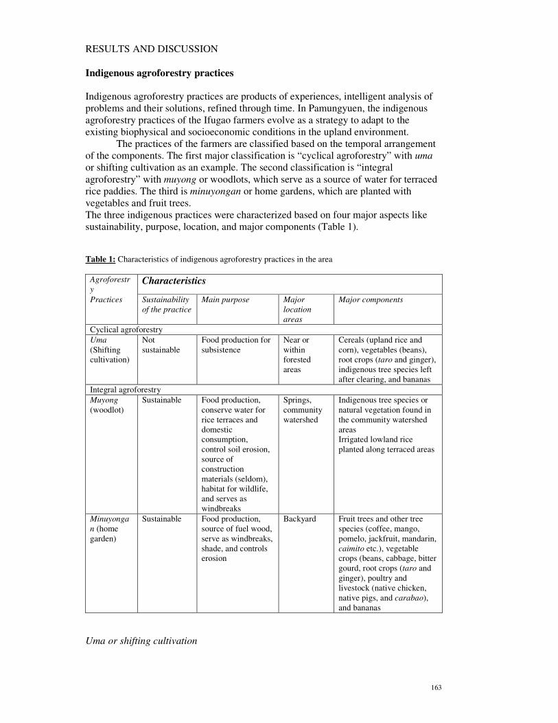
163
RESULTS AND DISCUSSION Indigenous agroforestry practices Indigenous agroforestry practices are products of experiences, intelligent analysis of problems and their solutions, refined through time. In Pamungyuen, the indigenous agroforestry practices of the Ifugao farmers evolve as a strategy to adapt to the existing biophysical and socioeconomic conditions in the upland environment.
The practices of the farmers are classified based on the temporal arrangement of the components. The first major classification is “cyclical agroforestry” with uma or shifting cultivation as an example. The second classification is “integral agroforestry” with muyong or woodlots, which serve as a source of water for terraced rice paddies. The third is minuyongan or home gardens, which are planted with vegetables and fruit trees. The three indigenous practices were characterized based on four major aspects like sustainability, purpose, location, and major components (Table 1). Table 1: Characteristics of indigenous agroforestry practices in the area
Agroforestr
y Characteristics
Practices Sustainability
of the practice
Main purpose Major
location
areas
Major components
Cyclical agroforestry Uma (Shifting cultivation)
Not sustainable
Food production for subsistence
Near or within forested areas
Cereals (upland rice and corn), vegetables (beans), root crops (taro and ginger), indigenous tree species left after clearing, and bananas
Integral agroforestry Muyong (woodlot)
Sustainable Food production, conserve water for rice terraces and domestic consumption, control soil erosion, source of construction materials (seldom), habitat for wildlife, and serves as windbreaks
Springs, community watershed
Indigenous tree species or natural vegetation found in the community watershed areas Irrigated lowland rice planted along terraced areas
Minuyonga
n (home garden)
Sustainable Food production, source of fuel wood, serve as windbreaks, shade, and controls erosion
Backyard Fruit trees and other tree species (coffee, mango, pomelo, jackfruit, mandarin, caimito etc.), vegetable crops (beans, cabbage, bitter gourd, root crops (taro and ginger), poultry and livestock (native chicken, native pigs, and carabao), and bananas
Uma or shifting cultivation

164
All the respondents in this study are shifting cultivators. Most of their farms are located near or within forested areas. The farmers prepare their farms by cutting the trees with the use of bolo, axe, or even chainsaw. It has been observed that big trees with commercial values are retained. However, this is considered temporary because according to the farmers, they will be cut down when needed for house construction or for sale. This practice of Ifugao farmers is similar with the practices of other ethnic groups. For instance, Denevan and Padock (1988) observed that the slash-and-burn farms of Peruvian Bora contain several wild species that are actively managed and used in their material culture.
Productivity of shifting cultivation areas usually declines on the third cropping, hence it is considered to be unsustainable. This is attributed to factors like erosion, invasion of weeds and removal of nutrients due to crop production.
Commercial tree species left in their kaingin farms, are not enough to control erosion. Besides, these trees are retained primarily for their monetary value and can be harvested anytime. Another contributing factor to non-sustainability of the practice is the short fallow period. Due to increasing population and the limited area suitable for cultivation most of the farmers practice a short fallow, which confirmed the findings of Garrity and Agustin (1995) and Menz et al. (1999). Shortening the time of fallow eventually results to the conversion of shifting cultivation areas into permanent agriculture (Richard & Flint 1993). Muyong or woodlots
The muyong or woodlot used in this research is a forested area that protects springs or other bodies of water. The indigenous trees and other vegetation are purposely conserved for watershed thus ensuring the availability of water for rice cultivation and for domestic consumption.
The Ifugaos mentioned some of the purposes of muyong as follows: (1) it conserves water for rice production and domestic consumption, (2) it controls erosion, (3) it serves as windbreaks, (4) it is habitat for wildlife, and (5) it is a source of housing materials. Minuyongan or home gardens
This indigenous agroforestry practice exemplifies the complex production system developed by the Ifugaos in order to adapt to upland condition. Minuyongans are located on settlement areas and within the households’ backyards. The major components are fruit trees (pomelo, mandarin, mango, coffee, avocado, jackfruit, caimito, etc.), vegetables (beans, cabbage, bitter gourd, carrots, etc.), poultry (native chicken), and livestock (native pig and carabao).
The major purposes of this practice include food production, fuel wood production, windbreaks, shades and controlling erosion. The production system is integrated. For instance, the edible portion of the taro tubers are collected for human consumption while the non-edible parts are cooked and served as feeds for pigs. The native chickens are ranged and subsist on insects, grasses, and farm wastes found in the backyard. One farmer in the area developed a home garden with a fishpond, fruit trees, vegetables, and poultry as different components. This proves the farmer’s capacity to intensify land use without compromising the long-term sustainable productivity of his farm.

165
Cultural management practices Source of planting stocks
Planting stocks are obtained from the crops they have previously grown. Upon harvesting, the farmers set aside good quality seeds to be used as planting stock for the next planting season. To maintain the viability of the seeds, the farmers kept them on tightly sealed glass containers locally known as garapon. For corn, they are bundled and kept in an improvised drier locally known as kasooran. It is constructed on top of the cooking area so that the heats from the burning fuel dry the seeds while the smoke drives the pest away. Lnd preparation and method of planting
The Ifugaos’ croplands are usually cleared and burned before cultivation. Their cultivation technique is through the use of a garden hoe (gabion), shovel, rake, and bolo. The most common practice of farmers in land preparation for cash crops is slash-and burn cultivation while strip clearing and hole digging are use for tree crops. Land preparation is carried out usually in a group called ammuyo or swapping of labor. The Ifugao farmers practice direct seeding and dibbling for upland rice and vegetable planting. This is also carried out in group, called ammuyo.
Fallow practices
Farmers from Pamungyuen usually rotate cropping within a given farmland, by dividing their farm into two. One half of the area is devoted to food production while the other half is on fallow. The alternate fallow and cultivation is rotated annually. The farmers believe that the one-year fallow can help sustain the productivity of the area by bringing back the fertility of the soil that has been depleted after cultivation. Pests and Diseases
Although isolated, pest and diseases also occur in the area. For bitter gourd, fruit fly is prevalent. The symptoms observed are the presence of deformed fruits, and fruits with holes that turn orange or yellow prematurely. Pole beans are attacked by bean fly and pod borers. Corn is attacked by cutworm (Spodoptera litura), locally known as arabas, characterized by the presence of distinct black band across the back of their head. Rice plants on the other hand are attacked by rodents, cutworms, and the bacilliform virus locally known as tungro. The symptoms given for tungro infested rice plants are stunted growth, with leaves turning yellow to orange. Banana, which is also an important cash crop, is attacked by the banana bunchy top virus. The frequency of spraying used by the farmers is shown in Table 2. Table 2: Pests and diseases
Crops Pests and diseases Frequency of spraying
Bitter gourd Fruit flies Three to six times per cropping Beans Pod borer & bean fly Three to six times per cropping Corn Cutworm One time per cropping Rice Rodents, cutworm, Bacilliform
virus Two to three times cropping

166
Banana Banana bunchy top virus None
Harvesting
Harvesting is done manually. Citrus fruits, mango and coffee are harvested through hand picking, while pomelo is done by shaking the branches. For other agricultural and vegetable crops harvesting is done through hand picking like for bitter gourd and beans. Ginger and other root crops are harvested by uprooting. Socioeconomic factors affecting the practice of agroforestry The indigenous agroforestry practices are affected by several socioeconomic factors like availability of labor, capital, knowledge, land tenure, accessibility, and a market. Table 3: Socioeconomic factors related to agroforestry
Factors
Frequency
Percentage
Security of land tenure 14 77.78 Accessibility 13 72.22 Market 13 72.22 Capital availability 10 55.56 Labor availability 9 50 Knowledge 6 33.33
n = 18; Multiple responses are possible
Security of land tenure
The Ifugao farmers have a simple philosophy on land ownership. About 77.78 percent of the farmers believe that the first one who had cleared and planted an area inside a forest automatically becomes the owner. This is locally termed as dappat. Although this type of ownership is recognized within their society, they still fear that at the end they need security of tenure to avert possible conflict when the lowlanders immigrate and apply for a land ownership title on these cleared areas. One farmer had a bad experience in Aurora province when his family was forced to abandon their dappat because an influential lowlander was able to secure a title of the property. As to the relationship of the security of land tenure to the practice of indigenous agroforestry, majority agreed that it is possible to develop their existing uma or kaingin into a more sustainable agroforestry system, like their home gardens, if they have secured land tenure. Accessibility and market
The majority of the respondents (77.22 percent) believe that the availability of farm to market road affects their desire to expand their home gardens. At present, the farmers have difficulty in bringing their products to nearby markets especially during rainy season because existing roads are muddy and not properly maintained. As in accessibility, the same percentage of respondents (77.22 percent) reported that availability of market is important in venturing into agroforestry. It is one of the major considerations in selecting crops to be planted.

167
Capital availability
One of the most important elements in production is capital. In the practice of indigenous agroforestry at Pamungyuen, most of the farmers’ capital is generated internally through on-farm and off-farm livelihood activities. Farmers with higher income have the capacity to expand their agroforestry farms in a more sustainable land use like a well planned integrated farming systems. For instance, one farmer produces rice, fish, vegetables and fruits in his farm. Labor availability
Since majority of the Ifugao farmers in sitio Pamungyuen use manual labor in their land preparation, the numbers of family members, who provide the bulk of the activity, influence their ability to practice agroforestry in terms of the extent of area and component of the system. Although swapping of labor locally known as ammuyo is being practiced, labor peak demand, which is usually dictated by planting calendar and weather conditions, redound to the overall dependence on family labor. This observation conforms to the findings of Labuguen (1998) identifying family size as one of the factors affecting upland production practices. Knowledge
The indigenous agroforestry as practiced in the area is a part of the Ifugao culture and tradition learned from their long experiences of producing their needs in the remote and fragile uplands. For instance, they could easily identify which fruits of the current vegetable crops should be preserved for seeds based on their physical appearance, and they would know which trees should be retained in their farm based on their potential use. Soil conservation practices like terracing (locally known as natuntun-od) have been handed down by the older members of the clan. The muyong or woodlot system is practiced in the Ifugao province to maintain the supply of water in rice terraces. Even the diversified component of their farm is a strategy to minimize risk of total crop failure. Impact of indigenous agroforestry practices on biodiversity conservation The Philippines is one of the richest countries in flora and fauna and is considered a biodiversity hotspot based on its number of species their degree of endemism, and the threats posed to biodiversity. In flora alone, it has 5 percent of the world’s species, 32 percent of which are endemic (EMB 1996; Freeman 1998). We should be however reminded that possibly 50 percent of endemic Philippine species have already been lost as a result of using 90 percent of our forest habitat (Sajise 1997).
To simplify the analysis of the impact of various indigenous agroforestry practices to biodiversity conservation, only the tree species found in the different agroforestry systems were utilized as indicator of the biodiversity changes. From the two woodlots or muyong found in the community, variations of trees were noted. The diversity of tree species in the woodlots is shown in Table 4.
Table 4: Diversity of tree species in the woodlots or muyong

168
Species
No.
Local
Name
Common
Name
Scientific Name Family Name Uses
1 Latbang
?
Ficus sp Moraceae
Fuel wood
2 Pao Pahutan Mangifera altissima Anacardiaceae Construction materials
3 Red nato Red nato Palaquium
luzoniensis
Sapotaceae Construction materials
4 Balete Balete Ficus balete Moraceae Fruits, food for wildlife
5 Apitong Apitong Dipterocarpus
grandi florus
Dipterocarpaceae Construction materials
6 Bunot Talisai-
gubat
Terminalia
feotidissima
Combretaceae Construction materials
7 Ukkapon Katmon Dillenia
philippinensis
Dilleniacea Food
8 Udyo Narra Pterocarpus indicus Fabaceae Construction materials, Furniture
9 Hablang Dapdap Erythrina orientalis Fabaceae Construction materials
10 Alino ? Macaranga sp Euphorbiceae Firewood
11 Anardong Anabiong Trema orientalis Ulmaceae Construction materials
12 Binua Hamindang Macaranga bicolor Euphorbiaceae Fuel wood
13 Tabak Tibig Ficus sp. Moraceae Construction materials
14 Banbanlag Takip-asin Macaranga
grandiflora
Euphorbiceae Fuel wood
15 Liwliw Hawili Ficus septica Moraceae Firewood & food for edible bat
16 Kuliwot Guijo Shorea guiso Dipterocarpceae Construction materials
17 Balante Binunga Macaranga tanarius Euphorbiaceae Fuel wood
18 Annagep Anang Mysristica/Knema
sp.
Myristicaceae Construction materials
19 Luppiang Tangisang
bayawak
Ficus variegata Moraceae Construction materials
On the other hand, sixteen tree species were observed in the home gardens. It is important to note however that twelve were introduced into the area and only four were retained from the original tree vegetation (Table 5). Table 5: Diversity of tree species in the home garden or Minuyongan Species
No. Local
Name
Common
Name Scientific Name Family Name
Uses
1* *Kape Coffee Coffea arabica Rubiaceae Beverage
2* *Mangga Mango Mangifera indica Anacardeaceae Food
3* *Ipil-ipil
Ipil-ipil
Leuceana
leucocephala
Mimosaceae Fuel wood
4* *Acasia Rain tree Samanea saman Mimosaceae Construction materials
5* *Santor Santol Sandoricum
ceotjape
Rubiaceae Food
6* *Tabuyog Suha Pomelo Citrus grandis Rutaceae Food
7* *Langka Jackfruit Arthucarpus
indicus
Moraceae Food
8* *Mandarin Mandarin Citrus sp. Rutaceae Food
9* *Kapas American kapok
Ceiba pentandra Bombacaceae Pillow filling

169
10* *Alokon
Himbabao
Brousonettia
luzonica
Moraceae Food
11* *Kaimito
Caimito
Chrysophyllum
cainito
Sapotaceae Food
12* *Melina Gmelina Gmelina arborea Verbenaceae Construction materials & furniture
13 Udyo Narra Pterocarpus
indicus
Fabaceae Construction materials, furniture
14 Lupiang Tangisang bayawak
Ficus variegata Moraceae Construction materials
15 Bunot
Talisai-
gubat
Terminalia
flotidissima
Combretaceae Construction materials
16 Liwliw Hawili Ficus septica Moraceae Fuel wood , food for edible bat
*Introduced species
Seven tree species were found on five newly developed uma or shifting cultivation areas (Table 6). Table 6: Diversity of tree species in newly developed shifting cultivation area
Species
No.
Local
Name
Common
Name
Scientific Name Family Name Uses
1 Pao
Pahutan Mangifera
altisima
Anacardiaceae
Construction materials
2 Red Nato Red nato Palaquium
luzoniensis
Sapotaceae Construction materials
3 Apitong
Apitong
Dipterocarpus
grandiflorus
Dipterocarpaceae Construction materials
4 Udyo Narra Pterocarpus indicus Fabaceae Construction materials
5 Bunot
Talisai
gubat
Terminalia
foetidissima
Combretaceae Construction materials
6 Kuliwot
Guijo
Shorea guiso Dipterocarpaceae Construction materials
7 Luppiang Tangisang
bayawak
Ficus variegata Moraceae Construction materials
Further analysis shows that a short fallow period with destructive practices like cutting and burning of existing vegetation to prepare the area for planting as practiced in shifting cultivation has a negative impact on biodiversity conservation. On the other hand, conservation of selected valuable indigenous trees and introduction of high value fruit trees and cash crops have both positive and negative impact to biodiversity conservation. The negative impact is that only those trees perceived as valuable by the home garden owner are retained. These imply a net biodiversity lost in his farm. Another factor that causes negative impact to biodiversity conservation is the increasing use of pesticides to suppress pests on high value crops. Although there are negative implications it could not be denied that the introduction of diversified

170
fruit trees among home gardens have a positive impact to biodiversity conservation (Table 7).

171
Table 7: Impact of indigenous agroforestry practices on biodiversity conservation
Indigenous
agroforestry
practice
Activities affecting biodiversity
conservation
Impact on biodiversity
conservation
Uma or shifting cultivation with short fallow period
Cutting and burning existing vegetation to prepare the area for planting, and planting cash crop
(-) Substantial reduction of indigenous vegetation
Muyong or woodlots Conservation of all vegetations within the main springs to ensure availability of water to support rice production and domestic consumption.
(+) Ensure the long term conservation of indigenous vegetation in the area
Minuyongan or home garden
Conservation of valuable native trees and introduction of high value fruit trees and cash crops
(-) Decrease in diversity of native trees in the area (+) Introduction of high value fruit trees increase diversity.
Among the three indigenous practices, the muyong system is considered as the
most ideal for the conservation of biodiversity in the place. Delineating a larger area to be declared by the community leader as part of the muyong can have a positive effect on the conservation efforts of the government. CONCLUSION The three indigenous practices represent the upland production system developed by the Ifugaos in order to produce their needs, survive and adapt to the fragile upland environment. The concepts of muyong and minuyongan as practiced by the Ifugao farmers can help conserve biodiversity. If the government wants to involve Ifugao communities in biodiversity conservation, these two local systems should be incorporated into such program. REFERENCES Denevan, W.M.& C. Padoch. 1988. Introduction of the Bora agroforestry project In Swidden-fallow; Agroforestry in the Peruvian Amazon edited by W.M. Denevan & C. Padoch. Advances in Economic Botany. Freeman, J. 1998. Biodiversity. Use it or lose it! Proceedings of the national workshop on local knowledge and biodiversity conservation in forestry practice and education. 19-23 October 1998. VISCA, Baybay, Leyte. Garrity, D.P. & P.C. Agustin. 1995. Historical land use evolution in tropical acid upland ecosystems. In Agriculture, Ecosystems and Environment, 3. Labuguen, M. 1998. Impacts of local forest resource management practices on environmental integrity: The case of Northern Sierra Madre Community, San Mariano, Isabela. Unpublished MSc. Thesis, ISU-Cabagan, Cabagan. Menz, K. & P.Grist. 1999. Impact of reduction in fallow length. Improving
smallholder farming systems in Imperata areas of Southeast Asia: Alternative to
shifting cultivation. ACIAR Monograph. No.52.

172
Richards, J.F. & E.P. Flint. 1993. Historic land use and carbon estimates for South
and Southeast Asia, 1880-1980. Oak Ridge National Laboratory, Environmental Sciences Division, Publication No. 4174. Sajise, P.E. 1997. Biodiversity for national survival. Paper presented to the Society of Filipino Foresters Symposium, 6 June 1997, Imus, Cavite.

173
CHAPTER FIFTEEN FROM NATURAL BIODIVERSITY TO AGROBIODIVERSITY: RAINFORESTS AND NATURAL SYSTEMS AS MODELS IN THE DESIGN OF SUSTAINABLE SPECIES-RICH AGORECOSYSTEMS Anneke C.J. Boerwinkel & Denyse J. Snelder ABSTRACT Agroecosystems that do not deviate greatly in their patterns of resource use and do maintain a substantial part of the diversity of natural systems will sustain over a long period of time, benefiting people and conserving natural resources. Rainforests are complex ecosystems high in biodiversity and sustainable in terms of biomass production, pest control and nutrient recycling. Hence, they serve in tropical humid regions as models on which to base the design of alternative systems of land use. However, how much agrobiodiversity is needed to satisfy long-term ecological and short-term agricultural and economic goals? Agroecosystems are continuously changing as farmers respond to new opportunities and constraints. Why are these changes directed towards simplification and specialization rather than diversification and multi-functionality? This paper addresses the concept of agriculture mimicking nature (the ecosystem mimic hypothesis) and its application in tropical environments. A discussion of the opportunities and constraints of farmers in the Sierra Madre Mountain Region in Northeast Luzon clarifies local realities in the development of species-rich, tree-based agroecosystems on former rainforest land. Attention is paid to both the agroecosystems on Imperata grassland and the home garden conglomerations in and around the villages and towns in lowlands and upland hills, along the western side of the Sierra Madre Mountains. INTRODUCTION As the world’s population will double within the next two or three decades and living standards rise, the need for food will grow. Moreover, today, some eight hundred million people in developing countries (about 20 percent of their total population) are chronically undernourished (FAO 2002). With a growing world population (the present figure of 5.7 billion is expected to rise to 8.3 billion by the year 2025) this situation of malnutrition will worsen unless measures are taken to improve food security.
Chronic malnutrition and food insecurity are mainly attributed to low productivity in agriculture. The latter is frequently caused by policy, institutional and technological constraints. The high seasonal and year-to-year variability in food supplies is often the result of unreliable rainfall and insufficient water for crop and livestock production. The lack of off-farm employment opportunities further contributes to low and uncertain incomes in urban and rural areas (FAO 2002). One way to break the vicious circle of poverty and food insecurity is to increase agricultural productivity. Yet in the following decades, the availability of under-utilized arable land for food production will continue to decrease and the remaining reserves of fossil energy will decline rapidly. Therefore, it is important to carefully determine where to implement what type of agriculture. For example, Ewel (1999) suggests intensifying production and investing the remaining fossil energy in land currently in use and with great potential for high-technology agriculture. He identifies the high-potential arable lands as areas where annual rainfall does not

174
deviate much from potential evaporation, where irrigation water, if needed at all, is required in only modest amounts, and rainfall is not so high that pests and nutrient leaching are overbearing problems. Lands that do not meet these criteria (for example lands that are too cold, too dry or too wet) are, in general, less optimal and marginally suitable for cultivation, and do not warrant such investments. These lands rather demand for agricultural systems that closely fit the ecological environment. Natural systems, with their specific structures and functions, can be used as models for the design of sustainable systems of land use.
The tropical humid lowlands are part of the agricultural frontier faced with “too wet” conditions for optimal crop production. Although they are covered with lush vegetation where left in natural state, they produce lower yields due to regular invasions of weeds, pests, and diseases. Moreover, much more water is coming into the system than departing through evapotranspiration. Excess of water moves down through the soil or flows over land towards rivers and streams, transporting all sorts of valuable nutrients that would otherwise be captured and stored in vegetation or tightly bound in the soil. Nevertheless, traditionally, people have been able to cope with biotic constraints and adjusted to such environments in various ways, for example by practicing slash-and-burn agriculture and mimicking, or partly retaining, natural forest structures in land use systems. Under present conditions of population growth some traditional land use systems fail and need adjustment, leading to decreased outputs and even environmental degradation, as in the case of slash-and-burn agriculture in more densely populated areas. Other systems sustain and can serve as models on which to base the development of new and sustainable systems of land use.
One system that may serve as a model, being successfully and widely practiced in tropical humid areas for many generations, is the home garden system. Home gardens are diverse, structurally complex and dominated by perennial plants. They are structurally and functionally probably the closest mimics of natural forest yet attained. They are characterized by continuous and diverse yields, providing a broad range of products for home consumption and high-value outputs for markets. Although home gardens are generally characterized as ecological sustainable systems of land use, they are labor intensive and require skilful management. Furthermore, they involve a trade-off between high diversity of products and low yield.
This paper addresses the agriculture-mimicking-nature hypotheses and their application to the environment of the Sierra Madre foothills and lowlands. The application will be discussed both at the landscape level and the local level, the latter by examining the constraints and potentials of the village home gardens. THE MIMICRY HYPOTHESES Van Noordwijk & Ong (1999) distinguish two hypotheses, with the first one based on the mimicry hypothesis defined by Ewel (1999):
1. There are clear advantages if man-made land use systems do not deviate greatly in their resource use patterns from natural ecosystems typical of a given climatic zone.
2. Additional advantages will accrue if agroecosystems also maintain a
substantial part of the biodiversity of natural systems. Advantages associated with agricultural systems that mimic natural ecosystems referred to are the reduction in risk of crop failure and the year-round yields, the restoration and maintenance of ecosystem services such as nutrient cycling and

175
fixation and water cycling, and the reduction in risks of invasions of pest and diseases. Yet, as stated by Main (1999), the biodiversity required bringing about these positive effects increases with each of the advantages mentioned above. Species diversity contributes to a constancy of biomass production and the supply of ecosystem services is in turn related to biodiversity.
Main (1999) further states that it is far easier to mimic specific ecosystem processes than to try to duplicate all the complexity of nature when designing new land use systems on the basis of natural-system models. Moreover, such complex land use systems may be productive, pest resistant and conservative in nutrients, they are most likely not without certain limitations. For example, can these systems provide yields like those from modern agriculture or do we have to accept that they give lesser but ecologically sustainable yields?
An important question, in order to achieve the said advantages associated with the ecological and socio-economic services provided by agricultural ecosystems mimicking the structural and functional complexity of nature, is: “How much agro-biodiversity is enough?” What is enough biodiversity to reduce risk of crop failure and to insure that incomes are more regular and support the costs of maintaining both field and landscape-level ecosystem services? How much biodiversity is needed to prevent invasions of pests, and diseases? Is there a single measure by which the question of “enough” biodiversity can be assessed? Home gardens as local species-rich agroecosystems The home garden is one of the most widespread cropping systems in the tropics. Conglomerations of home gardens in and around villages and towns can be characterized as man-made forest patches, providing a variety of products for subsistence and sale. Although few studies have been conducted on this type of land use throughout the Philippines (Seminiano 1996), home gardening as practiced in Southeast Asian countries elsewhere, or on other tropical continents, is described rather extensively in the literature. Numerous terms have been used to denote these practices: “home garden” (Soemarwoto 1975), “household garden” (Ninez 1987), “village-forest garden” (Bompard et al. 1980), “compound farm” (Okigbo 1985), and “kitchen garden” (Brierly 1985). Various forms of Indonesian home gardens dominate in most of the writings on the topic so that the Javanese words “pekarangan” and “talunkebun” are often interchangeably with the word “home garden” (Michon et al. 1983; Fernandes & Nair 1986). Home gardens occupy 20 percent of the arable land on Java (Jensen 1993). Due to the complex structure of most home gardens and the mixture of trees with other crops, they are often referred to as a type of agroforestry highly adapted to the local natural conditions, being the closest mimic (in terms of structure and function) of the natural forest yet attained. Home gardens are known because of their remarkable characteristics described as the layered canopy configuration, the compatible species admixture, the continuous production and saving for times when there is no other source of income. Home gardens have been classified as having the highest biodiversity and complexity among man-made agroecosystems (Swift & Anderson 1994). Home gardens in Thailand are called “microcosms or imitations of natural tropical forest ecosystems to serve daily subsistence” (Gajaseni & Gajaseni 1999). Milan (1997) even speaks of “rainforestation farming”, referring to a farming system that resembles closely the structure of a natural Philippine rainforest ecosystem. Home gardens sometimes even provide 15 to 20 percent of the total fuel wood requirement (Fernandes & Nair 1986). From a survey of forty households with home

176
gardens in the Philippines, it was found that nearly all households could meet the recommended daily requirement for vitamin A, vitamin C, iron and calcium. One in four households could meet their protein and energy requirements, with the outputs and resources of the home gardens (Fernandes & Nair 1986). Scientists have long been convinced that high population densities and agricultural intensification lead to crop specialization and a loss of diversity. Conelly & Caiken (2000) concluded however that at least in the case of the Hamisi in Western Kenya, intensification maintains or even increases agrodiversity. This is in accordance with a remark of Fernandes & Nair (1986) that:
Almost all the home gardens have evolved over time under the influence of resource constraints (population pressure and consequent reduction in available land, capital and labor) or physical limitations (remoteness of the area forcing the inhabitants to produce most of their basic needs by themselves, lack of adequate market outlets compelling the farmers to produce something of everything they can use, but not sell
The relevance of home gardening in the study area
In Northeast Luzon, population density is the lowest of the whole Philippines. Despite this, the pressure on natural resources outside the protected areas is high enough to cause severe environmental problems. To find alternatives for the use of the forest of the Northern Sierra Madre Natural Park (NSMNP), better solutions must be found for the development and use of the grassland zone. Migrants in search of fertile land have increasingly occupied these grasslands. One of the few places where people, both newly settled migrants and autochthon communities, spontaneously plant trees, without interference of government and non-governmental organizations, are the home gardens. Morris (1991) emphasizes the importance of valuing home-consumed production in a way that corresponds to farmers’ preference. A well-developed home garden can provide an extra source of income for direct use by the poorest families. Agroforestry and home gardens, as a small type of agroforestry system, could be a way of sustainable farming, adapted to the needs of the people, and might provide an alternative for the smallholder’s use of the lowland rainforests in Northeast Luzon. FROM NATURAL BIODIVERSITY TO AGROBIODIVERSITY; THE CASE OF THE SIERRA MADRE FOOTHILLS AND LOWLANDS Natural ecosystems Northeast Luzon is characterized by a diversity of natural forest habitats as a result of the complex geological history of the island. Habitat diversity in the Sierra Madre Mountains and adjacent foothills is directly associated with both altitudinal differences and the wide range of rock formations of varying age and composition on which distinct species have established themselves over time. Dipterocarp lowland rainforest is the most widespread natural forest type in the region, both in recent and historic times, covering part of the mountainous upland, the foothills and the lowland areas. The combination of dense stocking and very big trees gives these forests, like elsewhere in Southeast Asia (Whitmore 1989), an extremely high timber volume and hence high commercial value per hectare. This partly explains why the forest is nowadays under high pressure. It has been seriously threatened particularly by large-scale timber corporations who were allowed to extract

177
an estimated 26 million m3 of premium hardwood from natural forest stands between 1965 and 1990 (Van den Top 1998). Together with the forests in the southern part of the Sierra Madre, the Northern Sierra Madre Mountain Region now comprises an estimated 25 percent of the remaining old growth lowland evergreen rainforest in the country (DENR & UNEP 1997; Van den Top 1998; Araño & Persoon 1998). Other natural forest types include ultra basic forest (generally described as forests characterized by stunted trees of little commercial value on igneous rock with a silica content of less than 45 percent), montane and mossy forest at greater altitude, and coastal limestone, mangrove and beach forests. The mangrove forests cover about 5,500 ha in the whole Cagayan Valley (NEDA 1991) with an estimated 741 ha in the NSMNP. Agrobiodiversity at landscape level: Constraints and potentials Although the climate in most parts of the region is typical for the tropical rain forest zone, extensive areas of the Cagayan Valley are covered by grass vegetation instead of forest. The grasslands cover an area amounting to 500,000 ha in Region 02. They are part of the forest buffer zone and form a transition between the lowlands with irrigated crop cultivation and the uplands with the Sierra Madre forests. Ranching is the main land use and in addition cogon grass (Imperata cylindrica) is gathered, in most cases on a part-time basis, and sold as cheap material for the roofing of houses and other buildings or sheds.
The development of grasslands, particularly those predominated by cogon grass, is mainly associated with increased human and livestock populations, land shortage and more intensive land-use systems. It is assumed that the grasslands in Northeast Luzon mainly occur on former forested land. In the Cagayan Valley, small-scale forest clearance by means of slash-and-burn was already practiced before the Spaniards arrived in the sixteenth century and promoted the spread of grasses where fields were left for fallow. The persistence of grasslands during the last century is mainly attributed to the combination of frequent grazing and regular burning. The latter is conducted for a number of reasons, such as the growth of young shoots after fire, an easier access to green forage and the production of optimal cogon grass for roofing purposes, or is purely due to accidents (Masipiqueña et al. 2000). The large-scale logging by corporate timber companies during the last few decades mainly resulted in forest degradation and not in complete clearance and grassland development. Only an estimated 5 percent of the 750,000 ha of Sierra Madre forest in the provinces of Isabela and Cagayan were converted into other land uses, including grassland, between 1950 and 1990 (Van den Top 1998). Constraints
There has been much uncertainty about the quality of the grassland resources. Various studies refer to grasslands as idle, unproductive lands created by “overgrazing” and “overexploitation”, or attribute the low production to the removal of the forest cover and subsequent exposure of “nutrient-poor and acid soils only suitable for extensive cattle raising” (Concepcion & Samar 1995). These ideas are supported by the overall low survival rates of tree seedlings in reforestation projects discussed in a number of studies (Pasicolan 1996).
A recent study of grassland soil and vegetation in Northeast Luzon (Snelder 2001a) revealed, however, that the soil nutrient status is more favorable compared to grassland areas elsewhere in the humid tropics. The grassland mainly occurs on

178
Miocene-Pliocene sedimentary rock and Plio-Pleistocene volcanic and fluvial deposits. Whereas low soil organic matter content due to frequent burning is a region-wide major constraint to the implementation of alternative land use, other constraints mainly occur at a local level and pertain to soil physical, rather than soil chemical properties, such as high erodibility, low available moisture content, limited soil depth, stony surfaces, and irregular micro-topography. The proliferation of Imperata
cylindrica and Themeda triandra, both fire climax species, is the result of regular burning and intensive grazing rather than low soil nutrient status.
The fact that grassland resources are generally perceived as poor can be explained by placing resource quality in comparative perspective. The grasslands may be inferior to the nearby species-rich forests with soils higher in organic matter but they are superior to much grassland in humid tropical areas elsewhere. Furthermore, the ways in which grassland resources are managed, utilized and developed not always contribute to a more positive cognition, particularly among poor farmers. The large-scale attempts to rehabilitate grasslands show little diversity and particularly concentrate on the indiscriminate planting of one or two fast-growing timber species, paying little attention to the variable soil conditions associated with the complex geological substrate, physiography and history of local management (Snelder 2001b). The main activities on former grassland include: (1) the cultivation of corn, banana and irrigated rice in monocropping systems, and (2) the establishment of Gmelina
arborea plantations with locally rather limited success, due to drought and fire. The grassland areas function more and more as a migratory sink, absorbing
landless and jobless families who migrated from densely populated lowland and upland areas elsewhere in search of land to cultivate (Snelder 2001b). The extension of cultivated fields and tree plantations into former grassland areas has particularly increased since timber companies closed down in the late 1970s and the 1980s, and again since the logging ban of 1992, when former laborers in the timber industry had to turn to alternative sources of income, such as cash crop production. The landless farmers resort to squatting of grassland areas, most of which are leased on a long-term basis (for 25 years with possible extension of another 25 years) to absentee cattle owners and ranchers. More efficient management of grassland has become increasingly important in local government programs and forms a challenge for future land use planners. The government plans to reduce the total area under grassland from 500,000 ha to about 180,000 ha to meet the region's anticipated agroindustrial land requirements by the year 2020, with no specific reference to medium and small-scale farming enterprises (DENR 1996). The remaining grassland will be converted into well-managed and improved pastures to produce sufficient beef for the region’s projected population in the near future. Potentials
Although the grassland areas are commonly classified as marginal lands as explained in the previous section, they are definitely suitable to a diversity of land use types. This can be done by exploring landscape patterns that express local differences in geomorphology, soil, hydrology and biodiversity. Land use systems can be developed and adjusted to such patterns, taking into account the structural and functional properties of (former) natural ecosystems.
For example, whereas tree-based agricultural systems, composed of a mixture of tree, shrub and grain, root, or tuber crops, are most promising on the upper and mid-sections of hill slopes, intensive crop cultivation can be practiced on the more fertile lower sections (the foot slopes, local depressions and valley bottoms). The less fertile and coarse-textured watersheds and plateau areas are most suitable to

179
silvopastoral practices. Finally, various types of forest patches occur throughout the landscape, within and across different types of geomorphological units including slopes, watersheds and valley bottoms, as identified by Snelder (2001b). These forest patches demand a distinct management approach. Diverse gallery forests along streams demand a more conservative approach with a low level of exploitation and need restoration where fragmented by disturbance to form the foundation for a network of stable landscape elements. Isolated woody patches can be linked and structured through enrichment planting and assisted natural regeneration, including indigenous multi-purpose species, in such a way that they meet farmers’ specific needs and form stable line elements across cultivated fields and grasslands, contributing to soil erosion control. Naturally vegetated strips on cultivated fields proved to be highly effective in soil conservation and are widely adopted as a low labor and zero-cash alternative by farmers in Claveria, Mindanao, Philippines (Garrity et al. 1999).
The conservation of forest patches within this landscape highly depends on the perceived value of these patches for farmers and the possible integration of forest patches into local farming systems. From a farmer’s perspective, these forests may substantially increase in value if their function as reservoirs for natural enemies of agricultural pests can be proven. As opposed to tree plantations, the management of natural forest patches require low labor and cash investment whereas they provide multiple products with flexible harvesting times, reduce risks and meet emergency needs. Field observations suggest that the patches show greater resistance to fire than newly established tree plantations. They will enlarge and extend themselves onto open grassland if protected against frequent burning and grazing and form a network of stable elements with a continuous supply of organic matter, retaining soil base nutrients and fine earth particles, within an agriculturally diverse landscape. Likewise, some forest patches conserve local populations of trees, contributing to the conservation of biological diversity. They are potential “stepping stones” for seed dispersal, both crucial functions for reforestation efforts. These and other ecological services need, however, further investigation.
Adequate credit facilities and transfer of knowledge among farmers and from farmers to NGOs are needed to encourage tree planting activities and forest conservation. Reforestation programs directed at diversification of tree-planting activities including small-scale farm forestry are considered most promising, particularly among low-income groups. A case study of village home gardens Until now, little attention has been paid to the home garden systems in Northeast Luzon. Although from the air, the villages can be seen as green, forest spots in the grassland areas, the impression is that the home gardens in this region are not as well-developed and highly productive as home gardens elsewhere in a comparable climate. The question arises whether working towards well-developed home garden systems could be one way to stimulate sustainable development in rural areas within the region. These observations and questions triggered this study of home gardens in two villages of Isabela Province. The study examines the status of the gardens and their physical and structural appearance compared to those of the natural forest, in both a remote village close to the forest and a more readily accessible village in the lowlands. The assumption is that the home gardens in the remote village, rather than those in the more accessible lowlands, will be more diverse, well structured and aimed at self-sufficiency because of the absence of nearby market and shops. This

180
study has been extended with fieldwork in 2002, the result of which will be published elsewhere. Methods
The case study was conducted in two villages situated in the moist agro-climatic zone (annual rainfall ranges from 1500 to 2500 mm and a growing season of seven to eights months), from March to July 2001. The villages Moldero, a few kilometers North of Tumauini on the fertile plains of the Cagayan River, and Dy Abra, a few kilometers East of Tumauini in the hilly grasslands close to the forest edge. In Moldero, the main research site is sitio Pantalan located closest to, and at the lowest banks of, the Cagayan River. Another site referred as “barrio”, located at the older, more elevated and central part of Moldero is included for comparative purposes. In Dy Abra, the main research site is referred to as “barrio”, including the central part of the village surrounding the elementary school, and another site, sitio Pasto, located at a ten to fifteen minutes walk away from the central part of the village, is also included for comparative purposes.
The people in sitio Pantalan (sixty-six households), Moldero, are part of the lowland ethnic group, the Ibanag. Most families are tenants cultivating one half to one ha (average farm size is 0.90 ha) with corn and tobacco of which they have to give one-third to the landowner. The residential lots have been turned over from the landowner (haciendero) to the families through the Agrarian Reform Program but families are still financed by the landowner. During the dry season, all types of transport can reach to the village. To go to Tumauini, most people in sitio Pantalan take a tricycle (PhP. 10 to 12 per person for a twenty minute ride). The farmland that surrounds the village is well accessible by cart. During the rainy season the trails turn into mud. The distance from the residential site to the farmland however does not exceed 1 km. There is electricity in Moldero. The people in Dy Abra (115 households) are part of the upland ethnic group, the Tinguians. They are migrants from the province of Abra and arrived in Dy Abra in the 1970s. Most families have an Integrated Social Forestry (ISF) plot with a Certificate of Stewardship Contract (CSC). The latter is an agreement under which the “owner” can use the land for a period of twenty-five years, after which the agreement can be extended if the land is managed in a proper way. Beside this form of land tenure, there are more agreements under the Department of Environment and Natural Resources (DENR) or Department of Agrarian Reform (DAR). The total size of a farm in Dy Abra is bigger than in sitio Pantalan in Moldero (1.75 ha). Moreover, most families use a part of the forest for kaingin (shifting cultivation). The land tenure situation in the residential site is unclear. It is not sure if the land is still owned by a landowner or by the Bureau of Land or the Land Bank, being in the process of land reform. The village of Dy Abra can be reached by jeepney (PhP. 15 per person, one way) from the market in Tumauini. The travel takes about one hour (16 km) over a gravel road. During the dry season the village is accessible by any four-wheel type of vehicle. The village can however only be reached by crossing the Balasig creek, which flows close to the village and which cannot be crossed by vehicles during times of heavy rain. There is no electricity in Dy Abra.
A total of twenty households and heir respective home gardens in Pantalan and sixteen in Dy Abra were selected at random using the barangay population lists. The species composition and the vegetation structure of the home gardens were investigated. Semi-structured interviews were conducted to obtain information about the use of plants and the management and planting practices. Representative soil profiles were described; topsoil (0 to 10 cm) was sampled (composite samples of five

181
to six cores) and analyzed for organic matter content, available P and K and pH. Methods for soil chemical analyses are described in Snelder (2000a). Differences in pH-values were tested with a parametric test (one-way ANOVA and T-test for two independent samples). Other soil data were not normally distributed and the Kruskal-Wallis and Man-Witney U tests were used to test differences between and within sites. Home garden components and species composition
A home garden covers a residential lot with adjacent field planted by a family composed of one, or sometimes two or three (parents and grown-up children), households. Except for a few trees providing shade, the compound just around the house is kept bare and serves as a playground and a place to relax. Some parts are reserved for the processing of crops, handicraft and other activities. The houses are made of concrete or bamboo with a galvanized or cogon grass roofs. In Moldero, the kitchen is usually separated from the house. Racks of bamboo are placed on the compound or in seasonally cultivated fields. They are used for drying tobacco that is grown in fields outside the village. Farm products are stored in houses constructed on poles. In Dy Abra, the houses are similar to those in Pantalan but the kitchen is usually attached to the house. Aside from a house and a bare compound, the home gardens in both villages contain one or more of the following components: water pump, bath area, toilet, sheds for livestock, concrete platform for drying corn and rice, fishpond, compost pit, fences, cultivated field, and orchard. The home gardens vary in size, between 19 and 1800 m² in Moldero (average: 870 m²) and between 400 and 3750 m² (average: 2442 m²) in Dy Abra.
A total of 312 plant species (of which 282 are identified) are found in the home gardens of both villages. Common trees are paper tree (Gmelina arborea), alim (Melanolepsis multiglandulosa), and fruit trees like mango (Mangifera indica), coconut (Cocos nucifera), guava (Psidium guajava) and jackfruit (Artocarpus
heterophyllus). Favorite crops are taro (Colocasia esculenta), sweet potato (Ipomea
batata), many kinds of beans, bitter gourd (Momordica charantia), and bottle gourd (Lagenaria siceraria), squash (Cucurbita maxima), okra (Abermoschus esculentus), hot pepper (Capsicum frutescens), and eggplant (Solanum melongena). In every home garden common ornamental plants can be found. Cans planted with spices and seedlings are common in Moldero, but are seldom found in Dy Abra. In Dy Abra small rice paddies can be found near the residential site. Hedgerows made from pruned tawwa-tawwa (Jathropha curcas) and cassava (Manihot esculenta) are more common in Moldero. Natural species range from trees to a large variety of weeds. Especially in Dy Abra weeds and grasses form an important component of the home garden. Most home gardens are characterized by the presence of two or more vegetation layers or canopy strata, the lowest one composed of vegetables, ornamental plants, grasses and medicinal herbal plants and the highest one of tall fruit and timber trees. The number of species per canopy stratum, grouped according to local use, in the home gardens of Moldero and Dy Abra are presented in Table 1.

182
Table 1: Number of species for each canopy stratum A, B, C, D, E and F, grouped according to the main local use in the homegardens in Moldero and Dy Abra, Isabela province, Philippines.
Local use Vegetation stratum
A B C D E F
Tall trees Trees Shrubs Climbing Herbs Plants
> 5m < 5m 0.5 - 1.5m Vines < 50cm In pots
Fruits 3 26 2 1
Vegetables 3 2 12 15 3
Root crops 2 7
Timber/fuel 2 12 7
Ornamental plants
2 12 1 33 7
Herbal medicine 1 5 4 1 12
Other 1 13 11 11 49
Grass 23
Total 6 61 41 24 140 10
In Moldero, the first canopy stratum of the home gardens is predominated by
mango, jackfruit, paper tree and coconut. More species can be found in the second stratum, including banana (Musa spp.), horseradish (Moringa oleifera), guava, and also the younger trees of the first canopy stratum. The third stratum is composed of hedgerow species like pruned tawwa-tawwa, madre de cacao (Glidricidia sepium) and alim, but also of crops like hot pepper and several ornamental shrubs. The fourth stratum consists mainly of climbing vegetables like beans, gourds, squash and alugbati (Basella alba). Vegetables and weeds form the lowest vegetation stratum. Overlap between the different strata is often limited to a small part in the back of the home garden where trees and shrubs form a natural boundary. Few farmers grow cassava, pineapple or taro under the trees. Because the main function of the trees is to provide shade, the area underneath is not planted with other crops. Horseradish is an exception because the crown of this tree does not provide much shade. The most important activity underneath the trees is the processing of tobacco, and it is a resting place for people and cows. The majority of the vegetables is grown in direct sunlight on clearly marked fields. During the rainy season the appearance of the home gardens is very different, as the activities around the drying of tobacco make place for growing of vegetables, especially the leafy vegetables like pechay (Brassica
chinensis) and mustard (Brassica juncea). Every little spot that receives enough sunlight is somehow used for vegetable growing and new horseradish trees are planted.
Most people grow vegetables in their garden for home consumption. However, the surplus of harvest is sold, shared or bartered with neighbors. Only few people are selling products in the market. Chickens and pigs are raised for consumption during special occasions and for selling during times of shortage. Livestock is being sold if medicine has to be bought.
The staple food of the households in Moldero consists of corn and rice. Meat, fish and eggs are only consumed once a week or on special occasions if money is available. Home garden products do form an important supplement to the diet as the farmland is mostly used for the monocropping of cash crops (mainly corn and tobacco) and rarely for subsistence crops. The home garden supplies green leaves like horseradish, amaranth (Amaranthus viridus and Amaranthus spinoza) and leaves of vegetables like bitter gourd and sweet potato, flowers of squash and himbabao

183
(Brouzonettia luzonica), which are typical species that can be used throughout the year and which are often bartered with neighbors. It forms a good source of vitamins (Villareal et al. 1993; PCARRD 1988). Eggplant is a crop that is a favorite, probably because it can be harvested every three days during a long period. It is also the species that is most commonly planted to provide some cash income. The combination of fruit trees that is found in the village provides fruits throughout the year, with a peak in the dry season. The amount of fruits harvested supplements the diet, but is not enough for selling. Firewood is mainly collected from wood washed ashore on the riverbank. In times of heavy rain this source is enough to provide firewood for the whole village. Some people are hauling wood from villages close to the forest edge (among others Balasig and Masipig) by using cow and cart. In the village itself trees are pruned for firewood and fallen branches are collected. Stems of tobacco and corn and dried cobs of corn are also used for fuel. In Dy Abra, the residential lots are rather large compared to Moldero (2442 m2
on average), but often only a small part of the space is actually used for crop, firewood and timber production. Houses are built close to the road and in the back there is mostly a transition from home garden to pasture or sometimes a small rice field. The taps for water are next to the road. The area around the house can sometimes be distinguished by a clear change in vegetation or there is a row of trees or a fence that separates it from the rest of the home lot. During the research period in 2001 (and also during the research period in 2002), grass and herbal weeds covered an important part of the space around the houses. Trees are mostly planted at boundaries and some are planted close to the house for shade. Where trees (predominantly paper tree) are planted, the ground underneath is bare or covered with a short grass or herb layer. Many trees, however, show stunted growth. The free roaming goats often destroy newly planted seedlings.
The most important function of the home gardens in Dy Abra is the function as source of fodder for goats and carabaos. It is however remarkable how much of the weeds in the gardens have a medicinal value. Also wild species like amaranth and bush okra can be harvested for food, not requiring any inputs. The consumption of these species is more popular in the rainy season when the shoots are soft. Favorite vegetables are string beans, taro and squash, but instead of cultivating their home lot, people have chosen to plant these vegetables in their farm. Compared to Moldero, more products for home consumption are gathered from sites outside the village home gardens. Firewood, especially ipil ipil (Leucena leucocephala), arosip (Antidesma
pentandra) and guava, is collected from a nearby river and from the forest patches on farmland and in grassland. Many people are using gas for cooking besides the use of firewood. Other products, gathered for home consumption from nearby forest patches, include palm hart (Oncosperma tigillarium), young fern leaves (Athyrium
esculentum), wild pigs, jungle fowl, small crabs, fish, and shrimps. On the whole, the home gardens in Dy Abra look little developed. Families do
grow vegetables like taro, hot pepper and squash in a small field close to the house, but they form a minority. A border with common ornamental plants can be found in almost every garden. Soil properties
In Moldero, which is located on flood plain deposits, the soil (Fluvisols) consists up to about 80 cm depth of dull yellowish brown (10 YR 4/3) sandy loam to sandy clay. From 80 cm depth brown (10 YR 4/4)) loamy sand is found. Due to wet conditions during times of flooding, gley features (grey-coloured mottles in soil associated with oxidation-reduction processes) can be seen from about 28 cm down to 80 cm and

184
residues of charcoal, originating from clearing and burning in the past, have been spread throughout the profile up to the loamy sand. After flooding, which occurs virtually every year, it takes three days before the soil surface is dry again and people wait for one week before they will plough again. Dy Abra is located on a flat, terrace-like landscape unit (with characteristics similar to the Ferric Luvisols or Ferric Tropaqualfs in the palaeo-terraces described by Snelder 2000b) that is covered by tuffaceous sediment. The topsoil layers consist of dull yellowish brown to dark brown sandy clay loam to sandy clay. Under this layer, a layer of iron excretions and gravel can be found. At places where the topsoil is removed this concrete layer is exposed at the surface. In general the depth where it can be found varied from zero up to one meter. Underneath, bright yellowish brown clay is found on which water stagnates. This causes the gley features in the layer covering the clay and the concretions on the interface between sandy clay loam and clay.
Table 2 shows the average values of the soil properties of topsoil in home gardens and farmland (the latter are located outside the village and included for comparative purposes). The pH-values are higher in Moldero compared to Dy Abra. The organic matter content of the soil in general higher in Dy Abra than in Moldero. P-concentrations are remarkable high in the home gardens in Moldero, and K-concentrations are higher in Moldero compared to Dy Abra. Yet one should keep in mind that these values are affected by chemical fertilization. A number of the vegetable home gardens are fertilized with N-P-K, as confirmed by 46 percent of the respondents in Moldero and 20 percent of the respondents on Dy Abra. In general the pH values are neutral to weakly acid, the organic matter content is low (Metsons rating), and the soil is adequate to rich in extractable K and available P (based on interpretation given by Landon (1991) for Central African soils).

185
Table 2: Chemical properties of topsoil (0 to 10 cm) in homegardens and in the surrounding farm land in Moldero and Dy Abra, Isabela province, Philippines. Subsets a, b and c differ significantly.
Site pH OM Available Extract.
P K
(H2O) % (mg/kg) (mg/kg)
Homegardens
Moldero, sitio Pantalan 6.3 b 2.6 a 93 b 410 b
(n = 32) 0.22 0.66 14.6 98.4
Moldero, purok 1 6.9 c 3.3 a 89 b 457 b
(n = 4) 0.17 0.66 21.0 53.1
Dy Abra, barrio 6.1 a 3.4 b 30 a 189 a
(n = 16) 0.44 0.78 28.4 116.6
Dy Abra, sitio Pasto 5.8 4.2 c 15 a 318 a
(n = 4) 0.27 0.27 14.9 124.1
Farm land
Moldero 6.3 b 2.4 a 35 a 225 b
(n = 5) 0.08 0.48 6.9 107.5
Dy Abra 6.4 3.5 b 5 a 187 a
(n = 2) 0.35 0.00 2.8 159.1
Dy Abra, sitio Masan 6.8 3.5 7 145 (n = 1)
A high P-concentration in the vegetable gardens in Dy Abra suggests that the
management practices have a positive effect on the available P-concentration in the home garden. Sample sizes have however been too small to find a significant effect. None of the soil properties that were analyzed showed a significant difference between the various places that were sampled within a home garden. Planting systems and soil management
In Moldero, after the tobacco harvest from the fields outside the village, the sight of the village changes dramatically. Bamboo drying racks are stored or turned into racks for the growing of climbing vegetables. Wherever there is enough space, people plough the garden and plant vegetables in straight lines. Plots up to 8 m2 can be cultivated with animal traction, else a bolo is used to prepare the soil for planting. Large seeds are sown directly; smaller seeds (for example seeds of eggplant, tomato, pechay, and hot pepper) are first sown in cans and later transplanted to the garden. Seeds are bought on the market. Seeds stored from the last cropping season are often not available. Remarkable is that all the ornamental plants are propagated by stem or leave cutting. In this way plant material is spreading through the village. Crops that are propagated a-sexually are among others horseradish (stem cutting), sweet potato (stem and leaves) and taro. These are at the same time the most typical species that

186
can be found in every garden. Horseradish is planted every year because it is very susceptible to flooding.
The waste of every day sweeping around the house, from the kitchen and weeds from the garden are dried and burned in a compost pit in the back of the garden or just outside the residential site. The compost is perceived as waste that should be removed. The ashes are sometimes mixed with soil and used for the propagation of seedlings. Cow manure is incorporated in the vegetable garden during plowing. Chicken dung and manure of the pigs are not actively used, but as the animals stay in the home garden most of the time, they provide an important input of nutrients. Cows graze along the trails in the farmland and when staying in the residential site they are fed with weeds and corn residues, which are collected in the farmland. Chickens are fed with rice bran and corn. During the night they are put in a shed against animal attack and theft. Pigs are mostly fed with B-meg feeds and rice bran, but also products from the home garden are used, like the leaves of the sweet potato (camote tops) and all parts of the taro species that are not eaten by humans. Other nutrient inputs are inorganic fertilizers (ammonium sulphate, potassium, triple 14 NPK, and urea), which are often remaining surpluses of the farms. A source of nutrients that must be mentioned is the human faeces. Every family has a comfort room consisting of a hole of approximately 3 m depth, which is reached by the roots of trees.
In times with little or no rain people water their plants in the morning and late afternoon. After planting, seedlings are protected against the heat of the sun by covering them with a banana sheet. Weeding is done with a bolo, or weeds are uprooted by hand, and trees are regularly pruned for light. Pests are usually controlled with the help of chemical pesticides (Lanate 40SP, Desis-R, Tamaron, Novacron, Cymbush, and Karate). Especially eggplant, which is one of the favorite crops in the home garden, is susceptible to pests. Fruits like guava and sweetsop (Anonna
squamosa) are sometimes covered in plastic to protect them against insect attack. Sometimes people use ashes to control insect attacks. Fences are indispensable to keep the animals away from the plants. People use mainly bamboo for fences inside the village. Other materials used are branches and leaves of coconut. At the boundaries living poles and trees are forming a rail off.
Work in the home garden comes after the work on the farms outside the village. Both the farm and the home garden are managed without fixed gender-determined tasks, except for plowing and other activities where animal traction is used. Men and the elder sons of the family perform these activities. The preparation of a home garden when the planting season starts takes on average one day, but cleaning the surroundings of the house is a daily activity.
In Dy Abra, before planting vegetables, the weeds are cut and burned and then the soil is ploughed with a carabao. Large seeds are directly sown, whereas only few people mention that they first make a seedbed before transplanting the seedlings in the garden. Seeds are bought from the market or collected and borrowed from neighbors. Plants are watered in the morning and in the evening if there is no rain. During cropping the weeds are pulled and all waste material is burned. People use inorganic fertilizer and chemical pesticides in combination with organic materials. Carabaos and goats stay in the garden at night, but more often they are brought to a pasture area. Fodder is never collected to feed the animals in the residential site. Breeding of livestock is both in Moldero and Dy Abra done within the village. Ashes from waste material are ploughed into the soil. Some people use ashes to control insect attacks. During the dry season there are almost no crops left to be watered. During this time, the only individuals who are managing the garden are the goats who keep the grass short. Fences are not enough to keep the goats out of the garden. Live fences as made in Moldero are seldom found.

187
Constraints In Table 3 a summery is given of the problems in home garden production mentioned by the respondents. Soil related problems can especially be found in Dy Abra. The stunted growth of trees and vegetables is probably an effect of the lack of nutrients and the concrete layer in the soil. As the common remedy practiced against a poor soil is the application of chemical fertilizer, people link this problem with the lack of money for inputs. In Moldero opinions are contradicting. Some people say the soil in the residential site is very fertile and there is no fertilizer needed for home garden production. Table 3: Constraints in home garden production mentioned by respondents in Moldero and Dy Abra, Isabela province, Philippines
Moldero Dy Abra Sites
Purok 1 Pantalan
Soil-related problems
Stoniness x
Lack of soil fertility x x
Acid soil x
Climate-related problems
Flood x x
Drought x x
Rain destroying flowers of mango x x x
Vegetables destroyed by heavy rain x
Biological problems
Pests x x x
Stunted growth x
Weeds x x x Socio-economical problems
Small area x
No material for fencing x
Lack of seeds and seedlings x x
Lack of animal traction x
Lack of time x
Astray animals x x
Climate related problems seem to be a constraint in all of the three research sites listed in Table 3. Flooding is especially affecting sitio Pantalan in Moldero where the residential site is flooded three times on average every year. Vegetables, horseradish and all planting material are destroyed and people have to start over again. At the Northwest site of the village erosion features can be seen at places where the village is not bordered with vegetation (especially bamboo). The yearly flooding

188
as well as the lack of space might be the reason that in sitio Pantalan the home gardens are less tree-rich than in the rest of Moldero. However, people in Pantalan would, if they had more space, rather grow more vegetables for cash income than plant more trees. The drought during the dry season from March up to May makes the crop production in home gardens bound to the rainy season and continuous cropping is bound to the few shady places at the borders. In Moldero, people were watering their plants in the morning and the evening, but in Dy Abra it seems that people have given up the struggle with both the drought in summer and the goats during the rest of the year.
The respondents also link the problem of pests to the lack of money, just as poor soil, because an attack of pest is usually treated with chemical pesticides to be bought on the market. The same is the case with the lack of material for fencing. In sitio Pantalan, astray animals destroy newly planted crops, root crops and leafy vegetables. Particularly chicken and piglets cause much damage during daytime. In Dy Abra, goats form the biggest threat to the home garden production. Some people move their vegetables for home production to their farm to avoid damage by goats roaming around in the residential site. Others prefer to plant the vegetables in their home garden because it is close to the house where they can keep an eye on it. If time is lacking people concentrate first on their farms. In Dy Abra the struggle with drought, weeds, and a poor soil seems too much time consuming to invest more in the home garden.
The lack of seeds mentioned is partly caused by the problem of floods destroying the planting material, but people seem also very much to rely on other people and agencies. In the past they availed the seeds for free. The barangay captain of Dy Abra states that the people are simply used to buy vegetables.

189
DISCUSSION The home gardens in this study vary in terms of species composition and physical appearance. Yet they show similarity in garden components, management and planting systems, including the presence of a bare compound around the house, pasture for livestock, small-scale animal husbandry, seasonal vegetable growing, multi-storeyed cropping, fruit tree and multipurpose tree growing, and ornamental plants in hedgerows and pots. Stating that the Isabela home garden conglomeration is one of the five types of forest patches in the area (Snelder 2001a) is mainly true when looking at it from a distance: the sight of the villages, both from the air and on the ground, is that of a small forest when approaching it. When entering the village, however, several differences can be observed, particularly in vegetation structure and spatial arrangement of plants. Not all of the five vegetation strata defined in this study, which are supposed to be present in a natural forest patch (except for the plants in pots), are present in the home gardens. Whenever the trees form the dominant stratum, the other strata are often missing because the space underneath the trees is used as working place or as resting-place for cattle. Weeds and litter is removed for cleanness of the surroundings, large portions of the home gardens are kept bare to use as working place and vegetable growing is practiced in open sunlight. From a quick comparison with the species found in a natural or logged over forest (Simons 1994), not one of the tree species found in the natural forest was found in the home gardens. The species in the home garden can be characterized as both useful and common, but most of them are not native to the area. Likewise, the species density in home gardens is lower than in forest patches.
The total number of 312 plant species in this home garden study is comparable to the 235 useful plant species identified in home gardens of West Java, Indonesia (Kass et al. 1999). Against expectations the home gardens in the remote village of Dy Abra are of low species diversity and much less developed than the more accessible home gardens in Moldero (surprisingly, also farmers in Moldero characterize their village as “remote” and “far away from the market”). Whereas Dy Abra is situated close to the forest edge, the natural species in the home gardens seem to fit more in grassland vegetation than in a forest patch. Although the home gardens are low in crop diversity and output, it does not necessarily imply that all households in Dy Abra fail to be self-sufficient. Besides the availability of farms, outside the village, where food crops for home consumption are grown, the forest is near and also provides food and valuable forest products (timber, rattan). However most respondents, in both Dy Abra and Moldero, partly depend on market products and neighbors, who sell and exchange crops, to complement their diet with vegetables and fruits.
Some informants attribute the absence of diverse gardens in Dy Abra to the fact that home gardening is not a traditional practice for the majority of the people who belong to the Tinguians tribe. Yet they were stimulated to establish home gardens by various institutions and programs in the recent past, such as, the DENR with their Bio Intensive Gardening program, the Sierra Madre Greeners Association, and Plan Philippines. Efforts of some households failed because of the locally poor soil chemical and physical properties and the recurrent crop damage caused by the goats distributed by one of the programs.
Along the creeks in Dy Abra and in the Northwest boundary of sitio Pantalan in Moldero, forest vegetation is left intact to evade soil erosion. These parts are managed in an extensive manner and only few products are used. They could be characterized as small gallery forests.
Some of the small gallery forests along the creeks in the farmland surrounding Dy Abra, can be characterized as a man-made forest patch. The composition of useful

190
species in a more or less natural arrangement reminds to the term “rainforestation” introduced by Milan (1997), which describes the transition from a natural forest to a man-made forest. Unlike its small size and moderate distance to the home compounds, these patches are suited to provide several products for home use.
Concluding, the majority of the home gardens in this study are vegetable-based rather than tree-based systems. They have a strong seasonal production component and form rather a small copy of the farmland surrounding the village than a self-sustaining system. Unlike the multi-storied home gardens in Indonesia described by Michon (1983), the tree-rich components form fragmented little spots surrounding the home yard or the seasonal vegetable garden. Rather than having an important ecological value, the home gardens under study seem to address more the need for supplementing the diet of the household. It does not serve as a source of forest products, providing an alternative to extracting such products from natural forest (patches).
Yet, a recent study showed that the potential of a home garden as a self-sustaining production system is definitely present. In a number of home gardens in the older part of Moldero, the vegetation structure resembles more the characteristics of a natural forest with a multi-story canopy, several tree seedlings in the under storey and a high species diversity. Most of these households feed themselves with products from their garden and are not dependent on vegetables and fruit from the market. Unlike “old” Moldero, sitio Pantalan (where most home gardens in this study are located) is mainly composed of low-income farmers who work as tenants and hired laborers and own no or little land for the cultivation of perennial food crops. Other factors such as land tenure, availability of cultivable land, off-farm income, and traditional knowledge and practices clearly also play a role in the size, type and composition of home gardens. At present, the research is being extended to address these factors and including more sites that differ in biophysical and social environment. ACKNOWLEDGEMENTS This research has been conducted within the framework of the Cagayan Valley Program on Environment and Development (CVPED), a partnership institution of the College of Forestry and Environmental Management (Isabela State University, Philippines) and the Center of Environmental Science (Leiden University, Netherlands). For additional financial support, we would like to thank the Netherlands Foundation for the Advancement of Tropical Research (WOTRO). We are indebted to the Soil Laboratory of the Department of Agriculture, Tuguegarao, and the Bureau of Soils and Water Management, Manila, for their assistance in the soil analysis. This study would not have been possible without the support of the CVPED staff, and in particular Arnold Macadangdang, Mercedes Masipiqueña, Jan van der Ploeg, and Andres Masipiqueña. REFERENCES Araño, R.R. & G.A Persoon. 1997. Action research for community based resource management and development: The case of the Northern Sierra Madre Natural Park conservation project, Northeastern Philippines. In Seminar proceedings 1998,
research in tropical rain forests: Its challenges for the future. The Tropenbos Foundation, Wageningen

191
Bompard, J., C. Ducatillion, P. Hecketsweiler, & G. Michon. 1980. A traditional
agricultural system: Village-forest gardens in West Java. DEA report Terrestrial Ecology, University of Montpellier, Montpellier. Brierley, J.S. 1985. West Indian kitchen gardens: A historical perspective with current insights. In Food and Nutrition Bulletin, Vol. 7, No. 3. United Nations University, Tokyo. Concepcion, R.N. & E.D. Samar. 1995. Grasslands: Development attributes, limitations and potentials. In Strengthening Research and Development for
Sustainable Management of Grasslands edited by C.G. Umali, M.V.A. Bravo & A.B. Exconde. Proceedings of the First National Grassland Congress of the Philippines. ERDB, College, Laguna. Conelly, W.T. & M.S. Chaiken. 2000. Intensive farming, agrodiversity and food security under conditions of extreme population pressure in Western Kenya. In Human Ecology, Vol.28, No.1. DENR 1996. Proposed regional framework plan and policy recommendations for the
sustainable management and utilization of pasture resources and herd development in
Region 02. Special Study Report No. 30. Regional DENR Office, Tuguegarao. DENR & UNEP 1997. Philippine biodiversity: An assessment and action plan. Bookmark, Makati City. Ewel, J.J. 1999. Natural systems as models for the design of sustainable systems of land use. In Agroforestry Systems 21. FAO 2002. Special program for food security. http://www.fao.org/spfs. Fernandes, E.C.M. & P.K.R. Nair. 1986. An evaluation of the structure and functions of tropical homegardens. In Agricultural Systems. Vol. 21, No. 4. Gajaseni, J. & N. Gajaseni. 1999. Ecological rationalities of the traditional homegarden system in the Chao Phraya Basin, Thailand. In Agroforestry Systems 46. Garrity, D.P., M. Stark, & A. Mercado. 1999. Natural vegetative strip technology: A
‘no cost’ paradigm that may help transform tropical smallholder conservation. Paper presented at the 1st Asia-Pacific Conference and Exhibition on Ground and Water Bioengineering for Erosion Control and Slope Stabilisation. 19 to 21 April 1999, Manila. Jensen, M. 1993. Soil conditions, vegetation structure and biomass of a Javanese home garden. In Agroforestry Systems 24. Kass, D.C.L., H.D. Thurston & K. Schlather. 1999. Sustainable mulch-based cropping systems with trees. In Agroforestry in Sustainable Agricultural Systems edited by L.E. Buck, J.P. Lassoie & E.C.M. Fernandes. Lewis Publishers, CRC Press, Boca Raton. Landon, J.R. 1991. Booker tropical soil manual; A handbook for soil survey and
agricultural land evaluation in the Tropics and Subtropics. Booker Agriculture International Limited.

192
Main, A.R. 1999. How much biodiversity is enough? In Agroforestry Systems, 45. Masipiqueña, A.B., G.A. Persoon & D.J. Snelder. 2000. The use of fire in Northeastern Luzon (Philippines): Conflicting views of local people, scientists and government officials. In Indigenous environmental knowledge and its transformations edited by R. Allen, P. Harkes & A. Bicker. Harwood Academic Publishers, Canterbury. Michon, G., J. Bompard, P. Hecketsweiler & C. Ducatillion. 1983. Tropical forest architectural analysis as applied to agroforests in the humid Tropics: The example of traditional village-agroforests in West Java. In Agroforestry Systems 18. Milan, P.P. 1997. Strategy for community involvement in rainforestation farming. In Proceedings International Conference on Reforestation with Philippine Species for
Biodiversity Protection and Economic Progress, March 3-6 1997, Manila. Morris, J. 1991. Extension alternatives in Tropical Africa. Overseas Development Institute, London. NEDA 1991. Regional physical framework plan, Cagayan Valley. Tuguegarao,
Cagayan. National Economic Development Authority. Tuguegarao. Ninez, V. 1987. Household gardens: theoretical and policy considerations. In Agricultural Systems. Vol. 23, No.3. Okigbo, B.N. 1985. Home gardens in Tropical Africa. Paper presented at the International Conference on Home gardens. December 1985. Bandung. Pasicolan, P.N. 1996. Tree growing on different grounds. An analysis of local
participation in contract reforestation in the Philippines. PhD dissertation, Leiden University, Leiden. PCARRD 1988. Homegardening in the Philippines. Book series no. 69/1988. Philippine Council for Agriculture, Forestry and Natural Resources Research and Development. Los Baños. Seminiano, S.C. 1996. Food security status of Households in Laguna, Philippines. SEAMEO/SEARCA, Los Baños. Simons, H. 1994. The environmental impact of forest utilization in the Antagan
watershed, Tumauini, Philippines. Environment and Development Report, CML, Leiden. Snelder, D.J. 2001a. Soil properties of Imperata grassland and prospects for tree-based farming systems in Northeast Luzon, Philippines. In Agroforestry systems 52. Snelder, D.J. 2001b. Forest patches in Imperata grassland and prospects for their preservation under agricultural intensification in Northeast Luzon, The Philippines. Agroforestry systems 52. Soemarwoto, O. 1975. The Javanese home garden as an integrated agroecosystem.
Science for a better environment. Proceedings of the International Congress of HESC, Kyoto.

193
Van den Top, G. M. 1998. The Social Dynamics of Deforestation in the Sierra Madre,
Philippines. PhD dissertation, Leiden University, Leiden. Van Noordwijk, M. & C.K. Ong. 1999. Can the ecosystem mimic hypothesis be applied to farms in African savannahs? In Agroforestry Systems 45. Villareal, R.L., S. Shanmugasundaran & M.L. Chadha 1993. A primer on Vegetable
Gardening. Asian Vegetable Research and Development Centre, Shanhua, Tainan. Whitmore, T.C. 1989. Southeast Asian tropical forests. In Tropical rain forest
ecosystems edited by H. Lieth & M.J.A. Werger. E cosystems of the World 14B. Elsevier, Amsterdam.

194
CHAPTER SIXTEEN INDIGENOUS PEOPLES AND TROPICAL RAINFOREST MANAGEMENT; GLOBAL DISCOURSES, LOCAL DILEMMAS Gerard Persoon, Tessa Minter & Perla Visorro ABSTRACT In the context of co-management of tropical rainforests, a relatively recent and powerful development is that of indigenous peoples’ rights. This paper provides a comparative discussion of the developments taking place at both the international and national policy levels regarding indigenous peoples’ role and status within tropical rainforest management as well as on the local dilemmas this global discourse raises. The granting of rights to indigenous peoples in all kinds of fields currently receives a lot of attention at both local and supra-local policy levels. Examples of forums that discuss these issues at the international level are the Convention on Biological Diversity (CBD), the United Nations (UN) and the International Labor Organization (ILO). In addition, multilateral organizations such as the World Bank (WB) and the Asian Development Bank (ADB) have over the past years come up with specific guidelines regarding indigenous peoples. At the national level, discussions take place on whether or not indigenous peoples are to be included in state legislation and policies. Some countries, like the Philippines and Colombia, are trendsetters within this debate, while others, like Indonesia and Cameroon, are more hesitant. Lastly, the “indigenous peoples world” itself is becoming ever more organized and interconnected, thereby constituting a strong lobby for indigenous rights with a considerable impact on policy makers at all levels. This paper will first provide a brief discussion on the changing role and status of indigenous peoples in tropical rainforest management. In addition, it will list and discuss in more detail the most important issues that are at stake in the international forums and multilateral policy guidelines. From the international arena, the focus will then shift to the national level by comparing Philippine policies on indigenous peoples and forest conservation with those of Indonesia, Malaysia and Vietnam. Finally, this paper will stimulate a discussion on how the global discourse relates to the local realities of the Sierra Madre Mountain Range by raising a number of both practical and ethical dilemmas. INTRODUCTION In Asia, as elsewhere, most natural resources were formally either locally owned and exploited, or they enjoyed some form of open access regime with no clear form of ownership or management. In the course of history, however, these natural resources were appropriated from local communities by colonial governments. In general, colonial states claimed jurisdiction over all uncultivated lands, as well as the seashores and the open seas. They did so far as in excess of what their administrative staff could manage and in practice many of these resources consequently became open access resources at the frontiers of colonial society. Some areas were declared protected, either for nature conservation or as forest reserves for hydrological or other purposes. Rights of local communities were limited to land showing clear signs of human cultivation (Lynch & Talbott 1995; Ghee & Valencia 1990). Following national independence, most governments did not change this system of state-owned resources. Indeed, they reinforced it with new legislation, often

195
based on the colonial legal system. In most cases, they also incorporated the national park ideology, as developed in the United States towards the end of the nineteenth century (Lynch & Talbott 1995: 100). The practical implications of this state ownership of generally poor managed resources increased tremendously as a result of unexpected technological innovations in the 1960s and 1970s. As new, more powerful equipment became available, the frontiers of resource exploitation could be pushed ever further. In combination with causes such as inadequate government staffing, poor legislation and law enforcement, this has lead to severe erosion and breakdown of local resource management systems. Following several decades of state and centralized forms of resource management, the condition of the environment in many Asian countries is alarming. Forests have been depleted, fishing grounds overexploited or even destroyed, and much biodiversity has been lost in this process, in terms of both quantity and quality. Moreover, there is a widespread feeling that centralized forms of management have also done major injustices to local communities who have been deprived of their basic resources (Asquith & Kalland 1997). Over the past decades, a loosely woven transnational movement has emerged, consisting of environmental organizations and NGOs working together with local groups, national governments and transnational donor agencies to build and extend new forms of environmental management. One of the most significant developments has been the broad promotion of co-management programs, policies and projects. Co-management is usually defined as “the sharing of power, responsibilities and benefits with respect to the management of natural resources (including their exploitation and conservation) among governments and individual or collective users.” In Asia, co-management has become far more than an abstract idea. Community boundaries are being mapped and across the continent many experiments in local resource management are in progress. As one of the pioneers in this movement, the Philippines embarked on a completely new era of resource management when it adopted the NIPAS law in 1992. As this conference has once more shown, the Sierra Madre provides a vivid example of how new directions in forest management materialize in the real world. This broad reorientation of management styles has come about largely through an interplay of factors. On the one hand, it is a result of the limited success of top-down conservation projects and the continuing deterioration of environmental conditions in many countries in the region. On the other hand, the trend is also inspired by democratization processes and feelings of injustice done to local people in the past. In many of the countries currently undergoing decentralization, granting rights to local communities and indigenous peoples is part of social reform and political agendas. Local NGOs have played an important role in influencing policy agenda’s on this issue and have been successful in gaining political support for their struggles. A number of widely published incidents have triggered this process. First, the discourse on indigenous peoples has been heavily influenced by the case of the Penan people obstructing logging operations in Sarawak. The Swiss Bruno Manser reported from the interior of Sarawak about the struggle of the Penan with the logging companies and the authorities. Numerous other organizations started to pay attention to this issue and even in national parliaments in many western countries questions were asked about the Malaysian timber trade and its consequences for the local population. In retrospect, it is clear that the Penan resistance to logging was the start of much wider campaigns for recognition of indigenous peoples’ rights and for inclusion of these rights in criteria for sustainable forest management and certification of timber for the international market. As section we will see below, this attitude may have been bigger outside Malaysia than in the country itself, as Malaysia is still

196
persistent in its attitude towards many of the issues raised at the international forums (Persoon 2000). The Philippine popular protest against the Chico dam provides a second incident that has mobilized wide support for the struggle for indigenous rights. The Chico River Basin Development Project, a large-scale hydroelectric power program, was designed to meet the Philippines’ energy needs. Although already planned in the mid sixties, its implementation was postponed because of the high construction costs. However, with rising oil prices, the need for alternative energy sources became inevitable. As the plans started to materialize in the late 1970s, the costs of the project also became increasingly clear. The Chico dam would submerge Bontoc and Kalinga villages as well as vast tracts of agricultural land. About one hundred thousand people would have to be resettled to other areas. A strong movement against the further implementation of the plans arose, initiated by tribal people and soon supported by journalists, the church, students and the New Peoples Army (NPA). After failing negotiations, Marcos decided to bring in the army and the whole conflict became increasingly militarized. After the murder of a tribal elder in 1980, the conflict got international publicity from all kinds of support groups, human rights activists and indigenous peoples’ organizations. International funding for the project was withdrawn and finally in 1981 the government was forced to shelve the project (Persoon 2000). Over the years, struggles like these have resulted in the formation of a strong indigenous movement, active both within and across national borders. On a worldwide basis, but especially in Latin America and Asia, indigenous communities together with support groups have been and still are fighting for internal self-determination and collective, in particular territorial rights. This lobby has resulted in international agreements such as the ILO Convention No. 169 and the UN Draft Declaration on the Rights of Indigenous Peoples (see below).
To a large extent, this development has coincided with global discussions on environmental degradation. The indigenous rights issue has gained further importance when in 1987 the concept of sustainable development was coined by the UN World Commission on Environment and Development in its report Our Common Future. Since then, the potential role of indigenous communities in achieving the goal of sustainable development has been illuminated by social and natural scientists and is increasingly recognized by policy makers. More specifically, by the end of the 1980s, indigenous forest dwellers were receiving increasing attention as potential resource managers of threatened tropical forest ecosystems (Demmer & Overman 2001: 8). Thus, within a few decades, indigenous peoples, from being marginalized, oppressed, and rendered useless were considered to provide the “ultimate solution to environmental degradation” (DENR 1997, cited in van den Top & Persoon 2000).11 This has resulted in international forums such as the CBD and conservation agents like World Wildlife Fund (WWF) and the World Conservation Union (IUCN) to recognize and respect indigenous relationships with ancestral domains and natural resources.
This paper will first focus on the role and status of indigenous peoples in a number of international policy guidelines that have been formulated by several well-known bodies (paragraph 2). Paragraph 3 will then move on to the national level by comparing Philippine policies on indigenous peoples and forest conservation with
11 This “greening” of the indigenous movements’ discourse, has been criticized for its static and romanticized vision of indigenous people as “born ecologists” (Assies et al. 2000: 6; IWGIA 2001, pers. com.). It is argued that although linking up with transnational activism around environmental issues brought new opportunities for indigenous peoples’ movements and provided them with new leverage, the resultant tendency to equate indigenous rights with ecological preservation may entail patronization and the subordination of a struggle for human rights to imposed conservation agendas.

197
those of Indonesia, Malaysia and Vietnam. Finally, paragraph 4 raises a number of unresolved issues within the discourse on indigenous peoples and forest conservation. It will also show how these global dilemmas are being addressed in the local context of the Sierra Madre. INDIGENOUS PEOPLES IN INTERNATIONAL POLICY GUIDELINES Over the past fifty years, an increasing awareness of and commitment to indigenous peoples’ concerns has become visible within the international policy arena as well as amongst donor organizations. On the forefront of this movement has been the ILO, which was, in 1957, the first international policy body to focus on indigenous rights. Following more than two decades later, the WB issued its first policy on indigenous peoples, which was very much inspired by the ILO convention, after which it repeatedly refining its statements in various operational directives. Since then, subsequently the CBD and the UN Draft Declaration on Indigenous Peoples (both in 1993), WWF and IUCN (in 1996), and finally the ADB (in 1999), have come up with policy guidelines regarding indigenous peoples. This paragraph provides an overview of the various statements produced by above-mentioned bodies, thereby listing their approaches with respect to central issues such as definitions and wording used, recognition of collective rights, prior informed consent and resettlement procedures. In conclusion, Table 1 provides a summary of the most important features. International Labor Organization Throughout the twentieth century, the ILO formulated two policy documents dealing with the rights of indigenous peoples. First, in 1957, the ILO adopted the strongly protective and integrative Convention No.107, regarding indigenous peoples as backward and conservative, while pointing to governments’ responsibility for further integrating them in mainstream society. Several Latin American countries ratified the convention in the 1960s and early 1970s. Second, as a result of changes in the position of indigenous and tribal populations and of greater understanding of their position by governments, employers and workers, the Indigenous and Tribal Peoples Convention (No.169), followed Convention No.107 in 1991. This convention contains a more open notion of development than its predecessor, stating that indigenous peoples have the right to choose their own priorities for the process of development as it affects their lives, beliefs, institutions, spiritual well being and lands. So far, fourteen countries ratified it. In this convention, indigenous and tribal peoples are defined as:
1. Peoples in independent countries whose social, cultural and economic conditions distinguish them from other sections of the national community, and whose status is regulated wholly or partially by their own customs or traditions or by special laws or regulations.
2. Peoples in independent countries who are regarded as indigenous on account
of their descent from the populations which inhabited the country, or a geographical region to which the country belongs, at the time of conquest or colonization or the establishment of present state boundaries and who, irrespective of their legal status, retain some or all of their own social, economic, cultural and political institutions.

198
Apart from these conditions, the aspect of a group’s self-identification as “indigenous” or “tribal” is a fundamental criterion for determining the groups to which the convention’s provisions apply.
The convention explicitly recognizes the special importance of indigenous peoples’ (collective) relationships with their lands and natural resources and calls for legal government recognition thereof. This includes the right to participate in the use, management and conservation of these resources. Moreover, Convention No.169 opposes resettlement of indigenous and tribal peoples from their territories and offers procedures to be followed whenever relocation is unavoidable. The convention further shows a commitment to the important notion of prior informed consent. That is, appropriate studies have to be carried out, in close cooperation with the peoples concerned, to assess the social, spiritual, cultural and environmental impact of planned development activities on indigenous communities. The outcomes will be considered decisive for the implementation of planned activities. World Bank Since 1982, WB policies with respect to indigenous peoples have been designed and altered. The general trend has been from an early concern with protecting small, isolated tribal societies from the negative impacts of development, strongly inspired by above mentioned ILO Convention No.107, to the promotion of conditions among borrowers for the active participation of indigenous peoples in the development process itself (Davis 1993).
In its most recent Operational Directive on Indigenous Peoples (OD 4.20), the WB aims to ensure that indigenous people benefit from development projects, and to either avoid or mitigate potentially adverse effects on indigenous people caused by WB assisted activities. That is, there where adverse impacts are unavoidable and adequate mitigation plans have not been developed, the bank will not appraise projects until so called Indigenous Peoples Development Plans (IPDPs) are developed by the borrower and reviewed by the WB. Such plans are to be prepared for all WB funded projects that affect the lands, resources and cultures of indigenous peoples. OD 4.20 contains specific directions on the design and formulation of these IPDPs.
Given the varied and changing contexts in which indigenous peoples are found, the WB argues that no single definition can capture their diversity. Thus, the WB identifies indigenous peoples by the presence of a number of characteristics also featuring in the ILO definition. Also in line with the ILO, the WB’s overall policy is to avoid or minimize involuntary resettlement at all times. Still, in 1990 OD 4.30 was issued, dealing entirely with involuntary resettlement and providing stronger guidance than the ILO.
Despite the broad attention for indigenous peoples’ concerns in WB operational directives, indigenous peoples organizations have complained that OD 4.20 has been developed and finalized without their participation (FPP 2001). In reaction to this and other criticism, the WB began revising OD 4.20 in 1997 and is soon to release its draft IP policy (Operational Policy 4.10), which will replace its current OD 4.20. However, according to some groups the latest draft policy (February 2001), while addressing important issues like participation, is actually weaker than the existing policy (FPP 2001). Asian Development Bank

199
It was not until 1998, sixteen years later than the WB, that the ADB approved its Policy on Indigenous Peoples. Unlike the WB operational directives, the ADB policy was developed in close consultation with indigenous representatives. As a result, although it resembles OD 4.20 in many respects, the ADB policy can be considered more comprehensive and progressive than its WB counterpart, putting considerable emphasis on empowerment. Also the scope of the ADB differs from that of the WB. In its policy document, the ADB uses the terms “cultural minorities”, “ethnic minorities”, “indigenous cultural communities”, “tribals”, “scheduled tribes”, “natives” and “aboriginals” alongside with “indigenous peoples”, as it is of the opinion that the notion encompasses a generic concept that cannot be captured in one single term. The ADB working definition runs as follows: “Indigenous peoples should be regarded as those with a social or cultural identity distinct from the dominant or mainstream society, which makes them vulnerable to being disadvantaged in the process of development”. The additional characteristics attributed to indigenous peoples by the ADB are exactly the same as those formulated by the WB. Lastly, the ADB requires its borrowers to undertake a so-called Initial Social Assessment (ISA) prior to the start of every ADB development project. If the ISA determines that indigenous peoples are likely to be affected by an ADB intervention, an Indigenous Peoples Plan (IPP) must be developed. Obviously, this IPP much resembles the WB’s IPDP. However, beyond addressing indigenous peoples populations and relevant social issues like the IPDP does, the ADB commits itself to address structural constraints regarding legal recognition of ancestral domains and indigenous institutions, self-determination, and capacity building. Convention on Biological Diversity The CBD, negotiated under the auspices of the UNEP, entered into force in late 1993. Since then, around 180 countries have ratified the Convention. Its aims are to promote: (1) the conservation of biological diversity, (2) the sustainable use of its components, and (3) the fair and equitable sharing of benefits arising out of the utilization of genetic resources. The meetings of the Conference of Parties (CoP) result in decisions that provide instructions and guidance for parties on implementing the convention in their national activities. So far, six CoPs have taken place, the last of which was held in The Netherlands, in April 2002.
Although the CBD recognizes and respects the strong indigenous relationships with the natural environment as well as the need for benefit sharing, the parties have not yet decided on a definition of “indigenous and local communities”. This issue is on the agenda for the seventh CoP, to be held in 2004 (see below). Despite this, the CBD contains a number of provisions directly addressing “indigenous and local communities embodying traditional lifestyles” (IWGIA 2001). The most important of these is Article 8(j), which addresses the need for preserving and promoting indigenous knowledge and practices relevant for the conservation and sustainable use of biological diversity.
As a result of a powerful lobby, indigenous representatives have been directly involved in the CBD process since the fourth CoP in 1998. Their participation has mainly taken shape through the formation of an Open Ended Inter Sessional Working Group on Article 8(j”, taking place on an ad-hoc basis prior to a CoP. The two working groups held so far, have indeed strengthened indigenous communities’ position in the CBD process and enhanced their dialogue with governments. During the sixth CoP it was therefore agreed that yet another Working Group will be held prior to CoP seven.

200
Despite increasing participation potential of indigenous groups in the CBD process, the convention is subject to continuous indigenous criticism. First, the legally non-binding status of the convention worries indigenous groups and they claim parties ought to commit themselves legally to Article 8(j). Second, the article refers to “traditional lifestyles”, which is feared to be used by parties to reinforce isolationist notions of changeless peoples. On a general level, indigenous groups have expressed deep concerns that, unless interpreted positively, the convention will only be used to their disadvantage (Arias et al. 1999).
201
UN Draft Declaration on the Rights of Indigenous Peoples From the 1980s, indigenous peoples have made strong advances in the human rights arena. The UN Draft Declaration on the Rights of Indigenous Peoples, which was passed by the UN Working Group on Indigenous Populations (UNWGIP) and the UN Sub-Commission for the Prevention of Discrimination and Protection of Minorities during the UN Year for Indigenous Peoples (1993), is probably the most progressive document on indigenous rights formulated so far. Although the document has not been made by indigenous peoples, their ideas and suggestions have clearly influenced its positive tone. The Draft Declaration touches on a number of crucial issues such as self-determination, recognition of collective rights, prior informed consent, respect for indigenous culture and intellectual property, and recognition of indigenous peoples’ own institutions. It even states that Indigenous Peoples have the right to restitution of lands, territories and resources that were taken from them in the past without their free consent. If this is not possible, the Draft Declaration states that indigenous peoples should be appropriately compensated for the losses. Because of its comprehensive and progressive nature, the Draft Declaration has been endorsed by a broad range of indigenous organizations. They are prepared to uphold its present form and to fight against the weakening of the current text as it is considered in the higher political organs of the UN (IWGIA 2001). It is to be expected that the outcome of this process will be known by the end of 2004. World Conservation Union and World Wildlife Fund In 1996, WWF and IUCN presented their joint Principles and Guidelines on Indigenous and Traditional Peoples and Protected Areas (IUCN 2000). In this document, indigenous and traditional peoples are defined as in ILO Convention No.169. The joint policy statement provides a basis upon which to develop partnerships between indigenous peoples and protected area planners and managers. The joint policy statement is derived from a notion of mutual responsibilities. That is, on the one hand it is acknowledged that indigenous and other traditional peoples have long associations with nature and a deep understanding of it and that, therefore their rights to traditional, sustainable use of their lands and other resources should be fully respected. At the same time, however, such agreements should be based on the recognition by indigenous peoples of their responsibility to conserve the biodiversity, ecological integrity and natural resources harbored in those protected areas. Regarding resettlement procedures, prior informed consent, recognition of collective rights, respect for indigenous institutions, and benefit sharing, the policy statement largely follows previous mentioned WB and ADB policy guidelines. In addition, the statement calls on governments to take their share of responsibilities with respect to public awareness raising and local capacity building.

202
Table 1: Indigenous peoples in international policy guidelines
Year Definition Wording Indigenous
peoples’ position
in relation to
natural resource
conservation
Indigenous
organizations’
endorsement
ILO Convention 169, (ratified by 14 parties)
1957 & 1989
ILO Tribal and indigenous peoples
Recognition of (collective) rights to lands and natural resources.
Accepted
World Bank Operational Directive 4.20
1982 & 1991. Latest version forth-coming
Based on ILO
Indigenous peoples
Recognition of (collective) rights to lands and natural resources.
Lack of indigenous participation; weak implementation
Convention on Biological Diversity, (ratified by 78 parties)
1993 Non-existent (to be decided in 2004)
Indigenous and local communities
Instrumental: rights recognized and respected in as far as they benefit conservation of biodiversity.
“Communities” instead of “Peoples”; lack of legal government commitment; fear of emphasis on isolation
UN Draft Declaration on Indigenous Peoples, (to be considered by highest political organs UN in 2004)
1993 Non-existent (to be decided in 2004)
Indigenous peoples
Indigenous peoples as natural caretakers of the environment; full recognition of their collective rights to lands and natural resources in both past and present.
Widely embraced
WWF/IUCN joint policy statement
1996 ILO Indigenous and traditional peoples
Instrumental: rights recognized in as far as beneficial to biodiversity conservation; mutual responsibilities
Judged eco-centrist
Asian Development Bank Policy on Indigenous Peoples
1999 Based on World Bank OD 4.20
Indigenous peoples
Recognition of (collective) rights to lands and natural resources.
Weak implementation
INDIGENOUS PEOPLES IN SOUTHEAST ASIA The concept of indigenous peoples as used in the international discourse and by multilateral agencies is highly controversial in various Southeast Asian countries. There are great differences between countries in terms of indigenous peoples’ rights and status.
For example, the Philippines show a very progressive attitude towards indigenous peoples. In this country, a powerful movement of NGOs, the media, the Catholic Church and scientists speak out on issues related to indigenous peoples. In addition, the issue has since long been featuring on the political agenda. This finally

203
lead to the acceptance of the Indigenous Peoples’ Rights Act (IPRA) of 1997, which is among the world’s first of its kind.
In sharp contrast to the Philippines, the government of Indonesia has always denied that the international discourse on the position and rights of indigenous peoples bears any relevance to the country. It did not participate in the international discussions on the issue and also denied representatives of particular ethnic groups to represent Indonesia during such meetings.
The same is more or less true for Malaysia, which considers all Malay people (comprising almost 60 percent of the country’s population) as indigenous in opposition to ethnic Chinese and Indians. Moreover, there is a strong emphasis on the assimilation of the non-Malay indigenous population into mainstream Malaysian society.
Finally, Vietnam does not accept the concept of indigenous peoples either. Instead, it distinguishes between lowland Vietnamese (who make up 85 percent of the entire population) and fifty-three officially recognized ethnic minorities. These groups are considered to be in urgent need of development. Moreover they are blamed for unsustainable agricultural practices. The Vietnamese government addresses the ethnic minorities through forced resettlement and assimilation programs. This paragraph will discuss and compare the discourses on indigenous peoples in these four Southeast Asian countries. It will focus on backgrounds, definitions, policies and attitudes in the various national contexts. Table 2 provides an overview of the most important features discussed. The Philippines The indigenous people of the Philippines number about 8 million, or more than 10 percent of the nation’s population. In the general anthropology of the Philippines, it is common to distinct a few broad categories. This classification is also commonly used in both daily language and the media (Krieger 1942). One differentiates between: (1) mainstream Filipino’s, (2) Negrito communities, who live dispersed over the country in relatively small groups, (3) Muslims, who are found only in the South of Mindanao and on the Sulu archipelago, and (4) indigenous communities, making up the remainder of the highly varied non-Christian groups. These categories in themselves reflect no genuine or original Philippine situation but a strong colonial influence. Through Christianity, and the influence of Spanish and American culture, what is now being called the mainstream or majority culture, is in fact a blending of highly diverse ethnic groups (Scott 1997). In this section we will focus on above-mentioned categories of indigenous and Negrito communities, which will both be labeled here as indigenous.
At least 80 different indigenous groups can be distinguished. These can be broadly divided in two categories. On the one hand, the Negrito groups (Agta, Batak, Dumagat and Aeta) traditionally lived of hunting and gathering activities. Many of these groups have today shifted to slash-and-burn agriculture. On the other hand, there are groups of sedentary farmers; The Ifugao are by far the most well known of these peoples. In many cases ethnic labels refer to a common culture, a common language but not necessarily to a social political unit. Within some groups there is a strong differentiation in sub-ethnic groups. As a whole, the indigenous people cover a big variety of cultures, having very little in common apart from being non-Christians. It is mainly through the attitude of the outside world that these people were grouped together and because of their present political status they become increasingly united in their struggle for land and other rights. In contrast to indigenous peoples in other countries, those of the Philippines have lost many of their traditions already. There is

204
a strong tendency, even without outside force, for indigenous cultures to mix with mainstream society. Styles of clothing and housing tend to merge into one general Filipino style, leaving tribal differences as something to be expressed only during special occasions, festivals and big gatherings.
Initially, the Spanish talked about the Filipino’s as “Indians”. Their main interest was in opening the area for agricultural purposes and conversion to Christianity. The Spanish had a hard time to fight the indigenous peoples in the mountainous areas. In order to pay for their missionary activities, the colonial government was ordered to open up gold mining in the mountains. The various tribes confederated to resist the Spanish attacks. At the same time, the Spanish government wanted to control the trade with the lowland communities by forcing them to cultivate tobacco.
When the Americans bought the Philippines in 1898, in fact they only bought those areas occupied by the Spanish. This excluded much of the tribal areas in the country. This would later come up as an important issue as it caused the indigenous people to look at the Philippine government not as ‘theirs’ but as their real colonizers (Malayang 1996). The Americans usually labeled the tribal people as “pagan tribes”, “cultural minorities”, or “hill tribes”, and they were proposing a reservation policy comparable to that regarding the American Indians at home. The Americans gradually occupied the areas that were never brought under the Spanish flag in the previous era. Particularly in the Cordillera this required fierce battles. The Americans were mainly interested in the newly won areas for raw materials, minerals and timber. Roads were constructed and a new administrative system was imposed. Highlander’s protection against lowlanders was propagated. The new colonizers took a deep ethnographic interest in the indigenous people and this has contributed over the years to a wealth of information about various tribes. The Americans also introduced the notion of public lands, mineral lands and timber lands over which the colonial state claimed jurisdiction. These notions were totally alien to the indigenous peoples who were used to communally owned land and very different arrangements. Lastly, with regard to the cultural policy there was certainly a tendency to adapt to the American model of civilization, including clothing, food, music and art.
When the Philippines finally became an independent country after World War II there were initially no special provisions for the tribal community. The Philippine government continued more or less along the lines of the Americans, the general idea being that integration and assimilation were the best possible options for these communities. In 1975, the Revised Forestry Code declared that all the lands with slopes of 18 percent or more could not be classified as alienable and disposable. Through this law all the indigenous peoples became illegal squatters on state forest land, even though they occupied the land since the time of their forefathers. Forest dwellers, whatever their origins, were blamed for forest destruction and erosion through their slash-and-burn practices (kaingin). This remained the situation for more than two decades (Van den Top 1998). In 1967, President Marcos appointed a Presidential Advisor on National Minorities, whose responsibility was to implement socio-economic projects “to enable minority groups to cope with the problems of the modern world while retaining their identity and human dignity”. The organization got involved with indigenous peoples across the country. However, it was certainly not only an organization for the welfare of the indigenous communities. It was tied to the policy of reservation and also to military purposes since the struggle against the NPA was a very important issue in some areas (Headland 1992; Duhaylungsod & Hyndman 1993).
With the fall of Marcos and the rise of Cory Aquino as President there was a drive towards making special provisions for the indigenous peoples in the new constitution. The Presidential Advisor was replaced by three separate organizations:

205
the Office of Muslim Affairs (OMA), the Office for Northern Cultural Communities (ONCC) and the Office for Southern Cultural Communities (OSCC). At the same time, new processes of democratization spread all over the country and non-governmental organizations were flourishing. There was also strong support for the indigenous peoples through both the Catholic Church and the media. In addition, many academic spokesmen took a stand in this case. There was a call for the development of new policies. The process of democratization would indeed gradually lead to increased power at the local level. In 1991 the Philippines adopted the Local Government Code. Moreover, in the field of natural resource management the involvement of local communities has increased to such an extent that community based natural resource management has become mainstream in the Philippines. Yet, for various political reasons the indigenous peoples did not receive attention in the new constitution. The aim for a special law remained however. A draft version was made but it was never discussed in Congress and hopes for more recognition faded once more. Although the NIPAS Act contained some provisions regarding local people, it still did not meet the indigenous needs. Thus, indigenous people continued their struggle through indirect means, while at the same fighting to get an indigenous rights act through parliament. Because of the need for changes in resource management in line with the newly issued Local Government Code, it was the Department of Environment and Natural Resources (DENR) that finally decided to take some action. In 1993 it issued a Departmental Order that has resulted in the Certificate of Ancestral Domain Claim (CADC) system. It is evident that being awarded land is crucial to indigenous people. Instead of being looked at as illegal squatters on state forest land, they became the guardians of what was left of the country’s natural resources. Areas granted differ from a few hundred ha to over one hundred thousand ha in the case of the Bugkalot. While implementation of the CADC order was still in full operation, Congress tried to put together the Indigenous Peoples Rights Act (IPRA). Towards the end of 1997 the Act was passed through Congress, signed by the President and widely published. The IPRA has long been questioned for its constitutionality as the entitlement of ancestral domains and the granting of natural resources to indigenous peoples were considered not to be within the forms of ownership stipulated in the constitution. The petitioner claimed that ancestral domains are part of public property and can therefore not be privately or collectively owned by only a part of the nation’s population. However, the court case was dismissed after a seven to seven vote (Balesteros 2001), meaning that the IPRA is now indeed operative. With that, the Philippines are now among the world’s most progressive countries regarding indigenous peoples legislation. Indonesia In sharp contrast to the Philippines, the Indonesian government does not recognize the term ‘indigenous peoples’. Instead, it only distinguishes between native Indonesians and ethnic strangers such as the Chinese, Arabs and the Indo-Europeans. Census data make no reference to ethnic affiliation within the category of Indonesian citizens. The government strongly promotes the idea that Indonesia has always been a unified state ever since independence (Nicholas & Singh 1996; Barnes et al. 1996).
In the colonial ethnography, which was intimately linked with the administration of the colonial state of that time, the dominant classification of the Indonesian population has always been phrased in evolutionary terms. In addition to the central “high” cultures, mention was made of “half-cultures” and pagan or primitive tribes to indicate various hunting and gathering tribes and shifting agriculturists. Never throughout the colonial history was there any explicitly

206
formulated colonial policy towards these tribes. In general however, there was an idea to abolish primitive customs like headhunting, slavery, tribal warfare and burial of widows. At a later stage measures were taken to combat slash-and-burn agriculture in order to protect forests and watersheds. With regard to religion, the colonial government followed a policy of non-interference in Muslim areas, while strongly promoting conversion to Christianity in “pagan” areas. It was left to the local authorities to take adequate measures (Colijn 1907). There were a few interesting exceptions to this general rule. Scattered throughout the colonial state a number of small tribes became the focus of attention of the colonial government. These were the Baduy of West Java whose well-being was regarded “crucial to the world” (Iskander, 1992) and a number of hunting and gathering tribes in Sumatra and Borneo which needed to be protected against slavery and abuse in order to avoid serious harm and misery.
The Dutch did not leave any bureaucratic structure nor any clearly formulated policy in dealing with tribal communities when Indonesia became independent in 1949. There was even no terminology for this category of people beyond concepts like “primitive tribes”, “pagan tribes” and the like. When the Indonesian bureaucracy had passed through its initial turbulent phase it became clear that the Department of Social Affairs would be the one to be put in charge of the tribal people of the country. Tribal people were thought to be primitive and backward and policies were formulated to bring them back to the mainstream of Indonesian life. Over the years, terms referring to these people changed regularly in quite a significant manner. At present, the generally accepted term is “masyarakat terasing”, meaning “isolated community”. These are defined as: “members of communities who live in forests, in mountainous areas or in riverine or coastal zones and in social circumstances (economy and level of civilization) of simple nature. Because of their isolation they have no contact with the outside world, and as a result there is hardly any social change or progress”(Departemen Sosial 1991a: 3). Numbers regarding the size of these isolated communities have varied over the years. At some point in time nearly two million people were classified as such. At present however, a little over one million are considered as being socially and culturally isolated. They live scattered over the entire archipelago and include an enormous variety of peoples (hunters and gatherers, sea nomads, shifting agriculturists, isolated island populations and hill tribes).
Since the mid-seventies, the government has attempted to bring these communities (back) into mainstream Indonesian society through an all-encompassing and uniform “civilization and development program”, implemented in resettlement villages of about one hundred houses each. The duration of these projects is five years. This involves new forms of housing, modes of subsistence, education, religion, health care, and administration. At present more than 350 of these projects have been implemented all over the country. However, over one million people who belong to the tribal population are still “untouched” (Departemen Sosial 1999c). From a somewhat different perspective the Department of Forestry is also dealing with this group of people. In as far as they practice shifting agriculture or inhabit protected areas, this department aims to settle them down and turn them into permanent farmers outside national parks or nature reserves (Departemen Kehutanan 1991). Finally, mention should be made of the role of the Department of Religion in relation to the “masyarakat terasing”. One of the assumed characteristics is that “these tribal communities do not (yet) have a religion” (Departemen Agama 1991). Religion in Indonesia is officially limited to the five world religions and all other forms of religion and beliefs are condemned as paganism, superstition and primitive beliefs. For a long time it was suggested that people who do not adhere one of these religions were communists. That is why missionary activities among the “pagans” are strongly

207
promoted. The Department of Environment has over the years been the only department to criticize governmental programs because of their forceful nature. It has argued that tribal communities make a valuable contribution to the cultural diversity of the country. Moreover, they are also supposed to have important lessons to teach in the field of environmental sustainability (Persoon 1994; Salim 1984). Since the fall of president Suharto in May 1998 a wave of democratization processes has gone through the country. Numerous new political parties were founded and NGOs are booming in many areas (Pompe 1999). One of the most amazing events in relation to indigenous peoples has been the mass demonstration in Jakarta by people who labeled themselves as “masyarakat adat” communities.12 This massive manifestation took place in March 1999 and was implicitly supported by various organizations from the west. Hundreds of people, many of them in their traditional outfit, represented more than two hundred ethnic groups. High officials were invited for a discussion about the demands of the “masyarakat adat”. Not surprisingly, most of them did not show up.
During the meeting the “Aliansi Masyarakat Adat Nusantara” (AMAN, Alliance of Indonesian Adat Communities) was officially founded. A mission statement was formulated and an organizational structure designed. An official reaction to the declaration and demands was never given. Still, it is noteworthy to draw attention to two formal changes since that meeting. In the first place a presidential and a ministerial decree were issued in September and October 1999 to announce an official change in the name of the former “masyarakat terasing” to “komunitas adat terpencil”. This was to “announce a new vision and a more participatory approach in the development of these communities” (Departemen Sosial 1999a). The inclusion of the word adat is certainly to be understood as a kind of recognition that these people are more than just isolated; they have customs, a culture, and a particular way of life. Whether or not this will also lead to further changes in the kinds of projects that will be designed for them is still uncertain. The second formal change refers to the inclusion of “etnis minoritas” (ethnic minorities) as one of the so-called functional groups in the “Majelis Permusyawaratan Rakyat Republik
Indonesia” (MPR, or People’s Consultative Congress). Though they occupy only five out of a total of 695 seats, it is significant that this group is now included under the label of ethnic minorities. Moreover, the seats are occupied by representatives of ethnic groups that were formally classified as “masyarakat terasing” (MPR, 1999). The recent political history of Indonesia is still to be written but one of the remarkable features of present-day developments is certainly the new form of democratization. New organizations are arising and new democratic procedures are being formulated. It is very likely that the international discourse on indigenous peoples will provide an opportunity for many of the ethnic groups to articulate their rights and seek support within a rapidly changing Indonesia. They will also be inspired by recent developments in other countries, like the Philippines. Though at present the movement is still politically weak it is likely to gain strength in the near future. However, ambitions of various ethnic groups and indigenous peoples differ widely, ranging from independence to the right to land and to self-determination, including a fair share in the benefits of their territory’s natural resources. It is still highly unclear how the Indonesian bureaucracy will react to these new movements (GBHN ’99 1999).
12 “Adat” is a complicated concept. It encompasses concepts like culture, customs, systems of local justice and the like. In some contexts it is also understood as the traditional life style of a particular community. Adat land is usually understood as the (communal) village territory.

208
Malaysia In Malaysia, like Indonesia, the term “indigenous” is carefully avoided in all official documents, although anthropologists and local spokesmen prefer this word with reference to the international discourse and declarations (Dentan et al. 1998). The Malaysian discourse on indigenous people takes place along two different lines. On one hand, there is the international discourse, which refers to a very small part of the nation’s population: the “Orang Asli”. They number around one hundred thousand people divided over various groups. In numerous books and articles these peoples are considered as the indigenous peoples of the country to whom the international declarations should be applicable. Much of this literature is very critical about the ways the Malaysian government has been and still is dealing with these people (Dentan et al. 1998). One the other hand, there is the official position of the Malaysian government, which considers about 58 percent of the country’s population to be indigenous. This category of people is referred to as the “Bumiputera” community, and includes three groups: (1) the Malays, (2) the aborigines (or Orang Asli), and (3) the natives. These constitutional definitions are of great importance with regard to socio-economic privileges and benefits awarded to the groups, including scholarships, licenses and various other services (Lim 1998).
First, a 'Malay' is constitutionally defined as a 'person who professes the religion of Islam, habitually speaks the Malay language, conforms to Malay customs and was before “Merdeka Day” (Independence) born in the Federation or in Singapore or born of parents one of whom was born in the Federation. Second, the Orang Asli are usually divided in three different categories: (1) the Negritos, (2) the “Senoi”, and (3) the Proto-Malays. Culturally and linguistically, however, it is hard to maintain this distinction at the local level because of a high degree of mixture. According to the Aboriginal Peoples Act of 1954 the Orang Asli include:
1. Any person whose male parent is or was a member of an aboriginal ethnic
group, who speaks an aboriginal language and habitually follows an aboriginal way of life, customs and beliefs;
2. Any person of any race adopted when an infant by an aborigine and who is
brought up an aborigine;
3. The child of any union between an aboriginal female and a male of another race provided the child remains a member of an aboriginal community.
Lastly, the Malaysian Federal Constitution further defines the “native” as:
1. In Sarawak, a person who is a citizen and either belongs to one of the races specified as indigenous to the State (Bukitans, Dusuns, Kenyah, Punans, Malays, Penans) or is a mixed blood deriving exclusively from those races;
2. In Sabah, a person who is a citizen, is the child or grandchild or a person of a
race indigenous to Sabah, and was born either in Sabah or to a father domiciled in Sabah at birth.
During the International Year of the Indigenous Peoples (1993), the Deputy Prime Minister of Malaysia stated that: “the natives and aborigines should not be left in isolation. The best course for them is to accelerate their integration into the global society. However, it must necessarily mean a readiness to change on their part” (Anwar 1993). Thus, over the years the Orang Asli have received a lot of attention in

209
order to bring them to the mainstream of Malay life. Comparatively speaking there is a rather abundant literature on the various Orang Asli groups, focussing on ethnographic description and quite a number of publications also deal with issues of modernity, state interference and its effects on the life and culture of the people. The history of the position of the Orang Asli dates back to the early days of colonization. During, and even before that time, the forest dwelling tribes were engaged in the production of various kinds of non-timber forest products. In the literature special mention is made of products like rattan, camphor, wax, birds nests, rhino horn and forest fruits (Dunn 1975). Local markets were provided with these kinds of products through Malay or Chinese middlemen. In addition to the hunting and gathering activities, many of the Orang Asli were also involved in shifting agriculture.
Because of the political strategy of indirect rule by the British, the sultans were left in charge of Malay customs and religion and, as a consequence, the Orang Asli were further isolated and marginalized. The attitude of the colonial government is usually described as being rather mixed. On the one hand, the Orang Asli were treated as an interesting kind of noble savages. The government put a lot of research effort into studying their life style, religion and culture. On the other hand, in spite of the formulated intentions, the colonial government did not actually protect the Orang Asli against encroaching farmers, nor against repression from neighboring Malay communities. From the beginning of the century onwards the state officials appointed a “Superintendent of the Sakais”. Most of them had started their careers as good fieldworkers and deserved their appointments on the basis of their intimate knowledge of the people concerned. Superintendent Noone, for example, drafted the first formal government policy on Orang Asli, the Aboriginal Tribes Enactment, which was to become a basis for later government policies (Holman 1984; Dentan et al. 1998). It was recommended that the government would establish aboriginal reservations and appoint a high official for aboriginal affairs.
The Japanese occupation of Malaysia mainly implied a retreat into the forest for the Orang Asli and a kind of co-operation with the communist dominated guerrilla force. The period from 1948 to 1960 is known as the “Emergency”, the communist insurgency, which had a large impact on the Orang Asli. Large-scale resettlement of Chinese squatters was undertaken in order to cut the guerrillas of their supplies. The Orang Asli were resettled as well. In retrospect, this scheme is labeled a total disaster. Lack of shelter, poor nutrition and total social and psychological upheaval killed many of the resettled Orang Asli (Carey 1976). Others fled from the resettlement projects back to the forest and in many cases they retreated in “jungle forts” with high concentrations of guerrillas. Slowly it became clear that the sympathy of the Orang
Asli could not be won by coercion. The Department of Aboriginal Affairs was burdened with the duty of establishing better relations with them. In order to fulfill this task the Department substantially expanded in 1954. In 1957 the Federation became an independent state. Gradually, the government achieved more control over the situation and declared the Emergency over in 1960.
In 1961, the Ministry of the Interior published a Statement of Policy regarding the Administration of the Aborigine Peoples of the Federation of Malaya. The ultimate goal of the policy was the integration of the Orang Asli into mainstream Malay society. Yet, it was explicitly stated that this should be national integration and not artificial assimilation. The policy statement however, did not have the force of a law. The Department of Aboriginal Affairs was the single agency in charge of government supervision and services. It still has a very strong position in relation to almost anything that is happening in the Orang Asli areas and with regard to the Orang Asli themselves. Legally, the Orang Asli still occupy an ambivalent position. They are excluded from certain rights which the Malays and the “natives” of Sarawak

210
and Sabah have, while on the other hand the possibility of receiving designated areas as aboriginal areas, as was enabled by the Aboriginal Peoples Act, has not been used to the extent of its possibilities. Only seventeen of the 667 Orang Asli villages were labeled as Orang Asli Areas or Reserves (Nicholas 1994; Dentan et al. 1998). In other cases, regulations regarding the bumiputeras are said to be not applicable to the Orang Asli but only to the natives of Sarawak and Sabah. In the literature there are numerous cases of Orang Asli being forced off their land by Malay looking for arable land or by the states in search of extension of plantations or infrastructure development.
However, within Malaysia there are a number of organizations and individuals who do not give up trying to put the plight of the nation’s indigenous peoples, including both the Orang Asli and the natives of Sabah and Sarawak on the political agenda and to argue for more recognition of rights and less repressive attitudes. They do so by means of publications, raising public awareness domestically and representation at international meetings. Among them there are also a few fully educated academics with an Orang Asli background. So far however, the government of Malaysia has shown little willingness to change its formal position and is persistent in its general policies. So the near future is unlikely to show substantial differences in this respect. Vietnam In Vietnam, like Indonesia and Malaysia, the term “indigenous peoples” is not officially recognized. Instead, one differentiates between mainstream Vietnamese and ethnic minorities. On the one hand, the lowland ethnic Vietnamese, known as Kinh, make up 85 percent of the total population. They dominate politics as well as the economic and cultural affairs of Vietnam. Next to the Kinh, there are fifty-three officially recognized, highly diverse “ethnic minority” groups that together currently number around ten million people. Ethnic minorities are defined as those people that have Vietnamese nationality, who live in Vietnam but who do not share “Kinh” characteristics such as language, culture and identity (Jamieson 1996; IWGIA 2001; Colchester & Erni 1999; Corlin 1998). A considerable part of Vietnam’s ethnic minorities live in mountainous areas. Many of those minorities living in the central highlands, have until recent decades lived in relative isolation, with only limited interaction with lowlanders. In contrast, various groups living in the northern uplands have had contact with Chinese and Vietnamese for a very long period of time (Jamieson 1996). The majority of Vietnam’s ethnic minority groups are poor, marginalized subsistence farmers, living in the most remote areas of the country. In general, Vietnam’s ethnic minorities lack the ability to participate in national life, most especially in the economic sphere. They are suffering from several interrelated causes of poverty such as geographic, social and intellectual isolation, inadequate productive resources due to lack of labor, land, capital or skills, excessive health risks caused by poor crops, diseases, inadequate participation in planning and implementation of the Government’s numerous upland development programs, and last, but not least, environmental degradation (UNDP 1995; Jamieson 1996; IWGIA 2001). The main governmental body charged with responsibility for dealing with ethnic minorities in Vietnam is the Committee for Ethnic Minorities and Mountainous Areas (CEMMA). Its primary role is to advise the government on ethnic minority policies. Unfortunately, tasked with improving conditions for more than ten million ethnic minority citizens, CEMMA has been plagued by allegations of embezzlement and mismanagement since late 1998. The committee has also been accused of failing

211
to involve the ethnic minorities in its work. Also, although many provincial and districts people’s committees in the uplands are headed by members of minorities, fewer of them hold key positions in the Ministries and State agencies that implement national development policies. This means that individuals with personal knowledge of upland life have relatively little voice in key decision-making processes about upland development. Uplanders are also generally underrepresented in the ranks of cadre responsible for implementing and managing development in the uplands. Their absence is particularly evident in the technical branches of the civil service, a reflection of their relative lack of access to advanced education. State farm and forest enterprises are also most often headed by Kinh of lowland origin (Jamieson et al. 1998; IWGIA 2001; UNDP 1995). According to IWGIA (1997), minority policy in Vietnam has been a mixture of well-meant paternalism and ethnocentrism. It has been much less characterized by bad intentions than by a lack of knowledge about and proper understanding of the ecological and socio-cultural reality of the highlands. Over the past decades, the integration of ethnic minorities in the overall Vietnamese society has been actively pursued by the government through increased investment in infrastructure in the mountainous areas, resettlement of ethnic minorities, increased financial support for public services, increased enlistment of ethnic people as government cadres, and the introduction of forestry and commodity production as alternative means of income generation (UNDP 1995).
This special emphasis on upland development has deep historical roots in the resistance war period, when the Vietnamese liberation forces had their secure bases in the mountains of the Viet Bac and relied heavily on the support of the ethnic minorities. As a result, since 1954, ethnic minorities in Vietnam have been granted numerous rights and privileges that have not been available to minorities in many other countries. Perhaps most importantly, they have been granted full rights of citizenship. Also, Article 5 of the Constitution guarantees each ethnic group the right to use its own language and system of writing, to preserve its ethnic identity, and to promote its own positive customs, habits, traditions, and culture. The Constitution further mandates preferential treatment for ethnic minorities regarding education and health care. In addition, ethnic minorities receive heavily subsidized access to basic commodities such as kerosene and cooking oil. Lastly, all upland provinces, and most districts, have special boarding schools to provide education to ethnic minority children from isolated areas.
Their de jura status notwithstanding, there is, among the Kinh majority, a de
facto ambivalence towards the minority groups. On the one hand, those minorities who sided with the North in the Vietnam War are now referred to as “war heroes” in official rhetoric. Also, the arts and crafts of the ethnic minorities are exhibited and admired, and their herbal medicines are on the market. Moreover, the ethnographic museum in Hanoi displays a substantial economic investment in the presentation of minority cultures, exhibiting them in a scientifically correct and attractive framework; a counterweight against the way minority cultures are portrayed in the “cultural ethnic shows” of the tourist industry. Yet, on the other hand, Kinh people also hold negative attitudes and prejudices towards the minorities, regarding them as primitive nomads carrying on ecologically destructive shifting cultivation, being opium addicts and conservative maintainers of “backward” customs and superstitions. In addition to this stereotype, there is a certain fear of witchcraft and “black magic” that causes many lowlanders to shun closer contact with the minorities. And while authorities are genuinely interested in promoting ethnic minority culture, they are so in a selective way, reflecting an ethnocentric bias. Picturesque “folklore” is encouraged, but is de-contextualized from its ritual setting, the latter being dismissed as “superstition” (Jamieson et al. 1998; Corlin 1998).

212
Most of Vietnam’s ethnic minorities live in or near forest areas in the country’s mountainous regions. A large part of these ethnic minorities depend economically on forest resources. As in many countries however, forest resources are becoming scarcer at a rapid pace: government estimates report deforestation rates of 110,000 hectares annually. While 45 percent of Vietnam’s land surface was forested in 1945, it had decreased to only 22 percent in 1985. Deforestation is most severe in the North, while the remaining extensive areas of natural forests are mainly found in the Central Highlands (IWGIA not dated; Evans 1992).
Although the causes of deforestation in Vietnam are multiple and complex, government rhetoric generally considers shifting cultivation a major cause of forest loss. Government statistics estimate that anywhere from 25 to more than 75 percent of deforestation in Vietnam is due to slash-and-burn agriculture. There are thought to be 2.8 million shifting cultivators in the country, most of them being members of ethnic minorities, and the total area under shifting cultivation is estimated to be 3.5 million ha. However, numerous authors (Jamieson et al. 1998; Evans 1992; Corlin 1998; IWGIA 2001; McElwee 1999) claim that the lion’s share of these figures is inaccurate and based on little concrete countrywide data. According to them, shifting cultivation contributes far less to national deforestation than other causes such as land clearing for agricultural settlement by lowland Kinh, logging (both legal and illegal) by State enterprises, fuel wood collection, mining and hydropower projects, and war-time herbicide spraying. Also, the closing off of large areas of forest land formerly available for minority exploitation, either as a result of its enclosure by State enterprises or its incorporation into protected areas, has also tended to concentrate shifting cultivation into a smaller area where it causes much more serious and lasting environmental damage.
The central government perceives the highland provinces as an important arsenal of natural resources that the country hopes to mobilize for its economic development. In this context, a number of government policies were issued from the early 1990s. Although the professional scope and geographical target areas covered by these policies and programs vary, they can be generally characterized by their highly technical nature and their failure to incorporate local natural conditions and social concerns. Vietnam’s forest conservation policies have taken multiple forms. The most important examples are large-scale reforestation projects, massive resettlement schemes, land reform, and the designation of 105 protected areas (Donovan et al 1997; McElwee 1999; IWGIA 2001; Nguyen 1998). Regarding the latter, the Biodiversity Action Plan (BAP) calls for close cooperation with and intensive participation of local communities in forest conservation. However, the mechanisms for such involvement are not specified and the participatory approach is still highly experimental in Vietnam. Thus, although government policy is supportive in principle, this support has yet to be converted into widespread practical action (McNeely 1999; Kemf & Vo Quy 1999).
In conclusion, it is evident that Vietnam’s ethnic minorities’ position and status in society comes nowhere near that of the indigenous peoples of the Philippines. It remains to be seen whether they will be truly considered full-fledged partners in both development and natural resource management by their national government somewhere in the near future. Unlike Indonesia and Malaysia, Vietnam also seems to lack a civil advocacy movement that acts on behalf of the ethnic minorities, thereby providing a challenge to dominant government attitudes and a counter-weight to paternalistic popular opinion. Table 2: Indigenous peoples’ status in four Southeast Asian countries Wording Legal status Responsible Legislation Indigenous Peoples’

213
governmental
body
and policies role and status in
tropical rainforest
management
The Philippines
Indigenous peoples
Recognized National Commission of Indigenous Peoples (NCIP)
Indigenous Peoples Rights Act (IPRA) from 1997
Indigenous peoples are considered to be the “Ultimate solution to environmental degradation.” Community based forest management fully mainstreamed.
Malaysia Domestically all Malay, including Orang Asli
Orang Asli
not recognized as indigenous peoples.
Department of Aboriginal Affairs
Aboriginal Peoples Act: Masuk
malayu; strong emphasis on assimilation.
Role of indigenous peoples in forest management is considered to be romanticized by outsiders. No efforts at community based resource management.
Indonesia Isolated groups
Denied Departments of Social Affairs and Forestry.
Mainstream Civilization and Development Program (forced resettlement).
Indigenous peoples are considered to be an important cause of forest degradation: from shifting to permanent agriculture. No efforts at community based management arrangements.
Vietnam Ethnic minorities
Recognized as ethnic minorities, not as indigenous peoples.
Committee for Ethnic Minorities and Mountainous Areas (CEMMA)
Upland development policies; forced resettlement and assimilation.
Indigenous peoples are considered to be the main cause of forest degradation. Social forestry still in experimental phase.
UNRESOLVED ISSUES In the international discourse on indigenous peoples and communities there is still a large number of issues undecided. Due to the fact that in the international policy arena, decisions are usually taken by means of consensus, there are quite a few unresolved issues as not all countries are of the same opinion (as we saw above). Within the framework of this paper it is impossible to mention all of these dilemmas. However, based on our recent experience from a number of these meetings as well as from several difficulties encountered in the field we would like to mention the following issues. The first refers to terminology: which concept is used in the international discourse: “people”, “peoples”, “communities”, “minorities” or yet another term? A second issue deals with the question of how groups are to be defined: should it be a matter of self identification or would it be better to apply objective criteria in determining who does and who does not belong to a particular ethnic group? A third theme refers to the principles of justice employed in the granting of rights to particular ethnic groups while other groups will be denied similar rights. A fourth and related issue deals with the sensitive issue of granting exclusive rights to a particular ethnic group (the indigenous peoples) within nation states, with the inherent threat of drawing new boundaries along lines of ethnicity. Finally, we would like to pay attention to the issue of prior informed consent, which is supposed to be a warrant

214
for indigenous peoples’ and communities’ participation in all kinds of processes and developments affecting them. What does it mean and how is it used in the field? Discussion on these unresolved issues become all the more relevant in relation to local realities of the region. Therefore, the unresolved issue mentioned below, will be very briefly illustrated by local case material whenever appropriate. Terminology: “people”, “peoples” or “communities”? It may come as a surprise but a large part of the international discussions regarding indigenous peoples takes place without a clear definition of the core concept in this discourse. In most cases the description of indigenous peoples is rather vague in order not to upset particular countries. In the CBD, reference to the concept of peoples is explicitly avoided. Instead, reference is made to “indigenous and local communities”. This is largely done in order not to upset countries which do not want to refer to segments of their state citizens in terms of ‘peoples’ for two main reasons. First, it is supposed to threaten the unity of the nation as a whole. Second, it may create the need to recognize collective instead of individual rights. Within the CBD process a clear definition will only be suggested at the next CoP, which is bound to take place in 2004. At the same time, the UN Draft Declaration on the Rights of Indigenous peoples will be in its final phase. Most likely the proposals made in various forums will greatly influence one another.
Other concepts that are applied in this context are “tribal” or “upland communities”, “cultural” or “ethnic communities”. In particular contexts the concept of “first nations” or “first peoples” is used. From the discussions about the concept and the emotions that it raises, it is clear that the concept of indigenous peoples is a political one. The term cannot be related to historical events or to anthropological characteristics of the people involved. The variety of historical and social contexts and conditions, and the heterogeneity of types of populations, makes it almost impossible to strive for a clear, and politically acceptable definition. Nevertheless, in the international debates there has been a tendency to, for the time being, accept the definition proposed by UN Rapporteur José Martínez Cobo (UNDP 2000). The definition runs as follows:
“Indigenous communities, peoples and nations are those which, having a historical continuity with pre-invasion and pre-colonial societies that developed on their territories, consider themselves distinct from other sectors of the societies now prevailing in those territories, or parts of them. They form at present non-dominant sectors of society and are determined to preserve, develop and transmit to future generations their ancestral territories, and their ethnic identity, as the basis of their continued existence as peoples, in accordance with their own cultural patterns, social institutions and legal systems.”
The indigenous peoples’ movement however, does not stop to insist on their recognition as “peoples” instead of communities, or minorities.13 Strikingly, it is in the Philippines that indigenous peoples have obtained most success in terms of terminology. Whereas they have been referred to as “national 13 An interesting historical aspect of the classification of ethnic groups is that in many cases the colonial administration has been instrumental in the naming of ethnic groups and formalizing official boundaries between them in an effort to divide-and-rule or to bring more unity is what seemed to be extremely amorphous social groups. What now seems to be stressed as ethnic units “since times immemorial” are in many cases only relatively recent social units.

215
minorities” and “cultural minorities” in the past, since the 1986 EDSA Revolution mention has been made of “Indigenous Peoples” (IPs) and “Indigenous Cultural Communities” (ICCs). In the Indigenous Peoples Rights Act (IPRA) IPs and ICCs are defined as:
“A group of people or homogenous societies identified by self ascription and ascription by others who have continuously lived as an organized community on communally bounded or defined territory and who have, under claims of ownership since time immemorial, occupied, possessed and utilized such territories, sharing common bonds of language, customs, traditions and other distinctive cultural traits. ICCs/IPs shall also include people who are regarded as indigenous on account of their descent from the populations which inhabited the country at the time of conquest or colonization; who retain some or all of their social, economic, cultural and political institutions, but who may have been replaced from their traditional domains or who may have resettled outside of their ancestral domains.”14
Self-identification versus objective criteria with regard to being indigenous Due to lack of an officially accepted definition at the international level, there are still various debates regarding who can and who cannot claim membership to an indigenous people or community going on. Indigenous peoples themselves are strongly in favor of self-identification. As we saw above, this criterion is also included in ILO Convention No. 169.
It is not entirely clear how self-identification actually works in every day life. There may be rules and practices to decide whether a person by his or her behavior (language use, culture, religion, etc.) belongs to a particular ethnic group or whether he or she is accepted as such by fellow members, however, this does not automatically imply that the ethnic group is also accepted as an indigenous people. So the question to be asked here is: who is the “self” referred to in the concept of self-identification? Is it the individual person, the ethnic group, or its leaders? Another question that needs to be answered is what is the position of people of mixed ethnic origin. Throughout history, people of mixed blood have often taken an ambivalent position with regard to ethnic affiliation. And it depends of course on the degree of mixed origin and the nature of the mixture. There is surprisingly little information on how ethnic groups classify the descendants of mixed origins and how the people prefer to identify themselves. In many countries that have gone into some degree of positive discrimination of indigenous peoples there is a clear tendency to describe very clearly in terms of criteria, who is and who is not eligible to some of the awarded privileges. In these cases self-identification is unacceptable. It is the state which decides who is and who is not considered to be indigenous. Bennagen (2001) suggested the conceptual framework presented in Figure 1 for the identification of indigenous peoples in the Philippines. Anthropologists across the country have reached consensus on the value of this framework in identifying IPs. It visualizes the “historical transformation of group identity in relation to changing power relations in connection with the material, social, ideological and spiritual conditions of everyday life of indigenous peoples” (Bennagen 2001). The framework shows the impact of colonization and imperialism on communities’ material, social, ideological and spiritual life. Whereas these aspects of life were
14 Note the similarities with the definitions used in ILO Convention no. 169.

216
considered undifferentiated or weakly differentiated during pre-colonial times (1), the impact of trade, commerce, mission work, colonization, imperialism and eventually globalization (2) have resulted in a split amongst Philippine cultural communities (3). On the one hand, there are those who resisted outside influence and continue until this day their struggle for collective rights. These communities can be identified as “indigenous”. They can be characterized as still experiencing a strong link between the material, social, ideological and spiritual aspects of life. This is visualized by showing a large overlap between the circles left-under. On the other hand, those communities that were subjugated to outside influences show a strong differentiation between material, social, ideological and spiritual aspects of life. This is visualized by showing considerable space between the circles right-under. These communities now belong to mainstream society and can no longer be identified as indigenous.

217
Figure 1: Who are the indigenous peoples of the Philippines? (Source: Bennagen 2001)
Material conditions – natural environment and economy Social & ideological- language, belief system, values, ideas Spiritual relationship with nature
Principles of justice In the granting of rights to indigenous peoples and communities various principles are used in the justification of these rights. In most cases these rights are based on a history of injustice done to these peoples through all kinds of processes such a marginalization, removal from lands, slavery and various forms of exploitation and appropriation of natural resources in their environment. To a certain extent, the allocation of rights is an attempt to make up for the injustice created in the past. It can also be argued that indigenous people need special protection because of their present disadvantaged position within the nation state. Commonly, indigenous people classify among the poorest groups within many countries in terms of education, access of health facilities, life expectancy, and employment rates, while they still suffer from all kinds of discriminatory attitudes. It can therefore be argued that they need special protection and facilities to make up for their relatively backward position.
If emphasis is put on the present and previous inequality, the justification of granting special rights to indigenous peoples would no longer hold once general conditions have improved and various indicators regarding the quality of life and societal well being, are brought to a comparable level with other parts of the population. In other words, special rights would only be granted on a temporary basis and as long as the indigenous peoples are in a disadvantaged position. As soon as this would no longer be the case, there would be no need for maintaining these special rights. Indigenous people would not have to be treated differently from other people.
Material, social & ideological, spiritual life
1 2
3
1
2 3
Subjugated, colonized, acculturated, westernized, assimilated, etc.
Undifferentiated or weakly differentiated
1. Independent pre-Islamic, Pre-Hispanic IPs in village settlements, with three to four pyramidal social organization
2. Trade, commerce, mission work colonial conquest & imperialism neo-colonialism globalization
3. Resisted colonization; continuing struggle for collective rights as distinct social groups/IPs with local and international dimensions

218
Even though the justification of rights is often linked to their status of being the poorest of the poor, the allocation of rights is rarely phrased in terms of its temporary nature. Instead, the indigenous peoples’ movement usually expresses its claims in terms of permanent rights for the future. Numerous countries however, have indicated that this position is unacceptable for them.
IPRA has long been questioned for its constitutionality. The Philippine state has continuously emphasized its ownership and control of natural resources through the Regalian Doctrine, which dates back to the sixteenth century when the Philippines were under Spanish rule. However, IPRA allows indigenous peoples well-nigh absolute control over their ancestral domains. Thus, petitioners Cruz and Europa claimed that IPRA contravened with the Constitution. The case was dismissed as the Court was split down in the middle in a seven to seven vote (Balesteros 2001). This means that the question as to whether or not indigenous peoples’ ancestral domains are part of the public domain has still not been solved. The danger of ethnic cleansing A number of countries have made explicit reference to the fact that they cannot accept the concept of “indigenous peoples” because of the inequality this would bring about within their nations. And there is also a threat of officially reinforcing ethnic boundaries that many governments have been trying to wipe out in the name of building one nation with one people. Granting exclusive territorial rights to a particular ethnic group might provide a legitimate basis for ethnic cleansing. While in the past many indigenous peoples were discriminated, displaced or robbed of their land and resources, this most often happened at the forest frontier where the state executed little effective power. This process of marginalization often did not have a legal basis. The granting of exclusive territorial rights to particular groups could lead to the drawing of new, legally recognized boundaries between ethnic groups, creating a mirror image of the familiar pattern of relations: forest dwellers who used to be pushed aside by more powerful groups of migrants are now turned into collective owners of the land with a right to deny access to their resources by other groups. The latter might complain that they are now being turned into a lower class of citizens (Li 2000). Free and prior informed consent An important topic in the discussion regarding the participation of indigenous peoples in all kinds of processes is what is now called “free and prior informed consent”. This concept is used with regard to planned interventions within the territory occupied by indigenous peoples, it is also used for instance in relation to the use of traditional knowledge by other parties and in biodiversity prospecting. Owners of the land including its resources should be involved in the entire process of planning and designing of interventions in their home territory. Holders of traditional knowledge should be fully informed about the collection of plant and other material from their land and about the future uses that others are going to make of it. The concept of prior informed consent features in most of the policy guidelines by the major donor agencies.15
15 In ILO Convention 169 it is stated that: “These (indigenous and tribal) peoples are in most cases able to speak for themselves and to take part in the decision making process as it affects them” (ILO 1998: sect. 2). In the CBD it is stated in Article 15 that: “Access to genetic resources shall be subject to prior

219
But what exactly is meant by free and prior informed consent? Just like in many other cases what seems an almost self-evident concept turns out quite problematic in its actual use. The operationalisation of the concept is more difficult than was expected in the beginning. Based on an interesting but at the same time dramatic case study among the Maya in Chiapas (Mexico) Berlin and Berlin (2002) pose the following key questions to be answered in relation to prior informed consent: (1) What is it? (2) How do we get it? (3) From whom do we get it? (4) What constitutes evidence that we’ve got it? (5) Who decides (and accepts) when we’ve got it? In this case there was another complication. Ethno-botanical material can only be collected once permission of the legal owners of the land and its resources has been obtained. But what about getting permission about the uses of such material for healing purposes? Who is the one to give permission if this knowledge is in the public domain of the community or if this knowledge is confined to medical specialists? Just recently, in the Philippines, the conditions for free and prior informed consent have been specified by the NCIP. In the seven pages long NCIP Administrative Order No.3 (February 2002) free prior informed consent is defined as follows:
“This is the consensus of all members of the ICCs/IPs which is determined in accordance with their respective customary laws and practices that is free from any external manipulation, interference and coercion and obtained after fully disclosing the intent and scope of the program/project/activity, in a language and process understandable to the community. The Free and Prior Informed Consent is given by the concerned ICCs/IPs upon the signing of the Memorandum of Agreement containing the conditions/requirements, benefits as well as penalties of agreeing parties as basis for the consent.”
Apart from providing a definition of terms, the Administrative Order further sets extensive guidelines on the procedure and process for obtaining free prior informed consent. It also specifies prohibited acts and sanctions during the process of acquiring free prior informed consent. REFERENCES Anwar, S.I. 1993. Indigenous rights. Speech delivered at the international seminar on Indigenous People. 29 November 1993. In Sun Magazine, Special Issue, 15 November 1994, Kuala Lumpur. Arias, M., O.M. Arias & A. López. 1999. Participation and prior informed consent of
indigenous peoples in the implementation of the Convention on Biological Diversity.
Report on the third international indigenous forum on biodiversity and the fourth
Conference of the Parties of the Convention on Biological Diversity. WATU Acción Indigena, Madrid. Asian Development Bank (1999) Policy on Indigenous Peoples. ADB, Manila.
informed consent of the contracting party providing such resources.” During the Sixth Conference of Parties to the CBD that took place in The Netherlands last month, the wording of prior informed consent was a topic for serious discussion. Some countries wanted to have it replaced by “consultation”. Due to a strong indigenous peoples lobby however, in the end, all parties agreed with prior informed consent. Finally, the World Intellectual Property Organisation (WIPO) has clearly defined prior informed consent as a requirement for the use of traditional knowledge in an effort to protect traditional knowledge from being used by other parties.

220
Asquith, P. & A. Kalland. 1997. Japanese images of nature; Cultural perspectives. Curzon Press, Richmond. Assies, W., G. van der Haar & A. Hoekema. 2000. The challenge of diversity;
Indigenous peoples and reform of the state in Latin America. Thela Thesis, Amsterdam. Balesteros, A.G. 2001. A divided court. Legal Rights and Natural Resources Centre. Manila. Barnes, R.H., A. Gray & B. Kingsbury. 1995. Indigenous peoples of Asia. Association for Asian Studies, Ann Arbor. Bennagen, P.L. 2001. Who are the indigenous peoples of the Philippines? A suggested
conceptual framework. Unpublished. Berlin, B. & E.A. Berlin. 2002. Prior informed consent in biodiversity prospecting. Paper presented at the ad-hoc open-ended working group on article 8(j) of the Convention on Biological Diversity, Montreal. Carey, I. 1976. Orang Asli. The aboriginal tribes of peninsular Malaysia. Oxford University Press, Kuala Lumpur. CBD. 2002. Report of the ad-hoc open-ended working group on article 8(j) of the
Convention on Biological Diversity. 4-8 February 2002, Montreal. Colchester, M. and C. Erni. 1999. Indigenous peoples and protected areas in South
and Southeast Asia; Proceedings of the conference at Kundasang, Sabah, Malaysia
14-18 December 1998. From principles to practice. IWGIA, Copenhagen. Colijn, H. 1907. Politiek beleid en bestuurszorg in de buitengewesten. Vol. I-IV. Batavia. Corlin, C. 1998. Hmong and the land question in Vietnam: National policy and local
concepts of the environment. Paper presented at the first international workshop on Hmong studies, 11-13 September 1998, Aix-en-Provence. Davis, S. 1993. The World Bank and indigenous peoples. Paper prepared for a panel discussion on indigenous peoples and ethnic minorities at the Denver Initiative Conference on Human Rights, 16-17 April 1993 University of Denver Law School, Denver. Demmer, J. & H. Overman. 2001. Indigenous people conserving the rain forest? The
effect of wealth and markets on the economic behaviour of Tawahka Amerindians in
Honduras. Tropenbos Series 19. Wageningen. Dentan, R.K., K. Endicott, A.G. Gomes & M.B. Hooker. 1998. Malaysia and the
original people. A case study of the impact of development on indigenous peoples. Allyn and Bacon, Boston. Departemen Agama. 1991. Pembinaan suku-suku terasing dan tunas bangsa dalam
pembangunan. Departemen Agama, Jakarta.

221
Departemen Kehutanan .1991. Peraturan perundangan-perundangan di bidang
perlindungan hutan dan pelestarian alam. Departmen Kehutanan, Jakarta. Departemen Sosial .1999a. Pembinaan kesejahteraan sosial komunitas adat terpencil. Jakarta, Departemen Sosial. .1999b. Seminar tentang pembinaan komunitas adat terpencil. December 21, Departemen Sosial, Jakarta. . 1999c. Data dan informasi pembinaan masyarakat terasing. Departemen Sosial, Jakarta. Donovan, D., A.T. Rambo, J. Fox, Le Trong Cuc & Tran Duc Vien .1997. Development trends in Vietnam’s Northern mountain region. Vol. 1; An overview and
analysis & Vol. 2; Case studies and lessons from Asia. East-West Center & Center for Natural Resources and Environmental Studies Vietnam National University, National Political Publishing House, Hanoi. Duhaylungsod L. & D. Hyndman. 1993. Where T’Boli bells toll. Political ecology
voices behind the Tasaday hoax. IGWIA document 73. Copenhagen. Dunn, F.L. .1975. Rain forest collectors and traders: a study of resource utilization in
modern and ancient Malaya. MBRAS Art Printing Works, Kuala Lumpur. European Commission.1998. Working document of the commission of May 1998 on
support for indigenous peoples in the development co-operation of the Community
and the Member States. http://www.europa.eu.int European Commission Directorate General for Development.1998. Indigenous
peoples in the development process. Human & Social Development Issues no.8, Brussels. Evans, G. 1992. Internal colonialism in the central highlands of Vietnam. In Sojourn.
Social Issues in Southeast Asia. ISEAS, Vol. 7, no. 2.Singapore. Forest Peoples Programme. 2001. Update on the revision of the World Bank’s
indigenous peoples policy. WRM, Moreton-in-Marsh. GBHN ’99. 1999. Garis-garis besar haluan negara tahun 1999-2004. PT Pabelan Jayakarta, Jakarta. Ghee, L.T. & M.J. Valencia.1990. Conflict over natural resources in Southeast Asia
and the Pacific. Ateneo de Manila University Press, Manila. Headland, T.N. 1992. The Tasaday controversy: assessing the evidence. Special Publication no. 28, American Anthropological Association, Washington. Holman, D. 1984. Noone of the Ulu. Oxford University Press, Kuala Lumpur. ILO.1989. Convention no. 169 on indigenous peoples. ILO, Rome.

222
Iskander, J. 1992. Ekologi perladangan di Indonesia. Studi kasus dari daerah Baduy
Banten Selatan, Jawa Barat. Penerbit Djambatan, Jakarta. IUCN, WCPA & WWF. 2000. Principles and guidelines on indigenous and
traditional peoples and protected areas. IUCN, Gland. IWGIA. 2001. The indigenous world 2000-2001. IWGIA, Copenhagen. . not dated. Forest conservation and indigenous peoples in Vietnam; Exploring
possibilities for indigenous peoples’ community-based forest management. IWGIA, Copenhagen. Jamieson, N. 1996. Ethnic minorities in Vietnam. A country profile. Winrock International, Hanoi. , Le Trong Cuc & T. Rambo.1998. The development crisis in Vietnam’s
mountains. East-West Center, Honolulu. Kemf, E. & Vo Quy. 1999. Ethnic minorities and protected areas in Vietnam: The effect of land Use on biodiversity in the buffer and core zone of Yok Don National Park. In Indigenous peoples and protected areas in South and Southeast Asia. From
principles to practice edited by M. Colchester & C. Erni Copenhagen. IWGIA, Copenhagen. Krieger, H.W. 1942. Peoples of the Philippines. Smithsonian Institution, Washington. Ibrahim, Z. 1996. Kami bukan anti-pembangunan .bicara Orang Asli menuju
wawasan 2020.Persatuan Sains Sosial Malaysia, Bangi. Li, T.M. 2000. Locating Indigenous Environmental Knowledge in Indonesia. In Indigenous environmental knowledge and its transformations. Critical
anthropological perspectives edited by R. Ellen, P. Parkes & A. Bicker. Hardwood Academic Publishers, Amsterdam. Lim, Hin Fui.1998. Orang Asli, forest and development. Malayan Forest Records no. 43, FRIM, Kuala Lumpur. Lynch, O. & K. Talbott.1995. Balancing acts: Community based forest management
and national law in Asia and the Pacific. World Resource Institute, Washington. Malayang, B.S. 1996. Tenure, rights and ancestral domains in the Philippines. A case
study of the roots of conflicts. IESAM Bulletin, Vol. XVII, no. 1-2, Laguna. McNeely, J.A. 1999. Mobilizing broader support for Asia’s biodiversity: How civil
society can contribute to protected area management. IUCN/ADB, Manila. McElwee, P. 1999. Policies of prejudice: Ethnicity and shifting cultivation in Vietnam. In Watershed. Vol. 5, No. 1. Nationale Adviesraad voor Ontwikkelingssamenwerking.1993. Briefadvies inheemse
volkeren. NAR. Den Haag.

223
Nguyen, B.T. 1998. Natural resource policies in the highlands of Vietnam. A
synthesis of NGO experience. University of Minnesota, Minnesota. MPR.1999. Hasil sidang umum MPR RI tahun 1999. PT Pabelan Jayakarta, Jakarta. Nicholas, C. & R. Singh.1996. Indigenous peoples of Asia. Many peoples, one
struggle. Asia Indigenous Peoples Act, Bangkok. Nicholas, C. 1994. Pathway to dependence: Commodity relations and the dissolution
of Semai Society. Monash Papers on Southeast Asia no. 33, Center for Southeast Asian Studies, Monash University, Melbourne. Persoon, G.A. 1994. Vluchten of veranderen. Processen van verandering en
ontwikkeling bij tribale groepen in Indonesië. FSW, Leiden. . 2000. Indigenous peoples in Southeast Asia: Definitions and discourses in
Indonesia, Malaysia and the Philippines. Paper prepared for the conference Indigenous people, the trajectory of a contemporary concept, Uppsala, 7-9 April 2000. Unpublished. Pompe, S. 1999. De Indonesische algemene verkiezingen 1999. KITLV Uitgeverij, Leiden. Salim, E. 1984. Socio-cultural value system as supporting factor for conservation of
environment. Paper presented at ASEAN Workshop for Park Managers, 26-30 October 1984, Baluran. Scott, W.H. 1997. Barangay; Sixteenth-century Philippine culture and society. Ateneo de Manila University Press, Manila. The Ecologist. 1986. Banking on disaster. Indonesia's transmigration programme, 16: 2/3. UNDP.1995. Strengthening capacity in policy formulation and management of ethnic
minority development in Vietnam. UNDP, New York. UNDP. 2000. Draft policy statement on indigenous peoples. UNDP, New York. Van den Top, G.M. 1998. The social dynamics of deforestation in the Sierra Madre,
Philippines. PhD Thesis Leiden University, Manila. Van den Top, G.M. & G.A. Persoon. 2000. Dissolving state responsibilities for forests in Northeast Luzon. In Old ties and new solidarities; Studies on Philippine
communities edited by Ch. J.H. Macdonald & G.M. Pesigan, Ateneo De Manila University Press, Manila.
Van der Schaaf, C. 2000. The ocean between words and deeds. Claims over
indigenous peoples’ ancestral domains in the Northern Sierra Madre Natural Park. CML Environment and Development Report no.128. Leiden. World Bank. 2001. The World Bank operational manual. Operational policies. draft
OP 4.10. World Bank, Washington.

224
World Bank. 1991. Operational directive 4.20. Indigenous peoples. World Bank, Washington. World Bank. 1990. Operational directive 4.30. Involuntary resettlement. World Bank, Washington.

225
CHAPTER SEVENTEEN THE AGTA FORAGERS, AWARDED CADC, CONSERVATION AND DEVELOPMENT IN THE NORTHERN SIERRA MADRE NATURAL PARK: A POLICY STUDY IN THEORY AND PRACTICE Delia S. Magaña ABSTRACT The inappropriate implementation of policies provided in the DAO 02 Series of 1993 on Certificate of Ancestral Domain Claims (CADC), and its overlapping in the actual areas with Community-Based Forestry Management Agreements (CBFMA), have failed in its mission towards biodiversity conservation and sustainable development. The existence of other policies in the Indigenous Peoples Rights Act (IPRA) and the National Integrated Protected Areas System (NIPAS) Act has made CADC implementation more chaotic and unsustainable. Thus, the harmonization of these policies continued to be questioned at the filed level by the indigenous communities since their local traditional culture is being challenged. Through the social process of participatory formulating Community Resource Management Plans (CRMP) and Ancestral Domain Sustainable Development and Protection Plans (ADSDPP), all of these policies become interconnected. The Department of Environment and Natural Resources (DENR) and the National Commission on Indigenous Peoples (NCIP) must discuss these policies both at local and national levels based on actual field experiences for more community oriented and sustainable implementation of IPRA and NIPAS. It is stressed in this paper, that the local culture of the community must always be put into important consideration when speaking about biodiversity conservation and sustainable development both at the national and global levels. INTRODUCTION It is now almost a decade ago since the government policies on the recognition of indigenous peoples’ (IPs) ancestral domain claims was approved through the DENR DAO No. 02 series of 1993. Consequently, six years ago the Certificate of Ancestral Domain Claim had been granted to the Agta in the Northern Sierra Madre Natural Park (NSMNP). The CADC is one of the management policies in protected areas geared towards biodiversity conservation. Hence, it is now timely to critically study it both in theory and practice. Specifically, this paper aims to: (1) evaluate the awarded CADCs based on Agta culture and ancestral domains rights, (2) provide a social-legal strategy on the delineation and re-delineation of CADCs in accordance with different government policies and, (3) show how policies of NIPAS and IPRA are harmonized at the field community level. The data utilized in this paper are based on my work experience as anthropologist and rural sociologist in the NSMNP within a span of almost five years from 1997 to 2001 under the two NGOs namely: (1) the Northern Sierra Madre Natural Park-Conservation Project (NSMNP-CP), and (2) the Technical Assistance for Improving Biodiversity Conservation in the Philippines (TABC). HISTORY, CULTURE AND ENVIRONMENT

226
Historical background The Agta, one of the Asian Negrito groups are categorized under the hunting and gathering cultures were the earliest tribal groups to enter the Philippine Islands at least twenty thousand years ago (Headland 1998). In an archeological survey, Dimolid, which is at present, one of the sitios of barangay Culasi in Palanan, and considered as old Agta settlement due to the presence of wide burial grounds, was according to Peterson (1974), from 350 and 550 BP (Before Present): “a coastal habitation site seasonally occupied which represents a very few scheduled, specialized subsistence activities revolving around the gathering of grains and the manufacture of wood and bamboo tools.” This description on the Dimolid early inhabitants is consistent with the Agta seasonal activities wherein during the dry season they build their temporary rattan leaves lean-to dwellings by the shore and do their fishing activities. In the rainy season, they construct another house in the more elevated part of the coastal forests and engaged in hunting and gathering activities.
During the Spanish times, colonial efforts were largely focused in the coastal and valley regions of northern Luzon. The Franciscan missionaries began the Christianization along the Pacific coasts in 1588 in the more central Sierra Madre and eventually established a Spanish mission in Palanan. Later in 1609, the Franciscan missionary, Fr. Blas Palomino, built a church in Palanan. The Agta were found in the mountain ranges in much denser population in the eastern side around Cape Engaño and Palanan than the ones along the western part inhabited by groups of farmers who were variously called as Irrayas, Gadanes, Katalangans, Kalibugans and Kalingas (Keesing 1962). Most of the migrants came to Palanan beginning in late part of the nineteenth century and increased vigorously in the 1960s as logging operations expanded in San Mariano, Palanan and Maconacon. Two types of farmers who have been moving in the Sierra Madre since the 1960s were the Central Cordillera IPs and the lowlanders composed of the Tagalog, some Visayan and dominantly by the Ilocanos (Griffin 1965). The Irrayas who were found by the Spanish missionaries living along Tumauini River are the Ibanag presently one of the original lowland IP migrants in Palanan referred to as “Paranan”. The IPs from the Cordillera composed of Kalinga and Tinguians seeking for agricultural lands, migrated to the lowland forest areas of Divilacan and Maconacon. In a study on out-migration, it is recorded that for a period of seventeen years from 1969 to 1986 a total of forty families from Daoangan, Kalinga had settled in Divilacan (Aggulin: 1988, 51). Population and geographical groupings The total Agta population in the municipalities of Palanan, Divilacan, Maconacon, San Mariano and Dinapigue, as of year 2000 is 1,828 composed of 413 households with five members for every household. There are about ninety-nine Agta villages grouped as bands in twenty-seven barangays of the five municipalities in the NSMNP (See Table 1) Table 1: Agta population in the NSMNP based on 1998 census (Source: Magaña 1998)
Municipality Population Number of
households
Palanan 740 165 Divilacan 498 118 Maconacon 167 38

227
San Mariano 267 39 Dinapigue 156 33 TOTAL 1,828 413
The Agta do not live alone in Sierra Madre. For easier understanding of the Agta and their ancestral domains in NSMNP, I have geographically divided them into 8 different groups. This is a product of anthropological field survey and the cultural mapping done by the Agta themselves (See Figure 1). Palanan valley group
This Agta group settles in the western part of the Pinacanauan River in the mountain forests and riverine areas of Palanan. Since they are very far from the Palanan center and due to their distinct language, other Agta groups regard them as “Ebukid”, meaning people from the mountains. Under this category, are the Agta inhabiting in barangay Didian along the rivers Dipagsanghan, Disalang, Disibulig, Magtaracay, Nagsongo and Dirasao specifically along Pyagakan River. They are related with the Agta in San Mariano. Considered also under this group are the Agta inhabiting in areas not very far from the center and located along the main river of Pinacanauan and its tributaries namely, in barangay Bisag specifically in sitio Dinipan, Kirtang and Casarian, in barangay Villa Robles along Detalad river and in Sta. Jacinta in Caranayan lowland forests. The Agta in Bisag and Villa Robles claim that the old growth forests with dipterocarps like almaciga (Agathis philippinensis), minapo (…), and narra (Pterocarpus indicus) had been protected by their ancestors since time immemorial. These river Agta are also found in barangay Dialomanay along the rivers of Nikalingan, Detonwan and Dinagapilan. Palanan central group
They are found not far from the Palanan center. Due to these groups’ physical proximity to the town center, they are frequently seen there for trading purposes. Classified under this group are the Agta settled in barangay Marikit in the eastern tributaries of Pinacanauan river namely Dilanasan, Dekente, Canaroso, Dicaklong, Dibungco, and Dadulongen. Its nearness to the center made its resources accessible for lowland logging, thus turning their ancestral mountains into secondary forests. Another Agta group is found in barangay Dicabayo related with the Agta groups in the river valley areas like Villa Robles and Bisag. Palanan coastal group
This Agta group’s territory is composed of coastal strand, open sea and coastal forests. They are found in the whole stretch of the eastern Palanan coasts. Starting from the northern end are Agta settlements in Sabang and the coastal forests of Debeywan in barangay Maligaya The Sabang Agta transferred last 1998 to Dimatog of barangay Dicocotan to a land bought by lowland Born-again missionaries. From Sabang, the next barangay is Dicocotan with Agta settlements in sitios Dipagiden and Diago. Didadungan starts at the northern part with sitios Disomangit, Cacawayanan, Kanaipang and Divinisa as Agta ancestral domains.
228
Divilacan valley group
The forest boundary between Palanan and Divilacan is Nibuting, which is a sitio of Dimapnat. Here the Agta groups are related with the Palanan river-valley group in Dialomanay. At the northwestern most part of Divilacan are the Agta in barangays Dicaroyan, Ditarom and Sapinit. The ancestral domains of the Agta in Sapinit extend up to Abuan River in the municipality of Ilagan. Other groups of Agta who settle along Abuan River are closely related with the Agta in Sapinit. Just like the Agta in Didian (Palanan) they are also regarded as Ebukid. In the lowland forests about a five-hour hike from Divilacan proper are barangays Ditarom and, Dicaroyan Agta settlements. Divilacan coastal group
In Dimapnat, which is the first Divilacan coastal barangay from Palanan, the Agta live in the forests and coasts of Dimapnat proper, Diaguan and Dilacnadinum. The last two areas are of the same Agta group whereby from the coast of Diaguan, they go to the coastal forest, which is Dilacnadinum where they have farm lots and hunting and gathering grounds. In the 1960s, Manda Elizalde, who was then the chairman of the Philippine Assistance for National Minorities (PANAMIN), had proclaimed Dilacnadinum as resettlement farm area for all Agta in Palanan and Divilacan. The next group along the shoreline is found in barangays Bicovian, Dimasalansan, Dipudo, Dilakit and Dicatian. In Dimasalansan, the Agta are scattered in Dialinawan, Dicatongloden and Makengaden. They also claim the Honey Moon Island and the wide mangrove area in Dibigo as their important coastal domains. Maconacon group
Although these groups' settlements are near the sea, they prefer to be in the river-valley areas. There are only three barangays with Agta groups namely: Reina Mercedes, Canadam and Sta Marina. The Reina Mercedes Agta with a farm lot and house in the barangay center also claim their ancestral domain in Diaduan where they have wide farmland and forest areas. Along the Sumuyak river in Canadam is another Agta group related with Divilacan coastal group and other Agta groups settling in the Cagayan Province of northern Luzon. In St. Marina, the Agta groups are scatted in the rivers of Surung, Sabangan, Liquidin, Makagau and Malibo. These Agta groups are related with the Cagayan Agta through affinity. San Mariano group
They are found along the rivers of barangay Dibuluan namely, Ahesa, Ambabuk, Andarayan, Divisoria and Dunoy and related with the Agta at the northwestern part of Palanan specifically those in Didian. In barangay San Jose, they inhabit in the sitios Kameresetan, Diwakden and Ditapaya and claim that their ancestral domains also include Dicamalaclacan Mt. The Agta in Digud, Dimatayatayad and in Jopid of barangay Del Pilar, besides their respective ancestral areas have other traditionally used areas like Pagbigen. In barangay Dibuluan, the main ancestral area is in Pagsungayan,

229
Dinapigue group
This Agta groups are located in the river-valley areas of barangays Dibulo and Ayod. The permanent settlement of the Agta in Dibulo is in Salulug at the foot of the mountain. One band lives in the interior of Dibulo around the Manunu Falls and in Sagpo, the center of logging concession of Pacific Timber Export Corporation (PATECO). The band groupings in Salulug due to their employment with PATECO have another settlement in the Log Pan located at the Dibulo proper. Three Agta families also live in the Ulingan or the charcoal making area at the Dinapigue proper. The ancestral territory of the Agta in Ayod is located in Decadecan along the tributaries of Dimatatno River and in Diwagao, which are parts of the logging concession of the Luzon Mahogany Timber Corporation (LUZMATIM). Cultural evidences of ancestral domains Burial grounds and trees
All of the Agta sedentary villages in the five municipalities show burial grounds of ancestors living hundreds of years ago. Evidences are tall ornamental plants and offerings for the dead such as knives and pots. The presence of bamboo clumps growing out of bamboo coffins called “landasan” that can be still seen today is very interesting feature of Agta death practices. The trees planted by their ancestors like the old jackfruit, kapok, coconut and bamboo clamps are also evidences of the Agta ancestral domains. The most common of the bamboo species is called “buho” (Schizotachyum lumampao. Blanco) used for making arrow points, houses, coffins and wild pig trap called “bellatek”. A remarkable suha (Citrus hitrix) tree is the only species found all over the Agta areas Socio-political structure and economy The Agta society is divided into different bands consisting of related family groupings. A band is sub-divided into a smallest and basic organized unit referred to as a “mattama” or family usually composed of extended immediate families commonly of two or three generations. There are cases when in a certain village, two or more bands that decide to group together still maintain the distinction of each band. The traditional Agta political system is very loosely organized group based primarily on family groupings. They have permanent settlements historically identified with their respective bands. From their sedentary settlements, they move from one area to another for their seasonal economic activities and in times of death. After about a month, they return to their original sedentary settlements The Agta economy, which consists predominantly of traditional hunting, fishing, gathering, and small-scale farming, operates mainly on daily subsistence level, food sharing and egalitarian system. These economic activities are not primarily cash generating but predominantly food-producing since products are utilized as exchanging commodities especially for rice and corn. The influx of lowland farmers and loggers into the Agta ancestral territories resulted in continuing depletion of Agta resources. With the livelihood support from NGOs on sustainable agriculture and fishing, some of then have produced more food resources.

230
Knowledge, belief, and management systems The geographical knowledge of the Agta about the totality of their physical environment is greatly comprehensive. They have specific names for rivers, creeks, streams, seas, valleys, mountains, hills and rock formations and specific identification of parts of these features like the deepest part of the river or particular resource areas in the shorelines or seas. Attached to these geographical features are their folklore traditions containing etymology of names of places where most are derived from the names of trees, plants, animals and other resources abundant in a certain area and folk stories or events that happened in such areas. The Agta recognize all the common and unique characteristics of thousands of plant species in their environment. They can identify specific names of plants and their functional, medicinal, cultural and food value to both man and animals. Their economic life revolves around the plant world. Plants are utilized for a successful hunting wherein several kinds of unique forest grasses are rubbed all over the body before one goes out hunting. The extract from the grasses prevents the wild pig to recognize the smell of humans. The smoke from certain leaves is also used for fumigation before collecting honey from the forest. They also have knowledge on the growing, flowering and fruiting seasons of plants and associate these with the weather or months of the year.
“Gaygay” literally means putting a fence in a river area as a warning prohibition of not entering within the boundaries that they enclosed including the surrounding forests. Originally practiced by the Agta in relation to their death tradition, it is a way of honoring the dead by making the resources more sustainable. Badang Mora from Disallang (Didian, Palanan) who led the gaygay in the 1930s said that at each end of the fence are banana stalks pierced with several arrows signifying death penalty to person who enters the area. This was done within a period of three to five years to give sufficient time for the fishes to multiply. In opening the gaygay, the leader demands payment in any form like pot, bolo or knife, clothes and fishing spears. One who has already paid the leader can go fishing in the river for a period of one week. An old lowlander also narrated that he witnessed the gaygay in the 1940s after the Japanese occupation when the Agta had been angered with the lowlanders using gunpowder to poison the river fishes. Last 1998, another gaygay was observed in San Mariano along the Sengap River in relation to the death of an old Agta wife. In Palanan last year 2000, during a measles epidemic, the Agta in Didian with highest mortality rate of children decided to install a gaygay along Lucban River. In the same year, at barangay Bisag, the gaygay was also installed along Dinipan River when the wife of an Agta leader died. The last two gaygay mentioned had been supported by the DENR and Local Government Unit (LGU) in connection with carrying out the biodiversity conservation campaign. AWARDED CADC: A REVIEW DENR Administrative Order No. 02, 1993 The Philippine Constitution of 1987 recognized the IPs rights to their ancestral domains in Article XII Section 5:
The State subject to the provision of the Constitution and national development policies and programs, shall protect the rights of the indigenous cultural communities to their ancestral lands to ensure their economic, social and cultural well-being. The Congress may provide for the application of

231
customary laws governing property rights or relation in determining the ownership and extent of ancestral domain.
In 1993, due to persistent clamor for IP land rights, pursuant to the Constitution provisions, the DAO No. 02 was approved. This administrative order provided rules and regulations for the identification, delineation and recognition of the ancestral land and domain claims. After delineation, the IPs are awarded with the CADC. Awarded CADCs Palanan CADC
The CADC covering 28,375 ha was awarded to the Agta in the municipalities of Palanan, San Mariano and Dinapigue last 1996. Glaring inconsistencies are found in the list of CADC holders, in the awarded CADC area, and in the technical map. The attached technical map covers the whole eastern coastal forests of Palanan and a very small part of Dinapigue. However, it does not cover San Mariano as mentioned in the certificate. It also disregards the shorelines and coastal settlements of the Agta since it delineated only the coastal forests. From the northeast of Palanan to the southeast part, there are five barangays covered by CADC namely: Maligaya, Marikit, Dicotcotan, Dicadiowan, and Didadungan. Dicadiowan is a purely a lowland settlement while the other four barangays are settled by both Agta and non-Agta.
Annex B of the CADC contains a list of tribal leaders or CADC holders with eleven Agta names and their corresponding territories. There are Agta names inconsistent with the indicated ancestral territories, namely Bawe Donato, and Estaniel Prado, who are from Dilanasan (Marikit) and Lucban (Didian) respectively. There are only two names and corresponding territories correctly identified, namely Melencio Salasar from Kanaipang and Bobie Plata from Dipagiden. Another problem is that the CADC map does not consider their coastal ancestral domains. There are territories and corresponding Agta names listed but these are outside of the CADC technical map. They belong to the valley group, namely Okong Chaves from Dinipan and Romy Salasar from Dimakapak. There are two other CADC holders in the list, Harding Cortes from Diaguan and Itog Salasar from Dilacnadinum. These people are living in the municipality of Divilacan, and thus are not supposed to be in the list. Even within barangay Didadungan, the settlements of different Agta bands in Disomangit, Cacawayanan and Dibinisa are not part of the list and map. No one is mentioned in Dinapigue since there are no Agta communities in that part of the awarded CADC. Maconacon CADC
In1998, the Agta in Maconacon were awarded with CADC totaling to 3,309 ha, located in the upstream of barangays Canadam and Reina Mercedes in two separate plots. The list of holders consists of only six individuals from the two households of two barangays. It does not cover the Agta territories in Sumuyak of Canadam and in Diaduan of Reina Mercedes. These are located in the outlying upstream forest regions of the CBFMA areas awarded to the lowland migrants under the Aplaya Canadam Reina Mercedes Cooperative by DENR in 1995. It covers the large part of the hunting and gathering grounds in the primary and secondary forests of both barangays supposed to be part of the Agta CADC. The area of CBFMA has been excluded from

232
the NSMNP land area. Based on the superimposed maps, there is an overlapping in some areas of the CADC and CBFMA in the secondary and old growth forests.

233
San Mariano CADC
In 1998, also the Agta in San Mariano were awarded with a CADC of 13,591 ha. The list of CADC holders contains fourteen names of non-Agta from Dibuluan. Ten of them belong to the Ilocano group and the remaining four from Kalinga group. Although the Agta are mentioned in the certificate itself, there is no Agta name listed as CADC holders since the Agta ancestral domains are not located in the CADC area awarded.
RECTIFICATION AND RE-DELINEATION PROCESS Agta reaction on CADC The first time that the Agta heard about the awarded CADC was on May 1997 during the Protected Area Management Board (PAMB) meeting in Palanan. The Agta leaders whose names appear in the CADC certificate were surprised when it was announced that they already have their CADCs since they do not even know the meaning of CADC. In late 1997, the Agta in Palanan were showed the technical integrated map. The location of their settlements and ancestral domains was integrated in this map, and this was superimposed with the technical map of the awarded CADC. When they saw this, they reacted by saying:
Change the CADC area in that map. Almost all inhabitants inside the CADC area are the “tolay” (non-Agta). What should be made, as our CADC area, should be the seas, mountains, rivers, settlements and farm lots and everything from where we derive our sources of living and the burial grounds of our ancestors. If all of us transfer to that CADC area and drive away the tolay, we will surely fight one another.”
The following is a statement of an Agta leader from Palanan who attended the Indigenous Peoples Rights Act Forum at the Isabela State University (ISU) campus in Cabagan, Isabela, in 1998 in connection with the discussion on ancestral domains from the IPR:
“When I went to Manila, I saw in the streets the Pinatubo begging from the passers-by. I extremely pitied them and I wished I could bring them to Palanan where there are at least food to eat. I really wanted to give them money but I had also nothing. On the other hand, I also realized that there might come a time that we the Agta in Palanan would be in the same plight as the Pinatubo: scattered, fragmented and landless.” CADC inconsistencies In the above topics, I have illuminated in detail the inconsistencies of three awarded CADCs to the Agta in Isabela specifically those inside NSMNP. As I have shown, the awarded CADC in Palanan does not match in theory with the actual geographical locations of Agta ancestral domains and their social-cultural groupings. Their coastal resources in the strand, shoreline and sea, where they fish and gather food, are excluded in the CADC map. In Maconacon, there are overlapping CBFMA and CADC areas, while in San Mariano the CADC holders are composed of Ilocanos and

234
Kalinga. It should be noted, on the other hand, that Divilacan and Dinapigue must also have CADC or CADT delineation. All of these problems are due to non-conformity of DENR to the processes of delineating ancestral domains provided in DAO No. 02. In this policy, the conduct of delineation is truly participatory with first the Provincial Special Task Force on Ancestral Domains coordinating with the traditional leaders of each IP group and making preliminary identification of the ancestral areas. Very important in this provision is the submission by the community of their survey and sketch maps, which will then be the basis of on the ground perimeter survey to be conducted by DENR with the identified CADC claimants. The process
Since the awarded CADCs were not acceptable to the Agta communities, problems had evolved in formulation and implementation of the Ancestral Domain Management Plan (ADMP) and its integration in the NSMNP Management Plan. In order to solve this problem, the NSMNP IP Task Force was organized composed of representatives from all stakeholders. This task force was responsible in facilitating the field process of drafting CRMP and ADSDPP. CRMP process
The CRMP is a process wherein the representatives of all sectors of the communities in the barangay level, including the IPs, conduct the mapping and planning of the barangay and its resources. The first process, is mapping the barangay and its resources in the plastic sheet. The Agta’s geographical knowledge on the specific areas in the barangays and their respective names, resources and etymologies are very valuable. Without them, the lowlanders would not be able to identify the entire barangay. Their settlements, burial, hunting, gathering and fishing grounds are all indicated in the CRMP map. The second process is the actual field validation of the community plastic map that the community members have just accomplished. The third process is zoning the barangay in the community plastic map into the “multiple-use”, “sustainable use”, and “strict protection” zones based on NIPAS Act provisions on the management zones. The fourth process is planning their resources and land uses and their future uses and policies on the use of the resources. This process completes the CRMP of the barangay and it also contains statements from lowlanders for recognition of Agta ancestral lands and domains.

235
ADSDPP process
The exclusive process for the ADSDPP formulation of the IP community then starts since CADC was already awarded to them. This is based on DAO No. 34, 1996, which was issued providing the Guidelines on the Management of Certified Domain Claims requiring the IP rights to formulate their ADMP according to their indigenous systems and customary laws and participatory process such in community resource mapping. In IPRA, the ADMP became ADSDPP. Part 2, Section 1 provides rights of the IPs in their ancestral domains:
Rights to manage and develop ancestral domains. ICCs/IP shall have the right to freely pursue their economic, social, political and cultural development in the exercise of their rights, the ICCs/IP shall formulate and pursue their own plans to the sustainable management and development of the land and natural resources within the ancestral domains based on their indigenous knowledge systems and practices and on the principle of self determination.
The rules and regulations of the IPRA cover the implementation of all forms of development activities in the area. (NCIP Administrative Order No. 1, 1998) Before the ADSDPP process, a brief ethnography of the community is done. The first process of ADSDPP is CADT delineation or re-delineation of their CADCs through the use of the CRMP community plastic map. Last 1992, the Republic Act 7586 or NIPAS Act was approved as “an act providing for the establishment and management of National Integrated Protected Areas System, defining its scope and coverage and for other purposes”. It contains a provision on ancestral lands and domains:
Ancestral lands and customary rights and interests arising shall be accorded due recognition. The DENR shall prescribe rules and regulation to govern ancestral lands within the protected area. Provided, That the DENR shall have no power to evict indigenous communities from their present occupancy nor resettle from one area to another area without their consent. Provided, however that all rules and regulations whether adversely affecting said communities or not, shall be subjected to notice or hearing to be participated in by the members of concerned indigenous communities (Section 13).
The IPRA has also added very important provisions like defining ancestral domains more broadly which now includes, among others: (1) the inland waters, (2) coastal areas and natural resources therein, (3) bodies of water, (4) traditionally used lands, and (5) the home ranges of the nomadic IPs or shifting cultivators. With regards to the CADCs awarded by DENR, IPRA provides that:
Ancestral domains/lands already delineated according to DAO 02-93 or other laws prior to the enactment of IPRA, shall be given the right to apply for CADT without doing again the process delineation process (Chapter VIII, Sec. 52).
The IPRA, IRR provides more specific policies in the re-delineation of areas covered by the CADC as stated in Rule 8, Section 5:
In case of irregularity in the delineation process of CADCs granted under DENR DAO No. 02, 1993, the NCIP Provincial Office shall refer the matter to the NCIP Regional Office for a field investigation and appropriate, re-delineation if necessary, in accordance with the process herein above

236
described: (1) validation of Certificate of Ancestral Domain Claim (CADCs), (2) turnover of pertinent record from DENR or other government office to NCIP, and (3) endorsement to NCIP.
The second process is map field validation of the specific Agta ancestral domains delineated as proposed CADT areas. The third part is ADSDP planning process itself based on the IPRA Part 2, Section 2 on the preparation and adoption of ADSDPP that contains the following information: (1) the manner by which the ICC/IPs will protect their domains, (2) the kind or type of development programs, (3) basic community policies, and (4) basic management systems. Validation and approval process
First, the draft ADSDPP and community maps are done and validated in the field, by the NSMNP IP Task Force with the presence of the barangay members and officials. Approval is assured with the signature of the barangay captain both on the map and plan. Second, it is presented to the LGU by the Agta themselves and a written approval from the Mayors and Councilors with the resolutions for approval of both the plan and the proposed CADT or re-delineated CADC, and its adoption and integration into the LGU Municipal Development Plan. Third, the Agta leaders present the final ADSDPP to the PAMB with the presence of the NCIP representative. After deliberation by the PAMB, a resolution is passed by the PAMB for the adoption and integration of the ADSDPP into the NSMNP Management Plan, which also means that the PAMB has also approved the proposed CADT and re-delineated CADC. With the approval of the PAMB, copies of ADSDPP with proposed maps are submitted to the DENR Regional Executive Director, the Protected Area Superintendent, the NCIP, and the LGU. The Agta leaders and barangay captains are also given copies of their respective barangay ADSDPP maps and plan. ADSDPP Manual
Through this field experience in NSMNP of integrating the formulation of ADSDPP and CRMP through participatory process, a manual (Guidelines For Field Support to Ancestral Domain Sustainable Development and Protection Planning in the Protected Areas) was produced. Consequently, in August 2001, the training was conducted for the capacity building of NSMNP IP Task Force, which must be responsible in facilitating the formulation of the ADSDPP.
In this training, one of the Agta asked this question to the Mayor: “Can we at least shoot the foot of illegal loggers so they would learn a lesson?” It was stated that for the Agta a law should be strictly followed. Another Agta leader said: “It is the meat of our culture. It gave life to all our endeavors to fight for our rights. Before, the Agta had nothing, he was naked, but now he wears something, even if it is only a g-string.”
Field level harmonization of policies This section of my paper investigates some experiences in the field of the facilitators while applying the NIPAS Act and IPRA in the actual ground implementation and how these policies function in the recognition of IP rights within their ancestral domains and efforts towards biodiversity conservation

237
Zoning and CADC Areas
The NIPAS Act provides management policies in zoning:
Zones shall be established within the NSMNP and the buffer zones giving primary considerations to the preservation and conservation of all life forms, while according respect to the traditional areas used and recognized by the ICCs/IPs. Zoning shall also take into account the tenure and livelihood concerns of other communities and must ensure the efficient protection of habitats, fragile ecosystems and unique areas. The establishment and management of zones shall involve the community concerned by undertaking such steps as dialogue; community based management, and land and resource use mapping (Section 9).
There were only three basic management zones used in the CRMP and ADSDPP process: (1) the multiple use zone, (2) sustainable use zone, and (3) strict protection zone. These three zones reflected in the community map and on the map of proposed CADT or re-delineated, caused some problems in the definition of the strict protection zone since it is defined as: “Strict protection zones shall refer to areas with high biodiversity values, which shall be closed to all human activity except for scientific studies and or ceremonial or religious use by ICCs/IPs”.
In actual areas, the strict zones consist of old growth forests which are important in their traditional gathering and hunting activities of the Agta, thus denying them their rights to use the resources within their ancestral domains contradicts the IPRA provision in Section 56 on existing property rights regime which states that: “Property rights within ancestral domains already existing and/or vested upon affectivity of this Act shall be recognized and respected”. Moreover in Section 57 the IP rights to use the resources within their ancestral domains is more strengthened: “The ICCs/IPs shall have priority rights in the harvesting, extraction, development or exploitation of any natural resources within the ancestral domains”. These two laws, NIPAS and IPRA, are harmonized when the Agta themselves formulate their Basic Community Policies, which cover the implementation of all forms of development activities in the area. For example, in the ADSDPP of the Agta in Maconacon states that:
The park zoning must not conflict with the rights of the Agta to claim ancestral domains even in the strict zones. Delineation of ancestral domain claims must be ultimately based on the Indigenous Peoples Rights Act (IPRA). The old growth forests in barangay Canadam and Reina Mercedes that maybe classified as strict zones are important parts of ancestral domains of the Agta protected by their ancestors since time immemorial. The Agta therefore in these two barangays have the right to claim areas as their ancestral domains.
Thus, through the inclusion of the basic community policies in their ADSDPP, they have conformed to two policies: (1) zoning, and (2) delineation of CADC areas. It also implies that there is no policy in the zoning that prohibits the Agta to delineate the strict zones as their ancestral domains, and that all the zones can be delineated as CADC as long as they follow the prohibitions in the use of resources in the zones. Thus, in the strict zones, they have the rights to hunt and gather through traditional sustainable ways. In relation to this, they made another policy such as: “it is strictly prohibited both for Agta and non-Agta to cut trees in the strict zones”.

238
Endangered Species and Agta Cultural Rights
The management plan of the NSMNP states on the utilization of resources inside the protected area that: “except for protected species or whenever detrimental to the ecosystem, the use of resources derived from NSMNP by tenured migrants and ICCs/IPs for their domestic needs or for their subsistence shall not be restricted”. Furthermore it implies certain prohibitions namely: “hunting, collecting, catching, capture, wounding, killing, destroying or possessing, anywhere within the NSMNP or its buffer zones any protected species of plant or animal or their by-products or derivatives without prior PAMB approval”. The above policies on resource use rights of endangered or protected species were questioned last August 2001 by the Agta during the ADSDPP process in Palanan. The Agta leader asked why hunting the turtle is prohibited since the turtle is part of their culture. Somebody from IP Task Force responded that it is globally and nationally prohibited to kill the turtle since it is now one of the endangered species. The Agta insisted that it is one of their important food resources. An anecdote on what the Agta from Dimasalansan had done with the turtle that they caught accidentally in their small fishing net was recounted:
“This happened in Dimasalansan in December 1999. In the morning I saw the turtle in the paddleboat still alive inside the fishing net. When I asked the Agta what they are going to do with it, according to them, they are going to exchange it for rice with the lowlanders. I told them that I would buy the turtle so that they could have their rice and we set free the turtle. They consented. I paid about 200 pesos to the four households who own the turtle. The Agta said that if they set it free the lowlanders would surely catch it for commercial purposes with their wide and thick nets. The Agta decided to put a tag made of plastic carved with the word Agta date and place where it was freed.”
It was suggested that the Agta decide on the management of their resources including the turtle. When discussed the next day the Agta leader brought out again the issue on the turtle and said:
“We still insist that we continue our culture. We hunt through our fishing spear the turtles only for one month every December when they are no longer in their reproductive stage. There are still many turtles in Dicotcotan up to the present. On the other hand, the lowlanders catch the turtle at all times of the year with their wide and thick fishing nets.”
About three weeks later, three Agta men from barangay Dicotcotan reported that they found the turtle eggs near their settlement and they were afraid that the lowlanders would eat all of the eggs. They also claim that a few days ago, they saw some lowlanders catching the turtles in Dicotcotan. The Agta assert their customary and cultural rights, which are contrary to the global environmental laws and NIPAS policies on endangered species. These policies, however, do not take into consideration the local culture using traditional resources in a sustainable way is not being considered. The Agta turtle management system follows the closed season, uses traditional tools, and protects the turtle eggs until they are hatched. On the other hand, the lowlanders regularly catch the turtle for commercial purposes. In the IPRA, it is provided that the IPs have the rights to use their resources within the ancestral domains in a sustainable manner. In the end the

239
Agta leader was advised to incorporate their policies on the endangered species in their ADSDPP. Definition of ICCs and IPs
The problems appears with the definition of the ICC/IP in NSMNP: “Indigenous Cultural Communities and Indigenous Peoples as defined in the IPRA, shall refer specifically to the Agta, Paranan and Kalinga within the NSMNP”. Based on the definition of Indigenous Peoples in the IPRA, the Paranan would not qualify as IP but they can be considered only as one of the ethno-linguistic groups in the Philippines since they possess a language of their own (just like the Casiguranen in Quezon). Attempts to change this mistake was done by the Agta by presenting an Agta resolution to the public hearing of NSMNP Act in the Senate last October 2000 but this was not entered in the amendments of the final NSMNP Act. This has caused misinterpretations in the CADC community consultations in Palanan because some Paranan would like to have a CADC like the Agta.

240
CONCLUSION The DAO No. 02, 1993, which provides policies on CADC, requires a participatory process in the identification and ground delineation of ancestral lands and domains. Paradoxically, this policy has created CADCs for the Agta communities in NSMNP, which the Agta strongly oppose. To strengthen further the IP land rights of tenure, the IPRA provision on ancestral domains has transformed the CADC into CADT. Under the CADT application process, the IPs are given the rights to re-delineate their CADCs, but problems arise in consideration of the NIPAS Act which came earlier than IPRA. Although the rights of the IPs to their ancestral domains are recognized in the NIPAS Act, it still contradicts many of the ancestral domains rights clearly provided in IPRA. IPRA, which is an ultimate law in terms of the IP rights, does not refer to biodiversity conservation, which is ultimately also the issue in ancestral domains. In order to solve these conflicting policies, the CRMP and ADSDPP process has been designed as a strategy at the field level to harmonize these laws and policies with consideration of the actual local culture of the communities.
The integration of ADSDPP and CRMP participatory process for solving the problems on the conflicting policies provided in the NIPAS Act and the IPRA must be a guiding principle for the government and NGOs, especially the NCIP and DENR. These two government agencies need to work closely as partners in the participatory implementation of policies governing biodiversity conservation and sustainable development of the IP communities. At the national level, the NCIP and DENR must evaluate, in theory and practice, the different policies they have formulated, look at these policies at the community level, and agree on a strategy that would harmonize these policies for more effective management tools in sustainable development. REFERENCES Aggulin, A. 1988. Out-migration among the Idaoangan of Kalingga: An exploratory
study. MA. thesis, CSWCD, University of the Philippines, Diliman, Quezon City. Griffin, B.P. 1985. Population movements and socio-economic change in the Siera Madre. In The Agta of Northeastern Luzon, recent studies edited by P. B. Griffin & A. Estioko-Griffin. San Carlos Publications, Cebu City, Headland, T. N. 1998. Managing the natural resources of the Northern Sierra Madre: What is the role of the Agta? In Co-managing the environment: The natural resources of the Sierra Madre Mountain Range edited by E.C. Bernardo & D.J. Snelder. CVPED & Plan International Philippines, Cabagan. Keesing, F. 1962. The ethnohistory of Northern Luzon. Stanford University Press, Stanford. Magaña, D.S. 1998. Final anthropological report on the Agta in the Northern Sierra
Madre Natural Park. Plan International, NSMNP-CP, Cabagan. Peterson, W. 1974. Summary report of two archeological sites from Northeastern Luzon. In Archeology and Physical Anthropology in Oceania, 9 (1).

241
CHAPTER EIGHTEEN COMMUNITY-BASED FOREST MANAGEMENT FOR INDIGENOUS PEOPLES; STRENGHTS AND PITFALLS Dante M. Aquino ABSTRACT The Philippine government implemented the community-based forest management (CBFM) program to encompass all people-oriented programs and projects of the Department of Environment and Natural Resources (DENR). Among the various programs, a special concern was focused on indigenous peoples giving them the right to manage their ancestral domains. For the purpose, a process was designed to define and delineate a specific ancestral domain to be awarded for a particular indigenous people. This paper presents a brief discussion of the process involved in delineating ancestral domain claims. Based on experiences of the implementation of the system to the ancestral domain claims of the Bugkalots, the inappropriateness of some aspects of the process is presented. Examples of on-site situations where the system becomes inapplicable are highlighted. The paper argues that the problems arising from the implementation of the certificates of ancestral domain claims may be traced to the defects in the delineation process. To address the pitfalls of the system, this paper forwards possible alternative bases of delineating land claims deemed appropriate for community-based forest management. These alternatives are based less on biophysical features of the prospective domain area but more on some social phenomena that are more binding to a specific group, not necessarily an indigenous people. Mere physical contiguousness of an area where a group of people is a stakeholder is not enough. It is asserted that ancestral domains defined and delineated based on some other alternative ways will be better managed. Thus, the goals envisioned for the community-based forest management program of the government will be better attained. INTRODUCTION The Bugkalots, more popularly known as Ilongots16, inhabit the mountain ranges within the boundaries of the provinces of Quirino, Nueva Vizcaya and Aurora. They are now restricted within the confines of the hinterlands in six municipalities in these provinces: Nagtipunan in Quirino; Kasibu, Dupax del Norte, Dupax del Sur, and Alfonso Castañeda in Nueva Vizcaya; and Maria Aurora in Aurora. The Bugkalots, in the past, subsisted on slash-and-burn farming, and on hunting and gathering. During those days, their domain consisted of a vast mountainous and rolling land crisscrossed by clear water bodies that abound with aquatic resources and with forests teeming with wild animals and plants (Salgado 1994). Then, they did their subsistence activities practically unmolested. With the luxury of space, they practiced kaingin with long fallow periods and in a wide range of choice sites. A significant factor that kept the relative isolation of the Bugkalots for centuries was that they were ferocious headhunters. They used to be feared, and have long been considered a problem and treated as such by the Spanish regime and during the American occupation. All development efforts and attempts to “civilize” the
16 The Ilongots are also called by five other names (R.I. Rosaldo 1980).

242
Bugkalots failed (M.Z. Rosaldo 1980). Even after Philippine independence, their headhunting forays, sometimes sensationally published in the daily newspapers, continued. It was only in the early 1970s when headhunting was finally abandoned as an effect of various factors. Among these are: their evangelization by the New Tribes Mission, the declaration of Martial Law, an earlier peace pact initiated by various stakeholders (religious, government, and private groups), and the pressure exerted by the exodus of incoming migrants. The relative peace that followed was favorable for the invasion of “outsiders” to the Bugkalot domain. Logging roads constructed by concessionaires opened up areas that were inaccessible. The improved accessibility, enhanced by government programs of relocating displaced people from the Cordilleras, facilitated the entry of migrant settlers into the domain. The encroachment of the logging into the Bugkalot domain came from all fronts. Very soon, what remained of the vast forested land was concentrated in the more inaccessible areas of the domain. As a consequence, the tribe was also gradually driven into these remote areas. Through the initiative of the multi-sectoral forest protection committee, a logging moratorium was declared for the province of Quirino. This was at the time when the national government was exhausting all ways and means to address the deforestation problem. Having sizeable and relatively intact forest area, Quirino was host site of pilot projects for various government policies and programs on forest management implemented through the DENR. In 1993, the DENR issued Department Administrative Order (DAO) No. 2 that established the process of recognizing the rights of indigenous peoples (IPs) to their ancestral domains. A Certificate of Ancestral Domain Claim (CADC) is awarded to an IP that qualifies after undergoing through the process provided by the DAO. The Bugkalots of Quirino was the first recipient of a CADC in Region 02, the second in the Philippines. Until the law superseded the DAO in 1997, a total of 181 CADCs were issued by the DENR. Objectives of the Research
The general objective of this paper is to present how the policy on awarding CADCs to IPs was implemented for the Bugkalot ancestral domain and forward some ways by which the process may be improved. Specifically, the research paper will tackle the following objectives:
1. To briefly present the policy on delineating ancestral domain claims for awarding to specific indigenous peoples as then implemented by the DENR.
2. To present some issues and concerns where the awarded CADC is not
applicable to some specific on-site conditions during implementation of the policy.
3. To forward some alternative ways in delineating ancestral domain for their
better management. METHODOLOGY This paper was based on a research project anchored on the CADC awarded to the Bugkalots of Quirino. The DENR awarded them the domain certificate based on DAO

243
2 in 1993. Hence, the study coverage is from June 1994 when the CADC was awarded up to June 1998 when the Implementing Rules and Regulations (IRR) of the Indigenous Peoples Rights Act (IPRA) of 1997, the act that superseded the Order, was issued by the National Commission on Indigenous Peoples (NCIP). The various forest management instruments and activities and practices implemented during the period and how they fit into the goals and objectives of the DENR DAO were scrutinized and gathered. For the purpose different methods of gathering data were used. Intensive data gathering was undertaken at three study sites within the ancestral domain of the Bugkalots at Nagtipunan, Quirino. On these sites, participant observation techniques were used in gathering data on the resource use and management practices of the Bugkalots. For all three sites, data gathering was done for a period of seventeen months that started in April 1996. In the three study sites, collectively representing the entire domain, thorough studies were conducted on major resource uses such as agricultural, forest and water resources management. Secondary data were gathered from Local Government Units (LGU), from the barangays, from the provincial government and from government line agencies. For those that pertain to the three study sites, verification and triangulation were undertaken by taking representative samples concerning the data gathered in these respective areas. From these samples, each secondary data set was verified and validated through on-site observations in the farms, in the forest, in the rivers, in backyards, or in the household. When found insufficient, these are supplemented by gathering primary data.
While studying all of these resource use and management practices, based on the delineated ancestral domain, the appropriateness of the ancestral domain claim as awarded was evaluated and closely monitored. The evaluation and monitoring was mainly based on the implementation of the community based forest management agreements (CBFMAs) as a part and parcel of the ancestral domain claim. Due considerations were also accorded to non-forest resources uses as observed and documented during the study. DISCUSSION OF RESULTS The discussion starts by briefly describing the process of delineating ancestral domain claims in order that they will be awarded to indigenous peoples. It then presents some pitfalls of the delineated ancestral domain claim when used for purposes of resource use management. Finally, it presents alternative bases or ways and means by which delineation may be based on. Forest Management Policy and Indigenous Peoples Ancestral domain claims: the policy The Philippines was relatively ahead than other countries in the recognition of indigenous peoples rights. In 1993, DENR issued DAO No. 02. This order gave the chance for IPs to be given a CADC, as a formal recognition of a specifically delineated piece of land of their ancestral domain with corresponding rights and privileges and the attendant responsibilities thereto. The government policy was viewed as weak being only a DAO and not a binding law made by Congress. However, it was a very significant stride because it opened avenues for IPs. The order was in force for five years before it was superseded by another policy, this time a law passed by Congress.

244
While DAO 02 was in effect, a total of 181 CADCs were issued to various IPs throughout the country. These were aside from the certificates of ancestral land claims (CALC), which were also covered by the order, awarded to individual members or families also belonging to indigenous peoples. The basic policy of the order was to preserve and maintain the integrity of ancestral domains, ensure recognition of the customs and traditions of the indigenous cultural communities therein, and the recognition of the importance of promoting indigenous ways for the sustainable management of the natural resources such as the ecologically sound traditional practices. The objectives of the identification, delineation and recognition of ancestral lands and domain claims include:
1. To protect the tenure of the indigenous cultural communities over ancestral lands.
2. To pursue the constitutional mandate for equitable access to natural resources.
3. To ensure sustainable development of natural resources within the ancestral
lands and domains especially the forest.
Ancestral domain claims: history
The origin of ancestral domain claims delineation may be traced back to the problems of the Igorots in Baguio City. The city government implemented “Townsite Sales”, a land disposal process that brings sufficient income to the city coffers. Applications were suspended during the Marcos administration, but again opened under the Aquino administration. The Igorots were worried that the acceptance and processing of Townsite Sales applications will cause the diminution, if not disappearance, of their ancestral lands (Austria 1994). During that time (1987), the Igorots, with other IPs and NGOs supportive to their cause, had become vocal on the issue of ancestral lands. The Igorots of Baguio, specifically the Ibalois, trooped to the central office of DENR and demanded that their ancestral lands be recognized so that these will be excluded from the Townsite Sales applications. The Indigenous Communities Affairs Division, then a newly created unit under the Special Concerns Office, attended to them. But there was then no law on ancestral lands, so there was no way that their demand could be acceded. The Igorot leaders and DENR concerned officials came up with the idea of recognizing ancestral land claims, not ancestral lands. It was agreed that it is sufficient enough to address their problem. Townsite Sales applications will not be processed unless the ancestral land issue in the applied area has been resolved. A Special Task Force was created in the Cordillera Administrative Region (CAR) and guidelines were drafted, with due consultations with various stakeholders. The original target area was Baguio City but was expanded to include the whole Cordillera Region. This resulted to the issuance of twenty-two CADCs to the Ibaloi, Kankana-ey and Ihabbuan tribes covering 30.74 ha with a total of 393 individuals. Later in 1991 this was expanded to Palawan, which resulted to the issuance of eight certificates to Tagbanua, Batak and Palawanon communities covering 6,137.21 ha with 816 beneficiaries. The Palawan certificates were communal in nature while those in Cordillera were for individuals and families (Austria 1994: 51). Certificate of Ancestral Domain Claims

245
With the inception of the Natural Resources Management Program (NRMP) funded by the USAID, a group was assigned to research on delineation of ancestral lands and come up with appropriate recommendations. Conducting nationwide consultations on the matter, the task force recommended that the activity be implemented nationwide. It drafted an Administrative and Special Order for the purpose. So on 15 January 1993, DENR DAO No. 02 and Special Order No. 25 were issued. The former prescribes the guidelines in the acceptance, evaluation and processing of ancestral domain claims while the latter provides the creation of Special Task Forces in the DENR provincial and community offices (Austria 1994) to take charge of the whole process. The identification, delineation, and recognition of ancestral domain claims involve a tedious process. This is done by the Provincial Special Task Force for Ancestral Domain (PSTFAD) created in the Provincial Environment and Natural Resources Office (PENRO) of the DENR specifically for the purpose. In coordination with LGU, NGOs, and cultural community offices and in consultation with concerned indigenous cultural community (ICC), the boundaries of ancestral domains are identified. An information campaign is conducted and a publication is made in print media and posted in prescribed places. The community must submit proofs of claims after which the Task Force conducts ocular inspection of the territory, conduct consultation with people most likely to be affected by the issuance of the Certificate, and prepares a report.17 It acts favorably upon any claim that is deemed sufficiently proved. Otherwise, the contending parties meet and come up with a resolution of the conflict. After documentation process, a perimeter survey is conducted with the ICC claimants duly represented for the identification of landmarks and exact boundaries in the ground. Upon receipt of the recommendation from the provincial task force, the DENR Regional Executive Director (RED) recommends to the Secretary of the DENR who issues the CADC.
While social forestry and other people-oriented programs like CADC were put into practice as strategies for sustainable development of forest areas, the DENR was learning lessons in their implementation. As lessons were learned, policies were revised and regulations were issued to strengthen various projects already in place. The policies include DAOs coming from the DENR and an Executive Order from the Office of the President. Since the issuance of DAO No. 2 various DAOs affecting CADC areas were issued in response to lessons in the implementation of the Community Forestry Program (CFP).18 Community-Based Forest Management program
17 Proofs of claims included any of the following: (1) written accounts of their customs and traditions, (2) written accounts of their political structure and institutions, (3) fixture showing long term occupation such as those of old improvements, burial grounds, sacred places and old villages, (4) historical accounts, (5) survey plans and sketch maps, (6) anthropological data, (7) genealogical surveys, (8) pictures and descriptive histories of traditional communal forest and hunting grounds, (9) pictures and descriptive histories of traditional landmarks such as mountains, rivers, creeks, ridges, hills, terraces and the like, OR (10) write-ups of names and places derived from the native dialect of the community. 18 Barely three months after DAO 02 was issued, DAO No. 22 (Revised Guidelines for Community Forestry Program) was issued in April 1993 to: “initiate community-based forest development management and utilization of natural resources within second growth upland forest to promote social equity and prevent further degradation of natural resources, protect the remaining primary forests with the help of the community, and enhance institutional capacity of the DENR, LGUs, educational institutions and NGOs in catalyzing community-based forest management”.

246
In July 1995, after some time of implementing the various community-based programs and projects, President Ramos issued Executive Order No. 263 entitled: “Adopting Community-Based Forest Management as the National Strategy to Ensure the Sustainable Development of the Country’s Forest Land Resources and Providing Mechanisms for its Implementation.” In October 1996, the DENR issued DAO 96-29 known as the Community Based Forest Management (CBFM) program, prescribing the rules and regulations for the implementation of Executive Order 263. The Program became the overall umbrella program of the DENR. It integrated and unified all people-oriented forestry programs including the recognition of ancestral domain claims through DAO 02.19 IPs earlier awarded with a CADC may, at their own option, participate in the program through the preparation of an Ancestral Domain Management Plan after which a management agreement shall be issued over portions of the domain claims within forestlands. This meant the domain certificate is revised into a new instrument of tenure: a Community-Based Forest Management Agreement (CBFMA). The CBFMA, with duration of twenty-five years (and renewable for another twenty-five), is an agreement between the DENR and the participating people’s organization (PO).
Also pursuant to Executive Order No. 263 series of 1995, DAO 96-30 was issued for the “integration of all the community-based forest management strategies and people-oriented forestry programs and projects into the DENR regular structure”. The order provides for the integration of both the strategy and the program and projects to the Forest Management Bureau (FMB) until December 31, 1997.20 For the implementation of DAO 96-30, different offices of DENR have been tasked to handle each program or project. For “streamlining” purposes, such programs and projects were integrated into the regular DENR structure particularly into the FMB. For CBFMAs and CADCs, a revised implementing policy was issued: DAO 96-34 Guidelines on the Management of Certified Ancestral Domain Claims. The order provided guiding principles for preparing domain plans. Evident from the principles is the primacy given to ancestral rights, laws, self-determination, autonomy, and the secondary role of “outsiders”.21 The order also specified the basic steps in the
19 These programs include: the Integrated Social Forestry (ISF) Program, the Upland Development Project, the Forest Land Management Program, the Community Forestry Program, the Low Income Upland Communities Project, the Regional Resources Management Project, the Integrated Rainforest Management Project, the Forest Sector Project, and the Coastal Environment Program. 20 The CBFM system and the programs and projects (People Oriented Programs) as referred in DAO 96-30 include the ISF Program, the National Forestation Program (NFP-funded under ADB1), the Low-Income Upland Communities Project, the Community Forestry Program (CFP), the Community-Based Forestry CBF funded by RP-German); the Community Forest Management (CFM under NRMP), the Regional Resources Management Project (RRMP under ENR-SECAL), the Forestry Sector Project (FSP) funded by Forestry Sector Project Loan or ADB2), and the Recognition of the Indigenous Peoples. 21 Among the principles provided for by DAO 96-34 are:
1. The people have the right to formulate a domain plan reflective of their needs and aspirations. The plan should be made by the community, based on its own indigenous knowledge systems and practices, with the option to avail external assistance.
2. The primacy of customary laws shall be recognized and respected.
3. Ancestral domain plans shall basically affirm the people’s right to self-determination (for example the recognition of rights to their ancestral claims, the promotion of cultural integrity, the enhancement of their self-reliance and empowerment as a people, the protection of the environment and the sustainable management and development of natural resources within domain claims, the protection of their traditional resource rights, recognition of the right to information especially in relation to free and informed consent on all matters affecting their ancestral domains.

247
preparation of domain plans including the details that should be covered by each step.22 It further included some general guidelines for the formulation of annual work plans, the supervision and monitoring of the domain plan implementation, and the attendant submission of reports. The order also provided that annual work plans may be formulated by the IPs to guide implementation processes indicating how each priority activity may be carried out. Specific details on annual work plans and their preparations were covered in a succeeding Memorandum Circular issued by the DENR (Memorandum Circular 97-12, Guidelines for the formulation of Community Resource Management Framework and Annual Work Plan for Community Based Forest Management Areas). The supervision and monitoring of implementation is under the responsibility of the DENR (through the PSTFAD) in close coordination with the concerned IPs and agencies (both government and non-government). The status of CBFM
Based on DAO No. 2 of 1993 by the DENR, 181 CADCs covering an aggregate area of 2.553 million ha were awarded as of September 22, 1998.23 On this date the DENR Secretary issued a Memorandum stopping the processing and issuance of domain certificates because the jurisdiction over ancestral domains lie with the NCIP as prescribed by the IPRA. Before the DENR Secretary suspected CBFM operations, some of these awardees have implemented plans and operated in accordance with the prescriptions of the DAO. Many have prepared the required ancestral domain management plans (ADMP) and some of these were affirmed. Others were in the process of preparing their annual work plans while a few implemented theirs for a few years before the suspension order. During the initial years of implementation, particularly in the delineation of ancestral domain boundaries, plan preparation and implementation, various issues and problems were met and a lot of experiences encountered. The dynamics that happened as the policies were implemented is replete of lessons. A major contributory factor to many of these issues and problems can be traced to the bases by which the boundaries of the ancestral domain. The CADC system is hereby analyzed. Its pitfalls are discussed and some alternative bases are recommended. It is hope that when the NCIP shall be fully operational in pursuing its mandate it will give due consideration to all points mentioned in this paper.
4. The people shall have autonomy in the preparation and implementation of their plans.
5. The role of outside institutions shall be limited to the conduct of information or education campaign activities and providing assistance in the resolution of legal and policy issues that would tend to impede, distract or prevent the people from exercising freedom in making their own plans for sustainable management of their ancestral domains.
22 DAO No. 96-34 provided the basic steps in preparing a domain plans: (1) conduct of community workshops on the plan concept, (2) participatory appraisal of the domain existing natural resources and socio-economic conditions, (3) identification and indication of specific domain management units in a map, (4) formulation of indicative development activities, (5) preparation of the indicative plan in the community’s own language or any they prefer, (6) presentation for final review of the community members gathered in a general assembly, and (7) transmission of the adopted plan to the nearest CENRO concerned who shall forward the same to the DENR Secretary and other offices through proper channels.
23 This is 12,000 ha higher than the 25,310 sq. km cited by Pabico (1998), as of June 6, 1998, although with identical 181 CADC Certificates issued by the DENR.

248
An Analysis of the CADC system Collective land rights and the domain certificates
Philippine policy awards collective land rights to indigenous peoples, earlier through CADCs, and in the future, through CADTs.24 Although the policy is quite new and surely needs refinements as it is implemented over time, there are issues that should be highlighted for study and to raise questions that should be answered so that implementation problems may be addressed and solved appropriately. The CADC gives IPs collective rights for a specifically delineated ancestral domain. Through this instrument, the government aims for the co-management of natural resources in the covered domain area with the IP therein. The overall and long-term goal of the policy is the ultimate conservation of forest resources in these areas. This policy was based on the widely acknowledged discourse that people, when they are given the right of tenure to the land, will be more committed and concerned for its protection and therefore will redound to the conservation of resources therein (Gibbs et al. 1993; Poffenberger & McGean 1993). Government experiences in past projects in social forestry point to the tendency of people to participate not because they were convinced of the good intentions of the project but because they have to. Either their farms are within the area covered by the project or they happen to belong to a community or a group of people that is the subject of the project so they have no recourse but to participate. They did not even understand the provisions in the tenure instruments awarded to them so how can they be expected to do and implement the provisions therein. Hence they did their farming activities as though they were not recipients of some government programs (Gerrits 1996; Aquino 1998). But the government did not also religiously perform its part of the deal so they cannot be completely blamed.25 As a consequence to all these, the envisioned goal of forest conservation did not materialize. Illegal logging or timber poaching still proceeded unabatedly. Obviously the scheme was not that effective and needs some improvement. There are two major premises by which collective right is awarded in the Philippines, based on how it was implemented. First, the right is given to an IP with no clear distinctions. It does not necessarily encompass a specific indigenous people but may be just a group thereof. It does not include all persons of such a group either but only those who meet the qualification criteria. Second, the right applies only to an ancestral domain area specifically delineated for the purpose. It does not consider whether or not each of the recipients had access or stakes in the delineated domain area. It does not exclude other people (non-members of the IP) who have stakes within the delineated domain area.
Based on the first premise, a recipient IP may be: (1) composed of just some members of a tribe living in the same place, (2) composed of members of the IP living
24 The same policies also cover individual or family rights (CADCs or CADTs). However, only the awards for collective land rights are herein covered. These are the only land rights so far given to the Bugkalots. 25 Many recipients of the ‘Certificate of Stewardship Contracts (CSC) of the ISF Program did not know that certain responsibilities are expected of them by the government and that the government have responsibilities they can expect in return. Some do not even know for what the “paper” (the certificate) given to them is and what for. For example, many still expanded their farm clearings or did other separate clearings both of which are prohibited as provided in the stewardship contract; many also did farming without due regard to soil conservation measures as prescribed. On the other hand, the DENR did not also effectively provide the technical assistance as required.

249
in different places but trace their ancestry to the place, or (3) include all members of an IP that live, or once lived, within the confines of the delineated domain. The first case describes the conditions in the domain certificates awarded to the Bugkalots of Dupax del Sur (Nueva Vizcaya) and Maria Aurora (Aurora). The recipients include the members of the IP living in the barangays from which the domain area was delineated. The second case generally fits the category of the domain certificates for the Bugkalots of Kasibu and Dupax del Norte (both in Nueva Vizcaya). The IP recipients include some members of the tribe who live outside the villages. Usually these are those who were able to finish at least high school in “outside” towns, married non-Bugkalots, and settled with their families in these towns. The third broadly describes the case of the Bugkalots of Nagtipunan, Quirino. The recipients of the domain certificate include all Bugkalots living within the municipality specifically those living within the twelve barangays from which portions of the domain was delineated. Based on these three cases of certificate recipients, it is evident that the qualifications of those to be included are not clear-cut. Being a member of the tribe is enough regardless of the area where one resides. The applicability or inapplicability of the first premise involving each of these cases is discussed in later.
Based on the second premise, the recipient IP is awarded the certificate for an “ancestral domain” that was delineated and may only be part of a larger domain. The delineation of such an area is very laborious with many attendant requirements. However, following the process of validating the metes and bounds of the supposed ancestral domain, a land area may be identified. Such a land area may be a mountain, a contiguous area that may involve a series of mountains or a portion thereof. Ideally, the delineation of such an area is primarily based on anthropological records, historical records and stories, cultural sites, and other evidences. The resulting delineated area therefore may cover a land area where some members of the recipient IP may not have access at all. Hence the collective right awarded to an IP group may not actually apply to everyone but limited only to those who have present and past stakes at the delineated area. This scenario is complicated when migrants and are interspersed with the Bugkalots in the area, or vice versa. In such a case, the delineated ancestral domain area may actually encompass farms owned by these migrants. Hence, the actual area covered by the certificate of ancestral domain is not totally of the recipient people. The existence of such situations within the land area covered by the certificate of ancestral domain necessitates due consideration of such and similar phenomena in any undertaking the IP may decide within their delineated ancestral domain Domain certificates and on-site realities
The CADCs usually do not match or correspond with the realities in the delineated ancestral domain. These mismatches are hereby discussed by the paper with the assertion that they should be appropriately addressed so that the CADCs can become the means for effective forest management and conservation as they are meant to be. This will be explained by focusing on the social and physical context of the ancestral domains.
1. Social realities and the ancestral domain: The various barangays in the Bugkalot domain are inhabited by mixed ethnic groupings. In twenty-one of the thirty villages with a sizeable Bugkalot population that are within the areas covered by the six CADCs, the majority of the population are non-Bugkalots, most of them are migrants who came from the Cordilleras. Of the nine villages where Bugkalots are majority, only four have a population of at least 75
250
percent Bugkalots. Like other villages in the uplands, the villages covered by the certificates are with sparse population. Houses are grouped in sitios, the most populated of which is the village center. Bugkalots usually reside in one or more of the sitios depending on their number. Based on this distribution scenario, even among themselves, the Bugkalots are scattered within a village. Obviously the scatter is increased if more villages are involved. The six CADCs awarded to the Bugkalots cover thirty villages, each certificate’s coverage ranging from at least two to at most twelve: Nagtipunan (12), Kasibu (4), Dupax del Norte (4), Dupax del Sur (5), Alfonso Castañeda (3), and Maria Aurora (2). It is clear from these village distributions that the Bugkalot recipients for each of the certificates are scattered. As earlier discussed there are also those who do not live in these villages who belong to the recipient groups. Not only are the recipients scattered in one village, they also come from different villages, which are usually far away from each other. To be eligible as recipients of a certificate of ancestral domain the Bugkalots were required to form a PO. The collective rights of CADC recipients are embodied in the organization into which the certificate is awarded. What is being pointed out in this discussion is that the recipient body, the PO, is composed of scattered members who are not in any way connected by some binding force or a social institution except the new organization which at the very start is hardly functional. It is not possible for a multi-village organization to manage an ancestral domain, as manifested by the experience in the Nagtipunan domain. With twelve villages awarded to a municipal (also provincial) PO and with ten sectoral representatives from the villages, the organization has done nothing for the certificate award. Just holding a meeting can hardly be done; the people involved are too dispersed to make even ordinary things possible. And these are the officers and representatives who are supposed to be more committed. More problems in this regard are expected if the members, supposedly all Bugkalot households, are involved. It is evident from the foregoing that unless the social realities in the Bugkalots villages are appropriately considered in the delineation of ancestral domains, the recipient IPS cannot function as they are supposed to, in accordance with the goals and objectives of government policies.
2. Physical realities and the ancestral domain: All of the six ancestral domains
awarded for the Bugkalots were issued under the DENR Order. After the Task Force completed the requirements, it recommended the issuance of certificate through the DENR Provincial and Regional Offices. The DENR Secretary issued the CADC. The process was very arbitrary. A delineated ancestral domain is plotted in a scaled map with complete technical descriptions, certified by Geodetic Engineers of the Bureau of Lands of the DENR. This delineation was based on the output and recommendation of the Task Force. As reflected on the maps, straight lines bound each ancestral domain. These hardly reflect the physical ground conditions. The ancestral domain boundaries were not based on natural boundaries or physical features that can be easily discernible; hence ground delineation is hardly possible. The six Bugkalot CADCs cover a total area of 205,233 ha located in six municipalities (within three provinces and distributed in thirty villages): Nagtipunan, 108,360 ha in twelve villages, Kasibu, 2,822 ha in four villages, Dupax del Norte, 17,972 ha in four villages; Dupax del Sur, 31,113 ha in five villages; Alfonso Castañeda, 21,842 ha in three villages; and Maria Aurora, 23,124 ha in two villages. Each of these ancestral domains is contiguous and covers a part, or encompasses the whole, of the villages specifically included in the certificate.

251
The ancestral domains cover all areas within the boundaries set forth by the technical descriptions. These include mountains, forests, rivers, farms, and grasslands, including the villages found therein. Area-wise, for purposes of resource use and management the ancestral domain is far from ideal. The delineation was not in any way based on appropriate physical management design approaches.
Logging in the ancestral domains
Giving certificates to IPs for their ancestral domains may reflect the vulnerability of the government to the influence of international discourse and financial institutions. It may also be viewed as a manifestation of the realization that the government failed in the management and conservation of these resources and that people’s participation must be tapped for the purpose. In a way, the government had reneged one of its most revered policy and position that all natural resources belong to the public domain and must therefore be controlled and managed by the state. In a complete turn around, the responsibility of forest management and conservation was passed to the IPs living in their ancestral domain. The government is playing a secondary role, that of monitoring compliance to policy requirements and restrictions. The implementation of the policy on the people’s access to forest resources through the CBFM instrument, allowed the PO to do forest products extraction. The implementation was subjected to the “old ways” of the DENR. Lacking experience on community-based forest exploitation (logging), the old selective logging system practiced during the commercial logging boom in the 1970s was implemented. Requirements (set-up establishment, tree marking, allowable cut determination, etc.) were highly technical, so the people were completely dependent on DENR personnel for their operation. These procedures were far detached from the philosophy of community-based forest management. For the community-based forest management system to effectively function, an efficient personnel contingent of DENR is necessary. But because the DENR is operating on its regular budget this added function and responsibility was hardly addressed. Only one officer was assigned to the each CBFM area in addition to his regular work functions. There are four important issues related to the implementation of these policies that deserve our interest:
1. Financial constraints: CBFM was implemented relying from outside financial sources. The POs lack the financial capability so they cannot undertake projects defined in their operations plan. The banks, which are supposed to provide financial assistance, do not accept the certificate as collateral. Financial problems are real in upland areas. Households barely survive usually from farm produce and just a little money for other needs. Only a few households have the financial capability and no one is willing to shell out money for the project. Their resources are exclusively for their families and they spend only if this will directly benefit themselves. This is the reason why logging operations in the ancestral domain was predominantly participated in by rich households. One individual may finance his own timber harvesting activities up to transport to the processing plant. From there the financier takes over and the financial rewards are immediate. The creation of alternative sources of income was expected to lessen the people’s dependence on the forest and thereby reduce the pressure on forest extraction. Reforestation, which is one these options, is not religiously implemented despite being required. Much more, the activity is viewed not for its long-term benefits but
252
as a source of daily labor.
2. Approval for operation. Initially, the approval (affirmation) process of operations plans started at the Community Environment and Natural Resources Office (CENRO), then through the PENRO, and ended at the DENR regional office at Tuguegarao City some 300 km away. When the POs complained against this long process, the approval was devolved to the CENRO. This seemed to be a nice move, but the power to approve involving only one person, was conducive to abuse of authority. This created more problems than solutions. This “accommodation” on the part of the DENR is a reflection of the nature of policymaking and implementation in the Philippines. The government is very quick in changing policies to “respond” to problems that occur. The initial implementation of CADC raised expectations for logging. The program was seen as a means to do logging legally, a chance to earn “easy money” that goes with it. Everyone who has the means wanted to join the fray.
3. People empowerment. Aside from the protection and conservation of natural
resources in the domain area given to them through a tenure right, the people themselves are supposed to be empowered through their PO. Policy provisions are explicit about it but this is hardly realized. The PO was organized for purposes of domain management. The work needed to operationalize the domain certificate, both paperwork and the required time, necessitates the members and leaders of the organization to be capacitated so that they can do these things themselves. However, the operation of the PO did not empower the communities as envisioned. Only the few who had direct stakes in logging were involved in the process, so these select few were the ones empowered through expanded financial security and the powers that go with it. Ironically, those who have less financially got almost nothing and remained not empowered. Even with the facilitation of government and NGOs, community involvement was limited to their leaders. Even during consultations and meetings held for the plan preparation, many did not attend. During these few occasions, the dominant participants in the discussions are the leaders themselves.
4. Developments. The initial implementation of CBFM in the Bugkalot ancestral
domain, based on the experiences in the Quirino sites, is a perfect model for learning. The future of the entire Bugkalot ancestral domain in the three provinces, and the rest of ancestral domains in the country, can benefit from the lessons from these sites. For a more effective CBFM strategy, there is a need to study and identify appropriate ‘community-based’ social systems and practices so that activities to be undertaken for purposes of the ancestral domain may be defined in accordance and be made compatible with them (Sajise et al. 1999). Success in the co-management of forest resources is possible only through this approach. Awarding an IP with a CADC was a well-crafted government policy with noble intentions. From the time it was implemented by the DENR until the “take-over” by the NCIP in 1998, despite the legal obstacles and all, the policy was a drastic shift from the Regalian policy of the government. But well crafted it may be correcting some of its weakness is worth considering.
Social and physical realities of defining a “domain”

253
Based on the foregoing discussions on the implementation of granting collective land rights through CADCs to IPs in the Philippines, some pitfalls or lapses of the program may be generalized:
1. The PO, representing the IP and the recipient of the CADC, is not a functional social unit that can effectively implement group activities to promote the attainment of goals of forest conservation as envisioned. It lacks the organizational binding force to unite and mobilize its members, the individuals or the IP themselves.
2. The ancestral domain, which is the area identified, delineated, recognized and
awarded to the IP, is not a well-defined land surface area that can be effectively managed. It lacks the necessary characteristics of a geographical unit defined by physical and social interactions that truly define the “boundaries” of a “real domain”.
3. The implementation strategy, in accordance with government policy, is not
fitted to the obtaining conditions in the domains. It is not conducive to the attainment of the objectives set forth. It lacks flexibility and dynamics that can capture site-specific biophysical and social idiosyncrasies.
Recommended Options for Ancestral Domains
This paper now attempts to address the three shortcomings presented above. The purpose is not necessarily to give solutions but to present alternative options of viewing the entire process of giving IPs collective rights to their ancestral domains. It is hereby argued that it is essential for an ancestral domain to have well-identified people and the purposely- defined and delineated domain to be awarded to them. These are not easy but both are necessary preconditions for the implementation of appropriate strategies for the effective management of the awarded ancestral domain. To address the first shortcoming, the PO, the group for which a collective right is ascribed and to which the domain certificate is to be awarded, should have something in common much more than just belonging to an IP. The group must not be composed of too many members because membership is inversely proportional to participation. The group must have a social binding force that makes them cohesive. Among possible options for consideration are the following:
1. Proximity of residence. In this instance, a neighborhood or a sitio may be a possible criterion. In the domain areas, neighbors interact almost daily; going to a neighbor for an ordinary or friendly chat is commonly done. Built-in to the neighborhood is the camaraderie and trust necessary for a group to function collectively. However, proximity of residence must be combined with some physical criteria so that it can be effectively applied as a binding force for group cohesion.
2. Family ties or clan. “Blood is thicker than water” the saying goes. The
closeness of family relations could be tapped in defining a cohesive group as an IP recipient. In Philippine villages, especially in the rural areas, family ties are almost synonymous to neighborhood. Neighbors are mostly related either by consanguinity or affinity. The Bugkalot bertan may be used for this

254
purpose but care must be taken so that the group will not be too loose.26
3. Village (barangay) level. This is the smallest political unit in the Philippines and may be used for defining an IP group. However, the composition of the village must be homogenous enough to comprise a well-knit membership that can collectively function as an organization.
The second shortcoming pertains to the identified and delineated physical area
covered by the award – the certificate of ancestral domain. Critical here is the size of the area of the piece of land to be covered by the CADC. It is impractical to have a whole range of mountains if the group, assuming that it is cohesive enough based on the previous premises, cannot manage it. It is very ideal if the delineation of an ancestral domain for a particular IP group can have physical and natural boundaries. It must be pointed out, however, that in defining the physical area the social dimension (control, access, use, dependence, etc.) with respect to the IP group and other people must always be considered. Natural physical ground features, which are relatively permanent, are the most ideal boundaries for the domain: mountain ridges bounding a watershed, rivers and bodies of water, mountain peaks as point indicators, etc. Other relatively less permanent features may also serve the purpose: land use boundaries such as forest fringe, grassland edge, farm boundary, etc. As to how the social criteria may be used in conjunction with the physical area of the ancestral domain that may be defined and delineated, the following may illustrate possibilities and alternative options: 27
1. A certificate of ancestral domain may be awarded to a neighborhood or a sitio whose households depend on a tract of forest in a particular mountain range for a common purpose (for example for timber, non-timber, hunting, or gathering). This particular tract of forest, or even the whole mountain range if they are linked, may be delineated as an ancestral domain for this particular neighborhood group. Those who do not depend on the forest tract must be excluded, even if they belong to the neighborhood. The group (the resulting IP) must be limited on to those who have stakes in the defined ancestral domain. Being neighbors who depend on the forest tract (the delineated domain) will make them participate in collective undertakings connected with the management of the forest area.
2. A group of an IP who do farming in a contiguous irrigated parcel of land, or a
series of parcels along a river system, may also comprise an IP group that may be awarded a CADC. The ancestral domain that may be delineated may be the whole watershed upstream of these farm areas. The importance of the watershed (the delineated domain) to them is motivation enough so that they will participate in its management.
26 Bertan is a Bugkalot kin relationship composed of all persons who reckon their decent identity through either parent. It is a group of “related persons who share an origin from known common ancestors who once lived together” in some environment (‘downstream”, “in the lowlands”, “near a mountain”, etc.) from which the bertan takes its name. Examples of bertan based on places of origin (a river or tributary): Abeka, Aymuyu, Belansi (including Butag), Benabe, Be’nad, Dekran, Kebinengan, Payupay, Pugu, Rumyad, Sinebran, Taang, and Tamsi (R.I. Rosaldo 1980). 27 The illustrations as described herein are based on the assumption that the areas mentioned herein fall under the bigger, overall “real ancestral domain”. As being pointed out, these “sub-ancestral domain” may be more manageable.

255
3. A group of households, or even a whole village may also be considered an IP group if they have a common stake for a particular area that may be delineated as their ancestral domain. For example, in the Bugkalot domain, there are some villages, or parts thereof, that have a communal water system.28 In such a case, the whole watershed area from which they derive their water supply may be delineated as their ancestral domain.
4. For a forest area to be delineated for purposes of ancestral domain, especially
if it has potentials for logging, there are considerations that must be reflected. Because of some existing ancestral laws that somehow allocated forest areas to certain clans or families in some parts of the domain, these “ownership” structure or customary laws must be duly considered in the identification of the IP group that will be awarded the CADC. Only those identified to have stakes within the delineated forest area should be included in the IP group that may be awarded a certificate. It will be useless to award the domain to all people and involved them in various preparatory activities when in the end only those who own parcels within the domain can do management activities therein.29
The third and last shortcoming has to do with the management of the domain and the way the government implement the policy. The policy may be considered adequate per se but the implementation was too generalized that field realities were completely disregarded or not thoroughly considered, and were not based on on-site realities. Because of the arbitrary delineation of ancestral domain boundaries, some overlaps of tenure and access instruments resulted. Within the delineated ancestral domain, there are cases where migrant farms, licenses (for example for rattan gathering), mining claims, and other government projects exist simultaneously. Although the policy recognizes and honors all existing tenure rights (until they terminate) within the delineated domain, the duplication in area nonetheless created confusion. Other stakeholders, institutions or private individuals, are in a quandary on the status of their tenures and how to deal with the IP. Although assured that they will not be bothered, migrant farmers are worried about their future. No implementing rules and regulations specifically designed for community-based small-scale non-mechanized logging exists. Implementation policies for the ancestral domains were based on old government policies applied to commercial large-scale mechanized logging more than thirty years ago. The mechanics are too technical and the process is expensive. Likewise, despite financial difficulties, the Bureau of Internal Revenue requires tax payments immediately after the logs are scaled. These are inconsistent with the philosophy of community-based forest resources management in ancestral domains. Unscrupulous individuals took advantage and abused the logging operation in the ancestral domain. The operations provided the legal source of timber products for the entire province. Products from other areas were documented as gathered from the domain area to legalize their transport. The PO allowed this not realizing that all these appear as a part of their total 28 There are also villages that have potential for a water system. Many individual houses have their own water system (a siphon, several hundred meters long, tapped in a stream higher in elevation than the house site). Many of these siphons, crossing roads or pathways and rivers, are common sights in some parts of the domain area. 29 It must be noted that the presented options do not necessarily have timber extraction or logging as a component. It has become a common perception, especially among Bugkalots, that the management of an ancestral domain involves logging. That is the reason why an adequately stocked forest area is always used as a consideration in the delineation of the boundary of a domain to be awarded.

256
production. The DENR personnel know this and were accomplices to the practice. But even with or without this legal source, the furniture industry in Quirino was sustained through clandestine logging. Institution building for all stakeholders is necessary for any community-based undertaking. Unless there are synchronized actions from all parties concerned, duly capacitated with their check-and-balance roles, not much can be expected on the conservation of ancestral domains through the IP themselves as active participants. On the part of the DENR, reorientation of perspectives especially its field personnel is necessary. Relative to CBFM only a few are aware of the philosophy of the program. Most of them still have the ‘resource-extraction” view of forestry, the regulatory instead of autonomous developmental approach. On the part of the PO, developing their capacities starting from the concept of CBFM should be pursued on-site. Because most community organizing and capacity building activities were held in government offices in capital towns, only a handful of the IP participated. The inaccessibility of the villages discourages government personnel to do activities on site. On the part of the local government units there may be a need to create an office that will address environment and natural resources matters within its jurisdiction. It should pursue development projects not only within the built-up areas where there are voters, but also in the remote parts within its jurisdiction such as in mountainous or in forested areas where ancestral domains are situated. And for NGOs, they should pursue information, education and advocacy campaign with the genuine purpose of empowering the people. They should be “open” enough to put aside ideological and personal biases and provide correct and complete information to the people so that they can, by themselves, decide independently. CONCLUSION In the Philippines, the legal foundation for IPs direct role in managing their ancestral domain has been laid. With the dismal accomplishments of earlier well-intentioned policies in the past, the CBFM system involving the IPs is some kind of a last-ditch effort for resource conservation in the country. Through the new policy, the burden of forest conservation now lies on the hands of the IPs.
The Bugkalots themselves adapted to the environmental and social changes that occurred over time in their ancestral domain. Factors that facilitated these changes were various interventions brought about by various policies on forest management and conservation that were successively implemented by the government within their domain. Migrants who flocked into the ancestral domain since the 1970s, and have since then settled in the area, undeniably caused significant influences. The Bugkalots, once again, are on the verge of another major change with the titling of their ancestral domain. With the collective right that goes with the title, their ancestral domain is almost absolutely given for them to manage. The conservation of these vast areas for the future depends on their collective capability in managing their very own ancestral domain. This paper hopes to contribute to the better understanding of various factors that can make the difference in making them collectively decide on the best course to take, what things to do related thereto, and how to do these the proper way. It is only through their collective involvement and individual active participation in the implementation of the policy that the good intentions shall be attained. REFERENCES

257
Aquino, D.M. 1998. Forest management on the crossroads: The case of the
Bugkalots. Paper presented on the symposium “Acts of man and nature? Different constructions of social and natural resource dynamics”. CERES Research School for Resource Studies for Development, 22-24 October 1998, Bergen. Austria, J. 1993. Recognition and delineation of ancestral land/domain claims. In 4th
NGO consultative workshop on upland development issues proceedings. Upland NGO Assistance Committee, Benguet State University, La Trinidad, Benguet. Gerrits, R.V. 1996. The Philippine government’s approach to upland development: The Integrated Social Forestry Program. SEARCA-UQ Uplands Research Project, Working Paper No. 16, Los Baños. Gibbs, C., E. Payuan, & R. del Castillo. The growth of the Philippine Social Forestry Program. In Keepers of the Forest edited by M. Poffenberger. Kumarian Press, Hatford. Pabico, A.P. 1998. One year after; A landmark law on indigenous peoples hits a dead
end. Philippine Center for Investigative Journalism, Quezon City. Poffenberger, M. & B. McGean. 1993. Upland Philippine communities: Guardians of the
final forestry frontiers. Center for Southeast Asia Studies, University of California, Ber-keley. Rosaldo, M.Z. 1980a. Knowledge and passion: Ilongot notions of self and social life. Cambridge University Press, Cambridge. Rosaldo, R.I. 1980. Ilongot headhunting: 1883-1974: A study in society and history. Stanford University Press, Stanford. Sajise, P.E., F.P. Fellizar Jr. & G.C. Saguiguit Jr. 1999. The road to community-based resource management in the Philippines: Entries, bends, tolls and dead-ends. In Co-managing the environment: The natural resources of the Sierra Madre Mountain
Range edited by E.C. Bernardo & D.J. Snelder. Proceedings of the CVPED Work Conference, 21-24 September 1998, Cabagan. Salgado, P.V. 1994. The Ilongots 1591-1994. Lucky Press, Inc., Manila.

258
CHAPTER NINETEEN THE EFFECT OF INSTITUTIONAL PARTNERSHIP IN THE INSTITUTIONALIZATION OF COMMUNITY-BASED FOREST MANAGEMENT (CBFM) IN REGION 02; THE CASE OF VIBANARA Florence Z. Tarun-Acay ABSTRACT The Philippines embraced Community-Based Forest Management (CBFM) as a national strategy towards sustainable development in forestry as promulgated by Executive Order No. 263 of 1995. It is a strategy involving partnership among communities represented by People’s Organization (PO), the Department of Environment and Natural Resources (DENR), Local Government Units (LGU), NGOs and the private sector. The DENR and the LGUs, as the supra-local actors of CBFM, are mandated to strengthen the local communities as the de facto managers of forest resources. This paper describes the case of VIBANARA Multi-Purpose Cooperative, Inc. After eight years of institutional conflicts, VIBANARA has recently become a strong tripartite partnership of the PO, DENR and LGU. The various operations included comprehensive site development, forest protection, forest business enterprise (logging and processing), and other livelihood projects The great challenge for the stakeholders is to redefine their varied (usually conflicting) roles and interests in an orchestrated manner to be more effective and efficient in empowering the local PO in managing forest resources. Other issues and concerns were identified as follows: (1) PO’s lack of socio-economic base, (2) lingering issuance of AWP and cutting permits, (3) lack of transparency and accountability of PO, DENR and NGO, (4) loss of interest of PO members to participate in project activities, loss of credibility of DENR and lack of political will of LGU, (5) lack of equitable benefit-sharing schemes, and (6) lack of DENR technical assistance. INRODUCTION: CBFM IN ESSENCE The DENR, as mandated by EO 263, is implementing the Community-Based Forest Management program (CBFM) as a strategy for the forestry sector towards the fulfillment of the Philippine Strategy for Sustainable Development (PSSD). The program has the underlying assumption that local communities, when organized, trained, equipped, empowered and provided with security of tenure over public forestlands, develop a stake in the forest resources and are motivated to protect and manage them. Thus its aphorism: “People first and sustainable forestry will follow”. CBFM was conceptualized to be under some predetermined priority areas (those under the DENR people-oriented projects) with predetermined goals and schedules of activities on a multi-level and multi-sectoral (PO, LGU, DENR, NGO and the private sectors) endeavor, which advocates for people participation and participatory development. Along this context of multi-level and multi-sectoral system of institutional participatory arrangements, the roles of the various stakeholders in CBFM are defined as follows (DENR 1997):
1. DENR and LGU: Identifying potential CBFM sites, planning forestland uses with communities, endorsing and issuing the Community Based Forest Management Agreement (CBFMA), organizing and preparing CBFM communities for a CBFMA, providing technical assistance and training for

259
CBFM communities, and monitor progress and environmental impact of CBFM activities.
2. POs: Joining DENR and the LGU in making a forest land-use plan and
preparing a Community Resources Management Framework (CRMF) including the mission and objectives of the PO, representing the interests of their forest communities, and protecting forestland entrusted to their stewardship.
3. NGOs, Assisting Organizations (AO) and Forest Service Organization (FSO):
Facilitating the formation of a community organization, assisting the community in acquiring technical skills on forestry and management, and coordinating between the community, other organizations, financial institutions and LGUs in order to ensure their support and involvement in the implementation of CBFM (DENR 1996).
4. The private sector (7): Providing financial capital to POs, and enhancing
marketing activities The institutional partnership is indeed a one whole big team of various interests, groups and stakeholders wherein each has to play its role if CBFM were to succeed. Nevertheless, CBFM promises benefits to each of these various stakeholders namely (DENR 1997):
1. For the communities, including indigenous peoples: Security of tenure over forestlands, increased economic and employment opportunities without resorting to illegal harvesting of forest products, and better standards of living.
2. For the processors of forest products: A more stable supply of legally sourced raw materials, and increased business opportunities and income.
3. For the DENR and national government: More active partners in forest protection, rehabilitation and development of forest resources, less expenditures in forest management, more employment opportunities to millions of upland Filipinos, and increased income from forest charges and taxes to be paid by communities, processors and buyers of forest products which in turn can be used for other development projects.
4. For consumers of forest products: More stable market supply, and a stable
market price CBFM IN THEORY This study seeks its theoretical background in the systems theory (Esteban, 1996), which sees human organizations like biological organisms that live, grow, and develop. The theory states that organizations are systems made of constituent parts. Thus, on the context of the CBFM organizational system, its constituent parts are the various interest groups and stakeholders (PO, LGU, DENR, NGOs, private sectors). These parts perform specific but interrelated functions toward organization goals for survival. That is the sustainable forest development as the ultimate goal of CBFM. What concerns the researcher most is how the POs role as the de facto managers could well fit-in, considering the element of interest group relationship since each of these organizational constituents may have varied and conflicting (vested) interests.

260
Thus, one of the study’s purposes was to assess the POs contribution in CBFM institutionalization behind the orchestration of their roles and interests as well as their interdependence, actions and beliefs underlying these institutional arrangements and partnerships. For the purpose of this paper, the author focused on the case of VIBANARA Multi-Purpose Cooperative, Inc. at Ilagan, Isabela (Acay 2002).
This paper is based on the assumption that institutional partnerships affect the institutional viability of CBFM through the PO’s degree of institutionalization of CBFM as a new form of institution in their community. It takes the promised benefits as the indicators of institutional viability particularly the PO’s forest management capability and improvement in living standards and their project’s environmental impact. CBFM IN REALITY: THE CASE OF VIBANARA The case of VIBANARA Multi-Purpose Cooperative, Inc. (VIBANARA) was conducted and analyzed with the use of primary and secondary data. The primary data were gathered through key informants (from LGU, PO, DENR, NGOs) under self-report methods, focused group discussion, and structured interviews with respondents under a complete enumeration of the ten active participants of the project (those involved in all phases from pre-planning to monitoring and evaluation). The respondents were asked the kind and extent of linkages they have under the CBFM institutional arrangements, the rationale behind it, its impact, and how they perceived such mechanism in the past, present and future (Acay 2002). VIBANARA Multi-Purpose Cooperative, Inc. (VIBANARA) was formed from the four barangays the first letter of each were taken and coined namely: Villa Imelda, Batong Labang, Nanaguan and Rang-ayan (thus its name VIBANARA). It was first registered as a cooperative representing the people’s organization with 221 members for the Community Forestry Program (CFP) in December 1992 and awarded an area of 4,845 ha in December 1995. In 1998, it was converted into a CBFM-CFP with 300 members under the CBFMA instrument with an area of 10, 220 ha. The project is endowed with rich land and human resources (Tables 1 and 2). It is no wonder the PO was able to make some commendable accomplishments through its institutional partnership (DENR-NRMP, 1998).

261
Table 1: Land and population data of the four CBFM barangays.
Population Farmers Barangay Land Area
(ha) No. of
Households
Total
Population
No. of
CBFM
Members Number Average
Annual
Income (P)
Villa Imelda 108 87 523 41 366 30,000 Batong Labang
630 459 2,754 117 1,928 30,000
Nanaguan 128 52 309 27 216 30,000 Rang-ayan 892 144 866 147 606 30,000 TOTAL 1,760 742 4,452 332 3,116 120,000
Table 2: Vegetative Cover of Ilagan CBFMA
Cover Total
Area (ha)
Project Components
Old Growth 85 Residual Forest 6,585 Harvesting (timber & rattan), Assisted
Natural Regeneration (ANR) Timber Stand Improvement (TSI)
Reproduction Brush 1,200 Reforestation, TSI, Individual Property Rights (IPR)
Brush Land 900 Reforestation, TSI, IPR Grass Land 1,175 Reforestation, TSI, IPR Open/ Agric’l Land 275 Reforestation, TSI, IPR Total 10,220 Reforestation, TSI, IPR
It is perceived that there are iterative operations and mechanisms considered as limiting in the institutional viability of CBFM as a whole, since this process is the one generally followed by DENR in the implementation. Under such limiting conditions, the PO simply cannot operate or the members involved do not earn a living. Thus, some points along these iterative limiting conditions need an assessment and adjustment. It must be noted and reiterated that the expected mechanism next to these limiting conditions are the consummation of the expected benefits shared by the stakeholders especially by the PO. If there is no sharing of benefits, there is no institutional viability expected for CBFM. Nevertheless, this paper takes institutional viability as a measure of success of CBFM.
The experiences of VIBANARA Multi-Purpose Cooperative, Inc. (VIBANARA) is one of the most cited success stories not only in Region 02 but in the whole Philippines. Accordingly, as of August 1998, this success was indeed greatly attributed to institutional partnership. The DENR, though not in close partnership with the LGU in the first eight years of project implementation, was able to assist VIBANARA in monitoring and supervision, technical assistance, securing of land tenure, preparing CRMF, Resource Use Plans (RUP), and annual plans, Information and Education Campaigns (EIC), livelihood generation and market sourcing, and administrative support. Other government supports were the LGU maintenance of roads, and the vaccination and medical check-up (DENR-NRMP 1998).
Field investigations made by the researcher in the project site further reveal that resultant to the partnership among the above-mentioned stakeholders, the ten-year duration of the project has indeed enabled VIBANARA to extend a commendable contribution in the institutionalization of CBFM in Region 02. The various on-going operations the researcher has reviewed by the end of 1999 included comprehensive site development of about 900 ha, forest protection, forest business enterprise, and

262
other livelihood projects. The Asian Development Bank (ADB) funded most of these operations.
Nevertheless, along with these success stories are the project limitations. All of the project operations were not sustained. One phenomenon was the cancellation of PhP. 2 Million retention fee that could have been of great help in the care and maintenance of Comprehensive Site Development (CSD) project. The field visit of the researcher, a year after the first six month immersion in November 1999 to April 2000, found the PO inactive due to a year long internal conflict probably externally allege.
However, the past two fiscal years, co-incident with the author’s intermittent field investigations in the project site, VIBANARA has gained a strong technical and financial support from the LGU under the new administration instrumental in the management of the long unresolved conflict that has paralyzed the project for almost two years. The PO claims (which the author strongly agrees based from the various social negotiations made among the PO, LGU, and DENR-PENRO) such mediation as a great help in the processing of its annual operations held in abeyance for about two years. The project has now become a strong tripartite partnership among the PO, DENR and LGU. The PO in return is extending technical assistance to the DENR/PENRO-LGU partnership in the LGUs park development. The PO members obviously had established an image of CBFM not only within and around the communities in the project site but in terms of greening the environment as evidenced by plantations in lowland farms and along roadsides. However, the PO could have contributed much more and in a sustained manner were it not for some form of jealousy that arose due to conflict of interests from some members among the various groups of stakeholders, specially when manifestations of benefits was beginning to surface. People’s participation is considered to be mainly for expediency reasons as revealed by all respondents as evidenced by the high attendance of members in cash-driven activities.
What does success really mean in CBFM? For an answer, one must have to look back at its aphorism: “People first and sustainable forestry will follow”. How “first” were the “people” put, by whom and what, for whom and what? But most of all how “first” were the people put in benefit sharing? These are a big questions for us to answer based from the facts from the field. PROBLEMS, ISSUES, AND CONCERNS First, the lack of a stable socioeconomic base, the lack of institutional partnership for social services, and the lack of diverse source of subsistence and income in the communities often force the local people to depend on natural resources. Although they have internalized the significance of conserving biodiversity and other life support systems, they continue making a living from the open access resources that is why they fail to totally rid out illegal resource extraction.
Second, the POs used to experience delays in the implementation of their project activities due voluminous and lengthy processing of requirements for the issuance of cutting permits. It entails heavy financial burden in “follow-ups” where in most cases the DENR personnel in charge takes hold of such requirements as a powerful tool to demand grease money. The suspension order for harvesting has also caused the PO much loss due to non-marketing and disposal of their harvest (Acay 2002).
Third, lack of transparency and accountability between and within PO, DENR and NGO. The lack of transparency and accountability caused members to distrust the officers, which further caused management conflicts. On the other hand, respondents claim that an NGO instigated conflict among the members at an end of attaining their

263
own prescriptive agenda. This NGO conspired with few but influential DENR personnel in creating a scenario that would freeze issuance of the AWP. This phenomenon totally stopped the Cooperative’s operations and forced some of the members to go back to dependence in open access resources for subsistence. Though the PO is already a bit empowered to assert their agenda they cannot do otherwise than to operate at the mercy of these influential people (Acay 2002). They also expressed some doubts with their ADB contract. They claim they have not received any directive from ABD as to the cancellation of their funds.
Fourth, many PO members lost their interest to participate in project activities because of the loss of credibility of the DENR and the lack of political will of the LGU. The PO members also admit the fact that most of them lost their interest to participate in project activities because of the non-sustainability of cash-driven activities. Another reason is the poor support system from other government law enforcement agencies like the DENR, military, LGU, since these agencies believe forest protection as the POs sole responsibility. They were discouraged as they observed the lack of back-up support at times of critical situations like in encounters with illegal loggers. They were even blamed by those officials for initiating such danger. The confiscated timber the PO turned over to DENR was gone without due notice or share with them. The respondents even say that few but very influential members of these groups serve as escorts and protectors of illegal poachers and financiers.
Fifth, the lack of DENR technical assistance: the PO recognize their lack of applied technical and social skills in implementing CBFM projects that they still need wholesome technical assistance from DENR (i.e. PMO) despite the trainings and seminars attended. Once again, the role of some NGOs may come in so that such agents must be those of real field practitioners’ attitude (Acay 2002).
Sixth, the respondents claim to have observed that most of the DENR personnel in the Staff Bureau function more as nuisance than a support system to the PO. Instead of facilitating the work in the ground, they make things complicated, thus causing much delay in the operation. For instance, on the issuance of cutting permit this could be dealt with in a much shorter time frame if there is a sense of urgency and real commitment of the DENR staff (Acay 2002). The respondents complained that the effective operationalisation of their annual plans was at most good only for six months because the rest of it was wasted in waiting for its processing and affirmation usually due to unclear requirements and lengthy processing. This interfacing role of the DENR, if not properly directed to meet the needs of the POs, would continue to spoil the real spirit and ultimate intention of the program towards empowering the local people to be at the forefront of forest development.
Finally, the lack of an equitable benefit-sharing scheme is a major problem. The respondents recognize the immeasurable value and gains they can take from the forest resources awarded to them. However, they believe they cannot avail of such benefits if access and control are being controlled by the DENR. Moreover, they also perceive that they are least benefited in their institutional partnerships. They cited some cases where the PO has to spend a lot of money, time, and effort in the preparation of the requirements. The local people find themselves at the begging end. Nevertheless, they admit that even within their organization, there is no equity. CONCLUSIONS, IMPLICATIONS, AND RECOMMENDATIONS This paper wishes to reiterate that Community-Based Forest Management (CBFM) is a people-oriented strategy. One of its concepts is that all its activities must be

264
community-driven. Thus, along the context of the afore-mentioned principle and concept, the researcher arrives at the following conclusions:
First, CBFM, under the local reality of VIBANARA, is not yet relevant to the global paradigm of sustainable development. The fact that the approach is more of the conventional forestry, as the activities focused primarily on the hard technology with just the soft technology as the secondary objective. The way the researcher sees the situation is that the current implementation of CBFM takes productivity (economic sustainability) and stability (environmental sustainability) as the sufficient condition and social equity (social sustainability) as the necessary conditions towards sustainable development, whereas, it should be the other way around. In fact, the PO members have not improved their standard of living just yet. Such perception can be supported with following phenomena observed in the field:
1. The majority of the activities undertaken were more of the traditional
conventional forestry like forest protection and logging. Therefore, there is a need for the implementers for retooling on what sustainable development is and should be, and from the traditional forestry to social forestry with emphasis of CBFM as its variant. CBFM must be viewed as a system so that the retooling like in the DENR should not only involve the personnel in CBFM Division but to include all others. Such leveling-off is necessary since the paradigm shift is far different from the previous.
2. There is a need to reduce the volume of requirements and to modify AWP into
longer term like three to five year plans but with annual accomplishment reports for check and balance a breach of which can be the reason for the cancellation of RUP.
3. The DENR’s way of correcting the PO from non-compliance is still that of the
traditional punitive way. The PO must always be given the benefit of the doubt. Holding permits in abeyance means a complete cut off in operations, which is tantamount to the cut off of the PO households’ subsistence. The PO complained they were only the ones being punished for non-compliance of institutional arrangements while the implementers were not. The implementers just get punished if caught involved in corruption. Therefore, there is a need for POs training in conflict management, computer-based management information system (MIS), social and business negotiations, feasibility studies in addition to their need for knowledge and skills in resource production and utilization, and enterprise development.
4. Corruption is becoming habitual and normative and must be admitted as a
reality. It is a disincentive to the PO especially when they are setting up institutional arrangements and is also a disincentive to some DENR field workers who worked hard but not shared with the benefit (Acay 2002) Thus, there is a need to legalize/legitimize such mechanism to some regulated and reasonable proportion to every medium to large-scale projects searched by other agencies.
5. In VIBANARA, the local knowledge of the PO must be recognized like in
their choice of species to be planted to a particular development area. The implementers and other institutional partners must learn to be cultural sensitivity if possible through training on value reorientation. CBFM might as well be more effective were

265
6. The practice of people participation is not yet that participatory as being conceptualized to be under the defined institutional arrangements of EO 263. There is a need for some kind of motivating and incentive mechanism by which strong and dedicated institutional partnership becomes spontaneous especially something that promise sustained equitable sharing of benefits. The POs must also have participation in decision-making in all aspects of project activities even in the preparation of the evaluation reports of DENR or NGOs.
7. The operations of the project as well as the participation of the members are
not continuous or sustained. Participatory development approaches and techniques to community mobilization is then a felt need.
Furthermore CBFM under the local reality of VIBANARA, is not yet that community-based as conceptualized in EO 263 since the researcher observed the following:
1. The size of membership in VIBANARA is not large enough (only 332 out of the total population of 4,452 or approximately 7.46 percent) to represent the four communities involved.
2. The major activities undertaken were not community-based but rather donor-
driven.
3. The functions of the PO as the de facto managers of the forest are limited. The DENR representatives seem not to be willing to relinquish their role in the management of the forest resources. The DENR still practice the traditional control in the management of forest resources like in the issuance of special permits within the CBFMA watershed unit without the PO’s consent. A good example is the issuance of permits for the gathering of drifted woods to outsiders. Such permits enhance illegal logging and he PO maintains that the members are more entitled to the drifted woods being part of the products derived from their area of jurisdiction.
4. The mechanisms and instruments of harvesting are is faulty since the permits
issued enhanced illegal logging, too. The PO observed those holding instrument bringing out truckloads of timber but found out the holders plantations still untouched. The VIBANARA management must have direct authority and control over this matter, too. The term “community-based” fundamentally means common goals, common interests and common understanding among common people. Exactly this common understanding among all the interest groups and institutional partners of “what, why, and how CBFM is” is not clear. Differences in interpretation lead to division. The idealism of common interest in VIBANARA is still a big, and unresolved issue.
Summing up all the issues, problems and concerns discussed, the major issue at stake is conflicting interests of the various interest groups or institutional partners. Conflict of interests has caused divisiveness both within each and among the various interest groups. It was observed for example that the majority of DENR personnel who most frequented the field have more common interest and sentiment with the PO than those absorbed in their work in the office thus the difference of perspective in decision-making. Therefore, there is a need for the decision-makers to be more frequent in the field to consider the interface between what is ideal and what is real before a decision

266
is made. As partners in development, the stakeholders must face the great challenge for them to direct their varied roles and interests in an orchestrated manner for them to be more effective and efficient in empowering the local forest communities in managing forest resources. REFERENCES Acay, F.T. 2002. Project implementation status of CBFM and NIPAS in Isabela:
Rapid assessment of the problems, issues, and concerns. Paper presented at the Isabela stakeholders’ convergence workshop on CBFM and NIPAS. ISUC-JICA Formation Team, Tuguegarao City, February 28 to March 1, 2002. DENR-NRMP. 1998. Community and resource management profile. Ilagan CFP. Updated Profile. August 1998. Esteban, C. J. 1996. Predictors of organizational commitment and viability in fisher
folk cooperatives. PhD Thesis, UPLB, Laguna.

267
CHAPTER TWENTY OPERATIONALIZING THE ISABELA MULTI-SECTORAL FOREST PROTECTION COMMITTEE IN THE NORTHERN SIERRA MADRE BIO-GEOGRAPHIC ZONE: LESSONS, ISSUES, AND CHALLENGES Roger Z. Guzman ABSTRACT The Multi-sectoral Forest Protection Committee (MFPC) emerged as a response to the need to reinforce and balance the actions of the Department of Environment and Natural Resources (DENR) with other multilateral response from other government agencies and the civil society. The concept of establishing MFPCs for monitoring and enforcement of forestry laws and regulations is precisely intended to mobilize all public and private instrumentalities to provide a strong, cohesive, coordinative and supportive network which could assist and work with DENR in implementing forest protection measures. The committee places a premium on public awareness campaigns and effectively links forest protection with community-based programs. This was anchored on the paradigm that for forest protection to succeed, it must be anchored on total community involvement. This paper presents the significant contributions of the MFPC in containing illegal logging activities as well as monitoring operations of wood-using industries and other forest users in the province of Isabela. It highlights the effective and collective efforts, commitment and contributions including resource sharing among its extensive networks of memberships which include the academe, Local Government Unit (LGU), Department of Justice (DOJ), National Bureau of Investigation (NBI), Print and Broadcast Media, Philippine Information Agency (PIA), Philippine National Police (PNP), Department of Science and Technology (DOST), private agencies and foundations, religious sectors and the civil society, among others, towards eradicating illegal logging and poaching activities, cancellation of several sawmills including logging companies, regulating furniture industries, and exposing unscrupulous scalawags from the DENR. The paper likewise presents several development activities initiated towards livelihood opportunities and programs to divert the activities of the community from totally depending on the forest resources to non-sylvan projects through appropriate trainings and resource management techniques. Exhaustive and comprehensive data and details of confiscations and court litigations are also presented including status of wood-using industries. The contribution of the MFPC to national development as well as preservation and protection of natural resources are also emphasized. In the end, bringing together all sectors generate a better understanding of various aspects of protection and the role of each actor. The local government of Isabela has welcomed the process of fully integrating multi-sectoral forest protection into the structure of the local governance system. And it recognized that this is the opportune time to close ranks and organize the broad united front to spare our forests from further plunder. INTRODUCTION The (MFPC) was introduced in 1992 under the aegis of the monitoring and enforcement component of the Environment and Natural Resources Sectoral Adjustment Loan (ENR-SECAL) of the World Bank. Its creation was formalized by

268
virtue of DENR Special Order No. 1042 series of 1992. From a program driven status, the MFPCs were subsequently institutionalized within the DENR through Department Administrative Order No. 17, dated 20 May 1995. The original concept of the Monitoring and Evaluation Committee (MEC) is to provide mechanisms to respond to the need of DENR for support to effectively implement forest protection laws. It is specifically designed to respond to the problems of illegal logging in areas where documented and undocumented violations of forest laws have been monitored to be rampant. The MFPC emerged as a response to the need to reinforce and balance DENR actions with other multilateral response from other government agencies and the civil society. The concept of establishing MFPCs for monitoring and enforcement of forestry laws and regulations is precisely intended to mobilize all public and private instrumentalities to provide a strong, cohesive, coordinative, and supportive network, which could assist and work with DENR in implementing forest protection measures. The committee places a premium on public awareness campaigns and effectively links forest protection with community-based programs. This was anchored on the paradigm that for forest protection to succeed, it must be anchored on total community involvement. Generally, the MFPCs were envisioned to operate on the following premises: (1) promote effective partnership with various sectors of the community in the campaign against illegal logging, and (2) widen community awareness, participation, and support in monitoring and enforcing forestry laws and regulations, including protection measures to preserve and rehabilitate the country’s forests. The MFPCs are composed of representatives from DENR and leaders from the cross-section of the community who are in good standing and have positively contributed to forest conservation. The membership generally includes the media, academe, lawyers’ group, youth, local government, business, church, military, law enforcement group, and women’s group. NGOs with strong advocacy programs for environmental protection act as one of the pillars of MFPC.
THE BEGINNING OF ISABELA MFPC The provincial MFPC of Isabela was born and reared in the maelstrom of the illegal logging problem and was brought to national attention and debate in the early 1990s. Anti-logging movements brought to public focus and consciousness the adverse impact of illegal logging activities. In Cagayan Province, the Cagayan Anti-Logging Movement (CALM) became the fiercest crusader. On the other hand, in Isabela, the Save the Sierra Madre Movement took the cudgels to expose the tentacles of the logging industry over its diminishing forests. The province of Isabela has one of the richest production forests under intensive commercial extraction in the Cagayan Valley. In its creation in 1993, it hosted five Timber License Agreements (TLA), twenty-one sawmills and twenty-nine mini sawmills. It has an estimated 300,000 ha of production forests with an allowable cut of more than 50,000 m3. The province also has the largest narra (Pterocarpus
indicus) furniture-making industry in the region located in Alinguigan, Ilagan. It is also regarded as having the most critical forest protection hotspot in the region, enjoying a wide and deeply entrenched network of political support for illegal operations. The Isabela MFPC is the second provincial committee created by DENR with technical support from the ENR-SECAL. It happened when the multi-sectoral advocacy is at its most intense stage. The MFPC found the right arena for galvanizing community participation through an existing network of support groups who are

269
active in the province and region. Eventually, the Isabela MFPC took the lead as the citizens’ watchdog to neutralize existing support systems in illegal logging operations. Created through a memorandum of agreement with DENR, the Isabela MFPC, has the following objectives and functions: (1) serve as collecting point for information on illegal forestry activities through the assistance of independent networks where its members belong, (2) regularly receive and discuss reports from DENR on its monitoring, apprehension and prosecutorial activities, (3) advise DENR and other involved parties on the activities, (4) publicize the discussions and findings of the committee when necessary, (5) directly oversee programs on public awareness and alternative livelihood, (6) mobilize independent networks (where members belong) in support of forest protection activities, (7) assist in organizing municipal MFPCs in Isabela, and (8) perform other necessary functions to make the committee effective.
Apart from the awareness-building and advocacy campaigns and network building that MFPC regularly conducts, it has branched out into high-risk areas such as the following:
1. Conduct of monitoring in community forestry projects.
2. Validation and documentation of integrated annual operations plan of timber licensees and private land timber permits.
3. Disposition of confiscated products in their respective area.
The Isabela MFPC operates across four essential components. These are: (1) monitoring, validation and surveillance, (2) law enforcement (apprehensions and confiscation), (3) information, education and communication (IEC), and (4) alternative livelihood. IEC is the most dominant component while law enforcement has the highest profile. The least developed component is alternative livelihood. ORGANIZATION AND LEADERSHIP During its early organizational stage, the provincial MFPC voted to install the late governor Faustino Dy as its chairperson. However, the late governor declined the MFPC’s decision for reasons of failing health. The MFPC core group cast their lot upon this representation to fill the leadership. Fortunately or unfortunately, the author was never able to find his way out of this commitment over the last nine years. It is also worth mentioning that other equally influential figures in the committee are Fely Bautista of PIA and Jun Montreal of DZYL Radio. Despite limited resources and constraints on personal risks, these pillars of the provincial MFPC continued their unwavering commitment to forest protection as part of their individual and collective advocacy. The combined efforts of the NBI and the DOJ prosecutors’ office have likewise been instrumental to the citizens’ confidence on the capability of the MFPC to assert its role. Trust and confidence became the vital elements in the affairs of the committee. Shared values provided the glue that held us together even in our most trying times. Fears towards fighting “powerful forces” became the blanket of our security. We knew that trust and courage could only come from an understanding of our fears. Attendance in regular and even emergency meetings showed a pattern of consistency in increased participation. Experiencing small victories reinforced our desire to intensify our efforts. The growing track record of the committee on illegal

270
logging cases that were exposed and successfully prosecuted has won critical public support. Surprisingly, the NGO-organized mass action such as the Save the Sierra Madre Movement failed to mainstream in the MFPC structure. Since the MFPC apparatus has proven to be effective, such movements no longer has the “burning platform” to continue their advocacy. PRESENT STATUS
Stage of operationalisation
The provincial MFPC is at the crossroads of being banished into obscurity or getting a new lifeline for sustainability. Its operational effectiveness has been severely compromised by dwindling DENR support marked by increasingly limited access to logistics, particularly for monitoring purposes. The municipal MFPCs, created by the Provincial MFPC, are similarly struggling for survival since vertical networking with the provincial committee has weakened due to lack of funds and a declining membership interest. The San Mariano MFPC has disbanded. Its activities in Cordon, San Guillermo, and San Pablo have receded from a high point in 1995 to 1998. To stave off its possible extinction, the provincial MFPC has passed a resolution on 8 December 1998, integrating its operation with the local government system. The resolution, however, was disapproved by the regional MFPC. Despite current funding difficulties, the MFPC has creatively mobilized other latent resources. For instance, a program to train a cadre of DENR officers across several municipalities is presently planned to strengthen forest protection efforts by line officers within the local government system. The MFPC continues to amplify policy concerns to facilitate the operationalisation of CBFM in the province and region. It continues to intercede to achieve practical solutions in dealing with forest utilization issues such as the recovery and processing of timber debris and logs washed down during the height of typhoons.
Major accomplishments
The Isabela MFPC has presided over the vigilant and methodical monitoring and documentation of logging operations in the province. As of today, logging operations has significantly reduced from a high of eleven timber licensees with allowable cut of 50,552.37 m3 in 1992 to five timber licensees with only 21,397 m3 allowable cut. Out of the five timber licensees, only two are currently operational with a combined annual allowable cut of only about 12,000 m3. Likewise, eighteen sawmills and twenty-nine mini sawmills in 1992 have been reduced to only three sawmills and two mini sawmills to date. A year after its creation in 1993, the MFPC contributed a great deal in grounding twenty-seven mini sawmills that have long been suspected of providing the forward linkage to illegal loggers. The MFPC also unmasked the bloated inventories of Private Land Timber Permit (PLTP) holders, who in the guise of legitimate activities are involved in fraudulently misrepresenting inventories to cover illegal stocks. These accomplishments proved crucial in galvanizing the ranks

271
of the committee, including public support. It proved the critics wrong that the MFPC is no “paper tiger.” The organization of the MFPC network in four municipalities (San Mariano, San Guillermo, Cordon, and San Pablo) also ranks as one of the critical milestones of MFPC expansion. The participation of local government is noteworthy because each municipality has earmarked some amount from their budget for MFPC operations in their respective areas. The Isabela MFPC takes credit for the creative IEC materials it developed. The primer and video materials it has produced were circulated nationwide.
Impacts
Environmental:
1. The sharp decline in logging and processing has reduced the pressure on the remaining old growth forest in the province.
2. The incidence of flashfloods in areas normally affected has been abated.
3. Irrigation water has been restored in areas where re-growth has occurred.
Socio-Economic:
1. A return to farming for displaced workers in the logging and wood-processing sector
2. A marked reduction in migrant population as non-resident industry
workers had to leave the area due to limited livelihood opportunities Institutional:
1. The creation of the MFPC has heightened DENR reactive and proactive responses. The level of transparency has somehow reached a certain degree of clarity to build trust within the structure.
2. The public confidence on the role of the Provincial MFPC has inspired the set-
up of municipal networks, particularly in San Mariano, which is notorious for its reputation as the most critical protection hotspot of Isabela. The untouchable, errant sawmills finally had to close shop in the face of the MFPCs, unflinching and sustained anti-illegal logging drive.
Major operational strategies
1. Organization building and management. In 1996, the provincial MFPC
managed to hold thirteen regular and special meetings, which addressed the need for the organization of additional MFPCs, monitoring of annual operation plans of timber licensees, PLTPs and community forestry projects in the province. The organization consistently drew attention to contain timber

272
poaching on coastal areas and the alleged involvement of PNP in Dinapigue (which forms part of the Northern Sierra Madre Integrated Protected Area).
2. Conduct of cross-visits to various MFPCs as an avenue for exchange of
lessons and experiences.
3. Capacity-building DENR officers detailed in municipalities in forest protection
4. The key operational strategies of the provincial MFPC are anchored on
developing and strengthening municipal MFPC networks. Isabela MFPC was able to strengthen its network by creating municipal level MFPCs in the municipalities of Cordon, San Guillermo, San Mariano, and San Pablo.
5. Monitor the development of cases filed in court for violations of by constantly
interacting with the office of the provincial prosecutor and by attending court hearings
6. Monitoring, validation, surveillance, apprehensions, and confiscation. The
provincial MFPC figured prominently in this arena.
7. Joint MFPC and DENR operations in the conduct of surveillance over the San Mariano area resulted to the confiscation of volumes of illegal forest products by the DENR operations team in the municipalities of San Mariano, Benito Soliven, Cauayan, and San Guillermo
8. Participated in the apprehension and confiscation of illegally transported forest
products in Ilagan, Isabela
9. The installation of a monitoring checkpoint in Cordon, manned by a combined DENR and MFPC elements, resulted to the confiscation of a big volume of finished products transported out of the region without proper documents
10. Conducted on-site validation and review of the Community Forestry Program
(CFP) in Masipi East, Cabagan and monitor operations of VIBINARA in Ilagan.
11. Validation of annual plans of operation of timber licensees operating in the
Pacific coast, namely: Southern Plywood Corporation, Luzon Mahogany and Timber Corporation, and Pacific Timber Corporation.
12. Monitoring activities was also conducted on the operations of Jones Logging
Corporation in Jones, Isabela
Major management problems
The years 1996 and 2000 were considered the banner years of the Isabela MFPC as it reaped awards as one of the most outstanding MFPCs in the country. However, cracks in the MFPC armor have begun to appear in 2000 as DENR institutional support began to decline. The drop in DENR support is correlated with the tenure of the ENR-SECAL program where the required logistics are principally sourced. Gaps in the

273
operational effectiveness have increasingly widened with tapered DENR support. Besides, the MFPCs’ independent streak and assertiveness also began to strain relationships with the DENR. A case in point is the disbandment of the San Mariano MFPC, which was one of four municipal MFPCs organized with assistance from the Provincial MFPC. Accordingly, procedural conflicts with the DENR in effecting seizures and confiscation created a falling out between the clergy led by MFPC and the DENR. Weakened by lack of logistics and waning institutional support, the Isabela MFPC is now faced with a resurgence of forest protection problems, which include:
1. Unchecked illegal transport of logs and lumber.
2. Insufficient manpower to protect the coastal areas.
3. The lack of resources and network to support the livelihood component.
4. The need to resolve problems related to the operation of CBFM. Concerns have surfaced over the infractions committed in the CBFM areas such as the shipment of unregistered logs and the illegal issuance of a permit to operate a sawmill. The cooperatives are surreptitiously being used by unscrupulous elements to ship out logs under the guise of permits given by the cooperatives.
Policy problems have similarly emerged and are symptomatic of the forces that MFPC have to contend with.
1. Key regional players have received the positioning of the MFPC to align itself with the local government with alarm. Some fear that the MFPC will lose its independents if co-opted into a highly politicized government unit.
2. Weak integration of MFPC concerns in the CBFM, except in San Pablo,
Isabela, where the municipal MFPC has even facilitated the investment of close to PhP. 1 million, since 1996 by the LGU.
3. However, MFPC integration into the LGU system could become a serious
conflict of interest when LGU leaders were perceived to be involved in supporting anti-forest protection activities.
4. The institutionalization of the MFPC in the DENR system largely was project-
driven. The termination of external technical assistance is likely to weaken DENR institutional support and this does not bode well for MFPCs in the country.
Presently, the only technical problem that MFPC still has to resolve is the dependence and the resulting depletion of narra by the furniture industry. Most furniture makers are only familiar with narra. Illegal logging has not been stamped out as these are being countenanced by some influential political figures. THE LGU AND MFPC INTERFACE The participation of the provincial local government of Isabela is relegated to mere membership in the MFPC. LGU participation, for the most part, has been spotty over the last six years. The LGU’s stake in MFPC activities was weakly developed and the

274
interface exists more on the personal level than at the institutional level. Generally, MFPC did not find a space in the decision environment of the provincial government whose priorities are centered on infrastructure development. In some occasions, however, the governor has volunteered the use of his helicopter for aerial surveillance, which facilitated monitoring of suspected log depot and concealment areas. Experiences in applying forest protection mechanisms in local governance are few and far in between. The lack of a broad outline of a provincial LGU forest management strategy is seen as major weak spot in forest protection efforts in the province of Isabela. NGOs have expressed alarm over the marketing initiatives of the provincial government to promote the coastal tourism and industrial estate in the municipality of Divilacan. The plan apparently has not considered the integrated protected area status and the protected area plan covering the proposed development site. Divilacan has the highest biodiversity content among all areas in the Northern Sierra Madre Natural Park (NSMNP). Its beach and mangrove are two of the most extensive in the country. THE ROAD MAP TO SUSTAINABILITY The MFPC stands on the pillars of multi-sectoral commitment. To remain viable, institutional measures should be put in place to ensure that key actors will continue to have a firm stake in the MFPC. These sustainability measures underscores the critical role that local governments have to play in terms of providing the leadership and the operating environment that is transparent, accountable and participatory. The exercise of political will is essential to the process and this would require overcoming conflicts of interests. The MFPC needs a much-needed shot in the arm and these could only come if:
1. DENR intensifies its commitment to forest protection by continually including the MFPC in its key result area. It should also facilitate the development of strategic LGU environmental plans, which embody action programs for forest protection.
2. The MFPC become an LGU program with a developed sense of accountability
and MFPC networks are strengthened through the LGU to include MFPC programs in their annual budget.
3. LGU support is vital to the sustainability of the MFPC. Strategies to develop
LGU “buy-in” of the MFPC are a vital early step to ensure that LGUs will develop a stake in the process.
4. A forest protection summit needs to be undertaken to determine new strategic
areas where other institutional actors such as LGUs are able to articulate their objectives.
5. Developing and institutionalizing a citizen’s feedback mechanism should be
emphasized in the emerging set-up. The ability of the MFPC to institute new measures, which will be able to draw public understanding and support hinges on its ability to communicate results and capture feedback from various stakeholders.

275
CHAPTER TWENTY-ONE FACTORS AND LGU RESPONSES TO AGRICULTURAL LAND CONVERSION IN THE CAGAYAN VALLEY Milagros A. Rimando ABSTRACT The Northern Sierra Madre Natural Park (NSMNP) and other protected areas are threatened by land use changes and land conversion. The level of agricultural land conversion in the Cagayan Valley is, however, only moderate when compared with other regions. Land conversion affected thirty-seven Local Government Units (LGU) between 1989 and 2001. The 404 ha of farmlands, which were converted, are equivalent to 0.043 percent only of the region’s agricultural land. All these used to be planted to agricultural crops but later became either idle grasslands or brush lands. Their conversions were made for different purposes, with residential use accounting for 293 ha in 193 lots. From correlation analysis, it was shown that there is significant relationship between converted area and population density, and rural population income class. An increase in rural population and income class tends to be accompanied by lesser area that is converted. The study showed that LGUs have weak responses to agricultural land conversion taking place in their areas. For instance, only twenty-four LGUs of the sixty-three respondents have prepared their Comprehensive Land Use Plans (CLUP). Some employ at least one tool to implement their land use plans or try to control land conversion through zoning, infrastructure location, tax incentives, or reservation of development rights. There were only few LGUs that reported having passed local legislation to address land conversion and have organizational units to deal with land conversion issues. Coordination is undertaken by most LGUs with the Department of Agrarian Reform (DAR), the Department of Agriculture (DA), and the Department of Environment and Natural Resources (DENR) largely through meetings and informal sharing of information. INTRODUCTION The Sierra Madre Mountain Range occupies a significant portion of Region 02. It is among those that make up the 41 percent forest cover of the region. On the other hand, less than one-third of the region is agricultural area that yields palay, corn and other crops. Since forest and agriculture, as well as other land uses, have impacts on each other, a sustainable resource management in the Sierra Madre requires a holistic land use management in the entire Cagayan Valley. The NSMNP and other areas of high biodiversity are threatened by intrusions and land use changes introduced by people and their production activities. Likewise, the activities and changes in the farms and other production areas are affected by the state of its watersheds and other protected areas.
Meantime, food and agriculture have already become the leading industries in the region but there is a growing concern that farms are now being eaten up by urban development. These may have reached alarming proportions as indicated in the 2000 to 2004 Medium Term Agricultural and Fishery Modernization Plans of the five provincial governments as they specified the rampant conversions of arable lands as a threat to agricultural productivity and production of the provinces (Provincial LGUs 1999).

276
There is therefore a need to understand the nature and extent of agricultural land conversion in the different municipalities and determine what the LGUs, the level closest to the people, are currently doing. Hopefully, a study on this subject will reveal better and effective ways to involve the LGUs in land use planning, control, and management. They can and should enhance their influence and role in land resource decisions, specifically in land use control. OBJECTIVES OF THE STUDY This study generally aims to determine the relationship of agricultural land conversion to selected factors, and the responses of LGUs to land conversions in the Cagayan Valley. Specific questions for which answers were sought are the following:
1. What is the status of land conversion in the municipalities of Cagayan Valley?
2. How do LGUs respond to land conversions?
3. What is the degree of relationship between land conversion in the region and the LGU factors?
SCOPE OF THE STUDY Land conversion is a broad term encompassing various shifts from any land use to another. What is however presently receiving greater attention in the region is the change of agricultural land use to non-agricultural purposes. This study focused on this land conversion and excluded others, such as changes from one type of agricultural activity to another type, like in cropland converted to fishpond. Likewise, the conversion of rice and corn lands into other crops is outside the scope of the study. Also excluded are conversions of lands presently devoted to a particular non-agricultural use into another non-agricultural purpose, such as from forest to farm, residential to commercial use, or from residential to industrial use.
Agricultural land conversions caught public attention when landowners broke up their properties into smaller parcels in order to evade land reform in 1987 (Department of Agrarian Reform 2001). For this study, those conversions that occurred from 1989, when the first conversion was made in Region 02, to 2001 were examined.

277
CONCEPTUAL FRAMEWORK The framework for the study is shown in Figure 1. Just like any development problem and solution, land conversion has its roots in local activities so the LGUs assume a key role. The LGUs respond to land conversion through their land use plans, land use tools, local ordinances, an appropriate internal structure and external coordination. Land conversion can be controlled or guided through other tools available to LGUs. Among these is zoning to implement the land use plan, the reservation of development rights and tax incentives. Ordinances may be passed to further implement the land use plan and control land conversions. Figure 1: Model for LGU role in the regulation of agricultural land conversion.
Collectively, these LGU interventions lead to an effective control and regulation of agricultural land conversion. Consequently, the preservation of agricultural lands may help sustain the provision of food for the growing population in the region.
The trend of conversion is attributed to a number of factors. Population density, land area, and agricultural area give indications on the pressure on the land resources that may lead to conversions. Urbanization is seen by many as the primary cause of land conversion. Rural population, to which it is inversely related, is studied as another independent variable in order to give special emphasis to the rural or agricultural aspect of development. Additionally, the LGU’s income class is examined as a proxy of industrial and economic growth that is also commonly seen as cause of land use shifts. The status of agricultural land conversion serves as the dependent variable. It is studied at four levels: (1) the areas covered by land conversion, (2) the number of conversions, (3) the previous cover of converted lands, and (4) the proposed uses of these lands. As a dependent variable, the area converted is used as the measure for the correlation study.
LGU Internal
Organization
Land use plan Land use tools Ordinances
Regulation of agricultural land conversion
Protection of farmlands and food supply
External coordination with other government organizations.

278
RESEARCH METHODOLOGY A descriptive research design was employed in the study. It includes both a descriptive correlational analysis of land conversion and selected LGU factors, and a descriptive evaluative analysis of the municipalities in terms of their responses to land conversion. The study was conducted in the municipalities and cities of Region 02 (the Cagayan Valley), which occupies 2,731,183 ha of lands. This region was selected for this study as it is predominantly agricultural and is therefore vulnerable to threats of the conversion of arable lands. Historically, the agricultural sector accounted for more than half of the regional economy. For year 2000, the regional agricultural output was valued at PhP. 11.726 billion, which made up 54.3 percent of the region’s Gross Domestic Product. The agriculture sector is likewise the chief employer in the valley. Last October 2000, the farm workers in Region 02 accounted for 60.5 percent of regional employment A questionnaire was specially designed for this study. The ninety Municipal Planning and Development Coordinators (MPDC) and three City Planning and Development Coordinators (CPDC) were the target respondents in the survey. In the end, a total of sixty-three LGUs returned the accomplished questionnaires. This is equivalent to more than two-thirds of the target population and allows 7.16 percent as margin of error. DISCUSSION OF FINDINGS The first section analyzes the status of agricultural land conversion in the region while the second section describes the responses of the LGUs to agricultural land conversion. The next part used further statistical analyses to measure and tests the correlation of land conversion with some factors. Status of agricultural land conversion Areas converted in Region 02 Agricultural land conversion occurred in 37 municipalities and cities between 1989 and 2001, covering 403.93 ha of agricultural land. This is equivalent to 0.015 percent of the total regional area and 0.043 percent of the region’s agricultural area and about 0.047 percent of the rice and corn farmlands. This may not be significant as compared to the level of conversion in the country, which was estimated in 1989 at 0.10 percent of all rice and corn farmlands and 0.37 percent of irrigated farmlands in the country. Table 1 presents the areas converted in the provinces. Cagayan Province took the biggest share followed by Isabela. On the average, 31.07 ha of farmlands were converted every year during the period. Table 1: Areas converted in the provinces of Region 02, 1989 to 2001
Province Batanes Cagayan Isabela Nueva
Vizcaya
Quirino Total
Converted area (ha)
0 173.38 152.30 77.26 0.98 403.93
Share (%) 0 42.92 37.70 19.13 0.25 100.00 Conversion per year (ha)
0 13.34 11.72 5.94 0.08 31.07
Percent of 0 0.055 0.038 0.051 0.001 0.043

279
agricultural land
Number of conversions There were a total of 233 conversions during the last thirteen years. Table 2 presents the distribution across the provinces. The province of Cagayan contributed the most number of conversions that accounted for 82.40 percent of the total number of lots converted during the period. It was converting at an average rate of 14.8 lots every year while the entire region was converting 17.9 agricultural lots every year. Table 2: Number of conversions in Region 02
Province Batanes Cagayan Isabela Nueva
Vizcaya
Quirino Total
Number of conversions
0 192 25 15 1 233
Share (%) 0 82.40 10.73 6.44 0.43 100.00. Average number per year
0 14.8 1.9 1.2 0.1 17.9
Old cover of converted lands From the interviews made with the personnel at DAR, it was concluded that many lands that were devoted to agriculture became idle grasslands or brush lands. This implies that the lots, which were converted, even if suitable for agriculture, were not planted with any agricultural crop at the time the applications were filed at the DAR. Proposed uses of converted lands The new land uses, both by area and number of lots, are shown in Table 3 and 4. Nearly all of the areas affected by conversion in the region were for residential purposes. About 73 percent of converted lands were shifted to housing. In terms of the number of conversions, residential land use accounted for 193 out of the 233 lots. This high frequency of residential uses is noticeable even in the way families build their houses within their farm lots and later building more for other members of the household. It should be understood that the above picture of land conversions in Region 02 are based only on the legal conversions as approved by the DAR. Some land use changes were effected by landowners without the approval and documentation at the DAR and are considered illegal. In the survey, some respondent LGUs expressed opinion that illegal conversions took place that may be almost at the same rate if not more than the legal conversions. Table 3: New uses of converted lands, in area (ha)
Province Residential Commercial Residential
and
commercial
Industrial Agro-
industrial
Institutional Total
Batanes 0 0 0 0 0 0 0 Cagayan 152.82 3.34 3.86 2.63 0.29 10.42 173.38 Isabela 75.98 15.48 55.371 3.19 1.5 0.8 152.30

280
Nueva Vizcaya
63.62 4.27 2.48 2.96 1.5 2.41 77.26
Quirino 0.98 0 0 0 0 0 0.98 Total 293.42 23.06 61.72 8.79 3.29 13.63 403.93 Percentage 72.64 5.71 15.28 2.18 0.81 3.38 100.00
Table 4: New uses of converted lands, in number of lots
Province Residential Commercial Residential
and
commercial
Industrial Agro-
industrial
Institutional Total
Batanes 0 0 0 0 0 0 0- Cagayan 179 4 2 4 1 2 192 Isabela 7 6 6 3 1 2 25 Nueva Vizcaya
6 2 1 2 2 2 15
Quirino 1 0 0 0 0 0 1 Total 193 12 9 9 4 6 233 Percentage 82.83 5.15 3.86 3.86 1.72 2.58 100.00
Responses of LGUs to agricultural land conversion The responses of sixty-three LGUs to the questionnaires indicate how they try to influence land conversions in their areas of responsibility. Land use planning to address land conversion The LGUs are mandated to prepare their CLUP. However, out of the sixty-three LGUs who were covered in the study, there were only twenty-four who had CLUP for the period. This may be due to poorly skilled and overworked local planners and low priority given to local planning. The LGUs who responded to the survey pointed out the need to make the local executives and legislators understand and appreciate land use planning. Further, they put across their need for technical assistance from the different regional agencies. Table 5 summarizes the status of these plans. Out of the twenty-four CLUPs, there are only nineteen that have been finalized. Their Sangguniang Bayan (SB) or Panglungsod has approved three-fourths of these, however, not all have advanced further to the approval at the provincial level. Overall, these ten approved CLUPs constitute only 15.9 percent of the sixty-three respondent LGUs.
Land reclassification is an LGU function that is closely connected to planning. The implementing rules and regulations of the Local Government Code (LGC) provide that the CLUPs shall serve as the primary and dominant bases for the reclassification of agricultural lands. However, it was seen that while only twenty-four LGUs have prepared their CLUPs, there were already thirty-four who reported having proposed or requested the reclassification of some land. This implies that some LGUs do not use land use plans to provide basis for their actions to reclassify lands. Table 5: Status of CLUP of the LGUs
Status of CLUP Province Number of
LGU
respondents
With
CLUP Percentage
A B C D E
Batanes 4 1 25.0 1 0 0 0 0 Cagayan 15 8 53.3 1 7 6 4 1

281
Isabela 29 10 34.5 2 8 8 6 8 Nueva Vizcaya
10 1 10.0 1 0 0 0 0
Quirino 5 4 80.0 0 4 4 3 1 Total
63 24 38.1 5 19 18 13 10
Percentage
100.00 20.8 79.2 75.0 54.2 41.7
Note: A = draft CLUP
B = finalized CLUP
C = approved by SB and Panglungsod
D = submitted to Sangguniang Panlalawigan
E = approved by Sangguniang Panlalawigan
Land use tools used by the LGUs Most of the sixty-three respondent LGUs employ at least one tool, which is zoning, in influencing land uses in their areas (Table 6). Again, it is to be noted that the LGC implementing guidelines prescribes zoning that is drawn from the LGUs’ CLUP. In spite of this, many LGUs seem to undertake the zoning of their municipalities without using approved plans. The results in the study indicate that fifty-one LGUs claim using zoning as a land use tool even as only twenty-one of them have an available CLUP. Table 6 shows the number of LGUs that use the other alternative land use tools.

282
Table 6: Land use tools used in the municipalities and cities
Province Number of
respondent
LGUs
Zoning Tax
incentives
Development
rights
Infra-
structure
location
Economic
support
Planning
Batanes 4 3 1 1 3 0 0 Cagayan 15 12 2 2 9 1 2 Isabela 29 22 3 6 13 4 0 Nueva Vizcaya
10 9 2 2 5 1 0
Quirino 5 5 1 1 2 0 1 Total 63 51 9 12 32 6 3 Percentage 80.7 14.5 19.4 50.0 8.1 4.0
Ordinances filed in the municipalities and cities The extent LGUs use legislations to regulate land use and conversions is illustrates in Table 7. The minority enacted such ordinances while 74.60 percent never passed local legislation related to land conversions. Among those mentioned by the LGUs were ordinances that approved the zoning, the CLUP and the Strategic Agriculture and Fishery Development Zones (SAFDZs) and others. Table 7: Ordinances passed by the respondent LGUs
Province Number of
respondent
LGUs
With
ordinances
Zoning SAFDZ CLUP Subdivision Land
conversion
Protect
agri-
cultural
land
Batanes 4 2 0 2 0 0 0 0 Cagayan 15 3 1 0 0 1 0 0 Isabela 29 8 5 0 1 0 1 1 Nueva Vizcaya
10 2 1 0 1 0 0 0
Quirino 5 1 0 0 0 0 0 0 Total 63 16 7 2 2 0 1 1 Percent 100.0 25.4
Internal organization for land conversion matter Again, not many LGUs are organized to address land use and conversion issues. Only seventeen LGUs stated they had internal units to deal with land conversion. Table 8 displays the result of this part of the survey. The MPDC or CPDC are the focal unit for land conversion, being the coordinating actor for planning activities in the LGU. Some mentioned the SB or one of its committees as a convenient policy body to thresh out land conversion issues.

283
Table 8: Internal organization of respondent LGUs
Province Number of
respondent
LGUs
With internal
unit
Use MPDC or
CPDC
Use SB or
committee
Use
zoning
unit
Batanes 4 0 0 0 0 Cagayan 15 3 3 0 0 Isabela 29 10 6 2 2 Nueva Vizcaya 10 4 2 1 1 Quirino 5 0 0 0 0 Total
63 17 11 3 3
Percentage
100.00 26.98
External coordination by the respondent LGUs The LGUs coordinate with the concerned agencies such as DAR, DA, DENR, or the Housing and Land Use Regulatory Board (HLURB). Table 9 presents the number of LGUs that reported some form of coordination with these agencies. The LGUs coordinated with the DAR for land conversion approval, to seek technical assistance especially in CARP-covered areas, to gather relevant data, and to get help in CLUP preparation. Coordination with the DA is needed on matters relating to land suitability, economic viability of agriculture and the certification of production areas. The role of DENR is in the certification of protected areas, forest zones, environmental impact, and policy requirements. A good number of the LGUs make use of informal sharing of information and formal meetings to coordinate with relevant agencies. Table 9: Agencies coordinated with for land conversion matters
Province Number of
respondent
LGUs
With DAR
With DA
With DENR With
HLURB
With
others
Batanes 4 2 3 3 1 1 Cagayan 15 11 8 8 8 2 Isabela 29 19 17 10 13 0 Nueva Vizcaya
10 5 5 5 4 1
Quirino 5 3 2 0 1 0 Total 63 40 35 26 27 4
Degree of relationship between converted area and LGU factors A Pearson correlation analysis was applied only on the thirty-seven municipalities, which had recorded land conversions.
Relationship between land conversion and population density There is a positive correlation between land conversion and population density. The Pearson r of 0.366877 is positive, meaning as population density increases, the land converted tends to increase in size. Subsequent t-test confirms the significance of the coefficient at 0.05 levels. For municipalities or cities that have converted lands, the

284
area is the outcome of more residents demanding more space to build their homes. It should be noted, however, that the coefficient of determination is only 13 percent which suggests that only 13 percent of the variance in the land conversion is accounted for by population density. The 87 percent of the variance is not explained, it being caused by other factors other than population density. Land conversion can be predicted by the values that population density takes. The b- coefficient from the regression analysis implies that for every unit (one person per km2) increase in population density, there is the possibility of increasing converted area by 0.047 ha. Relationship between converted area and rural population There is a negative correlation between converted area and rural population. This means that as rural population increases, land conversion tends to decrease. The municipalities or cities with bigger rural population tend to have greater areas that are converted to non- agriculture. This is explained by the lesser need in the rural areas for industrial and commercial areas as well as for social projects such as housing. This likewise means a direct or positive relationship between converted area and urban population. As urban population increases, land conversion tends to increase because of the bigger number and scale of social and economic activities. There is also a higher coefficient of determination. The variable rural population can explain about 24 percent of the variance of the variable land conversion. Meanwhile, the regression analysis hints at the increase of the converted area by 0.73 ha for every unit (or 1 percent) decrease in rural population. Relationship between converted area and land area As confirmed by the computed correlation coefficient, there is a low relationship between converted area and land area (r = 0.188864). A t-test further shows that this coefficient is not significant. There is no significant relationship between converted area and the municipality’s land area. The coefficient of determination is equally low at 3.57 percent only explaining the variance in land conversion. Relationship between converted area and agricultural area There is a moderate correlation between converted area and agricultural area (r = 0.287233). However, a t-test renders it insignificant. Likewise the coefficient of determination is too low at 8 percent. About 92 percent of the variance in land conversion is not accounted for by agricultural area but by other factors. Relationship between converted area and income class The relationship between converted area and income class is significant at 0.05 level of significance (r =0.39285). There is a significant relationship, even if inverse or negative, between converted area and income class. As the LGU improves its income and its income class goes down from sixth towards the first class, the converted area tends to increase. A stronger economy, and therefore more need for space for non- agricultural uses such as housing and industry, causes the LGU to convert more lands. The slope of the regression line is -5.64072, which means that for every unit (or rank) decrease in income class rank (for example an upgrading of classification from fourth

285
to third class) the converted area tends increase by 5.6 ha. The coefficient of determination implies a 15.43 percent share of the income class to the variance in converted land. CONCLUSIONS AND RECOMMENDATIONS Based on the findings of the study, the following conclusions were drawn:
1. The level of agricultural land conversion in the Cagayan Valley is moderate. It is occurring mainly to allocate more space for housing.
2. Land conversion in the municipalities is related to population density, rural
population, and income class of the LGUs. There is no relationship with land and agricultural areas. In general, the municipalities with converted lands have higher population density, lesser rural population, and higher income class.
3. The LGUs commonly have weak responses to agricultural land conversions
taking place in their municipalities. On grounds of the conclusions made, the following recommendations are made:
1. The agencies tasked for agriculture development (DA and DAR) should improve the implementation of their programs to increase farm income and encourage farmers to preserve their farmlands.
2. The key agencies in land conversion processing like the DAR, DENR, DA,
and the HLURB should revise conversion guidelines to ensure better participation of LGUs. They should enhance their links with the LGUs especially in their technical assistance and information sharing related to land use management. Their land use database systems including those on illegal conversions should be improved.
3. The Department of Interior and Local Government (DILG) and HLURB,
which are responsible for leading technical assistance to LGUs, should enhance LGU awareness and understanding of the need to balance development such as housing and industry and the need to protect farmlands for the sake of food security and ecological balance. These agencies should push local land use planning as the only guides for land reclassification and land conversions. Local executives, legislators, and MPDCs and CPDCs should be provided support services such as training, CLUP guidelines that are refocused on agricultural development rather than urban development, incentives to employ land use control tools, training on CLUP implementation tools, and assistance to create Municipal Land Use Committees.
4. The LGUs should encourage the use of multi-story structures such as
condominiums instead of single houses in large lots especially in the urbanizing areas and adjacent towns.
5. The population commission as well as LGUs should strengthen the population
program to promote wiser utilization and distribution of the limited resources of the region.
286
6. The provincial governments should assume a more supportive role in the preparation of the CLUP by the municipalities.
7. The academe and other resource research organizations should encourage
more studies on land conversion in the region especially on the impact on the environment.
REFERENCES Provincial LGUs. 1999. Medium term agricultural and fishery modernization plans, 2000- 2004. Tuguegarao. Department of Agrarian Reform. 2001. Statistics on land conversion, 1989- 2001. DAR, Quezon City.

287
CHAPTER TWENTY-TWO LIVELIHOODS AND BIODIVERSITY CONSERVATION Marcelino V. Dalmacio ABSTRACT The Philippines is one of the most biologically rich countries in the world. However, its biodiversity has been under serious threat by large-scale habitat destruction, exploitation, and chemical and biological pollution. One of the principal reasons for these threats is the presence of large human populations inside forestlands, including protected areas. Driven by poverty and lack of opportunities in the lowlands, people migrate to these areas and exploit existing biological resources for livelihood. If they are the main cause of the problem, they can also be the solution. But they will only be willing to conserve biodiversity if by doing so it provides them and their families with economic and other benefits, now and in the future. This in turn would require a long-term security of tenure, sufficient capability, and a rational plan to manage and utilize the resources in a sustainable manner. Biodiversity conservation could be a vehicle to reduce poverty among upland communities, by helping them to develop viable, conservation-compatible livelihood opportunities. These livelihood options include sustainable upland farming systems, utilization of non-timber forest products, ecotourism, and wood production. To develop these opportunities would take time and a lot of hard work, understanding, cooperation, creativity, and sincerity on the part of both the implementers and the intended beneficiaries. INTRODUCTION The Philippines is ranked as one of seventeen megadiversity countries globally, due to its extraordinary species richness and high rate of endemism. Its forests alone contain about 13,500 of plant species, accounting for five percent of the world’s total, 185 mammals, 558 birds, and 95 amphibians (PAWB 1998). See Table 1 for the biodiversity resources of major ecosystems in the country. Table 1: Species diversity of major ecosystems in the Philippines (PAWB 1998)
Ecosystem Species Diversity
Forest 13,500 plant species 185 mammals 558 birds 95 amphibians
Freshwater 1,616 plant species 3,675 animal species (including 230 fishes)
Coastal and marine 4951 species of plants and animals (including 400 species of corals and 1,771 species of fish)
However, the rate of biodiversity loss has been rapid. Over the last fifty years, some 10 million hectares of forests (Table 2) were destroyed (DENR 1991). It should be pointed out that between 1955 and 1985, the rate of forest destruction was estimated at 200,000 ha to 300,000 ha yearly. At present, the annual rate of forest destruction could still be a very high 100,000 ha. Table 2: Forest cover of the Philippines, 1935 to 2000 (DENR 1991)

288
Year Forest cover
million ha
Percent land area Periodic change
‘000 ha
Annual
change‘000 ha
1935 16.9 56.3 1940 16.3 54.3 600 120 1945 15.7 52.3 600 120 1950 14.9 49.7 800 160 1955 13.9 46.3 1000 200 1960 12.9 43.0 1000 200 1965 11.6 38.7 1300 260 1970 10.1 33.7 1500 300 1975 8.6 28.7 1500 300 1980 7.4 24.7 1200 240 1985 6.6 22.0 800 160 1990 6.1 20.3 500 100 1995 5.6 18.7 500 100 2000 5.1 17.0 500 100
As of 1995, the remaining forests totaled only about 5.6 million hectares. The
dipterocarp forest, the backbone of the country’s forestry industry, was down to only 3.7 million hectares. The old growth forests were less than 0.80 million hectares. And only 200,000 hectares of our mangroves remained. As forest destruction continue unabated, these figures could be much less today. Habitat destruction, over-exploitation, and chemical and biological pollution are among the leading causes of biodiversity loss.
The conservation of biodiversity is among the ten major strategies adopted by the Philippine Strategy for Sustainable Development (PSSD). PSSD aims to achieve economic growth without depleting the stock of natural resources and degrading the environment (PAWB 1998). A centerpiece of the government’s action in this regard is the establishment of a National Integrated Protected Area System (NIPAS). The NIPAS Act (RA 7586) of 1992 provides the legal and development framework for the establishment and management of protected areas. There were 206 biodiversity conservation priority areas identified during the National Biodiversity Conservation Priority Setting Workshop held in December 2000 (Lim 2002). Ten of these priority areas are covered under the Conservation of Priority Protected Areas Project (CPPAP) supported by the World Bank-Global Environmental Facility while eight are managed under the National Integrated Protected Area Project (NIPAP) funded by the European Union (DENR 1997). The list of priority protected areas under CPPAP and NIPAP are listed in Table 3.

289
Rapid Population
Table 3: List of priority protected areas under CCPAP and NIPAP
Protected areas under CPPAP Protected areas under NIPAP
1. Batanes Island Protected Landscape and Seascape
1. Mt. Guiting-Guiting Natural Park (Sibuyan Island, Romblon)
2. Northern Sierra Madre Natural Park 2. Coron Island (Palawan) 3. Subic-Bataan Protected Area 3. Malampaya Sound (Palawan) 4. Apo Reef Marine Natural Park 4. Mt. Iglit Baco (Mindoro) 5. Mt. Kanlaon Natural Park 5. Mt. Isarog Natural Park 6. Siargao Wildlife Sanctuary 6. Mt. Malindang Natural Park 7. Agusan Marsh Wildlife Sanctuary 7. Mt. Pulag Natural Park 8. Mt. Kitanglad Natural Park 8. El Nido Marine Reserve 9. Turtle Island Marine Natural Park 10. Mt. Apo Natural Park
UPLAND POPULATION AND POVERTY Poverty is one of the most important root causes of habitat destruction and loss of biodiversity (Figure 1). It is poverty that drove people to migrate to the uplands (and to the urban centers), and forced them to engage in unsustainable practices such as timber poaching, kaingin making, harvesting of other forest products, and hunting of wildlife to earn a living. Without security of tenure, they continue with their unsustainable practices. This causes widespread forest destruction with serious consequences in the downstream areas, leading to more poverty, completing the vicious cycle (Dalmacio 1997). Figure 1: The poverty and deforestation cycle
Today, it is estimated that more than 24 million Filipinos are in the uplands (Table 4), about half of which are inside forestlands and protected areas (DENR 1991). In the proposed Samar Island Natural Park (SINP), it is estimated that more
“OPEN
ACCESS”
Lack of
POVERTY
INEQUITABLE ACCESS TO
NATURAL RESOURCES REDUCED POVERTY
FOREST DESTRUCTION
MIGRATION TO FORESTLANDS
LACK OF TENURE
SECURITY

290
than 187,000 people in more than 300 barangays are residing inside the area including its buffer zone. Poverty incidence among the households is very high. The majority of the households earn less than PhP. 30,000 annually, well below the poverty threshold set by the government. About 90 percent of them are mainly dependent on the forest and other natural resources for livelihood. Their subsistence economic activities include (1) kaingin farming, (2) timber cutting and poaching, (3) rattan, bamboo and abaca gathering, (4) almaciga resin tapping, (5) sand, stone and gravel extraction, (6) hunting of wildlife, and (7) fishing. Their situation is compounded by severe lack of social and economic infrastructure. Many of the upland barangays are inaccessible even with the use of 4x4 vehicles, have only primary or at best, elementary schools, and have no electricity, communication, or health facilities (SIBP 2002). Table 4: Population growth in the uplands
Year Population Growth percentage
1948 5,867,586 1960 8,190,012 2.82 1970 11,108,731 3.10 1980 14,440,088 2.60 1990 18,817,446 2.72 2000 24,726,613 2.79
In the case of the Northern Sierra Madre Natural Park (NSMNP), there were 20,757 individuals from the three coastal municipalities inside the park, in addition to 1,828 Agta (NSMNP-CP 2002). As in Samar, these NSMNP residents depend on the park resources, both terrestrial and marine, for economic survival. RESOURCE UTILIZATION AND CONSERVATION As shown above, one of the realities of forest and protected area management in the Philippines is the presence of large human populations in these areas, who are largely dependent on the resources for survival. These communities are the de-facto managers. They possess adequate indigenous or local knowledge and practices in the harvesting and processing of the natural resources. However, exploitation activities are often unregulated, leading to habitat destruction and loss of biodiversity.
If we consider the local communities the main cause of the problems, they can also be seen as the solution to these problems. According to FAO (2001):
The best way to protect a resource, such as forests and their biodiversity, is to make it useful to those destroying it. And if they are willing to preserve it instead, they should receive a fair income from it.
The idea is that people are willing to preserve biodiversity if by doing so provides economic benefits to them. This connotes that the resource(s) must have sufficient value for it to be worth conserving (FAO 2001), that it will provide local communities with substantial economic gains now and in the future, and that there is equitable sharing of benefits among these local communities. To make these happen, however, the following conditions must be provided:
1. Security of tenure. The communities must have a long-term security of tenure over the resources, even as they are responsible for their protection and

291
rehabilitation. These rights should be guaranteed by the Department of Environment and Natural Resources (DENR) and the Local Government Units (LGU), and must be respected by all sectors. People should fully understand these rights and be committed to perform the corresponding responsibilities.
2. Management capability. The technical, managerial, and financial requirements
for managing and utilizing the resources must be within the capability of local communities to perform. Trainings and other capability trainings that need to be conducted must build on existing knowledge and practices.
3. Management plan. There must be a comprehensive but clear management plan
that would guide the communities in managing the resources. This management plan must be consistent and supportive of the general management plan of the protected area.
LIVELIHOOD OPTIONS The challenge is to make biodiversity relevant to the people now and in the future. One strategy is to help local communities to develop conservation-compatible livelihood opportunities. Among the possible options are the following: Sustainable farming systems Farming constitutes the main source of livelihood of forest occupants. This includes a mix of sedentary and shifting cultivation in the uplands, and of rice production in the lowlands. In general, farmers employ traditional practices and cultivate small areas, limited by his manual labor and availability of planting materials. In the proposed SINP, upland farming is oriented towards subsistence although some root crops, vegetables, and bananas are marketed. Productivity is poor.
Farming systems improvement should increase crop yield, improve food sufficiency, provide additional income, and conserve soil, water and biodiversity resources. What kind of interventions to introduce, would depend on the crop, soil factors, topography, climate, farmers’ objectives (consumption or cash), labor and fund availability, and market, among others. Hence, it would be advisable to conduct a comprehensive study to assess existing farming practices, define issues, constraints and opportunities, which shall be the basis for designing needed improvements. It must also include an analysis of possible impacts on the environment, including mitigation measures. The results should be thoroughly discussed with the farmers, who should also be involved in the design of the intervention. In the end, the decision to accept and adopt the intervention rests on the farmers. If the area is a public land, provision of long-term security tenure is also necessary.
Among the promising interventions of the NSMNP-CP, is the agroforestry project in San Mariano, which involves the inter-planting of mangoes, citrus, coconuts, and other fruit trees with corn. Gmelina trees are usually planted alone in portion of the farm that is not cropped. The farmers are assisted in the acquisition of Socialized Integrated Forest Management Agreements (SIFMA). Establishment of agroforestry plantations is preceded by training on farm planning, where the farmers drew their own plan on where to plant the tree crops. This project shows the need to provide more technical advise in the field so that technical prescriptions are followed.

292
Sustainable harvesting of non-timber forest products The forest ecosystem contains several important non-timber forest products (NTFP), such as rattan, lukmoy, nito and other vines, resins, pandan, and bamboo, which are commercially exploited by the people. These NTFPs could provide sustainable livelihood if properly managed and utilized. This would require the conduct of an inventory to determine the existing stock, determination of sustainable harvesting regime, and the preparation of a management plan for the NTFPs. It would also involve the conduct of a feasibility study to look at the financial viability of NTFP-based rural enterprises, including the identification of skills training for the intended participants. Ecotourism Ecotourism has attracted increasing attention in recent years as a means of promoting sustainable development and environmental conservation. It is a form of sustainable tourism within a natural or cultural heritage area where community participation, protection and management of natural resources, culture and indigenous knowledge and practices, environmental education and ethics, as well as economic benefits are fostered and pursued for the enrichment of host communities and the satisfaction of visitors. By empowering local communities in the management of the site, ecotourism is expected to reduce economic leakages, minimize negative impacts on the environment, and concentrate the benefits locally.
Most, if not all protected areas have natural attractions that are potential for eco-tourism and recreation. In the proposed SINP, there are many such natural attractions, which include caves, waterfalls, extensive river systems, and primary forests, in addition to the fine beaches and seascapes in the coastal and marines areas. Many caves are still virgin and unexplored. Among the popular caves are the Calbiga, Sohoton, Rawis, and Aguing caves. These caves have also historical importance. Calbiga is composed of a network of twelve caves and is the country’s biggest karst formation and one of the largest in Southeast Asia. Sohoton is famous for its natural bridge where a river flows under it. Ecotourism can provide communities with reliable employment and entrepreneurial opportunities. As shown in Sohoton, local communities who are protecting and maintaining the site for free are earning as tourist guides, provision of local transportation services, catering, and selling small souvenir items such as driftwoods collected from the river (SIBP 2002).
Developing an area for ecotourism is often very expensive and could have adverse impacts on the ecosystem and to the sociocultural values of the local communities. Hence, a comprehensive study is required to determine financial, social, technical, and environmental feasibility of the project. Wood production Local residents, local governments and local industries need wood for housing, infrastructure, and raw materials. For communities inside or near a protected area, the protected area is the only viable source of wood. Prohibiting timber harvesting will not stop the cutting of trees. It will go on, illegally, unregulated, and thus more destructive. It is the reality that we have to face. The question is no longer whether it should be allowed or not. Under the NIPAS Act and its implementing regulations, timber extraction is allowed in the buffer zone, multiple use zone, and to a limited extent in the sustainable use zone. The question is how, so that it will be sustainable,

293
not subject to abuse, and even contribute to the overall conservation of biodiversity. The following are proposed:
1. Identify areas within the buffer zone, multiple use zone, or adjacent areas for wood production. These areas could be natural forests or tree plantations. For instance, portions of the multiple use zones in Maconacon, Palanan, and San Mariano include adequately stocked forest (Gumpal 1998), which can be allocated for this purpose. If no such areas are available, consider the multiple use zone as an interim source while developing tree plantations.
2. Survey and demarcate boundaries on the ground.
3. Identify organizations interested to manage the area. This could be the LGU or
a people’s organization (PO). The Local Government Code of 1992 has devolved the management of communal forests to LGUs not exceeding 5,000 ha. POs may be given the privilege to manage forestlands, including allowable zones within protected areas under a Community-Based Forest Management Agreement (CBFMA).
4. With the identified “forest manager”, jointly conduct an inventory of standing
timber and other forest products. The inventory is required in preparing a management plan. It will also serve as baseline information for monitoring and evaluation purposes. The inventory should be able to identify areas where timber cutting may not be allowed such as river banks, spring protection zones, strictly protected zones, etc. Trees in these areas should be properly marked, and mapped.
5. Prepare a comprehensive management plan. This management plan should
include low-impact logging techniques, timber stand improvement, reforestation, and protection. There may be a need to divide the area into management blocks, and to prescribe harvesting and silvicultural treatments required in each block.
6. Prepare annual operations plan. This plan should specify in detail the area to
be harvested, trees to be cut, volume allowed, silvicultural prescriptions to be undertaken, etc.
7. Closely monitor and evaluate the implementation of the plans
It is envisioned that management, protection and rehabilitation of the area shall be
the responsibility of the forest manager (LGU or PO) under a joint management agreement with the Protected Area Management Board (PAMB), and the Protected Areas Superintendent (PASu). The agreement should be consistent with the NIPAS Law, and other policies issued by the PAMB and DENR. The LGU or PO should set up a forest management unit to implement the forest management plan.
Allowing timber harvesting in certain areas could contribute to the effective protection of the protected area, and provide for a meaningful participation of the LGUs and local communities in park management. With good planning and proper implementation, close supervision, and monitoring timber production areas can sustain the supply of wood and other forest products of the communities and LGUs. Local wood based industries can continue operation, providing employment and contributing to the economic growth of the locality. It would keep natural forests intact and productive and would provide additional buffer to the protected areas. The

294
LGU and PAMB may even stand to earn revenues, which can be used to finance the management of these and other adjoining areas of the protected area. CONCLUSION Amidst the richness of our biodiversity is the pervasive poverty among the local communities, which we can no longer afford to ignore. We must address this poverty to reduce the threats to biodiversity. Biodiversity conservation could be the vehicle to alleviate the socioeconomic sufferings of the people by providing viable, conservation-compatible livelihood alternatives.
The livelihood programs outlined above are some options. Whatever is selected should translate into real rural enterprises with positive economic gains to farmers. In any case, it requires comprehensive study to ensure that the options are technically, financially, socially, and environmentally feasible. It would take time and a lot of hard work, understanding, cooperation, creativity, and sincerity on the part of both the implementers and the intended beneficiaries. We must also be vigilant against abuse and backsliding, greed, and corruption.
With or without our assistance, the people residing in and around the protected area will continue to find means to live in whatever way they can. Without viable livelihood options, they would continue on with their unsustainable practices. They will use the resource and we will all lose it. We need to help them use it in a sustainable way, and we will all be the winners. REFERENCES Dalmacio, M. 1997. Policy and institutional reforms for grassland development. Proceedings second national grassland congress, Grassland Society of the Philippines, ERDB, Los Banos, Laguna. DENR, 1991. Philippine forestry master plan. DENR, Quezon City. . 1995. Philippine forestry statistics. DENR, Quezon City . 1997. Guidebooks on sustainable land use planning. Vol. III. Integrated Environmental Management for Sustainable Development (IEMSD) Programme, DENR, Quezon City. FAO. 2001. News Highlights. In http/www.fao.org/news. Gumpal, E. 1998. Floral survey of the multiple use zones of the Northern Sierra
Madre Natural Park, final report. NSMNP-CP, Cabagan. Lim, M. 2002. Updating the national biodiversity strategy and action plan. Proceedings seminar workshop for the Philippine R & D agenda on biodiversity conservation, ERDB, College, Laguna. NSMNP-CP. 2002. A proposal for phase 2 NSMNP-Conservation and Development
Project, Cabagan. PAWB. 1998. The first Philippine report to the Convention on Biological Diversity. DENR, Protected Areas and Wildlife Bureau, Quezon City.

295
SIBP. 2002. Draft initial protected area plan of SINP, Samar Island Biodiversity Project, Catbalogan.

296
CHAPTER TWENTY-THREE LOCAL REALITIES IN THE SIERRA MADRE MOUNTAIN RANGE; THE CASE OF MACONACON, ISABELA Eric D. Buduan ABSTRACT Maconacon is one of the three municipalities entirely covered by the Northern Sierra Madre Natural Park (NSMNP). This was a former barangay of the municipality of Cabagan, Isabela until it became a municipality on 29 June 1969 by virtue of Republic Act (RA) 5776. Maconacon hosted the largest logging operation in Isabela, the plant site of ACME. The logging companies built an extensive road network and extracted thousands cubic meters of premium wood. When the communist rebels burned the company plant down in the early 1990s, ACME closed down its operations. Its laborers migrated or became engaged in farming and fishing. However, farm production is very low. Rice shortage is a common problem. The Northern Sierra Madre Natural Park-Conservation Project (NSMNP-CP) entered into the area in 1996. As a basis of the project interventions, community-based resource management plans were formulated. Food security, livelihood, and health conditions were the major issues raised by the local communities. In response to these concerns the NSMNP-CP supported the development of irrigation systems, provided assistance in livelihood, health, and education, and organized community-based cooperatives and conservation activities. As a result the people now have alternative livelihood options, and their dependency on the natural resources of the NSMNP has reduced. Food shortages are minimized and the previously logged forests are now slowly regenerating. The forests, formerly viewed as an indefinite source of income, are now protected because of their watershed functions. The case of Maconacon depicts how nature heals itself as long as the needs of the people are addressed. Conservation of the Sierra Madre Mountain Range can never be achieved if the people’s needs and concerns are not addressed. There is a clear and urgent need to integrate conservation with development activities. INTRODUCTION Maconacon, once called “the city in the jungle”, was created on 21 June 1969 by virtue of RA 5776. Dumagats originally inhabited the area. It has a land area of 53,866 ha: 1,764 ha are devoted to agriculture, 97 ha are defined as built-up area, and 52,006 ha are classified as public forest. The municipality is bounded on the East by the Pacific Ocean, on the South by the municipality of Divilacan, and on the West by the municipality of Penablanca, Cagayan. The municipality has ten barangays, namely: Aplaya, Diana, Lita, Fely, Flores (Canadam), Minanga, Malasin, Eleanor, Reina Mercedes, and Sta. Marina. The total population is 3,687 as compared to 5,026 in 1995. This population decline is attributed to the closure of the logging company and the minimal livelihood activities in the area, forcing some of the migrants to return to their places of origin. Literacy rate is 80 percent although 34 percent are elementary level. The municipality can be reached through air and water transportation, or by a few days hiking across the Sierra Madre. Light planes are regularly flying either from Tuguegarao City or Cauayan to Maconacon, which takes about 30 to 40 minutes

297
depending on weather conditions and demand. Wooden vessels (3 to 5 tons capacity), so- called “lanchas”, regularly travel from Aparri or St. Ana to Maconacon transporting goods and people. This takes about 8 to 13 hours and is very much dependent on the weather conditions.
Privately owned generators supply electricity and there are now few satellite TVs and one satellite phone that connects Maconacon to other areas. Old logging roads connect the town proper to its far-flung barangays, although some areas are not passable during rainy season due to the absence of bridges and high river water levels. There are few tricycles and jeeps and some converted and improvised vehicles in the town proper. There is no hospital in the area, only a Rural Health Unit (RHU) with only one doctor and few medical staff, and several barangay health stations. There is one high school and two elementary schools. Livelihood activities are fishing, farming, and few trading activities. DISCUSSION The logging era (1965 to 1990) Commercial logging operations started in 1965 when the ACME group established its Maconacon plant. Logging operations covered the forestlands of Maconacon and Peñablanca. A network of roads was constructed, traversing the vast forest to facilitate the movement of the logging equipment. The average timber production of amounted to fifteen truckloads a day, mostly for export to the international market. Included in its pool of heavy equipment are bulldozers, tower booms, graders, log stackers, log skidders and other mechanized equipment. The company employed more than one thousand laborers coming from over the Philippines. The company provided food, shelter and clothing and other needs, as the ships transporting exported wood products usually carried back provisions and supplies. The company supplied electricity twenty-four hours a day. The wood waste (sawdust, edgings, slabs, barks, etc.) served as fuel to generate steam for the company power supply. The company had also established a clinic for its medical needs and constructed an airstrip for its air transportation.
In December 1990, about three hundred members of the NPA attacked and burned down the entire plant, leaving behind smoldering equipment and piles of charcoal and ashes. The incident left the entire labor force jobless, forcing the majority of the laborers to go out. Those who decided to stay were forced to engage in agriculture and fishing. However, with insufficient fishing devices and fish processing facilities, fishery income is limited. In the absence of irrigation systems, the people were dependent on the availability of rainwater. This resulted in very low rice production level, often leading to rice shortage. Consequently, people resorted to timber poaching and illegal fishing and the clearing of kaingins to supplement the very low agro-fishery income. Community-Based Forest Management Project The closure of the logging company, which had controlled the vast forestlands through its Timber License Agreement, resulted to an open access situation. To cope with this situation, a community-based forest management program was implemented. Certificate of Stewardship Contracts (CSC) were awarded to the local people. The forestland of Aplaya, Canadam (now Flores) and Reina Mercedes, covering an area of 5,200 hectares, was awarded a Community Based Forest Management Agreement (CBFMA) in 1997. The allowable cut allocation is eight cubic meters per year.

298
However, this is not being utilized due to lack of technical manpower and capability of the cooperative, and the difficulty of compliance to DENR rules and guidelines. Ancestral Domain Management Prior to the arrival of the lowlanders, the Dumagat (or Agta) inhabited the area. They lived from fishing, hunting, and the gathering of wild foods. They usually moved from one place to another in search of food. With the influx of migrants and the operation of the logging company, this indigenous community was displaced from most of their domains. Due to their association and trading partnership, the Agta learned the way of life of the lowlanders. They learned to plant crops and raised livestock.
Presently, there are three major Agta groups in Maconacon (Magaña 2000). They are located in Sumuyak (Flores), Reina Mercedes proper and St. Marina (Dianggo), along the rivers of Surung, Sabangan, Liquidin, Makagau and Malibu. Table 1: Profile of the Agta of Maconacon (Source: Magaña 2000).
Location Population Household Band Head
Sumuyak, Flores 41 12 Epnak Padre Reina Mercedes 51 11 Gener Cabaldo Sta. Marina 75 15 Basilio Paran and
Nolie Magay Total 167 38
The Agta of Reina Mercedes and Sumuyak (Flores) were awarded a Certificate of Ancestral Domain Claim (CADC) on June 3, 1998 with an area of 3,309 ha. This is to ensure their survival, and the protection and security on their ancestral claims. However, some portion of the awarded CADC area overlap with the awarded CBFMA area. This situation is not yet resolved. The ground boundary demarcation of the CADC area is not yet undertaken.
To fulfill the requirements for the application of Certificate of Ancestral Domain Title (CADT), the TABC-NORDECO project, the Department of Environment and Natural Resources (DENR), the Local Government Unit (LGU), the Conservation of Priority Protected Areas Project (CPPAP), and the National Commission on Indigenous People (NCIP) assisted the community in the preparation of their Ancestral Domain Sustainable Development and Protection Plan (ADSDPP). This plan was submitted to NCIP for appropriate action.
Presently, these Agta groups are undertaking the required activities and documentation for the renewal of their rattan collection permit. If granted, the rattan collection shall provide an additional livelihood to Agta of Maconacon. Protected Area Management and Biodiversity Conservation Maconacon was included in the Palanan Wilderness Area in 1979 (Letter of Instruction 917) and was declared a priority site in the National Integrated Protected Areas System (NIPAS) Act of 1992 (RA 7586). In 1997, Presidential Proclamation 978 proclaimed the area the Northern Sierra Madre Natural Park, a claim which was enforced in 2001 when the Northern Sierra Madre Natural Park Act (RA 9125) was approved.

299
Being one of the ten priority sites, two major projects were implemented: the World Bank funded CPPAP being implemented by DENR and NGOs for Integrated Protected Areas (NIPA) and the NSMNP-CP funded by the Netherlands Government and implemented by Plan-Philippines. These projects focused on protected area management and biodiversity conservation, assisting the DENR and other stakeholders to manage the park. The long term objectives of NSMNP-CP include: (1) Preserve the remaining biodiversity of the Park, (2) rehabilitate degraded areas of the park and its buffer zone, (3) protect the park’s forested watershed which serves as the source of ground and surface water for domestic, agricultural and industrial purposes, and (4) address the socioeconomic needs and cultural aspirations of the local population and the indigenous people on the periphery and within the park. The short term objectives are: (1) Generate a socio-economic, ethnographic and bio-physical database of the park, (2) establish the physical boundaries of the park and the management zones, (3) strengthen the capacities of the local stakeholders, and (4) facilitate the preparation and operationalisation of the NSMNP Integrated Environmental Management Plan and community-based resource management and development plans. The NSMNP-CP employed participatory planning in the preparation of the community-based resource management and development plans. Such plans embody the needs, concerns, issues, aspirations and vision of the communities. Food security and alternative livelihood are among the major concerns as farm productivity is very low due to absence of production and processing facilities. Rice production ranges from 20 to 40 cavans per ha as the rice fields are very much dependent on rainwater. Thus, the various interventions in Maconacon were implemented as response to the identified issues and concerns of the communities. After almost six years of project operation, the NSMNP-CP and its partners (DENR, NGOs, People’s Organizations, LGUs, Indigenous People and the Academe) were able to generate a database of the park. This data (flora, fauna, soils, marine, and ethnography) served as a relevant input to the NSMNP management plan. Output of the various research studies in Maconancon included: (1) The recommendation for the protection of Reina Mercedes beaches as turtle sanctuaries for the breeding hawksbill and green sea turtle, (2) the Dibol mangroves as habitat of crocodiles, (3) the various sea grass beds as strict protection zone, and (4) the identification of the Aplaya shipwreck as a dive spot. The establishment of a 12 ha fish sanctuary in Minanga is another output of community involvement in the various research activities. Various trainings and workshops were conducted including: (1) legal training, (2) leadership training, (3) cooperative development and management training and seminars, (4) irrigation management system, (5) rice production, (6) bio-organic fertilizer production, (7) fish processing, (8) coastal resources management workshop, (9) fish stock assessment, (10) land evaluation and soil collection, (11) turtle and marine biology and conservation, (12) various health and education training, (13) community-based broadcasting, (14) Ancestral Domain Sustainable Development and Protection planning workshops, and (15) non-formal environmental education extension (Dalaw Turo). In terms of the improvement on the quality of life of local population, three communal irrigation projects with an aggregate command area of 270 ha were supported with counterpart funding from the LGU and the concerned beneficiaries. A fish processing (Multi-Commodity Solar Drier and Bagoong processing) and fish capture devices were also supported. Two day care centers, one barangay health station, and a dormitory were constructed including provision of various health and education materials. Just recently, the RHU was supported with various laboratory equipment and a generator to ensure the delivery of much needed medical services in the absence of a hospital in the area. Furthermore, the RHU staff and day care

300
workers are trained on basic first aid in addition to the various health campaigns. As education plays a vital role in the conservation of the park and participation of the communities, most of the teachers (elementary and high school) were trained on environmental education as an integral part of the present curriculum.
To empower the community as partners in the management and conservation of the park, barangay-based cooperatives were assisted in their registration to the Cooperative Development Agency (CDA). These Cooperatives are now a member of the organized Northern Sierra Madre Natural Park Development Foundation, which is a federation of various POs from the nine municipalities covered by the NSMNP.
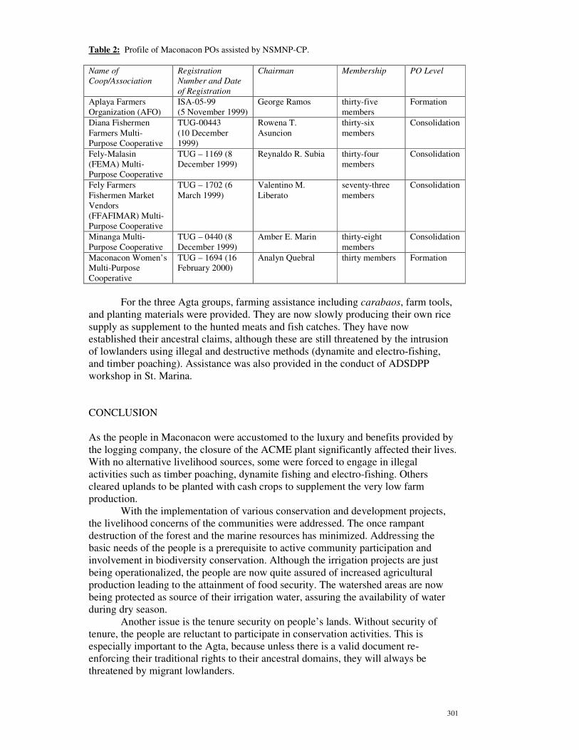
301
Table 2: Profile of Maconacon POs assisted by NSMNP-CP. Name of
Coop/Association
Registration
Number and Date
of Registration
Chairman Membership PO Level
Aplaya Farmers Organization (AFO)
ISA-05-99 (5 November 1999)
George Ramos thirty-five members
Formation
Diana Fishermen Farmers Multi-Purpose Cooperative
TUG-00443 (10 December 1999)
Rowena T. Asuncion
thirty-six members
Consolidation
Fely-Malasin (FEMA) Multi-Purpose Cooperative
TUG – 1169 (8 December 1999)
Reynaldo R. Subia thirty-four members
Consolidation
Fely Farmers Fishermen Market Vendors (FFAFIMAR) Multi-Purpose Cooperative
TUG – 1702 (6 March 1999)
Valentino M. Liberato
seventy-three members
Consolidation
Minanga Multi-Purpose Cooperative
TUG – 0440 (8 December 1999)
Amber E. Marin thirty-eight members
Consolidation
Maconacon Women’s Multi-Purpose Cooperative
TUG – 1694 (16 February 2000)
Analyn Quebral thirty members Formation
For the three Agta groups, farming assistance including carabaos, farm tools,
and planting materials were provided. They are now slowly producing their own rice supply as supplement to the hunted meats and fish catches. They have now established their ancestral claims, although these are still threatened by the intrusion of lowlanders using illegal and destructive methods (dynamite and electro-fishing, and timber poaching). Assistance was also provided in the conduct of ADSDPP workshop in St. Marina. CONCLUSION As the people in Maconacon were accustomed to the luxury and benefits provided by the logging company, the closure of the ACME plant significantly affected their lives. With no alternative livelihood sources, some were forced to engage in illegal activities such as timber poaching, dynamite fishing and electro-fishing. Others cleared uplands to be planted with cash crops to supplement the very low farm production.
With the implementation of various conservation and development projects, the livelihood concerns of the communities were addressed. The once rampant destruction of the forest and the marine resources has minimized. Addressing the basic needs of the people is a prerequisite to active community participation and involvement in biodiversity conservation. Although the irrigation projects are just being operationalized, the people are now quite assured of increased agricultural production leading to the attainment of food security. The watershed areas are now being protected as source of their irrigation water, assuring the availability of water during dry season.
Another issue is the tenure security on people’s lands. Without security of tenure, the people are reluctant to participate in conservation activities. This is especially important to the Agta, because unless there is a valid document re-enforcing their traditional rights to their ancestral domains, they will always be threatened by migrant lowlanders.

302
The municipality has undergone a shift from resource exploitation (logging) to community-based biodiversity conservation. The forestlands are now regenerating, as the natural ecological processes are again taking place. Development activities should really be integrated with conservation activities to ensure that the life-supporting Sierra Madre Mountain Range shall be passed to countless generations. REFERENCES Magaña, D. S. 2000. Final anthropological report on the Agta in the NSMNP. Plan Philippines NSMNP-CP, Cabagan. Van Lavieren, H. 2000. Marine survey report of the NSMNP; Options for the
management of marine resources and habitat. Plan Philippines NSMNP-CP, Cabagan.

303
CHAPTER TWENTY-FOUR INTERVENTIONS IN NON-TIMBER PRODUCTS SECTOR, SUCCESS OR DEADLOCK? THE CASE STUDY OF RATTAN IN CAMEROON
Louis Defo ABSTRACT Rattan is one of the non-timber forest products (NTFP), which received wide attention in Cameroon. The value and potential role of this resource for biodiversity and local livelihoods led to numerous interventions in the NTFP sector from NGOs, government, religious bodies and other organizations. However, the direct support from donors is declining, as the achievements of interventions are disappointing. These poor results are due to many factors: (1) inadequate approaches and methods of interventions, (2) lack of sufficient knowledge of the context, (3) bad identification of local partners, and (4) lack of co-ordination or collaboration amongst the supporting actors. Thus, despite the outside support and interventions, the rattan sector in Cameroon is not yet embarked on great positive changes. INTRODUCTION The interest for NTFP of tropical regions in the early 1990s was materialized throughout the World by numerous project interventions in several countries. Due to the importance of its forest resources, Cameroon was among the first African countries to experience this phenomenon. The rattan sector was one of the fields of concern of this rush towards the development and conservation NTFP in this country. Indeed, from the mid 1990s, the rattan sector witnessed the interventions of several NGOs, religious institutions, research and conservation programs and integrated conservation and development projects. Unfortunately, many of these projects seem to have poor results up to now.
The aim of this paper is to quickly present and evaluate the various projects in the rattan sector of Cameroon in order to develop more accurate, effective and efficient interventions. The first part of the paper is a short overview of the rattan sector in Cameroon. The second part examines the interventions and the attempts. Finally, we critically review the results achieved hitherto. THE RATTAN SECTOR IN CAMEROON Rattan, a significant example of NTFP with many assets Of the hundreds non-timber forest resource used in Cameroon (van Dijk 1999), rattan is a very representative NTFP by some of its characteristics, namely: (1) large species diversity, (2) well known habitat and ecology, (3) wide distribution, (3) production based exclusively on the wild, and (4) production oriented both to personal needs and market. Considering these characteristics and many other factors, one can say after Belcher (1997; 1999) that rattan is “a good model NTFP”. Rattan is not only a good example of these resources, but also a reference NTFP and one of the most important resources among these forest products. The economic, social and cultural role of rattan ranks it at the top of important NTFP in Cameroon (Debroux & Dethier 1993;

304
MINEF 1995; Tsagué 1995; Abwe 1999; Defo 1997; Defo 1998; Defo 1999; Sonné 2001). Rattan has many remarkable assets:
1. The raw material is relatively abundant and accessible in Southern Cameroon. 2. Rattan processing is a traditional activity in many forest areas in Cameroon.
3. There are no huge cultural, technical or financial barriers to start and run a
rattan processing business.
4. Rattan finished products are in large demand both at the national and international level.
5. Rattan production has a great potential in terms of employment, income and
export earning. Taking into consideration these assets, it is not surprisingly that the rattan sector derived considerable support from many organizations, institutions and agencies. The production to consumption system of the rattan sector in Cameroon
Cameroon has about eighteen species of rattan (Sunderland 2001), but Laccosperma
secundiflorum, Eremospatha macrocarpa and Eremospatha wendlandiana have great commercial value. Rattan production in Cameroon is exclusively based on the wild source. The raw material is almost always collected from State forests. The government has allowed the local population the “droit d’usage” (the right to collect certain NTFP for personal consumption), but has regulated the commercial collection and transport of rattan. Collectors are required to pay taxes to the government (Republique du Cameroun 1994). However, these rules and regulations are often not respected, which leads to over exploitation in some areas. The rattan commercial channel in Cameroon is very simple. As Figure 2 shows, the main participants in the channel are the harvesters, the buyers or sellers of the raw cane, the artisans, the traders or retailers, and the consumers of the finished products. The gatherers are of different categories and all of them work for themselves (they don’t have a boss). Their only working tool is a bolo. After identifying a mature cane stem in the forest, the harvesters cut it, take out the leaves, clean the stem, tie the rattan in bundles and carry it either to the village processing. The cane processing undergoes the following stages: (1) cleaning and removal of the skin; (2) drying of rattan in open air; (3) sizing, splitting and stripping; (4) bending; and (5) cutting or crosscutting. After these processing steps, the artisan manufactures the finished products by doing the following tasks: (1) construction of the skeleton, (2) tying, (3) weaving, and (4) polishing. Tools used are small knives, blowtorch, hammer, tape, brush and file. The finished products are usually sold in the domestic market. Very few of these products are sold for utilization abroad. The rattan sector in Cameroon is facing many problems. The major bottlenecks and constraints are: (1) the unsustainable harvesting of rattan, (2) irregular cane supply, (3) lack of proper storage facilities, (4) lack of appropriate working tools, (5) harassments by officials and widespread corruption, (6) lack of appropriate techniques for rattan preparation, (7) wasting of raw material, (8) lack of sufficient capital or credit facilities, (9) insufficient technical skills and poor management, (10) low quality outputs, (11) insufficient design innovation, (12) low demand, and (13) lack of an appropriate policy and regulatory framework. Project interventions have

305
aimed to overcome these obstacles, in order to offer the sector the possibility of extending its potentials and develop it assets.

306
Figure 1: The Cameroon rattan production to consumption system
Main steps of the channel Change in ownership/flow from one participant to another
Main participant of the channel Flow/flux without change in ownership (the same participant)
Rattan harvesting (wild sources)
Raw rattan marketing
Rattan processing
Rattan finished products marketing
Part-time harvesters (villagers/ farmers)
Harvesters-manufacturers (villagers working on part-time)
Full-time harvesters (few in number)
Part-time harvesters
Harvesters-manufacturers (mainly villagers)
Raw rattan traders (few in number)
Rattan Manufacturers (mainly townsmen)
Rattan Manufacturers (mainly townsmen)
Harvesters-manufacturers (mainly villagers)
Traders of finished products
Domestic market (urban &rural areas) -households -small businesses -restaurants -etc…
Foreign countries (very small part of the production)

307
OUTSIDE INTERVENTIONS The special assets of rattan (real or imagined) have captured the interests of many NGOs, religious organizations and others outsides supports (See Table 1). The diversity observed at the level of the actors and the identity of the donors necessarily implies a multiplicity of goals for these interventions. NGOs and religious institutions endowed with philanthropic preoccupations have as major objectives to train or finance marginal social actors (unemployed youths, handicapped or sick people, etc.), in order to help them to (re-) integrated in society. The goal is to reduce the dependency of these unfortunate people on the rest of the community, and to give them the means to carry out an income generating activity. The interventions of research and conservation projects are to try to fill the knowledge gaps in the sector. They work to collect and analyze data likely to be used by others actors to promote the sustainable development of the sector. The aim of integrated conservation and development projects is to promote the conservation of forests and wildlife through the development of alternative income generating activities like rattan processing. According to these projects, rattan and other NTFP should produce alternative incomes to hunters and contribute to the well being of the local people.

308
Table 1: Major outside interventions in the rattan sector in Cameroon
Types of the
organization
Organizations and
periods of support
Main
donors
/funding
institutions
Actions in
the rattan
sector
Targets of the
interventions
Geographical
area
concerned
Association Prolabore (APL) 1997 to 2000
Manos Unidas (Spanish NGO)
Training and funding (small credit)
Processing and sale of finished products
Yaoundé town
Community-based Rehabilitation Center (CBR) 1954 to 2002
Cameroon Baptist Convention
Training of artisans, production and sale
Processing & sale of finished products
Mbingo and some divisions of the North-West Province
Rehabilitation Center for Leprosy Patients of Manyemen. 1960s to 1997
Presbyterian Church
Training of artisans, production and sale
Processing & sale of finished products
Manyemen and some divisions of the Southwest Province
Rehabilitation Center for Leprosy Patients of Evindissi. 1960s to 1990s
Presbyterian Church
Training of artisans, production and sale
Processing and sale of finished products
Evindissi area, South Province
NGO and religious organizations
Presbyterian Craft Center (Prescraft) 1970 to 2002
Presbyterian Church
Training of artisans, production and sale
Processing and sale of finished products
Mezam division Northwest Province
African Rattan Research Program (ARRP) 1996 to 2002
INBAR, CARPE, DFID
Research, trials and training
Domestication and processing.
Southwest Province
Program Avenir
des Peuples des
Forêts Tropicales (APFT) 1996 to 2000
European Union
Research Entire commercial channel
Yaoundé area
Research-conservation projects
Limbe Botanic Garden (LBG) 1999
INBAR Research Entire commercial channel
Some regions of Southern Cameroon
ECOFAC Cameroon 1994 to 2000
European Union
Research and training of artisans
Conservation and processing
Dja Reserve area, South and East Provinces
Korup Project. 1998 to 2000
European Union, WWF, GTZ
Training of artisans and small credit
Processing Korup National Park and associated reserves,
Conservation and development projects
Projet Pôle de
Développement
Rural
(PPDR) 1996 to 1998
European Union
Financial support for equipments
Processing and cultivation
Sangmelima area, South Province

309
INBAR: International Network for Rattan and Bamboo; CARPE: Central African Regional Program
for Environment; DFID: British Department for International Development; GTZ: Deutsche
Gezellschaft fur Technische Zusammenarbeit.
A CRITICAL ASSESSMENT OF THE INTERVENTIONS
Achievements of Non-governmental and religious organizations
Between 1997 and 2000, APL trained six young men in the techniques and management needed for a small rattan production workshop, at a total cost of more than US$ 1,500. After this training, APL gave loans to these young men (with a total of US$ 12,000), payable with a very low interest rate (5 percent per year). With this money, each of these young men created a rattan workshop and made it functional.
Between 1954 and 2002, CBR trained more than one hundred handicapped people at its Mbingo rattan workshop. On their part, these artisans trained many other people, and it’s thanks to the CBR that the Bamenda area (Northwest Cameroon) has become today one of the most important regions for rattan processing in the country. CBR also takes care of autonomous artisan groups by providing them with rattan and helping them in the sale of the finished products. The Rehabilitation Center for Leprosy patients of Manyemen and Evindissi worked in this very way between 1960s and mid 1990s. However, the Center closed down for several reasons, the most important being that some Western churches stopped with their financial assistance.
The Presbyterian Craft Center in Bamenda is involved in the rattan sector since the beginning of the 1970s. In the 1990s it increased its support in the rattan channel by creating two training workshops (one in Bali and one in Babanki), and by diversifying its sales network abroad. In 1998, for example, it exported rattan products amounting to almost US$ 8,250 towards Western Europe and USA.
Achievements of research-conservation projects
Between 1996 and 2000, the APFT Programme carried out research on the rattan sector in the Yaoundé region. The LBG did the very same thing in many areas of Southern Cameroon in 1999 and 2000 in collaboration with INBAR. The ARRP did an almost similar exercise in Southern Cameroon. But the ARRP went further with its initiatives by carrying out some base line inventories. ARRP also carried out some studies on the ecology, phenology, botany and taxonomy of many rattan species. ARRP did also rattan domestication and cultivation trials and some training sessions for artisans and harvesters.
Achievements of conservation and/or development projects
In 1996 and 1997, the PPDR gave support to a rattan workshop under the framework of a NGO called PRARAAC. PPDR supplied the workshop with production tools, helped it to construct a new working site, and financed the acquisition of an electrical

310
power supply. This support amounted to US$ 6000 and should have culminated to US$ 15,000 in the years that followed. In return the PRAVRAAC workshop would have developed a commercial rattan processing workshop, trained youths, and cultivated rattan.
The ECOFAC programme put in place a rattan processing training workshop in Somalomo in 1996. In the same year it trained four trainers from the Dja region (and three other from other Central African countries) who will take over and spread the rattan commercial processing in the region. ECOFAC also carried out studies on the taxonomy, ecology, biology and ethnobotany of some rattan species in the region.
The Korup Project did some small research on the rattan in the Korup area. This project also trained nine artisans for a total cost of almost US$ 5000 and awarded them some loans to carry on work and train other people. The assessment of the results Taking into consideration the above-mentioned achievements, one can say with certainty that the project interventions had positive impacts on the rattan sector in Cameroon. But, after a critical reading of the achievements and a look on the objectives of the interventions, one realizes that the results are far below the expectations. Many actors focused their supports on the processing of rattan, and to a certain extent on the domestic marketing of the finished products. Little attention was given to the legal and regulatory framework, the conservation of the resource, the quality of the outputs, and the international market. The interventions were too segmented and lacked coherence; which is important because the commercial exploitation of rattan is before all a channel needing systematic approaches and methods of intervention. These bottlenecks and many other obstacles could have been avoided if there was collaboration between the various actors. Such collaboration could have helped avoiding unnecessary duplication of work. APFT, LBG, and ARRP for example, carried out quite the same socioeconomic studies. The same happened with the research works of ECOFAC and ARRP. There was also no sharing of lessons learned. The PPDR would have been less illusive if it read through ARRP or ECOFAC reports. Korup Project did not learn any lesson from the experience of ECOFAC on the training of trainer artisans. Yet, some of these interventions had the same donors. Donors would have gained a lot by clearly defining the objectives of their financial support, by adequately following up the interventions, and by effectively coordinating the funded projects in the field. This lack of coherence, the duplication, and the failure to take into account the past experiences led to an enormous waste of money.
Disengagement is unfortunately the general response of the donors to these findings. Presently, more than 70 percent of the above mentioned funds have already disappeared. In some cases, the supporting actors still function but have excluded the development of the rattan sector from their field of action. Now only CBR, Prescraft and ARRP are going on with their programs. The rattan sector has then experienced a quantitative and qualitative reduction of the financial and institutional support. This

311
withdrawal can be interpreted as a clear indicator of the disappointment of the donors. The results simply have not been up to the expectations:
1. 50 percent of the artisans trained by APL have already abandoned the rattan
activity because of the business failure and presently the rate of the refunding loans hardly goes beyond 10 percent.
2. Within 2 years of interventions, the PPDR realized that the PRAVRAAC was
only “a fake NGO”. The PRAVRAAC workshop had not trained any real artisans, and was far from producing regularly. In short, it could not develop a genuine pole of rattan. This intervention instead brought about false hopes, and activated egoistic and ethnic tensions amongst the artisans of Sangmelima.
3. Looking at the cases of ECOFAC and Korup Project, the rattan processing in
the concerned regions has almost not evolved positively, because the relay artisans/trainers artisans didn’t do their work of trainers. So, the rattan is far from contributing to the conservation and development in the Dja and Korup regions.
4. The works of APFT and LBG are until now confined to the level of research
reports, whereas these reports were clearly intended to be applied, or to be used for the development of the sector in a short term.
5. ARRP is making some progress in the field, but runs a risk of having positive impacts far bellow expectations.
The failures merely find their origin in:
1. The disregard of the social, economic and political context of interventions: For example, if ECOFAC and the Korup Project had carried out feasibility studies, they would have noticed that the rattan processing in Dja and Korup areas was not economically profitable; this because of the small size of the local consumption market and poor competitiveness. More over, it’s not easy for an artisan from these regions to have access to big consumption markets.
2. The poor identification of local partners: The PPDR, for example, would
have noticed from the beginning that the PRAVRAAC was not credible, if it had been interested in the local integration of this NGO, in its efficacy, in the way and level of participation of the local artisans in this organization, and in its power structure and decisions making processes. The ARRP shows the same weakness at the level of the choice of the relay persons it invites to its training sessions.
3. Weaknesses at the level of training: One can note that the local constraints are not sufficiently taken into account at the level of the conception and implementation of the trainings, and also at the level of post-training

312
procedures. For APL, ECOFAC, Korup Project and ARRP, one can note the absence of a genuine requirement of training, taking into account elements like the knowledge of the local context, the definition and planning of the training, the follow-up of post-training activities, the transmission of the knowledge received, and the capitalization of the lessons learned. One should also note the lack of conditions favorable to a real acquisition of skills and to the development of the abilities of self-learning and improvement. For example, the training sessions were too short, the trainers were not up to the task, and there was lack of didactic materials in many cases.
4. Some of the people in charge of the implementation process were haunted by
the achievement of concrete results in short terms (no doubt to make the donors and other partners happy) no matter their real qualities. This seems in the precipitation of certain actions, in the absence of rigorous planning, and in the figurative scenes and apparent adhesions. This has made certain donors to recommend that actions should be focused on process development.
5. The ignorance of the domain of intervention, the negligence to post-training
in some cases, and the lack of convergence of interests among the beneficiaries of the supports on one hand and the supporting organizations on the other. For example, ECOFAC lost interest in the trained artisan after the training session (taking for granted the spread of the acquired skills and knowledge) Another example to be noted here is the fact that in the case of Korup Project, the trained artisans saw the money given to them by the Project more as a gift than as a debt to be paid back.
6. The failure to established closed and accurate relationship between the final
aims and the actions carried out on the field CONCLUSION The development of the rattan sector has been the object of concern of several projects and programs in the humid forest zone of Cameroon. This interest is partially the result of the international rush on NTFP in the 1990s. This paper attempts to evaluate these outside interventions and support. Many outside interventions had undeniable positive results, but these achievements are generally far below the expectations. The cases of failure are quite remarkable. In most cases, these failures were due to the approaches and methods of the interventions. The socioeconomic, cultural and institutional context has also hindered these efforts. In spite of these interventions, the rattan sector in Cameroon has not evolved in the sense of modernization and sustainability. The sector hasn’t made any revolutionary changes and it still maintains its main characteristics: exploitation based exclusively on the wild, unsustainable harvesting techniques, poor organization, archaic processing methods and techniques, low quality production, no established export channels, very small quantities of products exported, etc.

313
For the outside interventions to effectively contribute to the sustainable development of the sector it will be necessary to avoid the bottlenecks mentioned. The supporting actors should then need (1) a systematic approach, (2) genuine coordination of their respective efforts, (3) appropriate knowledge of the local context, (4) better ways of identifying local partners, (5) active participation of beneficiaries in all the phases of the intervention, and (6) greater orientation towards the process instead of short term results.

314
REFERENCES Abwe, M.D. 1999. The wealth of forest in Cameroon: Results of the field-testing a
methodology for the valuation of non-timber forest products (NTFPs) in North-west
and South-west Cameroon. CERUT and AIDEnvironment, Limbe, Amsterdam. Belcher, B. 1997. Commercialization of forest products as a tool for sustainable
development: Lessons from the Asian rattan sector. University of Minnesota, Minnesota. Belcher, B. 1999. Constraints and opportunities in rattan production-to-consumption systems in Asia. In Rattan cultivation: Achievements, problems and prospects edited by R. Bacillier & Appanah. CIRAD /FRIM, Kuala Lumpur. Debroux, J. & Dethier, M. 1993. Valorisation des produits secondaires de la forêt dense
humide tropicale (Réserve de faune du DJA, Sud - Cameroun). Faculté Science Agriculture de Gembloux, Gembloux. Defo, L. 1997. La filière des produits forestiers non ligneux . L’exemple du rotin au
Sud-Cameroun. Approvisionnement et transformation : le cas de Yaoundé. Rapport APFT, Yaoundé. Defo, L . 1998. L’exploitation des rotangs dans la proche campagne de Yaoundé. Rapport APFT,Yaoundé. Defo, L. 1999. Rattan or porcupine: benefits and limitations of a high value NWFP for conservation in Yaoundé region of Cameroon. In Non-wood forest products of
Central Africa. Current research issues and prospects for conservation and
development edited by T.C.H. Sunderland, L.E. Clark & P. Vantomme. FAO, Rome. MINEF.1995. Document de politique forestière. Programme d’action forestier
national du Cameroun. MINEF, Yaoundé. République du Cameroun. Loi n°94/01 du 20 janvier 1994 portant régime des forêts,
de la faune et de la pêche. Yaoundé Sonné, N. 2001. Collection and uses of non-timber forest products by local people in
the north-eastern periphery of Campo-Ma’an National Park; South Cameroon. Thesis Wageningen University, Wageningen. Sunderland, T.C.H. 2001. Les resources en rotin et leur utilisation en Afrique Occidentale et Centrale. In Unasylva 205, Vol.52. Tsagué, A.1995. Etude de la filière des produits de cueillette du prélèvement à la
première commercialisation. API Dimako. Dimako.

315
Van Dijk, J.F.W. 1999. An assessment of non-wood forest product resources for the development of sustainable commercial extraction. In Non-wood forest products of
Central Africa. Current research issues and prospects for conservation and
development edited by T.C.H. Sunderland, L.E. Clark & P. Vantomme. FAO, Rome.

316
CHAPTER TWENTY-FIVE ECOTOURISM IN THE NORTHERN SIERRA MADRE NATURAL PARK: POTENTIALS AND REALITIES
Sophie Elixhauser, Denyse Snelder, Tessa Minter & Gerard Persoon ABSTRACT In this paper we would like to discuss the potential of the Northern Sierra Madre Natural Park (NSMNP) to attract tourists of various kinds. By Philippine standards, there can be no doubt that the NSMNP has a lot to offer in terms of biodiversity and in particular its wildlife. But there are also fascinating varieties of landscapes and numerous other attractions inside the park such as the small islands off the east coast. Among the staff members of the regional tourist board, the management of the National Park, and also among many politicians ecotourism is often discussed. There are high hopes that in the near future the region will attract both domestic as well as foreign visitors. The income that is expected from this flow of visitors would be an interesting source of money for local communities as well as for the region. It will make up for the losses as a result of the restrictions on resource use imposed upon the local people because of the protected status of the area. The aim of the paper is to make a qualitative assessment of the expectations based on a recent inventory of the perceptions about this subject among the key players in the region. By means of comparison we want to discuss the trends in ecotourism development in two others sites in Southeast Asia that have similar characteristics. The sites are the Khao Phra Thaew Wildlife Park on Phuket Island in Thailand and the Siberut National Park in Indonesia. The comparison will largely serve as a way to identify the crucial factors that will determine the attractiveness of the area, the organizational structure of the tourism sector, and the way money flows within this sector. Among the factors that will be discussed are: main attractions and the type of tourists that are expected to visit the area, quality of tourist facilities, accessibility, sustainability of the ecotourism in terms of its environmental and social impact. INTRODUCTION The industry of eco-tourism and the closely related ethno-tourism is growing fast, due to a new interest and appreciation of unspoiled nature and unfamiliar indigenous cultures. This interest is largely an offshoot of the wave of environmental awareness in the West and is facilitated by increased wealth, spare time and mobility. The number of tourists who travel to the outer boundaries of modern society to see nature in its pristine form and make contact with traditional cultures is growing every year. Urbanites from elite circles of capital cities form in many cases the first wave of “nature lovers”. In most cases, such encounters take place against a backdrop of spectacular mountain ranges, at the desert’s edge, on remote islands or in tropical forests. In Southeast Asia, Western tourists go to see the Dani in the Baliem Valley

317
of West-Papua; they want to experience the “heart of Borneo” and meet the Dayak communities in Kalimantan; they are bound to be impressed by the Ifugao rice terraces in Northwest Luzon and they want to follow the mountain tracks together with the colorful hill tribes in Thailand and Vietnam. Views on eco-tourism and particularly on tropical areas inhabited by indigenous people differ widely. Nature conservationists often reiterate that tourism is one of the few ways to make nature conservation economically attractive. Through the motto “use it, or loose it!” some conservationists argue for promoting tourism in protected areas. After all, well-organized tourism in protected areas can be one of the safest and most controllable means of generating much –needed revenues. In this way nature conservation can be “sold” to critics who see protected areas as a useless form of land tenure. Paragraphs on eco-tourism are to be found in all management plans for protected areas and nationals parks. Often, optimistic calculations are made on the projected revenues: in addition to the earnings made from increased numbers of visitors, there will also be new employment opportunities. These projections serve to generate political support for nature conservation efforts. In a number of cases these projections do materialize. In particular some African countries, like Kenya, Cameroon and Rwanda with large animals that can be observed relatively easily have been successful in turning eco-tourism into a highly profitable business. In Nepal, the Himalayan parks also attract large numbers of tourists who bring in substantial amounts of money. This not only pays for some nature protection but it is also an important source of income for local communities. In some cases hunting is accepted as an additional source of income to finance costs for nature conservation. In addition, there are also marine parks that can be managed on a profitable basis. Examples are to be found in the Caribbean, the Philippines and Australia.
Inspired by these examples, planners of new parks work hard to attract tourists and thereby generate political support for nature conservation. It is clear, however, that many parks will never be able to achieve this amount of financial success because of the location of the area, lack of spectacular animals or sites, lack of interesting looking people, insufficient infrastructure or because of socio-political considerations, like political unrest.
The rapid growth of the sector and some widely published cases on mismanagement and negative social and environmental impacts have generated general awareness that explicit thought ought to be given to the sustainability of ecotourism. Within the framework of the Convention on Biological Diversity (CBD) proposals have been made to address various aspects of the sustainability of eco-tourism. Numerous case studies have also been made available that should provide inspiration for park planners but that at the same time should make them projections in a more realistic way.
In this paper, we would like to discuss the potential of the Sierra Madre Natural Park (Northeast Luzon) to attract tourists. By Philippine standards, there can be no doubt that the area has a lot to offer in terms of biodiversity and in particular its wildlife (Libosada 1998: 123). There are also fascinating varieties of landscapes and numerous other attractions inside the park and on the small islands off the east coast. There are high hopes that in the near future the region will attract foreign as well as domestic visitors. The aim of this paper is to make a realistic assessment of

318
these expectations based on a recent inventory of the perceptions among the key players in the region. By means of comparison we want to discuss the trends in ecotourism in two other sites in Southeast Asia that have similar characteristics. The sites are the Khao Phra Thaew Non-Hunting Area on Phuket Island (Thailand) and the Siberut National Park (Indonesia). The comparison will largely serve as a way to identify the crucial factors that will determine the attractiveness of the area, the organizational structure of the tourist sector and the way the money will flow within the sector. GUIDELINES FOR SUSTAINABLE TOURISM At its fourth meeting in 1999, the Conference of the Parties (CoP) associated with the CBD decided to consider “sustainable use of biological resources, including tourism” as one of the three themes for in-depth consideration at its fifth meeting. A note was prepared discussing, the economic importance of tourism together with the potential impacts of this industry on biological diversity. The impact of tourism activities on different ecosystems, including both natural and also socio-economic environments, was reviewed. In this process, the potential benefits of tourism for the conservation of biological diversity and the sustainable use of its components were taken into account. In 2000, the CBD accepted an invitation to participate on an international programme and contribute to the development of a set of international guidelines for sustainable tourism development in vulnerable ecosystems. The CBD Secretariat organized an “International Workshop on Biological Diversity and Tourism” in Santo Domingo in June 2001. The workshop produced the “Draft International Guidelines for Activities related to Sustainable Tourism Development in Vulnerable Terrestrial, Marine and Coastal Ecosystems and Habitats of Major Importance for Biological Diversity and Protected Areas” (UNEP/CBD 2001). The guidelines have been forwarded to the World Ecotourism Summit and its preparatory meetings. The CBD guidelines focus on “making tourism and biodiversity more mutually supportive, engaging the private sector and local and indigenous communities, and promoting infrastructure and land-use planning based on the principles of conservation and sustainable use of biodiversity” (UNEP/CBD 2001). To be sustainable, the CBD supports the idea that tourism should be managed within the carrying capacity and limits of acceptable change for ecosystems. Moreover, it is stressed that tourism activities should contribute to the conservation of biodiversity and be restricted, and where necessary prevented, in ecologically sensitive areas. The CBD further advises that government agencies, private firms and other proponents of tourism projects and activities be required to submit proposals through a formal notification process. Once all required project information is submitted with a timely advance notice to relevant authorities and stakeholders, including local and indigenous communities, for comments, the project will be reviewed and approved or rejected. In order to follow up such advise, the CBD guidelines launch a ten-step management process to assist governments in their role as initiators and managers of

319
sustainable tourist projects and developers of policies on sustainable tourism in vulnerable ecosystems:
1. Gather baseline information, including data on socio-economic and environmental conditions (collected from the full range of stakeholders and on basis of ecosystem approach), trends within the tourism industry and their effects on local communities, sites of particular cultural or environmental biodiversity importance, action plans and reports on biodiversity and sustainable development.
2. Develop an overall vision, including a long-term vision for sustainable
development with a set of economic, social and environmental goals, targets or standards in land-use zoning, ecosystem functioning, poverty alleviation, biodiversity conservation and sustainable use and community participation.
3. Set specific objectives, especially shorter-term objectives with clear targets
and timetables ensuring that tourism development has acceptable environmental impacts while meeting real market demand.
4. Review legislation and controls, including measures for land-use planning,
environmental assessment, building regulations, and tourism standards, licensing procedures for tourist development, incentives for sustainable tourism and economic instruments for the management of tourism and biodiversity.
5. Assess the potential environmental, socio-economic and cultural impacts of
new projects, involving indigenous and local communities.
6. Manage the environmental impacts, within the carrying capacity and limits of each ecosystem and site (behavior controls, traffic flow, safeguards for the most sensitive areas, limitations on numbers of visitors, etc.).
7. Ensure decision-making is transparent and accountable, by consulting and
involving all stakeholders, the establishment of formal legal mechanisms for approving tourism development proposals, and monitor compliance with agreed conditions.
8. Implement the decision, whereby the project developer will be responsible for
complying with all the conditions set and must notify the designated authority of any changes and failures to do so.
9. Monitor impacts and compliance, by a periodic monitoring and reporting
system.

320
10. Pursue adaptive management, by accepting “learning-by-doing” needs and adjustments brought forward by active cooperation and close interaction of tourism and biodiversity managers.
THREE PROTECTED AREAS The Northern Sierra Madre Natural Park (The Philippines) In the Cagayan Valley, there is a lot of optimism with regards to the eco-tourism potential of the NSMNP. At this moment, few visitors visit the area. The park is not easily accessible and there are almost no tourist facilities. However, the park management, the Department for Tourism (DOT) and the Local Governments Units (LGU) have high hopes on the future of ecotourism in this area. They believe that it will generate income for the local communities and funds for the protection of the park. The inhabitants of the park are also very positive about tourism development and expect new job opportunities. The NSMNP is a relatively new protected area and has been established in 1997. It consists of an area of 359,486 hectares covering the northern part of the Sierra Madre Mountain Range. Ninety percent of the park is covered by forest, including lowland evergreen forest and mossy forest, ultra basic forest, limestone forest, beach forest and mangrove forest along the coast (Araño & Persoon 1997; Van den Top 1998). The eastern part of the mountain range falls down to the seaside that is characterized by white sand beaches, rock formations and several small islands. The area shows a high biological diversity, with sixty percent of the Philippine species diversity present here. Wildlife includes monkeys, wild pigs, lizards, Philippine crocodile, flying fox and Philippine eagle, and many other rare and endemic bird species. The number of inhabitants in the park is around twenty-one thousand, including the original Negrito population, the Dumagat or Agta. The majority of the inhabitants are, however, migrants from other parts of the country who have come in the wake of logging operations. They are outnumbering the indigenous people. Since the large logging companies left the area, they are mainly occupied with farming. The people live quite isolated in the park; infrastructure is poorly developed and there is no road that connects the coastal area with the Cagayan Valley. The people mainly live on the extraction of forest resources and agriculture.
The Department of Environment and Natural Resources (DENR) and the Protected Area Management Board (PAMB) jointly manage the NSMNP. The PAMB consists of representatives of all stakeholders in the protected area. The environmentally concerned stakeholders support ecotourism as an instrument for nature protection. It is hoped that ecotourism can be an alternative source of income for the inhabitants of the park in order to reduce the dependency on forest resources and illegal logging. The only tourist facility so far is a small resort in the coastal area of the park, which is owned by a local politician. Since community consultation prior to its

321
establishment had not taken place and the local community is hardly involved in running the business, the resort has not been of much benefit to the villagers so far. Yet, there are various efforts to promote tourism in the Northern Sierra Madre. Local governments contacted a few journalists that are now helping to promote the area. During the last years several articles about the NSMNP and its potential for tourism have been published in Philippine newspapers. Some tour operators have expressed their interest but so far no concrete plans have been put forward. The DOT has developed the National Ecotourism Strategy for the Philippines, in which the NSMNP is identified as one of the 64 emerging and potential ecotourism sites in the country. Also the president of the Philippines recently visited the region and called for tourism development in and around the NSMNP. The government especially wants to promote new tourism spots in the northern part of the country since tourists shy away from visiting the South because off terrorist activities. Going down to the local level and asking community members about their expectations and perception on ecotourism development, one again encounters almost exclusively positive reactions. Development, money and infrastructure are the key words in their motivations. The few outsiders coming to the area usually have money and they leave an impression of a wealthy and modern outside world. Through tourism the local people expect that their own standard of living will be changed to that direction.
One precondition for ecotourism development is, of course, getting the attention of tourists. Why would tourists come to this area? Within ecotourism one can distinguish various categories of tourists. In the first place, there are the nature lovers, who are especially interested in wildlife and pristine landscapes. In the second place, there are tourists who are attracted by the outlook and the life style of indigenous cultural communities in a natural environment. Finally, there is the group of adventure travelers who seek new areas for tracking, diving and other kinds of challenges in rough, wild environments. For the nature lovers, the Northern Sierra Madre offers a high variety of flora and fauna; especially for bird watching there are good possibilities. For example, it is one of the areas in the country where the Philippine eagle could be spotted. Another rare animal is the flying fox, which can be found in large colonies in coastal areas (Van Weerd 2001). The Philippine crocodile has just been rediscovered in the park, and the first community-based crocodile sanctuary has been established. The community hopes that the sanctuary forms an attraction for visitors in the near future (Van Weerd 2002). Educational purposes could be another main reason for ecotourists to visit the area. Educational trails could serve as an object for students and researchers. Various kinds of forest habitats could be visited, such as the sixteen-hectare biodiversity plot that has been established in the park area, in combination with explanation by forest experts. Conservation International (CI) has a visitors’ house near this plot and hopes to establish an educational trail. For tourists interested in physical challenges, there are ample opportunities for hiking and tracking, wild water rafting, exploring caves, and several kinds of water sports. The Aguinaldo trail, a fifty-four kilometer long path crossing the park in West-East direction, is a real adventure. However, for tourists interested in

322
colorful tribal communities, the area has not much to offer. The Dumagat or Agta bands are interesting in themselves, but they do not allow for large numbers of visitors because of their mobile life style, the lack of elaborate rituals and material culture. Moreover, some critics in the area are concerned that negative effects of tourism (social and cultural disruption, inappropriate behavior of tourists) on Agta culture and livelihood will outweigh the benefits. A previous pilot project on tourism in the area failed because of miscommunication between Agta and the project management (Elixhauser 2002)
Khao Phra Thaew Non-Hunting Area, Phuket Island (Thailand)
The Khao Phra Thaew Non-Hunting Area (KPT) is a small, protected area situated in the Northeast of Phuket Island, southern Thailand. The park comprises the last 2,228 ha of rain forest that allegedly once cloaked the entire island. Phuket’s environment has severely suffered from environmental degradation due to three main economic activities. First, since the mid-eighteenth century, large-scale mining operations have left their traces both in Phuket’s forests as well as along its coastline. Second, from the early twentieth century a great number of rubber plantations have replaced vast tracts of rain forest. Lastly, since the mid-seventies the tourism business has become Phuket’s primary source of income. Especially in the course of the 1980s, the rapidly growing industry was accompanied by intensive road construction, again impacting the island’s fragile environment (Ebsen 2000; Cohen 1996). Thus, in 1977 KPT was established as a non-hunting area in order to protect Phuket’s last rainforest from further degradation. Since that time it has been managed by the Royal Forest Department (RFD).
KPT is often said to be an island on an island, as the hilly forest patch is completely surrounded by roads, villages and agricultural plantations. The park is being heavily encroached upon by farmers converting forest land into fruit gardens, which, in 2000, were actually taking up almost twenty-five percent of the park’s total land surface (Minter 2001). Most of KPT’s remaining forest is of dense, though secondary nature. The only primary forest is to be found on the steepest hillsides. The number of birds and wildlife residing in the park is estimated to be relatively low, due to decades of over-exploitation. Hornbills, tigers and white-handed gibbons (hylobates lar) are species that used to roam the forest, but that have not been seen over the past decades. The only ecological attraction of the area consists of the White Backed, or Dransfield palm (Kerriodoxa elegans). This palm is endemic to the area and is especially abundant in a valley on the west side of the park. Regarding other ecological functions, KPT serves as watershed to the villages on the east side of the park, providing irrigation and drinking water year-through.
KPT has two main entrances, one at the east and one at the west side. The park can be easily reached by car or motorcycle; using public transport is less convenient. As of July 2000, no entry fees were charged. There were demands from RFD Headquarters in Bangkok however, to start requesting low entry fees, charging foreigners more than residents. Yet, RFD Phuket was not eager to implement this policy, as it feared it would reduce the appeal of the park.

323
Annually, some 60,000 people, both Thai and foreigners, visit KPT. They come year through, regardless of the season. The foreign visitors are mostly enjoying a beach holiday in one of Phuket’s west-coast resorts, and, for a change, decide to explore the island’s interior. Many of the foreign tourists who come to KPT individually are informed on the existence of the park through their hotels, tour-agencies, promotion by the Tourism Authority Thailand, or by individual tour guides. The latter regularly pay forty percent commission to their travel agencies.
Both park entrances are provided with small restaurants and food stalls, which are privately owned by local people who are in this way gaining an (additional) income. The park is further supplied with rather good sanitary facilities as well as basic guest accommodation for potential overnight visitors. This accommodation, however, is hardly ever used as most visitors are coming on a day-trip. At the west side of the park, a large visitors center is operative, providing information on request, mostly to high school students.
Nature lovers particularly visit the KPT. Its primary attractions are the Bang Pae and Ton Sai waterfalls. Although these are most spectacular during the monsoon season (May through November), they are being visited throughout the year. Both Thai and foreign visitors seek refreshment by the cool waterfalls. Especially Thai visitors also use the area to enjoy a picnic or a drinking session. Unfortunately, this results time and again in huge piles of litter. The RFD has so far not been actively addressing this problem.
A second important attraction is the Gibbon Rehabilitation Project (GRP). The GRP is situated on a steep hillside just past the park’s entrance at Bang Pae. The NGO was initiated by an American conservationist in 1992 and aims to rehabilitate and release captive gibbons in both KPT non-hunting area as well as on small islands in Phuket’s eastern bay. The ca. 50 white-handed gibbons that are present in the project have partly been donated by individuals keeping the apes as pets, and partly they have been brought in by the police who confiscate the gibbons from animal keepers exploiting them as tourist attraction at Phuket’s beach resorts. Apart from its (so far unsuccessful) attempts at rehabilitation and reintroduction of the gibbons, the GRP also provides environmental education to visitors. Information tours are given in both Thai and a number of foreign languages. Thai staff-members and foreign volunteers are present seven days a week to welcome visitors and show them around, while giving them an extensive information talk on both the aims of the project and the factors that cause the gibbon’s threatened status in the wild. No entree fee is charged, the GRP only asks for donations. Both Thais and foreigners intensively visit the project. The GRP is also highly promoted by tour agencies and hotels.
Most foreign visitors to KPT’s waterfalls and the GRP come in through either Siam Safari or Sun Nature Tours. These tour agents bring in large groups of visitors at a time, either by jeep or by touring car. Standard trips involve a guided tour around the GRP and a walk up to the waterfall. Both companies maintain they offer eco-tourism trips and their management plans sound promising on this point. In 1998, for example, Siam Safari wrote their aim is to:
“Create and run a sustainable business which organizes and operates eco-tours for people who want to enjoy and learn about the natural and social

324
environment of southern Thailand. This must be combined with direct economic benefits for local communities and active conservation of the areas visited.” (Griefenberg 1999)
However, in reality the activities organized by above mentioned companies cannot be labeled as eco-tourism. Groups of over 50 people walk up and down to Bang Pae waterfall, not receiving any information on what they see or hear. On the rare occasion that they cross the forest, groups are equally big and not accompanied by guides. This causes serious disturbance and pollution. The RFD acknowledges the problem, but feels it cannot afford to address the tour companies on this issue, even though the latter are officially only allowed to operate in KPT provided that they commit themselves to environmentally sound practices. As far as direct benefits to local communities are concerned, these are limited to the money that is earned at the restaurants on both sides of the non-hunting area. Guides generally do not belong to local communities, but instead mostly come from the Phuket town area or even from the mainland. As such, no active contribution to the conservation of KPT is made; even more so, it is likely that the non-hunting area actually suffers from this kind of mass tourism.
A third, potential attraction for both nature lovers and adventure tourists is the forest itself. However, up till now, only a very limited group of visitors makes it beyond the GRP and the waterfalls. Hardly any of these visitors cross the forest by themselves (the trail is not very well marked), instead they book a trip through Touch
the Local. This one-man business was set up four years ago by a marine biologist from Bangkok and operates from the town of Chalong in southern Phuket. Touch the
Local offers half-day treks from Ton Sai waterfall to Bang Pae waterfall for US$ 15, including lunch and snacks as well as a visit to the GRP. Groups are never bigger than eight people. The manager himself usually guides the trek, although in busy times he calls in the assistance of his brother. Both guides are very knowledgeable and provide the hikers with information all through the trek. The director has rather downright ideas on what forest conservation and eco-tourism should look like. For example, his customers are urgently asked to speak at low voice, to keep the area clean, and dress in unobtrusive colors. Furthermore, it annoys him that the RFD allows large groups to enter the non-hunting area. He complains of the noise this causes and of how this makes it even harder to spot the already rare wildlife. Siberut National Park (Indonesia) Siberut, a tropical island off the west coast of Sumatra and part of Mentawai Archipelago is covered with lowland rainforest and inhabited by a unique people with a remarkable material culture. This combination has stimulated the interest of many travelers. For a long time voyagers and civil servants in the Dutch colonial period were attracted by the island culture and lush tropical environment, so distinctly different from neighboring areas.
325
In their writings, various authors expressed their admiration for the people of the Mentawaian islands. Sir Stamford Raffles for instance, who was appointed Lieutenant-Governor for Bengkulu wrote in 1824 a statement that is often quoted:
“I was inclined to write a book to prove that the people of Nias were the happiest and best people on earth. Now however I have made the discovery, that the population of the Nassau- and Poggie Islands (Sipora and Pagai) are even more friendly and possibly less spoiled” (BRMG 1901: 33).
Maass (1902), writing many decades later, also expressed himself in similar terms. His book titled, Bei liebenswürdigen Wilden (With the amiable Savages) describes the Mentawaians as an exotic primitive group of people. Every article detailed the elaborate Mentawai religious life and ceremonies. Photographs accompanying these articles or books all showed flower- and bead-bedecked, friendly, smiling people with tattoos, often posing for the photographer. Favorite images of the landscape are beaches with bending palms, bird's eye views of the tropical rainforest mysteriously looking in the early morning mist, or views of a scenic river with crystal-clear water surrounded by dense vegetation. Photographs taken on Siberut have changed little over the years; they still promote an image of an island left untouched by modern times. Nature conservation on the island did not start until the late 1970s. At that time WWF started what it called “the battle for Siberut”. The entire island was granted to logging companies, which also threatened the population in their forest-based existence. The main argument for WWF was the presence of four endemic primate species. In 1982 a small park of 56,000 ha was declared. Logging, however, continued and the Indonesian nature conservation agency was hardly in a position to fight the companies due to a lack of bureaucratic and other “weapons”. The island however maintained the interest of numerous foreign organizations and individuals committed to “save the island and its people” from outside forces. Towards the end of the 1980s, when communication to the island was improved, and enterprising individuals started to attract western visitors “to a tropical paradise where Stone Age culture still survives”, the situation started to change. Eco- and ethno-tourism became a new business. The combination of an isolated tropical island with white beaches, coral reefs, thick forests and a colorful population was an unexpected surprise to many tourists on their travels through the mainland of Sumatra. Supported by this new interest, the Suharto regime cancelled the logging concessions in 1992 and the Asian Development Bank (ADB) started its Indonesia Biodiversity Programme on the island with a multi-million dollar project. The reserve area was extended to 192,000 ha and the log ban was fully implemented. Plans for palm oil plantation and transmigrations were cancelled at the same time. Government agencies, tour operators and the local people were embarking on a new adventure: receiving western tourists, guiding them over this unique islands and efforts were made to promote the marketing of handicrafts and primitive art. Small hotels were built and local guides were trained. In the management plans for the park, eco-tourism was a big issue. It would generate money and cultural pride among people who were always condemned as “primitive pagans”. An enormous head quarter office for the park including a visitors’ center was built on the island.

326
The majority of tourists are young western backpackers with limited amounts of money to spend. They want to experience “real life with Stone Age people”, including the tattooing of their bodies, hunting and jungle trekking. A large number of films and books on the traditional people on the island have been instrumental in attracting the attention of potential visitors. Once they arrive on the island they do everything to avoid the official visitors’ center and they also do not want to be confronted with other tourists. This has led to a kind of tourism in small groups traveling through the forest and staying overnight with local people, hoping for an elaborate ritual with trance dances, and medicine men performing their magical curing skills. In some cases tourists return from Siberut with a “life time experience”, but in other cases the trekking through the mud, the fierce and free roaming wild pigs and the lack of any spectacular ceremony bring severe disappointment to the tourists. Since the mid 1990s Australian surfers discovered the waves of the Southern parts of the island as among the best in the world and by now hundreds of sites are to be found on Internet promoting this new frontier among the surfers. The enormous forest fires of 1997 and the political unrest and violence following the end of the Suharto era in 1998, led to rapid decrease in number of tourists visiting the country. Tourism to Siberut as an isolated part of the country declined too and has not recovered since. In the long run it is also doubtful whether tourism to Siberut will ever attract the large number of visitors projected in the management plans for the national park. The main attraction of the island is the people and they will never be able to accommodate large numbers. The available infrastructure, which is still extremely simple, will not attract the “low quantity, high quality” type of tourism. Wildlife is not spectacular enough to attract large numbers of nature lovers. On various parts of Sumatra there are better places to observe wildlife or spectacular landscapes. Surf tourism is unlikely to sustain in the long run. It seems likely that the island will continue to attract small numbers of tourists that will bring some revenues for tour operators and for the “traditional” local people but benefits for nature conservation and the national park itself will remain rather minimal.

327
A COMPARATIVE ANALYSIS OF THE PROTECTED AREAS Table 1 summarizes for each of the three protected areas all factors considered relevant in determining the level of attractiveness for tourism development. Remarkable is that the smallest protected area, KPT, receives the highest number of tourists per year: 60,000 visitors compared to 2,000 to 3,000 visitors for Siberut National Park and less than fifty for the NSMNP. An explanation is in the combined effect of the area’s high accessibility, the relatively short-duration visits, and the nearby beach resorts from where tourists come on one-day trips. This high number of tourists suggests a high level of attractiveness. Yet, the latter is partly weakened by the negative side effects of littering and noise caused by relatively large groups of tourists visiting the attraction sites every day. Following the CBD guidelines, it is questionable whether the environmental impact is managed within the carrying capacity and limits of the park’s ecosystem. Table 1: A comparative summary of the major factors determining the relative attractiveness of the three protected areas: the Northern Sierra Madre National Park in the Philippines, the Khao Phra Thaew Non-Hunting Area in Thailand, and the Siberut National Park in Indonesia. Factors
NSMNP KPT Siberut National
Park
Size of protected area (ha)
359,486 2,228 192,000
Number of tourists per year
< 50 60,000 2000 – 3000
Attractiveness in terms of biodiversity
Rainforest Endemic flora and fauna
Rainforest Gibbon Rehabilitation Center Endemic flora
Rainforest Endemic primates
Attractiveness in terms of people
Indigenous communities but no colorful tribal outfit
No inhabitants Colorful tribal people on isolated island
Quality of tourist facilities
None Basic for sanitary facilities, day trips, easily accessible, visitor’s center
Basic accommodation for stay for couple of days
Side attractions
Islands, beaches, birds, diving, caves, jungle tracking
Jungle tracks, waterfalls Tribal people, surfing, jungle tracking
Ecological sustainability of ecotourism
High High but locally litter problem
High
Economic sustainability of ecotourism
Not applicable High Unstable because of subject to political climate
Organizational structure of tourist sector
Park management (DENR, PAMB, NGOs)
Commercial, private guides, forestry services
Private tour operators, some local guides
Management level Regional / Provincial Provincial Provincial Financial flows within tourist sector
Limited No benefits for protected area; medium benefits for local population
Benefits to private tour operators and some local

328
(restaurants); most benefits to outsiders (hotels, tour operators)
communities
Constraints to ecotourism development
Steep relief Lack of transport Earthquakes Typhoons Political unrest
Language problem with park staff Lack of involvement RFD in eco-tourism activities Lack of benefits to protected area and local population
Lack of transport Forest fires Political unrest Lack of benefits for nature conservation
Present reputation of protected area
Unknown area with safety and transport constraints
Good reputation for the conduct of daily trips
Well-known as adventure travel for at least one week stay
Contrary to KPT, the Siberut National park is not easily accessible and, at times, affected by political unrest. Yet its overall reputation is good, which is evident from relatively high numbers of adventure travelers visiting the area for a one-week stay or more. The attractiveness of this park is mainly associated with its unique and colorful tribal people and the isolated location. A major drawback is that the ecotourism activities do not contribute much to the conservation of biodiversity, and the park’s natural resources in general. Furthermore, ecotourism has often the propensity to view indigenous people as “human zoo”, and the indigenous people themselves often are the least benefiting from the tourists (Persoon & Heuveling van Beck 1998). Financial flows are mostly directed towards commercial agencies and private tour operators rather than “enriching” the park and its local communities.
How does the biggest protected area in the Philippines compare to the Thai and Indonesian examples? The NSMNP is a relatively large protected area with a high biological diversity, both at the species and ecosystem level and with inland and coastal areas, and it forms a habitat for a large number of rare and endemic species. It is therefore expected that both foreign and domestic tourists in search of nature and adventure will visit the area (see Table 2). However, it seems hard to imagine that eco-tourism will make it at this point of time. Unlike the other two protected areas, the positive, pull factors are overruled by a rather long list of factors that hinder tourism development in this area, for example poor accessibility in terms of transport and steep relief, poor infrastructure, safety constraints, mobile life style of tribal people, and its reputation of a relatively unknown area.

329
Table 2: A qualitative assessment of the potential and present level of attraction of the Northern Sierra Madre Natural Park (Philippines), the Khao Phra Thaew Non-Hunting Area (Thailand), and the Siberut National Park (Indonesia), for different tourist categories.
Level of attraction
Type of tourist
Northern Sierra Park Madre National (potential)
Khao Phra Thaew Non-Hunting Area (present)
Siberut National Park (present)
Nature X XX X Adventure X X X
Foreign
Culture - - XX Nature X XX - Adventure X - -
Domestic
Culture - - -
X: moderate; XX: high; -: none
What tourists could be concretely targeted? The majority of foreign tourists, looking for beaches, snorkeling and diving sites, and mountaineering adventures, travel to the South where, except for the Banaue Rice Terraces, most of the country’s well-known tourist attractions are located (for example Borocay, Bohol Chocolat Hills, St Paul’s Subterranean River, El Nido, Taal Volcano). Although the NSMNP has a lot to offer in terms of wildlife, to be able to actually see rare animals such as the Philippine eagle or the Philippine crocodile will cost substantial efforts. Poor accessibility of the park prevents tourists to visit the area. From Manila, it takes ten to twelve hours by bus to reach the take-off points from where to enter the park and hike a few hours before reaching the site of attraction. To get to the coastal area near Palanan, one is dependent on small airplanes that can only transport at relatively high cost a few tourists each time, if weather conditions permit. Moreover, once reaching the rainforest sites, tourists can easily be disappointed if the expected animal species are difficult to find during the limited time span of their visit. For example, nocturnal animals pose efforts to view them and many species are timid and hide at first sight of danger. Yet, in the NSMNP, one may expect a selected group of foreign and Philippine expert tourists, such as bird watchers who are taking substantial efforts and spend a considerable amount of money to be able to supplement their list of rare birds they have personally seen (Van Weerd 2001).
The main target group would, however, consist of domestic tourists. There is a growing interest among the younger, upper class Filipinos for nature tourism in the Philippines. Particularly outdoor activities organized by mountaineering and adventure clubs, such as tracking, camping and diving, are popular. Yet, also for these tourists the constraints mentioned above will hamper a larger, continuous flow of tourists to the area. A major expectation in the region is that ecotourism will provide many job opportunities and an alternative source of income for the local population. A wisely set up and promoted ecotourism could surely produce new job opportunities and

330
enhance the local economy to some extent. However, a sudden development of the area and increase in standard of living of local population are not very likely to emerge, as is also evident from the Thai and Indonesian examples discussed earlier. Moreover, sustainable ecotourism has mainly been achieved with smaller groups of tourists (Cochrane 1996). The latter implies that only a small number of new job opportunities will be created. Likewise, it is questionable whether park inhabitants will use this new income as alternative rather than an additional income. Another point to consider is that it takes a certain period of time until ecotourism is successfully working. At the beginning certain investments have to be made and just after some time one can expect returning profits. Since most activities of ecotourism in the NSMNP would only be possible during the dry season, many of those emerging jobs will probably be only seasonal. CONCLUSIONS Although the NSMNP has potential for ecotourism development to some extent, expectations seem too high. It is hard to imagine that ecotourism will evolve in due time, particularly now the CBD guidelines have been drafted and will be acted upon. Baseline information of the ecosystems of the NSMNP is still inadequate. Moreover, economic instruments for the management of tourism and biodiversity are lacking whereas a number of other factors limit sustainable ecotourism development. It should be stressed that the discussion on ecotourism development in the NSMNP is based on a qualitative comparative analysis of three protected areas. A quantitative market and economic assessment is needed as a follow-up study to support the conservative view, brought forward in this paper, on ecotourism development in the NSMNP. ACKNOWLEDGEMENTS This research has been conducted within the framework of CVPED, a partnership institution of ISU-CFEM and Leiden University-CML, the Netherlands. This study would not have been possible without the support of Plan Philippines NSMNP-CP, especially Dr Robert Araño. We further would like to thank the CVPED staff, in particular Arnold Macadangdang, Jan van der Ploeg, and Dr Andres Masipiqueña, for their assistance in the field and the office. REFERENCES Araño, R.R. & G.A Persoon. 1997. Action research for community based resource management and development: The case of the Northern Sierra Madre Natural Park conservation project, Northeastern Philippines. In Seminar proceedings 1998,
research in tropical rain forests: Its challenges for the future. The Tropenbos Foundation, Wageningen.

331
BRMG. 1901. Berichte de Rheinischen Missions-gesellschaft 40:33. Steinhaus, Barmen. CBD. 2002. Biological diversity and tourism: Development of guidelines for
sustainable tourism in vulnerable ecosystems. CBD, Montreal. Cochrane, J. 1996. The sustainability of ecotourism in Indonesia. In Environmental
change in Southeast Asia edited by M.J.G. Parnwell & R.L. Bryant, Routledge, London. Cohen, E. 1996. Thai tourism: Hill tribes, islands and open ended prostitution. In Studies in contemporary Thailand, No. 4.White Lotus Press, Bangkok. Ebsen, G.L. 2000. A visitor’s guide to Phuket. Plane Paper Guide Book, Thaiwave, Phuket. Elixhauser, S. 2002. Rhetoric or reality? The potential for ecotourism in the
Northern Sierra Madre Natural Park, Northeastern Luzon. Environment ad Development Report CML, Leiden. Griefenberg, R. 1999. Operating a successful ecotourism enterprise; the case of Siam Safari in Phuket, Thailand. Siam Safari Nature Tours, Phuket. Libosada, C.M. 1998) Ecotourism in the Philippines. Bookmark, Makati City. Maass, A. 1902. Bei liebenswürdigen wilden: ein beitrag zur kenntnis der Mentawai-
Insulaner, besonders der eingeborenen von si Oban auf Sued Pora oder tobo lagai /
nach Tagebuch-Blaettern von Alfred Maass. Suesserott, Berlin. Minter, T. 2001, Holes in the fence: Management dynamics of Khao Phra Thaew
non-hunting area, Phuket, Thailand. Environment and Development Report No. 141, CML. Leiden. Persoon, G. & H. Heuveling van Beek. 1998. Uninvited guests: Tourists and environment on Siberut.
In Environmental challenges in South-East Asia edited by V. King, Curzon Press, Richmond UNEP/CBD. 2001. http://www.biodiv.org Van den Top, G.M. 1998. The social dynamics of deforestation in the Sierra Madre,
Philippines; PhD thesis, University of Leiden. Van Weerd, M. 2001. Interesting locations in the Northern Sierra Madre Natural
Park (NSMNP) for eco-tourists. Plan Philippines NSMNP-CP unpublished preliminary report, Cabagan.

332
Van Weerd, M. 2002. Philippine crocodile conservation, Plan Philippines NSMNP-CP report, Cabagan.
333
CHAPTER TWENTY-SIX ECOTOURISM AS A POTENTIAL STRATEGY FOR THE INTEGRATION OF CONSERVATION AND DEVELOPMENT IN THE NORTHERN SIERRA MADRE NATURAL PARK? Jan van der Ploeg & Jouel B. Taggueg ABSTRACT Ecotourism is widely seen as a potential strategy to integrate environmental protection and rural development in the Northern Sierra Madre National Park (NSMNP). It is often argued that promoting tourism will provide livelihood for upland communities and will contribute to the preservation of natural resources. In this paper we look beyond these well-meant promises and examine in detail the potential of community-based ecotourism enterprises in the Park. Adopting a standardized approach, 18 potential ecotourism sites are systematically assessed. It is concluded that it is unlikely that setting up an ecotourism enterprise managed by local communities will succeed. Therefore, ecotourism is not a viable strategy to integrate or strengthen biodiversity conservation and rural development activities in the NSMNP. INTRODUCTION The NSMNP is often labeled as a high potential tourist destination. Ecotourism, it is widely believed, could minimize the ecological impact of tourism and serve as an integrated conservation and development strategy. This paper looks beyond these well-meant promises and tries to determine if ecotourism really could provide a viable strategy to conserve biodiversity in the NSMNP. The purpose of this paper is to describe in detail several ‘tourism top-spots’ in the nine municipalities surrounding the NSMNP in order to assess their real potential for community-based tourism enterprises. Using the systematic test for community-based enterprise strategies (Salafsky et al. 2001), it is argued that a sustainable tourism enterprise that both benefits local people and contributes to biodiversity conservation, is only a viable option at one site in the NSMNP: the Ilagan St. Victoria Caves and Springs. This has some profound consequences for the ambitious plans and projects of both government agencies and NGOs to develop “the country’s best eco-tourism destination” (Jacob 2000). The information presented in this paper draws from the authors research experiences in the region, extensive literature review, and numerous discussions with key informants in different levels of society.

334
DEFINITIONS: USING THREE GENERAL PRINCIPLES Ecotourism, “the purposeful travel to natural areas to understand the culture and natural history of the environment taking care not to alter the integrity of the ecotourism while producing economic opportunities that make the conservation of natural resource beneficial to local people” (Libosada 1998), appears to have the potential to serve both conservation and development goals. Ecotourism, it is often argued, generates the necessary revenues for efficient protection, provides local people with an alternative livelihood, and stimulates public support for protected areas (Cochrane 1996; Furze et al. 1996). Therefore, ecotourism is propagated as a possible strategy for nature conservation and poverty alleviation in and around the NSMNP. However, there exists some confusion about the exact meaning of the term, and consequently of the role NGOs and government agencies have in initiating, organizing, and supporting it.
Not surprisingly, various actors involved in ecotourism have their own distinctive ideas about ecotourism, which primarily suit their own vested interest (see Table 1). The lack of a single clear perspective on what ecotourism actually is, and what not, distorts the current debates and activities in the NSMNP. Elixhauser (2002) gives an extensive overview of the competing, conflicting and confusing definitions used in scientific literature and relevant policy documents in Region 02, and concludes there is not a single operational definition of ecotourism. The term ecotourism is widely used to describe a variety of alternative or sustainable tourism variants, including nature travel, adventure travel and cultural tourism but also often includes certain types of mass-tourism (France 1997).30 Even plans to set up up-market beach resorts and the development of a golf course in ecologically fragile areas in Palanan, were recently labeled as ecotourism activities by the Department of Tourism (DOT) and the media (Elixhauser 2002). Table 1: Characteristics of Actors in Ecotourism (Based on: France 1997, 18)
Actors Characteristics and perceptions of ecotourism
Tourists See ecotourism as a tolerance for the inconveniences of traveling to remote areas
Tour Operators Sell holiday packages focused on flora, fauna landscape, indigenous cultures and archaeology
Local Communities Are promised to benefit from intended development of tourism enterprises; demand local involvement in planning and operating tourism
Government Agencies Use ecotourism as a banner for national economic development
Conservation Groups See ecotourism as a means to ensure biodiversity conservation
Academic Institutions Debate precise meaning of ecotourism
30 In Region 02, it often seems the case that every outdoor leisure activity is labeled “ecotourism”. Consequently, the basic distinction between mass and alternative/sustainable tourism, which is often used in scientific literature (France 1997), becomes irrelevant. In this paper we will adopt a narrow definition of ecotourism and disregard the misleading discourse surrounding the term ecotourism that characterize policy making and project implementation in the Sierra Madre.

335
Following Furze et al. (1996), we prefer to move beyond a restrictive definition and use a set of principles ideally representing the term ecotourism. In this way, the emphasis is shifted from a limited and debatable definition to a set of ideals, on which different tourism operations can be based or judged against. Here, we use three generally accepted principles that form the basis of ecotourism:
1. Ecotourism involves places with special biological, ecological or cultural
interest, most often a protected area. 2. Ecotourism must always benefit biodiversity conservation. This link might be
indirect, for example through increased public awareness and education (non-cash benefits). In addition to this, ecotourism must have a minimal ecological impact and should be sustainable managed.
3. Ecotourism should generate economic, cultural and social benefits for the
local people. A tourism enterprise or activity only deserves the label “eco” when it conforms to these three principles. However, in the “green glow” of ecotourism plans these basic principles are often simply forgotten. There is a large gap between the rhetoric and the reality of promoting ecotourism the Sierra Madre. DREAMS: SEEING THROUGH THE GREEN GLOW OF ECOTOURISM Addressing the twin challenges of environmental degradation and poverty is considered to be the most difficult problem facing the NSMNP. Ecotourism is presented as the ultimate solution to integrate biodiversity conservation and rural development. The attractive scenery, primary forests, limestone formations, rivers and pristine coastline of the NSMNP, could make it the country’s “prime ecotourism destination” (Van Boven 2001), generating the necessary revenues for environmental protection and livelihood programs. Consequently, many stakeholders in the NSMNP see ecotourism as a viable strategy to pursue to preserve the natural resources of the Northern Sierra Madre. The DOT, for example, labeled the NSMNP as an “emerging and potential key ecotourism site” and suggests providing financial and technical assistance to ecotourism enterprises (DOT 2001). Also the Department of Environment and Natural Resources (DENR), the leading government agency in the NSMNP, and the Local Government Units (LGU) of the municipalities surrounding the park embraced the notion of ecotourism. However, concrete plans to mitigate the negative effect of tourism in the protected area are lacking and existing ideas are primarily focused on the short-term economic benefits of tourism rather than on the practical aspects of implementation (Elixhauser 2001).31
31 Among the environmental NGOs active in the NSMNP, Plan Philippines NSMNP-CP, NIPA Inc., and Conservation International, there is a general consensus that setting-up ecotourism would be a good strategy to provide alternative incomes. Although the topic ecotourism regularly comes up in meetings and workshops but there are, at this moment, no activities executed in the park.

336
Promoting tourism is, of course, a legitimate goal for many development agencies. Protected areas can make a substantial contribution to regional economic development. Protected areas can be major tourist attractions, bringing benefits to the country and, with proper planning, to the local communities (MacKinnon et al. 1986). There are, however, serious doubts whether tourism can support nature conservation activities in the NSMNP. What we see in the NSMNP at this moment is that promoting tourism to the NSMNP becomes a goal in itself, the set of ideals that underlie ecotourism are basically ignored. The “eco” is all too often forgotten in the golden promises of tourism revenues. Tourism in itself is by no means an incentive for biodiversity conservation or sustainable development (Cochrane 1996; Wheat 2002). In the NSMNP, “ecotourism” threatens to become at worst a misnomer for the development plans for golf courses and beach resorts, and at best a weak -not to say false- promise to the local people.32 There is an urgent need to move beyond the ill-defined plans and promises of ecotourism in the NSMNP and examine in detail the potentials and pitfalls of setting up tourism enterprises in the Sierra Madre. DUTIES: COMMUNITY-BASED TOURISM ENTERPRISE STRATEGIES The felt need to set up ecotourism in the NSMNP can be achieved by stimulating local tourism enterprises that are owned and managed by the local community. “If nature pays”, the saying goes, “nature stays”. Financial benefits from natural habitats will provide an incentive to preserve and sustainable use those areas. If local communities receive sufficient benefits from a viable tourism enterprise that depends on biodiversity, then they will act to counter internal and external threats to that biodiversity. Community-based enterprises are widely seen as the most viable strategy to provide local communities at the same time with an alternative income and an incentive to protect biodiversity (Salafsky 2001). Therefore, it is argued here that the idea of developing ecotourism in the NSMNP could best be operationalized by initiating, organizing and supporting community-based enterprises. Providing good conditions for community-based tourism enterprises will strengthen local participation, awareness and economic development that will be thoroughly linked with biodiversity conservation.33 Although, the concept of community-based enterprises is mainstream now, the real results still have to be evaluated in the field. As with other integrated conservation and development approaches there are some key issues, such as whether an increase in income leads to improved resource conservation, to be solved. From the scientific literature, 18 factors can be distilled which hold the key to a successful community based enterprise:
32 The misuse of the term ecotourism seems to be a trend throughout the country. Recently, Malaysian businessmen were promoting an “ecotourism casino” (Piore 2002). 33 Of course, there is also an urgent need to set up the necessary preconditions to avoid the negative impacts that have characterized tourism development in other countries and to provide the necessary information facilities for tourists (ARCBC 2001), but in this paper we will focus only on the development of community-based enterprise strategies in the NSMNP.

337
1. Potential profitability: A tourism enterprise strategy can only succeed in an area where the places of interest can sustain significant annual revenues for the communities. How high these revenues should be is, however, a point of continuous debate (Murphree 2001).
2. Market demand: “No matter how many conservationists view it” Libosada (1998) reminds, “ecotourism should still be treated like a business enterprise […].” Sustainable profits (see above) can only be secured with a reliable market demand.34
3. Infrastructure: A tourism enterprise can only succeed if infrastructure is good and tourist can easily get to the sites.
4. Local enterprise skills: The involvement of the private sector, from plain self-interest, is essential for a successful tourism enterprise (Murphree 2001).
5. Link with biodiversity: When there is no perceived linkage between the tourism enterprise and biodiversity, a linked enterprise strategy will, by definition, not work (Salafsky et al. 2001)
6. Cash benefits: Despite all the noble intentions of ecotourism it finally boils down to cash. Short-term economic gains are a necessary condition for a successful ecotourism enterprise (France 1997).
7. Non-cash benefits: Benefits can include non-cash benefits, such as promoting trust and cooperation between stakeholders, which can have positive effects (Salafsky et al. 2001).
8. Time Frame: Benefits have to flow back to the local stakeholders on the shortest possible time. The complete realization of benefits will improve commitment for the enterprise.
9. Distribution: While ecotourism has the potential to provide substantial benefits to communities this will not always be the case. Too often the majority of benefits accrue to elites and little remains for the local communities (Sherman & Dixon 1997). Ensuring an equal distribution of benefits among different stakeholders is essential for a successful community-based enterprise strategy especially in the socio-political context that characterizes Region 02.
10. Stakeholder group: There must be a community of stakeholders who have the capacity to counter internal and external threats to biodiversity. Salafsky et al. (2001) found that there is a strong correlation between the characteristics of the stakeholder group and the success of the enterprise.
11. Leadership: The insights, ingenuity and commitment of socially dedicated individuals in position of influence and leadership prove to be instrumental in setting up a viable ecotourism business. The ‘personal’ factor turns out to be an extremely important determinant of success or failure (Murphree 2001).
12. Access mechanisms: Tenure security proves to be an important determinant for success in community-based enterprises.
13. Stakeholder homogeneity: Every community has its internal differentiations but these should be contained by a sense of collective communal interest.
34 This issue if of crucial importance for the Sierra Madre. Whereas ecotourism is still experiencing high annual growth rates, local, national and international peace and order concerns plays an important role in fluctuating demands for holidays in the Sierra Madre (Elixhauser 2002).

338
Without it, and regardless of the presence of other positive elements, communal enterprises have little chance of success (Murphree 2001).
14. Conflict: When human-caused turmoil is affecting an enterprise it has direct effects on the sustainability and profitability of the enterprise.
15. Enforceability: It is particularly important for stakeholders to have the ability to enforce rules and regulations to safeguard the natural resources on which their enterprises ultimately depend.
16. Threat source: Stakeholders should have the capacity to mitigate threats in order to facilitate a successful ecotourism enterprise (Salafsky et al. 2001). If threats to the enterprise and the biodiversity upon which it depends are external, they can be dealt with. However, when threats are primarily internal it will be hard to counter them.
17. Chaos: Turmoil is bad for business. A certain amount of flexibility is a necessity for a successful community-based tourism enterprise (Murphree 2001) but operating in a highly unpredictable socio-economic and political environment is impossible.
18. Project alliance: It is an absolute necessity for projects related to biodiversity conservation to create collaborative partnerships with other institutions and to mobilize broader support from society in order to facilitate interventions (McNeely 1999)
These factors are crucial in determining if a community-based tourism enterprise contributes to biodiversity conservation and generates revenues for the local people. Early experiences with community-based tourism enterprises in the Sierra Madre have shown how important these factors are. The following paragraph gives a detailed account of the failure of the Palanan Ecotourism Enterprise Development Initiative. DISAPPOINTMENTS: THE PALANAN ECOTOURISM ENTERPRISE DEVELOPMENT INITIATIVE The Ecotourism Enterprise Development Initiative, initiated and funded by Conservation International (CI)35, was aimed at providing an alternative source of livelihood for the communities in exchange for the conservation of natural resources in the NSMNP. The planned ecotourism activities included taking tourists to different places around Palanan. The project became operational in 1994. Several spots were designated and local communities were tasked to provide basic amenities. Local tour guides were hired and trained, and local enterprises such as mat and hat weaving using local materials were improved. In cooperation with different actors from the region (DOT, Air Transport Organization, NAS airline transport group, and the LGU of Palanan), two pilot eco-tours were made. However, due to the emergence of unanticipated problems the funding for the project was terminated in 1995. The following possible reasons were acquired through interviews with different agencies and those involved in the project. 35 CI invested around US$ 250,000 in the Palanan Ecotourism Enterprise Development Initiative.

339
There were serious doubts about the potential profitability of the ecotourism enterprise, and hence the sustainability of the initiative. Costs were very high, US$ 21,830 per person per tour. Consequently, market demand was low and limited to foreign tourists. Not a single domestic tourist participated in the tour; very few Filipinos can afford such an expense. Infrastructure turned out to be a major problem; perhaps best illustrated by the airplane crash incident in 1995, killing all people including the DOT Regional Director. Possible tourists backed out due to fear and greatly jeopardized the proposed tour since the only other viable way is through an occasional boat ride from Santa Ana, Cagayan, which takes about a day or two. Local stakeholders, especially the targeted Agta communities, lacked the enterprise skills to efficiently and effectively run a tourism business. Although, the link with biodiversity conservation was well established on paper, it remains questionable if the targeted population made a connection between the revenues and the preservation of the natural resources of Palanan.
The premature termination of the ecosystem initiative makes it hard to give a reliable estimation of the benefits for the targeted population within the proposed time frame. Ideally high cash and non-cash benefits would flow to the local people but not many people saw pesos, let alone schools, come out of the project… In the socio-political context of Palanan, it would have been unique if an equitable distribution of the benefits had succeeded.
One of the main problems of CI was that the targeted beneficiaries and local stakeholders of the initiative were poorly organized. Leadership is heavily disputed between different Agta groups. Not surprisingly for a nomadic hunter-gatherers society, access mechanisms were ill defined or simply not followed. These issues could have been underscored had the cooperation between other important stakeholders not been so bad. The interaction between CI and the Christian Mission for the Unreached (CMU) in particular, caused several problems in the implementation of the Ecotourism Enterprise Development Initiative. CI-staff thought that the missionary group fed the targeted Agta with wrong information about the project. On the other hand, CMU thought that CI gave false promises to the Agta, such as better livelihood. Since CMU was integrated in the Agta community, problems and concerns by the Agta were directed to CMU rather than with the one concerned which was CI.36 Unfortunately, the lack of homogenous goals of stakeholders did not lead to improved communication between the stakeholders, but to conflict, chaos, poor enforceability, and no project alliances.
This combination of external and internal factors clearly shows that setting up a community-based enterprise is not an easy task. Before investing more financial and human resources into developing a community-based tourism enterprise, it is necessary to have an in-depth assessment of the strengths, weaknesses, opportunities
36 One of the conflicts between CI and CMU boiled down was about the cultural differences between the Agta and the tourists. Agta do not like publicly displayed affection. Kissing in public is considered a taboo in their culture. CI argued that these differences in culture did not greatly affect the conduct of the tour, since the Agtas’ only direct contact with tourists was the selling of their catch (fish, octopus, crabs and lobsters), such that Agta can still proceed with daily activities even if there were tourists or not. CMU, however, maintained that the tourist had a very bad influence on the Agta and that the Agta complained on several occasions about the misconduct of tourists in their ancestral domains (Elixhauser 2002).

340
and threats of such an enterprise. In this paper, we will focus exclusively on the potential of community-based tourism enterprise strategies on specific sites in the NSMNP. We have chosen for this approach to avoid the sweeping statements about tourism and the Sierra Madre that characterize the discourse in the region. Below, we will describe different tourism top-spots in the ecological hotspot and assess the possibility of setting up community-based tourism enterprises. A major concern for the NSMNP is whether (and if so, how) this potential for ecotourism can be developed and operated as an income generating activity for the local people and a catalyst for sustainable development. DESTINATIONS: POTENTIAL ECOTOURISM LOCATIONS IN NSMNP The NSMNP is the largest protected area in the Philippines. The park forms the largest tract of protected lowland dipterocarp rainforest on Luzon (Mallari et al. 2001). There are approximately twenty-one thousand people living inside the Natural Park. The NSMNP covers 359,486 hectare and consists of nine municipalities: San Pablo, Cabagan, Tumauini, Ilagan, San Mariano, Dinapigue, Palanan, Divilacan, and Maconancon. Van Weerd (2001) gives a preliminary overview of the most interesting sites for ecotourism activities in the NSMNP (Figure 1).

341
Figure 1: Top Ecotourism spots in the Northern Sierra Madre Natural Park (Source: Elixhauser 2002)
10
8
6
7
1
4
3
5
2
12
11
14
9
13

342
Here, the fourteen top ecotourism spots of the NSMNP are briefly introduced:
1. Location: Dinang Creek, Cadsalan, San Mariano. Accessibility: Accessible by a five hour boat ride during rainy season
or by a day of hiking from San Mariano town proper. Special Features: Presence of the Philippine crocodile (Crocodylus
mindorensis) and other wildlife. Activities: Camping, boat riding, crocodile sighting at night, and
bird watching. Amenities: None.
2. Location: Disulap river, San Mariano.
Accessibility: Accessible by two to three hours hike from San Jose. San Jose is accessible by a truck ride from San Mariano town proper.
Special Features: Crocodile sanctuary. An Agta community is settled within the area.
Activities: Trekking, camping, crocodile sighting at night, and bird watching.
Amenities: None.
3. Location: Dunoy, Pagsungayan, San Mariano. Accessibility: Accessible by two to three hours hike from San Isidro
or Dibulan respectively. San Isidro and Dibulan are accessible by truck from San Mariano town proper.
Special Features: Presence of the Philippine crocodile, bat caves and rare bird species. Forested mountains and the presence of an Agta community.
Activities: Trekking, camping, crocodile sighting at night, and bird and bat watching.
Amenities: None.
4. Location: Aguinaldo trail from Ilagan to Palanan. Accessibility: The trail can take four to six days to traverse
depending on the skill and strength of the hiker. It involves moderate to very rugged terrain as well as many river crossings. An Agta guide and porter is necessary.
Special Features: Historical landmark, forested mountains, and varied species of flora and fauna along the way.
Activities: Trekking, camping, and bird watching. Amenities: None on the western side but there are local
accommodations and a shrine in Palanan.
5. Location: “Sixteen hectares biodiversity plot”, Villa Robles, Palanan.

343
Accessibility: From Centro Palanan, a tricycle ride followed by hiking for 4 hours will take you to the area. It involves hiking in moderate terrain following a creek. A tour guide can be arranged. Palanan can be reached by plane from Tuguegarao, Cagayan or by boat ride from Sta. Ana, Cagayan.
Special Features: Forested Mountains, and varied species of flora and fauna.
Activities: Trekking, camping, bird watching, and research activities.
Amenities: CI built a bunker house inside the plot for visitors.
6. Location: Culasi, Palanan. Accessibility: Located beside the beach, a motorized boat ride can
take from half to one hour from Palanan town proper; otherwise, a hike can take two hours.
Special Features: Beach, mangrove and beach forest, waterfall, and a fishing village.
Activities: Trekking, camping, bird watching, swimming, diving and snorkeling.
Amenities: A guesthouse beside the beach and the Isabela School of Fisheries built by NSMNP-CP where visitors can stay.
7. Location: San Isidro and Dipaguiden, Palanan.
Accessibility: These seaside sitios that can be reached by a hike or boat ride from Palanan.
Special Features: Beach, mangrove, forested mountains, and an Agta community
Activities: Trekking, camping, whale watching, bird watching, fishing, diving, and snorkeling.
Amenities: The mayor of Palanan built the “Dicot-cotan Resort” in San Isidro. CI built bunker houses for an ecotourism project beside an Agta settlement in Dipaguiden.
8. Location: Bicobian Cove, Divilacan.
Accessibility: Divilacan can be reached by boat from Palanan or by truck from Maconacon.
Special Features: Beach, mangrove, forested mountains, and corals. Activities: Trekking, camping, whale watching, birdwatching,
fishing, diving and snorkeling. Amenities: Accommodations can be arranged with the local
community and some government agencies.
9. Location: Honeymoon Island and Dimasalansan, Divilacan.

344
Accessibility: The small island and adjacent barangay can be reached only by a motorized boat.
Special Features: White sand beach, small beach forest area, corals, and the presence of an Agta community.
Activities: Camping, whale watching, fishing, swimming, diving snorkeling, and research activities.
Amenities: None.
10. Location: Flying fox colony, Divilacan. Accessibility: It can be reached by hiking from Divilacan town
proper. A guide is needed in locating the bats colony since it keeps on transferring every few days.
Special Features: Bat colony, besides the sea, mangrove, and forested mountains.
Activities: Trekking, camping, bird and bat watching, and research activities.
Amenities: Accommodations can be arranged with the local community and some government agencies.
11. Location: Reina Mercedes and Romualdez playa, Maconacon
Accessibility: Located 15 km north of Maconacon town proper, it is connected by road that can be traveled by any road vehicle.
Special Features: Clear river, mangrove, forested mountains, and the presence of varied wildlife including the Philippine eagle and Estuarine crocodile.
Activities: A lighthouse, beach, mangrove, forested mountains, corals, and varied wildlife species. Good trekking, camping, bird watching, and fishing.
Amenities: In Reina Mercedes accommodations can be arranged with the local community and some government agencies. In Romauldez, an old house erected during the Marcos era can be used for accommodation. Other accommodations can be arranged with the local community and some government agencies. Partly paved road connects the area to Maconacon.
12. Location: Santa Victoria, Ilagan.
Accessibility: Accessible to any kind of vehicle. Commuters can take a thirty minutes tricycle ride from the national highway or an hour ride from Centro Ilagan, Isabela. Paved to gravel road.
Special Features: Chambered caves, secondary forest, a waterfall, and availability of recreational areas.
Activities: Trekking, camping, caving, swimming, mountain biking, and fishing.

345
Amenities: Tourism office, swimming pool, fishpond, and availability of tour guides.
13. Location: Maranao Lake, San Mariano
Accessibility: Accessible to any kind of vehicle. Commuters can take an hour jeepney or bus ride from the national highway in Gamu to San Mariano, Isabela. Gamu to San Mariano is fully paved road. From San Mariano, a dirt road leads to the area.
Special Features: Artificial lake, agricultural area, presence of wild ducks.
Activities: Picnicking, trekking, camping, swimming, boat riding, and fishing.
Amenities: Waiting shed and boats.
14. Location: Bonsai forest, Sumanget, Dinapigue Accessibility: The area is accessible via a truck up to Ango then a
hike for four hours. Special Features: 20,000 ha bonsai forest, dipterocarp forest, and the
presence of varied wildlife. Activities: Trekking, camping, birdwatching, and research
activities. Amenities: None.
DECISIONS: ASSESSING THE POTENTIAL FOR ECOTOURISM ENTERPRISE DEVELOPMENT It is of great importance to determine if a community-based strategy makes sense at the different sites in the NSMNP, in order to effectively and efficiently use the limited resource available for biodiversity conservation and rural development. Here, we will make a rapid assessment of the fourteen identified ecotourism top-spots using the Biodiversity Conservation Network Enterprise Strategy Guide (Salafsky et al. 2001). Only by such a detailed analysis of the local level we can avoid the sweeping statements that characterize the ecotourism discourse in Region 02. Salafsky et al. (2001) identified several specific conditions under which an enterprise strategy will or will not work (see above). The authors summarized these conditions in a decision chart that can be used by project managers, protected areas superintendents, entrepreneurs, local people and government officials to determine whether the community based enterprise strategy can be profitable for the local people and contribute to resource conservation. Table 2 shows the decision chart specified for the fourteen identified sites in the NSMNP. We have used the terminology of Salafsky et al. (2001) to systematically test the suitability of the top ecotourism spots in the NSMNP (Table 2).

346
Table 2: Systematic Test for Community-based Enterprise Strategies (Based on: Salafsky et al. 2001)
Din
an
g C
reek
Dis
ula
p r
iver
Du
no
y L
ake
&
Pa
gsu
nga
yan
Ag
uin
ald
o T
rail
16
ha p
lot
Cu
lasi
Sa
n I
sid
ro
Bic
ob
ian
Co
ve
Dim
asa
lan
san
/
Ho
ney
mo
on
Isl
an
d
Fly
ing
Fo
x C
olo
ny
Ro
mu
ald
ez P
laya
Rei
na
Mer
ced
es
St.
Vic
tori
a C
ave
s
Ma
ran
ao
La
ke
Bo
nsa
i F
ore
st
Enterprise *potential profitability high
fixed costs
high fixed costs
low fixed costs
low fixed costs
high fixed costs
costs & profits
low costs & profits
low costs
high cost & profits
high costs
costs & profits
costs + profits
profits
low costs
*market demand low low low medium
low medium
high marginal
medium
low medium
high
medium
none
*infrastructure marginal
marginal
poor poor okay marginal
okay poor poor poor marginal
good
good
marginal
*local enterprise skills few few none none few lots lots high none none some lots some none *link with biodiversity high high high medi
um high low low high low high low high none high
Benefits *cash benefits few few few few few mode
rate moderate
few high few moderate
moderate
few few
*non cash benefits few few few some high few few few some unknown
few high some few
*time frame unknown
unknown
unknown
unknown
unknown
short short long wait
short long wait
unknown
immediate
short long wait
*distribution targeted
targeted
limited
targeted
limited
limited
elites only
limited
elites only
very wide
elites only
limited
limited
very wide
Stakeholders

347
*stakeholder group very new
present
not present
not present
not present
established
established
not present
very new
not present
very new
very new
not present
not present
*leadership weak balanced
weak none balanced
balanced
strong none weak none weak strong
weak weak
*access mechanisms some some ill-defined
ill-defined
full some full none some none some full none ill-defined
*stakeholder homogeneity
moderate
moderate
moderate
minimal
moderate
moderate
moderate
low minimal
low minimal
moderate
minimal
minimal
*conflict occasional
occasional
frequent
rare rare occasional
occasional
occasional
occasional
occasional
frequent
occasional
constant
frequent
*enforceability limited
some none none strong
strong
strong none some none limited
strong
limited
none
*threat source most internal
most internal
most internal
all external
all external
most external
most external
most internal
most external
most external
most internal
most external
most internal
most external
Others *chaos unlik
ely unlikely
frequent
frequent
some unlikely
some frequent
some constant
frequent
some frequent
constant
*project alliance strategic
experienced
strategic
strategic
experienced
experienced
strategic
none strategic
none none experienced
experienced
none
IMPLICATION FOR SUPPORTING COMMUNITY-BASED ENTERPRISES T
hink
har
d M
aybe
if
…
Thi
nk h
ard
For
get
it
Thi
nk h
ard
Thi
nk h
ard
May
be i
f …
F
orge
t it
M
aybe
if
…
For
get
it
Thi
nk h
ard
Go
for
it
May
be i
f …
F
orge
t it

348
The outcome of this Biodiversity Conservation Enterprise Strategy Guide (Salafsky et al. 2001) has some profound implication for supporting community-based tourism enterprises in the NSMNP. Salafsky et al. (2001) suggest not starting working in sites in the “forget it” or “think hard” categories. In that case only five sites are worthwhile to consider in the NSMNP. In the assessment only one site qualifies as an excellent site for community-based enterprise: the St. Victoria Caves and Springs in Ilagan. Good accessibility, a strong market demand, local entrepreneurship, a short time frame for cash income, a clear link with biodiversity and above all strong political support, render this site as an excellent area for community-based tourism development. Perhaps not surprisingly, the local community in this site has already organized themselves to earn a living from the protected area. As Visaya Jr. (2002) notices:
Guiding tourists has opened an opportunity for residents near St. Victoria to earn extra cash, aside from the occasional allowances given by town officials. Their earnings have augmented their meager income from farming and other menial jobs. For 15-years old guide Alex Claro, earning at least P 100 a day aside from occasional tips, is the biggest motivation. […] When he is not guiding visitors he helps municipal aides to clean the park.
This suggests that the “glory of Ilagan” offers a very good opportunity to set up an ecotourism enterprise. Four other sites in NSMNP deserve also attention. First, the crocodile sanctuary in Disulap river would be a potential area for the development of community-based tourism if the efforts of the LGU and the communities are supported by regional and national government agencies and NGOs, the facilities will be updated and a combination of tourism activities is sought. The biggest challenge, however, is in the internal organization of the community. With sufficient financial and technical support, a community-based tourism enterprise would certainly be a possibility and would contribute to both rural development and biodiversity conservation. Second, the white sand beach of San Isidro in Palanan is an excellent ecotourism site if questions of ownership and income distribution will be solved. Unclear ownership patterns and political interference are guaranteed factors for failure of a community-based enterprise (Murphree 2001). As long as all the benefits go to a small political elite, and the local community does not have any benefits, the plans for an ecotourism enterprise in San Isidro should be regarded with suspicion. Third, the idyllic Honeymoon Island at the entry of Port Dimasalansan could be the top attraction of the NSMNP if infrastructure is improved and the community is involved. The presence of the NSMNP-Conservation Project provides a good opportunity in this site. There are however, some serious concerns about the development of tourism facilities on this ecological vulnerable island. Last, the Maranao Lake in San Mariano can accommodate local demands if the local community will be somehow involved. In the tense social climate, characterized by conflicts over resource access and control, this will not be an easy task. With the use of the Biodiversity Conservation Enterprise Strategy Guide we have tried to break trough the general statements about ecotourism in the NSMNP, and get to the necessary detailed information to make a good assessment of the potential of “the last great forest of Luzon” (Tan 2000).

349
CONCLUSION The difficulties in achieving sustainable ecotourism, as Cochrane (1996) already noted, have too often been cast into the shadows by the “green glow” promises of viable livelihoods and effective nature conservation. Rarely a thorough analysis of the real potential and pitfalls of setting up an ecotourism enterprise is made. In this paper, we have tried to look beyond the sweeping statements that characterize the discourse of organizing, initiating and financing ecotourism in the NSMNP and give an in-depth, detailed and standardized assessment of the viability of community-based enterprise strategies. The central question in this paper was whether it is possible to link rural development to biodiversity conservation through community-based ecotourism enterprises in the NSMNP. Based on the information presented above a general conclusion can be drawn regarding the viability of community-based ecotourism enterprises, which would benefit the local community and would support the preservation of natural resources in the Sierra Madre. It became clear that, under present conditions, setting up an ecotourism enterprise would almost certainly fail. Although we have to be careful to avoid pessimistic determinism, such a conclusion, based on the systematic test for community-based tourism enterprise strategies (Salafsky et al. 2001), is fully justified.
Learning from past experiences is crucial, especially in an area where financial resources for biodiversity conservation are limited. Giving specified recommendation how to address the crucial factors -poor infrastructure, stakeholder heterogeneity, weak leadership, few short-term cash benefits, unequal distribution of benefits, poor links between the tourism and biodiversity, mitigation of negative effects of tourism, institutional constraints and conflicts, among others- that hamper the development of profitable community-based ecotourism enterprises, will go too far for the purpose of this paper. What matters now is that ecotourism in the NSMNP is no longer seen as a possible strategy to integrate environmental protection and economic development. On the contrary, “ecotourism” as it is defined and promoted by several key stakeholders in the region, should be seen as a threat to the natural resources of the area. There is a need to be extraordinary cautious about these activities, which basically misuse the term “ecotourism” for large-scale development that threatens the sustainable future of people and nature in the NSMNP. REFERENCES ARCBC. 2001. Mt. Apo Natural Park. In ASEAN Biodiversity, Vol. 1, No. 3, July September 2001, 52-57, ARCBC, Laguna. Cochrane, J. 1996. The sustainability of ecotourism in Indonesia”. In Environmental
change in South East Asia edited by M.J.G Parnwell & R.L. Bryant. Routledge, London.

350
Conservation International. 1993. An Asia and Pacific regional initiative in biodiversity
conservation and enterprise development; A proposal to the Biodiversity Conservation
Network. Washington DC. DOT. 2001. National Ecotourism Strategy. Preliminary Draft, Manila. DOT. 1994. Regional Tourism Master Plan for Region 02. Draft, Tuguegarao City. Elixhauser, S. 2002. Ecotourism in the Northern Sierra Madre Natural Park as a strategy
for an integrated conservation and development project. CVPED Report, Cabagan. Furze, B., T. de Lacy, & J. Birckhead. 1996. Culture, conservation and biodiversity; The
social dimension of linking local level development and conservation through protected
areas, John Wiley & Sons, New York. Guerrero, A.M. 2001. Still Pristine Palanan. In Philippine Daily Inquirer, Sunday, June 3, 2001, Manila. Jacob, D.C. 2000. Palanan - the country’s best eco-tourism destination. In Manila
Bulletin; Philippine Panorama, June 18, 2000. Libosada Jr., C.M. 1998. Ecotourism in the Philippines, Bookmark Inc., Manila MacKinnon, J., K. MacKinnon, G. Child & J. Thorsell. 1986. Managing protected areas
in the tropics. IUCN/UNEP Natraj Publishers, Dehra Dun. Mallari, N.A., B.L. Tabaranza Jr., & M.J. Crosby. 2001. Key conservation sites in the
Philippines; A Haribon Foundation & BirdLife International directory of Important Bird
Areas. Bookmark Inc., Makati City McNeely, J.A. 1999. Mobilizing broader support for Asia’s biodiversity: How civil
society can contribute to protected area management. Asian Development Bank, Manila. Murphree, M. 2001. Community, council and client; A case study in ecotourism development from Mahenye, Zimbabwe. In African wildlife & livelihoods; The promise
and performance of community conservation edited by D. Hulme & M. Murphree. James Currey, London. Piore, A. 2002. Trouble in paradise. In Newsweek, July 22-29, 2000, 42-4. Robinson, D.W. 1997. Strategies for alternative tourism: the case of tourism in Sagarmatha (Everest) National Park, Nepal. In The Earthscan reader in sustainable
tourism edited by L. France. Earthscan Pub. Ltd., London. Salafsky, N, H. Cauley, G. Balachander, B. Cordes, J. Parks, C. Margoluis, S. Bhatt, C. Ercarnacion, D. Russell & R. Margoluis. 2001. A systematic test of an enterprise strategy

351
for community-based biodiversity conservation. In Conservation Biology. 1585-1595, Vol. 15, No. 6, December 2001. Sherman, P.B. & J.A. Dixon. 1997. The economics of nature tourism: Determining if it pays. In The Earthscan reader in sustainable tourism edited by L. France. Earthscan Pub. Ltd., London. Tan, J.M.L. 2000. The last great forest; Luzon’s Northern Sierra Madre Natural Park. Bookmark Inc., Makati City. Van Boven, G. 2000. NSMNP: Prime ecotourism destination. In Northern Sierra Madre
News, Vol. 2, Issue 4, February 2001. Van Weerd, M. 2001. Interesting locations in the Northern Sierra Madre Natural Park
(NSMNP) for eco-tourists. Plan-Philippines NSMNP-CP, unpublished preliminary report, Cabagan. Visaya Jr. V. 2002. Reviving Ilagan’s ‘old glory’. In The Philippine Inquirer, 27 February 2002, 3. Wheat, S. 2002. Visiting disaster. In The Guardian Weekly, June 20-26, 2002, 28.

352
CHAPTER TWENTY-SEVEN SPECIES SUITABILITY ASSESSMENT: AN ALTERNATIVE APPROACH TO SPECIES SELECTION IN REFORESTATION Tomas C. Reyes ABSTRACT People have put high expectations in reforestation as a means of averting further environmental degeneration and loss in biodiversity. In the Philippines, the apparent shortfall of accomplishments against set targets over the past years indicates among other things, the need for more comprehensive reforestation planning. One major drawback of the present system is the absence of a definite basis and a workable approach in the selection of species. More often than not, subjective choices based from generalized reports of species trials predominate. The high spatial variability of ecological factors and diversity of human needs however, suggest the use of an ecologically stable and participatory approach. Species-site suitability assessment as an alternative, deems fit to be explored of its potentials as the results from initial experiments conducted attest to its applicability and soundness. Its numerous advantages are compelling. Its extensive use however, requires substantial investment, and collective effort on the part of concerned institutions. INTRODUCTION It is acknowledged that the Philippines is in a forestry crisis, a forestry situation characterized by serious inadequacies in policies, strategies and programs, decline in forest resources, and shortage of forest goods and services both protective and amenities (Revilla 1998). This crisis must not be allowed to continue, as it will be more difficult and costly for us to arrest or reverse it.
As a response to this dilemma, the government through the Department of Environment and Natural Resources (DENR) has developed the Master Plan for Forestry Development as an appropriate starting point for anticipating future land use scenarios in the Philippine uplands (Garrity et al. 1993). Among other things, the plan also calls for extensive reforestation. The initial implementation of the national forestation program has shown impressive results. However, the apparent shortfall of accomplishments against set targets over the past years indicates among other things, the need for more comprehensive reforestation planning to increase success rate. It is worth to mention that forests are the habitat of more than 50 percent of the plant and animal species found on our planet. Furthermore, it is now accepted that the conservation of biodiversity should best be addressed in the framework of a holistic conservation strategy, involving all activities associated with forest resources (ITTO 1993). In this regard, reforestation as a form of forest renewal must necessarily be carried

353
out in such a manner as to maintain biodiversity or to minimize its loss. REFORESTATION Reforestation has been traditionally undertaken by the government for protection purposes in general, and for the conservation of soil and water in particular. It has been a source of livelihood and other economic opportunities, for many people who were hired to work in reforestation projects. Its commercialization has also caused the birth and growth of numerous wood-based industries. At present, reforestation has taken other roles such as environmental protection, maintenance, and conservation of biological diversity as seen in the context of achieving ecological balance (Mijares 1998), as a means of meeting community wood needs, and as an additional source of income primarily of upland farmers (DENR 1991).
Aside from other things, successful reforestation largely depends, on the following factors: (1) good knowledge on the prevailing conditions of the proposed reforestation area to adequately assess the opportunities for re-vegetation (PCARRD 1982; Agpaoa et al. 1975), (2) identification and selection of species preferred by people to get wider support and more meaningful social participation as people are assured that their needs for trees and by-products are well-considered (FAO 1978; Cernea 1989), (3) selection of species suitable to the reforestation site to enable the species not only to survive but to grow and develop to their optimum (Webb et al. 1984; Buante 2000), and (4) adequate protection and maintenance to guarantee optimum growth and development. In the light of the above-mentioned factors, species selection becomes an indispensable activity in reforestation planning. APPROACHES TO SPECIES SELECTION The benefits from trees for development are numerous. These include social, economic, ecological, environmental and genetic resource conservation potentials that can vary with different places. Once a re-vegetation project has been initiated, the next most important decision is the selection of what species to plant.
Selected species do not only influence silvicultural practices but also affect the management and utilization of the crop. The choice of species must necessarily address the following: (1) purpose of the intended re-vegetation, (2) potentially available species for planting, and (3) species suitability on chosen site (Evans 1992).
There are several approaches to species selection. Some of them are:
1. The use of indicators. Specific factors often determine rather precisely what kind of organisms will be present in an area. On the reverse, we can judge the physical environment from the organisms present (Odum 1971). As an example, the presence of cogon (Imperata cylindrica) can be taken to generally indicate that the soil is acidic. Unless acidity is corrected, only species tolerant to acidic soil condition such as coffee (Cofea spp.) may be selected for planting. The approach also encompasses the idea that in case there exists a symbiotic association

354
between or among species, the presence of any one in a given area can take to mean the suitability of the others. Pepper-salago association is an example. However, documented symbiotic associations between and among species particularly trees, are rare.
2. Species elimination through provenance trials. In classical plantation forestry,
species are usually predetermined. They are selected through a series of species elimination based from the results of provenance trials. Several disadvantages limit the application of the method. First, observations take a long time before one can confidently say that a given species performs satisfactorily. A mere high survival rate of newly established plantation is not a total guarantee of satisfactory growth and development. Second, the design of experiments necessitates that trial plantings encompass the range of existing ecological variations within the proposed reforestation areas and if possible, must be conducted in-place. In other words, the approach is long, laborious, costly, and without assurance that any one species will perform based on expectation.
3. Use of indigenous species. Indigenous species are those that grow naturally in the
locality, are adapted to the environment and are already filling an ecological niche though not necessarily in all parts and certainly not suited to all parts. The populace knows both its distribution and growth potentials and if there exists no compelling reason to widen the choice, indigenous species are potentially available and suitable species for reforestation. The approach deems fit to species selection in the case of agro-forestry due to its complexity both in terms of socioeconomic and biophysical aspects. It is to be emphasized however, that an indigenous species is not suited to all parts of the locality. Furthermore, variations in the state of degradation at different areas must also be considered. In addition, many individual small-scale farmers in the community with differing needs use a single or many tree species in several ways and in different quantities. And since these are not frequently marketed, they are difficult to value and often little scientific information is available about most of them (Franzel et al. 1996).
4. Species suitability assessment (a proposed alternative approach). Species
suitability assessment is an attempt to equate the actual conditions of the site with the known and reported ecological requirements of the species. It aims to secure the survival and optimum growth of the species in order to meet predetermined objectives.
SPECIES SUITABILITY ASSESSMENT The framework The conceptual framework of a Geographical Information System (GIS) aided species suitability assessment for species selection in reforestation is shown in Figure 1. The

355
process starts with the identification of the needs for biodiversity conservation, area protection and community needs for trees and associated services. Figure 1: Framework of a GIS-aided species suitability assessment and selection
A prioritized list of preferred species is then constructed as recommended by members of the community. They are chosen over others based on their potential to satisfy community needs and priorities. Species however, need be further screened based
Start
Bio-physical factors Socioeconomic factors
Preferred species
GIS
Preferred species site requirements Rainfall Temperature Altitude or Elevation Soil texture pH Soil Depth Drainage
Site factors Rainfall Temperature Altitude or Elevation Soil texture pH Soil Depth Drainage
Species habitat map
End
Biodiversity needs
Protection needs
Community needs (goods and services)
Suitability assessment
Species selection

356
on the ecological limitations of chosen reforestation areas (Agpaoa et al. 1975) in order for them to conform to the biological nature of the site (Foronda 1991). The site conditions consist of climatic and edaphic factors, each of which depends on such basic elements like temperature, rainfall, and humidity in the case of climate, the chemical and physical properties of the soil, and some land attributes such as elevation, slope and aspect (Webb 1984).
GIS-aided species suitability assessment is an attempt to equate the condition of the site with the known and reported ecological requirements of the species. The procedure requires the creation of a bolean image on every thematic map of requirement and overlaying the images sequentially by multiplication. The resultant image after overlaying represents the habitat of the species and indicates the suitability of the species. On the other hand, the absence of an image indicates the unsuitability of the species. Suitability assessment ends when a number of suitable species has been found, adequate enough to meet set management objectives. Advantages Increases the survival of planted seedlings
Seedling survival indicates the composite effect of varying ecological factors to which the seedling has been subjected after some time from establishment. Through species suitability assessment, a site is delineated in such a manner that the ecological conditions are within the tolerable limits of the species. The site, equated to the habitat, is supposed to be stress-free making it a suitable place for the species. Non-consideration of species suitability assessment often results to improper choice of the species, which is one of the major causes of low survival of seedlings in reforestation works (PCARRD 1982). Provides information about limiting factor
Organisms have an ecological minimum and maximum with a range in between that represents the limits of tolerance. The range of tolerance of a species for a given factor includes an optimum range of values within which the species thrive most efficiently. This is bounded by a lower limit and an upper limit, below or above which, few if any of the organisms survive. The presence and success of an organism depend upon the completeness of conditions exemplified by its ecological requirements. On the other hand, its absence or failure is controlled by either a qualitative or quantitative deficiency or excess with respect to any one of several factors that may approach the limits of tolerance for that organism. Organisms with wide range of tolerance for all factors are likely to be the most widely distributed (Odum 1971). For a given species or group of species, it is possible that none, one, or several site factors is limiting. Thematic map overlaying gives information as to what factor is limiting. Knowledge on the degree a factor limits the suitability of a species will provide guidance in identifying possible alternative solutions to ease the limitation. If soil pH is limiting, then liming can be resorted to ease the problem.

357
Gives assurance for optimum growth and development Seedlings planted in unsuitable areas if ever they survive, will have stunted growth and development. The results of a validation experiment on ten-year-old Gmelina plantations at Ganano watershed, Diffun, Quirino, Philippines, showed significant differences in the merchantable volume of plantations, with those in suitable sites having approximately six times higher volume compared to those in unsuitable sites (Reyes 2001). Provides alterative scenarios of what could be grown in an area
Among preferred species, the possibility exists that none, single or a mixture of species, are suitable in the reforestation area. As a result, possible species combination can be drawn to suit objectives. At one extreme as in the case that no species is suitable, other less-preferred species can be assessed of their suitability to the site. When several species are suitable, an optimum species-area combination must be determined where the application of mathematical programming techniques is of great help and importance. Enhances biodiversity conservation
On the basis of reforestation plans for many areas in the country, it appears that variations among ecological factors are not seriously considered as evidenced by the use of almost the same species and recommended strategies (Carandang et al. 1998). If the practice is allowed to continue, this could lead to monoculture. With the species habitat map, the spatial distribution of both pure and mix plantations, is rationalized. The possible dangers due to monoculture are avoided and at the same time, biodiversity conservation is enhanced. Serves as an aid to sustainable land use planning
Results of species suitability assessment can be used to refine the assignment of appropriate land uses for a given planning unit. Unsuitable areas due to multiple limiting factors that are beyond the control or influence of man can be designated at once as protection areas. Suitable areas may then be assessed in terms of their capability to support the growing of trees such as in the case for biodiversity conservation, agro-forestry and industrial forest production, to mention a few. Supports the efficient implementation of the community-based forest management.
Farmers are risk-averse and have high time preference rate (Pasicolan 1997). Along the idea of giving them the freedom to make decisions on matters affecting their lives, the

358
selection of reforestation species should be made primarily on the basis of local community needs and priorities (Warner et al. 1995). The species chosen by people with their known innate characteristics necessarily reflect species potentials to meet their varied needs for trees and tree products (Gregersen et al. 1989). This requires the use of a site-specific and need-driven scheme of species suitability assessment. The framework also provides avenues for consultation with the community before a final decision on species selection is reached. Requirements of use The numerous advantages of species suitability assessment should be enough inspiration for the reforestation planner to gather the basic requirements for its efficient use. These include: (1) the construction of the area ecological profile, and (2) the compilation of species ecological requirements. The ecological profile merges the socioeconomic and biophysical profiles of the planning unit. The data that are put into the profile are usually taken from secondary sources. Primary data are only generated in the absence or inadequacy of secondary information to be able to adequately characterize the area. At the minimum however, it should include thematic maps necessary for species-site suitability analysis.
Information about tree species is often limited, incomplete, fragmented, stored in separate publications and oftentimes, found in different libraries, schools and institutions. To facilitate retrieval of needed data and information, a management information system need be established in concerned institutions for the orderly reproduction, storage and use of historical data/information. Continuing research efforts must also be undertaken to generate additional data for the possible refinement of information about Philippine plant species particularly trees and presently non-cultivated fruit trees.
The tedious and laborious manual process of species suitability assessment is a major reason why many planners developed a negative attitude towards it. Advances in technology, however, have brought much comfort and efficiency through the use of GIS, a computer-aided system for the acquisition, storage, analysis, and display of geographic data in support to the spatial decision making process in resource planning and management (Eastman 1997; Schultink et al. 1986). The system has proven to be a very useful and cost-effective alternative to the analog data analysis model that is mental or formal in nature. Data gathering, analysis and interpretation of results require substantial investments in terms of finances, manpower and time. The extensive conduct of species suitability assessment therefore must be a collective effort among concerned institutions and people both in management and in the rank and file. CONCLUSION The apparent failure of government reforestation programs in the Philippines is one of the major reasons that led to the forestry crisis in the country. The absence of a definite basis and workable approach in species selection is considered a weak link of the present

359
system of reforestation. Species suitability assessment as an alternative shows more stability over other approaches having both social and ecological bases. Being need-driven, it is participatory. With the habitat as its main ecological basis, the maximum survival, optimum growth and development of the species are guaranteed. Besides, it also offers advantages that can lead to a more comprehensive reforestation planning. The extensive use of species suitability assessment requires substantial investments in terms of finances, manpower and time. Therefore, a collective effort among concerned institutions is sought. REFERENCES Agpaoa, A., D. Endangan, S. Festin, J. Gumayagay, T.H. Hoenninger, G. Seeber, K.
Unkel, & H. Weidelt. 1975. Manual of reforestation and erosion control for the
Philippines. German Agency for Technical Cooperation, Ltd. Bonn Buante, C.R. 2000. Growth performance of Yemane (Gmelina arborea Roxb) and
Mahogany (Swietenia macrophylla King) in three geographical locations in the
Philippines. MSc. Thesis. UPLB College of Forestry and Natural Resources, College, Laguna.
Carandang, W.M. & R.D. Lasco. 1998. Successful reforestation in the Philippines. Mega
issues in Philippine forestry: Key policies and programs. Forestry Development Center, Laguna, pp 49-59.
Cernea, M.M. 1989. User groups as producers in participatory reforestation strategies. The World Bank, Washington.
DENR 1991. Facts and figures on the national forestation program. Department of Environment and Natural Resources, Quezon City.
Eastman, R.J. 1997. User's guide for IDRISI for windows. version 4.1. Graduate School of Geography, Clark University, Massachusetts.
Evans, J. 1992. Plantation forestry in the tropics. Second Edition. Clarendon Press, Oxford.
FAO. 1978. Forestry for local community development. Food and Agricultural Organization of the United Nation, Rome.
Foronda, S.U. 1991. Status of reforestation technologies in the Philippines. Improved
reforestation technologies in the Philippines. Philippine Council for Agriculture, Forestry and Natural Resources Research and Development. Laguna.
Franzel, S. 1996. Choosing the right trees. Setting priorities for multipurpose tree
improvement. ISNAR Research Report No. 8. Garrity, D.P., D.M. Kummer & E.S. Guiang. 1993. Sustainable agriculture and the
environment in the humid tropics: the Philippines. National Academy Press, Washington.
Gregersen, H.M., S. Draper & D. Elz. 1989. People and trees: The role of social forestry. World Bank, Washington.
ITTO. 1993. ITTO guidelines on the conservation of biological diversity in tropical
production forest. International Tropical Timber Organization, Tokyo Mijares, N.R. 1999. Living with land: Interdisciplinary effort for adaptive decision-

360
making. A paper presented during the 21st Foundation Day of the Forestry Development Center at the UPLB-CFNR Auditorium on 29 June 1999.
Odum, E.P. 1971. Fundamentals of ecology. Third Edition, JMC Press, Inc. Quezon City. Pasicolan, P.N. 1996. Tree growing on different grounds: an analysis of local
participation in contract reforestation in the Philippines. PhD. Thesis, Leiden University, Leiden.
PCARRD. 1982. The Philippine recommends for reforestation. Philippine Council for Agriculture, Forestry and Natural Resources Research and Development, Laguna.
Reyes, T.C. 2001. Evaluation of species suitability of established reforestation areas at
Ganano watershed, Diffun, Quirino, Philippines. Ph.D. Dissertation. UPLB College of Forestry, College, Laguna.
Revilla, J.A.V. 1998. Necessary framework, strategies and programs for sustainable
forestry in the Philippines. Forestry Development Center, Laguna. Schultink, G., B. Buckley, S. Nair, D. Brown, W. Enslin, J. Chen, S. Chen, & B. Parks.
1986. User’s guide to the CRIES geographic information system. Michigan State University, East Lansing.
Warner, K. 1995. Selecting trees on the basis of community needs. Food and Agricultural Organization of the United Nations, Rome.
Webb, D.B., P.J. Wood, & J.P. Smith. 1984. A guide to species selection for tropical and
sub-tropical plantations. University of Oxford, Oxford.

361
CHAPTER TWENTY-EIGHT THÜNIAN LAND USE THEORY, VISIONS OF NATURE, AND THE FUTURE OF THE SIERRA MADRE FOREST Wouter T. De Groot ABSTRACT In nineteenth century Germany, the economist Von Thünen found that farming systems tend to arrange themselves in concentric zones around urban centers. New versions of this theory include more land use systems than farming only and put more emphasis on dynamic aspects. The overall image then becomes that if urban populations and markets grow, the land use zones expand as well, and three moving frontiers develop: (1) the extraction frontier, where extractive agents such as hunters, loggers and miners penetrate into the forest, (2) the agricultural frontier where the forest in burned and cut to make way for extensive cattle and cropping systems, and (3) the intensification frontier where intensive agriculture takes over, sometimes in a sustainable manner by way of investments in the land (the Boserupian transition). These dynamics result in a decreasing quality and surface of natural areas such as forest. In the industrialized countries some one hundred years ago, nature was saved because a new love of nature began to form in the cities, developing into a “fourth frontier” of nature protection and nature development activities in the rural areas. Through the international system, these Western urban visions have been very important for tropical forest protection. Can, however, tropical forest protection also become an authentic element in the national cultures of developing countries? In the paper, it will be argued that a fourth frontier is indeed forming in the developing countries too, and the position and future of the Sierra Madre forest will be discussed against that background. INTRODUCTION In the nineteenth century in Germany, the economist Von Thünen began to wonder what factors could explain why land use is different in different places, in spite of the fact that these places often appear to be the same in terms of soils and climate. The theory that Von Thünen designed to answer this question was fully focused on the farming systems and circumstances of his age. In De Groot (1999), however, we find his theory back as a much more general perspective, designed especially to generate insight in patterns of long-term land use change. We will use this general version as a first input to the present paper.
The second input to this paper is the concept of “visions of nature”. We will use the concept here as denoting the ideas that people have on the appropriate relationship between humans and nature. Examples of such ideas are that nature is your friend or rather your enemy, or that humans should be nature’s steward.
In this paper, land use and visions of nature will be treated as interlinked. One relationship is that it will be assumed that people’s concrete land use activities are somehow
362
connected to people’s vision of nature. Life as a hunter-gatherer, as a farmer or as a member of an urban middle class makes a difference on one’s ideas on what nature is and how we should relate to it. And conversely, these ideas are assumed to be somehow connected to people’s propensity to act for (or against) nature.
Appreciation of this paper requires of the reader a certain willingness to fluently “hop levels” in time, space and levels of abstraction. Part of the paper’s joy but also of its difficulty is that it mixes the global level and very general assertions with remarks on Western societies and Europe, on separate countries such as Brazil, the Netherlands and the Philippines and on the specific Sierra Madre region, and freely adds different time periods, from the Middle Ages to the present day, to the theory pot. Real-world data on processes of land use change and cultural change are used to build the theory of land use and visions. The theory may then also be applied on specific regions. The general theory is then used as a template in order to discover where the region’s history follows patterns predicted by the theory and where is deviates from it, thus generating additional explanations and insights (Brox 1990). For the present paper, the specific case of application is the history and future of nature in the Sierra Madre Mountain Range, the Philippines. Due to the many interrelationships between the mountains and the adjacent valley of the Cagayan River, the region we will focus on with be that whole upland and lowland complex, jointly called here the Cagayan region. Throughout the text, general theory and regional application will be separated by the headings of “general aspects” and “Cagayan region elements”, respectively. For the general reader it may be good to know that I do not provide background information on the Philippines and the Sierra Madre. For the Philippine reader on the other hand, it should be borne in mind that the author is not an expert on the Sierra Madre and Cagayan Valley. The paper aiming at general insights rather than detailed truth, however, I have assumed that this is not prohibitive. LAND USE ZONES: VON THÜNEN REVISITED Von Thünen (1826), aiming to explain land use patterns in the Northern German plain, considered land users on the individual level, and assumed that their land use decisions were aimed at simple profit maximization. Then, if soil and climate conditions are equal everywhere, transport cost becomes the decisive factor that causes land use differences, especially transport to the large urban markets where most of the agricultural outputs will have to go to and where most of the inputs come from. Because of that, concentric land use zones will arrange themselves around the cities, with intensive land use systems (high input and high output) close to the cities and the extensive land use systems, which have a lower transport cost component, farther away. In a totally featureless plain, these zones would be perfectly circular. In reality, the circular picture will be distorted by many factors such as soil variability, slopes and swamps, roads and rivers. A road, for instance, will cause the zones to bend because close to the road, transport costs to and from the urban markets are lower. Moreover, there are cumulative effects if more than one city is present. A small town with its own small zone of intensive agriculture around it may lie, for instance, within the wide zone of extensive land use around a big city farther away.

363
Figure 1 shows a Thünian zonation around a single large city in a hypothetical region. The region is bounded at three sides. A single road leads outward, and a mountainous area is present in the north-east. The land use zones are broadly defined but cover a longer range than was used by Von Thünen (or the modern offspring of his work, agricultural location theory). Going from the periphery to the center, the zones are:
1. Nature zone. This zone is farthest away from the urban centers, and in fact outside of their economic influence. Ecosystems are largely natural, often forest. People may be present in this zone but they practice subsistence land use only, in some mixture of hunting, gathering and cropping.
2. Extraction zone. This is the zone where urban markets penetrate. Being very far
from these markets, products with a very high value per kg are sought, such as hides, prime timber, gold, wild rubber, bush meat, animals for zoos and so on (or, at sea, pearls or whales). These products are extracted from wild nature in much the same way, as do the hunter-gatherers in the nature zone. Only, the new arrivals come from and work for the virtually insatiable urban markets, hence basically without limits. Impacts on nature may therefore be considerable and the prime natural resources may be quickly depleted.
3. Extensive livestock and cropping zone. In this zone closer to the urban centers, the most profitable land use types are crops and livestock without the use of inputs other than labor. Meat cattle on large-scale ranches is often most attractive here, due to its low labor requirements and because of its high per kilo value on the urban markets. Other characteristic activities here are slash-and-burn agriculture of migrant farmers that have followed the roads constructed by extractive corporations such as the oil or logging industry.
4. Intensive livestock and cropping zone. Close to the urban centers, land use with
heavy inputs and heavy or perishable outputs prevails. Often a sub-zonation is visible with horticulture, dairy farming and pig fattening in a ring just around, and sometimes inside, the cities.
Figure 1: A Thünian land use zonation of a hypothetical region with one large city, one road and a physical boundary (for example the sea) on three sides. The four major land use types are shown, without sub-zonation.

364
Because of its micro-economic foundation, the Thünian picture is applicable on many scales. We often see an intensive to extensive zonation, for instance, on a single farm. On the scale of a country such as the Netherlands, zones and pockets of intensive and more extensive land use types are still visible, depending on (economic) proximity to national and world markets. On the level of Europe as a whole, however, the Netherlands is exemplary for highly intensive land use (and the environmental problems connected with it).
Every region will have its own relative size of the zones. In Brazil, for instance, the extensive ranching zone is seemingly endless. In the Philippines, this zone is much narrower, not only because the country itself is of a different scale, but also because of lower meat demand and higher population densities. The zone of extensive land use zone may sometimes be so narrow that extensive (slash-and-burn) farmers may switch to intensive farming with the forest (extraction zone) still within arm’s reach, as shown in the example of Conelly (1992) from Palawan. As said, it is assumed here that the vision of nature that people have is linked to the physical circumstances of their land use. Therefore, it is possible to connect different visions of nature to the different land use zones. Figure 2 gives the key terms.
1. In the nature zone, people only live in low densities and do not request more from nature than subsistence and possibly some additional items to exchange for highly prized goods. Nature therefore is still abundant and supplying people with everything they need. It is the “giving environment”, as Bird-David (1990) puts it in her description of the hunter-gatherer’s worldview. The term in Figure 2 is “nature as friend”.
2. In the extraction zone, nature may still look like the same forest, sea or savannah as in the nature zone. The relationship with people, however, is quite different. In spite of the wide variation between the Brazilian rubber tapper, the Medieval peat worker, the Cameroonian gorilla poacher, the Canadian trapper or a logging corporation in the Philippines, they all enter nature while working for the urban markets, intending to extract as much as possible from it (sometimes in a more or less sustainable manner but usually in a style of “grab it and run”). In such circumstances, nature is not a willing friend any more. It becomes a simple economic resource, the value of which has to be extracted by way of technology, planning, cunning and sometimes violence. Expressing that nature here has lost its spiritual content, “nature neutral” is the term given in Figure 2.
3. In the zone of extensive livestock and cropping land use, people still make use of
many “wild functions” of nature such as the regenerative capacities of fallows and the ability of cattle to search its own food. Nature has become largely domesticated however, that is to say that many of its spontaneous patterns and processes have been selectively suppressed. At the zone’s edge where wild nature is still visible, nature has become a stranger, a green wall in front of you, behind which danger lurks. “Nature semi-domesticated” is the summary term in Figure 2.
4. In the zone of intensive agriculture, the domestication of nature has proceeded
further. Not only are many natural processes suppressed in this zone but additionally, many others are artificially boosted, with fertilizer, growing hormones,

365
artificial light and so on, even to the extent that what remains of natural processes is not recognized as nature any more. “Nature domesticated” is the term of Figure 2.
Figure 2: The people-nature relationship in the four zones. In the nature zone, nature is friend, the “giving environment”. In the extraction zone, nature is a neutral resource, to be managed, and in fact more often plundered, for the urban markets. In the zone of extensive agriculture (ranching, slash-and-burn agriculture etc.), nature is semi-domesticated, forced to yield the products the people want from it. Nature becomes fully domesticated in the zone of intensive agriculture, where production is boosted by fertilizer, pesticides, water level control etc.
EARLY DYNAMICS: THE PROTO-URBAN AND EXPANSION PHASES General aspects
What will happen to the land use zones over periods of say, decennia or centuries? Possibly, nothing much. Up to deep into the Middle Ages in Europe, the cities basically remained rural service centers and the four zones around them waxed and waned slowly depending on various factors such as population growth and decline, farming implements progress, soil degradation and so on (Blaikie & Brookfield 1987). This relatively static picture, summarized in Figure 1, may be called the “proto-urban phase”. Cagayan region elements
Van den Top (1998) reports on the land use history of our case study area of the Cagayan region. From this study, it appears that the proto-urban phase lasted a very long time, up to around 1900. The region was isolated from the national center of Manila because the Caraballo Mountains could not be passed. The only connection to the urban center was by ship, first taking the Cagayan River to the north and then the sea westward and south. The region’s own urban places, that existed mainly to accommodate the Spanish occupying forces (the army for the bodies and the church for the minds) must have had some small-scale zonation around them (especially for rice), but they were few in number and very

366
small, without their own dynamics or land use impact on the region as a whole. Most of the region was forest, a “nature zone” in terms of Figure 1, with local people involved in subsistence hunting and gathering, and small-scale agriculture. Cattle grazed on the natural grasslands of the relatively narrow floodplain strip along the Cagayan River. Only little by little, a zone of extensive agriculture became established in the region. Logically because of the transport situation, it was concentrated in the north, and logically too cultivation concerned a product with very low transport cost per kilo, in our case, tobacco, grown in the floodplain.37 Dynamics remained very low, however, with tobacco waxing and waning with the tides of macroeconomics and tobacco politics. No noticeable in-migration to the region took place, in spite of incentives (Van den Top 1998: 306). Only during the second half of the nineteenth century some fifty thousand ha of tobacco haciendas became established (amounting to 2 percent of the region’s total area). The overall picture of the proto-urban phase of the Cagayan Valley and its surrounding uplands hence is that of a region lacking its own urban center and largely out of economic reach of the urban center outside the region, except for a small zone of extensive agriculture of the “most Thünian” product at the “most Thünian” place. Remarkably in view if Figure 1,Van den Top (1998) does not report of the existence of substantial extraction of forest products oriented toward Manila. The lack of such an extraction zone, which would be predicted by Thünian logic, may have been caused by that the Spanish largely blocked the trade between their valley towns and the “wild”, unconverted upland people. They only turned a blind eye some illegal trade of forest products in order to allow some co-opted local leaders to enrich themselves sufficiently to remain co-opted (Van den Top 1998: 263). General aspects
Back in Europe 500 years earlier, the medieval towns were unique in the world in one sense. “City air makes free”, was the rule. The cities were politically independent and culturally disconnected from the conservatism of farmers and nobility. Thus, these towns could develop a dynamic of their own, setting in motion the Western explosion of science, technology and demographic and economic expansion. What will happen to the land use zones in such cases? It is obvious that if the cities will grow rapidly in demographic and economic terms, and continue to do so, then, ceteris paribus, the zones will simply expand rapidly with them. Figure 3 gives the overview, under the general heading of the “expansion phase”. In the expansion phase, three moving frontiers develop:
1. At the extraction frontier, hunters, loggers, gold seekers, and other extractors penetrate into wild nature. The first of them may come on foot in low numbers, such as the trappers in the nineteenth-century US. Sometimes they come with massive force, constructing their own roads in the process, such as the oil companies in Ecuador or the mahogany loggers in Brazil. These are called “lead agents” by Rudel and Horowitz (1993), because they open up the forest for the others frontiers to come. The original hunter-gatherers may move deeper into the periphery, or be co-
37 Some interest of the Spanish also concerned cattle, another typical extensive zone product (Van den Top 1998: 306).

367
opted into the commercial orbit of the urban markets, or simply be swept aside, or nowadays sometimes survive under the protection of international NGOs and indigenous people legislation.
2. Next comes the agricultural frontier, where nature is broken down (cut down, burned
etc.) to make way for the grasslands and slash-and-burn fields of extensive ranching and cropping. As Kleinpenning (1996) describes, these frontier may be “hollow” when expanding rapidly across wide spaces, then composed of a thin band of people busy with bringing down the forest at the forest fringe, and leaving virtually unpopulated grasslands in their wake. In rare cases such as the rubber fallow agriculture in Sumatra, an agricultural frontier may move slowly and leave some of the original nature intact (Gouyon et al. 1993).
3. Third in line is the intensification frontier, characterized by rising inputs in land and
usually rising outputs as well. In Western Europe, the expansion of intensive agriculture to the East was only very slow, due to manure constraints, up to the eighteenth century (Slicher van Bath 1960). Then, released by cheap energy and fertilizer, arose the well-known rapidly expanding frontier of land reclamation activities (drainage of swamps, conversion of heath lands into cropland, etc.), and other forms of agricultural intensification.
Figure 3: The expansion phase. Three expanding frontiers form around the expanding urban center: (1) the “extraction frontier” where hunters, loggers, miners, and other extractors penetrate into wild nature, (2) the “agricultural frontier” where nature is broken down to make way for extensive ranching and cropping, and (3) the “intensification frontier” of further land reclamation, dairy farming and so on. The small star denotes a place discussed under Figure 5. Visible as well are pockets of “remnant nature”: leftovers from previous phases at locations of low accessibility, high reclamation cost or other incidental factors.

368
Figure 4 repeats the key elements of the preceding figure but now focusing on the visions of nature. Several elements are still the same as in the proto-urban phase (Figure 2), but the strong dynamics of the expansion phase take care that a single “frontier mentality” dominates the overall picture: “nature as enemy”, the spirit of the agricultural frontier where nature is the land to be conquered, by fire or any other means. The persistence of this mentality even in areas where the agricultural frontier has become a thing of a (heroic) past may be illustrated by a quotation from a speech of the US secretary of agriculture, in Texas, 1982:
“We face two main obstacles in our industry [of agriculture]. The first is nature. (…) But whimpering is not the way our forefathers settled and tamed the land. They attacked the problem. Now it’s our turn.” (Ebenreck 1983). In the agricultural zones, the relationship between humans and nature is only the follow-up of the battlefield at the agricultural frontier. In ever-increasing intensity of the suppression of natural processes, human technology finally leads to the crossing of species boundaries, fragmenting nature to its smallest bits and re-assembling it to our liking, making us the true “masters and possessors of nature” that Descartes once dreamt us to be. In the great cities themselves, man is redeemed, delivered from nature and thus becoming fully human. This is the ideal “city of man” that Harvey Cox proclaimed in the 1960s and that was also the ideal polis of the Stoic philosophers a long time before him (Cheney 1989). Figure 4: Visions of nature in the expansion phase. The dominant spirit of the period is that of the agricultural frontier, “Nature as enemy” symbolized by the fires of the burning forest. In the cities, nature is not neutrally absent but humanity is delivered from nature; in the polis, man becomes truly human.

369
Cagayan region elements
In our case study area of the Cagayan region, the Americans had taken over from the Spanish by 1900, and it did not take long before the proto-urban Cagayan region, with its forests “almost untouched as a result of lack of transportation” and its “extensive lands available for homesteading” was earmarked to enter an expansion phase much like the United States themselves had just gone through.38 Two frontiers were set up to begin their expansion through the region, and one developed spontaneously. All three took off seriously only after an all-weather road was constructed through the Caraballo Mountains in 1924. The overall picture that arose then was much like in Figure 3.
One planned frontier was a frontier of largely intensive (irrigated) agriculture into the valley lands, backed up by government-sponsored in-migration from central Luzon. Before the World War II, some one hundred thousand ha of land was opened up. After the war until 1970, an additional 200,000 ha was converted (Van den Top 1998: 313). Tobacco surfaces fell rapidly but the region being much less peripherical after the road construction, rice and corn could easily take over. Both these products were headed for the cities just like tobacco had been, hence the region’s land use remains fully Thünian, urban driven. After 1970 the net influx of migrants stops. Important for the Sierra Madre forest, a smaller intra-regional flow of migrants persists to this day, moving to the forest areas either from the valley or from the Cordillera Mountains. The second frontier organized to expand through the region was the extraction frontier focused on high-prized dipterocarp timber from the forest. The logging story, characterized by large-scale concessions, grab-it-and-run operations and political involvement, has often been told (Van den Top 1998). Timber extraction peaked in the 1970s and then began to decrease, inter alia because the extraction frontier had reached the Pacific coast and the logging corporations had to focus more on finding the less accessible trees they had passed by on the first wave.
Completing the Thünian picture of the expansion phase (Figure 3), a third frontier moved in, between the previous two. That was the agricultural frontier, not planned but largely spontaneous, mainly consisting of slash-and-burn migrant farmers who followed the logging roads. Having much forest open before them and being squatters on state land with no prospects of secure land tenure, these farmers had no motivations for sustainable land use. Thus, they depleted the soils and moved onwards, leaving behind them a zone of grassland. This land was leased out by the state as large-scale “pasture leases” to an (urban) elite who used it for very extensive ranching, or only for speculative purposes. Hence the local name of “idle grasslands”. Thus, between the Cagayan River and the Pacific coast arose the perfectly Thünian zonation of intensive agriculture, idle grasslands, logged-over forest mixed with slash-and-burn agriculture by migrant farmers, and as yet less-logged forest mixed with still untouched patches (nature zone), where indigenous people (the Agta in our region’s case) found their last home, with all zones moving East towards the Pacific. A perfect “little Brazil”, of course on a much smaller scale, since in Brazil the zones may have a width or 1,000 km while in the Cagayan region, they were in the order of magnitude of 10 km each. Figure 4 would predict that “nature as enemy” was the dominant vision of nature during the region’s expansion phase. No data on this issue are available for the Cagayan 38 US Coast and Geodetic Survey 1900, cited in Van den Top (1998: 309).

370
region as yet. Most important for our region’s story, however, is the timing. The expansion phase peaked in the 1970s, a period when somewhere else in the world something new began to stir. The times, it was sung, were a-changing. A first notion of what this “something new” was may be glimpsed by taking a second look at the decline of logging extraction at around 1980. What was the reason behind it? One factor will certainly have been that the best trees were finished. More was at stake, however. Concessions were actively cancelled, logging in primary forest was banned, even the army sometimes took action against illegal operations and migrant farmers at the agricultural frontier were offered tenure arrangements (for example the Certificate of Stewardship Contracts) in lieu of less forest-destructive farming activities. In other words, forest protection policies, even if often implemented somewhat haphazardly, had arrived in the region. In the making of these policies at the national level, it will certainly have helped much that the Sierra Madre forest was virtually the last of the Philippines, and politicians who still had high stakes in the logging industry had become a minority. Besides this “conducive luck” at the national level, however, the active force behind the new policies must have been some notion that letting the extraction frontier run its full course (simply cut it all, was somehow wrong). More on this will be discussed below. First, however, we will have a look at what is usually the next phase after the expansion phase, starting out again in terms of general Thünian theory. THE INTENSIFICATION PHASE General aspects
Of a country like present-day Brazil, the overall land use change map and the overall culture are much like in Figures 3 and 4. Agricultural intensification does take place close to the urban centers but that does not have a great cultural impact. In other countries and other times, the expansion phase is succeeded by another phase. This occurs when the expansion of the agricultural frontier loses steam, caused (as in Figure 5) by that space for expansion is simply finished, or by that the frontier has moved so far from the cities that further expansion is no longer profitable. In that stage, the intensification frontier begins to dominate the scene, as shown in Figure 5, the “intensification phase”. Figure 5 shows that the nature and extraction zones have now moved to the periphery, protected from total disappearance by sheer distance from the urban centers or low accessibility. At the intensification frontier, the extensive systems that relied on fallowing are not feasible anymore due to lack of land, and farmers and government either invest in wetland drainage, heath land conversion, terracing, agroforestry, fertilizers and so on or, if they lack capital, put in ever more labor per ha to compensate for the fertility decline that comes with scarcity of space for fallowing.

371
Figure 5: The intensification phase: Nature defeated. The zones of nature and extensive land use systems have retreated further, and the general image is dominated by the dynamics of the intensification frontier of land reclamation, drainage schemes, mechanization, privatization of common property lands, fertilizer and pesticide use, and so on. Patches of incidental remnant nature of some size are still to be found dispersed in the agricultural landscape; they are visualized as the small islands in the figure. In the agricultural landscape itself, the small dots represent the still present natural elements at the level of separate individuals such as wild trees and birds that still persist or are promoted by agriculture.
Especially with respect to the present-day tropics, the theory of Boserup (1965) is relevant here. Boserup relates (successful and sustainable) agricultural intensification primarily to endogenous factors such as population density of a region, as opposed to the neo-Malthusian theories that predict that rising population densities result in ever-deepening environmental degradation and poverty. In the alternative Thünian perspective presented here however, agricultural intensification and an escape from a Malthusian future of a region occurs primarily because (and if) an urban-driven intensification frontier moves across that region, independent of endogenous factors such as local population density. See, for instance, the area denoted by the small star in Figures 4 and 5. Farmers in that place will change to

372
intensive agricultural systems for the simple reason that the intensification frontier (with its feeder roads network, government presence, extension and credit services, tenure security, higher land prices, lower farm gate prices for inputs, etc.) has expanded over their area and intensive systems are now the most profitable. These factors bring farmers both the incentives and the capacity (for example capital) to invest in new farming systems, irrespective of population density.39 In the Thünian perspective, unsustainable (Malthusian) intensification occurs at locations that are still in the zone of extensive agriculture but perversely forced to intensify because of rising population densities without the possibility to migrate to areas where sustainable intensive agriculture is economically feasible (because of lack of urban growth and hence a too small and static zone of intensive agriculture), or exclusion of small farmers from that zone (because of political protection of large landholdings there, that continue to be used in an extensive system because, as is the case in much of Latin America, the hacienda owners speculate on the ever-rising land values and fear they may lose their land to the squatters if they allow them to settle). Many regional land use histories may be written, and have been written, in which the frontier patterns and sequences of Figures 1 to 5 may be used as the theoretical template. De Groot (1999) summarizes the agricultural history of Drenthe, the most peripherical province of the Netherlands. That story shows that even Drenthe has followed a largely urban-driven, Thünian development pathway, connected to the urban centers of, in the course of the centuries, Flanders, Holland, Germany, England, and again Holland. In times that these urban markets did not reach Drenthe to a degree sufficient to sustain rural incomes or enable rural out-migration, Drenthe was caught in a Malthusian trap, only to be saved by the next “Thünian escape”, because of a new crop for the urban industry or the arrival of the railway. For the Netherlands and other European countries, Figure 5 depicts the situation of around 1900. Most of the “old nature” has disappeared behind the horizon; the intensification frontier was in full swing and the fate of nature seemed to be fixed. Concerning the visions of nature, “nature defeated” is the overall spirit of the intensification phase.
Note in Figure 5 that scattered over the landscape of intensive agriculture, patches of older types of land use tend to be left. They do so for incidental physical reasons, (because of low accessibility or high reclamation cost, or incidental social reasons). These patches of remnant nature will play an important role in the next section. They are also helpful to throw some light on the causes of tropical deforestation. Rudel and Roper (1997) have carried out one of the very few well-organized statistical studies that relate rates of tropical deforestation to driving forces such as population growth, tenure systems, and roads density, with data on the national level. Analyzing the dataset as a whole, not much structure was found. More significant relationships appeared, however, when they split the dataset in two types of countries: countries with small forest and countries with large forest. For the former group, a pattern of relationships was found that was called “immiserization theory”, which may be summarized as the more people and the lower the national income, the higher the rate of forest loss. For the countries with large forests, a “frontier theory” holds, in which no relationship with population density is apparent but where high rates of forest loss are associated with high, rather than low, national income. Our Figures 4 and 5 enable a
39 For support of the key role of cities and markets in successful agricultural intensification, see Hyden et al. (1993) and especially Murton (1999), because the latter
focuses on the ‘intensification miracle’ of Machakos district, Kenya, which has hitherto been interpreted largely as a Boserupian phenomenon (Tiffen et al. 1994).
373
unifying overall explanation of these two causal patterns. The frontier theory holds for the peripherical nature zone and the agricultural frontier. Forest loss there is associated with urban demand for extraction products, the construction of penetration roads and so on. Logically then, the rule is: the greater these markets and the more capital available for these roads, the greater the loss of this forest. The immiserization theory, on the other hand, is connected to the small patches of remnant nature. They lie in the agricultural zones and are surrounded by relatively dense population. They are threatened by being eaten away by these farmers, essentially because these farmers lack the means and markets to further intensify their farming system in situ. Logically then, the more farmers and the poorer they are, the greater the loss of this forest. For our case study region of the Cagayan Valley and Sierra Madre Mountain Range, the outcomes of Rudel and Roper (1997) may be interpreted chronologically: the frontier theory prevailed during the logging boom (expansion phase), and the immiserization theory is added thereafter, up to the present day. Cagayan region elements
More in general for the Cagayan Valley and Sierra Madre Mountain Range, the intensification phase may be set to have started after the logging boom. In the valley proper, intensification did not imply a rigorous farming system change, because valley agriculture was basically intensive already when it was established in the valley during the expansion phase. Green revolution rice and ongoing expansion of irrigation only deepened this intensive character. In the uplands however, an intensification frontier did expand through the zone of extensive land use with its two land use systems (grazing of the grasslands and slash-and-burn agriculture closer to the forest). Unstoppable by the pasture lease holders, upland farmers from the agricultural frontier began to plough the grasslands in order to plant (mainly) corn, inter alia because of policies that granted Certificates of Stewardship Contract on these lands if farmers would refrain from (too blatant) expansion of slash-and-burn fields, and a more implicit policy not to protect the pasture leases (as they still are in Brazil, for instance). Additionally, the national irrigation agency became active in the uplands, helping farmers to start irrigated agriculture in the small valleys of the uplands. Thus, upland policies that we saw working already in the previous section to put a brake on the expansion of the extraction frontier and the agricultural frontier, also worked to intensify land use in the zone of extensive agriculture, opening an alternative for farmers at the agricultural frontier at the “backside” of that frontier. It may be noted at this point that in Thünian terms, the farmers at the agricultural frontier “ploughed backwards”. The standard Thünian picture (Figure 5) would have been that the slash-and-burn farmers would have continued forward, further expanding their agricultural frontier, and that the grasslands would have been ploughed by farmers from the valley expanding their own system of intensive agriculture. As in the previous section, we here encounter a driving force, translated in land use policy formats, that is new to the three-frontiers theory that we have developed up till now. This new “fourth frontier” is the subject of the next section that, as did the others, starts out in general terms and then moves back to the Cagayan region.

374
EARLY URBAN PHASE: THE FOURTH FRONTIER General aspects
Our word paradise stems from the old Persian, where it denoted a beautiful green area set aside for the enjoyment of the nobility (Eisenberg 1998). This indicates that people have long been able to see more in nature than only a source for food and other products. In the Netherlands from the seventeenth century onwards, the urban merchant elites, having come into great riches through the trade in grains, spices and slaves, began to establish stately summer homes in the countryside surrounded by large gardens and parks, first in the French (Versailles) style of geometrically shaped plants and lanes, and later in the English landscape style of naturally flowing lines of water, trees and meadows. On the walls of their urban homes, and spreading rapidly to the dwellings of the rising middle class, the famous Dutch landscape painters brought nature to life in thousands of images of rivers, dunes, beaches, forests and great skies, engraining the icons of nature’s beauty in a whole nation. Stately homes and landscape paintings did not preclude that up to the nineteenth century, the overall land use change in the Netherlands was as sketched in the previous sections, with the three frontiers expanding basically unimpeded. Around the year 1900, however, something new began to stir. More and more people began to wonder where nature and nature’s beauty had in fact gone to, lost under the clouds of smoking chimneys, the machines of the dyking and draining engineers and the hands of ever-intensifying farmers. Many of these people were not only concerned about the loss of their personal enjoyments, but also about the loss of national heritage, the disappearance of species with intrinsic values, and finally, however paternalistically, with the plight of the working classes locked up in unhealthy living conditions. From these ingredients, a new, deeply felt and activistic “biophilia”, as Van den Born et al. (2001) call it, was born in the urban cultural laboratory.
At that time, the city of Amsterdam announced that a new site for dumping the municipal waste was found in the nearby Naardermeer, a shallow lake where agricultural reclamation attempts had recently been abandoned.40 In 1904, protests and capital of members of Amsterdam’s higher middle class wrought the cultural miracle that the Naardermeer was bought, not to be parceled out for private villas, not to become a French or English-style garden or park, but to remain forever natural.
In terms of Thünian theory, what we see here is that the new urban spirit did not move out primarily to put a break on the expansion of the three already existing frontiers. No delegations were sent to Drenthe or to the ministry of agriculture, for instance. Rather, a new fourth frontier was opened up, starting close to the cities and radiating from the cities outward. We may note also that the Naardermeer was an example of remnant nature, an incidental leftover from a previous phase. This then brings us to Figure 6, called “the early urban phase: nature newly sought”. Concerning the three already existing frontiers, the figure is just a continuation of the preceding ones. The three frontiers have simply moved yet farther away and, symbolized by the disappearance of the small dots in the dominant zone of intensive agriculture, nature in that zone has disappeared further. The new, fourth
40 It had been tried to pump the lake dry, as had been done with many others during the seventeenth to nineteenth century. The lake bottom lacks an impermeable
clay layer, however, so that very much water turned out the be welling up, and maintenance pumping did not pay off.

375
frontier is symbolized by the arrows originating from the city, pointing, first of all, at the still existing patches of remnant nature and later also at areas within the agricultural landscape with high potential for the re-creation of natural circumstances (nature development) such as, in the Netherlands, the river floodplains.
In the previous century, all Western countries developed their own version of the fourth frontier, depending on their own cultural, social and physical circumstances. The great mountains of Norway, for instance, bred a deep ecology type of vision of nature very different from the Dutch mainstream idea of nature in harmony with agriculture. In Germany, compared to the Netherlands, the focus was always less on nature as such and more on the preservation of the (national) landscapes, and civil society concerns were integrated much earlier with state power. In the United States, the fourth frontier developed when the country was hardly past its expansion phase (Figure 4) and a movement to protect the still present real wildernesses was the first to develop, even though far away from the urban centers.
On the global level, we see the fourth frontier expanding on an intercontinental scale. Originating from the urban centers of Europe and the US, NGO attention, government policies and ecotourism activities radiate out to the world’s large-scale zones of real nature, jumping on the rainforest, the coral reef seas, the great savannahs etc., often to the cultural amazement, economic delight, or political dismay of the involved national governments and indigenous people.

376
Figure 6: The early urban phase: nature newly sought. The three frontiers have moved to the far periphery. In the landscape of intensive agriculture, intensification is still deepening, causing a further disappearance of the small natural elements there. Starting out from the cities and symbolized by the arrows, a fourth frontier has been opened, however, a movement of nature protection (directed at the patches of remnant nature) and the development of new nature in the agricultural landscape. In the Netherlands at present (NL 2000), the accumulated effect of the fourth frontier is beginning to tip the overall balance for nature. In the figure, the dotted lines symbolize how from their existence “behind the horizon”, the cultural memory of the zones of nature, extraction and extensive agriculture may become the source of the urban biophilia driving the fourth frontier.

377
Cagayan region elements
How did the fourth frontier arrive in the Cagayan Valley? The answer is: by three routes, all originating from cities and middle class people, creating a complex but largely synergistic pattern in the region. The first route may be called “horizontal policy spreading”. This route was the first to arrive in the region, largely because the Philippines are a society very open to international innovations (and fashions). Originating in the US and Western Europe, new visions of nature moved upwards to the international agencies and fora, from there to Manila and the Department of Environment and Natural Resources (DENR), from there to the region’s capital and from there to the forest fringe. This movement took the shape of the policies concerning logging concessions, tenure arrangements etc. discussed already in the previous sections. This spreading had a civil society component as well, visible, for instance, in the policy changes of the catholic church and also of Plan International, a large NGO that straddles Western and Cagayan families. New visions moved from the Western membership to the NGO headquarters, from there to Manila, etc., much as in the government world. A major result of the horizontal policy spreading, besides the policies discussed already, has been the establishment of the Northern Sierra Madre Natural Park (NSMNP), now the cornerstone of the protection of the forest (people included), governed by devolved government agencies and backed up by locally-based NGO actors. The second route may be called the “vision jumps” as described above, including the amazement, delight and dismay in the region where the jumpers arrived. Examples for the Cagayan region are Conservation International (CI) from the US, Leiden University from the Netherlands and, temporarily, Haribon, the latter originating from Manila rather than from a Western country.41 It is tempting at this point to try to describe the chemistry of amazement, delight and dismay caused by these actors, but I will only relate one element, focusing on the struggle for ownership of the NSMNP initiative. Though designed by “jumpers” and local actors (see below), the NSMNP had to be taken up and financed by government agencies, and therewith became part of the “policy spread” route. Thus, the initiative arrived from the international scene in Manila first, there to be picked up by Manila-based Haribon. On that vehicle, Haribon jumped to the region, with dismay as the most prevalent emotion generated at the local level. There, it was felt that Leiden University might be confused and CI might be arrogant, but at least they were foreigners, hence essentially harmless. Local actors opposed Manila involvement in NSMNP not only because of the funding involved but also because they had different ideas (for example about sustainable forest management and the proper balance between global relevance and local needs). This is indicative of the third route by which the fourth frontier has arrived in the Cagayan region. This route may be called “direct fall-out of the global spirit”, denoting the new global ideas picked up directly by local actors, most of them young or young at heart, expressing themselves not only in the drive to be part of NSMNP but also in the romanticism of traveling down the river on a raft or, most moving of all, in songs to “let the mountains live”. Thus, local actors such as the Isabela State University (ISU) and the church became a force in the Sierra Madre movement. In the next section more attention will be paid to this authentic, the developing countries’ own fourth frontier phenomenon. 41 Rumour has it that also the first ecotourists have been spotted lately.

378
THE CONTENT OF THE NEW BIOPHILIA, AND THE FUTURE OF NATURE General aspects
In the preceding section, we looked at the fourth frontier largely in terms of concrete human activities. The present section will return to the level of the cultural and psychological phenomena that underlie these activities. What could be the psychological and cultural content of the “new biophilia” that drives the fourth frontier? The first way to approach this question is to say that the essence of biophilia is the degree to which people acknowledge that nature has intrinsic value, i.e. value independent of nature’s usefulness (functions) for humans. In survey research, people in several Western countries have been asked if nature has this right to exist even if not useful to humans in any way. As it turns out, 70 to 90 percent of the people do acknowledge this right (Van den Born et al. 2001). These high percentages are important because they affirm that some kind of ecocentric value system does indeed underlie the fourth frontier. At the same time, it leaves much to be asked about what this value system really could contain. For instance, one may say that people have become “ecocentric” or that they have come to “love nature”, but (as love goes) this leaves open to which extent this love may still be essentially self-oriented. If people contribute to the protection of the whales or the rainforest they obviously do not do so for crude self-oriented reasons (for example because they have invested in the whale oil or the ecotourism market) but at the same time, they may still do so for feelings of that we somehow need the whales and the rainforest, (for their ecological regulation functions for example), for their recreational functions, or for their own spiritual well-being. Empirical research allows for some first answers here. Van den Berg and Van den Berg (2002) reviewed the existing data on the value of nature for human health, and expressed the range of this value in a typology of nature: (1) nature as a source of peace and relaxation, (2) nature as a source of physical and psychological resilience, and (3) nature as source of spirituality and personal growth. Especially the latter two categories suggest that people may to a large extent love nature for reasons of their own psychological well-being, connected to what is usually called the deep ecology world view. Recent research of Williams and Harvey (2001), for instance, has indicated that visitors of forest areas in Australia attach great positive meaning to “transcendent nature experiences”. On the other hand, it is unlikely that enlightened self-interest covers everything there is in biophilia. Some empirical proof for that is found in Buijs and Volker (1997), who conducted a survey (n = 1999) in the Netherlands in which one question asked the respondents to evaluate twelve functions and values of nature, such as recovery from stress, enjoyment of beauty, health, providing food, providing medicines and so forth. In this study, the intrinsic value of nature came out third (after health and its value for future generations), while food procurement and earning money came last. In other words, also if intrinsic value is set in explicit competition with extrinsic (functional) values, it still survives with great ease. In yet other words, the new biophilia appears to be not only a form of very enlightened self-interest but to also have a component of other-centeredness; morally “true love” one could say. A second way to approach the question of biophilia content is to formulate possible components and types of biophilia, and then study the ways and degrees that these components and types are empirically present in society. One example is the approach followed by Van den Born (in press) who takes a typology of visions of nature from

379
environmental philosophy (De Groot, 1992) as her starting point, composed of: (1) mastership over nature, (2) stewardship of nature, (3) partnership with nature, and (4) (spiritual) participation in nature. Van den Born translated these visions in fourteen more concrete questionnaire items and used these in a survey (n = 1008), applied a factor analysis to recompose the visions from the respondents’ answers and then noted how many people agree or strongly agree to all items that make up the four visions. From the 913 respondents for which this could be done, three agreed or strongly agreed with the mastership vision, 623 with stewardship, 588 with partnership and 465 with participation. Obviously, the vision of “Man as master and possessor of nature”, long believed to be the dominant worldview in Western culture, has been superseded by much more ecocentric, and biophilic visions of nature. Obviously, connections exist between the philosophical categories of visions of nature used by Van den Born and the concepts used in the first sections of the present paper (“nature as friend”, “nature as enemy” etc.). Roughly and somewhat speculatively, the linkages may be that: (1) the nature zone and its “Nature as friend” relationship coincides with Van den Born’s partnership with nature and participation in nature, (2) the agricultural frontier and its “nature as enemy” relationship coincides with Van den Born’s mastership over nature in a strong, aggressive form, (3) the zone of extensive agriculture, with nature partly domesticated, is connected with Van den Born’s stewardship of nature, and (4) the zone of intensive agriculture, where nature is fully domesticated and subdued, is connected with stewardship of nature as well as with mastership over nature in a deeper, more penetrative form. As befitting a paper with an evolutionary point of view, the final issue to be tackled here is the future of nature. Will the fourth frontier continue to expand and deepen, or will it somehow lose steam and disappear, like a kind of biophilia supernova? That, of course, depends much on what energies drive the new biophilia. If urban life as such would be the source of the new biophilia, the fourth frontier would be likely to continue to expand as long as cities continue to expand. If, on the other hand, biophilia would be linked to a particular type of urban life or a particular type of urban people, the future would be much less certain. Below, I first take a look at what various authors have proposed on this issue. I will then interpret these ideas separately for Western Europe and for nature at a global scale.42 Finally, we will move again to the Cagayan region. Under the heading of “the biophilia hypothesis”, Kellert and Wilson (1993) have suggested that love of nature is inborn in humans.43 Measurements of eye movements of infants indeed suggest that they are highly attracted to objects that move in unexpected, self-propelling ways (Hauser 2000); objects that “live”. Moreover, Ulrich (1983) asserts that affective responses to visual stimuli that involve nature are processed so fast in the human brain that they can only be primary, not depending on learned schemata. Another source that underpins the notion of inborn affects for nature is the research of Kahn (1999) who interviewed children in urban Brazil (Manaus), in a rainforest village in Brazil, in Houston and in Lisbon, and found not only high levels but also a remarkable constancy of positive
42 I will refrain from discussing the US and southern Europe, basically because situations there are different without data being present on the ways and degrees to
which this may be so. Southern Europe, for instance, is more culturally urban in the sense that there is less appreciation of
”the countryside” and the nation tends to be seen as a gathering of cities with “nothing” in-between.
43 Focused more on landscapes than on nature proper, Balling and Falk (1982) state that humans have an innate positive response to savannah-type landscapes,
because that is where human evolution took place.

380
attitudes towards nature. Roughly then, some indications do point at an innate, or at least very stable, element of biophilia. Following this notion, urban people develop a longing for nature almost automatically, for the simple reason the nature is not around daily (much like that people who do not have other people around for a long time develop a longing to be with people).
Secondly, the roots of biophilia may be sought at the level of culture and land use evolution. This assumption is visually expressed in Figure 6, where we see the causal arrows that generate the fourth frontier originating from the old land use zones that have largely disappeared behind the physical horizon but still have a kind of virtual existence (for example. in pastoral poems, images and stories, landscape paintings, and in the memories of the lost Arcadia in the landscape of extensive agriculture). In Figure 6, these are visualized as the dotted lines. Schama’s (1995) book Memory and Landscape gives a broadly painted account of how such memories are expressed and transmitted through the generations. As does the innateness hypothesis on a psychological level, the “cultural memory” notion is able to explain why biophilia is a largely urban phenomenon; it is not difficult to imagine that the cultural memory machine starts to work especially in situations where a few urban trees are the only green spots left. The third notion about the roots of biophilia is to assume a basis in childhood experiences in and with nature (Kals et al. 1999; De Groot 1999, Van den Born et al. 2001). Although this hypothesis has much common sense logic and much research on the richness of childhood experiences with nature exists (Chawla 1978; Tuan, 1978; Nevers et al. 1997), empirical evidence on the linkage between childhood and adult visions of nature is as yet less strong. It may be noted that the “experiences hypothesis” generates predictions of highly variable degrees of biophilia between people. Extremely put, if there is no nature around during childhood, there will be no childhood experiences in nature, and no biophilia will be the result. This implies a certain risk that the new biophilia is in fact a cohort phenomenon, soon to be an old biophilia, because tied to a few generations of people who grew up in more or less green situations and now find themselves locked in urban surroundings. On the basis of present research findings, then, the future of nature is as yet unclear. The “innateness” and “cultural memory” perspectives lead to predictions of stable fourth frontier energy, but the “childhood experiences” hypothesis may lead in two quite different directions. The first of these reinforces the previous two. If fourth frontier forces are strong enough to bring nature close to urban life, it will plant nature experiences in new urban generations, and biophilia will be a stable phenomenon. If, however, urban areas continue to expand without natural areas included in them or within close reach, hence with nature present for young urban people only as a few formal trees and something vaguely on TV, cultural memories may evaporate and no new nature experiences will take care of the new generations. It could be speculated that even if people may be born with an innate tendency to love nature, this love needs an object, an “other”, to be expressed to; how can you love something that you do not really encounter? The two alternative pathways are as expressed in Figure 7: nature in the future will either be newly found or forgotten forever.

381
Figure 7: The urban phase: nature forgotten, or nature newly found. the new biophilia may turn out to have been characteristic of only one or two generations of people who still have lively memories or stories of nature experience whilst now living in urban situations. If so, the fourth frontier may die off and nature may be forgotten. On the other hand, if biophilia is innate and if the current biophilia may be transformed into real nature so close to (and inside) the urban areas that people’s capacity to love nature finds a place to grow, the fourth frontier may expand and deepen: nature newly found.

382
The discussion so far has focused on the situation in Western Europe. Does the Thünian perspective also allow us to say something about the future of nature at the global scale, for example in the developing countries where much of this “global nature” happens to be found? It does, however speculatively. As said in the previous section, much of global nature is protected at present by urban-Western NGOs, indigenous people in the nature and extraction zones, and global institutions dominated by Western governments. This coalition does have effects. Even a quick look at remote sensing images already shows that in extraction and agricultural frontier zones, more forest is left in the protected areas than outside them. At the same time, being totally external to the national elites and powers in de developing countries, the global actors and ideas cannot offer a stable long-term solution. Global nature will only be saved if the developing countries give birth to their own, authentic fourth frontier.
To my knowledge, no systematic research has as yet taken place on this issue. Traveler experiences (nature in Hong Kong, garden shops in Ouagadougou etc.) and somewhat deeper, though scattered, observations of researchers give some indications, however. Around many large cities in developing countries, urbanites are discovering their national parks, universities are transforming their large landholdings back to nature, remnant nature (rainforests, wildlife pockets) becomes protected by new urban-based national NGOs, agricultural landscapes are naturalized by urbanites establishing and greening their weekend fincas, isolated degraded forest patches are suddenly bought by urban capitalists and changed into a “private nature reserves” (with a nice villa, of course), school classes are taken out to the national parks where only the foreigners used to go, and so on. Even if not having a visible overall impact yet compared to the massive losses nature at the agricultural and intensification frontiers, something real seems to be brewing in the cities.
Whether or not this phenomenon will persist and expand depends, of course, on many factors of policies and luck. In the Thünian perspective, what nature in the developing countries needs most in the long run is economic growth and a large urban middle class that is free to express itself in civil society and politics. More peripherical but still important are policy elements of urban greening, peri-urban nature protection and cultural work through mass media and other channels. Even the traditional actors and policies of nature protection may find hope in this urban-based perspective, even though natural areas protected by international NGOs and government policies forced upon a nation by the World Bank can only delay the loss of nature. The art of “doing protected areas” is doing it so well (jointly with the local people, preparing for the frontiers that are yet to come, etc.) that the area is still there by the time the nation’s own fourth frontier arrives. Thus, much of nature in the developing countries will still be lost, but much may be saved in the end. Cagayan region elements
Arriving after all of the preceding considerations at the issue of what may be the future of nature in the Cagayan region, it may be intuitively clear already that seen in a Thünian perspective, there is hope indeed for the Sierra Madre forest. In this section, I will elaborate this first in an empirical sense, concentrating on what would logically happen without much policy intervention. Then I will briefly mention a number of policy recommendations that follow from the Thünian perspective. In all this it should be borne in mind that many

383
elements of the Thünian perspective have of course already been in the minds of many researchers and policy makers, however implicitly. Some of what I will say underneath may therefore be new even to local experts, but certainly not most of it.
A first element to be mentioned then is that the basic value pattern for safeguarding the Sierra Madre forest is much richer than only global biodiversity relevance versus local economic needs; it is much more than that “global people” are interested in nature conservation and local people are interested in food and money. First of all, there is also a national relevance, a national fourth frontier of biophilia that radiates out from the large cities and the middle classes. And second, there is also a local relevance of protecting nature’s intrinsic values. Why should local people be supposed not to be able to love nature? Are they only busy with slash-and-burn agriculture and survival, without living a full life? It is especially important here that Thünian theory predicts that in the course of land use intensification from slash-and-burn to regular agriculture, visions of nature shift from nature-as-enemy to a more neutral attitude, where room for biophilia may grow. Research of the NSMNP recently showed that maize-growing farmers find no trouble accepting the Philippine crocodile (Crocodylus mindorensis) as a co-inhabitant of their place, without financial compensations. People respond to other people in the way they are approached by these other people. If approached with a certainty that they can love nature and be proud of it, they will. More on the crocodile case is in the conference paper of Van Weerd & General.
Secondly, Thünian theory highlights the importance of spatial scale. On the national map, the Sierra Madre forest is only a patch. If the road through the Caraballo Mountains had been constructed in 1910 instead of 1924, the forest would have been gone before the forces of biophilia would have arrived. This highlights something that all local experts basically know already, namely that if the economic forces inherent in the extraction, agricultural and intensification frontiers would be left to run their course without fourth frontier policies to stop them, the forest would be gone in a whiff, even today. Being only a patch on the national map brings an important advantage too, however, especially when combined with being the last of them. The Sierra Madre forest is a natural focus of national and international fourth frontier forces and once these have arrived, relatively modest funds result in a relatively high dollar density per ha. Smallness of scale also brings advantages when looking at the zones surrounding the forest. Contrary to situations in Brazil, for instance, the zones around the Sierra Madre forest are so narrow that they are all essentially within the practical reach of a small number of policy actors that may coordinate their efforts in the various zones. Even urban people (from the region, that is) have the forest within daytrip distance if transport is organized well. And in the other direction, farmers at the forest fringe have good markets within reach, greatly facilitating a (Thünian, not Boserupian) transition to intensive agriculture. Only the distance to Manila is relatively problematic when looking at options to connect urban biophilia to forest protection. The forest cannot be reached in a routine of weekend outings, and the Manila side of the forest does not easily have enough tourist attraction for longer holidays. Finally, the Thünian perspective indicates that there is nothing inherently unstable in landscapes without zones of extraction or extensive agriculture. These zones develop in certain phases of land use history but are not necessary on a permanent basis. Though only theoretical for the Cagayan region, even a landscape with only cities and nature is nothing to exclude or to be afraid of. Central Park right in the heart of New York, after all, is the world’s best-protected area. The stability of these landscapes derives from the neutral

384
attitudes of intensive agriculture towards nature and the urban fourth frontier interest in nature protection. The intensive farmers do not need wild nature anymore for their economic survival and are fully oriented toward the urban markets, and the urbanites are oriented toward nature. Thus, a balanced whole, without strongly negative visions of nature present, can come into existence. Soft forms of extractive land use and extensive agriculture then become additional options that may be pursued for various reasons such as the procurement of special foods or medicines, special natural or cultural values, and so on. Policies to make true the positive potentials for saving nature in the Cagayan region have many institutional, political and social aspects that are not covered in the present paper. On the basis of the Thünian theory elements that the paper has focused on, however, the following policy elements may be identified. As said, parts of them only reiterate what is taking place already. They are organized in three policy lines. Intensify agriculture where agriculture is This policy line reduces the economic driving force of the extraction and agricultural frontiers, and lays a basis for more friendly visions of nature. Intensification should of course focus on sustainable systems in order to prevent the driving forces from re-establishing themselves (the immerization theory). Intensity as such, however, is not problematic, and neither are high population densities that may come with it. Policy elements here are the well-known mixture of market connections (feeder roads), tenure security, credit schemes, agricultural extension, government-sponsored irrigation schemes, abolishment of pasture leases and so on. Places to be exempted from this policy line are only those slash-and-burn fields that happen to lie in too disruptive places in the forest or, in the grass and maize lands, patches of extractive or extensive land use that may be continued for special reasons as mentioned above, focusing, for instance, on water courses, forest patches, special species and an idle grassland monument for future generations. Check the extraction, agricultural and intensification frontiers This seemingly more unfriendly policy line is necessary because being far from Manila, the economic force of the fourth frontier is as yet not strong enough, nor is it likely to be in the near future, to prevent the other three frontiers from running their course all the way to the Pacific Ocean, with the uplands ending in the well-known (Thünian) pattern of intensive agriculture with the mountain tops left as ringed islands of extensive plantations and some forest higher up. The fourth frontier need therefore also be expressed in regulatory policies. Checking the frontiers, with its often somewhat harsh elements of prohibiting new slash-and-burn fields, fines for over-extraction of trees and so on is in fact much less unfriendly in the longer run. In the Palawan case described by Conelly (1992), for instance, fines and a few prison sentences for illegal extraction greatly helped farmers to make the step towards sustainable agriculture before the forest was finished.44 The farmers are now bringing tourists to their forest and still enjoy the occasional, possibly legal, log. Besides such regulatory actions towards the farmers, policy elements of the check-the-frontiers-policy 44 The second factor for this success was the new road connection to Palawan’s capital

385
line are to keep local extraction under control, to stop in-migration behind the existing forest fringe and, most obviously because it would open up a whole new frontiers movement, no road through the forest. Crucial for a socially acceptable implementation of all this is to involve and compensate the local people as much as possible. Hence the preceding policy line of agricultural intensification and, as part of the present policy line, the well-known co-management arrangements in CADC, PAMB and so on (Bernardo & Snelder 1999). Not only money and power flows in these interactions between local people and supra-local entities. Implicitly or explicitly, visions of nature are exchanged as well. Thus, co-management arrangements may also reinforce the next policy line. Enhance the forces of the fourth frontier
The first lesson to be drawn from our Thünian explorations is that economic growth, urban culture, and the rise of a free middle class should be cherished and endorsed by nature protection organizations. Looking more specifically at the Cagayan region, it may be trusted that “Manila will come” to some extent but that especially the region’s own string of smaller towns along the Cagayan river and Maharlika highway should be a prime area for the enhancement of a biophilia that, as Thünian theory predicts and is underpinned empirically by Van der Ploeg (this volume), is growing there spontaneously already. Policy elements here are to bring people to nature and to bring nature to the people; physically in the form of nature close to home, natural elements between the town and the forest, nature trips for schools, but also culturally, spreading the words and images of nature’s work and beauty to the lowland people, as well as the pride that those blue mountains at the horizon are a unique place to which they also belong.
As indicated earlier in this section, farmers may become part of this policy line too. For them, nature is associated primarily with domestication and work. But, as a Thünian adage could be: the more maize, the more biophilia potential. Close to their own homes already, nature could become connected with values “beyond work”, for example enjoyment, respect and community pride. The first policy line to enhance this connection would seem to find a style of approaching people that brings people’s biophilia potentials to expression. And that, first of all, requires reflective work of the supra-local professional himself, for instance to rethink the notion that love of nature is an irrelevant emotion only to be admitted after dark and a few beers. Love of nature is a driving force, one of our own and people’s best, and part of the ever-richer human story of being in this world. REFERENCES Balling, J.D. & J.H. Falk. 1982. Development of visual preference for natural
environments. In Environment and Behaviour 14 (1), pp. 5-28 Bernardo, E.C & D.J. Snelder. 1999. Co-Managing the Environment; The natural
resources of the Sierra Madre Mountain Range. CVPED and Plan International, Cabagan
Bird-David, N. 1990. The giving environment: An other perspective on the economic system of hunter-gatherers. In Current Anthropology 31 (2), 189-195

386
Blaikie, P. & H. Brookfield (1987), Land degradation and society, Methuen, London Boserup, E. (1965), The conditions of agricultural growth. Aldine, Chicago Brox, O. 1990. The common property theory: Epistemological status and analytical utility.
In Human Organisation 49 (3), pp. 227-235 Chawla, L. 1978, Childhood place attachments. In Children and the environment edited by
I. Altman & J.F. Wohlwill. Plenum Press, New York Cheney, J. 1989. The neo-stoicism of radical environmentalism. In Environmental Ethics
11 (4), pp. 293-325 Cleuren, H.M. 2001. Paving the road for forest destruction: Key actors and driving forces
in Brazil, Ecuador and Cameroon, PhD. Thesis CNWS, Leiden University, Leiden Conelly, W.T. 1992. Agricultural intensification in a Philippine border community. In
Human Ecology 20 (2), 203-223 De Groot, W.T. 1999. Van vriend naar vijand naar verslagene en verder: Een
evolutionair perspectief op de verhouding tussen mens en natuur, Nijmegen University Press, Nijmegen.
. 1992. Environmental science theory. Elsevier Science Publishers, Amsterdam
Ebenreck, S. 1983. A partnership farmland ethic. In Environmental Ethics 5 (1), pp. 33-45 Eisenberg, E. 1998. The ecology of Eden, Picador, London. Gouyon, A., H. de Foresta & P. Levang. 1993. Does jungle rubber deserve its name? An
analysis of rubber agroforestry systems in southeast Sumatra. In Agroforestry
Systems 22 (3), pp. 181-206 Hauser, M.D. 2000. Wild minds; How animals really think. Henry Holt and Company,
New York Hyden, G., R.W. Kates & B.L. Turner II. 1993. Population growth and agricultural
change in Africa, University Press of Florida, Miami Kahn, P.H. 1999. The human relationship with nature, MIT Press, Cambridge Kals, E., D. Schumacher & L. Montada. 1999. Emotional affinity towards nature as a
motivational basis to protect nature. In Environment and Behaviour 31 (2), pp. 178-202
Kellert, S. R. & E.O. Wilson. 1993. The biophilia hypothesis, Island Press, Washington. Kleinpenning, J.M.G. 1996. Schuivende fronten. Nijmegen University Press, Nijmegen. Murton, J. 1999. Population growth and poverty in Machakos District, Kenya. In The
Geographic Journal 165 (1), pp. 37-46 Nevers, P., U. Gebhard & E. Billmann-Mahecha. 1997. Patterns of reasoning exhibited by
children and adolescents in response to moral dilemmas involving plants, animals and ecosystems. In Journal of Moral Education 26 (2), pp. 169-186
Rudel, T.K. & B. Horowitz. 1993. Tropical deforestation, Columbia University Press, New York.
. & J. Roper. 1997. The paths of rainforest destruction: Crossnational patterns of tropical deforestation. In World Development 25 (1), pp. 53-65
Schama, S. 1995. Landscape and memory, HarperCollins, London Slicher van Bath, B.H. 1960. De agrarische geschiedenis van West-Europa 500-1850,
Aulaboeken 32, Het Spectrum, Utrecht Tiffen, M., M. Mortimore & F. Gichuki. 1994. More people, less erosion; Environmental
recovery in Kenya. John Wiley, Chicester

387
Tuan, Y. 1978. Children and the natural environment. In Children and the environment edited by I. Altman & J.F. Wohlwill. Plenum Press, New York
Udo de Haes, H.A. 2001. Turning points in biodiversity conservation. In Conservation and
the Future edited by J.A. McNeely. Nijmegen University Press, Nijmegen, pp. 59-71
Ulrich, R.S. 1983. Aesthetic and affective response to natural environment. In Human
behaviour and environment: Advances in theory and research (Vol. 6) edited by I. Altman and J.F. Wohlwill. Plenum Press, New York, pp. 85-125
Van den Berg, A.E. & M.M.H.E. van den Berg. 2001. Van buiten word je beter, Alterra, Wageningen
Van den Born, J.G. (in press) Implicit philosophy: Visions of nature of the general public in the Netherlands. In Visions of nature edited by R.J.G. van den Born, R. Lenders & W.T. de Groot. Kluwer Academic Press, Dordrecht
, H.J. Lenders, W.T. De Groot, & E. Huijsman. 2001. The new biophilia: An exploration of visions of nature in Western countries. In Environmental Conservation 28 (1), p. 65-75
Van den Top, G.M. 1998. The social dynamics of deforestation in the Sierra Madre,
Philippines, PhD Thesis, Leiden University, Leiden Van der Woud, A.J. 1988. Het lege land; De ruimtelijke orde van Nederland 1798-1848.
Contact, Amsterdam Von Thünen, J.H. 1826. Der isoliertes staat, translated, interpreted and re-published as P.
Hall (1966), Von Thünen’s isolated state, Pergamon, Oxford Williams, K. & D. Harvey. 2001. Transcendent experience in forest environments. In
Journal of Environmental Psychology 21, pp. 249-260

388
CHAPTER TWENTY-NINE OF DUCKS, DESIRE, AND DISCOVERY CHANNEL: EMERGING ENVIRONMENTALISM IN THE SIERRA MADRE MOUNTAIN RANGE Jan van der Ploeg ABSTRACT Mobilizing broader public support in society for nature conservation is crucial to ensure the continuity and sustainability of biodiversity conservation in the Sierra Madre. Policies and projects to preserve natural resources, it is often argued, will have to be increasingly public-based rather than donor-driven. Over the past years, most attention in the Sierra Madre has legitimately gone to the preservation of large tracts of ‘undisturbed’ tropical forest habitat and the protection of globally endangered species. More common species in densely populated areas, however, provide most of local people’s experiences with nature and are therefore considered to be the starting point of local environmentalism. Adopting a comparative and historical approach this paper argues that places and species, which are embedded in the collective memory and local culture, will prove to be instrumental in creating a democratic basis for nature conservation in the Sierra Madre. The exclusive pursuit of preserving biodiversity in large parks -although a global relevant goal- may in fact undermine the broader objectives of locally supported conservation. This paper documents an emerging environmentalism among urban citizen in the Region. Their views and visions of nature -and to the species that they are enjoying- are not only of obvious relevance for the design and implementation of public awareness campaigns or environmental education programs, but also offer a great opportunity to involve civil society in the management of a globally important hotspot: the Sierra Madre Mountain Range.
INTRODUCTION
At a global level, the Sierra Madre has been identified as a top priority for biodiversity conservation action (Mallari et al. 2001; Mittermeier et al. 1998). At the local level, however, the Sierra Madre Mountain Range is often nothing more than a vague blue silhouette on the eastern horizon. Most people in Region 2 still see the forests of Sierra Madre as an inexhaustible source of timber or a dangerous place where wild animals and armed rebels roam. Bridging this ‘awareness gap’ between the local and the global will be the greatest challenge for biodiversity conservation in the Sierra Madre.
Awareness makes people more inclined to protect biodiversity (McNeely 1999). In Europe and the US, for example, the general public shows great interest in and support for nature conservation. Recent quantitative research shows that 70 to 90 percent of the general public recognizes the need to protect endangered species and habitat (van den Born et al. 2000). As a result, environmental matters have become a critical part of the political agenda. In the Philippines, this is clearly not (yet) the case. Public awareness, knowledge of, and support for biodiversity conservation is still very limited. A recent

389
survey on environmental awareness by the Haribon Foundation showed that none of the 400 respondents mentioned the loss of biodiversity as a serious environmental concern (Haribon 2001).
Mobilizing broad support for biodiversity conservation will be of great importance to safeguard the Sierra Madre. After all, management objectives of natural resources and protected areas are a matter of societal choice (Prins 1999). However, making society “choose” at this very moment would probably mean the very destruction of the forests of the Sierra Madre. This “local reality” raises some very important questions about the future of people and nature in the Sierra Madre. How, one might ask, do we build a democratic basis for nature conservation when citizens do not know what the options (not to mention the consequences) are? How can we create an ecological conscience in a society that has so many other priorities and problems to solve? And, how can we make sure that the concerns of the general public will be translated in specific actions to safeguard the Sierra Madre Mountain Range? The answer, surprisingly, is that these questions will solve themselves.
This paper documents an emerging environmentalism among urban citizens in Region 02. Institutions and individuals are stirring up society in a quest to protect what they see as an important local heritage. In this paper it is argued that, although these local nature conservation initiatives are often not directly in accordance with global conservation priorities, they play a crucial role in mobilizing and educating the general public. Linking these developments in Filipino society to global conservation priorities is the biggest challenge for biodiversity conservation in the Sierra Madre
MOBILIZING PUBLIC SUPPORT
“One gram of patriotic pressure”, the Economist (2001) wrote in a recent article about the conservation of tropical rainforests, “is often worth a tonne of well-meaning foreign meddling”. The natural resources of the Sierra Madre can only be safeguarded when Filipino citizens are concerned about and committed to their protection and management. Two obvious reasons -one very practical, one more fundamental- underline why it is essential to mobilize broader public support for biodiversity conservation in the Sierra Madre.
First, creating a democratic basis for nature conservation in society is necessary to be able to manage the Northern Sierra Madre Natural Park efficiently and effectively. Not only does local support for protected areas reduces the costs of law enforcement and is it a prerequisite for co-management (Persoon & van Est 1998); enjoying the support of the general public is crucial in times when difficult choices have to be made. Setting aside resources for the national (not to say global) interest, enforcing a logging ban, closing down illegal (but profitable) businesses, or denying people a livelihood, will only be possible with the support and pressure of a broad segment of society.
Second, financial sustainability is one of the major concerns for biodiversity conservation in developing countries. To ensure the continuity of conservation activities, it is of the greatest importance that the Philippines will gain their “financial independence” (Soliman 2001, pers. comm.). In the past five years the global community

390
has invested more than US$ 10 million45 in the Sierra Madre. This generous flow of dollars will some day stop; and when the donors go out, the general public should come in. Without support from civil society (of NGOs, the private commercial sector and ordinary citizens), financing biodiversity conservation in the Sierra Madre will certainly be inadequate (Simpson & Bugna 2001). So, to ensure the continuity of present day projects and programs in coming years, it is essential that civil society will be committed to the conservation of the Sierra Madre Mountain Range.
Biodiversity conservation will have to be increasingly public-based rather than donor-driven in order to sustain itself over the long run (Hannah et al. 1998). However, only a very small fraction of Filipino society is prepared to actively support the conservation of endangered species and habitats, let alone to provide the financial incentives for it. But this movement is growing and gaining influence, like it did in many other countries. A promising sign comes from the lowlands of the Cagayan Valley: urban citizens have declared several municipal sanctuaries and ecological parks to protect landscapes and species they consider to be important. There are strong indications that these choices mark the start of greater public support for biodiversity conservation in the Sierra Madre.
THE FOURTH FRONTIER: THE ORIGINS OF NATURE CONSERVATION
By tracing the historical origins and social contexts of the emerging environmental movement in other parts of the world, it becomes easier to understand the significance, similarities and specific character of the local situation. Without falling into evolutionary determinism it can be argued that the emergence of environmental concerns in society follows a clear historical pattern. To fully understand the implications of this phenomenon for the Sierra Madre, a clear understanding of the geographical location theory developed by Von Thünen is necessary.
In nineteenth century Germany, Von Thünen found that land use systems tend to arrange themselves in concentric zones around urban centers (De Groot 1999). He basically defined three expanding land-use zones situated around an urban core: (1) an intensification frontier, (2) an agricultural frontier, and (3) an extraction frontier. Each zone is characterized by a specific vision towards nature (see Figure 1). Far from the city, the extraction zone usually consists of extractive industries such as logging, commercial hunting, or mining companies, which view nature primarily as an unlimited source of resources. Second, the agricultural frontier is often associated with a strong motivation to reclaim land from nature. In the Sierra Madre the frontier mentality of kaigineros is exemplary for this phase (De Groot 1999). The pioneers usually have an ambivalent relationship with nature, probably best described as the “survival” attitude (Berger 1979). Nature is at the same time perceived as a cruel enemy and as a generous friend46. Finally, 45 A conservative estimation of the total budget of Plan Philippines Northern Sierra Madre Natural Park Conservation Project (NSMNP-CP), the USAID funded Community-Based Forest Regeneration and Related Research Project (COMFREP), Conservation International’s Sierra Madre Biodiversity Corridor Project and Palanan Ecotourism Initiative, and the CPPAP/GEF funds for the Northern Sierra Madre Natural Park (NIPA Inc. & NORDECO). 46 De Groot (1999) basically sees the attitudes of people in the agricultural frontier as an extension of the vision dominant in the extraction frontier. However, it is an oversimplification to describe the relationship

391
in the intensification frontier, nature is completely “defeated”, submitted to human wishes and needs. This phase is usually characterized by rapid modernization. Here, nature is mainly perceived as a commodity.
Recent theoretical work highlighted the existence of a fourth frontier (De Groot 1999). As a consequence of the complete dominance of man over nature, people in urban centers start to redefine their attitudes towards nature. In rapidly industrializing and urbanizing societies, urban elites develop a strong desire for “pristine” nature as antidote for the hectic life in the polluted cities (Thomas 1983). Instead of seeing nature in terms of a competitor, a compliant or a commodity, urban dwellers now seek nature for recreation, redemption and retreat. Below we will see that this newly developed “desire for nature” (De Groot 1999) forms the origin and the driving force of nature conservation in different places and times. The National Parks of the US, the Natural Monuments of the Netherlands, and the Ecological Rest Area Parks in the Philippines are all the evolutionary product of the same wishes and concerns of urban citizens. Figure 1: Moving frontiers, changing attitudes… (Source: De Groot 1999).
THE UNITED STATES: NATIONAL PARKS FOR PUBLIC ENJOYMENT
When European colonists began settling North America in 1607, they found a vast continent with seemingly unlimited resources of forests and wildlife. The first settlers saw the wilderness to be conquered and “developed” as quickly as possible. The frontier attitude of the pioneers led, as Von Thünen predicted, to enormous resource waste and between people and nature in agricultural frontiers solely in terms of animosity and competition. The agricultural frontier is indeed often characterized by the same destruction as in the extraction frontier, but this is not the result of the visions the primary actors have. People in agricultural frontier are dependent of the very resources they destroy, a contradiction they are often all too well aware of. Agricultural pioneers, such as the Ifugao kaigineros in the Sierra Madre, have an attitude to nature that is characterized by a continuous interaction with the environment. Nature and Man are submissive to each other’s will and force.
Agricultural frontier: Nature as “Compliant”
Intensification frontier: Nature as “Commodity”
Urban frontier: Nature as “Comforter”
Extraction frontier: Nature as “Competitor”
Natural ecosystem: Nature as “Companion”

392
ecological destruction (Miller 2000). The extinction of the passenger pigeon, once the most abundant bird of the world, is exemplary for the dramatic loss of biodiversity that characterized the extraction frontier in the United States.
The passenger pigeon (Ectopistes migratorius) occurred in large flocks of sometimes more than 2 billion birds in the Northeastern parts of the new continent (Flannery 2001). At the beginning of the nineteenth century, birdwatchers reported migrating flocks of passenger pigeons that completely darkened the sky for more than four hours. Less than one hundred years later, in 1914, the last passenger pigeon on earth died in Cincinnati Zoo. Uncontrolled commercial hunting (it became ‘fashion’ to shoot the bird) and the destruction of the bird’s habitat are the main reasons for the extinction of the species. Many American settlers simply did not want to believe they were responsible for the extermination of what was once the most common bird in North America. Flannery (2001) describes the, often ridiculous, explanations for the absence of the bird: one of the theories was that all pigeons had traveled to Australia.
However, not all Americans believed in these popular myths. Between 1850 and 1900, concerns about resource depletion and degradation began increasing in the country’s rapidly growing and increasing cities. The publications of Henry David Thoreau, John Muir and Aldo Leopold greatly influenced the general public on environmental issues (Rubin 2000). Public concern and awareness steadily rose and as a result Yellowstone National Park was established in 1872. In 1903, President Theodore Roosevelt, an ardent conservationist, established the first national wildlife refuge off the coast of Florida to protect the endangered brown pelican (Pelecanus occidentalis). And in 1912, the US Congress created, with great public support, the US National Park System (Miller 2000). These National Parks were primarily meant as a recreational area for the free enjoyment of the common people (van der Windt 1995).
The second wave of national resource conservation began in the early 1930s, as the federal government strove to prod the country out of the Great Depression (Miller 2000). The Civilian Conservation Corps, created in 1933 to provide jobs for 2 million unemployed people, planted trees, developed parks and recreation areas, and protected wildlife. After World War II rapid industrial growth and urbanization exposed the general public to an increasing array of environmental risks. The best-selling books of Rachel Carson, Paul Ehrlich and Garret Hardin awakened people to the interlocking relationships between population growth, resource use and public health. Media attention, public concern about environmental problems, scientific research and action to address these concerns rapidly grew after the 1970s, leading to the Earth Summit in Rio de Janeiro in 1992 (see Table 1).
Today, 42 percent of the total land surface of the United States has been set aside for public use, enjoyment and wildlife, including over one thousand National Parks (Miller 2000). Ironically, popularity is one of the biggest problems of national parks in the US: around 275 million people annually visit the parks, threatening the ecological integrity of many areas. NGOs play an important role in establishing wildlife refuges and other protected areas. The Nature Conservancy, for example, endowed with over eight hundred thousand members, uses private and corporate donations to protect more than two hundred thousand square kilometers of natural habitat.

393
Table 1: An historic overview of hallmark events in conservation, major policies breakthroughs and the establishment of important environmentalist groups in the United States (Source: Miller 2000).
1872 Yellowstone National Park established
1891 Logging ban on large tracts of Public Land
1892 Sierra Club founded by Muir
1903 First national wildlife refuge established
1912 National Park System created
1933 Creation of Civilian Conservation Corps 1935 Wilderness Society founded by Marshall & Leopold
1934 Migratory Bird Hunting Stamp Act
1951 Nature Conservancy founded
1964 Wilderness Act
1989 George Bush promises to be “the environmental president”
THE NETHERLANDS: MONUMENTS OF NATURE FOR PUBLIC EDUCATION
A similar process can be seen in the Netherlands at the dawn of the Industrial Era. A new vision on the relation between people and nature started to develop in the Dutch urban cores around 1900. As Udo de Haes (1998) noted:
The Netherlands is characterized by very intensive land use, leaving only limited room for biodiversity. […] Since the beginning of the century all types of natural areas […] have strongly decreased and now embrace about only 3.4 % of the country’s area. […] However, there are tendencies of change due to the shifts in public awareness and concern. Thus, the total area of terrestrial natural areas has shown an increase again during the last decade.
A new frontier opened as a consequence of the rapid industrialization and urbanization. People from the city started to buy the last small portions of nature left in the countryside: not to convert it into a more productive form of land-use but to protect it from the destructive forces of industrialization and agricultural development (De Groot 1999). The most famous example is the Naardermeer, a small lake strategically located near Amsterdam. In the late eighteen century it was tried to reclaim the land of the Naardermeer. The reclamation efforts failed due to the sandy soils and the area was simply abandoned for many years. Around 1900 the rapidly growing city of Amsterdam “rediscovered” the lake and developed a management plan to convert it into a dumping area. Some influential urban citizens, among them the teacher Jac. P. Thijsse, started an action against the plan. In 1904 the City Council of Amsterdam decided not to accept the dump plan (actually not because of the civil protests but for financial reasons). This “victory” is widely seen as the start of the nature conservation movement of the Netherlands (van der Windt 1993). In 1905, the “Vereniging tot Behoud van Natuurmonumenten in Nederland” (Society for Preservation of Monuments of Nature in Society) was founded.

394
The goal of “Natuurmonumenten” was to safeguard specific natural sites of great social value for future generations, in very much the same way as great pieces of art or architecture are preserved (van der Windt 1993). The first action of the young society was to buy the Naardermeer and declaring it the first Monument for Nature in the Netherlands. At present this organization has almost 1 million members and owns more than three hundred sites with a total area of 100,000 ha, and it is considered to be the most powerful nature conservation organization in the Netherlands (see Table 2). For our purpose, retracing the origins of public concerns about nature conservation through place and time, it is useful to focus on a prominent person in the conservation movement in the Netherlands: Jac. P. Thijsse. The teacher Thijsse laid the foundation for the public conservation of the Netherlands. In countless publications he educated the Dutch about the importance of the conservation of Monuments of Nature. He encouraged urban citizens to go out in to the field and study the “living nature” (van der Windt 1993). Influenced by developments in England and Germany47, he organized a social movement for the study and conservation of Monuments of Nature in the Netherlands. From the highly fragmented ideas, desires and concerns that arose by the general public in the beginning of the twentieth century, Thijsse created a homogenous conservation movement that became a powerful force in the Netherlands. Table 2: An historic overview of hallmark events in conservation, major policies breakthroughs and the establishment of important environmentalist groups in the Netherlands (Source: van der Windt 1999).
1814 Game and Fishery Act 1864 Society for the Protection of Animals founded 1871 Destruction of the last pristine forest “Beekbergerwoud” of the Netherlands 1880 Useful Animals Act enacted, protecting birds useful for forestry and
agriculture 1896 Foundation of the Journal The Living Nature by Jac. P. Thijsse. 1899 Foundation of Dutch Society for Protection of Birds
Foundation of State Forest Service 1905 Foundation of “Vereniging tot Behoud van Natuurmonumenten” 1906 The Vereniging tot Behoud van Natuurmonumenten buys its first nature
reserve 1907 For the first time, the Government decides to categorize an area as “nature
monument” 1929 The Government announces that a Nature Conservation Act is coming soon
(but it only was enacted in 1967!) 1999 Vereniging tot Behoud van Natuurmonumenten has more than 900,000
members
47 In Germany and England industrialization and urbanization got a head start compared with the underdeveloped Netherlands. Consequently, the public conservation movement was much more developed and powerful in these neighboring countries.

395
THE PHILIPPINES: AN EMERGING ENVIRONMENTALISM IN THE SIERRA MADRE
Large-scale commercial logging of the Sierra Madre forests only began in the late 1960s. But with the cementing of the Maharlika highway, logging corporations quickly expanded their operations to the last forest frontier of Luzon. During the “logging boom” from 1969 to 1982, 22,000 ha of virgin dipterocarp forest were logged annually (van den Top 1997). When democracy was restored to the country in 1986, an energized civil society in Metro Manila became deeply engaged in environmental issues. International funding institutions such as the WB, EU, ADB and USAID poured millions of dollars in the country to help the environment recover from the years of plunder (Vitug 1993).
In the 1990s, this awakened environmental awareness, which was strongly influenced by the global environmental movement, led to profound changes in forests policies and politics in the Sierra Madre. Several environmental NGOs, led by the charismatic Cagayan Anti Logging Movement (CALM), staged an intensive campaign to cancel all Timber Lease Agreements (TLA) in the Sierra Madre. Under great public pressure DENR cancelled all TLAs in the province of Cagayan and declared a logging moratorium in several municipalities of Isabela in 1992. The year 1993 saw the start of the foundation of the Multi-Sectoral Forest Protection Committees (MFPC), a clear example of civil societies commitment to environmental protection. It is important to note that the grassroots movement in the Sierra Madre was primarily motivated by health concerns and economic rationality of citizens who paid the price of environmental destruction during the logging boom48. The conservation of specific flora and fauna species in their natural habitat didn’t play a substantial role in the minds of this growing environmental coalition.
In the 1990s the priorities of the international donors shifted towards biodiversity conservation. Global concerns about the rapid loss of biodiversity led to the NIPAS Act and finally to the declaration of the Northern Sierra Madre Natural Park (NSMNP). Local environmentalists, the Filipino public and government agencies in the Sierra Madre, however, did not immediately make the transition from fighting for social justice in resource management to the protection of endemic species in their natural habitat. These groups were still coping with the change from commercial extractive industries toward community participation in resource management -a transition typical of the shift from an extractive to an agricultural frontier. The international donors, however, were already one step (or should we say frontier?) ahead and demanded the preservation of large tracts of pristine habitat. The local “awareness gap” for biodiversity conservation is one result of this sudden divergence between local and global concerns. But there are hopeful signs that this might change. Recently, urban citizens in the Cagayan Valley started to protect specific areas and species they consider to be important. This development (although unsurprising for those who follow the frontiers of Von Thünen) is of great importance for biodiversity conservation in the Philippines (see Table 3). The following three case studies clearly show that these local initiatives are of global importance and can be seen as the starting point of public support for biodiversity conservation in the Sierra Madre.
48 This was, as we saw above, also the case in the United States and the Netherlands between 1870 and 1900 (Miller 2000; van der Windt 1993). Philip Hirsch (1996) describes the same process in Thailand.

396
Case 1: Malasi Lakes Waterfowl Reserve The first example of the importance of local support for biodiversity conservation comes from the lowlands of Cabagan. The wetlands of the Cagayan Valley are the most productive agricultural areas of Region 02. Unfortunately, over-exploitation, reclamation, species introduction, siltation, pollution, and a host of other negative human impacts impinge a heavy toll on the biodiversity of these fragile areas. As a result wetlands and waterbirds are among the most threatened ecosystems of the Philippines (DENR & UNEP 1997). Although the Philippines ratified the RAMSAR Convention in 1994, thereby committing itself to the conservation of internationally important waterfowl habitat, national policies and legal instruments covering freshwater wetland ecosystems are almost exclusively focused on the conservation and protection of fishery resources; little or none attention goes to the conservation of waterbirds. The Cagayan Valley provides no exception to this general situation. Despite their national and international importance no wetlands in the Cagayan Valley are currently protected by the national government (van Weerd & van der Ploeg in prep.). But things are changing at the local level. In 2001 the LGU of Cabagan declared the Malasi Lakes as Municipal Waterfowl Reserve. The Malasi Lakes are two small natural lakes situated in open grassland about 3 km west of the Cagayan River. Under the inspired leadership of Vice-Mayor Rodriguez of Cabagan, several regulations were implemented to protect the large congregations of ducks in the lakes49. The area is now being developed for tourism and educational purposes for the benefit of the citizens of Cabagan and is the first effectively protected wetland in the Cagayan Valley.
Case 2: The Ilagan Caves and Springs National Park The second example comes from Ilagan, where the desire of urban citizen for nature has led to the rehabilitation of the Sta. Victoria National Park. St. Victoria is a limestone massive covered with lush tropical vegetation and littered with caves. Originally declared as a National Park in 1935, the area was abandoned in the 1960s because of the presence of NPA (Strijk 2002). In February 2002 some prominent Ilageños, among them the newly elected Mayor Delfinito Albano, took the initiative to rehabilitate the National Park for the benefit of the citizens of Ilagan. An article in The Philippine Inquirer recently stated:
Armed with the common goal to revive the park’s old glory as one of the premier tourist spots in the Cagayan Valley, Ilagan residents and officials are joining hands to preserve the park’s natural environment (Visaya 2002).
49 A recent survey classified the Malasi Lakes as an internationally important wetland based on the population of 1320 Philippine Ducks (Anas luzonica) the lakes surpass the 1 percent population threshold and would qualify for RAMSAR (van Weerd & van der Ploeg in prep.).

397
So far, the results have been impressive. A billboard welcomes the visitors in “the biggest environmental school of the Cagayan Valley”. The hiking trail to the idyllic Pinzal Falls has been cleared, picnic sites have been created and the park has been “rid of weeds” (Visaya 2002). The LGU, formally authorized to protect and improve the caves and springs, also gave a new name to the area: the Ilagan Caves and Springs National Park. It is envisioned that the area will educate the youth, create awareness of natural and cultural values, and serve the recreational needs of the citizens of Ilagan (Albano 2002, pers.
comm.). A visitors’ center and zoological garden will be created and facilities such as information signs will be improved. This case clearly illustrates the will of an urban elite citizen to protect and preserve a landscape in the face of rapid social and ecological change.
Case 3: The Philippine crocodile sanctuary The importance of public support for biodiversity conservation in the Sierra Madre can perhaps best be illustrated by the fate of the Philippine crocodile in San Mariano. The Philippine crocodile (Crocodylus mindorensis), a relatively small freshwater crocodile, was once widely distributed and abundant throughout the Philippines but intensive commercial hunting and habitat loss have led to the disappearance of C. mindorensis in most parts of the archipelago. The Wildlife Society of The Philippines concluded in 1997: “there is little future for the Philippine crocodiles in the existing and proposed wildlife sanctuaries […] Captive breeding is the only hope for the species until public sentiment and awareness of conservation permit effective protection” (WCSP 1997). However, in 1999 a research team ‘rediscovered’ a population in the buffer zones of the Northern Sierra Madre Natural Park (van Weerd 2000), which made the in-situ conservation of the critically endangered Philippine crocodile (IUCN 2000) again a viable option.
A widely held negative attitude of the general public is one of the major barriers to crocodile conservation in the Philippines. Without a change in the negative perception and vision the public has of crocodiles, it will be impossible to protect the animal in the wild; people will simply not tolerate an animal they perceive as dangerous and harmful. But in 2001, what was once thought to be impossible suddenly happened: the LGU of San Mariano declared a part of Disulap River as a crocodile sanctuary. Realizing the importance and uniqueness of the discovery of the Philippine crocodile in the municipality, the Sangguniang Bayan approved Ordinance No. 99-025, prohibiting the hunting of the crocodile and declaring it as the municipal animal. Apparently, public attitudes and cultural predispositions towards the crocodile in San Mariano are slowly changing. People do not any longer see C. mindorensis as a vermin but as “something to be proud of”.
These three cases show that a conservation movement is emerging in the Sierra Madre. Concerned citizens in San Mariano, Ilagan and Cabagan are starting to protect endangered wildlife or natural areas for their intrinsic and recreational value. A fourth frontier develops in the urban cores of the Cagayan Valley. The parallels with the developments in the US and the Netherlands are striking. It makes clear that the

398
biodiversity conservation in the Sierra Madre does not start, as is often assumed, on the steep slopes of Mount 1844, but, as Von Thünen predicted more than 150 years ago, in the urban cores of the lowlands. Table 3: An historic overview of hallmark events in conservation, major policies breakthroughs and the establishment of important environmentalist groups in the Sierra Madre Mountain Range.
1979 Declaration of the Palanan Wilderness Area
1986 People’s Power: the return of democracy energized civil society, leading to an enormous amount of environmental NGOs
1991 Ormoc disaster in Leyte
1992 Fidel Ramos promises to be the “environmental president” Logging Moratorium in Isabela National Integrated Protected Areas System (NIPAS) Act Vice President Estrada raids CLLMI & CVTC logging corporations on the 6 o’clock news
1996 ISU-CFEM offers BS Environmental Science
1997 Declaration on the Northern Sierra Madre Natural Park
1998 Alingigan Flash Floods
2000 José Lorenzo Tan publishes ‘The Last Great Forest’
2001 Declaration of Disulap River as ‘Philippine crocodile sanctuary’ Declaration of the Malasi Lakes Waterfowl Reserve
2002 Rehabilitation of the Ilagan Caves and Spring National Park
THE IRON LAWS OF VON THÜNEN
The middle class has been singled out as a major emerging force for change in South East Asia. Yet the role of the middle class is somewhat ambivalent in the new politics of environment. On the one hand environmentalism in Southeast Asia, as elsewhere, is commonly associated with urban, educated middle-class groups, since it is they who dominate environmental non-governmental organizations and serve as the most prominent public spokespersons on environmental causes. […] On the other hand, many of the key environmental and resource disputes […] have their origins directly or indirectly in the very same processes that have created the middle class (Hirsch & Warren 1998).
This comment is exemplary for the attitude the global conservation movement displays for local social developments such as those in the Sierra Madre. There is a tendency among the global expert system to trivialize the importance of local efforts to conserve biodiversity. “The effects of the headline making environmentalism of the urban, educated middle class”, Hirsch & Warren (1998) argue, “[…] is at best a misrepresentation and at worst a more pernicious portrayal of environmentalism as a kind of enlightment that is dependent on achieving a certain level of income prosperity and ‘development’”. Of course, the influential initiators of the San Mariano Philippine crocodile sanctuary, the Ilagan caves and springs, and the Cabagan waterfowl sanctuary are the very same people who finance and protect the illegal loggers in the Sierra Madre.

399
But these observations become irrelevant in the light of Von Thünen’s frontiers. This is, always and everywhere, how nature conservation starts! An historical comparison gives us a better insight in the evolutionary origins of the conservation movement. There are some striking parallels in the seemingly so distant cases of the United States during the Industrial Revolution, the Netherlands around 1900 and the Sierra Madre in the new Millennium. A clear pattern can be seen in the emerging environmental movements described above: (1) public support for nature conservation is always initiated by an urban elite, (2) people are primarily motivated by the protection of specific species or special places, and (3) the nature conservation movement has its internal limits to change. First, the influence of charismatic individuals such Henry Thoreau, Rachel Carson, Jac P. Thijsse, José Lorenzo Tan and Delfinito Albano is very important in the emergence of a conservation movement. Their crucial role has been to mobilize the general public. Millions of Americans still read and get inspired by the work of Thoreau. Thijsse educated the Dutch about the living nature in his countless publications. It is important to note that these people are usually not technocrats or scientists but ordinary citizens with a message for their fellow townsmen. The mission of these ‘enlightened’ individuals was to get popular support for the conservation of nature, not nature conservation per se. Second, the attention of the general public goes to the preservation of charismatic species and spectacular landscapes, which usually have a specific cultural importance. Wildlife conservation is primarily focused on birds and large mammals. As Naidoo & Adamowicz (2001) put it:
In general, people tend to display preferences for species that are large, highly visible and capable of displaying various behaviors interpretable as humanlike. Several studies of threatened species have shown that conservation efforts have been motivated less by the degree of threat to a particular species and more by whether the species belonged to a particular charismatic taxonomic group […]. People are more inclined to protect species that are large, aesthetically attractive and most similar to human beings in terms of their capacity for feeling, thought, and pain.
Conservation apparently starts with large, attractive visible, useful and above all familiar animals (see below). People are inclined to protect the species they known and attach aesthetic, cultural or economic value to. Especially birds are always and everywhere granted a lot of attention. Not surprisingly, the brown pelican was the first animal to be granted strict protection and its own nature reserve in the US (Miller 2000). From the very start of nature conservation in the Netherlands most attention and financial resources went to the conservation of avian fauna (see Figure 2). Exactly these motives play a role in choosing the Philippine Eagle (Pithecophaga jefferyi) as flagship species to raise public awareness for nature conservation in the Philippines (Collar et al. 1999). A similar conclusion can be drawn for the preservation of landscapes. In the US the first area to be protected was the spectacular landscape of Yellowstone, which symbolized the “spirit of the America” (van der Windt 1993; Flannery 2001). The first protected area in the Netherlands, the Naardermeer, is another clear example of the importance of cultural

400
predispositions in the nature conservation movement. So, the attitudes of the general public are not necessarily rational, they rather seem determined by local cultural values. Accessibility is another important factor. As protected landscapes are primarily designed for the education and recreation of the general public, people should be able to reach the area without too much effort. The Naardermeer, the Malasi Lakes and the Ilagan Caves & Springs National Park were all first threatened and later saved by the presence of a nearby town. Figure 2: Species and their relative attention in nature conservation policies in the Netherlands (Source: van der Windt 1997)
Numbers
insects
birds
mammals
others
Attention
birds
mammals
others
insects
Third, the institutions -the whole set of ideas, motivations, narratives, paradigm, goals, methods, practices, rules, networks and social relations that shape a social movement- of the nature conservation movement are usually very dynamic and open for transition. But, and this is a crucial point, they have their internal limits to change. Nature conservation in the Netherlands, for example, was highly influenced by developments in Germany and England. New ideas were eagerly picked up and incorporated in the daily conservation activities. As a result, the movement transformed itself over time, as new challenges and solutions broke ground. The Dutch nature conservation movement started with the preservation of useful, familiar, and above all charismatic species and cultural important landscapes, usually in response to a severe crisis or disaster. Over the years, as knowledge about the natural world grew, the attention gradually shifted; first to more slimy and spiny species, later to more fundamental and abstract ecological processes and scientific approaches. Many new visions and opinions were incorporated in the mainstream conservation movement. But, when newly articulated ideas and concerns were not compatible with the predominant social context they were basically ignored. This was clearly the case with the animal liberation movement in the Netherlands. This dogmatic group was too radical (or maybe too far ahead), wanted too much without compromising, and became, consequently, alienated from the mainstream conservation movement (van der Windt 1993). The Sierra Madre now faces the same situation as global demands to safe nature become disconnected from local realities (see below).
Historically formed social institutions determine what is acceptable and applicable in nature conservation. Everybody and everything that does not follow these “iron laws” (De Groot 1999) becomes simply irrelevant. This, however, does not imply

401
that nature conservation is not flexible or innovative.50 It means that the environmental movement has its historical evolving limits. Bypassing these limits does not make the developments go faster, as is often suggested, but instead threaten the fundamentals of the environmental movement. LINKING GLOBAL AND LOCAL CONSERVATION PRIORITIES
As we have seen above, it is of great importance to mobilize public support for nature conservation in Filipino society. Without local awareness and advocacy, the efforts of the international community to safeguard the flora and fauna of the Sierra Madre will prove to be unsuccessful. Although international conservation agencies acknowledge this basic fact, they tend to focus on their own priorities and visions. The motivations, attitudes, concerns and ideas of the general -urban- public are not fully integrated in the conservation and management plans of the NSMNP. As Barrow & Murphree (2001) put it:
Although there are important exceptions, the institutionalization of conservation […] is largely a product of initiatives by international conservation agencies (endorsed by state governments) shaped by conservation professionals and funded by the international environmental grant sources. With its cultural and socio-economic location, it is not surprising that this provenance tends to […] define conservation in terms of abstract concepts such as biodiversity and ecosystem maintenance, and to emphasize such goals as species preservation […].
This approach has the danger of alienating the local public from biodiversity conservation and can undermine the ultimate goals of the environmental movement. An emphasis on abstract concepts as “biodiversity corridors” or “ecosystem management” and a view that only strict preservation of large tracts of habitat can safe the flora and fauna of the Sierra Madre, finds little feedback from the general public. These global concerns are, although highly relevant and legitimate, not (yet) fully compatible with the interests of the emerging environmental movement in the Sierra Madre. Local conservationists are, as determined by Von Thünen’s iron laws, preoccupied with concrete issues involving familiar species or landscapes with great cultural (instead of ecological) values in the immediate surroundings of their urban homes. The result is a temporal dissonance between local and global conservation priorities. Let us illustrate this with describing the conservation efforts of those species that always grip public fascination first: birds. Fifty-nine of the sixty-nine (91 percent) globally threatened species in the Philippines occur in forest habitat (see Figure 3). Therefore, in the International Red Data Book of the Threatened Birds of the Philippines, which uses exact scientific criteria to set conservation priorities for avian fauna throughout the country, it is argued that “it is thus
50 On the contrary! As we saw above, the history of nature conservation is full of surprises, examples of human agency and challenged impossibilities.

402
on the protection of lowland forests that conservation resources should be chiefly targeted”(Collar et al. 1999). For the Sierra Madre that means that conservation should focus on the globally endangered endemic Philippine Dwarf Kingfisher (Ceyx melanurus) or the Ashy-breasted Flycatcher (Muscicapa randi), beautiful creatures that, sadly, nobody ever sees. Not only are these species very rare, but also extremely difficult to see in the dense vegetation of the forest. Even the larger (charismatic) species on the Red List for the Sierra Madre are hard to find. Well-equipped expeditions that stay in the mountains for more than a week might have a small chance to see the Philippine Hawk Eagle (Spizaetus philippensis) in the wild; but for the urban dweller this part of living nature lies simply beyond reach. Figure 3: The proportion of threatened birds occupying different habitats in the Philippines (Source: Collar et al. 1999)
Montane
forest
(33.8% )
Coastal
(4.6%)
Marsh/
freshwater
(7.7%)
Agriculture/
grasslands
(4.6%)
Scrub
(4.6%)
Lowland
forest
(83.1%)
This exclusive focus on rare forest-dwelling birds, instead of more common and
familiar avian species, can easily alienate the general public of the ultimate goals of nature conservation. To capture the imagination and interest of the general public in a way that stimulates conservation action, it is essential that more attention should be paid to the visions and needs of commoners.
Our historically conditioned view of nature (abetted by communications media that have a predilection for the plight of glamorous species in far-off lands, and often, it must be said, by conservation agencies themselves faced with difficult choices about where to allot their limited resources) has pushed conservation -both in its public image and in its practice- into a potentially dangerous preoccupation with the exotic and the rare. […] But it is the common species that keep the living world ticking over and provide most of our everyday experiences of wildlife, and I would argue that maintaining the abundance of these is as important a conservation priority as maintaining the existence of rarities. (Mabey 1980)

403
Following Von Thünen’s laws, nature conservation starts with species people know and appreciate. Clear examples in the Sierra Madre are the Cattle Egret (Bulbulcus ibis), an integral part of the agricultural landscape, the Red Junglefowl (Gallus gallus), an invaluable source of genetic material for the breeding of fighting cocks -and proteins-, the Chestnut Munia (Lonchura malacca), a welcome guest in every house, and a range of other common species that are deeply interconnected with the lives and times of local communities. The general public will be more inclined to support these common species, deeply imbedded in the collective memory, than the rare forest dwelling species that can only be seen on the Discovery Channel.51 More common species in densely populated areas provide most of local people’s experiences with nature and are, in Von Thünen’s theory, considered to be the starting point of local environmentalism. Therefore, conservation activities must, in order to engage the general public in nature conservation, focus more on the familiar species that have a great cultural value.52
As Von Thünen teaches us, the attention of the general public will, in time, shift to more abstract conservation issues that are more accordant with the current global priorities. Focusing on global priorities does not make this slow transition going faster; on the contrary, it carries the risk of losing support from the public. The narrow focus of the global conservationists puts them outside the mainstream local environmental movement -they cross the limits-, thus rendering them irrelevant. “Luzon’s last great forest” (Tan, 2002) can only be safeguarded if global priorities match local concerns and when the public understands and supports the necessary actions. In this light the cases from Ilagan, San Mariano and Cabagan are about more than caves, crocodiles and ducks. These local initiatives underline that concerned citizens can, and will, contribute significantly to biodiversity conservation in the Philippines.53 51 Focusing exclusively on endangered, endemic and rare forest birds creates a negative local effect, which we will call here the “discovery channel syndrome”. People in the urban cores of Region 02 are daily confronted with the most spectacular scenes of the natural world on their television screens. They are aware of the behavior of the most rare species and the need to protect them but do not realize that it is in their own backyard that conservation starts. Not aware that they themselves live in “the hottest of the hotspots” (Mittermeier et al. 1998) they see nature conservation as something exotic, an activity for the brave in far-flung places. And instead of bringing the public out to study nature around their house, the conservation expert system in the Sierra Madre eagerly supports the notion that biodiversity conservation is something abstract, scientific and technocratic–alien in fact. If nature conservation in the Sierra Madre is reduced to something abstract only done on television by the selected few it is indeed doomed to fail. It then indeed becomes “at best a misrepresentation, at worst a pernicious portrayal of environmentalism” to use the words of Hirsch & Warren (1998) once more. 52 It is important to note here that the birds recently exterminated in the Philippines were once all common. The plains and marshes of the Cagayan Valley were long thought to be the last area in the archipelago where the Sarus Crane (Grus antigone) and the Spot-billed Pelican (Pelecanus philippensis) could be found. The Cranes and Pelicans are among the first species that usually get public support (see above). However, in the Philippines it seems too late for the Sarus Crane and the Spot-billed Pelican (van Weerd & van der Ploeg in prep.). The fate of these big, charismatic species could generate public concerns about the future of Philippine birds but they have never been identified as a conservation priority because they are relatively well protected in other parts of the world. It is a clear illustration of the dissonance between global priorities and local realities. This is not an argument for downgrading the attention given to rare or little known species, but for paying more heed to the common species that could generate public support for nature conservation. 53 It is important to mention the recent financial support of Plan Philippines NSMNP-CP to the LGUs of the 9 municipalities surrounding the park. Although initially meant to “buy” support for nature conservation it

404
CONCLUSION
The global reality in the Sierra Madre Mountain Range is that biodiversity conservation should become more locally relevant. The three recent initiatives to protect biodiversity in Ilagan, Cabagan and San Mariano underline that local awareness and support for nature conservation is emerging in the Sierra Madre. Public support for nature conservation starts, in accordance with the laws of Von Thünen, among the urban elite, as reaction on the rapid modernization and consequent environmental destruction and pollution. The concerns of these citizens are -always and everywhere- primarily focused on the protection of attractive, useful and familiar species, and the use of spectacular landscapes for recreation and education. In time, these primarily local focal points will evolve in a more abstract and philosophical approach of nature conservation. The danger of bypassing the evolutionary laws of Von Thünen is that the common people, upon whose actions the future of people and nature in the Sierra Madre ultimately depends, starts to see biodiversity conservation as something exotic and remote.
The tendency to define global conservation priorities in abstract and scientific terms basically ignores the importance of local visions and cultural values. The general public in Region 2 will eventually support the protection of the White-browned Jungle-Flycatcher (Rinomyias insignis), but their engagement will start with the conservation of the Common Moorhen (Gallinula chloropus). A too narrow focus on the protection of endangered species and large tracts of pristine habitat alienates the general public of the broader goals of biodiversity conservation. Civil society will only support conservation activities that are relevant for their purposes and attitudes. Therefore it is argued that reassessing global conservation priorities, as to include the interest and visions of the local general public, will prove to be instrumental in safeguarding the natural resources of the Sierra Madre. Paying more attention to local realities-instead of focusing only on global relevance- will ensure that a broad segment of Filipino society eventually becomes engaged in biodiversity conservation. As Edward O. Wilson (1992) formulated it:
Familiarity will save ecosystems, because bioeconomic and aesthetic values grow as each constituent species is examined in turn – and so will sentiment in favor of preservation. The wise procedure is for law to delay, science to evaluate, and familiarity to preserve.
REFERENCES
Barrow, E. & M. Murphree. 2001. Community conservation; From concept to practice.
In African wildlife & livelihoods; The promise & performance of community
conservation edited by D. Hulme & M. Murphree. James Currey Ltd., Oxford. Berger, J. 1979. Pig earth. Pantheon Books, New York. has lead to the initiatives in San Mariano and Ilagan. It is a clear proof of the importance of global support to local initiatives and the great success it can generate.

405
Collar, N.J., N.A.D. Mallari & B.R. Tabaranza Jr. 1999. Threatened birds of the
Philippines; the Haribon Foundation/BirdLife international red data book. Bookmark Inc. Makati.
De Groot, W.T. 1999. Van vriend, naar vijand, naar verslagene en verder; Een
evolutionair perspectief op de verhouding tussen mens en natuur. Nijmegen University Press, Nijmegen.
DENR & UNEP. 1997. Philippine biodiversity; an assessment and action plan. Bookmark Inc. Makati.
Flannery, T. 2001. The eternal frontier; An ecological history of North America and its
peoples. Text Pub. Ltd., Melbourne. Hannah, L., B. Rakotosamimanana, J. Ganzhorn, R.A. Mittermeier, S. Olivieri, L. Iyer, S.
Rajaobelina, J. Hough, F. Andriamialisoa, I Bowles & J. Tilkin. 1998. Participatory planning, scientific priorities and landscape conversion in Madagascar. In Environmental Conservation, 1998, 25 (1): p. 30-36.
Haribon. 2001. A survey on biodiversity awareness in Metro Manila. Haribon foundation for the conservation of natural resources, Quezon City.
Hirsch, P. 1996. Seeing forests for trees: Environment and environmentalism in
Thailand. Silkworm Books, Chiang Mai. Hirsch, P. & C. Warren. 1998. The politics of environment in South East Asia; Resources
and resistance. Routledge, London. Hilton-Taylor, C. 2000. 2000 IUCN red list of threatened species. IUCN, Gland. Mabey, R. 1980. Perspectives on the British countryside. In Thinking through the
environment edited by M.J. Smith [1999], Routledge, London. McNeely, J.A.1999. Mobilizing broader support for Asia’s biodiversity: How civil
society can contribute to protected area management. ADB, Manila. Mallari, N.A., B.R. Tabaranza Jr. & M.J. Crosby. 2001. Key conservation sites in the
Philippines: A Haribon foundation & BirdLife International directory of
important bird areas. Makati City, Bookmark Inc. Miller Jr., G.T. 2000. Living in the environment; Principles, connections, and solutions.
11th edition, Thomson Learning, London. Mittermeier, R.A., N. Myers, J.B. Thomsen, G.A.B. da Fonseca, S. Olivieri. 1998.
Biodiversity hotspots and major tropical wilderness areas: Approaches to setting conservation priorities. Conservation Biology, 1998, 12 (3): p.533-548.
Naidoo, R. & W. Adamowicz. 2001. Effect of economic prosperity on numbers of threatened species. Conservation Biology, Vol. 15, No. 4, August 2001, p. 1021-1029.
Persoon, G.A., & D.M.E. van Est. 1998 Co-management of natural resources: The concept and aspects of implementation. In Co-managing the environment; The
natural resources of the Sierra Madre Mountain Range edited by E.C. Bernardo & D.J. Snelder. CVPED & PLAN International Philippines, Cabagan.
Philippine Daily Inquirer. 2001. How much do Filipinos know about their environment? Monday, December 3, 2001, Manila.
Prins, H.H.T. 1999. The Malawi principles: Clarification of the thoughts that underlay
the ecosystem approach. Proceedings of the UN conference on the ecosystem approach for sustainable use of biological diversity, Oslo.
Rubin, C.T. 2000. Conservation reconsidered: Nature, virtue and American liberal

406
democracy. Rowman & Littlefield Pub. Inc., Oxford. Simpson S., & S. Bugna. 2001. Biodiversity conservation and the community; A
literature review and inputs from the NIPAP experience. Essentials of protected area management in the Philippines, Vol. 1, NIPAP, PAWB-DENR, Quezon City.
Stott, P. 1999. Tropical rain forest: A political ecology of hegemonic myth making. IEA Environment Unit. London.
Strijk, J. 2002. Effects of forest fragmentation on avian diversity, abundance and
community structure in the Northern Sierra Madre Mountain Region
(Philippines). CVPED Field Report, Cabagan. Tan, J.M.L. 2000. The last great forest; Luzon’s Northern Sierra Madre Natural Park.
Bookmark Inc., Makati City. The Economist. 2001. Conservation in Brazil; Managing the rainforest. May 12th, p.87-
90. Thomas, K. 1983. Man and the natural world, changing attitudes in England (1500-
1800). Penguin Books, Middlesex. Udo de Haes, H.A. 1998. Co-management of agriculture and nature conservation in
the Netherlands. In Co-managing the environment; The natural resources of the
Sierra Madre Mountain Range edited by E.C. Bernardo & D.J. Snelder. CVPED & PLAN International Philippines, Cabagan.
Van den Born, R.J.G., R.H.J. Lenders, W.T. de Groot & E. Huijsman. 2001. The new biophilia: An exploration of visions of nature in Western countries. Environmental Conservation, 2001, 28 (1): p.65-75.
Van den Top, G. 1998. The social dynamics of deforestation in the Sierra Madre,
Philippines. PhD. Thesis Leiden University, Leiden. Van der Windt, H.J. 1995. En dan: wat is natuur nog in dit land? Natuurbescherming in
Nederland 1880-1990. Boom, Amsterdam. Van Weerd, M. & J. van der Ploeg (in prep.). Conservation status of wetlands and
waterbirds of Cagayan Valley, Northern Luzon, The Philippines. Submitted to Forktail.
Van Weerd, M. 2000. Update on Philippine crocodile occurrence in the Northern Sierra Madre Natural Park. Crocodile specialist group newsletter, 19 (4), 2000, p. 12-14, IUCN/SSC Crocodile Specialist Group, Gland.
Visaya Jr. V. 2002. Reviving Ilagan’s ‘old glory’. The Philippine Inquirer, 27 February 2002, p.3.
Vitug, M.D. 1993. Power from the forest; The politics of logging. Philippine Center for Investigative Journalism, Manila.
Vitug, M.D. 2000. Forest Policy and National Politics. In Forest policy and politics in
the Philippines; The dynamics of participatory conservation edited by U. Utting. UNRISD, Ateneo de Manila Univ. Press, Quezon City.
WCSP. 1997. Philippine red data book. Bookmark Inc, Makati. Wilson, E.O. 1992. The diversity of life. Penguin Books. Middlesex.

407
CHAPTER THIRTY ENVIRONMENTAL CONSERVATION: WHAT SCHOOLS CAN DO Eileen C. Bernardo ABSTRACT Schools can contribute to environmental protection in at least two ways: first, by integrating environmental issues into the curriculum, and second, by instituting environmentally responsible practices in the campus. While the concept of sustainable development is usually taken in the context of nations and the world at large, it can also be applied to schools and their operations. Schools have a role to play in sustainable development, particularly in the shaping of values and behavior. Schools themselves should show the way by being model communities. In particular, schools should be sustainable communities, where material resources are used efficiently and recycled. This paper presents practical information, which schools can use to save the environment in general, and the Northern Sierra Madre Natural Park (NSMNP) in particular. This is a response to environmental degradation as it has occurred on both the national and global scales. In the Philippines, environmental degradation is now in its alarming state. If schools are to help save the environment, they should be transformed into environmentally responsible communities where environmental education is taught, the appropriate values internalized, and environment-friendly practices made a way of life in campus. INTRODUCTION As a venue for shaping the values, attitudes, and character of the youth, the school should reflect the world as it should be, that is, a place where respect for nature and people determines the way things are done, from the construction of school buildings to the operation of the canteens, to the way classes are conducted. (Soriano 1995) The Philippines is comprised of 7,100 islands with a total landmass that offers a range of biologically diverse natural environments. In the forests, fields and mountains live some five hundred fifty eight different species of bird. Of these, 170 are found only in the country. The total flora is composed of over ten thousand different species. It ranks second only to Indonesia in terms of number of plant species in Asia. Included in this collection are over eight thousand flowering plants, 3,200 are unique to the Philippines. In the coastline are coral reefs encircling the country that contain 400 known species of coral. And within the reef themselves, live more than one thousand different species of fish, a number second only to that of Australia’s Great Barrier Reef (Guzman, R. Z. 2002).

408
In view of the Philippine government’s desire to be an industrialized country, several development projects have been undertaken. There is no doubt that development activities in the past have contributed to environmental problems we are now experiencing in the present. On a global scale, the signs that the environment is deteriorating steadily are: ozone layer depletion, global warming, and extreme pollution. In the Philippines, local environmental problems range from deforestation, soil degradation, improper solid waste disposal and loss of flora and fauna. However, national concern about the environmental effects of development has grown rapidly in the last twenty years or so. Planners and developers have been becoming increasingly aware of the importance of environmental considerations within the decision making process (Bernardo 1999b, Bernardo 2002). We have reasons to be concerned with the fate of our environment. If we look around us, we could see visible signs that the environment is really deteriorating irreversibly at very alarming rates. We could see all around us deteriorating human life support systems. We do not even need statistics to know that the world we live in today is far different from the world we had known, say, twenty years ago. We are in a time of environmental crisis. The impacts of development to the environment have been the topic of discussions by various national and international organizations. There is a challenge being posed by the environmental crisis. And schools have a great and crucial role to play. The effective integration of environmental values in a student’s education requires a holistic approach covering both the academic and the nonacademic aspects, with environmentally responsible behavior made a way of life. Outreach work for adjacent communities and advocacy in local and national environmental issues is particularly important in showing them a better way of doing things especially where livelihoods versus environmental situations are concerned. It is not enough to show what must not be done; a practical alternative must also be proposed if environmental protection is to be effective in the long term (Soriano 1995). The protection and improvement of the environment have, therefore, become imperative educational goals. The message is for the school community to recognize and accept this goal and become active participants towards its achievement. Because education is the means through which society prepares its citizenry to carry out their responsibilities, educational programs must include environmental concerns. These can be done through formal and non-formal means (ADB 1999). THE “GREENING” PROCESS: ENVIRONMENTAL POLICY FOR THE SCHOOL A “green” vision The term “greening” is more than planting trees or keeping the campus clean. It means making the school an environmentally sustainable community, where concern for the environment is reflected in every operation, academic or administrative. A school’s efforts to protect the environment should emanate from a vision. This may be termed a “green” vision. Soriano (1995) suggests that the vision can be either (1) the school’s perception of its role in society, particularly in contributing to the preservation of the environment, or (2) the school’s perception of what it should be at some future

409
time in terms of the environment. In the first instance, the school determines its place in a larger context. In the second, it looks toward a preferred future to see what it should be in terms of the environment. In either case, everything starts with a vision. This, then, is the first challenge to be hurdled, the adoption of a “green” vision. From this vision would follow a basic environmental policy, that is, a declaration of principles on the school’s role in the environment. Once adopted, this environmental policy should be put down in writing and disseminated to all members of the school community. From there, the school can get down to specifics. Environmental accountability As in any effort designed to meet desired objectives, the greening process should carry with it the element of environmental accountability.
A school that decides to undertake the greening process should integrate this element into all its academic and administrative operations. Members of the school community, particularly such units as academic and administrative departments, should be made responsible for the environmental effects of their operations (Soriano 1995).
For example, the school cafeteria can be made accountable for the amount of waste it generates. On the other hand, science departments can be made accountable for the proper disposal of chemicals and other hazardous wastes. In general, all classes and all the offices in the school can be made accountable for the amount of paper consumed and recycled. It is important for the community to recognize the impact of their actions on the environment and take positive action to protect and/or improve it for present and future generations. In effect the school, through such measures, puts into practice a basic principle of sustainable development, that is, the integration of environmental considerations into its operations, including the planning process at all levels of the institution. Environmental accountability should be a part of the environmental policy of the school. Moreover, the means of measuring such accountability and the consequences of performance should be well disseminated to the school community ahead of time. On its own, the school can decide on the mechanisms it could adopt to determine how well the different units of the institution have implemented environmentally responsible practices and activities. ENVIRONMENTAL EDUCATION Environmental education is multifaceted. It may mean different things to different people. The United Nations Environment Program (UNEP) defines environmental education as: (1) establishing sensitivity to environmental problems, (2) raising the level
410
of awareness, appreciation, and concern for nature, and (3) generating commitment for appropriate action. Environmental education is fundamentally education in problem solving from a philosophical basis of holism, sustainability, enhancement and stewardship (Meadows 1981 as cited by the ADB 1999). It is based on the principle of conservation for sustainable development. In its simplest form, it means, if we care for the environment, it will care for us. When we put environment first, development will last (Tolba 1991 as cited by the ADB 1999). It also means learning how to employ new technologies, increase productivity, avoid environmental disasters, alleviate poverty, utilize new opportunities, and make wise decisions. The three A’s (Aims) of environmental education are (1) Awareness, knowledge and understanding, (2) Attitudes and personal lifestyle decisions, and (3) Action for a better environment. Integrating environmental issues into the curriculum Section 53 of Presidential Decree No. 1152 of 1977 mandates the Department of Education, Culture and Sports, now Department of Education, to integrate subjects on environmental education in the school curriculum at all levels (Bernardo, 1999a). Environmental education is not an area separate or distinct from the subjects already being taught in Philippine schools. Neither is it a subject to be taught or learned in isolation from other disciplines. Environmental education involves every subject of the curriculum—physical and biological sciences, humanities, letters, and social sciences. Environmental education therefore, is the concern of every teacher. The output of an effective environmental education program is environmentally responsible behavior. Thus, environmental education goes beyond the acquisition of knowledge and skills but also the development of appropriate values, attitudes, life-styles, and behavior among individuals. For schools in general and for teachers in particular, the goals of environmental education may be pursued by integrating environmental issues into the curriculum. The environmental education curriculum is the sum total of all experiences that learners undertake inside and outside the formal educational system to help them become environmentally literate (ADB 1999). An environmentally literate person possesses (1) an awareness and sensitivity to the total environment, (2) a variety of experiences in and a basic understanding of environmental problems, (3) a set of environmental values and a feeling for the environment, and the motivation and commitment to actively participate in environmental protection and improvement, and (4) skill for identifying, investigating and solving environmental problems (Guzman et al. 2000). The goal of the environmental education curriculum is to help individuals become environmentally knowledgeable, skilled and dedicated citizens who are willing to work individually and collectively toward achieving and maintaining the dynamic equilibrium between the quality of life and the quality of the environment. The integration of environmental issues into the curriculum may be undertaken either as part of a coordinated effort covering several disciplines or as a discipline-centered effort.

411
In such integration, environmental problems form the stage for acquiring skills and knowledge and forming values, attitudes and behavior.
In elementary and high school levels, environmental education aims to orient young citizens develop their perceptions and actions toward environmental protection and conservation. At the primary level, activities may include single projects such as caring for plants and animals, taking trips to natural ecosystems, and studying environmental problems in school and at home. These will allow the students to have a direct contact with nature and make them appreciate the beauty and diversity of nature. At the intermediate level, topics such as pollution and waste management may be discussed. In this level, students begin to analyze problems, with the analytical tools becoming more quantitative. As the students undertake activities in the community to investigate and help solve problems, a sense of responsibility is built in them.
At the high school level, emphasis is given to the complexity of problems and their solutions. National and local issues may be discussed including the various themes of sustainable development such as poverty. These should be related back to activities in the local environment.
In higher education, environmental education aims to develop a critical mass of specialists capable of managing environmental resources in a manner, which sustains its productivity and maintains ecological integrity. It is aimed to prepare citizens for the future who will have the proper grounding on ecology, environmental sciences, and the dynamic interaction between nature and human systems, the motivation to work for environmental protection and the expertise to actualize the motivation for their personal and professional lives. Environmental education as delivered in the tertiary level is classified into (1) environmental education for the general students, (2) environmental education for specific professions, (3) environmental education for environmental specialists, and (4) environmental education for teachers (Guzman, R. S. 2002). The non-specialist at the tertiary level should incorporate important environmental perspectives in the general education curriculum to make learners become more effective citizens and community workers.
In higher education, the scientific explanation for environmental issues and problems as well as the interaction of social, economic, political and other factors should be explored in depth.
In the non-formal sector, environmental education inculcates awareness, understanding, skills, commitments and actions among individuals and social groups for the protection and improvement of environmental quality for the benefit of present and future generations. THE ACTORS IN INSTITUTIONAL GREENING The teacher Only the teacher can do the integration of environmental issues in specific subjects. Therefore, the teacher plays a crucial role in environmental education and consequently, in institutional greening.

412
As stressed earlier, environmental education is not only the acquisition of information and development of skills but more importantly, it entails the building of values, attitudes, lifestyles, and behavior among students. Teachers therefore, must assume tasks and responsibilities appropriate to this objective. The extent to which this objective is attained will depend to a large extent on how well teachers facilitate the learning and experience of their students and how well they are able to involve different teaching partners in the learning process (Soriano 1995). There are some ways in doing environmental education towards environmental conservation, that is, from the traditional to innovative ways of teaching environmental education. Going from awareness to action poses a challenge to the teacher. Environmental education takes place in real life and is geared towards understanding and solving real-life problems. Therefore, in environmental education, the core should be in the actual experience of environmental problems by students. The emphasis should be on problems that occur within the vicinity of the school, their homes, or in the community. This will allow students to learn by themselves, they will not only see but also feel the urgency of the problem. By actually experiencing the problem and learning about its causes, consequences, and possible solutions by themselves, the students will be able to realize the need for change. The teacher therefore must be able to facilitate this realization in their students in order to bring about the desired end of environmentally responsible behavior. The teacher participates in, but not dominates the discussions. This allows students to find answers for themselves. The following suggestions may serve as a guide for the teacher: (1) the teacher may divide the students into groups, assigns each group a problem to be investigated and point them in the direction that their assigned task should take, (2) the teacher may supply whatever information the students need in their assigned task. However, the students themselves do the actual investigation and analysis of a problem. They also explore the possible solutions and courses of action to take, and (3) the teacher may evaluate their assigned task by noting student participation and requiring progress reports.
Information is essential and in order to collect the necessary environmental information, teachers should be updated with local, national, and global environmental issues by attending seminars, reading journals and magazines on environment, compiling environmental news clippings, and networking with well informed people. The information that teachers collect from these different sources may give them a basis for organizing projects for their classes. The teacher as role model This is an old role, which can now be expanded to include concern for the environment. The teacher plays a significant and substantial part in environmental education by being a role model to students in ensuring acceptable environmental standards. Values are transmitted and reinforced through example. Therefore teachers should be genuinely concerned and active in terms of environmental problems. The teacher’s concern on the environment should be manifested by actions so that students will buy the need for

413
environmental protection. The teacher should practice what he/she teaches in the classroom. The teacher who shows regard and acts for the environment takes the lead and the students to follow. His or her concern should be reflected not only in the classroom, not only in the school but outside as well. The teaching partners The involvement of other teaching partners is particularly important in interdisciplinary work. Proper coordination with teachers in other disciplines is crucial in multidisciplinary work where the activities of different classes revolve in one particular problem. The teaching partners may include teachers in other disciplines, local government officials, civic leaders, journalists, scientists and researchers, and even the people who are directly affected such as the fishermen, the farmers, the indigenous peoples (IP), etc. These persons may be invited as resource persons in lecture classes or other activities such as symposia, seminars and interviews. In this case, these resource persons are brought into direct contact with the students. The teacher may also consult these persons for guidance in planning environmental activities for the students, or for information that may be needed by the class. Involving these teaching partners means going beyond the confines of the classroom. Other key players While the teacher plays a very important role in environmental education, the support of other members of the school community is deemed necessary in institutional greening, particularly in the institution of environmentally responsible practices on campus. The school may organize a “green” team or designate an environmental officer. Preferably, the green team should be composed of volunteers to ensure that members believe in the importance of the task they are undertaking. Schools, however, may opt to designate employees to such a team and make their membership a part of their job description. The green team would then become a regular part of the organization, instead of an ad hoc body whose existence would depend very much on the inclinations of the school’s present leadership. Ideally, the green team should have a representative from top management as one of its members. This would demonstrate the school’s commitment to achieving environmental goals. It would also ensure support from the highest level of governance in the institution. For colleges and universities, the other members of the team may include representatives from the different colleges, the faculty at large, the non-teaching staff, student services, and even the students themselves. For elementary and high schools, in addition to those mentioned above, the other members of the team may include representatives from the science departments. Instead of a green team, the school may opt to designate an environmental officer whose functions are the same as that of a green team The environmental officer may be called in different names in different schools, and the position that he or she occupies in the organizational structure may vary according to the individual school’s perception of the position’s importance in overall operations.

414
The green team, whose area of concentration is the environmental programs and activities and environmentally responsible practices started in the school, would function as any unit would within the organization. The same principle would hold true for the environmental officer. The green team or the environmental officer may perform any or a combination of the following functions: (1) study and recommend policies to be adopted by the school on specific environmental issues, (2) implement environmental policies adopted by the school, (3) conceptualize, formulate, implement, and monitor environmental programs and projects in the school, in coordination with academic and administrative departments, and (4) research on and provide the necessary information to undertake environmentally friendly practices in the school. The learners in environmental education The learners or students are a major component of the teaching-learning process. Therefore, they have to be guided in enhancing their own responsibility and accountability to the environment. They should be the stewards of the environment. They need to be exposed to situations so that they can develop and possess environmental ethics and participate in activities to conserve and protect it. A lot of the future depends on the students. In view of the projected increase in population and in the growth in demand for the limited resources that nature can provide, the students therefore, have to be taught how to manage efficiently and properly so that the desired quality of life is maintained and development is sustained. The best single solution to meet this objective is through the proper implementation of environmental education in the schools, in the homes, and in the community where desirable attitudes and values are developed and nourished. The college deans and department heads College deans and department heads (administrative or academic) have a big influence in their respective colleges and departments, and as such can determine the extent to which environmentally sound practices are carried out. In the absence of a green team or an environmental officer in the school, the deans or department heads can, on their own, institute environmentally sound practices in areas within their jurisdiction. Some few examples, among others, are energy and water conservation measures, a paper recycling program, waste segregation, and waste reduction through responsible purchasing. The dean or department head can also organize a green team or designate an environmental officer within a college or department to support the efforts of similar personnel at the institutional level. Here are some suggestions given by Soriano (1995):
The heads of science departments can require the safe disposal of hazardous wastes, especially in laboratory classes.
Departments concerned with buildings and grounds maintenance can start waste segregation and composting programs or use nontoxic commercial cleaners.
Student services can discourage the use of disposables in canteens, or encourage the double-sided use of paper in photocopying through price incentives.

415
In general, energy conservation, waste reduction, and recycling should be the concern of every department within the school. The purchasing and supply officer The purchasing and supply officer plays also an important role in the greening process. He can recommend a policy that favors recycled, reusable, refillable, rechargeable, nontoxic, and low-waste materials. Purchasing decisions should flow from this kind of policy. This means then favoring products made from recycled paper, cleaners with nontoxic substances, refilled cartridges instead of new ones, and rechargeable batteries and refillable pens instead of disposables. The top management The support of the school’s top management is very essential if greening efforts are to succeed. To begin with, top management should be open to the school’s adoption of a green vision and have this incorporated into the vision-mission statement or declaration of policies. The corresponding environmental policy should then be adopted, and a green team organized or an environmental officer designated. The support of the top management is indispensable in ensuring the cooperation of all members of the school community in environmental programs and projects. This support is essential to make environmentally responsible behavior a way of life on campus. The parents Aside from the school personnel key players, parents of students should be included, as their cooperation will serve to enhance the greening effort. Their role is crucial, as their cooperation and participation is deemed necessary to ensure that what the students do in school, they shall also do at home. Through their involvement, the school can achieve a multiplier effect. ENVIRONMENTALLY SOUND PRACTICES ON CAMPUS Hand in hand with the integration of environmental issues into the curriculum is institutionalization of practices appropriate to the environment. It should be made a way of life in the school. In this way, students are able to experience the transition from theory to practice. This educational practice applies not only to the students but also to all the stakeholders in the school community.

416
School cafeteria The cafeteria is one of the largest generators of waste in the school. Therefore, it has to be reoriented toward protection of the environment. The cafeteria should be a place where, at least, waste segregation is practiced, with biodegradable wastes separated from non-biodegradable wastes. Biodegradable wastes should be placed in compost bins or sold to hog raisers. The non-biodegradable wastes should be recycled or converted into other products. More importantly, wastes should be reduced at the source. For instance, avoid the use of disposable items such as paper cups, paper plates and paper napkins. Another is to reduce packaging of their own products or require minimal packaging of products they purchase. Land use and energy flow Land is a scarce resource and therefore, must be used in a sustainable way. Land should also be managed in a way that requires the least possible consumption of energy. Buildings, especially those on large campuses, should be constructed in ways that reduce the distances to be traveled, making unnecessary the use of cars and other vehicles to go from one place to another. This would not only reduce pollution and energy consumption but also save time. There can be more open space, especially on large campus. These open spaces can then be used for such environmental projects as mini-forests and organic farms. Energy conservation Soriano (1995) suggests the following ways of energy conservation. Buildings should be constructed so as to make maximum use of natural lighting and weather conditions. In tropical countries such as the Philippines, this means constructing school buildings in a way that would let the most light in while blocking out as much of the sun’s rays as possible. Planting trees outside the building can provide natural shading and reduce the energy requirement for cooling purposes. Windows should be installed in a way that allows for natural cooling during warm weather, as well as maximum natural lighting during daylight hours. Other ways by which buildings can be made more energy-efficient and environment-friendly can be determined by the school in consultation with its architect. Fluorescent lights are more energy-efficient than incandescent bulbs. Since they generate more light at less cost than incandescent bulbs, the use of fluorescents means more savings for the school. In schools, air conditioners are used in offices, some laboratories, conference rooms, and auditoriums. These air conditioners consume a lot of energy, which means more money spent on the part of the school and the greater emission of greenhouse gasses by power plants into the atmosphere. Air conditioners also use freon, which is an ozone-depleting CFC. Thus, an air conditioner that is isn’t properly maintained can release freon into the

417
atmosphere and further aggravate the condition of the protective ozone layer, posing even greater threats to life on this planet. Waste management Garden wastes often end up in dumpsites or landfills. These, however, are resources, which could be put to good use. Garden wastes and other organic wastes especially those generated by the school cafeteria can be made into compost. Schools can start a simple compost pile by placing leaves, weeds, and grass clippings in one corner and allowing them to decompose. Or these can be placed in a compost bin and maintained. As an alternative, fallen leaves can be left on the ground (usually under trees) and grass clippings where they were cut. These leaves and grass clippings, serve to retain moisture and fertilize the soil. Garbage segregation should be undertaken by the school as a standard practice. Separate bins/containers for biodegradable material and non-biodegradable wastes should be placed on campus, with the necessary information on their use disseminated to all members of the school community. Physical greening This term entails planting trees and shrubs on campus. One of its purposes is to improve air quality. Plants and trees absorb carbon dioxide (CO2), the biggest contributor to the greenhouse effect. Thus, schools can help save the atmosphere by such an activity. Physical greening can also be undertaken indoors to maintain a refreshing working and studying environment. ENVIRONMENTAL PROJECTS FOR SCHOOLS Schools may institute environmentally responsible practices in the course of normal operations and at the same time initiate specific environmental programs and projects. These environmental programs and projects are activities undertaken to help save the environment. Usually, these activities are beyond the scope of the school’s normal operations and therefore, would require the commitment of the entire community, as well as coordinated and sustained efforts on a long-term basis. Tree planting including mini forests Tree planting is one of the most popular environmental projects in most schools. However, it is seen as the easiest projects and this perception may account for the failure of such project. In many cases, the planting itself is seen as the end-goal with care and protection of trees neglected and insufficient knowledge and planning and the choice of species, contributes to the failure of such efforts. Before any tree planting activity,

418
schools should coordinate with the Department of Environment and Natural Resources (DENR) and other specialized agencies or organizations for guidance necessary for the activity so that it will succeed in the long term. Tree planting requires careful planning, more so, in nurturing the young trees. A mechanism must be devised for regular monitoring visits to see to it that the new trees grow to maturity. For schools with adequate areas, a mini forest must be put up/maintained. Here, the choice of species is again an important consideration. A careful planning is likewise required for putting up a mini forest. Adopt an area (for preservations and reserves) The mini forest mentioned earlier may serve as preservations and reserves for endangered plant and animal life. Since a technical knowledge is required for such activity, therefore, consultation with experts is necessary. A plan must be made identifying which kind of animal life to attract, what plants would attract such life, and where water resources can be placed. Landscaping must also be taken into consideration. Schools located close to natural ecosystems in need of protection may “adopt” the area. Protection, however, requires proximity. Composting and recycling Waste management was discussed earlier as one of the environmental practices that can me made a way of life in schools. A school must institute a waste management program, which includes recycling projects. Schools may institute a paper-recycling project as standard operating procedure. In addition, the program may include the sorting of wastes, the collection and appropriate disposal of these wastes either to recycling or composting centers or to places where wastes can be converted into usable or saleable products. The items that may be recovered by a recycling program include papers, aluminum and tin cans, metals, glass, and even plastics. Organic matter such as garden wastes and left over food from the school cafeteria can be made into compost; left over food can be collected and turned over to hog raisers.
Below are certain steps to be carried out by a school:
1. Information Education Communication (IEC). The school must compile information on what items must be recycled, composted or converted into other products and disseminate these information to the school community.
2. Solid Waste Management System. The system must be in place before
composting and recycling can be undertaken. Some salient features to be taken into consideration are: (1) the use of color-coded containers for biodegradable, non-biodegradable, and hazardous wastes, (2) a regular collection and storage mechanism. The latter requires at the very least, a vehicle for collection and any kind of storage area for storing recyclable materials.

419
3. Recycling Center. There must be a recycling center for the recycling of goods.
Some organizations have ecology centers. The ecology center must include both recycling and composting centers. Organic wastes generated in the school especially from the school cafeteria may be sent to the composting center. If the recycling and composting centers are not in place, the school must find and identify shops or factories that can convert wastes into marketable products, and hog raisers where organic wastes may be sent.
Once all of the above are put in place, orientation sessions should be held so that the members of the school community are made aware of the need to segregate wastes and of how the solid waste management system works. Organic gardening Schools must undertake organic gardening. Organic gardening means that no chemicals are used to fertilize the soil, neither pesticides used to control pests. Organic gardening can be easily undertaken especially if the school has a composting center. The compost produced from organic waste can be used to fertilize the soil. Instead of using pesticides, the school should employ Integrated Pest Management (IPM). IPM uses natural predators to control pests. Schools may consult agriculturists or agencies such as the Department of Agriculture (DA). The produce from organic gardening can be sold to nearby communities and the proceeds used for the school. Community outreach Community outreach is very important in environmental protection. Some specific community outreach activities are seminars and demonstrations on proper waste disposal (including composting and recycling), energy conservation, water conservation, and health and sanitation. Other community outreach activities are livelihood-training programs. EFFORTS DONE BY SOME PHILIPPINE SCHOOLS Miriam College As early as the 1970s, Miriam College has pursued their environmental activities. A subject on contemporary issues for graduating college students included a module on pollution. Subsequently, environmental issues were incorporated into the natural science courses. In 1978, the Bachelor of Science in environmental planning was offered which aimed at producing development planners with the environmental perspective. In 1993, the Master of Science in environmental studies and the Master of Arts in education with a major in environmental education were offered.

420
In 1986, Miriam PEACE (Public Education and Awareness Campaign for the Environment) was launched by a group of faculty members from the different departments (environmental planning, natural science, behavioral science, and communication arts). The group aimed to spread environmental concern more intensively in the institution and extensively among the general public. PEACE worked on the systematic infusion of environmental education in the various subjects in all levels of the curriculum. Miriam has now instituted a solid waste management program. Wastes are segregated. The recyclable items are collected by individuals or sectors to augment their income. Kitchen wastes are collected by hog raisers in the neighborhood. Funding for the external program of Miriam PEACE has been obtained to provide honoraria to resource persons and to employ some paid assistants and secretaries. However, much of the work is still done through volunteerism by a group of faculty members who comprise the core of Miriam PEACE. The whole college, however, has adopted, and is supportive of, the program. Teachers introduce environmental issues into their classes. There is an environmental club in its unit. The components of the Miriam PEACE Program include: curriculum development, seminars and workshops, development of instructional materials, Radyo Kalikasan, ecology camps, community solid waste management, networking and advocacy, annual environmental forum, upland reforestation, and special and miscellaneous projects. Isabela State University at Cabagan As early as the 1980s, the Isabela State University (ISU) has started pursuing environmental programs. The Cagayan Valley Programme on Environment and Development (CVPED), a joint program of the College of Forestry and Environmental Management (CFEM), Isabela State University, the Philippines and Center of Environmental Studies (CML), Leiden University, the Netherlands, was established with the aim of working towards solutions of environmental problems in line with the goals of sustainable development in the Cagayan Valley Region. The CVPED emerged out of a need to identify and investigate the underlying causes of environmental problems in the Cagayan Valley. It started operations in 1989.
In 1994, the Master of Science in environmental studies program was offered followed by the Bachelor of Science in environmental science program, which was offered in 1996 with major fields in resource management, and pollution and waste management.
ISU has now a solid waste management program. The program was a result of the proposal presented by a faculty of the Department of Environmental Science and Management (DESAM)-CFEM at the Asian chemical congress held at the Universiti Brunei Darussalam in February 2000. Based on the feedbacks of the participants in the congress, the said proposal was revised and presented to the ISU executive council meeting on 12 May 2000. Subsequently, an ad hoc Committee was formed composed of the proponent as the committee chairman, with the CFEM dean, Academic and Related Affairs (ARA) Director, and president of the faculty club as members. The Program

421
emphasizes waste segregation. Seminars on solid waste management and environmental conservation were conducted by DESAM for the following groups: (1) student leaders, advisers of student organizations, and class organizations; and (2) second year college students taking up military science. In addition, a poster-making contest was also conducted by DESAM with the executive director, deans and directors providing incentives to the participants.
DESAM is the “environment arm” of ISU. The activities of the department include the following: (1) an extension program, (2) collection and development of instructional materials on environment, (3) solid waste management, (4) networking, (5) lectures on environmental issues, (6) establishment and improvement of the CFEM ecology park, (7) recycling projects, (8) annual celebration of the environment month, and other projects.
The Environmental Information Center (EIC) was established as a result of the first international work conference on forestry for people and nature organized by the Cagayan Valley Programme on Environment and Development and held at ISU Cabagan on 26 to 29 August 1991. Through the EIC seminars and training on environment were conducted. These include, among others, the training on environmental impact assessment organized by the Regional Committee on Sustainable Development (RCSD) in cooperation with the ISU Cabagan, ecological solid waste management for the Local Government Units organized by the RCSD and ISU Cabagan; and the regional training on environmental education for tertiary level organized by the ISU in collaboration with the Philippine Association of Tertiary Level Educational Institutions for Environmental Protection and Management (PATLEPAM) and the Environmental Management Bureau (EMB). Research results under the CVPED are disseminated through the EIC. EIC also provides laboratory services for researches related to environment. Books, journals and various literatures on environment, development, forestry, and agriculture are available in the EIC Library. CONCLUDING STATEMENT It is hoped that this paper will lead to greater and more widespread efforts in all schools to save the environment. If we want our environment to survive, the greening process discussed in this paper is not only an alternative but also an imperative. It is therefore a challenge that all schools must address now before everything is too late. In view of the alarming rate of the degradation of our environment, the community must act now. Environmental education becomes fully imperative and underscores the need for readily available environmental information. Today, environmental knowledge is essential for everyone. REFERENCES Asian Development Bank. 1999. Environmental Education Guide. ADB, DECS and EMB-DENR, Quezon City.
422
Bernardo, E. C. 2002. Basic ecological concepts and principles. Paper presented at the first regional training on environmental education for tertiary level. 27 February-1 March, 2002. Environmental Information Center, Isabela State University, Cabagan. . 2001. Current issues and situations of the environment and natural resources
and the need for co-management. Paper presented at the annual conference of the Society of Filipino Foresters, Inc., Cagayan Chapter, 21 June, 2001. Tuguegarao City. . 1999a. Integration of environmental education into the science curriculum. Paper presented at the lecture-series in science and mathematics education. 16 October, 1999. Graduate School, Isabela State University, Cabagan. . 1999b. Basic concepts and principles of ecology and pollution. Paper presented at the training on Environmental Impact Assessment, 9 June 1999. Environmental Information Center, Isabela State University, Cabagan. Guzman, R. S. 2002. Environmental education in the tertiary level. Paper presented at the first regional training on environmental education for tertiary level. 27 February to 1 March 2002. EIC, Isabela State University, Cabagan. & R. Z. Guzman. 2000. Environmental education for sustainable development. Wisdom Advocates Publishing, Manila. Guzman, R. Z. 2002. The state of the Philippine environment. Paper presented at the first regional training on environmental education for tertiary level. 27 February to 1 March 2002. Environmental Information Center, Isabela State University, Cabagan. Soriano, L. E. 1995. Save mother Earth: What schools can do. Phoenix Publishing House, Inc. Manila.

423
CHAPTER THIRTY-ONE LESSONS LEARNED IN RAISING PUBLIC AWARENESS ON BIODIVERSITY CONSERVATION IN THE NORTHERN SIERRA MADRE NATURAL PARK Mary Ann B. Leones & Arne Jensen ABSTRACT The Technical Assistance for Improving Biodiversity Conservation in the Philippines (TABC) evaluated its awareness and education campaign in the Northern Sierra Madre Natural Park (NSMNP) in year 2001 to determine the effects of public awareness and education among the various stakeholders in the protected area. Among the parameters used in doing the communication evaluation in NSMNP were the results of the 1996 and 1999 baseline studies on the awareness level of selected target groups about biodiversity conservation. Here we present some of the important findings of the evaluation. First, there has been a significant increase in the conservation measures acted upon by the Protected Area Management Board (PAMB). However the ground implementation of many Local Government Unit (LGU) ordinances and PAMB resolutions is still relatively slow. This implies that the management effectiveness in the NSMNP is not yet fully sufficient. Second, there has been a significant increase in the number of park management dialogues between the protected area staff and local communities. Third, many of the elementary and high school teachers within and around the NSMNP have begun incorporating environmental principles in their science and social studies subjects. Fourth, among the different communication and education strategies, a community participation approach provided the most tangible and immediate results in building knowledge and positive support to some conservation measures. The following are some of the recommended future communication approaches for NSMNP: (1) advocacy campaign, (2) capacity-building for PAMB and, (3) capacity building for community biodiversity monitoring groups. HOW THE AWARENESS CAMPAIGN STARTED Several years ago, unsustainable fishing and logging practices, and agricultural conversion plagued the NSMNP. Despite its local and national significance, the NSMNP remained inadequately managed and protected from degradation. The nature of the problems besetting the park management of NSMNP in 1999 was deeply rooted on local political, economic, and cultural issues.
This situation and the results of the technical assistance of Conservation of Priority Protected Areas Project (CPPAP) from 1996 to 1998, impelled TABC to further extend its Information, Education and Communication (IEC) support to NSMNP for another three years. However, TABC’s second salvo of awareness and educational campaign served only as an immediate intervention, but not as the panacea to the much-needed structural and development reforms in the park management.

424
PROCESSES FOLLOWED IN IMPLEMENTING THE COMMUNICATION CAMPAIGN Figure 1 shows the systematic flow of communication planning and execution from 1999 to 2001. It started with qualitative baseline data gathering targeting these publics: PAMB, local government officials, staff of the Department of Environment and Natural Resources (DENR), and local schoolteachers. Figure 1: Process flow of the communication campaign
(1) Baseline Study (2) Integrated
Awareness and Education Plan
(3) Campaign Outcomes
TABC, Plan, CPPAP, DENR
(4) Monitoring
(5) Evaluation
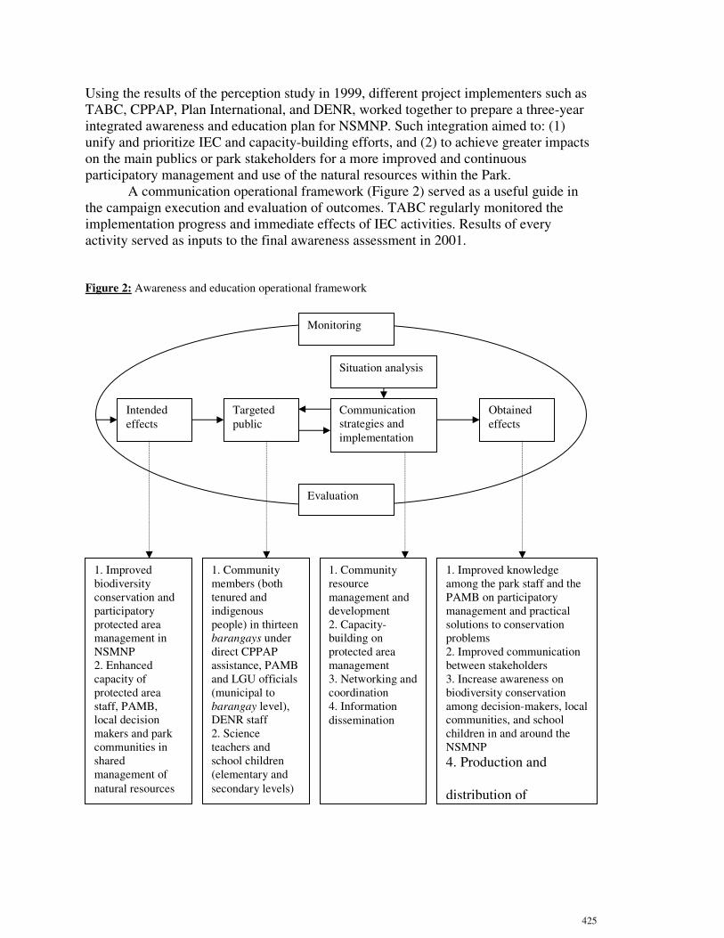
425
Using the results of the perception study in 1999, different project implementers such as TABC, CPPAP, Plan International, and DENR, worked together to prepare a three-year integrated awareness and education plan for NSMNP. Such integration aimed to: (1) unify and prioritize IEC and capacity-building efforts, and (2) to achieve greater impacts on the main publics or park stakeholders for a more improved and continuous participatory management and use of the natural resources within the Park. A communication operational framework (Figure 2) served as a useful guide in the campaign execution and evaluation of outcomes. TABC regularly monitored the implementation progress and immediate effects of IEC activities. Results of every activity served as inputs to the final awareness assessment in 2001. Figure 2: Awareness and education operational framework
Intended effects
Targeted public
Communication strategies and implementation
Obtained effects
Situation analysis
Evaluation
Monitoring
1. Improved biodiversity conservation and participatory protected area management in NSMNP 2. Enhanced capacity of protected area staff, PAMB, local decision makers and park communities in shared management of natural resources
1. Community members (both tenured and indigenous people) in thirteen barangays under direct CPPAP assistance, PAMB and LGU officials (municipal to barangay level), DENR staff 2. Science teachers and school children (elementary and secondary levels)
1. Community resource management and development 2. Capacity-building on protected area management 3. Networking and coordination 4. Information dissemination
1. Improved knowledge among the park staff and the PAMB on participatory management and practical solutions to conservation problems 2. Improved communication between stakeholders 3. Increase awareness on biodiversity conservation among decision-makers, local communities, and school children in and around the NSMNP
4. Production and
distribution of

426
AWARENESS AND EDUCATION EVALUATION The assessment employed a triangulation of methods such as field activity documentation, group interviews and discussion, and field observations. Three evaluation criteria were used to determine the effects of the campaign. Criterion 1: work targets versus delivered outputs The project obtained more than ten consecutive satisfactory ratings from the external review done by the World Bank. Such ratings were based on timeliness of output completion, and adherence to the approved project documents. Criterion 2: compliance with obtained effect indicators Results of the assessment showed a relative improvement in the awareness and practices of the target publics, to wit:
Protected Area Management Board
At the onset of 1999, the majority of the PAMB members still had insufficient understanding of their roles in managing NSMNP, and about the contents of the then draft protected area and management plan. The great majority of the LGU officials representing both the provincial and municipal levels had limited understanding of the communities’ roles in the sustainable management of their natural resources. This led to issues such as proposed road construction and mining inside the park, widespread illegal land acquisition, utilization of narra (Pterocarpus indicus) treetops and branches, and increased entry of fishermen from nearby provinces within the municipal waters. There had been no discussion, and no resolution passed to directly address conservation and sustainable use issues. The only two resolutions at that time pertained to the: (1) granting of livelihood support, and (2) the granting and processing of dead narra treetops and branches in the coastal areas of NSMNP (which led to increased illegal logging). When the PAMB convened in its en banc and execom meetings, specifically during the PAMB training on protected area management in midyear of 2000, the LGU, People’s Organization (PO) and Indigenous Peoples (IP) representatives to the PAMB endorsed around four resolutions. All these resolutions called for selected lawmakers to immediately pass the protected area bill into law. In 2001, after additional PAMB enhancement training on the NSMNP Act and management strategies implementation, a total of twenty-seven resolutions or decisions were drafted in relation to:
1. Support of the LGU in passing local ordinances that prohibit illegal fishing and entry or exit of illegally sourced timber.

427
2. Transparent and comprehensive discussions on the extent of illegal logging and timber poaching within the protected area.
3. Disallowance of narra tops and branches utilization.
4. Disallowance of an environmentally destructive road construction in Dinapigue,
Isabela.
5. Adoption of the park management plan.
6. Consensus and approval of thirteen Community Resource Management Plans (CRMP) and six Ancestral Domain Sustainable Development and Protection Plans (ADSDPP).
7. Discussion and approval of mitigating actions resulting from the Biodiversity Monitoring Systems (BMS).
8. Pursuance of environmental education.
These findings show a significant improvement in the decision-making discussions and actions of the PAMB. The actions of the PAMB towards conservation of the natural resources of the park and in encouraging community involvement in managing their own natural resources has increased to 16 percent since 1999. Protected area staff and local communities
In the early part of 1999, the DENR gave more attention to the conflicting jurisdiction of the Protected Area Superintendent (PASu), and the Community Environment and Natural Resources Office (CENRO) of Palanan, Isabela over the NSMNP. There was little focus on other important issues such as the limited coordination and communication between and among the DENR offices in Region 02, and the serious lack of protected area staff and operational budgets.
Prior to the full blast IEC and community development intervention of the TABC, CPPAP and NSMNP-CP projects in 1999, the bulk of the activities by the protected area staff concentrated on organizing people’s group to avail of livelihood support from the Global Environment Facility and the Government of Netherlands. During this period, the PASu staff also started organizing local environment protection groups known as the “Bantay Kalikasan Brigade”.
From 2000, the local communities’ increased their involvement in planning their local land and resource use management, and in protecting key biodiversity species. Protected area staff with technical back staffing and advice from TABC and Plan International facilitated activities leading to these. On the average, the number of meetings between protected area staff and park communities in 2000 was four meetings per barangay within the targeted thirteen CPPAP-assisted barangays. Meetings were also frequent at that time because the Bantay Kalikasan Brigades have started to engage in protection activities.

428
In 2001, the volunteers of BMS community monitoring groups increased to fourteen, and they maintained a quarterly group discussion on local resource use and conservation actions.
From 1999 to 2001, there has been a significant increase in the number of discussions between the protected area staff and communities. Their management initiatives constitute 57 percent of documented actions from 1999 to 2001 (second quarter). Various activities (preparation and validation of CRMP and ADSDPP, biodiversity monitoring using the Focus Group Discussion (FGD) method supported by community orientation and slideshows on general biodiversity information) have lead to a significant increase in the awareness and discussions on biodiversity-related issues at the community level.
Works of school teachers and school children
Despite the training of teachers and distribution of education materials, environmental education in the rural schools within the park was progressing slowly during the early part of 1999. This was due to the absence of an instruction from the Department of Education officials to pursue environmental education.
After orienting officials of the Department of Education on the importance of enhancing the schools participation in environmental education, and after fifty-four teachers participated in the environmental education training with demo teaching in 2000, many of the elementary and high school teachers in the NSMNP begun incorporating environmental principles supplemented with the TABC-produced education materials in their science and social studies subjects.
In the 2001 survey conducted by the project, which covered about fifty respondent samples of schoolchildren, around 80 percent could cite the importance of NSMNP to their community, and the threats that the park was still facing. In 2000, the Palanan and Maconacon school districts actively participated in the environment month celebration, and even made the protection of NSMNP as the overall theme in various activities such as essay and slogan writing, quiz and beauty contests. Among those who showed increased interest in pursuing environmental education through the schools semi-annual evaluation were the division superintendents in science and social studies. The district supervisor in the coastal side of the park made a commitment to form a group of environmental educators. Criterion 3: appropriateness of communication channels and formats Capacity-building activities
The facilitation of community participation through participatory resource appraisal, consultations, assemblies and meetings provided the most tangible and immediate results. During the appraisals, and community assemblies, local communities were able to raise their concerns regarding the management of their area. They arrived at consensus on how to sustain the use of forest and marine resources. Capacity-building strategies such as

429
orientations, workshops, and cross visits to other protected areas in the Philippines also proved very effective in facilitating learning among the decision-makers and protected area staff about appropriate local actions, conflict resolution, and different policies (for example the CBRM guidelines, DENR Administrative Orders on biodiversity monitoring, the National Integrated Protected Areas System (NIPAS) Act and the Indigenous Peoples Rights Act (IPRA), the NSMNP Act of 2001, and the NSMNP management plan). Results of the monitoring evaluation also revealed that the communities of the inland Western part of the park received very limited information and materials on NSMNP as a protected area and on its management plan implementation. This was a result of the focus of DENR, CPPAP and NSMNP-CP on the NSMNP coastal municipalities. IEC Materials Production and Distribution
Different print materials intended for the PAMB such as the simplified popular version of the NSMNP management plan in local dialect and the protected area bill leaflet produced by TABC served as important sources of information for the PAMB. Most PAMB members especially the barangay and PO representatives use the simplified management plan rather than the original bulky and difficult technical English version. The TABC print education materials such as flipcharts and booklets are regularly being used by almost all schools within the park. These served as supplement materials in social studies and science lessons of teachers in both the elementary and secondary levels.
Coastal communities of the park were captivated by slides presentation during community assemblies. They enjoyed identifying local animal and plant species projected on the screen as well as the different panoramic shots of the mountains and seas in NSMNP. Local communities in general, still have strong preference for visual communication medium over print medium.
Out of the fourteen representative samples in the radio listening survey in the coastal areas conducted by TABC, around three have heard the radio plug introduced by the now DENR Secretary Heherson Alvarez about the importance of conserving NSMNP. In the western side, out of ten survey respondents, five have heard the plugs; most of them were elementary students. Radio is more widely used in the western side than those in the coastal areas. LESSONS LEARNED Awareness and education campaigns are only one among the range of activities needed to make natural resource use more sustainable, and to make the Park management more effective. In NSMNP, the awareness and education strategies adopted by TABC were directly linked and in support to other interventions such as community resource mapping and planning, issuance of tenure instruments and establishing the focus group discussions for monitoring biodiversity.

430
Even with difficulties in coordination and refocusing of activities of various projects and government initiatives in the NSMNP, the communication efforts of TABC made headways in enhancing its target publics’ understanding of selected priority conservation actions. This can be indicated, for example, by a group of Agta or tenured migrants discussing their community resource management agreements, or by IPs advocating the protected area bill in the Senate, or by the local PO and PAMB decision-makers humbly but steadily holding firm to their stand against further unsustainable timber extraction and use of destructive fishing gear in the NSMNP, or by lower rank government and local NGO staff presenting their own recommendations on how to address conservation concerns. Despite the awareness and capacity enhancement initiatives undertaken, the NSMNP will however, continue to be degraded by unsustainable resource-use practices and biodiversity loss for as long as sincerity to pursue conservation is wanting among many stakeholders of the NSMNP, for as long as local decision-makers and park managers do not seriously institutionalize and implement on the ground what have already been started by the conservation projects, for as long as the government does not provide sufficient protected area staff, funding and clear directions for protected area establishment and sustainability, and for as long as the NGOs have major problems in establishing community livelihood and development assistance in support to conservation and sustainable use of natural resources. MOVING FORWARD The recommended refocusing of awareness and education campaign is directed to the PAMB, the PASu, the BMS groups, the Protected Areas and Wildlife Division (PAWD) Region 02, and NGO technical assistance projects. Focus on the implementation of CRMP and ADSDPP These two important initiatives of the government and the CPPAP, TABC and NSMNP-CP projects will remain only on paper if tenure instruments were not granted by DENR. Advocacy and lobbying for the issuance of a well-analyzed and situation-adapted administrative order on these instruments of tenure should be initiated. Some of the recommended specific communication actions to be taken are:
1. Concerned communities to prepare petition letters to the Secretary of DENR and establish a dialogue on this issue with the DENR Regional Executive Director of Region 02. Foreign-assisted projects, such as NSMNP-CP and Conservation International (CI) should be tapped to support this endeavor.
2. Since the tenured migrants and IPs are only starting to implement their local
resource management plans, it is very important that the PASu follows up the agreements in the CRMPs and ADSDPPs.

431
3. The PAMB must be thoroughly oriented by DENR specialists and experienced ecologists in resource-use permitting system to avoid further overuse of local resources.
Focus on BMS implementation The BMS is still not operational in the Western part of the Sierra Madre Mountain Range. This means that approximately 140,000 ha of forest is open for illegal timber poaching, new in-migrants and other major resource management problems. In the coastal part of the NSMNP, the BMS is up and running, but may get impeded if not monitored. Some recommended specific training courses are:
1. How to communicate effectively with local communities for DENR BMS field staff.
2. Law enforcement and biodiversity monitoring for local forest guards in BMS.
3. FGD technique in biodiversity monitoring for the community-monitoring group.
This will include the following: (1) understanding their roles in managing local resources, (2) monitoring, recording and reporting of observations, (3) participating actively in the discussions, and (4) issue analysis and decision-making.
Focus on the implementation by the PAMB of the management plan The effective management of the NSMNP depends largely on the ability of the PASu office and the PAMB secretariat to put forward important conservation concerns, and thereafter to act on the PAMB directives. Some of the recommended specific communication actions are:
1. Further train the PAMB in planning and decision-making. 2. Train the PAMB secretariat and PASu staff on how to provide effective assistance
so that the PAMB can come up with quality decisions on protected area conservation issues.
3. Make presentations to national, regional and provincial authorities about
conservation needs and problems resulting from the encroaching logging and development projects.

432
LIST OF CONTRIBUTORS Florence T. Acay is a professor at the department of social forestry, College of Forestry and Environmental Management (CFEM), Isabela State University (ISU) in Cabagan. She is currently on study leave from ISU and is completing her PhD. in community development at the University of the Philippines Los Baños. Juan R. Acay, Jr. is the local technical adviser and natural resources management specialist of the Northern Sierra Madre Natural Park Conservation Project (NSMNPCP). Jo Marie Acebes obtained the degrees in BSc. in biology in 1994 and veterinary medicine from the University of the Philippines in 1999. In September 1999, she volunteered at WWF Philippines and was the project leader for WWF’s cetacean research and conservation project from February 2000 to December 2001. Her work is on field research on cetaceans through vessel surveys and interviews. From November 2000, she has been the project manager for the humpback whale research and conservation project of WWF that includes research and conservation. The conservation initiative is focused on an intensive community-based, multi-stakeholder, and information, education, communication (IEC) program; the long-term goal being the creation of a humpback whale sanctuary in the Babuyan Islands, Cagayan Province. Artemio Antolin obtained the degrees BSc. in forestry and MSc. in forestry from the Isabela State University (ISU) in Cabagan in 1978 and 1992, respectively. He finished his PhD. degree in development management from the Cagayan State University in 1998. He worked at the Don Mariano Marcos Memorial State University as a faculty member from 1978 to 1982, as a staff forester and later as program chief at the Bureau of Forestry Development from 1982 to 1987, and as a forest management specialist in 1988 until he became an assistant division chief at the Department of Environment and Natural Resources (DENR), Region 02 from 1994 to 1996. In 1996, he joined the NSMNP-CP of Plan Philippines as area manager in Palanan, Isabela. Currently, he is the project manager of the Northern Sierra Madre Corridor Project of Conservation International (CI). Dante M. Aquino is a professor of environmental science at the department of environmental science and management, College of Forestry and Environmental Management (CFEM), Isabela State University (ISU) in Cabagan. He obtained his MSc. in environmental studies from the University of the Philippines Los Baños. He was granted a fellowship for his PhD. studies by Leiden University, the Netherlands, in 1996 and is currently completing his research on natural resources management of indigenous people. He has been working at ISU from 1975 in instruction, research, and extension. He is a professional forester and has been involved in some natural resources management projects in various capacities as consultant, technical assistant, subject matter specialist, or resource person. Orlando Balderama obtained the degrees BSc. in agricultural engineering from the Isabela State University (ISU) in 1985, MSc. in land and water engineering from the

433
Asian Institute of Technology, in 1987, and PhD. in agricultural engineering from the University of Tokyo in 1998. He has been employed as a faculty member at ISU from 1986. He is actively involved in research and consultancy work in the fields of irrigation and renewable energy. He served as a short term consultant on projects funded by the European Union, Plan Philippines, Department of Agriculture, Department of Energy, and the University of California. Eileen C. Bernardo is a professor at the department of environmental science and management and currently the chairperson of the graduate program of the College of Forestry and Environmental Management (CFEM), Isabela State University (ISU) in Cabagan. She teaches environmental chemistry, toxicology, and pollution and waste management, among others. She is presently a member of the board of directors of the Environmental Education Network of the Philippines (EENP), and a council member of the Asian association of academic activities for waste management based in Japan. She is also an on-call member of the Technical Working Group on Solid Waste Management of the Regional Committee on Sustainable Development (RCSD), Region 02. She was a research fellow in environmental science and technology at the department of chemistry, Tokyo Institute of Technology, Japan. Anneke Boerwinkel studied biology and specialized in plant ecology and tropical ecology at Groningen University, the Netherlands where she graduated in 2002. In 2001, she stayed in the Philippines for five months where she conducted her research on home gardens within the framework of the Cagayan Valley Program on Environment and Development (CVPED). Eric D. Buduan is presently involved in the Northern Sierra Madre Natural Park Conservation Project (NSMNP-CP) as senior technical officer. He is assigned to manage the operation of the Maconacon field office that covers the municipalities of Maconacon and Divilacan, Isabela, on the implementation of biodiversity conservation and community development activities. These include the establishment of fish sanctuaries, community organizing, construction of irrigation systems, agrofishery based livelihood activities, provision of health and education assistance, IEC, research, and training of community members and government personnel. Oscar P. Cardenas is an associate professor at the department of social forestry and currently the research coordinator of the College of Forestry and Environmental Management (CFEM), Isabela State University (ISU) in Cabagan. He served as technical professional assistant on agroforestry under the Community-Based Forest Regeneration and Related Research Project (COMFREP), a project funded by USAID and implemented by Plan Philippines and ISU. He is also a member of the technical advisory team of the Cagayan Valley Program on Environment and Development (CVPED). Marcelino V. Dalmacio obtained his PhD. degree in forestry from the University of the Philippines Los Banos. He has thirty-seven years of work experience that include stints in the Department of Environment and Natural Resources (DENR) as regional executive director and as Protected Areas and Wildlife Bureau (PAWB) director. He

434
has served as consultant to several projects in the Philippines, Bangladesh, and Indonesia on various fields such as social forestry, community-based forest management, silviculture, reforestation, industrial forest development and management, agroforestry, forest policy, watershed management, environmental impact study, forest certification assessment, protected area management, and biodiversity conservation. At present, he is the chief technical adviser of the Samar Island Biodiversity Project, a UNDP-GEF funded project which aims to establish the Samar Island Natural Park (SINP). Louis Defo is a PhD. student at the Center of Environmental Science (CML), Leiden University. He is currently conducting a research with a grant from the Netherlands Foundation for the Advancement of Tropical Research (WOTRO). His fields of research are non-timber forest products (NTFP) and conservation of tropical forest and livelihoods. Liesbeth Denis is a research associate at the Center of Environmental Science, Leiden University (CML). She was responsible for the material and energy flows accounting (MFA, EFA) studies on the local level studies of the SEAtrans project in the Philippines. Sophie Elixhauser is a graduate student in anthropology at the institute for cultural anthropology, Ludwig-Maximilians Universität in München. In 2001, she conducted a research on ecotourism in the Northern Sierra Madre Natural Park (NSMNP) within the framework of the Cagayan Valley Program on Environment and Development (CVPED). Hubert G. Garcia is the senior technical officer for botany of the Northern Sierra Madre Natural Park Conservation Project (NSMNP-CP) of Plan Philippines. He has been involved as field researcher for seven years in the Philippine plant inventory project implemented by National Museum-Manila. Alfredo Alex G. General graduated from the University of the Philippines Los Baños with the degree BSc. in agriculture and currently taking up a MSc. in environment and natural resources management at the University of the Philippines Los Baños. He is presently working with the Northern Sierra Madre Natural Park Conservation Project (NSMNP-CP) as area manager in the municipality of San Mariano, Isabela. Wouter T. de Groot is a professor in environmental science in Nijmegen University and senior associate at the Center of Environmental Science, Leiden University (CML). Jessie P. Guerrero finished his BSc. degree in forestry major in forest resources management from the Isabela State University (ISU) in Cabagan. He is currently employed as a wildlife associate of Plan Philippines’ Northern Sierra Madre Natural Park Conservation Project (NSMNP-CP). His work involves the conduct of fauna surveys to assess wildlife diversity of the park as a tool for management planning. Ma. Visitacion D. Guingab is an associate professor at the department of forest biological science, College of Forestry and Environmental Management (CFEM), Isabela State University (ISU) in Cabagan. She teaches forest biological science subjects.

435
She is engaged in research in the fields of plant taxonomy, physiology, and silviculture. Her research works include indigenous tree species in grasslands funded by the International Tropical Timber Organization (ITTO) in 1998 and endemic bamboo in Northeast Luzon funded by the Nagao Natural Environment Foundation of Japan in 2001. Roger Z. Guzman is a professor of silviculture at the department of forest resources management, College of Forestry and Environmental Management (CFEM), Isabela State University (ISU) in Cabagan. He is the former dean of the college. He is currently the chairman of the Isabela Multi-sectoral Forest Protection Committee (MFPC). He presently serves as one of the advisers of the Philippine Association of Tertiary Level Educational Institutions for Environmental Protection and Management (PATLEPAM). Marieke Hobbes is a research associate at the Center of Environmental Science, Leiden University (CML). Currently, she is executing the Action in Context (AiC) research component of the SEAtrans project. Arne Jensen served as co-manager of the Technical Assistance for improving Biodiversity Conservation (TABC) from 1997 to 2001. He was instrumental in the development and pilot-implementation of the Biodiversity Monitoring System (BMS) in selected protected areas in the country. Lissa Aireen R. Lesaca obtained the degree BSc. in human ecology from the University of the Philippines Los Baños in 1996. She is currently working with WWF-Philippines since January 2001 as project assistant for the humpback whale research and conservation project in the Babuyan Islands. She has worked intensively on the Information, Education, Communication (IEC) component of the project. She led the conduct of Project L.I.F.E. (Learning Interdependently For the Environment) the mobile educational tour for the mainland municipalities of Sta. Ana, Aparri, and Claveria, Cagayan, and organized trainings such as the marine mammal stranding response for Cagayan Province. She assisted in basic research through primary and secondary data collection on the biology, ecology, fishery, and other relevant information related to the project. Mary Ann B. Leones is currently the communication specialist of the integrating forest conservation project of Haribon Foundation for the Conservation of Natural Resources. Her work involves supervision of communication baseline study, packaging of information, education, and communication materials, and monitoring and evaluation of communication effects. Delia S. Magaña finished the degrees of BA. in sociology and MA. in Philippine cultural studies, and has taken some doctoral units in anthropology at the University of the Philippines, Diliman. At present, she has consultancy works in line with conservation and indigenous communities with NGOs. She lived with the Agta communities in the Northern Sierra Madre Natural Park (NSMNP) while working as anthropologist and technical assistant with the Northern Sierra Madre Natural Park Conservation Project

436
(NSMNP-CP) and NORDECO for almost five years from 1997 to 2001. Andres B. Masipiqueña is a professor at the department of forest resources management, College of Forestry and Environmental Management (CFEM), Isabela State University (ISU) Cabagan. He obtained the degrees, BSc., MSc., and PhD. in forestry from the University of the Philippines Los Baños. Presently, he is the coordinator of the Cagayan Valley Program on Environment and Development (CVPED), a joint research and education program of ISU and Leiden University. His main interests are forest policy and administration, community-based resource management, integrated land use, and protected area management. Mercedes D. Masipiqueña is a professor at the department of forest biological sciences, College of Forestry and Environmental Management (CFEM). She was the director of the department of research, Isabela State University (ISU) in Cabagan from 1997 to 2001. She was a research fellow and a member of the regional technical working group of the Cagayan Valley Agricultural Resources Research and Development (CVARRD) from 1997 to 2001. She is currently the regional program leader of the integrated banana bunchy top control and rehabilitation program in Region 02. Tessa Minter is an environmental anthropologist. She obtained her MA. degree from Leiden University, the Netherlands in September 2001. Her thesis is on protected area management in southern Thailand. Currently, she is a PhD. student at the Center of Environmental Science, Leiden University (CML). Her research is on indigenous peoples and tropical rainforest management. More specifically, she focuses on the integration of the Agta in the management of the Northern Sierra Madre Natural Park (NSMNP) in Luzon, the Philippines. Koen P. Overmars graduated from Wageningen University in 2000 in soil science with specialization in soil inventory and land evaluation. Since May 2001, he started conducting research for his PhD. degree at Leiden University and Wageningen University called “linking processes and patterns of land use change at the watershed level in the Sierra Madre region, the Philippines”. This research is a part of a project called “Integrating macro-modelling and actor-oriented research in studying the dynamics of land use change in North-East Luzon”. The project is carried out in cooperation with the Cagayan Valley Program on Environment and Development (CVPED). His main interest is in land use modeling focusing on the integration of information of different disciplines. Gerard A. Persoon obtained his PhD. degree in anthropology at Leiden University. At present, he is the head of the department of environment and development of the Center of Environmental Science (CML). His main interests are in indigenous peoples and forest management in Southeast Asia, not only at the local level but also at the level of national and international policy makers and conventions in this field. He has done extensive fieldwork in Indonesia and the Philippines. He has also worked as a consultant for a number of conservation projects in the region.

437
Jan van der Ploeg is the coordinator of the Cagayan Valley Program on Environment and Development (CVPED), a joint research and education program of the Isabela State University (ISU) and Leiden University, the Netherlands. Tomas C. Reyes is a professor at the department of forest resources management, College of Forestry and Environmental Management (CFEM), Isabela State University (ISU). He teaches courses related to watershed management, meteorology, soils, and land use planning both in the undergraduate and graduate levels. Presently designated as the campus director of the department of research, he administers the conduct of research activities at ISU in Cabagan. Milagros A. Rimando is currently the regional director of the National Economic and Development Authority (NEDA), Region 02. She is a member of the Board of Regents of two state universities and three state colleges in Region 02 namely: the Cagayan State University, Isabela State University, Nueva Vizcaya State Institute of Technology, Nueva Vizcaya State Polytechnic College, and Quirino State College. She is the vice chairwoman of the regional tripartite wage and productivity board and member of the technical working group for the North Luzon growth commission. She obtained a PhD. degree in development major in rural development from the Cagayan State University (CSU) in 2002. Dominic G. Rodriguez has a BSc. degree in forestry major in forest biological science. He is as a wildlife associate of the Northern Sierra Madre Natural Park Conservation Project (NSMNP-CP). His major concern is to conduct fauna surveys to assess wildlife diversity of the park as a tool for management planning. Marino R. Romero is an associate professor at the department of environmental science and management, College of Forestry and Environmental Management (CFEM), Isabela State University Cabagan. In 1998, he was granted a fellowship for his PhD. studies by the Center for Environmental Science (CML). His work experience includes teaching and research, and supervising MSc. students’ researches. He served as a local consultant and resource person in the fields of environmental impact assessment, environmental economics, and water resources management. Jovy M. Servitillo obtained the degrees BSc. in forestry in 1985, MSc. in forestry major in social forestry in 1989 from the University of the Philippines Los Baños and PhD. in rural development from the Cagayan State University (CSU) in 2001. She teaches social forestry, rural upland community extension, research and program development, and agroforestry and is currently the chairperson of the department of social forestry, College of Forestry and Environmental Management (CFEM), Isabela State University (ISU) in Cabagan. She conducts research relevant to social forestry and rural development. Denyse J. Snelder obtained her PhD. in physical geography from the University of Toronto. Currently, she is managing the Philippine program for environment and development of the Center of Environmental Science, Leiden University (CML). Her

438
main interests are in land use transition, soil erosion and conservation, agroforestry, and forest and grassland management in tropical regions. She has conducted extensive field work in Kenya and in the Philippines. She is participating in the North-South working group promoting the integration of sustainable development in higher education programs. Jouel B. Taggueg is currently the chairperson of the department of forest products utilization engineering of the College of Forestry and Environmental Management (CFEM), Isabela State University (ISU) in Cabagan. He obtained his BSc. degree in forest products engineering in 1994 and his MSc. degree in forestry major in wood science and technology from the University of the Philippines Los Baños in 2001. Bernard A. Tarun finished the degree BSc. in forestry major in social forestry from the Isabela State University in Cabagan. He is presently working as a wildlife associate of the Plan Philippines Northern Sierra Madre Natural Park Conservation Project (NSMNP-CP). He conducts fauna surveys to assess wildlife diversity of the park as a tool for management planning. Tom A. Veldkamp is a senior lecturer in soil science, land evaluation, geomorphology and multi-functional land use analysis at the Laboratory of Soil Science and Geology of Wageningen University, the Netherlands. He is a member of the scientific steering Committee of Land Use Cover Change (LUCC) project. His key qualifications include land use change modelling, quaternary geology, soil mapping, and land evaluation. Within LUCC, he is a specialist in integrated, dynamic models for land-use change that address the multi-scale characteristics of landscape and social organization. Peter H. Verburg is a researcher at the laboratory of soil science and geology of Wageningen University in the Netherlands and at the faculty of geographical sciences of Utrecht University. He has an extensive experience on spatial analysis and modeling of agro-ecosystems, land use, urban systems, and landscape pattern. He has participated in a number of research projects in different parts of the world, including China, the Philippines, and the northwestern European delta. He is the project coordinator of the CLUE model. Perla A. Visorro is the president of the Cagayan Valley Partners in People Development. She is currently the Vice Chairman of the Regional Committee on Sustainable Development (RCSD). Merlijn van Weerd studied biology at the University of Groningen, the Netherlands. His specializations are animal ecology, tropical ecology, and environment and development. As a student, he studied water bird populations in northern Cameroon and coastal bird ecology and behavior in Mozambique. He received his MSc. degree in 1996. After one year as an Irish folk violin player, he became a biologist again in 1998 studying freshwater fish migration in Cameroon. From 1999 to 2002, he worked in the Philippines as a wildlife biologist for the Dutch government at the Northern Sierra Madre Natural Park Conservation Project (NSMNP-CP). He is now at the Center of

439
Environmental Science of Leiden University (CML) where he hopes to publish the results of his research activities in the Philippines and earn a PhD. degree.

440
LIST OF ABBREVIATIONS AND ACRONYMS ADB Asian Development Bank ADMP Ancestral Domain Management Plan ADSDPP Ancestral Domain Sustainable Development and Protection Plan BFAR Bureau of Fisheries and Aquatic Resources BMS Biodiversity Monitoring System CADC Certificate of Ancestral Domain Claim CADT Certificate of Ancestral Domain Title CALM Cagayan Anti Logging Movement CAVAPPED Cagayan Valley Partners in Peoples Empowerment and
Development CBD Convention on Biological Diversity CBFM Community Based Forest Management CBFMA Community Based Forest Management Agreement CBRM Community Based Resource Management CENRO Community Environment and Natural Resources CFEM College of Forestry and Environmental Management CFP Community Forestry Program CI Conservation International - Philippines CITES Convention on International Trade in Endangered Species CML Center for Environmental Science Leiden University CLUE Conversion of Land Use and its Effects CLUP Comprehensive Land Use Plan CPDC City Planning and Development Coordinator CPPAP Conservation of Priority Protected Areas Project CRMP Community Resource Management Plan CSC Certificate of stewardship Contract CSU Cagayan State University CVPED Cagayan Valley Program on Environment and Development DA Department of Agriculture DAR Department of Agrarian Reform DAO Department Administrative Order DECS Department of Education, Culture and Sports DENR Department of Environment and Natural Resources DESAM Department of Environmental Science and Management DGIS Directorate General for International Cooperation DILG Department of Interior and Local Government DOH Department of Health DOJ Department of Justice DOST Department of Science and Technology DOT Department of Tourism DTI Department of Trade and Industry DPWH Department of Public Works and Highways EIA Environmental Impact Assessment EIC Environmental Information Center

441
EMB Environmental Management Bureau ENR-SECAL Environment and Natural Resources Sectoral Adjustment Loan EU European Union GEF Global Environmental Facility GIS Geographical Information System HLURB Housing and Land Use Regulatory Board ICC Indigenous Cultural Communities IEC Information Education Communication IFMA Industrial Forest Management Agreements
ILO International Labor Organization IP Indigenous Peoples IPM Integrated Pest Management IPRA Indigenous Peoples’ Rights Act IQL Investment in Land Quality ISF Integrated Social Forestry ISU Isabela State University IUCN World Conservation Union LGC Local Government Code LGU Local Government Unit MFPC Multi-sectoral Forest Protection Committee MMDA Metro Manila Development Authority MPDC Municipal Planning and Development Coordinator MRF Materials Recovery Facility NBI National Bureau of Investigation NCIP National Commission on Indigenous People NEDA National Economic and Development Authority NGO Non Governmental Organization NIPA NGOs for Integrated Protected Areas NIPAS National Integrated Protected Areas System NORDECO Nordic Agency for Development and Ecology
NTFP Non Timber Forest Products NSMNP Northern Sierra Madre Natural Park NSMNP-CP Northern Sierra Madre Natural Park-Conservation Project PA Protected Area PAMB Protected Area Management Board PASu Protected Area Superintendent PATECO Pacific Timber Export Corporation PATLEPAM Philippine Association of Tertiary Level Educational institutions
for environmental Protection And Management PAWB Protected PAWD Protected Area Wildlife Division PEACE Public Education and Awareness Campaign for the Environment PENRO Provincial Environment and Natural Resource Office PIA Philippine Information Agency PLTP Private Land Timber Permit PNP Philippine National Police

442
PO People’s Organization PRA Participatory Rural Appraisal PSSD Philippine Strategy for Sustainable Development RA Republic Act
RAMSAR Convention on Wetlands of International Importance Especially as Waterfowl Habitat
RCSD Regional Committee for Sustainable Development RNE Royal Netherlands Embassy SAFDZ Strategic Agriculture and Fishery Development Zones SB Sangguniang Bayan SIFMA Socialized Integrated Forest Management Agreement SINP Samar Island Natural Park SWM Solid Waste Management TABC Technical Assistance for Improving Biodiversity Conservation TESDA Technical Education for Skills Development Authority TLA Timber License Agreement UN United Nations UNEP United Nations Environment Program USAID United Stated Agency for International Development WB World Bank WWF World Wildlife Funds – Philippines
443
THE CAGAYAN VALLEY PROGRAM ON ENVIRONMENT AND DEVELOPMENT
The Cagayan Valley Program on Environment and Development (CVPED) is the research and education partnership of the Isabela State University (ISU) and Leiden
University, the Netherlands. Since 1989, the interdisciplinary and intercultural program has contributed to a better understanding of the social and environmental changes in the
Cagayan Valley, strengthened research capacities in Region 02, and provided the necessary scientific input to government, development agencies, grassroots organizations,
and conservation groups for the sustainable management of the natural resources of the Sierra Madre Mountain Range.
Cagayan Valley Program on Environment and Development
Isabela State University Cabagan Campus
3328 Isabela The Philippines www.cvped.org