Low latitude floral assemblage from the Late Oligocene sediments

Late Oligocene to Middle Miocene rifting and synextensional magmatism in the southwestern Sierra Madre Occidental,
Mexico: The beginning of the Gulf of California rift
Luca Ferrari1,2,*, Margarita López-Martínez3, Teresa Orozco-Esquivel1, Scott E. Bryan4, Jose Duque-Trujillo1, Peter Lonsdale5, and Luigi Solari1
1Centro de Geociencias, Universidad Nacional Autónoma de México, Campus Juriquilla, 76230, Querétaro, Qro., Mexico2Instituto de Geología, Universidad Nacional Autónoma de México, Ciudad Universitaria, 04510, México Distrito Federal, Mexico3Departamento de Geología, Centro de Investigación Científi ca y de Educación Superior de Ensenada (CICESE), Carretera Ensenada-Tijuana No. 3918, 22860 Ensenada, Baja California, México4School of Earth, Environmental and Biological Sciences, Queensland University of Technology, Brisbane, Queensland 4001, Australia5Scripps Institution of Oceanography, University of California at San Diego, La Jolla, California 92093, USA
ABSTRACT
Although Basin and Range–style exten-sion affected large areas of western Mexico after the Late Eocene, most consider that extension in the Gulf of California region began as subduction waned and ended ca. 14–12.5 Ma. A general consensus also exists in considering Early and Middle Miocene volcanism of the Sierra Madre Occidental and Comondú Group as subduction related, whereas volcanism after ca. 12.5 Ma is exten-sion related. Here we present a new regional geologic study of the eastern Gulf of Cali-fornia margin in the states of Nayarit and Sinaloa, Mexico, backed by 43 new Ar-Ar and U-Pb mineral ages, and geochemical data that document an earlier widespread phase of extension. This extension across the southern and central Gulf Extensional Province began between Late Oligocene and Early Miocene time, but was focused in the region of the future Gulf of California in the Middle Miocene. Late Oligocene to Early Miocene rocks across northern Nayarit and southern Sinaloa were affected by major approximately north-south– to north-north-west–striking normal faults prior to ca. 21 Ma. Between ca. 21 and 11 Ma, a system of north-northwest–south-southeast high-angle extensional faults continued extending the southwestern side of the Sierra Madre Occidental. Rhyolitic domes, shallow intru-sive bodies, and lesser basalts were emplaced along this extensional belt at 20–17 Ma. Rhyo-
litic rocks, in particular the domes and lavas, often show strong antecrystic inheritance but only a few Mesozoic or older xenocrysts, suggesting silicic magma generation in the mid-upper crust triggered by an extension-induced basaltic infl ux. In northern Sinaloa, large grabens were occupied by huge volcanic dome complexes ca. 21–17 Ma and filled by continental sediments with interlayered basalts dated as 15–14 Ma, a stratigraphy and timing very similar to those found in central Sonora (northeastern Gulf of California margin). Early to Middle Miocene volcanism occurred thus in rift basins, and was likely associated with decompression melting of upper mantle (inducing crustal partial melt-ing) rather than with fl uxing by fl uids from the young and slow subducting microplates. Along the eastern side of the Gulf of Califor-nia coast, from Farallón de San Ignacio island offshore Los Mochis, Sinaloa, to San Blas, Nayarit, a strike distance of >700 km, fl at-lying basaltic lavas dated as ca. 11.5–10 Ma are exposed just above the present sea level. Here crustal thickness is almost half that in the unextended core of the adjacent Sierra Madre Occidental, implying signifi cant lithosphere stretching before ca. 11 Ma. This mafi c pulse, with subdued Nb-Ta negative spikes, may be related to the detachment of the lower part of the subducted slab, allowing an upward asthenospheric fl ow into an upper mantle pre-viously modifi ed by fl uid fl uxes related to past subduction. Widespread eruption of very uni-form oceanic island basalt–like lavas occurred by the late Pliocene and Pleistocene, only 20 m.y. after the onset of rifting and ~9 m.y.
after the end of subduction, implying that pre-existing subduction-modifi ed mantle had now become isolated from melt source regions. Our study shows that rifting across the south-ern-central Gulf Extensional Province began much earlier than the Late Miocene and pro-vided a fundamental control on the style and composition of volcanism from at least 30 Ma. We envision a sustained period of lithospheric stretching and magmatism during which the pace and breadth of extension changed ca. 20–18 Ma to be narrower, and again after ca. 12.5 Ma, when the kinematics of rifting became more oblique.
INTRODUCTION
Over the past 30 m.y. the western North American plate margin has changed from con-vergence to highly oblique divergence through a complex interaction with the Pacifi c plate that produced two pairs of parallel structures: the San Andreas fault system and the Eastern California Shear Zone–Walker Lane in the U.S., and the San Benito–Tosco–Abreojos fault sys-tem and the Gulf of California rift in Mexico (Fig. 1). Strike-slip deformation in both regions moved inland; currently, the Eastern California Shear Zone–Walker Lane accommodates ~25% and the Gulf of California accommodates ~90% of the Pacifi c–North America relative plate motion (Wesnousky, 2005; Plattner et al., 2009). Stretching of the continental lithosphere pre-ceded direct interaction of the Pacifi c and North America plates and produced the Basin and Range composite extensional province (Dick-inson, 2002). In Mexico, the Basin and Range
For permission to copy, contact [email protected]© 2013 Geological Society of America
1
Geosphere; October 2013; v. 9; no. 5; p. 1–40; doi:10.1130/GES00925.1; 15 fi gures; 2 tables; 1 supplemental fi le.Received 6 March 2013 ♦ Revision received 31 July 2013 ♦ Accepted 15 August 2013 ♦ Published online 12 September 2013
*Corresponding author.
Origin and Evolution of the Sierra Nevada and Walker Lane themed issue

Ferrari et al.
2 Geosphere, October 2013
4
SONORA
4
46810
16
1214
20 1618
18 3.6
3.6
1620
22
16
16
16
16
1414
14
Tepic
Guadalajara
Durango
Fig. 2
East limit of GEP inCalmus et al. (2010)
East limit of GEPin Stock & Hodges (1989)
Mazatlán
U. S. A.
SINALOA
NAYARIT
JALISCO
ZACATECAS
DURANGO
CHIHUAHUA
Si e
r r aM
ad
r eO
c c i de
nt a
l
Hermosillo
6 8
EPR
Alarcón
Pescadero
Farallón
GuaymasCarmen
WagnerDelfin
Consag
Tosco-Abreojosfault
SanBenito
faultMF
San Diego
Continentala) offshore
Newly accretedintercontinental
OceanicInactivespreadingridge
Isochronage (Ma)
Active plateboundary
LITHOSPHERE
Area unaffected byCenozoic extension
a
B a j a C a l i f o r n i a
La Paz
B A S I NA N D R A N G E
21°
25°
27°
29°106° 104°
110°112°114°116°
23°
14
IT
SM
Sierra deJuárez
ITM
BATB
BG
MGE
SAF
GoC
SBTA
WL - ECSZ
PACIFICPLATE
NORTH AMERICAPLATE
RP
JF
SN
BC
G E P
Figure 1. Regional tectonic map of the Gulf of California and adjoining areas showing the different types of lithosphere, extents of the Basin and Range and Gulf Extensional Provinces (dashed orange lines), and preserved extent of the contiguous part of the Sierra Madre Occidental silicic large igneous province (dashed red line). The extent of the unextended core of the Sierra Madre Occidental has been revised according to this study. Patterns of oceanic plate boundaries and crustal isochrons are from Lonsdale (1991) and Tian et al. (2011). GEP—Gulf Extensional Province, where different eastern boundaries in Sonora are based on those defi ned by Stock and Hodges (1989) and Calmus et al. (2010); MGE—Main Gulf Escarpment; BG—Bahía Guadalupe; BA—Bahía de Los Angeles; IT—Isla Tiburón; TB—Tiburón Basin; ITM—Islas Tres Marias; MF—Magdalena Fan; EPR—East Pacifi c Rise; SM—Sierra El Mayor. Inset shows the main fault systems currently defi ning the Pacifi c–North America plate boundary (SAF—San Andreas fault system; WL-ECSZ—Walker Lane–Eastern Cali-fornia shear zone; SBTA—San Benito–Tosco Abreojos fault system; GoC—Gulf of California fault system) and the Sierra Nevada (SN) and Baja California (BC) microplates; RP—Rivera Plate; JF—Juan de Fuca Plate.

Early extension in the Gulf of California
Geosphere, October 2013 3
episode of extension is recognized across a wide region north of the Trans-Mexican Volcanic Belt (e.g., Henry, 1989; Henry and Aranda-Gomez, 1992, 2000; Calmus et al., 2010) (Fig. 1), although the western limit of this extension has been poorly defi ned. More focused extension in the Gulf of California area, bounded to the west by the Main Gulf Escarpment of Baja Califor-nia and to the east by the unextended core of the Sierra Madre Occidental (SMO), has been referred to as the Gulf Extensional Province (GEP) (Gastil et al., 1975) (Fig. 1) or the proto–Gulf of California (Karig and Jensky, 1972). In earlier studies (e.g., Stewart, 1978; Henry, 1989), it was argued that proto–Gulf of Califor-nia rifting substantially preceded the formation of a Pacifi c–North America plate boundary at this latitude (ca. 14–12.5 Ma); i.e., extension occurred when subduction was still ongoing. However, after the infl uential work of Stock and Hodges (1989), most (e.g., Henry and Aranda-Gómez, 1992, 2000; Umhoefer et al., 2001; Umhoefer, 2011; Fletcher et al., 2007; Lizarralde et al., 2007; Seiler et al., 2011; Sutherland et al., 2012; Miller and Lizarralde, 2013) assumed that extension in the Gulf of California region began only at the end of Middle Miocene time, when subduction ended and the transfer of Baja Cali-fornia to the Pacifi c plate began. In the past two decades workers have debated the onset of oblique rifting in the Gulf of California (e.g., Stock and Hodges, 1989; Gans, 1997; Oskin and Stock, 2003; Fletcher et al., 2007; Miller and Lizarralde, 2013), but a general consensus has existed where gulf opening was fundamen-tally a post-subduction event, controlled by the highly oblique, northwestward motion of Baja California that was able to rift the continental lithosphere in ~6–10 m.y. (Umhoefer, 2011).
Separating young extension of the GEP from that of the older Basin and Range is par-ticularly challenging in the northern part of the SMO (Fig. 1) (see discussion in Calmus et al., 2010). In Sonora and Chihuahua, exten-sion has affected the entire volcanically active region, and appears spatially contiguous and temporally continuous, leading to different interpretations on the location of the bound-ary between the two extensional provinces (Fig. 1). In western Chihuahua, extension is poorly dated but affects ignimbrites as young as ca. 29 Ma (McDowell and Mauger, 1994) and is considered to have started ca. 30 Ma on the basis of basalt geochemistry (Cameron et al., 1989; McDowell and Mauger, 1994). Near the Chihuahua-Sonora border, extension has been recently established as ca. 27–25 Ma (Murray et al., 2013) by detailed geologic map-ping and geochronology. In central Sonora, clastic sedimentation in extensional basins
as well as development of metamorphic core complexes began almost concurrently along a ~200-km-wide zone at the end of the Oligocene and continued throughout the Middle Miocene (McDowell et al., 1997; Gans, 1997; Gonzalez-León et al., 2000; Vega-Granillo and Calmus, 2003; Nourse et al., 1994; Wong and Gans, 2003; Wong et al., 2010). Low-angle detach-ment faulting in the core complexes waned by 15 Ma (Wong et al., 2010), but high-angle normal faulting continued until ca. 8.5 Ma in coastal Sonora (McDowell et al., 1997; Mora-Alvarez and McDowell, 2000; Roldán-Quin-tana et al., 2004). Gastil et al. (1975) placed the eastern limit of the GEP in the coastal region of Sonora. Stock and Hodges (1989) extended it to the western SMO (Fig. 1) to include the belt of core complexes, the age of which was not known at that time; however, they considered that it could be also related to the Late Miocene opening of the Gulf of California. Based on the new knowledge about the ages of the core complexes, Calmus et al. (2010) placed the boundary further to the west at the longitude of Hermosillo (Fig. 1), because this was the boundary of post–12 Ma extension. In this way they reiterated the notion that rifting in the Gulf of California was a postsubduction process.
Pre–Late Miocene extension was also reported from a few locations in the northern Gulf of California, although these examples have gener-ally been neglected because of overprinting by Late Miocene–Pleistocene deformation. In Baja California, Late Oligocene to Middle Miocene extension is reported at Bahía de Guada lupe (ca. 24–14 Ma; Axen, 2003), whereas extension at least partially concurrent with the Basin and Range of central-western Sonora is documented near the Main Gulf Escarpment of northern Baja California at Sierra el Mayor (ca. 15–10 Ma; Axen et al., 2000) and southern Sierra de Juárez (16–11 Ma; Lee et al., 1996) (Fig. 1). Micro-paleon to logi cal studies of deep wells drilled in the Wagner, Consag, and Tiburón Basins (Fig. 1) also suggest the presence of shallow-marine sedimentation in some areas of the northern Gulf of California in the Middle Miocene (Helenes et al., 2009). These data contrast with the geol-ogy of Isla Tiburón (Oskin and Stock, 2003; Bennett et al., 2012) (Fig. 1) that clearly indi-cates that marine incursion at this site is latest Miocene. Despite contrasting interpretations about the timing of marine sedimentation (see the Discussion), an early onset of extension in the northern Gulf of California region cannot be ruled out and the possibility exists that the Basin and Range and the GEP were at least partly over-lapping in space.
Cenozoic magmatism preceding and accom-panying the development of the Gulf of Cali-
fornia has also been divided into two different episodes, supposedly controlled by the tectonic setting at the plate boundary. Oligocene and Early Miocene silicic to bimodal volcanism of the SMO silicic large igneous province in mainland Mexico, as well as the Middle Mio-cene intermediate Comondú Group in Baja California, has for many years simply been interpreted as the expression of suprasubduction arc magmatism (e.g., Sawlan and Smith, 1984; Sawlan, 1991; Hausback, 1984; Umhoefer et al., 2001), whereas the appearance of more heterogeneous magma types (e.g., adakites, Nb-enriched basalts, magnesian andesites) after 12 Ma has been associated with the develop-ment of the oblique-divergent plate boundary (see reviews in Pallares et al., 2008; Calmus et al., 2010). Implicit in this view is the idea that a given tectonic setting should be promptly and clearly refl ected in magma composition. How-ever, the use of geochemistry to track the transi-tion from subduction to rifting has been proved inconclusive in Sonora (Till et al., 2009) and is challenged in Baja California, where calc-alka-line volcanism occurred well after subduction ended, until the Pleistocene (Martín-Barajas et al., 1995; Bigioggero et al., 1995; Schmitt et al., 2006; Calmus et al., 2010).
However, it has been shown that the domi-nantly silicic SMO volcanics have a strong crustal contribution (Ruiz et al., 1988, 1990; Albrecht and Goldstein, 2000; Bryan et al., 2008; this work), such that the calc-alkaline and other subduction-related signatures like Nb-Ta depletions essentially refl ect the composition of the crust involved in partial melting and do not directly provide any constraints on the tec-tonic setting of magmatism. Rapid large-scale crustal melting during the Oligocene and Early Miocene (Ferrari et al., 2007) is atypical of modern subduction zones and indicates that the SMO cannot be considered a normal volcanic arc (Bryan et al., 2008, 2013). In a similar line of reasoning, the origin of the compositionally distinctive, but volumetrically minor, intermedi-ate volcanism of the Middle Miocene Comondú Group in southern Baja California has recently been questioned, i.e., this volcanism is more consistent with mixing and hybridization in upper crustal reservoirs promoted by ongoing extensional tectonics (Bryan et al., 2013).
Due to poor access and security reasons, the southeastern side of the Gulf of California has been comparatively less studied than the west-ern side in Baja California. This region, com-prising the state of Sinaloa, the northern part of Nayarit, and the western part of Durango, Zacatecas, and Jalisco (Fig. 2), includes both the unextended core of the SMO and the GEP (Fig. 1). A better defi nition of the onset of rifting

Ferrari et al.
4 Geosphere, October 2013
in the southeastern side of the Gulf of Califor-nia can help to defi ne the timing of extension in the entire GEP. Henry and Fredrikson (1987) and Henry (1989) suggested that extension in Sinaloa adjacent to the Gulf of California might be as old as Late Oligocene based on the age of a few dated north-northwest–trending dikes in the region, and a maximum age of 17 Ma was reported for extensional faulting. Subsequently, it has been assumed that the GEP in this area developed after the end of the Middle Miocene (Henry and Aranda Gómez, 2000; Ferrari et al., 2002; Aranda Gómez et al., 2003; Sutherland et al., 2012), although geologic studies and radiometric ages to support this interpretation were restricted to a few locations.
We present results of a regional geologic study supported by 43 new 40Ar-39Ar and U-Pb ages (Figs. 3–5) and geochemical data that test the possibility of earlier extension in the south-ern GEP. We document a latest Oligocene to Middle Miocene phase of extension concurrent with the Early Miocene episode of SMO silicic to bimodal volcanism and show that substantial crustal thinning was accomplished before the end of subduction at 14–12.5 Ma. We conclude that distinguishing Neogene magmatism and extension in western Mexico into two stages with a separate subduction and rifting history is incorrect, as crustal extension and decompres-sion-driven mantle melting and crustal melting have been the controlling factors since at least
the end of the Oligocene. In this perspective, Basin and Range extension and particularly the bimodal volcanism of the SMO represent the initial stage of a long rifting process that led to the formation of the Gulf of California.
METHODS
Geologic Mapping
Few geological studies exist for the southeast-ern border of the Gulf of California and, where available, are mostly at a reconnaissance level (Henry and Fredrikson, 1987; Henry, 1989; Ferrari et al., 2002). The fi rst regional geologic synthesis (presented in Ferrari et al., 2007) was
E
E
E
E
W
E
W
W
S i n a l o a
TL
RML
CVF
PVF
MC
S o n o r a
D u r a n g o
Z a c a t e c a s
J a l.
N a y a r i t
Los Mochis
SMFTAF
Culiacán
La Paz
106° 104°108°110°
22°
24°
26°
MF
Loreto
SR
Durango
Mazatlán
P A C I F I C P L A T E
Baja California Microplate
NORTH AMERICAPLATE
R I V E R AP L A T E
LCB
JB
East
Pacif
ic Ri
se
Alarcón
Nayaritscarps
Tamayo F Z
Tres MaríasIslands
Pescadero
Carmen
Guaymas
FSI
Fig. 10
SC
TC
RCCTrans-Mexican Volcanic Belt
ENE tilted domain
Faults
Master faults
WSW tilted domain
StratovolcanoMonogenetic
volcanoes
Limit of oceanic crust
Pre-12.5 Ma subduction zone
Present plate boundary
Accommodation zone
Moho depth
from receiver functions
from refraction profiles
Active spreading center
Inactive spreading center
NC
Bo
26
18
26
21
30
22
22
17
2022
15
19
19
15
30
24
21
Plio-Pleistocene volcanism
R24
R3
D46
EGE
C h i h.
Tamayo Dome
Fig. 9
Fig. 8
Fig. 6
Tepic
Farallón
Figure 2. Tectonic map of the south-central Gulf of California and adjoining regions showing the main Neogene faults and crustal thick-nesses (from Persaud et al., 2007; Lizarralde et al., 2007). Offshore samples not included in Figures 6 and 8–10 are shown here (R3—ROCA 3J 5; R24—ROCA 24J 33; D46—DANA 46a). RML—Río Mezquital lineament; TL—Tayoltita lineament; Bo—Bolaños graben; RCC—Río Chico–Canatlán graben; NC—Nayar caldera fi eld; TC—Temoaya caldera; MC—Mesa Cacaxtla shield volcano; PVF—Pericos volcanic fi eld; CVF—Choix volcanic fi eld; JB—Jalisco block; TAF—Tosco-Abreojos fault system; SMF—Santa Margarita fault; FSI—Farallón de San Ignacio Island; SC—Santa Catalina Island; SR—Santa Rosalía; EGE—Eastern Guaymas evaporites; LCB—Los Cabos Block; MF—Magdalena Fan; Jal.—Jalisco State.

Early extension in the Gulf of California
Geosphere, October 2013 5
140 160 180 200 220 240 260
44 40 36 32 280.04
0.08
0.12
0.16
0.20
0.24
0.28
0.32SIN 05U/Pb age (Mean): ±0. Ma31.5 4MSWD= 1.4
2σ error ellipses
238 206U/ Pb
207
206
Pb/
Pb
Best age (Ma)25272933353739
boxes 2σ
2223242526
boxes 2σ
Best age (Ma)
207
206
Pb/
P b
28 26 24 220.04
0.06
0.08
0.10
220 240 260 280 300
Md 10CHU/Pb age (Mean): 2 ±0. 5 Ma3.7 2MSWD= 2.9
2σ error ellipses
238 206U/ Pb
2σ error ellipsesSIN 07U/Pb age (Mean): 31.5±0.4 Ma MSWD= 1.5
207
206
Pb/
P b
238 206U/ Pb
38 36 34 32 30 28
0.04
0.06
0.08
0.10
0.12
0.14
0.16
160 180 200 220 240Best age (Ma)
boxes 2σ272931333537
80 64 48 32
0.04
0.05
0.06
0.07
0.08
60 100 140 180 220 260 300 340
2σ error ellipsesRUIZ 07U/Pb age (Mean): 2 . ±0. Ma3 6 2MSWD= 1.5
238 206U/ Pb
207
206
Pb/
Pb
212223242526
boxes 2σ
Best age (Ma)
2σ error ellipses
Best age (Ma)
SIN 18U/Pb age (Mean): 29.5±0.34 MaMSWD= 1.3
207
206
Pb/
Pb
238 206U/ Pb
32 31 30 29 28 270.04
0.06
0.08
0.10
0.12
195 205 215 225 235 245
boxes 2σ
2627282930313224 23 22 21 20
0.04
0.05
0.06
0.07
0.08
260 280 300 320
SIN 39U/Pb age (Mean): 2 ±0. Ma1.6 1MSWD= 1.17
2σ error ellipses
238 206U/ Pb
207
206
Pb/
Pb
Best age (Ma)2021222324
boxes 2σ
202122232425
boxes 2σ
Best age (Ma)
2σ error ellipses
20242832364044480.0
0.1
0.2
0.3
0.4
0.5
120 160 200 240 280 320
Md 03CHU/Pb age (Mean): 22. ±0. Ma7 8MSWD= 0.31U/Pb age (intercept): 22.6±2.2 Ma
2σ error ellipses
ES 11U/Pb age (Mean): 32.5±0.2 MaMSWD= 0.89
207
206
Pb/
Pb
238 206U/ Pb
35 34 33 32 31
0.045
0.046
0.047
0.048
182 186 190 194 198 202 206 210 214
boxes 2σ
2930313233343536Best age (Ma)
Figure 3 (on this and following page). Histograms and concordia diagrams of U-Pb ages for zircons of silicic rocks. Errors in calculated ages are 2σ. Dashed ellipses are data points not used in calculating the weighted mean. Full details of the U-Pb experiments are given in the Supplemental File (see footnote 1).

Ferrari et al.
6 Geosphere, October 2013
based on the available literature data and the integration of 1:250,000 scale maps published by Servicio Geológico Mexicano (SGM) com-pleted in 2002. In the past decade, the SGM has systematically mapped many quadrangles at 1:50,000 scale (available at: http://mapserver.sgm.gob.mx/cartas_impresas/productos/cartas/cartas50/geologia50/numcarta50.html), thus improving the regional geologic database. Although these maps generally have good fi eld control, they often lack absolute age informa-tion. For the purpose of this study we have compiled a new regional geologic map through the reinterpretation of the 1:50,000 scale maps of SGM incorporating our new geochronologic data and fi eld work carried out between 2006 and 2010. The map design and integration was accomplished through the use of Google Earth
Pro (http://www.google.com) and Quantum GIS (geographic information system; http://www.qgis.org/).
Geochronology and Geochemistry
Previous geochronologic data were limited and unevenly distributed across the studied region. McDowell and Keizer (1977) dated (by K-Ar) ignimbrite successions along the Durango-Mazatlán highway in the central SMO and some of these samples were later redated by 40Ar-39Ar (McDowell and McIntosh, 2012), but without any signifi cant change to the assigned ages. Henry and Fredrikson (1987) and Henry et al. (2003) reported U-Pb (thermal ionization mass spectrometer, TIMS), and K-Ar ages for plutonic and volcanic rocks in southern Sinaloa.
In Ferrari et al. (2002), 40Ar-39Ar ages of the main ignimbrite sequences in northern Nayarit were provided. Additional sparse K-Ar and 40Ar-39Ar ages mostly without geologic context were presented in Damon et al. (1979), Solé et al. (2007), and Iriondo et al. (2003, 2004). However, large areas of the SMO in Sinaloa still lack geochronologic data.
The main problem with the K-Ar dating method is its inability to detect thermal reset-ting or excess Ar (Faure and Mensing 2005). As a further complication, laser ablation–induc-tively coupled plasma–mass spectrometry (LA-ICP-MS) zircon dating of SMO ignimbrites (Bryan et al., 2008) revealed signifi cant age discrepancies, beyond analytical error, between U-Pb zircon and K-Ar or 40Ar-39Ar biotite and feldspar ages. In several cases, the discrepancy
2σ error ellipses
Best age (Ma)
RUIZ 34bU/Pb age (Mean): 18.4±0.3 MaMSWD= 0.34
207
206
Pb/
Pb
238 206U/ Pb
24 22 20 18 160.04
0.06
0.08
0.10
0.12
0.14
0.16
0.18
250 270 290 310 330 350 370 390 410
16.817.618.419.220.0
boxes 2σ
Best age (Ma)
2σ error ellipsesRoca F6U/Pb age (Mean): 9.5±0.3 MaMSWD= 1.9
12 11 10 9 8
0.04
0.06
0.08
0.10
0.12
0.14
0.16
500 600 700 800 900238U/206Pb
207 Pb
/206 Pb
boxes 2σ
8.49.210.010.8
238 206U/ Pb
207
206
Pb/
Pb
24 22 20 18 160.04
0.06
0.08
0.10
0.12
260 300 340 380 420 460
2σ error ellipsesSIN 09U/Pb age (Mean): 18.6±0.3 MaMSWD= 1.0
1416182022
.
boxes 2σ
Best age (Ma) Best age (Ma)
2σ error ellipsesMic Barr 01U/Pb age (Mean): 20.8±0.2 MaMSWD= 1.9
207
206
Pb/
Pb
238 206U/ Pb
2221
20 19
0.04
0.06
0.08
0.10
0.12
280 300 320 340
boxes 2σ 1819202122
2σ error ellipses
Best age (Ma)
MdCH 05U/Pb age (Mean): 25.9±0.2 MaMSWD= 1.7
29 28 27 26 25 240.04
0.06
0.08
0.10
0.12
0.14
0.16
220 230 240 250 260 270
232425262728
boxes 2σ
207
206
Pb/
Pb
238 206U/ Pb
2σ error ellipsesSIN 21U/Pb age (Mean): 13.7±0.3 MaMSWD= 1.4
207
206
Pb/
Pb
238 206U/ Pb
17 16 15 14 13 12 110.04
0.08
0.12
0.16
0.20
360 400 440 480 520 560 600Best age (Ma)
910111213141516
boxes 2σ
Figure 3 (continued ).

Early extension in the Gulf of California
Geosphere, October 2013 7
refl ected the incorporation of xenocrystic and antecrystic zircons that skewed the population age toward ages older than the eruption. Inheri-tance signatures are a particular problem for zircons from Early Miocene rhyolites (see also Ramos-Rosique, 2013; Murray et al., 2013), which are suspected to be extensive in the study area. A fundamental conclusion of these recent studies in neighboring areas in the SMO is the importance of stratigraphic control on dated samples and the requirement to double date by both 40Ar-39Ar and LA-ICP-MS techniques to obtain stratigraphically relevant ages (Bryan et al., 2008), an approach that we have followed in this study for critical samples. We are aware that the term antecrysts is not unequivocally used in the literature. In this paper we adopt the defi nition in a previous paper on the SMO silicic volcanism (Bryan et al., 2008), where it was pointed out that when magmatism has been sustained for 15–20 m.y. at a provincial scale, defi ning what is antecrystic and what is xenocrystic becomes blurred. For ancient mag-matic systems like the SMO where individual vol canoes and their erupted products cannot always be identifi ed and correlated, coupled with the lower precision of the LA-ICP-MS technique, it is not possible to discriminate zir-cons into antecrystic and xenocrystic at time scales <1 m.y., as has been achieved at modern silicic vol canoes (e.g., Charlier et al., 2005; Schmitt et al., 2010). Within the SMO, any zir-con younger than 38 Ma has been produced by magmatism associated with the province (con-sidered as antecrysts in this study), while older zircons have been assimilated from mid-lower crustal rocks and are obviously unrelated to the SMO vol canism (xenocrysts).
For this study we collected a large suite of samples from representative rock units exposed along the southeastern margin of the Gulf of Cali-fornia, with the aim of better constraining exten-sional faulting and volcanism in space and time. Three samples were also obtained from rifted continental blocks submerged in the Gulf of California during the National Science Founda-tion–funded DANA and ROCA cruises in 2004 and 2008. We obtained 43 new mineral ages by U-Pb LA-ICP-MS and 40Ar-39Ar methods . U-Pb ages were determined at Centro de Geociencias, Universidad Nacional Autónoma de México (UNAM), campus Juriquilla. Ages are sum-marized in Table 1. Procedures are described in Appendix 1, and complete analytical results are presented in the Supplemental File1. The 40Ar-39Ar dating was performed at the Geo-chronology Laboratory of the Departamento de Geología, Centro de Investigación Científi ca y de Educación Superior de Ensenada (CICESE) with the procedures described in Appendix 2.
0.04
0.08
0.12
k
f
g
hi
j
a
b
c de
3940
Ar/
Ar
HU
A 1
bio
tite
t =
26.5
1 +
0.69
Ma
c
4036
(A
r /
Ar)
= 2
95 +
69
i
MSW
D =
0.3
2, n
= 5
3940
Ar/
Ar
0.04
0.08
0.12
f
a
b
cd
e
TS
16 p
lagi
ocla
se
t =
24.4
3 +
0.87
Ma
c
4036
(A
r /
Ar)
= 2
93 +
21
i
MSW
D =
0.6
8, n
= 6
3940
Ar/
Ar
0.04
0.08
0.12
f
g
h i
j k
ab
cd
HU
A 2
bio
tite
t =
23.1
9 +
0.27
Ma
c
4036
(A
r /
Ar)
= 2
82 +
21
i
MSW
D =
0.3
5, n
= 6
3940
Ar/
Ar
0.04
0.08
0.12
kf
g
h
ij
a
b
c
de
ESC
7 p
lagi
ocla
se
t =
22.3
5 +
2.73
Ma
c
4036
(A
r /
Ar)
= 2
95 +
6i
MSW
D =
0.1
0, n
= 1
1
p
q
kl
m
n o r
f
gh i
a j b
cd
e
MdC
H 6
pla
gioc
lase
t =
20.2
5 +
0.64
Ma
c
4036
(A
r /
Ar)
= 3
04 +
2i
MSW
D =
0.9
8, n
= 1
8
a
b
c
de-
g
OR
O 2
bio
tite
t =
20.7
4 +
0.44
Ma
c
4036
(A
r /
Ar)
= 3
25 +
59
i
MSW
D =
0.1
9, n
= 4
0.00
1 0
0.00
3
0.00
4
0.00
2
3640Ar/ Ar
f
h
i
a
de
MdC
H 1
0 pl
agio
clas
e
t =
22.5
1 +
0.90
Ma
c
4036
(A
r /
Ar)
= 3
22 +
39
i
MSW
D =
0.7
3, n
= 6
0
0.04
0.08
0.12
ES
10 p
lagi
ocla
se
t =
33.5
8 +
0.28
Ma
c
4036
(A
r /
Ar)
= 2
98 +
2i
MSW
D =
1.1
0, n
= 1
4
0.00
1
0.00
3
0.00
4
0.00
2
3640Ar/ Ar
3940
Ar/
Ar
g a
b
c dek
l
mn
j
ih
f
f
g
hi
a
b
cd
e
HU
A 5
pla
gioc
lase
t =
18.9
8 +
0.30
Ma
c
4036
(A
r /
Ar)
= 3
56 +
79
i
MSW
D =
1.5
7, n
= 5
k
l
fg
hij
a b
c deM
dCH
9 p
lagi
ocla
se
t =
18.3
2 +
0.40
Ma
c
4036
(A
r /
Ar)
= 3
00 +
3i
MSW
D =
1.6
3, n
= 1
1
Age
in
M
a
2520
1715
3050
SIN
25
who
le r
ock
t =
14.2
2 +
0.20
Ma
c
4036
(A
r /
Ar)
= 3
02 +
7i
MSW
D =
1.1
2, n
= 1
0
a b
c
de
i
l
gk
jf
h
Age
in
M
a
2520
1715
3050
ab
c
d
e
p q
r
sk
lm
n o
f-h
i j
MdC
H 5
gro
undm
ass
t =
17.5
2 +
0.24
Ma
c
4036
(A
r /
Ar)
= 2
92 +
9i
MSW
D =
2.4
, n =
14
Age
in
M
a
2520
1715
3050
f gh
i
j
ab
c
de
PE
R 1
2 gr
ound
mas
s
t =
17.4
2 +
0.77
Ma
c
4036
(A
r /
Ar)
= 3
35 +
19
i
MSW
D =
1.8
, n =
7
Age
in
M
aA
ge
in
Ma
2520
1715
3050
kl
g-j
f
a
b
c
d
e
RU
IZ 3
4B b
ioti
te
t =
17.5
7 +
0.19
Ma
c
4036
(A
r /
Ar)
= 3
57 +
40
i
MSW
D =
0.7
9, n
= 9
2520
1715
3050
i
a
b
c
mn
k l o
g f
hjd
e
RU
IZ 1
6 pl
agio
clas
e
t =
17.9
1 +
0.20
Ma
c
4036
(A
r /
Ar)
= 3
01 +
11
i
MSW
D =
2.4
, n =
14
0.00
1 0
0.00
3
0.00
4
0.00
2
3640Ar/ Ar
Fig
ure
4 (o
n th
is a
nd fo
llow
ing
two
page
s). 36
Ar/
40A
r ve
rsus
39A
r/40
Ar
corr
elat
ion
diag
ram
s fo
r th
e sa
mpl
es a
naly
zed.
Fir
st e
xper
imen
t is
in p
ale
blue
and
se
cond
exp
erim
ent i
s in
yel
low
. One
-ste
p la
ser
fusi
on e
xper
imen
ts fr
om s
ampl
e D
AN
A 4
6a a
re in
pin
k. L
ette
rs o
n el
lipse
iden
tify
frac
tion
of g
as r
elea
sed
repo
rted
in th
e Su
pple
men
tal F
ile (s
ee fo
otno
te 1
). T
he is
ochr
on a
ge (t
c) a
nd (40
Ar/
36A
r)i c
alcu
late
d is
giv
en fo
r ea
ch s
ampl
e. M
SWD
is th
e m
ean
squa
re
of w
eigh
ted
devi
ates
and
n is
the
num
ber
of d
ata
fi tte
d. F
ull d
etai
ls o
f the
40A
r-39
Ar
expe
rim
ents
are
giv
en in
the
Supp
lem
enta
l File
(see
foot
note
1).

Ferrari et al.
8 Geosphere, October 2013
The 40Ar-39Ar ages are summarized in Table 1. All the relevant 40Ar-39Ar information and a discussion of each experiment are given in the Supplemental File (see footnote 1).
A selection of samples dated in this work and in Ferrari et al. (2002) plus other samples for which we have stratigraphic controls were analyzed for major and trace elements. Major elements were analyzed with a Siemens SRS-3000 X-ray fl uorescence instrument at Instituto de Geologí a (UNAM), following the procedures outlined in Lozano-Santa Cruz et al. (1995). Trace element analyses were obtained by ICP-MS using a Thermo Series XII instrument at Centro de Geociencias (UNAM) Queré taro, Mexico. Major and trace element analysis of samples DANA 46a, ROCA 3J 4, and ROCA 24J 33 were obtained at the GeoAnalytical Laboratory of Washington State University. Results are presented in Table 2. Further details of procedures and measurements are given in Appendix 3.
REGIONAL GEOLOGIC SETTING
The study region encompasses the western part of the southern and central SMO (as defi ned in Ferrari et al., 2007). The region is here divided into three domains: northern Nayarit (Figs. 6 and 7), southern Sinaloa, and northern Sinaloa (Figs. 8–11), based on the dominant dip and tectonic transport direction during Gulf of Cali-fornia rifting (Fig. 2) (e.g., Axen, 1995) as well as the type of underlying basement. The prevol-canic basement in northern Sinaloa consists of metavolcanic and metasedimentary assemblages of Paleozoic to Late Jurassic age (El Fuerte Group; Mullan, 1978; Vega-Granillo and Vidal-Solano, 2008, 2012; Keppie et al., 2006) covered by shale, marl, and limestone of Berriasian to Turonian age (Servicio Geológico Mexicano, 1999a, 2000). In southern Sinaloa deformed granitoids intruding phyllitic sandstone, quartz-ite, and quartz-biotite-muscovite schist yielded Jurassic to Early Cretaceous ages (Henry et al., 2003) and are covered by limestone of Albian–Cenomanian age (Bonneau, 1970). In north-ern Nayarit, prevolcanic basement consists of undated slate and phyllites only exposed in small outcrops 14 km northwest of Acaponeta (Servi-cio Geológico Mexicano, 1999b) (too small to be shown in Fig. 6). Continental magmatism that formed the rocks of the lower part of the SMO (the lower volcanic complex of McDowell and Keizer, 1977) ranges in age from Cenoma-
3640Ar/ Ar
3940
Ar/
Ar
3640Ar/ Ar
Age
in
M
a
3940
Ar/
Ar
3940
Ar/
Ar
3940
Ar/
Ar
Age
in
M
aA
ge
in
Ma
Age
in
M
aA
ge
in
Ma
0.00
1 0
0.05
0.10
0.15
0.20
0.00
3
0.00
4
0.00
2
fg
hi
ab
c
d
e
SIN
15
grou
ndm
ass
t =
13.6
2 +
0.17
Ma
c
4036
(A
r /
Ar)
= 3
04 +
3i
MSW
D =
0.5
6, n
= 9
0.05
0.10
0.15
0.20
p
uq r
v
w
s
t
no
gi m
j-la e f
b
c h
d
DA
NA
46a
who
le r
ock
t =
11.9
6 +
0.26
Ma
c
4036
(A
r /
Ar)
= 2
91 +
3i
MSW
D =
0.5
0, n
= 2
1
0.05
0.10
0.15
0.20
e k i
f
gh
j
a
b
c d
RO
CA
3J
5 K
feld
spar
t =
11.6
9 +
0.08
Ma
c
4036
(A
r /
Ar)
= 2
84 +
8i
MSW
D =
1.5
, n =
11
0.05
0.10
0.15
0.20
kl
m
f g
h
i
ja
b
c
d
e
LM
2 g
roun
dmas
s
t =
11.3
4 +
0.79
Ma
c
4036
(A
r /
Ar)
= 4
00 +
10
i
MSW
D =
1.2
2, n
= 8
0.00
1 025
1512
1310
911
0.00
3
0.00
4
0.00
2
ab
c
d
e
PE
R 8
gro
undm
ass
t =
11.4
4 +
0.28
Ma
c
4036
(A
r /
Ar)
= 2
76 +
8i
MSW
D =
2.2
6, n
= 5
2515
1213
109
11
k
fg
hi
ja
b
cd
e
SC 3
pla
gioc
lase
t =
10.1
4 +
2.59
Ma
c
4036
(A
r /
Ar)
= 3
22 +
13
i
MSW
D =
8.4
, n =
11
2515
1213
109
11
f
gh i
a
b
cde
PE
R 7
gro
undm
ass
t =
9.76
+ 0
.90
Ma
c
4036
(A
r /
Ar)
= 3
04 +
13
i
MSW
D =
3.5
7, n
= 9
2515
1213
109
11
k
lf
g
h
ij
ab
c
de
HU
A 6
who
le r
ock
t =
10.6
1 +
0.15
Ma
c
4036
(A
r /
Ar)
= 2
79 +
10
i
MSW
D =
2.8
5, n
= 1
1
2515
1213
109
11
f
g
h
ia
b
cd e
PE
R 1
4 gr
ound
mas
s
t =
10.3
3 +
0.88
Ma
c
4036
(A
r /
Ar)
= 3
10 +
4i
MSW
D =
28,
n =
9
3940
Ar/
Ar
0.05
0.10
0.15
0.20
RO
CA
24J
33
horn
blen
de
t =
11.2
9 +
0.37
Ma
c
4036
(A
r /
Ar)
= 3
13 +
4i
MSW
D =
1.1
2, n
= 7
fg
ab
c
d
e
Fig
ure
4 (c
ontin
ued
).
1Supplemental File. Analytical data for U-Pb and Ar-Ar data. If you are viewing the PDF of this paper or reading it offl ine, please visit http://dx.doi.org/10.1130/GES00925.S1 or the full-text article on www.gsapubs.org to view the Supplemental File.

Early extension in the Gulf of California
Geosphere, October 2013 9
nian to Early Eocene (Ferrari et al., 2007, and references therein) and has been interpreted to record an inland migration of arc magmatism that produced the Peninsular Ranges batholith of Baja California in Aptian–Albian time (Gastil, 1975; Ortega-Rivera, 2003). The lower volcanic complex is capped by a 1–1.5-km-thick silicic-dominant to bimodal volcanic succession named the upper volcanic supergroup in Durango and Sinaloa (McDowell and Keizer, 1977). Silicic volcanic rocks in this package constitute ~85% of the erupted material and occurred in two pulses or fl are-ups ca. 34–28 Ma and ca. 24–18 Ma (Ferrari et al., 2002, 2007; Bryan et al., 2008, 2013); for simplicity, we refer to these as the Oligocene and Early Miocene pulses in the fol-lowing discussion. The Oligocene pulse is rec-ognized across the entire SMO and its volume is approximately three times larger than the Early Miocene pulse, being mainly observed in the central and southern SMO (Ferrari et al., 2007). Mafi c volcanism was less abundant but is found ubiquitously interspersed in the main ignimbrite successions younger than the Late Oligocene. Postignimbritic volcanic rocks consist of basal-tic lavas of Late Miocene (11–10 Ma), late Plio-cene, and Pleistocene age, mostly located in the coastal area.
The regional volcanic stratigraphy revised by us and constrained by new age data presented herein provides the key basis for establishing the age of extension in the southwestern SMO adjacent to the Gulf of California. The geologic
constraints of this early phase of extension in the three rift domains defi ned here are described in the following, from south to north.
EXTENSIONAL FAULTING AND SYNEXTENSIONAL MAGMATISM IN THE NORTHERN NAYARIT DOMAIN
Geologic and Tectonic Setting
The northern Nayarit domain is bounded to the south by a left-lateral transpressional zone located just to the north of the Trans-Mexican Volcanic Belt (Ferrari, 1995; Ferrari et al., 2002) and to the north by the Río Mezquital lineament, a fault zone accommodating opposite tilting of strata (Fig. 2). The northern Nayarit domain is a footwall segment in the terminology of Axen (1995), with rocks dominantly dipping east to east-northeast due to north-south– to north-northwest–striking, largely west-dipping normal faults (Figs. 6 and 7). The presence of the lower volcanic complex is evidenced by a small granite body 20 km north of Huajicori (Fig. 6) that yielded a late Maastrichtian U-Pb zircon age (Duque-Trujillo et al., 2013), by the occurrence of Late Paleocene detrital zircons in modern sands from the Acaponeta and San Pedro Rivers , the catchment areas of which include inaccessible areas of the southern SMO (Fletcher et al., 2007, their samples SM1 and SM 2), as well as by Late Cretaceous to Paleo-
cene zircon xenocrysts found in Early Miocene rhyolitic domes dated in this study (samples MdCH 10, RUIZ 7, and RUIZ 34b; Table 1; Supplemental File [see footnote 1]).
Most of the northern Nayarit segment is cov-ered by silicic ignimbrites, domes, and basalts of the upper volcanic supergroup. Rocks of the Oligocene pulse were reported only in the north-eastern part of the area, where several ignim-brites and a dome were dated as 31.2–27.9 Ma (Ferrari et al., 2002; Fig. 6); however, they may underlie most of the area, as indicated by the ages of an ignimbrite and inherited zircons found by us in the western part of the study area (see following). The rest of the area is covered by rocks associated with the Early Miocene ignimbrite fl are-up, ranging between ca. 24 and 17 Ma. These rocks can be grouped into three packages: the Las Canoas ignimbrite succes-sion (24–23 Ma), the Nayar ignimbrite suc-cession and associated rhyolites and basalts (ca. 22–20 Ma), and rhyolitic domes and intrusions emplaced in a belt along the western margin of the SMO (ca. 22–18 Ma; Figs. 6 and 7).
Extensional faulting affected almost the entire region apart from a north-elongated elliptical area, ~25 × 35 km wide, centered in the Mesa del Nayar, where ignimbrites are fl at lying. At least two generations of high-angle normal faults can be recognized: (1) north-south–striking faults affecting the entire region and bounding gra-bens and half-grabens (Atengo, Jesús María, Huajicori, Puente de Camotlán, Huajimic, and Sierra de Alica half-grabens; La Ventana and San Agustín grabens); and (2) north-northwest–striking faults developed along the western mar-gin of the SMO crosscutting the north-south faults (Pochotitán and San Pedro–Acaponeta fault systems; Fig. 6). Constraints on the age of faulting are available in a number of areas and indicate prolonged extension beginning at the Oligocene-Miocene boundary.
Atengo Half-Graben
Faulting in the Atengo half-graben has resulted in tilts to 25° for ignimbrites as young as 28 Ma (Ferrari et al., 2002). On the western side of the half-graben, approximately north-south rhyolitic dikes, 5–10 m thick, cut across the ignimbrite sequence and fed a large rhyolitic dome dated as 27.9 Ma (Ferrari et al., 2002) (Figs. 6, 7A, and 12A). The rhyolitic dikes are emplaced along the fl exure separating tilted blocks on the east from fl at-lying ignimbrites in the west, so they can be considered to mark the inception of the exten-sion. Several microporphyritic basaltic lavas sur-round and partly cover the rhyolites. These lavas are only moderately tilted (~10°) and show an intraplate affi nity (see Geochemistry discussion) ,
Age in Ma
3640
Ar/
Ar
Age in Ma
39 40Ar/ Ar1.0 2.0 3.0
f g
h
i
j
a
b
c
de
PER 4 groundmass
t = 853 + 80 Kac
40 36( Ar / Ar) = 300 + 9i
MSWD = 2.56, n = 7
3640
Ar/
Ar
0.001
0
0.003
0.004
0.002
1.0 2.0 3.0
39 40Ar/ Ar
f
g
h
a
bc
d
e
PER 1 groundmass
t = 884 + 97 Kac
40 36( Ar / Ar) = 288 + 23i
MSWD = 0.14, n = 4
0.001
0
0.003
0.004
0.002
2.0 1.0 0.60.8 0.55
f
g
h
i
ja
bc
d
e
PER 6 groundmass
t = 585 + 82 Kac
40 36( Ar / Ar) = 292 + 3i
MSWD = 1.36, n = 8
2.0 1.0 0.60.8 0.55
a
b c
d
CHO 4 groundmass
t = 29 + 181 Kac
40 36( Ar / Ar) = 311 + 10i
MSWD = 5, n = 4
Figure 4 (continued ).

Ferrari et al.
10 Geosphere, October 2013
TAB
LE 1
. SU
MM
AR
Y O
F N
EW
U-P
b A
ND
Ar-
Ar A
GE
S
Sam
ple
Loca
tion
Long
(W)
Lat
(N)
Ele
vatio
n(m
)R
ock
type
Mat
eria
l*
date
d
40A
r/39
Ar
age
Err
or
(2σ)
U-P
b ag
e (m
ean
206 U
/238 U
)E
rror
(2
σ)O
bser
vatio
nsS
ierr
a M
adre
Occ
iden
tal s
ynex
tens
iona
l vol
cani
smE
S 1
0A
ndes
itic
fl ow
s be
low
igni
mbr
ite
succ
essi
on o
f sam
ple
ES
11,
nea
r S
an P
ablo
, Dur
ango
105°
35′
49″
23°
51′ 2
9″ega
norhcosI82.0
28.33gal
Petisedna
citlasaB
84 91
ES
11
Pin
k ig
nim
brite
tilte
d 35
° to
the
east
-nor
thea
st b
y m
ajor
nor
th-
nort
hwes
t nor
mal
faul
t nea
r S
an
Pab
lo, D
uran
go
105°
36′
58″
23°
52′ 1
6 ″19
48Q
uart
z-ric
h, s
tron
gly
wel
ded
igni
mbr
ite
ehtni
slatsyrC.12
=n,98.0
=D
WS
M12.0
5.23r
Zra
nge
33.4
-31.
3 M
a
SIN
05
Blo
ck a
nd a
sh fl
ow fr
om d
ome
cut
by th
e C
onco
rdia
gra
ben
faul
ts
near
El V
erde
, Sin
aloa
106°
5′ 1
6″23
° 21
′ 47″
ehtni
slatsyrC.23
=n,4.1
=D
WS
M4.0
5.13r
Zaval
etiloyhryssal
G511
rang
e 36
–30
Ma
SIN
07
Rhy
olite
dom
e N
orth
of S
an J
uan
de J
acob
o al
ong
a po
ssib
le
nort
heas
t-tr
endi
ng fa
ult,
Sin
aloa
106°
8′ 4
9″23
° 27
′ 42″
ehtni
slatsyrC.02
=n,5.1
=D
WS
M4.0
5.13r
Zaval
etiloyhR
061ra
nge
35–2
9 M
a
SIN
18
Las
Adj
unta
s do
me
alon
g th
e E
l S
alto
–Esp
inaz
o de
l Dia
blo
road
, D
uran
go
105°
30′
45″
23°
45′ 3
6″27
78F
low
-ban
ded
rhyo
lite
lava
ehtni
slatsyrC.51
=n,3.1
=D
WS
M3.0
5.92r
Zra
nge
30.5
–28
Ma
HU
A 1
Igni
mbr
ite fr
om th
e lo
wer
par
t of t
he
succ
essi
on a
long
the
Hua
jicor
i-P
icac
hos
road
, Nay
arit
105°
16′
52 ″
22°
39′ 2
6 ″ega
uaetalP
51.084.62
oiB
etirbmingi
h ci r-l ats yrC
541
MdC
H 0
3In
term
edia
te la
va s
eque
nce
unde
rlain
rhy
olite
dom
e of
sam
ple
MdC
H 0
5, N
ayar
it
105°
14′
18″
22°
49′ 9
″=
DW
SM.snocriztnadrocsid
ynaM
8.07.22
rZ
avaletica
D0 37
0.31
, n =
3
TS
16
Bas
altic
lava
fl ow
und
erly
ing
23.5
Ma
igni
mbr
ite e
ast o
f Las
C
anoa
s, Z
acat
ecas
104°
13′
31″
22°
37′ 5
0″ega
uaetalP
57.083.42
galP
tlasabcitiryhproporci
M3252
RU
IZ 7
Low
erm
ost i
gnim
brite
in th
e ha
ngin
g w
all o
f San
Ped
ro fa
ult s
yste
m;
road
from
Est
ació
n R
uiz
to M
esa
del N
ayar
, Nay
arit
104°
53′
10 ″
22°
1 ′ 4
4″ 1
85F
ine-
grai
ned,
wel
ded
and
indu
rate
d pi
nk
igni
mbr
ite w
ith
quar
tz a
nd s
anid
ine
aM
75en
O.51=
n,5.1=
DW
SM
2.06. 32
rZ
xeno
crys
t.
HU
A 2
Igni
mbr
ite fr
om th
e up
per
part
of t
he
succ
essi
on a
long
the
Hua
jicor
i-P
icac
hos
road
, Nay
arit
105°
11′
28 ″
22°
42′ 3
1″eg a
u aet alP
41. 099.2 2
oiB
etir bm ing i
c ihti L46 51
ES
C-7
Ero
ded
lava
suc
cess
ion
alon
g th
e E
scui
napa
–Cor
ral d
e P
iedr
as
road
, Sin
aloa
105°
40 ′
43″
22°
53′ 2
0″ega
u aetalP
65. 293. 22
galP
ava leti se dna
citl as aB
715
MdC
H 1
0N
uevo
Leó
n do
me,
on
top
of
21.1
Ma
igni
mbr
ite p
late
au,
Nay
arit
105°
3′ 4
3″22
° 39
′ 7″
1668
Dac
ite la
va
Pla
g, Z
r22
.51
0.90
23.7
0.2
Isoc
hron
age
. U-P
b M
SW
D =
2.9
, n =
16
. Pos
sibl
y an
tecr
ystic
inhe
ritan
ce.
Fou
r xe
nocr
ysts
(72
–63
Ma)
.S
IN 3
9S
ilici
c do
mes
at n
orth
wes
t tip
of
Sie
rra
El I
nfi e
rno,
Sin
aloa
107°
4′ 3
5″24
° 21
′ 30″
ehtni
slatsyrC.22
=n,71.1
=D
WS
M1.0
6.12r
Zava l
eti lo yhR
4 11ra
nge
24.5
–21
Ma
OR
O 2
Wel
ded
igni
mbr
ite a
t roa
dcut
wes
t of
El C
ajon
Hyd
roel
ectr
ic P
lant
, N
ayar
it
104°
33′
2″
21°
27′ 6
″ega
no rh co sI44. 0
4 7.02oi
Betirb
mi ngIde dle
W514
Mic
Bar
r 01
Rhy
oliti
c do
me
in th
e ha
ngin
g w
all
of th
e S
an P
edro
–Aca
pone
ta
faul
t sys
tem
, eas
t of S
an M
igue
l, N
ayar
it
105°
12 ′
32 ″
22°
16′ 1
6″eht
nislatsyr
C.52=
n,9.1=
DW
SM
2.08.02
rZ
emod
citiloyhR
07 1ra
nge
22.5
–20
Ma
MdC
H 0
6C
aram
ota
dom
e, e
mpl
aced
in th
e ha
ngin
g w
all o
f the
Hua
jicor
i fau
lt sy
stem
105°
17′
2″
22°
36′ 5
8″e ga
norhcosI46.0
52.02gal
Pe
m odciti lo yh
R171
HU
A 5
Poo
rly w
elde
d as
h fl o
w a
t Rio
A
capo
neta
, nor
ther
n ex
it of
H
uajic
ori,
Nay
arit
105°
19′
10″
22°
38′ 5
2″ega
norhcosI03.0
89.81gal
Petirb
mi ngI58
MdC
H 0
9M
afi c
lava
fl ow
alo
ng a
nor
mal
faul
t ne
ar E
l Ryi
to, N
ayar
it10
5° 1
0′ 1
2″22
° 40
′ 8″
eganorhcosI
04.023.81
galP
avaltlasabenivil
O4411
RU
IZ 1
6R
hyol
itic
dom
e ca
ppin
g th
e N
ayar
su
cces
sion
nea
r th
e in
ferr
ed
cald
era
rim, w
est o
f Mes
a de
l N
ayar
, Nay
arit
104°
44′
42″
22°
9 ′ 1
8″ega
no rh cosI02.0
19. 71gal
Pe
modcit iloyh
R2 951
(con
tinue
d)

Early extension in the Gulf of California
Geosphere, October 2013 11
TAB
LE 1
. SU
MM
AR
Y O
F N
EW
U-P
b A
ND
Ar-
Ar A
GE
S (c
ontin
ued
)
Sam
ple
Loca
tion
Long
(W)
Lat
(N)
Ele
vatio
n(m
)R
ock
type
Mat
eria
l*
date
d
40A
r/39
Ar
age
Err
or
(2σ)
U-P
b ag
e (m
ean
206 U
/238 U
)E
rror
(2
σ)O
bser
vatio
nsS
ierr
a M
adre
Occ
iden
tal s
ynex
tens
iona
l vol
cani
sm (
cont
inue
d)
RU
IZ 3
4bR
hyol
itic
dom
e co
verin
g a
norm
al
faul
t at S
anta
Cru
z de
Gua
ybel
, ro
ad fr
om E
stac
ión
Rui
z to
Mes
a de
l Nay
ar, N
ayar
it
104°
48′
4″
22°
3 ′ 3
2″
846
Rhy
olite
lava
Bio
, Zr
17.5
70.
1918
.40.
3Is
ochr
on a
ge. U
-Pb
age
base
d on
5
youn
gest
ove
rlapp
ing
grai
ns.
MS
WD
= 0
.34,
n =
5
PE
R12
Ero
ded
mafi
c la
vas
inte
rlaye
red
with
sed
imen
ts B
ateq
uito
s–E
l Div
isad
ero
road
, Sin
aloa
107°
42′
36″
25°
18′ 3
1 ″ega
norhcosI77.0
24.71s
mG
avaletisedna
citlasaB
60 2
SIN
09
Sie
rra
El I
nfi e
rno
dom
e co
mpl
ex,
nort
h of
El E
spin
al, S
inal
oa10
6° 5
2′ 5
8″24
° 11
′ 48″
ehtni
slatsyrcelgni
S.egaaidrocno
C3.0
6.81r
Zaval
etiloyhR
55121
–16
Ma
age
rang
eM
dCH
05
Cuc
hara
dom
e, e
mpl
aced
alo
ng
maj
or n
orm
al fa
ult,
Nor
th o
f H
uajic
ori,
Nay
arit
105°
15′
40 ″
22°
46′ 3
7 ″
739
Rhy
olite
lava
Gm
s17
.41
0.07
25.9
0.2
U-P
b ag
e do
min
ated
by
ante
crys
ts
rang
ing
betw
een
28.5
and
23.
5 M
a (M
SW
D 1
.7, n
= 2
8). A
r-A
r pl
atea
u ag
e of
gro
undm
ass
cons
ider
ed th
e co
rrec
t eru
ptio
n ag
eS
IN 2
5M
afi c
lava
suc
cess
ion
near
El S
alto
re
serv
oir
dam
, Sin
aloa
106°
42′
4″
24°
7 ′ 1
2″ega
norhcosI32.0
10.41R
Wav al
citlasaB
20 2
SIN
21
Dom
e ne
ar E
l Pal
mito
(un
it C
of
McD
owel
l and
Kei
tzer
, 197
7),
Dur
ango
-Maz
atlá
n ro
ad, S
inal
oa
105°
49′
51″
23°
34′ 2
1″61
=n,4.1
=D
WS
M3.0
7. 31r
Za val
etil oy hR
500 2
SIN
15
Bas
altic
lava
fl ow
s co
verin
g S
ierr
a el
In
fi ern
o rh
yolit
ic c
ompl
ex, n
orth
of
Abu
ya, S
inal
oa
107°
0′ 4
″24
° 16
′ 8″
egan or hcosI
71.026.31
sm
Gtlasab
cit iryh pr opor ciM
451
Coa
stal
offs
hore
lava
s po
stda
ting
Sie
rra
Mad
re O
ccid
enta
l ext
ensi
onD
ana
46a
Sam
ple
dred
ged
on N
ayar
it sc
arp
106°
37′
48″
22°
26′ 2
4″ega
norhcosI62.0
69.11R
Wes aba id
etiiawa
H018–
Roc
a 3J
5R
OV
sam
ple
at T
amay
o do
me,
of
fsho
re N
ayar
it10
7° 1
7 ′ 5
4″22
° 58
′ 34″
egau aetal
P70.0
07.11dle
Ff fut latsy rc
c ihti L0 85–
LM2
El M
uelle
cito
, Sie
rra
Nav
achi
ste,
S
inal
oa10
8° 5
8′ 3
7″25
° 34
′ 41″
eganorhcosI
97.043.11
glP,s
mG
a valeti ca
D5
Roc
a 24
J 33
RO
V s
ampl
e so
uth
of P
esca
dero
tr
ansf
orm
108°
56′
17″
24°
2′ 2
8 ″ega
norhcosI73.0
92.11b
Hetiroidorci
M5851 –
PE
R-8
F
lat-
lyin
g m
afi c
lava
s in
a q
uarr
y w
est o
f Qui
la, S
inal
oa10
7° 7
′ 9″
24°
22′ 5
3″n ae
md eth gie
W32. 0
49.01s
mG
a valetise dna
cit lasaB
19
SC
3M
afi c
dik
e cu
tting
Ear
ly M
ioce
ne
gran
ites
and
aplit
e di
ke o
n S
anta
C
atal
ina
Isla
nd, B
C
110°
47′
19 ″
25°
41′ 4
4″nae
mdethgie
W25.0
98.01gal
Ptl asa
B0
PE
R 7
Low
er p
art o
f alm
ost fl
at-
lyin
g la
va
succ
essi
on a
t the
bas
e of
La
Pie
drer
a pe
ak, S
inal
oa
107°
20′
51″
24°
42′ 5
3″ega
uaetalP
02.045.01
sm
Gaval
etisednacitlasa
B091
HU
A-6
Fla
t-ly
ing
lava
suc
cess
ion
at th
e ba
se o
f Las
Peñ
itas
mic
row
ave
peak
, Nay
arit
105°
13′
14″
21°
56′ 3
9″ega
uaetalP
51.054.01
sm
Gaval
etisednacitlasa
B95
PE
R14
Fla
t-ly
ing
mafi
c la
vas
sout
h of
G
uam
uchi
l, S
inal
oa10
8° 0
′ 7″
25°
9′ 2
″ega
norhcosI88.0
33.01s
mG
avaletis edna
citlasaB
33
Roc
a F
6Lo
wer
uni
t at F
aral
lon
de S
an
Igna
cio,
offs
hore
Top
olob
ampo
, S
inal
oa
109°
22′
48 ″
25°
26′ 2
4 ″9
=n,9.1
=D
WS
M3.0
5.9r
Zaval
eticaD
5
Per
icos
Vol
cani
c F
ield
PE
R1
Lava
fl ow
nea
r La
s H
igue
ras,
ro
ad to
Lop
ez M
ateo
s re
serv
oir,
Sin
aloa
107°
31′
12″
25°
2′ 2
4″ega
nor hcosI790.0
488. 0s
mG
ava leti ia
w aH
622
PE
R-4
Lava
fl ow
from
con
e ne
ar A
guam
itas
de C
apira
to, S
inal
oa10
7° 3
2′ 2
4″25
° 6 ′
36″
eg auaet al
P47 0.0
3 48. 0s
mG
ava leti ia
w aH
524
PE
R-6
Rec
ent l
ava
fl ow
at a
rroy
o H
uich
arav
ito, r
oad
to B
adira
guat
o,
Sin
aloa
107°
37′
48 ″
25°
15′ 0
″eg a
norhcosI280.0
5 85.0s
mG
av alet iia
waH
39 1
Cho
ix V
olca
nic
Fie
ldC
HO
4Yo
ung
basa
ltic
lava
fl ow
alo
ng th
e ro
ad to
Hui
tes
rese
rvoi
r, S
inal
oa10
8° 2
3′ 2
0″26
° 49
′ 31 ″
egapets-en
O701.0
831.0s
mG
avalcitl as a
B702
Not
e: M
SW
D—
mea
n sq
uare
of w
eigh
ted
devi
ates
; RO
V—
rem
otel
y op
erat
ed v
ehic
le.
*Mat
eria
l abb
revi
atio
ns: P
lag—
plag
iocl
ase;
Zr—
zirc
on; H
b—ho
rnbl
ende
; Bio
—bi
otite
; Gm
s—gr
ound
mas
s ; W
R—
who
le r
ock;
Fel
d—fe
ldsp
ar. B
C—
Baj
a, C
alifo
rnia
.

Ferrari et al.
12 Geosphere, October 2013
suggesting that they were emplaced after exten-sion began. A small amount of plagio clase suit-able for dating was separated from one of these basaltic lavas (TS 16). The 40Ar-39Ar analy-ses yielded a consistent plateau age of 24.38 ± 0.75 Ma (Fig. 5; Supplemental File [see foot-note 1]), confi rming the inception of extension in the Atengo half-graben in the Late Oligocene. These basalts underlie the Las Canoas ignimbrite
succession, dated as 23.5 Ma by K-Ar (Damon et al., 1979) and as 23.3 Ma by 40Ar-39Ar (Fer-rari et al., 2002). Similar aged basaltic lavas also occur in the lower part of the ca. 24 Ma El Salto–Espinazo del Diablo ignimbrite sequence, exposed along the Mazatlán-Durango highway 130 km to the northwest (McDowell and Keizer, 1977; age from McDowell and McIntosh, 2012) (Fig. 8), and below the 23.5 Ma Alacrán, ignim-
brite exposed in the Bolaños graben 90 km to the southeast (Ramos-Rosique, 2013). In the Bola-ños graben, north-south faulting started ~1 m.y. before the emplacement of the Alacrán ignim-brite ca. 23.5 Ma and continued until at least 15 Ma (Ramos-Rosique, 2013). Other correlative basaltic lavas associated with normal faulting are found in the Rodeo half-graben and in the Nazas area (Luhr et al., 2001).
TABLE 2. MAJOR AND TRACE ELEMENT ANALYSIS OF SAMPLES FROM THE SOUTHEASTERN MARGIN OF THE GULF OF CALIFORNIA
PleistoceneSample CHO 1 CHO 2 CHO 3 CHO 4 PER 1 PER 3 PER 4 PER 5 PER 6
Area Choixv. f.
Choixv. f.
Choixv. f.
Choixv. f.
Pericosv. f.
Pericosv. f.
Pericosv. f.
Pericosv. f.
Pericosv. f.
Long (°W) 108.3513 108.4335 108.4693 108.3888 107.5185 107.5223 107.5356 107.5642 107.6260Lat (°N) 26.6634 26.7996 26.7376 26.8253 25.0353 25.0957 25.1084 25.1714 25.2510
585.0348.0488.0831.0)aM(egAClassifi cation AB AB B AB H H H H HRock type lava fl ow lava fl ow lava fl ow lava fl ow lava fl ow lava fl ow lava fl ow lava fl ow lava fl owMajor elements (wt%)SiO2 46.07 46.24 49.39 47.86 46.93 47.54 48.04 47.50 47.85TiO2 3.46 2.94 2.46 2.95 2.63 2.60 2.57 2.69 2.56Al2O3 15.48 15.73 16.35 16.59 16.27 15.66 16.65 16.70 16.61Fe2O3 2.67 2.65 2.50 3.48 3.69 3.57 3.60 3.74 3.47FeO 9.62 9.54 9.01 7.30 7.75 7.50 7.56 7.86 7.29MnO 0.173 0.182 0.179 0.175 0.188 0.162 0.176 0.182 0.173MgO 7.08 7.66 5.89 5.65 6.82 8.27 6.38 6.67 6.44CaO 9.90 10.28 8.62 8.40 8.99 8.81 8.41 8.51 8.51Na2O 3.29 2.73 3.36 4.28 4.28 3.70 4.00 3.91 4.30K2O 1.62 1.45 1.61 2.33 1.76 1.53 1.75 1.56 2.01P2O5 0.633 0.598 0.620 0.978 0.688 0.669 0.848 0.681 0.781Mg# 51.2 53.4 48.3 49.2 52.3 57.9 51.3 51.5 52.5
Trace elements (ppm)65.844.867.871.722.898.729.758.564.6iL55.283.225.212.264.206.287.146.197.1eB
Sc 24.9 26.4 18.9 14.8 21.4 20.5 18.8 20.5 19.7V 270.2 258.9 181.6 166.4 218.2 203.7 187.3 208.1 197.2Cr 145.0 181.3 105.3 133.3 121.8 231.0 104.5 101.5 109.9
4.9317.5154.173.2229.486.175.662.990.29iNRb 25.6 26.2 29.6 39.9 45.5 34.9 43.1 35.8 51.4Sr 686 648 573 881 746 694 741 684 773
7.039.036.130.921.130.339.924.923.92YZr 225 205 247 360 255 242 265 260 271Nb 60.3 59.7 67.5 91.0 81.6 66.6 80.8 69.0 85.0
64.034.014.043.035.034.062.072.003.0sCBa 395 433 598 527 575 499 604 461 619La 31.16 33.19 35.66 50.65 44.90 36.85 45.92 38.60 47.83Ce 67.05 67.81 71.02 103.82 86.50 73.04 88.60 76.46 91.88
19.0143.985.0159.804.0109.2148.846.865.8rPNd 35.61 34.95 35.04 50.85 39.76 35.15 40.49 36.72 41.36
92.859.772.835.780.864.0134.755.700.8mS25.254.235.243.284.211.382.292.244.2uE53.782.764.709.682.768.868.659.673.7dG70.170.190.120.170.172.120.120.180.1bT10.660.661.667.550.687.686.596.539.5yD31.141.171.180.151.122.170.160.190.1oH89.279.260.318.210.301.318.277.277.2rE36.206.296.264.286.245.224.253.252.2bY83.073.093.053.093.063.063.043.023.0uL27.545.535.581.504.543.781.546.440.5fH11.532.498.460.449.402.587.304.305.3aT88.246.276.222.277.279.290.280.259.1bP73.699.429.567.469.534.594.364.355.3hT28.105.186.183.117.196.131.160.190.1U
CIPW normative minerals (wt%)–––––––––q–––––––––c4.60.39.21.38.70.68.16.4en8.316.112.112.412.610.315.119.611.81id––––––9.5––yh6.112.316.218.418.110.012.018.517.31lo
(continued)

Early extension in the Gulf of California
Geosphere, October 2013 13
Jesús María Half-Graben
To the west of the Atengo half-graben, the Jesús María half-graben drops the Las Canoas succession ~1700 m to the west, where it is found tilted as much as 30° (Fig. 7B). The Jesús María fault system also downthrows the Nayar ignimbrite succession ~1300 m. As defi ned in
Ferrari et al. (2002), the Nayar succession con-sists of several ignimbrite sheets that thicken toward the Mesa del Nayar area, where at least 11 cooling units form a 1-km-thick sequence with 40Ar-39Ar ages ranging between 19.9 ± 0.4 and 21.2 ± 0.3 Ma. Basaltic andesitic lavas dated as 21.3 ± 0.3 Ma found along the Jesús María fault system (Ferrari et al., 2002) (Fig.
7B) suggest that extension associated with half-graben formation was ongoing at the time. The top of the fl at-lying Nayar succes-sion reaches a maximum of ~1950 m elevation just west of Mesa del Nayar. The Nayar succes-sion is not exposed in the Jesús María footwall block, where the top of the 23.5 Ma Las Canoas ignimbrite succession is at ~2450 m elevation.
TABLE 2. MAJOR AND TRACE ELEMENT ANALYSIS OF SAMPLES FROM THE SOUTHEASTERN MARGIN OF THE GULF OF CALIFORNIA (continued)
Late MioceneSample DANA 46a PER 7 PER 8 PER 14 ES 1 LM 1 ROCA F3 ROCA F1b ROCA 24J 33
Area Nayarit scarp
Coastal Sinaloa
Coastal Sinaloa
Coastal Sinaloa
Northeast of Pueblo Nuevo
Sierra Navachiste
Farallón de San Ignacio
Farallón de San Ignacio
South Pescadero transform
Long (°W) 106.6293 107.3476 107.1191 108.0020 105.3206 108.9472 109.3778 109.3778 109.0441Lat (°N) 22.4363 24.7147 24.3815 25.1506 23.4603 25.5848 25.4362 25.4362 24.0161
92.11*0133.0149.0145.0129.11)aM(egAClassifi cation KTB BA BA A BA BA BA A ARock type lava fl ow lava fl ow lava fl ow lava fl ow lava fl ow lava fl ow lava fl ow lava fl ow subvolcanicMajor elements (wt%)SiO2 51.43 53.49 53.52 57.52 55.44 55.08 56.21 57.23 62.06TiO2 3.08 1.11 1.70 1.20 1.40 1.75 1.81 1.76 0.86Al2O3 14.58 19.45 17.90 17.24 17.42 15.49 16.69 16.15 16.28Fe2O3 4.06 2.34 2.77 2.29 2.54 3.25 2.80 3.22 2.17FeO 8.52 4.90 5.81 4.80 5.34 6.82 5.89 5.38 3.62MnO 0.189 0.112 0.134 0.113 0.112 0.139 0.136 0.129 0.117MgO 3.96 4.53 3.74 3.72 4.19 4.88 3.66 3.33 3.41CaO 7.93 9.27 8.84 7.34 7.44 8.34 6.70 6.43 5.74Na2O 3.57 3.42 4.08 4.02 3.26 3.37 4.14 4.34 3.23K2O 1.72 1.13 1.15 1.44 2.31 0.61 1.37 1.58 2.34P2O5 0.957 0.253 0.366 0.308 0.572 0.276 0.594 0.448 0.181Mg# 36.7 53.5 44.6 49.2 49.5 47.2 43.7 41.8 52.2
Trace elements (ppm)–39.4179.844.673.880.1164.2130.01–iL–97.116.130.187.144.144.172.1–eB
Sc 37.2 21.4 25.8 21.5 19.0 21.4 22.3 22.6 20.0V 341.6 178.2 219.0 163.7 169.8 168.6 187.8 197.1 144.4
6.933.815.711.980.275.442.420.783.9rC7.011.619.617.580.938.626.010.047.21iN
Rb 28.8 18.8 17.3 22.6 42.5 7.1 22.4 15.5 64.8Sr 367 542 511 527 775 400 409 405 334
7.727.341.837.422.427.426.131.127.74YZr 222 133 172 185 211 135 231 263 201Nb 14.5 8.0 9.4 8.9 21.3 6.5 12.8 13.9 8.4
18.191.045.011.060.165.045.063.023.0sCBa 470 512 740 619 882 383 559 634 769La 31.48 13.50 17.10 18.25 34.72 11.33 19.23 21.57 25.68Ce 66.59 29.03 37.65 39.71 68.66 25.19 40.96 48.58 53.57
86.666.619.555.377.822.562.568.395.8rPNd 39.26 16.44 23.02 21.60 34.44 16.40 25.86 29.11 26.19Sm 10.17 3.91 5.66 4.84 6.87 4.60 6.51 7.34 5.85
53.180.298.175.149.114.156.112.183.3uE43.597.778.601.528.537.409.589.379.9dG78.032.190.108.038.037.019.026.085.1bT72.596.787.667.445.493.406.538.392.9yD80.155.163.109.068.088.031.177.028.1oH59.213.457.333.292.224.250.311.297.4rE56.290.465.310.250.223.238.200.219.3bY24.016.035.092.013.053.024.092.016.0uL95.598.513.594.365.461.460.490.347.5fH26.068.097.083.051.145.095.094.099.0aT25.753.529.485.250.970.666.579.434.7bP86.0193.261.259.068.389.136.173.154.4hT40.347.028.023.032.176.025.054.056.1U
CIPW normative minerals (wt%)7.613.85.75.81.69.73.20.36.3q–––––––––c–––––––––en5.34.72.56.117.59.77.110.88.11id5.013.93.217.313.316.015.98.217.11yh–––––––––lo
(continued)

Ferrari et al.
14 Geosphere, October 2013
These relations indicate that extension along the approximately north-south faults of the Jesús María half-graben must have initiated before the emplacement of the Nayar succes-sion ca. 21 Ma, so the footwall was already a topographic barrier to the east, preventing further eastward outfl ow of the Nayar ignim-brites. Extension must have continued for a few million years more to tilt and downthrow
the Nayar succession east of Mesa del Nayar (Fig. 7B). Further constraints on the age of faulting in the area just west of Mesa del Nayar come from a rhyolitic dome located 25 km to the southwest, which covers a north-south fault without being cut by the fault (Fig. 12B). A sample from this dome yielded 26 U-Pb ages in the range 23–17 Ma (sample RUIZ 34b; Fig. 3; Table 1). A weighted mean including
all the analyses would yield an age of 19.02 ± 0.3 Ma, with a mean square of weighted devi-ates (MSWD) of 3.7, indicating an age spread beyond the obtained analytical error. A further weighted mean, obtained with the 5 concor-dant and overlapping youngest analyses, yields an age of 18.4 ± 0.3 Ma (MSWD = 0.34, n = 5), which is interpreted as the best estima-tion for the last phase of zircon crystallization
TABLE 2. MAJOR AND TRACE ELEMENT ANALYSIS OF SAMPLES FROM THE SOUTHEASTERN MARGIN OF THE GULF OF CALIFORNIA (continued)
enecoiMylraEotenecogilOtsetaLenecoiMetaLSample LM 2 R F6 R 3J 4 PER12 ESC 7 TS 16 TS 21 NAY 21 MdCH 10
Area Sierra Navachiste
Farallón de San Ignacio Tamayo dome Badiraguato Huajicori-
Picachos Atengo Jesús María
Jesús María
Huajicori-Picachos
Long (°W) 108.9768 109.3800 107.3427 107.7100 105.6786 104.2254 104.5111 104.5780 105.0624Lat (°N) 25.5779 25.4400 23.0561 25.3085 22.8889 22.6305 22.2524 22.2410 22.6526Age (Ma) 11.34 9.7 11.7† 17.42 22.39 24.38 21.3§ 23.01 22.51Classifi cation D R D BA BA B B B DRock type lava fl ow lava fl ow tuff lava fl ow lava fl ow lava fl ow lava fl ow dike domeMajor elements (wt%)SiO2 66.26 71.41 – 55.17 55.03 48.66 50.97 50.64 68.24TiO2 0.55 0.43 – 1.11 1.09 2.39 1.70 1.54 0.72Al2O3 17.19 14.41 – 18.05 17.16 17.20 16.94 17.85 15.97Fe2O3 1.55 1.55 – 2.58 3.02 2.75 2.19 2.21 1.96FeO 2.10 1.39 – 5.41 6.35 9.89 7.87 7.97 2.64MnO 0.077 0.041 – 0.119 0.172 0.154 0.146 0.155 0.044MgO 0.95 0.66 – 4.30 4.30 5.03 5.97 6.21 0.51CaO 4.57 1.50 – 8.03 8.27 8.96 8.81 8.79 2.54Na2O 4.55 5.02 – 3.89 3.00 3.26 3.02 2.83 3.82K2O 2.06 3.51 – 1.08 1.39 1.24 1.73 1.25 3.32P2O5 0.157 0.084 – 0.246 0.214 0.444 0.660 0.555 0.23
2.717.250.251.249.548.948.926.23#gM
Trace elements (ppm)66.33–13.4553.5908.8181.9–12.3393.31iL71.2–37.147.102.151.1–49.252.1eB
9.11–0.529.625.828.121.57.56.9cS0.06–4.4227.7726.3726.5020.2816.235.88V5.4–7.7415.120.046.649.041.38.8rC7.2–1.452.331.911.027.70.23.21iN
Rb 41.7 72.5 214.0 20.4 36.8 26.8 32.2 – 112.1Sr 731 132 103 643 467 618 683 – 304
2.93–7.522.829.221.917.180.248.52Y422–88176160171165426269rZ
3.21–8.212.220.59.67.936.416.4bN20.6–19.6335.332.194.049.378.148.0sC
Ba 3878 722 184 554 527 389 816 – 1089La 31.63 27.92 70.69 13.19 12.98 23.17 29.72 – 40.49Ce 35.06 56.71 146.40 29.31 28.26 49.77 62.97 – 69.81
17.01–04.846.637.330.457.7189.649.5rPNd 23.57 27.72 66.23 17.64 16.22 27.67 34.20 – 42.27
97.8–02.782.658.381.458.4132.614.4mS62.2–41.229.131.113.155.029.024.1uE10.8–92.650.698.380.427.3123.655.4dG81.1–98.019.026.016.034.250.136.0bT79.6–19.403.518.315.380.5128.625.3yD53.1–49.030.177.096.080.314.137.0oH57.3–64.217.222.218.135.801.459.1rE35.3–71.293.241.216.139.772.426.1bY25.0–23.053.043.042.012.136.052.0uL15.5–41.439.327.248.284.4150.785.2fH68.0–27.034.123.004.018.290.173.0aT09.51–20.663.450.970.514.3276.762.8bP43.8–44.264.237.294.169.2200.780.4hT09.2–29.057.070.145.082.861.253.1U
CIPW normative minerals (wt%)8.62–––4.77.4–6.426.02q0.2––––––––c–––––––––en–2.67.97.015.88.7–4.00.1id4.30.220.610.72.411.31–1.27.3yh–7.01.32.9–––––lo
(continued)

Early extension in the Gulf of California
Geosphere, October 2013 15
for this rhyolite dome. We also dated a biotite concentrate from the same sample by Ar-Ar laser step-heating; the resulting isochron yielded an age of 17.57 ± 0.19 Ma (Table 1; Fig. 4), which we consider as the best esti-mation of the emplacement age of the dome.
We dated a large rhyolite dome capping the Nayar succession west of Mesa del Nayar, which is unfaulted and has a mostly fl at top (i.e., does not appear tilted) (sample RUIZ 16; Table 1). Plagioclase separated from the rhyolite was step-heated and yielded an iso-
chron of 17.91 ± 0.20 Ma (Fig. 4), indistin-guishable within error from the biotite age of the RUIZ 34b dome. These geologic relations suggest that by ca. 17.6 Ma extension associ-ated with the north-south faults had essentially terminated.
TABLE 2. MAJOR AND TRACE ELEMENT ANALYSIS OF SAMPLES FROM THE SOUTHEASTERN MARGIN OF THE GULF OF CALIFORNIA (continued)
Latest Oligocene to Early MioceneSample MdCH 03 MZ 1 ESC 2 ESC 3 ESC 8 HUA 5 MicBarr 01 MicBarr 03
Area Huajicori-Picachos
Camino Mazatlán-Miravalle
San Pedro-Acaponeta
West of Llano Grande
Road to Rincón Verde
Huajicori-Picachos
San Pedro-Acaponeta
Northern Nayarit
Long (°W) 105.2383 106.3446 105.1094 105.0757 105.7785 105.3195 105.2091 105.2286Lat (°N) 22.8192 23.2670 22.1849 22.7600 22.9204 22.6477 22.2715 22.2739
9.021.52)aM(egA § 21.1§ 18.98 20.62Classifi cation R R R D R R R RRock type lava fl ow ash fl ow ign. ign. ign. tuff dome domeMajor elements (wt%)SiO2 69.92 78.15 74.43 – 74.06 83.04 76.28 80.93TiO2 0.51 0.09 0.14 – 0.23 0.11 0.22 0.18Al2O3 15.90 12.32 15.28 – 13.82 9.67 12.69 10.43Fe2O3 1.76 0.59 0.54 – 1.03 0.72 0.69 0.35
13.026.056.029.0–84.035.085.1OeF900.0330.0310.0560.0–420.0530.0860.0OnM
70.032.063.074.0–74.081.033.0OgM85.037.022.022.1–55.074.025.1OaC
Na2 65.056.217.042.4–01.341.316.4OK2 85.628.505.478.3–69.484.456.3OP2O5 0.14 0.013 0.035 – 0.072 0.013 0.03 0.01
8.619.429.234.135.645.328.51#gM
Trace elements (ppm)–51.0446.4145.8277.4308.7508.3257.42iL–57.136.152.223.181.287.285.2eB–9.31.41.35.75.26.13.8cS–2.223.01.014.125.38.99.13V–4.33.32.37.30.35.23.2rC–9.12.22.23.32.27.17.0iN–6.1128.2012.3215.299.6511.5319.021bR–18636411837764343rS–4.115.310.718.410.618.428.93Y–8792112139127401582rZ–1.115.113.013.70.312.618.31bN–65.646.336.247.844.342.203.6sC
Ba 1254 1049 914 1315 1267 808 1242 ––55.7225.0367.7262.1239.3305.5338.03aL–80.7458.8329.8482.9306.1484.2604.95eC–01.511.786.572.551.720.810.8rP–83.6116.5273.9157.9125.3210.7278.03dN–47.260.434.336.350.470.536.6mS–75.015.066.009.066.005.074.1uE–52.290.329.240.353.332.473.6dG–43.034.064.054.005.096.000.1bT–49.103.296.275.267.249.372.6yD–04.044.045.094.015.097.082.1oH–21.133.176.184.135.114.217.3rE–22.132.158.175.125.175.297.3bY–91.081.092.042.042.004.075.0uL–93.214.435.313.536.298.321.7fH–89.089.078.075.091.142.110.1aT–21.7127.5104.8180.696.8135.766.41bP
–21.3137.3122.0145.823.3126.1166.31hT–06.320.254.382.137.310.321.4U
CIPW normative minerals (wt%)2.156.636.062.13–5.533.144.52q4.18.03.36.0–9.35.19.1c––––––––en––––––––id2.08.03.18.1–4.19.06.1yh––––––––lo
Note: Dash indicates not analyzed. Abbreviations: v.f.—volcanic fi eld; A—andesite; AB—alkali basalt; B—basalt; BA—basaltic andesite; D—dacite; H—hawaiite; KTB—potassic trachybasalt; R—rhyolite; ign.—ignimbrite.
*K-Ar age from Solé et al. (2007).†Age of the lithologically similar sample R3J-5, collected at the same site.§40Ar/39Ar age from Ferrari et al. (2002). Normative minerals: q—quartz; c—corundum; ne—nepheline; di—diopside; hy—hypersthene; ol—olivine.

Ferrari et al.
16 Geosphere, October 2013
Huajicori-Picachos Fault System
The Huajicori area is located in northwest-ern Nayarit (Fig. 6). Here, a system of north-south–striking and west-dipping normal faults creates an ~1800 m escarpment that bounds the SMO ignimbrite plateau toward the coastal plain (Huajicori-Picachos fault system; Fig. 7C). The lowermost ignimbrite exposed by the fault system is a pink, crystal-rich welded ignimbrite with biotite, quartz, feldspar, and plagioclase. We dated a biotite concentrate from this ignimbrite (sample HUA 1) by 40Ar-39Ar, obtaining a plateau age of 26.48 ± 0.15 Ma (Fig. 5; Table 1) from the weighted mean of the last four fractions of the second experiment. We have also dated some zircons from an aphyric dacitic lava in the same succession ~20 km to the north of HUA 1 (sample MdCH 03). We performed a total of 27 zircon analyses; once fi ltered, these yielded 18 concordant to variably discordant ages. In particular, the 3 youngest analyses yielded concordant and overlapping results, with a 206Pb/238U weighted average age of 22.7 ± 0.8 Ma (MSWD = 0.31, n = 3) (Fig. 3), consistent with the stratigraphic position of the sample. A succession of ~1000 m of ignimbrites covers the Oligocene ignimbrite and Early Miocene dacite. We dated one of the highest ignimbrites near the Los Picachos site, a mod-erately welded and poorly indurated ignimbrite with biotite and feldspar phenocrysts (HUA 2) that forms a distinctive erosional morphology with sharp peaks. Duplicate experiments by laser step-heating on a biotite concentrate gave a well-defi ned plateau age of 22.99 ± 0.14 Ma and an isochron age of 23.19 ± 0.27 Ma; we consider the former the best estimate age for the emplacement of this sample because of its smaller error (Table 1). The ignimbrite succes-sion is capped by a large dacitic dome, from which we separated 31 zircons that gave con-cordant to slightly discordant U-Pb ages in the range ca. 28–23 Ma and 4 xenocrysts with ages of 72–63 Ma (sample MdCH 10; Table 1; Fig. 3). The 206Pb/238U weighted mean of 16 crystals yields an age of 23.7 ± 0.2 Ma (MSWD = 2.9). The stratigraphic position of this dome above the HUA 2 ignimbrite dated as 22.99 Ma, combined with obvious inheritance, indicates that the weighted mean age is biased by an ante-crystic population and thus provides no con-straint on timing of dome emplacement. For this reason we also dated a plagioclase concentrate from the same sample by the 40Ar-39Ar method. The sample yielded an isochron age of 22.51 ± 0.90 Ma and a plateau age of 22.15 ± 0.93 Ma (Figs. 4 and 5; Table 1), consistent with the stratigraphic relations, and confi rming that this dacitic lava is dominated by relatively subtle
39Fr
actio
n of
A
r rel
ease
d0
1.0
0.8
0.6
0.4
0.2
SIN
25
who
le r
ock
t =
14.3
1 +
0.11
Ma
p
39Fr
actio
n of
A
r rel
ease
d0
1.0
0.8
0.6
0.4
0.2
MdC
H 5
gro
undm
ass
t =
17.4
1 +
0.07
Ma
p
39Fr
actio
n of
A
r rel
ease
d0
1.0
0.8
0.6
0.4
0.2
PER
12
grou
ndm
ass
t =
17.7
8 +
0.37
Ma
p
39Fr
actio
n of
A
r rel
ease
d0
1.0
0.8
0.6
0.4
0.2
RU
IZ 3
4B b
iotit
e
t =
17.8
2 +
0.07
Ma
p
RU
IZ 1
6 pl
agio
clas
e
t =
17.7
6 +
0.12
Ma
p
1.0
Age in Ma40
20
60
39Fr
actio
n of
A
r rel
ease
d
00
.80
.60
.40
.20
MdC
H 9
pla
gioc
lase
t =
18.3
4 +
0.39
Ma
p
HU
A 5
pla
gioc
lase
t =
18.9
9 +
0.27
Ma
p
ESC
7 p
lagi
ocla
se
t =
22.3
9 +
2.56
Ma
p
MdC
H 6
pla
gioc
lase
t =
20.5
4 +
0.79
Ma
p
HU
A 2
bio
tite
t =
22.9
9 +
0.14
Ma
p
Age in Ma
0
40
20
60
MdC
H10
pla
gioc
lase
t =
22.1
5 +
0.93
Ma
p
Age in Ma
0
40
20
60
ES
10 p
lagi
ocla
se
t =
33.9
2 +
0.30
Ma
p
HU
A 1
bio
tite
t =
26.4
8 +
0.15
Ma
p
TS
16 p
lagi
ocla
se
t =
24.3
8 +
0.75
Ma
p
OR
O 2
bio
tite
t =
20.8
8 +
0.12
Ma
p
Fig
ure
5 (o
n th
is a
nd fo
llow
ing
two
page
s). 40
Ar-
39A
r ag
e sp
ectr
a fo
r th
e sa
mpl
es a
naly
zed.
Ful
l det
ails
of t
he 40
Ar-
39A
r ex
peri
men
ts a
re g
iven
in
the
Sup
plem
enta
l File
(se
e fo
otno
te 1
). T
he p
late
au a
ge (
t p)
give
n in
the
fi gu
re w
as c
alcu
late
d w
ith
the
wei
ghte
d m
ean
(Wm
) of
the
fra
c-ti
ons
iden
tifi e
d w
ith
the
hori
zont
al a
rrow
. Fir
st e
xper
imen
t is
in p
ale
blue
and
sec
ond
expe
rim
ent
is in
yel
low
. For
illu
stra
tive
pur
pose
s th
e 13
one
-ste
p la
ser
fusi
on e
xper
imen
ts f
rom
sam
ple
DA
NA
46a
, are
plo
tted
as
pseu
do-a
ge s
pect
rum
in p
ink.

Early extension in the Gulf of California
Geosphere, October 2013 17
antecrystic inheritance, as observed elsewhere in the SMO (e.g., Bryan et al., 2008).
Several other silicic domes are emplaced in the hanging wall of the Huajicori-Picachos fault system. The Cuchara and Caramota domes are particularly interesting because they were emplaced above one of the north-south faults without being obviously cut; 28 zircons with acceptable discordance (i.e., <10% of deviation from concordia) from the Cuchara dome gave a 206Pb/238U weighted mean age of 25.9 ± 0.2 Ma (MSWD = 1.7, n = 28) (sample MdCH 05; Table 1). The somewhat high MSWD is indicative of age dispersion and the presence of multiple grain ages or populations, confi rmed by 40Ar-39Ar dating. A groundmass concentrate from the same sam-ple was laser step-heated and a well-defi ned plateau (14 fractions of 19 steps) gave an age of 17.41 ± 0.07 Ma (Fig. 5; Table 1). Given the high quality of this age datum, it must be concluded that all zircons in this dome are inherited from previous igneous episodes (i.e., antecrysts) as represented by other dated rocks exposed in proximity to this unit (e.g., ignim-brite HUA1 and dacite lava MdCH 03; Table 1). For the Cara mota dome (sample MdCH 6; Table 1), two 40Ar-39Ar experiments yielded a reproducible age spectra, with a wide plateau age of 20.54 ± 0.79 Ma and an isochron age of 20.25 ± 0.64 Ma, which we consider to be the best age estimate. We also dated a micropor-phyritic olivine basaltic lava vented from one of the approximately north-south faults 15 km east of Huaji cori (sample MdCH 09; Table 1). A plagio clase concentrate from this lava was laser step-heated, and yielded a plateau age of 18.34 ± 0.39 Ma defi ned by 5 consecutive frac-tions with 72.06% of the 39Ar released, identical to the isochron age of 18.32 ± 0.40 Ma obtained with the combined data of the two experiments. We dated a poorly indurated and poorly welded ignimbrite exposed in the Acaponeta River near Huajicori. This ignimbrite is tilted as much as 25° to the east but is not exposed in the footwall of the Huajicori-Picachos fault system, where the topmost ignimbrite was dated as 21.1 ± 0.7 Ma (sample ESC 3; Ferrari et al., 2002). A plagioclase concentrate from the Huaji-cori ignimbrite (sample HUA 5; Table 1) was laser step-heated and yielded an isochron age of 18.98 ± 0.30 Ma, considered to be our best age estimate. Further age relations are deduced 45 km northwest of Huajicori near the coast, where basaltic andesitic lavas vented from an approximately north-south fault cover, in angu-lar unconformity, ignimbrites tilted to the east (Fig. 6). A plagioclase concentrate from these basaltic andesite lavas (sample ESC 7; Table 1), was dated by the 40Ar-39Ar method by step-
01.0
0.8
0.6
0.4
0.2
39Fr
actio
n of
A
r rel
ease
d0
1.0
0.8
0.6
0.4
0.2
39Fr
actio
n of
A
r rel
ease
d0
1.0
0.8
0.6
0.4
0.2
39Fr
actio
n of
A
r rel
ease
d
DA
NA
46a
who
le r
ock
t =
11.9
7 +
0.30
Ma
p
RO
CA
3J
5 K
Fel
dspa
r
t =
11.7
0 +
0.07
Ma
pL
M 2
gro
undm
ass
t = 1
3.84
+ 0
.64
Ma
0
1015 5
20
Age in Ma
SIN
15
grou
ndm
ass
t = 1
3.84
+ 0
.15
Ma
00
1015 5
20
1.0
0.8
0.6
0.4
0.2
Age in Ma
39Fr
actio
n of
A
r rel
ease
d
PER
8 g
roun
dmas
s
t = 1
0.94
+ 0
.23
Ma
SC 3
pla
gioc
lase
t = 1
0.89
+ 0
.52
Ma
PER
7 g
roun
dmas
s
t =
10.5
4 +
0.20
Ma
p
01
.00.8
0.6
0.4
0.2
39Fr
actio
n of
A
r rel
ease
d
HU
A 6
who
le r
ock
t =
10.4
5 +
0.15
Ma
pPE
R 1
4 gr
ound
mas
s
RO
CA
24J
33
horn
blen
de
W =
12.
14 +
0.3
4 M
am
Fig
ure
5 (c
ontin
ued)
.

Ferrari et al.
18 Geosphere, October 2013
heating in a temperature-controlled Ta furnace, yielding a plateau age of 22.39 ± 2.56 Ma.
In summary, the new ages obtained in the Huajicori area, as well as the geologic relations, indicate that a signifi cant part of displacement along the approximately north-south faults of the Huajicori-Picachos system occurred before the emplacement of the ca. 18.98 Ma Huajicori ignimbrite and was waning by ca. 17.4 Ma, when the Cuchara dome was emplaced on one side of the fault escarpment. Basalts dated as ca. 18.3 Ma vented from the north-south faults were likely providing the thermal input to promote small-volume crustal melting and emplacement of rhyolitic domes. This suggests that extensional faulting in the area began before the Early Miocene and was likely waning by the time the mafi c lavas were emplaced (youngest age within error, 19.83 Ma).
Pochotitán and San Pedro–Acaponeta Fault Systems
Two major systems of north-northwest–strik-ing normal faults postdate the north-south fault systems and form a major breakaway zone bounding the Gulf of California (Figs. 6, 7A, 7B, and 7D). They consist of a series of normal faults that tilt ignimbrites of the Nayar succes-sion as much as 35° to the east-northeast (Fer-rari et al., 2002). Geologic maps of the SGM interpret some of the rocks cropping out at the base of the tilted succession as Paleocene to Oligo cene. However our new ages indicate that in most cases they are Miocene in age. We
dated a tilted ignimbrite near the southern end of the Pocho titán fault system (sample ORO 2; Table 1), and the lowermost ignimbrite in the hanging wall of the southern part of the San Pedro fault system (sample RUIZ 7; Table 1). Sample ORO 2 is from a moderately welded, indurated lithic ignimbrite with feldspar, quartz, and biotite, tilted 15° to the east-northeast. A biotite concentrate from the ignimbrite was laser step-heated and we conclude that the resulting isochron age of 20.74 ± 0.44 Ma is the best erup-tion age estimate (Fig. 4; Table 1). Sample RUIZ 7 is a pink, well-indurated, moderately welded ignimbrite with quartz and sanidine, dip-ping 20° to the east-northeast. Zircons separated from the ignimbrite yielded 17 accepta ble ages in the range 23–24 Ma, with an inherited crys-tal of ca. 57 Ma. The 206Pb/238U weighted mean yields an age of 23.6 ± 0.2 Ma (MSWD = 1.5, n = 15) (Fig. 3). We have also dated zircons from a porphyritic intrusion crosscut by north-northwest faults 30 km south of Acaponeta, in the coastal plain (sample MicBarr 01; Table 1). The rock is silicic, with quartz, feldspar, and biotite in a glassy matrix, which locally shows fl ow banding and probably represents the inner part of a dome; 27 zircons yielded ages in the range of 20–22.5 Ma, with a 206Pb/238U weighted mean of 20.8 ± 0.2 Ma (MSWD = 1.9, n = 25). Other shallow intrusive bodies exposed by the Pochotitán and San Pedro–Acaponeta fault sys-tems yielded ages between ca. 20 and 17 Ma (Ferrari et al., 2002; Duque-Trujillo et al., 2013). The described relations indicate that approxi-mately east-northeast extension associated with
the Pochotitán and San Pedro–Acaponeta fault systems began after ca. 21 Ma and that the faults served as an ascent path for discrete batches of silicic magmas between 20 and 17 Ma that either reached the surface as domes or crystallized at shallow depth. The upper limit of this extensional episode is constrained by undeformed basaltic lavas emplaced along the coast. A 28-km-wide and 35-km-long basaltic plateau is exposed northwest of Tepic and west of the Pochotitán fault system (Ferrari et al., 2000a, 2000b; Figs. 6 and 7A). The plateau consists of a succession of basaltic lavas as much as 300 m thick with an almost constant dip of 4°–5° toward the north-west, in striking contrast to the 20°–35° dipping ignimbrites exposed to the north and to the east. The uppermost lavas were dated as between 8.9 and 9.9 Ma (Gastil et al., 1979; Righter et al., 1995), and paleomagnetic studies indi-cate that they were not affected by signifi cant tectonic deformation after their emplacement (Goguitchaichvili et al., 2002). An even clearer angular unconformity can be observed at Cerro Peñitas, 5 km west of Estación Ruiz (Figs. 6 and 7B), where fl at-lying basaltic andesite lavas emplaced in the coastal plain surround a block of ignimbrites tilted 25° to the west-southwest (Fig. 7B). Laser step-heating experiments on a whole-rock sample from this basaltic ande-site (sample HUA 6) yielded a plateau age of 10.45 ± 0.15 Ma (Table 1; Fig. 5). In addition, many ca. 11–10 Ma and north-northwest–strik-ing mafi c dikes are emplaced along and paral-lel to the Pochotitán and San Pedro–Acaponeta extensional fault systems (Ferrari et al., 2002; Frey et al., 2007). Most of the dikes are vertical, and although some of them dip as much as 70°, they are not sheared, indicating that their incli-nation is due to the intrusion into preexisting normal fault planes that were already inactive. We thus conclude that extension associated with the north-northwest–striking Pochotitán and San Pedro–Acaponeta fault systems must have ended before ca. 10.5 Ma.
EXTENSIONAL FAULTING AND SYNEXTENSIONAL MAGMATISM IN THE SOUTHERN SINALOA DOMAIN
Geologic and Tectonic Setting
North of the Río Mezquital lineament the general architecture of the rift is dominated by west-southwest–tilted ignimbrites and north-northwest–striking normal faults (Figs. 8, 11A, and 11B), which defi ne a hanging-wall segment in the Axen (1995) terminology. This style of faulting continues to the north up to the Piaxtla River valley, where ignimbrites are tilted to the east-northeast (Figs. 2 and 8).
Age
in M
a
0
1.0
1.5
0.5
2.0PER 1 groundmass
t = 857 + 51 Ka
PER 4 groundmass
t = 843 + 74 Kap
Age
in M
a
39Fraction of Ar released0
0
1.0
1.5
0.5
2.0
1.00.80.60.40.2
PER 6 groundmass
t = 574 + 113 Ka
39Fraction of Ar released0 1.00.80.60.40.2
CHO 4 groundmass
t = 138 + 107 Ka
Figure 5 (continued).

Early extension in the Gulf of California
Geosphere, October 2013 19
Gulf of California
22º 00'
21º 30′
Río Santiago
Río San Pedro
Río
Ate
ngo
Aguamilpa Reservoir
Sier
ra A
lica
Pochotitán FS
San Pedro-Acaponeta FS
Sier
ra P
ajar
itos
Río Acaponeta
20.7
10.5
23.6
20.8
17.6
23.0
22.524.4
22.7
19.0
20.2
22.4
18.3
21.1
23.3
23.5
21.1
27.928.0
31.1
21.4
21.9
17.0
20.0
11.918.7
11.311.1
8.9
0.91.0
8.99.9
17.0
21.1
21.0
10.919.3
20.9
15D
TEPIC
La Ventanagraben
San Agustíngraben Atengo
half graben
Acaponeta
Estación Ruiz
San Blas
Mesa del Nayar
17.4
18.326.5
22.4
14.7
Huajicori
Pic
Ca
Cu
JM
Jesús Maríahalf graben
22º 30′
104º 30′105º 00'105º 30′
19.9
Puente deCamotlán
half graben
B
A
C
17.9
0
Early Miocene intrusives
Cretaceous intrusive rocks
Late Oligocene to Middle Miocene basalts
Oligocene and Miocene domes
Late Miocene basalts (11-10 Ma)
Quaternary basalts
Coastal plain
Trans-Mexican Volcanic Belt
Fault
New age (U-Pb)
New age (Ar-Ar)
Town
Federal highway
Secondary roadState road
Master fault
Syn-rift graben filling (Miocene)
21.4
20.4
Geologic section in Fig. 10
Published age 22.3
Oligocene and Early Miocene ignimbrites (undifferentiated)
40
0 20 40 km
Figure 6. Regional geologic map of northern Nayarit showing the main extensional structures and new and published ages (rounded at the closest decimal). JM—Jesús María, Pic—Picachos, Ca—Caramota dome, Cu—Cuchara dome.

Ferrari et al.
20 Geosphere, October 2013
Northern Nayarit segment
Las Navajasvolcano (Pleistocene) Aguamilpa
reservoirRio BolañosSierra Alica
NNW-strking faults ( 20–11 Ma)~
NNW-strking faults ( 20–11 Ma)~
NNW-strking faults ( 20–11 Ma)~
~ ~NS-striking faults ( 23–18 Ma) (Bolaños 25–18 Ma)~
(Bolaños 25–18 Ma)~
~ ~NS-striking faults ( 23–18 Ma)
~ ~NS-striking faults ( 23–18 Ma)
Sierra PajaritosPuente de Camotlán
half grabenBolaños graben
0 10 20 km
Pochotitanfault system
T M V B(10 Ma–Present)
Oligoceneignimbrites
19-18
20.7
21.1
28–25
1923
2421 19
20.9Tepic
21.511°N104.889°W
21.719°N103.638°W
2000 2000
0 01000 1000
BasaltsBasalts11–9 Ma
N a y a r i g n i m b r i t es u c c e s s i o n (21–20 Ma)
A
Rio San PedroRio Jesus Maria Rio Atengo
San Pedro-Acaponetafault system
Jesus Mariahalf grabenMesa del Nayar
calderasAtengo half graben
Bolañosgraben
0 25 50 km
Coastalplain
17.023.617.6
17.9 21 20.923.321.5
23.32000
21.901°N105.292°W
22.027°N104.873°W
22.248°N104.656°W
22.411°N103.873°W
2000
0 01000 1000
Basalts 10.5 BasaltsBasalts
N a y a r i g n i m b r i t es u c c e s s i o n (21 - 20 Ma)
Canoas ignimbritesequence ( 23.3 Ma)~
B
Rio AcaponetaRio San Pedro
San Agustín graben
? ??
Huajicori-Picachosfault system Atengo
half grabenLa Ventana
graben
0 25 50 km
Early Miocene ignimbritesOligocene
ignimbritesCoastal plain
21.8
17.218.3 21.1
18.7
24.4 3028
23.5
2000
22.572°N105.775°W
22.871°N103.996°W
2000
0 01000 1000
??
Lower Volcanic Complex batholith (74-62 Ma) and 20-17 Ma plutons
Intraplatebasalts
C
D E
Figure 7. (A, B, and C) Gulf-orthogonal geologic sections showing rifting style, tilting of strata, and synextensional volcanism for northern Nayarit (locations in Fig. 6). Note variable vertical exaggeration. Color of geologic units same as geologic maps except for ignimbrites. (D) Aerial picture of the Pochotitán fault system (geologic section A). Picture taken at ~20°31′00′′N, 104°35′00′′W looking north before the construction of the Aguamilpa reservoir. Note 21–20 Ma ignimbrites tilted as much as 35° to the east-northeast. (E) Aerial picture of the west-ern side of the north-south–trending San Agustín graben (geologic section C). Picture taken at ~22°35′40′′N, 104°46′00′′W looking N35°W.

Early extension in the Gulf of California
Geosphere, October 2013 21
Sier
ra
El In
fiern
o
Rio Chico - Canatlán graben
Dur
ango
Concordia
graben
Panuco graben
MA
ZATL
ÁN
A
B
C
CA
12.6
23.9
23.9
24
23.5
23.9
23.8
19.5
28.3
29.1
15.8
24.5
29.5
3.25
2.14
97-6
593
-86
94
89
865159
64
6363
63
645167
4746
4943
3346-4
5
52
6274
7473
85
133
96
54 57
57.9
10.7
21.4
11.3
22.3
28.5
10
2832
29.1
28.811.6 11.730
.7
17.3
21.6
10.9
13.6
14.0
Río
Piax
tla
Río
Elo
ta
Río Pre
sidio
El S
alto
re
serv
oir
Río Balu
arte
Gul
f of C
alifo
rnia
15D
15D
Río
Mez
quita
l lin
eam
ent
La C
iuda
d ED
D
Tayo
ltita
CC
El R
osar
io
23º 0
0′10
6º 0
0′23
º 00′
24º 0
0′
MN
13.6
SIG
Mes
a C
acax
tlaPu
nta
Piax
tla
Villa
Uni
ón
La C
ruz
Con
cord
ia
Pueb
lo N
uevo
Qui
la
CG
40
El S
alto
C
C
32.5
Ear
ly M
ioce
ne in
trusi
ve ro
cks
Sin
aloa
bat
holit
h(C
reta
ceou
s-P
aleo
cene
)
Pre
-bat
holit
ic b
asem
ent
Mid
dle
Mio
cene
bas
alts
Eoc
ene
and
Olig
ocen
e ig
nim
brite
s (u
ndiff
eren
tiate
d)
Lim
it of
the
Esp
inaz
o-E
l Sal
toig
nim
brite
suc
cess
ion
(24
Ma)
Faul
t
Tow
n Fe
dera
l Hig
hway
Sec
onda
ry ro
adS
tate
road
Mas
ter f
ault
New
age
(U-P
b)21
.4
New
age
(Ar-
Ar)
20
.4
Geo
logi
c se
ctio
ns o
f Fig
. 11
Pub
lishe
d ag
e 22
.3
Olig
ocen
e an
d M
ioce
ne d
omes
Late
Mio
cene
bas
alts
(11-
10 M
a)
Late
Plio
cene
bas
alts
Coa
stal
pla
in
0
20
40
km
Syn
-rift
gra
ben
fillin
g (M
ioce
ne)
40
33.8
31.5 31
.5
40
106º
00′
18.9
LA29
.3
Fig
ure
8. R
egio
nal
geol
ogic
map
of
sout
hern
and
cen
tral
Sin
aloa
sho
win
g th
e m
ain
exte
nsio
nal
stru
ctur
es a
nd n
ew a
nd p
ublis
hed
ages
. SI
G—
San
Igna
cio
grab
en;
CG
—C
onit
aca
grab
en;
ED
D—
Esp
inaz
o de
l Dia
blo;
LA
—L
as A
djun
tas
dom
e; M
N—
Mal
a N
oche
; C
C—
Cer
ro
Cua
drad
o.

Ferrari et al.
22 Geosphere, October 2013
10.3
0.58
0.84
0.88
10.5
58
59
23.2
55
15D
Pericos volcanic field
Pericos
Navolato
Guamúchil
A. López Mateos
Reservoir
Badiraguato graben
Sanalona graben
SanalonaReservoir
Río Culiacán
Río
Bad
iragu
ato
CULIACÁN
Gulf of California 107º 30′W 107º 00′W
Mocorito
Mocoritograben
Soyatitagraben
17.4
56
63
5754
88
78
G. DíazOrdaz
Reservoir
Early Miocene intrusive rocks
Cretaceous-Paleogeneintrusive rocks
Pre-batholitic basement
Middle Miocene basalts
Oligocene and Miocene domes
Late Miocene basalts (11-10 Ma)
Quaternary basalts and vents
Coastal plain
Fault
New age (U-Pb)
New age (Ar-Ar)
Town Federal Highway
Secondary roadState road
Master fault Syn-rift graben filling (Miocene)
21.4
20.4
Published age
Geologic section D in Fig. 11
22.3
15D
Eocene and Oligocene ignimbrites (undifferentiated)
108º 00′W
Gulf of California
0 10 20 km
25º 00′
25º 30′
Figure 9. Regional geologic map of Culiacán and Pericos areas (northern Sinaloa) showing selected geologic units, the main exten-sional structures, and new and published ages.

Early extension in the Gulf of California
Geosphere, October 2013 23
Cretaceous intrusive rocks
Late Miocene basalts(11-10 Ma)
Quaternary basalts and vent
Coastal plain
Fault
New age (Ar-Ar) Town
Federal Highway
Secondary road
Railroad
State road
Master fault Syn-rift graben filling (Miocene)
11.3
0.1
9.5
20.4
Published age 11.6
109º 00′W 108º 30′W
26º 00′N
25º 30′N
26º 30′N
Río El Fuerte
Farallón de San Ignacio
LOS MOCHIS
Gulf of California
GuasaveTopolobampo
Sierra Navachiste
Huites Res.
Choix
El Fuerte
Tapizuelas half-graben
M. HidalgoReservoir
33.6
600.7 57
57
15D
15D
15D
9.111.6
Pre-batholitic basement
Eocene and Oligocene ignimbrites (undifferentiated)
0 10 20 km
Figure 10. Regional geologic map of Los Mochis–El Fuerte areas (northern Sinaloa) showing selected geologic units, the main extensional structures, and new and published ages.

Ferrari et al.
24 Geosphere, October 2013
A smaller domain of east-northeast–tilted ignim-brites is observed farther inland in the Tayol tita and Mala Noche mining areas (Enríquez and Rivera, 2001; Aranda-Gómez et al., 2003; this work). The Mezquital lineament also marks the southern limit of a basement high, because to the north, the lower volcanic complex and its host rocks are well exposed or at shallower depths than in the northern Nayarit segment
(Fig. 8). In Sinaloa, Cretaceous to Paleogene intrusive rocks likely constitute a large com-posite batholith, the oldest parts of which were deformed during the Laramide orogeny. Henry et al. (2003) dated a syntectonic intrusion as ca. 105 Ma (TIMS U-Pb on zircon). A more recent study using both U-Pb dating of zircons and 40Ar-39Ar dating of muscovite constrains the deformation in the Mazatlán area between ca.
98 and 93 Ma (Cuéllar Cardenas et al., 2012). Post-tectonic intrusions consist of granodiorite to dioritic bodies that thickened the batholith toward the east in Campanian to Eocene time (Figs. 8 and 11). These are covered by ignim-brites and domes of the Oligocene pulse dated west of Durango between 31.7 and 28.5 Ma and by the 24–23.9 Ma Espinazo–El Salto volcanic sequence (Fig. 8) (McDowell and Keizer, 1977;
Rio Piaxtla
Rio Elota
G u l f E x t e n s i o n a l P r o v i n c e
G u l f E x t e n s i o n a l P r o v i n c e
G u l f E x t e n s i o n a l P r o v i n c e SMO unextended core
SMO unextended core
SMO unextended core
Mesa Cacaxtlashield volcano
Sierra El Infiernosilicic dome complex
Rio Chico-Canatlángraben
Rio Chico-Canatlángraben
Mocoritograben
Badiraguatograben
0 25 50 km
0 25 50 km
0 25 50 km
Oligocene ignimbritesequence (33–29 Ma)
Eocene-Oligocene ignimbritesequence (37–31 Ma)
Eocene-Oligoceneignimbrite sequence
Eocene-Oligocene ignimbrite sequence
Espinazo-El Salto ignimbritesequence (24 Ma)
Basalts
Basalts 17.3
Flat-laying basalts
Flat laying basalts
Coastal plain
Coastal plain
15.8–13.611–10
3.25
10.2 87.9
20.0
21.6–18.7
Tayoltita
23.582°N106.750°W
24.139°N107.277°W
25.097°N108.322°W
24.610°N105.097°W
24.480°N104.985°W
24.451°N106.124°W
25.766°N106.480°W
2000
3000
3000
2000
2000
0
0
0
1000
1000
1000
2000
2000
2000
3000
3000
3000
0
0
0
1000
1000
1000
Post-tectonic LVCbatholith (74–46 Ma)
Post-tectonic Sinaloa batholith (74–46 Ma)intruding Pz-J basement
Eocene-Oligocenebatholith (46–30 Ma)
Southern Sinaloa segment
Northern Sinaloa segment
?
??
Post-tectonicSinaloa batholith Paleocene granodiorite
(63–56 Ma) with Jurassic roof pendants
B
C
D
Concordiafault
SMO unextended coreNNW-striking faults (29–24 Ma)
NNW-striking faults (29–24 Ma)
NNW-striking faults (23.5–11 Ma)
NNW-striking faults (20–11 Ma)
NNW-striking faults (20–11 Ma)
NNW-striking faults (20–11 Ma)
B&R faulting
B&R faulting
B&Rfaulting
G u l f E x t e n s i o n a l P r o v i n c e
Rio Chico-Canatlángraben
0 25 50 km
Durango ignimbrite sequence (33–29 Ma)
Espinazo-El Saltoignimbrite sequence (24 Ma)
Tayoltita-Pueblo Nuevofault system
Tayoltita-Pueblo Nuevofault system
Tayoltita-Pueblo Nuevofault system
Intraplate basalts29.3
33.8–32.5
11.612.623.8 24
31.5Mazatlán
23.311°N106.533°W
24.079°N104.787°W
2000
0
1000
2000
0
1000
Pre and syn-tectonicbatholith (133–96 Ma)
intruding Pz-J basement
Post-tectonicLVC batholith
(98–55 Ma)
Eocene-Oligoceneignimbrites
A
?
?
?
?
~~~~ ~
~~
~ ~ ~ ~~ ~~
~ ~ ~ ~ ~ ~ ~ ~~ ~
Figure 11. Gulf-orthogonal geologic sections showing rifting style, tilting of strata, and synextensional volcanism for Sinaloa (locations shown in Figs. 8 and 9). Note variable vertical exaggeration. Color of geologic units same as geologic maps except for ignimbrites. SMO—Sierra Madre Occidental; B&R—Basin and Range.

Early extension in the Gulf of California
Geosphere, October 2013 25
Figure 12. Geologic and tec-tonic relations described in the text. (A) Rhyolitic dike feeding a large dome dated as 27.9 Ma (Ar-Ar; Ferrari et al., 2002) in the western part of the Atengo half-graben. Dikes are 10–15 m thick (person in inset for scale). Picture taken at 22°37′51′′N, 104°13′29′′W, looking north. (B) North-south–striking nor-mal fault covered by a rhyo-litic dome dated as 17.6 Ma (sample RUIZ 34b; see Table 1 for coordinates). (C) View of the Baluarte bridge (world’s second-highest bridge). Note the 400-m-deep canyon cut into the massive, flat-lying, basal unit of the Espinazo–El Salto ignimbrite sequence. Picture taken at 23°32′39′′N, 105°46′13′′W, looking south-southeast. (D) View looking north of west-dipping Oligo-cene ignimbrites at Mazatlán lighthouse (Cerro El Crestón). Picture taken at 23°10′25′′N, 106°25′33′′W, looking N15W. (E) View to the north-northwest of an angular unconformity between flat-lying Espinazo–El Salto ignimbrite sequence (Cerro Cuadrado to left) and Early Oligocene ignimbrites (32.5 Ma, sample ES 11, to right) in the Presidio River canyon. Picture taken at 23°51′00′′N, 105°35 ′30 ′ ′W. (F) Angular uncon formity between slightly tilted El Salto–Espinazo ignim-brite sequence and strongly tilted pre-Miocene ignimbrites in foreground. Picture taken at 23°32′28′′N, 105°45′22′′W, looking north-northwest from the eastern side of Baluarte River canyon. (G) Angular unconformity (as in E), but north of the Presidio River can-yon looking north-northwest from Ejido San Pablo (23°53′32′′N, 105°37′22′′W). (H) View of the southeastern dome complex of Sierra El Infi erno. The base of the Sierra is at 50 m and the highest peak reaches 1400 m above sea level. Picture taken at 24°04′02′′N, 106°48′21′′W, looking north. (I) North-north-west–striking mafi c dikes crosscutting Late Cretaceous granites and aplite dikes at Santa Catalina Island, Baja California Sur. The dike is dated as 10.9 Ma (sample SC 3; see Table 1 for coordinates). (J) Flat-lying mafi c lavas along the Sinaloa coast south of Guamuchil dated as 10.3 Ma (sample PER 14; Table 1). Picture taken at 25°12′31′′N, 107°59′26′′W, looking west. Height of lava pile is 290 m. (K) Subvertical, north-northwest–striking mafi c dike cutting a tilted ignimbrite succession near Pericos (Fig. 9). Dike likely fed fl at-lying basaltic lavas like those dated as 10.3 Ma nearby (Fig. 12J). (L) Late Pliocene hawaiite sill at Punta Piaxtla. The sill contains xenoliths of spinel lherzolite, granulites, pyroxenites, and megacrysts. Picture taken at 23°38′54′′N, 106°48′15′′W, looking north-northwest.
A B C
ED
F
H
K L
I
G
J
Rhyolite flow
Air fall deposits
Ash flow tuff

Ferrari et al.
26 Geosphere, October 2013
McDowell and McIntosh, 2012). Late Miocene mafi c dikes and late Pliocene lavas are observed along the coast. Scattered Late Miocene intra-plate basalts are also exposed in the eastern part of the SMO in the Río Chico–Canatlán graben (Fig. 8) (Henry and Aranda-Gómez, 2000).
Extensional structures affect the western half of the SMO, in Sinaloa state, as well as a narrow belt on its eastern side, just west of Durango. As in the northern Nayarit segment, two episodes of extension can be recognized: (1) approximately east-west to west-southwest extension responsi-ble for north-northwest–striking faults observed in the Piaxtla, Presidio, and Baluarte river val-leys and, possibly, the coastal area; and (2) sub-sequent west-southwest extension restricted to the coastal area (Pánuco, Concordia, and Villa Unión half-grabens) and a belt east of the SMO (Río Chico–Canatlán graben) (Fig. 7). Timing of faulting can be inferred from geologic relations in a number of areas described in the following.
Early Extension-Transtension in Westernmost Durango: Tayoltita–Pueblo Nuevo Fault System
To the northwest of Mazatlán, the Piaxtla and Presidio Rivers cut ~2-km-deep incisions orthogonal to the Gulf of California coast into the SMO igneous succession. The top of the suc-cession is made by the Espinazo–El Salto vol-canic sequence, making a plateau at an average 2700 m of elevation. Originally recognized and dated as ca. 23.5 Ma by McDowell and Keizer (1977), the sequence has been recently redated as 23.8–24 Ma (by 40Ar-39Ar; McDowell and McIntosh, 2012). It consists of a thick package of ignimbrites and tuffs (unit A), covered by massive rhyolites (unit B), basaltic lavas (unit C), and three ignimbrite packages (unit D, E, and F, or plateau series), briefl y described in Aranda-Gómez et al. (2003). The sequence can reach 1000 m in thickness in the La Ciudad area (Figs. 8 and 11A) and along the Baluarte River (Fig. 12C), but toward the east, in the El Salto area, only the uppermost three units can be recognized, with an approximate thickness of 350 m. East of La Ciudad, the Espinazo–El Salto sequence is essentially fl at lying and only affected by minor faulting. However, our recon-naissance fi eld work shows that it clearly fi lled a topographic trough that resulted from a previous episode of normal faulting. Along the Presidio River valley, between Mala Noche and Cerro Cuadrado (MN and CC in Fig. 8), a thick suc-cession of ignimbrites and andesites is tilted as much as 35° to the east-northeast, making a spectacular angular unconformity with the ca. 24 Ma Espinazo–El Salto succession, which is almost horizontal (Figs. 12E–12G). We dated
a sample of an ignimbrite at ~350 m below the top of the tilted sequence near Ejido San Pablo (sample ES 11; Table 1). The 22 dated zircons range between 31.4 and 33.4 Ma. The 206Pb/238U weighted mean yields an age of 32.5 ± 0.2 Ma (MSWD = 0.89, n = 21) (Fig. 5). This ignimbrite could be correlative with the Registro tuff and other ignimbrites dated by McDowell and Keizer (1977) and McDowell and McIntosh (2012) west of Durango City that underlie the El Salto sequence. Andesitic lavas underlying the ignim-brites were also dated (sample ES 10; Table 1). A plagioclase concentrate from these lavas yielded an isochron of 33.82 ± 0.28 Ma, confi rming the Early Oligocene age of this succession.
Tilting of this Oligocene ignimbrite and andesite succession occurs to the west of a north-northwest–striking and west-dipping breakaway fault zone northwest of El Salto that is part of a regional structure, here named the Tayoltita–Pueblo Nuevo fault system (see fol-lowing). A prominent north-northwest align-ment of rhyolitic domes occurs along this fault zone (Fig. 8). Among them is the massive Las Adjuntas dome (LA in Fig. 8), intersected by highway 40 west of El Salto (Figs. 8 and 11A), previously dated as 28.5 Ma by K-Ar (McDow-ell and Keizer, 1977; age corrected for modern decay constants); 15 zircons separated from this dome yielded a 206Pb/238U weighted mean age of 29.5 ± 0.3 Ma (MSWD = 1.3, n = 15) (sample SIN 18; Table 1) with single ages between 30.5 and 28 Ma; in comparison to the K/Ar age, this may indicate the occurrence of antecrysts. The emplacement of large-volume, viscous rhyolitic domes coupled with the occurrence of inherited zircons is consistent with stratigraphic, struc-tural, and zircon age relationships observed elsewhere in the SMO (e.g., Bryan et al., 2008; Ramos-Rosique, 2013; Murray et al., 2013), and is indicative of an extensional regime allowing the remelting of upper crustal, potentially still partially molten, plutons as well as an easy ascent of these viscous rhyolitic magmas. On this basis, we consider the Las Adjuntas dome to mark the initial extensional activity along the Tayoltita–Pueblo Nuevo fault system.
Toward the north, this pre-Miocene faulting episode is also reported in the Piaxtla River valley, the next valley to the north (Fig. 8). Here, in the Tayoltita mining district, Eocene to Middle Oligocene rocks are tilted as much as 70° to the east-northeast, whereas Early Miocene ignimbrite tilts do not exceed 30° (Enríquez and Rivera, 2001). Microstructural studies established that the fi rst episode formed a negative fl ower structure defi ned by north-south– to north-northwest–striking faults with right-lateral extensional kinematics, distributed in a 4-km-wide belt east of Tayoltita (Horner
and Enríquez, 1999). This right-lateral transten-sional corridor is the northern prolongation of the breakaway fault zone observed in the Presi-dio River valley (Tayoltita–Pueblo Nuevo fault system). At Tayoltita, transtensional faults dis-place the mineralized veins dated as between ca. 38 and ca. 32 Ma (Horner and Enríquez, 1999). This constrains this fi rst extensional episode as Late Oligocene, as inferred in the Presidio val-ley. The second episode of extension must have occurred after the emplacement of the capping ignimbrite sequence, dated as between ca. 24.5 and 20.3 Ma (Enríquez and Rivera, 2001).
Coastal Belt of Extensional Faults
Between Espinazo del Diablo (EDD in Fig. 8) and the coast, the ca. 24 Ma volcanic sequence is also faulted and tilted due to a sub-sequent extensional episode. In a 60-km-wide belt parallel to the coast, volcanic successions are tilted to the west-southwest by northwest-striking and northeast-dipping normal faults. Pre–ca. 24 Ma rocks are tilted as much as 40° whereas the Espinazo–El Salto ignimbrites dip more gently, not exceeding 20° (Fig. 12F). Approximately 12 km southwest of Espinazo del Diablo, two rhyolite domes aligned along strike of a northwest-striking fault are crossed by highway 40 (Fig. 8). The northernmost dome covers part of the Early Miocene succession and has a sub hori zontal base. The lava is a co herent por phyritic rhyolite with plagioclase, lesser alkali feldspar, and hornblende that was consid-ered part of the Espinazo–El Salto succession by McDowell and Keizer (1977; their unit B, undated). However, zircons separated from the rhyolites gave 16 acceptable ages in the range 12.7–14.7 Ma. The 206Pb/238U weighted mean yields an age of 13.7 ± 0.3 Ma (sample SIN 21, MSWD = 1.4, n = 16; Table 1). Because the dome does not appear to be faulted, this age can be taken as a minimum age for the activity of the northwest-striking faults in this area.
Near the coast, northwest-striking faults form several asymmetric grabens. The largest of these extensional basins are the Villa Unión and the Concordia half-grabens (Fig. 8). In the east-ern part of the Villa Unión half-graben, gravel fi lls are tilted as much as 24° and unconform-ably overlie a 22.6 Ma dacitic lava that is titled as much as 40° (Henry and Fredikson, 1987; Aranda-Gómez et al., 2003). The graben fi ll is intruded by ca. 11 Ma, north-south– to north-northwest–trending mafi c dikes dipping 65° to the east, suggesting that extension began some-time in the Middle Miocene and continued for a short time after 11 Ma (Aranda-Gómez et al., 2003). We tried to constrain the age of the Con-cordia half-graben by dating two rhyolitic domes
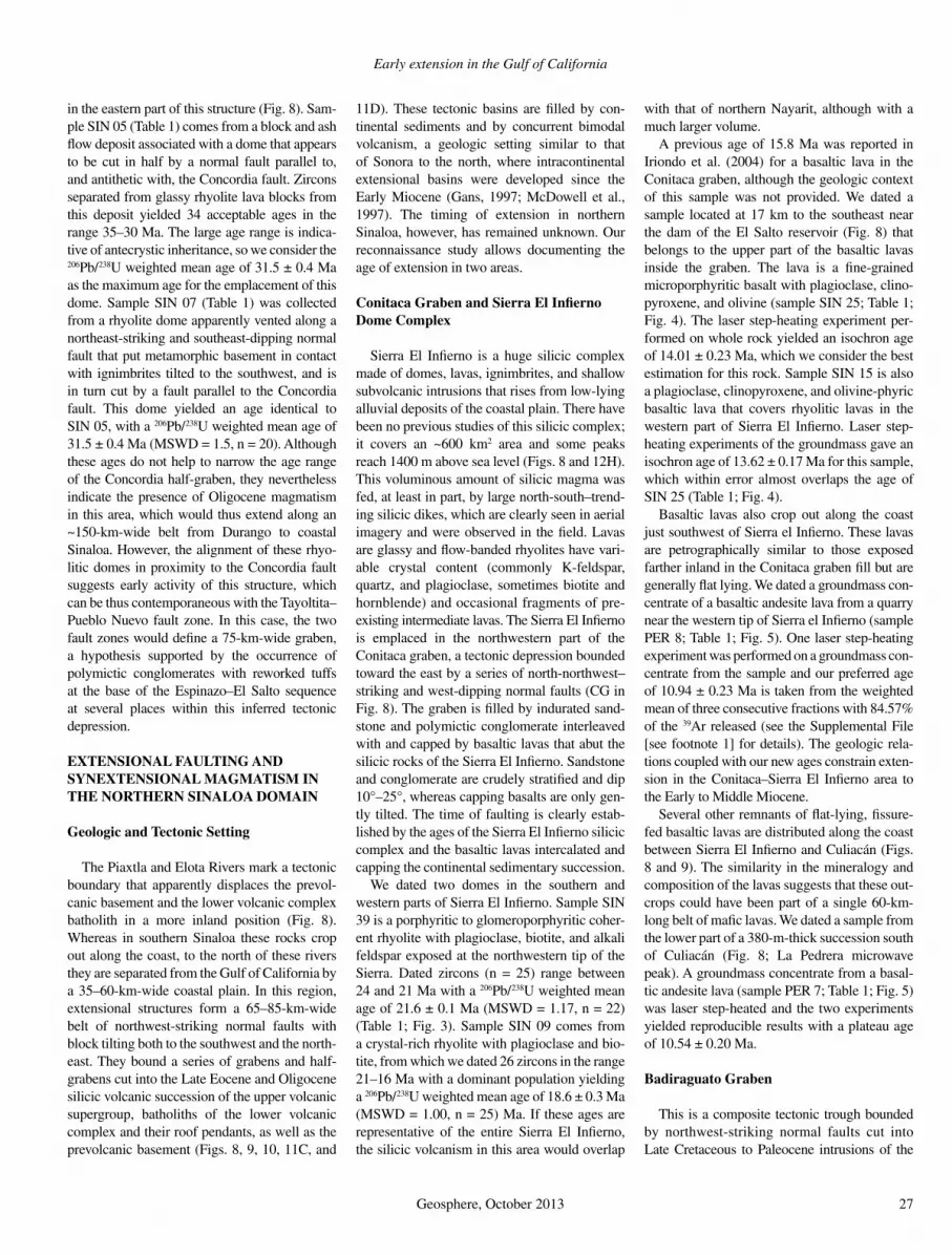
Early extension in the Gulf of California
Geosphere, October 2013 27
in the eastern part of this structure (Fig. 8). Sam-ple SIN 05 (Table 1) comes from a block and ash fl ow deposit associated with a dome that appears to be cut in half by a normal fault parallel to, and antithetic with, the Concordia fault. Zircons separated from glassy rhyolite lava blocks from this deposit yielded 34 acceptable ages in the range 35–30 Ma. The large age range is indica-tive of antecrystic inheritance, so we consider the 206Pb/238U weighted mean age of 31.5 ± 0.4 Ma as the maximum age for the emplacement of this dome. Sample SIN 07 (Table 1) was collected from a rhyolite dome apparently vented along a northeast-striking and southeast-dipping normal fault that put metamorphic basement in contact with ignimbrites tilted to the southwest, and is in turn cut by a fault parallel to the Concordia fault. This dome yielded an age identical to SIN 05, with a 206Pb/238U weighted mean age of 31.5 ± 0.4 Ma (MSWD = 1.5, n = 20). Although these ages do not help to narrow the age range of the Concordia half-graben, they nevertheless indicate the presence of Oligocene magmatism in this area, which would thus extend along an ~150-km-wide belt from Durango to coastal Sinaloa. However, the alignment of these rhyo-litic domes in proximity to the Concordia fault suggests early activity of this structure, which can be thus contemporaneous with the Tayoltita–Pueblo Nuevo fault zone. In this case, the two fault zones would defi ne a 75-km-wide graben, a hypothesis supported by the occurrence of polymictic conglomerates with reworked tuffs at the base of the Espinazo–El Salto sequence at several places within this inferred tectonic depression.
EXTENSIONAL FAULTING AND SYNEXTENSIONAL MAGMATISM IN THE NORTHERN SINALOA DOMAIN
Geologic and Tectonic Setting
The Piaxtla and Elota Rivers mark a tectonic boundary that apparently displaces the prevol-canic basement and the lower volcanic complex batholith in a more inland position (Fig. 8). Whereas in southern Sinaloa these rocks crop out along the coast, to the north of these rivers they are separated from the Gulf of California by a 35–60-km-wide coastal plain. In this region, extensional structures form a 65–85-km-wide belt of northwest-striking normal faults with block tilting both to the southwest and the north-east. They bound a series of grabens and half-grabens cut into the Late Eocene and Oligo cene silicic volcanic succession of the upper volcanic supergroup, batholiths of the lower volcanic complex and their roof pendants, as well as the prevolcanic basement (Figs. 8, 9, 10, 11C, and
11D). These tectonic basins are fi lled by con-tinental sediments and by concurrent bimodal volcanism, a geologic setting similar to that of Sonora to the north, where intracontinental extensional basins were developed since the Early Miocene (Gans, 1997; McDowell et al., 1997). The timing of extension in northern Sinaloa, however, has remained unknown. Our reconnaissance study allows documenting the age of extension in two areas.
Conitaca Graben and Sierra El Infi erno Dome Complex
Sierra El Infi erno is a huge silicic complex made of domes, lavas, ignimbrites, and shallow subvolcanic intrusions that rises from low-lying alluvial deposits of the coastal plain. There have been no previous studies of this silicic complex; it covers an ~600 km2 area and some peaks reach 1400 m above sea level (Figs. 8 and 12H). This voluminous amount of silicic magma was fed, at least in part, by large north-south–trend-ing silicic dikes, which are clearly seen in aerial imagery and were observed in the fi eld. Lavas are glassy and fl ow-banded rhyolites have vari-able crystal content (commonly K-feldspar, quartz, and plagioclase, sometimes biotite and hornblende) and occasional fragments of pre-existing intermediate lavas. The Sierra El In fi erno is emplaced in the northwestern part of the Conitaca graben, a tectonic depression bounded toward the east by a series of north-northwest–striking and west-dipping normal faults (CG in Fig. 8). The graben is fi lled by indurated sand-stone and polymictic conglomerate interleaved with and capped by basaltic lavas that abut the silicic rocks of the Sierra El Infi erno. Sandstone and conglomerate are crudely stratifi ed and dip 10°–25°, whereas capping basalts are only gen-tly tilted. The time of faulting is clearly estab-lished by the ages of the Sierra El Infi erno silicic complex and the basaltic lavas intercalated and capping the continental sedimentary succession.
We dated two domes in the southern and western parts of Sierra El Infi erno. Sample SIN 39 is a porphyritic to glomeroporphyritic coher-ent rhyolite with plagioclase, biotite, and alkali feldspar exposed at the northwestern tip of the Sierra. Dated zircons (n = 25) range between 24 and 21 Ma with a 206Pb/238U weighted mean age of 21.6 ± 0.1 Ma (MSWD = 1.17, n = 22) (Table 1; Fig. 3). Sample SIN 09 comes from a crystal-rich rhyolite with plagioclase and bio-tite, from which we dated 26 zircons in the range 21–16 Ma with a dominant population yielding a 206Pb/238U weighted mean age of 18.6 ± 0.3 Ma (MSWD = 1.00, n = 25) Ma. If these ages are representative of the entire Sierra El Infi erno, the silicic volcanism in this area would overlap
with that of northern Nayarit, although with a much larger volume.
A previous age of 15.8 Ma was reported in Iriondo et al. (2004) for a basaltic lava in the Conitaca graben, although the geologic context of this sample was not provided. We dated a sample located at 17 km to the southeast near the dam of the El Salto reservoir (Fig. 8) that belongs to the upper part of the basaltic lavas inside the graben. The lava is a fi ne-grained microporphyritic basalt with plagioclase, clino-pyroxene, and olivine (sample SIN 25; Table 1; Fig. 4). The laser step-heating experiment per-formed on whole rock yielded an isochron age of 14.01 ± 0.23 Ma, which we consider the best estimation for this rock. Sample SIN 15 is also a plagioclase, clinopyroxene, and olivine-phyric basaltic lava that covers rhyolitic lavas in the western part of Sierra El Infi erno. Laser step-heating experiments of the groundmass gave an isochron age of 13.62 ± 0.17 Ma for this sample, which within error almost overlaps the age of SIN 25 (Table 1; Fig. 4).
Basaltic lavas also crop out along the coast just southwest of Sierra el Infi erno. These lavas are petrographically similar to those exposed farther inland in the Conitaca graben fi ll but are generally fl at lying. We dated a groundmass con-centrate of a basaltic andesite lava from a quarry near the western tip of Sierra el Infi erno (sample PER 8; Table 1; Fig. 5). One laser step-heating experiment was performed on a groundmass con-centrate from the sample and our preferred age of 10.94 ± 0.23 Ma is taken from the weighted mean of three consecutive fractions with 84.57% of the 39Ar released (see the Supplemental File [see footnote 1] for details). The geologic rela-tions coupled with our new ages constrain exten-sion in the Conitaca–Sierra El Infi erno area to the Early to Middle Miocene.
Several other remnants of fl at-lying, fi ssure-fed basaltic lavas are distributed along the coast between Sierra El Infi erno and Culiacán (Figs. 8 and 9). The similarity in the mineralogy and composition of the lavas suggests that these out-crops could have been part of a single 60-km-long belt of mafi c lavas. We dated a sample from the lower part of a 380-m-thick succession south of Culiacán (Fig. 8; La Pedrera microwave peak). A groundmass concentrate from a basal-tic andesite lava (sample PER 7; Table 1; Fig. 5) was laser step-heated and the two experiments yielded reproducible results with a plateau age of 10.54 ± 0.20 Ma.
Badiraguato Graben
This is a composite tectonic trough bounded by northwest-striking normal faults cut into Late Cretaceous to Paleocene intrusions of the

Ferrari et al.
28 Geosphere, October 2013
lower volcanic complex and their roof pendants (Fig. 9). To the south, the graben is covered by middle Pleistocene basaltic lavas of the Pericos volcanic fi eld (see following). The Badiraguato graben is fi lled by sandstone and polymictic con-glomerate with intercalations of basaltic lavas and some rhyolitic domes and lavas. The con-glomerate is tilted 15°–38° both to the southwest and the northeast (Figs. 9 and 11D). We dated a basaltic andesite lava collected from an eroded succession of lavas between the Badiraguato and Mocorito grabens (sample PER 12; Table 1; Fig. 4). Although the lava is not in direct contact with the conglomerate it is considered equivalent to the basaltic lavas within the graben on a petro-graphic basis. A groundmass concentrate was step-heated with the temperature-controlled Ta furnace and we take the isochron age of 17.42 ± 0.77 Ma as the best estimate for this sample. Other basaltic lavas are exposed along the coast, ~30 km to the southwest. Similar to those more to the south, these coastal lavas are fl at lying. We dated a basaltic andesite (sample PER 14; Table 1; Figs. 4 and 12J) by step-heating using the temperature-controlled Ta furnace. The age spectrum is somewhat perturbed, but an isochron age of 10.33 ± 0.88 Ma can be confi dently cal-culated. In summary, the ages of the graben fi ll and the post extension lavas indicate that exten-sion in this part of Sinaloa is Early to Middle Miocene in age.
LATE MIOCENE VOLCANISM OF NORTHERN SINALOA AND OFFSHORE AREAS
Our new age data defi ne a regional pulse of mafi c magmatism just after the end of subduction across the entire Gulf of California region. Previ-ously, mafi c lavas in the range ca. 11–9 Ma were reported from western Sonora (Mora-Klepeis and McDowell, 2004) and in the Bahía de Los Angeles, Jaraguay, and Santa Rosalía areas in Baja California (Benoit et al., 2002; Calmus et al., 2003; Conly et al., 2005; Pallares et al., 2007). In addition to those described in the previ-ous section, we have recognized additional Late Miocene (ca. 12–10.5 Ma) mafi c lavas and dikes in the northernmost part of Sinaloa at Sierra de Navachiste, at the small Farallón de San Ignacio Island southwest of Los Mochis (Fig. 10), within the Gulf of California at Santa Catalina Island and in submerged rifted blocks (Fig. 2).
Sierra de Navachiste is an erosional remnant of a volcanic fi eld made of basaltic, andesitic, and dacitic lavas and some intermediate domes that currently cover an area of 170 km2 along the coast. Epiclastic deposits produced by the ero-sion of the lavas are also widespread. The lavas are essentially fl at lying and their base is at sea
level. We dated a groundmass concentrate from a dacitic lava interbedded with more mafi c lavas (sample LM 2; Table 1; Fig. 4). The preferred age is taken from the isochron age of 11.34 ± 0.79 Ma calculated excluding the fractions of sus-pected excess Ar (see the Supplemental File [see footnote 1]). Similar ages were obtained by the K-Ar method by Pallares et al. (2007) and Gastil et al. (1979) for andesitic lavas in the northwest-ern part of the fi eld near Topolobampo (Fig. 10).
Farallón de San Ignacio is a 0.3 km2 island 25 km offshore Sierra de Navachiste and just north of the northwest fault scarp bounding the Farallon Basin (Figs. 2 and 10). On the island, a massive rhyolitic lava is covered by 2 basaltic lavas 5–8 m in thickness. The tops of the basaltic lavas are horizontal, and they cover the original irregular morphology of the rhyolite without any visible paleosol. The rocks are too altered to be dated by 40Ar-39Ar, but we separated 11 zircons from the underlying rhyolitic lava. Single zircon ages of sample ROCA F6 range from 9 to 10 Ma with a 206Pb/238U weighted mean age of 9.5 ± 0.3 Ma (MSWD = 1.9, n = 9) . Despite this age not being very precise, it nevertheless suggests that the overlying fl at-lying basalts may be correla-tive with those of coastal Sinaloa. In the seismic images provided by Miller and Lizarralde (2013) in the nearby Guaymas Basin, a 2-km-thick evap-orite deposit overlies seaward-dipping refl ectors. We interpret the seaward-dipping refl ectors to correlate with the ca. 12–10 Ma basaltic lavas at Farallón de San Ignacio and along the coast of Sinaloa. Similar basalts, dated as ca. 11–9.1 Ma (Conly et al., 2005), were also found in the Santa Rosalia area (Fig. 2) below the Boleo evaporites that Miller and Lizarralde (2013) correlated with those seen on seismic sections.
Santa Catalina Island is part of a rifted conti-nental block at the latitude of Sierra de Nava-chiste in the western part of the Gulf of Cali-fornia (Fig. 2). The bulk of the island consists of Late Cretaceous granite of the Peninsular Ranges batholith heavily intruded by Miocene granitoids and aplitic dikes (Piñero-Lajas, 2009). Many northwest-striking, southwest-dipping mafi c dikes exposed in the cliffs of the northwestern part of the island cut all other rocks (Fig. 12I). A plagioclase concentrate from one mafi c dike was laser step-heated and ana-lyzed in two experiments (sample SC 3; Table 1; Figs. 4 and 5); although the sample shows evi-dence of excess argon, we obtained a plateau age of 10.89 ± 0.52 Ma consistent with the less-precise isochron age of 10.14 ± 2.59 Ma (see the Supplemental File [see footnote 1] for details) that we consider representative of the mafi c dike swarm at Santa Catalina Island.
Mafi c dikes and silicic rocks of similar ages were also found in the rifted blocks submerged
in the Gulf of California. Sample ROCA 3J 5 (Table 1; Figs. 4 and 5) is a lithic tuff that was collected using the remotely operated vehicle (ROV) Jason at the top of the Tamayo dome (also called Tamayo Bank; Sutherland et al., 2012), a 30 × 40-km-wide, ~1000-m-high vol-canic structure 80 km offshore Mazatlán (Fig. 2). Two laser step-heating experiments were per-formed on a feldspar concentrate defi ning a pla-teau age of 11.70 ± 0.07 Ma indistinguishable from the isochron age obtained by combining all the data points from the two experiments. Silicic volcanism of Late Miocene age is widespread in Sonora (Mora Alvarez and McDowell, 2000; Vidal-Solano et al., 2005, 2007), but has never been reported to the south. The sample from the Tamayo dome is the fi rst evidence of Late Mio-cene silicic pyroclastic rocks in the southern part of the Gulf of California. Sample ROCA 24J-33 was also collected using the ROV on a rifted continental block cut by a transform fault bound-ing the Pescadero Basin to the south (Fig. 2). It is a porphyritic, fi ne-grained subvolcanic microdiorite with plagioclase and hornblende (0.25–3.5 mm), scarce biotite and opaque miner-als, probably representing a shallow sill. A horn-blende concentrate was laser step-heated and we consider the isochron age of 11.29 ± 0.37 Ma as the best estimation for this sample.
Sample DANA 46a was dredged from a promi-nent north-northeast–striking and 800-m-high fault scarp offshore northern Nayarit, ~90 km southeast of the Tamayo dome (Fig. 2). The sample is a mafi c aphyric lava (either a fl ow or a dike) presumably associated with the fault scarp. Four experiments with different mass spectrom-eters and heating methods gave very consistent results, yielding a 11.96 ± 0.26 Ma isochron age (Table 1; Fig. 4; Supplemental File [see foot-note 1]). This age overlaps with those obtained for northwest-striking mafi c dikes in south-ern Sinaloa and northern Nayarit (Henry and Aranda-Gómez, 2000; Frey et al., 2007). In seis-mic profi les, Sutherland et al. (2012) recognized an irregular, ropey layer mantling the seismic basement offshore of northern Nayarit that they interpreted as a volcanic layer of the Comondú Group (24–12 Ma). Our dated samples ROCA 3J 5 and DANA 46a, collected close to the trace of the seismic profi le, provide a direct constraint of the nature and age of the uppermost part of this volcanic layer.
LATE PLIOCENE AND PLEISTOCENE INTRAPLATE VOLCANISM
Onshore post–Late Miocene volcanism is rare in the southeastern Gulf of California. The only previously known occurrences were the 3.4 Ma Mesa Cacaxtla shield volcano and

Early extension in the Gulf of California
Geosphere, October 2013 29
the 2.1 Ma mafi c lavas at Punta Piaxtla (Aranda-Gómez et al., 2003), both located along the coast ~60 km northwest of Mazatlán (Fig. 8). The geologic maps of the SGM also report two other mafi c volcanic fi elds with young morpho-logic appearance, Pericos and Choix. The only previous age available was a K-Ar age of 0.7 Ma (Clark, 1976) for a lava in the Choix volcanic fi eld, but no geochronologic information was available for the Pericos volcanic fi eld and there was no geochemical study for either fi eld.
The Pericos volcanic fi eld covers an area of ~20 × 32 km, and is ~25 km north of Culiacán (Fig. 9). Lava fl ows, small shield volcanoes, and cinder cones of basaltic composition uncon-formably overlie Paleocene granodiorite and Oligocene ignimbrites, which are mostly tilted to the west-southwest. Lavas are porphyritic and contain olivine, plagioclase, and clino pyrox ene in a microcrystalline matrix. Some lavas contain abundant megacrysts of green clinopyroxene (to 8 cm), olivine (to 1 cm), and/or plagioclase (to 1 cm), or aggregates of olivine and clino -pyrox ene. We recognized at least 16 cinder cones and maars, all with a well-preserved mor-phology, suggesting a Pleistocene age for this vol canism. We dated three samples, trying to cover the entire age range of the fi eld. The sam-ples (PER1, PER4, and PER 6) are hawaiitic in composition and have low K contents, so Ar had to be released in a few steps. Neverthe-less, they provide consistent middle Pleistocene ages ranging between 884 ± 97 and 585 ± 82 ka (Figs. 4 and 5; Table 1, see the Supplemental File [see footnote 1] for details). Rocks from the late Pliocene Punta Piaxtla sills and Mesa Cacaxtla shield volcano, 200 km to the south-southeast along the Sinaloa coast, show remark-ably similar compositions, mineralogies, and megacryst contents (see following), suggesting that the mantle of this wide region achieved a homogeneous composition that has been main-tained during the past 3.4 m.y.
The Choix volcanic fi eld consists of a few cinder cones and lava fl ows 120 km north-north-east of Los Mochis in the northernmost corner of Sinaloa, near the boundary with Sonora and Chihuahua (Fig. 9). Lavas are emplaced on top of Paleocene granodiorite and ignimbrites that are undated, but probably Oligocene. Sample CHO 4 comes from an alkali-basalt lava from a very well preserved cinder cone near the Huites reservoir dam (Fig. 9). The lava is vesiculated with phenocrysts of plagioclase, olivine, and pyroxene, and megacrysts of pyroxene (to 3 cm) and olivine (to 0.5 cm). Due to the very low K content and the presumed young age, only four fractions were collected. The bulk of the 39Ar was released in the last two fractions and no plateau can be defi ned. This also yielded an
imprecise isochron age of 29 ± 181 ka. The best estimate for this sample is 138 ± 107 ka, taken from the third fraction containing the bulk of the 39Ar released (see the Supplemental File [see footnote 1] for further details). Although impre-cise, this age confi rms the very young age of the Choix volcanic fi eld.
GEOCHEMISTRY
Major and trace element analyses were obtained for volcanic rocks of latest Oligocene to Early Miocene, Late Miocene, and Pleisto-cene age (Table 2) distributed along the south-eastern margin of the Gulf of California.
Late Oligocene to Early Miocene (28–16 Ma)
Late Oligocene to Early Miocene samples dis-play a bimodal distribution in the total alkali ver-sus silica diagram (Fig. 13A; LeBas et al., 1986). Samples with low silica content (SiO2 = 48.7–55.2 wt%) are lavas and dikes that are classifi ed as hypersthene-normative basalts and quartz-normative basaltic andesite, whereas silicic sam-ples (SiO2 = 68.2–83.0 wt%) from domes, lavas, and ignimbrite are classifi ed as peraluminous (molar Al2O3/CaO + Na2O + K2O, A/CKN >1), corundum-normative dacite and rhyolite, with a predominance of rhyolitic compositions. Most samples plot in the fi eld of subalkaline rocks of Irvine and Baragar (1971), with the exception of one basaltic lava from the Atengo half-graben (TS 16), which has the lowest SiO2 content and plots in the fi eld of alkaline rocks (Fig. 13A). None of the mafi c samples can be regarded as primitive mantle melts, as they have relatively low MgO and Cr contents (Figs. 13B, 13D) and low Mg# (100 × molar MgO/MgO + FeOtotal) of 42.1–52.5 (Table 2). The TiO2 content is variable (Fig. 13C), and is highest for the alkaline sample (TS 16; 2.39 wt%).
Mafi c rocks have variable trace element pat-terns in multielement diagrams normalized to primitive mantle values (Sun and McDonough, 1989) (Fig. 14E). Negative anomalies in Nb and Ta are absent in the TiO2-rich alkaline sample (basalt TS 16), and are variably developed in the subalkaline basalts and basaltic andesite. Posi-tive Pb and Sr anomalies are present in all sam-ples, but are more pronounced in the basaltic andesite. The lack of a Nb-Ta anomaly in sample TS 16 indicates an origin in an intraplate setting; nevertheless, the enrichment in Pb and Sr, which is not a common feature of intraplate magmas, could refl ect assimilation of crustal material (feldspar contamination) by the mafi c magma. Trace element patterns of the subalkaline sam-ples have typical features of subduction-related
rocks; however, in this sample group, crustal assimilation processes can have also contributed to generate signatures similar to those found in arc volcanic rocks. Alternatively, the subduction signature can be inherited from mantle domains previously modifi ed by subduction components, which partially melted under the extensional regime that generated the intraplate magmas. Consequently, the subduction-related geochem-ical signatures are unlikely to provide unequivo-cal constraints on tectonic setting.
Silicic rocks are enriched in the most incom-patible elements (Rb-U) and display well- devel-oped negative Nb-Ta and positive Pb anomalies (Fig. 14F). Despite the high silica content of these rocks, negative Ba anomalies, which result from the fractionation of K-feldspar, are absent. Eu and Sr negative anomalies are small in dacitic rocks, implying negligible plagioclase fractionation. The trace element behavior indi-cates that crystal fractionation had a restricted role in the early evolution of the silicic mag-mas; this is supported by the fact that inherited zircons remained in the melt. This feature is often associated with crustally derived magmas (e.g., Miller et al., 2003; Bryan et al., 2008). An origin in the crust is also consistent with the bimodal composition of the magmas emplaced in this period.
It is important to note that intermediate rocks comparable with the middle and upper members of the Comondú Group (19–12 Ma) observed in Baja California were not observed along the eastern margins of the Gulf of Califor-nia through Nayarit and Sinaloa. In this region volcanism is essentially bimodal, represented by rhyolitic domes and surrounding basalts in the range ca. 21–13.5 Ma and thus overlapping with peak activity of intermediate composition volcanism of the Comondú Group. This sup-ports the observation of Bryan et al. (2013) that, regionally, bimodal volcanism persisted during the Middle Miocene and to the east of the locus of Comondú Group volcanism.
Late Miocene (11.6–9 Ma)
Volcanic rocks emplaced in the Late Miocene have mainly a bimodal compositional distribu-tion (Fig. 13A). Mafi c to intermediate samples (SiO2 = 51.4–57.2 wt%) are classifi ed as sub-alka line quartz-normative basaltic andesite, low-silica andesite, and potassic trachybasalt. Unlike rocks emplaced in the previous event, basalts are absent and more differentiated com-positions with lower MgO and Cr contents (Figs. 13B, 13D) and Mg# (36.7–53.5) occur. Analyses of scarce rocks with SiO2 > 62 wt% indicate metaluminous (A/CKN < 1) high-silica andesite, dacite, and rhyolite compositions.

Ferrari et al.
30 Geosphere, October 2013
Low-silica rocks from the coastal area and Farallón de San Ignacio display relatively simi-lar, subparallel trace element patterns in a mantle normalized multielement diagram (Fig. 14B), with weakly developed Nb-Ta anomalies, posi-tive anomalies of Ba, Pb, and Sr, and relatively fl at rare earth element (REE) patterns (chondrite normalized La/Ybn = 3.7–5.3). Very similar compositions are reported for the nearest known outcrops of similar age to the north of the study area, in the central Sonora coast (Till et al., 2009), and for the Santa Rosalía area in Baja California (Conly et al., 2005) (Figs. 1 and 14B). Regional compositional variations are suggested by one potassic trachybasalt from the submarine Nayarit scarp in the southeastern Gulf of Califor-nia (Fig. 2), which has the lowest SiO2 content (51.4 wt%) and is more enriched in most trace elements, resulting in a more pronounced Nb-Ta anomaly. In addition, a basaltic andesite col-lected northeast of Pueblo Nuevo (Fig. 8), within the SMO, has an Nb-Ta anomaly similar to that of the coastal lavas, but is more enriched in the most incompatible elements (Rb to Sr), and has
a stronger depletion in the heavy REEs with respect to the light REEs (La/Ybn = 11.5). A more marked difference is observed in Late Miocene mafi c lavas from the Río Chico–Canatlán graben, located in the eastern part of the SMO (Fig. 8) (Henry and Aranda-Gómez, 2000); the lavas have the high Nb contents of intraplate rocks. Differ-ences in composition from east to west indicate changes in the mantle source composition from the Gulf of California to the eastern SMO, proba-bly related to decreasing contributions of subduc-tion components to the mantle and to increasing magma segregation depth.
Late Miocene silicic rocks from coastal and offshore areas display well-developed negative Nb-Ta and positive Pb anomalies, but differ in the abundance of trace elements (Figs. 14C, 14D). Rhyolite R-F6 from Farallón de San Ignacio (Fig. 10) and high-silica andesite R 24J 33 from the South Pescadero transform (Fig. 2) show a pattern similar to those of the latest Oligocene to Early Miocene, with less enrichment in all elements, no Ba anomaly, and less pronounced Sr and Eu anomalies, despite its high SiO2 content (71%
and 62%, respectively). A dacitic tuff (R3J-4a) from the submarine Tamayo dome (Fig. 2) has a higher abundance of most elements and displays pronounced negative anomalies in Ba, Sr, and Eu that indicate extensive feldspar fractionation. Similar differences are observed in Middle to Late Miocene silicic rocks (SiO2 >70 wt%) from the central Sonora coast (Till et al., 2009), and from the Santa Rosalía area in Baja California (Conly et al., 2005) (Figs. 2 and 14D). A mark-edly different trace element pattern characterizes a Sierra Navachiste dacite sample (Figs. 10 and 14C), which has a much lower Nb-Ta abundance, positive Ba and Sr anomalies, no Eu anomaly, and stronger depletion toward the heavy REEs (La/Ybn = 13.3). The composition of this sample is similar to those of samples from Sierra Libre, in the central Sonora coast (Till et al., 2009), and also coincides relatively well with that of clino-pyroxene-bearing andesite from Santa Rosalía (Conly et al., 2005), and Mg-andesite reported for the Borja and Jaraguay volcanic fi elds (Pal-lares et al., 2008) in the central Baja California peninsula. The variable composition of the Late
0
2
4
6
8
10
12
40 50 60 70 80
SiO (wt. %)2
Alkaline
Subalkaline
BBA
AD
R
Na
O +
KO
(w
t. %
)2
2
0
1
2
3
4
40 50 60 70 80
0
1
2
3
4
5
6
7
8
9
40 50 60 70 80
MgO
(w
t.%)
0
50
100
150
200
250
0 2 4 6 8 10
MgO (wt. %)
Cr
ppm
SiO (wt. %)2
TiO
(wt.
%)
2
SiO (wt. %)2
H/KTB
Pleistocene
Late Miocene
Latest Oligocene -early Miocene
A
B
C D
Figure 13. Composition of volcanic rocks of latest Oligocene to Early Miocene, Late Miocene, and Pleistocene age, from the eastern margin of the Gulf of California. (A) Total silica versus alkalis classifi cation diagram (LeBas et al., 1986), showing the line dividing alkaline from subalkaline compositions (Irvine and Baragar, 1971); A—andesite, B—basalt; BA—basaltic andesite; D—dacite; H—hawaiite; KTB—potassic trachybasalt; R—rhyolite. (B) Variation of SiO2 versus MgO. (C) Variation of SiO2 versus TiO2. (D) Variation of MgO versus Cr. Number of analyses is 33.

Early extension in the Gulf of California
Geosphere, October 2013 31
Miocene silicic rocks points to variable magma generation processes acting during this event. These processes may have involved crustal melt-ing and assimilation, or differentiation of mafi c rocks through crystal fractionation, but further studies are needed to better constrain the origin of the observed differences.
Middle to Late Pleistocene (Younger Than 1 Ma)
Lava samples from the Pleistocene Choix and Pericos volcanic fi elds (Figs. 9 and 10) plot in the fi eld of alkaline rocks (Fig. 13A). One sample classifi es as hypersthene-normative basalt, and
the rest are nepheline-normative hawaiite and alkali basalt. The samples have the highest MgO, TiO2, and Cr contents of all studied samples (Figs. 13B–13D), and Mg# of 48.2–57.9, but these val-ues are lower than those expected for primary magmas derived from the mantle, implying that differentiation occurred during their ascent.
1
10
100
1000CHO1 (AB) CHO2 (AB)CHO3 (B) CHO4 (AB)PER-1 (H) PER-3 (H)PER-4 (H) PER-5 (H)PER-6 (H)
Mesa Cacaxtla, Aranda-Gómez et al. (1997)
PleistoceneSiO = 46.9 - 47.9 wt. %2
Sam
ple/
PR
IMA
1
10
100
1000
Latest Oligocene - early MioceneSiO = 48.7 - 55.2 wt. %2
Sam
ple/
PR
IMA
1
10
100
1000
LM-2 (D)
Sam
ple/
PR
IMA
Late MioceneSiO = 66.3 wt. %2
1
10
100
1000
Central Sonora coastTill et al. (2009)
Sam
ple/
PR
IMA
Ba U Ta Ce Pr Nd Hf Eu Tb Ho ErRb Th Nb La Pb Sr Zr Sm Gd Dy Y Yb Lu
Ba U Ta Ce Pr Nd Hf Eu Tb Ho ErRb Th Nb La Pb Sr Zr Sm Gd Dy Y Yb Lu
Ba U Ta Ce Pr Nd Hf Eu Tb Ho ErRb Th Nb La Pb Sr Zr Sm Gd Dy Y Yb LuBa U Ta Ce Pr Nd Hf Eu Tb Ho ErRb Th Nb La Pb Sr Zr Sm Gd Dy Y Yb Lu
A
C D
EESC 7 (BA)TS 21 (B)
PER 12 (BA)
TS 16 (B)
Sta. Rosalía area, B.C.Conly et al. (2005)
Late MioceneSiO >59.8 wt. %2
R-F6 (R)R3J-4 (D)R24J-33 (A)
Mg-Andesite, B.C., Pallares et al. (2008)
Central Sonora coast, Till et al. (2009)Sta. Rosalía area, B.C., Conly et al. (2005)
1
10
100
1000
Sam
ple/
PR
IMA
ESC 2 (R)MDCH 10 (D)
MDCH 03 (R)
ESC 8 (R)
MicBarr 01 (R)MZ 1 (R)
Ba U Ta Ce Pr Nd Hf Eu Tb Ho ErRb Th Nb La Pb Sr Zr Sm Gd Dy Y Yb Lu
FHUA 5 (R)
ESC 3 (D)
Latest Oligocene- early Miocene
SiO = 68 - 83 wt. %2
1
10
100
1000
Sam
ple/
PR
IMA
Sam
ple/
PR
IMA
Late MioceneSiO = 51.4 - 57.5 wt. %2 PER-8 (BA)
PER14 (A) LM1 (BA)R-F3 (BA)
PER-7 (BA)
ES1 (BA) 46a (KTB)
R-F1b (A)
Ba U Ta Ce Nd HfPr Eu Tb Ho ErRb Th Nb La Pb Sr Zr Sm Gd Dy Y Yb Lu
B Coastal area
SMO Nayarit scarp
Río Chico-Otinapa, Henry and Aranda Gómez (2000)Sta. Rosalía area, B.C., Conly et al. (2005)Central Sonora coast, Till et al. (2009)
Figure 14. Multielement diagrams of volcanic rocks from the eastern margin of the Gulf of California, normalized to primitive mantle (PRIMA) values of Sun and McDonough (1989). (A) Pleistocene (0.884–0.138 Ma) mafi c lavas. Late Miocene (11.96–9.5 Ma) (B) mafi c lavas, and (C, D) silicic rocks. Latest Oligocene to Early Miocene (24.38–17.4 Ma) (E) mafi c rocks, and (F) silicic rocks. Letters in parentheses next to sample numbers indicate rock composition, A—andesite; AB—alkali basalt; B—basalt; BA—basaltic andesite; D—dacite; H—hawaiite; KTB—potassic trachybasalt; R—rhyolite. In A–D, data compiled from the literature for rocks of similar age in mainland Mexico and Baja California peninsula are shown for comparison. SMO—Sierra Madre Occidental.

Ferrari et al.
32 Geosphere, October 2013
The samples have quite uniform trace ele-ment patterns (Fig. 14A), which resemble those of oceanic island basalts (OIB), with the highest normalized abundances in Nb and Ta and strong enrichment of the light REEs with respect to the heavy REEs (La/Ybn = 9.4–13.5). The trace element pattern of a late Pliocene hawaiite from Mesa Cacaxtla (Figs. 8 and 14A), reported by Aranda-Gómez et al. (1997), is also remarkably similar to that of Choix and Pericos, considering the different emplacement times (Cacaxtla at 3.2 Ma; Aranda-Gómez et al., 1997; Pericos at 0.585–0.884 Ma; Choix at 0.138 Ma, this work) and the distance between them.
The alkaline character and the trace element composition suggest that the Pleistocene mag-mas originated in a deeper, enriched OIB-like mantle source in the stability fi eld of garnet, and differentiated at crustal levels.
DISCUSSION
Timing of Extension in the Southern Gulf Extensional Province
Figure 15 summarizes the ages of extension documented in this work and the literature. A precise determination of the direction of exten-sion awaits a structural study of the kinematics of the various fault systems that is in progress and will be published later. Although a strike-slip component of motion has been observed along some of the faults, the large vertical dis-placement and the consistent tilting of blocks indicate a dominant normal motion and an almost fault-orthogonal direction of extension. At a regional scale, we recognize a fairly con-sistent pattern along the ~700 km of length of the southeastern to central GEP with episodes of extension since ca. 29 Ma.
A Late Oligocene (ca. 29–24 Ma) phase of extension is documented in the central part of the study region (southern Sinaloa domain) in the area bounded by the Tayoltita–Pueblo Nuevo fault system to the east and the Concordia fault to the west (Fig. 8). This early extension would be only slightly younger than that reported in the Rodeo and Nazas area (Luhr et al., 2001) and in the northern part of the Rio Chico–Canatlán graben (Loza-Aguirre et al., 2012) to the east of the SMO unextended core (Fig. 15). We expect a similar Late Oligocene extensional phase to have affected areas to the north (northern Sinaloa domain, Fig. 9), particularly in the more inland part of the GEP, which we did not study directly. Supporting this is that extension of this age has recently been documented further to the north in the Guazapares area of southernmost Chihuahua (Murray et al., 2013). Because of the extensive cover of Early Miocene ignimbrites, the exis-
tence of a Late Oligocene phase of extension is diffi cult to prove in the northern Nayarit domain. However, Late Oligocene normal faulting is documented at least in the central Bolaños gra-ben (Fig. 2), where some of the faults (e.g., the prominent Ballena and Cabreras faults) are also northwest trending and served as mineralization pathways during the Early Miocene (Ramos-Rosique, 2013). The direction of extension during this fi rst phase is not well constrained but, considering the right-lateral component of motion reported in the northern part of the Tayol-tita–Pueblo Nuevo fault system (Horner and Enríquez, 1999), it may be slightly oblique with respect to the main faults, i.e., west-northwest–east-southeast directed (Fig. 15).
Extension continued during the Early and Middle Miocene (ca. 24–12 Ma) in Sinaloa and northern Nayarit. In Nayarit, this phase can be further divided into two main episodes with dif-ferent directions of extension. Normal faulting with approximately north-south trends affected a 180-km-wide area between Bolaños and Huaji cori (Fig. 15) between ca. 24 and 18 Ma and was postdated by north-northwest–trending fault systems (Pochotitán and San Pedro–Acapo-neta) active between before 18 to 11 Ma along the coast (Fig. 6). In Sinaloa, Early to Middle Miocene extensional faults strike essentially north-northwest, forming grabens and half-grabens fi lled by 21–17 Ma dome complexes and vol cani clastic sediments interlayered with ca. 17–13 Ma basalts. This last phase of exten-sion is postdated by fl at-lying basaltic lavas fed by north-northwest–trending dikes dated as between 11.3 and 10.3 Ma. These geologic and geochronologic relations make the Sinaloa area the southern prolongation of the latest Oligo cene–Middle Miocene extensional belt of Sonora, where high-angle faulting and volcani-clastic sedimentation of the Baucarit Formation occurred from 24 Ma and was essentially over by ca. 12 Ma (McDowell et al., 1997).
The western limit of this early extension is poorly constrained due to the superposed subsequent faulting in the southern Gulf of California. Textural and geologic evidence indicate that Early to Middle Miocene (ca. 21–15 Ma) plutons exposed along the Nayarit coast, the islands offshore southern Baja Cali-fornia, and recovered in the rifted blocks inside the southern Gulf of California were emplaced at shallow depths (Duque-Trujillo et al., 2012). The short time span between U-Pb zircon ages and hornblende and biotite ages also suggest rapid cooling and the possibility that they were emplaced into an extending crust (Duque-Tru-jillo et al., 2012), but more thermochronologic studies are needed to better constrain this infer-ence. However, Mark et al. (2012) found apatite
U-Th(He) exhumation ages of 25–17 Ma in the Loreto area that are in agreement with the early extension of the southern GEP evident from our study. In southernmost Baja California, the Cretaceous batholithic rocks of the eastern part of the Los Cabos block show a geochrono-logic, geochemical, and isotope similarity with those of the Jalisco block in mainland Mexico (Schaaf et al., 2000) and those exposed in the Maria Madre Island in between (Pompa-Mera et al., 2013), suggesting that the two blocks were contiguous in a north-northwest alignment prior to rifting (Fig. 15). The normal faults of the Los Cabos block are mostly north-south striking, thus parallel to the Early and Middle Miocene faults of Nayarit and Jalisco described in this work. The onset of faulting is constrained by the oldest sediments in the Los Cabos basin (Fig. 15) that consist of red terrestrial sandstone and conglomerate (Calera Formation; Martí nez-Gutié rrez and Sethi, 1997). These sediments are not dated, but they overlie tilted silicic vol-canic rocks correlative with the ca. 21–19 Ma ignimbrites of the La Paz area. They are also conformably covered by the marine Trinidad Formation, assigned to the Late Miocene on a paleontological basis (Martí nez-Gutié rrez and Sethi, 1997). Based on these stratigraphic con-straints, the approximately north-south normal faults in the Los Cabos blocks might be partly coeval with the last extensional faulting in the northern Nayarit domain (ca. 18–12 Ma). How-ever, thermochronologic studies indicate that rapid cooling of the footwall of the Los Cabos fault initiated at the beginning of the Late Mio-cene (Fletcher et al., 2000; Lovera et al., 2010). In summary, despite the fact that the onset of extension cannot be precisely determined, we consider that the available data do not preclude the possibility that by Middle Miocene time, the area now occupied by southern Gulf of Califor-nia was already an extending basin.
Pre–Late Miocene Extension in the Northern Gulf Extensional Province
The early extension we have documented in this work cannot be limited to the southern-cen-tral GEP. Early to Middle Miocene extension is well documented in eastern and central Sonora (McDowell et al., 1997; Gans, 1997; Gonzalez-León et al., 2000; Vega-Granillo and Calmus, 2003; Nourse et al., 1994; Wong and Gans, 2003; Wong et al., 2010), and constitutes the obvious prolongation to the north of the exten-sional belt of Nayarit and Sinaloa described in this work. However, the western boundary of this extensional belt is uncertain. Micro-paleontological studies of several deep wells drilled in the Wagner, Consag, and Tiburón

Early extension in the Gulf of California
Geosphere, October 2013 33
Basins (Fig. 1) reported the occurrence of >1 km of marine sediments with shallow-water (<200 m) foraminifera, dinoflagellates, and nanofossils older than 11.2 Ma (Helenes et al., 2009). Recent reinterpretation of these data by J. Helenes and A. Carreño (2013, written com-mun.) indicates that part of the recovered well material is reworked, a feature already reported for other sites in the northern Gulf of Califor-nia (e.g., Imperial Formation, McDougall et al., 1999; Laguna Salada, Martín-Barajas, 2001; Isla Tiburón, Gastil et al., 1999). Given that the Peninsular Range Batholith of Baja Cali-fornia was uplifted in the Early Eocene (e.g., Axen et al., 2000) the widespread occurrence of reworked Middle Miocene marine microfossils requires the existence and proximity of shallow-marine environments within the northern Gulf of California by the Middle Miocene. This inter-pretation is apparently at odds with the geology of Isla Tiburón (Fig. 1) (Oskin and Stock, 2003; Bennett et al., 2012), where marine incursion has been well dated as latest Miocene. However, we note that Isla Tiburón is at the southeastern margin of a basin that, in its central part, has
>7 km of sediments overlying the Late Creta-ceous basement (Martín-Barajas et al., 2013). The well T-1 drilled by PEMEX near the deepest part of the Tiburón Basin encountered ~4.8 km of marine deposits (Helenes et al., 2009), which in their lower part are considered not reworked and have an upper age limit of 11.9 Ma based on the microfossils Ciclycargolithus fl oridanus (known range 37–11.9 Ma), Cribroperdinium tenuitabulatum (69.9–11.63 Ma), Paleocys-todinium golzowense (56–9.2 Ma), and Dap-silidinium pseudocolligerum (56–7.12 Ma) (J. Helenes, 2013, written commun.). The recent seismic profi les of Martín-Barajas et al. (2013) show that the lowermost sedimentary package pinches out to the south and is not deposited on the basement high at the southeastern margin of the basin (Tiburon shelf and Isla Tiburón).
Therefore, the latest Miocene age of marine incursion at Isla Tiburón does not contradict the pre–11.9 Ma marine sediments in the deepest part of Tiburón Basin and simply records the widening development of marine conditions in the gulf in the Late Miocene. A defi nitive answer on the existence and extent of localized
marine basins of pre–Late Miocene age in the northern Gulf of California awaits further stud-ies of well stratigraphy and seismic data from the deeper part of the Tiburón and other basins, but the possibility of an early extension in this part of the gulf cannot be ruled out.
Pre–Late Miocene Lithospheric Thinning and Motion of Baja California
The data reported in this work provide impor-tant constraints on the magnitude of pre–Late Miocene rifting in the southern GEP. Different seismic methods consistently indicate that the crust along the Nayarit and Sinaloa coast is sig-nifi cantly thinner than in the core of the SMO. Estimations of the Moho depth from receiver functions and seismic refraction along the coast range between ~21 km west of Culiacán to ~18 km in northern Nayarit (Persaud et al., 2007; Lizarralde et al., 2007; Savage and Wang, 2012) (Fig. 2). By contrast, the crustal thickness in the unextended core of the SMO is estimated to be 55 km northeast of Culiacán (Bonner and Herrin, 1999), ~40 km northeast of Mazatlán
JaliscoBlock
batholith
~31–29 Ma
Rhyolitic domes~21–17 Ma
Late Cretaceousbatholith
Espinazo-El SaltoIgnimbrites (24 Ma)
Flat-lying mafic lavas(11–10 Ma)SMO
unextended core
Main extensional basins
Sinaloabatholith
Baja Californiaat 12 Ma Baja California
at 30 Ma
Nayar
PV
Hua
Bola
ños
Tlal
tena
ngo
Mez
quita
l
JM
Conitaca
Canatlán
Rodeo
Mocorito
Badiraguato
SoyatipaSanalona
Aten
go
Alic
a
S. Pedro
Panuco
Concordia
Pochititán
24-1818-11
21-11
?29-10
24-18
29-24 PuebloNuevo
Tayoltita
RioChico
18-11
Los Cabosbatholith
104°
22°
24°
106°C
abos
32-30
Proposed motion of Bajabetween 30 and 12 Ma
T M V B
3018
12
50 km in 6 m.y. = 8.3 mm/yr85 km in 11 m.y. = 7.7 mm/yr
Figure 15. Regional tectonic map summarizing the main structures and age of extension of the conjugate margins of the southern Gulf of California. Geographic coordinates refer to present position of Mexico mainland. Position of Baja Cali-fornia at 12 Ma is obtained by moving the southern tip of Baja California (Cabo San Lucas) 350 km to the southeast paral-lel to the Tamayo transform, removing all the oceanic crust accreted at the East Pacifi c Rise to the south. The position at 30 Ma is obtained by aligning the paleotrench off Baja Cali-fornia with the present trench off the Jalisco block and joining the Late Cretaceous batholith of the Los Cabos block in Baja California with the Sinaloa and Jalisco block batholith (see text for discussion). Abbreviations: PV—Puerto Vallarta; Hua—Huajicori; JM—Jesús María.

Ferrari et al.
34 Geosphere, October 2013
(Couch et al., 1991), and almost 30 km in the unfaulted part of the Los Cabos block (Páramo et al., 2008). The presence of 11.3–10.3 Ma fl at-lying mafi c lavas at or near sea level along the coast of Nayarit and Sinaloa indicates that no signifi cant tectonic activity occurred in this area after ca. 11 Ma. This implies that the thick-ness of the crust was substantially reduced by early extension occurring well before the end of subduction. This crustal thinning would have greatly aided the subsequent rupture, limiting the elastic thickness of the lithosphere to the uppermost crust, typical of a so-called “crème bruleé” rheology (Jackson, 2002).
The recognition of this early phase of exten-sion in the GEP has important implications for the mode of extension and lithospheric rupture that led to the formation of the Gulf of Califor-nia. Although the kinematics of opening are debated, studies in the past 20 yr essentially assumed a ca. 14–12.5 Ma initiation of the rifting process (e.g., Stock and Hodges, 1989; Gans, 1997; Umhoefer et al., 2001; Oskin et al., 2001; Fletcher et al., 2007; Sutherland et al., 2012), implying a very fast rate of crustal thin-ning and the initiation of seafl oor spreading only ~6–10 m.y. after the onset of extension (Umhoefer, 2011). This is a very short time span for complete rupturing of the lithosphere, which is commonly accomplished over 25–30 m.y. in other examples (see review in Umhoefer, 2011). Our results indicate a more reasonable time span of ~25 m.y. between the initiation of extension and the initial formation of oceanic crust.
An early phase of extension across the GEP beginning ca. 29 Ma also reconciles the appar-ent discrepancy between the 275–300 km of offset across the northern Gulf of California since 12.5 Ma estimated by correlative geo-logic units (Gastil et al., 1973, 1991; Oskin et al., 2001; Miller and Lizarralde, 2013) and the ~450–500 km of offset needed to close the southern Gulf of California based on palinspas-tic reconstructions using an Airy isostatic model of crustal thickness (Fletcher et al., 2003). In fact, the total offset estimated by Fletcher et al. (2003) can be accounted for by the sum of the post–12.5 Ma rifting plus the early extension documented in this work to have initiated ca. 29 Ma. We have tried to estimate the amount of this early extension by looking at the motion of Baja California during this period (Fig. 15). The position of Baja California before extension at 30 Ma is chosen in a way that realigns the Late Cretaceous batholiths of Puerto Vallarta (Jalisco block), Los Cabos, and Sinaloa, as well as by bringing the paleotrench west of Baja California in line with the present trench west of Puerto Vallarta (Fig. 15). In this reconstruction, the southern tip of Baja California is 475 km south-
east of its present position, essentially elimi-nating all the crustal stretching estimated by Fletcher et al. (2003) at the mouth of the Gulf of California. The position of Baja California at 12 Ma is obtained by removing the 245 km of oceanic crust accreted at the East Pacifi c Rise (Lizarralde et al., 2007) plus 110 km of exten-sion on both sides of the oceanic crust: 35 km in the stretched crust southeast of the Los Cabos block (Páramo et al., 2008) and 75 km of exten-sion in the 200-km-long area of stretched crust between Puerto Vallarta and the continental slope west of Tres Marías Islands (Lizarralde et al., 2007) (Fig. 2). In this scenario, the motion of Baja California between ca. 30 and 12 Ma would amount to 135 km, which, based on the age and geometry of faults, we propose was accommodated by west-northwest to east-west extension between ca. 30 and ca. 18 Ma and by west-southwest extension between ca. 18 and 12 Ma. Our reconstruction implies a moder-ate rate of separation of Baja California of 7.7 mm/yr during the fi rst phase and 8.3 mm/yr in the second. Of note is that these values are consistent with the rate of extension of the East African Rift (7 mm/yr; Fernandes et al., 2004). The subsequent 355 km of northwest-ward motion would have been accomplished with a higher average rate of 29.5 mm/yr. How-ever, if we consider the spreading rate for the past 3.6 m.y. in the southern Gulf of California (45.1 ± 0.8 to 51.1 ± 2.5 mm/yr; DeMets, 1995), the rate of motion during the Late Miocene phase of northwestward rifting would reduce to ~21 mm/yr. This progressive increase in the rate of separation (7.7–8.3 mm/yr prior to 12 Ma to ~21 mm/yr 12–3.6 Ma) is likely related to the decreasing yield strength of the continental lithosphere as it is mechanically and thermally thinned and, eventually, completely severed by the onset of transtension.
Our reconstruction for the original posi-tion of Baja California relative to mainland Mexico ca. 30 Ma (Fig. 15) approximates those of Fletcher et al. (2007) and Sutherland et al. (2012) at 12.5–14 Ma. Those reconstructions implicitly imply no extension prior to 14 Ma and a high rate of separation of 32–35 mm/yr, uncommon for continental rifts where geodeti-cally measured rates of opening are typically <10 mm/yr (Calais et al., 1998; Fernandes et al., 2004; Bendick et al., 2006). An implication of our reconstruction of ~475 km of northwest motion of Baja California since ca. 30 Ma is that little dextral shear is required to be accom-modated within the Gulf of California after 12.5 Ma other than the ~275–300 km estimated from the correlation of geologic units (Oskin et al., 2001; Miller and Lizarralde, 2013). How-ever, according to global plate circuit recon-
structions, since 12.3 Ma, the Pacifi c plate has moved ~600 km to the northwest relative to stable North America at the latitude of south-ern Baja California (Atwater and Stock, 1998). This implies that ~300 km of additional oblique shear must have been accommodated since that time between the Pacifi c plate and stable North America. One possibility is that this deforma-tion occurred in the belt of faults on the western margin of Baja California (Tosco-Abreojos and San Benito faults) that currently accommodates 10% of the Pacifi c–North America relative motion (Plattner et al., 2009). This possibility would agree with an early estimation of right-lateral motion along this fault belt (Stock and Hodges, 1989), but contrasts with the more lim-ited motion estimates by Fletcher et al. (2007) through correlation of the Magdalena Fan (Fig. 1) with its most probable source. Another place where Late Miocene extension may have been accommodated is in the Basin and Range east of the SMO unextended core. Henry and Aranda-Gomez (2000) reported an extensional episode in this wide area (Fig. 1) between 12 and 6 Ma, although this is not quantifi ed. A third possibility is that deformation has been under estimated in the GEP and some additional motion may be distributed within the Gulf of California in faults buried in the wide coastal plain and shelf of the Nayarit and Sinaloa margin. All these options may contribute to account for the missing ~300 km of displacement between the Pacifi c and North America plates, but more structural, geochronologic, and geophysical data are needed to assess their respective balance.
Genesis of Magmatism
The signifi cant pre–Late Miocene extensional deformation documented in this work for west-ern Mexico has important implications for the genesis of magmatism in the Gulf of California region. The overall calc-alkaline geochemical character, relatively primitive isotopic signature, and the suprasubduction position of the SMO and the Comondú volcanic rocks have tradi-tionally led to interpretations of these provinces as being the manifestation of arc volcanism, whereas volcanism related to the rifting pro-cess would have appeared only after subduction ceased. This view needs to be revised in light of the results presented here and elsewhere (see Bryan et al., 2008, 2013). As we have shown, extension and crustal thinning spatially associ-ated with volcanism occurred for at least 15 m.y. prior to the end of subduction.
Geologically observable extension began in the southern SMO just after the major Oligo-cene ignimbrite fl are-up. For example, the ca. 24 Ma El Salto–Espinazo ignimbrite succession

Early extension in the Gulf of California
Geosphere, October 2013 35
fi lled a tectonic depression bounded by this early normal faulting. Extension continued during the Early Miocene, likely triggering the last major sequence of ignimbrite eruptions ca. 21–20 Ma (Nayar ignimbrite succession). At the same time, volcanism became bimodal and was characterized by more effusive activ-ity. A belt of rhyolitic domes was emplaced along north-northwest–trending normal faults that bound extensional basins localized along the site of the opening of the Gulf of Califor-nia. Mafi c lavas and rhyolitic domes fi lled major grabens along the coast of Sinaloa. Geo-chemistry of Early Miocene silicic volcanism as well as the zircon antecrystic signa ture of many samples is consistent with signifi cant crustal assimilation and melting induced by the arrival of mafi c magmas in the crust. Similarly to Sinaloa, in southern Baja California the mid-dle member of the Comondú Group was likely emplaced in actively extending tectonic basins, as suggested by the dominance of volcaniclas-tic sediments with respect to primary volcanic materials (Dorsey and Burns, 1994; Umhoefer et al., 2001; Drake, 2005). The dacitic-andesitic nature of the volumetrically modest Comondú vol canism has alternatively been explained by mixing of basaltic and rhyolitic magmas rather than by fl uid fl uxing of the mantle wedge above the subducting Guadalupe and Magdalena plates (Bryan et al., 2013). By ca. 16 Ma, the subducting plate at the trench may have been as young as 3–5 Ma (Ferrari et al., 2012, Fig. 18 therein) and thus too dry and hot to release any meaningful amount of fl uids once it reached the appropriate depth to fl ux the mantle wedge (i.e., 105 km; Syracuse and Abers, 2006; see also Pea-cock and Wang, 1999). In this scenario, melting of sublithospheric mantle was essentially driven by decompression, induced by the signifi cant lithosphere thinning going on at this time. The apparent subduction-related signature of SMO and Comondú volcanics is most likely a feature inherited by the previous >100 m.y. history of subduction, and was acquired by lithospheric assimilation and melting. It is interesting that our easternmost Early Miocene basaltic sample (TS 16, 24 Ma) has an intraplate signature (albeit with some crustal assimilation), suggesting that by that time, at least beneath the eastern part of the SMO, the mantle was already devoid of any subduction infl uence. We conclude that since the Late Oligo cene, crustal extension and mag-matism were intrinsically linked and decom-pression melting progressively overwhelmed any fl ux melting of the mantle wedge.
A widespread mafi c pulse of volcanism occurred ca. 12–10.5 Ma along the Sinaloa and Nayarit coasts, as well as on the conjugate mar-gin of Baja California and in the rifted continen-
tal blocks submerged in the Gulf of California. Although this volcanism postdates the end of subduction off Baja California, it still shows a variable subduction signature and a striking difference with the OIB-like late Pliocene to Pleisto cene basalts emplaced in the same areas. The regional distribution of this volcanism over a 700-km-long belt from Sinaloa to Nayarit in a narrow time frame points to a common mecha-nism of mantle melting, albeit modulated by different degrees of fractional crystallization and crustal assimilation. We propose that this mafi c volcanism is related to the acceleration of the rate of separation between Baja Cali-fornia and mainland Mexico once subduction ended and the peninsula started to be dragged northwest by the Pacifi c plate. The increasing northwestward motion of Baja California fol-lows its coupling with the shallow part of the subducted Magdalena plate once the lower part of the slab had detached and started foundering in the mantle (Ferrari, 2004). The precise loca-tion of slab detachment in the Gulf of California area is debated, but it is thought to have initiated 13–12 Ma (Calmus et al., 2003; Pallares et al., 2007; Brothers et al., 2012). The ascent of hot asthenospheric mantle into the slab gap that formed after the slab detachment may have trig-gered extensive melting of the subduction-modi-fi ed former mantle wedge, which ultimately led to the ca. 12–10.5 Ma mafi c pulse. However, the scrubbing of a subduction signature from the mantle and the consequent melting of un depleted asthenosphere in the Nayarit-Sinaloa margin was delayed until the late Pliocene, whereas calc-alkaline melts are still being generated in some locations in eastern Baja California.
CONCLUSIONS
The data presented in this work show that the GEP represents the last and most visible phase of rifting in the Gulf of California driven by the oblique divergence of the Baja California penin-sula from the Mexican mainland. Although there are different views on how oblique divergence was partitioned between the San Benito–Tosco–Abreojos fault system and the Gulf of Califor-nia on the two sides of the peninsula (Stock and Hodges, 1989; Gans, 1997; Oskin and Stock, 2003; Fletcher et al., 2007), there is no doubt that this last episode of rifting and its associated volcanism were primarily controlled by plate boundary forces, namely the progressive drag-ging of Baja California to the northwest by the Pacifi c plate and the upwelling of asthenosphere into the slab gap produced by the detachment of the lower part of the subducted slab.
The causes of the early Basin and Range–type extension, however, are not completely
understood. The onset of extension in western Mexico was considered to be Oligocene in the eastern part of the SMO and to have subse-quently migrated to the west to reach the Gulf of California area at the end of the Middle Miocene (Cameron et al., 1989; McDowell and Mauger, 1994; Henry and Aranda-Gómez, 2000; Luhr et al., 2001; Umhoefer et al., 2001; Aranda-Gómez et al., 2003). By contrast, our work indicates that a sustained period of lithospheric stretching affected the entire western Mexico, from the eastern part of the SMO to the region of the future Gulf of California, since the Late Oligocene. The fi rst part of this extensional his-tory, producing the Mexican Basin and Range, occurred during the last period of subduction beneath North America, and broadly coincided with the silicic volcanism of the SMO and the intermediate volcanism of the Comondú Group. The initial wide zone of rifting between ca. 30 and 20 Ma subsequently focused in the westernmost part of the SMO and the Gulf of California region ca. 20–18 Ma to form a nar-rower rift where the Comondú Group was being deposited. Subduction of the Magdalena micro-plate started waning by 15 Ma, and ultimately ceased by ca. 12–11.5 Ma, to be replaced by oblique divergence (Lonsdale, 1991; Tian et al., 2011). Therefore, a signifi cant part of extension in the southern Gulf of Cali fornia (the proto–Gulf of California) occurred prior to subduction termina tion and cannot be directly associated with the interaction between the Pacifi c and North America plates.
Previous studies (e.g., Ferrari et al., 2002, 2007; Bryan et al., 2008, 2013), confi rmed by this work, showed that the outbursts of silicic volcanism in the SMO (the ignimbrite fl are-ups) cannot be explained by an assimilation and fractional crystallization process alone, but were dominantly produced by intrusion of large amount of mafi c melt in the crust. The accumula-tion of mafi c magma in the crust had to be suf-fi ciently rapid to produce enough silicic melt to feed many large-volume ignimbrite eruptions in a short time span (typically 1–2 m.y.). The occurrence in the SMO of two ignimbrite fl are-ups suggests that mantle melting and the produc-tion of mafi c magmas also occurred in two main pulses, ruling out a steady-state fl ux melting process related to a normal subduction regime.
Silicic magmatism and extension in the U.S. part of the Basin and Range province has been attributed to boundary forces (i.e., trench retreat, rollback, and steepening of the subducting Far-allon plate; Dickinson and Snyder, 1978; Best and Christiansen, 1991; Ward, 1991; Bohannon and Parsons, 1995; Dickinson, 2002; McQuarrie and Oskin, 2010) or body forces (i.e., active rift-ing induced by upwelling of hot asthenosphere

Ferrari et al.
36 Geosphere, October 2013
within a slab window or gravitational collapse of a thickened crust; e.g., Houseman et al., 1981; Gans et al., 1989; Harry et al., 1993; Lee-man and Harry, 1993; Axen et al., 1993; Wilson et al., 2005; Wong et al., 2010). As shown by Sonder and Jones (1999), a single mechanism is unable to explain all the extensional deforma-tion of the western United States and a combi-nation of both groups of forces is required. The cause of the Basin and Range extension and the ignimbrite fl are-ups in the SMO is probably related to a similar combination of processes, but assessing the role and weight of each factor needs a more complete data set on fault activity, magmatic evolution, and crustal structure.
We conclude that, in the past 30 m.y., west-ern Mexico has been dominated by lithospheric extension that was produced by different geody-namic mechanisms. The real change ca. 12.5 Ma was the direct interaction between the Pacifi c and North America plates that resulted in rifting focusing on the westernmost part of a wide and already thinned belt of lithosphere and in chang-ing the kinematics of deformation, imposing a high degree of obliquity. In this context, the GEP can be only distinguished from the previous epi-sodes of extension by its right-lateral component of deformation and thus should be more properly called the Gulf transtensional province.
ACKNOWLEDGMENTS
Research was supported by CONACYT (Consejo Nacional de Ciencia y Technologia) grants 82378 and 121513 (to Ferrari) and CONACYT P46600-F (to López-Martínez). We thank M. Cerca for information and discussions on the tectonics of Baja California Sur, C. Ortega for assistance in U-Pb dating, O. Pérez Arvizu for inductively coupled plasma–mass spectrom-etry trace element analysis, M.A. García Gracía for help in the Ar-Ar mass spectrometry, L. Luna for help-ing with map preparation, A.S. Rosas Montoya, V.M. Pérez Arroyo, G. Rendón, and L. Gradilla for Ar-Ar sample preparation, and A. Ramos-Rosique, J. Pelaez, G. Antillón Mata, V. Reyes, C. Cornejo-Jiménez , Y. González Romo, J. González Romo, V. Reyes Orozco, M. García Sierra, and J.C. Castro Climaco for fi eld assistance and zircon separation. DANA and ROCA samples were collected during research cruises by R/V Revelle and R/V Atlantis (funded by National Science Foundation grants 0203348 and 0646563 to Lonsdale); we thank the Government of Mexico for operating permission, and the ships’ offi cers and crews for their expert help. Detailed and constructive reviews by Axel Schmitt, Joann Stock, and guest editor Cathy Busby improved the original submission.
APPENDIX 1. U-Pb LA-ICP-MS DATING METHODOLOGY
U-Pb ages on separate zircons were obtained by laser ablation–inductively coupled plasma–mass spec-trometry (LA-ICP-MS) at the Laboratorio de Estudios Isotó picos, Centro de Geociencias, Universidad Nacio-nal Autó noma de Mé xico, according to the procedures reported in Solari et al. (2010). The analytical data are reported in the Supplemental File [see footnote 1].
The Plešovice reference zircon (ca. 337 Ma; Slá ma et al., 2008) was used in combination with NIST 610 standard glass to correct for instrumental drift and downhole fractionation and to recalculate elemen-tal concentrations, using Iolite software (Paton et al., 2010) in combination with the VisuaAge data reduc-tion scheme of Petrus and Kamber (2012). Precision on the measured 207Pb/206Pb, 206Pb/238U, and 208Pb/232Th ratios typically was ~0.95%, 0.7%, and 1.1% 1σ rela-tive standard deviation, respectively. Replicate analy-ses of the Plešovice zircon (Sláma et al., 2008) indicate an external reproducibility of 0.95%, 0.7%, and 1.6% on the measured 207Pb/206Pb, 206Pb/238U, and 208Pb/232Th ratios, respectively. These errors are quadratically included in the quoted uncertainties for individual analyses of the analyzed zircons. Because its signal is swamped by the 204Hg contained in the carrier gases, 204Pb was not analyzed during this study. When needed, the common Pb correction was performed, employing the algebraic method of Andersen (2002). With this method, the analysis of Cenozoic zircons is a complex task, due to the tiny signal of 207Pb, which yields some-what imprecise (i.e., discordant) analyses, diffi cult to correct with the Andersen (2002) algorithm. A concor-dance fi lter is therefore not applied, because this would eliminate most of the obtained ages. The concordia, weighted mean ages, as well as age error calculations, were performed using Isoplot v. 3.70 (Ludwig, 2008). The 206Pb/238U ages are preferred for grains younger than 1000 Ma because of the uncertainty involved in determining the 207Pb isotope in young crystals.
APPENDIX 2 . 40Ar-39Ar METHODOLOGY
The 29 new ages presented here were obtained over a period of 6 years. All the samples were step-heated. The temperature-controlled Ta furnace was used to extract the argon of four samples; for these, the argon isotopes were analyzed with a MS10 mass spectrom-eter. The rest of the samples were step-heated using an argon-ion laser beam and the extracted argon was analyzed with a VG5400 mass spectrometer. With the exception of samples ESC 7, MdCH 10, LM 2, PER 12, and PER 14, which were prepared at the mineral separation laboratory of the Centro de Geociencias, Universidad Nacional Autónoma de México (CGEO-UNAM), the samples were prepared at Departamento de Geología, Centro de Investigación Científi ca y de Educación Superior de Ensenada (CICESE). The basic sample preparation consisted of crushing and sieving, then rinsing with distilled water followed by 98% acetone. The rock fragments were dried overnight at ~60° C. The rock fragments or mineral crystals selected for analysis were generally ~500 µm; only 5 samples were smaller: feldspar ROCA 3J 5 was ~300 µm, and samples ESC 7, LM 2, PER 12, and PER 14 were ~200 µm. The fraction selected to pre-pare the samples was chosen from the fraction where the fragment size was closest to the size of the miner-als to be separated or where it could be observed that the groundmass fragments were free of phenocrysts. Mineral-separation procedure consisted of magnetic Frantz separation, heavy liquids if necessary, and fi nal examination of the samples under the microscope to ensure >99% purity of the concentrate. For some sam-ples, no mineral concentrate could be separated; these samples were examined under the microscope and the phenocrysts were eliminated by hand; these were labeled groundmass. If no phenocrysts were observed, the sample was labeled whole rock.
The majority of rock fragments and minerals were irradiated in position 5C and sample ES 10 was irradi-ated in position 8C. The irradiations were performed
in the U-enriched research reactor of McMaster Uni-versity in Hamilton, Ontario, Canada. Because the project was conducted over several years, the samples were irradiated in different groups. Samples DANA 46a and ES 10 received 40 MWh; the rest of the sam-ples received 30 MWh. With the exception of sample DANA 46a, which was irradiated without a Cd liner, rock fragments were covered with a Cd liner to block thermal neutrons. The irradiation monitors used were: TCR-2 (split G93) sanidine (28.34 ± 0.28 Ma; Renne et al., 1998); FCT-2 sanidine (28.201 ± 0.046 Ma; Kuiper et al., 2008); HD-B1 biotite (24.18 ± 0.09 Ma; Schwarz and Trieloff, 2007); CATAV 7-4 biotite (89.13 ± 0.35 Ma; internal standard calibrated with hornblende hb 3gr at the University of Toronto, with hornblende MMhb 1 at the University of Nice and at CICESE with sanidine TCR-2, sanidine FCT-2, biotite HD-B1, and 128.1 Ma biotite LP-6; Roddick, 1983). The irradiation monitors were distributed among the samples. The irradiation monitors were fused in one step to calculate J. The J value used for the samples came from the monitor that was closest to the sample during irradiation.
All the argon experiments were preceded by a blank measurement of all the argon masses. Upon blank subtraction, the argon isotopes were corrected for mass discrimination, calcium, potassium, and chlorine neutron-induced interference reactions. The parameters used to correct for neutron-induced inter-ference reactions were: (39Ar/37Ar)Ca = 6.51 × 10⁻⁴; (36Ar/37Ar)Ca = 2.54 × 10⁻⁴; (40Ar/39Ar)K = 2.87 × 10⁻² for DANA 46a. For the rest of the samples, which had Cd liners, the parameters were: (39Ar/37Ar)Ca = 6.50 × 10⁻⁴; (36Ar/37Ar)Ca = 2.55 × 10⁻⁴; (40Ar/39Ar)K = 0. Mass 36 was also corrected for chlorine-derived 36Ar [35Cl (n, γ) 36Cl → 36Ar + β with a half life of 3.1 × 10⁵ yr]. Isotopes 37Ar and 39Ar were corrected for radioactive decay. The constants recommended by Steiger and Jäger (1977) were used in all the cal-culation, while all the straight line calculations were performed with the equations presented in York et al. (2004). All errors are reported at 1σ level. The errors in the integrated, plateau, isochron, and weighted mean age include the uncertainty in the J parameter. In addition, for the plateau, isochron, and weighted mean ages, the goodness of fi t was included in the age uncertainty whenever the mean square of weighted deviates was >1. The integrated ages were calculated adding the fractions of the step-heating experiments. Plateau ages were calculated with the weighted mean of three or more consecutive fractions, which were in agreement within 1 σ errors excluding the uncer-tainty in J. All the data were plotted on an 36Ar/40Ar versus 39Ar/40Ar correlation diagram to determine the composition of the (40Ar/36Ar)i of the samples. Tables with the relevant 40Ar-39Ar data of all the experiments are given here. A brief discussion of the 40Ar-39Ar results follows, tables with the relevant 40Ar-39Ar data of all the experiments and the fi gures with age spec-trum, 37ArCa/39ArK diagram, and the 36Ar/40Ar versus 39Ar/40Ar correlation diagram for each sample are given in the Supplemental File [see footnote 1].
APPENDIX 3. SAMPLE PREPARATION FOR TRACE ELEMENT ANALYSIS
Mafi c to intermediate samples were analyzed using the procedure described in Mori et al. (2007). For silicic samples (SiO2 > 60%), two additional digestion steps were carried out, in order to achieve complete dissolution of refractory minerals (e.g., zircon) The same amount of sample (50 mg) was weighted in 15 mL Tefl on vials, and after an initial overnight attack

Early extension in the Gulf of California
Geosphere, October 2013 37
with 1 mL HF and 0.5 mL 8 N HNO3 on a hot plate at 90 °C, followed by evaporation to almost dryness, samples were transferred to 1.5 mL Tefl on vials with 1 mL HF and 0.5 mL 8 N HNO3. Closed vials were then placed inside the Tefl on liner of metal-jacketed Parr pressure bombs, to which 3 mL of a 2:1 HF-8N HNO3 mixture were added in order to equalize the pressure inside and outside the vials and prevent solution loss. The bomb was sealed and heated in an oven at 190 °C for 5 days. Thereafter, the bomb was allowed to cool to room temperature and the vials were removed, opened, and placed on a hot plate to evapo-rate the acids to almost dryness. After addition of 1.5 mL HCl, the vials were placed again in Parr bombs and 3 mL of 6N HCl were added to the Tefl on liner. The bombs were heated at 190 °C in an oven for 24 h. This step is required in order to decompose the fl uoride that might have formed in the previous steps. After cooling, vials were removed from the bombs and the samples were transferred to the original 15 mL vials, which have a larger surface area that allows faster evapora-tion. The fi nal steps consisted in evaporating the sam-ples to dryness, fl uxing the samples twice with 16N HNO3, evaporating the sample to dryness after each step. Then, 2 mL deionized water and 2 mL 8N HNO3 were added to the samples and the closed vials were left overnight on a hot plate at 90 °C. For analysis, the samples were diluted by weight to 100 g (1:2000 dilution) with an internal standard solution containing Ge (10 ppb), In (5 ppb), Tm (5 ppb), and Bi (5 ppb). Calibration was performed with the international rock standards AGV-2, BHVO-2, BCR-2, JB-2, and JR-1.
Samples DANA 46a, ROCA 3J 4a, and ROCA 24J 33 were analyzed by X-ray fl uorescence spectrometry and by inductively coupled plasma–mass spectrom-etry at the GeoAnalytical Laboratory of Washington State University with the methods described in Cas-tillo et al. (2010).
REFERENCES CITED
Albrecht, A., and Goldstein, S., 2000, Effects of basement composition and age on silicic magmas across an accreted terrane-Precambrian crust boundary: Journal of South American Earth Sciences, v. 13, p. 255–273, doi:10.1016/S0895-9811(00)00014-6.
Andersen, T., 2002, Correction of common lead in U-Pb analy ses that do not report 204Pb: Chemical Geology, v. 192, p. 59–79, doi:10.1016/S0009-2541(02)00195-X.
Aranda-Gómez, J.J., Henry, C.D., Luhr, J.F., and McDowell, F.W., 1997, Cenozoic volcanism and tectonics in NW Mexico—A transect across the Sierra Madre Occiden-tal volcanic fi eld and observations on extension-related magmatism in the southern Basin and Range and Gulf of California tectonic provinces, in Aguirre-Díaz, G.J., et al., eds., Magmatism and tectonics in the central and northwestern Mexico—A selection of the 1997 IAVCEI General Assembly Excursions: México, D.F., Universidad Nacional Autónoma de México, Instituto de Geología, p. 41–84.
Aranda-Gómez, J.J., Henry, C.D., Luhr, J.F., and McDowell, F.W., 2003, Cenozoic volcanic-tectonic development of northwestern Mexicó; a transect across the Sierra Madre Occidental volcanic fi eld and observations on extension-related magmatism in the southern Basin and Range and Gulf of California tectonic provinces, in Geologic transects across Cordilleran Mexico: Guide-book for the fi eld trips of the 99th Geological Soci-ety of America Cordilleran Section Annual Meeting, Puerto Vallarta, Mexico: Mexico, D.F., Universidad Nacional Autónoma de México, Instituto de Geología, Publicación Especial 1, p. 71–121.
Atwater, T., and Stock, J., 1998, Pacifi c–North America plate tectonics of the Neogene southwestern United States: An update: International Geology Review, v. 40, p. 375–402, doi:10.1080/00206819809465216.
Axen, G., 1995, Extensional segmentation of the Main Gulf Escarpment, Mexico and United States: Geol-ogy, v. 23, p. 515–518, doi:10.1130/0091-7613(1995)023<0515:ESOTMG>2.3.CO;2.
Axen, G., 2003, Late Oligocene(?)–Early Miocene exten-sion in the Bahía de Guadalupe region, north-central Baja California: Geological Society of America, Cor-dilleran Section, 99th Annual Meeting, abs. 5-7.
Axen, G.J., Taylor, W.J., and Bartley, J.M., 1993, Space-time patterns and tectonic controls of Tertiary extension and magmatism in the Great Basin of the western United States: Geological Society of America Bulletin, v. 105, p. 56–76.
Axen, G., Grove, M., Stockli, D., and Lovera, O., 2000, Thermal evolution of Monte Blanco dome: Low-angle normal faulting during Gulf of California rifting and late Eocene denudation of the eastern Peninsular Ranges: Tectonics, v. 19, p. 197–212, doi:10.1029/1999TC001123.
Bendick, R., McClusky, S., Bilham, R., Asfaw, L., and KLEMPERER, S., 2006, Distributed Nubia–Somalia relative motion and dike intrusion in the Main Ethio-pian Rift. Geophysical Journal International, v. 165, p. 303–310. doi:10.1111/j.1365-246X.2006.02904.x
Bennett, S.E.K., Oskin, M.E., Dorsey, R.J., and Iriondo, A., 2012, Volcanic rocks and microfossils confi rm a Late Miocene age for marine strata on Isla Tiburón, Gulf of California: Geological Society of America Abstracts with Programs, v. 44, no. 3, p. 19.
Benoit, M., Robles, A.A., and Calmus, T., 2002, Geochemi-cal diversity of Late Miocene volcanism in southern Baja California, Mexico: Implication of mantle and crustal sources during the opening of an asthenospheric window: Journal of Geology, v. 110, p. 627–648, doi:10.1086/342735.
Best, M.G., and Christiansen, E.H., 1991, Limited extension during peak Tertiary volcanism, Great Basin of Nevada and Utah: Journal of Geophysical Research, v. 96, p. 13,509–13,528, doi:10.1029/91JB00244.
Bigioggero, B., Chiesa, S., Zanchi, A., Montrasio, A., and Vezzoli, L., 1995, The Cerro Mencenares volcanic center, Baja California Sur: Source and tectonic con-trol on postsubduction magmatism within the Gulf Rift: Geological Society of America Bulletin, v. 107, p. 1108–1122, doi:10.1130/0016-7606(1995)107<1108:TCMVCB>2.3.CO;2.
Bohannon, R., and Parsons, T., 1995, Tectonic implications of post–30 Ma Pacifi c and North American relative plate motions: Geological Society of America Bulletin, v. 107, p. 937–959, doi:10.1130/0016-7606(1995)107<0937:TIOPMP>2.3.CO;2.
Bonneau, M., 1970, Una nueva área cretácica fosilífera en el Estado de Sinaloa: Boletín de la Sociedad Geológica Mexicana, v. 32, no. 2, p. 159–167.
Bonner, J.L., and Herrin, E.T., 1999, Surface wave study of the Sierra Madre Occidental of northern Mexico: Seismological Society of America Bulletin, v. 89, p. 1323–1337.
Brothers, D., Harding, A., González-Fernández, A., Hol-brook, W.S., Kent, G., Driscoll, N., Fletcher, J., Lizarralde, D., Umhoefer, P., and Axen, G., 2012, Faral-lon slab detachment and deformation of the Magdalena Shelf, southern Baja California: Geophysical Research Letters, v. 39, no. 9, doi:10.1029/2011GL050828.
Bryan, S.E., Ferrari, L., Reiners, P.W., Allen, C.M., Petrone, C.M., Ramos-Rosique, A., and Campbell, I.H., 2008, New Insights into crustal contributions to large-volume rhyolite generation in the mid-Tertiary Sierra Madre Occidental Province, Mexico, revealed by U-Pb geo-chronology: Journal of Petrology, v. 49, p. 47–77, doi:10.1093/petrology/egm070.
Bryan, S.E., Orozco-Esquivel, M.T., Ferrari, L., and Lopez-Martinez, M., 2013, Pulling apart the mid to late Ceno-zoic magmatic record of the Gulf of California: Is there a Comondú Arc?, in Gomez-Tuena A., et al., eds., Oro-genic andesites and crustal growth: Geological Soci-ety of London Special Publication 385, doi:10.1144/SP385.8.
Calais, E., Lesne, O., Déverchère, J., San’kov, V., Lukhnev, A., Miroshnitchenko, A., Buddo, V., Levi, K., Zalutzky, V., Bashkuev, Y., and Bashkuev, Y., 1998, Crustal deformation in the Baikal rift from GPS measure-
ments: Geophysical Research Letters, v. 25, no. 21, p. 4003–4006, doi:10.1029/1998GL900067.
Calmus, T., Aguillón-Robles, A., Maury, R.C., Bellon, H., Benoit, M., Cotten, J., Bourgois, J., and Michaud, F., 2003, Spatial and temporal evolution of basalts and magnesian andesites (“bajaites”) from Baja Califor-nia, Mexico: The role of slab melts: Lithos, v. 66, p. 77–105, doi:10.1016/S0024-4937(02)00214-1.
Calmus, T., Pallares, C., Maury, R.C., Aguillón-Robles, A., Bellon, H., Benoit, M., and Michaud, F., 2010, Volcanic markers of the post-subduction evolution of Baja California and Sonora, Mexico: Slab tearing versus lithospheric rupture of the Gulf of California: Pure and Applied Geophysics, v. 168, p. 1303–1330, doi:10.1007/s00024-010-0204-z.
Cameron, K.L., Nimz, G.J., Kuentz, D., Niemeyer, S., and Gunn, S., 1989, Southern Cordilleran basaltic ande site suite, southern Chihuahua, Mexico: A link between Tertiary continental arc and fl ood basalt magmatism in North America: Journal of Geophysical Research, v. 94, p. 7817–7840, doi:10.1029/JB094iB06p07817.
Castillo, P.R., Clague, D.A., Davis, A.S., and Lonsdale, P.F., 2010, Petrogenesis of Davidson Seamount lavas and its implications for fossil spreading center and intraplate magmatism in the eastern Pacifi c: Geo-chemistry Geophysics Geosystems, v. 11, no. 2, doi:10.1029/2009GC002992.
Charlier, B., Wilson, C., Lowenstern , J.B., Blake, S., Van Calsteren, P.W., and Davidson, J.P., 2005, Magma gen-eration at a large, hyperactive silicic volcano (Taupo, New Zealand) revealed by U–Th and U–Pb systematics in zircons: Journal of Petrology, v. 46, p. 3–32.
Conly, A.G., Brenan, J.M., Bellon, H., and Scott, S.D., 2005, Arc to rift transitional volcanism in the Santa Rosalía region, Baja California Sur, Mexico: Journal of Vol-canology and Geothermal Research, v. 142, p. 303–341, doi:10.1016/j.jvolgeores.2004.11.013.
Couch, R.W., Ness, G.E., Sanchez-Zamora, O., Calderon-Riveroll, G., Doguin, P., Plawman, T., Coperude, S., Huehn, B., and Gumma, W., 1991, Gravity anomalies and crustal structure of the Gulf and Peninsular Prov-ince of the Californias, in Dauphin, J.P., and Simoneit, B.R.T., eds., The Gulf and the Peninsular Province of the Californias: American Association of Petroleum Geologists Memoir 47, p. 47–70.
Cuéllar-Cárdenas, M.A., Nieto-Samaniego, A.F., Levresse, G., Alaniz Alvarez, S.A., Solari, L., Ortega-Obregón, C., and López-Martínez, M., 2012, Límites temporales de la deformación por acortamiento Laramide en el centro de México: Revista Mexicana de Ciencias Geológicas, v. 29, p. 179–203.
Damon, P.E., Nieto-Obregón, J., and Delgado-Argote, L., 1979, Un plegamiento neogénico en Nayarit y Jalisco y evolución geomórfi ca del Río Grande de Santiago: Asociación Ingenieros de Minas, Metalurgistas y Geólogos de México, Memoria Técnica, v. XIII, p. 156–191.
DeMets, C., 1995, A reappraisal of seafl oor spreading lin-eations in the Gulf of California: Implications for the transfer of Baja California to the Pacifi c plate and estimates of Pacific–North America motion: Geo-physical Research Letters, v. 22, p. 3545–3548, doi:10.1029/95GL03323.
Dickinson, W.R., 2002, The Basin and Range Province as a composite extensional domain: International Geology Review, v. 44, p. 1–38, doi:10.2747/0020-6814.44.1.1.
Dickinson, W.R., and Snyder, W.S., 1978, Plate tectonics of the Laramide orogeny. Geological Society of America Memoir 151, p. 355–366.
Dorsey, R.J., and Burns, B., 1994, Regional stratigraphy, sedimentology, and tectonic signifi cance of Oligocene-Miocene sedimentary and volcanic rocks, northern Baja California, Mexico. Sedimentary Geology, v. 88, p. 231–251.
Drake, W., 2005, Structural analysis, stratigraphy, and geo-chronology of the San José Island accommodation zone, Baja California Sur, Mexico [M.S. thesis]: Flag-staff, Northern Arizona University, 271 p.
Duque-Trujillo, J., Ferrari, L., Orozco-Esquivel, T., López Martínez, M., and Lonsdale, P., 2012, Rapid exhuma-tion of Early to Middle Miocene intrusive rocks in the southern Gulf of California: The early stages of

Ferrari et al.
38 Geosphere, October 2013
continental breakup. Geological Society of America Abstracts with Programs, v. 44, no. 3, p. 14.
Duque-Trujillo, J., Ferrari, L., López Martínez, M., Orozco-Esquivel, T., and Lonsdale, P., 2013, Early to Middle Miocene syn-extensional magmatism in the southern Gulf of California: Geological Society of America Abstracts with Programs, v. 45, no. 6, p. 15.
Enríquez, E., and Rivera, R., 2001, Timing of magmatic and hydrothermal activity in the San Dimas District, Durango, Mexico, in Albinson, T., and Nelson, C.E., eds., New mines and mineral discoveries in Mexico and Central America: Society of Economic Geologists Special Publication 8, p. 33–38.
Faure, G., and Mensing, T.M., 2005, Isotopes; principles and applications: New York, Wiley, 897 p.
Fernandes, R.M.S., Ambrosius, B.A.C., Noomen, R., Bastos, L., Combrinck, L., Miranda, J.M., and Spakman, W., 2004, Angular velocities of Nubia and Somalia from continuous GPS data: Implications on present-day rela-tive kinematics: Earth and Planetary Science Letters, v. 222, p. 197–208, doi:10.1016/j.epsl.2004.02.008.
Ferrari, L., 1995, Miocene shearing along the northern bound-ary of the Jalisco block and the opening of the south-ern Gulf of California: Geology, v. 23, p. 751–754, doi:10.1130/0091-7613(1995)023<0751:MSATNB>2.3.CO;2.
Ferrari, L., 2004, Slab detachment control on mafi c vol canic pulse and mantle heterogeneity in central Mexico: Geology, v. 32, p. 77–80, doi:10.1130/G19887.1.
Ferrari, L., Conticelli, S., Vaggelli, G., Petrone, C.M., and Manetti, P., 2000a, Late Miocene volcanism and intra-arc tectonics during the early development of the Trans-Mexican Volcanic Belt: Tectonophysics, v. 318, p. 161–185, doi:10.1016/S0040-1951(99)00310-8.
Ferrari, L., Pasquaré, G., Venegas Salgado, S., and Romero-Rios, F., 2000b, Geology of the western Mexican vol-canic belt and adjacent Sierra Madre Occidental and Jalisco block, in Delgado-Granados, H., et al., eds., Cenozoic tectonics and volcanism of Mexico: Geologi-cal Society of America Special Paper 334, p. 65–83, doi:10.1130/0-8137-2334-5.65.
Ferrari, L., López-Martínez, M., and Rosas-Elguera, J., 2002, Ignimbrite fl are-up and deformation in the southern Sierra Madre Occidental, western Mexico—Implications for the late subduction history of the Farallon Plate: Tectonics, v. 21, 1035, doi:10.1029/2001TC001302.
Ferrari, L., Valencia-Moreno, M., and Bryan, S., 2007, Mag-matism and tectonics of the Sierra Madre Occiden-tal and its relation with the evolution of the western margin of North America, in Alaniz-Álvarez, S.A., and Nieto-Samaniego, A.F., eds., Geology of México: Celebrating the Centenary of the Geological Society of México: Geological Society of America Special Paper 422, p. 1–39, doi:10.1130/2007.2422(01).
Ferrari, L., Orozco-Esquivel, T., Manea, V., and Manea, M., 2012, The dynamic history of the Trans-Mexican Volcanic Belt and the Mexico subduction zone: Tec-tonophysics, v. 522–523, p. 122–149, doi:10.1016/j.tecto.2011.09.018.
Fletcher, J.M., Kohn, B.P., Foster, D.A., and Gleadow, A.J.W., 2000, Heterogeneous Neogene cooling and exhumation of the Los Cabos block, southern Baja California: Evidence from fi ssion-track thermochro-nology: Geology, v. 28, p. 107–110, doi:10.1130/0091-7613(2000)28<107:HNCAEO>2.0.CO;2.
Fletcher, J.M., Martin-Atienza, B., Axen, G.J., González- Fernández, A., Hollbrook, W.S., Kent, G., Lizarralde, D., Harding, A., and Umhoefer, P., 2003, Palinspastic reconstructions of the Gulf of California based on Airy isostatic profi les: Evidence for one kinematic phase of Neogene shearing: American Geophysical Union Fall Meeting, abs. T32D-06.
Fletcher, J.M., Grove, M., Kimbrough, D., Lovera, O., and Gehrels, G.E., 2007, Ridge-trench interactions and the Neogene tectonic evolution of the Magdalena Shelf and southern Gulf of California; insights from detrital zircon U-Pb ages from the Magdalena Fan and adjacent areas: Geological Society of America Bulletin, v. 119, p. 1313–1336, doi:10.1130/ B26067.1.
Frey, H.M., Lange, R.A., Hall, C.M., Delgado Granados, H., and Carmichael, I.S.E., 2007, A Pliocene ignim-
brite fl are-up along the Tepic-Zacoalco rift: Evidence for the initial stages of rifting between the Jalisco block (Mexico) and North America: Geological Soci-ety of America Bulletin, v. 119, p. 49–64, doi:10.1130/B25950.1.
Gans, P., 1997, Large-magnitude Oligo-Miocene extension in southern Sonora: Implications for the tectonic evolu-tion of northwest Mexico: Tectonics, v. 16, p. 388–408, doi:10.1029/97TC00496.
Gastil, R.G., 1975, Plutonic zones in the Peninsular Ranges of southern California and northern Baja California: Geology, v. 3, p. 361–363, doi:10.1130/0091-7613(1975)3<361:PZITPR>2.0.CO;2.
Gastil, R.G., Lemone, D.V., and Stewart, W.J., 1973, Per-mian fusilinids from near San Felipe, Baja California: American Association of Petroleum Geologists Bulle-tin, v. 57, p. 746–747.
Gastil, R.G., Phillips, R.P., and Allison, E.C., 1975, Recon-naissance geology of the state of Baja California: Geological Society of America Memoir 140, 201 p., doi:10.1130/MEM140-p1.
Gastil, R.G., Krummenacher, D., and Minch, J., 1979, The record of Cenozoic volcanism around the Gulf of California: Geological Society of America Bulletin, v. 90, p. 839–857, doi:10.1130/0016-7606(1979)90<839:TROCVA>2.0.CO;2.
Gastil, R.G., Miller, R., Anderson, P., Crocker, J., Camp-bell, M., Buch, P., Lothringer, C., Leier- Engelhardt, P., DeLattre, M., Hobbs, J., and Roldán-Quintana, J., 1991, The relation between the Paleozoic strata on opposite sides of the Gulf of California, in Jacques-Ayala, C., ed., Studies of Sonoran geology: Geologi-cal Society of America Special Paper 254, p. 7–18, doi:10.1130/SPE254-p7.
Gastil, R.G., Neuhaus, J., Cassidy, M., Smith, J.T., Ingle, J.C., and Krummenacher, D., 1999, Geology and paleontology of southwestern Isla Tiburón, Sonora, Mexico: Revista Mexicana de Ciencias Geológicas, v. 16, p. 1–34.
Goguitchaichvili, A., Alva-Valdivia, L.M., Rosas-Elguera, J., Urrutia-Fucugauchi, J., Cervantes, M.A., and Caballero , C., 2002, Magnetic mineralogy, paleomagnetism, and magnetostratigraphy of Nayarit volcanic formations, western Mexico: A pilot study: International Geol-ogy Review, v. 44, p. 264–276, doi:10.2747/0020-6814.44.3.264.
González León, C.M., McIntosh, W.C., Lozano-Santacruz, R., Valencia-Moreno, M., Amaya-Martínez, R., and Rodríguez-Castañeda, J.L., 2000, Cretaceous and Ter-tiary sedimentary, magmatic, and tectonic evolution of north-central Sonora (Arizpe and Bacanuchi quadran-gles), northwest Mexico: Geological Society of Amer-ica Bulletin, v. 112, p. 600–610, doi:10.1130/0016-7606(2000)112<600:CATSMA>2.0.CO;2.
Harry, D.L., Sawyer, D.S., and Leeman, W.P., 1993, The mechanics of continental extension in western North America: Implications for the magmatic and struc-tural evolution of the Great Basin: Earth and Planetary Science Letters, v. 117, p. 59–71, doi:10.1016/0012-821X(93)90117-R.
Hausback, B.P., 1984, Cenozoic volcanic and tectonic evolu-tion of Baja California Sur, Mexico, in Frizzel, V.A., Jr., ed., Geology of the Baja California Peninsula: Pacifi c Section, Society of Economic Paleontologists and Mineralogists, p. 219–236.
Helenes, J., Carreño, A.L., and Carrillo, R.M., 2009, Middle to late Miocene chronostratigraphy and development of the northern Gulf of California: Marine Micro-paleontology, v. 72, p. 10–25, doi:10.1016/j.marmicro.2009.02.003.
Henry, C.D., 1989, Late Cenozoic Basin and Range structure in western Mexico adjacent to the Gulf of California: Geological Society of America Bul-letin, v. 101, p. 1147–1156, doi:10.1130/0016-7606(1989)101<1147:LCBARS>2.3.CO;2.
Henry, C.D., and Aranda-Gomez, J.J., 1992, The real south-ern Basin and Range: Mid-to late Cenozoic extension in Mexico: Geology, v. 20, p. 701–704, doi:10.1130/0091-7613(1992)020<0701:TRSBAR>2.3.CO;2.
Henry, C.D., and Aranda-Gómez, J.J., 2000, Plate interac-tions control middle-late Miocene, proto-Gulf and Basin and Range extension in the southern Basin and
Range: Tectonophysics, v. 318, p. 1–26, doi:10.1016/S0040-1951(99)00304-2.
Henry, C.D., and Fredrikson, G., 1987, Geology of part of southern Sinaloa, Mexico, adjacent to the Gulf of Cali-fornia: Geological Society of America Map and Chart Series MCH063, 1 sheet, 14 p.
Henry, C.D., McDowell, F.W., and Silver, L.T., 2003, Geol-ogy and geochronology of granitic batholithic complex, Sinaloa, México: Implications for Cordilleran magma-tism and tectonics, in Johnson, S.E., et al., eds., Tectonic evolution of northwestern México and the southwestern USA: Geological Society of America Special Paper 374, p. 237–273, doi:10.1130/0-8137-2374-4.237.
Horner, J.T., and Enríquez, E., 1999, Epithermal precious metal mineralization in a strike-slip corridor: The San Dimas district, Durango, Mexico: Economic Geology and the Bulletin of the Society of Economic Geolo-gists, v. 94, p. 1375–1380, doi:10.2113/gsecongeo.94.8.1375.
Houseman, G.A., McKenzie, D.P., and Molnar, P., 1981, Convective instability of a thickened boundary layer and its relevance for the thermal evolution of continen-tal convergent belts: Journal of Geophysical Research, v. 86, p. 6115–6132, doi:10.1029/JB086iB07p06115.
Iriondo, A., Kunk, M.J., Winick, J., and CRM, 2003, 40Ar/39Ar dating studies of minerals and rocks in vari-ous areas in Mexico: USGS/CRM scientifi c collabora-tion (Part 1): U.S. Geological Survey Open-File Report 03-020, 79 p., http://pubs.usgs.gov/of/2003/ofr-03-020/OFR-03-020-508eng.pdf.
Iriondo, A., Kunk, M.J., Winick, J., and CRM, 2004, 40Ar/39Ar dating studies of minerals and rocks in various areas in Mexico: USGS/CRM scientifi c collaboration (Part II): U.S. Geological Survey Open-File Report 04-1444, 46 p., http://pubs.usgs.gov/of/2004/1444/.
Irvine, T., and Baragar, W., 1971, A guide to the chemical classifi cation of the common volcanic rocks: Cana-dian Journal of Earth Sciences, v. 8, p. 523–548, doi:10.1139/e71-055.
Jackson, J., 2002, Strength of the continental lithosphere: Time to abandon the jelly sandwich?: GSA Today, v. 12, p. 4–9, doi:10.1130/1052-5173(2002)012<0004:SOTCLT>2.0.CO;2.
Keppie, J., Dostal, J., Miller, B., Ortega-Rivera, A., Roldán-Quintana, J., and Lee, J.W.K., 2006, Geochronology and geochemistry of the Francisco Gneiss: Triassic continental rift tholeiites on the Mexican margin of Pangea metamorphosed and exhumed in a Tertiary core complex: International Geology Review, v. 48, p. 1–16, doi:10.2747/0020-6814.48.1.1.
Kuiper, K.F., Deino, A., Hilgen, F.J., Krijgsman, W., Renne, P.R., and Wijbrans, J.R., 2008, Synchronizing rock clocks of Earth history: Science, v. 320, p. 500–504, doi:10.1126/science.1154339.
Le Bas, M., Le Maitre, R., Streckeisen, A., and Zanettin, B., 1986, A chemical classifi cation of volcanic rocks on the total alkali-silica diagram: Journal of Petrology, v. 27, p. 745–750, doi:10.1093/petrology/27.3.745.
Lee, J., Miller, M.M., Crippen, R., Hacker, B., and Ledesma-Vázquez, J., 1996, Middle Miocene extension in the Gulf Extensional Province, Baja California: Evidence from the southern Sierra Juarez: Geological Society of America Bulletin, v. 108, p. 505–525, doi:10.1130/0016-7606(1996)108<0505:MMEITG>2.3.CO;2.
Leeman, W.P., and Harry, D.L., 1993, A binary source model for extension-related magmatism in the Great Basin, western North America: Science, v. 262, p. 1550–1554, doi:10.1126/science.262.5139.1550.
Lizarralde, D., Axen, G.J., Brown, H.E., Fletcher, J.M., González-Fernández, A., Harding, A.J., Holbrook, W.S., Kent, G.M., Paramo, P., Sutherland, F., and Umhoefer, P.J., 2007, Variable styles of rifting in the Gulf of California: Nature, v. 448, p. 466–469, doi:10.1038/nature06035.
Lonsdale, P., 1991, Structural patterns of the Pacifi c fl oor offshore of peninsular California, in Dauphin, J.P., and Simoneit, B.R.T., eds., The Gulf and the Peninsular Province of the Californias: American Association of Petroleum Geologists Memoir 47, p. 87–125.
Lovera, O.M., Grove, M., Kimbrough, D.L., and Peter-man, E.M., 2010, Implications of Eocene subduction refrigeration of southern Baja California for the late

Early extension in the Gulf of California
Geosphere, October 2013 39
Miocene geotherm during initial rifting of the Gulf of California: Geological Society of America Abstracts with Programs, v. 42, no. 5, p. 577.
Loza-Aguirre, I., Nieto-Samaniego, Á., Alaniz Alvarez, S.A., and Ortega-Obregón, C., 2012, Cenozoic vol-canism and extension in northwestern Mesa Central, Durango, México: Boletín de la Sociedad Geológica Mexicana, v. 64, no. 2, p. 243–263.
Lozano-Santa Cruz, R., Verma, S.P., Girón, P., Velasco-Tapia, F., Morán-Zenteno, D., Viera, F., and Chávez, G., 1995, Calibración preliminar de fl uorescencia de rayos X para análisis cuantitativo de elementos mayores en rocas ígneas: Actas INAGEQ, v. 1, p. 203–208.
Ludwig, K.R., 2008, User’s manual for Isoplot 3.7. A geo-chronological toolkit for Microsoft Excel: Berkeley Geochronology Center Special Publication 4, 77 p.
Luhr, J., Henry, C., and Housh, T., 2001, Early extension and associated mafi c alkalic volcanism from the south-ern Basin and Range Province: Geology and petrol-ogy of the Rodeo and Nazas volcanic fi elds, Durango, México: Geological Society of America Bulletin, v. 113, p. 760–773, doi:10.1130/0016-7606(2001)113<0760:EEAAMA>2.0.CO;2.
Mark, C., Gupta, S., Carter, A., Mark, D., Gautheron, C., and Martin-Barajas, A., 2012, Temporal constraints on the landscape response to rifting in the Loreto region of Baja California Sur, Mexico: Geological Society of America Abstracts with Programs, v. 44, no. 3, p. 6.
Martín-Barajas, A., 2001, Late Neogene stratigraphy and tectonic control on facies evolution in the Laguna Salada Basin, northern Baja California, Mexico: Sedi-mentary Geology, v. 144, p. 5–35, doi:10.1016/S0037-0738(01)00133-6.
Martín-Barajas, A., Stock, J.M., Layer, P., Hausback, B., Renne, P., and López-Martínez, M., 1995, Arc-rift tran-sition volcanism in the Puertecitos volcanic province, northeastern Baja California, Mexico: Geological Soci-ety of America Bulletin, v. 107, p. 407–424, doi:10.1130/0016-7606(1995)107<0407:ARTVIT>2.3.CO;2.
Martín-Barajas, A., González Escobar, M., Fletcher, J.M., Pacheco, M., Oskin, M., and Dorsey, R., 2013, Thick deltaic sedimentation and detachment faulting delay the onset of continental rupture in the northern Gulf of California: Analysis of seismic refl ection profi les: Tectonics, doi:10.1002/tect.20063.
Martínez-Gutiérrez, G., and Sethi, P.S., 1997, Miocene–Pleisto cene sediments within the San José del Cabo Basin, Baja California Sur, Mexico, in Johnson, M.E., and Ledesma-Vázquez, J., eds., Pliocene carbonates and related facies fl anking the Gulf of California, Baja Cali-fornia, Mexico: Geological Society of America Special Paper 318, p. 141–166, doi:10.1130/0-8137-2318-3.141.
McDougall, K.A., Poore, R.Z., and Matti, J.C., 1999, Age and paleoenvironment of the Imperial Formation near San Gorgonio Pass, southern California: Journal of Foraminiferal Research, v. 29, p. 4–25.
McDowell, F., and Keizer, R.P., 1977, Timing of mid-Tertiary volcanism in the Sierra Madre Occidental between Durango city and Mazatlán, Mexico: Geological Society of America Bulletin, v. 88, p. 1479–1487, doi:10.1130/0016-7606(1977)88<1479:TOMVIT>2.0.CO;2.
McDowell, F.W., and Mauger, R.L., 1994, K-Ar and U-Pb zircon chronology of Late Cretaceous and Tertiary magmatism in central Chihuahua State, Mexico: Geological Society of America Bulletin, v. 106, p. 118–132, doi:10.1130/0016-7606(1994)106<0118:KAAUPZ>2.3.CO;2.
McDowell, F.W., and McIntosh, W.C., 2012, Timing of intense magmatic episodes in the northern and central Sierra Madre Occidental, western Mexico: Geosphere, v. 8, p. 1505–1526, doi:10.1130/GES00792.1.
McDowell, F., Roldán-Quintana, J., and Amaya-Martínez, R., 1997, Interrelationship of sedimentary and vol-canic deposits associated with Tertiary extension in Sonora, Mexico: Geological Society of America Bul-letin, v. 109, p. 1349–1360, doi:10.1130/0016-7606(1997)109<1349:IOSAVD>2.3.CO;2.
McQuarrie, N., and Oskin, M., 2010, Palinspastic restora-tion of NAVDat and implications for the origin of magmatism in southwestern North America: Jour-nal of Geophysical Research, v. 115, no. B10, doi:10.1029/2009JB006435.
Miller, C.F., Meschter McDowell, S., and Mapes, R.W., 2003, Hot and cold granites? Implications of zircon saturation temperatures and preservation of inheri-tance: Geology, v. 31, p. 529–532, doi:10.1130/0091-7613(2003)031<0529:HACGIO>2.0.CO;2.
Miller, N.C., and Lizarralde, D., 2013, Thick evaporites and early rifting in the Guaymas Basin, Gulf of California: Geology, v. 41, p. 283–286, doi:10.1130/G33747.1.
Mora-Alvarez, G., and McDowell, F.W., 2000, Miocene vol-canism during late subduction and early rifting in the Sierra Santa Ursula of western Sonora, Mexico, in Del-gado-Granados, H., et al., eds., Cenozoic tectonics and volcanism of Mexico: Geological Society of America Special Paper 334, p. 123–141, doi:10.1130/0-8137-2334-5.123.
Mora-Klepeis, G., and McDowell, F., 2004, Late Miocene calc-alkalic volcanism in northwestern Mexico: An expression of rift or subduction-related magmatism?: Journal of South American Earth Sciences, v. 17, p. 297–310, doi:10.1016/j.jsames.2004.08.001.
Mori, L., Gomez-Tuena, A., Cai, Y., and Goldstein, S., 2007, Effects of prolonged fl at subduction on the Miocene magmatic record of the central Trans-Mexican Vol-canic Belt: Chemical Geology, v. 244, p. 452–473, doi:10.1016/j.chemgeo.2007.07.002.
Mullan, H.S., 1978, Evolution of the Nevadan orogen in northwestern Mexico: Geological Society of America Bulletin, v. 89, p. 1175–1188, doi:10.1130/0016-7606(1978)89<1175:EOPOTN>2.0.CO;2.
Murray, B.P., Busby, C.J., Ferrari, L., and Solari, L., 2013, Synvolcanic crustal extension during the mid-Cenozoic ignimbrite fl are-up in the northern Sierra Madre Occi-dental, Mexico: Geosphere, doi: 10.1130/GES862.1.
Nourse, J., Anderson, T., and Silver, L., 1994, Tertiary metamorphic core complexes in Sonora, northwestern Mexico: Tectonics, v. 13, p. 1161–1182, doi:10.1029/93TC03324.
Ortega-Rivera, A., 2003, Geochronological constraints on the tectonic history of the Peninsular Ranges batho-lith of Alta and Baja California: Tectonic implications for western Mexico, in Johnson, S.E., et al., eds., Tectonic evolution of northwestern Mexico and the southwestern USA: Geological Society of America Special Paper 374, p. 297–336, doi:10.1130/0-8137-2374-4.297.
Oskin, M., and Stock, J., 2003, Pacifi c–North America plate motion and opening of the Upper Delfín basin, north-ern Gulf of California, Mexico: Geological Society of America Bulletin, v. 115, p. 1173–1190, doi:10.1130/B25154.1.
Oskin, M.E., Stock, J.M., and Martín-Barajas, A., 2001, Rapid localization of Pacific–North America plate motion in the Gulf of California: Geology, v. 29, p. 459–462, doi:10.1130/0091-7613(2001)029<0459:RLOPNA>2.0.CO;2.
Pallares, C., Maury, R.C., Bellon, H., Royer, J.-Y., Calmus, T., Aguillón-Robles, A., Cotten, J., Benoit, M., Michaud, F., and Bourgois, J., 2007, Slab-tearing following ridge-trench collision: Evidence from Miocene vol canism in Baja California, México: Journal of Volcanology and Geothermal Research, v. 161, p. 95–117, doi:10.1016/j.jvolgeores.2006.11.002.
Pallares, C., Bellon, H., Benoit, M., Maury, R.C., Aguillón-Robles, A., Calmus, T., and Cotten, J., 2008, Tempo-ral geochemical evolution of Neogene volcanism in northern Baja California (27°–30° N): Insights on the origin of post-subduction magnesian andesites: Lithos, v. 105, p. 162–180, doi:10.1016/j.lithos.2008.03.004.
Páramo, P., Holbrook, W.S., Brown, H.E., Lizarralde, D., Fletcher, J., Umhoefer, P., Kent, G., Harding, A., Gon-zalez, A., and Axen, G., 2008, Seismic structure of the southern Gulf of California from Los Cabos block to the East Pacifi c Rise: Journal of Geophysical Research, v. 113, no. B3, doi:10.1029/2007JB005113.
Paton, C., Woodhead, J.D., Hellstrom, J.C., Hergt, J.M., Greig, A., and Maas, R., 2010, Improved laser abla-tion U-Pb zircon geochronology through robust downhole fractionation correction: Geochemistry Geophysics Geosystems, v. 11, Q0AA06, doi:10.1029/2009GC002618.
Peacock, S., and Wang, K., 1999, Seismic consequences of warm versus cool subduction metamorphism: Exam-
ples from southwest and northeast Japan: Science, v. 286, p. 937–939, doi:10.1126/science.286.5441.937.
Persaud, P., Pérez-Campos, X., and Clayton, R.W., 2007, Crustal thickness variations in the margins of the Gulf of California from receiver functions: Geophysical Journal International, v. 170, p. 687–699, doi:10.1111/j.1365-246X.2007.03412.x.
Petrus, J.A., and Kamber, B.S., 2012, VizualAge: A novel approach to laser ablation ICP-MS U-Pb geochronol-ogy data reduction: Geostandards and Geoanalyti-cal Research, v. 36, p. 247–270, doi:10.1111/j.1751-908X.2012.00158.x.
Piñero-Lajas, D., 2009, Seismic refl ection and 40Ar-39Ar dat-ing of continental basement in the western margin of Farallon basin (southern Gulf of California, Mexico) [M.S. thesis]: Ensenada, Mexico, Centro de Investi-gación Científi ca y de Educación Superior de Ensenada, 155 p.
Plattner, C., Malservisi, R., and Govers, R., 2009, On the plate boundary forces that drive and resist Baja Cali-fornia motion: Geology, v. 37, p. 359–362, doi:10.1130/G25360A.1.
Pompa-Mera, V., Schaaf, P., Hernández-Treviño, T., Weber, B., Solís-Pichardo, G., Villanueva-Lascurain, D., and Layer, P., 2013, Geology, geochronology, and geochem-istry of Isla María Madre, Nayarit, Mexico: Revista Mexicana de Ciencias Geológicas, v. 30, p. 1–23.
Ramos-Rosique, A., 2013, Timing and evolution of Late Oligo cene to early Miocene magmatism and epi ther mal mineralization in the central Bolaños Graben, southern Sierra Madre Occidental, México [Ph.D. thesis ]: Lon-don, UK, Kingston University, 215 p.
Renne, P.R., Swisher, C.C., Deino, A.L., Karner, D.B., Owens, T.L., and De Paolo, D.J., 1998, Intercalibra-tion of standards, absolute ages and uncertainties in 40Ar/39Ar dating: Chemical Geology, v. 145, p. 117–152, doi:10.1016/S0009-2541(97)00159-9.
Righter, K., Carmichael, I.S.E., Becker, T.A., and Renne, P.R., 1995, Pliocene-Quaternary volcanism and fault-ing at the intersection of the Gulf of California and the Mexican Volcanic Belt: Geological Society of Amer-ica Bulletin, v. 107, p. 612–626, doi:10.1130/0016-7606(1995)107<0612:PQVAFA>2.3.CO;2.
Roddick, J.C., 1983, High-precision intercalibration of 40Ar-39Ar standards: Geochimica et Cosmochimica Acta, v. 47, p. 887–898, doi:10.1016/0016-7037(83)90154-0.
Roldán-Quintana, J., Mora-Klepeis, G., Calmus, T., Valen-cia-Moreno, M., and Lozano-Santacruz, R., 2004, El graben de Empalme, Sonora, México: magmatismo y tectónica extensional asociados a la ruptura inicial del Golfo de California: Revista Mexicana de Ciencias Geológicas, v. 21, p. 320–334.
Ruiz, J., Patchett, P., and Arculus, R.J., 1988, Nd-Sr isotope composition of lower crustal xenoliths—Evidence for the origin of mid-Tertiary felsic volcanics in Mexico: Contributions to Mineralogy and Petrology, v. 99, p. 36–43, doi:10.1007/BF00399363.
Ruiz, J., Patchett, P., and Arculus, R.J., 1990, Nd-Sr isotopic compositions of lower crustal xenoliths—Evidence for the origin of mid-Tertiary felsic volcanics in Mexico: Reply: Contributions to Mineralogy and Petrology, v. 104, p. 615–618, doi:10.1007/BF00306669.
Savage, B., and Wang, Y., 2012, Integrated model of the crustal structure in the Gulf of California Extensional Province: Seismological Society of America Bulletin, v. 102, p. 878–885, doi:10.1785/0120110196.
Sawlan, M.G., 1991, Magmatic evolution of the Gulf of Cali fornia rift, in Dauphin, J.P., and Simoneit, B.R., eds., The Gulf and Peninsular Province of the Califor-nias: American Association of Petroleum Geologists Memoir 47, p. 301–369.
Sawlan, M.G., and Smith, J.G., 1984, Petrologic characteris-tics, age and tectonic setting of Neogene volcanic rocks in northern Baja California Sur, Mexico, in Frizzell, V.A., Jr., ed., Geology of the Baja California Peninsula: Pacifi c Section, Society of Economic Paleontologists and Mineralogists, p. 237–251.
Schaaf, P., Böhnel, H., and Pérez-Venzor, J., 2000, Pre-Mio-cene palaeogeography of the Los Cabos block, Baja California Sur: Geochronological and palaeo magnetic constraints: Tectonophysics, v. 318, p. 53–69, doi:10.1016/S0040-1951(99)00306-6.

Ferrari et al.
40 Geosphere, October 2013
Schmitt, A., Stockli, D.F., and Hausback, B.P., 2006, Erup-tion and magma crystallization ages of Las Tres Vírgenes (Baja California) constrained by combined 230Th/238U and (U-Th)/He dating of zircon: Journal of Volcanology and Geothermal Research, v. 158, p. 281–295, doi:10.1016/j.jvolgeores.2006.07.005.
Schmitt, A.K., Stockli, D.F., Lindsay, J.M., Robertson, R., Lovera, O., and Kislitsyn, R., 2010, Episodic growth and homogenization of plutonic roots in arc volcanoes from combined U-Th and (U-Th)/He zircon dating: Earth and Planetary Science Letters, v. 295, p. 91–103, doi:10.1016/j.epsl.2010.03.028.
Schwarz, W.H., and Trieloff, M., 2007, Intercalibration of 40Ar-39Ar age standards NL-25, HB3gr hornblende, GA1550, SB-3, HD-B1 biotite and BMus/2 muscovite: Chemical Geology, v. 242, p. 218–231, doi:10.1016/j.chemgeo.2007.03.016.
Seiler, C., Fletcher, J.M., Kohn, B.P., Gleadow, A.J.W., and Raza, A., 2011, Low-temperature thermochronology of northern Baja California, Mexico: Decoupled slip-exhumation gradients and delayed onset of oblique rifting across the Gulf of California: Tectonics, v. 30, TC3004, doi:10.1029/2009TC002649.
Servicio Geológico Mexicano, 1999a, Carta Geológico-Minera Pericos, G13-7 Sinaloa, Durango y Chihuahua: Pachuca, México, Instituto Nacional de Estadística, Geografía e Informática (INEGI), scale 1:250,000.
Servicio Geológico Mexicano, 1999b, Carta Geológico-Minera Escuinapa, F13-5 Nayarit, Durango, Zacatecas, Sinaloa y Jalisco: Aguascalientes, México, Instituto Nacional de Estadística, Geografía e Informática (INEGI), scale 1:250,000.
Servicio Geológico Mexicano, 2000, Carta Geológico-Minera Huatabampo G 12-6, Sonora, Sinaloa, Chi-huahua: Pachuca, México, Instituto Nacional de Estadística, Geografía e Informática (INEGI), scale 1:250,000.
Sláma, J., and 13 others, 2008, Plešovice zircon—A new natural reference material for U-Pb and Hf isotopic microanalysis: Chemical Geology, v. 249, p. 1–35, doi:10.1016/j.chemgeo.2007.11.005.
Solari, L.A., Gómez-Tuena, A., Bernal, J.P., Pérez-Arvizu, O., and Tanner, M., 2010, U-Pb zircon geochronology by an integrated LA-ICPMS microanalytical worksta-tion: Achievements in precision and accuracy: Geo-standards and Geoanalytical Research, v. 34, p. 5–18, doi:10.1111/j.1751-908X.2009.00027.x.
Solé, J., Salinas, J.C., Gonzalez-Torres, E., and Cendejas Cruz, J.E., 2007, Edades K/Ar de 54 rocas ígneas y metamórfi cas del occidente, centro y sur de México: Revista Mexicana de Ciencias Geológicas, v. 24, p. 104–119.
Sonder, L.J., and Jones, C.H., 1999, Western United States extension: How the west was widened: Annual Review of Earth and Planetary Sciences, v. 27, no. 1, p. 417–462.
Steiger, R.H., and Jäger, E., 1977, Subcommission on Geo-chronology: Convention on the use of decay constants in geo and cosmochronology: Earth and Planetary Science Letters, v. 36, p. 359–362, doi:10.1016/0012-821X(77)90060-7.
Stewart, J.H., 1978, Basin-range structure in western North America: A review: Geological Society of America, v. 152, p. 1–32, doi:10.1130/MEM152-p1.
Stock, J.M., and Hodges, K.V., 1989, Pre-Pliocene exten-sion around the Gulf of California and the transfer of Baja California to the Pacifi c plate: Tectonics, v. 8, p. 99–115, doi:10.1029/TC008i001p00099.
Sun, S.S., and McDonough, J.D., 1989, Chemical and iso-topic systematics of oceanic basalts: implications for mantle compositions and process, in Saunders, A.D., and Norry, M.J., eds., Magmatism in the ocean basins: Geological Society of London Special Publication 42, p. 313–345, doi:10.1144/GSL.SP.1989.042.01.19.
Sutherland, F.H., Kent, G.M., Harding, A.J., Umhoefer, P.J., Driscoll, N.W., Lizarralde, D., Fletcher, J.M., Axen, G.J., Holbrook, W.S., González-Fernández, A., and Lonsdale, P., 2012, Middle Miocene to early Pliocene oblique extension in the southern Gulf of California: Geosphere, v. 8, p. 752–770, doi:10.1130/GES00770.1.
Syracuse, E.M., and Abers, G.A., 2006, Global compilation of variations in slab depth beneath arc volcanoes and implications: Geochemistry Geophysics Geosystems, v. 7, no. 5, doi:10.1029/2005GC001045.
Tian, L., Castillo, P.R., Lonsdale, P.F., Hahm, D., and Hilton, D.R., 2011, Petrology and Sr-Nd-Pb-He isotope geo-chemistry of postspreading lavas on fossil spreading axes off Baja California Sur, Mexico: Geochemistry Geo-physics Geosystems, v. 12, doi:10.1029/2010GC003319.
Till, C.B., Gans, P.B., Spera, F.J., MacMillan, I., and Blair, K.D., 2009, Perils of petrotectonic modeling: A view from southern Sonora, Mexico: Journal of Volcanol-ogy and Geothermal Research, v. 186, p. 160–168, doi:10.1016/j.jvolgeores.2009.06.014.
Umhoefer, P.J., 2011, Why did the Southern Gulf of Califor-nia rupture so rapidly?—Oblique divergence across hot, weak lithosphere along a tectonically active margin: GSA Today, v. 21, no. 11, p. 4–10, doi:10.1130/G133A.1.
Umhoefer, P., Dorsey, R., Willsey, S., Mayer, L., and Renne, P., 2001, Stratigraphy and geochronology of the Comondu group near Loreto, Baja California Sur, Mexico: Sedimentary Geology, v. 144, p. 125–147, doi:10.1016/S0037-0738(01)00138-5.
Vega-Granillo, R., and Calmus, T., 2003, Mazatán meta-morphic core complex (Sonora, Mexico): Structures
along the detachment fault and its exhumation evolu-tion: Journal of South American Earth Sciences, v. 16, p. 193–204, doi:10.1016/S0895-9811(03)00066-X.
Vega-Granillo, R., and Vidal-Solano, J.R., 2012, Island arc tholeiites of Early Silurian, Late Jurassic and Late Cretaceous ages in the El Fuerte region, northwestern Mexico: Revista Mexicana de Ciencias Geológicas, v. 29, p. 492–513.
Vega-Granillo, R., Salgado-Souto, S., Herrera-Urbina, S., Valencia, V., Ruiz, J., Meza-Figueroa, D., and Tala-vera-Mendoza, O., 2008, U-Pb detrital zircon data of the Río Fuerte Formation (NW Mexico): Its peri-Gondwanan provenance and exotic nature in relation to southwestern North America: Journal of South Ameri-can Earth Sciences, v. 26, p. 343–354, doi:10.1016/j.jsames.2008.08.011.
Vidal-Solano, J.R., Paz-Moreno, F.A., Iriondo, A., Demant, A., and Cochemé, J.-J., 2005, Middle Miocene per-alkaline ignimbrites in the Hermosillo region (Sonora, México). Geodynamic implications: Comptes Rendus Geoscience, v. 337, p. 1421–1430, doi:10.1016/j.crte.2005.08.007.
Vidal-Solano, J.R., Paz-Moreno, F.A., Demant, A., and Lopez-Martínez, M., 2007, Ignimbritas hiperalcalinas del Mioceno medio en Sonora Central: revaluación de la estratigrafía y signifi cado del volcanismo terciario: Revista Mexicana de Ciencias Geológicas, v. 24, p. 47–67.
Ward, P.L., 1991, On plate tectonics and the geologic evolu-tion of southwestern North America: Journal of Geo-physical Research, v. 96, no. B7, p. 12479–12496, doi:10.1029/91JB00606.
Wesnousky, S.G., 2005, Active faulting in the Walker Lane: Tectonics, v. 24, no. 3, doi:10.1029/2004TC001645.
Wilson, D.S., McCrory, P.A., and Stanley, R.G., 2005, Impli-cations of volcanism in coastal California for the Neo-gene deformation history of western North America: Tectonics, v. 24, no. 3, doi:10.1029/2003TC001621.
Wong, M.S., and Gans, P.B., 2003, Tectonic implications of early Miocene extensional unroofi ng of the Sierra Mazatán metamorphic core complex, Sonora, Mexico: Geology, v. 31, p. 953–956, doi:10.1130/G19843.1.
Wong, M.S., Gans, P.B., and Scheier, J., 2010, The 40Ar/39Ar thermochronology of core complexes and other base-ment rocks in Sonora, Mexico: Implications for Ceno-zoic tectonic evolution of northwestern Mexico: Journal of Geophysical Research, v. 115, no. B7, B07414, doi:10.1029/2009JB007032.
York, D., Evensen, N.M., López-Martínez, M., and De Basabe-Delgado, J., 2004, Unifi ed equations for the slope, intercept, and standard errors of the best straight line: American Journal of Physics, v. 72, p. 367–375, doi:10.1119/1.1632486.
Copyright © 2022 FDOKUMEN