Depositional History of the West Nile Delta - Upper Oligocene to Upper Pliocene
25
Depositional History of the West Nile Delta - Upper Oligocene to Upper Pliocene* Axel Kellner 1 , Hamsa El Khawaga 1 , Gerhard Brink 2 , Stiig Brink-Larsen 2 , Maksoud Hesham 1 , Hesham Abu El Saad 1 , Alaa Atef 1 , Helen Young 1 , and Bruce Finlayson 2 Search and Discovery Article #30092 (2009) Posted June 9, 2009 *Adapted from oral presentation at AAPG International Conference and Exhibition, Cape Town, South Africa, October 26-29, 2008 1 Exploration, RWE Dea, Cairo, Egypt (mailto:[email protected]) 2 Consultant, Cairo, Egypt Abstract Several Nile Delta publications in recent years have used very good quality data to illustrate and discuss depositional systems in great detail. The data presented in this study adds regional context to the common understanding. Recently acquired 3D seismic surveys in the onshore, offshore and transition zone were interpreted as part of a Nile Delta Prospectivity Study. Well data from more than 40 years of hydrocarbon exploration were intergrated. These data provided the basis for a regional understanding of the sedimentary and structural evolution during the past 30 million years. A robust biostratigraphic zonation scheme was adopted and consistently implemented to more than 60 wells throughout the study area. Integration of seismic surfaces and facies analysis using a variety of seismic attribute extractions and sedimentary facies, calibrated by well data and stacking pattern analysis, were done on a sequence by sequence level. A seismic facies catalogue was generated for different depositional environments. Paleo-depositional systems maps were constructed and serve as snapshots, mostly of lowstand systems, for each timeframe. These maps illustrate the regional depositional history for the West Nile Delta. They reflect, for instance, the relation between lowstand prograding deltas and relict shelf breaks at type one unconformities to the generally more distal and productive offshore slope settings. The different positions of the mapped relict shelfbreak and facies distribution in different sequences reflects the evolution of the deltaic geometry over the timeframe investigated as well as the sedimentary response to regional tectonic events at the time of Copyright © AAPG. Serial rights given by author. For all other rights contact author directly.
-
Upload
independent -
Category
Documents
-
view
1 -
download
0
Transcript of Depositional History of the West Nile Delta - Upper Oligocene to Upper Pliocene

Depositional History of the West Nile Delta - Upper Oligocene to Upper Pliocene*
Axel Kellner1, Hamsa El Khawaga1, Gerhard Brink2, Stiig Brink-Larsen2, Maksoud Hesham1, Hesham Abu El Saad1, Alaa Atef1, Helen Young1, and Bruce Finlayson2
Search and Discovery Article #30092 (2009)
Posted June 9, 2009 *Adapted from oral presentation at AAPG International Conference and Exhibition, Cape Town, South Africa, October 26-29, 2008 1Exploration, RWE Dea, Cairo, Egypt (mailto:[email protected]) 2Consultant, Cairo, Egypt
Abstract Several Nile Delta publications in recent years have used very good quality data to illustrate and discuss depositional systems in great detail. The data presented in this study adds regional context to the common understanding. Recently acquired 3D seismic surveys in the onshore, offshore and transition zone were interpreted as part of a Nile Delta Prospectivity Study. Well data from more than 40 years of hydrocarbon exploration were intergrated. These data provided the basis for a regional understanding of the sedimentary and structural evolution during the past 30 million years.
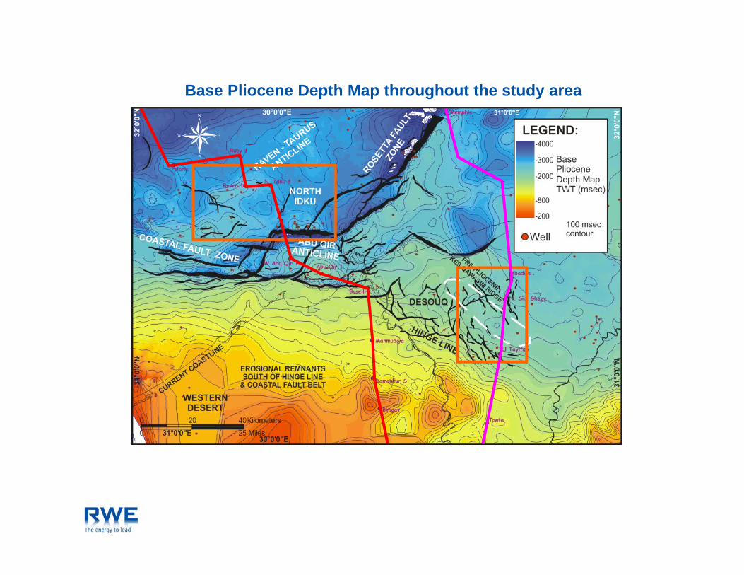
A robust biostratigraphic zonation scheme was adopted and consistently implemented to more than 60 wells throughout the study area. Integration of seismic surfaces and facies analysis using a variety of seismic attribute extractions and sedimentary facies, calibrated by well data and stacking pattern analysis, were done on a sequence by sequence level. A seismic facies catalogue was generated for different depositional environments.
Paleo-depositional systems maps were constructed and serve as snapshots, mostly of lowstand systems, for each timeframe. These maps illustrate the regional depositional history for the West Nile Delta. They reflect, for instance, the relation between lowstand prograding deltas and relict shelf breaks at type one unconformities to the generally more distal and productive offshore slope settings. The different positions of the mapped relict shelfbreak and facies distribution in different sequences reflects the evolution of the deltaic geometry over the timeframe investigated as well as the sedimentary response to regional tectonic events at the time of
Copyright © AAPG. Serial rights given by author. For all other rights contact author directly.

Depositional History of the West Nile Delta –Upper Oligocene to Upper Pliocene
Kellner A., G.J. Brink, H. El-Khawaga, S. Brink-Larsen,H. Maksoud, H. Abu El Saad, A. Atef, H. Young and B. Finlayson

Location Map and current plate tectonic setting of the study area
> Bathymetry and DEM data after: IOC, IHO and BODC, 2003. Centenary Edition of the GEBCO Digital Atlas, published on CD-ROM on behalf of the Intergovernmental Oceanographic Commission and the International Hydrographic Organization as part of g g p y g p g pthe General Bathymetric Chart of the Oceans, British Oceanographic Data Centre, Liverpool, U.K.
Base Pliocene Depth Map throughout the study area

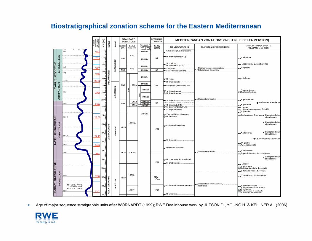
Regional Cross Sections within the study area
Flood Basalts
Ersosional RemnantsHinge Line
Flood Basalts
Hinge Line Rosetta Fault

Timing of Tectonic Events and relative Sea Level Changes in WND

Biostratigraphical zonation scheme for the Eastern Mediterranean
NN21
NN20 CN14b
CN15MNN21b
MNN21a
MNN20
H. inversaGephyrocapsa oceanica
MEDITERRANEAN ZONATIONS (WEST NILE DELTA VERSION)STANDARDZONATION
BLOW(1969)
N23
PLANKTONIC FORAMINIFERA DINOCYST INDEX EVENTS(WILLIAMS et al. 2004)
NST
AGE
SERI
ES
AG
E[M
a] STANDARDZONATIONS
MARTINI1971
Okada &Bukry 1980
Forniaca & Rio(1996) Forniaci
et al. (1996)Present Work
NANNOFOSSILS
Map
ped
Sequ
e nce
sSB
=R E
D ;M
FS=
B LU
E
NN20
NN19
CN14b
CN14a
CN13b
CN13a
MNN20
MNN19f
MNN19e
MNN19d
MNN19c
MNN19b
Pseudoemiliania lacunosa
Acme Gephyrocapsaspp. <4 microns
H. sellii
C. macintyrei
N22
Globorotalia truncatulinoides
Globorotalia tosaensisGloborotalia ronda
Globorotalia acostaensis (dextral)Globorotalia inflata acme
ION
I AN
P LE I
S TO
CENE
CA L
ABRI
AN
1.0
1.561.40
0.8
NN18
NN17
NN16
CN13a
CN12d
CN12c
CN12
CN12b
MNN19a
MNN18
MNN17
MNN16b
MNN16a
D. brouweri
D. pentaradiatus
D. asymmetricusD. tamalis
D. variabilis
H. sellii acme
R. minutula / minuta
N21
Globigerinoides extremus
Globorotalia crassaformis acme
Globorotalia bononiensis
Globorotalia miocenica
Globoquadrina altispiraSphaeroidinellopsis seminulina
Sphaeroidinella dehiscens immatura
S. dionaeacysta, T. glorianum
A. umbracula, A. confusum, I. tabulata,S. drugii, C. harlandii, O ? eirikianum
E. sexispinosa
GEL
ASI A
N
L ATE
P LIO
CENE
E NZI
AN
2.0
3.0
3.21
2.76
2.55
2.09
NN15
CN12a
NN14
NN13
CN11b
CN11a
CN10c
MNN15
MNN14
MNN13
D. variabilis
S. abiesR. pseudoumbilicus
D. asymmetricus increase
S. verensis
A. tricorniculatus
N20N19
Globorotalia punticulataGloborotalia margaritae
Globogerina nepenthes
Sphaeroidinella dehiscens immatura
PIAC
E
P LIO
CENE
CLI
AN4.0
4.37
3.95
NN
12
b
a
CN10c
CN10b
MNN12 Triquetrorhabdulus rugosus
N18
Orbulina bilobata acme
Sphaeroidinellopsis spp. acme
Ammonia beccarii acme
B. evangelineae,S. armageddonensis
R. actinocoronata
E ARL
Y
Z ANC
5.0
MES
S IN
I AN
6.0
7.0
NE
NN11
CN9
CN9bC*
CN9bA*
CN9bB*
BARRENINTERVAL
MNN11c
MNN11b
N17
N16
Globorotalia continuosa,Globorotalia acostaensis (sinistral)
G. etruscaH. floripes,H. tenuispinosum
BARRENINTERVAL? D. quinqueramus
D. toralus
H. orientalisR. rotaria
6.98
6.10
5.73
8.0
9.0
10
11
TORT
ON
I AN
L ATE
MIO
CEN
NN7
NN8
NN9
NN10
CN5b
CN6
CN7
CN8
CN7aCN7bCN8a
CN8b
CN9a MNN11a
MNN10b
MNN10aMN
N10
MNN9
MNN
8
MNN8b
MNN8a
N7
MNN7c**
MNN7b**
N15
N14
N13
Globorotalia siakensis
Globigerinoides subquadratusGloborotalia mayeri
P. striatogranulosum
G. verriculaN. downieiC. poulsenii, C. passio
C. aubryae
M. robustumS. soucouyantiae
H. stalisH. stalis
S. moriformisH. walberdorfensisD. bollii
C. miopelagicus (CP19)
D. kugleri (LCO)11.7
9.26
Page 6
12
13
14
15
MID
DLE
MIO
CENE
SER
RAVA
LLIA
NL A
NG
HI A
N
NN5
NN6
CN4
CN5a
CN5 M
NN
MNN7a**
MNN
6 MNN6b
MNN6a
MNN
5
MNN5b
MNN5a
N12
N11
N10N9
N8
Praeorbulina glomerosa circularisGlobigerinoides diminutus,Praeorbulina glomerosa glomerosa,Globigerinoides sicanus,Praeorbulina transitoria,Globorotalia acrostoma
Globorotalia peripherorondaAmmoniabeccariiacme
Orbulina universa
yU. aquaeductum
E. burdigalensis
H. tenuispinosum
P. fairhavenensisH. ampliaperta
D. kugleri (FCO)
C. preamacintyrei
C. floridanus (LCO) (CP15b)H. intermedia, ? H. euphratisS. heteromorphusH. waltrans
14.8
13.6
12.7
MEDITERRANEAN ZONATIONS (WEST NILE DELTA VERSION)STANDARDZONATION
AG
E
RIE
S
E[ M
a] STANDARDZONATIONS
F i & Riappe
dqu
e nce
s=
RED
;S
=B L
U E
Biostratigraphical zonation scheme for the Eastern Mediterranean
17
18
19
CEN
E BUR
DIG
ALI
AN
NN3
NN4
CN2
CN3
MNN4b
MNN4a
MNN3b
MNN3a
N7
N6
H. cinctum
H. reductum, C. cantharellus
M? picenaGlobigerinoides primordius,Catapasdryx dissimilis
S. conicusD. deflandrei (LCO)
S. disbelemnos (LCO+LO)S. calyculus
H. ampliaperta (LCO)
S. heteromorphus absence zone
BLOW(1969) PLANKTONIC FORAMINIFERA
DINOCYST INDEX EVENTS(WILLIAMS et al. 2004)ST
A
SER
AGE
MARTINI1971
Okada &Bukry 1980
Forniaca & Rio(1996) Forniaci
et al. (1996)Present Work
NANNOFOSSILS
Ma
Seq
SB MFS
19.5
18.7
17.3
16.4
20
21
22
23
EAR
LYM
IOC
AQU
ITA
NIA
N
NN1
NN2 CN1c
CN1bCN1a
CN1
MNN2b
MNN2a
MNN
1
MNN1d
MNN1c
MNN1bMNN1a
N5
N4
L. italicum
Globorotalia kugleri
D. apennicumD. phosphoritica
S. perforatum
H. pusillumDeflandrea abundance
C. bisceta (LCO)
S. delphix
MNP25b
S. disbelemnosS. disbelemnos
H. euphratis (acme event)
H. ampliapertaH. recta
23.8
22.2
20.52
Zygrhablithus bijugatusH. truncata
Chiasmolithus altus
P22
A. alcicornu
O. divergens, S. armata Chiropteridiniumabundances
Chiropteridiniumabundances
Chiropteridiniumabundances
26
27
EO
LIG
OCE
NE
CHA
TTIA
N25
24
NP25
CP19b
MNP25a
CN1a
S. pansum
C. galeap
H. pseudooceanicum, D. biffliS. capricornotusS. ciperoensis (CP19a)C. bisceta (LCO)MNP25b
27 49
25.38
NP24 CP19a
Markalius hirsutus
H. compacta, H. bramletteiP21
Globorotalia opima
Chiropteridiniumabundances
W. gochtii
S. cooksoniae abundance
A. semicirculata
P. amoenumE. pectiniformis, G. conopeum
R. dracoE partridgei
S. distentus
S. predistentus
28
29
30
LATE
C
29.4
28.5
27.49
NP23CP18
CP17
Chiasmolithus oamaruensis
R. umbilica
P20P19
P18
Globorotalia cerroazulensi,Hantkenia
E. partridgeiC. incompositum, L. serrataS. kakanuiensis, S. ornata
G. semitecta, O. divergens
M. pseudorecurvatumA. diktyoplokum, R. Perforatum,D. colligerumA. biformoides, H. semilunifeR. porosum, A? distinctum
31
32
33
34 EARL
YO
LIG
OC
E NE
RUP
E LIA
N
33.7
32.0
> Age of major sequence stratigraphic units after WORNARDT (1999); RWE Dea inhouse work by JUTSON D., YOUNG H. & KELLNER A. (2006).
Seismic Cross Section as Example
SW NE
TWT
(mse
c)
10 km

Facies Interpretation using Seismic & Borehole Data
980
MD (m)
980
Lithology MarkerTWT
(ms)GR (gAPI)
0 150 140 40 0.2 200DT (us/ft) ILM (ohmm)
MFS 2.21
1020
10001000
SB 2.30
> Type log modified after KRYSTINIK (pers. comm. 2007) and BALSLEY & PARKER (1983).

Thickness and Attribute Extraction of Correlative Intervals

Facies Map for the Lowstand & Transgressive Depositional Systems

Seismic facies catalogue for depositional facies interpretation
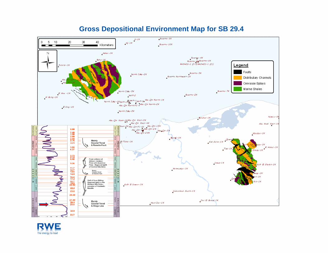
Gross Depositional Environment Map for SB 29.4

Gross Depositional Environment Map for SB 27.49
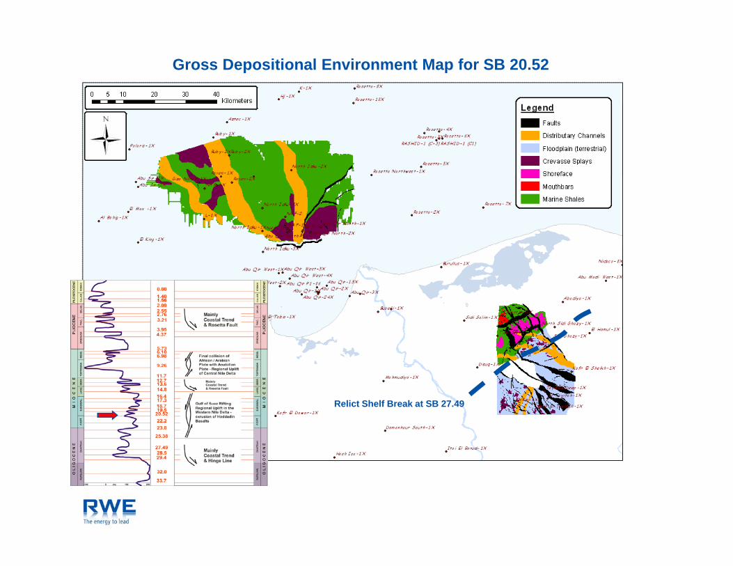
Gross Depositional Environment Map for SB 20.52
Relict Shelf Break at SB 27.49

Gross Depositional Environment Map for SB 19.5BASALT
Oli Ch lOligocene Channels

Gross Depositional Environment Map for SB 17.3

Gross Depositional Environment Map for SB 13.6

Gross Depositional Environment Map for SB 6.98

Gross Depositional Environment Map for MFS 4.0

Gross Depositional Environment Map for SB 3.21

Gross Depositional Environment Map for SB 2.09
Relict Shelf Break at SB 3.21

Conclusion & Lookout
Major tectonic events influence depositional patterns at a higher order scale.
Miocene deltaic deposition was interrupted by late Tortonian and Messinian hinterland erosion and deposition.
Pliocene deltaic deposition commences subsequent to major transgression at base Pliocene.
Proven “genetic” methodology approach enables reservoir / seal and migration prediction for successful gas exploration.
Results will be complemented by ongoing investigation of infill areas.

Selected References
Balsley, J.K. and L.R. Parker, 1983, Cretaceous wave-dominated delta, barrier island, and submarine fan depositional systems: Book Cliffs, east central Utah: A field guide: AAPG, 1 volume, irregular pagination. GEBCO Digital Atlas, 2003, Intergovernmental Oceanographic Commission and International Hydrographic Organization, part of the General Bathymetric Chart of the Oceans: British oceanographic Data Centre, Liverpool, U.K.: CD-ROM. Haq, B.U., J. Hardenbol, P.R. Vail, 1987, The new chronostratigraphic basis of Cenozoic and Mesozoic sea level cycles: Special Publications Cushman Foundation for Foraminiferal Research, v. 24, p. 7-13. Haq, B.U., J. Hardenbol, and P.R. Vail, 1987, Chronology of fluctuating sea levels since the Triassic: Science, v. 235/4793, p. 1156-1167.