The Polonez Cove Formation of King George Island, Antarctica: stratigraphy, facies and implications...
25
The Polonez Cove Formation of King George Island, Antarctica: stratigraphy, facies and implications for mid-Cenozoic cryosphere development ALEXA L. TROEDSON and JOHN L. SMELLIE British Antarctic Survey, Natural Environment Research Council, High Cross, Madingley Road, Cambridge CB3 0ET, UK (E-mail: [email protected]) ABSTRACT The middle to late Oligocene Polonez Cove Formation, exposed on south- eastern King George Island, South Shetland Islands, provides rare evidence of mid-Cenozoic West Antarctic cryosphere evolution. A revised lithostratigraphy and facies analysis and a review of the palaeoenvironmental significance of the formation are presented here. The diamictite-dominated basal member of the formation (Krakowiak Glacier Member) records the presence and retreat of marine-based ice on a shallow continental shelf. Five overlying members are recognized. These consist of basaltic-sourced sedimentary rocks and lavas and represent a variety of shoreface and shallow continental shelf environments in an active volcanic setting. These units contain diverse reworked and ice-rafted exotic clasts that become sparse towards the top of the formation, suggesting a continuing but waning glacial influence. New 40 Ar/ 39 Ar dates from interbedded lava flows indicate a late Oligocene age (25 6–27 2 Ma) for the Polonez Cove Formation, but are slightly younger than skeletal carbonate Sr- isotope ages obtained previously (28 5–29 8 Ma). There is evidence for wet- based subice conditions at the base of the Polonez Cove Formation, but no sedimentary facies to suggest substantial meltwater. This may reflect a subpolar setting or may result from lack of preservation or a high-energy depositional environment. A northern Antarctic Peninsula/South Shetland Islands provenance is probable for most non-basaltic clasts, but certain lithologies with possible origins in the Transantarctic and Ellsworth Mountains also occur sparsely throughout the formation. There is evidence to suggest that the presence of such far-travelled clasts within subglacially deposited facies at the base of the formation reflects the advance of a local ice cap across marine sediments containing the clasts as ice-rafted material. The presence of these clasts suggests that extensive marine-based ice drained into the southern Weddell Sea region and that a strong Weddell Sea surface current operated both before and during deposition of the Polonez Cove Formation. Keywords Antarctica, facies, glacial sedimentation, Oligocene, shallow marine, volcanism. INTRODUCTION Past variations in Antarctic ice extent can be closely linked to global sea level and other major environmental changes. Better constraints on Antarctic cryosphere history are needed if these links are to be thoroughly understood. An important approach to the problem involves obtaining direct evidence from the analysis of continental margin sediments at key sites (Barker et al., 1998). Evidence from continental shelf drilling has confirmed that major ice sheets have Sedimentology (2002) 49, 277–301 Ó 2002 International Association of Sedimentologists 277
-
Upload
independent -
Category
Documents
-
view
3 -
download
0
Transcript of The Polonez Cove Formation of King George Island, Antarctica: stratigraphy, facies and implications...

The Polonez Cove Formation of King George Island, Antarctica:stratigraphy, facies and implications for mid-Cenozoiccryosphere development
ALEXA L. TROEDSON and JOHN L. SMELLIEBritish Antarctic Survey, Natural Environment Research Council, High Cross, Madingley Road,Cambridge CB3 0ET, UK (E-mail: [email protected])
ABSTRACT
The middle to late Oligocene Polonez Cove Formation, exposed on south-
eastern King George Island, South Shetland Islands, provides rare evidence of
mid-Cenozoic West Antarctic cryosphere evolution. A revised lithostratigraphy
and facies analysis and a review of the palaeoenvironmental significance of the
formation are presented here. The diamictite-dominated basal member of the
formation (Krakowiak Glacier Member) records the presence and retreat of
marine-based ice on a shallow continental shelf. Five overlying members are
recognized. These consist of basaltic-sourced sedimentary rocks and lavas and
represent a variety of shoreface and shallow continental shelf environments in
an active volcanic setting. These units contain diverse reworked and ice-rafted
exotic clasts that become sparse towards the top of the formation, suggesting
a continuing but waning glacial influence. New 40Ar/39Ar dates from
interbedded lava flows indicate a late Oligocene age (25Æ6–27Æ2 Ma) for the
Polonez Cove Formation, but are slightly younger than skeletal carbonate Sr-
isotope ages obtained previously (28Æ5–29Æ8 Ma). There is evidence for wet-
based subice conditions at the base of the Polonez Cove Formation, but no
sedimentary facies to suggest substantial meltwater. This may reflect a subpolar
setting or may result from lack of preservation or a high-energy depositional
environment. A northern Antarctic Peninsula/South Shetland Islands
provenance is probable for most non-basaltic clasts, but certain lithologies
with possible origins in the Transantarctic and Ellsworth Mountains also occur
sparsely throughout the formation. There is evidence to suggest that the
presence of such far-travelled clasts within subglacially deposited facies at the
base of the formation reflects the advance of a local ice cap across marine
sediments containing the clasts as ice-rafted material. The presence of these
clasts suggests that extensive marine-based ice drained into the southern
Weddell Sea region and that a strong Weddell Sea surface current operated
both before and during deposition of the Polonez Cove Formation.
Keywords Antarctica, facies, glacial sedimentation, Oligocene, shallowmarine, volcanism.
INTRODUCTION
Past variations in Antarctic ice extent can beclosely linked to global sea level and other majorenvironmental changes. Better constraints onAntarctic cryosphere history are needed if these
links are to be thoroughly understood. Animportant approach to the problem involvesobtaining direct evidence from the analysis ofcontinental margin sediments at key sites (Barkeret al., 1998). Evidence from continental shelfdrilling has confirmed that major ice sheets have
Sedimentology (2002) 49, 277–301
� 2002 International Association of Sedimentologists 277

existed on East Antarctica since at least theearliest Oligocene, with many subsequent fluctu-ations (e.g. Hambrey et al., 1991; Cape RobertsScience Team, 1999; Shipboard Scientific Party,2001). However, the early glacial history of WestAntarctica remains less clear. The modern cryo-sphere in this region includes the mainly marine-based West Antarctic Ice Sheet and the smallerice caps, piedmont and tidewater glaciers andfringing ice shelves of the mountainous AntarcticPeninsula region. Based on modern conditions, ithas been inferred that the West Antarctic IceSheet and Antarctic Peninsula ice, in particular,is more dynamic and sensitive to external chan-ges than the East Antarctic Ice Sheet (e.g. Pudseyet al., 1994; Bart & Anderson, 2000).
It has been inferred by some that the growth ofsubstantial ice in the West Antarctic regionoccurred substantially later than in East Antarc-tica, and possibly not until the latest Miocene toearly Pliocene (e.g. Larter & Barker, 1989; Kennett& Barker, 1990). However, there is little directevidence, as no Oligocene to early Miocenecontinental margin sequences have been drilledin the region and the mid-Cenozoic terrestrialrecord is very sparse. The latter consists ofglacigenic and marine formations exposed onsouth-eastern King George Island, South ShetlandIslands. These formations provide a unique ter-restrial record of middle Oligocene to earliestMiocene glacial–interglacial cyclicity in the nor-thernmost Antarctic Peninsula region (Birkenma-jer et al., 1989; Dingle & Lavelle, 1998). The focusof this paper is the middle to late OligocenePolonez Cove Formation (PCF), the oldest glaci-genic unit known regionally (Dingle et al., 1997;Dingle & Lavelle, 1998).
The PCF consists of a basal unit dominated byglacigenic diamictite, overlain by a series ofbasalt-sourced sedimentary and dacitic volcanicunits. The presence of diverse pebble- to boulder-sized clasts, a minor proportion of which cannotbe sourced within the Antarctic Peninsula region,is a unifying characteristic of the formation. Manyclasts are faceted and striated, providing evidenceof glacial influence throughout. The formation isexposed most extensively in the vicinity of LionsRump, south-eastern King George Island (Fig. 1).
Birkenmajer (1980, 1982) was the first todescribe and recognize the potential significanceof the PCF for regional glacial history, whilePorebski & Gradzinski (1987) interpreted PCFlithofacies. This paper presents a detailedreappraisal of the lithofacies and palaeoenviron-mental significance of the formation, following
fieldwork by the authors and using a recentlyimproved chronostratigraphy. The study wasundertaken in response to continued uncertaintysurrounding aspects of the sedimentological and,to a lesser extent, stratigraphical interpretation ofthe PCF. In particular, the nature and extent ofglaciation implied by the deposits is conten-tious. Reports of exotic clasts with a proposedorigin in the Transantarctic and EllsworthMountains in a unit interpreted as lodgementtillite led to the suggestion that transport of suchclasts occurred as bedload in major ice streamssourced in the Transantarctic and EllsworthMountains (Birkenmajer, 1982). The distantprovenance of some clasts is supported by thisstudy. However, the concept of a major pan-Antarctic ice sheet capable of travelling along
Fig. 1. Maps showing: (A) the location of King GeorgeIsland in the northern Antarctic Peninsula region andin Antarctica (inset map also shows east–west divisionof the continent by the Transantarctic Mountains); (B)location of King George Island localities mentioned inthe text. An enlarged view of the boxed area aroundLions Rump is shown in Fig. 2.
278 A. L. Troedson and J. L. Smellie
� 2002 International Association of Sedimentologists, Sedimentology, 49, 277–301

the entire western flank of the broad WeddellSea embayment and crossing the northernAntarctic Peninsula is intuitively difficult toaccept, and an alternative hypothesis is presen-ted here. The nature of glacigenic influence andassociated palaeoenvironments in overlyingunits is also investigated. Finally, the signifi-cance of the findings for regional mid-Cenozoiccryosphere history is discussed.
REGIONAL SETTING AND PREVIOUSWORK
King George Island, the largest of the SouthShetland Islands, is situated on the periphery ofAntarctica and separated from the northernmostAntarctic Peninsula by Bransfield Strait (Fig. 1A).The South Shetland Islands formed on the lead-ing edge of the Antarctic Peninsula Mesozoic–Cenozoic magmatic arc, during eastward-dippingsubduction of proto-Pacific oceanic crust belowthe Gondwana margin (Pankhurst, 1982; Storey &Garrett, 1985). The opening of Drake Passagebetween South America and the Antarctic Penin-sula occurred during the Oligocene, between 22and 32 Ma (Barker & Burrell, 1977; Lawver et al.,1992). More recently, at »4 Ma, the South Shet-land Islands separated from the northern Antarc-tic Peninsula as a result of roll-back of DrakePassage oceanic crust and concomitant back-arcspreading in what became Bransfield Strait(Barker, 1982; Barker & Dalziel, 1983). Early tomid-Cenozoic volcanic and sedimentary strata areexposed along the southern edge of King GeorgeIsland (Smellie et al., 1984; Birkenmajer et al.,1986). The strata broadly become younger to theeast. Those west of the PCF exposures are mainlyterrestrial volcanic sequences, whereas someslightly younger marine strata occur further tothe east. The latter include the Cape MelvilleFormation, which consists of glaciomarine strataattributable to an earliest Miocene glacial episode(Birkenmajer et al., 1989; Dingle & Lavelle, 1998;Troedson & Riding, 2001).
The PCF was described and divided into fourmembers by Birkenmajer (1980, 1982) and is partof his Chopin Ridge Group. Porebski & Gradzinski(1987) described in detail the sedimentology anddepositional history of the formation as exposedon the coast south of Lions Rump. Porebski &Gradzinski (1990) and Smellie et al. (1998)investigated the genesis of volcanic units withinthe formation. A number of publications havedescribed the fossil fauna of the Low Head
Member of the formation (e.g. Gazdzicki &Pugaczewska, 1984). The presence and petrologyof diverse glacially transported exotic clastswithin the PCF, including some clasts with apossible provenance in the Transantarctic andEllsworth Mountains, were described by Bir-kenmajer (1980, 1982) and Birkenmajer & Wieser(1985). There have been numerous attempts todetermine the age of the PCF. K-Ar dating ofvolcanic rocks from surrounding and interbed-ded strata and dykes (e.g. Birkenmajer et al.,1985, 1989) has provided some erroneous results,with certain K-Ar dates conflicting with recentSr-isotope and 40Ar/39Ar dating results, as dis-cussed further below (Dingle et al., 1997; Dingle& Lavelle, 1998; Smellie et al., 1998).
LITHOSTRATIGRAPHY
Distribution, thickness, boundaries
The PCF is continuously exposed in 2Æ5-km-longcoastal cliffs and ledges between Lions Rump andLow Head (Fig. 2), which were the focus of allprevious accounts of PCF lithostratigraphy (e.g.Birkenmajer, 1980, 1982, 1994; Porebski & Grad-zinski, 1987). Further extensive exposures of thePCF occur inland at Godwin Cliffs, 2–3 km westof Lions Rump, and at Magda Nunatak, anisolated buttress »2 km north-west of GodwinCliffs. Exposures at Magda Nunatak were origin-ally assigned to a separate formation after anEocene K-Ar isotopic age was obtained from anoverlying basalt flow (Birkenmajer et al., 1985,1986). However, based on a striking stratigraph-ical similarity of the Magda Nunatak sequence tothe PCF in its type area (this paper), supported bySr-isotope dating (Dingle & Lavelle, 1998) andnew 40Ar/39Ar dating, the Magda Nunataksequence is interpreted to be part of the PCF.Small outliers of the basal PCF also occur at ThreeSisters Point, »10 km north-east of Lions Rump(Paulo & Tokarski, 1982), and at Vaureal Peak,10 km to the south-west (Birkenmajer, 1982)(Fig. 1B). Maximum thicknesses of the formationare 59 m at Mazurek Point, 58 m at Godwin Cliffsand 63 m (estimated) at Magda Nunatak.
Detailed vertical sections were measured at sixlocalities (Fig. 2). They form the basis for thepresent stratigraphical and sedimentologicalinterpretations (Figs 3–6). The PCF was previ-ously divided into four members with a simplehomoclinal stratigraphy (Birkenmajer, 1982;Porebski & Gradzinski, 1987). In this paper,
Polonez Cove Formation sedimentology 279
� 2002 International Association of Sedimentologists, Sedimentology, 49, 277–301

two new members are added to the previouslypublished stratigraphy, and the extent of someunits is redefined (Figs 3 and 4). In the previous
stratigraphy, the formation was separated into thefollowing four members: the Krakowiak GlacierMember (KGM; polymictic diamictite and sand-
Fig. 2. Map of Lions Rump areashowing approximate extent ofexposures of the Polonez CoveFormation and associated units andlocalities mentioned in the text.Stratigraphic sections were meas-ured at the six numbered sites.
Fig. 3. Diagram of generalized Pol-onez Cove Formation lithostratigra-phy, slightly modified from that ofPorebski & Gradzinski (1987), andsummary of 40Ar/39Ar and Sr-iso-tope age data for the formation. Errorbars represent 2r. Sr-isotope datesare from Dingle et al. (1997) andDingle & Lavelle (1998). 40Ar/39Ardates are new with the exception ofthe youngest Low Head Memberdate (Smellie et al., 1998). Age ofthe Oligocene–Miocene boundaryafter Shackleton et al. (2000).
280 A. L. Troedson and J. L. Smellie
� 2002 International Association of Sedimentologists, Sedimentology, 49, 277–301

stone); the Low Head Member (LHM; basalt lava,lava breccia, coarse basaltic sediments); the Sikl-awa Member (SM; planar-bedded sandstones,minor mudstone, granule conglomerate); and theOberek Cliff Member (OCM; basalt lava, breccia,conglomerate and gravelly sandstone). However,a previously unrecognized mudstone-dominatedunit (informally named the Bayview Member) islocally intercalated between the KGM and LHM.
Also, the heterogeneous facies grouped previouslywith the Oberek Cliff Member are separated hereinto two distinct members. The OCM is limited tothick exposures of basaltic breccia with interca-lated lava flows and associated coarse basalticsediments. Mainly planar beds of medium-grained to gravelly sandstone with sparse exoticclasts and occasional marine macrofauna inclu-ding Chlamys were previously included with the
Fig. 4. Schematic cross-sections of Polonez Cove Formation exposures, showing main lithofacies. Localities are:(A) coastal cliffs from Low Head to Battke Point; (B) Godwin Cliffs; (C) Magda Nunatak, north-east face (same viewas Fig. 8A). Note different scales for each. Numbered arrows indicate the locations of measured sections.
Polonez Cove Formation sedimentology 281
� 2002 International Association of Sedimentologists, Sedimentology, 49, 277–301

upper OCM. These beds are here reassigned to thenew, informally named Chlamys Ledge Member(CLM). Schematic cross-sections of the main PCFexposures are illustrated in Fig. 4.
The PCF is bounded by erosional unconformi-ties. It mainly overlies andesitic volcanic rocksassigned to the Mazurek Point Formation byBirkenmajer (1980). K-Ar dating of the MazurekPoint Formation suggested an unusually wide-ranging age (74–34 Ma; Birkenmajer et al., 1989),but lithology, geochemistry, other K-Ar ages andnew unpublished 40Ar/39Ar ages from associatedoutcrops indicate that the Mazurek Point Forma-tion is equivalent to the Eocene HennequinFormation of Smellie et al. (1984). The uppermostvolcanic basement is commonly porphyritic
andesite lava. Where exposed, the lava surfaceis irregularly jointed and Fe oxide coated. Itshows up to 15 m of relief. Striations on theunconformity have been reported previously(Paulo & Tokarski, 1982; Santos et al., 1990). Noconvincing striations were found in the presentstudy, and well-exposed bedrock surfaces wererare. At Conglomerate Bluff, the PCF overliesmoderately well-sorted, massive, boulder to cob-ble conglomerate forming a bed at least 10 mthick of uncertain age. The clasts are rounded tosubrounded and andesitic and were clearly de-rived from the Hennequin Formation. Thin beds(typically 5–30 cm thick) of andesitic pebbleconglomerate, breccio-conglomerate and brecciaalso occur between Polonez Cove Formation
Fig. 5. Stratigraphic logs throughthe Krakowiak Glacier Member at(A) western Godwin Cliffs (site 2)and (B) central Mazurek Point(site 4). Metre scale bars on left.
282 A. L. Troedson and J. L. Smellie
� 2002 International Association of Sedimentologists, Sedimentology, 49, 277–301

diamictite and volcanic basement at a few sites,including Battke Point and Three Sisters Point. Atthe latter site, Paulo & Tokarski (1982) described apossible roche moutonee on basement with adja-cent ‘leeside’ bedrock till.
The PCF exposures are consistently subhori-zontal to shallow dipping, and the formation isessentially unaffected by tectonic deformation.There are rare normal faults. The height of thebasal unconformity is variable, reflecting bothfaulting and basement relief. In the coastalexposures, the unconformity has a maximumelevation of c. 20 m a.s.l. at Battke Point, and itis below sea level at Low Head. A major fault ispresent between the coastal exposures and PCFexposures to the west, and the basal unconformity
is exposed at over 100 m a.s.l. at Godwin Cliffsand Magda Nunatak.
Arkosic sandstones and dacitic volcanic rocks,assigned to the Boy Point Formation by Bir-kenmajer et al. (1986), overlie the PCF in thecoastal exposures and at Godwin Cliffs. AroundPolonez Cove and at Godwin Cliffs, the upperPCF is truncated by an erosional unconformity.Exotic clasts are absent from the Boy PointFormation. Pectinid-bearing sandstones occurwithin the basal Boy Point Formation, indicatinga shallow-marine environment for at least thelower part of the formation. The Boy PointFormation is latest Oligocene in age and appar-ently only slightly younger than the PCF (Smellieet al. 1998).
Fig. 6. KGM photographs. (A) View of Polonez Cove Formation exposures at northern Mazurek Point (between sites3 and 4). The slightly undulating basal unconformity (2–6 m a.s.l), Krakowiak Glacier Member units K2 and K3,thickly bedded basaltic conglomerate of the Low Head Member and thinly bedded sheets of the Siklawa Member areidentified. The typically planar upper contact of the Krakowiak Glacier Member (interpreted as a marine erosionalsurface) is »9 m a.s.l. The section shown is »23 m thick. (B) Faceted, fractured andesitic (basement-derived) boulderlodged against basement within lodgement tillite of unit K1, basal Krakowiak Glacier Member, western Godwin Cliffs(site 2). The hammer, 33 cm in length, rests on the boulder. (C) Subrounded faceted boulders within slightly muddygravelly sandstone of unit K3, upper Krakowiak Glacier Member, north of Mazurek Point (near site 3). The largestboulder, 1Æ2 m long, is formed of gneiss, whereas the other two boulders are composed of basement-derived andesiteand are »0Æ6 m in diameter. Bryozoa encrust parts of the large boulder. (D) Cross-bedded sandstone in channel (»1 mthick) surrounded by muddy gravelly sandstone to diamictite, unit K3, Krakowiak Glacier Member, western GodwinCliffs (site 2).
Polonez Cove Formation sedimentology 283
� 2002 International Association of Sedimentologists, Sedimentology, 49, 277–301

Age
A middle to late Oligocene age for the PCF isindicated by Sr-isotope dating of fossil shells(Dingle et al., 1997; Dingle & Lavelle, 1998) and40Ar/39Ar dating of interbedded basaltic lavaflows (Smellie et al., 1998; this paper), althoughsomewhat older ages were obtained by the Sr-isotope method. Figure 3 illustrates the age dataobtained by the two methods. Other ages obtainedpreviously by the K/Ar method have provenunreliable and are not discussed further here.Ages of 26Æ4 ± 1Æ2 Ma and 27Æ2 ± 0Æ7 Ma wereobtained from basalt lava of the Low HeadMember at Low Head and southern MazurekPoint respectively. Oberek Cliff Member basaltsfrom southern Mazurek Point and MagdaNunatak gave ages of 26Æ0 ± 2Æ59 Ma and25Æ6 ± 1Æ3 Ma respectively. Sr-isotope agesobtained from bivalve and brachiopod fossilstaken from the KGM and LHM lie within therange 28Æ5 – 29Æ8 ± 0Æ8 Ma (Dingle et al., 1997;Dingle & Lavelle, 1998). Reasons for the discrep-ancy in ages determined by the two isotopicsystems are unclear at present, but a middle tolate Oligocene age for the PCF is certain.
SEDIMENTOLOGY
Krakowiak Glacier Member (KGM)
Description
The KGM consists largely of diamictite andgravelly sandstone, with minor interbeds andlenses of granule to pebble conglomerate andmedium sandstone. Sandy diamictite is the dom-inant diamictite type (classification after Mon-crieff, 1989). Thin mud stringers occur rarely.Gravel occurs predominantly as pebbles andcobbles, but boulders ranging up to »1Æ2 m indiameter occur in certain beds. Pebble- to boul-der-sized clasts are most commonly subangular orsubrounded. Faceting is very common, someclasts are bullet-nosed, and striations occur on asignificant minority of sedimentary clasts. Marinemacrofossils are sparse but widely distributed.
The KGM is composed of locally derivedandesitic material and a diverse collection oflithic grains, clasts and associated minerals. Thelatter include sedimentary, igneous and meta-morphic lithologies, but sedimentary clasts aremost common. The range of clast lithologies andtheir overall proportions resemble present-dayoutcrop proportions in the northern Antarctic
Peninsula and South Shetland Islands. However,as noted by previous authors, the mountainranges rimming the southernmost Weddell Seaare the nearest known provenance of certain clastlithologies. Examples of apparently far-travelledlithologies are red quartzose sandstone andarchaeocyathid-bearing and other coarse bio-clastic limestones.
The KGM is an extensive unit, with exposuresknown from localities up to 14 km apart. It wasobserved everywhere that the base of the PCF isexposed, infilling basal palaeorelief. The memberusually has a sharp and planar upper contact (e.g.Fig. 6A) but, in a few places, beds of basalticbreccia of the overlying Low Head Member cutnarrow erosional channels up to 2 m into theKGM. Additionally, the contact appears abruptlygradational into a diamictic facies of the LowHead Member (L4) in a few exposures. Measuredthicknesses generally range from 3 to 15 m, butrise to »24 m in a basement depression at GodwinCliffs (site 2). Three main units (K1–K3) arerecognized within the KGM, arranged in a tabularfashion, although K1 is generally thin and locallyabsent, and K3 is also absent at a few sites.Detailed sections are illustrated for two sites: awell-exposed section at western Godwin Cliffswhere all three KGM units are present (site 2);and a section typical of KGM coastal exposures atMazurek Point (site 4). The KGM is critical tounderstanding PCF glacial history, and individ-ual units are described in more detail below.Unit K1. This is well-indurated, intermediate tomuddy diamictite. It commonly has a red-brownsilty matrix that appears to consist largely ofcrushed basement-derived material. Mud contentranges from 20% to 40%. K1 is variably clast-rich to clast-poor. Gravel varies from granule toboulder-grade and is derived mostly (80–95%)from local andesitic basement, although diverseexotic clasts also occur. Large basement-derivedclasts are typically equant and subrounded,whereas exotic clasts are variably subroundedto subangular. Faceting is common on both clasttypes. K1 is typically <0Æ3 m thick, but is up to1 m thick in rare cases within basement lows. Insome localities, there is a degree of clast align-ment or imbrication, but no consistent direc-tional pattern was recognized across the studyarea. Ploughed clasts occur at a few sites (e.g.Fig. 6B). The upper contact of K1 is typicallysharp.
Fossils are generally uncommon within K1 but,at two localities, marine invertebrate fossils areabundant. On basement highs at central Godwin
284 A. L. Troedson and J. L. Smellie
� 2002 International Association of Sedimentologists, Sedimentology, 49, 277–301

Cliffs and at southern Mazurek Point, smalllenses of grey muddy diamictite a few metreslong and <1 m thick occur with concentrations ofmacrofossils. These include both intact andfragmented solitary corals, pectinid bivalves,brachiopods and benthic foraminifera. Alignedor imbricated shells parallel to sedimentarylaminations occur within one such pod.
Features indicative of deformation occur inassociation with K1 at a number of sites. Theseinclude ductilely deformed sedimentary clastsand brecciated or fractured clasts and grains.Many macrofossils in the sediment pods men-tioned above appear to be ductilely deformed orfractured. At some localities, notably parts ofGodwin Cliffs and Magda Nunatak, the upper-most metre of andesite lava is sheared andbrecciated, with matrix and rare exotic pebblesidentical to the basal PCF injected along joints inthe andesite. Iron oxide-coated, striated shearplanes extended from K1 into the uppermostbasement at these sites.Unit K2. This consists of moderately well-indu-rated, sandy to intermediate diamictite, withsome thin sandstone and granule to pebbleconglomerate beds and rare mudstone stringers.Bedding is typically lenticular and discontinu-ous. Diamictite occurs in unstratified beds, com-monly 1–1Æ5 m thick, with boundaries defined bytextural variations in the diamictite and by lensesof fine to medium sandstone or (rarely) thinmudstone. Sandstone lenses are typically <0Æ3 mthick, and are locally graded, laminated or cross-laminated. K2 has a brown-grey to grey matrixand generally low mud content. Gravel content ishighly variable. Diamictite beds are typicallyclast-rich, with up to 45% gravel. Gravel is mostlygranule to small pebble grade, although there areoccasional boulders and cobbles up to a maxi-mum diameter of c. 0Æ5 m. Large clasts arechaotically distributed, although maximum clastsize may decrease upsection from boulder tosmall cobble grade. Typically, over 50% of clastsare composed of basement-derived andesiticmaterial. Imbrication of elongate clasts and grainswas observed rarely. In a few localities, sandstonebeds appear faulted, folded or form sand dykes.Some sandstone beds contain fragments of marineinvertebrate fossils. Other observed features with-in a few diamictite beds include steeply inclined,brecciated marly lenses and brecciated or shearedpebbles and cobbles. K2 is generally 2–4 m thickbut, at western Godwin Cliffs, reaches a maxi-mum of »7 m thick where the KGM fills abasement low (Fig. 5A).
Unit K3. This consists of moderately to poorlyindurated intermediate to sandy diamictite andgravelly sandstone. Thin beds of pebble to gran-ule conglomerate and thin planar to channelized,sorted sandstone beds also occur in upper K3. K3is generally weakly to well stratified and, overall,the unit has a tabular morphology. Gravel modeand abundance commonly define stratificationwithin gravelly sandstone and diamictite beds.K3 has a grey to green-grey matrix, which ismuddy and fissile in patches. The diamictite isvariably clast-rich to clast-poor, with gravel con-tent varying from 1% to 50%. Clasts are mainlygranules to pebbles, but larger clasts occur dis-persed or in clusters and trains (e.g. Fig. 6C).
Upsection trends within K3 include an increas-ing dominance of sandstone over diamictite, adecrease in basement-derived clasts to <20% andincreased incidence of cobble- to boulder-gradeclasts. Thick-bedded diamictite occurs only with-in lower K3, whereas sandstone channels con-taining cross-beds were observed within theupper section of K3 at two localities. At south-western Godwin Cliffs, foresets occupy two chan-nels that are 1Æ5–3 m thick, 10 m wide and haveclearly erosional bases (e.g. Fig. 6D). In a numberof localities, thin (1–10 cm thick), planar, occa-sionally graded and moderately sorted sandstonebeds occur in upper K3. Macrofossils occursparsely in lower K3 and more commonly inupper parts of K3. Those observed include intact,ductilely deformed bivalves within sandstonebeds and bryozoans and worm tubes encrustingfaceted, subrounded cobbles and boulders. Ingeneral, K3 appears undeformed, but featuresindicative of deformation occur at a few sites.These include boudinaged sandstone beds inupper K3 north of Mazurek Point and inclinedbeds and shear planes associated with an opensynform structure at southern Mazurek Point(described by Porebski & Gradzinski, 1987). K3occurs at the top of the KGM and varies between 6and »16 m thick. It can be absent where the KGMis <5 m thick.
Interpretation
The ubiquitous presence of diverse lithic clastswith characteristics associated with glacial trans-port, such as facets, striations and bullet-nosedshapes, indicates that the KGM has a glacigenicorigin, as recognized by previous workers (Bir-kenmajer, 1982; Porebski & Gradzinski, 1987).There are a number of indications that thevolcanic basement surface was subject to
Polonez Cove Formation sedimentology 285
� 2002 International Association of Sedimentologists, Sedimentology, 49, 277–301

subglacial erosion. Evidence includes the (rarelyexposed) highly polished lava surface, fossilstriations observed by previous workers, thenature of basement relief, the locally brecciatednature of the contact with the overlying diamic-tite and the presence of diamictite intrusions intobedrock fractures. The latter two features resem-ble local till and ‘injection wedges’ described in aCanadian terrestrial glacial sequence (Brosteret al., 1979) and attributed to glacial deformation,erosion and deposition. The KGM marine fossilfauna is mostly reworked, but it is clear that theunit was deposited in association with marine-based ice. This interpretation differs from that ofprevious workers, who attributed the basal KGMto terrestrial glaciation.
K1 is subglacial tillite, deposited by a variety ofprocesses including lodgement, deformation andcomminution. Features of K1 characteristic ofsubglacial deposition include a high proportionof basement-derived clasts, rock matrix appar-ently consisting largely of finely crushed base-ment-derived material and occasional ploughedclasts associated with basement. The highlyindurated nature of this facies may reflect strongsubglacial compaction and subsequent loss ofporosity and comminution of grains. In places, K1sediments have been subject to deformation thatcan best be attributed to glaciotectonics, assurrounding units are undeformed. Polished andstriated joints that extend into basement at a fewsites are former shear planes (e.g. Boulton et al.,1974).
The evidence for glacial abrasion of volcanicbasement and the high proportion of basement-derived material in K1 suggests that preglacialsediment cover was minimal. However, preglacialdeposits such as the cobble to boulder andesiticconglomerate underlying the KGM at Conglomer-ate Bluff may have supplied the rounded tosubrounded andesite clasts common in the lowerKGM. Also, lenses of muddy diamictite contain-ing concentrations of marine macrofossils weremost likely marine sediment rafts entrainedduring ice advance. Their presence can be attrib-uted to a thin to patchy cover of preglacialadvance marine sediment on local basement.The rafts contain clear indications of deformationand reflect erosion and incorporation of marinesediment into a thin layer of deforming subglacialtill.
K2 is interpreted to be a subglacial to ice-marginal deposit. Major processes include melt-out and glacigenic debris flow. The occasionalmud drapes and thin sandstone and conglomerate
interbeds, some with shell fragments, indicateperiods of current reworking, possibly in subgla-cial cavities and channels by small-dischargesubglacial meltwater streams. The relatively highproportion of basement-derived clasts indicates apredominantly subglacial sediment source.Localized glaciotectonic structures reflect defor-mation in the vicinity of an unstable groundingline. The mud content of K2 is typically low,possibly because of flushing of fines by highporewater pressures (Lawson, 1981). High pore-water pressure may also have contributed topatchy sediment deformation.
K3 consists mainly of reworked and redepo-sited submarine glacial outwash and ice-rafteddebris. The common stratification suggests anice-proximal glaciomarine rather than subglacialorigin. Basement-derived clasts are much lessabundant than in the underlying units, suggest-ing that local sediment sources were swampedby abundant further travelled englacial sedimentreleased during grounding line retreat and byincoming icebergs from more distant sources.Thick diamictite beds with variable gravel con-tents within lower K3 are most likely debris flowdeposits. Channelized cross-bedded sandstonebeds exposed within upper K3 may be associatedwith proglacial or subglacial meltwater channels.Thin planar beds of moderately sorted, fine tomedium sandstone in upper K3, locally contain-ing intact bivalves, may be proglacial tractioncurrent deposits. Encrusting bryozoa and barna-cles on some cobbles and boulders confirm thatthe environment was glaciomarine. Outsizedclasts within sandstone, some of which occuras cobble and boulder lags, were deposited byice rafting during periods of current winnowingor low sediment supply. The lags become com-mon upsection, whereas thick debris flow dia-mictite beds become uncommon, suggesting arelative increase in the contribution from icerafting and distance from the grounding line (cf.Boulton & Deynoux, 1981). Unlike boulder lagsdescribed by Eyles (1988) for the YakatagaFormation (Alaska), the PCF examples do nothave planar tops and are of limited areal extent,and there is no suggestion of an associatedsignificant glacial readvance. Deformation fea-tures within ice-proximal deposits such as K3may relate to ice thrust, iceberg grounding orgravitational collapse (Eyles & McCabe, 1989).Localized folding in K3 has been attributedpreviously to iceberg grounding processes(Porebski & Gradzinski, 1987), but may equallyindicate a transient, local readvance.
286 A. L. Troedson and J. L. Smellie
� 2002 International Association of Sedimentologists, Sedimentology, 49, 277–301
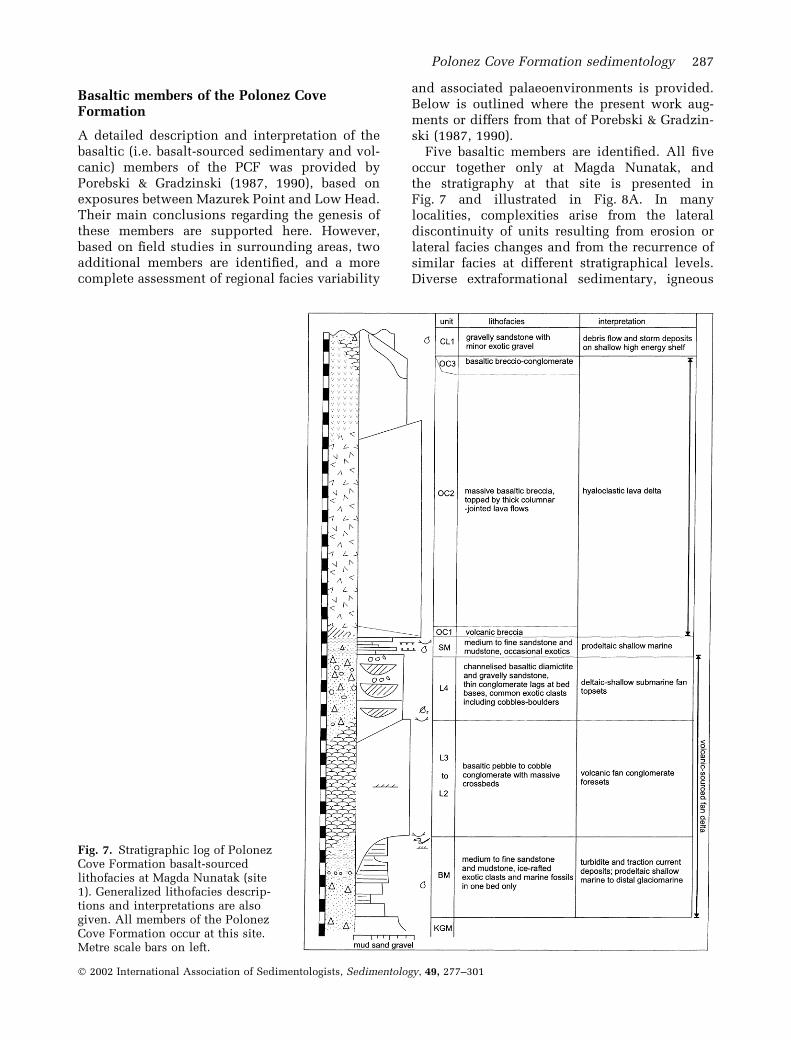
Basaltic members of the Polonez CoveFormation
A detailed description and interpretation of thebasaltic (i.e. basalt-sourced sedimentary and vol-canic) members of the PCF was provided byPorebski & Gradzinski (1987, 1990), based onexposures between Mazurek Point and Low Head.Their main conclusions regarding the genesis ofthese members are supported here. However,based on field studies in surrounding areas, twoadditional members are identified, and a morecomplete assessment of regional facies variability
and associated palaeoenvironments is provided.Below is outlined where the present work aug-ments or differs from that of Porebski & Gradzin-ski (1987, 1990).
Five basaltic members are identified. All fiveoccur together only at Magda Nunatak, andthe stratigraphy at that site is presented inFig. 7 and illustrated in Fig. 8A. In manylocalities, complexities arise from the lateraldiscontinuity of units resulting from erosion orlateral facies changes and from the recurrence ofsimilar facies at different stratigraphical levels.Diverse extraformational sedimentary, igneous
Fig. 7. Stratigraphic log of PolonezCove Formation basalt-sourcedlithofacies at Magda Nunatak (site1). Generalized lithofacies descrip-tions and interpretations are alsogiven. All members of the PolonezCove Formation occur at this site.Metre scale bars on left.
Polonez Cove Formation sedimentology 287
� 2002 International Association of Sedimentologists, Sedimentology, 49, 277–301

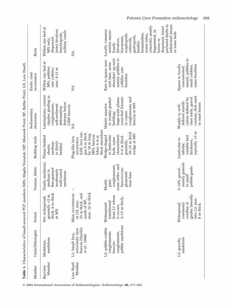
and metamorphic clasts occur in varying abun-dance through these units and are referred to hereas exotic clasts. Preliminary studies indicate thatthe range and proportions of clast lithologiesresembles that of the KGM, although far-travelledclasts appear more common. Details of faciesrecognized within each member including extentof exposure, exotic clast occurrence and biota aresummarized in Table 1.
Bayview Member (BM)
The Bayview Member (BM) is described here forthe first time. It consists mainly of dark-brown,planar-bedded, medium to fine sandstone andmudstone and has a stratigraphical positionbetween the KGM and Low Head Member. Themember is most extensively developed at MagdaNunatak, where it is up to 6 m thick (Fig. 7). Itwas not recognized previously within the PCFstratigraphy, presumably because it does notoccur in exposures south of Mazurek Point wherethe PCF type section was defined. Macrofossilsobserved in one BM medium sandstone bedindicate a shallow-marine setting. The generallyscarce biota suggests that deposition was rapidand/or that the sea-floor was poorly oxygenated.Sediment was supplied dominantly from a localbasaltic source and deposited mainly from sus-pension and traction currents during normalmarine conditions. The rarity of outsized exoticclasts suggests that floating debris-laden ice wasuncommon. Deformation of macrofossils andsedimentary structures directly underneath LowHead Member breccio-conglomerate beds andcommon erosional incision by these beds suggeststhat the BM was poorly consolidated duringdeposition of the Low Head Member, and thatthe intermittent occurrence of the BM is related topost-depositional erosion.
Low Head Member (LHM)
The Low Head Member consists of laterallydiscontinuous bodies of coarse basaltic sediment,basaltic lava and lava breccia. It contains ashallow-marine faunal assemblage (Gazdzicki &Pugaczewska, 1984). These occur as intact, in situspecimens, debris lenses and isolated fragments.In a few places, the basal surface of the LHM is
Fig. 8. Photographs of basalt-sourced lithofacies. (A)View of the Polonez Cove Formation, north-east face ofMagda Nunatak. See Fig. 4C for identity of units. Cliffheight is »60 m. (B) Exotic ice-rafted clasts in coarsebasaltic sediments of the Low Head Member, GodwinCliffs. Pale clast below hammer handle is red sand-stone, a lithology unknown in the Antarctic Peninsularegion and inferred to have been transported over1800 km by icebergs calving in the southern WeddellSea. The hammer is 33 cm long. (C) Granitic boulderpavement within coarse basaltic sediments of the LowHead Member north of Mazurek Point (site 3). Theclasts are angular, and some appear brecciated. Thegranitic clasts occur over a horizontal distance of»10 m. Their presence is attributed to iceberg ground-ing.
288 A. L. Troedson and J. L. Smellie
� 2002 International Association of Sedimentologists, Sedimentology, 49, 277–301
Table
1.
Ch
ara
cte
rist
ics
of
basa
lt-s
ou
rced
PC
Fm
em
bers
(MN
,M
agd
aN
un
ata
k;
MP
,M
azu
rek
Poin
t;B
P,
Batt
ke
Poin
t;L
H,
Low
Head
).
Mem
ber
Un
its/
lith
olo
gie
sE
xte
nt
Textu
re,
fabri
cB
ed
din
gst
yle
Sed
imen
tary
stru
ctu
res
Exoti
ccla
stoccu
rren
ce
Bio
ta
Bayvie
wM
em
ber
Mu
dst
on
e,
san
dst
on
eN
ot
wid
esp
read
;gen
era
lly
<2
mth
ick,
6m
thic
kat
MN
Fis
sile
mu
dst
on
e;
med
ium
tofi
ne-g
rain
ed
mod
era
tely
well
-sort
ed
san
dst
on
e
Pla
nar-
bed
ded
sheets
;m
ed
ium
toth
inly
bed
ded
Lam
inati
on
s;cu
rren
tri
pp
les;
gra
din
gin
con
glo
mera
te,
soft
-sed
imen
td
efo
rmati
on
featu
res
belo
wL
HM
bre
ccia
Wit
hin
on
ebed
at
MN
;p
ebble
s,ra
recobble
s,m
ax.
0Æ1
5m
Wit
hin
on
ebed
at
MN
on
ly;
dis
pers
ed
;in
tact
biv
alv
es,
bra
ch
iop
od
s,so
lita
rycora
ls
Low
Head
Mem
ber
L1:
basa
ltla
va,
au
tocla
stic
lava
bre
ccia
(Sm
ell
ieet
al.
,1998)
Main
occu
rren
ces
at
LH
,m
ax.
25
mth
ick,
an
dso
uth
of
BP
,m
ax.
12
mth
ick
–P
lug-l
ike
lava
occu
rren
ce
(LH
);la
va
ton
-gu
e,3
mth
ick
by
10
mlo
ng
(BP
);bre
ccia
lobes
3–4
mth
ick
els
ew
here
NA
NA
NA
L2:
pebble
–cobble
con
glo
mera
te,
bre
ccio
-con
glo
mera
te,
pebbly
san
dst
on
e
Wid
esp
read
;tr
an
siti
on
al
from
L1
wh
ere
itoccu
rs;
5–15
mth
ick;
Most
lyp
ara
-con
glo
mera
te,
som
eort
ho-
an
dbre
ccio
-con
-glo
mera
ten
ear
base
Wed
ge-s
hap
ed
tole
nti
cu
lar
bed
s,so
me
ch
an
neli
zed
;2–3
mth
ick
gen
era
lly,
10–15
mth
ick
wed
ge
at
MN
Main
lym
ass
ive
tow
eakly
gra
ded
bed
din
g;
larg
e-s
cale
pla
nar
cro
ss-b
ed
fore
sets
incoars
econ
glo
mera
tean
dbre
ccia
at
MN
Rare
tosp
ars
en
ear
un
itbase
,m
ore
abu
nd
an
tu
p-u
nit
;m
ain
lyp
ebble
sto
cobble
s,ra
rebou
lders
Locall
ycom
mon
mari
ne
macro
-fo
ssil
s(b
ivalv
es,
bry
ozoan
s,sc
ap
hop
od
s,ost
racod
s,gast
rop
od
s,ben
thic
fora
min
ifers
,w
orm
tubes,
cri
noid
s);
most
lyfr
agm
en
ted
,in
len
ses
or
dis
pers
ed
;in
tact
pecte
nid
shell
sin
imbri
cate
dle
nse
sin
som
ebed
sL
3:
gra
vell
ysa
nd
ston
eW
idesp
read
;com
mon
lyoverl
ies
or
gra
des
late
rall
yin
toL
2;
max.
8m
thic
k
2–10%
gra
vel,
main
lygra
nu
leto
small
pebble
-gra
de
Len
ticu
lar
tota
bu
lar;
vari
able
bed
thic
kn
ess
,ty
pic
all
y<
3m
Weakly
tow
ell
-d
efi
ned
stra
tifi
-cati
on
defi
ned
by
cla
sttr
ail
s,gra
vel
con
ten
t;th
insa
nd
or
mu
dle
nse
s
Sp
ars
eto
locall
ycon
cen
trate
d;
main
lyp
ebble
sto
small
cobble
s,so
me
bou
lders
Polonez Cove Formation sedimentology 289
� 2002 International Association of Sedimentologists, Sedimentology, 49, 277–301

Table
1.
(Con
tin
ued
).
Mem
ber
Un
its/
lith
olo
gie
sE
xte
nt
Textu
re,
fabri
cB
ed
din
gst
yle
Sed
imen
tary
stru
ctu
res
Exoti
ccla
stoccu
rren
ce
Bio
ta
L4:
dia
mic
tite
,con
glo
mera
tean
dgra
vell
ysa
nd
ston
e
Lim
ited
occu
rren
ces;
max.
5m
thic
kin
coast
al
exp
osu
res,
5–15
mat
MN
<10%
mu
d,
gra
vel
con
ten
tvari
able
,<
20%
Len
ticu
lar
toch
an
nel-
shap
ed
;ty
pic
all
y1–3
mth
ick
Tro
ugh
cro
ss-
bed
din
g;
ch
an
nels
wit
hgra
vel
lags
at
base
s
Dis
pers
ed
com
mon
pebble
sto
small
cobble
s(<
0Æ1
m),
som
ebou
lders
;si
ze
an
dabu
nd
an
ce
may
incre
ase
up
-un
it
Rare
shell
fragm
en
ts
Sik
law
aM
em
ber
SM
1:
san
dst
on
e,
silt
ston
e,
cla
yst
on
e
Main
lyaro
un
dM
P,
typ
icall
y<
6m
thic
k,
max.
15
m
Vari
able
,in
clu
des
poorl
yso
rted
gra
vell
ysa
nd
ston
e,
mod
era
tely
sort
ed
med
ium
tocoars
esa
nd
ston
e,
min
or
fin
esa
nd
ston
e,
fin
esi
ltst
on
eto
cla
yst
on
e
Pla
nar-
bed
ded
sheets
;0Æ1
–1Æ5
mth
ick
Lam
inati
on
sin
mu
dst
on
e;
occasi
on
al
gra
din
g;
thin
cla
yst
on
ed
rap
es
on
san
dst
on
ebed
s,so
me
wit
hcon
volu
teor
bre
ccia
ted
bed
din
gan
dcu
rren
tri
pp
les
Rare
ap
art
from
SM
1a
(see
belo
w)
Rare
pla
nt
stem
cast
sw
ith
incla
yst
on
ed
rap
es
SM
1a:
pro
min
en
tw
ell
-in
du
rate
dgra
vell
ysa
nd
ston
e
Sou
thof
MP
on
ly,
bed
str
aceable
for
severa
l100
m
Typ
icall
y10–20%
gra
vel
Tw
oto
thre
ep
lan
ar
sheets
;m
ost
ly0Æ2
–0Æ5
mth
ick,
locall
yam
alg
am
ate
dan
d1–1Æ5
mth
ick
Weakly
gra
ded
inp
art
s;so
me
cla
stim
bri
cati
on
Com
mon
inp
art
s;m
ain
lyp
ebble
s,so
me
cobble
san
dbou
lders
;oft
en
elo
ngate
an
dta
bu
lar
Locall
ycon
cen
trate
d;
inta
ct
biv
alv
es,
soli
tary
cora
ls,
bra
ch
iop
od
s;P
enit
ella
biv
alv
ebu
rrow
mou
lds
(Gazd
zic
ki
etal.
,1982)
SM
2:
med
ium
tofi
ne
san
dst
on
e,
min
or
gra
nu
leto
pebble
con
glo
mera
te
MN
on
lyM
od
era
tely
sort
ed
con
glo
mera
teP
lan
ar-
bed
ded
sheets
;<
0Æ2
mth
ick
Sym
metr
ical
cu
rren
tri
pp
les;
revers
ean
dn
orm
all
ygra
ded
bed
s
Sp
ars
e;
main
lyp
ebble
s,m
ax.
0Æ1
5m
Biv
alv
econ
cen
trati
on
sin
on
efi
ne
san
dst
on
ebed
Obere
kC
liff
Mem
ber
OC
1:
poly
mic
tbre
ccia
,m
inor
gra
vell
ysa
nd
ston
e,
con
glo
mera
te
Inte
rmit
ten
toccu
rren
ce;
max.
4m
thic
k
Poorl
yin
du
rate
d;
bre
ccia
of
poorl
yso
rted
an
gu
lar
cobble
san
dp
ebble
sin
aw
eath
ere
dm
atr
ix
Pla
nar-
bed
ded
;m
ax.
1Æ5
mth
ick
–R
are
;m
ax.
1m
Non
e
290 A. L. Troedson and J. L. Smellie
� 2002 International Association of Sedimentologists, Sedimentology, 49, 277–301

Table
1.
(Con
tin
ued
).
Mem
ber
Un
its/
lith
olo
gie
sE
xte
nt
Textu
re,
fabri
cB
ed
din
gst
yle
Sed
imen
tary
stru
ctu
res
Exoti
ccla
stoccu
rren
ce
Bio
ta
OC
2:
coars
ela
va
bre
ccia
,ass
ocia
ted
lava
flow
s
Occu
rsat
MP
an
dM
N;
max.
»22
mth
ick
Fin
es-
poor;
colu
mn
ar
join
tin
gin
lavas
Pro
gra
din
gw
ed
ges;
lava
flow
soccu
rin
up
per
part
of
un
it;
thic
kly
tom
ass
ively
bed
ded
Occasi
on
al
gra
din
g,
steep
tota
ngen
tial
fore
set
bed
son
lap
ped
by
subh
ori
zon
tall
yst
rati
fied
bre
ccia
at
MP
Sp
ars
eN
A
OC
3:
san
dst
on
e,
con
glo
mera
te,
bre
ccio
-con
glo
mera
te
Wid
esp
read
;la
tera
lequ
i-vale
nt
of
OC
2;
max.
10
mth
ick
An
gu
lar
lava
lap
illi
,p
ebble
s
Pla
nar-
bed
ded
;vari
able
bed
thic
kn
ess
Weakly
tow
ell
-d
efi
ned
stra
tifi
cati
on
;so
me
gra
ded
san
dst
on
e,
cro
ss-b
ed
fore
sets
Rare
Rare
trace
foss
ils;
spars
esh
ell
san
dsh
ell
fragm
en
ts
Ch
lam
ys
Led
ge
Mem
ber
CL
1:
san
dst
on
e,
min
or
mu
dst
on
e,
con
glo
mera
te
Wid
esp
read
;m
ax.
10
mth
ick
Vari
able
gra
vel
con
ten
tan
dsa
nd
ston
egra
des;
bett
er
sort
ed
up
secti
on
Len
ticu
lar,
ch
an
nel-
shap
ed
or
pla
nar
bed
din
g;
main
lym
ed
ium
toth
ickly
bed
ded
Cm
-scale
stra
tifi
cati
on
;n
orm
al
an
dre
vers
egra
din
g;
pla
nar
cro
ss-
lam
inae
an
dcro
ss-b
ed
din
g;
subh
ori
zon
tal
thin
mu
dle
nse
san
dlo
ad
cast
son
bed
bou
nd
ari
es;
som
ecla
sttr
ail
sin
basa
lp
art
Sp
ars
eto
com
mon
;m
ost
abu
nd
an
tn
ear
som
ebed
top
s;m
ain
lyp
ebble
sto
small
cobble
s,m
inor
larg
ecobble
san
dbou
lders
Min
or
macro
foss
ils
(biv
alv
es,
bra
ch
iop
od
s,gast
rop
od
s);
most
lyfr
agm
en
ted
;ra
reim
bri
cate
dp
ecte
nid
len
ses
CL
2:
med
ium
san
dst
on
e,
min
or
silt
ston
e
Wid
esp
read
;m
ax.
»11
mth
ick
–P
lan
ar;
san
d-
ston
ebed
sty
pic
all
y0Æ3
–1
mth
ick,
silt
ston
ebed
sty
pic
all
y0Æ1
–0Æ3
mth
ick
Lam
inati
on
sin
silt
ston
eM
ost
lysp
ars
e,
com
mon
inso
me
bed
sor
alo
ng
bed
din
gp
lan
es
Most
lysp
ars
ebu
tcom
mon
ina
few
bed
s;m
ain
lybra
ch
iop
od
s,m
inor
biv
alv
es,
bu
rrow
stru
ctu
res
Polonez Cove Formation sedimentology 291
� 2002 International Association of Sedimentologists, Sedimentology, 49, 277–301

clearly erosional and cuts channels up to 2 m intounderlying KGM beds.
The LHM was deposited in a shallow-marineenvironment above wavebase and in close prox-imity to active basaltic volcanism, which providedthe bulk of the sediment. Porebski & Gradzinski(1987) noted that the biota and indications of high-energy sedimentation suggest a near-shore, storm-dominated depositional environment. Four mainunits were recognized within the LHM, termed L1to L4 here, one more than was recognized byPorebski & Gradzinski (1987). The numbers reflectthe order of occurrence in the section. Units L1 toL4 represent a continuum from primary basalticlava and autoclastic breccia to increasinglyreworked volcanic-derived sediments with avariable admixture of exotic material.
A lava ‘plug’ and adjacent monomict lavabreccia at Low Head (L1) is the only clearlyexposed example of the type of volcanic sourceproducing the basalt. The outcrop has beeninterpreted as a subaqueous lava dome and coevalcarapace breccia with an original diameter ofabout 500 m, emplaced at water depths of poss-ibly 30–80 m (Smellie et al., 1998). A similarorigin may apply to lava and lava breccia exposedsouth of Battke Point. Deposition of L2 brecciaand breccio-conglomerate beds was rapid andepisodic and occurred mainly by slumping,debris flow and current reworking to form len-ticular or lobate beds. Intact and locally imbri-cated concentrations of pectinid bivalve fossils(‘coquinas’ of Porebski & Gradzinski, 1987) occurwithin L2 and may represent periods of lowersedimentation rates. Some such lenses are con-voluted, indicating post-depositional slumping.Fragmented granule to sand-grade shell debrissuggests reworking of shallow sea-floor depositsduring storm events. A thick wedge-shaped L2conglomerate bed at Magda Nunatak containslarge-scale cross-bed foresets and is best inter-preted as the prograding front of a marginalmarine fan delta (Gilbert-type sedimentary delta).The almost monogenetic (basalt) clast populationin the foresets suggests that the deposits accumu-lated within a relatively short transport distancefrom a basaltic volcanic source. An incisedshoreface may be preserved adjacent to thesebeds, which are incised by gravelly sandstonesand diamictites of units L3 to L4. The uppermostL4 beds are clearly channelized and may beshallow deltaic to marine topset beds. Elsewhere(e.g. south of Mazurek Point), L4 directly overliesKGM diamictite with a sharp to abruptly grada-tional contact, and the two units appear to be
texturally identical. Shallow-marine reworking ofthe uppermost KGM after initiation of localbasaltic volcanism is inferred.
Exotic clasts occur in varying abundancewithin the sedimentary units of the Low HeadMember. The clasts generally range from pebbleto cobble sized, but rare boulders also occur.Such clasts are often faceted and are typicallysubangular or subrounded. The clasts areinferred to be ice rafted. A trend of increasingexotic clast abundance towards bed tops noted ata number of sites most likely reflects waningbasaltic sediment supply rather than increasedice rafting. In some beds, the size range of exoticclasts is relatively restricted, suggesting thatthese are somewhat sorted and reworked. How-ever, within certain beds, exotic clasts occur in awide range of sizes and sometimes occur inclusters, suggesting direct deposition from ice(e.g. Fig. 8B). The presence of a granitic boulderpavement at one site (Fig. 8C) is also consistentwith former grounded ice. There is no other localevidence for ice-contact deposits, and the pave-ment was most likely deposited from a groundediceberg.
Siklawa Member (SM)
The SM comprises planar-bedded sheets ofbasaltic sediment. The unit is sharply boundedby subhorizontal surfaces, and truncation ofunderlying beds is locally evident. The mostextensive exposures occur between northern Pol-onez Cove and Mazurek Point, where the memberis typically 4–6 m thick but ranges up to 15 m.Porebski & Gradzinski (1987) provided a compre-hensive description of these strata, here termedSM1. A distinctive facies variant (SM1a) formsprominent well-indurated beds and is distin-guished by the presence of common exotic clastsand macrofossils, which are otherwise sparse torare in SM1. At Magda Nunatak, a planar-beddedunit correlates with the SM that is defined here asSM2. It consists mainly of thin-bedded, brown todark-grey, medium to fine sandstone and is <2 mthick.
Based on the faunal assemblage, whichincludes brachiopods, bivalves and solitary cor-als, the Siklawa Member is a shallow-marine unit.Sedimentary character suggests that depositionoccurred in the offshore transition zone. Sedi-ment was supplied mainly from the reworkedproducts of local basaltic volcanism. Gravel-freemedium to coarse sandstone in SM1, which isgenerally poorly exposed with no sedimentary
292 A. L. Troedson and J. L. Smellie
� 2002 International Association of Sedimentologists, Sedimentology, 49, 277–301

structures evident, was most likely depositedfrom traction currents. Laminated fine sedimentswere deposited from suspension and by weaktraction currents. The distinctive SM1a beds weredeposited by gravity flows during storm or vol-canic events (Porebski & Gradzinski, 1987). Thinclaystone drapes are locally preserved at the topof SM1a beds. A number of plant stem casts wereobserved in such a claystone at Mazurek Point(site 4). These are the first plant fossils reportedfrom the PCF and indicate that terrestrial veget-ation survived nearby. The exotic clasts commonwithin facies SM1a are redeposited rather thandirectly ice rafted. However, outsized exoticclasts occur sparsely through the SM, suggestinglimited contemporaneous ice rafting.
Oberek Cliff Member (OCM)
Porebski & Gradzinski (1987, 1990) have des-cribed the OCM in detail. It is redefined here toinclude only basaltic lava, lava breccia andassociated coarse basaltic sediments occurringabove the Siklawa Member. Three OCM lithofa-cies are identified: OC1 is mainly polymicticvolcanic breccia; OC2 is coarse lava breccia andassociated lava flows; and OC3 consists of coarsebasaltic sediment. The OCM is exposed from LowHead to Battke Point, at western Godwin Cliffsand at Magda Nunatak. It is thickest where thickbasaltic breccia units with lava flows (facies OC2)are developed at southern Mazurek Point (£27 m)and Magda Nunatak (c. 25 m). The OCM has asharp, planar basal contact. However, where OC1and OC2 are absent, the contact can be difficult toidentify because of the similarity of OC3 to LowHead Member units.
Unlike the volcanic parts of the Low HeadMember (L1; see above and Smellie et al., 1998),the OCM contains a series of lava deltas compar-able in lithofacies architecture to sedimentaryGilbert-type deltas (Porebski & Gradzinski, 1990).Porebski & Gradzinski (1987, 1990) suggested thatfacies OC1 (also OC1 in their scheme) wasdeposited as laharic cohesive debris flows. These,together with the Siklawa Member, are the shal-low-marine substrate across which the deltaprograded and form the delta bottomsets (Poreb-ski & Gradzinski, 1987, 1990). Massive cross-bedswithin facies OC2 at Mazurek Point represent thevolcanic delta foresets from which the originallava ‘topset’ unit has been largely removed byerosion. Lava in the approximate structural posi-tion of a ‘topset’ is now only preserved locally inthe cliffs above Mazurek Point, where it is
subhorizontal and up to 8 m thick, comprising athin (2–3 m) basal colonnade and a thicker (4–5 m) overlying entablature. The margins of thelava are gradational with surrounding breccia,which is atypically massive at that locality andcontains patches of mosaic breccia and a few lavapillows. The columnar jointing with a suppressedcolonnade is characteristic of lava flooded andcooled by water (Long & Wood, 1986; de Grafet al., 1989), consistent with the presence ofmassive lava breccia enclosing the lava. Lava atthe summit of Magda Nunatak has a sinuous,southerly dipping base. It is about 15 m thick andhas a thin basal colonnade and much thickerentablature (Figs 4C and 8A). The underlying lavabreccia appears massive, but there are faint tracesof apparently north-dipping coarse stratification.A similar interpretation is offered for this lava,but the precise relationship between lava and theunderlying lava breccia, which is essentiallymassive, is less clear. Both lavas may be ‘pooledflows’ that accumulated in local depressionscaused by subsidence at the delta front (cf.Skilling, 1994).
Facies OC3 may represent the more distallateral equivalent of the volcanic delta sequenceseen in northern Oberek Cliff. At some localities(Battke Point, Godwin Cliffs), OC3 occurs asforeset deposits interpreted as prograding frontsof epiclastic marginal marine fan deltas linked toa proximal subaerial basalt lava source (Porebski& Gradzinski, 1987, 1990), similar to unit L2 atMagda Nunatak.
Exotic clasts are rare in the OCM. This reflectsthe dominantly volcanic depositional mode andthe rapid supply rate of basaltic material. Thepresence of rare single pebbles, cobbles andboulders indicates limited contemporaneous icerafting.
Chlamys Ledge Member
The Chlamys Ledge Member (CLM) is a litholog-ically varied unit consisting of brown to blackconglomerate and gravelly sandstone in its lowerpart (CL1) and pale-green to brown sandstone,gravelly sandstone and minor mudstone higherup (CL2). The CLM overlies the Oberek CliffMember along a planar, but poorly exposederosional surface, interpreted as a marine hiatalsurface. It is most thickly developed at westernGodwin Cliffs (20 m) and above Mazurek Point(»18 m). A thin exposure of the CLM occurs onthe upper western surface of Magda Nunatak,truncated by modern erosion.
Polonez Cove Formation sedimentology 293
� 2002 International Association of Sedimentologists, Sedimentology, 49, 277–301

The CLM was deposited in a shallow-marineenvironment mainly by turbidites, debris flowsand traction currents, but with minor depositionfrom suspension and ice rafting. Sediment wassupplied mainly by reworking of the products oflocal basaltic volcanism. Concentrated occurren-ces of exotic clasts and marine fossils occur insome beds and may be related to periods of lowbasaltic sediment supply. The transition fromCL1 to CL2 represents a decrease in depositionalenergy and probable deepening. Exotic clastabundance clearly decreases upsection, and thisis inferred to represent a decrease in ice rafting.
FACIES ASSOCIATIONS
Figures 9 and 10 illustrate schematically theinterpreted palaeoenvironments for the Krak-owiak Glacier Member and the overlying basalt-sourced units respectively. Two main faciesassociation representing distinct palaeoenviron-ments can be identified within the PCF, asdescribed below.
Glacial grounding line facies association
The Krakowiak Glacier Member is interpreted as aglacial grounding line facies association. Depos-
ition of thin lodgement to deformation tilliteacross a glacially eroded substrate (unit K1),followed by melt-out tillite (?), diamictic gravityflow and minor sandy channels (unit K2) indicatethat the basal Krakowiak Glacier Member wasassociated with glacial advance followed byinitial retreat. The minor incidence of reworkedmarine fossil fragments and deformed lenses ofglaciomarine sediment suggest that ice advancewas across a shallow sea-floor. K3, the thickeruppermost unit, consists of marine outwash andice-rafted sediment deposited in a shallow-waterice-proximal environment. The greater incidenceof stratification and thicker, more common, sortedsandy beds are evidence for discharge from smallsubglacial meltwater streams and/or shallow-marine reworking by traction currents.
Such a facies succession is typical of subaqu-eous moraine complexes formed at glacialgrounding lines (e.g. Benn, 1996). The apparentlysheet-like morphology of K3 may indicate rapidgrounding line retreat (Powell, 1981, 1983). Theabsence of mud-rich facies indicates that K3 wasice proximal, as meltwater plumes are buoyant insea water and carry fine-grained sediment awayfrom the grounding line (Powell, 1990). It mayalso reflect high depositional energy related to anopen coastal shallow-water setting. The incidenceof ice-rafted boulders in some K3 beds suggests
Fig. 9. Schematic illustration of inferred depositional processes and settings for Krakowiak Glacier Member times.Deposition occurred in subglacial and ice-proximal marine environments in association with a glacier grounded on ashallow shelf. A single advance–retreat cycle is recorded.
294 A. L. Troedson and J. L. Smellie
� 2002 International Association of Sedimentologists, Sedimentology, 49, 277–301

that the glacier terminated in a tidewater cliffrather than an ice shelf. The absence of freshbasaltic material suggests that local basaltic vol-canism had not yet commenced. The mostlyplanar upper surface of the Krakowiak GlacierMember is a significant unconformity. It isdirectly overlain by sediments containing shal-low-marine macrofossils and is interpreted as ashallow submarine erosional surface formedshortly after glacier retreat.
Volcanic-dominated, high-energyshallow-marine facies association
The major change in sediment type and supplyacross the unconformity signalled an end to theglacigenic sedimentation represented by theKrakowiak Glacier Member (including ice-contactdeposits) and coincided with the onset of basalticvolcanism from several small submarine centres.Domes and lavas from the basalt centres subse-quently formed the main source of detritus to thedeveloping sedimentary basin (Fig. 10).
At least two significantly different modes ofbasalt eruption and sediment supply are indica-ted. In Low Head Member times, eruption centreswere submarine and comprised small domes ofdegassed highly crystallized basalt lava (Smellie
et al., 1998). Lava breccia, formed by mechanicaldeformation of chilled dome surfaces, was shedby avalanching at the dome margins and over-ridden by the advancing dome cores. Aftervolcanism ceased, the relatively high-standingsubaqueous domes formed local secondary sour-ces of coarse basalt detritus, mobilized by slump-ing, debris flows and current and wave reworking(unit L2). In addition, virtually monogenetic,basaltic foreset-bedded deposits were formed inmarginal marine fan deltas probably at shortdistances from source, although there is noevidence for Gilbert-type lava deltas during LowHead Member times. Lenses of imbricated pecti-nids and other shell debris are common only inthe Low Head Member, and this may reflectepisodic deposition in relatively shallow waterdepths.
In contrast, volcanic input to the basin duringOberek Cliff Member times was directly by lava-fed volcanic deltas (primary volcanic facies OC2)and, secondarily, by lava-sourced proximal fandeltas (sedimentary facies OC3). In the former,the upward change from foreset basalt breccia totopset lava (although mostly eroded in the PCF)corresponds to a subaqueous to subaerial trans-ition (the ‘passage zone’ of Jones, 1969), and it isa very good guide to contemporaneous water
Fig. 10. Schematic illustration of inferred depositional processes and environments for basalt-sourced Polonez CoveFormation facies. Deposition occurred in near-shore marine to shallow-marine shelf environments on a volcaniccoast, influenced by occasional ice rafting and reworking of glacially transported material. Features include lavahyaloclastite deltas (e.g. facies OC2 around Mazurek Point–Polonez Cove and at Magda Nunatak) and volcanic-sourced (Gilbert-type) fan deltas (e.g. facies L2–L3, Magda Nunatak; OC3, Battke Point). The submarine lava domeenvironment recorded by facies L1 that apparently predated the local construction of subaerial volcanoes is notshown.
Polonez Cove Formation sedimentology 295
� 2002 International Association of Sedimentologists, Sedimentology, 49, 277–301

levels (Jones & Nelson, 1970). A shallow-marineenvironment is indicated (probably »20–30 mdepth, based on the thickness of foreset-beddedand columnar lava units at both Magda Nunatakand Mazurek Point). Porebski & Gradzinski(1987) reached a similar conclusion based onthe Mazurek Point locality. Foreset beds show avariety of orientations within both lava deltaand sedimentary fan delta deposits. This indi-cates either that the coastline was indented orthat there were multiple small basaltic islandcentres.
Shallow continental–shelf facies association
The Chlamys Ledge Member overlies the OberekCliff Member along a planar hiatal surface, whichrepresents a period of enhanced shallow-marineerosion that was responsible for removing mostof the Oberek Cliff Member topset lava. TheChlamys Ledge Member consists mainly of re-worked basaltic sediment, with no interbeddedprimary volcanic units, suggesting that volcan-ism was more distal and/or had ceased. Thedominance of deposits from sediment gravityflows, minor occurrence of mudstone, absence ofwave-formed erosional or depositional featuresand upward fining from facies CL1 to CL2suggest that contemporaneous water depths hadincreased relative to Oberek Cliff Member timesand continued to increase to the top of theformation.
PALAEOENVIRONMENTS
Glacier type and palaeoclimate
There are indications within the KGM that coevalglaciers were wet based. The evidence includesthe presence within units K2 and K3 of sporadicsorted sandstone lenses and channels with aprobable meltwater origin. Additionally, glacialmoulding of the Eocene andesitic basement andinjection of unit K1 matrix into basement jointsmay have been associated with the presence ofwater-saturated basal till. However, recession oftemperate tidewater glaciers is usually marked bydeposition of thick mud deposits over proximalmorainal bank facies because of the large volumesof meltwater released (Powell, 1984). Laminatedclay and silt beds characteristic of meltwatersediment plume deposits are absent in the KGM,either because concentrated turbid meltwaterdischarge was not a significant depositional
mechanism or from lack of preservation. Thelatter is a strong possibility, as the unit terminatesin an erosional surface. However, the presence ofin situ marine fossils in the upper KGM suggeststhat water turbidity was not significant and,possibly, that there was not a substantial amountof proglacial meltwater dilution. Alternatively, ifdeposition was occurring on a relatively open,storm-influenced shelf, suspended meltwater-derived fine sediment may have been dispersedrapidly offshore.
The late Cenozoic Yakataga Formation inAlaska has been proposed as a possible analoguefor the PCF (Santos et al., 1990). It comprises awell-exposed, 5-km-thick sequence of glaciallyinfluenced marine sediments deposited in atemperate, tectonically active setting (Eyles et al.,1991). Continental-shelf deposits preserved in theupper Yakataga Formation include ‘rain-out’ dia-mictite units up to 65 m thick and thinner unitsof tabular mudstone, channelized graded sand-stone and conglomerate. However, inner-shelfdeposits including ice-marginal facies have notbeen described, so a direct comparison with thePCF setting is not problematic. Nevertheless, themuch greater scale of the Yakataga Formationdeposits compared with the PCF and the greaterincidence of mud-dominated facies reflect, inpart, greater importance of meltwater processes inthe temperate and high-relief Alaskan setting.Overall, it is suggested that the relatively thinsequence of tillites, debris flow diamictites andminor sandstones forming the Krakowiak GlacierMember is more closely comparable with agrounding line system associated with polyther-mal ice in a subpolar environment. In suchsettings, direct melt-out from the ice front andfrom icebergs dominates sedimentation, andmeltwater processes can be less significant, asituation somewhat similar to some modernglacial settings along the Antarctic Peninsula(e.g. Ashley & Smith, 2000). However, moreinformation on modern deposits from well-defined depositional settings is required beforereconstruction of ice properties from a singlegrounding line deposit, such as the KrakowiakGlacier Member, can be attempted with confid-ence.
Within the basaltic-sourced facies, there is noevidence for significant, local marine-based ice.Some proportion of the exotic clasts present mayhave been reworked by wave and current action,from the underlying glacial deposits, or suppliedto the coast via streams from a glaciated hinter-land or sea-ice rafting. Together with the occur-
296 A. L. Troedson and J. L. Smellie
� 2002 International Association of Sedimentologists, Sedimentology, 49, 277–301

rence of rare plant debris, reported here for thefirst time, this suggests that cool temperateconditions prevailed after Krakowiak GlacierMember times, with the local cryosphere reducedto terrestrial glaciers (Fig. 10). However, becauseof the presence of large exotic clasts (e.g. graniteboulder pavement in L3), clast clusters and someapparently far-travelled clasts, continued icerafting is also required. This indicates thatmarine-based ice was present elsewhere, presum-ably further south. In general, variations in exoticclast abundance between the basalt-sourced sedi-mentary units may reflect differences in deposi-tional processes and basaltic sediment supply.However, exotic ice-rafted clasts are increasinglyrare upsection within the shelfal sandstones ofthe Chlamys Ledge Member and are absent inmarine sediments within the overlying Boy PointFormation, suggesting that climatic improvementcontinued into latest Oligocene times.
Although this study concurs with many inter-pretations of depositional mechanisms for indi-vidual sediment types within the KrakowiakGlacier Member (KGM) made by Porebski &Gradzinski (1987), those authors proposed asignificantly different environmental history fromthat envisaged here. Porebski & Gradzinski (1987)adopted the glacial model of Birkenmajer (1982).They linked the basal KGM deposits with majorcontinental ice streams rooted in the Ellsworthand Transantarctic Mountains, which flowedalong the western flank of the Weddell Sea andacross the northern Antarctic Peninsula. Themodel thus attempted to explain far-travelledexotic clasts within the lower KGM by invoking asubglacial source at least 1800 km distant fromKing George Island. The late Oligocene palaeog-eography of the Antarctic Peninsula is not wellknown. If the peninsula formed an importanttopographical barrier similar to today, subglacialtransport of clasts the length of the peninsulawould be improbable.
Alternatively, it is suggested that the smallproportion of far-travelled clasts were suppliedoriginally by iceberg rafting. Although exoticclasts within the PCF are lithologically diverse,the range of lithologies and their proportionsresemble present-day exposures in the northernAntarctic Peninsula region and South ShetlandIslands. It is suggested that, in the late Oligocene,these regions were covered by an ice cap withsome tidewater glaciers and were the majorsource of glacier bedload and ice-rafted debrisduring the ‘Polonez’ glacial event. The sporadicpresence of far-travelled exotic clasts in subgla-
cially deposited facies of the lower KGM can beexplained most simply by reincorporation of ice-rafted material on the sea-floor during glacialadvance. The exotic clasts are thus envisaged asglacially rafted debris subsequently incorporatedas bedload in the local Polonez glacier(s). Evi-dence for this mechanism is provided by thepresence of deformed rafts of glaciomarine sedi-ment in the basal KGM. The pervasive occurrenceof far-travelled exotic clasts in the upper KGMand in overlying PCF basaltic facies indicates thatice rafting from the southern Weddell Sea regioncontinued throughout the depositional period ofthe PCF.
Sea level
A shoreface to offshore marine shelf setting isinferred for the entire PCF. This is reflected in theabsence of appreciable mudstone deposits andthe occurrence of shallow-water fauna in allmembers. Possibly, the hiatal upper surface ofthe Krakowiak Glacier Member may be related toshallowing associated with glacio-isostatic re-bound. An upper unconformity formed by waveerosion after regression resulting from isostasyhas been recognized in comparable groundingline sequences (e.g. Domack, 1983). A series offluctuations between offshore transitional (Bay-view Member, Siklawa Member, upper ChlamysLedge Member) and shoreface conditions (LowHead Member, Oberek Cliff Member) are recordedthrough the basalt-sourced PCF members. Suchfluctuations may have been driven mainly byvariations in sediment supply associated withpulses of local volcanism. The relative contribu-tions of glacio-eustatic, glacio-isostatic and localtectonic effects are unclear. The preservation of apassage zone yields an unambiguous contem-poraneous sea level and estimate of water depthsat the top of the Oberek Cliff Member (»20–30 m).Subsequent gradual relative sea-level rise can beinferred from the formation of a marine-erodedhiatal surface at the base of the Chlamys LedgeMember and from facies changes within thatmember.
IMPLICATIONS FOR WEST ANTARCTICCRYOSPHERE HISTORY
Based on King George Island exposures, Bir-kenmajer et al. (1989) proposed a local glacialstratigraphy consisting of four mid-Cenozoicglacial episodes, in middle Eocene, middle
Polonez Cove Formation sedimentology 297
� 2002 International Association of Sedimentologists, Sedimentology, 49, 277–301

Oligocene, latest Oligocene and earliest Miocenetimes, a scheme that has been widely referencedin reviews of Antarctic glacial history. However,two of these episodes are not tenable. The Eocene‘Krakow’ event was based on an erroneous K/Arage from lava atop Magda Nunatak, an outlier ofthe PCF (Dingle & Lavelle, 1998; this paper). Thelatest Oligocene ‘Legru’ glaciation related to atillite exposed near Vaureal Peak (Fig. 1B), com-posed of local clasts overlying an incised volcanicbasement. The proposed age of the tillite is basedon the flawed assumption that it is age equivalentwith basement. Therefore, only two glacial epi-sodes can be inferred from King George Islandexposures, these being the middle to late Oligo-cene ‘Polonez’ event and the early Miocene‘Melville’ event (Dingle & Lavelle, 1998; Troedson& Riding, 2001; this paper).
The PCF is the earliest known exposure indi-cating significant cryosphere development andthe only proven Oligocene glacigenic deposit inthe region. It provides evidence for a singleepisode of grounded ice extension into theshallow-marine environment during the middleto late Oligocene (c. 26–30 Ma). Evidence of localglacial expansion onto the outer continental shelfin earliest Miocene times is provided by the CapeMelville Formation, a mainly glaciomarine sequ-ence exposed at Cape Melville, south-easternKing George Island (Fig. 1B) (Birkenmajer, 1984;Troedson & Riding, 2001). Like the PCF, the CapeMelville Formation contains ice-rafted debrisfrom as far afield as the Transantarctic Mountainsand diverse clasts with a likely northern Penin-sula origin, similarly reflecting extensive contem-poraneous marine-based glaciation around themargins of the Weddell Sea. The clasts alsoprovide evidence for a strong Weddell Sea gyre,and this cold current may be implicated in frigidconditions in the King George Island region. LateOligocene shallow-marine sedimentary forma-tions containing no evidence of glacigenic influ-ence directly overlie the PCF and underlie theCape Melville Formation, indicating an inter-vening latest Oligocene interglacial period (»26–24Æ5 Ma) (Birkenmajer et al., 1989; Dingle &Lavelle, 1998).
Few other Oligocene exposures have beenidentified regionally. Pyroclastic depositsexposed at Mount Petras in Marie Byrd Landprovide the only other terrestrial evidence forOligocene ice known from West Antarctica. Thesedeposits show characteristics of volcanic erup-tion beneath ice and have been 40Ar/39Ar dated atc. 29–27 Ma (Wilch & McIntosh, 2000), suggesting
deposition in a similar period to the PCF. LeMasurier & Rex (1983) suggested that the depositswere indicative of a thick ice sheet. However,Wilch & McIntosh (2000) suggested that theyprovide evidence of local alpine glaciation only,rather than significant Oligocene ice.
Little is known of the potentially more exten-sive offshore Oligocene record in the AntarcticPeninsula region. No drilling has been underta-ken on the Weddell Sea margin of the peninsula,and recent ODP drilling of the Pacific margin ofthe northern Antarctic Peninsula did not extendbeyond late Miocene strata (Shipboard ScientificParty, 1999). There have been a number ofstudies, based on seismic records, of late Ceno-zoic marine to glaciomarine sediment packagesand unconformities on continental shelves abut-ting the northernmost Peninsula and South Shet-land Islands. Conflicting views have emergedfrom these studies as to the age of initial wide-spread marine-based glaciation in the region. Ithas been argued that substantive ice did not erodethe northern Antarctic Peninsula margin untillatest Miocene to Pliocene times (Larter & Barker,1989, 1991; Larter et al., 1997). Bart & Anderson(1995) proposed instead that ice expanded ontothe continental shelf from the middle Miocene,based on an alternative age interpretation forsignificant unconformities. The PCF cannot settlethis controversy. As outlined here, the formationprovides local evidence only for grounded ice in ashallow-water, most likely nearshore, environ-ment during middle to late Oligocene times.Grounded ice may have been more widespreadfurther south in the Weddell Sea region of WestAntarctica, but the extent of such ice remainsunclear.
Composite deep-sea benthic foraminiferal d18Otrends indicate intermittent episodes of Antarcticice expansion superimposed on a long-termwarming trend during the mid-Oligocene tomid-Miocene (Miller et al., 1991). Distinct mid-to late Oligocene (Oi-2) and earliest Miocene(Mi-1) glacial events have been recognized. Oi-2extended from »29Æ7 to 27 Ma (Miller et al.,1998), while the Mi-1 peak occurred close tothe Oligocene–Miocene boundary, now dated at22Æ9 Ma (Shackleton et al., 2000). The Polonez(between 30 and 26 Ma) and Melville (c. 22–23 Ma) glacial episodes may be correlated withthese events. As such, the two King GeorgeIsland glacigenic formations may record extremepalaeoclimatic events that were neither long-lived nor typical of mid-Cenozoic conditions inthe region.
298 A. L. Troedson and J. L. Smellie
� 2002 International Association of Sedimentologists, Sedimentology, 49, 277–301

CONCLUSIONS
The Polonez Cove Formation contains a uniquerecord of mid-Cenozoic glacial activity in thenorthern Antarctic Peninsula region. Dating byboth 40Ar/39Ar and Sr-isotope methods confirmsthat the formation is of middle to late Oligoceneage but has only constrained deposition tobetween » 30 and 26 Ma. The genesis of theformation may be considered in two parts. Thebasal diamictite-dominated unit (Krakowiak Gla-cier Member) was formed during a single majorepisode of glacial grounding line advance andretreat on a shallow inner continental shelf.Overlying basalt-sourced members of the PolonezCove Formation were deposited in a nearshoremarine to offshore-transitional shelf environmenton a volcanic coast influenced by ice rafting.Glacially transported clasts are lithologicallydiverse and include both locally and distallysourced lithologies. It is inferred that ice coverwas widespread regionally and included signifi-cant marine-based ice for a period in the middleto late Oligocene.
ACKNOWLEDGEMENTS
The authors gratefully thank their field assistants,Andy Teesdale and Carl Haberl, for their unstint-ing help during the several months of arduousfieldwork required during this investigation. Weare also very grateful to the Captains, officers andcrews of HMS Endurance and RRS Bransfield fortheir invaluable logistical support, without whichthe fieldwork could not have taken place. Wethank S. Porebski and J. B. Anderson for usefulcomments on the original manuscript.
REFERENCES
Ashley, G.M. and Smith, N.D. (2000) Marine sedimentation ata calving glacier margin. Geol. Soc. Am. Bull., 112, 657–667.
Barker, P.F. (1982) The Cenozoic subduction history of the
Pacific margin of the Antarctic Peninsula: ridge crest–trench
interactions. J. Geol. Soc. London, 139, 787–801.Barker, P.F., Barrett, P.J., Camerlenghi, A., Cooper, A.K.,
Davey, F.J., Domack, E.W., Escutia, C., Kristoffersen, Y. and
O’Brien, P.E. (1998) Ice sheet history from Antarctic con-
tinental margin sediments: the ANTOSTRAT approach.Terra Antarctica, 5, 737–760.
Barker, P.F. and Burrell, J. (1977) The opening of Drake Pas-
sage. Mar. Geol., 25, 15–34.Barker, P.F. and Dalziel, I.W.D. (1983) Progress in geody-
namics in the Scotia Arc region. In: Geodynamics of theEastern Pacific Region, Caribbean and Scotia Arcs
(Ed. R. Cabre). Geodynamics series 9, pp. 137–170. AGU,
Washington, DC.
Bart, P.J. and Anderson, J.B. (1995) Seismic record of glacial
events affecting the Pacific margin of the northwesternAntarctic Peninsula. Am. Geophys. Union Publ. Antarct.
Res. Series, 68, 75–95.
Bart, P.J. and Anderson, J.B. (2000) Relative temporal stability
of the Antarctic ice sheets during the late Neogene based onthe minimum frequency of outer shelf grounding events.
Earth Planet. Sci. Lett., 182, 259–272.
Benn, D.I. (1996) Subglacial and subaqueous processes near aglacier grounding line: sedimentological evidence from a
former ice-dammed lake, Achnasheen, Scotland. Boreas, 25,23–36.
Birkenmajer, K. (1980) Discovery of Pliocene glaciation onKing George Island, South Shetland Islands (West Antarc-
tica). Acad. Pol. Sci. Bull. Ser. Sci. Terre, 27, 59–67.
Birkenmajer, K. (1982) Pliocene tillite-bearing succession of
King George Island (South Shetland Islands, Antarctica).Stud. Geol. Pol., 74, 7–72.
Birkenmajer, K. (1984) Geology of the Cape Melville area, of
King George Island (South Shetland Islands, Antarctica):pre-Pliocene glaciomarine deposits and their substratum.
Stud. Geol. Pol., 79, 7–35.
Birkenmajer, K. (1994) Geology of the Tertiary glacigenic
deposits and volcanics (Polonia Glacier Group and ChopinRidge Group) at Lions Rump (SSSI, 34), King George Island,
West Antarctica. Bull. Pol. Acad. Sci. Earth Sci., 42, 164–
180.
Birkenmajer, K. and Wieser, T. (1985) Petrology and proven-ance of magmatic and metamorphic erratic blocks from
Pliocene tillites of King George Island (South Shetland
Islands, Antarctica). Stud. Geol. Pol., 81, 53–94.Birkenmajer, K., Paulo, A. and Tokarski, A.K. (1985) Neogene
marine tillite at Magda Nunatak, King George Island (South
Shetland Islands, Antarctica). Stud. Geol. Pol., 81, 99–107.
Birkenmajer, K., Delitala, M.B., Narebski, W., Nicoletti, M.and Petrucciani, C. (1986) Geochronology of Tertiary
island-arc volcanics and glacigenic deposits, Group, King
George Island (South Shetland Islands, Antarctica). Bull.Pol. Acad. Sci. Earth. Sci., 34, 257–273.
Birkenmajer, K., Soliani, E. and Kawashita, K. (1989) Geo-
chronology of Tertiary glaciations on King George Island,
West Antarctica. Bull. Pol. Acad. Sci. Earth Sci., 37, 27–48.
Boulton, G.S. and Deynoux, M. (1981) Sedimentation in gla-cial environments and the identification of tills and tillites
in ancient sedimentary sequences. Precambrian Res., 15,397–422.
Boulton, G.S., Dent, D.L. and Morris, E.M. (1974) Subglacial
shearing and crushing, and the role of water pressure in tills
from south-east Iceland. Geogr. Ann., 56A, 135–145.
Broster, B.E., Dreimanis, A. and White, J.C. (1979) A sequenceof glacial deformation, erosion and deposition at the ice–
rock interface during the last glaciation: Cranbrook, British
Columbia, Canada. J. Glaciol., 23, 283–294.
Cape Roberts Science Team (1999) Studies from the CapeRoberts Project, Ross Sea, Antarctica. Initial Report on
CRP-2/2A. Terra Antarct., 6, 173 pp.
Dingle, R.V. and Lavelle, M. (1998) Antarctic Peninsula cry-osphere: Early Oligocene (c. 30 Ma) initiation and a revised
glacial chronology. J. Geol. Soc. London, 155, 433–437.
Dingle, R., McArthur, J.M. and Vroon, P. (1997) Oligocene
and Pliocene interglacial events in the Antarctic Peninsuladated using strontium isotope stratigraphy. J. Geol. Soc.London, 154, 257–264.
Polonez Cove Formation sedimentology 299
� 2002 International Association of Sedimentologists, Sedimentology, 49, 277–301
Domack, E.W. (1983) Facies of late Pleistocene glacial-marine
sediments on Whidbey Island, Washington: an isostatic
glacial-marine sequence. In: Glacial-Marine Sedimentation(Ed. B.F. Molnia), pp. 535–570. Plenum Press, New York.
Eyles, C.H. (1988) A model for striated boulder pavement
formation on glaciated shallow marine shelves, and exam-
ple from the Yakataga Formation, Alaska. J. Sed. Petrol., 58,62–71.
Eyles, N. and McCabe, A.M. (1989) Glaciomarine facies within
subglacial tunnel valleys, the sedimentary record of glacio-
isostatic downwarping in the Irish Sea Basin. Sedimentol-ogy, 36, 431–448.
Eyles, C.H., Eyles, N. and Lagoe, M.B. (1991) The Yakataga
Formation: a late Miocene to Pleistocene record of
temperate glacial marine sedimentation in the Gulf ofAlaska. In: Glacial Marine Sedimentation: PaleoclimaticSignificance (Eds J.B. Anderson and G.M. Ashley), Geol.Soc. Am. Spec. Paper, 261, 159–180.
Gazdzicki, A. and Pugaczewska, H. (1984) Biota of the ‘Pectenconglomerate’ (Polonez Cove Formation, Pliocene) of King
George Island (South Shetland Islands, Antarctica). Stud.Geol. Pol., 79, 59–120.
Gazdzicki, A., Gradzinski, R., Porebski, S.J. and Wrona, R.(1982) Pholalid Penitella borings in glaciomarine sediments
(Pliocene) of King George Island, Antarctica. Neues Jb.Mineral. Geol. Palaontol. Monat., 12, 723–735.
de Graf, J.M., Long, P.E. and Aydin, A. (1989) Use of joint-
growth directions and rock textures to infer thermal regimes
during solidification of basaltic lava flows. J. Volcanol.Geoth. Res., 38, 309–324.
Hambrey, M.J., Ehrmann, W.U. and Larsen, B. (1991) Ceno-
zoic glacial record of the Prydz Bay continental shelf, East
Antarctica. In: Proceedings of the ODP Sci. Results, 119 (EdsJ. Barron, B. Larson, et al.), pp. 77–132. Ocean Drilling
Program, College Station, TX.
Jones, J.G. (1969) Intraglacial volcanoes of the Laugarvatn
region, southwest Iceland – 1. J. Geol. Soc. London, 124,197–211.
Jones, J.G. and Nelson, P.H.H. (1970) The flow of basalt lava
from air into water: its structural expression and strati-
graphic significance. Geol. Mag., 107, 13–19.Kennett, J.P. and Barker, P.F. (1990) Latest Cretaceous to
Cenozoic climate and oceanographic developments in the
Weddell Sea, Antarctica: an ocean-drilling perspective. In:
Proceedings of the ODP. Sci. Results, 113 (Eds P.F. Barker,J.P. Kennett, et al.), pp. 937–960. Ocean Drilling Program,
College Station, TX.
Larter, R.D. and Barker, P.F. (1989) Seismic stratigraphy of theAntarctic Peninsula Pacific margin: a record of Pliocene-Pleis-
tocene ice Volume and paleoclimate. Geology, 17, 731–734.
Larter, R.D. and Barker, P.F. (1991) Neogene interaction of
tectonic and glacial processes at the Pacific margin of theAntarctic Peninsula. Int. Assoc. Sedimentol. Spec. Publ., 12,165–186.
Larter, R.D., Rebesco, M., Vanneste, L.E., Gamboa, L.A.P. and
Barker, P.F. (1997) Cenozoic tectonic, sedimentary andglacial history of the continental shelf west of Graham Land,
Antarctic Peninsula. Am. Geophys. Union Publ. Antarct.Res. Series, 71, 1–28.
Lawson, D.E. (1981) Distinguishing characteristics of diamic-
tons at the margin of the Matanuska Glacier, Alaska. Ann.Glaciol., 2, 78–84.
Lawver, L.A., Gahagan, L.M. and Coffin, M.F. (1992)The development of paleoseaways around Antarctica.
Am. Geophys. Union Publ. Antarct. Res. Series, 56, 7–30.
Le Masurier, W.E. and Rex, D.C. (1983) Rates of uplift and the
scale of ice level instabilities recorded by volcanic rocks in
Marie Byrd Land, West Antarctica. In: Antarctic Earth Sci-ence (Eds R.L. Oliver, P.R. James and J.B. Jago), pp. 663–670.Cambridge University Press, New York.
Long, P.E. and Wood, B.J. (1986) Structures, textures, and
cooling histories of Columbia River basalt flows. Geol. Soc.Am. Bull., 97, 1144–1155.
Miller, K.G., Wright, J.D. and Fairbanks, R.G. (1991)
Unlocking the ice house: Oligocene to Miocene oxygen
isotopes, eustasy, and margin erosion. J. Geophys. Res.,96, 6829–6848.
Miller, K.G., Mountain, G.S., Browning, J.V., Kominz, M.,Sugarman, P.J., Christie-Blick, N., Katz, M.E. and Wright,J.D. (1998) Cenozoic global sea-level, sequences, and theNew Jersey transect: results from coastal plain and contin-
ental slope drilling. Rev. Geophys., 36, 569–601.
Moncrieff, A.C.M. (1989) Classification of poorly sorted sedi-
ments. Sed. Geol., 65, 191–194.Pankhurst, R.J. (1982) Rb-Sr geochronology of Graham Land,
Antarctica. J. Geol. Soc. London, 139, 701–711.
Paulo, A. and Tokarski, A.K. (1982) Geology of the TurretPoint – Three Sisters Point area, King George Island (South
Shetland Islands, Antarctica). Stud. Geol. Pol., 74, 81–103.
Porebski, S.J. and Gradzinski, R. (1987) Depositional history
of the Polonez Cove Formation (Oligocene), King GeorgeIsland, West Antarctica: a record of continental glaciation,
shallow marine sedimentation and contemporaneous
volcanism. Stud. Geol. Pol., 93, 7–62.
Porebski, S.J. and Gradzinski, R. (1990) Lava fed Gilbert-typedelta in the Polonez Cove Formation (Oligocene), King
George Island, West Antarctica. Int. Assoc. Sedimentol.Spec. Publ., 10, 335–351.
Powell, R.D. (1981) A model for sedimentation by tidewater
glaciers. Ann. Glaciol., 2, 129–134.
Powell, R.D. (1983) Glacial-marine sedimentation processes
and lithofacies of temperate tidewater glaciers, Glacier Bay,Alaska. In: Glacial-Marine Sedimentation (Ed. B.F. Molnia),
pp. 185–232. Plenum Press, New York.
Powell, R.D. (1984) Glacimarine processes and inductive
lithofacies modelling of ice shelf and tidewater glaciersediments based on Quaternary examples. Mar. Geol., 57,1–52.
Powell, R.D. (1990) Glacimarine processes at grounding line
fans and their growth to ice contact deltas. In: GlacimarineEnvironments Processes and Sediments (Eds J.A. Dowde-
swell and J.D. Scourse). Geol. Soc. London. Spec. Publ., 53,53–73.
Pudsey, C.J., Barker, P.F. and Larter, R.D. (1994) Ice sheet
retreat from the Antarctic Peninsula shelf. Cont. Shelf Res.,14, 1647–1675.
Santos, P.R., dos, Rocha-Campos, A.C., Trompette, R., Uhlein,A., Gipp, M. and Simoes, J.C. (1990) Review of Tertiary
glaciation in King George Island: preliminary results. Pesq.Antarct. Bras., 2, 87–99.
Shackleton, N.J., Hall, M.A., Raffi, I., Tauxe, L. and Zachos, J.(2000) Astronomical calibration age for the Oligocene–
Miocene boundary. Geology, 28, 447–450.
Shipboard Scientific Party (1999) Leg 178 summary: Antarcticglacial history and sea-level change. In: Proceedings ODPInitial Report (P.F. Barker, A. Camerlenghi, G.D. Acton
et al.), 178, 1–58.
Shipboard Scientific Party (2001) Leg 188 summary. Prydz BayCooperation Sea Antarctica. In: Proceedings ODP Initial Re-port (P.E. O’Brien, A.K. Cooper, C. Richter et al.), 188, 1–65.
300 A. L. Troedson and J. L. Smellie
� 2002 International Association of Sedimentologists, Sedimentology, 49, 277–301

Skilling, I.P. (1994) Evolution of an englacial volcano: Brown
Bluff, Antarctica. Bull. Volcanol., 56, 573–591.
Smellie, J.L., Pankhurst, R.J., Thomson, M.R.A. and Davies,R.E.S. (1984) The geology of the South Shetland Islands. VI.Stratigraphy, geochemistry and evolution. Br. Antarct. Surv.Sci. Report, 87, 85 pp.
Smellie, J.L., Millar, I.L., Rex, D.C. and Butterworth, P.J.(1998) Subaqueous, basaltic lava dome and carapace brecciaon King George island, South Shetland Islands, Antarctica.
Bull. Volcanol., 59, 245–261.
Storey, B.C. and Garrett, S.W. (1985) Crustal growth of theAntarctic Peninsula by accretion, magmatism and exten-
sion. Geol. Mag., 122, 5–14.
Troedson, A.L. and Riding, J.B. (2001) Late Oligocene to
earliest Miocene strata of King George Island, South Shet-
land Islands, Antarctica: stratigraphy, facies analysis, and
implications for Antarctic Peninsula glacial history. J. Sed.Res., in press.
Wilch, T.I. and McIntosh, W.C. (2000) Eocene and Oligocene
volcanism at Mount Petras, Marie Byrd Land: implications
for middle Cenozoic ice sheet reconstructions in WestAntarctica. Antarct. Sci., 12, 477–491.
Manuscript received 4 September 2000;revision accepted 19 September 2001.
Polonez Cove Formation sedimentology 301
� 2002 International Association of Sedimentologists, Sedimentology, 49, 277–301