The Pleistocene to recent geological development of the Ormen Lange area
12
The Pleistocene to recent geological development of the Ormen Lange area K. Berg a , A. Solheim b,c, * , P. Bryn a a Norsk Hydro ASA, N-0246 Oslo, Norway b International Centre for Geohazards, Norwegian Geotechnical Institute, P.O. Box 3930, Ullevaal Stadion, N-0806 Oslo, Norway c University Centre in Svalbard, P.O. Box 156, N-9171 Longyearbyen, Norway Received 11 February 2004; received in revised form 30 June 2004; accepted 15 October 2004 Abstract A large volume of geological, geophysical and geotechnical data have been acquired over the last decade in order to perform a safe development of the Ormen Lange gas field, which is located in the scar of the Holocene Storegga Slide, the last in a series of large slides in this region over the last 500 ky. Based on high resolution seismic data and a series of geotechnical borings, a unified Pleistocene stratigraphy has been established for the area. Two main modes of deposition prevailed in the Pleistocene. During periods of peak glaciation, when glaciers extended to the shelf break, basal tills were deposited on the shelf, and glacial debris flows on the continental slope. During the much longer periods of reduced ice cover, including interglacial periods, normal marine and distal glacial marine deposition prevailed, partly developed as contourites on the slope. The resulting two sediment types are unsorted glacial diamictons, and fine grained, partly laminated sediments, respectively. These display distinctly different sedimentological and geotechnical properties, and the failure planes for all the major slides are found in the fine grained marine deposits. q 2005 Elsevier Ltd. All rights reserved. Keywords: Norwegian sea; Pliocene; Quaternary; Glaciomarine deposits; Glacial deposits; Submarine landslides 1. Introduction Development of the Ormen Lange gas field, located in the scar of the Holocene Storegga Slide (Fig. 1), has necessitated intensive geological, geotechnical, and geo- physical studies of the entire region. The aim has been to obtain a best possible understanding of the geology of the area and geological processes responsible for the large scale sliding. The Storegga Slide is only the last in a series of large slides, which have occurred in this area during the last 0.5 My (Solheim et al., 2005). The objectives of the present study are to: † Establish a robust stratigraphy for the Ormen Lange area, by tying borehole information, including chronology to the seismic stratigraphy. † Tie the Ormen Lange stratigraphy to the Fennoscandian glacial history. † Identify characteristic sedimentological features in the strata critical for the large slides of the region. † Identify the depositional environments and the processes which were active and important in the Ormen Lange area during the Pleistocene. The interpretations presented in this study are mainly based on high resolution seismic data and shallow borings. In addition, both 2D and 3D exploration seismic data have assisted the interpretations. The extensive seismic data base suffered from a general lack of ‘ground truth’, however, 0264-8172/$ - see front matter q 2005 Elsevier Ltd. All rights reserved. doi:10.1016/j.marpetgeo.2004.10.009 Marine and Petroleum Geology 22 (2005) 45–56 www.elsevier.com/locate/marpetgeo * Corresponding author. Address: International Centre for Geohazards, Norwegian Geotechnical Institute, P.O. Box 3930, Ullevaal Stadion, N-0806 Oslo, Norway. E-mail address: [email protected] (A. Solheim).
-
Upload
independent -
Category
Documents
-
view
3 -
download
0
Transcript of The Pleistocene to recent geological development of the Ormen Lange area
The Pleistocene to recent geological development
of the Ormen Lange area
K. Berga, A. Solheimb,c,*, P. Bryna
aNorsk Hydro ASA, N-0246 Oslo, NorwaybInternational Centre for Geohazards, Norwegian Geotechnical Institute, P.O. Box 3930, Ullevaal Stadion, N-0806 Oslo, Norway
cUniversity Centre in Svalbard, P.O. Box 156, N-9171 Longyearbyen, Norway
Received 11 February 2004; received in revised form 30 June 2004; accepted 15 October 2004
Abstract
A large volume of geological, geophysical and geotechnical data have been acquired over the last decade in order to perform a safe
development of the Ormen Lange gas field, which is located in the scar of the Holocene Storegga Slide, the last in a series of large slides in
this region over the last 500 ky. Based on high resolution seismic data and a series of geotechnical borings, a unified Pleistocene stratigraphy
has been established for the area. Two main modes of deposition prevailed in the Pleistocene. During periods of peak glaciation, when
glaciers extended to the shelf break, basal tills were deposited on the shelf, and glacial debris flows on the continental slope. During the much
longer periods of reduced ice cover, including interglacial periods, normal marine and distal glacial marine deposition prevailed, partly
developed as contourites on the slope. The resulting two sediment types are unsorted glacial diamictons, and fine grained, partly laminated
sediments, respectively. These display distinctly different sedimentological and geotechnical properties, and the failure planes for all the
major slides are found in the fine grained marine deposits.
q 2005 Elsevier Ltd. All rights reserved.
Keywords: Norwegian sea; Pliocene; Quaternary; Glaciomarine deposits; Glacial deposits; Submarine landslides
1. Introduction
Development of the Ormen Lange gas field, located in
the scar of the Holocene Storegga Slide (Fig. 1), has
necessitated intensive geological, geotechnical, and geo-
physical studies of the entire region. The aim has been to
obtain a best possible understanding of the geology of the
area and geological processes responsible for the large scale
sliding. The Storegga Slide is only the last in a series of
large slides, which have occurred in this area during the last
0.5 My (Solheim et al., 2005).
0264-8172/$ - see front matter q 2005 Elsevier Ltd. All rights reserved.
doi:10.1016/j.marpetgeo.2004.10.009
* Corresponding author. Address: International Centre for Geohazards,
Norwegian Geotechnical Institute, P.O. Box 3930, Ullevaal Stadion,
N-0806 Oslo, Norway.
E-mail address: [email protected] (A. Solheim).
The objectives of the present study are to:
†
Establish a robust stratigraphy for the Ormen Lange area,by tying borehole information, including chronology to
the seismic stratigraphy.
†
Tie the Ormen Lange stratigraphy to the Fennoscandianglacial history.
†
Identify characteristic sedimentological features in thestrata critical for the large slides of the region.
†
Identify the depositional environments and the processeswhich were active and important in the Ormen Lange
area during the Pleistocene.
The interpretations presented in this study are mainly
based on high resolution seismic data and shallow borings.
In addition, both 2D and 3D exploration seismic data have
assisted the interpretations. The extensive seismic data base
suffered from a general lack of ‘ground truth’, however,
Marine and Petroleum Geology 22 (2005) 45–56
www.elsevier.com/locate/marpetgeo

Fig. 1. Map of the Storegga Slide area, with the Ormen Lange Field shown in yellow. The red and green dots in the northern part of the slide are boring sites NF
and 28, respectively. Other boring sites are shown in Fig. 2. NT in location map marks the Norwegian Trench, which is the deep area around southern Norway.
Buadjupet and Onadjupet are local transverse shelf troughs directed toward the Storegga Slide.
K. Berg et al. / Marine and Petroleum Geology 22 (2005) 45–5646
until 13 geological/geotechnical boreholes were drilled
during the Ormen Lange Project (Tjelta et al., 2002).
The boreholes were from 30 to 465 m deep (Fig. 2) and
provided new insight into the Plio-Pleistocene geology of
this region. Highly targeted coring was performed during
the geotechnical borings, which primarily aimed at key
horizons and units. As a result, the overall core recovery in
these borings is low (10–20%) (Fig. 2B), and wireline logs
have been of great importance. Extensive work has also
been carried out to correlate the local and regional geology,
Fig. 2. (A) Map showing the inner part of the Storegga Slide scar, with the Ormen
referred to as geoborings. The piezometer measurements at sites 19_2, 20 and 22 ar
shown in Fig. 1. Location of seismic line in figure 4 is shown by the heavy line in t
relative to the seismic stratigraphy of Ormen Lange. The black areas in each col
as studied to the south, east and north of the Ormen Lange
area proper (Hjelstuen et al., 2005; Nygard et al., 2005; Rise
et al., 2005).
An extensive geological, geotechnical and geophysical
database is available, and the present paper is a summary of
the current knowledge of the Ormen Lange area, much of
which has only been available in confidential reports. The
results reported here have been important for the risk
assessment regarding submarine slides in relation to the
field development at Ormen Lange. The result, that
Lange reservoir outlined in orange. The geotechnical/geological borings are
e described by Strout and Tjelta (2005). Note that boring sites NF and 28 are
he upper part of the map. (B) The geotechnical borings shown schematically
umn mark core recovery.

K. Berg et al. / Marine and Petroleum Geology 22 (2005) 45–56 47
the stability is high in the area and that field development
activities will not affect this situation (Kvalstad et al., 2002,
2005; Bryn et al., 2002), is founded in the geological
development model presented in this paper.
2. Physiographic setting
2.1. Glaciations
Major glaciations of Fennoscandia began around 2.6 Ma
(e.g. Jansen and Sjøholm, 1991). The early period of
glaciations was generally a time of moderate glaciations
with ice caps over Scandinavia, and only occasionally did
ice sheets carry detritus to the contemporary shelf break.
The first widespread shelf glaciation off Norway is thought
to have been the ‘Fedje Glaciation’ at 1.1 Ma. There was
apparently no further shelf glaciation until about 0.5 Ma
(Haflidason et al., 1991; Sejrup et al., 2000).
At least four shelf-edge glaciations occurred between
500 and 130 ka. During the Weichselian (the last 100 ky),
the south-western part of the Fennoscandian ice sheet
experienced three advances, between 80 and 60, 50 and 37,
and 28 and 22 ka, respectively, of which the last, the Late
Weichselian, was the largest (Sejrup et al., 2000). The most
likely mode of glacial sediment transport was through
deformable till beds carrying fast-flowing ice streams
(Nesje et al., 1987, 1988; Alley et al., 1989; Nesje and
Dahl, 1992). Ottesen et al. (2000) have mapped seafloor
morphological characteristics strongly indicative of ice
streams in the transverse troughs which cross the continental
shelf at several locations, the most prominent being the
Norwegian Trench (Fig. 1).
2.2. Palaeoceanography
Plio- and Pleistocene sedimentation on the NW European
margin was primarily controlled by glacial—interglacial
variability and the thermo-haline circulation system (Stoker,
1999). The Norwegian continental margin is heavily
influenced by the warm and saline Norwegian Atlantic
Current, which dominates the upper water column down to a
strong thermocline, which fluctuates at water depths of
500–700 m, where the water temperature drops from 5 to
6 8C to less than 0 8C (Alendal et al., 2005).
The circulation pattern in the North Atlantic became
similar to that of the present-day around 0.6 Ma, and in the
warmest interglacials (marine isotope stages (MIS) 11 and
5e) there was broad inflow of North Atlantic water with
maximum carbonate deposition in oxygenated deep water
(Henrich and Baumann, 1994). The Norwegian Atlantic
Current was a main transport agent for fine-grained
sediments from the south into the study area. Although
stronger during interglacial/interstadial periods, the north-
ward flowing currents along the margin have probably been
present through the entire Plio- Pleistocene, including
glacial periods. This is demonstrated by open-water
foraminifers and fragments of chert from the North Sea
found in Late Weichselian deposits west of Svalbard
(Hebbeln et al., 1994; Solheim et al., 1998). Deposition of
the suspended sediment load took place in response to
reduced current velocities, either climatically induced or
caused by topography. Large accumulations, exceeding
100 m thickness, commonly found in a mounded, climbing
geometry on the mid- to lower continental slope, are
probably formed by deposition of current-transported
sediments. These accumulations are referred to as contour-
ites in the present paper.
2.3. Mass wasting
The study area has been subject to a number of large
slides during the last 0.5 My, i.e. during the main period of
continental shelf glaciations (Evans et al., 1996; Bryn et al.,
2003; Solheim et al., 2005). The Storegga Slide, which
occurred at about 8150 calendar years B.P. was the last of
the slides, which appears to have occurred at semi-regular
intervals, following the glacial-interglacial cyclicity. This
predisposition for sliding has two primary reasons. Firstly
the region is situated between the bedrock highs formed by
volcanic rocks of the Faeroe-Shetland Escarpment and the
Vøring Escarpment- and Plateau (Berndt et al., 2001).
The Storegga Slide itself was delimited to the south by the
glacigenic deposits of the North Sea Fan and the Vøring
Plateau to the north (Fig. 1). Secondly, the region forms a
regional embayment in the strike of the margin, and thereby
appears to be a preferred location for deposition of fine
grained sediments which are transported by the Norwegian
Atlantic Current from the south. These fine grained
contouritic deposits comprise the slip planes of the slides
in the region.
3. Ormen Lange Pleistocene stratigraphy
The last 3 My are comprised by the Naust Formation,
which in the Ormen Lange area is subdivided into 5 main
units, Naust Units W, U, S, R and O (McNeill et al., 1998)
(Fig. 3). These form regional seismic sequences, which are
linked to the main glaciations. Each sequence may,
however, contain more than one glaciation. The ice sheet
did not reach the shelf break until near the end of Unit U
time, and horizon TNU is correlated to the initial ‘Fedje
Glaciation’ at about 1.1 Ma (Haflidason et al., 1991). This
stratigraphy covers the strata that were affected by the
Storegga Slide, and for which ground truth has been
acquired during the geotechnical borings (Fig. 2). The
correlation across the main Storegga Slide scar is also tied to
exploration wells of the Ormen Lange field. The seismic
stratigraphy coincides mostly with the lithostratigraphy, as
well as with the geotechnical stratigraphy.
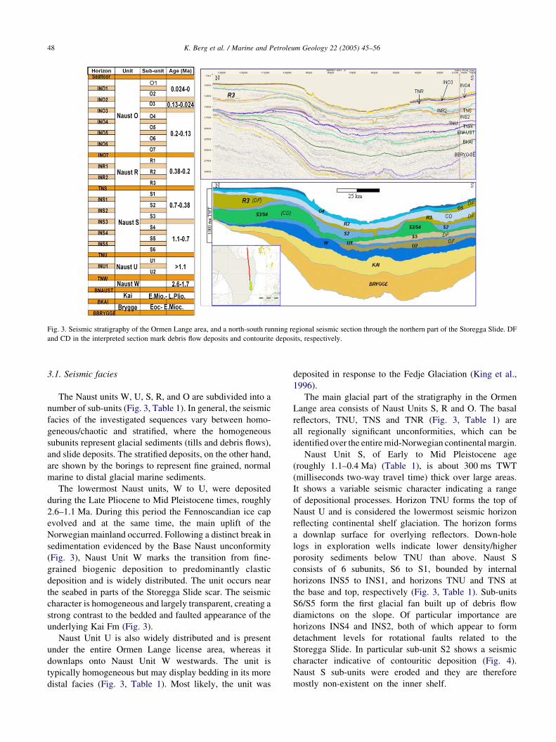
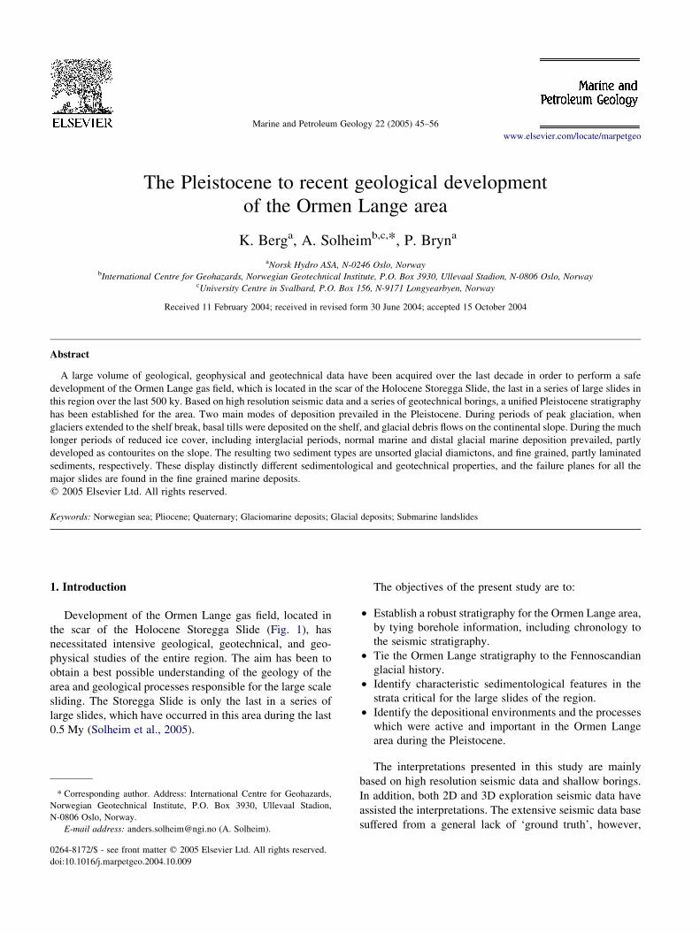
Fig. 3. Seismic stratigraphy of the Ormen Lange area, and a north-south running regional seismic section through the northern part of the Storegga Slide. DF
and CD in the interpreted section mark debris flow deposits and contourite deposits, respectively.
K. Berg et al. / Marine and Petroleum Geology 22 (2005) 45–5648
3.1. Seismic facies
The Naust units W, U, S, R, and O are subdivided into a
number of sub-units (Fig. 3, Table 1). In general, the seismic
facies of the investigated sequences vary between homo-
geneous/chaotic and stratified, where the homogeneous
subunits represent glacial sediments (tills and debris flows),
and slide deposits. The stratified deposits, on the other hand,
are shown by the borings to represent fine grained, normal
marine to distal glacial marine sediments.
The lowermost Naust units, W to U, were deposited
during the Late Pliocene to Mid Pleistocene times, roughly
2.6–1.1 Ma. During this period the Fennoscandian ice cap
evolved and at the same time, the main uplift of the
Norwegian mainland occurred. Following a distinct break in
sedimentation evidenced by the Base Naust unconformity
(Fig. 3), Naust Unit W marks the transition from fine-
grained biogenic deposition to predominantly clastic
deposition and is widely distributed. The unit occurs near
the seabed in parts of the Storegga Slide scar. The seismic
character is homogeneous and largely transparent, creating a
strong contrast to the bedded and faulted appearance of the
underlying Kai Fm (Fig. 3).
Naust Unit U is also widely distributed and is present
under the entire Ormen Lange license area, whereas it
downlaps onto Naust Unit W westwards. The unit is
typically homogeneous but may display bedding in its more
distal facies (Fig. 3, Table 1). Most likely, the unit was
deposited in response to the Fedje Glaciation (King et al.,
1996).
The main glacial part of the stratigraphy in the Ormen
Lange area consists of Naust Units S, R and O. The basal
reflectors, TNU, TNS and TNR (Fig. 3, Table 1) are
all regionally significant unconformities, which can be
identified over the entire mid-Norwegian continental margin.
Naust Unit S, of Early to Mid Pleistocene age
(roughly 1.1–0.4 Ma) (Table 1), is about 300 ms TWT
(milliseconds two-way travel time) thick over large areas.
It shows a variable seismic character indicating a range
of depositional processes. Horizon TNU forms the top of
Naust U and is considered the lowermost seismic horizon
reflecting continental shelf glaciation. The horizon forms
a downlap surface for overlying reflectors. Down-hole
logs in exploration wells indicate lower density/higher
porosity sediments below TNU than above. Naust S
consists of 6 subunits, S6 to S1, bounded by internal
horizons INS5 to INS1, and horizons TNU and TNS at
the base and top, respectively (Fig. 3, Table 1). Sub-units
S6/S5 form the first glacial fan built up of debris flow
diamictons on the slope. Of particular importance are
horizons INS4 and INS2, both of which appear to form
detachment levels for rotational faults related to the
Storegga Slide. In particular sub-unit S2 shows a seismic
character indicative of contouritic deposition (Fig. 4).
Naust S sub-units were eroded and they are therefore
mostly non-existent on the inner shelf.

Table 1
Summery table for the Naust Formation in the Ormen Lange region
Fm. Unit Sub-unit Hor. Seismic facies Lithology Phys. Props. Dep. Env. Age (ka)
Naust O O1–O2 INO2 Generally transparent, occasional
weak internal reflections. Largely
removed by Storegga Slide. Present
and but displaced and partly disturbed
at Site 22
Unsorted silty, sandy, gravely clay
(Diamicton), with shell fragments
Clay: 20–40%, S&G:
10–25%, Wc: 14–27%,
UW: 19.7–21.1 g/cm3,
Ip: 16–34%
Basal till and/or deformation till,
deposited beneath fast-flowing ice
stream
30–15
(MIS 1–2)
O3 INO3 Stratified, Mounded, climbing charac-
ter on the slope, with thickness
increase down-slope. Largely eroded
on the shelf
Silty clay with sand, scattered gravel
and shell fragments. Increasing clay
content in lower part of the sub-unit
Clay: 40–65%, S&G:
5–15%, Wc: 30–34%,
UW: 18.5–19 g/cm3,
Ip: 30–32%
Major part is glacial marine, variable
glacial proximity. Lower 5–10 m rep-
resent interglacial marine hemipelagic
deposits. Contouritic deposition
130–30 (MIS
5e–3) (Lower
part is
Eemian)
O4–O7 TNR Homogeneous, transparent, w/ some
discontinuous reflections. Fan-shaped
distribution on the slope, cut by the
Storegga Slide. Some internal high
relief formed by INO5
Diamicton with shell fragments and
variable content of gravel and larger
clasts. In general a upwards-fining
character of O4
Clay: 20–40%, S&G:
10–25%, Wc: 13–20%,
UW: 20.8–22.2 g/cm3,
Ip: 15–20%
Primarily glacial. Tills on the shelf,
debris flows on the slope. O4 is
transitional in character
200–130
(MIS 6)
R R1–R2 INR2 Stratified, with partly mounded,
climbing character (R2) filling in
underlying topography. R1 only lim-
ited extent as a wedge–shaped deposit
near Site 99. TNR is a main horizon
and forms a main failure plane for the
Storegga Slide
Silty clay (w60% clay) w/ little sand
and gravel. Lower part of R2 shows
gradual change to the more diamictic
R3 unit
Clay: 35–70%, S&G:
3–20%, Wc: 20–31%,
UW: 18.9–21.5 g/cm3,
Ip: 27–31%
Glacial marine to normal marine
conditions, in an ice-distal to inter-
glacial setting. Largely affected by
contour currents, i.e. contouritic
deposition
330–200
(MIS 9–7)
R3 TNS Less stratified than R2, but some
internal reflections of variable strength
Increasing sand and gravel compared
to R2
Clay: 31–66%, S&G: 4–
40%, Wc: 16–18%, UW:
21.4–22.0/cm3, Ip: 19–
20%, (Poorly sampled)
Primarily glacial marine, but more ice-
proximal than R2. Probably also some
glacial debris flow deposits on the
slope
380–330
(MIS 10)
S S1–S2 INS2 Stratified, partly mounded, contouritic,
filling in old slide scars in the INS2
surface
Poorly sampled. Silty clays with
variable sand, gravel and shell frag-
ments. Primarily fine grained, as also
supported by downhole logs
Clay: 26–66%, S&G:
2–30%, Wc: 30–40%,
UW: 18.1–19.8 g/cm3,
Ip: 25–45%
Distal glacial marine to normal mar-
ine, hemipelagic deposition
420–380
(MIS 11)
S3–S6 TNU Varies between homogeneous, chaotic
and stratified. S5 and S6 have an
opaque character and limited lateral
extent. S4 partly stratified and
mounded
Poorly sampled. Silty clays with
variable content of sand, gravel and
shell fragments. Thin sand layers.
Increased content of coarse com-
ponents relative to Unit R
Clay: 30–60%, S&G:
3–20%, Wc: 17–30%,
UW: 19.3–21.5 g/cm3,
Ip: 20–28%
Glacial marine deposits, deposited
under variable glacial conditions. The
sequence represents one or more
glaciations
S3–S5: 550–
420 (MIS
14–12), S6:
1000–550(?)
U U1–U2 TNW Present under the entire Ormen Lange
license area. Mainly homogeneous, but
with some stratification in distal parts
Unsampled Clay: S&G: Wc: UW: Ip: U1 represnts distal glacial marine to
normal marine deposits from initial
glacial advance (‘Fedje glaciation’).
U2 is probably debris flow or slump
deposits
w1700–1100
W W1–W3 BNa-
ust
Present under the entire Ormen Lange
license area. Massive, transparent
character. Strong contrast to the
underlying stratified, faulted biogenic
Kai Fm. Deposits
Undiffentiated Unit W sampled spar-
sely at Storegga North Flank (Site 28);
Silty clay with relatively high biogenic
content (foraminifera)
Clay: S&G: Wc: UW: Ip: Mainly normal marine, hemipelagic
deposits, but with some IRD from
mainly land-based glaciers
w2600–1700
Lithology and physical properties are from analyses of core samples. The depositional environment has been interpreted from sediment samples and seismic facies combined, whereas the age is inferred from all
available information, as shown in Fig. 6 for the last 1 My.
K.
Berg
eta
l./
Ma
rine
an
dP
etroleu
mG
eolo
gy
22
(20
05
)4
5–
56
49

Fig. 4. Interpreted seismic section across the shelf break and the upper continental slope in the northern part of the Storegga Slide. Main horizons and sub-units
are indicated. The two blue sub-units (R2 and S1–S2) are contourites, as shown by their monded, climbing seismic character, whereas the green sub-units (O4–
O7, R3, and S3), are all glacial debris flow diamictons. See Fig. 2 for location.
K. Berg et al. / Marine and Petroleum Geology 22 (2005) 45–5650
The following Mid Pleistocene unit, Naust R, (roughly
0.4–0.2 Ma) (Table 1) reaches 450 ms thickness locally
beneath the flank of the Storegga Slide. The unit shows a
bipartite seismic character, with a bedded upper part and a
more structureless lower part. It is largely eroded by the
Storegga Slide (Fig. 5). Three sub-units, R3, R2, and R1 are
bounded by internal horizons INR2 and INR1, and horizons
TNS and TNR at the base and top, respectively. Sub-unit R2
has a regional distribution. It resembles unit S2 in being
relatively thin and stratified on the outer continental shelf,
and thick, with a mounded, contouritic character on the
continental slope (Fig. 4). Sub-unit R1 seems to be only
locally developed, as a wedge shaped body behind the lower
slide scarp (Fig. 2). Naust R sub-units are also eroded and
therefore non-existent on the inner shelf. Horizon TNR
forms one of the main detachment levels for the Storegga
Slide.
The upper part of the Naust Formation, unit O, has been
divided into sub-units O7–O1 by the internal horizons
INO6-INO1 above the basal reflector, horizon TNR (Fig. 3,
Table 1). As TNR forms the base for a large part of the
Storegga Slide, Naust unit O was removed or severely
disturbed in the central slide scar, in which the Ormen
Lange field is located. Units O1 and O2 are seismically
transparent, with occasional weak internal reflectors.
Beyond the shelf edge, they were remoulded and mostly
removed by the Storegga Slide. Sub-unit O3 displays a
seismically stratified character and generally thickens
down-slope. On the shelf, the sub-unit has mostly been
eroded, but is present and cored at Site 20 (Fig. 2). The
lower sub-units of Naust unit O mainly display a
homogeneous to chaotic seismic character, with few and
mostly discontinuous internal reflecting horizons. Sub-units
O5–O7 stack up to form a fan-shaped lateral distribution,
cut by the Storegga Slide. Relief in horizon INO5 on the
shelf may represent an original till topography.
The upper disrupted deposits within the Storegga Slide
scar are termed the ‘Storegga Slide Sediments’. These
sediments are distinguished by their seismically structure-
less character and are commonly associated with headwall

Fig. 5. (A) Regional time structure map of seismic horizon INR2, which is the base of the contouritic sub-unit R2. The horizon and overlying strata are largely
eroded by the Storegga Slide, which forms an indent in which new contouritic deposits can accumulate. Note similar indents in the contours to the north of the
Storegga Slide. These were eroded by previous slides and formed local depocentres for contouritic deposits of sub-unit R2. (B) Isopach map of Naust sub-units
O7–O4, representing the Saalian glaciation, reconstructed to pre-Storegga Slide topography. Despite the uncertainties of the reconstruction, the outline of the
depocenter shows a fan-shaped sediment volume outside the Buadjupet Trough, which most likely was the location of ice streams, both during the Saalian and
other glaciations. Thickness contours are in meters, the Ormen Lange field is outlined in yellow.
K. Berg et al. / Marine and Petroleum Geology 22 (2005) 45–56 51
or sidewall scarps. Due to their completely disturbed nature,
their provenance in the original seismic stratigraphy is most
commonly unrecognisable.
3.2. Lithology and physical properties
Units U and W are only sparsely sampled at the distal site
28 (Fig. 2B), whereas unit U is drilled and logged, but not
sampled, at site 27. Consequently, the interpretation of these
units relies largely on down-hole logs and seismic
interpretation. Both units consist of fine grained marine to
distal glacial marine deposits. The IRD content is sparse in
the sampled deposits of unit W, as seen at site 28, but is
assumed to increase slightly as the glacial influence
increased during the time represented by unit U.
The sampled sediments of unit S are generally silty clays
with variable content of sand and gravel. Indications of
current variations are seen in silty, sandy lamina, which is in
agreement with a mounded, contouritic seismic character.
SEM studies support a fine grained, laminated structure in
particularly sub-unit S2. Internally there is a change across
horizon INS2, to a lower unit weight and higher water
content and plasticity above the horizon (Table 1). This is
also supported by the down-hole logging results, which
show a change to lower density and velocity from S3 to S2,
across horizon INS2.
The transition into Unit R, across TNS is marked by
an increase in unit weight and a corresponding decrease
in water content and plasticity. This change implies a
transition into more coarse-grained and unsorted (dia-
mictic) deposits of sub-unit R3 (Fig. 4, Table 1). There
is a gradual change from R3 into the clay-rich sub-units
R2 and R1. The two latter units show higher clay
content, higher water content and plasticity and lower
unit weight than R3 (Table 1), a trend which is
confirmed by the down-hole logs.
Naust Unit O is the main unit drilled at sites 19_2, 20 and
22 on the outer continental shelf (Fig. 2), and a large amount
of information is therefore acquired from this unit. The
transition across horizon TNR into the lower sub-units of
Naust O is sharp. Sub-units O7–O4 consist of silty, sandy,
gravely clay, with shell fragments and larger clasts, where
the sub-unit O4 appears to form a transitional zone. Water
content increases and unit weight decreases steadily upward
K. Berg et al. / Marine and Petroleum Geology 22 (2005) 45–5652
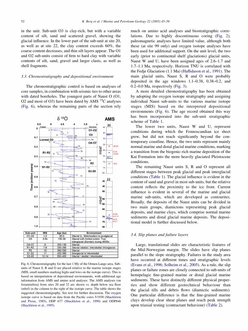
in the unit. Sub-unit O3 is clay-rich, but with a variable
content of silt, sand and scattered gravel, showing the
glacial influence. In the lower part of the sub-unit at site 20,
as well as at site 22, the clay content exceeds 60%, the
coarse content decreases, and thin silt layers appear. The O1
and O2 sub-units consist of firm to hard clay with variable
contents of silt, sand, gravel and larger clasts, as well as
shell fragments.
3.3. Chronostratigraphy and depositional environment
The chronostratigraphic control is based on analyses of
core samples, in combination with seismic ties to other areas
with dated boreholes. The youngest parts of Naust O (O1,
O2 and most of O3) have been dated by AMS 14C analyses
(Fig. 6), whereas the remaining parts of the section rely
Fig. 6. Chronostratigraphy for the last 1 My of the Ormen Lange area. Sub-
units of Naust S, R and O are placed relative to the marine isotope stages
(MIS, small numbers marking highs and lows on the isotope curve). This is
based on interpretation of depositional environments, with additional age
information from AMS and amino acid analyses. The AMS analyses (on
foraminifera) from sites 20 and 22 are shown vs. depth below sea floor
(mbsf) in the column to the right of the isotope curve. The table shows the
suggested chronostratigraphy. See text for further discussion. The oxygen
isotope curve is based on data from the Pacific cores V1930 (Shackleton
and Pisias, 1985), ODP 677 (Shackleton et al., 1990) and ODP846
(Shackleton et al., 1995).
much on amino acid analyses and biostratigraphic corre-
lations. Due to highly discontinuous coring (Fig. 2),
paleomagnetic analyses have limited value, although both
these (at site 99 only) and oxygen isotope analyses have
been used for additional support. On the unit level, the two
early (prior to continental shelf glaciations) glacial units,
Naust W and U, have been assigned ages of 2.6–1.7 and
1.7–1.1 Ma, respectively. Horizon TNU is correlated with
the Fedje Glaciation (1.1 Ma) (Haflidason et al., 1991). The
main glacial units, Naust S, R and O were probably
deposited in the age windows 1.1–0.38, 0.38–0.2, and
0.2–0.0 Ma, respectively (Fig. 3).
A more detailed chronostratigraphy has been obtained
by adopting the oxygen isotope stratigraphy and assigning
individual Naust sub-units to the various marine isotope
stages (MIS) based on the interpreted depositional
environments (Fig. 6). The age record obtained this way
has been incorporated into the sub-unit stratigraphic
scheme of Table 1.
The lower two units, Naust W and U, represent
conditions during which the Fennoscandian ice sheet
grew, but did not reach significantly beyond the con-
temporary coastline. Hence, the two units represent mainly
normal marine and distal glacial marine conditions, marking
a transition from the biogenic-rich marine deposition of the
Kai Formation into the more heavily glaciated Pleistocene
conditions.
The remaining Naust units S, R and O represent all
different stages between peak glacial and peak interglacial
conditions (Table 1). The glacial influence is evident in the
content of sand and gravel in most sub-units, but the relative
content reflects the proximity to the ice front. Current
influence is evident in several of the marine and glacial
marine sub-units, which are developed as contourites.
Broadly, the deposits of the Naust units can be divided in
two main groups, diamictons representing peak glacial
deposits, and marine clays, which comprise normal marine
sediments and distal glacial marine deposits. The deposi-
tional model is further discussed below.
3.4. Slip planes and failure layers
Large, translational slides are characteristic features of
the Mid-Norwegian margin. The slides have slip planes
parallel to the slope stratigraphy. Failures in the study area
have occurred at different times and stratigraphic levels
(Evans et al., 1996; Solheim et al., 2005). As a rule, the slip
planes or failure zones are closely connected to sub-units of
hemipelagic fine-grained marine or distal glacial marine
sediments. These have distinctly different physical proper-
ties and show different geotechnical behaviour than
the glacial tills and debris flows (diamictic sediments).
One particular difference is that the fine-grained marine
clays develop clear shear planes and reach peak strength
upon triaxial testing (contractant behaviour) (Table 2).
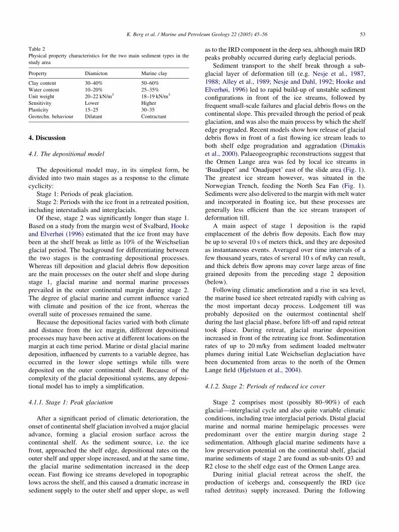
Table 2
Physical property characteristics for the two main sediment types in the
study area
Property Diamicton Marine clay
Clay content 30–40% 50–60%
Water content 10–20% 25–35%
Unit weight 20–22 kN/m3 18–19 kN/m3
Sensitivity Lower Higher
Plasticity 15–25 30–35
Geotechn. behaviour Dilatant Contractant
K. Berg et al. / Marine and Petroleum Geology 22 (2005) 45–56 53
4. Discussion
4.1. The depositional model
The depositional model may, in its simplest form, be
divided into two main stages as a response to the climate
cyclicity:
Stage 1: Periods of peak glaciation.
Stage 2: Periods with the ice front in a retreated position,
including interstadials and interglacials.
Of these, stage 2 was significantly longer than stage 1.
Based on a study from the margin west of Svalbard, Hooke
and Elverhøi (1996) estimated that the ice front may have
been at the shelf break as little as 10% of the Weichselian
glacial period. The background for differentiating between
the two stages is the contrasting depositional processes.
Whereas till deposition and glacial debris flow deposition
are the main processes on the outer shelf and slope during
stage 1, glacial marine and normal marine processes
prevailed in the outer continental margin during stage 2.
The degree of glacial marine and current influence varied
with climate and position of the ice front, whereas the
overall suite of processes remained the same.
Because the depositional facies varied with both climate
and distance from the ice margin, different depositional
processes may have been active at different locations on the
margin at each time period. Marine or distal glacial marine
deposition, influenced by currents to a variable degree, has
occurred in the lower slope settings while tills were
deposited on the outer continental shelf. Because of the
complexity of the glacial depositional systems, any deposi-
tional model has to imply a simplification.
4.1.1. Stage 1: Peak glaciation
After a significant period of climatic deterioration, the
onset of continental shelf glaciation involved a major glacial
advance, forming a glacial erosion surface across the
continental shelf. As the sediment source, i.e. the ice
front, approached the shelf edge, depositional rates on the
outer shelf and upper slope increased, and at the same time,
the glacial marine sedimentation increased in the deep
ocean. Fast flowing ice streams developed in topographic
lows across the shelf, and this caused a dramatic increase in
sediment supply to the outer shelf and upper slope, as well
as to the IRD component in the deep sea, although main IRD
peaks probably occurred during early deglacial periods.
Sediment transport to the shelf break through a sub-
glacial layer of deformation till (e.g. Nesje et al., 1987,
1988; Alley et al., 1989; Nesje and Dahl, 1992; Hooke and
Elverhøi, 1996) led to rapid build-up of unstable sediment
configurations in front of the ice streams, followed by
frequent small-scale failures and glacial debris flows on the
continental slope. This prevailed through the period of peak
glaciation, and was also the main process by which the shelf
edge prograded. Recent models show how release of glacial
debris flows in front of a fast flowing ice stream leads to
both shelf edge progradation and aggradation (Dimakis
et al., 2000). Palaeogeographic reconstructions suggest that
the Ormen Lange area was fed by local ice streams in
‘Buadjupet’ and ‘Onadjupet’ east of the slide area (Fig. 1).
The greatest ice stream however, was situated in the
Norwegian Trench, feeding the North Sea Fan (Fig. 1).
Sediments were also delivered to the margin with melt water
and incorporated in floating ice, but these processes are
generally less efficient than the ice stream transport of
deformation till.
A main aspect of stage 1 deposition is the rapid
emplacement of the debris flow deposits. Each flow may
be up to several 10 s of meters thick, and they are deposited
as instantaneous events. Averaged over time intervals of a
few thousand years, rates of several 10 s of m/ky can result,
and thick debris flow aprons may cover large areas of fine
grained deposits from the preceding stage 2 deposition
(below).
Following climatic amelioration and a rise in sea level,
the marine based ice sheet retreated rapidly with calving as
the most important decay process. Lodgement till was
probably deposited on the outermost continental shelf
during the last glacial phase, before lift-off and rapid retreat
took place. During retreat, glacial marine deposition
increased in front of the retreating ice front. Sedimentation
rates of up to 20 m/ky from sediment loaded meltwater
plumes during initial Late Weichselian deglaciation have
been documented from areas to the north of the Ormen
Lange field (Hjelstuen et al., 2004).
4.1.2. Stage 2: Periods of reduced ice cover
Stage 2 comprises most (possibly 80–90%) of each
glacial—interglacial cycle and also quite variable climatic
conditions, including true interglacial periods. Distal glacial
marine and normal marine hemipelagic processes were
predominant over the entire margin during stage 2
sedimentation. Although glacial marine sediments have a
low preservation potential on the continental shelf, glacial
marine sediments of stage 2 are found as sub-units O3 and
R2 close to the shelf edge east of the Ormen Lange area.
During initial glacial retreat across the shelf, the
production of icebergs and, consequently the IRD (ice
rafted detritus) supply increased. During the following
K. Berg et al. / Marine and Petroleum Geology 22 (2005) 45–5654
period of retreated ice front (interglacial, interstadial or even
a limited stadial), normal marine deposition resumed on
the slope and in the deep ocean, partly influenced by
contour-following currents, as the oceanic polar front
moved northwards and the general circulation pattern was
re-vitalized. This led to increased biogenic production as the
terrigeneous sediment supply decreased.
The currents must periodically have been powerful
enough to transport and erode fine grained sediment,
which were re-deposited in areas of reduced current
velocity, such as in the scars left by earlier slides (Solheim
et al., 2005). These palaeo-slide scars trapped sediments
moving northwards along the slope and the thickest
contouritic drift sequences, such as sub-units R2 and S2,
are recorded within the largest slide scars. Where the
palaeo-slope prior to contourite deposition is even, without
local topography such as slide scars, these deposits are
relatively thin.
Although the age control is problematic, relatively long
time spans seem necessary to build up O100 m of
sediment drifts such as the stage 2 deposits of sub-units
R1/R2 and S1/S2. The sediment supply may have been
episodic, and extreme local sedimentation rates in excess
of 20 m/ky provide a likely model although these
conditions probably prevailed only for limited periods
and only for limited parts of the slope. Hence, large output
of terrigeneous sediments during early deglaciation from
areas in the vicinity and south of Ormen Lange are the
most likely sediment sources. In particular the Norwegian
Trench Ice Stream would provide a significant sediment
supply. Consequently, this important deglaciation phase
forms the transition between stage 1 and stage 2 deposition.
During true interglacials, when the ice probably
disappeared from most of the inland areas, conditions
may periodically have been like the present. Large
submarine slides, such as the Holocene Storegga Slide as
well as older slides recorded deeper in the stratigraphy
seem to have occurred during early parts of stage 2
deposition (Solheim et al., 2005). The detachment levels
for the failures seem to follow the fine grained marine,
partly contouritic layers. Hence, the sliding process is
apparently strongly controlled by the glacial—interglacial
sedimentary cyclicity, and the resulting differences in
depositional processes, rates, and physical properties
between stages 1 and 2 sediments (Tables 1 and 2) (Bryn
et al., 2005). During late stage 2 climatic deterioration, ice
again accumulated in inland alpine areas, and a new glacial
period was initiated, which subsequently led to a new
period of stage 1 deposition.
4.2. Age constraints
Age control is a key problem in unravelling the
depositional history for the Ormen Lange area. Results
of AMS 14C dating show that most of the upper section of
sub-units O1, O2 and O3 consist of sediments deposited
during the Late Weichselian, i.e. the last approximately
30 ky. Seismic horizon INO2 at site 22 has an age between
23 and 24 ka (Fig. 6).
Horizon INO3 is important because it forms the
shallowest and laterally greatest of the Storegga Slide
slip planes. The age of 33 ka 5 m above INO3 (Fig. 6)
shows that the horizon was not created by the Late
Weichselian glaciation, which reached the shelf break
later than 30 ka. The horizon is a distinct, regional
unconformity and is most likely created by a regional
glaciation reaching the shelf break. According to Sejrup
et al. (2000), the Early and Mid Weichselian ice
advances did not reach the shelf break and were probably
quite moderate in extent. Hence, the most likely
glaciation to create the INO3 erosional unconformity
was the Saalian. This is in accordance with the dating
results, but implies a period of low sedimentation rate on
the shelf between the Saalian retreat and the Late
Weichselian advance. Possibly this may also include
periods of non-deposition or erosion, but our temporal
resolution is not sufficient to resolve this. An Eemian age
is therefore inferred for the lowermost part of sub-unit
O3, which also clearly represents normal marine
deposition and is the finest grained part of the sub-unit.
Horizon INO3 hence represents the final Saalian retreat.
This also supports a Saalian age for the lower glacial
sub-units (O4–O7) of Naust Unit O, as interpreted based
on amino acid analyses. The reconstructed isopach map
of O7–O4 (Fig. 5B) supports a glacial fan build-out from
the east.
The peak glacial periods represented by tills on the
outermost shelf, and glacial debris flow units on the upper
slope are only short intervals during each glacial period.
This may introduce an error to the ages based on the marine
isotope stratigraphy (Fig. 6). In fact, the periods assigned
interglacial or interstadial may be considerably longer and
the periods assigned glacial shorter. The ‘interglacial to
interstadial’ periods may therefore represent periods during
which the ice cover varied from none to an ice margin at a
mid-shelf position.
The ice sheets reached the shelf break from MIS 12
(Fig. 6). The thick and extensive glacial debris flow units R3
and S5 are assigned glacial stages 10 and 12, respectively,
although the amino acid analyses also open for a possible
stage 14 age for S5 (University of Bergen, 2002). R1–R2 is
assigned stages 7–9. Since R1–R2 are essentially marine to
glacial marine deposits, this implies that stage 8 glaciation
probably was less extensive than stages 6, 10 and 12, and
did not manifest itself with significant debris flow deposits
on the continental slope.
The long interval represented by sub-unit S6 is a concern
with regards to the above discussion. A younger age than
1.1 Ma for horizon TNU cannot be excluded. However,
continuous coring and detailed isotope- as well as
magnetostratigraphic investigations work would be necess-
ary to clarify this.
K. Berg et al. / Marine and Petroleum Geology 22 (2005) 45–56 55
5. Conclusions
†
Pleistocene sedimentation in the Ormen Lange area wasstrongly controlled by glacial—interglacial climatic
variability, which also controlled the development of
sedimentary sequences.
†
Two distinctly different depositional modes wereresponsible for the Pleistocene section in the area;
(1) peak glaciation with ice reaching the shelf break, and
(2) periods of retreated ice front.
†
The two broad classes of sediments resulting from thedepositional stages are (a) glacial diamictons, consisting
of tills and debris flow deposits, and (b) fine grained
normal marine and glacial marine clays, with variable
content of coarser IRD and biogenic components.
†
Deposition was most rapid during periods of peakglaciation, when fast-flowing ice streams supplied glacial
diamictons through a system of subglacial deformation
tills directly to the outer shelf and upper slope. Frequent
debris flows moved these glacial sediments further out on
the continental slope, thereby giving rise to rapid,
periodic shelf progradation and debris flow aprons
(fans) on the slope.
†
Under the influence of contour currents, depositionduring periods of a retreating or retreated ice cover
may also locally reach significant thickness, in particular
when filling in older slide scars.
†
The two sediment types show distinctly differentgeotechnical properties, and this is interpreted to be a
main controlling factor for the development and the
geometry of the large submarine slides, which took place
in this area, particularly during the last 0.5 My.
†
Slip occurred in the fine grained marine clays and slidedetachment levels follow the stratal geometry.
Acknowledgements
Norsk Hydro is acknowledged for the open access to the
data related to the Storegga Slide. The manuscript was
critically reviewed by Drs Atle Nesje and David Long. This
is publication number 54 of the International Centre for
Geohazards (ICG).
References
Alendal, G., Berntsen, J., Engum, E., Furnes, G.K., Kleiven, G., Eide, L.I.,
2005. Influence from ‘Ocean Weather’ on near seabed currents and
events at Ormen Lange. Marine and Petroleum Geology, this issue, doi:
10.1016/j.marpetgeo.2004.10.011
Alley, R.B., Blankenship, D.D., Rooney, S.T., Bentley, C.R., 1989.
Sedimentation beneath ice shelves—the view from Ice Stream B.
Marine Geology 85, 101–120.
Berndt, C., Planke, S., Alvestad, E., Tsikalas, F., Rasmussen, T., 2001.
Seismic volcanostratigraphy of the Norwegian margin: constraints on
tectonomagmatic break-up processes. Journal of the Geological Society
158, 413–426.
Bryn, P., Berg, K., Lien, R., Solheim, A., Ottesen, D., Rise, L., 2002. The
Storegga geomodel and its use in slide risk evaluation: Geological and
geotechnical site investigations in the Storegga Slide area. Offshore Site
Investigation and Geotechnics—Diversity and Sustainability. Proceed-
ings of an International Conference, London, UK, 26–28 November,
2002. The Society for Underwater Technology, pp. 219–232.
Bryn, P., Solheim, A., Berg, K., Lien, R., Forsberg, C.F., Haflidason, H.,
Ottesen, D., Rise, L., 2003. The Storegga Slide complex; Repeated
large scale sliding in response to climatic cyclicity. In: Locat, J.,
Mienert, J. (Eds.), Submarine Mass Movements and Their Conse-
quences. Kluwer Academic Press, The Netherlands, pp. 215–222.
Bryn, P., Berg, K., Forsberg, C.F., Solheim, A., Lien, R., 2005. Explaining
the Storegga Slide. Marine and Petroleum Geology, this issue, doi:
10.1016/j.marpetgeo.2004.12.003
Dimakis, P., Elverhøi, A., Høeg, K., Solheim, A., Harbitz, C.B.,
Laberg, J.S., Vorren, T.O., Marr, J., 2000. Submarine slope stability
on high latitude glaciated Svalbard—Barents Sea margin. Marine
Geology 162, 303–316.
Evans, D., King, E.L., Kenyon, N.H., Brett, C., Wallis, D., 1996. Evidence
for long-term instability in the Storegga Slide region off western
Norway. Marine Geology 130, 281–292.
Haflidason, H., Aarseth, I., Haugen, J.E., Sejrup, H.P., Løvlie, R.,
Reither, E., 1991. Quaternary stratigraphy of the Draugen area, Mid-
Norwegian Shelf. Marine Geology 101, 125–145.
Hebbeln, D., Dokken, T., Andersen, E.S., Hald, M., Elverhøi, A., 1994.
Enigmatic arctic ice sheets. Nature 370, 357–360.
Henrich, R., Baumann, K.H., 1994. Evolution of the Norwegian current and
the Scandinavian ice sheets during the past 2.6 m.y: evidence from ODP
Leg 104 biogenic carbonate and terrigeneous records. Palaeogeogra-
phy, Palaeoclimatology, Palaeoecology 108, 75–94.
Hjelstuen, B.O., Sejrup, H.P., Haflidason, H., Bryn, P., Berg., K., 2004.
Neogene and Quaternary depositional environments on the mid-
Norwegian continental margin, 628N–688N. Marine Geology 213,
257–276.
Hjelstuen, B.O., Sejrup, H.P., Haflidason, H., Nygard, A., Ceramicola, S.,
Bryn, P., 2005. Late Cenozoic glacial history and evolution of the
Storegga Slide area and adjacent slide flanks regions, Norwegian
continental margin. Marine and Petroleum Geology, this issue, doi:
10.1016/j.marpetgeo.2004.10.002
Hooke, R., Elverhøi, A., 1996. Sediment flux from a fjord during glacial
periods, Isfjorden, Spitsbergen. Global and Planetary Change 12, 237–
249.
Jansen, E., Sjøholm, J., 1991. Reconstruction of glaciation over the past
6 Myr from ice-borne deposits in the Norwegian Sea. Nature 349, 600–
603.
King, E.L., Sejrup, H.P., Haflidason, H., Elverhøi, A., Aarseth, I., 1996.
Quaternary seismic stratigraphy of the North Sea Fan: Glacially-fed
gravity flow aprons, hemipelagic sediments, and large submarine slides.
Marine Geology 130, 293–315.
Kvalstad, T.J., Gauer, P., Kaynia, A.M., Nadim, F., Bryn, P., 2002. Slope
stability at Ormen Lange. Offshore Site Investigation and Geotech-
nics—Diversity and Sustainability. Proceedings of an International
Conference, London, UK, 26–28 November, 2002. The Society for
Underwater Technology, pp. 233–250.
Kvalstad, T.J., Nadim, F., Kaynia, A.M., Mokkelbost, K.H., Bryn, P., 2005.
Soil conditions and slope stability in the Ormen Lange area. Marine and
Petroleum Geology, this issue, doi: 10.1016/j.marpetgeo.2004.12.001
McNeill, A.E., Salisbury, R.S.K., Østmo, S.R., Lien, R., Evans, D., 1998. A
regional shallow stratigraphic framework off mid- Norway and
observations of ‘special features’, 1998, Offshore Technology
Conference, Paper 8639, vol. 2, pp. 97–109.
Nesje, A., Dahl, S.O., 1992. Geometry, thickness and isostatic loading of
the Late Weichselian Scandinavian ice sheet. Norsk Geologisk
Tidsskrift 72, 271–273.
K. Berg et al. / Marine and Petroleum Geology 22 (2005) 45–5656
Nesje, A., Anda, E., Rye, N., Lien, R., Hole, P.A., Blikra, L.H., 1987. The
vertical extent of the Late Weichselian ice sheet in the Nordfjord-Møre
area, western Norway. Norsk Geologisk Tidsskrift 67, 125–141.
Nesje, A., Dahl, S.O., Anda, E., Rye, N., 1988. Block fields in southern
Norway; Significance for the Late Weichselian ice sheet. Norsk
Geologisk Tidsskrift 68, 149–169.
Nygard, A., Sejrup, H.P., Haflidason, H., Bryn, P., 2005. The glacial North
Sea Fan, southern Norwegian Margin: Architecture and evolution from
the upper continental slope to the deep-sea basin. Marine and Petroleum
Geology, this issue, doi: 10.1016/j.marpetgeo.2004.12.001
Ottesen, D., Olsen, L., Thorsnes, T., 2000. Ice sheet dynamics on the mid-
Norwegian continental shelf based on regional and detailed bathymetric
and seismic data. NGU Report 2000.017, p. 52.
Rise, L., Ottesen, D., Berg, K., Lundin, E., 2005. Large-scale development of the
mid-Norwegian shelf and margin during the last 3 million years. Marine and
Petroleum Geology, this issue, doi: 10.1016/j.marpetgeo.2004.10.010
Sejrup, H.P., Haflidason, H., Hjelstuen, B.O., Nygard, A., Bryn, P., Lien, R.,
2004. Pleistocene development of the SE Nordic Seas margin. Marine
Geology 213, 169–200.
Sejrup, H.P., Larsen, E., Landvik, J., King, E.L., Haflidason, H., Nesje, A.,
2000. Quaternary glaciations in southern Fennoscandia: evidence from
south-western Norway and the northern North Sea region. Quaternary
Science Reviews 19, 667–685.
Shackleton, N.J., Pisias, N.G., 1985. Atmospheric carbon dioxide, orbital
forcing, and climate. In: Sundquist, E.T., Broecker, W.S. (Eds.), The
carbon cycle and atmospheric CO2: Natural variations, Archaean to
present. Geophysical Monographs, vol. 32, pp. 412–417.
Shackleton, N.J., Berger, A., Peltier, W.R., 1990. An alternativeastrono-
mical calibration of the lower Pleistocene timescale based on ODP Site
677. Transactions of the Royal Society of Edinburgh, Earth Sciences
81, 251–261.
Shackleton, N.J., Crowhurst, S., Hagelberg, T., Pisias, N.G.,
Schneider, D.A., 1995. A new Late Neogene time scale: Application
to Leg 138 sites. Proceedings of the Ocean Drilling Program, Scientific
Results 138, 73–101.
Solheim, A., Faleide, J.I., Andersen, E.S., Elverhøi, A., Forsberg, C.F.,
Vanneste, K., Uenzelmann-Neben, G., Channell, J.E.T., 1998. Late
Cenozoic seismic stratigraphy and glacial geological development of
the East Greenland and Svalbard-Barents Sea continental margins.
Quaternary Science Reviews 17, 155–184.
Solheim, A., Berg, K., Forsberg, C.F., Bryn, P., 2005. The Storegga Slide
Complex: Repetitive large scale sliding with similar cause and
development. Marine and Petroleum Geology, this issue, doi:
10.1016/j.marpetgeo.2004.10.013
Stoker, M.S., 1999. Stratigraphic nomenclature of the UK North West
Margin: 3. Mid-Late Cenozoic stratigraphy. British Geological Survey
1999.
Strout, J.M., Tjelta, T.I., 2005. In situ pore pressures: What is their
significance and how can they be reliably measured? Marine and
Petroleum Geology, this issue, doi: 10.1016/j.marpet-
geo.2004.10.024
Tjelta, T.I., Strout, J.M., Solheim, A., Mokkelbost, K.H., Berg, K.,
Bryn, P., 2002. Ormen Lange geoborings—geological and geotech-
nical site investigations in the Storegga Slide area. Offshore Site
Investigation and Geotechnics—Diversity and Sustainability. Pro-
ceedings of an International Conference, London, UK, 26–28
November, 2002. The Society for Underwater Technology, pp.
199–217.
University of Bergen, 2002. The Ormen Lange geotechnical/geological
boring 2001: Chronological and lithological analyses of borehole site 27.
University of Bergen Report 100-06/02.