The palaeolimnology of the Aral Sea: a review
20
Quaternary Science Reviews 19 (2000) 1259}1278 The palaeolimnology of the Aral Sea: a review Ian Boomer!,*, Nikolai Aladin", Igor Plotnikov", Robin Whatley# !Department of Geography, University of Newcastle, Newcastle upon Tyne, NE1 7RU UK "Zoological Institute, Russian Academy of Sciences, St. Petersburg 199034, Russia #Institute of Earth Studies, University of Wales, Aberystwyth, Dyfed, SY23 3DB, UK Abstract Formerly the fourth largest inland water body in the world, the volume and area of the Aral Sea have decreased dramatically over the past 30 yr largely as a result of human actions. Throughout its approximately 2 million year history the fate of this water body has been intimately linked with that of its two main in-#owing rivers, the Amu Darya and the Syr Darya. We present a review of the hydrological, palaeontological and sedimentological evidence for the evolution of the Aral Sea based largely on Russian literature. Although the structure of the Aral Basin can be traced back to the late Neogene, the Sea has only existed in its present form for the past 8}10 ka and the Holocene history has been shaped by regional climatic variations, the development of the associated drainage system and anthropogenic forces. Past hydrological changes in the Aral Basin have led to systematic shifts in the level of the Aral Sea which are re#ected sedimentologically through the deposition of &transgressive' and ®ressive' sedimentary units and geomor- phologically through the development of terraces. All the above data are integrated to produced a Late Quaternary history of this important water body. ( 2000 Elsevier Science Ltd. All rights reserved. 1. Introduction The Aral Sea is a large continental water body in Central Asia (Fig. 1) bordering on Kazakhstan, Uzbekistan and Turkmenistan. It is divided into two parts, the northern, shallow Small Aral and the southern, deeper Large Aral (Fig. 2). The dramatic recession of the Aral Sea witnessed over the past 30 yr has brought the worlds' attention to the environmental crisis in this ex- tensive and important body of water. Both the level and volume have been severely reduced, primarily by the sustained withdrawal of large quantities of water from the two main feeder rivers, the Amu Darya and the Syr Darya (formerly known as the Oxus and Jaxartes, respec- tively) to irrigate the cotton "elds of Uzbekistan. From 1960 to 1990 the area of the Aral was reduced by 40% and the volume by 60%. During this period the salinity rose from 9 to 30& with a dramatic e!ect on the #ora and fauna. These changes have led to increased seasonal- ity in the regional climate, a deterioration in the quality of drinking water supplies and a dramatic increase in local health problems. The crisis has been further * Corresponding author. Tel.: #44-191-222-5111; fax: #44-191- 222-5421. E-mail address: ian.boomer@ncl.ac.uk (I. Boomer). compounded by the almost uncontrolled use of chemical fertilisers, pesticides and defoliants within the valleys of the two rivers. The severity of the environmental problems has attrac- ted the attention of scientists from the former Soviet states and the west including the United Nations Envir- onmental Program (UNEP) and United Nations Educa- tion, Science and Cultural Organisation (UNESCO) which have helped bring the crisis to the attention of the outside world. We do not intend to give a detailed de- scription of the current environmental problems since they are well documented in the recent literature (Aladin and Kuznetsov, 1990; Aladin and Glasovsky, 1991; Ellis, 1990; Kotlyakov, 1991; Micklin, 1988, 1991, 1993; Pearce, 1995a, b; Plotnikov et al., 1991; Saiko and Zonn, 1994). However, we will show that the most recent fall in the level of the Aral Sea is just one of a number of #uctuations known to have occurred during its history. In the following we present a history of the Aral Basin together with evidence for past changes in water level. This study is essentially a review of past work undertaken both before and since the recognition of the recent envir- onmental crisis. We hope to set the Aral Sea problem in a geological and historical perspective, incorporating much of the literature which has previously only ap- peared in Russian, with the aim of understanding the processes which have led to the formation of the Aral Sea 0277-3791/00/$ - see front matter ( 2000 Elsevier Science Ltd. All rights reserved. PII: S 0 2 7 7 - 3 7 9 1 ( 0 0 ) 0 0 0 0 2 - 0
-
Upload
birmingham -
Category
Documents
-
view
3 -
download
0
Transcript of The palaeolimnology of the Aral Sea: a review

Quaternary Science Reviews 19 (2000) 1259}1278
The palaeolimnology of the Aral Sea: a review
Ian Boomer!,*, Nikolai Aladin", Igor Plotnikov", Robin Whatley#!Department of Geography, University of Newcastle, Newcastle upon Tyne, NE1 7RU UK
"Zoological Institute, Russian Academy of Sciences, St. Petersburg 199034, Russia#Institute of Earth Studies, University of Wales, Aberystwyth, Dyfed, SY23 3DB, UK
Abstract
Formerly the fourth largest inland water body in the world, the volume and area of the Aral Sea have decreased dramatically overthe past 30 yr largely as a result of human actions. Throughout its approximately 2 million year history the fate of this water body hasbeen intimately linked with that of its two main in-#owing rivers, the Amu Darya and the Syr Darya. We present a review of thehydrological, palaeontological and sedimentological evidence for the evolution of the Aral Sea based largely on Russian literature.Although the structure of the Aral Basin can be traced back to the late Neogene, the Sea has only existed in its present form for thepast 8}10 ka and the Holocene history has been shaped by regional climatic variations, the development of the associated drainagesystem and anthropogenic forces. Past hydrological changes in the Aral Basin have led to systematic shifts in the level of the Aral Seawhich are re#ected sedimentologically through the deposition of &transgressive' and ®ressive' sedimentary units and geomor-phologically through the development of terraces. All the above data are integrated to produced a Late Quaternary history of thisimportant water body. ( 2000 Elsevier Science Ltd. All rights reserved.
1. Introduction
The Aral Sea is a large continental water body inCentral Asia (Fig. 1) bordering on Kazakhstan,Uzbekistan and Turkmenistan. It is divided into twoparts, the northern, shallow Small Aral and the southern,deeper Large Aral (Fig. 2). The dramatic recession of theAral Sea witnessed over the past 30 yr has brought theworlds' attention to the environmental crisis in this ex-tensive and important body of water. Both the level andvolume have been severely reduced, primarily by thesustained withdrawal of large quantities of water fromthe two main feeder rivers, the Amu Darya and the SyrDarya (formerly known as the Oxus and Jaxartes, respec-tively) to irrigate the cotton "elds of Uzbekistan. From1960 to 1990 the area of the Aral was reduced by 40%and the volume by 60%. During this period the salinityrose from 9 to 30& with a dramatic e!ect on the #oraand fauna. These changes have led to increased seasonal-ity in the regional climate, a deterioration in the qualityof drinking water supplies and a dramatic increase inlocal health problems. The crisis has been further
*Corresponding author. Tel.: #44-191-222-5111; fax: #44-191-222-5421.
E-mail address: [email protected] (I. Boomer).
compounded by the almost uncontrolled use of chemicalfertilisers, pesticides and defoliants within the valleys ofthe two rivers.
The severity of the environmental problems has attrac-ted the attention of scientists from the former Sovietstates and the west including the United Nations Envir-onmental Program (UNEP) and United Nations Educa-tion, Science and Cultural Organisation (UNESCO)which have helped bring the crisis to the attention of theoutside world. We do not intend to give a detailed de-scription of the current environmental problems sincethey are well documented in the recent literature (Aladinand Kuznetsov, 1990; Aladin and Glasovsky, 1991; Ellis,1990; Kotlyakov, 1991; Micklin, 1988, 1991, 1993;Pearce, 1995a, b; Plotnikov et al., 1991; Saiko and Zonn,1994). However, we will show that the most recent fall inthe level of the Aral Sea is just one of a number of#uctuations known to have occurred during its history.In the following we present a history of the Aral Basintogether with evidence for past changes in water level.This study is essentially a review of past work undertakenboth before and since the recognition of the recent envir-onmental crisis. We hope to set the Aral Sea problem ina geological and historical perspective, incorporatingmuch of the literature which has previously only ap-peared in Russian, with the aim of understanding theprocesses which have led to the formation of the Aral Sea
0277-3791/00/$ - see front matter ( 2000 Elsevier Science Ltd. All rights reserved.PII: S 0 2 7 7 - 3 7 9 1 ( 0 0 ) 0 0 0 0 2 - 0
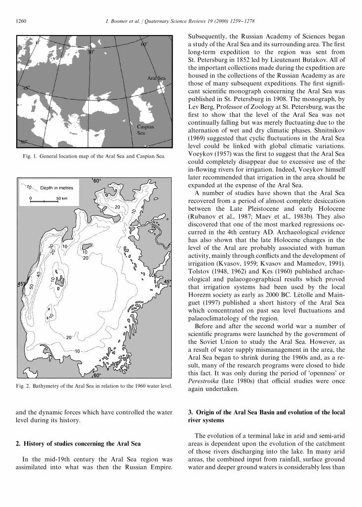
Fig. 1. General location map of the Aral Sea and Caspian Sea.
Fig. 2. Bathymetry of the Aral Sea in relation to the 1960 water level.
and the dynamic forces which have controlled the waterlevel during its history.
2. History of studies concerning the Aral Sea
In the mid-19th century the Aral Sea region wasassimilated into what was then the Russian Empire.
Subsequently, the Russian Academy of Sciences begana study of the Aral Sea and its surrounding area. The "rstlong-term expedition to the region was sent fromSt. Petersburg in 1852 led by Lieutenant Butakov. All ofthe important collections made during the expedition arehoused in the collections of the Russian Academy as arethose of many subsequent expeditions. The "rst signi"-cant scienti"c monograph concerning the Aral Sea waspublished in St. Petersburg in 1908. The monograph, byLev Berg, Professor of Zoology at St. Petersburg, was the"rst to show that the level of the Aral Sea was notcontinually falling but was merely #uctuating due to thealternation of wet and dry climatic phases. Shnitnikov(1969) suggested that cyclic #uctuations in the Aral Sealevel could be linked with global climatic variations.Voeykov (1957) was the "rst to suggest that the Aral Seacould completely disappear due to excessive use of thein-#owing rivers for irrigation. Indeed, Voeykov himselflater recommended that irrigation in the area should beexpanded at the expense of the Aral Sea.
A number of studies have shown that the Aral Searecovered from a period of almost complete desiccationbetween the Late Pleistocene and early Holocene(Rubanov et al., 1987; Maev et al., 1983b). They alsodiscovered that one of the most marked regressions oc-curred in the 4th century AD. Archaeological evidencehas also shown that the late Holocene changes in thelevel of the Aral are probably associated with humanactivity, mainly through con#icts and the development ofirrigation (Kvasov, 1959; Kvasov and Mamedov, 1991).Tolstov (1948, 1962) and Kes (1960) published archae-ological and palaeogeographical results which provedthat irrigation systems had been used by the localHorezm society as early as 2000 BC. LeH tolle and Main-guet (1997) published a short history of the Aral Seawhich concentrated on past sea level #uctuations andpalaeoclimatology of the region.
Before and after the second world war a number ofscienti"c programs were launched by the government ofthe Soviet Union to study the Aral Sea. However, asa result of water supply mismanagement in the area, theAral Sea began to shrink during the 1960s and, as a re-sult, many of the research programs were closed to hidethis fact. It was only during the period of &openness' orPerestroika (late 1980s) that o$cial studies were onceagain undertaken.
3. Origin of the Aral Sea Basin and evolution of the localriver systems
The evolution of a terminal lake in arid and semi-aridareas is dependent upon the evolution of the catchmentof those rivers discharging into the lake. In many aridareas, the combined input from rainfall, surface groundwater and deeper ground waters is considerably less than
1260 I. Boomer et al. / Quaternary Science Reviews 19 (2000) 1259}1278
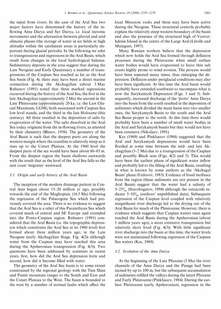
the input from rivers. In the case of the Aral Sea twomajor factors have determined the history of the in-#owing Amu Darya and Syr Darya, i.e. local tectonicmovements and the alternation between pluvial and aridclimatic phases (the storage of water in ice "elds at highaltitudes within the catchment areas is particularly im-portant during glacial periods). In the following we referto transgressions and regressions in the Aral Basin, whichresult from changes in the local hydrological balance.Sedimentary deposits in the area suggest that during theLate Neogene and Early Quaternary a number of trans-gressions of the Caspian Sea reached as far as the AralSea basin (Fig. 4), there may have been a direct marineconnection during the Akchagylian (about 3 Ma).Rubanov (1991) noted that three marked regressionsoccurred during the history of the Aral Sea, the "rst in thelate Akchagylian (approximately 2 Ma) the second in theLate Pleistocene (approximately 20 ka, i.e. the Last Gla-cial Maximum, LGM), both associated with Caspian Sealow level stands, and the third in the late Holocene (thiscentury). All three resulted in the deposition of salts byevaporation of the water. The salts dissolved in the AralSea today originate from the in-#owing rivers, as attestedby their chemistry (Blinov, 1956). The geometry of theAral Basin is such that the deepest parts are along thewestern margin where the coastline is relatively steep as itrises up to the Usturt Plateau. At the 1960 level thedeepest parts of the sea would have been about 60}65 m.From the deepest region the basin shallows eastwardswith the result that as the level of the Aral Sea falls so theeast coast &migrates' westward.
3.1. Origin and early history of the Aral Basin
The inception of the modern drainage pattern in Cen-tral Asia began about 15}20 million yr ago, possiblytowards the end of the Magliopian, (16.5 Ma) followingthe regression of the Palaeogene Sea which had pre-viously covered the area. There is no evidence to suggestthat the Aral Sea is a relict of this Paratethyan Sea whichcovered much of central and SE Europe and extendedinto the Ponto-Caspian region. Rubanov (1991) con-sidered that the Aral Basin (i.e. the topographic depress-ion which constitutes the Aral Sea at its 1960 level) "rstformed about three million years ago, in the LateNeogene (early Akchagylian Stage, Fig. 4(2)) althoughwater from the Caspian may have reached this areaduring the Apsheronian transgression (Fig. 4(3)). Twoquestions have been addressed by scientists in recentyears, "rst, how did the Aral Sea depression form andsecond, how did it become "lled with water.
The geometry of the Aral Sea basin is to some extentconstrained by the regional geology with the Tien Shanand Pamir mountain ranges to the South and East andthe Usturt Plateau to the West. The basin is bounded tothe west by a number of normal faults which a!ect the
local Mesozoic rocks and these may have been activeduring the Neogene. These structural controls probablyexplain the relatively steep western boundary of the basinand also the presence of the structural high of Vozroz-hdenie Island in the centre of the Large Aral (LeH tolle andMainguet, 1997).
Many Russian workers believe that the depressionwhich now holds the Aral Sea formed through de#ationprocesses during the Pleistocene when small surfacewater bodies would have evaporated to leave thin saltcrusts highly prone to wind erosion. The process wouldhave been repeated many times, thus enlarging the de-pression. De#ation under periglacial conditions may alsohave been signi"cant. At this time the Aral basin wouldprobably have extended southwest to encompass what isnow the Sarykamysh Depression (Figs. 3 and 5). Sub-sequently, increased discharge of the &proto' Amu Daryainto the basin from the south resulted in the deposition ofsediments which divided the main basin into two smallerones, the Sarykamysh Basin to the south and the AralSea Basin proper to the north. At this time there wouldprobably have been a number of small water bodies inthe Aral and Sarykamysh basins but they would not havebeen extensive (Nikolaev, 1991).
Kes (1969) and Pinkhasov (1984) suggested that theAral and Sarykamysh depressions would have been#ooded at some time between the mid- and late Ak-chagylian (3}2 Ma) due to a transgression of the Caspianand possibly Black seas (Figs. 4(2) and 5). This wouldhave been the earliest phase of signi"cant water in#owand probably led to the "lling of the Aral Basin, resultingin what is known by some authors as the &AkchagylBasin' phase (Fedorov, 1983). Evidence of fossil molluscsfrom the region (these sediments are not present in theAral Basin) suggest that the water had a salinity of5}25& (Starobogatov, 1994) although the ostracods in-dicate 5}10& (authors' unpublished data). Subsequentregression of the Caspian level coupled with relativelyinsigni"cant river discharge led to the drying out of theAral Basin for much of the Pleistocene. However, there isevidence which suggests that Caspian waters once againreached the Aral Basin during the Apsheronian (about1 million years ago), a more extensive transgression butrelatively short lived (Fig. 4(3)). With little signi"cantriver discharge into the basin at this time, the water levelswere not maintained following regression of the CaspianSea waters (Kes, 1969).
3.2. Evolution of the Amu Darya
At the beginning of the Late Pliocene (3 Ma) the riverchannels of the Amu Darya and the Piange had beenincised by up to 100 m, but the subsequent accumulationof sediments re"lled the valleys during the latest Plioceneand Early Pleistocene (Pinkhasov, 1984). During the ear-liest Pleistocene (early Apsheronian), regression in the
I. Boomer et al. / Quaternary Science Reviews 19 (2000) 1259}1278 1261
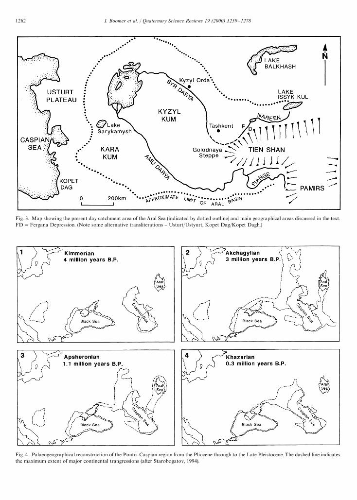
Fig. 3. Map showing the present day catchment area of the Aral Sea (indicated by dotted outline) and main geographical areas discussed in the text.FD"Fergana Depression. (Note some alternative transliterations } Usturt/Ustyurt, Kopet Dag/Kopet Dagh.)
Fig. 4. Palaeogeographical reconstruction of the Ponto}Caspian region from the Pliocene through to the Late Pleistocene. The dashed line indicatesthe maximum extent of major continental trangressions (after Starobogatov, 1994).
1262 I. Boomer et al. / Quaternary Science Reviews 19 (2000) 1259}1278
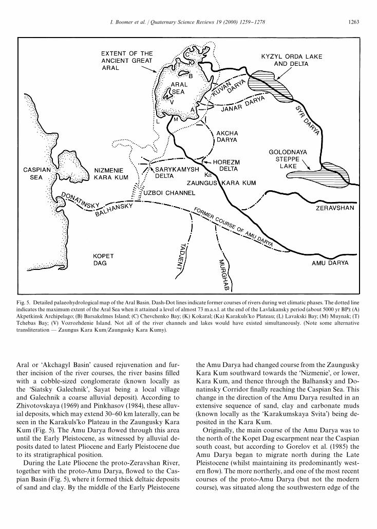
Fig. 5. Detailed palaeohydrological map of the Aral Basin. Dash-Dot lines indicate former courses of rivers during wet climatic phases. The dotted lineindicates the maximum extent of the Aral Sea when it attained a level of almost 73 m.a.s.l. at the end of the Lavlakansky period (about 5000 yr BP): (A)Akpetkinsk Archipelago; (B) Barsakelmes Island; (C) Chevchenko Bay; (K) Kokaral; (Ka) Karakuls'ko Plateau; (L) Lavakski Bay; (M) Muynak; (T)Tchebas Bay; (V) Vozrozhdenie Island. Not all of the river channels and lakes would have existed simultaneously. (Note some alternativetransliteration * Zaungus Kara Kum/Zaungusky Kara Kumy).
Aral or &Akchagyl Basin' caused rejuvenation and fur-ther incision of the river courses, the river basins "lledwith a cobble-sized conglomerate (known locally asthe &Siatsky Galechnik', Sayat being a local villageand Galechnik a coarse alluvial deposit). According toZhivotovskaya (1969) and Pinkhasov (1984), these alluv-ial deposits, which may extend 30}60 km laterally, can beseen in the Karakuls'ko Plateau in the Zaungusky KaraKum (Fig. 5). The Amu Darya #owed through this areauntil the Early Pleistocene, as witnessed by alluvial de-posits dated to latest Pliocene and Early Pleistocene dueto its stratigraphical position.
During the Late Pliocene the proto-Zeravshan River,together with the proto-Amu Darya, #owed to the Cas-pian Basin (Fig. 5), where it formed thick deltaic depositsof sand and clay. By the middle of the Early Pleistocene
the Amu Darya had changed course from the ZaunguskyKara Kum southward towards the &Nizmenie', or lower,Kara Kum, and thence through the Balhansky and Do-natinsky Corridor "nally reaching the Caspian Sea. Thischange in the direction of the Amu Darya resulted in anextensive sequence of sand, clay and carbonate muds(known locally as the &Karakumskaya Svita') being de-posited in the Kara Kum.
Originally, the main course of the Amu Darya was tothe north of the Kopet Dag escarpment near the Caspiansouth coast, but according to Gorelov et al. (1985) theAmu Darya began to migrate north during the LatePleistocene (whilst maintaining its predominantly west-ern #ow). The more northerly, and one of the most recentcourses of the proto-Amu Darya (but not the moderncourse), was situated along the southwestern edge of the
I. Boomer et al. / Quaternary Science Reviews 19 (2000) 1259}1278 1263
Zaungusky Karakum, "nally reaching the valley of theUzboy and thence the Balhansky Channel. The AmuDarya #owed through the &Nizmenie' (lower) Karakumuntil the end of the Early Pleistocene. At this time theAmu Darya had many tributaries, two of the largestbeing the Murghab and Tadjent (Fig. 5). These tribu-taries joined from the left while many smaller tributariesjoined from the right con"rming the existence of a largeamount of surface water runo! at this time. Thesepalaeohydrological reconstructions have been possiblethrough extensive studies of palaeo-channels in theregion (Fig. 6).
Mamedov (1991a) suggested that local di!erences inthe rate of tectonic uplift in the Early/Mid- Pleistocenemeant that areas such as the Tadjik Depression (PiangeValley) rose by only a few tens of metres while themountain areas rose by a few hundred metres reachinga maximum of 2000}2500 m. Thus, the Pamirs becameglaciated again, reaching 1700}1400 m.a.s.l. in the Piangeand Vardudz valleys. Further valley incision of about1500 m occurred in the mountains and approximately100 m in the lower reaches of the rivers due to increasedmeltwater runo! (Mamedov, 1991a}f). During the latestPleistocene, the rate of uplift in the mountainous regionof the Amu Darya catchment decreased and accumula-tion increased in the lower reaches of the valley. Sub-sequent climatic warming resulted in higher meltwaterdischarge which increased the erosive power of the riverin its upper reaches (Mamedov, 1991d, e).
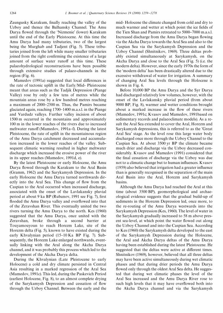
By the latest Pleistocene or early Holocene, the AmuDarya #owed through the Karakum to the Aral Basin(Gramm, 1962) and the Sarykamysh Depression. In theearly Holocene the Amu Darya turned northwards dir-ectly into the Aral Sea. This change of #ow from theCaspian to the Aral occurred when increased discharge,associated with the onset of the Lavlakansky pluvialperiod at about 9 ka BP (Rubanov, 1991 see Fig. 7), "rst#ooded the Amu Darya valley and over#owed into thatof the Zeravshan River. This eventually united the tworivers turning the Amu Darya to the north. Kes (1960)suggested that the Amu Darya, once united with theZeravshan, broke through a second barrier atTouyamouyoun to reach Horezm Lake, site of theHorezm delta (Fig. 5), known to have existed during theearly Khvalynian period (15}10 Ka BP Fig. 7). Sub-sequently, the Horezm Lake enlarged northwards, event-ually linking with the Aral along the Akcha Daryachannel, and it was probably this process which led to thedevelopment of the Akcha Darya delta.
During the Khvalynian (Late Pleistocene to earlyHolocene) a cold and dry climate persisted in CentralAsia resulting in a marked regression of the Aral Sea(Mamedov, 1991c). This led, during the Paskevich Period(earliest Holocene, Fig. 8), to an almost complete dryingof the Sarykamysh Depression and cessation of #owthrough the Uzboy Channel. Between the early and the
mid- Holocene the climate changed from cold and dry tomuch warmer and wetter at which point the ice "elds ofthe Tien Shan and Pamirs retreated to 5000}7000 m.a.s.l.Increased discharge from the Amu Darya began #owingvia the Akcha Darya towards the Aral Sea and also to theCaspian Sea via the Sarykamysh Depression and theUzboy Channel (Shnitnikov, 1969). Three deltas prob-ably existed simultaneously at Sarykamysh, on theAkcha Darya and close to the Aral Sea (Fig. 5) (i.e. themodern delta). However, since the early 1970s the form ofthe &modern delta' has been drastically altered due to theexcessive withdrawal of water for irrigation. A summaryof changing Aral Sea levels through the Holocene isshown in Fig. 6.
Before 10,000 BP the Amu Darya and the Syr Daryahad discharged relatively low volumes, however, with theonset of the Lavlakansky pluvial period (from about9000 BP, Fig. 8), warmer and wetter conditions broughtabout a marked increase in the #ow of these rivers(Mamedov, 1991c; Kvasov and Mamedov, 1991based onsedimentary records and palaeoclimate models). As a re-sult the Aral Sea extended to cover the Aral, Horezm andSarykamysh depressions, this is referred to as the 'GreatAral Sea' stage. As the level rose this large water bodydischarged once more through the Uzboy Channel to theCaspian Sea. At about 3500 yr BP the climate becamemuch drier and discharge via the Uzboy decreased con-siderably. Kvasov and Mamedov (1991) considered thatthe "nal cessation of discharge via the Uzboy was duenot to a climatic change but to human in#uences. Kvasov(1959) also believed that irrigation had a greater in#uencethan is generally recognised in the separation of the mainAral Basin into the Aral, Horezm and Sarykamyshbasins.
Although the Amu Darya had reached the Aral at thistime (about 3500 BP), geomorphological and archae-ological evidence suggests that the gradual build-up ofsediments in the Horezm Depression led, once more, tothe re-routing of the Amu Darya westwards into theSarykamysh Depression (Kes, 1960). The level of water inthe Sarykamysh gradually increased to 58 m above pres-ent sea-level, at which point the water #owed out alongthe Uzboy Channel and into the Caspian Sea. Accordingto Kes (1960) the Sarykamysh delta developed to the eastof the Sarykamysh Depression during the Holocene,the Aral and Akcha Darya deltas of the Amu Daryahaving been established during the latest Pleistocene. Hesuggested that the deltas were active at di!erent times.Shnitnikov (1969), however, believed that all three deltasmay have been active simultaneously during wet climaticphases and that during drier periods the Amu Darya#owed only through the oldest Aral Sea delta. He sugges-ted that during wet climatic phases the level of theAral Sea increased and the Amu Darya River rose tosuch high levels that it may have over#owed both intothe Akcha Darya channel and via the Sarykamysh
1264 I. Boomer et al. / Quaternary Science Reviews 19 (2000) 1259}1278
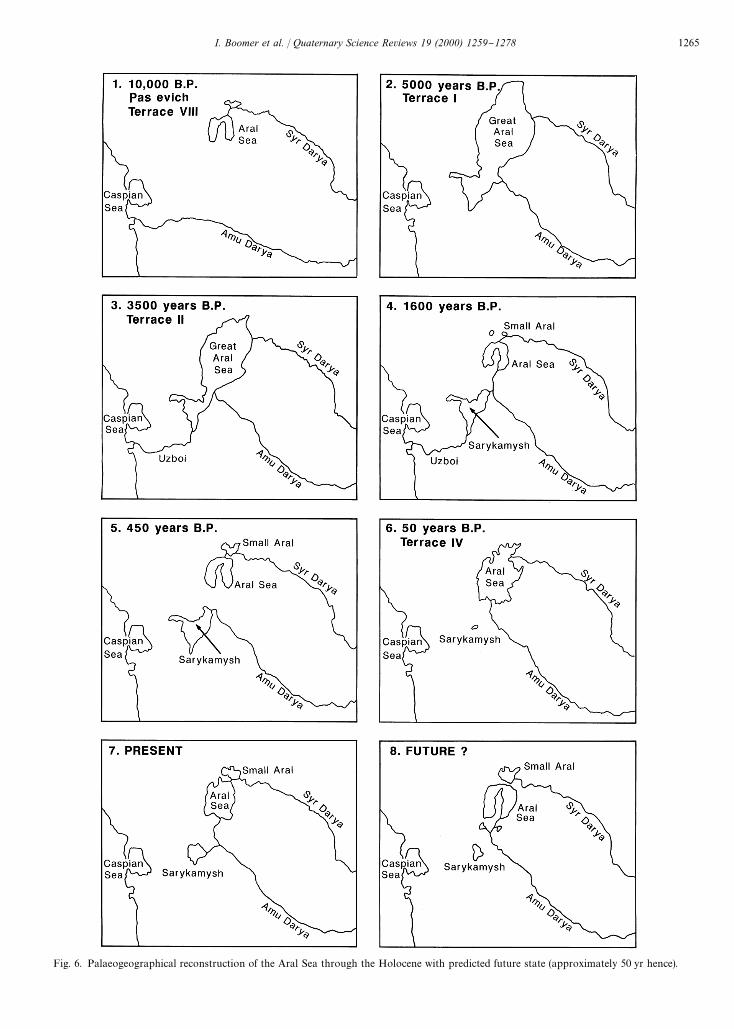
Fig. 6. Palaeogeographical reconstruction of the Aral Sea through the Holocene with predicted future state (approximately 50 yr hence).
I. Boomer et al. / Quaternary Science Reviews 19 (2000) 1259}1278 1265

Fig. 7. Pliocene and Quaternary stratigraphy of the Ponto-Caspianregion (after Jones and Simmons, 1996).
Depression and the Uzboy Channel to the Caspian. Pin-khasov (1984) supported Shnitnikov's idea that the AmuDarya #owed, past Touyamouyoun, into Lavakski Bay,a shallow part of the Aral Sea limited to the east by thecli!s of the Usturt Plateau and to the west by a linethrough Muynak.
During the last two millennia, human impacts on theregion's drainage system have undoubtedly in#uencedthe course and discharge of the main rivers. The popula-tion of the State of Horezm controlled the #ow of theAmu Darya into the Aral and the Sarykamysh Basinsfrom about the 5th century BC to the 17th century AD(Tolstov, 1962). They may have been able to manage the#ow into one or both basins, and in the latter case thelevel of discharge to each lake may also have been con-trolled. Such management of the Amu Darya can onlyhave been maintained during periods of relatively stablesociety. Civil unrest in the area, often the result of waterdisputes, doubtless led to periods during which control ofthe river was lost and it reverted to its natural course,towards the Aral Sea.
It is probable that during the 13th and 14th centuriesAD, but certainly during the 14th}16th centuries ADfrom historical records, that the lower reaches of the AmuDarya and the Sarykamysh had a strong water supply,su$cient to permit at least occasional excesses to #owinto the Uzboy Channel. Historical records show that in1573 the Amu Darya &turned' from Sarykamysh to theAral Sea. This may have happened as the local popula-
tion lost control over the course of the Amu Darya whichhad been arti"cially diverted to #ow into theSarykamysh. Since then the entire discharge of the AmuDarya has been into the Aral Sea. The "rst Englishmanto record a journey through Central Asia, a merchant,Anthony Jenkins, wrote in 1558 of the likelihood that thelocal population would loose control of the river.
`..the water that serveth all the country is drawn byditches out of the river Oxus (old name for Amu Darya)unto the great destruction of the said river, for which itfalleth not into the Caspian Sea as it hath done in timespast, and in short time all that land is like to be de-stroyed, and to become a wilderness for want of water,when the river Oxus shall fail.a
Sedimentological and palaeontological evidence forthis change in the course of the Amu Darya comes fromvarious sources and puts the timing of the event betweenthe middle of the 16th and the "rst half of the 17thcentury AD. It is probable that within a period of about70 yr the in#ow from the Amu Darya to the SarykamyshDepression had been completely cut o!. The Uzboychannel and the Sarykamysh Depression both dried outand the level of the Aral Sea increased rapidly. Theprevious redirection of the Amu Darya by the localpopulation during the middle ages, away from the Aral,had resulted in desiccation of the Aral Sea to a levelcomparable with that of the late 20th century. A sub-sequent rapid increase in the level of the Aral Sea aboutfour centuries ago destroyed Saxaul groves which hadexisted along the fringes of the sea. Radiocarbon analysesof drowned Saxaul stumps (now uncovered by the recentlevel fall) give an age of 287$5 14C yr BP (S. Stine pers.comm.).
3.3. Evolution of the Syr Darya
Compared to the Amu Darya, the pre-Holocene evolu-tion of the Syr Darya is less well known. According toFedorovich (1970), tectonic uplifting of the central TienShan area in the Early Pleistocene, combined with globalclimatic changes, resulted in the development of large ice"elds in the region. Late Pleistocene melting united theNareen and Syr Darya. The upper reaches of the SyrDarya, in the Tien Shan, migrated from one intermon-tane basin to the next until each in succession became"lled with sediment. Thus the Syr Darya worked its waythrough the depressions of the Fergana Valley (Fig. 3)and the Golodnaya Steppe from where it found a courseto the northwest leaving thick deposits of alluvial sandand clay in the southeast Kyzyl Kum just to the west ofthe modern river course (Figs. 3 and 5).
Fedorovich (1952) and Andrianov and Kes (1967) fromstudies of palaeo-channels and #oodplain deposits notedthat during the Early and Mid-Pleistocene the Syr Daryamigrated through the north Kyzyl Kum and its modern
1266 I. Boomer et al. / Quaternary Science Reviews 19 (2000) 1259}1278
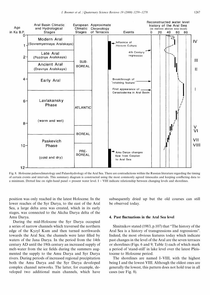
Fig. 8. Holocene palaeoclimatology and Palaeohydrology of the Aral Sea. There are contradictions within the Russian literature regarding the timingof certain events and intervals. This summary diagram is constructed using the most commonly agreed timescales and keeping con#icting data toa minimum. Dotted line on right-hand panel"present water level. I } VIII indicate relationship between changing levels and shorelines.
position was only reached in the latest Holocene. In thelower reaches of the Syr Darya, to the east of the AralSea, a large delta area was created, which in its earlystages, was connected to the Akcha Darya delta of theAmu Darya.
During the mid-Holocene the Syr Darya occupieda series of narrow channels which traversed the northernedge of the Kyzyl Kum and then turned northwardstowards the Aral Sea; the channels were later "lled bywaters of the Jana Darya. In the period from the 14thcentury AD until the 19th century an increased supply ofmelt-water from the ice "elds during the summers aug-mented the supply to the Amu Darya and Syr Daryarivers. During periods of increased regional precipitationboth the Amu Darya and the Syr Darya developedcomplex channel networks. The latter, for example, de-veloped two additional main channels, which have
subsequently dried up but the old courses can stillbe observed today.
4. Past 6uctuations in the Aral Sea level
Shnitnikov stated (1983, p.107) that `The history of theAral Sea is a history of transgressions and regressionsa.Indeed, the most obvious features today which indicatepast changes in the level of the Aral are the seven terracesor shorelines (Figs. 6 and 9; Table 1) each of which marka period of &stand-still' in lake level over the latest Pleis-tocene to Holocene period.
The shorelines are named I}VIII, with the highestbeing I and the lowest VIII. Although the oldest ones aregenerally the lowest, this pattern does not hold true in allcases (see Fig. 8).
I. Boomer et al. / Quaternary Science Reviews 19 (2000) 1259}1278 1267
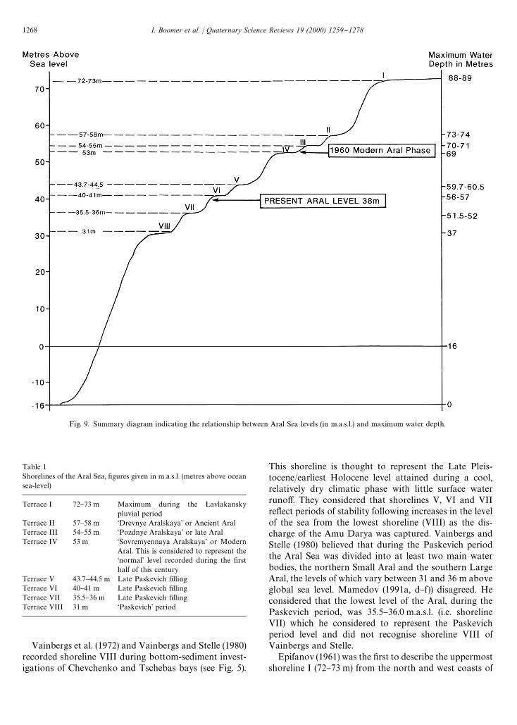
Fig. 9. Summary diagram indicating the relationship between Aral Sea levels (in m.a.s.l.) and maximum water depth.
Table 1Shorelines of the Aral Sea, "gures given in m.a.s.l. (metres above oceansea-level)
Terrace I 72}73 m Maximum during the Lavlakanskypluvial period
Terrace II 57}58 m &Drevnye Aralskaya' or Ancient AralTerrace III 54}55 m &Pozdnye Aralskaya' or late AralTerrace IV 53 m &Sovremyennaya Aralskaya' or Modern
Aral. This is considered to represent the&normal' level recorded during the "rsthalf of this century
Terrace V 43.7}44.5 m Late Paskevich "llingTerrace VI 40}41 m Late Paskevich "llingTerrace VII 35.5}36 m Late Paskevich "llingTerrace VIII 31 m &Paskevich' period
Vainbergs et al. (1972) and Vainbergs and Stelle (1980)recorded shoreline VIII during bottom-sediment invest-igations of Chevchenko and Tschebas bays (see Fig. 5).
This shoreline is thought to represent the Late Pleis-tocene/earliest Holocene level attained during a cool,relatively dry climatic phase with little surface waterruno!. They considered that shorelines V, VI and VIIre#ect periods of stability following increases in the levelof the sea from the lowest shoreline (VIII) as the dis-charge of the Amu Darya was captured. Vainbergs andStelle (1980) believed that during the Paskevich periodthe Aral Sea was divided into at least two main waterbodies, the northern Small Aral and the southern LargeAral, the levels of which vary between 31 and 36 m aboveglobal sea level. Mamedov (1991a, d}f )) disagreed. Heconsidered that the lowest level of the Aral, during thePaskevich period, was 35.5}36.0 m.a.s.l. (i.e. shorelineVII) which he considered to represent the Paskevichperiod level and did not recognise shoreline VIII ofVainbergs and Stelle.
Epifanov (1961) was the "rst to describe the uppermostshoreline I (72}73 m) from the north and west coasts of
1268 I. Boomer et al. / Quaternary Science Reviews 19 (2000) 1259}1278

the Aral Sea. This level was achieved during the Lav-lakansky pluvial phase (Atlantic climatic phase) of theearly to mid-Holocene as the Aral basin "lled to itshighest recorded level. Hondkarian (1977) and Fedorov(1980) described the presence of a geomorphological re-taining feature in the southeast of the Aral Basin whichwould have permitted the sea level to rise to the proposedmaximum of 72}73 m. They stated that following thebreaching of this barrier, the water level was reduced toshoreline II at 57}58 m.a.s.l. (the &Drevnye Aralskaya' orAncient Aral shoreline). They rejected any suggestionthat the fall in level was attributed directly to climaticfactors.
Archaeological evidence dates the "rst connection ofthe Uzboy Channel to the Caspian Sea at between8000}7000 yr BP although the channel itself was a relictfeature of previous water courses (Kes, 1960). These dataalso suggest that the Aral Sea existed at the level of57}58 m level during the period 8000}5000 yr BP,marked by shoreline II (&Drevnye Aralskaya' or AncientAral). The archaeological information is in accordancewith the palaeoclimatic evidence for a wet climatic phaseduring this time (Atlantic climatic phase) (Mamedov andTro"mov, 1986).
Both shoreline I (72}73 m) and shoreline II (57}58 m)contain species of the bivalve Cerastoderma and, there-fore, cannot be older than the "rst appearance of thatgenus in the Caspian Basin, assuming that Cerastodermaentered the Aral Basin via the Caspian. However, theexact timing and method of Cerastoderma migration intothe Aral Basin remains unclear. A number of authorshave presented radiocarbon dates for shoreline II(Drevnye Aralskaya) with widely varying ages, (Yanshin,1953; Maev et al., 1983a) and Vainbergs and Stelle (1980)dated it as 5000 yr BP, Kes (1983) as 3000 years BP,Maev et al. (1983a) as 3000}2000 yr BP and Serebryanniyet al. (1980a,b) and Shnitnikov (1983) as 12,000 yr BP.Although the exact date of shoreline II remains uncer-tain, we do know that the short duration of the &contain-ing structure' means that shoreline I cannot be mucholder than shoreline II. The best dating available forshoreline II relates to Neolithic settlements connectedwith this level which give an age of 5000 yr BP. SinceCerastoderma is thought to have "rst entered the CaspianSea between 7000}5000 yr BP (Fedorov, 1983) and "rstentered the Aral Sea not earlier than 5000 yr BP (Maevet al., 1983a), its presence in both shorelines I and IImeans that these levels can be no more than 5000 yrold, supporting the archaeological evidence. Clearlythe geochronology of these deposits needs further in-vestigation.
Nikolaev (1991) calculated, based on the altitude ofpeat beds, that during the 4th century AD the deepestparts of the Aral Sea were not more than 30 m deep, thus,supporting Maev's suggestion of a 4th century regressionrecognised by the presence of peats of that age in shal-
lower parts of the basin. He also considered that at thistime the main channel of the Syr Darya, or at least one ofits main courses, meandered somewhere near the north-ern coast of Barsakelmes Island in the northern part ofthe main Aral Basin "nally #owing into the remnantfreshwater/brackish water part of the Aral Sea duringthis time. Nikolaev doubted that the Amu Darya couldhave reached this shallow water body but that if it did so,it would have discharged only a small volume of watervia the Jana Darya delta. Rubanov (1977) noted thatMirabilite (from evaporation) only occurs in the AralBasin below 33 m.a.s.l. thus con"rming the proposed lowstand of approximately 30 m.a.s.l.
At this time of maximum regression (1600 BP, Fig. 6)the eastern and western depressions of the Aral Basinwere linked by a single connection in the north. Duringslightly higher levels there was also a connection furthersouth between the two depressions; the northern smallAral would have been completely desiccated at this time.Salinity levels in the eastern depression varied betweenfreshwater to slightly brackish at maximum regression inadjacent areas. The variation was brought about by thechanging levels of freshwater river input which broughtabout the co-existence of freshwater and brackish waterinvertebrates. Salinity in the western basin was relativelyhigher than in the eastern central depression althoughabsolute values have not been determined. Nikolaev(1991) con"rmed that the last &medium-sized' regressionoccurred about 400 BP and that the maximum trans-gression of the Aral Sea was probably at 4800}3600 yrBP.
5. Palaeoclimatology and palaeohydrology of theAral Sea Basin
The discharge of the two main in-#owing rivers iscalculated to be about 120 km3 annually. Before exten-sive irrigation began this century it was calculated thatan annual in#ow of 56 km3 was su$cient to maintain thesea at a steady level.
Shultz (1975) calculated that during the 1950s theannual river discharge into the Aral Sea was 52 km3,a further 10 km3 was lost to the deltas through variousprocesses including evaporation. In 1980 and 1985 thenet in#ow was zero while in 1989 it had risen to 5 km3
annually. Mamedov (1991c) stated that the annual pre-cipitation onto the surface of the, &normal', 20th centuryAral Sea surface equated to 10}13% of the &normal'discharge of the Amu Darya and the Syr Darya into theAral Sea.
Climate models have evaluated the e!ect of pastclimatic variation on the hydrological balance withinthe Aral Sea Basin. Mamedov and Tro"mov (1986)calculated that annual surface discharge plus directprecipitation during the early and mid-Holocene was
I. Boomer et al. / Quaternary Science Reviews 19 (2000) 1259}1278 1269
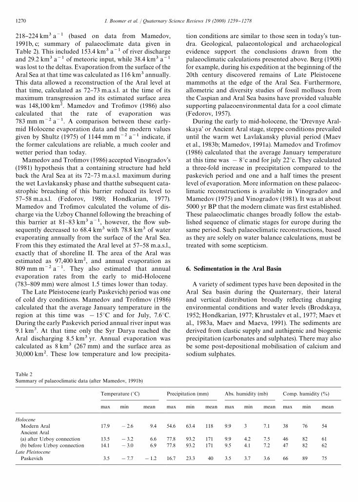
Table 2Summary of palaeoclimatic data (after Mamedov, 1991b)
Temperature (3C) Precipitation (mm) Abs. humidity (mb) Comp. humidity (%)
max min mean max min mean max min mean max min mean
HoloceneModern Aral 17.9 !2.6 9.4 54.6 63.4 118 9.9 3 7.1 38 76 54Ancient Aral(a) after Uzboy connection 13.5 !3.2 6.6 77.8 93.2 171 9.9 4.2 7.5 46 82 61(b) before Uzboy connection 14.1 !3.0 6.9 77.8 93.2 171 9.5 4.1 7.2 47 82 62
Late PleistocenePaskevich 3.5 !7.7 !1.2 16.7 23.3 40 3.5 3.7 3.6 66 89 75
218}224 km3 a~1 (based on data from Mamedov,1991b, c; summary of palaeoclimate data given inTable 2). This included 153.4 km3 a~1 of river dischargeand 29.2 km3 a~1 of meteoric input, while 38.4 km3 a~1
was lost to the deltas. Evaporation from the surface of theAral Sea at that time was calculated as 116 km3 annually.This data allowed a reconstruction of the Aral level atthat time, calculated as 72}73 m.a.s.l. at the time of itsmaximum transgression and its estimated surface areawas 148,100 km2. Mamedov and Tro"mov (1986) alsocalculated that the rate of evaporation was783 mm m~2 a~1. A comparison between these early-mid Holocene evaporation data and the modern valuesgiven by Shultz (1975) of 1144 mm m~2 a~1 indicate, ifthe former calculations are reliable, a much cooler andwetter period than today.
Mamedov and Tro"mov (1986) accepted Vinogradov's(1981) hypothesis that a containing structure had heldback the Aral Sea at its 72}73 m.a.s.l. maximum duringthe wet Lavlakansky phase and thatthe subsequent cata-strophic breaching of this barrier reduced its level to57}58 m.a.s.l. (Fedorov, 1980; Hondkarian, 1977).Mamedov and Tro"mov calculated the volume of dis-charge via the Uzboy Channel following the breaching ofthis barrier at 81}83 km3 a~1, however, the #ow sub-sequently decreased to 68.4 km3 with 78.8 km3 of waterevaporating annually from the surface of the Aral Sea.From this they estimated the Aral level at 57}58 m.a.s.l.,exactly that of shoreline II. The area of the Aral wasestimated as 97,400 km2, and annual evaporation as809 mm m~2 a~1. They also estimated that annualevaporation rates from the early to mid-Holocene(783}809 mm) were almost 1.5 times lower than today.
The Late Pleistocene (early Paskevich) period was oneof cold dry conditions. Mamedov and Tro"mov (1986)calculated that the average January temperature in theregion at this time was !153C and for July, 7.63C.During the early Paskevich period annual river input was9.1 km3. At that time only the Syr Darya reached theAral discharging 8.5 km3 yr. Annual evaporation wascalculated as 8 km3 (267 mm) and the surface area as30,000 km2. These low temperature and low precipita-
tion conditions are similar to those seen in today's tun-dra. Geological, palaeontological and archaeologicalevidence support the conclusions drawn from thepalaeoclimatic calculations presented above. Berg (1908)for example, during his expedition at the beginning of the20th century discovered remains of Late Pleistocenemammoths at the edge of the Aral Sea. Furthermore,allometric and diversity studies of fossil molluscs fromthe Caspian and Aral Sea basins have provided valuablesupporting palaeoenvironmental data for a cool climate(Fedorov, 1957).
During the early to mid-holocene, the &Drevnye Aral-skaya' or Ancient Aral stage, steppe conditions prevaileduntil the warm wet Lavlakansky pluvial period (Maevet al., 1983b; Mamedov, 1991a). Mamedov and Tro"mov(1986) calculated that the average January temperatureat this time was !83c and for july 223c. They calculateda three-fold increase in precipitation compared to thepaskevich period and one and a half times the presentlevel of evaporation. More information on these palaeoc-limatic reconstructions is available in Vinogradov andMamedov (1975) and Vinogradov (1981). It was at about5000 yr BP that the modern climate was "rst established.These palaeoclimatic changes broadly follow the estab-lished sequence of climatic stages for europe during thesame period. Such palaeoclimatic reconstructions, basedas they are solely on water balance calculations, must betreated with some scepticism.
6. Sedimentation in the Aral Basin
A variety of sediment types have been deposited in theAral Sea basin during the Quaternary, their lateraland vertical distribution broadly re#ecting changingenvironmental conditions and water levels (Brodskaya,1952; Hondkarian, 1977; Khrustalev et al., 1977; Maev etal., 1983a, Maev and Maeva, 1991). The sediments arederived from clastic supply and authigenic and biogenicprecipitation (carbonates and sulphates). There may alsobe some post-depositional mobilisation of calcium andsodium sulphates.
1270 I. Boomer et al. / Quaternary Science Reviews 19 (2000) 1259}1278
The clastic input has three main components (1) ero-sion and reworking of the coastline (local Mesozoic andCainozoic cli!s, Holocene lacustrine deposits): (2) #uvialinput and: (3) aeolian processes. As a rule (for the 20thcentury) the volume of sediments supplied by the AmuDarya has been 10 times greater than that of the SyrDarya. Khrustalev et al. (1977) calculated that the AmuDarya carries 74 million tonnes and the Syr Darya 8 mil-lion tonnes of sediment per year, while erosion of thecoastline adds 7 million tonnes and aeolian input 22million tonnes per year.
Today #uvial sands and gravels are associated with thedelta regions but aeolian sand is present throughoutmuch of the basin, although it is usually concentratedalong the margins. Clays and silts, often in associationwith in situ carbonate and sulphate precipitation,are perhaps the most extensive type of lacustrine sedi-mentation. Locally, biogenic carbonate (Mollusca,Crustacea and Protista) is also important while "ne-grained organic detritus also contributes to the bottomsediments.
Authigenic processes provide 13 million tonnes peryear chie#y as calcium carbonate, magnesium carbonateand calcium sulphate. These processes dominate the shal-low eastern parts of the Aral Sea (Rubanov, 1977). Bi-ogenic material provides 5 million tonnes per year inroughly equal parts of organic matter, silica mainly fromdiatom frustules and carbonate shell material (mainlymolluscan). In the deepest part of the Aral Sea the sedi-ments consist of silt and clay whilst in the shallower areassand and oolites are more commonly recorded(Rubanov, 1977).
Zhamoida et al. (1997) reported on the surface sedi-ments of the northern Aral sea-bed during a survey in1991 and concluded that the fall in the level of the seaover the previous 30 yr has resulted in marked changes inthe pattern of sedimentation with coarser grained deposi-ts now overlying what had previously been "ne-grainedsediments. This is partly due to an increase in aeolianaction (particularly associated with erosion of the now-exposed sea bed) but also to the formation of sand-sizegypsum crystals.
The greatest thickness of lacustrine sediments recordedfrom the central and western parts of the Aral basin isapproximately 4 m, although the deposits in the deltaicregions exceed this "gure (see below). Nikolaev (1991)and Maev et al. (1983a,b) note that the base of many AralSea sequences is marked by a brown, massive, "ne-grained layer, which they consider to be of glacio#uvialorigin. Above this lie the various lacustrine and deltaicsediments, generally light grey to white in colour rangingfrom sands through to muds and with shell debris atcertain levels; gypsum occurs both in layers and as smallindividual crystals within the "ne grained matrix. Thesesediments are thought date from the Late Pleistocenebased on faunal evidence, indicating a low rate of sedi-
ment accumulation (averaging about 0.3 mm a~1) al-though it is unclear if any signi"cant erosion has takenplace during low stands.
Some of the oldest lacustrine sediments (Late Pleis-tocene to early Holocene) are dominated by grey claysand gypsum rich horizons (Nikolaev, 1991). These arethought to represent accumulation in small, shallow tem-porary water bodies with carbonate and sulphate-richsediments forming as the pools dried out. The processwas repeated as the area became inundated again due tochanges in the water table or in the course of smallstreams. Nikolaev (1991) referred to this as the &SaltPools' or Solonchak Stage, during which there wouldhave been very little freshwater discharge into the AralBasin.
Above the &Solonchak' interval Maev et al. (1983a)described green/grey silts and muds which they con-sidered to be the "rst sediments deposited following theinitial establishment of a permanent river water supply tothe Aral Basin. They also con"rmed that carbonate muddeposition was established during the transgressions andthat during regressive periods, coarser sediments such assand and shell detritus were inter-bedded with gypsifer-ous horizons. Oxygen isotope analyses of carbonatesfrom bottom sediments in the eastern central Aral de-pression and in the North Caspian (Nikolaev, 1991) indi-cate that during regressive phases, freshwater conditionsprevailed in these areas. These results support Maev'sobservation that during the regressive phases the deltasmigrated towards the centre of the Aral Basin. Threemain sediment types are recorded in the Aral Basin,deltaic/alluvial, lacustrine and evaporitic, the character-istics of each are outlined below.
6.1. Deltaic sediments
Since about 10,000 BP when the Amu Darya "rstdrained into the Aral Basin the delta has migratedlaterally and three distinct palaeo-deltas have been re-cognised in addition to the present one (Fig. 5). TheHorezm delta in the Horezm depression, is on the presentriver course but up stream of the modern delta. The twoother deltas are in the Sarykamysh depression to thesouthwest and the Akcha Darya to the northeast. Theoldest delta is the Horezm delta and its deposits areburied under those associated with the Sarykamysh andAkcha Darya (Kes, 1960). The deposits of theSarykamysh delta contain the bivalves Dreisseina poly-morpha and Anodonta sp. (indicating fresh to slightlybrackish water conditions), together with plant rich bedsup to 20 cm thick. Estimates for the total vertical thick-ness of the Amu Darya delta deposits vary from 30}40 m(Kostenko, 1978) to 120 m (Akulov, 1960). These valuesrepresent the absolute di!erence between the highest andthe lowest recorded sediments in the delta area, at no onepoint would the entire thickness have been observed. The
I. Boomer et al. / Quaternary Science Reviews 19 (2000) 1259}1278 1271
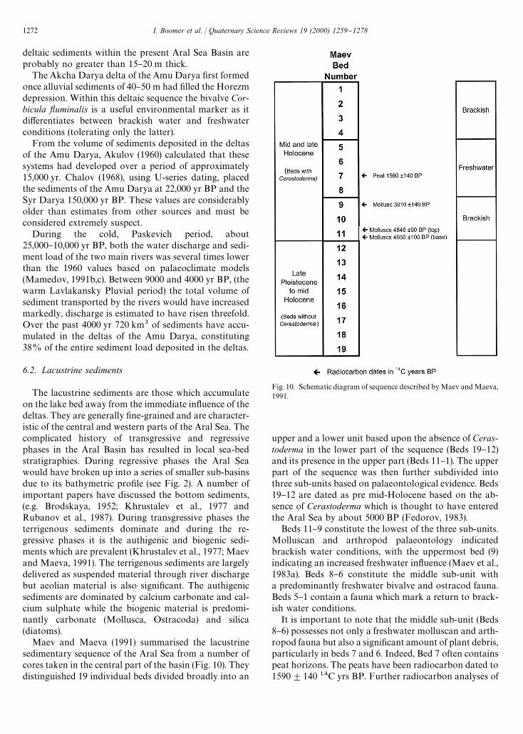
Fig. 10. Schematic diagram of sequence described by Maev and Maeva,1991.
deltaic sediments within the present Aral Sea Basin areprobably no greater than 15}20 m thick.
The Akcha Darya delta of the Amu Darya "rst formedonce alluvial sediments of 40}50 m had "lled the Horezmdepression. Within this deltaic sequence the bivalve Cor-bicula yuminalis is a useful environmental marker as itdi!erentiates between brackish water and freshwaterconditions (tolerating only the latter).
From the volume of sediments deposited in the deltasof the Amu Darya, Akulov (1960) calculated that thesesystems had developed over a period of approximately15,000 yr. Chalov (1968), using U-series dating, placedthe sediments of the Amu Darya at 22,000 yr BP and theSyr Darya 150,000 yr BP. These values are considerablyolder than estimates from other sources and must beconsidered extremely suspect.
During the cold, Paskevich period, about25,000}10,000 yr BP, both the water discharge and sedi-ment load of the two main rivers was several times lowerthan the 1960 values based on palaeoclimate models(Mamedov, 1991b,c). Between 9000 and 4000 yr BP, (thewarm Lavlakansky Pluvial period) the total volume ofsediment transported by the rivers would have increasedmarkedly, discharge is estimated to have risen threefold.Over the past 4000 yr 720 km3 of sediments have accu-mulated in the deltas of the Amu Darya, constituting38% of the entire sediment load deposited in the deltas.
6.2. Lacustrine sediments
The lacustrine sediments are those which accumulateon the lake bed away from the immediate in#uence of thedeltas. They are generally "ne-grained and are character-istic of the central and western parts of the Aral Sea. Thecomplicated history of transgressive and regressivephases in the Aral Basin has resulted in local sea-bedstratigraphies. During regressive phases the Aral Seawould have broken up into a series of smaller sub-basinsdue to its bathymetric pro"le (see Fig. 2). A number ofimportant papers have discussed the bottom sediments,(e.g. Brodskaya, 1952; Khrustalev et al., 1977 andRubanov et al., 1987). During transgressive phases theterrigenous sediments dominate and during the re-gressive phases it is the authigenic and biogenic sedi-ments which are prevalent (Khrustalev et al., 1977; Maevand Maeva, 1991). The terrigenous sediments are largelydelivered as suspended material through river dischargebut aeolian material is also signi"cant. The authigenicsediments are dominated by calcium carbonate and cal-cium sulphate while the biogenic material is predomi-nantly carbonate (Mollusca, Ostracoda) and silica(diatoms).
Maev and Maeva (1991) summarised the lacustrinesedimentary sequence of the Aral Sea from a number ofcores taken in the central part of the basin (Fig. 10). Theydistinguished 19 individual beds divided broadly into an
upper and a lower unit based upon the absence of Ceras-toderma in the lower part of the sequence (Beds 19}12)and its presence in the upper part (Beds 11}1). The upperpart of the sequence was then further subdivided intothree sub-units based on palaeontological evidence. Beds19}12 are dated as pre mid-Holocene based on the ab-sence of Cerastoderma which is thought to have enteredthe Aral Sea by about 5000 BP (Fedorov, 1983).
Beds 11}9 constitute the lowest of the three sub-units.Molluscan and arthropod palaeontology indicatedbrackish water conditions, with the uppermost bed (9)indicating an increased freshwater in#uence (Maev et al.,1983a). Beds 8}6 constitute the middle sub-unit witha predominantly freshwater bivalve and ostracod fauna.Beds 5}1 contain a fauna which mark a return to brack-ish water conditions.
It is important to note that the middle sub-unit (Beds8}6) possesses not only a freshwater molluscan and arth-ropod fauna but also a signi"cant amount of plant debris,particularly in beds 7 and 6. Indeed, Bed 7 often containspeat horizons. The peats have been radiocarbon dated to1590$140 14C yrs BP. Further radiocarbon analyses of
1272 I. Boomer et al. / Quaternary Science Reviews 19 (2000) 1259}1278
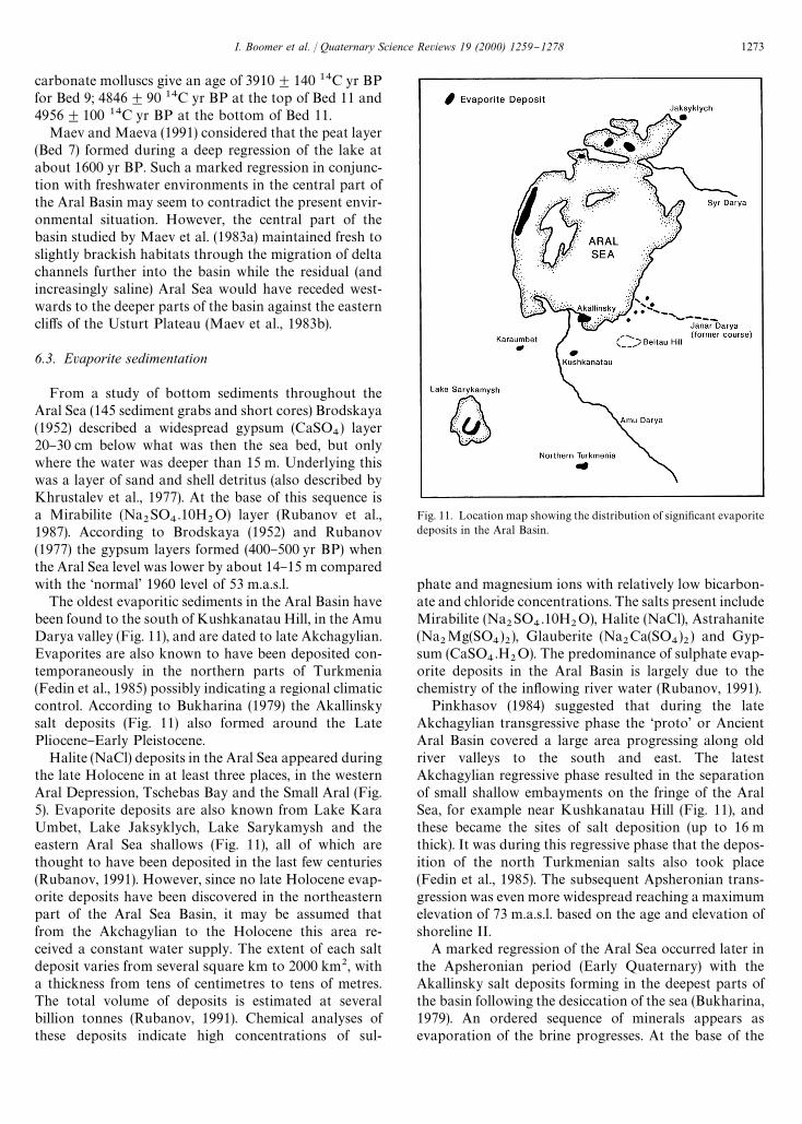
Fig. 11. Location map showing the distribution of signi"cant evaporitedeposits in the Aral Basin.
carbonate molluscs give an age of 3910$140 14C yr BPfor Bed 9; 4846$90 14C yr BP at the top of Bed 11 and4956$100 14C yr BP at the bottom of Bed 11.
Maev and Maeva (1991) considered that the peat layer(Bed 7) formed during a deep regression of the lake atabout 1600 yr BP. Such a marked regression in conjunc-tion with freshwater environments in the central part ofthe Aral Basin may seem to contradict the present envir-onmental situation. However, the central part of thebasin studied by Maev et al. (1983a) maintained fresh toslightly brackish habitats through the migration of deltachannels further into the basin while the residual (andincreasingly saline) Aral Sea would have receded west-wards to the deeper parts of the basin against the easterncli!s of the Usturt Plateau (Maev et al., 1983b).
6.3. Evaporite sedimentation
From a study of bottom sediments throughout theAral Sea (145 sediment grabs and short cores) Brodskaya(1952) described a widespread gypsum (CaSO
4) layer
20}30 cm below what was then the sea bed, but onlywhere the water was deeper than 15 m. Underlying thiswas a layer of sand and shell detritus (also described byKhrustalev et al., 1977). At the base of this sequence isa Mirabilite (Na
2SO
4.10H
2O) layer (Rubanov et al.,
1987). According to Brodskaya (1952) and Rubanov(1977) the gypsum layers formed (400}500 yr BP) whenthe Aral Sea level was lower by about 14}15 m comparedwith the &normal' 1960 level of 53 m.a.s.l.
The oldest evaporitic sediments in the Aral Basin havebeen found to the south of Kushkanatau Hill, in the AmuDarya valley (Fig. 11), and are dated to late Akchagylian.Evaporites are also known to have been deposited con-temporaneously in the northern parts of Turkmenia(Fedin et al., 1985) possibly indicating a regional climaticcontrol. According to Bukharina (1979) the Akallinskysalt deposits (Fig. 11) also formed around the LatePliocene}Early Pleistocene.
Halite (NaCl) deposits in the Aral Sea appeared duringthe late Holocene in at least three places, in the westernAral Depression, Tschebas Bay and the Small Aral (Fig.5). Evaporite deposits are also known from Lake KaraUmbet, Lake Jaksyklych, Lake Sarykamysh and theeastern Aral Sea shallows (Fig. 11), all of which arethought to have been deposited in the last few centuries(Rubanov, 1991). However, since no late Holocene evap-orite deposits have been discovered in the northeasternpart of the Aral Sea Basin, it may be assumed thatfrom the Akchagylian to the Holocene this area re-ceived a constant water supply. The extent of each saltdeposit varies from several square km to 2000 km2, witha thickness from tens of centimetres to tens of metres.The total volume of deposits is estimated at severalbillion tonnes (Rubanov, 1991). Chemical analyses ofthese deposits indicate high concentrations of sul-
phate and magnesium ions with relatively low bicarbon-ate and chloride concentrations. The salts present includeMirabilite (Na
2SO
4.10H
2O), Halite (NaCl), Astrahanite
(Na2Mg(SO
4)2), Glauberite (Na
2Ca(SO
4)2) and Gyp-
sum (CaSO4.H
2O). The predominance of sulphate evap-
orite deposits in the Aral Basin is largely due to thechemistry of the in#owing river water (Rubanov, 1991).
Pinkhasov (1984) suggested that during the lateAkchagylian transgressive phase the &proto' or AncientAral Basin covered a large area progressing along oldriver valleys to the south and east. The latestAkchagylian regressive phase resulted in the separationof small shallow embayments on the fringe of the AralSea, for example near Kushkanatau Hill (Fig. 11), andthese became the sites of salt deposition (up to 16 mthick). It was during this regressive phase that the depos-ition of the north Turkmenian salts also took place(Fedin et al., 1985). The subsequent Apsheronian trans-gression was even more widespread reaching a maximumelevation of 73 m.a.s.l. based on the age and elevation ofshoreline II.
A marked regression of the Aral Sea occurred later inthe Apsheronian period (Early Quaternary) with theAkallinsky salt deposits forming in the deepest parts ofthe basin following the desiccation of the sea (Bukharina,1979). An ordered sequence of minerals appears asevaporation of the brine progresses. At the base of the
I. Boomer et al. / Quaternary Science Reviews 19 (2000) 1259}1278 1273
sequences Mirabilite is recorded, followed by Haliteand then Astrahanite. The average thickness of theAkallinsky deposits is between 47 and 50 m (Rubanovet al., 1983). At the inception of salt deposition (i.e. theprecipitation of Mirabilite) the salinity of the water bodywould have been about 155&. Experimental work(Rubanov, 1977) suggests that the precipitation ofMirabilite took place mainly during the winter whileduring the summer the mineral was re-dissolved in theshallower parts of the sea, those deposits in the deepestpart of the sea remaining "xed. The areal extent of thishigh-salinity water body was from Muynak to KokaralIsland (south to north) and from Vozrozhdenie Island tothe Akpetkinsk Archipelago (east to west). When thesalinity reached more than 295& Halite began to precipi-tate and at 300& Astrahanite appeared together withEpsomite and Halite.
7. Micropalaeontological studies of the Aral Seasediments
A number of micropalaeontological studies on theAral Sea sediments have yielded useful palaeoenviron-mental and palaeoclimatic information. A review ofthe living (20th century) fauna and #ora of the Aral Seais given by Mordukhay-Boltovskoy (1974). A numberof organisms have been studied particularly in termsof their response to the recent fall in the Aral level,the main examples being the pollen, diatoms andostracods.
7.1. Palynological and diatom analysis
A number of studies concerning the palynology anddiatom #oras of the Aral Sea sediments have appeared inrecent years (Vronsky, 1976; Zhakovschikova, 1981;Maev et al., 1983a and Aleshinskaya, 1991). The Holo-cene palynological record is characterised by grass andherb (mainly Artemisia and the salt tolerant Che-nopodiaceae) pollen, few tree pollen have been recorded.Other groups recorded in low abundance include repre-sentatives of the Poaceae, Cyperaceae and Sparganium.The few trees recorded were mainly Pinus (pine) andBetula (birch). Spores of Sphagnum, Bryales, Poly-podiaceae, and Lycopodium were also present.
Diatom abundances in the sediments are high, reach-ing 2,750,000 individuals g~1 of sediment with speciesdiversity ranging from 10 to 65 making the study ofdiatoms extremely important. Aleshinskaya (1991) re-corded a total of 188 marine, brackish water/marine,brackish water continental and freshwater species in sev-eral cores from the Aral.
The diatom assemblages indicate a mid- to late-Holo-cene regressive phase in the Aral Sea with conditionscomparable to the &normal' 20th century Aral Sea
recorded above and below. This would appear to con"rmthe ideas of Maev et al. (1983a, b) and Maev and Maeva(1991) that, for some time, the river deltas migratedtowards the centre of the Aral Basin during which theabundance of freshwater diatoms increased, as did thenumber of freshwater plants and associated #ora, in-dicated by palynological evidence.
7.2. Ostracoda
Studies on living Ostracoda from the Aral Sea havebeen undertaken by Schornikov (1973) and Aladin(1993). Boomer (1993a), Boomer et al. (1996) and Aladin(1993) discussed the fate of the 11 ostracod species whichhad inhabited the Aral Sea before 1960. By 1970 only onespecies, the euryhaline and geographically widespreadCyprideis torosa (Jones), survived. Boomer (1993b) madepreliminary investigations into the ostracod assemblagesfrom two short cores and one section from the shores ofthe Aral Sea. The faunal record was combined withchemical analyses of molluscs and ostracod shells(Mg/Ca, Sr/Ca, d18O) which indicated that the 1991salinity levels had not been attained during the periodrepresented by the cores, which were unfortunately un-dated. Future palaeolimnological studies on deeperwater cores from the westcentral part of the basin mayprovide a quantitative palaeosalinity record for the AralSea.
8. Archaeological evidence from the Aral Sea region
Evidence of historic and pre-historic human activitycan be seen along the delta channels and lakes associatedwith the Amu Darya and Syr Darya and also in the southand southeast margins of the Aral Sea in the largenumber of monuments and structures, prehistoric settle-ments and ruins of fortresses, cities and caravan stopp-ing places dating from 9000 BP through to the middleages. Earlier this century an archaeological expeditionwas organised by the Institute of Ethnography of theRussian Academy of Sciences (Tolstov, 1948, 1962) tostudy the social and cultural history of the Horezmregion over the past 6000 yr, this was one of the mostimportant societies in the region and it appears tohave exerted direct control on river discharge in thesouthern part of the Aral Basin. Vinogradov (1968,1981) also studied evidence from Neolithic settlements inthe region. The archaeology of the Usturt Plateau wasinvestigated by the Karakalpak Academy of Sciences(1978) while Formozov (1945, 1949, 1951) and Vinog-radov (1959) examined evidence on the northern fringesof the Aral Sea. These archaeological studies have al-lowed us to date and reconstruct the evolution of deltachannels and lakes and the development of the Aral Seamargins.
1274 I. Boomer et al. / Quaternary Science Reviews 19 (2000) 1259}1278
There is no certainty that late Palaeolithic settlementshave been identi"ed from the region of the UsturtPlateau, Kyzyl Kum or the Aral itself. Neolithic settle-ments in this area have been dated to the period between9000 and 5000 yr BP and all have been located higherthan 75 m.a.s.l. con"rming that during much of the Neo-lithic the Aral Sea level was probably at about72}73 m.a.s.l. During the latest Neolithic the level of theAral Sea fell rapidly. Monuments and settlements of laterBronze Age are seen to migrate towards the new, lower,shoreline. All settlements of Bronze Age strictly adhere tothe shoreline of the &normal', 20th century, Aral Sea level(at 53 m.a.s.l.). Vinogradov (1981) noted that there is littleevidence of Mesolithic habitation in the area despitethere being much evidence for Neolithic settlements. Hesuggested that the change from the cold Paskevich periodto the warmer Lavlakansky period (dated to around8000}9000 BP) made that area much more suitable forhabitation during the Neolithic.
The archaeological evidence is in good agreement withthe models of both climatic (Vinogradov and Mamedov,1975) and hydrological (Mamedov and Tro"mov, 1966)succession in this area. These, together with the archae-ological data, have proven that during this period theAral Sea level stood much higher than what is considerednormal for the 20th century.
9. History of irrigation in the Aral Sea Basin
Irrigation in the Aral Sea region began more than5000 yr ago. The area has always been one of greateconomic importance, indeed, the Silk Route passedthrough the region. Kvasov (1959) postulated that, hadthe Aral Sea Basin not been so heavily irrigated during itshistory, the Aral Sea would be a much larger featuretoday. Shultz (1948) calculated that within the Aral Basinit is possible to irrigate 8 or perhaps 9 million ha using allthe available water sources. At present there are 22 mil-lion ha capable of supporting irrigated agriculture.Therefore, approximately 13 million ha must lie unused.At the time of the break up of the former U.S.S.R. (1991),o$cial statistics recorded 6.5 million ha under irrigationin the Aral Basin. Some scientists believe that many areasmay not have been included in these "gures and the realvalues may be much higher. In 1949, 2.14 million ha wereirrigated, rising to 6.41 million by 1986, a more thanthree-fold increase in less than 40 yr, with the result thattoday 60% of the volume of the sea has been lost since1960.
Andrianov and Kes (1967) dated the origin of irriga-tion in Iran and Central Asia as early as 8000}7000 BP.At that time, in south Turkmenia, the most primitivetypes of irrigation utilising natural river channels "rstappeared. Later, about 6000}5000 BP, the "rst man-made channels for irrigation appeared (Lisitsina, 1965).
In the lower regions of the Amu Darya and the SyrDarya the area with archaeological evidence of irrigationchannels occupied 4.5}5 million ha. The age of the chan-nels varies, representing long periods of time and not allchannels would have been in use, nor would all areashave been irrigated, simultaneously. By 4th}2nd centu-ries BC the irrigation networks in the Aral Basin hadbecome highly developed. Tolstov (1962) showed that theirrigated area at that time covered 3.5}3.8 million ha.Tolstov also recognised that following a decrease in thearea under irrigation the levels recovered in the 7th and8th centuries AD but subsequently declined once more.Kvasov and Mamedov (1991) calculated that from about400 BC to 1400 AD an overall decrease in irrigation tookplace, declining from an area of 3.5}3.8 million ha to 2.4million ha resulting in a 1.5 times increased #ow to theAral Sea. By 1700 AD following the assimilation of theregion into the Russian Empire, irrigation was re-intro-duced creating a total area of 1.9 million ha (Tolstov,1962).
During the prehistoric period the salinity and the levelof the Aral Sea was primarily controlled by regionalclimatic factors causing changes to the river discharge. Inthe historic period, however, the in#uence of humanactions, mainly through irrigation, war, economic andpolitical decisions became the dominant factor in these#uctuations. It is not true to suggest that today's environ-mental problems in the Aral Basin are new to the area;similar events have occurred a number of times pre-viously. Perhaps the only &new' event witnessed in thepresent environmental disaster is the chemical con-tamination of water sources and land largely result-ing from the use of chemical fertilisers, pesticides anddefoliants.
10. The future
In the late 1970s and early 1980s scientists and engin-eers had been seeking to restore the Aral to somethinglike its 1960 level although they soon realised that thisgoal was unobtainable. Subsequently, their energieswere directed towards maintaining the current state ofthe Sea but this too now seems impractical. Presentresearch programs aim to lessen the impact of the in-creasing environmental problems in the region havinggiven up all hope of restoring the Aral to its former (1960)state. In the last 5 yr pilot schemes have tried to savesome parts of the Sea utilising what little in#ow stillreaches the Aral (Aladin et al., 1995). One such projectsought to isolate the northern Small Aral using a tempor-ary dam and diverting #ow from the Syr Darya into it.This was only partly successful and came to an end afterthe failure of the dam. Only through large-scale invest-ment can such schemes hope to bring life back to theAral.
I. Boomer et al. / Quaternary Science Reviews 19 (2000) 1259}1278 1275
11. Summary
Following the retreat of the marine (Paratethys) waterswhich had covered much of this area during the Neogene,the topographical low which we know as the Aral Basin"rst became established as a continental feature duringthe Pliocene. Transgression of the basin by waters fromthe Caspian and possibly Black seas probably occurredagain at about 3 million years ago (Akchagylian) andpossibly for a short period about 1 Ma (Apsheronian).The Aral basin was probably dry throughout much of thePleistocene with signi"cant evaporite deposits formingfrom the brackish-saline waters which had transgressedthe basin.
Hydrological conditions during the Early Pleistocenecaused the Amu Darya to #ow south of the Kara Kum tothe Caspian Sea but by the Late Pleistocene, althoughmaintaining a predominantly westward #ow, the in-creased discharge from post glacial meltwater caused itto capture a number of old channels to the north and itbegan #owing into the Sarykamysh basin and centralAral depression which accumulated signi"cant amountsof freshwater for the "rst time. During this early post-glacial period (Khvalynian) a number of major channelsof the Amu Darya reached the Aral Sea formingdeltas at Sarykamysh, Horezm and on the Akcha Daryachannel.
Subsequently a cold-dry climatic phase (Paskevich,early Holocene) caused recession of the Aral Sea but thiswas soon reversed by the onset of the warm and wetLavlakansky climatic phase. This culminated in theGreat Aral Sea stage reaching its maximum extent.This level was governed by over#ow in the Southwestpart of the basin. Dating suggests that this over#owfeature may have failed in a short period reducingthe level by as much as 20 m causing the Aral Seato link directly with the Caspian Sea during the mid-Holocene.
The region has a rich archaeological record and it isclear that management of water resources was achievedby the medieval period to the extent of controlling themain #ow of the Amu Darya. Throughout the Holocenethe Syr Darya #owed into the Aral basin although itsdischarge has always been low compared with that of theAmu Darya. There is evidence of regression during the4th and the 16th centuries AD. The reason for the formeris unclear but the later may have been due to socialunrest in the region causing control of the rivers to belost.
There are clearly problems in interpreting the geomor-phological and sedimentological evidence and this iscompounded by much of the geochronological data. Des-pite this, the fundamental role of climatic change and thecapture of the Amu Darya are obvious. The Aral Sea isa geologically short lived feature, it is shallow and haslong been susceptible to the slightest changes in the
region's climate. It is perhaps not surprising that it tooksuch a short space of time for man to decimate itsecosystems and natural resources.
Acknowledgements
The authors wish to thank the Royal Society forthe award of a Kapitza Fellowship which allowedProf. Aladin to visit the UK and initiate this review.Prof. Aladin also acknowledges the support of INTAS(Grant 93}1491) during the later preparation of thispaper. Mr. Phillip Judge (University of East Anglia) andMrs. Ann Rooke (University of Newcastle) draughted thediagrams. Dr. Scott Stine (Berkeley) is thanked forarranging Radiocarbon dates of Holocene material re-covered by the authors. The authors wish to acknow-ledge Dr. Jonathan Holmes and Dr. Bob Jones for theirreviews of this article.
References
Akulov, V.V., 1960. Geology of the Amu Darya delta: on the physical-geographic characteristics. Trudy Tashkentskogo Gosudarstven-nogo Universiteta. Novaya Seriya, Geogra"cheski Nauki 18,59}109. Tashkent (in Russian).
Aladin, N.V., 1993. Salinity tolerance, morphology and physiology ofthe osmoregulatory organ in Ostracoda with special reference toOstracoda from the Aral Sea. In: McKenzie, K.G,. Jones, P.J. (Eds.),Ostracoda in the Life Sciences, A.A. Balkema, Rotterdam,pp. 387}403.
Aladin, N.V., Glasovsky, N.F. (Eds.) 1991. Current state of the separatebays of the Aral Sea. Proceedings of the Zoological Institute, USSRAcademy of Sciences, Vol. 237, 79pp. (in Russian).
Aladin, N.V., Kuznetsov, L.A. (Eds.) 1990. Current state of the Aral Seaunder conditions of increasing salinization. Proceedings of the Zo-ological Institute, USSR Academy of Sciences, Vol. 223, 153pp. (inRussian).
Aladin, N.V., Plotnikov, I.S., Potts, W.T.W., 1995. The Aral Sea desic-cation and possible ways of rehabilitating and conserving its north-ern part. Econometrics 6, 17}29.
Aleshinskaya, Z.G., 1991. Diatom and palynological characteristicsof bottom sediments. In: Sevastyanov, D.V. (Ed.), The Historyof Lakes Sevan, Issyk-Kul, Balkhash, Zaisan and Aral, Leningrad,pp. 253}245 (in Russian). Russian Academy of Science.
Andrianov, B.V., Kes, A.S., 1967. Drainage patterns and irrigationdevelopment on the plains of Central Asia. In: Gerasimov, I.P. (Ed.)Problems of Nature Enhancement in Central Asia. Moscow, pp.38}45 (in Russian).
Berg, L., 1908. The Aral Sea: scienti"c results of the Aral expedition.Izvestiya Turkestanskogo otdeleniya Imperatorskogo RusskogoGeographicheskogo obschestva (St. Petersburg) 5, 1}580 (inRussian).
Blinov, L.K., 1956. Hydrochemistry of the Aral Sea. Leningrad, 252 pp.(in Russian).
Boomer, I., 1993a. Ostracoda (Crustacea) and the death of the Aral Sea.Geology Today 9, 18}22.
Boomer, I., 1993b. Late Holocene and contemporary Ostracoda of theAral Sea. Palaeogeography, Palaeoclimatology, Palaeoecology 103,141}153.
Boomer, I., Whatley, R.C., Aladin, N., 1996. Aral Sea Ostracoda asenvironmental indicators Lethaia (Oslo) 29, 77}85.
1276 I. Boomer et al. / Quaternary Science Reviews 19 (2000) 1259}1278
Brodskaya, N.G., 1952. Bottom sediments and sedimentation processesin the Aral Sea. Trudy Geologicheskogo instituta An SSSR 115,1}106 (in Russian).
Bukharina, A.A. 1979. On the ecological complexes of ostracods of theSouth Aral Region. In: Negadaev-Nikonov, K.N. (Ed.), The Evolu-tion, Systematics and Ecology of Ostracods and Problems of Bio-stratigraphy. Kishinev. pp. 14}15. (in Russian).
Chalov, P.I., 1968. Uranium Series Dating. Frunze, pp. 1}105 (inRussian).
Ellis, W.S., 1990. A Soviet Sea Lies Dying. National Geographical 177,73}92.
Epifanov, M.I., 1961. On the the Aral Sea terraces. TrudySoyuznoy Geologo-Poiskovoy Kontory (Moscow) 2, 164}170(in Russian).
Fedin, V.P., Kuliev, E.D., Abrosimov, P.N., 1985. A new salt basin inNorthern Turkmenia. Razvedka i okhrana nedr. 12, 16}17 (inRussian).
Fedorov, P.V., 1957. Stratigraphy of quaternary sediments and theevolution of the Caspian Sea. Trudy Geologicheskogo Instituta AnSSSR 10, 1}300 (in Russian).
Fedorov, P.V., 1980. Problems of the Aral and Caspian Seas during theHolocene. In: Andrianov, B.V., Zorin, L.V. and Nikolaeva, R.G.(Eds.), Oscillation of Precipitation in the Aral Sea Region Duringthe Holocene. Moscow, pp. 19}22 (in Russian).
Fedorov, P.V., 1983. Problems of the Aral and Caspian Seas in the LatePliocene and Pleistocene. In: Maev, E.G. (Ed.), Palaeogeography ofthe Caspian and Aral Seas in the Cainozoic. Part I. Moscow,pp. 19}22 (in Russian).
Fedorovich, B.A., 1952. Ancient rivers in the deserts of Turan.Materialy po chervertichnomu periodu SSSR 3, 93}100(in Russian).
Fedorovich, B.A., 1970. Age and structure of valleys of the Tien Shan.Geomorfologiya 2, 55}56 (in Russian).
Formozov, A.A., 1945. The discovery of the Keltaminar culture inKazakhstan. Vestnik Kazakhskogo "liala An SSSR. 2, 6}8 (inRussian).
Formozov, A.A., 1949. The Keltaminar culture in Western Kazakhstan.Kratkie Soobscheniya o Dokladakh i Polevykh IssledovaniyakhInstituta Istorii Materialnoy Kultury 25, 49}58 (in Russian).
Formozov, A.A., 1951. The problem of the origin of the Andronovskayaculture. Kratkie Soobscheniya o Dokladakh i PolevykhIssledovaniyakh Instituta Istorii Materialnoy Kultury 25, 3}18 (inRussian).
Gorelov, S.K., Eziashvili, A.G., Kuliev, Z.D., Redzhepov, M., 1985.Analysis of the Relief and Deep Structure of Arid RegionsThrough Aerial Photography in Turkmenia. Moscow, pp. 16}66(in Russian).
Gramm, M.N., 1962. Stratigraphy of the Cainozoic molasse of Ferganaand a comparison with Tertiary continental sediments of neigh-bouring regions. Autoreferat, Doctoral Dissertation in Geographi-cal Science, University of Moscow (In Russian).
Hondkarian, S.O., 1977. Transgressive facies development in the AralSea Basin during the Holocene. In: Oscillation of Precipitation inthe Aral Sea Region during the Holocene: Abstracts of Conference.Moscow, pp. 1}34. (in Russian).
Jones, R.W., Simmons, M.D., 1996. A review of the stratigraphy ofEastern Paratethys (Oligocene to Holocene). Bulletin of the NaturalHistory Museum, London (Geology) 52, 25}49.
Karakalpak Academy of Sciences, 1978. The Ancient andMedieval Culture of Southeastern Usturt. Tashkent, pp. 1}137(in Russian).
Kes, A.S., 1960. The Lower Amu Darya, Sarykamysh and Uzboy(History of formation and settlement). Materials of the HorezmExpedition (Moscow) 3, 1}348 (in Russian).
Kes, A.S., 1969. The main stages in the development of the Aral Sea. In:Geller, S.Yu. (Ed.), Problems of the Aral Sea. Moscow, pp. 60}172(in Russian).
Kes, A.S., 1983. The palaeogeography of the Aral Sea in the LatePleistocene and Holocene. In: Maev, E.G. (Ed.), Palaeogeography ofthe Caspian and Aral Seas in the Cainozoic, Part II. Moscow, pp.1}103, (in Russian).
Khrustalev, Yu. P., Reznikov, S.A., Turovskiy, D.S., 1977. Lithologyand geochemistry of the Aral Sea Bottom Sediments. Rostov}on-Don, 205pp. (In Russian).
Kostenko, N.N., 1978. Quaternary sediments in Kazakhstan and ad-joining territories of the Union republics. In: Kalmykov, S.P. (Ed.)Explanation for 1:500000 Scale Geological Map. Alma-Ata, pp.89}111 (in Russian).
Kotlyakov, V.M. 1991. The Aral Sea Basin: a critical environmentalzone. Environment 33, 4}9, 36}38.
Kvasov, D.D., 1959. Causes of #ow cessation in the Uzboy channel andthe Aral Sea problem. Problemy osvoyeniya pustyn 6, 24}29 (inRussian).
Kvasov, D.D. and Mamedov, E.D., 1991. The development of Irriga-tion and its in#uence on water balance. In: Sevastyanov, D.V. (Ed.),History of Lakes Sevan, Issyk-Kul, Balkhash, Zaisan and Aral.Leningrad, pp. 227}230. (in Russian). Russian Academy of Science.
LeH tolle, R., Mainguet, M., 1997. Histoire de la mer d'Aral (Asie centrale)dequis le dernier maximum glaciaire. Bulletin de la SocieteHgeologique de France 168, 387}398.
Lisitsina, G.N., 1965. Irrigated agriculture in the neolithic of SouthTurkmenia. Lower reaches of Amu Darya, Sarykamysh, Uzboy (thefarming and settlement history). In: Material from the HorezmExpeditions, 1960. Moscow, 168pp. (in Russian).
Maev, E.G., Maeva, S.A., Nikolaev, S.D., 1983a. Transect of the bottomsediments of the central Aral Sea. In: Maev, E.G. (Ed.), Palaeogeog-raphy of the Caspian and Aral Seas in the Cainozoic. Part I.Moscow, pp. 119}133 (in Russian).
Maev, E.G., Maeva, S.A., Nikolaev, S.D., Parunin, O.B. 1983b. Newdata on the Holocene history of the Aral Sea. In: Maev, E.G. (Ed.),Palaeogeography of the Caspian and Aral Seas in the Cainozoic.Part II. Moscow, pp. 133}144 (in Russian).
Maev, E.G., Maeva, S.A., 1991. Bottom sediments of the Aral. In:Sevastyanov, D.V. (Ed.), History of Lakes Sevan, Issyk-Kul, Bal-khash Zaisan and Aral. Leningrad, pp. 239}242. (in Russian).
Mamedov, E.D., 1991a. Paleogeographic reconstruction. In: Sevas-tyanov, D.V. (Ed.), History of Lakes Sevan, Issyk-Kul, BalkhashZaisan and Aral. Leningrad, pp. 219}221. (in Russian). RussianAcademy of Science.
Mamedov, E.D., 1991b. Water balance calculation. In: Sevastyanov,D.V. (Ed.), History of Lakes Sevan, Issyk-Kul, Balkhash, Zaisanand Aral. Leningrad, pp. 222}224 (in Russian). Russian Academy ofScience.
Mamedov, E.D., 1991c. Paleoclimatic models. In: Sevastyanov, D.V.(Ed.), History of Lakes Sevan, Issyk-Kul, Balkhash, Zaisan andAral. Leningrad, pp. 225}226 (in Russian). Russian Academy ofScience.
Mamedov, E.D., 1991d. Upper Pleistocene and Holocene sediments ofthe Amu Darya and Syr Darya. In: Sevastyanov, D.V. (Ed.), Historyof Lakes Sevan, Issyk-Kul, Balkhash, Zaisan and Aral. Leningrad,pp. 235}238 (in Russian). Russian Academy of Science.
Mamedov, E.D., 1991e. The history of the Amu Darya and Syr Daryaand their breakthrough to the Aral. In: Sevastyanov, D.V. (Ed.),History of Lakes Sevan, Issyk-Kul, Balkhash, Zaisan and Aral.Leningrad, pp. 250}255 (in Russian). Russian Academy of Science.
Mamedov, E.D., 1991f. Archaeological data on the Aral history. In:Sevastyanov, D.V. (Ed.), History of Lakes Sevan, Issyk-Kul, Bal-khash Zaisan and Aral, Leningrad, pp. 256}258. (in Russian). Rus-sian Academy of Science.
Mamedov, E.D., Tro"mov, G.N., 1986. On the problem of long-termoscillations of the Central Asian rivers. Problemy osvoyeniya pus-tyn 1, 12}16 (in Russian).
Micklin, P., 1988. Desiccation of the Aral Sea: a water managementDisaster in the Soviet Union. Science 241, 1170}1176.
I. Boomer et al. / Quaternary Science Reviews 19 (2000) 1259}1278 1277

Micklin, P., 1991. Touring the Aral: visit to an ecological disaster zone.Soviet Geography 32, 90}105.
Micklin, P., 1993. The Shrinking Aral Sea. Geotimes 38, 4}18.Mordukhay-Boltovskoy, F.D., 1974. Atlas of Invertebrates of the Aral
Sea. Izvestiya &Piscevaja Promyshlennost' (Moscow), 1}272 (inRussian).
Nikolaev, S.D., 1991. The development of the Aral Sea from oxygenisotope data. In: Sevastyanov, D.V. (Ed.), History of Lakes Sevan,Issyk-Kul, Balkhash, Zaisan and Aral. (Moscow), pp. 246}249, (inRussian). Russian Academy of Science.
Pearce, F., 1995a. How the Soviet Seas were lost. New Scientist 2003,39}42.
Pearce, F., 1995b. Poisoned waters. New Scientist 2000, 29}33.Pinkhasov, B.I., 1984. Neogene-Quaternary sediments and Recent tec-
tonics of the South Aral Sea Region and Western Kyzyl-KumTashkent, pp. 1}150, (in Russian).
Plotnikov, I.S., Aladin, N.V., Filippov, A.A., 1991. The past and presentAral Sea fauna. Zoologicheskiy zhurnal 4, 5}15 (in Russian).
Rubanov, I.N., 1977. Lake and Soil Accumulation of Salts in Uzbekis-tan. Tashkent, pp. 1}157 (in Russian).
Rubanov, I.V. (1991) Salt accumulation in the Aral Basin. In: Sevas-tyanov, D.V. (Ed.), History of Lakes Sevan, Issyk-Kul, Balkhash,Zaisan and Aral. Moscow, pp. 231}234, (in Russian). Russian Acad-emy of Science.
Rubanov, I.V., Gorr, V.G., Chvanov, N.A., 1983. Geology of the Atkalysalt deposit. Uzbekskiy Geologicheskiy Zhurnal 5, 38}41 (inRussian).
Rubanov., I.V., Ischniyazov, D.P., Baskakova, M.A., 1987. Geology ofthe Aral Sea. Tashkent, pp. 1}248. (In Russian).
Saiko, T., Zonn, I., 1994. Deserting a dying Sea. Geographical 66,12}15.
Schornikov, E.I., 1973. Ostracoda of the Aral Sea. Zoologicheskiyzhurnal 52, 1304}1314 (in Russian).
Serebryanniy, L.R., Pshenin, N.G., Punning, Y.M., 1980a. Tien Shanglaciations and the Aral Sea level oscillations. Izvestiya AN SSSR.Seriya Geogra"cheskaya 2, 52}65 (in Russian).
Serebryanniy, L.R., Pshenin, N.G., Punning, Y.M. (1980b). New data onthe development of the Fergana landscape in the Late Quaternary.In: Andrianov, B.V., Zorin, L.V., Nikolaeva, R.G. (Eds.), Oscilla-tions of Precipitation in the Aral Sea Region during the Holocene.Moscow, pp. 214}222 (in Russian).
Shnitnikov, A.V., 1969. Century Scale Variation in Humidity. Leni-ngrad, pp. 1}245 (in Russian).
Shnitnikov, A.V., 1983. The Aral Sea in the Holocene and naturaltendencies of its evolution. In: E.G. Maev (Ed.), Palaeogeography ofthe Caspian and Aral Seas in the Cainozoic. Part II. Moscow, pp.106}118 (in Russian).
Shultz, S.S., 1948. Analysis of the neo-tectonics and relief of Tien Shan.Zapiski VGO. Novaya Seriya 3, 1}200 (in Russian).
Shultz, V.L., 1975. Water balance of the Aral Sea. Trudy Sredneaziat-skogo Regionalnogo Gidrometeorologicheskogo Instituta 23, 3028(in Russian).
Starobogatov, Ya. I., 1994. Systematics and palaeontology. In:Starobogatov, Ya. I. (Ed.), The Freshwater Zebra Mussel; System-atics, Ecology and Applications. Moscow, pp. 18}46 (in Russian).
Tolstov, S.P., 1948. Ancient Horezm. Moscow, pp. 1}352 (in Russian).Tolstov, S.P., 1962. Through the Ancient Deltas of Oxus and Jaxartes.
Moscow, pp. 1}324 (in Russian).Vainbergs, I.G., Ulst, V.G., Roze, V.K., 1972. Ancient shore-lines and
oscillations in the level of the Aral Sea. Voprosy chetvertichnoygeologii Gos Universiteta. Seriya VIIIa. Zoologiya (Tashkent) 7,1}21 (in Russian).
Vainbergs, I.G., Stelle, V.Ya., 1980. Late Quaternary stages of the AralSea and the connection with climate change. In: Andrianov, B.V.,Zorin, L.V., Nikolaeva, R.G. (Eds.), Oscillations of Precipitation inthe Aral Sea Region During the Holocene. Moscow, pp. 176}180 (inRussian).
Vinogradov, A.V., 1959. Archaeological excavations near Aralsk-Sak-saulskaya during 1955. Trudy Instituta Istorii, Arkheologii i Etnog-ra"i AN KazSSR 7, 75}85 (in Russian).
Vinogradov, A.V., 1968. Neolithic Monuments of the Ancient HorezmMoscow, pp. 75}85 (in Russian).
Vinogradov, A.V., 1981. Ancient hunters and "shermen of theCentral Asian rivers. Proceedings of the Horezm Archaeologicaland Ethnographic Expedition, Vol. 13, Moscow, pp. 38}39(in Russian).
Vinogradov, A.V., Mamedov, E.D., 1975. Prehistoric Lyavlyakan. In:Tolstov S.P (Ed.), Stages of Ancient Settling and Pioneering. Mos-cow, pp. 1}142 (in Russian).
Voeykov, A.I., 1957. Irrigation of the Transcaspian Region froma geographical and climatological perspective. In: Grigorjev,A.A. (Ed.), Selected Works, Vol. 4, 1. Moscow, pp. 73}191(in Russian).
Vronsky, V.A., 1976. Marine Palynology of the Southern Seas. Ros-tov}on}Don, pp. 1}200 (in Russian).
Yanshin, A.L., 1953. Geology of the Northern Aral Region. Moscow,pp. 1}643 (in Russian).
Zhakovschikova, T.K., 1981. Diatoms in bottom sediment cores fromthe Aral Sea. In: Gromov, B.V., Strelnikova, N.I. (Eds.), The Dia-toms, Leningrad, pp. 102}117 (in Russian).
Zhamoida, V.A., Butylin, V.P., Popova, E.A., Aladin, N.V., 1997. Re-cent sedimentation processes in the Aral Sea. International Journalof Salt Lake Research 6, 67}81.
Zhivotovskaya, A.I. 1969. Pliocene of the Turkmenian NorthernKara-Kum and its connection with the Pliocene of WesternUzbekistan. In: Parnikelya, E.S., Ptushkina, E.I. (Eds.), Geologyand Mineral Products of Turkmenia, Ashkhabad, pp. 258}262(in Russian).
1278 I. Boomer et al. / Quaternary Science Reviews 19 (2000) 1259}1278