Advances in understanding the late Holocene history of the Aral Sea region
17
Climate variability during the past 2,000 years and past economic and irrigation activities in the Aral Sea basin Hedi Oberhänsli & Nikolaus Boroffka & Philippe Sorrel & Sergey Krivonogov Published online: 26 October 2007 # Springer Science + Business Media B.V. 2007 Abstract The lake level history, here based on the relative abundance of Ca (gypsum), is used for tracing past hydrological conditions in Central Asia. Lake level was close to a minimum before approximately A.D. 300, at about A.D. 600, A.D. 1220, A.D. 1400 and since 1960s it is lowering again. Lake water level was lowest during the fourteenth or early fifteenth centuries as indicated by a coeval settlement, which today is still under water near the well-dated mausoleum of Kerderi. Pollen data from riparian vegetation indicate generally wet conditions between A.D. 400 and A.D. 900, intermitted by short intervals with drier conditions (AD 550–600; A.D. 650–700) and riverbanks were again dry from A.D. 900– 1150, A.D. 1450–1550, and from A.D. 1970 onward moisture decreased steadily. Irrigation activities were at a maximum between 300 B.C. and A.D. 300 (Classical Antiquity) and between A.D. 800 and A.D. 1300 (Medieval Age) and after A.D. 1960. Keywords Lake levels . Hydrology . Riparian vegetation . Settlement history . Medieval Warm Period . Little Ice Age Irrig Drainage Syst (2007) 21:167–183 DOI 10.1007/s10795-007-9031-5 H. Oberhänsli (*) GeoForschungsZentrum, Telegraphenberg, 14473 Potsdam, Germany e-mail: [email protected] N. Boroffka Deutsches Archäologisches Institut, Im Dol 2-6, 14195 Berlin, Germany P. Sorrel Laboratoire “Morphodynamique Continentale et Côtière” (UMR 6143 CNRS), Université de Caen Basse-Normandie, 24 rue des Tilleuls, 14000 Caen, France S. Krivonogov United Institute of Geology, Geophysics and Mineralogy of the Russian Academy of Sciences, Siberian Division, Novosibirsk Regional Center of Geoinformational Technologies, Academic Koptyug Prospekt 3, 630090 Novosibirsk, Russia
-
Upload
univ-lyon1 -
Category
Documents
-
view
1 -
download
0
Transcript of Advances in understanding the late Holocene history of the Aral Sea region
Climate variability during the past 2,000 years and pasteconomic and irrigation activities in the Aral Sea basin
Hedi Oberhänsli & Nikolaus Boroffka & Philippe Sorrel &Sergey Krivonogov
Published online: 26 October 2007# Springer Science + Business Media B.V. 2007
Abstract The lake level history, here based on the relative abundance of Ca (gypsum), isused for tracing past hydrological conditions in Central Asia. Lake level was close to aminimum before approximately A.D. 300, at about A.D. 600, A.D. 1220, A.D. 1400 and since1960s it is lowering again. Lake water level was lowest during the fourteenth or earlyfifteenth centuries as indicated by a coeval settlement, which today is still under water nearthe well-dated mausoleum of Kerderi. Pollen data from riparian vegetation indicategenerally wet conditions between A.D. 400 and A.D. 900, intermitted by short intervals withdrier conditions (AD 550–600; A.D. 650–700) and riverbanks were again dry from A.D. 900–1150, A.D. 1450–1550, and from A.D. 1970 onward moisture decreased steadily. Irrigationactivities were at a maximum between 300 B.C. and A.D. 300 (Classical Antiquity) andbetween A.D. 800 and A.D. 1300 (Medieval Age) and after A.D. 1960.
Keywords Lake levels . Hydrology . Riparian vegetation . Settlement history .
MedievalWarm Period . Little Ice Age
Irrig Drainage Syst (2007) 21:167–183DOI 10.1007/s10795-007-9031-5
H. Oberhänsli (*)GeoForschungsZentrum, Telegraphenberg, 14473 Potsdam, Germanye-mail: [email protected]
N. BoroffkaDeutsches Archäologisches Institut, Im Dol 2-6, 14195 Berlin, Germany
P. SorrelLaboratoire “Morphodynamique Continentale et Côtière” (UMR 6143 CNRS),Université de Caen Basse-Normandie, 24 rue des Tilleuls, 14000 Caen, France
S. KrivonogovUnited Institute of Geology, Geophysics and Mineralogy of the Russian Academy of Sciences, SiberianDivision, Novosibirsk Regional Center of Geoinformational Technologies, Academic Koptyug Prospekt 3,630090 Novosibirsk, Russia
Introduction
The modern regression in the Aral Sea region, which started in 1960, has received greatattention (e.g., Aral’skij krizis 1991; Létolle and Mainguet 1996; Micklin and Williams1996; Nihoul et al. 2004; Nurtaev 2004; Ferguson 2003). Due to extensive agriculturalcultivation in this area, the abusive exploitation of water resources has not only reduced thelake level but the system reached a critical stage in the water and soil pollution. As a result,a broad scope of studies is required to improve our knowledge on ecosystem functioning,which will help to attenuate environmental and socio-economic risks in future decades. Inthe context of a policy of appeasement, sustainability rather than searching for new ways toexploit the system should be in the focus of upcoming studies.
But which have been the links between climate variability and ecology in the Aral Seabasin in the past? Due to the climatically exposed continental conditions (semi-arid or evenarid over large areas), western Central Asia is potentially vulnerable to minimalenvironmental change. Therefore extensive deserts in this area are a prominent feature ofthe region. They spread north of the Kopet Dagh – the Karakum Desert – and west of themountain ranges of Pamir and Tien Shan, – the Kyzylkum Desert. For settlements, todayand in the past, active fresh water resources are restricted to the spatially very constrainedflood plains and riverbanks along the Syr Darya and Amu Darya, both of them discharginginto the endorheic Aral Sea. However, water resources feeding the rivers seem almostunlimited as, in the headwaters of the rivers, extended glacier systems of the Tien Shan andPamir Mountains are steadily delivering fresh water. Similar climate conditions not onlyapply for today, but also have been dominating the landscape throughout most of theHolocene though the Amu Darya has transiently bypassed the Aral Sea and directlydischarged into the Caspian Sea (e.g., Tolstov 1962).
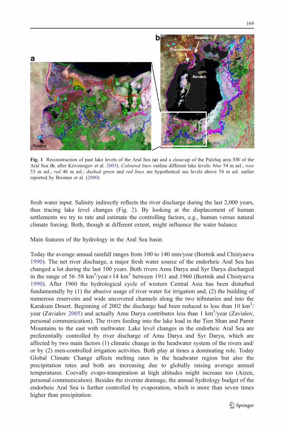
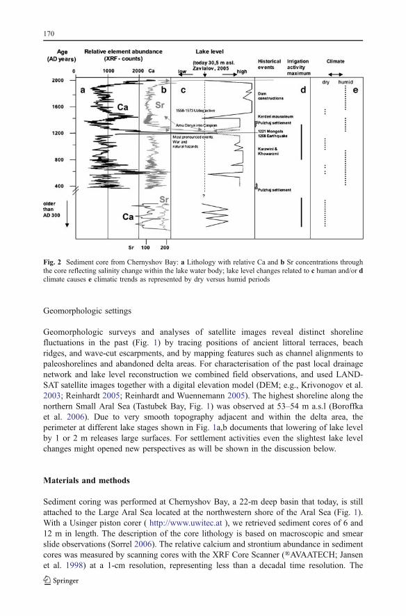
The Aral Sea basin hosting one of the Silk Road branches is, therefore, an excellentstudy area for tracing human agricultural activities but also for highlighting humanmeasures and reactions to past climate changes. To shed light on the past climatic andespecially hydrological conditions we launched the INTAS-Project “CLIMAN” (Holoceneclimatic variability and evolution of human settlement in the Aral Sea basin; http://climan.gfz-potsdam.de/). The interdisciplinary study was designed to analyse natural climatic variationsand anthropogenically controlled environmental changes in the past (Boroffka et al. 2003–2004, 2005, 2006; Sorrel et al. 2006, 2007a, b; Austin et al. 2007). In a geomorphologicsurvey, we focused on previous lake-level changes as recorded in shoreline marks during thelast 5,000 years (Fig. 1; Krivonogov et al. 2003; Reinhardt and Wuennemann 2005) andrelated these observations to archaeological findings (Boroffka et al. 2006).
However to date, relatively little attention has been granted to connections between localand regional climate changes over the Eurasian region. At a regional scale, past climatevariability in the arid Aral Sea basin represents an important key for understanding futureclimate change, which may affect even more drastically such arid and semi-arid regions.Besides, understanding past climate change it is of great importance to evaluate the anthro-pogenic impact on present-day and future climates in this highly sensitive semi-arid region.
In this paper we focus on past climatic variations as expressed in humidity andtemperature changes and evaluate irrigation activities as inferred from archaeological data.Natural climatic changes evidenced by temperature and precipitation variations during thelast 2,000 years are inferred from vegetation remains (pollen grains) studied in a coreretrieved from Chernyshov Bay, in the northwestern Large Aral Sea (Fig. 2). We then usegeochemical proxies, the relative Ca and Sr abundances (mostly contained in gypsum andauthigenic carbonates), as a measure of salinity change and an indication of the origin of
168
fresh water input. Salinity indirectly reflects the river discharge during the last 2,000 years,thus tracing lake level changes (Fig. 2). By looking at the displacement of humansettlements we try to rate and estimate the controlling factors, e.g., human versus naturalclimate forcing. Both, though at different extent, might influence the water balance.
Main features of the hydrology in the Aral Sea basin
Today the average annual rainfall ranges from 100 to 140 mm/year (Bortnik and Chistyaeva1990). The net river discharge, a major fresh water source of the endorheic Aral Sea haschanged a lot during the last 100 years. Both rivers Amu Darya and Syr Darya dischargedin the range of 56–58 km3/year±14 km3 between 1911 and 1960 (Bortnik and Chistyaeva1990). After 1960 the hydrological cycle of western Central Asia has been disturbedfundamentally by (1) the abusive usage of river water for irrigation and, (2) the building ofnumerous reservoirs and wide uncovered channels along the two tributaries and into theKarakum Desert. Beginning of 2002 the discharge had been reduced to less than 10 km3/year (Zavialov 2005) and actually Amu Darya contributes less than 1 km3/year (Zavialov,personal communication). The rivers feeding into the lake load in the Tien Shan and PamirMountains to the east with meltwater. Lake level changes in the endorheic Aral Sea arepreferentially controlled by river discharge of Amu Darya and Syr Darya, which areaffected by two main factors (1) climatic change in the headwater system of the rivers and/or by (2) men-controlled irrigation activities. Both play at times a dominating role. TodayGlobal Climate Change affects melting rates in the headwater region but also theprecipitation rates and both are increasing due to globally raising average annualtemperatures. Coevally evapo-transpiration at high altitudes might increase too (Aizen,personal communication). Besides the riverine drainage, the annual hydrology budget of theendorheic Aral Sea is further controlled by evaporation, which is more than seven timeshigher than precipitation.
Fig. 1 Reconstruction of past lake levels of the Aral Sea (a) and a close-up of the Pulzhaj area SW of theAral Sea (b; after Krivonogov et al. 2003). Coloured lines outline different lake levels: blue 54 m asl.; rose53 m asl.; red 46 m asl.; dashed green and red lines are hypothetical sea levels above 54 m asl. earlierreported by Boomer et al. (2000)
169
Geomorphologic settings
Geomorphologic surveys and analyses of satellite images reveal distinct shorelinefluctuations in the past (Fig. 1) by tracing positions of ancient littoral terraces, beachridges, and wave-cut escarpments, and by mapping features such as channel alignments topaleoshorelines and abandoned delta areas. For characterisation of the past local drainagenetwork and lake level reconstruction we combined field observations, and used LAND-SAT satellite images together with a digital elevation model (DEM; e.g., Krivonogov et al.2003; Reinhardt 2005; Reinhardt and Wuennemann 2005). The highest shoreline along thenorthern Small Aral Sea (Tastubek Bay, Fig. 1) was observed at 53–54 m a.s.l (Boroffkaet al. 2006). Due to very smooth topography adjacent and within the delta area, theperimeter at different lake stages shown in Fig. 1a,b documents that lowering of lake levelby 1 or 2 m releases large surfaces. For settlement activities even the slightest lake levelchanges might opened new perspectives as will be shown in the discussion below.
Materials and methods
Sediment coring was performed at Chernyshov Bay, a 22-m deep basin that today, is stillattached to the Large Aral Sea located at the northwestern shore of the Aral Sea (Fig. 1).With a Usinger piston corer ( http://www.uwitec.at ), we retrieved sediment cores of 6 and12 m in length. The description of the core lithology is based on macroscopic and smearslide observations (Sorrel 2006). The relative calcium and strontium abundance in sedimentcores was measured by scanning cores with the XRF Core Scanner (®AVAATECH; Jansenet al. 1998) at a 1-cm resolution, representing less than a decadal time resolution. The
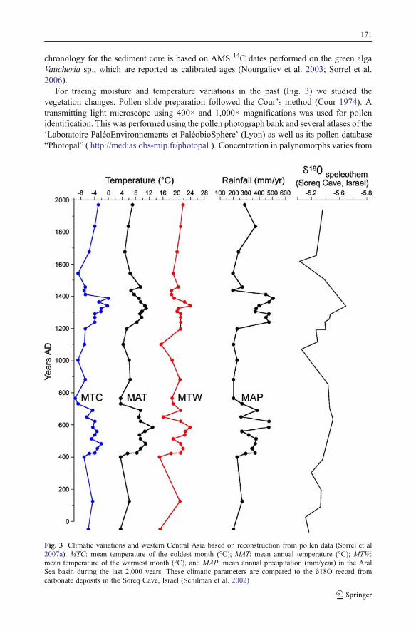
Fig. 2 Sediment core from Chernyshov Bay: a Lithology with relative Ca and b Sr concentrations throughthe core reflecting salinity change within the lake water body; lake level changes related to c human and/or dclimate causes e climatic trends as represented by dry versus humid periods
170
chronology for the sediment core is based on AMS 14C dates performed on the green algaVaucheria sp., which are reported as calibrated ages (Nourgaliev et al. 2003; Sorrel et al.2006).
For tracing moisture and temperature variations in the past (Fig. 3) we studied thevegetation changes. Pollen slide preparation followed the Cour’s method (Cour 1974). Atransmitting light microscope using 400× and 1,000× magnifications was used for pollenidentification. This was performed using the pollen photograph bank and several atlases of the‘Laboratoire PaléoEnvironnements et PaléobioSphère’ (Lyon) as well as its pollen database“Photopal” ( http://medias.obs-mip.fr/photopal ). Concentration in palynomorphs varies from
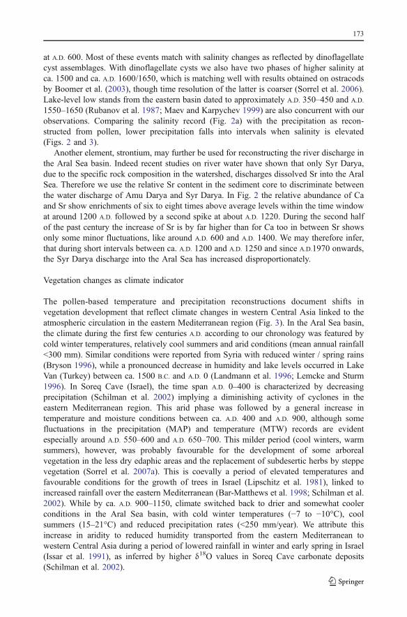
Fig. 3 Climatic variations and western Central Asia based on reconstruction from pollen data (Sorrel et al2007a). MTC: mean temperature of the coldest month (°C); MAT: mean annual temperature (°C); MTW:mean temperature of the warmest month (°C), and MAP: mean annual precipitation (mm/year) in the AralSea basin during the last 2,000 years. These climatic parameters are compared to the δ18O record fromcarbonate deposits in the Soreq Cave, Israel (Schilman et al. 2002)
171

<500 to >45,000 grains/g. Minimums of 100 pollen grains, excluding Amaranthaceae-Chenopodiaceae and Artemisia, which are usually over-represented in arid environments,were counted in each sample. Generally more than 25 different taxa were found in eachsample, but a total of 79 different taxa have been identified (Sorrel et al. 2007a).
Pollen grains transported either by air or by rivers reflect the local to regional vegetation.Here we present the results inferred from the quantification of pollen data. For thequantification of palaeoclimate signals recorded in plant assemblages, the “probabilitymutual climatic spheres” (PCS) method described in detail by Klotz and Pross (1999) andKlotz et al. (2003, 2004) was used. The main restriction in applying modern analoguemethods in this study is the general poorness of the available database of surface pollenspectra from the Aral Sea region (only 91 in Kazakhstan, Tarasov et al. 1998), which mayserve as modern analogues for reliable climate reconstructions. Hence the use of the PCSmethod is more suitable than modern analogues for the reconstruction of climate change inthe Aral Sea basin during the last 2,000 years. For more compelling information on theapplication of the PCS method to our case study, we refer to Sorrel et al. (2007a).
Besides, we investigated the northern and southern shores of the Aral Sea forarchaeological remains during two expeditions in 2002 and 2003. During these studies,archaeological traces were positioned by geographic positioning system (GPS) and dated by(1) conventional archaeological methods and, (2) by comparing archaeological assemblagesto radiocarbon-dated material from analogous sites (Boroffka et al. 2006). The completerepertoire of archaeological finds (the toolkit) was studied to reconstruct the economic basisthrough time. Previously collected archaeological data is re-evaluated in light of newinformations, and placed within the context of results from both palaeontological andgeological investigations.
Lithology: Gypsum and Sr content as hydrological indicators
From sediments retrieved at Chernyshov Bay, in the northwestern Aral Sea, we useddinoflagellate cysts and diatoms, both sensitively reacting on salinity changes, for tracingvariations in lake levels (Sorrel et al. 2006; Austin et al. 2007). Furthermore, the sediments,mostly consisting of dark clayey and silty muds with changing organic contents (Sorrel2006), contain four levels of gypsum-rich mud, forming distinct light-coloured beds or darkclayey muds with abundant idiomorphic gypsum crystals (Fig. 2, in Sorrel et al. 2006). Theobserved lithological changes are coeval to the increase of the relative content in calcium(Boroffka et al. 2006). Gypsum (CaSO4·2H2O) precipitates when salinity reachesconcentrations beyond a certain level; it is, therefore, a typical indicator of progressivesalinization, and we use the element scans of calcium to keep track of the lake’s desiccationstate. In the Aral Sea, the stage of over saturation for gypsum was reached in the early1960s when salinity exceeded 26–28 ppt (Bortnik and Chistyaeva 1990). Thus, we can usethe relative abundance of Ca to estimate beginning of changes in the river inflow, whichcontrol, together with the annual evaporation (approximately 100 cm/year), the waterbalance and at a longer time range the lake level of the Aral Sea. In Fig. 2, the relativecalcium abundance indicates distinct changes through the last ca. 2,000 years. High relativecalcium contents are taken as indication for rising salinities and thus lowering lake levels.The acme of the lake level lowering, with precipitation of chloride salts is howeverfollowing the Ca–sulphate maximum and thus not reported in Fig. 2a. According to the agemodel, these events culminate between ca. around A.D. 600, A.D. 1220, A.D. 1500 andslightly elevated values occur at about A.D. 750, A.D. 1000, and A.D. 1800. Between A.D. 0and A.D. 300 (?) we observe an increased variability with average values similar to the event
172
at A.D. 600. Most of these events match with salinity changes as reflected by dinoflagellatecyst assemblages. With dinoflagellate cysts we also have two phases of higher salinity atca. 1500 and ca. A.D. 1600/1650, which is matching well with results obtained on ostracodsby Boomer et al. (2003), though time resolution of the latter is coarser (Sorrel et al. 2006).Lake-level low stands from the eastern basin dated to approximately A.D. 350–450 and A.D.
1550–1650 (Rubanov et al. 1987; Maev and Karpychev 1999) are also concurrent with ourobservations. Comparing the salinity record (Fig. 2a) with the precipitation as recon-structed from pollen, lower precipitation falls into intervals when salinity is elevated(Figs. 2 and 3).
Another element, strontium, may further be used for reconstructing the river discharge inthe Aral Sea basin. Indeed recent studies on river water have shown that only Syr Darya,due to the specific rock composition in the watershed, discharges dissolved Sr into the AralSea. Therefore we use the relative Sr content in the sediment core to discriminate betweenthe water discharge of Amu Darya and Syr Darya. In Fig. 2 the relative abundance of Caand Sr show enrichments of six to eight times above average levels within the time windowat around 1200 A.D. followed by a second spike at about A.D. 1220. During the second halfof the past century the increase of Sr is by far higher than for Ca too in between Sr showsonly some minor fluctuations, like around A.D. 600 and A.D. 1400. We may therefore infer,that during short intervals between ca. A.D. 1200 and A.D. 1250 and since A.D.1970 onwards,the Syr Darya discharge into the Aral Sea has increased disproportionately.
Vegetation changes as climate indicator
The pollen-based temperature and precipitation reconstructions document shifts invegetation development that reflect climate changes in western Central Asia linked to theatmospheric circulation in the eastern Mediterranean region (Fig. 3). In the Aral Sea basin,the climate during the first few centuries A.D. according to our chronology was featured bycold winter temperatures, relatively cool summers and arid conditions (mean annual rainfall<300 mm). Similar conditions were reported from Syria with reduced winter / spring rains(Bryson 1996), while a pronounced decrease in humidity and lake levels occurred in LakeVan (Turkey) between ca. 1500 B.C. and A.D. 0 (Landmann et al. 1996; Lemcke and Sturm1996). In Soreq Cave (Israel), the time span A.D. 0–400 is characterized by decreasingprecipitation (Schilman et al. 2002) implying a diminishing activity of cyclones in theeastern Mediterranean region. This arid phase was followed by a general increase intemperature and moisture conditions between ca. A.D. 400 and A.D. 900, although somefluctuations in the precipitation (MAP) and temperature (MTW) records are evidentespecially around A.D. 550–600 and A.D. 650–700. This milder period (cool winters, warmsummers), however, was probably favourable for the development of some arborealvegetation in the less dry edaphic areas and the replacement of subdesertic herbs by steppevegetation (Sorrel et al. 2007a). This is coevally a period of elevated temperatures andfavourable conditions for the growth of trees in Israel (Lipschitz et al. 1981), linked toincreased rainfall over the eastern Mediterranean (Bar-Matthews et al. 1998; Schilman et al.2002). While by ca. A.D. 900–1150, climate switched back to drier and somewhat coolerconditions in the Aral Sea basin, with cold winter temperatures (−7 to −10°C), coolsummers (15–21°C) and reduced precipitation rates (<250 mm/year). We attribute thisincrease in aridity to reduced humidity transported from the eastern Mediterranean towestern Central Asia during a period of lowered rainfall in winter and early spring in Israel(Issar et al. 1991), as inferred by higher δ18O values in Soreq Cave carbonate deposits(Schilman et al. 2002).
173
After ca. A.D. 1150, reconstructed climatic parameters suggest the onset of moisterconditions in western Central Asia with increased humidity (370–500 mm year−1) andwarmth (mean annual temperature: 7–11°C), which were maintained until the beginning ofthe fifteenth century A.D. (“Medieval Warm Period”). These conditions probably favouredthe establishment of a riparian forest vegetation and the regression of both steppe herbs andshrubs in the Aral Sea region, coevally with the development of some trees along rivervalleys. At the onset of more humid conditions in the Aral Sea basin, the climate signalfrom the Eastern Mediterranean indicates a conspicuous decline in terrestrial δ18O valuesfrom the Soreq Cave. This is interpreted as strong positive rainfall anomalies in Israel(Schilman et al. 2002), reflecting enhanced cyclonic activity in the eastern Mediterraneanduring winter and early spring. It also coincides with high-stand levels of the Dead Sea(Issar et al. 1991) and the Sea of Galilee (Frumkin et al. 1991) implying thus elevatedmoisture conditions. From ca. A.D. 1450 to A.D. 1550, the Aral Sea region probablyexperienced a brief aridification with colder and drier conditions. This short-term intervalhas been identified in other regions within Eurasia (Mackay et al. 2005), and corresponds tothe Little Ice Age. In the eastern Mediterranean region, it is contemporaneous with higherδ18O values from the foraminifera G. ruber (Schilman et al. 2002) from marine deposits offIsrael (Bar-Matthews et al. 1998; Schilman et al. 2002), indicating lower sea surfacetemperatures and thus lowered moisture transported to western Central Asia. From A.D.
1550 onwards (to ca. A.D. 1970), the pollen reconstruction document a progressive warmingof the climate and corroborate evidence of enhanced aridity and higher temperatures duringrecent decades. For the last ca. 50 years, our reconstructed values are in accordance withpresent-day instrumental data from Central Asia (Sorrel et al. 2007a).
The climate reconstruction provides evidence that centennial-scale events are recordedfor the last 2,000 years, implying that the precipitation pattern in the Aral Sea basin isstrongly linked to atmospheric changes in the eastern Mediterranean region, whichmodulates the moisture distribution towards the Middle East and western Central Asia. Theclimatic reconstruction is in agreement with former paleoenvironmental, historical andarchaeological studies from Russian scientists who attributed the decline of the classical andmedieval civilization of Turkestan to an enhanced aridity (Shnitnikov 1969; Doluhanov1985; Varuschenko et al. 1987). For the last 2,000 years, however, no human activity exertingcontrol on vegetation change has been detected from the pollen record of Chernyshov Bay.Hence a pervasive and strong impact of human-induced processes on climatic andenvironmental changes in western Central Asia during the last millennia, as suggested byKharin et al. (1998), is unlikely.
Archaeological features and water availability
As to the settlement history there is a tight link between climate and hydrology. Levina(1998) and Boroffka et al. (2003–2004, 2005, 2006) have recently demonstrated thatancient settlement development is quite well understood for the region south of the lake.Although the CLIMAN expeditions have filled many chronological gaps in the humansettlement history, the knowledge of human life along the northern shore is still patchy.Human settlement around lake Aral begins in the middle Palaeolithic (50,000–35,000 B.C.).After a long period of missing information, a gap that is not yet well understood, Neolithic(5,000–3,000 B.C.) sites of the Kel’teminar culture are well known north and south of thelake. During Eneolithic and Early Bronze Age (3,000–2,000 B.C.) the Kel’teminar cultureremains restricted to the south. Along the northern shore settlers change their cultural andeconomic orientation. They used large projectile points for hunting big game which shows
174
analogies to finds from the forest and forest-steppe zones of the Tobol-Ishim-Irtysh Riversystem and the eastern Ural Mountains, therefore indicating that forest and forest-steppezones had extended further to the south. This vegetation change heralds more humidconditions, as humans did not apply irrigation systems in this region at that time (Boroffkaet al. 2003–2004, 2005, 2006).
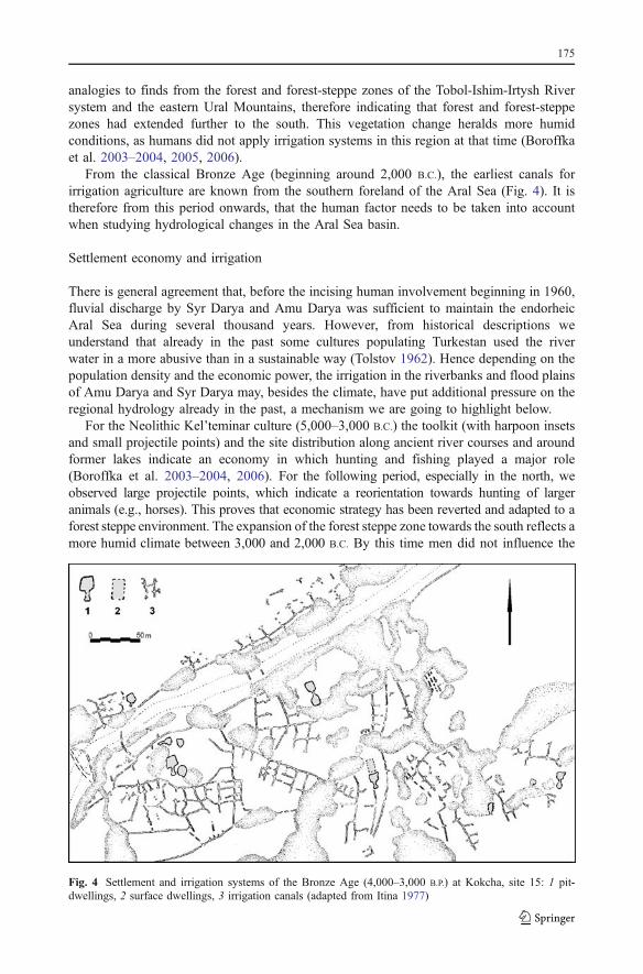
From the classical Bronze Age (beginning around 2,000 B.C.), the earliest canals forirrigation agriculture are known from the southern foreland of the Aral Sea (Fig. 4). It istherefore from this period onwards, that the human factor needs to be taken into accountwhen studying hydrological changes in the Aral Sea basin.
Settlement economy and irrigation
There is general agreement that, before the incising human involvement beginning in 1960,fluvial discharge by Syr Darya and Amu Darya was sufficient to maintain the endorheicAral Sea during several thousand years. However, from historical descriptions weunderstand that already in the past some cultures populating Turkestan used the riverwater in a more abusive than in a sustainable way (Tolstov 1962). Hence depending on thepopulation density and the economic power, the irrigation in the riverbanks and flood plainsof Amu Darya and Syr Darya may, besides the climate, have put additional pressure on theregional hydrology already in the past, a mechanism we are going to highlight below.
For the Neolithic Kel’teminar culture (5,000–3,000 B.C.) the toolkit (with harpoon insetsand small projectile points) and the site distribution along ancient river courses and aroundformer lakes indicate an economy in which hunting and fishing played a major role(Boroffka et al. 2003–2004, 2006). For the following period, especially in the north, weobserved large projectile points, which indicate a reorientation towards hunting of largeranimals (e.g., horses). This proves that economic strategy has been reverted and adapted to aforest steppe environment. The expansion of the forest steppe zone towards the south reflects amore humid climate between 3,000 and 2,000 B.C. By this time men did not influence the
Fig. 4 Settlement and irrigation systems of the Bronze Age (4,000–3,000 B.P.) at Kokcha, site 15: 1 pit-dwellings, 2 surface dwellings, 3 irrigation canals (adapted from Itina 1977)
175
environment to any significant point, but rather reacted to natural environmental changesadapting settling and economic strategies (Boroffka et al. 2003–2004, 2005, 2006).
During the Bronze Age (2,000–1,000 B.C.) man became more independent of theenvironment, and the first irrigation channels have been documented near the southern AralSea (Itina 1977; Fig. 4). However these systems were of local scale and did not, therefore,have any major effect on the hydrology of the Aral Sea. Besides, water level at this timewas low, as could be observed in a coeval settlement located at the southeastern part of theAral Sea, which was later buried under lake sediments. Moreover, a high density ofNeolithic settlements may be observed along the Uzboj channel. We conclude that, due to achange in the river course before the Neolithic, the Amu Darya had been diverted from theAral Sea and drained to a great extent the Caspian Sea. A lack of coeval sites along theAkcha Darya channel to the north of the Khorezm basin indicate that this channel was notactive at that time, hence confirming this interpretation. Conditions changed during theBronze Age, when intense settling occurred along the Akcha Darya (now clearly carryingwater into the Aral Sea), while river flow almost ceased along the Uzboj (Tolstov 1962;Itina 1977; Boroffka et al. 2005, 2006). These shifts in water-courses may have been due totectonic uplift in the lower Amy Darya river valley, as observed in other regions of Central
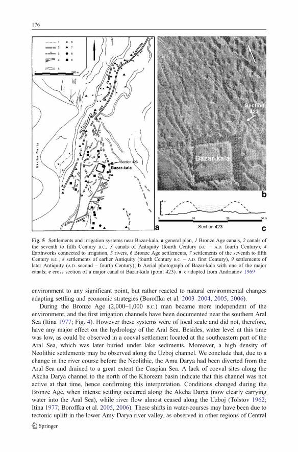
Fig. 5 Settlements and irrigation systems near Bazar-kala. a general plan, 1 Bronze Age canals, 2 canals ofthe seventh to fifth Century B.C., 3 canals of Antiquity (fourth Century B.C. – A.D. fourth Century), 4Earthworks connected to irrigation, 5 rivers, 6 Bronze Age settlements, 7 settlements of the seventh to fifthCentury B.C., 8 settlements of earlier Antiquity (fourth Century B.C. – A.D. first Century), 9 settlements oflater Antiquity (A.D. second – fourth Century); b Aerial photograph of Bazar-kala with one of the majorcanals; c cross section of a major canal at Bazar-kala (point 423). a–c adapted from Andrianov 1969
176
Asia (Gentelle 1989). However there are no early historical sources referring toearthquakes, which could help to unravel the chronology of geodynamic events. Furtherresearch is needed before this aspect can be evaluated at large.
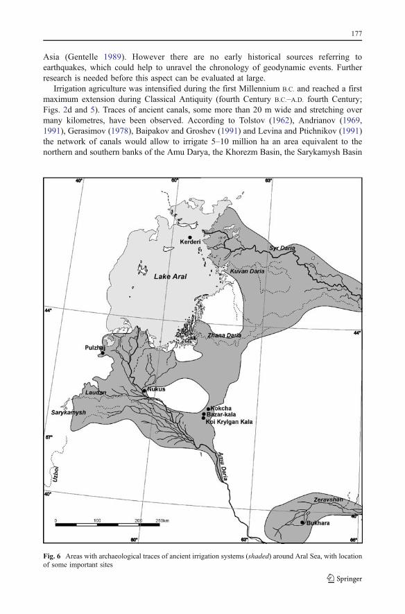
Irrigation agriculture was intensified during the first Millennium B.C. and reached a firstmaximum extension during Classical Antiquity (fourth Century B.C.–A.D. fourth Century;Figs. 2d and 5). Traces of ancient canals, some more than 20 m wide and stretching overmany kilometres, have been observed. According to Tolstov (1962), Andrianov (1969,1991), Gerasimov (1978), Baipakov and Groshev (1991) and Levina and Ptichnikov (1991)the network of canals would allow to irrigate 5–10 million ha an area equivalent to thenorthern and southern banks of the Amu Darya, the Khorezm Basin, the Sarykamysh Basin
Fig. 6 Areas with archaeological traces of ancient irrigation systems (shaded) around Aral Sea, with locationof some important sites
177
and the entire area between the Syr Darya and the Zhana Darya (Fig. 6). A regression of theAral Sea has been reconstructed for this period (Aladin and Plotnikov 1995; Boomer et al.2000; Sorrel et al. 2006). The increased irrigation activity possibly helped to accelerate thedesiccation of the Aral Sea during Classical Antiquity, as increased aridity at this time hasbeen observed in several regions of the Old World (Bryson 1996; Landmann et al. 1996;Lemcke and Sturm 1996; Schilman et al. 2002; Schmidt and Gruhle, 2003). The irrigatedsurface in this region surprisingly was of similar extent, 6.5 million ha, when the SovietUnion collapsed (Boomer et al. 2000). Today we know that irrigation is indeed one of thefactors controlling the extent of lake regression.
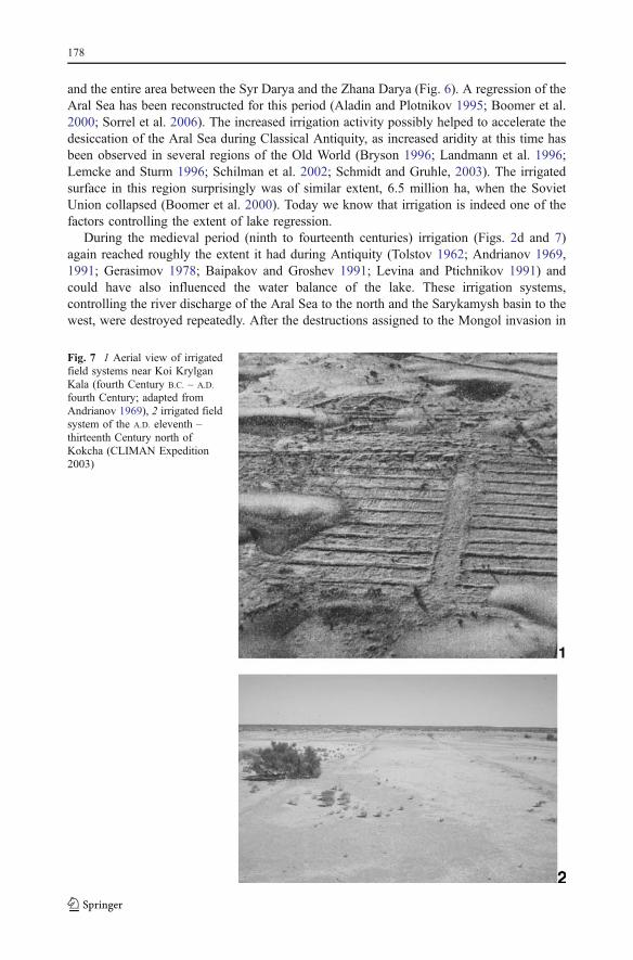
During the medieval period (ninth to fourteenth centuries) irrigation (Figs. 2d and 7)again reached roughly the extent it had during Antiquity (Tolstov 1962; Andrianov 1969,1991; Gerasimov 1978; Baipakov and Groshev 1991; Levina and Ptichnikov 1991) andcould have also influenced the water balance of the lake. These irrigation systems,controlling the river discharge of the Aral Sea to the north and the Sarykamysh basin to thewest, were destroyed repeatedly. After the destructions assigned to the Mongol invasion in
Fig. 7 1 Aerial view of irrigatedfield systems near Koi KrylganKala (fourth Century B.C. – A.D.
fourth Century; adapted fromAndrianov 1969), 2 irrigated fieldsystem of the A.D. eleventh –thirteenth Century north ofKokcha (CLIMAN Expedition2003)
178

the year 1221, the Amu Darya appears to have changed its course towards the Uzboj and theCaspian Sea (Barthold 1910). Support comes from the Sr record when we observe increasedSr input indicating that possibly at this time mainly Syr Darya water was discharging intothe lake. During the 1370s and 1380s, coeval to Timurs campaigns against Khorezmia,dams and weirs were again destroyed and the Amu Darya filled lake Sarykamysh. Howeverthis event did not have a deep impact on the lake’s chemistry like at the beginning of thethirteenth century. Enrichment of Sr was moderate to minor indicating that the Amu Daryawas probably only partly deviated towards Lake Sarakamysh and still discharged a majoramount of water into the Aral Sea (Fig. 2b). Based on archaeological data it was onlyduring the A.D. fourteenth or early fifteenth centuries when the lake level was well belowthe present day lake level (Fig. 2c), though it is not recorded in both aquatic (dinoflagellatecysts, diatoms) and geochemical (Ca, Sr) proxies. This mismatch might be due to the actualage model available for this time period, which mostly relies on a correlation with the tree-ring record of Esper et al. (2002) (see Sorrel et al. 2006). This regression is, however,witnessed by the mausoleum at Kerderi situated at 31 m a.s.l. (Fig. 2c,d). Furthermore, it isduring this regression when settling activities at Pulzhaj ceased.
Both Kerderi and Pulzhaj, until then unknown sites, are for the medieval period important,being only observed for the first time during the CLIMAN expeditions. The mausoleum ofKerderi is located in the northeastern part of the Large Aral Basin while Pulzhaj is situated at thesouthern end of the former Aibugir Bay on the southwestern edge of the Aral Sea (Figs. 1 and6). At Pulzhaj the dated archaeological materials together with dated sediments from anadjacent outcrop allow to identify transgressions around the A.D. fourth Century and afterA.D. 1400. Between these transgressions, people lived on the lowlands indicating that thewater level (53 m a.s.l.) must have been lowered by at least a few meters. Lowering of lakelevels, however, should be minimal and would corroborate other observations. According tothe dinocysts, the Aral Sea experienced lower salinity levels between ca. A.D. 400 andA.D. 900, suggesting still relatively high lake levels. A short lasting lowering might haveoccurred at about 600 A.D. as also indicated by increased Ca contents (Fig. 2a).
The Medieval regression seems at least partly be related to human activity (Boroffka etal. 2006; Austin et al. 2007). Dinoflagellate cyst assemblages like the negative sheet-washindex (Sorrel et al. 2006) are rather in favour of a climatically driven Medieval regressionstarting around A.D. 900 and lasting until about A.D. 1220. A climatically driven decreasedriver discharge would indeed been confirmed by the tree ring record from the Tien Shanand northwestern Karakorum moutains (Esper et al. 2002), the high catchment areas of theSyr Darya and Amu Darya rivers. During this interval where lowered river discharge arereported, tree-ring growth was minimal, still an indication that summer temperatures wereat a minimum. At about 1220 A.D. this regressive event terminates, which may match quitewell with pollen data indicating that climate became transiently more humid. However it isat about the time when a drastic event changed the lake’s chemistry. It may be a com-bination of several events, which fall into this time window. At A.D. 1208 a major earth-quake with magnitude above 6 occurred in this area (Nurtaev 2004). This might have causedmajor damages including destroying the riverbank thus changing the flow direction of AmuDarya towards the Caspian Sea. Furthermore, historical sources document another event,which might have affected the discharge of the Amu Darya. In A.D. 1221 the Mongolsdestroyed great parts of the irrigation system in the delta plain. As a result both events mighthave deviated the Amu Darya for some decades during which only the Syr Darya was feedingthe lake as shown by the dramatic increase of Sr in the Aral Sea sediments (Fig. 2b).
After A.D. 1550 the pollen reconstruction document a steady warming, with only minoroscillations. Since the nineteenth Century reliable reports exist on irrigation in the Aral Sea
179
region (Sarybaev 2002). At this time water management has been started. At aboutA.D. 1815–1816 construction of dams is well documented. The first dam was built on theSyr Darya, causing the Tanghi-Daria (=Zhana Darya?) to fall dry (Murchison and deKhanikoff 1844; Wood 1875; Meiendorf 1975). A following dam cut off the Kuvan Darya(south of the Syr Darya) from the Aral Sea (Butakoff 1853; Michell 1868; Wood 1875). Onthe Taldyk several dams were constructed (Wood 1875) and remains of dams wereobserved on the Kuldun (Wood 1875). In A.D. 1857 the Laudan canal, branching west fromthe Amu Darya, was closed; before A.D. 1863 a dam was built near Khodzeili to close theKok Uzak (Wood 1875). Some of the actions were politically intended. The Khan of Khivashot down the Laudan and the Kok Uzak to impose a penalty for nomads or Turkmenraiders. This resulted in the drying up of Aigubir Bay (Butakoff and Michell 1867; Wood1875 and map). However, this basin was already flooded again by A.D. 1891 (Blanc 1891)and at least the northern part remained under water until A.D. 1931 (Arkhangelskii 1931),which Kropotkin (1904) ascribed to a climatic change. Indeed there is no indication, thatthe Laudan canal was re-opened at that time. These well-documented records showingabundant manipulations on the irrigation system during the nineteenth Century, match withwater levels changes (Sorrel et al. 2006; Austin et al. 2007) and vegetation changes in thesediment cores retrieved from the Aral Sea.
Conclusions
Reconstruction of past climate from proxy data is important for improving constraints onthe role and the scope of natural climate variability onto environments that have beenpersistently influenced by anthropogenic activities. Mostly observations show that thechanges in climate was a prominent factor controlling the environment and to a variableextent also human irrigation activities (most probably during the Antiquity and the MiddleAges) exerted some controlling function. But it is only for the last decades, we havecompelling evidences that mankind is unequivocally controlling the environmental changesin the Aral Sea basin occurring since the 1960s. Given the different time resolution it is notalways unequivocal to match single anthropogenically-influenced with climatically drivenevents. Highest time resolution is provided from chemical data (XRF scanning data), whichallow a resolution better than a few years, while from archaeological toolkits, unless writtendocuments are available, the spatial and temporal resolution is rather sketchy. Therefore thepresented interpretations on mutual influences between climate and man are a first attempt tohighlight past interaction/reactions between men and climate in this region.
Acknowledgements The project is funded by the INTAS organization of the European Union (Project no.Aral 00-1030) and the German Science Foundation (DFG Project 436 RUS 113/663–OB 86/4). We aregrateful for their support. We thank A. Kenesov for help in logistics and to all local collaborators fromAral’sk, Nukus, and Tastubek who contributed to the success of the expeditions.
References
Aladin NV, Plotnikov IS (1995) Izmenenie urovinia Aral’skogo morja: Paleolimnologicheskie Iarkheologicheskie dokazatel’stva. In Biologicheskie i prirodovedcheskie problemy Aral’skogo moria iPriaral’ia, Part 1 (pp. 17–46). Trudy Zoologicheskogo instituta RAN 262. Nauka, Saint Petersburg
Andrianov BV (1969) Drevnie orositel’nye sistemy Priaral’ja (v svjazi s istoriej vosniknovenija i razvitijaorošaemogo zemledelija). Nauka, Moscow
180
Andrianov BV (1991) Iz istorii orosheniia v basseine Aral’skogo moria. In: Aral’skij krizis (Istoriko-geograficheskaia retrospektiva). Nauka, Moscow, pp 101–123
Aral’skij krizis (1991) Aral’skij krizis (Istoriko-geograficheskaia retrospektiva). Nauka, Moscow (in Russian)Arkhangelskii AD (1931) Geologicheskie issledovanija v Nizov’iakh Amu-Dar’i. Trudy Glavnogo Geologo-
Razvednogo Upravleniia V.S.N.Kh. S.S.S.R. (Transactions of the Geological and Prospecting Service ofU.S.S.R.) 12. Glavnogo Geologo-Razvednogo Upravleniia, Moscow, Leningrad
Austin P, Mackay A, Palagushkina O, Leng M (2007) A high-resolution diatom-inferred palaeoconductivityand lake level record of the Aral Sea for the last 1600 yr. Quat Res 67:383–393
Baipakov K, Groshev V (1991) Istoricheskaia dinamika irrigacii na Srednei Syrdar’e. In: Aral’skij krizis.Aral’skij krizis (Istoriko-geograficheskaia retrospektiva). Nauka, Moscow, pp 173–186
Bar-Matthews M, Ayalon A, Kaufmann A (1998) Middle to late Holocene (6500 years period) palaeoclimatein the eastern Mediterranean region from stable isotopic composition of speleothems from Soreq Cave,Israel. In: Issar AS, Brown N (eds) Water, environment and society in time of climate change. Kluwer,Dordrecht, pp 203–214
Barthold W (1910) Nachrichten über den Aral-See und den unteren Lauf des Amu-darja von den ältestenZeiten bis zum XVII. Jahrhundert. Quellen und Forschungen zur Erd- und Kulturkunde 2. Otto Wigand,Leipzig
Blanc E (1891) Discovery of a fresh-water lake near the Sea of Aral. Science 17(434):300Boomer I, Aladin N, Plotnikov I, Whatley R (2000) The palaeolimnology of the Aral Sea: a review. Quat Sci
Rev 19:1259–1278Boomer I, Horne DJ, Slipper I (2003) The use of ostracodes in palaeoenvironmental studies or what can you
do with an ostracod shell? Palaeontological Society Papers 9:153–180Boroffka NGO, Bajpakov KM, Achatov GA, Erzhanova A, Lobas DA, Savel’eva TV (2003–2004)
Prospektionen am nördlichen Aral-See, Kazachstan. Archäologische Mitteilung aus Iran und Turan 35–36[2005]:1–81
Boroffka NGO, Oberhänsli H, Achatov GA, Aladin, NV, Bajpakov KM, Erzhanova A, Hörnig A,Krivonogov S, Lobas DA, Savel’eva TV, Wuennemann B (2005) Human settlements on the northernshores of Lake Aral and water level changes. Mitigation Adapt Strateg Glob Change 10:71–85
Boroffka NGO, Oberhänsli H, Sorrel P, Demory F, Reinhardt C, Wünnemann B, Alimov K, Baratov S,Rakhimov K, Saparov N, Shirinov T, Krivonogov SK (2006) Archaeology and climate: settlement andlake level changes at the Aral Sea. Geoarchaeology 21(7):721–734
Bortnik VN, Chistyaeva SP (eds) (1990) Gidrometeorologiya i Gidrokhemiya Morei SSSR. Vol. VII:Aral’skoye more. Gidrometeoizdat, Leningrad
Bryson RA (1996) Proxy indications of Holocene winter rains in southwest Asia compared with simulatedrainfall. In: Dalfes HN, Kukla G, Weiss H (eds) Third millenium BC; climate change and old worldcollapse. NATO ASI Series I, vol. 49. Springer, Verlag, pp 465–473
Butakoff A (1853) Survey of the Aral Sea. Journal of the Royal Geographical Society of London 23:93–101.Available at: http://www.lib.utexas.edu/maps/historical/aral_1853.jpg )
Butakoff A, Michell J (1867) The delta and mouths of the Amu-Daria, or Oxus. Journal of the RoyalGeographical Society of London 37:152–160
Cour P (1974) Nouvelles techniques de détection des flux et de retombées polliniques: étude de lasédimentation des pollens et des spores à la surface du sol. Pollen et Spores 23(2):247–258
Doluhanov PM (1985) Aridnaja zona Straogo Sveta v pozdnem Pleistocene I Holocene (Arid zone of the OldWorld in the Late Pleistocene and Holocene). Bulletin of the All-Russian Geographic Society 117(1):16–23(in Russian)
Esper J, Schweingruber FH, Winiger M (2002) 1300 years of climate history for western Central Asiainferred from tree-rings. Holocene 12:267–277
Ferguson RW (2003) The devil and the disappearing Sea. Ramcoast, Vancouver (See comment Page 1)Frumkin A, Magaritz M, Carmi I, Zak I (1991) The Holocene climatic record of the salt caves of Mount
Sedom, Israel. Holocene 1:191–200Gentelle P (1989) Prospections archéologiques en Bactriane Orientale (1974–1978) 1. Données paléogéog-
raphiques et fondements de l’irrigation. Mémoires de la Mission Archéologique Française en AsieCentrale 3. De Boccard, Paris
Gerasimov IP (1978) Ancient rivers in the deserts of Soviet Central Asia. In: Brice WC (ed) The environmentalhistory of the near and Middle East since the Last Ice Age. Academic, London, pp 319–334
Issar AS, Govrin Y, Geyh AM, Wakshal E, Wolf M (1991) Climate changes during the Upper Holocene inIsrael. Israelian Journal Earth Sciences 40:219–223
Itina MA (1977) Istoriia stepnykh plemen Iuzhnogo Priaral’ia (II – nachalo I tysiacheletiia do n. e.). TrudyKhorezmskoi arkheologo-etnograficheskoi ekspedicii 10. Nauka, Moscow
Jansen JHF, Van der Gaast SJ, Koster B, Vaars AJ (1998) CORTEX, a shipboard XRF-scanner for elementanalyses in split sediment cores. Mar Geol 151:143–153
181
Kharin NG, Tateishi R, Gringof IG (1998) Use of NOAA AVHRR data for assessment of precipitation andland degradation in Central Asia. Arid Ecosystems 4(8):25–34
Klotz S, Pross J (1999) Pollen-based reconstructions in the European Pleistocene: the modified indicatorspecies approach as a tool for quantitative analysis. Acta Palaeobot Supplementum 2:481–486
Klotz S, Guiot J, Mosbrugger V (2003) Continental European Eemian and early Würmian climate evolution:comparing signals using different quantitative reconstruction approaches based on pollen. Glob PlanetChange 36:277–294
Klotz S, Müller U, Mosbrugger V, Beaulieu JL, de Reille M (2004) Eemian to early Würmian climatedynamics: history and pattern of changes in Central Europe. Palaeogeogr Palaeoclimatol Palaeoecol 211:107–126
Krivonogov S, Lebedeva O, Dementiev W, Vishnevskaya E, Devjatova A (2003) Geoinformationnayapodderschka projekta INTAS: Aralskoe Morie. Arcreview 3/26:19–20
Kropotkin P (1904) The desiccation of Eur–Asia. Geogr J 23(6):722–734Landmann G, Reimer A, Lemcke G, Kempe S (1996) Dating late glacial abrupt climate changes in the
14,570-yr long continuous varve record of Lake Van, Turkey. Palaeogeogr Palaeoclimatol Palaeoecol122:107–118
Lemcke G, Sturm M (1996) 18O and trace element measurements as proxy for the reconstruction of climatechanges at Lake Van (Turkey). In: Dalfes HN, Kukla G, Weiss H (eds) Third millenium B.C.; climatechange and old world collapse. NATO ASI Series I, vol. 49. Springer, pp 653–678
Létolle R, Mainguet M (1996) Der Aralsee: Eine ökologische Katastrophe. Springer, BerlinLevina LM (1998) K istorii i issledovanii Khorezmskoj arkheologo-etnograficheskoj ekspeditsii v
Vostochnom Priaral’e. In: Nerazik EE (ed) Priaral’e v drevnosti i srednevekov’e. K 60-letiiuKhorezmskoj arkheologo-etnograficheskoj ekspeditsii. Vostochnaja Literatura, Moscow, pp 42–59
Levina LM, Ptichnikov AV (1991) Dinamika irrigacii i drevnikh rusel Kuvandar’i v Dzhetyasar (VostochnoePriaral’e). In: Aral’skij krizis (Istoriko-geograficheskaia retrospektiva). Nauka, Moscow, pp 142–161
Lipschitz N, Lev-Yadun S, Waisel Y (1981) Dendroarchaeological investigations sin Israel (Asada). IsrExplor J 31:230–234
Mackay AW, Ryves DB, Battarbee RW, Flower RJ, Jewson D, Rioual, PMJ, Sturm, M (2005) 1000 years ofclimate variability in Central Asia: assessing the evidence using Lake Baikal diatom assemblages and theapplication of a diatom-inferred model of snow thickness. Glob Planet Change 46:281–297
Maev EG, Karpychev YA (1999) Radiocarbon dating of bottom sediments in the Aral Sea: age deposits andsea level fluctuations. Water Resour 26:187–194
Meiendorf EK (1975) Puteshestvie iz Orenburga v Bukharu. Central’naia Aziia v istochnikakh i materialakhXIX- nachaa XX veka, M 46. Nauka, Moscow (Translation by E. K. Vetger of the french edition:Voyage d’Orenbourg à Boukhara, fait en 1820, à travers les steppes qui s’étendent à l’est de la merd’Aral et au-delà de l’ancien Jaxartes. Rédigé par M. le baron G. de Meyendorff et revu par M. lechevalier Amédée Jaubert, Paris 1826)
Michell R (1868) The Jaxartes or Syr-Daria, from Russian sources. Journal of the Royal GeographicalSociety of London 38:429–459
Micklin PP, Williams WD, (eds) (1996) The Aral Sea basin. NATO Advanced Science Institute Series,Partnership Sub-Series 2, Environment 12. Springer, Berlin
Murchison RI, de Khanikoff MN (1844) On the desiccation of the Tanghi-Daria, a branch of the Jaxartes.Journal of the Royal Geographical Society of London 14:333–335
Nihoul JCJ, Zavialov PO, Micklin PhP (eds) (2004) Dying and dead seas: climatic versus anthropic causes.Proceedings of the NATO Advanced Research Workshop, Liège, Belgium (7–10 May, 2003). NATOScience Series: IV: Earth and Environmental Sciences 36. Kluwer, Dordrecht
Nourgaliev DK, Heller F, Borisov AS, Hajdas I, Bonani G, Iassonov PG et al (2003) Very high resolutionpaleosecular variation record for the last ∼1200 years from the Aral Sea. Geophys Res Lett 30:17, 1914.doi:10.1029/2003GLO18145
Nurtaev B (2004) Aral Sea basin evolution: geodynamic aspect. In: Nihoul JCJ, Zavialov PO, Micklin PP(eds) Dying and dead seas climatic versus anthropic causes. Proceedings of the NATO AdvancedResearch Workshop. NATO Science Series: IV: earth and environmental sciences 36. Springer, Berlin,pp 91–97
Reinhardt Ch (2005) Untersuchungen zur holozänen Seespiegelentwicklung des Aralsees. Unpublisheddoctoral dissertation, Freie Universität Berlin, Germany
Reinhardt C, Wuennemann B (2005) Investigating the Holocene lake history of the Aral Sea—A GISsupported geomorphological approach. In From source to delta, Abstract Volume Biannual MeetingDeutsche Quartärvereinigung, pp69–70 Deutsche Quartärvereinigung, Nijmegen
Rubanov IV, Ishnijazov DP, BaskakovaMA, Chistiakov PA (1987) Geologija Aral’skogoMorya. Tashkent: Fan
182
Sarybaev K (2002) L’agriculture irriguée dans le delta de l’Amou Darya à la fin du XIXe et au début du XXe
siècle. In: Karakalpaks et autres gens de L’Aral: entre rivages et déserts. Cahiers d’Asie Centrale 10pp167–175. IFÉAC, Tachkent, Aix-en-Provence
Schilman B, Ayalon A, Bar-Matthews M, Kagan EJ, Almogi-Labin A (2002) Sea–land palaeoclimatecorrelation in the Eastern Mediterranean region during the Late Holocene. Isr J Earth-Sci 51:181–190
Schmidt B, Gruhle W (2003) Klimaextreme in römischer Zeit. Eine Strukturanalyse dendrochronologischerDaten. Archäologisches Korrespondenzblatt 33(3):421–426
Shnitnikov AV (1969) Vnutrivekovaja izmenchivost komponentov obchei uvlaznennosti (Intercentennialvariability of general humidity components). Nauka, Leningrad, p 244 (in Russian)
Sorrel P (2006) The Aral Sea: a palaeoclimate archive. PhD thesis, University Potsdam (Germany) andUniversity Claude Bernard–Lyon (France), p 109
Sorrel P, Popescu S-M, Head MJ, Suc JP, Klotz S, Oberhänsli H (2006) Hydrographic development of theAral Sea during the last 2000 years based on a quantitative analysis of dinoflagellate cysts. PalaeogeogrPalaeoclimatol Palaeoecol 234(2–4):304–327
Sorrel P, Popescu S-M, Klotz S, Suc JP, Oberhänsli H (2007a) Climate variability in the Aral Sea basin (CentralAsia) during the late Holocene based on vegetation changes. Quat Res, doi:10.1016/j.yqres.2006.11.006
Sorrel P, Oberhänsli H, Boroffka NGO, Nourgaliev D, Dulski P, Röhl U (2007b) Control of wind strength andfrequency in the Aral Sea basin during the late Holocene. Quat Res, doi:10.1016/j.yqres.2006.12.003
Tarasov PE, Webb III, T, Andreev AA, Afanas’eva NB, Berezina NA, Bezusko LG, Blyakharchuk TA,Bolikhovskaya NS, Cheddadi R, Chernavskaya MM, Chernova GM, Dorofeyuk NI, Dirksen VG, ElinaGA, Filimonova LV, Glebov FZ, Guiot J, Gunova VS, Harrison SP, Jolly D, Khomutova VI, KvavadzeEV, Osipova IM, Panova NK, Prentice IC, Saarse L, Sevastyanov DV, Volkova VS, Zernitskaya VP(1998) Present-day and mid-Holocene biomes reconstructed from pollen and plant macrofossil data fromthe former Soviet Union and Mongolia. J Biogeogr 25:1029–1053
Tolstov SP (1962) Po drevnim del’tam Oksa i Jaksarta. Vostochnaja Literatura, MoscowVaruschenko SI, Varuschenko AN, Klige RK (1987) Izmenenija rezima Kaspijskogo morja i besstochnih
vodoemov v paleovremeni (Variations of the Caspian regime and of closed lakes in palaeotimes). Nauka,Moscow, p 239 (in Russian)
Wood H (1875) Notes on the Lower Amu-darya, Syr-darya and Lake Aral, in 1874. Journal of the RoyalGeographical Society of London 45:367–413
Yagodin VN (2007) The medieval Aral Sea crisis. Archäologische Mitteilungen aus Iran und Turan, DietrichReimer Verlag GmbH, Berlin 37(2005):307–322
Zavialov PO (2005) Physical oceanography of the Dying Aral Sea. Springer, Chichester, UK, p 146
183