The Delaware-Hudson and Erie Canals By
48
The Delaware-Hudson and Erie Canals By: Cristina Giansante, Meaghan Lakios, Elizabeth O’Brien, Lauren Cirillo, and Brian Townsend The Majestic Riverscapes History of the Mid Hudson Valley Final Paper Colonel Johnson
-
Upload
khangminh22 -
Category
Documents
-
view
1 -
download
0
Transcript of The Delaware-Hudson and Erie Canals By

The Delaware-Hudson and Erie Canals
By: Cristina Giansante, Meaghan Lakios, Elizabeth O’Brien, Lauren Cirillo, and Brian Townsend
The Majestic Riverscapes
History of the Mid Hudson Valley
Final Paper
Colonel Johnson

Brian Townsend- Technical Overview of Industry
The beginning of the Erie Canal came in 1817 when it was first approved. With today’s
technology the building of a canal seems less of a major project then it truly was back then. At
the completion of the canal, it was 363 miles, 40 feet wide, 4 feet deep, descended 555 feet, and
contained 83 locks. All of the work was done by horse, mules, hand tools, wheel barrels, and a
ton of unskilled workers. Farmers whose farms fell along the route were contracted to build tiny
portions of the canal which would be connected to other tiny portions. Since tree stumps and
were used for the building of the gates, workers would have to chop down and transport the
wood to the canal. A stump-puller was invented,
which allowed thirty or forty stumps to be removed
in a day by a small number of men. The stump puller
was a set of wheels on an axel with a larger wheel in
the middle. Rope would be tired around the tree
stump and to the cart, pulled by oxen. All soil was
removed by manual labor using wheel barrels and
shovels.1
The Delaware-Hudson canal was started in 1825 and opened for navigation in October of
1828. The canal was built by over two-thousand five hundred unskilled workers using the same
materials as the Erie. Once complete the canal ran 108 miles long, ending at the city of Kingston.
It was 4 feet deep, 32 feet wide and changed a total of 1075 feet in water elevation. Eventually,
1 Guntert and Zimmerman. 2000. "Canal Machinery". Accessed Oct 1. http://www.guntert.com/Canal/Canal.htm.
"Map of the Canal, and Profile of the Canal" -- from: Marco Paul's Voyages & Travels, Erie Canal / by Jacob Abbott. (Harper & Brothers, New York, c1852)

both canals were expanded in depth and width as
ships continued to grow in size. The Delaware-
Hudson Canal is no longer in use and is now an
historic landmark.2
Both canals were built based on the English
canal building patterns. Back then, a mule would
drag a boat in between both locks and the rear lock would close shut. Then, sluices, which were
passages for water fitted with a value or a gate back in 1818, would allow water either in or out
depending on whether the boat was going from higher elevation or lower elevation. The boat
would rise or sink with the change in water level and the front gate would open. The mule would
then pull the boat out of the lock, and the boat would continue on the journey.
A clay, sand, and water type mixture was used as a base in order to waterproof the canals
to ensure that no water escaped. Also, all canals must be level. Typically, lock gates were made
of wood from the trees and the lock chambers were lined with wood, stone, or bricks. It wasn’t
until 1827, in Cheshire England, that case iron was used to build the locks and gates. The first
canal trimming and lining machines were not invented until 1946 by an American company.
Today, canals are made of concrete, steel, and iron.3
2 National Park Service's National Register of Historic Places.1998 “Kingston”. Accessed Oct 1. http://www.nps.gov/nr/travel/kingston/index.htm 3 Spier,Peter. The Erie Canal. Rochester: Heron's Bend Productions, 2009
"Map showing Present and Proposed Canal System" http://www.eriecanal.org/maps.html

Images courtesy of the Department of Rare Books & Special Collections, University of Rochester Library.
"Erie Canal at Salina St., Syracuse, N.Y." -- Detroit Publishing Co., c1900.
http://www.eriecanal.org/Syracuse.html
"View of the Aqueduct bridge at Rochester", by James Eights, 1824. From "A Geological and Agricultural Survey of the District Adjoining the Erie Canal in the State of New York" by Stephen Rensselaer (Printed by Packard & Van Benthuysen, 1824) http://collections.rmsc.org/BritishPottery/84.46.2.html

Elizabeth O’Brien- Relationship to nearest towns or municipalities
Erie Canal exhibits are displayed in Syracuse, Camillus,
Albany, Rome, and Chittenango. Some great attractions are the
Erie Canal Museum, Steam Engine Exhibit, Hudson-Mohawk
Heritage Area, Rome Erie Canal Village, and the Chittenango
Landing Canal Museum. The Erie Canal Museum is located in Syracuse, New York and opened in 1962.
The museum preserved the life of the last Weighlock Buildings in America. The Steam Engine Exhibit in
Camillus, New York, was created to preserve the last Stem Engine. The Hudson-Mohawk Heritage Area
located in the capital region, displays labor and industry. The Rome Erie Canal Village is an outdoor living
museum which recreates life during 1840-1860 eras. The Chittenango Landing Canal Boat Museum
shows the structural framework of an authentic Eric Canal Packet boat. All of these exhibits are part of
Erie Canal history and are valuable sits for a field trip.
Syracuse is near the Erie Canal making this area vital to
understand the demographics; in 1850 the population of Syracuse was
22,281 people. Today this number has expanded to 140,658 people
due to growth and industry. According to the census, “in Syracuse the
percent of people who are high school graduates
is 76.2% and the number of people who have earned a bachelor’s degree is 23.2%.”4
4 US Census Bureau, Census of Population and Housing: 1850 Census, http://www.census.gov/prod/www/abs/decennial/1850.html(October, 1, 2010).
Education is vital
today, whereas, in 1850 there was only one college and 9 teachers. Today, industry is business,
production, and manufacturing, but 1850 industry was based on farmers, butchers, carpenters, painters,
blacksmiths, and mechanics. This type of industry is the same for Albany, Rome, Buffalo and
Chittenango.
“View of the Camillus Erie Canal Park”
http://www.eriecanal.org
“Image from Erie Canal Museum of Syracuse and the Erie Canal”
//

Albany has a population of 93,836. According to the census, “the number of high school
graduates is 93.5% and the number of people with a bachelor’s degree is 44.1%”.5
Buffalo’s population is 270,240. According the census,
“the number of people with a high school degree is 74.6% and bachelor’s degree is 18.3%”. Buffalo’s
industry is based on education, health, social services, retail trade, and manufacturing. Buffalo in 1850
had a population of 42,255 and had a total of one college and teachers for 115 pupils. Today, the ethnic
groups in this area consist of American Indian (0.8%), Asian (1.4%), Hispanic (7.5%), and the remaining
consists of Caucasians.
In 1850 Albany’s
population was 50,763 and there was only one college with a total
of eight teachers. Today, the ethnic groups in this area consist of
American Indian (1.3%), Asian (8.0%), Hispanic (2.3%), and the
remaining consists of Caucasians. In 1850 the ethnic groups consist
of Irish (15.9%), Italian (14.1%), German (12.2%), English (7.6%),
and Polish (5.0%). The rest of the cities had very similar ethnic
groups for the 1850s.
The population in Rome today is about 34,220 people. According to the census, “the number of
high school graduates is 74% and the number of bachelor’s degrees is 15.7%”. Rome’s industry today is
based on manufacturing, education, health, social services, and retail trade. The population in 1850 was
7,918 people who had one college and nine teachers for 150 pupils.6
5 US Census Bureau, Census of Population and Housing: 1850 Census, http://www.census.gov/prod/www/abs/decennial/1850.html(October, 1, 2010).
. Today, the ethnic groups in this
area consist of American Indian (0.3%), Asian (0.9%), Hispanic (4.7%), and the remaining consists of
Caucasians.
6 Ibid
“Image of Buffalo, NY and the Erie Canal.” http://www. turbeville-genea-trek.blogspot.com

Troy has a population of 81,118 people. According to the census, “92.2% of people are high
school graduates and 50% have their bachelor’s degree.”7
It is important to understand the growth of these towns along the Erie Canal. Much growth and
progress grew from the building of the canal. The industry sprung rapidly as well as the increase in the
population. This also allowed for education systems to be put into place and a mix among people.
Ethnicity?
Today the industry is based on manufacturing,
retail trade, and public administration. Troy had a population of 7,564 people and a very small education
system which consisted of only one college. Today, the ethnic groups in this area consist of American
Indian (0.2%), Asian (13.3%), Hispanic (1.5%), and the remaining consists of Caucasians.
7 Ibid
“Image of the canal and Albany” http://www. norwayheritage.com “Image of Erie Canal Village in Rome, New
York” http://www.nycanals.com

The Delaware and Hudson Canal like the Erie Canal also has exhibits
and displays which would make a great field trip such as, The Delaware
Hudson Canal Park and The Neversink Valley Museum of History and
Innovation in Cuddebackville, New York located in
Orange County. This exhibit shows the canal history
and has guided walks which include canal buildings, lock tenders house, canal
store, blacksmiths house and land-based canal boat replicas. Another great place
is the Mini Sink Valley Historical Society in Port Jervis, New York. Delaware Hudson
artifacts are displayed as well as historical references. The Fort Decker Museum of
History and the Robert Kienstuber House are also included. Why this para. here? Wrong placement of
paragraph
Some of the major towns along the Hudson Delaware Canal
are Kingston, Ellenville, Rosendale, Lackawaxen, and Honesdale.
Kingston is located in Ulster County New York and has a population of 908 people. Amongst these
people, 81.7 % have high school degrees and 25% have
bachelor’s degrees. Kingston’s largest industries consist of
mostly education, health, social services, and retail trade.
Ellenville is also in Ulster County and has a population of
3,905 people.
25.7% of these people are high school graduates and 7% have bachelor degrees.8
8 US Census Bureau, Census of Population and Housing: 1850 Census, http://www.census.gov/prod/www/abs/decennial/1850.html(October, 1, 2010).
This industry is based
on agriculture, construction, and retail. Rosendale is as well in Ulster Country and has a population of
6,352 people. The percent of high school graduates from this area is 28.1% and the number of people
“Image of Neversink Area Museum” http://www.neversinkmuseum.org
“Image of Fort Decker”
http://www.portjervisny.com
“Town of Ellenville and the canal” http://www.nps.org

with a bachelor’s degree is 16%. Rosendale industry is based on education, health, social services, arts,
entertainment, recreation, accommodation, and food services. Compared to 1850 this area of Ulster
County was much different. The total population of the entire county was 59,384, there was hardly any
education, and most professions included: blacksmiths,
mechanics, carpenters, painters, and farmers. Today in Ulster
County the ethnic groups consist of white (89.8%), black (6.4%), American Indian (0.3%), and Asian
(1.7%).
The Delaware and Hudson also travelled to Pennsylvania where Lackawaxen and Honesdale are
important locations. Lackawaxen has a population of 4,154 people.
44.4% of these people are high school graduates and 9.9% have a
bachelor’s degree. The industry in this region today is mainly
construction, retail trade, education, health, social services, and
entertainment. Compared to 1850 the population was only 1,419 people who were mostly laborers,
carpenters, masons, merchants, famers and clerks who had very little education. Today the ethnicities in
Pike County which is where Lackawaxen is located consists of white (91.4%), black (5.9%), American
Indian (0.2%), and Asian (1.3%).
Honesdale today has a population of 4,874 people
in it. The number of people with a high school graduate
degree is about 38.9% and the number of people with a
bachelor’s degree is 10.9%. The industry in this region is
based on retail trade, education, health, social services,
and manufacturing. Back in 1850 the population was 2,263 people whose county only had one college
and seven teachers. Many professions were the same as Lackawaxen. Wayne County is where
“Hudson Delaware Canal Today” http://www.canals.org
“Delaware Hudson Canal in Pennsylvania” http://www.miniartifacts.org

Honesdale is located where the ethnicities today consist of white (96.1%), black (2.5%), American Indian
(0.2%), and Asian (0.6%). It is interesting to see how the land and population developed between 1850
and 2010. Good comparison. Ethnicities?

Lauren Cirillo - Key Points
The Erie Canal Museum is a great place to take
students where they can better their understandings of the
famous canal. The museum is located at 318 Erie Blvd East in
Syracuse New York. Entering the museum is free ,however they
greatly appreciate a $5.00 donation. The museum is so historic
itself because it is located in the Syracuse Weighlock Building
which was made in 1850 to weigh the canal boats and to collect
tolls. Coming to this museum, children are guaranteed hands on learning from the many participatory
exhibits, museum tours and specialty programs made to excite and entertain children of all age groups.
Tours are led by Museum Docents who have been well trained in history of the Erie Canal. During the
tour one of the many exhibits the Erie Canal Museum has is a full size replica of an Erie Canal line boat
called the Frank B. Thomson Line Boat. The boat has reproduced passenger, cargo and crew areas and
contains surround sound describing what life on the Erie Canal was like (Permanent Exhibits). Another
exhibit is the computer kiosk where people can learn about
Erie Canal History.9
9 Boats on the Erie Canal.
The computer system allows for a fun
learning experience with bright pictures, catchy music and
different categories to click including canal construction,
weighlock buildings and life on the Erie Canal. A
reproduction of a tavern in which travelers in the mid
1800’s would stop to eat, drink and gossip is displayed as
well. One last exhibit is pottery from the Onondaga
http://www.eriecanal.org/boats-2.html (Accessed Sept 28 2010)
This picture displays the Erie Canal Line Boat that was reproduced.
http://www.eriecanalmuseum.org/EXHIBITS.tab.aspx
This picture displays the Erie Canal Line Boat that was reproduced.
http://www.eriecanalmuseum.org/EXHIBITS.tab.aspx

because the Erie Canal was used to transport finished goods (Permanent Exhibits). The Erie Canal School
Boat is another great and exciting field trip that students enjoy. Nicknamed the floating school bus,
students will sail along the Erie Canal for the day. They will learn the history and impact of the famous
canal along with visiting the Herkimer Home (The Erie Canal School Boat). Both of these sites are
wonderful for field trips because they cater to
enhance student learning. 10
The Delaware and Hudson Canal
Historical Society and Museum is a key site of
the famous D&H Canal and is a terrific place
to bring students on a field trip. The Museum
is located in High Falls and their mission is to
preserve and protect the history of the Delaware and
Hudson Canal (The D&H Canal Historical Society and
Museum). The museum has many exhibits to enhance
students learning including a life sized recreated canal boat cabin, a moving model of a gravity railroad
brake car, a working model of a lock and various financial documents, tools and artifacts. At this
museum visitors can view Locks 16 – 20 which were built in 1847. This walk is known as the Five Locks
Walk (The D&H Canal Historical Society and Museum). Another exciting trip to take with students or
even just to visit on one’s own time is to the D&H Canal Park in Cuddebackville. Here, children can
experience a real life canal boat themselves by steering the boat, tying the boat to a snubbing post and
hauling supplies on and off the boat. On the one hour walk along the canal students cannot only view
the canal but observe buildings such as a lock tenders house, blacksmith’s house, remains of an
10 The Erie Canal: A Brief History. http://www.canals.ny.gov/cculture/history/ (Accessed Sept 25 2010)
This is the tavern that was recreated and currently displayed at the Erie Canal Museum.
http://www.eriecanalmuseum.org/EXHIBITS.tab.aspx

aqueduct, a canal basin, a section of towpath along a water filled section of the canal, and the site of
Lock 51(D&H Canal Field Trip Program). Along with these great features comes a wall size canal map,
visual information on the history, boat models, photographs and a canal lock demonstration. One last
site that is important to see is the Delaware and Hudson Canal Linear Park which is located in Sullivan
County. This park contains 45 acres and 3 ½ miles of trail running along the Canal. There are some
remains of locks, drydock and waste weirs visible. Hikers, bikers and cross country skiers will really enjoy
this beautiful trail (Delaware & Hudson Canal Linear Park)
All of these key sites at the two famous canals prove to be exceptional trips to take. They each
provide masses of information for visitors and each have entertaining exhibits. Children will love coming
to any of these places because it gets them out of the classroom and makes the information come to
life. All of the museums and tours are very significant because they are historically connected to the
area which the site is located.
This is a picture of the Museum which is located in an old Episcopal Church.
http://www.canalmuseum.org/dh-canal_002.htm

Lauren Cirillo- interpretive signs
While visitors are at the Delaware and Hudson Museum and Historical Society they may come
across an interpretive sign at The Five Locks trail.
What is a Lock? A lock is used in a canal to move a ship from either lower to higher water levels
or higher to lower water levels. It is a stretch of water with gates on both sides built into a canal. How
does it work? When a ship needs to be raised to higher level it enters the lock and the gate behind the
ship closes. Water is then let in or out of the lock until the water level is the same as the water ahead.
The front gate then opens and the ship progresses on its journey. The locks are controlled by either
electric or hydraulic power. Culverts, which the water is poured into or out of, are built into the
structure of the lock walls.11 On this walk you will see the remains of Lock 16, 17, 18, 19 and 20. These
locks, built in 1847, are made of Shawangunk conglomerate and indigenous stone. These locks were
actually built as a new route to help accommodate the heave traffic flow on the canal 12
While on board The Erie Canal School Boat an interpretive sign children might see would be one
describing the Erie Canal and its impact on New York.
What about the Erie Canal? The Erie Canal is 363 miles long, 40 feet wide and 4 feet deep. It
runs from Buffalo near Lake Erie to Albany. Before the Erie Canal it was extremely hard for travelers to
11 Canal Lock. (Accessed Oct 1, 2010) 12 The D&H Canal Museum and Historical Society. (Accessed Oct 1, 2010)
This is a picture of the Erie Canal School Boat. It is a fun and interactive field trip for students because they get to enjoy a day sailing on the Erie Canal. < http://www.herkimer-boces.org/education/components/scrapbook/default.php?sectiondetailid=163

get to the Northwest Territories which were rich in timber, minerals and fertile land for farming. In order
to get there travelers had to deal with bumpy turnpike roads. Impact on New York? Opened in 1825,
the Erie Canal made New York the top commercial city in the United States. Within the first fifteen years
opened, the Erie Canal made New York one of the busiest ports in America. The Canal affected most
people in New York State because most major cities were relatively close to the trade route established
by the Erie Canal. Trade on the Erie Canal? Trade exploded immediately after the Canal was opened.
Traveling from Buffalo to New York, freight rates went from $100 per ton by road to $10 per ton by
Canal. The amount of bushels of wheat increased dramatically as well. In 1829, 3,640 bushels were
transported from Buffalo and in 1837 500,000 bushels were being transported.13
At many of the key sites they have a replica of a line boat that was used on the canal. Visitors
may come across an interpretive sign which describes the purpose of a line boat.
Line boats or working boats could carry either freight or people. The boats would carry lumber,
gravel or agricultural products east and the manufactured products west. People were able to get to the
Northwest Territories, now areas around Ohio and Michigan, to take advantage of their products with
the help of the line boats. Sometimes the boats were even homes for families. The line boats were all
different sizes and configurations however they were all restricted to a certain size to the size of the
Locks.14
13 The Erie Canal: A Brief History. (Accessed Oct 1, 2010) 14 Boats on the Erie Canal. (Accessed Oct 1, 2010)

Meaghan Lakios- Highway Route Markers
The Erie Canal stretched from Buffalo to Albany, Interstate 90 also
stretches this length; this is why it would make
sense to take Interstate 90 to get to the important
cities along the Erie Canal: Albany, Watervliet,
Cohoes, Rome, Canastota, Syracuse, Rochester, Pendleton and Buffalo. Albany is the first city
that you encounter as you travel west across the state. To get to this city you would travel west
on Interstate 90 and exit at exit 2. The next two cities are Watervliet and Cohoes and would
require you to take Interstate 90 to I 787 North toward Troy. To get to Albany, you would have
to take I 787 South. Traveling further west to Rome, New York, you would continue taking
Interstate 90 to exit 31 toward I-790 W/NY-8/NY-12 and then to NY-49. Canastota is the next
stop as you travel west and requires you to exit off I-90 W at exit 32 toward NY-233. By exiting
at 34 A off I-90 W onto I-481 S and then exiting onto I-690 W, you would be traveling toward
Syracuse. If you were to travel to Rochester, you would exit I-90 W at exit 45 and merge onto I-
490 W toward Rochester. A few exits up on I-90 W would be where you would exit to travel to
Pendleton, New York, exit 49; after exiting at 49 you would travel toward Depew/Lockport. The
last stop on your Erie- Canal trip along I-90 W would be Buffalo; to reach Buffalo you would
need to exit at 51 W and merge onto NY-33 W toward Buffalo. About one mile before each of
these exits as well as the exits themselves, there would be a sign indicating the Erie Canal,
labeled with the appropriate city(exit 2, exit for I 787, exit 31, exit 31, exit 34A, exit onto I-690
Interstate 90 Highway marker
http://www.upstatenyroads.com/2di.shtml

W, exit 45,exit 49,exit 51 W).15
As you travel along the Delaware-Hudson Canal, you encounter cities such as Kingston,
Rosendale, Ellenville, the valleys of Sandburg Creek, Homowack Kill and Basher Kill,
Lackawaxen and Honesdale all in the state of New Jersey. To be able to travel
to each of these cities on a common route, US-209 is the best route. Kingston is
located off US-209 N toward Beaver Valley Road and then off of I-80 E.
Traveling to Ellenville from Kingston would require you to continue on US-209
South to Center Street. After visiting Ellenville and
continuing along your travels toward Honesdale, you
would get back onto US-209 S and exit right at NY-52
W/Center Street to get to Sandburg Creek, Homowack Kill and
Basher Kill. While traveling to Lackawaxen, PA, you would
take the same route that you would to Sandburg Creek,
Homowack Kill and Basher Kill, but you would continue onto
NY-42 S, then to NY-17 W and exit at 104 for New York 17B
toward Monticello/Raceway. Lastly, as you finish you
travels to Honesdale you would take the same route
that you would to Lackawaxen, and continue onto
NY-52 and then PA-652 W/Hansdale and Delaware
Turnpike/ Honesdale and Delaware Turnpike. US 209 is an important route because it is
It was also important to have the main route be I-90 W because
it allows those traveling to parts of the Erie Canal, to travel to many parts while on the same
route.
15 “Google Maps,” Google, http://maps.google.com/maps?hl=en&tab=wl (Accessed Oct 1 2010)
Coal route via the DHC
http://www.nps.gov/nr/travel/kingston/transport.htm
This is the symbol, labeled with the appropriate canal and the city, that would be placed along the major highways to indicate important stops.
http://commons.wikimedia.org/wiki/Category:Rijksmonumenten_icons

common in all of routings to these cities, and like the
Erie Canal trip, it allows people to travel to all of the
cities, while using a common major highway. Similar
to the idea of the Erie Canal routing, signs indicating
the Delaware-Hudson Canal would be placed about
one mile prior to the exit, labeled with the appropriate
city; these signs would occur at the exit for I-80 E, exit
for Center Street, exit for NY-52 W/Center Street, exit
for NY-42 S, exit for NY-17 W, exit 104 for New York
17B, exit for NY-52 and exit for PA-652 W. By having
these signs it would allow drivers to know before their exit and would also show the route as
they travel on other major highways.16
Interstate 90 and US-209 will allow visitors to travel from site to site using the same
major highway for the majority of their travels. Although they may be required to use another
highway in addition to I-90 or US-209, it is a commonality between all of the sites along the Erie
Canal and all the sites along the Delaware-Hudson Canal. By having this commonality, I believe
it will make it somewhat easier for those traveling to another site along that particular canal,
because they can remember "I have to take Interstate 90 or US-209".
16 “Driving Directions,” MapQuest, http://www.mapquest.com (Accessed Oct 1 2010)
Highlighted in red is US 209 as it passes through New York state.
http://commons.wikimedia.org/wiki/File:US_209_(NY)_map.svg

Cristina Giansante
History:
A flour merchant, Jesse Hawley from Geneva, New York, proposed the Erie Canal in 1805. He
didn’t like how long it took for goods to travel in and out of the New York Harbor. He was the first and
biggest advocate in the idea of the canal system. His business went bankrupt; he faced twenty months in
prison where he wrote about his ideas for the canal. New York Governor DeWitt Clinton spoke to the
public about Hawley’s ideas and bought into them, but many did not like the idea and made a mockery
of it. In 1808 the New York Legislature authorized a survey of canal routes, taken by Judge James
Geddes, friend of Jesse Hawley. The main promoter of the canal was still New York’s Governor DeWitt
Clinton but even he couldn’t convince President Thomas Jefferson to fund the project federally as he
rejected it in 1809. The travel time was slow and expensive and mostly done by draft animals and
wagons that would take days. Clinton believed that if the seaboard cities, like New York City, were
connected travel time and expenses would be drastically cut and there would be more trade options.
Clinton also thought New York was a prime location because of its many waterways and the Mohawk
River Valley provided the only gap in the Appalachian Mountains between Canada and Georgia. The idea
of creating a canal still seemed farfetched due to the foreign deserted western land in New York and the
lack of technology. Clinton had previously been a state assemblyman, U.S. Senator and the mayor of
New York so with his leadership and political skills he persuaded New Yorkers to sign onto this
construction in 1810. The canal was to be approximately 363 miles long, starting at the beginning of the
Hudson River and ending at Lake Erie in Buffalo. The channel was to b e made 40 feet wide and just 4
feet deep. The canal was put on hold due to the war with Great Britain in 1812-1815. The war also
proved how badly Americans needed transportation from the east to the west.

Ground broke on July 4, 1817 in Rome, New York. Even though President James Madison denied
federal funding the state backed the canal. Benjamin Wright was chosen to be one of the three
engineers to design and build the Erie Canal. He was the chief engineer and directed all construction.
Through the construction many workers died of malaria and pneumonia while working in swamp areas
up north. The canal opened on October 26, 1825. There were huge celebrations across New York.
Clinton and other high social ranks boarded boats in Buffalo and headed to New York City. The 11-day
trip ended with Governor Clinton pouring water from Lake Erie into the sea to “wed the waters”
together. DeWitt Clinton died on February 11, 1828, 3 years after the canal was completed and right
before he saw all the wonders of it become true.
The canal was enlarged from 1835-1865 for bigger
ships to pass though.
Prior to the Erie Canal, New York City was
the 5th largest seaport, but by 1840 it was
Americas busiest by far. Wheat, coal, lumber, iron
and salt were all being shipped down while
settlers were being shipped up to new lands.
Within twenty years the state made all of the money back from construction and took in a little more
than $42 million more before tolls were abolished. Cities on the canal were booming with life,
populations were skyrocketing.
From 1905-1918 the New York State Barge Canal was built with more natural waterways but
using some parts of the Erie. The start of the 1920’s was the final call for the canal as it was slowly filed
in and paved over. By 1990 most of the canal was paved over and made into a recreational trail,
Canalway Trail in Albany that is now used for excursions and a different way to view the rich colonial

American history. Although it is mostly gone, it is not forgotten, the United States Congress designated
the Erie Canalway National Heritage Corridor to show how important the canal system was and how it
influenced and positively changed New York. It is known as one of the most successful man-made
waterways and a spectacular work of civil engineering art in North America. 17
Key leaders:
Jesse Hawley was born in 1782 and was a flour merchant in
Geneva, New York. He was the first supporter of the Erie Canal,
especially because of his business. Shortly after 1805 his business
went bankrupt, he faced twenty months in prison where he
wrote daily under his pen name, Hercules. He wrote about how
to build the canal and even cited information he found about
European canals and their success. Once he was released from jail
New York Governor DeWitt Clinton gave Hawley the credit of the
Canal System idea. No one in the past had ever put thought into
creating a traversable waterway and found it to be a farfetched
idea. Luckily Hawley had one believer, DeWitt Clinton, and that’s all he needed to watch his dreams
become reality. Hawley shared many of his ideas with James Geddes who ended up being a surveyor of
the Erie Canal. To show his gratitude Governor Clinton asked Hawley to make the first speech at the
opening ceremony of the Erie Canal on October 26, 1825. He was also invited on board the prestigious
Seneca Chief that rode from Buffalo to New York City. Once Hawley’s name gained recognition he
became village treasurer of his town, Lockport from 1836 until 1842. Hawley died unexpectedly in
17 E-Podunk. The Erie Canal- A Journey Through History. (Accessed October 1, 2010).

Cambria in 1842 and was buried in Cold Spring Cemetery. He luckily saw most of his dreams unfold and
the Erie Canal in full effect. On Cold Spring Road there’s a historical marker that says, “Cold Spring
Cemetery- Jesse Hawley who first advocated building the Erie Canal in 1805 is buried here. Friend of
DeWitt Clinton.” 18
James Geddes was born on July 22, 1763, in Carlisle, Pennsylvania. He was born into a Scottish farming
family where he worked for many years. Geddes eventually settled in 1794 in Onondaga Lake. He was a
prominent engineer, surveyor, New York state legislator, and
U.S. Congressman. His first surveyed and laid out the village
of Geddes in 1807. In the early beginning of the 1800’s he
became involved in the building of the canal. Since he was a
supporter of the canal he was appointed the Ne w York State
Surveyor General to find possible routes the canal could take.
In 1812 Geddes served as a judge in the New York State
Common Pleas Court. Geddes was one of the five engineers
chosen in 1816 to supervise the construction of the Erie
Canal. He served two terms as a Federalist in 1818 for
Onondaga County then in 1821 he was elected to the U.S. House of Representatives. After he was done
with the Erie Canal he helped with other canal commissions. James Geddes died on August 17, 1838 at
the age of 75 in Camillus, New York.
18 Genewich, Bruce and Farley, Doug. 2009. Jesse Hawley. (Accessed October 1, 2010).

DeWitt Clinton was born to James Clinton and Mary DeWitt on March 2, 1769. He was educated at
Columbia University and worked as a secretary for his uncle, George Clinton, Governor of New York. In
1798 he became a member of the New York State Assembly and the New York State Senate from 1798
to 1802 and then again from 1806-1807. After John Armstrong Jr. resigned, Clinton won by election for
United States Senator from New York and served from 1802 to 1803. After he resigned he was
appointed mayor of New York City in 1803. He served three terms as mayor and organized the Historical
Society of New York, American Academy of the Fine Arts and was the regent of the University of New
York. DeWitt Clinton was married twice where he
accumulated ten children, one serving as mayor of Buffalo in
1842. From 1810 to 1824 Clinton was a member of the Erie
Canal Commission and a huge advocate for the creation of the
canal. He was persuaded by Jesse Hawley to construct a canal
from Lake Erie to the upper Hudson River. In 1812 Clinton ran
for President of the United States as a member of the
Federalist Party but was defeated by James Madison; he only
lost by a mere thirty-nine votes. On July 1, 1817, Clinton
became the sixth Governor of New York where he was re-
elected in 1820. Clinton died on February 11, 1828 in office. He was originally buried in the Clinton
Cemetery but was later moved to the Green-Wood Cemetery in Brooklyn, New York. He was known for
being a leader and improving many things such as public school systems, modifying laws, and helping
make the Erie Canal happen.19
19 Envisum Inc. 2000. De Witt Clinton. (Accessed October 2, 2010).

Benjamin Wright was born on October 10, 1770, in Wethersfield,
Connecticut. Wright’s father, Ebenezer, was an ex-lieutenant of
Washington’s Continentals and faced debt troubles. Due to his father’s
debt he received barely any schooling. Fortunately for Benjamin Wright
his uncle Joseph taught him as much as he could about law and surveying.
Later in his life he moved to Rome, New York, where he was in great
demand as a surveyor due to his high reputation he established for
himself. Wright was chosen to be one of the three engineers to design and build the Erie Canal. He was
the chief engineer and directed all construction to what would be the greatest man-made waterway in
the world. The first boat that traveled on the canal was named in his honor. After the Canal was created
he was demanded all over the country and Canada. The Wurts brothers approached him to survey the
route of the Delaware and Hudson Canal. In addition to his engineering work he was elected to the New
York State Legislature in 1794 and appointed as a New York Country Judge. He married his wife,
Philomela Waterman on September 27, 1798 and had nine children, 5 of which took his role in
becoming civil engineers. On August 24, 1842 Benjamin Wright died at the age of 72. He is buried in the
New York Marble Cemetery in Manhattan. 20
History:
William Wurts, a Philadelphia businessman enjoyed exploring the northeast region on his free
time. During one of his trips he noticed and found interest in a blackish rock. After thorough research of
this rock he became one of the first explorers of the Coal Region. Due to the War of 1812, America had
essentially no supply of coal, which created an energy crisis, because most of it came from England.
20 FitzSimons, Neal. Father of American Civil Engineering, Benjamin Wright. (Accessed September 30, 2010).

Wurts went back to Philadelphia and told his brother Maurice, about his discovery and the potential
value behind this rock. Finally, after convincing his brother to make the trip to see his discovery they
invested. In 1812, the Wurtses began buying large pieces of land in which they extracted a large amount
of coal. Unfortunately they were losing a lot of large pieces of coal due to the terrible waterways on
their way back to Philadelphia. The recent success of the newly built Erie Canal inspired the brothers to
create one of their own. They wanted to create a river that went through Shawangunk Ridge, the
Catskill Mountains and to the Hudson near Kingston, New York. This would be the first long distance
transportation route in America, and an extremely profitable one to say the least.
In 1823 the Wurts brothers were given permission by the Delaware and Hudson Canal Company
to construct the canal. On April 23, 1823 New York passed the law to grant permission for the canal and
on March 13th Pennsylvania also granted permission. The Delaware and Hudson Canal Company hired
engineer Benjamin Wright and his assistant John Jervis, who were in charge of creating the Erie Canal, to
survey and plan the route. The estimated cost was nearly 1.6 million dollars at the time, therefore,
investors were tremendously needed. The Wurts brothers decided to show off the coal at a local
coffeehouse, the Tontine, on Wall Street in 1825. The viewers loved the coal and the idea of the Canal
and oversubscribed in hours; The Canal was off to a rapid start. This was America’s first privately owned
million-dollar job.
On July 13th, 1825 ground was finally broken and after 3 hard years of labor using only picks,
shovels, draft animals and blasting powder by 2,500 men, the canal was finally opened in October of
1828. The canal began at Rondout Creek, where the creek fed into the Hudson River in Kingston. It
flowed southwest into Port Jervis on the Delaware River from there it ran northwest into the New York
side of the Delaware River crossing into Pennsylvania. The finished canal ran a total of 108 miles from
Honesdale to Kingston. The elevation changes totaled to 1076 feet, which surpassed and nearly doubled

the Erie Canal’s. The canal was originally 4 x 32 and was crossed by 137 bridges and had 26 dams,
reservoirs, and basins.
By 1832 the Canal had already carried 90,000 tons of coal and 3 million feet of lumber. All the
profits that were made were invested into improving the canal so that larger ships could pass through to
excel trade and transportation. Aqueducts were also built to help cut several days off the travel time
and to reduce the risk of accidents. Many towns were created because of the frequent stops made on
the canal. These towns took names from the canal executives such as “Honesdale” (Phillip Hone),
“Wurtsboro” (Wurts brothers), and Summitville (the highest part of the canal). The Delaware Hudson
Canal was a large source of employment and successfully stimulated the growth of New York City.
Although New York City was far to get to, with the help of the canal the city developed at the same pace
as other cities. Many people benefitted from being a part of the creation of the canal, including Philip
Hone who was the Delaware Hudson Canal Company’s first president and mayor of New York City. John
Roebling’s experience in building the canal also helped him create and build the Brooklyn Bridge.
After the end of the season in 1898 the Delaware Hudson Canal Company drained the canal.
Later that summer Samuel Coykendall purchased the canal to use as a water supply resource.
Unfortunately after that failed the canal was never used again. 21
Key Leaders:
Philip Hone was born in New York City on October 25, 1780 to German immigrants. Hone became
wealthy in the auction business and was a supporter of the Whig Party. He was the first President of the
21 Levine, David. 2010. How the Delaware & Hudson Canal Fueled the Valley. (Accessed September 29, 2010).

Delaware and Hudson Canal Company in 1825 and 1826. In 1826 Hone was elected as a Whig and served
one term as Mayor of New York City. After his time as being a mayor he became extremely socially
active and had major events, some of which that changed the city for the better. He was a highly
successful merchant and founder of the Mercantile Library Association as well as the Clinton Hall
Association. He was known for the detailed diary he kept from 1828 until his death on May 5th, 1851. 22
John Bloomsfield Jervis was born on December 14, 1795 in Huntington, New York. He grew up in Rome,
New York where he was hired to work on the Erie Canal as an axe man in 1817. While he was at work he
would observe and study engineering. By 1827 he had gained his role as the Chief Engineer for the
Delaware Hudson Canal Company. Jervis was known for his most famous work in 1830, the Croton
Aqueduct that supplies New York City with water. He was the leading consulting engineer of his time
and a pioneer in the development of canals and railroads. He was the brain behind the 5 earliest
railroads in America and the chief engineer of three major canal projects. He was also an author, and
founder of the Rome, New York public library. In 1864 Jervis retired where he helped form the
Merchants Iron Mill (Rome Iron Mill). On January 12, 1885 he passed away in his home in Rome, New
York.
23
Benjamin Wright was born on October 10, 1770, in Wethersfield, Connecticut. Wright’s father,
Ebenezer, was an ex-lieutenant of Washington’s Continentals and faced debt troubles. Due to his
father’s debt he received barely any schooling. Fortunately for Benjamin Wright his uncle Joseph taught
him as much as he could about law and surveying. Later in his life he moved to Rome, New York, where
he was in great demand as a surveyor due to his high reputation he established for himself. Wright was
chosen to be one of the three engineers to design and build the Erie Canal. He was the chief engineer
and directed all construction to what would be the greatest man-made waterway in the world. The first
22 Francis, J. 1898. The Diary of Philip Hone. (Accessed September 29, 2010). 23 New York Times Online.1885. A Veteran Engineer’s Death. (accessed September 29, 2010).

boat that traveled on the canal was named in his honor. After the Canal was created he was demanded
all over the country and Canada. The Wurts brothers approached him to survey the route of the
Delaware and Hudson Canal. In addition to his engineering work he was elected to the New York State
Legislature in 1794 and appointed as a New York Country Judge. He married his wife, Philomela
Waterman on September 27, 1798 and had nine children, 5 of which took his role in becoming civil
engineers. On August 24, 1842 Benjamin Wright died at the age of 72. He is buried in the New York
Marble Cemetery in Manhattan.24
John Roebling was born on June 12, 1806 in Muhlhausen Germany. As a boy growing up he was an
excellent painter and drawer. He went to a public school but his mother arranged for him to have a
tutor in math and science at Erfurt. When he turned 15 he began attending Erfurt as his primary school.
After he finished secondary school he enrolled at Bauakademie, an English building academy, in Berlin
where he studied architecture, engineering, bridge construction, foundation construction hydraulics and
languages in 1824. He had also developed an interest in natural philosophy and later in his life worked
on a paper of how he perceived the universe. In 1825 he started his job for the government working on
military roads. During this time he would keep a sketchbook of ideas for suspension bridges. Four years
later in 1829 he returned home to work on his final thesis and engineers exam, which he would never
take. On may 22, 1831 John and his brother Karl left Germany due to difficult economic times created by
the aftermath of the Napoleonic Wars. Upon arrival in the United States, John and Karl purchased 1582
acres of land in Butler County, Pennsylvania on October 28,1831. Economic times were just as rough as
they were in Germany at the time so John Roebling picked up farming and started a family. A few years
later, in 1837 Karl Roebling died and John returned to engineering. His first engineering work in America
was dealing with canal building. In 1848, he was made in charge of constructing four suspension
aqueducts for the Delaware and Hudson Canal. Roebling was the head of several future bridge projects
24 FitzSimons, Neal. Father of American Civil Engineering, Benjamin Wright. (Accessed September 30, 2010).

such as railroad bridges but the American Civil War ceased his jobs for a few years. He himself designed
the John A. Roebling Suspension Bridge that crosses the Ohio River in Cincinnati. In 1867 he designed
one of the most well known bridges, the Brooklyn Bridge which extends over the East River in New York
City. While working on the location of where the bridge would stand his foot was crushed by a ferry
causing his toes to be amputated. His belief in water therapy made him opt out of further medical
treatment. Twenty-four days later, John Roebling died of tetanus on July 22, 1869. His son Washington
and daughter-in-law Emily Roebling continued his work on the Brooklyn Bridge. His other sons,
Ferdinand and Charles expanded and designed wire ropes and machines. They also founded the town
Roebling in New Jersey where their company steel mill was built. His grandson Washington Roebling II
died on the Titanic in 1912.25
25 Placzek, Adolf. 1982. John Augustus Roebling. (accessed September 30, 2010)
Jesse Hawley’s burial stone

From Throgs Neck Bridge to Erie Canal Museum, 4 hours 27 mins (261 mi.):
1. Head southeast on I-295 S
2. Take the exit toward 26th Ave
3. Turn left at 26th Ave
4. Turn left to merge onto I-295 N/Clearview Expy
Partial toll road
5. Take the exit onto I-95 S
6. Continue onto Interstate 95 Upper Level S/George
Washington Bridge (signs for I-95 S/Trenton)
7. Take the NJ-4/I-95 S exit toward Hackensack/I-80/New
Jersey Turnpike
8. Take exit 72A to merge onto NJ-4 W toward Paramus
9. Exit onto NJ-17 N
10. Merge onto I-287 N/NJ-17 N via the ramp on the left to
I-87/N Y. Thruway
11. Take the exit onto I-87 N/NY-17 N toward Albany
Toll road
12. Take exit 16 to merge onto NY-17 W toward US-
6/Harriman
Toll road
13. Continue onto US-6 W
14. Continue onto NY-17 W
15. Continue onto I-86 W
16. Continue onto I-81 N (signs for I-88/Syracuse/Albany)
17. Take exit 18 for Adams St toward Harrison St
18. Merge onto Almond St
19. Turn left at E Genesee St
20. Take the 2nd right onto S Townsend St
21. Turn left at Erie Blvd E

Driving Directions: Erie Canal Museum (Day 1/Night 1) 318 Erie Boulevard East Syracuse, NY 13202-1106 (315) 471-0593 Visit Time: 1 hour Tour Visit: 11:00 AM Price: $5.00 for adults
The Erie Canal Museum is a full gallery that allows the viewers to see what canal life was like. The guided tour includes a short video presentation of the history of the Erie Canal and how the canal developed. The tour guides are all trained in the history of the Erie Canal. Leave Erie Canal Museum at approximately 12:15 PM Head to The Steam Engine Exhibit, 11 minutes away (8.8 mi):
1. Head west on Erie Blvd East toward Montgomery Street 2. Erie Blvd E turns slightly right and becomes Oswego Blvd 3. Turn left at James Street 4. Continue onto NY-5W/W Genesee St. 5. Take the ramp onto NY-5 W 6. Take the exit toward Camillus Warners 7. Turn right at Co Road 36/Newport Road 8. Take the 1st right onto Devoe Road

The Steam Engine Exhibit (Day 1/Night 1) Camillus Erie Canal Park 5750 Devoe Rd Camillus, NY 13031 (315) 488-3409 Visit Time: 30 minutes Tour Visit: 12:45 Price: Free Admission
Camillus Erie Canal Park offers a variety of exhibits including a 10 mile scenic trail and even boat tours along the Erie Canal but we will be going to the Steam Engine Exhibit where one will get a chance to see a fully restored Steam Engine. Visitors will learn about the technology during this industrious time in America.
Leave The Steam Engine Exhibit at approximately 1:20 PM Head to Strong Hearts Café for lunch, 13 minutes away (9.5 mi):
1. Head southwest on Devoe Road toward County Road 36/Newport Road 2. Take 1st left onto Co Road 36/Newport Road 3. Turn left onto the ramp to Syracuse 4. Merge onto NY-5 E 5. Turn left at NY-5E/W Gensee Street 6. Turn right at Oswego Blvd 7. Slight left at Erie Blvd E 8. Take 1st right onto S. State St 9. Left at E Genesee St

Strong Hearts Café (Day 1/Night 1) 719 East Genesee Street Syracuse, NY 13210
Lunch: 1:45PM Phone: 315.478.0000 Hours (Sat): 10am-2am Price Range: Approximately $10.00 a person Departure Time: 2:45 PM
This hip café is 100% vegan and 100% friendly. They offer breakfast, lunch, soups, baked goods, sandwiches, pizzas, teas, coffees, and amazing milkshakes. Strong Hearts Café supports its local food producers and uses organic food products. Leave Strong Hearts Café at 2:45 PM Head to Rome Erie Canal Village, 52 minutes away (45.4 mi):
1. Head east on E. Genesee St. toward Forman Avenue 2. Take the 1st right onto Irving Avenue 3. Turn right at Harrison Street 4. Take the 1st right onto Almond Street 5. Merge onto I-81N via the ramp on the left to I-690 W 6. Take exit 30 for NY-31 toward Cicero/Bridgeport 7. Turn right at NY-31E 8. Turn left at NY-46N

Rome Erie Canal Village (Day 1/Night 1) 5789 Rome New London Road Rome, New York 13440 Phone: 315-337-3999 Visit Time: 1 hour Tour Visit: 4:00 PM Price: $10.00 (Adult) $5.00 (Children 5-17) $7.00 (Seniors 60+) Erie Canal Village is an outdoor history museum. Here you can unfold the story of the Erie Canal. There are several structures located at this site that could be found in a village during the 19th century. Visit the Canal Museum for a journey from the pre-canal era to the building of the canal. After, visit the Blacksmith where you can get a taste of the work of a Blacksmith in 1860. Lastly, stop at Bennett’s Tavern to sit and relax for a little. Bennett’s Tavern was built in the 1850’s. Leave Rome Erie Canal Village at 5:30 PM Head to The Brewster Inn, 50 minutes away (37.3 mi):
1. Head west on NY-46 S/Rome-New London Rd toward Seifert Rd 2. Turn right at NY-31 W 3. Turn left at NY-13 S/N Peterboro St 4. Turn right at NY-13 S/NY-5 W/Seneca Turnpike 5. Turn left at Genesee St 6. Slight left at NY-13 S/Falls Blvd 7. Turn right at Albany St 8. Turn Left at Forman St 9. Take the 1st right onto Ledyard Ave

The Brewster Inn (Day 1/Night 1) 6 Ledyard Avenue Cazenovia, NY 13035 Dinner: 6:30 Phone: 315.655.9232 Hours: 5:00pm- 9:00pm Price Range: Approximately $31-60.00 per person Room: Two Double Beds/Shower with lakeside view- $90/night The Brewster Inn will serve as dinner, a night’s sleep, and its infamous brunch to prepare you for tomorrows adventure. The Brewster Inn was built in 1890 and was the summer home to Benjamin Brewster who with John D. Rockefeller established the Standard Oil Company. Sunday Brunch: 10:30am-1:30pm Price: $21.00 per person (includes coffee/tea) The brunch menu features homemade Belgium waffles, scrambled eggs, eggs benedicts, omelets, homemade sausage, bacon, home fries, salads, Crème Brulee’, French toast, and an assortment of baked goods. Depart The Brewster Inn at 12:30 PM Head to Chittenango Landing Canal Museum, 17 minutes away (11.0 mi): 1. Head northeast on Ledyard Avenue toward Forman Street 2. Turn left at Forman Street 3. Take the 2nd right onto Albany Street 4. Turn left at Farnham Street 5. Continue onto NY-13/Sweetland St. 6. Continue onto Lakeport Road

Chittenango Landing Canal Boat Museum (Day 2/Night 2) 7010 Lakeport Road Chittenango, NY 13037-9594 (315) 687-3801 Tour Visit: 1:00 Price: $5.00 (12 & under Free) During the 19th and 20th centuries cargo boats that were used on the canal were built and repaired on this site. The Museum shows the construction of these boats and how they worked. Through preservation and restoration and of course reconstruction this museum will give visitors the opportunity to get a feel for life during the canal era. Leave Chittenango Landing Canal Museum at 3:00 PM Wurtsboro- Days Inn, 3 hours 17 minutes away (191 mi):
1. Head south on Lakeport Road
2. Continue straight onto NY-5 W/Genesee St
3. Slight right onto the Interstate 481 S ramp to
Jamesville 4. Merge onto I-481 S
5. Take the exit toward I-81 S
6. Keep left at the fork to continue toward I-81 S and merge onto I-81 S
7. Slight left at I-86 E
8. Continue onto NY-17 E 9. Take exit 113 for US-209 toward
Wurtsboro/Ellenville
10. Turn left at US-209 S/Treasure Lake Rd 11. Turn left at Perron Drive

Wurtsboro- Days Inn (Day 2/Night 2) 21 Perron Drive Wurtsboro, NY 12790 Phone: 845.888.2415 Room: Two Double Beds Room- $76.50/per night (breakfast included) Arrival Time: 6:30 PM Check in before dinner and refresh if needed. The hotel is in Wurtsboro because this town is named after the Wurts Brothers who built the canal. Depart Days Inn at 7:00PM for Dinner Head to Danny’s Village Inn, 3 minutes away (1.0 mi): 1. Head east on Perron Drive toward US-209 S 2. Turn left at US-209 N/Kingston Ave 3. Take the 2nd right onto Sullivan Street

Danny’s Village Inn (Day 2, Night 2)
209 Sullivan Street Wurtsboro, NY 12790 Phone: 845.888.2000 Hours: 11AM- 11PM Price Range: $11-30.00 per person
Dinner: 7:10PM
Danny’s is a local restaurant that used to be large old colonial house built in the late 1800’s. The food style is your typical American diner and they’re known for their huge portions. A great bang for your buck and a taste of the local folk.
Head back to The Days Inn after dinner for the night. Stop at a local grocery store or deli and pick up lunch for tomorrow!
Depart in the morning for the museum by 11:45 AM
Directions from The Days Inn to The Neversink Valley Museum: (15 minutes (10 mi.))
1. Head east on Perron Drive toward US-209 S 2. Turn right at US- 209 S 3. Turn right at Hoag Rd.

The Neversink Valley Museum of History and Innovation (Day 3/Night 3) 26 Hoag Road Cuddebackville, NY 12729 Tour Time: 12:00 PM Price: $3.00 (Adults) $1.50 (Children)
Take advantage of this historic park where the Delaware-Hudson once ran. There’s a one-hour self-guided walk along where the workers once built the canal. The Black Diamonds and the D&H Canal show a working canal lock model as well. Picnic under one of the trees on the land! Depart from Neversink at 2:00 PM Head to The D&H Canal Historical Society and Museum, 1 hour (41.2 mi):
1. Head northeast on Hoag Rd toward US-209 2. Turn left at US-209 N 3. Turn right at NY-213 E 4. Turn right at Co Rd 6a/Mohonk Rd

The D&H Canal Historical Society and Museum (Day 3, Night 3) 23 Mohonk Road High Falls New York 12440 Phone: (845) 687-9311 Tour time: 3:30 Price: $4.00 (Adults) $2.00 (Child) Take a walk through the museum and view the artifacts that were used during the canal era. Once you’re done indoor head outside to the five locks walk where you can walk through the parts of the Delaware-Hudson route.
Depart and head home! 1 hour 48 minutes (89.5 mi):

1. Head south on Co Rd 6a/Mohonk Rd
toward Steep Hill Rd 2. Continue onto County Rd 6/Mt Rest Rd
3. Continue onto County Rd 7/Springtown
Rd 4. Turn left at NY-299 E/New Paltz-
Minnewaska Rd
5. Take the I-87 ramp to Thruway Toll road
6. Keep left at the fork to continue toward I-
87 S and merge onto I-87 S Partial toll road
7. Take exit 15 for NY-17 S/I-287 S toward
New Jersey 8. Merge onto I-287 S
9. Take exit 66 on the left to merge onto NJ-
17 S toward Mahwah 10. Take the NJ-4 E ramp to Fort Lee/New
York
11. Keep left at the fork to continue toward NJ-4 E and merge onto NJ-4 E
12. Take the I-95 N ramp to G W
Bridge/New York City 13. Merge onto Interstate 95 Lower Level
N
14. Slight left at US-9 N Partial toll road
15. Merge onto Interstate 95 Upper Level
Partial toll road 16. Continue onto I-95 N
17. Continue onto Cross Bronx Expy
18. Continue onto I-295 S (Crossing Throgs Neck Bridge

Guidebook: Erie Canal
Erie Canal Museum
http://www.eriecanalmuseum.org
318 Erie Boulevard East Syracuse, NY 13202
Hours: Open Mon. - Sat. 10 a.m. - 5 p.m., Sun. 10 a.m. - 3 p.m.
*Closed on Christmas and New Year's Day, Easter Sunday, July 4 and Thanksgiving Day. Holiday hours may vary, please contact us for current hours.
Phone: (315)471-0593
Historical Description: The Erie Canal Museum opened October 25, 1962. The museum preserved the life of the last remaining Weighlock Building in the United States. This is a monument to the history of the Erie Canal. The Weighlock Building was preserved by the New York State Department of Public Works until 1954. In 1956 two members of the New York State Canal Society sponsored legislation to give the building to the New York State Department of Education.
The Site: This Museum consists of many exhibits to learn more about the history of the Erie Canal. These exhibits include the Frank B. Thomson Line Boat, Penny Postcard Arcade, Weighmaster’s office, Computer Kiosk, Uniquely Syracuse Room, The tavern, Potter Display, General Store, Stonecutters Shed, and the Nineteenth Century Theater Stage.
Directions: Traveling North on I-81 Exit at Adams Street, continue straight on Almond Street. After several blocks, turn left onto Water Street. The Erie Canal Museum is located four blocks down on your right.
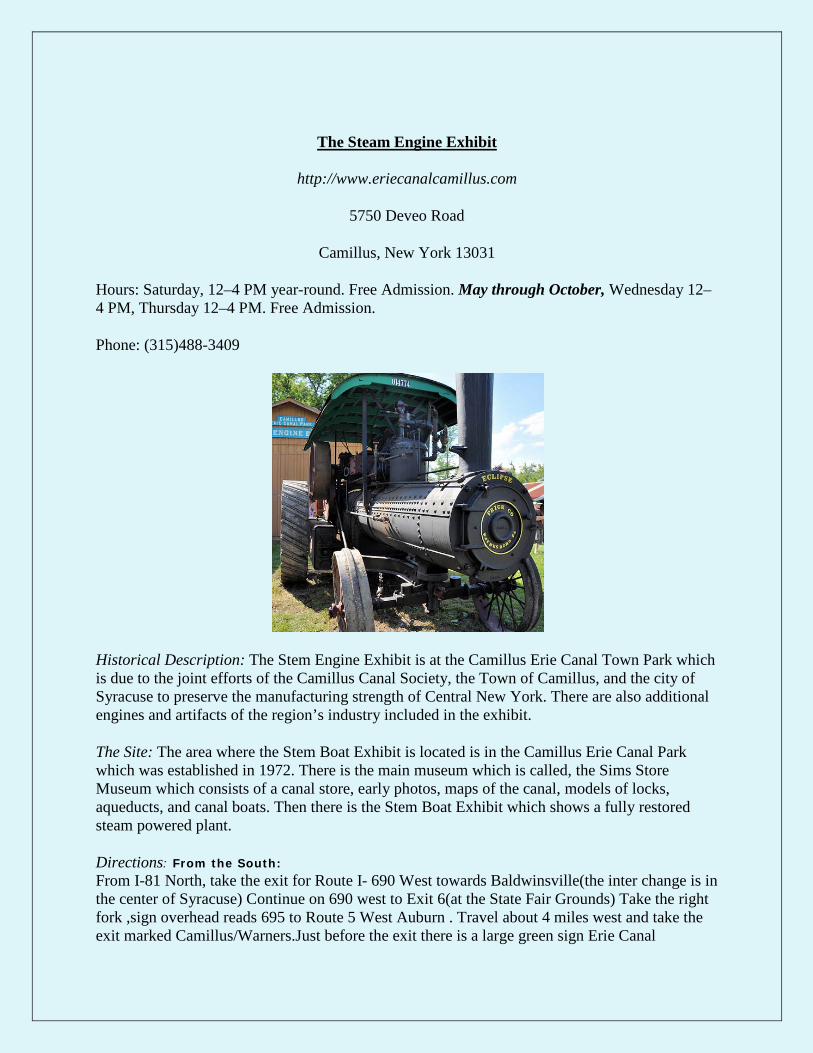
The Steam Engine Exhibit
http://www.eriecanalcamillus.com
5750 Deveo Road
Camillus, New York 13031
Hours: Saturday, 12–4 PM year-round. Free Admission. May through October, Wednesday 12–4 PM, Thursday 12–4 PM. Free Admission.
Phone: (315)488-3409
Historical Description: The Stem Engine Exhibit is at the Camillus Erie Canal Town Park which is due to the joint efforts of the Camillus Canal Society, the Town of Camillus, and the city of Syracuse to preserve the manufacturing strength of Central New York. There are also additional engines and artifacts of the region’s industry included in the exhibit.
The Site: The area where the Stem Boat Exhibit is located is in the Camillus Erie Canal Park which was established in 1972. There is the main museum which is called, the Sims Store Museum which consists of a canal store, early photos, maps of the canal, models of locks, aqueducts, and canal boats. Then there is the Stem Boat Exhibit which shows a fully restored steam powered plant.
Directions: From the South: From I-81 North, take the exit for Route I- 690 West towards Baldwinsville(the inter change is in the center of Syracuse) Continue on 690 west to Exit 6(at the State Fair Grounds) Take the right fork ,sign overhead reads 695 to Route 5 West Auburn . Travel about 4 miles west and take the exit marked Camillus/Warners.Just before the exit there is a large green sign Erie Canal
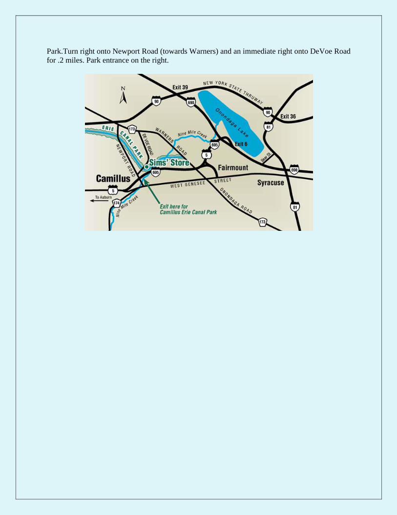
Park.Turn right onto Newport Road (towards Warners) and an immediate right onto DeVoe Road for .2 miles. Park entrance on the right.

Rome Erie Canal Village
http://www.eriecanalvillage.net
5789 Rome New London Road
(Routes 46 & 49) | Rome, New York 13440
Hours: Wednesday – Saturday 10:00 a.m. -5:00 p.m. Sunday noon- 5:00 p.m. (The village is closed Monday and Tuesday
Phone: 315-337-3999
Historical Description: The Erie Canal Village is an outdoor living history museum which reconstructs 19th century settlement which began July 4, 1817 when the construction of the original Erie Canal first started.
The Site: There are three museums which are on the site. The first is the Erie Canal Museum which shows the firs proposals for the canal which would create an improved route to the West. The Harden Museum is an exhibit which is a collection of horse drawn vehicles. There is lastly, the New York State Museum of Cheese building which once housed the Merry and Weeks cheese factory.
Directions: From Exit 33- Take Route 365 East to Route 49 West, From Exit 32- Take Route 233 North to Route 49 West, From Exit 31- Take Route 49 West

Chittenango Landing Canal Museum
http://www.chittenangolandingcanalboatmuseum.com
7010 Lakeport Road
Chittenango, NY 13037
Hours: May - June: Sat & Sun, 1 - 4 p.m. July - August: Daily, 10 a.m. - 4 p.m. September - October: Sat & Sun, 1 - 4 p.m.
Phone: (315) 687-3801
Historical Description: This area of Chittenango was on the Western frontier in 1817 when the canal construction began. The canal was complete in 1825 and expanded the region westward. The Erie Canal was very beneficial and had a great impact on the area. The growth of Upstate New York communities prospered and expanded the regions ability to trade to further markets with such items as, lumber, grain, and coal and raw materials.
The Site: This area has much to offer. There is a visitor center which everything is handicap accessible. There are adult and children educational programs.
Directions: NYS Thruway Exit 34 Rt. 13 (S) to Rt. 5, turn right (W) at traffic light, travel 6 miles to Chittenango, turn right (N) at traffic light on Lakeport Rd., Chittenango Landing Canal Museum 1/2 mile on left. NYS Thruway Exit 34A Rt. 481(S) to exit 3E, Rt. 5 east 10 miles to the village of Chittenango. Go north through traffic light on Lakeport Rd. Chittenango Landing Canal Museum is a ½ mile.

The Neversink Valley Museum of History and Innovation
http://www.neversinkmuseum.org
26 Hoag Road
Cuddebackville, New York 12729
Hours: April through October: Friday, Saturday, Sunday, noon to 4 p.m.
Phone: (845) 754-8870
Historical Description: This area is a private, non-profit organization which is historic due to its location. The location occupies the historic canal era buildings in the Delaware and Hudson Canal Park on the Neversink River. Much of the canal was built through the wilderness by only using picks, shovels, blasting powder and the manual labor of thousands of men. In the spring of 1826 there were 200 teams of horses and 2,500 men working on the canal between Cuddebackville and Kingston.
The Site: There are many field trips to this site where there are hands-on canal activities in full-size land-based canal boat replicas. Also there is a one-hour guided walk along the canal to see canal buildings. Another exhibition is the “Black Diamonds and the D&H Canal” which displayed a working canal lock model.
Directions: To get to Cuddebackville Orange County, New York: from Port Jervis, take Rt. 209 10 miles north or from Rt. 17 (the Quickway) take exit #113 and head 10 miles south. The Museum is located in the D&H Canal Park on Rt. 209. A good landmark is the beautiful green iron bridge over the Neversink River just south of the park.

The D&H Canal Historical Society and Museum
http://www.canalmuseum.org/
23 Mohonk Road PO Box 23
High Falls, NY 12440-0023
Hours: The Museum is open to the public from May through October on Saturdays and Sundays from 11:00 a.m. to 5:00 p.m.
Phone: (845) 687-9311
Historical Description: The D&H Canal Historical Society was established in 1966 to preserve and protect the history of the Delaware and Hudson Canal in Ulster County. The museum maintains the Five Locks Walk which is a national historic landmark. The 108-lock waterway carried anthracite coal from Pennsylvania mines to the Hudson River at Kingston, New York between 1828 and 1898.
The Site: The D&H Canal Museum exhibit includes the canal’s history, a working model of a lock, a life-sized recreated canal boar cabin, a moving model of a gravity railroad brake car, financial documents, and dioramas of the gravity railroad and canal life.
Directions: FROM NEW PALTZ (NYS Thruway exit 18): After toll booth turn left (west) at the light onto Route 299 (Main St.). Continue approximately 2 miles into the village of New Paltz and out of town over the Wallkill River. Take the first right after the Wallkill onto County Rte. 7-Springtown Road, go 1/2 mile and bear left at the fork onto County Rte. 6-Mountain Rest Road (follow the signs for Mohonk). This route will take you up over Mohonk Mountain and down the other side (about 5 miles). At the bottom of the mountain continue on the same road (County Rte. 6/Mohonk Road) for another 3 miles, heading into High Falls. The museum will be on the right, just before the intersection with Route 213