hudson-raritan estuary, liberty state park ecosystem ...
190
US ARMY CORPS OF ENGINEERS NEW YORK DISTRICT HUDSON-RARITAN ESTUARY, LIBERTY STATE PARK ECOSYSTEM RESTORATION INTEGRATED FEASIBILITY REPORT & ENVIRONMENTAL IMPACT STATEMENT Volume 1 October 2005
-
Upload
khangminh22 -
Category
Documents
-
view
1 -
download
0
Transcript of hudson-raritan estuary, liberty state park ecosystem ...
US ARMY CORPS OF ENGINEERS NEW YORK DISTRICT
HUDSON-RARITAN ESTUARY, LIBERTY STATE PARK ECOSYSTEM RESTORATION
INTEGRATED FEASIBILITY REPORT
& ENVIRONMENTAL IMPACT STATEMENT Volume 1
October 2005

Hudson-Raritan Estuary, Liberty State Park
Ecosystem Restoration
Integrated Feasibility Report & Environmental Impact Statement
Vol. 1: Main Report & Appendix A
New York District
U.S. Army Corps of Engineers In Partnership with
The Port Authority of New York and New Jersey
October 2005

Hudson-Raritan Estuary, Liberty State Park
Integrated Feasibility Report and Environmental Impact Statement
Foreword
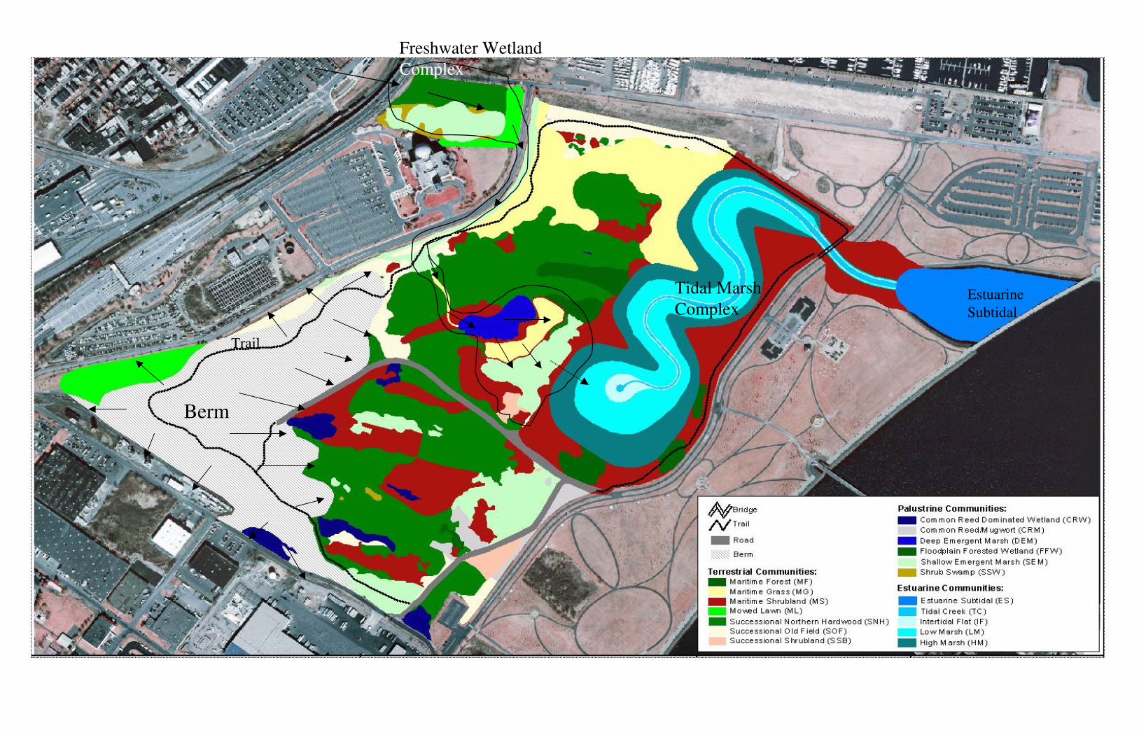
Liberty State Park is an extraordinary and unique public resource. With the Manhattan skyline, the Statue of Liberty and Ellis Island as a spectacular backdrop, it is also one of New Jersey's most dramatic parks. Liberty State Park is also an important first step of an ambitious restoration process for the Port District section of the Hudson-Raritan Estuary ecosystem restoration study, cost shared with the Port Authority of New York and New Jersey. The New Jersey Department of Environmental Protection (NJDEP) will be the construction cost sharing partner and has made invaluable contributions to the study of Liberty State Park. This foreword provides an overview of the recommended plan’s contributions to the region and the context of the planning process, beginning with the significance of Liberty State Park in the New York and New Jersey Harbor. The historic Central Railroad of New Jersey Terminal (CRRNJ), a grand setting for much of New Jersey's transportation history in the northeast, sits prominently at the north end of Liberty State Park. A two-mile promenade, Liberty Walk, links the picnic area to the Interpretive Center and the CRRNJ Terminal, while presenting visitors with a sweeping view of the Hudson River and Manhattan. Liberty Science Center, a popular attraction for students and families, is located in the park's western section.1 Together these amenities help visitors learn about the past, experience the natural resources of the present and look towards a future of stewardship. Liberty State Park was formerly the rail yards of the CRRNJ.2 After the bankruptcy of the CRRNJ in 1969, the local community advocated for the protection of the land and historic rail terminal. The State of New Jersey has spent the past 30 years acquiring the land, planning and building a park infrastructure that is suitable for public recreation and protecting the associated habitats. With approximately five million visitors annually, the park's development has been an extraordinary success. The restoration of the 234 acre interior section, currently fenced off and inaccessible, will provide substantial benefit to all 1,121 acres by linking previously developed and restored, but isolated, components of the park into one cohesive whole. The four components of the restoration project include the creation of approximately 46 acres of salt marsh, the creation and/or enhancement of approximately 26 acres of freshwater wetlands, the creation of approximately 50 acres warm weather grasslands and the enhancement of approximately 100 acres of urban successional northern hardwoods and maritime shrub assemblages (refer to diagrams 1-4).
Salt marshes, which once lined the harbor, were gradually eliminated during the industrial revolution. These endangered remnant pocket marshes exist primarily between piers throughout the harbor. They provide invaluable wildlife habitat in the center of the most densely populated area of the country. The creation of 46 acres of salt marsh at LSP will significantly enhance the ecological value of salt marshes in the harbor (diagram 1).
1 See Section 3.12, Recreation for more detail. 2 See Section 2, Site History for more detail.

One of the largest remaining marshes is within Liberty State Park, and has been included in New Jersey’s Natural Areas system. In addition, a four-acre wetland system has been created as mitigation for waterfront development at a property adjoining the park, and is functioning at a high level. These two sites provide excellent reference for the proposed salt marsh and will help to ensure the success of the project. Freshwater wetlands were eliminated from the Bayonne/Jersey City peninsula, long ago. In fact most of the New York metropolitan area had eliminated these wetlands to make way for development. The creation/enhancement of 26 acres of Freshwater wetland systems will help to restore this locally endangered habitat. The proposal calls for the creation of a series of three wetlands, one of which will provide for deepwater habitat, currently absent from the park (diagram 3). In addition, by regrading the southwest corner of the park with the material excavated from the proposed salt marsh, the watershed of the existing 23 acres of seasonally flooded wetlands will be significantly increased. The improved hydrology combined with minimal control of invasive exotic species will greatly enhance the ecological value of these wetlands (diagram 2).
The excavated material from the salt marsh will be used to create approximately 50 acres of warm weather grasslands in the southwest corner of the site. This use was determined to be the least cost disposal option for the excavated material. With the disappearance of agriculture from the area, and much of the state, this type of habitat is also considered threatened in New Jersey. The warm weather grasses will provide forage and breeding areas for many passerine and raptor species. They will enhance the potential for successful nesting of Circus cyaneus, a state listed species that has unsuccessfully nested in the park for the past several years. The remainder of the site, currently dominated by northern hardwood tree species and maritime shrubs assemblages, will be used as a demonstration urban forest. Its management will focus on assemblage development and the control of invasive species, especially portions closest to the tidal marsh and freshwater wetland that will act as protective buffers for these rare habitats. The urban forest is one of the largest contiguous areas of naturally established successional hardwoods in the metropolitan area. The restoration of maritime forest at this site will provide a unique opportunity for a long-term study of urban forestry, which is not part of the recommended plan, but may be pursued by other parties. Throughout the planning process, the study team was mindful of a Consent Decree (included as attachment B) issued by the United States District Court, District of New Jersey, in June 2000 on behalf of the Interfaith Community Organization, Inc. to the NJDEP. The Consent Decree describes problematic areas within Liberty State Park identified by the Interfaith Community Organization and outlines mutually acceptable solutions for these areas. It should be noted that although the Court Decree invokes Section 7002 (a)(1)(B) of RCRA, this is only in the context of giving the Federal Court jurisdiction to preside over the case and does not mean that this is a RCRA site. Exhibit A (which is figure 2 of the ESA) is the site plan and identifies the current uses of each section of the park. Chromium Site 15 to the south of Middle Cove and Chromium Site 17 to the south of the Industrial Park contain Hazardous, Toxic, and Radioactive Waste (HTRW) at levels high enough to trigger Federal action. The study team excluded these sites from the study area. As for the remainder of the site, particularly North Cove, Dredge Spoils Storage Area, and the Freight Yard, substances listed under CERCLA/RCRA are listed, but not

at high enough levels to require Federal action. Avoidance of this area was not possible during the course of plan formulation. The consent decree excludes any further action in these areas if the project recommended in this plan is constructed. The Consent Decree anticipates this restoration feasibility study, explicitly mentioning Army Corps of Engineers involvement in paragraphs 25 to 27 of the text. In brief, if construction of a salt marsh or other desirable habitat in the dredge materials area does not begin by December 31, 2007, NJDEP must place a one-foot cap of clean fill on the area, beyond the one-foot cap already present. The capping measure is a secondary alternative, to be enacted only if the Corps of Engineers finds the restoration project is not feasible. Federal analysis of the site found a restoration alternative that is feasible, provides substantial ecological benefits, and is fortunately in compliance with the requirements of the Consent Decree. Another point to clarify is that Federal participation in restoration of Liberty State Park does not relieve NJDEP of a legal obligation to clean up the site because there is no non-Federal legal responsibility unless the Corps decides not to proceed with the restoration, and construction does not begin before December 31, 2007. In effect, the Consent Decree encourages restoration of the study area. If the State were to place the one foot cap required if the restoration project does not advance, and the restoration project does move foreword after such local action, then there would be a substantial increase in overall cost a this additional one foot of material would have be removed for implementation of the restoration project. Finally, it should be noted that the busy industrial history of New York Harbor has left its imprint throughout the region in the ubiquitous nature of contaminants in the water and land. No part of the New York and New Jersey metropolitan area can be considered pristine, which is why restoration efforts are so vital here. We are confident that the recommended salt marsh will succeed because there are two nearby existing salt marshes functioning well. Lastly, with over five million visitors per year, two educational facilities, and existing relationships with several universities, Liberty State Park provides an unparalleled forum for the study and enjoyment of public open space. The proposed project will undoubtedly receive national attention and could be used as a model for the integration and maintenance of diverse habitat structure in an urban context.

Diagram 1 – Tidal Complex
Least -cost environmentally acceptable placement site

Diagram 2 – Tidal and Related Upland Buffer. The light green and blue shapes out of the tidal creek system denote seasonal wetlands that would benefit from the increased water flow provided by the berm in yellow.
Enhanced Wetlands
Run-Off

Diagram 3 – Recommended Plan Features. The colored shapes mark the actual extent of the construction in the recommended plan. Diagram 4, which depicts the recommended plan in conjunction with existing habitats that will remain with implementation of the plan, is on the following page.
LSC Wetland
No Action Planned
Here
Wetland Creation
Infiltration Basin
Trail
Berm
Freshwater Wetland
Complex
Estuarine
Subtidal
Tidal Marsh
Complex

Hudson-Raritan Estuary, Liberty State Park Ecosystem Restoration Study
TABLE OF CONTENTS Table of Contents............................................................................................................................. i List of Figures ................................................................................................................................. v List of Tables ................................................................................................................................. vi List of Study Members and Report Preparers............................................................................... vii List of Interagency Study Team Members................................................................................... viii Glossary of Terms, Acronyms, and Abbreviations........................................................................ ix Executive Summary ...................................................................................................................... xii Pertinent Data................................................................................................................................ xv 1. INTRODUCTION ..................................................................................................................... 1
1.1 Study Authority................................................................................................................. 1 1.2 Study Purpose and Need ................................................................................................... 2 1.3 Study Scope ...................................................................................................................... 3 1.4 Report Organization.......................................................................................................... 3 1.5 Study Area ........................................................................................................................ 5 1.6 National Environmental Policy Act Requirements........................................................... 5 1.7 Study Process .................................................................................................................... 6 1.8 Existing Projects ............................................................................................................... 6 1.9 Prior Studies and Reports.................................................................................................. 8
2. SITE HISTORY....................................................................................................................... 13 3. EXISTING CONDITIONS....................................................................................................... 17
3.1 Physical Setting............................................................................................................... 17 3.1.1 Geology.................................................................................................................... 19 3.1.2 Topography.............................................................................................................. 21 3.1.3 Soils.......................................................................................................................... 21
3.2 Climate............................................................................................................................ 23 3.3 Water Resources ............................................................................................................. 24
3.3.1 Surface Waters ......................................................................................................... 24 3.3.2 Water Quality........................................................................................................... 27 3.3.3 Regional Hydrogeology and Groundwater .............................................................. 27
3.4 Socioeconomic Conditions ............................................................................................. 29 3.4.1 Population ................................................................................................................ 29 3.4.2 Economy, Employment and Income........................................................................ 29
3.5 Cultural Resources .......................................................................................................... 30 3.6 Land Use ......................................................................................................................... 31
3.6.1 Land Use in Jersey City ........................................................................................... 31 3.6.2 Coastal Zone Management ...................................................................................... 31
3.7 Biological Resources ...................................................................................................... 32 3.7.1 Vegetation ................................................................................................................ 33
3.7.1.1. Terrestrial Vegetation ...................................................................................... 33
Integrated Feasibility Report & Environmental Impact Statement i

Hudson-Raritan Estuary, Liberty State Park Ecosystem Restoration Study
3.7.1.2 Wetland Vegetation .......................................................................................... 38 3.7.1.3 Invasive Vegetation .......................................................................................... 41 3.7.1.4 Regulated Wetlands .......................................................................................... 42
3.7.2 Fish and Wildlife Resources .................................................................................... 43 3.7.2.1 Amphibians and Reptiles .................................................................................. 43 3.7.2.2 Birds.................................................................................................................. 44 3.7.2.3 Mammals .......................................................................................................... 46 3.7.2.4 Threatened and Endangered Species (TES)...................................................... 46 3.7.2.5 Benthic invertebrates ........................................................................................ 47 3.7.2.6 Fish.................................................................................................................... 48 3.7.2.7 Essential Fish Habitat ....................................................................................... 50
3.8 Air Quality ...................................................................................................................... 50 3.9 Noise ............................................................................................................................... 50 3.10 Recreation ..................................................................................................................... 51 3.11 Aesthetics...................................................................................................................... 51 3.12 HTRW........................................................................................................................... 51 3.13 Transportation and Other Infrastructure ....................................................................... 55
4. FUTURE WITHOUT-PROJECT CONDITION..................................................................... 55
4.1 Study Area Conditions that are Unlikely to Change....................................................... 57 4.2 Study Area Conditions that are Likely to Change .......................................................... 57
5. PURPOSE OF AND NEED FOR PROPOSED ACTION / PROBLEMS AND OPPORTUNITIES........................................................................................................................ 58
5.1 Problems and Opportunities............................................................................................ 58 5.2 Planning Objectives, Constraints, and Key Assumptions............................................... 58
5.2.1 Planning Objectives ................................................................................................. 58 5.2.2 Planning Evaluation Criteria.................................................................................... 59
5.2.2.1 Engineering Criteria.......................................................................................... 59 5.2.2.2 Economic Criteria ............................................................................................. 59 5.2.2.3 Environmental Criteria ..................................................................................... 59
5.2.3 Planning Constraints ................................................................................................ 61 5.2.3 Public Concerns ....................................................................................................... 61
6. ALTERNATIVES INCLUDING PROPOSED ACTION / PLAN FORMULATION AND EVALUATION............................................................................................................................. 62
6.1 Identification of Alternative Plans .................................................................................. 62 6.1.1 No Action Alternative.............................................................................................. 62 6.1.2 Alternative Ecosystem Restoration Measures ......................................................... 62
6.1.2.1 Restoration Areas.............................................................................................. 62 6.1.2.2 Potential Restoration Measures ........................................................................ 63
6.2 Screening of Alternative Plans........................................................................................ 65 6.2.1. Derivation of Restoration Benefits and Costs......................................................... 65 6.2.2. Screening of Plans................................................................................................... 68
6.3 Plan Evaluation and Comparison.................................................................................... 71
Integrated Feasibility Report & Environmental Impact Statement ii

Hudson-Raritan Estuary, Liberty State Park Ecosystem Restoration Study
6.3.1 Cost Effectiveness and Incremental Cost Analysis of Restoration Plans ................ 71 6.3.2 Combinable Management Measures........................................................................ 72 6.3.3 Outputs and Costs of Combinations ........................................................................ 72 6.3.4 Elimination of Economically Inefficient Solutions ................................................. 74 6.3.5 Elimination of Economically Ineffective Solutions................................................. 75 6.3.6 Cost Effective and Least Cost Solutions.................................................................. 75 6.3.7 Average Costs of Remaining Alternatives............................................................... 78 6.3.8 Recalculation of Average Costs for Additional Levels of Output ........................... 79 6.3.9 Incremental Cost Analysis and Pair-wise Comparison of Successive Outputs ....... 83 6.3.9 Summary of Conclusions......................................................................................... 84
6.4 Selected NER Plan.......................................................................................................... 85 6.4.1 Tidal Marsh.............................................................................................................. 87 6.4.2 Fresh Water Marsh................................................................................................... 90 6.4.3 Upland Buffer and Seasonal Wetlands .................................................................... 99
7. ENVIRONMENTAL CONSEQUENCES ............................................................................ 101
7.1 Environmental Effects of Restoration Measures .......................................................... 101 7.1.1 Physical Setting...................................................................................................... 104 7.1.2 Climate and Weather.............................................................................................. 104 7.1.3 Water Resources .................................................................................................... 104 7.1.5 Cultural and Historic Resources ............................................................................ 105 7.1.6 Land Use ................................................................................................................ 106 7.1.7 Biological Resources ............................................................................................. 106
7.1.7.1 Vegetation....................................................................................................... 106 7.1.7.2 Fish and Wildlife Resources ........................................................................... 106 7.1.7.3 Threatened and Endangered Species .............................................................. 108
7.1.8 Air Quality ............................................................................................................. 108 7.1.9 Noise ...................................................................................................................... 108 7.1.10 Recreation ............................................................................................................ 109 7.1.11 Aesthetics............................................................................................................. 109 7.1.12 HTRW.................................................................................................................. 110 7.1.13 Transportation and Other Infrastructure .............................................................. 111
7.2 Environmental Justice Summary .................................................................................. 111 7.3 Relationship Between Short Term Uses and Long Term Productivity......................... 111 7.4 Irreversible and Irretrievable Commitments of Resources ........................................... 112 7.5 Unavoidable Adverse Effects and Considerations that Offset Adverse Effects ........... 113 7.6 Cumulative Impacts ...................................................................................................... 114
8. RECOMMENDED PLAN..................................................................................................... 116
8.1 Ecosystem Restoration.................................................................................................. 116 8.2 Real Estate .................................................................................................................... 116
Integrated Feasibility Report & Environmental Impact Statement iii

Hudson-Raritan Estuary, Liberty State Park Ecosystem Restoration Study
8.3 Ecological Monitoring and Adaptive Management ...................................................... 117 8.4 Cost Estimate ................................................................................................................ 117
9. PLAN IMPLEMENTATION ................................................................................................ 118
9.1 General.......................................................................................................................... 118 9.2 Local Cooperation......................................................................................................... 118 9.3 Cost Apportionment...................................................................................................... 121 9.4 Pre-Construction Engineering and Design Cost Sharing.............................................. 122 9.5 Construction Schedule .................................................................................................. 123 9.6 Financial Analysis......................................................................................................... 123 9.7 Views of Non-Federal Partners and Other Agencies.................................................... 123 9.8 Major Conclusions and Findings .................................................................................. 125 9.9 Areas of Concern .......................................................................................................... 127
10. PUBLIC INVOLVEMENT .................................................................................................. 127 11. COMPLIANCE WITH ENVIRONMENTAL REQUIREMENTS...................................... 128 12. RECOMMENDATIONS...................................................................................................... 131 13. REFERENCES ..................................................................................................................... 133
Integrated Feasibility Report & Environmental Impact Statement iv

Hudson-Raritan Estuary, Liberty State Park Ecosystem Restoration Study
LIST OF FIGURES Number Title Page 1.1 Location Map of Hudson-Raritan Estuary (HRE) 4 1.2 Location Map of Liberty State Park (LSP) 7 1.3 Active Ecosystem Restoration Projects in HRE 10 2.1 LSP/Communipaw Cove Prior to Filling 14 2.2 Filling of Communipaw Cove 1880-1916 15 3.1 New Jersey Geologic Provinces 20 3.2 LSP Topographic/Bathymetric Maps overview 22 3.3 Storm Surges at the Battery, NY 26 3.4 LSP Groundwater Flow Direction 28 3.5 LSP Groundwater Contour 28 3.6 Existing Vegetative Communities 34 3.7 Invasive Species 42 3.8 Regulated Wetlands 43 3.9 2003 Geotechnical and HTRW sampling locations 54 3.10 2004 Geotechnical and HTRW sampling locations 54 6.1 Outputs and Costs of All Solutions 73 6.2 Cost Effective and Least Cost Solutions 78 6.3 Average Costs of Remaining Solutions 79 6.4 Liberty State Park Recommended Plan 86 6.5 LSP Benchmarking and Tidal Datums 88 6.6 LSP Salt Marsh Profile 88 6.7 Freshwater Alternative Plan D with Adjacent Wetlands 93 6.8 Liberty Science Wetland, Plan View 94 6.9 Liberty Science Wetland, Profile View 95 6.10 Biofilter, Plan View 95 6.11 Biofilter, Profile View 96 6.12 Deepwater Emergent Marsh, Plan View 97 6.13 Deepwater Emergent Marsh, Profile View 97 6.14 Infiltration Basin, Plan View 98 6.15 Infiltration Basin, Profile View 99 9.1 Preliminary LSP Construction Schedule 124
Integrated Feasibility Report & Environmental Impact Statement v

Hudson-Raritan Estuary, Liberty State Park Ecosystem Restoration Study
LIST OF TABLES Number Title Page
1.1 Active Ecosystem Restoration Projects in HRE 11 3.1 LSP Water Level Observations, Summer and Fall 2003 25 3.2 LSP Terrestrial Communities 35 3.3 LSP Wetland Communities 39 6A Example Evaluation with Synergistic Interactions 67 6.1 Outputs and Costs of Management Measure Increments 71 6.2 Ability to Combine Management Measures 72 6.3 Outputs and Costs of Combinations 74 6.4 Elimination of Economically Ineffective Solutions 75 6.5 Cost Effective and Least Cost Solutions 76 6.6a Average Costs of Each Level of Output 80 6.6b Average Cost for Additional Output, First Recalculation 81 6.6c Average Cost for Additional Output, Second Recalculation 82 6.6d Average Cost for Additional Output, Third Recalculation 82 6.6e Summary of Average Cost per Additional Habitat Output Calculations 83 6.7 Incremental Costs for Solutions with Lowest Average Cost for Additional Output 84 8.1 Ecosystem Restoration Acreages 116 8.2 Real Estate Project Costs 116 9.1 Total First Cost of LSP Recommended Plan 121 9.2 Total Annual Cost of LSP Recommended Plan 122 9.3 Costs Apportionment 122
Integrated Feasibility Report & Environmental Impact Statement vi

Hudson-Raritan Estuary, Liberty State Park Ecosystem Restoration Study
APPENDICES A Study Correspondence B Environmental Compliance & Coordination C Cultural Resources D Real Estate E Engineering F Cost Estimate
LIST OF STUDY MEMBERS AND REPORT PREPARERS The following individuals were primarily responsible for the preparation of this integrated feasibility report and environmental impact statement.
Individual ResponsibilityOlivia Ng Cackler Project Planner Robert J. Will Biologist; National Environmental Policy Act Mark F. Lulka Project Manager William P. Shadel Restoration Biologist Marty Goff Engineering Specialist Kerry Anne Donohue Couch Bethany McClanahan
Project Engineer Coastal & Hydraulics
Kristen Van Horn Geotechnical Specialist Daniel Kriesant Hydrology & Hydraulics Emily Eng Cost Engineering Naomi R. Fraenkel Economics Lynn Rakos Cultural Resources Richard P. Dabal Hazardous, Toxic, and Radioactive Waste Robert A. Hass Stanley Nuremberg Paul Sabalis Roselle Henn
Real Estate Real Estate Review & Policy Review & Policy
Integrated Feasibility Report & Environmental Impact Statement vii
Hudson-Raritan Estuary, Liberty State Park Ecosystem Restoration Study
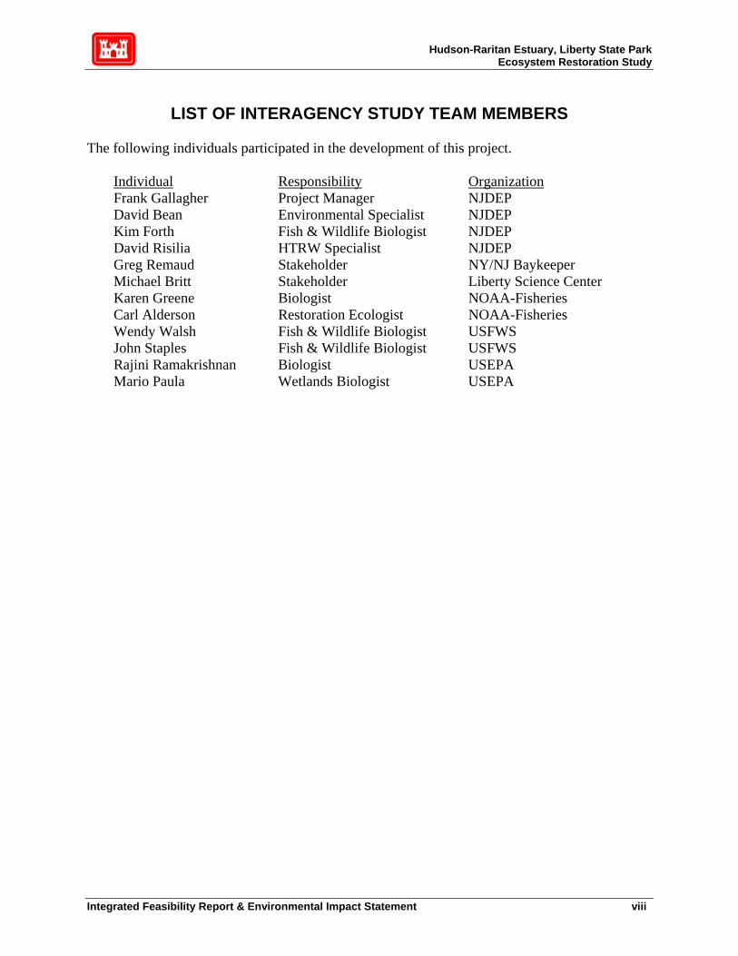
LIST OF INTERAGENCY STUDY TEAM MEMBERS
The following individuals participated in the development of this project.
Individual Responsibility OrganizationFrank Gallagher Project Manager NJDEP David Bean Environmental Specialist NJDEP Kim Forth Fish & Wildlife Biologist NJDEP David Risilia HTRW Specialist NJDEP Greg Remaud Stakeholder NY/NJ Baykeeper Michael Britt Stakeholder Liberty Science Center Karen Greene Biologist NOAA-Fisheries Carl Alderson Restoration Ecologist NOAA-Fisheries Wendy Walsh Fish & Wildlife Biologist USFWS John Staples Fish & Wildlife Biologist USFWS Rajini Ramakrishnan Biologist USEPA Mario Paula Wetlands Biologist USEPA
Integrated Feasibility Report & Environmental Impact Statement viii

Hudson-Raritan Estuary, Liberty State Park Ecosystem Restoration Study
GLOSSARY OF TERMS, ACRONYMS, AND ABBREVIATIONS
ABN AQ
Acid Base Neutral Air Quality
AF Alternatives Formulation BMP C&D CCMP
Best Management Practice Construction & Demolition Debris Comprehensive Conservation and Management Plan (NYNJHEP)
CCPW cm CRIP
Chromate Chemical Production Waste Centimeter(s) Comprehensive Restoration Implementation Plan (HREERP)
CRM CRW CSO CZMA
Common Reed/Mugwort (terrestrial) Common Reed-dominated Wetland (palustrine) Combined Sewer Outfall Coastal Zone Management Act
DDT DEM District DM
Dichloro Diphenyl Trichlorethane Deep Emergent Marsh (palustrine) New York District (USACE) Dredged Material
DO Dissolved Oxygen EA Environmental Assessment EFH Essential Fish Habitat EIS Environmental Impact Statement ER ERI ER-M ES ESA FCSA
Effects Range Environmental Resources Inventory Effects Range-Median Estuarine Subtidal (estuarine) Endangered Species Act Financial Cost Sharing Agreement
FFW FR
Floodplain Forest Wetland (palustrine) Feasibility Report
FS Feasibility Study FW Fresh Water GIS Geographic Information System GPS Global Positioning System H&H Hydrology and Hydraulics HD Hydrodynamic HRE Hudson-Raritan Estuary HREERP Hudson-Raritan Estuary Ecosystem Restoration Project HTRW Hazardous, Toxic and Radioactive Waste EFU Ecological Functional Unit IC ICA
LSP Interpretive Center Incremental Cost Analysis
IDC Interest During Construction IR Integrated Report (Feasibility Report + NEPA document)
Integrated Feasibility Report & Environmental Impact Statement ix

Hudson-Raritan Estuary, Liberty State Park Ecosystem Restoration Study
IWR Institute for Water Resources JCSA JD LOI
Jersey City Sewerage Authority Jurisdictional Delineation (wetlands) Letter of Interpretation
LSC LSP LVRR
Liberty Science Center Liberty State Park Lehigh Valley Railroad
MAFMC m mg/L
Mid-Atlantic Fisheries Management Council Meter(s) Milligrams per liter (ppm)
MHHW Mean Higher High Water MHW Mean High Water ML MLLW
Mowed Lawn (terrestrial) Mean Lower Low Water
MLW Mean Low Water MS MSL
Maritime Shrubland (terrestrial) Mean Sea Level
NAVD North American Vertical Datum NAWMP NEP NEPA
North American Waterfowl Management Plan National Estuary Program National Environmental Policy Act
NER NHP NJAC NJDEP
National Ecosystem Restoration National Heritage Program New Jersey Administrative Code New Jersey Department of Environmental Protection
NJDOT New Jersey Department of Transportation NJNHP New Jersey Natural Heritage Program NJSHPO New Jersey State Historic Preservation Office NMFS National Marine Fisheries Service NOAA National Oceanic and Atmospheric Administration NPS National Park Service NRCS NRDCSCC NYNJHEP
Natural Resources Conservation Service (NJDEP) Non-Residential Direct Contact Soil Cleanup Criteria New York New Jersey Harbor Estuary Program
OSHA PAH P&S
Occupational Safety & Health Administration Polynuclear Aromatic Hydrocarbon Plans and Specifications
PCB Phragmites ppm PED
Polychlorinated Biphenyl Common reed (Phragmites australis) Parts per million Pre-Construction Engineering and Design
Ppb Parts per billion Ppt Parts per thousand QA/QC RE
Quality Assurance/Quality Control Real Estate
SCC NJDEP Soil Cleanup Criteria
Integrated Feasibility Report & Environmental Impact Statement x

Hudson-Raritan Estuary, Liberty State Park Ecosystem Restoration Study
SCS SEM SM SNH SOD SOF SSB SSW STP SVOA T&E
Soil Conservation Service Shallow Emergent Marsh (palustrine) Salt Marsh (estuarine) Successional Northern Hardwood (terrestrial) Sediment Oxygen Demand Successional Old Field (terrestrial) Successional Shrubland (terrestrial) Shrub Swamp (palustrine) Sewage Treatment Plant Semi-Volatile Organic Threatened and Endangered (species)
TCL TPHC USACE
Target Compound List (USEPA) Total Petroleum Hydrocarbons United States Army Corps of Engineers
USDA USDOI USEPA
United States Department of Agriculture United States Department of the Interior United States Environmental Protection Agency
USFWS United States Fish and Wildlife Service VOAWQ WRDA
Volatile Organic Water Quality Water Resources and Development Act
Integrated Feasibility Report & Environmental Impact Statement xi

Hudson-Raritan Estuary, Liberty State Park Ecosystem Restoration Study
EXECUTIVE SUMMARY New York District has completed this Integrated Feasibility Report/Environmental Impact Statement (FR/EIS) for the Liberty State Park Ecosystem Restoration Project in accordance with the Principles and Guidelines adopted by the Water Resources Council and the requirements of the National Environmental Policy Act (NEPA) to assess the need for modifying the existing degraded habitat, to evaluate the effects of the restoration activities, to determine a solution that maximizes environmental benefits while minimizing economic costs, and to assess the environmental impacts of the restoration alternatives. The purpose of the project is to address the adverse impacts associated with past filling activities on the project site, with the overall purpose of improving the environmental quality of the area. This area was altered due to past fill activities and is consequently less productive than the pre-existing ecosystem habitat. The site is dominated by invasive species, which are expected to expand and overwhelm the various vegetative habitats on site without the implementation of ecological management measures described in the plan recommended in this report. Liberty State Park (LSP) is part of the Hudson-Raritan Estuary (HRE) Ecosystem Restoration Feasibility Study being carried out under the U.S. Army Corps of Engineers General Investigations Program. This feasibility study was authorized in a resolution of the Committee on Transportation and Infrastructure of the U.S. House of Representatives, dated 15 April 1999, which reads in part, “Resolved by the Committee on Transportation and Infrastructure of the United States House of Representatives, That, the Secretary of the Army (the U.S. Army Corps of Engineers) is requested to……..(determine) the feasibility of environmental restoration and protection relating to water resources and sediment quality within the New York and New Jersey Port District (much of the lower Hudson Raritan Estuary), including but not limited to creation, enhancement and restoration of aquatic, wetland and adjacent upland habitats.” The LSP project marks an interim response to the HRE study authority and is the first implementation level of the goals of the HRE Comprehensive Restoration Implementation Plan as defined in the Needs and Opportunities Report. The proposed LSP restoration project is located in Jersey City, Hudson County, New Jersey, on the western side of Upper New York Bay. It is located directly on the waterfront across the Upper Bay from lower Manhattan and adjacent to the Statue of Liberty and Ellis Island. The proposed project area is approximately 234 acres of mostly undeveloped semi-degraded parkland within a fenced-off portion of Liberty State Park’s 598 terrestrial acres. Liberty State Park has an additional 523 tidal acres, for a total of 1,121 acres. The park itself is bounded by residential and commercial neighborhoods to the west, by the Morris Canal to the north, by the Upper Bay to the east and by the “Black Tom” cove to the south. Numerous surveys, studies, and extensive literature surveys have been conducted to establish necessary baseline information to identify resource shortcomings and potential restoration options. The results of these surveys are presented in the Environmental Resources Inventory (ERI), located in the Environmental Appendix. The results indicate strong opportunities for increasing habitat functionality at this site. Implementation of the plan recommended in this
Integrated Feasibility Report & Environmental Impact Statement xii

Hudson-Raritan Estuary, Liberty State Park Ecosystem Restoration Study
report is expected to increase and restore more sustainable desirable communities, provide more cover, nesting, and breeding habitat for wildlife, and increase species richness. Technical screening analysis was performed throughout the project development stages for each of three implementation phases of the proposed project: tidal marsh, fresh water wetlands and terrestrial habitat. For the tidal marsh, a variety of configurations were proposed for consideration, including a single-inlet creek entering the terrestrial portion of LSP at North Cove, a continuous tidal loop entering the terrestrial portions at North Cove and returning to Upper Bay at the former Middle Cove, and an island in the middle of the creek. The single-inlet creek was determined to be the most efficient solution, meeting engineering, technical, and biological requirements. Subsequently, the shape, width and length of the proposed tidal channel, and its associated intertidal flats, low marsh and high marsh habitat were refined through hydrologic modeling. The tidal channel is designed to maximize functional habitat value of the proposed tidal marsh area by increasing the tidal range, and regular tidal flooding and drainage through the maximum area available. For the fresh water wetland phase, four separate plans were technically analyzed, each delivering different amounts of acceptable quality fresh water to the target area in the central portion of the interior of the site. The selected freshwater plan provides the most amount of water for habitat creation and enhancement without expensive and high-maintenance mechanical pumping from already stressed municipal water supplies. The recommended plan incorporates a self-maintaining gravity-based system for supplying adequate quality water. This water-delivery system obtains additional water from the NJ Transit parking area, which is then filtered in an enhanced wetland area adjacent to the Liberty Science Center (LSC). The levels of the LSC wetland are controlled by a self-adjusting weir, which directs water through a diversion pipe underneath Phillip Street to an additional Phragmites australis dominated bio-filter wetland. This bio-filter wetland removes remaining suspended sediment, potential toxicants, and unwanted nutrients. From the bio-filter, a created swale will deliver the substantially enhanced volume and quality of water to a created permanent deep-water emergent marsh. The deep marsh will provide fish, reptile, and other habitat not currently found in Liberty State Park. During high-flow periods, excess water will drain out of the deep-emergent marsh into an infiltration basin, in effect creating an additional, periodically flooded wetland. The high permeability of the infiltration basin soil will allow water to penetrate underlying groundwater sources, in turn feeding an existing jurisdictional freshwater wetland. The third phase of this restoration project involves improving ecological functional value on the remaining terrestrial portions of the site. Measures include the selective removal of invasive species and other undesirable vegetation. If monitoring indicates that further measures are necessary, the District will consider addition of topsoil and/or sand to selected areas to discourage unwanted vegetation, and promotion of native vegetation through replanting and/or seeding. A berm is planned for the southwestern portion of the site to protect and help isolate the habitat from outside influences. This berm will be created by using soil excavated from the proposed tidal marsh area. This soil, and any industrial residue it contains, will be completely encapsulated within the berm. The berm will act as an isolation barrier for sensitive species and add topographical relief to a relatively flat site. Most terrestrial habitats will be maintained in the same vegetative community type, while simultaneously controlling invasive species and
Integrated Feasibility Report & Environmental Impact Statement xiii

Hudson-Raritan Estuary, Liberty State Park Ecosystem Restoration Study
encouraging native species. Thus, a mosaic of high-functional value terrestrial habitat will be established including hardwood and maritime forest, scrub-shrub, maritime grassland and old field. Where possible, grassland habitat to be enhanced will be contiguous to enhance feeding areas for raptors and isolation for ground nesting birds. The functional integrity of the existing forested areas will be maintained and enhanced. The District’s National Ecosystem Restoration (NER) plan will result in a significant increase in wildlife habitat value and diversity and estuarine functional value when compared to existing habitat. The NER plan will increase the availability of cover, foraging, nesting and breeding habitat for State threatened and endangered species; restore USEPA designated priority wetlands (e.g., salt marsh); improve water quality; increase the value and availability of spawning and nursery habitat for anadromous fish species; enhance wetland habitat for migratory waterfowl; assist in the enhancement of wildlife habitat corridors; and increase aesthetics and opportunities for passive recreation; and promote science education. In addition the NER plan will meet the multi-jurisdictional, interagency goals and objectives for many programs including the National Estuary Act, the Administration’s net wetland increase policy, the joint Corps-NOAA wetland restoration Memorandum of Understanding, and local stakeholders through synergy on an institutional, public and technical level, using the most cost-effective methods. For further information, please contact: Olivia Ng Cackler, Project Planner U.S. Army Corps of Engineers, New York District Planning Division, Plan Formulation Branch 26 Federal Plaza New York, NY 10278-0090 ATTN: CENAN-PL-F PHONE: 917-790-8705 FAX: 212-264-6040 [email protected] http://www.nan.usace.army.mil Robert J. Will, Project Biologist and NEPA Coordinator Army Corps of Engineers, New York District Planning Division, Environmental Assessment Branch 26 Federal Plaza New York, NY 10278-0090 ATTN: CENAN-PL-E PHONE: 917-790-8635 FAX: 212-264-0961 [email protected] http://www.nan.usace.army.mil
Integrated Feasibility Report & Environmental Impact Statement xiv

Hudson-Raritan Estuary, Liberty State Park Ecosystem Restoration Study
PERTINENT DATA DESCRIPTION The identified plan provides for ecosystem restoration in Liberty State Park, Hudson-Raritan Estuary. LOCATION Jersey City, Hudson County, New Jersey. REAL ESTATE REQUIREMENTS There are no real estate requirements because the prospective implementation non-Federal sponsor, the New Jersey Department of Environmental Protection, owns the project area. ECOSYSTEM RESTORATION Direct Project Area 234 acres
Habitat Restored/Created: Tidal Marsh (High Marsh and Low Marsh) 32 ac Berm (ancillary component to tidal marsh) 50 ac Tidal Creek, Estuarine Subtidal, and Mudflat 14 ac Freshwater Wetland (Deep and Shallow Emergent Marsh) 26 ac
Related upland buffers and improved seasonal wetlands 112 ac Indirect benefits will extend to the Hudson-Raritan Estuary study area (about 500 square miles). ECONOMICS (October 2004 price levels) Initial Project Cost $32,226,850 Annual Initial Cost (Discounted at 5.375 % over a 50-year period) $ 1,868,532 Annual IDC Cost $ 111,926
Annual O&M Costs $ 161,134 Annual Monitoring Cost $ 8,299
Total Annual Cost (Discounted at 5.375 % over a 50-year period) $ 2,149,891 COST APPORTIONMENT
Federal Share (65%) Non-Federal Share (35%) TOTAL
Total Project Initial Project Costs $20,947,450 $11,279,400 $32,226,850 Real Estate Costs* $ 30,000 $ 30,000 Cash Contribution $20,947,450 $11,249,400 $32,196850 O&M Costs $ 161,100 $ 161,100
* Applicable to required non-Federal cash contribution.
Integrated Feasibility Report & Environmental Impact Statement xv

Hudson-Raritan Estuary, Liberty State Park Ecosystem Restoration Study
LIBERTY STATE PARK, HUDSON-RARITAN ESTUARY ECOSYSTEM RESTORATION
INTEGRATED FEASIBILITY REPORT &
ENVIRONMENTAL IMPACT STATEMENT 1. INTRODUCTION This integrated Feasibility Report and Environmental Impact Statement (FR/EIS) investigates the feasibility and environmental impacts of alternative plans to address problems and opportunities associated with ecosystem restoration in Liberty State Park, Hudson-Raritan Estuary.1 This FR/EIS has been prepared by the New York District of the U.S. Army Corps of Engineers (Corps) under the General Investigations Program of the Corps. The Port Authority of New York and New Jersey (PANYNJ) is the non-Federal partner for this study. The New Jersey Department of Environmental Protection (NJDEP) is the prospective non-Federal partner for project implementation and has played a prominent role in the planning process.
1.1 Study Authority Liberty State Park is part of the Hudson-Raritan Estuary Environmental Restoration Study being carried out under the U.S. Army Corps of Engineers’ General Investigations Program. The study was authorized by a resolution of the Committee on Transportation and Infrastructure of the U.S. House of Representatives, dated 15 April 1999, Docket 2596, which reads:
Resolved by the Committee on Transportation and Infrastructure of the United States House of Representatives, That, the Secretary of the Army is requested to review the reports of the Chief of Engineers on the New York and New Jersey Channels, published as House Document 133, 74th Congress, 1st Session; the New York and New Jersey Harbor Entrance Channels and Anchorage Areas, published as Senate Document 45, 84th Congress, 1st Session; and the New York Harbor, NY Anchorage Channel, published as House Document 18, 71st Congress, 2nd Session, as well as other related reports with a view to determining the feasibility of environmental restoration and protection relating to water resources and sediment quality within the New York and New Jersey Port District, including but not limited to creation, enhancement, and restoration of aquatic, wetland, and adjacent upland habitats.
The Liberty State Park (LSP) Integrated Feasibility Report/ Environmental Impact Statement is an interim response to the study authority noted above. Its purpose, as stated in the HRE §905(b) Reconnaissance Report (NYD, 2000), is to advance restoration of the estuary and provide both a
1 The recommendation to integrate the FR and the EIS can be found in Engineering Regulation 1105-2-100, Appendix G, paragraph 10.
Integrated Feasibility Report & Environmental Impact Statement 1
Hudson-Raritan Estuary, Liberty State Park Ecosystem Restoration Study
springboard and model on which to develop the overall restoration plan, known as the Comprehensive Restoration Implementation Plan (CRIP). As such, reconnaissance phase recommendations for LSP have been drawn primarily from the overall HRE §905(b) Reconnaissance Report Analysis. The HRE Reconnaissance Report of 2000 identified site-specific water resource problems as well as regional water resource problems. These sites can be categorized into seven degraded habitat types: 1) inter-tidal wetlands/mudflats, 2) freshwater wetlands/riparian habitat, 3) benthic habitat, 4) shallow water habitat, 5) shoreline/coastal habitat, 6) fish habitat, and 7) shellfish habitat. Local project partners also identified continuous ecosystem degradation problems such as fragmentation of past restoration efforts in the estuary, impacts of infrastructure improvements, and impacts of urban development including but not limited to brownfields, refuse landfills, and infrastructure encroachments on tidal flow.
The Port Authority of New York and New Jersey (PANYNJ) became the non-Federal partner for the Hudson Raritan Estuary Feasibility Study by signing the Feasibility Cost Sharing Agreement in May 2001. The Port Authority and the Corps, with input from local sponsors, identified two main goals in the feasibility study of potential solutions: (1) a single comprehensive estuary-wide analysis of ecosystem restoration needs and opportunities to be used as an implementation plan for future restoration within the estuary, including, but not limited to: analysis and recommended solutions to benthic habitat restoration, salt marsh restoration, reef restoration, infrastructure encroachments on tidal flow, debris and derelict structures impact on coastal habitats, brownfields impact on coastal habitat, and refuse landfill impacts on coastal habitat and; (2) ecosystem restoration at 13 representative sites identified as priority restoration sites.
Initially, the two components of the Hudson-Raritan study, CRIP development and site restoration, will proceed on parallel tracks because there are potential restoration sites that have local public support, few constraints on land use, and willing implementation cost-sharing partners. Because the system has been degraded and suffers from acute resource losses, and because site availability and sponsorship can be significant constraints for each potential restoration site, it is important to move forward now with sites that have sponsorship and are free from substantial constraints as building blocks while the CRIP development is underway. The initial restoration projects, in coordination with other restoration activities in the Hudson-Raritan Estuary, beyond providing immediate relief to the resource-stressed system, will provide a foundation of experience in both the technical and management aspects of restorations, which will be used to refine the CRIP during its development. In addition, the initial restoration projects will be prominent in the public involvement program to showcase the HRE study and to investigate partnering opportunities. The Liberty State Park project includes most of the seven degraded habitat types described in the HRE Reconnaissance report. Results from restoration efforts at Liberty State Park will have exceptional value to the planning and construction of future projects within the Hudson-Raritan Estuary.
1.2 Study Purpose and Need
Integrated Feasibility Report & Environmental Impact Statement 2

Hudson-Raritan Estuary, Liberty State Park Ecosystem Restoration Study
The Hudson-Raritan Estuary study is a comprehensive program. Within it is the PANYNJ district, roughly defined as being within a 25-mile radius of the Statue of Liberty, which represents the most impacted portion of the estuary (Figure 1.1). The magnitude of restoring such a huge, highly urbanized area is considerable. As part of the Hudson-Raritan Estuary Reconnaissance Report completed in 2000, the District identified the need for “building blocks,” that is, projects that could be built while the general Hudson-Raritan Estuary study was still being formulated. Building blocks provide an immediate and important ecological benefit to the estuary. Additionally, the study team can use the results from these interim projects to evaluate the success of the various projects, and their inherent restoration measures, and incorporate this information into the CRIP to calibrate predictive ecological models. Liberty State Park is the first of these building blocks. In general at Liberty State Park, the cumulative effects of environmental degradation have adversely impacted the study area. Aquatic, wetland and associated upland habitats have experienced significant water resources problems. Industrialization and development, including prior wetland filling, hydrologic and benthic changes and deterioration of sediment quality have contributed to creating conditions that do not support a productive ecosystem. Loss of rare, valuable and diverse habitats and increased vulnerability and susceptibility to the encroachment of invasive species are the primary aquatic, wetland and upland habitat problems. The study area is in need of improvements that will reestablish diverse habitat, based on indicator species, and measures that will set forth the conditions to allow the restored ecosystem to be sustainable.
1.3 Study Scope The Liberty State Park Integrated Feasibility Report and Environmental Impact Statement is an interim response to the Hudson-Raritan Estuary Study Authority that will focus mostly on Liberty State Park itself. A full response to the overall Hudson-Raritan Estuary study authority is in progress. This integrated report will discuss the overall Hudson-Raritan Estuary study when necessary and pertinent.
1.4 Report Organization The FR/EIS begins with existing conditions and problem identification. This section ends with a description of what will happen if this project is not constructed. The existing conditions and problem identification section is followed by the plan formulation section, in which the study team presents the recommended plan, how it identified the recommended plan, and what carrying out the recommended plan would involve. The main report summarizes the results of the feasibility studies and contains sections appropriate for NEPA documentation. Technical appendices, which present details of technical investigations conducted during the feasibility study, are attached.
Integrated Feasibility Report & Environmental Impact Statement 3

Hudson-Raritan Estuary, Liberty State Park Ecosystem Restoration Study
Integrated Feasibility Report & Environmental Impact Statement 4

Hudson-Raritan Estuary, Liberty State Park Ecosystem Restoration Study
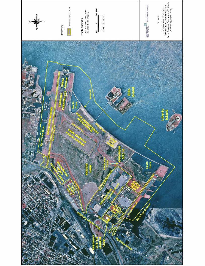
1.5 Study Area The PANYNJ district, roughly defined as being within a 25-mile radius of the Statue of Liberty, represents the most impacted portion of the Hudson Raritan Estuary (HRE) and is commensurate with the broad study area limits of the HRE effort. The defined study area under this interim response consists of the Liberty State Park representative site, located in Jersey City, Hudson County, New Jersey, is on the western side of New York’s Upper Bay, a few hundred feet from Ellis Island and the Statue of Liberty (Figure 1.2). The park consists of 598 mainly degraded upland and wetland acres and 523 tidal acres, for a total of 1,121 acres. Liberty State Park was once mostly open cove and coastal marshland until people started filling it during the 1860s with assorted fill material, including construction debris and garbage to create a large urban rail yard. The rail yard and nearby properties were converted into an urban waterfront park in 1976 as part of the United States bicentennial celebrations. LSP is not yet complete, however, and 234 acres of mostly undeveloped parkland is proposed for habitat restoration under this project. The restoration of this now fenced off and inaccessible interior section will provide substantial benefit to all 1,121 acres by linking previously developed and restored, but isolated, components of the park into one cohesive whole.
1.6 National Environmental Policy Act Requirements The National Environmental Policy Act2 (NEPA) requires that federal agencies document the environmental impacts of all federal actions significantly affecting the human environment. As required in Sec 102 of the Act, proposals for major Federal actions shall include a detailed statement on: • The environmental impact of the proposed action; • Any adverse environmental effects that cannot be avoided if the action is implemented; • Alternatives to the proposed action, including no action; • The relationship between short-term uses of the environment and long-term productivity; and • Any irreversible and irretrievable commitments of resources that would be involved if the
proposed action is implemented. The implementation of the recommended plan for LSP has been determined by the District to be a significant Federal action requiring NEPA documentation via an EIS. This does not mean that the District has determined that there is a significant negative impact on the environment from the recommended plan. Quite the opposite has been determined by the District, as documented in detail in the following pages of this report, which demonstrates that the net effects of this singularly purposed environmental restoration project are overwhelmingly positive (Sections VII and VIII). This FR/EIS was written to incorporate the required sections of a NEPA document (in this case, an Environmental Impact Statement) into a traditional Feasibility Report (FR). The following sections concentrate on NEPA issues:
2 42 U.S.C. 4321, et seq.
Integrated Feasibility Report & Environmental Impact Statement 5

Hudson-Raritan Estuary, Liberty State Park Ecosystem Restoration Study
• Existing Conditions • The Future Without the Proposed Project • Purpose of and Need for the Proposed Action • Environmental Consequences of the Recommended Plan
Scoping (investigating, discussing and resolving NEPA issues) was conducted over the past several years and included extensive coordination with the appropriate Divisions of the NJDEP (the anticipated non-Federal sponsor for project implementation), federal agencies (USFWS, USEPA, NOAA), and public advocacy groups (LSP Planning Committee, NJ Audubon Society, the NY-NJ Baykeeper, etc). A public meeting to receive comments, and several meetings with the LSP Planning Committee, were an integral part of the public scoping process. In addition to documenting impacts, the USACE also must document compliance with all applicable federal, state and local permit requirements and approvals thereof (Section 11, Compliance with Environmental Requirements).
1.7 Study Process New York District is responsible for conducting the overall feasibility study in cooperation with the non-Federal partner for the feasibility study phase, the PANYNJ. The feasibility study and eventual implementation of the project continue to receive strong support from PANYNJ and the NJDEP, owner of the park. These non-Federal interests are committed to working with the Corps to address opportunities for ecosystem restoration at Liberty State Park. As will be explained in detail in this document, plan formulation for ecosystem restoration was conducted in close coordination with Federal and State of New Jersey regulatory resource agencies, including U.S. Fish and Wildlife Service, NOAA, USEPA and NJDEP. As part of scoping activities, a public scoping meeting was held at LSP in October 2002 to solicit comment on the range of issues to be examined in the EIS as permitted by CEQ Regulations (40 CFR 1500-1508) and the U.S. Army Corps of Engineers Regulation (ER-200-2-2).3 The purpose of the scoping process is to 1) formally establish a dialog and coordination with local, County, State, and Federal agencies and the public; and 2) identify issues and concerns that may be associated with the project. Specifically, the preliminary information provided to resource agencies and the public during scoping presents potential ecosystem restoration solutions; discusses existing biological and cultural resources located within the study area; preliminarily identifies the direct, indirect, and cumulative impacts of the project; and identifies the local, County, and State policies and permits applicable to the project.
1.8 Existing Projects The New York District has conducted numerous studies and prepared prior reports related to the Hudson-Raritan Estuary study area. Authorized Federal ecosystem restoration projects currently
3 Minutes to the public scoping meeting located within the Environmental Appendix.
Integrated Feasibility Report & Environmental Impact Statement 6

Hudson-Raritan Estuary, Liberty State Park Ecosystem Restoration Study
Figure 1.2 Location Map of Liberty State Park
Integrated Feasibility Report & Environmental Impact Statement 7

Hudson-Raritan Estuary, Liberty State Park Ecosystem Restoration Study
underway by the New York District are mapped on Figure 1.3 and listed in Table 1.1. Attachment 1 contains a more extensive table detailing projects underway in New York District.
1.9 Prior Studies and Reports Other system-wide USACE General Investigations ecosystem restoration projects, planned or underway, in the HRE area include the Jamaica Bay Ecosystem Restoration Project, the Hudson River Ecosystem Restoration Project, the Flushing Bay and Creek Ecosystem Restoration Project, the Bronx River Basin Ecosystem Restoration Project, the South River Hurricane & Storm Damage Reduction and Ecosystem Restoration Project, and the Saw Mill River Basin Ecosystem Restoration Project. Studies under Section 206 and Section 1135 of the Continuing Authorities Program include Gerritsen Creek, Jamaica Bay (CAP), Spring Creek, Jamaica Bay (CAP), Lincoln Park, Jersey City (CAP), Rahway River, New Jersey, and the Jamaica Bay Marsh Islands Erosion project. Within the HRE program, studies have begun on Hackensack Meadowlands, Lower Passaic River, Gowanus Canal, Newtown Creek and Sherman Creek. Liberty State Park would be the first large scale component of an ecosystem restoration project in the area to be implemented. Within the Corps’ Civil Works navigation mission, the Rivers and Harbors Act of 1874 authorized the first Federal navigation improvements to the Hudson Raritan Estuary. Most recently, a major feasibility study for the New York Harbor Deepening Program was completed in 1999 and serves as the decision document for 50 foot channel depth in New York Harbor, as authorized by the Water Resources Development Act of 2000. A Limited Reevaluation Report for New York Harbor was produced in 2003. The Flood Control Act of 1937 authorized the first Federal Flood Control Projects in the Hudson Raritan Estuary. Closer to the subject at hand, New York District built a seawall, levee and pedestrian walkways at Liberty State Park as part of a flood protection project authorized by the Supplemental Appropriations Act of 1985.
A summary of reports produced by the Army Corps of Engineers on Liberty State Park is listed below:
1. Effects of Construction of the Liberty State Park on Hydraulic Characteristics of New York Harbor (September 1976).
2. Cultural Resource Reconnaissance Liberty State Park (produced by Historic Conservation and Interpretation for New York District) (May 1977).
3. Plan of Study, Liberty State Park (April 1980). 4. Liberty State Park, New Jersey, Levee and Seawall Design Memorandum and Project
Design (June 1981): resulted in construction of levee, seawall, and pedestrian walkway known now as Liberty Walk on the eastern edge of the park, completed in 1987.
5. §905(b) Reconnaissance Report of the Hudson-Raritan Estuary (June 2000): Federal interest was identified in pursuing ecosystem restoration in the Hudson-Raritan Estuary. A two-pronged approach was identified, in which a Comprehensive Restoration Implementation Plan would be developed in conjunction with site-specific restorations at 13 identified building blocks. Liberty State Park is the first of these building blocks recommended for implementation.
Integrated Feasibility Report & Environmental Impact Statement 8

Hudson-Raritan Estuary, Liberty State Park Ecosystem Restoration Study
6. Restoration Opportunities in the Hudson-Raritan Estuary (April 2001): a technical supplement to the §905(b) Reconnaissance Report that identifies specific estuarine and coastal restoration opportunities within HRE.
In conducting this feasibility study, a number of documents were consulted that had been prepared by others. A partial list is contained in the References section of this report. The most notable of these were the “Needs and Opportunities for Environmental Restoration in the Hudson-Raritan Estuary;” prepared in May 2003 by the Regional Plan Association based on the recommendations of the Harbor Estuary Program Habitat Working Group and Estuary Stakeholders; “General Design Memorandum for The Parks Interior Section;” prepared by the New Jersey Department of Environmental Protection Division of Parks and Forestry in October 2001.
Integrated Feasibility Report & Environmental Impact Statement 9

Hudson-Raritan Estuary, Liberty State Park Ecosystem Restoration Study
Figure 1.3 Active Ecosystem Restoration Projects in the Hudson-Raritan Estuary
Integrated Feasibility Report & Environmental Impact Statement 10

Hudson-Raritan Estuary, Liberty State Park Ecosystem Restoration Study
Table 1.1. A Partial List of Active New York District Projects Related to Ecosystem Restoration in the Hudson-Raritan Estuary.
PROJECT COUNTY, STATE
PHASE NON-FEDERAL SPONSOR
MAP LABEL1
HRE EFFORTS
Liberty State Park (one of the original 13 sites identified in the HRE Reconnaissance Report)
Hudson County, NJ Feasibility Phase Investigations
Port Authority of New York and New Jersey 1UB
Comprehensive Restoration Implementation Plan (CRIP)
New York, New Jersey
Feasibility Phase Investigations
Port Authority of New York and New Jersey N/L
HRE-Sherman Creek (one of the original 13 sites identified in the HRE Reconnaissance Report)
New York, NY Feasibility Phase Investigations
Port Authority of New York and New Jersey 9HEL
HRE-Newtown Creek (one of the original 13 sites identified in the HRE Reconnaissance Report)
Kings County, NY and Queens County, NY
Feasibility Phase Investigations
Port Authority of New York and New Jersey 32 HEL
HRE- Hackensack-Meadowlands
Bergen County, NJ, and Hudson County, NJ
Feasibility Phase Investigations
New Jersey Meadowlands Commission
20NHP
HRE - Lower Passaic
Passaic County, NJ; Essex County, NJ; Hudson County, NJ, and Bergen County, NJ
Feasibility Phase Investigations
New Jersey Department of Transportation, Office of Maritime Resources
7NHP
HRE - Gowanus Kings County, New York
Feasibility Phase Investigations
New York City Department of Environmental Protection
3UB
GENERAL INVESTIGATIONS
NY & NJ Harbor Deepening Project
New York & New Jersey
PCA on May 28
The Port Authority of New York and New Jersey
N/L
1. The characters in this column indicate the label by which the site can be located on Figure 1.3, when applicable. Some projects, such as the CRIP, were too comprehensive to be located with a single point.
Integrated Feasibility Report & Environmental Impact Statement 11

Hudson-Raritan Estuary, Liberty State Park Ecosystem Restoration Study
PROJECT COUNTY, STATE
PHASE NON-FEDERAL SPONSOR
MAP LABEL1
GENERAL INVESTIGATIONS (continued) South River Flood Control and Ecosystem Restoration
Middlesex County, New Jersey
Feasibility Phase Investigations
New Jersey Department of Environmental Protection
N/L
Jamaica Bay Ecosystem Restoration Project - Including Dead Horse Bay, Spring Creek, Fresh Creek, Brant Point, Bayswater, Hawtree, and others
Queens, New York Feasibility Phase Investigations
New York City Department of Environmental Protection
3JB, 6 JB, 44JB, 52 JB
Hudson River Ecosystem Restoration Project
New York Feasibility Phase Investigations
New York State Department of Environmental Conservation and the New York State Department of State
N/L
Flushing Bay and Creek Ecosystem Restoration Project
Queens, New York Feasibility Phase Investigations
The Port Authority of New York and New Jersey and the New York City Department of Environmental Protection
25HEL
Rahway River Basin Flood Control and Environmental Restoration Project
New Jersey Feasibility Phase Investigations
New Jersey Department of Environmental Protection
12AK
Woodbridge River Basin Flood Control and Environmental Restoration Project
New Jersey Feasibility Phase Investigations
New Jersey Department of Environmental Protection
32AK
Bronx River Basin Ecosystem Restoration Project
Bronx, New York Westchester, New York
Feasibility Phase Investigations
Westchester County Department of Planning, New York City Department of Environmental Protection
18HEL
Saw Mill River Basin Ecosystem Restoration Project
Westchester, New York
Feasibility Phase Investigations
Westchester County Department of Planning
N/L
Integrated Feasibility Report & Environmental Impact Statement 12

Hudson-Raritan Estuary, Liberty State Park Ecosystem Restoration Study
PROJECT COUNTY, STATE
PHASE NON-FEDERAL SPONSOR
MAP LABEL1
CONTINUING AUTHORITIES PROGRAM
Lincoln Park (Section 1135)2
Jersey City, New Jersey
Feasibility Phase Investigations
New Jersey Department of Environmental Protection
2UB
Gerritsen Creek (Section 1135) 2 Kings County
Pre-Construction Engineering & Design
New York City Department of Parks 19JB
Spring Creek (Section 1135) 2
Queens County, Kings County
Feasibility Phase Investigations
New York City Department of Parks 3JB
Soundview Park (Section 206) 3 Bronx County Feasibility Phase
Investigations New York City Department of Parks 17HEL
Hempstead Harbor (Section 206) 3 Nassau County Feasibility Phase
Investigations Town of North Hempstead 20HEL
Notes: 1. The characters in this column indicate the label by which the site can be located on Figure 1.3, when
applicable. Some projects, such as the CRIP, were too comprehensive to be located with a single point. 2. Section 1135 of Water Resources Development Act 1986: Project Modifications for Improvements to the
Environment 3. Section 206 of Water Resources Development Act 1996: Aquatic Ecosystem Restoration
2. SITE HISTORY The project area at Liberty State Park was once mostly open water known as Communipaw Cove (Figure 2.1). The name comes from the Native American term, “Gameonpa,” meaning, “where the water remained.” Before the site was filled in the industrial era, the Lenape Indians used it mainly for fishing and collecting oysters. The Dutch first moved into the area around the 1630s, buying land from the Lenape to create the district of Pavonia. However, disputes over land and property between the Dutch and the Lenape created friction between the two groups, which culminated in the Dutch-Indian War (1643-5). The Dutch repurchased the land of Pavonia in 1658 from the Hackensack Indians in an effort to avoid any more misunderstandings over property rights. The transaction created what is now Hudson County. A village named Communipaw was established at the cove. While the nearby village of Bergen rapidly developed, Communipaw Cove was used mostly for oystering, fishing, and running a ferry to Manhattan across the Hudson River. Such uses persisted after the English took over the area from the Dutch in 1664. The surrounding area was populated with factories, equipment, and experienced other effects of industrialization. However, Communipaw Cove remained a quiet, rural area where people went to fish and collect oysters until it was filled in the late 19th century.
Integrated Feasibility Report & Environmental Impact Statement 13
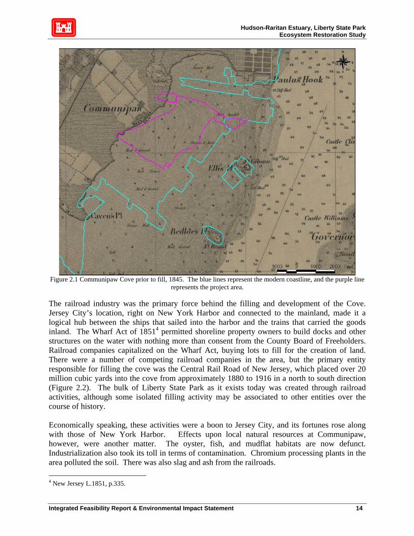
Hudson-Raritan Estuary, Liberty State Park Ecosystem Restoration Study
Figure 2.1 Communipaw Cove prior to fill, 1845. The blue lines represent the modern coastline, and the purple line
represents the project area. The railroad industry was the primary force behind the filling and development of the Cove. Jersey City’s location, right on New York Harbor and connected to the mainland, made it a logical hub between the ships that sailed into the harbor and the trains that carried the goods inland. The Wharf Act of 18514 permitted shoreline property owners to build docks and other structures on the water with nothing more than consent from the County Board of Freeholders. Railroad companies capitalized on the Wharf Act, buying lots to fill for the creation of land. There were a number of competing railroad companies in the area, but the primary entity responsible for filling the cove was the Central Rail Road of New Jersey, which placed over 20 million cubic yards into the cove from approximately 1880 to 1916 in a north to south direction (Figure 2.2). The bulk of Liberty State Park as it exists today was created through railroad activities, although some isolated filling activity may be associated to other entities over the course of history. Economically speaking, these activities were a boon to Jersey City, and its fortunes rose along with those of New York Harbor. Effects upon local natural resources at Communipaw, however, were another matter. The oyster, fish, and mudflat habitats are now defunct. Industrialization also took its toll in terms of contamination. Chromium processing plants in the area polluted the soil. There was also slag and ash from the railroads. 4 New Jersey L.1851, p.335.
Integrated Feasibility Report & Environmental Impact Statement 14

Hudson-Raritan Estuary, Liberty State Park Ecosystem Restoration Study
Figure 2.2 Fill Sequence at Communipaw Cove, 1860-1928
Integrated Feasibility Report & Environmental Impact Statement 15

Hudson-Raritan Estuary, Liberty State Park Ecosystem Restoration Study
Evidence of contamination is present today in the portions of Liberty State Park that are fenced off. The fortunes of the railroad industry at Jersey City declined in the middle of the 20th century due to a decreased demand for resources such as coal. The waterfront rail yards were abandoned by 1967 with the bankruptcy of the Central Railroad of New Jersey, and came into the possession of Jersey City. In the following decade, the former railroad site was proposed for extensive waterfront revitalization. Jersey City turned the land over to the State of New Jersey, which used a combination of federal and state funds to convert the site into Liberty State Park (LSP 2003). Liberty State Park opened to the public in 1976 as part of the national bicentennial celebrations. Approximately 234 acres, mostly within the interior of the park, remain undeveloped. The proposed ecosystem restoration project focuses on these 234 acres.
Integrated Feasibility Report & Environmental Impact Statement 16
Hudson-Raritan Estuary, Liberty State Park Ecosystem Restoration Study
3. EXISTING CONDITIONS 3.1 Physical Setting
The Liberty State Park Site is located in Jersey City, New Jersey, along the lower Hudson River, approximately two (2) miles south of the Holland Tunnel Crossing and on the mainland, just west of Ellis Island (Figure 1.2). Located in Hudson County, NJ, the potential restoration site is generally bordered by Phillip Street on the west5, the mowed grass areas south of Audrey Zapp Drive on the north, Freedom Way on the east6, and Thomas McGovern Drive on the south. Liberty State Park is located within the Hudson Raritan Estuary, specifically the lower Hudson River Estuary, in Jersey City, Hudson County, New Jersey. Historically, as late as the mid 1800's, the general area that now encompasses LSP was predominantly shallow open water, intertidal mud flat, and salt marsh along its western fringes adjacent to the South Bergen glacial moraine that runs north-south along this part of the New Jersey shore. The vast majority of the proposed restoration area, as well as the majority of LSP itself, was shallow open water estuary ranging in depth from approximately 2 to 6 feet MLW (according to 1845 bathymetry).7 The outline of the proposed restoration area is superimposed upon a map of existing physical/cultural conditions in Figure 2.1. The entire LSP is anthropogenically derived; it is made from fill, rubble, dredged material, construction and debris materials, cinder from railroad operations and other wastes, as documented exhaustively in chronological sequence in Figure 2.2. The Cultural Resources appendix also contains many representative photographs of existing physical conditions at the proposed restoration area. The undeveloped area in the center of the park has remained undeveloped and a fence restricts access to the public due to the presence of polynuclear aromatic hydrocarbons (PAHs), pesticides, and metals that exceed the NJDEP residential clean up criteria (MacFarlane 2001). Some of the fill in the undeveloped area comprises materials dredged from the Upper Bay during construction of the LSP causeway. Due to the historic use of the park as a rail yard, there is little historic drainage into the park from outside. Recent construction, such as the Liberty Science Center and the New Jersey Transit Light Rail Terminal and parking lot, contribute storm water runoff to the fringes of the park, but not to the interior. The area surrounding Liberty State Park is essentially fully developed with little room for additional development. Commercial and industrial development is immediately adjacent to the park to the west and south. LSP is bordered on the west by a highly industrialized, commercialized and densely populated urban area of Jersey City, on the north by the Morris Canal, on the east by Upper Bay and on the south by the “Black Tom” cove. The physical setting of each of these areas is described in further detail below. 5 Except for the Liberty Science Center wetland area, which extends to the New Jersey Turnpike. 6 Except for the tidal creek inlet area, which extends to North Cove. 7 Figure 3.1 of the Cultural Resources appendix (1845 USGS Coast chart) shows the outline of most of the proposed restoration area. The outline does not include the Liberty Science Center wetland and the proposed tidal creek inlet area, which were added later in the project development process. (This applies to all of the figures in the Cultural Resources Appendix.) As per the 1845 chart, the LSC wetland area had a greater proportion of salt marsh than the remainder of the proposed restoration area.
Integrated Feasibility Report & Environmental Impact Statement 17

Hudson-Raritan Estuary, Liberty State Park Ecosystem Restoration Study
Jersey City The area west of LSP in Jersey City is characterized by extensive industrialization and by intense residential development, the majority of which is working class neighborhoods. The mostly elevated NJ Turnpike also dominates the view just west of LSP at the base of the South Bergen/Communipaw glacial moraine. There is also a light rail link that partially moves through the same transportation corridor as the NJ Turnpike. Since LSP is built on fill in the Upper Bay at the base of this eastward sloping landscape, surface water of degraded quality tends to flow towards LSP. This is primarily street drainage from the physical settings described above. However, this water is the only feasible source of abundant fresh water to enhance fresh water wetland and aquatic habitat in the proposed restoration area (refer to section 3.3.1). The Liberty Science Center is another dominant physical feature on the western edge of LSP. Morris Canal Area The Morris Canal and the high-rise structures of the rejuvenated Jersey City waterfront dominate the area north of LSP. The canal itself, although connected to the Upper Bay, is now a dead-end basin with poor flushing characteristics. It has hypoxic to anoxic dissolved oxygen conditions in the summer months, also partially due to the discharge of a large CSO at its head. However, attempts to cleanup and provide waterfront recreational amenities to this area are moving ahead. There is a walkway near the mouth of the canal that connects LSP to the Jersey City waterfront area. This walkway provides pedestrian access to LSP from PATH trains, light rail, and bus. The Grove of Remembrance (Millennium Park) is a special area of LSP dedicated to residents of New Jersey who lost their lives at the World Trade Center on 11 September 2001. This is a grassy area with trees and appropriate landscaping that will remain separate from and not be negatively affected by the proposed restoration project. Upper Bay The entire eastern side of LSP is abutted by Upper Bay. The bay’s vistas of lower Manhattan, Ellis Island, the Statue of Liberty, and the Verrazano Bridge are prominent at LSP. This position at the heart of the urban portion of the Hudson-Raritan Estuary underlies the appeal of this park and separates it from most other park locations in the region. Upper Bay has variable water quality that changes frequently with weather, tides and seasons, which was taken into consideration in restoration plans. The proximity of the bay and the tidal forces directly fronting the eastern side of LSP is the key characteristic that makes tidal marsh restoration feasible at this site. The bottom of the bay along the promenade (east) side of LSP is a varied mixture of mud, rock and other coarse material. It varies from biologically stressed to highly productive depending on location and currents. Fishing, both from boat and shore, is popular in this portion of the estuary, particularly around Ellis Island and the Statue of Liberty. In general, incoming (northward moving) tidal currents tend to bring higher salinity, better quality water from the southern, cleaner portion of Upper Bay. However, CSO discharges may contribute to water quality degradation in North Cove during high precipitation periods when STP capacities are exceeded. Likewise, on outgoing (southern moving) tides, poor-quality water from the Morris Canal may affect the eastern waterfront area of LSP, including North Cove. In general, however, WQ is sufficiently high enough to support benthic and fish communities in North Cove and the proposed tidal marsh.
Integrated Feasibility Report & Environmental Impact Statement 18
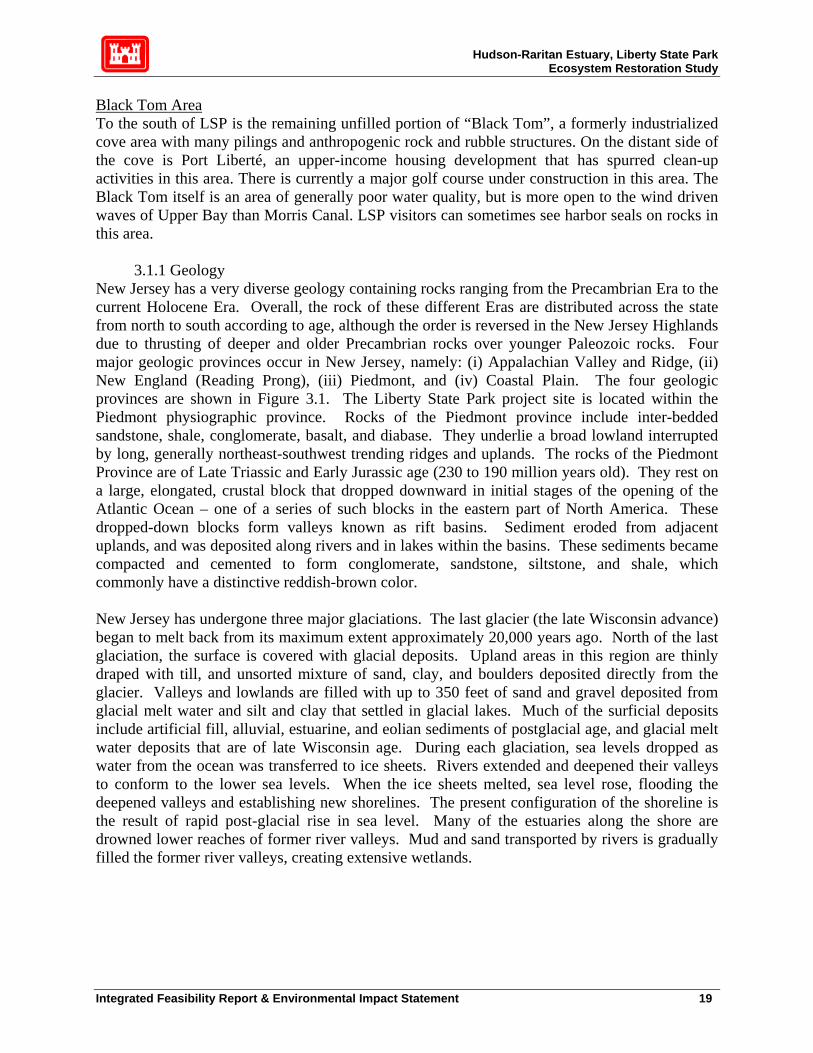
Hudson-Raritan Estuary, Liberty State Park Ecosystem Restoration Study
Black Tom Area To the south of LSP is the remaining unfilled portion of “Black Tom”, a formerly industrialized cove area with many pilings and anthropogenic rock and rubble structures. On the distant side of the cove is Port Liberté, an upper-income housing development that has spurred clean-up activities in this area. There is currently a major golf course under construction in this area. The Black Tom itself is an area of generally poor water quality, but is more open to the wind driven waves of Upper Bay than Morris Canal. LSP visitors can sometimes see harbor seals on rocks in this area.
3.1.1 Geology New Jersey has a very diverse geology containing rocks ranging from the Precambrian Era to the current Holocene Era. Overall, the rock of these different Eras are distributed across the state from north to south according to age, although the order is reversed in the New Jersey Highlands due to thrusting of deeper and older Precambrian rocks over younger Paleozoic rocks. Four major geologic provinces occur in New Jersey, namely: (i) Appalachian Valley and Ridge, (ii) New England (Reading Prong), (iii) Piedmont, and (iv) Coastal Plain. The four geologic provinces are shown in Figure 3.1. The Liberty State Park project site is located within the Piedmont physiographic province. Rocks of the Piedmont province include inter-bedded sandstone, shale, conglomerate, basalt, and diabase. They underlie a broad lowland interrupted by long, generally northeast-southwest trending ridges and uplands. The rocks of the Piedmont Province are of Late Triassic and Early Jurassic age (230 to 190 million years old). They rest on a large, elongated, crustal block that dropped downward in initial stages of the opening of the Atlantic Ocean – one of a series of such blocks in the eastern part of North America. These dropped-down blocks form valleys known as rift basins. Sediment eroded from adjacent uplands, and was deposited along rivers and in lakes within the basins. These sediments became compacted and cemented to form conglomerate, sandstone, siltstone, and shale, which commonly have a distinctive reddish-brown color. New Jersey has undergone three major glaciations. The last glacier (the late Wisconsin advance) began to melt back from its maximum extent approximately 20,000 years ago. North of the last glaciation, the surface is covered with glacial deposits. Upland areas in this region are thinly draped with till, and unsorted mixture of sand, clay, and boulders deposited directly from the glacier. Valleys and lowlands are filled with up to 350 feet of sand and gravel deposited from glacial melt water and silt and clay that settled in glacial lakes. Much of the surficial deposits include artificial fill, alluvial, estuarine, and eolian sediments of postglacial age, and glacial melt water deposits that are of late Wisconsin age. During each glaciation, sea levels dropped as water from the ocean was transferred to ice sheets. Rivers extended and deepened their valleys to conform to the lower sea levels. When the ice sheets melted, sea level rose, flooding the deepened valleys and establishing new shorelines. The present configuration of the shoreline is the result of rapid post-glacial rise in sea level. Many of the estuaries along the shore are drowned lower reaches of former river valleys. Mud and sand transported by rivers is gradually filled the former river valleys, creating extensive wetlands.
Integrated Feasibility Report & Environmental Impact Statement 19

Hudson-Raritan Estuary, Liberty State Park Ecosystem Restoration Study
Figure 3.1 New Jersey Geologic Provinces
LSP is located at the south end of the glacial ridge (moraine) separating the Newark Bay Basin from the lower Hudson Basin, along the east edge of the Piedmont Physiographic Province. Bedrock deep beneath the project area is Triassic-Jurassic sedimentary formation. The entire LSP was created from fill material between the mid 1800's and the 1960's. There is no natural geology. Prior to fill, LSP was predominantly shallow open water, with much intertidal flat and some salt marsh along the western fringe, correlating to the shoreline at that time. The type and volume of fill varies between locations within the site. Previous investigations of the fill material at Liberty State Park by NJDEP (NJDEP 1995) indicate that the material consists primarily of cinder and ash fill, mixed rubble and debris, and dredged material, likely underlain by organic clay, glacial melt water deposit, alluvial deposits, and glacial till. Bedrock in nearby New Jersey Geological Survey (NJGS) borings is 40 feet deep or deeper. There are no rock outcrops anywhere on LSP, although they do occur in some parts of the New York-New Jersey Harbor, and natural substrate is between 15 to 30 feet below the surface. Heaving sands have also been reported by NJDEP at depths greater than 20 feet. A freshwater wetland that exists at the west side of the site must be supported and maintained. Given the coarseness of the fill, the project area soil is extremely pervious, which partially accounts for the
Integrated Feasibility Report & Environmental Impact Statement 20
Hudson-Raritan Estuary, Liberty State Park Ecosystem Restoration Study
lack of permanent fresh water habitat on the site. The geology of the site is described in greater detail in Appendix E.
3.1.2 Topography There is no macrotopography to LSP, as it is a relatively flat site due to the nature of its use as a railroad yard for over a century. Small linear berms between the old railroad tracks were created during the construction of the railroad yard. Typically, changes in elevation exist only as the result of the additional deposition of dredged material or the construction of DM containment berms following cessation of rail operations. Additional changes in relief commenced with the construction of LSP, which including the addition of a shorefront promenade and removal of the pier system that serviced the rail operations. Microtopography (less than a few feet) varies depending on location. Topographic and bathymetric surveys were conducted in 2003 and are documented in the Engineering Appendix. It is clear from the topographic survey that water tends to settle where microtopographic elevations are low, for relatively short period due to the high permeability of site substrate. In some locations, microtopography has encouraged the formation of wetlands, such as Jurisdictional (JD) wetlands No. 3 and No. 8 (Figure 3.8). Microdepressions also occur around remnant railroad tracks. Often these sites support small and fragmented but numerous patches of fresh water wetland vegetation. Slopes on site are very shallow, making manipulation of gravity flow of surface water difficult. North Cove is a shallow indentation in the predominantly straight eastern shoreline of LSP facing Upper Bay. Depths vary from Mean Low Water (MLW) along the internal shoreline of North Cove to about 6 feet MLW at the center of the cove near the promenade. Bathymetry east of the promenade in Upper Bay is a generally shallow “flat” but is crossed by dredged channels in certain areas. The bathymetry of North Cove is discussed in further detail in Appendix E. See Figure 3.2 for the overview sheet of the LSP topographic/bathymetric maps. The individual sheets (1-4) can be found in the Engineering Appendix.
3.1.3 Soils Topsoil is thin and shallow, and non-existent in some locations. The existing upper soil horizon has developed from overgrowth-derived organic matter since incremental abandonment of the railroad yards. As mentioned previously, deeper soils are virtually all anthropogenic fill materials of varying texture. The geotechnical cores taken for this project indicate alternating lenses of sand and clay to a depth varying between 15 and 30 feet below the current surface of LSP. At this depth, the pre-1860's (pre-fill) natural alluvial soils of the estuary are reached. Small amounts of peat, indicting former approximate depths of relict salt marsh are found in some locations. The US Department of Agriculture (USDA) Soil Conservation Service (SCS) has not prepared a Soil Survey Report of Hudson County. However, a preliminary mapping based on field observation was published in 1952. In general, natural soils (sediments) in the vicinity of the project area were derived from stratified drift and wash from glacial till. More specifically, the project area would have been inundated alluvium and muck prior to landfill creation.
Integrated Feasibility Report & Environmental Impact Statement 21

Hudson-Raritan Estuary, Liberty State Park Ecosystem Restoration Study
Figure 3.2 – Overview of LSP topographic/bathymetric maps
Integrated Feasibility Report & Environmental Impact Statement 22

Hudson-Raritan Estuary, Liberty State Park Ecosystem Restoration Study
The results of the geotechnical analysis indicate that the soils vary considerably across the site. Both fine-grained and course grained soils are present. Soils in virtually all of USCS soil classification are found on site. The project site is overlain with coarse-grained soils.8 Average thickness of this coarse-grained layer is about 14-ft, although local variations exist with both thinner layers (3-ft) and thicker layers (30-ft plus) encountered. Underlying this coarse-grained layer is a layer of fine-grained soil.9 This fine-grained layer was observed in about 85% of the drill holes, and was encountered at an average depth of 13-ft. The thickness of this fine-grained layer ranged from 1.5-ft. to 27-ft, averaging out about 12-ft throughout the site. Subsequent lower layers of coarse-grained and then fine-grained soils were occasionally encountered. At surface depths to 4.5 ft below grade, approximately 90% of the soil is poorly graded silty sand and approximately 6% is clay. This largely accounts for the generally very high infiltration rate of this site. However, there may be clay lenses at depth that restrict and redirect groundwater flow, potentially causing “perched” water tables that contribute to the existence of JD wetlands and the wetter parts of some terrestrial habitats. Man-made debris materials were found in about 27 of the 49 total drill holes. Near surface excavation of this material should present no unusual excavation problems. However, deeper excavations, notably excavation of the proposed tidal inlet in the vicinity of the North Cove, may require additional earth moving and dewatering equipment to allow excavation to take place within the soft clay layer. An initial phase (Phase I) of drilling and sampling program was performed during August and September of 2003. Thirty-eight drill holes were completed and a comprehensive geotechnical testing program was performed. An additional phase (Phase II) of drilling and sampling program was performed in February 2004. The results of the geotechnical investigation can be found in Appendix E. Chemical contamination of soil is addressed in section 3.12 (HTRW).
3.2 Climate
The climate of Jersey City, New Jersey, is characteristic of the Middle Atlantic seaboard. Marked changes in weather are frequent, particularly during the spring and fall. The winters are normally moderate, and the summers are generally hot and humid with frequent thunderstorms. Precipitation is also moderate, with about 45 inches falling annually, well distributed throughout the year. Summer totals of precipitation are slightly higher than those of winter. Average monthly temperatures ranges from 38 to 78 degrees Fahrenheit with extremes ranging from 22 degrees below zero to 105 degrees F at Newark, NJ. The growing season averages 174 days. However, early spring vegetation can start growing in late February and late autumn flowers can bloom outdoors until December under beneficial conditions. The mean annual relative humidity varies from 53 to 73 percent. Prevailing winds are from the northwest with an average annual velocity of approximately 10 miles per hour. The number of days with rainfall of 0.01 inch or greater averages about 122 per year, generally contributing to keeping soil moisture content in the region relatively high through the growing season, although droughts can occur. Appropriate climate and precipitation data was analyzed for this project to develop a water budget and predict the potential for enhancing fresh water wetland habitats. This analysis is described in detail in the Engineering Appendix (Hydrology and Hydraulics of Fresh Water Wetlands Report, Section 3.3). 8 Sands, silty sands, silty gravels, etc. 9 Clay, clay with traces of shells, sand, and gravel, etc.
Integrated Feasibility Report & Environmental Impact Statement 23

Hudson-Raritan Estuary, Liberty State Park Ecosystem Restoration Study
3.3 Water Resources
3.3.1 Surface Waters TIDAL INFLUENCES The project is located on the western banks of Upper New York Bay, at the mouth of the Hudson River, which has a drainage area of 13,370 square miles. While the project area originally was shallow estuary, filling activities and hardening of the shoreline have disconnected the area from the tide. For this study, water level recorders in the South Cove and in Morris Canal observed tidal signals for a period of 6-14 weeks. The South Cove gage was the closest gage to the proposed tidal creek inlet in the North Cove. The results of the tidal analysis at the South Cove gage revealed that the tidal ranges (diurnal tide range, great diurnal tide range, and spring tide range) at LSP for the period of record 31-July 2003 to 11-Sept. 2003 were 4.69, 4.82 and 6.39 ft, respectively. All the tidal data computed can be found in table 3.1. Mean High Water (MHW) and Mean Low Water (MLW) are calculated by measuring the elevation differences between the highest water level and lowest water level for each tide cycle in the period of record. Diurnal Tide Range (RangeM) is the difference between the MHW and MLW data. In this region of the North Atlantic Ocean, there is one slightly higher tide within each two tide cycle segments. Mean Higher High Water (MHHW) and Mean Lower Low Water (MLLW) are calculated by measuring the elevation differences between the highest water level and lowest water level within each two tide cycle segments. Great Diurnal Tide Range (RangeGD) is the difference between the MHHW and MLLW datums. Mean High Water Spring (MHWS) and Mean Low Water Spring (MLWS) are calculated by measuring the difference between the highest water level and lowest water level that occurs during each full and new moon (approximately twice a month). Spring Tide Range (RangeS) is the difference between the MHWS and MLWS data. The observations from the other gages were compared to the NOAA Tide Station 8518750 at The Battery, NY, 2000 ft directly across the bay, and the signals were extrapolated to the 1983-2001 Tidal Epoch using the NOAA, modified range ratio method (Appendix E). Readings from the Battery were deemed to best represent the anticipated conditions because of its relative position to the proposed tidal creek and North Cove. The results of the extrapolation revealed that the 1983-2001 Tidal Epoch for the South Cove diurnal tide range, great diurnal tide range, and spring tide range at LSP is 4.51, 4.84 and 5.60 ft, respectively. All the data observed and calculated can be found in Table 3.1 STORM SURGES Hurricanes and Northeaster storm events frequently influence the tide stage in Upper New York Harbor Bay. The Liberty State Park Causeway Project (USACE 1981) determined the frequency of these high water events (Figure 3.3). Morris Canal and the North Cove will experience similar stages for the same storm surge events. Audrey Zapp Drive on the north side, Phillip Street on the west side, Thomas McGovern Drive on the south side and Freedom Way along the east side all lie at elevations between 8 – 10 ft NAVD88. All currently act as shore protection for the more frequent storm surge events. The proposed tidal wetland will be connected to the
Integrated Feasibility Report & Environmental Impact Statement 24

Hudson-Raritan Estuary, Liberty State Park Ecosystem Restoration Study
Table 3.1 Liberty State Park Water Level Observations: Summer and Fall 2003
bay via the proposed tidal creek inlet in the North Cove. The existing elevations of the adjacent upland area surrounding the proposed tidal wetland are about 10ft NAVD88. The proposed tidal wetland will flood for lower frequency events and the tidal event will be contained within the wetland. It is anticipated that the wetland will be resilient enough to withstand these flood events, just as natural tidal wetlands currently do in the vicinity of Liberty State Park. In the proposed Fresh Water Wetland area, the scenario is the same as the fresh water wetland. The proposed project will not affect any structures. FRESH WATER HYDROLOGY Currently, the project site is encompassed within the interior of Liberty State Park. The streets adjacent to the park drain into ditches that discharge either into Morris Canal or into the Harbor. The watersheds included in the proposed project consist of four catchment areas: (1) the interior of Liberty State Park, (2) the Liberty Science Center (LSC) and parking lot, (3) the existing wetland area immediately adjacent to the Science Center, and (4) the NJ Transit parking lot and adjacent drainage area.
Integrated Feasibility Report & Environmental Impact Statement 25

Hudson-Raritan Estuary, Liberty State Park Ecosystem Restoration Study
Figure 3.3 Storm Surges at the Battery, NY
In the interior of Liberty State Park, there are several small drainage areas within the park itself due to the lack of significant relief within the park, the presence of old berms, dredged material mounds, and other debris mounds. There are numerous small drainage areas and several existing freshwater wetlands areas that will be retained in the proposed plan. Near the center of the park, an existing shallow emergent marsh is adjacent to the 45-acre dredged materials area. North and west of this wetland is upland terrain. This upland area has potential for restoration due its proximity to potential sources of additional freshwater runoff. The drainage area for the existing, two-acre shallow emergent marsh is approximately 20 acres, all of it pervious. No additional impervious areas provide runoff to this area. No significant source of runoff is currently routed to the proposed tidal wetland. The drainage area within the LSC complex can be divided into two main subcatchment areas: the LSC parking lot and the LSC itself, which consists of roof drains, walkways, and nearby mowed areas. The LSC parking lot is approximately 10.4 acres, 89% of which is impervious. Along Phillip Street is a drainage ditch referred to as the East Ditch. This ditch primarily provides the conduit for runoff from the LSC parking lot to the Morris Canal. The drainage area of the LSC itself is approximately 8.5 acres, with 50% of it impervious. Runoff from the LSC flows to either the West Ditch along Phillip Street or to the adjacent wetland. An existing wetland is currently located immediately north of the LSC. The wetland area is approximately 2.3 acres in size, with an immediate drainage area consisting of the New Jersey Transit parking lot and a small adjacent area totaling approximately 11.13 acres. Across the NJ Turnpike from the Liberty Science Center is the NJ Transit Light Rail Liberty State Park Station, which provides service to Bayonne, Jersey City and Hoboken. The terminal consists of an outdoor station and a parking lot. The NJ Transit terminal area is divided into the three subcatchment areas: the parking lot and interior detention basin, the southern terminal area and detention basin, and the northern terminal area and drainage swale.
Integrated Feasibility Report & Environmental Impact Statement 26

Hudson-Raritan Estuary, Liberty State Park Ecosystem Restoration Study
3.3.2 Water Quality Since there is no permanent moving surface water on site (i.e., all surface water is temporary precipitation and/or groundwater derived) on-site fresh water quality is predominantly influenced by the short-term effects of the quality of the water received in storm events. Water quality is also influenced by highly permeable on-site soils, which encourage rapid drainage and turnover in low topographic areas (largely vernal pools). Also, in general (notwithstanding storm events which can occur at any season), there is a water surplus on site during winter and spring, and a deficit in summer and fall. Hence, the effects of on-site water quality are primarily on certain adaptable wildlife species, preferentially affecting seasonally water-dependent amphibians and reptiles (Appendix B). These taxa occur in relatively low abundances and species-richness on this site. There are no fish, since there is no permanent standing water. Thus, water quality is suitable for those species that can occur under these stressful conditions, namely, unreliable and often temporarily completely unavailable water. Even under extremely wet conditions, it cannot be expected that any particular pool or low topographic area will retain standing water for more than a few weeks. During high evapotranspiration (summer/early fall), periods of standing water are generally on the order of days. There is little connection between fresh water quality and human health, since neither surface nor groundwater is used for drinking, bathing, fishing, or any other direct contact activity. Disease-bearing freshwater dependent species of mosquito undoubtedly breed on-site. However, there is no reason to consider LSP more of a threat to human health than the numerous other locations located throughout the NY-NJ metropolitan region, such as the thousands of clogged and/or slow-draining neighborhood storm drains. Water quality in North Cove is highly seasonal and tidally variable but generally moderate to poor, although it was apparently good enough to support a fairly representative fish sample in late summer, 2003, when DO concentration is generally at its seasonal low. Limited DO samples taken on the bottom at that time indicated that concentrations were averaging about 5 mg/L, which is generally considered a borderline condition between stressed on non-stressed, although adequate for most HRE species adapted to high variations in DO.
3.3.3 Regional Hydrogeology and Groundwater As part of the geotechnical analysis (Appendix E) twelve piezometers were installed as permanent piezometers in existing drill holes for long-term groundwater level monitoring purposes. An additional eight temporary piezometers were also installed in selected existing drill holes. Groundwater depths ranged from about 1.3-ft below existing grade to about 5.5-ft below existing grade, as measured from the twenty piezometers installed throughout the site. Maximum fluctuations in groundwater levels up to 3.1-ft were observed in the piezometers. Groundwater gradients between piezometers were typically very flat. Groundwater flow direction and average gradient calculations suggest that groundwater flow direction is about N35o and discharges towards the adjacent Morris Canal (Figure 3.4). A plan view of the groundwater contour map of the 15 November 2003 groundwater readings is shown in Figure 3.5. Due to the possibility of contamination in the ground water and/or proposed excavation elevations and soil contamination, the proposed plan includes an impervious clay layer to be placed where excavation will take place for the fresh water and tidal wetlands.
Integrated Feasibility Report & Environmental Impact Statement 27
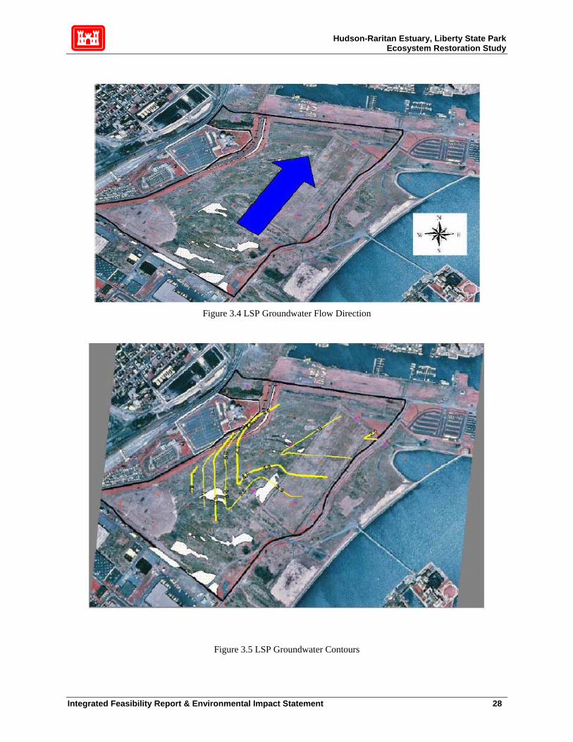
Hudson-Raritan Estuary, Liberty State Park Ecosystem Restoration Study
Figure 3.4 LSP Groundwater Flow Direction
Figure 3.5 LSP Groundwater Contours
Integrated Feasibility Report & Environmental Impact Statement 28
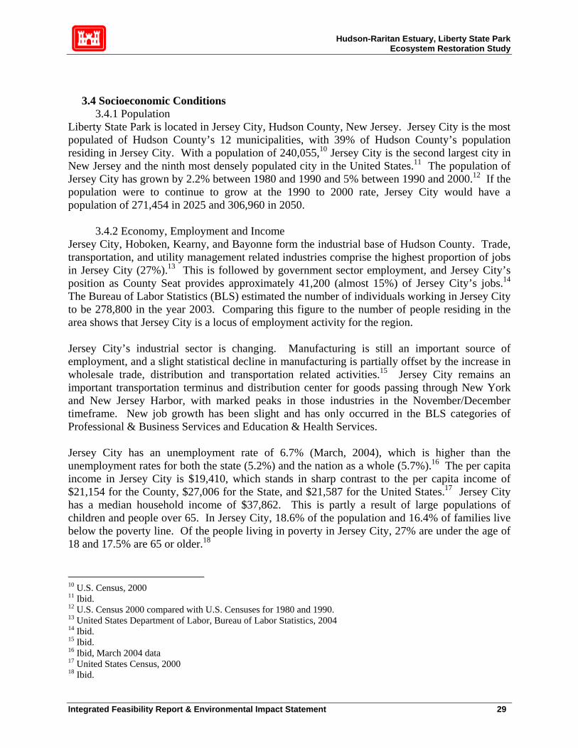
Hudson-Raritan Estuary, Liberty State Park Ecosystem Restoration Study
3.4 Socioeconomic Conditions 3.4.1 Population
Liberty State Park is located in Jersey City, Hudson County, New Jersey. Jersey City is the most populated of Hudson County’s 12 municipalities, with 39% of Hudson County’s population residing in Jersey City. With a population of 240,055,10 Jersey City is the second largest city in New Jersey and the ninth most densely populated city in the United States.11 The population of Jersey City has grown by 2.2% between 1980 and 1990 and 5% between 1990 and 2000.12 If the population were to continue to grow at the 1990 to 2000 rate, Jersey City would have a population of 271,454 in 2025 and 306,960 in 2050.
3.4.2 Economy, Employment and Income Jersey City, Hoboken, Kearny, and Bayonne form the industrial base of Hudson County. Trade, transportation, and utility management related industries comprise the highest proportion of jobs in Jersey City (27%).13 This is followed by government sector employment, and Jersey City’s position as County Seat provides approximately 41,200 (almost 15%) of Jersey City’s jobs.14 The Bureau of Labor Statistics (BLS) estimated the number of individuals working in Jersey City to be 278,800 in the year 2003. Comparing this figure to the number of people residing in the area shows that Jersey City is a locus of employment activity for the region. Jersey City’s industrial sector is changing. Manufacturing is still an important source of employment, and a slight statistical decline in manufacturing is partially offset by the increase in wholesale trade, distribution and transportation related activities.15 Jersey City remains an important transportation terminus and distribution center for goods passing through New York and New Jersey Harbor, with marked peaks in those industries in the November/December timeframe. New job growth has been slight and has only occurred in the BLS categories of Professional & Business Services and Education & Health Services. Jersey City has an unemployment rate of 6.7% (March, 2004), which is higher than the unemployment rates for both the state (5.2%) and the nation as a whole (5.7%).16 The per capita income in Jersey City is $19,410, which stands in sharp contrast to the per capita income of $21,154 for the County, $27,006 for the State, and $21,587 for the United States.17 Jersey City has a median household income of $37,862. This is partly a result of large populations of children and people over 65. In Jersey City, 18.6% of the population and 16.4% of families live below the poverty line. Of the people living in poverty in Jersey City, 27% are under the age of 18 and 17.5% are 65 or older.18
10 U.S. Census, 2000 11 Ibid. 12 U.S. Census 2000 compared with U.S. Censuses for 1980 and 1990. 13 United States Department of Labor, Bureau of Labor Statistics, 2004 14 Ibid. 15 Ibid. 16 Ibid, March 2004 data 17 United States Census, 2000 18 Ibid.
Integrated Feasibility Report & Environmental Impact Statement 29

Hudson-Raritan Estuary, Liberty State Park Ecosystem Restoration Study
3.5 Cultural Resources As a federal agency, the Corps must ensure that its projects are compliance with Section 106 of the National Historic Preservation Act of 1966, as amended (16 U.S.C. 470 et seq.). This law requires Federal agencies or project sponsors seeking Federal funding and/or permits to take into account the effect of any undertaking on any cultural resource included in, or eligible for inclusion in, the National Register of Historic Places. A cultural resources investigation was conducted for the Corps in the spring of 2003 for the Liberty State Park Restoration Project. Pan-American Consultants, Inc. (PCI) undertook this work and based much of the research on a previous study by Historic Conservation and Interpretation (HCI). HCI conducted their work in 1977 when Liberty State Park was being developed. Background research, a site walkover and analyses were conducted by PCI but no subsurface testing was undertaken. The area proposed for wetland restoration was once open water. An analysis of soil borings suggests that the potential for buried Late Pleistocene/Early Holocene deposits is high in certain areas within LSP as a whole (Historic Conservation and Interpretation, Inc. 1977). Near the project area traces of peat were found at approximately 43 feet below mean sea level (MSL). Wood, wood fiber and peat on bedrock were found between 94 and 101 feet below MSL. Work in connection with the restoration project is not anticipated to reach these depths. Shallower deposits (11 – 13 feet below MSL) were found to the south of the project area where bedrock rises rapidly. It is unlikely that any deposits would be encountered in the current project area. The sensitivity for prehistoric resources within the project area is low as the location consists entirely of man-made land and no work is anticipated to reach depths determined sensitive for paleo-environmental data. Work along the western edge of the project area, which was once the Communipaw shoreline and is therefore sensitive for prehistoric and early historic resources, will not include excavation. As discussed above, land at LSP was created over a period of six decades spanning the late 19th and early 20th centuries to hold the vast rail yards that developed along the Jersey City waterfront. HCI included a projection of shoreline changes in their 1977 report that indicates that land filling in the project area was completed by 1916 (Figure 2.2). Associated with the various fill episodes are likely to be timber cribbing and other construction methods used to retain fill. Late 19th and early 20th century cribbing has been recorded throughout the New York and New Jersey Harbor. The filling episodes were documented as they occurred and this data was included as an appendix to the HCI report. Most of the retaining structures were earthen. It should also be noted that Morris Canal boats were deliberately sunk in 1900 to form a fill retaining structure and may be present beneath the fill. Documentary evidence suggests that these boats are located to the east of the project area, on the opposite side of Freedom Way. Railroad use within the project area was limited to rails, no longer present, and ancillary structures such as signals and livestock pens. The few remnants of these structures that remain on the property are deteriorated and are not considered eligible for the National Register of Historic Places. The landscape on the whole was altered considerably with the construction of LSP. Within the park, little evidence remains of the once expansive rail yards. The proposed restoration project is within sight of the Statue of Liberty Ellis Island National Monument and the NRHP listed
Integrated Feasibility Report & Environmental Impact Statement 30

Hudson-Raritan Estuary, Liberty State Park Ecosystem Restoration Study
Central Railroad of New Jersey Terminal. It is not anticipated that the creation of new wetlands and habitat will have an effect on these important historic sites. The Liberty Science Center Wetlands Complex area was not under consideration for restoration at the time the cultural study was undertaken, and so has not been surveyed. As the project proceeds, this area will be surveyed and subsequent cultural resources work will be undertaken as required. It is the Corps’ opinion that the restoration work for the remaining areas at Liberty State Park will have no effect upon cultural resources if project plans remain as proposed. If excavation is determined necessary in the vicinity of the former Communipaw shoreline than subsurface work may be required. The New Jersey Historic Preservation Office concurred with this evaluation (see Appendix C). This work was also coordinated with the Liberty State Park Resource Interpretive Specialist.
3.6 Land Use
3.6.1 Land Use in Jersey City The land use category of Liberty State Park is classified as recreational. Adjoining the park to the south is Port Liberté, a residential complex with 1,290 condominiums. Liberty Science Center is on the western side of the park. The northern boundary along the Morris Canal has experienced increased residential development and will be further impacted by the construction of the Jersey City Medical Center. Ellis Island and the Statue of Liberty are located a few hundred feet from Liberty Walk, the eastern boundary of the park. From a broader perspective, Hudson County’s residential areas consist mostly of older housing stock, with most housing units containing two or more dwelling units. Single-family detached dwellings are generally found in Secaucus, Kearny, Bayonne and parts of North Bergen. High-rise apartments are located near the Hudson River along the palisades. Overall residential land usage comprises 5,634 acres, or 14 percent of the land area in Hudson County in 1999. The total residential land area increased by 254 acres, or 4.7 % between 1974 and 1999. Commercial land usage comprises a total of 1,942 acres or 4.9% of the land area in Hudson County in 1999. The total commercial land area increased by 580 acres, or 43.0%, between 1974 and 1999. Industrial land usage comprises a total of 5,129 acres or 12.9 percent of the land area in Hudson County in 1999. The total industrial land area since 1974 has increased by 580 acres or 12.8 percent.
3.6.2 Coastal Zone Management Pursuant to the Coastal Zone Management Act of 1972 and the Coastal Zone Reauthorization Act Amendments of 1990, New Jersey has defined its coastal zone boundaries and developed policies to evaluate and issue permits for projects located within the designated coastal zone. These policies are set forth in New Jersey’s Rules on Coastal Zone Management (N.J.A.C. 7:7, 7:7E, dated July 18, 1996 and addenda to 7:7 and 7:7E, dated August 19, 1996, and December 1999). The NJDEP administers the coastal permit program through the Coastal Area Facility Review Act (CAFRA) (New Jersey State Act [N.J.S.A.] 13:19-1 et seq.), the Wetlands Act of 1970
Integrated Feasibility Report & Environmental Impact Statement 31

Hudson-Raritan Estuary, Liberty State Park Ecosystem Restoration Study
(N.J.S.A. 13:9A-1 et seq.), and the Waterfront Development Law (N.J.S.A 12:5-3). Each of these acts provides a slightly different definition of the coastal zone; therefore, the designated coastal zone consists of the cumulative total of these three definitions. Since the proposed project is limited to estuarine-related habitat restoration, it is expected that this project will comply with all CZM requirements (see section 11, Compliance with Environmental Regulations, for further details).
3.7 Biological Resources The Environmental Resources Inventory (ERI) comprehensively describes the biological resources existing on the proposed LSP restoration site (see Appendix B). Past studies, including extensive environmental data provided by the NJDEP and IC/LSC staff, were used to develop this inventory, in addition to biological surveys conducted in 2003 to verify and update relevant portions of these studies. This updated inventory was used to establish an environmental baseline in order to:
• Conduct a comparative analysis of environmental benefits and impacts. • Develop alternative candidate restoration plans. • Select the recommended plan (along with engineering feasibility and economic justification). • Describe environmental impacts of the recommended plan. • Develop post-construction monitoring plans to evaluate the level of habitat restoration attained from implementation of the recommended plan.
The biological resources described in the ERI that occur in the proposed restoration area are:
• Terrestrial vegetation communities • Palustrine (FW wetland) communities • Intertidal vegetative communities19 • Benthic invertebrates (North Cove) • Fish (North Cove) • Herptiles • Birds • Mammals • TES (threatened and endangered species).
The proposed restoration area vegetative communities and applicable invertebrate, fish and wildlife communities are briefly but systematically described in the sub-sections below, along with species of concern, essential fish habitat, air quality, noise, recreational resources, HTRW site characteristics and transportation and other infrastructure resources. Detailed discussions of biological resources are contained in the ERI. The ERI provides all common and scientific names of species. 19 None exist within the proposed site, but they do occur in adjacent areas to LSP, and are utilized primarily as biobenchmarks for planning the proposed tidal marsh.
Integrated Feasibility Report & Environmental Impact Statement 32

Hudson-Raritan Estuary, Liberty State Park Ecosystem Restoration Study
3.7.1 Vegetation
There are two general categories of existing vegetative communities (Figure 3.5) within the proposed restoration site, terrestrial (forest, scrub-shrub and herbaceous) and palustrine (seasonal FW wetlands). These two general community types are further categorized into more specific vegetation communities as described below in sections 3.7.1.1 and 3.7.1.2. There are no intertidal vegetation communities within the proposed restoration site, however the North Cove (Figure 3.6) is an existing somewhat degraded intertidal mud flat and shallow water habitat. The non-vegetative biological resources (benthos and fish) of North Cove are primarily described below in sections 3.7.2.4, 3.7.2.5 and 3.7.2.6. With some modification to more accurately categorize disturbed urban conditions, the vegetation communities within the proposed LSP restoration site are based on the descriptions and associations provided in Edinger, et al. 2002.20 In general, the existing communities reflect almost two centuries of anthropogenic disturbance, primarily the result of filling with degraded sediments, rubble, construction waste, coal-ash cinders, blasted rock, railroad ties and rails onto what was formerly mostly shallow water, intertidal flat and salt marsh habitat.21 The terrestrial and palustrine communities of today are the result of opportunistic vegetation taking hold in a mosaic pattern, often varying significantly among the various microtopographical features, throughout LSP. This is primarily a result of conversion of organic matter that gradually built up enough soil to support the communities in LSP seen today. Where the upper soil horizon is more developed, there tends to be more forest. Some areas remain almost barren because of the presence of cinders and other poor and/or highly permeable substrate. Seasonal wetlands tend to form in microtopographical depressions of various sizes, even between and adjacent to abandoned railroad tracks. Figure 3.6 depicts eleven vegetative communities within the project site. These are described separately below under the categories of terrestrial and palustrine communities, although in some cases there is overlap in plant species (e.g., Spartina patens in a maritime grassland community), as a result of the complex mosaic nature of this site. Again, North Cove has no intertidal or subtidal vegetative communities.
3.7.1.1. Terrestrial Vegetation Seven terrestrial vegetative communities currently exist within the boundaries of the proposed restoration area (Figure 3.6). Section 2 of the ERI describes these communities in comprehensive detail. Some important characteristics of these communities are summarized below (Note: % coverage of restoration site is based on a 234 acre restoration site rounded to the nearest whole number) in tabular format (Table 3.2):
20 See Section 2 of the ERI for a detailed description of methodology. 21 A time-series of fill activities is available in the Cultural Resources appendix, along with maps and photographs of the area at various historic periods.
Integrated Feasibility Report & Environmental Impact Statement 33
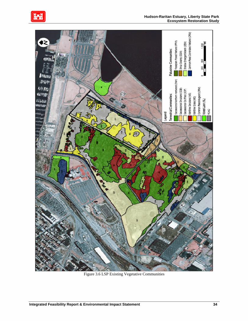
Hudson-Raritan Estuary, Liberty State Park Ecosystem Restoration Study
Figure 3.6 LSP Existing Vegetative Communities
Integrated Feasibility Report & Environmental Impact Statement 34

Hudson-Raritan Estuary, Liberty State Park Ecosystem Restoration Study
Table 3.2 LSP Existing Terrestrial Communities
TERRESTRIAL Successional Northern Hardwood (SNH)
Successional Scrubland (SSB)
Community Description Forest located on previously disturbed or cleared sites where shrubs represent less than 50% of vegetative cover
Shrubland located on sites that have been cleared and are dominated by at least 50% shrub species.
Acreage 62.7 4.2 Coverage of Restoration Site
27% <1%
Location Throughout site Southeast part of site Interspersion Moderate. Found in large contiguous
units at the center of site. Low. Found in contiguous patches near roadways
Dominant Canopy Vegetation
Quaking aspen, eastern cottonwood, gray birch, tree of heaven, big-toothed aspen, black locust, white pine, red maple, Lombardy poplar, black oak
N/A
Dominant Shrub Vegetation Winged sumac, smooth sumac, northern bayberry, staghorn sumac
Cut-leaved blackberry, Japanese knotweed
Dominant Herbaceous Understory
Canada goldenrod, cut-leaved blackberry, common reed, mugwort, steeplebush.
Canada goldenrod, common reed
% Invasive/ Opportunistic Vegetation
Moderate/high Moderate/high
Successional Stage Early pioneer (poplars and gray birch) and later successional stages (red maple)
Likely succeeded from old field
Identifiable Trends Possible succession to more shade tolerant hardwoods, such as red maple
Likely succession to SSN community through introduction of wind-dispersed seeds
Probability of Succession to an Invasive Species Dominated Community
Moderate Moderate to high
Habitat Value Breeding and foraging habitat for year round resident birds (American robin, downy woodpecker, northern flicker); grassland edge good foraging habitat for birds; Cooper’s hawk, northern harrier and red-tailed hawk observed foraging along forest edge in 2003
Cooper’s hawk and downy woodpecker foraging; breeding and foraging habitat for many of the same bird species that occur in maritime shrublands
Integrated Feasibility Report & Environmental Impact Statement 35

Hudson-Raritan Estuary, Liberty State Park Ecosystem Restoration Study
Table 3.2 LSP Existing Terrestrial Communities (continued) TERRESTRIAL Successional Old Field (SOF) Maritime Shrubland (MS)
Community Description Meadow dominated by non-woody herbs and grasses located in cleared and abandoned areas. Most diverse community type within the site (67 identified plant species).
Shrub community located in coastal region exposed to onshore wind and spray. Typically dominated by tall shrubs with tree canopy.
Acreage 49.6 22 Coverage of Restoration Site 21% 9% Location Small contiguous areas found along
northern edge of site, in the central eastern part of the 45-acre rectangle, and along its western edge.
Throughout most of site generally in shallow depressions
Interspersion Low. Found in large contiguous areas.
High, in small to moderately sized patches within or adjacent to forest
Dominant Vegetation Non-woody herbs and grasses including common mullein, Canada goldenrod, spotted knapweed, mugwort, butter and eggs.
Diverse, but dominated by winged and smooth sumac, and to a lesser extent, northern bayberry, Canada goldenrod, common reed, cut-leaved blackberry, gray birch and quaking aspen
% Invasive/ Opportunistic Vegetation
Moderate/high High/high
Successional Stage Early successional Pre-successional to either wetland shrub or successional upland forest, depending on soil moisture, but without management, more likely to succeed to monocultural common reed.
Identifiable Trends Will likely succeed to SSB and eventually SNH
High soil moisture areas may succeed to wetland shrub communities, dry soil moisture areas to hardwood forest. In either case, without management, likely to be dominated by invasives such as common reed and/or tree of heaven and opportunists such as sumac.
Probability of Succession to an Invasive Species Dominated Community
High High
Habitat Value Important foraging grounds for most bird species at LSP because of abundance of seeds and insects. Dense herbaceous cover provides nesting and roosting habitat, but lack of tree/shrub canopy enables predatory birds (northern harrier) to locate songbirds and rodents. Extensive stands of mugwort decrease habitat value of SOF.
Several summer, winter and year-round resident birds use shrubland communities for foraging and breeding. American goldfinch, brown-headed cowbird, yellow warbler, eastern towhee and red-winged blackbird are known to breed within these shrublands. Tree swallow, yellow warbler, American woodcock, chimney swift and American kestrel use shrubland communities as foraging grounds.
Integrated Feasibility Report & Environmental Impact Statement 36

Hudson-Raritan Estuary, Liberty State Park Ecosystem Restoration Study
Table 3.2 LSP Existing Terrestrial Communities (continued) TERRESTRIAL Maritime Grassland (MG) Common Reed/Mugwort (CRM)
Community Description Dominated by more than 50% grasses and few shrubs located where ocean wind and spray present.
More than 75% cover of the invasive herbs mugwort, common reed and/or Japanese knotweed.
Acreage 14.7. 38.7. Coverage of Restoration Site 6%. 17%. Location Mostly within 45-acre DM deposit. May
be affected by brackish groundwater from Upper Bay via ditches to adjacent vegetation. There is a narrow strip next to a brackish ditch apparently connected by culvert to the Morris Canal in the extreme NW portion of the site.
Mostly within 45-acre DM deposit but also a large area next to upland forested area in N. part of the site. A narrow strip also occurs the S. edge of the site adjacent to the industrial area outside LSP, and some isolated areas in the SE portion of the site.
Interspersion Moderate (mostly wide or narrow contiguous bands adjacent to ditches).
Low, since well-established reed monocultures tend to replace other vegetation.
Dominant Vegetation Grasses (salt meadow cord grass), herbs (common reed, common mullein, Canada goldenrod and hemp dogbane), shrubs (eastern baccharis, marsh elder) and quaking aspen. Many of these species are salt-tolerant. The source of salt is unknown. Besides undocumented culvert connections, there may be residual salt in DM deposits, and/or salt accumulation in ditches via drainage from adjacent roadways.
Mugwort, common reed, Japanese knotweed. Most frequently occurring subdominant species are purple loosestrife, hemp dogbane and common mullein.
% Invasive/ Opportunistic Vegetation
Moderate/High Very high/Very high.
Successional Stage Early successional stage following intense disturbance
Early successional on highly disturbed generally poor soil.
Identifiable Trends All of these maritime grass communities are located adjacent to and somewhat interspersed among monocultures of common reed (CRM community) and it is likely that reed stands will expand and outcompete and eventually replace the grasses.
Establishment of late successional community unlikely since invasives have adaptations (rhizomal colonization, root toxins) allowing them to outcompete native herbs that reproduce through seed dispersion. Over very long term, non-managed, non-salt influenced communities at LSP will tend to succeed to SNH
Probability of Succession to an Invasive Species Dominated Community
Very high.
N/A
Habitat Value High. Similar to SOF habitat, including valuable foraging and ground nesting habitat for the northern harrier (although on-site nesting success questionable).
Because mugwort, common reed and Japanese knotweed tend to grow in monocultures, CRM provides little habitat diversity. Some birds (red-winged blackbird, marsh wren) prefer common reed for nesting, but raptors dislike hunting prey in tall reeds.
Integrated Feasibility Report & Environmental Impact Statement 37

Hudson-Raritan Estuary, Liberty State Park Ecosystem Restoration Study
Table 3.2 Existing LSP Terrestrial Communities (continued) TERRESTRIAL Mowed Lawn (ML) Road
Community Description Residential, recreational or commercial land in which ground cover is dominated by mowed grasses and there is less than 30% tree cover.
Vegetation rooted in a road or path made of the parent material of the site and maintained by regular trampling of the land surface.
Acreage 5.6 Probably less than a few acres. Coverage of Restoration Site 2% Estimated at less than 1%. Location Restricted to the tidal channel inlet
area adjacent to North Cove and to that portion of the Liberty Science Center wetland area adjacent to Phillip St.
Two unpaved roads in the SE portion of the site
Interspersion None. N/A Dominant Vegetation Grass. Mugwort, ragweed, white sweet
clover, common mullein, tree-of-heaven wild carrot, other clovers, snakeroot, poison ivy and spotted knapweed.
% Invasive/ Opportunistic Vegetation
N/A.
Very high/very high.
Successional Stage Very early Remains in early successional pioneer stage due to compacted soils and frequent trampling.
Identifiable Trends None None
Probability of Succession to an Invasive Species Dominated Community
None (assuming continued maintenance).
N/A.
Habitat Value Foraging for American robin, ring-billed gull, rock dove and eastern squirrel. Raptors sometimes hunt on lawns.
Some road edges represent an ecotone that attracts wildlife. Habitat value of this community at this site is probably minimal, given the abundance of similar adjacent habitat.
3.7.1.2 Wetland Vegetation Figure 3.6 shows 4 wetland vegetation communities that currently exist within the boundaries of the proposed restoration area. Section 2 of the ERI describes these communities in exhaustive detail. A brief description follows in Table 3.3:
Integrated Feasibility Report & Environmental Impact Statement 38
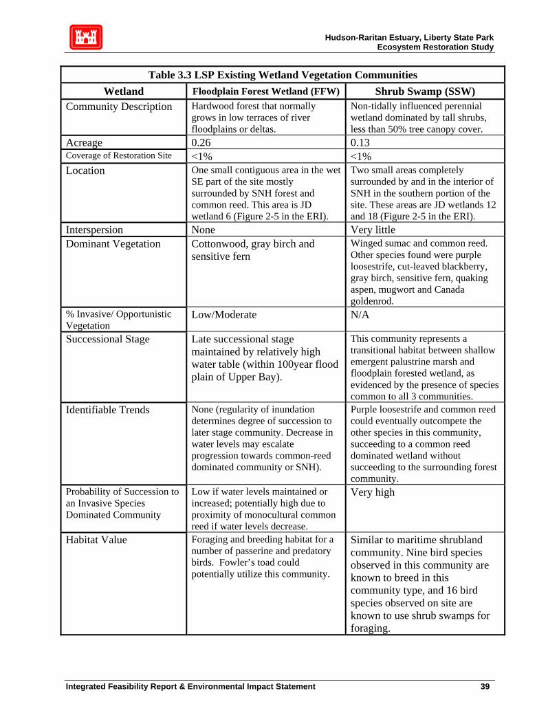
Hudson-Raritan Estuary, Liberty State Park Ecosystem Restoration Study
Table 3.3 LSP Existing Wetland Vegetation Communities Wetland Floodplain Forest Wetland (FFW) Shrub Swamp (SSW)
Community Description Hardwood forest that normally grows in low terraces of river floodplains or deltas.
Non-tidally influenced perennial wetland dominated by tall shrubs, less than 50% tree canopy cover.
Acreage 0.26 0.13 Coverage of Restoration Site <1% <1% Location One small contiguous area in the wet
SE part of the site mostly surrounded by SNH forest and common reed. This area is JD wetland 6 (Figure 2-5 in the ERI).
Two small areas completely surrounded by and in the interior of SNH in the southern portion of the site. These areas are JD wetlands 12 and 18 (Figure 2-5 in the ERI).
Interspersion None Very little Dominant Vegetation Cottonwood, gray birch and
sensitive fern Winged sumac and common reed. Other species found were purple loosestrife, cut-leaved blackberry, gray birch, sensitive fern, quaking aspen, mugwort and Canada goldenrod.
% Invasive/ Opportunistic Vegetation
Low/Moderate N/A
Successional Stage Late successional stage maintained by relatively high water table (within 100year flood plain of Upper Bay).
This community represents a transitional habitat between shallow emergent palustrine marsh and floodplain forested wetland, as evidenced by the presence of species common to all 3 communities.
Identifiable Trends None (regularity of inundation determines degree of succession to later stage community. Decrease in water levels may escalate progression towards common-reed dominated community or SNH).
Purple loosestrife and common reed could eventually outcompete the other species in this community, succeeding to a common reed dominated wetland without succeeding to the surrounding forest community.
Probability of Succession to an Invasive Species Dominated Community
Low if water levels maintained or increased; potentially high due to proximity of monocultural common reed if water levels decrease.
Very high
Habitat Value Foraging and breeding habitat for a number of passerine and predatory birds. Fowler’s toad could potentially utilize this community.
Similar to maritime shrubland community. Nine bird species observed in this community are known to breed in this community type, and 16 bird species observed on site are known to use shrub swamps for foraging.
Integrated Feasibility Report & Environmental Impact Statement 39

Hudson-Raritan Estuary, Liberty State Park Ecosystem Restoration Study
Table 3.3 LSP Existing Wetland Vegetation Communities (continued)
Wetland Shallow Emergent Marsh (SEM)
Common Reed Dominated Wetland (CRM)
Community Description Seasonally flooded non-tidally influenced perennial wetland saturated throughout the year having less than 50% tree canopy cover.
Wetland dominated by common reed and purple loosestrife. Created, maintained, or modified by human activity to such a degree that substrate, hydrology and/or biological communities are substantially different than prior to human disturbance.
Acreage 10.2. 13 Coverage of Restoration Site
4.5%. 6%.
Location Four moderately large and five unmapped very small areas located primarily in the forested zone in the southern and central portion of the site. The 4 larger areas are JD wetlands 3, 4, 7 and 20 (figure 2-5, ERI).
Interspersed throughout the project site (mapped on figure 2-3 of the ERI). As shown on figure 2-5 of the ERI, these areas are JD wetlands 2, 8, 9, 10, 11, 13, 14, 19 and 23. The “LSC” wetland is also a CRM wetland, however this particular area is not mapped as a JD wetland.
Interspersion High. High Dominant Vegetation Purple loosestrife, common
reed, gray birch, wool grass and steeplebush.
Common reed and/or purple loosestrife. Subdominants include winged sumac, sensitive fern, steepelebush and Canada goldenrod.
Successional Stage The earliest successional stage wetland type in the project area.
Common reed outcompeted other vegetation soon after deposition of dredged material, and continues to dominate.
Identifiable Trends Tendency to succeed to scrub swamp and then forested wetland. However, the significant presence of purple loosestrife and common reed here makes that normal progression questionable.
Likely to remain dominated by monocultural common reed for a long period and may eventually succeed to SNH in the very long term.
Probability of Succession to an Invasive Species Dominated Community
Moderate to high N/A
Habitat Value Foraging habitat for many of the birds found in LSP, including the northern harrier, chimney swift, American kestrel, tree swallow and killdeer. Breeding habitat for the bobolink.
Relatively low, and of limited use to raptor predation due to height of vegetation. Red-winged blackbirds and gray catbirds, which tend to prefer this habitat, were infrequently observed in these communities. Other species may use monocultural Phragmites for various purposes, but it is generally not preferred.
Integrated Feasibility Report & Environmental Impact Statement 40

Hudson-Raritan Estuary, Liberty State Park Ecosystem Restoration Study
3.7.1.3 Invasive Vegetation The reader is referred to Section 2.1.3 of the ERI for a detailed discussion of the relationship between the scale of the problem of existing invasive species on the proposed restoration site, and the interactions between communities with and without project implementation. The important issue of the ecological future of LSP with and without the proposed restoration project and/or the application of aggressive invasive species management is further discussed in sections 4, 6.1.1 and 7.1.7.1 of this report. Figure 3.7 shows the 5 vegetative communities where invasive species cover a minimum of (dominate) 75% of each community type. Invasive species also represent a significant cover type in most other communities of the proposed restoration area, but at less than 75% coverage. The 5 community types where invasive species dominate, their total acreage and their approximate invasive species coverage are as follows: 1. SNH 62.7 total acres (minimum of approximately 47 acres invasive species). 2. SOF 49.6 total acres (minimum of approximately 37 acres invasive species). 3. CRM 38.7 total acres (minimum of approximately 29 acres invasive species). 4. SEM 10.2 total acres (minimum of approximately 8 acres invasive species). 5. CRW 13 total acres (minimum of approximately 10 acres invasive species). TOTAL 174.2 total acres (minimum of approximately 131 acres invasive species, or ½ of the entire site). Note: Exact acreage of invasive vegetation in each community was estimated, not calculated. Consequently, some communities could theoretically be as high as virtually 100% covered by invasive species, although this is unlikely. Invasive species found at this site include common reed, mugwort, purple loosestrife and tree-of-heaven. Table 2-1 of the ERI lists the dominant species (including invasive) for all community types found at the LSP restoration site.
Integrated Feasibility Report & Environmental Impact Statement 41
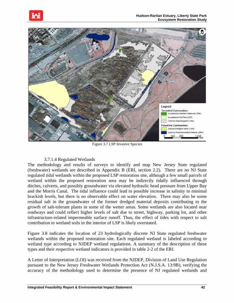
Hudson-Raritan Estuary, Liberty State Park Ecosystem Restoration Study
Figure 3.7 LSP Invasive Species
3.7.1.4 Regulated Wetlands The methodology and results of surveys to identify and map New Jersey State regulated (freshwater) wetlands are described in Appendix B (ERI, section 2.2). There are no NJ State regulated tidal wetlands within the proposed LSP restoration site, although a few small parcels of wetland within the proposed restoration area may be indirectly tidally influenced through ditches, culverts, and possibly groundwater via elevated hydraulic head pressure from Upper Bay and the Morris Canal. The tidal influence could lead to possible increase in salinity to minimal brackish levels, but there is no observable effect on water elevation. There may also be some residual salt in the groundwater of the former dredged material deposits contributing to the growth of salt-tolerant plants in some of the wetter areas. Some wetlands are also located near roadways and could reflect higher levels of salt due to street, highway, parking lot, and other infrastructure-related impermeable surface runoff. Thus, the effect of tides with respect to salt contribution to wetland soils in the interior of LSP is likely overstated. Figure 3.8 indicates the location of 23 hydrologically discrete NJ State regulated freshwater wetlands within the proposed restoration site. Each regulated wetland is labeled according to wetland type according to NJDEP wetland regulations. A summary of the description of these types and their respective wetland indicators is provided in table 2-2 of the ERI. A Letter of Interpretation (LOI) was received from the NJDEP, Division of Land Use Regulation pursuant to the New Jersey Freshwater Wetlands Protection Act (N.J.S.A. 13:9B), verifying the accuracy of the methodology used to determine the presence of NJ regulated wetlands and
Integrated Feasibility Report & Environmental Impact Statement 42
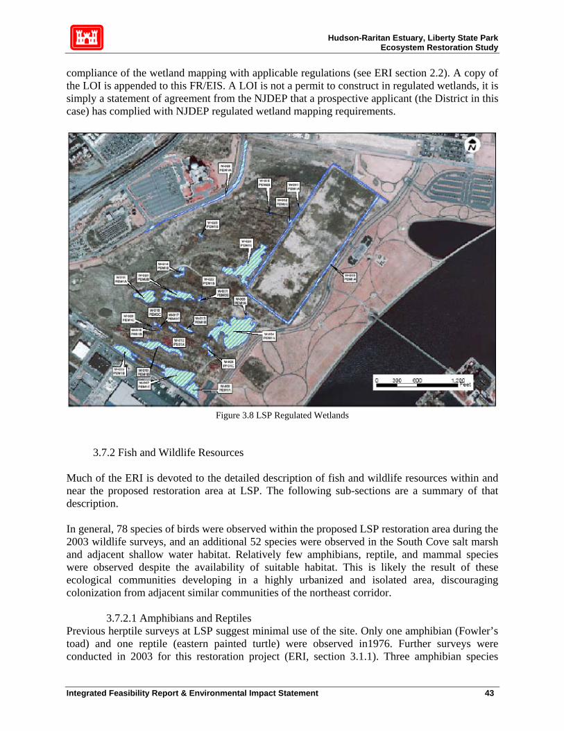
Hudson-Raritan Estuary, Liberty State Park Ecosystem Restoration Study
compliance of the wetland mapping with applicable regulations (see ERI section 2.2). A copy of the LOI is appended to this FR/EIS. A LOI is not a permit to construct in regulated wetlands, it is simply a statement of agreement from the NJDEP that a prospective applicant (the District in this case) has complied with NJDEP regulated wetland mapping requirements.
Figure 3.8 LSP Regulated Wetlands
3.7.2 Fish and Wildlife Resources Much of the ERI is devoted to the detailed description of fish and wildlife resources within and near the proposed restoration area at LSP. The following sub-sections are a summary of that description. In general, 78 species of birds were observed within the proposed LSP restoration area during the 2003 wildlife surveys, and an additional 52 species were observed in the South Cove salt marsh and adjacent shallow water habitat. Relatively few amphibians, reptile, and mammal species were observed despite the availability of suitable habitat. This is likely the result of these ecological communities developing in a highly urbanized and isolated area, discouraging colonization from adjacent similar communities of the northeast corridor.
3.7.2.1 Amphibians and Reptiles Previous herptile surveys at LSP suggest minimal use of the site. Only one amphibian (Fowler’s toad) and one reptile (eastern painted turtle) were observed in1976. Further surveys were conducted in 2003 for this restoration project (ERI, section 3.1.1). Three amphibian species
Integrated Feasibility Report & Environmental Impact Statement 43

Hudson-Raritan Estuary, Liberty State Park Ecosystem Restoration Study
(Fowler’s toad, green frog and wood frog) and 4 reptilian species (northern brown snake, eastern garter snake, northern water snake and northern diamondback terrapin) were observed in 2003. This does not suggest that LSP is an improving habitat since sample numbers were small and different methodologies were used in 1976 and 2003. In both surveys, many expected species common in northern NJ were not found (ERI, section 3.1.2). It appears that despite the apparently suitable habitat for herptiles at the LSP restoration site, many expected herptilian species may have been extirpated, or never occurred here. This may be due to: 1. Isolation. LSP is surrounded on 3 sides by Upper Bay, and on the land side is cut off from available sources of recruits to populations by intense infrastructure and dense residential development. 2. Extremely high soil permeability, which promotes rapid water percolation from vernal pools, resulting in spring/summer time periods too short to support viable populations. 3. Toxicity effects in available surface and groundwater, particularly salt in areas closest to Upper Bay. 4. LSP has been impacted by the surrounding urbanized area for hundreds of years, having been created entirely by fill in the 1800's. It is lacking in high-quality fresh water, which further suggests that adequate populations of herptiles were never present on site. In the absence of more evidence for herptiles at LSP, the history of the site and the available herptile data suggests that it is unlikely that populations of even common species of amphibians and reptiles will prosper in the future under existing conditions.
3.7.2.2 Birds Avian surveys were conduced in 2003 to update existing NJDEP and other on-site information collected over the years. Abundance, species richness, and habitat use were identified.22 It is notable that total count results (130 species) include North and South Coves, and thus are skewed in favor of species with an affinity for salt marsh/shallow estuarine water. During weekly wildlife observations in August, 758 individual birds representing 56 species were recorded within the proposed LSP restoration area, and in North and South Coves. Songbirds were the largest group represented (29 species, 61.7%). Doves and pigeons (13.1%), gulls and terns (11.2%), waterfowl (3.6%), swifts (2.8%), shorebirds (2.5%) raptors (1.6%), cormorants (1.5%), waders (1.2%) and woodpeckers (0.9%) were also represented. Table 3-1 of the ERI lists all bird species observed. The most common species observed were European starling (12.3%), rock dove (10.6%), gray catbird (10.2%), American robin (9.9%), ring-billed gull (7%), song sparrow (6.2%), barn swallow (5.8%) and eastern towhee (3.4%). Most birds observed were flying and thus not associated with any particular vegetative community. However, of the numerous observations of birds using a particular vegetative 22 The methodology employed is described in section 3.2.1 of the ERI. Figure 3-1 of the ERI locates the observation stations. Survey results are presented in section 3.2.2 of the ERI.
Integrated Feasibility Report & Environmental Impact Statement 44
Hudson-Raritan Estuary, Liberty State Park Ecosystem Restoration Study
community, most of the observations were made in mowed lawn, maritime shrubland and successional northern hardwood communities respectively (ERI table 3-2). The known habitat and seasonal use requirements of the most common bird species observed and that relationship to the vegetative communities present on the site is described in table 3-3 of the ERI. Most common species observed are residents and use a variety of existing habitats, primarily for foraging. Additional observations of bird utilization of the proposed LSP restoration site were made during northern harrier surveys (ERI, section 4), April 2003 amphibian surveys, October 2003 mammal surveys and by LSC staff between 3 January and 6 June 2003. These supplemental observations yielded another 76 bird species, bringing the total to 130 species observed on or near the proposed restoration site. Of this total, 78 were observed within the proposed restoration site and 52 observed in the South Cove salt marsh and its adjacent shallow water. Appendix C of the ERI contains a comprehensive list of all 130 species observed during all 2003 surveys and the vegetative community in which these species were found, when known. Section 3.2.2 of the ERI contains a discussion of the habitat preferences of selected desirable avian species that have been observed in the vicinity of LSP and would be expected to utilize the existing project area, assuming availability of suitable habitat and environmental conditions, based on a multitude of sources. A list of representative species follows: Raptors: Osprey, northern harrier, red-tailed hawk, common barn owl, peregrine falcon, rough- legged hawk, American kestrel, short-eared and long-eared owl, Cooper’s hawk, great horned owl, sharp-shinned hawk, turkey vulture, merlin, snowy owl. Passerines: Song sparrow, American robin, gray catbird, yellow warbler, red-winged blackbird, grasshopper sparrow, savannah sparrow, bobolink, European starling, barn swallow, eastern towhee, American goldfinch. Waders: Black-crowned night heron, snowy egret, glossy ibis, cattle egret, great egret, yellow- crowned night heron, green heron. Waterfowl: American black duck, mallard, Atlantic brant, greater scaup, canvasback, Canada goose, bufflehead, oldsquaw, red-breasted merganser, common goldeneye, American wigeon, ruddy duck, white-winged scoter, gadwall, green-winged teal, blue-winged teal, northern pintail. Shorebirds: Semipalmated sandpiper, semipalmated plover, sanderling, ruddy turnstone, black- bellied plover, dunlin, short-billed dowitcher, greater and lesser yellowlegs, least sandpiper, spotted sandpiper, killdeer, black-bellied plover, Baird’s sandpiper. Gulls and terns: Herring gull, greater black-backed gull, ring-billed gull, laughing gull, common tern, least tern, black skimmer. Cormorants: Double-crested cormorant, great cormorant.
Integrated Feasibility Report & Environmental Impact Statement 45
Hudson-Raritan Estuary, Liberty State Park Ecosystem Restoration Study
Rails and coots: Clapper rail, Virginia rail, sora, American coot. Others: Downy woodpecker, chimney swift, wild turkey, ring-necked pheasant, northern flicker, red-bellied woodpecker, pigeon.
3.7.2.3 Mammals A small mammal trapping study was conducted between 28 October and 1 November 2003 to update observations made by LSP staff and others over the years (ERI, section 3.3). Several collection devices were used, including pit traps with drift fences, live traps, snap traps, hair snares and cover boards.23 Prior to this survey, Texas Instruments conducted a mid-sized and small mammal survey in 1976 and found the following species: eastern cottontail rabbit, raccoon, eastern fox, muskrat, meadow vole, Norway rat and the house mouse. Table 3-4 of the ERI lists eleven mammalian species (including feral dogs and cats) found in the 2003 survey. This recent survey suggests changes in the small mammal population of LSP since 1976; specifically, slightly more species and a shift from house mouse to white-footed mouse. White-footed mice were not represented in 1976 but appear to have replaced the house mouse by 2003, and actually are now somewhat abundant. Although numbers are low, the Norway rat and house mouse are still present. The presence of feral dogs and cats and raccoons is a problem for the introduction/reintroduction of certain species of amphibians, reptiles, birds and mammals. This is further discussed under the following TES section and in Section 7, Environmental Consequences, of this report.
3.7.2.4 Threatened and Endangered Species (TES) It is required by federal law (NEPA, ESA), federal regulations (USFWS, USACE, NOAA-Fisheries) and NJDEP laws and regulations (e.g., Freshwater Wetlands Protection Act) that federal or state endangered or threatened species and /or critical habitats be documented and the impacts on these species and habitats, if any, described. There are no known Federally listed species or critical habitats within the proposed LSP restoration area. This is based on:
• A thorough literature review of relevant studies. • Coordination with affected agencies and groups (NJDEP, NOAA-Fisheries, USFWS,
NJDEP, IC staff, LSC staff, NJ Audubon Society) • Extensive biological observations documented in the ERI and this FR/EIS.
There are however, six NJ state listed species found at LSP. Their associated habitats are described in Section 4 of the ERI. The species are Torrey’s rush (a grass) and 6 birds (northern harrier, Cooper’s hawk, long-eared owl, short-eared owl, Bobolink and Savannah sparrow). Although the bobolink is not officially listed in NJ, this rare bird’s habitat preferences are described in section 4.2 of the ERI also. A summary of northern harrier observations during 2003 is provided in Table 4-2 of the Environmental Resources Inventory. Figure 4-1 of the ERI locates the northern harrier observation stations. 23 Figure 3-1 of the ERI locates the wildlife observation stations and section 3.3.1 of the ERI describes the methodology employed.
Integrated Feasibility Report & Environmental Impact Statement 46

Hudson-Raritan Estuary, Liberty State Park Ecosystem Restoration Study
In summary, NJ state listed TES have been documented by various sources within the proposed LSP restoration site. Of the 5 state listed birds, only the northern harrier has been documented to have recently nested, although nesting success in 2003 is uncertain. Northern harriers and long-eared owls use LSP for winter roosting and/or foraging. Short-eared owls have been observed foraging on the proposed LSP restoration site but have not been documented using the area for nesting, although an individual was observed roosting in the thickly wooded area adjacent to the LSP Interpretive Center in winter 2003-2004. Savannah sparrows and bobolinks are known to use the proposed LSP restoration site during migration.
3.7.2.5 Benthic invertebrates Benthic invertebrates were collected in North Cove (section 5.2 and figure 5-1 of the ERI), since a small amount of dredging needs to occur at the head of the cove to provide for adequate tidal exchange in the proposed salt marsh. Grab samples were taken in late summer 2003 and represent the worst-case conditions (highest water temperatures and lowest dissolved oxygen) for shallow benthic communities. Appendix E of the ERI contains a detailed description of the North Cove benthic survey. The purpose of this survey was three-fold: 1. Characterize the nature of the benthic population in North Cove as a benchmark for
the benthic population expected within the proposed tidal creek and salt marsh. 2. Determine the general environmental health of the benthic community in North Cove to address any potential impacts from the proposed restoration project. 3. Assist in the planning of improved habitat functional value in North Cove. The methodology utilized in the survey is provided in section 5.2.1 of the ERI. Briefly, 21 Ponar grab samples (3 replicate samples at each station) were collected at 7 stations (figure 5-1of the ERI). Four stations (station B-6, B-4, B-5, B-7) were located along a west-east transect beginning at the proposed mouth of the tidal creek and ending just east of the promenade in Upper Bay. The remaining 3 stations (B-1, B-2, B-3) were located in the intertidal zone in the shallowest water possible at the edges of the cove. Analysis consisted of identifying organisms passed though a 0.5mm sieve, sediment texture and % organics. Field observations of visually detectable petroleum hydrocarbons, shell hash, and obvious odors such as petroleum or hydrogen sulfide were recorded. Table 5-1 of the ERI summarizes the results of the survey. The samples were dominated by polychaete worms. Several species of stress-tolerant polychaetes such as Stroblospio, Nepthys and Capitella were represented. These species are often found in environments with low dissolved oxygen concentration, high organic matter and sewage content and sometimes petroleum hydrocarbons. Amphipods were found in some intertidal zone samples, however, Ampelisca abdita, an indicator of transition (recovering or declining) environmental health, was absent, further suggesting that North Cove sediments are biologically stressed. Horseshow crabs were found, but these are considered to be highly pollution tolerant animals, common in the NY-NJ Harbor in shallows during spring and summer. Although direct comparisons cannot be made,
Integrated Feasibility Report & Environmental Impact Statement 47

Hudson-Raritan Estuary, Liberty State Park Ecosystem Restoration Study
benthic organisms found in North Cove are somewhat similar to other studies of Upper Bay conducted over the last decade, although North Cove infauna abundance is lower, as expected in a near-shore shallow protected environment. The benthic assemblage in North Cove represents a very early successional stage dominated by small opportunistic worms. It is likely to remain at this stage absent sediment and water quality improvement. Field observations also indicated that there was a smell of petroleum hydrocarbons and the visual presence of oil droplets in the sampled sediments. This is an indication that North Cove is a source and/or sink of petroleum hydrocarbons. However, this is also characteristic of much of the fine sediment in NY-NJ Harbor. This is discussed further in section 7.1.12 and the HTRW report in Appendix E. The benthic community of North Cove can be characterized as follows: 1. From a geochemical standpoint, surficial sediments are typical of shallow water in sequestered areas of NY-NJ Harbor, i.e., soft black unconsolidated high organic content fines with evidence of chemical pollution. 2. There is a geological and biological gradient from the near-shore samples to the relatively deeper mid-cove samples, i.e., coarse sediment/low abundance to finer sediment/higher abundance, which is to be expected. It is not known what process is responsible for the coarser sediments near shore. However, wave action in the lower intertidal zone may contribute to winnowing of fines, and /or coarse material may have been deposited to support adjacent rip- rap and still remains near shore since creation of the cove. 3. Infauna abundance and species richness are relatively low compared to higher energy regimes in Upper Bay (as would be expected) such as the NJ flats adjacent to the main shipping channel (refer to NOAA references in Appendix E of the ERI). 4. Species composition is typical of highly stressed shallow urban estuarine environments: dominance of polychaetes, especially Capitella, Streplospio, certain Nephthys and others. 5. The proximity of CSO’s between North and South Cove and the Morris Canal may be contributing to the character of the North Cove benthic community, among many other factors.
3.7.2.6 Fish Since there is no permanent fresh water at LSP, there are no fish. There is, however, a fish population in North Cove, somewhat typical of shallow waters of the NY-NJ Harbor, as described below and in further detail in section 5.3 of the ERI. Characterization of the fish community in North Cove was accomplished utilizing seine net and trap samples taken during late summer to early fall of 2003 for the following reasons: 1. Establish a baseline for predicting fish use of the proposed tidal creek and salt marsh, which will exchange water with North Cove on a regular basis.
Integrated Feasibility Report & Environmental Impact Statement 48
Hudson-Raritan Estuary, Liberty State Park Ecosystem Restoration Study
2. Provide a comparison with post-construction surveys to determine level of success of establishment of a viable fish community in the tidal marsh. 3. Determine environmental impacts. 4. Help plan the overall restoration effort and predict and evaluate habitat function changes. Since small and/or juvenile fish were expected in North Cove, beach seines and traps were used to sample the fish community. The focus on juveniles and small forage fish was due to the expectation that they would primarily utilize the proposed salt marsh habitat. Additionally, it is difficult to impossible to deploy trawls and gill nets in the area inside the promenade. Figure 5-1 and table 5-2 of the ERI describe the location of the 3 sampling stations (F-1, F-2, F-3) and the type of gear used, respectively. Table 5-2 of the ERI also describes the date, depth, number of species caught (species richness) and number of fish caught (abundance) for each gear deployment. Samples were collected from 28 August 2003 to 24 September 2003. As with the benthic community, this late summer collection period represents worst-case (highest temperature/lowest DO) conditions. On the other hand, it is also the best time of the year to capture tropical migrants, particularly in beach seines. Note, however, that there are more variables in the connectivity between fish populations and physicochemical environmental factors than with benthic communities. Table 5-2 of the ERI indicates that seines were more efficient to capture fish in North Cove than traps, as evidenced by the relative number of fish caught. Of course, direct comparisons in numbers of fish caught, or species richness, cannot be made because of the difference in gear type and selectivity and length and frequency of deployment of gear types. The total number of fish caught by both types of gear, seines and traps are 257, 205 and 52, respectively. Note that the average depth deployment of seines was approximately 5 feet, while for traps it was approximately 7 feet (necessary because beach seines could not be deployed in the deeper area of North Cove). Table 5-3 of the ERI lists the total of species caught and their average, minimum and maximum length, from which can be construed their life cycle stage, i.e., juvenile vs. adult. Species collected were alewife, American eel, Atlantic menhaden, Atlantic silverside, bay anchovy, hogchoker, northern pipefish, oyster toadfish, scup, striped bass, summer flounder, tautog, weakfish, white perch and winter flounder. This assemblage represents both juvenile and adult fishes depending on species, however the majority of individual fish caught were juveniles. Both the assemblage and the dominance of juveniles and small forage fish were expected for this shallow habitat in this salinity gradient of the Hudson River Estuary. The presence of hogchoker, white perch and juvenile striped bass indicate the typical salinity range (approximately 10-20 ppt) found in North Cove, although it must be kept in mind that salinity varies considerably over tidal cycles, storm events and seasons in temperate estuaries. Bay anchovy was the most dominant species collected during the survey. All of these species are pollution tolerant to varying degrees and at various life stages and all of them would potentially utilize tidal creek and flooded low marsh habitat.
Integrated Feasibility Report & Environmental Impact Statement 49

Hudson-Raritan Estuary, Liberty State Park Ecosystem Restoration Study
3.7.2.7 Essential Fish Habitat The 1996 amendments to the Magnuson-Stevens Fishery Management and Conservation set forth a number of new mandates for the National Marine Fisheries Services (NMFS) (now the National Oceanic and Atmospheric Administration (NOAA)-Fisheries), regional fishery management councils (Councils), and other Federal agencies to identify and protect important marine and anadromous fish habitat. The Councils, with assistance from NOAA-Fisheries, are required to delineate “essential fish habitat” (EFH) for all managed species. Federal action agencies, which fund, permit, or carry out activities that may adversely impact EFH are required to consult with NOAA-Fisheries regarding the potential effects of their actions on EFH, and respond in writing to the fisheries service’s recommendations. In addition, NOAA-Fisheries is required to comment on any state agency activities that would impact EFH (NMFS 1998). Essential fish habitat (EFH) is regulated by NOAA-Fisheries. The North Cove is the only area within this proposed project site where EFH species, or any fish, occur. Of the species listed in table 5-3 of the ERI, several are listed as EFH species. There are also other EFH listed species not found in North Cove in 2003 but known to be present in Upper Bay and are undoubtedly sometimes present in the project area. Coordination with NOAA-Fisheries is on-going. This coordination will be completed before the finalization of this IR and documented in the final report. 3.8 Air Quality The USEPA assesses overall air quality according to the National Ambient Air Quality Standards (NAAQS) for six criteria pollutants: carbon monoxide (CO), lead (Pb), nitrogen dioxide (NO2), ozone (O3), particulate matter (PM) and sulfur dioxide (SO2). Commonly cited sources of criteria pollutants include automobile exhaust emissions, fossil fuel (coal, natural gas and oil) fired power plants, oil refineries, ore smelters, storage and transfer operations involving solvents, and industrial emissions, among others (USEPA 1998). The study area is located in the New York-Northern New Jersey-Long Island Consolidated Metropolitan Statistical Area (CMSA). According to the National Air Quality and Emissions Trends Report (USEPA 1998), the New York-Northern New Jersey-Long Island CMSA is considered a non-attainment area for CO and is classified as an extreme/severe non-attainment area for O3 (NJDEP 1999b).
3.9 Noise For the purposes of this report, noise is defined as unwanted sound, and therefore relative to the receiver, human or non-human. People, heavy equipment, vehicles, airplanes, boats or many other sources could generate unwanted sound. Existing noise levels at LSP are location specific. Noise levels are low compared to most of the surrounding metropolitan area because this is a large and relatively isolated park. The interior (mostly fenced-off) areas are even quieter since they are obviously the most insulated from most significant noise sources. The closer wildlife gets to the four main roads at LSP and the parking lots, the more noise impacts become important. However, it should be noted that nesting and other wildlife functions can occur
Integrated Feasibility Report & Environmental Impact Statement 50
Hudson-Raritan Estuary, Liberty State Park Ecosystem Restoration Study
immediately behind fencing, despite intense human presence nearby, because of physical isolation by impassable barriers. Boat traffic can also generate noise at times near the Morris Canal and the Black Tom, where boat traffic is concentrated. However, these two areas are sufficiently removed from the proposed restoration area so as not to be considered a major existing source. Likewise, scrap yards at Caven Point generate exceptionally loud noise levels, but these are too far away to be of significant impact to the proposed restoration area. However, noise generated by the industries adjacent to the south near Thomas McGovern Drive and, to a lesser extent, the western side across Phillip Street of the proposed restoration area may have an effect upon species. Two specific areas that may be affected by existing noise impacts within the proposed restoration area are the LSC wetland site (slightly affected by noise generated on the NJ Turnpike and Audrey Zapp Drive), and the tidal creek inlet area (directly open to noise from Freedom Way, in addition to a greater intensity of pedestrian traffic on the surrounding walkways).
3.10 Recreation Liberty State Park is a premier recreational destination, owned and maintained by the State of New Jersey. Numerous public facilities include the Liberty Science Center and Hall of Technology, Visitors Center, Interpretive Center, the former Central Railroad of New Jersey (CRRNJ) railroad terminal, a swimming pool, hiking trails, picnic area, playground, food concession, and associated parking and roads. Waterfront facilities include the Liberty Landing Marina, a trailer launch, canoeing and boating facilities, and boat storage facilities. There is a pedestrian walkway on top of the seawall and levee built by New York District on the eastern edge of the park.
3.11 Aesthetics Aesthetics is subjective and depends on what the viewer considers to be pleasant or objectionable. For example, a well-constructed bridge may be considered an eyesore to someone who wants to keep an area entirely “natural,” whereas, to the engineer who built the bridge, it could be considered a work of art. To the extent that LSP can be considered a welcome green area in a sea of industrialization and urbanization, the park is highly aesthetical. Liberty State Park has scenic views of the Statue of Liberty, Ellis Island, and lower Manhattan from its Liberty Walk. It also has many recreational venues, as discussed in section 3.10. Generous expanses of grassland are to be found throughout the park. However there are elements of the existing landscape that might be considered objectionable. These are, potentially, the chain-link fences surrounding interior sections of the park that deny access to the public, the interior sections themselves, and invasive vegetation such as Phragmites, mugwort and tree of heaven. Additionally, the relative lack of topographical relief, due to the site’s past usage as a railroad yard, allows views of the surrounding industrial areas at some points within the park.
3.12 HTRW There are substances listed under CERCLA/RCRA within the study area, but not at high enough levels to require CERCLA/RCRA action. It was not possible to avoid these substances during the formulation of complete and ecologically sensitive restoration measures. The New Jersey
Integrated Feasibility Report & Environmental Impact Statement 51

Hudson-Raritan Estuary, Liberty State Park Ecosystem Restoration Study
Department of Environmental Protection (NJDEP) has conducted numerous environmental investigations within the LSP project area from 1978 to the present (NJDEP 1989; 1995; 2000). Results from these investigations show evidence of relatively widespread soil contamination, but generally at levels below applicable hazardous-waste thresholds. Heavy metals, including arsenic, lead, zinc, and copper, and polynuclear aromatic hydrocarbons (PAHs) are nearly ubiquitous in fill materials at the site, and commonly occur at concentrations above the applicable NJDEP Non Residential Direct Soil Cleanup Criteria (NRDSCC). The second NJDEP criteria used was Impact to Groundwater Soil Cleanup Criteria (IGWSCC). The concentrations of PAHs and metals in common fill materials are generally within the ranges listed in the NJDEP Historic Fill Database, and appear to meet the general definition of “historic fill” under Technical Rules for Site Remediation (N.J.A.C. 7:26E App.D). Therefore, soils other than those containing chromate chemical production waste (CCPW) or petroleum free-product can be probably managed on site, such as by capping with a layer of clean soil and establishing vegetative cover. However, soils that are saturated with petroleum or which contain CCPW generally require either off-site disposal or on-site stabilization. Petroleum hydrocarbons are commonly present in surface soils, probably as a result of incidental spillage during historic railroad operations, and petroleum free-product has been observed in subsurface soils in two different locations within the park. Traces of Polychlorinated biphenyls (PCBs) and organochlorine pesticides, such as dieldrin and DDT, have also been detected locally at concentrations above the NJDEP NRDCSCC (but generally below applicable hazardous waste thresholds). Additionally, fill materials containing CCPW have been identified at one site adjacent to the project area (brick sewer, southern edge). The presence of hexavalent chromium is a prevalent concern at LSP. Within LSP, dredged material is contained within a 45-acre rectangle (Figure 3.9). The dredged sediment is presently contained by a series of eight foot high earthen berms, constructed by PANYNJ during 1980-1981 using existing fill material excavated on-site (NJDEP 2000a). Dredged material was deposited in two episodes, in connection with the construction of the Liberty Walk Seawall project on the eastern edge of the park in the 1980s. In 1981, 93,000 cubic yards were deposited in this area, followed by 225,000 cubic yards in 1987. The dredged material was capped with clean soil, which experienced some erosion in the dry winter of 1991-1992. In response, NJDEP arranged to recap the berms and establish vegetative cover during the summer of 1993 (NJDEP 2000a). In 1995, NJDEP conducted more soil samples within this 45-acre area and found that soil contaminants within this area were generally similar to the historic fill conditions in other portions of the park, with exception of PCBs and dieldrin (NJDEP 1995a). Ground water quality at the site is generally reflective of the soil conditions described above. In 1994, the NJDEP Site Remediation Program conducted a site-wide reconnaissance investigation of ground water conditions of at the site, during which 50 ground water samples were collected for laboratory analysis using a Hydropunch direct-push sampling rig. The sampling locations were targeted to specific features that were previously identified by the NJDEP during a review of historical aerial photography (NJDEP 1994). The samples were analyzed for TCL VOCs, Metals and SVOCs. No VOCs were detected in the samples. However, metals and PAHs were detected locally at concentrations above the NJDEP Groundwater Quality Criteria.
Integrated Feasibility Report & Environmental Impact Statement 52

Hudson-Raritan Estuary, Liberty State Park Ecosystem Restoration Study
Results from NJDEP investigations are extensive and provide detailed soil contamination data to an approximate depth of five feet below ground surface (bgs) throughout the site. However, because potential ecosystem restoration alternatives consider removal of fill in the 45-acre area to historic marsh and tidal levels, which are at least 12-15 ft bgs, New York District conducted more intensive site HTRW investigations for the feasibility study. During the first phase in August 2003, 40 soil/sediment contaminant samples were taken throughout LSP, 38 on land, 2 in the North Cove (Figure 3.9).24 The two North Cove Samples were not collected in this first round, but in the second round. Samples in the first round were taken from 30 feet bgs for two reasons: 1) to find the original, historic surface layer and 2) the assumption that over time, amounts of contamination, spilled fuel oil, hexavalent chromium, other heavy metals and VOA’s would have migrated downward through the back fill. All samples were analyzed for: Volatile Organics Library + 15 (VOA+15), Acid Base Neutral Library +25 (ABN+25), Pesticides/PCB’s (Pest/PCB), Total Petroleum Hydrocarbons (TPHC), RCRA Metals, Percent Solids (% solids). Considering the known chromium contamination, additional analyses were conducted for hexavalent chromium. The analysis for hexavalent chromium was sent to a laboratory specializing in that particular analysis. The results from this phase showed a relatively low number of borings, 16 out of 38, with measurable contamination at 30 feet bgs. No PCBs or VOAs were found in any of the 38 samples collected. TPHC, dieldrin, Acid Base Neutrals, arsenic, cadmium, copper, lead, mercury and nickel were sparsely scattered throughout the site and few exceeded NJDEP/NRDCSCC thresholds. It is worth noting that hexavalent chromium, the primary concern of this HTRW investigation, came in below the threshold of 10ppm for all samples in which it was detected. One sample, #20 near North Cove, had significant test results and is located at the entrance of the proposed tidal creek (Figure 3.9). Sample #20 exhibited high numbers of Priority Pollutant metals and several compounds of ABNs, signifying a concentration or hotspot of contamination. In the other categories, #20 did not exceed NJDEP criteria. A second phase was conducted in February 2004, based on results of the August 2003 investigations. The two sediment samples from North Cove were collected in this second round. This round focused on the route of the proposed tidal creek and collected continuous samples from the surface to 15 feet bgs (Figure 3.10). No pesticides, PCBs, or Volatile Organics were detected in this round. Two areas of concern were identified in the second round, in the area of North Cove and the 45-acre containment area. Samples collected in the second round closest to sample point 20 from the first round showed the highest levels of metals, including hexavalent chromium, arsenic, lead, copper, and zinc. Other contaminants found include petroleum hydrocarbons and semi-volatile organics, also in the North Cove and the 45-acre containment area. At the time of construction, procedures will be in place to manage excavations from this area to ensure that minimal amounts of soil/sediment are released to the general environment and that excavated materials are disposed of properly and securely in the park’s on-site placement area.
24 HTRW samples were taken concurrently with Geotechnical samples.
Integrated Feasibility Report & Environmental Impact Statement 53

Hudson-Raritan Estuary, Liberty State Park Ecosystem Restoration Study
Figure 3.9. 2003 Geotechnical and HTRW sampling locations
Figure 3.10. 2004 Geotechnical and HTRW sampling locations
Integrated Feasibility Report & Environmental Impact Statement 54

Hudson-Raritan Estuary, Liberty State Park Ecosystem Restoration Study
3.13 Transportation and Other Infrastructure Major highways close to Liberty State Park include the New Jersey Turnpike, which is immediately northwest of the project area, and Route 1, 9, also north and west of LSP. Public transportation is available through bus, rail, and ferry. New Jersey Transit operates buses and the Hudson-Bergen Light Rail line. The New Jersey Light Rail Park and Ride has 1,290 parking spaces at its boarding point in the northwest corner of the park, by the Liberty Science Center. Two companies operate ferries: New York Waterway and Circle Line, between LSP and lower Manhattan. New York Waterway ferries stop at the Liberty Landing Marina, and Circle Line ferries stop at the Central Rail Road of New Jersey terminal. Newark International Airport is approximately 7 miles away (by air). Remnants of the Morris Canal system exist at Liberty State Park and are non-functional. Similarly, there are artifacts from previous railway activities by CCNJR and LVRR that, with the exception of the CCNJR terminal, are non-functional and lack historic significance (refer to Cultural section). The Jersey City Sewerage Authority (J.C.S.A.) operates a treatment facility (East Side Treatment Plant) immediately to the west of LSP. A utility plan of LSP produced by PANYNJ (1975) shows subsurface electrical, water, telephone, and sanitary sewer service throughout the LSP project area. Three sewer mains operated by the JCSA are pass through the site and discharge to the Hudson between the filled Middle Cove and South Cove: (1) 96-inch diameter steel combined sewer, (2) an 84-inch abandoned brick combined sewer, and (3) an 80 inch by 80 inch reinforced concrete sanitary sewer. No excavation is planned for the area above these sewer mains. 4. FUTURE WITHOUT-PROJECT CONDITION
The study area has experienced severe habitat degradation due to past fill activities, which converted an estuary into an upland environment. In the absence of Federal action, it is anticipated that the study area ecosystem will remain in a degraded condition, with wetland areas dominated by invasive species. In addition, some areas that are currently of higher functional value are expected to degrade in the long term without significant management. The predevelopment condition of much of the study area was open water and intertidal marsh. Accordingly, it would not be feasible to restore the existing environment to its “original” or “predevelopment” condition. However, restoration to a more ecologically valuable condition is feasible and could restore vital tidal saltwater marsh habitat in the New York Harbor that was once abundant and is currently scarce in the State of New Jersey. Salt marsh, which is classified as an EPA priority wetland, can support diverse and thriving communities that provide spawning and nursery habitats for commercially valuable anadromous fish (e.g., striped bass, shad, herring) and for shellfish (e.g., blue crabs and oysters), as well as many species of waterfowl that nest and/or use the marshes as a migratory stopover. In many areas where Spartina-dominated marshes still exist, they have become degraded and are subject to Phragmites encroachment. As in the case of Liberty State Park, where Spartina marsh still
Integrated Feasibility Report & Environmental Impact Statement 55

Hudson-Raritan Estuary, Liberty State Park Ecosystem Restoration Study
persists, it has been dislocated, reduced in functionality and encroached upon by more aggressive vegetation. Seasonally flooded freshwater wetlands already exist at Liberty State Park. However, they are generally small, fragmented parcels that serve primarily as drainage areas and are not high quality wetlands, consisting mostly of common reed and purple loosestrife. Also, the surface water of these wetlands disappears in the later months of summer, consequently limiting the overall habitat functional value and making it impossible for some water-obligate species (fish, and some amphibians, reptiles and vegetation) to exist at all on this site. Currently, these wetlands are scattered throughout the site, mainly existing as vernal pools that are more often dry than wet. As a result of these combined factors, the wetlands in their current state are an untenable habitat for some important habitat species. Terrestrial habitat at Liberty State Park is dominated by opportunistic tree species such as poplars and gray birch that often colonize disturbed areas because they generally have high light requirements, can colonize bare mineral soils, and are tolerant of poor soil conditions. Old field, grassland, and scrub-shrub are distributed in a mosaic pattern across most of the interior of the site. Half of the upland zones are overrun by invasive species, which will continue to spread, if no action is taken. With no ecosystem restoration or enhancement at this site, its habitats will continue to degrade. Some of the site’s existing habitats would further degrade as a result of continued expansion of the invasive plants, further limiting the abundance of wildlife populations and reducing biodiversity. Wetlands within the LSP restoration site will likely continue to decrease in functionality over the next ten years without the proposed restoration project. Common reed and/or purple loosestrife are common in most of the freshwater wetlands. It is likely that, with the possible exception of the floodplain-forested wetland, existing wetlands will develop into monocultures of these invasive species. In addition, the water-filtration/groundwater recharge capacity of the existing freshwater wetlands would decline as wetlands succeeded to drier habitats because of the lack of reliable water sources. Habitat of valuable and state-listed species such as the Northern Harrier will be threatened by increased nearby traffic. Currently, the N. Harrier uses some of the 45-acre containment area for nesting. As the popularity of Liberty State Park grows, increased pedestrian and vehicular traffic from the Liberty Science Center, the Marina, and Liberty Walk may negatively affect the current N. Harrier habitat. Through ecosystem restoration, Northern Harrier habitat would be created in better, less fragmented locations. Maritime shrubs are located throughout the old field communities, and the acreage of the grasses is likely to decrease as the shrubs become dominant. Existing maritime grassland communities are located adjacent to monocultures of the invasive species common reed and mugwort. The invasive species will likely encroach upon the grasslands and eventually out-compete them for resources, and the maritime grasslands will likely be rare or non-existent within the Liberty State Park restoration area in as little as ten years. The threat to maritime grasses and shrublands is important from an aquatic ecosystem perspective because these upland habitats act as the first line of defense against the invasive species for tidal marshes and freshwater wetlands.
Integrated Feasibility Report & Environmental Impact Statement 56

Hudson-Raritan Estuary, Liberty State Park Ecosystem Restoration Study
In summary, the problems at Liberty State Park are:
• Loss of habitat biodiversity • Loss of rare habitat • Loss of habitat for rare or special-interest species • Vulnerability of existing desirable wetland habitats to invasive species and an inadequate
water supply • Expansion of Phragmites and other invasives
The site’s inaccessible contaminated area would remain as such rather than potentially serving as a publicly accessible wildlife habitat, which is especially important given the public visitation of this park. With no habitat restoration, opportunities would not be realized for greater biodiversity in estuarine-related ecological functions, significantly increased scientific education, and passive recreation that restoration at this site offers. Given the density of the New York Metropolitan area, it is possible that some entity would eventually develop the study area at Liberty State Park for recreational purposes if a restoration project were not implemented. However, at this moment, there is no evidence that anyone is planning to develop the park. Additionally, a Consent Decree25, which requires remediation if the restoration project is not implemented, places some technical constraints on the development of the park. The Liberty State Park Development Commission (LSPDC) investigated the feasibility of turning the study area into a golf course in the 1970s, but was ultimately dissuaded by strong public sentiment. The LSPDC has since been dissolved, and with the technical constraints of the Consent Decree, development of the restoration along these recreational lines would probably be more difficult than the habitat restoration anticipated in the Consent Decree.
4.1 Study Area Conditions that are Unlikely to Change Some existing conditions are not expected to undergo significant changed during the period of analysis. For example, most aspects of the physical setting are expected to remain largely unchanged over the planning period, specifically topography and soils, including contaminant levels that degrade the ecological value and possibly human health, necessitating the continued denial of public access to a premier harbor park. The HTRW situation (essentially unusable contaminated area in the interior) will likely remain as is. In addition, no significant changes are anticipated for cultural and historic resources, air quality, and noise.
4.2 Study Area Conditions that are Likely to Change
Without project implementation, invasive species (primarily phragmites, purple loosestrife, mugwort, tree of heaven, Japanese knotweed) are likely to increase in coverage, there will likely be a gradual transition to drier habitats (with resulting loss of wetlands).
25 Discussed in greater detail in section 5.2.2.3.
Integrated Feasibility Report & Environmental Impact Statement 57
Hudson-Raritan Estuary, Liberty State Park Ecosystem Restoration Study
5. PURPOSE OF AND NEED FOR PROPOSED ACTION / PROBLEMS AND OPPORTUNITIES
5.1 Problems and Opportunities As described above in existing conditions and without-project future conditions, it is anticipated that in the absence of Federal action, the study area ecosystem will remain in its present condition, accompanied by a long-term decrease in on-site ecological value, due to successional processes and probable accelerated dominance of invasive and opportunistic species. The predevelopment condition of much of the study area appears to have been open water, intertidal flats, and tidal marshlands. Accordingly, it would not be practical to restore this site to its “original” or “predevelopment” condition. However, restoration to a more ecologically valuable condition, than current and future conditions would bring with no action, is feasible and would restore vital tidal saltwater marsh habitat in New York Harbor that was once abundant and is currently scarce in the State of New Jersey. It would also add considerable terrestrial and palustrine functional value to the site. Tidal saltwater marshes, which are classified as EPA priority wetlands, can support diverse and thriving communities that provide spawning and nursery habitats for commercially valuable anadromous fish (e.g., striped bass, shad, herring) and for shellfish (e.g., blue crabs and oysters), as well as many species of waterfowl that nest and/or use the marshes as a migratory stopover. Within the HRE, existing Spartina-dominated marshes have become degraded and are subject to Phragmites encroachment. As in the case of Liberty State Park, where Spartina still persists, it has been relegated to the margins of the Phragmites marsh. Ecosystem restoration in Liberty State Park would provide an important contribution to the local and regional ecology in the New York metropolitan area by returning some of the high functional value wetland, forest, grassland and shrub habitat that has been systematically altered over time.
5.2 Planning Objectives, Constraints, and Key Assumptions The Federal objectives in making investments in water resource/ecosystem restoration projects are to contribute to National Ecosystem Restoration (NER) and National Economic Development (NED). USACE planning objectives must be consistent with Federal, State, and local laws and policies, and technical, economic, environmental, regional, social, and institutional considerations. Recommended restoration plans should maximize benefits to the environment and meet local preferences to the fullest extent possible.
5.2.1 Planning Objectives In pursuit of the goal to restore degraded ecosystems in the study area, the following restoration objectives were established:
• Increase habitat functionality; • Restore under-represented habitat (e.g., permanently flooded FW wetlands); • Increase habitat for rare or special-interest species (e.g., raptors), • Restore tidal wetlands to estuary; • Stabilize/protect existing desirable wetland habitats; • Reduce invasive species (e.g. Phragmites, mugwort, and Japanese knotweed);
Integrated Feasibility Report & Environmental Impact Statement 58

Hudson-Raritan Estuary, Liberty State Park Ecosystem Restoration Study
• Improve water quality on-site and in the estuary; • Increase recreational opportunities (as a secondary consequences of restoration
activities); • Restoration projects should have a useful life span of at least 50 years; • Contribute to national ecosystem restoration by providing more natural habitat in the
densest metropolitan region in the country; and • Maximize NER benefits in all plan components.
5.2.2 Planning Evaluation Criteria
Each potential solution will be evaluated with regard to engineering, economic, environmental and social criteria. The evaluation of each solution will be done using National Ecosystem Restoration (NER) guidelines.
5.2.2.1 Engineering Criteria Plan alternatives for ecosystem restoration for this analysis were based on a 50-year project life and period of analysis. The intent is to formulate a plan that does not have unacceptable impacts on environmental and cultural resources and will be environmentally sustainable for the life of the project, with minimal maintenance needs.
5.2.2.2 Economic Criteria In accordance with the overall objectives of the study, the plan should minimize the total cost including investment, operations, maintenance, and replacement, and the overall economic impact on the surrounding area. Accordingly, plan formulation shall follow these economic criteria:
• Alternative plans will be compared on the basis of Cost Effectiveness and Incremental Cost Analysis. Costs to be considered in the analysis should include, but not be limited to construction cost; interest during construction; lands and damages, easements, rights-of-way, relocations, and disposal areas; and average cost of operation and maintenance and/or major replacement costs.
• Appropriate risk and uncertainty analyses will be required to determine the sensitivity of economic variables, including items such as the increase in cost of required construction materials.
• To quantify the relative benefits of each of the proposed alternatives for ecosystem restoration, the ecological functions and societal values of the existing and the proposed habitat types will be determined through a modified version of the USACE New England Highway Methodology.26 It was chosen for its ability to evaluate a range of habitat types, and the ecological outputs in this modified version will be termed Ecological Functional Units (EFU).
5.2.2.3 Environmental Criteria
Plan alternatives will be assessed and compared for acceptability based on overall ecosystem benefits and the potential impacts each may have on the human environment as a result of implementation. The environmental evaluation will be conducted in accordance with the
26 The modification is described in section 6.2.1.
Integrated Feasibility Report & Environmental Impact Statement 59

Hudson-Raritan Estuary, Liberty State Park Ecosystem Restoration Study
National Environmental Policy Act of 1970, as amended (42 U.S.C. 4321 et seq.). Public and interagency coordination has been conducted and will continue to be conducted to aid in the screening of alternatives and identification of environmental concerns, including social concerns for environmental acceptability. Specifically, predicted alterations of habitat structure, substrate type or other physical, chemical or biological condition will be considered for evaluation of the alternatives. Plans will be in compliance with a Consent Decree issued by the United States District Court, District of New Jersey, in June 2000 on behalf of the Interfaith Community Organization, Inc. to NJDEP, stipulating safe handling procedures during construction at Liberty State Park. These procedures and processes will ensure that appropriate measures would be taken upon construction implementation. Compliance measures governing conservation and development actions include but are not limited to the following constraints as stipulated in the Consent Decree: Utilization of an approved Health and Safety Plan Preservation of existing fencing for public safety Use of certified, clean fill material Utilization of grading stakes to ensure clean fill tolerances of 1 ft. are met Limits on public access to walkways and observation areas Use of specified public signage
Employing vegetative or physical barriers in direct proximity of walkways where contaminants may be present
Notwithstanding the above constraints and provisions, Corps of Engineers policy regulations governing contaminants as outlined in ER 1165-2-132 would apply during the PED and construction phases, and the provisions of NJAC 7:26E-1.1 related solely to site remediation shall be the responsibility of the non-Federal sponsor. Furthermore, the improvement plans will also be assessed on the basis of their consistency with the New Jersey State Coastal Zone Management Program and all other applicable local, state and federal environmental or cultural resource laws and regulations, including, but not limited to, the Magnuson-Stevens Fishery Conservation and Management Act of 1996, as amended (16 U.S.C. 1801 et seq.); the Endangered Species Act of 1973, as amended (7 U.S.C. 136, 16 U.S.C. 460 et seq.); the Fish and Wildlife Coordination Act of 1958, as amended (16 U.S.C. 661 et seq.); the Clean Water Act of 1977, as amended (33 U.S.C. ss/1251 et seq.); the National Historic Preservation Act of 1966, as amended (16 U.S.C. 470 et seq.); and the Coastal Zone Management Act of 1972, as amended (16 U.S.C. 1455). Marine fishery and shellfishery resources and essential fish habitat, as well as water quality, are of concern in analyzing potential environmental impacts. Threatened and endangered species resources at Liberty State Park include the New Jersey state-listed Northern Harrier, Cooper’s hawk, long-eared owl, short-eared owl, bobolink, Savannah sparrow, and Torrey’s rush. There are no Federally-listed species at Liberty State Park.
Integrated Feasibility Report & Environmental Impact Statement 60
Hudson-Raritan Estuary, Liberty State Park Ecosystem Restoration Study
5.2.3 Planning Constraints The formulation and evaluation of alternative plans was constrained by a variety of considerations. The planning constraints used to guide this feasibility study are listed below: Technical Constraints
• Plans must be realistic and use proven technologies; • Plans must represent sound, safe, acceptable engineering solutions; • Plans must be in compliance with USACE Engineering Regulations; • Plans must be complete and not dependent on future projects. • Plans must incorporate Environmental Operating Principles where practicable.
Environmental Constraints • Plans must be evaluated in a systems context in order to improve the ability of the
features to function as self-sustaining systems; • Plans must be formulated in consideration of intended and unintended effects, both on
and off of the project site; • Plans must be formulated recognizing the attainable restoration state, given the influences
of human activities and culturally induced changes in the landscape that are likely to persist and influence system conditions after project completion.
Economic Constraints • Plan benefits must justify plan costs through efficient use of funds; • Plans must be efficient; accomplishment of one economic purpose cannot unreasonably
impact another economic system. Regional and Social Constraints
• The needs of the region must be considered and one area cannot be favored to the unacceptable detriment of another;
• The potential impact of the project on other areas and groups must be considered; • All reasonable opportunities for development within the study scope must be weighed
against each other. Institutional Constraints
• The plans must be consistent with existing Federal, state, and local laws; • The plan must provide public access to the project in accordance with Federal and State
laws and regulations; • The plan must be fair and find overall support among stakeholders.
5.2.3 Public Concerns A public scoping meeting was held in the study area in October 2002. Corps representatives discussed ecosystem restoration opportunities in Liberty State Park with interested parties, and solicited their input to the study. Specifically, local interests and the public at large were invited to identify their issues and concerns regarding the direction, process, and potential finds of this investigation. Public response was very positive. Some individual concerns were raised about the project effect on the northern harrier, which have been addressed in this report (see Section 7). The minutes to this meeting can be found in the Environmental Appendix.
Integrated Feasibility Report & Environmental Impact Statement 61

Hudson-Raritan Estuary, Liberty State Park Ecosystem Restoration Study
6. ALTERNATIVES INCLUDING PROPOSED ACTION / PLAN FORMULATION AND EVALUATION
6.1 Identification of Alternative Plans Previous reports were consulted in the development of restoration features for screening and served as the starting point for the development of restoration features for screening. These included the Reconnaissance Report of the Hudson-Raritan Estuary (New York District, 2000); General Design Memorandum for the Parks Interior Section (NJDEP Division of Parks and Forestry, October 2001); and the Needs and Opportunities for Environmental Restoration in the Hudson-Raritan Estuary (Regional Plan Association, May 2003). Possible alternative plans have been formulated through screening of restoration features and evaluation of potential planning alternatives. The plans that have clear environmental benefits, potential economic and technical feasibility, and would not appear to have significant adverse effects on environmental and cultural resources have been identified for further evaluation. Those plans that do not meet the goals of the feasibility study and would not be implementable are identified but not carried further for more detailed evaluation.
6.1.1 No Action Alternative If no action is taken, Liberty State Park will lose biodiversity, and, as a result, functional habitat value. Maritime grasslands and freshwater wetlands are especially at risk. Existing maritime grassland communities are located adjacent to monocultures of the invasive species common reed and mugwort. The invasive species will continue to encroach upon existing grasslands and eventually outcompete them for resources. As a result, maritime grasslands will likely become non-existent within the Liberty State Park restoration area at some future point. Freshwater wetland functional value will likely decrease over time, as common reed and/or purple loosestrife are common in most of the freshwater wetlands, and are poised to spread in many cases. With the exception of the flood-plain forested wetland, it is possible that existing wetlands may develop into monocultures of these invasive species, losing ecological value and further reducing the already severely depleted acreage of tidal wetlands, a key driver of a healthy system.
6.1.2 Alternative Ecosystem Restoration Measures Alternative plans have been formulated for ecosystem restoration at Liberty State Park. Portions of the park have been developed by other organizations or are set aside for other purposes, such as recreation. Therefore, this proposed project focuses on the approximately 234 undeveloped acres in the interior of the park. It is anticipated that restoration of this interior section will provide substantial benefit by linking previously developed and restored, but isolated, components of the park into one cohesive whole. This project will provide ecological benefits beyond the area being restored, such as contributions to fish and bird migration, and seed dispersal of desirable native vegetation.
6.1.2.1 Restoration Areas In accordance with the project's restoration objectives, restoring wetlands that have experienced the most degradation without jeopardizing successful habitat pockets that are already on-site,
Integrated Feasibility Report & Environmental Impact Statement 62
Hudson-Raritan Estuary, Liberty State Park Ecosystem Restoration Study
ecosystem restoration options at Liberty State Park can be conceived as a three–pronged approach:
• Tidal system • Freshwater wetland systems • Terrestrial buffers and enhanced wetlands
The tidal system is proposed to replace the extensive fill on the eastern side of Liberty State Park, concentrating on the 45-acre undeveloped, fenced-in portion of the site. Tidal system options address the restoration of lost salt marsh and tidal creek and flats. Some freshwater wetlands currently exist, but they are small and too poor in quality to reliably sustain the listed species that use them now. Upland options are designed to act as buffer zones to protect the resource investment in the tidal system and freshwater wetlands. Some species in the tidal and freshwater wetlands also use nearby upland habitat, so there is a direct ecological tie to the aquatic habitat described above. Seasonal wetlands were included in what are designated terrestrial or upland zones, because of their seasonal nature. The freshwater wetland system refers to a specific set of wetlands near the Liberty Science Center that are interconnected and function as a system.
6.1.2.2 Potential Restoration Measures The following sections briefly describe various ecosystem restoration measures considered: 1) Removal of invasive species. Invasive species to be removed through clearing, grubbing
and regrading include common reed (Phragmites australis), Japanese knotweed (Polyganum cuspidatum), and mugwort (Artemisia vulgaris).
2) Planting of native species. Native species to be planted include Spartina alterniflora in
wetland areas and maritime shrubs in transitional and upland zones. This measure would be counterproductive without the implementation of measure 1.
3) Topsoil/Sand Treatment. Some habitats will require capping with either topsoil or sand to
prevent the recurrence of invasive species. This measure will require 1 to 2 ft for topsoil or 2 to 3 feet of sand per square yard.
4) Addition of water to freshwater wetlands. As stated in the Problem Identification (Section
4.0), existing wetlands are not reliable habitat because their surface water disappears during late summer months. To remedy this situation, water will be channeled from the Liberty Science Center drainage system and parking lot to an existing biofilter wetland and through a swale to a Deep Emergent Marsh.
5) Enhancement of existing wetlands. The existing wetland associated with the Liberty
Science Center is currently dominated by a monoculture of common reed. In this measure, it will be enhanced through the removal of common reed, re-grading, and replanting. This measure requires the implementation of above measure 4 to be productive. An enhanced wetland is impossible without a greater and more reliable water supply.
Integrated Feasibility Report & Environmental Impact Statement 63
Hudson-Raritan Estuary, Liberty State Park Ecosystem Restoration Study
6) Creation of infiltration basin. An infiltration basin could receive overflow water from the deep emergent marsh, further treating this water. Its soils will be highly permeable and allow quick groundwater recharge. Infiltration basins are also effective in removing both soluble and fine particulate pollutants in storm water discharge. The proposed basin would receive excess storm water during wet periods and larger storms. While this water will have been treated by existing wetlands, during large storms the discharge may still contain some pollutants. In this case the infiltration basin would serve as a further cleansing system as well as providing control of peak discharges for large storms. This measure requires the implementation of measures 4 and 5 to be productive and cost effective in terms of habitat gain.
7) Single inlet tidal creek with on-site placement of excavated material. The path of the
proposed tidal creek begins on the western shoreline of North Cove and ends in the southern half of the existing 45-acre dredge material containment area. The location of tidal creek inlet will require the relocation of the Christopher Columbus monument. If the monument were to remain in place, the tidal inlet would have to discharge into the north cove on its northern or southern shores. The scalloped shape of the cove allows the most wave dissipation at the apex of the cove, or its western shoreline. If the tidal creek discharged on the northern or southern shorelines, more dredging and bank stabilization features would be needed to keep the inlet stable and free of excess sedimentation. Thus, creating the tidal inlet at the location depicted is the most effective solution. Additionally, the proposed creek will cross Freedom Way, and consequently requires the construction of vehicular bridge to maintain the road’s function. The most efficient angle at which the creek should cross the road is 90 degrees. The creek’s course turns 4 times, as more sinuosity creates more fringe habitat. This system is expected to support approximately 35-50 acres of tidal marsh in addition to restoring open water habitat to the area. Presently, sizes under consideration for the tidal creek range from 25 feet to 75 feet wide, and will be refined in the screening process below.
8) Single inlet tidal creek with off-site placement of excavated material. This measure is
similar to the single inlet tidal with on-site placement of excavated material, but differs in that the excavated material would be placed off-site
The following ecosystem restoration measures were considered and screened out on technical, biological, and cost-effective grounds:
1) Maximum removal of fill/maximum flooding of site. Maximum removal of fill to its
full depth would not provide substantially more habitat gain than removing part of the fill. Maximum removal of the fill would create too much open water habitat, significantly limiting the amount of salt marsh, the restoration of which is a primary goal of this project. Another problem is that it would impair access to Liberty State Park itself, and would also adversely impact the freshwater wetlands that have developed on the edge of the fill. This option is ineligible for further consideration.
2) Flow-through tidal creek. A two-outlet creek was proposed because it seemed to provide
the best conditions for tidal flushing at preliminary glance. However, it was determined
Integrated Feasibility Report & Environmental Impact Statement 64

Hudson-Raritan Estuary, Liberty State Park Ecosystem Restoration Study
upon further investigation that the water would rush in from each outlet, rather than going in one direction straight through, resulting in a stagnant pool in the middle of the creek. Although this option was popular at the public scoping meeting, it provides no additional benefits at significant increase in costs and was removed from further consideration.
3) Island in Creek. An island in the middle of the tidal creek was proposed to create some
protected habitat for endangered species such as diamondback terrapins and assorted small birds. The island was not feasible from an engineering technical standpoint, as it would impede proper tidal flushing and eventually erode away. This option was removed from further consideration.
6.2 Screening of Alternative Plans
6.2.1. Derivation of Restoration Benefits and Costs This section describes the derivation of restoration benefits and costs, upon which the Cost Effectiveness/Incremental Cost Analysis will be based. Restoration Benefits To quantify effects to the Liberty State Park ecosystem that would result from the proposed alternative plans, an analysis was performed on each of the site’s ecological communities for both the existing conditions (No-action Alternative) and proposed alternative plans using a modified version of the USACE New England Highway Methodology. The ecological outputs of the modified New England Methodology are termed Ecological Functional Units (EFUs). This analysis had three major objectives: (1) identify the functions and values provided by the existing communities; (2) evaluate functions and values of the proposed alternative plans; and (3) compare the change in functions and values of the proposed alternative plans versus existing conditions. (The analysis can be found, in full, in Appendix B). Based on a delineation of the site, it was determined that 12 different ecological communities exist in the project area. In addition, three ecological community types that do not exist in the project area are proposed. Each type was evaluated and assigned a numerical score for 16 functions and values (ERI, Appendix B) and the scores were summed for each type. The results of the functional analysis (the per-acre numerical scores) were used to ascertain the effectiveness of the proposed alternative plans by calculating the numerical difference between the existing conditions and the proposed alternative plans. Proposed alternative plans consist of one of more of the following habitats: the restoration of a salt marsh, the enhancement of on-site freshwater wetlands, the creation of deep emergent marshes, as well as the enhancement of upland areas immediately adjacent to the proposed marshes and wetlands. Each proposed habitat type is composed of one or more ecological community. The score for each habitat was calculated by multiplying its component communities’ score by their sizes and summing the products. The score of the existing conditions (at the location of each habitat) was subtracted from each habitat score, resulting in
Integrated Feasibility Report & Environmental Impact Statement 65

Hudson-Raritan Estuary, Liberty State Park Ecosystem Restoration Study
the net Ecological Functional Units (or benefit) for each proposed habitat. For each proposed alternative plan, the net EFUs were summed, resulting in total EFUs for each plan. This was done for all of the 75 possible combinations of the proposed alternative plans. Each alternative was further assessed for potential additional benefits resulting from synergistic interactions between its components (freshwater wetlands, salt marsh, etc) that were not already reflected in the sum of its components. This assessment resulted in three additional benefits:
1. Increased biodiversity 2. Water management 3. Threatened or endangered species
For each category, alternatives were assessed using a simple question and, similar to the assessment in the ERI, each alternative was assigned a score (0: none, 1: low, 2: medium, or 3: high) as to how it contributed to the interaction. Biodiversity Biodiversity increases as the variety of habitats increases. On this site, the proposed berm, upland management area, and the tidal wetland all add significantly to the diversity of the site. The created and enhanced freshwater wetlands, while valuable additions to the ecosystem, do not add significantly to the diversity because many already exist onsite. For this category, the question was “Does this alternative increase the biodiversity of the site?” If yes, a positive score was assigned based on the relative magnitude of the contribution. The biodiversity scores were assigned as follows:
Alternative Score Tidal Creek/Salt Marsh 1 Tidal Creek/Salt Marsh plus Berm 2 Upland Management Area 1 Tidal Creek/Salt Marsh + Berm + Upland Management Area 3
Water management Alternatives containing both the proposed berm and freshwater wetlands components utilize innovative techniques to gather water that would support the ecological function of adjacent components. Because the site is rather permeable, this is an important project component. The proposed berm is designed in such a way as to direct sheetflow toward the site rather than out of the site and into the stormwater system. In this way, the existence of the berm would improve water availability in other adjacent site components, such as the upland management area. To enhance and create freshwater wetlands, water would be diverted from adjacent parking lots. This will not only support the wetland in question, but by keeping water nearer the surface in these areas, would support improved water availability for adjacent habitats. For this category, the question was “Does this alternative improve the management of onsite water for ecosystem benefit?” If yes, a positive score was assigned based on the relative magnitude of the contribution. The positive water-management scores were assigned as follows:
Alternative Score Berm 2 Berm + Freshwater Wetland #4 3
Threatened or endangered species
Integrated Feasibility Report & Environmental Impact Statement 66

Hudson-Raritan Estuary, Liberty State Park Ecosystem Restoration Study
While general benefits to threatened and endangered species were already assessed in the ecological functional units for the component habitats of each alternative, some additional specific benefits would accrue due to the interaction between the components in some of the alternatives. Specifically, two State-listed species, short-eared owl (Asio flammeus) and northern harrier (Circus cyaneus), will benefit from certain characteristics of the proposed component habitats, including large grassy areas, shrub areas, and production of small mammals and birds. For this category, the question was “Does this alternative provide specific benefits to short-eared owl or northern harrier?” If yes, a positive score was assigned based on the relative magnitude of the contribution. The positive threatened-and-endangered-species scores were assigned as follows:
Alternative Score Tidal Creek/Salt Marsh + Berm 2 Upland Management Area 1 Tidal Creek/Salt Marsh + Berm + Upland Management Area 3
For each alternative, the additional benefits for each category were summed, multiplied by the size of the alternative, and added to its original value (EFUs) as determined above. This process is illustrated in Table 6A and the results are displayed in table 6.1. Table 6A - Example evaluation showing: 1) the EFUs resulting from the initial analysis, 2) the addition of synergistic interactions; and 3) the EFUs resulting from the synergistic interactions.
Biodiversity Water Management
Threatened/ Endangered
Species
grade grade gradeNo A + No B + No C 0 0.0 0 0 0 0 0
A1 + No B + No C 1616 83.9 2 2 2 6 503 2120A2 + No B + No C 1336 44.9 1 0 1 2 90 1426
No A + B1 + No C 62 2.9 0 0 0 0 0 62A1 + B1 + No C 1678 86.8 2 2 2 6 521 2199A2 + B1 + No C 1398 47.8 1 0 1 2 96 1494
No A + B2 + No C 66 2.9 0 0 0 0 0 66A1 + B2 + No C 1682 86.8 2 2 2 6 521 2203A2 + B2 + No C 1402 47.8 1 0 1 2 96 1498
No A + B3 + No C 156 6.9 0 0 0 0 0 156A1 + B3 + No C 1772 90.7 2 2 2 6 544 2316A2 + B3 + No C 1492 51.8 1 0 1 2 104 1595
No A + B4 + No C 415 14.7 0 0 0 0 0 415A1 + B4 + No C 2031 98.6 2 3 2 7 690 2721A2 + B4 + No C 1751 59.6 2 0 1 3 179 1930
Total Interaction
Grade
Total EFUs
Total Interaction
EFUs (grade x size)
Pro
0
posed Alternative Plan Combinations
Ecological Functional
Units (EFUs)
Size (acres)
Synergistic Interactions
The restored, created, and enhanced wetlands that are proposed would restore historic losses of wetland functions and values while enhancing the developing upland communities and their associated wildlife. The salt marsh would add an entirely new host of functions and values that are not currently present on the LSP Restoration site, particularly aquatic habitat. The deep emergent marsh would provide new habitat functions and values that presently do not exist, including deep-water habitat for waterfowl. The shallow persistent open water depressions would provide the important function of groundwater recharge and habitat value. The palustrine
Integrated Feasibility Report & Environmental Impact Statement 67

Hudson-Raritan Estuary, Liberty State Park Ecosystem Restoration Study
emergent marsh would provide bird, mammal and amphibian habitat value. The wet meadow community along the salt marsh would assist important wetland functions of wildlife habitat and flood storage. The scrub-shrub wetland would provide flood flow attenuation to adjacent areas wildlife habitat value. In addition, the re-direction of run-off to the proposed wetlands will help prevent flooding of Audrey Zapp Drive. The entire restoration plan provides upland, and wetland complex that would be a mosaic of habitats similar to what is present with two additional important ecosystems, the saltmarsh system and deep-water marsh system. Opening the site to the public with a system of walkways and observation platforms would add both aesthetic and educational value to the Liberty State Park interior that does not exist today. Costs Implementation costs for each restoration scenario were calculated based on estimates of location, mobilization/demoblization, site access, site preparation and excavation, disposal, planting, erosion and sediment control and monitoring costs. These project construction costs were estimated as part of the planning phase for the purpose of determining project feasibility, and to provide a means of comparing proposed restoration options. The chosen alternative will be designed further, and the quantities and costs will be refined in the cost appendix. However, for the alternative analysis, all alternatives have the same quantity and cost assumptions. A contingency cost of 20% was included to account for uncertainties in the final design and/or implementation of the selected NER Plan. Pre-Construction Engineering and Design (PED) and Management during construction were assumed as 8% and 7% respectively, of the total construction costs. An escalation factor of 3% was included to project the present day construction costs to the estimated midpoint of construction. All labor, material, equipment, overhead, bond and profit costs were considered in the costs. The costs were based on the cost estimate on experience at other projects and published estimating tools such as RS Means©. The derivation of project cost estimates is detailed in Appendix F (Cost estimating).
6.2.2. Screening of Plans The environmental restoration opportunities for Liberty State Park consist of three components, as well as the no-action alternative. Each “action” alternative could be implemented separately, leaving the other two elements of the project with the no-action option; however, the components are designed to work optimally as a system. These components are: Tidal Creek/Salt Marsh/Berm Creation: The study team determined that creation of a Tidal Creek/Salt Marsh would increase tidal flushing of existing wetlands, increase biodiversity, and restore underrepresented habitat in Liberty State Park, three of the major goals for the area. This feature is designed for the northeast corner of the site beginning at the North Cove and extends into the southern half of the existing 45-acre dredged material containment area. In addition to excavation, regrading to marshland elevations, and planting, the intended location of this project element will require the relocation of the Christopher Columbus monument and the construction of a vehicular bridge to retain the continuity of Freedom Way. In spite of the costs associated with the statue relocation
Integrated Feasibility Report & Environmental Impact Statement 68

Hudson-Raritan Estuary, Liberty State Park Ecosystem Restoration Study
and bridge building, this area of the site is hydrologically and environmentally preferable to locating the creek elsewhere within the project site (see Section 6.1.2.2, no. 7). In the same vein, hydrological considerations have limited the width of the Tidal Creek to 50 feet. A 25-foot inlet tidal creek was initially suggested for the site in order to emulate the naturally occurring tidal creeks within the Hudson-Raritan Estuary, which tend to be approximately 25 feet in width. After considering the proposed length of the creek and sinuosity, there were hydrological concerns that the creek would silt up over time and lose functionality within the 50-year project life, and the 25-foot Inlet Tidal Creek was screened out. At the other end of the spectrum, the 75-foot Inlet Tidal Creek was expected to function properly within the 50-year project life from a hydraulic perspective, but raised concerns about its biological benefits. As a 75-foot alternative is substantially wider than the naturally occurring tidal creeks in the area, there were ecology-based concerns that so much open water would detract from the amount of desirable salt marsh habitat. For these reasons, the 75-foot Inlet Tidal Creek was screened out in the preliminary screening. A 50’ Inlet Tidal Creek, though wider than naturally occurring tidal creeks in the region, was determined to both provide adequate water for proper tidal flushing and ensure that natural sedimentation would not impair its functionality. For these reasons, the 50-foot Inlet Tidal Creek was the only alternative from the initial screening to potentially accomplish the amount of habitat gain that could economically justify a project recommendation without raising significant hydrological concern. For the purpose of economic analysis, options for the tidal portion are limited to the placement of dredged material coming from a 50-foot Inlet Tidal Creek. These options are:
A-1: 50’ Inlet Tidal Creek with On-Site Placement, and A-2: 50’ Inlet Tidal Creek with Off-Site Placement.
The placement of dredged material is limited by the contaminated nature of the area within the fenced-off 45 acres, and the high cost of remediation, off-site transport, and placement. The contamination of the soil makes off-site placement comparatively expensive without any corresponding advantage. As a result, the study team had to formulate alternatives that would allow for the placement of dredged material from the tidal creek on site in an environmentally sensitive manner. The berm creates an opportunity to replace this material in an environmentally sensitive manner for the long term. For this reason, the Berm and Tidal Creek/Salt Marsh are linked because the berm functions as the placement opportunity that allows for less expensive Tidal Creek/Salt Marsh creation, while also providing an additional buffer from surrounding park activities. The berm would also be contoured in such a way as to increase water flow to the seasonal wetlands scattered throughout the park interior.
Freshwater Wetland Enhancement:
In an effort to restore underrepresented habitat, improve water quality, and protect existing desirable wetland habitats, the study team devised a set of alternatives that would formalize and expand freshwater wetlands in the area, an especially rare form of historical wetlands in the harbor. All alternatives considered for this habitat are additive (i.e. B-2 incorporates everything in B-1, plus…), they are:
Integrated Feasibility Report & Environmental Impact Statement 69

Hudson-Raritan Estuary, Liberty State Park Ecosystem Restoration Study
B-1: Route water from the LSC drainage area to the existing biofilter and create deep emergent marsh from existing vernal pool;
B-2: Alternative B-1 plus collecting additional water from the nearby New Jersey Transit parking lot and routing it to the existing wetland at LSC;
B-3: Alternative B-2 plus enhancement of the LSC wetland; and B-4: Alternative B-3 plus an infiltration basin that would return excess storm water to
the freshwater wetland, ensuring that the water was being discharged to an area with high permeability and allowing quick groundwater recharge. Infiltration basins are also effective in removing both soluble and fine particulate pollutants in storm water discharge.
Upland Buffer Management & Seasonal Wetlands:
The upland management alternatives for the Liberty State Park site are designed to protect the salt marsh component and freshwater wetlands from invasive species encroachment, restore underrepresented habitat to the area, and increase overall diversity. For the purposes of this report, Upland refers to areas of the site not designated for tidal or freshwater system options. However, this does not mean that upland management options were formulated for their own sake. There are pockets of successful upland habitat for which no action is planned. The options focus on parcels within the upland area that will act as buffer zones for vulnerable wetlands and as foraging zones for species that use the wetlands. The uplands also include seasonal wetlands, particularly in the southern half of the study area (see Figure 3.8). In addition to needing an increased water supply, they also require clearing of invasive species and protective buffers. The study team considered four alternatives for Upland Management:
C-1: Removal of invasive species; C-2: Option C-1 plus landscaping and planting; C-3: Option C-1 plus topsoil and erosion control; and
C-4: Option C-2 plus topsoil, landscaping and planting, and erosion control. Each of the above project elements has been evaluated at varying levels of cost and output. The outputs and costs of these alternatives are presented in Table 6.1, below.
Integrated Feasibility Report & Environmental Impact Statement 70

Hudson-Raritan Estuary, Liberty State Park Ecosystem Restoration Study
Table 6.1 - Outputs and Costs of Management Measure Increments
Management Measures
Management Measure Increment Total Net EFUs
Cost
No Action None 0 $01- Tidal Creek, On-Site Placement 2120 $22,361,909A - Tidal Creek, Salt
Marsh & Berm 2- Tidal Creek, Off-Site Placement 1426 $101,319,0001- Liberty Science Water 62 $1,065,5682- 1+ NJ Transit, LSC Existing Wetland 66 $1,692,1883- 2 with Enhanced LSC Wetland 156 $2,095,277
B - Freshwater Wetland System
4- 3 + Infiltration Basin 415 $2,300,9481- Removal of Invasive Species 770 $4,966,4322- 1 + Plantings 1051 $12,274,649 3- 1 + Topsoil + Erosion Control 1051 $22,331,910
C - Upland Buffer & Seasonal Wetlands
4- 2 + Topsoil + Erosion Control 1051 $29,640,127
6.3 Plan Evaluation and Comparison
6.3.1 Cost Effectiveness and Incremental Cost Analysis of Restoration Plans
Corps ecosystem restoration policies require that restoration projects include Cost Effectiveness and Incremental Cost Analyses (CE/ICA).27 ER 1105-2-10028 reads, in pertinent part:
CE/ICA are two distinct analyses that must be conducted to evaluate the effects of alternative plans. First, it must be shown through cost effectiveness analysis that an alternative restoration plan’s output cannot be produced more cost effectively by another alternative. “Cost effective” means that, for a given level of non-monetary output, no other plan costs less, and no other plan yields more output for less money. Subsequently, through incremental cost analysis, a variety of implementable alternatives and various-sized alternatives are evaluated to arrive at a “best” level of output within the limits of both the sponsor’s and the Corps capabilities. The subset of cost effective plans are examined sequentially (by increasing scale and increment of output) to ascertain which plans are most efficient in the production of environmental benefits. The most efficient plans are called “Best Buys.” They provide the greatest increase in output for the least increases in cost. They have the lowest incremental costs per unit of output.
CE/ICA analysis uses the “No-Action Alternative” as its baseline against which project benefits are measured. For Liberty State Park, the No-Action Alternative assumes that no Federal actions will be taken to provide for ecosystem restoration, but it does not provide a floor against which absolute habitat gains can be compared. This CE/ICA analysis uses “no cost/no habitat gain” as
27 ER 1105-2-100, paragraph 7-35 (h.) 28 ER 1105-2-100, paragraph E-36
Integrated Feasibility Report & Environmental Impact Statement 71
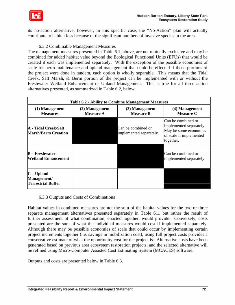
Hudson-Raritan Estuary, Liberty State Park Ecosystem Restoration Study
its no-action alternative; however, in this specific case, the “No-Action” plan will actually contribute to habitat loss because of the significant numbers of invasive species in the area.
6.3.2 Combinable Management Measures The management measures presented in Table 6.1, above, are not mutually exclusive and may be combined for added habitat value beyond the Ecological Functional Units (EFUs) that would be created if each was implemented separately. With the exception of the possible economies of scale for berm maintenance and upland management that could be effected if those portions of the project were done in tandem, each option is wholly separable. This means that the Tidal Creek, Salt Marsh, & Berm portion of the project can be implemented with or without the Freshwater Wetland Enhancement or Upland Management. This is true for all three action alternatives presented, as summarized in Table 6.2, below.
Table 6.2 - Ability to Combine Management Measures (1) Management
Measures (2) Management
Measure A (3) Management
Measure B (4) Management
Measure C
A - Tidal Creek/Salt Marsh/Berm Creation
Can be combined or implemented separately.
Can be combined or implemented separately. May be some economies of scale if implemented together.
B – Freshwater Wetland Enhancement
Can be combined or implemented separately.
C – Upland Management/ Terrestrial Buffer
6.3.3 Outputs and Costs of Combinations Habitat values in combined measures are not the sum of the habitat values for the two or three separate management alternatives presented separately in Table 6.1, but rather the result of further assessment of what combination, enacted together, would provide. Conversely, costs presented are the sum of what the individual measures would cost if implemented separately. Although there may be possible economies of scale that could occur by implementing certain project increments together (i.e. savings in mobilization cost), using full project costs provides a conservative estimate of what the opportunity cost for the project is. Alternative costs have been generated based on previous area ecosystem restoration projects, and the selected alternative will be refined using Micro-Computer Assisted Cost Estimating System (MCACES) software. Outputs and costs are presented below in Table 6.3.
Integrated Feasibility Report & Environmental Impact Statement 72
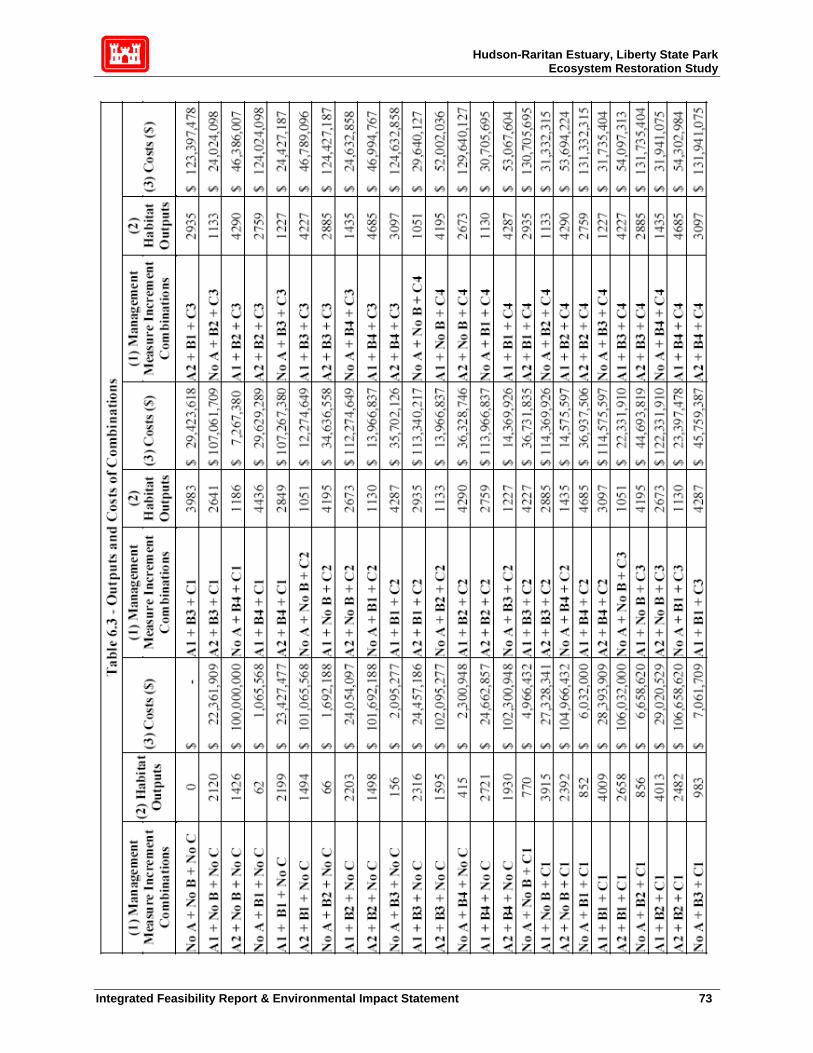
Hudson-Raritan Estuary, Liberty State Park Ecosystem Restoration Study
Integrated Feasibility Report & Environmental Impact Statement 73

Hudson-Raritan Estuary, Liberty State Park Ecosystem Restoration Study
Figure 6.1 presents this information in graphic form, which allows for a number of conclusions relating to the cost and environmental effectiveness of certain management measures.
There is a cluster of solutions at and above the $100,000,000 that produce less habitat value than some of the less expensive options. These $100,000,000+ solutions all include management measure A2 – Tidal Creek with Off-Site Disposal. There are two related reasons for this. The high cost is the result of the fact that the tidal creek is to be excavated from a contaminated portion of the site and disposing of this material elsewhere is very expensive because they involve more money and less output in EFU terms. On the other hand, creating a berm by placing the material on the site and capping it, provides the opportunity to generate more value producing habitat in Liberty State Park. For this reason, alternative A1, which calls for on-site placement and berm creation, is a better alternative than A2. There are two other clusters of solutions. The first cluster is centered about the $20,000,000 / 1200 EFU area and is comprised of combinations of alternatives that do not include the tidal creek. The second cluster is at the $40,000,000, 4250 EFU level. These are alternatives that include the tidal creek and berm as well as some combination of Freshwater Wetland Enhancement and Upland Management. This shows that measures that include the Tidal Creek, Salt Marsh, and Berm provide almost four times the habitat value of options that do not.
6.3.4 Elimination of Economically Inefficient Solutions Solutions are re-ordered by the amount of habitat value they create. This allows for the elimination of economically inefficient solutions, which create the same habitat value as another
Integrated Feasibility Report & Environmental Impact Statement 74

Hudson-Raritan Estuary, Liberty State Park Ecosystem Restoration Study
alternative, but at higher cost. Note that alternatives using Upland Management increments greater than the Clearing and Grubbing and Landscaping level are eliminated as economically inefficient.
6.3.5 Elimination of Economically Ineffective Solutions Economically inefficient solutions are omitted from further analysis, and pair-wise comparison of outputs and costs is used to identify which of the remaining solutions are economically ineffective. Economically ineffective solutions are combinations of alternatives that produce less habitat output at equal or greater cost that subsequently ranked solutions. Table 6-4 presents the results of this comparison. Economically ineffective solutions are shaded.
No Action 0 -$ No A + B1 + No C 62 1,065,568$ A1 + B3 + No C 2316 24,457,186$ No A + B2 + No C 66 1,692,188$ A2 + No B + C1 2392 104,966,432$ No A + B3 + No C 156 2,095,277$ A2 + B2 + C1 2482 106,658,620$ No A + B4 + No C 415 2,300,948$ A2 + B3 + C1 2641 107,061,709$ No A + No B + C1 770 4,966,432$ A2 + B1 + C1 2658 106,032,000$ No A + B1 + C1 852 6,032,000$ A2 + No B + C2 2673 112,274,649$ No A + B2 + C1 856 6,658,620$ A1 + B4 + No C 2721 24,662,857$ No A + B3 + C1 983 7,061,709$ A2 + B2 + C2 2759 113,966,837$ No A + No B + C2 1051 12,274,649$ A2 + B4 + C1 2849 107,267,380$ No A + B1 + C2 1130 13,966,837$ A2 + B3 + C2 2885 114,369,926$ No A + B2 + C2 1133 13,966,837$ A2 + B1 + C2 2935 113,340,217$ No A + B4 + C1 1186 7,267,380$ A2 + B4 + C2 3097 114,575,597$ No A + B3 + C2 1227 14,369,926$ A1 + No B + C1 3915 27,328,341$ A2 + No B + No C 1426 100,000,000$ A1 + B3 + C1 3983 29,423,618$ No A + B4 + C2 1435 14,575,597$ A1 + B1 + C1 4009 28,393,909$ A2 + B1 + No C 1494 101,065,568$ A1 + B2 + C1 4013 29,020,529$ A2 + B2 + No C 1498 101,692,188$ A1 + No B + C2 4195 34,636,558$ A2 + B3 + No C 1595 102,095,277$ A1 + B3 + C2 4227 36,731,835$ A2 + B4 + No C 1930 102,300,948$ A1 + B1 + C2 4287 35,702,126$ A1 + No B + No C 2120 22,361,909$ A1 + B2 + C2 4290 36,328,746$ A1 + B1 + No C 2199 23,427,477$ A1 + B4 + C1 4436 29,629,289$ A1 + B2 + No C 2203 24,054,097$ A1 + B4 + C2 4685 36,937,506$
(1) Management Measure Increment
Combinations
(2) Habitat Outputs (EFU)
(3) Cost ($)
Table 6-4 - Elimination of Economically Ineffective Solutions
(1) Management Measure Increment
Combinations
(2) Habitat Outputs (EFU)
(3) Cost ($)
6.3.6 Cost Effective and Least Cost Solutions
Integrated Feasibility Report & Environmental Impact Statement 75

Hudson-Raritan Estuary, Liberty State Park Ecosystem Restoration Study
Table 6.5, below, presents Cost Effective and Least Total Cost Solutions – i.e. possible restoration combinations that have passed the test for economic effectiveness and economic efficiency prescribed in IWR Report 94-PS-2.
Table 6-5 - Cost Effective and Least Cost Solutions
(1) Name of Solution (2) Description (3) Outputs (EFU) (4) Costs ($)
No Action No Action 0 $ -
S1 = No A + B1 + No C LSC water 62 $1,065,568
S2 = No A + B2 + No C LSC water and LSC existing wetland 66 $1,692,188
S3 = No A + B3 + No C LSC water and enhanced LSC wetland 156 $2,095,277
S4 = No A + B4 + No C LSC water, enhanced LSC wetland and infiltration basin 415 $2,300,948
S5 = No A + No B + C1 Removal of invasive species 770 $4,966,432
S6 = No A + B1 + C1 LSC water and removal of invasive species 852 $6,032,000
S7 = No A + B2 + C1 LSC water, LSC existing wetland, and removal of invasive species 856 $6,658,620
S8 = No A + B3 + C1 LSC water, enhanced LSC wetland, and removal of invasive species 983 $7,061,709
S9 = No A + B4 + C1 LSC water, enhanced LSC wetland, infiltration basin and removal of invasive species
1186 $7,267,380
S10 = No A + B3 + C2 LSC water, enhanced LSC wetland, removal of invasive species, and landscaping
1227 $14,369,926
S11 = No A + B4 + C2 LSC water, enhanced LSC wetland, infiltration basin, removal of invasive species and landscaping
1435 $14,575,597
S13 = A1 + B1 + No C Tidal creek creation with on-site placement and LSC water 2199 $23,427,477
Integrated Feasibility Report & Environmental Impact Statement 76

Hudson-Raritan Estuary, Liberty State Park Ecosystem Restoration Study
(1) Name of Solution (2) Description (3) Outputs (EFU) (4) Costs ($)
S15 = A1 + B3 + No C Tidal creek creation with on-site placement, LSC water, and enhanced LSC existing wetland
2316 $24,457,186
S16 = A1 + B4 + No C Tidal creek creation with on-site placement, LSC water, enhanced LSC existing wetland,and infiltration basin
2721 $24,662,857
S17 = A1 + No B + C1 Tidal creek creation with on-site placement and removal of invasive species 3915 $27,328,341
S18 = A1 + B1 + C1 Tidal creek creation with on-site placement, LSC water, and removal of invasive species 4009 $28,393,909
S19 = A1 + B2 + C1 Tidal creek creation with on-site placement, LSC water, LSC existing wetland, and removal of invasive species
4013 $29,020,529
S20 = A1 + B4 + C1 Tidal creek creation with on-site placement, LSC water, enhanced LSC wetland, and removal of invasive species
4436 $29,629,289
S21 = A1 + B4 + C2
Tidal creek creation with on-site placement, LSC water, enhanced LSC wetland, removal of invasive species, and landscaping
4685 $36,937,506
A graphic representation of these solutions, in the form of a total cost curve, presents a clearer view of the opportunity costs of the remaining alternatives. See Figure 6.2, below. Please note that the EFU scale is compressed, which makes it appear as though solutions falling on the lower end of the spectrum have lower average cost. This is a result of the distortion arising from the compressed scale.
Integrated Feasibility Report & Environmental Impact Statement 77

Hudson-Raritan Estuary, Liberty State Park Ecosystem Restoration Study
Figure 6.2 - Cost Effective and Least Cost Solutions
$-$5,000,000
$10,000,000$15,000,000$20,000,000$25,000,000$30,000,000$35,000,000$40,000,000
0 66 415
852
983
1227
2120
2203
2721
4009
4436
Habitat Output (EFU)
Cos
t ($)
Figure 6.2 allows for a number of observations. Alternatives S1 to S4, at the left end of the curve, represent options using only Freshwater Wetland alternatives without any other type of habitat mitigation. These provide relatively little in terms of habitat value until they are combined with increments of Upland Management or Tidal Creek, Salt Marsh & and Berm. When combined with Upland Management alternatives C1, Clearing and Grubbing, habitat output increases greatly. Nonetheless, this is not a result of synergies between them but rather the mere act of adding the values of those increments together. Any synergistic output from combining measures is limited to 60 EFUs. Including Landscaping to the Freshwater Wetland alternatives 3 and 4 increases the habitat value but doubles the cost of the restoration from approximately $7M to $14.5M. Solutions involving salt-water habitat creation increase the cost of site mitigation to above $22M; however, creating the Tidal Creek, Salt Marsh, & Berm provides for a significant jump of more than 2000 EFUs. Adding the Freshwater Wetland opportunities to the tidal creek creation adds more value to the combination, with more than 150 EFUs in habitat output added in the A1 + B4 (Solution 16) alternative than would be created just adding the values of the separate projects together. Adding the Upland Management increment of Clearing and Grubbing to the salt water and freshwater combinations adds more than twice the habitat value of the Clearing and Grubbing increment alone. In these cases, the habitat value produced by the increments is 1715-1810 EFUs greater than the sum of the individual components.
6.3.7 Average Costs of Remaining Alternatives
Integrated Feasibility Report & Environmental Impact Statement 78

Hudson-Raritan Estuary, Liberty State Park Ecosystem Restoration Study
The remaining solutions are arranged in Figure 6.3, below, to show their average cost per unit of habitat value created.
Figure 6.3 - Average Costs of Remaining Solutions
$-
$5,000
$10,000
$15,000
$20,000
$25,000
$30,000
S0 S2 S4 S6 S8S10 S12 S14 S16 S18 S20
Solution (0 = No Action)
Cos
t/Hab
itat V
alue
(EFU
)
Figure 6.3 shows that the alternative that provides habitat value at least cost is Solution 4, the largest increment of freshwater wetland creation with no other project components. Comparing Figure 6.3 and Figure 6.2, we find that Solution 4 alone will only provide 415 EFUs, far less than other potentially economically effective and efficient environmental restoration plans for the site that provide greater habitat value. Figure 6.3 also shows that until the Freshwater Wetland Enhancement alternatives get to their final increment, they are relatively expensive for the amount of output they create. In fact, solutions that use any other freshwater alternative but the largest increment result in higher average costs than freshwater alternatives using the same saltwater and upland combinations without the greatest increment of freshwater wetland restoration. Alternatives using both freshwater and saltwater, without upland management options, have a higher average cost than alternatives using all three sets of habitat mitigation alternatives. Thus, alternatives that maximize diversity of habitat also have lower average costs.
6.3.8 Recalculation of Average Costs for Additional Levels of Output After the initial average cost calculation, solutions with greater average cost but smaller habitat output are eliminated from further analysis. Average costs of additional outputs are calculated for the remaining solutions by first subtracting the habitat value and cost of the solution with the initial average cost calculation. This process is iterative, with solutions of higher average cost eliminated from further analysis and subtraction of the output and cost of the previous lowest
Integrated Feasibility Report & Environmental Impact Statement 79

Hudson-Raritan Estuary, Liberty State Park Ecosystem Restoration Study
average cost solution. Table 6-6a shows the initial average cost calculation from Section 6.3.7, with the lowest average cost solution identified.
Table 6-6a Average Costs of Each Level of Output
(1) Management Measure Increment Combinations
(2) Habitat Outputs (3) Cost ($) (4) Average Cost
($ per EFU)
S0 = No A + No B + No C 0 $ - S1 = No A + B1 + No C 62 $ 1,065,568 $ 17,174 S2 = No A + B2 + No C 66 $ 1,692,188 $ 25,687 S3 = No A + B3 + No C 156 $ 2,095,277 $ 13,473 S4 = No A + B4 + No C 415 $ 2,300,948 $ 5,547 S5 = No A + No B + C1 770 $ 4,966,432 $ 6,447 S6 = No A + B1 + C1 852 $ 6,032,000 $ 7,079 S7 = No A + B2 + C1 856 $ 6,658,620 $ 7,779 S8 = No A + B3 + C1 983 $ 7,061,709 $ 7,187 S9 = No A + B4 + C1 1186 $ 7,267,380 $ 6,126 S10 = No A + B3 + C2 1227 $ 14,369,926 $ 11,713 S11 = No A + B4 + C2 1435 $ 14,575,597 $ 10,158 S12 = A1 + No B + No C 2120 $ 22,361,909 $ 10,550 S13 = A1 + B1 + No C 2199 $ 23,427,477 $ 10,653 S14 = A1 + B2 + No C 2203 $ 24,054,097 $ 10,919 S15 = A1 + B3 + No C 2316 $ 24,457,186 $ 10,559 S16 = A1 + B4 + No C 2721 $ 24,662,857 $ 9,063 S17 = A1 + No B + C1 3915 $ 27,328,341 $ 6,980 S18 = A1 + B1 + C1 4009 $ 28,393,909 $ 7,082 S19 = A1 + B2 + C1 4013 $ 29,020,529 $ 7,232 S20 = A1 + B4 + C1 4436 $ 29,629,289 $ 6,679 S21 = A1 + B4 + C2 4685 $ 36,937,506 $ 7,885
Table 6-6b, displays the outputs and costs of remaining levels of output and compares them to the 415 EFUs, which was found to have the lowest average cost per Ecological Functional Unit. Column 3 shows the level of added habitat beyond the initial 415 EFU level and Column 5 shows the additional cost for that extra level of habitat value beyond the 415 EFUs. Column 6 displays the average cost for each additional unit of output. This was calculated by dividing additional cost by additional output at each remaining level of output. The level of output with the lowest average cost per additional habitat unit is shaded.
Integrated Feasibility Report & Environmental Impact Statement 80

Hudson-Raritan Estuary, Liberty State Park Ecosystem Restoration Study
Table 6-6b - Average Cost for Additional Output, First Recalculation
(1) Management Measure Increment
Combinations
(2) Habitat Outputs (EFU)
(3) Additional
Habitat Output
(4) Cost ($) (5) Additional Cost ($)
(6) Average Cost per
Additional Output ($ per EFU)
No A + B4 + No C 415 0 $ 2,300,948 $ - $ - No A + No B + C1 770 356 $ 4,966,432 $ 2,665,484 $ 7,497 No A + B1 + C1 852 437 $ 6,032,000 $ 3,731,052 $ 8,533 No A + B2 + C1 856 441 $ 6,658,620 $ 4,357,672 $ 9,879 No A + B3 + C1 983 568 $ 7,061,709 $ 4,760,761 $ 8,385 No A + B4 + C1 1186 772 $ 7,267,380 $ 4,966,432 $ 6,437 No A + B3 + C2 1227 812 $ 14,369,926 $ 12,068,978 $ 14,863 No A + B4 + C2 1435 1020 $ 14,575,597 $ 12,274,649 $ 12,034 A1 + No B + No C 2120 1705 $ 22,361,909 $ 20,060,961 $ 11,768 A1 + B1 + No C 2199 1784 $ 23,427,477 $ 21,126,529 $ 11,840 A1 + B2 + No C 2203 1788 $ 24,054,097 $ 21,753,149 $ 12,165 A1 + B3 + No C 2316 1901 $ 24,457,186 $ 22,156,238 $ 11,653 A1 + B4 + No C 2721 2307 $ 24,662,857 $ 22,361,909 $ 9,695 A1 + No B + C1 3915 3500 $ 27,328,341 $ 25,027,393 $ 7,150 A1 + B1 + C1 4009 3594 $ 28,393,909 $ 26,092,961 $ 7,260 A1 + B2 + C1 4013 3598 $ 29,020,529 $ 26,719,581 $ 7,426 A1 + B4 + C1 4436 4021 $ 29,629,289 $ 27,328,341 $ 6,796 A1 + B4 + C2 4685 4270 $ 36,937,506 $ 34,636,558 $ 8,112 The next iteration, shown in Table 6-6c will use the second lowest average total cost option (1186 EFUs at an additional cost of $7,267,380) as its baseline.
Integrated Feasibility Report & Environmental Impact Statement 81
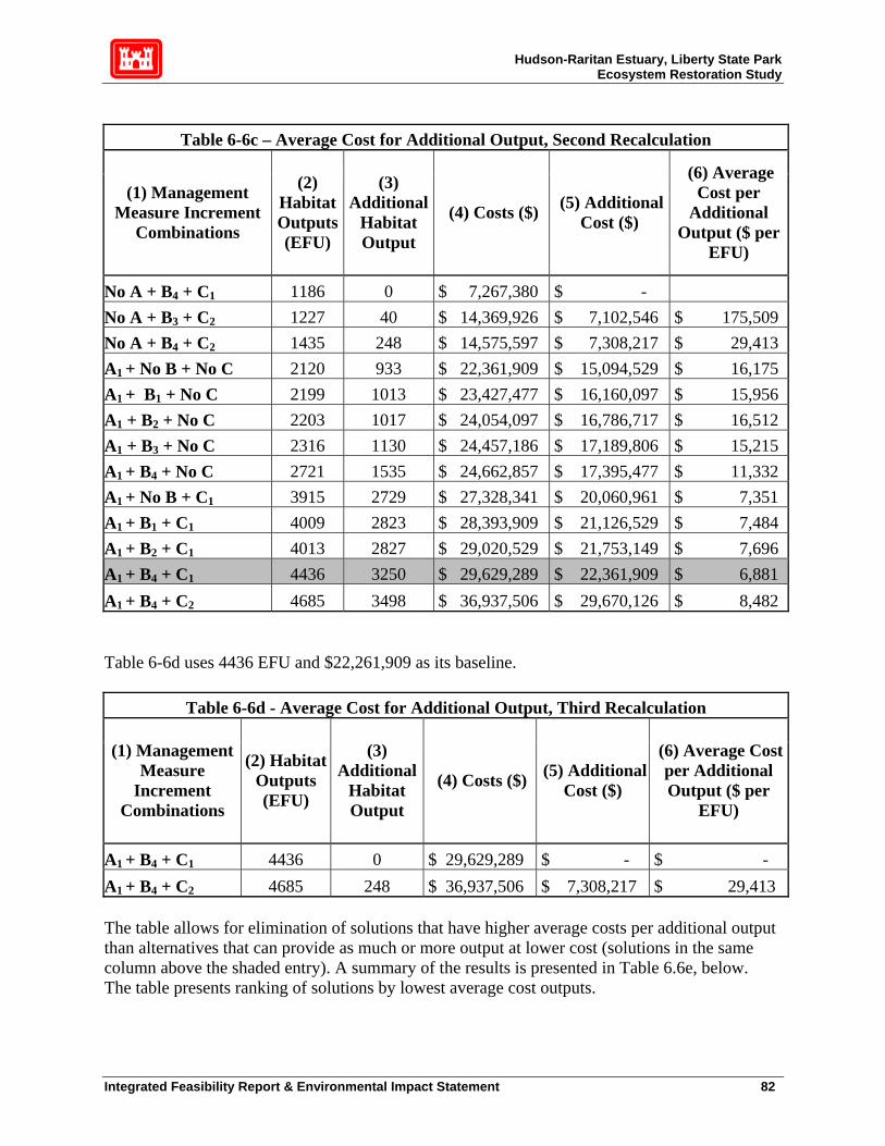
Hudson-Raritan Estuary, Liberty State Park Ecosystem Restoration Study
Table 6-6c – Average Cost for Additional Output, Second Recalculation
(1) Management Measure Increment
Combinations
(2) Habitat Outputs (EFU)
(3) Additional
Habitat Output
(4) Costs ($) (5) Additional Cost ($)
(6) Average Cost per
Additional Output ($ per
EFU)
No A + B4 + C1 1186 0 $ 7,267,380 $ - No A + B3 + C2 1227 40 $ 14,369,926 $ 7,102,546 $ 175,509 No A + B4 + C2 1435 248 $ 14,575,597 $ 7,308,217 $ 29,413 A1 + No B + No C 2120 933 $ 22,361,909 $ 15,094,529 $ 16,175 A1 + B1 + No C 2199 1013 $ 23,427,477 $ 16,160,097 $ 15,956 A1 + B2 + No C 2203 1017 $ 24,054,097 $ 16,786,717 $ 16,512 A1 + B3 + No C 2316 1130 $ 24,457,186 $ 17,189,806 $ 15,215 A1 + B4 + No C 2721 1535 $ 24,662,857 $ 17,395,477 $ 11,332 A1 + No B + C1 3915 2729 $ 27,328,341 $ 20,060,961 $ 7,351 A1 + B1 + C1 4009 2823 $ 28,393,909 $ 21,126,529 $ 7,484 A1 + B2 + C1 4013 2827 $ 29,020,529 $ 21,753,149 $ 7,696 A1 + B4 + C1 4436 3250 $ 29,629,289 $ 22,361,909 $ 6,881 A1 + B4 + C2 4685 3498 $ 36,937,506 $ 29,670,126 $ 8,482 Table 6-6d uses 4436 EFU and $22,261,909 as its baseline.
Table 6-6d - Average Cost for Additional Output, Third Recalculation
(1) Management Measure
Increment Combinations
(2) Habitat Outputs (EFU)
(3) Additional
Habitat Output
(4) Costs ($) (5) Additional Cost ($)
(6) Average Cost per Additional Output ($ per
EFU)
A1 + B4 + C1 4436 0 $ 29,629,289 $ - $ - A1 + B4 + C2 4685 248 $ 36,937,506 $ 7,308,217 $ 29,413 The table allows for elimination of solutions that have higher average costs per additional output than alternatives that can provide as much or more output at lower cost (solutions in the same column above the shaded entry). A summary of the results is presented in Table 6.6e, below. The table presents ranking of solutions by lowest average cost outputs.
Integrated Feasibility Report & Environmental Impact Statement 82
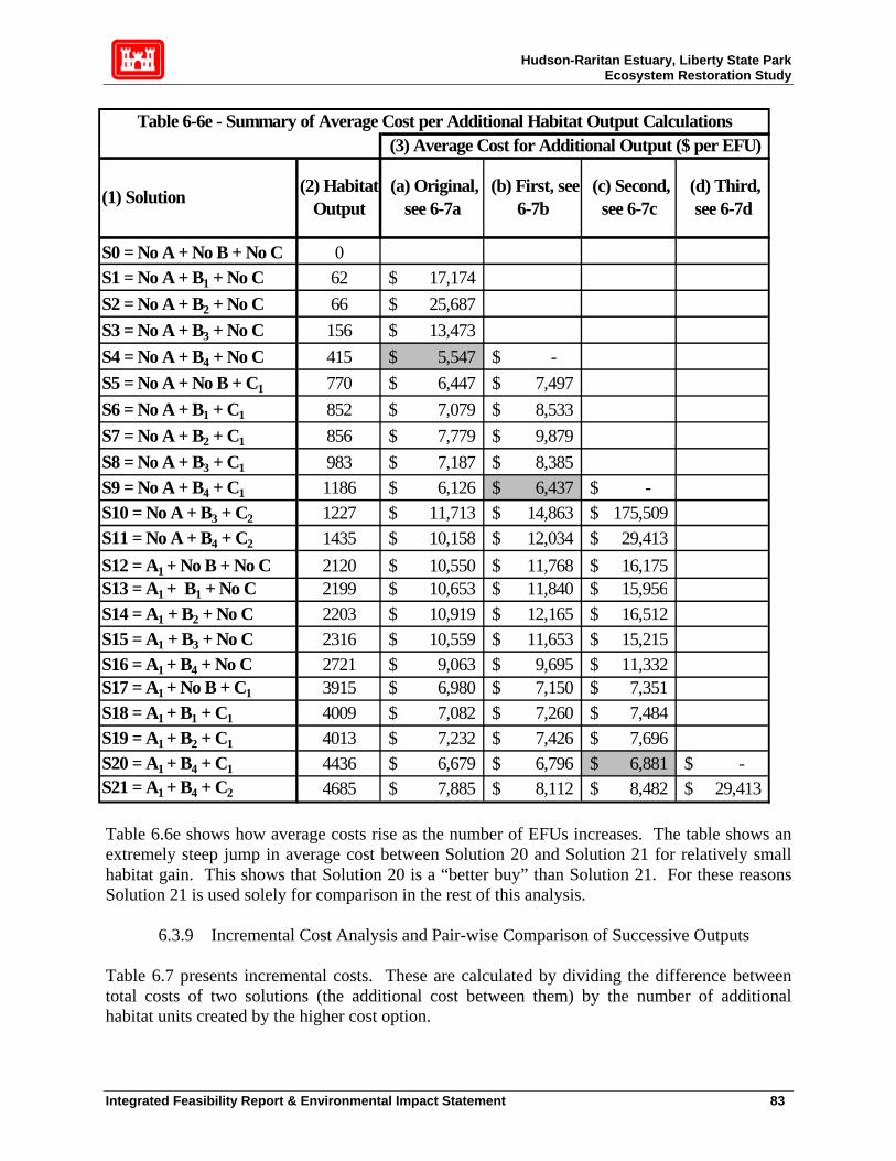
Hudson-Raritan Estuary, Liberty State Park Ecosystem Restoration Study
S0 = No A + No B + No C 0S1 = No A + B1 + No C 62 17,174$ S2 = No A + B2 + No C 66 25,687$ S3 = No A + B3 + No C 156 13,473$ S4 = No A + B4 + No C 415 5,547$ -$ S5 = No A + No B + C1 770 6,447$ 7,497$ S6 = No A + B1 + C1 852 7,079$ 8,533$ S7 = No A + B2 + C1 856 7,779$ 9,879$ S8 = No A + B3 + C1 983 7,187$ 8,385$ S9 = No A + B4 + C1 1186 6,126$ 6,437$ -$ S10 = No A + B3 + C2 1227 11,713$ 14,863$ 175,509$ S11 = No A + B4 + C2 1435 10,158$ 12,034$ 29,413$ S12 = A1 + No B + No C 2120 10,550$ 11,768$ 16,175$ S13 = A1 + B1 + No C 2199 10,653$ 11,840$ 15,956$ S14 = A1 + B2 + No C 2203 10,919$ 12,165$ 16,512$ S15 = A1 + B3 + No C 2316 10,559$ 11,653$ 15,215$ S16 = A1 + B4 + No C 2721 9,063$ 9,695$ 11,332$ S17 = A1 + No B + C1 3915 6,980$ 7,150$ 7,351$ S18 = A1 + B1 + C1 4009 7,082$ 7,260$ 7,484$ S19 = A1 + B2 + C1 4013 7,232$ 7,426$ 7,696$ S20 = A1 + B4 + C1 4436 6,679$ 6,796$ 6,881$ -$ S21 = A1 + B4 + C2 4685 7,885$ 8,112$ 8,482$ 29,413$
(1) Solution
Table 6-6e - Summary of Average Cost per Additional Habitat Output Calculations (3) Average Cost for Additional Output ($ per EFU)
(2) Habitat Output
(a) Original, see 6-7a
(b) First, see 6-7b
(c) Second, see 6-7c
(d) Third, see 6-7d
Table 6.6e shows how average costs rise as the number of EFUs increases. The table shows an extremely steep jump in average cost between Solution 20 and Solution 21 for relatively small habitat gain. This shows that Solution 20 is a “better buy” than Solution 21. For these reasons Solution 21 is used solely for comparison in the rest of this analysis.
6.3.9 Incremental Cost Analysis and Pair-wise Comparison of Successive Outputs Table 6.7 presents incremental costs. These are calculated by dividing the difference between total costs of two solutions (the additional cost between them) by the number of additional habitat units created by the higher cost option.
Integrated Feasibility Report & Environmental Impact Statement 83
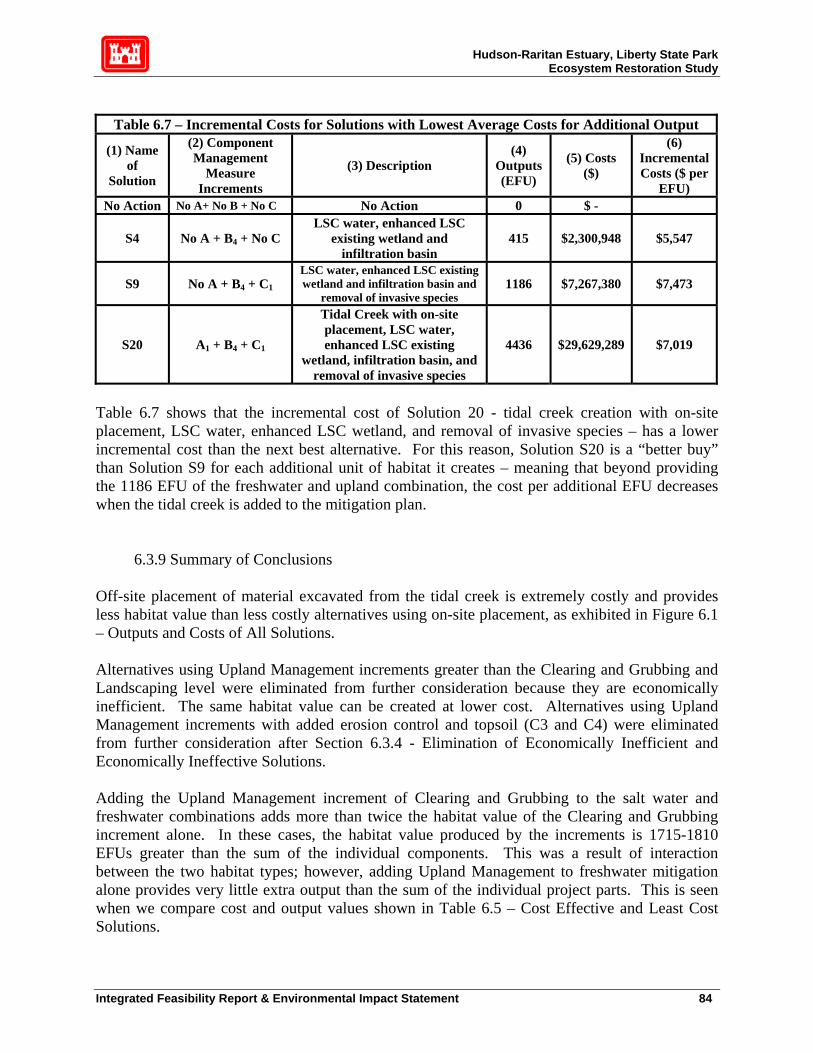
Hudson-Raritan Estuary, Liberty State Park Ecosystem Restoration Study
Table 6.7 – Incremental Costs for Solutions with Lowest Average Costs for Additional Output
(1) Name of
Solution
(2) Component Management
Measure Increments
(3) Description (4)
Outputs (EFU)
(5) Costs ($)
(6) Incremental Costs ($ per
EFU) No Action No A+ No B + No C No Action 0 $ -
S4 No A + B4 + No C LSC water, enhanced LSC
existing wetland and infiltration basin
415 $2,300,948 $5,547
S9 No A + B4 + C1
LSC water, enhanced LSC existing wetland and infiltration basin and
removal of invasive species 1186 $7,267,380 $7,473
S20 A1 + B4 + C1
Tidal Creek with on-site placement, LSC water, enhanced LSC existing
wetland, infiltration basin, and removal of invasive species
4436 $29,629,289 $7,019
Table 6.7 shows that the incremental cost of Solution 20 - tidal creek creation with on-site placement, LSC water, enhanced LSC wetland, and removal of invasive species – has a lower incremental cost than the next best alternative. For this reason, Solution S20 is a “better buy” than Solution S9 for each additional unit of habitat it creates – meaning that beyond providing the 1186 EFU of the freshwater and upland combination, the cost per additional EFU decreases when the tidal creek is added to the mitigation plan.
6.3.9 Summary of Conclusions Off-site placement of material excavated from the tidal creek is extremely costly and provides less habitat value than less costly alternatives using on-site placement, as exhibited in Figure 6.1 – Outputs and Costs of All Solutions. Alternatives using Upland Management increments greater than the Clearing and Grubbing and Landscaping level were eliminated from further consideration because they are economically inefficient. The same habitat value can be created at lower cost. Alternatives using Upland Management increments with added erosion control and topsoil (C3 and C4) were eliminated from further consideration after Section 6.3.4 - Elimination of Economically Inefficient and Economically Ineffective Solutions. Adding the Upland Management increment of Clearing and Grubbing to the salt water and freshwater combinations adds more than twice the habitat value of the Clearing and Grubbing increment alone. In these cases, the habitat value produced by the increments is 1715-1810 EFUs greater than the sum of the individual components. This was a result of interaction between the two habitat types; however, adding Upland Management to freshwater mitigation alone provides very little extra output than the sum of the individual project parts. This is seen when we compare cost and output values shown in Table 6.5 – Cost Effective and Least Cost Solutions.
Integrated Feasibility Report & Environmental Impact Statement 84

Hudson-Raritan Estuary, Liberty State Park Ecosystem Restoration Study
Measures that include habitat restoration in the saltwater portion provide almost four times the habitat value of options that do not, as shown in Figure 6.2 – Cost Effective and Least Cost Solutions. Until the Freshwater Wetland Enhancement alternatives get to their final increment, they are relatively expensive for the amount of output they create. In fact, solutions that use any other freshwater alternative but the largest increment result in higher average costs than freshwater alternatives using the same saltwater and upland combinations without the greatest increment of freshwater wetland restoration. These facts are shown in the analysis of Figure 6.3. Table 6.7 – Solutions with Lowest Average Cost per Additional Habitat Output shows how average cost rises as habitat output increases. The table shows an extremely steep jump in project cost between Solution 20, the tidal creek with on-site placement/maximum freshwater habitat restoration/minimum upland management (Clearing and Grubbing) and Solution 21, the same tidal and freshwater increments with the next highest increment of upland management (Clearing and Grubbing with Landscaping) for relatively small habitat gain. Solution 9, LSC water, an enhanced LSC wetland, an infiltration basin, and removal of invasive species had the lowest average cost. Nonetheless, the difference in average cost was less that $500/EFU between Solution 9, which produced 1186 EFUs at an average cost of $6437/EFU and Solution 20, which produced 4436 EFUs at an average cost of $6681/EFU. Table 6.7 shows that the incremental cost of Solution 20 - tidal creek creation with on-site placement, LSC water, enhanced LSC wetland, and removal of invasive species – has a lower incremental cost than the next best alternative which left out the tidal creek. For this reason, Solution S20 is a “better buy” than Solution S9 for each additional unit of habitat it creates. Beyond providing the 1186 EFU of the freshwater and upland combination, the cost per additional EFU decreases when the tidal creek is added to the mitigation plan, allowing an additional 3250 EFU to be created for a total of 4436 EFUs. For these reasons, Solution 20 - the creation of a tidal creek with on-site material placement (berm creation), freshwater wetland enhancement including Liberty Science Center water, an enhancement of the LSC wetland, and an infiltration basin, and clearing and grubbing of the upland portion of the site – for an estimated total cost of $29,629,289 and an estimated habitat output gain of 4436 EFUs, is recommended.
6.4 Selected NER Plan The following sections describe the design details of Solution 20, the selected NER plan, show in Figure 6.4.
Integrated Feasibility Report & Environmental Impact Statement 85

Hudson-Raritan Estuary, Liberty State Park Ecosystem Restoration Study
Integrated Feasibility Report & Environmental Impact Statement 86

Hudson-Raritan Estuary, Liberty State Park Ecosystem Restoration Study
6.4.1 Tidal Marsh
Salt marsh vegetation communities are tightly coupled with the tidal regime. Water levels fluctuate over the daily and monthly tidal cycle, flooding the shoreline for different periods of time. The period of inundation is dictated by elevation contours, and zonation among plant species occurs along these contours. The location of plant species along the gradient is determined by the species’ tolerance to salinity and water (frequency, duration, and/or depth of inundation). Species that are tolerant to water and salinity occur at lower elevations in the intertidal zone, between the Mean High Water (MHW) level and the Mean Low Water (MLW) level. Less tolerant species occur at higher elevations, which are inundated only during spring-tide high water levels. The success of a salt marsh restoration effort greatly depends upon the location of the planted vegetation along the shoreline gradient. Since local conditions vary (salinity, tidal amplitude etc), biological benchmarks measured from surrounding local marsh vegetation and local tidal information should be used as a guide for determining the elevations for vegetation replanting. Elevation ranges of plant communities in reference wetlands can be duplicated in the restored salt marsh. Thriving wetland communities throughout the Hudson-Raritan Estuary were used to collectively establish the general environmental design criteria and flow prescription for the four proposed tidal wetland communities. To account for varying local conditions, two sites were used as reference sites for the tidal salt marsh: One was in the South Cove of Liberty State Park and the second was just south west of the site in Port Liberté. Their characteristics were documented by Ecosystem Restoration Consultants (ERC) on 17 and 25th September 2003 and 14 October 2003. The results of this biobenchmarking effort is documented in Appendix G of the ERI, and is summarized in Figure 6.5 and Figure 6.6. The following describe the design criteria for each proposed tidal salt marsh community. 1. Tidal Creeks. Tidal Creeks are permanently flooded for the mean tide range (MHW
to MLW). The creeks offer a place for fish to congregate at low water. The substrate of the tidal creeks should be able to retain sufficient Dissolved Oxygen and other water quality parameters to support benthic populations, and to have the proper conditions for sub-aquatic vegetation to eventually take root. The velocities in the creek should not be so great as to trigger unrecoverable deposition and erosion in the channel so that parts of the wetland become hydraulically disconnected from the tide. However, circulation within the marsh is encouraged to facilitate better water quality and to avoid stagnant water. Sinuosity of the creek layout is an important feature as it maximizes fringe habitat, it slows down the high velocities in the creek, and also encourages greater water circulation.
2. Mudflats. Mudflats connect the tidal creeks and low marsh. They will dry out at low tide, although they usually are flooded for more than half of the tide cycle. The mudflats also should be able to retain sufficient Dissolved Oxygen and other water quality parameters to support benthic populations.
3. Low Salt Marsh. In the Hudson-Raritan Estuary and in other estuaries in the Northeast United States, the dominant low salt marsh species is Spartina alterniflora.
Integrated Feasibility Report & Environmental Impact Statement 87
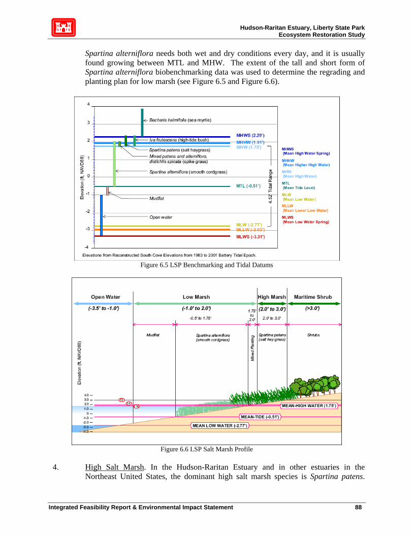
Hudson-Raritan Estuary, Liberty State Park Ecosystem Restoration Study
Spartina alterniflora needs both wet and dry conditions every day, and it is usually found growing between MTL and MHW. The extent of the tall and short form of Spartina alterniflora biobenchmarking data was used to determine the regrading and planting plan for low marsh (see Figure 6.5 and Figure 6.6).
Figure 6.5 LSP Benchmarking and Tidal Datums
Figure 6.6 LSP Salt Marsh Profile
4. High Salt Marsh. In the Hudson-Raritan Estuary and in other estuaries in the
Northeast United States, the dominant high salt marsh species is Spartina patens.
Integrated Feasibility Report & Environmental Impact Statement 88

Hudson-Raritan Estuary, Liberty State Park Ecosystem Restoration Study
However, this zone is usually much less homogeneous than the low marsh, and is often a mosaic of a number of species including salt hay grass (Spartina patens), spike grass (Distichlis spicata), a short form of smooth cordgrass, black grass (Juncus gerardii), switchgrass (Panicum virgatum), high tide bush (Iva frutescens) and common reed (Phragmites australis) (Tiner 1985). Spartina patens grows at a minimum to mean high water spring (elev. 2.29) but often occurs up to the extreme high tide. This upper boundary may be inundated infrequently, in some locations as little as once or twice annually. Such inundation usually occurs during the spring tide cycle (highest annual tides or MHWS) and during the severe storm events. This is confirmed for New Jersey salt marshes by Tiner (1985), who states “The upper margins of the high marsh may be flooded only during storm tides which are more frequent in winter.” “Extreme high tide” is not specifically recorded in the regional tide data. While, the highest observed water level was actually over 4 feet above MHWS, about one foot above MHWS or an elevation of 3.3 ft is a reasonable estimate of “Extreme high tide” and a possible upper limit for the high marsh. The Spartina patens biobenchmark results are also found in Figure 6.5 and Figure 6.6. The regrading and planting plan for high marsh also was developed by merging the tidal datum and biobenchmarking information, and by incorporating the observations of scientists in the region studying salt marshes.
The material excavated for the creation of the tidal creek will be placed on-site in a berm in the southwest corner of the site. The berm will be contoured in such a way as to increase water flow to the seasonal wetlands in the southern half of the site. To ensure stability, the material will be encapsulated above and below in a clay layer, as the soil tends to be porous. Following the clay layer, a layer of sand will be placed on the berm and seeded with native vegetation. These measures will add stability to the structure in an ecologically sensitive manner. Components of Proposed Alternatives Not only was the South Cove tidal marsh used as a biobenchmarking reference site, correlations between the width of the channel (at high and low tide) and the upstream channel length, drainage area and tidal prism were examined and used as a guide to laying out the proposed 36 acre salt marsh. A channel width of 50 ft at the North Cove confluence, tapering to 25 ft at the upstream end of the marsh was found to convey sufficient flooding to the proposed low and high marsh throughout the site while minimizing costly excavation. This analysis is discussed later in this report. A 48 ft wide culvert will be constructed to facilitate the creation of the tidal creek under Freedom Way, thereby allowing vehicular to continue unimpeded. The culvert is necessary to convey the tidal waters from the North Cove to the proposed tidal marsh within the rectangle. It will have a natural bottom consistent with the sandy bottom proposed for the entire length of the tidal channel (see Engineering Appendix for details). Natural tidal marsh channels in the region have very mild slopes in the longitudinal direction. The proposed LSP tidal channel slope is 0.0001 ft/ft. The proposed sinuosity, or the ratio between the tidal channel length and the tidal valley length is 1.7, also similar to natural tidal channels in the region.
Integrated Feasibility Report & Environmental Impact Statement 89
Hudson-Raritan Estuary, Liberty State Park Ecosystem Restoration Study
The maximum slope used in the design of the mudflats was 1V:3H. The geotechnical investigation revealed that unconsolidated, silty material lies in the location of the proposed tidal creek outlet. A 1V:3H slope was suggested by contractors as the steepest slope at which their earth moving equipment can operate comfortably. The marsh will undergo an adjustment period after a few tidal cycles whereby equilibrium slopes will form, and it is anticipated that minimal adjustments will be made to the planting plan to adjust to the equilibrium process. Natural tidal mudflats in the region vary considerably in slope. However, well-established Spartina alterniflora dominated tidal marshes have the root structure in the soil to support much steeper slopes. These slopes cannot be constructed without the use of hard structures. Monitoring the slope of the mudflats will be a part of the monitoring plan, and efforts will be made to guide the mudflat slopes to mimic natural systems. A mudflat feature was created at the upstream extent of the tidal channel. This feature adds more essential fish habitat and more diversity to the tidal marsh plan. The low and high marsh re-grading plan was discussed in the previous section. To stabilize the slopes and to outcompete phragmitites, Spartina alterniflora and Spartina patens will be densely planted, at a spacing of 18 inches on-center for each plug. To account for contingencies in the regarding equilibrium process, in the elevation zones between low marsh and high marsh, both Spartina alterniflora and Spartina patens will be planted. Similarly, in the elevation zones between high marsh and maritime scrub/shrub, both Spartina patens and spike grass (Distichlis spicata), a short form of smooth cordgrass, black grass (Juncus gerardii), switchgrass (Panicum virgatum), hightide bush (Iva frutescens), sea myrtle (Baccharis halimifolia), rose mallow (Hibiscus moscheutos), and seaside goldenrod (Solidago sempervirens) will be planted. Low levels of contamination have been found during investigations at Liberty State Park. For added security, to minimize exposing the proposed tidal marsh to contaminants, a one-foot layer of compacted cohesive material will line the footprint of the tidal marsh. The clay layer is also necessary because of the porous nature of the study area soil. A one-ft layer of clean sand will be placed on top of the cohesive material to provide a more common substrate for tidal marsh plants to take root. The testing conducted for this feasibility report indicated that low levels of contamination might be present in the North Cove. To prevent this material from entering the proposed tidal marsh, and to provide a more suitable substrate for benthic habitats, the entire North Cove below MLLW, out to the Liberty State Park Causeway will also be capped with 1 ft of clean sand.
6.4.2 Fresh Water Marsh Wildlife Considerations The Threatened and Endangered listed bird species do not have habitat requirements that include a specific hydroperiod. They can be expected to use wetland or upland habitats provided that the vegetative structure of these habitats meets their needs. For example, the northern harriers prefer grassland habitat with few trees and shrubs. Harriers will nest in both uplands and wetlands, but the pair nesting at Liberty State Park seems to prefer uplands for nesting. For winter roosts,
Integrated Feasibility Report & Environmental Impact Statement 90

Hudson-Raritan Estuary, Liberty State Park Ecosystem Restoration Study
harriers prefer upland sites. Many sources indicate harriers prefer to nest and roost in fields that are 50 acres or more in size; however, the species has also been documented to nest in habitat blocks as small as 20 acres. Aside from the northern harrier, none of the other Threatened and Endangered bird species of special concern that were observed during inventory surveys have been documented as breeding in the park. Their use of habitat relies more on habitat with the correct vegetative structure and adequate food resources rather than hydroperiod. One listed plant species, Torrey's rush, was found on the site. This species has hydrologic requirements and is adapted to specific types of soils. It is a facultative wetland (FACW) species, which means it has the probability of being found in a wetland 67-99% of the time. The Natural Resource Conservation Service's (NRCS) Plant Database indicates this species is adapted to medium to coarse-textured soils and has a low-tolerance for drought conditions. The NRCS lists the minimum and maximum amount of precipitation needed as 14 and 50 inches per year, respectively. The minimum root depth is 10 inches and the species is intolerant of both shade and salinity. This species was identified in a freshwater wetland on-site. That wetland area should be protected during construction while also considering the habitat requirements for the species when enhancing other freshwater wetland habitats on-site. Besides accommodating the listed species in the design, the primary design goal of the fresh water wetland system was to create a fresh water deep emergent marsh, a habitat that once was prevalent in Hudson County, NJ, and now is very rare. Enhancing existing fresh water wetlands and enhancing storm water runoff quality from adjacent parking lots were secondary goals. Hydraulic and Hydrology Considerations The minimum water requirements for wetland sustainability are determined by a combination of factors that require balance. In order to maintain a wetland with a permanent pool of water and sufficient flow to maintain good water quality, sufficient drainage area is required. Without supplementing the water supply through pumping, a minimum watershed of ten acres is required for maintaining a year round permanent pool of approximately one acre. A second rule of thumb is that four acres of contributing watershed are needed for each acre-foot of storage (Md SCS 1976; Schueler 1987). For this plan, five to nine acres of contributing urban watershed are available for each acre-ft of planned wetland storage. This range of ratios suggests that the watershed is sufficiently large to support the planned wetlands. Relying on a smaller watershed than this would make maintaining a permanent pool difficult and would produce large fluctuations in the water level due to evaporation and infiltration losses. There are many hydrologic and hydraulic considerations important to wetland restoration and construction. The primary list of design criteria includes the following basic interrelated elements:
• Hydrologic setting, • Flood duration and timing, • Water depth,
Integrated Feasibility Report & Environmental Impact Statement 91
Hudson-Raritan Estuary, Liberty State Park Ecosystem Restoration Study
• Flow velocities and hydraulic retention time, • Storage capacity, and surface area
Hydrologic Setting: The hydrologic setting of the wetland describes the location of the wetland in relation to other water bodies. The hydrologic setting is important to all wetland functions, but is of particular importance to groundwater recharge/discharge, sediment retention, flood-flow alteration, and production export. The existing and proposed freshwater wetlands within Liberty State Park are generally independent of any other water body (e.g., stream, river, lake, etc.). They occur in typically heterogeneous material that has a relatively shallow water table. Thus, they are presumably influenced by a fluctuating water table. The proposed wetlands would be constructed in the same general area (park interior) as the existing wetland in similar substrate types. Flooding Duration and Timing: The existing wetlands within Liberty State Park are typically seasonally wet (i.e., during the spring and fall), with the exception of the Liberty Science Center wetland, which is frequently flooded from runoff from the NJ Transit terminal and parking lot. Similarly, the drainage ditches along Phillip Street are frequently flooded with runoff from the Liberty Science Center. Based on the hydrologic budget analysis, diversion of stormwater runoff from the parking lots adjacent to the park into the proposed wetlands will result in the proposed wetlands maintaining measurable pool depths most of the year. Water Depth: Water depth is an important factor in determining the types and extent of vegetation supported by the wetland. The existing wetlands are shallow, seasonal wetlands, most likely augmented by a rising water table during the wet seasons of the year. The proposed wetland system would have both shallow and deepwater areas to support a greater abundance of plants and wildlife than the existing wetlands. Flow Velocity and Hydraulic Retention Time (HRT): Maintaining a low velocity related level of flowing water shear stress is important to several wetland functions. As a result of the shallow gradient of the park and the detention-design of the wetlands, velocities will be minimal. The HRT is defined as the average amount of time that a parcel of water stays within the wetland before exiting. The HRT is the key design criteria for water quality enhancement functions such as sediment/toxicant removal and nutrient removal/transformation. For this feasibility analysis, the focus was on flood frequency and duration, and depth. It is expected that the wetland system will cause a measurable increase in HRT, which will further result in improved water quality entering the Harbor. Obviously, excessive HRT in the wetland could result in wetland water quality problems such as low dissolved oxygen and the production of sulfide and methane gases. However, frequent runoff is expected to provide frequent flushing of the wetland system. Storage Capacity and Surface Area: The storage capacity is most important in the flood-flow alteration function because the amount of available storage in the wetland determines how much of the runoff can be routed into and through the wetlands. The storage capacity may also affect aquatic abundance and diversity, in that larger wetlands will have more potential for groundwater recharge, greater volume and surface area, and may support more aquatic organisms. Storage capacity was used in this analysis to reach design water surface elevations based on seasonal inflows. The wetland bottom area is important for groundwater recharge and discharge. Ground
Integrated Feasibility Report & Environmental Impact Statement 92

Hudson-Raritan Estuary, Liberty State Park Ecosystem Restoration Study
water recharge was not a primary concern of the proposed designs; it is anticipated that the wetlands will be lined with a low permeability liner. Runoff inflows were expected to be sufficient to overcome evapotranspiration, even during the drier months of the year. Components of the Proposed Alternative In order to maximize habitat function and value, the freshwater wetland system will have four primary components: (1) an enhanced Liberty State Park wetland, (2) a Biofilter (BF) wetland, (3) a Deep Emergent Marsh (DEM), and (4) natural connecting swales (Figure 6.7). The proposed freshwater wetland system should be located in the center of the park, in close proximity to the proposed tidal wetland. Ideally, the DEM should be at least 400 or 500 feet away from the nearest road or heavily used area.
Figure 6.7 Freshwater Wetland Alternative Plan D with Adjacent Wetlands
The proposed freshwater wetlands will contain a number of hydrologic/habitat zones, as follows: Zone 1. Deep Water Pool (1-6 feet deep), to support submerged aquatic plants such as wild celery, sago pondweed, and redhead grass. Zone 2. Shallow Water Bench (6-12 inches between groundwater level and the discharge invert), to support emergent aquatic plants. Proposed plants are obligates and are relatively intolerant to drawdowns. Typical plants in this zone include: Pickerelweed (Pontederia cordata), Duck potato, (Sagittaria latifolia), and Soft stem bulrush (Scirpus validus).
Integrated Feasibility Report & Environmental Impact Statement 93
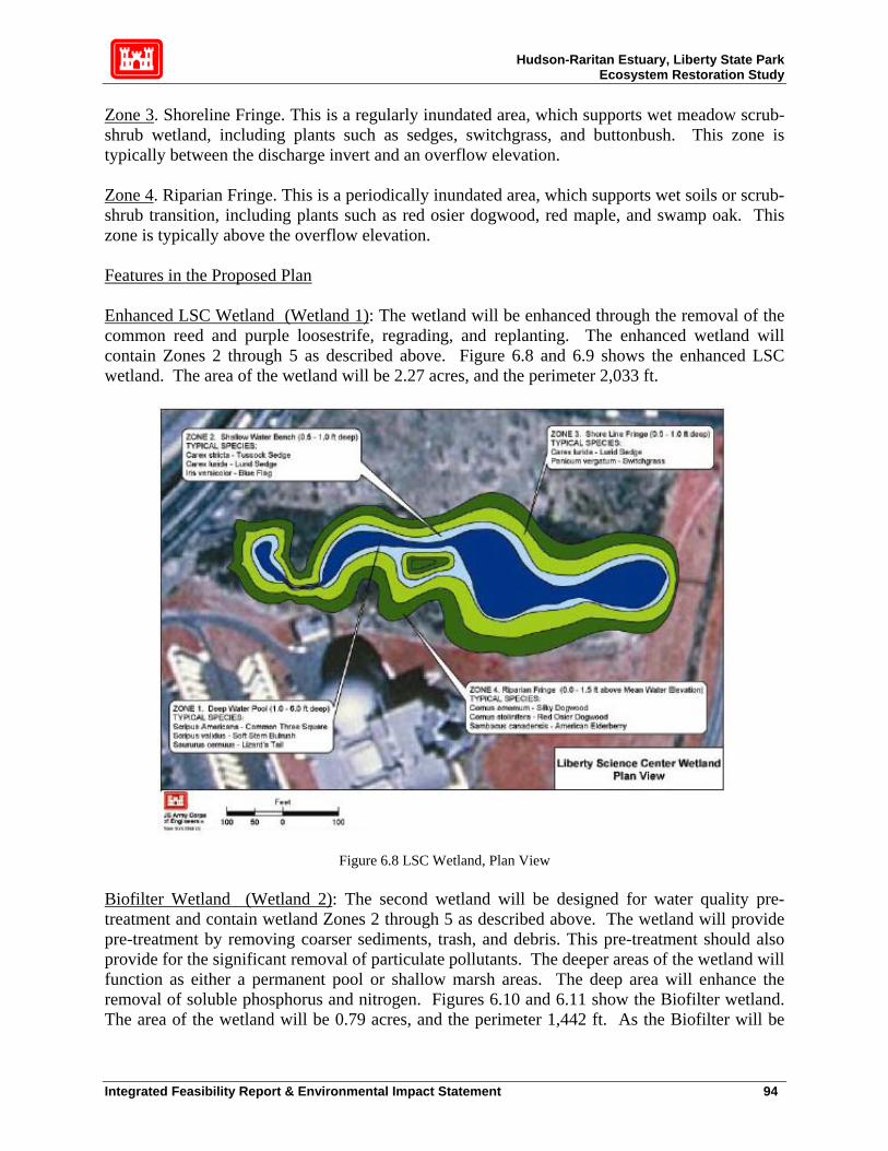
Hudson-Raritan Estuary, Liberty State Park Ecosystem Restoration Study
Zone 3. Shoreline Fringe. This is a regularly inundated area, which supports wet meadow scrub-shrub wetland, including plants such as sedges, switchgrass, and buttonbush. This zone is typically between the discharge invert and an overflow elevation. Zone 4. Riparian Fringe. This is a periodically inundated area, which supports wet soils or scrub-shrub transition, including plants such as red osier dogwood, red maple, and swamp oak. This zone is typically above the overflow elevation. Features in the Proposed Plan Enhanced LSC Wetland (Wetland 1): The wetland will be enhanced through the removal of the common reed and purple loosestrife, regrading, and replanting. The enhanced wetland will contain Zones 2 through 5 as described above. Figure 6.8 and 6.9 shows the enhanced LSC wetland. The area of the wetland will be 2.27 acres, and the perimeter 2,033 ft.
Figure 6.8 LSC Wetland, Plan View Biofilter Wetland (Wetland 2): The second wetland will be designed for water quality pre-treatment and contain wetland Zones 2 through 5 as described above. The wetland will provide pre-treatment by removing coarser sediments, trash, and debris. This pre-treatment should also provide for the significant removal of particulate pollutants. The deeper areas of the wetland will function as either a permanent pool or shallow marsh areas. The deep area will enhance the removal of soluble phosphorus and nitrogen. Figures 6.10 and 6.11 show the Biofilter wetland. The area of the wetland will be 0.79 acres, and the perimeter 1,442 ft. As the Biofilter will be
Integrated Feasibility Report & Environmental Impact Statement 94

Hudson-Raritan Estuary, Liberty State Park Ecosystem Restoration Study
composed of Phragmites australis, which generally does not attract species, it is not anticipated to be an attractive nuisance or adversely affect wildlife species in other similar ways.
Figure 6.9. LSC Wetland, Profile View
Figure 6.10 Biofilter, Plan View
Integrated Feasibility Report & Environmental Impact Statement 95
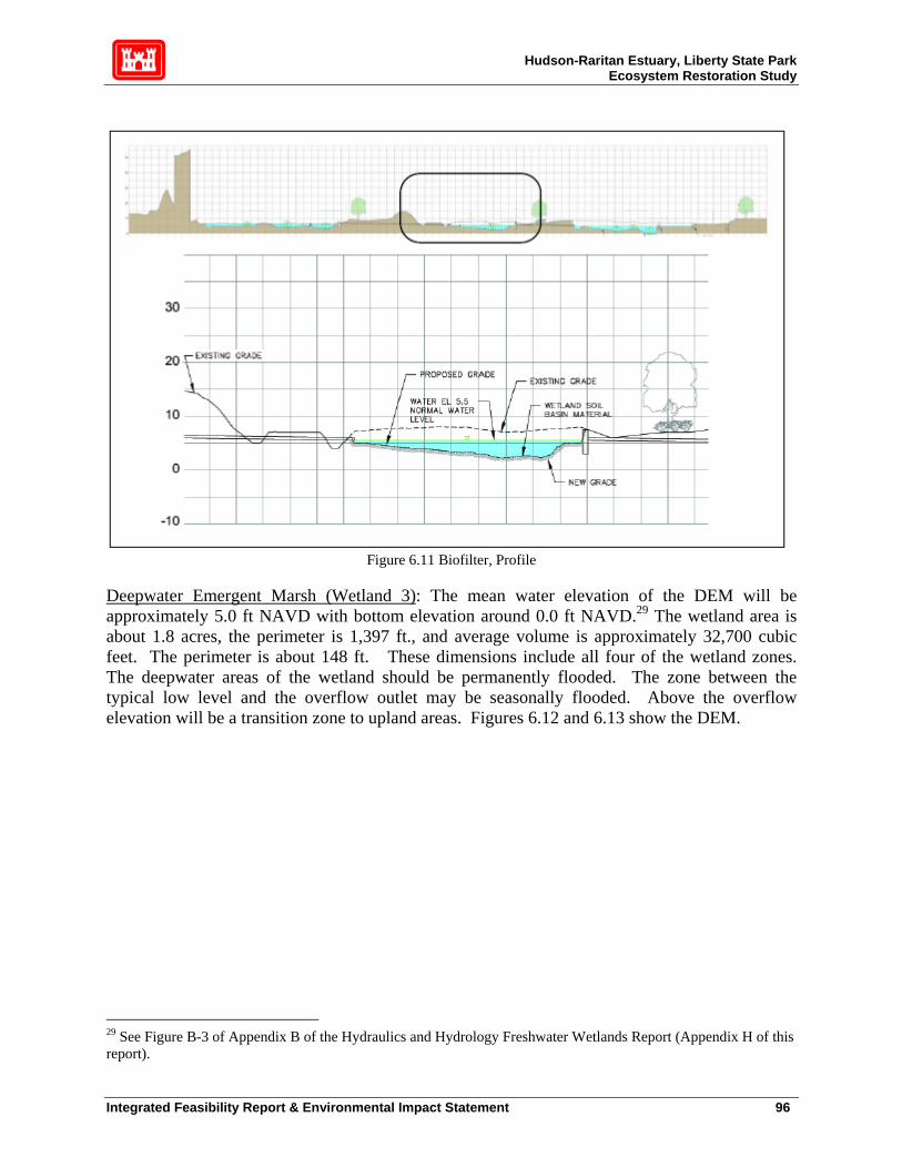
Hudson-Raritan Estuary, Liberty State Park Ecosystem Restoration Study
Figure 6.11 Biofilter, Profile
Deepwater Emergent Marsh (Wetland 3): The mean water elevation of the DEM will be approximately 5.0 ft NAVD with bottom elevation around 0.0 ft NAVD.29 The wetland area is about 1.8 acres, the perimeter is 1,397 ft., and average volume is approximately 32,700 cubic feet. The perimeter is about 148 ft. These dimensions include all four of the wetland zones. The deepwater areas of the wetland should be permanently flooded. The zone between the typical low level and the overflow outlet may be seasonally flooded. Above the overflow elevation will be a transition zone to upland areas. Figures 6.12 and 6.13 show the DEM.
29 See Figure B-3 of Appendix B of the Hydraulics and Hydrology Freshwater Wetlands Report (Appendix H of this report).
Integrated Feasibility Report & Environmental Impact Statement 96
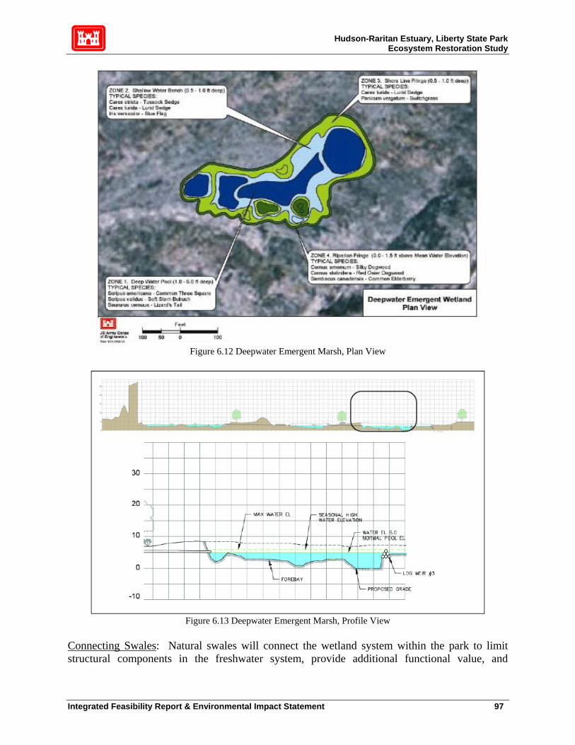
Hudson-Raritan Estuary, Liberty State Park Ecosystem Restoration Study
Figure 6.12 Deepwater Emergent Marsh, Plan View
Figure 6.13 Deepwater Emergent Marsh, Profile View
Connecting Swales: Natural swales will connect the wetland system within the park to limit structural components in the freshwater system, provide additional functional value, and
Integrated Feasibility Report & Environmental Impact Statement 97
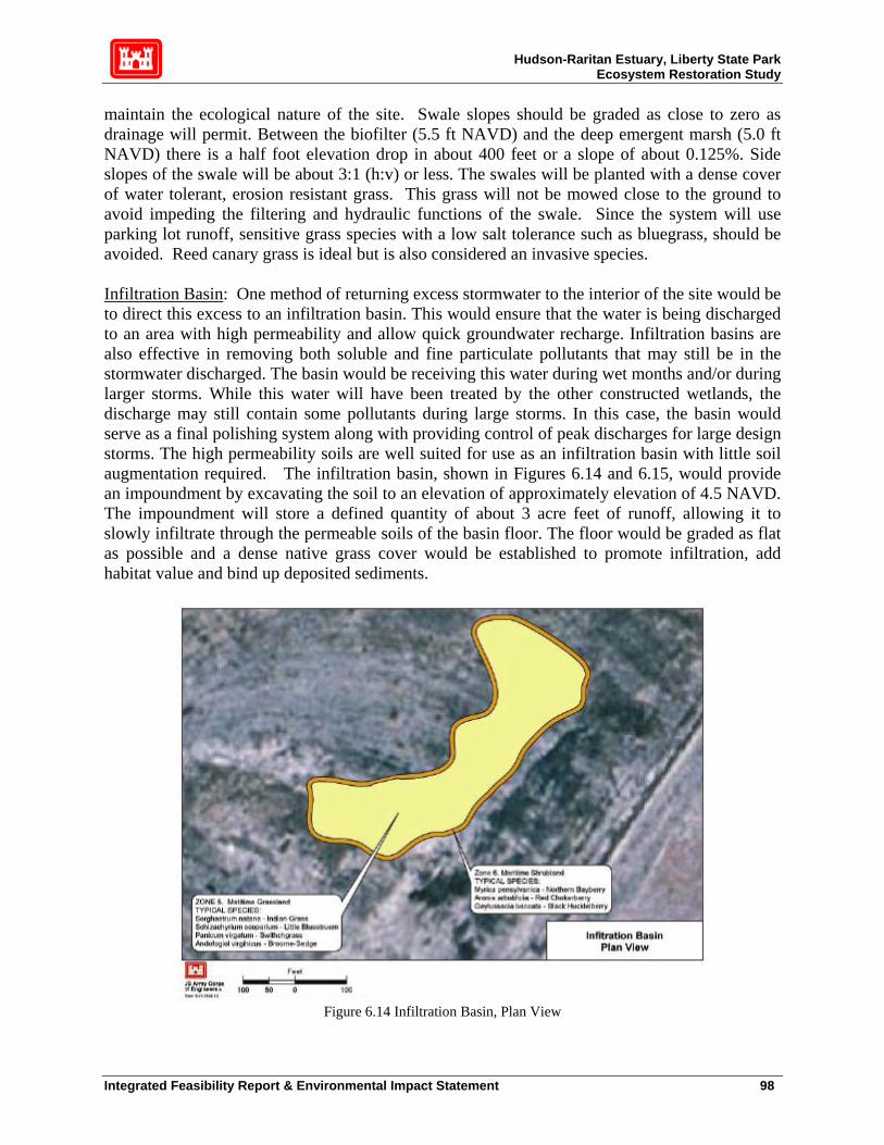
Hudson-Raritan Estuary, Liberty State Park Ecosystem Restoration Study
maintain the ecological nature of the site. Swale slopes should be graded as close to zero as drainage will permit. Between the biofilter (5.5 ft NAVD) and the deep emergent marsh (5.0 ft NAVD) there is a half foot elevation drop in about 400 feet or a slope of about 0.125%. Side slopes of the swale will be about 3:1 (h:v) or less. The swales will be planted with a dense cover of water tolerant, erosion resistant grass. This grass will not be mowed close to the ground to avoid impeding the filtering and hydraulic functions of the swale. Since the system will use parking lot runoff, sensitive grass species with a low salt tolerance such as bluegrass, should be avoided. Reed canary grass is ideal but is also considered an invasive species. Infiltration Basin: One method of returning excess stormwater to the interior of the site would be to direct this excess to an infiltration basin. This would ensure that the water is being discharged to an area with high permeability and allow quick groundwater recharge. Infiltration basins are also effective in removing both soluble and fine particulate pollutants that may still be in the stormwater discharged. The basin would be receiving this water during wet months and/or during larger storms. While this water will have been treated by the other constructed wetlands, the discharge may still contain some pollutants during large storms. In this case, the basin would serve as a final polishing system along with providing control of peak discharges for large design storms. The high permeability soils are well suited for use as an infiltration basin with little soil augmentation required. The infiltration basin, shown in Figures 6.14 and 6.15, would provide an impoundment by excavating the soil to an elevation of approximately elevation of 4.5 NAVD. The impoundment will store a defined quantity of about 3 acre feet of runoff, allowing it to slowly infiltrate through the permeable soils of the basin floor. The floor would be graded as flat as possible and a dense native grass cover would be established to promote infiltration, add habitat value and bind up deposited sediments.
Figure 6.14 Infiltration Basin, Plan View
Integrated Feasibility Report & Environmental Impact Statement 98

Hudson-Raritan Estuary, Liberty State Park Ecosystem Restoration Study
Figure 6.15 Infiltration Basin, Profile View
6.4.3 Upland Buffer and Seasonal Wetlands
Within the project areas not designated for the tidal system or the freshwater wetland systems, invasive species such as Phragmites and mugwort are thriving. The presence of these very aggressive invasive species, so close to the proposed tidal and fresh water wetlands, imposes a great risk to the sustainability of these communities. Therefore, in order to ensure the integrity of the restoration, upland buffer zones for the tidal wetlands and the freshwater wetlands throughout the site (including the freshwater wetland system and the seasonal wetlands) are included as a necessary part of project implementation. Where monitoring of the cleared upland areas show that additional measures are required, a mixture of clean fill and topsoil could be brought in where needed, and maritime scrub/shrub plants could be planted in the places where vegetation of low habitat value currently exists, to create a protective buffer for these water resource solutions. Some of the seasonal wetlands themselves are infested with invasive species, and will require clearing and grubbing to function properly. This area, along with the tidal and fresh water systems, will be managed in the years following construction to minimize the reintroduction of invasive species. The location of these buffer zones will be refined in the Pre-Construction Engineering and Design (PED) phase. Although the berm is technically a byproduct of the tidal marsh construction, the result will be an upland environment and is consequently discussed in this section. Its functions are directly linked to the aquatic habitat portions of the site, as it increases water flow to the now seasonal wetlands. The berm also protects the tidal marsh and freshwater wetland habitats from the industrial activities right outside the park. It should be noted that there are vast swaths of successful upland habitat with no wetlands. Nothing is planned for these swaths.
Integrated Feasibility Report & Environmental Impact Statement 99

Hudson-Raritan Estuary, Liberty State Park Ecosystem Restoration Study
There is proposed trail that is part of NJDEP’s General Management Plan that will be planned and constructed at 100% non-Federal cost. NJDEP will coordinate with USACE to ensure that the recreational feature is compatible with the ecosystem features.
Integrated Feasibility Report & Environmental Impact Statement 100

Hudson-Raritan Estuary, Liberty State Park Ecosystem Restoration Study
7. ENVIRONMENTAL CONSEQUENCES
7.1 Environmental Effects of Restoration Measures Implementation of the recommended plan is expected to result in a substantial net increase in estuarine-related functional habitat value throughout the proposed restoration area. Thus it is determined that there will be no significant adverse impact to the environment as a result of implementation of the proposed restoration project.30 There will be minor, acceptable permanent exchange of habitat in low-functional value vegetative communities. There will be some substantial but temporary permitted construction impacts in relation to the excavation of the contaminated soils of the tidal marsh area and the safe upland placement and encapsulation of this material. In every case, throughout this project area, the physical replacement of habitat will result in a net increase in functional habitat value, including JD wetlands and relatively high value existing terrestrial habitat, such as in the proposed tidal marsh area. Potential non-significant adverse environmental impacts and their rationale for non-significance are summarized as follows: a) Tidal marsh habitat exchange. Estuarine functional habitat value will increase very substantially as a result of altering existing habitat for salt marsh, including tidal creek, intertidal flat, low marsh and high marsh. The expected change in habitat function is detailed in table 6-3 and figure 6-2 of the ERI. Effects on the northern harrier, which uses the existing MG, are addressed in section 7.1.7.3. A clay layer of thickness meeting NJDEP requirements will be placed on top of the newly exposed soil right after excavations for the salt marsh to prevent potential bio-uptake. Topsoil will be placed on top of the clay layer to make the tidal marsh amenable to planting of S. alterniflora, S. patens and other salt marsh plants. The thickness of the clay layer will be determined by NJ DEP requirements to prevent the upward migration of contaminants present in the soils below the depth of excavation. It should be thick enough to be stable from an engineering standpoint and deep enough to prevent root penetration through the clay layer. b) Excavation, transport and encapsulation of contaminated soil. It is expected that the proposal to excavate, transport, place and encapsulate the contaminated soils to be removed from the 45- acre rectangle for the construction of a salt marsh system will have an overwhelmingly positive effect on the environment. This expectation is based on the following:
1. Contaminated soils to be excavated will be handled strictly according to the Health and Safety Plan approved by the NJDEP and applicable OHSA rules and regulations. This may include reducing effects through use of watering down surface soils during excavation to reduce or eliminate air borne contamination; the addition of soil treatment
30 The criteria, metrics and rationale for this determination are summarized in the ERI, specifically, section 6 (Functional Assessment of Ecological Communities), figure 6.2 (Cumulative Functional Values of Existing Conditions and the Proposed Habitat Restoration Plan at LSP) and table 6.3 (Functional Assessment Scores for Existing and Proposed (i.e., Recommenced Plan)) Conditions at LSP).
Integrated Feasibility Report & Environmental Impact Statement 101
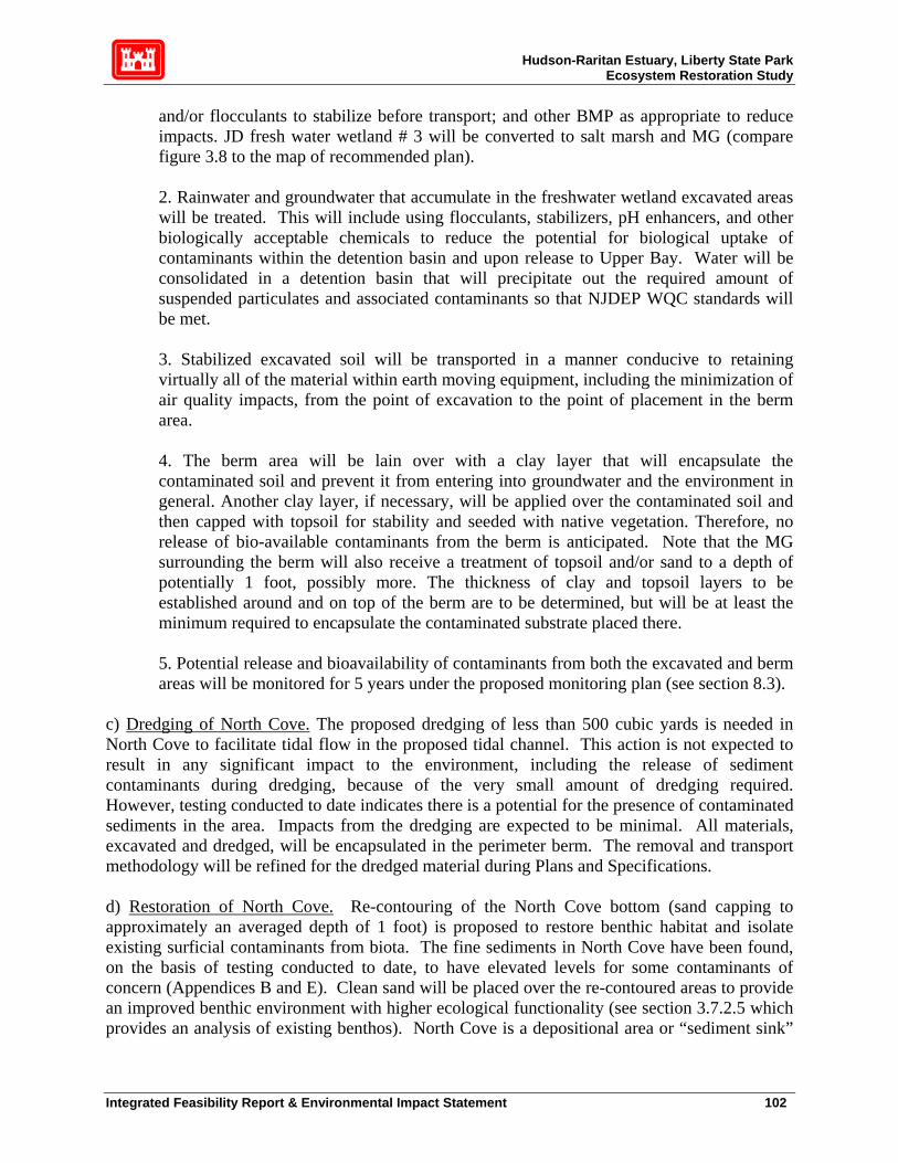
Hudson-Raritan Estuary, Liberty State Park Ecosystem Restoration Study
and/or flocculants to stabilize before transport; and other BMP as appropriate to reduce impacts. JD fresh water wetland # 3 will be converted to salt marsh and MG (compare figure 3.8 to the map of recommended plan).
2. Rainwater and groundwater that accumulate in the freshwater wetland excavated areas will be treated. This will include using flocculants, stabilizers, pH enhancers, and other biologically acceptable chemicals to reduce the potential for biological uptake of contaminants within the detention basin and upon release to Upper Bay. Water will be consolidated in a detention basin that will precipitate out the required amount of suspended particulates and associated contaminants so that NJDEP WQC standards will be met.
3. Stabilized excavated soil will be transported in a manner conducive to retaining virtually all of the material within earth moving equipment, including the minimization of air quality impacts, from the point of excavation to the point of placement in the berm area.
4. The berm area will be lain over with a clay layer that will encapsulate the contaminated soil and prevent it from entering into groundwater and the environment in general. Another clay layer, if necessary, will be applied over the contaminated soil and then capped with topsoil for stability and seeded with native vegetation. Therefore, no release of bio-available contaminants from the berm is anticipated. Note that the MG surrounding the berm will also receive a treatment of topsoil and/or sand to a depth of potentially 1 foot, possibly more. The thickness of clay and topsoil layers to be established around and on top of the berm are to be determined, but will be at least the minimum required to encapsulate the contaminated substrate placed there.
5. Potential release and bioavailability of contaminants from both the excavated and berm areas will be monitored for 5 years under the proposed monitoring plan (see section 8.3).
c) Dredging of North Cove. The proposed dredging of less than 500 cubic yards is needed in North Cove to facilitate tidal flow in the proposed tidal channel. This action is not expected to result in any significant impact to the environment, including the release of sediment contaminants during dredging, because of the very small amount of dredging required. However, testing conducted to date indicates there is a potential for the presence of contaminated sediments in the area. Impacts from the dredging are expected to be minimal. All materials, excavated and dredged, will be encapsulated in the perimeter berm. The removal and transport methodology will be refined for the dredged material during Plans and Specifications. d) Restoration of North Cove. Re-contouring of the North Cove bottom (sand capping to approximately an averaged depth of 1 foot) is proposed to restore benthic habitat and isolate existing surficial contaminants from biota. The fine sediments in North Cove have been found, on the basis of testing conducted to date, to have elevated levels for some contaminants of concern (Appendices B and E). Clean sand will be placed over the re-contoured areas to provide an improved benthic environment with higher ecological functionality (see section 3.7.2.5 which provides an analysis of existing benthos). North Cove is a depositional area or “sediment sink”
Integrated Feasibility Report & Environmental Impact Statement 102
Hudson-Raritan Estuary, Liberty State Park Ecosystem Restoration Study
in the Hudson River Estuary. It is anticipated that additional natural sediments will continue to migrate to this area and mix with the placed sand. This mix of sediments is expected to further enhance habitat values for benthos over time. The re-contouring plan will be refined during Plans and Specs with further modeling to optimize sand placement for geotechnical stability. The intertidal zone within North Cove, although relatively small, may also benefit from restoration depending on the results of additional contaminant testing to be conducted during Plans and Specs. Also, where warranted, identified unwanted debris will be removed from the intertidal zone to promote intertidal productivity and reduce the amount of anthropogenic materials that may trap flotsam that may enter the tidal creek. e) Elimination of JD wetland # 3. At present, there is an approximately 3-acre common reed dominated JD wetland along the perimeter of the 45-acre rectangle area (ERI Figure 2-5 and Table 2-2). This will be converted to high salt marsh (S. Patens dominated) and MG with the result that functional values will be considerably increased (ERI Table 6-3 and Figure 6-2). Conversion of this low-value, invasive species-dominated habitat to high functional salt marsh and MG is not expected to have a significant impact on the environment. f) Re-plumbing for creation and enhancement of fresh water wetlands. Significant redirection of fresh water sources and sinks within the proposed restoration area will occur upon implementation of this project. This engineering work is not expected to have significant impact on the environment, in fact it is anticipated that the addition of fresh water to areas that currently do not have it will substantially increase functional habitat value in the areas to be restored. Some existing habitat will be lost, although these are generally low-value invasive species-dominated habitats (see Figure 6.4). In addition, an integral part of this recommended plan is the enhancement of fresh water wetlands on site to utilize existing low-value common reed dominated areas as bio-filters to improve WQ for wetlands further down stream.31 g) Invasives dominated habitat exchange. Approximately one-half of the existing restoration site is dominated by invasive vegetation, mostly common reed, purple loosestrife, tree of heaven, mugwort, Japanese knotweed and others. Without intensive management, more areas will be dominated by these invasive species and other undesirable opportunistic vegetation, such as winged sumac, consequently lowering overall vegetative diversity. The proposed restoration involves selective removal and control of invasive species. However, small invasive stands of vegetation that do not threaten nearby habitats will be left alone, if appropriate (e.g., where Phragmites forms a barrier to isolate a breeding area and is not spreading). Per table 6-3 and figure 6-2 of the ERI, functional habitat value is predicted to increase substantially from application of this practice of replacement with non-invasives. Wildlife such as red-winged blackbird and marsh wren, which prefer common reed for nesting to other habitats, may be reduced in number on site, but they will not be negatively affected in the overall population. They are generally very adaptable and common animals that have numerous other available habitats in the immediate area, and on site, to satisfy their life requirements. Replacement of
31 See locations of the 2 bio-filter wetlands and the infiltration basin, which itself will be converted from terrestrial, invasive-dominated habitat to a seasonally flooded freshwater wetland on the recommend plan. A detailed description of this re-plumbed engineering is provided in the Engineering Appendix, Hydrology and Hydraulics of Fresh Water Wetlands report, Plan D.
Integrated Feasibility Report & Environmental Impact Statement 103

Hudson-Raritan Estuary, Liberty State Park Ecosystem Restoration Study
common reed, mugwort, Japanese knotweed and other nearby species with grassland and marsh will greatly benefit raptors, such as the northern harrier, which feed and nest in relatively short grasses. h) Increased cost to federal and state governments. Implementation of the proposed project will have a negative effect on the taxpayer in the sense that federal tax funds will be used to pay for the federal share of this project. However, this cost is justified based on the benefit-cost analysis performed by the District. Maintenance costs, generally a non-Federal partner responsibility, for the state of NJ will be increased. However, it is also assumed that the cost is justified because many people will enjoy the vastly improved park. Local businesses are expected to have increased revenue as a result of increased visitorship to the park. i) Increased vehicular traffic. An increase in visitorship to the park would mean more vehicles and noise. However, because there are no new roads, parking lots or massive vehicular infrastructure additions, no significant impacts to the environment are expected. j) Construction and long-term air emissions. There will be a significant impact to select parts of the LSP during construction. These effects will be temporary and locally restricted. All feasible precautions will be taken to avoid and minimize construction impacts as described in other sections of this report. A small increase in temporary air emissions is expected due to increased visitorship to the park as a result of this restoration.
7.1.1 Physical Setting Short-term (construction) or long-term significant adverse impacts to the physical setting of the project area are not expected as a result of implementation of the recommended plan. Parts of the project area will look like a typical construction site with associated impacts at varying stages in the construction process, but these temporary impacts will be avoided and minimized to the extent feasible. In general, long-term impacts are expected to be overwhelmingly positive as currently existing fenced-off hazardous waste sites are converted to high value natural habitats, fences are removed and aesthetically pleasing trails and educational amenities are erected, improving the physical setting of the area significantly.
7.1.2 Climate and Weather No short or long-term significant adverse impacts to climate or weather are expected from implementation of the recommended plan because of the relatively small size of the project. On the contrary, localized vegetative cover and humidity from greater surface water retention will locally have a small effect on temperature and oxygen content of the air.
7.1.3 Water Resources Significant short or long-term effects on water resources are not expected due to implementation of the recommended plan. All necessary permits, including a NJ State Water Quality certificate will be applied for at the appropriate time in the planning process to insure that short-term temporary construction impacts to water quality are avoided, minimized and rendered acceptable to the State of New Jersey. Long-term permanent water quality impacts are expected to be overwhelmingly positive. NJDEP WQ standards attainment for North Cove are expected to
Integrated Feasibility Report & Environmental Impact Statement 104
Hudson-Raritan Estuary, Liberty State Park Ecosystem Restoration Study
remain the same or improve, but definitely not get worse due to the expected decrease in residence time of tidal water and consequential increase in DO. Best Management Practices (BMP) will be utilized throughout the site, and likely required by the WQC, during all construction activities.32
7.1.4 Socio-Economics
Temporary Construction Effects Temporary positive effects to the local economy will accrue from the construction of the Recommended Plan due to the introduction of construction workers and resulting purchase of supplies and food. Temporary negative effects include lack of access to certain portions to the park during construction, and air emissions from construction equipment (see Section 7.18 for details). Long-Term Effects The implementation of the recommended plan will not have any long-term adverse effects on the local economy, local income, or local housing. The environmental restoration of Liberty State Park may increase visitation to the site by providing visitors additional recreation opportunities. Increased visitation may benefit local businesses by adding demand for amenities and concessions. The implementation of the recommended plan may also provide the incidental benefit of increasing property values in the area surrounding the site. The improvement of the area in an aesthetically sensitive manner (i.e. maintaining sight lines of the Manhattan skyline) and the provision of passive recreation opportunities (overlooks, trails, benches, etc.) inherent in Recommended Plan may add to the desirability of the neighborhoods surrounding the site. Other social benefits of the environmental restoration of Liberty State Park include reduction of the odor and other negative effects of standing water as well as eliminating exposure to the contaminants already existing at the site.
7.1.5 Cultural and Historic Resources The Liberty Science Center Wetlands Complex area was not under consideration for restoration at the time the cultural resources study was undertaken, and so has not been surveyed. As the project proceeds, this area will be surveyed and subsequent cultural resources work will be undertaken as required. It is the Corps’ opinion that the restoration work for the remaining areas at Liberty State Park will have no effect upon cultural resources if project plans remain as proposed. If excavation is determined necessary in the vicinity of the former Communipaw shoreline then subsurface work may be required. The New Jersey Historic Preservation Office concurred with this evaluation (see Appendix C). This work was also coordinated with the Liberty State Park Resource Interpretive Specialist.
32 Appendix D of the ERI describes the WQ sampling program accomplished to date, and on-going additional sampling, such as groundwater salinity, DO, pH and water table fluctuations.
Integrated Feasibility Report & Environmental Impact Statement 105

Hudson-Raritan Estuary, Liberty State Park Ecosystem Restoration Study
7.1.6 Land Use Implementation of ecosystem restoration measures will not adversely affect the current land use in the Liberty State Park study area. Jersey City’s economic growth and development will not be restricted by construction of the project because construction is located within the park itself. To the contrary, implementation of the selected plan will benefit the current and future land uses in Jersey City by augmenting the education and recreational capacity of Liberty State Park, and raising the value of adjacent residential and commercial properties.
7.1.7 Biological Resources
In general, biological resources will be enhanced by implementation of the recommended plan (see table 6-3 and figure 6-2 of the ERI). Higher functional value terrestrial vegetative communities are expected to be expanded and enhanced; fresh water wetland communities are expected to, on balance, be expanded in aerial extent and inundation period; a variety of estuarine ecological functional values are expected to be directly enhanced by the creation of the proposed tidal marsh; human values such as recreation, aesthetics, science, education, access to water and wildlife communities and park facilities are expected to be significantly increased.
7.1.7.1 Vegetation Long-term adverse impacts to vegetative communities in the project area are not expected due to implementation of the recommended plan. There will be temporary construction impacts to specific areas, especially the tidal marsh and berm areas and selected fresh water and terrestrial areas. In all cases, a higher functional value vegetative community will replace areas temporarily affected in an adverse manner by excavation, landscaping and replanting. Depending on the community type desired, there will be varying amounts of time before the functional value of the enhanced communities are realized, with early successional communities (such as MG) achieving their maximum habitat values earlier than later successional communities (such as SNH). Torrey’s rush, a NJ State endangered plant species, is present in relatively low numbers on the LSP restoration site, entirely in an MG community.
7.1.7.2 Fish and Wildlife Resources There are not expected to be to any long-term adverse effects on fish and wildlife resources, including North Cove and the adjacent estuary, as a result of the implementation of the recommended plan. Under existing conditions, there are no fish in fresh water areas of LSP to impact. DEM habitat with deeper permanently flooded refuge areas will be created which are expected to maintain a fresh water fish and aquatic invertebrate assemblage. Only seasonally flooded wetlands, which obviously do not support fish populations, exist currently at LSP. In terms of estuarine fish in North Cove and the adjacent Upper Bay, adverse impacts will be limited to the temporary construction phase effects from the small amount of dredging to extend the bottom of the proposed tidal channel to approximately ambient -3.0 MLW depth in North Cove. Since habitat restoration is planned for North Cove as well as the terrestrial and fresh water parts of LSP, measures will be taken to restore this area also. Sand will be placed, to a
Integrated Feasibility Report & Environmental Impact Statement 106
Hudson-Raritan Estuary, Liberty State Park Ecosystem Restoration Study
depth to be determined, over existing contaminated sediments/biologically stressed benthos of North Cove. The purpose is to isolate sediment contaminants now in the predominantly fine substrate from the Upper Bay, and to allow for a more biologically productive, less stressed benthic community to take hold in the cove, further enhancing the proposed tidal creek and marsh. An enhanced North Cove would be expected to act as a biological bridge to attract fish and invertebrates into the proposed tidal marsh from cleaner, more productive parts of Upper Bay. Sand (sediment transport) movement, if any, over time will be closely measured during the post-construction monitoring period to ensure that the sand cap remains where placed, thus reducing or eliminating contact between the contaminants in the underlying fine substrate of North Cove, and the created tidal marsh and deeper parts of Upper Bay. There is neither salt marsh nor SAV in North Cove or in any adjacent area of Upper Bay. The closest salt marsh to North Cove is South Cove (also part of LSP but not part of the proposed restoration). The placement of a sand cap over existing North Cove fine sediment is also expected to increase bottom DO levels (primarily through a reduction in SOD), further enhancing fish and invertebrate functionality for the estuarine species and allowing for greater localized species richness. Over time, fine sediments will mix with the sand cap. This is desirable from a benthic habitat standpoint because some species, particularly infauna, prefer mixed sediment. At a point during the post-construction monitoring period (TBD) the efficacy of this habitat enhancement methodology will be reevaluated and a decision made to renourish, if necessary or sufficiently beneficial. Long-term adverse effects are not expected on amphibians, reptiles, birds and mammals that currently utilize or would potentially utilize the proposed site. On the contrary, the analyses conducted for this EIS found that there would be an overwhelming increase in habitat appropriate to the species that currently utilize the site. This takes into account recognition that some habitat must be exchanged, resulting in a temporary loss of habitat value in the whole restoration site. For example, the known nesting site for the northern harrier within an existing unit of MG habitat located in the central portion of the 45-acre rectangle will be destroyed since virtually this entire area will be excavated for the creation of the tidal marsh system. As part of the overall restoration of LSP, however, habitat connectivity will be increased. The overall functional value habitat will be markedly improved, primarily by the increase in MG in locations currently dominated by mugwort that could be potentially overwhelmed by common reed and other invasive vegetation in the future. This approach is agreeable to USFWS and the NJDEP for the following reasons: 1. The temporary loss habitat function will be replaced by much greater amount of higher functional value habitat in the long term. 2. Species like the northern harrier are ephemeral and adaptable in choosing nesting sites and will benefit from expansion of preferable habitat in the long term. 3. The proposed plan may increase the possibility of successful harrier breeding, which is currently marginal. Large contiguous areas of habitat of preferable grassland habitat will be established that will increase isolation for nesting and substantially increase feeding territory for raptors.
Integrated Feasibility Report & Environmental Impact Statement 107

Hudson-Raritan Estuary, Liberty State Park Ecosystem Restoration Study
4. Northern harriers can still feed in the salt marsh, and possibly nest in the MG area that will be established along the edges of the new tidal marsh, some of which will be contiguous with a swath of MG that will extend around the western part of the overall restoration site. The same logic applies to all species and all habitats for the purposes of this restoration project. If information comes to light during further coordination with the agencies and the public that requires certain areas to be left untouched, the District will seriously consider excluding these areas from the final designs for the project as long as doing so does not interfere with implementation of the overall project plan.
7.1.7.3 Threatened and Endangered Species
No significant adverse impacts to any TES are expected as a result of implementation of the recommended plan. There are no Federal TES or critical habitats on site, based on 2003 surveys (ERI). The IC has identified (Appendix B of ERI) some Federal listed species such as the piping plover. However, these were rare sightings, possibly outside the project area, and therefore should not require consultation with the USFWS. There are, however, 7 NJ State listed species found within the proposed restoration area during the 2003 surveys described in the ERI (Appendix A). These are one plant, the Torrey’s rush, and 6 birds including the northern harrier, the Savannah sparrow, the long-eared owl, the short-eared owl, Cooper’s hawk and the bobolink.
7.1.8 Air Quality The General Conformity provisions related to the Clean Air Act require a conformity demonstration for each pollutant where the total and indirect emissions from the Federal action exceed the corresponding de minimis standard for each pollutant threshold. Preliminary emission estimates were made based on emission estimates generated from similar activities for other projects. Based on the preliminary analysis, which are solely based on assumptions regarding construction equipment staging and schedule, total direct and indirect NOx emissions appear to exceed de minimis threshold of 25 tons per year. In close consultation with the USEPA and the NJDEP, the Corps will conduct a detailed, comprehensive quantitative analysis in the next project phase (PED) to precisely quantify all emissions from the Liberty State Park project and to determine if conformity has been met. Upon completion of the revised emission estimates, if applicability is determined, a Draft General Conformity Determination will be prepared and will undergo formal agency and public review. Results and conclusions of this process will be part of the environmental review, including, as necessary, detailed analyses of alternatives, such as emission offsets, emission credits, emission reduction technologies, and operational modifications to reduce emissions during PED.
7.1.9 Noise
No significant long-term (post construction) noise impacts are expected due to implementation of the proposed project. In fact, the proposed berm in the SW corner of the proposed restoration site
Integrated Feasibility Report & Environmental Impact Statement 108

Hudson-Raritan Estuary, Liberty State Park Ecosystem Restoration Study
will reduce noise impacts to the interior of the site to a small degree, possibly adding to the isolation effect for sensitive wildlife, such as ground-nesting birds in the MG habitat east and north of the berm. There will, however, be significant short-term (construction phase) noise impacts in localized areas due primarily to the operation of earth moving vehicles. These localized noise impacts will occur primarily on the 45-acre rectangle and the SW corner of the site, due to excavation and creation of the proposed berm area and the North Cove area, due to some re-contouring of the Cove bottom. These noise impacts during the construction period will result in little if any wildlife ecological functionality in the actively constructed areas. Noise impacts to heavy equipment workers will not be significant assuming they follow OHSA and NJDEP Health and Safety Plan rules (head gear, ear protection gear, etc). Once construction is completed in any particular area, noise levels will return to ambient levels. They may actually be reduced over the long-term because of the addition of trees and shrubs and, as stated previously, because of the presence of the berm. Construction windows may be applied to minimize, among other impacts, noise impacts to wildlife. This will be addressed in Plans and Specs when construction schedules are developed. Vehicular traffic will likely increase somewhat because of anticipated increased visitorship to the park. However, existing roads are sufficiently removed from existing habitat areas enough that this should not be a significant impact. Unauthorized vehicular access to the restoration area will not be allowed. Trails will be laid out to minimize noise/human presence impacts to sensitive wildlife and habitats.
7.1.10 Recreation There is no USACE recreation plan at this time, although NJDEP is planning recreational features to be undertaken at 100% non-Federal expense. Any future recreational features will be coordinated with USACE to ensure compatibility with ecosystem restoration measures. There will be no long-term direct or indirect adverse impacts to any existing or planned recreational areas after construction of the proposed ecosystem restoration measures. Minor, temporary impacts associated with bird watching, fishing, hiking, biking, and boating may occur during construction activities. Once construction is complete, there will be additional recreational opportunity such as walking, running or biking along trail ways within Liberty State Park and the restored area. The passive recreational and educational values of the proposed project are substantial (see table 6.4 in the ERI). In addition, the restored habitats in the study area will increase the aesthetic value of the area.
7.1.11 Aesthetics
No significant long-term adverse impacts on the aesthetics of LSP are expected as a result of implementation of the recommended plan. Quite the opposite is true. Although there will be short-term construction phase impacts to aesthetics during the construction period, the long-term effects on aesthetics will be overwhelmingly positive. Appropriate construction phase fences and methods to reduce runoff, sedimentation and infusion of loosened and dried soil into the air will be implemented per the Health and Safety plan approved by the NJDEP. BMP will be used throughout the construction periods to minimize aesthetic impacts. If necessary, rainwater accumulating in excavated areas would be pumped and/or treated (e.g., addition of flocculants to precipitate out suspended organic particulate complexes and particle-associated contaminants) before being released, possibly into North Cove, a CSO and/or directly to Upper Bay proper. NJ
Integrated Feasibility Report & Environmental Impact Statement 109

Hudson-Raritan Estuary, Liberty State Park Ecosystem Restoration Study
State WQC requirements will be met, helping to reduce temporary construction related aesthetic impacts. In the long term, unappealing chain link fences that currently block access to the interior of the proposed site will be removed and replaced by trails, elevated walkways or high value vegetation where feasible. Low intensity pedestrian access for hikers, school children, scientists, birders, and nature lovers will be greatly improved as the interior unpaved/asphalt roads are grassed over. A narrow, naturalistic trail system will be developed to facilitate appropriate access to all of the improved wildlife features of the restored park. Appropriate elevated wildlife and landscape viewing platforms will be built to further enhance the aesthetic qualities of the restored areas. A layer of sand is proposed to be placed over the apparently contaminated sediments of North Cove will also improve the aesthetics of the area by reducing the H2S smell emanating from these sediments (although this is a very minor issue) and by adding to the visual clarity of the water by reducing re-suspension of fine surficial sediments. The most important aesthetic improvement in the restoration plan may be the creation of the berm in SW corner of the proposed restoration area. This berm will block views of the industrial area to the south and west of LSP from the park. The berm will be sloped gently towards the east to the restoration area in to maximize MG and supply additional water to the JD wetlands adjacent to the MG area, and secondarily create a desirable elevated view-shed to the east into the interior of the natural area, and to the Harbor and the lower Manhattan skyline in the distance. This aesthetic improvement will further enhanced by a walking trail, picnic areas, and wildlife observations platforms along the spine of the berm. Trees will also be planted along this spine to aesthetically enhance the picnic areas and to further block the view to the industrial area to the south and west. In the long term, assuming aggressive invasive species control, aesthetics of the restored areas will continue to increase over time as desired vegetation grows and fish and wild life repopulate the restored areas. The Grove of Remembrance (Millennium Park), which is located adjacent to the north side of the proposed restoration area, will not be affected in the long-term in any way by implementation of the recommended plan.
7.1.12 HTRW Implementation of the proposed ecosystem restoration measures will remove human and faunal exposure to certain contaminants, which are currently partially exposed at Liberty State Park (hence the necessity for the 45 acre enclosed containment area). As this contaminated material will be secured within a clay-lined berm and topped with at least a foot of clean fill, it will no longer be a danger to the public and ecosystem, within and outside the park. During construction, levels of certain materials, including PCB’s, TPHC’s, ABN’s, hexavalent chromium, and dieldrin are constituents of potential concern and may, in some locations, exceed NJDEP Soil Clean Up Criteria and Effects Range Criteria, due to the nature of the site’s past usage and depositional history. Restoration plans have been considered with the potential presence of these materials in mind, and are addressed through a Health & Safety Plan (see Appendix E). Should any additional concerns arise during the construction phases, procedures for this contingency will be specified in the construction contract.
Integrated Feasibility Report & Environmental Impact Statement 110

Hudson-Raritan Estuary, Liberty State Park Ecosystem Restoration Study
7.1.13 Transportation and Other Infrastructure
Construction activities will result in minor, temporary impacts to traffic flow and volume within Liberty State Park. An increase in large slow-moving vehicles needed for construction of ecosystem restoration components may decrease traffic flow and increase traffic volume in the area for short times. To help alleviate the temporary impacts associated with construction activities, flagmen would available and construction signs will be posted. Upon completion of construction, no adverse impacts to local transportation systems would occur. A permanent alteration would be the transformation of a segment of Freedom Way from road into a bridge to cross the proposed tidal creek. Public transportation facilities such as rail and ferry would not be affected, except in increased usage as the proposed plan is expected to increase visitorship to LSP.
7.2 Environmental Justice Summary This site was chosen as the first mainstream HREERP project to be implemented because it advances the goals of the HRE CRIP Needs and Opportunities Report and the Reconnaissance Study, and because of the intense interest of the State of New Jersey to enhance and restore this ideally located NY-NJ Harbor waterfront park, which contains substantial habitat and recreational amenities, much of it ideally suited for improvement. Since the main focus of this project is habitat creation and enhancement within a highly industrialized and densely populated residential area, access to this relatively natural oasis to varied interest groups and income levels will be improved. A system of trails, walkways, observation points, signage and other interpretive aids will provide a greater number of local and regional park visitors an opportunity to experience nature in their own backyard. Consideration will be given to developing the landscape and trail plan for this project to conform to the “greenway” concept of the Urban Rivers Initiative, which is, in part, an attempt to connect the major waterfront recreational amenities of the NY-NJ Metropolitan region to the extent feasible. This would increase the access to LSP to people of various economic backgrounds and people who are dependent on mass-transit. Likewise, trails and boardwalks will be designed in a modern fashion, facilitating access to handicapped individuals.
7.3 Relationship Between Short Term Uses and Long Term Productivity The long-term productivity of the habitat restoration site at LSP will vastly outweigh the short-term uses. The Environmental Resources Inventory describes how habitat units for the recommended restoration plan are predicted to increase overall from existing conditions for the metrics utilized in the functional assessment and for existing vegetative community cover types. Short-term uses of the existing site are largely limited, and long-term productivity generally increased as evidenced by the following: 1. The grassy area in the proposed tidal creek inlet area does provide some recreational uses, such as ball playing and jogging. However, this type of recreational activity will be
Integrated Feasibility Report & Environmental Impact Statement 111

Hudson-Raritan Estuary, Liberty State Park Ecosystem Restoration Study
replaced by relatively higher-value (albeit low-intensity) aesthetics and wildlife observation, and much greater estuarine habitat functional value. The existing environment has none. 2. The Christopher Columbus monument, which presently resides at the head of North Cove must be relocated to another location within LSP to allow for the proper functioning of the proposed tidal creek and salt marsh. This represents an unavoidable short-term loss of recreational value. However, since the location of the monument does not represent an integral part of its value, and LSP staff will relocate the monument to an appropriate place in LSP, this is considered a minor and temporary short-term loss of recreational and aesthetic value. It will be offset by the new location and the establishment of a tidal inlet and salt marsh in its place. 3. The long-term habitant functional value of the entire upland (forest, grassland, fresh water wetland, and other non-tidal habitat) will be generally and significantly increased. As stated in the Future Without Project section, upland habitat will continue to degrade, as it becomes drier, more upland, mostly invasive, low-functional lesser value habitat, dominated by Phragmites and Japanese knotweed. This would involve the loss of some existing fresh water wetland, which is the natural process of habitat succession from wetter to drier habitat as organic matter accumulates soil and elevations rise and more aquatic obligate and facultative species are converted to more dry tolerant ones. This is not inherently detrimental. However, considering the history of the NY-NJ metropolitan area and its vast loss of wetlands (one of the main reasons for the Hudson- Raritan Estuary Ecosystem Program), long-term estuarine productivity would suffer under the no action alternative. 4. In the proposed tidal creek and salt marsh area, long-term estuarine productivity would be vastly increased since a filled, contaminated, lower-functional value dredged material disposal area will be converted to a relatively high productivity tidal marsh. Localized long term productivity of the Hudson-Raritan Estuary will increase in this area from very low functional value to a relatively high productivity area of Upper Bay, which itself is characterized by very few remaining tidal wetlands. 5. The long-term productivity of the Liberty Science Center wetland will be significantly increased through the implementation of water management.
7.4 Irreversible and Irretrievable Commitments of Resources Except for the utilization of fossil fuels during construction of the recommended plan, and the federal and state financial resources needed to implement this project, there will be no irreversible and irretrievable commitment of resources as a result of implementation of the recommended plan. This is evidenced by the following: 1. Cultural resources that could be potentially affected by the implementation of this project were identified by the NJSHPO as being of small concern. Routine monitoring for cultural resources will occur during construction, and construction plans modified as needed to accommodate documentation and/or retrieval of resources. As stated previously, the vast majority of excavation
Integrated Feasibility Report & Environmental Impact Statement 112

Hudson-Raritan Estuary, Liberty State Park Ecosystem Restoration Study
will occur only in previously filled areas. The entire proposed restoration area is located on 19th and 20th century fill. No natural landscape features will be disturbed. 2. Financial resources of the Federal government, the Port Authority of New York and New Jersey and the State of New Jersey will be irreversibly committed to the planning, construction, monitoring and maintenance (as applicable) of this project in the amounts necessary to implement and maintain the recommended plan for the project life. 3. Construction equipment such as backhoes and bulldozers will irretrievably consume fossil fuels during the construction and maintenance phase of this project. The equipment and amount of fossil fuels to be consumed are documented in the MCACES section of the FR/EIS. 4. Table 6-3 of the Environmental Resources Inventory documents an expected significant increase in functional habitat value throughout much of the proposed restoration site. Thus, there would be little if any irretrievable and irreversible loss of environmental resources from implementation of the recommended plan, and long-term resources will be significantly increased.
7.5 Unavoidable Adverse Effects and Considerations that Offset Adverse Effects USACE regulations require that sequenced steps be taken to insure that adverse effects of a federal project are avoided and, if unavoidable, minimized. This has been done for the recommended plan as evidenced by the following:
1. There has been close coordination with the NJDEP, and others, for several years during the process of scoping and developing the details of the recommended plan. Alternative plans that may have resulted in significant adverse impacts were eliminated from consideration.
2. Appropriate permits from the NJDEP will specify measures to avoid and minimize
potential adverse impacts. These measures will likely include:
a) Construction monitoring. b) Employment of physical methods to reduce or eliminate contact between humans and
wildlife and significant concentrations of bioavailable contaminants. c) Post-construction monitoring to insure compliance with project plans.
Also, nuisance dust generated from construction will be managed according to a Health and Safety plan approved by the NJDEP (see sample plan in Appendix E).
3. The District has received an LOI from the NJDEP that documents the location of jurisdictional fresh water wetlands. Every reasonable step will be taken to avoid any adverse impact on these existing wetlands. In some cases functional value will be added to JD wetlands by removal of invasive plants and/or increasing inundation period/soil saturation. Ultimately, net wetland benefits will far outweigh any short-term losses.
Integrated Feasibility Report & Environmental Impact Statement 113
Hudson-Raritan Estuary, Liberty State Park Ecosystem Restoration Study
4. All reasonable steps will be taken to avoid or minimize adverse construction impacts, and
these steps will be coordinated with and approved (as appropriate) by NJDEP and other agencies.
5. By nature of this project, i.e., a habitat restoration, the net positive effects must be
positive. By definition, any adverse environmental effects will be offset many fold.
7.6 Cumulative Impacts The cumulative impacts of implementation of the recommended plan will be both positive and adverse. Positive cumulative impacts include: 1. A significant local and regional addition to estuarine habitat functional value in the Upper Bay region of the Hudson-Raritan Estuary, a heavily developed inner-harbor portion of the system especially hard hit by habitat alteration and reduced resources. This is due to fish and wildlife benefiting from the addition of an extensive salt marsh that will complement already existing nearby habitat, e.g., increased feeding and nesting for shorebirds and a greater contribution to estuarine biogeochemical processes due to the addition of the tidal marsh. 2. This project will add both numerically and value-wise to other projects that also contribute to the restoration of the Hudson-Raritan Estuary restoration efforts, e.g., The Hudson River, Flushing Bay, Jamaica Bay, Bronx River, Gowanus Canal, the Hackensack Meadowlands, the Lower Passaic River and many other planned and smaller, site-specific restoration efforts, as described in this FR. 3. Additional (and previously unavailable) low impact, nature and education related recreational opportunities will be added to those already available, such as the Liberty Science Center and the Statue of Liberty/Ellis Island complex. 4. Additional contaminated soil will be “locked up” (isolated from water, wildlife and humans) adding to the cumulative value of LSP. 5. A major contribution to the cumulative aesthetics of the NY-NJ Harbor area, considering the recommended plan’s highly visible location. 6. Because of expected increase in volume of visitors to LSP, an increase on the cumulative effect on spending is expected in the surrounding Jersey City area, e.g., local attractions (Ellis Island, Liberty Science Center), local restaurants, food and provision shops, sporting goods stores, gas stations, etc. Adverse cumulative impacts include:
Integrated Feasibility Report & Environmental Impact Statement 114

Hudson-Raritan Estuary, Liberty State Park Ecosystem Restoration Study
1. Temporary addition to the cumulative fossil fuel generated air contaminants in the region (mainly during construction). 2. Increased visitor use of LSP and concomitant contributions to air pollution. 3. Increased need for LSP staff and maintenance efforts, due to increased sensitive habitat that needs expanded management and increased visitorship to newly landscaped trails and wildlife observation points.
Integrated Feasibility Report & Environmental Impact Statement 115

Hudson-Raritan Estuary, Liberty State Park Ecosystem Restoration Study
8. RECOMMENDED PLAN
8.1 Ecosystem Restoration The NER plan would involve restoration of those portions of the study area degraded by past fills, contamination, and subsequent Phragmites and other invasive species colonization. Specifically, 234 acres would be restored to targeted habits, as summarized in Table 8.1 below:
Table 8.1 Ecosystem Restoration Acreages
Resulting Habitat Acres Tidal Marsh (High Marsh and Low Marsh) 32 ac Berm (ancillary component to tidal marsh) 50 ac Tidal Creek, Estuarine Subtidal, and Mudflat 14 ac Freshwater Wetland (Deep and Shallow Emergent Marsh) 26 ac
Related upland buffers and improved seasonal wetlands 112 ac Direct Project Area 234 ac
Indirect Benefits will extend to the Hudson-Raritan Estuary study area (approximately 500 square miles). The results of this restoration plan are expected to be significant in institutional, public and technical terms, and consistent with Federal, State, and local laws and resource management plans.
8.2 Real Estate As described in the Real Estate Plan (Appendix D) and summarized in Table 8.2, the prospective non-Federal sponsor, NJDEP, owns all the lands within the project boundary lines. Accordingly, no further acquisitions of real property, or interests in real property (including site access), are required for this project. Upon signing a PCA, the Corps (NY District) will provide the Sponsor with a legal description of the required project area (approx. 234 acres) and NJDEP, in turn, will submit a formal Authorization for Entry for Construction to the NY District. As a State Park, the project area’s highest and best use is as State Parkland. It is limited by New Jersey law (NJSA 13:8A-48) to open space uses and is precluded from non-park related uses and from ordinary commercial, industrial, or residential development. Neither can it sold by the State except under specific, limited circumstances. Because the 1) landowner’s (Sponsor’s) utility derived from the land will be enhanced (rather than diminished) by the proposed project, 2) the project would result in no greater restrictions on the land than are currently in place under New Jersey law, and 3) the Sponsor-owned land was acquired more than five years ago, for cost-sharing crediting purposes, the estimated value of the Project LERRD is zero ($0).
Table 8.2 Real Estate Project Costs
Administrative Costs $25,000 Contingency (20%) $ 5,000
Total $30,000
Integrated Feasibility Report & Environmental Impact Statement 116

Hudson-Raritan Estuary, Liberty State Park Ecosystem Restoration Study
8.3 Ecological Monitoring and Adaptive Management In order to monitor the success of the selected restoration plans, several performance criteria and potential corrective actions were developed. In particular, the ecological success of the restored habitats will be evaluated based on the following performance criteria:
• Successful establishment of each habitat type (low emergent marsh, high marsh, mudflat, fresh water wetland and upland forest/scrub-shrub, and tidal creek) relative to similar habitats in the region
• Vegetation should occur in proper zones (e.g., hydric species in wet sites) in all layers (tree, shrub, herbaceous) and have adequate characteristics compared to similar habitats in the region
• Air Management Program site constraints • Water quality, general landscape, sinuosity, and water depth should be similar to natural
tidal creeks occurring in the region The details on how these criteria will be quantified are to be finalized after the NEPA process is concluded and incorporated into the final PED phase. To ensure the success of the NER Plan, corrective action will be taken if performance criteria are not met. Potential corrective action may include:
• Replanting vegetation in areas where plantings do not meet predetermined criteria • Enhancing survival of planted vegetation (by applying a fertilizer such as Osmocote) • Improving tidal flushing • Installing erosion control devices • Suppressing encroachment by Phragmites through mechanical landscaping techniques,
physical removal and/or replanting of desirable species • Preventing herbivory (by installing fencing) • Adjusting channel morphology and hydrology, or stabilizing banks • Adjusting weirs for freshwater wetlands • Adaptive management as required.
8.4 Cost Estimate
The costs of the selected ecosystem restoration plan are summarized below: Initial Project Cost $32,226,850 Operations and Maintenance (O&M) Costs $ 161,100 Total Annual Project Cost33 $ 2,149,891
33 (Discounted at 5.625%) over a 50-year period.
Integrated Feasibility Report & Environmental Impact Statement 117

Hudson-Raritan Estuary, Liberty State Park Ecosystem Restoration Study
9. PLAN IMPLEMENTATION PANYNJ is the feasibility study partner. NJDEP is the identified construction partner. As non-Federal construction partner, NJDEP must sign a Design Agreement that will carry the project through Preconstruction Engineering and Design (PED) phase, which includes development of Plans and Specifications (P&S). The PED phase will be followed by project construction. Funds must be budgeted by the Federal Government and the non-Federal partner to support these activities. A Project Management Plan (PMP) will be prepared to identify tasks, responsibilities, and financial requirements of the Federal Government and the non-Federal partner during PED. A project schedule will be established based on reasonable assumptions for the detailed design and construction schedules.
9.1 General The Liberty State Park ecosystem restoration project must be authorized by Congress for implementation through a Water Resources Development Act or other legislation. Following Congressional authorization, the project would be eligible for construction funding appropriation of funds. The project will be considered for inclusion in the president’s budget on the basis of national priorities, magnitude of the Federal commitment, economic and environmental feasibility, level of local support, willingness of the non-Federal partner to fund its share of the project cost, and budgetary constraints that may exist at the time of funding.
9.2 Local Cooperation In accordance with Section 105 (a)(1) of WRDA 1986, the HREERP Feasibility Study was cost shared 50 percent between the Federal government and the Port Authority of New York and New Jersey. The contribution of funds by the local partner indicates their support for a project for Liberty State Park. NJDEP, the prospective construction non-Federal partner, has indicated their intent to implement the Liberty State Park project through a strong record of involvement and coordination in the feasibility study, and a letter of support (Appendix A). A fully coordinated Design Agreement (DA) package, which will include the non-Federal partner’s financing plan, will be prepared subsequent to the approval of the feasibility phase to initiate the PED phase for detailed design. It will be based on the recommendations of the Feasibility Study. The prospective non-Federal partner, the NJDEP, has indicated support of the recommendations presented in this Feasibility Report and its desire to execute a DA for the selected plan. Specifically, the NJDEP has agreed to comply with all applicable Federal laws and policies and other requirements including, but not limited to:
a. Provide all lands, easements, rights-of-way, and relocations and disposal/borrow areas (LERRD) uncontaminated with hazardous and toxic wastes.
b. Provide an additional cash contribution, if the value of LERRD contributions toward total
project costs is less than 35 percent, so that the total non-Federal share equals 35 percent.
Integrated Feasibility Report & Environmental Impact Statement 118
Hudson-Raritan Estuary, Liberty State Park Ecosystem Restoration Study
c. Provide all improvements required on lands, easements, and rights-of-way to enable the proper disposal of dredged or excavated material associated with the construction, operation, and maintenance of the project. Such improvements may include, but are necessarily limited to retaining dikes, waste-weirs, bulkheads, embankments, monitoring features, stilling basins, and dewatering pumps and pipes.
d. Operate, maintain, repair, replace, and rehabilitate the completed Project, or functional
portion of the Project, at no cost to the Federal government, in a manner compatible with the project’s authorized purposes and in accordance with applicable Federal and State laws and regulations and any specific directions prescribed by the Federal Government, for so long as the project remains authorized.
e. Give the Federal Government a right to enter, at reasonable times and in a reasonable
manner, upon property that the non-Federal project partner, now or hereafter, owns or controls, for access to the Project for the purpose of inspection, and, if necessary after failure to perform by the non-Federal project partner, for the purpose of completing, operating, maintaining, repairing, replacing, or rehabilitating the Project. No completion, operation, maintenance, repair, replacement, or rehabilitation by the Federal Government shall operate to relieve the non-Federal project partner of responsibility to meet the non-Federal project partner’s obligations, or to preclude the Federal Government from pursuing any other remedy at law or equity to ensure faithful performance.
f. Hold and save the United States free from all damages arising from the construction,
operation, maintenance, repair, replacement, and rehabilitation of the Project and any Project-related betterments, except for damages due to the fault or negligence of the United States or its contractors.
g. Keep, and maintain books, records, documents, and other evidence pertaining to costs
and expenses incurred pursuant to the Project in accordance with the standards for financial management systems set forth in the Uniform Administrative Requirements for Grants and Cooperative Agreements to State and Local Governments at 32 Codes of Federal regulations (CFR) Section 33.20.
h. Assume complete financial responsibility, as between the Federal Government and the
non-Federal project partner for all necessary cleanup and response costs of any CERCLA regulated materials located in, on, or under lands, easements, or rights-of-way that the Federal Government determines to be necessary for the construction, operation, or maintenance of the Project.
i. Operate the project for the purpose of CERCLA liability. Operate, maintain, repair,
replace and rehabilitate the Project in a manner that will not cause liability to the Federal government to arise under CERCLA.
j. Comply with the applicable provisions of the Uniform Relocation Assistance and Real
Property Acquisition Policies Act of 1790, Public Law 91-646, as amended by Title IV of
Integrated Feasibility Report & Environmental Impact Statement 119
Hudson-Raritan Estuary, Liberty State Park Ecosystem Restoration Study
the Surface Transportation and Unifom1 Relocation Assistance Act of 1987 (Public Law 100-17), and the Unifom1 Regulations contained in 49 CFR Part 24, in acquiring lands, easements, and rights-of-way, required for the construction, operation, and maintenance of the Project, including those necessary for relocations, borrow materials, and dredged or excavated material disposal, and inform all affected persons of applicable benefits, policies, and procedures in connection with said Act.
k. Comply with all applicable Federal and State laws and regulations, including, but not
limited to, Section 601 of the Civil Rights Act of 1964, Public Law 88-352 (42 U.S.C. 2000d), and Department of Defense directive 5500.11 issued pursuant thereto, as well as Army regulation 600- 7, entitled "Nondiscrimination on the Basis of Handicap in Programs and Activities Assisted or Conducted by the Department of the Army."
l. Provide 35 percent of that portion of total historic preservation mitigation and data
recovery costs attributable to ecosystem restoration that are in excess of one percent of the total amount authorized to be appropriated.
m. Provide and maintain necessary access roads, parking areas, and other public use
facilities, open and available to all on equal terms.
n. Provide, during construction, any additional funds needed to cover the non-Federal share of PED costs.
o. Grant the Government a right to enter, at reasonable times and in a reasonable manner,
upon land which the non-Federal project partner owns or controls for access to the project for the purpose of inspection and, if necessary, for the purpose of completing, operating, maintaining, repairing, replacing or rehabilitating the project.
p. Comply with Section 221 of Public Law 91-611, Flood Control Act of 1970, as amended,
and Section 103 of the Water Resources Development Act of 1986, Public Law 99-662, as amended, which provides that the Secretary of the Army shall not commence the construction of any water resources project or separable element thereof, until the non- Federal project partner has entered into a written agreement to furnish its required cooperation for the project or separable element.
q. Prevent obstructions of or encroachments on the project (including prescribing and
enforcing regulations to prevent such obstructions or encroachments) that might hinder its operation and maintenance, or interfere with its proper function, such as any new development on project lands or the addition of facilities that would degrade the benefits of the project.
r. Do not use Federal funds to meet the non-Federal sponsor’s share of total project costs
unless the Federal granting agency verifies in writing that the expenditure of such funds is authorized.
Integrated Feasibility Report & Environmental Impact Statement 120
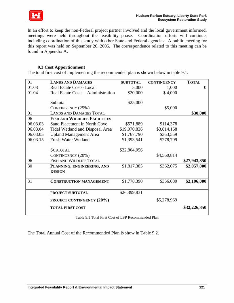
Hudson-Raritan Estuary, Liberty State Park Ecosystem Restoration Study
In an effort to keep the non-Federal project partner involved and the local government informed, meetings were held throughout the feasibility phase. Coordination efforts will continue, including coordination of this study with other State and Federal agencies. A public meeting for this report was held on September 26, 2005. The correspondence related to this meeting can be found in Appendix A.
9.3 Cost Apportionment The total first cost of implementing the recommended plan is shown below in table 9.1.
Table 9.1 Total First Cost of LSP Recommended Plan
01 LANDS AND DAMAGES SUBTOTAL CONTINGENCY TOTAL 01.03 Real Estate Costs- Local 5,000 1,000 001.04 Real Estate Costs – Administration $20,000 $ 4,000
Subtotal $25,000 CONTINGENCY (25%) $5,000 01 LANDS AND DAMAGES TOTAL $30,00006 FISH AND WILDLIFE FACILITIES 06.03.03 Sand Placement in North Cove $571,889 $114,378 06.03.04 Tidal Wetland and Disposal Area $19,070,836 $3,814,168 06.03.05 Upland Management Area $1,767,790 $353,559 06.03.15 Fresh Water Wetland $1,393,541 $278,709
SUBTOTAL $22,804,056 CONTINGENCY (20%) $4,560,814 06 FISH AND WILDLIFE TOTAL $27,943,85030 PLANNING, ENGINEERING, AND
DESIGN $1,817,385 $362,075 $2,057,000
31 CONSTRUCTION MANAGEMENT $1,778,390 $356,080 $2,196,000
PROJECT SUBTOTAL $26,399,831
PROJECT CONTINGENCY (20%) $5,278,969 TOTAL FIRST COST $32,226,850
The Total Annual Cost of the Recommended Plan is show in Table 9.2.
Integrated Feasibility Report & Environmental Impact Statement 121
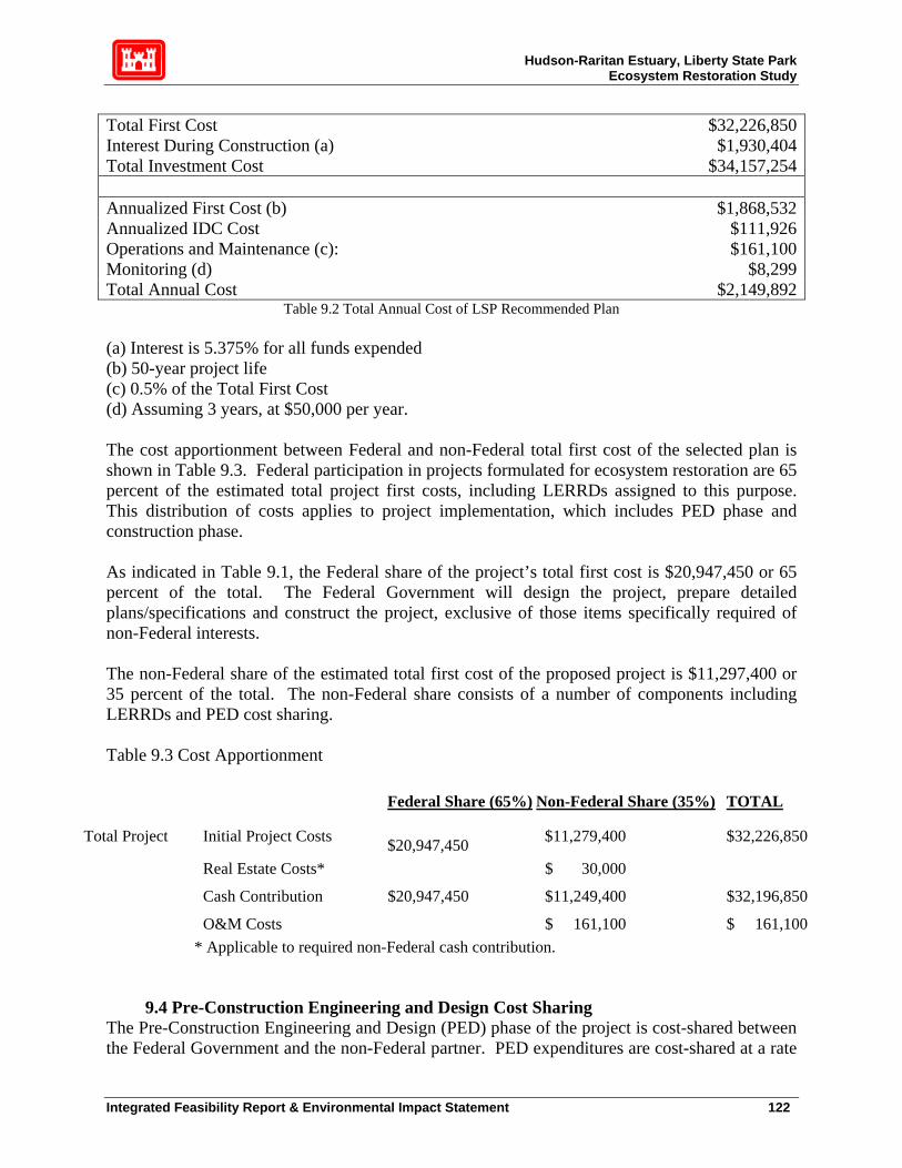
Hudson-Raritan Estuary, Liberty State Park Ecosystem Restoration Study
Table 9.2 Total Annual Cost of LSP Recommended Plan
Total First Cost $32,226,850Interest During Construction (a) $1,930,404Total Investment Cost $34,157,254 Annualized First Cost (b) $1,868,532Annualized IDC Cost $111,926Operations and Maintenance (c): $161,100Monitoring (d) $8,299Total Annual Cost $2,149,892
(a) Interest is 5.375% for all funds expended (b) 50-year project life (c) 0.5% of the Total First Cost (d) Assuming 3 years, at $50,000 per year. The cost apportionment between Federal and non-Federal total first cost of the selected plan is shown in Table 9.3. Federal participation in projects formulated for ecosystem restoration are 65 percent of the estimated total project first costs, including LERRDs assigned to this purpose. This distribution of costs applies to project implementation, which includes PED phase and construction phase. As indicated in Table 9.1, the Federal share of the project’s total first cost is $20,947,450 or 65 percent of the total. The Federal Government will design the project, prepare detailed plans/specifications and construct the project, exclusive of those items specifically required of non-Federal interests. The non-Federal share of the estimated total first cost of the proposed project is $11,297,400 or 35 percent of the total. The non-Federal share consists of a number of components including LERRDs and PED cost sharing. Table 9.3 Cost Apportionment
Federal Share (65%) Non-Federal Share (35%) TOTAL
Total Project Initial Project Costs $20,947,450 $11,279,400 $32,226,850
Real Estate Costs* $ 30,000 Cash Contribution $20,947,450 $11,249,400 $32,196,850 O&M Costs $ 161,100 $ 161,100
* Applicable to required non-Federal cash contribution.
9.4 Pre-Construction Engineering and Design Cost Sharing The Pre-Construction Engineering and Design (PED) phase of the project is cost-shared between the Federal Government and the non-Federal partner. PED expenditures are cost-shared at a rate
Integrated Feasibility Report & Environmental Impact Statement 122

Hudson-Raritan Estuary, Liberty State Park Ecosystem Restoration Study
of 35 percent non-Federal and 65 percent Federal. Adjustments are made during construction to bring the cost of PED in line with actual cost sharing of the project. The PED phase begins with approval of the Integrated FR/EIS and will continue until the plans and specifications are developed; construction is expected to begin shortly thereafter.
9.5 Construction Schedule A preliminary construction schedule was developed for the selected plan. The schedule is based on information available to date, and is predicated on the assumptions listed below. A proposed construction schedule for Liberty State Park ecosystem restoration is presented in the Gantt chant in Figure 9.1. The proposed schedule assumes a PED phase of 12 months, with a resultant construction period of 25 months.
9.6 Financial Analysis For purposes of executing the Design Agreement (DA), NJDEP has stated its intention to seek authorization from the State of New Jersey to act as the non-Federal partner. The state has a stable source of funding for ecosystem restoration projects and further has indicated its intent to enter into a DA at the conclusion for the study.
9.7 Views of Non-Federal Partners and Other Agencies The selected plan has received strong support from the prospective non-Federal project partner, NJDEP. Affected local governments, including Hudson County and Jersey City, have also expressed their support for the project. This support is documented in the Study Correspondence Appendix (Appendix A). Through project planning and NEPA scoping, a variety of other Federal agencies have been involved in this investigation and support the project goals.
Integrated Feasibility Report & Environmental Impact Statement 123

Hudson-Raritan Estuary, Liberty State Park Ecosystem Restoration Study
Integrated Feasibility Report & Environmental Impact Statement 124

Hudson-Raritan Estuary, Liberty State Park Ecosystem Restoration Study
9.8 Major Conclusions and Findings
New York District has completed this Integrated Feasibility Report/Environmental Impact Statement (FR/EIS) for the Liberty State Park Ecosystem Restoration Project in accordance with the requirements of NEPA to assess the need for modifying the existing degraded habitat, to evaluate the effects of the restoration activities, and to determine a solution that maximizes environmental benefits while minimizing economic costs. The purpose of the project is to ameliorate the adverse impacts associated with past filling activities on the project site, with the overall purpose of improving the environmental quality of the area. Besides alterations to the topography of the site that buried existing salt marsh/mudflats, the quality of the sediments and adjacent waters have also deteriorated, further jeopardizing the aquatic habitats that they support. The domination by invasive species is expected to expand and continue to overwhelm the various native vegetative habitats on site without the implementation of ecological management measures described in the plan recommended in this report. Past and present surveys, studies, and extensive literature searches have been conducted to establish necessary baseline information to identify restoration options and evaluate the potential for control of invasive species, isolation of contaminants, and subsequent conversion to more desirable habitats currently underrepresented in the HRE. These underrepresented habitats include salt marsh, deep-water emergent palustrine marsh and significantly enhanced terrestrial habitats such as maritime grassland, scrub-shrub and hardwood forest, with a superior mix of native and wildlife-friendly species. Some of the biological tasks conducted include literature review, existing vegetative community mapping, jurisdictional wetland delineations, faunal surveys, and existing and proposed project habitat evaluation using the New England District USACE Highway Methodology. The results of these surveys are presented in the Environmental Resources Inventory (ERI), located in the Environmental Appendix and summarized in Sections 3 and 7 of this report. The results indicate strong opportunities for increasing habitat functionality at this site. Implementation of the plan recommended in this report is expected to increase and restore more desirable communities, provide more cover, nesting, and breeding habitat for wildlife, and increase species richness. Technical screening analysis was performed throughout the project development stages for each of three implementation phases of the proposed project: tidal marsh, fresh water wetlands and terrestrial habitat. For the tidal marsh, a variety of configurations were proposed for consideration, including a single-inlet creek entering the terrestrial portion of LSP at North Cove, a continuous tidal loop entering the terrestrial portions at North Cove and returning to Upper Bay at the former Middle Cove, and an island in the middle of the creek. The single-inlet creek was determined to be the most efficient solution, meeting both technical engineering and biological requirements the most successfully. Subsequently, the shape, width and length of the proposed tidal channel, and its associated intertidal flats, low marsh and high marsh habitat were refined through hydrologic modeling. The tidal channel is designed to maximize functional habitat value of the proposed tidal marsh area by maintaining the largest feasible tidal range, and regular tidal flooding and drainage through the maximum area available.
Integrated Feasibility Report & Environmental Impact Statement 125

Hudson-Raritan Estuary, Liberty State Park Ecosystem Restoration Study
For the fresh water wetland phase, four separate plans were analyzed on technical grounds, each delivering different amounts of acceptable quality fresh water to the target area in the central portion of interior of the site. The selected freshwater plan provides the most amount of water for habitat creation and enhancement without relatively expensive and high-maintenance mechanical pumping from already-stressed municipal water supplies. The recommended plan incorporates a self-maintaining gravity-based system for supplying adequate quality water. This water-delivery system begins procurement of additional water from the NJ Transit parking area, which is then filtered in an enhanced wetland area adjacent to the Liberty Science Center (LSC). The levels of the LSC wetland are controlled by a self-adjusting weir, which directs water through a diversion pipe underneath Phillip Street to an additional Phragmites dominated bio-filter wetland. This bio-filter wetland removes remaining suspended sediment, potential toxicants and unwanted nutrients. From the bio-filter, a created swale will deliver the substantially enhanced volume and quality of water to a created permanent deep-water emergent marsh. The deep marsh will provide fish, reptile and other habitat not currently found in Liberty State Park. During high-flow periods, excess water will drain out of the deep-emergent marsh into an infiltration basin, in effect creating an additional, periodically flooded wetland. The high permeability of the infiltration basin soil will allow water to penetrate underlying groundwater, in turn feeding an existing jurisdictional freshwater wetland. The third phase of this restoration project involves improving ecological functional value on the adjacent terrestrial buffer portions of the site. Measures include the selective removal of invasive species and other undesirable vegetation. If monitoring indicates that further measures are necessary, the District will consider addition of topsoil and/or sand to selected areas to discourage unwanted vegetation and promotion of native vegetation through replanting and/or seeding. A berm is planned for the southwestern portion of the site, using soil excavated from the proposed tidal marsh area. This soil, and any industrial residue it contains, will be completely encapsulated within the berm. The berm will act as an isolation barrier for sensitive species and add topographical relief to a relatively flat site. In conjunction with a clean fill cap over the surface of the excavated site, this will substantially reduce the contaminant uptake of plants and animals, further improving the ecological value of the site. Most terrestrial habitats will be maintained in the same vegetative community type, while simultaneously controlling invasive species and encouraging native species. Thus, a mosaic of high-functional value terrestrial habitat will be established including hardwood and maritime forest, scrub-shrub, maritime grassland and old field. Where possible, grassland habitat to be enhanced will be contiguous to enhance feeding areas for raptors and isolation for ground nesting birds. The functional integrity of the existing forested areas will be maintained and enhanced. The District’s NER plan will result in a significant increase in wildlife habitat and estuarine functional value when compared to existing habitat. The NER plan will increase the availability of cover, foraging, nesting and breeding habitat for State threatened and endangered species; restore USEPA designated priority wetlands (e.g., salt marsh); improve water quality; increase the value and availability of spawning and nursery habitat for anadromous fish species; enhance wetland habitat for migratory waterfowl; assist in the enhancement of wildlife habitat corridors; and increase aesthetics and opportunities for passive recreation; and promote science education.
Integrated Feasibility Report & Environmental Impact Statement 126
Hudson-Raritan Estuary, Liberty State Park Ecosystem Restoration Study
In addition the NER plan will meet the goals and objectives of many programs, statutes, and policies on an institutional, public, and technical level.
9.9 Areas of Concern One area of concern regarding the selected plan for Liberty State Park ecosystem restoration is compliance with the Clean Air Act during implementation. Based on the preliminary analysis, which are solely based on assumptions regarding construction equipment staging and schedule, total direct and indirect NOx emissions appear to exceed de minimis threshold of 25 tons per year. In close consultation with the USEPA and the NJDEP, the Corps will conduct a detailed, comprehensive quantitative analysis in the next project phase (PED) to precisely quantify all emissions from the Liberty State Park project and to determine if conformity has been met. Upon completion of the revised emission estimates, if applicability is determined, a Draft General Conformity Determination will be prepared and will undergo formal agency and public review. Results and conclusions of this process will be part of the environmental review, including, as necessary, detailed analyses of alternatives, such as emission offsets, emission credits, emission reduction technologies, and operational modifications to reduce emissions during PED. The plan is fully supported by the non-Federal feasibility study partner, PANYNJ, and the non-Federal construction partner, NJDEP. Affected local governments and interested Federal agencies are also supportive. These parties have full confidence in the anticipated performance of the selected plan in terms ecosystem restoration and benefits to the environment. 10. PUBLIC INVOLVEMENT NEPA Scoping: The scoping meeting was open to the public and was held at Liberty State Park, on October 16, 2002. Fliers announcing the meeting were sent directly to property owners in the study area, interested parties, and elected officials. Comments and questions were recorded at both meetings and have been summarized in the Environmental Appendix (B). Public Meeting: The draft report was released August 19, 2005, with the public review period in the Federal Register closing on October 4, 2005. The public meeting was held on September 26, 2005, at Liberty State Park. About 50 people attended. There were no objections to the plan, public response was overwhelmingly positive. A summary of the public meeting is included in the Study Correspondence. Comments & Responses to the FR/EIS: Six letters were received in response to the draft report from the following individuals: Name Organization/Agency John Filippelli, Chief of Stategic Planning and Multi-Media Programs Branch
USEPA
Stanley Gorski, Field Offices Supervisor NOAA-NMFS Carter Craft, Director Metropolitan Waterfront Alliance Troy Ettel, Director of Conservation New Jersey Audubon Society Michael Britt, Classroom Workshop Coordinator Liberty Science Center Dorothy Winant Individual
Integrated Feasibility Report & Environmental Impact Statement 127

Hudson-Raritan Estuary, Liberty State Park Ecosystem Restoration Study
The letters were positive and supportive in nature. Reproduction of these letters, and the responses to them, can be found in the Appendix A. The study team also received approximately six email messages expressing support for the project. 11. COMPLIANCE WITH ENVIRONMENTAL REQUIREMENTS Federal laws and Executive Orders applicable to all USACE recommended plans, their applicability to this project, and, if applicable, their status, is presented below: N/A Non-applicable C In compliance P Compliance pending34 STATUS PUBLIC LAW (US CODE)/EXECUTIVE ORDER N/A Abandoned Shipwreck Act of 1987 (43 USC 2101) N/A American Indian Religious Freedom Act (42 USC 1996) N/A Agriculture and Food Act (Farmland Protection Policy Act) of 1981 (7 USC4201) N/A American Folklife Preservation Act of 1976, As Amended (20 USC 2101) N/A Anadromous Fish Conservation Act of 1965, As Amended (16 USC 757a et seq) N/A Antiquities Act of 1906, As Amended (16 USC 431) C Archeological and Historic Preservation Act of 1974, As Amended (16 USC 469) C Archeological Resources Protection Act of 1979, As Amended (16 USC 470) N/A Bald Eagle Act of 1972 (16USC 668) N/A Buy American Act (41 USC 102) N/A Civil Rights Act of 1964 (Public Law 88-352) (6 USC 601) P Clean Air Act of 1972, As Amended (42 USC 7401 et seq) P Clean water Act of 1972, As Amended (33 USC 1251 et seq) N/A Barrier Resources Act of 1982 (16 USC 3501-3510) P Coastal Zone Management Act of 1972, As Amended (16 USC 1451 et seq) N/A Comp. Environ. Response, Compensation & Liability Act of 1980 (42 USC 9601) N/A Conservation of Forest Lands Act of 1960 (16 USC 580 mn) N/A Contract Work Hours (40 USC 327) N/A Convict Labor (18 USC 4082) N/A Copeland Anti-Kickback (40 USC 276c) N/A Davis-Bacon Act (40 USC 276) N/A Deepwater Port Act of 1974, As Amended (33 USC 1501) N/A Emergency Flood Control Funds Act of 1955, As Amended (33 USC 701m) N/A Emergency Wetlands Resources Act (16 USC 3901-3932) C Endangered Species Act of 1972 (16 USC 1531) C E.O. 11988, Floodplain Management C E.O. 11990, Protection of Wetlands C E.O. 12898, Environmental Justice 34 In certain cases, per normal procedure, compliance will not be attained until the PED phase of this project, when design-level details, required by reviewing and permitting authorities, can be developed with construction funding.
Integrated Feasibility Report & Environmental Impact Statement 128

Hudson-Raritan Estuary, Liberty State Park Ecosystem Restoration Study
C Estuary Protection Act of 1968 (16 USC 1221 et seq) C Equal Opportunity (42 USC 2000d) N/A Farmland Protection Policy Act (7 USC 4201 et seq) N/A Federal Environmental Pesticide Act of 1972 (7 USC 136 et seq) N/A Federal Water Project Recreation Act of 1965, As Amended (16 USC 4601) C Fish and Wildlife Coordination Act of 1958, As Amended (16 USC 661) N/A Flood Control Act of 1944, As Amended, Section 4 (16 USC 460b) N/A Food Security act of 1985 (Swampbuster) (16 USC 3811 et seq) N/A Hazardous Substance Response Review Act of 1980, As Amended (26 USC 4611) N/A Historic and Archeological Data Preservation (16 USC 469) C Historic Sites Act of 1935 (16 USC 461) Note: Superceded by NHPA, Section 106 N/A Jones Act (46 USC 292) N/A Land and water Conservation Fund Act of 1965 (16 USC 4601) P Magnuson Fishery Conservation and Management Act (16 USC 1801) C Marine Mammal Protection Act of 1972, As Amended (16 USC 1361) N/A Marine Protection, Research and Sanctuaries Act of 1972 (33 USC 1401) C Migratory Bird Conservation Act of 1928, As Amended (16 USC 715) C Migratory Bird Treaty Act of 1918, As Amended (16 USC 703) C National Environmental Policy act of 1969, As Amended (42 USC 4321 et seq) C National Historic Preservation Act of 1966, As Amended (16 USC 470) C National Historic Preservation Act Amendments of 1980 (16 USC 469a) N/A Native American Religious Freedom Act of 1978 (42 USC 1996) N/A Native American Graves Protection and Repatriation Act (25 USC 3001) N/A National Trails System Act (16 USC 1241) N/A Noise Control Act of 1972, As Amended (42 USC 4901 et seq) N/A Rehabilitation Act of 1973 (29 USC 794) N/A Reservoir Salvage Act of 1960, As Amended (16 USC 469) C* Resource Conservation and Recovery Act of 1976 (42 USC 6901-6987) N/A River and Harbor Act of 1888, Section 11 (33 USC 608) C River and Harbor Act of 1899, Sections 9, 10, 13 (33 USC 401-413) N/A River and Harbor and Flood Control Act of 1962, Section 207 (16 USC 460) N/A River and Harbor and FC Act of 1970, Sects 122, 209 and 216 (33 USC 426 et seq) N/A Safe Drinking Water Act of 1974, As Amended (42 USC 300f) N/A Shipping Act (46 USC 883) N/A Submerged Lands Act of 1953 (43 USC 1301 et seq) N/A Superfund Amendments and Reauthorization Act of 1986 (42 USC 9601) N/A Surface Mining Control and Reclamation Act of 1977 (30 USC 1201-1328) C Toxic Substances Contol Act of 1976 (15 USC 2601) N/A Policy Act of 1970, As Amended (43 USC 4601) C Utilization of Small Business (15 USC 631, 644) N/A Wild and Scenic River Act of 1968 * Although Liberty State Park is not a RCRA site, RCRA is noted because it was used for determining Federal jurisdiction in the matter of the Consent Decree. The mention of RCRA in
Integrated Feasibility Report & Environmental Impact Statement 129

Hudson-Raritan Estuary, Liberty State Park Ecosystem Restoration Study
the Consent Decree in no way constitutes a finding of fact or law that this is RCRA site.35 Implementation of the recommended project will satisfy the Consent Decree and any requirements of RCRA.
35 Stated in Paragraphs 1-3 of the Consent Decree.
Integrated Feasibility Report & Environmental Impact Statement 130

Hudson-Raritan Estuary, Liberty State Park Ecosystem Restoration Study
12. RECOMMENDATIONS In making the following recommendations, I have given consideration to all significant aspects in the overall public interest, including environmental, social and economic effects, engineering feasibility and compatibility of the project with the policies, desires and capabilities of the State of New Jersey and other non-Federal interests. I recommend that the selected plan for ecosystem restoration at Liberty State Park, Hudson-Raritan Estuary, Hudson County, New Jersey project, as fully detailed in this integrated feasibility report and environmental impact statement, be authorized for construction as a Federal project for ecosystem restoration, subject to such modifications as may be prescribed by the Chief of Engineers. I recommend authorization of the ecosystem restoration plan for Liberty State Park, Hudson Raritan Estuary Ecosystem Restoration Project, with such modifications thereof as in the discretion of the Commander, HQUSACE, as may be advisable. These recommendations are made with the provisions that local interests will:
a. Provide to the United States all necessary lands, easements, rights-of-way, relocations, and suitable borrow and/or disposal areas deemed necessary by the United States for initial construction and subsequent maintenance of the project.
b. Hold and save the United States free from claims for damages that may result from
construction and subsequent maintenance, operation, and public use of the project, except damages due to the fault or negligence of the United States or its contractors.
c. Maintain continued public ownership and public use of the shorefront areas upon which
the amount of Federal participation is based during the economic life of the project. d. Provide and maintain necessary access roads, parking areas, and other public use
facilities open and available to all on equal terms. e. Contribute the local share of non-Federal costs for initial construction and operation and
maintenance over the economic life of the project, as required to serve the intended purposes.
f. Upon completion of each project feature, acquire, rehabilitate, repair, replace, operate
and maintain easements for public access to areas created or enhanced by the project. The cost of the operation, and maintenance of these easements will be the responsibility of the non-Federal sponsor.
The recommendations contained herein reflect the information available at this time and current departmental policies governing formulation of individual projects. They do not reflect program and budgeting priorities inherent in the formulation of a national Civil Works construction program nor the perspective of highest review levels within the Executive Branch. Consequently,
Integrated Feasibility Report & Environmental Impact Statement 131


Hudson-Raritan Estuary, Liberty State Park Ecosystem Restoration Study
13. REFERENCES Fields, James, M. 1990. “Policy-Related Goals For Community Response Studies”.
Environment International, Volume 16, pp. 501-514. Groundwater Flow Direction and Gradient Calculator [online], LMNO Engineering, Research, and Software, Ltd., http://www.lmnoeng.com/Groundwater/gradient.htm. March 2004 MacFarlane, D.W. 2001. The Ecology of Liberty State Park: A Historical Perspective National Marine Fisheries Services (NMFS). 1998. The 1996 Amendments to the Magnuson-
Stevens Fishery Conservation and Management Act. NCDC. 2000. Hourly Precipitation Data (1948-1999). New Jersey Department of Environmental Protection (NJDEP). 1989. Executive Summary: The
History of Environmental Investigations at the Liberty State Park. NJDEP Hazardous Waste Program, Division of Hazardous Site Mitigation, Bureau of Environmental Measurements and Quality Assurance, Division of Hazardous Waste Management, Bureau of Planning and Assessment.
New Jersey Department of Environmental Protection (NJDEP). 1994. Memorandum dated from
03 October, 1994 from Catherine Drake, Assistant to the Director, Division of Parks and Forestry to Edward Putnam, Assistant Director, Hazardous Site Mitigation.
New Jersey Department of Environmental Protection (NJDEP). 1995. Liberty State Park Soil
Sampling Report, August 1995. NJDEP Site Remediation Program. New Jersey Department of Environmental Protection (NJDEP). 1999. 1998 Air Quality
Monitoring Report. NJDEP, Bureau of Air Monitoring. New Jersey Department of Environmental Protection (NJDEP). 2000. Liberty State Park –
Dredge Material Storage Area. Remedial Planning and Design Element. NJDEP Site Remediation Program, Division of Publicly Funded Site Remediation.
New Jersey Department of Environmental Protection (NJDEP). 2001. General Design
Memorandum for the Parks Interior Sections. Division of Parks and Forestry. New Jersey Department of Environmental Protection (NJDEP). 2003. New Jersey Stormwater
Best Management Practice Manual, Draft February 2003 New Jersey Geological Survey [online],http://www.state.nj.us/dep/njgs/March 2004 Pierce, G. 1993. Planning Hydrology for Constructed Wetlands. Prepared by the Wetland
Integrated Feasibility Report & Environmental Impact Statement 133

Hudson-Raritan Estuary, Liberty State Park Ecosystem Restoration Study
Training Institute. Port Authority of New York and New Jersey. 1975. State of New Jersey Liberty Park –
Engineering Report on Proposed Landfill in New York Bay. Liberty State Park Existing Utility Plan – Sketch No. SK-LSP-2.
Regional Plan Association. 2003. Needs and Opportunities for Environmental Restoration in
the Hudson-Raritan Estuary. (Based on recommendations of the Harbor Estuary Program Habitat Working Group and Estuary Stakeholders.
United States Army Corp of Engineers (USACE). 1976. Effects of Construction of the Liberty
Sate Park on Hydraulic Characteristics of New York Harbor. United States Army Corp of Engineers (USACE). 1977. Cultural Resource Reconnaissance Liberty State Park United States Army Corp of Engineers (USACE). 1978. Protective Noise Levels. A
Supplement to the USEPA Report: Information on Levels of Environmental Noise Requisite to Protect Public Health and Welfare with an Adequate Margin of Safety, EPA/ONAC 550/9-74-004, March, 1974, Office of Noise Abatement and Control, Washington, D.C.
United States Army Corp of Engineers (USACE). 1980. Plan of Study, Liberty State Park. United States Army Corp of Engineers (USACE). 1981. Liberty State Park, New Jersey, Levee
and Seawall Design Memorandum and Project Design. United States Army Corp of Engineers (USACE). 1994. Priority Wetlands for the State of New
Jersey. USEPA, Region 2, Marine and Wetlands Protection Branch. United States Army Corp of Engineers (USACE). 1998. National Air Quality and Emissions
Trends Report, 1997, EPA 454/R-98-016, Office of Air Quality Planning and Standards, Research Triangle Park, NC 27711.
United States Army Corp of Engineers (USACE). 1999. Hudson-Raritan Estuary Ecosystem
Restoration Reconnaissance Report. USACE, New York District. (CENAN-PL-F). Prepared by Northern Ecological Associates, Inc. for U.S. Army Corps of Engineers, New York District.
United States Army Corp of Engineers (USACE). 2003. New York Harbor Deepening Limited
Reevaluation Report. (CENAN-PL-F), U.S. Army Corps of Engineers, New York District.
Integrated Feasibility Report & Environmental Impact Statement 134

Hudson-Raritan Estuary, Liberty State Park Ecosystem Restoration Study
United States Army Corp of Engineers (USACE). 2004. Liberty State Park Environmental Resource Inventory. USACE, New York District (CENAN-PL-EA). Prepared by LMS. for U.S. Army Corps of Engineers, New York District, April 2004.
United States Army Corp of Engineers (USACE). 2004. Site Investigation Liberty State Park
Jersey City, NJ. USACE, New York District (CENAN-EN-HH). Prepared by U.S Army Corps of Engineers, Baltimore District for U.S. Army Corps of Engineers, New York District, April 2004.
United States Army Corp of Engineers (USACE). 2001. Restoration Opportunities in the
Hudson-Raritan Estuary. U.S. Army Corps of Engineers, New York District (CENAN-PL-ES).
United States Army Corp of Engineers (USACE). 2003. Phase IA Cultural Resources
Investigation of the Hudson-Raritan Estuary Ecosystem Restoration Project, Liberty State Park, Hudson County, New Jersey”
United States Army Corps of Engineers (USACE). 2003. Final Phase 1 Environmental Site
Assessment of Priority Sites. Part 1: Liberty State Park, Jersey City, Hudson County, New Jersey. Prepared by AMEC Earth & Environmental, Inc and Northern Ecological Associates, Inc.
United States Army Corp of Engineers (USACE). 2004. Liberty State Park Hydrology and
Hydraulics of Fresh Water Wetlands. United States Army Corp of Engineers (USACE). 2004. Liberty State Park: The Ground Survey
Control Report. United States Army Corp of Engineers (USACE). 2004. Site Investigation. Liberty State Park,
Jersey City, NJ. Final Report.
U.S. Fish and Wildlife Service (USFWS). 1999a. Written communication on January 20, 1999 from Lisa Arroyo, USFWS, to Frank Santomauro, USACE, New York District
U.S. Fish and Wildlife Service (USFWS). 2000a. Federally-Listed Rare, Threatened, or
Endangered Species. [Online]. Available: http://endangered.fws.gov/wildlife.htm.
Integrated Feasibility Report & Environmental Impact Statement 135

Hudson-Raritan Estuary, Liberty State Park
Ecosystem Restoration
Appendix A
Study Correspondence


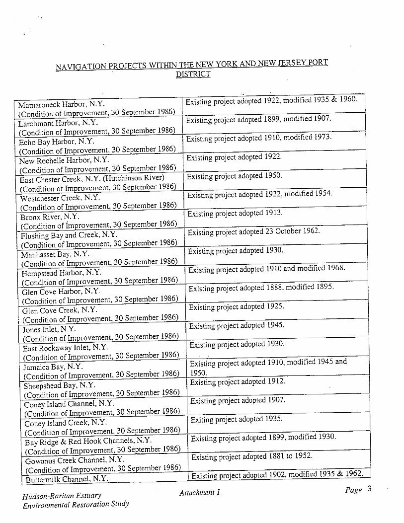
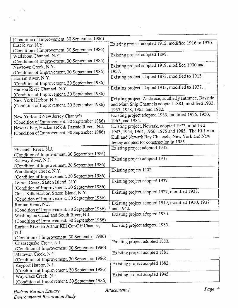

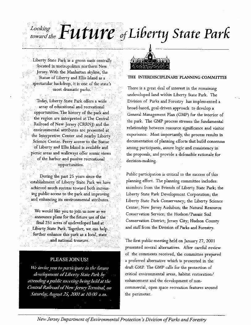
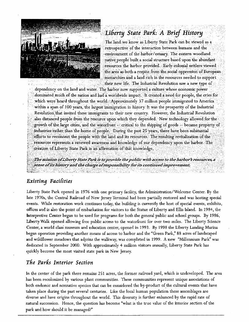
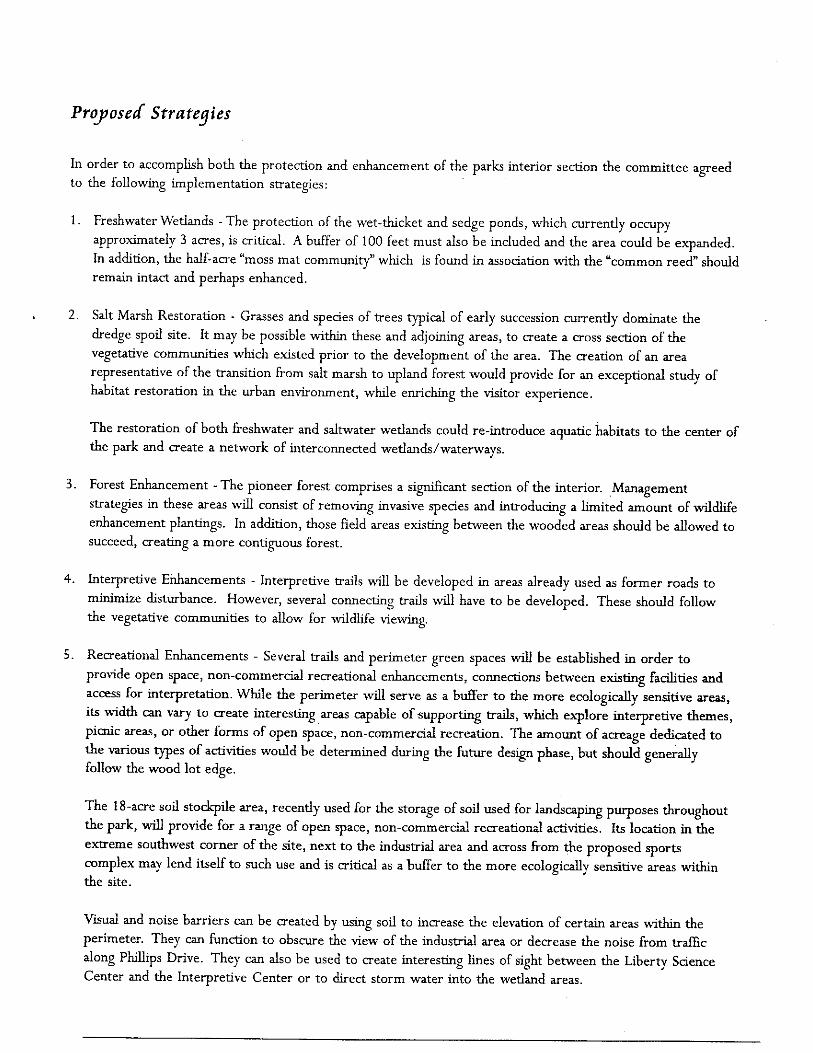


LIBERTY STATE PARK - PUBLIC MEETING – SEPTEMBER 26, 2005; 7:00 PM
CENTRAL RAILROAD TERMINAL, LIBERTY STATE PARK, JERSEY CITY, NJ.
On Monday evening, 26 September 2005, a public meeting was held at Liberty State Park, NJ. NJDEP and USACE representatives conducted a poster board session and gave a presentation for all attendees. At the conclusion of the presentation, the public was afforded an opportunity to make statements and voice opinions in either written or oral fashion. Summary Points – public speakers 1. Mr. Marc Matsil – NJDEP Mr. Marc Matsil thanked the Corps, Baykeeper, Sam Pesin, the PANYNJ, HEP, HWG and others for their efforts in advancing the project. His main stated concern is that the project would receive the WRDA match (Federal funds) for implementation. He’s been working with Congressman Menendez and has been assured that if the document is signed by 12/31/05 that they will get their match. He wants to use Ambrose Channel sands and to bring the Northern Harrier back to the site. He stressed that non-Federal interests must encourage local officials that we need money for this project because we have new hurdles with every natural disaster. 2. Ms. Martina Hoppe – USFS Ms. Martina Hope is a resident of Jersey City and she wanted to take the opportunity to introduce herself. In her previous job she worked on the planning committee, and she offered her assistance and guidance for the upland management/forest improvement phase of the project. She would like to assist, if there is funding. 3. Mr. Marvin Silber - NJ Audubon He is a member of the society who is in the park every day to search for birds. He has documented more than 100 species. He is concerned by the possibility of opening access to the park because of the few hawks and several owls that occupy the park in the winter. His primary area of concern is the southeast corner of the park where Cooper’s and red tail hawk occupy. He also stated that the park is one of the only spots in NJ that has a documented occurrence of the snowy owl. Three years ago they returned after a brief hiatus because of the development of the Global Marine Terminal. He suggested that the plan should protect the wild birds of LSP. 4. Mr. Sam Pesin – Friends of Liberty State Park (FOLSP) Mr. Sam Pesin stated that this is a milestone in LSP History. He suggested a plan for nature trails and habitat. There will be recreation opportunities around the perimeter. It will be a spectacular transformation. He expressed gratitude to Congressman Menendez (who is looking to get more funding), the Corps and the entire project team.

5. Mr. Michel Cuillerier – Sierra Club/FOLSP Mr. Cuillerier expressed thanks to the Corps and stated that the plan is the result of a long process. He objects to using the words “mainly degraded” when discussing the park in its current state. It is home to many species of flora and fauna and is not necessarily degraded. He suggests changing the wording to “emergent ecosystem”. He expressed a concern that there needs to be a systematic public access plan that will avoid impacts to sensitive wildlife. Frank Gallagher responded that human access to the park will be addressed at a later time. 6. Ms. Alicia Richmond – FOLSP Ms. Alicia Richmond suggested an approach to make more money for the park by dedicating trees for people who had loved ones in Jersey City cemeteries. People could safely visit the trees planted in the park in lieu of the gravestones in the cemeteries. She suggested that the cemeteries in Jersey City are not safe, and this would be an opportunity to raise funds for LSP while doing something for the community. She said that she knew a number of people that were interested in the idea, and that she has already “sold lots of trees”. 7. Mr. Mike Selner – Hudson-Meadowlands Sierra Club Mr. Mike Selner said that he approves of the plan that addresses freshwater and salt water wetlands, and contaminant issues. He looks forward to the implementation of the plan. 8. Ms. Grace Stenlake – FOLSP Ms. Grace Stenlake shared her memories of the train station with the audience. She suggested putting a light on the flag at the Interpretive Center, and offered to pay for the light bulb. 9. Mr. Greg Giordano – FOLSP Mr. Greg Arregiodono expressed concern that the trip on Public Transit is too long. He stated that the elevations in the cross sections of the plan are missing. A minor rain event causes ponding on the section of the park east of Freedom Way. This may be a problem during a major storm. He hopes that the issue of drainage has been taken into consideration. He expressed concern that the Chromium issue has not been addressed in the plan. It is his opinion that there are 3 responsible parties: Allied, PPG and Axis. But, if they removed the Chromium it would probably make their products more costly. He suggested approaching them and asking them to donate the money for restoration. He compared the Holocaust to what we are doing to the Earth, and what we did to the Native Americans and the African Americans. He pointed out that the Statue of Liberty’s back is facing NJ, and that it is symbolic of what we are doing to the Earth. He suggested that the contracting for the park be done by locals. He stated that the marina should not exist. He lastly expressed concern about the drainage issues.

10. FOLSP One member of the FOLSP shared her memories of emigrating from London on the Moritania. After a harrowing journey, she arrived in the US by train to the Central Railroad Terminal in Jersey City. 11. Mr. Greg Remaud – Baykeeper Mr. Greg Remaud expressed thanks to the Corps and the entire project team for progressive thinking. The key point he wanted to make is that the interior of the park should be kept secure. He suggested keeping people around the perimeter of the park. He believes that the plan is very good and will tie the park together in a cohesive way. He wants to send a message to Washington and the immediate project delivery team that the project must move at a faster pace than the normal Corps projects. Otherwise, the restoration will move forward without them, or not at all. He reiterated that the project cannot move at a normal pace. He described small fund raising meetings and phone calls to agencies that have taken place recently. He and Mr. Frank Gallagher (NJDEP) made a presentation for the freshwater wetlands portion of the project and received a $1.5 million grant for that component of the plan. At this point they have $11.5 million of dedicated funds on the local end for the restoration project. He is confident that the project is moving forward.
Comments and Responses to the LSP Feasibility Report/Environmental Impact Statement
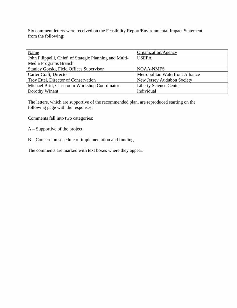
Six comment letters were received on the Feasibility Report/Environmental Impact Statement from the following: Name Organization/AgencyJohn Filippelli, Chief of Stategic Planning and Multi-Media Programs Branch
USEPA
Stanley Gorski, Field Offices Supervisor NOAA-NMFS Carter Craft, Director Metropolitan Waterfront Alliance Troy Ettel, Director of Conservation New Jersey Audubon Society Michael Britt, Classroom Workshop Coordinator Liberty Science Center Dorothy Winant Individual The letters, which are supportive of the recommended plan, are reproduced starting on the following page with the responses. Comments fall into two categories: A – Supportive of the project B – Concern on schedule of implementation and funding The comments are marked with text boxes where they appear.

Letter from John Filippelli, USEPA:

A
Comment A: Support for the project. Response: Thank you for your letter supporting the recommendation in the Hudson Raritan Estuary (HRE), Liberty State Park feasibility report. It appears that many of your agency’s goals and objectives are consistent and compatible with the overall HRE vision and goals for Liberty State Park. The HRE effort maintains broad relevance through the key recognition that the environment, the economy and social well-being are fundamentally interlinked and interdependent.

Letter from Stanley Gorski, NOAA-NMFS:
A
Response: See response to above.
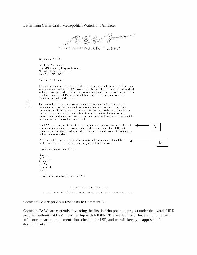
Letter from Carter Craft, Metropolitan Waterfront Alliance:
A
B
Comment A: See previous responses to Comment A. Comment B: We are currently advancing the first interim potential project under the overall HRE program authority at LSP in partnership with NJDEP. The availability of Federal funding will influence the actual implementation schedule for LSP, and we will keep you apprised of developments.

Letter from Troy Ettel, New Jersey Audubon Society
A
Response: See previous responses to Comment A.

Letter from Michael Britt, Liberty Science Center
A
B
Responses: See previous responses to Comments A & B.

Letter from Dorothy Winant, Interested Individual
A
See previous response to Comment A.