
The deep structure of the Eolian arc (Filicudi-Panarea-Vulcano sector) in light of gravity, magnetic...
18
ELSEVIER Journal of Volcanology and Geothermal Research 61 (1994) 189-206 Joumalofvolcanology and geothermalresearch The deep structure of the Eolian arc (Filicudi-Panarea-Vulcano sector) in light of gravity, magnetic and volcanological data F. BarberP, A. Gandino b, A. Gioncada a, P. La Torre b, A. Sbrana a, C. Zenucchini b aDipartimento di Scienze della Terra, Universith di Pisa, Via S. Maria 53, 56100 Pisa, Italy bAGIP S.p.A. Exploration services, 20097 S. Donato Milanese, Milan, Italy (Received April 30, 1992; revised version accepted August 3, 1993 ) Abstract The magnetic and gravimetric methods of investigation have been applied to the central sector of the Eolian arc, combined with geovolcanological data, for the purpose of defining the structural framework in which the volca- nism developed. The processing of the magnetic and gravimetric data involved 3D modeling of the volcanic bodies and the application of a "depth separation filter", in order to subtract from the measured field the effect caused by the subaerial and submarine volcanic edifices and by all surface inhomogeneities. Magnetic and gravimetric 2.5D modeling on selected profiles has also been done, in a joint interpretation of the magnetic and gravimetric data, constrained by volcanological knowledge. The interpretation of the final maps and profiles has demonstrated the existence of extensional tectonics, resulting in the development of horst and graben. Volcanism occurs in the gra- ben areas. In particular, the Salina-Lipari-Vulcano magmatic axis has developed in a very deep articulated graben of lithospheric importance and completely filled by volcanic deposits and intrusive bodies. The origin of this structure and of the associated igneous activity is suggested to be related to trans-tensional tectonics along a Plio- Pleistocene regional strike-slip fault system. 1. Introduction The aim of this work is to formulate a struc- tural model of the central sector of the Eolian is- land arc through the integration of magnetic and gravity data with geovolcanological data. In this area good information is available on the structural setting of the volcanic edifices, due to high-quality magnetic and gravity surveys, which include sea surface surveys, in support of the geothermal research studies. Information is also available on the subsurface stratigraphy, for the area of Vulcano only, also in support of the geothermal exploration activity carded out between 1983 and 1986 by the AGIP- ENEL-EMS Joint Venture. The processing of magnetic data was designed to eliminate effects caused by the subaerial and submarine volcanic edifices and by all surface inhomogeneities from the measured magnetic field. This has been achieved through 3D mod- eling of the volcanic bodies and the application of a "depth separation filter". Analogous filtering has been applied to gravity data. The interpretation has been supplemented by 2.5D modeling on selected profiles. The construction of an adequate structural model of this sector of the arc is an important 0377-0273/94/$07.00 © 1994 Elsevier Science B.V. All rights reserved SSDI 0377-0273 (93) E0068-D
-
Upload
independent -
Category
Documents
-
view
1 -
download
0
Transcript of The deep structure of the Eolian arc (Filicudi-Panarea-Vulcano sector) in light of gravity, magnetic...
ELSEVIER Journal of Volcanology and Geothermal Research 61 (1994) 189-206
Joumalofvolcanology and geothermal research
The deep structure of the Eolian arc (Filicudi-Panarea-Vulcano sector) in light of gravity, magnetic and volcanological data
F. BarberP, A. G a n d i n o b, A. G i o n c a d a a, P. La Torre b, A. Sbrana a, C. Zenucchin i b
aDipartimento di Scienze della Terra, Universith di Pisa, Via S. Maria 53, 56100 Pisa, Italy bAGIP S.p.A. Exploration services, 20097 S. Donato Milanese, Milan, Italy
(Received April 30, 1992; revised version accepted August 3, 1993 )
Abstract
The magnetic and gravimetric methods of investigation have been applied to the central sector of the Eolian arc, combined with geovolcanological data, for the purpose of defining the structural framework in which the volca- nism developed. The processing of the magnetic and gravimetric data involved 3D modeling of the volcanic bodies and the application of a "depth separation filter", in order to subtract from the measured field the effect caused by the subaerial and submarine volcanic edifices and by all surface inhomogeneities. Magnetic and gravimetric 2.5D modeling on selected profiles has also been done, in a joint interpretation of the magnetic and gravimetric data, constrained by volcanological knowledge. The interpretation of the final maps and profiles has demonstrated the existence of extensional tectonics, resulting in the development of horst and graben. Volcanism occurs in the gra- ben areas. In particular, the Salina-Lipari-Vulcano magmatic axis has developed in a very deep articulated graben of lithospheric importance and completely filled by volcanic deposits and intrusive bodies. The origin of this structure and of the associated igneous activity is suggested to be related to trans-tensional tectonics along a Plio- Pleistocene regional strike-slip fault system.
1. Introduction
The aim of this work is to formulate a struc- tural model of the central sector of the Eolian is- land arc through the integration of magnetic and gravity data with geovolcanological data.
In this area good information is available on the structural setting of the volcanic edifices, due to high-quality magnetic and gravity surveys, which include sea surface surveys, in support of the geothermal research studies.
Information is also available on the subsurface stratigraphy, for the area of Vulcano only, also in support of the geothermal exploration activity
carded out between 1983 and 1986 by the AGIP- ENEL-EMS Joint Venture.
The processing of magnetic data was designed to eliminate effects caused by the subaerial and submarine volcanic edifices and by all surface inhomogeneities from the measured magnetic field. This has been achieved through 3D mod- eling of the volcanic bodies and the application of a "depth separation filter".
Analogous filtering has been applied to gravity data. The interpretation has been supplemented by 2.5D modeling on selected profiles.
The construction of an adequate structural model of this sector of the arc is an important
0377-0273/94/$07.00 © 1994 Elsevier Science B.V. All rights reserved SSDI 0377-0273 (93) E0068-D
190 k2 Barheri et al. / Journa l (~f I ~k'anoh~gy and Geothermal Re~earch 61 (I 994) 1~'9- 20(,
step in gaining understanding of the evolution of this complex area of the Tyrrhenian basin.
2. Regional geologic framework
The studied area covers the central part of the Eolian island arc, comprising the islands of Fili- cudi, Salina, Lipari, Vulcano and Panarea. The volcanism of the Eolian islands has been consid- ered as a typical example of island arc activity (Keller, 1974; Barberi et al., 1974; Ellam et al., 1989 ) and the Tyrrhenian bathyal plane, floored by oceanic crust, as a back-arc basin (Barberi et al., 1978 ). The volcanic centres of the Eolian arc form a ring-like structure at the edge of the Mar- sill basin, which constitutes the sector of the Tyr- rhenian Sea that was oceanized in more recent, Late Pliocene-Pleistocene times (Sartori, 1989). The rifting of this basin developed along a NW- SE direction, in an area where there is evidence for the existence of an active Benioff zone dip- ping northwest beneath the southeastern Tyr- rhenian Sea (Gasparini et al., 1982). The distri- bution of the earthquake foci displays a concave upward geometry of the Benioff plane, with a surface that is nearly vertical in the first 250 km and less inclined in the deepest part to about 500 km (Caputo et al., 1972; Gasparini et al., 1982 ).
The Marsili basin and the neighbouring areas seem to have undergone a very rapid subsidence in the Pleistocene, in a post-rift phase, calculated at about l mm/yr , associated with a contempor- aneous and rapid uplifting of the Calabrian arc (Sartori, 1989). The volcanic arc appears to be located right south of the sector of maximum subsidence.
The Pleistocene volcanic pile of the Eolian arc lies on a basement formed by the metamorphic and sedimentary formations of the Calabro-Pe- loritani arc and by the Neogene cover, which is present in narrow thicknesses, however. This is demonstrated by the finding in the products of all the volcanic edifices of both metamorphic (gneiss) and sedimentary (marls, silts and clays) xenoliths, at times thermometamorphosed (cor- nubianites) (Honnorez et al., 1968; Bargossi et al., 1989).
The beginning of the submarine volcanism in
the Marsili basin dates to about 1.3-1.1 Ma (Savelli, 1984); the oldest islands began to emerge above sea level at about 0.6-0.5 Ma (Savelli, 1984) and some (Lipari, Vulcano, Stromboli) have continued activity into histori- cal times. Stromboli is characterized by a persist- ent mild explosive activity and Vulcano and Li- pari are to be considered as still active, although presently only fumarole activity persists.
The Pleistocene volcanism predominant in the southeastern Tyrrhenian sea has calc-alkaline/ shoshonitic affinity, typical of the orogenic as- sociations of converging margins (Barberi et al., 1974; Ellam et al., 1989). Tholeiitic basalts with island arc affinity have also been dredged from some seamounts.
The oldest Eolian islands have products with calc-alkaline or high-K calc-alkaline affinity (high-Al basalts, andesites, dacites). As the ac- tivity becomes more recent, it takes on a more markedly potassic character, passing from prod- ucts with shoshonitic affinity (basalts, latites, trachytes, rhyolites) to undersaturated products ranging from leucite-bearing latites to trachytes that are present only on Vulcano, Vulcanello and Stromboli. Hence, a great variety of magmas have erupted over a short period of time and in a rather limited area.
The volcanism tends to become younger as one follows the arc counterclockwise and reaches the eastern (Stromboli) and southern (Vulcano) tips.
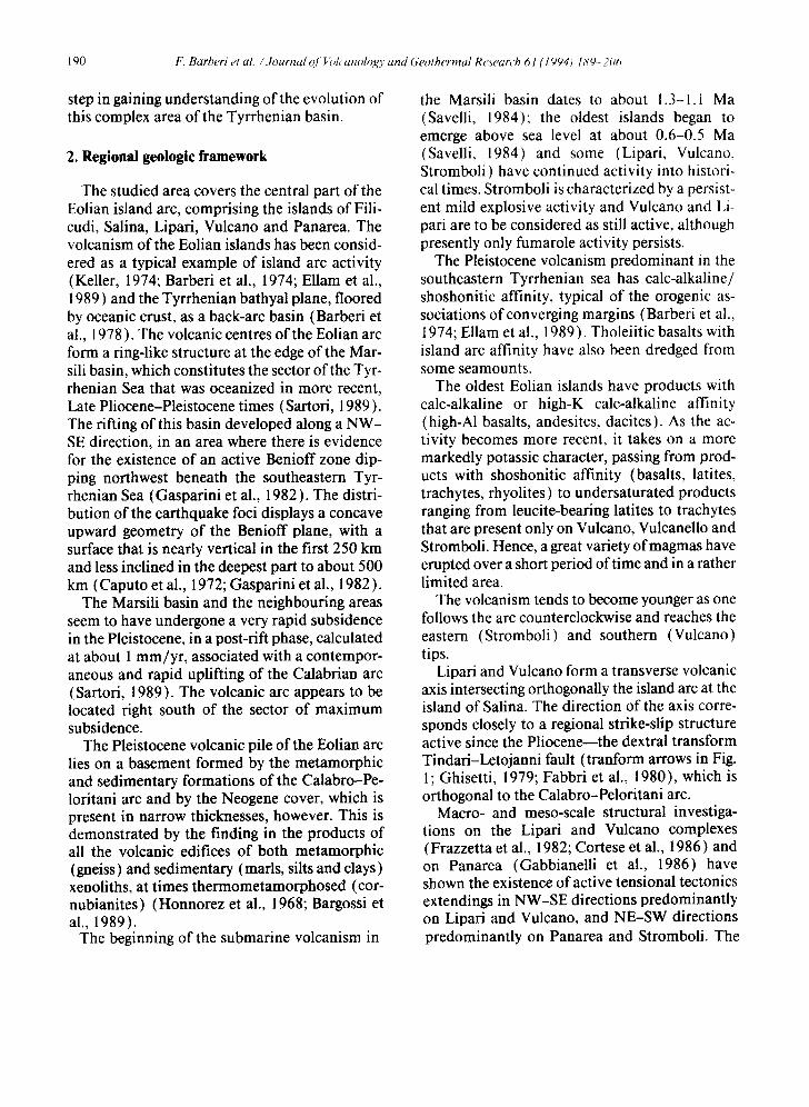
Lipari and Vulcano form a transverse volcanic axis intersecting orthogonally the island arc at the island of Salina. The direction of the axis corre- sponds closely to a regional strike-slip structure active since the Pliocene--the dextral transform Tindari-Letojanni fault (tranform arrows in Fig. 1; Ghisetti, 1979; Fabbri et al., 1980), which is orthogonal to the Calabro-Peloritani arc.
Macro- and meso-scale structural investiga- tions on the Lipari and Vulcano complexes (Frazzetta et al., 1982; Cortese et al., 1986) and on Panarea (Gabbianelli et al., 1986) have shown the existence of active tensional tectonics extendings in NW-SE directions predominantly on Lipari and Vulcano, and NE-SW directions predominantly on Panarea and Stromboli. The
F. Barberi et al. / Journal of Volcanology and Geothermal Research 61 (1994) 189-206 191
Mar=ill
OLIAN ISLANDS
39"
~--~-~/2ooo
\ F'''c°d'
CEFALU BASIN ..
Sal ina ~ 600-
BASIl
M i la~o
0 5 10krn
=" Y- 138" 1"45'50" EAST i MARIO- ROME 3*o2'50*
Fig. 1. Morphostructural sketch map of the Eolian islands; the studied area is shown by the rectangular outlines. Continuous lines = isobaths; toothed lines = normal faults (modified from Ambrosetti et al., 1983 ). Pliocene basins are indicated by ruled and dotted areas.
NW-SE directions likely represent the expres- sion at the surface of the Tindari-Letojanni li- thospheric discontinuity. On Lipari, dextral strike-slip displacements have been determi- nated along faults with a NW-SE trend (Cortese et al., 1986), clearly in accord with the strike of
the Eolie-Tindari-Letojanni system. In this landscape, magnetic and gravimetric data reveal the presence ofa graben system, with its axis par- allel to the Eolie-Tindari-Letojanni structure, and coinciding with the Salina-Lipari-Vulcano magmatic axis (Fig. 1 ).
192 k: Barberi et al. / Journal q / I~lcanology and Geothermal Research 61 ,/t 904) /89. 20;;
3. Notes on the structural and volcanological evolution of the islands
3.1. Filicudi
The island constitutes of at least six basaltic and K-andesitic volcanic centres mainly made of lava flows; reliable radiometric data are not available on the oldest rocks of the island. The youngest products are older than 230 ka (Villari and Nathan, 1978).
3.2. Salina
The activity of the sub-aerial portion of the Salina island started at about 500 ka and contin- ued until 13 ka (De Rosa et al., 1989). In the initial period (500-430 ka) andesitic fissure ac- tivity occurred along NE-SW structures (Rivi and Corvo); tectonic N-S-trending structures are also recognizable in the eastern part of the island (De Rosa et al., 1989 ). Subsequent activity pro- duced the stratocones of Fossa delle Felci and Porri ( 130-60 ka), controlled by NW-SE direc- tions. Approximately at 40 ka, phreatomagmatic pyroclastics interbedded with scoriae and lavas occurred. Around 30 ka, the Pollara center be- came active, first with basaltic lava effusions and later (around 13 ka) with rhyolitic and basaltic explosive activity from the same vent (De Rosa et al., 1989). It is noteworthy that the tectonic directions corresponding to the main active trends on the volcanic arc can be observed on Salina (NW-SE, N-S, NE-SW directions, De Rosa et al., 1989), which is located at the inter- section of the Lipari-Vulcano axis with the arc.
bianelli et al., 1986). The activity continued in the caldera area producing the Dattilo, Panarelli and Lisca Bianca lava centres. An age of about 10 ka has been obtained for the Basiluzzo rhyol- itic dome (Gabbianelli et al., 1986). A buried volcanic complex is present between Lipari and Panarea evidenced by seismic data and attrib- uted to Middle Pliocene by Fabbri et al. ( 1980 ) on the basis of seismostratigraphic data.
3.4. Lipari
The Lipari complex was formed by volcanic products ranging in age from pre-Tyrrhenian (223 ka) to 580 A.D. Four periods of volcanic activity have been distinguished on Lipari (Pi- chler, 1980; Cortese et al., 1986; Bargossi et al., 1989); the first two are characterized by andesi- tic and andesitic-rhyodacitic magmas, while the last two are characterized mainly by rhyolitic compositions. Tensional structures deeply af- fected the volcanic edifice, the oldest formations being faulted and lowered in the southern and northeastern areas of the island around 40 ka. The genesis of these collapses or subsidences is not completely clear. No caldera-forming erup- tions preceded the emplacement of the rhyolitic lava domes of southern Lipari, implying a role for regional tectonics in the genesis of these structures. In the area comprising southern Li- pari and northern Vulcano a shoshonitic phrea- tomagmatic activity developed between 40 and 13 ka (Crisci et al., 1983; Losito and Calderoni, 1990).
3.3. Panarea 3.5. Vulcano
Northeast-southwest tectonic systems play a prominent role in the evolution of this volcanic complex, but also NW-SE structures are active on the island (Gabbianelli et al., 1986). An age of 650-590 ka (Gillot, 1984) has been obtained for the oldest products, which belong to a stra- tocone whose apical part forms the island of Panarea; parasitic cones were then emplaced and a caldera collapse occurred around 100 ka (Gab-
The island of Vulcano was formed by several volcanic complexes. The oldest edifice was situ- ated at the northwestern end of the island and its existence is today indicated only by the E-dip- ping trachybasaltic lavas cropping out at Spiag- gia Lunga (Keller, 1980). A trachybasaltic- trachyandesitic stratovolcano showing some mi- nor parasitic centres developed between 120 and
F. Barberi et al. / Journal of Volcanology and Geothermal Research 61 (I 994) 189-206 193
100 ka (GiUot et al., 1990 ) and was disrupted by an elliptical summit caldera. This caldera was re- juvenated by mainly intracaldera effusive activ- ity, both tephritic and trachybasaltic in compo- sition, between 99 and about 48 ka (Frazzetta et al., 1985). After this period, the island was af- fected by a collapse of its northern portion with a concomitant trachybasaltic eruptive phase (Keller, 1980; Frazzetta and La Volpe, 1987). This phase was closely followed by the building of the Lentia complex, formed by latitic, rhyoli- tic and trachytic lavas (De Astis et al., 1989), which were involved in a collapse after 15 ka. In the collapsed area, the latitic-trachytic and rhyolitic pyroclastic cone of La Fossa developed and the leucite-tephritic activity of Vulcanello occurred. These repeated collapses on the north- ern side of Vulcano are not simply ascribable to caldera collapses because of the absence of cald- era-forming eruption products as we have al- ready noted for Lipari. They are probably linked to regional tensional features (Gioncada and Sbrana, 1991 ).
4. Drilling data on the deep structure of the volcanic edif ices
On the Eolian islands deep drilling has been limited to the island of Vulcano. The wells were drilled in the framework of a geothermal explo- ration project that was carried out in the 1980s as a result of previous studies, conducted 30 years before by AGIP S.p.A. These studies led to the identification at shallow depth of a geothermal system with medium-high enthalpy in the cen- tral part ofLa Fossa caldera (Sommaruga, 1984). This geothermal field is connected with a system of active NNW-SSE-running fractures which is present both in La Fossa caldera and on the nearby island of Lipari. The geothermal project revealed the existence of very high temperatures at shallow depth ( > 420°C at 2050 m below sea level), but also a lack of diffuse permeability in the subsurface of the volcano, at least in the drilled areas (Faraone et al., 1986). The wells supplied basic information for the interpretation of the deep structure of the area, revealing sec-
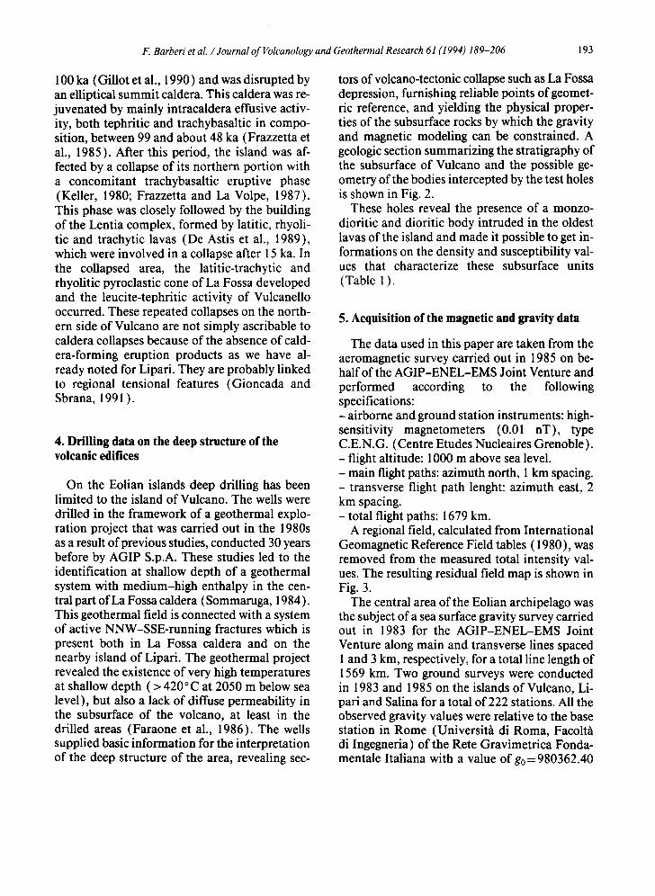
tors of volcano-tectonic collapse such as La Fossa depression, furnishing reliable points of geomet- ric reference, and yielding the physical proper- ties of the subsurface rocks by which the gravity and magnetic modeling can be constrained. A geologic section summarizing the stratigraphy of the subsurface of Vulcano and the possible ge- ometry of the bodies intercepted by the test holes is shown in Fig. 2.
These holes reveal the presence of a monzo- dioritic and dioritic body intruded in the oldest lavas of the island and made it possible to get in- formations on the density and susceptibility val- ues that characterize these subsurface units (Table 1 ).
5. Acquis i t ion of the magnet ic and gravity data
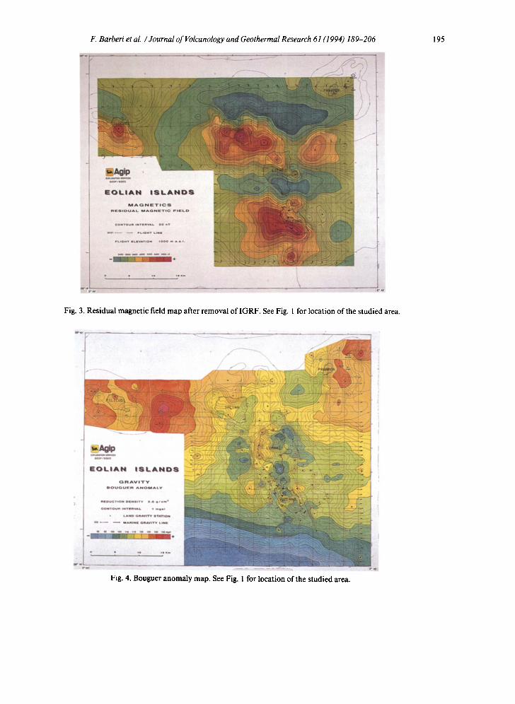
The data used in this paper are taken from the aeromagnetic survey carried out in 1985 on be- half of the AGIP-ENEL-EMS Joint Venture and performed according to the following specifications: - airborne and ground station instruments: high- sensitivity magnetometers (0.01 nT), type C.E.N.G. (Centre Etudes Nucleaires Grenoble). - flight altitude: 1000 m above sea level. - main flight paths: azimuth north, 1 km spacing. - transverse flight path lenght: azimuth east, 2 km spacing. - total flight paths: 1679 km.
A regional field, calculated from International Geomagnetic Reference Field tables (1980), was removed from the measured total intensity val- ues. The resulting residual field map is shown in Fig. 3.
The central area of the Eolian archipelago was the subject of a sea surface gravity survey carried out in 1983 for the AGIP-ENEL-EMS Joint Venture along main and transverse lines spaced l and 3 km, respectively, for a total line length of 1569 km. Two ground surveys were conducted in 1983 and 1985 on the islands ofVulcano, Li- pari and Salina for a total of 222 stations. All the observed gravity values were relative to the base station in Rome (Universith di Roma, Facolth di Ingegneria) of the Rete Gravimetrica Fonda- mentale Italiana with a value of go = 980362.40
194 F, Barberi et al. / Journal of I~bh'anology and Geothermal Research 61 (1994) 189-206
A . . . . . . . . . . . . . . . . B . . . . . C - D . . . . . . . . . . . . . . . . . . . . . . . . . . . . . . . . . . . ~.
FOSSA PIANO
o, , p ~
t r achybasa l l l c phaao
o l cs l do ra up f l l l i ng ~f Sou thvu l cano
Fig. 2. Interpretative geologic section of the island of Vulcano inferred from deep drillings (from Gioncada and Sbrana, 1991, modified ).
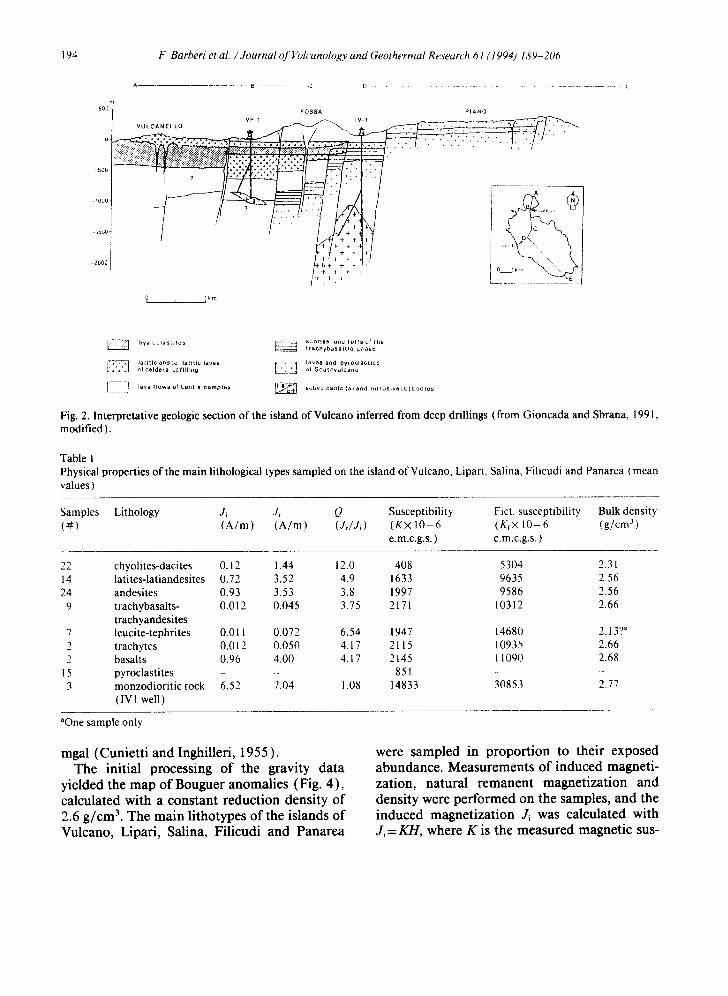
Table 1 Physical properties of the main lithological types sampled on the island of Vulcano, Lipari, Salina, Filicudi and Panarea (mean values )
Samples Lithology J~ Jr Q Susceptibility Fict. susceptibility Bulk density ( # ) ( A / m ) ( A / m ) (Jr/Ji) (K× 1 0 - 6 (Kf× 10-6 (g/cm 3 )
e.m.c.g.s. ) e.m.c.g.s. )
22 chyolites-dacites 0.12 1.44 12.0 408 5304 2.31 14 latites-latiandesites 0.72 3.52 4.9 1633 9635 2.56 24 andesites 0.93 3.53 3.8 1997 9586 2.56
9 trachybasalts- 0.012 0.045 3.75 2171 10312 2.66 trachyandesites
7 leucite-tephrites 0.011 0.072 6.54 1947 14680 2.13? a trachytes 0.012 0.050 4.17 2115 10935 2.66
2 basalts 0.96 4.00 4.17 2145 11090 2.68 15 pyroclastites - - 851 - - 3 monzodioritic rock 6.52 7.04 1.08 14833 30853 2.77
( IV 1 well )
aOne sample only.
mgal (Cunietti and Inghilleri, 1955 ). The initial processing of the gravity data
yielded the map of Bouguer anomalies (Fig. 4), calculated with a constant reduction density of 2.6 g/cm 3. The main lithotypes of the islands of Vulcano, Lipari, Salina, Filicudi and Panarea
were sampled in proportion to their exposed abundance. Measurements of induced magneti- zation, natural remanent magnetization and density were performed on the samples, and the induced magnetization Ji was calculated with Ji = K H , where K is the measured magnetic sus-
F. Barberi et al. / Journal of Volcanology and Geothermal Research 61 (1994) 189-206 195
Fig. 3. Residual magnetic field map after removal of IGRF. See Fig. l for location of the studied area.
Fig. 4. Bouguer anomaly map. See Fig. 1 for location of the studied area.
196 F. Barberi et aL / Journal of Volcanology and Geothermal Research 61 (1994) 189-206
ceptibility and H is the value of the local mag- netic field (44,000 nT).
The natural remanent magnetization Jr was measured in the laboratory and proved to be the dominant component of the total magnetization of the rocks. Indeed, the Koenigsberger ratio Q=JJJ~ is very high (0.5 < Q< 110).
The direction and the orientation of the re- manent magnetization are equal to those of the present magnetic field in conformity with the re- cent age of emplacement of the Eolian volcan- ites. For this reason the quantitative interpreta- tion of the magnetic anomalies requires that the total magnetization of the rocks Jt=Ji+Jr be taken into consideration as the vector sum of the induced and remanent components. From the physical point of view it is, therefore, correct to calculate and utilize the fictitious magnetic sus- ceptibility Kf= K( 1 + Q) reported in Table 1. On numerous samples measurements of thermal de- magnetization were also performed (to explore the variation of remanent magnetization as a function of gradual temperature increase). The magnetization intensity displays an average re- duction on the order of 50% at 400-500°C and is completely eliminated between 600 and 650 °C (Curie temperature).
In the absence of direct measurements on the rocks of the Eolian basement we hypothesized values of magnetic susceptibility K< 100 × 10-6 e.m.c.g.s. (practically null) and of density= 2.72 g/cm 3 measured on the quartzites and phyllites of the Tuscan-Latian and Calabro-Peloritani sectors.
Table 1 also reports the average values of the bulk density measured for the samples. The ma- jority of the products has a density of 2.55-2.65 g/cm 3 with the exception of the rhyolitic rocks (2.3 g/cm 3) and, presumably, the pyroclastic rocks ( 1-2 g/cm 3 ).
6. Magnetic and gravity, processing and interpretation
The map in Fig. 3 displays both short- and long-wavelength magnetic anomalies. The short- wavelength anomalies are linked to variations in
the susceptibility of the surface volcanic depos- its; the long-wavelength anomalies are presumed to have a more regional character and are pre- sumably caused by deep bodies beneath the out- cropping volcanic structures. Among the short- wavelength anomalies, the one located about 4 km south of Vulcano Piano should be pointed out. This anomaly indicates the presence of shal- low magnetic bodies corresponding to the Eolie- Letojanni-Tindari regional structure (Fig. 1), which controlled the emplacement of the erup- tive complexes of Vulcano and Lipari.
Short-wavelength anomalies are also identi- fied in correspondence with the Piano caldera, coinciding with the susceptible tephritic lavas that fill this depression, and with Vulcanello, which coincides with the effusions of susceptible tephritic lavas that form the lava platform.
A smaller magnetic anomaly is observed east of Vulcano, in the area where recent studies (Gabbianelli et al., 1991 ) have shown the pres- ence of a peripheral vent, probably of very recent age (last eruption of 1888-1890?).
The Lipari volcanic complex is less magnetic (Knct. = 1000-6000 e.m.c.g.s. ). Two short-wave- length anomalies correspond to Monterosa and to the northwestern sector of the island where the pre-Tyrrhenian andesitic lavas crop out, forming the base of the exposed complex of Lipari.
The island of Salina is characterized by two in- tense positive anomalies, 300-500 nT, coincid- ing with the two andesitic eruptive centres of Mt. Fossa delle Felci and Mt. dei Porri. A local anomaly, also intense, appears to be perfectly centred on the andesitic structure of Filicudi. The Panarea area, although at the limit of the survey, does not seem to possess significant magnetic anomalies.
As far as long-wavelength anomalies are con- cerned, a large one is located in the area west of Vulcano, apparently not connected with prefer- ential directions, and another in correspondence to a belt extending eastward from Salina.
These anomalies are thought to be linked to the deeper causative bodies of this part of the Eolian structure.
Similarly to the magnetic map, the gravity map is divided into short-wavelength anomalies char-
F. Barberi et al. /Journal of Volcanology and Geothermal Research 61 (1994) 189-206 197
acteristic of shallow inhomogeneities attribut- able to the volcanic centers and long-wavelength anomalies associated with deep structures; in large part these gravity features are unrelated to the volcanic centers but connected with the trend of the pre-volcanic basement, very likely formed by the metamorphic formations that make up the Calabro-Peloritani arc.
In the Bougner map four large regions are ob- served: two zones of strong positive values, one to the west between Salina and Filicudi and the other to the east between Panarea and Strom- boli, and two zones of negative anomaly. The southernmost negative anomaly partly coincides with the Neogene basin of Cefal/~, and the N-S- trending region of low value within which the complexes ofVulcano, Lipari and, in part, Salina developed in very recent times.
The short-wavelength anomalies are preferen- tially distributed in the volcanic areas, particu- larly in the Lipari and Vulcano complexes where the greatest density contrasts are present in the volcanic sequences.
This panorama of gravity and magnetic anom- alies makes it possible to define the principal re- gional structures that affect this sector of the vol- canic arc, and it is to this end that the processing and interpretation of the data described here were carried out. In particular, the work was aimed at separating the long-wavelength regional compo- nents from the short-wavelength local ones.
The approach to the processing of the mag- netic data was: ( 1 ) calculation and subtraction of the magnetic effect of the volcanic edifices, of which the islands represent only the subaereal summits; (2) subsequent removal, by means of filtering, of the short-wavelength component of the residual anomalies; and (3) calculation of anomalies reduced to the pole for the residual.
More specifically: ( 1 ) The magnetic effect of the edifices or top-
ographic effect was calculated with the Barnett method (Barnett, 1976), starting with a 3D re- construction of the complex volcanic structures by representing them as eighteen triangular-faced polyhedral bodies with bases fixed at 1300 m depth below sea level. An average value of mag- netic susceptibility was attributed to each one.
The values used relative to the individual mod- eled bodies are reported in Table 2.
(2) The removal of the short-wavelength component of the residual anomalies was ac- complished by applying a depth separation filter (Jacobsen, 1987). The Jacobsen filter is an op- t imum depth separation filter of the sandwich distribution of many thin sheets designed to sep- arate the effects originating from sources above and below a datum level Zo, respectively. The depth of separation was set at 1300 m depth and a "pass below" operation was performed, so that the resulting anomalies can be considered to be caused exclusively by magnetic bodies located beneath the base of the volcanic edifices (depth> 1300 m below sea level). We note that this filter for estimation of the field originating below 1300 m is an upward continuation and is therefore quite stable. Data filtered in this way are suitable for direct quantitative modeling, if the assumption of sandwich source distribution is correct, as it seems in this case.
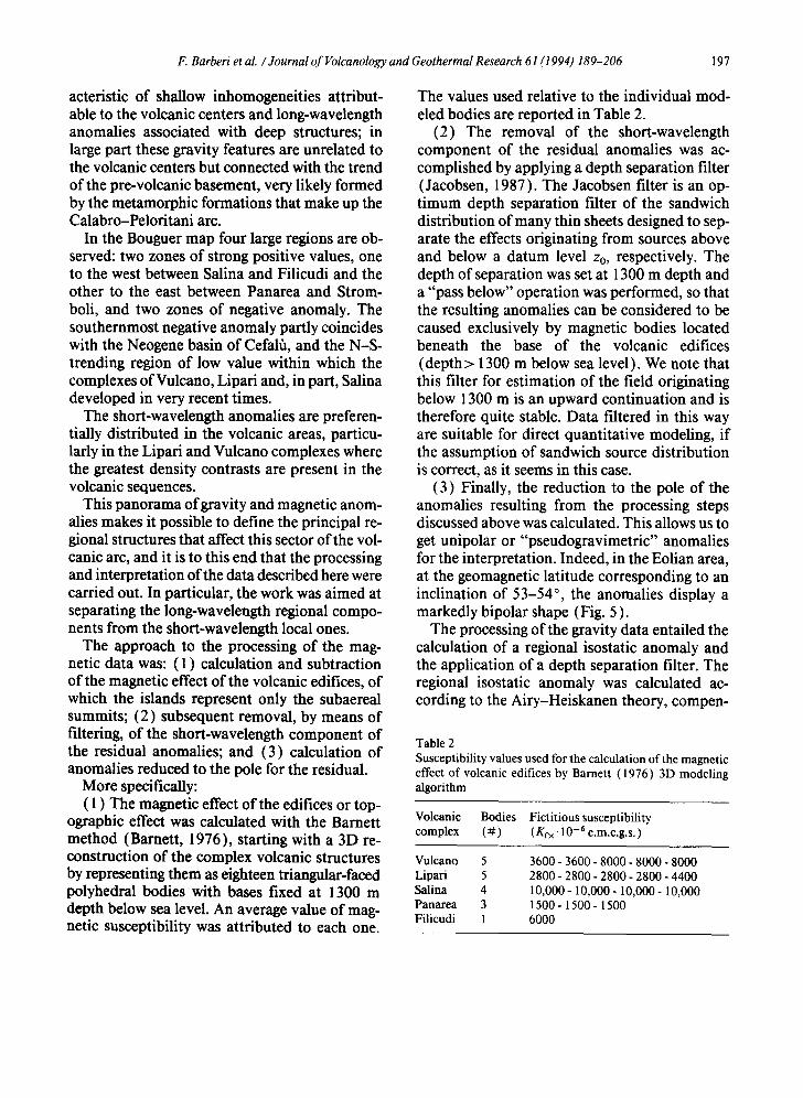
(3) Finally, the reduction to the pole of the anomalies resulting from the processing steps discussed above was calculated. This allows us to get unipolar or "pseudogravimetric" anomalies for the interpretation. Indeed, in the Eolian area, at the geomagnetic latitude corresponding to an inclination of 53-54 °, the anomalies display a markedly bipolar shape (Fig. 5 ).
The processing of the gravity data entailed the calculation of a regional isostatic anomaly and the application of a depth separation filter. The regional isostatic anomaly was calculated ac- cording to the Airy-Heiskanen theory, compen-
Table 2 Susceptibil i ty values used for the calculat ion o f the magnet ic effect o f volcanic edifices by Barnet t (1976) 3D model ing a lgor i thm
Volcanic Bodies Fict i t ious susceptibil i ty complex ( # ) (Kr×. 10 -6 e.m.c.g.s. )
Vulcano 5 3600 - 3600 - 8000 - 8000 - 8000 Lipari 5 2800 - 2800 - 2800 - 2800 - 4400 Salina 4 10,000- 10,000- 10,000- 10,000 Panarea 3 1500 - 1500 - 1500 Filicudi 1 6000
198 k: Barberi et aL / Journal of Volcanology and Geothermal Research 61 (1994) 189-206
Fig. 5. Residual magnetic field, corrected for topographic effects and processed with "pass below" separation filter set tor 1300 m below sea level, reduced to the pole.
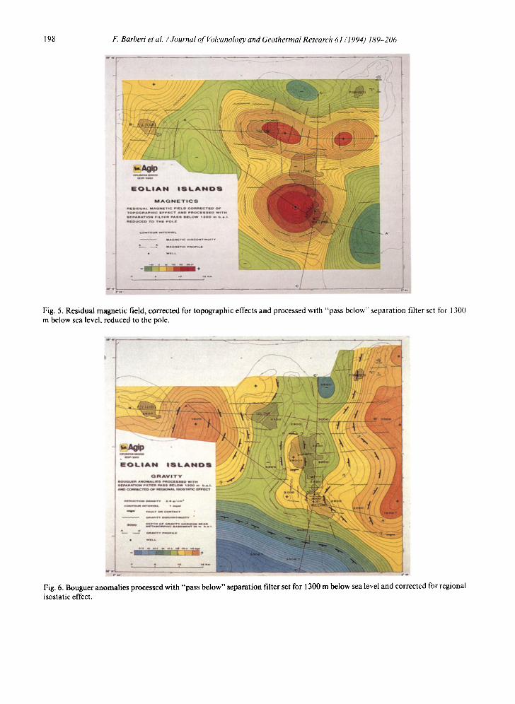
Fig. 6. Bouguer anomalies processed with "pass below" separation filter set for 1300 m below sea level and corrected for regional isostatic effect.
F. Barberi et al. /Journal of Volcanology and Geothermal Research 61 (1994) 189-206 199
sation depth 20 km in accordance with the pub- lished data relative to the Moho. It can be represented, to first-order aproximation, by a tilted plane with a maximum gradient of + 0.45 mGal/km, direction N21°W. This was sub- tracted from the measured gravitational field.
Next, as described for the magnetic process- ing, Jacobsen's depth separation filter was ap- plied by performing a "pass below" operation with a separation depth of 1300 m below sea level thereby enhancing the anomalies caused by bod- ies situated beneath the base of the volcanic edifices.
7. Discussion of the regional data
The results of the processing aimed at elimi- nating the effects of shallow bodies are given in Figs. 5 and 6 and these figures can therefore be interpreted in terms of regional structures.
The filtered Bouguer map (Fig. 6) suggests a structure defined by low anomaly values formed by a large axial depression "bounded" by struc- tural highs. The gravity gradients suggest a fault- bounded graben-like structure extending in a N- S direction, orthogonally to the volcanic arc.
The raised sides of the structure are repre- sented by higher-density causative bodies not linked with any magnetic anomaly. The most likely hypothesis is that they were formed by metamorphic formations similar to the ones constituting the Calabro-Peloritani arc. Sup- porting in this hypothesis is the presence of abundant metamorphic xenolithes in the lava and pyroclastic sequences of the various Eolian vol- canoes. Quartzites are dominant on Vulcano (Silvestri et al., 1891 ), quartzites, granulites and phyllites are found at Lipari (Bargossi et al., 1989), and inclusions of metamorphic or ther- mometamorphosed sedimentary rocks have been reported on all the Eolian islands (Honnorez et al., 1968).
The main graben appears to be nearly filled by at least 3000 m of both effusive and intrusive (Faraone et al., 1986; Barberi et al., 1989) vol- canic formations which cover the metamorphic
and sedimentary formations at depths greater than 3000-3500 m.
The volcanic bodies with the highest suscepti- bility are concentrated just west of Vulcano and along a trend in conformity with the trend of the Eolian arc extending eastward from Salina. Of these, the deep body west of Vulcano occupies an axial position in the graben defined by gravity while the northernmost ones might correspond to the intersection between the border structures of the graben and regional fractures parallel to the arc, trending east-west.
The same gravity and magnetic maps (Figs. 5 and 6 ) indicate that in the area of Filicudi a sec- ondary depression may also be present in which the eruptive complex of Filicudi is located.
The main graben appears to be divided into several smaller structures; of special interest is the structure indicated by the gravimetric high present in the western sector of Lipari. This structure cannot be associated with a significant magnetic anomaly (Fig. 6) even though high susceptibility andesitic lavas crop out in this sec- tor of the island. They are hence inferred to be present in limited masses, and the anomaly is probably linked to an elevation of the metamor- phic basement. It should be pointed out in sup- port of the proposed interpretation that the cor- dierite-bearing andesitic and rhyolitic lavas, considerably contaminated by crustal material, were emitted precisely in this sector of the island (Bargossi et al., 1989 ).
A relative high of the metamorphic basement is probably also present east of Vulcano (Fig. 5 ).
A seismic reflection survey, carried out in 1983 around the island of Vulcano (along five lines 48 fold for a total of 59.5 km), does not show sig- nificant indications of continuous reflective ho- rizons except for some low-frequency reflections detectable in the southeastern sector of the is- land, at depths estimated at 2-2.5 km below sea level. Such depths are largely consistent with the local top of the metamorphic basement esti- mated on the basis of gravity data.
Northeast of Salina, at the centre of the gravity depression, a fairly large circular seamount is present, to which no magnetic anomaly corre- sponds. Pyroclastic rocks, probably with an
200 F. Barberi et al. / Journal of ~ blcanology and Geothermal Research 61 (1994) 189-206
evolved composition, may therefore constitute the greatest part of the seamount.
The southern part of the studied area is char- acterized by a portion of a large negative gravi- metric anomaly which corresponds to the Neo- gene basin of Cefal~.
Wavy lines in Figs. 5 and 6 indicate to the magnetic and gravity "discontinuities" corre- sponding to the main gradient changes. The dis- continuities show two main trends (north-south and east-west) in agreement with the regional structure.
The interpretation of the gravity and magnetic data was completed by calculating three 2.5D models, oriented to constrain the geometry and the significance of the principal magnetic and gravity anomalies by utilizing the information provided by the deep holes drilled on the island of Vulcano. The 2.5D modeling allows calcula- tion of the magnetic or gravity effect of bodies and/or layers limited in extent in a direction or- thogonal to the profile. The algorithm employed for the calculation uses the formulae of Shuey and Pasquale ( 1973 ). The magnetic and gravity pro- files were obtained from the Jacobsen filtered maps which, in our assumption of sandwich sources distribution, represent the field originat- ing below 1300 m below sea level. In the inter- pretation, the magnetic effect of the basement was neglected. A susceptibility contrast of AK= 6000 × 10-6 e.m.c.g.s, was attributed to the deep causative bodies, prudentially low with re- gard to the few samples of intrusive rock but consistent with the values measured for the lavas and with the high temperatures at depth.
A density of 2.6 g/cm 3 was attributed to the same bodies, which cannot be considered to be exclusively of an intrusive nature.
In the calculation of the models a density of 2.72 g/cm 3 was used for the rocks of the base- ment and 2.5 g/cm 3 for the volcanics.
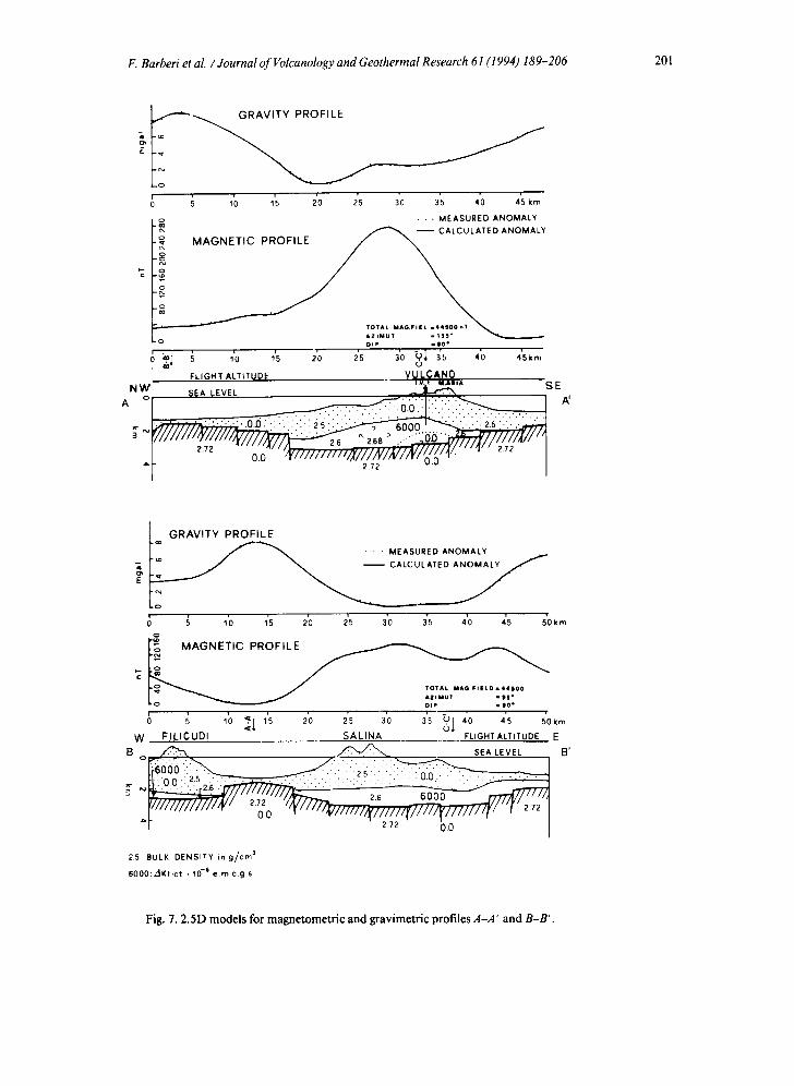
The NW-SE-trending profile A-A' (Fig. 7) crosses the main graben and passes through the area of the island of Vulcano with the deep ex- ploration well IVI. The model clearly shows the broad central depression in which the body that causes the magnetic anomaly is located. Intru- sive bodies definitely cause the magnetic anom-
aly in the area of Vulcano; it cannot be ruled out that in the adjacent areas the anomaly is also caused by magnetic lava masses belonging to ef- fusive volcanic activity related with the initial opening phases of the graben and buried by more recent volcanic successions.
In the area of well IV1, on the basis of the mea- sured high temperature and thermal gradient, we drew the probable 500°C isotherm, below which the magnetic effect is practically null.
An increase in the density of the intrusive and/ or effusive body west of well IV 1 is necessary for a good fitting of the gravity anomaly.
Model B-B' (Fig. 7) follows a W-E profile that includes the islands of Filicudi and Salina; it intersects the profile A-A' on the basement high that separates the secondary graben of Fili- cudi, at the western limit of the survey, from the main graben that extends eastward from Salina. The horsts are clearly characterized by positive gravity anomalies and negative magnetic anom- alies linked to the prevalent presence of dense, low-susceptibility metamorphic rocks. In con- trast, the grabens display anomalies of the op- posite kind due to filling by high-susceptibility relatively less dense volcanites.
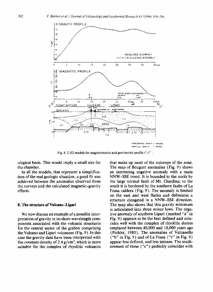
Profile C-C' (Fig. 8) runs south-north and includes the main graben longitudinally, passing through the island of Vulcano and the wells IV1 and VP 1, Vulcanello and the eastern side of the island of Lipari. The model shows: (1) a low- density body in the southern sector, correspond- ing to the thickening of the elastic sediments of the Cefalh basin; (2) a series of deep magnetic bodies with maximum volumes in the area of Vulcano and north of Lipari; (3) the basement cut between 3000 and 3500 m depth by smaller structures; in particular, the relative structural high, located beneath Monterosa on Lipari, which seems to divide the lowered area north of Vulcano into two sectors to which the rhyolitic volcanism of northern Vulcano and southern Li- pari and of the northeastern sector of Lipari might be linked.
There is no gravimetric-magnetic evidence of a magma chamber underneath La Fossa of Vul- cano, whose existence is inferred on geovolcan-
F. Barberi et al. / Journal of Volcanology and Geothermal Research 61 (1994) 189-206 201
- o
J
N W
2.72
3'0 3'5 4 '0 4 '5 k m
• • . M E A S U R E D A N O M A L Y
M A G N E T I C p TED A N O M A L Y
" TOTA6. M A G . F I E L . 4 4 1 0 0 n T
D I P ml lO"
; ;o ;s 2'o 2*5 3'o V~. 3's 4'o ,;5k~ r j
FUGH'r ALTITUDE VVb(;;AN0 ~ , A S E
~;EA LEVEL K
i GRAVITY PROFILE ¢0 , , , , I . . ~ - ~ - " - MEASURED A N O M A L Y
i . o ~ '
; ~ ~'o l's 2'0 2'5 3'o 3'5 4'0 ;s s'o k m
c
TOTAL I I IAG F I E L D I 4 4 5 0 0 A Z I M U T u l l § * DtP = 1 0 e
6 ; 1'0 ~1 1'5 20 25 30 35 ~1 ,o ,5 ~'Okm W FILICUDI SALINA FLIGHT ALTITUDE E
B o ~ . ~ SEA LEVEL B'
,.[~///////////'~" ~ ~ / F / / ~ / / / / m / 7 / / / / r / / / / / / / f J i ' " 1 I 272 00
2.5 : B U L K DENSITY in g / c m 3
6 0 0 0 : A K t i c t • 10 -6 e .m .c .g s
Fig. 7. 2.5D models for magnetometric and gravimetric profiles A-A' and B-B'.
202 F. Barberi et al. / Journal of ~blcanology and Geothermal Research 61 (1994) 189-206
m
E
C S FLIGHT ALTITUDE VULCANO LIPARI I.V.1 V,p. I
SEA LEVEL ~ VULCANELLO MONTEROSA o
i ' . . '
GRAVITY PROFILE
o ~ ~b ~'s 2'0 is a'o ;s 4'okm
"~ ~ ~ D IP =90 '
o ; ~; ~'s 2'0 2'~ 3'o~ ~ 4'o~ N
C'
HORIZONTAL SCALE 1 100 .000
VERT ICAL SCALE 1 50 .000
Fig. 8.2.5D models for magnetometric and gravimetric profile C-C.
ological basis. This would imply a small size for the chamber.
In all the models, that represent a simplifica- tion of the real geologic situation, a good fit was achieved between the anomalies observed from the surveys and the calculated magnetic-gravity effects.
8. The structure of Vulcano-Lipari
We now discuss an example of a possible inter- pretation of gravity in its short-wavelength com- ponents associated with the volcanic structures for the central sector of the graben comprising the Vulcano and Lipari volcanoes (Fig. 9 ). In this case the gravity data have been interpreted with the constant density of 2.4 g/cm 3, which is more suitable for the complex of rhyolitic volcanics
that make up most of the outcrops of the zone. The map of Bouguer anomalies (Fig. 9) shows an interesting negative anomaly with a main NNW-SSE trend. It is bounded to the north by the large normal fault of Mt. Giardina; to the south it is bordered by the southern faults of La Fossa caldera (Fig. 9). The anomaly is limited on the east and west flanks and delineates a structure elongated in a NNW-SSE direction. The map also shows that this gravity minimum is articulated into three minor lows. The nega- tive anomaly of southern Lipari (marked "a" in Fig. 9) appears to be the best defined and coin- cides well with the complex of rhyolitic domes emplaced between 40,000 and 10,000 years ago (Pichler, 1980). The anomalies of Vulcanello ("b" in Fig. 9) and of La Fossa ("c" in Fig. 9) appear less defined, and less intense. The south- ernmost of these ("c") perfectly coincides with
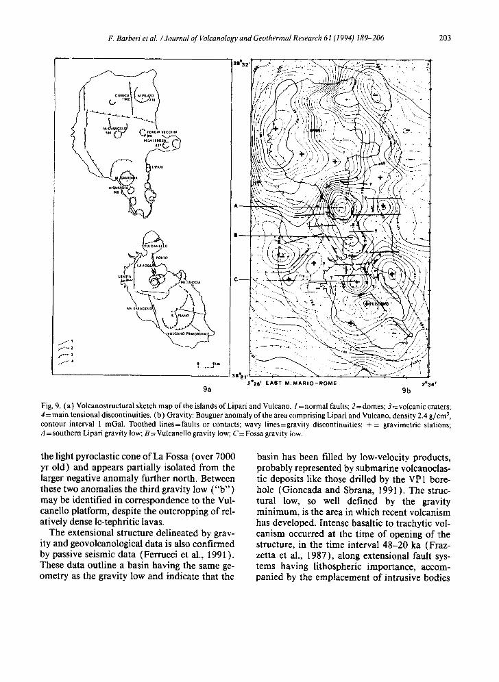
F. Barberi et al. /Journal of Folcanology and Geothermal Research 61 (I 994) 189-206 203
MONIEIIOS
J $
f 4
~ollo
LA ross
LINII& ,LtJ~CIA
\
? 1, ~
2°26 f E A S T M . M A R I O - R O M E 2°34 I
9a 9b
Fig. 9. (a) Volcanostructural sketch map of the islands of Lipari and Vulcano, I = normal faults; 2 = domes; 3 = volcanic craters; 4 = main tensional discontinuities. (b) Gravity: Bouguer anomaly of the area comprising Lipari and Vulcano, density 2.4 g/cm 3, contour interval 1 reGal. Toothed l ines=faults or contacts; wavy lines=gravity discontinuities; + = gravimetric stations; A = southern Lipari gravity low; B= Vulcanello gravity low; C = Fossa gravity low.
the light pyroclastic cone of La Fossa (over 7000 yr old) and appears partially isolated from the larger negative anomaly further north. Between these two anomalies the third gravity low ("b") may be identified in correspondence to the Vul- canello platform, despite the outcropping of rel- atively dense lc-tephritic lavas.
The extensional structure delineated by grav- ity and geovolcanological data is also confirmed by passive seismic data (Ferrucci et al., 1991 ). These data outline a basin having the same ge- ometry as the gravity low and indicate that the
basin has been filled by low-velocity products, probably represented by submarine volcanoclas- tic deposits like those drilled by the VP 1 bore- hole (Gioncada and Sbrana, 1991 ). The struc- tural low, so well defined by the gravity minimum, is the area in which recent volcanism has developed. Intense basaltic to trachytic vol- canism occurred at the time of opening of the structure, in the time interval 48-20 ka (Fraz- zetta et al., 1987), along extensional fault sys- tems having lithospheric importance, accom- panied by the emplacement of intrusive bodies
204 t". Barheri el al. / , lourtlal o f l 'o/cam~hgg.l, and Geothermal Research 61 ; 19~4) /,~'u- 206
(Faraone et al., 1986; Barberi et al., 1989). In the basin, shallow magma chambers were em- placed in southern Lipari and northern Vulcano. In the latter area tensional events were repeated in recent times ( 15 ka) with the formation of La Fossa depression. In this tensional structure, la- titic and leucite-bearing latitic volcanism oc- curred (Gioncada and Sbrana, 1991 ), followed by the emplacement of a magmatic chamber in La Fossa area, currently active and responsible for the present unrest (Barberi et al., 1991 ) there recorded.
9. Summary and concluding remarks
The existing magnetic and gravimetric data, interpreted together with the geovolcanological surface and subsurface data using an appropriate
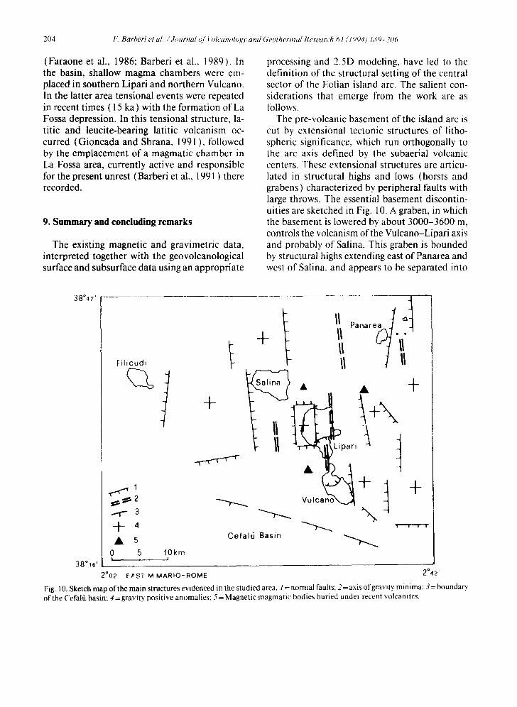
processing and 2.5D modeling, have led to the definition of the structural setting of the central sector of the Eolian island arc. The salient con- siderations that emerge from the work are as follows.
The pre-volcanic basement of the island arc is cut by extensional tectonic structures of litho- spheric significance, which run orthogonally to the arc axis defined by the subaerial volcanic centers. These extensional structures are articu- lated in structural highs and lows (horsts and grabens) characterized by peripheral faults with large throws. The essential basement discontin- uities are sketched in Fig. 10. A graben, in which the basement is lowered by about 3000-3600 m, controls the volcanism of the Vulcano-Lipari axis and probably of Salina. This graben is bounded by structural highs extending east of Panarea and west of Salina. and appears to be separated into
38°42 '
38"16'
Filicud~
~ .2
3
4- 4
• 5 o 5
J
10km I
f + • +
+ •
+ + q
! ! i ""T
Cefal6 Basin - ~
2002 ' E/~ST M M A R I O - R O M E 2°43'
Fig. 10. Sketch map of the main structures evidenced in the studied area. 1 = normal faults; 2= axis o f gravity minima; 3= boundary of the Cefal~ basin: 4 = gravity positive anomalies: 5 = Magnetic magmatic bodies buried under recent volcanites.
F. Barberi et al. / Journal of Volcanology and Geothermal Research 61 (I 994) 189-206 205
minor basins, apparently showing an "en 6che- Ion" arrangement. A minor graben occurs in cor- respondence to the Filicudi complex.
The volcanic edifices are located inside (Sal- ina, Lipari, Vulcano, Filicudi) or on the edge (Panarea) of the graben (Fig. 10). Older vol- canic centres and/or intrusive bodies buried be- neath the recent centers are also present inside the graben. In particular, a buried body of con- siderable size (several kilometres wide) is lo- cated northwest of Vulcano, coinciding with the pre-South Vulcano edifice mentioned by Keller (1980). A body with slightly lower susceptibility is present between Lipari and Panarea, and cor- responds to a Late Pliocene-Early Pleistocene volcanic structure as indicated by reflection se- ismic profiles (Fabbri et al., 1980).
The studied area is situated in a sector of the Tyrrhenian sea that is subject to rapid and in- tense tectonic movements from Late Pliocene to Pleistocene times, with the opening of the Mar- sili basin followed by a strong subsidence of the southern Tyrrhenian Sea with the contempora- neous uplift of the Southern Appenninic range (Sartori, 1989; Patacca and Scandone, 1989). The central area of the Eolian volcanic arc ap- pears to be strongly influenced by the presence of a regional dextral strike-slip fault--the Eolie- Tindari-Letojanni fault--active since the Pli- ocene (Fabbri et al., 1980), which now repre- sents a seismogenetic structure (Barbano et al., 1979 ). Active extensional tectonics along NNW- SSE and ENE-WSW directions, reflecting a clear influence of the Eolie-Tindari-Letojanni struc- ture, affect Lipari and Vulcano complexes (Frazzetta et al., 1982), which have been also interested by recent (40-10 ka) collapse and tensional structures. Some of these (southern Li- pari-northern Vulcano sectors, northeastern Li- pad and La Fossa depression ) are hardly ascrib- able to caldera collapses only because of the absence of caldera-forming eruptions; they are more probably linked to regional tectonic pro- cesses (Gioncada and Sbrana, 1991 ).
As a matter of fact, extensional tectonics have been active in the area since the Plio-Pleistocene (Ghisetti, 1979). Volcanism, and widespread magma intrusions, appear to be associated with
the development of an extensional structure, a graben segmented in small basins disposed "en 6chelon". The geometry suggests an origin con- trolled by trans-tensional tectonics along the dextral strike-slip Tindari-Letojanni fault sys- tem, affecting an active converging plate bound- ary. The chemical changes recorded since 40 ka, with the appearance and development of basic and alkaline magmas, might suggest an increase of the extensional movements in the graben structures, which might then tend to assume the character of pull-apart basins.
Acknowledgements
The authors wish to thank AGIP S.p.A., Enel, Ente Minerario Siciliano for permission to use geophysical data and to publish this paper and the two reviewers Dave Hill and Bob Simpson for their useful comments. This work is sup- ported by a GNV grant to A. Sbrana.
References
Ambrosetti, P., Bosi, C., Carraro, F., Ciaranfi, N., Panizza, M., Papani, G., Vezzani, L. and Zanferrari, A., 1983. Neotectonic map of Italy. C.N.R., Progetto Finalizzato Geodinamica, Scala 1:500.000. Quad. Ric. Sci. 114(4).
Barbano, M.S., Bottari, A., Carveni, P., Cosentino, M., Fed- erico, B., Fonte, G., Lo Giudice, E., Lombardo, G. and Patanr, G., 1979. Macroseismic study of the Gulf of Patti earthquake in the geostructural frame of North-Eastern Sicily. Boll. Soc. Geol. Ital., 98: 155-174.
Barberi, F., Innocenti, F., Ferrara, G., Keller, J. and Villari, L., 1974. Evolution of Eolian arc volcanism (Southern Tyrrhenian Sea). Earth Planet. Sci. Lett., 21: 269-276.
Barberi, F., Bizouard, H., Capaldi, G., Ferrara, G., Gaspar- ini, P., Innocenti, F., Joron, J.L., Lambret, B., Treuil, M. and Allegre, C., 1978. Age and nature ofbasalts from the Tyrrhenian abyssal plain. Init. Rep. DSDP, 42( 1 ): 509- 516.
Barberi, F., Ferrara, G., Taddeucci, G. and Villa, I.M., 1989. L'intrusione monzodioritica del sottosuolo della Fossa (Vulcano, lsole Eolie). Boll. G.N.V., 1989(2): 611-630.
Barberi, F., Neri, G., Valenza, M. and Villari, L., 1991. 1987- 1990 unrest at Vulcano. Acta Vulcanol., 1 : 95-106.
Bargossi, G.M., Campos Venuti, M., Gasparotto, G. and Rossi, P.M., 1989. Petrologia e stratigrafia delle succes- sioni andesitiche l.s. di Lipari, Isole Eolie, Italia. Mineral. Petrogr. Acta, 32: 295-326.
206 F. Barberi et al. / Journa l o f l blcanoh~gy and Geothermal Research 61 (1994) l,~'9-- 2~m
Barnett, C.T., 1976. Theoretical modeling of the magnetic and gravitational fields of an arbitrarily shaped three-dimen- sional body. Geophysics, 41 : 1353-1364.
Caputo, M., Panza, G.F. and Postpischl, D., 1972. New evi- dences about the deep structure of the Lipari arc. Teclon- ophysics, 15: 219-231.
Cortese, M., Frazzetta, G. and La Volpe, L., 1986. Volcanic history of Lipari (Aeolian Islands, Italy) during lhc last 10,000 years. J. Volcanol. Geotherm. Res., 27:1 l 7-- 133.
Crisci, G.M., Delibrias, G., De Rosa, R., Mazzuoli, R. and Sheridan, M.F., 1983. Age and petrology of the late-Pleis- tocene Brown Tufts on Lipari, Italy. Bull. Volcanol., 46 ( 4 ): 381-39t.
Cunietti, M. and Inghilleri, G., 1955. La rete gravimctrica fondamentale italiana. Pubbl. Comm. Geod. ltal. 3rd Set.. Mem. 8.
De Astis, G., Frazzetta, G. and La Volpe, L., 1989.1 depositi di riempimento della Caldera del Piano e i depositi della Lentia. Boll. G.N.V., 1989 (2): 763-778.
De Rosa, R,, Mazzuoli, R., Rossi, P.L., Santacroce, R. and Ventura, G., 1989. Nuovi dati ed ipotesi per la ricostru- zione della storia eruttiva dell'Isola di Salina ( lsole Eolie ). Boll. GNV, 1989(2): 809-826.
Ellam, R.M., Hawkesworth, C.J., Menzies, M.A. and Rogers, N.W., 1989. The volcanism of southern Italy: role of sub- duction and the relationship between potassic and sodic alkaline magmatism. J. Geophys. Res., 94: 4589-4601.
Fabbri. A., Ghisetti. F. and Vezzani, L., 1980. The Pelori- tani-Calabria range and the Gioia basin in the Calabrian arc (Southern Italy): relationships between land and ma- rine data. Geol. Rom., 19: 131-150.
Faraone, D., Silvano, A. and Verdiani, G., 1986. The mon- zogabbroic intrusion in the island of Vulcano, Aeolian Archipelago, Italy. Bull. Volcanol., 48: 299-307.
Ferrucci, F., Gaudiosi, G., Milano, G., Nercessian, A.. Vi- lardo, G. and Luongo, G., 1991. Seismological explora- lion of Vulcano (Aeolian Islands, southern Tyrrhenian Sea): case history,. Acta Vulcanol., 1:143-152.
Frazzetta, G, and La Volpe, L., 1987. Storia erultiva dell'lsola di Vulcano: stato di avanzamento della ricerca. Boll. GN V, 1987: 361-372.
Frazzetta, G., Lanzafame, G. and Villari, L., 1982. Defor- mazioni e tettonica attiva a Lipari e Vulcano (Eolie). Mere. Soc. Geol. ltal., 24: 293-297.
Frazzetta, G., Gillot, P. Y. and La Volpe, L., 1985. The island of Vulcano. 1985 IAVCEI Scientific Assembly. Excur- sions Guideb., pp. 125-140.
Gabbianelli, G., Gillot, P.Y., Lanzafame, G., Ligi, M., Post- pisch, D. and Rossi, P.L., 1986. Controllo strutturale nell'evoluzione vulcanica di Panarea (Isole Eolie/. CN R IIV Open File Rep. 4/86, 27 pp.
Gabbianelli, G., Romagnoli, C., Rossi, P.L., Calanchi, N. and Lucchini, F., 1991. Submarine morphology and tectonics of Vulcano (Aeolian Islands, Southeastern Tyrrhenian Sea). Acta Vulcanol.. 1: 135-141.
Gasparini, C., lannaccone, G., Scandone, P. and Scarpa, R., 1982_ Seismotectonics of the Calabrian Arc. Tectono-
physics, 84: 267-28~. Ghisetti, F., 1979. Relazioni tra strutture e fasi trascorrenti c
distensive lungo i sistemi Messina-Fiumefreddo, Tin- dari-Letojanni e Atia-Malvagna (Sicilia nord-orientale ): uno studio microtettonico. Geol. Rom., 18: 23-58.
Gillot, P.Y., 1984. Datation par la methode du potassium- argon de roches volcaniques recentes (Pleistocenes ct Holocenes). Contributions t'~ l'etude chronostraligrap- hiquc et magmatique des provinces volcaniques de la Campanie, des lies Eoliennes, de Pantelleria (Italic du Sud) el de la Reunion (Ocean Indien). These Dr. Sci.. Univ. Paris Sud, 249 pp.
Gillot, P.Y., Frazzetta, G. and La Volpc, L., 1990. Volcano- tectonic ew~lution of Vulcano (Aeolian Islands, southern Italy) from geochronological (K-Ar) study. Int. Vol- canol. Congr., Mainz, September 3-8 (abstract).
Gioncada, A. and Sbrana, A., 199 I. "La Fossa caldera" ~ Vul- cano: inferences from deep drillings. Acta Vulcanol.. 1 115-125.
Honnorez, ,l., Keller, J. and Rittman, A., 1968. Xenolithe in vulkanischcn Gesleinen der Aolischen Inseln (Sizilien). Geol. Rundsch., 57(3): 719--736.
Jacobsen, B.H., 1987. A case for upward continuation as a standard separation filter for potential-field maps. Geo- physics, 52:1138-1148.
Keller, J., 1974. Petrology of some volcanic rock series of the Aeolian Arc, Southern Tyrrhenian Sea: Calc-alkaline and shoshonitic associations. Conlrib. Mineral. Petrol., 45: 29- 47.
Keller, J., 1980. The island of Vulcano. Rend. Soc. ltal. Min- eral. Petrol., 36: 369-414.
Losito, R. and Calderoni. G., 1990. Stratigraphy of Brown Fuffs on Lipari (Aeolian Archipelago, Italy). E.J. Miner.- Plinius, 4.
Patacca. E. and Scandone, P., 1989. Post-Tortonian moun- tain building ill the Apennines. The role of the passive sinking of a relic lithospheric slab. Atti Accad. Naz. Lin- cei, 80: 157-176.
Pichler, H., 1980. The island of Lipari. Rend. Soc. llal. Min- eral. Petrol., 36:415-440.
Sarlori, R., 1989. Evoluzione neogenico-recente del bacmo tirrcnico e suoi rapporti con la geologia delle aree circos- tanti. G. Geol., 51 (2): 1-39,
Savctli, C., 1984. Evoluzione del vulcanismo cenozoico (da 30 Ma al presente) nel Mar Tirreno e nelle aree circos- tanli: ipotesi geocronologica sulle fasi di espansione oceanica. Mem, Soc. Geol. Ital., 27:1 I 1-119.
Shucy, R.T. and Pasquale, A.S., 1973. End corrections in magnetic profile interpretation. Geophysics, 38:507-512.
Silvestri, O., Mercalti, G., Grablowitz, G. and Clerici, V.. 1891. ke eruzioni dell'isola di Vulcano incominciate il 3 Agosto 1888 e terminate i122 Matzo 1890. Ann. Uff. Cent. Meteorol, Geod. 10(4), 212 pp.
Sommaruga, C., 1984. Le ricerche geotermicbe svolte a Vul- cano negli anni '50. Rend. Soc. Ital. Mineral. Petrol.. 39: 355-366.
Villari, L. and Nathan, S., 1978. Petrology of Filicudi, ~eo- lian Archipelago. Bull. Volcanol., 41( 2 ): I-16.