Computational Simulation of Shock Tube and the Effect of Shock Thickness on Strain-Rates
Upload
independentCategory
view
4download
0
The 2009 L’Aquila (central Italy) MW6.3 earthquake: Main shock
and aftershocks
C. Chiarabba,1 A. Amato,1 M. Anselmi,1 P. Baccheschi,1 I. Bianchi,1 M. Cattaneo,1
G. Cecere,1 L. Chiaraluce,1 M. G. Ciaccio,1 P. De Gori,1 G. De Luca,1 M. Di Bona,1
R. Di Stefano,1 L. Faenza,1 A. Govoni,1 L. Improta,1 F. P. Lucente,1 A. Marchetti,1
L. Margheriti,1 F. Mele,1 A. Michelini,1 G. Monachesi,1 M. Moretti,1 M. Pastori,1
N. Piana Agostinetti,1 D. Piccinini,1 P. Roselli,1 D. Seccia,1 and L. Valoroso1
Received 16 June 2009; revised 28 July 2009; accepted 25 August 2009; published 30 September 2009.
[1] A MW 6.3 earthquake struck on April 6, 2009 theAbruzzi region (central Italy) producing vast damage in theL’Aquila town and surroundings. In this paper we presentthe location and geometry of the fault system as obtainedby the analysis of main shock and aftershocks recordedby permanent and temporary networks. The distribution ofaftershocks, 712 selected events with ML ! 2.3 and 20 withML ! 4.0, defines a complex, 40 km long, NW trendingextensional structure. The main shock fault segment extendsfor 15–18 km and dips at 45! to the SW, between 10 and 2 kmdepth. The extent of aftershocks coincides with the surfacetrace of the Paganica fault, a poorly known normal faultthat, after the event, has been quoted to accommodate theextension of the area. We observe a migration of seismicity tothe north on an echelon fault that can rupture in future largeearthquakes. Citation: Chiarabba, C., et al. (2009), The 2009L’Aquila (central Italy) MW6.3 earthquake: Main shockand aftershocks, Geophys. Res. Lett., 36, L18308, doi:10.1029/2009GL039627.
1. Introduction
[2] On April 6th 2009 (1:32 UTC, 3:32 local time),a Mw6.3 earthquake struck central Italy, devastating theL’Aquila town and surrounding villages of the Abruzziregion, causing 300 deaths and leaving sixty thousandhomeless. This region of central Apennines has one of thehighest seismic hazard in Italy [Akinci et al., 2009, andreferences therein]. Many destructive earthquakes are filedin the historical catalogue [Gruppo di Lavoro CPTI, 2004].The last dramatic event was the MW 6.7, 1915 Avezzanoearthquake [Amoruso et al., 1998], located about 30 km to thesouth–west, that caused about thirty thousand deaths. Largeearthquakes originate mainly on a narrow belt along the cen-tral Apennines (Figure 1a), accommodating a NE-trendingextension, with a rate of about 3 mm/yr [D’Agostino et al.,2008], progressively thinning the Apennines thrust and foldbelt. The normal fault system is elongated NW–SE andcomposed of adjacent, west-dipping, and echelon fault seg-ments [Amato et al., 1998; Boncio et al., 2004; Chiaraluceet al., 2004]. While the northern portion is almost continu-ously releasing seismicity, the central part, i.e., the Abruzziregion, was silent during the past decades, with only few and
sparse events occurring around the main faults [Bagh et al.,2007; De Luca et al., 2009]. The extension in this region isaccommodated by two sub-parallel sets of faults, the easternand western normal fault systems [see Boncio et al., 2004],which include several Quaternary normal faults with clearsignature at the surface and paleoseismological evidence ofHolocene surface faulting earthquakes [Pantosti et al., 1996;Galadini andGalli, 2000;Papanikolaou et al., 2005;Robertsand Michetti, 2004]. The deep geometry of most of thesefaults is poorly constrained by sub-surface data [Boncio et al.,2004].[3] After the 2009 MW6.3 event, two additional earth-
quakes, MW 5.6 and MW 5.4, occurred at the edges of themain structure, raising concern that additional M > 6 shockscould develop on one of the adjacent seismogenic faults[Galli et al., 2002].[4] In this study we use data from permanent and tempo-
rary seismic networks to define the space-time evolution ofthe seismicity, providing accurate earthquake locations andthe geometry of faults that accommodate the extension in thisportion of the Apennines. Our results yield basic constraintsto kinematic and dynamic source models and to statisticalanalysis of earthquake occurrence in the region.
2. Data Analysis
[5] We use data from the INGV national and regionalpermanent networks and some of the temporary stationsdeployed soon after the main event (see the auxiliary mate-rial, Figure S1).2 These networks were strongly improved inthe last few years [Amato and Mele, 2008; De Luca et al.,2009] and are now capable of resolving details on the activefaults at depth.[6] Until May 15, more than 6,000 aftershocks were
located by the surveillance duty. We selected and relocatedabout 3200 events recorded by at least 10 seismic stations(see the auxiliary material). Then, the ML ! 2.3 aftershockshave been carefully reanalyzed yielding high quality picksfrom digital recordings at three-component seismic stations.The final dataset consists of 17497 P- and 10815 S-wavearrivals from 712 earthquakes at 81 seismic stations locatedwithin 100 km from the epicentral area.[7] Earthquakes are located with the Hypoellipse code
[Lahr, 1989] and a 1D velocity model optimized for theregion (Table S2 of the auxiliary material). The locations for
2Auxiliary materials are available in the HTML. doi:10.1029/2009GL039627.
GEOPHYSICAL RESEARCH LETTERS, VOL. 36, L18308, doi:10.1029/2009GL039627, 2009ClickHere
for
FullArticle
1Istituto Nazionale di Geofisica e Vulcanologia, Rome, Italy.
Copyright 2009 by the American Geophysical Union.0094-8276/09/2009GL039627$05.00
L18308 1 of 6
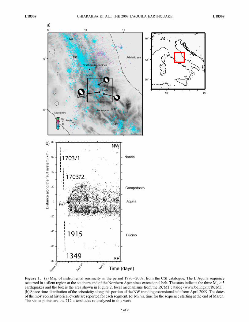
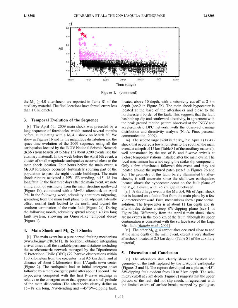
Figure 1. (a) Map of instrumental seismicity in the period 1980–2009, from the CSI catalogue. The L’Aquila sequenceoccurred in a silent region at the southern end of the Northern Apennines extensional belt. The stars indicate the three ML > 5earthquakes and the box is the area shown in Figure 2, focal mechanisms from the RCMT catalog (www.bo.ingv.it/RCMT).(b) Space time distribution of the seismicity along this portion of the NW-trending extensional belt fromApril 2009. The datesof the most recent historical events are reported for each segment. (c)ML vs. time for the sequence starting at the end ofMarch.The violet points are the 712 aftershocks re-analyzed in this work.
L18308 CHIARABBA ET AL.: THE 2009 L’AQUILA EARTHQUAKE L18308
2 of 6
the ML ! 4.0 aftershocks are reported in Table S1 of theauxiliary material. The final locations have formal errors lessthan 1.0 kilometer.
3. Temporal Evolution of the Sequence
[8] The April 6th, 2009 main shock was preceded by along sequence of foreshocks, which started several monthsbefore, culminating with a ML4.1 shock on March 30. Weshow in Figures 1b and 1c the magnitude distribution and thespace-time evolution of the 2009 sequence using all theearthquakes located by the INGV National Seismic Network(RSN) from March 30 to May 15 (about 3200 events, see theauxiliary material). In the week before the April 6th event, acluster of small magnitude earthquakes occurred close to themain shock location. Four hours before the main event, aML3.9 foreshock occurred (fortunately spurring part of thepopulation to pass the night outside buildings). The mainshock rupture activated a NW–SE trending, "15–18 kmlong fault. In the first three days after the main event, we notea migration of seismicity from the main structure northward(Figure 1b), culminated with a Mw5.4 aftershock on April9th. In the following week, seismicity continues migrating,spreading from the main fault plane to an adjacent, laterallyoffset, normal fault located to the north, and toward thesouthern termination of the main fault (Figure 2a). Duringthe following month, seismicity spread along a 40 km longfault system, showing an Omori-like temporal decay(Figure 1).
4. Main Shock and ML !!!!!!!!!!!!!!!!!!!!!!!!!!!!!!!!!!!!!!!!!!!!!!!!!!!!!!!!!!!!!!!!!!!!! 4 Shocks
[9] The main event has a pure normal faulting mechanism(www.bo.ingv.it/RCMT). Its location, obtained integratingarrival times at all the available permanent stations includingthe accelerometric network managed by the Dipartimentodi Protezione Civile (DPC) (79 P-wave observations within130 kilometers from the epicenter) is at 9.5 km depth and atdistance of about 2 kilometers from L’Aquila town center(Figure 2). The earthquake had an initial emergent onsetfollowed by a more energetic pulse after about 1 second. Thehypocenter computed with the first P-wave readings isrelative to the emergent onset that appears as a small preludeof the main dislocation. The aftershocks clearly define an15–18 km long, NW-trending and "45!SW-dipping fault,
located above 10 depth, with a seismicity cut-off at 2 kmdepth (sez-2 in Figure 2b). The main shock hypocenter islocated at the base of the aftershocks and close to thenorthwestern border of the fault. This suggests that the faulthas both up-dip and southward directivity, in agreement withthe peak ground motion pattern observed at the INGV andaccelerometric DPC network, with the observed damagedistribution and directivity analysis (N. A. Pino, personalcommunication, 2009).[10] The second large event is the MW 5.6 April 7 (17:47)
shock that occurred a few kilometers to the south of the mainevent, at a depth of 15 km (Table S1 of the auxiliary material),well constrained by the use of P- and S-wave arrivals at8 close temporary stations installed after the main event. Thefocal mechanism has a not negligible strike slip component.Only a few aftershocks followed this event, and they arelocated around the ruptured patch (sez-3 in Figures 2b and2c). The geometry of this fault, barely illuminated by after-shocks, is still uncertain since the shallower earthquakeslocated above the hypocenter occur on the fault plane ofthe MW6.3 event, with "5 km gap in between.[11] A third large event is the Mw 5.4, 9th of April shock
that is located on a fault offset from the main plane by a fewkilometers northward. Focal mechanisms show a pure normalsolution. The hypocenter is at about 11 km depth and itsaftershocks define a steep SW-dipping plane (sez-1 inFigure 2b). Differently from the April 6 main shock, thereare no events in the top 6 km of the fault, although its uppercontinuation is consistent with the surface trace of the LagaMts. fault [Boncio et al., 2004].[12] The other ML ! 4 earthquakes occurred close to and
at the same depth of the main event, except a very shallowaftershock located at 2.3 km depth (Table S1 of the auxiliarymaterial).
5. Discussion and Conclusion
[13] The aftershock data clearly show the location andgeometry of the fault ruptured by the L’Aquila earthquake(Figures 2 and 3). The rupture developed on a planar, "45!,SW-dipping fault evident from 10 to 2 km depth. The seis-micity cutoff at 2 km depth (Figure 2) suggests that the upperportion of the fault did not slip much, in agreement withthe limited extent of surface breaks mapped by geologists
Figure 1. (continued)
L18308 CHIARABBA ET AL.: THE 2009 L’AQUILA EARTHQUAKE L18308
3 of 6
[Emergeo Working Group, 2009]. In the southern portionof the fault, the seismicity distribution is cloudy (sez-3 inFigure 2b), suggesting a change in the fault plane orientationalong strike or, more likely, the transition to a more distrib-uted deformation on several small faults.[14] The extent of aftershocks near the surface coincides
with an active fault recognized in the field that has a poorlyconstrained geometry, lateral continuity and doubtful seis-mogenic role (the Paganica fault of Bagnaia et al. [1992] orthe ‘‘Aquilano s.l.’’ fault of Boncio et al. [2004]). This poorlyknown fault is located close to other larger Quaternary faultspreviously considered to be the main seismogenic sources ofthe region [Barchi et al., 2000; Galadini and Galli, 2000;DISS Working Group, 2005].[15] Most of the aftershocks occur on the main fault plane
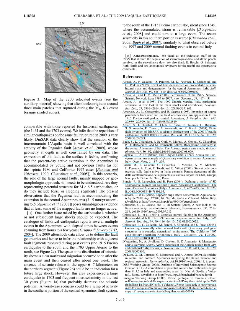
around three patches that, we hypothesize, accounted for the
largest slip during the main shock (the main asperities, seeFigure 3). The aftershock data suggest a size of"10# 6 km2
for the main ruptured patch, whereas the second shallowerpatch is smaller, "5 # 5 km2. The third patch is smaller andlocated northward of the first two. There is also a smallvolume around the main shock hypocenter where aftershocksare absent, probably around the fault portion where the initialonset of the rupture developed. All the largest magnitudeevents (ML ! 4.0) originate at about 11–8 km depth(excluding the 7th April event), and most of them aroundthis volume that can be a compliant part of the fault plane,surrounded by the main asperities. The hypothesized asperitylocation well agrees with the maximum slip areas defined byDinSAR models [Atzori et al., 2009].[16] Macroseismic intensities assigned by immediate
surveys in the epicentral area [Camassi et al., 2009] are
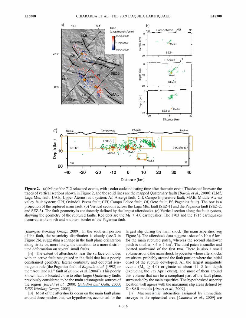
Figure 2. (a)Map of the 712 relocated events, with a color code indicating time after the main event. The dashed lines are thetraces of vertical sections shown in Figure 2, and the solid lines are the mapped Quaternary faults [Barchi et al., 2000]: (LMf,Laga Mts. fault; UAfs, Upper Aterno fault system; Af, Assergi fault; CIf, Campo Imperatore fault; MAfs, Middle Aternovalley fault system; OPf, Ovindoli Pezza fault; CFf, Campo Felice fault; Of, Ocre fault; Pf, Paganica fault). The box is aprojection of the ruptured main fault. (b) Vertical sections across the Laga Mts. fault (SEZ-1) and the Paganica fault (SEZ-2,and SEZ-3). The fault geometry is consistently defined by the largest aftershocks. (c) Vertical section along the fault system,showing the geometry of the ruptured faults. Red dots are the ML ! 4.0 earthquakes. The 1703 and the 1915 earthquakesoccurred at the north and southern border of the Paganica fault.
L18308 CHIARABBA ET AL.: THE 2009 L’AQUILA EARTHQUAKE L18308
4 of 6
comparable with those reported for historical earthquakes(the 1461 and the 1703 events). We infer that the repetition ofsimilar earthquakes on the same fault ruptured in 2009 is verylikely. DinSAR data clearly show that the creation of theintermountain L’Aquila basin is well correlated with theactivity of the Paganica fault [Atzori et al., 2009], whosegeometry at depth is well constrained by our data. Theexpression of this fault at the surface is feeble, confirmingthat the present-day active extension in the Apennines isaccommodated by young and not obvious faults (as forthe Irpinia 1980 and Colfiorito 1997 cases [Pantosti andValensise, 1990; Chiaraluce et al., 2005]). In this scenario,the role of the large normal faults, mainly mapped by geo-morphologic approach, still needs to be understood. Are theyrepresenting potential structure for M > 6.5 earthquakes, ordo they include fossil or creeping segments? The presentobservation that the Paganica fault is accommodating theextension in the central Apennines area (3–5 mm/yr accord-ing toD’Agostino et al. [2008]) poses unambiguous evidencethat at least some of the mapped faults are no longer active.[17] One further issue raised by the earthquake is whether
or not subsequent large shocks should be expected. Thecatalogue of historical earthquakes reports several multipleevents in the Apennines, with elapsed times between eventsspanning from hours to a few years [Gruppo di Lavoro CPTI,2004]. The 2009 aftershock data allow us to define the faultgeometries and hence to infer the relationship with adjacentfault segments ruptured during past events (the 1915 Fucinoearthquake to the south and the 1703 Upper Aterno to thenorth, see Figure 2c). The space-time distribution of seismic-ity shows a clear northward migration occurred soon after themain event and then ceased after about one week. Theabsence of seismic release in the upper 6–7 kilometers onthe northern segment (Figure 2b) could be an indication for afuture large shock. However, this area experienced a largeearthquake in 1703 and frequent microseismicity in the last30 years (Figure 1a) that probably decrease the seismicpotential. A worst-case scenario could be a jump of activityin the southern portion of the central Apennines fault system,
to the south of the 1915 Fucino earthquake, silent since 1349,where the accumulated strain is remarkable [D’Agostinoet al., 2008] and could turn to a large event. The recentseismicity in this southern portion is scarce [Chiarabba et al.,2005; Bagh et al., 2007], similarly to what observed beforethe 1997 and 2009 normal faulting events in central Italy.
[18] Acknowledgments. We thank all the technician staff of theINGV that allowed the acquisition of seismological data, and all the peopleinvolved in the surveillance duty. We also thank E. Boschi, G. Selvaggi,Ruth Harris and two anonymous reviewers for the useful and constructivecomments.
ReferencesAkinci, A., F. Galadini, D. Pantosti, M. D. Petersen, L. Malagnini, andD. Perkins (2009), Effect of time dependence on probabilistic seismic-hazard maps and deaggregation for the central Apennines, Italy, Bull.Seismol. Soc. Am., 99, 585–610, doi:10.1785/0120080053.
Amato, A., and F. M. Mele (2008), Performance of the INGV NationalSeismic Network from 1997 to 2007, Ann. Geophys., 51, 417–431.
Amato, A., et al. (1998), The 1997 Umbria-Marche, Italy, earthquakesequence: A first look at the main shocks and aftershocks, Geophys.Res. Lett., 25, 2861–2864, doi:10.1029/98GL51842.
Amoruso, A., L. Crescentini, and R. Scarpa (1998), Inversion of sourceparameters from near and far field observations: An application to the1915 Fucino earthquakes, central Apennines, J. Geophys. Res., 103,29,989–29,999, doi:10.1029/98JB02849.
Atzori, S., I. Hunstad, M. Chini, S. Salvi, C. Tolomei, C. Bignami,S. Stramondo, E. Trasatti, A. Antonioli, and E. Boschi (2009), Finitefault inversion of DInSAR coseismic displacement of the 2009 L’Aquilaearthquake (central Italy), Geophys. Res. Lett., 36, L15305, doi:10.1029/2009GL039293.
Bagh, S., L. Chiaraluce, P. De Gori, M. Moretti, A. Govoni, C. Chiarabba,P. Di Bartolomeo, and M. Romanelli (2007), Background seismicity inthe central Apennines of Italy: The Abruzzo region case study, Tectono-physics, 444, 80–92, doi:10.1016/j.tecto.2007.08.009.
Bagnaia, R., A. D’Epifanio, and S. Sylos Labini (1992), Aquila and Sub-equan basins: An example of Quaternary evolution in central Apennines,Italy, Quat. Nova, 2, 187–209.
Barchi, M., F. Galadini, G. Lavecchia, P. Messina, A. M. Michetti,L. Peruzza, A. Pizzi, E. Tondi, and E. Vittori (2000), Sintesi delle con-oscenze sulle faglie attive in Italia centrale: Parametrizzazione ai finidella caratterizzazione della pericolosita sismica, report for CNR, GruppoNaz. per la Difesa dai Terr., Rome.
Boncio, P., G. Lavecchia, and B. Pace (2004), Defining a model of 3Dseismogenic sources for Seismic Hazard Assessment applications: Thecase of central Apennines (Italy), J. Seismol., 8, 407–425, doi:10.1023/B:JOSE.0000038449.78801.05.
Camassi, R., et al. (2009), Rapporto sugli effetti del terremoto Aquilano del6 Aprile 2009, Rep. RPT03, Ist. Naz. di Geofis. e Vulcanol., Milan, Italy.(Available at http://www.mi.ingv.it/eq/090406/quest.html)
Chiarabba, C., L. Jovane, and R. Di Stefano (2005), A new look to theItalian seismicity: Seismotectonic inference, Tectonophysics, 395, 251–268, doi:10.1016/j.tecto.2004.09.013.
Chiaraluce, L., et al. (2004), Complex normal faulting in the Apenninesthrust-and-fold belt: The 1997 seismic sequence in central Italy, Bull.Seismol. Soc. Am., 94, 99–116, doi:10.1785/0120020052.
Chiaraluce, L., C. Collettini, M. Barchi, F. Mirabella, and S. Pucci (2005),Connecting seismically active normal faults with Quaternary geologicalstructures in a complex extensional environment: The Colfiorito 1997case history (northern Apennines, Italy), Tectonics, 24, TC1002,doi:10.1029/2004TC001627.
D’Agostino, N., A. Avallone, D. Cheloni, E. D’Anastasio, S. Mantenuto,and G. Selvaggi (2008), Active tectonics of the Adriatic region from GPSand earthquake slip vectors, J. Geophys. Res., 113, B12413, doi:10.1029/2008JB005860.
De Luca, G., M. Cattaneo, G. Monachesi, and A. Amato (2009), Seismicityin central and northern Apennines integrating the Italian national andregional networks, Tectonophysics, doi:10.1016/j.tecto.2008.11, in press.
DISS Working Group (2005), Database of Individual Seismogenic Sources(version 3.0.1): A compilation of potential sources for earthquakes largerthan M 5.5 in Italy and surrounding areas, Ist. Naz. di Geofis. e Vulca-nol., Rome. (Available at http://www.ingv.it/banchedati/banche.html)
Emergeo Working Group (2009), Rilievi geologici di terreno effettuatinell’area epicentrale della sequenza sismica dell’Aquilano del 6 aprile 2009(in Italian), Ist. Naz. di Geofis. e Vulcanol., Rome. (Available at http://portale.ingv.it/primo-piano/archivio-primo-piano/notizie-2009/terremoto-6-aprile/copy_of_la-sequenza-sismica-dell-aquilano-aprile-2009/)
Figure 3. Map of the 3200 relocated events (see theauxiliary material) showing that aftershocks originate aroundthree main patches that ruptured during the MW 6.3 event(orange shaded zones).
L18308 CHIARABBA ET AL.: THE 2009 L’AQUILA EARTHQUAKE L18308
5 of 6
Galadini, F., and P. Galli (2000), Active tectonics in the central Apennines(Italy)—Input data for seismic hazard assessment, Nat. Hazards, 22,225–270, doi:10.1023/A:1008149531980.
Galli, P., F. Galadini, M. Moro, and C. Giraudi (2002), New paleoseismo-logical data from the Gran Sasso d’Italia area (central Apennines),Geophys. Res. Lett., 29(7), 1134, doi:10.1029/2001GL013292.
Gruppo di Lavoro CPTI (2004), Catalogo Parametrico dei TerremotiItaliani, versione 2004, Rep. CPTI04, Ist. Naz. di Geofis. e Vulcanol.,Bologna, Italy.
Lahr, J. C. (1989), HYPOELLIPSE/Version 2.0: A computer program fordetermining local earthquake hypocentral parameters, magnitude, andfirst motion pattern, U.S. Geol. Surv. Open File Rep., 89-116, 92 pp.
Pantosti, D., and G. Valensise (1990), Fault mechanism and complexity ofthe November, 23, 1980, Campania-Lucania earthquake, inferred fromsurface observations, J. Geophys. Res., 95, 15,319–15,341, doi:10.1029/JB095iB10p15319.
Pantosti, D., G. D’Addezio, and F. Cinti (1996), Paleoseismicity of theOvindoli-Pezza fault, central Apennines, Italy: A history including a largepreviously unrecorded earthquake in the Middle Age (860–1300 A.D.),J. Geophys. Res., 101, 5937–5959, doi:10.1029/95JB03213.
Papanikolaou, I. D., G. P. Roberts, and A. M. Michetti (2005), Fault scarpsand deformation rates in Lazio-Abruzzo, central Italy: Comparison be-tween geological fault slip rate and GPS data, Tectonophysics, 408, 147–176, doi:10.1016/j.tecto.2005.05.043.
Roberts, G., and A. M. Michetti (2004), Spatial and temporal variationsin growth rates along active normal fault systems: An example from theLazio Abruzzo Apennines, central Italy, J. Struct. Geol., 26, 339–376,doi:10.1016/S0191-8141(03)00103-2.
$$$$$$$$$$$$$$$$$$$$$$$A. Amato, M. Anselmi, P. Baccheschi, I. Bianchi, M. Cattaneo, G. Cecere,
C. Chiarabba, L. Chiaraluce, M. G. Ciaccio, P. De Gori, G. De Luca,M. Di Bona, R. Di Stefano, L. Faenza, A. Govoni, L. Improta, F. P.Lucente, A. Marchetti, L. Margheriti, F. Mele, A. Michelini, G. Monachesi,M. Moretti, M. Pastori, N. Piana Agostinetti, D. Piccinini, P. Roselli,D. Seccia, and L. Valoroso, Istituto Nazionale di Geofisica e Vulcanologia,Via di Vigna Murata 605, I-00143 Rome, Italy. ([email protected])
L18308 CHIARABBA ET AL.: THE 2009 L’AQUILA EARTHQUAKE L18308
6 of 6
Copyright © 2022 FDOKUMEN