Technical Guidance for INSPIRE Spatial Data Services and ...
43
INSPIRE Infrastructure for Spatial Information in Europe Technical Guidance for INSPIRE Spatial Data Services and services allowing spatial data services to be invoked Drafting Team “Network Services” Title Technical Guidance for INSPIRE Spatial Data Services and services allowing spatial data services to be invoked Creator Network Services Drafting Team Date 02-08-2012 Subject Technical Guidance for INSPIRE Spatial Data Services and services allowing spatial data services to be invoked Status Draft Publisher Network Services Drafting Team Type Text Description This document defines technical guidance for INSPIRE Spatial Data Services and services allowing spatial data services to be invoked Format MS Word (doc) Source Network Services Drafting Team Rights Public Identifier Draft TG for INSPIRE SDS and invoke 1.0.doc Language EN Relation Not applicable Coverage Project duration
-
Upload
khangminh22 -
Category
Documents
-
view
1 -
download
0
Transcript of Technical Guidance for INSPIRE Spatial Data Services and ...

INSPIRE
Infrastructure for Spatial Information in Europe
Technical Guidance for INSPIRE Spatial Data Services and services allowing spatial data services to be invoked
Drafting Team “Network Services”
Title Technical Guidance for INSPIRE Spatial Data Services and services allowing spatial data services to be invoked
Creator Network Services Drafting Team
Date 02-08-2012
Subject Technical Guidance for INSPIRE Spatial Data Services and services allowing spatial data services to be invoked
Status Draft
Publisher Network Services Drafting Team
Type Text
Description This document defines technical guidance for INSPIRE Spatial Data Services and services allowing spatial data services to be invoked
Format MS Word (doc)
Source Network Services Drafting Team
Rights Public
Identifier Draft TG for INSPIRE SDS and invoke 1.0.doc
Language EN
Relation Not applicable
Coverage Project duration
INSPIRE Technical Guidance for INSPIRE Spatial Data Services
and services allowing spatial data services to be invoked
02-08-2012 Page 2 of 43
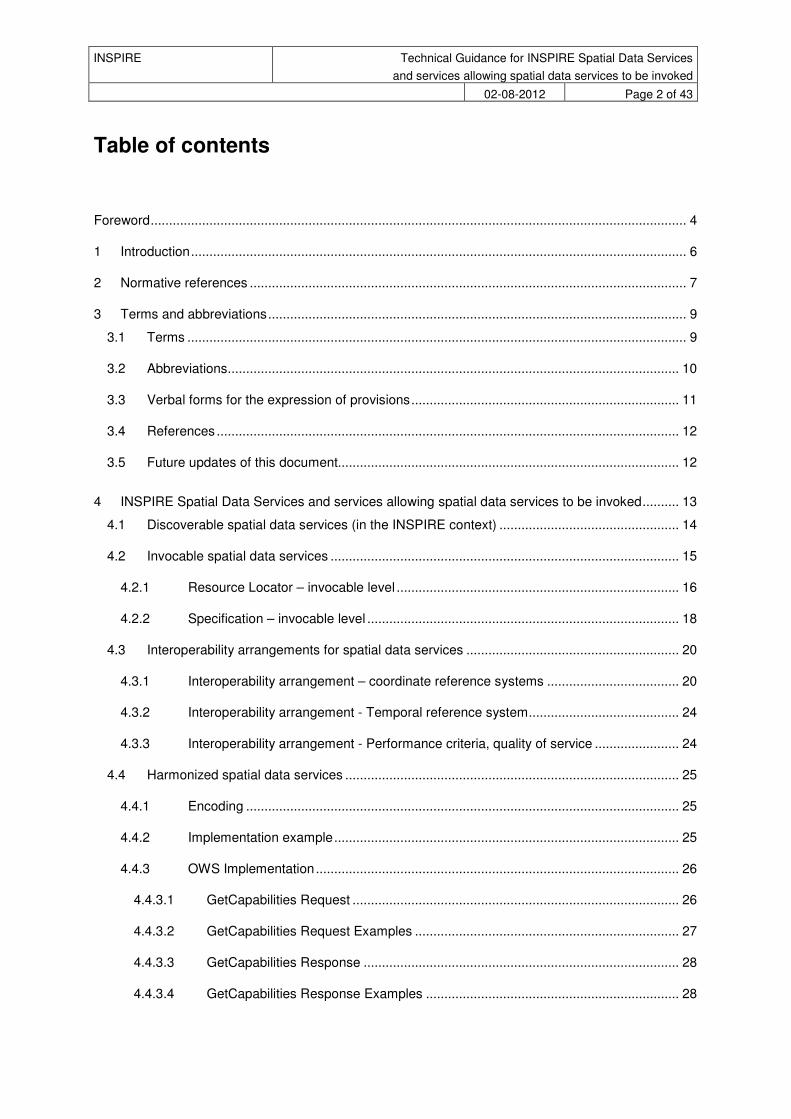
Table of contents
Foreword .................................................................................................................................................. 4
1 Introduction ....................................................................................................................................... 6
2 Normative references ....................................................................................................................... 7
3 Terms and abbreviations .................................................................................................................. 9
3.1 Terms ........................................................................................................................................ 9
3.2 Abbreviations........................................................................................................................... 10
3.3 Verbal forms for the expression of provisions ......................................................................... 11
3.4 References .............................................................................................................................. 12
3.5 Future updates of this document............................................................................................. 12
4 INSPIRE Spatial Data Services and services allowing spatial data services to be invoked .......... 13
4.1 Discoverable spatial data services (in the INSPIRE context) ................................................. 14
4.2 Invocable spatial data services ............................................................................................... 15
4.2.1 Resource Locator – invocable level ............................................................................. 16
4.2.2 Specification – invocable level ..................................................................................... 18
4.3 Interoperability arrangements for spatial data services .......................................................... 20
4.3.1 Interoperability arrangement – coordinate reference systems .................................... 20
4.3.2 Interoperability arrangement - Temporal reference system ......................................... 24
4.3.3 Interoperability arrangement - Performance criteria, quality of service ....................... 24
4.4 Harmonized spatial data services ........................................................................................... 25
4.4.1 Encoding ...................................................................................................................... 25
4.4.2 Implementation example .............................................................................................. 25
4.4.3 OWS Implementation ................................................................................................... 26
4.4.3.1 GetCapabilities Request ......................................................................................... 26
4.4.3.2 GetCapabilities Request Examples ........................................................................ 27
4.4.3.3 GetCapabilities Response ...................................................................................... 28
4.4.3.4 GetCapabilities Response Examples ..................................................................... 28
INSPIRE Technical Guidance for INSPIRE Spatial Data Services
and services allowing spatial data services to be invoked
02-08-2012 Page 3 of 43
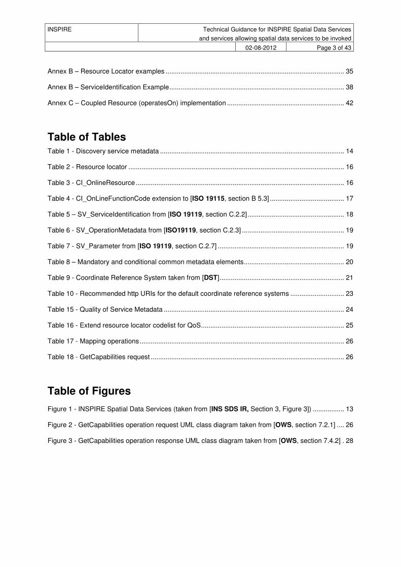
Annex B – Resource Locator examples ................................................................................................ 35
Annex B – ServiceIdentification Example .............................................................................................. 38
Annex C – Coupled Resource (operatesOn) implementation ............................................................... 42
Table of Tables Table 1 - Discovery service metadata ................................................................................................... 14
Table 2 - Resource locator .................................................................................................................... 16
Table 3 - CI_OnlineResource ................................................................................................................ 16
Table 4 - CI_OnLineFunctionCode extension to [ISO 19115, section B 5.3] ........................................ 17
Table 5 – SV_ServiceIdentification from [ISO 19119, section C.2.2] .................................................... 18
Table 6 - SV_OperationMetadata from [ISO19119, section C.2.3] ....................................................... 19
Table 7 - SV_Parameter from [ISO 19119, section C.2.7] .................................................................... 19
Table 8 – Mandatory and conditional common metadata elements ...................................................... 20
Table 9 - Coordinate Reference System taken from [DST] ................................................................... 21
Table 10 - Recommended http URIs for the default coordinate reference systems ............................. 23
Table 15 - Quality of Service Metadata ................................................................................................. 24
Table 16 - Extend resource locator codelist for QoS ............................................................................. 25
Table 17 - Mapping operations .............................................................................................................. 26
Table 18 - GetCapabilities request ........................................................................................................ 26
Table of Figures
Figure 1 - INSPIRE Spatial Data Services (taken from [INS SDS IR, Section 3, Figure 3]) ................. 13
Figure 2 - GetCapabilities operation request UML class diagram taken from [OWS, section 7.2.1] .... 26
Figure 3 - GetCapabilities operation response UML class diagram taken from [OWS, section 7.4.2] . 28

INSPIRE Technical Guidance for INSPIRE Spatial Data Services
and services allowing spatial data services to be invoked
02-08-2012 Page 4 of 43
Foreword
Directive 2007/2/EC of the European Parliament and of the Council [Directive 2007/2/EC], adopted on 14 March 2007 aims at establishing an Infrastructure for Spatial Information in the European Community (INSPIRE) for environmental policies, or policies and activities that have an impact on the environment. INSPIRE will make available relevant, harmonised and quality geographic information to support the formulation, implementation, monitoring and evaluation of policies and activities, which have a direct or indirect impact on the environment.
INSPIRE is based on the infrastructures for spatial information established and operated by the 27 Member States of the European Union. The Directive addresses 34 spatial data themes needed for environmental applications, with key components specified through technical implementing rules. This makes INSPIRE a unique example of a legislative “regional” approach.
To ensure that the spatial data infrastructures of the Member States are compatible and usable in a Community and trans-boundary context, the Directive requires that common Implementing Rules (IR) are adopted in the following areas.
• Metadata;
• The interoperability and harmonisation of spatial data and services for selected themes (as described in Annexes I, II, III of the Directive);
• Network Services;
• Measures on sharing spatial data and services;
• Co-ordination and monitoring measures.
The Implementing Rules are adopted as Commission Decisions or Regulations, and are binding in their entirety.
In particular with respect the Network Services, Implementing Rules are required for the following services (Article 11(1) of the Directive):
a) “discovery services search for spatial datasets and spatial data services on the basis of the content of corresponding metadata, and display the metadata content;
b) view services as a minimum, display, navigate, zoom in/out, pan, or overlay spatial datasets and display legend information and any relevant content of metadata;
c) download services enabling copies of complete spatial datasets, or of parts of such sets, to be downloaded;
d) transformation services enabling spatial datasets to be transformed with a view to achieving interoperability;
e) invoke spatial data services" enabling data services to be invoked.”
In addition to the Implementing Rules, non-binding Technical Guidance documents describe detailed implementation aspects and relations with existing standards, technologies, and practices. They may need to be revised during the course of implementing the infrastructure to take into account the evolution of technology, new requirements, and cost benefit considerations.
Technical Guidance documents define how Member States might implement the Implementing Rules described in a Commission Regulation. Technical Guidance documents may include non-binding technical requirements that must be satisfied if a Member State chooses to conform to the Technical Guidance. Implementing this technical guidance will maximise the interoperability of INSPIRE services.
This Technical Guidance concerns the INSPIRE Spatial Data Services and services allowing spatial data services to be invoked. The Technical Guidance contains detailed technical documentation

INSPIRE Technical Guidance for INSPIRE Spatial Data Services
and services allowing spatial data services to be invoked
02-08-2012 Page 5 of 43
highlighting the mandatory and the recommended elements related to the implementation of INSPIRE Spatial Data Services and services allowing spatial data services to be invoked. The technical provisions and the underlying concepts are often illustrated by use case diagrams and accompanied by examples.
This document will be publicly available as a ‘non-paper’, as it does not represent an official position of the Commission, and as such cannot be invoked in the context of legal procedures.
Legal Notice
Neither the European Commission nor any person acting on behalf of the Commission is responsible for the use which might be made of this publication.

INSPIRE Technical Guidance for INSPIRE Spatial Data Services
and services allowing spatial data services to be invoked
02-08-2012 Page 6 of 43
1 Introduction
Directive 2007/2/EC of the European Parliament and of the Council of 14 March 2007 establishing an Infrastructure for Spatial Information in the European Community (INSPIRE) was published in the official Journal on the 25
th April 2007. The INSPIRE Directive entered into force on the 15
th May 2007.
The purpose of the infrastructure is to enable the formulation, implementation, monitoring activities and evaluation of Community environmental policies at all levels – European, national and local – and to provide public information.
INSPIRE builds on the infrastructures for spatial information that have already been created by the Member States. The components of those infrastructures include: metadata, spatial data themes (as described in Annexes I, II, III of the Directive), network services and technologies; agreements on data sharing, access and use; coordination and monitoring mechanisms, processes and procedures.
The guiding principles of INSPIRE are:
• that the infrastructures for spatial information in the Member States should be designed to ensure that spatial data are stored, made available and maintained at the most appropriate level;
• that it is possible to combine spatial data from different sources across the Community in a consistent way and share them between several users and applications;
• that it is possible for spatial data collected at one level of public authority to be shared between all the different levels of public authorities;
• that spatial data are made available under conditions that do not restrict their extensive use; and
• that it is easy to discover available spatial data, to evaluate their fitness for purpose and to know the conditions applicable to their use.
The text of the INSPIRE Directive is available from the European Union Law website (EU-LEX) http://eur-lex.europa.eu/LexUriServ/LexUriServ.do?uri=CELEX:32007L0002:EN:NOT. The Directive identifies what needs to be achieved, and Member States have two years from the date of adoption to bring into force national legislation, regulations, and administrative procedures that define how the agreed objectives will be met taking into account the specific situation of each Member State. To ensure that the spatial data infrastructures of the Member States are compatible and usable in a Community and trans-boundary context, the Directive requires that common Implementing Rules (IR) are adopted in a number of specific areas. Implementing Rules are adopted as Commission Decisions, and are binding in their entirety.
According to Article 5(4) of the Directive, the INSPIRE Implementing Rules shall take account of relevant, existing international standards and user requirements.
The scope of this document is to detail the INSPIRE technical requirements for Spatial Data Services and services allowing spatial data services to be invoked from the Implementing Rules, such that these services can be implemented consistently across Europe. These Implementing Rules are, as much as possible, in conformance with European and international standards, current practices in stakeholder communities and relevant European initiatives such as e-Government, and the EU interoperability framework.
This document will be publicly available as a ‘non-paper’, as it does not represent an official position of the Commission, and as such can not be invoked in the context of legal procedures.

INSPIRE Technical Guidance for INSPIRE Spatial Data Services
and services allowing spatial data services to be invoked
02-08-2012 Page 7 of 43
2 Normative references
The following referenced documents are indispensable for the application of this document. For dated references, only the edition cited applies. For undated references, the latest edition of the referenced document (including any amendments) applies.
[ISO 19115] ISO 19115:2003, Geographic information – Metadata – Part 1: Fundamentals http://www.iso.org/iso/catalogue_detail.htm?csnumber=26020 [ISO 19119] ISO 19119:2005, Geographic information – Services http://www.iso.org/iso/catalogue_detail.htm?csnumber=39890 [ISO 19139] ISO/TS 19139:2007, Geographic information – Metadata – XML schema
implementation http://www.iso.org/iso/catalogue_detail.htm?csnumber=32557 [ISO 19108] ISO 19108:2002, Geographic information - Temporal schema http://www.iso.org/iso/home/store/catalogue_tc/catalogue_detail.htm?csnumber=2601
3 [ISO 19111] ISO 19111:2007, Geographic information - Spatial referencing by coordinates http://www.iso.org/iso/home/store/catalogue_tc/catalogue_detail.htm?csnumber=4112
6 [ISO 19127] ISO/TS 19127:2005, Geographic information - Geodetic codes and parameters http://www.iso.org/iso/home/store/catalogue_tc/catalogue_detail.htm?csnumber=4178
4 [ISO 8601] ISO 8601:2004 Data elements and interchange formats - Information interchange -
Representation of dates and times http://www.iso.org/iso/catalogue_detail?csnumber=40874 [ISO 19157] ISO/DIS 19157 Geographic information -- Data quality http://www.iso.org/iso/home/store/catalogue_tc/catalogue_detail.htm?csnumber=3257
5 [INS SDS IR] INSPIRE Spatial Data Services and services allowing spatial data services to be
invoked – Implementing Rules v 2.0 [INS DS TG] INSPIRE Technical Guidance for the implementation of Inspire Dispovery Services v
3.1 http://inspire.jrc.ec.europa.eu/documents/Network_Services/TechnicalGuidance_Disco
veryServices_v3.1.pdf [INS MDTG] INSPIRE Metadata Implementing Rules: Technical Guidelines based on EN ISO
19115 and EN ISO 19119 v 1.2 http://inspire.jrc.ec.europa.eu/documents/Metadata/INSPIRE_MD_IR_and_ISO_v1_2_
20100616.pdf [OWS] OpenGIS Web Service Common Implementation Specification 1.1.0 https://portal.opengeospatial.org/modules/admin/license_agreement.php?suppressHe
aders=0&access_license_id=3&target=http://portal.opengeospatial.org/files/%3fartifact_id=20040

INSPIRE Technical Guidance for INSPIRE Spatial Data Services
and services allowing spatial data services to be invoked
02-08-2012 Page 8 of 43
[INS NS] Commission Regulation (EC) No 976/2009 of 19 October 2009 implementing Directive 2007/2/EC of the European Parliament and of the Council as regards the Network Services
http://eur-lex.europa.eu/LexUriServ/LexUriServ.do?uri=OJ:L:2009:274:0009:0018:EN:PDF
[DST] Common document template providing for all INSPIRE Data Specifications
(http://inspire.jrc.ec.europa.eu/index.cfm/pageid/2 ). See e.g. section 8 in the Data Specification on Oceanographic geographical features – Draft Guidelines (http://inspire.jrc.ec.europa.eu/documents/Data_Specifications/INSPIRE_DataSpecification_OF_v3.0_rc2.pdf )
INSPIRE Technical Guidance for INSPIRE Spatial Data Services
and services allowing spatial data services to be invoked
02-08-2012 Page 9 of 43
3 Terms and abbreviations
3.1 Terms
(1) Spatial Data Services and services allowing spatial data services to be invoked allows defining both the data inputs and data outputs expected by the spatial services and a workflow or service chain combining multiple services. It also allows defining the external web service interface of the workflow or service chain [INSPIRE Directive] (2) metadata information describing spatial datasets and spatial data services and making it possible to discover, inventory and use them [INSPIRE Directive] (3) network services network services should make it possible to discover, transform, view and download spatial data and to invoke spatial data and e-commerce services [INSPIRE Directive] (4) spatial data data with a direct or indirect reference to a specific location or geographic area [INSPIRE Directive] (5) spatial dataset identifiable collection of spatial data [INSPIRE Directive] (6) dataset short term sometimes used instead of ‘spatial dataset’, same meaning as ‘spatial dataset’.

INSPIRE Technical Guidance for INSPIRE Spatial Data Services
and services allowing spatial data services to be invoked
02-08-2012 Page 10 of 43
3.2 Abbreviations
CRS Coordinate Reference System
FE Filter Encoding, referring to ISO 19143
GeoRSS GeoRSS-Simple
GET HTTP Get Method
GML Geography Markup Language
HTTP Hypertext Transfer Protocol
INSPIRE Infrastructure for Spatial Information in Europe
IR Implementing Rule
ISO International Organisation for Standardisation
JRC Joint Research Centre
NS Network Services
OGC Open Geospatial Consortium
OWS OGC Web Services Common Specification

INSPIRE Technical Guidance for INSPIRE Spatial Data Services
and services allowing spatial data services to be invoked
02-08-2012 Page 11 of 43
3.3 Verbal forms for the expression of provisions
In accordance with the ISO rules for drafting, the following verbal forms shall be interpreted in the given way:
• “shall” / “shall not”: a requirement, mandatory to comply with the technical guidance
• “should” / “should not”: a recommendation, but an alternative approach may be chosen for
a specific case if there are reasons to do so
• “may” / “need not”: a permission
Technical Guidance Conformance Classes notation
The Technical Guidance in this document is divided into Conformance Classes, so that it is possible to declare conformance to specific parts of the Technical Guidance. To conform to a Conformance Class it is necessary to meet all of the Requirements (see next section) in that Conformance Class.
Conformance Classes are identified in the document as follows:
TG Conformance Class #: [TITLE] conformance classes are shown using this style
Technical Guidance Requirements and Recommendations notation
Requirements and the recommendations for INSPIRE Spatial Data Services and services allowing spatial data services to be invoked within this technical guidance are highlighted and numbered as shown below:
TG Requirement #requirements are shown using this style
TG Recommendation #recommendations are shown using this style.
It is important to note that, implementation requirements and implementation recommendations may refer to either service or client implementations. Requirements and recommendations belong to the conformance class in which they are found in this document.
Note: It is worth noting that requirements as specified in the INSPIRE Regulations and Implementing Rules are legally binding, and that requirements and recommendations as specified in INSPIRE Technical Guidance are not legally binding. Therefore, within this technical guidance we have used the terms ‘TG requirement’ and ‘TG recommendation’ to indicate what is technically required or recommended to conform to the Technical Guidance.
XML Example notation
XML Examples are shown using Courier New on a grey background with yellow for emphasis as below:
<inspire:example>
<inspire:highlight>
Highlighted Text for emphasis
</inspire:highlight>

INSPIRE Technical Guidance for INSPIRE Spatial Data Services
and services allowing spatial data services to be invoked
02-08-2012 Page 12 of 43
</inspire:example>
Note: XML Examples are informative and are provided for information only and are expressly not normative.
3.4 References
References within this document are denoted using “Section” or “Annex”. For example, Section 5.3.1 or Annex A.
References to other documents refer to the list of normative references in Section 3 and use the abbreviated title as indicated in Bold text. For example, [INS NS] uses the abbreviated title for the document as shown below:
INSPIRE Network Services Regulation, INS NS, COMMISSION REGULATION (EU) No 1088/2010 of 23 November 2010 amending Regulation (EC) No 976/2009 as regards download services and transformation services
References within other documents are shown as above using the abbreviated title, together with the appropriate section within the document. For example, [INS NS, Section 2.2.3], refers to Section 2.2.3 within the document as listed above.
3.5 Future updates of this document
There are some issues that are foreseen, but are not covered or only partially covered in this version of the Technical Guidance.
INSPIRE Technical Guidance for INSPIRE Spatial Data Services
and services allowing spatial data services to be invoked
02-08-2012 Page 13 of 43
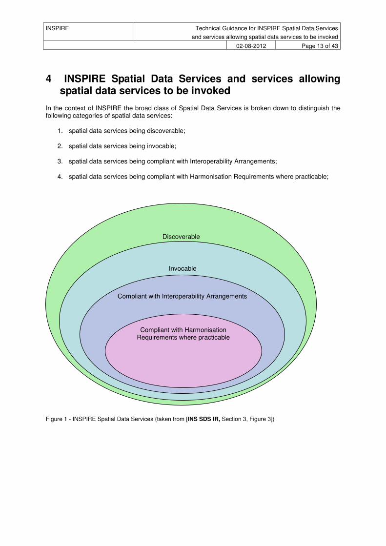
4 INSPIRE Spatial Data Services and services allowing spatial data services to be invoked
In the context of INSPIRE the broad class of Spatial Data Services is broken down to distinguish the following categories of spatial data services:
1. spatial data services being discoverable;
2. spatial data services being invocable;
3. spatial data services being compliant with Interoperability Arrangements;
4. spatial data services being compliant with Harmonisation Requirements where practicable;
Discoverable
Invocable
Compliant with Interoperability Arrangements
Compliant with Harmonisation Requirements where practicable
Figure 1 - INSPIRE Spatial Data Services (taken from [INS SDS IR, Section 3, Figure 3])
INSPIRE Technical Guidance for INSPIRE Spatial Data Services
and services allowing spatial data services to be invoked
02-08-2012 Page 14 of 43
4.1 Discoverable spatial data services (in the INSPIRE context)
TG Conformance Class 1: Implementation of Discoverable spatial data services
This conformance class is inclusive of:
TG Requirement 1
Making spatial data services discoverable does not bring any other obligation than creation of metadata. In particular there are no quality of service requirements that have to be met and there is no obligatory quality of service information in the metadata record.
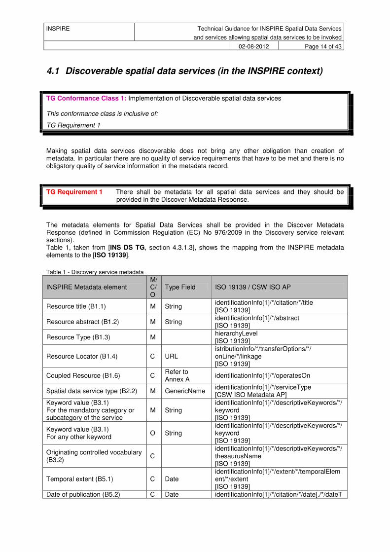
TG Requirement 1 There shall be metadata for all spatial data services and they should be provided in the Discover Metadata Response.
The metadata elements for Spatial Data Services shall be provided in the Discover Metadata Response (defined in Commission Regulation (EC) No 976/2009 in the Discovery service relevant sections). Table 1, taken from [INS DS TG, section 4.3.1.3], shows the mapping from the INSPIRE metadata elements to the [ISO 19139].
Table 1 - Discovery service metadata
INSPIRE Metadata element M/ C/ O
Type Field ISO 19139 / CSW ISO AP
Resource title (B1.1) M String identificationInfo[1]/*/citation/*/title [ISO 19139]
Resource abstract (B1.2) M String identificationInfo[1]/*/abstract [ISO 19139]
Resource Type (B1.3) M hierarchyLevel [ISO 19139]
Resource Locator (B1.4) C URL istributionInfo/*/transferOptions/*/ onLine/*/linkage [ISO 19139]
Coupled Resource (B1.6) C Refer to Annex A
identificationInfo[1]/*/operatesOn
Spatial data service type (B2.2) M GenericName identificationInfo[1]/*/serviceType [CSW ISO Metadata AP]
Keyword value (B3.1) For the mandatory category or subcategory of the service
M String identificationInfo[1]/*/descriptiveKeywords/*/keyword [ISO 19139]
Keyword value (B3.1) For any other keyword
O String identificationInfo[1]/*/descriptiveKeywords/*/keyword [ISO 19139]
Originating controlled vocabulary (B3.2)
C identificationInfo[1]/*/descriptiveKeywords/*/thesaurusName [ISO 19139]
Temporal extent (B5.1) C Date identificationInfo[1]/*/extent/*/temporalElement/*/extent [ISO 19139]
Date of publication (B5.2) C Date identificationInfo[1]/*/citation/*/date[./*/dateT
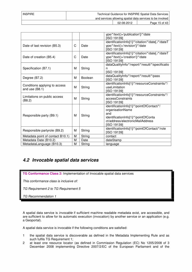
INSPIRE Technical Guidance for INSPIRE Spatial Data Services
and services allowing spatial data services to be invoked
02-08-2012 Page 15 of 43
ype/*/text()='publication']/*/date [ISO 19139]
Date of last revision (B5.3) C Date identificationInfo[1]/*/citation/*/date[./*/dateType/*/text()='revision']/*/date [ISO 19139]
Date of creation (B5.4) C Date identificationInfo[1]/*/citation/*/date[./*/dateType/*/text()='creation']/*/date [ISO 19139]
Specification (B7.1) M String dataQualityInfo/*/report/*/result/*/specification [ISO 19139]
Degree (B7.2) M Boolean dataQualityInfo/*/report/*/result/*/pass [ISO 19139]
Conditions applying to access and use (B8.1)
M String identificationInfo[1]/*/resourceConstraints/*/useLimitation [ISO 19139]
Limitations on public access (B8.2)
M String identificationInfo[1]/*/resourceConstraints/*/accessConstraints [ISO 19139]
Responsible party (B9.1) M String
identificationInfo[1]/*/pointOfContact/*/ organisationName and identificationInfo[1]/*/pointOfConta ct/address/electronicMailAddress [ISO 19139]
Responsible partyrole (B9.2) M String identificationInfo[1]/*/pointOfContact/*/role [ISO 19139]
Metadata point of contact B10.1) M String contact
Metadata Date (B10.2) M Date dateStamp
MetadataLanguage (B10.3) M String language
4.2 Invocable spatial data services
TG Conformance Class 2: Implementation of Invocable spatial data services
This conformance class is inclusive of:
TG Requirement 2 to TG Requirement 5
TG Recommendation 1
A spatial data service is invocable if sufficient machine readable metadata exist, are accessible, and are sufficient to allow for its automatic execution (invocation) by another service or an application (e.g. a Geoportal).
A spatial data service is invocable if the following conditions are satisfied:
1 the spatial data service is discoverable as defined in the Metadata Implementing Rule and as such fulfils TG Requirement 1;
2 at least one resource locator (as defined in Commission Regulation (EC) No 1205/2008 of 3 December 2008 implementing Directive 2007/2/EC of the European Parliament and of the
INSPIRE Technical Guidance for INSPIRE Spatial Data Services
and services allowing spatial data services to be invoked
02-08-2012 Page 16 of 43
Council as regards metadata) for the spatial data service needs to be provided (refer to Section 4.2.1);
3 the resource locator defines an activation point and shall be a URL (refer to section 4.2.1); 4 a spatial data service belongs into one of the categories 200, 300, 400, 500, 600, 700, 800 as
defined in part D.4 of Commission Regulation (EC) No 1205/2008 of 3 December 2008 implementing Directive 2007/2/EC of the European Parliament and of the Council as regards metadata;
5 the spatial data service is conformant to either a standardized specification or well documented specification (e.g. ISO, OGC):
5.1 thus respective metadata entry on ‘conformance’ (as defined in the Metadata Implementing Rule) is set to ‘conformant’
5.2 The cited specification (see Commission Regulation (EC) No 1205/2008 of 3 December 2008 implementing Directive 2007/2/EC of the European Parliament and of the Council as regards metadata) corresponds to the implementing rules adopted under Article 7(1) of Directive 2007/2/EC or of a specification providing all necessary descriptions (human or machine readable) to allow for an automated invocation of the described service;
6 the spatial data service has a well-documented and accessible description
Metadata elements that need to be provided for invocable services are described below.
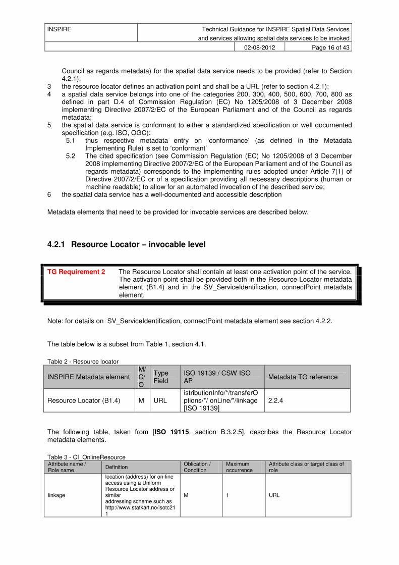
4.2.1 Resource Locator – invocable level
TG Requirement 2 The Resource Locator shall contain at least one activation point of the service. The activation point shall be provided both in the Resource Locator metadata element (B1.4) and in the SV_ServiceIdentification, connectPoint metadata element.
Note: for details on SV_ServiceIdentification, connectPoint metadata element see section 4.2.2. The table below is a subset from Table 1, section 4.1.
Table 2 - Resource locator
INSPIRE Metadata element M/ C/ O
Type Field
ISO 19139 / CSW ISO AP
Metadata TG reference
Resource Locator (B1.4) M URL istributionInfo/*/transferOptions/*/ onLine/*/linkage [ISO 19139]
2.2.4
The following table, taken from [ISO 19115, section B.3.2.5], describes the Resource Locator metadata elements.
Table 3 - CI_OnlineResource Attribute name / Role name
Definition Oblication / Condition
Maximum occurrence
Attribute class or target class of role
linkage
location (address) for on-line access using a Uniform Resource Locator address or similar addressing scheme such as http://www.statkart.no/isotc211
M 1 URL

INSPIRE Technical Guidance for INSPIRE Spatial Data Services
and services allowing spatial data services to be invoked
02-08-2012 Page 17 of 43
protocol connection protocol to be used
O 1 Free Text
applicationProfile name of an application profile that can be used with the online resource
O 1 Free Text
name name of the online resource O 1 Free Text
description detailed text description of what the online resource is/does
O 1 Free Text
function code for function performed by the online resource
O 1 CI_OnlineFunctionCode <<CodeList>>
TG Requirement 3 The Resource Locator shall be one of the following: - A link to the capabilities document; - A link to the service WSDL document (SOAP binding); - A link to a web page with further instructions; - A link to a client application that directly accesses the service; - A link to an activation point.
The CI_OnLineFunctionCode code list shall be extended to fit all possible resource locator cases. The following table shows the possible extensions to the code list.
Table 4 - CI_OnLineFunctionCode extension to [ISO 19115, section B 5.3]
Key Description
view Online interface for viewing the resource (Client application interaction)
transformation Transformation services
clientApplication Client application that directly accesses the service
serviceTypeInfo Online information describing the service type specified in SV_ServerIdentification serviceType element. Mandatory if serviceType is set to “other”.
TG Recommendation 1 If the type of client application pointed to by the resource locator does not fit into the specific code described above, we recommend to use the "clientApplication" function code, filling the item “description” of the CI_OnlineResource with a human readable description of the service provided by that interface.
It may be useful to add also the key "machineInteraction". However, since the “machine to machine” URL are identified when placed in the connectPoint element (SV_serviceidentification, refer to 4.2.2), it is no longer necessary to have another key in this codelist for Machine to Machine interaction. So, the “machineInteracion” resource locator (capabilities, WSDL and activation point) do not need the CI_OnLineFunctionCode to be specified.
INSPIRE Technical Guidance for INSPIRE Spatial Data Services
and services allowing spatial data services to be invoked
02-08-2012 Page 18 of 43
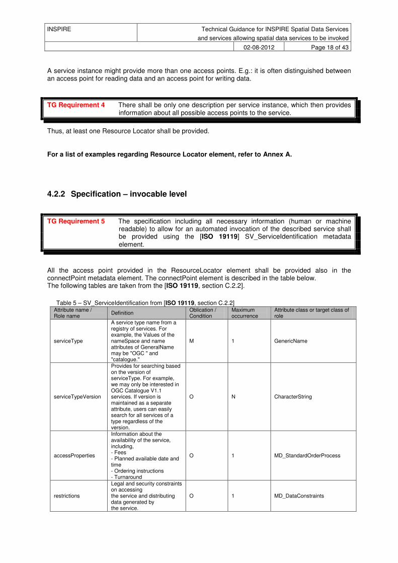
A service instance might provide more than one access points. E.g.: it is often distinguished between an access point for reading data and an access point for writing data.
TG Requirement 4 There shall be only one description per service instance, which then provides information about all possible access points to the service.
Thus, at least one Resource Locator shall be provided.
For a list of examples regarding Resource Locator element, refer to Annex A.
4.2.2 Specification – invocable level
TG Requirement 5 The specification including all necessary information (human or machine readable) to allow for an automated invocation of the described service shall be provided using the [ISO 19119] SV_ServiceIdentification metadata element.
All the access point provided in the ResourceLocator element shall be provided also in the connectPoint metadata element. The connectPoint element is described in the table below. The following tables are taken from the [ISO 19119, section C.2.2].
Table 5 – SV_ServiceIdentification from [ISO 19119, section C.2.2] Attribute name / Role name
Definition Oblication / Condition
Maximum occurrence
Attribute class or target class of role
serviceType
A service type name from a registry of services. For example, the Values of the nameSpace and name attributes of GeneralName may be "OGC " and "catalogue."
M 1 GenericName
serviceTypeVersion
Provides for searching based on the version of serviceType. For example, we may only be interested in OGC Catalogue V1.1 services. If version is maintained as a separate attribute, users can easily search for all services of a type regardless of the version.
O N CharacterString
accessProperties
Information about the availability of the service, including, - Fees - Planned available date and time - Ordering instructions - Turnaround
O 1 MD_StandardOrderProcess
restrictions
Legal and security constraints on accessing the service and distributing data generated by the service.
O 1 MD_DataConstraints
INSPIRE Technical Guidance for INSPIRE Spatial Data Services
and services allowing spatial data services to be invoked
02-08-2012 Page 19 of 43
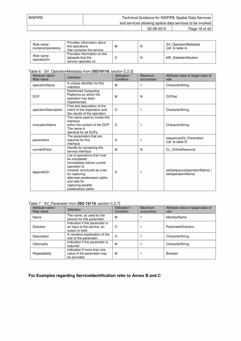
Role name: containsOperations
Provides information about the operations that comprise the service
M N SV_OperationMetadata (ref. to table 4)
Role name: operatesOn
Provides information on the datasets that the service operates on
O N MD_DataIdentification
Table 6 - SV_OperationMetadata from [ISO19119, section C.2.3] Attribute name / Role name
Definition Oblication / Condition
Maximum occurrence
Attribute class or target class of role
operationName A unique identifier for this interface.
M 1 CharacterString
DCP
Distributed Computing Platforms on which the operation has been implemented.
M N DCPlist
operationDescription Free text description of the intent of the ooperation and the results of the operation.
O 1 CharacterString
invocationName
The name used to invoke this interface within the context of the DCP. The name is identical for all DCPs.
O 1 CharacterString
parameters The parameters that are required for this interface.
O 1 sequence(SV_Parameter) (ref. to table 5)
connectPoint Handle for accessing the service interface.
M N CL_OnlineResource
dependsOn
List of operations that must be completed immediately before current operation is invoked, structured as a list for capturing alternate predecessor paths and sets for capturing parallel predecessor paths.
O 1 set{sequence{operationName} | set(operationName}
Table 7 - SV_Parameter from [ISO 19119, section C.2.7] Attribute name / Role name
Definition Oblication / Condition
Maximum occurrence
Attribute class or target class of role
Name The name, as used by the service for this parameter.
M 1 MemberName
Direction Indication if the parameter is an input to the service, an output or both.
O 1 ParameterDirection
Description A narrative explanation of the role of the parameter
O 1 CharacterString
Optionality Indication if the parameter is required
M 1 CharacterString
Repeatability Indication if more than one value of the parameter may be provided.
M 1 Boolean
For Examples regarding ServiceIdentification refer to Annex B and C
INSPIRE Technical Guidance for INSPIRE Spatial Data Services
and services allowing spatial data services to be invoked
02-08-2012 Page 20 of 43
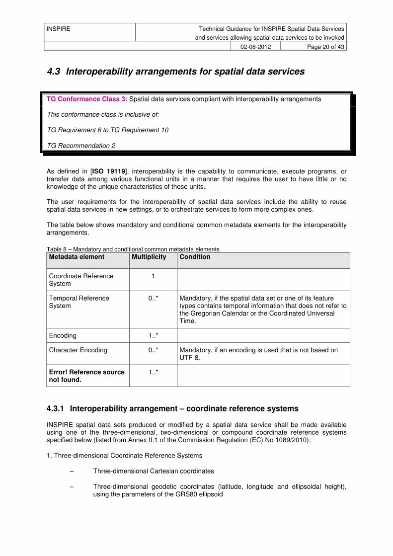
4.3 Interoperability arrangements for spatial data services
TG Conformance Class 3: Spatial data services compliant with interoperability arrangements
This conformance class is inclusive of:
TG Requirement 6 to TG Requirement 10
TG Recommendation 2
As defined in [ISO 19119], interoperability is the capability to communicate, execute programs, or transfer data among various functional units in a manner that requires the user to have little or no knowledge of the unique characteristics of those units. The user requirements for the interoperability of spatial data services include the ability to reuse spatial data services in new settings, or to orchestrate services to form more complex ones.
The table below shows mandatory and conditional common metadata elements for the interoperability arrangements.
Table 8 – Mandatory and conditional common metadata elements
Metadata element Multiplicity Condition
Coordinate Reference System
1
Temporal Reference System
0..* Mandatory, if the spatial data set or one of its feature types contains temporal information that does not refer to the Gregorian Calendar or the Coordinated Universal Time.
Encoding 1..*
Character Encoding 0..* Mandatory, if an encoding is used that is not based on UTF-8.
Error! Reference source not found.
1..*
4.3.1 Interoperability arrangement – coordinate reference systems
INSPIRE spatial data sets produced or modified by a spatial data service shall be made available using one of the three-dimensional, two-dimensional or compound coordinate reference systems specified below (listed from Annex II.1 of the Commission Regulation (EC) No 1089/2010):
1. Three-dimensional Coordinate Reference Systems
– Three-dimensional Cartesian coordinates
– Three-dimensional geodetic coordinates (latitude, longitude and ellipsoidal height), using the parameters of the GRS80 ellipsoid

INSPIRE Technical Guidance for INSPIRE Spatial Data Services
and services allowing spatial data services to be invoked
02-08-2012 Page 21 of 43
2. Two-dimensional Coordinate Reference Systems
– Two-dimensional geodetic coordinates, using the parameters of the GRS80 ellipsoid
– Plane coordinates using the Lambert Azimuthal Equal Area projection and the parameters of the GRS80 ellipsoid (ETRS89-LAEA)
– Plane coordinates using the Lambert Conformal Conic projection and the parameters of the GRS80 ellipsoid (ETRS89-LCC)
– Plane coordinates using the Transverse Mercator projection and the parameters of the GRS80 ellipsoid (ETRS89-TMzn)
3. Compound Coordinate Reference Systems
– For the horizontal component of the compound coordinate reference system, one of the two-dimensional coordinate reference systems specified above shall be used.
– For the vertical component on land, the European Vertical Reference System (EVRS) shall be used to express gravity-related heights within its geographical scope. Other vertical reference systems related to the Earth gravity field shall be used to express gravity-related heights in areas that are outside the geographical scope of EVRS. The geodetic codes and parameters for these vertical reference systems shall be documented and an identifier shall be created, according to [ISO 19111] and [ISO 19127].
– For the vertical component in the free atmosphere, barometric pressure, converted to height using ISO 2533:1975 International Standard Atmosphere, or other linear or parametric reference systems shall be used. Where other parametric reference systems are used, these shall be described in an accessible reference using [ISO 19111-2:2012].
– For the vertical component in marine areas where there is an appreciable tidal range (tidal waters), the Lowest Astronomical Tide (LAT) shall be used as the reference surface.
– For the vertical component in marine areas without an appreciable tidal range, in open oceans and effectively in waters that are deeper than 200 meters, the Mean Sea Level (MSL) or a well-defined reference level close to the MSL shall be used as the reference surface.
Other coordinate reference systems than those listed above may only be used if specified for a specific spatial data theme and for regions outside of continental Europe. The geodetic codes and parameters for these coordinate reference systems shall be documented, and an identifier shall be created, according to [ISO 19111] and [ISO 19127].
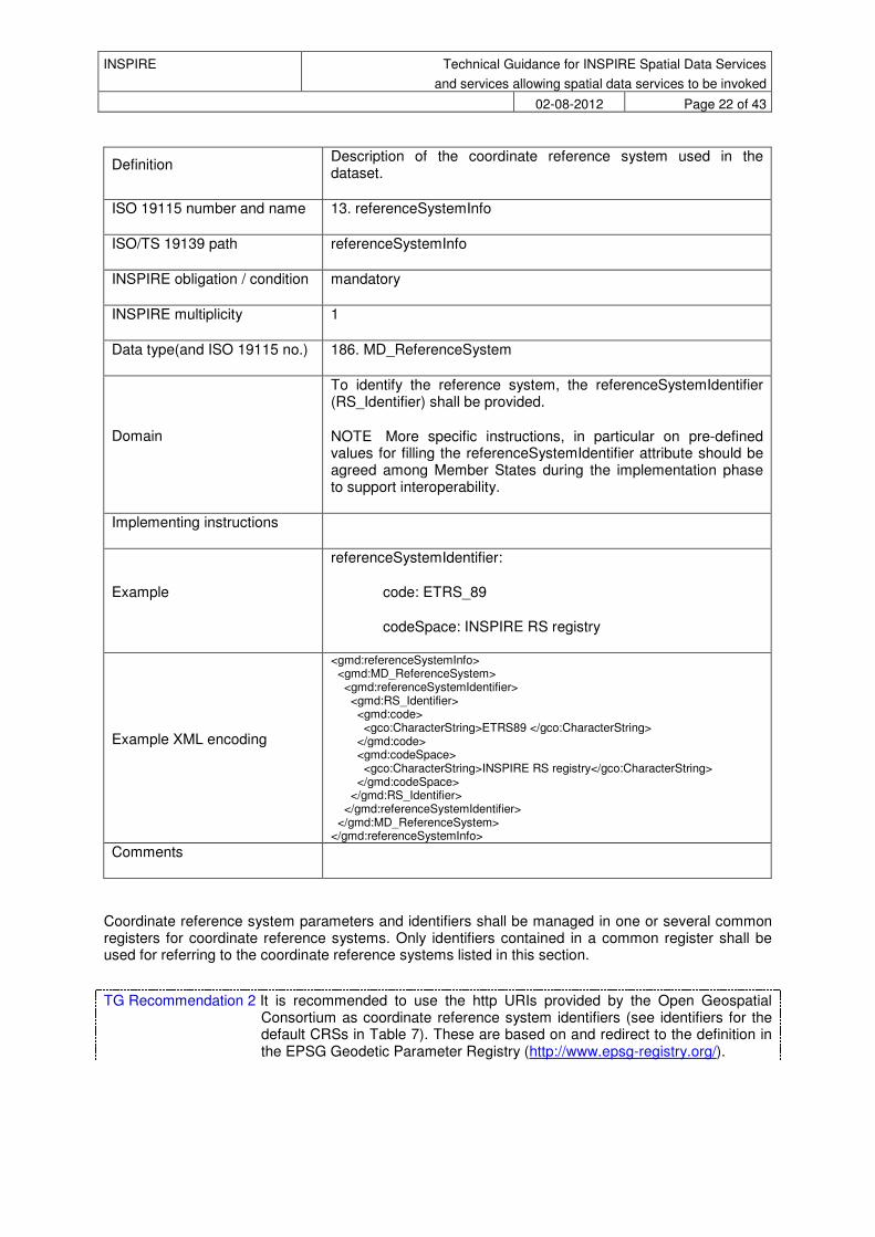
TG Requirement 6 A spatial data service compliant with interoperability arrangement shall include ISO metadata with the coordinate reference system(s) of the spatial data set(s) on which it operates.
Table 9 - Coordinate Reference System taken from [DST]
Metadata element name Coordinate Reference System
INSPIRE Technical Guidance for INSPIRE Spatial Data Services
and services allowing spatial data services to be invoked
02-08-2012 Page 22 of 43
Definition Description of the coordinate reference system used in the dataset.
ISO 19115 number and name 13. referenceSystemInfo
ISO/TS 19139 path referenceSystemInfo
INSPIRE obligation / condition mandatory
INSPIRE multiplicity 1
Data type(and ISO 19115 no.) 186. MD_ReferenceSystem
Domain
To identify the reference system, the referenceSystemIdentifier (RS_Identifier) shall be provided.
NOTE More specific instructions, in particular on pre-defined values for filling the referenceSystemIdentifier attribute should be agreed among Member States during the implementation phase to support interoperability.
Implementing instructions
Example
referenceSystemIdentifier:
code: ETRS_89
codeSpace: INSPIRE RS registry
Example XML encoding
<gmd:referenceSystemInfo> <gmd:MD_ReferenceSystem> <gmd:referenceSystemIdentifier> <gmd:RS_Identifier> <gmd:code> <gco:CharacterString>ETRS89 </gco:CharacterString> </gmd:code> <gmd:codeSpace> <gco:CharacterString>INSPIRE RS registry</gco:CharacterString> </gmd:codeSpace> </gmd:RS_Identifier> </gmd:referenceSystemIdentifier> </gmd:MD_ReferenceSystem> </gmd:referenceSystemInfo>
Comments
Coordinate reference system parameters and identifiers shall be managed in one or several common registers for coordinate reference systems. Only identifiers contained in a common register shall be used for referring to the coordinate reference systems listed in this section.
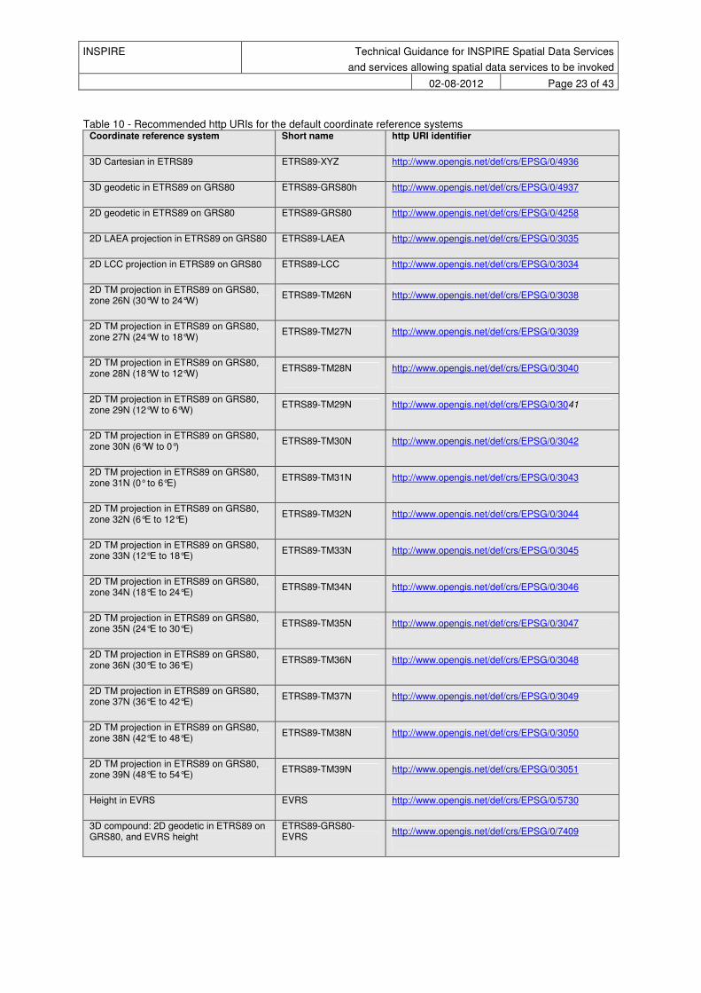
TG Recommendation 2 It is recommended to use the http URIs provided by the Open Geospatial Consortium as coordinate reference system identifiers (see identifiers for the default CRSs in Table 7). These are based on and redirect to the definition in the EPSG Geodetic Parameter Registry (http://www.epsg-registry.org/).
INSPIRE Technical Guidance for INSPIRE Spatial Data Services
and services allowing spatial data services to be invoked
02-08-2012 Page 23 of 43
Table 10 - Recommended http URIs for the default coordinate reference systems Coordinate reference system Short name http URI identifier
3D Cartesian in ETRS89 ETRS89-XYZ http://www.opengis.net/def/crs/EPSG/0/4936
3D geodetic in ETRS89 on GRS80 ETRS89-GRS80h http://www.opengis.net/def/crs/EPSG/0/4937
2D geodetic in ETRS89 on GRS80 ETRS89-GRS80 http://www.opengis.net/def/crs/EPSG/0/4258
2D LAEA projection in ETRS89 on GRS80 ETRS89-LAEA http://www.opengis.net/def/crs/EPSG/0/3035
2D LCC projection in ETRS89 on GRS80 ETRS89-LCC http://www.opengis.net/def/crs/EPSG/0/3034
2D TM projection in ETRS89 on GRS80, zone 26N (30°W to 24°W)
ETRS89-TM26N http://www.opengis.net/def/crs/EPSG/0/3038
2D TM projection in ETRS89 on GRS80, zone 27N (24°W to 18°W)
ETRS89-TM27N http://www.opengis.net/def/crs/EPSG/0/3039
2D TM projection in ETRS89 on GRS80, zone 28N (18°W to 12°W)
ETRS89-TM28N http://www.opengis.net/def/crs/EPSG/0/3040
2D TM projection in ETRS89 on GRS80, zone 29N (12°W to 6°W)
ETRS89-TM29N http://www.opengis.net/def/crs/EPSG/0/3041
2D TM projection in ETRS89 on GRS80, zone 30N (6°W to 0°)
ETRS89-TM30N http://www.opengis.net/def/crs/EPSG/0/3042
2D TM projection in ETRS89 on GRS80, zone 31N (0° to 6°E)
ETRS89-TM31N http://www.opengis.net/def/crs/EPSG/0/3043
2D TM projection in ETRS89 on GRS80, zone 32N (6°E to 12°E)
ETRS89-TM32N http://www.opengis.net/def/crs/EPSG/0/3044
2D TM projection in ETRS89 on GRS80, zone 33N (12°E to 18°E)
ETRS89-TM33N http://www.opengis.net/def/crs/EPSG/0/3045
2D TM projection in ETRS89 on GRS80, zone 34N (18°E to 24°E)
ETRS89-TM34N http://www.opengis.net/def/crs/EPSG/0/3046
2D TM projection in ETRS89 on GRS80, zone 35N (24°E to 30°E)
ETRS89-TM35N http://www.opengis.net/def/crs/EPSG/0/3047
2D TM projection in ETRS89 on GRS80, zone 36N (30°E to 36°E)
ETRS89-TM36N http://www.opengis.net/def/crs/EPSG/0/3048
2D TM projection in ETRS89 on GRS80, zone 37N (36°E to 42°E)
ETRS89-TM37N http://www.opengis.net/def/crs/EPSG/0/3049
2D TM projection in ETRS89 on GRS80, zone 38N (42°E to 48°E)
ETRS89-TM38N http://www.opengis.net/def/crs/EPSG/0/3050
2D TM projection in ETRS89 on GRS80, zone 39N (48°E to 54°E)
ETRS89-TM39N http://www.opengis.net/def/crs/EPSG/0/3051
Height in EVRS EVRS http://www.opengis.net/def/crs/EPSG/0/5730
3D compound: 2D geodetic in ETRS89 on GRS80, and EVRS height
ETRS89-GRS80-EVRS
http://www.opengis.net/def/crs/EPSG/0/7409
INSPIRE Technical Guidance for INSPIRE Spatial Data Services
and services allowing spatial data services to be invoked
02-08-2012 Page 24 of 43
4.3.2 Interoperability arrangement - Temporal reference system
The temporal reference system is described as metadata in the [DST] document.
4.3.3 Interoperability arrangement - Performance criteria, quality of service
The metadata mandated by the following requirements need an extension of the standard metadata. This extension will be implemented using one of the solutions proposed below.
TG Requirement 7 A new metadata element shall be provided to document the Availability of the Spatial Data Service
TG Requirement 8 A new metadata element shall be provided to document the Performance of the Spatial Data Service
TG Requirement 9 A new metadata element shall be provided to document the capacity of the Spatial Data Service
The attribute for the Quality of Service Metadata extension is listed in the table below:
Table 11 - Quality of Service Metadata Attribute name Attribute Definition Attribute Type Name Name of the QoS criteria codelist (capacity performance and availability)
Unit Unit of Measurement Free Text
Value Value of the QoS Free Text
Measurement Context Provides more information on the context, pre-requisites, constraints and context to understand to what the value refers to.
Free Text
The possible solutions to extend the standard metadata to fit these requirements are listed below:
Scenario 1 Extend the ISO 19115 metadata, using the MD_MetadataExtensionInformation element; This solution presents some difficulties, including the management of the workflow needed by ISO for the update of the metadata. Scenario 2 Create a custom XML that represents the QoS metadata and pass it via resource locator (with a proper function code). Below is presented a first example of xml encoding. <QoS> <name codeList="http://www.example.com/Codelists.xml" codeListValue="availability" ></name> <unit>%</unit>
INSPIRE Technical Guidance for INSPIRE Spatial Data Services
and services allowing spatial data services to be invoked
02-08-2012 Page 25 of 43
<value>99</value> <measurementContext>simple example regarding availability measurement</measurementContext> </QoS>
In case this scenario is chosen, the Resource Locator codelist should be extended with the following key:
Table 12 - Extend resource locator codelist for QoS
Key Description
qualityOfService Online xml resource that describe the quality of service.
4.4 Harmonized spatial data services
TG Conformance Class 4: Implementation of Spatial Data Services compliant with Harmonisation Requirements where practicable
This conformance class is inclusive of:
TG Requirement 11
The Directive states that the MS implementation of these harmonised services is ‘where practicable’. The decision to implement them according to the Implementing Rules given here is thus left to the MS.
TG Requirement 10 Spatial data services conformant to harmonization arrangement shall include a Get Spatial Data Service Metadata operation
4.4.1 Encoding
The Encoding is described as metadata in the [DST] document.
4.4.2 Implementation example
The implementation proposed below (following OWS specifications) is only one of the possible implementations of SDS. Other examples of non-OGC implementations will be provided in subsequent versions of those TGs. Input from is more than welcome.

INSPIRE Technical Guidance for INSPIRE Spatial Data Services
and services allowing spatial data services to be invoked
02-08-2012 Page 26 of 43
4.4.3 OWS Implementation
Table 13 - Mapping operations
INSPIRE Spatial Data Services Operations OGC Web Services Operations
Get Spatial Data Service Metadata GetCapabilities
The example reported below follow [OWS] specifications.
4.4.3.1 GetCapabilities Request This section contains a description about the get capabilities Request, including a table specifying the parameters needed by the request.
Figure 2 - GetCapabilities operation request UML class diagram taken from [OWS, section 7.2.1]
The service used (CSW) is only for example purpose; any of the OWS service could be used.
Table 14 - GetCapabilities request
Request Parameter Mandatory / optional
Description
INSPIRE Technical Guidance for INSPIRE Spatial Data Services
and services allowing spatial data services to be invoked
02-08-2012 Page 27 of 43
Service=code M Service type identifier (text). Example value: CSW,…
Request=GetCapabilities M Operation name (text).
Fixed value: GetCapabilities.
AcceptVersions=version O Request version: 2.0.2
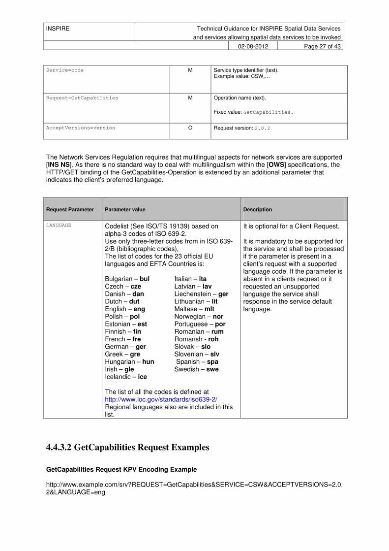
The Network Services Regulation requires that multilingual aspects for network services are supported [INS NS]. As there is no standard way to deal with multilingualism within the [OWS] specifications, the HTTP/GET binding of the GetCapabilities-Operation is extended by an additional parameter that indicates the client’s preferred language.
Request Parameter Parameter value Description
LANGUAGE Codelist (See ISO/TS 19139) based on alpha-3 codes of ISO 639-2. Use only three-letter codes from in ISO 639-2/B (bibliographic codes), The list of codes for the 23 official EU languages and EFTA Countries is: Bulgarian – bul Italian – ita Czech – cze Latvian – lav Danish – dan Liechenstein – ger Dutch – dut Lithuanian – lit English – eng Maltese – mlt Polish – pol Norwegian – nor Estonian – est Portuguese – por Finnish – fin Romanian – rum French – fre Romansh - roh German – ger Slovak – slo Greek – gre Slovenian – slv Hungarian – hun Spanish – spa Irish – gle Swedish – swe Icelandic – ice The list of all the codes is defined at http://www.loc.gov/standards/iso639-2/ Regional languages also are included in this list.
It is optional for a Client Request. It is mandatory to be supported for the service and shall be processed if the parameter is present in a client’s request with a supported language code. If the parameter is absent in a clients request or it requested an unsupported language the service shall response in the service default language.
4.4.3.2 GetCapabilities Request Examples
GetCapabilities Request KPV Encoding Example http://www.example.com/srv?REQUEST=GetCapabilities&SERVICE=CSW&ACCEPTVERSIONS=2.0.2&LANGUAGE=eng
INSPIRE Technical Guidance for INSPIRE Spatial Data Services
and services allowing spatial data services to be invoked
02-08-2012 Page 28 of 43
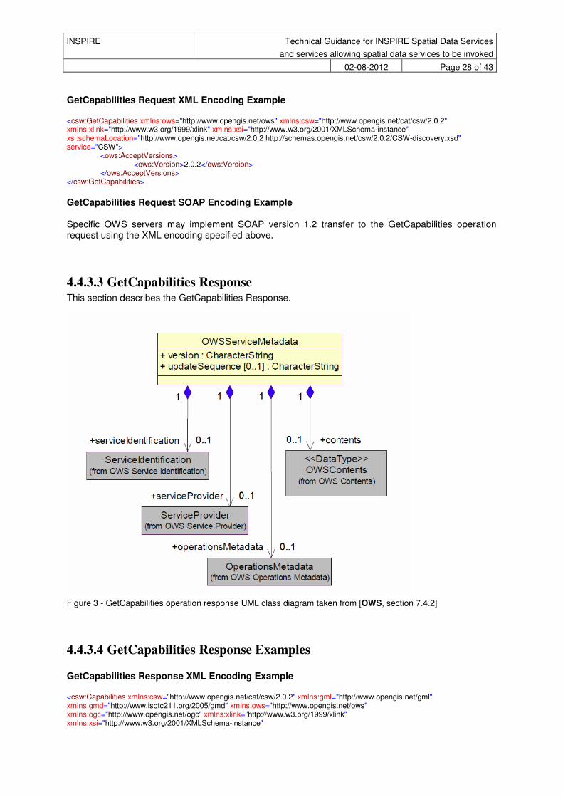
GetCapabilities Request XML Encoding Example <csw:GetCapabilities xmlns:ows="http://www.opengis.net/ows" xmlns:csw="http://www.opengis.net/cat/csw/2.0.2" xmlns:xlink="http://www.w3.org/1999/xlink" xmlns:xsi="http://www.w3.org/2001/XMLSchema-instance" xsi:schemaLocation="http://www.opengis.net/cat/csw/2.0.2 http://schemas.opengis.net/csw/2.0.2/CSW-discovery.xsd" service="CSW">
<ows:AcceptVersions> <ows:Version>2.0.2</ows:Version>
</ows:AcceptVersions> </csw:GetCapabilities>
GetCapabilities Request SOAP Encoding Example Specific OWS servers may implement SOAP version 1.2 transfer to the GetCapabilities operation request using the XML encoding specified above.
4.4.3.3 GetCapabilities Response This section describes the GetCapabilities Response.
Figure 3 - GetCapabilities operation response UML class diagram taken from [OWS, section 7.4.2]
4.4.3.4 GetCapabilities Response Examples GetCapabilities Response XML Encoding Example <csw:Capabilities xmlns:csw="http://www.opengis.net/cat/csw/2.0.2" xmlns:gml="http://www.opengis.net/gml" xmlns:gmd="http://www.isotc211.org/2005/gmd" xmlns:ows="http://www.opengis.net/ows" xmlns:ogc="http://www.opengis.net/ogc" xmlns:xlink="http://www.w3.org/1999/xlink" xmlns:xsi="http://www.w3.org/2001/XMLSchema-instance"

INSPIRE Technical Guidance for INSPIRE Spatial Data Services
and services allowing spatial data services to be invoked
02-08-2012 Page 29 of 43
xmlns:inspire_ds="http://inspire.ec.europa.eu/schemas/inspire_ds/1.0" xmlns:inspire_common="http://inspire.ec.europa.eu/schemas/common/1.0" version="2.0.2" xsi:schemaLocation="http://www.opengis.net/cat/csw/2.0.2 http://schemas.opengis.net/csw/2.0.2/CSW-discovery.xsd http://inspire.ec.europa.eu/schemas/inspire_ds/1.0 http://inspire.ec.europa.eu/schemas/inspire_ds/1.0/inspire_ds.xsd"> <ows:ServiceIdentification> <ows:Title>EXAMPLE CSW</ows:Title> <ows:Abstract>Example</ows:Abstract> <ows:Keywords> <ows:Keyword>Example KW 1</ows:Keyword> <ows:Keyword>Example KW 2</ows:Keyword> <ows:Type>theme</ows:Type> </ows:Keywords> <ows:ServiceType>CSW</ows:ServiceType> <ows:ServiceTypeVersion>2.0.2</ows:ServiceTypeVersion> <ows:Fees>no</ows:Fees> <ows:AccessConstraints>no</ows:AccessConstraints> </ows:ServiceIdentification> <ows:ServiceProvider> <ows:ProviderName>Example</ows:ProviderName> <ows:ProviderSite xlink:href="http://www.example.com/" /> <ows:ServiceContact> <ows:IndividualName>Name</ows:IndividualName> <ows:PositionName>Administrator</ows:PositionName> <ows:ContactInfo> <ows:Phone> <ows:Voice /> <ows:Facsimile /> </ows:Phone> <ows:Address> <ows:DeliveryPoint>Example</ows:DeliveryPoint> <ows:City>Example</ows:City> <ows:AdministrativeArea>Example</ows:AdministrativeArea> <ows:PostalCode>12345</ows:PostalCode> <ows:Country>EX</ows:Country> <ows:ElectronicMailAddress>[email protected]</ows:ElectronicMailAddress> </ows:Address> <ows:HoursOfService /> <ows:ContactInstructions /> </ows:ContactInfo> <ows:Role>publisher</ows:Role> </ows:ServiceContact> </ows:ServiceProvider> <ows:OperationsMetadata> <ows:Operation name="GetCapabilities"> <ows:DCP> <ows:HTTP> <ows:Get xlink:href="http://www.example.com:80/srv/csw" /> <ows:Post xlink:href="http://www.example.com:80/srv/csw" /> </ows:HTTP> </ows:DCP> <ows:Parameter name="sections"> <ows:Value>ServiceIdentification</ows:Value> <ows:Value>ServiceProvider</ows:Value> <ows:Value>OperationsMetadata</ows:Value> <ows:Value>Filter_Capabilities</ows:Value> </ows:Parameter> <ows:Constraint name="PostEncoding"> <ows:Value>XML</ows:Value> </ows:Constraint> </ows:Operation> <ows:Operation name="DescribeRecord"> <ows:DCP> <ows:HTTP> <ows:Get xlink:href="http://www.example.com:80/srv/csw" /> <ows:Post xlink:href="http://www.example.com:80/srv/csw"> <ows:Constraint name="PostEncoding"> <ows:Value>XML</ows:Value> <ows:Value>SOAP</ows:Value> </ows:Constraint> </ows:Post> </ows:HTTP> </ows:DCP>

INSPIRE Technical Guidance for INSPIRE Spatial Data Services
and services allowing spatial data services to be invoked
02-08-2012 Page 30 of 43
<ows:Parameter name="typeName"> <ows:Value>csw:Record</ows:Value> <ows:Value>gmd:MD_Metadata</ows:Value> </ows:Parameter> <ows:Parameter name="outputFormat"> <ows:Value>application/xml</ows:Value> </ows:Parameter> <ows:Parameter name="schemaLanguage"> <ows:Value>http://www.w3.org/TR/xmlschema-1/</ows:Value> </ows:Parameter> <ows:Parameter name="typeName"> <ows:Value>csw:Record</ows:Value> <ows:Value>gmd:MD_Metadata</ows:Value> </ows:Parameter> <ows:Constraint name="PostEncoding"> <ows:Value>XML</ows:Value> </ows:Constraint> </ows:Operation> <ows:Operation name="GetDomain"> <ows:DCP> <ows:HTTP> <ows:Get xlink:href="http://www.example.com:80/srv/csw" /> <ows:Post xlink:href="http://www.example.com:80/srv/csw" /> </ows:HTTP> </ows:DCP> </ows:Operation> <ows:Operation name="GetRecords"> <ows:DCP> <ows:HTTP> <ows:Get xlink:href="http://www.example.com:80/srv/csw" /> <ows:Post xlink:href="http://www.example.com:80/srv/csw"> <ows:Constraint name="PostEncoding"> <ows:Value>XML</ows:Value> <ows:Value>SOAP</ows:Value> </ows:Constraint> </ows:Post> </ows:HTTP> </ows:DCP> <ows:Parameter name="resultType"> <ows:Value>hits</ows:Value> <ows:Value>results</ows:Value> <ows:Value>validate</ows:Value> </ows:Parameter> <ows:Parameter name="outputFormat"> <ows:Value>application/xml</ows:Value> </ows:Parameter> <ows:Parameter name="outputSchema"> <ows:Value>http://www.opengis.net/cat/csw/2.0.2</ows:Value> <ows:Value>http://www.isotc211.org/2005/gmd</ows:Value> </ows:Parameter> <ows:Parameter name="typeNames"> <ows:Value>csw:Record</ows:Value> <ows:Value>gmd:MD_Metadata</ows:Value> </ows:Parameter> <ows:Parameter name="CONSTRAINTLANGUAGE"> <ows:Value>FILTER</ows:Value> <ows:Value>CQL_TEXT</ows:Value> </ows:Parameter> <ows:Constraint name="PostEncoding"> <ows:Value>XML</ows:Value> </ows:Constraint> <ows:Constraint name="SupportedISOQueryables"> <ows:Value>Operation</ows:Value> <ows:Value>Format</ows:Value> <ows:Value>OrganisationName</ows:Value> <ows:Value>Type</ows:Value> <ows:Value>ServiceType</ows:Value> <ows:Value>DistanceValue</ows:Value> <ows:Value>ResourceLanguage</ows:Value> <ows:Value>RevisionDate</ows:Value> <ows:Value>OperatesOn</ows:Value> <ows:Value>GeographicDescriptionCode</ows:Value>
INSPIRE Technical Guidance for INSPIRE Spatial Data Services
and services allowing spatial data services to be invoked
02-08-2012 Page 31 of 43
<ows:Value>AnyText</ows:Value> <ows:Value>Modified</ows:Value> <ows:Value>PublicationDate</ows:Value> <ows:Value>ResourceIdentifier</ows:Value> <ows:Value>ParentIdentifier</ows:Value> <ows:Value>Identifier</ows:Value> <ows:Value>CouplingType</ows:Value> <ows:Value>TopicCategory</ows:Value> <ows:Value>OperatesOnIdentifier</ows:Value> <ows:Value>ServiceTypeVersion</ows:Value> <ows:Value>TempExtent_end</ows:Value> <ows:Value>Subject</ows:Value> <ows:Value>CreationDate</ows:Value> <ows:Value>OperatesOnName</ows:Value> <ows:Value>Title</ows:Value> <ows:Value>DistanceUOM</ows:Value> <ows:Value>Denominator</ows:Value> <ows:Value>AlternateTitle</ows:Value> <ows:Value>Language</ows:Value> <ows:Value>TempExtent_begin</ows:Value> <ows:Value>HasSecurityConstraints</ows:Value> <ows:Value>KeywordType</ows:Value> <ows:Value>Abstract</ows:Value> </ows:Constraint> <ows:Constraint name="AdditionalQueryables"> <ows:Value>AccessConstraints</ows:Value> <ows:Value>ResponsiblePartyRole</ows:Value> <ows:Value>OnlineResourceMimeType</ows:Value> <ows:Value>OnlineResourceType</ows:Value> <ows:Value>Lineage</ows:Value> <ows:Value>SpecificationDate</ows:Value> <ows:Value>ConditionApplyingToAccessAndUse</ows:Value> <ows:Value>SpecificationDateType</ows:Value> <ows:Value>MetadataPointOfContact</ows:Value> <ows:Value>Classification</ows:Value> <ows:Value>OtherConstraints</ows:Value> <ows:Value>Degree</ows:Value> <ows:Value>SpecificationTitle</ows:Value> </ows:Constraint> </ows:Operation> <ows:Operation name="GetRecordById"> <ows:DCP> <ows:HTTP> <ows:Get xlink:href="http://www.example.com:80/srv/csw" /> <ows:Post xlink:href="http://www.example.com:80/srv/csw"> <ows:Constraint name="PostEncoding"> <ows:Value>XML</ows:Value> <ows:Value>SOAP</ows:Value> </ows:Constraint> </ows:Post> </ows:HTTP> </ows:DCP> <ows:Parameter name="outputSchema"> <ows:Value>http://www.opengis.net/cat/csw/2.0.2</ows:Value> <ows:Value>http://www.isotc211.org/2005/gmd</ows:Value> </ows:Parameter> <ows:Parameter name="outputFormat"> <ows:Value>application/xml</ows:Value> </ows:Parameter> <ows:Parameter name="resultType"> <ows:Value>hits</ows:Value> <ows:Value>results</ows:Value> <ows:Value>validate</ows:Value> </ows:Parameter> <ows:Parameter name="ElementSetName"> <ows:Value>brief</ows:Value> <ows:Value>summary</ows:Value> <ows:Value>full</ows:Value> </ows:Parameter> <ows:Constraint name="PostEncoding"> <ows:Value>XML</ows:Value> </ows:Constraint>
INSPIRE Technical Guidance for INSPIRE Spatial Data Services
and services allowing spatial data services to be invoked
02-08-2012 Page 32 of 43
<ows:Constraint name="AdditionalQueryables"> <ows:Value>Degree</ows:Value> <ows:Value>AccessConstraints</ows:Value> <ows:Value>OtherConstraints</ows:Value> <ows:Value>Classification</ows:Value> <ows:Value>ConditionApplyingToAccessAndUse</ows:Value> <ows:Value>Lineage</ows:Value> <ows:Value>ResponsiblePartyRole</ows:Value> <ows:Value>SpecificationTitle</ows:Value> <ows:Value>SpecificationDate</ows:Value> <ows:Value>SpecificationDateType</ows:Value> </ows:Constraint> </ows:Operation> <ows:Operation name="Transaction"> <ows:DCP> <ows:HTTP> <ows:Get xlink:href="http://www.example.com:80/srv/csw" /> <ows:Post xlink:href="http://www.example.com:80/srv/csw" /> </ows:HTTP> </ows:DCP> </ows:Operation> <ows:Parameter name="service"> <ows:Value>http://www.opengis.net/cat/csw/2.0.2</ows:Value> </ows:Parameter> <ows:Parameter name="version"> <ows:Value>2.0.2</ows:Value> </ows:Parameter> <ows:Constraint name="IsoProfiles"> <ows:Value>http://www.isotc211.org/2005/gmd</ows:Value> </ows:Constraint> <ows:Constraint name="PostEncoding"> <ows:Value>SOAP</ows:Value> </ows:Constraint> <inspire_ds:ExtendedCapabilities> <inspire_common:ResourceLocator> <inspire_common:URL>http://www.example.com/srv?REQUEST=GetCapabilities&SERVICE=CSW&ACCEPTVERSION=2.0.2&outputFormat=application/xml</inspire_common:URL> <inspire_common:MediaType>application/vnd.ogc.wms_xml</inspire_common:MediaType> </inspire_common:ResourceLocator> <inspire_common:ResourceLocator> <inspire_common:URL>http://www.example.com:80/geonetwork</inspire_common:URL> <inspire_common:MediaType>text/html</inspire_common:MediaType> </inspire_common:ResourceLocator> <inspire_common:ResourceType>service</inspire_common:ResourceType> <inspire_common:TemporalReference> <inspire_common:TemporalExtent> <inspire_common:IntervalOfDates> <inspire_common:StartingDate>2010-07-01T00:00:00</inspire_common:StartingDate> <inspire_common:EndDate>2011-07-01T00:00:00</inspire_common:EndDate> </inspire_common:IntervalOfDates> </inspire_common:TemporalExtent> </inspire_common:TemporalReference> <inspire_common:Conformity> <inspire_common:Specification xsi:type="inspire_common:citationInspireInteroperabilityRegulation_ger"> <inspire_common:Title>Example</inspire_common:Title> <inspire_common:DateOfPublication>2010-12-08</inspire_common:DateOfPublication> <inspire_common:URI>OJ:L:2010:323:0011:0102:DE:PDF</inspire_common:URI> <inspire_common:ResourceLocator> <inspire_common:URL>http://eur-lex.europa.eu/LexUriServ/LexUriServ.do?uri=OJ:L:2010:323:0011:0102:DE:PDF</inspire_common:URL> <inspire_common:MediaType>application/pdf</inspire_common:MediaType> </inspire_common:ResourceLocator> </inspire_common:Specification> <inspire_common:Degree>notEvaluated</inspire_common:Degree> </inspire_common:Conformity> <inspire_common:MetadataPointOfContact> <inspire_common:OrganisationName>Example</inspire_common:OrganisationName> <inspire_common:EmailAddress>[email protected]</inspire_common:EmailAddress> </inspire_common:MetadataPointOfContact> <inspire_common:MetadataDate>2010-07-15</inspire_common:MetadataDate> <inspire_common:SpatialDataServiceType>discovery</inspire_common:SpatialDataServiceType>

INSPIRE Technical Guidance for INSPIRE Spatial Data Services
and services allowing spatial data services to be invoked
02-08-2012 Page 33 of 43
<inspire_common:MandatoryKeyword xsi:type="inspire_common:classificationOfSpatialDataService"> <inspire_common:KeywordValue>humanCatalogueViewer</inspire_common:KeywordValue> </inspire_common:MandatoryKeyword> <inspire_common:Keyword xsi:type="inspire_common:inspireTheme_eng"> <inspire_common:OriginatingControlledVocabulary> <inspire_common:Title>GEMET - INSPIRE themes</inspire_common:Title> <inspire_common:DateOfPublication>2008-06-01</inspire_common:DateOfPublication> </inspire_common:OriginatingControlledVocabulary> <inspire_common:KeywordValue>Orthoimagery</inspire_common:KeywordValue> </inspire_common:Keyword> <inspire_common:SupportedLanguages> <inspire_common:DefaultLanguage> <inspire_common:Language>eng</inspire_common:Language> </inspire_common:DefaultLanguage> <inspire_common:SupportedLanguage> <inspire_common:Language>ger</inspire_common:Language> </inspire_common:SupportedLanguage> <inspire_common:SupportedLanguage> <inspire_common:Language>por</inspire_common:Language> </inspire_common:SupportedLanguage> <inspire_common:SupportedLanguage> <inspire_common:Language>fre</inspire_common:Language> </inspire_common:SupportedLanguage> <inspire_common:SupportedLanguage> <inspire_common:Language>spa</inspire_common:Language> </inspire_common:SupportedLanguage> <inspire_common:SupportedLanguage> <inspire_common:Language>dut</inspire_common:Language> </inspire_common:SupportedLanguage> </inspire_common:SupportedLanguages> <inspire_common:ResponseLanguage> <inspire_common:Language>ger</inspire_common:Language> </inspire_common:ResponseLanguage> </inspire_ds:ExtendedCapabilities> </ows:OperationsMetadata> <ogc:Filter_Capabilities> <ogc:Spatial_Capabilities> <ogc:GeometryOperands> <ogc:GeometryOperand>gml:Envelope</ogc:GeometryOperand> <ogc:GeometryOperand>gml:Point</ogc:GeometryOperand> <ogc:GeometryOperand>gml:LineString</ogc:GeometryOperand> <ogc:GeometryOperand>gml:Polygon</ogc:GeometryOperand> </ogc:GeometryOperands> <ogc:SpatialOperators> <ogc:SpatialOperator name="BBOX" /> <ogc:SpatialOperator name="Equals" /> <ogc:SpatialOperator name="Overlaps" /> <ogc:SpatialOperator name="Disjoint" /> <ogc:SpatialOperator name="Intersects" /> <ogc:SpatialOperator name="Touches" /> <ogc:SpatialOperator name="Crosses" /> <ogc:SpatialOperator name="Within" /> <ogc:SpatialOperator name="Contains" /> </ogc:SpatialOperators> </ogc:Spatial_Capabilities> <ogc:Scalar_Capabilities> <ogc:LogicalOperators /> <ogc:ComparisonOperators> <ogc:ComparisonOperator>EqualTo</ogc:ComparisonOperator> <ogc:ComparisonOperator>Like</ogc:ComparisonOperator> <ogc:ComparisonOperator>LessThan</ogc:ComparisonOperator> <ogc:ComparisonOperator>GreaterThan</ogc:ComparisonOperator> <ogc:ComparisonOperator>LessThanEqualTo</ogc:ComparisonOperator> <ogc:ComparisonOperator>GreaterThanEqualTo</ogc:ComparisonOperator> <ogc:ComparisonOperator>NotEqualTo</ogc:ComparisonOperator> <ogc:ComparisonOperator>Between</ogc:ComparisonOperator> </ogc:ComparisonOperators> </ogc:Scalar_Capabilities> <ogc:Id_Capabilities> <ogc:EID /> <ogc:FID /> </ogc:Id_Capabilities>

INSPIRE Technical Guidance for INSPIRE Spatial Data Services
and services allowing spatial data services to be invoked
02-08-2012 Page 34 of 43
</ogc:Filter_Capabilities> </csw:Capabilities>
INSPIRE Technical Guidance for INSPIRE Spatial Data Services
and services allowing spatial data services to be invoked
02-08-2012 Page 35 of 43
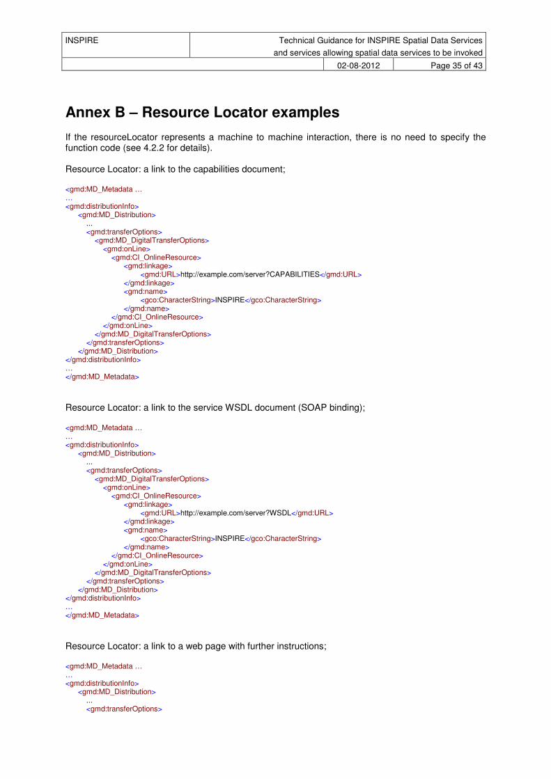
Annex B – Resource Locator examples
If the resourceLocator represents a machine to machine interaction, there is no need to specify the function code (see 4.2.2 for details). Resource Locator: a link to the capabilities document; <gmd:MD_Metadata … … <gmd:distributionInfo>
<gmd:MD_Distribution> ... <gmd:transferOptions>
<gmd:MD_DigitalTransferOptions> <gmd:onLine>
<gmd:CI_OnlineResource> <gmd:linkage>
<gmd:URL>http://example.com/server?CAPABILITIES</gmd:URL> </gmd:linkage> <gmd:name>
<gco:CharacterString>INSPIRE</gco:CharacterString> </gmd:name>
</gmd:CI_OnlineResource> </gmd:onLine>
</gmd:MD_DigitalTransferOptions> </gmd:transferOptions>
</gmd:MD_Distribution> </gmd:distributionInfo> … </gmd:MD_Metadata>
Resource Locator: a link to the service WSDL document (SOAP binding); <gmd:MD_Metadata … … <gmd:distributionInfo>
<gmd:MD_Distribution> ... <gmd:transferOptions>
<gmd:MD_DigitalTransferOptions> <gmd:onLine>
<gmd:CI_OnlineResource> <gmd:linkage>
<gmd:URL>http://example.com/server?WSDL</gmd:URL> </gmd:linkage> <gmd:name>
<gco:CharacterString>INSPIRE</gco:CharacterString> </gmd:name>
</gmd:CI_OnlineResource> </gmd:onLine>
</gmd:MD_DigitalTransferOptions> </gmd:transferOptions>
</gmd:MD_Distribution> </gmd:distributionInfo> … </gmd:MD_Metadata>
Resource Locator: a link to a web page with further instructions; <gmd:MD_Metadata … … <gmd:distributionInfo>
<gmd:MD_Distribution> ... <gmd:transferOptions>

INSPIRE Technical Guidance for INSPIRE Spatial Data Services
and services allowing spatial data services to be invoked
02-08-2012 Page 36 of 43
<gmd:MD_DigitalTransferOptions> <gmd:onLine>
<gmd:CI_OnlineResource> <gmd:linkage>
<gmd:URL>http://inspire-geoportal.ec.europa.eu/discovery/</gmd:URL> </gmd:linkage> <gmd:name>
<gco:CharacterString>INSPIRE</gco:CharacterString> </gmd:name> <gmd:function>
<gmd:CI_OnLineFunctionCode codeList="http://www.isotc211.org/2005/resources/Codelist/gmxCodelists.xml" codeListValue="information" />
</gmd:function> </gmd:CI_OnlineResource>
</gmd:onLine> </gmd:MD_DigitalTransferOptions>
</gmd:transferOptions> </gmd:MD_Distribution>
</gmd:distributionInfo> … </gmd:MD_Metadata>
Resource Locator: a link to a client application that directly accesses the service; <gmd:MD_Metadata … … <gmd:distributionInfo>
<gmd:MD_Distribution> ... <gmd:transferOptions>
<gmd:MD_DigitalTransferOptions> <gmd:onLine>
<gmd:CI_OnlineResource> <gmd:linkage>
<gmd:URL>http://inspire-geoportal.ec.europa.eu/discovery/</gmd:URL> </gmd:linkage> <gmd:name>
<gco:CharacterString>INSPIRE</gco:CharacterString> </gmd:name> <gmd:function>
<gmd:CI_OnLineFunctionCode codeList="http://www.isotc211.org/2005/resources/Codelist/gmxCodelists.xml" codeListValue="view" />
</gmd:function> </gmd:CI_OnlineResource>
</gmd:onLine> </gmd:MD_DigitalTransferOptions>
</gmd:transferOptions> </gmd:MD_Distribution>
</gmd:distributionInfo> … </gmd:MD_Metadata>
Resource Locator: a link to an activation point. <gmd:MD_Metadata … … <gmd:distributionInfo>
<gmd:MD_Distribution> ... <gmd:transferOptions>
<gmd:MD_DigitalTransferOptions> <gmd:onLine>
<gmd:CI_OnlineResource> <gmd:linkage>
<gmd:URL>http://example.com/do?</gmd:URL> </gmd:linkage> <gmd:name>

INSPIRE Technical Guidance for INSPIRE Spatial Data Services
and services allowing spatial data services to be invoked
02-08-2012 Page 37 of 43
<gco:CharacterString>INSPIRE</gco:CharacterString> </gmd:name>
</gmd:CI_OnlineResource> </gmd:onLine>
</gmd:MD_DigitalTransferOptions> </gmd:transferOptions>
</gmd:MD_Distribution> </gmd:distributionInfo> … </gmd:MD_Metadata>

INSPIRE Technical Guidance for INSPIRE Spatial Data Services
and services allowing spatial data services to be invoked
02-08-2012 Page 38 of 43
Annex B – ServiceIdentification Example
<srv:SV_ServiceIdentification uuid="ingrid#26472b27-50d2-32da-8d59-1d8b155e4ff8"> <gmd:citation> <gmd:CI_Citation> <gmd:title> <gco:CharacterString>Service Identification DEMO</gco:CharacterString> </gmd:title> <gmd:date> <gmd:CI_Date> <gmd:date> <gco:DateTime>2012-07-09T00:00:00</gco:DateTime> </gmd:date> <gmd:dateType> <gmd:CI_DateTypeCode codeList="http://www.tc211.org/ISO19139/resources/codeList.xml#CI_DateTypeCode" codeListValue="publication"/> </gmd:dateType> </gmd:CI_Date> </gmd:date> </gmd:CI_Citation> </gmd:citation> <gmd:abstract> <gco:CharacterString>Service abstract should go here</gco:CharacterString> </gmd:abstract> <gmd:status> <gmd:MD_ProgressCode codeList="http://www.tc211.org/ISO19139/resources/codeList.xml#MD_ProgressCode" codeListValue="inOperation"/> </gmd:status> <gmd:pointOfContact> <gmd:CI_ResponsibleParty> <gmd:individualName> <gco:CharacterString>Name Surname</gco:CharacterString> </gmd:individualName> <gmd:organisationName> <gco:CharacterString>Organisation Name</gco:CharacterString> </gmd:organisationName> <gmd:contactInfo> <gmd:CI_Contact> <gmd:phone> <gmd:CI_Telephone> <gmd:voice> <gco:CharacterString>+39 123 456 789</gco:CharacterString> </gmd:voice> </gmd:CI_Telephone> </gmd:phone> <gmd:address> <gmd:CI_Address> <gmd:electronicMailAddress> <gco:CharacterString>[email protected]</gco:CharacterString> </gmd:electronicMailAddress> </gmd:CI_Address> </gmd:address> </gmd:CI_Contact> </gmd:contactInfo> <gmd:role> <gmd:CI_RoleCode codeList="http://www.tc211.org/ISO19139/resources/codeList.xml#CI_RoleCode" codeListValue="custodian"/> </gmd:role> </gmd:CI_ResponsibleParty> </gmd:pointOfContact> <gmd:descriptiveKeywords> <gmd:MD_Keywords> <gmd:keyword> <gco:CharacterString>Hydrography</gco:CharacterString> </gmd:keyword> <gmd:type> <gmd:MD_KeywordTypeCode codeList="http://www.tc211.org/ISO19139/resources/codeList.xml#MD_KeywordTypeCode" codeListValue="theme"/>

INSPIRE Technical Guidance for INSPIRE Spatial Data Services
and services allowing spatial data services to be invoked
02-08-2012 Page 39 of 43
</gmd:type> <gmd:thesaurusName> <gmd:CI_Citation> <gmd:title> <gco:CharacterString>GEMET - INSPIRE themes, version 1.0</gco:CharacterString> </gmd:title> <gmd:date> <gmd:CI_Date> <gmd:date> <gco:Date>2008-06-01</gco:Date> </gmd:date> <gmd:dateType> <gmd:CI_DateTypeCode codeList="http://www.isotc211.org/2005/resources/codeList.xml#CI_DateTypeCode" codeListValue="publication"/> </gmd:dateType> </gmd:CI_Date> </gmd:date> </gmd:CI_Citation> </gmd:thesaurusName> </gmd:MD_Keywords> </gmd:descriptiveKeywords> <gmd:descriptiveKeywords> <gmd:MD_Keywords> <gmd:keyword> <gco:CharacterString>river basin development</gco:CharacterString> </gmd:keyword> <gmd:keyword> <gco:CharacterString>river management</gco:CharacterString> </gmd:keyword> <gmd:thesaurusName> <gmd:CI_Citation> <gmd:title> <gco:CharacterString>GEMET - Concepts, version 2.3</gco:CharacterString> </gmd:title> <gmd:date> <gmd:CI_Date> <gmd:date> <gco:Date>2009-07-13</gco:Date> </gmd:date> <gmd:dateType> <gmd:CI_DateTypeCode codeList="http://standards.iso.org/ittf/PubliclyAvailableStandards/ISO_19139_Schemas/resources/Codelist/ML_gmxCodelists.xml#CI_DateTypeCode" codeListValue="publication">publication</gmd:CI_DateTypeCode> </gmd:dateType> </gmd:CI_Date> </gmd:date> </gmd:CI_Citation> </gmd:thesaurusName> </gmd:MD_Keywords> </gmd:descriptiveKeywords> <gmd:descriptiveKeywords> <gmd:MD_Keywords> <gmd:keyword> <gco:CharacterString>infoFeatureAccessService</gco:CharacterString> </gmd:keyword> <gmd:type> <gmd:MD_KeywordTypeCode codeList="http://www.tc211.org/ISO19139/resources/codeList.xml#MD_KeywordTypeCode" codeListValue="theme"/> </gmd:type> <gmd:thesaurusName> <gmd:CI_Citation> <gmd:title> <gco:CharacterString>Service Classification, version 1.0</gco:CharacterString> </gmd:title> <gmd:date> <gmd:CI_Date> <gmd:date> <gco:Date>2008-06-01</gco:Date> </gmd:date>

INSPIRE Technical Guidance for INSPIRE Spatial Data Services
and services allowing spatial data services to be invoked
02-08-2012 Page 40 of 43
<gmd:dateType> <gmd:CI_DateTypeCode codeList="http://www.isotc211.org/2005/resources/codeList.xml#CI_DateTypeCode" codeListValue="publication"/> </gmd:dateType> </gmd:CI_Date> </gmd:date> </gmd:CI_Citation> </gmd:thesaurusName> </gmd:MD_Keywords> </gmd:descriptiveKeywords> <gmd:resourceConstraints> <gmd:MD_LegalConstraints> <gmd:useLimitation> <gco:CharacterString>no limitations</gco:CharacterString> </gmd:useLimitation> </gmd:MD_LegalConstraints> </gmd:resourceConstraints> <gmd:resourceConstraints> <gmd:MD_LegalConstraints> <gmd:accessConstraints> <gmd:MD_RestrictionCode codeList="http://standards.iso.org/ittf/PubliclyAvailableStandards/ISO_19139_Schemas/resources/Codelist/gmxCodelists.xml#MD_RestrictionCode" codeListValue="otherRestrictions">otherRestrictions</gmd:MD_RestrictionCode> </gmd:accessConstraints> <gmd:otherConstraints> <gco:CharacterString>no conditions apply</gco:CharacterString> </gmd:otherConstraints> </gmd:MD_LegalConstraints> </gmd:resourceConstraints> <srv:serviceType> <gco:LocalName>download</gco:LocalName> </srv:serviceType> <srv:extent> <gmd:EX_Extent> <gmd:geographicElement> <gmd:EX_GeographicBoundingBox> <gmd:westBoundLongitude> <gco:Decimal>-32.0</gco:Decimal> </gmd:westBoundLongitude> <gmd:eastBoundLongitude> <gco:Decimal>61.0</gco:Decimal> </gmd:eastBoundLongitude> <gmd:southBoundLatitude> <gco:Decimal>27.0</gco:Decimal> </gmd:southBoundLatitude> <gmd:northBoundLatitude> <gco:Decimal>72.0</gco:Decimal> </gmd:northBoundLatitude> </gmd:EX_GeographicBoundingBox> </gmd:geographicElement> </gmd:EX_Extent> </srv:extent> <srv:couplingType gco:nilReason="missing"/> <srv:containsOperations> <srv:SV_OperationMetadata> <srv:operationName> <gco:CharacterString>test</gco:CharacterString> </srv:operationName> <srv:DCP> <srv:DCPList codeList="http://someurl#DCPList" codeListValue="HTTPGet"/> </srv:DCP> <srv:operationDescription> <gco:CharacterString>Descriptive text about the operation</gco:CharacterString> </srv:operationDescription> <srv:parameters> <srv:SV_Parameter> <srv:name> <gco:aName> <gco:CharacterString>test parameter</gco:CharacterString> </gco:aName> <gco:attributeType>
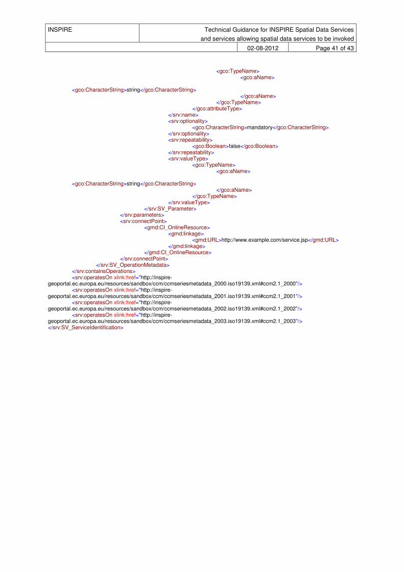
INSPIRE Technical Guidance for INSPIRE Spatial Data Services
and services allowing spatial data services to be invoked
02-08-2012 Page 41 of 43
<gco:TypeName> <gco:aName> <gco:CharacterString>string</gco:CharacterString> </gco:aName> </gco:TypeName> </gco:attributeType> </srv:name> <srv:optionality> <gco:CharacterString>mandatory</gco:CharacterString> </srv:optionality> <srv:repeatability> <gco:Boolean>false</gco:Boolean> </srv:repeatability> <srv:valueType> <gco:TypeName> <gco:aName> <gco:CharacterString>string</gco:CharacterString> </gco:aName> </gco:TypeName> </srv:valueType> </srv:SV_Parameter> </srv:parameters> <srv:connectPoint> <gmd:CI_OnlineResource> <gmd:linkage> <gmd:URL>http://www.example.com/service.jsp</gmd:URL> </gmd:linkage> </gmd:CI_OnlineResource> </srv:connectPoint> </srv:SV_OperationMetadata> </srv:containsOperations> <srv:operatesOn xlink:href="http://inspire-geoportal.ec.europa.eu/resources/sandbox/ccm/ccmseriesmetadata_2000.iso19139.xml#ccm2.1_2000"/> <srv:operatesOn xlink:href="http://inspire-geoportal.ec.europa.eu/resources/sandbox/ccm/ccmseriesmetadata_2001.iso19139.xml#ccm2.1_2001"/> <srv:operatesOn xlink:href="http://inspire-geoportal.ec.europa.eu/resources/sandbox/ccm/ccmseriesmetadata_2002.iso19139.xml#ccm2.1_2002"/> <srv:operatesOn xlink:href="http://inspire-geoportal.ec.europa.eu/resources/sandbox/ccm/ccmseriesmetadata_2003.iso19139.xml#ccm2.1_2003"/> </srv:SV_ServiceIdentification>

INSPIRE Technical Guidance for INSPIRE Spatial Data Services
and services allowing spatial data services to be invoked
02-08-2012 Page 42 of 43
Annex C – Coupled Resource (operatesOn) implementation
Implementation of the operatesOn (Coupled Resource) element of ISO 19139 metadata documents for services.
Here is the schema definition of the operatesOn element in the ISO 19139 implementation:
<xs:element name="operatesOn" type="gmd:MD_DataIdentification_PropertyType" minOccurs="0" maxOccurs="unbounded"/>
In XML this means that you can EITHER:
• include inside the operatesOn element an MD_DataIdentification fragment of the coupled resource: <srv:operatesOn>
<gmd:MD_DataIdentification>
… </gmd:MD_DataIdentification>
</srv:operatesOn> • or leave the element empty and use XLink, which is the approach recommended by the MD Guidelines as it
avoids replication of metadata:
<srv:operatesOn xlink:href="http://inspire-geoportal.ec.europa.eu/resources/sandbox/ccm/ccmseriesmetadata_2000.iso19139.xml#ccm2.1_2000"/>
The fragment notation #ccm2.1_2000 identifies the MD_DataIdentification element having id=”ccm2.1_2000”
and that resides inside the document available at the specified url (i.e. http://inspire-geoportal.ec.europa.eu/resources/sandbox/ccm/ccmseriesmetadata_2000.iso19139.xml ).
NOTE: the fragment notation is something that is interpreted by clients not by the server (ref.
http://www.w3.org/TR/webarch/#media-type-fragid ). As far as the server is concerned, only the first part of the url (i.e. the one without the fragment) is relevant.
The gmd:MD_DataIdentification_PropertyType is the same type of element gmd:identificationInfo inside the ISO
19139 documents for datasets and series.
As such, the content of srv:operatesOn must be the same of gmd:identificationInfo, in other words it must be a gmd:MD_DataIdentification element, like for example:
<?xml version="1.0" encoding="UTF-8"?>
<gmd:MD_Metadata xsi:schemaLocation="http://www.isotc211.org/2005/gmd
http://schemas.opengis.net/iso/19139/20060504/gmd/gmd.xsd" xmlns:gmd="http://www.isotc211.org/2005/gmd" xmlns:gco="http://www.isotc211.org/2005/gco"
xmlns:xsi="http://www.w3.org/2001/XMLSchema-instance" xmlns:gml="http://www.opengis.net/gml" xmlns:xlink="http://www.w3.org/1999/xlink">
<gmd:fileIdentifier> <gco:CharacterString>18ad1e85-8527-4629-8405-f3db0c0561cf</gco:CharacterString>
</gmd:fileIdentifier> …
<gmd:identificationInfo> <gmd:MD_DataIdentification>
…
Note: In the case of a Unique Resource Identifier having a codespace in addition to the mandatory code, the Metadata
Technical Guidelines recommend to use RS_Identifier that is not mentioned in the figure.
<gmd:identifier> <gmd:RS_Identifier>
<gmd:code> <gco:CharacterString>ccm2.1_2000</gco:CharacterString>
</gmd:code>
<gmd:codeSpace>

INSPIRE Technical Guidance for INSPIRE Spatial Data Services
and services allowing spatial data services to be invoked
02-08-2012 Page 43 of 43
<gco:CharacterString>http://ccm.jrc.ec.europa.eu/</gco:CharacterString>
</gmd:codeSpace> </gmd:RS_Identifier>
</gmd:identifier>
The corresponding mapping in the Layer element inside the WMS capabilities document, needs to make use of the optional Authority attribute, like this:
<Identifier authority="http://ccm.jrc.ec.europa.eu/">ccm2.1_2000</Identifier>
XLink specification:
http://www.w3.org/TR/xlink/#link-types