Tackling ionospheric scintillation threat to GNSS in Latin America
9
Tackling ionospheric scintillation threat to GNSS in Latin America Vadakke Veettil Sreeja 1, * , Marcio Aquino 1 , Biagio Forte 1,6 , Zeynep Elmas 1 , Craig Hancock 1 , Giorgiana De Franceschi 2 , Lucilla Alfonsi 2 , Luca Spogli 2 , Vincenzo Romano 2 , Bruno Bougard 3 , Joao Francisco Galera Monico 4 , Andrzej W. Wernik 5 , Jean-Marie Sleewaegen 3 , Andrea Canto ´ 7 , and Elcia Ferreira Da Silva 8 1 Institute of Engineering Surveying and Space Geodesy, University of Nottingham, Nottingham, NG7 2RD, UK *corresponding author: e-mail: [email protected] 2 Istituto Nazionale di Geofisica e Vulcanologia, Vigna Murata 605, 00143 Rome, Italy 3 Septentrio N. V., Greenhill Campus, Interleuvenlaan 15G, 3001 Leuven, Belgium 4 Faculdade de Cie ˆncias e Tecnologia, Departamento de Cartografia, Universidade Estadual Paulista Julio de Mesquita Filho, Rua Roberto Simonsen, 305, Presidente Prudente, SP, Brazil 5 Space Research Center, Polish Academy of Sciences, ul. Bartycka18a, 00-716 Warsaw, Poland 6 Centre for Atmospheric Research, University of Nova Gorica, Vipavska 13, SI 5000 Nova Gorica, Slovenia 7 Pildo Consulting, SL, Parc Tecnolo `gic de Barcelona Nord Office A216-A220, Marie Curie 8-14, 08042 Barcelona, Spain 8 Consultgel Consultoria em Geomatica Ltda, Rua Jose Tognoli, 238, Presidente Prudente, SP 19060-370, Brazil Received 10 February 2011 / Accepted 24 October 2011 ABSTRACT Scintillations are rapid fluctuations in the phase and amplitude of transionospheric radio signals which are caused by small-scale plasma density irregularities in the ionosphere. In the case of the Global Navigation Satellite System (GNSS) receivers, scintillation can cause cycle slips, degrade the positioning accuracy and, when severe enough, can even lead to a complete loss of signal lock. Thus, the required levels of availability, accuracy, integrity and reliability for the GNSS applications may not be met during scin- tillation occurrence; this poses a major threat to a large number of modern-day GNSS-based applications. The whole of Latin America, Brazil in particular, is located in one of the regions most affected by scintillations. These effects will be exacerbated dur- ing solar maxima, the next predicted for 2013. This paper presents initial results from a research work aimed to tackle ionospheric scintillation effects for GNSS users in Latin America. This research is a part of the CIGALA (Concept for Ionospheric Scintillation Mitigation for Professional GNSS in Latin America) project, co-funded by the EC Seventh Framework Program and supervised by the GNSS Supervisory Authority (GSA), which aims to develop and test ionospheric scintillation countermeasures to be imple- mented in multi-frequency, multi-constellation GNSS receivers. Key words. 2447: modelling and forecasting – 2400: ionosphere – 2415: equatorial ionosphere – 2439: ionospheric irregularities 1. Introduction The Earth’s ionosphere is the single largest contributor to the Global Navigation Satellite System (GNSS) error budget and the phenomenon of scintillation in particular poses degrading effects. Ionospheric scintillation is a rapid fluctuation in the amplitude and phase of radio signals from GNSS satellites as they pass through small-scale plasma density irregularities in the ion- osphere (Wernik & Liu 1974; Kintner et al. 2001 and the refer- ences therein). Scintillation may have a considerable impact on the performance of space geodesy, navigation and communica- tion systems; they can lead to an increase in the probability of los- ing the GNSS signal lock as well as reduce the precision of the pseudorange and phase measurements. Although scintillations are unlikely to affect all GNSS satellites in view simultaneously, losing the signal lock on some of the satellites can affect the accu- racy of the positioning solution. In general, scintillation effects are characterised by two indices, namely the amplitude scintilla- tion index, S 4 , which is the standard deviation of the received power normalised by its mean value, and the phase scintillation index, SigmaPhi (r / ), which is the standard deviation of the detr- ended carrier phase. These indices are considered at every 1-min interval. The occurrence of scintillation shows large day-to-day vari- ations and is determined by the local time, season, latitude, lon- gitude, solar and geomagnetic activity (Aarons 1982; Groves et al. 1997 and the references therein). The two geographic regions where scintillation occurs more predominantly are the equatorial bands extending from about 20°N to 20°S geomag- netic latitudes and the high latitude (auroral and polar cap) regions. However, in these two regions, the processes which produce scintillation are quite different, thereby leading to sig- nificant differences in the characteristics of the observed scintil- lation effects. The auroral and polar cap scintillations are mainly the result of geomagnetic storms which are associated with solar flares, coronal mass ejections and coronal holes. Equatorial scintillation, on the other hand, is mostly produced after the local sunset by the combined effects of the chemical recombination and the electrodynamic lifting of the F-region by the Pre-Reversal Enhancement (PRE) (Kelley 1989). As equatorial scintillation is strongly coupled to the Equatorial Ion- isation Anomaly (EIA), it tends to become frequent and more severe during the solar maximum period, when the anomaly is at its greatest and the plasma density irregularities occur in a background of high ionisation density. J. Space Weather Space Clim. 1 (2011) A05 DOI: 10.1051/swsc/2011005 Ó Owned by the authors, Published by EDP Sciences 2011 This is an Open Access article distributed under the terms of creative Commons Attribution-Noncommercial License 3.0
-
Upload
independent -
Category
Documents
-
view
3 -
download
0
Transcript of Tackling ionospheric scintillation threat to GNSS in Latin America
Tackling ionospheric scintillation threat to GNSS in Latin America
Vadakke Veettil Sreeja1,*, Marcio Aquino1, Biagio Forte1,6, Zeynep Elmas1, Craig Hancock1,
Giorgiana De Franceschi2, Lucilla Alfonsi2, Luca Spogli2, Vincenzo Romano2, Bruno Bougard3,
Joao Francisco Galera Monico4, Andrzej W. Wernik5, Jean-Marie Sleewaegen3, Andrea Canto7,
and Elcia Ferreira Da Silva8
1 Institute of Engineering Surveying and Space Geodesy, University of Nottingham, Nottingham, NG7 2RD, UK*corresponding author: e-mail: [email protected]
2 Istituto Nazionale di Geofisica e Vulcanologia, Vigna Murata 605, 00143 Rome, Italy3 Septentrio N. V., Greenhill Campus, Interleuvenlaan 15G, 3001 Leuven, Belgium4 Faculdade de Ciencias e Tecnologia, Departamento de Cartografia, Universidade Estadual Paulista Julio de Mesquita Filho,
Rua Roberto Simonsen, 305, Presidente Prudente, SP, Brazil5 Space Research Center, Polish Academy of Sciences, ul. Bartycka18a, 00-716 Warsaw, Poland6 Centre for Atmospheric Research, University of Nova Gorica, Vipavska 13, SI 5000 Nova Gorica, Slovenia7 Pildo Consulting, SL, Parc Tecnologic de Barcelona Nord Office A216-A220, Marie Curie 8-14, 08042 Barcelona, Spain8 Consultgel Consultoria em Geomatica Ltda, Rua Jose Tognoli, 238, Presidente Prudente, SP 19060-370, Brazil
Received 10 February 2011 / Accepted 24 October 2011
ABSTRACT
Scintillations are rapid fluctuations in the phase and amplitude of transionospheric radio signals which are caused by small-scaleplasma density irregularities in the ionosphere. In the case of the Global Navigation Satellite System (GNSS) receivers, scintillationcan cause cycle slips, degrade the positioning accuracy and, when severe enough, can even lead to a complete loss of signal lock.Thus, the required levels of availability, accuracy, integrity and reliability for the GNSS applications may not be met during scin-tillation occurrence; this poses a major threat to a large number of modern-day GNSS-based applications. The whole of LatinAmerica, Brazil in particular, is located in one of the regions most affected by scintillations. These effects will be exacerbated dur-ing solar maxima, the next predicted for 2013. This paper presents initial results from a research work aimed to tackle ionosphericscintillation effects for GNSS users in Latin America. This research is a part of the CIGALA (Concept for Ionospheric ScintillationMitigation for Professional GNSS in Latin America) project, co-funded by the EC Seventh Framework Program and supervised bythe GNSS Supervisory Authority (GSA), which aims to develop and test ionospheric scintillation countermeasures to be imple-mented in multi-frequency, multi-constellation GNSS receivers.
Key words. 2447: modelling and forecasting – 2400: ionosphere – 2415: equatorial ionosphere – 2439: ionospheric irregularities
1. Introduction
The Earth’s ionosphere is the single largest contributor to theGlobal Navigation Satellite System (GNSS) error budget andthe phenomenon of scintillation in particular poses degradingeffects. Ionospheric scintillation is a rapid fluctuation in theamplitude andphase of radio signals fromGNSS satellites as theypass through small-scale plasma density irregularities in the ion-osphere (Wernik & Liu 1974; Kintner et al. 2001 and the refer-ences therein). Scintillation may have a considerable impact onthe performance of space geodesy, navigation and communica-tion systems; they can lead to an increase in the probability of los-ing the GNSS signal lock as well as reduce the precision of thepseudorange and phase measurements. Although scintillationsare unlikely to affect all GNSS satellites in view simultaneously,losing the signal lock on some of the satellites can affect the accu-racy of the positioning solution. In general, scintillation effectsare characterised by two indices, namely the amplitude scintilla-tion index, S4, which is the standard deviation of the receivedpower normalised by its mean value, and the phase scintillationindex, SigmaPhi (r/), which is the standard deviation of the detr-ended carrier phase. These indices are considered at every 1-mininterval.
The occurrence of scintillation shows large day-to-day vari-ations and is determined by the local time, season, latitude, lon-gitude, solar and geomagnetic activity (Aarons 1982; Groveset al. 1997 and the references therein). The two geographicregions where scintillation occurs more predominantly are theequatorial bands extending from about 20�N to 20�S geomag-netic latitudes and the high latitude (auroral and polar cap)regions. However, in these two regions, the processes whichproduce scintillation are quite different, thereby leading to sig-nificant differences in the characteristics of the observed scintil-lation effects. The auroral and polar cap scintillations aremainly the result of geomagnetic storms which are associatedwith solar flares, coronal mass ejections and coronal holes.Equatorial scintillation, on the other hand, is mostly producedafter the local sunset by the combined effects of the chemicalrecombination and the electrodynamic lifting of the F-regionby the Pre-Reversal Enhancement (PRE) (Kelley 1989). Asequatorial scintillation is strongly coupled to the Equatorial Ion-isation Anomaly (EIA), it tends to become frequent and moresevere during the solar maximum period, when the anomalyis at its greatest and the plasma density irregularities occur ina background of high ionisation density.
J. Space Weather Space Clim. 1 (2011) A05DOI: 10.1051/swsc/2011005� Owned by the authors, Published by EDP Sciences 2011
This is an Open Access article distributed under the terms of creative Commons Attribution-Noncommercial License 3.0
The most severe scintillation is generally associated withthe crests of the EIA, which are centred approximately 15�in latitude on either side of the magnetic equator. Over theBrazilian longitudinal sector, the large magnetic declinationangle coupled with the horizontal gradients in the electron den-sity due to EIA produces important peculiarities in the irregular-ity distribution (Abdu et al. 1981; de Paula et al. 2007 and thereferences therein). Under the geomagnetically disturbed peri-ods, the formation/inhibition of small-scale plasma densityirregularities causing scintillation becomes highly complex, asrecently presented by Muella et al. (2010), who discussedevents that took place over Brazil during the Halloween stormof 29–30 October 2003.
With the increasing reliance of modern-life applications onGNSS, in particular on geodesy and navigation, the preciseinformation on the occurrence characteristics of scintillationand an ability to predict scintillation have become increasinglyimportant. Mitigation tools are necessary to minimise theeffects of scintillation (including loss of lock and accuracy deg-radation) on the receiver’s performance. The research presentedin this paper is a part of the CIGALA (Concept for IonosphericScintillation Mitigation for Professional GNSS in LatinAmerica) project, co-funded by the EC Seventh FrameworkProgram and supervised by the GNSS Supervisory Authority(GSA). This project aims to understand the cause and implica-tions of scintillation over low latitudes, model their effects anddevelop novel countermeasures to be implemented in multi-fre-quency, multi-constellation GNSS receivers. Moreover, sincethe occurrence of scintillation is strongly correlated to the solaractivity, the forthcoming solar maximum, peak expected around2013, opens a great opportunity to collect and analyse scintilla-tion data. This collected data can be used to develop accuratescintillation prediction and receiver tracking models that canbe directly used to develop novel mitigation algorithms.
The overall methodology used in this research is describedin Section 2. Section 3 presents some results on the validationof a newly designed scintillation monitor receiver and some ini-tial results from the scintillation climatology study based ondata collected in Brazil. A scintillation event recorded in Brazilby the newly designed scintillation monitor receiver is alsopresented in this section with some results on receiver trackingperformance under scintillation. Section 4 contains theconclusion.
2. Methodology
Although the theoretical studies, intensive observations andrefined modelling techniques have isolated the stabilising(Mendillo et al. 1992) and the destabilising forces (Basuet al. 1996) in the equatorial ionosphere, the forecasting ofequatorial scintillation still remains a challenging task. Thus,research on the underlying causes of scintillation and the devel-opment of the state-of-the-art models capable of predicting sig-nal propagation and tracking perturbations remains relevant.With that in mind this research work aims to take advantageof field measurements via the deployment of multi-frequency,multi-constellation GNSS receivers (Septentrio’s PolaRxSreceivers) at stations in Brazil. These receivers’ specificationswere laid out at the early stages of this research to providethe computation and storage of some parameters of interestfor scintillation analysis and implementation of mitigation
techniques. At the time of writing such receivers were onlyrecently deployed. They will allow open sky data to berecorded, which can be analysed to support the developmentof the scintillation countermeasures to be implemented at recei-ver level. The following subsections give a brief description ofthe current status of this research.
2.1. Scintillation and tracking modelling
GNSS receivers need to robustly and continuously track theincoming satellite signals. Demodulation of the navigation datafrom the incoming signal requires an exact replica of the signal,which can be achieved by tracking the code and phase (or fre-quency) of the incoming signal through a Delay-Locked Loopand a Phase (or Frequency)-Locked Loop, PLL (or FLL),respectively. Ionospheric scintillation may cause the PLL tolock onto a wrong phase while tracking the signal, which candegrade the quality of the carrier phase measurements, or evenlose lock completely, which causes cycle slips (Conker et al.2003; Humphreys et al. 2005 and the references therein). Themean time between cycle slips depends on the intensity of scin-tillation such that under high scintillation levels, the PLL maynever recover the phase lock. Under such conditions, the recei-ver cannot use the signal from that particular satellite, leading topoorer receiver-satellite geometry. This problem may intensifyduring solar maximum especially at the low latitudes, whenthe intensity of scintillation becomes stronger and the signalsfrom a number of satellites may be affected simultaneously(Groves et al. 2000; Morrissey et al. 2004 and the referencestherein). Therefore, developing new ionospheric scintillationand receiver tracking models and/or an improvement of existingmodels are a necessity.
The receiver PLL performance is usually evaluated in termsof the phase error variance, which is observed to increase dur-ing ionospheric scintillation (Conker et al. 2003). Severalefforts have been made to model the effects of ionospheric scin-tillation on the PLL performance. These can be summarised as:(i) simulation of time histories passed through software modelsof tracking loops (Cervera & Knight 1998; Conker et al. 2003;Humphreys et al. 2005), (ii) evaluation of PLL performanceusing a Global Positioning System (GPS) signal simulator(Morrissey et al. 2004) and (iii) observation of receiver perfor-mance during actual events of scintillation in locations of inter-est (Knight & Finn 1998; Groves et al. 2000). Although theseapproaches have provided some high-level description of thescintillation effects on the PLL performance, they also presentsome strong limitations if they were to be used to describethe picture completely (Humphreys et al. 2009).
The dependence of scintillation on local time, season, solarand magnetic activity has a stochastic character; therefore, theprediction of scintillation still remains a challenging task. Vari-ous models of scintillation have been developed to predict scin-tillation levels and therefore assist in mitigating this problem.The simulation of scintillation effects on the signals (to be inputto the software PLL models) is accomplished by using eitheranalytical models (Fremouw & Rino 1973; Aarons 1985; Iyeret al. 2006), global climatological models like the WideBandMODel (WBMOD; Secan et al. 1995), Global IonosphericScintillation Model (Beniguel & Buonomo 1999) or in situdata-based models (Basu et al. 1976; Wernik et al. 2007).
Based on a review of the available scintillation models, aspresented in Aquino et al. (2010), it is suggested that the most
J. Space Weather Space Clim. 1 (2011) A05
A05-p2

adequate models to predict the occurrence of scintillation withinthe context of this research, i.e. with the aim to aid GNSS satel-lite signal tracking under scintillation, are the WBMOD model(Secan et al. 1995) and the WAM (Wernik et al. 2007). Boththese models rely on the physical principles driving the radiowave propagation through plasma density irregularities in theionosphere according to specific heliogeophysical conditions.Although originally developed to model the high latitude iono-spheric scintillation, the WAM will be modified to predict theoccurrence of equatorial scintillation. This model will beadapted in the CIGALA to also output critical spectral param-eters such as the spectral strength (T) and slope (p), which areneeded for error analysis and for the implementation ofimproved receiver tracking models. Furthermore, the WAMcan be updated and fine-tuned with the low latitude in situ satel-lite data (such as from the Communication/Navigation OutageForecasting System).
Another approach to model ionospheric scintillation is bygenerating scintillation time histories that can be implementedin a GNSS hardware signal simulator, which can in turn be con-nected to a GNSS receiver to assess the effects on the receiver’stracking performance. One such model is the Cornell Scintilla-tion Model (CSM), which is a statistical model that generatesperturbations on the signal amplitude and phase (Humphreyset al. 2009), i.e. it is not a global scintillation model; it ratherfocuses on the severe equatorial scintillation effects on GPSsignals.
2.2. Instrumentation
This research involves the collection of high sampling rate mea-surements of phase and amplitude of GNSS signals receivedover Latin America, covering as much as possible the equatorialregion around the EIA crest locations. The monitoring stationsare equipped with Septentrio’s PolaRxS receivers, mentionedabove. The list of the monitoring stations is given in Table 1and a map showing their locations in Figure 1.
In the past, ionospheric monitoring was limited to the GPSL1C/A (Coarse/Acquisition code – 1575.42 MHz) and L2P(Precision code – 1227.60 MHz) signals. However, in recentyears, there has been the advent of new civilian signalslike the L2C (Coarse/Acquisition code – 1227.60 MHz) andL5 (1176.45 MHz) from the GPS satellites, L1 (1598.0625 –1609.3125 MHz) and L2 (1242.9375 – 1251.6875 MHz)from GLONASS (Russian Global Navigation Satellite System)and L1 (1575.42 MHz), E5a (1176.45 MHz) and E5b(1207.14 MHz) from the Galileo In-Orbit Validation Element(GIOVE) satellites. Therefore, the main novelty of this researchis that scintillation effects on all these new signals will be mon-itored for the first time, using the PolaRxS receiver. Such mon-itoring will maximise the number of scintillation events that canbe observed and will also increase the probability of actually
recording the events. Furthermore, the signal structure used inthe new GNSS signals is expected to lower the probability ofloss of lock during scintillation, especially when the datalesscomponent of these signals is tracked.
To support the research necessary to improve existing mod-els or to develop new scintillation and receiver tracking modelsas proposed in Section 2.1, specifications were laid out and sub-sequently implemented on the PolaRxS receiver. This unit’smain features, which are essential for this research, are summa-rised below.
The PolaRxS is a multi-frequency, multi-constellationGNSS receiver that incorporates a state-of-the-art triplefrequency receiver engine that is capable of tracking simulta-neously the GPS, GLONASS, Galileo and SBAS (Satellite-Based Augmentation System to GPS used for navigation andprecision approaches) signals. It has an ultra-low noise oscilla-tor frequency reference with a standard deviation of phase noiseless than 0.03 rad. The receiver can generate and store raw high
Fig. 1. Map showing the locations of the stations in Latin America.
Table 1. List of the locations selected for the PolaRxS receivers’ deployment. Co-locations with other instruments useful for the research are alsoreported.
Name Geo. latitude Geo. longitude GPS Ionosonde
Manaus 3.1�S 60.0�W Y YPorto Alegre 30.0�S 51.2�W Y NPresidente Prudente 22.1�S 51.4�W Y NSao Jose dos Campos 22.2�S 45.1�W Y YPalmas 10.2�S 48.3�W Y YMacae 22.3�S 41.8�W N N
V.V. Sreeja et al.: Tackling ionospheric scintillation threat
A05-p3
rate (correlated I and Q samples) data at 50 Hz in hourly fileswhich can be (post- or real-time) processed to give 60 s scintil-lation indices, S4 and r/, along with other parameters like TotalElectron Content, lock time and the scintillation spectral param-eters, p (spectral slope of the phase Power Spectral Density,PSD) and T (spectral strength of the phase PSD at 1 Hz), forall visible satellites and frequencies. The carrier frequencies thatcan be tracked are: GPS L1, L2, L5; GLONASS L1, L2;Galileo L1, E5a, E5b; SBAS L1 (1575.42 MHz). In addition,the new modulations, like GPS L2C and Galileo AltBOC(Alternative Binary Offset Carrier – 1191.795 MHz), can alsobe tracked on these carriers.
The high rate (50 Hz) as well as the 60-s scintillation indi-ces data will be used as input for the development of the newalgorithms and models, firstly to reproduce and secondly to mit-igate the scintillation effects.
2.3. Mitigation strategy
Based on the newly developed scintillation and receiver track-ing models, a novel ionospheric scintillation countermeasure/mitigation algorithm will be developed and implemented as partof the PolaRxS receiver firmware. As a first stage of this coun-termeasure/mitigation algorithm, the PLL performance underscintillation was investigated using the CSM. Simulated scintil-lation amplitude and phase time series were fed into a represen-tative Matlab model of the tracking loop implemented in thePolaRxS receiver. It was found that, in the case of moderate-to-strong scintillation, the probability of loss of lock could besignificantly reduced by optimising the lock detector. The lockdetector monitors the lock status of the loop and forces signaltracking to stop when the lock conditions are not met. The lock
detector was too prudent in the sense that, in case of scintilla-tion, loss of lock was declared while tracking could have con-tinued without the loop diverging (a so-called false alarm). Thelock detector has been optimised and receivers with the newfirmware (improved lock detector threshold) will be field-testedin order to assess the improvement in robustness to real iono-spheric scintillation. When they do not cause the receiver tolose lock, scintillation still introduces errors in GNSS position-ing. This must be dealt with by suitable error modelling algo-rithms, using approaches such as, for instance, the oneproposed in Aquino et al. (2009).
3. Initial results
Some of the preliminary results obtained from this researchwork are presented in the following subsections.
3.1. Scintillation monitor validation
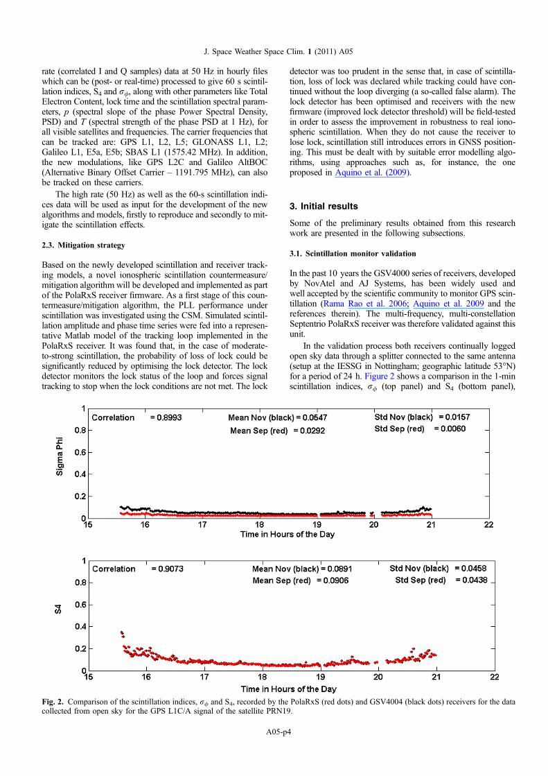
In the past 10 years the GSV4000 series of receivers, developedby NovAtel and AJ Systems, has been widely used andwell accepted by the scientific community to monitor GPS scin-tillation (Rama Rao et al. 2006; Aquino et al. 2009 and thereferences therein). The multi-frequency, multi-constellationSeptentrio PolaRxS receiver was therefore validated against thisunit.
In the validation process both receivers continually loggedopen sky data through a splitter connected to the same antenna(setup at the IESSG in Nottingham; geographic latitude 53�N)for a period of 24 h. Figure 2 shows a comparison in the 1-minscintillation indices, r/ (top panel) and S4 (bottom panel),
Fig. 2. Comparison of the scintillation indices, r/ and S4, recorded by the PolaRxS (red dots) and GSV4004 (black dots) receivers for the datacollected from open sky for the GPS L1C/A signal of the satellite PRN19.
J. Space Weather Space Clim. 1 (2011) A05
A05-p4
estimated from open sky signals at Nottingham, for theGSV4004 (black marker) and PolaRxS (red marker) receivers,respectively, for the GPS L1C/A signal of satellite PRN19. Thislocation was chosen, given the very quiet conditions of the mid-latitude of Nottingham prevailing during the solar minimumperiod, which provides the right environment for a comparisonof the sensitivity and noise floor of the two receivers. It isobserved from the bottom panel of Figure 2 that S4 indicesrecorded by both receivers are comparable, with a correlationcoefficient of 0.9. The mean value of the S4 index recordedby the PolaRxS receiver is slightly higher than that recordedby the GSV4004 receiver (mean value of PolaRxS = 0.0906,mean value of GSV4004 = 0.0891). This small offset in theS4 values is probably due to the change in signal-to-noise ratiointroduced by the use of the splitter. From the top panel ofFigure 2, it is observed that the r/ values recorded by thePolaRxS receiver are lower than those recorded by theGSV4004 receiver: the mean value of r/ for the PolaRxS recei-ver is 0.0292 and that for GSV4004 receiver is 0.0547. Thisgives evidence that the PolaRxS receiver oscillator seems toprovide a better noise floor level than its GSV4004 counterpart.
3.2. Climatology studies based on data collected at the Brazilianstation, Presidente Prudente (PP)
An analysis with the Ground-Based Scintillation Climatology(GBSC) method was performed on the available data fromPP (22.1�S, 51.4�W, dip latitude = 12.3�S) in Brazil. GBSCwas originally developed for the high latitude receivers toinvestigate the physical process involved in the ionosphericscintillation, to contribute to the mitigation algorithms and asa first step towards forecasting the space-weather-related eventswith the GNSS receivers (Spogli et al. 2009, 2010; Alfonsiet al. 2011). The core of the GBSC is the maps of amplitudeand, if available, phase scintillation occurrence. All the satellitesin view at each epoch are considered to produce the maps. Inthe low latitude version of the GBSC, the maps can be definedin a bi-dimensional coordinate system expressed in terms ofcouples of two of the following: geographic coordinates, lati-tude and longitude, universal time, azimuth and elevation.The adopted binning is selected according to the availablestatistics and to a meaningful fragmentation of the map. The per-centage occurrence O of the given index is evaluated in eachbin of the map as:
O ¼ N thr=N tot ð1Þ
where Nthr is the number of data points corresponding to theindex above the characterising threshold and Ntot is the totalnumber of data points in the bin. Typical threshold valuesare 0.25 (in unit of the index) for moderate/strong scintillationscenarios and 0.1 for weak conditions. To remove the contri-bution of the bins with a scarce statistics, the data consideredin each bin must be above a given number. To ensure this, weadopted a threshold on the statistical accuracy that is definedas (Taylor 1997):
R% ¼ 100� rðN totÞ =N tot ð2Þwhere r(Ntot) is the standard deviation of the number of datapoints in each bin and Ntot is the total number of data points inthe bin. Typical threshold values of R% between 2.5% and10% are a good compromise between the necessity to includemeaningful bins in the map and to avoid overestimations ofthe occurrence due to scarce statistics.
This past data was collected by a SCINTMON (CornellScintillation Monitor) receiver (developed by Cornell Univer-sity) (Beach & Kintner 2001 and the references therein), man-aged by the Instituto Nacional de Pesquisas Espaciais (INPE,the Brazilian National Institute for Space Research), whichhas the ownership of the data. SCINTMON is a single fre-quency receiver that is not able to calculate the phase scintilla-tion index, but only S4. S4 data analysed refer to the solarminimum year of 2009, from 1 January to 31 October, with asignificant data gap between 29 June and 25 July.
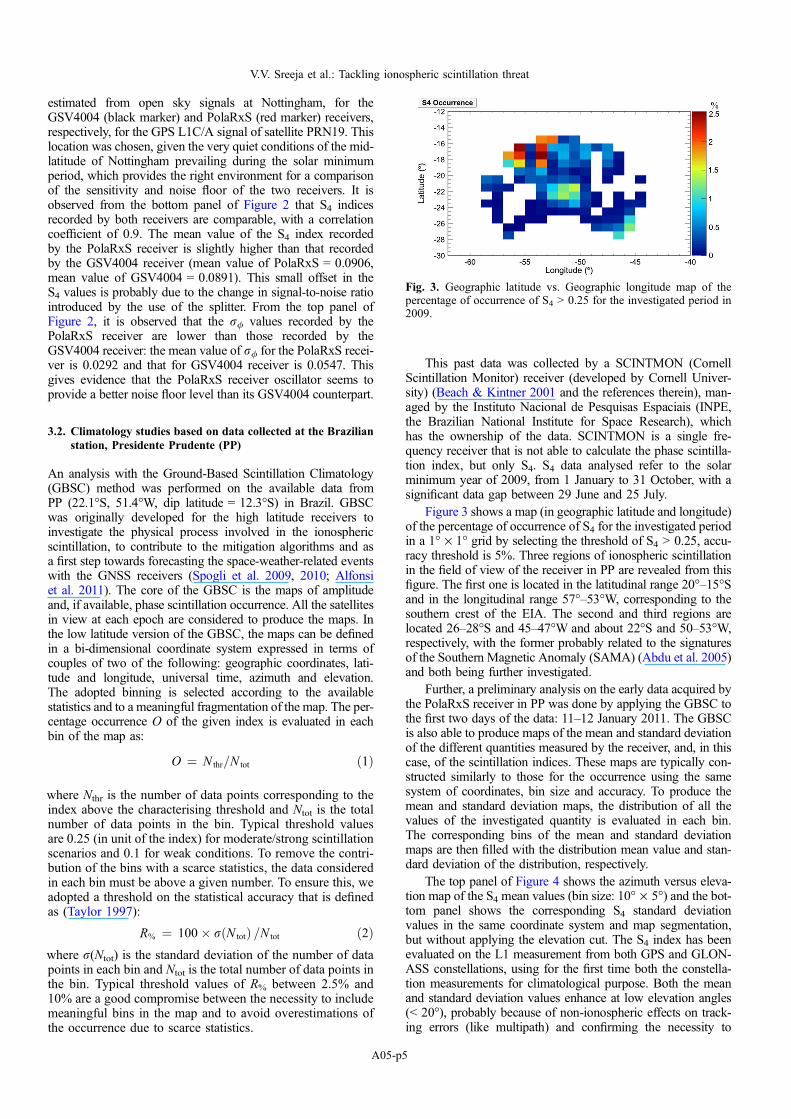
Figure 3 shows a map (in geographic latitude and longitude)of the percentage of occurrence of S4 for the investigated periodin a 1� · 1� grid by selecting the threshold of S4 > 0.25, accu-racy threshold is 5%. Three regions of ionospheric scintillationin the field of view of the receiver in PP are revealed from thisfigure. The first one is located in the latitudinal range 20�–15�Sand in the longitudinal range 57�–53�W, corresponding to thesouthern crest of the EIA. The second and third regions arelocated 26–28�S and 45–47�W and about 22�S and 50–53�W,respectively, with the former probably related to the signaturesof the Southern Magnetic Anomaly (SAMA) (Abdu et al. 2005)and both being further investigated.
Further, a preliminary analysis on the early data acquired bythe PolaRxS receiver in PP was done by applying the GBSC tothe first two days of the data: 11–12 January 2011. The GBSCis also able to produce maps of the mean and standard deviationof the different quantities measured by the receiver, and, in thiscase, of the scintillation indices. These maps are typically con-structed similarly to those for the occurrence using the samesystem of coordinates, bin size and accuracy. To produce themean and standard deviation maps, the distribution of all thevalues of the investigated quantity is evaluated in each bin.The corresponding bins of the mean and standard deviationmaps are then filled with the distribution mean value and stan-dard deviation of the distribution, respectively.
The top panel of Figure 4 shows the azimuth versus eleva-tion map of the S4 mean values (bin size: 10� · 5�) and the bot-tom panel shows the corresponding S4 standard deviationvalues in the same coordinate system and map segmentation,but without applying the elevation cut. The S4 index has beenevaluated on the L1 measurement from both GPS and GLON-ASS constellations, using for the first time both the constella-tion measurements for climatological purpose. Both the meanand standard deviation values enhance at low elevation angles(< 20�), probably because of non-ionospheric effects on track-ing errors (like multipath) and confirming the necessity to
Fig. 3. Geographic latitude vs. Geographic longitude map of thepercentage of occurrence of S4 > 0.25 for the investigated period in2009.
V.V. Sreeja et al.: Tackling ionospheric scintillation threat
A05-p5

remove contribution from such low elevation angle measure-ments. Just above the 20� elevation, the mean value increasesin the azimuthal range of about (330�, 360�) and (0�, 30�),i.e. in the N-NW direction. In correspondence, also the standarddeviation increases, indicating a region where larger values ofS4 are more probable. This region corresponds to the southerncrest of the EIA, confirming what was already found with thehistorical data analysis of the SCINTMON receiver. A longertime interval and availability of the data from the entire networkof receivers, shown in Figure 1, are expected to maximise thenumber of scintillation events recorded and a more precisecomparison with what was found with the SCINTMON histor-ical data will be allowed. Moreover, the possibility of acquiringthe signals from GPS (civil signals on L1, L2 and L5),GLONASS (civil signals on L1 and L2) and GALILEO/GIO-VE (civil signals in the L1, E5a and E5b bands) increases theredundancy of the problem. All these features will allow anexperimental identification of the different areas of the equato-rial ionosphere more affected by the scintillation phenomena(and in particular the contribution of the SAMA) and theirdependence on the local time and season.
3.3. Scintillation event recorded by the PolaRxS receiver at PP
The PolaRxS receiver deployed in PP recorded a scintillationevent on 26 March 2011, a geomagnetically quiet day (Kpvalue of 1). Figure 5 shows the variation in the scintillationindices (S4 – bottom panel and r/ – top panel) as a functionof local time and Ionospheric Pierce Point (IPP) latitude, dur-ing the post-sunset hours and for the GPS L1C/A signal. TheIPP latitude for the different satellite-to-receiver links at every1 min has been calculated assuming a single shell ionosphericmodel centred at an altitude of 350 km. Also, a satellite
elevation angle cut-off of 30� is applied in order to reducethe impact of non-scintillation-related tracking errors (e.g.induced by multipath). Since scintillation events over theequatorial and low latitudes are essentially post-sunset phe-nomena, the local time in Figure 5 varies continuously from18:00 LT to next morning 04:00 LT. It can be observed fromthe enhancement in S4 and r/ that, the evolution of the irreg-ularities on this day occurred between 20:00 and 24:00 LT.Further, S4 and r/ values are considerably higher (around0.8 and 0.6, respectively) and more widespread in latitude,implying that the irregularities have a greater latitudinal extent(extending between 18 and 24�S).
3.4. Receiver tracking performance
Once validated for use in scintillation monitoring, the PolaRxSreceiver tracking performance was evaluated. This was done bycalculating the variance of the error at the output of the PLLusing the formula given in Conker et al. (2003). The Conkeret al. (2003) formula for the GPS L1 carrier PLL accountsfor the effects of scintillation on the input phase and computesthe tracking error variance at the output of the PLL ðr2
/Þ as:
r2/ ¼ r2
/sþ r2
/Tþ r2
/oscð3Þ
where r2/s, r2
/Tand r2
/oscare the error variance components
relating to the phase scintillation, the thermal noise (ampli-tude scintillation) and the oscillator noise (assumed as0.01 rad2 in the receiver), respectively.
In equation (3), amplitude scintillation is modelled as anincrease in the thermal noise, related to the decrease in thereceived signal power as (Conker et al. 2003):
r2/T¼
Bn½1þ 12g c=g0ð ÞL1�C=Að1�2S24ðL1ÞÞ
�
c=g0ð ÞL1�C=Að1� S24ðL1ÞÞ
ð4Þ
where Bn is the L1 third-order PLL one-sided bandwidthequal to 15 Hz, (c/g0)L1�C/A is the fractional form of signal-
Fig. 5. Scintillation indices (S4 – bottom panel and r/ – top panel)maps as a function of the local time and IPP latitude for 26 March2011 for the GPS L1C/A signal.
Fig. 4. Maps of the amplitude scintillation index S4 measured on L1frequency in azimuth vs. elevation. Top plot shows the mean values,bottom plot shows the root mean square.
J. Space Weather Space Clim. 1 (2011) A05
A05-p6
to-noise density ratio, equal to 100.1C/N0, g is the predetectionintegration time, equal to 0.01 s and S4(L1) is the amplitudescintillation index measured at L1 frequency. The model isvalid only for S4(L1) < 0.707; loss of lock is assumed forgreater values of S4.
The phase scintillation component is modelled as (Conkeret al. 2003):
r2/s¼ pT
kf p�1n sin 2kþ1�p½ �p
2k
� � ð5Þ
where T is the spectral strength of the phase PSD at 1 Hz, p isthe spectral slope of the phase PSD, k is the order of the PLL(equal to 3) and fn is the loop natural frequency (equal to1.91 Hz).
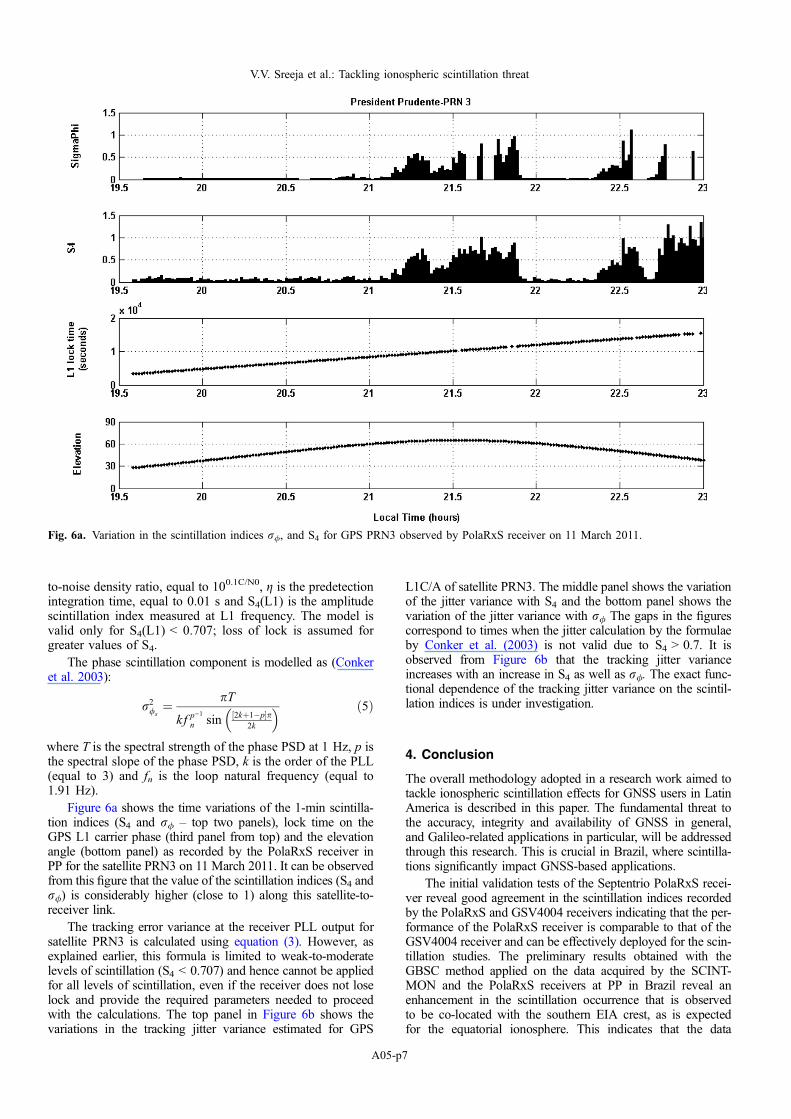
Figure 6a shows the time variations of the 1-min scintilla-tion indices (S4 and r/ – top two panels), lock time on theGPS L1 carrier phase (third panel from top) and the elevationangle (bottom panel) as recorded by the PolaRxS receiver inPP for the satellite PRN3 on 11 March 2011. It can be observedfrom this figure that the value of the scintillation indices (S4 andr/) is considerably higher (close to 1) along this satellite-to-receiver link.
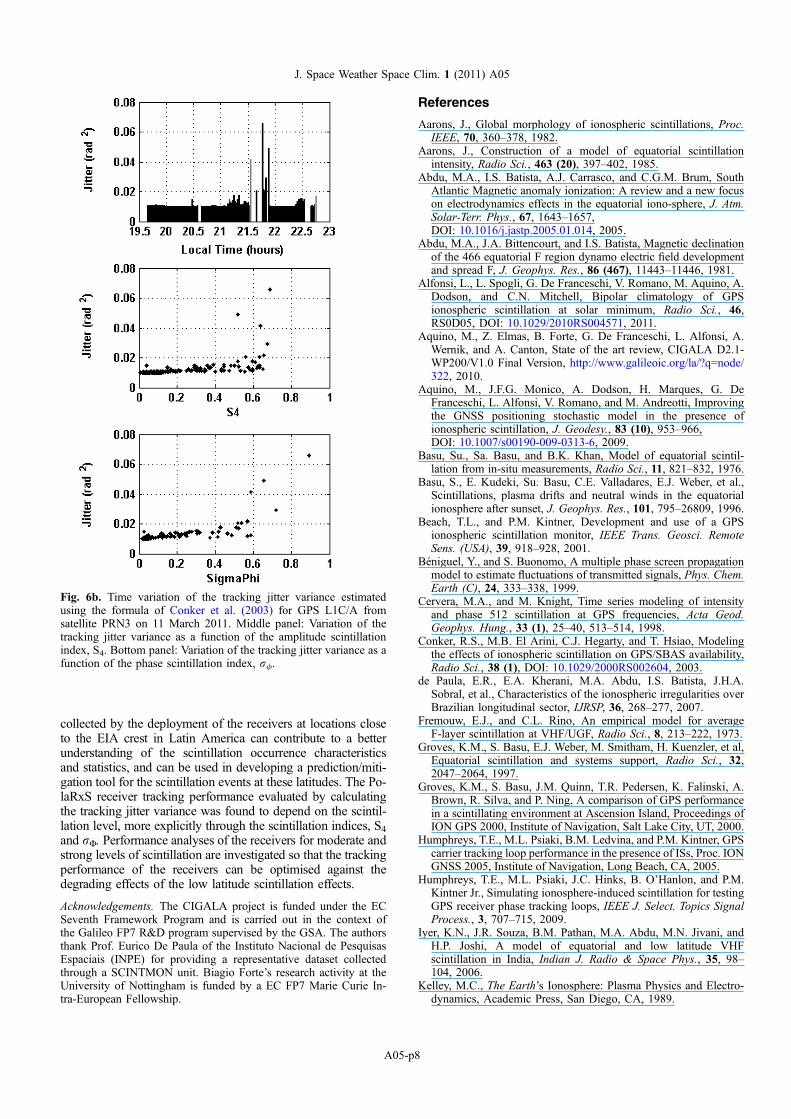
The tracking error variance at the receiver PLL output forsatellite PRN3 is calculated using equation (3). However, asexplained earlier, this formula is limited to weak-to-moderatelevels of scintillation (S4 < 0.707) and hence cannot be appliedfor all levels of scintillation, even if the receiver does not loselock and provide the required parameters needed to proceedwith the calculations. The top panel in Figure 6b shows thevariations in the tracking jitter variance estimated for GPS
L1C/A of satellite PRN3. The middle panel shows the variationof the jitter variance with S4 and the bottom panel shows thevariation of the jitter variance with r/ The gaps in the figurescorrespond to times when the jitter calculation by the formulaeby Conker et al. (2003) is not valid due to S4 > 0.7. It isobserved from Figure 6b that the tracking jitter varianceincreases with an increase in S4 as well as r/. The exact func-tional dependence of the tracking jitter variance on the scintil-lation indices is under investigation.
4. Conclusion
The overall methodology adopted in a research work aimed totackle ionospheric scintillation effects for GNSS users in LatinAmerica is described in this paper. The fundamental threat tothe accuracy, integrity and availability of GNSS in general,and Galileo-related applications in particular, will be addressedthrough this research. This is crucial in Brazil, where scintilla-tions significantly impact GNSS-based applications.
The initial validation tests of the Septentrio PolaRxS recei-ver reveal good agreement in the scintillation indices recordedby the PolaRxS and GSV4004 receivers indicating that the per-formance of the PolaRxS receiver is comparable to that of theGSV4004 receiver and can be effectively deployed for the scin-tillation studies. The preliminary results obtained with theGBSC method applied on the data acquired by the SCINT-MON and the PolaRxS receivers at PP in Brazil reveal anenhancement in the scintillation occurrence that is observedto be co-located with the southern EIA crest, as is expectedfor the equatorial ionosphere. This indicates that the data
Fig. 6a. Variation in the scintillation indices r/, and S4 for GPS PRN3 observed by PolaRxS receiver on 11 March 2011.
V.V. Sreeja et al.: Tackling ionospheric scintillation threat
A05-p7
collected by the deployment of the receivers at locations closeto the EIA crest in Latin America can contribute to a betterunderstanding of the scintillation occurrence characteristicsand statistics, and can be used in developing a prediction/miti-gation tool for the scintillation events at these latitudes. The Po-laRxS receiver tracking performance evaluated by calculatingthe tracking jitter variance was found to depend on the scintil-lation level, more explicitly through the scintillation indices, S4and rU. Performance analyses of the receivers for moderate andstrong levels of scintillation are investigated so that the trackingperformance of the receivers can be optimised against thedegrading effects of the low latitude scintillation effects.
Acknowledgements. The CIGALA project is funded under the ECSeventh Framework Program and is carried out in the context ofthe Galileo FP7 R&D program supervised by the GSA. The authorsthank Prof. Eurico De Paula of the Instituto Nacional de PesquisasEspaciais (INPE) for providing a representative dataset collectedthrough a SCINTMON unit. Biagio Forte’s research activity at theUniversity of Nottingham is funded by a EC FP7 Marie Curie In-tra-European Fellowship.
References
Aarons, J., Global morphology of ionospheric scintillations, Proc.IEEE, 70, 360–378, 1982.
Aarons, J., Construction of a model of equatorial scintillationintensity, Radio Sci., 463 (20), 397–402, 1985.
Abdu, M.A., I.S. Batista, A.J. Carrasco, and C.G.M. Brum, SouthAtlantic Magnetic anomaly ionization: A review and a new focuson electrodynamics effects in the equatorial iono-sphere, J. Atm.Solar-Terr. Phys., 67, 1643–1657,DOI: 10.1016/j.jastp.2005.01.014, 2005.
Abdu, M.A., J.A. Bittencourt, and I.S. Batista, Magnetic declinationof the 466 equatorial F region dynamo electric field developmentand spread F, J. Geophys. Res., 86 (467), 11443–11446, 1981.
Alfonsi, L., L. Spogli, G. De Franceschi, V. Romano, M. Aquino, A.Dodson, and C.N. Mitchell, Bipolar climatology of GPSionospheric scintillation at solar minimum, Radio Sci., 46,RS0D05, DOI: 10.1029/2010RS004571, 2011.
Aquino, M., Z. Elmas, B. Forte, G. De Franceschi, L. Alfonsi, A.Wernik, and A. Canton, State of the art review, CIGALA D2.1-WP200/V1.0 Final Version, http://www.galileoic.org/la/?q=node/322, 2010.
Aquino, M., J.F.G. Monico, A. Dodson, H. Marques, G. DeFranceschi, L. Alfonsi, V. Romano, and M. Andreotti, Improvingthe GNSS positioning stochastic model in the presence ofionospheric scintillation, J. Geodesy., 83 (10), 953–966,DOI: 10.1007/s00190-009-0313-6, 2009.
Basu, Su., Sa. Basu, and B.K. Khan, Model of equatorial scintil-lation from in-situ measurements, Radio Sci., 11, 821–832, 1976.
Basu, S., E. Kudeki, Su. Basu, C.E. Valladares, E.J. Weber, et al.,Scintillations, plasma drifts and neutral winds in the equatorialionosphere after sunset, J. Geophys. Res., 101, 795–26809, 1996.
Beach, T.L., and P.M. Kintner, Development and use of a GPSionospheric scintillation monitor, IEEE Trans. Geosci. RemoteSens. (USA), 39, 918–928, 2001.
Beniguel, Y., and S. Buonomo, A multiple phase screen propagationmodel to estimate fluctuations of transmitted signals, Phys. Chem.Earth (C), 24, 333–338, 1999.
Cervera, M.A., and M. Knight, Time series modeling of intensityand phase 512 scintillation at GPS frequencies, Acta Geod.Geophys. Hung., 33 (1), 25–40, 513–514, 1998.
Conker, R.S., M.B. El Arini, C.J. Hegarty, and T. Hsiao, Modelingthe effects of ionospheric scintillation on GPS/SBAS availability,Radio Sci., 38 (1), DOI: 10.1029/2000RS002604, 2003.
de Paula, E.R., E.A. Kherani, M.A. Abdu, I.S. Batista, J.H.A.Sobral, et al., Characteristics of the ionospheric irregularities overBrazilian longitudinal sector, IJRSP, 36, 268–277, 2007.
Fremouw, E.J., and C.L. Rino, An empirical model for averageF-layer scintillation at VHF/UGF, Radio Sci., 8, 213–222, 1973.
Groves, K.M., S. Basu, E.J. Weber, M. Smitham, H. Kuenzler, et al,Equatorial scintillation and systems support, Radio Sci., 32,2047–2064, 1997.
Groves, K.M., S. Basu, J.M. Quinn, T.R. Pedersen, K. Falinski, A.Brown, R. Silva, and P. Ning, A comparison of GPS performancein a scintillating environment at Ascension Island, Proceedings ofION GPS 2000, Institute of Navigation, Salt Lake City, UT, 2000.
Humphreys, T.E., M.L. Psiaki, B.M. Ledvina, and P.M. Kintner, GPScarrier tracking loop performance in the presence of ISs, Proc. IONGNSS 2005, Institute of Navigation, Long Beach, CA, 2005.
Humphreys, T.E., M.L. Psiaki, J.C. Hinks, B. O’Hanlon, and P.M.Kintner Jr., Simulating ionosphere-induced scintillation for testingGPS receiver phase tracking loops, IEEE J. Select. Topics SignalProcess., 3, 707–715, 2009.
Iyer, K.N., J.R. Souza, B.M. Pathan, M.A. Abdu, M.N. Jivani, andH.P. Joshi, A model of equatorial and low latitude VHFscintillation in India, Indian J. Radio & Space Phys., 35, 98–104, 2006.
Kelley, M.C., The Earth’s Ionosphere: Plasma Physics and Electro-dynamics, Academic Press, San Diego, CA, 1989.
Fig. 6b. Time variation of the tracking jitter variance estimatedusing the formula of Conker et al. (2003) for GPS L1C/A fromsatellite PRN3 on 11 March 2011. Middle panel: Variation of thetracking jitter variance as a function of the amplitude scintillationindex, S4. Bottom panel: Variation of the tracking jitter variance as afunction of the phase scintillation index, r/.
J. Space Weather Space Clim. 1 (2011) A05
A05-p8

Kintner, P.M., H. Kil, T.L. Beach, and E.R. de Paula, FadingTimescales Associated with GPS Signals and Potential Conse-quences, Radio Sci., 36 (4), 731–743, 2001.
Knight, M., and A. Finn, The effects of ionospheric scintillation onGPS, Proc. ION GPS 1998, Nashvill, TN: ION, 1998.
Mendillo, M., J. Baumgardner, Pi. Xiaoquing, P.J. Sultan, and R.T.Tsunoda, Onset conditions for equatorial spread F, J. Geophys.Res., 97 (13), 865–876, 1992.
Morrissey, T.N., K.W. Shallberg, A.J. Van Dierendonck, and M.J.Nicholson, GPS receiver performance characterization underrealistic ionospheric phase scintillation environments, RadioSci., 39, 1–18, 2004.
Muella, M.T.A.H., E.A. Kherani, E.R. de Paula, A.P. Cerruti, P.M.Kintner, I.J. Kantor, C.N. Mitchell, I.S. Batista, and M.A. Abdu,Scintillation-producing Fresnel-scale irregularities associated withthe regions of steepest TEC gradients adjacent to the equatorialionization anomaly, J. Geophys. Res., 115, A03301,DOI: 10.1029/2009JA014788, 2010.
Rama Rao, P.V.S., S. Gopikrishna, K. Niranjan, and D.S.V.V.D.Prasad, Study of spatial and temporal characteristics of L-bandscintillations over the Indian low latitude region and their possibleeffects on GPS navigation, Ann. Geophys., 24, 1567–1580, 2006.
Secan, J.A., R.M. Bussey, E.J. Fremouw, and Sa. Basu, An improvedmodel of equatorial scintillation, Radio Sci., 30, 607–617, 1995.
Spogli, L., L. Alfonsi, G. De Franceschi, V. Romano, M.H.O.Aquino, and A. Dodson, Climatology of GPS ionosphericscintillations over high and mid-latitude European regions, Ann.Geophys., 27, 3429–3437, 2009.
Spogli, L., L. Alfonsi, G. De Franceschi, V. Romano, M.H.O.Aquino, and A. Dodson, Climatology of GNSS iono-spheric scintillations at high and mid latitudes under differentsolar activity conditions, Il Nuovo Cimento B,DOI: 10.1393/ncb/i2010-10857-7, 2010.
Taylor, J.R., An Introduction to Error Analysis: The Study ofUncertainties in Physical Measurement, 2nd edition, Univ. Sci.,Sausalito, CA, 1997.
Wernik, A.W., L. Alfonsi, and M. Materassi, Scintillation modelingusing in situ data, Radio Sci., 42, RS1002,DOI: 10.1029/2006RS003512, 2007.
Wernik, A.W., and C.H. Liu, Ionospheric irregularities causingscintillations of GHz frequency radio signals, J. Atm. Terr. Phys.,36, 871–879, 1974.
V.V. Sreeja et al.: Tackling ionospheric scintillation threat
A05-p9