T H E P O S S I B I L I T Y OF A N A B S O L
134
THE POSSIBILITY OF AN ABSOLUTE ARCHITECTURE
Transcript of T H E P O S S I B I L I T Y OF A N A B S O L

THE POSSIBIL ITY OF AN ABSOLUTE ARCHITECTURE

Writing Architecture series
A project of the Anyone Corporation; Cynthia Davidson, editor
Earth Moves: The Furnishing of Territories
Bernard Cache, 1995
Architecture as Metaphor: Language, Number, Money
Kojin Karatani, 1995
Differences: Topographies of Contemporary Architecture
Ignasi de Solà-Morales, 1996
Constructions
John Rajchman, 1997
Such Places as Memory
John Hejduk, 1998
Welcome to The Hotel Architecture
Roger Connah, 1998
Fire and Memory: On Architecture and Energy
Luis Fernández-Galiano, 2000
A Landscape of Events
Paul Virilio, 2000
Architecture from the Outside: Essays on Virtual and Real Space
Elizabeth Grosz, 2001
Public Intimacy: Architecture and the Visual Arts
Giuliana Bruno, 2007
Strange Details
Michael Cadwell, 2007
Histories of the Immediate Present: Inventing Architectural Modernism
Anthony Vidler, 2008
Drawing for Architecture
Leon Krier, 2009
Architecture’s Desire: Reading the Late Avant-Garde
K. Michael Hays, 2010
The Possibility of an Absolute Architecture
Pier Vittorio Aureli, 2011
The Alphabet and the Algorithm
Mario Carpo, 2011
THE MIT PRESS
CAMBRIDGE, MASSACHUSETTS
LONDON, ENGLAND
THE POSSIBIL ITY OF AN ABSOLUTE ARCHITECTURE
P I E R V I T T O R I O A U R E L I
© 2011 Massachusetts Institute of Technology
All rights reserved. No part of this book may be reproduced in
any form by any electronic or mechanical means (including
photocopying, recording, or information storage and retrieval)
without permission in writing from the publisher.
MIT Press books may be purchased at special quantity
discounts for business or sales promotional use.
For information, please email [email protected]
or write to Special Sales Department, The MIT Press,
55 Hayward Street, Cambridge, MA 02142.
This book was set in Filosofia and Trade Gothic by the MIT
Press. Printed and bound in the United States of America.
Library of Congress Cataloging-in-Publication Data
Aureli, Pier Vittorio.
The possibility of an absolute architecture / Pier
Vittorio Aureli.
p. cm. — (Writing architecture)
Includes bibliographical references and index.
ISBN 978-0-262-51579-5 (pbk. : alk. paper)
1. Architecture. 2. Cities and towns. I. Title.
NA2540. A97 2011
720.1—dc22
2010030741
10 9 8 7 6 5 4 3 2 1
ACKNOWLEDGMENTS vii
INTRODUCTION ix
1. TOWARD THE ARCHIPELAGO 1
Defining the Political and the Formal in Architecture
2. THE GEOPOLITICS OF THE IDEAL VILLA 47
Andrea Palladio and the Project of an Anti-Ideal City
3. INSTAURATIO URBIS 85
Piranesi’s Campo Marzio versus Nolli’s Nuova Pianta di Roma
4. ARCHITECTURE AS A STATE OF EXCEPTION 141
Étienne-Louis Boullée’s Project for a Metropolis
5. THE CITY WITHIN THE CITY 177
Oswald Mathias Ungers, OMA,
and the Project of the City as Archipelago
NOTES 229
INDEX 247
C O N T E N T S

I offer deep thanks to Cynthia Davidson for her continuous sup-
port, critical help, and editorial work on the manuscript of this
book. Without her strong encouragement and patience the book
would not exist. Thanks also to Matthew Abbate and the MIT Press.
The following people have been important in shaping the con-
tent of the book in different ways, consciously or unconsciously:
Wiel Arets, Marco Biraghi, Cesare Birignani, Alice Bulla, Luca
Galofaro, Maria Shéhérazade Giudici, Elias Guenoun, Ariane
Lourie Harrison, Rolf Jenni, Gabriele Mastrigli, Vedran Mimica,
Philippe Morell, Joan Ockman, Manuel Orazi, Bernardo Secchi,
Lukasz Stanek, Brett Steele, Roemer van Toorn, Thomas Weaver,
Alejandro Zaera Polo, and Guido Zuliani. The Berlage Institute
in Rotterdam and the Architectural Association in London have
been welcoming platforms for the development of the ideas
expressed in this book. Fundamental discussions with Umberto
Barbieri, Andrea Branzi, Peter Eisenman, Gabriele Mastrigli,
Martino Tattara, Mario Tronti, and Elia Zenghelis have directly
influenced the writing.
I dedicate this book to my parents and my sister.
A C K N O W L E D G M E N T S
This book proposes to reconsider architectural form in light of
a unitary interpretation of architecture and the city. This uni-
tary interpretation is put forward via the paradox of a unilateral
synthesis: a unitary interpretation made from within projects
on architectural form itself. This unilateral synthesis addresses
the possibility of interpreting architectural form as the index for
the constitution of an idea of the city. In order to highlight the
constitutive paradox implied in such a thesis, I have defined
the object of this book as absolute architecture.
The term absolute is intended to stress, as much as possible,
the individuality of the architectural form when this form is
confronted with the environment in which it is conceived and
constructed. I use absolute not in the conventional sense of “pu-
rity” but in its original meaning as something being resolutely
itself after being “separated” from its other.1 In the pursuit of the
possibility of an absolute architecture, the other is the space of
the city, its extensive organization, and its government.
In the course of history, certain architects have articulated the
autonomy of form through a radical and systematic confrontation
with the city in which they have operated. If politics is agonism
through separation and confrontation, it is precisely in the pro-
cess of separation inherent in the making of architectural form
that the political in architecture lies, and thus the possibility of
understanding the agonistic relationship between architecture
and its context. The very condition of architectural form is to
separate and to be separated. Through its act of separation and
being separated, architecture reveals at once the essence of the
I N T R O D U C T I O N

x INTRODUCTION
city and the essence of itself as political form: the city as the com-
position of (separate) parts.
In the first chapter, I theorize the possibility of an absolute
architecture by introducing the categories of the formal and the
political in architecture. The formal and the political are overlap-
ping categories, as they both address the possibility of separa-
tion, composition, and counterposition; in architecture, these
categories are interpreted within the separateness implied in the
constitution of architectural form. For this reason the formal and
the political are seen as the basis not only of architectural form,
but also of the idea of the city. Both the idea of architecture and
the idea of the city as defined through the categories of the formal
and the political are mobilized against the ethos of urbanization,
the “managerial” paradigm that, within the rise of capitalism, has
characterized our global civilization since the twilight of the so-
called Middle Ages. Urbanization is here understood according to
Ildefons Cerdà’s initial use of the term as the ever-expanding and
all-encompassing apparatus that is at the basis of modern forms
of governance. These modern forms of governance consist in the
absorption of the political dimension of coexistence (the city)
within the economic logic of social management (urbanization).
It is precisely within the rise of the space of urbanization
that architecture as the project of the finite, and thus separated,
form(s) can be read as critical, inasmuch as it both obeys the
managerial principle of urbanization and its extensive logic of
total integration, yet makes explicit and tangible the inexorable
separateness of the city, since the city is made not only of flows but
also of stoppages, walls, boundaries, and partitions. Of course,
urbanization is not an apparatus made of flows; it is made of clo-
sures and of strategic forms of containment. Today it is clear that
the outcome of the logic of urban governance manifests itself not
only in the smooth space of global economic transactions, but
I N T R O D U C T I O N xi
also, and especially, in the proliferation of enclaves, walls, and ap-
paratuses of control and closure established in order to maintain
the “smoothness” of global economic trade. This is nothing new.
The rise of urbanization as an apparatus of governance is marked
precisely by the constant dialectic of integration and closure.
Within urbanization, integration and closure are not the con-
sequence of each other, but are two simultaneous phenomena
meant to reinforce each other. The possibility of an absolute
architecture consists in the alteration of this dialectic by re-
claiming separation, not only as part of the principle of urban
management but as a form that exceeds it. In this way the pos-
sibility of an absolute architecture is the attempt to reestablish
the sense of the city as the site of a political confrontation and
recomposition of parts. While the urban theories of Cerdà, Lud-
wig Hilberseimer, Archizoom, and Rem Koolhaas are seen here as
the most extreme paradigmatic projects of urbanization, the late
work of Ludwig Mies van der Rohe is interpreted as demonstrat-
ing the possibility of an absolute architecture. Mies’s late projects
absorbed the reifying forces of urbanization, but presented them
not as ubiquitous but as finite, clearly separated parts.
The idea of separated parts links the possibility of an ab-
solute architecture to the idea of the archipelago as a form for
the city. The concept of the archipelago describes a condition
where parts are separated yet united by the common ground
of their juxtaposition. In contrast to the integrative apparatus of
urbanization, the archipelago envisions the city as the agonistic
struggle of parts whose forms are finite and yet, by virtue of their
finiteness, are in constant relationship both with each other and
with the “sea” that frames and delimits them. The islands of the
archipelago describe the role of architectural form within a space
more and more dominated by the “sea” of urbanization. The
islands are framed by this sea, yet their formal boundaries allow

xii INTRODUCTION
them to be understood as what frames and, to a certain extent,
(re)defines the sea between the islands. Such an act of fram-
ing and redefinition consists not in the imposition of a general
principle or of an overall norm, but in the strategic deployment
of specific architectural forms that act as frames, and thus as a
limit to urbanization. These forms are the opposite of what today
are called “iconic buildings.” Iconic buildings are typically sin-
gular landmarks whose agency is inscribed entirely within the
logic of urbanization. Indeed, the agenda of the iconic building
is a postpolitical architecture stripped bare of any meaning other
than the celebration of corporate economic performance. In this
sense, rather than being agonistic forms, contemporary “icons”
are the final and celebratory manifestations of the Grundnorm of
urbanization: the victory of economic optimization over politi-
cal judgment. The islands of the archipelago, on the other hand,
confront the forces of urbanization by opposing to urbanization’s
ubiquitous power their explicitness as forms, as punctual, cir-
cumscribed facts, as stoppages.
This understanding of architecture was the trigger for my re-
visiting the work of four architects whose project was advanced
through the making of architectural form, but whose concern was
the city at large. Using the metaform of the archipelago, I attempt
to identify the project of the city in the work advanced by Andrea
Palladio, Giovanni Battista Piranesi, Étienne-Louis Boullée, and
Oswald Mathias Ungers. On the one hand, the choice of these ar-
chitects is subjective and motivated by my profound interest in
their work, which I have approached not as a historian but as an
architect interested in the work of other architects. At the same
time, the work of these architects addressed the transformations
of the modern city and its urban implications not through a gen-
eral vision for the city, but through the elaboration of specific and
strategic architectural forms. For this reason, their respective
I N T R O D U C T I O N xiii
projects for the city do not take the form of an overall plan but
are manifested as an archipelago of site-specific interventions.
The themes and concepts that frame these interventions can
be seen as the stepping-stones of a strategy, and thus of a project,
that attempts to reinvent the city. Consequently, this book does
not argue for the autonomy of design, but rather for the autonomy
of the project, for the possibility of architectural thought to pro-
pose an alternative idea of the city rather than simply confirm-
ing its existing conditions. The difference between the idea of
the project and the idea of design is crucial here. Design reflects
the mere managerial praxis of building something, whereas the
project indicates the strategy on whose basis something must be
produced, must be brought into presence. In the idea of the proj-
ect, the strategy exceeds the mere act of building and acquires a
meaning in itself: an act of decision and judgment on the reality
that the design or building of something addresses.
For this reason, the forms advanced by these four architects
are described in terms of how their themes and concepts have
resonated with the political, social, and cultural circumstances
of each city. In each case I emphasize how the project of a specific
architectural form is at once an act of radical autonomy from and
radical engagement with the forces that characterized the urban-
ization of cities.
Apart from Ungers, none of the architects discussed here ever
presented his projects in terms of an archipelago. Representing
their work within the idea of the city as an archipelago is precisely
the argument of this book. The asymmetry between the scale of
architectural form and the overwhelming vastness of the urban
scale provoked these architects to elaborate architectural form
toward the possibility of being not a general rule but an example
for the city. In this way, each architectural intervention is bound
to a conceptual continuity that transforms the episodic nature of

xiv INTRODUCTION
each intervention (built or unbuilt) into islands of the archipel-
ago: the general project of the city that manifests itself through
the exceptional and “insular” form of architecture. The possibil-
ity of an absolute architecture is thus both the possibility of mak-
ing the city and also the possibility of understanding the city and
its opposing force—urbanization—through the very finite nature
of architectural form.

If white and black blend, soften, and unite
A thousand ways, is there no black or white?
—Alexander Pope, Essay on Man, 1733
Architecture has been popular in recent years. Ironically, how-
ever, its growing popularity is inversely proportional to the
increasing sense of political powerlessness and cultural disillu-
sionment many architects feel about their effective contribution
to the built world. Within this paradoxical situation—and beyond
the phenomenon of architecture’s “success”—it is necessary to
face and acknowledge the popularity of architecture critically.
To do so, we need to seriously address the unequivocal social
and cultural power architecture possesses to produce represen-
tations of the world through exemplary forms of built reality.
At this level, the problem of form—that is, the strategizing of ar-
chitecture’s being—becomes crucial. The making of form is thus
the real and effective necessary program of architecture.
But what form can architecture define within the contempo-
rary city without falling into the current self-absorbed perfor-
mances of iconic buildings, parametric designs, or redundant
mappings of every possible complexity and contradiction of the
1 TOWARD THE ARCHIPELAGODEFINING THE POLITICAL AND THE FORMAL IN ARCHITECTURE

2 TOWARD THE ARCHIPELAGO
urban world? What sort of significant and critical relationship
can architecture aspire to in a world that is no longer consti-
tuted by the idea and the motivations of the city, but is instead
dominated by urbanization? In what follows I will attempt to re-
construct the possibility of an architecture of the city that is no
longer situated only in the autonomous realm of its disciplinary
status, but must directly confront urbanization. This possibil-
ity is put forward in two ways: first, by critically understanding
the essential difference between the concept of the city and the
concept of urbanization—how these concepts overlap, as well as
how they address two radically different interpretations of in-
habited space—and second, by looking at how urbanization has
historically come to prevail over the city. I will show the rise of
urbanization not through its presumed “real” effects, but through
exemplary projects for cities, which here are understood as effec-
tive representations not simply of urbanization itself but also of
its logic. In an argument critical of the logic of urbanization (and
its instigator, capitalism), I will redefine political and formal as
concepts that can define architecture’s essence as form. Finally,
using these concepts as a springboard, I will illustrate a coun-
terproject for the city—the archipelago—by referring to a specific
architectural form that is a counterform within and against the
totality of urbanization. This project will lead to what I see as a
preliminary introduction for a definition of architecture itself, or
what I define as the possibility of an absolute architecture.
Polis, Civitas, UrbsAristotle made a fundamental distinction between politics and
economics—the distinction between what he defines as technè
politikè and technè oikonomikè.1 What he calls technè politikè is the
faculty of decision making for the sake of the public interest—de-
cision making for the common good, for the way individuals and
D E F I N I N G T H E P O L I T I C A L A N D T H E F O R M A L I N A R C H I T E C T U R E 3
different groups of people can live together. Politics in this sense
comes from the existence of the polis2 (and not the other way
around). The polis is the space of the many, the space that exists
in between individuals or groups of individuals when they coexist.
However, contrary to Aristotle, who assumed that “man is a
political animal” by nature, and thus conceived of the institu-
tion of politics as natural, we can say that political space—the
space in between—is not a natural or given phenomena. Political
space is made into the institution of politics precisely because
the existence of the space in between presupposes potential
conflict among the parts that form it. This possibility is the very
foundation of technè politikè—the art of politics—the decision
making that must turn conflict into coexistence (albeit without
eradicating the possibility of conflict). Precisely because politics
is incarnated in the polis—the project of the city—the existence
of the polis holds the possibility of conflict and the need for its
resolution as its very ontological foundation.
Technè oikonomikè—economy—concerns the administration of
private space par excellence: the house, or oikos, from which the
word oikonomikè derives. Aristotle’s oikos is a complex organism
of relationships that he divides into three categories: despotic
relationships, such as master-slave; paternal relationships, such
as parent to child; and marriage relationships, such as husband
to wife. Unlike political space, in the space of oikos, human re-
lationships are given, unchangeable, and despotic (for Aristo-
tle, the despot is the subject who governs the oikos). Oikonomikè
concerns the wise administration of the house and control over
the relationships of its members. The principle of economy can
be distinguished from the principle of politics in the same way
that the house is distinguished from the polis. Unlike politics,
the authority of economy acts not in the public interest but in
its own interest; furthermore, it cannot be questioned because

4 TOWARD THE ARCHIPELAGO
its sphere is not the pubic space of the polis but the private space
of the house. This distinction originated in the Greek city-state,
where there was a contrast between two constituent elements:
the oikoi—the agglomeration of houses—and the political space
of the agora, where opinions are exchanged and public decisions
are made. The private space of the house is the basic social space
that ensures the natural reproduction of its members; the pub-
lic space of the agora is the political space where discussion and
confrontation for the sake of the public interest takes place. The
history of cities in the West can be summarized in this at times
latent and ambiguous, at times evident struggle between public
and private interests, between political interests and economic
interests. In the Roman city, an analogous struggle played itself
out in the dichotomy between urbs and civitas. The Latin term urbs
indicated “city” in a different sense from the Greek word polis.
The term urbs addressed the very material constitution of the city.
In principle, an urbs was a walled agglomeration of houses with-
out further political qualification.3 Whereas the polis was founded
from a preexisting, latent community, the formation of the urbs
transcended any community, and thus could be founded ex novo,
in a tabula rasa condition, like the building of a domestic space.
From this we can affirm that urbs describes a generic condition of
protected cohabitation reducible to the principle of the house and
its material necessities. While the Greek polis was a city strictly
framed by its walled perimeter, the Roman urbs was not intended
to be restricted, and in fact it expanded in the form of a territorial
organization, in which roads played a crucial role.
As Hannah Arendt has remarked, the idea of nomos (law) was
crucial for the ancient Greeks. Nomos is law that, rather than
regulating political action, frames it within a defined spatial
form that coincides with the walled perimeter of the city and the
distinction between public and private space.4 Nomos was seen
D E F I N I N G T H E P O L I T I C A L A N D T H E F O R M A L I N A R C H I T E C T U R E 5
as a frame, as a necessary precondition for politics, but not as
an object of politics. The aim of nomos was to contain or, bet-
ter, to counter the infinite nature of relationships that originate
from the political life of a polis—the “insatiability” that Arendt
(following Aeschylus) defines as the inevitable collateral effect
of politics, “which can be held in check only by nomos, by law in
the Greek sense of the word.”5 Arendt writes, “The nomos limits
actions and prevents them from dissipating into an unforesee-
able, constantly expanding system of relationships, and by doing
so gives actions their enduring forms, turning each action into
a deed that in its greatness—that is, in its surpassing excellence—
can be remembered and preserved.”6
In contrast to the Greek concept of nomos, the Roman con-
cept of law, lex, was tout court a political thing in itself; it required
a political consensus of the parties involved in its jurisdiction
and its function as a treaty. Unlike the Greek nomos, which was
a predetermined form that framed the unfolding of political life,
the Roman law was a political instrument at the service of Rome’s
expansionist logic, through which the Romans could force alien
populations to be part of an ever-inclusive alliance for the sake
of Rome itself.7 While the nomos, by forming a limit, prevented
the Greek polis from unfolding into a totality, it was precisely the
inclusive concept of the lex that turned Rome from a polis into
a civitas, and thus into an empire. For this reason the idea of the
Greek polis can be described as an archipelago, not only because
it took this geographical form, but also because the condition
of insularity as a mode of relationships was its essential politi-
cal form.8 The Roman Empire, by contrast, can be described as
an insatiable network in which the empire’s diversity became
an all-inclusive totality. This totality was the settlement process
that originated in the logic of the urbs. The urbs, in contrast to the
insular logic of the Greek polis, represents the expansionist and

6 TOWARD THE ARCHIPELAGO
inclusive logic of the Roman territories.9 The Romans used the
term urbs to designate the idea of Rome because, in their expan-
sionist logic, Rome was the universal symbolic template for the
whole inhabited space of the empire. Thus urbs came to designate
a universal and generic condition of cohabitation, which is why,
as we will see later, it was used by the “inventor” of urbanism,
Ildefons Cerdà, to replace the term ciudad, which he found too
restrictive because it referred to “city”—to the political and sym-
bolic condition of civitas.10
Within urbs is the Roman civitas, the condition of citizenship
or right to citizenship. Unlike urbs, civitas concerns not the mate-
riality of inhabited space but the political status of its inhabitants.
Civitas comes from cives,11 a gathering of people from different
origins who decide to coexist under the same law, which in turn
gives them the condition of citizenship. As with urbs, there is a
fundamental difference between the Roman civitas and the Greek
polis. The civitas is a gathering of people of different origins, while
the Greek polis is a community of people who come from the same
place (foreigners did not have the right to participate in the politi-
cal life of the polis). However, we can say that both the polis and
the civitas are explicitly political forms of coexistence, unlike the
sphere of the oikos or, at a different scale, the urbs, which indi-
cates the material condition of cohabitation independent of any
political sense. By designating the built structure of the city and its
functioning without any initial political qualification, the urbs can
be interpreted as simply the generic aggregation of people—fami-
lies or clans—and their necessary circulation systems. The form
of this aggregation is a “cohabitation,” which means that what
is shared is simply the material condition of inhabiting a place.
The civitas is the gathering of free individuals who come to-
gether by recognizing and sharing a public sphere, the existence
of which makes them citizens. One can speculate that the Roman
D E F I N I N G T H E P O L I T I C A L A N D T H E F O R M A L I N A R C H I T E C T U R E 7
civitas and urbs play complementary roles similar to technè poli-
tikè and technè oikonomikè—of polis and oikos. But while the oikos
simply indicates the realm of domestic cohabitation, the urbs
extends this realm to the structure intended to support the sim-
ple aggregation of houses. This structure lies in the space infra,
or in between them: it is infrastructure. If the infra, as defined by
politics, is a trace of the impetus toward separation and confron-
tation within the city, the infra of the urbs is the space of con-
nection and integration. Urbs is infrastructure, the network that,
starting from the reality and necessity of the habitat, unfolds and
aggregates the house within an organic whole that bypasses any
political space. Its primary purpose is the functioning of the pri-
vate space of the family, which it connects to the infrastructure.
In the Roman city, urbs and civitas indicated two irreducible but
complementary domains of human association, but these began
to overlap and coexist within the same context. Hence, the Roman
city manifests what will be the ongoing central dilemma of the city
as such. First is the demand for the good functioning of the city as
a place for cohabitation through its economic administration and
the physical manifestation of administration, its urban plan—the
urbs—without which the city would be an uncomfortable and in-
secure place. Second is the demand for discussion and confron-
tation, its political life—civitas—without which the city would
be the unfolding of a predictable and despotic order of things.
The attempt to meet these demands via a single totality has been
the deep source of totalitarianism in the real sense of the word—to
rule human associations according to one total system that does
not differentiate between public and private aspects of human
behavior. However, with the rebirth of the Western city after the
dissolution of Roman civilization, the distinction between urbs
and civitas was not simply dissolved; rather, the economic impe-
tus of urbs gradually took over the political idea of civitas.

8 TOWARD THE ARCHIPELAGO
Unlike the Greek polis or the Roman civitas, the origins of
which were essentially political, the rebirth of the Western city
at the turn of the first millennium was propelled primarily by
the role of economics: agricultural improvements, the rise of
artisanal industry, and the consequent demographic expansion,
which created a totally new way of living and working.12 Though
this new form took place within a rural and feudal order, its prem-
ises were couched in a fundamental network of economic trans-
actions. The gradual rise of the bourgeoisie, a new social entity
that identified with the primary role assumed by the economy,
defined (and still defines) the very identity of the contemporary
city. The bourgeoisie constituted a new public sphere, one that
was no longer civitas but rather comprised the interests of owners
of private property, who constituted a new form of “public inter-
est.” This new form of public interest, however, is paradoxical.
It is essentially private because it is in the economic interest
of only one segment of the entire social body;13 but it is also de
facto public, because it concerns the primary source of the func-
tion of the modern city and modern state: the exchange of com-
modities and the social domain of work, which is precisely what
urbs is now meant to support and expand. Colonial urbanism in
the Americas, for example, was the ideal projection of this new
order. Not by chance, the Laws of the Indies that regulated the
layout of new cities in the American colonies were derived from
Alberti’s precepts in De re aedificatoria.14 In the “New World,” as
in the colonies of the Roman Empire, the economic efficiency of
urbanization was propelled by the military logic of settlement.
With the crisis of the ancien régime, the advent of industrializa-
tion, and the rise of capitalism, the role of the urbs absorbed the
idea of civitas to the point that over the last three centuries we
have witnessed the triumph of a new form of human association
based entirely on the mastery of the urbs. Enter urbanization.
D E F I N I N G T H E P O L I T I C A L A N D T H E F O R M A L I N A R C H I T E C T U R E 9
The word urbanization was introduced by the Spanish engi-
neer and planner Ildefons Cerdà, who theorized the concept in
his 1867 book Teoría general de la urbanización.15 Conscious of the
extreme importance of the phenomena he wanted to describe,16
Cerdà legitimized his invention of urbanization as elucidating the
emerging “conceptual” features of a paradigm. This paradigm
was the condition of limitlessness and the complete integration
of movement and communication brought about by capitalism,
which Cerdà saw as the unprecedented “vast swirling ocean of
persons, of things, of interests of every sort, of a thousand di-
verse elements”17 that work in permanent reciprocity and thus
form a totality that cannot be contained by any previous finite
territorial formations such as the city. Precisely for this reason,
after a careful investigation of the origin of the words available
for describing this new condition, he coined the word urbaniza-
tion, deriving it from the word urbs, with the intention to replace
the word ciudad (city), which he found too conditioned by its
meaning as civitas:
Since the genuine sense of urbs referred principally to the
material part of the grouping of buildings, for all matters
referring to the inhabitants [the Romans] used the word
civis (citizen), from which they derived all the terms
intended to express things, objects, happenstance, and
qualities concerning dwellers. The word urbanus (from
urbe) referred to matters concerning the material organi-
zation of the urbs: so it was that the citizens never called
themselves urban, because the root word did not allow for
such an application.18
Therefore, for Cerdà, the center of the new forms of human
habitat was not the city center with its monuments and symbolic
10 TOWARD THE ARCHIPELAGO
spaces, but what lay beyond it: the suburbs.19 Composed only of
roads and individual dwellings, the suburbs, according to Cerdà,
offered the best living conditions, and thus the task of urbaniza-
tion was to expand infrastructure as much as possible in order to
develop human habitats beyond the symbolic frame of the city.
“To ruralize the city and to urbanize the countryside”20 was, for
Cerdà, the double agenda of urbanization.
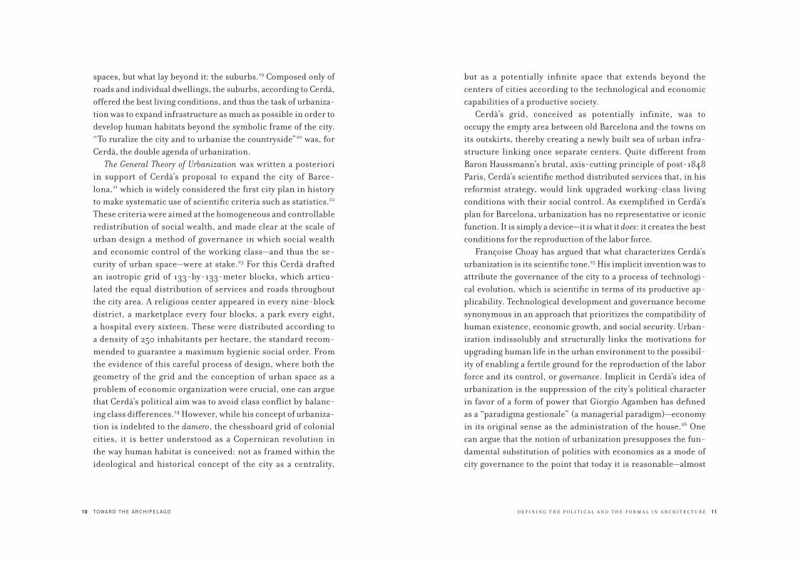
The General Theory of Urbanization was written a posteriori
in support of Cerdà’s proposal to expand the city of Barce-
lona,21 which is widely considered the first city plan in history
to make systematic use of scientific criteria such as statistics.22
These criteria were aimed at the homogeneous and controllable
redistribution of social wealth, and made clear at the scale of
urban design a method of governance in which social wealth
and economic control of the working class—and thus the se-
curity of urban space—were at stake.23 For this Cerdà drafted
an isotropic grid of 133-by-133-meter blocks, which articu-
lated the equal distribution of services and roads throughout
the city area. A religious center appeared in every nine-block
district, a marketplace every four blocks, a park every eight,
a hospital every sixteen. These were distributed according to
a density of 250 inhabitants per hectare, the standard recom-
mended to guarantee a maximum hygienic social order. From
the evidence of this careful process of design, where both the
geometry of the grid and the conception of urban space as a
problem of economic organization were crucial, one can argue
that Cerdà’s political aim was to avoid class conflict by balanc-
ing class differences.24 However, while his concept of urbaniza-
tion is indebted to the damero, the chessboard grid of colonial
cities, it is better understood as a Copernican revolution in
the way human habitat is conceived: not as framed within the
ideological and historical concept of the city as a centrality,
D E F I N I N G T H E P O L I T I C A L A N D T H E F O R M A L I N A R C H I T E C T U R E 11
but as a potentially infinite space that extends beyond the
centers of cities according to the technological and economic
capabilities of a productive society.
Cerdà’s grid, conceived as potentially infinite, was to
occupy the empty area between old Barcelona and the towns on
its outskirts, thereby creating a newly built sea of urban infra-
structure linking once separate centers. Quite different from
Baron Haussmann’s brutal, axis-cutting principle of post-1848
Paris, Cerdà’s scientific method distributed services that, in his
reformist strategy, would link upgraded working-class living
conditions with their social control. As exemplified in Cerdà’s
plan for Barcelona, urbanization has no representative or iconic
function. It is simply a device—it is what it does: it creates the best
conditions for the reproduction of the labor force.
Françoise Choay has argued that what characterizes Cerdà’s
urbanization is its scientific tone.25 His implicit invention was to
attribute the governance of the city to a process of technologi-
cal evolution, which is scientific in terms of its productive ap-
plicability. Technological development and governance become
synonymous in an approach that prioritizes the compatibility of
human existence, economic growth, and social security. Urban-
ization indissolubly and structurally links the motivations for
upgrading human life in the urban environment to the possibil-
ity of enabling a fertile ground for the reproduction of the labor
force and its control, or governance. Implicit in Cerdà’s idea of
urbanization is the suppression of the city’s political character
in favor of a form of power that Giorgio Agamben has defined
as a “paradigma gestionale” (a managerial paradigm)—economy
in its original sense as the administration of the house.26 One
can argue that the notion of urbanization presupposes the fun-
damental substitution of politics with economics as a mode of
city governance to the point that today it is reasonable—almost

12
1.1Ildefons Cerdà, Plan for Barcelona, 1860.
Urbanization replaces the city. Following colonial
cities in the Americas, Cerdà’s plan for Barcelona
exemplified the role of urbanization as the new
form of biopolitical government. The result is a plan
that optimizes urban infrastructure.
D E F I N I N G T H E P O L I T I C A L A N D T H E F O R M A L I N A R C H I T E C T U R E 13
banal—to ask not what kind of political power is governing us,
but whether we are governed by politics at all—that is, whether
we are living under a totalitarian managerial process based on
economy, which in turn uses different political modes of public
governance ranging from dictatorship to democracy to war. Of
course an economy acts politically, but its politics ultimately aims
to establish economic criteria as the primary organization of the
human environment. At the center of this principle, from Cerdà
on, the fundamental space of human association shifts from the
political space of the city to the economic space of the house.
In 1927, in his book Groszstadt Architektur (The architecture
of the big city), Ludwig Hilberseimer affirmed that the project
for the city consists of coordination between two extremes: the
overall plan for the city that would link the form of the city with its
productive and economic forces, and the definition of the single
inhabitable cell.27 One of the most radical representations of this
interpretation of urban management is Hilberseimer’s project
for the so-called Vertical City, the Hochhausstadt. Like Cerdà’s
plan for Barcelona, Hilberseimer’s plan for the Hochhausstadt (a
theoretical project that can be read as a plan for the reform of
Berlin) is an attempt to establish an overall urban system rather
than insisting on a composition of different city parts. In this
project Hilberseimer takes a polemical stand against not only the
utopian images proposed by expressionist architecture but also
Le Corbusier’s Contemporary City for Three Million Inhabitants
(1922). In his well-known proposal, Le Corbusier seems to ar-
range different building types according to the figures of clas-
sical architecture: the spatiality of the typical Parisian classicist
square is evoked by the space between the Cartesian skyscrapers;
the layout of the Palace of Versailles is evoked by the Redents;
the communitarian form of the abbey cloister is reinterpreted in
the Immeubles-Villas; and, finally, the outline of Michelangelo’s
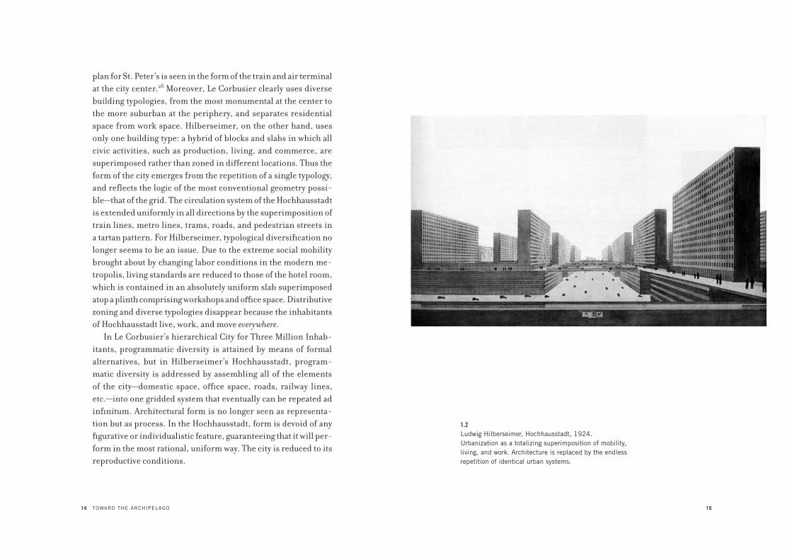
14 TOWARD THE ARCHIPELAGO
plan for St. Peter’s is seen in the form of the train and air terminal
at the city center.28 Moreover, Le Corbusier clearly uses diverse
building typologies, from the most monumental at the center to
the more suburban at the periphery, and separates residential
space from work space. Hilberseimer, on the other hand, uses
only one building type: a hybrid of blocks and slabs in which all
civic activities, such as production, living, and commerce, are
superimposed rather than zoned in different locations. Thus the
form of the city emerges from the repetition of a single typology,
and reflects the logic of the most conventional geometry possi-
ble—that of the grid. The circulation system of the Hochhausstadt
is extended uniformly in all directions by the superimposition of
train lines, metro lines, trams, roads, and pedestrian streets in
a tartan pattern. For Hilberseimer, typological diversification no
longer seems to be an issue. Due to the extreme social mobility
brought about by changing labor conditions in the modern me-
tropolis, living standards are reduced to those of the hotel room,
which is contained in an absolutely uniform slab superimposed
atop a plinth comprising workshops and office space. Distributive
zoning and diverse typologies disappear because the inhabitants
of Hochhausstadt live, work, and move everywhere.
In Le Corbusier’s hierarchical City for Three Million Inhab-
itants, programmatic diversity is attained by means of formal
alternatives, but in Hilberseimer’s Hochhausstadt, program-
matic diversity is addressed by assembling all of the elements
of the city—domestic space, office space, roads, railway lines,
etc.—into one gridded system that eventually can be repeated ad
infinitum. Architectural form is no longer seen as representa-
tion but as process. In the Hochhausstadt, form is devoid of any
figurative or individualistic feature, guaranteeing that it will per-
form in the most rational, uniform way. The city is reduced to its
reproductive conditions.
15
1.2Ludwig Hilberseimer, Hochhausstadt, 1924.
Urbanization as a totalizing superimposition of mobility,
living, and work. Architecture is replaced by the endless
repetition of identical urban systems.

16 TOWARD THE ARCHIPELAGO
Within this frame, any distinction between public space and
private space, between political space and economic space, col-
lapses in favor of a totalizing, organic understanding of the city
as devoid of any limit, where urbanity itself is conceived as one
domestic space. The governing methods of economy transcend
the boundaries between public space and private space, institut-
ing the latter—the despotic administration of the house—as the
principal mode of governance for the whole of urbanity. The es-
sence of urbanization is therefore the destruction of any limit,
boundary, or form that is not the infinite, compulsive repetition
of its own reproduction and the consequent totalizing mecha-
nism of control that guarantees this process of infinity.
The process of urbanization transcends not only the difference
between public and private, but also any difference that matters
politically, such as the difference between built space and open
space, or between what Arendt identified as the three spheres of
the human condition: labor, work, and “vita activa.”29 All of these
differences are absorbed within a process of growth that is no
longer dialectical but incremental and therefore infinite. It is not
by chance that the key concepts of contemporary urbanity—such
as network, landscape, globalization—share the same conceptual
and ideological common ground: the infinite continuity of move-
ment propelled by production, which systematically metabolizes
anything within a process that always changes, and is thus able to
preserve its stability.
From minimalism to Andy Warhol, from cybernetics to Rob-
ert Smithson, the main task of much late modern culture seems
to have been the development of the idea of processing infinity
through endless repetition. As the art historian Pamela Lee has
suggested,30 this can be described in terms of Hegel’s concept of
“bad infinity”—a sort of nightmare of the dialectical process.31 For
Hegel, “bad infinity” is the infinity that, in spite of its attempted
D E F I N I N G T H E P O L I T I C A L A N D T H E F O R M A L I N A R C H I T E C T U R E 17
negation of the finite—the fact that things and events have a form,
a limit, and an existence—cannot avoid incarnation in the finite,
which pushes toward a perennial, compulsive repetition of itself.
This compulsive repetition leads to a loss of temporal specific-
ity and historical process—that is, to the sense of destiny in the
moment in which we happen to live. In bad infinity, everything
is reduced to blind faith, to the infinite creation of new, finite
things just for the sake of new things. It is creation ex nihilo, be-
cause it is patently detached from any goal other than instigating
the production—through consumption—of the new.
The architectural metaproject that most radically expressed the
idea of bad infinity was Archizoom’s No-Stop City (1968–1972),
which shows the city consumed by the infinity of urbanization.32
This project was initially inspired by the autonomist Marxism of
the 1960s, known as Operaismo.33 As the political theorist Mario
Tronti argued, it was a fatal mistake to search for the salvation
of the working class independent of the development of the
capitalist integration of society, because the capitalist revolution
offered more advantages to the working class—the association of
producers—than to the bourgeoisie itself.34 The more society was
totalized by the network of production and cooperation, the more
possibilities there were for the working class to exercise a decisive
political sovereignty over all of society by simply refusing soci-
ety’s fundamental power mechanism: the organization of work.35
The more advanced capitalism became, the more advanced the
working class’s capacity to attack it would become. Consequently,
Archizoom elaborated a model of extreme and total urbanization
wherein technological integration was so advanced that the idea of
the center as a place of financial accumulation and the periphery
as a place of production would be increasingly superseded by an
urban model in which production, accumulation, and consump-
tion coincided within an ever-expanding, ever more isotropic
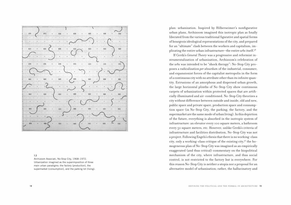
18
1.3Archizoom Associati, No-Stop City, 1968–1972.
Urbanization imagined as the superimposition of three
main urban paradigms: the factory (production), the
supermarket (consumption), and the parking lot (living).
D E F I N I N G T H E P O L I T I C A L A N D T H E F O R M A L I N A R C H I T E C T U R E 19
plan: urbanization. Inspired by Hilberseimer’s nonfigurative
urban plans, Archizoom imagined this isotropic plan as finally
liberated from the various traditional figurative and spatial forms
of bourgeois ideological representations of the city, and prepared
for an “ultimate” clash between the workers and capitalism, im-
plicating the entire urban infrastructure—the entire urbs itself.36
If Cerdà’s General Theory was a progressive and reformist in-
strumentalization of urbanization, Archizoom’s celebration of
the urbs was intended to be “shock therapy”: No-Stop City pro-
poses a radicalization per absurdum of the industrial, consumer,
and expansionist forces of the capitalist metropolis in the form
of a continuous city with no attribute other than its infinite quan-
tity. Extrusions of an amorphous and dispersed urban growth,
the large horizontal plinths of No-Stop City show continuous
carpets of urbanization within protected spaces that are artifi-
cially illuminated and air-conditioned. No-Stop City theorizes a
city without difference between outside and inside, old and new,
public space and private space, production space and consump-
tion space (in No-Stop City, the parking, the factory, and the
supermarket are the same mode of urban living). In this depiction
of the future, everything is absorbed in the isotropic system of
infrastructure: an elevator every 100 square meters, a bathroom
every 50 square meters, etc. However, unlike Cerdà’s criteria of
infrastructure and facilities distribution, No-Stop City was not
a project. Following Engels’s thesis that there is no working-class
city, only a working-class critique of the existing city,37 the ho-
mogeneous plan of No-Stop City was imagined as an empirically
exaggerated (and thus critical) commentary on the biopolitical
mechanism of the city, where infrastructure, and thus social
control, is not restricted to the factory but is everywhere. For
this reason No-Stop City is neither a utopia nor a proposal for an
alternative model of urbanization; rather, the hallucinatory and
20 TOWARD THE ARCHIPELAGO
exaggerated descriptions of the existing conditions in which the
economy reproduces its labor force are finally exposed as the ul-
timate core of urban culture. Thus, the salient aspect of No-Stop
City—as its name declares—is its unlimited growth, its abolition
of any limits, and therefore its lack of any form.
A fundamental aspect of No-Stop City is the disappearance
of architecture and its replacement by furniture design, which
was seen as a more effective form of urbanization because it is
more flexible, and therefore more consumable and reproduc-
ible, than architecture. But if No-Stop City was imagined as the
ultimate shock therapy for urbanization by its exaggeration of
urbanization’s consequences, in reality the tendency described
by No-Stop City evolved not toward infinity and the final dis-
solution of the city, but rather toward a process of bad infin-
ity. Following Hegel, the condition of the noncity proposed by
No-Stop City perpetually undergoes a process of compulsive
repetition, in which any complexity or contradiction, any dif-
ference or novelty, is an incentive for the infinite reproduction
of the system itself and thus for its stasis. For this reason, in
spite of its aspiration to represent per absurdum the capitalist
process of urbanization, and in spite of its theoretical purity
and radicalism, No-Stop City ultimately “succeeded” in proph-
esying a world in which human associations are ruled only by
the logic of economy and rendered in terms of diagrams and
growth statistics. Like No-Stop City, the actual modern city has
become a shopping mall, where value-free pluralism and diver-
sity—the totalizing features of its space—have made urbanization
the perfect space of mass voluntary servitude to the apolitical
democracy imposed by the market. While beginning as a po-
litically radical project, No-Stop City has come to prefigure how
bad infinity has ensnared humanity within the logic of indefinite
growth as a means of development, constantly aspiring to the
D E F I N I N G T H E P O L I T I C A L A N D T H E F O R M A L I N A R C H I T E C T U R E 21
new and different, and thereby forcing humanity to identically
repeat its own condition.
Cerdà’s General Theory, Hilberseimer’s Groszstadt Architektur,
and Archizoom’s No-Stop City theorized urbanization as the ulti-
mate and inevitable fate of the contemporary city. They imagined
this fate with the best intentions: for them, liberation from the
city meant liberation from its traditional powers and hierarchies
and the full realization of what even for Marx was the ultimate
mastery of society: economy. Their proposed models and de-
scriptions imagined an isotropic geography of infrastructure that
would homogenize the entire urban territory.
According to Cerdà, Hilberseimer, and Archizoom, there
was no need for monuments, forms, or exceptions to the rule.
That rule was both the ever-expanding web of the network and
the individual capsule of the house: that which maintains the re-
production of work. However, even if Cerdà’s General Theory, Hil-
berseimer’s Groszstadt Architektur, and No-Stop City are correctly
understood as defining the aspirations and, in some respect, the
reality of the contemporary urban condition, they could not pre-
dict two fundamental “collateral effects” of urbanization, which at
first sight seem to contradict the logic of bad infinity: the enclave
and the landmark. These “collateral effects” seem to be the basic
elements of another metaproject of contemporary urbanization,
in which captivity and iconographic diversity play a fundamental
role: Rem Koolhaas’s City of the Captive Globe.38 Conceived in
1972, the City of the Captive Globe is a representation of Manhat-
tan and its culture of congestion, and also, as Koolhaas himself
declared, the de facto ideological and conceptual blueprint of
Delirious New York, which he published six years later.39
The City of the Captive Globe describes an urban condition
that, through the simultaneous explosion of human density and
invasion of new technologies—precisely what constitutes the core

22
1.4Rem Koolhaas, The City of the Captive Globe, 1972.
Urbanization imagined as a collection of different,
and competing, built “ideologies.” The more
different the ideologies, the more the urban order
that maintains them is reinforced. Here the potential
agonism between built forms is absorbed by the
managerial order of the urban layout.
D E F I N I N G T H E P O L I T I C A L A N D T H E F O R M A L I N A R C H I T E C T U R E 23
of urbanization—perpetually challenges its limits as a city. In the
project the Manhattan grid is represented by a potentially infinite
series of plots, each composed of a base of heavy polished stone.
Koolhaas calls these bases “ideological laboratories” in which
different kinds of metropolitan consciousness are formed.40
Each base is a state of exception (as defined in chapter 4) and, as
Koolhaas writes, each is equipped to “suspend unwelcome laws,
undeniable truths, and to create extreme artificial conditions.”41
The suspension of any general law or truth is manifested in the
deliberately and radically different architectures that sit on top
of each base. These architectures constitute a Valhalla of Kool-
haas’s favorite archetypal buildings, such as the RCA Building,
Superstudio’s Isograms, El Lissitzky’s Lenin Tribune, Malevich’s
Tektonics, Mies’s typical American building complex, and even
an elevator. In Koolhaas’s city these archetypes, once singular
avant-garde gestures or forerunners of ideal cities and worlds,
are now “lobotomized” from their original context (whether
real or ideological) and placed on top of a block that mediates
between them and the horizontal grid that makes possible their
coexistence within the same urban space. The aim of the City of
the Captive Globe is to resolve the inevitable schism between the
permanency of the urban system—the combination of horizontal
and vertical circulation provided by the grid and the elevator—
and the radical pluralism required by the metropolis represented
by the eclectic skyline, where avant-garde archetypes of the city
are “accepted” and reduced to “icons.” The City of the Captive
Globe allows what Koolhaas later, in describing China’s Pearl
River Delta region, would call the “city of exacerbated differ-
ences”42—to the point that the state of exception contained by
each plot becomes the norm of the city itself. The more change
and exception are allowed, the more the urban principle is rein-
forced, because the axioms of Koolhaas’s city consist of the grid,

24 TOWARD THE ARCHIPELAGO
which equalizes differences within an isotropic network; the
lobotomy, which largely eliminates the relationship between
the “inside” (architecture) and the “outside” (urbanization); and
the schism, which reduces every plot to a self-sufficient enclave
that, by retaining its function, can host any ideology without
affecting the general principle of urbanization.
Like Cerdà’s idea of urbanization, Hilberseimer’s principle of
the plan, and Archizoom’s No-Stop City, the City of the Captive
Globe is based on an isotropic principle and the potential for in-
finite development, but unlike these models it has a center, which
is the square of the Captive Globe itself. If the project is a portrait
of Manhattan, then the square of the Captive Globe—which for
Koolhaas reinforces the identity of the city as a miniature of the
world itself—is analogous to Central Park’s role in New York. This
void—a carpet of synthetic nature—nullifies the most evident
attribute of the metropolis—its density—to dialectically reinforce
its opposite: urban congestion. Koolhaas called his model an
“archipelago”: the grid is a sea and the plots are islands. The more
different the values celebrated by each island, the more united
and total the grid or sea that surrounds them. Hence, the plots are
not simply buildings but are cities in miniature or, as Koolhaas
calls them, quoting Oswald Mathias Ungers, “cities within cities.”
Indeed, the project for the City of the Captive Globe, and, one
can argue, the whole structure of Delirious New York, are heavily
influenced by the urban ideas of Ungers, with whom Koolhaas
collaborated between 1972 and 1975, first while studying at Cor-
nell and then at the Institute for Architecture and Urban Stud-
ies, where he wrote his book. Though the book is a retroactive
manifesto for Manhattan, the city is not described in its entirety
but rather is represented through a series of exceptional and
idiosyncratic architectural visions, such as Coney Island, the RCA
Building, and Rockefeller Center, and through the contrasting
D E F I N I N G T H E P O L I T I C A L A N D T H E F O R M A L I N A R C H I T E C T U R E 25
ideologies of Dalí and Le Corbusier. Similarly, in the 1960s and
1970s Ungers worked on several projects (both with his office
and with his students at TU Berlin and Cornell) based on the
idea of the city of contrasting parts. In each project he developed
architecture as an urban composition in miniature that would
contain the complexity of the city as a whole. The city, and its ar-
chitecture, would be not a unitary system but what Ungers (quot-
ing the fifteenth-century German theologian and philosopher
Nicholas of Cusa) called a “coincidentia oppositorum”—that is,
the coincidence, or composition, of not just different parts but
opposing ones, which leads to a critical unity.43 Ungers’s concept
of the archipelago as a city made of radically different parts jux-
taposed in the same space was the primary influence on Kool-
haas’s idea of New York as an urban paradigm. While for Ungers
the parts that compose the city are meant to oppose each other,
and are thus bound to the dialectical principle that something is
united by being separated, for Koolhaas, the difference between
the blocks is difference itself, where variations can unfold infi-
nitely without affecting the general principle. In Koolhaas’s Man-
hattan archipelago, difference is reinforced by the total schism
between the image of architecture—where anything goes—and the
functioning of the island, which ultimately is dictated by the grid
and the elevator, and which indeed “lobotomizes” the forms of
the buildings. Yet the space of the building in Koolhaas’s City
of the Captive Globe is not really that of an island, where the re-
lationship between inside (terra firma) and outside (the sea) is
vital and open to different approaches, but is more like an enclave,
where the enclave’s strict dependence on the regime of accessibil-
ity and circulation is compensated for by the overdose of ideology
and iconography provided by the landmark.
The enclave is a restricted space that makes the urban terri-
tory uneven. Unlike the Greek polis, which was a kind of enclave
26 TOWARD THE ARCHIPELAGO
because its inside was clearly separated and self-sufficient from
the outside, the space of the contemporary enclave as exempli-
fied by Koolhaas’s Manhattan landmarks is not truly separated
from the outside but is simply segregated; in other words, while
access to its space is restricted, its existence depends on the
functioning of the network of urbanization. The enclave can be
understood as a direct consequence of the economic mastery
of capitalist accumulation, because capitalism always connects
and integrates the urban territory when it must absorb, exploit,
control, and organize labor and transform it into profit; but it
also always segregates when it comes time to accumulate and
distribute that profit. The social discrimination dictated by the
selective space of the enclave is, in the end, based not on poli-
tics but on the total sovereignty of economy in the form of urban
management, which in turn can use other criteria, such as
politics, to reinforce the effectiveness of organization and dis-
crimination. A similar phenomenon can be applied to the con-
temporary use of the landmark, which in the City of the Captive
Globe is represented by the exuberant iconic spectacle of the
city skyline and its divorce from the logic of the whole. Contrary
to the idea of a “nonfigurative” city as imagined by Archizoom,
the City of the Captive Globe can be interpreted as a prediction
of contemporary urbanization in which pluralism and diver-
sity are celebrated (and exaggerated) within the strict spatial
logic of the enclave. Bound to the regime of the economy, this
logic of inclusion/exclusion dissolves the potential dialectical
conflict among the parts of the city, and transforms confron-
tation and its solution—coexistence—into the indifference of
cohabitation, which indeed is the way of living in urbanization.
If, as stated before, the city began as a dilemma between civitas
and urbs, between the possibility of encounter (the possibility
of conflict) and the possibility of security, it has ended up as
D E F I N I N G T H E P O L I T I C A L A N D T H E F O R M A L I N A R C H I T E C T U R E 27
completely absorbed by the infinite process of urbanization and
its despotic nature.
Facing this scenario of infinite urbanization—which today is
no longer just theory but daily practice—I would argue that the
time has come to drastically counter the very idea of urbaniza-
tion. For this reason I propose a partisan view of the city against
the totalizing space of urbanization. In order to formulate a meta-
critique of urbanization as the incarnation of infinity and the
current stasis of economic power over the city, I propose to reas-
sess the concepts of the political and the formal as they unfold
into an idea of architecture that critically responds to the idea of
urbanization. In this proposal, the political is equated with the
formal, and the formal is finally rendered as the idea of a limit.
Arendt writes, “Politics is based on the fact of human plural-
ity.”44 Unlike desires, imagination, or metaphysics, politics does
not exist as a human essence but only happens outside of man.
“Man is apolitical. Politics arises between men, and so quite
outside man,” she writes. “There is no real political substance.
Politics arises in what lies between men and it is established as a
relationship.”45 The political occurs in the decision of how to ar-
ticulate the relationship, the infra space, the space in between. The
space in between is a constituent aspect of the concept of form,
found in the contraposition of parts. As there is no way to think
the political within man himself, there is also no way to think the
space in between in itself. The space in between can only materi-
alize as a space of confrontation between parts. Its existence can
only be decided by the parts that form its edges.
In the dual terms of Carl Schmitt, the space in between is
formed by the decision of who is a friend and who is an enemy.46
This decision does not exist “as found” in between the parts, but
arises from the position taken by the parts that form this space.
The word decision derives from the Latin caedere: to cut, to cut

28 TOWARD THE ARCHIPELAGO
the links. To decide one’s own counterpart means to consciously
struggle for autonomy, but in a way in which, through this ges-
ture of cutting, one also realizes an inner belonging to what one
is detaching from. In this sense, the notion of agonism—the
counterpositioning of parts—functions as a critical mirroring of
oneself via the other, to the extent that it is possible to say that to
make a collective claim of political autonomy one must first de-
clare one’s counterpart. In other words, there is no way to claim
autonomy without first asking what we are affirming ourselves
against as political subjects—as parts.47 After the period of great
ideological conflicts such as the cold war between capitalism and
socialism, this dialectical process of political recognition has
been absorbed by, and has vanished within, the political cor-
rectness of pluralism and difference, to the extent that the figure
of the enemy has been transformed into an evil figure par excel-
lence—what Schmitt calls the “total enemy.”48 In contemporary
common opinion, the word enemy evokes a bloody and noncivic
way of being. From an economic point of view, agonism as such
is useless and damaging, so it must be made into competition,
or even war, to make it profitable. In turn, the parts of society
that, facing the existing order of civil society, find themselves in
a position of agonism, no longer understand their struggle as an
implicit recognition of a counterpart, but see it as antagonism,
as an endless struggle without any acknowledgment of the adver-
sary. Given this mentality, we have to remember that the figure
of the enemy—understood not as inimicus but as hostis49—is one
of the greatest existential figures of human civilization. The no-
tion of agonism renders, in an essential way, the idea of oneself
not as a value-free atom of society but as an active part capable of
distinction, judgment, and action toward something declared as
its opposite. The figure of the enemy is the form per via negativa
through which we recognize ourselves. There cannot be civili-
D E F I N I N G T H E P O L I T I C A L A N D T H E F O R M A L I N A R C H I T E C T U R E 29
zation without recognition of the enemy, without the possibility
of division, difference, decision within the universal space of
cohabitation—the possibility of deciding one’s destiny. Schmitt
affirmed that the recognition of one’s opposite is instrumental to
avoiding self-deception. For this reason, in Schmitt’s definition
of the political, the figure of the friend is conspicuously over-
looked, or to be more accurate, remains in the background, be-
cause Schmitt mostly focuses on the enemy. As Heinrich Meyer
suggests, this is because, according to Schmitt’s definition, the
friend, by virtue of his benevolence, cannot help but confirm
our situation of self-deception.50 The enemy, on the other hand,
estranges us from our familiar self-perception and gives us back
the sharp contour of our own figure, of our own position. What
counters us inevitably constitutes the knowledge of our own
limit, our own form. To answer the pressing question of who is
an adversary and who is not is inevitably to be political—that is,
to judge. As Arendt writes, “Political thought is essentially based
on judgment.”51 The sphere of the political is the sphere in which
a part, a group of individuals, acquires knowledge of itself in the
form of knowing what it is, what it ought to be, what it wants, and
what it does not want. The political is an attitude (to act in rela-
tionship to something); it consists of knowledge (knowing who,
and what, to counterpose), and indicates a task (to transform
conflict into coexistence without exaggerating, or denying, the
reasons for the conflict itself). The political cannot be reduced
to conflict per se; it indicates the possibility of conflict and as
such calls for its solution. Even if it means slightly confounding
the terms of Hegel’s dialectic, the political realizes the solution
of conflict not by a synthesis of the confronting parts, but by rec-
ognizing the opposition as a composition of parts. This suggests
that it is possible to theorize a phenomenological and symbolic
coincidence between political action and the making of the form

30 TOWARD THE ARCHIPELAGO
of an object. Both deal with the fundamental question of defining
the limits that constitute related, but different, parts. It is from
this vantage point—the question of a composition of parts, the
question of limits posed through knowledge of the other—that I
propose to redefine the concept of the formal.
The Latin forma stands for two Greek words with quite dif-
ferent meanings: eidos, or abstract form, and morphè, or visible
form. In its very origin the word form seems to contain the dis-
pute between those who give priority to the visibility of things as
a fundamental datum of experience and those who give priority
to the inner structure of experience itself as the factor that de-
termines how visible things are. Since this dispute runs the risk
of being reduced to the abused dichotomy of form/content—form
as visible container with invisible content—I propose a defini-
tion of form that transcends the duality of abstract/visible. Thus,
analogous with Schmitt’s argument in The Concept of the Political,
I do not discuss form as such, but rather its application as
criteria, as a concept: the formal.
The formal can be defined as the experience of limit, as the
relationship between the “inside” and the “outside.” By the in-
side, I mean the position assumed by an acting subject; by the
outside, I mean the datum, the situation, the state of things in
which the subject acts. Action versus situation or subject versus
datum: these are the poles through which the notion of the formal
materializes.52 Therefore, form is the implicit limit that inevita-
bly exists between action and datum—of action’s grasp of the world,
to paraphrase the Swiss philosopher Jeanne Hersch, who wrote
one of the most penetrating books on the idea of form. 53 Hersch
maintains that the notion of form is a paradox, or rather, that
it “simultaneously indicates unity on the one hand and, on the
other, spatial differentiation, a partial character, limitation, de-
termination, and change.”54 The inherent tension in the concept
D E F I N I N G T H E P O L I T I C A L A N D T H E F O R M A L I N A R C H I T E C T U R E 31
of form lies entirely in the subjective will of a unity, or rather the
subjective will of knowing through a conceptual a priori, through
form’s own limits, and the differentiation that this a priori nec-
essarily entails in the indefinite space of the possible. In this
sense, form is above all a cognitive instrument. Not despite but
through this paradox—as Hersch maintains—form exists from the
moment it represents the tension from an inside toward an out-
side. We can argue that the formal indicates a decision on how the
“inside” relates itself to the “outside,” and how the latter is delin-
eated from within. The formal essentially involves an act of spa-
tial determination, of (de)limitation. Within this understanding
of the formal it is possible to make the following propositions.55
Inasmuch as the formal is defined in terms of limits rather
than self-sufficiency, it is fundamentally relational. In its fini-
tude and specificity, it implies the existence of something outside
of itself. In being concerned with “itself,” it necessarily concerns
the “other.” For this reason, the formal is against totality and ge-
neric conceptions of multiplicity. The formal is thus a veritable
representation of the political, since the political is the agonistic
space of real confrontation, of the others. As such, the formal is
a partisan idea. From this perspective we can say that it is pre-
cisely the condition of the absoluteness of the form of an object
(absolute being understood in its original meaning, “separated”)
that implies what exists outside of it. Like the concept of the
political, the concept of the formal expresses the condition of a
cum-positio of parts.
In this condition of a composition of parts, the concept
of the formal and the concept of the political coincide and can be
posited against notions such as urban space, urban landscape,
and network, which are facts but also the very ideological mani-
festation of the idea of urbanization. These notions imply the
integration and dissolution of difference, while the concept of

32 TOWARD THE ARCHIPELAGO
the political and the concept of the formal indicate the possibility
of the composition of difference by assuming the limits of parts
as their constituency. Consequently, both the political and the
formal contain the idea of the whole per via negativa, by virtue of
being absolute parts.
To what idea of the city do concepts such as the formal and the
political refer? What is the form of the city that incarnates the po-
litical composition of parts? Before addressing these questions,
I would like to emphasize that these criteria are reformulated here
against the tide of contemporary descriptions of the city, where
“realism” and “postcriticality” have become excuses for denying
responsibility and surrendering to the economic forces of urban-
ization. The coincidence between the formal and the political as
defined here is not meant literally to formalize a city against the
fluidity of urbanization, but rather to sharpen the ways in which
we critically approach the political in order to define a possibil-
ity for the formal. This possibility can only occur if we search for
a form of reference that can critically reconstruct an idea of the
whole—the integrity of the city as a political manifestation that is
critical of urbanization itself, while also within urbanization. One
thing must be clear: there is no way back from urbanization, and
the search for the contemporary agora is a pathetic endeavor that
only manifests the weakness of our political understanding of the
city. At the same time, we must build the political and formal in-
tegrity of the city, which consists not of a nostalgic reconstruction
of an ideal place which has never existed,56 but of a clear set of
criteria and forms of reference. What could be a form of refer-
ence for a renewed political and formal understanding of the city
and its architecture?
If we do not appeal to peremptory images such as those urban-
ization provides of globalization, the governance of the market,
D E F I N I N G T H E P O L I T I C A L A N D T H E F O R M A L I N A R C H I T E C T U R E 33
and so on, it becomes quite difficult to synthesize the aspira-
tions and ideas that constitute the evolution of what we still call
the contemporary city into a simple form of reference. Without
general projects such as those we have seen before, every recent
attempt to build a representative and intelligible image of the
urban phenomena has been preempted by the complex, cogni-
tive, hybrid, and often intentionally vague metabolism that is
implied in the more recent descriptions of the city—descriptions
continuously subjugated to the appearance of new concerns, and
thus more and more averse to building interpretative models
that are capable of placing themselves beyond the rhetoric of
change. This cognitive metabolism, exemplified by terms such as
mutation, transurbanism, postmetropolis, city in transition, city on
the move57—terms that have characterized fundamental moments
in reflections on the city in recent years—gives place to a certain
imaginary in which it is impossible to identify the parts that con-
stitute the ensemble of the city. In the absence of a representable
whole, the individuality or singularity of parts is dissolved into
a vision dominated by the figure of the fragment, which renders
any representation of the world impossible unless it is through
the paradoxical use of comprehensive and totalizing concepts
such as globalization, dispersion, congestion, or density. Because
these concepts are unable to comprehend the multiplicity, they
celebrate it, hence allowing for a representation in which the
forms of the manifold themselves paradoxically disappear.
Given this situation, I am not concerned with the further
mappings of urbanization and their complexities and contradic-
tions. Rather, I am concerned with the possibility of constituting
other criteria for an interpretation of the idea of the city and its
architecture based on the concepts of the political and the formal.
Instead of resorting to cognitive frameworks such as vision,
scenario, and utopia, which often reduce the world to simplistic

34 TOWARD THE ARCHIPELAGO
and totalizing representations, I am proposing a way in which
any general construction of the idea of the city is conceived
by starting from the limits of architectural form itself. I am
therefore opening, in a different way, the problem of form as
the critical relationship between architecture and the city by
revisiting a “city project” that is not considered as such: the per-
sistence of the form of the plinth in all of Mies van der Rohe’s
major projects.
To oppose Mies’s architecture, which is bound to the scale of
the building, to projects or visions that focus on overall urban
systems may seem incongruous. Unlike the previous examples,
but also unlike many architects of his time, from Le Corbusier to
Frank Lloyd Wright, Mies never proposed a general plan, a gen-
eral model, or a general project of reform for the city or even a
utopian scheme for the city. It is even more problematic to talk
about Mies within a discourse on the political and the formal, for
Mies seems to be the most remote reference for such argument.
He rarely expressed positions, or even opinions, on politics, and
he always showed a caustic attitude toward theoretical discourses
on form in architecture, to the point that historian Werner
Oechslin defined Mies as the greatest antiformalist architect of
the twentieth century.58
Mies focused on architecture as a “distanced” accomplish-
ment of its purpose: the framing of space. Yet, as Manfredo Tafuri
has pointed out, the silent forms through which Mies pursued
this goal are far from idealistic.59 Especially in his American
corporate projects, Mies allowed the attributes of industrial
technology—the famous I-beams used in the Seagram Build-
ing facade, for example—to enter and envelop his architecture.
In this way the forces of urbanization in the form of the mass
production of building technology became the very appearance
of his architecture.
D E F I N I N G T H E P O L I T I C A L A N D T H E F O R M A L I N A R C H I T E C T U R E 35
In this regard it is important to mention Mies’s lifetime friend-
ship and collaboration with Hilberseimer. Hilberseimer’s idea of
the city consisted of the most extreme reduction of city form to
the logic of urban management. Although he opted, shortly after
his Hochhausstadt proposal and later in his American period, for
a more dispersed model of urbanization, Hilberseimer radical-
ized the generic forms of settlements to the point that, as Albert
Pope has pointed out, his urban plans were made not for “form”
but of “space.”60 This is evident in the way Hilberseimer drew his
urban plans. Only the systems of circulation and the natural fea-
tures of the territory are figured in these plans; all the rest—the
city, its places, its borders, its forms—are completely dissolved
into the “urban system.” The diagrammatic minimalism through
which Hilberseimer represented his plans is much more than a
simple technique of drawing. Such graphic minimalism amounts
to a highly evocative rendering of the very ethos of urbaniza-
tion—its composition of systems and flows rather than places and
forms. Hilberseimer’s drawings suggest a complete acceptance
of the main value of urbanization—that of management—yet they
express this without any formal commentary.
Mies’s architectural language is not at odds with Hilber-
seimer’s “regional patterns” of urbanization.61 The “silence” of
Mies’s architecture seems to evolve directly from the “generic
city” evoked by Hilberseimer. The same gray unaesthetic logic
that guides Hilberseimer in confronting the complex and ineffa-
ble forces of urbanization is implied in Mies’s approach to these
architectural complexes. For this reason Hilberseimer’s “generic
city” can be seen as the backdrop to Mies’s projects, which seem
to be the most appropriate form within Hilberseimer’s ruthless
reduction of the city to the logic of urbanization.
Neither an architecture of hope nor of celebration, Mies’s
buildings remain stubborn yet docile and simple orthogonal

36 TOWARD THE ARCHIPELAGO
forms within the generic space of the modern metropolis. Their
apparent indifference to context is paradoxically their true
contextual quality, which reflects, in the most literal and objec-
tive terms, precisely what one cannot see: the generic space of
exchange and reproduction behind the appearance of figural
diversity.62 The “silence” of Mies’s architecture has often been
interpreted by historians and critics as reflecting and incorpo-
rating the uprooting nature of modernity while defining a critical
distance from it.63 These interpretations range from the aesthetic
of renunciation proposed by Tafuri, who saw in Mies’s American
projects the explicit interiorization of the abstraction of social
life itself in the form of a paradoxical formal autonomy per via
negativa, to Massimo Cacciari’s reading of Mies’s abstraction
(and of modern architecture) as a conscious image of fulfilled
nihilism; to Michael Hays’s use of Mies as an example of criti-
cal architecture, posited as both a radical detachment from all
that is outside architecture and a reflection of the conditions that
permit such distance; to Detlef Mertins’s rendering of Mies’s re-
deeming use of technology; to Sven-Olov Wallenstein’s interpre-
tation of Mies’s silence not as an act of negativity and rejection,
but an act of harboring a plethora of words to come: “the promise
or rather the threat of a new and pliant discourse that in many
aspects forms the very element of the world today.”64Yet, with
the notable exceptions of the German critic Fritz Neumeyer65and
Oswald Mathias Ungers,66 these canonical readings seem mostly
to have focused on the Miesian motif of the building envelope,
while giving less importance to the element that defined all of
Mies’s projects: the careful placement of buildings through the
use of the plinth. From his early suburban houses in Germany
to his corporate office complexes in the United States, the sim-
ple, bounded form of the plinth (which can be interpreted as
an abstract version of the Greek stylobate) is the precondition
D E F I N I N G T H E P O L I T I C A L A N D T H E F O R M A L I N A R C H I T E C T U R E 37
for nearly all of Mies’s designs. If, as Neumeyer argues, the
pavilion-like quality of Mies’s buildings seems to follow Karl
Friedrich Schinkel’s attempt to elevate the freestanding architec-
tural object as an analogous form encompassing bourgeois space
(as opposed to the imperial claims of baroque architecture), then
the plinth gives this appropriation a self-defined limit. This is
evident in projects such as the Riehl House (1907), the Barce-
lona Pavilion (1929), the Seagram Building (1954–1958), and
the New National Gallery in Berlin (1962–1968). By putting em-
phasis on the building site, the plinth inevitably makes the site
a limit for what it contains. The isotropic order of industrial-
ization evoked by the building envelopes is contrasted by their
siting, framed by the plinth. Moreover, the way the plinth re-
organizes the connection between a building and its site affects
not only one’s experience of what is placed on the plinth, but
also—and especially—one’s experience of the city that is outside
the plinth. One of the most remarkable things felt by anyone
climbing a Mies plinth, whether in New York or in Berlin, is the
experience of turning one’s back to the building in order to look
at the city. Suddenly, and for a brief moment, one is estranged
from the flows and organizational patterns that animate the city,
yet still confronting them. In this way Mies’s plinths reinvent
urban space as an archipelago of limited urban artifacts. It is this
emphasis on finiteness and separateness that makes artifacts like
these the most intense manifestation of the political in the city.
There is no doubt that Mies’s projects, especially those executed
for corporations, are the embodiment of the values that have pro-
duced the logic of urbanization. And yet, precisely because Mies’s
architecture has this source, its emphasis on separateness and
self-limitation seems even more intensely political.
While the materiality and composition of Mies’s envelopes
reproduce the attributes of the generic city, their placement on a

38 39
1.5Ludwig Mies van der Rohe, Seagram Building, 1954–1958.
The generic attributes of architecture framed by the plinth.
The gesture of the plinth implies a city made by self-limited,
and thus countering, forms rather than by ubiquitous flows.

40 TOWARD THE ARCHIPELAGO
plinth presents these attributes not as ubiquitous, but as sensual
and finite objects. And while Mies’s buildings assume the generic
attributes of production, his insistence on framing and limiting
proposes these attributes not as norms, but as architectural states
of exception that force the generic to conform to the finite form of
location. In this way the forces of urbanization are made explicit
and are made to define their own position as agonistic form.
In Mies’s architecture the idea of location and the sense of
“place” that this embodies are not the outcome of some sort
of genius loci or other form of place “authenticity.” The singularity
of location, and thus of place, that the plinth evokes is the direct
outcome of the same generic architecture of its context. Mies’s
urban spaces make no attempt to decorate their architecture with
attributes that visually mimic the city within their microcosm.
Mies’s urban spaces are literally made by those materials and
forms that one would expect at the entrance to a modern build-
ing: the gridlike tiling of the pavement, the freestanding elevator
shafts, pools of water, or green grass, some benches. Yet it is the
composition and framing of these elements within the plinth that
estrange them from the ordinary, and render them as unique ex-
periences without any aura of formal uniqueness.
In the age of “biopolitics” and “geopolitics,” where political
subjectivity is constantly reformulated in ever more complex and
impalpable terms, one can ask whether the bodily experience of
form and location can make sense at all. But this is precisely the
point. Today a possible and radical counteraction to the ubiquity
of the management of space in all its forms can be proposed only
by reaffirming in the most radical terms the most graspable junc-
tures through which space must be made. A noniconic gesture
such as the plinth seems to open an analogical crack in urban
space even when it has been totalized by the managerial forces of
urbanization. The plinth introduces a stoppage into the smooth-
D E F I N I N G T H E P O L I T I C A L A N D T H E F O R M A L I N A R C H I T E C T U R E 41
ness of urban space, thus evoking the possibility of understand-
ing urban space not as ubiquitous, pervasive, and tyrannical, but
as something that can be framed, limited, and thus potentially
situated as a thing among other things. While buildings assume
the ineffable attributes of urbanization, the plinth limits these
attributes to a finite location. Moreover, unlike the wall, a form
like the plinth is a frame that does not simply separate or isolate;
it also recuperates in subtle ways the difference that the modern
city has subsumed within its generic space: the symbolic possi-
bility of confrontation.
Unlike Cerdà, Hilberseimer, Archizoom, and Koolhaas, Mies
is concerned not only with the generic quality of this form but
also with its limit, with the finitude of its location. Architecture
is thus reinvented by absorbing the compulsion to repeat, which
is the essential trait of capitalist civilization, while increasing
architecture’s function as a frame, as a limit both to itself and to
the forces and interests it represents. Mies not only developed a
particular model of architecture, he also introduced a particular
attitude toward the city.
Today, against the ubiquity of design and its embedded or-
ganizational complex, this attitude toward framing and limit-
ing needs to be developed both as a literal material form of
architecture and as a political principle of design. Rather than
open-ended growth, limiting, or the confrontation among parts,
should be conceived as the fundamental metaproject that gives
form to architecture’s critical position toward the city. There
is no question that the idea of limits implies issues that go far
beyond the scope of architecture and its project, and involves
the complex ecology of political and economic space. Yet, like
the archetypes we have seen before, the task of architecture is to
reify—that is, to transform into public, generic, and thus grasp-
able common things—the political organization of space, of which

42 TOWARD THE ARCHIPELAGO
architectural form is not just the consequence but also one of the
most powerful and influential political examples. In this way, ab-
solute architecture as a finite form is not simply the tautological
claim of its literal object; it is also the example for a city no longer
driven by the ethos of expansion and inclusion but by the positive
idea of limits and confrontation.
By clearly exposing their limits, architectural parts confront
each other and form an agonistic plurality, becoming a site where
judgment through difference is again possible. Here the formal
clearly becomes the political essence of the city. Architecture no
longer follows urbanization’s despotic routine; rather, it is a pre-
condition for urbanization, a project that reconstructs through
itself the formal and the political sense of the city.
In this sense, Mies’s interventions, especially the formal
principle enumerated by projects such as the Seagram Building
in New York, the Federal Center in Chicago, Westmount Square in
Montreal, and the Toronto-Dominion Centre, are here assumed
as examples for a city conceived as a group of islands within a sea
of urbanization.
These interventions can be reduced to a prototype—a set
of finite volumes arranged within a clearly demarcated space,
the plinth. I believe that these interventions constitute one of
the highest examples of an absolute architecture, for they make
clear its separateness, provoking the agonistic experience of the
city. The city made by agonistic parts is the archipelago.
An archipelago is a group of islands set in a sea that simulta-
neously unites and divides them. Yet the archipelago is not just
a collection of different parts that share proximity; the form of
the archipelago presupposes that its parts, even in their absolute
separation, are moved by an absent center, toward which each
island, in communion with the others, is oriented without claim-
ing possession of this center.67 The absent center is the locus of
43
1.6Ludwig Mies van der Rohe, Toronto-Dominion Centre,
Toronto, 1963–1969. The possibility of an absolute
architecture as the separation and self-containment
of generic forms.
44 TOWARD THE ARCHIPELAGO
confrontation among the islands. Confrontation is both what
attracts the islands toward each other and what separates them,
preventing their coalescence into a single mass. Analogously,
the absent center of the archipelago is the political form of the
city, which is continually redefined by the limits, separation,
and confrontation of its parts, just as the relationship between
the islands and the sea is an important aspect of the archipelago.
In this framework, Mies’s interventions should be seen as the
method of making these parts, not their style. As I have said,
the sea is the extensive space of urbanization, its all-embracing
connectiveness, the space of management of anything that con-
stitutes our civilization. There is no other way to exceed this sea
if not from within, by absorbing and forcing its attributes into
finite, clearly separated parts
Like the forms of Mies’s complexes, the architecture of the
parts of the archipelago must be made of the attributes of urban-
ization—the common ethos of our civilization. By being forced
into a form, these aspects will inevitably define a position within
the endless space of urbanization. Through the emerging posi-
tion of a part, the political and the formal in architecture can be
reconstructed.
What sort of architecture incarnates the archipelago? The
iconic building—which affirms its own singular presence
through the appearance of its image, and today constitutes one
of the primary expressions of architectural culture at the scale of
the city—cannot be a valid part of the city. Even in putting aside
problems of morality, issues of taste, and the gratuitous char-
acter of its forms, the iconic building cannot be considered an
exemplary part of the city because its economic principle is to be
unique and unrepeatable. Since it is no longer the state but the
corporation that builds these grands projets, the iconic building
responds to a demand for uniqueness as an emblem of market
D E F I N I N G T H E P O L I T I C A L A N D T H E F O R M A L I N A R C H I T E C T U R E 45
competitiveness. The huge variety of these buildings subscribes
to one main criterion: to obey the despotic law of difference
and novelty—precisely the attributes that fuel the bad infinity of
labor for the sake of production and profit. In the economy of the
iconic building, what is considered “productive” is the person-
ality of the architect, his or her creative ego, which is exploited
and used by the corporation to oppose the difficult whole of the
polis—the space in which difference is not infinite variation or
commercial competition, but rather a confrontation of parts.
The confrontation of parts can be achieved only based on com-
mon and existing aspects of the city, not ex nihilo creation of
the new. Through the exemplary and exceptional clarity of the
compositional gesture, a true part of the city recognizes and rep-
resents its typical aspects. The part is absolute; it stands in soli-
tude, yet it takes a position with regard to the whole from which
it has been separated. The architecture of the archipelago must
be an absolute architecture, an architecture that is defined by
and makes clear the presence of limits which define the city. An
absolute architecture is one that recognizes whether these limits
are a product (and a camouflage) of economic exploitation (such
as the enclaves determined by uneven economic redistribution)
or whether they are the pattern of an ideological will to separa-
tion within the common space of the city. Instead of dreaming of
a perfectly integrated society that can only be achieved as the su-
preme realization of urbanization and its avatar, capitalism, an
absolute architecture must recognize the political separateness
that can potentially, within the sea of urbanization, be mani-
fest through the borders that define the possibility of the city.
An absolute architecture must map these borders, understand
them, formalize them, and thus reinforce them so that they can
be clearly confronted and judged. Instead of being an icon of di-
versity per se, an absolute architecture must refuse any impetus

46 TOWARD THE ARCHIPELAGO
to novelty and accept the possibility of being an instrument of
separation, and thus of political action.
If one were to summarize life in a city and life in a building in
one gesture, it would have to be that of passing through borders.
Every moment of our existence is a continuous movement through
space defined by walls. Architects cannot define urbanization:
how program evolves, how movement performs, how flows un-
fold, how change occurs. The only program that can reliably be
attributed to architecture is its specific inertia in the face of ur-
banization’s mutability, its status as the manifestation of a clearly
singular place. If the ubiquitous nature of mobility and integra-
tion is the essence of urbanization, the singularity of places is the
essence of a city. We cannot return to a preurban world, but within
the present urban situation there is the possibility to redefine the
meaning of the city as a site of confrontation and thus of coexis-
tence. In this sense architecture is a constructive and theoretical
apparatus whose “publicness” consists in its possibility of sepa-
rating, and thus forming the space of coexistence within the city.
For this reason, architecture has no option but to express itself
through a language that is radically and consciously appropriate,
that is clear in its goals and its cause, and is able to represent and
institutionalize the business of living as a value that is at once
universal and singular. Architecture can have no other goal than
that of relentless inquiry into the singularity of finite parts—the
very singularity by which it constitutes the city. Architecture must
address the city even when the city has no goal for architecture.
For the city is ultimately the only object for and method of archi-
tectural investigation: decisions about the form of the city are the
only way to answer the question, Why architecture?
In 1944 Rudolf Wittkower published two essays on Andrea Palla-
dio’s architecture. The essays, later included in his book Architec-
tural Principles in the Age of Humanism, featured eleven schematic
drawings of Palladio’s villas that Wittkower used to reinforce his
argument for reading Renaissance architecture in terms of irre-
ducible rules or principles.1 These drawings showed that archi-
tectural artifacts such as Palladio’s villas were not merely episodic
formal studies but were systematic variations of the same com-
positional logic. Architectural principles were thus implicitly
proposed as an intellectual framework for architectural form,
superior to the functional, programmatic, or aesthetic goals to
which architectural history was then still bound.
As a core component of architecture’s emerging historiog-
raphy, Wittkower’s reading of Renaissance architecture quickly
proved to be influential far beyond academic historical scholar-
ship. Within postwar reconstruction in England, for example, his
project established a point of reference for a generation of ar-
chitects searching for formal legitimacy beyond the technocratic
impetus of functionalist modernism. In particular, his drawings,
reducing Palladian villas to proportional and spatial schemes,
offered the possibility of defining a more profound rationality
than could be provided simply by technology. This commitment
to seeing and interpreting a contemporary condition through a
2 THE GEOPOLITICS OF THE IDEAL VILLAANDREA PALLADIO AND THE PROJECT OF AN ANTI-IDEAL CITY

48 THE GEOPOLITICS OF THE IDEAL VILLA
Renaissance precedent was reinforced five years later (and more
radically still) by Colin Rowe, whose “Mathematics of the Ideal
Villa” famously established a comparison between Palladio’s Villa
Foscari in Malcontenta and Le Corbusier’s Villa Stein in Garches.2
While Wittkower’s impact on a wider, contemporary archi-
tectural discourse was as unsuspected as it was unintentional,
Rowe’s iconoclastic comparison of two villas—one from the six-
teenth century, the other from the twentieth—seems to have been
a deliberate attempt to interfere with the trajectory of postwar
architectural modernism. This desire to subvert is seen not only
in his argument for the comparable nature of Renaissance and
modern architecture, but also in his pointing to the possibility of
a rigorous close reading of architectural form independent of its
historical circumstances. For this reason, Rowe deliberately ex-
trapolates the villas of Palladio and Le Corbusier from their geo-
graphical and political context; he even argues that the architects’
lyrical site descriptions celebrating their best-known villas—“La
Rotonda” and the Villa Savoye at Poissy—offer too easy a point of
entry for comparison. In this way, Rowe’s text reinforces Witt-
kower’s radical denial of Palladio’s site specificity, apparent in
the removal of the barchesse (barns) in his schematic drawings
of the villas. These adjoining loggias were adapted from local
Venetian agricultural sheds and were an essential component of
Palladio’s villas, providing both a sense of context and a semiotic
distinction that allowed these buildings to be classified as villas
rather than palaces. The barchesse, in this sense, are Palladio’s
geopolitical context because they figure as the key metonymical
register for the whole typology.
Palladio’s villas themselves were commissioned at the high
point of widespread social and economic reforms advanced by the
Serenissima Republic in the sixteenth century, and their particu-
lar formal composition—a central palace flanked by two barns—is
A N D R E A P A L L A D I O A N D T H E P R O J E C T O F A N A N T I - I D E A L C I T Y 49
deeply embedded in the political, social, and formal impetus of
these reforms. If, as James S. Ackerman has argued, the villa is
one the most radically ideological architectures because it hides
its economic dependency on the city by claiming self-sufficiency
within the countryside, then Palladio’s palace-plus-barchesse
composition openly signals the villa’s relation with its regional
and agricultural economic context.3 This immediately suggests
an alternative interpretation of Palladio’s architecture to the ones
advanced by Wittkower and Rowe. This counter position does not
define Palladio’s relevance to contemporary discourse in terms of
proportion or the “mathematics” of its architectural composition,
but reads the villa as one element within a larger, latent project.
Rather than taking Palladio’s “ideal” as a model for an equally
ideal urban configuration, it views the geography and politics of
the villa as a framework for rethinking and retheorizing the sig-
nificance of Palladio’s work as a project for an anti-ideal city.
First, however, let’s deal with the name, Palladio—bombastic
and slightly ridiculous in its overloaded pretension. This was
the name conferred on Andrea della Gondola when he was al-
ready in his thirties, having completed a long apprenticeship in a
stonemason’s workshop. The man who named him—the Renais-
sance poet, humanist, and diplomat Giangiorgio Trissino—was
making clear from the outset that Palladio was invested with
a program.4 For Trissino, this program was the reinvention of
Vicenza as a model for an imperial Roman city—that is, in his
classicist terms, a new Italian civilization finally liberated from
the Goths, whose ascendancy, he believed, had paralleled the de-
cline of the Roman Empire and Italy’s descent into political and
cultural chaos. Drawing inspiration from Trissino’s classicist
urban ideology, Palladio’s early architectural designs include a
classical facade for a series of city houses and a proposal for the
Palazzo Civena—austere, simple, and thus repeatable prototypes,
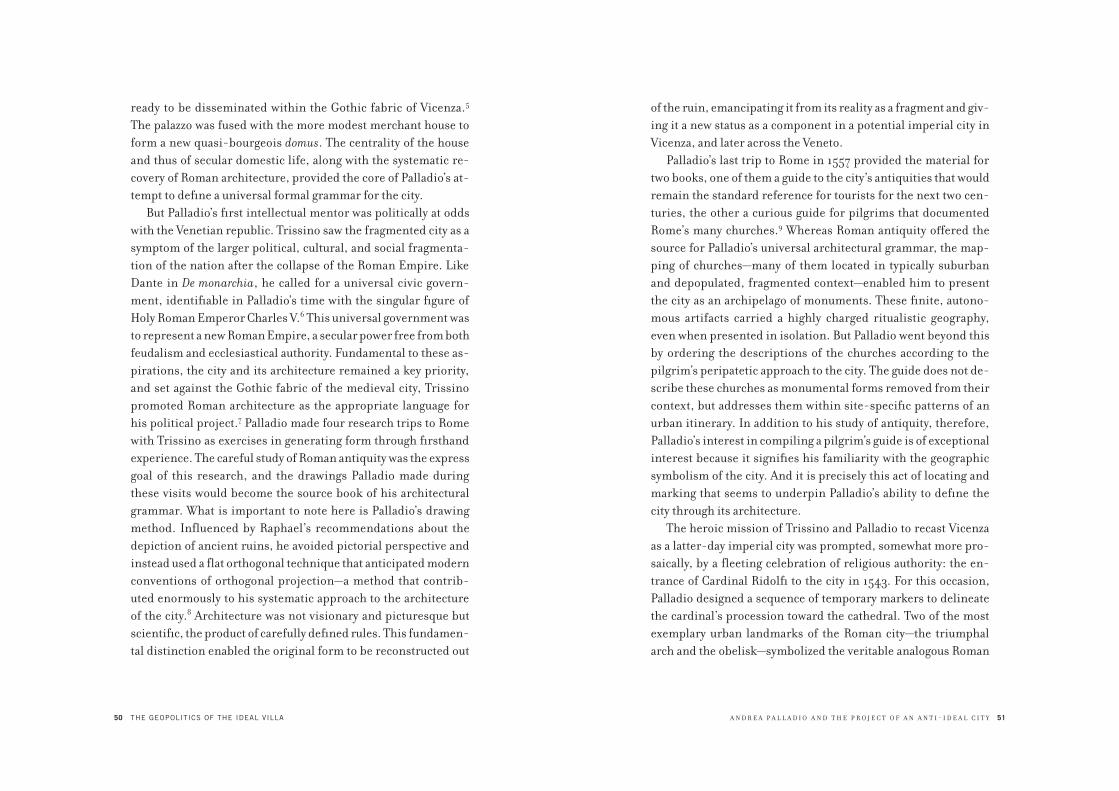
50 THE GEOPOLITICS OF THE IDEAL VILLA
ready to be disseminated within the Gothic fabric of Vicenza.5
The palazzo was fused with the more modest merchant house to
form a new quasi-bourgeois domus. The centrality of the house
and thus of secular domestic life, along with the systematic re-
covery of Roman architecture, provided the core of Palladio’s at-
tempt to define a universal formal grammar for the city.
But Palladio’s first intellectual mentor was politically at odds
with the Venetian republic. Trissino saw the fragmented city as a
symptom of the larger political, cultural, and social fragmenta-
tion of the nation after the collapse of the Roman Empire. Like
Dante in De monarchia, he called for a universal civic govern-
ment, identifiable in Palladio’s time with the singular figure of
Holy Roman Emperor Charles V.6 This universal government was
to represent a new Roman Empire, a secular power free from both
feudalism and ecclesiastical authority. Fundamental to these as-
pirations, the city and its architecture remained a key priority,
and set against the Gothic fabric of the medieval city, Trissino
promoted Roman architecture as the appropriate language for
his political project.7 Palladio made four research trips to Rome
with Trissino as exercises in generating form through firsthand
experience. The careful study of Roman antiquity was the express
goal of this research, and the drawings Palladio made during
these visits would become the source book of his architectural
grammar. What is important to note here is Palladio’s drawing
method. Influenced by Raphael’s recommendations about the
depiction of ancient ruins, he avoided pictorial perspective and
instead used a flat orthogonal technique that anticipated modern
conventions of orthogonal projection—a method that contrib-
uted enormously to his systematic approach to the architecture
of the city.8 Architecture was not visionary and picturesque but
scientific, the product of carefully defined rules. This fundamen-
tal distinction enabled the original form to be reconstructed out
A N D R E A P A L L A D I O A N D T H E P R O J E C T O F A N A N T I - I D E A L C I T Y 51
of the ruin, emancipating it from its reality as a fragment and giv-
ing it a new status as a component in a potential imperial city in
Vicenza, and later across the Veneto.
Palladio’s last trip to Rome in 1557 provided the material for
two books, one of them a guide to the city’s antiquities that would
remain the standard reference for tourists for the next two cen-
turies, the other a curious guide for pilgrims that documented
Rome’s many churches.9 Whereas Roman antiquity offered the
source for Palladio’s universal architectural grammar, the map-
ping of churches—many of them located in typically suburban
and depopulated, fragmented context—enabled him to present
the city as an archipelago of monuments. These finite, autono-
mous artifacts carried a highly charged ritualistic geography,
even when presented in isolation. But Palladio went beyond this
by ordering the descriptions of the churches according to the
pilgrim’s peripatetic approach to the city. The guide does not de-
scribe these churches as monumental forms removed from their
context, but addresses them within site-specific patterns of an
urban itinerary. In addition to his study of antiquity, therefore,
Palladio’s interest in compiling a pilgrim’s guide is of exceptional
interest because it signifies his familiarity with the geographic
symbolism of the city. And it is precisely this act of locating and
marking that seems to underpin Palladio’s ability to define the
city through its architecture.
The heroic mission of Trissino and Palladio to recast Vicenza
as a latter-day imperial city was prompted, somewhat more pro-
saically, by a fleeting celebration of religious authority: the en-
trance of Cardinal Ridolfi to the city in 1543. For this occasion,
Palladio designed a sequence of temporary markers to delineate
the cardinal’s procession toward the cathedral. Two of the most
exemplary urban landmarks of the Roman city—the triumphal
arch and the obelisk—symbolized the veritable analogous Roman

52 THE GEOPOLITICS OF THE IDEAL VILLA
city generated by this circuit; Palladio considered them to be ideal
and instant devices for urban reinvention, radically transforming
the Gothic form of the city into a classical landscape.10 The theme
of the triumphal procession also highlights the city as a contested
field of directions to be mapped and manipulated by a series of
punctual interventions. Palladio’s approach to the city, then, as
his temporary installation for Vicenza makes clear, is based not
on an overall urban plan but on the strong formal continuity and
universalism evoked by his classical references. Yet, in contrast
to the Roman city model, Palladio’s universalism is defined by the
concrete figure of architecture as a clearly circumscribed artifact,
distinct from the ground of the city spaces surrounding it.
Palladio’s mapping of Roman churches and his processional
installation for Vicenza together anticipate his later mastery
of the programming of architectural sequences. The variety of
contexts in which he operated—the city of Vicenza, the Veneto
countryside, and the Venetian Lagoon—offered an array of urban
situations of various scales in which he could test the seam-
lessness of an architectural language against the inexorably
fragmented nature of a city. The strategic link between the two
extremes—continuity and discontinuity—is precisely the core
dialectic of Palladio’s urban design methodology.
In the sixteenth century Vicenza was one of Italy’s most vio-
lent cities. Infighting among the most important families and
political turmoil among the populace made it a theater of almost
perpetual mayhem and murder.11 The physical manifestations of
this violence also unfolded within a larger conflict involving the
local oligarchy, the colonial power of Venice, and the adversarial
relationship between the church and the Veneto (at that time,
Vicenza was the Italian epicenter of Calvinist and heretical sen-
sibilities). Given this context, Trissino and Palladio’s attempt to
recast Vicenza as a model for an imperial city that evoked the Pax
A N D R E A P A L L A D I O A N D T H E P R O J E C T O F A N A N T I - I D E A L C I T Y 53
Romana seems a very obvious and deliberate provocation—or,
conversely, an attempt to use the unifying architectural language
of classicism to project a self-harmonizing sense of civic calm.
The grammar of this classicism lay in Palladio’s impeccable
use of the five orders as a way to make architecture intelligible as
form, in contrast to the irrational patterns of the medieval city.
There is an interesting parallel between Palladio’s systematic use
of the five orders and Trissino’s political vision, based on the idea
of a unifying secular government. Trissino (ever the poet and
diplomat) was especially concerned with the reform of the Italian
language, as evidenced by his letter to Pope Clement VII about the
urgent need to address vernacular or colloquial Italian, and by his
translation of Dante’s De vulgari eloquentia. In many ways, Tris-
sino’s interest in the idea of grammar as a metahistorical political
tool can be seen as the inspiration for Palladio’s systematic ap-
proach to architecture, for Palladio used classicism not simply as
a means of representation and authority but also as an ordered set
of repeatable elements whose influence could extend beyond the
construction of buildings to embrace the whole manifestation of
the city itself. However, in order to be established, a grammar re-
lies on clear examples. It is not by chance that Palladio’s debut as
an independent architect, under Trissino’s mentorship, resulted
in a design for the most important public monument in Vicenza:
the completion of the Palazzo della Ragione, a vast civic hall built
in the fifteenth century, and significantly renamed by Palladio
as the “Basilica.” Palladio’s intervention was nothing more than
a lintel-arch-lintel device, stacking two serliane orders built
in white stone so that they wrapped the existing hall and shops
underneath. The irregular structure of the existing building was
absorbed by varying the length of the lintel without altering the
arches. The building was thus conceived as a didactic display of
the orders and their ability to support, correct, and mask the

54 THE GEOPOLITICS OF THE IDEAL VILLA
existing irregular Gothic structure. Moreover, his restructuring
of the Basilica placed classicism at the heart of the civic space of
the city as the hegemonic and universal architectural language
of a long-desired civitas.
The Basilica, like many of Palladio’s buildings, would not be
completed during his lifetime. A permanent state of instabil-
ity defined by wars, economic crises, disease, and, more spec-
tacularly, the tormented vicissitudes of the families for whom
Palladio worked, delayed or prevented their construction. It is
easy to imagine that a desire to counteract this flux was the key
impulse behind Palladio’s I quattro libri dell’architettura (The Four
Books on Architecture), which sets out all of his projects in order
and according to his original design, regardless of alterations
made during their construction. The four books, in this sense,
suggest the emancipation of the idea of architecture from its
material realization. Confronted with an unstable and complex
environment, the language of building cannot tame the city in all
its manifestations, but can only insert exemplary forms into its
unstable body. As with his experiment for the triumphal route
for Cardinal Ridolfi, Palladio’s confidence in the city is revealed
by the way he positions a building, even if he never proposed any
ideal urban scheme. The architectural historian Franco Barbieri
has suggested that although Palladio never predetermined the
site of his projects, the location of his buildings seems to follow
the Roman axial grid that was still legible in medieval Vicenza (it
remains legible today—the intersection of a north-south cardo
axis and an east-west decumanus is provided by the Corso Pal-
ladio and the route that goes from the ruins of the Roman Berga
theater to the Pusterla bridge on the river Bacchiglione).12 Tris-
sino’s utopian vision of Vicenza as a Roman city thus seems to be
carried out in Palladio’s insistence on this layout as the ordering
principle of his interventions.
55
2.1Andrea Palladio, Basilica, Vicenza, 1549 onward.
The classical orders “correct” the irregularities of
the preexisting Gothic structure of the Palazzo della
Ragione rather than masking them. The Basilica can
read as sublimating Trissino’s political project of
universal government within the formal inner workings
of architectural form.
56 THE GEOPOLITICS OF THE IDEAL VILLA
If we follow this hypothesis diachronically, we find along the
decumanus the highly abstract forms of the Palazzo Chiericati
(1550), the sophisticated facade of the Casa Cagollo (1559–1562),
and the Palazzo Pojana (1560–1561). Nearby was the intended site
of an unrealized project for the Palazzo Capra (1563–1564) and,
at the end of the decumanus, directly opposite the Palazzo Chieri-
cati, another Palazzo Capra. Following the perpendicular cardo, we
start at the ruins of the Berga theater (itself a strategic precedent
for Trissino and Palladio in their vision of resurrecting Vicenza’s
latent Roman plan) and then pass the bridge of San Paolo (which
in the sixteenth century was believed to be another Roman struc-
ture), before arriving at the loggias of the Basilica and the Capita-
niato at the intersection with the decumanus. The cardo would then
lead us to two of Palladio’s most impressive buildings—the Palazzo
Montano Barbarano (1569–1570) and the Palazzo Porto (1549).
Finally, we would end up at the Casa Bernardo Schio (1565–1566).
Following the streets that run parallel to the cardo, toward the east
we would find the Palazzo Da Monte (1541–1545), Palazzo Thiene
(1542–1546), a project for a palazzo for Giacomo Angarano (1564),
and a fragment of the Palazzo Pojana (1555). Similarly, following
the streets that run parallel to the decumanus, on the north we
would find projects for the Palazzo Trissino (1558) and a palazzo
for Giambattista Garzadori, along with other minor but significant
works such as Palladio’s youthful interventions during his appren-
ticeship at the Pedemuro workshop with the church of Santa Maria
in Foro (1531) and Vicenza’s cathedral (1534–1536). Collectively,
these interventions can be summarized as the mediation between
two opposite forces which constitute the two major ingredients
of all of Palladio’s projects: on the one hand, an abstraction of the
orders, proportion, and symmetry; and on the other, a site speci-
ficity, with each building being carefully inserted into the tight and
complex medieval fabric of the city.
A N D R E A P A L L A D I O A N D T H E P R O J E C T O F A N A N T I - I D E A L C I T Y 57
The project that most fully articulates this mediation is the
Palazzo Chiericati. Strategically located on the edge of the Isola
(the beginning of the decumanus and thus at the city gate approach-
ing from Padua and Venice), the main facade of the palazzo consists
of two superimposed loggias powerfully framed by the orders. But
what is most striking about this design is that for the first time in
the Renaissance the composition of the facade is rigorously pro-
jected into the interior. The elevation thus becomes a veritable
index of the workings of the plan and section. At the same time, the
space onto which this utopian architectural language is projected
is far from ideal—the loggia is directly at odds with the narrow and
long form of the site, derived in turn from the city’s complex to-
pography. Forcing the building to fit into its unlikely site generated
an unprecedented compression in the plan, which reads as a kind
of sixteenth-century barcode, with its sequence of compressed
versions of atria, internal loggia, and a garden.13 Moreover, within
this logic, the facade’s classical form may be understood as a clear
political maneuver. Expanding the building’s transverse section
by only a few meters, the loggia occupies a portion of the Isola,
not only creating a noble public gesture in one of the city’s most
important civic spaces, but also projecting a highly formal gram-
mar. The generative principle of the building (the rule) and the
peculiarities of the site (the exception) are thus intrinsically linked
and mutually reinforced, producing a paradoxical combination of
formal abstraction and radical site specificity.
It is precisely Palladio’s mastering of the dialectic between
continuity and discontinuity that theatrically emphasizes the
urban role of his buildings as civic actors within Vicenza’s analo-
gous city—a dialectic also perfectly depicted by Canaletto in his
own analogous city in the form of the painting he made of the
Rialto Bridge. Rather than the actual bridge, Canaletto shows
the bridge as designed by Palladio and presented in his Quattro

58
2.2Antonio Canaletto, Capriccio, or a Palladian Design
for Rialto Bridge, with Buildings at Vicenza, 1740s.
In this painting, Canaletto depicts Palladio’s project
for an anti-ideal city made not by overall plans but
by a coherent, yet disposable, architectural program.
The scene depicts an imaginary view of Venice’s
Grand Canal with Palladio’s unbuilt design for the
Rialto Bridge framed by two buildings of Vicenza: the
Basilica (right) and Palazzo Chiericati (left).
A N D R E A P A L L A D I O A N D T H E P R O J E C T O F A N A N T I - I D E A L C I T Y 59
libri—a synthesis of two buildings, the Basilica and the Palazzo
Chiericati, through a singularity of language and absolute forms.
These forms are therefore precise in their paradigmatic integ-
rity and yet disposable, to be used and combined according to
the geography of the site.
More than his bridges and palazzos, however, the villas in the
Veneto region are the most celebrated of Palladio’s work. What
is impressive about these buildings is not so much their archi-
tectural quality as their quantity. With the exception perhaps of
Frank Lloyd Wright, no other architect has offered a portfolio
filled with designs of such impressive continuity. The penchant
for villas, a patrician typology of the Roman Empire, was revived
in the fifteenth and sixteenth centuries.14 In a rural economy,
the villa’s reappearance marked the transition from feudalism
to the economic power of the estate. Fueled by this succession,
Palladio assigned the villa a position of exceptional importance
in his Quattro libri: five chapters of the second book are devoted
to the architectural principles of this type, which is treated with
the same attention to detail as other crucial city types such as
palaces and religious buildings. By the time the Quattro libri was
published, Palladio had already designed a large number of vil-
las, and the serial nature of the solutions he developed (akin to
the repeating rules he employed in his palaces in Vicenza and
churches in Venice) had allowed him to define a consistent for-
mal lexicon. Although made up of very few principles, this lan-
guage was very strict in its application—notably, a clear symmetry
of plan, an abundance of loggias in the form of belvederes and
barns, the unconventional use of pediments, and the spatiality
of imperial Roman baths (Palladio’s most striking typological
cross-contamination for rural buildings).
A number of historians have addressed Palladio’s mixing
of classical motifs, discussing his use of vernacular elements

60 THE GEOPOLITICS OF THE IDEAL VILLA
and his villa typology as providing both a country retreat and an
economically and culturally productive rural hub. Much, too,
has been written about his use of the pediment, which, but for
one exception, had previously been confined to religious build-
ings (with the implied argument that temples and houses share
the same origin).15 Much less, however, has been said about how
the interior space of Palladio’s villas appropriated the spatial-
ity of the imperial baths which he obsessively mapped, drew,
and reconstructed during his field trips to Rome, and whose
organization—a sequence of monumental spaces juxtaposed
along axes of symmetry—lent his countryside villas a quintes-
sentially metropolitan air. In many ways, the theatrical spatial
complexity of the Roman bath offered an indoor miniaturized
city. It is thus possible to speculate that Palladio’s appropriation
of the imperial bath and the pediment, and the conflation of
these typologies with an agricultural context, are part of a strat-
egy that goes beyond erudite references to Roman classicism
and the accommodation of the material demands of the estate.
Instead, it seems to have more to do with the idea of figuring
the ground as an assemblage of metropolitan structures where
the political and economic power of the Venetian archipelago
(until then constituted by the sea) is projected analogically—
that is, via the example of imperial Rome—toward the Veneto
countryside. It is precisely this complex of analogical appro-
priations that made Palladio’s architecture so successful and
influential as an urban model.
Underlying all of Palladio’s architectural output was the biggest
crisis then facing the Serenissima Republic. Founded some time
during the first decades of the eighth century and developed as a
mercantile city-state, Venice’s raison d’être had been economic
transaction in the form of maritime commerce. Throughout its
early history, this trade was bolstered not only by the city-state’s
61
2.3Andrea Palladio, study of the Baths of Agrippa
(with a detail of the Loggia del Capitaniato), 1570s.

62 THE GEOPOLITICS OF THE IDEAL VILLA
geographical position at the edge of the Adriatic and the defeat
of other maritime republics such as Genoa, but also by the influ-
ence of the Byzantine Empire, which helped to establish Venice
as a privileged economic hub linking the Mediterranean basin
with commercial routes toward the east. However, Venice’s im-
petuous rise came abruptly to an end with two major events. The
first was the War of the League of Cambrai (1508–1516), when
the most important European superpowers—Pope Julius II, Em-
peror Maximilian I, and King Louis XII of France—united against
the Serenissima in order to limit its land expansion. The second
decisive event, whose consequences would only slowly become
apparent over the course of the sixteenth century, was the discov-
ery of the New World and the consequent shift of major maritime
traffic from east to west.
Confronted with this crisis, the Serenissima’s oligarchy be-
came convinced that they were about to enter a period of decline.
What is interesting about their response is that they accepted the
prospect of their diminishing fortune and, rather than seeking
to reverse what seemed inevitable, they did something politically
and conceptually far more radical: they attempted to slow down
the decline, so that instead of precipitating a sudden collapse,
the republic’s waning influence could be tamed and governed as
a utopian condition of “duration.”16 Their response consisted of a
complex series of strategic maneuvers, all of them predicated on
a shift of Venice’s economic basis from the sea to the land—from
maritime commerce to agriculture. Within this transfer, the
ground or terra firma suddenly took on the status of a territorial
project—one that included land reclamation, cartographic map-
ping, and the hydrological control of the network of rivers that
descended into Venice from high in the Alps.17 And so, rather
than projecting itself solely toward the sea as a stato del mar,
Venice turned inward, toward its territorial lands—a (re)discov-
A N D R E A P A L L A D I O A N D T H E P R O J E C T O F A N A N T I - I D E A L C I T Y 63
ery of its more earthly influence that must be seen as the defining
context for Palladio’s unprecedented succession of countryside
villas, each commissioned by patricians of the Serenissma re-
gime, and which would ultimately give Venice’s project of dura-
tion its most enduring historical form.
Offering a kind of theoretical legitimacy to this shift from sea
to land were the ideas of the theorist and patron of the arts Alvise
Cornaro (1484–1566), who argued, in particular, for the promo-
tion of agriculture as an alternative to Venice’s existing mercan-
tilist economy. Author of La vita sobria, a treatise on the virtue
of living in the countryside, Cornaro was one of the most active
political thinkers during the Veneto’s economic crisis. His ideas
largely concerned the reclamation of land and the promotion of
agriculture over trade as the basis for a more solid relationship
between power and territory.18 Before Cornaro, country life (of
which the villa was the most idealized form) was typically un-
derstood as radically antipolitical because it turned its back on
the political space par excellence, the city. After Cornaro, how-
ever, this image was subverted. Rather than being predicated on
the fundamentally apolitical ideas of disinterest and denial, the
countryside became highly politicized by its promotion of a new
formal model and its explicit rejection of the existing one—Ven-
ice. To represent his vision of civic life, Cornaro built his own
analogous city near Padua, Palladio’s birthplace. In the 1520s, he
commissioned the Paduan painter Giovanni Battista Falconetto
to produce a garden loggia, and a year later a stage was built next
to it to host the performances of a famous local dialect actor,
Angelo Beolco (better known by his pseudonym, Ruzzante). In
Cornaro’s garden it is possible to see an attempt to elevate the
rustic countryside to the level of a new, cultivated civic condi-
tion—one that lay beyond the city’s monumental spaces but had a
competing measure of cultural and social charisma. Falconetto’s

64 THE GEOPOLITICS OF THE IDEAL VILLA
loggia—the first example in the Veneto of architecture alla
romana—was clearly built as a highly symbolic prototype, an ex-
ample. Its key feature is the formal theme of the loggia itself,
with its generous openings, didactic exposition of the orders as
a new lingua franca of civic life, and theatrical framing of the
garden, which made the loggia both the scenery and the specta-
tors’ tribune. This compositional dialectic between subject and
object, between a point of view and a space framed within it,
would be the basis of Palladio’s own unique approach to land-
scape. In all of his work, the encircling territory is not a passive
ground waiting to be activated by the imposition of a figure, but
a specific site made of existing natural and artificial elements of
which the object—the villa—becomes a theatrical frame. In this
sense, Palladio’s villas are not simply objects enclosed within a
reconstructed context (like the Medici villas in the Florentine
hills or Pirro Ligorio’s Villa d’Este), but are specific objects that
frame and redefine the existing landscape as an economic, cul-
tural, and political counter to the city.
The Villa Emo in Fanzolo (1556) perhaps best shows the radi-
calism of Palladio’s approach to the relationship between the villa
and its immediate landscape. It is his simplest and most obvi-
ously minimal villa, and yet its structure, like all the others, is
based on the clear juxtaposition of the casa dominicale (palace)
with the flanking barchesse, which served as storage and as a
covered gallery passage between the central body and the sym-
metrical colombare along its two sides. Unlike his other villas,
however, this juxtaposition is revealed along the same frontal
plane, a device that accentuates the Villa Emo’s perpendicular-
ity against the horizontality of the surrounding Veneto plains. In
its simplicity, the villa heightens the importance of directing the
landscape, not by imposing on it a new, meticulously regulated
ground arrangement, but by figuring it through the simple act of
65
2.4Andrea Palladio, plan and facade of Villa Emo
(1555–1565), as engraved in the Quattro libri
dell’architettura (1570).
66 THE GEOPOLITICS OF THE IDEAL VILLA
framing. Palladio does this by developing one side of the villa as a
continuous row of loggias and the other side as a row of windows,
thereby establishing, in a very powerful way, the experience of
front and back within the vastness of the building’s landscape.
With the Villa Emo we see the classic Palladian paradox of
a building that has been designed according to its own composi-
tional logic (typically based on symmetry), yet at the same time
is also inflected so as to react to its specific site condition. This
paradox is further radicalized in Palladio’s most famous (and
most bizarre) building, the Villa Capra, or La Rotonda (1567).
In the Quattro libri, this villa is included in the section dedicated
to urban palaces, an aspirational characterization that further
reveals Palladio’s attempt to transform a building in the country-
side into a veritable civic form.19
Palladio’s equation of city and countryside is already visible in
the very obvious formal similarities between his rural villas and
civic palaces (apart from the absence of the barns, the palaces are
the same as the villas—for example, the Palazzo Antolini in Udine
bears a striking similarity to the Villa Pisani in Montagnana).
And yet at the Rotonda, the unity of city and countryside is fur-
ther radicalized, as if the building were a kind of manifesto.
Situated on a hilltop just outside Vicenza, the villa was clearly
designed as an ideal “observatory” of the landscape (a concep-
tual and iconoclastic program revealed by the long description of
the site that prefaces this project in the Quattro libri). The vast-
ness and variety of this landscape is exemplified in the form and
peculiar composition of the villa itself: it is a rather small build-
ing with four huge porticos made up of colonnades, pediments,
and ramps. As is well documented, this unusual form for a house
was inspired by the temple at the top of the Sanctuary of Fortuna
Primigenia in Palestrina, a building Palladio had visited while
in Rome. Yet with the Rotonda, the monumentality and depth
A N D R E A P A L L A D I O A N D T H E P R O J E C T O F A N A N T I - I D E A L C I T Y 67
of the villa’s porticos appear exaggerated against the scale of the
actual building—a contrast that suggests that rather than being
grand entranceways into the villa, they are actually oriented out-
ward, toward the surrounding countryside. Thus, the porticos
act more like theaters for a spectacle that predates the building:
the landscape all around. If we follow this reading, then the clas-
sical view of Palladio’s Rotonda as a pyramidal composition in
which the building forms the pinnacle of the hill is subverted, if
not inverted: the diagram of the villa is not about a conventional
architectural relationship in which the outside is drawn toward
the inside but is a relationship in which the inside is always pro-
jecting outward. The formal symmetry of the building is thus an
index of the Rotonda’s territorial site specificity. Moreover, the
fact that the building’s symmetry required all four sides to have a
portico, and Palladio’s placement of a dome over them (the first
time such a detail was used in a residential building), convey not
a unidirectional aspect but a roundness that suggests an analogy
with the infinity of the landscape outside. The result is that the
Rotonda subverts both architectural convention, with its inver-
sion of the dominance of the building over its site, and the con-
ventions of Renaissance drama and the rigidities of proscenium
front-to-back projection. Fundamentally, then, the building is
as radical theatrically as it is architecturally.
Ultimately, and to a certain extent, naturally, it was in Venice
that Palladio finally seemed able to satisfy his project of the city.
His buildings constructed there, which are mostly churches, can
all be seen against the backdrop of Venice’s economic, geographic,
and political crises, but more immediately they relate to two sig-
nificant proposals for restructuring and preserving the city in the
wake of the Serenissima’s demise. The first was a project initi-
ated by Cristoforo Sabbadino (1489–1543), Venice’s first and most
illustrious hydraulic engineer, who began to develop the city’s

68 THE GEOPOLITICS OF THE IDEAL VILLA
borders in the form of a ring of waterfront fondamenta—large
embankments that would enclose and define Venice’s forma urbis.
(The Fondamenta Nuove and Fondamenta Zattere, two of the city’s
most suggestive sites, still visible today, were the result of this
proposal.) Sabbadino envisioned this ring not only as a functional
element and a necessary limit to the city, but as a new monumental
space that, if realized in its entirety, would have opened up the city
toward the vastness of the Lagoon.20
The second visionary project, culturally more complex and
sophisticated, was an elaboration by Alvise Cornaro of the con-
cept of the theater he had constructed in his garden in Padua.
Like Sabbadino, Cornaro aimed to synthesize two apparently
contradictory forces by opening the city toward the Lagoon while
at the same time insisting on a clearly defined urban edge. The
project itself was articulated in two parts. The first consisted of
a man-made grove of trees planted on a linear island, built in
the form of a floating city wall. Besides being proposed as a de-
fense system, offering protection from military attacks and the
forces of the sea, this wooded isthmus would also have served as
social infrastructure for the city—in effect, a gigantic park. The
project’s second part focused on the most strategic and monu-
mental point in the city: the basin of San Marco, the vast and
monumental space triangulated by the Piazzetta of San Marco,
the Punta della Dogana, and the island of San Giorgio Maggiore.
Within this space Cornaro imagined another triangulation—a
floating theater alla romana: an artificial island in the form of
a “shapeless little hill,” built out of the mud extracted from the
city’s canals, planted with trees and topped with a loggia; and
a spring-water fountain set on the edge of the piazzetta, right
between the two monumental columns featuring Venice’s twin
patrons, the lion of St. Mark and the statue of San Teodoro of
Amasea, which framed the view of the basin from St. Mark’s
A N D R E A P A L L A D I O A N D T H E P R O J E C T O F A N A N T I - I D E A L C I T Y 69
Square. The rationale for this composition (and, as Manfredo
Tafuri has noted, its powerful ideological resonances)21 seems
to have been to introduce a territorial condition into Venice’s
largely aquatic universe. Yet what is interesting about this
insertion is that it is formalized not by destroying Venice’s
insularity, but by theatrically emphasizing the silhouette of the
Lagoon as an archipelago.
The schemes of both Sabbadino and Cornaro were designed to
expand the city beyond the limits of its traditional monumental
spaces, which until then had been iconographically controlled by
the Piazza San Marco. Elements of Cornaro’s urban vision—nota-
bly the freshwater spring and the linear wooded glade—were also
clearly meant to introduce, analogically, the theme of agriculture
and land management into a city that had previously devel-
oped only through its maritime economy. Moreover, the island
theater, imagined as a place of public spectacle and thus, like the
archipelago of trees, conceived as a piece of social infrastructure,
emphasized the performative character of the entire project.
Within the context of the Serenissima Republic, the theater was
the most popular formal register of a kind of intrinsic, collective
art of memory, which made it the most effective formal typol-
ogy for staging broader political and cultural ideas. Significantly,
Cornaro’s theater on water was imagined according to the pre-
cepts of Vitruvius’s ancient Roman theater as reconstructed by
Daniele Barbaro in his 1556 edition of De architectura—an edition
illustrated by Palladio. Thus, an island (Venice’s defining urban
form) in the shape of a theater (the classical type par excel-
lence) offered the centerpiece of Cornaro’s territorial project for
Venice, and made explicit precisely what was also at the core of
Palladio’s analogical language: the utopian and timeless abstrac-
tion of architecture, and its ability to evoke potential or even preg-
nant geographic and political scenarios. The difference between

70
2.5Graphic reconstruction of Alvise Cornaro’s project
for the Basin of San Marco: (A) the fountain; (B) the
theater; (C) the “shapeless little hill.” (Drawing by
Luca Ortelli, from Manfredo Tafuri, Venice and the
Renaissance, fig. 115.)
71
2.6Reconstruction of Venice surrounded by walls in the
Lagoon according to Cornaro. (From Manfredo Tafuri,
Venice and the Renaissance, fig. 117.)

72 THE GEOPOLITICS OF THE IDEAL VILLA
Sabbadino’s urban project and Cornaro’s vision is that while Sab-
badino aimed at the consolidation of the existing city, Cornaro
imagined a new Venice that radically invested architecture by
stressing the analogy between the singularity of the architectural
artifact and the insularity of the city form.
Both projects, however, were united in introducing an urban
theme that is key to Palladio’s monumental interventions in
Venice: the idea of the urban edge not just as city form but also
as a new monumental space linking the city to its territorial
context—in this case, the Lagoon. In other words, there is a link
between the idea of the edge, as introduced by the projects of
both Sabbadino and Cornaro, and the physical location of all
of Palladio’s Venetian buildings. Of course, Palladio never ac-
tively chose the site for any of these projects (the site always came
with the commission), but in retrospect it is impossible not to
see that nearly all of his interventions in Venice were situated
on the edge of the city—for example, the facade for San Pietro di
Castello (1559), the facade of the church of San Francesco alla
Vigna (1564–1565), the church and monastery of San Giorgio
Maggiore (1560–1565), the church of the Redentore (1592), and
the church and hospice of the Zitelle (1574). Besides their occu-
pation of the periphery, all of these projects also share the same
formal language and, above all, a common lexicon for the facade:
an austere and hieratic classicism made of the rigorous use of the
orders; the superimposition of facades (a technique invented by
Palladio but clearly inspired by Bramante as well as by Vitru-
vius’s description of the Fano basilica); and, most obviously, the
unprecedented use of pietra d’Istria, a white stone that renders
the buildings in marked contrast to the vernacular brick, plas-
ter, and wood colors of the city. Visually pronounced, then, not
simply by their removal to the edge of the city but also by their
striking white stone elevations, Palladio’s churches—in particu-
A N D R E A P A L L A D I O A N D T H E P R O J E C T O F A N A N T I - I D E A L C I T Y 73
lar San Giorgio Maggiore, Redentore, and Zitelle—also radiated
their difference through their foreground, the open Giudecca
canal or basin. If the palaces in Vicenza are still flanked by the
existing medieval fabric, and the villas across the Veneto are
mediated by vernacular elements such as the barchesse, it is only
in Venice—through the wide open expansiveness of the Venetian
Lagoon and the loaded, neither-sea-nor-land archetype of the
archipelago—that Palladio was able to establish his architecture
as an absolute geopolitical form.
In the end, in order to fully understand Palladio’s analogical Ven-
ice, we need to go back to his earliest failed assault on the city and
the first of two proposals he made for a new Rialto Bridge (1556). In
this project Palladio programmatically established an approach to
the city that is anything but classical. The bridge—a central theme
of Roman urbanism where infrastructure and monument are in-
dissolubly linked—is conceived here as a civic hub made up of two
parallel rows of shops spanning the Grand Canal. On either side,
two identical, gigantic squares frame the approaches to the bridge,
enclosed by an uninterrupted columned gallery. Though only ever
illustrated in plan, the form of this project is impressive. And, as
with everything Palladio produced, it should be seen not in vacuo
but in relation to the tight and intricate Gothic fabric of the city—
as absolute space miraculously emerging out of the existing dark,
labyrinthine city structure.
In the second version of the project—the one published in
the Quattro libri and painted by Canaletto—Palladio focused only
on the bridge. At its center he placed a classical square flanked
by two symmetrical colonnaded galleries that would host the
various shops. By moving the theme of the city square from
the entrances to the center of the span, Palladio transformed
the bridge into a forum, a microcosm dialectically linked to the
city by virtue of its radical autonomy as a city within the city.
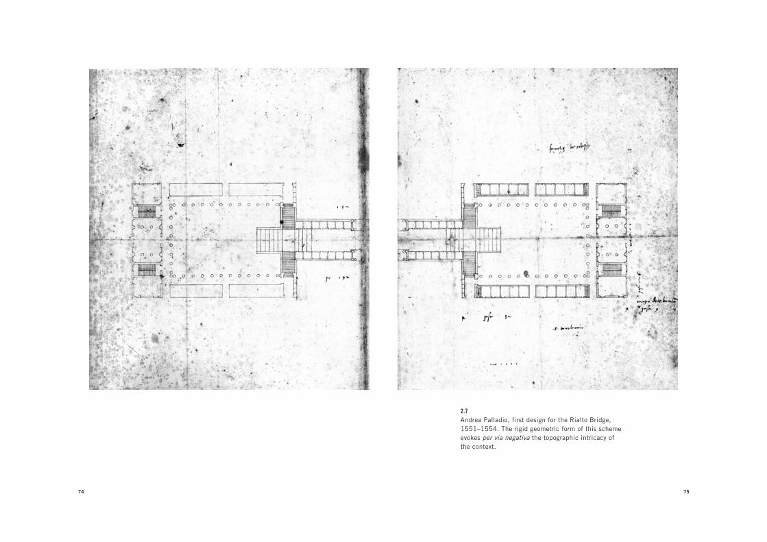
74 75
2.7Andrea Palladio, first design for the Rialto Bridge,
1551–1554. The rigid geometric form of this scheme
evokes per via negativa the topographic intricacy of
the context.

76 THE GEOPOLITICS OF THE IDEAL VILLA
The analogical motive of the Rialto Bridge—as Tafuri once
noted—is the radical contrast that Palladio established between
the static, somewhat sober character of the forum/square (the
elevation of which was designed in the form of a temple, topped
by a pediment) and the everyday hustle and bustle of the canal
activities below—a contrast perfectly captured in Canaletto’s
painting. According to this analogy, Palladio’s bridge acts as a
frame for Venice’s constituent elements—a “mental montage,”
as Tafuri describes it—that defines Palladio’s approach to the
city.22 Tafuri argues that “the utopian character of the Rialto
project seems to have been generated by a design principle that
transformed the city into a territory. In this city-territory the
heroic image of architecture entered the city in the form of fi-
nite parts, of points that defined the city, without reducing it to
an all-encompassed form.”23
It is precisely this characteristically modern dialectic between
the absoluteness of architecture and the openness of the city that
Palladio’s unique architectural approach sought to establish.
Using forms and typologies to effect contextual relationships
and political visions, he fundamentally reimagined not only the
physical manifestation of the city but its very idea. Significantly,
however, unlike most other key theorists of architecture—such
as Vitruvius, Alberti, Filarete, or Serlio—Palladio never produced
a comprehensive theory or plan, or even a general view of the
city. Even though his architecture takes the form of repeatable
prototypes, his projects are always rigorously site-specific. As a
result, Palladio did not take part in one of the topics through
which architectural culture in the fifteenth and sixteenth centu-
ries is repeatedly defined—the “ideal city.”
In the popular imagination, ideal cities are those rationally
planned, perfectly harmonious Renaissance municipalities
whose structure and image reflected the rediscovery of humanist
77
2.8Andrea Palladio, “Stone bridge of my own invention,”
design for the Rialto Bridge as engraved in the Quattro libri
dell’architettura (1570). The image of the temple contrasts
with the hectic life of the Grand Canal. The project shows
Palladio’s dialectical montage of forms at its best.

78 THE GEOPOLITICS OF THE IDEAL VILLA
values within a culture of civic coexistence. But in order to effec-
tively understand how the radicalism of Palladio’s project for the
city subverted this image, we need to go beyond its conventional
interpretation. What is traditionally referred to as an “ideal city”
is in fact a complex of theories, projects, and actions for a city de-
signed according to rational and scientifically intelligible crite-
ria. Its origin dates back to Greco-Roman times and the founding
of ex novo settlements according to repeatable principles inde-
pendent from the context in which they were to be applied. These
principles, often under the umbrella of a singular urban layout,
aimed to more effectively link the internal social management
of a city with its defense against outside enemy forces. Mediat-
ing between the ancient Greek oikos (household) and polis (city-
state), the idealism of the city therefore incorporated everything
from the private space of the family house to the militarization of
the city-state.24
With the fall of the Roman Empire in 476 CE, however, a
paralysis ensued in the evolution of the European city that
lasted through the eleventh century, as settlements took the
form of small, self-sufficient citadels or fortress cities—practi-
cally diagrams of the politics of feudalism. The feudal model,
of course, proved to be as economically unsustainable as it was
architecturally unnavigable, and it was against this model that
the city as civitas was rediscovered as the fundamental structure
for human coexistence from the fourteenth century onward. It
is precisely this rediscovery—together with the recovery of the
juridical implications of being a citizen as opposed to a feudal
subditus—that prompted philosophers and, later, architects
to retrace the legacy of antiquity as a model for the new city.
Vitruvius’s De architectura, rediscovered in the fifteenth cen-
tury, was an emblem of this historicism, and supported not only
an erudite antiquarianism but also a treatise on city manage-
A N D R E A P A L L A D I O A N D T H E P R O J E C T O F A N A N T I - I D E A L C I T Y 79
ment covering all scales of the urban project from the design of
houses to warfare.
It was in this context that figures such as Alberti, Francesco
di Giorgio, and Filarete expanded the task of the architect from
designing buildings to designing entire cities. Subsequently, the
image of the ideal city as orderly and conceived according to a
rational plan appears in many fifteenth-century paintings, pre-
cisely reflecting the political immediacy of urban design. Here
the Renaissance invention of perspective clearly resonates, be-
cause it demonstrated the possibility of reducing the space of
the city to the manageable logic of calculation and the mapping
and organization of spatial and geographical facts. But for all the
perspectival idealism exemplified by architects like Sebastiano
Serlio, Italy in the fifteenth and sixteenth centuries was in reality
so politically fragmented and unstable that an overall planning
of its cities according to rational criteria was quite impossible.
Those Italian cities that do appear as “ideal” (towns like Pienza
in Tuscany or Vigevano in Lombardy) are in fact fairly restricted
spaces enveloped by a medieval urban fabric. Interestingly, this
is also the case with Rome, a city long predicated on a chaotic
and somewhat haphazard model of urban growth. Although the
city’s papacy in the fifteenth and sixteenth centuries attempted
to reconstruct Rome in accordance with its ancient splendor,
such plans materialized only in the form of small interventions
within the existing infrastructure. For example, Bramante’s im-
plementation of Pope Julius II’s vision for Rome as an imperial
city was (partially) realized, not in the form of an overall plan,
but as a strategic positioning of large-scale architectural artifacts
connected by an axial grid of roads. Given the limited scope of
these interventions, architects like Bramante tended to over-
load the metonymical and microcosmic resonances of individual
buildings in an architectural organism whose formal and spatial

80 THE GEOPOLITICS OF THE IDEAL VILLA
composition (via the use of porticos, squares, forums, villas,
and basilicas) exuded the exemplary characteristics of ancient
cities. Consider, for example, his Belvedere in the Vatican, where
the model of an ancient villa—with explicit references to the
Sanctuary of Fortuna Primigenia in Palestrina—is translated into
a massive, self-contained courtyard building. Through overly
symbolic structures like these, Renaissance Italy’s project for the
city shifted away from the overall plan à la Filarete toward ana-
logical representations based around contained, finite architec-
tural compositions.
Palladio, like Bramante, looked to the ancient monuments
of Rome not simply as sources for the correct interpretation of
the orders, but as complex organisms that reproduced the rich
architectural qualities of a city. It was for this reason that he so
carefully studied the model of the Roman bath, an urban type to
which he had planned to devote one whole book in his unfinished
architectural treatise. Palladio viewed the bathhouse as a unique
public structure because, unlike temples or basilicas, it grouped
together multiple programs and activities, lending it an intricacy
through its sequence of different spaces. This same spatiality is
often evoked in Palladio’s villas, palaces, and churches. Think,
for example, of the interiors of the Redentore or San Giorgio
Maggiore, the forms of which are the result of radically different
spatial models, each developed according to its own autonomous
geometries and linked together only by the symmetry and con-
tinuity of the orders. Or consider the two extraordinary proj-
ects for palaces in Venice, published in the second book, whose
plans develop around the elucidation of a succession of spaces,
the sequence of which is not simply reducible to the traditional
tripartite Renaissance palazzo atrium or courtyard.25
The same miniaturization of city space into compound archi-
tectural artifacts also pushed Palladio to reconstruct Greek and
A N D R E A P A L L A D I O A N D T H E P R O J E C T O F A N A N T I - I D E A L C I T Y 81
Latin squares (following Vitruvius’s description) in the Quattro
libri, as models for a variety of colonnaded indoor and outdoor
spaces. Because they were associated with the forums of an-
cient Rome, porticos made by colonnades became the definitive
architectural response in framing open, public civic space.
Within this analogical context, as we have seen in the Palazzo
Chiericati, the Basilica, or the Palazzo Civena, Palladio would
often introduce a ground-floor portico, thereby instantly trans-
forming the building from a simple, self-standing object to an
entity that symbolically resonated with all of the formal attributes
of the city around it. By incorporating public spaces, these build-
ings were not simply outstanding examples of architecture, but
exemplars of an architectural relationship to the city. It is this
explicit will to idealize that made Palladio’s collective series of
buildings the absolute embodiment of a project for the city. Yet
the impact of these examples should not be viewed simply in
terms of their role in establishing an architectural pattern book
(a subservience to type and form that has made Palladio one of
the most copied architects in the history of the discipline). In-
stead, Palladio’s portfolio is more powerfully influential within a
cultural understanding of the Renaissance city, offering specific
architectural compositions that immediately evoke paradigms of
city space.
As Giorgio Agamben has written, the act of making an exam-
ple is a complex business because it presupposes that in order
to represent the canon, an example has to be conceptually dis-
connected from the forms of its everyday use.26 In the rhetorical
mechanisms of an example, form is not simply an object in itself
but an object that operates as a paradigm for something else.
Agamben also reminds us that in Latin culture there was a dis-
tinction between an exemplar, something to be appreciated and
understood only with the senses—and thus something destined
82 THE GEOPOLITICS OF THE IDEAL VILLA
to be imitated—and an exemplum, a form whose interpretation
requires additional intellectual or symbolic references.
It is exactly as an exemplum that Palladio’s architecture oper-
ates, with its subtle references to ancient typologies and reso-
nances to wider geographical and political contexts. Through
Palladio, architecture extends its influence on the city precisely
by being a finite and thus clearly recognizable thing, a “spe-
cies”—in the sense that the Marxist philosopher Paolo Virno
has used the term—consisting of a sole individual that can
only be politically reproduced and never be transposed into
an omnivorous general program.27 The power of the exemplum
resides in its ability to propose a general paradigmatic frame-
work rather than a set of regulations or commands to be literally
deployed. As an exemplum, Palladio’s architectural form is not
deployed onto a plan, nor is it an urban rule; rather, it is invested
with the representation of an alternative idea of the city within
the very space of the existing city.
Such an intuitively tactical understating of architecture, as
both a coherent set of principles and a mobile element never tied
to an overall plan, seems to have its origin in Palladio’s passion for
the art of war.28 In the Quattro libri he notes that the imperative to
construct perimeter walls is of little use to the successful defense
of a city compared to the training of the soldiers and an accurate
knowledge of the surrounding territory—thus demonstrating a
militarized understanding of landscape and civic management
which was also faithfully represented in his battle illustrations
for the sixteenth-century publication of Polybius’s Histories.
What is interesting about these troop formation diagrams is the
way they replicate his villas’ own framing of the landscape. This
mentality, which fused the stability of architecture with the fluid
complexity of new urban spaces and forms, seems to have made
Palladio deeply skeptical about any overarching urban plan, and
A N D R E A P A L L A D I O A N D T H E P R O J E C T O F A N A N T I - I D E A L C I T Y 83
pushed him instead to frame his (implicit) project for the city in
the same way he understood the art of war—as a project tactically
open to the multiplicity of its territorial circumstances and yet
resolute in its formal strategy. In this respect, Palladio’s acces-
sible geography of architectures can be read as exemplars of a
city no longer constrained by its walled civitas, but as a territory
whose form lies in its attempt to trace and make explicit the geo-
graphical and political conditions of its existence.
Within the history of projects for cities, no image for a “new
city” is as radical as the Scenographia Campi Martii, engraved
by Giovanni Battista Piranesi as the prologue to the Venetian
architect’s more famous plate, the Ichnographia Campi Martii
antiquae urbis, an eighteenth-century “reconstruction” of Rome
in the age of the Roman Empire. In the Scenographia, Piranesi
presents an image of Rome in which several existing ruins from
its imperial past stand in a desolate landscape. Representing
neither the existing city nor the ancient city, this engraving
simply depicts the few surviving ruins of Piranesi’s day, minus
the context of modern Rome: the ruins are not restored but are
represented in their current condition, as if they had been lib-
erated from all subsequent historical layers. Here the ruins can
be read both as what had survived the subsequent development
of the city and as the conceptual guides for the reconstruction
of a new city, which Piranesi would present in the Ichnographia
plate. His Scenographia thus condenses three seemingly con-
flicting actions—destruction, restoration, and reconstruction
of the city—into one representation. To understand the ideo-
logical purpose of such a project, it is necessary to situate the
Campo Marzio and its source, Piranesi’s radical mapping of
Rome in Le antichità romane, within the important tradition
3 INSTAURATIO URBISPIRANESI’S CAMPO MARZIO VERSUS NOLLI’S
NUOVA PIANTA DI ROMA

86 87
3.1Giovanni Battista Piranesi, Scenographia Campi Martii,
from Il Campo Marzio dell’antica Roma (1762). The
modern city has been removed. Once fragments of a past
civilization, new ruins are the beginning of a “new” city.
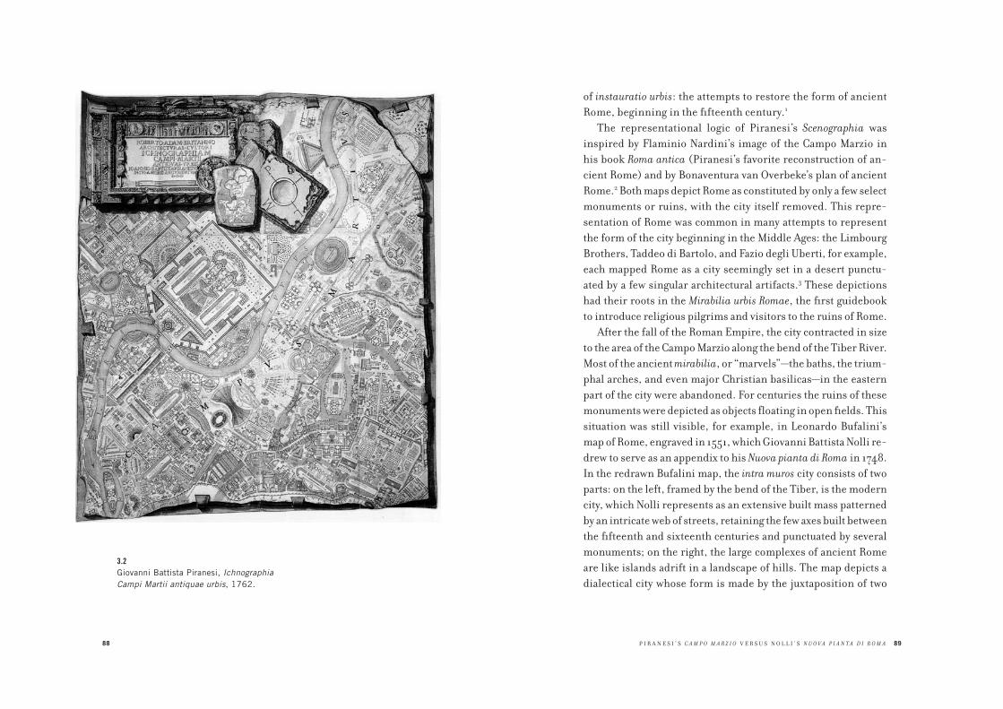
88
3.2Giovanni Battista Piranesi, Ichnographia
Campi Martii antiquae urbis, 1762.
P I R A N E S I ’ S C A M P O M A R Z I O V E R S U S N O L L I ’ S N U O V A P I A N T A D I R O M A 89
of instauratio urbis: the attempts to restore the form of ancient
Rome, beginning in the fifteenth century.1
The representational logic of Piranesi’s Scenographia was
inspired by Flaminio Nardini’s image of the Campo Marzio in
his book Roma antica (Piranesi’s favorite reconstruction of an-
cient Rome) and by Bonaventura van Overbeke’s plan of ancient
Rome.2 Both maps depict Rome as constituted by only a few select
monuments or ruins, with the city itself removed. This repre-
sentation of Rome was common in many attempts to represent
the form of the city beginning in the Middle Ages: the Limbourg
Brothers, Taddeo di Bartolo, and Fazio degli Uberti, for example,
each mapped Rome as a city seemingly set in a desert punctu-
ated by a few singular architectural artifacts.3 These depictions
had their roots in the Mirabilia urbis Romae, the first guidebook
to introduce religious pilgrims and visitors to the ruins of Rome.
After the fall of the Roman Empire, the city contracted in size
to the area of the Campo Marzio along the bend of the Tiber River.
Most of the ancient mirabilia, or “marvels”—the baths, the trium-
phal arches, and even major Christian basilicas—in the eastern
part of the city were abandoned. For centuries the ruins of these
monuments were depicted as objects floating in open fields. This
situation was still visible, for example, in Leonardo Bufalini’s
map of Rome, engraved in 1551, which Giovanni Battista Nolli re-
drew to serve as an appendix to his Nuova pianta di Roma in 1748.
In the redrawn Bufalini map, the intra muros city consists of two
parts: on the left, framed by the bend of the Tiber, is the modern
city, which Nolli represents as an extensive built mass patterned
by an intricate web of streets, retaining the few axes built between
the fifteenth and sixteenth centuries and punctuated by several
monuments; on the right, the large complexes of ancient Rome
are like islands adrift in a landscape of hills. The map depicts a
dialectical city whose form is made by the juxtaposition of two

90
3.3Bonaventura van Overbeke, Roma antica, 1708.
91
3.4Giovanni Battista Nolli, rendition of Leonardo
Bufalini’s 1551 map of Rome, 1748.

92 INSTAURATIO URBIS
conditions: the modern city, with its figure-ground relationship
between monuments and the organic fabric of the city, and the
ancient city, with its monuments completely liberated from their
urban framework. This urban composition is unique. It dramati-
cally reveals the difference between the inhabited city, with its
urban framework of streets and squares, and the deserted city,
whose potential is open to multiple possibilities.
In comparison, in the Campo Marzio, Piranesi displaces the
urban fabric that for centuries characterized the eastern part of
the city to the site of the modern city: the Campo Marzio. In the
Scenographia, he envisions the destruction of modern Rome as a
precondition for a new Rome, designed through the restoration
of its ancient form. The link between these two Romes is the few
extant ruins, which Piranesi selected for the introduction to his
topographical reconstruction of the Campo Marzio.
In ancient Rome, the Campo Marzio was a chaotic agglom-
eration of large architectural complexes. Unlike the originary
sites in Rome’s landscape of hills, the Campo Marzio was a flat
area subject to recurring flooding of the Tiber. As a result, it was
populated mostly by public buildings such as theaters and cir-
cuses, but like the rest of Rome the Campo Marzio had developed
without a plan; the area was defined simply by the juxtaposition
of its buildings. After the fall of the Roman Empire, the ruins of
these complexes were absorbed by the first nucleus of medieval
Rome. Ruins were used as the foundations for new buildings,
resulting in an intricate pattern of streets that evolved from the
chaotic condition of the area. Piranesi’s Campo Marzio was an at-
tempt to reconstruct the ancient form of this part of the city, but
his representation of the project was more than just a visionary
archaeological reconstruction. Indeed, the Campo Marzio can be
understood as a project for the city that Piranesi composed as a
polemical response to the condition of Rome in his time.
P I R A N E S I ’ S C A M P O M A R Z I O V E R S U S N O L L I ’ S N U O V A P I A N T A D I R O M A 93
Much has been written on Piranesi’s project, but it is not fair
to judge its topographical and architectural inventiveness as
utopia or, worse, as an architectural fantasy. Rather, Piranesi’s
Campo Marzio can be considered the summa of a vision of the city
that developed between the fifteenth and eighteenth centuries:
instauratio urbis, which literally means “the installment of the
city,” and in practice involved the reconstruction of the ancient
form of the city. Rather than being simply antiquarian or erudite
exercises, these reconstructions were attempts to restore the la-
tent vocation of the city: Rome as capital not only of the ancient
world but also of the modern world.
Because ancient Rome had no overall plan, the restoration ad-
vanced by instauratio urbis took the form of a careful and selective
topographic survey of the ancient ruins of the city. It is impor-
tant to emphasize that the implicit project of many instaurationes
urbis was the liberation of the ancient ruins from the modern
city that had developed around them. Unlike the earlier Mirabilia
tradition, in instauratio urbis ruins were no longer seen as the
remnants of a past world, nor as mere melancholic mementos
of the greatness of ancient Rome. Instead, instauratio urbis used
the remnants of the ancient city as clues for the reconstruction
of a new Rome. One of the most important proponents of this
project was the artist Raphael, whose ideas to protect and restore
the ruins of ancient Rome were presented to Pope Leo X by Bal-
dassarre Castiglione. This proposal to preserve antiquity was one
of the earliest examples of a desire for an urban project focused
on the concept of heritage.4
One of the most impressive attempts at instauratio urbis is Pirro
Ligorio’s Antiquae urbis imago of 1561.5 Ligorio’s process of cross-
referencing antiquarian findings exemplified the method that was
typical of instauratio urbis, in which ruins were not just evidence of
a past per se, but also became examples that resonated conceptually

94 INSTAURATIO URBIS
and formally as the foundations for the grammar of contemporary
city forms. Ligorio selected evidence from ruins, from schematic
images of ancient buildings as represented on coins, and from
references in ancient literature, and then formed a coherent ar-
chitectural grammar through which he was able to reconstruct
the entirety of the city’s architecture. Ligorio’s reconstruction of
ancient Rome is the most direct precedent for Piranesi’s Campo
Marzio.6 In Ligorio’s Imago, Rome appears as a city almost without
streets and crowned by objects: different compositions of domes,
pyramids, pitched roofs, obelisks, amphitheaters, exedras, por-
ticos, and circuses. The Imago is the most radical representation
of a city whose form is embodied in the composition of its build-
ings rather than dictated by an overall plan. When Le Corbusier
discussed Rome as a city composed of architectural forms “against
the illusion of the plan,” it was not by chance that he traced a detail
of Ligorio’s Imago.7 With this example, Le Corbusier argued that,
against the pretensions of urban axiality and overall city plans, the
“Lesson of Rome” proposed a city form made by the juxtaposition
of the sheer mass and volumes of its monumental buildings.8
Because ancient Rome was an accumulation of individual
complexes without an overall plan, any attempt at instauratio
urbis began with the careful topographic siting of the ancient
ruins. The city had to be mapped ruin by ruin in a never-ending
adventure of antiquarian and topographical exploration. For the
architects who were reconstructing Rome, instauratio urbis meant
adherence to a city form that was not reducible to a single overall
logic, but that revealed itself through the city’s individual archi-
tectures and their relationship with the surrounding geography.
In this thinking, instauratio urbis was an infinite puzzle: every
time something was discovered, mapped, and reconstructed, an
ensuing enquiry on ancient Rome would contest the discovery
and propose an alternative reconstruction.
95
3.5Pirro Ligorio, Antiquae urbis imago, 1561
(detail of the central area of the city).
96 INSTAURATIO URBIS
What sort of intellectual and conceptual impetus sustained
this reconstruction of antiquity, of which Piranesi’s Campo Mar-
zio is the ultimate realization? What was at stake in this endless
attempt to trace the ancient form of Rome? In short, why did the
ancient form become such a topical drive in the development of
the city for at least three centuries?
As seen in Palladio’s survey of Rome, interest in ancient ruins
was motivated not by an abstract respect for heritage but rather
by its political instrumentality, which often coincided with the
desire to refound and reconstruct the city. The motivation of
instauratio urbis also reveals the ideological ground zero for the
revival of antiquity during what, since the nineteenth century,
has been called the Renaissance.
The ideology of instauratio urbis originated in the politi-
cal awakening of the Roman populus in the fourteenth century,
after a long period of political and social backwardness that had
afflicted the city since the fall of the Roman Empire. A decisive
event in this awakening was the revolt of the people of Rome, led
by Cola di Rienzo, against the aristocratic rulers left in power by
the absence of the popes. As Manfredo Tafuri has noted, Cola’s
uprising was not simply a revolt but a truly “cultural revolution,”
the effects of which reverberated through Rome for centuries.9
Its ideological trigger was rooted in the first attempt to reevalu-
ate the cultural legacy of ancient Rome as a counterweight to the
feudal power of the fourteenth-century city’s ruling families.
The uprising was legitimated by the discovery of the Lex romana,
written on bronze tablets at the time of the Emperor Vespasian,
which Cola symbolically inserted in the apse of the church of San
Giovanni, the cathedral of Rome, with theatrical ceremony.10
According to the Lex romana, it was the populus who had conceded
power to the emperor. This finding had explosive ramifications,
because it made clear that the power of the ruler of Rome and his
P I R A N E S I ’ S C A M P O M A R Z I O V E R S U S N O L L I ’ S N U O V A P I A N T A D I R O M A 97
heirs, the pope included, came from the people of Rome. This
Roman event can be considered one of the first detonations of
the Renaissance period, which originated in the rediscovery
of the Roman law and consequent rediscovery of the figure of the
civis—the political subject defined by its civil prerogatives—as
opposed to the subditus, the subordinate subject of feudal power.11
This paradigm shift in politics resulted in the revival of antiquity.
This also explains why the popes, from the fifteenth century on-
ward, appropriated the revival of antiquity with the intention of
turning its political meaning to their advantage. From the begin-
ning of his papacy in 1447, Pope Nicholas V explicitly envisioned
Rome as the direct heir of its ancient empire and translated that
vision into a plan for the city.12 The ghostwriter of this vision was
Leon Battista Alberti, whose architectural treatise De re aedifica-
toria was the theoretical framework for the reinvention of the city
in continuity with the legacy of Roman civilization. The revival
of antiquity through many projects of instauratio urbis led to a
contested cultural legacy, as the revival was used both by those
who challenged the temporal power of the Church by envision-
ing the city in its ancient times, and by the Church itself which
appropriated the same city to legitimize its imperial renovatio.
For example, Poggio Bracciolini, the humanist who discovered
Vitruvius’s De architectura and wrote the Ruinarum urbis Romae
descriptio (1431), the first antiquarian description of ancient
Rome, was critical of Pope Nicholas V’s building activity. Yet
Poggio’s friend Flavio Biondo, author of Roma instaurata (1446),
the first systematic topographic survey of ancient Rome, would
declare in his later work, De Roma triumphante (1459), that the
papacy was the direct continuation of the Roman Empire.13
A fundamental architectural aspect of the sixteenth-century
Roman surveys was the analysis of monuments within their top-
ographic locations, just as the Mirabilia urbis Romae guidebook
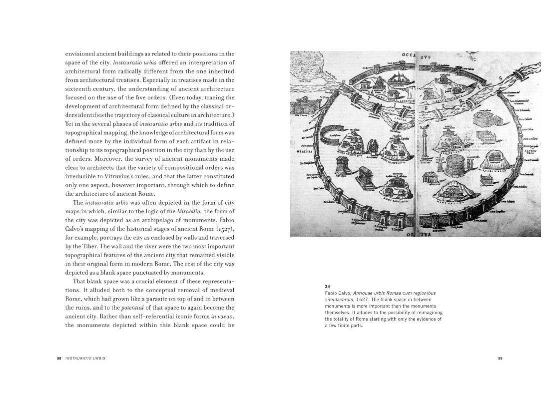
98 INSTAURATIO URBIS
envisioned ancient buildings as related to their positions in the
space of the city. Instauratio urbis offered an interpretation of
architectural form radically different from the one inherited
from architectural treatises. Especially in treatises made in the
sixteenth century, the understanding of ancient architecture
focused on the use of the five orders. (Even today, tracing the
development of architectural form defined by the classical or-
ders identifies the trajectory of classical culture in architecture.)
Yet in the several phases of instauratio urbis and its tradition of
topographical mapping, the knowledge of architectural form was
defined more by the individual form of each artifact in rela-
tionship to its topographical position in the city than by the use
of orders. Moreover, the survey of ancient monuments made
clear to architects that the variety of compositional orders was
irreducible to Vitruvius’s rules, and that the latter constituted
only one aspect, however important, through which to define
the architecture of ancient Rome.
The instauratio urbis was often depicted in the form of city
maps in which, similar to the logic of the Mirabilia, the form of
the city was depicted as an archipelago of monuments. Fabio
Calvo’s mapping of the historical stages of ancient Rome (1527),
for example, portrays the city as enclosed by walls and traversed
by the Tiber. The wall and the river were the two most important
topographical features of the ancient city that remained visible
in their original form in modern Rome. The rest of the city was
depicted as a blank space punctuated by monuments.
That blank space was a crucial element of these representa-
tions. It alluded both to the conceptual removal of medieval
Rome, which had grown like a parasite on top of and in between
the ruins, and to the potential of that space to again become the
ancient city. Rather than self-referential iconic forms in vacuo,
the monuments depicted within this blank space could be
99
3.6Fabio Calvo, Antiquae urbis Romae cum regionibus
simulachrum, 1527. The blank space in between
monuments is more important than the monuments
themselves. It alludes to the possibility of reimagining
the totality of Rome starting with only the evidence of
a few finite parts.
100 INSTAURATIO URBIS
interpreted as the starting points for the reconstruction of the city.
In the numerous papal attempts to plan Rome from the fifteenth
to the eighteenth centuries, the restoration of ancient Rome pro-
moted by instauratio urbis resonated as the implicit, and some-
times explicit, project for the modern reconstruction of Rome.
In the ideological context of ancient Rome’s political instrumen-
tality, the attempts to recuperate and “restore” this legacy have to
be viewed as the fundamental leverage for new visions of the city.
For example, Pope Nicholas V’s plan for Rome was focused not
simply on building new structures and opening new roads, but
also on the restoration of old churches such as Santo Stefano Ro-
tondo, then believed to be a late Roman structure; it was restored
by Alberti as an important “new” monument of the new Rome.
The most emblematic instance of instauratio urbis as a program
for rebuilding the entire city in the manner of the ancients was
Pope Julius II’s large projects. In addition to giving himself the
name of the most emblematic Roman ruler, Julius also brought
back the scale of ancient imperial Roman architecture through
Bramante’s large-scale interventions, such as the Belvedere,
the Tribunal Palace, and the reconstruction of the basilica of
St. Peter.14
Under the papacy of Sixtus V in the late sixteenth century,
instauratio urbis became a cultural legacy to resist. Following
in the steps of his immediate predecessors, who, in the aus-
tere and antipagan context of the Counter-Reformation, were
already at odds with the ideological implications of the revival
of antiquity, Sixtus V drastically shifted the focus of Rome from
its ancient ruins to the early basilicas of Christianity. His short
but extremely productive work in planning the city focused on
Domenico Fontana’s strategic highlighting of the basilicas, whose
locations outside the inhabited part of the city were encompassed
within a new devotional urban sequence. The campaign against
P I R A N E S I ’ S C A M P O M A R Z I O V E R S U S N O L L I ’ S N U O V A P I A N T A D I R O M A 101
ancient Rome also included the destruction of famous ruins such
as the Septizonium and a project to transform the Coliseum into
a factory for the production of wool, with annexed houses for the
workers. And yet, even with this anti-antiquity approach, Pope
Sixtus V’s “plan” for Rome took the form and strategy of instau-
ratio urbis. His choice of obelisks to highlight the axis of basili-
cas and to mark the city’s sequence of urban spaces can be seen
as a gesture similar to those of previous popes who used exist-
ing archaeological findings (whether in situ or appropriated
from other contexts) as highlights for the new city to come. What
can be seen as a radical change is the meaning Sixtus V gave to
these archaeological forms. The obelisk was appropriated not
as an erudite reminder of ancient Rome, but as a semantically
diminished form whose hieroglyphic inscriptions were illegible
and whose meaning was thus reduced to its literal presence as
a mass in space.15 The same logic was applied to Sixtus V’s res-
toration of the ancient triumphal columns, which were isolated
from their surrounding structures and each topped with a statue
of one of the patron saints of Rome. Though Sixtus V rejected the
erudite and antiquarian apparatus of instauratio urbis, he never-
theless assumed the principle of reinventing the city by strate-
gically highlighting some of its existing but latent monuments.
Bordino’s famous illustration of late-sixteenth-century Rome,
engraved as a pilgrim’s guide, eloquently explains the spirit of
Sixtus V’s city. The city is portrayed as a tabula rasa in which the
only elements are the restored ancient columns and the basili-
cas, the “as found” objects now highlighted as the poles of the
new city. In his anti-archaeological fundamentalism, Sixtus V’s
formula of demolition and restoration not only accomplished,
if unintentionally, the principle of instauratio urbis, but, in its
tabula rasa strategy, can also be seen as one of the most important
precedents of Piranesi’s approach to modern Rome.

102
3.7Antonio Bordino, map of Rome, 1588. Illustrating the
principal links between the basilicas at the time of
Pope Sixtus V, and intended as a guide for pilgrims
visiting Rome, the map shows the city as a tabula rasa
dotted with a few existing landmarks of Christian Rome.
P I R A N E S I ’ S C A M P O M A R Z I O V E R S U S N O L L I ’ S N U O V A P I A N T A D I R O M A 103
By the seventeenth century, with the development of baroque
Rome as the theatrical stage of the triumphant Catholic Church,
instauratio urbis was no longer in vogue as an urban strategy. In
the difficult geopolitical situation in Europe caused by the con-
flict between the Lutheran Reformation and Catholic Counter-
Reformation, the pagan implications of antiquarian knowledge
had become politically incorrect as an urban project, and work on
antiquity survived mostly as a field of study rather than as a political
tool. But the seventeenth century was also when Rome assumed its
definitive form, shaped by the scenographic spatiality of the post-
Sixtus V city. As its number of inhabitants increased, Rome saw its
residential areas grow, causing the city to develop a more dense
urban fabric. Baroque Rome would reach its artistic and urban
splendor at the end of the Thirty Years’ War, when the influence of
the Catholic Church in Europe was drastically reduced. With this
geopolitical decline, a process of cultural and political decadence
ensued, which deeply affected the meaning and resonance of the
city’s urban transformations.
In the mid-eighteenth century, the cultural prestige of Rome
suffered a further blow as a result of its depiction in Diderot and
d’Alambert’s Encyclopédie. In this influential effort to organize
knowledge according to the principles of reason, the capital of
Christianity was portrayed as a corrupt city, a symbol of irrational
culture, and a slave to its past. This accusation signaled a growing
suspicion of the cultural legacy of Rome. Under attack was the
very validity of antiquarian knowledge through which the history
of the ancient world had been reconstructed according to the
myth of Rome.
The culture of the Enlightenment challenged antiquarian eru-
dition with the idea of archaeological knowledge. Knowledge of
antiquity—the core of instauratio urbis—had been largely based
on cross-referencing topographical evidence, monuments, and

104 INSTAURATIO URBIS
the classic descriptions of the ancient world by writers such as
Livy, Strabo, and Pliny. Ancient monuments, particularly those
in Rome, were interpreted as evocative clues for analogical
reconstructions and recompositions of the ancient world. This
power of evocation and the analogy of instauratio urbis had been
used politically to support ideological and political visions.
Ancient ruins were not simply evidence of a past to be preserved,
but were also formal examples to be recomposed according to the
narratives of power.
Distinct from this analogical reconstruction of the past, ar-
chaeology was embraced by the Enlightenment as a scientific
reconstruction of the past based on the empirical knowledge
of findings in the field and their accurate stylistic classifica-
tion. Yet behind this conflict lay a more fundamental cultural
issue that would enormously influence Piranesi’s work: the
Enlightenment attacked the humanist tradition as a culture
largely based on literary sources and their analogical evocations
of the world. For example, the Encyclopédie strongly criticized
as superstitious the method of identifying ruins by following
the writings of ancient authors, because these sources included
legend and myth, and thus were far from scientifically correct
historical knowledge. Moreover, Enlightenment thinkers saw
antiquarian erudition as compromised by its attempt to estab-
lish the primary role of Roman civilization in defining the cul-
tural origin of the Western world, and its attempt to construct
a direct link between imperial Rome and its successor, Chris-
tian Rome. The progressive culture of the eighteenth century
thus mobilized archaeology to replace the myth of antiquarian
knowledge and its humanistic underpinnings with another
myth grounding contemporary knowledge on science: the idea
of producing knowledge via a rigorous empirical method liber-
ated from ideological preconceptions.
P I R A N E S I ’ S C A M P O M A R Z I O V E R S U S N O L L I ’ S N U O V A P I A N T A D I R O M A 105
Cartography arose as a fundamental manifestation of scien-
tific knowledge in the urban culture of the seventeenth and eigh-
teenth centuries. Besides being propelled by new geographic
discoveries that changed the form of the world, new maps of cit-
ies and territories had to be produced to define more subtle and
sophisticated forms of governmental power. Domenico Cassini’s
map of France, promoted by Louis XIV and begun in the 1670s,
and John Ogilby and William Morgan’s map of London of 1676,
made after the Great Fire, were directly connected with urban
reform projects and the administrative reorganization of the city
and state based on accurate knowledge of geographical features.16
The development of cartography produced a new professional
figure: the surveyor, an expert at measuring the land. With the
intellectual development of this figure, cartographic representa-
tions were freed of nonscientific symbolism such as allegorical
representations, through which geographical knowledge had
often been presented. The surveyor replaced the allegorical nar-
rative of maps with the exactitude of numbers and scientifically
objective data.
Within the evolution of cartographic knowledge, archaeol-
ogy advanced as the principal mode of scientific investigation
of the ancient world. For this reason, the instauratio urbis that
took form in Rome in the first half of the eighteenth century was
now begun in the name of scientific accuracy. As Mary Sponberg
Pedley has affirmed, in spite of the Catholic Church’s hostile
reception of scientific development in the seventeenth century,
the same institution became one of the most advanced epicenters
of cartographic science, as well as the object of this science.17 Just
as early papal instauratio urbis had appropriated and developed
according to its own terms the political concepts rediscovered
from antiquity, now instauratio urbis appropriated the new sci-
ence by taking the form of an advanced cartography. The new

106 INSTAURATIO URBIS
cartographic surveys and, above all, the new wave of interest in
antiquity were now perceived not only within the framework
of humanist erudition but also within the new scientific ethos
of cartographic research.
Nolli’s Nuova pianta di Roma (1748) must be considered in this
context. The surveying work for the Nuova pianta was initiated by
Diego Revillas, an important antiquarian and cartographer, and
a member of the scientific and archaeological circle promoted
by Cardinal Alessandro Albani, nephew of Pope Clement XI.
Revillas was the author of advanced cartographic mappings of
regions of the Papal States linked to a program of urban reform.
Nolli, an experienced surveyor, had been connected with early
attempts to promote a type of mapmaking called cadastral cartog-
raphy in the area surrounding Milan in the first half of eighteenth
century. Cadastral cartography was the first cartographic effort to
organically link the form of a region, its economic organization
and productivity, and its social control—its territorial statistics.
In Rome, Nolli connected this approach with the new archaeo-
logical impetus that developed in reaction to the city’s political
and cultural decline.
The resulting Nuova pianta di Roma was the first rigorous
scientific survey of Rome. The final map consists of twelve large
sheets that represent the city at a scale of 1:3000. The survey-
ing was first mapped in the field on separate panels, at a scale of
1:100, using the most sophisticated and up-to-date measuring
instruments, such as the tavoletta pretoriana (Praetorian tablet)—
a measuring device invented in the early seventeenth century to
allow graphic records to be made in situ. The scale relationship
between the field mapping and the final map allowed for unprec-
edented topographical precision. Moreover, the Nuova pianta
marked the first time the north-south geographical convention
was used in a map of Rome. Rome now appeared in its “real”
107
3.8Giovanni Battista Nolli, Nuova pianta
di Roma, 1748.

108 INSTAURATIO URBIS
topographic dimension, without the spectacular effects of its
iconic image as portrayed in earlier maps of the city.18
The Nolli map depicts not only the plans of the major monu-
ments such as churches but also atria, stairs, and courtyards of
both major and minor buildings. Open spaces are also mapped
in detail, recording elements such as fences, fountains, obelisks,
steps, and other minor monuments. Also mapped are the ruins
of ancient Rome, because a goal at the outset had been to map
and scientifically survey Rome’s archaeology. With the passing of
time, however, the goal of accurately measuring all of the ruins
became less important, and the project focused exclusively on
mapping the entirety of modern Rome.
Besides the topographic precision with which all of the city’s
layers are recorded, the Nolli map is characterized by the figure-
ground technique which distinguishes the architectural features
from the rest of built space. While the plans of church interiors,
palace atria, and courtyards are drawn as poché excavated within
built mass, the remaining built mass, primarily the residential
fabric of the city, is rendered as “building” footprints filled with a
linear hatch. Nolli took the convention of the figure-ground rela-
tionship of monumental buildings from Bufalini’s map of Rome,
but he applied this convention systematically to all architectural
features in the city, not just the important monuments.
The figure-ground distinction that Nolli introduced has often
been discussed as symbolizing the difference between public and
private space, but such an interpretation is incorrect. Many of
the courtyards and gardens represented as “open spaces” were
inaccessible to the public; furthermore, it is problematic to apply
the notion of public space to a church nave or a cloister. Rather,
the distinction between the figure of architecture and the ground
of the city introduces a more subtle but decisive difference in the
cartographic representation of the city: the difference between
P I R A N E S I ’ S C A M P O M A R Z I O V E R S U S N O L L I ’ S N U O V A P I A N T A D I R O M A 109
architectural space and urban space. The Nuova pianta di Roma is
one of the primary illustrations of the change in the representa-
tion of the city from architectural form to urban mass.
Louis Marin has said that any map of a city implies a discourse
on and thus a project of the city.19 In the case of the Nolli map,
the project consists of the radical separation between archi-
tectural form and the fabric of the city. Whereas Renaissance
treatises from Alberti to Palladio postulate that the city could be
considered a large house and the house a small city, implicitly
theorizing the equivalence of city form and architectural form,
the Nolli map for the first time attacked this equivalence and dif-
ferentiated city and architecture. In the Nolli map, this division
was meant to be effective in the urban management of the city.
The blackened sections indicate the parts of the city that were
adaptable to change and reform, while the architectural poché
indicates parts that were more fixed.
Unlike the tradition of instauratio urbis with its prolific produc-
tion of views and representations of the city, in the entire history
of Christian Rome very few accurate topographic maps were ex-
ecuted. Between the fifteenth and eighteenth centuries only five
maps were made of Rome, and only one, the plan engraved by Bu-
falini in 1551, was, like Nolli’s map, an ichnographic map—that is,
an orthogonal projection of the city plan. The limited production
of maps of Rome reflected the city’s turbulent political condition,
for papal Rome was a largely ungovernable and highly contested
territory. In the history of mapmaking, the accurate survey of
topography is always a preliminary action for long-term urban
reform, and the production of accurate maps always implies that
there is powerful political stability. Such a condition was impos-
sible in Rome until the eighteenth century because the city had
developed as one of the most unstable political institutions of all
times. Ruled by a nondynastic monarchy of popes, the city could
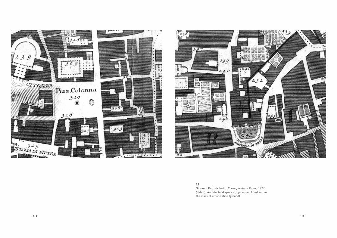
110 111
3.9Giovanni Battista Nolli, Nuova pianta di Roma, 1748
(detail). Architectural spaces (figures) enclosed within
the mass of urbanization (ground).
112 INSTAURATIO URBIS
not develop under long-term planning policies because each pope
had his own objectives, which were often in conflict with the work
started by his predecessor. Moreover, because popes were elected
at a very advanced age—in order to limit their absolute power—
each pope had only a short time to leave his mark on the city. Thus,
attempts to transform the city were advanced by strategically
located architectural projects rather than by an overall urban plan.
Given its political organization, Rome developed as a kind of
dynamic battlefield made up of the destruction and reconstruc-
tion of city parts, where individual buildings were erected either
to define alliances or to use city space against an enemy. The result
was an intricate and ever-changing topography that was devoid of
any coherence between buildings, monumental structures, and
the few straightforward streets. Only in the eighteenth century,
when the Church had less geopolitical relevance and the antago-
nism between popes, their families, and their allies became less
pressing, did Rome become a more stable and governable city,
in spite of its decline in economics and prestige. In this context,
papal efforts shifted from building monuments to promoting
urgent urban reforms, especially in the management of the city’s
administration and infrastructure. The Nolli map was executed
at precisely this moment. The shift in priority from conducting
an archaeological survey to surveying the entire city was due to
the increasing relevance of cartography in framing the project of
urban reforms. As Mario Bevilacqua argues, the Nolli map was
not simply a map of the city; it was also the first scientific instru-
ment of Rome’s extensive urban management.20 Indeed, coming
at the very end of Rome’s urban and architectural evolution as
the capital of Christianity, Nolli’s map provided a framework for
the stabilization of the city’s management.
In Nolli’s representation of the relationship between architec-
tural space and urban space, architectural space no longer appears
P I R A N E S I ’ S C A M P O M A R Z I O V E R S U S N O L L I ’ S N U O V A P I A N T A D I R O M A 113
to propel change in the city, but instead frames such change as
an obstruction to the all-encompassing forces of urban space.
Architectural space is defined by its internal logic, while urban
space appears determined by the external constraints of the built
mass such as circulation, property, and density, and is thus not
reducible to a univocal form like architecture. Observing Nolli’s
representation of the city, and especially of architecture, one can
argue that Piranesi’s embrace of the instauratio urbis project was
not motivated only by his desire to defend Roman architecture
against claims for the superiority of Greek architecture. Rather,
the tenets of Piranesi’s idea of Rome could be seen as a reaction to
the idea of the city implied in Nolli’s map.
Both the Nolli map and other representations of the city influ-
enced by it, such as Giuseppe Vasi’s vedute (views of Rome), pro-
duced what can be considered the most extensive and detailed
chronicling of Rome of their time, when the image of the city we
know today was “completed.” There is an important connection
between Nolli’s topographic work and the portrait of the city that
Vasi executed through his many vedute: Piranesi worked with both
men. Working as the engraver of Vasi’s vedute and collaborating
with Nolli on the Nuova pianta were Piranesi’s two most impor-
tant formative experiences in Rome, and his own work developed
as a combination of these two approaches.
Vasi compiled his vedute in ten volumes entitled Delle magnifi-
cenze di Roma, a title that Piranesi later borrowed from in nam-
ing one of his most important and polemical works on Rome.
The term magnificenza links the aesthetic quality of an artifact
to its urban utility. It traditionally was used to describe Roman
architecture, whose high quality was understood to combine
beauty and usefulness as a catalyst of urban life. In the vedute,
Vasi extended the idea of magnificenza to all aspects of the city,
depicting major and minor places of modern Rome, but seldom

114 INSTAURATIO URBIS
addressing the ancient ruins. Vasi, like Nolli, privileged the
image of modern Rome, and his captions for the drawings em-
phasize that he was interested in the everyday aspects of the city.
These captions often included detailed accounts of the heights
of monuments, distances between places, and other quantitative
data that Nolli provided him.21 The Vasi views of Rome show a city
completely filled with the mass of houses that had developed with
the population growth of the seventeenth century. In these views,
the monuments of Rome are submerged within the new urban
density of the city, much as Nolli’s topographic survey resulted in
the built mass of the city obscuring architectural forms.
Seen against these two representations of Rome—topographic
and scenographic—and, more generally, the role of architecture
that they imply, Piranesi’s project for Rome acquires its profound
critical dimension. The traditional interpretation of Piranesi’s
polemical work focuses on its most explicit argument—that is,
the defense of Roman architecture against the archaeology-based
assaults of French theorists who claimed that Roman architec-
ture was just a corrupted version of Greek architecture. It is pos-
sible, however, to argue that an implicit and for this reason more
profound and critical raison d’être for Piranesi’s project lies in its
confrontation with the idea of Rome found in Nolli’s topography
of the city, whose image was exemplified by Vasi’s Magnificenze.
Piranesi’s method of surveying the city and reconstructing its
form can be read as a critique of the urban epistemology that the
Nolli map exemplified in the discourse implied by its techniques
and goals. Against the scientific premises of the Nolli map, which
developed toward a totalized mapping and thus control of the city,
Piranesi recuperated the formal thinking of the instauratio urbis
as an ideological reading of the city. While Nolli grounded his
mapping in the scientific objectivity of measurement and sur-
veys made with the most up-to-date technology, Piranesi turned
P I R A N E S I ’ S C A M P O M A R Z I O V E R S U S N O L L I ’ S N U O V A P I A N T A D I R O M A 115
these tools to the production of a knowledge of the city still in-
formed by conjectures, assertions, and decisions rather than just
scientific “facts.”
As mentioned earlier, Piranesi acquired his topographic
knowledge of Rome by collaborating with Nolli on the engrav-
ing of the small version of the Nuova pianta di Roma, which was
included as an appendix to the main map, along with the re-
drawn Bufalini plan of Rome. The maps were drawn at the same
scale, which makes it clear that they were paired to illustrate the
changes that had occurred in the city during the two centuries
that separated them.
It is worth examining the reasons Nolli redrew the Bufalini
map, in order to understand Piranesi’s critical perception of Nol-
li’s work. Since the early project behind the Nolli map involved an
archaeological survey of the ancient ruins of Rome, it is likely that
the Bufalini map was proposed as a replacement for the never-
executed archaeological map. Bufalini had mapped Rome just a
few years before the popes of the late sixteenth century started
to expand the city eastward, to the area intra muros that had been
sparsely inhabited since the fall of the Roman Empire. For Pira-
nesi, the redrawn Bufalini map may have dramatically illustrated
the alternative to what Rome had become in his own time. There
is no more radical opposition than that between the eastern part
of Bufalini’s map of Rome as a city of unmoored, isolated archi-
tectural forms and Nolli’s baroque city as an urban condition
locked into a stable image. Moreover, the comparison between
the small Nolli map and the Bufalini map demonstrated that in
the centuries between the two maps, ruins had disappeared, ab-
sorbed by the expanding urbanization of the city and the increase
in agricultural fields within the city. Knowing Piranesi’s obses-
sive focus in his own work, it is not difficult to imagine that he
was strongly provoked by the transformation of the city revealed
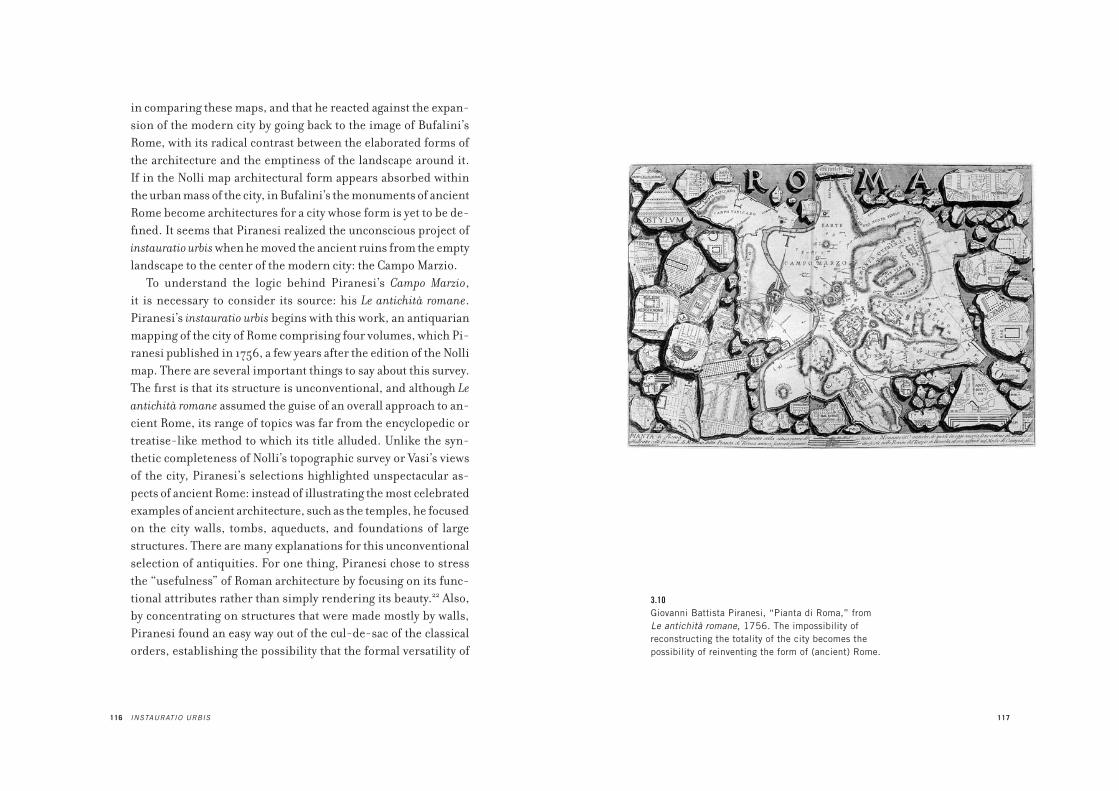
116 INSTAURATIO URBIS
in comparing these maps, and that he reacted against the expan-
sion of the modern city by going back to the image of Bufalini’s
Rome, with its radical contrast between the elaborated forms of
the architecture and the emptiness of the landscape around it.
If in the Nolli map architectural form appears absorbed within
the urban mass of the city, in Bufalini’s the monuments of ancient
Rome become architectures for a city whose form is yet to be de-
fined. It seems that Piranesi realized the unconscious project of
instauratio urbis when he moved the ancient ruins from the empty
landscape to the center of the modern city: the Campo Marzio.
To understand the logic behind Piranesi’s Campo Marzio,
it is necessary to consider its source: his Le antichità romane.
Piranesi’s instauratio urbis begins with this work, an antiquarian
mapping of the city of Rome comprising four volumes, which Pi-
ranesi published in 1756, a few years after the edition of the Nolli
map. There are several important things to say about this survey.
The first is that its structure is unconventional, and although Le
antichità romane assumed the guise of an overall approach to an-
cient Rome, its range of topics was far from the encyclopedic or
treatise-like method to which its title alluded. Unlike the syn-
thetic completeness of Nolli’s topographic survey or Vasi’s views
of the city, Piranesi’s selections highlighted unspectacular as-
pects of ancient Rome: instead of illustrating the most celebrated
examples of ancient architecture, such as the temples, he focused
on the city walls, tombs, aqueducts, and foundations of large
structures. There are many explanations for this unconventional
selection of antiquities. For one thing, Piranesi chose to stress
the “usefulness” of Roman architecture by focusing on its func-
tional attributes rather than simply rendering its beauty.22 Also,
by concentrating on structures that were made mostly by walls,
Piranesi found an easy way out of the cul-de-sac of the classical
orders, establishing the possibility that the formal versatility of
117
3.10Giovanni Battista Piranesi, “Pianta di Roma,” from
Le antichità romane, 1756. The impossibility of
reconstructing the totality of the city becomes the
possibility of reinventing the form of (ancient) Rome.

118 INSTAURATIO URBIS
Roman architecture greatly exceeded the constraints of the or-
ders.23 Yet in looking at the way Piranesi rendered ruined tombs,
it is clear that this selection gave him a distinctive formal lexicon
that can help us to understand his critical position toward the
organicism of the baroque image of modern Rome rendered in
Nolli’s systematic topographic survey.
The nucleus of the work for the Antichità was a survey of an-
cient tombs. Over the course of time Piranesi gradually developed
this initial topic into a general survey of all of ancient Rome. Situ-
ated along the consular roads outside the walls of Rome, tombs
were peripheral features in the topography of the city. Moreover,
unlike temples, which were the classical subject of antiquarian
research, the architecture of tombs was devoid of the orders and
made of a free arrangement of masses and spaces. Because tombs
in Roman antiquity were often a mix of religious and profane
architecture, their character gave them a certain compositional
freedom compared to the spatial and typological conventions of
other architectural genres. The compositional freedom of the
ornament on the tombs gave Piranesi a very specific vocabulary
for his interpretation of the city. Following this lexicon, he imag-
ined the architecture of Rome as consisting of volumes emerging
from an amorphous ground and freed from the economy of the
orders. This architecture takes the form of self-supporting
blocks, vaults, underground rooms, apses, tablets with inscrip-
tions, and blocks of stones.
Piranesi’s obsession with depicting walls demonstrates the
idea of an architecture made by the simple stacking of stones,
which seems to be the model that guided his idiosyncratic aes-
thetic of formal composition. For example, the frontispieces of
his published work all present compositions of stones whose in-
scriptions not only are titles but also render the strong materiality
of these elements. From this, it is possible to say that Piranesi’s
P I R A N E S I ’ S C A M P O M A R Z I O V E R S U S N O L L I ’ S N U O V A P I A N T A D I R O M A 119
passion for ruins gave him a way to render buildings themselves
as gigantic masses of stones. Piranesi saw the ruin as the reduc-
tion of architecture to its essential and ultimate form: sheer
mass. Far from being a romantic interpretation of architecture as
having succumbed to the inexorable course of time, the images of
disfigured ruins of Roman tombs that Piranesi engraved demon-
strate how their mass resisted even the most adverse conditions
of nature, time, and use. The more often Piranesi portrayed the
ruined tomb as a disfigured building invaded by nature, the more
it seemed he reinforced a view of architecture as a resistant form.
For example, his depiction of the tomb of Cecilia Metella, one of
the monuments of ancient Rome along the Via Appia, is charac-
terized by a pattern of huge stones, which gives the architecture
of the tomb its massive presence.
The aesthetic of an architecture made of stones—and there-
fore freed from the orders—is associated with the Etruscan style,
which Piranesi defended as the origin of Roman architecture.
This theme was not new. The modern interpretation of Etruscan
architecture constituted one of the most important themes of Re-
naissance architecture.24 The rustication produced in the heavy
masonry facades of Brunelleschi’s Palazzo Pitti and Michelozzo’s
Palazzo Medici was believed to follow the Etruscan principle
that architecture should be made of simple stone walls to give
the buildings a strong physicality. In the sixteenth century, in
works from Bramante to Giulio Romano to Palladio, rustication
became one of the primary forms of monumental architecture.
The technique was often seen as an alternative to the Vitruvian
architecture of the orders, since there was no mention of it in De
architectura, although rustication appeared in many ancient ruins.
Piranesi’s preference for this kind of non-Vitruvian motif helped
him to bypass the grammar of the orders and imagine architecture
as a free composition of masses. This was evident not only in his
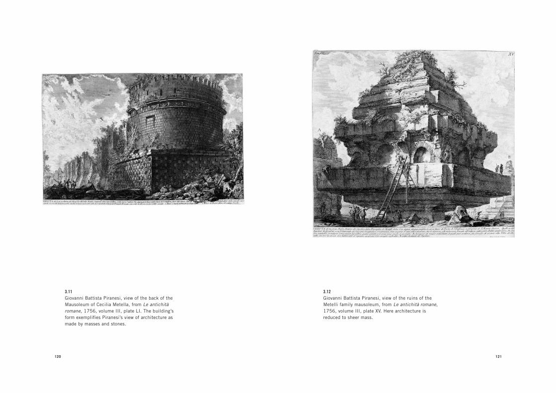
120
3.11Giovanni Battista Piranesi, view of the back of the
Mausoleum of Cecilia Metella, from Le antichità
romane, 1756, volume III, plate LI. The building’s
form exemplifies Piranesi’s view of architecture as
made by masses and stones.
121
3.12Giovanni Battista Piranesi, view of the ruins of the
Metelli family mausoleum, from Le antichità romane,
1756, volume III, plate XV. Here architecture is
reduced to sheer mass.

122
3.13Giovanni Battista Piranesi, view of the piers of the
triumphal bridge, from Le antichità romane, 1756,
volume IV, plate XIII.
P I R A N E S I ’ S C A M P O M A R Z I O V E R S U S N O L L I ’ S N U O V A P I A N T A D I R O M A 123
Invenzioni di carceri, in which the architecture is made exclusively
of large stones, but also in Piranesi’s interest in Egyptian architec-
ture, which is composed of simple prismatic elements. Reducing
architecture to its most elemental presence, this rusticated form
is the antithesis of the scenographic effects created by baroque
architecture with polished travertine and stucco.
The theme of rusticated architecture runs through the entire
Antichità romane. The tombs, walls, aqueducts, bridges, obelisks,
and trophies (think of the amazing view of the “Ancient Circus of
Mars”) suggest a city made exclusively of stone blocks. Yet this
depiction openly contradicts the archaeological evidence of an-
cient Roman Empire architecture, which was largely made with
bricks and concrete, materials that gave Roman architecture un-
precedented spatial flexibility. Piranesi was scarcely interested
in these materials and devoted few illustrations to them because
they would have expressed amorphous form.25 Instead, in every
detail possible he rendered the city as being made of stone, as
seen in the gigantic foundations of the Mausoleum of Hadrian,
the wall that enclosed the area of the Ustrinum. One of Piranesi’s
favorite subjects, which he depicted numerous times, the Mau-
soleum of Hadrian can be considered the manifesto of his poetics
of architectural form, for it focuses on what is usually invisible
in architecture: foundations—the element of architecture that,
more than anything else, manifests a sense of permanence.
Piranesi’s reconstruction of foundations is largely a work of
imagination. What is shown on grade is remarkably dispropor-
tionate to what is underground. The foundations below grade
are depicted as immense, with elaborate stone patterns that are
conjecture unsupported by evidence. It is thus possible to claim
that, with foundations, Piranesi elaborates ideal architectural
form. This insistence on what is below and literally at the bot-
tom of a structure—which Piranesi seems to celebrate as the real

124
3.14Giovanni Battista Piranesi, the “Ancient Circus of Mars,”
from Le antichità romane, 1756, volume III, plate II.
125
3.15Giovanni Battista Piranesi, a fragment of the Ustrinum
wall, from Le antichità romane, 1756, volume III, plate
IV. Detail of walls, foundations, enclosures, stoppages.
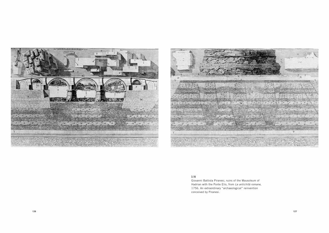
126 127
3.16Giovanni Battista Piranesi, ruins of the Mausoleum of
Hadrian with the Ponte Elio, from Le antichità romane,
1756. An extraordinary “archaeological” reinvention
conceived by Piranesi.

128 INSTAURATIO URBIS
“magnificenza” of Roman architecture—describes architecture
as that which extends deep into the ground and anchors form to
its place. No urban force—no destruction, no reconstruction, no
modification—can remove this trace of urban construction. Such
an ideal of form, together with the theme of rustication, gives
Piranesi’s architecture a sense of strong physicality that seems to
obstruct the space around it, rather than simply frame it.
The obstructive nature of Piranesi’s forms runs through all
his work. His Carceri and vedute propose a space completely filled
with gigantic, out-of-scale forms that block the view. The same is
evident in his early work, Prima parte di architetture e prospettive, a
series of architectural scenes designed in the manner of theatri-
cal stage sets and engraved during his first stay in Rome. Unlike in
traditional stage design—where perspective orders architectural
elements such as columns, and where arches become a frame for
something, such as a landscape, the sky, or other subjects—in Pi-
ranesi’s perspectives the vantage point always clashes with some
architectural element. Architecture seems simply to exhibit it-
self in a variety of forms, such as columns, stairs, and loggias, as
an obstructive presence. This way of representing urban space
is consistently applied in the Antichità and the Campo Marzio,
as for example in the views of the Ponte Fabrizio and Ponte Ces-
tio, two ancient bridges that are seen from below and whose
scale is dramatically increased compared to the actual situation.
In these views, urban elements meant to connect the two sides
of a river, and thus to guarantee circulation, instead become two
gigantic obstructions placed against the urban structure of the
city. This depiction opens up an interesting paradox in Piranesi’s
view of the role of architecture in urban space. Piranesi’s focus
on Roman architecture emphasizes the purposeful beauty of this
architecture, the magnificenza, and the fact that Roman struc-
tures were not simply monuments but also infrastructure. Yet his
P I R A N E S I ’ S C A M P O M A R Z I O V E R S U S N O L L I ’ S N U O V A P I A N T A D I R O M A 129
rendering of many infrastructures focuses more on their materi-
ality than on their function. This is evident in Le rovine del castello
dell’Acqua Giulia, his survey of the waterworks that managed the
flow coming from what Piranesi believed to be the Aqua Julia.
In the survey presentation, Piranesi counterposes details of the
castello’s function with views of the ruin itself. The massive pres-
ence of the ruin, its form consumed by nature, takes precedence
over the image of its function. In contrast to the continuity and
connectedness that is implicit in infrastructure when viewed
topographically (as in Nolli), Piranesi offers close-ups of the
physical attributes of the waterworks as finite forms. Such a
presentation emancipates these elements from their role in an
encompassing system and depicts them as autonomous forms.
Discontinuity is also emphasized as a spatial attribute of the
city. Increasing the dimensions of elements is a constant tech-
nique in Piranesi’s views of Rome. Beginning with his early ve-
dute, Piranesi took the opposite approach from Vasi. Whereas
Vasi recorded the landscape of Rome with a realism that accu-
rately depicts elements within balanced scenes, thus manifesting
a desire to mollify the formal and political impetus that animated
the development of Rome, Piranesi alters the scenes of baroque
Rome in order to increase both the proportions of the architec-
ture and the dimensions of the space in between buildings. For
example, in his views of modern Rome, which Piranesi executed
throughout his life in order to finance his antiquarian projects,
he deliberately changed the scale of the city by enlarging the nar-
row spaces between monuments. We can see this in the small
vedute, where the monumental buildings of the Renaissance and
baroque Rome, such as the Palazzo della Cancelleria, Palazzo di
Propaganda Fide, Palazzo Borghese, and Archiginnasio della
Sapienza, sometimes appear as completely isolated masses,
when in reality these buildings were often part of the baroque

130
3.17Giovanni Battista Piranesi, view of the Ponte Fabrizio,
from Le antichità romane, 1756, volume IV plate XVI.
Architectural form as obstruction.
P I R A N E S I ’ S C A M P O M A R Z I O V E R S U S N O L L I ’ S N U O V A P I A N T A D I R O M A 131
city’s spatiality, surrounded by a dense context of residential fab-
ric. In the vedute, Piranesi applied the same aesthetic of mass that
he saw in the ruins to the buildings of modern Rome. The city
appears not as ordered by streets and squares but as an open field
punctuated by gigantic and contrasting forms. This urban form
renders what Nolli’s topography and Vasi’s views had downplayed
with their urban realism: the geographical and political struggle
through which the city had evolved its form. Piranesi renders
this form as irreducible to any totalizing order or convention.
He seems to suggest that the form of the city is the unsolvable
confrontation between the individuality of its parts. The ten-
sion of confrontation between forms and their removal from the
coherent part-to-whole system of an overall spatial management
constitute the paradoxical unity of Piranesi’s instauratio urbis.
In the map of Rome published at the beginning of the first
volume of the Antichità, which can be read as a critique of Nolli’s
Rome, Piranesi removes the modern city, just as he would later
propose in the Campo Marzio. Significantly, this map is framed
by fragments of the Forma urbis, an ancient detailed map of Rome
engraved in marble and discovered in pieces in 1562, just one
year after publication of Ligorio’s Imago urbis. A fundamen-
tal aspect of the Forma urbis was its planimetric projection of
Rome at a high level of architectural resolution. After working
on his own map of Rome, Nolli worked on the fragments of the
ancient stone map in order to reconstruct the overall form of
ancient Rome, but he gave up on it a few years later due to the
overwhelming complexity of the problem. Piranesi probably as-
sisted Nolli in this work, because the title page of the Antichità
romane with its images of fragments clearly references this un-
finished project.26 These fragments emphasize the impossibil-
ity of reconstructing ancient Rome through mere archaeological
evidence—that is, through a philological “scientific” method.

132
3.18Giovanni Battista Piranesi, Archiginnasio
della Sapienza, from Varie vedute, 1748.
133
3.19Giovanni Battista Piranesi, Palazzo della
Cancelleria, from Varie vedute, 1748.

134 INSTAURATIO URBIS
Inspired by the scientific methodology of topographic survey,
Nolli had approached the reconstruction of ancient Rome as an
archaeological problem based on found evidence and devoid of
intuitive conjecture or any argumentative thesis other than the
need to make the entire topographical form of ancient Rome
scientifically legible.
In his incipit to the Antichità, Piranesi radically contradicts
this approach, suggesting that the restoration of the true form of
ancient Rome is possible not by relying on mere evidence or by
attempting an overall survey of all the topographic layers of the
city, but by focusing on the remaining ruins and using them as
points of entry for a conjecture about the form of the city. Rather
than interpreting the fragments of the Forma urbis as evidence to
be recomposed in an overall map, he approaches them as partial
examples for reinventing Rome. Piranesi treats both the ruins
that punctuated the empty field of Rome and the fragments as ex-
amples whose forms can only be assumed as analogical and not
literal representations of ancient Rome. This approach to ancient
Rome made Piranesi’s work impossible to categorize as either
antiquarian endeavors or projects for a new city.
It is important to stress that Piranesi’s knowledge of monu-
ments was supported by careful surveying campaigns. His col-
laboration with Nolli gave him the most up-to-date knowledge
in topographic measurement. His plans, sections, and elevations
of monuments appear to be precise and accurate, and he often
corrected mistakes of earlier surveys.27 The pictorial impact of
his vedute has often overshadowed the impeccable precision with
which Piranesi drew plans and elevations of monuments. Yet he
systematically altered specific details, such as the real structure
of foundations, in a way that makes it impossible to separate the
precision and objectivity of his depiction from the invention.
In this fusion of precision and invention, Piranesi pursued the
P I R A N E S I ’ S C A M P O M A R Z I O V E R S U S N O L L I ’ S N U O V A P I A N T A D I R O M A 135
analogical knowledge of Rome promoted by the tradition of in-
stauratio urbis. The Campo Marzio was just such an accomplish-
ment of this method.
Il Campo Marzio dell’antica Roma was executed by Piranesi as
an attempt to reconstruct the “original” form of imperial Rome
in the area of modern Rome. The reconstruction is conjectural,
based both on established evidence and on reinvented forms of
the ancient city. The survey follows the same method as the An-
tichità, but here Piranesi focuses not on the city but on the part of
the city he polemically wants to attack. Like the Antichità, the work
consisted of a variety of illustrations, from views to topographic
reconstructions to depictions of details, all arranged without fol-
lowing a precise trajectory within the city. The most important
and well-known part of Campo Marzio is the Ichnographia Campi
Martii antiquae urbis, a topographic reconstruction of the site in
which Piranesi drew the plan of every building. The visual ef-
fect of the map is unprecedented. In rendering the entire city
through the architectural plan of every building, he produced an
abundance of information that counters the synthetic approach
of scientific surveys of cities. The map is based on the same mix
of topographical precision and imagination as his previous work.
Some of the complexes were accurately reconstructed by follow-
ing the existing ruins, but others were drawn according to his
imagination. Many artifacts were elaborated following the exam-
ples of tombs, which produced the compositional and typological
variety characteristic of this map.
Yet the topographic precision with which the map is pro-
duced makes the Campo Marzio not a romantic or utopian foil
to the scientific mapping and survey of cities, but rather a cri-
tique of scientific mapping that uses the same instruments and
methods of scientific precision. In this sense it is interesting to
note the difference between Pirro Ligorio’s Imago and Piranesi’s
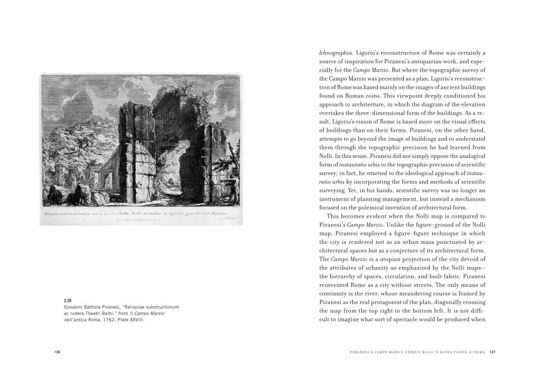
136
3.20Giovanni Battista Piranesi, “Reliquiae substructionum
ac rudera Theatri Balbi,” from Il Campo Marzio
dell’antica Roma, 1762, Plate XXVIII.
P I R A N E S I ’ S C A M P O M A R Z I O V E R S U S N O L L I ’ S N U O V A P I A N T A D I R O M A 137
Ichnographia. Ligorio’s reconstruction of Rome was certainly a
source of inspiration for Piranesi’s antiquarian work, and espe-
cially for the Campo Marzio. But where the topographic survey of
the Campo Marzio was presented as a plan, Ligorio’s reconstruc-
tion of Rome was based mainly on the images of ancient buildings
found on Roman coins. This viewpoint deeply conditioned his
approach to architecture, in which the diagram of the elevation
overtakes the three-dimensional form of the buildings. As a re-
sult, Ligorio’s vision of Rome is based more on the visual effects
of buildings than on their forms. Piranesi, on the other hand,
attempts to go beyond the image of buildings and to understand
them through the topographic precision he had learned from
Nolli. In this sense, Piranesi did not simply oppose the analogical
form of instauratio urbis to the topographic precision of scientific
survey; in fact, he returned to the ideological approach of instau-
ratio urbis by incorporating the forms and methods of scientific
surveying. Yet, in his hands, scientific survey was no longer an
instrument of planning management, but instead a mechanism
focused on the polemical invention of architectural form.
This becomes evident when the Nolli map is compared to
Piranesi’s Campo Marzio. Unlike the figure-ground of the Nolli
map, Piranesi employed a figure-figure technique in which
the city is rendered not as an urban mass punctuated by ar-
chitectural spaces but as a conjecture of its architectural form.
The Campo Marzio is a utopian projection of the city devoid of
the attributes of urbanity so emphasized by the Nolli maps—
the hierarchy of spaces, circulation, and built fabric. Piranesi
reinvented Rome as a city without streets. The only means of
continuity is the river, whose meandering course is framed by
Piranesi as the real protagonist of the plan, diagonally crossing
the map from the top right to the bottom left. It is not diffi-
cult to imagine what sort of spectacle would be produced when

138 INSTAURATIO URBIS
the area flooded—hundreds of monumental complexes would
emerge from the water like islands. Piranesi’s Campo Marzio
seems to emerge from such a vision: a city whose potential for
possible associations, compositions, and trajectories among
its parts is not absorbed by any infrastructural or other overall
spatial order.
To fully understand this vision, it is necessary to return to
the idea of Rome that emerges in the Scenographia, the view of
the Campo Marzio that introduces the Ichnographia. The Sceno-
graphia belongs to the tradition of representation of instauratio
urbis: it shows the city as constituted only by the ruins that had
been incorporated in the development of the modern urban
form, but with modern Rome removed. The resulting image is
neither a mapping nor a restoration of ancient Rome; the Sce-
nographia reveals that the premise (and perhaps the goal) of the
reconstruction of the ancient form of Rome was the destruction
of modern Rome—the destruction of a form that Nolli had repre-
sented in all its urban dimensions. Indications of this intention
are the astonishing and unique views of the Campo Marzio that
Piranesi composed as a compendium to the big map.
While in the Antichità Piranesi portrayed the ruins of ancient
Rome within their modern context, in the vedute for Campo Mar-
zio he showed the ruins of what was in his time the most densely
populated area of Rome as completely liberated from all other
historical layers of the city. Significantly, Piranesi titled these
vedute “reliquiae substructionum” (relics liberated from sub-
sequent layers of built form), but he did not restore the ruins
to their original state. Instead, the ancient complexes appear
as forms that are irreducible either to their present condition
or to their original state, an aesthetic that Piranesi conjures
against the refined forms of baroque Rome and the topographic
precision of Nolli.
P I R A N E S I ’ S C A M P O M A R Z I O V E R S U S N O L L I ’ S N U O V A P I A N T A D I R O M A 139
The result of this operation, which must be seen not only as
the heart of the Campo Marzio but also as the summa of instauratio
urbis, was an unprecedented interpretation of the architectural
ruin not as something that has succumbed to the course of time,
but as something that has survived both time and the modern
city. Through Piranesi these ruins are emancipated to become
the latent beginning of a new city whose potential is not yet sub-
sumed by any incipient urban order.
As the ruins of Piranesi’s vedute and Scenographia imply, such
a beginning is imagined as the selection of the city’s constituent
elements of autonomous monumental architectures, rather than
as an overall plan of the city. The isolation of the ruins reinforces
their presence but also creates potential in the spaces between
them. Against the managerial logic implied in Nolli’s city plan,
Piranesi opposed a way of thinking of the city based on conjec-
tures. Here lies the fundamental critique that Piranesi’s work
implicitly made, not simply of the Nolli map, but of the mental-
ity and values that such a paradigmatic representation of Rome
suggested.
The Nolli map illustrates the difference between architecture
as finite form and the city as a totality of urban space, which he
represented with a diagrammatic blackened mass. This dem-
onstrated that architecture is simply an island within the city,
whose urban form far exceeds the possibility of an architectural
morphology to accommodate its scale. The conjecture of Pira-
nesi’s forms confirms the unbridgeable discrepancy between
architectural form and the totality of urban space. This is affirmed
in the Campo Marzio where the city appears as only buildings,
devoid of streets and all the other infrastructural means of conti-
nuity that are necessary for a city to function. In this “unplugged”
condition of the city, all attributes of urbanity are gone. Rather
than interpreting such a scenario as a terminal point of the city,
140 INSTAURATIO URBIS
however, Piranesi presents it as a latent beginning embedded
within what already exists in urban space—the ruins. The differ-
ence between architecture and urban space is radicalized in order
to show the architectural clues that allow the critical imagination
to rethink the city, not through its managerial practices but as a
field of potential possibilities. In this way, Piranesi overcame the
insufficiency of architectural form, making it possible to rethink
architectural design not as what exhausts the form of the city, but
as what opens the potential for imagining it differently.
In 1967 Aldo Rossi translated into Italian, and wrote an introduc-
tion to, Étienne-Louis Boullée’s Architecture, Essay on Art.1 Written
at the end of the eighteenth century but unpublished until 1953,
Architecture, Essay on Art can be understood as an architectural
treatise in the form of commentary on a series of public monu-
ments that Boullée designed between the last years of the French
monarchy and the years immediately after the 1789 Revolu-
tion. Some of the buildings Boullée describes were site specific
and executed as commissions or competitions, including the
Opera Theater (1781) and the Library (1781), while others were
theoretical proposals, including the Metropolitan Church (1781),
the Justice Palace (1782), and the National Palace (1792), but all
of the projects were characterized by the austere composition
of simple volumes. Notably, Boullée’s Architecture, Essay on Art
was the first architectural treatise to focus exclusively on public
monuments. Boullée’s use of the term monument is important.
Before Boullée, monument was used to describe a commemorative
building (from memento, “remember”). After Boullée, the monu-
ment also included any public building housing a public service,
such as a theater, library, or museum, and potentially accessible
to all.2 Boullée distinguished the monument from residential
architecture, which was defined as “private,” or not accessible
to all. For this reason he omitted residential architecture, which
4 ARCHITECTURE AS A STATE OF EXCEPTIONÉTIENNE-LOUIS BOULLÉE’S PROJECT FOR A METROPOLIS
142 ARCHITECTURE AS A STATE OF EXCEPTION
traditionally constituted the core of architectural treatises, from
the essay.3 Rather than being predicated on celebration or com-
memoration, Boullée’s definition of the monument distinguished
public from private; for him, monumental buildings offered no
personal or specific element for commemoration. Instead, Boul-
lée’s monument addressed and celebrated its use by the anony-
mous and free individual: the citizen who was governed no longer
by a monarchy but by a secular and republican state. Thus a library
is a monument to “science,” a museum is a temple to “culture.”
Correspondingly, Boullée’s public monuments shared an archi-
tectural language based on the composition of anonymous and
simple geometrical volumes. These volumes were characterized by
two kinds of partitions: bare walls, and densely arranged columns
that seem to form walls. The former was Boullée’s favorite archi-
tectural “ornament” as it produced an architecture made only of
shadows, which he considered his most important achievement.4
The shadows presented nature in its primary perceptual form of
light and dark, and Boullée wanted this anonymous, primary, and
empirical experience of bare volumes projecting shadows to be
the main attribute of the public monument dedicated to the free
citizen. Even when he designed a commemorative monument to
an individual—the Funeral Cenotaph of Newton, for example—the
way he abstracted the subject in the perfect form of a sphere makes
clear that it was not so much the person as it was the scientist, or
the idea of science, being celebrated by the effect of natural light
penetrating the dark interior of the globe.
None of the projects described in the Essay was realized, but
to see them simply as “visionary” projects overlooks the specific
conditions of each proposal, which Boullée articulates in terms
of technically inventive and individual approaches to func-
tional, programmatic, and even contextual problems. Indeed,
he describes not only what the monuments were intended to
É T I E N N E - L O U I S B O U L L É E ’ S P R O J E C T F O R A M E T R O P O L I S 143
symbolize through their “character” or formal references, but
also how they responded to specific programmatic and techni-
cal requirements such as accessibility, safety, circulation, and,
in some cases, site constraints. For example, in his project for
the Opera, the extreme geometrical regularity of the form—a
cylinder surrounded by columns—not only reinforces its monu-
mental and public nature, but also demonstrates a concern for
public welfare with its unprecedented provision for egress in the
event of a fire. His theoretical project for a fort departed from
the landscape-like form of baroque fortifications and returned
to the massive vertical form of the castle. Besides recuperating
the monumentality of military architecture, this choice reflected
the advances in military architecture introduced by Marc René de
Montalembert in his treatise on perpendicular fortifications (in
which the eighteenth-century engineer anticipated the form of
twentieth-century bunker architecture).5
Boullée’s work is “exceptional” in its exclusive use of public
monuments as a means for a general theory of architecture, and
because these monuments respond to specific site and technical
conditions. Rossi considered Boullée’s manuscript an example
of theorizing architecture from within the poetic experience of
designing specific architectural compositions. He interpreted
Boullée’s work as a radical manifesto for architectural autonomy
intended as the possibility of self-reflection, not on abstract
norms but on the making of architecture as exceptional, spe-
cific, and finite forms. Understanding Boullée’s choice of the
monument as a way to emphasize the limits of architecture as
a circumscribed, finite object, Rossi was fascinated by the ex-
treme simplicity and austerity with which Boullée represented
architecture and the theoretical consistency through which the
sequence of these finite forms manifested a design method.
He argued that Boullée was the prototypical rationalist architect

144
4.1Étienne-Louis Boullée, project for an Opera House,
1781. (Bibliothèque Nationale de Paris.)
É T I E N N E - L O U I S B O U L L É E ’ S P R O J E C T F O R A M E T R O P O L I S 145
because he had established a few “logical principles” through
which it was possible to address any design problem; according
to Rossi, these principles were the idea of composition achieved
through the paratactic juxtaposition of simple geometrical
forms; the use of natural effects such as the play of light and
shadow; and the distributive clarity of a building—the primary
attribute of a public monument. Even though these logical prin-
ciples sought to establish an intelligible, and thus transmissible,
architecture, Rossi noted that Boullée had not applied them as a
totalizing system of norms; that approach would later typify the
work of Boullée’s most important student, Jean-Nicolas-Louis
Durand. Instead, Boullée illustrated these principles through
the design of exceptional finite forms. Rossi thus seems to sug-
gest that Architecture, Essay on Art was based on the invention of
a few exemplary architectural compositions which, by repeat-
ing certain principles, even within the finite scheme of a series
of monuments, had the potential to define a general approach
to architecture.
Although Boullée explicitly described the sequence of monu-
ments in the Essay as a “project for a metropolis,” Rossi con-
cludes that Boullée’s text has no connection to the city. Having
just published The Architecture of the City,6 Rossi seems to have
needed to focus on a text in which, as he wrote, architecture
was analyzed in vacuo, as a pure act of architectural autonomy
apart from the problems of the city. Unlike his thinking in The
Architecture of the City, Rossi’s introduction to the Essay focuses
not on the structural relationship between the typological datum
of the city and the urban artifact, but on the artifact itself as a
composition devoid of any external constraint other than the
architect’s self-imposed logical principles. I propose to coun-
ter Rossi’s interpretation, not by denying his argument, but by
demonstrating how Boullée’s logical principles produced an
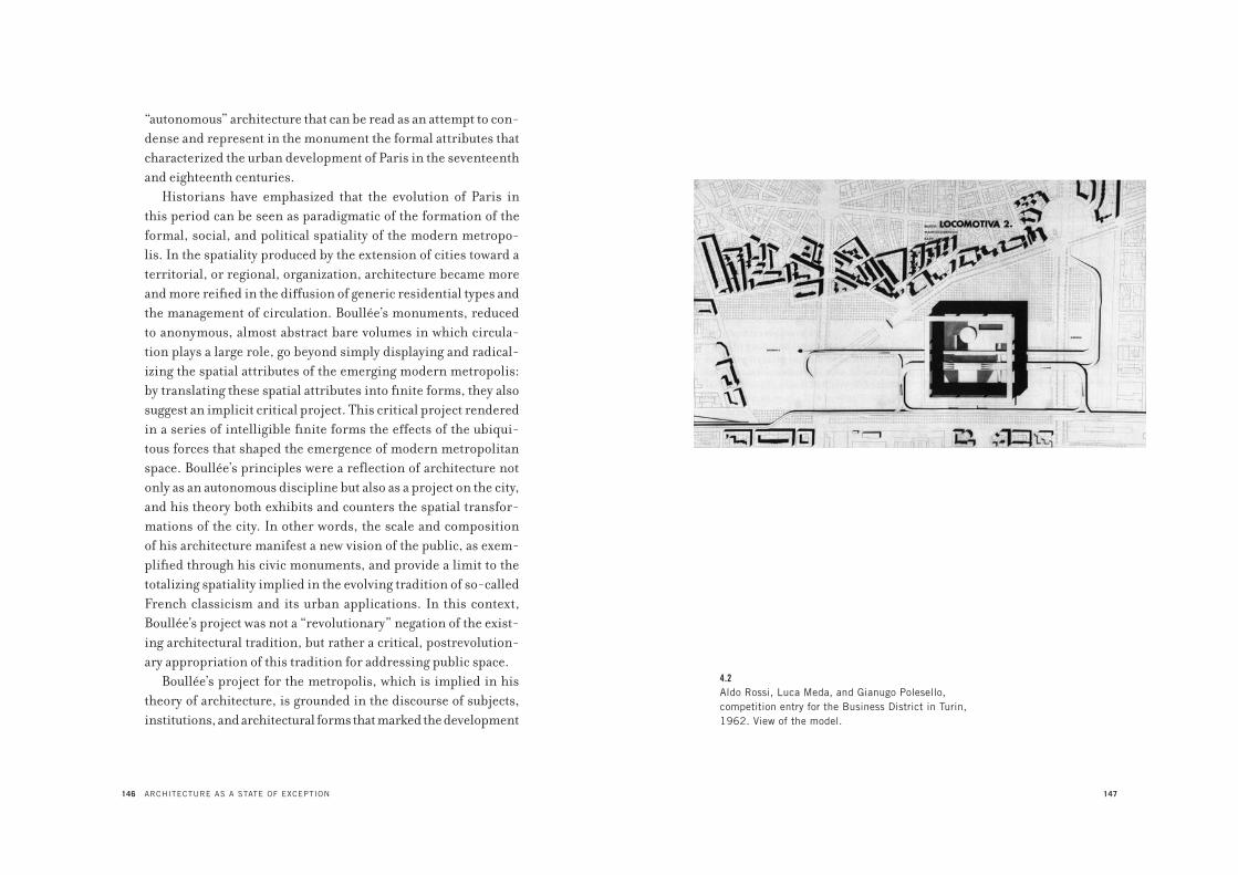
146 ARCHITECTURE AS A STATE OF EXCEPTION
“autonomous” architecture that can be read as an attempt to con-
dense and represent in the monument the formal attributes that
characterized the urban development of Paris in the seventeenth
and eighteenth centuries.
Historians have emphasized that the evolution of Paris in
this period can be seen as paradigmatic of the formation of the
formal, social, and political spatiality of the modern metropo-
lis. In the spatiality produced by the extension of cities toward a
territorial, or regional, organization, architecture became more
and more reified in the diffusion of generic residential types and
the management of circulation. Boullée’s monuments, reduced
to anonymous, almost abstract bare volumes in which circula-
tion plays a large role, go beyond simply displaying and radical-
izing the spatial attributes of the emerging modern metropolis:
by translating these spatial attributes into finite forms, they also
suggest an implicit critical project. This critical project rendered
in a series of intelligible finite forms the effects of the ubiqui-
tous forces that shaped the emergence of modern metropolitan
space. Boullée’s principles were a reflection of architecture not
only as an autonomous discipline but also as a project on the city,
and his theory both exhibits and counters the spatial transfor-
mations of the city. In other words, the scale and composition
of his architecture manifest a new vision of the public, as exem-
plified through his civic monuments, and provide a limit to the
totalizing spatiality implied in the evolving tradition of so-called
French classicism and its urban applications. In this context,
Boullée’s project was not a “revolutionary” negation of the exist-
ing architectural tradition, but rather a critical, postrevolution-
ary appropriation of this tradition for addressing public space.
Boullée’s project for the metropolis, which is implied in his
theory of architecture, is grounded in the discourse of subjects,
institutions, and architectural forms that marked the development
147
4.2Aldo Rossi, Luca Meda, and Gianugo Polesello,
competition entry for the Business District in Turin,
1962. View of the model.

148 ARCHITECTURE AS A STATE OF EXCEPTION
of Paris during the seventeenth and eighteenth centuries. In my
reading of this architectural development, I intend to go be-
yond the stylistic terms, such as baroque, rococo, and neoclas-
sicism, through which the history of French architecture has
traditionally been defined. At stake in this development and in
the conceptual and formal foundations of Boullée’s project was the
establishment of a new form of publicness that evoked vastness
and uniformity as attributes of urban space. With the emergence
of the hôtel and the square, this new spatiality was inserted into
the existing fabric of Paris; it also formed a very urban infrastruc-
ture through the opening of boulevards and the engineering of city
space, which became a paradigm of modern metropolitan space.
Beginning in the early sixteenth century, the ancient idea
of the nation was reformulated within a new political concept
of the state. Over some two hundred years, until the mid 1700s,
the nation-state evolved by centralizing sovereignty and un-
dermining regimes such as feudalism and the Catholic Church.
In the seventeenth century, this political paradigm, of which
France was the most important manifestation, not only con-
solidated power toward an absolutist monarchy as the form of
the state, but also reacted to the problem of religious conflict
that had plagued Europe since the Reformation. One of the po-
litical consequences of the establishment of the nation-state as a
paradigm of sovereignty was the beginning of a progressive secu-
larization of society. This process began with relative religious
tolerance and increasingly relied on initiatives to secularize
social relationships, such as Henri IV’s elevation of the noblesse
de robe, an aristocracy linked to the growing power of the state’s
bureaucracy. The new prerogatives of the noblesse de robe in the
administration of justice, bureaucracy, and public finance gave
rise to a truly metropolitan aristocracy. The lifestyle, attitudes,
and cultural pursuits of this class can be seen as a fundamental
É T I E N N E - L O U I S B O U L L É E ’ S P R O J E C T F O R A M E T R O P O L I S 149
cultural and social origin of the bourgeoisie’s political rise in
the late eighteenth and early nineteenth centuries. Though the
noblesse de robe was still a “court society” bound to the hierarchi-
cal forms of the ancien régime city, the rising bourgeoisie would
be linked to the increasing social and economic mobility of
the modern metropolis, brought about by the rise of scientific
thought at the turn of the nineteenth century. And yet the met-
ropolitan anonymity of the bourgeois city is unthinkable without
the normative and bureaucratic abstraction that originated with
the introduction of the noblesse de robe and that constituted the
political essence of what is called French classicism.7
Architecturally, French classicism represents the rise of a sys-
temic architecture and urban design that developed in parallel
with the consolidation of the nation-state’s sovereignty and the
emergence of the noblesse de robe as the new ruling class. Unlike
in Italy, where classicism arose during the Renaissance, between
the fifteenth and sixteenth centuries, in France it developed dur-
ing the baroque period in the seventeenth century. Where the
Italian baroque was synonymous with a growing formal complex-
ity, French classicism was a style of public representation based
on the diffusion of canons and formal simplification. Italian
classicism had produced influential architecture and treatises,
but due to unending political instability in Italy, it had a limited
impact on the reformation of the city, the medieval character of
which remained until the nineteenth century. The political stabil-
ity that characterized France in the seventeenth century made it
possible to implement and further develop the classicist canons
that in Italy were limited to exceptional structures such as pala-
zzi, churches, and monumental squares. In politics, as in archi-
tecture and urbanism, French classicism designated an approach
more inclined toward norms than exceptions, toward regularity
rather than complexity. In architecture, the systematic approach
150 ARCHITECTURE AS A STATE OF EXCEPTION
of French classicism was manifested in well-organized and dif-
fused pedagogy, such as the seminal theoretical work of Fran-
çois Blondel. Blondel’s influential Cours d’architecture, which was
published beginning in 1675 and remained an important text for
over a century, is an example of the systematic diffusion of archi-
tecture as an esprit de système based on strict rules and propor-
tions.8 The same way of thinking is found in the theories of Claude
Perrault. In a treatise on the five classical orders published in
1683, Perrault polemically attacked Blondel’s rigid system of pro-
portions and argued for a mathematical ordering of the classical
rule, which would rationalize and simplify the use of the orders
according to the mathematical relationships of their different
proportions. Ultimately Perrault suggested an average proportion
based on the best architectural examples in order to produce a sin-
gle cohesive system. The effectiveness of these teachings, both in
the making of architecture and in the ordering of a more systemic
and scientific approach to architecture, narrowed the gap between
theory and practice in France and aided the circulation of an “aver-
age” and “normative” classical language within the city itself.
A fundamental “political” contribution to the diffusion of this
classical language was the creation in 1671 of the Académie Royale
d’Architecture by Louis XIV’s minister of finance, Jean-Baptiste
Colbert, as the outgrowth of his Conseil des Bâtiments, of which
Blondel was the first director.9 The institutional emancipation
of architecture from building further separated architectural
language from the mere “art of building” and invested that lan-
guage with a means of diffuse political power. At the same time,
Colbert conveyed systems for architecture by means of lectures,
courses, and ateliers, and disseminated these teachings through
texts. With the Académie, Colbert created a radically new way to
organize architecture that explained it not only as a technical or
artistic competence but also as a veritable form of organizational
É T I E N N E - L O U I S B O U L L É E ’ S P R O J E C T F O R A M E T R O P O L I S 151
knowledge that could be developed and transmitted systemati-
cally. In this way, purveyors of architectural knowledge aimed to
establish a formal and political consensus by defining the ex-
amples of a new state-based architecture. These examples, such
as public buildings initiated through competitions among archi-
tects or prizes awarded to projects executed by promising young
students of architecture, would help to spread state-controlled
architecture in both the city and the nation. The fundamental
strength of Colbert’s Académie was that this diffusion operated
not by imposing a particular architectural style, but rather by
promoting clarity as the fundamental quality of a public archi-
tectural knowledge. This emphasis on clarity often coincided
with the development of a systematic architectural language,
which resulted in an architecture characterized by austerity and
a combinatory logic that would have a great influence on French
architects, gradually liberating them from the proportional and
ornamental logic of the classical orders. This evolution of archi-
tectural pedagogy based on attributes such as clarity, austerity,
and the combinatory logic of form would serve as the foundation
of Boullée’s simple forms. Yet Boullée’s monuments would trans-
form these attributes from their normative control of the city into
an archipelago of finite formal and spatial “states of exception.”
To understand Boullée, it is first necessary to reconsider how
the establishment of the systematic simplification and stan-
dardization of architectural language took its cue from the ar-
chitecture of the city of Paris and the development of exemplary
urban forms. The three most powerful forms of architecture and
urbanity that were inspired by the systematic language of French
classicism were the courtyard, the square, and the axis. These
took the respective forms of the hôtel, place, and boulevard.
The hôtel can be seen as the originating type of a spatiality that
emerged within the city of French classicism. As an urban version
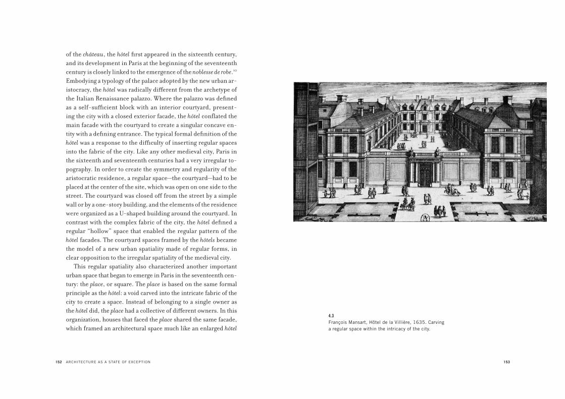
152 ARCHITECTURE AS A STATE OF EXCEPTION
of the château, the hôtel first appeared in the sixteenth century,
and its development in Paris at the beginning of the seventeenth
century is closely linked to the emergence of the noblesse de robe.10
Embodying a typology of the palace adopted by the new urban ar-
istocracy, the hôtel was radically different from the archetype of
the Italian Renaissance palazzo. Where the palazzo was defined
as a self-sufficient block with an interior courtyard, present-
ing the city with a closed exterior facade, the hôtel conflated the
main facade with the courtyard to create a singular concave en-
tity with a defining entrance. The typical formal definition of the
hôtel was a response to the difficulty of inserting regular spaces
into the fabric of the city. Like any other medieval city, Paris in
the sixteenth and seventeenth centuries had a very irregular to-
pography. In order to create the symmetry and regularity of the
aristocratic residence, a regular space—the courtyard—had to be
placed at the center of the site, which was open on one side to the
street. The courtyard was closed off from the street by a simple
wall or by a one-story building, and the elements of the residence
were organized as a U-shaped building around the courtyard. In
contrast with the complex fabric of the city, the hôtel defined a
regular “hollow” space that enabled the regular pattern of the
hôtel facades. The courtyard spaces framed by the hôtels became
the model of a new urban spatiality made of regular forms, in
clear opposition to the irregular spatiality of the medieval city.
This regular spatiality also characterized another important
urban space that began to emerge in Paris in the seventeenth cen-
tury: the place, or square. The place is based on the same formal
principle as the hôtel: a void carved into the intricate fabric of the
city to create a space. Instead of belonging to a single owner as
the hôtel did, the place had a collective of different owners. In this
organization, houses that faced the place shared the same facade,
which framed an architectural space much like an enlarged hôtel
153
4.3François Mansart, Hôtel de la Villière, 1635. Carving
a regular space within the intricacy of the city.
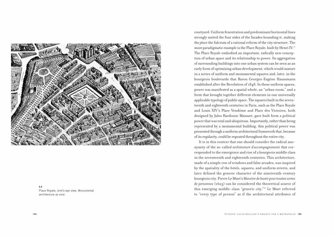
154
4.4Place Royale, bird’s-eye view. Monumental
architecture as void.
É T I E N N E - L O U I S B O U L L É E ’ S P R O J E C T F O R A M E T R O P O L I S 155
courtyard. Uniform fenestration and predominant horizontal lines
strongly united the four sides of the facades bounding it, making
the place the fulcrum of a rational reform of the city structure. The
most paradigmatic example is the Place Royale, built by Henri IV.11
The Place Royale embodied an important, radically new concep-
tion of urban space and its relationship to power. Its aggregation
of surrounding buildings into one urban system can be seen as an
early form of optimizing urban development, which would mature
in a series of uniform and monumental squares and, later, in the
bourgeois boulevards that Baron Georges-Eugène Haussmann
established after the Revolution of 1848. In these uniform spaces,
power was manifested as a spatial whole, an “urban room,” and a
form that brought together different elements in one universally
applicable typology of public space. The squares built in the seven-
teenth and eighteenth centuries in Paris, such as the Place Royale
and Louis XIV’s Place Vendôme and Place des Victoires, both
designed by Jules Hardouin-Mansart, gave built form a political
power that was total and ubiquitous. Importantly, rather than being
represented by a monumental building, this political power was
presented through a uniform architectural framework that, because
of its regularity, could be repeated throughout the entire city.
It is in this context that one should consider the radical ano-
nymity of the so-called architecture d’accompagnement that cor-
responded to the emergence and rise of a bourgeois middle class
in the seventeenth and eighteenth centuries. This architecture,
made of a simple row of windows and false arcades, was inspired
by the spatiality of the hôtels, squares, and uniform streets, and
later defined the generic character of the nineteenth-century
bourgeois city. Pierre Le Muet’s Manière de bastir pour touttes sortes
de personnes (1623) can be considered the theoretical source of
this emerging middle-class “generic city.”12 Le Muet referred
to “every type of person” as if the architectural attributes of
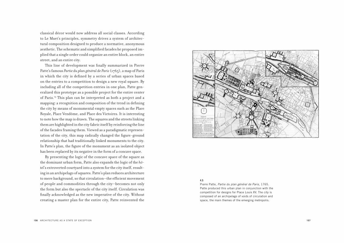
156 ARCHITECTURE AS A STATE OF EXCEPTION
classical décor would now address all social classes. According
to Le Muet’s principles, symmetry drives a system of architec-
tural composition designed to produce a normative, anonymous
aesthetic. The schematic and simplified facades he proposed im-
plied that a single order could organize an entire block, an entire
street, and an entire city.
This line of development was finally summarized in Pierre
Patte’s famous Partie du plan général de Paris (1765), a map of Paris
in which the city is defined by a series of urban spaces based
on the entries to a competition to design a new royal square. By
including all of the competition entries in one plan, Patte gen-
eralized this prototype as a possible project for the entire center
of Paris.13 This plan can be interpreted as both a project and a
mapping: a recognition and composition of the trend in defining
the city by means of monumental empty spaces such as the Place
Royale, Place Vendôme, and Place des Victoires. It is interesting
to note how the map is drawn. The squares and the streets linking
them are highlighted in the city fabric itself by reinforcing the line
of the facades framing them. Viewed as a paradigmatic represen-
tation of the city, this map radically changed the figure-ground
relationship that had traditionally linked monuments to the city.
In Patte’s plan, the figure of the monument as an isolated object
has been replaced by its negative in the form of a concave space.
By presenting the logic of the concave space of the square as
the dominant urban form, Patte also expands the logic of the hô-
tel’s extroverted courtyard into a system for the city itself, result-
ing in an archipelago of squares. Patte’s plan reduces architecture
to mere background, so that circulation—the efficient movement
of people and commodities through the city—becomes not only
the form but also the spectacle of the city itself. Circulation was
finally acknowledged as the new imperative of the city. Without
creating a master plan for the entire city, Patte reinvented the
157
4.5Pierre Patte, Partie du plan général de Paris, 1765.
Patte produced this urban plan in conjunction with the
competition for designs for Place Louis XV. The city is
composed of an archipelago of voids of circulation and
space, the main themes of the emerging metropolis.

158 ARCHITECTURE AS A STATE OF EXCEPTION
city using a rational language that reduced the problem of urban
space to one of delineating voids. Though he could not define the
city’s circulation with the technical competence and precision of
the engineers who were then emerging as more effective practi-
tioners in shaping the city, the architecture of the city implied by
his plan proposed a scenario that anticipated the metropolitan
scale of nineteenth-century Paris.
Boullée’s public monuments are conceptually related to Patte’s
plan in their scale and design. The very form of Boullée’s monu-
ments, with their strong symmetry, their autonomy, and their dis-
location in the city, can be seen as conceptually “molded” by Patte’s
archipelago of squares. In fact, Boullée’s isolated monuments can
be read as a “positive” developed as a response to the “negative”
of Patte’s squares. As a summary of the urban transformations of
Paris, Patte’s plan not only literally indicated the place as the new
scale of urban development, but also announced the scale and ar-
chitecture of another urban element that would further expand the
unifying logic of the hôtel and the place: this was the boulevard.
With Louis XIV’s demolition of the city walls in 1670, the
form of the city finally broke its ancient constraints. The boll-
werk—the expansive system of fortifications that used to enclose
cities within geometrically complex earthworks—became the
boulevard, a broad system of circulation that acquired its scale
precisely by incorporating the new “extra-city” space created by
the removal of the city walls. Significantly, what had once limited
and enclosed the city was now transformed into a system that ex-
panded the city’s circulation and, by implication, produced the
possibility of endless growth. The demolition of the fortifications
was the most clear and aggressive manifestation of the way eco-
nomic transactions and urban development were linked, ready
to become the very form of the new urban expansion. With the
removal of its walls, the city could no longer be conceived as an
É T I E N N E - L O U I S B O U L L É E ’ S P R O J E C T F O R A M E T R O P O L I S 159
autonomous entity placed within a territory from which it had
been disconnected by its defensive system. The new metropo-
lis now became the hub of the nation-state, where concentra-
tion and decentralization were simultaneously organized as
part of the process of the circulation and distribution of people,
resources, and commodities.
Circulation thus became the sine qua non of these emerging
cities. The invention of the boulevard can be seen as the urban
form that blurred the distinction between the city and the ter-
ritory around it, conflating it into one system. As enormous
structures, these boulevards were isolated from the city fabric,
confronted with a seemingly endless amount of residential space
organized by the new axes of mobility. The planting of trees on
both sides of the boulevard added to its uniformity, giving the
boulevard a visually identifiable border.
Within this generic grammar of the city based on pattern,
repetition, and the insistence on the horizontal over the vertical,
one finally approaches the architectural dimension that Boullée
critically sublimated in his architectural language of large and
simple forms placed in vast open landscapes. Before addressing
Boullée’s architecture, it is useful to analyze the way the emerg-
ing grammar of the city unfolded in a new regional and generic
dimension, where architecture as form disappeared: the engi-
neering of the region.
Whereas the architect addressed the new paradigm of the city
as a space of circulation, the engineer designed plans and poli-
cies for the management of the larger region in order to exploit
its full productivity. For the engineer, nature was synonymous
with production. Thus, unlike the architect, the eighteenth-
century French civil engineer did not work within an established
canon of rules, but rather continuously rationalized his method
of design according to the empirical needs of land management
160 ARCHITECTURE AS A STATE OF EXCEPTION
and the emergent potential of natural resources. For this reason,
the engineering of the territory is closely linked to the mastery
of technological progress. As Antoine Picon has argued, the
work of engineers in France in the eighteenth and nineteenth
centuries was not simply a form of competence but a paradig-
matic attitude toward the city.14 Michel Foucault describes this
paradigm in his studies of the emergence of territorial gover-
nance.15 In territorial governance, Foucault writes, the dynamic
of exchange prevailed over the singularity of places, and the
improvement of infrastructure and mobility became engineer-
ing’s most urgent concern. Rather than being an open-ended
form of progress, however, the development of infrastructure
was closely linked to the need to optimize the productivity of the
land, the mobility of workers, and the exchange of commodities.
With this logic, the equilibrium of supply and demand was seen
as a new form of natural equilibrium. The economic pressure
to control the region led to the attempt to scientifically map its
features; such mapping produced a new definition of space as a
complex of transactions, movement, and services that extended
beyond the boundaries of localities. The geography of a region
was thus reorganized by these maps in terms of economic con-
trol and exploitation, which led to the emergence of engineering
as an extremely sophisticated form of state control, beyond the
traditional form of military force. Indeed, this new institutional
control was wielded not through war and conquest but through
colonization by infrastructural “improvements.” In this way the
traditional use of violent imposition and enmity—the bases of
political institutions—was transformed and concealed by the
economic criteria of “utility.” The idea of utility allowed the con-
cept of reason to be subsumed within the control of economic
calculation and accumulation. Civil engineering became a tac-
tic of spatial organization that blended similarities and differ-
É T I E N N E - L O U I S B O U L L É E ’ S P R O J E C T F O R A M E T R O P O L I S 161
ences, norms and exceptions, in one total and flexible system of
knowledge. The increasing relevance of the École Polytechnique
and Durand’s architectural response to it with his gridded, and
thus normative, approach to design are examples of this sys-
tem. While architecture as an object was seen as less relevant,
the engineers absorbed the idea of architecture as a form of the
organization of space. Engineering did not reject the epistemic
premises of the architectural treatise with its will to a systematic
organization of knowledge, but expanded that systematic logic
from the physical embodiment of space to its management. In
this expansion, the criteria of the orders and the combination
of geometric forms into one coherent whole were replaced by
the ideal of utility as the new social and political whole. At the
core of utility was precisely what the urban development of Paris
was forecasting: unimpeded circulation, the economic utopia of
laissez-faire politics.
The hierarchical and combinatory nature of the architectural
treatise, with its norms, orders, and classifications, was thus
translated into the managerial practice of the engineering of the
territory, seen as a site of production. As Picon writes, “Whereas
architects had argued for a form of production which was regu-
lated by a freely agreed adherence to the same formal language,
which they tried to render ever more transparent, the engineers
proposed a compactness of entities, which they had first of all
sought to unify, and then the abrupt revelation of the tension thus
created.”16 For this reason, engineering initially was applied not
to the city but to the countryside of the territory. As a complex
of resources—agricultural fields, timber forests, and mines—the
countryside was considered to be the productive realm, while
the old dense city with its problems of congestion and conflict
was seen as increasingly unproductive, and thus in need of reor-
ganization as a regional form.
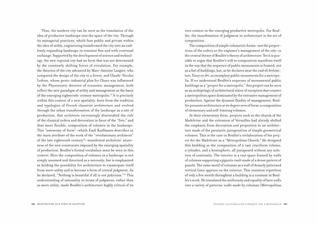
162 ARCHITECTURE AS A STATE OF EXCEPTION
Thus, the modern city can be seen as the translation of the
idea of productive landscape into the space of the city. Through
its managerial practices, which fuse public and private within
the idea of utility, engineering transformed the city into an end-
lessly expanding landscape in constant flux and with continual
exchange. Supported by the development of science and technol-
ogy, the new regional city had no form that was not determined
by the constantly shifting forces of circulation. For example,
the theories of the city advanced by Marc-Antoine Laugier, who
compared the design of the city to a forest, and Claude-Nicolas
Ledoux, whose proto-industrial plan for Chaux was influenced
by the Physiocratic theories of economic management, both
reflect the new paradigm of utility and management as the basis
of the emerging eighteenth-century metropolis.17 It is precisely
within this context of a new spatiality, born from the tradition
and typologies of French classicist architecture and evolved
through the urban transformation of the landscape as a site of
production, that architects increasingly diminished the role
of the classical orders and decoration in favor of the “free,” and
thus more flexible, composition of volumes in the landscape.
This “autonomy of form”—which Emil Kaufmann describes as
the main attribute of the work of the “revolutionary architects”
of the late eighteenth century18—manifested architects’ aware-
ness of the new constraints imposed by the emerging spatiality
of production. Boullée’s formal vocabulary must be seen in this
context. Here the composition of volumes in a landscape is not
simply assumed and theorized as a necessity, but is emphasized
as holding the possibility for architecture to emancipate itself
from mere utility and to become a form of critical judgment. As
he declared, “Nothing is beautiful if all is not judicious.”19 This
understanding of rationality in terms of judgment, rather than
as mere utility, made Boullée’s architecture highly critical of its
É T I E N N E - L O U I S B O U L L É E ’ S P R O J E C T F O R A M E T R O P O L I S 163
own context in the emerging productive metropolis. For Boul-
lée, the manifestation of judgment in architecture is the act of
composition.
The composition of simple volumetric forms—not the propor-
tions of the orders or the engineer’s management of the city—is
the central theme of Boullée’s theory of architecture. Yet it is pos-
sible to argue that Boullée’s will to composition manifests itself
in the way that the sequence of public monuments is framed, not
as a list of buildings, but, as he declares near the end of Architec-
ture, Essay on Art, as exemplary public monuments for a metropo-
lis. If we understand Boullée’s sequence of monumental public
buildings as a “project for a metropolis,” this project can be seen
as an archipelago of architectural states of exception that counter
a metropolitan space dominated by the extensive management of
production. Against the dynamic fluidity of management, Boul-
lée presents architecture at its degree zero of form: a composition
of elementary and self-limiting volumes.
In their elementary form, projects such as the church of the
Madeleine and the extension of Versailles had already shifted
the emphasis from decoration and proportion to an architec-
ture made of the paratactic juxtaposition of simple geometrical
volumes. This is the case in Boullée’s reelaboration of his proj-
ect for the Madeleine as a “Metropolitan Church.” He designed
this building as the composition of a vast cruciform volume,
a cylinder, and a hemisphere, all juxtaposed without any solu-
tion of continuity. The interior is a vast space framed by walls
of columns supporting a gigantic vault made of a dense pattern of
panels. The same motif of columns as a wall of densely patterned
vertical lines appears on the exterior. This insistent repetition
of only a few motifs throughout a building is a constant in Boul-
lée’s work. He translated the uniformity and equality of bare walls
into a variety of patterns: walls made by columns (Metropolitan

164 ARCHITECTURE AS A STATE OF EXCEPTION
Church), by books (Library), by texts (National Palace), can-
nonballs (Fortress), arches (Coliseum), doors (Opera). In each
case Boullée endlessly repeated a single element, so that even an
opening like a door, or a single element like a column, became
part of a uniform pattern. Sometimes these elements referred
to the program of the building in a familiar, almost naïve way,
like the books for the library or the cannonballs for the fortress,
but their repetition estranged their familiarity in the same way
that a rapidly repeated word slowly loses its familiar sound and
becomes something other. This compositional technique can be
seen in Boullée’s projects for the Metropolitan Church and the
Museum, where, as in a Greek temple, the span between the col-
umns is reduced to a minimum so that their sequence appears
to be a horizontal screen of densely patterned vertical lines.
These patterns seem to exaggerate the repetition of the forms of
the emerging metropolis. In this sense, both the patterns and the
bare walls of Boullée’s architecture can be understood as an anal-
ogy of the process of architectural abstraction implied in French
classicism, but now developed to its logical end. It is possible to
see the walls of Boullée’s finite objects as mirroring and empha-
sizing the uniformity of the architecture of squares and the bou-
levards framed by “walls” made of endless rows of trees.
For this reason, Boullée’s simple geometrical volumes, jux-
taposed and presented in the open landscape, reveal not just
the flexible, combinatory logic of architectural form in the ab-
sence of the static classical orders, but also the purity of simple
geometrical volumes, their irreducible autonomy, and the act
of composition as the will to put together irreducibly different
elements without blurring the juncture that separates them. In
this way, composition is exalted both by what is put together and
by how that arrangement emphasizes the separation of its parts,
thus evoking a sense of stoppage within the continuity of space.
É T I E N N E - L O U I S B O U L L É E ’ S P R O J E C T F O R A M E T R O P O L I S 165
In Boullée’s radical embrace of composition, this “separation”
becomes the ultimate index of the separateness of all things, and
thus of the possibility to make a decision, in the original sense
of “to cut” (decaedere). Boullée’s use of bare walls adorned only
by the play of light and shadow is, on the one hand, the evoca-
tion of the endless and anonymous architecture and spaces of the
emerging metropolis, and on the other, the analogy of a barrier—
an obstruction—to the flux that shapes such a metropolis.
But, since Boullée’s projects are often represented in vacuo, or
in what appear to be natural or empty landscapes, where is that
metropolis? In fact, this method is an analogical representation
of the metropolis that illustrates the impossibility of “architec-
turally” representing—and thus making—the metropolis as a lim-
itless territory of flows. In his stubborn focus on the architectural
object isolated in its context, Boullée seems to suggest a strategic
retreat of architecture from the city and into “architecture”: a cir-
cumscribed form that encloses the space of a finite place.
When Boullée was working in Paris, before the Revolution,
the metropolis was envisioned as a sequence of singular spaces.
After the Revolution, the metropolis had become a vast complex
of movement and transactions that exceeded any finite place. At
best, the metropolis could be represented as an open landscape,
an extensive scene. This was precisely the setting of Boullée’s
metropolitan buildings. Given such a landscape, the anonymous
simplicity of his architecture and its grammar of generic and in-
finitely repeated elements gave up any architectural pretension
to decoration and formal complexities in order to concentrate
instead on what architecture could still control: its finite form,
its monumental objecthood.
For Boullée, architecture was the opposite of engineering’s
emergent managerial practice, because architecture could be con-
ceived as a system of static objects rather than one of circulatory
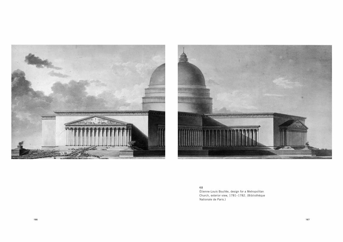
166 167
4.6Étienne-Louis Boullée, design for a Metropolitan
Church, exterior view, 1781–1782. (Bibliothèque
Nationale de Paris.)
168 ARCHITECTURE AS A STATE OF EXCEPTION
flows. Yet it is a mistake to think of Boullée’s architecture of finite
forms as a romantic gesture of resistance opposed to the forces
of the metropolis. While his bare walls may appear in elevation
as obstructions, in plan they frame and organize circulation in
public monuments. This idea of publicness, which Boullée em-
phasized as the precondition for architecture that triggers access,
would become the primary compositional theme of his plans.
This is evident in his projects for public institutions, such as
the Museum, the National Palace, and the Municipal Palace. In
the plans of these projects, the parts are organized in order to
efficiently frame spaces that allow for the free access and circu-
lation of great numbers of people. In this respect, Boullée also
seems to exaggerate the logic of urban spaces developed within
the tradition of French classicism, such as the hôtel courtyard.
An impressive example of Boullée’s appropriation of these
urban spaces is his project for the National Library. As is well
known, the library was to be located in the hôtel of Cardinal Maza-
rin, which Boullée was to adapt to accommodate a large collection
of books and a spacious reading room. The structure of the hôtel
posed a problem because the long and narrow wings framing the
courtyard were difficult spaces for managing a library’s control
and distribution. Moreover, storing the books in these wings was
extremely risky, for a fire in the adjacent buildings could easily
spread here. Boullée’s solution, made in one gesture, was to cover
the existing hôtel courtyard, transforming it into one gigantic in-
door room. In this room, he echoed the uniform pattern of the
hôtel courtyard by excessively repeating two elements: recessed
panels in the vaulted ceiling, and rows of books that served as
the framing walls of the room. The inspiration for this solution,
Boullée wrote, came from Raphael’s fresco The School of Athens,
which had in turn been inspired by Bramante’s project for St. Pe-
ter’s basilica. In spite of this appropriation, which may have been
É T I E N N E - L O U I S B O U L L É E ’ S P R O J E C T F O R A M E T R O P O L I S 169
an a posteriori reference, Boullée’s solution seems to elaborate
the compositional principles of the urban architecture of Paris,
with its particular emphasis on the city’s uniform patterns and
horizontal lines, to develop the space of an enclosed form that is
also an interior public space. In vaulting a courtyard—the space
between the wings—Boullée seems to anticipate the vast halls of
such public facilities as train stations, in which the scale of the
enclosed space reaches the limit of architectural space to contain
circulation and void. Circulation plays a fundamental role also in
Boullée’s project for the Monument to the Supreme Being. Remi-
niscent of the temple of Fortuna Primigenia in Palestrina (a ruin
that was also the inspiration for Bramante’s Belvedere and Palla-
dio’s Villa Rotonda), the monument is at the top of a vast volumetric
composition of terraces and stairs that frames the base of a moun-
tain, which serves as the protagonist of the whole composition. In
this sequence of terraces, the diagonal movement of the connect-
ing ramps is the only break from the strong horizontality of the
composition. Boullée adopted a similar strategy for his Museum
project, in which an enormous ramp, covered by an immense bar-
rel vault, is the only “active” element. In this composition, hierar-
chies and images disappear within an architecture made purely of
light and shadow. At a time when the real protagonist of the vast
and rapidly expanding territory was the directionless movement
of people, Boullée’s projects could be seen as “miniatures” of the
vast spaces of the emerging metropolis. Through analogies such
as Edmund Burke’s concept of the sublime, Boullée’s constructed
effects exemplified the way the city is made of anonymous forms
and their (infinite) repetition.
The best example of Boullée’s conception of architecture in
terms of its public access and circulation is his project for a Coli-
seum. After the Revolution, Boullée proposed the Coliseum as a
place for public festivals at which an enormous mass of citizens

170
4.7Étienne-Louis Boullée, design for a Library, view of
the interior of the second version, 1785. (Bibliothèque
Nationale de Paris.)
É T I E N N E - L O U I S B O U L L É E ’ S P R O J E C T F O R A M E T R O P O L I S 171
could celebrate the “national well-being.” Because his major
concern was the safety of this large structure, the main form of
the monument is its accessibility. For Boullée, any other aspect
was redundant, because what matters architecturally in a coli-
seum is the movement of masses of citizens and the spectacle of
these masses seated in the tribunes. As he writes in the Essay,
“Imagine three hundred thousand people gathered in an amphi-
theatre where none could escape the eyes of the crowd. The effect
produced by this combination of circumstances would be unique.
The spectators would be the elements of this surprising spectacle
and they alone would be responsible for its beauty.”20 Methods of
circulation compose the rest of the structure: “countless” stair-
cases that take spectators to the tribune, and galleries that would
protect the crowd from the rain.
In its absolute formal symmetry and sameness, the Coli-
seum sublimated its urban context. Indeed, Boullée strategically
placed this gathering and exhibition of a crowd within the heart
of the emerging territorial metropolis: the Étoile at the top of the
Champs-Élysées. In this place of constant movement, Boullée’s
Coliseum analogically sublimated flows and circulation in the
concrete limits of a form that constituted a machine for gathering
a crowd. Together with the bare walls, the assembling and staging
of the crowd is thus the analogical figure par excellence in Boul-
lée’s metropolis, achieved through two fundamental architec-
tural principles: symmetry and the sameness of formal elements.
While symmetry, with its perfect correspondence of the parts
to the whole, constituted a long tradition in architectural trea-
tises, in Boullée’s architecture, symmetry is treated also (and es-
pecially) as a logical consequence of equality expressed through
the sameness of forms. The users of his buildings are masses of
anonymous citizens. Symmetry is used as a compositional logic
that guarantees the building’s maximum legibility, and thus its

172 ARCHITECTURE AS A STATE OF EXCEPTION
public accessibility. Thus Boullée’s architecture staged equality
not so much in terms of social and symbolic representation but
in terms of a formal perception. His vast, uniform, symmetri-
cal, and thus equal spaces destabilized the hierarchies that ar-
chitecture always exhibited. Instead of following the principles
of symmetry and uniformity that characterized the tradition of
French classicism as a norm, Boullée developed them as “states
of exception” in the form of singular monuments that strategi-
cally punctuated and thus opposed the endlessness of the emerg-
ing metropolis.
For this reason Boullée’s architectural projects, like Palladio’s
villas, can be seen as analogous cities that, through their finite
exemplary objects, stage and define the features of an emerging
urban paradigm: the modern metropolis. Because the modern
metropolis and its flows are unrepresentable, architecture can
only be a frame; but in the act of containment, that frame made
of bare walls reveals movement. Far from being self-referential,
Boullée’s bare walls are an analogy of the process of architectural
abstraction implied in French classicism, and now developed to
its ultimate end. Once the forms of the emerging metropolis born
out of the esprit de système of French classicism were liberated
from the power that had made them effective, the abstraction of
the bare walls would celebrate equality not as a social effect but
as a political attribute.
If the spaces of the emerging metropolis were molded by an
emphasis on circulation and exchange, Boullée’s large but ulti-
mately finite spaces retain the “hollowness” of the new metropol-
itan spaces as the product of a compositional act. This act is one
of judgment regarding the forces that produced these spaces. As
Rossi writes, Boullée’s architecture is not just the form of “ratio-
nalism” sic et simpliciter, but the form of an “exalted rationalism”—
a rationalism that was not in the spirit of a calculus but one of
173
4.8Étienne-Louis Boullée, design for a Coliseum, second
version, section view, 1782. (Bibliothèque Nationale
de Paris.)

174 ARCHITECTURE AS A STATE OF EXCEPTION
subjective instrumentality—and thus provides the possibility
of judging and taking a position on the city and its institutions.21
In this context, Boullée’s architectural visions can be understood
as an attempt to produce, at the very heart of a new and vastly ex-
tended metropolis, an exemplary formal and political subjectiv-
ity. Contrary to the generic revolutionary attitude often wrongly
attributed to Boullée, this subjectivity echoed the very core of the
French Revolution’s political form: Jacobinism. Beyond simply
evoking the liberal freedom of the bourgeois class, these clearly
defined volumetric compositions standing within the endless-
ness of space in the metropolis also evoke the autonomy of the
political will, free from the social and economic constraints of a
society that was at the heart of the politics of the French Revolu-
tion. Boullée renders the republican ideals of the French Revo-
lution not through iconography, but through his emphasis on
composition as the core of any architectural decision.
Rossi’s interest in Boullée’s Architecture, Essay on Art showed
his preference for an architecture generated by using a few logi-
cal principles to produce a composition of simple geometrical
forms. Yet for Rossi, Boullée’s preference for simplicity was not
motivated by the necessity to make architecture conform to the
dry mechanism of rules. Instead, Rossi seems to suggest that
within Boullée’s theoretical work there coexists the need for
a method and a radically subjective approach, which results in a
theory of architecture composed only of Boullée’s own projects.
For this reason, Rossi distinguishes between Boullée’s “razio-
nalismo esaltato” (exalted rationalism) and the rationalism of
French classicism, which he defines as “razionalismo conven-
zionale” (conventional rationalism). Rossi identifies the latter in
the legacy of most architectural treatises and manuals, and in the
normative research of the functionalist architects of the twenti-
eth century. For Rossi, conventional rationalism is a normative
É T I E N N E - L O U I S B O U L L É E ’ S P R O J E C T F O R A M E T R O P O L I S 175
apparatus composed of descriptions of the classical orders,
techniques of construction, and programmatic taxonomies that
preceded the making of architecture and from which architecture
was supposed to derive its forms. On the other hand, he defines
exalted rationalism as a method in which the subjective decision
to produce a certain architectural composition leads to the defi-
nition of the logical principles necessary for the transmission of
that architectural composition. While conventional rationalism
predicates an architecture in which norms automatically produce
their application, exalted rationalism postulates an architecture
in which the decisions regarding a specific architectural form are
exceptional moments that define the framework for principles.
Rossi’s distinction between the approaches to architecture
defined by conventional rationalism and exalted rationalism,
and his appraisal of the latter in the work of Boullée, is similar
to Carl Schmitt’s theory of the state of exception.22 According to
Schmitt, it is not the norm that eventually produces the excep-
tion; it is the exception that produces the order necessary to be
able to conceive and apply norms. Schmitt wanted to emphasize
the priority of the subjective decision to apply certain norms
over the mere application of norms. He argues that subjective
decisions are not “arbitrary” but rather manifest the way the act-
ing subject positions itself toward the essential problems and
dilemmas of life. If a normative approach pretends to subsume
essential problems and dilemmas within a totalizing apparatus in
which the application of a norm is prescribed by another norm,
then the theory of the state of exception addresses the priority of
decisions and their exceptional and conjunctural form in estab-
lishing a framework in which norms are thus applicable.
Unlike the tradition of architectural treatises and manu-
als and the normative approach to the city that evolved within
traditional French classicism, Boullée’s exalted rationalism
176 ARCHITECTURE AS A STATE OF EXCEPTION
reinvented the legacy of that tradition as a subjective creative act.
In other words, Boullée did not negate the effects of the tradition
of French classicism on the architecture of the city of Paris; his
work even recuperated French classicism’s most salient traits,
such as uniformity, the prevalence of horizontal lines, the con-
cave spatiality of hôtel courtyards and royal squares, and the vast
space of the emerging metropolitan city. But he developed these
effects through the exceptional terms of subjective composi-
tions that resulted in finite form-objects. Whereas the making
of modern spatiality, as exemplified by the transformation of
Paris during the seventeenth and eighteenth centuries, evolved
toward the totalizing space of circulation—in which architecture
was more and more dissolved within the infinite space of urban-
ization—Boullée critiqued this tendency with the enclosed space
and finite form of his public monuments. And the architecture
of these monuments was made by recapitulating, in exceptional
terms, the forms and experiences of an urban tendency, not as a
ubiquitous force but as a finite, and thus critical, form.
In the 1970s, West Berlin faced an ongoing urban crisis. Fol-
lowing the destruction of the Second World War, the division of
Germany into two opposing blocks, and the partition of Berlin
into two cities—East Berlin as the capital of the Democratic Re-
public of Germany, and West Berlin as the eleventh state of West
Germany—West Berlin had become an island, a city-state en-
closed by a perimeter wall and surrounded by a hostile territory.
Because of this captivity, West Berlin had not recuperated from
its postwar crisis. The city still contained vast tracts of empty
space in which buildings seemed to be isolated islands and, in
the 1970s, its population was declining.
In 1977 a group of architects launched a rescue project called
Berlin as a Green Archipelago. Led by Oswald Mathias Ungers,
the group included Rem Koolhaas, Peter Riemann, Hans Koll-
hoff, and Arthur Ovaska. To these architects, the problems of
postwar West Berlin provided a potent model of “cities within
the city,” or in Ungers’s terms, a “city made by islands.”1 This
approach reflected the driving concept of Ungers’s urban proj-
ects, which he and his students elaborated between 1964 and
1977, first when he was first teaching at the Technical University
in Berlin (1963–1969) and then at Cornell University (1968–
1986).2 Ungers sought to turn Berlin’s idiosyncratic character as
5 THE CITY WITHIN THE CITYOSWALD MATHIAS UNGERS, OMA,
AND THE PROJECT OF THE CITY AS ARCHIPELAGO

178 THE CITY WITHIN THE CITY
a politically divided city in economic difficulty into a laboratory
for a project of the city that countered the technocratic and ro-
mantic approaches popular at the time. Berlin as a Green Archi-
pelago can also be understood as one of the earliest critiques of
the Krier brothers’ perimeter block restorations, which would
have a decisive impact on the reconstruction of Berlin in the
1980s and 1990s.3
Berlin’s fragmented reality—a city whose ruins registered
the destruction of war, yet whose political intensity reflected its
position as the “capital” of the Cold War—provided Ungers with
a basis for interpreting the city as an entity no longer reliant on
large-scale urban planning but rather composed of islands, each
of which was conceived as a formally distinct micro-city. Ungers
derived this approach from Karl Friedrich Schinkel, who was
the city architect of Berlin during the first half of the nineteenth
century. Schinkel had envisioned the capital of Prussia as a fabric
punctuated by singular architectural interventions, rather than
as a city planned along the principles of cohesive spatial design
typical of the baroque period. For Ungers, this approach could
overcome the fragmentation of postwar Berlin by turning the
crisis itself (the impossibility of planning the city) into the very
project of the architecture of the city. Following this line of think-
ing, Ungers developed his theory of the city as an archipelago,
shrinking the city to points of urban density as a way to respond
to the dramatic drop in West Berlin’s population.
Berlin as a Green Archipelago is one of the very few projects
in the history of city planning to address an urban crisis by radi-
cally shifting the focus from the problem of urbanization—the
further growth of the city—to that of shrinking the city. Ungers’s
archipelago looked to frame and thus to form the existing city
by accepting its process of depopulation. This acceptance was
not projected as a “disurbanization” of the city, but as a way to
179
5.1Oswald Mathias Ungers, Rem Koolhaas, Hans Kollhoff,
Arthur Ovaska, and Peter Riemann, The City within the
City—Berlin as a Green Archipelago, 1977. The city
as a “project of crisis,” shrinking the city to its significant
and irreducible parts.

180 THE CITY WITHIN THE CITY
reinforce its form by articulating the limits of each “island” in an
archipelago of large-scale artifacts.
Countering the utopian visions of city dissolution or, con-
versely, the ideal of reducing the city to an overall system, or
even of restoring the image of urban control by consolidating
forms such as the perimeter block, Berlin as a Green Archi-
pelago proposed a paradigm that went beyond modernist and
postmodernist references and that even today is not fully ap-
preciated for its provocative logic. This logic is revealed by
tracing the development of Ungers’s project of the city through
the series of proposals and studies he worked on in the 1960s
and 1970s. This series can be seen as one project culminating in
Berlin as a Green Archipelago, especially when one considers
Ungers’s seminal urban design projects, his didactic research
on Berlin, and then the link between his work and theories and
OMA’s early attempt to define a “metropolitan architecture.”
The intellectual exchange between Ungers and OMA was one
of the most interesting lines of research about the city in the
1970s, even if it was not sufficiently developed. This exchange
was based not only on the collaboration between Koolhaas and
Ungers on key projects, but also on their mutual interest in the
development of a “third way” to address the project of the city.
Both sought to move beyond the impasse represented by mod-
ernist city planning and the incipient postmodern deconstruc-
tion of any project of the city.
The central focus of this chapter is to reconstruct Ungers’s
project as an attempt to define the architecture of the city as in-
vested in architectural form. In his projects, Ungers articulated
the limits and finitude of architectural form as possible “cities
within the city,” as a recovery of defining traits of the city, such as
its inherent collective dimension, its dialectical nature, its being
made of separate parts, its being a composition of different and
O . M . U N G E R S , O M A , A N D T H E P R O J E C T O F T H E C I T Y A S A R C H I P E L A G O 181
at time opposing forms, within the urban crisis that was affecting
many cities in the late 1960s and 1970s, of which Berlin was the
most extreme and thus paradigmatic example.
Ungers’s formation as an architect coincided with one of the
most difficult periods of German history. After the Second World
War, Germans faced not only the task of rebuilding a country
devastated by war, but also the tormented political, cultural,
and moral reconstruction of a nation that for twelve years had
succumbed to Nazism. Reconstruction was also difficult because
Germany was the epicenter of Cold War politics. The ideologi-
cal contraposition of East and West charged the reconstruction
with ideological momentum, which produced on both sides, via
a series of plans and competitions, exemplary urban projects
whose forms and programs resonated as models for other cities
throughout Germany and Europe.4 Two of the most exemplary
flagship projects were the Stalinallee in the East, a monumental
boulevard planned in 1952 by Hermann Henselmann and com-
pleted in 1960 as the new center of East Berlin, capital of East
Germany, and the Hansa Viertel Interbau in the West, a residen-
tial district planned in 1957 and completed in 1961 as an inter-
national exhibition of housing projects designed by key figures in
modern architecture, including Alvar Aalto, Walter Gropius, and
Oscar Niemeyer. Besides emphasizing the dialectical nature of
city, the formal and ideological contraposition of these projects
also made explicit the impasse in defining new models for city
reconstruction. If the Stalinallee recuperated, with monumen-
tal emphasis, the theme of the boulevard as the main image of
the city, the Hansa Viertel produced the opposite extreme with
an image of scattered housing types in a green landscape. It may
have been the search for a third way, beyond these two directions,
that motivated Ungers’s early attempts to outline his principles
for the project of the city.

182 THE CITY WITHIN THE CITY
These principles were first formulated in a series of urban
projects that Ungers developed in the early 1960s: housing pro-
posals for Cologne Neue Stadt (1961–1964), Cologne Grünzug
Süd (1962–1965), and Berlin Märkisches Viertel (1962–1967),
and a competition entry for a student dormitory in Enschede,
Holland (1964). Ungers’s approach in these projects was explic-
itly polemical. Their rational, monumental form was intended
as a critique of the late modernist praxis of designing the city
through the generic application of given building standards,
which reduced the role of the architect to the design of envelopes.
In opposition to the traditional mandate given to urban projects,
the main principle guiding these proposals was the conception
of new housing complexes not as a generic extension of the city
but as clearly formalized city parts, as finite artifacts that, in their
internal formal composition, were evocative of an idea of the city.
The project for Cologne Neue Stadt, for example, was a direct
critique of a typical late-modernist urban layout in which slabs
and towers were scattered in green areas without producing a
recognizable form. Ungers’s complex was conceived as a series
of residential towers of different heights, yet composed to form
a single architectural entity. The typical plan of each apart-
ment placed discrete rooms around the main living space. This
composition gave form to the towers themselves, which were
grouped vertical volumes that further articulated the spatial and
formal composition of the entire complex. With this inventive
composition, Ungers elevated the living room from just another
room in the apartment to a sort of atrium (eliminating the cor-
ridor), while defining the exterior form of the housing blocks as
a monumental composition of volumes. Alluding to the play of
light and shadow produced by such an idiosyncratic formal com-
position, Ungers defined his Neue Stadt project as the archetype
for a city of “negatives and positives”—that is, a city in which the
183
5.2Oswald Mathias Ungers, proposal for Neue Stadt
Housing Complex, Cologne, 1961–1964. The city as
a composition of “positives and negatives.”

184 THE CITY WITHIN THE CITY
experience of form as a composition of built and void space be-
came the main architectural motif.5
This solution was Ungers’s first attempt to incorporate within
an architectural complex the spatial phenomenology of the city.
He applied the same approach, albeit less successfully, to the
Märkisches Viertel complex in Berlin, grouping the given pro-
gram of residential towers to form a sequence of open courts
with irregular forms. As in Neue Stadt, he proposed to alter
the given distribution of the apartments by changing the form
or position of one or two rooms in each column of apartments.
This procedure created a formal tension between the simplicity
of each architectural part and the complexity of spatial arrange-
ments created by their overall composition. This tension can be
interpreted as an implicit critique of the spatial monotony of
postwar urban settlements. In both Neue Stadt and Märkisches
Viertel, Ungers accepted the building technology and typologi-
cal standards that were given for these housing complexes, but
he altered their formal composition in order to recuperate the
possibility of monumental form within the peripheral spaces in
which they were inserted.
Such a critique of postwar urbanism is explicit in Ungers’s
project for the Enschede student housing competition in Hol-
land. He designed this complex as a catalog of formal composi-
tions starting with the basic figures of geometry—the triangle,
the square, and the circle. Similar to his previous schemes,
the design method produced a complex space evocative of the
city by using a very restricted formal vocabulary. In reaction to
the site—on the outskirts of a provincial town—Ungers rejected
the typical settlement logic of a campus of scattered pavilions
in a green space and proposed to design the new campus addi-
tion in the form of a self-sufficient city, whose spatiality recalls
the complex composition of spaces of Hadrian’s villa, but whose
185
5.3Oswald Mathias Ungers, Märkisches Viertel Housing
Complex, Berlin, 1962–1967, axonometric. The
project achieves a sense of monumentality through
the use of raw, prefabricated architectural forms.
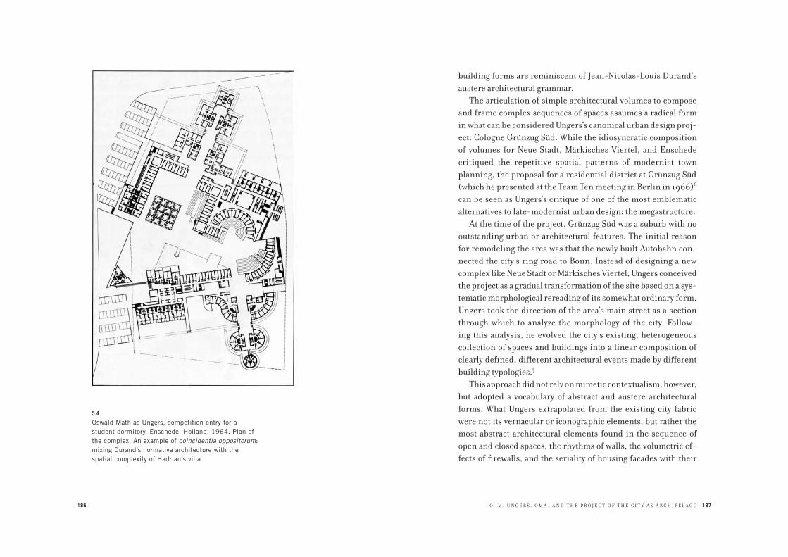
186
5.4Oswald Mathias Ungers, competition entry for a
student dormitory, Enschede, Holland, 1964. Plan of
the complex. An example of coincidentia oppositorum:
mixing Durand’s normative architecture with the
spatial complexity of Hadrian’s villa.
O . M . U N G E R S , O M A , A N D T H E P R O J E C T O F T H E C I T Y A S A R C H I P E L A G O 187
building forms are reminiscent of Jean-Nicolas-Louis Durand’s
austere architectural grammar.
The articulation of simple architectural volumes to compose
and frame complex sequences of spaces assumes a radical form
in what can be considered Ungers’s canonical urban design proj-
ect: Cologne Grünzug Süd. While the idiosyncratic composition
of volumes for Neue Stadt, Märkisches Viertel, and Enschede
critiqued the repetitive spatial patterns of modernist town
planning, the proposal for a residential district at Grünzug Süd
(which he presented at the Team Ten meeting in Berlin in 1966)6
can be seen as Ungers’s critique of one of the most emblematic
alternatives to late-modernist urban design: the megastructure.
At the time of the project, Grünzug Süd was a suburb with no
outstanding urban or architectural features. The initial reason
for remodeling the area was that the newly built Autobahn con-
nected the city’s ring road to Bonn. Instead of designing a new
complex like Neue Stadt or Märkisches Viertel, Ungers conceived
the project as a gradual transformation of the site based on a sys-
tematic morphological rereading of its somewhat ordinary form.
Ungers took the direction of the area’s main street as a section
through which to analyze the morphology of the city. Follow-
ing this analysis, he evolved the city’s existing, heterogeneous
collection of spaces and buildings into a linear composition of
clearly defined, different architectural events made by different
building typologies.7
This approach did not rely on mimetic contextualism, however,
but adopted a vocabulary of abstract and austere architectural
forms. What Ungers extrapolated from the existing city fabric
were not its vernacular or iconographic elements, but rather the
most abstract architectural elements found in the sequence of
open and closed spaces, the rhythms of walls, the volumetric ef-
fects of firewalls, and the seriality of housing facades with their

188 189
5.5Oswald Mathias Ungers, competition entry for Grünzug
Süd, 1962, as presented in Deutsche Bauzeitung 7
(1966). Against the megastructure: city form as a
(linear) composition of parts. The intervention uncovers
the latent formal themes of the existing city.
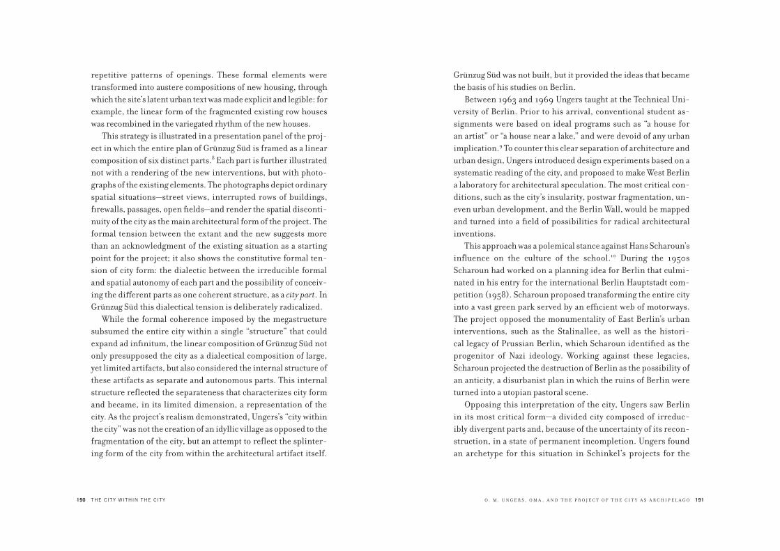
190 THE CITY WITHIN THE CITY
repetitive patterns of openings. These formal elements were
transformed into austere compositions of new housing, through
which the site’s latent urban text was made explicit and legible: for
example, the linear form of the fragmented existing row houses
was recombined in the variegated rhythm of the new houses.
This strategy is illustrated in a presentation panel of the proj-
ect in which the entire plan of Grünzug Süd is framed as a linear
composition of six distinct parts.8 Each part is further illustrated
not with a rendering of the new interventions, but with photo-
graphs of the existing elements. The photographs depict ordinary
spatial situations—street views, interrupted rows of buildings,
firewalls, passages, open fields—and render the spatial disconti-
nuity of the city as the main architectural form of the project. The
formal tension between the extant and the new suggests more
than an acknowledgment of the existing situation as a starting
point for the project; it also shows the constitutive formal ten-
sion of city form: the dialectic between the irreducible formal
and spatial autonomy of each part and the possibility of conceiv-
ing the different parts as one coherent structure, as a city part. In
Grünzug Süd this dialectical tension is deliberately radicalized.
While the formal coherence imposed by the megastructure
subsumed the entire city within a single “structure” that could
expand ad infinitum, the linear composition of Grünzug Süd not
only presupposed the city as a dialectical composition of large,
yet limited artifacts, but also considered the internal structure of
these artifacts as separate and autonomous parts. This internal
structure reflected the separateness that characterizes city form
and became, in its limited dimension, a representation of the
city. As the project’s realism demonstrated, Ungers’s “city within
the city” was not the creation of an idyllic village as opposed to the
fragmentation of the city, but an attempt to reflect the splinter-
ing form of the city from within the architectural artifact itself.
O . M . U N G E R S , O M A , A N D T H E P R O J E C T O F T H E C I T Y A S A R C H I P E L A G O 191
Grünzug Süd was not built, but it provided the ideas that became
the basis of his studies on Berlin.
Between 1963 and 1969 Ungers taught at the Technical Uni-
versity of Berlin. Prior to his arrival, conventional student as-
signments were based on ideal programs such as “a house for
an artist” or “a house near a lake,” and were devoid of any urban
implication.9 To counter this clear separation of architecture and
urban design, Ungers introduced design experiments based on a
systematic reading of the city, and proposed to make West Berlin
a laboratory for architectural speculation. The most critical con-
ditions, such as the city’s insularity, postwar fragmentation, un-
even urban development, and the Berlin Wall, would be mapped
and turned into a field of possibilities for radical architectural
inventions.
This approach was a polemical stance against Hans Scharoun’s
influence on the culture of the school.10 During the 1950s
Scharoun had worked on a planning idea for Berlin that culmi-
nated in his entry for the international Berlin Hauptstadt com-
petition (1958). Scharoun proposed transforming the entire city
into a vast green park served by an efficient web of motorways.
The project opposed the monumentality of East Berlin’s urban
interventions, such as the Stalinallee, as well as the histori-
cal legacy of Prussian Berlin, which Scharoun identified as the
progenitor of Nazi ideology. Working against these legacies,
Scharoun projected the destruction of Berlin as the possibility of
an anticity, a disurbanist plan in which the ruins of Berlin were
turned into a utopian pastoral scene.
Opposing this interpretation of the city, Ungers saw Berlin
in its most critical form—a divided city composed of irreduc-
ibly divergent parts and, because of the uncertainty of its recon-
struction, in a state of permanent incompletion. Ungers found
an archetype for this situation in Schinkel’s projects for the

192 THE CITY WITHIN THE CITY
so-called Havellandschaft (the landscape around the river
Havel), a vast complex of pavilions, castles, and gardens that
Schinkel, together with his collaborators and Peter Joseph
Lenné, developed throughout the first half of the nineteenth
century as a royal amenity for the Hohenzollern.11 Commis-
sioned by the royal family to design a sort of Hadrian’s villa to
be built along the Havel, Schinkel had proposed a landscape of
architectural events that involved the entire area of the river
without subsuming it within an overall geometrical composi-
tion. His interventions took the form of an archipelago in which
architecture was juxtaposed with the natural setting. The para-
digm for Ungers’s later approach was one of the Havellandschaft
sites: Schinkel’s design for Klein Glienicke, a garden with pa-
vilions designed between 1824 and 1837, which Ungers would
use as a veritable guiding archetype for himself and his students
on the essential nature of Berlin. In this complex, architectural
objects such as a casino, villa, and pavilion are placed in the
garden without any axial reference; rather, they establish un-
expected relationships that are further multiplied by other,
smaller architectural elements scattered within the park.
What characterizes Klein Glienicke is the radical opposi-
tion between the richness of the spatial relationships and the
elemental simplicity of the architecture made of primary forms,
such as the pergola on the Havel. Moreover, these forms are not
just fragments scattered in the park. Because of their differ-
ent compositions, materials, and programs, they are all based
on a formal grammar that establishes an archipelago of formal
events. Schinkel used the same approach in his interventions
in Berlin. The city’s fabric, fragmented after the urban crisis of
the Napoleonic war, was not corrected with attempts to produce
overall plans but was simply assumed to be the landscape of the
city. Schinkel developed his public works as point compositions
O . M . U N G E R S , O M A , A N D T H E P R O J E C T O F T H E C I T Y A S A R C H I P E L A G O 193
of autonomous blocks freely arranged within the space of the
city, leaving the incompleteness of the urban fabric as the pos-
sibility for a new spatiality. Ungers adapted this conception of
Berlin in order to address the effects of war on the city rather
than tap into a romantic ideal. In this context, Schinkel’s open
compositions along the Havel and in Berlin were used to subli-
mate the fragmented landscape of contemporary Berlin.
Following this reading of the city and employing the method
Ungers used for Grünzug Süd, his students produced system-
atic morphological and geographic surveys of Berlin in which
they systematically analyzed the infrastructure of the city—the
Autobahn, the parks, the canals, the river Spree, the U-Bahn
network.12 These layers of Berlin were viewed not only as urban
data, but also in terms of their architectural consequences: as
disruptive forms that divided the city into parts, obstructing any
organic recovery of the city. The unpredictable way in which the
river Spree cut through the city, for example, was assumed to be
the logic for settlement interventions that would transform the
disrupted sites into parts of a new linear city.13 Rather than try-
ing to “solve” the crises of the city, the projects proposed with
this method sought to exploit them as the thematic form of the
project itself. Looking at the projects shown in Ungers’s course
booklets, one sees the contrast between the will to contextualize
the project themes and interventions in the most critical points
of the city and the will to confront these conditions with an aus-
tere repertoire of restrained forms. In one project, published in
Wohnen am Park (Buildings in the park), four partially destroyed
city blocks are superimposed on a sequence of three different
residential structures (a mixed-use slab, a low-rise T-shaped
building, and a mixed-use courtyard building), all held together
in a linear composition by a public elevated street.14 While the
elevated street unites the four blocks in one complex, the three

194 THE CITY WITHIN THE CITY
proposed freestanding buildings fill the blocks without complet-
ing their perimeters, thus maintaining the status of ruins in the
“park” of the complex. The common basis for all of these projects
was point interventions: instead of being made with an overall
plan, the project for Berlin was made through the design of radi-
cal urban architectures that envisioned the development of the
city as the eruption of radical forms of metropolitan living. In
some cases the students simply mapped existing “ordinary” fea-
tures of the city and idealized them not as default situations but
as explicit projects. For example, the numerous firewalls made
visible by the destruction of the war were systematically photo-
graphed and then compiled to create an architectural sequence of
blind brick walls that also parodied the Berlin Wall.15
The best representation of this method came not from Berlin
but from London. In the late 1960s, chafing against Archigram’s
dominant pedagogy at the Architectural Association, Elia Zen-
ghelis, a teacher at the AA, introduced the students in his unit,
among them Rem Koolhaas, to Ungers’s work. In a conversation
with Ungers in 2004, Koolhaas said that Grünzug Süd was his first
contact with Ungers’s work.16
In 1971, Koolhaas decided to visit the Berlin Wall and docu-
ment it as a work of architecture for his third-year project.17
Koolhaas’s description of the architecture of the wall is similar
to Ungers’s compositional logic for Grünzug Süd. Koolhaas dis-
cusses his discovery that the linear structure of the wall was not
just a single line cutting through the city, but a linear sequence
of different architectural events held together by the political
will to impose on the city a state of closure.18 In his descrip-
tion, Koolhaas strategically silences the political meaning of the
wall to emphasize the way in which the political institution of
closure, once made real within the form of the city, manifested
itself not as the ideal form of a line, but in the ordinary forms
195
5.6Ulrike Bangerter, multifunctional block, ground-floor
plan and model, from Wohnen am Park, 1967, student
project no. 5.

196 THE CITY WITHIN THE CITY
of houses, walls, fences, and other architectural means of the
division of space.
It was precisely the “ordinary” architecture of the Berlin Wall
that suggested to Koolhaas how even the most imposing artifact,
once deployed in a real situation, loses its purity as a unitary
form and becomes a sequence of very different situations. Fol-
lowing Ungers’s Grünzug Süd project and the “retroactive” ra-
tionalization of existing critical situations that Ungers and his
students applied in their projects for Berlin, Koolhaas “elevated”
the Berlin Wall as a representation of how architecture was more
likely to provoke discontinuity than unity. This is evident in the
pictures of the wall that Koolhaas used in order to construct
his argument. In these photos, the linear form of the wall, like
the strip of Grünzug Süd, becomes many different spatial
events—open fields, rows of buildings, fences made of different
materials, etc. As in the projects of Ungers’s students, the theme
of the wall is represented through a series of radically different
situations hardly conceivable as a coherent sequence or form
of continuity, but instead revealing city form as a site of radical
discontinuity.19
One can argue that such an approach to the city—an approach
inspired by Ungers’s Grünzug Süd project—became the concep-
tual basis for Koolhaas’s Delirious New York, which uses the most
critical urban conditions as the basis for a city project.20 In fol-
lowing this link between Ungers and the early work of Koolhaas
and Zenghelis, we can see the fundamental development of
Ungers’s city-within-the-city concept as the germ of Koolhaas
and Zenghelis’s Exodus, or the Voluntary Prisoners of Architec-
ture (1972). As the subtitle suggests, the subject of this project
is the inmate. Koolhaas and Zenghelis intended the “voluntary
prisoner” to serve as a metaphor for the inhabitant of the me-
tropolis in its most extreme condition, an exacerbated version of
O . M . U N G E R S , O M A , A N D T H E P R O J E C T O F T H E C I T Y A S A R C H I P E L A G O 197
communitarian citizenship based on self-imposed closure.21 The
voluntary prisoner is a metaphor for a subject who deliberately
accepts the reality of the city as made of separation and exclusion
rather than unity and inclusion. Correspondingly, Exodus con-
sists of two parallel walls cutting through London and dividing it
into eight enclosed parts. Both the housing complex of Grünzug
Süd and the Berlin Wall also cut through an existing city, encom-
passing and radicalizing the different city conditions. Exodus
was not simply a line, like Superstudio’s Continuous Monument,
or the repetition of an identical module, like Ivan Leonidov’s
scheme for Magnitogorsk (although both projects were surely
inspirations for Exodus); it was a linear composition made of
radically different city parts. Each of these parts was meant to
be a morphological and programmatic exaggeration of city parts
(the suburb, the hospital, the museum, the park) in the form of
social and architectural allegories of city life. Exodus deliberately
assumed that conditions such as separation, aggression, and en-
mity were logical ingredients for the city. Thus, Exodus evolved
from Ungers’s interpretation of Berlin as a city made of contrast-
ing parts to a more explicit political scenario.
In a recent lecture, Zenghelis maintained that the different
parts of Exodus were conceived in two ways: as arranged within a
linear structure, and as autonomous city islands for independent
metropolitan communities.22 As a project, Exodus—for which
Ungers, after encountering Koolhaas, showed great admiration
and interest—can be considered the link connecting the ar-
chitectural principles introduced in Grünzug Süd and Ungers’s
studies on Berlin with the more politically explicit project of
Berlin as a Green Archipelago. For Exodus amplified a theme
already emergent in Ungers’s work: the principle of turning the
splintering forces of the metropolis into architectural form that
addresses the collective dimension of the city.

198
5.7Rem Koolhaas and Elia Zenghelis with Madelon
Vriesendorp and Zoe Zenghelis, Exodus, or the
Voluntary Prisoners of Architecture, 1972, plan.
Architectural form as analogous to the splintering
forms of the metropolis.
O . M . U N G E R S , O M A , A N D T H E P R O J E C T O F T H E C I T Y A S A R C H I P E L A G O 199
Ungers had already begun to elaborate a more overtly political
approach in the research topics he initiated upon moving to the
United States in 1969. (For one year, 1968–1969, he taught both
in Berlin and at Cornell.) Living in upstate New York, he became
interested in historical examples of communal life in America,
and wrote a book on this topic with his wife, Liselotte, in the early
1970s.23 It is easy to imagine that Ungers began to research these
communities for possible social and political clues that would
support his idea of the city as a field of delimited forms. Coun-
tering the traditional Marxist critique of experimental socialist
communes as irrelevant in changing the general organization of
society, Ungers argued that these American communities pro-
vided a viable urban paradigm.
For example, in an essay summarizing his studies of religious
communities, Ungers considered how radical social lifestyles
were implemented not only as totalizing utopias imposed on the
whole of society, but also as a set of communitarian principles
voluntarily embraced by secessionist groups that built their vil-
lages as self-sufficient places, independent from existing urban
centers.24 According to Ungers, these “concrete utopias” were
possible precisely because they were conceived as limited in
terms of space and number of inhabitants. Religious commu-
nities such as the Shakers were characterized by a principle of
communal life in which there was no private property; all facili-
ties were for collective use. This resulted in settlements whose
form was organized for a communal life, with an abundance of
common spaces, and in clear contrast to cities, which are shaped
by land ownership. Ungers observed that radical communality
was possible only within limited settlements, where an increase
in population did not result in the growth of individual settle-
ments but in their multiplication. The limits of each settlement
were self-imposed by the community itself according to the

200 THE CITY WITHIN THE CITY
possibility of self-management; thus their form was indepen-
dent from any external urban order.
These villages were not the embodiment of economic segrega-
tion or other social management criteria, but of the ideological
will of a community to separate itself from the rest of society by
following a principle of collective life. This example led Ungers
to believe that developing an idea of the city as an archipelago of
limited parts was more feasible than attempting to realize overall
projects like those of modernist architects; in addition, the con-
cept of the archipelago opened up a new political conception of a
city form in which groups of inhabitants could self-organize their
independence through architectural artifacts that allowed them
to claim space for their communitarian life.
A similar observation emerged in Ungers’s research on the
superblock. He especially focused on the Vienna superblock,
the most prominent urban architectural project of the social-
democratic government of the Austrian capital between 1919
and 1934. The so-called Red Vienna can be considered the clear-
est representation of what a “city within the city” means, and is
thus one of the most important references for Berlin as a Green
Archipelago. Over the course of a few years, and in spite of dif-
ficult economic circumstances, the government of Vienna had
constructed 14,000 new apartments for the working class in the
form of blocks located within the city. In one of his course book-
lets Ungers published a map of the Viennese superblocks, which
showed that their locations were not based on an overall city
plan but were point interventions.25 The municipality proposed
locating these new housing schemes within the city, counter to
an initial idea of building them on the periphery as an exten-
sion of the city. In an introductory article to his research on the
Vienna superblock, Ungers stressed how this typology was an
alternative to the settlement logic of both the garden city and the
O . M . U N G E R S , O M A , A N D T H E P R O J E C T O F T H E C I T Y A S A R C H I P E L A G O 201
Siedlung; in those models, the working class was alienated from
the rest of society within a fragmented and marginalized dis-
trict on the periphery of industrial cities. Vienna’s municipal
government opted instead for a new social housing stock in the
form of a very precise typology: the Hof, a superblock whose
spatial and programmatic principle was based on monumental
interior courtyards reminiscent of the monastic typology of the
cloister. Ungers noted that the main goal of the Vienna govern-
ment was to raise working-class consciousness and the com-
munitarian spirit of its inhabitants rather than just to solve the
problem of a housing shortage. For this reason, the Viennese
superblocks did not expand the existing city, but were situated
within the city as self-sufficient islands in pronounced contrast
to their surroundings. As Ungers emphasized, the superblock’s
clear architectural identity and generosity of collective spaces
were in opposition to the individualization of bourgeois met-
ropolitan residences. Unlike many modernist city projects, the
Viennese superblocks were not innovative in terms of style,
newness of building components, or layout of the apartments;
instead, their innovation lay in their radical redistribution of
collective facilities within a radical and recognizable architec-
tural form. Each superblock was equipped with basic commu-
nity services such as a clinic, library, laundry, gym, restaurant,
and kindergarten. These facilities were designed to provide
the superblock with both self-sufficiency and a monumen-
tal character that was intended to convey the political image
of these complexes through the use of their collective spaces.
The result was the autonomy of the superblocks from the plan-
ning standards of the city, which led to an archipelago of places
for communitarian life. The formal and typological theme of
the courtyard was decisive in reinforcing the identity of this
communitarian life.
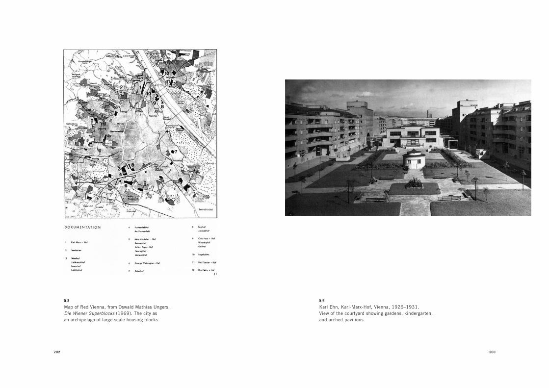
202
5.8Map of Red Vienna, from Oswald Mathias Ungers,
Die Wiener Superblocks (1969). The city as
an archipelago of large-scale housing blocks.
203
5.9Karl Ehn, Karl-Marx-Hof, Vienna, 1926–1931.
View of the courtyard showing gardens, kindergarten,
and arched pavilions.

204 THE CITY WITHIN THE CITY
This aspect was also decisive in Ungers’s reevaluation of the
superblock. He stressed that while modernist planning focused
on refining architectural space with optimal living standards,
the architects of the superblocks focused instead on the thematic
performance of space, giving the architecture a precise ritual
identity that would elevate social housing from the mere act of
providing space for the social management of the working class
to the bold gesture of a monumentality that gave the inhabitants
dignity without masking their class identity. Ungers’s fascination
with both the communes of America and the idea of the super-
block as a building type, which corresponded to his idea of the
city as a composition of Grossform (big form), added a social and
political dimension to the concept of designing a city through the
kinds of point interventions that he took from Schinkel’s Berlin.
This increasingly political understanding of the city as archi-
pelago was triggered by two events: one, Ungers’s encounter with
Koolhaas and Zenghelis in 1972, and the other, his confrontation
with Colin Rowe’s “neoliberal” theory of urban design, which
took form in the early 1970s as Collage City. For Ungers, the latter
event was decisive in clarifying that his concept of the city as an
archipelago was more than just the morphological collage of dif-
ferent architectural figures.
Rowe first invited Ungers to teach at Cornell in 1968. As his
academic and professional position became increasingly con-
troversial with the anti-architecture political protests in German
universities in 1968, Ungers moved to Cornell in hope of find-
ing a more sympathetic university environment.26 At the time,
Rowe was shifting his work from a close reading of architecture
to the formulation of a comprehensive theory of urban design,
which would later appear in his book Collage City (published in
1978, but completed in 1973).27 Rowe countered the utopian ta-
bula rasa method of modernist planning with an urbanism based
O . M . U N G E R S , O M A , A N D T H E P R O J E C T O F T H E C I T Y A S A R C H I P E L A G O 205
on a sophisticated bricolage of different historical architectural
examples. Such an approach, he held, would lead to a city fit for a
liberal democratic regime based on the cultural principles of in-
clusion and pluralism. For Rowe, the formal paradigm for such an
ideal city was already realized in the Rome depicted by Giovanni
Battista Nolli in his famous topographic survey.28 Through the
ideological lens of liberal politics, Rowe transformed Nolli’s
Rome into a “collage city,” a city formed by the incremental ad-
justment of disparate architectural forms, yielding an intricate
collage of elegant architectural “figures” coexisting, in spite of
their differences, within the “ground” of the city fabric. By this
move, Rowe compressed Rome’s time-based evolution into the
present tense, suppressing its heritage of conflict by collapsing
its complexity into a single temporal layer. The potential for con-
flict was reduced to mere morphological variety contained within
the informal framework of the topographic ground—the city’s ir-
regular fabric—which in Rowe’s terms was meant to act as a poché
between the different figures.
Rowe invited Ungers to Cornell because he assumed that Un-
gers’s ideas in architecture and urban design were evolving in a
direction similar to his bricolage approach. But it was precisely
Ungers’s recognition of the fundamental difference between
Rowe’s project and his own that helped him to further radicalize
the theoretical premises of his approach, which he later charac-
terized as the “dialectic city,” as opposed to Rowe’s “collage city.”29
Rowe’s central thesis in Collage City revolves around under-
standing architecture as offering “set pieces” for building city
spaces. Set pieces are architectural forms that can be reduced to
relativistic devices freely extrapolated from any historical, po-
litical, or geographical context. The only context Rowe acknowl-
edges is morphological collage: the possibility of combining
radically different architectural figures in a pleasant composition.

206 THE CITY WITHIN THE CITY
According to him, any architectural figure can sustain multiple
uses as long as it remains useful and convincing as a figure—
namely, as a morphological datum. Rowe argues that its convinc-
ingness as a figure is merely based on the architect’s personal
sense of morphology. The criteria of composition, by implication,
are subjective and separated from the broader cultural and politi-
cal context, which Ungers placed at the center of his idea of the
city of contrasting parts. In Rowe’s idea of the city, difference is
reduced to a mere morphological exercise: the incremental accu-
mulation of differences. It was precisely against this idea of urban
design that Ungers developed his own method. Ungers’s rejection
of this image of the city of accumulation, the concrete result of
free-market politics, becomes evident in what can be considered
the two most important projects he elaborated in the 1970s, dur-
ing his American period: the urban design proposals for two areas
of West Berlin—Tiergarten Viertel and Lichterfelde.
The project for Tiergarten Viertel was Ungers’s competition
entry for the area around West Berlin’s cultural center, the Kultur-
forum, developed in the 1960s as the city’s ideological counter-
part to the East’s Alexanderplatz.30 The Kulturforum was already a
place of conflicting ideologies, as it consisted of two radically dif-
ferent buildings: Scharoun’s expressionist Philharmonic Concert
Hall and Public Library, and Mies van der Rohe’s classicist New
National Gallery. The dialectic between Scharoun’s and Mies’s
interventions was more than a stylistic one, as it summarized the
two most important cultural directions that had animated Ger-
many in the first half of the twentieth century: expressionism and
rationalism. At the time of the competition, the area was in a frag-
mented state, and the resolutely insular form of Mies’s National
Gallery was perhaps the most appropriate comment.
The competition called for a densification and recomposi-
tion of the area’s fragmented urban structure. Ungers rejected
207
5.10Oswald Mathias Ungers, proposal for the Tiergarten
Viertel, Berlin 1973, axonometric. Fusing architectural
abstraction and urban realism.
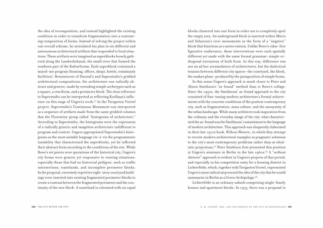
208 THE CITY WITHIN THE CITY
the idea of recomposition, and instead highlighted the existing
condition in order to transform fragmentation into a contrast-
ing composition of forms. Instead of solving the project within
one overall scheme, he articulated his plan in six different and
autonomous architectural artifacts that responded to local situa-
tions. These artifacts were imagined as superblocks loosely gath-
ered along the Landwehrkanal, the small river that framed the
southern part of the Kulturforum. Each superblock contained a
mixed-use program (housing, offices, shops, hotels, community
facilities). Reminiscent of Durand’s and Superstudio’s gridded
architectural compositions, the architecture was radically ab-
stract and generic, made by extruding simple archetypes such as
a square, a cruciform, and a perimeter block. The clear reference
to Superstudio can be interpreted as reflecting Koolhaas’s influ-
ence on this stage of Ungers’s work.31 In the Tiergarten Viertel
project, Superstudio’s Continuous Monument was interpreted
as a sequence of artifacts made from the same gridded volumes
that the Florentine group called “histograms of architecture.”
According to Superstudio, the histograms were the expression
of a radically generic and imageless architecture indifferent to
program and context. Ungers appropriated Superstudio’s histo-
grams as the most suitable language vis-à-vis the programmatic
instability that characterized the superblocks, yet he inflected
their abstract form according to the conditions of the site. While
Rowe’s set pieces were quotations of the historical city, Ungers’s
city forms were generic yet responsive to existing situations,
especially those that had no historical pedigree, such as traffic
intersections, wastelands, and incomplete perimeter blocks.
In the proposal, extremely repetitive eight-story courtyard build-
ings were inserted into existing fragmented perimeter blocks to
create a contrast between the fragmented perimeter and the con-
tinuity of the new block. A wasteland is colonized with six equal
O . M . U N G E R S , O M A , A N D T H E P R O J E C T O F T H E C I T Y A S A R C H I P E L A G O 209
blocks clustered into one form in order not to completely spoil
the empty area. An underground block is inserted within Mies’s
and Scharoun’s civic monuments in the form of a “negative”
block that functions as a metro station. Unlike Rowe’s value-free
figurative exuberance, these interventions were each spatially
different yet made with the same formal grammar: simple or-
thogonal extrusions of built form. In this way, difference was
not an ad hoc accumulation of architectures, but the dialectical
tension between different city spaces—the courtyard, the block,
the sunken plaza—produced by the juxtaposition of simple forms.
In this sense Ungers’s approach is much closer to Peter and
Alison Smithson’s “as-found” method than to Rowe’s collage.
Since the 1950s, the Smithsons’ as-found approach to the city
consisted of fine-tuning modern architecture’s formal achieve-
ments with the concrete conditions of the postwar contemporary
city, such as fragmentation, mass culture, and the anonymity of
the urban landscape. While many architects took inspiration from
the ordinary and the everyday image of the city, what character-
ized the as-found was the Smithsons’ commitment to the language
of modern architecture. This approach was eloquently elaborated
in their late 1970s book, Without Rhetoric, in which they attempt
to rewrite modern architectural examples as pragmatic solutions
to the city’s most contemporary problems rather than as ideal-
istic projections.32 Peter Smithson first presented this position
at Ungers’s seminars in Berlin in the late 1960s.33 A “without
rhetoric” approach is evident in Ungers’s projects of that period,
and especially in his competition entry for a housing district in
Lichterfelde, which, together with Tiergarten Viertel, represented
Ungers’s most radical step toward the idea of the city that he would
summarize in Berlin as a Green Archipelago.34
Lichterfelde is an ordinary suburb comprising single-family
houses and apartment blocks. In 1973, there was a proposal to
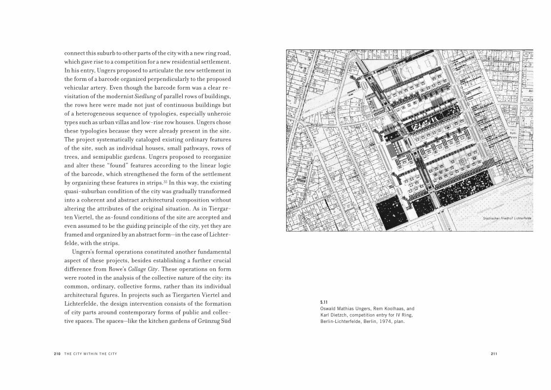
210 THE CITY WITHIN THE CITY
connect this suburb to other parts of the city with a new ring road,
which gave rise to a competition for a new residential settlement.
In his entry, Ungers proposed to articulate the new settlement in
the form of a barcode organized perpendicularly to the proposed
vehicular artery. Even though the barcode form was a clear re-
visitation of the modernist Siedlung of parallel rows of buildings,
the rows here were made not just of continuous buildings but
of a heterogeneous sequence of typologies, especially unheroic
types such as urban villas and low-rise row houses. Ungers chose
these typologies because they were already present in the site.
The project systematically cataloged existing ordinary features
of the site, such as individual houses, small pathways, rows of
trees, and semipublic gardens. Ungers proposed to reorganize
and alter these “found” features according to the linear logic
of the barcode, which strengthened the form of the settlement
by organizing these features in strips.35 In this way, the existing
quasi-suburban condition of the city was gradually transformed
into a coherent and abstract architectural composition without
altering the attributes of the original situation. As in Tiergar-
ten Viertel, the as-found conditions of the site are accepted and
even assumed to be the guiding principle of the city, yet they are
framed and organized by an abstract form—in the case of Lichter-
felde, with the strips.
Ungers’s formal operations constituted another fundamental
aspect of these projects, besides establishing a further crucial
difference from Rowe’s Collage City. These operations on form
were rooted in the analysis of the collective nature of the city: its
common, ordinary, collective forms, rather than its individual
architectural figures. In projects such as Tiergarten Viertel and
Lichterfelde, the design intervention consists of the formation
of city parts around contemporary forms of public and collec-
tive spaces. The spaces—like the kitchen gardens of Grünzug Süd
211
5.11Oswald Mathias Ungers, Rem Koolhaas, and
Karl Dietzch, competition entry for IV Ring,
Berlin-Lichterfelde, Berlin, 1974, plan.
212 THE CITY WITHIN THE CITY
and Lichterfelde, the sunken metro station, or the sport center in
Tiergarten Viertel—are not camouflaged with the traditional spa-
tial and symbolic attributes of publicness such as plazas and mon-
uments, but are rendered in all their metropolitan anonymity.
Like Schinkel’s approach to Berlin, Ungers’s urban design
proposals deliberately accepted and made visible the effects
of forces on the city such as the fragmentation of urban form,
anonymity of architecture, and instability of program. Projects
such as Tiergarten Viertel, Lichterfelde, and those made by Un-
gers’s students all attempted to extract from these urban forces
the seeds for the architectural reinvention of the city as a site of
contrasting collective forms. It is in light of this attitude, which
mixed urban realism and what one might call the “will to city
form,” that OMA’s early work can be considered part of the de-
velopment of ideas and projects that would lead Ungers toward
Berlin as a Green Archipelago.
Koolhaas worked with Ungers on both the Tiergarten Viertel
and Lichterfelde projects, and OMA’s early projects were carried
out in close dialog with Ungers, whose initials—OMU—were an
inspiration for the name of Koolhaas and Zenghelis’s office.36
In 1972, after completing Exodus, Koolhaas moved to Ithaca,
New York, to study at Cornell with Rowe and Ungers. He imme-
diately realized there were differences between the two men’s
approaches, and that his own position had much more affinity
with Ungers’s explicit adherence to the reality of the city than
with Rowe’s nostalgic approach.37 When Koolhaas met Ungers,
the German architect was conducting research with his students
on idiosyncratic urban forms of the American city as models
for new urban design interventions. It was in this context that
Koolhaas began his research for his book Delirious New York.38 The
narrative structure of Delirious New York is itself organized as a
kind of “archipelago” in which New York is analyzed not through
O . M . U N G E R S , O M A , A N D T H E P R O J E C T O F T H E C I T Y A S A R C H I P E L A G O 213
the isotropic order of the grid but through the individuality of
exemplary artifacts such as Rockefeller Center, the RCA Build-
ing, the Downtown Athletic Club, and the Waldorf-Astoria Hotel.
Koolhaas identified the potential of these architectures as “cities
within cities,”39 microcosms in which the metropolitan life of
New York was contained and its social and ideological implica-
tions were made radically explicit. In contrast with his City of the
Captive Globe, the project that was meant to be the blueprint for
this book, the examples are not a collection of eclectic modern
“souvenirs” optimized by the grid, but a reasoned composition
of radically different buildings that elucidates in miniature the
logic of Manhattan.
One of Koolhaas’s obsessions in New York City was the Wal-
dorf-Astoria Hotel, which housed such a variety of services that
the building itself was a veritable city.40 Koolhaas’s fixation with
the typology of the metropolitan hotel—to which OMA devoted
its early projects—resembled Ungers’s focus on metropolitan
superblocks like those he proposed for Tiergarten Viertel. For
example, the superblock made of six towers placed atop a gigan-
tic plinth, for which Koolhaas sketched an early proposal, was
later recast in OMA’s proposal for Welfare Island. In both cases,
the metropolitan hotel becomes an assembly of programs and
functions, to the point that the buildings themselves no longer
have a specific program or function. Both Ungers’s and OMA’s
projects were organized as two-part buildings: a plinth that
contains public facilities and organizes access to the subway and
trains, with towers for apartments and hotel rooms on top of the
plinth. This composition was also tested in several projects done
by Ungers’s students (for example, Wolf Meyer-Christian’s pro-
posal for a multifunctional housing slab on Kaiserdamm, done in
1966), and has a precedent in the concept of the Hochhausstadt
(vertical city) elaborated by Ludwig Hilberseimer in 1924. In his

214
5.12Wolf Meyer-Christian, student project for an apartment
building in Kaiserdamm, Berlin, 1966 (from O. M.
Ungers, Schnellstrasse und Gebäude, Berlin, 1966).
O . M . U N G E R S , O M A , A N D T H E P R O J E C T O F T H E C I T Y A S A R C H I P E L A G O 215
“ideal” project for a capitalist Groszstadt, Hilberseimer proposed
to superimpose the main functions of the city within mixed-use
city blocks rather than separating them in different zones of the
city. The result was a city made by endlessly repeating a single
building type consisting of vertically stacked programs. Hilber-
seimer’s proposal, with hotel rooms as the main metropolitan liv-
ing cell and a grid of transportation systems, accommodated the
main driver of the capitalist metropolis: the mobility of workers.
For Hilberseimer, mobility was more than a functional problem:
it also embodied the radical process of social and cultural uproot-
ing that created anonymous and generic space. Consequently, the
architecture of the Hochhausstadt was a generic form made by
the endless repetition of the same elements.
A similar formal and programmatic vocabulary is present in
many of Ungers’s own projects and in those done by his students
in Berlin, including the proposals presented in his 1968 course,
“Berlin 1995.”41 Yet for Ungers, and later for OMA, the concept
of the “vertical city” was conveyed not by the horizontally exten-
sive and repeatable system of Hilberseimer’s Hochhausstadt, but
rather by islands of intensity—collective forms of living—that
pierced the endlessness of the individualized metropolis. The
tension between the uprooting forces of the metropolis and an
architecture that accommodates these forces characterizes both
Ungers’s and early OMA urban design. This theme is expressed in
two OMA projects that, while they can be interpreted as an out-
growth of Ungers’s architecture, are the starting point of Koolhaas
and Zenghelis’s “metropolitan architecture”: Zenghelis’s Hotel
Sphinx (1975) and Koolhaas’s Welfare Palace Hotel (1976).42
Both of these projects developed the typology of the hotel as
the ultimate carrier of “cityness” within the agonized urbanity of
1970s New York. In both cases the building consists of a two-part
composition: a base containing collective facilities, and towers

216
5.13Elia Zenghelis, Hotel Sphinx in Times Square,
New York, 1975, axonometric view (painting by
Zoe Zenghelis). The hotel block as the ideal form
for social housing.
217
5.14Rem Koolhaas, Welfare Palace Hotel, Roosevelt Island,
New York, 1976, cutaway axonometric (painting
by Madelon Vriesendorp). Architecture as the life raft
of the (decaying) city.
218 THE CITY WITHIN THE CITY
containing hotel rooms and more private shared facilities. For
OMA, this composition was meant to replicate, at a “miniature”
scale, the form of New York City with its repetition of towers and
their endless fenestration. Following Ungers’s method, in which
the most controversial aspects of a site are idealized as the main
drivers for a project, both the Hotel Sphinx, a social housing
project proposed for the then-derelict Times Square, and the
Welfare Palace Hotel, a social housing hotel proposed within a
larger competition entry for the renewal of Welfare Island (now
called Roosevelt Island), addressed New York’s period of crisis by
exaggerating and compressing into finite architectural projects
the two faces of the capitalist city: extreme individual anonymity
and a seemingly limitless potential for encounter.
Following in Ungers’s steps, these two projects embraced the
city even in its most wild and dangerous manifestations. Reacting
against Rowe’s skepticism toward modernist urban design, the
OMA projects, like Ungers’s Tiergarten Viertel and Lichterfelde,
took on the modernist project’s optimism at the prospect of
designing the city, yet departed from modernism’s comprehen-
sive planning to propose a strategic retreat into a composition
of finite, limited forms. The artifacts that dominate the derelict
landscapes of the Tiergarten Viertel, Times Square, and Welfare
Island predate Koolhaas’s summary of this approach, which is
contained in his most important theoretical manifesto, “Big-
ness” (1994).43
In “Bigness,” Koolhaas makes explicit the principles that were
embryonic in the earlier OMA projects. The architecture of big-
ness artificially reconstructs the city just as the city is under the
assault of urbanization. “Bigness” refers to the scale of gigantic
architectural forms—not those that develop horizontally, as in the
case of megastructures or suburban sprawl, the two primary op-
tions for the American postwar city, but rather those that develop
O . M . U N G E R S , O M A , A N D T H E P R O J E C T O F T H E C I T Y A S A R C H I P E L A G O 219
vertically as finite architectural forms. Due to their massive scale,
these forms cannot be controlled by a single architect. For this
reason, the architecture of bigness, as Ungers’s work and OMA’s
early forms demonstrated, could only be anonymous simple
forms, the scale of which schematizes authorship to the most
generic architectural components. Here, authorless architecture
is not simply the effect of scale and quantity; it is also the pre-
requisite for an architecture that is finite in its envelope, yet that
allows maximum flexibility and indeterminacy in its interior.
Ungers anticipated this position in “Planning Criteria,”
a short text he published in 1976. He affirmed that a fundamental
aspect of buildings that aspire to be “cities within the city” is their
disposable form vis-à-vis further development and change, and
that such a possibility is more feasible with a finite form, which,
by being straightforward in its function, allows for its appropria-
tion by the inhabitants.44
The most powerful representation of a city landscape pro-
duced by such an approach is an axonometric view of New York
that includes Koolhaas’s Welfare Island project. The proposal
for Welfare Island (1975–1976) is rendered together with other
Manhattan examples of “cities within the city” whose stories
are narrated in Delirious New York: the RCA Building, the Hotel
Sphinx, and the United Nations. These are depicted as islands
in a tabula rasa Manhattan reduced to an empty grid. The Man-
hattan grid is also replicated on Welfare Island to create eight
new blocks on the small island, in a way making it a miniature
version of Manhattan. Ungers would apply the same strategy in
his entry for the Roosevelt Island competition one year later, but
with a difference: whereas OMA replicated a fragment of the grid
at the same size as the original, Ungers introduced a miniature
version of Central Park, which required him to reduce the size
of the Manhattan blocks on the small island. Koolhaas conceived
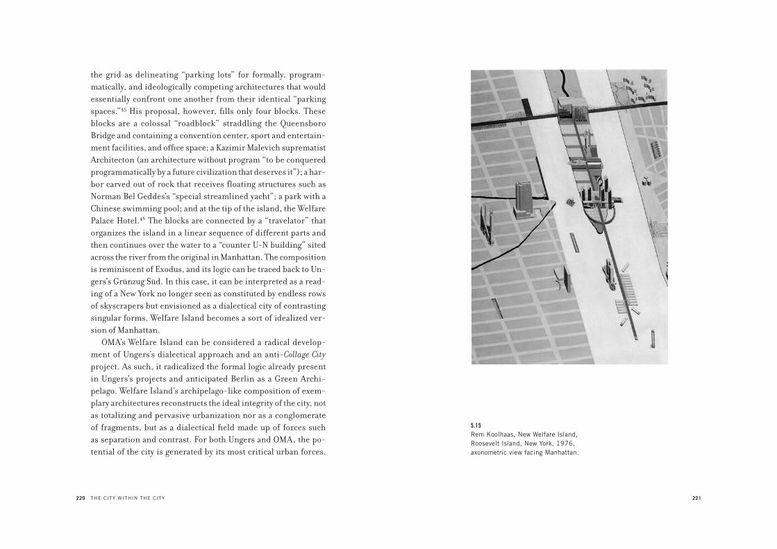
220 THE CITY WITHIN THE CITY
the grid as delineating “parking lots” for formally, program-
matically, and ideologically competing architectures that would
essentially confront one another from their identical “parking
spaces.”45 His proposal, however, fills only four blocks. These
blocks are a colossal “roadblock” straddling the Queensboro
Bridge and containing a convention center, sport and entertain-
ment facilities, and office space; a Kazimir Malevich suprematist
Architecton (an architecture without program “to be conquered
programmatically by a future civilization that deserves it”); a har-
bor carved out of rock that receives floating structures such as
Norman Bel Geddes’s “special streamlined yacht”; a park with a
Chinese swimming pool; and at the tip of the island, the Welfare
Palace Hotel.46 The blocks are connected by a “travelator” that
organizes the island in a linear sequence of different parts and
then continues over the water to a “counter U-N building” sited
across the river from the original in Manhattan. The composition
is reminiscent of Exodus, and its logic can be traced back to Un-
gers’s Grünzug Süd. In this case, it can be interpreted as a read-
ing of a New York no longer seen as constituted by endless rows
of skyscrapers but envisioned as a dialectical city of contrasting
singular forms. Welfare Island becomes a sort of idealized ver-
sion of Manhattan.
OMA’s Welfare Island can be considered a radical develop-
ment of Ungers’s dialectical approach and an anti-Collage City
project. As such, it radicalized the formal logic already present
in Ungers’s projects and anticipated Berlin as a Green Archi-
pelago. Welfare Island’s archipelago-like composition of exem-
plary architectures reconstructs the ideal integrity of the city, not
as totalizing and pervasive urbanization nor as a conglomerate
of fragments, but as a dialectical field made up of forces such
as separation and contrast. For both Ungers and OMA, the po-
tential of the city is generated by its most critical urban forces.
221
5.15Rem Koolhaas, New Welfare Island,
Roosevelt Island, New York, 1976,
axonometric view facing Manhattan.
222 THE CITY WITHIN THE CITY
In the OMA project, as in Ungers’s Tiergarten Viertel, the illusion
of an architectural project that “improves” the city is replaced by
an architecture that reifies in the most radical way the splintering
forces of the metropolis that might otherwise remain ungrasp-
able. From this perspective, Welfare Island can be interpreted as
an extreme consequence of a scenario of decline in which New
York—once the paradigm of congestion and density—survives a
radical process of depopulation. Beyond being simply examples
of New York’s culture of congestion, the artifacts floating within
the empty grid are also the last bastions of “cityness” left in this
scenario of urban decadence. Architecture is thus projected as an
island, the last opportunity for the city to become something and
survive its decline.
The starting point for Berlin as a Green Archipelago was the
urban crisis of Berlin in the 1970s. If urbanization fundamentally
implies the capacity of the city to expand, to accommodate and
even to trigger growth (both economic and demographic), one
of the most crucial manifestations of urban crisis is the process
of a city’s depopulation. Depopulation has an immediate impact
on the economy of a city because it undermines an essential factor
of the urban economy: profit from land speculation. Moreover,
the decreasing number of inhabitants in a city is connected with
a fundamental problem of the social and economic management
of cities: the idea of population as the link between demography,
economy, and governance.47 Since the seventeenth century, pop-
ulation has been the deus ex machina of the power politics that
govern the city and the state, and depopulation has been consid-
ered the unequivocal sign of “bad” government.48 As discussed
in the first chapter, the discipline of urbanism is quintessentially
linked with the maintenance of population; urbanization can be
considered the material and organizational embodiment of the
principle of population. In the history of population theories,
O . M . U N G E R S , O M A , A N D T H E P R O J E C T O F T H E C I T Y A S A R C H I P E L A G O 223
urban growth has been the fundamental goal of government. For
this reason, the possibility of growth has historically been the
mission of any modernizing city project. Berlin as a Green Archi-
pelago is the first project to break with this tradition and propose
an opposite goal: the “undesirable” scenario of city depopulation.
Berlin as a Green Archipelago was based on the prediction,
made at the end of the 1970s, that the next decade would see West
Berlin’s population drop dramatically.49 What was unique in this
scenario, even apocalyptic, was the city’s status as a closed island
within a hostile territory, making any flight to the suburbs im-
possible. Following his criteria of urban design, Ungers and his
collaborators considered the crisis of a declining population not
as a problem to solve but rather as the very engine of the project.
This mechanism consisted in the reduction of the city’s size to
concentrated points, or city islands. As its main thesis, Berlin as
a Green Archipelago promoted the demolition of zones of the city
that had been abandoned or that were in a state of unstoppable
decline, so that the project could focus only on the few selected
parts of the city where residents were staying. Finally liberated
from the impasse of urbanity, these parts of the city, in the form
of islands, would compose a green archipelago in a natural “la-
goon.” The islands were conceived not as ex novo settlements but
as a restructuring of existing situations. Following the strategy of
Lichterfelde, Ungers proposed to insert typologies such as urban
villas in order to densify these islands without filling the incom-
plete perimeter blocks of the city.
The selection of these “island zones” of the city was critical.
Rather than being based on economic criteria, this selection was
based on the possibility of discerning what had developed over
time as cornerstones of the symbolic geography of the city. An-
other criterion for selection was the possibility of a dialectical
complementarity between the selected parts of the city; each part

224 THE CITY WITHIN THE CITY
that was chosen would be formally antithetical to one or two other
parts. This criterion is fundamental to the logic of the archipel-
ago, because it avoids the simple and ad hoc incremental addition
of parts that is typical of urban sprawl. Accordingly, Ungers pro-
posed to save and consolidate the southern part of Friedrichstadt
Süd, Gorlitz station, the area around Schlosstrasse, and twenti-
eth-century districts such as Märkisches Viertel, Gropiusstadt,
and Onkel Toms Hütte, among other areas. These settlements
were characteristically the products of precise ideological inten-
tions about living and the city; thus each part was the embodi-
ment of an idea of the city different from the others.
In order to heighten the distinctions of each form, Ungers
associated each part with other city project paradigms, such
as Friedrich Weinbrenner’s plan for Karlsruhe, the Manhat-
tan grid, or Leonidov’s plan for the linear city of Magnitogorsk,
using plans that were proposed for entire cities as paradigms for
parts of the city. This process of association provided a nonde-
terministic means for the formal definition of city parts. Form
in this case was not the imposition of one particular figure or
image onto each of these city parts; here, form was understood
as the possibility of association between existing situations and
city paradigms. Thus, city form is not one particular image of the
city but the possibility of forming moments within the city on the
basis of architectural examples. In order to explain this strategy,
Ungers referred to Schinkel’s and Lenné’s works at the Havelland-
schaft.50 For Ungers, the approach of this particular project—a
monumental complex developed as a territorial archipelago of
radically different artifacts merged with the landscape of the
Havel River—provided the most powerful paradigm through
which to conceptualize Berlin itself as an archipelago city. Such
an association between a monumental complex and a city avoids
literal quotation of the reference and uses it only as a conceptual
O . M . U N G E R S , O M A , A N D T H E P R O J E C T O F T H E C I T Y A S A R C H I P E L A G O 225
device through which to heighten the idea of existing situations
and extract from them their latent form. Unlike Rowe’s Collage
City, where examples from the past are quoted literally, the sys-
tem of associations presented by Ungers was meant to provide a
field of references through which the architecture of the islands
could be identified.
Another important aspect of the project was the “sea” in be-
tween the islands. While the islands were to be consolidated and
eventually densified, the areas between the islands were to be left
to the “informal” metabolism of a vast green area. These areas
were imagined as forests, agricultural fields, gardens, and space
for any sort of self-organized activity of the islands’ inhabitants
or of those who chose to live in this more informal and temporary
habitat. In this sense, the “green” between the islands serves as
an antithesis to the “cityness” of the islands. While the islands
were imagined as the city, the area in between was intended to
be the opposite: a world in which any idea or form of the city was
deliberately left to its dissolution. In other words, the dialectical
logic of the project implied that the more the islands were meant
to heighten the logic of the city, the more the “sea” was supposed
to “develop” as a mix of opposing tendencies: self-management,
extreme suburbanization, and dark forest.
Ungers provided two opposing references for these green
areas: on the one hand, the practice of what today would be
called “zero-mile” agriculture—fields in which the inhabitants
of the islands could manage their own food supply and thus
make the economy of their settlement independent from larger
systems; and on the other, the urban studies that Hilberseimer
developed in Chicago between the 1940s and 1950s, in which he
proposed to radically decentralize the city in the form of settle-
ments immersed in a green landscape and served by motorways.
This twofold, contradictory explanation for the “green” sea of the

226 THE CITY WITHIN THE CITY
archipelago provoked the imagination and challenged assump-
tions about ecological urbanism, then on the rise, by showing
how the notion of “green” could host such opposing scenarios as
collective self-organization and absolute individualism. Ungers
identified “green,” or the void, as something permanently am-
biguous that accommodates both extreme scenarios: withdrawn
from urbanity and equally embracing it. These references created
an opposition between the island and the sea as a dialog between
something with intelligible borders and something unstable and
in permanent flux. Moreover, the limit, or “shoreline,” between
the sea and the islands was crucial. In this way, the project implied
that the more the form of certain city parts was clearly defined,
the more other parts would be released from definition, and vice
versa. This idea was rehearsed and radicalized by Koolhaas in his
1985 text “Imagining Nothingness,” where he proposed to think
the project of the city by starting from what Berlin as a Green
Archipelago indicated as the green sea.51
Ungers’s architectural islands in Berlin as a Green Archi-
pelago can be considered both as self-referential entities and as
city parts that, through their position and insular form, frame
what escapes legibility: the inescapable sea of urbanization. In
this way, architectural form becomes the index of its opposite:
that which escapes the stability of architecture. Berlin as a Green
Archipelago postulates a city form that, in order to be defined,
requires confrontation with its opposite—urbanization—and with
the city’s most controversial aspects, such as division, conflict,
and even destruction. At the same time, such an idea of the city
postulates a form in which even the most disruptive forces can
be framed by the possibility of giving them a form—that is, the
possibility of establishing criteria of knowledge and reification
of these disruptive forces in the form of architectural examples.
The city within the city is thus not only the literal staging of the
O . M . U N G E R S , O M A , A N D T H E P R O J E C T O F T H E C I T Y A S A R C H I P E L A G O 227
city’s lost form within the limits of architectural artifacts; it is
also, and especially, the possibility of considering architectural
form as a point of entry toward the project of the city. In this sense,
architecture is not only a physical object; architecture is also what
survives the idea of the city.
I N T R O D U C T I O N
1. For an analysis of the idea of the absolute, see Giorgio Agamben, “*Se: Hegel’s Abso-
lute and Heidegger’s Ereignis,” in Potentialities: Collected Essays in Philosophy, ed. and
trans. Daniel Holler-Roazen (Stanford: Stanford University Press, 1999), 116–137.
C H A P T E R 1
1. See Scott Meikle, Aristotle’s Economic Thought (Oxford: Clarendon Press, 1995).
2. Initially the Greek term polis indicated a fortress. Later the term was used to name
a community organized in the form of a state. The Greek polis is always a city-
state. See Paolo Morachiello, La città greca (Bari: Laterza, 2003), 51.
3. For example, Virgil says in the Aeneid that “Aeneas designates the city with the
plow” (Aeneas urbem designat aratro). On the difference between the polis and
the civitas, see Massimo Cacciari, La città (Pazzini: Verrucchio, 2004). For the
etymological roots of the words urbs and civitas, see Luigi Castiglioni and Scevola
Margotti, Vocabolario della lingua latina (Turin: Loescher, 1966).
4. Hannah Arendt, “Introduction into Politics,” in Arendt, The Promise of Politics,
ed. Jerome Kohn (New York: Schocken Books, 2005), 186–187. On the concept
of nomos, see also Carl Schmitt, The Nomos of the Earth in the International Law of
the Jus Publicum Europaeum, trans. G. L. Ulmen (London: Telos Press, 1974). For
an interpretation of the concept of nomos and its crisis, see Massimo Cacciari,
Geofilosofia dell’Europa (Milan: Adelphi, 2003). Originally used to mean “pasture,”
nomos came to mean “the partition of land” (nèmein). For the ancient Greeks the
fundamental law was the configuration and partition of land according to this
original way of settlement.
5. “To the Greek mind,” writes Arendt, “this lack of moderation [insatiability] did
not lie in the immoderateness of the man who acts, or in his hubris, but in the fact
that the relationships arising through action are and must be of the sort that keep
extending without limits. By linking men of action together, each relationship
N O T E S

230 NOTES TO PAGES 5–8
established by action ends up in a web of ties and relationships in which it trig-
gers new links, changes the constellation of existing relationships, and thus always
reaches out ever further, setting much more into interconnected motion than the
man who initiates action ever could have foreseen. The Greeks countered this thrust
toward limitlessness with the nomos, limiting action to what happens between men
within a polis and when, as inevitably happened, action drew the polis into matters
lying beyond it, such matters were referred back to the polis.” Arendt, “Introduc-
tion into Politics,” 186–187.
6. Ibid, 187.
7. Ibid., 185.
8. On the archipelago as geopolitical form, see Massimo Cacciari, L’arcipelago
(Milan: Adelphi, 1997).
9. This fundamental difference can be fully understood in the way the Greeks and
the Romans would create colonies. For the Greeks, colonies that were trade cen-
ters were largely politically independent, while colonies that were founded by
people who had escaped from other poleis for political reasons were often fully
independent. In other words, a colony was largely autonomous from the “mother
city” (in ancient Greek, metropolis), from which the “colonizers” originally came,
meaning an existing polis could replicate itself but not expand its domain. For the
Romans, the colonies were simply territories annexed to the power of Rome, and
thus were included in the totality of the empire.
10. It is interesting to see how Cerdà went through a painstaking philological (and
philosophical) process to decouple the words urbs and civitas in order to make
the former the center of theory, as he intended his concept of urbanization to go
beyond the traditional frame of the city. See Ildefons Cerdà, The Five Bases of the
General Theory of Urbanization, ed. Arturo Soria y Puig, trans. Bernard Miller and
Mary Fons i Fleming (Madrid: Electa España, 1999), 81. This book is a partial
translation of Cerdà’s Teoría general de la urbanización (Madrid, 1867).
11. Cives comes from civis, “citizen,” and ultimately from an Indo-European root that
means “to settle.” See Manlio Cortellazzo and Paolo Zolli, Dizionario etimologico
della lingua italiana (Bologna: Zanichelli, 1979), s.v. “Cives.”
12. For an accurate description of this process, see Paul M. Hohenberg and Lynn
Hollen Lees, The Making of Urban Europe, 1000–1994 (Cambridge, MA: Harvard
University Press, 1995).
N O T E S T O P A G E S 8 – 9 231
13. On this fundamental paradox of modern Western civilization, see the reflections
of Jürgen Habermas in The Structural Transformation of the Public Sphere: An Inquiry
into a Category of Bourgeois Society, trans. Thomas Burger (Cambridge, MA: MIT
Press, 1989).
14. See S. Lyman Tyler, “Spanish Laws Concerning Discoveries, Pacifications, and
Settlements among the Indians, with an Introduction and the First English
Translation of the New Ordinances of Philip II, July 1573, and of Book IV from the
Recopilacion de Leyes de las Indians Relating to These Subjects” (Occasional Paper,
no. 18, American West Center, College of Humanities, University of Utah, Salt
Lake City, 1980).
15. In his commentary to the English translation of Cerdà’s Teoría general de la urban-
ización, Arturo Soria y Puig remarks that the most important books or treatises
on urbanism between the nineteenth century and the beginning of the twentieth
never mention the now common word urbanization or its derivatives urban and
urbanity. Urbanisme appeared in French in 1842, but it failed to become a common
word until later. See Cerdà, The Five Bases of the General Theory of Urbanization, 79.
16. Conscious of how language itself is the primary material both of theory and of
practice, Cerdà introduces the invention of the word urbanization: “Before
launching into the study of the subject [the theory of urbanization], it is advis-
able … to start with definitions and explanations of the most usual words within
that subject. …With all the more reasons than any other author, I find myself
obliged to follow this rational custom, I who am going to lead the reader to the
study of a new subject, a completely new, intact, virgin one, in which everything
being new, even the words, which I had to seek and invent, had to be new, since,
as I need to broadcast my new ideas, I was unable to find expressions for them in
any panlexicon. Faced with the dilemma of either inventing a word or failing to
write about a subject which I had come to believe ever more useful to society the
deeper I have delved into studying it, I preferred to invent and write rather than to
remain silent.” Cerdà, The Five Bases of the General Theory of Urbanization, 79–80.
17. Ibid., 79.
18. Precisely to avoid the concept of the city as the locus of citizenship, and thus as a
political form, Cerdà returned to the concept of urbs. In describing Cerdà’s pains-
taking process of selecting the best term to describe the object of his theory, Soria
y Puig writes: “The term that Cerdà initially thought of to designate the subject

232 NOTES TO PAGE 10
of the new theory was ciudad (city), which is what he used in his first writings on
urban planning and in the title of his first book with some theoretical ambition,
the 1859 Theory of City Building. But the word city, as he explained some years later,
did not totally satisfy him since it was an amphibological term, particularly in
mind of its Latin origin civitas” (ibid., 79, 83, 80).
19. The word suburbio existed before Cerdà invented urbanización. As Soria y Puig
remarks, Cerdà first used the derivatives of the word urbs, such as suburbio, in
order to find a more suitable word for an unspecified group of dwellings, which
led him to the word’s root, urbs (ibid., 83).
20. Ibid., 87.
21. As is well known, the original layout of Cerdà’s project was largely compromised
by the densification of the blocks. However, the evolution of the city benefited im-
mensely from the rational planning of the infrastructure. On the history and pro-
cess of the realization of Cerdà’s Barcelona, see Joan Busquets with the Harvard
University Graduate School of Design, Barcelona: The Urban Evolution of a Compact
City (Rovereto: Nicolodi; Cambridge, MA: Harvard University Graduate School of
Design, 2005).
22. Ibid., 31.
23. This particular Foucauldian reading of Cerdà has been made by Andrea Cavalletti
in his studies on the relationship between the foundation of urbanism as disci-
pline and the rise of biopolitics as a method of governance during the eighteenth
and nineteenth centuries. According to Cavalletti, who conducted his studies
under the supervision of Giorgio Agamben, Cerdà’s General Theory played an
important role in establishing the paradigm of biopolitical administration of the
territory in the discipline of making cities. Andrea Cavalletti, La città biopolitica:
Mitologie della sicurezza (Milan: Bruno Mondadori, 2005), 20–32.
24. As a socialist and reformer, Cerdà thought that industrialization sometimes had
bad consequences, but was not at all bad in its causes and principles. Thus his
work must be understood as an attempt to solve the contradictions between in-
dustrialization and (capitalist) accumulation by upgrading the condition of the
working class. However, it is precisely in this attempt that it is possible to see
the subtle dialectic that always exists between the social upgrading of the workers
and their political repression. My reading of the social upgrading of the working
class as the supreme form of its political repression, which I also apply to my
N O T E S T O P A G E S 1 1 – 1 7 233
interpretation of Cerdà’s work, has been largely influenced by Operaist theories
about the organization of the labor force and its transformation into work. See
Raniero Panzieri, “Sull’uso delle macchine nel neocapitalismo,” Quaderni Rossi 1
(1961): 53–72.
25. See Françoise Choay, L’urbanisme, utopies et réalités: Une anthologie (Paris: Édi-
tions du Seuil, 1965).
26. Giorgio Agamben, Il Regno e la Gloria: Per una genealogia teologica dell’economia e
del governo (Vicenza: Neri Pozza, 2007), 31.
27. Ludwig Hilberseimer, Groszstadt Architektur (Stuttgart: Julius Hoffmann Verlag,
1927).
28. Le Corbusier, “Une ville contemporaine,” in Oeuvre complète, 1910–1929, ed. Willy
Boesiger and Oscar Stonorov (Zurich: Éditions d’Architecture, 1964), 34–43. Ga-
briele Mastrigli has proposed a close reading of the “classical” figures that can be
identified in Le Corbusier’s Contemporary City for Three Million Inhabitants. See
Gabriele Mastrigli, “In Praise of Discontinuity,” in Christine de Baan, Joachim
Declerck, Veronique Patteeuw, and the Berlage Instituut, Visionary Power: Produc-
ing the Contemporary City (Rotterdam: NAi Publishers, 2007), 113–124.
29. See Hannah Arendt, The Human Condition (Chicago: University of Chicago
Press, 1958).
30. As Lee argues, “the Sixties are endless in staging endlessness as cultural phenom-
enon. Of revealing, in the long shadows cast by its technological entropy, a vision
of the future ever quickening and repeating. This is one legacy of sixties art that
continues to haunt us today.” Pamela M. Lee, Chronophobia: On Time in the Art of
the 1960s (Cambridge, MA: MIT Press, 2004), 259.
31. Georg Wilhelm Friedrich Hegel, The Encyclopaedia Logic, trans. T. F. Geraets,
W. A. Suchting, and H. S. Harris (Indianapolis: Hackett, 1991), 149.
32. The theses concerning what Archizoom later called No-Stop City were presented
in 1970 in the pages of Casabella with the significant title “Città, catena di montag-
gio del sociale” (City, assembly line of the social). The project was first published
in 1971 as “No-Stop City: Residential Parkings, Climatic Universal System,” in
the magazine Domus. See Archizoom Associati, “Città, catena di montaggio del
sociale: Ideologia e teoria della metropoli,” Casabella, no. 350–351 (1970); Ar-
chizoom Associati, “No-Stop City: Residential Parkings, Climatic Universal Sys-
tem,” Domus, no. 496 (1971). For a detailed description of the project, see Andrea

234 NOTES TO PAGES 17–27
Branzi, No-Stop City: Archizoom Associati (Orleáns: Éditions HYX, 2006), which
contains English translations of the magazine texts.
33. Archizoom members Massimo Morozzi and Gilberto Corretti often took part in
the gatherings of the Operaisti, both in Turin at the time of Raniero Panzieri’s
journal Quaderni Rossi (1962–1964), and in Florence at the time of Mario Tronti’s
journal Classe Operaia (1964–1966). I have reconstructed the intense relationship
between Archizoom and Operaismo in The Project of Autonomy: Politics and Poetics
within and against Capitalism (New York: Princeton Architectural Press, 2008).
34. Mario Tronti, Operai e capitale (Turin: Einaudi, 1966), 66.
35. Ibid., 262.
36. As the members of Archizoom argued, this ultimate clash could have been pos-
sible if the political debate over the city had shifted from the problem of changing
and reforming the existing city to the question of taking power over it by making
clear its real mechanisms of control and reproduction. See Branzi, No-Stop City:
Archizoom Associati, 162–163.
37. Ibid., 142.
38. The project consists of one panel and was first published in 1977 in a mono-
graphic issue of Architectural Design devoted to OMA; in 1978 it was reprinted in
the appendix of Delirious New York (New York: Oxford University Press, 1978). For a
more recent edition, see Rem Koolhaas, Delirious New York: A Retroactive Manifesto
for Manhattan (New York: Monacelli Press, 1994), 294–296; subsequent refer-
ences to this text are to this edition.
39. Ibid., 296.
40. Ibid.
41. Ibid.
42. Rem Koolhaas and the Harvard Graduate School of Design Project on the City,
Great Leap Forward (Cologne: Taschen, 2001), 26.
43. See Oswald Mathias Ungers and Stefan Vieths, The Dialectic City (Milan: Skira, 1997).
44. Arendt, “Introduction into Politics,” 93.
45. Ibid., 95.
46. See Carl Schmitt, The Concept of the Political (Chicago: University of Chicago Press,
1996). My combination of Arendt’s definition of politics as the space of plurality
and Schmitt’s controversial concept of the political as the dual friend/enemy dis-
tinction is deliberately provocative. I believe that while Schmitt’s concept suffers
N O T E S T O P A G E S 2 8 – 3 0 235
from the political context in which it was theorized by the German jurist, Arendt’s
definition may suffer from the political correctness in which the idea of plurality
has come to be used today. Thus I propose the following possible formula: Arendt
+ Schmitt. In other words, as it is no longer possible to read Schmitt’s belliger-
ent concept without Arendt’s much broader conception of political life, it is also
not possible to read Arendt’s optimism toward individual responsibility without
Schmitt’s political realism.
47. In the most fundamental passage of The Concept of the Political, Schmitt empha-
sizes that the possibility of the autonomy of the political is not self-referential
despotism, but rather a profound relational condition: “Thereby the inherently
objective nature and autonomy of the political becomes evident by virtue of its
being able to treat, distinguish, and comprehend the friend-enemy antithesis
independently of other antitheses.” Ibid., 27.
48. See Carl Schmitt, “Total Enemy, Total War,” in Four Articles, 1931–1938, trans.
Simona Draghici (Washington, DC: Plutarch Press, 1999), 23.
49. Inimicus is the “personal” enemy, stemming from a feeling of personal antipathy.
Hostis is the “public” enemy, the enemy that challenges a collective group of indi-
viduals. Thus the concept of enemy as hostis, in spite of its immediate meaning,
is a fundamental category that addresses the idea of publicness and collectivity.
As Schmitt writes: “The enemy is not merely a competitor or just any partner of a
conflict in general. He is also not the private adversary whom one hates. An enemy
exists only when, at least potentially, one fighting collectivity of people confronts
a similar collectivity.” See Schmitt, The Concept of the Political, 28–29.
50. Heinrich Meier, The Lesson of Carl Schmitt: Four Chapters on the Distinction between
Political Theology and Political Philosophy, trans. Marcus Brainard (Chicago: Uni-
versity of Chicago Press, 1998), 76.
51. Arendt, “Introduction into Politics,” 99.
52. This antithesis should not be understood “visually” as a figure-ground relation-
ship, but in a much broader, conceptual and existential sense. Eventually figure-
ground can be one possibility of this distinction, but it is not at all the only one
(and not even the most interesting).
53. See Jeanne Hersch, L’être et la forme (Neuchâtel: Éditions de la Baconnière, 1946), 68.
54. Ibid., 73.

236 NOTES TO PAGES 31–36
55. These propositions were discussed in part with Joan Ockman as points of de-
parture of the For(u)m, a two-year program exploring the relationships between
politics and contemporary life. The For(u)m project was organized under the
auspices of the Temple Hoyne Buell Center for the Development of American
Architecture at the Graduate School of Architecture, Planning, and Preservation,
Columbia University, during the academic years 2006–2007 and 2007–2008.
56. See, for example, the work and ideas of the movement called “new urbanism,”
which is one of the most extreme manifestations of the ethos of urbanization in
terms of economic segregation.
57. See Rem Koolhaas, Stefano Boeri, Sanford Kwinter, Nadia Tazi, Hans Ulrich
Obrist, et al., Mutations (Barcelona: Actar, 2001); Arjen Mulder et al., TransUrbanism
(Rotterdam: NAi Publishers/V2_Publishing, 2002); Edward Soja, Postmetropolis:
Critical Studies of Cities and Regions (Oxford: Blackwell, 2000); Rita Schneider-
Silwa, City on the Move: Globalization, Political Change, and Urban Development
(Vienna: Hatje Cantz, 1999); Cities in Transition (Dordrecht: Springer, 2006).
58. See Werner Oechslin, “‘Not from an Aestheticizing, but from a General Point of
View’: Mies’s Steady Resistance to Formalism and Determinism: A Plea for Value-
Criteria in Architecture,” in Phyllis Lambert, ed., Mies in America (New York:
Whitney Museum of American Art and Harry N. Abrams, 2001), 22–89.
59. Manfredo Tafuri and Francesco Dal Co, Architettura contemporanea (Milan: Electa,
1976), 301–309; trans. Robert Erich Wolf as Modern Architecture (New York: Harry
N. Abrams, 1979).
60. Albert Pope, Ladders (New York: Princeton Architectural Press, 1996).
61. To quote the title of an important study that Hilberseimer made on the project of
the American city. See Ludwig Hilberseimer, The New Regional Pattern: Industries
and Gardens, Workshops and Farms (Chicago: Paul Theobald, 1949).
62. See Manfredo Tafuri, Progetto e utopia: Architettura e sviluppo capitalistico (Bari:
Laterza, 1973), 64.
63. See Sven-Olov Wallenstein, The Silences of Mies (Stockholm: AXL Books, 2008).
64. See Tafuri, Progetto e utopia; Tafuri and Dal Co, Modern Architecture; Massimo Cac-
ciari, Architecture and Nihilism: On the Philosophy of Modern Architecture, trans.
Stephen Sartarelli (New Haven: Yale University Press, 1993); K. Michael Hays,
“Critical Architecture: Between Culture and Norm,” Perspecta 21 (1984); Detlef
Mertins, “Mies’s Skyscraper ‘Project’: Towards the Redemption of Techni-
N O T E S T O P A G E S 3 6 – 5 0 237
cal Structure,” in Detlef Mertins, ed., The Presence of Mies (New York: Princeton
Architectural Press, 1994), 49–67. The quotation is from Wallenstein, The
Silences of Mies, 91.
65. Fritz Neumeyer, “Space for Reflection: Block versus Pavillion,” in Franz Schulze, ed.,
Mies van der Rohe: Critical Essays (New York: Museum of Modern Art, 1989), 148–171.
66. Oswald Mathias Ungers, “Mies van der Rohe and Toronto,” Lotus 112 (March
2002): 108–131. Ungers reads Mies’s use of the plinth in his North American
complexes, such as the Toronto-Dominion Centre, as an attempt to design a city
form from within the limited boundaries of the architectural artifact. Addressed
in this way, the plinth becomes the element that transforms the limits of the ar-
chitectural artifact into its fundamental contribution to the city form.
67. Cacciari, L’arcipelago, 20–21.
C H A P T E R 2
1. Rudolf Wittkower, “Principles of Palladio’s Architecture,” parts 1 and 2, Journal of
the Warburg and Courtauld Institutes, no. 7 (1944): 102–122; no. 8 (1944): 68–102.
Reprinted in Rudolf Wittkower, Architectural Principles in the Age of Humanism
(London: Warburg Institute, 1949).
2. Colin Rowe, “The Mathematics of the Ideal Villa: Palladio and Le Corbusier Com-
pared,” Architectural Review (May 1950): 289–300.
3. James S. Ackerman, The Villa: Form and Ideology of Country Houses (Princeton:
Princeton University Press, 1990), 10–14.
4. The name Palladio comes from Pallade, a nickname given to Pallas Athena. In
Greek, pallax means “young” and the Palladium was a wood statue of Pallas Athena.
It became a famous image of ancient Greco-Roman mythology and was believed to
keep a city safe. The name was probably chosen by Trissino in reference to Angel
Palladio, a character in his poem Italia liberata dai Goti. Trissino’s choice of this
name makes explicit the cultural intentions he saw embodied in the young ar-
chitect—in Trissino’s militant (and slightly delirious) classicism, Palladio was the
resurrection of an ancient architect. On the sources of Palladio’s name, see Franco
Barbieri, ed., Architetture palladiane (Vicenza: Neri Pozza, 1992), 211–212.
5. See Flavia Cantatore, “Casa Civena e i primi studi di Andrea Palladio per case e
palazzi,” in Franco Barbieri, ed., Palladio 1508–2008: Il simposio del cinquecentena-
rio (Venice: Marsilio, 2008), 245–249.

238 NOTES TO PAGES 50–66
6. Pierfilippo Castelli, La vita di Giovangiorgio Trissino, oratore e poeta (Venice:
Giovanni Radici, 1753), 75. See also Franco Barbieri, “Giangiorgio Trissino e An-
drea Palladio,” in Atti del convegno di studi su Giangiorgio Trissino (Vicenza: Neri
Pozza, 1980).
7. The same promotion of Roman architecture would be embraced by Daniele Bar-
baro, another patrician and diplomat, who supported Palladio after Trissino’s
death in 1550.
8. See Francesco Paolo di Teodoro, “Andrea Palladio e il lascito teorico di Raffaello:
alcune osservazioni,” in Barbieri, Architetture palladiane, 80–86.
9. See Peter Vaughan Hart and Peter Hicks, eds., Palladio’s Rome (New Haven: Yale
University Press, 2006).
10. Guido Beltramini, “Andrea Palladio 1508–1580,” in Barbieri, Palladio 1508–2008,
2–4. See also Giangiorgio Zorzi, Le opere pubbliche e i palazzi di Andrea Palladio
(Vicenza: Neri Pozza, 1965), 167–169.
11. For an overview of the urban and political history of Venice, see Franco Barbieri,
Vicenza: Storia di una avventura urbana (Milano: Silvana Editoriale, 1982). See also
Guido Beltramini, Palladio privato (Venice: Marsilio, 2008), 14.
12. Barbieri, Vicenza, 54, 68.
13. See Andrea Palladio, The Four Books on Architecture, trans. Robert Tavernor and
Richard Schofield (Cambridge, MA: MIT Press, 1997), 82.
14. On the idea of the villa, see Ackerman, The Villa: Form and Ideology of Country
Houses.
15. This one, infamous exception was Giuliano da Sangallo’s Villa Medici at Poggio a
Caiano (1485).
16. Stefano Ray, “Integrità e ambiguità,” in Kurt Foster, ed., Palladio: Ein Symposium
(Rome: Schweizerisches Institut in Rom, 1980), 53–74.
17. For an analysis of the link between Palladio’s architecture and the reform of
the Serenissima’s Terraferma, see Denis Cosgrove, The Palladian Landscape:
Geographical Change and Its Cultural Representations in Sixteenth-Century Italy
(University Park: Pennsylvania State University Press, 1993).
18. See Gino Benzoni, ed., Verso la Santa Agricoltura: Ruzzante, il Polesine (Rovigo:
Associazione Culturale Minelliana, 2004).
19. See Palladio, The Four Books on Architecture, 18–20.
N O T E S T O P A G E S 6 8 – 9 3 239
20. On the Venetian projects of Sabbadino and Cornaro, see Manfredo Tafuri, Venice
and the Renaissance (Cambridge, MA: MIT Press, 1995), 139–160.
21. Ibid., 146.
22. Ibid., 58.
23. Ibid.
24. On the elevation of the Greek oikos as a principle of city management, see Giorgio
Agamben, Il potere e la gloria (Vicenza: Neri Pozza, 2007).
25. Palladio, The Four Books on Architecture, 149–150.
26. Giorgio Agamben, “Che cosa è un paradigma?” in Giorgio Agamben, Signata
rerum: Sul metodo (Turin: Bollati Boringhieri, 2008), 20.
27. Paolo Virno, Mondanità: L’idea di “mondo” tra esperienza sensibile e sfera pubblica
(Rome: Manifestolibri, 1994), 106.
28. On Palladio’s war architecture, see Guido Beltramini, “Palladio e l’architettura
della battaglia: Le edizioni illustrate di Cesare Polibio,” in Barbieri, Palladio
1508–2008, 217–229.
C H A P T E R 3
1. The link between Piranesi’s Antichità romane and the tradition of instauratio urbis
has been proposed by Lola Kantor-Kazovsky in her book Piranesi as Interpreter
of Roman Architecture and the Origins of His Intellectual World (Florence: Leo S.
Olschki Editore, 2006).
2. On the link between Piranesi’s Campo Marzio and Bonaventura van Overbeke’s
plan of ancient Rome, see Marcello Fagiolo, “L’immagine di Roma,” in Mario
Bevilacqua, ed., Nolli, Vasi e Piranesi: Immagine di Roma antica e moderna. Rap-
presentare e conoscere la metropolis dei Lumi (Roma: Artemide, 2004), 37–48.
3. For a critical overview of these maps, see Margaret Scherer, Marvels of Ancient
Rome (New York: Phaidon Press for the Metropolitan Museum of Art, 1955), 5–6.
4. Baldassarre Castiglione wrote a letter to the pope that was intended to introduce
Raphael’s drawings of ancient ruins in Rome. In this letter, Castiglione, inter-
preting Raphael’s ideas, proposed for the first time the rigorous use of orthogo-
nal projections in depicting ancient ruins in place of the pictorial convention of
perspectival drawing. Several historians have read the letter as a clear project in
which the preservation and maintenance of ancient ruins is directly linked with
the urban development of the modern city. Raphael proposed the preservation
240 NOTES TO PAGES 93–105
of ruins not as a mere act of historical piety but, following Bramante, as the cul-
tivation of examples for the definition of new architectural models. See Gabriele
Morolli, “Le belle forme degli Antichi”: Raffaello e il progetto del primo trattato rina-
scimentale sulle antichità di Roma (Florence: Alinea, 1984).
5. For a detailed history of Ligorio’s Antiquae urbis imago, see Howard Burns, “Pirro
Ligorio’s Reconstruction of Ancient Rome: The Antiquae Urbis Imago of 1561,” in
Pirro Ligorio: Artist and Antiquarian (Milan: Silvana Editoriale, 1988), 19–92.
6. Werner Oechslin, “L’intérêt archéologique et l’expérience architecturale avant et
après Piranèse,” in Piranèse et les Français: Colloque tenu à la Villa Médicis, 12–14
mai 1976, ed. Georges Brunel (Rome: Edizioni dell’Elefante, 1976), 395–410.
7. See Le Corbusier, Toward an Architecture, trans. John Goodman (Los Angeles:
Getty Publications, 2007), 200.
8. On the relationship between Piranesi’s Campo Marzio, Pirro Ligorio’s Imago, and
Le Corbusier’s Lesson of Rome, see Gabriele Mastrigli, “In Praise of Discontinu-
ity,” in Christine de Baan, ed., Power: Producing the Contemporary City (Rotterdam:
NAi Publishers, 2007), 45–54.
9. See Manfredo Tafuri, Ricerca del Rinascimento: Principi, città, architetti (Turin:
Einaudi, 1992), 37–38.
10. Walter Ullmann, A History of Political Thought: The Middle Ages (Baltimore: Penguin
Books, 1965), 106.
11. Tafuri, Ricerca del Rinascimento, 34.
12. For a comprehensive history of Nicholas V’s plan for Rome and its cultural and
political implications, see Franco Borsi, Nicolò V e Roma: Alberti, Angelico, Manetti
e un grande piano urbano (Florence: Polistampa, 2009).
13. On the work of Poggio Bracciolini and Flavio Biondo and their interconnections,
see Eugenio Garin, Umanisti, artisti e scienziati: Studi sul Rinascimento italiano
(Rome: Editori Riuniti, 1989), 39–47.
14. See Arnald Bruschi, Bramante, trans. Peter Murray (London: Thames and
Hudson, 1977).
15. See Brian A. Curran, Anthony Grafton, Pamela O. Long, and Benjamin Weiss,
Obelisk: A History (Cambridge, MA: MIT Press, 2009), 103–140.
16. See Mary Sponberg Pedley, “Scienza e cartografia: Roma nell’epoca dei Lumi,” in
Bevilacqua, Nolli, Vasi e Piranesi, 37–48.
17. Ibid., 42.
N O T E S T O P A G E S 1 0 8 – 1 4 3 241
18. For the most historically detailed account of the Nuova pianta di Roma, see Mario
Bevilacqua, Roma nel secolo dei Lumi: Architettura, erudizione, scienza nella pianta
di Giovanni Battista Nolli “celebre geometra” (Napoli: Electa Napoli, 1998).
19. Louis Marin, “The City in Its Map and Portrait,” in On Representation, trans. Cath-
erine Porter (Stanford: Stanford University Press, 2001), 202–218.
20. Mario Bevilacqua, “Nolli, Piranesi, e Vasi: Percorsi e incontri nella città del
Settecento,” in Bevilacqua, Nolli, Vasi e Piranesi, 23.
21. On the relationship between Nolli and Vasi, see Mario Gori Sassoli, “Sulle magnifi-
cenze di Roma antica e moderna di Giuseppe Vasi,” in Mario Gori Sassoli and Giu-
seppe Vasi, Magnificenza di Roma antica e moderna (Roma: Salerno Editrice, 1992).
22. This is the argument advanced by Wittkower in his important essay on Piranesi.
See Rudolf Wittkower, “Piranesi’s Architectural Creed,” in Studies in the Italian
Baroque (Boulder: Westview Press, 1975).
23. See Kantor-Kazovsky, Piranesi as Interpreter of Roman Architecture, 144–156.
24. Ibid., 143–192.
25. Ibid., 134.
26. Mario Bevilacqua in Nolli, Vasi e Piranesi, 29.
27. Kantor-Kazovsky, Piranesi as Interpreter of Roman Architecture, 59–118.
C H A P T E R 4
1. Aldo Rossi, introduction to Étienne-Louis Boullée, Architettura, saggio sull’arte,
trans. Aldo Rossi (Padua: Marsilio, 1967), 4–14. The English edition is Étienne-
Louis Boullée, “Architecture, Essay on Art,” in Boullée’s Treatise on Architecture, ed.
Helen Rosenau (London: Alec Tiranti, 1953).
2. See Sylvia Lavin, Quatremère de Quincy and the Invention of a Modern Language of
Architecture (Cambridge, Mass.: MIT Press, 1992).
3. Boullée devoted another treatise to the topic of residential architecture, but only
its table of contents, written by Boullée himself, survives. Some of the projects
of this treatise are known by copies made by his students such as Jean-Nicolas-
Louis Durand and Antoine-Marie Peire. See Jean-Marie Pérouse de Montclos,
Étienne-Louis Boullée 1728–1799 (Milan: Electa, 1997), 160–164. However, Boullée
described the topic of “private” architecture as “sterile.”
4. Boullée, “Architecture, Essay on Art,” 12.
5. See Pérouse de Montclos, Étienne-Louis Boullée, 139.
242 NOTES TO PAGES 145–174
6. Aldo Rossi, L’architettura della città (Padua: Marsilio, 1966).
7. For a general discussion of the idea and history of French classicism, see
Anthony Blunt and Richard Beresford, Art and Architecture in France, 1500–1700
(New Haven: Yale University Press, 1999).
8. See Anthony Gerbino, “François Blondel, 1618–1686: Architecture, Erudition,
and Early Modern Science” (PhD diss., Columbia University, 2002).
9. On Colbert’s politics of state management, see Jacob Soll, The Information Master:
Jean-Baptiste Colbert’s Secret State Intelligence System (Ann Arbor: University of
Michigan Press, 2009).
10. A fundamental study of the hôtel as an originator of the urbanity of Paris in mod-
ern times is Michael Dennis, Court and Garden: From the French Hôtel to the City of
Modern Architecture (Cambridge, Mass.: MIT Press, 1986).
11. For an in-depth historical analysis of Place Royale, see Hilary Ballon, The Paris of
Henry IV: Architecture and Urbanism (Cambridge, Mass.: MIT Press, 1991), 57–113.
12. Pierre Le Muet, Manière de bastir pour touttes sortes de personnes (Paris: Melchior
Tavernier, 1623).
13. My discussion here is based on Carlo Olmo’s reading of Pierre Patte’s plan as a
paradigm of the emergence of modern spatiality. See Carlo Maria Olmo, Le nuvole
di Patte: Quattro lezioni di storia urbana (Milan: Franco Angeli, 1995), 55–73.
14. Antoine Picon, French Architects and Engineers in the Age of Enlightenment, trans.
Martin Thom (Cambridge: Cambridge University Press, 1992), 107.
15. Michel Foucault, Naissance de la biopolitique: Cours au Collège de France 1978–1979
(Paris: Gallimard, 2004).
16. Picon, French Architects and Engineers in the Age of Enlightenment, 113.
17. In this sense, it is interesting to note that Boullée himself was familiar with the
engineers’ metropolitan space, because he was actively collaborating with the
preparatory work for the map of Paris executed by the engineer Gaspard de Prony,
who was commissioned by the Revolutionary government to produce a cadastral
map of France. See Pérouse de Montclos, Étienne-Louis Boullé 1728–1799, 69.
18. See Emil Kaufmann, Three Revolutionary Architects: Ledoux, Boullée, Lequeu (Phila-
delphia: American Philosophical Society, 1952).
19. Boullée, “Architecture, Essay on Art,” 87.
20. Ibid., 101.
21. Rossi, introduction to Boullée, Architettura, saggio sull’arte, 12.
N O T E S T O P A G E S 1 7 5 – 1 8 7 243
22. See Carl Schmitt, Political Theology: Four Chapters on the Concept of Political Sover-
eignty, trans. George Schwab (Chicago: University of Chicago Press, 1995).
C H A P T E R 5
1. Oswald Mathias Ungers, Rem Koolhaas, Peter Riemann, Hans Kollhoff, Arthur
Ovaska, Cities within the City: Proposal by the Sommer Akademie for Berlin. The
model of the city in the city, or Berlin as a Green Archipelago, was organized on
a general basis during Cornell University’s Sommer Akademie in Berlin in 1977;
it was designed by the senator in charge of building and housing systems and by
the Künstlerhaus Bethanien. See Oswald Mathias Ungers et al., Die Stadt in der
Stadt: Berlin, das Grüne Stadtarchipel: Ein stadträumliches Planungskonzept für die
zukünftige Entwicklung Berlins (Berlin: Studioverlag für Architektur, 1977). For
English and Italian translations of the project, see Lotus 19 (1978): 82–97.
2. For an overview of Ungers’s studios between 1964 and 1977, see Arch+ 181/182
(2006).
3. The German architect Josef Paul Kleihues, director of the Internationale Bau-
ausstellung (IBA) from 1978 to 1984, was very much influenced by Leon and Rob
Krier’s conviction that the city needs streets, blocks, and squares. See Josef Paul
Kleihues, “Stations in the Architectural History of Berlin in the 20th Century:
IBA,” A+U Extra Edition on International Building Exhibition Berlin (1987): 218–236.
4. See Paul Stangl, “The Vernacular and the Monumental: Memory and Landscapes
in Post-war Berlin,” Geojournal 73, no. 3 (November 2008): 245–253.
5. See Oswald Mathias Ungers, “Zum projekt Neue Stadt in Koln,” Werk 50, no. 7 (July
1963): 281–283.
6. The form of Grünzug Süd can be seen in relationship to Aldo van Eyck’s proto-
structuralist projects, though Ungers was much more interested in achieving
formal complexity by absorbing and reinterpreting the spaces of the existing city
than in relying on behavioral patterns, as van Eyck’s schemes did. See Dirk van
den Heuvel, “Grünzug Süd Competition, Cologne Zollstock 1962–1965,” in Dirk
van den Heuvel and Max Risselada, eds., Team 10, 1953–81: In Search of a Utopia of
the Present (Rotterdam: NAi Publishers, 2005), 154–155.
7. There are numerous publications on Grünzug Süd. The most detailed analysis is
in Oswald Mathias Ungers, “Erlauterungen zum Projekt Grünzug Süd in Koln,”
in O. M. Ungers, ed., Team-X Treffen: 1965, Berlin (Berlin: Technical University of
244 NOTES TO PAGES 190–197
Berlin, 1966), 20–28. See also Wilfried Kuhn, “The City as Collection,” in Andres
Lepik, ed., O. M. Ungers: Cosmos of Architecture (Berlin: Hatje Cantz, 2006), 73.
8. This panel appears in Jürgen Pahl, “Betrachtungen über das Schaffen der Archi-
tekten O. M. Ungers,” Deutsche Bauzeitung 71, no. 7 (July 1966): 580–581.
9. As recalled by Ungers in a conversation with Rem Koolhaas and Hans
Ulrich Obrist. See Rem Koolhaas and Hans Ulrich Obrist, “An Interview with
O. M. Ungers,” Log 16 (Spring/Summer 2009): 75.
10. Ibid., 73.
11. Ibid., 76–77.
12. See the maps of Berlin illustrated in O. M. Ungers, ed., Schnellbahn und Gebäude
(Berlin: Technical University of Berlin, 1967), 102–103.
13. See O. M. Ungers, ed., Werkehrsband Spree (Berlin: Technical University of Berlin,
1965–1966).
14. The project was for the area of Preussen Park and was executed by diploma stu-
dent Ulrike Bangerter. See O. M. Ungers, ed., Wohnen am Park (Berlin: Technical
University of Berlin, 1967), no page number.
15. See O. M. Ungers, ed., Brandwande (Berlin: Technical University of Berlin, 1971).
16. Koolhaas and Obrist, “Interview with O. M. Ungers,” 63.
17. See Rem Koolhaas, “Fieldtrip, (A)A Memoir,” in Rem Koolhaas and Bruce Mau,
S, M, L, XL (New York: Monacelli Press, 1995), 570–578.
18. Ibid.
19. It is interesting to note the similarity between the subjects depicted in the photo-
graphs of the Berlin Wall that Koolhaas used to illustrate his memoir and those in
Ungers’s photographs of Grünzug Süd.
20. Grünzug Süd can be considered the first project to deliberately use a “systematic
idealization” of the most banal features of the site. This attitude can be compared
with Team 10’s reality-as-found discussion (an attitude promoted by Peter and
Alison Smithson), but Ungers’s appropriation of the real went much further than
Team 10’s reformist approach, and toward a radical celebration of the least in-
nocent attributes of the city.
21. Exodus was first published in Casabella in 1972. It was entered in the magazine’s
competition for “The City as a Meaningful Environment.” For a complete illustra-
tion of the project, see Rem Koolhaas and Elia Zenghelis, “Exodus: or the Volun-
N O T E S T O P A G E S 1 9 7 – 2 1 2 245
tary Prisoners of Architecture,” in Martin van Schaik and Otaker Mácel, eds., Exit
Utopia: Architectural Provocations 1956–1976 (Munich: Prestel, 2005), 80–85.
22. Elia Zenghelis, lecture at the Berlage Institute, Rotterdam, April 3, 2004.
23. See Liselotte Ungers and Oswald Mathias Ungers, Kommunen in der Neuen Welt,
1740–1971 (Cologne: Kiepenheuer & Witsch, 1972).
24. Oswald Mathias Ungers, “Le comuni del Nuovo Mondo,” Lotus 8 (1970).
25. Oswald Mathias Ungers, ed., Die Wiener Superblocks (Berlin: Technical University
of Berlin, 1969).
26. Koolhaas and Obrist, “Interview with O. M. Ungers,” 81.
27. Colin Rowe and Fred Koetter, Collage City (Cambridge, Mass.: MIT Press, 1978).
28. Ibid., 105–107.
29. See Koolhaas and Obrist, “Interview with O. M. Ungers,” 87. See also O. M. Ungers
and Stefan Vieths, Oswald Mathias Ungers: The Dialectic City (Milan: Skira, 1997).
30. For a detailed explanation of the project, see Lotus 11 (1976): 21–27.
31. In the Lotus presentation, Koolhaas is not listed among the collaborators for
Tiergarten Viertel, but Ungers’s 1985 monograph names the Dutch architect as a
collaborator. See Heinrich Klotz, ed., O. M. Ungers 1951–1984: Bauten und Projekte
(Braunschweig and Wiesbaden: Vieweg, 1985), 254.
32. Peter Smithson and Alison Margaret Smithson, Without Rhetoric: An Architectural
Aesthetic (Cambridge, Mass.: MIT Press, 1974).
33. Peter Smithson presented the part of the book devoted to Mies at Ungers’s semi-
nar. See Alison Smithson and Peter Smithson, Mies van der Rohe (Berlin: Techni-
cal University of Berlin).
34. For a detailed explanation of Ungers’s project for Berlin-Lichterfelde, see Lotus 11
(1976): 28–72.
35. The barcode scheme is very similar to the strips OMA would propose in their
La Villette Park competition entry in Paris ten years later.
36. As stated by Elia Zenghelis in a conversation with the author.
37. A few years after he met Rowe at Cornell, Koolhaas described his disappointment
with the British theorist and historian: “Colin Rowe’s modernism was completely
stripped from its social programme, the social for him being the height of ri-
diculousness. In his book Collage City, there is a very revealing phrase: ‘In this
way we can enjoy the aesthetic of utopia without suffering from the annoyance
of the political utopia.’ It was the first time I was confronted with this tendency,

246 NOTES TO PAGES 212–226
typically Anglo-Saxon, which later became more and more dominant.” Patrice
Goulet, “Interview with Rem Koolhaas,” Architecture d’Aujourd’hui, no. 38 (April
1985), my translation.
38. Rem Koolhaas, Delirious New York: A Retroactive Manifesto for Manhattan (New York:
Monacelli Press, 1994; first published by Oxford University Press, 1978).
39. Koolhaas uses this expression in “The City of the Captive Globe,” in Delirious New
York, 296.
40. In a short interview in Andy Warhol’s magazine Interview, published at the release
of Delirious New York, Koolhaas said that the Waldorf-Astoria was his model of liv-
ing. See Interview (February 1979): 65.
41. Oswald Mathias Ungers, ed., Berlin 1995: Planungsmodell für eine Fünfmillionen-
stadt in übergang zu den Siebziger Jahren (Berlin: Technical University of Berlin, 1969).
42. These projects were published in the appendix of Delirious New York.
43. Rem Koolhaas, “Bigness,” in S, M, L, XL, 495.
44. Oswald Mathias Ungers, “Planning Criteria,” Lotus 11 (1976): 13.
45. Koolhaas, Delirious New York, 300.
46. Ibid., 302.
47. On the history of the concept of population, see Andrea Cavalletti, La città bio-
politica (Milan: Mondadori, 2003). See also Michel Foucault, Security, Territory,
Population: Lectures at the Collège de France, trans. Arnold I. Davidson, ed. Michel
Senellart, François Ewald, and Alessandro Fontana (London: Palgrave Macmil-
lan, 2007).
48. Cavalletti, La città biopolitica, 45–66.
49. Oswald Mathias Ungers et al., “Cities within the City: Proposal for the Sommer
Akademie for Berlin,” Lotus 19 (1978): 82.
50. Oswald Mathias Ungers, “Berlin as a Green Archipelago,” Lotus 19 (1978): 45.
51. Rem Koolhaas, “Imagining Nothingness,” in S, M, L, XL, 199–202. First published
in Architecture d’Aujourd’hui, no. 238 (April 1985): 67.
I N D E X
Aalto, Alvar, 181
Académie Royale d’Architecture,
150–151
Ackerman, James S., 49
Aeschylus, 5
Agamben, Giorgio, 11, 81
Albani, Alessandro, 106
Alberti, Leon Battista, 8, 76, 79, 97,
100, 109
Angarano, Giacomo, 56
Archigram, 194
Architectural Association, 194
Archizoom Associati, xi, 17–20, 21,
24, 41, 234nn33, 38
No-Stop City, 17–21, 24, 233n32
Arendt, Hannah, 4–5, 16, 27, 29,
234–235n46
Aristotle, 2–3
Bangerter, Ulrike, 195
Barbaro, Daniele, 69, 238n7
Barbieri, Franco, 54
Barcelona, 10–12
Bel Geddes, Norman, 220
Beolco, Angelo (Ruzzante), 63
Berlin, 13, 37, 177–181, 191–197,
204, 206–212, 222–227. See
also Technical University, Berlin
Bevilacqua, Mario, 112
Biondo, Flavio, 97
Blondel, Jacques-François, 150
Bordino, Antonio, 101, 102
Boullée, Étienne-Louis, xii, 141–148,
151, 158, 159, 162–176
Architecture, Essay on Art,
141–145, 163, 171, 174
Coliseum, 164, 169, 171, 173
Funeral Cenotaph for Newton, 142
Library, 141, 164, 168–170
Metropolitan Church, 141,
163–164, 166–167
Monument to the Supreme Being,
169
Museum, 164, 168, 169
National Palace, 141, 164, 168
Opera House, 141, 143, 144, 164
Bracciolini, Poggio, 97
Bramante, Donato, 72, 79–80, 100,
119, 168, 169, 240n4
Brunelleschi, Filippo, 119
Bufalini, Leonardo, 89, 108,
115–116
Burke, Edmund, 169
Cacciari, Massimo, 36
Calvo, Fabio, 98, 99
Canaletto (Giovanni Antonio Canal),
57, 58, 73, 76
Cassini, Domenico, 105
Castiglione, Baldassarre, 93, 239n4
Cavaletti, Andrea, 232n23
Cerdà, Ildefons, x, xi, 6, 9–13, 19,
21, 24, 41
plan for Barcelona, 10–12, 13
248 I N D E X
Cerdà, Ildefons (cont.)
Teoria general de la urbanización,
9–10, 19, 21
Charles V (emperor), 50
Choay, Françoise, 11
Clement VII (pope), 53
Clement XI (pope), 106
Cola di Rienzo, 96
Colbert, Jean-Baptiste, 150–151
Cornaro, Alvise, 63, 68, 69–72
Cornell University, 177, 199, 204,
205, 212
Corretti, Gilberto, 234n33
D’Alembert, Jean Le Rond, 103
Dalí, Salvador, 25
Dante Alighieri, 50, 53
Diderot, Denis, 103
Dietzch, Karl, 211
Durand, Jean-Nicolas-Louis, 145,
161, 186, 187, 208
École Polytechnique, 161
Ehn, Karl, 203
Engels, Friedrich, 19
Falconetto, Giovanni Battista, 63
Filarete (Antonio di Pietro Averlino),
76, 79, 80
Fontana, Domenico, 100
Forma urbis, 131
Fortuna Primigenia, sanctuary
(Palestrina), 66, 80, 169
Foucault, Michel, 160
Francesco di Giorgio Martini, 79
Garzadori, Giambattista, 56
Giulio Romano, 119
Greece, 4–6
Gropius, Walter, 181
Hadrian, villa, Tivoli, 184, 192
Haussmann, Georges-Eugène, 11,
155
Hays, K. Michael, 36
Hegel, Georg Wilhelm, Friedrich, 16,
20, 29
Henri IV (king of France), 148, 155
Henselmann, Hermann, 181
Hersch, Jeanne, 30–31
Hilberseimer, Ludwig, xi, 13–15, 19,
21, 24, 35, 41, 225
Groszstadt Architektur, 13, 21
Hochhausstadt, 13, 14, 15, 35,
213, 215
Institute for Architecture and Urban
Studies, 24
Julius II (pope), 62, 79, 100
Kaufmann, Emil, 162
Kleihues, Josef Paul, 243n3
Kollhoff, Hans, 177, 179
Koolhaas, Rem, xi, 21–26, 41,
177, 179, 180, 194, 196,
204, 208, 211, 212–222, 226.
See also Office for Metropolitan
Architecture
“Bigness,” 218–219
City of the Captive Globe, 21–26,
213
Delirious New York, 21, 196,
212–213, 219
Exodus, or the Voluntary Prisoners
of Architecture, 196–198, 212,
220
Welfare Island, 213, 218,
219–222
Welfare Palace Hotel, 215,
217–218, 220
I N D E X 249
Krier, Léon, 178
Krier, Rob, 178
Laugier, Marc-Antoine, 162
Laws of the Indies, 8
Le Corbusier, 13–14, 25, 34, 48, 94
City for Three Million Inhabitants,
13–14
Villa Savoye, 48
Villa Stein, 48
Ledoux, Claude-Nicolas, 162
Lee, Pamela, 16
Le Muet, Pierre, 155–156
Lenné, Peter Joseph, 192, 224
Leo X (pope), 93
Leonidov, Ivan, 197, 224
Ligorio, Pirro, 64, 93–94, 95, 131,
135, 137
Limbourg Brothers, 89
Lissitzky, El, 23
Livy (Titus Livius), 104
London, 105, 194, 197, 198
Louis XII (king of France), 62
Louis XIV (king of France), 105, 150,
155, 158
Malevich, Kazimir, 23, 220
Mansart, François, 153
Mansart, Jules Hardouin-, 155
Marin, Louis, 109
Marx, Karl, 21
Mastrigli, Gabriele, 233n28
Maximilian I (emperor), 62
Mazarin, Jules, 168
Meda, Luca, 147
Mertins, Detlef, 36
Meyer, Heinrich, 29
Meyer-Christian, Wolf, 213, 214
Michelangelo Buonarroti, 13
Michelozzo di Bartolommeo, 119
Mies van der Rohe, Ludwig, xi, 23,
34–44, 206, 209
New National Gallery, 206
Seagram Building, 34, 37, 38–39,
42
Toronto-Dominion Centre, 42, 43
Milan, 106
Mirabilia urbis Romae, 89, 93, 97, 98
Montalembert, Marc René de, 143
Morgan, William, 105
Morozzi, Massimo, 234n33
Nardini, Flaminio, 89
Neumeyer, Fritz, 36, 37
New York, 22–26, 37, 212–213,
215–218, 219–222
Nicholas V (pope), 97, 100
Nicholas of Cusa, 25
Niemeyer, Oscar, 181
Nolli, Giovanni Battista, 89, 91, 106,
115–116, 129, 131, 134, 137,
138, 205
Nuova pianta di Roma, 89, 106–115,
116, 129, 137, 138, 139
Ockman, Joan, 236n55
Oechslin, Werner, 34
Office for Metropolitan Architecture
(OMA), 180, 212–222
Ogilby, John, 105
Ovaska, Arthur, 177, 179
Overbeke, Bonaventura van, 89, 90
Palladio, Andrea, xii, 47–83, 109,
119, 169, 172
Basilica (Palazzo della Ragione),
53–55, 56, 58, 59, 81
Palazzo Chiericati, 56, 57, 58,
59, 81
Palazzo Civena, 49, 81

250 I N D E X
Palladio, Andrea (cont.)
I quattro libri dell’architettura, 54,
57, 59, 66, 81, 82
Redentore, 80
Rialto Bridge design, 73–77
San Giorgio Maggiore, 80
Villa Capra (La Rotonda), 48,
66–67, 169
Villa Emo, 64–66
Villa Foscari, 48
Paris, 11, 13, 146, 148, 151–158,
161, 165, 169, 176
Patte, Pierre, 156–158
Pearl River Delta, 23
Pedley, Mary Sponberg, 105
Perrault, Claude, 150
Picon, Antoine, 160, 161
Piranesi, Giovanni Battista, xii,
85–96, 113–140
Le antichità romane, 85, 116–128,
130, 131, 134
Invenzioni di carceri, 123, 128
Prima parte di architettura e
prospettiva, 128
Le rovine del castello dell’Acqua
Giulia, 129
Varie vedute, 129, 131–133
Il Campo Marzio dell’antica Roma,
85–93, 94, 96, 116, 128, 131,
135–140
Pliny the Elder (Gaius Plinius
Secundus), 104
Polesello, Gianugo, 147
Polybius, 82
Pope, Albert, 35
Pope, Alexander, 1
Raphael (Raffaello Sanzio), 93, 168,
239n4
Revillas, Diego, 106
Ridolfi, Niccolò, 51, 54
Riemann, Peter, 177, 179
Rome, 5–7, 50–51, 60, 79–80, 81,
85–140, 205
Rossi, Aldo, 141, 143, 145, 147,
172, 174–175
Rowe, Colin, 48, 49, 204–206, 208,
209, 212, 218, 245n37
Collage City, 204, 205–206, 210,
220, 225
Sabbadino, Cristoforo, 67–68, 69, 72
Scharoun, Hans, 191, 206, 209
Schinkel, Karl Friedrich, 37, 178,
191–193, 204, 212, 224
Schmitt, Carl, 27, 28–29, 30, 175,
234–235nn46, 47, 49
Serlio, Sebastiano, 76, 79
Shakers, 199
Sixtus V (pope), 100–101
Smithson, Peter and Alison, 209,
244n20
Smithson, Robert, 16
Soria y Puig, Arturo, 231nn15, 18,
232n19
Strabo, 104
Superstudio, 23, 208
Continuous Monument, 197, 208
Taddeo di Bartolo, 89
Tafuri, Manfredo, 34, 36, 69, 76, 96
Team Ten, 187, 244n20
Technical University, Berlin, 25, 177,
191, 199
Thirty Years War, 103
Trissino, Giangiorgio, 49–50, 51,
52–53, 56, 237n4
Tronti, Mario, 17, 234n33
Uberti, Fazio degli, 89
I N D E X 251
Ungers, Liselotte, 199
Ungers, Oswald Mathias, xii, xiii,
24–25, 36, 177–212, 213, 215,
218–227
Berlin as a Green Archipelago, 197,
200, 209, 212, 220, 222–227
dormitory, Enschede, 182, 184,
186, 187
Grünzug Süd, Cologne, 182,
187–191, 193, 194, 196, 197,
210, 220
Lichterfelde, Berlin, 206,
209–212, 218, 223
Märkisches Viertel, Berlin, 182,
184, 185, 187
Neue Stadt Housing Complex,
Cologne, 182–184, 187
“Planning Criteria,” 219
Tiergarten Viertel, Berlin, 206–209,
210, 212, 213, 218, 222
Van Eyck, Aldo, 243n6
Vasi, Giuseppe, 113–114, 116, 129,
131
Venice, 58, 59, 60, 62–63, 67–76
Vicenza, 49–50, 51–53, 54, 56, 57,
59, 73
Vienna, 200–203
Virgil (Publius Vergilius Maro), 229n3
Virno, Paolo, 82
Vitruvius Pollio, Marcus, 69, 72, 76,
78, 81, 97, 98, 119
Vriesendorp, Madelon, 198, 216
Wallenstein, Sven-Olov, 36
Warhol, Andy, 16
War of the League of Cambrai, 62
Weinbrenner, Friedrich, 224
Wittkower, Rudolf, 47–48, 49
Wright, Frank Lloyd, 34, 59
Zenghelis, Elia, 194, 196, 197,
204, 212. See also Office for
Metropolitan Architecture
Exodus, or the Voluntary Prisoners
of Architecture, 196–198
Hotel Sphinx, 215–216, 218
Zenghelis, Zoe, 198, 216


![S B T il Lai] igua EB n n Ige b; r I iarri( er](https://static.fdokumen.com/doc/165x107/631a4a485d5809cabd0f579d/s-b-t-il-lai-igua-eb-n-n-ige-b-r-i-iarri-er.jpg)