t.======= Ala~ka Power Authority ======:=J - ARLIS
319
SUSITNA HYDROELECTRIC L-' ROJECT ,.OI .. AL INI .. GY ,_IGULATO,_Y COMMISSION ..,_OJICT No. 1114 PHASE I REPORT: BACKGROUND RESEARCH AND PREDICTIVE MODEL FOR CULTURAL RESOURCES LOCATED ALONG THE SUSITNA HYDROELECTRIC PROJECT'S LINEAR FEATURES HISTORICAL RESEARCH ASSOCIATES UIIOJ,_ C OIIT,.ACT TO 8USITNA JOINT VENTURE VOLUME I FINAL REPORT JUNE 1885 DOCUMENT No. 2885 t.======= Power Authority ======:=J
-
Upload
khangminh22 -
Category
Documents
-
view
6 -
download
0
Transcript of t.======= Ala~ka Power Authority ======:=J - ARLIS

SUSITNA HYDROELECTRIC L-'ROJECT ,.OI .. AL INI .. GY ,_IGULATO,_Y COMMISSION ..,_OJICT No. 1114
PHASE I REPORT: BACKGROUND
RESEARCH AND PREDICTIVE MODEL FOR CULTURAL RESOURCES LOCATED
ALONG THE SUSITNA HYDROELECTRIC
PROJECT'S LINEAR FEATURES
HISTORICAL RESEARCH ASSOCIATES
UIIOJ,_ C OIIT,.ACT TO
oo~oo~~c=~~~@©@ 8USITNA JOINT VENTURE
VOLUME I
FINAL REPORT
JUNE 1885 DOCUMENT No. 2885
t.======= Ala~ka Power Authority ======:=J

SOSITRA BYDROBLBCTRIC PROJBCT
PBASB I RBPORTt BACKGROONO RBSBARCB ABO PRBDICTIVB MODBL POR CULTURAL
RBSOORCBS LOCATBD ALONG TBB SOSITNA BYDROILICTRIC PROJICT'S LINEAR PBATORBS
VOLOMB I CHAPTERS 1-7
Report by Riatorical Reaearch Aaaociatea
Hiaaoula, Montana
With Contribution• from Alaska Heritage Reaearch Croup, Inc.
T. Weber Creieer, Project Henegar Selly T. Crei .. r, Co- !~veatigetor Clem H. S.c:on, Co- tnv .. tigator
T~• A. roor, Pr.dictive Modeling Consultant Priac:illa Ru ... ll Karl and Ja .. e Kerl, Ethnographer•
Daniel H. Gallec:her, Project Hietorlan Janene N. Ceywood, Supervlaory Archaoloo1•t
Under Contract to
Harza- Eb. Jco Suaitna Joint Venture
Prepared for
Alaaka Power Authority
Final Report
June 1985
Oocu .. nt No . 2865 Suaitne Fil• No. 4.4.6

MOJ.'ICB
AHY QOBSTIORS OR COMM!NTS CtlNCB~~IRG
THIS RBPORT SBOOLO 8! OIRBCTBO TO ftB ALASKA POWD AOTBORIT:'
SUSITMA PAOJBCT OPPICB

Table of Content s
Chapter Page
i v
vii vi ii
Table of Contents • • • . List of Tables . • List of Figures • • • Bxecutive Summary . . . .
1.0 INTRODUCTION
2.0
T. Weber Greiser, BRA
1.1 Project Description . . . . . . . . . . . . . 1- 1 1.2 Ph~se I Task Descriptions . . . . . . . . . . . 1-4
1.2.1 Task 1 Background Research . . . . 1-4 1.2.2 Task 2 Definition of Environmental
Units . . . . . . . . . 1-6 1.2.3 Task 3 Definition of Site Types
and Cultural Periods . . . 1-6 1 . 2.4 Task 4 Environmental Mapping and
Model Development . . . . . 1-7 1. 2. s Task s Development of Research
1trategy . . . . . . . . . l-8 1.2 . 6 Task 6 Phase I Report Production 1- 8 1. 2 . 7 Task 7 Quality Control and
Project Management l-8 1.3 Phase I Report . . . . . . 1-9
ENVIRONMENTAL SETTING T. Weber Greiser and Sally T. Greiser, BRA
2.1 Late PleistOcene and Early Holocene Environments • • • . . . . . . . • . . . . . . . 2-1 2.1.1 Late Pleistocene . • . . . • • . . . . . . 2-1 2.1.2 Terminal Pleistoce ne/ Incipient Holocene 2-4 2.1.3 Early Holocene . . . . . • . . 2- 5 2.1.4 Late Holocene 2-6
2.2 Recent Environment . • • • . 2-6 2.2.1 Physical Environment . 2-7 2.2.2 Geology • . . . . • • 2-12
2.2.2 . 1 Stratigraphy 2-12 2 . 2.2 . 2 Tectonic History 2-13 2.2.2.3 Quaternary Geology 2-14
2.2.3 Terrain Unita . . • . . • . 2-15 2.2.4 Climate • • • • • . . . . . . 2- 24
2.3 Botanical Resources/ Vegetat ive Units . • . . 2-25 2. 4 Wildlife Resources • • • • . . . . . • 2-:6
i

Table of Conte nts
Chapter
3.0 CULTURAL RBSOORCBS DATA BASE
3 . 1 PRBBISTORY OP THE ST~DY RBGlON: CBNTRAL AND SOOTBCBNTRAL ALAS~A Glenn H. Bacon, ABRG Sally T. Greiser, BRA
3 .1.1 3 .1.2 3 .1. 3
3 . 1.. 3 .1. 5 3.1.6
Introduction . . • . . . • • . Regional Context . •. Northern Subarea . . • 3.1.3.1 Tundra Period ••. 3.1.3.2 Barly Taiga Period .. • . 3 .1. 3. 3 Late Taiga Period . . • . . Central Subarea Southern Subarea • Synthesis
3.2 ETHNOGRAPHY ,Janene M. C~ywood, BRA
3.2.1 3.2.2 3.2.3 3.2.4 3.2.5
Introducti ~n ..• Tanaina (Dena'ine) Ahtna • • . • Lover Tanana . Conclusion • . • . •
3.3 HISTORIC OVBRVT.EW Daniel P. Gallacher, BRA
3.3 . 1
3.3.2 3.3.3 3.) .4
Early Exploration and Russian Control, 1741-1867 ..•... . The American Presence in Alaska, 1867 The Alaska Railroad Summary • . . . . .
4.0 CULTURAL RESOURCE DATA BASE ANALYSIS Historical Research Assoc iates Staff Alaska Heritage Resource Group Staff
4.1 4 . 2 4.3 4 . 4
Introduction Methodology . • . . . Review of Data Source Site Type Definitions • 4.4.1 Prehiatoric/Ethnohistoric Sites
4.4 .1.1 Long Term Occupations .. 4.4.1.2 Short Term Occupations
ii
3-1 3-4 3-7 3-7 3-13 3-15 3-18 3-24 3-25
3-28 3-32 3-43 3-•8 3-56
3-57 3-60 3-72 3-76
4-1 4-14 4-18 4-19 4-19 4-20 4-23

Chapter
4.4.2
Table of Contents
4.4.1.3 Large Mammal Kill and
4 .4.1. 4 4 . 4.1.5 4. 4.1. 6 4.4.1.7 4 .4.1.8 4.4.1.9 Historic 4.4.2.1
Processing Sites Lithic Material Sites • Isolates Cache Pit Sites • Cairns . Burials • . . . Pictoqr apha . . Site Types •• Individual Buildings or Structures . . . . • .
4 . 4.2 .2 Railroad-related Sites 4.4.2.3 Trail Systems ..••. 4.4.2.4 Historic Communities .. ... .
4.5 4.6
4.4.2.5 Mining Sites .•...••. 4.4.2.6 Aviation Sites
Summary of Data Base . • . . . . • . . • • . . Unrecorded Cthnohistoric and Historic Sites . 4.6.1 ~otential Ethnohistoric Sites 4. 6. 2 Potential Historic Si tea . . . . . • .
5.0 PREDICTIVE MOOEL Dr. Thomas A. Poor, Consultant T. Weber Greiser, BRA
5 . 1 Previous Predictive Models 5.2 Statistical Methods . . . . . . . .
. . . . . . . . . . . . . . 5.3 Site Types and Environmental Unit Assoc iations
5 .3. 1 Site Type 1 Chipping Stat ion/Lithic Scatters . . . . .
5.3.2 Site Type 2 Campsite/Temporary Habitations . . . . .
5.3.3 Site Type 7 Isolated Stone Tool or Flake . . . . . . . . .
5.3 . 4 Si te Type 21 Histor ic Buildings/ Structures . . . .
5.3.5 Site Type 23 Rail road Bridges . . 5.3.6 Site Type 24 Railroad Stations . 5.3.7 Site Type 25 Railroad Tunnels . . 5.3 . 8 Site Type 27 Historic Mining Camps
and Operations . . . . 5.3.9 Site Type 40 Disturbed or Unknown
5.4 Cultural Chronology and Environmental Unit Associations . . . . . . . . . 5.4.1 Bistorlc Period . . . . . . . 5.4.2 Athapaskan Period . . . . . . . . . 5.4.3 Unknown Chronological Period .
iii
. .
.
.
.
.
4-24 4-25 4-26 4-26 4-26 4-27 4-27 4-28
4-28 4-29 4-29 4-29 4-29 4-30 4-30 4-33 4-33 4-35
5-1 5-5 5-7
5-11
5-17
5-20
5-21 5-24 5-27 5-29
5-30 5-31
5-32 5-32 5-36 5-39

Table of Content-
Chapter
6.0 R&S&ARCB DBSIGM POR PIBLD TES~ING TBB MODEL Thoaas A. Poor, Pr diccive Modaling Consultant S~ly T. Greiaer, BRA T. Weber Greiser, BRA
6.1 Background tor SaJ11Ple Selecting . . . . . 6 .2 Sall!ple Selection . . . . . . . . . . 6.3 Pield Methode for Teating the Predict ive Model
7.0
6.3.1 Pield Logistics . . . . . . . . 6.3.2 Tranaect Intervals and Frequency
Subsurface Testing 6.3.3 Site Recording Procedures
SUMMARY AND PUTURB RBSBARCH CONSIDERATIONS Sally T. Greiaer, BRA
BIBLIOGRAPHY • • • • •
VOLUMB II
APPBNDICBS
. . of . . . . . .
. .
. .
A Site Record Porma, Susitna Linear Features ABRS Site Pile Search , References Cited AttachJaent A: Latitude and Longitude Coordinates of Study Area
Alaska Heritage Resource Group, Inc. Fairbanks, Alaska
B Athabaskan Cultural Resources Along the Linear Peaturea of the susitna Hydroelectric Project
James Kari and Priscilla Russell Kar i Consulting Ethnologists
iv
6-1 6-29 6-39 6-39
6-39 6-45
7-1
1

List of Tables
Chapter-~er
2-1 Terrain Onita Located within the Linear Peaturea . • • • . . • . .
2-j Hectares and Percentage of Total Areas Covered by Vegetation/Habitat Types in the Opper Suaitna River Basin Abrve Gold Creek, tha Willow to Cook Inlet Tranaaiaaion Corridor , and the Healy
2-17
to Pairbanka Transmission Corridor . . .. • . . . 2-29
2-3 Vegetative Units Located within the Linear Peatarea • . . • . • . . 2-32
2-4 Ca..on Wildlire Species Present in oc near the Lineae teatures • . . . . . . . . . . 2-37
3-1 Prehistoric Technologiea of Alaska 3-3
3-2 Rad1oaetric Oates and Associated Stratigraphic Units . . . • . . . . 3-19
4-1 Recorded Cultural Resource Sites Within and
4-2
4-3
5-l
S-2
5-3
5-4
5-S
Adjacent to the Lin~ar Features . . • • 4-2
Terrain Unit 2: Intuitive Terr•ln Units
Sum.ary Si~e Data Accordinq to Subdivisions of Variables Recorded from Site Descriptions .
Site Types and Strong Po3itive or Negative lnvironcnental Unit Associations . . • . . .
Prehistoric Chipping Station/Lithic Scatters by Terrain Unit • • . • . . • • . . . • • . .
Prehistoric Chipping Station/Lithic Scatters by Vegetative Unit . . . . . . . • . • • . .
Prehistoric Campsite/Temporary Habitations by TerrAin Unit • . • . . . . . . . . • . . . .
Prehistoric Campaite/Temporacy Habitations by Vegetative Unit •••.•..........
v
4-15
4-30
5-10
5-13
5-15
5-18
5-19

List of Tables
Chapter-Number
5-6 Isolated Lithic Material by Terrain Un i t 5-21
5-7 Historic Buildings/ Structyres by Terrain Unit • . 5-22
5-8 Historic Buildings/ Structures by Vegetative Unit 5-23
5-9
5-10
5-11
5-12
Railroad Bridges by Terrain Unit
Railroad Bridges by Vegetative Unit .
Rai lroad Stations by Terrain Unit . .
Railroad Stations by Vegetative Unit
5-13 Chronological Periods and Strong Positive or
5-25
5-26
5-27
5-28
Negative Environmental Unit .Associations . • . • 5-32
5-14
5-15
5-16
S-17
5-18
5-19
6-1
6-2
6-3
6-4
6-5
6-6
Historic Sites by Terrain Units •
Historic Sites by Vegetative Unit •.
Athapaskan Sites by Terrain Unit
Athapaskan Sites by Vegetative Unit .
Undated Sites by Terrain Unit ..••
Undated Sites by Vegetative Unit
Research Unite
SAmple Units
Proportions of Vegetative Units in the Sample and Survey Areas . . . . .
Rank Proportions of Vegetative Units in the Sample and Survey Areas
Rank Proportions of TerraJn Units in the Sample and Survey Areas • . • . • . • . •
Average Site Size by Terrain Unit, Vegetative Unit , Site Type, and Period of Occupation ..
vi
5-34
5-34
5-37
5-37
5-40
5-41
6-5
6-30
6-37
6-38
6-40
6-42
--

List of Figures
Chapter-tllaber
1-l
2-l
2-2
Map of the qeneral locations of the Susitna Hydroelectric Project Linear Features .. .
Preliminary reconstruction of past climates .
Physiographic Divisions Wit hi n or Adjacent to the Linear Features • • • . • . . • . • . . •
2-3 Linear Feature naap.s Cunder separate cover)
3-1
3-2
3-3
3-4
3-S
3- 6
3-7
3-8
6-l
6-2
Map of the study area, illustrating three •ubareas: (1 > Northern i ( 2 > Central 1 11nd <l> Southern •.•••.•.•••..•
Cultural chronology , modified from Bacon et al . 1983:55 .• • . • • ..•..
Selected archeologic~! site locations in Interior Alaska . • • . . . .
Speculative cultural chronologies for the southcentral i nterior of Alaska ...
Approximate distribution of Tanaina, Ahtna, and Tanana qroups over t~e project area
Generalized Upper Inlet Tanaina annual set tlement and subsistence cycle
Generalized Ahtna annual settlement and subsistence cycle • . . . . . • • . . •
Generalized Lower Tana i na annual settlement and sub•istence cycle . . . • • . . . • • .
Design for •nested plots• samplinq strategy .
Sample Unit Record . . . . . . . . . .
vii
1-3
2-2
2-8
3-5
3-6
3-8
3-26
3-29
3- 35
3-45
3-Sl
6-3
6- 41

Biatorical Research Asaociates <BRA) was subcontracted by the Barla-Bbaaco Suaitna Joint Venture, Inc., to develop and test a predictive .odel for the location and density of cultural resources along the Susitna Hydroelectric Project's Linear features. The Alaska Power Authorlty 'a (APA) Susitna project is lcated on th~ Susitna River, approx1~~tely 140 miles northeast of Anchorage, Alaaka. The proposed Linear Features consist of three transmission !.ines which will i nterconnect railbelt communitie-s fro. Anchorage to Fairbanks with power plants on the SusiLna River, a railroad spur from Gold Creek to Devil Canyon~ and an access road from the Denali Highway south to the Watana construction campsite, then west to Devil Canyon. The APA submitted an application to the Federal !.nergy Regulatory CoDDission <PERC> for a 11cenae to develop the project in February 1983 . In May 1984, PBRC issued a Draft Bnvironmental .Impact Statement CDEIS) for the project.
The goal of the current project is to develop a model which can be used to predict the occurrence and density of cultural resource site types, by age and cultural affiliation if possible, within defined environmental units along the Linear Features corridors. This study will utilize research units 0.5 mile aquare located along the corridors. The resulting model eventually wi ~ l be uaed by the Author1ty and 1ts contractors to:
(l) assist in the final dealqn. and siting of the susitna Hydroelectric Project•r Linear Features;
<2> determine the nature, methods, and extent of additional cultural resourcas survey which may be necessary along the Linear Features; and
< 3 > anticipate the types, amounts, and costs of measures which may be needed to mitig4te the adverse effects on significant cultural resources ~f constructing and operating the Project's Linear Features.
This report preaents the results of the first phase of work, Background Research and Model Development. Phase I tasks included an extensive literature search and data source review; compilation and analysis of pertinent data; development of a predictive model; presentation of sample research units selected to teat the model, and field methods to be used. Phase II, which will be reported separately, shall include implementing the field work, ~omparing the results with the initial model, and refining the model.
viii

The literature review resulted in preparation of environmental aod c~ltural overviews which develop the setting for the project area and a fr ... work for aaseaaing Phase I and II data. lnviron .. ntal unita, deacribed a~ apecific Terrain and Vegetative Onita, are defined in the text. and are plotted on Linear Peature .. pa. Seven en~ironmental and cultural variables from 398 cites conaiating of 476 identlfiable atratigraphic components or individual activity loci form the data base for development of the Phase I predictive model. ~heae sitea are located on or near the Linear Peatures.
eton--tr ic factor analysia of the entire data set was then conducted, to inveatigate bi\ ar late asaoc lation of site type by rerrain Unit, site type by Vegetative Un1t, chronolog1cal period by Terr•in Unit, and chronoloqical period by Vegetative Un1t. Thia reaulted in the development of t.he predictive :aodel for prehistoric, ethnographic, and historic altas ~lthin the Linear Pea turea.
'the Linear Features were t hen divided into 552 160-acre Research Units. Environmental data were t hen recorded for each Research Onit, and totalled for the entire study area. Upon coapletion of the above plotting, 110 160-acre Sample Units were aelected on the basis of weighted environmental units to allow proportionate representation within the population. A field survey reaearch deaign haa been developed to teat the accuracy of tbe aodel in predicting the diatribution of cultural resources. Data derived fro• reaulta of Phase II field work will be analyzed and reported aeparately. Model revision•, including density projectiona, will be presented as part of the Phase II report.
ix

1. 0 INTROI>UCTION
T. Weber Greiaer Biatorica1 Research Aaaociatea
1.1 Project oeacription
Historical Research Associates (RRA), of Missoula, Montana,
was subcontracted by the Rarza-Ebasco Susitna Joint Venture, Inc., to develop and test a predictive model for the location and
denaity of cultural resources alonq the Sus i tna Hydroelectric Project's proposed transmission lines, access ro~ds, and railroad spur <the Linear Peatures>. The Alaska Power Authority's Susitna Hydroelectric Project is located on the Susitna River, approximately 140 miles northPast of Anchoraqe, Alaska. The Linear Fea
tures will consist of:
(1) 76.3 mi!es of new access road corridor from the Denali Hiqhway south to the Watana construction campsite, then
west to De~il Canyon;
<2> 10.2 miles of railroad ac~ess corridor from a railhead facility at Gold Creek to Devil Canyon.
( 3) 36 . 2 miles of transmission line corridor from power plants at watana and Devil Canyon dams to a new substa
tion at Gold Creek;
<4> 94.4 miles of transmission line corridor from Healy to -the new Ester substation, west of Fairbanks; and
(5) 64.4 miles of transmission line corridor from Willow to
the new Itnik Arm and University nubstations in the
Anchorage area.

•
1-2
Figure 1-1 presents the general locat1on of the Linear Features in relation to southcentral Alaska. The Alaska Power Authority aubm1tted an application for a license to de,relop the project to the Federal Energy Regulatory Commdssion <FERC> in February 1983 .
In May 1984, FBRC i ssued a Draft Environmental Impact Statement <OBIS ) for the project.
The goal of the current project is to develop a model which
can be used to predict the occurrence and densi t y of cultural resource site types, by age and ~ultural af filiation if possible,
within defined environmental units along the Linear Featuren corridors. This study will utilize research units 0.5 mile square located along the corridors. The resulting model even
tual ly will be used by the Authority and i ts contractors to:
\1> assist in the final des ign and siting of the Susitna Hydroelectric Project's Linear Features;
(2) determine the nature, methods, and extent of additional cultural resources survey which may be necessary along
the Linear Features~ and
( 3 )' anticipate the tJpes, amounts, and costs of measures which may be needed to mitigate the adverse effects on
significant cultural resources of construct ing and operating the Project's Linear Features.
This report presents the results of the first phase of work, Background Research and Model Development . Phase I tasks included an extensive literature search and data source review; compilation and analysis of pertinent data; de velopment of a pre
di ctive modelJ presentation of sampl~ research uni ts selected to test the model1 and field methods to be used . Phase I I, which will be reported separately, shall include implementing the field work, comparing the results with the i ni t ial model, and refining
the model .

.. .. • ~ \
i I i . " -" ~
"'"••
HCA~ ,.AIItiANK$ rltANSMISSION
LINE
rJtAIIISMISSIOil
1-3
Fiqure 1-1. Map of the general locations of t-.he Susitlla Hydroelectric Project Linear Features.
.,.,
. J
I
I~

1-4
1.2 •ba•• I ttaak De.c:~riptioaa
Pbaaa I bu beeo divided into aavan taaka, ineludinq preparation of tbia report. ~ au..ary of work conducted under eaeh taak la u fo11oww .
1.2.1 ,.aak 1 -- aacktroaad •••••rob
•acktroun4 raaaarcb waa initiated concurrently with tha peat-contract award confaranca, held froa January 14 to January 19, 1985, io Ancboraqa an4 rair baoka, Alaaka. Durioq tbia time, ruaarcb of cultural raaource and anviron.antal -tar iala waa conducted at the Baraa-lbaaco officaa and &t tba Alaaka Baritaga a .. ourcaa Survay tABRS) Office of Biatory and Archeology (Alaaka Diviaion of Parka and OUtdoor Recreation, Oapart .. nt of Natural a .. ourcaa) in Ancbor•9•J and at Alaaka Barita9a Raaaarcb Group, Inc. (AIIG), officaa in rairbanka. aackqround raaaarcb baa bean conducted by BRA ataff, ABRG ataff <Appendix A), conaultinq blatorian Tarrance Cola, and couaultinq at.bnographer Priscilla luaaa11 ~JZi, uaio9 data collaQted by Jaaaa Kari <Appendix B>.
Major aourcu include · Arctic Bibliography, Bibliography. of ~k• CD A1aaka Pabliaba4 Before 1861, in4axaa for t.he Q..:..!.:.
Geolcslcal Survey (0808) Bulletin• and Profeaaional Papera, procaedin9• of tbe Alaakan Scianca Conference, Arctic, Arctic ADthropoloqy, Anthropological Paper• of the Oniveraity of Alaska, a..rlean Antiquity, aod other pertinent journala. In addition, blb1iograpb.laa preaentad in Oniveraity of Alaska MuaeWD (UAM> atudiaa for the Sualtoa Bydroalactric Project <Dixon at al . 1981, 1912, 1913, 1914) and the nearby Port Wainwriqht atucly (Dixon at al. 1910>, tha 1913 o.s. Dapartmant of Aqricultura suaitna River ... in Study CUltural Raaourca Aaaaaament, and the Commonwealth Aaaociatea/AIIJ1G Anc:bora9e to Pairbanka Tranamiaaion Intertie Cnltural Raaourca Survey <Bacon at al. 1983 > were reviewed for pertinent raferancaa. Ourinq the initial literature aearch,

1-5
refer~ncea were checked at libraries at the University of Montana, the University of Alaska-Fairbanks, the University of Penn
sylvania, Bryn Mawr College, and the American Philosophical Society (Philadelphia). Documents pertinent to the current research not accessible to BRA researchers at the University of
Montana Mansfield Library were borrowed and/or copied through the other institutions.
The literature review provided the background informat.ion necessary to prepare the environmental and cultur~l overviews for
the study area. As in most research areas, the best documented cultural and climatic data are for the recent past , with the amount and degree of detailed information rap4dly decreasing as one researches earlier time periods.
Intensive resaarch of the ethnographic data for the study area, including review of literature from published and unpublished data . and interviews with Native tnformants , was conducted
by Priscilla Russell Kari and James Kari. Their results are pre-; •
aented in a report that synthesizes annual rounds of Native inhabitants ~nd presents lists of place names keyed to area maps (Appendix B) . The annotated place name data is variable in quality, depending upon available informants and other available
sources. The best data evailable are for the Oena ' ina (Tanaina> (Anchoraqe to Willow and Gold Creek) area. The data available are moderately good for the Ahtna Caccess road> area, in that ethnographies are available and place names have been researched, although there is little aupportive documentation. The Tanana (Pairbanka to Healy) area has not had comparable research con
ducted and provides the weakest data set. The emphasis of Kari's ongoing research as part of this project will be to conduct addi
tional research through informant interviews for the HealyFairbanks area.

1-6
1.2.2 ~aat 2 -- Defioitioc of &Dvlroo.eotal Ooita
Aa part of the research conducted at the Barza-Ebaaco offices in Anchorage, it was determined that mapa were available in acalea ranging from 1:2,000 ft. to 1:5,250 ft., with extensive geOIIOrpholOCJical, geoloqical, and vegetative information. These mapa cover both the mai n inundation area of the Suaitna project and all Linear Feature are~s. ~nvironmental units, which consist of Terrain and Vegetative Units, were transferred from their respective mapa onto Exhibit G Linear Feature maps. Thi s data transfer resulted in definition of a total of 38 Terrain Units and 9 Vegetative Units. For development of the cultural resource location model, previously recorded sites were interpreted in terms of these same Terrain and Vegetative Units.
1.2.3 ~au 3 -- Defioitioo of Sit-. Types aDd Cultural Periods
Research conducted under Task 1 yielded 398 sites to be used aa the priaury data base for developing the predict1ve model . These aite data allowed BRA ataff to develop working def1nitions ot !unctlonal site types which might be anticipated along the Linear Peatures. Certain site types, known ethnographically but not yet archeolog.\cally recorded, are also presented because of their potential for being located in the study area. In addition to site type, specific data ~eta recorded for these sites include site alae, distance to water, appropriate Vegetative and Terrain Unite, and whenever possible, age or cultural affiliation. As discussed in Chapter 3 , the local chronology is poorly documented and the numerou.a proposed cbronoloqieo are c:>nfuaing. The presence of volcanic aah lenses at many of the OAM sites in the Suaitna Basin holds promise for development of a cor trolled local chronology, even though absolute dates of occupation are generally lacking.

1-7
1.2.• ~aak • -- &DYiroa..ntal Mappiog an4 Model DeYelop.ent
Aa diacuaaed, defined Terrain and Vegetative Unite were
auperimpoaed on the Linear Peaturea. In addition, SSl 160-acre
research units were plotted along the Linear features, overlying
the environmental data. The units are oriented to a projected
townahip grid and, where poasible, are placed so that Linear
reaturea are centered within them. Due to curves or angles in
the varioua Linear features and the need to use 160-acre-square
u.nita, aoae research unita may have only a small portion of a
Linear feature in one corner .
Aa part of the actual model development, our predictive
modeling r:oneultant, Dr. Thomas Poor, aided BRA in developJ ng
computer c "Xlee for various types of da.ta, which were entered onto
the University of Montana's mainframe computer. Poor applied his
knowledge ot predictive modeling to determine appropriate com
puter applications for this study. A total of 476 cases from 398
sites were coded. The higher number of cases ref lects that a
number of sites had more than one locus recorded, which may have
had a different function or have been occupied at a different
time, and that some altea were strati£ ied, with more t.han one
occupation identified.
Non- metric factor analysis of the entire data set was then
conducted, to investigate bivar1ate association of site type by
Terrain Unit, site type by Vegetative Unit, chronological period
by Terrain Unit, and chronological period by Vegetative Unit.
This reaulted in the development of the predi ctive model for pre
historic, ethnographic, and historic sites within the Linear
Features.

1-8
A f ield survey research desiqn has been developed to test the accuracy of the model in predicting the distribution of cultural resources. The field survey will bf! conducted on no more than 20t and no leas than 1St of the total Linear Features area. A total of 110 160-acre sample units have been selected for field survey, ao that majoc Terrain and Vegetative Units identified are represented in sufficient quantity to interpret the validity of hypothesized relationships amonq the defined envi ronments and cultural resources . Information on averaqe site size within e&ch Terrain Unit ana Vegetative Unit has been computer generated. These data are used to determine appropriate intervals between field surveyors, and to quide testinq strategy for potential sites that lack surface indicat i on .
1.2.6 Ta•k 6 -- Ph••• I Report Production
This task included preparation and submission of an ar.notated Phase I report ouLline early in February 1985. This outline was reviewed by Barza-Ebasco personnel, and recommendations for revisions and questions about the outline were submitted to B.RA. The following report generally follows the accepted outline.
1.2. 7 Ta•k 7 --Quality Control aDd Project Manage .. nt
Ourinq Phase I, the Project Manaqer monitored research work and proqresa of all in-house personnel, personnel suppl led by ABRG, and other consultants. Research and writ inq proqress was mon itored on a weekly basis, and monthly reports were prepared and submitted to Harza-Bbasco. These reports included task-bytask proqreaa information, anticipat ed problems, and suqqested recommendations for solvinq those problems. The object of quality control and project management was to ensure that all Phase I tasks were completed thoroughly and efficiently.

1-9
1.3 Pbaae I aepor~
This report contain• aix additional chapters, present i ng the reaulta of background research in the fottr~ of environmental and cultural overviews, analysis of ~nvironmental aou cultural data, c!evelopaent· of the predictive model, methodology for field teatiog the JDOdel, and discussion of additional research conaiderations. Theae chapters are followed by a complete literature bibliography.
Chapter 2 present• the environmental overview, whlch include• Mtboda used to research av ilable data on environment s, presentation of Late Pleistocene and Holocene reconstructed environments, and data on the current environment. Supportive figure• and tables are included.
Chapter 3 present• overviews of the prehistory, ethnography and ethnohiatory, and history of southcentral Alaska, with emphasis on the Linear Feature areas. Pertinent references for the archeological, ethnographic, ethnohistoric, and historic literature from within the general study area are cited as is appropriate. Local Athapaskan settlement and subsistence patterns are presented as a guide to understanding Native land use patterns in the study area. Again, graphic di apla;,· is used when and where appropriate.
Chapter 4 presents a review of data sources, wi th brief evaluations of their utility in developing the predictivd model. A copy of the coded data is then presented, with keys defining tb- Terrain Units, Vegetative Units, and other data recorded for uae in thia report.
Chapter 5 ia the pres entation of the predictive model, with an introductory discussion of data modeling and how the site locstion model was developed. Following tho pres entation of the

1-10
.odel, obaerved patterns of cultural reaource diatribution through ti.a and apace are diacuaaed.
Chapter 6 pre~enta the aaaple unita aelected for field testing the .odel, ana .ethoda to be empl~yed durinq field work. A rationale for aample •election is preaented and, where environ.. ntal variables dictate, var1ation in method• or techniques also are diacuaaed.
The final chapter au ... riaea the current state of cultural reaouree 1nforaation and recommends aaethoda to be awlied ln aouthcentral, interior Alaaka. Furthermore, previous attempts at predictive .adeling are reviewed and suqqeationa for a systematic approach to behavioral interpretations are presented .

T ... ber Greiaer aDd P.~11y T. Greiaer Biatorica1 Reae~cch Aasociates
2.1 Late Pleiatocene ~o4 aarly Holocene lo•iroa.eota
Jtnowledg~ of past environments is standing of human adaptations through widely reeogni1ed that climate and,
eat~~ential to the undertime. Although it is thus, environment have
changed on global, regional, and even local levels, our review of available literature revealed that the study of paleoclimate in interior Alaska ia in ita infancy and relatively little is known about the specifics of climatic and environmental change through time. Por the study area, the last decade is marked by a burst of activity in the realm of paleoenvironmental reconstruction (Bopkina et al. 19821 P'w€ 1975, 1983; Powers et al. 1983). Even with th is burst of activity, only the most obvious environmental changes can be distinguished. Accordingly, the following reconstr uction o~ past climates (Pig. 2-1> is tentative and general, at beat, but does serve as a backdrop from which to consider human adaptations.
2.1.1 Late Pleiatoceoe <ca. 30,000-14,000 B.P .)
Moat researchers agree that the end of the Late Pleistocene, 30,000 to 14,000 years B. P., was characterized by a cold and dry climate and steppe-tundra habitat in unglaciated areas. Matthews (1982:127) describes the Late Pleistocene environment of Beringia as a •treeless region composed of a mosaic of communities, among which were large tracts that can only be termed steppe-! ike." Similarly, Hopkins <1982:151) describes Late Pleistocene vegetation of Beringia as:
a mosaic of vegetation types differing from present-day Beringian ve~etation in its near absence of forests and

Cliaatic Cbaracterletica
Moder a
SaeentiallJ .odern; Kacrocli .. tic trend of
2, 000 a. P.- Neoalac iat loo ehove little or ao effect on local veaetatioa
4,000 I. P.-
-~------------
6,000 B.P.-
8,000 B.P.
10,000 B.P.-
12,000 B.P.· Drier, varaer au-ere ; increaaed precipitat ion; iacr .. aed vioter aoov cover
Flora
Decline in apruce
Tree line .. xiaum
I Wide-
1 epread Doaiaence of apruce- peat bi rc:h foreau I accuau--------------------- lation Spruce in lowllnda I
Abrupt chana• to ae•i~ abrub tundre
2-2
Fauna
Eaeentially aodern
-------------------
Diainut ion of lara• .. -..1 a pee ha - aoat notably bi IOD
-------------------
Leaa diveraity in lerae ..... 1. due to extinction•
~~fPifO!,i!!8!_e_H~l~c!n!/ __ ~ ______________ -~ ________ _ Ple atocene boundary
14,000 B.P.
Colder. drier, • aore continental than preaent;
16,000 B.P.- eprlna doainant ator ..
Steppe-tundra Larae UIIIIUla 110re varied than today; fauna aenerally diverae & abundant
Figure 2-1. Preliminary reconstruction of past climates.

2- 3
woodlands, a much more restr i cted r CJle for shrublands and marshes, and a predominance of v~ry extensive steppe-tundra biotopes characteri1ed by discontinuous her baceous vegetation in which xerophytes wertt prou\inent .
Gutbrie't~ (1983:250-253) reconstruction of a •mammoth at.eppe•
biome in aouthcentral, i nterior Alaska fits well wi th the
descriptions ot Beringian environments presented above .
Ilia a and Richards ( 1982 > assume, on the basis of polle&.
spectra and modern plant community distr i bution, that:
and
four major habitat types occupied regional landscapes in Beringia. Tall-shrub willow communities of Salix alaxensis, !· rlchra, and _§. arbusculoides occupied 1100d plai ns an low river terraces. A rich understo~y o! herbs and grasses in open areas no doubt occurred as with present shrub communities . In poorly drained lowlands, sedge-moss meadows prevailed with a species compouition and plant structure similar to those found in similar habitats today .•.
a mot1aic of upland sedge. • , grass, and Artemesia occupied the better-drained rolling uplands <Bliss and Richards 1982:252>.
Climate during this interval is described as colder and drier than present (Hopkins 1982), but also more continental,
with comparatively warm summers over much of Beringia north of
the Alaska Range CYoun9 1982>.
The Late Pleistocene steppe-tundra supported an abundant and
diverse fauna rGuthrie 1968a, 1968b, 1983 >. Large herbivores
included mammoth, bison, horse, sheep, goat, wapiti, saiga, deer,
musk oxen, and others. Non-herbivorous mammal ian species also
were d \ verse and abundant. Seasonal d i stribution of these spe
cies ia unclear b&~ause so many factors are unknown. As Guthrie
Cl983) points out, wL1ter range cannot be reconstructed for Late

2-4
Pleistocene aa-·ls becauae of the lac.k of l nforaa.t ion about wi oter an. w cover at the ~ime, other than that it was 1 ight
(Guthr i e 1968a, b).
2.1.2 ~~DAl Pleiatoceae/Incipient Holocene (ca. 14,000-10,000 B.P.)
The Pleistocene came to a relatively abrupt end with a climatic cbaoga that resulted in rapid invasion of dwarf birch
shrubs between 14,000 and 12,000 year a ago throughout interior
Alaska CAger 1975, 1982, 19831 Hopkins 1982) . SuiDD\ers were warmer and drier and there was an increase in precipitation.
Thia aame period coincides with general deglaciation, ca. 13,300 to 9,600 yeara ago, aa derived from minimum dates on soil. Fluctuations, including readvancea of the Cordilleran ice sheet, affected parta of the area until approximately 12,000 years ago
<Porter et al. 1983). Alpine glaciation extended well into major valleys such as the Nenana, at least 1nto the llth millsnium B.P. The youngest glacial advance known in the Alaska Rauge, restticted to the heads of the highest mountain valleys, occurred
sometime before 9, 800 years ago <Porter et al. 1983:81) .
Young ( 1982), in describing vegetational changes in landbridge Beringia during this time , suggests that the invasion of dwarf birch was ao rapid and widespread as to be termed catastrophic. Be interprets the influx of birch pollen as •being the result of a rapid shift from a highly continental climate aaaociatdd with the vaat land areas of the Bering land bridge to a .ore maritime climate caused by the expansion of the seas•
(Young 1982:191). The changed vegetation affected changes in soils (Young 1982), aa is evidenced by the initiation of widespread peat accumulation by 10,000 B.P. CBopkins 1982). The
raised water table and vegetational changes had profound effects on other elements of the ecosystem <e.g., larqe mammals a nd

2-5
humaoa) (Young 1982>. Only rel ict steppe tundra remained, impoaing atreaa on the varied, large, grazing species adapted to tbia habitat. Furthermore, the increased precipi tation would have resulted in increased snow cover which, in turn, would have affected winter ranqe for large mammals. These factors certainly influenced the rate of extinction of large Pleistocene mammal a that occurred during these millenia. Concurrently, many of those apec1ea which survived experienced diminution or dwarfing.
2.1.3 Barly Boloceae (ca. 10,000-6,000 B.P. )
Spruce began to penetrate interior Alaska some 10,000 years ago. This invasion may have been enabled by the continued recession of the continental glaciers and the widening of the •corridor. • The warmi ·~g trend, which marked the Pleistocene/ Holocene boundary, continued until approximately 6,000 years ago, when tree linea reached their maximum elevation. This tree line maximum coincided with the Thermal Maximum . <Some researchers use an age of 4,000 yebr& for the Thermal Maximum, e.g., Anderson 197 5. )
Holocene glacial cycles have been documented in some areas for the period 8,500 to 6,000 years ago <P'w' 1975). Landscape alterations were notable. The •geologic components of the landscape has changed significantly during this time as a result of late- and post-glacial fluvial, eolian and cryopedoloqic proceases• {Anderson 1975:43). Landscape alterations are obviously important to consider in the context of a predictive model of human settlement.
Faunal distributions mimic:ked habitat dis t ributions. Gra1era continued to be pressured int o reduced area~ of appropriate hab~ tat and the boreal forest provided abundantly for the more solitary browser species which favored that biome.

2-6
2.1.. La~a 8oloceae (Ca . 6,000 B.P.-Preaent)
Moe~ reaearchera agree that the cliute of the laat 5,000 to ,,000 year5 haa been fairly conatant. Although on a large scale , cl~ .. t• baa not been conatant thro~h th••• aillenia, cli .. tic treocla auch aa neoglaciation apparently have not been of aufficient .. 9Ditu4e to create a notab\e change in the poll•~ record fr011 the atu4y area <Agar 1972• 961 An4eraon 1975:45 >. Th~• ia not to aay tbat ainor alteration• in plant coaaaunitiea did not occur, but that 9eneral eoapoaition and diatribution have r-lne4 eaaentially t:be •-· 1'hia ia aurpriaing, given the .. 9ni~ude of 9lacial re-a4vance durin9 tbe laa~ 3,000 yeara, auch aa tbe entire filliD9 of Glacier Bay with glacial ice (Peve 1975).
Given the relative v~etative atability of the laat aix aillania, faUD&l co.poaition and diatribution alao have remained eaaentially atable, eacept •• they .. Y have been affected by glacial expanaion, at leaat until early b!atoric tiaea. Aa a reault of intenaive bunting preaaurea on auch fur-beario9 and prey speciea aa baave.l', the ca.poai tion of the faunal caD.IIluni ty during biatoric ti••• waa altered. Por the entire Late Holocene period, the reader ia referred to the following section on Recent •nviroG8ent for deacriptive detaila.
2.2 treaeat •n•lroa.eat
Geology, cli .. te, ve9etation, and wildlife are briefly auaaariaed in the followiD9 diacuaaion. Al l aapecta of the environ-nt previoualy have been reaearcbed, r eported on, and au~~~~~&rized
aa part of the Pederal Bnergy Regulatory Commiaaioo (f!RC) application proceaa. Por apecific detaila, the reader ia referred to the Draft &nviron.ental ~pact Statement (OBIS) prepared by PERC uaing Alaata Power Authority (APA) baaeline data; various baseline data collection atudiea which have been conducted or are in

2-7
progress in relation to the Susi tna Bydroelectr 1c Project, and
additional pertinent sources, aa referenced.
The principal portion of the Susi tna Hydroelectric Project
is locat.ed in the middle Susi tna Basin of southcentral Alaska,
between the Alaska Range to the north and west, the Talkeetna
Mountains to the south, and the Copper River lowlands to the
east. The Linear Peat urea associated with the susitna Project I
which are the subject of the current study 1 run north and a
little west throuqh the Alaaka Range 1nto the Yukon-Tanana Basin
to Pal rbanka, and south along the Susl tna River nearly to the
coast, and then eaat acroas ~nlk .\r.m into Anchorage.
2.2.1 Pbyaical BDYJroa.eDt
The general study area which includes thfl') Linear Features
transects four physiographic provinces, as defined by Wahrhaftig
(1965>. These provinceo, from south to north , are the Coastal
Trough, which lncludeo the Susitna Bas1n; the Alaska - leutian
Province, which includes the Alaska Range; western Alaak~, wh1ch
runa north from the Alaaka Range foothills to the Yukon River and
includes s.oat of the lover Yukon-lower Tanana-~uakokwlm basins;
and the periphery of the Northern Plateaus, which extend east
into Canada from near the con£ luence of the Yukon and Tanana
Rivera.
The four physloqraphic provinces are further broken into
physiographic divisions by Wahrhaft ig < 1965 >. seven of these
divisions are located either within or adjacent to the study area
and, fro.m north to south, are as follows <Pig. 2-2).
The South Intertie or southern transmission line originates
in Anchorage, croaaea Cook Inlet, and follows a westerly , then
northerly, route across the formerly glaciated, Cook Inlet
Susitna Lowland division. The elevation is less than 500 feet

,; .. • ~ \
,,,.
2-8
(\
A ' • •• , • .._. ,,._,
.. ,....,..;.u...,....., C .._.., ._. ,..,...,, .,; 1 .. •~•U t ...,.
4•- ~ .. ., .,..,...., ..,,,,.._,
Figure 2-1 . Physiographic divisions transccted by or ndjacent to the susitna Hydroelectn.c Project Linear J'ea .. ur••·

2-9
and features include ground moraines, stagnant ice topography,
drualin fields, eskers , and outwash plains. Near the Alaska
Range an~ Talkeetna Mountains, rolling upland areas in this divi
sion rise to 3,000 feet. The Susitna River is the primary
drainag• in this structural basin. The area has only one glacier
to the west and some permsfroat in the north . Bedrock geology
conaiata of Tertiary ago, coal-bearing rocks covered by gl cia1
moraine and outwash and marine and lake deposits .
The railroad access and lower three-fourths of the access
rol\d, aa well aa the middle Suaitna River, are within the Pog
Lakes Upland section of the Talkeetna Mountains division. The
Upland section rises to elevations of 3, 000 to 4, 500 feet and
"•:- lea from extensive glacial aculptur i ng in the southwest to
high, flat, unglaciated terraces in the northeast. Portions of
the access road transect foothills of the Chulitna Mountains sec
tion, wh.&.ch consists of a compact group of glaciated mountain
blor.ka interspersed with low passes. Glaciers in the division
are 't"ained by large, braided tributaries to the susi tna and
other rivera. The Suaitna has a 1,000-foot, steep-walled gorge,
Devil Canyon, where it has cut through the mountains. Lakes,
primarily in the northern part of the di via ion, are located in
ice-carved, moraine-dammed basins, and are up to several miles in
length. Geologic resources of the primary area of interest in
the Talkeetna Mountains are northeast-trending belts of 9reen
atonea , graywacke, and arg.&.llite of Paleozoic and Mesozoic age.
The eastern portion of the Broad Pass Depression ~ivision is
a broad, glaciated lowland which encompasses the north~rn quarter
of the access road. The rolling morainal topography and central
outwash flats are underlain by permafrost. This 1,000- to
2, 500-foot elevation area contains the ~.·~per Nenana and Susitna
Rivers. Since drainages or i ginate i n net. rby glaciers, they are
swift, turbid, and braided. Lakes are common and are considered

2-10
.orainal or thaw in ori9 i n . The mai n part of the Broad Paaa
Depreaaion ia underlain by Tertiary coal-bear i ng rocks in Lault
contact with ~li9htly metamorphoaed Paleoaoic and Mesozoic rocks .
The lowland&, eaat of the Tertiary ACJe C)raben, are mantled with
9round 110raine.
A ... 11 part of the central sect ion of the Ala aka Ran<Je
d i viaion ia included alon9 the southern periphery of the Bealy
Pairbaoka Tra~mias ion Line. The Nenana Gor9e, just south of
Sealy, ia typical of the auperposed drainaC)es which cross-cut the
6,000-9,000-foot C)lacial rid9ea and enhance the 9, 5 00 t o
20,000-feet, anow·-capped mountain&. The Alaska Ran9e cont ains
numeroua valley C)laciera which produce swift, braided drainages .
Majer fault& paral tel the Range and a complex of syncline& has
forced rocks of Paleozoic and perhaps Precambrian a9e to t he
flanks. Tertiary rocks have easily eroded to form lowlands. A
ain i aua of four period& of glaciation are recognized in the
Range, per.afrQat ia extensive and well developed, and solifluc
tion features are present.
Prom Healy to between Browne and Rex, which includes ':he
southern third of the Sealy-Fairbanks Tran11mission Line, is the
di via ion known as the Northern Foothills of the Alaska Ranqe.
The foothills are ~=oad, east/west, flat-topped ridqes 2,000 to
4,500 feet high, interspersed with broad, rolling lowlands 700 to
1,500 feet hiCJh . AlthOUCJh primarily unqlaciated, some valley
qlaciera from the Alaska Ran9e extended into the footh i lls.
DrainaC)ea, flowing mainly north-northwest across the foothills
fro. the JDOuntaina, have cut very deep canyons into the ridges
and created terraced valleys in the lowlands. Extensive badlands
have been incised into the soft • ~ba~r~te of Tertiary aqe. Lakes
and ponds tn the division are of thaw or morainal oriqin. There
are extensive permafroat, frost polyqona, and solifluction fea
ture&. Bedrock CJeOloqy of the r id9es is schist and 9ran i te

2-ll
intrusives, while the lowlands contain poorly consolidated Ter
tiary rocks and thick beds of subbituminous coal capped with
coarse conqloaerate.
The final portion of the Healy-Fairbanks Transmission Line
is priurily in the Tanana-Kuskokwim Lowland division, which is
under 1,000 feet in elevation. Surface topography includes out
wash fans from the Alaska Range, banda of morainal deposita at
the upper end s of some fans; broad, deep, terraced valleys asso
ciated with rivera originating 1n the Alaska Range, flood plains
of the Tanana and Kuskokwim' and extensive, stabiliaed dune
fields between Nenana and McGrath. Drainages include the major
eaat/weat-flowin9 rivers plus braided glacial streams originating
in the Alaska. Range. Thaw lakes occur in fine alluvium, while
thaw sinks are in loess. The area is unglaciated and contains
permafrost and dry permafrost . Coarse to f1ne outwash fan depo
sita and alluvial fill several hundred feet thick are the primary
ge.ologic features below the transmission l i ne corridor.
The final division, along the north edge of the study area,
is the Yukon-Tanana Upland. The area near Fairbanks consists of
flat, alluv ium-filled valleys, 1,000-1,500 feet in elevation,
generally leas t han O. S mile wide , located between broad, gentle,
generally flat-topped divide ridges and spurs between 1, 500 and
1,300 fe6t, which are in turn topped by tight clusters of rugged
moUntainS rising 41 000-51000 feet • AlthOUgh COnSidered Within
the YuJton drainage basin . streams along the south half of the
division flow into the Tanana River. There are few thaw lakes in
valley floors and low passes . There are no glaciers, although
active mass waoting occurs in the mountains, ice we~ges are pre
sent in frozen valley mucks, and scattered permafrost is present.
The portion closest to the study area has thick, 411indborn silts
on slopes, with thick muck over deep gravels in the valleys.

2- 12
2.2.2. Geolon
Tbe regioll&l geolOCJY ia beat aw.ariaed in the fol lowing bAaellne deacrlption fr011 Chapter 6 (Geological and Soil Reaourcea) of the Suaitu Hydroelectric Project rBRC Licenae Application <pp. 1-6-3 through B-6-·U. Baaed on the following deacription, oae can gala aa initial underatanding of the phyaical eaviroa..nt wbicb prebiatoric occupant• adapted to and uploitecl. Scae idea rtl4)arding locally available lithic raw aateriala for aanufecture of atone toola alao ia gained.
2.2.2.1 ltratigrapb7
•Tbe oldalllt rocka whicb outcrop in tbe rtl4)ion are a aaeta.orpboaed upper Paleoaoic • rock aequence which trenda northeaatward along the eaatern portion of the Suaitna River baain • • Tbeae rocka c:onaiat chiefly of coarse to fine grained claatic flova and tutfa of baaaltic: to aodeaitlc coa-. poaitioa, locally coatainiag .. rble iotubeda. Tbia ayatea of rocka ia unccaforaably overlaia bl' Triaaaic and Juraaaic: ~~eta
volcanic aod aedi .. ntary rocka. Theae roeka conaiat of a ahallow .. rine aequence of .. tabaaalt flowa, interbedded with chert, argillite, .. rble, and volcaniclaatic rock~. Thea• are beat upreaaed in tbe project area around Natana and Portage Creeka. Tbe Paleoaoic aDd lover Meaoaolc: rocka are intruded by Juraaaic plutonic rocka ca.poaed chiefly of granodio.rite and quartz diorite. Tbe Juraaaic: age iatruaive rocka fora a batholithic ca.plu of tbe Talkeetna Mountaiaa.
•Tbick turbidite aequencee of argillite and graywacke• were 4epoaited during tbe Cretac:eoua. thea• depoaita foraa the bedrock at the Devil Canyon eite. Thea• rocka were aubaequently deformed and intruded by a aeriea of Teritary age plutonic rocka ranqinq in compoaition froa granite to diorite and included related felsic and uf ic volcanic extruaive roc.:Jca. The Watana aite is

2- 13
underlain by one ot these large plutonic bodi es. These plutons were subsequently intruded and overlain by felsic and maf i c volcanics. Mafic volcanics, composed of andesite prophyry, occur downstream from the Watana aite.
2.2.2.2 TectoDic Biatory
•At least three major episodes of deformation are recognized for the project areaa:
(1) A period of intense metamorphism, plutonism, and uplift in the Juraasic1
<2> A similar orogeny during the middle to late Cretaceous; and
(3) A period of extensive uplift and denudation from the middle Tertiary to Quaternary.
The first period <early to middle Jurassic) was the first major orogenic event in the suaitna River basin as it now ex ists . It waa char acterised by the intrusion of plutons and accompanied by crustal uplift and regional metamorphism .
•Moat of the structural features in the region are the result of the Cretaceous orogeny associated with the accretion of northwest drifting continental blocks into the North American plate. Thia plate convergence resulted in complex thrust faulting a nd foldi ng which produced the pronounced northeast/ aouthweat structural grain across the region. The argillite and graywacke bftds in the Devil canyon area were isoclinally folded along northwest-trending folds during thi~ orogeny. The majority of the structural features, of which the Talkeetna Thrust fault ia the moat prominent in the Talkeetrc~ Mountains, are a consequence t)f this orogeny. The Tal)(e~tna Thru3t is postulated as representing an old suture zone, involving the thrusting of

2-14
Paleo1oic, Triassic aod Jurassic rocks over the Cretaceous sedi... ,tary rocks. • Other compresaional atructures related to this orogeny are evident in the intenae ahear zones roughly parallel to and aoutbeaat of the Talkeetna ThLust .
•Tertiary deformation• are evidenced by a complex system of noraal, oblique slip, and high-anqle reversu faults. The prominent tectonic features of this period bracket the basin area. The Denali fault, a. right-lateral, strike-slip fault 40 to 43 miles north of the daaaitea on the Susitna River, exhibits evidence of fault displac•ent during Cenozoic time. The Castle Mountain-Caribou fault ayatea, which borders the Talkeetna Mountains approxiaately 70 ailea southeast of the ai tea, 1a a normal fault which haa had fault displacement during the Holocene .
2.2.2.3 Quateroary Geology
•A period or .yclic climatic cooling during the Quaternary resulted in re, .ted glaciation of southern Alaska. Little information ia 1Vailable regarding the glacial history in the upper ~uaitna River basin . Unlike the north side of the Alaska Range, which ia characterized by alpine type glaciation, the Suaitna Basin experienced coalescing piedmont glaciers that originated froc both the Alaska Range and the Talkeetna Mountains which .. rged and filled the upper ba~in area.
•At least three periods of glaciation have been delineated for the region baaed on the glacial stratigraphy. Our ing the moat recent period (Late Wisconsinan) , glaciers filled the adjoining lowland baaina and spread onto the continental shelf ..
Man1nq of the ice atAaaea from the Alaska Range and Talkeetna Mountains formed ice barr i ers which blocked the drainage of glacial meltwater and produced proglac i al lakes. Aa a cona11quence of the repeated gtaciatio~, the Su&itna and Copper River basins are covered by varying depths of glacial till and topographic feature• of glacial origin.

2-15
•within the site reqion, the late Quaternary surfaces include thoae of Holocene and Pleiatocene age (including the Wiaconalnan and Illinoian atagea). These s~rfaces range from a few yeara to approxi8&taly 120,000 years befo~e present .•
2.2.3 ~errala Oalta
During the initial phase of raaearch tor data on environmenta or aicroenvironments located within or adjacent to the Linear Faaturea, a set of mapa prepared in 1981 were made available to BRA. These upa illuatrate individual landforms and cloaely cor~elated landforms, referred to aa Terrain Units, which are phyaical division• of the project environment and were determined to be a usable aet of microenvironmental variables. The &aapa co~er JDOat of the Linear Features, pl:.~s all of the proposed inundation area (ACRBS/ R'M 198la, 198lb). The area adjacent to Cook Inlet had not been mapped. Therefore, data presented by Schmoll and Oobrovoln~ Cl972> baa been adapted by BRA to the same torut. The discussion below is extracted from cover ~c~ges of the ACRBS/R'M <198la> mapa. It ia followed by Table 7.-1, which present• BRA'a Terrain Unit numbers <Al-A38>; ACRES/R'~ unit symbola, names, topograhic and areal diatributior, and soil atratigraphy; Qnd the Linear Peature<a> that each unit is associated with, i.e., Cl> South Intertie, <2> Road Ac::ess/Railroad Acc•aa, and (3) North Intertl~ . The Terrain Unit ~'P scale for the access roada/inundation area is 1 r 24,000 and foe the North and South Intertiea ia 1:30,000. Pinally, Terrain Units have been plotted on the Linear Features maps <PERC Application Plate G> and are included as a separate, but integral, part. of this report CFig. 2-3).
The primary object of definition and documentation of the Terrain Units was to develop data for use by engineers. However, geologic factors auch aa permafrost, slopes, urocHble soils,

2-16
bor ied channel a, flood plain•, and organic .. ter iala are uaable in defining where var ioua human acti vi tiea Might occur, as well •• giving phyaiographic attr ibutea to areas where human act~vi
tiea have been defined . As presented in the ACRES/R6M <l98la )
report:
A landform ia defined <Kreig and Rflger 1976) aa any eleaent of the landscape which haa a def ineable compoaition and range of physical and viaual characteriatica. SUch characteristic• can include topographic fora, drainage pattern, and gully D>rphology. Landforms claaaified into groups b~aed on common model• of origin are moat useful becau•~ aimilar geologic proce•••• usually produce aimilar topography, soil properties, and engineering characteristics. The t•rrain unit ia defined as a apecia! purpose term c011prlaingthe landforms expected to occur from the ground surface to a depth of about 25 feet. . The terrain unit ia uaed in mapping landforms on an areal baaia.
ACRBS/R6M (198la> have mapped the areal extent of each Terrain Unit and have identif led each vi th letter symbols. The aymbola include genetic origin <i.e., G • glacial), specific Terrain Unit, and whether the materials ace froaen (i.e., -f>. Specific compoaition of each bedrock mater i al is designated, which again may aid in defining sources of lithic raw material. Where landform• were mapped., compound or complex Terrain Units, theae data currently are being retained for the current report .
Ca.pound terrain units result when one landform overlie• a aecond recogni1ed unit at a shallow depth (leas than 25 feet>, auch aa a thin aheet of glacial till overlying bedrock or a mantle of lacuatrine aedi.. nta overlying till. Complex terrain unita have been upped w(h)ere the aurfici.al expoaure pattern of two landfor•• are ao intricately related that the~ muat be mapped aa a terrain unit complex, such as aome areas of bedrock and colluvium. The compound and complex terraln uni ta behave and are deacr 1bed a a a compoa1 te of individual landform• comprising them.

Dait Nwlbera
Al
A2
A)
A5
Unit s,.~»ol
0
Pp
Cta
CFit
Cu Bxu
Table 2-1
Terrain Dnita Located Within the Linear Peaturea
Unit ....
Oraanic .. tedah
flood plaia depoaiu
Ablation ti 11
la.e depoaiu
Ablation ti 11 over unweathered bed roc: It
Topoaraphy and Areal Dietribution
In avalea betveen aaall riaea ov•~l1ina all other terTaio uoita. Generally flat and very poorly drain•d.
flat plaina, ali&htly above and adjacent to the preaent Sua i tna liv~r and ita .. jor tributariea
Tributary valley tide valle and valley botto.. in aeneral, between Tauaena and Deadaao Creek bUIIIOcky rollin& aurface, nu.eroua cbanoela
Rounded to abarp-created, hu..oclty billa
Hu.aocky, rollin& aurface tranaitional to biaher .ouotaioa adjacent to Deadaan Creek
Lhear feature
Soil Stratiaraphy ._eociation*
Decoapoaed and uodecoa- 1, 2, l poaed oraanic -~eriali vith aoae ailt
lounded cobblea, aravel 1, 2, l and aand aorted and layered. Witb or v.itbout tilt cover.
lounded and atriated cobblea , aravel, and aand, no aortiQI or layerioa. Boulder-cobble laa coverioa 1urface.
Rounded and atriated cobblea, aravel, and aand. Crudely aorted and layer~.
Rounded and atriated cobble•, aravel and aaod, no aortina or layering ower bedrock
2
2
2
*Linear Feature AJ•ociation ley: 1 • South Iotertie 2 • Road Acceaa/lailroad A'ceaa 3 • North lntertie
N I .... .....

Table 2-1. Terrain Unita Located Within tbe Linear f qaturea (eontiaaed)
Unit a..bera
A6
A7
A8
A9
AlO
All
c
Unit Syabol
Gtb-f
Bxu +lx•:.
Fpt
Ffg
CFe
Unit llaae
Baul till (frouo)
Collu.,iu• over bedrock and bedrock expoaure
Lacu1trin~
deposit• over baaal till
Terrace
Granular alluvial fan
Eaker deposits
Topoarapby and Areal Diatributioo
Iotta.. of laraer o-abaped valleya and adjacent aeatle alopea
Bi&b elevation .ouotaio area; atre .. -inciaed billa and bedrock ridaea tbrouabout the corridor and in acarpa alona the Nenana liver
Lowlands (belov l,OOO') between Stephan Lake and Watana C~eek, and extending upatreaa ~~-~ the Tyone liver
Flat surface reananta of for.er flood plain deposita iaolated above present flood plain
Lov ccne-shaped depoaita fo~ed vhere hi&b &radieot streaas flow onto flat aurfaces
Rounded to sharp-crested, aiouous ridse• in upper Susitna area
Soil Stratiaraphy
Linear feature
A.uodation
Gravely ailty aand and aravely aaady tilt; no layeriaa or aortina; cobble• and boulder• poorly rounded and striated.
ADaular blocka of rock vitb eo~ aand and ai lt overlyi na bedrock (Bi. ch Creek Scbi at )
Vell-aorted tilty sand and aandy ailt overlyina baul till
2
2, l
2
~,ded cobblea, aravel 1, 2. l and aand vith ao.e silt covered by a tbio ailt layera. Sorted and layered.
IDuoded cobble a and 1 , 2. l aravel vitb aaod and aoee dlt; aoae aortioa aod layerin& of aaterial•
Rounded and striated 2 cobbles. sravel, and aand. Crudely to well sorted and layered.
N I
t-J CD

Table 2-1. Terraia Oniu Located Vi thin the Linear feat urn (coot inued)
Uoit Oait ~era S,abol Dait aa.e
Al2
All
Al4
A15
A16
In
Ca-f fpt
Gtb-f Bxu
Ff-c+O Ff
c +Scv Scv
Oawutbered, coa.olidated bedrock
Sol if luct ion depoeiu (frouo) over terrace "ediaeota
Frozen baaal ti 11 over bedrock
Fan cover depoaita and oraaoic• over fall river bed depoaita
Colluviu• over bedrock and bedrock expoaure
Topoaraphy and Areal Diatributioo
Cliffe io river c•oyon; rouaded lmoba on broad valley floor aod .ouotaio peak•
S.OOth to lobate flova of fro&eo fiae-ar~ioed .. teriala, found on terrace of the Suaitoa, frequent betveeo the Tyone and Oabetoa liver•
Roll ' oa lowland area• aod .oderat e to ateeply alopio& river caoyoo valla. Traoaitiooal to bi&b .ouotaio area•
Flat to aeotly alopio& ioterchaooel areaa of the Totatlaoilta Fan, characterized by overbank deposition alld oraanic .. terial accu.ulatioo
Str u.-iociaed billa; bedrock rid&e• aod acarpa tbrouahout the corridor
Soil Stratiarapby
Linear feature
uaodatiOQ
Silty , aaod and aaody allt abovill& contorted layerloa over aeotle aorted and layered rounded cobble•, &ravel and uod
Cravela, ailty aand and undy ailt \•itb no layerin& or aortioa, overlyio& bedrock
Pinely laye.ed ailt and aaody ailt vitb a•aociated oraaoic .. teriala overlyio& aaody channel depoaita
A.o&ular and rO\.oded blocka of rocka, &ravel, aand, and ailt overlyin& weathered aediaent~ry con~ol .. rate of t t.• Nena~a Gravel For .. tion
2
2
2
3
3

Table 2-1. Terraia Uaita Located Witbia the Linear feature• (continued)
Unit Nullbere
A17
AlB
A19
A20
A21
A22
Unit s,.bol
Mt
CFo
c. GPo
c Nau +Hau
Cto
Ca Nsv
Unit lla.e
Marine tidal dtopoaita
Outvaab depoeita
Solifluction deposita over outvaab
Colluviua over bedrock and bedrock eaposure
Clacial t i 11
Solifluction depotiu over weathered bedrock
Topoarapby and Areal Diatributioa
Marah aad audflat area• . croaaed by lov aradieat cbaoneh
Generally flat to aently alopina aurfacea poaaibly vitb cbaanela and nu.eroua aaall acarpe; found aloaa the Nenana liver
Saootb to lobate and etriped flova of thawed outwash debris over in place older outvaa~ aateriale
Streaa-inciaed billa; bedrock ridaes and acarp throughout ~be corridor
Subdued bu..ocky terrain found ia isolated areaa near Healy and on the hi&h land aouth of Clear
S.ooth to lobate and striped flows of tbewed over fro&en residual soil, colluviua,
Soil Stratiarapby
Linear future
uaociatioa
Silt, aaady ailt, aod 1 ~iae aaad with eo.« oraanic •terial
louaded and atriated 1, 3 cobble•, ar••ela. and aand , aorted aod layered . Often vitb a eilt cover.
Gravel• and saada with 3 contorted layerioa and poaeible ice leoeee over uadieturbed outvaeb
Anaular and rounded blocke 3 of rocka, gravel, sand, and eilt overlyioa uoveatbered aecaaorpbit acbist of the Birch Creek Foraatioo
Cravely ailty aand and 1, 2 aravely aandy ailty; oo layering or eortin&; cobble• and boulder• poorly rounded and atriated
3 Cravela, sands, aad ailts with faint contorting layers, possible ice lenaea over bedr~ck and till over weathered aeta
aorphic achiat of the Birch Creek and Totalaoika Foraations
N I
N 0

Tabl~ 2-1. Terrain Units Located Within tbe Lin~ar Features (cootinu~d)
Unit Unit luebe re Syabo 1 On i t tta.e
All Cl Landslide
A24
A25
A26
A27
A28
Fpa-c
Bt
C+!lu Nsw
Faa
Elu
deposita
Abandoned flood plain deposita
Tail ina•
Colluviu• and loess over v~athered
b~drock
Silty r~tranaported deposita
Eolian loess
Topoarapby ano Areal Distribution
Bu..ocky, uocoosoli~ted d~poaita east ca..oo olona th~ Sueitoa River and it• .. jor tributaries
Flat to aent ly slopioa ab ndooed flood plain surfaces generally vitb silt coveT over riverbed .. terials; adjac~nt to active flood plain
Flat to bu..ocky tailinaa deposited fro. gold dredaiog and coal .ioiog
Fluvially carved weatb~red bedrock ridges .. ntled with colluviu• and loess found between Fairbanks and Nenana
Fluvial and colluvial retranaported silt (loess) accu•ulations in tbe foot elope areas on the low bills between Nenana and Fairbanks
Thick aantle covering the weathered bedrock billa north of the Tanana River
Soil Stratiarapby
Silty &ravels. silty sands and s il u ; possible crude contorted layers
Linear Feature
Auociation
1.. 2. 3
Silt and sandy ailt finely layered over sa_nds and aravels; frequent ice lenses
3
Unsorted, crudely layer~d fine to coarse-grained deposita
Silts, sands, and aoaular to aubrouoded blo: ks of b~drock over bedrock (B~rcb Cre~k Schist)
Sandy silt; aassiv~ to finely la•ioated, witb so.e oraaoics •nd icerich layera
Angular sandy ailt, .. s sive or layered, well sorted
3
3
3
3
N
• N ~

Table 2-1. turain Uaiu Located Vitbia tbe Linear Puturea (continued)
Unit a.-hera
A29
A30
Al l
A32
All
A34
Unit Syabol
c
Ff-r
0 Gfo
0 Pd
Fd
Unit la.e
Eolian .. ad
Colluvial depoliu
Topoarapby and Areal Distribution
Vell-aorted, clun aand foraiaa l..w dunes overlyiaa cover aad ri¥erbed depoaita of tbe Totatlaaika Pan
Predo.iaantly found at the base of ateeper bedrock alopea aa coaleacioa cones and fane and rock &lacier
Alluvial fan Low to .ediu. aradient : hannel aandy channel depoaita of aedi.enta the Totatlanika Fan; ele
vated by natural leveea; often abandoned
Oraanic depoe ita over outwaah
Organic a over deltaic depoaiu
Fluvial delta depoe it
Low-lyina, oraanic covered, flat to gentle outwaah plaine
Low-lying. oraaoic-covered, surface of deltaic depoaita bid down wbere the Suaitna liver entered the proalacial lake occupyina Cook Inlet
Flat to aentle surface• of deltair depoaita for~d vbere the Sueitna River entered the Naptowne aae proalacial lake occupyina Cook Inlet
Linear reacure
Soil Stratiarapby A. .. ochtlon
Eolian aorted and layered 1, 3 aaod and ailt. aand
An&ular, froat-cracked block• of rock, ao.e ailt aod .. ad
Gravel•, eanda, and aravelly aanda, layered and well aorted to vell &Taded
Oraaaic .. terial overlyiaa rounded and atriated cobble•. aravel and aand, crudely aorted and layered
Oraanica overlyioa aorted and layered aanda and ailta
Gravel and ailt • aenerally aorled and layered
1, 2
3
1
1
...., • N N

I
Table 2-1. Terrain Units Located Within the Linear Features (continued)
Ooit rtu.bers
Al5
A36
A37
A38
Ooit Syabol
c. Sc:v
Cs-f Ctb-f
Cs-f Cta
Cs-f Bzu
Unit ••
Solifluction depodta over bedrock
Solifluction depoliu (froaen} over basal till (frozen}
Solifluction deposita ( frouo) over ablation t i 11
Sol Hl uct ioo depoaiu ( froaen) .. .,c, Pearocll
Topoaraphy and Areal Distribution
S.aoth to lobate and atriped flovs of tbaved (over frozen) reaidoal aoil, colluvi .... , and till over weathered aedieentary conala.erate of the Menaoa Gravel Por.atioo
Seootb to lobate, ateplike topogra~by on aentle slopes above the proalacial lake level, vest of Tauaeoa Cr~•k
S.ooth to lobate and hu•.ocky topoaraphy along Deadaan Creek
S.ooth to lobate, ateplike topoaraphy oo the flanka of so.e .ountaiaa . north and south·of the Devil Canyon area
LiDur reatloll'e
Soil Stratiar•pbJ a.aociatloo
Cravela, aanda , and ailts 3 vitb faint, contorted layera; pD&aible ice layera over bedrock
Unsorted aravels, sa~ds, aod ai ~ t• vitb thin i ce layer•, contorted aoil layerio'
Silty, aandy aravel and ailty, aravelly ••nda shovioa contorted layering
Hixed aravela , sand•, and silts with thia ice layers And faint, contortina aoil 1ayer1o• u .... ~~!:::~
2
2
2
.... ' N w

2-24
Later in thia report, cultural resource site data are preaented in conjunction with Terrain Units. In Chapter 4, an ini
tial tabla of known aitea is presented which contains several varlablea, including T•rrain Onit•. Chapter 5 subsequently preaenta the predictive r?del for aite location, which include• site typea aod per ioda of occupation and how they relate to Terrain Onita. Finally, in Chapter 6, tbe 160-acre Research Un1 ta and
Sample Units are presented in table• ahowing the amount <in acrea> of each Terrain Unit represented.
The Linear raatures associated with thi~ project extend from a Transitional cliiDAtic zone located south of the Alaska Ranc;e into a Continental climatic zone to the north. In general, the Transitional 1one has a wetter and more temperate clunate, uhile the Continental ~one climate is characterized by ~xtremes in daily and aeaaonftl temperatures (hotter summers, colder winters> and leaa precipitation (Joint Pederal/State Land Use Planning
Commiaaion <JPSLUPC> 19731.
In the Lowetr Sua itna baa in, temperature extremes ove c a SO-year ~r1od have range~ from 103°F to -9j,F. The temperatures in the Anchorage area are moderated by Cook Inlet. Temperature extreme• at Willow sinc e 1963 have been 90°F to -S6°F. Temperature extremeb in the middle sua itna area are typically 95 •r to -s8•r, with average southwest or northeast winds of 22 mph and extremes of 120 mpn . 9road Pass temperature extremes are 107°F ftnd -68•r, with high winda of 80 mph over the past 50 years
(~ommonwea1th 1982 ). Temperature extremes at McKinley Park ra"ge fr~ go•r to -s2•r. Average precipitation is 15 inches per year,
1Theae data have been extracted from Plasket t <1977>, Commonwea lth Aaaociatea, Inc. (1982>, and the 1984 Sus1tna Hydroelectric Project OBIS .

2-25
which falla aainly in June through September but includes an
average annual anowfall of 75 . 7 inches <Plaskett 1977).
The limited, but deep, canyons bisecting the Alaska Range
and foothill• are fun~ela wh~re winds reach record speeds. Healy
haa recorded apeeda well in exceaa of 100 mph, with anticipated
extr ... a of 160 mph for Healy and 190 mph for Nenana Gorge over a
SO-year period. Prevailing winds are from the southeast, except
durin9 the aummer, vher they are from the northwest.
Average Range, range
below -so•r.
annual temperatures at Tandna, north of the Alaska
from 58•r to -38•r, with extremes of over 94°F and
Annual average precipi tation is just under 13
inchea, with over half falling between June and September
<Streten 1969, 1975) .
2.3 Botanical Reaourcea/Vegetative Onita
In 1980 and 198!, an intensive Plant Ecology Studies Project in the impoundment area as well as along the Linear Features was
carried out by the University of Alaska Agricultural Experiment
Station <McXendrick at al. 1982). Using the vegetation classifi
cation syatem of Viereck and Dyrness C 1980 >, vegetation of the entire area was mapped at 1:2 50,000 and for specific project
areas at acalea of 1:24,000 to 1:63,360. Upon completion of the
mapa, f :eld checking, which 1ncl uded reconnaissance 9urveys and
more intenaive sample areas, was conducted. Vegetat ion/habitat typea were described on the basis of species composition and com
munity atructure. Cover of plant species in vegetation layers
was baaed either on height of vegetation or diameter at bre5st height Cdbh) of larger woody species . The layers are described
thua:
(1) the ground layer consisted of all herbaceous species and all woody species less than O. S m tall;

2-26
<2> Tb~ ~nrub layer conaiated of woody species taller than
0.5 • but leaa than 2.5 em dbh;
(3) Understory vegetation waa woody species between 2.5 em
and 10 em dbh1
( 4) Over a tory vegetation consisted of species larger than 10 em dbh CMcltendriclt et al. 1982:6> .
The following general description of various portions of the atudy area troa McKendrick et al. Cl982:13-14, 30> best sum
aariaea the vegetation and habitat types subsequently used by BRA for Vegetative Onita.
•The upper Suaitna River basin is located in the Pacific Mountain physiographic division in aouthcentral Alaska (JFSLUPCA
1973). The Susitna basin occurs within an ecoregion classified by Bailey < 1976, 1978 > aa the Al "iska R1.an9e Province of the Subarctic Division.
•The Suaitna River system drains parts of the Alaska Ran9e on the north and parts of the Talkeetna Mountains on the south. Many areaa alon9 th~ east-vest portion of the river between the
confluences ot Porta9e Creek and the Oshetna River are steep and covered with conifer, deciduous, and mixed coni fer and dt!C iduous forests. Plat benches occur at the tops of these b3nks and usually contain low shrub or woodland conifer comrounities. Rising from these benches are low mountains covered by sedge
grass tundra and mat and cushion tundra.
•The southeastern portion of the study area betwfen the Suaitna River and Lak~ Lo~ise is characterized by extensive flat
areas covered with low ~hrubland and woodland conifer communities which, because of int~rqradations, are often intermixed and difficult to distinguish in the field or on aerial photographs. To the northeast, the area along the Susitna R1ver between the

2-27
Maclaren River and the Oenal i Highway consists of woodland and
open spruce stands. Parther east, low shrubland cover increases.
The Clearwater Mountains north of the Denali Highway have extensive tundra vegetation. The flood plain of the sus1tna River
north 'f the Den~li Highway has woodland spruce and willow
stands, while the Alaska Range contains most of the permanent
snow fields and glaciers in the study area.
•steep portions and some adjacent areas along the east-west
reaches of the river are considered to be in the closed sprucehardwood fotest type of Viereck and Little <1972), the moderately
high mixed everqreen and deciduous forest map unit ot' Spetzman
< 1963), and the upland spruce hardwood forest by the JFSLUPCA
<1973) . Whichever classification one chooses, this type of vege
tation, is f ound mainly along rivers in the southcentral and interior regions of the state.
•The benches bordering the east-west portion of the river
and the area around the Maclaren River are classified as moist tundra in all three of the previously mentioned references. This
classification includes herbaceous meadows as well as shrub
dominated sites, both of which also occur around the Brooks
Ranga, on the Seward Peninsula, and near the Killuck Mountains.
"The extensive flats in the lower Oshetna Rlver and Lake Louisu areas in the southeastern portion of the upper basin cU'e
consid~red open, low-growing spruce forests by Viereck and Little
( 1972), low mixed evergreen and dec 1duous forests by Spetzman
(1963) and lowland spruce-hardwood forests by the JPSLUPCA
C 1973 >. Viereck and Little's ( 1972 > descript i on appears most
appropriate since the aroa is covered primarily by spruce stands
with treeless bogs.
"The vegetation along the lower mountains and the lower
slopes of the higher mountains was classLfied as alpine tundra by

2-28
Viereck and Little (1972) and the JFSLOPCA <1973) and aa barren and aparae dry tundra by Spetaaan <1963). In tb~ currenc atudy, ac:.e of tbeae areaa were .apped aa rock while other areaa were .. pped aa aedge-graaa tundra or mat and cushion tundra. On the previoua mapa, rock waa included in alpine tundra. some areas which were mapped aa rock do have some important pioneering specie• growing in crevices , but the plants prov1ded negligible ground cover. Regardleaa of the mapping and cla-sification ayatu uaed, the habitat is common on mountains throughout the at.ate.
•The downat.ream flood plain ia a part of the Cook InletSuaitna Lowlanda, a portion of the trough which forma a major bifurcation in the Pacific Mountain System (JFSLUPCA 1973>. This 'Ce<Jion ia generally flat, occurs below tSO m in elevation, and uperiences a cli.ate that is transitional between maritime and continental. The growing season is at least one month longer than in the upper basin. The vegetation of this region is considered closed apruce-hardwood forest by Viereck and Little <1972 ) , moderately high mixed evergreen and deciduous forest or high evergreen spruce forest by Spetzman <1963) and upland spruce-hardwood or bottomland spruce-poplar forest by the JPSLUPCA (1973)• (McKendrick et al. 1982:13-14).
•The Bealy-Pairbanka corridor passes through a dissected plateau i n the southern aection, the Tanana Plats in the ~iddle, and the Chana Ridge on the north. Different vegetdt 1on/habi tat types are aaal"~iated with each of these three aeqments. The soulbern portion of the corridor characteristically haa open apruce and open spruce/decidu~ls types along the ridges, with low shrub and sedge-graaa occupying the flatter areas. The central segment is covered by a complex mosaic of wet v~getat1on types, open apruce, and low shrub. The gradat1ons between types and many unmappable small patches of vege~ation made it necessary to

2-29
.. p much of this area as complexes. The Chena Ridge segment is predoain4ntly covered by open and closed deciduous forest•
(McKendrick •~ al. 1982:30> .
The vegetation/habitalt types sampled and estimated bi percentages during the Plant ~ology Studies for all areas listed in Table 2-2 are summarized from McKendrick et al. (1982:Tables 4,
7, 8 >. The Upper Sus it na basin coverage was broad enough to include the inundation uea as well as the associated Linear
Features. The Willow to Cook Inlet and Healy to Fairbanks tranamission corridors' vegetation/ habitat types coverage was presented separately.
Table 2-2
Hectares and Perrcentage of Total Areas Covered by Veqetation/!dabitat rypes in the Opper Susitna River Basin
Above Gold Creek, the Willow to Cook Inlet Transm1ssion Corridor, and the Healy to Fairbanks Transmission Corridor
Vegetation/ Habitat Type
Total Vegetation Porest
Conifer Woodland Spruce Open Spruce Closed Spruce
Deciduous Open Birch Closed Birch Open Balsam Poplar Closed Balsam Poplar Woodland Deciduous Open Deciduous Closed Deciduous
Mixed Open Closed
Hectares
1,841,804 768,500 659,156 192,660 154,014
4,896 29,147
984 3,961
100 172 993
12,553 10,384 80 ,197 23,387 15,968
Percentage of Total Area
88.18 36 . 80 31.56 9.22 7.37
.23 1. 40
.OS
.19
.01
.01
.OS
.60
.so 3.84 1.12
.76

2-30
Table 2-2. Areaa Covered by Veqeta tlon/B,bitat Types <continued)
Veqetatio~/Babltat Type
TUndra
Open Conifer/Deciduous Cloaed Conifer/Deciduous Woodland Conifer/De=lduous Open Spruce/Open Deciduous Open Spruce/Net Sedqe-Grasa/
Open Dec:iduoua Open Spruce/ Low Shrub/ Wet
Sedge-Graas/Open Deciduous Open Spruce/Low Shrub
wet Sedge Gr aaa <Mealc> Sedge Graaa Sedge Grasa Sedge Shrub Herbaceous Alpine Mat and cushion Mat and Cuahioc/Sedge Grass Sedge Graaa/~t and r.ushion
Shrubland Tall Shrub
: loaed Tall Snrub Low Shrub
Birch ;.;! l.low Mixed
Willow Shrub Low Shrub/Wet Sedge-Grass
Agricultural Land Disturbed Land Unvegetated
Water Lake a Rivera
Rock Snow and Ice Gravel
Total Area
Hectare a
14,199 15,268
961 948
1,993
7,008 465
408,215 16,230
184,358 277 566 807
65,001 139,680
1,296 664,102 129,127
92 533,181
33,549 10,645
488,987 58
l, 736 175 812
246,871 43,190 26,369 16,821
113,712 89,841
128
2,088,675
Percentaqe of Total Area
.68
.73
.OS
.cs
.10
.34
.02 19.54
.78 8.83
.01
.03
.04 3.11 6.69
.06 31 . 80 6.18 <. 01
25.53 1.61
.51 23.41
<. 01 .08 .01 .04
11.82 2.07 1.26
.81 5.44 4.30 <.01
100.00
The final vegetation/habitat type data were plotted on maps
of 1:250,000, 1:63,36u/1:63,000, and 1:24,000. As part of the

2-31
initial reaearcb of available data at the Baraa-Bbaaco officea, copiee of lc63,360/la63,000 mapa for the entire atudy area were o.,tainecS <OAABB ltiOa, ltiOb, lttl). McKendrick et al. C 1982) caution thoae who ~ght uae their aapa by pointing out that rarely do vecJetation/habitat typea change abruptly. Therefore, boundariea pceaen~ed are judg .. ental on the part of the cartographer.
Two probl ... were encountered in trying to uae these mapa. The firat waa that certain routing change• bad been made, ao that portion• of tbe currant Linear Peaturea, aucb aa the eaat aide of tbe Nenana River north of Sealy, did not have vegetation/habitatioo type coverage on tbe aapa. The aecond wae that the degree of detail, and hence, the l~rge nuaber of potential variablea, waa felt to be too unwieldy at thie atage of .odal dev•lopment. Bowever, a aolution to both of theae probl .. a waa available through two aete of .. pe recently prepared. by Barza-Bbaaco. Tbeee are Ve9etatioo and Wildl1fe aeaourcee upe for the South and North Study Area., which have a acale of lr31,680 (Baraa-Ebaaco n.d . a, b) . The numeroue vegetation/habitat typea identified bt Mc~endrick and others <lt82) were reduced to eight major typee : Coniferoue Poreat, Oeciduoue Poreat, Mixed Poreat, Recent aurn/Logged Area, Dwarf Tree Scru~/Tall Shrub, Low Shrub, Wetland, and Developed/Mater/Barren. Bo~ever, the mapa prepared by Mc~endrick and othera ( 1982) were uaec.' lor the Linear Peaturea aaaociated with the impo&lnd.ment area, a\nce they were the only onea available. BRA deterained which of the finer plant communities were lumped to;ether to for. the major v~qetation typea (Vegeta tive Onita) in the Baraa-Bbaaco .. pa, and the aame ayatem waa applied to all areaa. Vegetative Onita are preaented in Table 2-3 by number <Cl-9>, aymbol, name, vegetation/habitat typea within each unit, plant cover within each vegetation/ habitat type, and the Linear Feature<•' with which each unit ie associated. Vegetative Onita have been plotted on the full-alae Linear Peature maps along with the T~rrain Onita <aee Pig . 2-3> .

Table 2-3
Vegetative Units Located Within the Linear Peatu~••
uan. a.u ......,u s,..-oa u.u ..._
Cl Olr t~r•
v.,.~atJoa/aaal tat 'YPe•
•n ... au•ace c.-ra, ...... rua t.aMra, Cruel ... Udoaaa
Crowberrr lAbrador taa ~tot bl .. bart)' .. 41rMnr o-rt lllhct~ .. try- cap -• .Ullow ..... ca...._. -.waaujl Cotto.trua PUrple tae4olra .. .. Jr., ••• ... c.. "~·7 ...... ~~---W.allow
Craaalaada era ~, .. , .. by c:.J-tr-th ea nadeaeh cal- 'o&ul
C:l Jl Rata LAYDa Salh as. .
1 1 coaoue una, ~•••• Ynl4antlfl .. sm·- ... . s. .... . ~.-.,roatla c aaedenaia 6r .. as..
·~u:uuol preaence/AI>aance an4 perc enLA<J•• varr ct.poa~l., upon elawat 1011, aoal eolatwr•, and 4analtr of upper layera .
••a.a .. ~ Feat ure &•aoelatloa l•r• 1 • Sout• latertle :l • aoad Aeeeu,..l lr oa.o A« .. a l • Mo~• latartl•
..,...., ..... -· tiiiUow aa- Joiat .._,.
...... ( ,..~"·
a.aooaaci-••
1. ) , l
IV I w IV

Table 2-3. Vegetative Units Located Within the Linear Featurea (oontinued)
o.u ..-lt ..... ,.. lyallol U&&t ....
Cl
C 4
Cf
Cf O.C:&.Woua (or eat
Qpea black ·~...:e ,
~laad bl~ck •irwce Qpea .. h e 66'CIICe lloodla.,. • &te •suoac:• Cl-ed a~..c• Qpea 66't..Ce Mood 1a ..S 66>C\&4:e
Cloaed baccb foreet ~~~ b&cc a toreat Cloaed ~~ ... popl•r Open bela .. popl•r Cloaed aepen tor~t Cloeed .S.C&dt&-. OpeQ <Me .. s., 0\&Q
•~t• apl'"oate aleck afNIICe Wlc:ll ,,. .....
Uate ., .. -lyl
..Ute aa>r..ee al-IL 66't..ee a i tlla al4ec
lllltlte •a>rYC:• a &a c ll •a>r..ee WUlow ...,.,. lean tr-n al4ec hidllr roe•
... u.c -· ... Cte»Weccy W...ce4oc tea
Li ... r ,_title
uaociau-
l, J , )
al-beur alld c:c.-ur 8o.cute1 l <rvla 11-c al- )Oillt ..,_. a..S cl~cry ... Wtll-alcc:ll Prtcllly roa• a lack aa>r .. c•
Paper baccll .. ~ ... poplar heabl ,.., aapeft Wute •a>r...:e
,, ••• t••• ~·· a hcb lllltH e apr..ce .. aa .. poplar Tc.-a &ft9 aap.on
1, 2, )
N
• w w

n ..
• ~ c tr
n ...
0~ .. .. :& ..
If~ oi - . ••a. t;. ~&; ;; ... & l~ ...
•o ... ,.. • ,.
~ ~~ I ; ,. ... l ~~ ..
c • .. f
l • ' "
I " • .. i •
-8 :;, ... ~
0 c CD 0. -

Table 2-3. Vet)etative Onits Located Within the Linear Features (continued)

2-36
Aa with Terrain Unita, described above, cultural resource
ait~ data aa related to Vegetative Units are preaented 1n Chap
ter• 4, 5, and 6 of this report. Theae chapters present known cultural reaourcea with information regarding in which Vegetative
Onlt they are located; the extent of positive or negat1ve corre
lation• of site typea and periods of occupation with Vegetative
UnitaJ and the proportional representation of Vegetative Units in
the 160-acre Research and Sample Survey Units.
2.4 Wildlife aeaoureea
Extensiv~ studies of wildlife resources have been conducted
in ~he Suaitna River Basin since the mid- to late 1960a. Sine~
the late l970a, intenaive baseline studies of waterfowl, f1sh ,
and game and non-game mammals have been conducted in association
with the proposed Suaitna Bydroelectr ic Project. Diverse wild
life speciea typical of southcentral Alaskan ecosystems are
located within the project area. The reader is referred to the
OBIS, the PERC ~~plication, and baseline studies referenced there
and in the attached bibliography for details on wildlife re
sources. Table 2-4 presents common wildlife species by habitat
and season.
Many of the species presented in Table 2-4 were exploited
aboriginally on at least a seasonal bas is . In the following chapter, the second section presents ethnograptuc ov~rv iews for
the study area which include information regarding subsistence
resource exploitation and associated sett l ement patterns. Avail
able data allow reconatruction of seasonal and annual patterns of settlement and subsistence oriented toward availability of selec
ted environmental features and selected animal or plant species.
Obviously, the native inhabitants would exploit a greater number
of resources as they became available.

Table 2-4
Ca.-on Wildlif~ Speci~• Preaent in or near tb~ Linear reaturea
Scientific laae
Cavia i-~r ~~~ioator ~ platyrbyncho• Anaa aeuta ~ cr;cca carolineoaia ~ Dericana Aythy~ udla Arythya affinia Bucephala cianaula Bue•pbala albeola Cianaula byeulia Hiatrionicu• hiatrionicua Helanitta oiara Aquila chryaaetoa Circua cyaneua Canach it ·• canadenaia Lagopua uaopua Laaopua ~ Pluvialia doaioica
Trinaa flavipu Actilil .acularia Phalar~eu• lobatua Cap~l1a gallanaao Calidris •inutilie Sc:ercorariua looaicaudua
ec-oo loon Tru•pet er av ' n Mallard Pintail Green-vinaed teal Aaericao vidaeofl Greater acaup Lesser scaup eo..on aoldeneye Bufflehud Oldsquav Harlequin duck Black acoter r;>} den eagle Harab hawk Spruce arouae Willow ptar.iaan lock. ptaraiaan AJ.erian aoldeo
Leeser yellovle&• Spotted aandpaper Northern ph ala rop·~ ec-on aoipe Leaat aaodpiper Lona-tailed jaea~r
Hew &ull Arctic tern eo-on raven
Habitat
IAku t..ku t.kea, riven ukea Lakea Lakea IAkea IAkea lAke a. ri v~ra Lakea lAkes lli vera Lakea Cl1 ffa Headova Coniferous ' Mixed foreat Mountaana ' lowland• Mountain• ' lovlanda Dwarf ahruba, aountaina,
i •eadov• Laltea, rivera. ahoreline Alluvial ~ra Wet aeadova w1tb ponda Wet aeadova Wet ' dwarf ahrub aeadowa Dwarf shrub, aountain•,
6 aeadova Laku, ri vere Lakea, lakuhorea bparian ' upl.and cl i fh
asee~ona : l • aprioa; 2 • •u-er; 3 • fall i 4 • winter
2 2
1. 2. l 1, 2 1, 2 1' 2 1, 3
2 1, 1
3 1, 2 1, l(1) l, 2( 1) 1. 2(1) l, 3
1, 2. 1. 2.
1, 2 l 1, 2( 1) 1, 2 1, 2(1) 1, 2
l, 2 l, 2 1, 2
4 4

•
Table 2-4. eo..oo Wildlife Specie• Preaent in or near t~e Linear Feature• (cootioued)
Scientific Raae
Merau• .eraanaer Mergua aerrator Tringa eolitaria ~ philadelphia Larue araeotatua
L .. petra japooica Laapetra tideotata Coregooua oeleooi Oocorhyocbua gorbuacha
Oncorbynchua keta
Oncorhynchus kiautcb
Oncorhynchus oerka
Oncorbyochua tahavycacha
Proscpiua ctlindrac~u•
Sa lao aa1 rdned
Salvellnua aalaa
Coraoo ~raanaer Red-breaa ted aeraaoaer Solitary sandpiper aooaparte'a aull Herrin& gull
Arct1c laaprey Pacific laapuy .Uuk.a vbi ufiab Pir~Jt aalaon
Chua aalaoo
Coho salaon
Sockeye aalaoo
Chi nook aalaoo
Round vbitefiah
Dolly Yar~eo
Lake trout
Al."ct ic srayl i n&
Babitat
liven livel·• liver • a ectae liver'• edae & alouah• Alluvial ialaoda & alooa
rivera Main rivera Lover Suaitna liver- area Streau Tr-ibutar-iea. aoae alouaha. &
upriver e••••ae• Main rivera. alougba. & aoae
tributariee & upriver e•••aae•
Tributary aoutb & upriver ea•••ae•. 'aaio river .touah•
Main river alouaba & a fev tributariea & upriver paaaaau
Tributariea • upriver paaaaae•. aaio river slouah•
Mouth of tributariea. alouaha & aballov r i vera & ioabore for apawnioa
Tributary aoutba 1 al~uah~ ,
& aa1n r-iven Tributariea. aaio rivera.
====~ ·' •t-r•....,. & lakea
2 2
1. 2(?) 1, 2
1, 2 1, 2
1 • 2. Spavoina•l
1, 2, Spavnlaa•l 4
1, 2, Spawnina•l ,2
1, 3, 4, Spavoing•1.2
1. 2, 3
2, 4
I, 3 l're- • pu• .. apavoioa io fall
~p lakea. lacae r1vera, & ailt-la4eo &lacier •J•tea. I, J . 4

Table 2-4. eo..oo Wildlife Species Present in or near the Line.r Feature• (cont inued)
Scientific Ma.e
Tbaleicbtbya pacificus
Catoatoaua catoatoaus Lota lota
Casterosteus aculeatua
r.oregoous Lepus aaericanus Sper.opbilus parryll Taaiasciurua budsooicus Castor canadenais
Oodatra &ibetbica
Eretbizoo doraatu•
Delphioapt erus leucas
Vulpes fulva
Canis latraoa Canis lupus
Ursua aaericanua
ec-,o Haae
Balacboo
Loogoose •~cker Burbot
Tbreespine stickleback
Bering cisco Sbovaboe bare Arctic ground ~quirrel Red squirrel Beaver
Muskrat
Porcupine
Beluga whale
Red fox
Coyote Wolf
Black bear
Babi tat Season•
aiffle areas 6 offshore fro• cutbank• 1, 2
Maio rivera & tributary ayst~ 1 Maio rivera, deeper alouaha,
tributaries & shallow 2, 3, 4 waters for spawning
Generally shallow areas & bays, deep water in winter
Ma i o rivera Lowland forest ~n tundra 6 ahrubland Forest
2, 4 2, 3
Marshy regions, lakes, & slow-flowing streams
Lakes & pond regions
2•lakea & rive r a above 2,000 ft.
2•lakes & rivera above 2, 000 ft.
Rolling hills & elevated sections of landscape
Saltwater & saltwater aixed w/freahvater
Rolling hills adjacent to mountains; water nearby; prefer higher elevations
No data Low elevations Low elevation~-denning areas High elevations Low elevat iona High sprucr habitat near river
Tundra areas for berries & river for salaoo
High spruce hab1tat Steep terrain near .ain
Sus i tna ili ver
late late iate
1. early 2 2. •'! r ly 4 4
& early 2
2 3
4
N I
""' ~

Table 3. Ca..on Wildlife Speci ea Preaent in or near tbe Linear Feature• (continued)
Scientific N .. e C:O..On R .. e
Brovn bear-
Kartes aaericana Harten
Must~la eraioea Short-tailed weaael
Leaat weaael
Ku~tela viaon Kink
Wolverine
Lutra canadensis River otter
Alces alcea Hoose
Rangifer tarandus Caribou
Ovis dalli Dall sheep
S.bitat
Lowland foruta Open tundra Sal11011 rivera Open tundra uplanda Tuodra/abrub dennina •reaa
Spruce foreat • .Uxed foreat l w~odlanda below 3,000 ft.
Woodland white or bleck spruce, .ediua ahrub types
All habitats . especially near river•
Strea .. & lake tributary c reeks below 1.200 •
Latel , early2 2
3 4
Mid-level elevations 1, 3 High elevations 2 Lowland elevations. spruce
foreats 4 Upper baa i n, rivera, tributary
c reeks & hkea Range through all habitats
& prefer woodland black spruce & willow forests Riparian for calving Forested areas Flood plain area Riparian or lowland forest
Open tundra & abrubland River areas & f lata for
calving High ground River areas over 2,700 ft. Forested areas
Up1 and areas Mineral lick locations KOUDtaJDOUI areas South-facing hill s lope s
2 3
4
1 2
3 4
1 & e.arly 2 2, 3
4
N I ~
0

l.O CULTURAL ~SOURCBS DATA BASB
3 .1 PU.JilS'l'ORY OP 'tD STODY RIG ION: CBlft'RAL Am SOOTIICBII'l'llAL ALASitA
GleDD B. Bacoo, Alaaka Heritage Reaoorce Group Sally T. Greiaer, Biatorical Reaearcb Aaaociatea
3.1.1 IntroductioD
John Cook <1975a) once characterized the culture history o!
interior Alaska in terms of three periods, •<1> historic or late prehistoric occupations, rather definitely Athapaskan in nature, (2) an older cultural stratum which may, or may not, be early or ancestral Athapaskan, and ())a vaguely defined early period.• Ten years later Cook is still subs~antially correct.
Reconstruction of the prehistory of the study area is accomplished primarily through analys1s of abandoned or lost
material culture. These analyses focus on surviving lithic artifacts, since organic artifacts per ish readily from exposure to surface weathering and from burial in acidic soils. The natural forces which destroy organic artifacts also destroy other organ
ics associated with archeological deposits, thus severely limiting opportunities for placing archeological assemblages in time through radiometric analysis . logical analysis are frustrated classes, some of which persist
Attempts at comparative typoby relatively few artifact
for millennia with apparently little stylistic change. Given these limitations, the current level of prehistoric detail for the region is low.
In contrast, the material cultures of ethnographically deacr ibed people from inter lor Alaska are made up largely of organica such as bone, skins, and plant fiber (cf. McClellan 1975; McKennan 1959). If prehistoric cultur£s were equally
dependent upon organics for manufacture of their mater1al

•
3-2
culture, this may explain why the lithic-dominated assemblages
surviving from prehiator ic times appear so impover 1shed. Pew distinctive lithic artifact for ma h ve been recovered to date frc. the central and southern interior reg ions o! Alaska.. The
most common lithic forms, aside from debitage, includ~ e ndscrapera, microblades and the cores fr om which they are derived, bur ina ted flakes, various styles of projectile points, bi faces, notched pebbles, boulder chip scrapers <chi·· thos), and unifaci al
ly chipped forma. Typological comparis ons that form the basis
for the myriad technological complexes defined for inter1or Alaska are gener ally limited to these f ew lithic artifact classes (Table 3-l).
Attempts at seriat i ng combinations of lithic forms and styles over time and space have been frustcated by the paucity of dated assemblages and geologically stratified , multicomponent
recovery loci. Thus, wh i le the literatur e is full of attempts at organizing l ithic data in time and. space < eg. Bacon 1977: Dumond 1977; West 1981> , none of these attempts 1s without signif1cant probl ems. Historically, archeologists working with Alaskan lithic material have focused on analysis of two common components of lithic assemblages, microblade cores and project lle points Ce.g., Campbell 1961:73>. Prom the beginni ng, the attempt has been to produce a typology which would allow defi nition of prehistoric traditions, horizons, and phases Ccf. Wi lley and Phillips 1958). Stylistic analysis of individual artifact
classes has met with some success (eg. Anderson 1S68b: Cook 1968), but assemblage analysis has still not produced concensus conc- rninJ which artifact classes are culturally associated with
one another. In large part, this i s because most known interior Ala Jtan ~i tea are either sur face or shallowly bur ied sites, the
compo~ents of which re difficult to identify and date .

~able l-1
Prebiatoric ~ecbnologiea of Alaaka
...
.......... 11111111··-c.eu. .... ,
_&a& ........
....... .. .._
.... ...... .,. .... _.._. ..... ,. ... .... ._ ....... . ....... , ... --- ll&c.-&.M ,,.. . . . . .. ,.,. • •• • , .... ,,,_
.... ._ .. ce.r•·· ... ....... . •.• , •= ,, .. ,,,_ 11.- • . • • , • .......
- .ric. ... -··· u ...... . ........ . , ... Jc ...
~~ C..,lu U, .. l .r . u ,... a.r .
-- c.plec ~c-11 , .. a.r .
~,.._, ... -...cclc ~c-1),111 a.r . ce.,au
Ol....._ C..,lcc II , .. l .r . ,. II , .. I .P.
CIIMcecthe-•-' ,.._., ._,......,_ .. - -.. ,......, ...._. .. ~u-. '-••-· -..-.. ...... -·-·· ........... , .......... ,.,.u ..... a.n ............... - ...... ._. .......... . ...._ .......... __. ................. ... .....,_ ... ,_, ..... -·-· _ ............ . ..... ....... ... ............. u .......... .............. w ........ . .. ............ -.................. ....... .. ._ ........................ -......... ---·· _ .... ,... ... a.. .......... ,., .. , • u .... , eA1 rell ... •, -~~ ... W i ed el c\u.J .. ,....,.,
IMc ... a .... _. c.r .. , "-'" ._., .. , ,,,.__ .. ._. _. .. _. ,., .. ,, .... ,. _. ............. ••--J•u ,.&a& •
...... ej ... _ ~a~-............ - --. Ia ... ....... _. ~a...-a&M ,..._, ._., .. , _. ... _ •• ...........
...... ... ...... - ............ - --. w ...
...... ....... 411....& .. 1 ...... ..
• ......... - - - · ............ - ...... . u. .............. ...... w .. _ -·-· ......... ~. _ .... , ..... au ..... ._., .. , urae ., ... , , ._, .. , . ....... ,..,.,. , ................. -·· llokri .... lu ._._, -II crl .... lcr ,.,.,, ._.. .. , ,., ___ .......,. ,., ....
~·--... .., ... ..... ..... ..... _ .....
_._ ..... ... C.. - .. .._.. IUO
.. ....... ._ .....
....._ .....
... .... ,
... ....... . ..,
..., tiU
~ · ... w I w

3-4
l.1.2 ~ia.al Coeten
The atudy area ia ca.poaed of three parte: (1) a northern aubarea, between the Alaaka Range divide and the Tanana River; ( 2> a central aubarea, including the Middle and Upper Suaitna Baain1 and (3) a aouthern aubarea, which includes the lower Suaitna Baain and Upper Cook Inlet (Pig. 3-1>. The prehistory of tbe northern portion ia the beat known of the three subareas, but it, too, ia poorly docu.ented. The central aubarea haa recently received attention tbrougb a Univeraity of Alaaka Museua reaearch prograa, docu.enting the potential iapact of a susitna Bydroelectr ic Project on the reg ion' a cultural reaourcea. The southern subarea, reatricted to a portion of the aouthern Talkeetna Mountaina, ia the leaat known of the three aubareaa, prehlatorically.
Varioua chronologie• have been auggeated for the region of central Alaaka that include• the study .uea. The prehistoric archeology of central Alaaka can be discussed within a framework which reflect• aajor enviroa.ental characteristics of three poetglacial aubperiodaa (1) a Tundra period, end1ng circa 8000 years before preaent (8.P.)r <2> an Barly Taiga per1od, circa ~000 to 4500 B.P.J and ()) a Late Taiga period, circa 4,500 years ago to biatoric contact (Pig. 3-2>.
Aa ahould be expected, exaaination of the archeological record ahowa leaa and leaa available data as we move back in tiM. Purtberaore, what data are a Jailable for the Tundra period are extr ... ly confuaing, aa the various interpretations presented below d..anatrate. 'l'hia confuaion reaults fro• an inductive approach to a li~ted data baae. W. thout a large scale fraRework for interpretation, the ob1erved variety in the data base simply create• confuaion. Inter io& Alaskan archeology would bene£ it froa focuaing future reaearch dizect1ona on develop•ent of behavioral IIOdela baaed on generali lations of hunter-gatherer adaptation• to prehiatoric environaents in the study ~rea. such

3-5
NORTHERN I
SUBAREA
.....
(\
J ,.,. I~
Fiqure 3-1. Map of the study area illustratinq three subareas : northern, central, and s outhern.

CUltural Chronology
bcent 100 B.P. Biatoric
~----------
1000 B.P. Atbapaakan
2000 B.P.
6000 B.P.
8000 B.P.
~rican Paleo-Arctic
14,000 B.P. Barly Sites?
Period
Recent Modern
Late Taiga
Barly Taiga (shrub tundra doainates)
-------
Barly Tundra (grassland
tundra doainates )
B a p a D
• i 0 n
0 f
T a i g a
, 0 r e s t s
Aaaociated Technology
Copper iaple-nta, ate-ec! atone projectile pointe, flaked end ac raper • , bowader chip toola
Large bifacially chipped for.., ~crolitha, large lanceolatea
Side-notched projectile points, stone end acrapera, elongated stone bifacea, boulder chip acrapera, unifacially chipred foraa, notched pebbles, atone axes, h...-rstonea, chopper•
Stone cores and adcrobladea, burins, bifacial atone knives, stone end scrapers
~------------+-----------------------~-------------+------~-----------------------------
Figure 3-2. CUltural chronology, .edified fro. Bacon et al. 1983:55-

3-7
IIOdela will provide a fr.-work for interpretation of seasonal va. cultural differences in tool ita and land use patterns, among other topic~. Oltiaately, such ~ala may take years to refine to an acceptable decjree, but their developaent should be a priority for Alaskan archeology .
l.l. l llortbe.rD hbarea
The earliest known archeological sites in the northern subarea date to the llth aillenniua before present. This per~od in Alaska ia still poorly understood, but it likely represents a change in early poet-glacial adaptations fro• steppe Cgrasaland) to shrub tnndra enviroruMtnt. This change in vegetative cover over large regions must h.SVe had dramatic conaaq,1encea for local fauna and, thus, for early human adaptations CStanlay 1980:663-666). Aa noted, a number of complexes and traditions have been na.ad that date to this period. Model ref ineaent and substantially .ore data are needed before adequate assessment of these varieties and their significance can be ~~ade.
One of the first early Holocene technologies to be 4efined is the Chindadn Cc.elex, recovered from the basal the Healy Lake Village a J , (Cook 1969) CP'ig. 3 - 3).
tite date places tbia coaplex at between 11,000 and
sediments at <A bone ape-10,000 B.P.)
This ... 11 collection ia characteriaed by aubtr iangular knives, ... 11 triangular projectile pointe, and basally thinned, concavebaaed pointe. While aicrobladea are present, Morlan and CinqMara Cl982:l73> have suggested that these are intrusive from later occupations at the site.
Since the excavation of the Cbindadn Complex at Healy Lake in the lata l960a, a growing number of sites dating to the early 11th aillenniua B.P. have been reported from the northe rn slopes

SELECTED ARCHAEOLOGICAL SITE LOCATIONS IN INTERIOR ALASKA
1, r,~,.,
I. c.,.,. .J. MIIHII C,Hk 6111!1
4. HHI' t11111 lor:./11,
$ , DI1IHN
6 fiNIIIII It/,.,
' r_,. ,.~ .. '--"'' I . DHHII, HI. lot:ttllll,
Pigure 3- 3.
...... !I lky c,.-
10 Ctll"• c,.-II rt~.llllflltl Rl rN l tiCtll/1,
II . tlllll MIH/tiJIIfi iHI
I.J. L~ ,.,. ltH:fll/1, I H11rl "t1 . H . IIIII IIIII Pol,, / $ O"ltllf Po, ltl'tl
., ' It •"' CIM IJ, l u i .... ,.,
3-8
,.~ .

3-9
of the AlaaJta Range. These incl ude t he Dry Creek site CHolaaea
l974a, Powers and Baail ton 1978 ; Povera, Guthrie, and Hoffecker
19131 Thoraon and Baailton 1977 ) , the Carlo Creek aite CBowera
1971), and the Mooae Creek alte (Hoffecke r 1979, 1982). Other
aitea, auch aa PAI- 091 <now knovn aa the Owl Ridge site> and the
Walker Creek site (Hoffecker 1979:15> are the subject of ongoing
reaearcb. However , few of theae data have been ~ubl i shed (Peter
Phippen, personal comaunication, 1985).
Recently, aeveral inveatlgatora have remarked on the abaence
of aicrobladea in the earliest components from these aites Ceq.
Anderaon 1980:2361 Hoffecker l979:15r Morlan and Cinq-Mara
1912:3721 Power• et. al. 1983:292>. It is not yet clear whether
thia abaence ia a product of aaapling bias or whether a non
aicroblade technology is truly preaent in the earlieat recogniz~d
caaponenta in interior Alaaka. To date, these early aaaemblagea
include elongate bifacea and retouched flakes froe Component I at
CArlo Creek (Bovera 1978) 1 a projectile ?Oint from the Moose
Creek aite <Hoffecker 1982 > and bifacial knives and projectile
pointa, aide acrapera, tranaverae scrapers, endacrapera, burina,
flake tools, and cobble corea and tools from Component I at Dry
Creek (Povera et. al 1983). Hoffecker has lumped cheae early
archaeological aaaellblagea from the north slopes of the Alaska
Range under the rubric of the Henana Complex, whic-h he thinks
.ay be either: (1) •a northern extension of the Paleo-Indian big
ga .. hunting tradition•, or <2> ancestral to the Paleo-Indiana
(1979:21).
A large nwaber of aaaeaablagea fro• interior Alaska have been
interpreted aa technologically related to matf''C ial from DyuJttai
Cave on the Aldan River in Siberia CMochanov 1973). Preder ick
Hadleigh Neat waa UIOng the first to argue for technological
relationahipa between interior Alaskan archeological si tea ar.d
thoae being reported from Siberia. West < 1967) proposed that

3-10
four known inter lor Alaskan assemblages, two from north of the Alaska Range and two from south of the Alaska Range, were representative of an archeological culture which he t~rmed the Denali
!=o.elex.
The Denali Coaplex type assemblages were recovered from the Ca.pua, Teklanika last, Teklanika west, and Donnelly Ridge sites. The Denali Coaplex was defined as several lithic artifact forms f~und in association with one another, including bifacial bicon~•• knives, endacrapera, large bladea and blade-like flakes, prepared corea, core tablets and microbladea, burina and burin a~palla, and worked flakes. Neat excludes the aide-notched and lanceolate projectile point forma recovered from the two Teklanika sites and the Ca~ua site, which he considered to be intrusive (Meat 1967:371>. On the basi s of morphological comparisons with other asaeablagea from Alaska, Canada, and Siberia, west concluded that the Denali Complex assemblages date between 13,000 and 8000 B.P. (Neat 1967:378).
Both Meat <1981> and Dumond <1977, 1982> have considered the Denali Complex as a regional variant of an American Paleo-Arctic Tradition, a tera coined by Douglas Andersen to describe two archeological coeponents found in northwest ern Alaska, which he believes result from a •1ong period of isolated regional development• and which he believes date to the period from approximately 13,000 to 6000 B.P. <Anderson 1968a : 29). Artifactual elements of the American Paleo-Arctic Tradition include discoidal bifaces, blades and unifacial tools on blades, microblades, prepared blade and caapua-type aicroblade cores, and burins .
Wu t baa argued that the locations of many Denali Complex sites suggest a primary dependence upon caribou. His reasoning taktta into account that many of the ai tea are located on the shores of lakes, which are, in turn, located in the vicinity of one of interior Alaska's major caribou herds (the Nelchina herd),

3-11
and tbat interior Alaaka ethnoqraphiea are ~illed with accounts
of caribo•J bunted by cbaaing th- into water, where they were
.,re eaaily killed. .Recently, Meat ( 1981) bas considered tbe
poaaible usociation between Denali peoplea and interior Alaalta biaon herda.
Varioua reaearchera diaagree with Meat's propoaed Denali
Cc.plex. In 1970, Cook and McKennan reported Denali Co•plex
.. teriala younger than 3,000 years old at the Healy Lake Vi llage
aite . To tun.her queation the datea of the Denali Complex,
Mobley (1984) pointe out that none of the radiocarbon dates for
the ca:apus site (one of the type aites for the co~lex) is older
than about l,SOO yeara.
This diaparity led Dw.ond (1977:52) to conclude that :
• • • the eo-called Denali caaplex probably represents not one but two cultural entities: the firat, of the Paleo-arctic tradition, dating fro. aa early as 8000 B.C. J the aecond, an aspect of the Northern Archaic tradition •.•.
Meat (197Sa) reviewed the Tangle Lakes data and conceded that
D•nali-derived technology extends later in time than the Denali
Caaplex. Other reaearchera <Bacon 1977; Holmes 1974b> argue for
a long-lived Denali Tradition. Holmes and Bacon (1982) discuss
the Denali Tradition as a reflection of cultural conservatism,
poaaibly aaaociated with continuation of a bison-hunting tradi
tion.
One of the firat attempts to integrate the bulk of interior
Alaalta archeological aitea was Cook • a ( 1969> Athapaakan Tradi
tion. Baaed in part on a radiocarbon chronolOCJY, the Athapaaltan
Tradition is thought to begin around 11,000 B.P. and to extend
upward in tiae to the ethnohistoric period (Cook 1969>. Results
of excavation at the Healy Lake Village site led Cook and McKen-

3-12
n.an < 1970b) to define a four-phase sequence of the AthapaaJtan Tradition, preceded by the Chindadn Coaplex of an unrelated tradition. This sequence ia aa follova :
Level• Garden Site Village Site Dates
Sod Athapaakan Athapaakan AD 680-1050 1 Ca.pua (Denali> Proto-AthapaaJtan eat. 2500 BC 2 C~ua • Tuktu Ca~~pua eat. 4500 BC 3 ca.pua • TuJttu CUIPUS i Tuktu 1000 BC 4 CUipUS i Tuktu Quartzite horizon 5 Tuktu ' Quartzite Quartzite horizon
6-10 ----------------- Chindadn eat. 8000 BC or older
•Note : Level a are 2-in., arbitrary excavation uni ta and are sequenced from top to bottom. Thus , level 11 represents the top 2 in. of the section <Cook n.d . , 1970; McKennan and Cook 1968 >.
Critics of the AthapaaJtan Traditicn , as defined archeologically, point to the ahallovneas of the Healy Lake ai tea and que~tion the aaauaed spatial association for artifacts and between artifacts and dated samples. The stratigraphically lowest artifact aaaeablage, the so-called Chindadn Complex, is signifi
cantly different f r om the components that comprise the Athapaskan Tradition. Specifically, this lowest component lacks good evi
dence of the production of microblades and prepared cores.
At th~a tiae, the Tundra Period in interior Alaska is characterised by a potential early cultural tradition with a technology do.inated by bifaces and lacking microblades. This
tradition .. y be related to the Paleo-Indian Tradition defined in the ~rican High Plains (Sellards 1952r Worminqton 1957). Later Tundra Period components are character i zed by a core-blade technology as opposed to the earlier, bifacial core technology. Microblades and burina are common tool forms in this component .

3-13 •
l.l.l.l &arlf ~aiga Period
Poreata be9an poatqlacial invaaion of eastern .nteriop
Alaaka perhapa aa early as 10,000 :;ears aqo and, by 6,0(0 years
ago, apruce forest w~-. preaent near the Onion Pcrta.qe ardleologi
cal aite in weat~~n interior Alaaka (Anderson 1971 >. Ourlnq this
period, a aeriea of boreal adaptations was evident acroua North A.Mrica. Many of these adaptations were expressed J n tech
nologlea characterized, in part, by aide-notched projectile
pointa. This new and distinctive atone tool aaaemblaqe appears
in archeological sites in the southern Yukon Territory ef Canada
(Workaan 1978a> and spread alonq the Brooks Ranqe into r.orthweat
Alaska by 6000 B.P . Anderson (l968a, l968b) defined the Northern
Archaic Tradit.ion by the presence of:
( 1) projectile point foraa which chanqed throuqh ·:i11e fr011
deeply aide-notched to hiqh-shoulder~d, obltnceolate
fOr11S7
(2) larqe, elonqate bifacea which are replaced by smaller,
seal-lunar bifacea;
Cl> larqe, ae~~i-lunar bifaces;
(4) endacrapers which exhibit a qreater number of retouched
edgea through ti11e and a shift in raw mate1· ial fro11
chert to obsidian;
(5) large, straiqht-edqed unifaces;
(6) occaaional alate items;
( 7> notched pebbles which chanqe from an elongat:e fora, often with 110re than one notch on a aide, t(• a leas
elonqage for11, seldom with more than one notch 0 :1 one
aide .J and

3-14
(I) for the early Northern Archaic, cobble chopper• with unifacially prepared edgea.
According to Anderaon'a claaaification, Northern Archaic aitea lack a •icrot~l technology. However, tbia definition ia baaed on the Onion Portage aite, not on a large aaaple of conte•poraneoua aite aaae~lagea .
OVer a period of aeveral aillennia, atone toola aiailar to thoae of th~ Northern Archaic Tradition appeared in the aouthern inter lor of Alaaka and the Tanana Valley ( Plaakett and Bacon 1!111•6). The unifo111ity of the Northern Archa ic aateriala and the directional orientation of the aitea through ti- auggeat that thia Tradition repreaenta an actual aigration of new people• into Alaaka <MOr~n 1971as426).
In a •~ry of lorth Star Borough prehiatory, in reference to the IIOrthern Archaic Tradition, Plaakett and Bacon < 1981:7) wrote a
The aoat enig .. tic aapect of the late Northern Archaic Period in Interior A.laaka ia the appearance of aicrocore and •icroblade caaponenta at aeveral aitea. Later period aitea include the upper levela at the Healy Lake Village and Garden Sitea, the Univeraity of Alaaka Campua Site, the lower or pre-midden material• at the Dixthada Site, the two component• at the Yardang Site, and the upper component at Site XMB-246 on the Geratle River.
A pr iaary queation concerning the Northern Archaic Period in inter lor Alaaka ia whether or not thia co-occurrence of coreblade and bifacial core tecbnologiea repreaent a aingle cultural tradition or whether their co-occurrence ia the reault of aixinq of coaponenta, cultural caaplexea, or traditions.
Aa the effecta of the Thermal Maximua began to diainiab, interior Alaaka likely felt the alight retreat of foreat margins.

l-15
More iiiPOrtantly, conditione for the alight expanaion of .shrub
tundra aight bave htproved. Thia ia a particularly intereatinq
point when considering the urgina of the Susitna River tNsin, ainc:e taucb of that area ia preaently near tree line. ... will
COIM back to thia point below in the diacuaaion of the aiddle
subarea prehiatory. It is thia hypotheai aed change in for eat
cbaracteriatica that dividea the Taiga ti .. a into early and late
periods.
3.1.3.3 Late 7alta .. rlod
On the weatern coast and northern interior of .\laaka, the tranaition period between early and late Taiga perioda aaw the
develos-ent of the Arctic SMll Tool Tradition (Giddings 19547
Irving 1954, 1957), with ita -phaaia on a aicrolith.ic tech
nology. Concurrently, in the western i nterior regions of Alaska,
aitea occur which have aaaeablagea ahailar to Northern Archaic Tradition aitea. Artifact types froa theae Boreal Choria aites (Bacon 1977) include large, lanceolate and large, bifac lally
flaked projectile point foraa, but lack aic:otoola. The areal
extent of Boreal Choria aitea ia unknown, although Boreal Choris
uy be evident aa f ar eaat aa Lake Minchuaina.
On the baaia of excavation• at Lake Minchumina, which liea north of the Alaaka Range and qenerally northwest of the project area, Charles Bolaea <1974b, 1977, 1982, 1984) baa defined the
~nch~na Tradition, which be deacribea aa •a local variant with
croastiea to the Northern Archaic Tradi ion and the NOrton
Tradition. • The three phasea that uke up this tradition are
linked by the presence of flaked bur ina, microblade technology,
and lanceolate point foraa (Bol .. a 1984: iv >. A combination of
obsidian hydration analyais, radiocarbon dating, and ca.parative
typological analyaia haa led Bolaea to conclude that the Mincbu
aina Tradition datea froaa 2600-1000 years B. P. The Minchuaina
Tradition may express itself in the central project subarea.
3-16
Characteristic tool typea of the Northern Archaic Tradition, notably large aide-notched points, appear to have persisted in central Alaska unti l about 1, 000 year a ago, aa did aicrobladea. Subaequeat archeological ca.ponenta contain toola of a technological ca.pleJr aiailar to that of hiator ic Athapaakan populations. The category of •1arge aide-notched points• requires additional c~nt. Bolaaea haa auggeated that early aide-notched points are larger tban later typea, an~ that thea• early foraa •~Y be associated with darta (apear throvera) and later foraa with arrows
<bow and r"'r ov co.plex). After a auperiicial •tudy of a few collec t ions, Bacon noted aayw.etry of .. ny of t~e larger apeci-
SUch aa~try .. y indicate that the la~ge toraa are not •points• at all, but end-hafted knives. The•• apecimena should be studied aicroacopical t y for indications o~ uae-wear. Circwaatantial evidence aupporta the hypothesi a in that, while both aiaea (aaauaing biaodality) coaaonly occur in spatial cluatera, ... 11er point foraa are caa.only aaaoci11ted with hearths, while the larger fora rarely (if ever) are. Thia auggesta the possibility of association with a differer1t aet of activities <e.g., butchering va. weapon repair) . In ahort, noted aiae differenc~a, if they uiat, .. y have either functional and/or temporal iJ~Pli
cationa.
Aa diaouaaed previously, Cook <1969) suggests that an Athapaakan Tradition began around 11,000 years ago and continued through the ethnohiatoric per iod. According to this theory, the current Athabaakan-apeaking people found within the study area today represent direct deacttndanta of long-established prehistoric populations. Other researchers (Borden 19751 Dumond 1969, l97tt CMrlaon 1979) have suggested that the spread of Athapaskan groups ia repreaented archeologica1ly by the North~eat Microblade Tradition (MacBeiah 1964). According to thia theory, the Northvest llicrob1ade Tradition, present in Beringia since the Late Pleiatocene, had spread throughout large parts of Alaska and northwest canada by 6,000 years ago.

l-17
Linguiatic data indicate that proto-Athapaakan , dating to at leaat l, 500 yeara ago, developed aa an interior rather than coaatal language Cltrauaa and Golla 1981). K_rauaa and Golla (1911•11) auggeat that the •bo.el and• of thia language is •eaatern interior Alaak&, tbe upper drainage of the Yukon River, aDCt aoutbern lr itiah Colwabia, or so• par~ of this area, • and that the earlieat directions of Athapaskan expansion probably
included .oving westwa~d f rther into Alaaka. This •ove .. nt ia believed to have occurred prior to 1,500 yeara ago .
Only fou.r late prehiatoric sitea in the Tanana and Upper Tanana Athapaakan region have been utenaively excavated,
although over 200 aitea have been reported CShinkwin 1977:42> . Tbeae aitea are the Dixtbada aite near Manafield Lake (Shinkwin 1975J Rainey 1939, 1940, 1953>, the Village and Garden aitea at Bealy Lake (Cook 1969), and the Nenana Riv..tr Gorge site in the
foothill• of the Alaaka Range near Healy CPlaakett 1977) Caee Pig. l-l).
The Dixthada aite yielded Athapaakan material culture including contracting at .... d poi~ta, flaked end and boulder apall acrapera, tabular bifacea, ha ... rstonea, whetstonea, copper iiiPl ... nta, and unilaterally barbed bone pointe exhibitinq a ladder deaiqn decorative element CShinkwin 1975:156) . This technology ia diatinct from that of the earlier Northern Archaic Tradition and the Denali Cc:.plex. Flaked atone tools, includinCJ aicrocorea and aicrobladea recovered by Rainey from the Dixthada aite, are now known to belonq to an older coaponent of the aite (Cook 1972J Sbinkwin 1975). Since no aite baa been found which doc:u.enta a tranaition from the earlier core and microblade technology to the later technology aaaoci ated with Athapaakan
apeakera, •~ reaearchera C •. CJ . , Bacon 1 977J Bacon and Hol-• 1980J Sbinkwin 1975) interpret the archeoloqical record aa indicating the replac•ent of an earlier core and microblade technology by a later Athapaakan technology at about 1,000 years aqo.

3-18
An i~rtant reaearcb question ia whether the lack of technological continuity bet ... n early and late ~rehiatoric ti .. a in tbe ~aDana Valley ia reflective of population replace .. nt. ao.. answers MY ca.. fro. eJEcavation and analysis of such known Athapaakan aitea aa tbe lalcbaket Villa9e •ite, which ia reported to nave historic and prehistoric coaponenta CYarborou9h 1975:14), WOOd aiver Buttes CAndreva 1977a401), and the Chena site CAndreva 1977a401).
3.1.4 Ceatral lubareal
Prehistory of the central aua,.rea baa yet ":o be clearly docu-nted. baearch by University of Alaska archeologists baa addressed the probl .. of artifact chronol09y in the Upper Suaitna a1ver basin tbrou9b analysis of several tephr• (wind-deposited volcanic aab) units found in the Suaitna River rec)ion. These tepbra units appear to be rV9ionally recognizable and divide the Holocene aedi .. ntary record into distinct aedi .. ntary units, providiD9 a aeries of ti .. atrati9raphic Mrkera for the relative clatiD9 of archeological clepoaita found in the r.-gion (Dixon et al. 1915aCbapter a, Gillispie 1985a). While unpublished radio.. tric and tephra data .... to allow definition of detailed ti .. -atrati9raphic relationships between archeolo9ical deposita (Dilley 198~), published data CDixon et al. 1985aTable 8.1) are ao•what 110re probl ... tic . Of 83 published radiocarbon dates associated with tephra in stratigraphic contexts, 23 of the dates are directy associated with artifacts . The other dates bracket archeol()()ical ca.ponenta or individual tephra units. These radic.etric dates and their associated stratigraphic units are s~riaed in Table 3-2.
l~h• central subarea discussion ia leas structured than the northern area diacuaalon because of th• general absence of a reliable cbronol09y for the central subarea.

3-19
Table 3-2 R~ia.etric Dates and Associated Stratigraphic Units
Stratigraphic Unit
Above Devil Tephra
Devil Tephra
Below Devil Tephra, no Matana Tephra preaent
Above Matana Tephra, no Devil Tephra preaent
Below Devil Tephra, above Watana Tephra
Watana Tephra
BelOt-' Watana Tephra, above Oshetna Tephra
Radioaetric Date Cat 1 standard deviation)
Range of 15 datea:
10 accepted dateaz
138a!l55 CDIC 2246)
Mode rn to 2070+60 (Beta 9899) -Modern to 1800+55 CDIC 2284) -
2310!220 CDIC 1877>, rejected
2340+145 CDIC 1903), rejected 2940±110 <Beta 19780), rejected
Range of 4 dates: 1240+60 <Beta 10785) to 1880!50 (Beta 9892), all accepted
Range of 5 dates: 835+180 <Beta 10784) to 5200!70 (Beta 10781), all rejected
Range of 28 dates: 1730+120 <Beta 7689) to 6490+370 (B@ta 7694>1 16-of these dates are aasoeiated with paleosol 23 accepted datea z 2690+70 <Beta 7301) to
5130+140 <Beta 7302>
Below Oahetna Tephra Range of 7 dates :
3 accepted dates:
1260+80 <Beta 7848) to 9140+100 <Beta· 10783) 5900+135 (Beta 10786) to 7240±110 CBeta 7306)
Out of the 83 dates uaed to generate the above table, 20 were either from archeological contexts without associated tephras, or from wood, peat, or bone collected from stratigraphic profiles inveatigated to qain chronological knowledge of glacial geology . Of the 63 dates from archeological context, or pond or bag core samples, 22 were considered unacceptable by the inveati-

l-20
gator•. Date a were r .... ,ected on the baaia of r ( 1 > unclear provenience, (2) the nature of the aoil or aedi .. nta waa difficult to rectify with the tephra aequenceJ (J) the aa~le waa too aaall to give a reliable dateJ (4) the aource .. terial waa redepoaited or diaturbedJ or ( 5) the date waa run on a bult organic aa.-ple. Only the Devil Te~hra ia directly datedJ however, thia date falla within the braetetiDCJ da·tea both above and below. Although the Matana and Oahetna Tephra• either have not been directly dated or datea have been rejected, the bracketing datea froa above and below each indicate that the tephra• were depoaited aOtMti .. during a aeveral hundred year ti .. apan. It appear• that the Suaitna tephra• can be uaed for relative chronological place .. nt of archeological depoeita atratigrapbic•lly above or below.
Another problea with eaerging regional cultural chronologie• ia linted to underlying aaauaptiona made by researcher a. Soee reaearchera (e.g., Dixon et al. 19801 Dixon et al. 1984) routinely uae the preaence of aide-notched points to aaaign archeological aaaeablagea to the Northern Archaic Tradition and the preaence of Caapua-type microblade corea to assign assemblage• to the ~rican Paleo-Arctic Tradition. This may be reaaonable if the two artifact claaaea are linked excluaively with the two raaed tradition• and if no obvious alternative explanations are preaent. That ia, one has to believe that aide-notched points and aicroblade corea are never produced by the same culture at any given point in ti... However, as various other investigators point out (e.g., Ca8pbell l961J Cook 19697 Holmes 1984), aidenotched point• and aicrobladea can be found t ogether. Por some, thia apatial aaaociation between aide-notched pointe and ~crobladea ia the artificial product of a depositional environaent which produce• deflated atrata in ahallow archeological aitea and undated coaponenta . Por others, the spatial association ia the product of cultural patterning, and the two arti fact claaaea are the product of the aame archeological culture.

3-31
10 .. tter vbich aide ia correct, there ia enough circu.atantial ••idence for either aide that neither aide ahould be ignored.
ror the 'fundra Period, baaed on excavation• at the ,Jay Creek Ridte aite C'f~l31), Dixon and hia colleague• Cl984al-349) have defined a •new diatnoatic artifact aaaeablage for the interior of Alaaka. • ro r purpoaea of thia diacuaaion, thia aaaeahlage ia teraed the Suaitna CQ!R~· 'l'hi• ca.ple"C ia not foraall)' n-d, but •the 80at diatinc:tive character iltic of thia aaaeab..\age 11 bifacial edge-retouched, concave-baaed projectile pointa, exhibitint baaal edge grinding, which have been manufactured on thin flakea, • and •..tdi tional artifact• aaaoc iated with thia ••••mblage include aodified bifacia~ thinning flake• and a micr oblade induatry.• Of aeveral radia.etric datea available for thia ca.plu, the earlieat date to about 9000 8. P. (Dixon et al . 1984a3-348). It r ... ina unclear whether the Jay Creek Ridge occupation ia another variant of the American Paleo-Arctic Tradition or a rapraaentativa of an ai yet unnamed · co-tradition. Another poaaible candidate for incluaion in the American PaleoArctic Tradition ia the Tuff Creek North aite (TLM-037), which ia thought ~o date to early Holocene times, and whi~h ia aaaociated with an aaaeablage that containa •blocky• corea, bladea and aicrobladea Caa.e of which are retouched), and lithic debitage (Dixon et al. 1982a7-10).
Within Cook'• (1969) sequence at Healy Lake, the Tuktu component contain• both aicrobladea and aide-notched pointe . Thia coaponent .. y repreaent a co-occurrence of technologiea characteriatic of the late Tundra C <American Paleo-Arct.ic) and the early Taiga (Northern Archaic) per ioda. The preaence of both aicrobladea and aide-notched pointa later in the Healy Lake aaquenoe ia not inconaiatent with reaulta from a recent analyaia of aeveral aitea CGilliapie 1985b) which baa led to definition of the following aequence for interior Alaaka, including the northern and middle aubareaa of the study areas

3-ll
Cl) 7,500 to 5,500 yeara ago -- early notched biface plua aicroblade uaeablagea,
( 2) I, 700 to 4, 000 year a ago -- aiddle Holocene notched biface aaaeablagea without aicroblade technology,
(3) 4,000 to 2,550 yeara ago -- abaence of notched bifacea in aiddle Holocene uaeablagea, and
(4) 2,550 to 750 yeara ago late Holocene Interior notched biface aaaeablagea with aicroblade technology .
several ai tea located aouth of the Ala aka Range MY be
related to tbe llorthern Archaic Tradition. Theae include aitea in the Opper Suaitna River baain (Dizon et al . 1984), the undated Ratekin aite CSkarland and leia 1958), and nuaeroua aitea in the vicini ty of Tangle Lakea c .. at 1981). Aaaociation of theae aitea and the llortbe~n Archaic Tradition ia aade pri .. rily by t he preaence of aide-ootcbed projectile pointe, a hall .. rk artifact claaa of thia tradition. However, aa noted above, early and late co~~PQnenta in the Healy Lake aequence are reported to contain both aide-notched pointe and •icrobladea, but aaaociated artifact claaaea appear aore cloaely a!igned technologically with the Denali Coaplez than with the Northern Archaic Tradition. Because ·be annual reporta fro• the on-going Suaitna investigation• indi-cate that aicrobladea and aide-notched points both occur in early and late Bolocene geologic contezta CDizon et al. 1984:3-42, 3-70, 3-82, 3-320), no aeparation of theae claaaea in tiM or apace ia clearly evident . Cultural chronologie• baaed on the newly -rging Suaitna data auat be exaained carefully. Several aitea found there bave been aaaigned to cultural-chronological unita on the baaia of atratigraphic poaition and aaaociated radi.ocarbon datea alone Ce.g., Dixon et al. 1984 z3- 253). The for89oing diacuaaion att .. pta to point out the tentative and confuaift9 nature of the data base and the need for caution in developaent of aubarea chronologies .

l-23
llaewbere in the central aubarea, few prehiatoric ei tea are known, and few of theae date to early prehietoric tt.ee. Recent overview• of the Middle and Lower Sua:tna River drainage, inclodiD9 vaterahed areae bet ... n the Talkeetna Mountain• and the Al•aka laDCJe, prep•red for the o.s. Oep•rt .. nt of Agriculture , Soil Conaervation Service, revealed a general paucity of known prehietoric eitea (8acon et al. 1982a, b, c). A recent arcbeolOCJ ical aurvey of a power trana•ieaion corridor between Willow and Healy reaulted in diacovery of 17 eitee. Thirteen of tbeee are preeu.ect to date to prehiatoric ti .. a (8acon et al. 1981) . S..ll artifact aaa .. blagea revealed through li•ited eite teeting include •icrobladee, aide-no~cbed projectile pointe (not found in .Ucroblade eitea), bifacea, ecrapera, and lithic debitage. None of theae aitea have been radia.etrically dated, but are preeu.ed to date to Holocene ti .. a on the baeie of geological eetting .
11orkllan ( 1977) baa aurveyed the copper River drainage and exa•ined exieting archeological evidence for Ahtna cultural root• (aee lthnohietory aection, 3.2, for diacueeion of Ahtna). Priurily on the baaie of evidence from two aitee, GUL077 and MS23-0, he conclude• that Ahtna prehietory can be traced back . to the early aecond ailleni\111 A.D. Theae aitea reflect a aettlement pattern of winter hunting camp• and eummer fishing at4tiona aiailar to that of the hiatoric Ahtna. workiDan enwneratea aiiDilaritiea in .. terial culture between hiatoric and prehiatoric aitea. Although the att-pt to extend -athnographic and lingu~ atically ethnic boun4ariea back into pr•hietory ehould be done with caution (lrauae 1972r Sbinkwin 197Sr Wor~n 1977), data etrongly aupport affixing an Atbapaakan label to aitea dating aa early aa A. D. 1000 in the area. Sites dating ~o the previous milleniwa are diatinctly different and do not appear to be part of the Athapaakan Tradition (Sbinkwin 1975; Work .. n 1977>.
To date, other than the Suaitna Coaplex, nothing baa emerged fro. the central aubarea whicb appears inconeiatent with chrono-

3-24
logl.ea developed for the northern aubarea . Y• t, at thia point vbe data are eo l.ncCIIIIPlete, it •e ... pr ... ture and unneceaa.ary to illpcMte uternal cbronolog iea on the O.pper sua i tna baa in.
J .1. 5 IOatbuD ..... r' ..
~be prehiatory of the aouthern aubarea ia even .are poorly docu..nted than that of the central aubarea. The greateat known concentration of .. terial ia being reported froa undated archeological contexte in the vicinity of Bonnie, Ravine, and Loft9 Lakea in the aouthern Talkeetna Mountain• <Bacon 1975b, 19711 ••t 1975a) . Long Lake core and blade •ter iala have a publiahed radiocarbon date of around 6,500 yeara B.P. c .. at 1975a•rig. 1), but .are recent viaita to the aite have indicated that thia date •Y be aaaociated vith an aaa.ablage dominated by bifacea aDd lacldftCJ a core and blade technology. Therefore, aitea aucb aa the .. luga Point aite CReger 1977, 1981), located alODCJ tbe northern ahore of Turnagain Ara, that have been coe~red to LoD9 Lake, uae an inappropriate -a•ure for the tidepth of core aDd blade technoloczy for thia region. Indeed, the occurrence of core and blade technology at both of theae aitea .. y be coincidental. ror exaaple, it ia poaaible that the core and blade ca.ponenta at Beluga Point are related to the Ocean Bay I phaae of the Koniag Tradition <Clark 1979), while the aimilar technology at Long Lake •Y be, •• Meat and Bacon believe, more cloaely related to the Denali Co~lex in the Alaakan i nterior.
While Pladllark C 1979) and other a have c~nted on the poaaibility of Late Pleiatocene coaatal aigrationa, no archeological aitea tbat date to theae ti-• have been diacovered. Later Holocene ca.ponenta of the Beluga Point aite CII, Ilia, and IIIb) appear cloaely aligned with the Kacheaak Bay aequence Cde Laguna 1975r ~rt.an 1971b), centered a uch further to the aouth on the lenai Peninaula. Little other evidence ia preaently known which docu.enta bu.an occupation in the aouthern po.rtion of the study
3-25
area during early and aiddle prehistori c ti .. a. However, recent, liaited field investigations <Bacon et al. 1982a, b) and a wealth of Dena' ina CTanaina > place na• (Bacon et al. 19,2a, bJ lar i 1912> and ethnohiatorical data <Pall 1981> provide ample evidence that this region vas heavily utiliaed by aboriginal populations in the late prehistoric period.
3.1.1 Syatbeele
Considering the diverse biases with which various investigators have approached interior Alaska archeolOCJ ical data, aurpr ising agr-•nt baa been reached by those who have offered inte rior Alaska cultural chronologies for ~•view <Pig . 3-4>. Moat inveati9atora faailiar with the region agree that the earliest dated evidence !or h.uman occupation places this event aa.evhere in the neighborhood of 11,000 years ago for interior Ala•ka north of the Alaskan Range and slightly later for areas further south.
Zarly Holocene cultures, which may represent an early adaptation to postglacial conditions, utiliaed a core and blade technolOCJy, vbicb .. y or .. y not have been pr~c~ded by a non-core and blade technology. Beginning about the time of early forestation of central Alaska in the mid-Holocene, side-n·otched projectile point foraa can be found in archeological assead>lagea. These are aaaetimea found in association with microblade technologies. At about 1,000 years ago, microblade technologies disappear and are replaced by aaaeablagea that can be traced directly to historic period Athapaakan cultures.
It ia evident that current archeological investigation reports from the Upper Susitna basin have looked northward for coa~rative cultural-chronological frameworks . This is due in no ... :1 measure to the lack of comparative material from more southerly regions. Currently available archeological data are so

---- ......... _ --..-..... ·-...... .. _ • .a. - ...... ....... ........... - (1 ... ,, ..... .a. ·- ...... , .... .. . ·- I I ~y I
jl ....... .., I J
~: ..... ..... ·- "-~• ........... .... ,......
-~·~~-............ ....... ~ ~ 1-- ........ t-- &.L .... t--'""' ..
I .....
lllla' t-- ....... Jj ....... ..... I IJ
..... ..._ . .•. ·-
I - .. 1 J ~~ • .... I I ,I
! ~ t
! i j jl }I ....... J I Jt t - j ~;
J • . I' ...... I J i t-- 1-a • ..
I
j I 1 IJ j ..... I I i j .J
I ~ a .,... .. I I J e arJ J - ,
I. '"I
il 1 .. ~t ,irl ' ~ • ld:fll _ _. t-- • ..
I i I ...... i
I ... ~
'! I u I • ~~ I Jl ..... ,. I I
1:
II j • J 1 .. ~ iJ j I! I lu,, .. w ~ j I t I
I t I I ' • lu ...... I I - I
Jl I I j lu ...... ' I I
I I I I t I ~
I ' I I I 1l ~ ....... I
I I lu ....... I t I
I I t
lu ....... I I
Pigure 3-4. Speculative cultural chronologies for the south-central interior of Alaska.

3-21
t80CJrapbically diacontinuoua that one auat go aa far aouth aa the •id-Kenai Peninaula to find a aouth-central chronology that ia relatively c011plete (R~er 1981). IVen there, large data gapa
at~~l axiat . Aaide fro• the Pacific Mariti .. Tradition• of the Alaakan Pacific coaatal areaa, little prehiatory ia known for aouthern aout h-central Alaaka. When 110re infor .. tion becomea available, w can reaaonably expect the Upper Suaitna baain to
reflect the culture hiatoriea of areaa i-.diately to the north and to the aouth.
Becauae aouthern aoutll-central Alaakan prehiatory ia aa yet undocu.ented, w auat .proceed with caution wben foraulating cultural hiatorical fr ... worka for the Upper Suaitna baain. Juat aa core and blade technologiea near Cook Inlet have at leaat two potential aourcea, theae aa• aource a IIAY apply to the Upper
fluaitna baain.

3.2 81•108...ar
J-•· •. :afWDOd liatorical ... earcb Aaaociatea
3.2 . 1 Iat~odactiOD
3-:~a .
The current project area enc011paaaea parte of tbe tt:rr i
tor iea of thrH Athapaakan-apeakinq groupe: the Tauaina
(Dena • ina), the Ahtna, and the Tanana, aa they existed at the
ti- of European contact (Pig. 3-5). These three groupt are
identified on the baaia of linguistic ailllilaritiee and, to ac.e
degree, geographical distribution. Por example, the Tanana apeak
thrH distinct but related languages and live within the drainage
basin of the Tanana River UlcKennan 1981 >. Bach of the thrH
groupe identified above consisted of a continuum of banda dJatri
buted acrose a aa.eti .. a broad geographical area, who spoke simi
lar language• and/or dialect•. However, a local band at tti ther
end of the continuum MY have had •ore in common, in teuaa of econa.l c atrateqiea, etc., wi t h adjacent banda from a dif:~erent
language group than with spatially separate bands from thelr own
group. Bven the degree to whic h adjacent groups were altle to c01111unicate with each other depended more upon familiarity and
c011petence with the language of their neighbors than wi t h 11 COli
moo linguiatic heritage.
The concept of a larger socio-political unit above the band
level, aucb aa the tribe, was lacking in all of the above-named groupe at the time of white contact. •What have sometimes been
called tr ibea were a imply spatially localized gr!)upa,
diatinguiahed for the moat ~art by relatively slight cultural

Figure 3-5.
3-29
Approximate dis t ribution of Tanaina, Ahtna, and Tanana groups over the project area.

3-30
difference•• evan Stone 1974a8). Tanaina, Ahtna, and Tanana econoaica were oriented around bunting and gathering activitiea and, tbua, confora to tbe generalised Atbapaa«an patterc aa diacuaaed by Van Stone el974) and other•. However, withi n tbe range of each 9roup•a territory, difference• in reaource availability and diatribution created concoaitant cfifferences in reaource exploitation, acbeduling, and aaaociated aettl ... nt patterna.
Intra-9roup difference• in econa.ic orientation are perhapa moat clearly •••n a.ong tbe Tanaina, wbo were distributed along tbe weat aide of tbe Kenai Peninaula, up tbe Suaitna River drainage, and froa tbe weat aide of Cook Inlet into tbe Alaakan interior to tbe beadwatera of aoM of tbe .. jor tributariea of tbe luakokwia River eTownaend 1981). Tanaina people living alon9 or near tbe lower Cook Inlet bad acceaa to and exploited a wider variety of ••• aa..ala than were available to people living adjacent to the upper Cook Inlet near the mouth of the Suai tna and Turna9ain Ara evan Stone 1974) . Similarly, Tanaina who traditionally occupied the upper reachea of the Suaitna River were oriented 110re around tbe exploi tation of the annual aalmon runs and bunting of lar9e land ~~&-.ala. The availability and/or aeaaonality of aubaiatence reaourcea directly influenced the degr .. to which individual banda could remain in ~ne area at any given aeaaon, and created variation• in aettlement pattern• exhibited within a group of people Ci.e. , Tanaina, Ahtna, or Tanana).
One of the reaulta of difference• in reaource availability and tbe interaction of aaall, contiguous banda waa the develop.. nt of an extenaive prebiatoric trade ayatem that may bave included iteaa from the Cbuckcbi Peninaula of Siberia , the Alaakan interior, and the Pacific Coaa t of Ala aka. Townsend (1981) aaya of tbe Tanaina that special faira were held for the expreaa purpoae of traae, and that nat ~ve •rich men• with trading

partDera were considered i~ortant individuals. Ite .. of trade included native copper fraa the Copper River drainage, dentaliua ahella fraa the Pacific Coaat, caribou and other fura froa interior land ..... la, aea ..... 1 products, porcupine quills, and alao alavea CTownaend 191la627).
The period of elaboration of trade networks haa not been identified. However, evidence indio&tea that a widespread ayatea had developed by the late prehiat;oric era. Plaskett (1977) found trade it .. a at the .. nana River Gorge aite, located on the Nenana River Can area occupied by the Lower Tanana in the 18th century). Thia aite yielded two radiocarbon dates of A.D. 1490!115 and A.D. 1690!75, and produced artifacts that originated froa both north and aouth of the Alaska Range. •tte•• that represent trade include obsidian, copper, chalcedony, a red-purple chert, and pottery• CPlaakett 1977al810).
The vell-developed trade ayatea that existed at the time of IUropun contact provided a · network for the adoption of nonnative trade goods and the incorporation of native Alaakana into the econaay of the fur trade. The degree to which native Athapaakana • life ayateaa changed after contact depended upon their role in the fur-trading ayatea (i.e., trapper a or middle men)! and differential acceptance of a wide variety of teehnoloq leal innovations introduced or advocated by whites ( 1. e., the fiah wheel, dog tea .. , etc.).
The following section will give a auaaary of the environ.. nt, eeonaaie and aubaiatenee patterns, and material culture of the Tanaina, Ahtna, and Tanana, both contact. Sine• each of theae groupa ... ller linguistic and geographical directly applicable to the atudy area
before and after European ia subdivided into several units, only those unita
will be diaeuased. Speci-fically, tbeae are the Upper Inlet Tanaina, the western Ahtna, and the Lower Tana~s. Karl and Kari <1985) have identified

3-32
&egioD~l baDda within the Upper Inlet Tanaina, ~•tern Ahtna, and Low.r Tanau. Uao, they have provided a deacription of the · .. aaoaal round of theae banda and a liat of place na .. a derived fr011 interview• with native inforaanta. Thia inforaation waa incorporated into tbia chapter and ia available aa a aeparate report in Appendix a.
In general, the three aubgroupa identified above confora to the general Athapaakan cultural pattern. That ia, people were organiaed in ... 11, local banda and followed a acheduled cycle of aeaaonal tranahu.ance, in order to exploit a wide variety of reaourcea.
Tbe Tanaina are an Athapaakan-apeaking group who, at the ti .. of IUropean contact, occupied the area around Cook Inlet and adjaceDt region• to the north and weat. Thia area offer• great 4ivera1ty in teraa of terrain and weather. The J{.ni.k Am area conaiat~ of •graaay .. adowa and ahelving flat land • • • between the ~ and the Chugach Mountaina, while the valley• and atreama flowing fro. the northweat offer opportunitiea for pleaaant aettl ... nta• (Osgood 1976al8). The cli .. te of Knik Arm ia not as aevere aa interior areaa auch aa the Suaitna River baain, aince it ia t-pered to aaae degree by Pacific weather ayateu. The Suaitna River itaelf ia a heavily channeled stream that generally carrie• a heavy load of ailt, aince many of ita tributariea are glacially fed. The Alaa.ka Range aeparatea the suai tna drainage fro. the Alaa.kan plateau to the north, and the drainage ayatem of the Yukon River. The Alaa.ka Range aerved aa an effective barrier to frequent contact between hu..n groupe loc•ted on either aide.
loth lari <1975) and Townaend Cl981) divide Tanaina apeakera into four cSi•lecta, with correapond.i.ng geographic boundar .i.eaa Upper Inlet, OUter Inlet, Iliamna, and Inland. Townsend Cl981)

l-ll
divide• tbe Tanaina into three •aocietiear• the Suaitna , Inland, and Kenai aocietiea . According to Townaend ( 198lr6l4), theae •aocietal diviaiona reflect difference• in Mrr iage pattern•, aocio-cultural el ... nta, degree of interaction, and proxiaity. • The aoc:iety pertinent to thia projec~ ia the SUaitna aor.:iety, vbich included people occupying tbe drainage baain of the Suaitna River aa far north aa the h .. dvater~ of the Chulitna and Talkeetna Rivera, tbe eaat aide of Opper Cook Inlet, including the area adjacent to &nik Ara and Turnagain Ara1 and the weat aide of Cook Inlet aa far aouth aa Tuxedni lay and inland to the Alaaka Range <Tovnaend 191la625). (Tbe aouthweatern part of the Suaitna aociety area ia not directly applicable to thia project.> With the exception of aeveral group• belov Nikolai cr .. k who apoke the Outer Inlet dialc~t, all of the local groupa included by Townaend in the Suaitna aociety apoke the Upper Inlet dialect <Townsend 191la625).
Townaend pointa . out that , within any of the three Tanaina aocietiea, Suaitna, Interior, or Kenai, differential distribution of reaourcea cauaed difference• in .. phasia on and acheduling of particular reaourcea, and ultiMtely influenced the degree of cultural elaboration and aocietal coaplexity attained by a local band. Deapite such var iationa in economic orientation, a • high defjr ee of interaction• ..ang contiguous local banda aerved to preaerve the •suaitna aociety• aa a unit <Townaend 1981:624>.
J-• ltar i ( 1977a) and Pall < 1981 > divide the Tanaina who apeak the Opper Inlet dialect into three regional banda a the Suaitna River Baain, the lnik Ara, and the Tyonek area. The combined territoriea of theae three aubgroups correapond in general to Townaend'a Suaitna aociety. Only two of lari'a aubgroupa, the Suaitna River Baain group and the lnik ArrA group, are pertinent to thia atudy. The territory of the Suaitna River Baain Tanaina, aa defined by J. lari (1977a), runa from the mouth of the Susitna

R1Yer to tbe foothill• of the Talkeetna Mountaina, including the ckaina9e of the Yentna River. The ltnik Arll Tanaina were found alon9 the &nik and llatanuaka Rivera, and their ter.r itory included the Cbu9acb and Talk .. tna Mountaina.
Aa atated above, differential diatribution of reaourcea throutbout the area occupied by the Suait.na aoeiety Cor Upper Inlet apeakin9 people) cauaed difference• in reaource acheduling . Pall (1911) identifiea thr .. aettl ... nt and aubaiatence pattern• uaed by the Opper Inlet Tanaina during the 19th century <Pig. 3-6)r
(1) the coaat al pattern, conaiating of two aabgroupa, Cal the Lower Suaitna River baain and (b) the Tyonek area [the latter ia not applicable to thia atudy)J
C2) the interior pattern of the Tanaina found in the upper reachea of the Susitna River drainage, and
C3) the &nik Ara pattern.
People of the Lower Suaitna River baain, a subgroup of the Coaatal pattern, apent the fall, winter, and early apring month• in •winter• villa9ea, the location• of which were determined by the preaence of a reliable aupply of fuel and water and cloae proxiaity of rivera or trail ayateaa that could be uaed aa tranaportation corridor•. Theae village• tended to be located in areaa that provided a good vantage point for apotting gaae and en .. y partiea, auch aa bluffa overlooking major atrea... Also, winter ca.pa tended to be located cloae to aWIIIMtr fiahing areaa Cltari and Kari, Appendix B).
The coaing of apring neceaaitated moveme~ t of the local band to the head of Cook Inlet, often near the eoutha of major rivera auch aa the Suaitna. Migrant waterfowl and beaver were hunted initially, followed by aeala and Beluga whale• in June. Candle

lllllftl -· fALl. •. .,.. lettl ... Dt
hbehteace
labitat
a.rlr ~,.1• Late larlr ~ .. 1• Late
I I I
Vhur willqu ------------> T..,orarr eettl ... ata
O.erloou Hat there or trail• wit• rell•••• f••l a .... ter
of local ~ ... (trMl88 u,.4it ioaa -., laterlo• arou,. ----->
I ltore4 aa4 4rie4 foo4a. .oo••. lliaratorr b.ar aa4 free~ter fi•• ----> ~ter fowl
u4 hewer
leah, bel ..... caa4le fhb,
roreetecl uue aloaa Su•itu liwer or -i• tri~tariee --->
I Del iDa JIOtatoe•
Cook Ialet aacl 80Ut•• of .. jor riwer• ---->
I T
"•' c .... (a .. r wiater will .. ••) ->
IDl~• ------> rrea'-eter
"•'· INtawer,
rloo4 plaia/ urracH of .. ia .. aitu, clear1ater tri~tariee
I
..... caribou at low elewatioaa
... r. _.lataia ,,,_,, arou..t .. •lrrel, .. ...,t at ., ... elewatiou
*-•tala• ... iaterior lake•
Pipre 3-6. C..eralhecl u,..r Ialet Tauiu aa ... l eettl ... at a .. ltabebteace crch.
I Wiater wUl•a••
ltore4 ... 4rie4 , ..... ..... bear, tree~ter
"''
roreete4 area• aloat ... it .. lher or .. ,. 'i' tribuuri•• :;:
I

3-36
fieb aDCI a root Juaown •• •xnctiah potatoea• <Sedyaarwa alpinwa) auppl ... nted tbe diet during thia ••••on.
~be betinning of the ••lao~ runa in June required relocation of tb~ band to fiah ca~a along the .. jor clear water tributariea of the SUaitna. SalAon ca~• were occupied for 110at of the •~r, until it ••• ti• to leave for the fall bunting trip• into tbe IIOUDtaina and to interior lakea. Thea• tripa w.re undertaken by .. n only or by entire fa~liea, depending upon the diatancea traveled, the longer tripa requiring the cooperation of all band -bera <~ownaend 191lz627). A variety of reaourcea were harveated at thia ti• of year, including freahwater fiah (pike and grayling), beaver, and 1100ae in the lover ele.vation lake enviroa.enta, and bear, 110untain aheep, ground aquirrel, and .. r.ot at higher elevationa. Men uaually hunted the larger ga .. , while WOllen anared the aMller •-1•. The band returned to the winter village• at the co.pletion of the fall hunt•, and aubaiated on atored, dried fooda, auppl-nted by IDOOae and bear wbich were hunted throughout the winter in areaa adjacent to the village. rreahwater fiah were alao caught throughout the winter (Pall 1911).
~he people of 1n1t Ara had a aubaiatence atrategy aiailar to the Lowr Suaitna River baa in people. Bow.ver, they were r:~quirecl to travel farther to eJCploit the initial runa of king .. t.on tbat occur in June. ling aalmon runa do not extend to the tzibutariea of lnik A~, ao people w.re required to travel to the lower end of the Arll to aet up their aal110n campa. After the king aal.on runa ended, people .aved to tributariea of lnik Arm to exploit tbe run• of other apeciea of aalmon. The Chugach and Talk .. tna Mountain• were tbe focua of the fall hunta, when abeep, bear, ground aquirrel, sar.ot, and caribou were har~eated. The lnUt Ana people u .. d fence a to trap or anare caribou. Like the people of the Lower Suaitna River basin, inhabitants of Knik Arm
l-37
returned to .their winter villagea at the cloae of the fall hunta, where tbey aubaiated on atored food auppl-nted by freah ga• aDd f~ab until tbe beginning of the apring fiahing aeaaon <Kari aDd lari, AppeDdix B).
'l'be orientation of local banda living in the Upper Suaitna Rivar baain waa concentrated on fiah and ..... 1 reaourcea available in the interior . coaatal and aalt water product• were received through trade with Lower Suaitna River baain people, but people froa tbe upper river c!id not participate in proeur•ent of aucb producta. Trading expedition• to tbe .outb of the Suaitna for aaltwa·ter product• and aalaon f iahing bee) an in the apr ing, the latter taking place on the .. jor tributariea of tbe suaitna River. larly rune of king aalaon were eapecially iJIP()rtant to upper river banda, providing tbe firat available reaource that could be taken in larg• quantiti••· Tbe fall buftt required the .av ... nt of faailiea to the lower alopea of the Alaaka Range and tbe Talk .. tna Mountain• for caribou, .ountain abeep, bear, ground aquirrel, and .. r.ot. Winter found the local banda back in their winter caapa located along tbe tributariea of tbe suaitna. Winter aubaiatence activitiea included .ooae and bear bunting and fiabing tbrougb tbe ice of freab water lakea <Karl and Kari, Appendix 8) •
A a extenc1•d tradera . aociety)
with .. ny other Native American groupe, tbe firat contact that the Tanaina had with whitea waa with fur
At tbe ti .. of contact, Upper Inlat-apeaking (Suaitna people bad a well-developed network of inter- and intra-
group trade. After introduction of the fur trade , the Tanaina integrated trapping for trade fur a into the aboriginal trade ayat•. Trapping for fura waa included in the traditional bunta of fall and early apring and, therefore, did not alter extenaively tbe aboriginal aeaaonal round of aubaiatence activitiea <'l'ownaend 1981•627).

l-31
ODe cbaDge that d&d occur waa an elaboration of tbe i~rtaace of •rich .. n• -- tboae i ndividual• who were act i ve i n tbe utift trade before the t ur t.rade and who bad eatabl i ahed trading partnera. IDaaian trad~• foatered the involv ... nt of tbeae .. n in the fur trade by .&tending tb .. .ore credit than tbe average trapper. t'be •ricb •nc profited by tbe poaaeaa i on of large quantitiea of high-preatige trade goode auch aa dental i~ ahella and beada, aDd worked to auatain their place in the fur trade econa.y. lecauae of their elevated preatige, the •rich .. n• were able to attract relative• to join their houaeholda and to work for tb .. in fur-trading activitiea. Thia pattern continued until the decline of tbe fur trade in the lat e l800a CTownaend 198la 127).
At tbe ti.. of white contact, t he Tanaina exhibited a ca.pl .. i nventory of .. terial goode and .. nutacturing techni quea. A wide variety of .. teriala were uaed i n weapon, i~l ... nt, and clothing .. aufacture, including native copper, bone, atone, antler, plant fibera, wood, and ani .. l producta aucb aa tanned akina, ainew, and bide corda. The following is a au ... ry of .. terial culture aa deacribed by Oagood Cl976).
Bunting large ga .. waa priaarily the reaponaibility of .. ~, and required apecialiaed iapl ... nta, including harpoona, apeara, bow and arrow, knivea, anarea, and a variety of trapa. Harpoon• with detachable, coapound beada of bone and atone, ao .. timea uaed with attached bladder• or float• deaigned to tire a wounded ani.. 1, were uaed for .. rine .. nn·la. A abort , thruating apear waa uaed to diapatcb wounded ani .. la aa tbey neared boat• . Large, bone-tipped apeara were used to kill both black and griaaly beara. The apear thrower or atlatl waa known to people i n Upper Cook IDlet, but •• not uaed by people in tbe suaitna River baain. t'Wo kinde of bowa were .. de by the Tanaina, one of Athapaakan 4eaign and another aiailar to the type uaed by the

3-39
aoutbern kkiao. A variety of different arrow pointe were uaed, 4epeD4iD9 upon the aniaal or bird being hunted. Arrow pointe .. re .. de fraa atone , copper, bone, antler , and later fro. iron received through true with auropeana. s .. ll birda and ..... la were killed with blunt-tipped arrow. Sinew line waa uaed to .. te a variety of anarea for ..... 1. and birda. MOaen, aa well aa .. n, anared ... 11 ani .. la and birda. Large and ... 11 ani .. la alao were caugh~ in deadfall• and pitfalla. The deaign of theae trapa depended upon the behavior and aile of the deaired aniMl. A t ype of alingahot .. de with a aingle piece of akin waa alao uaed by the Tanaina.
Piahing technology included the conatruction of weira acroaa atre ... , fiah trapa, apeara, and dip neta. Both .. n and wo .. n •ight dip fiah fraa weira, but the wo .. n•a priMry role waa preparation of the fiah for drying. Any laahing required for atructurea or 1~1-enta to be uaed in the water was done with cord .. de fro• vegetable fiber (aplit epruce roote), e!nce this did not atretch when wet. The fiah traps coneiated of barrier• that iJIPeded upatre.. progreaa . The f iah generally could not find their way around the barrier and were then removed from the water with clip neta. Long, oyl indr ical baaket trap "cage a" made of alder polea, about 10 feet long, were alao placed in the water at the opening of we i ra. Piah awi-.dng into the trap from the downatrea• openift9 .. re r•oved through a IIIUlll hole in the top of the baaket . The baaketa for dip neta were Mde of netted apruce root. PJ.ah .. re alao taken individually with a "leiater• or thr .. -pronged thruating apear with a bone point. Piah hooka .ade froa antler and bone, and uaed with a line, were aleo uaecS, eepecially during the winter while fiahing through the ice.
warfare waa predaainantly the realm of •n and required weapon• and ar110r. The moat common weapon wae a one-piece antler club with a protruaion formed by an antler tine, at r ight angle

..
to tbe baDdle. A atone poi at waa aff 1xe4 to the end of the protraaion aAd the entire piece waa loaked in oil to incr•~•• ita witbt. A type of U80r waa .. ct. by laahing totether vertically poeitioeed bircb rode. A kind of abield, ~ut tbe alae of a club, waa •WUDt in front of an individual in order to knock down arrowa fraa aaaailanta.
aone, atone, and b-red copper knivea were uaect by •n for a variety of aaka. Adaea, cbiaela, and awla were uaed to .. aufacture other iwpl ... nta or for conatruction. Actaea were .. ct. of atone or copper and uaed to cut trHa or for cutting through ice in tbe winter . Awla wre Mete by baftint beaver or porcupine tHtb in bone or wood bandlea, and wre uaed in the Mnufacture of .aoden containera.
Sa.. ~n'a r .. ponaibilitiea that required apecialiaed akilla and/or tecbnolotY included baaketr), clotbint .. nufacture, aAd preparation of bidea and f iab for drying. Baaketa were Mde fraa apruce root fiber by coiling and weaving technique•. The alae of tbe .. baaketa varied aod they were uaed for cooking, aa atorat• containera, and aa drinking cupa. typea of clotbiDt w.re .. ct. by weaving. uaed aa door cover• and laid on the floor.
Both Mta and aaae Woven graaa .. ta were Blanket• or cloaka of
woven rabbit akin atripa were alao .. ct •• Moat clothing waa made of tanned akina, either with the hair left on or removed. Gar-nta with the hair left on were uaed in the winter for extra warath. &kina were aewn with ainew threada, uaing bone needlea and ... 11 bone awla. Clothing waa decorated with porcupine quill -.broidery, bite of fur and, later, with beacta. The •everyday• i~l ... nt uaed by wo.en waa tbe •aeai-ovaloict• knife with a atone blade, bafted leDgtbwiae in a wood handle. Tbia knit• wu uaed for aplitting fiah and a variety of everyday t naka.
!fhe !faoaina built aeveral different types of atructurea. Winter c~ dwelling• were rectangular, •••1-aubterranean etruc-

l-41
turea, ~ti•• a• large .. 40xl0 feet . s .. atbou••• .. r. attached to aod entered through tbe Min atructure. A village
MY bave included four or five web structure•, occupied by aeveral related nuclear faailiea. AccorcUng to OSgood < 1976), the MiD atructurea at tbe ~r fiabing caapa aerved as botb dwellift9• aod ..okebouaes, and conaisted of a bent pole fra .. work covered witb birch bark atripa. Townaend ( 1901) aays that the prt.ary atructurea at flab ca.pa .. r• ... 11, aod and 109 structure• built on the ground aurface and aeparate fro. the aweathoueee. cacbea were built botb above and below ground in winter villagea, at tbe su..er flab ca.ps, and wherever elae they aight be needed, auch aa aloDCJ trail•, trap linea, etc . rish 4rying racka alao .. re built 1 .. the •~r c .. ps . A variety of t-porary abeltera were built by individual• or faailiea on buntiDCJ tripe. Seai-apberoid lodgea built of atripa of birch bark laid
over bent polea, lean-ta., and akin tipla were uaed, •• well •• abeltera -.de of alder brush in the area• above the ti~rline.
Travel durincJ the winter was benefitted by the use of snowsboea conatructed of birch wood with rawhide webbing. During the
au..er, people travelled via .. jor waterway• in birch bark canoe• and .:K)ae akin boata. Tbe traditional Baki.o kayak and wain .. r• alao uaed by the Tanaina. However, it ia not known how long tbe Tanaina bad been uaing theae before white contact.
At the tl- of white contact, the re\igion of the Tanaina coneieted of a ca.plex ayat .. of interaction between the •real• or everyday world of individuals, the world of •apirits• or gboate, aDd the power of inani .. te objects which vet a relatively greater or leaaer tban that of huaan being•. •The religion of the Tanaina ia a reapectful conaciouanesa of tbe activity of an ani .. ted ... iviaible world wbicb exiats aa a ahadow of their own phyaical environ..nt• (Oagood 1976sl69).
Sha.ana aerved as .. diators t~tween the everyday world and the world of spi~ita tOagood 1976al77). Evil spirits could

3-42
poaaeaa an individual and cauae aickneaa or death. CUrea could be affected by ah ... na, uaing a apecial wooden ... k and a a .. ll, carved wooden ball that waa aent .. gically to the ailing peraon to locate the aickneaa <Townaead l98la634). sh ... nia~ continued aa an i~rtant aapect of Tanaina life even after their converaion to Chriatianity in the aid-liOOa (Townaend 198la634).
Tbe character of Tanaina religion did not lend itaelf to the obaervation of r it.ual or cer..ony at apeeial i1ed, identifiable localitiea. ror exaaple, a peraon becaM a ah ... n aiaply through experiencing a dreaa.
Diapoaal of tbe dead by tbe Tanaina waa through cr ... tion . Their co.plex belief ayat•, in which apirita or ghoata of the dead often played a .. levolant role, neceaaitated the diapoaal of tbe body in a pr .. cribed aanner, •• well aa the ca.pletion of a period of aourning and the holding of a •potlatch• in honor of the dead. The body of the deceaaed waa cloth~d in apecial gar.. nta and placed in the funeral pyre along with a few of hia or her peraonal belonginga. Any bonea and aahea that r ... ined after burning wre collected together and a fence built around the place of cr ... tion ~o keep out ani .. la (Oagood 1976•166). A bag containing tbe eaaential traveling equi~nt of the deceaaed waa bung froa a pole erected a·t the placQ of cremation. Cremation generally took place within 2-3 ailea of the aettlement, but not directly within it (Qagood 1976al66). Aft er their converaion to Chriatianity, the Tanaina buried their dead. Small houae a were built over the gravea, or fencea were built around th .. (Townaend 198~a634). Offering• were placed inaide the qrave houaea or directly on top of the grave.

l.2.l abtaa
Tbe Abtna occupied the drainage baa in ... l tbe Copper aiver.
Their territory waa bounded on the north by the Alaaka Ran~• froa tbe Mentaata Mountain• to Oenal! National Park and Preaerte, on the eaat by the wrangell Mountaina, and to the aouth by the delta
area of the Copper River. The northweatern edge of their terri
tory waa ahared with tbe Opper Inlet Tanaina and the Lower Tanana
Indiana. Bowever, contact with the Tanain~ waa much aore fre
quent than vi t.h the Tanana, who were aeparated f roa the At.tna by
tbe Alaaka Range (de Laguna and McClellan 198la64l>.
The Opper Copper River valley baa a climate •imilar •;o tha~ of tbe Opper Suaitna River baain. It baa a Continental ·Mather
pattern with utr- variation• in aeaaonal teaperature•. The
lower part of the valley, near the Chugach Mountaina, ia war .. r, aore humid, and wetter than the upper valley due to ita pzoxiaity
to tbe moderating weather ayat .. a of the Pacific Ocean (dt Laguna
and MCClellan 198lr641>.
The Abtna are divided into three aubqroupa, Lower Ahtna, Middle and ••tern Abtna, and Upper Ahtna, with corre•;ponding
difference• in dialecta and geographic diatributiona. The
aubgroup pertinent to the project area ia the we a tern Ahtna.
Theae people, along with the Middle and r.~r Ahtna, all apoke a aingle dialect. The language of the Neatern Ahtna ahcua Mny
aiailaritiea to the language of the Upper Inlet Tanaina (J. Kari
1977a), and aay indicate intenae inter-group contact and ~lO~,.ra
tion. Ind .. d, the Abtna aa a whole regarded the T~n• ina aa frie~da and relativea (de Laguna and McClellan 1981 ~ 642) .
Relatively little ia known of the aubaiatence patttrna of
tbe Abtna in general, and the Ma~tern AhLna apecificall:r. Oa La 1una and McClellan ( 1981) indicate that each local c;n· ·~uf, Mde
up of fro• one to nine extended family uni t s, had it.a own

3-44
reaourca territory, 1DClucSiDCJ a part of the Copper River or a
-jor tributary for f .iab1DCJ, aDd a porti.on of land r..aved fro.
the •in rl .. r that included ·-11 atru .. , lakea, -rahea, foreata, open uplaDda, and .auntain regiona• (198lal46>. Aa with the ,.aaaiaa, aligbt dlfferucea i.n raaource diatribution created
difference• in raaource acheduliDCJ (Pig. 3-7).
DuriDCJ the apr ing and •u-r, banda were located at good
fiabiDCJ area• along the Copper River or i.ta tributariea (de
Laguna and McClellan 1981). The apeciea of flab aought depended upon the territory being exploited. Only two of the three regional banda reCOCJniaed by lari and lari (Appendix 8) for the
... tarn Abtna had direct ace••• to aalaon. The Talkeetna band
(occupyir.o: tbe Talkeetna and Chulitna River drainagea) and the
Tyone band (occupying portion• of the Suaitna, Gulkana, •nd Tyone
Rivera, Late LouiH, and suaitna and Tyone Lakea) both could
obtain aal.an within their raaource territor lea. However, the
cantwell-Denali band, who utiliaed the Opper suaitna and Opper
alenana Rivera, did not have direct ace••• to aal.an. Inatead, local banda in thia reg ion concentrated on barveating wbitef iab
during the apring and au..er. Racka for drying flab and pita for
fer•nting fiah alao wre uaed at the apring and au ... r CaJIP•· Plant reaourcea were alao collected in the apring, and continued
to be available during au.mer and early fall.
After apring and •~r fiahing, the local banda moved to upland area a to bunt caribou and ot'her large 9 ... , auch aa aountain ahaep. lari and lari (Appendix 8) aay that the cant~ell
Denali band barveated caribou year-round, in the au-r at the front of the glacier at tbe head of the Suai tna River, and in
A~uat and Sept.-ber in lowland areaa. Carlbou fence• with
anarea and corral• were uaed, and ani .. la were killed froa canoe•
aa they •waa aero•• lowland lakea in the fall. Sh,,ep and ground aquirrela alao were bunted by the Cantwell-Denali banda in the
fall.

a•son
lab it at.
Vlllftl -· rALL
I I I I I I I I
T-.orary c ... • Fhlal .. c-.• -----------> T-.orarJ ._ati .. c..• .. 41 (Vuten AlatM) ->
Villaa•• (Lower ... Upper AlatM) -)
-.roe• uiMl aM Sal•• 011 •i• rhere -~-----·----> IIOUatah elaHp, cariboll aDd otlaer lara• .... fiala apeciee ------>
tillite fhla 00 u.,.r ludt .. aDd u.,.r llauu lhere ----------> Varioua plaau ---------------->
I I roreatecl ar ...... r lip poiau aear •i• •ieva Uplaod area• for alaHp •••ilable vater -> or tlaeir' tribuuri.. -------> . .- arou .... ulrrele
root of alaciara for carl bou ------->
1 I
Lowla .. areaa, .. peciallJ ... r lakea , for cariiHM& ----->
l I riaure l-7. CeD~raliaecl Alataa abaual aettl ... ot aocl euba&ateoce CJcle.
w t .. "'

l-46
Probably all of tbe ••tern Ahtna returned to lower elevationa in tbe fall of tbe year. However, the length of tiM duriDCJ wbicb people could r-in in any given location ia unknown. A pruent-day infor~~ant interviewd by lari and lari CAppendia 8) indicated that groupe in the Talkeetna region were never able to atay in per~~anent winter aettl-nta, but were required to .ave continually froa one aubaiatence ca~ to
another. lfinter aubaiatence probably depended upon the harveatiDg of .. ny different ani .. l and fiah apeciea. De Laguna and MCClellan <1911) identify winter villagea ~• one of three aettle.. nt typu of the A.htna aa a whole. However, theae ca-.pa and
tbei~ aaaociated •••i-aubterranean houaea .. Y not have been uaed by the .. atern Ahtna.
Ahtna Mterial culture and technol09y ia aiailar to that of
the Tanaina aDd other Athapaakan groupe. 'l'he except ion ia the abaence of t.pl-nta uaed in the harveating of aaltwater re
aource~. A variety of atone, bone, antler, and copper hunting weapona were .. nufactured. Piahing technol09iea were aiailar to thoae diacuaaed for the Tanaina, involving the conatruction of we ira aDd trapa and the uae of dip neta. Clothing atylea and
aethoda of conatruction were ••••ntially the aame as thoae of the Tanain& and .. ny other Athapaakan groupa.
Aa noted above, it ia not known whether or not the Weatern Ahtna conatructed large, •••1-aubterranean winter houaea in per.. nent villagea. In other areaa of Ahtna territory, theae winter villagea conaiated of a .. aiaua of nine large, multifamily houaea, either grouped together or acattered over an area of Hveral ailea (de Laguna and McClellan l98lz 6C4) • The winter houaee conaiated of a large, rectangular room with partitioned
aleepin9 cubiclea along the aidea. A central fire hearth waa uaed for cooking and alao for heating rocka to be uaed in the
. aveathouae, a aeparate but attached rooa off the back of the

l-47
clwelliDt oppo.ite tbe door. De Lquna aDd McClellan (1911•645) HJ tbat "ery liYing aite bad a aveathouae, pit, aDd trH or platfo~ each .. , aDd additional, ... 11 encloaurea for .-natruanta or parturient• aet at a dia~ance fro• other atructurea. ...tern Abtna inforunta indicate that, to their knowledge, they never uaed -i-aubterran .. n bouaea (bri and lari, Appendix I). They
uaed can••• tenta late in the Biatoric Period. Tbeae probably replaced akin-covered winter lodgea and •~r lean-toa of tbe .. rly Biator ic Period. In both winter and •~r CQIP8, the ... tern Abtna bact akin-covered (later blanket-covered), cto.eabaped ..,.atbouaea.
Another type of houae, built of loge chinked with .oaa and w1tb abed-type roofa, wa5 built in winter ca.pa and by faailiea on bunting tripe. Taporary ahelt era uaed by falliliea on the 80Ve wre double lean-toe conatructed with bruah for walla and bark roofa and aidea. Siaple bruah aheltera were uaed by individual huntera. lent pole fr ... a covere~ with hidea, which generally belonged to wealthy .. n (de Laguna and McClellan 191la645>, alao aerved a• teaporary abeltera.
TbrH typea of cachea alao are known to have been uaed by the W.atern Abtna (lari and lari, Appendix 8). Two typea of pole cache•, one above-ground and one on the 9round, were built. Tbeae were the only type uaed at fiah oampa, aa they allowed circu l.~tion and prevented rottin9. The third type waa .. de with rocka, fraa rockalidea above the tiaberline, for teaporary cacbing of .. at. The layera of .. at were aeparated by layera of b%'uah, apparently to allow circulation. Lar9e rock• then vera palced on top, to kHp out predatort .
One difference between the Abtna and the Tanaina waa that the Ahtna were reatricted pri .. rily to foot travel. Travel via waterway• in the Ahtna terri tory waa limited due to dan9eroua currenta. water craft ware of two typea. Lar9e, akin boat a

l-·· capable of bol4iDt up to 30 paddler• w.re uaed on the riv~r• to carrJ bMYJ loada, u4 for tra4iDt tripe to the coaat. A em:J 1,
oae-.ua cuoe -.de of birch or apruce bark waa uaed in quiet water for butiDt. IDowboea wre uaed in the winter, and loacla •re curled on 1-foot-loDCJ alecla with runnera turned up at both •cia, ucl palled by band.
~be religioua and burial practice• of the Abtna were aiailar
to thoae of the ~anaina. Sb-n• played a proainent role in eociety, intercHcli ng for indi viduala, bet wen the • real• and •apirit• world. Like the Tanaina, the Ahtna ar ... ted their dead. ~be uhea of the cleceaaed aa.eti-• wre kept by hia or her cleacendanta, or wre buried in a birch bark container (de Laguna ancl McClellan 191la151-659). Bxceptiona to thia practice involved ah ... na, who were alwaya buried (de Laguna and McClellan
1911•''1).
By the aid-liOOa, the Ruaaiana had introduced the Chriatian faitb ancl alao tbe practice of burial in a plank-lined box. Gravea were .. rked by a croaa and aurrounded by a fence. s .. ll bouaea were built over the gravea to contain aa.e of the peraonal poaaeaaiona of the deceaaed (de Laguna and McClellan 198lr6S~).
J.2.t ~ ~aaaaa
The tera •Tanana• refera to the native Athapaakana who inhabited the drainage baain of the Tanana River, a .. jor tributary of the Yukon River . •Lover Tanana• ia a aubcategory of ~anana apeakera and ia uaed by Mclennan <1981) to identify thoae banda of ~anana Athapaakana wbo apoke one of three Lower Tanana clialecta and who occupied the drainage baain of the Tanana River fro. tbe Goodpaater River downatreaa to the 110utha of the Tolonna and aantiahna Rivera. Lover Tanana apeaker a .. y foraerly bave occupied an area farther weat, to the junct1on ot tbe Tanana
ancl Yukon Rivera. However, by the ti.e of wh 1 te contact,

l-49
IOJQkon-apeakiD9 people• occupied tbia area aDd .. re apparutly ao.iDI tr..Saally ap the 'fauna River UtcJennan 1911). The
r ... 1Dder of tbe 'l'anaoa River drainage vaa populated with people
apeakiDI t.o laD9uagea related to Lower Tananas 'l'anacroaa aDCS Upper '!'&DaDa. '!'be tbrH •in language• of the 'l'anana and the
dialectic 4ifferucea within each language correapond to the geographic 4iatribution of band•.
'!'be 'l'aoana liver drainage ay•t- foraa part of the Alaaka
Plateau and ia bounded by natural phyaical barrieras the Alaaka la09e and the wrangell Mountain• to the aouth, and to the north
by tbe .ountaina of the Yukon-Tanana upland• fro. the head of the
Tolovana River eaat to Mount Harper at the head of Healy River
CMc&enoan 19111565). The eaatern diatributional boundary of the 'l'anaoa-apeakiD4J people•, u it ex.iated at the ti- of IUropean
contact, ia not known.
The Tanana · · ' er drainage baa a cliaate aiailar to the reat of interior Al:....s. • The IIOderati ng effecta of the Pacific air
cur rente are bJ ocked by the 10-ll, 000 ft. high peaka of the
Alaaka Range. Conaequently, winter and au ... r teaperaturea are
extr ... , froa aa low ~• -1o•r in winter to aa high aa 9o•r during the •~r .oath•. Precipitation throughout the year averagea
only about ll inch••, but there ia 11uch atanding wat er in aome
localitiea due to the preaence of peraafroat (Mclennan 198ls564).
About half of the rain falla during the aummer, with July and Auguat being the .. tteat .oath•. Snow generally cover a the
tround between OCtober and May C de Laguna 194 7) •
Several Mjor tr ibutariea feed the Tanana River below the Qoodpaater River . Delta Creek, Little Delta River, the Mood,
.. nana, aDd Jantiahna Rivera all enter the Tanana froa the aouth.
'l'h••• are all glacially fed, channeled atreaaa with heavy ailt
load•, aa ia the Tanana itaelf. The aajor tributari•• that enter the 'l'anana froa the north, the Salcha, Chena, and Tolovana
Rivera, are generally clear of •ilt (Mclennan 198la563>.

A wide variety of .. mn·l, bir4, and flab apeciea were able to tbe people occupyiDg tbe Lower Tanana River area.
l-50
availCarl
they bou bercla wre -.t abUDCIADt above the tillberline, u follo.ed tbeir Haaoul aigratioD routea acroaa the tundra. At tbe ti .. of IUropeaD coDtact, .ooae were plentiful in the arear however, there ia aa.e evideace tbat .. , indicate that .aoae are fairly Dew arrival• to interior Alaaka . In any event, for at leaat the paat 100-150 y .. ra, .ooae have been available at lower elevatioDa and in the river bottc:.a, where browae is available. Mountain abHp, .. riiOt, and ground aquirrel, aa well aa Mrten (the latter aought for their pelt a), were found in the higher IIOUDtaina. Tbe varying bare and the porcupine were aought for food, and tbe latter provided quill• for decorative .. broidery. Addi tional fur bearera include red fox, lynx, wolverine, beaver, aiDk, otter, aDd auakrat. Beara (black and griaaly) were bunted for botb .. at ud bidea. Bowe•·•r, bear bunting doea not appear to have beaD of .. jor ecoDaaic ~~rtance CMcKennan 1981:565).
Migrant waterfowl wre evailable aeaaonally, and reaident posnalationa of ptaraigan aDd ruffed and aharptail grouae were alao exploited. Sal110n vaa perhapa the IDOat illportant fiah reaource to the Lover Tanana. Seaaonal apawning runa progreaaed only aa far up tbe T~nana aa the Goodpaater River, the approxiaate boundary between Lover Tanana and Tanacroaa aubgroupa. Spawning took place in all of the clear water tributariea of the Tanana below the Goodpaater, where aboriginal fiahing activities were coDcentrated. ~itefiah, grayling, northern pike, aucker, and ling were alao barveated froa f ,reabvater lakea and atreau.
•ffective uploitatioD of the f ood and fur-bearing apeciea identified above rftquired aeaaonal IDOv•ent fro. place to place (fig. l-1). Mclennan <1911) indicate• that reliable ethnographic data are available only for the area above the Goodpaater River . Bowver, the aodel of aubaiatence activity acheduling that he

•. ,..
S&alte ia t eac e
a.bitet
VI lin& -· , ..... larlJ ~ .. 1• Late larlJ ~ .. 1• Late larlJ ~.... Late larlJ .,.... Late
I I I I I I I
Iaiii-,. ....... , T..,orer, rlelll c ... • ------> ~ea~-,.,...•••t .... ,, .. c-..--> c.pe ---> IMaatlaa c .... -->
T...,o-rerJ ..... ,, .. c-.a
C.ri~ ----> IIDoee, ... krat. S.l.oa aDd otlller free .... ter fielll, berriee, roote, ducka, ... otber bir41 after
C.rilllou ------->
Oplaad1 aear ... r ti-.rllae -->
N.Jwu .._. cari•
.. l80D AD ---- )
Lovlaade aear Clearwater trlbutariea fialll c-.• -> aD4 lake• -------->
SIIIHp, •rtea, -1'80t • .,_ .. 141ttirreh Ia .o.atalu
•.• ...J .................. , •. -.ataiae
w
' Ul ...

3-5~
propoeea ia probably applicable to banda throughout the entire !'-U ainr clrainqe ayat•. Accordint to McKennan ( 1981), the
fall caribou bunt waa of priMry i-.portance to local band aubaiatence .. !'be aoutbward-lligratiD9 caribou were dispatched in a varietr of waya, but tbe large bunts usually involved the uae of caribou f•ncea to snare aniMla or to herd th• into an enclo
sure, where tbey could be speared or shot with bow and arrow. If aucceaaful, the fall hunt could produce enough .. at to support an entire band (consisting of froa one to ten oxtended faailiea) through tbe winter. The winter caiiP• for a local band were generally located close to the caribou fences in the uplands . Maintenance of fences was the collective responsibility of the
local banc!a uing tb•.
Tbe ca.ing of apr ing required the .ov ... nt of people to areas nearer the .. in river. A variety of aniaala were hunted in the lowlands, inclu4iD9 .ooae, .uskrat, beaver, and caribou, the
latter 110Vift9 once again to the area above the tiaberline. By
late spring and early •'-'-r, the aalaon began their spawning runs and were tbe focus of collective fishing efforts. Large weirs were constructed on clear water rivera and atreama near lake outlets. The flab we ·e taken in cylindrical traps and from dip nets suspended froa the weirs, and also by individuals with dip nets fishing fro. canoes in the .. in river. The arrival of several runs of aalaon allowed the Lower Tanana to reiDAin in their fishing caiiP• for a longer period of time than banda located above the Goodpaster River, who did not have direct access to aalaon.
After the aalaon runs had ended, local banda subsisted on clr ied aalaon and auppl-nted their diets vi th vegetable foods and ducks and other birds until the late au ... r. At this time, hunting trips were Mde to the 110untaina, where the Mn would bunt big horn sheep, using fences and snares, and the women would

l-53
aaare -.niOta aDd gro\lDCS aquirrel.a. All thr.. of tbeae ani•l• wre proc.'Ured for their -t ard akina. Pall brou9ht the sszMra of tbe local band back to tb• vicinity of tbe caribou fencea (MCKeDDAD 191la565-566).
During pre-contact tisea, soat of the aubaiatence atrategiea identified above were carried out on the level of the local band. McKennan (1911) atatea that, altbough individual faailiea sight participate in aa.e aubaiatence act1v1tiea by the .. elvea, the cooperation of the local band •• a unit waa required for aoat sajor aubaiatence activitiea. However, banda were probably not atatic groupift9a of fasil1ea.
'!'he baDda were of auc:h ... 11 aiae that periodic faaiDea, warfare and later, diaeaeea introduced by whit•• coul4 eaaily reduce tb .. to a point where tbey were no longer viable. '!'be aurvivoro would be forced to join anotber aDd larger baDd or atarve. On the other hand under optizus conditione aase banda no ·doubt increaaed to a aile where they were fo~ced to aplit into ... 11er unite and aeek new territory CMcltennan 198la566).
Although tbe Tanana did not think c t th ... elvea aa a ainqle aocio-political unit, Mc&ennan Cl98 , a562) deacribea the Lower 'l'anana aa a •regional band• or a , r oup of a .. ller banda unit~d through •rriage and cos.on intereate, auch as a aiailar pattern of aeaaonal reaouree exploitation.
Tbe incorporation of the Tanana into the fur trade aystea brou9bt about chant•• i.o technology, reaource achadul i ng , and .. ttl ... nt patterna. lefor• the late 1800s, Ta.oana contact with Buropean fur tradera bad taken place pr i .. r ily through intersediariea and by annual tripe to the south of the Tanana River, wbere they dealt directl y with Rueaian and aritish tradera. lowever, the penetration of white• into the Tanana River drainage and the eat&bliahsent of fur trading poata increased the deeire to obtain fura which could then be exchanged for luropean trade goode.

l-54
7be adoptioD of. tbe dog aled f or traction by Tanana nativea •a• encour_.,.s by fur trader a. Tbe uae of a te.. and a led allo.ed an iadividual to treatly iAcreaae tbe area of ezploitatioa of bia trap line. However, kaepift9 aled doga created tbe Deed for a reliable aource of dot food - 4r ied f iab. An
increue in tbe •rket for 4rie4 flab extended the ti- apent fiabiD4J, aDd tbe introduction of the fiah wheel by whitea chanted fiahift9 localea frGII tbe clear water tributariea to the heavily ailted .. 1n channela of the Tanana River. The econa.ic .. phaaia tradually 8Witcbed fro. the collective level of tbe band to the individual eftdeavora of the nuclear faaily. Settl ... nt began to be cluatered aroUAd tradin9 poata •nd the traditional aeaaonai, na.adic .av ... nta decr .. aed.
The Mterial culture and technological ayat- of tbe Tanana were alailar to otber Alaakan Athapaakan-apeakint groupa. A wide variety of Mteriala and akill~ were uaed to faahion toola, weapona, and atructurea, varietiea of which uaually depended upon tbe availability of raw Mteriala. AI atated earlier, caribou were hunted by conatructing large fencea near tillber line, that were either lined with anarea or built ao aa to funnel the aniMll into a corral. Speara and bon and arrowa .. de of birch were then uaed to kill the individual ani .. la. Arrow point• for killin9 large , ... were Mde of bone, antler, or ha ... red native copper, and later, iron or at .. l. Blunted arrow• were uaed for killiDCJ birda. A variety of anarea and deadfall• alao were uaed to take IMll ..... 11 and birda.
riabiDCJ activitiea roquired a coaplex technological ayat .. involviDCJ the conatruction of veira, and the production of cyli~tdrical f lab trapa and dip net•. •Leiatera, • three-pronged apeara, were alao uaed to apear fi1h . Pita near fiah ca.pa were excavated to fer-nt fiah .
Wa.en were uaually reaponaible for cleaning and drying the flab, and uaed a •aa•i-lunate• atone knife for thia purpoae.

l-55
ail'cb badt containel'a, laced with plant f ibel', 1Ml'e Mde by ~n, tlbo alao Wl'e r eaponaible fol' pl'epal'ation of hidea and clotb1D9 .. nufactul'e.
IIC&enoan Cltlla57U idutified tbl'ee typea of atl'uctur•• built by tbe Taoana. Winter c-..p bouaea conaiated of a da.ed lod9e conatructed of bent polea covered with tanned akina. 1~1' fiab ca.p dwellin9a conaiated of bark-covered huta . oo.eabaped 8Weathou .. a were cooatructed aeparately at both winter and a~l' ca.pa. Tbe double lean-to, uaually houaing two nuclear faai liu , waa uaed in tr ana i tory bunt i ft9 ca.pa •
aecent infonMnt interview• by Priacilla Kari Clari and &ari, Appendix 8) provide infor.atioo on aeveral additional
atructurea built and uaed by the Lover Tanana . S.Okehouaea were conatructed for dryi ng both fiah and .. at. They alao built log cacbea on pole a, aa well aa long-lined, aubterranean, cubical
cachea up to 6 ft. on a aide. The final atructure waa a platfora built on polea in low, open areaa, to be uaed aa obaervation areaa for g ....
Like the Tanaina and the Ahtna, the Tanana uaed anowahoea for winter travel aa well aa tobaggana and double-ended aleda. Durin9 abol'iginal ti .. a, theae aleda were pulled by hand. summer travel waa along waterwaya, uaing aaall, partially decked, birch bal'k canoea, and a large, akin-covered boat for tranaporting heavy loada doWGatreaa.
Like the Tanaina and the Ahtna, the religion of the Tanana centered around ahaaani•. Shaaana were •bel ieved to poaaeaa apec:ial apir i tual power aecured by •ana of dreaaa • Cllelennan ltllal74) . Tanana burial practicea were ala\l ai•ilar to thoae of the Tanaina and Ahtna. Cre•tion waa uaed before white contact. Peraonal belong inga of the deceaaed were often burned with the body, or ao.eti .. a given away . However, ~ith the

3-56
flrat tlblte 1Df lue11ce, burial replaced cr-tion aJld a -11 boaae ... ballt over tbe grave <MC&eDAan l91lz572).
rra. the foreroi09 d1acuaa1on, tbe ai~larity of aettl ... nt patterna, rea<aarce uae acbedul1DC), technolOCJy, aDd Mterial c.altue Gf tbe varioaa Athapaakan qroupa in tbe atudy area ia apparent. Individual baDd adaptation• reflect the inti .. te relationabip between hunt1nt-gatber1D9 group• and their enviroa.enta • .. DY of tbe enviroa.ental diatinctiona that affected local Athapaakan cultural pattern• preau.ably affected earlier occupant• aa well~

3-57
J.J Uftea!C OfDVU.
Daaiel •· Gallacbu aJ.at~iaal .. ...rob Aaaociatea
J.J.l ~lr ... lcwatioa aDd aaaaiaa coatrol, 17t1•1117
In 17tl, 13 yeara after Vitua Bering firat diacovered a paa••t• HparatiDg Aaia froa llortb ~rica, be and Alexei Cbirikov captaineG two veaaela on an exploratory voyage eaatvard fraa the eaatern coaat of Ruaaia . The two co..andera loat contact dur 149 a at3"a, and Cbir ikov aailed aouthe&at along the aoutbeaatern coaat of Alaaka. ler i09 procHded in a 110re .. aterly direction to the aoutbern coaat of Alaaka, where be aav and n.aMd IIOunt St. aliaa. ,. Cbir lkov returned to Ruaaia in OCtober 17tl, but Bering'• abip capaiaed on the return trip, killing the ca..ander and •ny of bia crew. The aurvivora, inclading Georg Wilbela Stellen, a noted Geraan phyaician and naturaliat, conatructed a -ller boat out of the wreckage of their craft and arrived aafely in their boae port in Auguat 17t2. Stellen carr led with bia a nwaber of aea otter akin• and, upon bia return, prepared detailed report• of the abundant ani .. l life on tbe Aleutian Ialanda and along the aoutbern coeat of Alaaka.
Although ill-fated, Bering'• voyage and the infor .. tion obtained by Stellen atiaulated intereat among Ruaaian tur trader• in the fur reaourcea of Alaaka . However, according to Ivan Petroff, Ruaaian fur-tradift9 activity in Alaaka prior to 1800 vaa liaited to tbe Aleutian and Kurila Ialanda. Tbe nuaber of fir•• involved in thia trade aultiplied rapidly after Bering'a diacovery, aDd •every Siberian .. rcbant who bad a few thouaand ruble• at bla ca..and aougbt to aaaociate biaaelf with a few other•' in order to fit out a aiaerable c raft or two and engage in the aa .. buaineaa• (Petroff 1900al75). Petroff indicated that there were over 60 fir•• caapet ing for the Alaakan trade, and that their

3-51
ujut trM~at of the native population created probleM for later fur-tradic2 operationa.
ay tbe late 1710a, although there atill -re a nUJiber of ... 11, independent tradera, tbe abelikof Caapany and the L~evLa8tocbkin Ca.pany ware the leading ca.peti tor a for doairunce of tbe lGCrative trade. 'fbe rivalry between the two firaa and the independent tradera continued until the late 1790a, add at ti .. a reaulted ia violent confrontation. finally, in 1799, the auaaian Gover .... nt iaaued a lO-year ii!perial charter to the pa ivately owned l\laaian AMrican Ca.pany Cfor-rly the Shelikof Cc-.pany) •
. 'fbia COIIPUJ aot only controlled the fur trade in Alaat.a until the United Statea purcbaaed tbe territor~ \ n 1867, but it waa the repraHAtative of auaaian aovereignty in the region um.il that date (8rooka 1906). r£'0. a nuaber of fortified tradi~f poata, located OD the coaat or on coaatal ialanda, the Ruaaian ~rican Ca.paay tradect witb the Dati••• for fur• or outfitt•l _.li, co.paay-ataffed, trapping partie• . Between 1799 and 1120, the ~•turna fro. thia trade -re encour&C)ing, and a.tperor Alt1xaftder I gr4nt~ the ca.pauy a aecond lO-year charter in 1830.
In addition to their trading activitiea, ca.pany ,,fficiala atte.pted to tranafora the nativea into faraera and at~kaen and to thereby enaure a ·a table food supply. The COIIP&ny J•urchaaed cattle berda froa JJpaniah-held Cal .ifornia and aupplied the nati••• with aeeda and faraing i~l ... nta. The experi .. nt t 1 civiliaation .. t liaited aucceaa. The native• were indifferen : to the requir ... nta of crop production, and feared the large at~k ani•1•. Collpany official• aoon abandoned their effort• uncl -r• forced -vain to rely on i~rted foodatuffa.
'f~ lblaaian AMr lean COIIP&RY a lao encouraged rel ig i oua and educational training . 'fbia effort increaaed after 1820, and the co.pany aponaored conatruct ion of a nuaber of cburchea, chapela, and echoola for the benefit of the nativea , aa well ae fer their

3-59
e.ployHa. Many of the atructurea bui.lt during this period are still extant <Petroff 1900).
Despite the atteapta to establish a more peraanent pre aence in their Alaakan coloniea, evidenced by the introduction of agriculture aDd the- foater ing of re.ligioua aM educational training, the Ruaaian ~rican COIIP&nY r ... ined priaarily intereated in exploiting tbe area's fur wealth. Atteapta were aade to explore new areaa, yet the Ruaaian preaence in Alaska was al.aat exclusively liaited to the fur-rich Aleutian Islands, the coaatal region, and the offshore islands. There are few documented atteapta of Ruaaian uploration of the interior. A Ruaaian uplorer nailed Malakof ascended the Suaitna River in 1834, but returned hoae with little inforaation concerning the region. In 1842-1843, Lieutenant Alexiev Zagoakin followed the Yukon River,
kHping extensive notes on the native population and the fur reao\.orcea during his reconnaiaaan.ce of the river and ita tributaries. Ria survey proapted the Russian American Company to pursue the exploration of the region <Brook• 1906>.
lxpeditiona by Sngland and the United States between 1840 and the late 1860• provided additional i nforaation about interior Alaaka. Moat of these aurveya traveraed the country along and north of the Yukon River. One of the aost celebrated expeditions began in 1865, when Robert ~ennicott led a party of men on a sur-ey of the Yukon in an att empt to locate a route for a proposed
telegraph line to be built by the western Union Telegraph Coapany through British Coluabia and Alaska, acroaa the Bering Strait and Siberia, to Burope. ~lthougb ltennicott died at Nulato, Alaska, in 1866, hia associate& ca.pleted the survey and, in turn, provided additional knowledge of the terrain and the resources of the Lower Yukon and its tributaries.

l-'0
J.J.2 tfbe a..loaa •~'••• la Alaalua, 1117
AltboQ9b the United States apreaaed an intereat in purcbaaint Alaaka aa early aa 1154, it waa not until 115,, at the end of the Cri•an •r, that Ruaaia aerioualy conaidered the ~rican propoaition. 'lbe war pra.pted Caariat Jtuaaia to re.. alaate ita world colonial poaaeaait'na. A!aaka, for a ,.rlety of. political and econa.dc reaaona, waa viewed by the Ruaai ana aa a potential liability, deapite the docu.ent.ed wealth of ainerala and fura. In addition, ~rican acquia i tion of Alaaka appeared to threat en Jtuaaia leaa than acquiaition by a a;,re foraidable world poar aucb •• Great Bri tain. Deapite conaider.able aupport for tbe propoaed aale, Mny influential Ruaaian official• con-aidered the cUveatiture pr-ture. Alaaka re.&l~ed a Ruaai~n colony .
'lhua, for over 10 year a,
finally, on MArch 30, 18,7, a treaty negotiated betwee n u.s. secretary of State Williaa Seward, and Baron Stoeckl, the Ruaaian foreign office alniater, for the purchaae of Alaaka waa aubaitted for rati.fication to tbe u.s. Senate. On April 9, 18'7, the senate approved the treaty, but anti-expanaioniat aembera of the Bouae of Repreaentativea, led by CAdwallader c. Maahburn of Wiaconain and Benj~n Butler of Maaaachuaetta, waged a stubborn and often vicioua battle against the neceaaary appropriation a bill. Congreaa finally granted approval for the purchase of Alaska on July 14 , 18'8 (Luthin 1937).
With the acquiaition of Alaaka, the Un i ted States obtai ned a vaat and virtually unexplored wilderneaa. The once-lucrative fur reaourcea had been largely depleted by the trapping activitiea of the Ruaaian ~rican Caapany and tbe Budaon Bay Co.pany along tbe coaat and t be Yukon a~ver. The aineral reaourcea, although docu.. nted, had been virtually ignored by the Ruaaians and the lngliah, to avoid conflicting with their lucrative fur-trading activitiea . Thua , explorat i on of the uncharted inter i or, mineral

1167.
l-61
aDd tbe eatablia~nt of tbe requiaite tranaportacharacteriaed the hiatory of Alaaka Territory a ter
~be o.s. Govera.ent vaa reluctant to fund utenaive exploration of tbe interior and choae inatead to concentrate official
wrveya of the coaat of Alaaka. There were, however, aeveral interior expeditiona, funded pri .. rily by the Depart .. nt of the
AriiY, deai9ned to gain a better underatanding of tbe geography
and Datiwe inhabitant• for defenaive purpoaea. Virtually all of tbe interior
concentrated
tributuiea,
up1orationa conducted prior to the late 1890a were along tbe Yukon and Copper aivera and their
north and eaat of the atudy area CReed 1966).
~here were few doeu .. nted incuraiona into the atudy area
prior to the 18901. One uc:eption wae the eatabliabMnt of •
-11 trading center known aa Suaitna Station, on the suaitna
aiver north of Cook Inlet. The Ala aka co.aercial Coapany, a large, privately owned fur trading coapany, atarted the poet in the aid 1870a. The ... 11 poet waa tbe ca.pany • a northeriUIOat
trading center in the Cook Inlet region and aerved the few native
inhabitant• along the Suaitna and Yentna Rivera. The trading
atation alao provided auppliea to the few ainera who atteapted to aacend the Suaitna prior to the 1890a (Cole 1983).
The 4iacovery of gold at Turnagain Arm on the Kenai Peninaula in 1895 proapte4 the firat well-docu..nted incuraion into tbe SUaitna River drainage. In 1896, Will iaa Dickey and Allen
Monka aacended tbe river, hoping to find gold on or along ita
tributariea. After reaching Suaitna Station, the two aen
conatructed ... 11 boata and rowed and portaged aa far north aa
Portage CrHk. Dickey and Monka were unaucceaaful in their proapecting, but they provided information about the previously
unexplored region ecole 1983).

3-62
!'be - year tbat Dickey and IIOnka proapected the upper luitna aiver, ainera diacovered gold on tbe Klondike River, nortbeut of tbe atudy area in canadian Territory. By 1897, there ... an influa of ainera into the region that waa unparalleled in tbe biatory of tbe uu. The ailver panic of 1193 bad devaatated tbe hard-rock aining induatry in the aountainoua region• of tbe continental United Statea, and tbe Klondike atrike provided DeW bope and incentive for dedicated ainera. Utilising every available .. ana and route of tranaportation, .. n aurged into Dawaon City and other ca~• along the Klondike. They were aoon followed by buaineaaMn and far .. ra, who enviaiO'bed tbat, fro. tbe n--found wealth of the gold fielda, tbey could and would proaper ccarlaon 1946).
Tbe Klondike atrike awakened the u.s. Goverrwent to the poaaibilitiea of uten•ive aineral wealth in Alaalta '!'err itory. Aa atated above, Govern .. nt funding for exploring the territory aince i~• acquiaition bad been 1iaited and had been devoted alaoat entirely to coaatal aurveya. In 1895, the u.s. Geological Survey COSGS) allocated a aaall a.ount of aoney for exploration ~f tb~ interior. Tbe gold atrikea on the Kenai Peninaula and on the llondike in 1896 reaulted in increaaed funding for exploration of all aajor interior drainagea.
J .B. Spurr led the firat majtor acientific expedition into parta of the atudy a t:ea in 1898. Spurr and his five assistant.• arrived at Tyonek in April and, after procuring suppliea, they atarted up tbe Suaitnu River. By late May, had they reached the &.arican Cc.aercial Cca~any 'a poat at Suaitna Station, where they repleniabed tbeir proviaiona and attempted to hire a native guide. Tbe Indiana at the poat refuaed Spurr's offera , claiaing tbat tbe river waa iapaaaable becau•e of the rapid currant. Spurr continued up the Su•itna to the mouth of the Yentna River, wbicb be followed to tbe Skwentna River. Be aacended the

3-63
lkwntu, located and croaaed Porta9e Paaa through tbe Alaaka I&Dfe, aDd deaceoded into the Yukon River valley (Cole 1983).
~be OIGS alao aent aurvey partiea into the Copper Ri~er and other Mjor d%'aina9ea in 1898. The Copper River aurvey waa funded and conducted jointly with the DepartMnt of the Ar•Y. Two aeparate partiea, on• led by captain &.r. Glenn and w.c. Mendenhall, aod tbe otber by captain W.R. Abercroabie, entered the r~ion fro. different direction• dPrin9 the early •~r of 1898 . Glenn followed tbe Matanuaka Valley fro. Cook Inlet, and croaaed the Alaaka ltaft9e into the Delta River Valley. • Glenn and Mendenhall 4eacended tbe Delta River to the Tanana River, carefully noti09 tbe 9eology of tbe r~ion. Abercroabie, r.L. SChrader of the U808, and their .. n entered the Copper River from Valdea, fo.llowin9 the •proapectora' trail• over Valdea Glacier. SChrader, like hi a counterpart Abercrombie, noted the geologic for .. tiona along the lower Copper River.
Durin9 tbe - au-r, G.B. &ldrj.dge and Robert Muldrow aacended the Suaitna River to tbe Jack River and croaaed overland to tbe Nenana Cknovn then aa the cantwell) River. lldridge and Muldrow endured extr-e bardahip during their aurvey, pri .. rily durin9 the trip up the Suaitna when they were forced to literally dra9 their canoea becauae they were unable to row againat the awift current <Reed 1966).
The following year Cl899), one of the moat famoua and comprebenaive aurveya of Alaaka waa conducted . The expedition waa privately financed by ldward B. Barri .. n and included .. ny of the leadiOCJ acientiata, •a9in .. ra, and huaaniata in ~r i...:a. Barri .. n'a party, inic.ially intended aa a pleaaure crui ae for hia fa•ily and aeveral frienda, totaled 14 fa.ily .. abera, 2~ acientiata, and 65 crew ... bera and aupport ataff. Por over two aontha, the .. abera of the Harriman Expedition reaalned in Alaaka, devotin9 moat of their time to surveying the coastal
'

3-64
rec,ic., bat ~akiD9 au.aroua abort tr ipa iato the later ior. The
kDowledge 9aiaed by thia privately funded •pleaaure cruiae•
vreatly iacreaaed ~rica • a UDderataDdiD9 of the vaat reaourcea
of Alaau CltHd 1166).
~be .oat thorouvh aurvey of the Suaitaa ~iver waa undertaken
ia 1102. Oil May 7, Or. Alfred B. Brooka an,d aeven •n departed Tyoaek oa a journey that covered over 100 &ilea and took over 5
.aat ba to ca.plete. ~be party aacended the SUaitaa River, diaco
vered and croaaed aaiay Paaa through the Ala aka Range, and ~e
aceDded the Ku.akokwia River. They thea t 11rnec! to the northenat
aad followcl tbe Alaau Range, ca.ping or• AuCJuat 4 below Mount McKinley. Brook• aurveyed the Yanert Pork of the Nenana River,
followd the Nenana to the Tanana, and then turned northweat,
arriving in Ra.part on the Yukon River in mid-September. Al
thOU9h Brooka and hia .. n auffered eatroau hardahipa during th&ir jouraey aDd daily riaked their livea, t ey provided the acien
tif ic world with invaluable data on the topography, geography,
aad ;eology of tbia little-known region (Reed 1966).
llappin9 and aurveyin9 the interior of Alaska by •IIbera of the war Depart.ent and the USGS coincided with the advance .. nt of
the llining froatier froa the Yukon River valley into the atudy
area alon9 the »anana, Tanana, and Suaitna Rivera and their tributariea. Mbile the acientific expeditions left little evidence
of their paaaing, the thouaanda of miner• and attendant support
9roupa eatabliahed aettl-enta, ao.. epbeMral and others tbat
beca .. peraaaent, thriving co..unitiea.
Gold initially waa diacovered on the Tanana River in the
early 1170a, but these early proapectora did not develop tbe
atr ike. Over 20 year a later, in 1898, proapcctora aboard two -11 ate ... hipa ascended the Tanana River nd established a winter caap on the Cbena River, a tributary of the Tanana. While
proapecting, they diacovered traces of gold in the river gravels,

J-65
but tbe aiDera were Dot equipped to <Sevelop tl•• richer placer depoeita, wbicb were covered by a deep layer of gravel aDd dirt. AccordiDCJ to 1.11. PriDdle, who aurveyed the J'airbaDka Oiatrict bet ... a 1903 aDd 1909, tbe reaulta of thia proapectiag veDture were typical of aiDiDCJ in tbe region in the late 1890a and early 1900a. ~beae .. D ofteDr
bad only ... 11 auppliaa of food. They vera obliged to travel rapidly. They bad few opportuni tiaa to IBOre thaD gli~ae the country traveraad and fewer atill to proapect with aufficiant thoroughneaa, aapecially in valley• where the deptba to bedrock in .oat placea far axcHctad the deptba obtaininq in other region•. • • • So, apart fraa aporadic tripa by ainara froa the Partyaile aDd Birch CrHk region• or fro• the teJIPOrary balta of thoaa wbo traveled down tbe Tanana, tbia rich regioD waa neglected <Prindle l913r86).
However, the Pairbanka region waa not neglected for long .
ln 1901, a ... 11 trading atation waa eat abliahed on a alough of tbe TaDana River. The atati~n, B& .. d Pairbanka, aupplied the few ainera iD the region. In July 1902, Pelix Pedro diacovered gold OD a ... 11 atraaa 12 •~lea froa Pairbanka. The Padro Creek atrike vaa quickly follot)ed by at.rikea on Pairbaruca and Cleary CrHka. llewa of the diacover iea apread quickly to the aining caapa along the Yukon Piver in Alaaka and Canada •nd, during the winter of 1902-1903, thouaanda of ainara ruahed into the area.
~he overburden covering the placer gold diacouraged aany of tbe new proapectora and Mny had left the area by the end of 1903. ~boae who r ... ined began uncovering richer placer a under the thick, froaen overburden. To extract theae richer placera, the lliDera needed .ore aophiaticated aining equiPIHint than the pan and rocker ayat .. uaed to aine placer depoaita on the Yukon. Tbua, the ainera in the Pair banka region had to iaport aore elaborate Mchinary, including ateaa proda to thaw the froaen ground aDd power hoiating aquip.ent to re.-ove the earth. Thia poaed

l_,, probl ... for tbe Pairbaat. ain•ca, aince exiatinv tranaportation qat- were a c.-ely inadequate. Tbe neceaaary equis-ent could be
broutbt by atueboat up tbe Tuana River, but tbere were only -11 s-ck trail a frc:. tbe river to the placer cu.pa. llinera worked to widen tbe traila fr011 the ... 11 ca..unitiea of rairbaDka aD4 Cbeaa Calao on the Tanana River) to acco-odate tbe wagOAa required to carry tbe beavy and CWiberao.e hoiating Mchinery.
In 1904, Palcon Joalin, a rairbanka attorney who enviaioned treat profit froa providiot dependable tranaportation, incorporated the Tanana Valley Railroad CTVRR). The conatruction of the narrow-taut• line waa funded by buaineaa .. n froa New York and Cbicato . Conatruction began in 1905 at Chena and, the fir at year, tracka were laid froa Cbena to Pedro cr .. k, with a 4.7-aile apur line to rairbanka. In 1907, conatruction crew• •xtended tbe line to Cbatanika (Koenig 1954).
Tbe TVRR facilitated the developaent of tbe aining induatry in tbe PairbaDka Diatrict and it alao contributed to the early and rapid growth of both Fairbank• and Chea . ..t. Initially, the beadquartera for tbe '1'VIUt W.re located at Cbena, vi th terainal ground• at Cbena J•JDotion, Fairbanka, and Gilmore. Yet, by 1910, Cbena had begun to loae the battle w1th Fairbanks aa the premier aupply point for ainera in the PaJ rbanka Oiatr ict. In 1907, there were over 400 people in Chena, but by 1915, only 50 reMined. The Chena buaineaa diat:rict in 1907 included several hotel a and reatauranta . a bakery, and other tbr i ving buaineaaea but, in 1915, only one general atore reaained. The TVRR 110ved their headquarter• to Fairbank• and aany of tbe reaidenti~l and ca..ercial building• were either torn down or •oved to rairbanka or to aaall aining caapa in the nearby billa (Koenig 1954>.
Tbe town of Fairbanks grew quickly after ita initial beginniot in 1901 u a trading atation. By 1904, there were

3-67
reportecU.y cr~er 5,000 people livin9 in the city. However, thia populatioa wu transient aDd f .luctuated wi tb the succeaa or
failure of tbe nearby ainea. Nonetheless, rairbanka beca- tbe re,ioaal center for euppliera as well •• for enterta1Jment . Accc••~tiona were often iapossible to obtain, but the a.- waa not true of liquor aDd fine food. PairbanJta waa a ainin9 booa
town r .. iniecent of siailar ca.aunitiea in Montana, california, Colorado, aDd otber ainiot areaa in the continental United States Cltoeni9 1954).
ror the first five years of the aining boom near Pairbanka, the tvaa waa a 9reat aucceas. Jo•lin boasted that the TVRR would soon utend their line to Naae and Circle City. However, by
1910, when the placer cSepoaita that pro•pted th• initial boo•
were depleted, tbe TVRa began a rapid financial decline. Neva in
1914 of the iJII)eDding construction of a Govern.ent-aponaored railroad boosted the hopes of the TVRR stockholders. In 1917, the Govern.ent leased and then purchased the entire rolling stock of tbe TVRR CKoeni9 1954).
Tbe aucceaa and prosperity of the TVRR was intl .. tely tied to aineral production. The .... waa true for the city of Pairbanks. Tbe city aupported a population of over 5,000 by 1906-1907, but the 1920 cenaua, reflected a decline to leaa than 1,200 (Koenig 1954>.
Gold atr ikea proapted aettleaaent in other reg iona of the study area, yet none were aa iaportant aa the on•• that occurred near Pairbanks. In 1905, proapec·tora discovered placer depoaita in the cache cr .. k, Petera Creek, and Lake Creek baaina, tributariea of tbe Yentna River. Although lone prospector• accounted for tbe bul~ of the production in the Yentna Mining Di str i ct, the cache cr .. k Mining Ca.pany , organi1ed i n 1908, was i nfluential in advertiaing the potential of tbe area. The caapany owned over 3,000 acres of .!ninq clai.. along Cache Creek and imported

l-68
bydraulie equi~nt aDd conatruet~ aeveral ailea of ditehea to
provide •ter for t.be bydraW.ie ainiDCJ that waa nec:eaaary to .. tract tbe buried placer gold ecole 1983) .
7be ... 11 ~ity of McOoU9all, originally a trading poet, bee... tbe priMry aupply point for tbe llining eU!pa in the
Yentna aiat riet. SUppliea reached MCDougall froa Suaitna Station
by riverboat dur iDCJ the au-r and dog aled during the winter .
However, after tbe CQilPletion of tbe Alaa.lta Railroad CARR) in
1923, ainera found it cheaper and leaa difficult to tranaport
auppliea fr011 Talkeetna, a atation on the ARR, than to utili1e the atoru at McDougall ecole 1983). The town of McDougall quickly declined in iaportanee.
Another equally productive a.ining region located near tbe
atu4y ar .. waa tbe Willow Creek Diatriet. Pr~ap6ctora firat dis
covered placer depoaita in tbe early 1900a on several saall tributar iea of Willow cr .. k, including Craig.le Cr eek and Archangel
cr .. k. ay 1909, tbe placer 4epoaita had been exhauated, but the
Willow Creek Minea , Inc., opened aeveral lode ~nea in the abovenaaed drainagea . OD Craigie Creek, the Lucky Shot and War Baby
Minea proved to be the .oat product!·-•. The coaapany concstructed
a ataap aill , aaalgAMtion tablea, and utili1ed the cyani de pro
eeaa to r .. ove gold fro. the c=u•h•l ore. The Pern Gold Leasing Co.pany operated a lode aine near the head of Archangel Creek,
while other, ... ller ainea were o~rated by the Bralaaka Mining
CcapaAy. In 1936, tbe USGS reported that the Willow Creek Diatr iet waa tbe Heood l eading producer of gold ore in Alaska (8aitb 1936).
All of thv aining diatr icta in the atudy a.rea underwent radical c:bangea in aining techni q ue• after the initial placer
cSepoalta were diaeovered. Pr011 the initial p-an and rocker .. tbod of extraction, ainera aoon beqan using hydraulic• to extract
free-ailllng gold fro• atreaa banks and hills i des auapected of

l-69
coota1niD9 payin9 depoe1ta. loth the pan and rocker and bydraQlic lliniD9 •thocS. were relatively inupenai ve. BOW8ver, wbeo and if 90ld ore veina were diacovered, the ... 11, independent ainer Qaually waa unable to provide the neceaaary capital to develop tbe lode. 'fhQI, be either aolcS hia claia to a larger co.pany or aold aharea in the claia to obtain the funda neceaaary to ncceaafQlly conduct a lo4e-aining operation. The typea of equis-ent neceaaary included power 4r1lla, hauling and cruahing eqQipaent, and proceaaio9 facilitiea. Moat of the lode ainea in the atucSy area were liaited io ai1e Qfttil after the conatruction of tbe Alae-. Railroad, becauae it waa prohibitively upenaive to tranaport beavy lode-aining equipaent into reaote regiona.
Prior to the conatruction of the ARR, ainera and .. ttlera in the atucSy area relied on an extenaive network of overland traila. Alao, duriog the winter, the rivera in the atucSy area, including t~e Suaitna and Yentna, were fro1en and provided a natural tbo~ougbf•r• for ov•rl•nd tran,port•t i on . Althougti tbe r ... ina of the traila ayatea, which were .. intained by the Alaaka Road c~aaion (ARC>, are at ill viaible and uaed even today, the a& jority of the traila t_lave long been abandoned and have beca.e O'lergrovn.
The aoat fa110ua and undoubtedly the longeat trail in the atudy area waa the Iditaro4, firat aurveyed by the ARC in 1907-1908. Conatruction of the trail began in 1910, when the ARC aent eight Mn ~nd aix dog teaaa out to locate and conatruct a wir.ter trail froa *-- to Iditarod and thence to Seward . The portion of the trail within the atudy area beq ina near Suai tna Station and follo• the Suaitna River north to the Yentna . It then proceeda northweat to Rainy Paaa acroaa the Alaaka Range and i .nto the Jtu. .. kokwi a River valley. The trail waa uaed heavily be
tween 1911 and the early 1920a , but an alternate route into the ltuakokwia val ley waa pioneered in 1924, wh i ch obviated the need for ca..ercial uae of t he Idi t arod Trai l ecole 1983 >.

l-70
At aet iDtervua, the Idl tarod and 110at other traila ware •rked witb tripoda built of .ooden apruc:e polea. Tbe tripoda were tall eDOU9b to be viaible after beavy anowfalla and enabled winter traveler• to avoid the danger of wandering froa the trail in baaar4oua winter weather. The ARC alao provided ... 11 roadbouaea, aaually at 20-aile intervale. The roa4hou••• could be uaed by anyone traveliDCJ tbe trail, and aa.e were ataffe4 by .ploy .. • of tbe MC. Ac~m ;odationa varied froa 500 to •1 for a bed aDd an additional f .. for boardiDCJ dOCJ teau . Within the atu4y area, tbere ware aever al roadhouaea, inc:l uding thoae at SaaitDa Station, Lakeview, and Alexander. The roadhouaea, like .a.t of the traila, were a~ndoned during the 1920a when alternate, and aafer, .. ana of tranaportation bec:a .. available (Cole 1913).
3.3.3 'l'rapplDI
Raaaia • a inter eat in the fur reaourc:ea of Alaaka proapted their initial coloniaation and encouraged their preaenc:e in the territory for over 100 yeara. Mben tbe United Statea purc:haaeL1 Alaaka Territory in 1167, the population of fur-bearing ani .. laon the c:oaatal lands and offahore i.alanda had dropped dr ... t i c:ally, due to utenaive trapping. However, the fur reaourc:ea of the interior r ... ined relatively atable, deapite the preaenc:• of a trading a't.ation on the Yukon River eatabliahed by the Hudaon '• Bay Ca.pany in 1157.
It waa not until after the aining booa of the late l890a and early 1900a that the fur reaourc:ea of interior Ala•ka were uploited extenaively. With the influx of ainera , the extent and availability of beaver, -.a.krat, otter, and other fur-bearing aniMla bee•- well known. Moreover, the ainera often trspped ani .. la to auppl.,.nt thei r income from mining.
Outing the early l920a, the market price for fox and other fur a inc:reaaed dramatically . Several individual• in the atudy
•I

3-71
taru eatabliabecl fur faru ud capitalised on tbia Cbaft9e in the
Mrket. oae traveler tbro"'gh the at"'dy are• <baring tbia period C:C: ITJDted that a
I a retQraiAg down tbe Yeatna to SQai tna Stat ion, 1 found very little activity except for trapper• aod f"'r far.ara, wbo w.re located on an average every aia ailea or ao aloa~ tbe river baak. • • • The wbite -n ae .. ad to be a.bitioua and energetic, b"'ilding traila, cabiu and doing other work in readineaa for tbe trappiDCJ Haaon. • • • Aa far aa I co"'ld aacertain, there appeared to be no activity in prospecting or aining' probably the high pr icea paid for fQr during the recent yeara Mde trapping .,re profitable (Cole 1913194).
'fhe high price for
aWiber of f"'r faru
fur-bearing ani .. la
aouth .. atern Alaaka.
l.l.4 Al~iealtare
f"'r• waa abort-lived and , after 1930, the declined . Yet today, trapping and raiaing
ia an ~rtant part of the econo•y of
Agr ic"'lt"'ral aettl ... nt in the at ... dy area began with the
.tning boOII of the late 18901 and Mrly 1900a. Paraera and atoct.en followed the ainera and aining ca.paniea into the
aineral-rich 'fa.nana Valley in order to provide food prod"'cta to
the rapidly growing aining pop"'lation. Until the conatrQction of the Alaaka Railroad, the agr ic"'ltural aector of the atudy area
flouriahed, deapite the liaited growing aeaaon. After the Alaaka
Railroad waa coaatr"'cted, however, far .. ra found it increaaingly difficult to ca.pete with product a iaported f roa seattle and other a.reaa i n the atatea .

3-72
J.J.S ~ llaa~ &ail~oed
fte roa4a u4 traila Mintain.c! by tbe AltC in tbe early
liOOa offer..S a relatively priaiti ve ~• of tranaportation. •intuance coeta wre u~naive and br14gea acroaa cr .. ka and
rt.nra freq•ntly wre deatroyed cluriD9 apring runoff . Tbe
leadiag buainea-n in aD4 a.ar tbe atudy area real.ised tbat a .are de~ndable type of tranaportation route waa eaaential.
Duriag tDe ft. rat 15 year a of tbe 20th century, tbey lobbied
Congreaa for funda either to conatruct or to provide incentive•
for the private conatruction of a Mjor railroad . Congreaa waa
relw:tant to grant financial guarantHa or lar9e land granta ai~lar to tboae granted to the .. jor railroad• in tbe continen-
tal OnitK
Pacific.
r..atan•••
Statea, aucb aa the Onion Pacific and tbe Northern Yet, Coagreaa realiaed tbat, becauae of Ala•ka ' a
ud iftacceaaibility, it vaa Haential to provide a ~~Ddable .. ana of tranaportation for the Territory in order to
eali\lre cootin\led growth anc:l to aaaure the extraction of the pre
cioua .. tala tbat, by the early 1910a, .. re beca.iog i ncreaainqly
i~rtant to tbe ~rican build-up for World Nar I.
In 1912, after continued urg~~g by private intereat and the
Governor of Alaaka Terri tory, Congr••• &CJreed to eatabliah a cc.aiaaion to atudy the tranaportation problema in Alaaka Territory. Preaident Williaa Boward Taft appointed J.J. Morrow of the
o.s. Corpa of B~ineera aa cbairaan, and Alfred B. Brooke, USGS
geologiat, aa vice-chairaan. The coaaiaaion reported in 1913
that, to enaure the continued growth of the •ineral induatry in Alaaka and to en,!o\lrage a9ricultural production , the u.s. Govern
.. nt abould begin conatruction of two railroad• i ... diately . The
c~aaion a\lggeated that one route abould uae the exiating
tracka of tbe Copper River and Norrthweatern Railroad, •fro. Cordova to Cbitin.a, and extending on to Pairbanka,• and that the
aecond railroad ahould extend fro• Seward, around Cook Inlet, to

l-7J
tbe Iditarod Rinr. 1'be c~aaion also auggested tbe rates tt.at
abould be charged for uae of tbe rail l ine. Pruident Taft aub
aitted tbe JIOrrow Ca.aiaaioo 's .report to Congresa in Pebr unry
1113. l.D AD aeca.panyiD9 .report, Taft ·-pbaai1ed his oppoeltloo
to Ga.eraa.nt operation but acquiesced in Govern.ent ownerah1p•
critcb 1167•••).
OD March 12, ltl•, Coft9r••• paaaed what beca• the Altaka
Railroad' a organic act. 1'he act author i led the President to
locate, conatruct, ADd operate a railroad in tbe Territory of
Ala aka. Oil May 2, 191•, Preaident WOodrow Wilaon ordered Seure
t..,.ry of tbe Interior franklin K. Lane to begin aurvey.J for the
location of tbe railroad. Wilaon also appointed the Alaska Btgi
n.erift9 Ca..isaion to over••• the conatruction work. Ocrinq the
a...-r of 191•, crewa conducted surveys al ong the two ro"'tea
augguted by the JIOrrow Ca.aiaaion. The ABC sublai"!ted the
resulta of ~beir aurvey to the Preaident in Peb1uary 1915, ard it
vas left to President Wilaon to decide which of the t wo rc•utea should be utili1ecl f""c conatruction of tbe railro.d. On hpril
10, 1915, Wilson ·elected tbe preaent route of the A1lR, that
generally follow• ne su.sito~ River , crosaes the Alaaka Roanqe,
and t•&ainates in Pairbanllta . Be ordered the Secretary o1 the
Ioterit,r to begin conatruc tion on the ARR i-diately.
'Jhe ABC selected a site at the head of Cook Inle t as the
h .. cSquarters for constrl.lct ion of the Alaska Rail •·oad. con1t ruc
tion cr... began arriving at the newly named sett.le .. n1: of
Anchorag• by the end of April 1915, and cons~ruction began 1 ... -
diately . Tbe ABC .oved their he~dquarters fro• Seva~d to
Anchorage in 1917. Tbe act of March 12, 191•, enabled t he AI: to
utili1a all •machinery, equip.ent, i nstrWI8nta, •ter ial, and
other pcopercy of aray aort whats.oevec • tha.t 'u .. d been u••• to
construct the Pan ... canal <Pitcb 1967>. The surplus equip.lent
fro• the Panaaa Canal construction act i vity beqan arrivi ng in the

3-74
•~r of 1915, and inr.:luded ateauhovela, derricks, locoiDOtives, flatcars, shop .. chi nery, and railroad equipaent.
The construction of the ARR vaa a massive under t aking that took over eight year a to c~lete. The topography and climate contributed to the extensive length of time for completion of the railroad. Transportation of construction materials was impossible in .oat areas during the au..er mon~ hs because of the boggy condi tiona 1.long the Suaitna River valley. our ing the winter, when 110at of the reg ion vaa froaon, construction materials were transported by horae and sled to construction camps in advance of the rail line. The severe winter weather prevented construction activity during approximately seven months out of the year, except for the ~lac-ent of bridge supports, which had to be
CQ~~Pleted when the ground was frozen in order to sink the pylons
to the proper depth. Conatruction crews waited until the ground vaa froaen and then used ateaa p . tnta to thaw only the ground in the area where the pylon voulo be sunk . Then , the earth 'as r .. oved and the concrete pylon waa set in pl~ce . Construct i on of the railroad required aillions of board-f eet of lumber and hundreds of thousands of railroad ties that. often had to be
shipped in fro• Seattle, Maahington. Also, because of boggy conditione along the Sualtna River, the ABC had to import virtually all of the fill dirt and gravel used to build the railroad bed. Aa faat as the tracks were laid, trains were used to bring more equip .. nt and materials for further construction.
In addition to the topographic and cl i matic conditions that retarded construction of the railroad, the United St.atea involveaent in World Mar I posed a problem of manpower for the ABC . In 1917, there were approxi .. tely 4,500 men working on the railroad.
The following year, that number had dropped to leas than 2,500. In 1917, 103 lailes of track were laid by the ABC, compared to 54
ailea of track in 1918 and 68 miles i n 1919.

3-75
In June 1919, the original $35 aillion congressional appropriation for construction of the railroad vas exhausted. Congreea appropriated •11 aillion in October 1919, but additional appropriations were required before final caapletion. The total coat expended for construction of the Alaska Railroad was approxiaately $65 •ill ion. on July 15, 1923, President warren G. Barding, in a cera.ony across the Suaitna River Crom the town of Nenana, drove the final spike, co~apleting conatruction of the ARR. Within two year• after construction was completed, several Cong reaa .. n began a moveaent to force the abandonment of the railroad because of what they viswed as the exorbitant coat of maintenance and operation. Criticiaa of the operation of the ARR continued into the 1930a. In part, the criticiaa was justified because, until the •id-l930a, the ARR never generated enough revenue to satisfy the operation and maintenance coats. However,
in 1936, under the direction of Colonel Otto P. Ohlson, the railroad returned a net profit of over $76,000. Since that year, the ARR has Aot run a deficit.
The construction of the ARR provided the first dependable transportation route fro• the coastal waters of south,rn Alaska to the inter lor, •ineral-r ich valleys. There were numerous, ..all, privately owned railroads that were able to conn~~t with the ARR and, in effect, extend the ARR linea (Pitch 1967>. With the conatruction of the ARR, the Alaska Road Commission began abandoning a number of winter trails throughout the study area. Whereas, prior to the construction of the railroad, Suaitn& Station had beer. the •oat i~rtant supply point for the Suaitna River valley, the town of Talkeetna assumed that role after conatruction waa ca.pleted in 1923. Alao, a number of small coa•unitiea were eatabliabed during the construction period, as either construct ion caa~pa or railroad stat ions. Some of the ... 11 co.aunitiea include Healy, ~aahwitna, curry, Chulitna,
Honolulu, Clear, Browne, and Nenana. Many of these camps continue to support a small population.

3-76
Althouqh construction of the ARR provided a de pendable means
of tran•portation for previ ously i naccessible areaa, there
r ... ined in the l920e t bouaands of ailea of land i n Alaska Terri
tory that could not be reached by dependable transportation .
With the advent of the airplane i n t he late l920a, theae areas
were provided with dependable, if infrequent , transportation by
air. The ARC aaau.ed responsibi lity foe construction and main
tenance of airfields in Alaska. In moat casea, the airstrips
constructed by the ARC usually were located on abandoned r i vee
beds. Thua, they were noraaally aui ted only for emergency lan
cUnga. However, •buah pilots• became an essential part of the
transportation network throughout Alaska Territory in the 1920s
and 1930a, and r ... in ao today.
3.3.1
IUatoric aitea within the study area derive primarily from
the 1890a and poat-1900a. The explorers who surveyed the area
before and after 1900 left little physical evidence of thei r
paaainq. The developaent of the mining front i er and the
eatabliah .. nt of the requisite support fac i lities, i ncluding the
..ajor roada and trails and the Alaska Railroad, were the major
events that transpired after 1900 in the region. The prepon
derance of hi a tor ic ai tea are the remnants of these events and
often can provide information that illuminates the process of
historic development .

t.O CUL!fORAL U8onc8 DA'fA BASB AIIALYSIS
li•torical •••••reb A88ociate• Staff Ala•lta Berita9• Re•ource Group Staff
t.l Introduction
An extenaive review of published literature and limited circulation •nu•cript a, plua a review of site file• housed at AHRS
by ataff peraonnel at RRA and ARRG, has led to the accumulation of data for t76 prehiatoric, ethnohistoric, and histor i c cases, either ca.ponenta or loci, at 398 sites. A total of 269 of those sitea were recorded during the 5-year Susitna Hydroelectric Project inundation area cultural reaource survey, conducted by the University of Alaaka Museum (Dixon et al. 1981, 1982, 1983, 1984,
1985) . BRA was supplied with final copies of reports from the firat four year a of the surve~· , and draft copies of Chapter 8 CAnalyaia and Syntheaia of Project Data) and Appendix D (Historic
and Archeological Sites Documented as Part of the Cultural Reaourcea Survey) of the UAM 1985 report by Harza-Ebasco . In addition, BRA compiled data on 18 aitea recorded along the Anchorage-Fairbanks Intertie (Bacon et al. 1983>. AHRG supplied written suaaaries plus USG6 map locations for 111 sites on and near tbe proposed Linear Features, located through a search of the ABRS filea (Appendix A). These data were then reformatted by
BRA staff to be compatible with all other data (Table 4-1>.

4-2
Table 4-1
lecor4 .. C.ltural la1oorca lit•• Vitbia •nd Adjaceat to tbe Lia••r Feature•
.... lite Tarrai~ Terreie 9eaetati•e -.Mra Ueit Alt hit 1c O.itb
UC0140 All AJICOZlO All ~20 AOt UC04l0 A09 AIICGI\40 All dC0600 ADt AIIC0610 ADt UC0760 ADt AIICOHO AD9 AJIC2510 A21 OCZ640 All dC2650 l21 AIIC2MO ADt
ruoo1o ADl fAIOlOO A16 fAIOllO AOt fAI0140 A24 fAI0160 A24 fAl0220 A15 fA.I0210 A16 fA.I0610 A15 fAI0620 A17 fA.I0640 A14 fAI0610 All fA.I06to . A09 fAl0700 ADt fAlOito ADt fAlotOO ADt fAlot40 ADl
121 llt 117 117 121 117 117 117 117 llt llt llt 111
105 124 117 117 111 •• 103 121 116 117 121 111 117 111 117 101
COl COl COl COl COl cos C05 C04 C04 COl C05 C05 C04
C02 COl C05 C07 C05 COl C07 C04 COl C06 C06 COl C07 C06 C07 C06
20 2000 2000 2000 2000 100
44257 100 400
3050 uo 200 100
4 200 200 2.50 200
* 0 400 200 150 150 170 180
4725 400
4
Dhtaace to Vater
(a)
804 2000 400 l60 800
20 10
400 0
100 150 740 to
400 2.500
40 20 40
200 100 ,00
40 50
850 40 20
0 500 300
22 21 21 21 21
' 5 21 2l 21 21 2l 11
1 24 26 24 24 27 40 27 24 24 24 24 24 2l 24
1
Per i od of Occupat toaC
1 1 l 1 1 l l 1 1 1 1 1 1
0 1 1 l 1 1 0 1 1 1 1 1 1 1 1 l
aAla•ka leritaae a.eoorce• Sur•eJ (Alii) l ite auaber1 are baeed oa the threeletter altltr .. iatloe of tbe 1:250,000 USGS .. , OQ whi cb th•J are located, aad tbe epeclfic auaber a11i1a .. to that lite.
bo.fieltloee of tb11e •ariablll are pre .. at .. f.D Chapter 2
CDefiaitloae of tbe1e •ariab1el are pre1eatecl below.

4-3
Table 4-1. leco rded Cultural leaource Sitea Within and Adjacent to the Lioear Feature• ( coot i nued)
dU Site Dhtance Site Teru.i n Terrai n Veaetu ive Siu to Water Site Period of Ruaber Uolt A Uait I Uait <•2) <•> Type Occupation
PAI0960 AOl 101 C02 75 300 1 0 fAI0980 Au9 117 C07 300 5 23 1 PAil060 AOl lOS C02 25 900 I 0 PAl 1120 AJ9 121 cos 4 700 1 0 PAil210 A29 101 C02 25 850 3 0 PAI1220 A29 101 C02 25 700 3 0 rAl l230 .\29 101 C02 2.5 700 3 0 PAI1140 A29 101 C02 4 600 3 0 PAlUSO .\29 101 C02 25 650 I 0 rAI1260 1.29 101 C02 25 700 1 0 PAI1270 Al6 120 C07 25 400 1 0 rAU340 .us 128 C04 400 20.;') 27 1 rAI14lO A19 121 C06 6 90 1 0 rAI142A Al9 121 C06 80 175 1 0 PAI1421 A.l9 121 C06 80 1700 1 0 PU1430 1.19 121 C06 4 1100 1 0 PAI1440 A19 121 C06 10 1000 1 0 PA114SO 1.19 121 C06 4 995 1 0 PAl1460 AU 121 C06 J5 1000 1 0 PA11690 A09 117 C06 300 100 22 1 fU2020 A09 117 cos 329 40 27 1 PAI2130 AlS 110 C04 100 800 1 0 PA12140 1.16 101 COl 1 400 1 0 PAI2210 .us 128 C08 250 100 21 1 PAU220 A2S 128 cos 100 10 27 1 PA12240 A25 128 C04 2500 20 27 1 fA12250 A02 117 C07 300 30 21 1 fA12260 All 121 C07 300 100 21 1 PA12280 A2S 128 C04 200 40 27 1 PAI2300 A09 117 cos 300 46 21 1 PAI2310 A25 128 C08 400 100 21 1 PAI2320 A25 128 C08 100 1SO 21 1 JAUJJO A25 128 C08 150 100 21 1 fAl2340 A2S 128 C08 300 100 21 1
IIIAOOSO Al9 116 C06 400 20 3 11 IUOOSO A19 116 C06 400 20 3 9 BIA0060 A09 117 C06 0 804 40 0 IIU0070 Al6 101 cos 1 1000 7 0 IUOOIO A19 121 OS 0 800 40 0 UA0090 A22 809 cos 0 700 40 0 IU0120 A10 101 cos 0 200 I 0

4-4
Tabl e 4-1. lecorded Cultural leaource Sitet Within and Adjacent to the Li near Feature• (continued )
ABU Site Dittance Site Terrain Terrain Veaetative Siae to Water Site Period of luaber Unit A Unit 8 Unit (a2) (a) Type Occupation
IU0140 AlO 820 COl 0 90 40 0 BU0180 AlO 816 C06 225 so 3 0 BU0190 AJO 116 C06 32S 40 3 0 BU0200 All 119 C06 0 19 1 3 UA02SO All 119 C06 0 1000 1 0 BU0260 All 121 C06 0 100 1 0 UA0270 A.22 104 COl 0 400 1 0 BIAOJOO All 119 C06 0 400 1 0 BBA0320 All 121 C06 0 1500 40 0 IIUOJJO Al6 101 C06 4 400 1 0 HIA0340 A19 821 cot 4 800 40 0 BJAOJSO Al6 101 cos 100 800 3 s BIA0360 Al9 821 C04 25 100 40 0 II.IA0370 A19 121 cos 25 90 40 0 UAOJIO Al9 816 cos 200 400 1 s IliA OliO A19 116 cos 200 100 1 11 BEAOSlO Al8 121 cos 200 800 24 1 BBA0620 A23 123 COl 150 70 40 0 UA0750 All 121 cos 200 300 24 1 IIIA0760 A.20 120 cos 300 40 25 1 IIIA0770 AlO 120 C03 250 60 25 1 UA0780 All 121 C04 800 400 26 1 IIIA0790 A20 120 C06 465 20 25 1 BEAOIOO Al8 821 cos 2SO 800 24 1 BIA0810 AlO 816 cos 166 0 23 1 HIA0820 A09 117 cos 400 25 24 1 BIA0830 A02 818 cos 164 0 2:t 1 lliA0840 A20 820 cos 55 0 23 1 BU0910 AlO 816 cos 240 , 000 soo 28 1 BIA1090 A.20 120 C06 200 90 40 0 !11All70 Al6 116 cos 200 400 3 11 DAll80 A19 821 C06 10 800 1 0 11Ull90 A19 121 C06 10 200 1 0 lliA1400 A19 121 C06 :a 20 1 0 UA1410 Al9 121 cos 40 50 1 0 BBA142A Al9 121 cos 10 800 10 0 BIA1421 Al9 821 cos lS 800 1 0 BIA1740 A05 810 C02 2000 200 1 0 ll1Al7SA A08 106 C06 41SO 1SO 1 0 HIA1758 A08 801 C06 850 so 1 0 HBA176A A04 808 C06 300 100 1 0 BBA1761 A04 808 C06 " 100 1 0

4-5
Table 4-1. b earded Cultural le•ource Site• Withiu and Adjacent to the Linear Feature• (continued)
AlliS Site Diatance Site Terrain Terrain Veaetative Siu t o Water Site Per4od of ltuaber Unit A Unit I Unit (•2) <•> Type Occupation
IIIA177A AOJ 119 C06 2 100 1 0 IIIA1771 AOJ 119 C06 5 100 1 0 BU1780 AOJ 119 C06 18 so 1 0 HL\1790 A03 121 C07 1 300 1 0 HU1800 A05 110 C06 .!003 1.20 1 0 IIIA18 10 All 107 C06 34 30 1 5 UA1820 A04 108 C06 16 100 1 0 UA1830 A05 810 C06 1 110 7 0 IIIA1840 A05 12.5 C06 1 10 1 0 HIA1850 A07 801 C06 1 160 1 0 BL\1860 A07 810 C06 600 250 1 0 BU181SO Al6 803 COJ 500 100 27 1 IIIA1900 All 119 cos 5 100 1 0 HIA1950 A03 119 COl 25 1600 1 0 HL\1960 A03 117 COl 1 110 7 0 BL\1970 AOS 120 COJ •• 100 1 0 81Al980 A05 113 COl 100 50 0 HtA1990 A05 113 COJ 1 1000 7 0 HL\2000 A05 810 COl 25 1500 1 0 HIA2010 A05 110 COJ 100 1500 1 0 HIA2020 A05 101 COJ 100 1200 1 0 ll!A203A A05 116 COl 25 100 1 0 lliA2038 A05 116 COl 25 100 1 0 HL\2040 A05 110 COl 100 600 1 0 HIA2050 A05 110 COl 100 800 1 0 IIL\2060 A05 117 COJ 100 100 21 1 BL\2070 A05 117 COl 100 100 21 1 IIIA2100 A09 117 C06 400 50 1 0 lllA2110 A09 117 C07 20 200 1 0 BIAU50 A05 117 COl 4000 1000 1 0 BIA2260 A06 107 COl 4500 1600 1 0
TAL0040 A09 117 cos 14478 50 24 1 TAL0050 A03 119 COl lOO 800 26 1 TAL01 10 A05 101 COl 10500 200 31 1
TLM.OOlO A20 122 COl 250 750 24 1 TLM0050 A09 117 cos 200 800 21 1 TLM0060 A02 818 cos 1000 0 23 1 TLM0070 A01 826 C06 0 1 3 9 TLH0070 AOl 126 C06 0 1 3 0 TLH0070 AOl 826 C06 0 1 3 J

4-6
tabh 4-1. lecorded Cultural leaource Sitea Within and Adjacent to the Linear Feature• (cont i nued)
ADS Site Dhtance Site terrai a terrain Veaetathe She to Water Site Period of ._ber Oait A Oult I Oa i t <•2) <•> type Occupation
tut0090 .02 118 COl 0 10 40 )
tLMOlSO A03 108 COl 1 10 1 0 TLM0160 AOJ 108 COl 79 200 l 0 TLM0170 A04 108 COl 6 122 1 0 TLM0180 AOS 801 C06 171 800 1 3 tLMOliO AOS 101 C06 171 800 1 5 TLM0200 A07 124 cos 1 10 29 1 tLM02lA A08 127 C06 200 112 1 0 TLM0211 A08 806 C06 25 150 1 11 TLM021C A08 106 COl 8 150 1 0 TLM0220 . .\09 124 COl 51 l l )
tt.M0220 A09 124 COl 57 3 3 l TLM0220 .\09 124 COl 57 l l )
TLM0230 .\09 816 cos 90 443 21 1 TLM0240 A10 127 cos 8 300 1 0 tLII02SO A08 127 COl 140 100 1 0 TLM0260 A09 117 C07 75 46 1 )
TLM027A .\09 110 COl 105 100 1. 11 TLM0271 A09 810 COl lOS 100 1 s TLM027C .09 810 COl lOS 100 1 3 TLM028A AH 107 COl 4 30 1 0 TLM0288 All 803 COl 1 30 1 0 TLM0290 A09 817 COl 31 30 l 9 TLM030A A10 116 COl 2571 46 3 9 TI.M0301 A10 816 COl 2561 46 3 3 TLM0310 AU aos C06 1 274 8 0 TLM0320 Al2 aos C06 54 274 1 0 TLM0330 .\09 117 cos 4 30 8 0 TLM0340 All 801 COl 6 30 1 0 TLliOl'O A06 117 cos 42 30 1 0 tl.M0360 A12 810 C06 1 335 1 0 TLM0370 AU 103 COl 1 196 1 0 TLM0380 .06 121 C06 63 61 l c
TLM039A AOl 110 C06 75 20 1 11 tLMOl91 AOJ 110 C06 75 20 1 )
TLM040A A03 820 C06 144 20 7 11 TLM0408 AOl 120 C06 144 20 l 5 TLM040C M l 120 C06 144 20 1 )
TLM0410 \08 110 COl l 181 7 0 n.M042.A A06 121 COl 65 46 40 0
"tl.M0421 .\06 821 COl 91 so 3 0

4-7
Table 4-l. Recorded Cultural Reaource Sitea Within and Adjacent to the Linear Peaturea (continued}
AlliS Site Distance Site Terrain Terrain Veaetative She to Water Site Period of Muaber Unit A Unit I Unit (a2) (a) Type Occupation
TLM04l0 A09 817 C06 40 2l 3 l TLt-'0440 Al2 110 COl 7000 400 3 0 Tl.M045A Al2 110 COl 1050 200 1 0 r-LM0451 Al2 111 COl 200 200 1 0 TLM0460 Al2 110 C06 4400 150 3 0 TLM0470 A07 104 C06 lO 30 1 0 TLM0480 AOl 110 COl 50 30 l l TLM0480 AOJ 110 COl 50 lO 3 7 TLH0490 A06 106 C06 1 so 1 0 TLMOSOO A02 118 COl 51 4 3 l TLMOSOO A02 118 COl 51 4 3 5 TLM0510 AOl 112 C06 1 40 1 0 TLMOS20 AOJ 108 C06 8000 100 1 3 TLMOSJA A03 121 C06 48 500 1 0 TLMOSll A03 a21 C06 1 560 1 0 TLMOS40 A04 808 C03 4 30 1 3 TLMOSSO A03 IHO CO'\ 8 400 1 l TLMOS60 A09 117 C03 225 16 21 1 TLMOS70 A03 110 C06 30 60 1 0 TLMOS80 A09 117 COl 4 60 1 3 TLMOS90 A08 108 COl 41 250 5 3 TLH0600 A04 10~ co:; 15 150 1 0 TLM061A A04 108 COl 21 300 3 11 TLM0611 A04 108 COl 21 lOO 3 3 TLM0620 A09 117 COl 384 120 3 l TLM0620 A09 117 COl 384 120 1 0 TLM0630 .A09 108 COl 15 65 2 5 TLM064A A08 110 COl 4 300 1 0 TLM0641 A08 110 COl 9 350 1 3 TLM065A A02 118 COl 524 30 3 3 TLM06SI A08 110 COl 4 30 3 3 TLM06SC A08 110 COl 24 30 3 3 TLM0660 A07 103 COl 300 70 1 0 TLM0670 A07 110 COl 2625 180 1 0 TLM0680 A08 113 C06 1350 100 1 0 TLM0690 A14 114 COb 225 so 3 3 TLM0690 Al4 114 C06 225 50 3 9 TLM0690 A14 114 C06 225 50 3 0 TLM0700 A08 113 C06 16 70 1 0 TLM0710 .A09 117 C06 960 16 21 1 TLM0720 A02 103 COl 28 31 5 3

4-8
T1'ble 4-1. bcorded Cu1tucll leaoucce Slitn Within 1nd Adj•cent to tbe Linear Felt urea (cootinued)
A.BU She Diatence Site Terrain Terrlin veaet•tlve She to W1ter Site Period of Nuaber Unit A Untt 8 Unit (•2) <•> Type Oc:c:upet ion
TUI07l0 A09 817 COl 9 lOO 1 0 TLM0740 A06 817 C06 10 so 1 s TLM0750 AO 806 COl 8 200 I l TLM076A &06 808 C06 4.5 400 1 0 TlJI0761 106 108 C06 1 17.5 1 0 TLM076C A06 108 C06 1 160 1 0 TLM071A A10 116 COJ 46 lO 3 .5 TLM0771 A10 116 COl 46 30 3 l TLM0780 &04 108 COl l9 8 I .5 TLM078C A04 108 COl l9 8 1 l TLM0790 A09 117 COl 2100 800 21 1 TLH0800 A07 117 COl 36 20 21 1 TUI0810 A04 108 C06 4 40 1 0 TLM082.A AOJ 119 COl 1 100 1 0 TU108U AOl 119 COl l l 90 1 0 TLM08l0 A04 108 C06 4 7 1 0 TLM0840 A04 808 COl 12 s 1 3 TLM08SO A04 808 COl 4 1.50 1 0 tLM0860 ,\04 108 COJ 7 10 1 0 TLH0870 A04 108 COl 28 70 1 3 TLH0880 All 107 COJ 4 90 1 3 TLM0890 A07 801 C06 )7 .5 64 l 3 TLM0900 A07 802 C06 3 92 1 0 TLM091A A07 101 C06 1 122 1 0 TLH0918 A07 101 C06 1 130 1 0 TLM0920 A07 801 C06 1 75 1 0 TLH0930 A07 110 C06 lO 60 1 0 TLH0940 A04 108 COl 20 46 1 3 TLH~SO A04 808 C03 8 400 1 0 TLM0960 AOJ 827 COJ 4 .563 1 )
TLH097A AOJ 810 COl 18.5 400 3 9 TLM0978 AOl 110 C03 18.5 400 3 .5 TLM097C AOl 110 C03 18.5 400 l 3 TLH0980 A04 108 COl 1 40 1 0 TLK099A A07 ii\0 C06 10 84 1 0 TLK0991 A07 110 C06 16 80 1 0 TLH100A AOJ 826 C06 4200 20 l 3 TLH1001 AOJ 126 C06 C:> 1.50 3 3 TLH1010 A14 821 COl 8 7.5 l 0 TLM1020 A07 101 COJ 8 60 1 J TLM10l0 A14 121 COl 14 90 1 0

4-9
Table 4-1. bc.>rdd Cultural leaource Site• Within and Adjacent to the Linear Peaturea (continued)
AlliS Site Dittance Site Terrain Terrain Veaetative Siae to Water Site Period of llu8ber Uait A Uait a Unit (•2) <•> Type Occupation
TLM1040 A14 809 C03 24 36 3 3 TLM1050 AOJ 812 C06 ISO !00 1 3 TLM1060 All 81.5 C06 4 40~ 7 0 TUU070 AOJ 816 C06 84 3.50 1 0 TUUOIO A03 816 COl 270 100 1 0 TLM1090 AOJ 816 COl 13 IS 1 0 TLMllOO AOl 801 COl .52 20 1 0 TLMlllO A03 82.5 COl 4 20 40 3 TLM1120 A0.5 801 COl IS 15 8 0 TLM1130 A03 816 C06 s 100 1 0 TLMt140 A03 116 COl 17 200 1 0 TLM1150 A09 101 COl 4 400 7 0 TLM1160 A12 110 C06 1 400 8 0 TLM1170 A04 801 C06 200 40 1 0 TLM1110 A05 810 cos 1 40 1 0 TUU190 A08 101 C03 44 643 1 0 l'LM1200 08 806 COl 9 724 1 0 TLM1210 A08 801 COl 1 ISO l 0 TLM12.20 A08 122 COl 3 160 7 0 TLM12l0 A08 822 C06 7.5 soo 5 3 TLM1240 A08 122 COJ 2250 200 1 0 TLM12SO A08 806 COl 1 1.50 1 0 1'LM1260 A14 101 COl 17 700 3 0 TLM1270 A08 110 C03 3 321 1 0 TLM121A A08 lOS COl 600 80S 3 11 TLM1281 A08 lOS COl 600 805 1 3 TLM129A A08 110 C03 1.50 200 1 3 TLM1291 A08 110 C03 4 17.5 1 3 TLM130A AOI 810 COl 12 100 3 5 TLMllOB AOI 810 C03 12 100 l 3 TLM1310 AOI 110 COl 1 60 7 0 TLM1320 AOI 101 COl 1 40 7 0 TLM1330 AOI 101 COl 1 20 7 0 TLM1340 AOl 101 cos 2 400 1 0 TLM13.50 AOl 101 cos 12 4.50 1 0 TLM1360 ,\0(1 lUO C03 6 1!-0 ~ s TLM1370 A04 108 COl 4 804 1 0 TLM1380 A04 108 C06 1 .500 7 0 TLM1390 ACJ7 101 C06 1 700 1 3 TLM1400 A03 101 C06 800 250 1 3 TLM1410 A04 108 C06 2.5 100 1 3 TLM1420 A04 108 C06 1 1.50 3 5
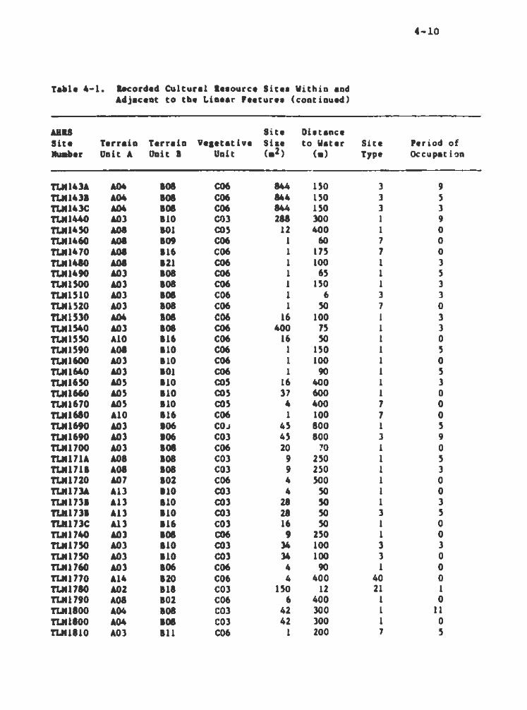
4-10
Table 4-1. a-corded Cultural le•ourct S i te• Wi thin and Adjacent to tbe Linear Feature• (cont i nued)
ABU Si te Di atanc:e Site Terrai n Terrain Veaeut ive She to Water Site Period of Juaber Unit A Unit 8 Unit <•2) <•> Type Occupat ion
TUU43A &04 808 C06 844 150 3 9 TLII1431 &04 808 C06 844 150 3 5 TUU43C A04 808 C06 844 ISO 3 3 TIJU440 &03 810 CO) 288 lOO 1 9 TLIU4SO A08 101 cos 12 400 1 0 TLII1460 A08 109 C06 1 60 7 0 TLII1470 &08 116 C06 1 175 7 0 tLM1480 A08 121 C06 1 100 1 3 TLIU490 AOJ 108 C06 1 65 1 5 TLMUOO AOl 108 C06 1 150 1 3 TLII1510 AOJ 108 C06 1 6 3 3 TLM1S20 AOJ 108 C06 1 so 7 0 T1Jtl530 A04 108 C06 16 100 1 3 TLM1S40 AOl 108 C06 400 75 1 3 TLMUSO A10 116 C06 16 50 1 0 TUU590 AOI 810 C06 1 150 1 s TLM1600 AOl 110 C06 1 100 1 0 TLM1640 AOl 101 C06 1 90 1 s TLIU650 A05 110 cos 16 400 1 )
TLM1660 A05 110 cos 37 600 1 0 TLIU670 A05 110 cos 4 400 7 0 TLII1680 A10 816 C06 1 100 7 0 TLM1690 AOJ 806 COJ 4S 800 1 5 TLM1690 AOl 106 COl 45 800 l 9 TLII1700 AOJ 108 C06 20 :'0 1 0 TLM171A A08 808 COl 9 250 1 s TLM1711 A08 808 COl 9 250 l 3 TLM1720 A07 802 C06 4 500 1 0 TUU73A All 110 COl 4 so 1 0 TLM1731 All 110 COl 28 so 1 3 TLII17ll All 110 COl 28 so 3 s TIJU7lC All 116 COl 16 so 1 0 TIJI1740 AOJ 108 C06 9 250 1 0 TLM1750 A.Ol 110 COl 34 100 3 3 TLII17SO AOl 110 COl 34 100 3 0 TLII1760 AOl 106 C06 4 90 1 0 TLM1770 A14 120 C06 4 400 40 0 TLII1780 A02 118 COl 150 12 21 1 TLII1790 A08 102 C06 6 400 1 0 TLM1800 A04 108 COl 42 300 1 11 tLMliOO A04 108 COl 42 300 1 0 TIJU810 AOJ Ill C06 1 200 7 5

4-11
Table 4-1. .. corded Cultural Reaource Site• Within and Adjacent to the Linear Feature• (continued)
ABU Site Diatance Si te Terrain Terrain Yeaetathe Sin to Water Site Period of lluaber Unit A Unit I Unit ( a2) ( a) Type Occupat: ion
TLM1120 A09 117 C06 4 so 1 0 TUUIJO A04 101 COl 1 250 1 0 TLM114A AOI 110 COl 93 300 3 5 TLM114A AOI !10 COl 93 300 l 9 TLM1141 AOI 110 C03 93 300 3 l TLMliSO All 101 C06 100 800 l 0 TlJU860 AOI 110 C06 35 30 1 3 TlJUI70 A09 110 C03 16 20 l l TLM1110 AOJ 110 C06 4 20 1 3 tUI1190 All 110 C06 300 150 1 3 TLlC1900 A04 108 C06 12 402 1 5 TUU910 AOl 101 C06 1 100 7 0 TLltl920 AOl 121 C06 1 700 7 0 TlJU9lO AOJ IOl C06 4 20 1 0 TUU940 A04 108 COl 9 95 1 0 TLM1950 AOI 101 COl 1 30 1 0 TUU960 All 123 C04 4 7 40 0 TLM1970 A03 IOl C06 1 45 7 0 TlJU910 A06 121 C06 1 50 7 0 TLM1990 A14 108 COl 46 100 3 l TLM1990 A14 108 COl 46 100 1 7 TLM2000 A09 109 COl 4 150 7 0 TUI2010 A04 108 COl 4J 16 1 l TLM2020 A09 117 COl 4 147 7 5 TLM2030 A09 110 C06 40 58 1 3 TLM2040 All 116 COl 4900 50 21 1 TLM2050 A14 1110 COl 1 40 7 0 TLM2060 A02 117 C06 15 1.50 7 l TLM207A A06 101 COl 35 200 1 11 TLM2071 A06 101 COl l5 200 1 l TLM.201A AOl 110 COl 4200 400 1 0 TLM2011 AOl 112 C06 6 800 1 0 TLM208C AOl 127 C06 .s 400 1 0 TLM2090 A05 110 COl 24 400 1 l T'I.M2100 A05 110 COl 8 150 1 l TLM2110 AO.S 110 COJ 4 90 1 3 TLM2120 A09 118 C06 96 7 21 1 TlJI21lO A05 121 COl 4 20 7 5 TLM214A AO.S 121 C06 4 900 1 0 TLM2141 A05 121 C06 12 900 1 l TLM2150 A08 110 COJ 52 500 5 3 TLM2160 A08 110 COl 27 60 3 5 •

4-12
Table 4-1. Recorded Cultural leaource Sitea Within and Adjacent to tbe Linear Feature• (continued)
AJIU Site Distance Site Terrain Terrain Ve1etative Siae to Water Site Period of Jluaber Unit A Unit 8 Unit (a2) (a) Type Occupation
TLN217& &03 1101 COl 22 400 3 5 TLM2171 AOl 1101 COl 22 400 3 l TLM218A A08 810 C06 12 300 1 0 TLM2188 &08 810 C06 1 275 J 5 TLM21~~ &08 821 C06 20 60 1 0 n.~UOA A03 1109 COl 145 400 l J .11Jt2208 &03 809 COl 145 400 1 ' TLM2210 A08 1108 COl 28 150 l t
T'LM222A A08 121 COl 87 15 3 TLM2221 &08 1121 C06 511 250 l . .. TLM222C A08 1108 C06 4 300 3
,, ·' TLM222D A08 810 C06 36 250 l • TLM2221 A08 121 C06 4 250 40 )
TLM2230 A08 112 COl 40 1.50 l )
TLM2240 A08 1110 COl 16 400 1 3 TUtU5A . A08 1110 C03 31 75 3 ~
TLM2251 A08 810 C03 31 15 l 3 TLM226A A06 108 cos 58 15 l .5 TLM226A A06 808 cos 58 15 l 3 TLM2261 A04 809 cos l2 250 3 3 TLH226C A04 1108 cos 16 250 l .5 TLM2.26D A04 808 cos 16 250 3 3 TLM2261 A04 808 cos l2 250 l 3 TLM226P A04 808 cos 16 75 7 0 TLH2270 A06 1110 COl 4 30 1 3 TLM2f80 A14 1110 C06 4 5 1 5 TLM2290 A09 108 C04 24 100 3 5 TLM2l0A A09 1117 C04 66 175 1 ; TLM2301 A09 817 C04 66 175 10 l TLM2l10 A08 801 COl 19 50 3 • TLM2320 A09 117 COl 4l9 75 3 :I TLM23JO A09 117 C03 4 30 40 :I TLM234A A07 102 CO:> 104 100 l :. TLM2341 A07 1102 cos 56 125 3 TLM235A A08 102 COl 12 200 1 (
TJJt2351 A08 101 COl 26 150 1 G TLM235C A08 802 COJ JJ 100 40 3 TLK2360 A08 101 cos 30 300 1 l TLil2370 A08 116 C03 4 10 7 l TLM2J80 A10 116 COl 26 5 40 3 TLM2390 A10 816 C03 12 50 1 0 TLM2400 A10 816 COl 314 20 3 3

4-13
Table 4-l. lacorded Cultural leaource Si t•• Wi thin and Adjacent to the Linear fea t ure• (cont i nued)
ABU Site Dhtance lite Terrain Terrain Veaeut i ve Si u to Water Site Period of "-ber Unit A Uoit I Uni t <•2) <•> Type Occ:upat i on
TLM2410 AlO 116 COJ 4 100 1 0 TLM2420 A09 117 COl 49 75 3 3 TLM2430 A06 101 COl 4 150 1 0 TLM2440 A08 101 COl 4 200 40 3 TU124SO A04 108 C06 1 200 1 0 TLM246A A07 101 co.s 4 100 40 .s TLM2461 A07 101 cos 4 100 1 3 TLM2470 A02 ll7 cos .592 90 l l TLM2480 A07 116 cos 25 10 27 l TLM2490 A09 117 COl 24 10 3 3 11.M2500 A02 118 C06 2 6 l l tLMUl O AlJ 110 COJ 17 100 J 0 TLM2S20 A07 116 C04 2.5 10 l 3 TLMl.SlO A07 116 C04 4 10 3 3 TLM2.S60 AlO 118 COl 6 80 3 l 11JtZ570 Al4 111 C05 4 100 5 l TLM2510 A10 116 cos 12 8 40 l TLN2.S90 A02 118 cos 123 10 1 3
TYOOOJO AOl 119 cos 2000 lO 15 1 nooo6o AOl 119 cos 3 90 7 0 TY00140 A09 117 COl 700 800 s 3 TY00170 A02 118 cos 800 90 21 1 TY00240 A09 117 C:04 37.5 .so 1.5 3 TY002.SO A02 118 cos 300 800 26 1 TY00260 A09 117 cos 4SO 0 2l 1 TY00270 A09 117 cos 250 0 2l l TY00280 AOl 119 COl 300 800 26 l TY00290 AOl 119 COl 2SO 1000 26 1 TY00310 AOl 119 COl 4.50 0 2l 1 TY00340 A09 117 COl 1500 20 15 l TYOOl.SO All 121 C04 800 25 5 3 TY00370 AOl 119 cos 60 40 21 1

4-14
OUr objective in researching the existing cultural resource cSata b'\ae was to 9ather aite-·apecific inforaation regarding enviro~ntal cSata, site alae, distance to water , site function, and period of occupation. Aa discussed later in Chapter 5, due to the uneven quality of recorded inforaat1on, bivariate rather than aultivariate factor analyaia would be uaed on the coaputeriaed data. Therefore, seven key variable• were selected to be recorded for each site. By liaiting the nuaber of variables, the resulting factors and the subsequent aodel would be aa clear and concise aa possible. Tbe .. thodoloqy for recording theae variables is diacuaaed below.
The f irat variable we aought for each ai te vas the topographic association. The Terrain Units and Terrain Unit aapa, aa discussed in Chapter 2 and Table 2-1, were the ideal unit• for describing the UAM and 110at other aitea and the beat docu .. nts. for use in illustrating the topographic intoraation. Th•r•fote, UAM sites were easily transferred fro• a set of liaited circulation, 1••1 aile Cla63,360) •P• prepared by UAM to inundation area Terrain Unit aapa. Transfer of ABRG site locations from 0808 -P• to the Terrain Unit mapa vas alao straightforward. Th••• data were then recorded and coded aa Terrain Unit A.
On the basis of site narrative and alta form review, a second variable was selected. This variable was labelled Terrain Onit a, and consisted of on-site ~baervationa by site recorders . ... refer to th••• aa intuitive Terrain Units, since they were rarely defined and represent localised observation• (Table 4-2).
This variable vas 110at useful if questions arose aa to si t e location a.ong one of two or .are adjacent Terrain or Vegetative Units. Because these observati ons were made usi ng very localized inforaation, Terrain Unit 8 could not be reconstructed on Linear Peature aapa and, therefore, was not used in the predictive model develop~~ent.

Table 4-2 Terrain Unit 2a Intuitive Terrain Onita
-rerrain Unit .,.
81 12 13 14 85 86 87 88 19 110 Ill 112 Ill 814 815 116 817 818 8lt 820 821 822 123 824 825 826 827 828
oeacription
Ridge Bench on ridge Slope on ridge Bedrock ridge Plateau on ridge Knoll on ridge Baker 1 ... ata.e elope Knoll Knoll alope Bench on knoll Knoll on 110raine Knoll on bedrock Knoll on eaker Alluvial terrace Plood plain terrace Plood plain Moraine Bedrock outcrop-bench Plain (Glacio-lacuatrine) Low ridge on lacuatrine plain Broaional aluap River confluence Lakeahore Lake outlet Bnd of ridge Tailing•
4-15
The third variable recorded waa Vegetative Unit. These we[e alao preaented and diacuaaed in Chapter 2, and defined in Table 2-3. Again, baaed on locational data from the UAM report• and
the USGS •P• aupplied by ABRG, thia inforaation was easily plotted an Linear Peature and inundation area general vegetation .. pa, and then data recorded aa Variable C on ca.puter aheeta.
Site aiae, the fourth variable, waa recorded for each site on the baaia of aurface or aubaurface units recorded by the

4-16
inYeatigatora. Onl y do<:uMnted aite waa recorded, rather than Mai.. potential aiae baaed upon the topographic feature on wbicb a aite waa located. Several aitea recorded i n the ABRS filea did not bave alae indicated. In auch caaea, thia var iable waa coded aa aero.
Diatance to water, the fifth var i able , vaa generally eaay to obtain fro. the UM aite narrative• or by uai ng accoapanying Mpa. With the ABRB aitea plotted on USGS mapa, diatance to water waa alao eaaily recorded.
Si te type claaaification, the aixth variable, waa based on the aeriea of definition• preaented below. Site deacr i ptions were re•iewed for key it... aucb aa preaence or abaence of featurea, typea of feature• preaent, and types of toola or tool aaaeablate• preaent. Por aultica.ponent sites, it was possible that sit e function aight be d i fferent for each level or locus: tbua , each of theae caaea waa coded on a aeparat& line.
Period of occupation, baaed primarily on the cultural chronology preaented by the OAM, waa the final variable recorded. We opted for thia chronology becauae the majority of available data ia coded from UAM aitea. Aa diacuaaed in Chapter 3, the culture hiatory of the atudy area ia extremely confusing, at leaat as it ia generally expressed in the literature. Aa stated, classification of cultural tradition on the baaia of preaence of microblade• or aide-notched pointa is an overaimplif ication and probable aiarepreaentation of caaplex data . However, our applica
tion of thia chronology through Phaae 11 field work may serve as a teat of ita value.
ror a nwaber of aitea, more than one period of occupation waa docu-nted. Bach component waa coded as a separate case where all inforaation aight be identical except for the period of occupati on. Placeaent of aitea within t he chronoloqy waa done on

4-17
the basis of diagnoatic artifacts, radiocarbon dates, or, for a large nWiber of the UAM sites, presence of one or .ore dated, visually distinct ash lenses. Finally, Chapter 8 of the UA.M 1985 final Report presents a su..ary discuasion of occupation through ti .. , with su..ary tables of chronological clasaification of sites, which also was checked for usable inforaation .
To extract data froa the AIIRS files, ABRG began by plotting the Linear Features on USGS 15 • quadrangle .. pa . Because AIIRS aaes a latitude and lon~1tude coordinate system, ABRG defined broad corridors of latitude or longitude to include the Linear reatures (sH Appendix A, attach .. nt A>. Using a co-.puter printout of AIIRS files, all sites within the defined corridors were plotted on the USGS aapa. The assu•ption was that MRS coordinates were accurate, but the plotting indicated that errors existed, auch a r; railroad-related features having coordinates a aile or .ore from the railroad.
There were, however, several cross-checks for this potential source of error, including reference to the original source of docu.entation cited in ABRS and USGS maps Cl:250,000 series ) on which Division of Geological and ~eophysical Survey COGGS) personnel have plotted ABRS inventory listings Cwith an eye toward correcting obvious loeational errata). Certain isolated sites reported in AKRS .. y have fallen through the •safety net• due to inherent errors in their locational descriptions, but these should be very few.
An additional problem with the ARRS inventory was that references are cited only by author and dates, with no description of the title, place of publication, or depository for unuscr ipt sources. Locating some of the JDOre obscure unuscr ipts proved to be quite difficult. In some caaes, these bard-to-find references, once found, turned out to be a personal coaaunication with no specific site information CCook 1975b), or

t-18
very bTief narrative• lackinq aoat ua ble data auch aa aite aiae (IOlM8 l975a).
Deapite the AIIRS inv&ntory' • inherent probleaa, ABRG reaearcbera fHl confident that all prehiator ic aitea that have been reported in the area are liated and aourc e documentation ia identified. Much leaa confidence ia placed on the reliability of the ABRS inventory in id&~tifying hiatoric aitea, baaically becauae biatoric aitea have aelda. been treated conaiatently in cultural reeource inventory projecta. In addition, aoat biatoric aitea liated in tne AIIRS filea have been taken directly froa Orth'a 1967 Dictionary of Alaaka Place Nallea, which generally has li ttl• or no uaable detail, and no ground truthing baa been undertaken to check locational or aite integrity i nformation.
t.l a..i .. of Data loarcea
Aa Mntioned above, the OAM report• (Dixon et al. 1981,
1912, 1913, 1984, 1985) were the aource of the majority of availabls data for developing the current predictive .odel. Data needed to code all variable• were presented either in the aite narrative• or in project area .. pa. Once the draft• oi Chapter 8 and Appendix D for the 1985 report were received, the early report• generally were not uaed. In conversations with B. James Dixon and George Smith, co-inveatigatora of the UAM project, it waa learned that ac.e reviaiona of earlier site narratives had been •de in preparing the 1985 Pinal Report. Chapter 8 and Appendix A lack conciae au.ur iea of var iablea auch aa formal Terrain Onita, Vegetative Onita, and distance to water, although intuitive Terrain Onita are su ... ri~ed (Dixon et al. 1985:Table 8.18, Bnvironaental Setting), aa are periods of occupation <Dixon et al. 1985rTablea 8.19-8.23> .
Data preaented in Appendix C of the Intertie Report <Bacon et al. 1983) were eaaily coded into our format. Although aite

4-19
aiae was spec if iecl on ai te forma, additional interpretation of site data would have been enhanced with the presentation of indivi~ual site aapa for all aitea .
Aa -ntioned previously, the inforaation froa the ABRS site files was variable in quality. Part of this variability ia probably due to the way original inve•tigatora recorded aitea and aubaitted inforaation to ABRS or OGGS. However, there are reports available for individual aitea such aa Carlo Creek (Bowers 1980) and Dry Creek <Powers et al. 1983) which present in detail inforaation for the variables we were recording. Pinally, it should be -ntioned that several cultural resource survey reports (Plaskett 19761 Reger 1980, 1983) a lao present usable site inforaation in narrative form or in appended site forma.
t.t Site fYpe DefiDit10D8
4.4.1 Prebiatoric/8tbDobiatoric Sitea
Typea of aitea are diacuaaed in teras of maintenance va. extractive taaka <Binford and Binford 1966:291-292) . Maintenance taaka pertain to the fulfillaent of nutritional and technological require .. nta of the group, whereas extractive taaka involve the direct exploitation of environmental resources. Both categories represent aapecta of primary goal fulf i llment (Jochim 1976>.
It has been suggested (Binford nnd Binford 1966:292 > that .. intenance activities occur at base camps •selected principally in te~a of apace and shelter regulations of the residence group.• These base camps coapare to Jochim's <1976> immediate aettl ... nt locations, to which he added water, fuel, and a view aa determinants.
Extractive taaka, on the other hand, involve work C)roups rather than the entire band and the locations are determined by
•the distributions of resources with i n a territory• (Binford and

4-20
Binford 1166a211). The 1i te1 of thee• extractive ta1k1 confora to general reeourc• exploitation location•, ae preeented by Jocbia.
Recorded 1ite1 in or near the etudy area, ae well as 1i te1 referenced in the ethnographic literature, have been categorised according to tbe Mjor activity repreeented, baeed on known or anticipated cultural Mter ial and/or feature•. Aa can be •••n froa tbe diacueeion of lite type1 preeented below, there i1 not yet eufficient data in the ethnographic and archeological literature to fully define each lite type. Aleo, there i1 eaae overlap of activitiea fraa one type of eite to another. The eite type• preeented repreeent an anticipat4td range, although not all of theee type• bave been docu.ented archeologically.
t.t.1.1 LoDI Ter. OCOUpatioDa
Por purpo••• of thi& etudy, long tera occupation• or villagel are defined ae location• at which both .. intenance and extractive taaka took place. Diatinguiahing character iat ica of village• are the aise and variety of activities repreaented. The degree of variability depend• on whether the eite wae ueed for .are than a eingle aeaaon, and/or over a period of yeare.
lthnographic inforaation froa the three Athapaakan groupe living within the atudy area inc:licatea that the location• of village ·aitea, aa well aa kl nda of activitiee diatinguiahable in an archeological context, will depend upon the econa.ic orientation of the local band occupying a apecific area. Although it ia recognised that ethnographic data ehould not be uaed aa a model for tbe entire prebiatoric period, the following diacuaaion concerning likely archeological reJU i na from long term occupation aitea i1 probably applicable to at least the last 1,000 yeare .
Archeological reJUina aaeociated with winter villages in Tanaina territory My conaiat of house pita -- the remains of

4-21
large, aeai-.ubterranean, log atructurea with attached aweat
bouaea. Theae aitea alao .. y have the re .. in• of aeparate
atorage atructurea or cache pita . Winter village• tended to be
located on tbe .. jor tributariea of the Suaitna River or on the
aain river it@lelf, ao.eti•• along the edge of a bluff or in a
bi4den, defenaive poaition, and alwaya adjacent to a good fuel
aource. Poet-contact village• contained aaaller housea built
above-ground, but a till •de of log a with aide a blanketed wi tb
earth. Poat-contact aweathouaea were built aeparate fro• the
aain dwelling . A variety of atorage atructures and cache• alao
aay be found in poet-contact winter villagea.
Winter aubaiatence conaiated of dried and stored product•, auppl ... nted by freahly killed ga .. Cbear, mooae , porcupine,
beaver) and f iah . A wide variety of tools uaed for hunting,
butchering, and proceaaing freah fooda may be expected to occur
in winter village aitea. Activities auch as hide preparation,
and clothing and iaple .. nt manufacture (i.e., showahoes) also
ahould be repreaented in archeological assemblages from such
aitea.
Spring and aummer fish campa may be considered long term•
occupation aites, in that groupe of people apent a good part of
their aubaiatence year at apecif ic localitiea, and returned to
the aa.a location• year after year. Piah campa were located on
clearwater tributaries of the major rivers, often near lake
inleta. Aaong the Tanaina, fiah camp houaes were smaller than
winter dwellinga. Theae houses may have been of two typeaa bent
pole atructurea covered with bark strips COsgood 1976) or amall,
above-ground, log and aod dwellings (Townsend 1981). Separate
aweathouaes, cache pita, storage platforms, and drying racks also
were located at fiah campo .
Activities represented i n the archeological record at such
aitea would be more restricted than at winter villages. Rere,

the prlMr'( act i vity was catching and processing of fish. Specialia•d tools, i~l ... nts, and structures Ci.e ., weira , baaket traps, dip nets, drying racks> would not gener ally preserve well. IIIIPl ... nts such as •u1u• knives, used for Bplitt i ng fish, and fish spearheads would be .ore likely to be f~und i n these sites. Secondary subsistence activities that .. y be represented would be
gather iD9 aDd processing of vec,etable foods and other product a, and .. intenance or repair of toola and clothing.
Within the territory of the Lower T•nana, winter villages .. y contain the r ... ina of do .. d structure&, .. a. by laying tanned bides over bent pole fr ... s anchored in the ground. Also, .. parate ... atbousea, storage structure&, and cache p i ta .. Y occur . Tanana winter villagea tended to be located in upland areu, near the tiaberline and the location of caribou fences.
Villages sites were selected for their proxiaity to water an.i fuel sources, as well as traila and other travel corridor&. Like the Tanaina, winter subsiatence was baaed upon dried food sourcea suppl ... nted with fresh foods. The range of activities repr.. nted i n the archeological record for :'anana winter villages would be si~lar to those fro. the Tanaina area.
In tbe spring, the Tanana moved from thei r upland camps to the lowlands, to hunt a variety of mammals and birds. With the beginning of the spring salmon runs, fish camps were established on clearwater tributaries of the Tanana River near lake outlets, where they r ... ined foa. .oat of the auiiiiMr . SWiller dwellings were bark-covered buts, vi th separate, bent pole sweathouaea. Dryin9 racks, and storage pita and structures alao would be found at these caiiiPS. Tbe acti vities and art i facts repreaented at Tanana fishing caiiiP• would be similar to thoae diacussed for the Tanaina .

4.4.1. 2 lbort ~•r. OCCUpatloaa
Short tera occupation• or campaite/ temporary habitation aitea are alao localit iea where activitiea f ocua on uintenance taa , . The variety of activitiea are either leaa intenaively car~ied out or fewer in number than at the village sitea . Theae abort tera occupation• are more likely than village aitea to be
aasociated with a particular extractive acti vity in the general area . Purtbermore, theae aitea ahould show a seasonal rather than year-round uae pattern.
The Upper Inlet Tanaina, the Lower Tanana, and the Western Abtna all uaed abort term occupation sies during different phases of their aeaaonal round. Tbia ia eapecia1ly true of the Western Abtna, who were thought to be more nomadic than either of the
otbet two groupa, due to a lack of reliable, concentrated reaourcea. In western Ahtna territory, short term occupation sitea
•Y include the remains of loq and sod houses, double lean-toa .. de of bruab with bark roofs and sides, and dome-~haped sweatbouse• .. de of polea or saplinga covered with hi des (de Laguna and McClellan 198lr645). Activities represented in the archeological record would depend upon the reaource being exploited. weapona for killing animal• or fiab and processing implements as well aa evidence of manufacture and/or repair of tools may all be
found at short term occupation sites. Paunal remains recovered fro. such sitea would probably be restricted in species composition, reflecting specific procurement activities.
The temporary dvellinga of the Tanaina included semispheroid, bent pole lodges covered with b4rch bark strips; leantOll akin tipis7 and alder brush shelters -- the latter built in areas above the timber line (Osgood 1976; Townsend 1981). The double lean-to 111ade with poles was used by the Tanana in transitory hunting campa (McXennan 1981) . Sweathousea would not be found in temporary camps. However, depending upon the duration

4-24
8114 purpoae of tbe atay, the r ... .ina of cache pita or alevated
atora9e atructuru aay be located. Tbe type a of act i v l t i ea and
biotic r ... ina repreaented archeollogically would be ai•ilar to
thoae diacuaaed for the Ahtna . It ahould be noted that natural
aheltera, auch aa cavea, probably would have been uaed by .oat
abori9inal groupe for abort ter. habitation aitea.
t.4.1.3 L&rt• Mann·l Kill aDd ProeeaaiDg Site•
Kill and proceaaing aitea generally refer to locations where
80re tban one or two large .. .-.la have been diapatched and/or
aubaequently butchered. Generally, aggregation of apeciea due to
topographic conatrictiona (i.e., narrow valleya> or other natural
cauar.a ia needed in order to conduct large kill a. The tendency of apeciea •~oh aa caribou to gather at certain times of year or
to follow a eonl i ltent route of travel ia very conducive to con
ducting .... kil a. With caribou-aiaed ma ... la1 killing and pro
ceaaing of c•rca•••• can be carried out at the aame location if the nuabera of kil l ed aniaala ia not too great. Processing would
include akinninq and dividing the carcaaaea into easily trana
ported .. at package• and other uaable iteaa. If large numbers
are invol~ed, a aecondary proceaaing alte for boning and drying
.. at, ainew r-.oval, and initial cleaning and drying of hides may
be aelected to avoid attracting carnivores and insecta. General
ly, tbeae activities are ex.tractive in nature. However, certain
•intenance taaka auch aa tool reaharpening 1 tool replacement 1
and food preparation would be perfor•ed to meet immediate needa.
Peaturea aaaociated with kills would include natural or
con~rived trapa or conatrictions. Natural traps would include
box canyon• or cliff a. However,. conatr ictions along reqular
aigration routea, or aven lakes, could be used as effectively as
trapa. Contrived trapa would be fences and canals, such as used
in caribou hunting (Osgood 19761 McKennan 19811 de Laguna and
MCClellan 1981 >. caribou fencea in the study area were

·-25
eonatructed near tree linea and cona iated of loga laahed to atanding tr .. a, or fr .. -atanding fencea which would leave little evidence after they decoapoa~~ . The pri .. ry evidence would have to ~a layer of bone at the aite of the kill.
Cultural .. teriala at kill and proceasing aite~ would include projectile pointa, knives or bifacial butchering tools, acrapin9 toola, and poaaibly ha..eratonea and anvil atonea for bone .. rrow and greaae extraction and preparation.
4.4.1.4 Litbic Materi al Sites
The range of aite typea included under this beading includes lithic quarry or procure .. nt aitea, lithic workshop• or chipping atationa, and generalized lithic acattera.
Lithic quarry or procur..ent aitea are located at or ad j acent to lithic raw .. terial aourcea auch as rock outcrops or re4epoaite4 lenaea of gravel or cobbles. Taaka include the extraction of raw •terial fro. ita aatrix and the initial tool aanufacturing atagea (i . e., preparation of blanks and preforms). Theae aitea generally contain unused or teated and discarded pieces of raw .. terialJ large amount~~t of primary reduction debriar aame frag .. nted corea or bifacea broken during early stages of manufacturer manufacturing toola such as hammeratones, and poaaibly digging paraphernalia such aa antlers.
A lithic workshop or chipping station, located further from the aource than a procur ... nt aite, contains lithic manufacturing debris, including primary and/ or aecondary reduction debris, biface blanks, corea, broken or rejected tools, and manufacturing tools aucb aa ha..erstones. Morn or resharp~ned tools are generally not present. Lithic workshops are considered to be
extractive in .l•tture because of their task-specific nature and, generally, the!r location near a lithic raw material source. The

4-26
.. jor difference bet ... n a lithic workahop and a lithic procure
.. nt aite ia that no aource .. terial ia preaent at the workabop.
A alte contalnl09 liaited a.ounta of lithic debria and .J
41A9Doat1c toola la categori1ed aa a lithic acatter. Such aitea .. y repreaent llaited tool unufacture and/ or .. intenance, or they .. y repreaent .are ca.plex activitiea froa which functionally 4iagnoatic toola have been carefully r..aved and curate4.
c.c.1.5 Iao1at ..
Iaolatea are cultural reaourcea that are liaited in content and bave no contextual inforaation through which to evaluate their place in the prehiatory or biatory of the area, other than intr inaically. Strictly apeaking, an iaolate ia a aingle itea
wbicb .. y have been loat or diacarded and ia not aasociated with any other cultural .. terial.
C.C.1.1 CAcbe Pit lit ..
Cache pita were uae4 by the Athapaakan inhabitant• of the atudy area for abort tera atorage of .. at, fiah, or other iteaa. Another kind of pit, which aay reaeable a cache pit, ia a pit dug at or near fiah caapa in which fiah were placed for fermentation. Theae pita were located along trail syatema and adjacent to trap linea, aa well aa in occupation sites.
c.c.1.7 cairu
Cairn• are aiap1y piles of rocka . Antiquity and integrity of calrna are aaaeaaed on the baaia of whether or not they are aodde4-in or lichen-covered. Cairna served a variety of purpoaes prebiatorically. Reflecting this variety, ao.. cairna have cultural debria or other features aaaociated, whereaa others are iaolated occurrencea. Cairns are preaWMd to have served as

4-27
.. xkcra for traila, ca.pa i tea, and bur i ala . Within ca~a , cairn•
.. , have Hrved functional purpoaea auch aa .. rkir.g a .. at cache or a atorage pit. cairn• aay have been erected to co .... orate an iiiPOrtant place or event. Finally, aligrutenta of cairoa aight bave been uaed to fora drive lin•• in aaaociation wlth kill aitea. Drive linea generally begin where bard gathering can take place, and gradually narrow aa deatinati on is approached . T~
deatination ia either a topographic break or aome fora of iiiiiPouncment.
•.4.1.1 aurlala
Tbe ethnographic record indicates that the Athapas•an groupe in the atudy area cr ... ted their dead. Tb~s practice uaually took place out aide of the village or caiiiiP. !Jowever, aa.eti-• the atructure in which a peraon died vaa burned along with the body (de Laguna and McClellan 19&1 ) . Generally, these c r e .. tion aitea were .arked in ao.a manner, such as with a smalJ fence or pole, and tbe aahea and reaaining bones of the dead ••re either collected and buried or kept by relatives of the deceased.
Diapoaa1 of the dead by earlier prehistoric peoples may include both inhumation and cr ... tion. At this point, 10 aaaociationa can be made between different cultural periods aad specific practices, beyond tbe Protohistoric Period practice of cremation by Atbapaakan groupe .
•••• 1 . 9 Platographa
Pictographs have been found in the Tanana Ri VItr valley (Giddings 194l z69) aa well aa the Lover Cook Inle: (Osgood 1976:118>. Tbe Tanana River valley pictograph• cnnaiat of anthropo.arphic figures from 4 to 25 i nches i n height, crawn with red pigaent. SOlie of the smaller human figures are contained within a double-ended boat. The figures were p6 : n·:ed on a
,

4-28
aootb, aligbtly \uxterhung, rock face 20 feet high and 50 feet loft9, on a bluff above the confluence of of the Tanana River, 18 ~lea ... t 1941• 19). The pict09rapha reported by
Mooae cr .. k and a alough of Pairbanka CGiddinga O.good C 1971 > include a
acbool of fiah, a .. n ahooting a bow, a foa, a aea lion, and a belQga whale. All are drawn in ~niature Cl inch to 1.5 inchea ) with red pig•nt. The figures are located on the walla of a ~hallow rockabelter on Bear Ialand in Bear Cove, Kach ... k Bay, in the lower part of Cook Inlet COagood 1971 all8 >. The origin of the pictograph• in both areaa ia undetermined. They Dilly have been .. de by Atbapaakan groupe, by earlier, non-Athapaakan realdent population•, or by P.ople who uaed the area infrequently Ci .e., the lakl.a> .
4.4.2 llatorlc Site ~,..
4.4.2.1 IAdiYldaal Bul141D9• or Structure•
The 110at likely iaolated hi a tor ic atructurea to have been built in the atudy area are the ahelter cabin• which were eatabliahed by the Alaka Road Ca..iaaion at approximately 20-mile intervale along winter traila . They were uaually 12xl4-ft., oneatory atructurea. Moat of the available information indicate• that there are very few reuining . Moat were abandoned in the l920a, and the lack of maintenance, coupled with the effects of che aevere cli .. tic conditione, have probably reduced moat of the cabina to foundation re~~Aina or collapaed atructurea . However, re.aina of thia a i te type atill could be located i n the study area.
Log cabin• built by individual trappers and/ or miners alao may ~cur ~ Theae structure• might be located along a trap line uaed ~hrough the trapping aeaaon or adjacent to mineral claima a paraon or persona might have. Same mi ners trapped in the winter, thua, cabin• might have two functions. Actual i dentification of

4-29
trappiDCJ location• .. Y not be poaaible, and uae of a cabin for trappift9 purpoaea aight only be concluded if infor .. tion r~arding the occupant atill exiata .
4.t.2.2 &ailroa4-related litea
In addition to the Alaaka Railroad bed, there are related aite typea, which include railroad bridgea, atopa, the r ... ina of conatruction ca.pa abandoned after tion of the railroad in 1923, and tunnela.
t.t.2.l 7rail Syateaa
aeveral atation COiiple-
The Iditarod Trail ia the foremoat hiatoric winter trail in the atu4y area. However, other traila that branched otf of tbe I4itaro4 could be located during the field aurvey .
4.t.2.t liatoric Ca..uaitiea
Moat of the hiator ic coaaunitiea located within the atudy area are related to the conatruction of The Alaska Ra.ilroad. Other ca.aunitiea were related to gold-mining activity in the Pairbanka region, including Bater and the auburba of Pairbanka, and coal mining in the Healy and Lignite Creek area.
4.t.2.5 ~aiag litea
There are a number of mining sitea that could be located within the atudy area. Moat of theae aites will be located near Pairbanka, in the vicinity of Bater. The typea of sites conaist of reaidential and co-ercial atructurea1 dredgi"lg operational lode-aining operational and attendant facilities such as stamp ailla, cyanide and araenic proceaaing planta, and various types of mining equipment .

4-30
t.t.2.1 &Ylatloa litae
~be current OSGS topo;raphic .. P• of the atudy area indicate the greaence of a nuaber of private landing atripa along the Suaitna River that .. rve outlying diatricta. It ia not poaaible to deter.lne exactly when tbeae landing atripa were conatructed, but the uae of airplane• aa a priM.ry •ana of tran•portation began in tbe late 1920a. The earlieat of tbeae aitea could be of biatoric iaportance.
4. 5 •••• -.ry of Data ....
Aa -ntioned, a total c. 476 caaea r ep.reaenting 398 aitea we.re recorded fr011 aouthcentral Alaaka, on or near the Linear Peaturea or within co.parable enviroDJMntal aettinqa. The data recorded for the aeven variable• deacribed above have been aubjected to factor analyaia, aa diacuaaed below. Theae data, which are preaented J.n raw fora in Tabl e 4-l, can be au-.rized aa followa (~able 4-l). Detailed d i acuaaion and interpretation of tbeae data are preaented in the next two chaptera.
Table 4-3 S~ry Site Data According to Subdivision• of
Variablea Recorded from Site Descripti on• cK • number of caeea>
Terrain Terrain Vegetative Si te Size Distance to Onit On it Onit water -- - - a2 -A n 8 n c n n ID n
Al 3 IU 51 Cl 25 0 24 0 9 A2 15 82 7 C2 10 l 57 1 3 A3 78 83 8 C3 173 2 3 A4 40 84 2 C4 18 3 4 3 3 A5 31 85 6 C5 71 4 49 4 2 A6 19 86 10 C6 155 5 4 5 4 A7 25 87 • C7 11 6 7 6 2 A8 67 88 65 c8 13 7 1 7 3 A9 60 89 7 C9 0 8 8 8 3 AlO 19 810 78 9 7

4-ll
t-able 4-l. ••znnry lite Data Accordiog to SUbdiviaiona of Variable• aecorded frc:. Site Deacriptiona <continued)
'l'errain t-errain Vegetative Site Siae Diatance Unit Unit Unita to water - a - .2 - -A n n n • n
All 7 Ill 2 10 6 10 ll Al2 9 112 4 12-20 41 12-20 l4 All • Ill 4 21-lO l5 21-lO 26 Al4 ll B14 l 31-40 22 l1-40 18 A15 1 815 1 41-50 18 41-50 ll A16 I 116 37 51-60 13 51-60 10 Al7 0 117 59 61-70 4 61-70 9 All 10 Ill 13 71-10 10 71-80 10 Al9 22 119 21 81-90 3 81-90 16 A20 7 120 12 91-100 20 91-100 49 A21 I 821 41 101-150 17 101-150 l6 A22 2 122 • 151-200 24 151• 200 28 A23 1 123 2 201-300 27 201-300 37 A24 3 124 5 301-400 16 301-400 41 A25 11 125 2 401-500 6 401-500 12 A26 1 126 5 500-1000 17 500-1 , 000 64 A27 1 127 5 1001-2000 10 1,000- 2,500 11 A21 1 121 11 2001-10,000 17 A29 6 10,000-240,000 4 A30-
31 0 ----- ----- ----- ---t-otal a
476 476 476 476 476

4-32
~able t-3: tvnn·ry Site Data According to SUbdi via! ona of Variable• aecorded fraa Site Deacr i ptiona (continued)
C.,ater Code
1 2 3 5 7
• 10 15 21 22 23 24 25 26 21 21 29 31 40
Daacription a Protolliator ic:/Hiator ic
Chipping atation/litbic ecatter li11 aite/proc .. aiog aite ca.paite/t-.porary habitation cacbe pit Iaolated atone tool or flake lock aliga.ent/cairn Burial Village llatorlc buildiog/atructare IDftu.ent/~tery
lai1road br ldge lailroad atation lallroad tunnel towr Mining ca.p and operation ftail Inac:rip~ion
lecent ~litary activity Diaturbed beyond rec09nition
Total
11\Uiber of caaea
223 1
99 9
34
• 2 3
30 2
10 15
3 6 9 1 1 1
23
476

4-ll
Table 4-3. Snnrery Site Data According to Subdivieione of Variable• Recorded fraa Site Deecriptione (continued>
Ca.puter Code
1 3 5
' 7 9 0
Deecriptiona CUltural Chronology
Bietoric Period Athapaekan Period Late Denali Co~lex Arctic s .. ll Tool Tradition Morthern Archaic Tradition A8erican Paleo-Arctic Tradition Unknown
'l'otal
4.1 Oa.recor..S ~DObiatoric aDd lietoric Sitea
NWI.ber of caeea
78 122
40 2
10 11
213
476
Ae part of the reeearch conducted for cultural reeourcee along or adjacent to the Linear reaturee, BJtA staff and ethnograpic coneultante identified localitiee of aitea or potent i al eitee. The•e eitee ehow up in the ethnographic or hie tor ic
literature and .. nuecripte as location• of activit iea or atructuree which have not yet been formally recorded. In our reeearch, there w.re no comparable caeea for preh i storic sites . Therefore, the following discuesion will detail aourcee reviewed and preeent reeulte of the reeearch .
4.1.1 ~eDtlal athDobiatoric Sitee
The recent ethnographic literature for the etudy area was reeearched to locate potential ethnoh i etoric sites r definite but unrecorded ethnohietoric eite~J and resource uee areas which aight contain phyeical remaine of the native usere. The eources ueed include the Tanaina and Ahtna place names 1 i sta < Itar i and Jtari 1982J Jtari and Itari, Appendi x BJ J. lari 1983) and three

report• preaented in ttla 1983 USDA SUaitna River Baain Study caacon et al. 1982a, 1982bJ Reger 1978).
The fo11owin9 data regarding !thnographic aitea .ia keyed to the .Linear P•ture •P• CPig. 2-3). .~~•ilable deacriptiona and general location• fro. J. bri (in Bacon -=: al. 1983) are alao provided. Tbeae abould be considered aa aite l:''4• until they are .are fully recorded. Thea• aitea have the potential of alao being prehia~oricr however, location of prehiatoric ca.ponenta ~t the village aitea and aaaociation of prehiatoric aitea with the traila are n .. ded to confira thia.
Cl) l~hnographic Site 1 Cl-1) -- Red Shirt Lake Villagea. Karl statea, •At leaat three aeparate village• were located on Red Shirt Lakes one at the outlet, one on Lynx Creek, and one at the head of the lake• <Bacon et a1. 1983a25). The . .area waa uaed . intenaively early in the Biatoric Period on a aeaaonal basis because of the abundant lake trout and aal.JDon runa froa July to Noveaber. riah trapa were aet along the lake and it ia reported that houaea exten~ed continuously to Cow Lake, 1 ~le to the south.
(2) 1-2 -- OUtlet ~f Cow Lake Village. Many houae pita are located at thia early Hiatoric Tanaina village, but it waa ... 11er than Red Shirt Lake vi l lage. All the houaea are reputed to have been located along the east aide of Cow Lake outlet atreaa.
(3) 1-3 -- Opper Piah Creek. Karl atatea, •Thia ia the Red Shirt Lake outlet atream to Flat Born Lake. Many fiah are reported to be in this creek, and Indian houses uaed to be all along it• CBacon et al. 1983:24).
(4) 1-4 -- Trail along a low ridge from Plat Born Lake to Cow Land and on to Susitna Stat ion. The ridge

t-35
parallels a creek that flows into the north end of Plat
lorn Lake. The trail ayat .. continued on to Red Shirt
Lake fro. Cow Lake. The ridge, which ia only 3-t feet
tligb and approxi .. tely 200 yards vide, MY be an eater.
(5) 1-5 -- Lov ridge extending fro• cow Lake south to tbe
Little Susitna River. Thia ia an area where the
Suai tna River Athapaakana his tor ic:ally gathered birch
bark in the spring. In the fall, it vaa a reliable
aourc:e area for g ... , particularly bear. Tbia ridge
alao ia part of an intersecting trail ayat.. between
Suaitna Station and Knik Ani and the Red Shirt-Cow
Laku trail. Baaed on the description of thia ridge,
it .. y represent another eater.
(6) a-6 - Polly cr .. t Trail. Thia ethnohiat.or ic: trail
runa fro. the Susitna River to Red Shirt or Nancy
Latea. In tbe 19t0a and 1950a, Billy Pete extensively
trapped tbe area, which had an abundance of beaver.
Sites B-1 through B-5 are located on or near the Suaitna
Trana•iaaion Line, on Plate G-33 of the Linear Peaturea .. ps
(fig. 2-3). Site B-6 is on Plate G-lt of the Linear Features
ups .
•• ,.2 Poteatial Bi•toric: Site•
BRA utiliaed a nuaber of research aateriala to locate unre
corded historic: aitea within the study area. Initially, BRA
res•arc:hera conducted an extensive literat\lre search to locate
pri .. ry and secondary research ~Dater ials that would indicate the
presence of historic aites. These included, but were not limited
to, tbe followings
(1) u.s. Geological Survey Bulletins, Professional Papers,
water supply papers, and cartographic materiala1

4-36
(2) preYioualy prepared biatoric aurveya o! areaa adjacent to tbe atudy areaJ
()) biatoric cart09rapbic .. terialaJ and
(4) .. nuacripta and narrative• docu .. nting the hiatoric develo~nt within and adjacent to the atudy area.
1'beae reaourcea provided a broad fr ... work for an underatandiDCJ of tbe typea of biator ic reaourcea that a till •ight be
viaible in tbe atudy ar... However, becauae of the inexact loca~ional 1Dfor.ation for biato~ ic aitea on .. iatinq hiatoric aapa, tbeae are coaaidered to be potential aitea, to be watched for by cultural reaouree aurvey crewe in tha general vicinity.
After reviewing the reaearch materiala, BRA hiatoriana atudied aerial pbot09rapha of the propoaed hydroelectric project provided by Baraa-lbaaeo. Moat of the aeri•l photographs are fro. tbe 1910a, witb only tvo of tbe Healy area frc. 1949. The review of the aerial photograph• waa coordinated with the eaiatioq project .. pa and, whenever atructurea of any type were located within tbe centerline and right-of-way, they were added to tbe project .. pa and identified with a preliminary hiatoric aite nuaber. ~ile aaae recent atructurea, auch aa mobile homea, were eaaily eliainated, the aerial photograph• did not allow full acr .. ning of recent atructurea. The reaulta of thia review cannot be eonaidered to be concluaive. However, it can provide a fr...work for tbe actual field aurvey for hi a tor ic re•ourcea along tbe project eorr1dor.

4-37
Plate Q-J Q
(1) Biatoric Site 1 CB-1> ia an L-ahaped atructure approxi.. tely the SBt NWt of Section 20, Tl4N R2W,. about t aile aouth of the railroad tracka .
<2> a-2 ia located in the NWt NBi of Section 23, Tl4N R3W. It appear a to be a covered, round, a tor age facility, probably an oil atorage facility or poaaibly a treat.. nt plant for sewage.
<3> B-3 ia located in the NWi NWt Nli of Section 23, Tl4N R3W. The tranaaiaaion line paralle ls what appears to be an exiating right-of-way for a pipelihe . The rightof-way haa been cleared to a certain extent in 110st areaa, and heada to the west to Jenik Arm.
C 4) B-4 ia located at the point where the proposed line .. eta Knik Arm . There appears to be a facility associated with the gas pipeline.
Plate G-31
C 5) B-5 conaiata of several cabins on the northwest shore of Lost Lake. It waa not possible to determine exactly how aany cabins there are due to incomplete maps for the area.
Plate G-32 •
The line enters G-32 at a point in almoat the exact middle of the st of Section 28, Tl5N R4W, and extends through Sectiona 29 and 19. There are apparently no historic sites or atructurea viaible . There is, however, a landing strip for a ... 11 airfield that is located in Sections 33 and 29, Tl4N R4W.

·-31
(I) In approat.ately tbe s.t Sit •nd Sit swt of Section t, ~15• 15W, 8-6 appears to be two structures. They are not Yery visible on the Mrial photOC)rapbs, but are located Dear u old stre- bed of the susi tna River. tf tbey are bistoric sites, tbe cl osest one is approa. t ~1 west of tbe centerline of the project .
Plate G-3.
(7) 8-7 appe•rs to be so .. type of structure, located approaiaately 3/ t aile north-northweat of the northweat abore of Yobn Lake.
Plate G-34
(I) 8-1 appeara to be ao .. type of foundation or dwelling r-ins, in a clearing in the sw• nt of Section 7, located along a tractor trail noted on the topographic aap.
( 9) In the •t swt of Section 6, 8-9 appeara to be soae atructurea along a ... 11, abandoned bed of the Suaitna RiYer .
( 10) 8-10 appear a to be a atructure in a au11 clearing about 100 yarda froa one of the meander• of the suaitna River, in the l!Mt Dt of Section 21, Tl9N R5W. It ia located near the centerline on the weatern edge of the Delta Ialanda. Tbere appear to be three atructurea at this location.
( 11) 8-11 ia a nullber of atructurea that are part of the ca.aunity of Willow, in Tl9N RtW, Section• t, 5, 6, 7, I, and 9. Tbey are located approximatel y 1-2 miles fro. tbe centerline, depending on how far north they are .

4-39
Plate G-35
<12) a-12 ia a nuaber of c:abina, located in Section• 30 and 31 of T208 R4W, and the It of Section 26. It ia i~aaible to deter.ine exactly how old they are. They My be ju.at •~r c:abina or a aMll auburb of Willow. Along the Min road, or one of the pri .. ry roada, into
Willow fraa the northweat, aoutb of the c:abina deaignated aa H-12, are a nuaber of atruc:turea on eitht~r
a.ide of the road. Solie of ttaem look to be buaineaaea, wit~ c:ara outaide.
Platea G-45 and G-46
(13) H-13 ia the c:~unity of Healy. Aqein, like Willow, Healy will be denaely populated in the c:a.aunity and in areaa nearby, which inc:ludea Sees. 18, 19, 20, 21, 28, 29, and 30 in Tl·2S R7W. There are a number of potential aitea (Hl4-18), including the community and outlying suburba. The plotting begins north of Healy and extends to Brown'• Trailer Court. There are a number of atruc:turea nortbwest · of Healy. In the NBt NWt Sec. 11, TllS R8W, is H-141 and in the swl swt sec . 2, are H-15 and H-16. In the NWl swt sec. 1 is H-17, and in the Sit swt is H-18, almost directly on t he North Tranaaiasion Line center l ine. Northeast of those atruc:turea, at what appears to be the railroad s.iding called Lignite, ia H-20, in TllS R8W. On the topographic .. p or Plate G-46, there ia a designation for a landing strip at this location. There are al~o a number of other struc:tuces.
(14) H-19 is southeast of B-20, and includes a tramway across the Nenana River. This tramway crosses the river to the east and connects with a road that goes up

•-•o into tbe hillaide eaat of the Nenana River to vbat appeara to be a atrip-~ning operation. B-19 probably would 1ocl\lde tbe tipple and aaaociat.ed atructurea . Mineral• fro. the atrip •in• acroaa the river are tranaport.ed on tbe tra.way to depoait in a large pile by tbe aide of the river . B-19 and B-lO are approxi Mtely 3/4 to 1 ~le eaat of the centerline of the propoaed tran .. iaaion line .
C 15) B-ll conaiat.a of approxi .. t.ely 12 atruct.urea, in TllS .... , .... ( 16) B-ll conaiata of aeveral atruct.urea along an ace•••
road to the railroad, in TlOS RIM, sec. 33, NBl sst. They are probably related to the railroad.
Cl7) B-ll conaiata of are a nu.ber of atructure near a railroad bridge acroaa the Nenana River. They are probably railroad aaaociat.ed, and are located either on the N&t NBl Sec. 33 or sat sst sec. 28 .
B-24 ia located in the Sill NWt swt sec . 27 and conaiata of aoae atructurea located along an ace••• road fro. the railroad that heada to the east.
B-25 ia in either the NBl sat Sec . 28 or the NWl swt Sec. 27, and conaiata of aeveral atructurea along the railroad that are, again, probably aaaociated with the railroad.
•

4-41
Plate G-47
<11) B-26 and ~-27 are a nuaber of atructurea located in T9S RIW, Sit Sit sec. 21, on the banka of the Nenana River. There appear to be about 8-9 atructurea in the bend of the .. nana, on the centerline of the propoaed tranaaiaaion line. Directly north of B-26 and H-27, the powerline croaaea the Nenana River and then the Alaaka Railroad.
Cl9) B-21 ia located in T9S R8W, NWl sec. 7, approxi .. tely 1 aile fraa tbe centerline . The Nenana River ia between the centerline and the ai te. It appear a to be a currently utilised gravel pit with several structure• located at a bend in the George Parka Highway.
( 20) B-29 ia a reat area deai gnated on Plate G-47 in T9S
R9W, at Sit ~Bl See. 14. On the aerial photograph,
there appear• to be one structure, located approximately 1 aile from the propoaed centerline.
(21) B-30 ia aa.e type of aiding of the Alaaka Railroad and ac:.e bu ildi nga, located in T9S R9W, NWl Sec • 12 . It appear a to be only one building on the aerial photo, but on Plate G-47, there appear t o t)Q several other atructurea . There ia also a na•, • arowne,• which would probably be Browne Siding on the Alaska Railroad.
<22) B-31 appear• to be several atructurea located along the atreaa in T8S R8W, swt NWt Sec. 13 and SBl NBl s .. c. 14. It ia not certain that they are atructurea, but tbey are located in clearings along the at ream and ther• could be foundat t on remains.
(23) H-32 ia in T8S R7W, on the banks of a lake in the SWl NWl Sec . 7, approxi .. tely lt mile from the centerline

of the tranaaiaaion line. There could be .ore t ban one atructure at different location• around tMa lake. There appeara to be a float plane or boat-docki•• facility on the west aide of the lake. This coult be the aite of aeveral •~r hoMe or a guiding or fiahin9 venture.
<24> B-33 ia in T7S ~aw, wwt sec. 23, and ia labele4 •Radio Tower• on the topographic .. p. It ia located approxi.. tely ll-ll ~lea west of tbe centerline.
Plate G-51
<25) B-34 ia located in TlS R3W, on the line betwe•• the Nil and sat of sec. 29.
(26) 8-35 ia in TlS R2W, NWl NBt and NEt NWl Sec. 11, and in portions of the Sit Sit and swt sat of sec. ·1. There are a nuaber of what appear to be reaidenti 11 atructurea on the outskirts of the town of later.
(26> 8-35 ia alao in Sec. 18, TlS R2W, and consists of .are atructurea further back into the forest and al.oat directly on the centerline of the project in the Nil ot Sec. 18.
(27) 8-37 ia located in TlS R2W, in the SBl Sec. 8, SWl Sec. 9, and portions of the N!:l Sec. 17. This appe.U'a to be a dredging operation southeast of the town of Hater.
( 28) B-38 ia located in TlS R2W, and ia baaicall ( a continuation of B-37. Tbe.re are residential at ructurea and what appear to be businesses located alonq a high-way through and east of the town of Sa tar. theae appear to be residential structures asaociat.ed with the miniilg cperation.a at Bater .
5. 0 ftDICIIft IKDIL
Dr. ~b • A. •oor Ca.aalt&at
~ ... bar Q.:eiau 11at01'1cal •••ucb Aaaociat•
Moat archeolovical atucUea which are concerned vi th predictin9 the preaence or abaence of cultural valuea involve the analyeie of ca.plex and interactift9 variable• that are difficult to ieolate and etudy individually CJochi• 19761 1ut1er 19711 Leitb 19731 Ieeac 19721 Jud9e and Daweon 19721 Ju49• 19731 Mood
1971). 'rbie recovni••• anthropolovy'a 1ar9ely intuitive belief that the arch~lotical record refleeta a aite eelection deciaion proceee that ia aultivariate and aulticauaal for prehiatoric bunter-9atherera. Previoua reaearcbera in aouthcentral interior A1aeka caacon et al. 19131 Dixon et al. 1910> have propoaed intuitive aite location aodela conaiderin9 auch factor• aa topG9raphy and reaource availability.
In 1910, Dixon and othera deecribed four •locat ion• that .. , have been ueeful for 'eaource exploitation• CDixon et al. 1910a41). Theae included overlook• or hi9h pointe in the topocJraphyJ terrace• adjacent to lakea or atreaaa vhere •ultiple reeourcea euch aa fieh, aquatic ..... 1., and water fowl could be exploited, terrace• adjacent to abandoned or foraer vater bodiea, for tbe ea .. reaeoneJ and natural topovraphic conatrictiona vbere ai9ratory land ..... 1. would be concentrated. Data froa atudiea of aodern faunal behavior, ethnographic aourcea, previoualy recorded aitea, and •other pertinent data• were uaed to develop the locational aodel (Dixon et al . l910a41>.
Ae part of t he aulti-year cultural reaource aurvey of the propoaed Suaitna Hydroelectric Project inundation area, the Uni-

5-2
veraity of Alaau Muaewa COAII) developed a precUotive .odel for aite location CDiaOD et al . 1911, 1912, 1913, 1914). Aa part of their reaearcb atrategy, OAK arcbeologiata atated that •
An aulyaia of the data derived fra. the literature Harcb focuaiD9 on aite locale• baa eatabliahe4 that ucbeological ait•• occur in a non-randa. pattern in relation to aaaociated phyaical, topographic, and ecolOCJical feature•. • • • CDixon et al. 1912•2).
our int the followin9 three year a, UM archeologiata apecifled a nuaber of environ.ental variable• which they believed to influence aborivinal aite aelection patterna. In 1981, overlook&, lake .. rvina and active or abandoned atrea• and river .. rvina were preaented •• the topographic/environ .. ntal feature• where alt•• fra. all ti- perioda are likely to occur. In the neat aanual report CDiaon et al. 1912), natural conatr let i on• were added to aa.pl•t.• the au i te of .. jor var lablea aaaoc iated with or influenciDt archeological aite location•. They noted th•t, where two or .ore of the natural feature• co-occurred, aite denaity or probability of aite reuae increaaed. Aa a r eault of later field work, one final natural feature waa added r aineral licka CDiaon et al. 1914), the only noted feature not dl1cernable on a topG9raphic .. p. The location• of aalt-enr i ehed O':'tcropa can be deter•ined indirectly throu9h deteraination ot Oall 1heep diatribution. In the atudy area, Dall aheep ar e the pr i nwary uaera of licka for natural aineral aalta, and the per lod of intenaive uae ia aprift9 and early au ... r <Tankeraly 198•).
The report of the 1913 field aeaaon <Dixon et al. 198•) a lao identified area• of little or no cultural reaource alt• potential and areae that wer~ not teatable ua i n9 available .. thode. Theae areaa with little or no potential for finding aitea i nclude a~eep
canyc;,n walla, areaa of a tanding water, and upoaed gravel bar•. Theae areaa were not aelected aa aurvey local ea, except in caaea wbere ~ney .. r• acbeduled for i .. ediate iapact froa project

5-3
related actiYitiea •aa a .. ana of ~ntiD9 their low archeolotical potential• (Dixon et al. 191••2-2>.
ADOtber atte.pt at predictive mdellift9 ia reported in the ADcborate-Pairbanka Tran .. iaaion Intertie CUltural Re1ourcea survey report caacon et al. 1913). Tbe .odel i• teneral and ••••ntally regional •n ecope, but la baaed on earlier, area-apecific, efforta in which att-.pta were aade to correlate lite potential and aicroenvironMnta over ti... The .ore teneral approach allowed for incorporation of etbnotraphic data, increaaing J t• uaefulneaa. Uaint aodern environ .. ntal reaource di1tribution data, in conjunction with known Athapaakan aubaiatence patterna, lacon and colleetuea apecified the· typaa of ait•• expected and deliaited areaa aoat likely to contain the highe1t denaity of archeolotical aitea, including the followint•
l. ria'\int ai tea alont thoae rivera flowing to the Paci~ic. Tbeae aitea occur ethnotra~hically .oat caa.only nearer the confluence• of river• -- particularly at confluence• which join clear and au44y watered rivera.
2. lpawnint aitea in clear water tributar lea to the 8uaitna River .
3 o Areaa through which large ..... 11 would be naturally funneled aa they aoved fro. wintering to au ... ring ground•. Such area• will include nu .. roua lookout and aabuah aite1 1uch a• 1ull pointe of top~raphic pra.inence.
• o Areaa near the ahor•• of lakea and pond a. Th••• ar .. a caa.only provided fuel and water for caapa. Piahea auch aa trout and grayling are al1o ca.aon aa are a .. ll furb .. rera.
5. Areaa near ~h• aargin1 of awa.py lowland•. Theae areaa aupport \arge nuaber• of aaall furbearer• a1 well aa lealt>nally large nuaber• of aigratorr waterfowl.
6. Araaa near tr~ line at higher elevation• provide nece1aary wood for fuel and con1truction of winter

boua••· Tbey al1o provide ace••• to nearby alpine tWidra area• wbicb IOIMtti•• 1upported caribou caacon et al. 1913a74).
In addition to tbi1 .odel of where lite den1ity 1hould be bi9be1t, the author• briefly diacu•aecS the type• of aite• whi ch can be expected to occur in the area. Prebiatoric and hiatoric occupation• of tbe area are interp~eted aa pri .. rily tran1itory, and exploitative of particular r•aourcea for relatively abort period• of ti.. . They predicted the preeence of overnight ca~• or -i-peraanent villacJ• aitea and aitea aaeociated with foocl
procur ... nt, eoci•l interaction, and religion. finally, the author• noted that the preeence and vieibility of the cultur al reeouraee would have been affected by natural and cultural proceeaee which ~ght have either 4eetroyed aitea or covered thea ao uteneively that relocation would be extre .. ly difficult.
A recent approach, labeled the a.o .. tr ic or DiiMna i onal Reduction Technique (Tboraon et al. 198 \ ), uaea additional arcbeolotiaal and gea.orpbic data froa interior Alaaka to identify pointe of bi9h aite probability. The point• are defined by the •intereection of two linear unita, three planar aurfacea, or by placea of change i n character along a linear uni t• (Thoraon et al. 1914•13) .
lxaaplee of •urvey point• that reeult trom the interaection of two linear unite include the 110uth1 of etrea .. and rivera into lakea and oceana, the juncti on• of tributariee and .. jor rivera , the corner of an expoaed terrace, the intar eection of an aniaal aigration path with another line •~cb aa a river valley, and the drainage divide region between two etreau . A known etratigrapbic target on a line formed by bluff intereectiona aleo repreaenta a point focua for aurvey. Recotnition of aedi .. ntological .indicator• of paleoehorelinea or river channel• along an expoae4 atrati-9raphic unit .. y alao repreaent a point focua for aurvey .
Eaaentially aero diMnaional survey point• can alao be commonly recogniaed aa variations along a

5-S
linear ualt in a planar aurfaee . txa.plea include pro~nent ebaDgea in river 9radient, aballow apota aero•• rivera, •alley eoaatrletiona, ricScJe ereata and ed9ea of rid9ea, -11 baya aloDCJ atrai9bt eoaat, the end a of peninaulaa, and aonea of no offaet or aineral lieka aloDCJ recent fault eaears-enta. SUch interpretation a can ... ily be Mde for IIOdern 9eocJraphie aettin9a. AlthoU9h mre difficult to ree09niae for paleOCJeo-9rapbie .. ttin9a, they are eapeeially iaportant if the probability for old aitea ia hi9h.
Durinq pre-aurvey plannin9, aurvey point• can be identified on planar aurfaoea independent of interaeetiona of linear unit•. txa-.plea include ••11 lakea, topographic praaineneea, eavea, outcrop• of rook auitable for tool Mkinq, and iaolated aineral lioka. Any ana.aloua tQP09raphie or lithologie feature on an otberwir• expanaive aurfaee ahould be a foeua for aurvey. CTboraon et al. 198••1•-15>.
Of the above-cited report•, only the latter atteapted to teat their IIOdela. In the other eaaea, the predictive atat-enta vera aiaply preaented, 9enerally not to be diacuaaed again.
5.2 ltatiatical .. tboda
Aa previoua reaearchera have demonatrated, development of a teatable aite location aodel which ia able to iaolate complex and interacting v•r iablea for atudy ia no eaay taak. The Linear reaturea project ia no different in thi a regard, and the method• diaeuaaed here directly addr••• the problem of how teatable hypoth•••• will be developed regarding prehiatoric, ethnographic, and hiatoric Alaakan aettle•ent.
A careful review of tne literature that report• the reaulta of aurveya in and around the area of i nterest indicates that survey boundariea have not alwaya been preeiaely atated and thatthere ia an abaence of quantifiable geographical inforaaation fo.r thoae aurveyed areaa that did not contain aites. Unfortunately, the lack of auch information Mkea it cUff icult to accurately eati .. te site denaity within identifiable environments or
5-6
aicroenviroDMnta. It alao liaita tbe uee of aucb data for eu~~PliD9 queationa and teatint hypotbeaea like •Area A' ahould
ba•e a bitber denalty of CUIIPaitea than Aru B. • Becaa.aae one aapect of our r .. earcb probl.. 1• to develop teatable hypotheaea aboat Httl-nt pattern• i n var ioua per ioda of Alaakan prebiatory aad biatory, yet becauae 4enaity data are unavailable, we bave cboaen to exaaine aa Mny faceta aa poaaible and to aort
out, ~ po!teriori, the aajor factora •
.. be9an our data collection by uaing infor•tlon fro. rele
vant aurvey report• Caa apecified in Chapter • above> and •P• to •uure aA4 code each reported aite for characteriatica per
taining to topovraphy, gea.orphol09Y and aoi1a1 vegetation ,
diatance fraa water, aite alae, aite function' and perlod<a> of occupation. The reaulting data Mtrix waa then entered i nto a ca.puter data file where it ia available for analyaia.
ractor analyaia ia uaed to analyse the quantitat i ve rela
tionahipa aaong the aevera.l variable• that are uaed to deacr ibe each aite. BxaiiPlea of data appropriate for factor analyaia
abound in archeo109Y and the uae of thia aethod haa prov i ded fruitful return• ln. paat archeol ogical investi gations <Binford and Iinford 19661 Iinford 19721 Rowlett and Po1lnac 19711 Glover
19691 Bill 1968).
ractor analyaia provides one of the moat powerful tools for the qua~titative analyai a of aultivariate probleaa. One of ita
aoat · . . tr•ctive feature• ia that it ia appropriate for t hose
aitu•c '.oJna auch u thia where the relati ve worth ot one of a n~.c of poaaible aettle .. nt-rel ated variables ia d i ff i cult to
aaaeaa beforehand.
In addition, factor analyai a can be uaed to deacr i be the
waya in which a aet of region• (each one defined by a d i fferent geographical variable) MY vary. When se ve ral 1 i t e a show basi-

5-7
cally the .... pattern of variation, we intuitively auapect that aa.e of the va~iablea are redundant or aaaociated and that a .ore baaic pattern 11ea beneath, the •factor• ia an approxi .. tion of that •baaic pattern• <Berry 1960, Tbaapaon et al. 1962).
7be ruulta of the factor analyaia are interpreted with reapect to the Alaakan ethnographic record •• well aa previoualy propoeed archeological aettle .. nt theoriea for the re;ion. Thia 1nfor.at1on will be uaed to aupport our prediction• about the relationahipa between the aettle-nta, location atrat~iea, and .ob111ty pattern• between the prehiatoric and ethnohiatoric Alaakan hunter-9atherera, aa well aa the h.iatoric: period developera and aettlera.
Data froa the field aurvey will be uaed to teat two hypothetical .odela 9enerated through thia analyaia, wh i ch predict the preaence or abaence of cultural valuea in the pr~1~ct arear
Cl) The fir at predictive aettle .. nt IIOdel la der i ved fro• previoua archeological work, the factor analyaia, and the ethnographi c and hiatoric recorda.
( 2) The aecond ia a llodel which ia analOC)oua to the null hypotheaia uaed in inferential atatiatica. The 110del 8P"\C if iea a hypothetical aettleraent pat tern with env ron.ental unlfor•ity -- a random aite diatribution when conaidered aero•• the releva~t geOC)raphic variablea .
According t o the hypotheaia of environ•ental unifor•ity, the prehiator ic, ethnographic, and hi a tor ic Alaakan groupe would be
expected to have apread out into all geographic areaa, achieving a randa. diatribution at a qi ven denaity. The alternative i a, of courae, that there are preferred geOC)raphic aett i nqa for particular act i vitiea. Therefore, we would expect that higher denaitiea
...,

5-8
o'.' aitM u.S for a certain kiDd of activity will be found in
apecific teovrapbic aettint• ·
~be r .. earcb probl .. of ca.parint our two predictive .adela for cultU'al valuea atainat the reaulta of f .ield aurvey ia a ca..on one in the analyaia of t•otraphioal data. It falla under the t•neral headint of •the diatribution of point Caite) denaity• (Davia 1973>. Several advanta;•• are tained by uaint the point clenaity app.roacb in conjunction with atancSard-aiaed MIIPling unite . ay apecifyint 160-acre quadrant• that, •• a Whole, will reflect the rant• of variation• within the aurvey area, we vi 11 be able to .. aaure how cloae we have ca.e to .. eting our goal of a ha.ogeneoua, adequate, and unbiaaed aaiiple of cultural valuea. ~he atandard-aiaed aa11Plift9 unite and well-controlled inforaation on t•ovraphioal characteriatica perait a wide range of tial atatiatica for ca.paring the aite frequenciea durift9 the aurvey with the expected frequenciea.
inferenobta ined
~he ainc:.ial aaaplint diatr ibution (Link and Brown 1973 ) , tbe Poiaaon aaapling diatribution (Davia 1973 ), and the Chiaquared cf2) teat for independence (Cochran 1952 > are uaed to teat the effectiveneaa of tbe predictive .adel aga i nat the inforution collected dur int the aurvey. Theae tool a, and other a , will be uaed when appropriate. Th••• Mthoda will be uaed to provide anavera to queationa auoh aa a •Are campaitea randomly aituated with reapect to vegetation?• or •Are the location• of ca.paitea and flaked atone tool work areaa aaaociated?•
OUr choice of .. aaur .. ent acalea will be detera1ned by the requir-nta of tbe probl .. at hand. ror exa-.ple , one problea we are intereated in aolving ~•latea to tbe frequency of di atr i oution of aitea within our aa-.pling ,quadrant•. The moat paraiaaonioua approach to thia problea ia to conaider the variable aa a diacontinuoua quanti ty, i.e . , it can only aaaume integral values Cvhole numbera) and not fraction• of integers. Because we have

5-9
deaigned our a.arvey with a large n&laber of aa.pliDCJ .anita, tbe counta can be •~riaed aa integera, placed in nu.erical order, and tben gro.aped into frequ.ncy claaaea . &ach claaa ia .. rked by integera , and the nuaber of val.aea that fall into a claaa ia the claaa frequency. Therefore, the frequency aiaply recorda the n.a.ber of aa.pliDCJ unita which contain the .... nu.ber of aitea . a.cauae w have deaigned the aurvey with a large nuaber of .. apliDCJ unita, the counta can be •~riaed in a frequency diatribution and treated with atatiatical teata, auch aa t he poaitive bina.ial or Poiaaon aer iea. The acale of Maaur ... nt and the treatllent of thia data are auch different than how we would, for exaaple, approach probl ... involviog the dea~ription of aaaociation between ordinal acalea . SUch a probl .. ia pre-Hnted in thia docu-nt, where we are intereated in knowing whether the rank of an environaental aone on one aale .. aauring proportion of araa within tho atudy area can be predicted fro• ita rank on a acale .. aauring proportion of area within a aelected aaaple area. Thia queation ia aore fruitfully addreaaed, not with the approach we would uta with the frequency diatribution, but with the uae of ordinal acalea and aoae appropriate atatiatic that deacribea aaaociation between two ordinal tcalea. Aa a .. tter of practice, ou~ aignificance level will be apecified at alph! • .01, which meana we are willing to riak rejecting our null hypotheaia when in real i ty it ia true lt of the ti-.
'fhe reaulta of the non-aetric factor analya i t (Cooab• 19641 Cooaba and Kao 1955) were exaained with an eye caat toward• factor• t hat aight meaaure difference• in topographic and vegetation aettinga for different kind• of aite types . The queation aaked ia whether there are vegetation and topographic unita that can be uaed to predict the preaence or absence of a particular tita

5-10
type. lacb an aaaociation can be 4-.onatrated for •ny of the aitea aa4 aite type• conai4ered here. ro11owin9 ia a •u..ary of tbe interpretation•, arraoged aeeordin9 to aite type defined in Chapter 4, for tho•• •ite type• that have apparent patterning.
Table 5-l Site Typea an4 Stroft9 Poeitive or -.;ative
lnviro~ntal Onit Aa8ociationa
Site Type Aaaociation
1 Stron9 Poaitive StroDCJ llecjative
3 Strong Poaitive Stron9 Negative
1
21
23
2'
25
27
40
Strong Poaitive
Stron9 Poaitive Stron9 Negative
Strong Poeitive Strong Jegativ•
Stron9 Poait.ive Stron9 llecJative
Strong Poaitive
Stron9 Poaitive Stron9 Jegative
Stron9 Poaitive Stron9 Negative
Terrain Unit
Al, 4, 5, 6, 1, 11, 19 Al, 2, 9, 10, 18, 20, 24, 25
u, 2, a, 10, 14, 29 A5, 18, 25
A3, 8
A2, 9, 21, 25 A3, 4, 8
A9
A9 , 18, 24
A20
A25
Al6, 19 Al r 4
Vegetative Unit
C1, 6 C4, 5, 8
C2, 3 Cl, 5, 6, 7, 8
C5, 7 , 8 Cl, l, 6
C5 CJ, 6
C5, 7 Cl, 6
C4, 5 C6
If there va• no patta=ning, then thoae •itea e&n either be
expected to be evenly dietributed aero•• all unite or the aample ia too ••11 to generaliae to the population at this time. When neither etrong poaitive or neqative pattern• were determined,

5-11
tbeae caHa were dropped fr011 the aa..,le tr .. t .. nt and, thua, .. IIPle count• do not al•y• equal the total nuaber of caaea .
S.J.l lite ,_ 1 - CbtppiDf ltatiOD/Litbic leattera
~errain Unit Aaaociationa
Of the ZZ3 occurrence• of tbia aite type, lll or 59t have atroDCJ, poaitive aaaociationa with 7 pare icular Terrain Unite. Thea• ~•rrain Onita within which high proportion• of prehiatoric chipping atationa/lithic acattera are docu.ented and can be expected .to cluater area
Al Ablation till• A4 a ... depoai t •• A5 AblAtion till over unweathered bedrockJ AI rroaen baaal till7 A7 Colluviua ~•r bedrock and bedrock expoaurear All aaker depoaitaJ and Al9 Solifluction depoaita over outwaah depoaita.
Twenty of the ZZ3 ca••• of Site Type l (9t l have atrong , negative correlat~ona with 8 Terrain Unita . Th•~• Terrain Uni ta in which the factor analyaia aug9eata that low proportion• of aitea of thia type are found includea
Al Ol'9anic depoaitaJ AZ Flood plain 4epoaitar A9 Terrae••• AlO Granular alluvial fan•• All OUtwaah depoaitaJ AZO Colluvi um over bedrock and bedrock expoaurea
(Birch Creek Poraation>J AZ4 Abandoned flood plain depoaita1 and AZ5 Tailin9a.

II
5-1~
Of tbe 223 chippift9 •tation/lithic acatter•, 151 C68•> are ad4reaaed in tbi• .odel of Terrain Unit a••ociation•, Terrain Onit aa•ac1ation• were undeterainable for the r ... inin9 32,. Of the•• 151 cue• with patterned relationahipa to Terrain Uni ta, . 131, or 87,, accu in tbe 7 unite with the atroft9••t, poai tive aa•aciation•. In tbe .... aeven Terrain Unit• with the bi9beat proport .~on of Site Type 1, the total nu.ber of ca•e•, in the overall aa.ple of 476, i• 222, or 4 ! ,. (To avoid confuaion, the reader •bould be aware of the coincidence that the total nuaber of Site type 1 occurrence• ( i .e. , 2~3) i• t he .... aa the total nwaber of ca••• in well-repreaented unit., . J Chippin9 at• tion/ lithic aoattera caapri•• 59' ( lll/~2~) of the total ca•e• in thoae 7 Terrain Unit• 8tron9ly a••ociated with thia ~ite type.
In the ei9ht Terrain Unit• that contain a lnw proportion of tbi• •ite type, the total nuaber of ca•e• in the overall •a.ple of 476 i• 126, or 27,. Cbippin9 •tat i ona/ lithic acattera ca.pr iae only 16' of the 126 ca••• c ii•~O >. rurther, theae 20 ca••• repre•ent only 13' of the total chipping atation/lithic ac:atter• found in the 15 Terrain Unite with either po•it i ve or n89ative aa•aciation•.
Table 5-~ pre•enta the inforaation di acuaaed above in a 2x2 conti09ency table, the chi-~quared ci2> value for thia table ia 59.15 Cle•• than a 1 in 1000 chance> . A value thia •iae for l de9r .. of fr .. da. ia extr .. ely rare and augge•t• that there ia a •trOD9 aa•aciation between the two group• of Terrai n Unit• diacloaed by the factor analy•i• and the occurrence of chipping •tation/lithic acattera. The f i rat group baa a atrong poaitive correlation, while the •econd group haa a atrong negative correlation with thia particula~ •ite type.

5- ll
Table 5-2 Prebiatoric Cbippift9 Station/Lithic Scattera by Terrain Onit
Chipping Station/ All Other Terrain Onit Lithic scatter Site Typea Total
Al, A4, A5, A6, A7, All, Al9 131 91 222
Al, A2 , A9, AlO , All , A20, A24, A25 20 106 126
-~---------------------~-------------Total 151 197 348
!!t•tative Onit Aaaociat i ona
In regard ~o Vegetative Onita, chipping atation/lithic acat tera cluter in high proportion• in Dry tundra and Low ahrub unite. Pifty-thr .. percent <119/223) were located in theae two unit a. Of the 223 chippinq a tat ion/lithic acattera, lll < 62') are addreaae4 in thia .odel of Vegetative Unit aaaociationa. Of tbeae lll caaea with patterned relationahipa, 86' were located in the two unita with the atrongeat poaitive aaaociationa.
In the t wo Vegetative Onita with the higheat frequency of Sit e Type 1, t he t otal number of caaea i n the overall aample of 476 ia 180 , or 38, . Site Type l co• priaea 66' <119/180 ) of the t otal nuaber of ca••• in th••• two unita. Areaa where auch aitea are ahown to cluter in ao.ewbat lower proportion• include the Coniferoua foreat an4 tbe Dwarf tree acrub-Tall ahrub unita. A total of 187 caaea were repo~ted in thea• unita and 79 <42') of tho~• are chipping atation/lithic acattera. Ninety-one percent <198/211) of the Site Type l ca••• which de.onatrated aa.e correlation <either poaitive or negative) with Vegetative Unit• have atrong or aoderately atrong aaaociationa with one of four Vegetation Unita .

5-14
'fbe factor aulyaia ••UCJ9••t• tbat tbe Dec:iduoua foreat, lliaed fore•t, aDd Developed unita are tboae ill which chipping
atation/11tbic acattera conatitute a low proportion of the t otal aite type caapoaition. An analyaia of the ~o~nent frequenciea
reveal• that only 20 out of the 111 oa.ponenta reported in thea• WJita C lit) are claaaed ae chipping etation/lithic ecattere and
that thoae 20 are only 9t of the total chipping etation/lithic ac:atter aite type.
'fable 5-l preauta ·the reeulta of the above-lieted analyeie in a 2al contingency table. 'fhe !2 etatietic l or thie table ie 10.59, indicatiDCJ that the cluater ing tendency revealed by the factor analyeia i1 aupported by the infor.ation fro. the previoue
aurveya. A value ae large ae thie with 2 degr••• of freedom ia an eatr-ly rare event if there w.ae no aeeoc: iat ion between the vegetative unite and the diatribution of chipping atation/lithic
ac•ttere. 'fbe fact that ''' of the docu.ented chippin9 etation/ lithic .c::atter 1ite1 in the atudy population are loc:atod .in the
firet two groupe of vegetative unite in the table indicatea another atrong poaitive correlation.
Diacueaion
In reviewift9 the top()9 r:aphio deacr iptiona of the Terrain Unite containing high to .aderate proportion• ot chipping
etation/lithic ecatter caaponenta, 10 of the 12 have alight to pronounced topographic relief. The topography includea dunea,
hn-ocky terrain , lower canyon wall I, hi lla, r idgea, and acarpa. In a draft of Chapter 8 for the 1985 Suaitna Hydroelectr ic Project cultural reaource report (Dixon et al. 1985), 70t ot all
record•d aitea were olaeaified aa being located in overlook aet
tinga. OVerlook• are areaa of h i gher topographic relief with 90od viewe of the aurrounding area . It appears, then, that we uy have the atatiatical baaia for atating that overlook• are preferred aite aett inga. It ia poaa i ble that t he UAM survey may

5-15
Table S-3 Prehiatoric Chipping Station/Lithic Scatter• by Veg•:ative Unit
Chipping Station/ All Other Vegetative Unite Lithic Scatter~ Site Type1 t'Otal
Dry tundra-Low abrub U9 61 110 CCl, Cl)
Conifet~u• foreat, Dwarf tr .. acrub/Tall ahrub 79 105 114 CC3, C7)
Deciduoua foreat, Mixed foreat, Developed 19 83 102 CC4, C5, Cl) ~~~~----~-----------~·----------
Tot.a1 217 249 .,, have bad biaaea toward overlook aettinga. If that ia true, then
there ahould be a aignificant difference in our field findint•·
Vegetative Unita Cl, C6, and C7 alao have a nearly 50' or greater
corre~ation with the Terrain Uni ta with topographi1 · relief.
A aecond factor for aa.e Terrain Unita hlvin9 hi9h to
1104erate proportion• of Site Type 1 ia that the. udta are tran
aitional between lowland and upland areaa. Unita J5, A6, and Al•
are defined aa tranaitional. Archeological reaearch baa
de8onatrated that tranaitional environ.ental aon•• ha ve been .are heavily exploited or occupied by prehiator ic hWII n population•
becauae of the proxiaity of reaourcea froa the v .. · ioua adjacent
areaa.
Terrain Unit 8 doea not appear to fall into tither of the
previoua explanation•. Unit 8, Lacuatr:ine s edi•n-:.a (froa 91.$
cial lakea) over baaal till, ia located in low:.anda betwHn
Stephan lAke and Natana Creek, upatreaa paat the Tyone River.
The proxiaity to theae feature• plua the proxiaity to caribou

5-16
calvint trounds .. y eaplain the above average nwaber of chipping statioa/litbic acatters.
The Terrain Units where few occurrences of Site Type l have been recorded aDd few can be expected to occur are units that contain low topotr'-.,nic relief, aroaa of disturbance, or areaa likely to be aubject to disturbance. However, Terrain Unit 9, Terraces, contain• 13 chipping atation/lithic acatter caaea out of 67 total caaes in theae units. ~ile this repreaenta 19t of the total cases within the unit, it accounts for leas than 6t of Site Type .1. further res,arch .. y increaae the repreaentation of this aite type in this ur.it, especially aince previous investigator• have specified terracea aa likely location• for aitea. r inally, Terrain Oni t 20, Colluviua over Birch Creek .roriMt ion bedrock , appears to have a atrong negative correlation with Site Type 1, even tbougb siailar unita, A7 and Al6, have atrong to aoderate correlations. The pattern here .is unclear and certainly warrants further da~a collection.
As .. ntioned above, Vegetative Unite Cl, C6, and C7 appear to have a better than even correlation with Ter.rain Unite marked by topographic relief . The Vegetative Units with low proportions cf Site Type 1 are those where surface visibility may be quite liaited or where deatruction of cultural resource aitea may have occurred. The moderate relationship of Coniferous forest <Cl) to Site Type 1 ia not clear, especially in light of the low proportion unita which include Deciduous and Mixed forest .

5-17
Terrain Oait Aaeociatione
Of the t9 occurrence• of Site Type 3, 46 or 46t have etrong poeitive aaaociatione with 6 Terrain Unite. The factor analytic aolution euggeete that Terrain Unite where ca~eite/te•porary
habitation ca.ponenta appear to clueter area
Al organic 4epoeite ; A2 rlood plain 4epoeiter AI Lacuatrine aedi .. nta ove~ ablation tillr AlO Granular alluvial fanr Al4 Proaen baaal till over bedrock, and A29 lolian aand.
TbrH Terrain Onita bad a total •baence of Site Type 3 . Tbeae Terrain Onita , where a low proportion of campsite/te~orary habitations are expected, arez
A5 Ablation till over unweathered bedrock; All OUtwash depositsr and A25 Tailings.
In the six Terrain Units with the predicted high proportion of . Site Type 3, the total number of cases in the overall sample of 476 is 121, or 25t. Campsite/temporary habitation cases COilpriae lit C 46/121) of the total cases in these units vi th strong, positive asaociations.
Table 5-4 ia a 2x2 contingency table which croas-cl~saifies Site Type l caaeo found with respect to the two above-listed
groups of Terrain Units. The !2 statistic for this table is
22.27 for 2 degrees of freedom. A value this large suggests that. proportions of thJa aite type are not evenly distri buted over the
terrain classes and the factor analytic groups are good predictors of the occurrence of campsite/ temporary habitations .

'fable 5-4 Prebiatoric Ca.paitetreaporacy Habitation• by
Terrain Onit
Terrain Unit
Al, A2, AI, AlO, Alt, A29
A5, All, A25
Total
Cupaite/ T•porary Babitation
46
0
46
V!CJetative Ut&it Aaaociationa
All Other Site Typea
75
46
121
5-18
Total
121
52
173
In regard to Vegetative Unita, ca.paite/teaporary habitation• cluater in bigb proportion• within the Net tundra and Coniferoua foreat unita. Approxi .. tely 6lt of Site Type 3 caaes are found in thea• two unita. Purthe~ore, 3lt of all cases recorded in the .. t tundra and Coniferoua foreat unita were of thia type.
Caapaite/t-porary habitation• constitute a low proportion of the cc:.ponenta found in the Dry tundra, Mixed for eat, Low ahrub, Dwarf tree acrub/Tall shrub and Developed units. Only 13t of the caaea claaaified in theae aonea are thought to be of this aite function.
Table 5-5 ia a 2x2 contingency table which preaenta the diatribution of caaea with reapect to the two groupe of Vegetative Onita diacuaaed above. Tb'3 distributional difference in proportion• between the two groupa of Vegetative Units ean1feats itaelf in a aignificant ~2 value of 26.19 for l degree of free~, which atrongly auggeata a non-random aasociation of the two Vegetative Unit groups and this aite type.

Table 5-5 Prebiatoric Ca.paite/T .. porary Babitationa by
Vegetative Onit
Caapaite/ Teaporary All other
Vegetative On it Habitation Site Types
Net Tundr a Coniferoua r oreat 60 123 (C2, Cl>
Dry Tundra , Ni xed Poreat, Low Shrub , Dwar f 'l'r .. Sc rub/Tall ahrub , Developed 36 247 <Cl, C5, C6, C7, Cl>
5-19
Total
183
283
-----------------------------------Total 96 370 466
Diacuasion
w .. rly balf ( 5 of 11) of the Terrain Units with high to aoderate proportion• of ca.paite/teaporary habitation caaea have alight t o prono\6nced topographic relief. As with Site Type 1, aicroenvironaents within tbeae units .. Y provide s ufficient elevation f or ova r l ook locationa. Three of t he 11 unita are defined aa tranaitiona l a nd , again , prehistoric people occupying those areaa could expl oit multiple r eaources from a s i ngle location.
Three Terrain Unita with high to IDOderate proportions of Site Type 3 ar e currently or were formerly adjacent to lakes and/or .rivera and larger tributariea. These unit~ (A8, A2, and A9 > fit into the pattern identified by previous investigators of aitu near active or abandoned l &ke, stream, and rive.r mar gins . Tbia aaaociation also .. y indicate that these environments are .ore conducive to ca.ps or to short term habitat i on r ather than to the 110re transitory activities represented by Site Type 1. There is also s moderately strong correlation between Vegetative

5-20
Unit Cl, Coniferoua foreat, with unita A2, AI, and A9 . Nearly
42t of all caaea and 34t of Site Type l caaea recorded in CJ are
froa theae thr .. Terrain Unita.
The low proportion asaociationa are probably 80at aignif i
cant for Vegetative Onita Cl, C7, and Cl, aince no coaponenta
were located in thoae unita , while the expected value ia between
l and 5. llhile aite deatruction due to develo~ent uy be a
probl- in Cl, lack Of preaervation due to natural proceaaea IUf be .are of a factor in Dry tundra <Cl> and Dwarf tree-ahrub/Tall
ahrub (C7). Vegetative Unita CS and C6 had fewer cases than
expected. In t.be Mixed foreat (CS), site visibility -y be a
probl-, while in the Low shrub, the probl .. .. y be lack of site
preaervation.
5.3.3 lite !'ype 7 - Iaolated Stone Tool or rl3ke
Terrain Unit Association•
The factor analyaia auggeata that the Terra i n Uni t s which
will have a higher proportion of pre histor ic •isolates• i nclude
Ablat i on till (AJ) and Lacustrine sediments <of glacial orig in>
over ablation t il l (AI>. Purther examination of the data reveals
that, while llt of the caaea in our total sallple <145/476) are
found in theae areas, so• of the isolat es Cl7/34> are found in
these areaa. The other half show no patterning acrotts t he
r-.ining anita.
A _!2 statistic for the counts presented in Tabl l'! 5-6 was
calculated to be 5. 64 . A value of thia size for 1 deq ree of
freedom .ia likely to arise only 1.5 time& out of 100 if there is
no aasociation or predictability between terrain and the occur
rence of this site type . Bence, we conclude that there is a dif
ference in the proport ion of si tea of this type falling into
Units Al and AI, when considered across the groups of Terrain
Unita derived froll the. factor analysis.

5-21
Table 5-6 Iaolat.c! Lithic llater : al by Terrain Unit
Iaolate Lithic All ()ther
Terrain Unit Material Site Typea Total
Al, AI 17 128 145
All other Terrain Unita 17 114 331 ----------------------------------Total 34 442 476
Diacuaaion
The correlation of iaolatea with hummocky terrain in Al and lake/river/atreaa •r~in• in AI ia atrongly influenced by the high to .oderate proport ions of Si tea Types 1 and 3 in these unita. Apparently, in unit• with hlgh•r proportions of chipping atation/lithic acattera and CaiiP&i te/tempoa·ary habitat ion al tea, higher proport.iona of of iaolated lithic lUter ial can be expected to occur.
5.3.4 Site ~ 21 - !iatoric Buildlova/Structurea
Terrain Unit Aaaociationa
Of the )CJ recorCIIed historic bui tdinga/ atructurea, 22, or 7lt, have atrong to aDderat e, positive associati ons with one of four Terrain Unita:
A2 Plood plain deposita;
A9 Terrace;
A2l Glacial till; and
A25 Tailings.
The total number of cases in these four units is 92, with Site Type 21 representing 24t, whereas this site type represents

5-22
ooly '' of tbe caaea in tbe total •UIPl• (30/476>. The non-tr ic factor analyaia alao auqqeata that caaea claaaif ied aa blatoric buildioga/atructu~•• ahow atronq, negative correlati on• with tbeae unitaa
Al Ablation tillJ &4 -... depoaitaJ and AI Lacuatrine aedi .. nta over ablation till.
Only one of the 115 aitea reported in theae areas ia claaaified aa a biatoric bulldinq/atructure.
Table 5-7 ia a 2x2 contingency table which cro:Js-c::laaaifiea Site Type 21 c::aaea found trith reapec::t to the two noted qroupa of Terrain Onita. The !2 atatiatic for tbia table ia 41.07 for l degr.. of freedaa. Tbe hiqh value atronqly auqqeata that Biator ic:: Buildinqa/Structurea are not evenly diatr ibuted acroaa tbe landacape.
Table 5-7 Hiatoric:: Buildinqa/Structurea by Terrain Unite
Biatoric Buildinqa/ All Other
Terrain Unit Structure• Site Typea Total
A2, A9, A21, A25 22 70 92
Al, A4, AI 1 114 185 -----------------------------------Total 23 254 277

5-23
V!9etative ODit Aaaociatiooa
Of the 21 hiataric buildinga/atructurea with atrong poaitive or negative aaaociationa with Vegetative Onita, 19 (61') are found in high proportion• within Mixed foreat, Dwarf tree acrub, and Tall ahrub unite. In addition. 19 of 95 <20•> total caaea in the tbree unite are Site Type 21 .
Biatoric buildinga/atructure• .. a up a low proportion of the caaea found in Dey tundra, Coniferoua foreat, and Low ahrub Vegetative Onita. Tbe nine caaea found in tboae unite repreaent only 2.5, of tbe total caaea found there.
Table 5-I ia a 2x2 contingency table preae11ting the diatribution of caaea in reapect to the Vegetative Unite diacuaaed above. The !2 value for thia table is 38.87 for 1 deqree of fr .. do., .. aning that there is a leaa than 1 in 1,000 chance of the value ariaing if there ia no atrong aaaociation.
Table 5-8 Biatoric Buildinga/Structurea by Vegetati ve Units
Vegetative Unit
Biatoric Buildinga/ Structure•
Mixed foreat, Dwarf tr .. acrub/Tall ahrub, Developed <C5, C7, C8>
Dry tundra, Coniferoua foreat, Low ahrub (Cl, Cl, C6)
Total
19
9
28
All Othe r Site TypeE
76
420
Total
95
353

5-24
Diacuaaioa
'fhe two .. jor hiatoric th ... a along .oat of the Linear Peaturea atudy area are tt-e Alaaka Railroad and aining. The railroad waa conatructed in area• tbat were well drained or that could be ... ily built up, and in level or gently aloping terrain. Apparently, Plood plain depa.ita, Terracea, and Glacial till unita contained aaae of the beat terrain for routing the railroad. Mining, on the other hand, although not airall~trly
liaited to apecific terrain, alway• leave• ita aark in the form of Tailin9• (five caaea are recorded in the Tailings Unit). Although not apecifically deacribed for aites in thia category, it ia aaa~ that the aaaociation of Historic Buildinga/Structurea is pri .. rily with the railroad or with aining. Hence, we
have the atroag Terrain Unit aaaociations.
Aa diacuaaed below, there are atrong positive aaaoeiations of Dwarf tree acrub/Tall ahrub with the Alaska Railroad, possibly Nixed foreat with aining, and both activities with Deve loped areaa. The atrong negative association with Dry tundra and Low abrub .. y be due to their location in h i gher elavations, where hiatoric activities did not take place. ~he negative association with Coniferoua forea t and Site Type 21 may be due to t he location of that Vegetative Unit in low-lying, V6ry moist areas.
5.3.5 lite 7Jpe 23 - Railroad Bridgea
Terrain Onit Aaaociations
Of ttae 10 railroad br i dges in the sample, 5 (SOt) occur in the Terrace Terrai n Unit. A total of 60 cases are reported in the Terrace unit, with 8t of these cases c lassified as ra ilroad bridges. All other topographic areas contain 416 components, of which 5 are classed as railroad br i dges . The i2 statist ic for the count• preaented i n Table S-9 is 9.73 with 1 degree of free-

5-25
~. auggeating that the proportional di1tr ibution of railroad bridge aitea aero•• the Terrain Unita ia not equal.
Table 5-9 Railroad Bridges by Terrain Onit
Terrain Onit Railroad Bridge
A9 5
All other Terrain Unita 5
Total 10
Veqetative Onit Aasoeiationa
All Other Site Typea
55
411
466
Total
60
416
476
The reaulta of the factor analyais suggest that areas elaaaified aa Mixed foreat would contain a greater proportion of
sitea claaaified aa railroad bridges t~an other Vegetative Units. Tbe analyais further auggeata that Coniferous foreat and Low
shrub unita were area• in which railroad bridges were not likely to cluster. Table 5-10 preaenta the reaulta of croas-classifying
site type by these Vegetative Units. The i2 value for this
table ia 14.49 for 1 degree of freedom, indic~t ing that the two factor analytic derived groups of Vegetative Units are not iden
tical in their proportion of railroad bridge sites. Por tt:e
three Vegetative Units, 75' of the reported railroad bridges fall into the Mixed for eat unit. Further exaainat ion reveals that lesa than 1' of the total cases reported in the Coniferous for~st and Low shrub uni .s are Railroad Bridge lites, significantly less
than expected.

5-26
'fable 5-10 aailroad lridgea by Vegetative Unit
All Other Vegetative Unit Railcoad Br idCJ• Site Typea Total
Mixed foreat (C5) 6 65 71
Coniferoua foreat (Cl) Low abrub lC6) 2 326 328
-----------------------------------Total 8 391 399
Diaeuaaion
'fhe .oat preferred route for the Alaaka Railroad, aa noted, appeara to have included terraeea. Beeauae of the aaaociation of terrae•• in 9eneral with current or foraer rivera or atrea .. , the neceaaity for brid9 .. ia obvioua wherever the water body, tributariea, or old ehannela were eroaaed. The atrong aaaoeiation be
tween Mixed foreat and railroad br idgea .. y be 1a0re related to the aaaociation of Terrace and IUxred foreat unite. Over 20t of all eaaea recorded in the Terrace unit are located in Mixed foreat, which ia greater than the expected frequency of l6t . Regarding the low pro~ortion unite, Low shrub appear• to be
aignificGntly under-repreaented in the Terrace unita7 however, Coniferoua foreat waa recorded at the expected level. One poaaible uplanation for the atrong negative relat.ionahip with Coniferoua foreat ia that thia unit tend• to be aasociated with low-lying, .oiat araaa .

5-27
S.l.l lite type 2t - lailroad ltatioaa
Terrain Unit Aaaociationa
Of the 15 railroad atationa in the aa.ple1 12 <80') occur in one of thr .. Terrain Unitaa
A9 Terrae••• All OUtwaab depoaitaJ and A2t Abandoned flood plain depoaita.
A total of 73 caaea were recorded in theae Terrain Unite 1 with tbe 12 railroad atationa caapriaing 16.4, .
Thoae Terrain Onita wbicb were rated aa having a low proportion of atation aitea are Ablation till <Al> and Lacuatrine aedi.. nta over baaal till <A8). No atationa were recorded in theae two uoita out of a total of 159 cuea 1 a lover-than-expected value. The !,2 value for Table 5-11 ia 24.14 with 1 degrH of freedaa1 auggeating a aignificant1 non-random diatribution of railroad atationa.
Table 5-11 Railroad Station• by Terrain Onitl
Railroad All Other Terrain Unit Station• Site Typea Total
A91 ual A24 12 61 73
All other Terrai n On ita 3 400 403 -----------------------------------Total 15 461 476

5-21
!!9etati•• ODit Aaaociationa
t'be factor aulyaia rat ed tbe Mixed foreat and Dwarf tr .. acrub/'rall abrQb areaa aa Vegetative Onita in which rai lroad atation aitea were likely to cluster. Coniferoua foreat and Low abrub areaa were rated aa unite where low proportion• of auch ca.ponenta would be found. Of the total 410 caaea reported in tbeae areaa, 14 <3.4') .. re claaaified aa railroad atationa. A total of 12 aaaea were found in the areaa rated •• 90od predictor• for the preaence of railroad atationa, and 60' of the caaea ( 9/15) were found in thoae areaa. Coniferoua foreat and Low
abrub unite contained 321 caaponenta, only 5 <1.5') of which were claaaified aa railroad atationa (Table 5-12) . Tbe !2 value for Table 5-10 ia 15.02 for 1 degr .. of fr .. doa, indicatin9 that the areaa are diatinct for all practical purpoaea . There ia a difference in the proportion of railroad atationa to all caaea when conaidered acroaa tbe two above-liated 9roupa of vegetation aODea .
Table 5-12 Railroad Station by Vegetative Unit
Vegetative Unit
Mixed foreat, Dwarf trM acrub/T~ll ahrnb (C5, C7)
Coni feroua foreat <Cl> Low abrub <C6>
Total
Railroad Station
9
5
14
All Other Site Types
73
323
396
Total
82
328
410

Diacuaaioo
aecauae the Alaaka Railroad waa located in level to 9ently alopiD9 areaa, tbere ia a atron9 correlation bet111een railroad atationa and Terrain Onita A9, All, aad A24. All thr .. Terrain Unite are flat to 9ently alopiQ9 and all are ideal location• for a railroad. In respect to the unite with low proportiona, Ablation till 1a hn=ocky and Lacuatrine aediaenta over baaal till unite are low-lyiD9 terrain located a conaiderable diatance fro. tbe railroad.
'I' be relationabip between rail road stat ion a and Vegetative Onita ia quite aiailar to tbe pattern dt.acr ibed for railroad bridcJea. Tbe -in difference la the addition of Dwarf tree acrub/'rall ahrub (C7 > into the hi9h proportion cat89ory. Pour of t.be 15 railroad atationa <24•> occur in thia unit . The aaaociation -y not be fortuitoua, but .. y be a reault of the preaence of tbe railroad. Railroad atationa are initially conatructed at predeter.ine« diataacea to ensure an adequate fuel aupply for t he loca.otivea.
5.3.7 lite type 25- aallroad ~naela
Three railroad tunnel• were reported in the area of intereat . All thr .. were found in areaa claaslfied as Colluvium over bedrock and bedrock expoaurea (A20). No a~sociat ion between vegetation aone and tbla aite type waa found. Railroad tunnels were conatructe1 alon9 the route of the rail line when the rock outcrop in q\leation would aupport tunnelin9 and when avoidance would be probibltively expenaive.

5-30
S.J. I al~ type 27 - ala~lc MiaiDI Ceape aed Qparetloaa
~•rreia Qait Aaeacietione
•ine bietoric aining caape were recorded in the etudy area. 11ot eurprie1Dt1Y, eia of the nine were reported in topographic uaite claeeitied ae ~ailinge CA25), while only five ~ ~her caeee were reported 1ft tbie Terrain Onit. A total of 465 caeee were fouftd in all other Uftite and only 3 of theee caeee were claeeified ae ainift9 c•~•· The !2 etatietic for theee data ie 144.78 with 1 d'9r., of fr .. doa, indicatiog aft unueually etr ftg aeeociation.
Vegetative Oftit Aaeociatiofte
rector analyeie euggeeted that •ining ca.p co.ponente would be found in bi9her proportion• in Vegetative Unite claeeified •• Deciduoue foreet <C4) or Miaed foreet CC5). They •leo ehould be
fouftd in lower proportion• in areae claeeified •• Low ehrub CC6). rurther analyeie of actual frequenciee diecloees that nt,ne of the 155 eitee reported in the Low ehrub araae are claesif led ae aining cu.pe. Seven of the 89 eitee found in the Oeciduoue foreet and Miaed foreet areas are claeeified ae mining ca-.pe, wltb 4 of the 9 uning caape reported a1110ng the 18 total caeee found in the Oeoiduoue foreet areae.
Diecueeion
Minin9 ca~e were ueually loca~•d at or near the •discovery claia, • if the claia proved viable. The reeult of the mining activity would obviouely be tailinge and the extent of tailings depoeite ~uld depend upon tbe extent of the auriferoue depoeite. ~be relationehip of aining ca.pe to the high-proportion Vecjetative Unite aay be related to the well-dralned gravels which may eupport Deciduoue and/ or Mixed forests. Hence, it is propoeed that the relatlonehip is txtween Terrain and Veget:.ative Unite,
not eite type and Vegetative Units.

5-31
5.3. 9 lite Type 40 - Olaturbed Sitea
Results of the factor analysis suggest that 28 unclassified caaea tend to cluster in areas classified as Colluv ium over bedr~ck and bedrock exposures of Nenana Grav&l Formation <Al6), and Solifluction deposita over outwash deposita <Al9>. A~eaa in which they are f~und in lower proportions than expected include Terrain Unita claaaified as Ablation till (A)) and Kame deposita ( A4) • One-quarter ( 9/36 > of the total case~ reported in the first two units (hl6 and Al9) are unclaaalfiabl~ as to site function and only one out of the 118 total cases recorded in the 1a · e r two Terrain Units (AJ and A4> are unclaasifiable. The i2 atati•tic for these counts is 22.67, with 1 deqree of freedom, J dicating a non-random distribution.
The initial interpretation of the above data is that natural pr~eaaea are more active in units Al6 and Al9 than in Al and A4, and, thus have a\lbjected prehistoric sites to greater disturbance. It is int~:eating to note, however, that Terrain Units Al6 and Al9 contained sufficient numbers of intact chipping station/ lithic scatters to be high and moderate predictors of their preaence.

5-32
5.4 CUltural Cbrooolowy aDd &DYiroa.eotal oait Aaaociatiooa
The factor analyais reaults also disclosed potential relationships a.ong chronology, Terrain Units, and Veg&tattve Units . Aa with si te types, there are strong positiv~ and negative associations between periods of occupation and environmental units. Following is a su ... ry of i nterpretati ons arranged according to chronological claas for thoae periods wich apparent patterning (Table 5-13 > • The chronolog leal per ioda used below are those established and defined in Chapter 4.
Table 5-13 Chronological Periods and Strong Positive or
Negative Bnviron .. nta1 Unit Associat ions
Chronological Period Associations Terra in Unit Vegetative
Historic Strong Poaitive A9, 18 , 20, 21, C4, 5, 24 , 25
Strong Neq&tlve A3, 4, 6, 8, 14, Cl, 3, 19
Atbapaskan Strong Poaitive A2, 8 C3 Strong Negative Al2, 16, 19, 20, C1, 2 ,
25
Unknown Strong Positive AS, 12, 19 , 29 Cl, 2 t Strong Negative A2, 9, 18 , 25 C3, 4,
5.4.1 Biatoric Period
Terrain Unit Associations
Unit
7, 8
6
8
6 5, 8
The factor analysis suggests that historic period case s have positive correlations with the following Terrain Units:
A9 Terrace; Al8 Outwash deposits )

A20 Colluviw. over Birch Creek Formation bedrock and bedrock exposures;
A21 Glacial tillt A24 Ab4ndoneci flood plain depoaita1 and A25 Tailings.
5-33
Of the 78 cases classified ~a historic period si tea, 54 < 69\ >
occur in these s i x Terrain Units . Of the 99 total cases in thes e Terrain Units, 55\ are historic.
The Ter.cain Units which are expected to have a low proportion of such sites are:
A3 Ablati on till1 A4 ~a.e deposita; A6 Basal till; A8 Lacustrine sediments over abla eion till; Al4 Prosen basal till over bedrock1 and Al9 Solifluction deposita over outwash depos i ts.
Of the 78 cases classified as historic , only 6 ( 8\) occur in these six uni ta . These six represent only 2. 5\ of the total cases found in these units .
Table 5-14 croaa-clasaifiea ~he distribution of historic sites and Terrain Units. A _!2 value of 126.28 for 1 degree of freedom is highly significant. The results suggest that historic sites are not ra.ndOIIlly distributed across the landscape.

r
Table 5-14 Historic Sites by Terrain Unit
Historic Terrain Unit Sites
A.9, All, A20, A21, A24, A25 54
A3, A4, A6, A8, Al4, Al9 6
Total 60
Vegetative Unit Asaociations
Other Cultural Period Sites
45
233
278
5-34
Total
99
239
338
The factor analysis suggests that the Deciduous forest (C4), Mixed forest (C5), Dwarf tree scrub/Tall shrub <C7), and Deve
loped areas (C8) have higher proportions of historic period cases than expected, whereaa Dry tundra (Cl), Coniferous forest <CJ), and Low shrub <C6) unite have lower proportions of such sites
than expected. An analysis of the 480 cases found in these 7
Wlite supports this result (Table 5-15).
Table 5-15 Historic Sites by Vegetative Unit
Vegetative Unit
C4, C5, C7, C8
Cl, CJ, C6
Total
Historic Sites
55
23
78
All Other Site Types
58
330
388
Total
113
353
466
Seventy percent of the historic period cases are found in the four units judged to have a high proportion of such sites and

5-35
t7t of tbe total caaea froa thoae ~nita are hiatoric . Only 7t of the ca.aea found in the Dry tundra (Cl), Coniferoua forest (Cll, or Low ahrub (C6> unita ara historic, representing 29t of the total hiatoric caaea found. The i2 statistic for these correlatio'\a ia 106.15 at 1 deqree of freedom, which ia very aignif icant.
Diacuaaion
As diacuaaed under site type d i.stribution, the two major bistor ic th-s repreaented by recorded ai tea are The Alaska Rail road t.nd ai ning. The railroad route was selected to cross level to gently aloping terrain, such as Terraces, outwash deposita, Glacial till, and Abandoned flood plain deposits . Railroac tunnels were constructed through, bedrock when that became an iapediMnt for routing. The TaU inga obviously would have a atrong association with the historic •ining.
The veqetati ve usoc lations also duplicate those with high and low proportion• of the various historic site types. Oeci-duous foreata had the strongest association with ai ning caaps, and this uy reflect the better-drained gravel and gold-bearing deposita. The location of historic sites on terraces which have high proportions of Mixed foreat generally explains the Bistoric aites/Mixed forest areaa with historic should be strong.
relationships,. Developed areas are those or more recent sites; thus, the relationship The vegetation of the Dwarf tree scrub/Tall
shrub areaa ia believed to be a direct result of historic develos-ent, aa well. This is especially obvious in areas that were cleared for tiaber for railroad construction and to provide fuel for trains. The Dry tundra and Low shrub uni ta tend to be in areas of greater topoqrahic relief, where we anticipate fewer of the known types of historic aitea. The low proportion of hist oric aitea in the Coniferous forest unit is thought to be due to these units being in marshy, low areas.

5-36
Terrain On1t Aaaociationa
The factor analyaia suggeats that the Lacustrine sediments oveJr ablation till (AI) and Plood plain deposit <A2) Terrain Dntta have a high proportion of Athapaskan period cases. Of the 121 caaea claaaified aa Athapaakan period aitea, 36 <lOt) occur in theae two 'l'•rrain Unite. Of the 80 total cases found in the ani ta, 45t are elaaaified as Athapaakan.
Ooveathered conaolidated bedrock <Al2), Colluviua over bedrock and bedrock upoaurea (A7), Solifluction deposita over outwaah depoaita (.\19), and Tailinga <A25) are units in vhich lov proportion• of theae caaea vill be found . Of the 122 cases of Athapaakan aitea, none occur in the•e four Terrain Onita.
Table 5-16 croaa-claasifiea the distribution of Athapaakan aitea and Terrain Onita as identified through the factor analy
aia. A total of 136 caaea were found i n the above-di scuaed unite. Athapa~kan period aitea co.prise 45t of t he total cases reported in the unite believed to have a high proportion of sites are fro. thia period. None of the sitae in the low proportion are asaigned to the Athapaakan period. A i2 value of 32.51 at 1 degree of freedaa is aiqnificant. The results suggest that Athapaakan period aitea are not randomly distributed across the landacape.

5-37
Table 5-16 Athapaskan Sitea by Terrain Unit
Athapaskan Other Cultural Terrain Unit Sitea Period Sites Total
A2, A8 36 44 80
A12, A16, Al9, A20, A25 0 57 57
------------------------------------Total 36 101 137
Vegetative Unit Asaociationa
The factor analyaia auggeats that areas of Conifer0us forest <Cl) have a relatively high proportion of cases dating to the Athapaakan period, and that a low proportion of such sites occur in the Dry tundra <Cl), Net tundra <C2>, and Developed (C8) Vegetative Unite. An analysis of the distribution of Athapaskan period aites over these units supports this interpretation .
Table 5-17 Athapaskan Sitea by Vegetative Unit
Athapaskan Vegetative Unit Sites Other Sites Total
Cl 67 106 173
Cl, C2, C8 1 47 48 -----------------------------------
Total 68 153 221
A total of 68 Athapaskan .~riod sites are reported ln the 4 above-.. ntioned zones. A total of 67 <98\) of them were found in the Coniferous forest unit. Only 1 of the 49 components reported

5- 38
in the Dry tundra, "-t ~undra, and Developed units is f r om th i s period. Tbe i2 atatist.c of 22 . 00 at 1 degree of freedom i ndi catea that thia is def i nitel y a non-randoa assoc iation.
The atrong association of Athapaskan period s i tes with Terrain Units A8 and A2 ia probably due to the pattern of resource ezploitation pr acticed by the Athapaskans. Many of the priaary food resources in their diet throughout the year are located in rivera or streau and the nearby lands. Therefore, sites located for ezplolting these resources would likely be
located in the adjacent flood plain. The assoc i ation with the lacustrine deposita probably baa to do with the fact that these units are prill4rily located in lowlands between Stephan Lake and Watana Creek, upstreaa past the Tyone River, which was apparently heavily ezploited by Athna groups. It will be interesting to see if this latter pattern holds true outside of the inundation area.
The Terrain Units where proportions are low would either be
areas not preferred by Athapaakana, associated with other activities {such as tailings) or where cultural reaaina would not be
well preserved. The ezplanation for the high proportion of Athapaskan site• in the Coniferous forest unit is at least partially ezplained by the fact that nearly two- thirds of the recorded case A of Coni feroua forest (Cl) occur in Terrain Unit A8, and nearly half of the cases in Flood plain deposita are C3. The low proportion of Athapaskan s i tes in certain Vegetative Units appeara to correlatf' aa.ewbat with the low proportion Terrain uni t categor i es. The correlation between the Developed Vagetative Unit (C8> and Tailings (A25) i3 much greater than expected (50' as opposed t .J 2.9,). The low proportion of Athapaskan sites in Dry ani Net tundra correlates with a general absence of sites in these units .

S- 39
S.t. 3 Or&kaowa Cbroaolotical Period
~~rain Unit Aaaoclationa
Terrain Unit• within whi ch s i tes with an unknown chronological affil1ation are expected to cluster are :
AS Ablat.ion till over unweathered bedrock; Al2 Unweathered consolidated bedrock; Al9 Solifluction deposits over outwash deposits; A29 Bolian sand.
Of the 69 undated caaea, ao• occur in the~e four Terrain Units . Of the 70 total caaea found in these units, 79' ara undated.
Terrain Unita in which undat ed sites are expected in low
proportions ares
A2 Plood plain deposita; A9 Terrace; Al8 Outwash depoaits; and
A25 Tailings.
Of the 69 undated caec a, 14 ( 20t) occur in these four units. Tbeae 14 repreeent 14t of the total cases found in thes~ units.
Table 5-18 croaa-claasifies the distribution of undated eitee and Terrain Units. Purther analysis of frequencies of occurrence discloaes that 10 components are reported in araas thought to have a high proportion of this site type. A total of 55 or 79' of thoee components are classified as Unknown for chr onological period. A total of 69 chronologically Unknown components were reported in the areas of interest. A total of 55 of those 69 (80t> are reported in the areas thought to have a high
proportion.

Table 5-18 Undated Sites by Terrain Unit
Terrain Unit
AS, Al2, Al9 , A29
A2, A9, Al8, A25
Total
Dated
54
ll
65
Undated
14
83
97
Total
68
94
162
A total of 101 components were found in the areas predicted to have a low proportion of undated COIDponents. Only 14 of those co~~ponents are undated. Further, only 20t of the undated components are found i n these areas. A i2 value of 72 . 50 at 1 degree of freedoe suggests that the relationship is definitely non-rando•.
Vegetative Unit Aasociationa
Sites which cannot be confidently classified into one class or another clu•ter withi~ the Dry tundra (Cl>, Nat tundra ~C2>,
and Low ohrub (C6> Vegetat i ve Units and are found in lower proportions in the Coniferous forest (C3), Deciduous forest (C4 >, Mixed forest <CS), and Developed (C8> units. Table 5-19 crossclassifies components by chronological period and the above•entioned Vegetative Units .

5-41
Table 5-19 Undated Sites by Vegetative Units
Undated Dated Tota l
Cl, Cl, C6 116 64 190
Cl, C4, CS, C8 83 192 275
Total 109 256 465
A total of 192 si tea were reported in the Dry tundra , wet
tundra, or Low shrub units, 66t of which are ~laced in the Unknown category. A total of 285 aitea were reported in the
units believed, on the basis of the factor analytic results, to have a relatively low proportion of cases vith an unknown chrono
logical aff illation. Only 31\ of those 285 are placed in the Unknown category. The il value for this table is 57.84 for 1
degree of freedo.. This value indicates that the two factor analytic derived groups of Vegetative Units definitely do not contain randa. distributions of sites in the Unknown chronological
period.
Discussion
It is interesting to note that high prC\portions of sites classified chronologically as Unknown are located in Terrain
Units All and Al9, which had low proportions of h~storic and Athapaskan period sites, and vice-versa . While the other two
Terrain Unit&, AS and Al9, did not correlate strongly with the other chronological periods, they did fit into an overall pattern
of units subject to natural disturbance or unfit for huaan occupation. Terrain Unit All, Unweathered consolidated bedrock,
includes cliffs along the Susitna R1ver canyon.
Basically, the same pattecn of site location by chronologi
cal period applies to Vegetative Units. The areas with high pco-

5-42
portions of undated caaea are those likely to be used briefly,
and aucb transitory aitea are not likely to contain diagnostic
-teriala.

6.0 -UilCII DUIG• POll PIU.O TIIS"l'I._ TD MODBL
7 . .. ber Greiaer aDd Sally T. Greiser Biatorical aeaeareb Aaaoeiatea
6.1 BaetgrouDd for Sa.ple Selecting
In our proposal, we recommended the use of weiqhted, simple random aa.aplinq within each environmental unit because of the limited a.aunt of data available reqardinq internal variation within the samplinq population. OUr recommendation, prior to data analysis, was to weiqbt environmental units accordinq to the total number of located •points• or archeological cases within each unit . This recommendation was modified due to insufficient case density information for the study area. Too few data were available reqardinq site density by type or period of occupation, within any specified qeographical unit, to allow weiqhtinq by case density . Our modified approach was to weight environmental units for sample selection by their proportionate representation within the population.
· The quadrant method is proposed, where the area to be
saapled is subdivided into squares and an effort is made to count or collect all the sites found within each of a selected number of these units. When the quadrants are well chosen, the total number of sites in the area can be closely estimated. The number of saapling units to be chosen was influenced oy the work of plant ecologists and qeoqraphers, who indicate that the samplinq unit should be larqe enouqh so that several sites will occur in each quadrant. It is not necessary or even desirable that each quadrant include a representati ve assemblaqe of all the site types of the area. It is much better as a samplinq o.peration that the samplinq quadrants be small and widely scattered, each with only a random and not complete representation of the

6-2
aitea. If the quadrant• co.prise a good sample of the area, the aitea froa all uni t e coabined will be a good sample of the cultural valwea even though the sites of any single quadrant are not .
A rev i ew of literature indicates that no rel1able density eati .. tea are avai lable for the study a re a as a whole . As a solution to this problea, we chose to i nves t1gate m1n1mal areas
by ua.ing •nested plota• of one-half-mile, or 160-acre squares .
Our ing analysis, thia allows for each half-mile quadrant to be
aubdivided and a "alyzed to determine optional sampling uni t size for the area of intereat (Fig. 6-1). The half - mile unit is selected because of the half-aile corridor width .
In the sa~!e aelection process , we have two priaary qoals . The flrat ia t o aelect as represent at i ve and, therefore, statistically valid aai!ple as poss i ble. The second is to adequately
aaaple all the aubpopul~tiona in the universe to ensure the collection of neceaaary data for aanagement needs. To accomplish
this, we designed a plan to draw independent samples of half-mile unite, in relative proportion to the size of environ•enta: ~nita
or aubpopulationa. Purthermore, by us i ng •nested plots," we can readily increaae our total number of sampling units as the data
indica~•·
The question of how large a sample to take from a popula tion for .. king a teat la often asked by cultural resource managers .
Thia queation can be anavered, prov i ded the manager can first anaver theae two queationsr (1) Bow great a difference in saaple averagea do you wiah to detect?; and ( 2) How much var i abi lity is
preaent in the population? I f numerical values are available for anawering theae ques t i ons with a reasonable degree of accur~cy, then the appropr iate aaaple size can bd determined.

6- 3
16 10-acre pl.>ts
8 20-acra plots
·-
4 40 -acre plots
~---------------
2 80-acre plots
1 160-acre plot
Piqure 6- 1. Design for •nested plots' sampling strategy.

6-4
Por aouthcentral inter i or Alaaka, data re .. in t oo liai ted to anawer theae queationa with any degree of confidence . w. choae a 20• aa~le alae aa beift9 adequate to addr••• the queation of aite diatribution in tbe atudy area. 'l'venty percent i a a generally accepted fi9ure for an adequate a .. ple with a population of tbia alae, i.e., n•552. The 552 quadrant• that ar• plotted on Pigure 2-2 were derived by dividing the 276 ailea of the project area !nto equal-aiaed, 160-~~re quadrant• (Table 6-1).
We recoqniae that ground conditione and acceaaibility may inhibit adequate atudy of all aelected aaaple unite . Accordingly, the ulti .. te aaaplin9 fraction .. y be reduced to no leaa than 15 •.
Tbia aaaple alae ahould be aufficient for all but the aoat rare aite typea, to provide uaeful eati .. tea for a i te type values during aubaequent cultural reaource i nvea tigat i ona. w. wi ll use the field wrvey reaulta to der lve eati .. t ea for each type of aite identified. We will addreaa the queation, •now large a aaaple would be neeeaaary to be aure , for all practical purpoaes, to inc lude at leaat one quadrant with each part i cular aite type?•
It auat be kept in aind that sampl ing will allow t eating of prediction• concerning only aitea which are detectable through atandard archeological aurvey techniques . Because of thia effective filter, it ia not clear whe ther the pattern of • identifi~d·
aitea will repreaent a true pic ture of the pattern of •a11• aitea. Thia ia a funda .. ntal problem assoc i ated with teating of predictive aodela .

Oelt IJolt ... .,..., AI • 0 AJ ., A) .. ,. A. . .,, u ·m .. . .,,., A7 • de .... ... ad:t ... "' All • Prt AU • Vo All .... AlJ•P,t.t
AU • 'IIi' AU•~
AU • .£; •lew
AU • M All • Ve Alt. ih AJI •Ji. .... lU • GLe AU • Q; AU • Cl AU • ,,. •• AU • ft All • ~if!~
All . ,,, All .. ,. A It ... AJI • c an . ,,., AJI ·ate A)J •• AU • r• AJS • i!; AU • Hi! . , an • Hi' AJI .i!i' .,, -~ .... ••• -~ .....
Cl • Ot Cl • wt/• CJ • Cl c• • ot cs ... c• • r.e C7 • OU/ft Cl • 0..1 0 ct • ._, ...
lilly to Tabla 1-1
el . ,
Oalt ·-
ferule OeiU
ort•••• .. ,,,,,,. ,, ...... , ....... u .... u .. till ._ ........ MletlH UU -r -UMr .. M4r .. ll
.... , till , ,, ••••• Colh•i- _, M<ilrocll ,,.. M4rocll .. ,..,.,.
&.ec•ettlH ..,..Itt, " '' ""' tlll ,., ..... Or•••ler •llo• l • l teo '''-' ...... " llll ... etMr ... c.eell4u .. -..rocll ..,,,, .. ,, .... ,..,,. ,,, ........ , ,........ ... .... ,. ''"" ..... , t&U "'' ._. ....
..... , .. ,, .. , ..... , .. o., .......... ,u .. ,,,, .. ,, .... ,..,, ............ .. C.llowl- "'' M<llrocll •114 -..rocll ,,,... ,,
Gleclel till 14tliU~tet&CNI depoelu ower .,.etllered M4roct
&.A ... ell4e .. poelU AN ....... lloM Phl11 '''"'" Teua.,. Coll~a•l- •114 loe" oYer ... ,u,., .. IM4rooll
''''' '''''"'"'' .. ,,,.,,,, loll•• ... .. loll .... ... Coll~awlel 4opo•lte .,,.,,., ,,. ~~··"·' ...... "'' Drtaalo ,.poeltl "'' ~tweelil
Ort•••~• o.or deltelQ 4epoeltl
rhwlel ,., .. ,.,.,,, 14tllfl .. tloe 4epoeltl ower bedrocll
lollfliK'tl .... ,.,.,,. ,, .......... .. ""' till Cfr••••• .. ,,,, .. ,, .... ,..,,. ,,, ........ , .. tau .. tUl
14tllflllCtl .... poel u lfroa .. l '"' be4rocll tllla ,,_
'"'' ,,_ Y•t•t•tl •• u~•••
orr ,.,.,. •t u "'u/ Hnllh .. Co•lfor .. , foe••• Dtct ...... ,,,.,, ...... '"'" a- .-.. -O..rf treo •~ru iii/Tell •~r..-
Oo••l .... t .. ur/ Mu .. aec•• t\r ~, . .. ,,.,,., ''''
1-5

!fable ,_1 Ra8earcb 0Dit8
....... ..... . ..,.. .... ~ ... ... .. , .. .., .. ... ... ... .... &U &U .. ., ... &U ... .. ., ... ... ... .... 612 ..., ... ..., ... ..., .... ........ l UJ 11 I I • • u u :t- ..., u • ... :: II I .. I t • ,. u
~ ,. us , • • .. • • &I 11 ., ., •• I ,. • , 11 ll ' I U • II l ll ,. n u • » IU •• •• )J "' 11 u •• • "' .. :~
JS if tS
~= • ,. II II u II , .. ... lll • • » » ll • " .: : • • u u IU ., • Ill .. ., Ia IS ., ~ !:': : ..
u • .. , ., I It Ul II IS , • ,. u SJ Jl D 1:1 :: ' )
U• n • ... ,.. . .. n n Ill , • 14 • ta • : ,, • " IJ Jl Ill ,. 4 ,.. ... .. . .. ••• . .. u ,.
"' u t .,. I) ., 1) 1 44 .. • .. II u an ... .. ,. ., .. .. ... ... • II ,. lit ... IJ • " Jl
• , J •• ._ .... 1]6 lilt .. , • • •m IIIJ .,, .,

!'able 6-1. .. aearcb ODita (CODtiDued:
...~ 1'UI&U..nC_,_., ....... All &» &I) ... &» .... All ... .. ... CJ ca
• l ,. • , • ,. • t
•• II u u .. " :; •• It
• Jl u D a. n •• , • Jt
• ~
-,. ,.. ))
• )J
• ,.. .. I ••• u ., . ,. .. " ... u ,. ... • ... .. ,. • ... , .... 111
--..n 0 • a a.
• ..
• -n .. . .. .. • ... .. m ... ,,. J ...
IU •-; ... = ·: ., ... ., ·~~ • • u ., • • ... . .. ... ... ... •• .... . .. ., IU
IU J .. , IU • ... ·~
I ... ': •• • -- I )to
CJ
... ... D
• ~
n
" ue .. , u -
ca
.. ... .. .. ... .. ... ••
' " J
•
C'l
·-
eft I .....

,.able '-1. leaearcb UDl ta ICODtlDDed)
---u .. AI .. .. • .., • . .... &II &U &U &M &IS &16 &U .... &It- &It &II .., - &rl ... .., ... ... ,. Ul J , ,.. • • u .. ,. au .: " :r = • .. :. ..
Ill • " ... .: ., ., ... .. ... ... lM ..
= " .. .. :- = " l U • ra t .. , t
~ lM ,. ., , , .. , JIS ,. ... D ,. .~ .:: ..
:; -: . , • .. ., n D .. , ... •• IJ ... • ,. "
., ... .. ... .,._, ... ., ' . , • ., " • " _l .. .. .. , ., ... , .. , • " l • .. • .. ---........ ,,. ... .... , .. "" .. \

......... ,_ ..... , ..... .... AJI&U&MAB .. &JJ ... ..... Cl
,. ... ~ .. .. :-• • .. : u :. = .. .. • »
: .: n ... ,.. ... , • : .. • .. u • I
:: : ., ... ' .. ::! ., :- : • .. :. ·= :: .. ::: " • : Ill .. , : ~ : • lM • .: .. .. ........ ,. ·- , ..
_, ........ a a • • •
• • • ... Ill n -~ .. ... ...
i ... ... , • ... u ~ IJJ • U) ... -.. Ill
.: ·~ ::: ... ·: &II
" .. • .. .. : • : ·: ... ... .. , ll
: : 111 u ... .. •• • » = • .. :: • : .: ,. .. • an II -- ......
Cl • , .. .. .. •
I
';
•
.. l
4M II
•
.. I w

Yable 6-1. a.aearcb ODita (coatiDued)
........ ....._.. .... .-- ... &I .., .. .., "' "' ... •• all all an au &Ia .. ., .... .., .......... &II &IJ &I) ... &IS ... .. ., ... &It ...
Ill u . .,. .. _, ,. , ... .. ., .., u .. ·- -: .. , &I •• ... ... , Ill •• ::~
J I .. .... ... an ::~ • .:: :: D Ill , .., II • . Ill • • .. .... ., n • :;! , : : 111 • .. • .,. • .., • n IU au _M
·~ IU
~ IU •• Ill ., , .... U J , Ul Ul u~
UJ ... .,. II ... ~·
.. ., " •
as; UJ ,, I
Ul 141 &I ,,. " ' ' Ill .... "' • ... .. ,. :u .: au u • .. .,. •• ..
l64 . , ltJ .... . .. ::r ,, u
... " ... IJ , • • Ill ••• ' Ill • IJ ,,. n Ill IS II ........ ~· .. ,. "' . , .. , ... ... II u

!'able 6-1. ..aearcb Onita Ccootioued)
...... ct ........ ..n,_l .... ) ..... ., ... ....,. .... ~ &SI &SI &lJ .,.. a» .. &SJ .. &Jt ... CJ Cl CJ c. a c. Cl Cll ct
••• IU ... .... ... ... ••• .. .. .. ... •• •• • - " .. • ·- ., ., 7J
'" IU II ... •• • II ... ... Ill .. IU ... ... IU u Ill :! ... •• " au ,,
" " ,
Ill• ... ... ... I) » 1) ,. u IU n ., ,. .. '" ~ . .: ",! IIJ ... l lH )I ... IU 4J ... ua at IJI : : IU J1 " Ill • il 11
!: ... " " • • ·-IH :: : • UJ ue ... .,,. ... ue .... ,.
~ It an IM 4 I .. Ht. .,. ... ... IJJ • ttl l l' lll » I)) .. ... • ••• .. IH • Ill , •• n IJI .. a .. U t ,. l) n ·- ..,, 4 14 1 ·- • 141 Ill 4J I4Je J lSI IU ,. .. .. ,. • IM .... .: IH au .. ...
" .. ... , lU ,,. .. , )J
....... J u ...... , ... .,,_. 14t) lit H» UtJ •

Table 6-1 . Reaearcb Unita (conttoued)
.. --· t'DMII ...... , ,_, .... , 11Utt41flft.aft .....,_ &JI &V UJ u. Ut ... &)J •• Ul ... Cl Q CJ Q ct 0 C1 ca C't
••• • I) .. , ., Ill 1 .. ~ .. • .., - u • I» In ... II
= :-.: '!: ¥ ... _ ,., - I n » .. ... ... Ill » 1 .. Ill .. ... lU ' ... u:.- ... 114 ... 11, ... ~~.
... » ••
U l 161 lit II 161 De u ... Ul , 2 IW ,,. - » w 161 u.. • .. ~ ) U> au- ., n u• &I .. :: U J 41 ut I ... Uf'O • 161 De Jl ... lll• : ... w IM II lJJ .. ... D4 u 161 ZU • lt Ill lJ& : ~ ll) Ul II llt JJt " &:) - - 1 .. 161 1 .. lU • I. ,. •• ;K)e .. .. .. :K4• 1 Q .. JU ... ...... I'! I au Ill .. - ... • ll4t )l IU ,. ., .,
. ---J
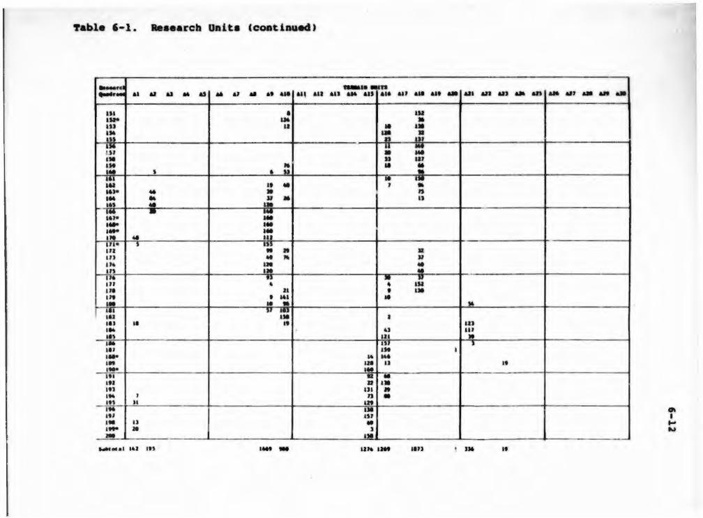
!'able 6-1. aeaearcb Unit• Ccoatinued)
..... rd 1alaU81n ....-- .. AI &) .. ., .. ., .. At ~ .. , ... Ail ... .. , '" .. , &&a ... .. UJ an au ... an ... .., .. ... .. . ,. • IU IU* •• .. US .. .. •• a• a: .: an .,. u ... UJ • ... . ,. u Ul .,. : ae : ... ' • :~
.. ttl I t .. , • . .,. .. • , ... .. Jl .. n ,., .. .. ... • :: atJ• .... . ..
1 ... . .. . ,. .. IU an • s ': I U a ,. ,, .. " Jl .,. ... : 1n ... . .,. n • u IU • • w
"' Jl • .. . ,. • 141 .. •• ae • " Ill lJ :: ,., I IIJ .. •• IU ... u Ill II\ &U ,. I M IIJ , liJ IM I .... ~ ... '" us I) .. ·- ... Ill It .. ••• aa •• ,., IJI .. 1 .. J , • an Jl m IM .. "' "' ... u .. ·~
.. ) - IMI
1 ... -.,,. liM .. , I ,,. It

'fable 6-1. Reaearcb Unita (continued)
..._d w-•• ... n ,~_,...,, ..,.._ &JI all &ll .,. an ... .,, ... .. .... ca a
na .,. au ·~ au 1M .~,
IY
'" ... ... au . .,. ... .. ') ... .. ,. .... .... .,. Ul•
'" an .,. an Ill an .,. .,, •• ••• Ill au ... u' ... .. , .... ... .... ... '" I U ... au ... -u 111 ) ... .. .... an - J
...... . a .)U
..aarawa .. n C) • C) •
, I)
•• » .. ... ... ... J .,,
» • .. .., .. .. , •
• If J)
IU .. .. lJ ... ... ...
.. J
u l.U ... Ill .. ~ ..
:b w II
"' n • ~
u • • ... ...
CJ
~ ... .. : ., • ...
::! ... ... IM
~~ u
IM IM
·~: • .. , ::! IM
.JJ , ... -m-... ., • 4J . .. ... ... ... ..
• n
n
• D
• n
~
n
- "' I ... w

Table 6-1. leae accb Ooita (cootioued)
-cl ....,._ &1 "' u .. ., .. &I .. u .... ... &U
••• IU IJ .J .. u an •• = u -.... ••• ::: U)e 114 IU ,.. l 111• ... ... 1M Ul . UJ• UJ U4. u.a. ,.,. ~ Ul Ut• Ill
~:;- : I))
U4 au :!! .. ,, ne ... nt u Me I ,., 11 J41 ,. J4)• ... ,... ... IU • •• - , us ,., • .. n -141 HI
hkecel liS Itt ,,
1UMU...a .. , AM &lS ... &U ... &It Ail All AD
.. .. .. us ,. .. "' ... -~! ua ate ... ... •• ... ... l4J
• :: ... ... ... . .. .:: lH ... • : tl ., .., ': ,. u~ .,, '
4JU
AD &a &IS &a a.tl
• ... •
• Ill
• Ill
&II &II &II
.
. ., ., . ,. .. 0\ I .... ..

'fable 6-1 . Reaearch Oni t a (cont inued)
-.....c .......... ....... &J AI &J .. as .. &J .. •• ..... All &U UJ &J4 .., ... ,., ... ••• .. &Ja &II w .. .., .. &aJ .. ... .. HI • I ll au » .. .,,. ua • .,.. • :::. , nu J. 1M ... I t .,, au at ne • .. U t • .. _... lll • Ma ... ., . tt Jt . , , .. , = I' ...
"" II ~
1M au ., .. , • aM ... .. "" ::.. ,. -..... Ul ,,. " n
JU .. ... ,, .. .. ~~:
.. • II .. , JJI lJI )I IH w 11 ,. ,,. • !!! •• II
- - lJiil aa •• ., an .,. .. au . , ... • .. .. • • _., U l u .. • " .. , IJJ D 1M D ,, •• !:! )) 1M .. ,. .. • '" Itt .. .. ,., •• u :r.. ,.
~ _M.l •• .... ... ., "' .. , u 1M .. .. Itt •• • - • .., ........ ..,, ,.,.

~able 6-1 . leaearcb Unita Ccontio~ed)
.._Ill tUM~• • ..,, ec-•.,..» ..UAIPI-ft ...... UJ U) ..,, &» a» .... UJ all dt ... Cl Q CJ C4 " ca CJ c:e ct
lSI ... I JSJ ~
,, JS)e II .. , ,.. a .,. )i,. ... ~
... ... ,. a I» m n '" ... . .. •• . .. a.z .. IM ,., , IU .... .. .. •• UJ J) .. " .. , ,., .,. ,. ... fJ I) .. lJ , U4 ,,.. - ··~
II .. lll " m au , an ... ,. .: , an ,. • -.16 4 D •:; an ,. n t an II u Ill ,,. ,. u - • ,. ... 111 ... . ,. .., II ,., • -,.. - • . , • -.. IU , ,., IU 4) .. . .. .. IH .. 2M ... -Jtl• .: I U
"' ,., .. • ,. ., tl ,, 4 ) 111 lt6<> J) I U JtJ ... ,. u IIJ Jtt !!
., .. u -.... 4JI »6t - ... , u

'fable 6-l • Reaeareh ODita (eoatiaued)
.....,c·a ..-ua..n ~-
.. ., &) .. .., .. ., .. ... .... &U All ... .,. ill ... ... .... ... &II AIJ &D AU &a ..., .. .,, &II &II &II
•• Ul • - .., u .,. IJt , -· nt • = ·: .: ... u IU .. • •• .. • ,. )II IU •• ;:~ ,:-; : JU Ill u II' • " .. ,. w • ;:; :; ,:; Ill • • • )It .. s u JM . .. n • :~ ::: : JIJ .. • • U.• D LJJ u.se n II ,. ~ .. u • ~~ Jll 4 IJI ) It s • ., ,,. ,, .. ~!· • u )))
·~ • JU• , ;:~
•J ; n• • .. I ,, n n u 140 IM .. .... !!! JU ... 11 14) ., ,, .. 144 ., au JU ,,. .. ~
~ .. , m • I ,.. - ,. ... • ... , ... .. . .. • ---·· ..., .•. .. . .. I ,. IU -., .... . .,

7able 6-l. 8e•••rcb Unita CcoatiDUed)
·- - - ---_ .. ftiMa• .an, ........ , WIGIIAIIIft -ft ....,_ &II &JI a» ... &.» .. &J .• .. .. ... Cl Cl CJ .. 0 .. CJ a ce
.J .. au .. ,. . .. -~ • •• =- • w • ., . - .. , ... ... .. a» ,.. ... .. ::! J JJe • Jll - ' .: Jll ' )l
)I) w • )14
,, .., JJ~ u ... , .. .. ·: JU .., ) JI
, .. , JJI • , . JM ... Ia I ... lU ... JJl ... II'• ... at• ... .. . .. , .,. . .. ,..
" ... Ut .,
.:~ ,. •1 u --uT• ... .. • • UJ • .. .. J)) ,,. ,. ... ,,~ 11 ...
~,. ,. :: lll na .. JJe .. , ... Ut ... ... ... .... ·-JU ... . ., ... ... :: .. , ::- •• :: ... " ~ . ... t) • , ~ ••• It " .. ,

'!'able 6-1. Reaearcb Onita (continued)
== .. AZ &.1 .. &Jj .. &1 .. &I &&e au au
U l .. .. HI , .,, ,,, • IJI »& ,. ., • :: Bte • ,.. ... -~ ... ,. .. ll1 ::- • • Jl
UA
•• .. .. ., • ., - t ,... 'Ill'& -.. a • ., a u ,. .. , u •• • .. ... • • ,. Jl , .. • ... Jll • Jne s •• ) l) u n J M • ]
" : us 1J ,,. • ,, • , Jll , • ,, • • u ... 1 --- .. •• • .. )It- ... ,. ., 16 I us I .. u .., ... U J ., " • :;- D
~ ... • .. a ,.. .. :~ u
c ., ,., • II ,.. , , .. ,., • u • : ... .• u; IJJ
n
,.. D Ut It ,., 7 .. u ~
, ., loikao• ' l &l Dt liM ... IIU • U J& an
1UMIII..a &U ... .. , ... &U ... .. , ... w
.
u •
u
au au.- &IJ ... AIJ ... &II &JI
u
It
•
0\
• N 0
t'able 6-1. leaearcb Unita (coatinuedl
-d TIIMl• .an,._, .... , _.. ......... ....,_ &JI &JI an &» &» a» an &JI &JI ... Cl a Cl c. a -Cl Cll "' lSI I» • )U ... . , Ill ., ...
~ .: 'Jt~
JMe .. Bte ... »a ... ~ I :: .. aJ • I
•• .. ' IU JW lU II " ., .. » Ill I ,... ... 141 It ., ,. .. .. Ill I
~ ..
~ 11 : I
I H
* " a ' ,.. • ... u ,. • .,. II
~:~ .., ., , as •• D ,, u " .. ,,. • ::: ,
»J ., J JK 1M T -u- : ,, ... • ,,. UJ ... It .,, .. Jt • Ml .. I .. , ., .I -.. It
~! .,. • I ., 1 .. .. ltl ' ... n 1 .. . , • IM • = Ill .. •• . ,. " .. ... ... n .. , ,.. ::- 1 .. ,.. II IM .. =~
IM :: • ,., ... It Ul ,.. ,. 1 .. Itt ., ... ,.. IT !: ' ,.,. ,.. ,. .., I ,. ... ... , ,. • •
....... 1 MM 191 liD "

'fable 6-1. le•ea rcb Uni t• (continued)
_.. ... .,..._ AI 61 ., .. d .. .., • .. ... All ·All .,, ... ..., ... .,, ... ... .. .... AU ..., .. An AM .,, .. .. ..
... ., w .. • • .. .., • ' .... .... • ,, ... --= -; • ': ... .., .. ... = .... ... ,. • .: •u • " •n u .. ,
••• • .. . ., .. . ... ::; : ~ .. ... , LU ... LM ut u • ::: ,; u :;: a U) n .. • .. l .... .. Ute ... ~
... ... .,. ... ~ ... .... u lM W I ar ': : •» u UJ n ... •l' •n u. • ...
1 ~: " IJ ..,, • , Ul .. II &N l ut .. IU ... » 117 ... • • .. , .. ..... " -· ... , ,, .. , ll ... " .. , ... ... .. ... ., n •M ,. a
........ , •u •• n u .. ,,., ,. ' l)

'!'able 6-1. Reaeareb Unita (continued)
....... 1UMU...n tc:_ , ..... __. ... -.n ..... All &II .,, .. &.» .. .,, &)I &)I .... Cl a C) • cs • C) Cll a
... ... .., n .., .., ... .... IM • ... . .. = = ... ... .. ... .... . .. ... :: 4U . ., ... ••• ... . ., ... 414 .. :t ., 4U • ,. , ••• ., ., •••
., u .. . .. :;~
- :: 4U ... .. ... .,. " .. u. : .~ 4U 4H • 71 .,.. IS .. , •• ) an u l -4U ... .,, ... .,. ., ... ~ :: .,. .,. J U t )) • Ul 46e IU , ... ... • • .. , .. .,. I
44Je • I .,. .... .. ... " .. , .,. U4 • ... " ... .. , u ... 46e " ... ... ... 4M ...
D .. , ... JU

!'able 6-1 . ..•••~cb Oaita Ccoatioued)
........ 41 &I ., .. d .. aJ AI ....... 411 411
.., .. ... II ..,. • I &It .,. • w , . ,. u II • .., .. .. I ... :: : • .: : I .. • .,. • u .. .,. .. Ill ... II • _._
~·· ... . ~: • .:: ... Ill .. .... a: ·:: .., D
= 7 a:; ... I& .. .... • . ,. "' ... .. u : •n ..., .. ,. ... • ·- .,. • us U4 .. ... ': ..
I .,, •• ..
I ... • I ... " • ... •• • .., II .. , 11 ... u .. ,. • .... ,., J !! .. , .. • • .. ., .,, ... J II
.., ... I IM
••• : .,, uz IU .. , • ... ) ... IU ., .. , )I '" :: IU J
u • ,. ... .. I u r:J .... 1 .. ,. II n • ..... 1 ,., .... , 11 aur un 114 lU ...
..... . ..,. AU .... 411 ... 41J &aa ue ..
• u ... I
Ill
" ':
~I -Ill U ' ... .. ':' ...
Ill .,.
lttl
all all an .- &It .. all ..... ..
o• N •

!'able 6-l . Reaearcb Uoita Ccontiooed)
. I .._ ... tuMlll lUIS , ... , _ • .... ..... .us ....,_ .,, ... &I) ... &» ... UJ .. &It ... Cl Cl C) c. a Cit Cl Cit 0
ua• ... U l let it U )e .. " .... .., p •n JJ • :: . .:: . . .. . . ,. • .,. Ut • .. we u n .. ~ . "' ::; ~ .. , ... .... , nt .. , ., ,., ...
;~ ~; .. , ... .., .. ' .... .. n ,. .,. .. . .. D .,. " -Ul • • ,,,. ... .. .... .. , SJ
r.u- .. .. .. • :!: U J •• Ul , u • .,, Ul " • .... D •• ·-... • ' ~ .., w .., .. • .. ... ~) au .. ,. ) ,., ..,
·...:--::" : ::; ... » ue ut u ... .... .. I ... ... ..
= 4U .. , ... ... • IJI ., 11 • ... J :;; . ., I ,. .,. ,. • ~ .... .. .. .... - u ,. I ll ..
.,,.. IU ... •U JIJIJ IJ)I IMI tl

'fable 6-1. Reaearcb UD1ta Ccoot1Dued)
::::: &I aa · &J .. aJ .. &J .. ..... &U
•• .. U& - Ut 4& .. SJ .., .. ... :: - • - = .,. ,.. ... .. ll .. 11e ll •• :;. • :: tUe ., ,.. n , .. au tu ... ;:; : : ,.. n ~ J
~;. ::; w • ,.. • use .. ., J II
~ ,: '
D
,. ., v .. •• ,. .. IU • ,. u • • :~~ ~:
.. lt ,, II , .. • tn '
~:- " Ut " Ut •• • ,.. I • •• :~
.. • • , ., ,.,. ... ,.. .. IU
"'' • Ill - -; -"'' n ,.. .. ,.... ... ue ... "' ...
....... a lit Uti ... Hf • a-.a &eM a•t
...... ..n &II &U &It &II u• &IJ
.. Ill
" D
• •
• = ·~ .. .. ,. .. ::
J
.. •
" • ,.
...
... &It .. .... &II &IJ ... &It .. &ll ......
"' I ~
"'

!'able 6-1. leaearcb Unite (continued)
-d ..... _.. ,._, ... , ..... -..,. ..., ., .. &JS .. &II ... ... ... • I
lei -., = .. le,. ,.. ,.. , . Sll ,.,.. ~~ .. ~n•
~·· ,, -sit
I ,., ~·· =-=-,, ~
tna Ui ,.., ,.. ,. ,,. m w ,. UJ .. "' 1M tU na U6e ... ,, ... ,.,. II Ut tM ,... )U ,..,. M4 ,.,
-s.,-,.., ,... ,.. .. tie lSI
...... eJ .. , Ut
c• a
.. , .. Ill Ui ., .. • Ill ..
t• 1 ..
:: .. u• .. U4
•
........ ..n C) 0 a • CJ Cll
, IU • , • ., liS .,
= • Mil" : ate .. 1 .. ...
n aw ... . .. .. ... ~ • .. .., ,. ., • .. :: ., .., .. • -:a: u ...
IJ
• ,. ~~ ... ... ... :: 1 ..
• ,~ I'U , ., -... ... . .. ... • ... ... IS IMI .. lttl IU
•
~
I N ....

Yable 6-1. ..•••reb Uni~• CcODtinued)
::::: ...... ..,. ' •• ., ., .. ., ... ., .. .. .. ... ... ... ... .. , a a .., ... .. . ... ., . &D .,, .. an ... .,, ... ... ... 1-· - u. ••• .., • • l ilt au ., ., , .... ,. IM , •• • .. 1,. Dl ,
l ti- UI tU Mit It I . , .. , .. ... .. II ., Ul- - .., Itt .... - ~.~,. &Ut .. , • - .. •.. ,. ., ... » &JU ,.. ,. ltJ ,,._ ... , tall .... ... J!Ie I&J ••• .., - I ,.. IU I .. ., .. ... ., »I .... IW Ut .,.. ... .. , .... ,.. an ., • .. 1..,. . ., . , lttJ .... ... ,,.1 • • .. D . ua-• ... •• MJ u U l DIS Jl6 Ill Ml .. u tel - HI 1,. UN .. I U .. ....... 1 .. , &J • - 1 .. r----- ----------- ------------ -------------- ---· -------- 1--- --- - ----------·-...... H6J .. » tJI& •1 M JI .,. .. , ... , .,., ,.., ••• ... • »:Jt,... .,., ... ,. .. I~~ • " lll .. ., ,_,. ... ... .. ..... ;r ........... · " J.eJ . . .. J .U 6 . tJ J.ea J . JI ....... • • ·• &.n .. ,. .. '·" ... ... ... • •• . u _., .... ,. , ... ·" . »
..... d tll!lllY •n c- f l!!!!H!II, ....aJm•n ....,_ ... &II &JJ ... ., ... ., .. .. ... Cl a 0 0. " 0. C7 Cll Cll
·-· Dl Die .... ,,. - .. , .... Jtl . ,. JJI .. .., ....... •• D
···-Lit Dl .. .., I& ..,. ..., Ut - at) • l SI-- ... D 1,.1 -I&U .., • " ... ,. ~-
.. , t U •• ... , ... , .... . ,. ,,., -tiiU u
-~--... .. , ....... ., JIU& a&n • lSI_.. u ia&tt lit u u , ,. ... • ... ., ...... ,. Jl .. , ... JIJ D6 ... IJ
.,1- - .,,. an -4U lUI . , . .... • ,. .. ,. . ., Ut .. ,. ... D lteJ - ..,, IU --- ------tor&&. Ul ,.. J l . 1%12 .. ~ ... u ,. • • n u W I JJW ,. .. IMJJ ........... " ruca.. . ,. . .. J.tt ••• •• ~··
. N l .&r • • I . JI J • • 6 . 8 1 ... ae. t& . .u 11.11 . ... . .

6-29
After dividing up the project area into 552 equal-aiaed, 160-acre q •.1 dranta, a aa~le of 110, or 20• of the total nwaber, waa drawn ('fable 6-2) • The aaaple waa drawn vi th a cloae eye caat on population apecificationa -- in oth._.t worda, to inaure that the kinde and quantitiea of cultural valuea obaerved during ~he aurvey do not differ fro. thoae predicted for the area beeauae of inea.plete ••8Pl• apecificationa. ror irtatance, our background reae~:rh baa provided ua with reaaon to auapeet that different kinda of aitea are found in different Terrain and Vegetative Unite. If ' rvey inforution focuaed on one particular topographic region, we would not be able to au..ariae the range of cultural valuea found in the project area. our approach to tbia probl .. waa to aelect the 110 quadrant• aueh that they would fairly repreaent the range of variation for beth Terrain and VecJetative Unita, while at the sa .. tiae main.taining aa coCDplete coverage of the project area aa poaaible. SUch an approach makea the beat uae of data from the predictive model• in recovering the full range of cultural valuea froa the area of intereat by providing aaaurance that ao.e areaa are n~t over- or underrepreaented in the ••~~Ple.
In order to deteraine how well our sampling quadrant• repreaented the kinde and quantitiea of environmental units Ln the project area, we firat aought inforaation about the correlation between the proportion• of area for each Vegetative Unit in the aaaple quadrant• and the proportion• of areaa in the project area•a Vegetative Unite (Table 6-l) .

oan oah .. .,..., Al •O u ... AJ •l&a At ..... AI ... u • Cltlt-f AT ...... .. • .d:r AI·~ All • Pf9 All ••• All .... AU • Ni' Alt •11;1 All. ";r.i All.* ....
AlT • Ill All • CliO Alt • ih Ul • __;___ llii .... Ul • Ito UJ • il; UJ • Cl AU • 9 .. -e Ul • ft Ul • 'i!J UT • ru AH • 11• AJI • Ia AJI • e Ul • rf•r AU •tfo AU • ~~
AU • H Ul•e.
Ul • li!r AJT • i6' Ul•i!i'
1 u•. llOt .... MO • INK .....
C:1 • Dt C3 • 1ft/ • cl • c:r c:4 • or C:l • "' Cl • Ll C:l • OU/'tl C:l • 00.1 0 c:t • lll/w
torre1• aailu
ore•••• .. ,.,,.,. ,, ... ,,., ...... ,u AltleU• UU ....... h. •l•U• uu 01rer -'"•' .. -..roolt IIM1 UU Uroa .. l eou .. , ..... , -..ren ... .,,.,, .. ,...,.
r.annr&• ..... at• ... , MMl uu
t.rr•• Ck ... ler all .. &el fa• llllor ..,_,u a .... u., ... -..u .. , .. -..rooll lollfl .. tl ....... ,, •• ,, .... , ... ,
terr... ..., ... ,. rroa• MMl uu ... r ...,rMII
rae a...r ..... , ...... ,..,., ... , , •• rlYOr -- ::r:''' C:.lh•l• -r ...... • ...... rooll ....... ,.
•r& .. t .. , ...... h. O.t~·· ..... ,,. lollfliOt& ....... ,, .... , .. , ... ~
eou .. , ..... , -..roell .... .._ .. , ........ r.
Olaolel till IOlUluoU011 ..,..,, .... r .. atllored Mdrocll
~.,, ....... , .. ......... u ... ,,., • ..,..,,. t1Ul .. 1 eou .. , ..... , ....... r ... , ... , .. Mdroolt
.,,,, rotr•••por• ....... ,,. IOUea loeee aou .... ... Coll••&•l ....... . All•YlAl faa ~l .. ol ... l .. atl <~rt•••• ..... "' ... r ... , ... ~
ortaalel ... , .. ltale •o.-lte
fltaYlal .. ,, • ..,..,, lollfl01tl011 ..,..,, .... , Mdroelt
lol&rl .. t&oe ..... ,,, ctro1oa1 oYOr llaMl till Cfroa .. l
IOl&fl .. tloa ..... ,,, crroa .. l ... , .. ,.u .. tlu
IOllfluct &oa do,..&ta lfto1oa1 ower Mdroelt . , ~~·· ,, .. at tlll l u ..
Yototatlwo U~ltl
orr , .... ,. .. , , ._.,./ .. raltland C:Oalfar011e roreet Deel .. OIII rornt JUa .. roun '- nr1111 O..rf UOI 11111111/Tdl 1llr11b .,. •• , .... , .. tlr/llarron Rooontlr -..rn .. / lott .. •r••
1-30

~able i-2
~1• Daita
-·- --- --, ...... -~ ..... _
~· .. &) .. &) .. u M .. ... ... ... .. , ... ... ... .. , ... &19 .. All All &1.1 .. All .. All .. &It ..
,. au ., ,. IIJ , a ... ., ... • .. ue ... .,. ... ~· ... .. . .. .... ... U• u :: Ul ... .. ... • u • ... ... D • u .. ,. • • ,... ... ... IJI • .,. ... ... . .. ... ... • • .. .. ••• '! ... lJ .... .. ,. ... ., n • .... an ' ,,. ... • UJ .... .,. • .. ,. - • .. ,. :: .... ., .. ... l6
IU• .. ,. , .. ,. ... .... . .. .... . .. Ill• , ., .... .. ... ~--
... ,,.. • ~ ••• .. ... . .. .. ,. ... au• ... .... . .. usa ... ute ... Ul• .. ,. .,.. . ..
.... «.& .. ,,. '" tS UM ... , .. , au • ,,.,

'!'able 6-2. &a.ple ODita Ccoatinued)
...... ..... .an,_,_. • WIICIItdlft ..,. ..... -&II All aD ... &» ... &JJ &Ja &JI ... Cl a CJ "' a "' CJ a a
,. ... •• ,. , , .. .. IU ' ,. ... ,. ... •• ... .. " IU
••• » .. , ue ... ... . .. - • •• ... .. • • ,.. • I " ,.. .. , u ... . .. u• ... ., l .. - ... ,.. ... . .. ... u .. : .. .. .,, ... lU ... .,. • Ill Jl '" ,.,. ... ... .. ,. ... ... ... w • '"'" ... u,. ... . .. ,,.. .. .. .. .... .,. • .. ~ , an .. ,. 4 :: .... Jll ,,.. •• Jl .. ,. n .., • ,.,. ... .... . .. .... . .. Ill• l) .. , ••• , au. ... " .. ==
an ... .. u .., .... ... ,.,. ... ,.,. , •• u,. .. " 1& IJ n
'"'" • ... ,,. .. . .. ,.,. .. .. .. .... Mal .. IM .. U. 14 1- JM »> 1lll IIU »16 ltl

'fable 6-2. &a.ple UDita Ccoatlo~)
..... ....,._ &I .. ... .. as .. A1 .. .. AM au ... ... .,,. ,.. • .,,. • ... ... ....
au-.... ... . ,. -· ... ,... . ,.,. ..... Site ,,. l l .. , ua• »te ., .... ... ,... ... ,,. • • ,.. ... .,,. ... ,.. • • II .... ,,.. , a• ... ... ,. ... D • ~ • , au .... ) lU .. te ... .... ... , .. .... ... U1• ... U9• ... ..... ,. ..... ,. , , .,,. ... u .,,.
' an .. a. • .., .... " .... ' Ute &It .... .. ' .. ,. • .... au • » ..... • ·- l
........ au .. .... ., ,.. .,, ... ... .,. •••
.......1ft au au .... au ... &IJ ... ... .. ... ... ....
.
u a
, D a
Ut ,,. )J .. , .,.
I . . .. ...
.. an .. ... .. ... I dl , .. •• I .. ... ... u .. ... .: ·:: Ill -, ..,. • u . .. • ... au • D ., .. .. •
n at .... ea
- -
....
-
~
I -w

"fable 6-2.
....... .........,. ·~-, ...... ..... ... .. a.IJ •• a.lt .. .., .. .. ... ... '"'" a.-ate ... ... ~--ate .... ..
. ..,. ... .... ... ,.,. ... Jne ,,. Dl• ... Dte ., ..... ... ,,. JW .,,. .,.. I ... ... ,.,. a .,. ... Ul
= .. .... ..,. .... u .. us-4J9e .. ,. • - .. . , .. .,.,. ~· .... .... .,,. .... ..,. .... .... .......
..... ... ..,. a Cl CJ .. n 0 Cl ~
, .. .. .. IU I .,. ...
Ito , ., UJ .. .. .. , .. ~
~~~
IU
• .... » au .. ..,. . ..
4) ,., ... . .. ... .. •• ... . .. . .. ,. ... ... ... ... ... ., '" u • ... I
• •• IT ::! IM I ... . .. ...
"' .. ., IU I ·: -... . ., »
IU u ~ IU ., IJ " ... ..
u •• , an 41 )I lit
It I ... .... U 1,. ~U ... J»l IN ..
Cit
.,_ • w •

~able 6-2. SUpla Units (contin'--d)
...... ...,.._ .... ... . ,. ,.,. , ... ,,. ,,. ,.. ,.,. ,. ..
._ .. ..... .... -· ,.,. tu• ,. .. S.U• Ute Jl6• ~~· ,...
.......
- -- ----------------------------------------------..... • .an
a a "' ., .. at .. ., .. at • au aaa an aM an all au a.. ••• .. aaa aaa All .,.. ..., ... "'' ..- aat .. a
... ... ... ... UJ .. .. I p ... ... ·--., .,. ..
--- --- -- -----a-•• •ars (_ ,_ , All A» .u• ..,. an ... ..,, ... Ut ... --- -- --------
MO
- - --. ..
,
Cl
• ,,.
...
. .. ..
tu:&"t&ran •n• a C) ~ a C6
.. ... .,. ... M ... • • ...
---- ... , .. .. ,
______ ._ __ _
cr C8 Cl
.. • ..
... " -- -- • ~
I w Ul

~able 1-2. luple ODita (CODtiaaed J
...... ..... ..... &1 .. &J .. &J .. ,., .. .. &18 &11 &1J ,., &16 ut ... .... .... ... .. All &II .., .. ... .. ... .. .. .. .... -... ... ..... ... .. , IIJ • ••• ., a • • • a4-41e u• ••n ltJ .. ... IU ... .. &JI ... .,. I • It .... .. . ......,.. - .. IIJ •• - .. J - -- -------· -- ... .,_ u• .. .. tn ..... .,, • '" • ... I.J.S •• • t»J I I - I I I " ...... ... • • • - a.l '·' .... ••• ... ••• ,_, ••• ·~· ••• • 1 . 1 • • •• • •• • •• ••• ••• I • ••• • I • ••• ••• .. , , .. • •• • ••
~- ~~~-..c-~t -.nllft.nl .,...._ ... .. UJ u. .. .. ..,, .. .. ... a Cl Q .,. Q Cit " Cll Cl
.... .J ... ... -.. ... .. ,., DJI IJI- . .. ~ ... ,,. ., .. II lM tU -t.JII .... • ..,._,.. ... .. ,., ... - • - -- --·------.... •• "' ... .. .. -.,. ., • • ....... ,,. ... _
~ ... .. • ..... • •• ••• ••• • • J ••• • •• 1 . 1 '·' • • • •• • •• ••• •.. .... ~·· 11.1 ... •

6-37
Table 6-3 Proportion• of Vegetative Onitl in the Sa~le and Survey Areaa
Vegetative Proportion of Acre• Proportion of Acree Onit in ~le in Survey Area
Cl .07 .09 C2 .01 .07 Cl .03 .04 C4 . 06 .01 C5 .22 .11 C6 .29 .30 C7 . 23 .21 Cl .02 .02 C9 .00 <.01
The Spean~an rank correlation coeff leient wa aelected to •aaure the detrH of aaaociation between the two aerlea. The probl .. of aaaoclation between ordinal acalea can be viewed aa a Mtter of 9Ueaain9 order. The probl.. here la the detr•• to which a vegetation uait'a relative poeition or rank in one ordinal acale ia predictable fraa ita rank in another. In order to ca.pute the Spean~an coefficient between the two aeta of proportion•, it waa neceaaary to rank thea in two aeriea. The ranka of the p&oportiona 9iven in Table 6-3 are ahown in Table 6-4. Thua, for eaa.ple, Table 6-2 ahowa that Vetetatlve Unit C6, Low ahrub, which ahowed the hi9beat proportion of aerea in the project area, alao ahowcS tbe hi9heat proportion of acrea in the aaaple, and thi1 WI uai9ned a raa.k of 9 oa both variablea. The reader will obaerve that no Vegetative Unit '• rank in one aeriea waa 1t0re than 2 ranka diatant fraa ita rank on the other aeriea. ror the acrea9e proportion• in theae nine unita, the cor~elation between the aa~le and the projec:t area rank• ia !•. 99 . Thia obaerved value exc .. da the table value of . Ill tor nine obaervationa and • • 01. !hua, w conclude that there ia aaaociatlon between our aa~l• proportion• and the atudy area proportion•.

6-ll
1'able 6-4 a&Ak f~opo~tiona of Vegetative Unite
in tbe sa.ple aod SUrvey Area•
Vec,etative Unit
Cl C2 Cl C4 C5
c' C7 Cl Ct
lank •~opo~tion of Ac~•• in &a.ple
5
' l • 7
' 8 2 1
Rank Propo~tion of Acree in Project Area
' • l 5 7
' • 2 1
One alternative to tbia approach waa to tr .. t the percentage data u interval acalea and calculate Pearaon '• coefficient of correlation to cleacribe the degrH and direct.ion of linear aaaociat ton between the two Hta of nWibera. haraon • • coefficient alao can be unde~atood in teraa of gueaaea, but it ia diatinct in tenu of bow tu••••• are •4• and how errore are tabulated. While aaaociation in Daainal acalea involve• the notion of gueaaint claaa •••berahip, and we have aeen that ln ordinal acalea the probl• ia one of gueaainCJ order, when it com•• to interval acalea, aaaociation ia a queation of gueaaing acorea or valu.a on -••urea. lecauae the acorea or valuea we are dealing with conatitute a •cloaed ~riea,• that ia, each aerie• ia conatrained to add up to 1. 00, and becauae of other •••ureaent and aa.plint conaiderationa, we felt the nonpara .. tric atatiatical teat beat fit thia particular probl... A Pearaon•a correlation coefficient for tbe aa .. aeries vaa coaputed to ••• if there waa any great diacrepancy between tbe interval acale .. aaure and the ordinal acale •aaure . The coaputed value of . 99 for the Pearaon'a coefficient indicate• a reaaonable agree .. nt with the Speara.n coefficient value, which alao ia .99.

6-39
Aa part of ogr evaluation, we alao wanted to know whether the data autt .. t an agr .... nt between tbe proportion of acre• for each Terrain Onit in tbe project area and tbe proportion of acrea in .. cb Terrain Onit in ogr aa.ple (Table 6-5). Me eapreaa thia queation by ~ain aaldncJ whether a correlation exiata between project area proportion• and HIIPl• proportion• aa •••ured by ranka. The calculated teat atatiatic £a•.995, which ia 9reater than tbe critical valge of .47 for !•.01 and 31 ranka aug9eata • 9reat deal of ~r .... nt between the project area proportion• and the aa.ple proportion•.
Pour pecleatrian field crew• of fogr peraona each, each under the direct auperviaion of an experienced, 9raduate-1evel archeologiat and under overall auperv iaion of Glenn Bacon, CoInveati9ator, will conduct the field rec:onnaiaaance. Not•• retardiQ9 9eneral daily activitiea, weather, 9round cover , n.tural featuree, aDd other pertinent lnfor .. tion will be kept by each crew. Tbeae notea will contain. lnfor .. tion not otherwiae fognd in aite foraa . Such notea can be eaaily .. intained by each crew on SaiiPl• Quadrant Recorda (Pi9. 6-2) upon cc.pletion of each auvey unit. Thea• recorda allow for eaaier field review and later analyaia of data .
1.3.2 Traaaaot Iater.ala &Dd freqae•cy of IUbaarface TeatiDI
A,t r "\9• caae aiae 1a au.ariaed by Terrain Unit, Vegetative Unit, . i t '~ Type, and Period of occupation in Table 6-6. Twentyone of che recorded ca••• did not have e••• alae data1 therefore, thea• have been deleted fr011 th i a phaae of analya i a, l eavin9 ua with • population of 455. OVerall, the avera9• aite alae 1• 962

Al A2 Al A4 AS AI A7 AI At AlO Al2 Al4 Al5 All Al7 All A21 A23 Ul A27 • 'll A4t9 AlO All Al2 All Al4 Al! All Al7 All
6-•o 'fable 6-5
laak Proportioaa of t'errain Onita iD tbe aa.ple aDd Survey Ar .. a
laDk Proportion of Acree in aa.ple
16 24 ll • 17 20 26 23 27.5 21 10 22 27.5 13
• 2t 14
5 2
30 25
3 7
15 9
lt 11
1 11
6 12
Rank Proportion of Acree in Project Area
16 24 31
7 17 20 21 23 28 21 10 22 27 14.5
3 at 13
6 1. 5
30 25 • 5
1 •• 5
• 19 11 1.5
11
' 12

·-·1
1. ....1e Gait wrtua 2·. I •1e Gait 1..,a1 .. 8CI'lptloaa J. Dete iaftatocy ia .... 1e aait begaaa 4. DaU laftatoQ la .... 1e aalt f1a1abe4a 5. C:.1tual naouce altea foalld 1D HJ1Ple ualta
r1t14 lite WPeber verz lrlef Deacrlptloa
I. leola ted utlfaata fouda Jent1 locasiog Very lrle! biacrlptloa
7. Wieber, 1ocat1oa, and reaulta of aubaurface teata.
I. Dlrectloaa for 1ocat1Dt IUIP1e OaltJ laDdOWDer a- Cpboae DO.)
10. ,.raeatave aDd/or acreege of eaYlroa.eatal "ualta.
12. •-ruub111tt• of walt (Dote ' of per .. troat, bedrock, or otbar lab1blt1DI factor).
14. Otber releYaDt lnfor .. tlon Cl.e., viaible cultural reaouraea in adjaceat ualta).
I~IOW or MAl IBOWIIG
IAIDLI UWIT
r19ure 1-2. &a.ple Onit lecord.

Ta'1e 6-6 &weraae lite llae ~, Terral• U.lt, Y .. etatiwe U.lt, lite TJpe, ... ,.rlo4 of Occ•,.tloe
Terraia U.i t , .. etatiwe Dait lite T,. hri .. of Occ•,.tl• -- ----&wuaae ... of Alrerqe ... of &weraae ... of •eraa• ....
Uait ... Site Siae lit .. U.h ... Site liae She• Uah ... lite She lite• Oait ... She She lit ..
&2 2SO u C1 1,011 u 1 216 211 0 217 117 &l 2tt 11 C2 121 10 2 u 1 1 l,MI 71 &4 90 40 Cl Ul 170 l l40 ~ 3 60t 119 &S 60S l1 C4 374 17 s 5,117 9 s " .. &6 265 19 cs 4,614 " 7 7 l4 7 41 2 A7 171 2S C6 291 144 • 2,104 5 9 520 ' •• 191 67 C7 115 10 10 )I 2 11 165 10 ,., 1,361 59 ca "' n lS 1,292 l A10 14.475 17 21 719 lO All 64 7 u 160 2 &12 1, 412 ' 23 796 10 All 62~ • 24 1,179 lS &14 6S 1l 2.S lll l &IS 100 1 26 na ' &16 119 7 27 sso 9 &11 sso 2 21 240,000 l &11 SSl • 29 1 1 &19 17 18 40 40 u &20 2.51 6 &21 1,011 s &23 ISO 1 &24 200 l &15 412 11 &27 200 1 &21 lOO 1 ~
&29 22 6 I .. N

6-43
8CI• •tera, but thia include• 57 caaea recorded aa 1 a2, the .. jority of wbich are iaolat .. , plu. 2 hiatoric caaea over 20,000
aq. •tera in alae. 'l'herefore, a aecoDd ca.puter run waa •de that elaiaated aitea -ller than 2 al and lar9er than 20,000 aq.
Mtera. 'fhe a"r~~te caae alae for tbia run ia 317 aq. •tera for 396 caaea .
ADAlyaia of variance waa alao run for Site Siae by Terrain Unit, Vegetati" Unit, Site Type, and Period of OCcupation to deteraine if ai9nifica~t relationahipa were diacernable. In only oae caae did thia analyaia abow a atatiatically ai9nificant correlation . 'fbi a correlation waa between Site Siae and Period of occupation wben the utr•ely lar9e aitea, all of which were
hiatoric, were included. Bowever, the aecond run reaulta indicated that the utr .. ly lar9• aitea had overwbelain9ly
influenced the &Dalyaia. Generally, it can be concluded that
ai9nlf lc:ant correlation• wer not deteralned due to the ... 11
UIIPle aiae and heteroteneoua nature of the population under atudy. '!'hie ia not to aay, however, that indication a of patternift9 ~ not exiat.
'l'errain Unite At, AlO, Al2 aDd A21 have the lar9eat avera9e
aite aiaea (aee Table 6-6) . After r•oval of the lar9eat and aalleat aitea fr011 the population., only Terrain Unite Al2 and
A21 continue l~ have avera9e aite aiaea over 1,000 aq. a, with A9
d.roppift9 to 511 and AlO dropplft9 to 390. It ia intereatin9 to note that 'l'erracea CAt) and Glacial T i ll CA21> have hi9h propor
tion• of hiator ic caaea and IIOderate ~roportiona of prehiator ic C&IIP• and lithic ac:attera. Granular alluvial fane <AlO > have
hi9h proportion• of CaJIPaitea. Unweathered conaol i dated bedrock <Al2> waa not found to have a atron9 relationahip with par ticular aite typea or aitea froa any one tl .. period.
AYerate aite aiae of below 100 aq . .. tera characteriaea Terrain Uni ta A4, All, Ai.4, Al9 and A29. Only one unit < A4 >

anrat• iocr .. led to a.er 100 1q. •t•r• alter the MCond run,
vltb tbe ftrJ -11 aDd ftty lart• e .. ••• r..ovecl. llker depoaita CAll) &Dd IOlifluction depoaita O¥ec outwaah depoaita CAlt> have
bi9b proportion• of lithic acattera and IIOderate proportion• of
ca~aitea. rro1ea baaal till over bedrock CAl•> and &olian aand
CA2t> ba" hi9h proportion• of c~aitea and IIOderate proportion• of lithic acatteca. 'rhea• .. 11 a it•• will be the bardeat to
locate, .. pecially if tbere ia no aurface viaibility.
Wben lite lile 11 conaideced in teraa of Vetetative Unita c ... 'fable 1-1), there are no unita with a aite 1i1e avecaqe of
leaa than 115 aq. •t•r• and the lart••t averat• excHdl •,600
aq. •teca. Again, after r .. ovift9 the extr ... ly lart• and aaall aitea fro. the u-.ple, the aaalleat a \terat• aite 1i1e for a unit
increa••• to ltS aq. Mtera and the lar9e1t clropa to 1,155 aq.
•t•r•.
Vetetative Onita with the lart••t lite 1i1e averat• ue Cl,
CS, aDd Cl. Dry tundra (Cl) haa hi9h proportion• of undated
lithic acattera, whi le Mixed foreat CC5> and Developed CCI) area•
have hi9h proportion• of Biatoric Period aitea. The ... lleat
lite 1i1e averaqea occur in Vetetative Onitl C7, C2, and Cl.
D~rf tr .. acrub/Tall ahrub CC7) haa hi9h proportion• of hiatoric aitea and IIOderate propottior.a of lithic acattera. wet tundra
CC2) and Coniferoua foreat CCl) both have hi9h propor t ion• of
ca&peitea and IIOderate proportion• of lithic .c:attera.
'rb••• upecta of the predictive .odel provide for plannint
tbe aurvey and teatift9 1trate9y on a t•neral level. That ia,
froa th••• reaulta we recogni•• a need for ao.ewhat narrower aur
"Y tranaecta in Terrain and Vetetative Unite with ... 11 lite
1i1e averat••. However, for a .ore detailed level of plannin9
and 1.~1--ntation, ~ield obaervat1ona which have evolved into
intuitive .odela , ... Chapter 5) are i~ortant.

6-45
Iaoo~porat1og the above inforaation, we p~opoae u1i09 t~anMCt apaciDg betwan aurveyora of 20 to 50 •tara . Tba wide~
apaciDCJ will be uaed in area• of IIOclarata to ltHp alopea where few aitaa would be located. Craw ...mara will walk a aig-aag pattern to •xilliaa coverage. •or lOCJiltical raaaona and to avoid the poeaibil1ty of people getting loat, apacing will not excHd the diatanca at wbich people can .. intain cont~ct. Hance, 50 -tara •ta a ••iaua, and aay be too broad, apacing to be practical. The narrower apacing will be uaed when pointe auch aa the intaraection of a tributary with a drainage ara encountered, regardl••• o~ ~•rrain or Vegetative Unit.
'.l.l lite a.aodiag Proceduae
All prahiatoric aitaa will be recorded by the archeological cr-. The archaolOCJical craw alao will record hiatoric aitea, later to be reviewed by the Project Hiatoriana. The aita rocor4in9 procedure• to be eaployed are deai9ned to doeu .. nt, to the fullaat extent poaaible, all obaarvable cultural and related natural phenc:.ena. ror archeological aurfaca aitea, the crew a .. bara place pin flaga by each flake or other cultural indicator to aid viaually in detaraininv the extent and denaity of cultural •terial. Craw ••bera collect all diavnoatic cultural •teriala. The location of all aaaplea will be "lot .. ed on a akatch .. P of the aite, in relation to a ~.tum point eat abl lahed on•aita by the c.rew.
Controlled aubaurface ahovel teati •9 in area• of poor aurfaca viaibility or in area• lackin9 cutbank• will be iapla .. nted in a procedure aiailar to aurvey apacing. Teata will be placed every 20 to 50 .. tara along point• of high alte probabil i ty where aurfaca viaibla cultural .. teriala have not bean located . Thaae controlled ahoval teat• will be of variable dlmenaiona dapandinv on aadiaant character and depth, with ra110vad backdirt acraanad through 1/ t• ••h acraa.n t:.y 10-ca incrementa . Teata will be

acan~ad tbrOQ9b 30 to 50 c~ of aterlle depoelta unl•~• bedrock ~ pe~froet are •couteced. ID the caae of per .. froat, att-.,ta will bl .. de to .. poe• and thaw the aedJ .. at• or return to tbe alte if poealble. Ot~erwlae, a ... 11 bore core (2.5 ca) will be uM4 for 8\lbauface teatlftCJ. our goala in aubaurface tutiDt area
(1) to deteraiae the preaeoce and depth of aubaurface cultural depoaitar
(2) to atteapt to deteraine teaporal plac ... ntJ
(]) to enhance aite boundary 4eterainationa.
Prebiatorlc aitea eacountered in cutbanka require different tecbaiquea frc:. thoae deacr ibec! above. Tbe expoeed bank will be
cl .. aed up for atratigraphic exaaination and recordift9.
After a aite hu bMD defined through aurface or bank uaaieatioa, tbe crew proc .. 4a to record the aite on approved foraa, to include•
(1) aaai9nin9 a teaporary field nuaber1
(2) lOC'ating the aite on a 15-ainute quadrangle .. P or aerial photograph and on the Linear feature .. par
(]) .. aauring the aite1
(4) apecifyinq concentration• of cultural debria within the aite, in addition to featurear
(5 ) recording and codiR9 environ .. ntal var1ablea auch aa Terraia Unit , Vegetative Unit, habitat, local topography, aapect, aoil type, view, expoaure to wind, rank and order of neareat water, and elevation,

,_., Cl) pbotograpbiDCJ the aite in both black-ucl-wbite u4
color fila, incluctinv an overview ahot aa well aa photoe of individual feature• or concentration• where poeaible.
(7) aketcbint the aite in relation to topographic featurea, 1DClud1D9 the location of aubaurface teata ud collected artifactaJ
(I) wen appropriate, carbon aa.,;»lea will be gathered for ractloaetric analyaia .
liatoric altea will be recorded in a aanner aiailar to preblatorlc altea . alack-ancS-wbite and color phot09rapha will be
taken of all atan4inv atructurea in auch a way aa to ahow two ele•ationa . Structural condition will be noted by the recording t•••· In addition, .. aaur ... nta will be aade f 'r each atructure and feature .

7. 0 IIIIIIU a. fOfUU ·-UCJI CO.IDDftlO.
lall7 !f. Greiaar llatorlaal ..... reb Aaaoaiat ..
'l'be pr iaary goal of the Pha•• I research waa to deVt ! op a
.adel Wbich could be uaect to predict tbe occ:urrenc:e and dtnaity
of cultural reaource aitea by type, &9•• and cultural affi
liation, if poaaible, within defined enviroa.ental unita along
the luaitna Bydroelectric: Project Linear Peaturea corridora.
'l'hia IIOdel, •• preaenteO here, proal••• to allow for pre4!.ic:tion of aite diatribution by type. Age and cultural affiliation are
auch .ore difficult to deteraine, given the atate of c:a ltural
c:hronolQCJical clevelos-ent in the atody area. Aa diaco1 aed in
Chapter l, ar1eral c:~~ing chronologie• uiat, none of which are baaed on adequate data. A nu.aber of auggeationa ., .• pre
.. nted here for future reaearch aiaed at the need for a reliable
cultural chronology.
liiP<)rtant data c:ategor iea for ref in ... nt of the cultural c:hronolQCJY include lithic: aaaeablaqea and datable c:ultu:Al and
natural phena..na. Por .are recent ai tea, o1·ganic r ... ina are
plentiful which aid in cultural ldent.if ication •• well •• aubaiatenc:e reconatruction. Unfortun•tely, tor the earlier t•rioda,
the variability in .aterJal c:la•••• ia nini .. l .
Initially, raaearchera in the ar~• auat rethink and juatify
the baaia on which ai tea are c:ategor iaad by c:ul tural c:a.,•l•x or tradition. A pivotal iaaua in Alaakan preniatory ia the ~·aaence
or abaenc:e of toola and debria repreaantativa of a cora a~ blade
technology. ror exa~la, for aitea thought to date betwa1n 5000 and 1500 yaara I.P., UAM arc:haologiata uae the praeance of micro
( ladea to aaaign ait•• to the Late Denali Coaplex and U 11t pre
.. nce of aide-notched points to aaaign aitee to the Northern
Archaic Tradition <Dixon at al. 1985). Whereae the caae tYy be

7-2
aa aiaple aDd atraigbtforvard aa tbia dichotc:.y appear s, the cooccurrence of theae two tool typea at a n\Uiber of sites (e.g., sealy Lake) calla ua to look further prior to applying a potentially overai~lified acb .. e. The aaau.ption in thia claaaification ach ... ia that two cultural tradition• are repreaented on the baaia of one tool type per tradition. Although thia .. y, in fact, be the caae, thoughtful exaalnation of aultiple hypotheaea auat firat be conducted.
A atartin; point for investigation of such key tool typea is the question, •What is the Maning of the difference in technology repreaentec:l by a core and blade va . a bifacial reduction
•y•t•?· The preaence of the reaul tant tools at a ai te away reflect cultural, teapor t\l, or econ011ic factor a. Apparently, lit"'le effort haa been ~ut toward ayate .. t: ic technolog leal and uae-vear analyses of these tool foraa in au at.teapt to determine the source of variability. Bven within the core and blade tradition, t he source of variability is general!~ not considered and different core and blade types are used as temporal urkera . Thi• practice ia coiBOn, although Anderson ( 1970) demonstrated the co-occurrence oJf four core and blade types at Akmak, from which he concluded that their variety vas due to functional difference• rather than teaporal.
Por aitea lacking datable carbon , a few avenues are open for determining teaporal position. The high frequency of obsidian at sites in the atudy area provides one avenue for improving the local chronology . In other areaa where obsidian ia colllllon, eatabliah .. nt of a local hydration rate haa proved valuable (e.g., aee Davia 1972) . In addit i on to providi ng r n absolute dating .ethod, trace element analysis of the available aoua.-ce .ateriala can help researchers to identify patterns of exploitation which IIAY be inforaative about particular cultures and their UMe of and access to the resource base .

7-l
Aootber proaiaing 4atiog aource ic tephra. OAM reaearchers bave cUacuaaecS four prehiator ic tephra falla, oc:curr ing between 5, 000 year a a90 and the beginning of the Chr iatian era. More reaearch ia neceaaary to refine the local tephrochronology, which at thia tiM appeara to conflict with aa.e of the radiocarbon reaults froa 4ated cultural coaponents. However, with r:!tf ine.. nt, thia datiog aource ahould prove to be an iaportant contribution toward refining the local cbronology.
Although w recogniae the iaportance and usefulness of regional cultural chronologiea, thia reaearoh focua in inherently atatic. The developaent of pr.edictive aodela of hunter-gatherer behavior, baaed on reconatructed r a aourcea and conatrainta of the environaent through tiae, can provi~e a proceas-oriented reaearch fra .. work out of which will eventually come a reasonable chronology. We recogniae the limitations of the environmental data baae for the Terminal Pleistocene and the first half of the Holocene, but are encouraged by the ·increasing nuaber of researcher• working in thia area . Por the last 6,000 years, with environmental reaourcea and conatr•inta constant on a macro-level, such IDOdeling ahould not be too difficult. Of course, aaaaller- acale environaental phenomena, · such aa aah falls and ice flows, would need to be incorporated into the model.
Given a beat posaible reconstruction of environmental reaourcea and conatrainta, reaource use schedules and settle~~nt pattern• can be predicted for local groups depending upon their level of technology. A aeriea of hypotheses can be proposed and teated through the implementation of well-thought-out survey and excavation deaigns. Ultimately, patterns of seasonal behavior will become more viaible, as will land use patterns of different cultural traditions .
Through auch a focus as is recommended here, basic questions of technology and subsistence can be evaluated in a framework

7-4
tbat allowa for ..tel refin ... nt. aventaally, not only will a
8CMUld wlta.ral chronolQCJy -rge, but thia fra .. work will allov
for a dfnaaic picture of prehiator ic and early hiatory lifewaya
to be 4evelope4.
Wtth regard to the Suaitna Linear Peaturea Project, we hope
to incorporate auch a behavioral ~•1 aa part of the interpre
t! n acb... for Phaae II data analyaia. Much of the neceaaary
data are preaentecl in Cbaptera 2 and 3 an'J the author• have
eaperiance in developing auch .odela for ot her regiona <e,g . ,
Qreiaer 1915). W. believe that the behavioral .odel would pro
vide tbe ideal fr.-work for ad4reaaing the reaearch queationa
poaed in the Alaaka Power Authority'• •cultural Reaourc .. :
a .. earch Prioritiea• workahop held in Anchorage in Noveabar 1984. finally, w believe that thia aodel providea for explaining,
rather tban .. rely deacribing, culture change.

BIBLIOGRAPHY

BIBLIOGRAPHY
ACRIS ~rican Incorporated and R•M Conaultanta 198la SUbtaak 5. 02,. Photo Interpretation Terrai n Unit Mapa.
Prepared for the Alaaka Pcwer Authority'• SUaitna. Bydroe~ectric Project.
l98lb Tran..Uaaion Corridor Terrain Oni t 118paa South Intertie/MOrth Intertie. Prepared for the Alaaka Power Autbo~i
ty•a Suaitna Hydroelectric Project.
A9er, Tha.aa A. 1972 SUrficial GeolOCJY and Quatern.ary Biatory of tha Healy
Lake Area, Alaaka. M.A. theaia, Univeraity of Alaaka.
1982 Vegetational Biatory of Weatern Alaaka during the Miaconain Glacial Interval and the Holocene. In Paleoecol~x of Beri~ia. , pp. 75-961. ldited by David M. Bopklna, J n V. Ma~t~va, Jr., Charlea 1. Schwager, and Ste ven a. Young. Acaduic Pre11, Hew York.
1983 In Late ~~----~----rrr-~~~~~~~~~~~S~t~a~t~•~3, vol. 2 , The
Wr g t, 3r. UniVir=
A1alka Power Authority 1983 SUaitna Hydroelectric Project a Application for License
for Major Project. SUbaitted to the Federal anergy Regulatory C~aaion. PIRC No. 7'114.
Alaakan ln; lneering Ca.aiaaion 1911-1920 Alaaka Rai l road RecorJ. Anchorage.
Alexan, N. 1965a Bow Tyonek Peopl e Uaed ~o Bat. Alaska Sportaman 31(1):
38-39.
1965b Storie• About Bow to Raise Children. A1aaka Spo=taman 31(4) t13-14.

2
Alaaka load Cc .. iaaioD 1106-195Q A!DUAl leporta Cvari oaa titlea ).
ADderaoa, Doutlaa D. 1961a A Stone Age ca.paita at. the Gateway to ~rica .
ICientific a..rican 211C6)z24-33 .
1961b larly IIOtched Point and Related Aaaallblagea in the ... tarn ~r lean Arctic. Paper praaanteJ at the Annual .... t1D9 of the ,_.rican AnthropolOCJica l Aaaociation, leattla.
1970 Akaakz An &arly Archaol OCJical Aataablaga froa Onion Portage, IIOrthwaat Alaaka. In Acta ~~ctica Paac. XVI, C~nhagan.
1971 COntinuity and Chaft9• in the Prahiatoric Record froa lortb Alaaka. In Alaaka .. tiva Culture and Biatorx, pp. 233-252. Sanri •thnoioglcai Sarlaa No. i, .. tlonai Muaeua of •thnolOCJY, oaaka, Japan.
Aodaraon, J.B. 1975 A Palynolog leal Study of Lata Bolocana v~atat ion and
Cli .. ta in the Baaly Lake Area, Alaaka. In Cli .. ta of the Arctic, pp. 43-47. Proc .. dinga of the 24th Alaaka Science Confaraoca. Geopbyaical Inatituta, Univaraity of Alaaka, Pairballka.
Andrawa, •11aabetb P. 1977 le~$ on the Cultural Raaourcaa of the Doyon R~ion,
Centra Alaaia. OCca•·lonai Paper 110. 5 ( 2 vola.) , thropol09J aDd alatoric P• &•ervation Prograa , Cooperative Park Stu41aa Onit, UnivaraJ ty of Alaaka, Pairbanka .
And rewa, lli sabath, Cb ad Tho•paon, and Peter John 1910 Native Place .._. of Minto Plata and Vicinity. Pair
ban~•• Tanana Chiafl~ferance and Minto Village Council.
Arctic &nviron.ental Inforuation and Data Canter 1974 Alaaka R!CJional J•rofilea, Southcantral Region and Yukon
Region.
Atwood, W.W. 1909 Mineral P.aaourca of southweatarn Alaaka . u.s . Geol ogi-
cal Survey Bullati o No . 379, pp. 153-160 . Gove rn .. nt Printing Office, was hington , D.C .
lacon, Glenn B. 1975a Cedi tor) Bar it CJ• Rea ourcaa Along the Upper Sua i tna

3
River. Miacellaneoua Publications, Biatory an4 Archeology serl .. , ID. 14. Alaska State Divi sion of Parka, Anchorage.
1975b Preliaioary 'feating at the Long Lake Archeological lite. Paper presented at the 2nd Annual MHting of the Alae-. Anthropological Aaaociation, Pairbanka.
1977 'fbe Prehistory of Alaska• A Speculative Alternative. In Probl .. a in tne Prehiatory of tbe IOrth ~rican Subarctic• fbi Athar.abn Q.aeatlon, ialtid by J .w. Bel .. r, 8. Van tsYki, aDa .J. lenae, pp. 1-10. ProcHdinga of the Ninth Annual Conference of the Archeological Aaaociation of the Oniveraity of Calgary.
1971 'fhe Denali Caaplex aa Seen fraa Long Lake, Southcentral Alaaka . Paper preaented at the 5th Annual Meeting of the Alaaka Anthropologica l Aaaociation, Anchorage.
Bacon, Q.lenn 8. and Cbarlea B. Bol.Jaea 1910 Archeological Survey and Inventory of Cultural Reaourcea
at Port GrHly, Alaaka, 1919. Report aubllitted to the Alaaka Diatrict, u.s. ~ Corpa of lnginHra.
Bacon, Glenn and Terrence Cole 1912 CUltural Reaourc• Aaaea ... nt r Talkeetna-L'*8r Suai tna
River Baain, Southcentral Alaaka (Suppl ... ntal Report>. Report aubllitted to the Soil Conaervation Service, u.s. Oepartllent of Ac)riculture, Anchorage. Alaakarctic, Pairbanta.
Bacon, Glenn, Charlea M. Mobley, T.rrence Cole, and Cbarlea Bolaea
1913 The Pinal Report of the 1981 and 198~ Cultural Reaourcea Survey of the Anchorage-Pair bank• Tranaaiasion Intertie. Report fro. Alaaka Heritage Reaearch Group, Inc., through C~nwealth Aaaociatea, Inc., to the Alaaka Power Authority, Ahcborage.
Bacon, Glenn, Ja-• hri, and Terrence Cole 1912a Cultural Reaource Aaaeaa .. nt r Talkeetna-Lower Suaitna
River Baain, Southcentral Alaaka. Report aubllitted to the Soil Conservation Service, U.~. Depart~~nt of Agriculture, Anchorage.
Bacon, Glenn, J-• lar i, Terrence Cole, Char lea B.. Mobley, and Riaa J. Carlaon
191~b Cultural Reaource Aaaeaa .. nt s Beluga Study Area, Southc•ntral Alaaka. Report aub•itted to the Soil Conservation Service, u.s. Oepar~nt of Agriculture, Anchorage.

4
Bailey, l.G. 1976 korsiona of tbe Onited Statea. o.s. Departaent of
Agriculture Poreat service , Ogden, Utah.
1971 oe.criptiona of the Beor!9iona of the United State• . o.s. Dipar~nt of Agriculture Por eat Servlc•, Ogden, Otah.
Ballard, warreft B., Jackaon s. Wbitaan, Larry D. Auailler, and Pauline Beaaing
1914a SUaltna BydrMleetric Project 1983 Annual Report, Big ~ Studiea, Vol e 5, WOlf. Report prepared for tbe Alaeka Pow.r Authority by the Alaaka Depart.ent of Piah and Ga ...
Ballard, warren B., Jaekaon s. Whit..an, Nancy G. Tankeraley, Lawrenea D. Aa.dl ler, and Pauline Beaaing
1914b sualtna Hydroelectric Project 1983 Annual Report, Big oa- Studiea, Vol. 3, Nooae - Upatreaa. Repo·rt prepared for tbe Alaaka Power Authority by the Alaaka Depart .. nt of rlah ancl G ....
Barry, Mary J. 1973 A Biator~ of llining on t.he Kenai Peninaula .
Rorthweat Pub lehlng Ca.pany, Anchorage. Alaaka
Barry, ROC)er G. 111~ Approach•• t, Reconatrueting the Cliute of the Steppe
Tundra Bia.e. In Paleoecolog~ of Beringia, pp. 195-204. ldited by David M. Sopklna, J~ n v. Matthewa, Jr., Charlea 1. 8ehweger, and Steven B. Young . Academic Pr•••, New York .
Beach, Willia• 1931 In the Shadow of Mt. McKi nley.
York. Derrydale Preas, New
Berry, B.J.L. 1960 An Inductive Approach to the Regionalisation of Bconomic
Develos-ent . Department of Geoqraphy Reaearch Paper No. 62, pp. 78-107. Oniveraity of Chicago.
Binford, Lewia R. 1972 Cont .. porary Model Building: Paradigm• and the Current
State of Paleolithic Reaearcb. In Modele in Archeology, edited by David Clarke, pp . 109-166. Methuen, London.
Bi~ford, Lewia R. and Sally R. Binford 1966 A Preliainary Analyaia of Punction.al Variability in the
Mouaterlan of the Levalloia Paciea. American Antht opologiat 68:238-295.

5
81iaa, L.C. aad J ... a B. Ricbarda. 1912 Preaent-day Arctic Vegetation and Bco.yat•• •• a Pre
dictin Tool for the Arctic-steppe ..._,th Bi011e . In Paleoeco109~ of 8eri99ia, pp. 241-258. ldited by David N. B()pklna, Jo~n V. Jlatthewa, Jr., Charlea B. Schweger, and Steven 8. Young. Acad•ic Preaa, New York.
Borden, Cbarlea B. 1975 ~!Gina and Develo~ent of Barlx Northweat Coaat
t., AbOut JOOO a.c. nada National Nuaeu• of Man Jirlea, Archeol09lca1 Survey Paper No. 45. Ottawa .
Bowra, Peter M.
cult1,1re Mercury
1971 Reaearch S~rya 1977 Cr .. k Site, Central Alaaka. veraity of A1aaka Muaeu..
Inveatigationa of the Carlo Report aubaitted to the Uni-
1979a The Cantwell Aah Bed, a Holocene Tephra in the Central Alaaka Range. In Short Notea on A1aakan Geolagx--1978, pp. 19-24. Geological Report No. 61. Alaaka Divlalon of Geologic and Qeophyaical surveya, College.
l979b Pinal Report a Archeological Survey of a Propoaed Blectrical Diatribution Line Bxtenaion to Mount MclUnley Rational Park, Alaaka. Re:port aubait ed to the National Park Service under contract CX-9000-7· 0027. Univeraity of Alaaka, Pairbanka .
1980 The Carlo Creek Sitea Geo1i?y and Archeology of an Barlx Holocene site In the Centr~ Alaaka Ran9e. Anthropol09Y Blatorlc Preaervatlon, Cooperative Park Studiea Unit, Occaaional Paper No. 27. Cooperative Park Studiea unit, Oniveraity of Pairbanka, Alaaka.
Brooke, Alfred B. 1900 A Reconnaiaaance in the Tanana and White River Basin,
A1aaka, in 1898. In 20th Annual Re~rt of the u.s. GeoloJical Survey, Part 7, Bxplaratlonan Alaaka In 1898, pp. 24-494. Qovernaent Printing Office, Waahlngton.
l906a The Geagra~hy and Geology of Alaaka: A su ... ry of &xiatlng ttnowle9e. u.s. Geological Survey Proleaaional Paper No . 45. Govern .. nt Printing Office, washington.
l906b (editor) Report on Pr~reaa ;t>f Inveati~ationa of Mineral Reaourcea of A1a8ka ~ 1905. u.s. Geo oglcal Survey Bulletin No . 284. Government Printing Office, waahington, o.c.

' 1910 (editor) Mineral Reaourcee of Alaakar Report on Prog
reaa of Inveatltatlona In 11o9. b. S. Qeolog leal SUrvey •ulietln 10. 442. Qovern.ent Printing Office, Maabington, D.C.
191la (editor) Mineral Reaourcea of Alaaka 1 Re~rt on Pri!reaa of Inveatltatlona In 1910. u.s. GeologicA: Survey lu etln &o . 480. Governe.nt Prlntiog Office, .. abington, D.C.
19llb The Mount Jleltinley R!Cjion, Alaaka. u.s. Geological Surv~y Profeaaional Paper MO. 70. Govern.ent PrJnting Office, .. abin9ton, D.C.
191• (editor> Mineral Reaourcee of Alaakar Report on Progreaa of Inveatlctatlona In 1913. u.s. Geological Survey luiietln No. 59£ Qovernaent Printing Office, Waabington, D.C.
1916 teditor) Mineral Reaourcee of Alaakar Report on Proqreaa of Inveatltationa In 1915. u.s. Geological Survey lulletin No. 142. Qovernaent Printing Office, Waahington , D.C.
1918 (editor) Mineral Reaourcee of Alaaka: Report ota Progreaa of Inve"it''qatlona In 11116. o.s. Geological survey Bulletin No. 112. Governaent Printing Office, Naahington, D.C.
1925 (editor) Mineral Reaourcee of Alaakar Report on Progre~a of Inveatltatlona In 1923. u. s . Geoloqical Survey luiietln Mo. 773. QOvernMnt Printing Office , lfaahington, D.C.
1973 Blaainq Alaaka • • Traila . rairbini•.
Uni verai ty of Alaaka Preaa,
Brown, C. Michael Cultural Reaource Inventory of The Alaaka Railroad.
Alaaka Diviaion of Parka, Offi.ce of Biatory and Archeology .
Browne, Belaore 1913 The Conqueat of Mt . McKinley . Pucnam'a, New York .
Buck, Mildred and J ... a Kari 1975 Ahtna Noun Dictionary. Alaaka Native Language Center,
Pairbinka.
aur9e, M.S. 1938 Indiana of t~e U~er Tanana Region of Alaska .
Aaaoclatlon on Am8r can Indian Affaire . New York

luab, J-• D. 1944 Narrative Report of Alaakan
u.s. Aray Conatruction Diviaion. Univeraity of Alaaka Library.
lutser, I.W.
7
Conatruction, 1941-1944. xarox copy available at
1971 lnviroftllent aod Archeol09Yt An Bco10CJical Approach to Pre6latory. A14lne, chlca90 .
ly.ra, D. 1962 llew lnqland and the Arctic. Arctic Inatitute of North ~r lea Tecbnlca1 Paper No. 11.
1959 An Introduction to rive Papera on the Archaic Stage . ~rican Antiquity 24(3).
Cadwallader, Charlea B. n.d. R•iniacencea of Char lea Lee Cadwallader . Unpubliahed
Mnuacript on file, Alaaka and Polar Regiona Department, Univeraity of Alaaka, rairbanka.
Ca.pbell, John Martin 1961 The Tuktu Cc.plex of Anaktuvuk Paaa. Anthropological
Paper• of the Univeraity of Alaaka 9(2)t61-80.
1962a (editor) Prehiator ic C\lltural Relation• Between the Arctic and T .. perate zonea of North ~rica. Arctic Inatitute of North AIMrlca Technical Paper No. 11. Sympoaiua o f 25th Annual Meeting of the Socieey for American Archeology, Montreal.
1962b Cultural Succeaaion at Anaktuvak Paaa, Arctic Alaaka. In Prebiatoric Sultural Relation• Between the Arctic and T•Rrate lonea of North Aaerlca. Arctic Inatltute of Nor~ AIMrica Techlcal Paper No. 11 . Sy.poaiua of the 25th Annual Meetin9 of the Society for American Archeology, Montreal.
Cappa, Stephen R. 1912 The Bonnifield
Bulletin No. 501. D.C.
Region, Alaaka. u.s. Geological Survey Governllent Pri rtting Office, washington,
1913 The Yentna Diatrict, Al.aak~. u.s. Geological Survey Bulletin No . S34 . Government Printing Office, Washington, D.C.

• 1115 tbe Willow CrMk Diatric¥, Alaata. u.s. Geological
SWYer Eiietla a,. 167. vero.ent PrintincJ Office, waabiDttOD, D.C.
Printin9
1919a Gold Lode Minin9 in tbe Willow CrMk Diatrict. In IUneral auaurc• of Alaataz a.eort on Pr09reaa of Iav .. £l,atlona la 1917, pp. 177-111, edltid by G.C . Martin. 0. I. GiOiotlcal Survey Bulletin ao. 692. GoverruMnt Print1D9 Office, .. abin9ton, D.C .
19194 tbe bntiabna Region, Alaaka. u.s. Geological Sur ey lulletln 10. 617. Govera.ent Printing Office, .. abington, D. C.
Willow Creek Diatr1ct, u.s. Geological Survey Bulletin 10. 773, pp. 19-95. Govern .. nt Printing Office, Maahington, D. C.
1924 Geology and Mineral Reaourcea of the Region Traveraed by 'l'be Alaaka Railroad. u.s . Geological Survey Bulletin No.

9
755, pp. 75-150. Qovern-nt Printing Office, waahington, D.C.
1925 AD larly Tertiary Placer Depoait in the Yentna Diatrict . In Mineral Reeourcea of Alaakaa Report on PrOCJre•• of I~aveatlqatlona In 1923, pp. 53-62, idlted by Allrid B. lrooia . u.s. deo1ogical Survey Bulletin No. 773. Govern.. nt Printin9 Office, Maabington, D.C.
1929 The Skw.nta Region, Alaeka. u.s. Geological Survey Bulletin 110. 797, pp. 67-91. Govera.ent Printing Off ice, .. ahington, D.C.
1930 Tbe laatern Portion of Mount Jlc:IUnley National Park. In Mineral Reaourcea of Alaakaa Reeort on Proqre•• of Inveatlqationa In 1930, pp •. 219-3oo, edited by Philip s. iilth. u.s. Geological SUrvey Bulletin No . 836 . Qovern.. nt Printing Office, W.ahin.gton, D.C.
l9l4 Mineral Inveatigation• in The Alaaka Railroad Belt, 1931. In Mineral Reaourcea of Alaakaa Ref[rt on Pri!r••• of Inveatiqationa In 1931, pp. 119-135, id~ed by Ph lp s. lilth. u.s . Geological Survey Bulletin No . 844. Govern.. nt Printing Office, ~aahington, D.C.
1935 Tbe Southern Alaaka Range. u.s. Geological Survey Bulletin 10. 812. Qovern .. nt Printing Off ice, Maahington , D.C.
1940 Geology of the Alaaka Ra i lroad Region. u.s. Geological survey Bulletin Ro. 907. Qovern .. nt Printing Office, ... hington, D.C.
Cappa, S. R. and M.N. Sbort 1926 A Rubf-Silver Pro•fi:ct in Alaaka. u. s . Geological sur-
vey i\11 etin No. 1 3. Government Printing Off i ce, waahington, D. C.
Carberry, Michael a. 1179 Pattern• of tbe Pa•ta An Inventor~ of Anchorage'• Beri-
taqe iiaourcea. Biatorlc Landair • Preaervatlon Com-alaalon, The Municipality of Anchorage, Alaaka .
Carlaon, L.a. 1946 The Discovery of Gold at Nome, Alaaka. Pacific Histori
cal Review 15 (Septe•ber) a2S9-278.
Carlaon, Roy L. 1979 The Barly Period on the Central Coast of Briti•h Colum
bia . Canadian Journal of Archeology 3:211-228.

10
carpenter, rraok o. 1125 !tatkaa OUr
!'ran• lerlea. ._ York.
llortbern 11on4erlaDd. carpenter'. llorld b0u6liday, Page 6 Co~ny, Garden City,
Caatner, Joaepb c. lilt .. poet. In .. f:rta of la~lorationa in the Territory of fl••ta (Cooke nfet, f!• ltna, COeeer ua Tanana
V.ra), 1111, pp. 119-2. CO'Iera..nt Printing Office, iaahlngton, b.c.
1914 Lieutenant Caatner •a Alaakan Bxploration, 1898. Cook Inlet Blatorlcal Society, Anchorage.
Chandonnet, Ann 1971 'l'be Once anct ruture Village of Ikulat/Bklutna. Adau
Preaa, Chicago.
Chapin, Tbeodor.e 1911 'l'be •elcbina-suaitna Region, A: aaka.
Survey l\llletln llo. 668. Govern .. nt o.s. Geological
Printing Office, Maabington, D. C.
1919a A Molybdenite Lode on Healy Ri ver . u.s. Geologi cal Survey Bulletin llo . 692, p. 329. GovernJMnt Pr inting Office, --.blngton, D.C.
1919b Mininq in the Pairbanka Diatrict. vey lkl1letin llo. 692, pp. 321-327. Office, W~hington, D.C.
O~ S . Geologi cal SurGovern .. nt Printing
1920 Ceo1Q9Y in the Matanuaka Coal Pield and the Willow cr .. k Diatrlct. o.s. Geological Survey Bulletin No . 7l2. Qovern .. nt Printing Office, -.abington , D.C.
NjY• edited by Jaco w. ~:tuber, 0 eraity Preaa, New York.
Chatelain, a.r.
In Philadellhia Anthroon Ita Gol en Annlver-pp. 77-106. Coluabla
1953 Winter R•nge Probl-• of Mooae in the Suai tna Valley. In Proc .. dinga of the 2nd Alaakan Science Conference, pp . 343-3i7.
Cochran, W . G. 1952 The Cbi-aquare Teat of Goodness of Pit. Annals of
Math ... tical Stat1atica 23:315-345.

l l
CocbraDe, Marjorie 1911 letveeD Two Rivera a The Growth of Chugiak-Bawl• River.
Al&ii• llltol'lc;al C~l11lon 8tu4l•• In &latory No . 26, ADchorage.
Cohen, KathryD Koutaky 1912 1D4e§[:D4ence lline and the Willow CrHk Mining Di at.r i ct .
Alaaii vlalon of Parka, Anchorage.
Coben, 8. 1911 Tbe Porgotten Mar. Pict orial Riatoriea Publishi ng Ca.
pany, lllaaoula, MOntana.
Colby, Merle 1950 A Guide to Alaaka a LaAt ~rican rrontier . Tte
llaclllllan Caapany, New York.
Cole, Terrence 1979 The Biatory of the oae of
Indian River to tbe Beadwatera. of Reaearch and Deve1o~nt.
the Opper Suaitna Rivet ~ ,
State of Alaaka, Diviai,,n
198la I.T. Barnettea The Strange Story of the Man Who Poundad Pairbanka. Alaaki Northweat Publlabing Company , Anchor agi7
1981b Ria tory of · Sout.hcentra1 Alaeka. Report to the Ala1ka Biatorical Ca..iaaion, 259 pp.
l982a Hiatoriaal Survey of the Beluga Study Region. In Cultural Reaource Aaaeaaaen t 1 Beluga Study Area, southcentral ilaaka. Report to the u.s. DepartMnt ol AgJ1-culture Soil Conaervation Se·rvice, by Alaakarctic •.
l982b Biatorical Survey of the Talkeetna- Lower suaitna River Baa in. In CUltural Reaource Aaaeaaaent : Beluga Stud:L._ Area, Southcentral Alaaka . Report to the o. s. Department of Agriculture Soil Conaerv~tion Service, by Alaakarcti c .
Ca..onweatb Aaaociatea , Inc. 1982 lnvironaental Aaaeaamentt Report: Anchorage-PairbaO:ta
Tranaaiaaion Intertie. Prepar ed for the Alaaka PoMtr Authority with aaaiatance from DOWL Bngineera and Kev:.n Waring Aaaociatea .
Cook, Frederick A. 1908 To the Top of the Conti ne nt. Doubleday, New York.
Cook Inlet Riat oric Sites Proj•;t 1975 Cook Inle t ROlion Inventory of Native Hi storic Si tes ·~~
c ... teriea. Coo Inlet Region , Inc . , Anchorage .

12
Cook, John P. n.d. Tbe Athapaakan Tradition . 'l'ypeacript, 9 pp .
1911 aa.. JUeroblade Corea fro• the ••tern Boreal Poreat. Arctic AnthropologY 5Cl)sl21-127. Madia~n.
1969 The &arly Prehiatory of Healy Lake, Alaaka. Onpubliahed Ph.D. diaaertation, Oniveraity of Wiacona i n, Madiao". Oniveraity llicrofilu, Allr. Arbor.
1970 The Village Site at Healy Lake , ~laakaa An Interia Report. Paper preaented at the 35th A"nual Meeting of the Society for Aaerican Archeology .
! 975a Arche~logy of Interior Alaaka. W.atern ~anadian Journal gl_!nthropolQ9Y 5<3-4)sl25-13l.
197Sb Peraonal caaaunicationa to the Alaaka Heritage Reaourcea Sauvey fUea r unpubliah~ data.
Cook, John P. aud lob.rt A. McKennan l970a Ta• Ath~pa~kan Tradition: A Viev froa Healy Lake in the
Yukon-Tanana Opland•. Paper preaented at the lOth Annual M .. tiDg of the 8orthea•t Anthropological A•aociation, Ottawa.
l970b The Village Si te at Healy Lalte, Alaaka : An Inter ia Report. Paper preaented at the 35th Annual Meeting of thf! Society for ~rican Archeology, Mexico City.
Coollba, c.a. 1976 A Theory of Data. Matheaia Preaa, Ann Arbor.
Cooaba, c.a. and R.C. Kao 1955 Non-.. tric Pactor Anal,•ia. Engineering Reaearoh Bulle
tin No. 38. Onlveralty o Michigan Preaa, Ann Arbor.
1960 On a Connection between Pactor Analyaia and Multidimenaional Unfolding. Paycho .. trika <25)s219-231.
Couch, J ... a 1957 Philatel~ .. low leroa A Poatal Biatory of Alaaka.
~rlean fhl atellc Society, State College, P~~naylvanla.
Crappen, John Philip 1912 Cli .. tic aeconatruction ( 1101 to 1938) fro• TrH-ring
Width Chronolog lea of the North Aaer lean Arctic. Arctic and Alpine Reaearch 14(3):213-241 .

ll
caejtey, B., Jr., w.a. Nelaon, D.L. Jonea, N.J. Silberline, R.M. Dean, M.S. Morria, M.A. Lanphere, J . G. S.i th, and M.L. Silbe~n
1978 Reconnaiaaance Geologic Map and Geochronology, Talk•etna Mta. Quad., northern part of Anchorage Quad. an.d aouthweat corner of Sealy Quadrangle, Alaaka. USGS Open File Report No. 78-558-A.
Oale, Robert F. 1956 The CliMte of the Matanus·ka Valley.
Bureau Technical Paper No. 2·1. U.S. Weather
Dall, Williaa B. 1877 Tribea of the &xt.r- Northweat . In Contribution• to
IIOrth AMrican lthnolOCJY l<l)al-156. u.s. Geographical and Geological Surve y of the Rocky Mountain Region, Oepart .. nt of the Interior. GovernMBt Printing Office, W.ahington, D.C.
1902 The Discovery and Bxploration of Alaaka. In Hiatory, Qeography4 Re•ourcea, edited by W.B. Dall, c. Keeler, B.l. fernow, • Gannett, W.B . Brewer, c. Hart Merria•, G. B. Grinnell, and M.L. itaahburn, Barriaan Alaaka Ser ies, Vol. 2, pp. 185-204. Saithsonian Inatitution Publication No . 1991. Sllithaonian lnatitution, waahington, D.C.
Alaska and Ita Resourcea. ~no and The New York Times.
Dall, W.illiaa B., Charlea Keeler, B. !. Pernow, Henry Gannett, Williaa B. Brewer, C. Bart Merri.aa, George Bird Grinnell, and M.L. waahburn
1910 Biatory, Ge~raphy, Resources. Harri .. n Alaska Series, Vol. 2. Siat aonlan Institution Publication No. 1991. 811ithaonian Institution, Washington, D. C.
Davia, J .C. 1973 Statiatica and Data Analysis. John Wiley and son1 , New
York.
Dekin, A.A., Jr. 1978 Arctic Archeology: A Bibliography and History . Garland
Publlahlng Cc.pany, New York.
de Laguna, Frederica 1934 The Archeology of Cook Inlet, Alaska. University of
Pennsylvania Presa, Philadelphia .
1975 The AroheolOCJY of Cook Inlet, Alaska . 2nd ed., Alaska Historical Society, Anchorage.

14
1947 'rbe Prehiatorl of MortheLn llorth Aller l ea aa S .. n f r011 the faion. -..a ra of the Society for Aaerlcan Archeol ogy iO. ]. Lower 'ranana-Yukon-.. nana-Bol y Cross areas.
n.4. lotes on Ahtna Sitea. Typeacr i pt.
de Laguna, frederica and Catherine McClellan 1911 Ahtna . In Bandbook of North ~rican Indi ana, vol. 6,
'rhe SUbarctic, edited by June Bela, pp. iil-i64. The lilthaonlan Institution, Maa~ington .
Deaaauer, Peter P. and David W. Harvey 1910 An Biatorical Resource Study of the Valdea cr .. k Mining
District, Alaaka--1977. Project funded by the Recreation Progr .. of the Bureau of Land Manag .. ent and the wtestern Interatate Caaaiaaion for Higher Bducation . Anchorage Diatrict Office of the Bureau of Land Manag-ent, Anchorage, Alaska.
Dickey, Willi .. A. 1197a Diacoveriea in Alaska. Rev York Sun, January 24 .
1197b 'rbe 8uaitna River, Alaska. National Geographi c Society .. ,aaine CIOveaber)al22-l27.
Dilley, Tt.o.aa 1915 8podoaola,
RJ ver Valley , .... ting of Anchorage .
Paleosols, and Tephra fro• the Mi ddl e Sua i tna Alaska . Paper presented at the 12th Annual the Alaska Anthropological Association,
Dixon, 1. J ... a, George Saith, and Davi d Plaakett 1910 Archeological Survey and Inventory of Cultural Re
aourcea. Report to the Alaaka Di atrict, Corp• of lnglnHra, froa the Univeraity of Alaaka Museum, Contract No. DACA85-78-C-0047.
Dixon, I.J., Jr., G.S. saith, R.M. Thoraon, and R. C. Betts 1911 Annual Report-1980, Subtaak 7. 06. Cultural Reaourcea
tnveatigation for the Suaitna Hydroelectric Project.
Dixon, I.J . , Jr., G.S. saith, R. C. Betta , and R.M. Thoraon 1912 Pinal Report, Subtaak 7. 06. CUltural Reaourcea Inveat i
gation for the Suaitna Bydroelectr ic Project 1 A Prel i a inary Cultural Resource Survey in the Upper sua l tna Ri ver Valley.
Di xon, I . J . , Jr . , G.S. S~th, M.L. King, and J.D. Romick 1913 Pinal Report, Subtaak 7 . 06 . 1982 Pield Seaaon , Cu l tural

15
R•aourcea Inveatigatlon for the suaitna B~roelectric Projecta CUltural Reaourcea Survey in the Middle Suaitna River Valley.
Dixon, I.J., G.S. Saith, w. Andrefeky, B.M. Saleeby, C.J. Uteraohle, and M.L. IUD9
198• Suaitna Hydroelectric Project, 1983 Pield Season, Cultural Reaour~ea Inveatigationa. 3 vola.
Dixon, R.G. and W.P. Jobnaon 1972 Survey of the Prehistoric and Riatoric value• of •8
Wayaidea of the Alaaka Park Syatea. Photocopy. Alaska Diviaion of Parka, Anchorage.
OUIBOnd, Don B • 1969 Toward a Prehiatory of the Na-Dene, with a General coa
.. nt on Population Mov ... nta Aaong Naaadic Bunters. Aaerican Anthropoloqiat 71C5)t857-863.
197• Reaarka on the Prehiatory of the North Pacific: To Lu.p or Not to Luap? In Intern•tional Conference on the Prehiator~and Paleoecol~ of weatern North Aaerlcan Arctic and Su rctlc, pp. 47~ , idlted by Scott Ray.ond and Peter &chlederaann. Uni verai ty of Calgary, Arch eo logical Aaaooiation, Depart .. nt of Archeology, Calgary.
1977 The Bakimoa and Aleuts. Tha .. a and Hudson, London.
1979 Bakimo-Indian Relationahipa: Arctic Anthropology 16(2):3-22.
A View from Prehistory .
1982 A Chronol~y of Native Alaakan Subsiatence Syatema. Senrl Bthnolog~al Studies No. 4, Alaska Native culture and Riatory, tfat.iona1 Museum of Ethnology, Oaaka, Japan.
Dunn, Robert 1907 The sh ... leaa Diary of an Explorer. OUting Publishing
Caapany, New York.
lakin, Henry M. 1913 A Geologic Reconnaiaaance of a Part of
wadrangle, Alaaka. U.S. Geological Survey 5. Govern .. nt Printing Office, washington,
the Rampa.r t Bulletin No.
D.C.
1918 The Coana-Nowitna Region, Alaska. u.s. Geological Survey Bulletin No. 667. Government Printing Office, Washington, D.C.
Bldridge, George H. 1900 A Reconnaissance in the Sushitna Basin and Adjacent

16
~rritory, Alaaka, in 1191. In 20th Annual RePOrt of tbe u.s. Geolopical Survey, Part 7, l-e1oratlona In ilaaia In 1111, pp . -21. Go•er~nt Println9 Office, .. ahinqton .
a..ona, G.~., Lieutenant 1905 Conclition and ~· of tbe Nat i ve• of Alaaka. Senate
Docu.ent ~. 106, 51th Con9 . , ld aeaa .
Fall, J-a A. 1911 Pattern• of Opper Inlet Tanaina Leaderahipa, 1741-1918.
Unpubliabed Ph.D. diaaertation, Oniveraity of Wiaconain, Madiaon . Univeraity Microfilaa, Ann Arbor.
Federal 1ner9y Retulatory C~iaaion <PBRC), Off ice of llectr ic Power R89ulation
1914 Draft lnviron.ental l~act Stat ... nt, SUaitna Hydroelectric Project . PIIC No. 7114-Alaaka.
Pernald, A.~. 1962 aadiocarbon Datea Relatin9 to a Wi deapread Volcani c Asb
Depo8it, laatern Alaaka. In Short Paeera i n Geology, 1Jdrol2if and Topo9raR~• Art icle• 1-59, Geological Survey leaear~il&2, pp . a2r-Jo. u.s. Geological survey Pr of••aional Paper ~. 450-a. Govern.ent Pr i nt i n9 Office, Waahin9ton, D.C.
Pi tch, ldvin 1967 ~he Alaaka Railroad . Preder ick A. Praeger, New York .
Pladllark, anut 1979 Routeaa Alternate Ni9ration Corr i dor• for larly Man in
North ~rica. ~rican Antiquity 44(l) a55-70.
roote, D. C. and S . l . McBain 1964 A selected R!9·ional Bibli~ra,hy for Hwaan Gerrafhical
Studlea of the Natlve Pop~ at. on• In Centra A aaka. PUblication No . 12 of the Oepart .. nt ol Geography , McGill Univeraity.
Pox, J-• B. 1910 The Pirat Su..era Pbot~ra,ha of the Matanuaka Valley
Colo~ of 1935. Rural Reb~il tatlon Corporation , Pal•er , Alae •
rrenael, a . 1966 Cli .. tic Chan9e i n the Atlantic/Sub-Boreal Tr ana i t ion i n
the Northern Hea iaphere : Bot ani cal lvi de nce. In Proc .. dinJ• of the International SY!fOa l ua on world e1I .. te,OOO-O B.C., pp . 99-123 .
17
Gal-eben, ts•i 1912 Approach•• to Matb ... tical Modeling of the Steppe-TUndra
Paleoclt.ate. In Paleoecolpg~ of lerin~ia, pp . 205-222 . ldited by DaYid M. Bopklna, Jon v. Matt eva, Jr., Charles a. Scbweter, and Ste•en a. Young. Acad .. ic Preas, llew fork.
George, Paul 1913 Interview with Diane Gudqel-Bolaea. Manuacript.
Giddings, J ... a L. 1941 Rock Painting• in Central Alaska. Mrican Antiquity
7s69-70. Located on Tanana about 18 ailea roa ralrbanka.
1951 The Denbigh Plint Co.plex. ~rican Antiquity 16(3)tl93-202.
1954 larly Jlan in the Arctic. !Sientif ic Aller ican 190 ( 6): 12-19.
Gilliapie, T~a I. 1915a Radiocarbon &vidence for Aogea of Tephra and Paleoaola
in central Alaaka. Paper presented at the 12th Annual Meeting of the Alaska Anthropological Aaaociation, Anchorage.
1915b Radiocarbon Dated Notched Biface Sites in Alaska . Paper presented at the 12th Annual Meeting of the Alaska Anthropological Aaaociation , Anchorage.
Gipson, Philip s., Steven w. Buakirk, and T. Winston Hobgood 1912 Suaitna Hydroelectric Project rurbearer Studies, Phase I
Report. Prepared for Terrestrial lnviron.ental Spe-cialists, Inc. Alaska Cooperative Wildlife Research Unit.
Glenn, ldwin r. 1900a A Trip to the Tanana Region, 1~98. In Coapilation of
.. rrativea of the Bxeloration of Alaska. dOvern .. nt Printing Office, washington, D.C.
190Gb lxporation In and About Cook Inlet, 1199, in Coapilation of .. rrativea of the lxploration of Alaska . Governaent Printing orrice , Mashlngton, D.C.
Glover, I .c . 1969 The Use of ractor Analysis for the 01ac~very of Artifact
Types. llankind 7a36-51 .
Grant, u.s. and o.r. Higgins 1913 coastal Glaclera of Prince Williaa Sound and Kenai

18
PeDiDaula. u.s. Geological Survey Bulletin No. 526. Qovern .. nt Printing Office, Waahington, D. C.
Greiner, J-• 1974 111ter with the Wind. Rand McNally, New York.
Greiaer, Sally T. 1985 Predictive Modela of Bunter-Gatherer Subsistence and
Settl-nt Strategiea on the Central High Plains. Plains Anthropol~iat ~ir, in preaa. Ph.D. dissertation, Unlveralty o Colorado, Boulder. University Microfilaa, Ann Arbor.
Groening, lrneat 1954 Tbe State of Alaska. Rando• Rouae, New York.
Guedon, M.P. 1975 People of Tetlin, Why Are You Sinqin~? Ethnology
Divialon Paper No. 9, National Muaeua of Cana a , Ottawa.
Guthrie, R. Dale 1968a Paleoecology of a Late Pleistocene S•ll Ma ... l ca~~
•unity fro. Interior Alaska. Arctic ~la223-244.
1961b Paleoecology of the Large Ma ... l Community in Interior Alaaka During the Late Pleistocene. AiMr lean Midland .. turaliat 79a246-263.
1982 ..._.11 of the Ma..ath Steppe aa Paleoenviron.nental IncUoatora. In PaleoecolOCJY of Berin~ia, pp. 307-328.
· ldited by David M. Sopklna, John v. Matt ewa, Jr., Charles 1. ScbwecjJer, and Steven B. Young. Acadeaic Preas, New York.
1913 Paleoecology of the Site and Ita Iaplicationa for Barly Buntera. In Dry Creaka Archeol~y and Paleoecolo~ of a Late Pleiatocene ilaakan aunt ng Caii!P, pp. 9-287 . litlonal Park Service report on lite with the Alaska Regional Office.
Ball, s., Jr. Ceditor) 1976 Contribution• to Anthropoloqya 'l'he Interior Peoplea of
Northern Alaaka. Archeological Survey of Canada Paper No. 49. ..tlonal Muaeua of Man, Mercury Set iea.
Ra.ilton, Tho•• D. and Robert M. Thoraon 1983 The Cordilleran Ice Sheet in Alaaka. In Late Quaternary
Bnvironmenta of the United Statea, vol. 1, pp. 38-52. 14itid by ii.l . Wright, Jr. Univer sity of Minnesota Preas, Minneapolia.

19
Banaoa, Benry P. 1953 Poettlacial Poreat;a in the Yukon Territory and AJ.aaka.
~rican Journal of Science 251•505-542.
aar•a-Bbaaco suaitna Joint Venture, Inc. n . d.a loath study Area, Vegetation Reaourcea . Map prepared
for Alaaka Power Authority Su.i tna Hydroelectric Project. Scale 0.5'•1 ~le, 1•31,610.
n.d.b IDrth study Area• tation Reaourcea. Map su8itna Hydroelectric 1131,610.
Pairbanka and Healy Subareaa, Vegaprepared for Alaaka Power Authority
Project. Scale 0.5'•1 aile,
Baycox, Stephen w. and Betty J. 1977 llalvin Ricka • Alaalta Bibliography•
Guide to naalii Blatorlcal Literature . caiiaaalon. PortlaDd, Binford and Mort.
Reiner, Vir1inia Doyle
Baycox Ceditora) An Introductory ilaaka Hlatorlcal
1977 Alaaka Mini~ Biatorya A source Docu.ant. Off ice of Biatory and Arc\eoloqy, Dlvlalon of Parka, Anchorate.
Heinrich, Albert 1960 Sib and Social Structure on the Upper Tanana. In Pro
ceeding• of the lth Alaakan Science Conference, pp . 10=12. liaid on field work at Tetlin.
Beller, Chriatine A. 1953 Wild ldible and Poiaonoua Planta of Alaaka. btenaion
Bulletin 10. P-40, reviaed 1966. Cooperat i ve btenaion servioe, Oniveraity of Alaaka.
a ... in9, J ... a a. 1971 The Oiatribution and Moveaent Pattern• of Caribou in
Alaaii. Alaaka DepartMnt of rlah and aa.. Technical Bullet in No. l.
Herron, Joaeph 1901 Bxploration in Alaaka in 1199 for a n All
overland Route fr011 Cook Inlet to the Yukon. Oeneral'a Office, March .
aeuaaer, Calvin J.
~rlcan
Adjutant
1957 Pleiatoc:ene and Post-Glacial Veqetation of Alaaka and the Yukon Territory . In Arctic liolog~, edited by H. P. Banaen, p . 131 . 18th l i olotY Colloqu ua, Oreqon State College, Corvallia .

20
1960 Late Pleistocene Bnviron.ents of North Pacific North ~rlca. ~rlcan Geographical Society Special Publication Mo. 35. New York.
1965 A Pleistocene Phytogeographical Sketch of the Pacific llorthweat and Alaska. In The Quaternary of the United States, edited by 8.1. Wrigh~ and D.G. Prey, pp . 469-483. Princeton University Preas, Princeton.
1983 Vegetational History of the Northwestern Oni ted States, including Alaska. In Late uaternar Bnviron.ents of the United Statea, vol. 1, pp. t y 8.2. Wr ght, Ji: University of M1nneaota Preas, Minneapolis .
Hickok, David M. 1968 Land the Ethnic Relationships. In Alaska Natives and
the Land, pp. 85-285. Pederal Pield COIUlittee for Developing Planning in Alaska, Anchorage.
Bill, J.N. 1968 Broken K Pueblo: Patterns of rora and Function. In New
Perspective• in Archeology, edited by S. R. Binford and LT. IInford, pp: 163-142. Alaine~ Chicago.
Hinckley, Ted c. 1972 The AMricaniaation of Alaska, 1867-1897.
Books, Publiahera, Palo Alto, California. Pacific
Hippler, Arthur B. and John R. Wood 1974 The Subarctic Athabaska nsa A Selected Annotated
Bibli:yraehl. Unlveralty of Alaska Institute of social, lconaa c, and Govern .. nt Reaearch Report No. 39.
Hoffecker, John P. 1978 The North Alaska Range Bar ly Man Project SUIIIUlry of
Pield Research, Su-er 1978. A report to the National Greoqraphic Society and the National Park Service on the potential of the North Alaaka Range for archeological sites of Pleistocene age. Manuscript, 18+ pp.
1979 The Search for larly Man in Alaska: Results and Recom-ndationa of the North Alaaka Range Project, 1979. A report to the National Geographic Society and the National Park Service, 27 pp.
1980 Archeological Pield Research 1980: The North Alaska Range Early Man Project. Report to the t~tional Geographic Society and the National Park Service. Manuscript, 25 pp.

21
1982 The Moose Creek Site: An Early Man Occupation in Central Alaska. A Praliainary Report to th~ National Park Service and the National Geoqraphic S~iety.
Bo~s, Cha~les B. 1974s New !vidence for a Late Pleistocene Culture in Central
Alaska 1 Preli•inary Investigations at Dry Creek. Paper presented at the 7th Ann~al Meeting of the Canadian Archeological Association in Mhite~ors•, Yukon, March 1974.
1974b Prali•inary Testing of a Microblade Site at Lake Minchuaina, Alaska. In International Conference on the Prehistory and Paleoecol~ of Western North Amer lean Arctie ana Subarctic, edlte y s. Raymond and P. Schlederman, pp. 161-112. University of Calgary Archeological Association.
19"75a Archeological Survey in the Nenana Valley, 1975. Report subaitted to Division of Parka in fulfillment of contract PL 89-665 matching grant . Laboratory ot Anthropology, Alaska Methodist University, Alaska .
1975b A Northern Athabascan Environment System in Deachronic Perspective. Mestern canadian Journal of Anthropology 5(3)t92-124.
1977 3000 Years of Prehistory at Minchumina : The Question of Cultural Boundaries. In Prehistory of the North American Subarctic 1 The Athapaskan Ques tl on, e,a~~~t..;.;it.,dr-Tb;.;;y~J:;.;.~w~.=-:H~e~li'"me~r--,
S. Van Dyke, and P.J. Kense, pp. 11-15 . Archeological Association of the University of Calgary.
1982 Norton Influence in the Alaskan Hinterland . Arctic Anthropology 19(2):133-142.
1984 The P.rehistory of the Loake Minchumina Region, Alaska : An Archeological Analysis. Unpublished Ph.D. dissertation, Washington State University.
Bol .. s, Charles r. and Glenn Bacon 1982 Holocene Bison in Central Alaska s A Posa ible lxplana
tion for Technological Conservatism. Paper prepared for presentation at the 9th Annual Meeting of the Alaska Anthropological Association, April, Fairbanks.
Hopkins, David M. 1959 S~e Characteristics of the Climate in Porest and Tundra
Regions . Arctic 12:214-220 .

22
1912 Aapecta of the Paleogeography of Beringia during the Late Pleiatocene. In Paleoecology of Beringia, pp . 3-28. ldited by David M. Ropklna, John v. Matthewa, Jr., Charlea 1. Schweger, and Steven 8. Young. Ac:adeaic: Preaa, Nev York.
Ropklna, David M., John v. Matthews, Jr., Charlea ~ - Schwager, and Stephen B. Young <editora)
1912 Paleoecology of Beringia. Ac:adealc Preas, Nev York .
Bulley, Clarence c. 1949 A Biator ic:al Survey of the Matanuaka Valley SettleMnt
in Alaaka. Pacific: Northweat Quarterly 40z327-340.
1953 Alaaka, 1741-1953. Binford• and Mort, Portland, Oregon .
1970 Alaakas Paat and Preaent. Binford• and Mort, Portland, Oregon.
Bunt, Williaa R. 1974 lbrth of 53. Macaillan, New York .
1976 !licenten"ial Biatory of Al•aka. Norton, New York.
International Aaaociation for Quaternary Rese•rch 1965 Guidebook for Pield Conferea.ce P: Cen tra l and South
central Alaaki. Nabraaka Acadeay of Sc t encea, Li ncol n .
Irving, Williaa H. 1954 Preliainary
the -•tern Manuacript.
Report on an Ar~heologic3l Reconnaiasance in Part of the Brook Range of Alaska.
1955 Burina fro• Central Alaska. American Antiquity 20&380-384.
1957 An Archeological Survey of the Susitna Valley . Anthropological Papera of the Univeraity of Alaaka 6:37-52 .
1963 Morthw.at North ~r lea and Central United States: A Review. Anthropological Papera of the Univeraity of Alaaka 10•63-71.
Iaaac:, G. L. 1972 Chronology and the Teapo of Cultural Change Our ing the
Ple iatocene. In Calibration of Ho.inid Evolution, edited by w.w. Biahop and J.A. Miller, pp. 181-430. Scottish Acad .. ic: Preaa, ldinburgh.

23
Jette, Jules 1910 On the Geographical Na .. s of the Ten 1 a. Manuscript,
Gonaaga Pile 14, Drawer 13.
A Predic-
Joint Pederal/State Land Use Planning Commission CJPSLUPC) 1973 Major lcosyst .. s of Alaska . Map compiled by JPSLUPC for
Alaska .
Judge, W.J. 1973 Paleoindian OCcu~tion of
in llew Mexico. On verslty querque.
Judg~ , W.J . and J. Dawson
the Central Rio Grande Valley of N~w Mexico Preas , Albu-
1972 Paleoindian Settlement Technology in New Mexico. Science 176:1210-1216 .
ltari, Jaaes 1975 A Classification of Tanai na Dialects. Anthropological
Papers of the Univers.ity of Alaska 17(2):49-53 . I
1977a Linguistic Diffusion Between A~tna and Tanaina . International Journal of American Linguistics 4lz274-289 .
1977b Dena 1 ina Noun Dictionary. Alaska Native Language Center, Palrbanks .
1978 The Heritage of lklutna: Mike Alex, 1908-1977. lklutna-Alex Associates, lklutna.
1982 Dena' ina Place Names in the Talkeetna Study Area. In CUltural Resource Assessment, .Part One: Talkeetna-Lower Susltna River Basin, idlteCf by Glenn Bacon, pp. 16-65. Report to the 0. S. De·part .. nt of Agriculture Soil Conl"'!rvation Service. Alaskarctic ,, Fairbanks.
1983 Ahtna Place Names Lists.. Copper River Native Association and Alaska Native Language Center, Fairbanks.
1985 Athabaskan Place Names in the Pai.rbanka Area. New River Tt.es, Pebruary.
ltari, James and Priscilla Russell •ari 1982 Dena'ina B*nena~ Tanaina Country .
Language Center, Pair anka. Alaska Native

24
l91S Atbabaakan CUltural Resources Along the Linear Features of tbe Suai tna Rydroelectr ic Project. Draft Mnuacr ipt CAppendia 8) prepared for Bistor ical Research Associates, Missoula, Montana, under Contract No . 076L04-0C for BarzaBbasco Suaitna Joint Venture.
lari, Priscilla Russell 1977 Dena' ina l'et 'una, Tanaina Plant lore.
Laborator y , Anchorage. Adult Literacy
larlstroa, ~bora Nels Vincent l9SS Late Pleistocene to Recent Glacial Chronology of South
central Alaska. Bulletin of the Geological Society of ~rica 66alS8l-lS82.
1960 Surficial Deposita of Alaska. In u.s. Geological Survey Professional Paper No. 400-B, pp. 333-335.
1961 The Glacial History of Alaska: Its Bearing on Paleocli.. tic Theory. Annals of the National Acadeay of Sciences 9Sz290-340.
lesael, Brina, Stephen 0. MacDonald, Daniel D. Gibson, Brian A. Cooper, and Betty A. Anderson
1912 Alaska Power Authority &nviron8ental Studies Phase ar id• and Non -Ga .. Ma..als.
Susitna Hydroelectric Project I Pinal Report, Subtask 7.11,
University of Alaska Museum, Fairbanks.
loenig, Duane 1954 Ghost Railway in Alaska: The Story of the Tanana Valley
Railroad. Pacific Northwest Quarterly 45CJanuary):8-l2.
lrauaa, Michael B. l974a Native Peoples and Languages ot Alaska, <map). Revised
in 1982. Alaska Native Language Center, Paicbanks.
1974b Minto-Nenana Athabaskan Noun Dictionary. Alaska Native Language Center, ralrbanks.
lrecb, Shepard III 1978 On the Aboriginal Population of the lutchin. Arctic
Anthropology lSCl) s89-l04.
1910 Northern Athapaskan Ethnology in the 1970s. Annual Review of Anthropology 9:83-100.
lreig, Ray.and A. and Richard D. Reger 1976 Preconatruction Terrain &valuation for the Trans-Alaska

25
Pipeline Project . In GeoJDOrphology and Engineering, edited by O.R. Coates. Dowden, Hutchinson and Ros, Inc. (Wiley) .
Lada~Mocaraki, Valerian 1969 BibllografhX of Books on Alaska Published Before 1868.
Yale Unl vera ty Pres•, New Haven. This was looked a l to see if any were relevant to the study area . None ware found.
Landar, Herbert J. 1960 Tanaina Subgroups .
Linguistics 26:120-122.
Learnard, B.G.
International Journal of American Hiatorlcal llngulstlca.
1899 Report. In Reports of Bxplorations in the Territory Alaska CCNka Inlet
I PP• l tJ.S., Washington, D.C.
1900 A Trip from Portage Bay to Turnagain Arm ar.d Up the sushitna . In Ca.!ilations of Narratives of the Exploration of Alaska, pp. 6 8-677. U.S . Government Print l ng Off lee, washington, D.C.
Leith, 8. 1973 Primary Productivity: Terrestrial Ecosystems. Human
Bc~l99Y 1 : 303-332.
Link, R.P. and M.L. Brown 1973 ·Classifying Pebbles: A Look at the Binomial Distr ibu
tion . In Statistics by BX!J!Ple, edited by P. Mostellsr, w. Kruakal, R. Link, R. Pieters, and G. Rising, pp. 33-44. Addison-wesley, Reading.
Luthin, Reinhard H. 1937 The Sale of Alaska. Slavonic and Bast European Reviews
16:168-182.
MacDonald, G.M. 1983 Holocene Vegetation Hiatory of the Upper Natla River
Area, Nortt!'.lest Terr itoriea, Canada. Arctic and Alpine Research 15(2):169-180.
MacNeish, Richard s. 1957 Archeological Investigations in the Arctic and Subarc
tic, 1957 . Arctic 10:189- 190.
1964 Investigations in the Southwest Yukon . Papers of the Robert s . Peabody Foundation for Archeology 6:20-488.

Maddren, A.G. 1913 The Kovultuk-Chandalar
Survey Bulletin 532. Waahinqton, D.C.
26
Rftgion, Alaska. U.S . Geologic al Government Printing Off ice ,
1917 Gold Placers Near the Nenana Coal Fi eld . ·u.s . Geological Survey Bulletin No . 662, pp . 363- 402. Government Printing Office, Nashington, D.C.
Martin, G.C. 1919 (editor) Mil"•ra.l Resources of Alaska : Report on
Prl!r••• of Inveatlgatlona In 1917. u.s . Geological Survey Bu etln No. 692. GOvernment Printing Off.ice, Wash i ngton, D.C.
Martin, G. C. •nd F. J. Katz 1912 Geo"iogy and Coal Pields of the Lower Matanuska Valley,
Alas~~· u. s. Geological Survey Bulletin No. 500. Government Printing Office , washington, D.C.
Mut j,n . Paul S. !967 Prehistoric OVerkill . In Pleistocene Extinctions: The
Search for a Cause, edited by P. S. Morter and B.B. wright. Yale University Press, New Haven .
Mason, Otis T. 1896 Primit i ve Travel and Tranaportat i on. In 1894 Annual
Report of the united States National Museum, pp . 239-617: Govern .. nt Printing Otfice, Washingt on, D. C.
Matheson, Janet 1978 Fairbanks: A City Hi storic Sui lding Survey. City o~
Fairbanks, Alaa~3.
Matheson, Janet and F. Bruce Haldeman 1981 Hi storic Resources in the Fairban·ks North Star Borough .
Report prepared for Fairbanks North Star Borough Planni n!J Department. Fairbanks North Star Borough, Fai rbanks.
Mathys, Frederick 1900 Up the Chickaloon and Down the Talkeetna. In Co!ftPi la··
tiona of Narratives of the Bx~lora~ion of Alaska, pp. 679-681. Governl8ent Printing Of~ce, Washington, D.C .
Matthews , John v., Jr. 1970 Quaternary Environmental History of Interior ~laaka :
Pollen samples froaa Organic Colluvium and Peats . Arctic and Alpine Research 2 C4> a241-2Sl.
li

27
1912 last Beringia during Late lfi•conain TiM: A Review of th• Biotic lvidence. In Paleoecology of Berincria, p". 127-152. ldited by David M. Ropklna, John v. -Natthewa, Jr., Charles 1. SChweger, and Steven B. Young. Acad-ic Preas, llew York .
Maxwell, Moreau S. 1910 Archeology of the Arctic and Subarctic zones . Annual
Review of Anthropol09Y 9al61-l85.
McClellan, Catherine 1975 !Y Old Peo~le Say. Rational Muaeua of Canada Publica
tiona In lthno OCJY 110 . 6 Cl and 2). Ottawa.
McCutcheon, s. 1969 Coal Mining History. Alaaka Construction and Oil 10(2):
16·20.
Mcttendr ick, Jay, Willia• Coll ina, Dot Bel•, Joseph McMullen, and John Jtoranda
1982 Alaska Power Authority suaitna Hydroelectric Project lnvironaental Studies - Subtaak 7.12a Plant leology Studies Phaa~ I r inal Report.. Oni verai ty of Alaska Agr icultural lxperi .. nt Station, Pal .. r, Alaska.
Mcltennan, Robert A. 1959 The Upeer Tanana Indiana. Yale University Publications
in Anthropology No. 55. Yal• University Preas, New Haven.
1981 Tanana. In Handbook o.f ttorth Aller ican Indiana, vol. 6, The Subarctic, edited by June Helm, pp. 562-577. The Salthaonlan Institution, ~abington, D.C.
Mcttennan, Robert A. and John P. Cook 1968 Prehistory of Healy Lake, Alaska. Paper presented at
the 8th International Congress of Anthropological and Ethnological Sciences, 'l'okyo-Jtyoto, Japan.
Mendenhall, .. lter c. 1900 A Reconnaissance fro• Resurrection Bay to the Tanana
River, Alaska, in 1898. In lOth Annual Report of the u.s. Geolflical Survey, Part 7, B~lorationa In Alaska In 1898, pp. 5-340. Govern .. nt Print ng Office, washington. -
Mertie, J.B. 19 37 'l'ne Yukon-Tanana Reg ioa'l, Ala aka. u.s. Geological survey
Bulletin No. 872.
Miller, Orlando 1974 The Prontier in Alaska and the Matanuaka Valley Colony.
Yale Onlveralty Preas, New Haven.

28
Miller, Sterling 1914 8118ltna Byclroelectric Project 1983 Annual Report, Big
a.. Studt••, Vol. I - Black Bear and Brown Bear. Report prepar• for tbe Ala•ka Power Authority by the Ala•ka Depart•nt of Pi•h and a-.
Mobley, Charle• M. 1982 '!'he LanciMrk Gap Trail Site, '!'angle Lake•, Ala•kaa
Another Per•pective on the A:llphitbeater Mountain C~lex .
Arctic AnthropolQ9Y 19Cl)a81-102.
1984 A Report to the Ala8ka Bi•tor ical Co-l•aion for the Ca.pu• Site Re•tudy Project. Manu•cript, Alaaka Bi•torical Ca..ia•ion, Anchorage.
Mocbanov, IU.A. 1973 larly Migration• to ~rica in Light of a Study of the
Dyuktai Paleolithic CUlture in Northeaat A8ia . Paper prepared for the 9th International Congre•• of Anthropological and ltbnological Sciencea, Chicago.
Modafferi, Ronald D. 1984 SU•itna Bydroelectr ic Project 1983 Annual Report, Big
a ... 8tudie8, Vol. 2a Mooae - Do~natreaa. Report prepared for the Alaaka Power Authority by the Alaaka Depart .. nt of Pl•h and a ....
Moffit, Precl a. 1904 Map, drawn by local Ahtna-Denaina, inaide front cover of
field notebook 119. u.s . . Geological Survey Arcbivea, Menlo Park.
1901 Gold Pield• of the Turnagain ~ Reqion. u.s. Geological Survey Bulletin No. 227. Qovern•nt "Printing Off ice, waab.ington, D.C.
1909 Mining in the Kotaina-Cbitina, Cbiatocbina and Valdea Creek Region•, Alaaka. u.s. Geological Survey Bulletin No. 379, pp. 153-110. Qovern .. nt Printing Office, Naahington, D.C.
1911 '!'be Opper Suaitna and Chiatocbina Diatricta, Alaaka. In Mineral Re•ourcH of Alaaka 1 Report on Progreaa of Inve•titation• In illo, pp. 112-127, edited by Allred a. lrooka. b.s. Geological Survey Bulletin No. 480. Qovernaent Printing Office, Waabington, D.C.
1912 Headwater Region• of the Gulkana and Suaitna Rivera, Alaaki. u.s. Geological Survey Bulletin No. i98. Govern.. nt Printing Office, Naabington, D.c.

1115 Tbe aroad Paaa ~ion, Maaka. u.s. Geological survey Bulletin 10. ldl. ~vernMent Printi ng Office, Maahington, D.C.
D.C.
llllb Minin9 DeveloPMnt in the Tatlanika and Totatlanika laaina. In IUneral .. aouccea of Alaaka a Re~rt on Pryyreaa of Inveatltatlona in 1930, pp. 339-345, erltid by Pb [p •• silth. o.s. Qeologlcal Survey Bulletin No. 136 . Qovern.ent Printing Office, Waahin9ton, D.C.
1154 Geology of the Baatern Part of the Alaaka Range and Adjacent Area. 0.8. Geological Survey Bulletin No. 111-D, pp. 65-211. Govern .. nt Prin~in9 Office, Maahington, D.C.
Moore, 'l'erria 1167 Mowat llelinleya The Pion .. r Clillba.
Alaaii Preaa, falrbania. Univeraity of
Morlan, aichar4 •· and Jacquea Cinq-Mara 1112 Ancient lerin9ianaa Buun OCcupation in the Late
Pleiatocene of Alaaka and Yukon Territory. In PaleoecologY of lerintia, edited by David Bopkina, John Matthewa, Chirlea Scbwegar, and Steve Young, pp. 353-312 . Acad .. ic Preaa, leW York.
Mud9ett, Gi~n C. 1151 caribou Creek. Military Review 31(5) a3-12.

-•ball, A9bery 1151 Aluka'• •rr-nri..,. 24 - •
.. l.oa, •.c.
30
Pa•ta It• Preaervatioa and Interpretation. of tbe ZDd Alaekan Science Conference,
In pp.
1115 larlJ' IUtration• of Man to llorth ~rica. ..tural li•torr 35a352.
1137 llot•• oa Cultural Relation• .. tween Aaia and ~rica. ftl!rican ADtiqultY ZC4)a67-Z7Z.
~:P .. ~~P..~~~~~==--=:~~ .. =~w~• CAnchorat• and Knik),
~~pp~~~~~~~~~~ner~, 1903-pr•••nt 7-preaent
CPa1 .. r), 1935-1936
•tcbol., J.P. 1tl1 Alaakaa A Bi•to~ of Ita Aaaini•tration, l~loitation,
aa4 fDLitrlil Dive Ol!ll!nt Durlnt It• Plr•t I f Centur~ diler the iule of the onltid Stat••· Rua•ell ana Ru•••i , .. York.
O'Cotter, P. 1911 ~be &ewar4-lt1tarod Trail. Ala•ka-Yukon Ma9a1ine
(Jilly), pp. 31-35.
Orth, Donald J. 1971 Dictionary of Ala•k• Place Na••.
Iurvey Prof•••lonal Paper lo. 517. Printint Office, ... hintton, D.C.
oetoo4, Corneliua
U.S . Qeolog ical u.s. Govern .. nt
1115 ~anaiaa CUlture. ~rican AnthropolQ91•t 35a695-717.
1971 !be ltbn~raphy of the ~anaina. Yale Oniver•ity Publicatloa• In thropolOCJY 110. 11. Reprin.ted froa the 1937 edition by lu..n Relation• Area Pile• Pr•••• •ew Haven.
Oftrbeck, a.11. 1111 Lode Depoeita •ear the ••nana Coal Pield. In u.s.
Q!olotical Iurvey Bulletin ~. 66Z, pp. 351-362.

31
Pai9e, Sidney 1907 aeconnaiaaance in the llatanuaka and TalkHtna aaaina,
with *»tea on the Placera of the Adjacent Region. In ~neral leaourcea in Alaalca, pp. 104-125. U.S. Geological uney 1\ilietln iO. ]14. GovernMnt Printing Office,
.. abington, D.C.
Paige, licl~ay, W.'l'. roran, and J ... a Gilluly 1925 A a.conuiaaance of tbe Point Barrow lepio(t; Alaaka.
u.s. diologlcal SUrvey iUlletln llo. 772. verDMnt Printing Office, .. abington, D.C.
Pete, Sb• 1975 Suaitnu ltauk4u'a [luaitna Story). Alaaka Native
LUguat• Cinter, falrbinka.
1977 Diqelaa 'l'ukdaa 'l'be &tor&. of a Tanaina Chief. .. tlve LAnguage Center, ralr aka.
Alaaka
1910 Cb'aaqet•, A --.n fro• the TalkHtna llountaina. Manuacript, Alaaka Rative L&ngua9e Center, Pairbanka .
at Ma •nadMi.
Petroff, Ivan 1900 The Population and Reaou~c•• of Alaaka, 1810 . In C~
Illation of -.rrativea of lxplorationa of Alaaka, -pp. 5-215. d.s. GoverDMnt Printing Office, iiahlngton, D.C.
''-', 'l'roy L. 1969 (editor) 'l'be Peri9lacial lnvironMnt\ Paat and Preaent.
MeGill-Queena unlveralty Preaa, llontrea • Baaed on 8)'11-poaia~~ on Cold CliMte lnviroruMnta and Proceaaea, 7th Congreaa of the International Aaaociation for Quaternary aeaearch, Pairbanka, Auguat 11-25, 1965.
1975 Quaternary Stratiqraphic No .. nclature in Central Alaaka. u.s. Geological Survey Profeaalonal Paper No. 862. Govern.. nt Printing Office, Waahington, D.C.
1983 The Periglacial lnvironaent in North Aaerica during Wiaconain Ti.. . In L.ate Quaternary &nvironaenta of the
~~~~---------- ----------------------------------------------------------

32
J''t!j ft•tif' wol. 1, pp. 157-119. ldited by 8.1. Wrigbt, r.D .. r~ty of ~nneaota Preaa, llinneapolia.
Plwl, ftOJ L., David 11. Bopkina, and J. L. Gi44inga 1H5 ttbe Quaternary Geol09Y and Arcbeol09)' t)f Alaaka. In 'fbe
~ter;i!x of tbe United Statea, edited by 8.1. wrigbt ii! ~. ~y, pp. 355-374. liinceton Oniveraity Preaa,
•rincetoa.
Pitcher, &eftnetb •· 191t laaitna Bydroelectric Project 1913 Annual Report, 119
ca.. ltudiea, Vol. t - caribou. Report prepared for the Alaaka Power Authority by the Alaaka Depart .. nt of Piah and a-.
Pitta, a.o. 1972 'fhe Chantint Settl~t
tbe Opper 'fanana Indiana. Alaaka, fairbanka.
Plaakett, David c.
Pattern• and 8ouaing 'fypea of M.A. 'fbeaia, Oniveraity of
1971 A CUltural a .. ource Survey in an Area of tbe aenana and 'feklanika aivera of Central Alaaka. Contract report no. 02-71-00035-00 for the Alaaka Diviaion of Parka, Anchorage. lt pp.
1977 'fbe .. nana ai .. r Gorge litea A Late Prehiatoric Atbapaakan ca.paite in Central Alaaka. Onpubliabed M.A. tbeaia, Oniveraity of Alaaka, Palrbanka.
Plaakett, David c. and Glenn lacon 1911 kcheology and •ative 8iatory. In l!tatoric Reaourcea in
t.be fair,.ng IIOrtb Star Borou,h, edit by Janet Mattheeon, lie teet, ana '· lruce Ia a ... ,, pp. 1-17. Pairbank• •ortb Star Borough, Pairbanka.
Porter, Stepben c., hnnetb L. Pierce, and Tboua D. 8aailton 1913 Late Wlaconain Mountain Glaciation in the ... tern United
ltatea. In Late terur lnvironMnta of the United fttatea, vol. , pp. - • t y 8.1. Wr19 t, Jr. nlveraity of ~nneaota Preaa, Minneapolia.

ll
Pot tee, Loalaa ltll A ~t~~f a ~contiac Town in Alaakaa
aobic • aact L1 bogc apbac , Banovec • ••illa to 1151.
Poweca, W. aogac 1173 Paleolithic *n in liOctheaat Aaia. Arctic Anthropology
10C2)al-101. Madiaon
1171 ,.capecti••• on lacly Man. In Abatracta of tbe 5th e•ial -ti!l of the a.rican aUatacnacy Aaaoclatlon,
nton.
Pa.ra, •· Iogar, a. Dllka Guthrie, and John r. Hoffecker 1 Ill Dey cr .. k 1 ArcheolotY aDd PaleoecolOCJY of a Late
Pleiat.ocana Alaakan lhlnti119 ca.p. •t.ional Park Service report. on file with the Alaaka Regional Office.
Powera, w.a. aDd T.D. aa.ilton 1171 Dry Cr•ka A Late Pleiatocane B.-an occupation in
Central Alaau. In larl~ Man in ~rica, edited by A. lryan, pp. 72-77. occaa onal Paper llo. 1, Depart•nt of Ant.bropolovy, Univerait.y of Alberta, l~nton.
Prieatly, •·•· 1110 Tbe Suaitnaa Alaaka r a Land of Pra.iae. Alaaka-Yukon
!ataaine CSeptaaber-oct.ober)at07-tt8.
Prince, larnacJina L. 1114 Tbe Alaau Railroad in Pict.urea, lilt-lilt. Ken Wray
Print lhop, lichorate.
Prindle, L ••• 1107 Th .. IOnnifielcJ and Kant.iabna Retiona. u.s. Geological
Survey Bulletin 10. llt, pp. 205-226. Govern.ent Printing Office, laahintton, D.C.

11•0 kabeolotical IIWeatitatio;\a in Central Alaaka. ~r i"' Mtlp1tr SC •) a211-301. ftaaaa-Opper Copper area.
1153 tbe 11talficaace of Recent Archeological Diacovariaa in Inla.. Alaaka. _,ira of tbe loc iaty for Allar lean IJcbtolOIY 1••3-•1.
laacbe, lerbert 1. 1117 Alaatan turcbaae Centennial. &rctie 20a63-76. General
treat8ent.
aecurd, lollr 1113 tlaere lt!!n ~· CUltural leaourcea of tba Ahtna
lflloa• Cooperat ~arE ltudlaa dnlt, falrbinia.
a.ecl, J.C. 1111 q,eniDf tbe Alaaka
•••1•7-112. A •ebu of dlacaaaed, lacladint tbo.e
a.der, A.
Packat•· ~lorer•a Journal .. ploratlona ~aa 1117-1162 are of .s. McKinley.
111• blk. Alaau lt?Ortaan (January) •
...... , arlan o.a. 1173 ~be aatara and At• of the Contact letwean the Laurentide
and Cordlller ian Ice lbHta in the .. a tarn Inter lor of lacth a.erlca. Arctic and Alpine ••••arch 5Cl)al-16.
Ieger, Daatlaa loland n.d. •teld notea , 1971. on fila at Alaaka Dlvialon of Parka.
1977
liver ... in. In Cgltural Part one a 'l'alk .. tna-Lower lual tna
t a ann aacon, pp. • .. port to • • rt.ent of Africultura Soil Conaarvation &er-
Yice. Alaakarctic, •airbanka.

15 .
1110 leport of Archeological rield aurwey in the Wi1low... 111a ar .. , 1111. In kcbeolotical "r•em ~ojecta, ltD, edited by 'I'.L. Dilllplane, pp. l-2 eacellaneoua Jiliilcatlona, liatory u4 Archeology leriea, llo. 22. Office of liatory and ArcbeolotY• Alaaka D1v1aion of Parka, ADCborate.
1111 A IIDClel for CUltural Biatory in Opper Cook Inlet, A1aaka. ODpabliabed Pb.D. 41aaertation, ••bintton State Vft1•era1ty, Pal~n. Oniweraity Microfil .. , Ann Arbor .
aeynolda, CleortMane 1914 liatorlc Preaervation Plan, u.s. Aray Inatallationa and
late111tea ln Alaakas Inventory of Cultural Reaourcea and O..r•l-, Pbaae I. u.s. Aray Corpa of lntin•ra, Alaaka Diatrict, ADcborate.
lieu, llalwin 1115 Directory of Alaaka Poet Officea u4 to.taaatera.
'I'ODfaH h61lahlDCJ Ca.pany, letchlkiA.
11tcb1e, w. 1tl2 'l'be ~ka lite. a .. earcbea and 'l'ranaactiona of the leW
~ork ltate e;cbeol,lcai baoclatlon, Levla 1. Morgan hijter , Vol. , iiO • •
loberta, Daryl L. 1957 larveyora find Devil canyon Aptly -4. Pacific
IUilder aDd JDiln•r 13(11)al04.
logera, atward s. 1915 AD Atb3fatan 1'YDe of Knife . ADthropological Paper a of
tbe &tloaa IUie.-ot ii&n 10. 9.
loa a, C17de P. ltll 'l'be Valdea Cr .. k Minin9 Diatric~ Alaaka. U. S.
Cleologlcal larvey Bulletin llo. 149-a.vern .. nt Priftting Office, waabintton, D.C.
Rowlett, a.M. and Pollnac , R.B . 1971 Multivariate Analyaia of Marnian La Ten• Cultural

31
G~oape. Ia ~tb-tica ia tbe kcbeol:c~ical aDd liator leal P.'P."'' ed tedby f.l. IOdaoa, 6. . &aLII, aid f. ;.~, pp. 41-51. ldiabur9b ODiYeraity Preaa, ldinbur9b,
JcKla ...
1a119er, D. 1111
lcblloll, l•rr a. aDd kaeat DobroYOlay 1172 Geaeraliled GeolQ9iC llap of Aacbora9• aDd Vicinity,
Alaaka. rolio of Ancbora9• aad Vicinity, Al.aaka, Map 1-717-A. 0.1. Geolotical Iurvey, waabin9ton, D.C.
lebaeider, Will 1-, Dlaaae Gudel-Bol••, ancl John Dalle-Molle a.d. Laacl uM ia the llortb Addition• of Denali .. tional Park
aDd PreMI'Yea An liftorical ,.rapective. ..nuacript draft ia preparation.
lc:bWier, Cbarl• a. 1112 Late Pleiatoceae Vegetation of ... tern leringiaa fallen
ADalpia of Dated AllaYiua. Ia Paleoecolr;rr of .. rih:ia, pp. 15-112. ldited by David 11. aopElna, Jon v. •tt ..,., Jr., Cbarlea a. lcbweger, an4 Steven 1. YOUDCJ. Acad-ic Pre .. , -fork.
lellarda, a.a. 1952 larlr I!• in a..ricaa A Study in Prahiatory. Univer
aity of fexaa Preaa, Auatln.
lbe14oa, Cbarlea 1130 Wilf!r ... a of Denali. lcribner•a, -.w York.
lber.ood, -~a· 1115 !9lo~atioa ia Alaaka, 1115-1900.
PNaa, liW & .. a. Yale Oaiveraity
1117 Alaaka aDd Ita liatorx. Oniveraity of waabia9ton Preaa, -ttle.
lbiakvin, Anne D. 1974 Dakab De'ain'a Villa9•• An larly Biatoric Alna Site.
Arctic ADtbropolotY llCSuppl.)a54-64 .

<
37
lt75 7be Dixtbada Sitea Reaulta of 1971 lxcavationa. The !!tterg CaDAdian Journal of Anthropology 5(3-t)altl-151:---
Shintwin, Anne and Martha caae 191!d:ern rorateraa Wild Reaource oae in Nenana Village,
laa • Technical Paper No. II. Alaaka Depart .. nt of rlah a a .. , Diviaion of Subaiatence.
Skar land, Ivan 1955 Upper Tanana Reviaited. Paper preaented to the 6th
Alaakan Science Conference, College, Alaaka.
1960 Archeological Diacoveriea on the Denali Highway, Alaaka. Paper pr .. ented at the 11th Alaakan Science Conference, Collet•, Alaaka.
Skarland, Ivan and Charlea J. Keia 1951 Archeological Diacoveriea on the Denali Highway, AlaakA.
Antbror.lf!ical Papera of the Oniverai tx of Alaaka 1(2)a7 -1 •
Skinner, Morrie r. and ave c. Kaiaen 1947 Tbe •oaail liaon of Alaaka and Preliainarx Reviaion of
tbe Qinua. iiirlcan Muaeu. of Natural Hiatory rrlch LabOratory Bulletin 19(3). New York.
a.itb, Michael a. 1974 Alaaka • • Biator ic Roadhouaea. WICHB Report for Alaaka
Diviaion of Parka, Office of Statewide Cultural Progra ...
Saitb, Philip 8. 1933a (editor) InveatiGationa in Alaaka Railroad Belt, 1931.
u.s. Geological Survey Bulletin NO. Iii. Govern.•nt Printing Office, waahington, D.C.
1933b Mineral Induatrx of Ala~ka in 1931 and Adainiatrative Report. u.s. Geological Survey Bulletin No. Itt-A. Qovern.ent Printing Office, waahington, D.C.

38
ltllc Cedi tor) !Uneral aeaourcea of Alaau' Reeoct on ~~r .. a of Inweati9ationa in 1930. o.s. Geological Survey Iii etln lo. 131. COvern.ent Printing O~fice, Naah i ngton, D.C.
ltlld Paat Placer Gold Production fro. Alaaka. o.s. Geological Survey Bulletin No. 857-1. Govern.ent Printing Office, .aabingt~n, D.C.
ltlta (editor) ttinera1 aeaouroes of Alaaka z Report on Propreaa of Inveati9ationa in 1931. o.s. Geological Survey lulletln 10. 144. QOvernaent Printing Office, waahinqton, D.C.
19l•b Cedi tor) Mineral haourcea of Alaaka r Report on 1Ui1reaa of Inveati9atlona In 1132. u.s. Geological Survey
etln 10. 157. Governaent Printinq Office, Maahington, D.C.
1931 (editor) lliDeral aeaourcea of Alaska: Report on l:i!reaa of IDYeati9atlona ln 1133. o.s. Geological Survey
etlD 10. 114. GOverft8ent Printing Office, Waahington, D.C.
of A.l.aaka : Re rt on
Sniffin, llattbew K. and Tha.aa Speea Carrington 111• 1'be Indiana of the Yukon and Tanana Valleys, Ala aka.
Pbiladelpbia.
ss-uldiD9, A.c. 1110 Statiatic~1 Deacription and Coaparison of Artifact
Aaae.blaqea. In 1'be Application of Quantitative Method• in Al'cbeolW., edited by a.P. Belaer and Sherburne P. Cook, pp. 16- . Viking rund Public at ion• in Anthropology No. 28.
Spet ... D, L.A. ltll 1'errain Study of Alaaka, Part V: Vegetat ion. (Map)
IDgiD"r Intelligence Study. Office, Chief of Eng i neers , Depart.ent of the Aray, Waahington, D.C.

39
Spurr, Josiah 1. 1900 A ReconnaisaanC"e in Southwestern l.:l.aska in 1898. In
20th Annual Report ot the u.s. Geological Survey, Part 7, l:yioratlona In Alaski In 1898, pp. )1-262 . Govern~~ent Pr ntlnq Office, Washington.
Stanley, Vincent 1980 Paleoecology of the Arctic Steppe Mammoth Biome.
Current Anthropology 21:663-666.
Steele, Julia L. 1980 Archeological Survey and Cultural Resources overview:
Port Richardaon, Alaska. Manuaer ipt prepared for United States Ar11y, Corps of lngineers, Alaska District. 61 pp.
Streten, N.A. 1969 Aapecta of Winter Te~~peraturea in Interior Alaska.
Arctic 22(4)•403-412.
1975 SOlie Paatures of the Sum~~er Climate of Tnterior Alaska. Arctic 27(4):273-286.
Stuck, Hudson 1914 Ascent of Denali. Scribner's, New Yor k.
1917 Voya9es on the Yukon and Ita Tributaries: A Narrative of S~r Travel In the Inter lor of Ala aka. Scr lbner 1 a, New York.
Suess, Hans B. 1956 Absolute Chronology of the Last Glaciation.
123&355-357.
Sweaaey, Manley B.
Science
1950 Moose of the Suaitna . Alaska Sportsman 16:10-ll, 24-28.
Tankersley, Nancy G. 1984 Suaitna Hydroelectric Project Pinal Report, Big Game
Studies, Vol. 8: Dall Sheep. Document No. 2327. Report prepared for the Alaska Power Authority by the Alaska Depart .. nt of Pish and Game.
Tansy, Jake 1982 Upper Susitna Map. Manuscript. Alaska Native Language
Center, Pairbanka.

40
Tha.paon, J. B., s.c. Sufr in, P.R. Gould, and M.A. Buck 1962 Toward a Geography of lconaaic Healtht The Case of New
York State. Annals of the Association of Aaerican Geographers 52al-20.
Thorson, R.M. and T.D. Hamilton 1977 Geology of the Dry Creek Siter A Stratified Early Man
Site in Interior Alaska. Quaternary Research 7tl49-176. Seattle.
Titus, Matthew 1981 Notes on Tanana Pla~es with Jia Kari. Manuscript.
Alaska Native Language Center, Fairbanks.
Townsend, Joan 1981 Tanaina. In Handbook of American Indiana, vol. 6, The
Subarctic, edited by June Helm, pp. 623-641. The SmTt"haonlan Institution, Washington, D.C.
Tourville, Blsie A. 1974 Alaska: A Bibliography, 1570-1970. Boston, G. K. Hall
and Caapany.
Tuck, Ralph 1938 The Valdes Creek Mining District, Alaska, in 1936. u.s.
Geological Survey Bulletin No. 897-B. Government Printing Office, W.ahington, D.C.
United States Aray Corps of Bngineera 1955 Tanana River Basin. House Document lli, 1st sess., 84th
Cong. Govern .. nt Printing Office, washington, D.C.
United States Depart .. nt of the Army, Ala~ka
1972 The u.s. Army in ~laska. USARAL Pamphle t 360-5. Department o.f the Army, Headquarters, United States Army, Port Richardson, Alaska.
United States Department of the Interior, Bureau of Reclamation 1952 Susitna River Basin: A Report on Potential Development
of Mater Resources in the susitna River Basin of Alaska.
University of Alaska Agricultural Experiment Station CUAAES> 1980a Vegetation Map of Proposed Healy-Fairbanks Transmission
Corridor. Scale 1:63,360 c1••1 mile).
1980b Vegetation Map of Proposed Willow-Ft. McKen~ ie Transmission Corridor. Scale 1:63,000 c1••1 mile>.
1981 Vegetation Map of Proposed Susitna Hydroe lectric Access Corridors . Scale 1:63,360.

41
van Schoonhoven, George w. 1900 A Quest for the Tanana . In
tbe lap1oration of Alaska. waahlogton, D.C.
COIIpilation of Narratives c•f Govern.ent Printing Offlc:e,
Van Stone, J.Jt . 197t Athapaakan Adaptations. Aldine Publishing C011pany, 011 -
cago.
Van Stone, J ... a Jt. and Joan B. Townsend 1970 Jti jik: An Ria tor ic Tanai na Indian Settle•ent.
Pieldianas AnthropologY 59. Chicago.
Vaudrin, Bill 196t The Chickadee. Alaska Review 1<2l:l6-29 .
1969 Tanaina Tales fro• Alaska. Univers i ty of Oklataoaa Preas, Noraan.
Viereck, L.A. and C.T. Dyrneas 1980 A Pre1 iminary Class if icat ion for Vegetation of Ala Jka.
Pacific Northwest Forest and Range Experiment Statl<On, Gener.l Technical Report No. PNW-10~ .
Viereck, L.A. and !.L. Little, Jr. 1972 Alaska Trees and Shrubs. Agricultural Handb~ok No. tlO.
u.s. Department of Agriculture Forest Service.
Vitt, R. 1973 Hunting Pract ices of the Upper Tanana Indians. M.A.
Thesis, University of Alaska, Fairbanks.
Wahrhaftig, Clyde Adolph 19t5 Coal Deposits in the Valley
u.s. Geological survey Report. Washington, D.C .
of the Healy River, Al•ska. Government Printing Office,
1958
1965 Physiographic Divisions of Alaska . vey Professional Paper No. 482. Office, Washington, D. C.
Waring, Gerald A.
u.s. Geolog1ca l !;urGove rnment Prlnt:lng
1936 Geology of the Anthrac ite Ridge Coal Ol s trLct, Al aska . o.s . Geolog1cal Survey Bul l et 1n No . 861 . Gove rnaent Printing Off1ce , washington, D. C.

... bburn, kadford 1151 lit. llellDler aDd tbe Alaaka AaftSI!• MueWI of Sc:leDce,
aoetoa •
... t, CoeataDCe •. 1971 An Inventory of ~ralla and Babitatlon Sitea in the Ahtna
aeg ion. 'l'ypeacr lpt •
... t, Prederlck la41eltb 1961 Leaf-abaped PolDta lD the .. atern Arctic. Anthropologi
cal Paper• of the ODlveraitr of Alaaka 10•51-62.
1965 lxcavationa at 'l"Wo Sitea on the ~aklanika River, Mount MCKinley .. tional Park, Alaalua. Report to the National Park Service. Univeralty of Alaaka, College.
1967 ~be Donnelly Rid9e Site and the Definition of an Barly Core ud 8lade Ca.plea iD Central Alaaka . &Mr lean Antiquity 12C1)a160-112 .
1972 Archeological and Paleoecological Reaearch in the Tangle Lakea, Central Alaaka, 1966-1972. Manuacript on file, Alaaka Methodiat Univeraity , Anchorage .
1973 Late Paleolithic CUlturea in Alaaka.
1974a International Conference on the Prehiatory and Paleoecology of .. a tern North AIDer lean Arct lc and Subarct ic . Oepartaent of Archeology, unlverei ty of Calgary.
l974b The Significance of Typologically Early Site Collection• fro. Tangle Lakea, Central Alaska . In International Conference on the Prehlstory and Paleoecolog¥ of the .. atern Arctic and Subarct ic , pp . 217-238 . Unlversity of Calgary.
l975a Dat i ng the Denali Coa~plex. Arctic Anthropology 12 < l >: 76-80.
l975b The Alignment of Late Paleolith1c Chronol• g ies in Beringia. Paper presented at the Al l - Un1 on S}mposium, Novoe i birek.
1980 Late Paleolithic Cul t ures in Alaska. In Early Nat ive Americans: Prehi s toric Demography , Ec-ono~ny, and Tech-

43
DOli!'' edited by O.L. Brow.an, pp . 161-187. Yor •
Mouton, New
1911 The Archeolosx of Beringia. Colu.bia Univeraity Preaa.
Whlt .. n, Jackaon 8. and warren B. Ballard 1914 Suaitna Hydroelectric Project Pinal Report, Big Ga ..
Studiea, Vol. 7a WOlverine . Report prep.lred for the Alaaka Power Authority by the Alaaka Oepart .. nt of Piah and G._.
Wilde, S.A. and B.a. Krauae 1960 Soil-Poreat Typea of the Yukon-Tanana Valley• in Subarc
tic Alaaka. Journal of Soil Science 11z2668 279 .
Willey, Gordon and Philip Phillipa 1958 Method and Theory in American Archeology. Univeraity of
Chicago Pr•••·
Wilaon , Williaa H. 1967 The rounding
Laat Prontier. 130-141.
of Anchorage s Pederal Townbuilding on the Pacific Northweat Quarterly (July), pp.
1977 Railroad in the Cloudas The Alaaka Railroad in the Age of Steam, 1914-1945 . Pratt Publishinq Company.
Wood, J.J. 1978 Optimal Location in St·~ttlement Space : A Model for
Deacribinq Location Strategies. American Antiquity 43:258-270.
Workmar. , Will i am B. 1977 Ahtna Archeology& A Prel i minary Statement. In Problems
in the Prehiator~ of the North American Subarctic s The Athabascan Queat on, edited by J . W. Helmer, A. Van Dyke, and P.J. Kenae, pp. 22-40. Ninth Annual Conference of the Archeological Association of the University of Calqary .
l978a Prehiatory of the Diahihik-Kluane Aread Southwest Yukon Territory. Archeoloqlcal Survey of Cana a Paper No. 74, National Museum of Man Mercury Series, Ottawa .
1978b Continuity and Chanqe in the Pr ehistor ic Record f rom Southern Alaska. In Alaska Native Culture and Hi s tory, pp. 49-102. Senr i Ethnoloq ical Series No. 4, National Muse um of Ethnoloqy, Osaka, Japan.
1979 Preh i story o f the Ai shikik-Kluone Area , Southwest Yukon Territory. National Muse um of Man Mercury Serie s No. 74, Ottawa .

•• Woraington, B.M.
1957 Ancient Man in North Aaerica. Denver Muaeu• of Natural Biatory Popular Seriea No . 4.
Wrangell, Perdinand Petrovich 1839 ltuaaian ~rica/ Statiatical and lthnograehic Inforaa
tion. Tranalated ra. the German edition of 1139 by Mary iiCIOuaki, edited by Richard Pierce. The Lime fll tone Preas, Kingaton.
Wright, J.V. 1972 Th• Shield Archaic. Publ icationa in Archeology No. 3,
National Muaeua of Man Mercury Seriea, Ottawa .
1900 A Trip to the Tanana River . In Coaeilat i on of Narra-tive• of the l~loration of Alaaka, pp . 677-679. Govern.. nt Printing 0 lee, Waahlngton, D.C.
Yarborough, Linda 1975 Archeology in the Delta Land Manageme nt Plann i ng Study
Area. Pinal Report submitted to the State of Alas ~a, Diviaion of Parka, Contract No. CCl0-0825 .
Yarborough, Michael 1983 Archeological Survey of the Proposed Wi llow Creek/Biq
Suaitna River Access Road and Boat Launch i ng Area. Manuscript =•port submitted to the Matanuaka- Sua i tna Borough by Cultural Resource Consultant~ , Anchorage, Alaaka. 13 pp.
Young, Steven B. 1982 The Veqetation of Land-Br i dqe Beringia . In Pal eo~col~
of Berinill, pp. 179-191. Edieed by Dav i d M. Ropkins, John V. Matthewa, ,J r., Char lea E. Schweqe r, and Steven B. Young. Academ i c Pr~sa, New York .