Sustainable Highlands Highway Investment Program -Tranche 2
200
ii Project Number: 48444 Date: February 2020 Document status: Draft PNG: Sustainable Highlands Highway Investment Program -Tranche 2 Volume I: Erap River Bridge (Km 46+500) to Kabalipi River (Km 288 + 100) Prepared by the Department of Works (DOW) for Asian Development Bank This Initial Environmental Examination (Volume I) is a document of the borrower. The views expressed herein do not necessarily represent those of ADB’s Board of Directors, Management, or staff, and may be preliminary in nature. In preparing any country program or strategy, financing any project, or by making any designation of or reference to a particular territory or geographic area in this document, the Asian Development Bank does not intend to make any judgments as to the legal or other status of any territory or area. Initial Environmental Examination
-
Upload
khangminh22 -
Category
Documents
-
view
4 -
download
0
Transcript of Sustainable Highlands Highway Investment Program -Tranche 2

ii
Project Number: 48444 Date: February 2020 Document status: Draft
PNG: Sustainable Highlands Highway Investment Program -Tranche 2
Volume I: Erap River Bridge (Km 46+500) to Kabalipi River (Km 288 + 100)
Prepared by the Department of Works (DOW) for Asian Development Bank
This Initial Environmental Examination (Volume I) is a document of the borrower. The views expressed herein do not necessarily represent those of ADB’s Board of Directors, Management, or staff, and may be preliminary in nature.
In preparing any country program or strategy, financing any project, or by making any designation of or reference to a particular territory or geographic area in this document, the Asian Development Bank does not intend to make any judgments as to the legal or other status of any territory or area.
Initial Environmental Examination


i
CURRENCY EQUIVALENTS (as of February 2020)
Currency Unit – Kina (K)
K1.00 = $0.294 $1.00 = K3.396
ABBREVIATIONS
ADB – Asian Development Bank AIDS – Acquired Immunodeficiency Syndrome
AP – Affected Persons BOD – Biochemical Oxygen Demand
CEMP – Contractor’s Environmental Management Plan CEPA – Conservation and Environmental Protection Authority
CSC – Construction Supervision Consultant DC – Design Consultant
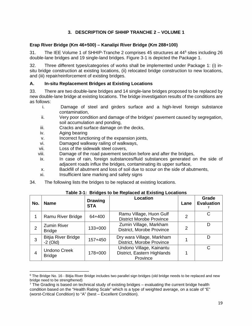
DFAT – Department of Foreign Affairs and Trade of the Government of Australia
DMS – Detailed Measurement Survey DNPM – Department of National Planning and Monitoring DOW – Department of Works EARF – Environmental Assessment and Review Framework EHSG _ Environmental Health and Safety Guidelines EHSO _ Environment, Health and Safety Officer
EMP – Environmental Management Plan EP – Environmental Permit
EPAR – Environmental (Prescribed Activities) Regulations ESSB – Environmental and Social Safeguards Branch ESO – Environmental and Safety Officer
ENSO – El Niño Southern Oscillation GCMs – Global Circulation Models
GOPNG _ Government of Papua New Guinea GRM – Grievance Redress Mechanism GFP – Grievance Focal Points
HCRN – Highlands Core Road Network HH – Highlands Highway HIV – Human Immunodeficiency Virus
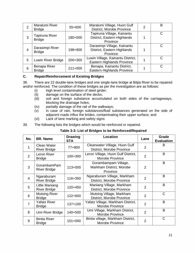
HRMG – Highlands Road Management Group HRRIIP – Highlands Region Road Infrastructure Investment
Program IEE – Initial Environmental Examination LIR – Land Investigation Report
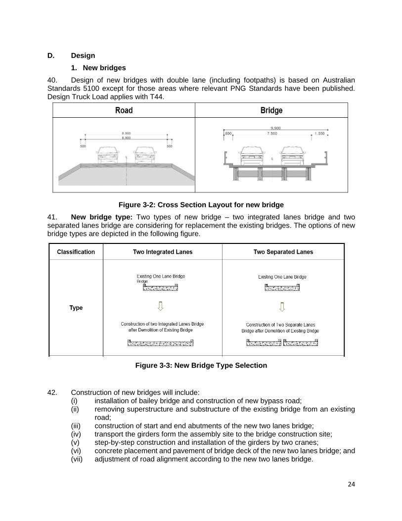
LLG – Local Level Government MFF – Multi-tranche Financing Facility
MPFF _ Multi-partner Financing Facility PACCSAP – Pacific - Australia Climate Change Science and
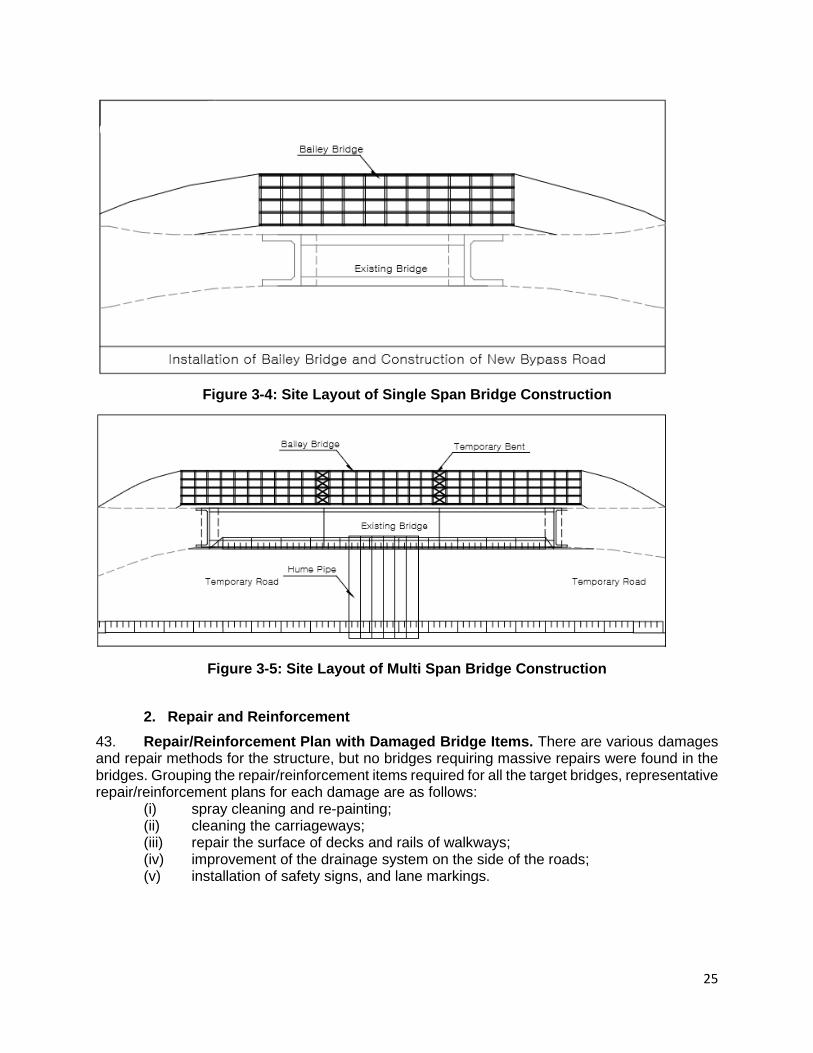
Adaptation Planning PCR – Physical Cultural Resources PFR – Periodic Financing Request

ii
PMO – Program Management Office PMV – Public Motor Vehicle PNG – Papua New Guinea PPE _ Personnel Protection Equipment
QMP – Quarry Management Plan QPR – Quarterly Progress Report
SCPP – Stakeholder Consultation and Participation Plan SHHIP _ Sustainable Highlands Highway Investment Program
SPS – Safeguards Policy Statement SR – Safeguard Requirement
TSS – Total Suspended Solids VEC – Valuable Environmental Components
WHO – World Health Organisation
NOTE
NOTE In this report, “$” refers to United States dollars.

iii
Table of Contents
EXECUTIVE SUMMARY ............................................................................................................... 6 1. INTRODUCTION ...............................................................................................................11
A. SHHIP Background ............................................................................................................... 11 B. SHHIP-Tranche 2 .................................................................................................................... 13 C. Project Cost and Implementation Schedule ........................................................................... 14 D. IEE for SHHIP Tranche 2 – Volume 1 .................................................................................... 15
2. LEGAL AND POLICY FRAMEWORK ................................................................................16 A. Papua New Guinea Environmental Laws ............................................................................. 16 B. Asian Development Bank Safeguard Requirements ............................................................ 17
3. DESCRIPTION OF SHHIP TRANCHE 2 – VOLUME 1 ......................................................19 A. In-situ Replacement Bridges at Existing Locations................................................................. 19 B. Relocated Bridge to New Locations ........................................................................................ 20 C. Repair/Reinforcement of Existing Bridges .............................................................................. 21 D. Design...................................................................................................................................... 24
4. DESCRIPTION OF THE ENVIRONMENT .........................................................................26 A. Physical Environment ............................................................................................................ 26 B. Environmental Quality ............................................................................................................. 35 C. Biological Environment .......................................................................................................... 41 D. Socio-Economic Environment ................................................................................................. 50
5. ANTICIPATED ENVIRONMENTAL IMPACT AND MITIGATION MEASURES...................58 A. Design Phase .......................................................................................................................... 58 B. Pre-Construction Phase .......................................................................................................... 59 C. Construction Phase ............................................................................................................... 65 D. Operation Phase .................................................................................................................... 75 E. Cumulative Impacts ................................................................................................................. 78
6. ANALYSIS OF ALTERNATIVES ........................................................................................84 A. Alternative No.1 -"No Bridge Improvement"............................................................................ 84 B. Alternatives for Bridges Improvement ..................................................................................... 84
7. INFORMATION DISCLOSURE, CONSULTATION, AND PARTICIPATION .......................85 A. Results of Consultations ........................................................................................................ 85 B. Further Consultations during Design and Implementation Stages ......................................... 87
8. GRIEVANCE REDRESS MECHANISM .............................................................................87 9. ENVIRONMENTAL MANAGEMENT PLAN .......................................................................89
A. Institutional Arrangements and Responsibilities ................................................................... 89 B. Monitoring and Reporting ........................................................................................................ 94 C. Environmental Management Plan (EMP) and Monitoring Matrix......................................... 97 D. Environmental Claims and Penalty System .......................................................................... 173 E. Estimated Budget for EMP Implementation .......................................................................... 173
10. CONCLUSIONS AND RECOMMENDATION ................................................................... 174 ANNEXES .................................................................................................................................. 175
Annex A: List of Bridges for SHHIP-Tranche 2 ........................................................................ 176 Annex B: List of International Treaties and Agreements to which PNG is a Signatory ............. 180 Annex C: Results of Ecological Survey Undertaken by SHHIP Team and Research & Conservation Foundation (Goroka, EHP) in December 2019 .................................................. 181 Annex D: Cost Estimated for Environmental Quality Monitoring .............................................. 191 Annex E: Location Map of Volume 1 for Environmental Quality Monitoring ............................. 193 Annex F: Public Consultation Meetings ................................................................................... 194 Annex G: References .............................................................................................................. 198
iv
List of Tables Table 1-1: Location of SHHIP -Tranche 2 ..................................................................................13 Table 1-2: Summary of Bridge Investigation ..............................................................................14 Table 3-1: Bridges to be Replaced at Existing Locations ..........................................................19 Table 3-2: Bridges to be relocated at New Locations ...............................................................20 Table 3-3: List of Bridges to be Reinforced/Repaired ................................................................21 Table 4-1: Geology at Critical Sections .....................................................................................27 Table 4-2: Summary of Soil Types at Critical Sections .............................................................28 Table 4-3: Average Monthly and Annual Rainfall for Highlands Highway 1998 - 2000...............31 Table 4-4: Climate Change Projections ....................................................................................33 Table 4-5: Active Mines in PNG with type of waste (tailings) disposal and annual tailing waste discharged into receiving water bodies .....................................................................................34 Table 4-6: Air Monitoring Locations ...........................................................................................35 Table 4-7: Air monitoring results ...............................................................................................36 Table 4-8: Noise Monitoring Locations ......................................................................................36 Table 4-9: Noise monitoring results ...........................................................................................37 Table 4-10: Surface Water Monitoring Locations .......................................................................37 Table 4-11: Results of Surface Water Monitoring ......................................................................37 Table 4-12: Ground Water Monitoring Locations .......................................................................38 Table 4-13: Results of Ground Water Monitoring ......................................................................38 Table 4-14: PNG and the World Terrestrial ...............................................................................41 Table 4-15: Change in rainforest area (km2) in project area (2002 – 202014) ...........................45 Table 4-16: Summary of Sites and Habitat Types .....................................................................46 Table 4-17: Population by Districts and LLGs Served by Highlands Highway: 2011 Census .....50 Table 4-18: Educational facilities along the Highlands Highway ................................................56 Table 4-19: Health Facilities along the SHHIP Highlands Highway Scope ................................57 Table 5-1: List of in-situ New Bridge Constructions Requiring Temporary Acquisitions .............59 Table 5-2: Impacts due to Volueme 1 Bridge Works Requiring Permanent Acquisitions ...........61 Table 5-3: Emission factors of some diesel equipment ..............................................................65 Table 5-4: Mitigation measures for PM emission from construction ...........................................66 Table 5-5: Terrestrial Fauna Impacts ........................................................................................69 Table 5-6: Potential areas affect to the livelihood and market patterns of local people ..............75 Table 5-7: Types of Activities, Environmental Impact Assessment Coding ................................79 Table 5-8: Environment Impacts Matrix .....................................................................................79 Table 9-1: Institutional Responsibilities for Environmental Safeguards ......................................93 Table 9-2: Key Tasks for Environmental Monitoring ..................................................................96 Table 9-3: Environmental Management Plan (EMP) and Monitoring Matrix for In-situ
Replacement Bridges at Existing Locations (16 Bridges) ..........................................98 Table 9-4 Environmental Management Plan (EMP) and Monitoring Matrix for Relocated Bridge
to New Locations (6 Bridges) .................................................................................. 138 Table 9-5: Environmental Management Plan for Repair/Reinforcement of Existing Bridges (23
Bridges) .................................................................................................................. 162

v
List of Figures
Figure 1-1: Map Showing the SHHIP Highlands Highway Section.............................................11 Figure 1-2: Map of SHHIP-Tranche 2 ........................................................................................14 Figure 3-1: Map of Volume 1 Bridges ........................................................................................23 Figure 3-2: Cross Section Layout for new bridge .......................................................................24 Figure 3-3: New Bridge Type Selection .....................................................................................24 Figure 3-4: Site Layout of Single Span Bridge Construction ......................................................25 Figure 3-5: Site Layout of Multi Span Bridge Construction ........................................................25 Figure 4-1: Mean Monthly Rainfall for the Highland and Lowland Regions, 1998-2000 .............31 Figure 4-2: Main Mineral Occurrences of Papua New Guinea ...................................................34 Figure 4-3: Map of Baseline monitoring location ........................................................................40 Figure 4-4: Map of Biodiversity Priorities ...................................................................................43 Figure 4-5: Map of Protected areas ...........................................................................................44 Figure 4-6: Administrative Boundaries along the Highlands Highway ........................................52 Figure 9-1: Institutional Arrangement for SHHIP, Safeguards Management ..............................90
6
EXECUTIVE SUMMARY
1. Background: The Highlands Highway traverses the Highland Region to Lae in Morobe Province of Papua New Guinea (PNG). These regions are major contributors to the PNG economy through agricultural production and mineral resources, as well as commercial and shipping activities. While the Government of PNG has made significant investments in improving the road network, a lack of maintenance has resulted in deterioration not only of its core road network but also the Highlands Highway itself where only about 3% of the investment program section is in good condition.
2. In order to address the further deterioration of the Highlands Highway, PNG requested the Asian Development Bank (ADB) to support financially the implementation of a Sustainable Highlands Highway Investment Program (SHHIP) through a multitranche financing facility (MFF). This includes four highlands provinces of Western Highlands, Jiwaka, Simbu, and Eastern Highlands (excluding Enga and Southern Highlands), and Morobe Province of the Momase Region from the Nadzab Airport turnoff near Lae City to the Kagamuga Airport turnoff in Mt. Hagen. The executing agency for the program is the Department of National Planning and Monitoring (DNPM) and the implementing agency is the Department of Works (DOW).
3. Objectives, impacts and outcome of the investment program: The overarching objectives are to (i) improve access to health and education, and to raise standards of living; (ii) increase opportunities for equality and prosperity in rural areas; and (iii) provide well-integrated, safe, financially and environmentally sustainable transport systems. The expected outcome of the investment program is to make the movement of people, goods and services between the highlands region and domestic and international markets safer and more efficient. The program is also expected to benefit the environment in terms of reduced soil erosion and landslides through slope stabilization measures and construction of retaining structures.
4. Program description and components: The SHHIP is a 10-year program designed to (i) restore, upgrade and effectively maintain the entire 430 km section of the highlands highway between Nadzab and Kagamuga airports; (ii) increase the resilience to climate change and the safety of pedestrians and vehicle occupants; (iii) improve transport logistics and services between the provincial capitals; and (iv) develop DOW managerial and operational capacity to deliver the program and sustain its benefits.
5. The SHHIP is implemented in three tranches with the main components and core activities as follows:
• SHHIP Tranche 1 - Comprehensive sustained maintenance is under implementation and covers the entire 430 km section under specific (repairs) routine and periodic (resurfacing) maintenance from day one to keep the road open to traffic at all time; gradually improve the ride comfort; salvage the sections in fair condition; remove the vegetation encroachment, restore drainage efficacy, and unearth currently suppressed paved shoulders; and secure a quick response to emergency situations. Over the Program period, incrementally resurface or strengthen the pavement structure; increase the drainage capacity and multiply the protections against slope instability following recommendations for adaptation to climate change; improve the traffic safety.
• SHHIP Tranche 2 - Bridges improvement to be constructed from 2021 with four-year project period. SHHIP-Tranche 2 comprises of seventy-two (72) structures at seventy-one (71) sites with seventy-one (71) bridges and one (1) culvert on the 430 km of Highlands Highway from Lae Nadzab airport to Kagamuga airport in Mt. Hagen to be strengthened or replaced by double-lane bridges. It will allow bi-directional traffic, be physical capable
7
of passing all vehicles expected, be seismic resistant as required, have sufficient hydraulic capacity for the 1:100-year flow, and have pedestrian lanes on both sides.
• SHHIP Tranche 3 to be constructed between 2022 and 2028. It will build (i) a new two-lane bypass to divert heavy and through traffic around Goroka because the dense urban fabric cannot accommodate a four-lane highway; (ii) about 20 km of truck climbing lanes in the steep slopes of the Kassam and Daulo Passes; (iii) two truck weigh stations in Jiwaka and Goroka; and (iv) two logistics platforms for the trade of fresh produce in Jiwaka and Goroka.
• Improving the capacity of the PNG DOW and related departments to manage and sustain bridge, road, and infrastructure assets, and to provide greater levels of accountability and transparency of safeguards.
6. SHHIP Tranche 2 Scope of Works: The scope of tranche 2 works is primarily maintenance and upgrading works executed for all 71 bridges and a group of three culverts along the SHHIP Highlands Highway sections. As there are two independent single-lane bridges in a single location over the Bitja River and one group of culverts at Temnaike Creek is also planned to be replaced by new double-lane bridges, the number sites (Rivers) for tranche 2 is 71 while the actual number of crossing structures (bridges) is 72 considering these variations.
7. Four different types/categories of works shall be implemented under tranche 2: (i) in-situ replacement bridges construction at existing locations; (ii); relocation bridges construction at new sites; (iii) in-situ replacement of one culvert with new two-lane bridge; and (iv) repair/reinforcement of existing bridges. The impacts and risks will vary accordingly, hence four separate environmental management plans (EMPs) have been prepared for SHHIP-Tranche 2 works under IEE Volume I and II (Nadzab to Goroka as Volume I, and Goroka to Kagamuga section as Volume II) planned for the design and build (D&B) modality of works. Altogether, 45 bridges including 301 single-lane bridges, 14 double-lane bridges and one culvert are recommended to be replaced by new double-lane bridge. Other 26 double-lane bridges and one single-lane bridge shall be repaired over partial or whole damage area of bridge members.
8. Initial Environmental Examination (IEE): The IEE (Volume I) was conducted as part of the feasibility study to identify potential direct, indirect, cumulative and induced environmental impacts and physical, biological, and socioeconomic risks on physical and cultural resources and provide information for the design that will be developed further by the D&B contractor. It includes environmental management plans (EMPs) which outlines the mitigation measures for the anticipated impacts, environmental monitoring activities and parameters to be monitored, institutional responsibilities, and environmental management capacity building.
9. The IEEs and EMPs shall be developed with more details during the detailed engineering design stage as tranche 2 works are planned to be implemented following design and build modality of contracts. In depth environmental impact assessment on site specific basses will be conducted specifically for every bridge location and IEEs and EMPs will be updated and finalized accordingly. The D&B contractor will update the IEEs and EMPs during detailed design and will develop a construction EMP (CEMP including a detailed and site-specific EMP for each bridge, setting out the works and approach to that site and measures to mitigate impacts and risks specific to the conditions at that site).
1 The double lane Bitjia river bridge (Km 157+450) comprises two one lane bridges – the new bridge (build in 2003) will be repaired and reinforced, while the old ones is proposed to be replaced.

8
10. Legal and policy framework: The program will comply with the country safeguards system, which include the Environment Act 2000, Environment (Amendment) Act 2014 and Environment (Prescribed Activities) Regulation 2002 (EPAR). The Environment Act provides for the sustainable management of the biological and physical components of the land, air and water resources of the country. The EPAR categorizes projects as “prescribed activities” in two schedules according to the anticipated potential environmental impact. There is no specific activity covering the upgrading or rehabilitation of existing bridges. However, a number of activities associated with the upgrading of the existing roads such as quarrying, and extraction of gravel may require environmental permits from the Conservation and Environmental Protection Authority (CEPA).
11. Several other pieces of legislation will apply to the program. This includes the Public Health Act 1978; the Employment Act 1978; the Forestry Act 1991; the National Cultural Property Preservation Act 1965; Public Health Drinking Water Quality Standards 1984, and Environment (Water Quality Criteria) Regulation 2002; and related legislations administered by CEPA that includes the Fauna Protection and Control Act (1966), the Conservation Areas Act (1978), the International Fauna and Flora Trade Act (1978), and the National Parks Act (1984); regulations related to biosecurity including Fisheries Management Act (1998), Animal Diseases and Control Act (1995), and Plant Diseases Control Act (1952). PNG is also a signatory to a number of international agreements (treaties and conventions).
12. In addition, the SHHIP does not only have to comply with the national safeguards, it has to comply with ADB’s Safeguard Policy Statement 2009 (SPS) which sets out the policies and principles for protecting the environment and people by wherever possible avoiding impacts and/or mitigation and/or compensation for impacts that cannot be avoided.
13. Following country safeguards and the SPS, an Environmental Assessment and Review Framework (EARF) has been prepared and updated for this Program, setting out the procedures for complying with the principles and requirements of SPS. The EARF reflects (i) the policy objectives and relevant policy principles and safeguard requirements governing preparation and implementation of projects and/or components; (ii) explains the general anticipated impacts of the project and/or components; (iii) specifies the requirements that will be followed for subproject such as screening and categorization, assessment, and planning, information disclosure, meaningful consultation, and grievance redress mechanism; (iv) describes implementation procedures including budgets, institutional arrangements, and capacity development.
14. Categorization. The SHHIP-Tranche 2 has been categorized by ADB as environment Category B and this IEE was prepared consistent with the environmental assessment requirements of the SPS.
15. Consultation, participation and information disclosure: Consultations were undertaken with community leaders and local people to present the SHHIP-Tranche 2, to identify issues and concerns that the people, stakeholders, and concerned parties in the impacted area may have relevance to the proposed development. The project preparation team presented and explained to the participants the scope of the SHHIP-Tranche 2 including explanation of the environmental and social impacts and mitigating measures that will be established during the implementation of the subproject. There was unanimous support for the subproject due to a wide range of economic and social benefits identified by participants (i.e. rehabilitation of coffee gardens; more accessibility of coffee factories; expansion of cash cropping; improved accessibility to markets; reduced costs for transport of goods and lower maintenance costs for vehicles; better access to health care, education and other services; improved family ties and social networking, among others). The EARF, this IEE and other project documents
9
(such as safeguards monitoring reports) will be disclosed locally and to the ADB website according to ADB’s Access to Information Policy 2018.
16. Grievance Redress Mechanism: A grievance redress mechanism (GRM) has been established for the program and has been implemented during SHHIP-Tranche 1 works – which can be implemented for SHHIP-Tranche 2 works as well. The key objective of establishing GRM is to ensure that all grievances regarding any aspect of their environmental or socio-economic rights are resolved in a timely and satisfactory manner. Stakeholders will be made fully aware of their rights (both verbally and in writing), and informed how they can access the GRM, during the initial community consultations, and through an information brochure. The GRM operates on the principle of trying to solve problems locally at the lowest project level, as far as possible taking into account customary problem-solving methods. SHHIP has established a grievance redress committee (GRC) in each province for hearing and resolving any complaints that cannot be resolved at the local level or by the project management office (PMO) based in Goroka, Eastern Highlands Province.
17. Impacts and mitigations: The SHHIP-Tranche 2 does not traverse nor is located near within wildlife management and protected areas; the nearest - Chuave protected area is about 3.5Km from the project site. Most of the habitat have had some human modifications to the environment and its vegetation. However, there are 6 sites-Clean Water River Bridge 77+800 (B#4), GorambamPam River Bridge 113+000 (B#6), Feonoku River 355+450 (B#51), Nurape River 342+850 (B#52), Kenangi River 345+200 (B#53) and Baikabai River 348+400 (B#54) which still have some primary and secondary forests near the mountains close to the bridges. No endangered terrestrial and/or aquatic species will be affected by the program activities.
18. The construction works at in situ new (replacement) bridges and repar/reinforcement of existing bridges will be executed within or directly adjacent to the existing cross section and the alignment and longitudinal profile of the bridge. While the relocation bridges require permanent land acquisition at per new bridge construction for approach road re-alienations. Given the nature and scale of proposed works, it is anticipated that there will be site-specific and mostly short-term negative impacts during construction activities. These impacts include: risk of introduction of invasive and alien species (flora and fauna), dust, sedimentation, run-off and erosion, gaseous emissions and noise , waste generation, access and traffic disruption, haulage and disposal of excavated materials, operation of borrow sites and quarries; and potential occupational and community health and safety risks.
19. Health risk to the roadside communities will be reduced due to the bridges’ improvement, sustained maintenance, and soil erosion control measures. Road safety will be improved by stabilizing unstable sections; installing road safety barriers including pedestrian safety facilities, footpaths, and pedestrian crossings especially near schools and market areas; proper traffic engineering signs and display boards; traffic control devices with high intensity reflective traffic signs, road delineation and reflective road markings and edge lines; preparation of accident black spot management program to identify and improve hazardous locations on the main road network; and community road safety awareness raising.
20. Institutional arrangements for environmental management: Overall implementation of environmental and social safeguards including environmental management requirements is a joint responsibility between the DOW/PMO, the construction supervision consultant (CSC), and the D&B contractors. The DOW has established the environmental and social safeguards branch (ESSB) which will monitor the activities and works.
21. Environmental Management Budget: DOW/PMO operating budget and induction cost of contractor to site will be included in the project cost. The cost for CSC to supervise EMP implementation in accordance with the EMP and the project bidding and contractual

10
documents is integrated in the contract with the CSC. The cost for contractor for training, dissemination, procurement, operation of equipment and labour for implementation of management and mitigation measures in accordance with the EMP (and any conditions of permits issued by CEPA) will be included in the bidding and contractual documents requirements and will be costs covered by the works contracts. Cost for monitoring of SHHIP-Tranche 2, a total of Kina 639,990 ($ 188,157) - $91,988 for volume-I and $ 96,169 for volume-II is envisaged to be required.
22. Monitoring and reporting requirements: Throughout implementation of the SHHIP-Tranche 2, the DOW-ESSB, PMO, CSC and ADB will monitor the progress and impact of subprojects, this includes monitoring and inspection/audit of the implementation of safeguards and effectiveness of mitigation measures. DOW/PMO is required to implement safeguard measures and relevant safeguard plans, as provided in the legal agreements, and to submit periodical monitoring reports.
23. Reporting includes: (i) a monthly report prepared during construction by the contractor reporting on progress of the subprojects and including a section on CEMP activities, issues and corrective actions; (ii) quarterly progress reports (QPR) prepared by the PMO that includes a section on safeguards activities and CEMP compliance, and summarizes the monthly reports submitted by the contractor and any actions or citations made by the CSC; (iii) semi-annual safeguards monitoring reports prepared by the PMO and submitted to DOW and ADB for disclosure; and (iv) a project completion report that will be prepared by DOW-ESSB three months prior to the end of Tranche 2, which will include a section on safeguards implementation, lessons learned and recommendations.
24. Conclusion: By using the conceptual model, as described in Section V, to assess cumulative environmental impacts, the IEE revealed that the project has 11 activities that will have a “high impact”, 50 activities will have a “medium impact” and 66 activities will have a “low impact” on the physical environment, biological environment and socio-economic environment. The scale of these impacts will be assessed in further during the Detailed Design phase. At present, the IEE reveals that there are no significant and irreversible environmental impacts. Most bridges (40 bridges) are located in remote areas. Homes, businesses, vegetable plots, etc. at other bridge sites are located more than 100m from each end of the bridge. Therefore, construction impacts such as noise, air pollution, and vibration on the communities will be minimal, yet the contractor is required to implement measures to ensure these impacts are kept to a minimum. The highest impact will be from runoff of material from embankment construction, removal and constructing bridge piers. The communities downstream that use the rivers for washing and drinking water may be affected by the runoff. Special measures and procedures are proposed in the EMP for addressing this impact.
25. The type of works identified in the Feasibility Study stage of the Package 1 of SHHIP-Tranche 2 include (i) in-situ replacement bridge construction at existing locations, (ii) relocation bridge construction at new locations, and (iii) repair/reinforcement of existing bridges. The Environmental Management Plans (EMPs) are prepared for three (3) major activities. Following stages of Detailed Engineering Design, these EMPs will be developed to be specific at each bridge location.

11
1. INTRODUCTION
A. Sustainable Highlands Highway Investment Program Background
1. The Highlands of Papua New Guinea (PNG) is a chain of mountains and high valleys stretching in a generally west to east direction from the border with Indonesia in the centre of the island to the eastern coast. The valleys are typically 1,500 m above sea level and are surrounded by peaks up to 4,000 m. These regions are major contributors to the PNG economy through agricultural production and mineral resources, as well as commercial and shipping activities. A well-maintained Highlands Highway is essential to facilitate the movement of goods and people. While the Government of PNG (the government) has made significant investments in improving the road network, a lack of maintenance has resulted in deterioration not only of its core road network but also the Highlands Highway itself where only about 3% of the investment program section is in good condition. 2. The Highlands Highway is a two-lane highway and stretches from Lae in Morobe Province on the eastern coast for over 600 km to Mendi in Southern Highlands Province as shown in Figure 1-1. The Highlands Highway passes through the following provinces: Southern Highlands, Enga, Western Highlands, Jiwaka, Simbu, Eastern Highlands, and Morobe. Although construction started in the 1950s, it was only in the late 1970s that construction commenced on a modern, sealed highway. Till this day, it is the only terrestrial means of communication between the large Highlands population and the rest of PNG and the world.
Figure 1-1: Map Showing the SHHIP Highlands Highway Section
3. In order to address the further deterioration of the Highlands Highway, the government of PNG requested the Asian Development Bank (ADB) to support the implementation of the Sustainable Highlands Highway Investment Program (SHHIP) through a multi-partner financing facility. The program covers four highlands provinces of Western Highlands, Jiwaka, Simbu, and Eastern Highlands (excluding Enga and Southern Highlands), and Morobe Province of the
12
Momase Region2 from the Nadzab Airport turnoff near Lae City to the Kagamuga Airport turnoff in Mt. Hagen. 4. Program Objectives, Impact and Outcome: The overarching objectives and expected outcome of the Program are: (i) to improve access to health, education and standard of living, (ii) increase opportunities for equality and prosperity in rural areas, (iii) provide well integrated, safe, financially and environmentally sustainable transport systems, and (iv) make the movement of people, goods and services between the highlands region and domestic and international markets safer and more efficient. 5. Context: The SHHIP aligns with the government’s Development Strategic Plan 2010-2030; National Transport Strategy 2014-2030; ADB’s Country Partnership Strategy 2016-2020; and ADB’s Country Operations Business Plan 2015-2017. It draws on the experience of and ties in with the ongoing ADB-funded Highlands Road Infrastructure Investment Program; DFAT-funded Transport Sector Support Program; and World Bank operations in support of road maintenance. 6. The program addresses the following risks and constraints:
(i) the failures of the road pavement are primarily due to a prolonged lack of maintenance not to an inadequate structural design, except for flood-prone sections in the Morobe Province;
(ii) many sections can be restored without engaging into costly reconstruction if corrective actions are implemented rapidly;
(iii) the current two-lane design is sufficient to carry the projected traffic over the next 20 years, except in the vicinity of Goroka; however, there, the dense urban fabric in Goroka town would not accommodate a 4-lane highway so other solutions must be investigated;
(iv) road traffic safety is poor, and pedestrians are especially at risk; (v) twenty nine one-lane bridges constitute a primary safety hazard and 40 two-lane
bridges need repairs if not reinforcement or full reconstruction; (vi) the budget is constrained; and (vii) climate change, although a real threat, is of an uncertain nature, meaning flexible,
adaptive response mechanisms are necessary. 7. Program description: The SHHIP is a 10-year Program designed to: a) restore, upgrade and effectively maintain the entire 430 km section of the Highlands Highway between Nadzab and Kagamuga airports; b) increase the resilience to climate change and the safety of pedestrians and vehicle occupants; c) improve transport logistics and services between the provincial capitals; and d) develop DOW managerial and operational capacity to deliver the program and sustain its benefits. 8. The program will be implemented in three tranches as following:
(i) Tranche 1 is currently under implementation (2019 and 2022) and includes road maintenance and road investment works, drainage and slope protection works, road safety improvements as well.
(ii) Tranche 2: will be implemented between 2021 and 2025 including (i) Continue road maintenance and road investment works, (ii) Widen all twenty nine (29) single-lane bridges to double-lane bridges with pedestrian footpaths, (iii) Repair, reinforce and reconstruct as appropriate all forty one (41) double-lane bridges. The planned subprojects are depicted in the following table.
2 Momase Region is one of four regions of Papua New Guinea and includes Morobe, Madang and Sepik (East and West). Its largest city is Lae, the second city of the nation.

13
Table 1-1: Location of SHHIP -Tranche 2 No. Province District 1 Morobe
(K40-Km168) Huon Gulf Markham
2 Eastern Highlands (Km168-Km355)
Kainantu Henganofi Ungai Bena Goroka Daulo
3 Chimbu (Km355-Km 412)
Kundiawa Gembolg Kerowaghi
4 Jiwaka (Km412-Km463)
North Waghi Anglimp South Waghi
5 Western Highlands (Km463-Km469)
Mt Hgaen
(iii) Tranche 3: The preparation phase of SHHIP Tranche 3 will be implemented
between 2026 and 2028 including: (i) Continue road maintenance and road investment works, (ii) Build a new two-lane bypass to divert heavy and through traffic around Goroka because the dense urban fabric cannot accommodate a four-lane highway, (iii) Build about 20 km of truck climbing lanes in the steep slopes of the Kassam (Eastern Highlands Province) and Daulo Passes (Eastern Highlands Province), (iv) Build two truck weigh stations in Jiwaka and Goroka (Eastern Highlands Province); and build two logistics platforms for the trade of fresh produce in Jiwaka and Goroka (Eastern Highlands Province).
B. SHHIP-Tranche 2
9. SHHIP-Tranche 2 comprises 72 structures at 71 sites including 29 single-lane bridges, 413 double-lane bridges and one4 group of three culverts, which are located on the 430 km of HH from from Lae Nadzab airport to Kagamuga airport in Mt. Hagen, and are planned for replacement, repair and reinforcement as follows:
(i) All single lane bridges shall be either replaced or twinned to allow bi-directional traffic.
(ii) All bridges shall have pedestrian lanes on at least one side, separated by physical barriers from the vehicle traffic.
(iii) All bridges shall be physically capable of passing all vehicles expected on the Highlands Highway.
(iv) All bridges shall be seismic resistant as required by the seismic zone of the highlands of PNG.
(v) All bridges shall have sufficient hydraulic capacity for the 1:100-year flow, after taking into account expected climate changes.
10. The 72 structures were inspected in detail by a team of bridge experts between August and September 2019. The inspections are documented in the feasibility study that confirms the dimension, type of bridge structure, and condition (defect and damage) of superstructure-deck, main steel girder beams, and cross beam, substructure-abutment and pier, pavement, expansion
3 The double lane Bitjia river bridge (Km 157+450) comprises two structures over the Bitjia River – the new bridge (build in 2003) will be repaired and reinforced, while the old ones is proposed to be replaced. 4 An existing group of three culverts (Km 398+450) at Tem Naike Creek need to be replaced by a new double lane Bridge
14
joint, bearing, pedestrian walkway, drainage, approach roads, etc. Table 1-2 summarises the results of bridge investigation.
Table 1-2: Summary of Bridge Investigation No. Type of Structures Quantity Remark 1 Single-lane bridges 29 One-lane bridges have no walkway and guardrail
excluding some bridges those have temporary walkway 2 Double-lane bridges 41 Generally, Two-lane bridges have walkways at both
sides, one side 0.85 meter and 1.55 meter on the other side, and some of the bridges have no walkways installed, or temporary steel walkways at one side
3 Culvert 1 One pipe culverts should be replaced with new bridges due to insufficient flow capacity and possibility of blocking by debris from upstream
11. Total 45 structures including 305 single-lane bridges, 14 double-lane bridges and one culvert are recommended to be replaced. Other 26 double-lane bridges and one single-lane bridge should be repaired over partial or whole damage area of bridge members for proper road service. C. Project Cost and Implementation Schedule
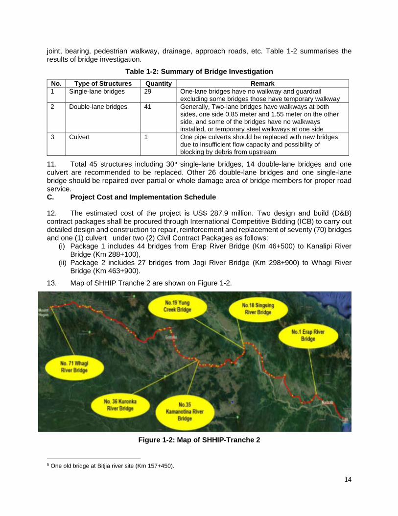
12. The estimated cost of the project is US$ 287.9 million. Two design and build (D&B) contract packages shall be procured through International Competitive Bidding (ICB) to carry out detailed design and construction to repair, reinforcement and replacement of seventy (70) bridges and one (1) culvert under two (2) Civil Contract Packages as follows:
(i) Package 1 includes 44 bridges from Erap River Bridge (Km 46+500) to Kanalipi River Bridge (Km 288+100),
(ii) Package 2 includes 27 bridges from Jogi River Bridge (Km 298+900) to Whagi River Bridge (Km 463+900).
13. Map of SHHIP Tranche 2 are shown on Figure 1-2.
Figure 1-2: Map of SHHIP-Tranche 2
5 One old bridge at Bitjia river site (Km 157+450).
15
D. IEE for SHHIP Tranche 2 – Volume 1
14. The IEE Volume 1 report was conducted during the feasibility study of SHHIP-Tranche 2 from Erap bridge in Morobe to Kabalip bridge in Eastern Highlands province following the Environmental Assessment and Review Framework (EARF) prepared for the Program and in accordance with the requirements of the country safeguard system (CSS) and the ADB Safeguard Policy Statement (SPS) 2009. 15. This IEE identifies potential environmental impacts of the construction and operation of bridge works and to identify the measures required to avoid / mitigate the negative impacts arising during pre-construction, construction and operation. The IEE comprises the following:
(i) identifying the project impact area and describing the baseline environmental conditions of the sub-project area;
(ii) identifying the potential environmental impacts of the proposed works and activities at the bridge sites;
(iii) recommending appropriate mitigation measures to avoid/minimise the environmental impacts; and
(iv) preparing an environmental management plan for implementation. 16. The IEE is based on the physical environmental baseline survey (i.e. air, water, noise) conducted during March and April 2019 by the SHHIP team, ecological survey undertaken in December 2019, primary and secondary sources of information and data conducted during preparation the report. The team conducted consultations with the local people and leaders in the area to gather relevant social and environment-related information/data and to provide information about the Program overall and the subprojects in Tranche 2. During the site visits, the existing bridges and immediate environment, including watercourses, were visually inspected and photos taken. 17. Public consultations with government stakeholders and communities where the bridges are located were undertaken as part of the information disclosure process and to determine community perceptions and obtain relevant information. 18. Structure of the report. This IEE Vol.1 report has been presented in the format prescribed in ADB’s SPS. An Executive Summary is also prepared and presented in the beginning of the report. The report is organized into the following Sections:
Section I : Introduction Section II : Policy, Legal and Administrative Framework Section III : Description of the SHHIP-Tranche 2 – Package 1 Section IV : Description of the Environment Section V : Anticipated Environmental Impacts and Mitigation Measures Section VI : Analysis of alternatives Section VII : Information Disclosure, Consultations and Participation Section VIII : Grievance Redress Mechanism Chapter IX : Environmental Management Plan; and Chapter X : Conclusions and Recommendations.

16
2. LEGAL AND POLICY FRAMEWORK
A. Papua New Guinea Environmental Laws 19. Country safeguards system. The CSS includes Environment Act 2000 and Environment (Prescribed Activities) Regulation 2002 (EPAR) address environmental impact assessment and management. The Environment Act provides for the sustainable management of the biological and physical components of the land, air and water resources of the country. The Conservation and Environmental Protection Authority (CEPA) administers both the Act and the EPAR. The EPAR categorizes projects as “Prescribed Activities” in two schedules according to the anticipated potential environmental impact. Schedule 1 consists of Level 2 activities that are subdivided into two categories (Category A and B). Category B has 13 sub-categories with sub-category 12 addressing Infrastructure Development. While item 12.5 includes construction of new national roads, there is no specific activity covering the upgrading or rehabilitation of existing roads. However, a number of activities associated with upgrading of existing roads such as quarrying, extraction of gravel etc. may require environmental permits (EP) from CEPA. In addition the DOW has established procedures and guidelines for environmental assessment and management for road projects. 20. The mandate of CEPA, as the government’s environmental management agency, is “To ensure PNG’s natural resources are managed to sustain environmental quality, human well-being and support improved standards of living” (CEPA Corporate Plan (2009-2012). The CEPA consists of three divisions: Environment Protection responsible for environmental approvals; Sustainable Environment Management; and Policy Coordination and Evaluation. 21. CEPA has issued several guidelines including the Notification of preparatory work on level-2 and level-3 activities (IB-ENV/01/2004) dated 1 January 2004; the Guideline for the submission of an application for an environmental permit to discharge waste (GL-Env/03/2004) which covers: noise discharges (IB-ENV/03/2004); air discharges (IB-ENV/02/2004); and water and land discharges (IB-ENV/04/2004). 22. CEPA operates at the national level from its office based in Port Moresby. It does not have offices and staff in the provinces. All environmental approvals are done in the central office in Port Moresby. As part of the government decentralization policy, CEPA has to work in close consultation with the provincial governments through the respective provincial administrations to ensure implementation of environmental legislation at the provincial level. Certain environmental management and monitoring functions are delegated to provincial administrations on an “if and when” basis, meaning “if and when” they have the resources and the capacity to conduct them. 23. The following legislation also applies to Tranche 2 works:
• Public health. The Public Health Act 1978 protects the general public by regulating and controlling the unplanned disposal of any environmental contaminants such as domestic or industrial waste and/or refuse that will have some kind of impact on the lives of people. The act regulates the proper and planned establishment of waste disposal points such as rubbish dumps and landfills so that such establishments are seen to be causing minimal inconvenience to people’s lives. The act also covers all the activities that pose risks and potential risks, and inconveniences to the usage of the environment surrounding the area of activity. As the subproject will affect the lives of people, especially the local community downstream, this act is applicable and has been taken into consideration.
• Labour health and safety. The Employment Act 1978 is an act relating to the employment of nationals and non-citizens. The act covers recruitment, conditions of employment as well as health and safety aspects and is administered by the Department of Labour and
17
Employment. Conditions of this act are relevant to the health and safety of workers employed during construction and are reflected in the IEE.
• Forestry. The Forestry Act 1991 has the objective to manage, develop and protect PNG forest resources and environment in such a way as to conserve and renew them as an asset for succeeding generations.
• Cultural resources. The National Cultural Property Preservation Act 1965 covers the preservation and protection of objects of cultural or historical importance. This act is administered by the National Museum and Art Gallery. Should “chance finds” be made during construction this act will be triggered, provisions for this have been made in the EMP.
• Water quality. Drinking water quality standards for raw (untreated) water are contained in the Public Health Drinking Water Quality Standards 1984 while the standards for aquatic life protection are listed in the Environment (Water Quality Criteria) Regulation 2002. Ranges of criteria are given for several parameters including turbidity, which should not exceed 25 NTU. Since many of the water courses in PNG are naturally quite turbid this standard appears to be unrealistic as it is close to drinking water standard. Therefore, the pre-project turbidity in the watercourse is suggested as the standard for assessing turbidity during construction.
• Biosecurity. Fisheries Management Act 1998 aims to promote the management and sustainable development of fisheries with PNG. Animal Diseases Control Act 1952 focuses on both terrestrial and aquatic animal health management through minimising the introduction of exotic species, and Animal Disease and Control Regulation 1995 provides quarantine protocols, including those to be implemented when introducing exotic animals into PNG. Plant Diseases Control Act 1952 focuses on both terrestrial and aquatic plant health management through minimising the introduction of exotic species.
24. Other related legislation administered by CEPA includes; the Fauna Protection and Control Act (1966), the Conservation Areas Act (1978), the International Fauna and Flora Trade Act (1978), and the National Parks Act (1984). PNG is a signatory to a number of international agreements (treaties and conventions). These are listed in Annex A.
B. Asian Development Bank Safeguard Requirements
25. Safeguard policy. In addition to the obligation to comply with the CSS, Tranche 2 also has to comply with ADB’s SPS which sets out the policies and principles for protecting the environment and the people by wherever possible avoiding impacts and mitigating and/or compensating for impacts that cannot be avoided. ADB’s SPS is a policy document in respect of safeguards and avoiding, minimizing or mitigating adverse impacts on people and the environment. For projects with a number of components or subprojects, SPS requires the preparation of safeguards (environment and resettlement frameworks) which set out the processes to be followed for screening and assessment of each sub-project. 26. The SPS has the following objectives: (i) avoid adverse impacts of projects on the environment and affected people; (ii) where possible; minimize, mitigate, and/or compensate for adverse project impacts on the environment and affected people when avoidance is not possible; and (iii) help borrowers/clients to strengthen their safeguard systems and develop the capacity to manage environmental and social risks. The environment safeguard requires due diligence which entails addressing environmental concerns, if any, of a proposed activity in the initial stages of project preparation.
18
27. The SPS categorizes potential projects or activities into categories of impact (A, B or C) to determine the level of environmental assessment required to address the potential impacts. The EARF prepared for the Program sets out the steps for screening, assessing, mitigating and monitoring the impacts of the subprojects. Tranche 2 works are categorized as Category B for environment because potential adverse environmental impacts are site-specific, few if any of them are irreversible, and in most cases mitigation measures can be designed readily. Accordingly, this IEE has been prepared as the requisite level of assessment to address the potential impacts in line with the SPS. 28. The SPS also requires compliance with the World Bank’s Environmental Health and Safety Guidelines (EHSG). 29. Environmental Assessment and Review Framework. An EARF has been prepared for SHHIP, setting out the procedures for complying with the principles and requirements of SPS. The EARF: (i) reflects the policy objectives and relevant policy principles and safeguard requirements governing preparation and implementation of projects and/or components; (ii) explains the general anticipated impacts of the project and/or components; (iii) specifies the requirements that will be followed for subproject screening and categorization, assessment, and planning, information disclosure, meaningful consultation, and grievance redress mechanism; and (iv) describes implementation procedures, including budgets, institutional arrangements, and capacity development. 30. The EARF also sets out the capacity building measures that will be executed during its implementation. Under the SPS, Volume 1 of SHHIP-Tranche 2 is classified Category B because the potential adverse environmental impacts are site-specific, few if any of them are irreversible, and mitigation measures can be designed readily.
19
3. DESCRIPTION OF SHHIP TRANCHE 2 – VOLUME 1
Erap River Bridge (Km 46+500) – Kanalipi River Bridge (Km 288+100) 31. The IEE Volume 1 of SHHIP-Tranche 2 comprises 45 structures at 446 sites including 26 double-lane bridges and 19 single-land bridges. Figure 3-1 is depicted the Package 1. 32. Three different types/categories of works shall be implemented under Package 1: (i) in-situ bridge construction at existing locations, (ii) relocated bridge construction to new locations, and (iii) repair/reinforcement of existing bridges. A. In-situ Replacement Bridges at Existing Locations 33. There are two double-lane bridges and 14 single-lane bridges proposed to be replaced by new double-lane bridge at existing locations. The bridge investigation results of the conditions are as follows:
i. Damage of steel and girders surface and a high-level foreign substance contamination,
ii. Very poor condition and damage of the bridges’ pavement caused by segregation, soil accumulation and ponding,
iii. Cracks and surface damage on the decks, iv. Aging bearing v. Incorrect functioning of the expansion joints, vi. Damaged walkway railing of walkways, vii. Loss of the sidewalk steel covers, viii. Damage of the road pavement section before and after the bridges, ix. In case of rain, foreign substances/fluid substances generated on the side of
adjacent roads influx the bridges, contaminating its upper surface, x. Backfill of abutment and loss of soil due to scour on the side of abutments, xi. Insufficient lane marking and safety signs
34. The following lists the bridges to be replaced at existing locations.
Table 3-1: Bridges to be Replaced at Existing Locations
No. Name Drawing STA
Location Lane
Grade Evaluation
7 1 Ramu River Bridge 64+400 Ramu Village, Huon Gulf
District Morobe Province 2 C
2 Zumin River Bridge 133+000
Zumin Village, Markham District, Morobe Province 2
D
3 Bitjia River Bridge -2 (Old) 157+450 Dry wara Village, Markham
District, Morobe Province 1 D
4 Undono Creek Bridge 178+000
Undono Village, Kainantu District, Eastern Highlands
Province 1
C
6 The Bridge No. 16 - Bitjia River Bridge includes two parallel sign bridges (old bridge needs to be replaced and new bridge need to be strengthened) 7 The Grading is based on technical study of existing bridges – evaluating the current bridge health condition based on the “Health Rating Scale” which is a type of weighted average, on a scale of “E” (worst-Critical Condition) to “A” (best – Excellent Condition).

20
No. Name Drawing STA
Location Lane
Grade Evaluation
7
5 Namupimpa River Bridge 206+100
Namupimpa Village, Kainantu District, Eastern Highlands
Province 1
C
6 Kingkio River Bridge 234+800
Kingkio Village, Henganofi District, Eastern Highlands
Province 1
D
7 Avani River Bridge 237+500 Avani Village, Henganufi
District, Eastern Highlands Province
1 D
8 Kamanotina River Bridge 249+250
Henganofi Station, Henganofi District, Eastern Highlands
Province 1
D
9 Kuronka River (Hebganofi) 249+450
Henganofi Station, Henganofi District, Eastern Highlands
Province 1
D
10 Berefi River 250+650 Berefi Village, Henganofi
District, Eastern Highlands Province
1 D
11 Dirty Wara River 258+000 Kugumo, Henganofi District, EHP 1 D
12 Siguya River 266+250 Kintunu, Ungai Bena District, Eastern Highlands Province 1 C
13 Yasifo River 271+450 Korefegu DPI Station, Ungai
Bena District, Eastern Highlands Province
1 D
14 Parirosay River 272+400 Korefegu DPI Station, Ungai
Bena District, Eastern Highlands Province
1 C
15 Bena Bena River 280+650 Bena Village, Ungai Bena District, Eastern Highlands
Province 1
C
16 Taraboro River (Sunufamu) 285+400
Sunufamu Village, Ungai Bena District, Eastern Highlands
Province 1
C
B. Relocated Bridge to New Locations 35. There are two double-lane bridges and four single-lane bridges proposed to be relocated (re-aligned) and newly constructed by double-lane bridges. The following lists the bridges to be replaced at new locations.
Table 3-2: Bridges to be relocated at New Locations
No. Name Drawing STA Location Lane
36. Grade Evaluation
1 Erap River Bridge 46+500 Erab Village, Huon Gulf District, Morobe Province 2 37. D
21
2 Maralumi River Bridge 55+600 Maralumi Village, Huon Gulf
District, Morobe Province 2 B
3 Tapiruna River Bridge 180+000
Tapiruna Village, Kainantu District, Eastern Highlands
Province 1
C
4 Darasimpi River Bridge 198+900
Darasimpi Village, Kainantu District, Eastern Highlands
Province 1
C
5 Luwin River Bridge 200+350 Luwin Village, Kainantu District, Eastern Highlands Province 1 C
6 Benapa River Bridge 211+000 Benapa, Kainantu District,
Eastern Highlands Province 1 C
C. Repair/Reinforcement of Existing Bridges 38. There are 22 double-lane bridges and one single-lane bridge at Bitjia River to be repaired and/or reinforced. The condition of these bridges as per the investigation are as follows:
(i) high level contamination of steel girder; (ii) damage on the surface of the decks; (iii) soil and foreign substance accumulated on both sides of the carriageways,
blocking the drainage holes; (iv) partially damage of the rail of the walkways; (v) in case of rain, foreign substances/fluid substances generated on the side of
adjacent roads influx the brides, contaminating their upper surface; and (vi) Lack of lane marking and safety signs
39. The following lists the bridges which would be reinforced or repaired. Table 3-3: List of Bridges to be Reinforced/Repaired
No. BR. Name Drawing STA
Location Lane Grade Evaluation
1 Clean Water River Bridge 77+800 Cleanwater Village, Huon Gulf
District, Morobe Province 2 B
2 Leron River Bridge 100+300 Leron Village, Huon Gulf District,
Morobe Province 2 B
3 GorambamPam River Bridge 113+000
Gorambampam Village, Markham District, Morobe
Province 2
B
4 Ngaraburam River Bridge 116+350 Ngaraburam Village, Markham
District, Morobe Province 2 B
5 Little Maniang River Bridge 120+450 Maniang Village, Markham
District, Morobe Province 2 B
6 Mutsing River Bridge 122+600 Mutsing Village, Markham
District, Morobe Province 2 C
7 Yafatz River Bridge 137+100 Yafatz Village, Markham District,
Morobe Province 2 B
8 Umi River Bridge 140+500 Umi Village, Markham District, Morobe Province 2 B
9 Bintia River Bridge 151+000 Bintia village, Markham District,
Morobe Province 2 C
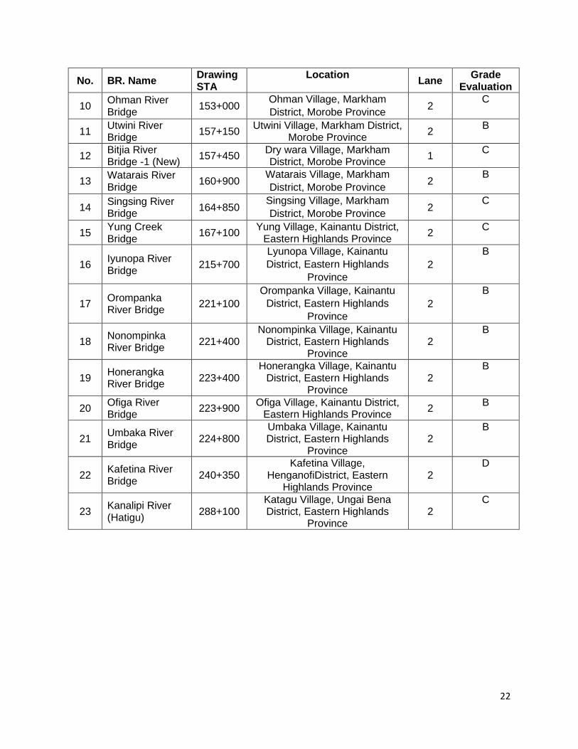
22
No. BR. Name Drawing STA
Location Lane Grade Evaluation
10 Ohman River Bridge 153+000 Ohman Village, Markham
District, Morobe Province 2 C
11 Utwini River Bridge 157+150 Utwini Village, Markham District,
Morobe Province 2 B
12 Bitjia River Bridge -1 (New) 157+450 Dry wara Village, Markham
District, Morobe Province 1 C
13 Watarais River Bridge 160+900 Watarais Village, Markham
District, Morobe Province 2 B
14 Singsing River Bridge 164+850 Singsing Village, Markham
District, Morobe Province 2 C
15 Yung Creek Bridge 167+100 Yung Village, Kainantu District,
Eastern Highlands Province 2 C
16 Iyunopa River Bridge 215+700
Lyunopa Village, Kainantu District, Eastern Highlands
Province 2
B
17 Orompanka River Bridge 221+100
Orompanka Village, Kainantu District, Eastern Highlands
Province 2
B
18 Nonompinka River Bridge 221+400
Nonompinka Village, Kainantu District, Eastern Highlands
Province 2
B
19 Honerangka River Bridge 223+400
Honerangka Village, Kainantu District, Eastern Highlands
Province 2
B
20 Ofiga River Bridge 223+900 Ofiga Village, Kainantu District,
Eastern Highlands Province 2 B
21 Umbaka River Bridge 224+800
Umbaka Village, Kainantu District, Eastern Highlands
Province 2
B
22 Kafetina River Bridge 240+350
Kafetina Village, HenganofiDistrict, Eastern
Highlands Province 2
D
23 Kanalipi River (Hatigu) 288+100
Katagu Village, Ungai Bena District, Eastern Highlands
Province 2
C

23
FIGURE 3-1: MAP OF VOLUME 1 BRIDGES
24
D. Design 1. New bridges
40. Design of new bridges with double lane (including footpaths) is based on Australian Standards 5100 except for those areas where relevant PNG Standards have been published. Design Truck Load applies with T44.
Figure 3-2: Cross Section Layout for new bridge 41. New bridge type: Two types of new bridge – two integrated lanes bridge and two separated lanes bridge are considering for replacement the existing bridges. The options of new bridge types are depicted in the following figure.
Figure 3-3: New Bridge Type Selection
42. Construction of new bridges will include: (i) installation of bailey bridge and construction of new bypass road; (ii) removing superstructure and substructure of the existing bridge from an existing
road; (iii) construction of start and end abutments of the new two lanes bridge; (iv) transport the girders form the assembly site to the bridge construction site; (v) step-by-step construction and installation of the girders by two cranes; (vi) concrete placement and pavement of bridge deck of the new two lanes bridge; and (vii) adjustment of road alignment according to the new two lanes bridge.
25
Figure 3-4: Site Layout of Single Span Bridge Construction
Figure 3-5: Site Layout of Multi Span Bridge Construction
2. Repair and Reinforcement 43. Repair/Reinforcement Plan with Damaged Bridge Items. There are various damages and repair methods for the structure, but no bridges requiring massive repairs were found in the bridges. Grouping the repair/reinforcement items required for all the target bridges, representative repair/reinforcement plans for each damage are as follows:
(i) spray cleaning and re-painting; (ii) cleaning the carriageways; (iii) repair the surface of decks and rails of walkways; (iv) improvement of the drainage system on the side of the roads; (v) installation of safety signs, and lane markings.

26
4. DESCRIPTION OF THE ENVIRONMENT
44. The description of the environment presented below, is based on the baseline surveys, and the collected secondary information. A. Physical Environment
1. Natural Conditions 45. Geography: The IEE Volume I, under SHHIP-tranche 2 covers a physically and culturally diverse environment, beginning in in Nadzab, Morobe province to Goroka, Eastern Highlands province (EHP). 46. EHP: EHP includes the Bismark Range (3,500m), and the Upper Ramu Valley in the north of the province, but the HH runs through the valleys of Asaro, Benabena and Dunantina, all of which are in the agriculturally very productive and relatively well-off northern region of the province which supports high intensity gardening. The population density is relatively high averaging of 38.8 per km2, while in Goroka district it is very high at 243 per km2. There is high potential for agriculture, but this is complicated by the population pressures, and high rates of in-migration. The province divides into two based on the physical environment and level of development. The northern valleys are economically vibrant with intensive smallholder coffee production and good road access to markets in Goroka and Lae. The Asaro Valley is an example of this, with fertile soils, low slope gradients, mild temperatures, optimum rainfall and ample sunlight. The south of the province is mountainous, remote and poor. To the east, the HH drops sharply over the Kassem Pass down to the plains of the Markham Valley in Morobe Province. Average annual rainfall is between 1800mm and 2800 mm with a moderate to long dry season in the eastern half. 47. Morobe is one of the largest provinces in PNG (33,525 km2) and stretches from the Owen Stanley Range northeast across two major fault valleys to the coastal Sarawaget Range and offshore islands. Curving around to the northeast is the Huon Peninsula. To the south, the Bulolo and Watut Valleys run north south, between the lowlands and the Ekuti Range. The altitude in Morobe ranges from sea level to over 4000m on the Sarawaget Range, which rises from the sea blanketed by tangled and impenetrable rainforest. The Markham Valley runs through the centre of the province from the Madang border in the west, to the Huon Gulf south of Lae, the capital of Morobe and second largest city in PNG. There is a good network of roads but not all are passable in mountainous terrain during the rainy season. The HH runs through the most prosperous part of the province through the flat grassy plains of the Markham Valley, where the population density is only 11.5 per km2. A long dry season and frequent burning have created large areas of grassland where big cattle ranches and intensive large-scale poultry farming have been established. A palm oil plantation has also recently been planted along the highway. Agriculture here is constrained by the long dry season, low fertility soils and frequent inundation in flood plain areas. The villagers here mostly grow bananas, betel nut, coconuts, peanuts, sugar cane, Chinese taro, mangoes and other sweet fruit, which provide fairly high incomes. 48. Topography Conditions: Volume 1 includes works on the 241.6 km section of Highlands Highway from the Erap River Bridge (Km 46+500) to the Kanalipi River Bridge (Km 288+100) and includes forty-four (44) bridges. The current condition of this section is determined by specific topographical and soil characteristics, and is divided into two zones as follows:
• Zone 1 (from Nadzab airport (Km 39) to Umi Bridge (Km 140), a total of 101 km): This part of the Highlands Highway, comprises 12 bridges, all two-lane. The road is mostly flat, undulating between 150 m and 450 m above sea level. It runs close to and crosses the Markham river and/or tributaries at several points. Several tributaries pass through large culverts under the HH. The sedimentation loads in the rivers are high, and consequently,

27
the rivers are braided and are prone to shifting course. At several points, the HH passes over land that appears swampy, and several areas appear at risk from flooding. There is almost no danger of landslides in Zone 1
• Zone 2 (from Umi Bridge (Km140) to Kanalipi River Bridge (Km 288+100), a total of 148.1 km): It includes 13 double-lane bridges and 19 single-lane bridges. In addition, the road crosses many small streams running under the road through culverts. The crossing streams are narrow with fast running water and highly variable discharges. Umi Bridge lies 450 m above sea level. The road climbs, slowly at first, and then rapidly to over 1,500m asl at the Kassam summit - approximately 33 km from Umi Bridge. In general, the land lying next to the road has a low-medium incline towards the road, although some stretches of the road in this Zone lie next to very steep inclines with a high danger of rock or landslides. Recently a severe landslide occurred, close to Kassam Summit, creating a very dangerous and unstable situation. The water table appears high and close to the surface at many points. Side drains are largely absent or ineffective.
49. Geological Conditions: Based on secondary data, PNG can be generally divided into three geotectonic regions -southwestern, central and north eastern (Davies, 1976), each of which is characterized by different geological features. The Highlands Highway runs through the central geotectonic region, which has developed from tectonism, volcanism and sedimentation through the Quaternary, Mesozoic and Cainozoic periods. For the purpose of this subproject the region can be sub-divided further into two sub-regions, Central Highlands and Sepik-Markham Plain. 50. The Highlands have many defining geographical characteristics some of which are particularly pertinent to this study. First is the prevalence of sharp relief. There is very little flat land in the highlands and a large proportion of the land is steep to very steep. Second is the highly fragmented nature of the watersheds. Much of the Highlands are made up of small and micro-catchments. Third, there are large areas with loose soil and large areas with clay-based soil and large areas where the water table is very high. This latter has resulted in many damp or swampy areas. These geographical characteristics contributed to historical impenetrability of the Highlands; until the middle of the 20th century the Highlands were almost entirely isolated from the rest of the country and the world. 51. The Morobe provincial section (within the first 170 km of the Highway), which are located between Lae and Gusap, are in the Sepik-Markham Plain geological sub-region. This sub-region is mainly characterized by strong faulting and Quaternary deposits such as alluvium, raised corals and subaerial lavas and pyroclastic. From north to northeast of Markham Plain are the Saruwaged, Finnisterre and Atzera Ranges responsible for major sedimentation and alluvial deposits in the Markham Plain. 52. The Eastern Highland is characterized mainly by crystalline rocks (metamorphic, intrusive, and volcanic) and by strong faulting and structural complexity (Davies, 1976). The road corridor of these highway sections passes mainly through Miocene deposits such as siltstone, conglomerate, volcanic, granodiorite, diorite, gabbro, limestone and mudstone.
Table 4-1: Geology at Critical Sections
Road Section and Area Geological Sub-Region
Geological Features (Rock Type)
Lae through Markham Valley to Gusap
Sepik-Markham Plain
Mostly alluvial deposits. Also, some sedimentary rocks as conglomerate and tuff.
Kassam Pass Summit to Yonki Dome
Central Highlands
Mainly sedimentary rocks such as mixed to undifferentiated calcareous and alluvial deposits,
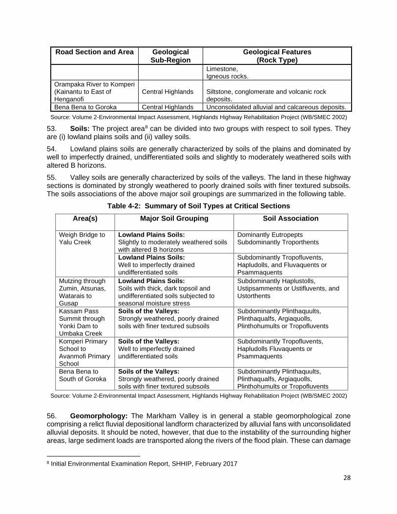
28
Road Section and Area Geological Sub-Region
Geological Features (Rock Type)
Limestone, Igneous rocks.
Orampaka River to Komperi (Kainantu to East of Henganofi
Central Highlands
Siltstone, conglomerate and volcanic rock deposits.
Bena Bena to Goroka Central Highlands Unconsolidated alluvial and calcareous deposits. Source: Volume 2-Environmental Impact Assessment, Highlands Highway Rehabilitation Project (WB/SMEC 2002)
53. Soils: The project area8 can be divided into two groups with respect to soil types. They are (i) lowland plains soils and (ii) valley soils. 54. Lowland plains soils are generally characterized by soils of the plains and dominated by well to imperfectly drained, undifferentiated soils and slightly to moderately weathered soils with altered B horizons. 55. Valley soils are generally characterized by soils of the valleys. The land in these highway sections is dominated by strongly weathered to poorly drained soils with finer textured subsoils. The soils associations of the above major soil groupings are summarized in the following table.
Table 4-2: Summary of Soil Types at Critical Sections Area(s) Major Soil Grouping
Soil Association
Weigh Bridge to Yalu Creek
Lowland Plains Soils: Slightly to moderately weathered soils with altered B horizons
Dominantly Eutropepts Subdominantly Troporthents
Lowland Plains Soils: Well to imperfectly drained undifferentiated soils
Subdominantly Tropofluvents, Hapludolls, and Fluvaquents or Psammaquents
Mutzing through Zumin, Atsunas, Watarais to Gusap
Lowland Plains Soils: Soils with thick, dark topsoil and undifferentiated soils subjected to seasonal moisture stress
Subdominantly Haplustolls, Ustipsamments or Ustifluvents, and Ustorthents
Kassam Pass Summit through Yonki Dam to Umbaka Creek
Soils of the Valleys: Strongly weathered, poorly drained soils with finer textured subsoils
Subdominantly Plinthaquults, Plinthaqualfs, Argiaquolls, Plinthohumults or Tropofluvents
Komperi Primary School to Avanmofi Primary School
Soils of the Valleys: Well to imperfectly drained undifferentiated soils
Subdominantly Tropofluvents, Hapludolls Fluvaquents or Psammaquents
Bena Bena to South of Goroka
Soils of the Valleys: Strongly weathered, poorly drained soils with finer textured subsoils
Subdominantly Plinthaquults, Plinthaqualfs, Argiaquolls, Plinthohumults or Tropofluvents
Source: Volume 2-Environmental Impact Assessment, Highlands Highway Rehabilitation Project (WB/SMEC 2002)
56. Geomorphology: The Markham Valley is in general a stable geomorphological zone comprising a relict fluvial depositional landform characterized by alluvial fans with unconsolidated alluvial deposits. It should be noted, however, that due to the instability of the surrounding higher areas, large sediment loads are transported along the rivers of the flood plain. These can damage
8 Initial Environmental Examination Report, SHHIP, February 2017
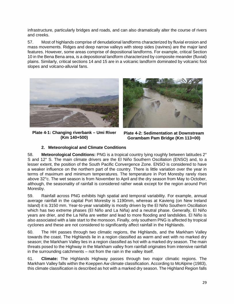
29
infrastructure, particularly bridges and roads, and can also dramatically alter the course of rivers and creeks. 57. Most of highlands comprise of denudational landforms characterized by fluvial erosion and mass movements. Ridges and deep narrow valleys with steep sides (ravines) are the major land features. However, some areas comprise of depositional landforms. For example, critical Section 10 in the Bena Bena area, is a depositional landform characterized by composite meander (fluvial) plains. Similarly, critical sections 14 and 15 are in a volcanic landform dominated by volcanic foot slopes and volcano-alluvial fans.
Plate 4-1: Changing riverbank – Umi River
(Km 140+500)
Plate 4-2: Sedimentation at Downstream
Gorambam Pam Bridge (Km 113+00)
2. Meteorological and Climate Conditions 58. Meteorological Conditions: PNG is a tropical country lying roughly between latitudes 2° S and 12° S. The main climate drivers are the El Niño Southern Oscillation (ENSO) and, to a lesser extent, the position of the South Pacific Convergence Zone. ENSO is considered to have a weaker influence on the northern part of the country. There is little variation over the year in terms of maximum and minimum temperatures. The temperature in Port Moresby rarely rises above 32°c. The wet season is from November to April and the dry season from May to October, although, the seasonality of rainfall is considered rather weak except for the region around Port Moresby. 59. Rainfall across PNG exhibits high spatial and temporal variability. For example, annual average rainfall in the capital Port Moresby is 1190mm, whereas at Kavieng (on New Ireland Island) it is 3150 mm. Year-to-year variability is mostly driven by the El Niño Southern Oscillation which has two extreme phases (El Niño and La Niña) and a neutral phase. Generally, El Niño years are drier, and the La Niña are wetter and lead to more flooding and landslides. El Niño is also associated with a late start to the monsoon. Finally, only southern PNG is affected by tropical cyclones and these are not considered to significantly affect rainfall in the Highlands. 60. The HH passes through two climatic regions, the Highlands, and the Markham Valley towards the coast. The Highlands lie in a region classified as warm and wet with no marked dry season; the Markham Valley lies in a region classified as hot with a marked dry season. The main threats posed to the Highway in the Markham valley from rainfall originates from intensive rainfall in the surrounding catchments – not from the rain in the valley itself. 61. Climate: The Highlands Highway passes through two major climatic regions. The Markham Valley falls within the Koeppen Aw climate classification. According to McAlpine (1983), this climate classification is described as hot with a marked dry season. The Highland Region falls
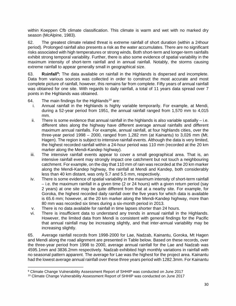
30
within Koeppen Cfb climate classification. This climate is warm and wet with no marked dry season (McAlpine, 1983). 62. The greatest climate related threat is extreme rainfall of short duration (within a 24hour period). Prolonged rainfall also presents a risk as the water accumulates. There are no significant risks associated with high temperatures or strong winds. Both short-term and longer-term rainfalls exhibit strong temporal variability. Further, there is also some evidence of spatial variability in the maximum intensity of short-term rainfall and in annual rainfall. Notably, the storms causing extreme rainfall to appear generally small in geographical size. 63. Rainfall9: The data available on rainfall in the Highlands is dispersed and incomplete. Data from various sources was collected in order to construct the most accurate and most complete picture of rainfall, however, this remains far from complete. Fifty years of annual rainfall was obtained for one site. With regards to daily rainfall, a total of 11 years data spread over 7 points in the Highlands was obtained. 64. The main findings for the Highlands10 are:
i. Annual rainfall in the Highlands is highly variable temporarily. For example, at Mendi, during a 52-year period from 1951, the annual rainfall ranged from 1,570 mm to 4,015 mm.
ii. There is some evidence that annual rainfall in the highlands is also variable spatially – i.e. different sites along the highway have different average annual rainfalls and different maximum annual rainfalls. For example, annual rainfall, at four highlands cities, over the three-year period 1998 – 2000, ranged from 1,282 mm (at Kainantu) to 3,026 mm (Mt. Hagen). The region is subject to intensive rainfall events. Although the data is very limited, the highest recorded rainfall within a 24-hour period was 110 mm (recorded at the 20 km marker along the Mendi-Kandep highway).
iii. The intensive rainfall events appear to cover a small geographical area. That is, an intensive rainfall event may strongly impact one catchment but not touch a neighbouring catchment. For example, on the day that 110 mm of rain was recorded at the 20 km marker along the Mendi-Kandep highway, the rainfall at Mendi and Kandep, both considerably less than 40 km distant, was only 5.7 and 5.5 mm, respectively.
iv. There is some evidence of spatial variability in the maximum intensity of short-term rainfall – i.e. the maximum rainfall in a given time (2 or 24 hours) with a given return period (say 2 years) at one site may be quite different from that at a nearby site. For example, for Goroka, the highest recorded daily rainfall over the five years for which data is available is 65.6 mm; however, at the 20 km marker along the Mendi-Kandep highway, more than 80 mm was recorded six times during a six-month period in 2013.
v. There is no data available for rainfall in time lapses shorter than 24 hours. vi. There is insufficient data to understand any trends in annual rainfall in the Highlands.
However, the limited data from Mendi is consistent with general findings for the Pacific that annual rainfall may be increasing slightly, and that inter-annual variability may be increasing slightly.
65. Average rainfall records from 1998-2000 for Lae, Nadzab, Kainantu, Goroka, Mt Hagen and Mendi along the road alignment are presented in Table below. Based on these records, over the three-year period from 1998 to 2000, average annual rainfall for the Lae and Nadzab was 4595.1mm and 3836.2mm respectively. Nadzab exhibited high monthly variations in rainfall with no seasonal pattern apparent. The average for Lae was the highest for the project area. Kainantu had the lowest average annual rainfall over these three years period with 1282.3mm. For Kainantu
9 Climate Change Vulnerability Assessment Report of SHHIP was conducted on June 2017 10 Climate Change Vulnerability Assessment Report of SHHIP was conducted on June 2017

31
and the other highlands locations the months around May to July were the driest. Figure 4-1 compares the average monthly rainfall for the lowland and highland regions.
Table 4-3: Average Monthly and Annual Rainfall for Highlands Highway 1998 - 2000
Location Mean Monthly Rainfall (mm) Annu
al Total Jan Feb Mar Apr May Jun Jul Aug Sep Oct Nov Dec
Lae 312.5 229.2 272.9 458.6 337.4 480.7 425.7 488.3 454.4 442.9 395.1 297.4 4595.1
Nadzab 354.2 225 143.2 709.3 97.9 614.4 234.1 170.5 366 612.6 87.8 221.2 3836.2
Kainantu 161.5 225.3 165.5 189.0 133.5 51.5 50.0 76.3 119.0 156.7 124.7 179.0 1282.3
Goroka 200.9 210.9 167.1 185.7 51.7 85.8 45 108.2 80.5 144.2 142.8 218.8 2879.1
Mt Hagen 354 379.6 336.3 241.0 166.6 170.0 133.3 211.33 167.0 218.0 368.0 280.3 3025.6
Mendi 232.4 209.6 227.2 296.1 156.9 175.1 247.8 396.3 169.6 150.3 215.3 157.2 2053.3
Source: National Weather Service – Papua New Guinea
Source: National Weather Service, Papua New Guinea
Figure 4-1: Mean Monthly Rainfall for the Highland and Lowland Regions, 1998-2000 66. Temperature: Temperatures differ between the lower Markham valley and the Highlands. SMEC (2002) reported that temperature data for the highlands is not available from the National Weather Service. SMEC (2002) using various sources reported a mean annual maximum temperature of 23.7oC and mean annual minimum temperature of 13.0oC (both for Mount Hagen area). It reported that similar temperatures can be expected along the length of the highway within the highlands. However, it reported that temperatures in the lowlands are consistently hotter, falling between 25oC and 35oC and rarely falling below 20oC. 67. Temperatures for the two regions differ, with the highlands experiencing cooler conditions. Temperature data for the highlands is not available from the National Weather Service. However, Warren (1988) recorded a mean annual maximum temperature of 23.7oC and mean annual minimum of 13.0oC for Mount Hagen area. Similar temperatures can be expected along the length of the highway within the highlands. Temperatures in the lowlands are consistently hot, falling between 25 oC and 35oC and rarely falling below 20oC. The climate is humid and tropical.
100120140160180200220240260280300320340360
1 2 3 4 5 6 7 8 9 10 11 12
Rai
nfal
l (m
m)
Month
Highlands: Road Sections 6-16
Lowland: Road Sections 1-5
32
68. Wind: Typically, the Northwest and Southeast trade winds dominate the broad-scale surface wind patterns over the project area. The Northwest winds are predominant during the (monsoon) season: mostly between November and March. April and May are transitional months where the wind starts to shift to southerly. The south-easterly in contrast are dominant from months June to August with September and October being transitional months when wind is variable. 69. Hydrographical Conditions: The Highlands Highway traverses many waterways (a combined total of 52 rivers, creeks, including large rivers in the Markham River and Ramu River valleys. Many of these large rivers carry high sediment loads. Some have unstable bed slopes and bed width. Importantly, evolving river morphology poses threats to existing bridges along the highway. This is particularly so at the Yalu, Maniang, Gusap and Bora rivers. 70. Major problems along the highway of the flat-floored Markham Valley have resulted from aggradation of its rivers induced by landslides in recent years. Some of these problems are major and require advanced river engineering techniques. Others are of a more confined nature, requiring relatively minor works. In the Highlands sections of the highway, streams vary from being nascent in nature to fast flowing rivers.
3. Natural Disaster 71. Seismicity: Papua New Guinea lies in the collision zone between two major lithospheric “plates” of the earth’s surface, the Pacific Plate and the Australian Plate. Major earthquakes and volcanic activities are associated with this collision zone. These can cause destruction of properties, injury and death. There are no records of volcanic activity in the project area in the last century, but earthquakes are very common. 72. There are four main earthquake zones in PNG, according to Everingham and Ripper (1976), and they are: (i) most active zone of shallow (0-69 km) earthquakes; (ii) moderately active zone of shallow (0-69 km) earthquakes; (iii) zone of intermediate depth (70-299 km) earthquakes; and (iv) zone of deep (300-600+ km) earthquakes. 73. Road sections in Morobe Province are in the transitional area between earthquake zones (i) and (ii). The road sections in the Eastern Highlands and Simbu Provinces include earthquake zones (i), (ii) and (iii) experiencing both shallow (0-69 km) and intermediate depth (70-299 km) earthquakes. The highway sections in the Western Highland and Southern Highland Provinces experience moderately active shallow (0-69 km) earthquakes (earthquake zone (iii)). 74. Overall, seismic activity along the Highlands Highway is mostly evidenced by landslides and subsidence and to a lesser extent, changes in watercourses. The landslides have an enormous impact on the Highway and those who use it. Subsidence is also responsible for many of the degraded critical areas along the highway.
4. Climate change 75. Climate Change in the PNG Highlands: The climate change vulnerability study11 takes the existing best available climate change projections for PNG and uses these to determine how rainfall in the Highlands (and other parameters) may evolve in coming decades. PACCSAP findings, the most comprehensive and recent studies available on climate change in the Pacific were completed with the support of the Australian Government under the Pacific - Australia Climate Change Science and Adaptation Planning (PACCSAP) Program in 2014. This work was undertaken through partnerships between BoM, CSIRO and Meteorological Departments in the Pacific island countries. The summary findings for Papua New Guinea are presented below. It is
11 A Climate Change Vulnerability Assessment of SHHIP was conducted on June 2017

33
important to note that the models and knowledge are not sufficiently resolved to focus on the PNG Highlands. The information and understanding, to the extent that it does exist, exists at the level of PNG as a whole.
• El Niño and La Niña. These events are projected to continue, but there is little consensus as to whether these will be more or less frequent, or whether they will be more or less intensive;
• Temperature. Annual mean temperatures are projected to continue to rise across PNG. Relative to 1995, they are projected to rise by 1.1°C by 2030, and, by 2090, a further rise of 0.4 – 4.2°C is projected, depending on scenarios and models used;
• Extreme temperatures are also projected to continue to rise, by approximately the same amount as the annual mean temperatures. Further, the frequency of extremely hot days is projected to increase;
• Annual rainfall. The long-term average rainfall is projected to increase in most areas of PNG. By 2050, annual rainfall is projected to increase by 6% to 8 % depending on the scenario (the entire range of possible increases, using all models, is from -3 to +14%). In addition, rainfall is projected to be more concentrated into the rainy seasons. Based on this, to avoid risk, it may be appropriate to assume that the average annual rainfall will increase by at most 14% by 2050. This figure will be used where pertinent through the remainder of this report;
• Extreme rainfall. The maximum intensity of rainfall is also projected to increase, although this projection is subject to a lower level of confidence than for annual average rainfall. The PACCSAP report states that, by 2030, the current 1-in-20-year daily rainfall amount is projected to increase by 12-14 mm; and by 2090, it is projected to increase by 21-55 mm. By 2090, the current 1-in-20-year daily rainfall event will become, on average, a 1-in-7 year or even a 1-in-4 year event.
76. The Pacific Climate Futures program has been preparing regionalized climate change projections for application at the national scale. Dynamic downscaling of Global Circulation Models (GCMs) to 60km and 8km grids undertaken for PNG is summarized in the following Table. Given that the expected design life of the road improvements anticipated for this program is 20-30 years, these projections consider 2030 and 2055 timeframes only.
Table 4-4: Climate Change Projections
Climate variable 2030 Projections (annual average)
2055 projections (annual average)
Surface air temperature (0 C) +0.80 C +1.450 C Total rainfall (%) +1.2% +8.8% Humidity (%) +0.1% +0.15% Sea surface temperature (0 C) +0.7 ±0.4 +1.3 ±0.5 Mean sea level (cm) +10 (5-14) +20 (9-30)
Source: Pacific Climate Futures Program; Climate Futures Exploration Tool (February 2012). Note: Ensemble mean data for 2030 and 2055 projections for A1B (medium emissions scenario)
5. Natural Resource and Minerals 77. The discovery of Panguna showered that Papua New Guinea was a major porphyry Copper province, and greatest potential for further production lines in this type of deposit. Promising Nickel values have been found in weathering profiles overlying ultramafic rocks.

34
78. Large-scale mining for minerals such as gold and copper have resulted in both direct impacts from forest clearing (including for infrastructure, access roads, and associated processing infrastructure) as well as extensive crossboundary indirect impacts from pollution and runoff of tailings. The figure 4-2 and table 4-5 are depicted the minarals related to the subproject area. 79. Gold and Silver: Gold (and alloyed Silver) has been mined in Papua New Guinea since its discovery in Papua in 1888. Until the opening of Panguna mine, almost the Gold had been won form alluvial deposit; primary loges had been worked in mist of the goldfields but had contributed only a small proportion of the goal produces. 80. Nickel and Cobalt: Economic concentration of Nickle and Cobalt can be formed by the deep weathering of ultramafic rocks, and Papua New Guinea has large areas of such rocks the chances of finding an economic deposit were thought to be good. However, most of the areas containing ultramafic rocks are of high relief, and consequent rapid erosion prevents the accumulation of a deep-weathering profile. 81. The search for Nickle/Cobalt concentrations has therefore been confined to areas of low relief. Nickeliferous sulphides have been found in boulders from streams draining the Papua ultramafic Belt and Marum Basic Belt, but the only occurrence in the Adau Rever, east Papua. This has been drilled but was of no commercial significance.
Figure 4-2: Main Mineral Occurrences of Papua New Guinea12
Table 4-5: Active Mines in PNG with type of waste (tailings) disposal and annual tailing
waste discharged into receiving water bodies
12 A Geological Synthesis of Papua New Guinea, Bureau of Mineral Resources, Geology and Geophysics, Department of Natural Resources, Australian Government Publishing Service, 1977.

35
Mine Province Mineral Open Type of disposal
Tailings disposal/Year
Ok Tedi Western Gold, silver and copper
1984 Riverine discharge
>22million tonnes
Porgera Enga Gold and silver
1989
HiddenValley Morobe Gold and silver
2009
Ramu Nickel Madang Nickel and cobalt
2012
B. Environmental Quality 82. To assess the current status of environmental quality, the SHHIP’s Team has undertaken an environmental monitoring study during March and April 2019 as follows:
i. Ambient air quality: The parameters of PM10 and PM2.5 were sampled and analysed in one-hour averaging period sampling at sensitive receptors along the corridor including schools and residential areas.
ii. Noise level: In-situ noise level measurements were conducted in the same location as the selected ambient air quality measurement.
iii. Surface water quality: Parameters of temperature, pH, turbidity was sampled in-situ by portable sampling equipment. Parameters of Biochemical Oxygen Demand (BOD), Chemical Oxygen Demand (COD), Total Nitrogen, Total Phosphorus, Total Suspended Solids (TSS), Oil and Grease, and Total Coliform Bacteria were sampled and analysed at the Laboratory of Lae University of Technology.
iv. Groundwater quality: Parameters of temperature, pH, turbidity was sampled in-situ by portable sampling equipment. Parameters of Total Coliform Bacteria, E. Coli, Arsenic, Chloride, Flouride, Total Dissolved Solids, Nitrate, Nitrite, Hardness, Sodium, and Iron were sampled and analyzed at the Laboratory of Lae University of Technology.
1. Air Quality
83. The samplings of air include public sites, bus stops, market places, schools and health centres, which are located along the project corridor. Air monitoring locations are as the following table.
Table 4-6: Air Monitoring Locations
No. Monitoring location
Chainage (Km)
Coordinate (x,y)
Sampling Code
Description
1 Nadzab Junction
39+250 6o33'49" S 146o44'49" E
AQ 1 Market area and community
2 41Mile Community
62+400 6o35'34" S 146o35'4" E
AQ 2 Near market area and community
3 Leron Community
100+300 6o22'37" S 146o25'27" E
AQ 3 Market area and community living near the road
4 Mutzing Community
122+600 6o20'44" S 146o14'42"E
AQ 4 Near School and Community
5 Zummin Community
133+000 6o12'24" S 146 o11'12" E
AQ 5 School and market
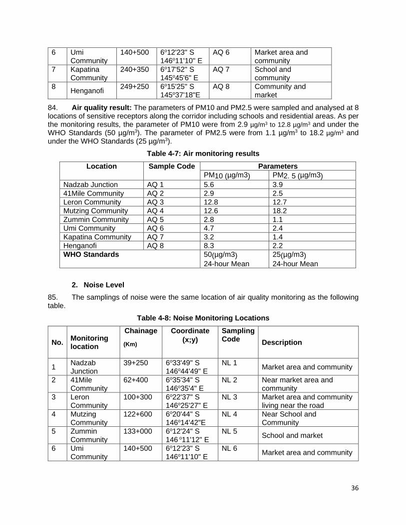
36
6 Umi Community
140+500 6o12'23" S 146o11'10" E
AQ 6 Market area and community
7 Kapatina Community
240+350 6o17'52" S 145o45'6" E
AQ 7 School and community
8 Henganofi 249+250 6o15'25" S 145o37'18"E
AQ 8 Community and market
84. Air quality result: The parameters of PM10 and PM2.5 were sampled and analysed at 8 locations of sensitive receptors along the corridor including schools and residential areas. As per the monitoring results, the parameter of PM10 were from 2.9 µg/m3 to 12.8 µg/m3 and under the WHO Standards (50 µg/m3). The parameter of PM2.5 were from 1.1 µg/m3 to 18.2 µg/m3 and under the WHO Standards (25 µg/m3).
Table 4-7: Air monitoring results Location Sample Code Parameters
PM10 (µg/m3) PM2. 5 (µg/m3) Nadzab Junction AQ 1 5.6 3.9 41Mile Community AQ 2 2.9 2.5 Leron Community AQ 3 12.8 12.7 Mutzing Community AQ 4 12.6 18.2 Zummin Community AQ 5 2.8 1.1 Umi Community AQ 6 4.7 2.4 Kapatina Community AQ 7 3.2 1.4 Henganofi AQ 8 8.3 2.2 WHO Standards 50(µg/m3)
24-hour Mean 25(µg/m3) 24-hour Mean
2. Noise Level
85. The samplings of noise were the same location of air quality monitoring as the following table.
Table 4-8: Noise Monitoring Locations
No. Monitoring location
Chainage (Km)
Coordinate (x;y)
Sampling Code Description
1 Nadzab Junction
39+250 6o33'49" S 146o44'49" E
NL 1 Market area and community
2 41Mile Community
62+400 6o35'34" S 146o35'4" E
NL 2 Near market area and community
3 Leron Community
100+300 6o22'37" S 146o25'27" E
NL 3 Market area and community living near the road
4 Mutzing Community
122+600 6o20'44" S 146o14'42"E
NL 4 Near School and Community
5 Zummin Community
133+000 6o12'24" S 146 o11'12" E
NL 5 School and market
6 Umi Community
140+500 6o12'23" S 146o11'10" E
NL 6 Market area and community
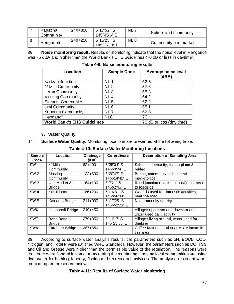
37
7 Kapatina Community
240+350 6o17'52" S 145o45'6" E
NL 7 School and community
8 Henganofi 249+250 6o15'25" S 145o37'18"E
NL 8 Community and market
86. Noise monitoring result: Results of monitoring indicate that the noise level in Henganofi was 75 dBA and higher than the World Bank’s EHS Guidelines (70 dB or less in daytime).
Table 4-9: Noise monitoring results Location Sample Code Average noise level
(dBA) Nadzab Junction NL 1 62.8 41Mile Community NL 2 57.6 Leron Community NL 3 58.3 Mutzing Community NL 4 64.2 Zummin Community NL 5 62.2 Umi Community NL 6 68.1 Kapatina Community NL 7 62.8 Henganofi NL8 76 World Bank’s EHS Guidelines 70 dB or less (day time)
3. Water Quality
87. Surface Water Quality: Monitoring locations are presented at the following table. Table 4-10: Surface Water Monitoring Locations
Sample Code
Location Chainage (Km)
Co-ordinate Description of Sampling Area
SW1 41Mile Community
62+400 6o35'34" S 146o35'4" E
School, community, marketplace & bridge
SW 2 Mutzing Community
122+600 6o20'47" S 146o14'42" E
Bridge, community, school and marketplace
SW 3 Umi Market & Bridge
164+100 6o7'21" S 146o2'46" E
Road junction (blackspot area), just next to roadside
SW 4 Yonki Dam 186+200 6o16'31" S 145o56'44" E
Water is used for domestic activities, near the road
SW 5 Kainantu Bridge 211+000 6o17'25" S 145o52'23" E
No community nearby
SW6 Henganofi Bridge 249+450 Villages upstream and downstream, water used daily activity
SW7 Bena Bena Bridge
279+850 6011’17’ S 145025’53’ E
Villages living around, water used for drinking
SW8 Taraboro Bridge 287+350 Coffee factories and quarry site locate in this area
88. According to surface water analysis results, the parameters such as pH, BOD5, COD, Nitrogen, and Total P were satisfied WHO Standards. However, the parameters such as DO, TSS and Oil and Grease were higher than the permissible value of the regulation. The reasons were that there were flooded in some areas during the monitoring time and local communities are using river water for bathing, laundry, fishing and recreational activities. The analysed results of water monitoring are presented below.
Table 4-11: Results of Surface Water Monitoring

38
Sample Code
Parameters
ToC (°c)
pH DO
(mg/L)
BOD5
(mg/L)
COD
(mg/L)
Nitrogen
(mg/L)
total P
(mg/L)
TSS
(mg/L)
Turbidity Oil and Grease
(mg/L)
Coliform total
SW 1 26.0 7.34 6.4 2.2 20 <10 <0.05 12 <1 -
SW 2 28.4 7.46 9.7 3.7 40 <10 <0.05 900 1 -
SW 3 27.4 7.3 5.2 2.1 <5 <10 <0.05 4.0 <1
SW 4 26.8 7.54 3.8 6.9 10 <10 <0.05 6.0 6.5
SW 5 23.9 7.55 8.2 2.5 <5 <10 <0.05 16 5.5
SW 6 24 7.0 5.1 3.4 6 <10 0.05 310 68 7.0 -
SW 7 24 7.1 5.1 1.0 6 <10 <0.05 1800 600 74 -
SW 8 24 6.8 4.0 1.3 8 <10 0.32 7000 2000 445 -
WHO Standards
≤ 6.0 ≤30 ≤125 ≤10 ≤4 ≤50 ≤10 ≤400
89. 90. Ground water: Monitoring locations present as the following table.
Table 4-12: Ground Water Monitoring Locations Sample Code
Location Chainage (Km)
Co-ordinate Description of Sampling Area
GW 1 Nadzab Junction
39+250 6o33'49" S 146o44'48" E
Project starting point. - Small market, community use it for bathing
GW 2 41Mile Community
62+400 6o35'34" S 146o35'4" E
school, community, marketplace & bridge
GW 3 Mutzing Community
122+600 6o20'47" S 146o14'42" E
Bridge, community, school and marketplace
GW 4 Watarais Junction
161+100 6o7'21" S 146o2'46" E
Road junction (blackspot area), just next to roadside
GW 5 Sing-sing creek
163+600 - 6o8'40" S 146o2'22" E
Contractor camp
GW 6 Kassam Springwater
170+300 6o11'20" S 146o2'47" E
Few houses, spring water near the road, washing vehicles area
GW 7 Coldwara Market
195+200 6o16'31" S 145o56'44" E
water using for domestic activities, near the road
GW 8 Henganofi Bridge
249+250 6o15'29" S 145o37'16" E
Near the market and provincial office, esidential area
91. 92. Parameters of Total Coliform Bacteria, E. Coli, Arsenic, Chloride, Flouride, Total Dissolved Solids, Nitrate, Nitrite, Hardness, Sodium, and Iron were sampled and analysed at Laboratory. According to groundwater analysis results, the parameters of ground water were satisfied, as per the permissible value of WHO. The analysed results of the water monitoring are presented below.
Table 4-13: Results of Ground Water Monitoring
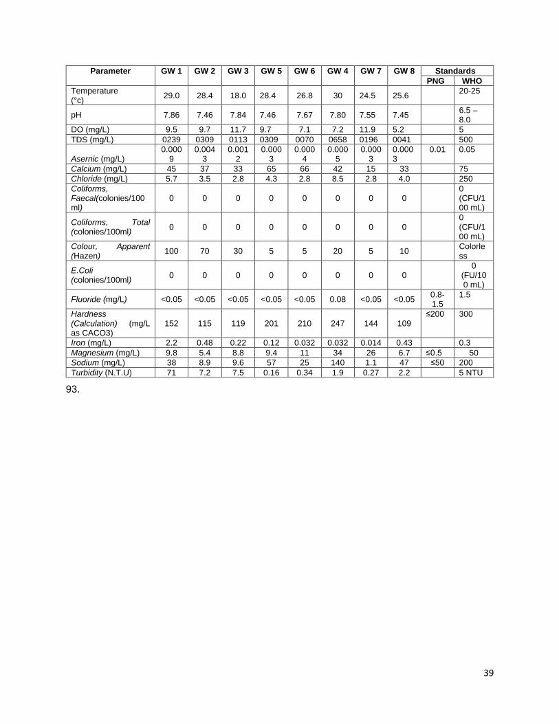
39
Parameter GW 1 GW 2 GW 3 GW 5 GW 6 GW 4 GW 7 GW 8 Standards PNG WHO
Temperature (°c) 29.0 28.4 18.0 28.4 26.8 30 24.5 25.6 20-25
pH 7.86 7.46 7.84 7.46 7.67 7.80 7.55 7.45 6.5 – 8.0
DO (mg/L) 9.5 9.7 11.7 9.7 7.1 7.2 11.9 5.2 5 TDS (mg/L) 0239 0309 0113 0309 0070 0658 0196 0041 500
Asernic (mg/L) 0.000
9 0.004
3 0.001
2 0.000
3 0.000
4 0.000
5 0.000
3 0.0003
0.01 0.05
Calcium (mg/L) 45 37 33 65 66 42 15 33 75 Chloride (mg/L) 5.7 3.5 2.8 4.3 2.8 8.5 2.8 4.0 250 Coliforms, Faecal(colonies/100ml)
0 0 0 0 0 0 0 0 0
(CFU/100 mL)
Coliforms, Total (colonies/100ml) 0 0 0 0 0 0 0 0
0 (CFU/100 mL)
Colour, Apparent (Hazen) 100 70 30 5 5 20 5 10 Colorle
ss
E.Coli (colonies/100ml) 0 0 0 0 0 0 0 0
0 (FU/100 mL)
Fluoride (mg/L) <0.05 <0.05 <0.05 <0.05 <0.05 0.08 <0.05 <0.05 0.8-1.5
1.5
Hardness (Calculation) (mg/L as CACO3)
152 115 119 201 210 247 144 109 ≤200
300
Iron (mg/L) 2.2 0.48 0.22 0.12 0.032 0.032 0.014 0.43 0.3 Magnesium (mg/L) 9.8 5.4 8.8 9.4 11 34 26 6.7 ≤0.5 50 Sodium (mg/L) 38 8.9 9.6 57 25 140 1.1 47 ≤50 200 Turbidity (N.T.U) 71 7.2 7.5 0.16 0.34 1.9 0.27 2.2 5 NTU
93.
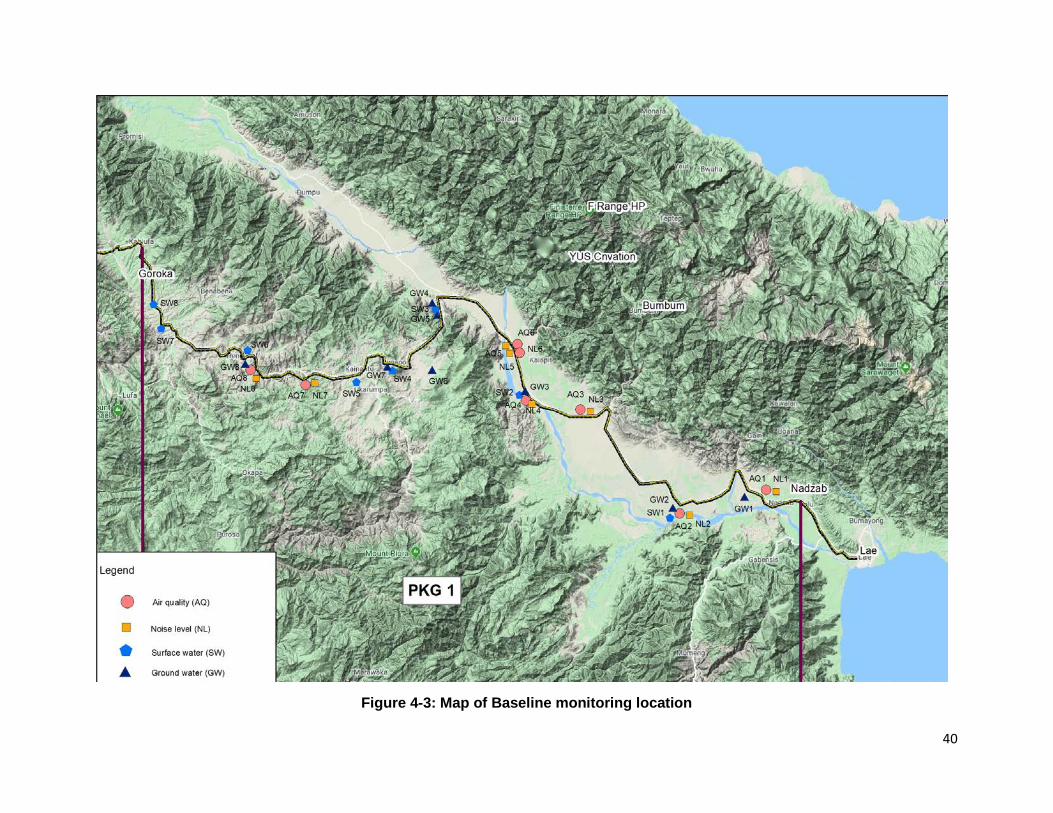
40
Figure 4-3: Map of Baseline monitoring location

41
C. Biological Environment 1. Biological Environment in PNG and Highlands Region
95. Papua New Guinea (PNG) contains a wealth of biodiversity13 and is one of eighteen mega diverse countries of the World, which has a high total number of species. PNG contains more than 7% of the World’s biodiversity in less than 1% of the World’s land area. It is home to more than 18,894 described plant species, 719 birds, 271 mammals, 227 reptiles, 266 amphibians, 341 freshwater fish species, 600 species of coral and 3000 species of reef fish. Many species remain to be discovered and documented scientifically. 96. Terrestrially14, PNG contains more than 5-7% of the world’s terrestrial biodiversity in less than 1% of the land area (Ausaid 2010). PNG has more than 18,894 described plant species, 719 birds, 271 mammals, 227 reptiles, 266 amphibians, 341 freshwater fish and unknown number of invertebrate species (Vie et al. 2009). The current status of species in PNG includes: 1 extinct, 36 critically endangered, 49 endangered, 365 vulnerable, 288 near threatened, 1289 Least Concern. Moreover, 1 in 5 assessed species in PNG is endemic, with the highest number of endemic mammals globally (Vie et al 2009). 97. Species richness of PNG and World Higher Vertebrates15
Table 4-14: PNG and the World Terrestrial Taxa World PNG
(2015) % World
Amphibians 7,360 352 4.6 Reptiles 10,119 335 3.3 Birds 10,560 813 7.7 Mammals 5,416 298 5.5 Total 33,455 1,798 5.3
98. PNG also hosts up to 6%16 of the world’s flora and is considered one of the most species-rich areas in the world with high levels of species endemism of around 60%. The consensus among authorities is that the true size of botanical inventory for PNG is unknown and open to considerable speculation. Estimates of vascular plant biodiversity for Papuasia currently range from 11,000 species to 13,858 based on species area relationships, or 16,204 to 20,000-25,000 species calculated on the basis of orchid and fern flora of the region. It has been estimated that PNG hosts about 15% of the world’s fern species with around 3,000 species, including hosting around 2,800 species of orchids accounting for about 11% of the world’s total orchid species. 99. The Highlands Highway begins in Lae, the provincial capital of the maritime province of Morobe. Its ecology is quite diverse, as it comprises a total of nine administrative districts that spread from the islands to the inland mountain areas. Vital ecosystems comprise of coral reefs to rainforests and sub-alpine to alpine vegetation. The jungles and forests are also home to some 15, 000 plant species and over 1000 species of birds and mammals including the emperor bird of paradise, cassowary, varieties of megapods, and tree kangaroos. An important protected area in Morobe Province that contributes to conserving the endangered Matchies Tree Kangaroo is the YUS conservation area (Refer to Figure 4-5 - Map of Protected areas). This is a newly established Conservation Area located in the Kabwum district which is about 17Km far from the project area.
13 Papua New Guinea POLICY ON PROTECTED AREAS 14 Papua New Guinea’s Fourth National Report to the Convention on Biological Diversity 15 Papua New Guinea’s Fifth National Report to the Convention on Biological Diversity, December 2017 16 Papua New Guinea’s Fifth National Report to the Convention on Biological Diversity, December 2017
42
100. The ecology of Eastern Highlands Province (Refer to Figure 4-4 - Map of Biodiversity Priorities) is spread from sub-alpine and alpine grasslands to montane forests and anthropogenic grasslands. The Highlands Highway that runs from Kasam Pass to Daulo Pass, clearly passes through all these vegetation and habitat types. Common fauna of the province includes Raggianna bird of paradise (Paradisaea raggiana) and the Princess Stephanie Astrapia (Astrapia stephaniae) as well as mountain cuscus (Phalanger carmelitae) and good fellows tree kangaroos (Dendrolagus goodfellowi). Some important flora species include Nothofagus grandis. Eastern Highlands also has two protected areas that are recognised by the Act of parliament – Crater Mountains and Mt Gahavisuka (Refer to Figure 4-5 - Map of Protected areas). Both are not near the Highlands Highway.
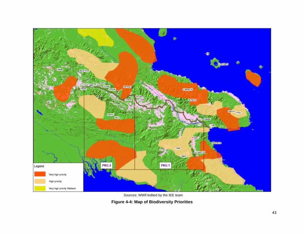
43
Sources: WWF/edited by the IEE team
Figure 4-4: Map of Biodiversity Priorities

44
Sources: CEPA 2017/edited by the IEE team
Figure 4-5: Map of Protected areas

45
101. Forest Resources. Papua New Guinea retains significant and intact areas of forest, with an estimated 34 million hectares of forest in the country in 2014 (Bryan and Shearman 2015; FAO 2015b). The actual estimation of the extent of forest within the country is contentious. According to Bryan and Shearman (2015), forests in PNG are declining at a rate of around 0.5% per year, although this figure is contradicted by FAO (2015) figures for PNG. While FAO (2015) report no major change in forest area, their data does indicate an annual decrease of 2.3% in the area of primary forest. 102. The Kassam Pass17 is montane forest along the route of this Highlands Highway section. Based on a previous study, the forest in Kassam Pass had been described by Saunders (1993), as a medium crowned forest with canopy at 20-25m, generally uniform with 60-80% closure but height of emergent at about 40m. It is floristically very mixed but dominant Genera are Pometia, Canarium, Anisoptera, Terminalia, and Cryptocarya. 103. The forest is however highly disturbed, have low to negligible biological biodiversity and conservation values as a direct result of increasing population pressure on the forests’ resource. These have been progressively cleared for agriculture over the past 9,000 years (see for example Golson and Hughes 1980) and today the landscape through which the highway passes consist of a mixture of cultivated land, coffee plantations, gardens, fallow grassland and shrub land with extensive areas of planted groves of trees (the local Casuarina species and exotic Eucalyptus trees) which the villagers use for building, timber, fencing and firewood. Village plantations have also been established to provide firewood and (to a lesser extent) building timber for sale to people living in the towns along the Highway. 104. Trends in PNG Forests: Papua New Guinea including its island provinces of the Bismarck Archipelago covers a total land area of about 46.3 million hectares. Approximately twothirds of the country is covered in forest, the majority of which is classified as tropical rainforest. The extent of the country under forest has been contentious(Filer,2011), but the two most recent estimates have stated Papua New Guinea contained between 28 million hectares of ‘tropical rainforest’ (Byran and Shearman 2015) to 33.6 million hectares of ‘forest areas’ (FAO 2015). 105. As a young developing country, PNG’s forestry sector is one of the major foreign revenue contributors to the country’s economy and thus becomes one of the major drivers of deforestation and forest degradation. While PNG still retains a large proportion of its natural forests, there is considerable loss of primary forests and forest degradation and widespread small-scale clearance for gardens and subsistence agriculture. Commercial logging is primarily focused in the lowlands and island forest areas while subsistence agriculture is prevalent throughout the country. However, the subsistence agriculture sector in the Highland provinces accounts for a major part of the industry and urban-driven economy. 106. Annual deforestation rates in PNG are reported as around 0.49% for most provinces within the country according to recent estimates of Byran & Shearman (2015) as shown in Table 4-15. Table 4-15: Change in rainforest area (km2) in project area (2002 – 202014)18
Province Rainforest Area 2014 Rainforest Change 2002-2014 Total (Km2)
Unlogged (Km2)
Logged (Km2)
Deforested (Km2)
Logged (Km2)
Deforested (%)
Logged (%)
Total Change (%)
Morobe 20,78 3 19,644 1,140 182 38 0.9 0.2
17 Initial Environmental Examination Report, SHHIP, February 2017 18 Papua New Guinea’s Fifth National Report to the Convention on Biological Diversity, December 2017

46
Province Rainforest Area 2014 Rainforest Change 2002-2014 Total (Km2)
Unlogged (Km2)
Logged (Km2)
Deforested (Km2)
Logged (Km2)
Deforested (%)
Logged (%)
Total Change (%)
Western Highlands + Jiwaka
4,941 4,941 0 39 0 0.8 0 0.8
Chimbu 3,596 3,596 0 42 0 1.1 0 1.1 Eastern Highlands
5,687 5,617 70 39 0 0.7 0 0.7
2. Biological Environment in the Project Area 107. An Ecological survey for Package 1 section between Erap Bridge (Km 46+500) in Morobe Province and Kanalipi Bridge (Km 288+100), Eastern Highlands Province was undertaken at 44 bridge sites were in December 2019 to identify existing biological conditions in the project area, especially at every bridge site. Summary of sites and habitats observation is in the Table 4-16.
Table 4-16: Summary of Sites and Habitat Types Site No. Site Name Chainage
(Km) Coordinate Site Description
1 Erap River Bridge 46 + 500 6°31’028’’S
146°42’619’’E
Modified environment with mostly anthropogenic grassland. Have a few houses and human settlement on the left side of the
bridge.
2 Maralumi River Bridge 55+600 6°34’796’’S
146°39’798’’E Modified with human settlement. Mostly
grassland
3 Ramu River Bridge 64+400 6°35’519’’S
146°35’256’’E A modified environment. Mostly grassland.
4 Clean Water River Bridge 77+800 6°32’746’’S
146°30’134’’E A more natural environment, with little or no
human impact
5 Leron River Bridge 100+300 6°22’571’’S
146°25’397’’E A modified environment with market nearby
and high human activities
6 GorambamPam River Bridge 113+000 6°23’516’’S
146°19’069’’E A natural environment with mostly savannah
grassland
7 Ngaraburam River Bridge 116+350 6°22’714’’S
46°17’490’’E A modified environment with anthropogenic
grassland
8 Little Maniang River Bridge 120+450 6°21’628’’S
146°15’599’’E A modified environment. Old gardens and
human settlements nearby.
9 Mutsing River Bridge 122+600 6°20’796’’S
146°14’705’’E A modified environment with a market nearby
10 Zumin River Bridge 133+000 6°15’758’’S
146°12’690’’E A modified environment with some human
settlement few meters away
11 Yafatz River Bridge 137+100 6°13’780’’S
146°12’181’’E A modified environment with anthropogenic
grassland
12 Umi River Bridge 140+500 6°12’393’’S
146°11’160’’E Although environment seemed natural, it has
high human accessibility
13 Bintia River Bridge 151+000 6°8’212’’S
146°7’369’’E A modified environment. The river is dried
with little no aquatic life
14 Ohman River Bridge 153+000 6°7’885’’S
146°6’476’’E A modified environment with anthropogenic
grassland

47
Site No. Site Name Chainage
(Km) Coordinate Site Description
15 Utwini River Bridge 157+150 6°7’333’’S
146°4’273’’E Modified environment. The river/creek is dried
up with not much life
16 Bitjia River Bridge (1 & 2) 157+450 6°7’454’’S
146°4’148’’E A modified environment. Seemed deserted by
humans. No human settlement
17 Watarais River Bridge 160+900 6°7’379’’S
146°2’520’’E Modified environment with human interaction
and settlement.
18 Singsing River Bridge 164+850 6°9’269’’S
146°2’511’’E Modified with some human interactions
19 Yung Creek Bridge 167+100
6°10’188’’S 146°2’741’’E
Modified with human settlement and little aquatic life. Situated on the foot of Kassam Pass with mostly grassland and shrubs on
one side of the bridge
20 Undono Creek Bridge 178+000 6°13’105’’S
146°1’709’’E A modified environment with human
settlement and food gardens
21 Tapiruna River Bridge 180+000 6°13’526’’S
146°0’944’’E A modified environment with food gardens.
22 Darasimpi River Bridge 198+900
6°16’960’’S 146°55’463’’E
Old human settlement consisting of domesticated plants now taken over by
anthropogenic grassland.
23 Luwin River Bridge 200+350 6°16’288’’S
146°54’998’’E Modified with human settlement meters away. Had coffee gardens and domesticated plants.
24 Namupimpa River Bridge 206+100 6°16’984’’S
145°52’517’’E Modified with coffee plants, pine, bamboo and
other domesticated plants.
25 Benapa River Bridge 211+000 6°17’426’’S
145°52’387’’E Modified with human settlement far off but old
food gardens on one side
26 Iyunopa River Bridge 215+700 6°18’005’’S
145°50’267’’E Modified with human settlement, not much
insect life.
27 Orompanka River Bridge 221+100 6°18’328’’S
145°48’059’’E A modified environment with human
settlement and coffee plots
28 Nonompinka River Bridge 221+400 6°18’299’’S
145°47’921’’E Seemed natural but may have been modified
years back with anthropogenic grassland.
29 Honerangka River Bridge 223+400 6°18’167’’S
145°47’075’’E A modified environment with human settlement and coffee plots.
30 Ofiga River Bridge 223+900 6°18’124’’S
145°46’883’’E A modified environment with human
settlement.
31 Umbaka River Bridge 224+800 6°17’878’’S
145°46’504’’E A modified environment with human
settlement
32 Kingkio River Bridge 234+800 6°17’512’’S
145°42’302’’E A modified environment with human
settlement and coffee plots
33 Avani River Bridge 237+500 6°17’959’’S
145°41’084’’E Modified environment with human
settlements, food gardens and coffee plots. 34 Kafetina River
Bridge 240+350 6°18’067’’S
145°39’599’’E Modified environment with small shelters for
roadside markets and few coffee plots.
35 Kamanotina River Bridge 249+250 6°15’575’’S
145°37’292’’E Modified environment in the Henganofi District
station and market
36 Kuronka River (Henganofi) 249+450 6°15’496’’S
145°37’278’’E Modified environment in the Henganofi District
station and market

48
Site No. Site Name Chainage
(Km) Coordinate Site Description
37 Berefi River 250+650 6°15’218’’S 145°36’655’’E
A modified environment with human settlement.
38 Dirty Wara River 258+000 6°14’594’’S
145°34’072’’E A modified environment with human settlement, food and coffee gardens.
39 Siguya River 266+250 6°14’480’’S 145°31’089’’E
Modified environment with little human settlement and mini roadside market.
40 Yasifo River 271+450 6°15’327’’S
145°36’655’’E
Modified environment with human settlement and a small roadside market
41 Parirosay River 272+400 6°13’531’’S 145°28’394’’E
A modified environment with human settlement, food gardens and new coffee
plots.
42 Bena Bena River 280+650 6°11’251’’S
145°25’957’’E
A modified environment with a quarry on one side. The other side had human settlements
and old food gardens.
43 Taraboro River (Sunufamu) 285+400 6°10’148’’S
145°24’761’’E A modified environment with coffee gardens.
Water was quite low.
44 Kanalipi River (Hatigu) 288+100 6°8’851’’S
145°24’397’’E A modified environment with human
settlement and stone quarry on one side.
108. Table 4-16 indicates that most of the habitats on these locations from Bridges 1 to 44 have had some human impact. Human settlement in or near the bridges have changed the ecosystems through both clearing for gardening and house construction as well as washing and other daily activities. Of these, the environments where two bridges - Clean Water River Bridge 77+800 (B#4) and GorambamPam River Bridge 113+000 (B#6) - were located were found to have had little or no human impact thus, appearing to be more natural. There are no major protected areas, wildlife management or protected areas in or near the bridge locations. 109. Data Collection Methods: For each location, the description of the vegetation and the measure of human interactions on the environment were observed. Field guides on fauna and flora of Papua New Guinea as well as general information on invertebrates and insects were also used to assist the surveyors to identify the species. The details of each survey method used on site are described below. 110. Methods for Terrestrial ecosystem:
• Fauna: The data on insects and invertebrates such as butterflies, dragonflies, bees and common flies were gathered through physical sighting of organisms. These were further observed through capturing of the organisms, closely observing and recoding their details and releasing them to their environment. For water tolerant birds, fly over counts as well as by their calls were recorded. The fly over count involved close observation of the bird that flew over, near or around the location. This enabled the observers to take note of the details of the bird including its colour, size and type. Bird calls were also used to identify the bird type. Additional information about other animals that were not sighted at the time of the survey, were gathered through informant interviews. A total of 40 informant interviews were conducted out of the 44 bridges surveyed.
• Flora: At each site, there was a physical observation of the vegetation in the surroundings. A physical count of common trees and plant species were carried out to determine their availability. Photographs of plant and tree species were also captured and a field guide on the Flora of Papua New Guinea was also used to identify common species.
49
111. Methods for Aquatic ecosystem: • Fauna: The data and information on fish and other aquatic invertebrates were gathered
through three main methods - physical sighting of organisms, capture release and informant interviews. Physical sighting and capture release were used for juvenile fish and prawns. These were caught with a net, observed and released back into the water. For zooplankton, water sample was collected, and a hand lens used to look at this sample. This was then poured back into the water. Due to the timing of the surveys, informant interviews were also carried out to establish other kind of fish and aquatic fauna present in each location. Again, a total of 40 interviews were conducted.
• Flora: Data for aquatic flora was gathered through physical sightings of water in each location. A water sample was also collected at each site and checked using a hand lens to identify any signs of phytoplankton.
112. The main findings of the survey are as follows: i. All locations from Erap River Bridge (B#1) to Kanalipi River Bridge (B#44) had some
human impact which had modified most of the environment and ecosystems within them. ii. Only two bridges (Clean Water B#4 and GorambamPam River B#6) were recorded as
having a more natural environment or ecosystem due to no or minimal human impact. This can also be seen in the variety of fauna and flora species existing in these two locations (i.e. over 24 varieties of species recorded) including rattan palm (Korthalsia zippelii) which was only recorded in Clean Water River (B#4).
iii. Absence of native and endemic species were also noted in nearly all the bridge locations. iv. No special or threatened aquatic fauna were noted in B#1 to B#44. All species were either
introduced or commonly available. Similarly, the only aquatic flora recorded is green algae, 113. A summary of the discussions about the species and their presence or absence are discussed as bellows (detail survey results indicated in the Annex C). 114. Terrestrial ecosystem
• Fauna: Common terrestrial fauna identified in each location (B#1 to B#44) included invertebrates such as Eurema hecabe, Anisoptera, Apis cerena, Fomicidae, Daanaus plexippus and Plutella xylostella. Presence of these invertebrates may be attributed to their preference of water in their ecology. Birds that were commonly sighted included sparrows (Passeridae), hawk (Accipitridae) and kingfisher (Alcedinidae) and Willy wagtail (Rhipidura leucophrys). These birds are also identified as common in open grasslands and rivers.
• Flora: Common terrestrial flora from B#1 to B#44 included elephant grass (Pennisetum purpureum), cow grass (Axonopus compressus), rain tree (Samanea saman), Piper adancum and banana. Coastal locations on B#1 to B#19 also recorded common coastal flora such as betel nut tree (Areca catechu), coconut, cogon grass (Imperata cylindrica), sensitive grass (Mimosa pudica) and mango. On bridges B#20 to B#44, commonly occurring highland flora included bamboo, Casuarina oligodon (she-oak), Ficus dammaropsis and coffee. Rare occurrences of flora of interest such as Leucaena leucocephala in B#1, Korthalsia zippelii in B#6, Octomeles sumatrana in B#7 and Elaeocarpus in B#15 imply that they could have been distributed via other medium as they are not common grassland flora. According to IUCN, the status of Korthalsia zippelii is unknown although it is commonly distributed in the lowlands of continental Asia and Malesian region
50
(Barfod, Banka & Dowe, 2001). Similarly, Leucaena leucocephala and Octomeles sumatrana are of least concern.
• On the highlands side, the occurrence of Pandanus julianetti in B#21, B#23, B#27, and B#32 and Ficus dammaropsis in B#30 and B#31 imply that they were introduced by people. In addition, Nothofagus grandis (a least concern species according to IUCN) recorded in B#30 also implicate a human origin.
115. Aquatic ecosystem • Fauna: Common aquatic fauna in B#1 to B#44 included carp (Cyprinidae), tilapia
(Oreochromis mossambica), juvenile fish and freshwater prawns (Palaemonidae). Trout (Oncorhynchus mykiss) was recorded in B#32, B#33, B#39, B#41 and B#43 while catfish (Arius spp) was only recorded in B#1, B#2, B#3 and B#4. Golden carp and black carp were also reported in B#26, B#27, B#28, B#29 and B#30. The findings imply that most of these species are common and were introduced into the locations.
• Flora: There was no aquatic flora of significance recorded in B#1 to B#44. The most common was green algae that only appeared at certain locations depending on the water quality.
116. Invasive alien species • Terrestrial Flora: Piper Adancum as a terrestrial flora invasive species was found in the
bridge sites (B#10, B#17, B#19, B#20, B#21, B#22, B#23, B#27, B#28,30, B#31, B#39, and B#43); and Mimosa pudica in the coastal side of the Highlands Highway.
• Aquatic fauna: Tilapia (Oreochromis mossambica) as an aquatic fauna was recorded at the bridge sites (B# 1, B#2, B#3, B#4, B#5, B#9, B#12, B#17, B#18, B#21, B#24, B#26, B#27, B#28, B#29, B#30, B#32, B#34, B#35, B#37, B#38, B#41, B#42, B#43, and B#44).
D. Socio-Economic Environment 1. Population
117. PNG has a population of 7.2 million, of whom 88% live in rural areas; 39% of the population lives in the Highlands region, (2,854,874), followed by Momase region with 26%. The annual population growth is high, currently estimated at 3.1%.19 The ratio of men to women is 108:100, and the population is very young: 40% under the age of 15 years; 60% under the age of 24 years; and 68% is under the age of 30 years. Administratively the country has 22 provinces and 89 districts. The tranche 2 Volume 1 section of HH traverses two provinces and 14 districts. Table 4-17 below shows the population within the scope of the Investment Program:
Table 4-17: Population by Districts and LLGs Served by Highlands Highway: 2011 Census
Provinces and districts
Households Persons Males Females % of province
Average household
Eastern Highlands
136,992 579,825 301,048 278,777 100.0 4.2
Daulo 14,378 45,783 24,029 21,754 7.9 3.2
19 National Statistics Office, 2011, National Population and Housing Census of Papua New Guinea – Final Figures

51
Provinces and districts
Households Persons Males Females % of province
Average household
Goroka 23,565 103,396 53,292 50,104 17.8 4.4
Unggai/Benna 15,391 67,125 35,050 32,075 11.6 4.4
Henganofi 15,191 62,904 32,503 30,401 10.8 4.1
Kainantu 28,686 126,248 65,723 60,525 21.8 4.4
Obura/ Wonenara
8,126 39,919 20,537 19,382 6.9 4.9
Morobe 130,109 674,810 350,902 323,908 100.0 5.2
Markham 13,352 62,495 32,497 29,998 9.3 4.7
Huon Gulf 16,075 77,564 40,333 37,231 11.5 4.8
Lae 21,901 148,934 77,446 71,488 22.1 6.8
118. All the communities along the HH are indigenous, most living on their own customary land, (apart from those in urban areas or those who married into the local clans), although there is a settlement at Kassam in EHP, established during the building of the Yonki dam and power station, where there are migrants from other places such as Simbu, Western Highlands, and other parts of Eastern Highlands. In the lowland area of Morobe, most settlements are clustered, often around a market, church or school, whereas in the highland’s settlements may be more dispersed, with houses scattered along the highway, or located near to gardening land. Some of the settlements were developed as a direct result of the highway, with residents gravitating from more distant hinterland to the roadside so that they have better access to services and can conduct business with those travelling. Government services like health centers, aid posts and schools, as well as churches are also commonly located along the highway. 119. The Volume 1 bridges include the following main linguistic and tribal groups (though there are many other smaller groups):
• Morobe: Gadsup (EHP and Markham), Adzera (Markham Valley)
• EHP: Gahuku-Asaro (Goroka), Dano (Goroka), Yagaria (Goroka), Benabena (Goroka), Kamano (Henganofi and Kainantu), Keyagana (Henganofi), Agarabi (Kainantu), Kuman (Daulo & Unggai Bena), Siane (Mangiro, Daulo, Watabung), Sinasina (Sinasina-Yonggamugl); Gimi (border of EHP and Simbu)
120. Following the ADB definition of Indigenous People “as those with a social or cultural identity distinct from the dominant or mainstream society which makes them vulnerable to being disadvantaged in the processes of development”, these local tribal and clan groups will not need special provisions for the SHHIP. They are all considered part of the mainstream society living in highland areas. PNG is made up of over 800 language and ethnic groups, all with a similar status. Assessment and field visits confirm that the people in the proposed Project sites experience the same social problems and opportunities as other tribes and linguistic groups in PNG. Social divides are more pronounced between those living in urban or rural areas, between those along the main highway and other groups in more remote locations, and in some cases between the two genders, rather than being particularly socially disadvantaged because of their tribal identity or linguistic group.
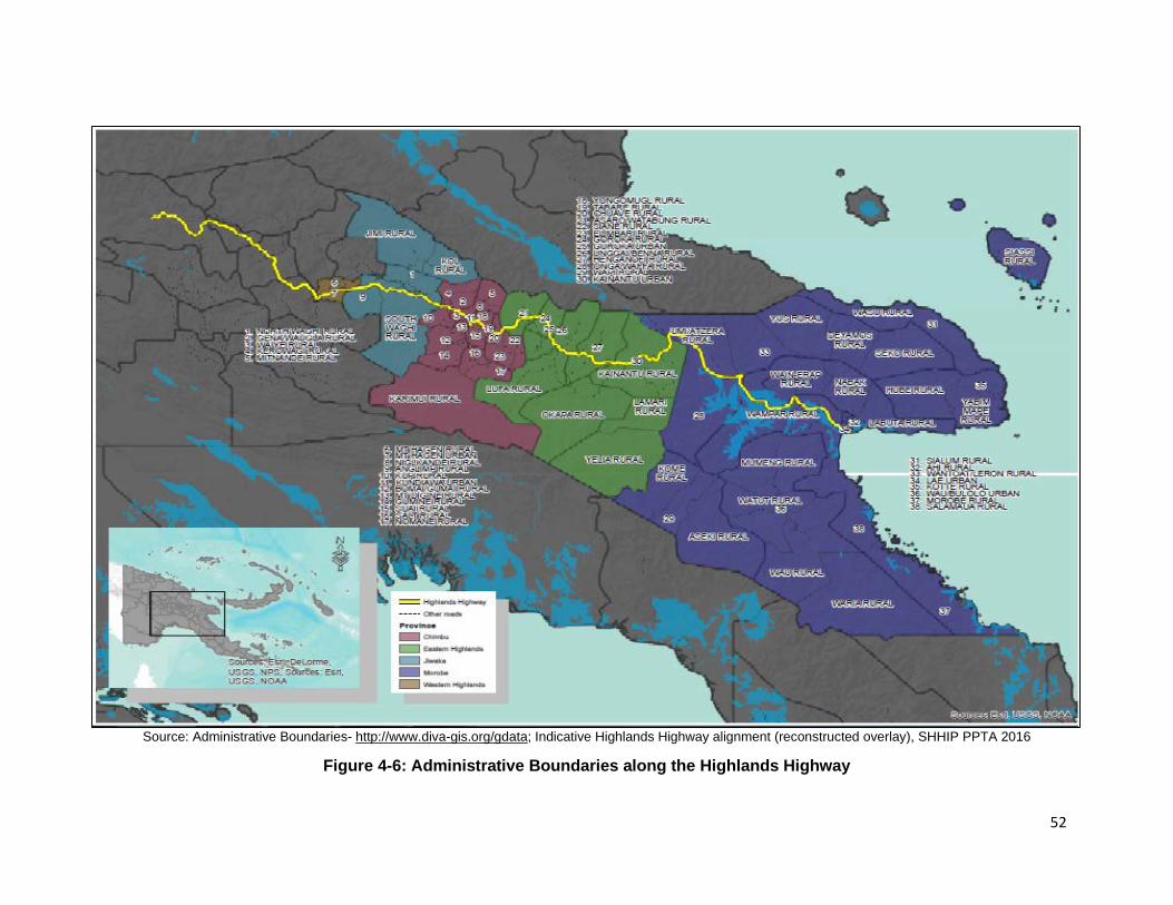
52
Source: Administrative Boundaries- http://www.diva-gis.org/gdata; Indicative Highlands Highway alignment (reconstructed overlay), SHHIP PPTA 2016
Figure 4-6: Administrative Boundaries along the Highlands Highway

53
2. Economic Situation 121. PNG has a small export-oriented economy heavily reliant on commodity products: minerals constitute 75% of total exports, agriculture products 20%, and forestry products 5%. The GDP economic forecast for PNG almost halved for 2016 because of cuts to public spending. The economy also suffered from the effects of El Niño weather in 2015, and the weakness in global prices for export commodities. Economic growth has not been inclusive and is skewed towards the urban population, leaving the majority of rural dwellers in poverty.20 122. The HH is the transport backbone of PNG’s economy, linking core economic regions that produce much of the country’s major exports (minerals, petroleum, coffee, sugar, tea and other commodities), to the country’s major port at Lae. It also links major domestic markets along the way, particularly for fresh food produce, which is critical to rural livelihoods. As well as servicing the five provinces within this Investment Program, the HH is the major route to the port of Lae for three others: Enga, Southern Highlands and Hela provinces. 123. Agriculture accounts for approximately a third of GDP: approximately 85% of PNG population’s lives in rural areas and works in agricultural and other rural industries. However, the distribution of natural resources is very unequal, and much of the land is of low quality. Population density is highest in areas with high quality land, which includes much of the large highlands’ valleys, such as the Wahgi and Asaro basins21. Many of the highlands areas adjacent to the HH are highly productive farming areas, with better access to markets than those more distant from main roads. 124. Most of the land through which the HH passes is customary land, which, in the Highlands, is inherited through patrilineal descent. Customary land, (also known as un-alienated land), makes up about 97% of the total land area in PNG, and most of it, is managed by male leaders (even in matrilineal societies). Planting annual food crops does not secure long-term use rights over land, unlike the planting of small plantations of perennial crops such as coffee and coconuts. Food gardens are generally transient, whereas plantation of tree crops are semi-permanent markers of property rights and confer status on the men who control them. When customary land is leased for plantations, logging or mining, women seldom take part in negotiations, nor are women usually considered to have the right to claim a direct share of leases, royalties or compensation payments. With high rates of population growth, land is increasingly scarce, exacerbating long-standing patterns of conflict over land. Women’s access to land depends on male kin or spouse’s kin, which makes women who live without male support, particularly vulnerable to exploitation or abuse of their rights. 125. The subsistence food production system, with smallholder farming dominated by root crops, small-scale animal husbandry, hunting, gathering and fishing, provides sufficient food supply on a year-round basis for most of the population, but people living in highly marginal environments suffer from periodic food shortages. Malnutrition resulting from inadequate diets is a serious problem in many parts of the country, and is associated with less developed areas, low monetary incomes, and poor delivery of health services. Malnutrition is less common along the HH communities, which have more reliable cash incomes because of their proximity to the road. Vegetables and fruits are grown both for home consumption and sale of the surplus. Many families also keep a few pigs, and a small number of households have two to six goats or sheep.
20 ADB 2015, Country Partnership Strategy, 2016-2020 21 Allen, B., R.M. Bourke and J. Gibson, 2005, Poor Rural Places in Papua New Guinea. Asia Pacific Viewpoint.

54
126. Many women market their produce at the main HH town markets, or at small roadside informal markets, but others sell to ‘collectors’ who gather up produce from many growers and on-sell to larger companies, including the Goroka Fresh Produce Development Agency (FPDA). FPDA provides extension services to seven Highlands provinces, to try to improve the supply chain through seed multiplication, consistency of supply, quality, and marketing services for farmers. They provide information, seeds, training and do a market survey on a weekly basis to inform growers of current prices, covering 60 different crops. 127. It is estimated that highway improvements together with bridge works could at least double the amount of produce transported from the highlands to Port Moresby.22 Currently, the Bismarck Maritime Company sends 15-20 containers of highlands fresh produce from Lae to Port Moresby every week, while Consort Express Line Ltd ships a similar amount twice weekly. There are cool storage sheds at Kainantu, (run by NKW Holdings Ltd formerly Waufresh), but these are insufficient and there is high wastage and damage to crops during transportation, partly because of poor grading, poor post-harvest processing, a lack of suitable packing materials, and because of the condition of the road. The Mapai Transport Company manager, who has 18-20 trucks travelling up the HH daily, estimates that almost half of all fresh produce goes to waste and that cool storage, packing and logistic facilities and better road conditions are necessary to improve this situation. NKW received aid from the New Zealand government in the form of chiller trucks and storage facilities. They receive produce direct from farmers, quality check the product, pack them in ‘green baskets’, and transport to a depot in Lae with 100 tonne chiller capacity, from where they supply nearby markets (such as UNITECH, Lae International Hotel, Henderson Foodland Supermarket, and the catering department at Hidden Valley goldmine.) The main produce marketed is potatoes, bulb onions, spring onions, zucchini, English cabbage, purple cabbage, carrots, and broccoli. 128. Other economic activities dependent on the highway section include the mining industry, particularly the Ramu Nickel and Cobalt Mine run by Chinese Metallurgical Construction Group in Madang Province, as well as large scale agricultural enterprises. These include:
i. Intensive chicken farming along the Markham Valley ii. The Ramu sugar industry on the Madang road iii. Trukai rice farms including their research farm near Nadzab at Gabmatzum iv. Cattle ranches and estates such as Leron Plains Ranch, Wawin, the government
station at Erap, Zifazing, Ramu Beef, and Sulikon 129. Approximately 71% of PNG’s cattle are in Morobe and Madang provinces mainly in the Markham and Ramu valleys. The average small holder runs 34 head on 136 hectares (ha). While large farmers raise 2,100 head on 3,645 ha. Workers on estates gain stock expertise and breeding stock to establish their own small herds, and frequently sell store cattle to estates to finish and market. However, numbers of cattle are dwindling, with currently only an estimated 30,000 head of cattle in PNG, down from 100,000. 130. Business activities along the HH include transport companies running passenger services (PMVs or mini-buses), gravel extraction in river beds, liquor retailing, workshops for mechanical repairs, fuel, battery and tire shops, contractors involved in infrastructure projects and roadside markets with sugar cane, kaukau, carrots, cabbages, strawberries, mandarins, cooked meat, scones and donuts, soft drinks, and non-food items such as bilums, hats, woven palm or bamboo building materials and matting, petrol, flowers, and coffins.23
22 Bonney L, M Warinu, and P. Muscat, 2012, Yu Tokim Mi Long Planim Kaikai Na Maket We? Feasibility Study for a New Wholesale Fresh Produce Market in Port Moresby, NZAid, MFAT 23 Coffin building has become a small industry since the advent of the HIV/AIDS epidemic, catering with the increase in deaths.
55
131. While women expect to be able to increase their production and marketing of fresh produce when the highway improves with bridge works also implemented, the gender division of labor and women’s traditional exclusion from the benefits derived from road rehabilitation and maintenance works have been identified as a problem during community discussions. Women want more access to jobs provided during implementation of the tranche 2 works , mainly in bridge construction and repair/maintenance tasks suitable to individual skills or ability to learn such skills while on-the-job. Relevant Contract provisions are envisaged to be helpful in increasing the percentage of women workers in the labor force, and in ensuring they are paid equally to men for equal work.
3. Household Incomes and Poverty 132. The economic and social benefits of SHHIP, with a comprehensive and properly upgraded and maintained highway traversing the regions, will contribute to poverty reduction. An average household in the Highlands Region consists of 6.8 persons which may have up to 5-7 hectares (ha) of productive land divided into five food gardens averaging 1.5 ha per garden, which are used to cultivate a range of food and cash crops, both for consumption and surplus for sale. In 2016, surveyed households in the Highlands Region suggested average income of 971 kina a month against average household expense of 652 kina a month. Non-income dimensions of poverty included a lack of access to (i) cash paying jobs, (ii) education and health services, (iii) potable water, and (iv) transport services and roads. The most pressing demands from these households were for safe drinking water, electric power, and usable roads. While available data are limited, the risks of rapidly rising poverty levels in PNG are clear. Salient issues included the following: (i) poor economic performance and rapid population growth (2.8%) have led to a sharp increase in the incidence of poverty. In 2011, it was estimated that about 40% of the PNG population lived on less than $1 per day, while 70% were below the level of $2 per day; and (ii) the highest poverty levels occur among households with little or no cash income in remote areas away from roads. The national poverty rate is 37%. The proportion of population living below the national poverty line is 37.5%.24 Farmers that grow and sell cash crops such as coffee and cocoa may also have high poverty levels due to the fluctuation in commodity prices. Overall, people involved in the agriculture sector account for 86% of the poor. Households headed by women are among the poorest in rural areas. With the Human Development Index (HDI) value as 0.544 (low human development category), PNG is rated 153rd of the 189 countries in the 2017 HDI.25 133. Women are concentrated in informal employment, unpaid domestic work, and low paying less secure occupations. In the Highlands region most women are engaged in small-scale animal husbandry (mainly pigs, goats, and chickens), fresh food production and marketing, along with some export cash crops such as coffee and, in the Markham Valley, cocoa, sugar cane and coconuts. Women do most of the planting, weeding, harvesting, and make significant contributions to coffee gardens and other cash crops. Women’s workloads are heavy: they walk long distances every day to gardens, markets, collecting firewood, fetching drinking water, and providing the cooking and childcare. Due to the absence of proper shoulders, women and children walk along the roads, carrying heavy loads, taking produce from gardens to home, or for sale at a market. Traditionally most women in the Highlands do not have land ownership rights, and many are economically dependent on their husband’s clan group. As the majority market vendors and users of health services, women are disproportionately disadvantaged by poor transport networks. Recent studies show that markets, bus stops, and parking lots are spaces with high levels of violence against women, particularly by young men. Most women in the Project areas are engaged in agricultural activities. They will be the main beneficiaries of improvements in:
24 ADB. 2019. Basic 2019 Statistics. Manila https://www.adb.org/sites/default/files/publication/499221/basic-statistics-2019.pdf. 25 UNDP. 2018. Human Development Indices and Indicators: 2018 Statistical Update. New York.
56
roadside improvements, fresh vegetable marketing through logistical depots, safety provisions near schools and other The highest incidences of poverty are among people with no income generating activities, the self-employed in the semi-subsistence agricultural sector, as well as market vendors and others working in the informal economy.26 134. The majority of people’s dependence on subsistence rain-fed agriculture raises levels of vulnerability to natural disasters and changing environmental conditions. Insufficient income opportunities and high levels of crime and violence further exacerbate hardship and inequalities. In PNG, people’s on-going connections to land and food production mask poverty, and many prefer to talk of ‘hardship’. But income poverty, and poverty of opportunity are real challenges with almost 2.5 million people living in hardship. Income and poverty levels along the entire HH section will be investigated through the socio-economic survey during tranche 2 detailed engineering design stage.
4. Social Services 135. Physical isolation and poor transport networks pose major challenges to expanding access to basic social services, a situation compounded by underlying state fragility and weak bureaucracy. Rural health services and basic education facilities are often closed, are cut off from supplies, and lack access to reliable power, while teachers and health workers are forced to spend a lot of their time travelling to and from regional centers for salaries and supplies. Although the social services located on the HH are better off than many more isolated facilities, many are still suffering from the same problems. Of particular concern for the SHHIP are the large number of children walking long distances to school, using the HH who are often at risk from heavy traffic thundering by because of the lack of footpaths or other safety features. 136. Almost half of primary school-aged children are still out of school, with fewer girls going to school than boys. The country’s net enrolment rate 63% is the lowest in the Asian Pacific region, and only one in three children complete basic education.27 Many schools have poor facilities, with some schools having no toilets at all and no piped water system. There is little road safety or health education in the curriculum. A large number of schools are situated along the HH. Below is a preliminary list of educational facilities on the HH within the Investment Program scope:
Table 4-18: Educational facilities along the Highlands Highway Morobe Province Zumin Primary School
Arifiran Community School Mutzing Community School Markham High School
Eastern Highlands Province
Avanmofi Community School Yagusa Community School Komperi Community School Watabung Primary School Mando Primary School Ganarafo Primary School Asaro Primary School Kabiufa SDA Secondary School Lufalufa Primary School Mt Sion Disabled School Kamaliki Vocational School
Agribusiness Training Institute Ketarobo Primary School New Tribes Mission School Kintunu Primary School Henganofi Secondary School Kafentina Primary School Komperi Primary School Barola Primary School Raibinka Primary School Duempinka Primary School Agarabi Primary School SDA Nuemfindenu School
26 UNDP, 2014, National Human Development Report: Papua New Guinea, From Wealth to Wellbeing: Translating Resource Revenue into Sustainable Human Developmen 27 UNICEF PNG, https://www.unicef.org/png/activities.html

57
137. There are also many health facilities situated along the Package 1 section of the HH, with varying levels of service. Provincial Hospitals act as the referral centers for district hospitals and health centers, while the health centers supervise and support smaller aid posts, which provide only preventative services and basic primary health care. While hospitals have the capability of dealing with road traffic accident victims, health centers located where there are many accidents, complain that their staff are not trained to deal with emergencies or trauma victims, and those suffering severe injuries often die before they reach larger hospitals. Many of the health facilities provide HIV/AIDS services. A partial list of health facilities along the section of HH is below:
Table 4-19: Health Facilities along the SHHIP Highlands Highway Scope Province Helth Facilities
Morobe Province Atsunas Aidpost Mutzing Health Centre
Eastern Highlands Province Goroka Base Hospital Kainantu District Hospital Komperi Health Centre Yonki Health Centre
5. Health Issues 138. PNG is characterized by a generalized HIV epidemic: the estimated prevalence rate of is 0.8% with 40,000 people living with HIV. Data also suggests that the PNG HIV epidemic is mostly concentrated in the Highlands region (with an overall prevalence of 1.07%). As of mid-2016, there were 22,548 people living with HIV receiving antiretroviral therapy, which they must remain on for life. Key at-risk groups include truck drivers that work on the HH; female sex workers, particularly at PMV stops along the HH; and men who migrate to towns and development enclaves for work. These are highly mobile groups. Wives and their new-born children are also at risk because the use of condoms is not widespread and there is a high degree of sexual violence within marriages. The Mutzing Health Centre in Markham Valley has 345 registered sex workers receiving regular preventative and treatment services, of whom six are children under 16 years. Twenty-five of the female sex workers are being treated with antiretroviral drugs, but because they are move frequently, it is difficult to ensure regular follow-up. The exposure of roadside communities to higher levels of road traffic means that special attention must be paid to the risk of sexually transmitted infections (STIs). Considering women’s greater exposure to the risks and impacts of HIV, culturally sensitive and gender-responsive awareness and behavior change initiatives need to be provided in campsites and corridors of influence as part of broader health education programs. 139. Alcohol: There are a huge number of liquor outlets along the HH, and a lack of proper licensing.28 This has contributed to the number of vehicle accidents, as well as to violence (particularly against women), fights between groups, loss of income for family needs, obesity, and ill health. Enga and Southern Highlands have both introduced liquor bans along the HH sections within their provinces, which are strictly policed, but no such bans or policing exist for the Investment Program provinces. 140. Accidents: Road safety is a major issue in PNG, causing significant loss of life, injuries, and economic losses. Staff at Mutzing Health Centre in the Markham Valley report that there are very frequent serious accidents (at least one per week), which at Mutzing, they are ill-equipped to deal with. Many of the injured die being transported to the Lae Hospital. The steeper sections
28 The PPTA assessment team counted 58 beer shops between Kagamuga and Kundiawa; 54 SP beer outlets between Wara Simbu (outside Kundiawa) and Goroka), and 29 between Akamore market at Yongki and Nadzab.
58
and many unmarked corners are also traffic accident black spots. While no accurate figures exist for the number of accidents or fatalities, rates are thought to be some of the highest in the world. There is a danger that improving the HH will allow higher traffic speeds but may also cause an increase in traffic accidents. Therefore, mitigation measures are planned through the road safety component of the Investment Program: road safety surveys, the removal of black spots, improved signage, crash barriers and footpaths will be part of the engineering design; road safety awareness will be raised among road users and roadside communities; and efforts made to ensure traffic laws are enforced.
6. Gender 141. There are few countries in the world where men outnumber women, but PNG is one of them having 108 men for every 100 women. This phenomenon is only found in countries with profound gender inequalities. The country is ranked 133 out of 149 countries on the Gender Inequality Index. The PNG Country Gender Assessment, conducted in 2011, highlighted significant gender gaps limiting women’s economic opportunities and access to health care, as well as educational attainment and literacy. Women in PNG are facing serious health issues: maternal mortality rates are high by world standards at 733 per thousand births. In 2009, there were only 92 girls for every 100 boys in primary school, and just 78 girls per hundred boys attending secondary school. In the Highlands, this disparity was worse, with only 85 girls in primary school to every 100 boys. Around 37% of females, compared with 26% of males have never attended school.29 In the Momase region, over a quarter of girls between 15 and 17 never attended school, compared to only 5.6% of boys.30 Factors influencing enrolment in schools are distance from school, lack of sanitation, sexual harassment and violence towards girls by other students or male teachers, the expenses of education, and cultural factors relating to gender discrimination and exploitation of girls who are kept home to do household chores, look after children, or help plant and harvest food crops. 142. As noted above, the HIV/AIDS prevalence rate is 0.8% nationally, but higher in the Highland provinces. Women and girls are more vulnerable to HIV/AIDS and sexually transmitted infections (STIs), as they are less able to protect themselves, partly because of the widespread gender-based violence. Many men feel they have the right to beat and sexually abuse wives, prostitutes, women from enemy groups, and strangers. Alcohol and drug use have accelerated the violence, which includes domestic violence, child abuse, rape, and gang rape. The high level of gender-based violence, not only increases vulnerability to HIV/AIDS but also constrains women’s and girls’ mobility and opportunities. A study in four provinces found that nearly half of the women had experienced physical and/or sexual violence in their relationships, and women with physically or sexually abusive husbands were much more likely to have HIV/AIDS. Women are twice as likely to report that crime stops them from using public transport, walking to work or shopping, fetching water, walking to the gardens, and allowing children to walk to school.
5. ANTICIPATED ENVIRONMENTAL IMPACT AND MITIGATION MEASURES
A. Design Phase 143. Design: The bottlenecks of Eighteen (18) single-lane bridges and insufficient clearance of the double bridges for water flow during the rainy period are big challenges for the vehicles
29 World Bank, UN, AusAID, ADB, Government of Papua New Guinea, 2012, Papua New Guinea Country Gender Assessment, 2011-2012 30 National Statistics Office, 2012

59
travelling on the HH, especially where the road section(s) are getting upgraded and improvements for double-lane traffic flows are in progress. The design will also address on the following:
i. Design of structures to allow for continued flow of water through or appropriate overtopping in flood.
ii. Adjust alignment of access roads to minimize need for removing large trees, iii. Design road realignments to take into account value of land and to minimize area
required. 144. Climate change adaptation. A complete climate risk and vulnerability assessment has been prepared and submitted separately31. Climate change adaptation measures are properly considered and incorporated into design as follows:
i. Rainfall effect related to short-time intensive rainfall and prolonged rainfall significantly affects the bridge and approach road design. Meteorological & Hydrologic survey has been undertaken to collect the statistic and data on Highlands Highway regions for the application of new bridge design,
ii. Rational bridge design for this project considers enough drainage capacity to minimize sliding failure, flooding damage,
iii. Design bridges to be sufficient hydraulic capacity for the 1:100-year flow and taking into account expected climate changes,
iv. Design of flood discharges and flood elevation based on hydrological analysis. B. Pre-Construction Phase 145. Land clearance: Land acquisition for permanent may acquire for 7 bridge relocations where need to be realigned for road safety, social and environmental reasons and longevity of structures and abutments. Land acquisition for temporary will be required for purposes of traffic diversions, campsites, storage yards, etc. There is no physical displacement of people, either on an individual household basis or through the acquisition of public properties such as schools, churches or other community centres. Loss of land and asset will be compensated through measures outlined in Resettlement Plan (RP). 146. Repair/maintenance/reinforcement bridge works: no permanent or temporary land acquisition is required for the repair/maintenance/reinforcement bridge works. 147. Temporary land acquisition: There are temporary land acquisition requirements due to implementation of SHHIP tranche 2 Volume-I works in all 15 in-situ new construction bridges under the scope of this plan (that is, the section from Nadzab to Goroka) based on implementation approach for tranche 2 works. Such temporary acquisition of land is for traffic diversions, working areas including for movement of equipment, stockpiling of construction materials, batching plants, storage yards, etc. It is estimated that about one (1) hectare (ha) of land shall be required at each new bridge construction site for such purposes. The rentals shall be mutually agreed up on by the Contractor and the landowner, documented in the form of Contract and paid directly by the Contractor. Such land shall be reinstated and returned to the owner(s) after completion of bridge works at each site. Table 5-1 below presents details on such new bridges to be constructed in-situ (without alienation changes).
Table 5-1: List of in-situ New Bridge Constructions Requiring Temporary Acquisitions
31 Climate Change Vulnerability Assessment, SHHIP, June 2017

60
Name Estimated land loss (ha)
Current Land use
Clan Leader/ Landowner
Ramu River Bridge
1 Trees/shrubs Steven Fortione
Bitjia River Bridge (old) 1
Natural Bushes/grass
Eri Michae
Undono Creek Bridge
1
Natural Bushes/grass
M. Nonafo
River Bridge
1
Natural Bushes/grass
Noti Asa
Kingkio River Bridge
1
Natural Bushes/grass
Alus Asi
Avani River Bridge
1 Natural Bushes/grass
Tai Onesi
Kamanotina River Bridge (Henganofi Bridge 1)
1
Cultivation, Trees/shrubs
Kepsy Kevo
Kuronka River (Henganofi Bridge 2)
1 Trees/shrubs Toro Lapenu, Sepi Snoopy & Joe Banu
Berefi River
1 Natural Bushes/grass
Aps Kokore, Jerrim Areso, Philip Mike & Apoko Tonny
Dirty Wara River
1 Trees/shrubs Tamako Etufe, Steven Toba & Job Kunkeso
Siguya River
1
Natural Bushes/grass
Seta Nevesi & Tatovera Zokanao
Yasifo River 1 Trees/shrubs Fomina Haki & Silly Kuta Parirosay River 1 Trees/shrubs Malo Kiniafa
Bena Bena River 1 Trees/shrubs Aisman Kafe
Taraboro River (Sunufamu) 1 Trees/shrubs Ira Kinoka
148. Permanent land acquisition: Based on Feasibility Study (FS) stage social impact assessment findings for Volume 1 bridges under SHHIP Tranche 2 works, physical displacement of 106 people will be triggered due to permanent and temporary land acquisitions for the bridges to be relocated (re-aligned) and newly constructed. Such permanent acquisition is required in seven (7) whereas 15 sites will have temporary land acquisition impacts under Contract Package 1 of the bridge works. Following sections provide further details on such impacts.

61
Table 5-2: Impacts due to Volueme 1 Bridge Works Requiring Permanent Acquisitions Name Estimated land
loss (ha) Current Land use Clan Leader/ Landowner
Erap River Bridge Trees/shrubs Gewisa Yanot Maralumi River Bridge 2 Barren/some natural
vegetation Paul Goi
Zumin River Bridge
4 Trees/shrubs Komiti Daniel Puma
Tapiruna River Bridge
2 Trees/shrubs Kation Noti
Darasimpi River Bridge
2 Trees/shrubs Wesly Amao
Luwin River Bridge
2 Trees/shrubs Tulip Nemori
Benapa River Bridge
2 Trees/shrubs Kora Isare and Aaron Afantae
149. Mobilization of the contractor, establishment of compound and construction camp: Prior to contractor(s)’ mobilization to the sites, PMO and CSC(s) will work with the Contractors to establish the communications protocol between the contractor and the communities as per their communications plan(s) and assist the contractor(s) to obtain necessary licenses for quarrying and gravel extraction. The Contractor(s) will identify one member of their staff to perform community relations work and to be the liaison between the ward councillors, village leaders and elders and contractor(s), as well as between the contractor(s) and CSC(s). 150. The construction camp(s) accommodation, maintenance yard and other associated facilities such as quarry(ies), crushers, batching plant(s), asphalt mixing plant-base(s) shall be located outside any areas identified by the authorities to be protected for biodiversity or landscape values and shall be outside of any designated protected areas and/or wildlife management areas. 151. Mitigation measures: The contractor will adopt good management practices to ensure that fuels and chemicals, raw sewage, wastewater effluent, and construction debris/scarified material is disposed of in controlled conditions to reduce the risk of contamination as well as community grievance. Measures to minimize disturbance by construction workers and others’ presence at the works site/area include:
i. As much as possible, labour shall come from the communities traversed by the Highlands Highway. But where this cannot be avoided due to the absence of skills appropriate to the requirements, workers hired from off-site shall be provided briefing of village protocols as part of awareness and mobilization training.
ii. The contractor is to ensure that workers’ actions outside work site are controlled and village codes and rules of conduct are always observed.
iii. The contractor will identify one member of their staff to be the liaison between the ward councillor, village leaders and elders and contractor, as well as between the contractor and PMO.
iv. The contactor will engage an accredited third-party service provider to deliver HIV/AIDS/STIs awareness and prevention for the contractor’s workers and adjacent communities in accordance with provisions of the gender action plan (GAP). The service provider must be an existing organization actively providing such services in the vicinity of the highway, to ensure on-going activities and follow-up of at-risk groups.
v. vi. Worker camp location and facilities will be located at least 500m from settlements
and agreed with local communities and facilities approved by CSC(s) and

62
managed to minimize impacts; signage and security will be adequately provided at the site office and works yard and unauthorized people (especially children) entering the area will be prevented.
vii. Work and camp sites will be cleaned up to the satisfaction of the landowner and/or local community after use.
152. Water supply: The Contractor shall provide safe potable water for food preparation, drinking and bathing compliant with the relevant national technical regulations issued by the Department of Health, and other applicable Laws, 153. Sanitary Facilities
i. In every camp site, separate and adequate lavatory facilities (toilets and washing areas) shall be provided for the use of male and female workers. Toilet facilities should also be provided with adequate clean water, soap, and toilet paper. Such facilities shall be conveniently accessible and shall be kept in clean and hygienic conditions.
ii. Where workers of both sexes are employed, there shall be displayed outside each block of latrine and urinal, a notice in the language understood by the majority of the workers “For Men Only” or “For Women Only” as the case may be.
iii. Sanitary arrangements, latrines and urinals shall be provided in every work place on the following scale: Where female workers are employed, there shall be at least one latrine for every 25 females or part thereof; Where males are employed, there shall be at least one latrine for every 25 males or part thereof.
154. Wastewater Management i. Water from kitchens, showers etc. shall be discharged into a conservancy tank for
removal from the Site or pass through an oil screener before discharge. ii. Wastewater from construction camps, even after the settling and oil/water
separator treatment shall still not be allowed to be discharged into river systems directly. They can be discharged into ditches, smaller creeks before being disposed into the rivers.
iii. At every construction camp there must be at least one septic tank or holding tank. The wastewater from the holding tank shall not be discharged into any watercourses. The wastewater shall be periodically transported away by a water tank to the nearest treatment plant or treated by the site wastewater treatment system.
iv. Sewage tanks shall be designed and installed by the Contractor(s) in accordance with the National Design Code for construction of camps.
v. Discharge of treated wastewater must comply with the discharge limit according to the PNG’s regulation and standards.
155. Solid Waste Management i. The Contractor shall provide refuse bins with lids for all Worker ‘camp; refuse shall
be collected and removed from the camp at least twice per week; and domestic waste shall be transported to the approved refuse disposal site in covered containers or trucks; and collection and disposal of domestic waste shall be coordinated with Local Authorities.
ii. Fire control: The contractor shall ensure that basic firefighting equipment is available at all camp areas.
iii. Medical Facilities: to equip medical cabinets and facilities for first aid and under the charge of a responsible person who shall always be readily available during working hours of the workplace. He/she shall be adequately trained in administering first aid treatment.

63
iv. Worker camp area: each room of worker should not more than 10 person with a minimum of 4m 2 per person included bed, locker and any other personal furniture provided and space area.
156. Material extraction: Materials extraction would be an important activity of the program that shall be managed accordingly to minimize associated environmental impacts. Sources of materials (sand and gravel, borrow materials etc.) and quarry sites shall be agreed with the CSC and PMO prior to any extractions. Permits and licenses shall be obtained prior to commencement of works and quarry sites must not be occupied, prepared or operated by the contractor before the issuance of the necessary land occupation permit and EPs from the CEPA and all other authorities as required. 157. The contractor will be required to identify sources during the preconstruction phase and prepare an extraction plan for all sources of materials that will be used in the road works. The aggregate extraction plan shall be submitted to PMO through the CSC, which will approve and monitor implementation of the extraction plan. No quarries and borrow sites shall be in areas for protecting biodiversity and/or wildlife management areas. The suitability of quarry and borrow pit sites will be assessed in consultation with the CSC together with landowners and village chiefs that shall provide written permissions or consent. 158. Only permitted/licensed facilities and operations may provide materials for the program. Establishment of quarries, crushers and asphalt mixing plants shall be disclosed to the CEPA following the requirements of the Environment Act and EPAR and obtain an EP in accordance with DOW’s Code of Practice. 159. The BCD will specifically require contractors to: (i) balance cut and fill requirements to minimize impacts from extraction of aggregates; (ii) prioritize use of existing quarry sites with suitable materials and update the list of quarries and borrow pits monthly and report to PMO; (iii) procure materials only from quarries and borrow sites acceptable to CEPA or licensed and authorized by CEPA; (iv) if the contractors shall operate the quarry site, required environmental licenses and permits shall be secured prior to operation of quarry/borrow areas (including preparation, approval and implementation by PMO and CEPA as required of aggregate extraction plan and/or quarry management plan); and (v) borrow/quarry sites shall not be located in productive land or forested areas or land subject to instabilities and landslides. 160. Mitigation measures. Mitigation measures identified to minimize impacts from material extraction at quarries and borrow pits include but not necessarily limited to the following:
i. As part of the CEMP and EP (or similar) application, the contractor will prepare and submit to PMO through CSC and CEPA for approval the aggregate extraction plan and/or quarry management plan.
ii. Topsoil, overburden and low-quality materials shall be properly excavated and stockpiled near the site to be used for re-use and/or site rehabilitation after completion of the construction works.
iii. Quarry sites close to where the road works will be done and highly accessible with low hill gradients will be used.
iv. Adequate drainage shall be provided to avoid accumulation of stagnant water during quarry/borrow site operation.
v. Access roads affected by the transport of quarry/borrow materials shall be rehabilitated. Agricultural lands and other privately- or communally owned properties shall be likewise compensated if similarly affected by the same or any other project-related activities.
vi. Choose alluvial materials from at least 10m from the banks of the river to maintain the integrity of the flowing stream.
64
vii. Gravel and alluvial materials shall not be taken from within 200m upstream or downstream of any bridge or river protection structures.
viii. Alluvial terraces or alluvial deposits which lie on the riverbeds but not covered by water in normal hydrological conditions shall be preferred.
ix. Berms and terraces shall be cut during and after extraction in quarries in the mountainous or hilly areas to stabilize slopes; and provide drainage works to properly channel runoff, and vegetative cover or bio-engineering for rehabilitation.
x. Quarries and borrow pits shall be dewatered and fenced off as appropriate, upon completion of extraction activities to minimize community safety risks most especially to children.
xi. If borrow pits cannot be immediately dewatered, the contractor shall provide fencing and flotation devices to warn communities of impending danger and risks.
xii. Borrow pits shall be provided with stable side slopes and proper drainage to avoid creation of water bodies favouring mosquito breeding.
xiii. Borrow pits shall be backfilled and marked as maybe required by CEPA using surplus inert materials and excavated unsuitable soils.
xiv. Restoration of quarry sites and borrow areas, as well as their immediate surroundings, will be undertaken in an environmentally sound manner to the satisfaction of the PMO which will sign-off before final acceptance and payment under the terms of the contract.
xv. Additional extraction sites and/or borrow pits shall not be opened until ESSU is satisfied with the restoration of previously utilized areas.
161. Spoil disposal. Along the highland’s highway, the use of readily available excavated materials or what would otherwise be classified as construction spoils when not immediately utilized will reduce the need for additional extraction of quarry-based materials. These materials shall be graded, and suitable materials reused as much as possible. The surplus can then be stockpiled at locations agreed with local authorities for use on the other sections of the highway reducing the need to extract other rock and gravel resources from off-site vulnerable hillsides and riverbeds. Areas for temporary storage if not immediately utilized on the worked sections shall be identified with local landowners and agreed with village leaders and local authorities. The CSC will advise PMO before these materials shall be used for stockpiling or eventual disposal to a suitable location. 162. Surplus rock and soil-based materials for re-utilization along the highlands highway or eventual disposal shall be managed to avoid or minimize potential impacts. Spoil disposal management shall form part of the CEMP to be submitted by the contractor. This CEMP shall update the EMP prepared under this IEE and shall include a section ensuring construction wastes are properly managed. Government land is preferred to be used for stockpiling and dumping of material where these are available along the highway. Otherwise, if private lands are to be used for the purpose, storage or dumping shall commence only after written permission from the landowner is confirmed by the PMO and likewise agreeable to the community leaders and CEPA. 163. Mitigation measures. The CSC will be responsible for reporting to PMO the monthly update of the contractor’s cut and fill estimates in conjunction with asphalt and aggregate materials planning between the different areas and advise on overall balancing for cut and fill materials to minimize impacts on local resources. 164. The spoil disposal section of the CEMP will include; (i) locations and quantities of spoil anticipated from the works; (ii) agreed locations for disposal/endorsement from CEPA and local groups; (iii) method of transportation to minimize interference with normal traffic; (iv) establishment of acceptable working hours and constraints; (v) agreement on time scale and programme for disposal and chain of custody; (vi) rehabilitation and bioengineering of spoil dump

65
slopes after works completion, (vii) programming issues including the time of year and available resources; (viii) discussion of the PMO inspection/monitoring role; and (viii) links to the grievance redress mechanism and complaints management system for the duration of the works. 165. The PMO assisted by the CSC will be responsible for the monitoring of the progress of slope cutting and the implementation of mitigation measures to minimize impacts. The mitigation measures in the CEMP will include but not necessarily be limited to:
i. Spoil will be reused as much as possible for backfilling; ii. Spoil will not be disposed in any waterways along the highland’s highway; iii. Spoil disposal shall not cause sedimentation and obstruction of flow of
watercourses, damage to agricultural land and densely vegetated areas; iv. Surplus materials shall not be stockpiled on the roadside or dumped over crash
barriers; v. Construction spoils shall not be disposed on fragile slopes, flood ways, wetland,
farmland, forest, religious or other culturally sensitive areas or areas where livelihood is derived;
vi. Surplus spoils shall be used as much as possible for local repair works along the highway; backfill eroded gullies, low-lying areas, and degraded lands in consultation with the local communities;
vii. Spoils shall be disposed only in areas approved by local authorities and landowners after approval by the PMO through the endorsement of the CSC;
viii. Spoil disposal shall be monitored by PMO through the CSC and recorded using a written chain of custody (trip-ticket) system to the designated disposal sites;
ix. Random and uncontrolled tipping of spoil, or any materials will not be permitted; x. Before dumping commences, designated spoils dumping areas shall be marked
on a plan and in the field with marker poles/flags to identify the agreed areas and limits for disposal. Spoils may be disposed in disused quarries and abandoned borrow pits if these are practicable; and
xi. The spoil disposal site shall be located at least 50m from surface water courses and shall be protected from erosion by avoiding formation of steep slopes and provided grassing.
C. Construction Phase 1. Impacts on the Physical Environment
166. Air quality and particulates: The spoil coming from unsuitable materials’ removal and soil excavation during the bridge construction, will be transported away and dumped at the sites authorized by the local authority(ies). However, the excavated soil might cause PM emissions in the form of dust on sunny and windy days if there are no proper mitigation measures taken. The spoil and/or construction materials may affect the environment and deteriorate the scenery of the project area if they are not disposed properly. The following table shows PM emission factors from some equipment, machinery and vehicles during construction.
Table 5-3: Emission factors of some diesel equipment Construction equipment Hours of operation per day Emissions
(g/horse-power/hr) PM10 PM2.5
Water truck 8 0.410 0.400 Dump truck 8 0.410 0.400 Excavator 8 0.320 0.310 Graders 8 0.330 0.320 Backhoes 8 1.370 1.330

66
Bull dozers 8 0.330 0.320 Front end loaders 8 0.350 0.340
167. Emission factors of exhaust fumes are much dependent upon the types of the used equipment, machinery and vehicles and their operation time. Obviously, old equipment, machinery and vehicles will produce more exhaust compared to the new ones. Moreover, equipment, machinery and vehicles lacking maintenance will also generate much more exhaust compared to the fully maintained. . 168. Pollution of PM and exhaust fumes will significantly impact on human health, especially on the workers and local people living near the construction site(s). Respiratory diseases are typical of the ambient air environment polluted by PM and exhaust. However, it is difficult estimate the exact concentration of PM and exhaust fumes in the ambient air environment at the construction site(s). 169. Mitigation measures: To mitigate impacts of PM emission the spoil and sand should be covered and/or wetted as transported or piled to reduce PM emissions into the surroundings. The spoil will be disposed of to the allocated sites. The following table shows some indicative mitigation measures for PM emissions.
Table 5-4: Mitigation measures for PM emission from construction
Source activity Mitigation measure PM10 control efficiency
Demolition and debris removal
Apply water every 4 hours to the area within 30 meters of a structure being demolished, to reduce vehicle track out
36% - 98%
Construction activities
Apply water every 3 hours to disturbed areas within the construction site
61%
Scraping Minimum soil moisture of 12% for earth moving by use of a moveable sprinkler system of a water truck. Moisture content can be verified by lab sample or moisture probe
69%
Construction traffic Limit on-site vehicle speeds (on unpaved roads) to 15 miles per hour
57%
Grading All trucks hauling dirt, sand, soil, or other loose materials to be trapped with a fabric cover and maintain a freeboard height of 12 inches
91%
170. Based on the data in Table 5-3, an emission of exhaust fumes into the ambient air may be estimated. In this respect, the application of effective mitigation measures will eliminate unexpected impacts arising from problems of PM and exhaust fumes emissions. Contractors will be obliged to use construction equipment, machinery and vehicles which must conform with the emission standards of PNG and the standards set out in the World Bank’s EHSG. 171. The Contractor shall prepare and implement a plan for dust management to minimize and/or suppress dust generation and resuspension created by construction activities in the affected work areas. This plan will include a water spraying schedule to be agreed with the Engineer and address dust issues created by the civil works activities along the highway, as well as by off-site hauling and disposal of construction wastes. It will include regular watering services during dry construction days in settlement areas such as markets, schools and other sensitive entities such as hospitals, and on dust generators such as excavation/open cut areas, and stockpiles. Spillage during transport shall be minimized by covering dump trucks when

67
transporting excavated soils to approved disposal sites. The Contractor shall also ensure that dump trucks will not be overloaded. 172. Vibration: Vibration propagates from a piece of construction equipment through the ground to a distant vibration-sensitive receiver predominantly by means of surface waves and secondarily by body waves. The amplitude of these waves diminishes with distance from the source. The general equation modelling propagation of ground vibration from point “a” (a location at distance ra from the source) to point “b” (a location at distance from the source) may be stated in the form of Equation:
)( ba rr
b
aab e
rr −
= α
γ
νν
Where γ is a coefficient dependent of propagation mechanism and α is a material damping coefficient.
173. Depending upon propagation mechanism of wave types and types of soil, vibration diminishing will vary. As per Wiss (1967), if the soil type is sand the geometric attenuation (γ) is 1.0 and if the soil type is claying the geometric attenuation (γ) is 1.5. The most common generic model of construction vibrations as a function of distance was developed by Wiss (1981), the damage threshold for residential area is approximately 80 mm/s. Construction of the network will require small equipment and machinery so the vibrations emitted from them will not be large and are predicted to be less than 10 mm/s at distance of 1 meter. 174. Mitigation measures: In order to avoid unnecessary claim for damages caused by construction activities from local residents, especially when use vibration rollers to compact materials, prior starting construction work at the part of road crossing resident’s houses, the Contractor(s) and the PMO will invite commune authorities, related local residents and the Engineers’ Representatives to participate in a house investigation to record existing conditions of their facilities. This data will serve as a basisto estimate cost for repairing these damages after completion of the construction work. The Contractor(s) shall also confirm that they will pay compensation for repairing these damages after the completion of the construction works. 175. Water quality and pollutants: Short-term impacts to the water quality of runoff draining from project construction areas may result, predominantly from sediment loading related to erosion of exposed soil surfaces. Long-term impacts to the water quality of runoff may result from increased pollutant loading to storm water due to additional impervious roadway surfaces. Storm water runoff may, possibly, wash pollutants, including hydrocarbons, metals, and sediments, from impervious surfaces. 176. Impacts on water quality can occur during construction through an increase in a suspended matter attributed to earthmoving works, and removal of vegetation for slope protection works. Impacts may also include: (i) contamination of water bodies and the aquifer resulting from generation of solid and domestic wastes from construction camps and offices; (ii) contamination of nearby water courses resulting from accidental spills and improper storage of fuel and lubricants and construction materials; (iv) turbidity of river water from eroded materials; (v) blockage of streams and changes in water courses affecting community access to water, including existing roadside drains and water sources used for washing; (vi) impairment of water quality from uncontrolled runoff from quarry and borrow areas; (vii) disruption in the hydrology of the water courses resulting from excavation of river beds; (viii) increased turbidity as a result of the disturbance of the channels or creeks; and (ix) disruption of the hydrology and hydraulic

68
characteristics of creeks as a result of laying of gabions and other water course protection works and river training works. 177. Mitigation measures: Mitigating measures for long-term impacts to water quality related to the potential increase in pollutant loading of storm water will include the construction of water quality basins to receive and treat storm water runoff from the proposed roadway. Work for the bridge abutments and piers will be performed with the use of coffer dams and sealing off of sediments which will then be appropriately disposed of offsite. Measures will be taken during construction of the piers (i.e., cofferdams, turbidity barriers, etc.) to minimize disturbance of bottom sediments thereby not affecting turbidity. 178. Waste management: Construction wastes such as steel and timber off-cuts, sand and gravel, cement bags are anticipated to be generated. These materials may cause nuisance to the surrounding environment if not properly collected and disposed of. Anticipated impacts may include but not necessarily limited to the following: (i) contamination of the land where the solid waste is deposited; (ii) decrease in water quality of nearby water courses; (iii) the stockpile of solid wastes may create habitation for rodents, pest and vermin which may present a health risk to workers and residents of nearby communities; (iv) health and safety impacts on local communities and reduced aesthetics as the heaps of solid waste in the area will be an eyesore. 179. Mitigation measures: Contractor(s) shall practice waste segregation, provide the necessary receptacles and organise awareness campaigns to their staff and workers. Organic (biodegradables) shall be collected and disposed on-site by composting, and recyclable materials shall be recovered and collected for sale to third party collectors/integrators and/or recyclers. 180. Hazardous materials: Hazardous substances such as oils and lubricants are anticipated to be used and can cause significant environmental impacts if improperly managed or disposed. 181. Improper storage and handling of hazardous materials may result in the pollution of the surrounding areas and may lead to the loss of aesthetics in the surrounding landscape environment. 182. Mitigation measures: The contractor(s) shall segregate hazardous wastes (oily wastes, used batteries, fuel drums, etc.) and ensures that storage, transport and disposal of these wastes shall be undertaken consistent with national and local regulations and shall not cause pollution. The contractor(s) shall be required to display safety information in all work areas and to train workers in the safe use of hazardous materials, including the provision of protective equipment. 183. Soil quality and erosion. Clearing and grubbing activities for setting up the temporary facilities that will be used by the Contractor(s) including contractors’ facilities, offices, worker camps, storage of equipment and materials, service areas, quarries and batching plant areas may affect the landscape and soil quality of adjacent lands as there may be accidental spillage of solid wastes, construction debris, petroleum products and many other construction wastes. The natural landscape maybe also damaged from unnecessary clearing and removal of vegetation as well as grading of rolling terrains of the natural surroundings. These are, however, anticipated to be minimal, manageable and avoidable with siting criteria, and for the most part short term in nature. 184. Mitigation measures: Soil erosion is anticipated during civil works when vegetation will be removed to make way for slope and drainage works that will expose soil to rainfall. During heavy rains, these loose soil materials will be carried away by run-off from the construction areas to the waterways. The impacts during this phase will be of short duration and will be moderate. Cutting of elevated slopes during construction is expected to cause erosion and landslides and the landscape of the project site along the highway will be physically altered on a permanent basis.

69
2. Impacts on the Biological Environment 185. Overall implications from this survey are that all existing bridges have had human impact from a long time. This has also affected the terrestrial and aquatic ecosystems along the Highlands Highway hence, no new species were recorded. There are two bridge sites (B#4, Km77+800 and B#6, Km, 113+000) indicated existence of nil to less impacted environments, howerever these bridges are to be reinforced/repaired and there is no construction activities which may impact to the environmental and ecosystem in these areas. 186. Impacts on terrestrial flora: Undertaken civil works activities at 16 in-situ new bridges and repar/reinforcement of 23 existing bridges shall be confined within the existing bridge corridor or acquired bridge right of way that had already experienced past disturbances. While the 6 relocation bridges require permanent land acquisition at per new bridge construction for approach road re-alienations. 187. Construction activities are anticipated to result in the loss of vegetation including trees in the area. For most of the sections, the vegetation comprises grasses and shrubs interspersed with growths of small to medium trees. 188. There are some gardens, coffee plantations and occasional individual trees such as eucalyptus that may require removal. However, these are common species and have no special characteristics to merit protection. Consistent with DOW’s Code of Practice, trees shall be avoided as much as possible by adjustments in the design. Table 5-5 indicates the terrestrial flora afftected by the construction activities.
Table 5-5: Terrestrial Fauna Impacts Name Tree affected
Ramu River Bridge 35 small trees/shrubs Kamanotina River Bridge (Henganofi Bridge 1)
58 banana trees
Kuronka River (Henganofi Bridge 2) Approx. 15 timber trees and two bamboo grooves Dirty Wara River Approx. 25 banana trees and two bamboo grooves Yasifo River Shrubs Bena Bena River Approx. fifty coffee trees Taraboro River (Sunufamu) Approx. 50 banana trees, 35 timber trees and three
bamboo grooves
189. Mitigation measures: Measures to be included in the project to ensure minimization of impacts from vegetation removal include but not necessarily limited to the following:
i. The contractor shall conduct a tree inventory (species and size) during the staking of the alignment in the pre-construction stage, and trees that may be removed will be agreed with PMO and landowners prior to cutting and carefully marked on a site drawing. Trees to be maintained will be protected.
ii. Vegetation clearing shall be kept to a minimum and occur only within the designated construction limits. Trees shall not be indiscriminately cut, but instead given root protection for replanting elsewhere if possible.
iii. Vegetation clearance during staking and demarcation activities, especially of trees along the roadside shall be minimized. Trees that may be felled shall be clearly marked and only these marked trees shall be removed.
iv. The contractor shall be responsible for providing adequate knowledge to construction workers in relation to existing laws and regulations regarding illegal tree cutting.
v. Contract documents and technical specifications shall include clauses expressly prohibiting the indiscriminate felling of trees by construction workers.
70
vi. The contractor shall not utilize cut timber as fuelwood but return it to the landowner. 190. Impacts on terrestrial fauna: The construction activities are anticipated to have only minimal impacts on mammals, birds, and reptiles that may still be found in the already disturbed condition of the surrounding environment of the traversed areas. For the most part, these are highly mobile and would easily move away from sources of noise disturbance and dust generation during construction. The potential for construction workers to poach edible animals and birds of the locality whenever they may be found despite prohibition on poaching exists and this could be an impact to be managed. 191. Mitigation measures: The contractor(s) will be responsible for providing awareness to construction workers regarding fauna in the area. Contract documents and technical specifications will include clauses expressly prohibiting the poaching of fauna by construction workers and making the contractor responsible for imposing sanctions on any workers who are caught trapping, killing, poaching, being in possession of or having poached fauna.The mitigation measures include but not necessarily limited to the following:
i. labor employment agreement between the contractor and workers shall include a provision for prohibiting the hunting, poaching and/or catching wildlife (including birds and fish) for trade or any other reason;
ii. contractor shall provide adequate food supplies and rations at the construction camp for camp-based workers;
iii. workers shall be prohibited from hunting or catching wildlife including fish; and iv. the contractor will be responsible for providing awareness to construction workers
regarding fauna in the area. contract documents and technical specifications will include clauses expressly prohibiting the poaching of fauna by construction workers and making the contractor responsible for imposing sanctions on any workers who are caught trapping, killing, poaching, being in possession of or having poached fauna.
192. Impacts on aquatic fauna and flora: The excavation work to construct piers and abutments and other construction activities will induce sedimentation and turbidity near the work site and impact to the aquatic life. Generally, free swimming aquatic fauna like fishes are able to swim away from highly turbid waters. But for those that follow or linger in turbid water, feeding rates of certain species are reduced at a high turbidity level (120 NTU). This is presumably due to a decrease in the reactive distance of the fish to their planktonic prey (Hecht and van der Lingen 1992 in DOER 2000). Clogging of gills is also known to affect fish in waters with high concentration of suspended sediments. 193. Survey results shown that the aquatic fauna is common carp (Cyprinidae), tilapia (Oreochromis mossambica), juvenile fish and freshwater prawns (Palaemonidae). With the project location, the aquatic habitats will be temporarily affected; and the most common aquatic flora are green algae which only appeared at certain locations depending on the water quality. 194. All the bridge construction sites do not in or go through Nature Reserves for Biodiversity and the impacts to aquatic flora caused by construction activities are temporary and short term in the construction phase. 195. Mitigation measures: Pollutant loading of stormwater will include the construction of water quality basins to receive and treat stormwater runoff from the proposed roadway. Strict adherence to the Soil Erosion and Sediment Control Plan should eliminate negative water quality impacts due to sediment loading. 196. Work for the bridge abutments and piers will be performed with the use of coffer dams and sealing off sediments which will then be appropriately disposed of offsite.
71
197. Given the immense size of the river, and the degraded nature of these aquatic environments, it is anticipated that the project will not result in any significant impact to aquatic habitats. Additionally, the project will not create a physical barrier to fish movement and will not adversely affect migrating fish. 198. Invasive alien species: Biological impacts from introduced species and invasive species can cause a great deal of damage to naturally adapted systems. Invasive or introduced species are species that are non-indigenous and can colonise and out compete local species. Most of these species are a major threat to freshwater ecosystems of Papua New Guinea. Aquatic plants such as Piper Adancum has been reported to cause major problems in the bridge location. Introduced aquatic fauna such as tilapia (Oreochromis mossambica) is an example that threaten natural freshwater fauna in the country. Tilapia is the only invasive noted in the area being purposefully introduced about 40-50 years ago. As it provides an ample source of protein it has been particularly well adopted by the local community 199. Mitigation measures: invasive species have the ability to out compete local vegetation and the introduction of these into new areas is to be avoided. The measures are to control invasive alien species but not necessarily limited to the following:
i. Prior to commence works, the contractor will arrange to review the site and determine whether there is or is not any infestations of invasive species in the area.
ii. The contractor is to determine where the contractor’s machinery was last used and whether the area is infested with any invasive species. Depending on the state of any infestation at the project construction site then the CSC will advise the contractor whether machinery must be cleaned before moving to the site. This includes the removal of any potential seed sources such as earth and organic material that may be attached to the machinery.
iii. The contractor will be required to observe for any infestations. iv. Should infestations occur on construction sites that are due or are not due to the
contractor’s activities the contractor will be required to control the infestation. v. Invasive species shall not be used to revegetate cut slopes and replanting or
compensatory tree planting that maybe required shall have full agreement of the local forest authorities.
vi. Control and avoidance of the introduction of invasive species is the contractor’s responsibility and this also extends to any sub-contractors that are working under his control.
200. Endangered species: The implication of the ecological survey is that less or no endangered species will be affected by the proposed project as the locations have already been greatly modified through human impact. However rare and endangered species known may occur in the zone of the construction and can be affected. 201. Mitigation measures: Regularly monitoring and maintain a database of the occurrence of rare and endangered species of plant or animal and take actions to avoid their disturbance during construction works through isolation of their habitats or adjustment of timing of works.
3. Impacts on the Socio-economic Environment 202. Noise: During construction, noise pollution is inevitable due to operation of construction equipment, machinery and heavy vehicles. Most construction equipment operates with a noise level between 75 and 90 dBA as measured at a distance of 50 feet (US EPA, 1971). Noise levels from a point source such as a piece of construction equipment will attenuate 6 dBA per doubling

72
of distance over hard surface. Over a “soft” or vegetated surface noise levels will attenuate 9 dBA per doubling of distance. Thus, if a piece of construction equipment generates 87 dBA at 50 feet, the noise level at 100 feet would be 78 dBA. In some cases, when lots of construction equipment are operating at the same time, a total equivalent noise level is computed based on the following formula:
LAeq, total = 10 x log10k∑i=1 [10(L
Aeq, i /10)]
Where:
LAeq,total is the total equivalent noise level for a typical work day during a particular construction period; k is the number of different types of equipment; and LAeq,i is the equivalent sound level for equipment type i.
203. Temporary noise impacts in vicinity of the project site may occur due to the construction and transportation activities. The magnitude of impact will depend upon the specific types of works, types of equipment used and their associated range of noise level, as well as the traffic volume. 204. Mitigation measures: Among the impacts identified are the following: (i) operation of heavy equipment and various construction machinery are primary noise generators during construction. It is projected that noise levels could reach from 65 - 80 dB (A) at peak times; (ii) poor equipment maintenance may cause very high noise levels; faulty or damaged mufflers, loose engine parts, rattling screws, bolts, or metal plates all contribute to increasing the noise level of a machine including careless or improper handling and operation of equipment; and (iii) poor loading, unloading, excavation and hauling techniques may also lead to increased noise levels. 205. The Contractor(s) will manage noise in the work areas to ensure these will not affect the adjacent communities. Noise will not likely be an issue due to the dispersed nature of and low-density levels of settlements along the highway, and the distance between the activities and the communities. However, the contractor(s) shall be prepared to limit work only to daylight hours mostly for security reasons and where the community finds that any night-time operations cause any nuisance. 206. Access and traffic safety. Project activities will cause temporary negative impacts due to the presence of vehicles and equipment on the worked portions of the highway, including inconvenience, minor disruptions to traffic flow, and on local access to and from the villages along the highway during the construction period. 207. Mitigation measures: To reduce the risk of accidents in the workplace, access to construction camps by others than authorized workers and people will be prohibited. Security personnel are expected to implement rules and procedures in securing access to work areas. 208. The contractor(s) will provide information boards near the work sites to inform and instruct the public on how to conduct themselves if they approach the work zones. Information boards shall show the name and contact details in the CSC, PMO and contractors’ offices for complaints about the works. 209. The contractor(s) shall provide warning signs at the periphery of the site(s) to warn the public of imminent danger. The contractor(s) shall coordinate with local level authorities regarding limiting speed in these areas; restricting speed of its project vehicles; and control traffic by providing flag-men and warning signs at either end of the work zones.
73
210. Public safety, particularly of pedestrians and children can be threatened by the excavations for the preparation of sub-base(s) and base(s), trenches for drainage works and slope stabilization construction. Fencing shall be installed on densely populated settlements prior to excavation work commencing on all sides of temporary excavations. This shall also include provisions for site security and watchmen (preferably coming from the community), trench barriers and coverings, and any other applicable safety measures necessary to ensure community safety. 211. Occupational health and safety. Construction activities pose a range of health and safety risks. The ADB SPS 2009 requires that health and safety impacts on workers and the community are identified and mitigation measures are proposed meeting World Bank’s Environmental Health and Safety Guidelines (EHSG). 212. The excavation will utilize land based heavy equipment. The workers will be exposed to ergonomic stress, hazards of operating heavy equipment and hazards of heavy lifting, exposed to possibly prolonged elevated noise levels and dusty condition. In addition, they will be working around water, hence they will also be exposed to water hazards such as drowning. This impact is rated negative, minor, short term duration. 213. Mitigation measures: Workers’ occupational health and safety is generally governed by the Employment Act. The CEMP shall address this concern and routine safety measures as required by EHSG and Employment Act and by good engineering practice, shall be established. Contractor(s)’ construction camp(s) shall be equipped with first aid and health-post which shall include basic medical supplies. To protect and keep workers safe, the following shall be implemented:
i. workers shall be given orientation on safety procedures on job site; ii. they shall be provided with personal protection equipment such as hard hat, safety
shoes, ear plugs, masks when necessary, gloves and goggles; iii. a first aid station with a trained emergency first responder shall be provided in the
construction site; iv. a safety officer shall be designated to enforce safety regulations in the construction
site; v. sanitary facilities shall be available in the construction site; vi. an emergency warning system shall be instituted to protect workers from site
emergencies and natural hazards; vii. Evacuation plan for extreme emergency conditions shall be formulated.
214. HIV/AIDS/STIs: This critical issue requires a two-pronged approach for its management. One relates to its control during the construction process. This is manageable through the efforts of both PMO and the Contractor(s). The second approach relates to education of truck drivers in the transport industry. It is suggested that the management of the spread of HIV/AIDS at this level is required as part of a broader programme to address this issue on a regional or national basis and is beyond the scope of this project alone. Workers from many places in the world may carry and transmit certain diseases to the local people 215. The management of the spread of HIV/AIDS within the construction workforce can be addressed by the construction contractor(s) through the preparation and implementation of a comprehensive screening and awareness program, for which assistance can be provided by agencies specifically focussed on the management of this disease. 216. The management of this issue should be three-fold – control of the introduction of HIV/AIDS through the workforce, development of awareness within the workforce about the disease, its spread and its consequences, and introducing preventative measures, available whilst controlling external vectors that may introduce the disease.

74
217. Mitigation measures: The contractor(s) should be required to implement a HIV/AIDS awareness program as part of the occupational health and safety training provided to personnel on the project; provide visual stimuli in the workplace (offices, canteens, construction camps) to ensure the need to take care and control this disease is continuously presented and reinforced. 218. Physical cultural resources: Due to the disturbed nature of the highway, it is unlikely that physical cultural resources (PCR) may be discovered. However, as a precautionary measure, the contractor shall prepare as part of the CEMP a plan to address such concerns. Generally, in the event PCRs are uncovered, work shall cease immediately and the PMO through the DSC shall be informed. The PMO will then inform relevant authorities to conduct the necessary assessments. Construction activities shall not re-commence until the authorities have signed-off that the site/resources have been dealt with appropriately and that work may continue. The contractor shall be responsible for complying with the requirements of authorities and the PMO shall monitor compliance. The contractor will include a section on “chance finds” in the CEMP. 219. Mitigation measures: As a precautionary measure, the Contractor(s) shall prepare a plan to address such concerns. Generally, in the event PCRs are uncovered, work shall cease immediately and the PMO through the CSC shall be informed. The PMO will then inform relevant authorities to conduct the necessary assessments. Construction activities shall not re-commence until the authorities have signed-off that the site/resources have been dealt with appropriately and that work may continue. The Contractor(s) shall be responsible for complying with the requirements of authorities and the PMO shall monitor compliance. Mitigation measures for potential impacts on PCR include but not necessarily be limited to the following:
i. Contract personnel shall be instructed to keep watch for relics that may be uncovered during excavations, and local communities will be consulted to identify potential sites of concern, such as graveyards or tabu areas.
ii. Should any potential items be located, the PMO through the CSC shall be immediately informed and work stoppage be immediately implemented.
iii. The PMO with the assistance of the CSC, and in cooperation with local leaders, will determine if the item is of potential significance and contact DOW to pass the information to the relevant department in the government who will be invited to inspect the site.
iv. Work shall stop to allow time for inspection, removal or in-situ preservation of the PCR and until the relevant government agency indicates works can re-commence.
v. Until the government has responded to this invitation, work will not re-commence in this location until agreement has been reached with the government and PMO as to any required mitigation measures.
220. Social conflicts: Presence of construction workers may affect community structure and patterns and conflict with local people. 221. Mitigation measures: The contractor shall take the following mitigation measurements:
i. Undertake training of construction works to minimize conflicts with local communities, particularly in relation to safety, hygiene and transmission of diseases.
ii. Consider the location of construction camps away from communities in order to avoid social conflict in using resources and basic amenities such as water supply.
iii. Maximize number of local people employed in construction works. iv. Maximize goods and services sourced from local commercial enterprises.
222. Impacts on sources of livelihood and Modified market patterns: Changes resulting from the induced demands of the construction project may create a false market economy for the duration of the project which affects those least able to pay for commodities in the community.

75
223. The construction of the project will disrupt normal patterns of trade due to increased inputs into the project area to meet project demands and changes to normal patterns of traffic and access resulting from construction staging. The following bridge sites may affect to the livelihood and market patterns of local people.
Table 5-6: Potential areas affect to the livelihood and market patterns of local people
No Name Drawing STA Description
1 Leron River Bridge 100+300 Market nearby and high human activities
2 Mutsing River Bridge 122+600 A market nearby
3 Yung Creek Bridge 167+100 Human settlement, business market and bus stop nearby
4 Darasimpi River Bridge 198+900 Old human settlement and small business near by
5 Kingkio River Bridge 234+800 Human settlement and small business nearby
6 Kamanotina River Bridge 249+250 The Henganofi District station and market nearby
7 Kuronka River (Henganofi) 249+450 The Henganofi District station and market nearby
8 Dirty Wara River 258+000 Human settlement and small business nearby
9 Siguya River 266+250 Little human settlement and mini roadside market 10 Yasifo River 271+450 Human settlement and a small roadside market
224. Mitigation measures: An income restoration program to help the severely affected and vulnerable households rebuild their sources of livelihood will be prepared and implemented. This item is specifically addressed in the Social Assessment. D. Operation Phase 225. After the completion of the construction phase, the Contractor(s) will maintain and/or make correction on all defects in the implementation of the project for one year prior to hand-over to the DOW. Maintenance works will be properly implemented in the operation which includes: strengthening of the inspection and monitoring system, periodic inspection and assessment of road condition, timely implementation of repair works, asphalt removal, replacement and re-sealing, vegetation control, clearing of side diches, repair of erosion protection works, and periodic replacement/repainting of traffic safety signages.
1. Operation Impacts on the Physical Environment 226. Greenhouse gas emissions: Increase road capacity will lead to higher speeds and use of the road section by heavier vehicles. Both these items will increase per km emissions on the road. 227. The maintenance of free traffic flow will reduce the volume of greenhouse gas emitted. Traffic management mechanisms should be used to ensure speed differentiation between classes of vehicles does not reduce freedom of movement for vehicles. 228. Air quality - particulate emissions: Vehicle emissions will be the main air pollution sources during operation. This concern shall be addressed by local level and national government authorities to implement anti-pollution laws after project completion.

76
229. Particulate contamination from dust will be expected to be significantly reduced due to the sealed surface. However, toxic residues from vehicle emissions are likely to accumulate or create significant impacts if anti-pollution laws are not implemented. This concern shall be addressed by local level and national government authorities to implement anti-pollution laws after project completion. 230. No significant air quality impacts are anticipated if anti-pollution laws are implemented. However, sustained highway maintenance activities are required to ensure vehicles continue to efficiently run the highway without being bothered by potholes and other obstructions that may result in congestion creating highly localized vehicle emission pollution. 231. Water quality: Major potential impacts on water quality are not expected to occur during operations unless accidental spills of hazardous materials happen. 232. There is however, anticipated minor impacts on sedimentation and water quality during improper management of removed silt from lined drainage canals or during close ground clearing of roadside vegetation, and vegetation removal on unlined canals. 233. The maintenance contractor will be responsible for regular clearing of drainage structures to keep them effective. Vegetation on unlined canals shall not be removed but only cut just above ground to maintain vegetative cover. Vegetation growing on silt in lined drainage will however be removed together with desilting activities. Additional plantings of deep-rooted vegetation in sloping areas adjacent to drains in combination with engineered structures will also be done to further prevent soil erosion that may eventually accumulate as silt in drainage canals. 234. Dilapidated or damaged culverts will be replaced during the maintenance program to ensure that passage of high runoff and overland flows from the carriageways are unimpeded, ensuring the integrity of the surface of the road pavement; and removing the potential risk from scouring.
2. Operation Impacts on the Biological Environment 235. Effects on terrestrial flora and fauna. The operation of the subproject is not likely to have impacts on flora except for vegetative cover on the roadsides that needs to be regularly cut as part of the regular maintenance activities. 236. There are no rare or endangered fauna that may be impacted by the operation of the highway. The traversed area of the highland’s highway currently as in the past have already disturbed highly mobile fauna in the area due to sustained noise disturbances from passing vehicles. Besides, the areas adjacent to the highway are also already heavily disturbed from agricultural activities, gardens and coffee plantations that would have denied habitation of endangered or rare fauna. 237. Effect on aquatic flora and fauna: Storm water runoff which has the potential to wash pollutants, including hydrocarbons, metals, and sediments, from impervious surfaces will impact to the water quality and lead to impact on the aquatic life. In addition, spillage of hazardous materials in transport along the road and crossing the bridge could lead to rapid loss of aquatic life as well. Develop emergency plan and train and equip commune emergency teams to manage such events.
3. Operation Impacts on the Social Environment 238. Noise: Noise associated with road and bridge development has main sources: (i) vehicles, (ii) friction between vehicles and the road surface and (iii) driver behaviour.
• Vehicles: Vehicle noise comes from the engine, transmission, exhaust, and suspension, and is greatest during acceleration, on upgrades, during engine braking, on rough roads,

77
and in stop-and-go traffic condition. Poor vehicle maintenance is a contributing factor to this noise source
• Road noise: frictional noise from the contact between tires and pavement contributes significantly to over and condition of tires and pavement. Frictional noise is generally greatest at high speed and during quick braking.
• Driver behavior: diver contributes to road noise by using their vehicles’ horn, by shouting at each other, and by causing their tires to squeal as a result of sudden braking or acceleration.
239. Even when it is not perceived consciously, chronic exposure to road noise can affect human welfare in varying degrees, both physiologically and psychologically. Chronic noise exposure can be a source of annoyance creating communication problems and leading to elevated stress levels as well as associated behavioral and health effects. It can cause auditory fatigue, temporary and permanents, and can even contribute to learning problems in children. 240. To mitigate transportation noise, motor vehicle noise can be reduced at source, for example through vehicle construction, selection of tires and exhaust systems, as well as vehicle maintenance. Control of vehicle noise emissions can be attempted using vehicle design rules and in-use noise regulations and enforcement. 241. Maintenance of vehicles to maintain an acceptable level or to reduce noise emissions is beyond the scope of the project but is more to do with policy implementation (i.e. implementation of anti-pollution laws). 242. Risk of spread communicable disease. Bridges and roads have the potential to pose a risk as a pathway for disease transmission particularly if they carry a large volume of traffic; routes that connect cities, towns or large numbers of villages, (especially roads with international borders where improved access to major markets can facilitate international trade); and there is a commercial industry established that is geared towards large numbers of truck drivers and a mobile population. 243. The highlands highway has some of these characteristics although traffic volume is still considered low, and it does not connect directly to the international border with Indonesia in West Papua. However, In PNG, the Highlands Highway has become known colloquially as “the HIV/AIDS Highway” because this is where the epidemic is focused, largely as a result of truck drivers picking up sex workers along the route. There are many truck stops that cater for sexual services and although the extent has not been assessed thoroughly at this time, there is an risk of transmission of communicable diseases and this is anticipated to increase during operation. This risk will be mitigated with the implementation of STIs/HIV/AIDS awareness and prevention campaign, in cooperation with local government and NGO health service providers. 244. Safety and access. During operation, safety and access between the capital centers in the Highlands and Momase regions as well as local access of the rural transport network connecting to the highland’s highway, is anticipated to significantly improve. This will result in the smoother flow of traffic, exchange of goods and services, and passenger comfort when travelling between the capital centers, towns and villages along the highlands highway. Access to social services and key community facilities will be likewise anticipated to improve as a result of the investment program. The implementation of the maintenance plan to be implemented by DOW will ensure the sustainability of the road rehabilitation. 245. In general, road safety will be also improved with road safety infrastructure and improvements put in place. Overgrown vegetation poses a traffic hazard, especially when it reduces sightlines around corners. Vehicles are known to cross to the other side of the road to avoid heavily vegetated areas or potholes, posing accident risks to oncoming vehicles. Regular
78
cutting and clearance of road-side vegetation will be included as part of the road maintenance program. 246. An improved highlands highway is likely to encourage vehicle drivers to increase speed, necessitating the review, regulation and enforcement of speed restrictions in built-up areas. Overall the condition of the road facilities will be enhanced and driving conditions will also improve. Routine safety measures, signage and road markings will be introduced to reduce driving risks between capital centers, villages and accident-prone areas. 247. Riverbank and scour protection: Rip-rap, gabion baskets will be used appropriately to protect abutments and river-banks up and downstream. These structures may be damaged due to storm water or human activities 248. The frequency of preventive maintenance inspections and implementation of sustained maintenance on designed structures will be increased. A system of monitoring, reporting and maintenance shall be developed consistent with the concept of this investment subproject. 249. Impacts on morphology and hydrologic regime: The change in the longitudinal profile by bridge construction, bank improvement and training works will result to change the hydrodynamics and may also change current direction and may cause erosion downstream and river morphology. The River Management Stations will regularly monitor and keep track of erosion status of rivers and report to DOW for maintenance and on time actions. E. Cumulative Impacts 250. Approach: Based on the nature of the project-environmental linkages, the baseline conditions within the receiving environment and the amounts of change expected in each case, the environmental impacts of the proposed project have been identified and quantified to the extent possible. The following conceptual model has been used as the underlying basis for assessment.
• Examining the role of the Valuable Environmental Components (VEC) in the environment:
- Key links in the social, economic or ecological integrity of the area; - Components directly linked to human health and welfare; - Local key resources; - Important cultural resources; - Variability in abundance or quality over time (i.e. periods of critical availability). - Absolute change in numbers, densities, frequencies and/or duration; and - Proportional increase or decrease in volumes, flow and composition.
• Determining the severity of negative impacts: - Very high - major losses or ecosystem disruption, system unable to function without
substantial mitigation, usually irreversible impacts. - High - substantial losses or disruption but system could still function albeit at a lower
level, usually irreversible impacts; - Moderate - measurable losses or disruption, but system could continue to work without
mitigation; - Low - small changes, possibly measurable, reversible;
• Examining the scale of the effect: - Site (local) - within close range of a specified component or activity; - Catchment - within the drainage area of the River and its linked catchments;

79
- Regional - within a specified and well-defined area within PNG; - National - country wide.
• Examining the likely duration of impacts: - Short-term - occurring during construction phase only (2-3 years); - Medium term - approximately 1-2 decades; or - Long-term - persisting during the project's existence.
• Other considerations: - Synergistic effects on the VECs by non-project related actions; - Project-on-environment and environment-on-project impacts.
251. Significance is defined as the perceived level of importance of an impact and is dependent on many factors, including duration, severity, scale, and reversibility. The amount of subjectivity in impact significance assignment can be reduced by formulating a definite set of criteria based on the above assessment parameters. The links have been subjectively but consistently determined and provide a basis for comparing and prioritizing impacts of the overall project. 252. Total impacts to environment within the project will be presented by marking points and calculated by the following formula:
253. The Environmental Impact Matrix overleaf presents an assessment of Impact Severity of each activity for all sensitive issues using the following coding:
Table 5-7: Types of Activities, Environmental Impact Assessment Coding
Activity Scale of impact Severity of impact
A Preparation of site clearance 4 National 3 High
B Excavation and filling activities 3 Province 2 Moderate
C Transporting and storing of materials and wastes 2 District 1 Low
D Production of materials 1 Commune
E Construction superstructure of bridges Duration Significance
F Construction substructure of bridges 3 Long-term 5 Very high
G Strengthening of the existing bridges 2 Medium-term 4 High
H Operation of Bridges 1 Short-term 3 Moderate
Others 2 Low
N/A Not assessed-0 1 Nil
254. The following environmental impact matrix has been developed using the methodology described above. It identifies those issues of greatest significance and enables the development of mitigation strategies and management plans to limit the adverse effects of those issues whilst building on potential environmental benefits that may arise.
Table 5-8: Environment Impacts Matrix
Total impact = ∑ (Criteria of impacts) x Significance of impacts
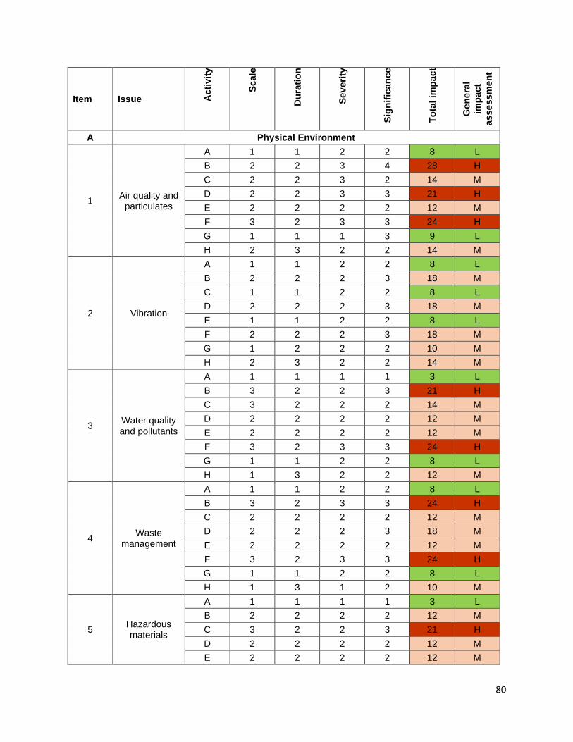
80
Item Issue Act
ivity
Scal
e
Dur
atio
n
Seve
rity
Sign
ifica
nce
Tota
l im
pact
Gen
eral
im
pact
as
sess
men
t
A Physical Environment
1 Air quality and particulates
A 1 1 2 2 8 L B 2 2 3 4 28 H C 2 2 3 2 14 M D 2 2 3 3 21 H E 2 2 2 2 12 M F 3 2 3 3 24 H G 1 1 1 3 9 L H 2 3 2 2 14 M
2 Vibration
A 1 1 2 2 8 L B 2 2 2 3 18 M C 1 1 2 2 8 L D 2 2 2 3 18 M E 1 1 2 2 8 L F 2 2 2 3 18 M G 1 2 2 2 10 M H 2 3 2 2 14 M
3 Water quality and pollutants
A 1 1 1 1 3 L B 3 2 2 3 21 H C 3 2 2 2 14 M D 2 2 2 2 12 M E 2 2 2 2 12 M F 3 2 3 3 24 H G 1 1 2 2 8 L H 1 3 2 2 12 M
4 Waste management
A 1 1 2 2 8 L B 3 2 3 3 24 H C 2 2 2 2 12 M D 2 2 2 3 18 M E 2 2 2 2 12 M F 3 2 3 3 24 H G 1 1 2 2 8 L H 1 3 1 2 10 M
5 Hazardous materials
A 1 1 1 1 3 L B 2 2 2 2 12 M C 3 2 2 3 21 H D 2 2 2 2 12 M E 2 2 2 2 12 M

81
Item Issue Act
ivity
Scal
e
Dur
atio
n
Seve
rity
Sign
ifica
nce
Tota
l im
pact
Gen
eral
im
pact
as
sess
men
t
F 3 2 2 2 14 M G 1 1 1 2 6 L H 1 1 1 1 3 L
6 Soil quality and erosion
A 2 2 2 1 6 L B 2 2 2 3 18 M C 1 1 1 1 3 L D 1 1 1 1 3 L E 1 1 1 1 3 L F 2 2 2 3 18 M G 1 2 1 2 8 L H 1 3 1 1 5 L
B Biological Environment
1 Terrestrial flora
A 2 2 2 3 18 M B 1 1 2 2 8 L C 1 1 1 2 6 L D 1 1 1 2 6 L E 1 1 1 2 6 L F 1 1 1 2 6 L G 1 1 1 2 6 L H 1 3 1 1 5 L
2 Terrestrial fuana
A 2 2 2 2 12 M B 1 1 2 2 8 L C 1 1 1 2 6 L D 1 1 1 2 6 L E 1 1 1 2 6 L F 1 1 1 2 6 L G 1 1 1 2 6 L H 1 3 1 1 5 L
3 Aquatic flora and fauna
A 1 1 1 1 3 L B 3 2 2 2 14 M C 1 1 2 2 8 L D 1 1 2 2 8 L E 1 1 2 2 8 L F 1 1 2 2 8 L G 1 1 2 2 8 L H 1 3 1 2 10 M
4 Invasive Alien Species
A 2 2 2 2 12 M B 1 2 2 3 15 L

82
Item Issue Act
ivity
Scal
e
Dur
atio
n
Seve
rity
Sign
ifica
nce
Tota
l im
pact
Gen
eral
im
pact
as
sess
men
t
C 1 1 2 2 8 L D 1 1 2 2 8 L E 1 1 2 2 8 L F 1 1 2 2 8 L G 1 1 2 2 8 L H 1 3 1 1 5 L
5 Rare and
endangered species
A 1 1 2 2 8 L B 1 1 2 2 8 L C 1 1 2 2 8 L D 1 1 2 2 8 L E 1 1 2 2 8 L F 1 1 2 2 8 L G 1 1 2 2 8 L H 1 3 2 2 12 M
C Socio-Economic Environment
1 Noise
A 1 1 2 2 8 L B 2 2 2 3 18 M C 1 1 2 2 8 L D 2 2 3 2 14 M E 1 2 3 2 12 M F 2 2 3 3 21 H G 1 1 2 2 8 L H 2 2 3 2 14 M
2 Access and traffic safety
A 1 1 2 3 12 M B 1 1 2 3 12 M C 2 2 3 3 21 H D 1 1 2 2 8 L E 1 1 2 2 8 L F 1 1 2 2 8 L G 2 2 2 2 12 M H 3 3 2 2 16 M
3 Occupation health and
safety
A 2 1 1 2 8 L B 3 2 2 2 14 M C 2 1 1 2 8 L D 2 2 2 2 12 M E 1 2 3 3 18 M F 1 2 3 3 18 M G 1 1 1 2 6 L

83
Item Issue Act
ivity
Scal
e
Dur
atio
n
Seve
rity
Sign
ifica
nce
Tota
l im
pact
Gen
eral
im
pact
as
sess
men
t
H 1 1 2 2 8 L
4 HIV/AIDS/STIs All 3 2 2 2 14 M
5 Permanent
land acquisition
A 3 3 2 3 24 H
6 Temporary
land acquisitiony
A, D 2 2 2 2 12 M
7 Social confilicts All 3 3 1 2 14 M
8
Sources of livelihood and
Modified market patterns
A 2 1 1 2 8 L B 2 2 2 3 18 M C 2 2 2 2 12 M D 1 1 2 2 8 L E 1 1 2 2 8 L F 2 2 2 3 18 M G 1 1 3 3 15 M H 1 2 1 2 8 L
9 Physical cultural
resources A-G 3 2 2 2 14 M
10 River-bank and scour protection
H 2 3 3 2 16 M
11 Morphology
and hydrologic regime
H 3 3 2 2 16 M
Legend:
Colour Code Impact Point H High Greater than 20 M Medium Greater than 10 and Less than 20 L Low Less than 10
84
6. ANALYSIS OF ALTERNATIVES
A. Alternative No.1 -"No Bridge Improvement" 255. "No new action" is always an alternative and often it compares favourably in a purely economic analysis. However, there can also be significant non-economic impacts from such an approach which makes a straightforward evaluation more difficult. The “No Improvement” alternative will mainly involve continuity of the current activities. 256. The bridges can still be used without improvement. However, the limitations to transportation in terms of capacity will continue to prevail. One major concern with the “No Project Option” is how well can the present situation enhance safety of the bridges, mitigate environmental impacts and enhance transport in support of the economic development of the Highlands Region. 257. Environmental Impacts: "No new action" preserves the existing status quo of environmental impact versus benefit, whatever that balance might be. Noise and air pollution will continue, and unsafe conditions of the bridges is a challenge for pedestrians and vehicles. 258. “No New Action” will mean foregoing the economic and environmental benefits that are expected to be derived from improved bridges. B. Alternatives for Bridges Improvement 259. Major bottlenecks and safety hazards of Volume I, of SHHIP Tranche 2 along the Highlands Highway corridor under consideration consist of 18 single-lane bridges with 4.0m to 5.0m width, blackspot at Km 133+000 and insufficient hydraulic capacity of Maralumi River Bridge at Km 55+600. Other constraints are bank erosion and sedimentation. Bank erosion, which is often triggered upstream and downstream nearby the bridges, is sometimes destabilizing the bridge’s abutments and piers. Sedimentation is a problem at specific locations, often in areas with brackish water or areas with a sudden decrease in flow velocity. 260. The basic options for repair, rehabilitation, upgrading and maintenance of the bridges for meeting bi-directional traffic, physical capable of passing all vehicles expected, seismic resistant as required sufficient hydraulic capacity and pedestrian lanes on both sides, consist in general of measures aiming at:
• Replacement of 18 single-lane bridges by new double lane ones;
• Replacement of a double-lane bridge (Maralumi River Bridge, Km 55+600) without sufficient hydraulic capacity by a new one;
• Replacement of a double-lane bridge (Ramu River Bridge (T33), Km 64+400) without sufficient vehicle load as requirement of T44;
• Replacement of 2 double-lane bridges (at Km 46+500 and Km 133+000) with Bridge Evaluation of “C and D” based on the “Health Rating Scale”; • Repair and reinforcement of other 27 double-lane bridges; • Other measures.

85
7. INFORMATION DISCLOSURE, CONSULTATION, AND PARTICIPATION
A. Results of Consultations 261. Meaningful multiple consultations have been conducted with relevant stakeholders during July 2019 to September 2019 as a key component of the Sustainable Highlands Highway Investment Program (SHHIP) tranche 2 preparation adhering to applicable GOPNG and ADB policies, principles and procedures (see the Annex F). 262. The principal stakeholders of the SHHIP are the people who live along the Highlands Highway (HH). This includes the communities as a whole, and groups within them. People who cultivate and market food cash crops, vendors at informal markets in villages and at public motor vehicle (PMV) stops, as well as at larger formal markets, and those producing and transporting cash crops to the ports or airports for export elsewhere. These stakeholders will benefit directly from the tranche 2 works, which will make travel faster and more convenient, improve accessibility to Social centres, health centres, schools and markets, and ensure their produce reaches its destination timely and undamaged by poor roads/crossing structures. They will also benefit from the opportunities for employment in bridge construction and maintenance works, and ability to pay for enhanced public transport services. 263. The road transport sector constitutes another category of principal stakeholders. This includes the people and companies involved in the movement of passengers and freight along the HH, such as: public motor vehicle (PMV) and mini-bus drivers, their passengers, transport companies, commercial truckers, including independent truckers, and the businesses and development enclaves in the Highlands region that rely on these transport services. The transporters are interested in lowering their vehicle operating costs, as well as increasing the services they can provide. In the case of development enclaves (such as LNG ExxonMobil extraction in Tari, and Porgera mine in Enga), they may contribute to the costs of maintenance through tax credit schemes. Civil works contractors also benefit directly from their involvement in the upgrading, rehabilitation, and maintenance of bridges. 264. A third category of core stakeholders are the local, provincial and national government agencies that both benefit from and are instrumental in the implementation of the road improvements. Their interests stem, from their mandates to provide services to people, businesses and communities in the Program areas, and from their direct contributions of funds and/or technical expertise for the road maintenance. The DOW will gain from both the funding, and the capacity building provided through the Program. The Program will assist the GoPNG to achieve its objectives for Development Strategic Plan (2010-2030) and National Transport Development Plan (2011-2020), which identifies the HH as the number one priority road for the country. 265. The approach for tranche 2 consultations includes: indoor core group consultations (seven), public meetings (21) involving both women and men from communities, specific facilitated meetings with clan leaders (four), separate meetings with women groups (14), key informant interviews (seven), and informal conversations with residents and passers-by (numerous) near the subproject sites. Consultations have been undertaken in local vernacular languages and in Tok Pisin. An especially prepared leaflet, SHHIP pamphlet and Protection of Transport Infrastructure Act pamphlet were also distributed to the participants during the consultations. 266. Detailed dissemination of information on the Sustainable Highlands Highway Investment Program (SHHIP) in general, and for Tranche 2 works in particular has been completed.
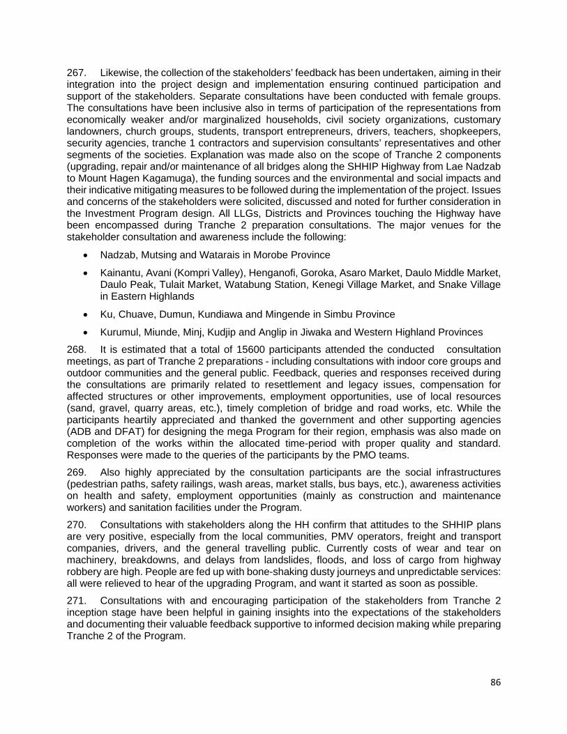
86
267. Likewise, the collection of the stakeholders’ feedback has been undertaken, aiming in their integration into the project design and implementation ensuring continued participation and support of the stakeholders. Separate consultations have been conducted with female groups. The consultations have been inclusive also in terms of participation of the representations from economically weaker and/or marginalized households, civil society organizations, customary landowners, church groups, students, transport entrepreneurs, drivers, teachers, shopkeepers, security agencies, tranche 1 contractors and supervision consultants’ representatives and other segments of the societies. Explanation was made also on the scope of Tranche 2 components (upgrading, repair and/or maintenance of all bridges along the SHHIP Highway from Lae Nadzab to Mount Hagen Kagamuga), the funding sources and the environmental and social impacts and their indicative mitigating measures to be followed during the implementation of the project. Issues and concerns of the stakeholders were solicited, discussed and noted for further consideration in the Investment Program design. All LLGs, Districts and Provinces touching the Highway have been encompassed during Tranche 2 preparation consultations. The major venues for the stakeholder consultation and awareness include the following:
• Nadzab, Mutsing and Watarais in Morobe Province
• Kainantu, Avani (Kompri Valley), Henganofi, Goroka, Asaro Market, Daulo Middle Market, Daulo Peak, Tulait Market, Watabung Station, Kenegi Village Market, and Snake Village in Eastern Highlands
• Ku, Chuave, Dumun, Kundiawa and Mingende in Simbu Province
• Kurumul, Miunde, Minj, Kudjip and Anglip in Jiwaka and Western Highland Provinces 268. It is estimated that a total of 15600 participants attended the conducted consultation meetings, as part of Tranche 2 preparations - including consultations with indoor core groups and outdoor communities and the general public. Feedback, queries and responses received during the consultations are primarily related to resettlement and legacy issues, compensation for affected structures or other improvements, employment opportunities, use of local resources (sand, gravel, quarry areas, etc.), timely completion of bridge and road works, etc. While the participants heartily appreciated and thanked the government and other supporting agencies (ADB and DFAT) for designing the mega Program for their region, emphasis was also made on completion of the works within the allocated time-period with proper quality and standard. Responses were made to the queries of the participants by the PMO teams. 269. Also highly appreciated by the consultation participants are the social infrastructures (pedestrian paths, safety railings, wash areas, market stalls, bus bays, etc.), awareness activities on health and safety, employment opportunities (mainly as construction and maintenance workers) and sanitation facilities under the Program. 270. Consultations with stakeholders along the HH confirm that attitudes to the SHHIP plans are very positive, especially from the local communities, PMV operators, freight and transport companies, drivers, and the general travelling public. Currently costs of wear and tear on machinery, breakdowns, and delays from landslides, floods, and loss of cargo from highway robbery are high. People are fed up with bone-shaking dusty journeys and unpredictable services: all were relieved to hear of the upgrading Program, and want it started as soon as possible. 271. Consultations with and encouraging participation of the stakeholders from Tranche 2 inception stage have been helpful in gaining insights into the expectations of the stakeholders and documenting their valuable feedback supportive to informed decision making while preparing Tranche 2 of the Program.
87
B. Further Consultations during Design and Implementation Stages 272. Further consultations with affected households, clans/tribes and other stakeholders shall be conducted throughout the project cycle - including during Tranche 2 detailed engineering design and implementation stages. Consultation will be ongoing and managed by the PMO safeguards staff. As part of the development of SHHIP works to ensure safeguards compliance, the PMO will implement a stakeholder consultation and participation plan (SCPP) with communities located along subproject sites. The SCPP will be organized with the collaboration of provincial, district and local-level government (LLG) authorities; and, following detailed engineering design by the Design Consultant (DC) for a subproject, the PMO will involve affected persons’ (APs) participation in further investigating each subproject, undertaking the detailed measurement survey (DMS), collecting data for the socio-economic survey (SES) and in other activities related to enhancing benefits for communities and mitigating adverse environmental and social impacts. 273. Support also of the clan/customary leaders, ward councillors and LLG presidents shall be sought for enhanced participation of wider segments of the societies including that of the women, deprived groups, elderly people and young people. Because women are often reluctant or unable to speak in general community meetings, separate meetings shall be held with them to understand and discuss their preferences and concerns. The PMO staff shall be also joined by the Provincial and/or district lands officers or surveyors/valuers of the office of the Valuer-General when their services are necessary to produce the Land Investigation Report (LIR) and valuations.
8. GRIEVANCE REDRESS MECHANISM
274. A grievance redress mechanism (GRM) has been established for the Program and has been implemented in Tranche 1. 275. Following the established GRM, at the start of Tranche 2 implementation, a grievance redress committee (GRC) will be established in each participating province, the GRC will be headed by the Provincial Administrator. Such Committees may be formed at community levels too if deemed to be further supportive for the purpose. 276. The GRCs perform, inter alia, four major functions: acceptance, investigation, mediation, and advisory. 277. People with a complaint or grievance related to SHHIP Tranche 2 works can register their grievances in any form (verbal, written, over the phone, etc.). 278. GRCs shall use common procedures in dealing with grievances to assure that objective and fair decisions are taken, and agreements made. The procedures include verifying documents; conducting field inspections to verify the authenticity and eligibility of the grievance reported; listening to different parties involved; and referring cases to other GRMs or, if necessary, to the courts. 279. For each grievance received, initial response shall be made to the grievance raiser within one week for minor grievances and within two weeks for the major ones. 280. Verification of the grievance shall be done by sector/issue-specific sub-committee as may be formed if required under the GRC. A verification report shall be submitted to the PMO and/or GRC. 281. The GRC shall try to resolve the grievance at its level. The GRC shall make its decision on the resolution of the issue/grievance within one month for minor grievances and within five months for the major ones.

88
282. Any grievance cases unresolved by the GRC or those the GRC feels are beyond SHHIP GRC jurisdiction shall be directed to the concerned relevant authority for appropriate resolution of the grievance - providing guidance to the concerned person/entity on other legal avenues s/he may approach to resolve the grievance. 283. GRCs shall be provided with appropriate orientation by the PMO focusing on the overall approach, modality, procedures and processes aimed at ensuring effective GRM for SHHIP. 284. SHHIP teams (PMO and contractor) shall support the GRCs in their smooth functioning, including support with stationeries and other relevant logistics wherever deemed necessary. 285. Each periodic report originating from the contractor shall include a GRM section and be submitted to the PMO – which will be further submitted by the PMO to the government and ADB. 286. The SHHIP grievance process is similar to and will also take account of the PNG procedure for addressing environmental issues outlined in Section 87 of the Environment Act 2000. Any unsolved grievances related to land and compensation issues received by the PMO, also involves discussions with the DOW teams as appropriate. 287. If the AP is not satisfied with any environmental decision of the GRC, the complainant may take the complaint further to the CEPA and follow the grievance process in accordance with Section 87 of the Environment Act 2000 (which deals with compensation claims for environmental impacts.) This procedure is set out as follows:
i. The complainant meets with the contractor and/or EP holder to formally register concern over impact and seek redress. A copy of the alleged impact is submitted to CEPA.
- EP holder has to determine whether the impact has occurred due to its activities.
- If EP holder accepts responsibility for the impact, it can negotiate a mutually acceptable settlement with AP within 90 days.
- If EP holder rejects responsibility for the impact, the complainant can request CEPA to carry out a verification investigation.
- If CEPA confirms that the impact has occurred, he/she will advise the EP holder and complainant to negotiate a settlement within 90 days.
- If a negotiated settlement is not reached, the EP holder or complainant can request CEPA to formulate a determination. Once this request is made, CEPA will have 90 days to reach a determination. If either party is dissatisfied with the determination, they can appeal to the National Court.
ii. Should the complainant not be satisfied with the ruling of the CEPA, the AP may at their discretion take the grievance to the PNG judicial system. This will be at the AP’s cost but if the court shows that the CEPA or the administration have been negligent in making their determination the AP will be able to seek costs.
288. All of the foregoing steps are being recorded in an inventory/register and included in the PMO Quarterly and Semi-annual social and/or environmental safeguards monitoring reports (based on the nature of the grievances), and such reports are being submitted to DOW and ADB. 289. During both construction and operation, the same procedures and conditions apply: i.e. there are no fees attached to the AP for making a complaint, the complainant is free to make the complaint which will be treated in a transparent manner, and the AP will not be subject to retribution for making any complaint.

89
9. ENVIRONMENTAL MANAGEMENT PLAN
290. An important objective of IEE is to develop procedures and plans to ensure that the mitigation measures and monitoring requirements approved during the environmental compliance review, will be carried out in subsequent stages of the project. Environmental management involves the implementation of environmental protection and mitigation measures and monitoring of environmental impacts. Environmental protection measures are taken to (i) mitigate environmental impacts, (ii) provide in-kind compensation for lost environmental resources, or (iii) enhance environmental resources. These measures are usually set out in the EMPs, which covers all phases of the project from pre-construction through decommissioning, and outlines mitigation and other measures that will be undertaken to ensure compliance with environmental regulations and reduce or eliminate adverse impacts. 291. The EMPs preparation is suitable for ADB Safeguard Policy Statement and GoPNG Law and Regulations on Environmental Protection. Main content of the program includes:
i. Undertake measurement to reduce environmental pollution in executing, and operation phases.
ii. Supervise construction progress of treatment works and their quality such as wastewater treatment system, sewage and rainy water drainage systems.
iii. Regularly inspect the labour safety regulations, undertaking measures to prevent fire and explosion in the construction phase and operation process.
iv. Supervise and require of construction vehicle owner complying the mentioned mitigation measure of dust, noise and labour safety.
v. Prepare the environmental monitoring plan including air, noise, water quality and solid waste.
vi. Co-ordinate to undertake environmental quality monitoring in case of requirements from functional agencies.
A. Institutional Arrangements and Responsibilities 292. Overall implementation of environmental safeguards including environmental management requirements is a joint responsibility between the DOW/PMO, CSC, Contractor(s) and ADB. The overall organizational structure for environmental management for the project is shown in Figure 9-1.
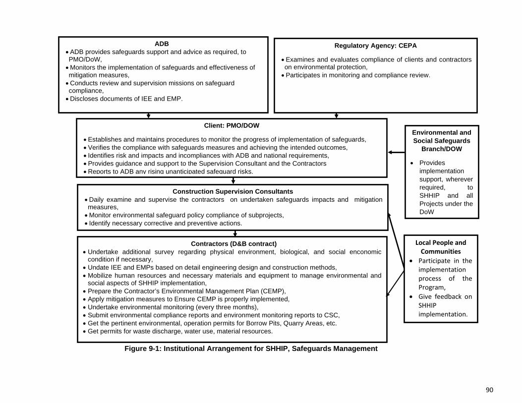
90
Figure 9-1: Institutional Arrangement for SHHIP, Safeguards Management
Regulatory Agency: CEPA
•Examines and evaluates compliance of clients and contractors on environmental protection, •Participates in monitoring and compliance review.
ADB •ADB provides safeguards support and advice as required, to PMO/DoW, •Monitors the implementation of safeguards and effectiveness of mitigation measures, •Conducts review and supervision missions on safeguard compliance, •Discloses documents of IEE and EMP.
Client: PMO/DOW
•Establishes and maintains procedures to monitor the progress of implementation of safeguards, •Verifies the compliance with safeguards measures and achieving the intended outcomes, • Identifies risk and impacts and incompliances with ADB and national requirements, •Provides guidance and support to the Supervision Consultant and the Contractors •Reports to ADB any rising unanticipated safeguard risks.
Contractors (D&B contract) • Undertake additional survey regarding physical environment, biological, and social enconomic
condition if necessary, • Undate IEE and EMPs based on detail engineering design and construction methods, • Mobilize human resources and necessary materials and equipment to manage environmental and
social aspects of SHHIP implementation, • Prepare the Contractor’s Environmental Management Plan (CEMP), • Apply mitigation measures to Ensure CEMP is properly implemented, • Undertake environmental monitoring (every three months), • Submit environmental compliance reports and environment monitoring reports to CSC, • Get the pertinent environmental, operation permits for Borrow Pits, Quarry Areas, etc. • Get permits for waste discharge, water use, material resources.
Environmental and Social Safeguards
Branch/DOW
• Provides implementation support, wherever required, to SHHIP and all Projects under the DoW
Construction Supervision Consultants • Daily examine and supervise the contractors on undertaken safeguards impacts and mitigation measures, • Monitor environmental safeguard policy compliance of subprojects, • Identify necessary corrective and preventive actions.
Local People and Communities
• Participate in the implementation process of the Program,
• Give feedback on SHHIP implementation.

91
294. Department of Works. The DOW, as executing agency for the Investment Program, has overall responsibility to manage the planning, implementation and monitoring of the performance of the Program. The DOW will be responsible for ensuring that adequate funding will be provided under the Program to enable the PMO and ESSB to fulfil their responsibilities. DOW will be responsible for ensuring that environmental assessments are prepared and submitted to ADB together with the Periodic Financing Request (PFR) for review and approval prior to commencement of any work proposed under the Program. DOW--through the PMO based in Goroka and ESSB--will monitor the progress of the environmental work stream to ensure that environmental safeguards as set out in the EARF are implemented and comply with country safeguards requirements and the SPS. The PMO will be responsible for daily management and implementation of the subprojects under the Program and the ESSB will support the PMO in ensuring the Program’s environmental safeguard requirements are adequately and properly implemented. 295. Environmental and Social Safeguards Branch (ESSB). The ESSB is primarily responsible for DOW's compliance with the National safeguard’s requirements. They interact between DOW and the PMOs and Works Managers. The ESSB is responsible for implementing safeguards on behalf of DOW for all programs and projects (development partner financed and internally financed) throughout the country. 296. Project Management Office (PMO). For each tranche of this Program, the DOW, through the PMO and ESSB, will be responsible for the implementation of the entire environmental assessment and review procedures. Given that EP applications and assessments are not required for road maintenance and rehabilitation activities, the assessments will be prepared following ADB prescribed format. For other activities (waste discharge, water use, materials sources and quarry activities) that trigger need for permits, these will follow national requirements as well as SPS. As discussed above, all of the subprojects have been identified but will be executed over time in three subsequent tranches. The safeguards due diligence and assessments for T2 and T3 have yet to be undertaken. Safeguards activities for tranche 2 have been completed and undertaken by DOW represented by ESSB and by the PPTA team. 297. Construction Supervision Consultants. The CSC will support DOW, PMO and ESSB during implementation of the program, assisting the international and national safeguards specialists in complying with country systems and SPS. The CSC will include international and national safeguards specialists to actively ensure that contractors’ operations comply with the CEMP, country systems and SPS. The safeguards expert with the CSC supervises the compliance of contractor's operations with the safeguards requirements in the contract, and more specifically the Environmental Management Plan (prepared by the contractor, reviewed and validated by the safeguards expert of the CSC and vetted by the PMO). 298. PMO and ESSB Collaboration. With support from the CSC, the ESSB and the PMO will be jointly responsible for implementation of the EARF. This will include, but not be limited to ensuring that: (i) the EARF procedures are strictly adhered to and that screening and preparation of environmental assessments will be carried out in a timely and adequate manner, (ii) environmental monitoring and institutional requirements will be fully met, and (iii) meaningful public consultations are carried out satisfactorily. DOW will submit the categorization, environmental assessments, and monitoring reports to ADB for review in a timely manner. These same requirements apply for the subsequent investment tranches (T2 and T3) while the categorization and environmental assessments has been done for tranche 2 (monitoring for tranche 2 projects will follow during implementation). 299. Both will be tasked to (i) strengthen the environmental management of subprojects during contract process, construction, and implementation; (ii) provide induction training to contractors

92
prior to preparation and submission of the CEMP for each subproject; (iii) provide assistance for review and clearance of the CEMPs; (iv) monitor compliance with the approved CEMP of each subproject; (v) prepare reports on environmental safeguards activities as required; and (vi) supervise and guide the environmental assessment and review process for implementation of subsequent tranches. 300. Environmental specialists in the PMO. The PMO's safeguards experts are responsible for the compliance of SHHIP's operations with national and ADB's safeguards requirements. They interact with the Safeguards Expert of each CSC, with ESSB, and with ADB. For the implementation of Tranche 2 and the preparation of Tranche 2 and 3, the environmental specialists will work with and support the ESSB in carrying out environmental management steps such as the following:
i. Build capacity of the ESSB staff, providing on-the-job and specialist support, advice and training as required;
ii. Undertake the screening of each subproject of Tranche 2 and then of Tranche 3 (based on design information and baseline conditions) and plan resources for preparing due diligence, depending on the category, required per subproject;
iii. Undertake assessment (including baseline, surveys as required, consultations etc) and prepare the due diligence for each subproject (IEE for category B subprojects and guidelines for category C subprojects);
iv. Ensure that the due diligence is undertaken in compliance with the requirements of the government and ADB (as set out in this EARF), and that adequate consultation with affected people is undertaken in accordance with ADB requirements;
v. Following ADB clearance of the assessments/due diligence, apply for and obtain necessary permits and/or clearance, as required, from CEPA and other relevant government agencies (DOM), ensuring that all necessary regulatory clearances are obtained before awarding contracts for civil works;
vi. Based on detailed design, update the EMP from the approved/cleared assessment and integrate the updated EMP and any permit conditions into the civil works bid and contract documents;
vii. Provide induction training to the contractor(s) on the EMP requirements and ensure that the contractor(s) understand their responsibilities to mitigate environmental problems associated with construction activities;
viii. Review and clear the contractor(s)’ CEMP and ensure and monitor that the approved CEMP, including an environmental monitoring plan, will be properly implemented;
ix. Working with the resident engineer or site supervisor, undertake regular checks of contractor(s) compliance with the approved CEMP, and report on the same;
x. Note and document corrective actions required to be implemented by the contractor(s);
xi. Based on findings from above and review of contractor(s) monthly reports, prepare inputs to the quarterly progress reports; and
xii. Submit semi-annual safeguards monitoring reports to PMO for onward submission to DOW and ADB and forwarded to CEPA for information.
301. Contractors (D&B modality) The Contractor shall undertake additional survey regarding physical environment, biological, and social enconomic condition if necessary, to undate IEE and EMPs based on detail engineering design. The contractor shall take all necessary measures and precautions and otherwise ensure that the execution of the Works and all associated operations on the Work Sites or off-site are carried out in conformity with statutory and regulatory environmental requirements of the Government of Papua Nui Guine.

93
302. Based on the approved EMP, the Contractor will be responsible for establishing a site-specific EMP for each construction site area, submit the plan to CSC for review and approval before commencement of construction. In addition, it is required that the Contractor get all permissions for construction (traffic control and diversion, excavation, labor safety, etc before civil works) following current regulations. The contractor shall be required to appoint a competent individual as the contractor‘s on-site Safety and Environment Officer (SEO) who will be responsible for monitoring the contractor‘s compliance with the EMP requirements and the environmental specifications. 303. Conservation and Environmental Protection Authority. The CEPA will be required to review applications and issue permits (with or without conditions) for associated activities (waste discharge, water use, materials sources and quarry activities), and where possible, participate in monitoring and compliance review. 304. Asian Development Bank. The ADB will provide safeguards support and advice as required to the ESSB and PMO. The ADB will responsible for the: (i) concurrence with the screening (and resulting due diligence requirements) of each subproject; (ii) review and clear the due diligence prepared for each subproject; (iii) participate in missions to review implementation of the EARF and subprojects; (iv) arrange disclosure on the ADB website of cleared due diligence reports and monitoring reports; and, (v) as required, provide advice to DOW in carrying out its responsibilities to implement the EARF for the Program. 305. The responsibilities of the agencies and institutions involved, are summarized in the following table.
Table 9-1: Institutional Responsibilities for Environmental Safeguards Responsible
Agency Responsibilities DOW Support PMO and ESSB for the preparation of and the submission of PFR (and
supporting documentation) for all Program Tranches Ensure budget and funding availability for ESSB; Provide counterpart support and contribution to the Program as agreed; Disclose safeguard documents on behalf of government
ADB Review and clearance of due diligence (IEE and EMP) Review all feasibility study documentation Board approval of project (incl. preparing documents package for Board review – requirements in FAM and covenants in loan agreement) Assist government to recruit CSC Review contractors’ reports and monitoring reports Disclose documents on website
ESSB Prior to works commencing ensure the requirements under EPAR and CSS (including permits for associated activities) are met; Audit construction phase through environmental inspections and review monitoring data
PMO Environmental Specialists
Together with ESSB, undertake the screening of each subproject of Tranche 2 and then of Tranche 3 (based on design information and baseline conditions) and plan resources for preparing due diligence, depending on the category, required per subproject Together with ESSB, undertake assessment (including baseline, surveys as maybe required, consultations etc.) and prepare the due diligence for each subproject (IEE for category B subprojects and guidelines for category C subprojects) Ensure that the due diligence is undertaken in compliance with the requirements of the government and ADB (as set out in this EARF), and that adequate consultation with affected people is undertaken in accordance with ADB requirements With the support of CSC, provide induction training to the contractor prior to the preparation and submission of the contractor’s CEMP and as required work with

94
Responsible Agency Responsibilities
the contractor’s environmental specialist to identify appropriate construction methodologies and detailed site-specific mitigations; Work with contractors’ environmental specialists for the provision of awareness/training to workers and technology transfer to contractor(s) as required Supervise, monitor and report on contractors’ implementation of CEMP and all other contractual obligations and enforce contractual requirements Submission of quarterly progress reports and semi-annual monitoring reports
CSC Provide support to, and coordinate with, PMO and ESSB for safeguards implementation Undertake preliminary design and detailed design Prepare IEE including overall EMP Update IEE (including EMP) filling information gaps and elaborating baseline as required based on surveys and detailed design Incorporate IEE mitigation measures into bidding documents and technical specifications Incl. in above TOR for environmental specialist as part of contractor’s team Provide inputs to the bid evaluation in respect of contractor’s response to the EMP requirements including the suitability of the environmental specialist proposed as part of the contractor’s team; Supervise, monitor and report on contractor’s implementation of CEMP and all other contractual obligations Audit construction phase through environmental inspections and review monitoring data Submission of QPR and semi-annual monitoring reports
Contractor(B&D) Undertake additional survey regarding physical environment, biological, and social enconomic condition if necessary, Undate IEE and EMPs based on detail engineering design and construction methods, Provide suitably qualified environmental specialist Prepare CEMP including the site-specific plans and drawings at river crossings, construction camps and yards showing layouts and mitigation, and construction methodologies (working methods, and spoil disposal locations and methods etc) and GRM, Submit CEMP to CSC for review and approval Identify materials and equipment sources and arrange necessary permits and compliance certificates Pre-mobilization provide induction on CEMP to employees Implementation and monitoring of CEMP Implementation of GRM Reporting of CEMP and GRM implementation in monthly reports Implement corrective actions as required by CSC
CEPA Ensure compliance with government requirements Review applications and issue permits (with or without conditions) for associated activities (waste discharge, water use, materials sources and quarry activities) Review complicated issues arising from the project Participate in monitoring and compliance review where possible
B. Monitoring and Reporting 306. Throughout implementation of the subproject, DOW and ADB will monitor the progress and impact of the subproject. This includes monitoring the implementation of safeguards and effectiveness of mitigation measures. DOW is required to implement safeguard measures and relevant safeguard plans, as provided in the legal agreements, and to submit periodically monitoring reports on their implementation performance. 307. Overall, the EMP implementation will be monitored by the PMO through the CSC. In consultation with DOW and ADB, the PMO will establish a system for preparing quarterly progress reports (QPR) which will include safeguards (environmental performance i.e. compliance with EMP and approved CEMP, GRM implementation and issues resolution, audits/compliance
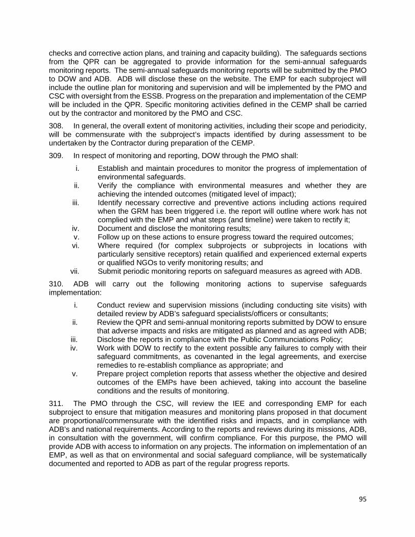
95
checks and corrective action plans, and training and capacity building). The safeguards sections from the QPR can be aggregated to provide information for the semi-annual safeguards monitoring reports. The semi-annual safeguards monitoring reports will be submitted by the PMO to DOW and ADB. ADB will disclose these on the website. The EMP for each subproject will include the outline plan for monitoring and supervision and will be implemented by the PMO and CSC with oversight from the ESSB. Progress on the preparation and implementation of the CEMP will be included in the QPR. Specific monitoring activities defined in the CEMP shall be carried out by the contractor and monitored by the PMO and CSC. 308. In general, the overall extent of monitoring activities, including their scope and periodicity, will be commensurate with the subproject’s impacts identified by during assessment to be undertaken by the Contractor during preparation of the CEMP. 309. In respect of monitoring and reporting, DOW through the PMO shall:
i. Establish and maintain procedures to monitor the progress of implementation of environmental safeguards.
ii. Verify the compliance with environmental measures and whether they are achieving the intended outcomes (mitigated level of impact);
iii. Identify necessary corrective and preventive actions including actions required when the GRM has been triggered i.e. the report will outline where work has not complied with the EMP and what steps (and timeline) were taken to rectify it;
iv. Document and disclose the monitoring results; v. Follow up on these actions to ensure progress toward the required outcomes; vi. Where required (for complex subprojects or subprojects in locations with
particularly sensitive receptors) retain qualified and experienced external experts or qualified NGOs to verify monitoring results; and
vii. Submit periodic monitoring reports on safeguard measures as agreed with ADB. 310. ADB will carry out the following monitoring actions to supervise safeguards implementation:
i. Conduct review and supervision missions (including conducting site visits) with detailed review by ADB’s safeguard specialists/officers or consultants;
ii. Review the QPR and semi-annual monitoring reports submitted by DOW to ensure that adverse impacts and risks are mitigated as planned and as agreed with ADB;
iii. Disclose the reports in compliance with the Public Communciations Policy; iv. Work with DOW to rectify to the extent possible any failures to comply with their
safeguard commitments, as covenanted in the legal agreements, and exercise remedies to re-establish compliance as appropriate; and
v. Prepare project completion reports that assess whether the objective and desired outcomes of the EMPs have been achieved, taking into account the baseline conditions and the results of monitoring.
311. The PMO through the CSC, will review the IEE and corresponding EMP for each subproject to ensure that mitigation measures and monitoring plans proposed in that document are proportional/commensurate with the identified risks and impacts, and in compliance with ADB’s and national requirements. According to the reports and reviews during its missions, ADB, in consultation with the government, will confirm compliance. For this purpose, the PMO will provide ADB with access to information on any projects. The information on implementation of an EMP, as well as that on environmental and social safeguard compliance, will be systematically documented and reported to ADB as part of the regular progress reports.
96
312. Monitoring plans have been prepared and are included as part of the EMP in the IEE prepared for the Tranche 2. Following loan effectiveness, the following monitoring actions will be taken: (i) the PMO and CSC will be responsible for reviewing and updating the monitoring program to ensure that it meets the intention of the EMP and that it identifies resources and arrangements suitable for carrying it out; (ii) the CSC will provide inputs to the QPR and the PMO will use the QPR to prepare the semi-annual safeguards monitoring reports, (iii) the semi-annual safeguards monitoring reports will be reviewed and cleared, and cleared reports disclosed on ADB’s website; and (iv) after one year the ESSB will arrange to review the monitoring program and make any adjustments to it as required. The PMO will inform the ESSB who will inform ADB and DOW of any changes that are recommended to be made prior to implementing any changes. 313. Table 9-2 provides the key tasks for environmental monitoring that will be incorporated into the EMP, and as necessary, elaborated by the contractor in the CEMP. The reporting will be as per the following schedule:
i. A monthly report prepared during construction by the Contractor reporting on progress of CEMP activities, issues and corrective actions. This will be based on the site diary maintained by the EHSO and compiled notes of daily and weekly inspections;
ii. QPR prepared by PMO every three months. The QPR will include a section on safeguards activities and CEMP compliance for the subproject and will summarize the monthly reports submitted by the contractor and any actions or citations made by the CSC;
iii. A semi-annual safeguard monitoring report (prepared every six months) by the PMO be submitted to DOW and ADB and disclosed; and
iv. The project completion report will include a section on safeguards implementation and make recommendations as required for modifications to the processes set out in the EARF and EMP procedures based on the review undertaken at the end of the project. The safeguards section will be prepared by the DOW-ESSU three months prior to the end.
314. During operation monitoring will be carried out by the DOW, in coordination with the CEPA. Table 9-2: Key Tasks for Environmental Monitoring
Environmental monitoring tasks Responsibility Timing Design Phase
For information, or as required, submit EMPs (including monitoring plans) to CEPA
PMO Prior to construction
Ensure updated EMP is integrated into tender and bidding documents to ensure IEE and EMP included in bids and environmental provisions are included
PMO and ADB Prior to issue of bidding documents
Construction Phase Training and briefing of contractor’s management, site agents with regards to all EMP requirements in respect of monitoring
PMO and Contractor First training prior to preparation of CEMP and commencement of each contract and refresher courses at yearly intervals throughout construction period

97
Monthly monitoring and reporting by contractor on implementation of approved CEMP and statutory environmental requirements
Contractor,
Continuous throughout the construction period
Regular monitoring and reporting of contractor’s compliance with CEMP and statutory environmental requirements
CSC
Continuous throughout the construction period
Monitor the performance of environmental training by contractor and briefings and of the environmental awareness of contractor staff, toolbox talks and refresher courses.
PMO and Contractor Ongoing, prior to and during implementation of works and operation
Regular monitoring and reporting of complaints and responses (GRM)
PMO and Contractor Continuous throughout construction period
Monitor adjustments to the CEMP for unexpected impacts and the thorough implementation of detailed CEMP
PMO and Contractor Continuous throughout construction period
Operation and Maintenance Phase Observations during routine maintenance inspections of facilities. Inspections will include monitoring implementation of operational mitigation measures versus environmental criteria specified in EMP for operational impacts
DOW-ESSB, Maint. Contractor
As per PMO inspection schedules
Post-construction monitoring of water quality at any sites where complaints about air/noise/water quality from works were justified in construction phase
DOW-ESSB Monthly up to three months after completion of construction or until air/noise, water quality meets baseline conditions
Monitoring survival of trees / shrubs and grass in bioengineered slopes (e.g. at landslides, also transplanted / compensatory planted trees)
DOW-ESSB During the first three years after installation or rehabilitation
C. Environmental Management Plan (EMP) and Monitoring Matrix 315. Each environmental impact will have a relevant mitigation action, to be mitigated and/or eliminated impact, in order to ensure that the construction of the project will not pose any threats to the environment and human health. The type of works identified in the Feasibility Study stage of the Volume 1, under SHHIP-Tranche 2, as described earlier, include (i) in-situ replacement bridge construction at existing location (16 bridges) , (ii) relocated bridge construction at new locations (6 bridges), and (iv) repair and reinforcement of 23 existing bridges. The mitigation measures and monitoring are depicted in Table 9-3 - Environmental Management Plan and Monitoring Matrix for in-situ replacement bridge construction at existing location, Table 9-4 - Environmental Management Plan and Monitoring Matrix for relocated bridge construction at new location, and Table 9-5 - Environmental Management Plan and Monitoring Matrix for repair/reinforcement of existing bridges.

98
TABLE 9-3: ENVIRONMENTAL MANAGEMENT PLAN (EMP) AND MONITORING MATRIX FOR IN-SITU REPLACEMENT BRIDGES AT EXISTING LOCATIONS (16 BRIDGES)
Activity/ Environm
ental Issue
Mitigation and/or Enhancement Measures Monitoring Plan
Mitigation measures and actions
Responsible to
implement
Timing to implemen
t
Cost Parameters Frequency & means of verification
Responsible to
monitor
Cost
PRE-CONSTRUCTION STAGE
Land clearance – temporary and permanent land acquisition
DOW has prepared a land acquisition and resettlement plan for detailed compensation and supporting policies,
The Contractor(s) will accordingly coordinate with related authority(ies) and locals to undertake inventory for the loss of land and assets;
The Contractor(s) will negotiate with local people for compensation of temporary land acquisition based on the loss and time of occupation.
DOW/PMO
Contractor
Before construction phase
During construction works
State budget (counterpart fund)
Included in contract price
1 RPs are prepared and clearance,
2 and 3 Compensation progress and satisfaction of affected persons
An assistance program prepared and implemented
(1) review project documents,
(2 - 3) Survey by questionnaires and direct interview
DOW/PMO
CSC/PMO
State budget (counterpart fund)
Included in contract price
Preparation and approval Contractor’s Environmental Management Plan (CEMP)
The Contractor is required to prepare and submit a Contractor’s Environmental Management Plan (CEMP) based on the Contractor's actual detailed construction methodologies, work program, management of construction activities and management of workforce for review and approval by CSC,
Contractor No later than 28 days after the Commencement Date
Included in contract price
1 -2 CEMPs prepare and approved,
3 compliance with CEMP
(1-3) Review contractor’s documents and reports
CSC/PMO Included in contract price
99
Activity/ Environm
ental Issue
Mitigation and/or Enhancement Measures Monitoring Plan
Mitigation measures and actions
Responsible to
implement
Timing to implemen
t
Cost Parameters Frequency & means of verification
Responsible to
monitor
Cost
The Contractor(s) commencement works only the CEMP approved by CSC,
The CSC may withhold payments and/or stop construction due to CEMP non-compliance and/or in the event of serious or repeated violations of the conditions stipulated herein.
Preparation and clearance associated plans: Health and Safety Management Plan, Traffic Management Plan, Site Security Management Plan, Quarry Management Plan, HIV/AIDS/STI
The Contractor requires to submit the plans to CSC for review and approval.
The Contractor(s) commencement works only the Plans approved by CSC,
Contractor
Before commencing works on sites
During construction works
Included in contract price
1 Plans prepared and approved,
2 compliance with the Plans
(1-2) review contractor and CSC’s documents and reports
CSC/PMO Included in contract price
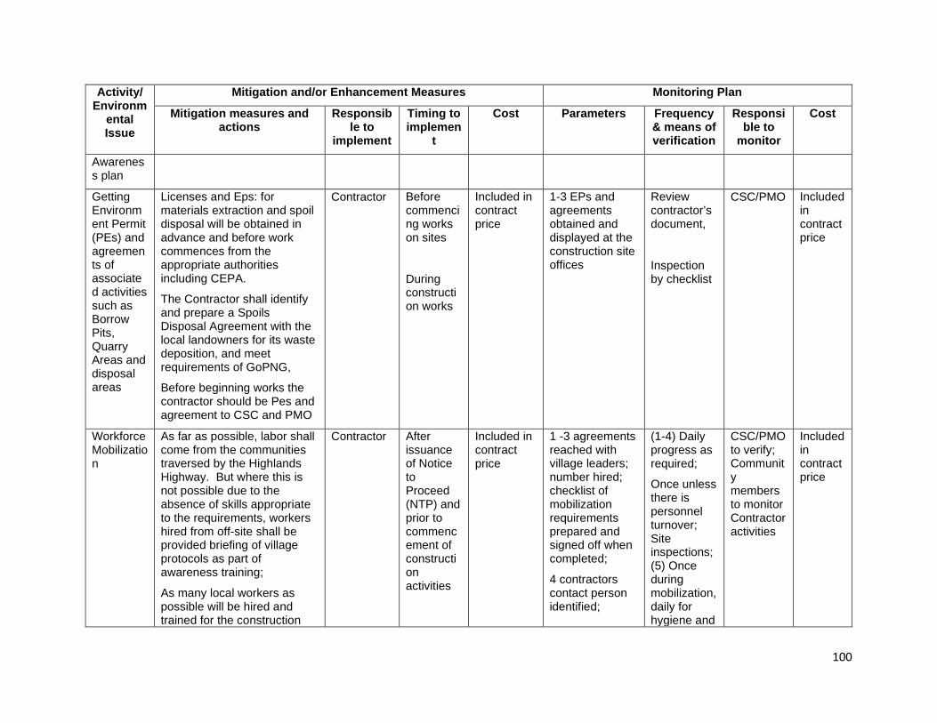
100
Activity/ Environm
ental Issue
Mitigation and/or Enhancement Measures Monitoring Plan
Mitigation measures and actions
Responsible to
implement
Timing to implemen
t
Cost Parameters Frequency & means of verification
Responsible to
monitor
Cost
Awareness plan
Getting Environment Permit (PEs) and agreements of associated activities such as Borrow Pits, Quarry Areas and disposal areas
Licenses and Eps: for materials extraction and spoil disposal will be obtained in advance and before work commences from the appropriate authorities including CEPA.
The Contractor shall identify and prepare a Spoils Disposal Agreement with the local landowners for its waste deposition, and meet requirements of GoPNG,
Before beginning works the contractor should be Pes and agreement to CSC and PMO
Contractor Before commencing works on sites
During construction works
Included in contract price
1-3 EPs and agreements obtained and displayed at the construction site offices
Review contractor’s document,
Inspection by checklist
CSC/PMO Included in contract price
Workforce Mobilization
As far as possible, labor shall come from the communities traversed by the Highlands Highway. But where this is not possible due to the absence of skills appropriate to the requirements, workers hired from off-site shall be provided briefing of village protocols as part of awareness training;
As many local workers as possible will be hired and trained for the construction
Contractor After issuance of Notice to Proceed (NTP) and prior to commencement of construction activities
Included in contract price
1 -3 agreements reached with village leaders; number hired; checklist of mobilization requirements prepared and signed off when completed;
4 contractors contact person identified;
(1-4) Daily progress as required;
Once unless there is personnel turnover; Site inspections; (5) Once during mobilization, daily for hygiene and
CSC/PMO to verify; Community members to monitor Contractor activities
Included in contract price

101
Activity/ Environm
ental Issue
Mitigation and/or Enhancement Measures Monitoring Plan
Mitigation measures and actions
Responsible to
implement
Timing to implemen
t
Cost Parameters Frequency & means of verification
Responsible to
monitor
Cost
activities. In order to avoid clan conflicts over access to employment, it is important that local workers are sourced from each of the customary land areas along the highway;
The contractor shall ensure that workers’ actions outside work site are controlled and village customs and traditions are observed at all times;
The contractor will identify one member of their staff to be the liaison between the ward councilor, village leaders and elders and contractor, as well as between the contractor and PMO;
Adequate housing shall be provided for all workers at the construction camps and establish clean canteen/eating and cooking areas;
Poaching of animals (incl. fish and birds) for food, trade or other will be prohibited with sanctions imposed for non-compliance;
During construction works
5 adequate housing, cooking and dining areas, potable water, and sanitation and drainage facilities provided as per agreed specifications;
6-8 report of poaching and/or access to protected areas with administrative sanctions imposed;
9 approved HIV/AIDS/STI service provider engaged; number of awareness activities; reported incidence of infections; number of workers hired locally and
housekeeping;
Once for (6-10) during mobilization; periodic spot-checking during operation

102
Activity/ Environm
ental Issue
Mitigation and/or Enhancement Measures Monitoring Plan
Mitigation measures and actions
Responsible to
implement
Timing to implemen
t
Cost Parameters Frequency & means of verification
Responsible to
monitor
Cost
Use of guns and hunting equipment by workers will be banned and workers taking or in possession of wildlife shall be dismissed from employment;
Entry to protected and wildlife management areas and/or sensitive areas (forested areas and rivers) by workers will not be allowed;
Provide education classes on HIV and sexually transmitted diseases.
Establish a Code of Conduct to outline the importance of appropriate behavior, drug and alcohol abuse, respect for local communities, and compliance with relevant laws and regulations. Ensure adequate use of resources and proper waste management
trained for the construction activities;
10 established and implemented code of conduct
Mobilization of the contractor/ construction camp and works/materials sites prepared -
Worker camp area: Worker camp location and facilities will be located at least 500m from settlements and agreed with local communities and facilities approved by PMO and managed to minimize impacts;
Contractor After issuance of Notice to Proceed (NTP) and prior to commencement of
Included in contract price
1-3 compliance with work camp locational requirement;
Daily progress as required;
Site inspections;
(1 to 3) Once during mobilization,
CSC/PMO to verify; Community members to monitor Contractor activities
Included in contract price
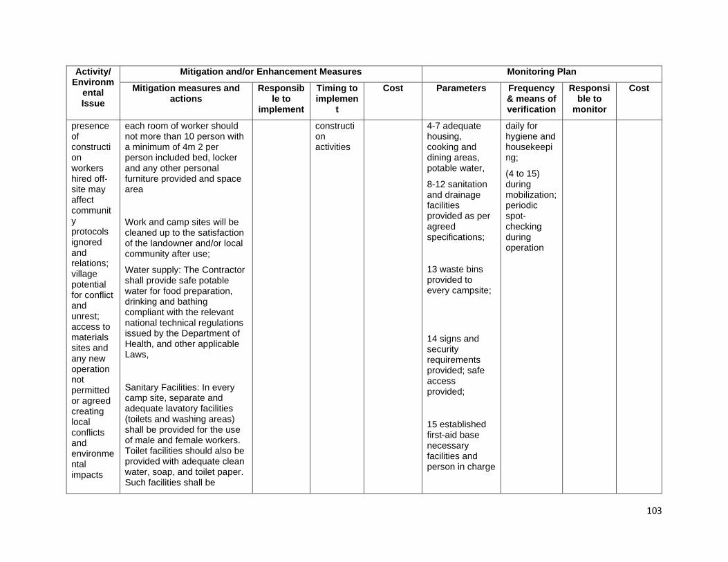
103
Activity/ Environm
ental Issue
Mitigation and/or Enhancement Measures Monitoring Plan
Mitigation measures and actions
Responsible to
implement
Timing to implemen
t
Cost Parameters Frequency & means of verification
Responsible to
monitor
Cost
presence of construction workers hired off-site may affect community protocols ignored and relations; village potential for conflict and unrest; access to materials sites and any new operation not permitted or agreed creating local conflicts and environmental impacts
each room of worker should not more than 10 person with a minimum of 4m 2 per person included bed, locker and any other personal furniture provided and space area
Work and camp sites will be cleaned up to the satisfaction of the landowner and/or local community after use;
Water supply: The Contractor shall provide safe potable water for food preparation, drinking and bathing compliant with the relevant national technical regulations issued by the Department of Health, and other applicable Laws,
Sanitary Facilities: In every camp site, separate and adequate lavatory facilities (toilets and washing areas) shall be provided for the use of male and female workers. Toilet facilities should also be provided with adequate clean water, soap, and toilet paper. Such facilities shall be
construction activities
4-7 adequate housing, cooking and dining areas, potable water,
8-12 sanitation and drainage facilities provided as per agreed specifications;
13 waste bins provided to every campsite;
14 signs and security requirements provided; safe access provided;
15 established first-aid base necessary facilities and person in charge
daily for hygiene and housekeeping;
(4 to 15) during mobilization; periodic spot-checking during operation

104
Activity/ Environm
ental Issue
Mitigation and/or Enhancement Measures Monitoring Plan
Mitigation measures and actions
Responsible to
implement
Timing to implemen
t
Cost Parameters Frequency & means of verification
Responsible to
monitor
Cost
conveniently accessible and shall be kept in clean and hygienic conditions;
Where workers of both sexes are employed, there shall be displayed outside each block of latrine and urinal, a notice in the language understood by the majority of the workers “For Men Only” or “For Women Only” as the case may be;
Sanitary arrangements, latrines and urinals shall be provided in every work place on the following scale: Where female workers are employed, there shall be at least one latrine for every 25 females or part thereof; Where males are employed, there shall be at least one latrine for every 25 males or part thereof;
Wastewater Management: Water from kitchens, showers etc. shall be discharged into a conservancy tank for removal from the Site or pass through an oil screener before discharge;
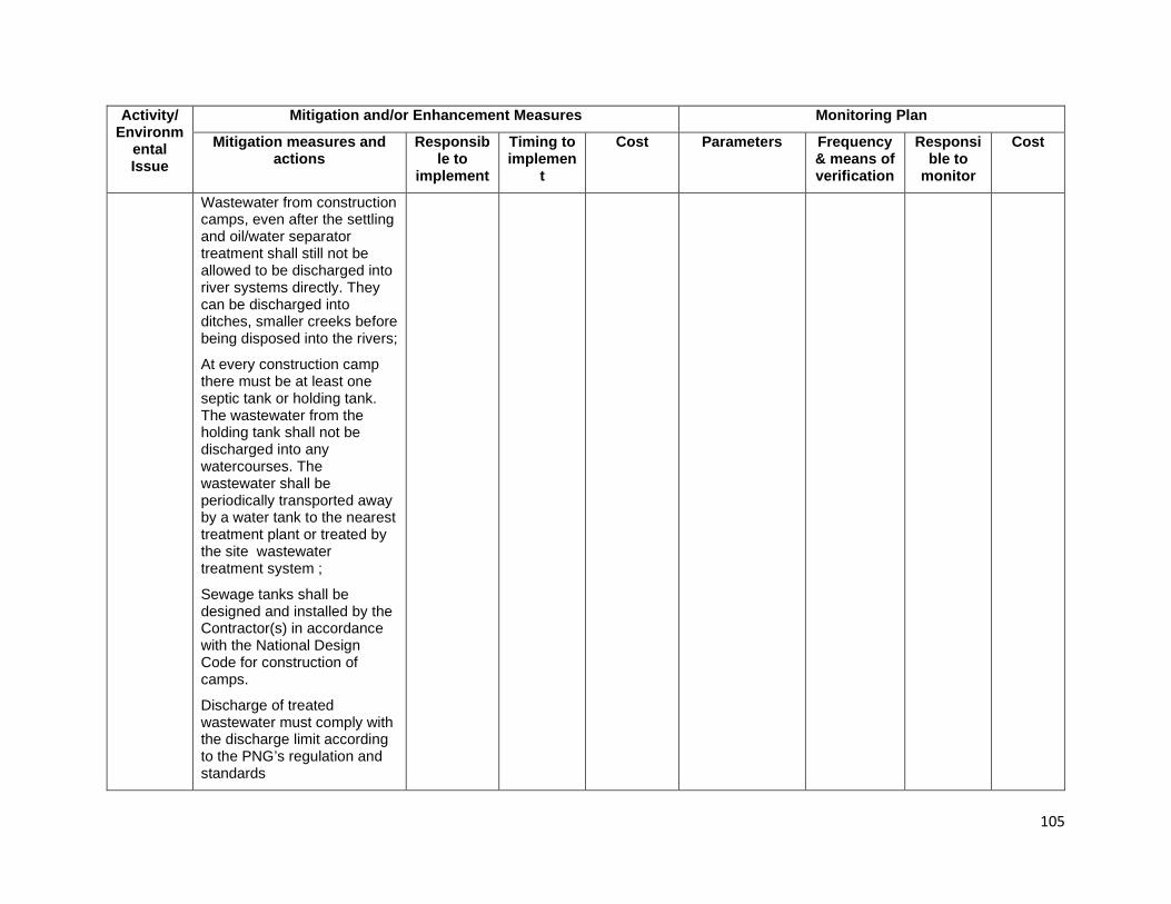
105
Activity/ Environm
ental Issue
Mitigation and/or Enhancement Measures Monitoring Plan
Mitigation measures and actions
Responsible to
implement
Timing to implemen
t
Cost Parameters Frequency & means of verification
Responsible to
monitor
Cost
Wastewater from construction camps, even after the settling and oil/water separator treatment shall still not be allowed to be discharged into river systems directly. They can be discharged into ditches, smaller creeks before being disposed into the rivers;
At every construction camp there must be at least one septic tank or holding tank. The wastewater from the holding tank shall not be discharged into any watercourses. The wastewater shall be periodically transported away by a water tank to the nearest treatment plant or treated by the site wastewater treatment system ;
Sewage tanks shall be designed and installed by the Contractor(s) in accordance with the National Design Code for construction of camps.
Discharge of treated wastewater must comply with the discharge limit according to the PNG’s regulation and standards
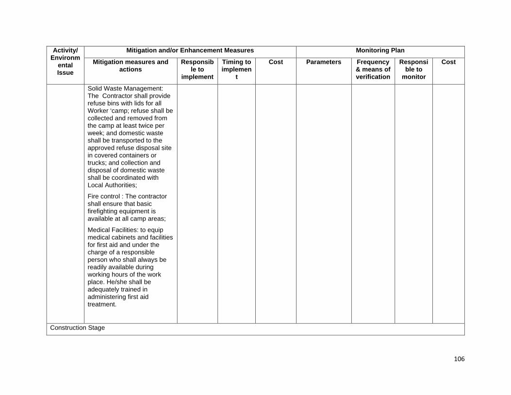
106
Activity/ Environm
ental Issue
Mitigation and/or Enhancement Measures Monitoring Plan
Mitigation measures and actions
Responsible to
implement
Timing to implemen
t
Cost Parameters Frequency & means of verification
Responsible to
monitor
Cost
Solid Waste Management: The Contractor shall provide refuse bins with lids for all Worker ‘camp; refuse shall be collected and removed from the camp at least twice per week; and domestic waste shall be transported to the approved refuse disposal site in covered containers or trucks; and collection and disposal of domestic waste shall be coordinated with Local Authorities;
Fire control : The contractor shall ensure that basic firefighting equipment is available at all camp areas;
Medical Facilities: to equip medical cabinets and facilities for first aid and under the charge of a responsible person who shall always be readily available during working hours of the work place. He/she shall be adequately trained in administering first aid treatment.
Construction Stage
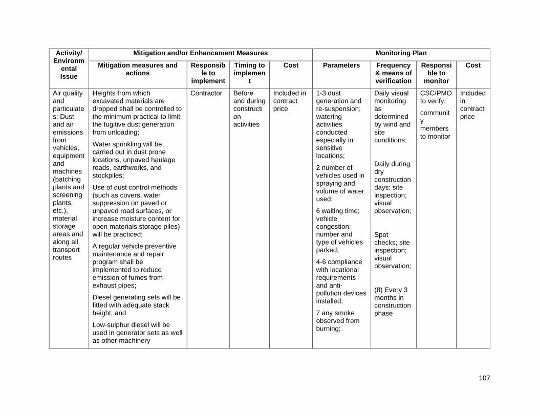
107
Activity/ Environm
ental Issue
Mitigation and/or Enhancement Measures Monitoring Plan
Mitigation measures and actions
Responsible to
implement
Timing to implemen
t
Cost Parameters Frequency & means of verification
Responsible to
monitor
Cost
Air quality and particulates: Dust and air emissions from vehicles, equipment and machines (batching plants and screening plants, etc.), material storage areas and along all transport routes
Heights from which excavated materials are dropped shall be controlled to the minimum practical to limit the fugitive dust generation from unloading;
Water sprinkling will be carried out in dust prone locations, unpaved haulage roads, earthworks, and stockpiles;
Use of dust control methods (such as covers, water suppression on paved or unpaved road surfaces, or increase moisture content for open materials storage piles) will be practiced;
A regular vehicle preventive maintenance and repair program shall be implemented to reduce emission of fumes from exhaust pipes;
Diesel generating sets will be fitted with adequate stack height; and
Low-sulphur diesel will be used in generator sets as well as other machinery
Contractor Before and during construction activities
Included in contract price
1-3 dust generation and re-suspension; watering activities conducted especially in sensitive locations;
2 number of vehicles used in spraying and volume of water used;
6 waiting time; vehicle congestion; number and type of vehicles parked;
4-6 compliance with locational requirements and anti-pollution devices installed;
7 any smoke observed from burning;
Daily visual monitoring as determined by wind and site conditions;
Daily during dry construction days; site inspection; visual observation;
Spot checks; site inspection; visual observation;
(8) Every 3 months in construction phase
CSC/PMO to verify;
community members to monitor
Included in contract price

108
Activity/ Environm
ental Issue
Mitigation and/or Enhancement Measures Monitoring Plan
Mitigation measures and actions
Responsible to
implement
Timing to implemen
t
Cost Parameters Frequency & means of verification
Responsible to
monitor
Cost
Open burning of solid wastes (plastic, paper, organic matters) will be prohibited;
Monitoring air quality parameters: Temperature, PM10, PM2.5
8 regularly air sampling
Noise: Noise from excavation and delivery of fill, spreading and compacting of materials.
Noise from pile driving will disturb surrounding residents and businesses and traffic management will add to additional
Temporary construction facilities such as labour camps, vehicle maintenance workshop and earth moving equipment will be located at least 500 meters away from settlements and other sensitive receptors;
Noise sources such as stone crushers, vehicle movements and quarries shall be re-located to less sensitive areas and at least 1 km away to take advantage of distance and shielding;
Opportunities will be explored to take advantage of the natural topography as a noise buffer such as behind the ridge that break the line of sight between the source of noise and the receptors;
Silencers will always be installed in construction equipment and machinery and maintained properly;
Contractor During construction activities
Included in contract price
1 permission to be sought from community; complaints from communities (GRM and records);
2 and 3 distance from settlements and sensitive areas;
4 presence of natural breaks;
5 muffled equipment;
6 PPE provided;
1 as determined by village protocols and site conditions;
2 Once; Site inspection to verify locational requirements compliance; checklist of items to be monitored is prepared and used to check off items of concern;
(11) Every 3 months in construction phase
CSC/PMO to verify; Community members to monitor ambient noise
Included in contract price

109
Activity/ Environm
ental Issue
Mitigation and/or Enhancement Measures Monitoring Plan
Mitigation measures and actions
Responsible to
implement
Timing to implemen
t
Cost Parameters Frequency & means of verification
Responsible to
monitor
Cost
traffic noise around bridge sites.
Noise from equipment delivering, spreading, laying and compacting pavement
The production of materials for road and bridge construction will include a requirement for aggregates to be produced and concrete manufactured.
Equipment and machinery with lower sound levels will be selected for the construction activities;
Protection devices such as ear plugs or earmuffs will be provided to the workers during period of operating high noise generating machines;
Noise levels will be regularly measured during the peak of construction period in particular using portable noise meters to ensure the effectiveness of mitigation measures;
Noise generation activities may be carried out between 7 am to 7 pm only to avoid disturbance to nearby communities at night and ideally should not exceed 45 dBA measured at the outside of any residence. Only in extreme instances will work beyond these hours be allowed after the Community Relations Officer (CRO) of the contractor has informed the community about change in work program well in advance;
7 and 8 peak construction activities identified; noise meters made available; complaints received from community if work activities carried out beyond prescribed period;
9 type of barriers installed in sensitive receptors and effectiveness (noise levels through readings and/or complaints)
10 information disseminated;
11 regularly noise monitoring
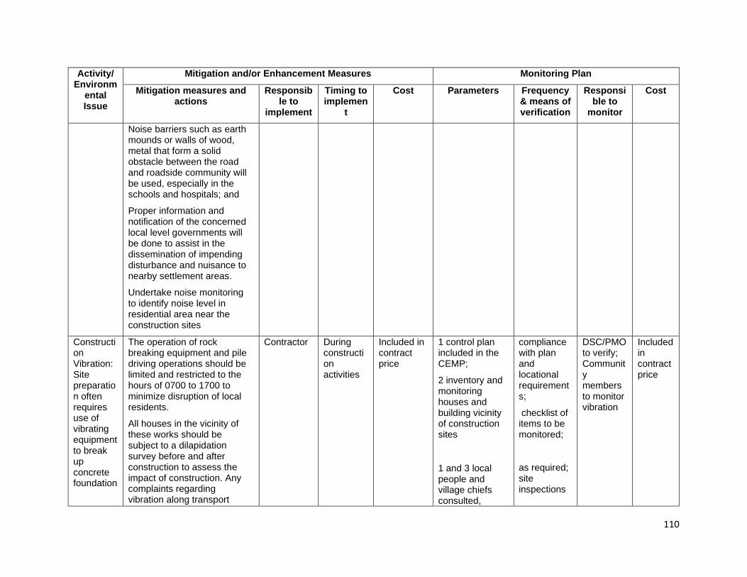
110
Activity/ Environm
ental Issue
Mitigation and/or Enhancement Measures Monitoring Plan
Mitigation measures and actions
Responsible to
implement
Timing to implemen
t
Cost Parameters Frequency & means of verification
Responsible to
monitor
Cost
Noise barriers such as earth mounds or walls of wood, metal that form a solid obstacle between the road and roadside community will be used, especially in the schools and hospitals; and
Proper information and notification of the concerned local level governments will be done to assist in the dissemination of impending disturbance and nuisance to nearby settlement areas.
Undertake noise monitoring to identify noise level in residential area near the construction sites
Construction Vibration: Site preparation often requires use of vibrating equipment to break up concrete foundation
The operation of rock breaking equipment and pile driving operations should be limited and restricted to the hours of 0700 to 1700 to minimize disruption of local residents.
All houses in the vicinity of these works should be subject to a dilapidation survey before and after construction to assess the impact of construction. Any complaints regarding vibration along transport
Contractor During construction activities
Included in contract price
1 control plan included in the CEMP;
2 inventory and monitoring houses and building vicinity of construction sites
1 and 3 local people and village chiefs consulted,
compliance with plan and locational requirements;
checklist of items to be monitored;
as required; site inspections
DSC/PMO to verify; Community members to monitor vibration
Included in contract price
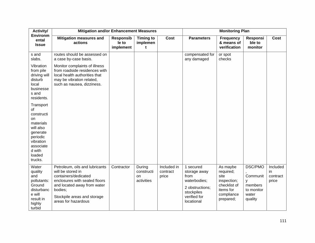
111
Activity/ Environm
ental Issue
Mitigation and/or Enhancement Measures Monitoring Plan
Mitigation measures and actions
Responsible to
implement
Timing to implemen
t
Cost Parameters Frequency & means of verification
Responsible to
monitor
Cost
s and slabs.
Vibration from pile driving will disturb local businesses and residents.
Transport of construction materials will also generate periodic vibration associated with loaded trucks.
routes should be assessed on a case by-case basis.
Monitor complaints of illness from roadside residences with local health authorities that may be vibration related, such as nausea, dizziness.
compensated for any damaged
or spot checks
Water quality and pollutants: Ground disturbance will result in highly turbid
Petroleum, oils and lubricants will be stored in containers/dedicated enclosures with sealed floors and located away from water bodies;
Stockpile areas and storage areas for hazardous
Contractor During construction activities
Included in contract price
1 secured storage away from waterbodies;
2 obstructions; stockpiles verified for locational
As maybe required; site inspection; checklist of items for compliance prepared;
DSC/PMO, Community members to monitor water quality
Included in contract price

112
Activity/ Environm
ental Issue
Mitigation and/or Enhancement Measures Monitoring Plan
Mitigation measures and actions
Responsible to
implement
Timing to implemen
t
Cost Parameters Frequency & means of verification
Responsible to
monitor
Cost
runoff being generated which will add to existing high levels of turbidity in local waterways,
Runoff from materials storage areas and materials production areas generates turbid runoff unless contained,
Bridge construction, adjacent to and over waterways, has a high risk of spillage
substances shall be located away from water bodies;
Diversion ditches will be dug around material stockpiles;
Interference with natural water flow in rivers, watercourses or streams within or adjacent to work sites shall be avoided or minimized. Abstraction from rivers will only be allowed after permission from PMO and shall not be done immediately near the vicinity of bridges.
Solid wastes, debris, spent oil or fuel from construction machinery or plant, construction material, or waste vegetation removed from work sites will not be dumped in or near streams, rivers or waterways;
Spoil and material stockpiles will not be located near waterways, streams or rivers, or on the edge of slopes or hills above rivers or stream and shall be protected by perimeter diversion drains;
Used oils and waste hydrocarbons will be
requirements compliance;
3-4 diversion ditches provided; permission granted by PMO;
5-6 cleanliness of work areas; settling ponds provided; availability of approved disposal sites;
7-8 approved plan and timeliness of response; available approved sites for disposal;
9 regularly sampling and monitoring water quality
During each work and location; checklist of items for compliance prepared; site inspection;
(9) Every 3 months in construction phase

113
Activity/ Environm
ental Issue
Mitigation and/or Enhancement Measures Monitoring Plan
Mitigation measures and actions
Responsible to
implement
Timing to implemen
t
Cost Parameters Frequency & means of verification
Responsible to
monitor
Cost
of materials into watercourses during construction. These may liquid or solid and have the potential to pollute before any controls can be implemented
disposed in approved sites approved by SCS and shall not be indiscriminately discharged into the soil or any waterbody;
Temporary sediment controls such as silt fences or other sediment reducing devices (rock dams or silt barriers) shall be provided to prevent both siltation and silt migration during works being undertaken in the vicinity of streams and rivers;
Regularly sampling and analysis water parameters (Temperature, pH, turbidity, Biochemical Oxygen Demand (BOD), Chemical Oxygen Demand (COD), Total Nitrogen, Total Phosphorus, Total Suspended Solids (TSS), Oil and Grease, and Total Coliform Bacteria)
Construction waste: Large quantities of solid waste generated by
Contractor(s) shall practice waste segregation, provide the necessary receptacles and institute awareness campaign to its staff and workers. Organic (biodegradables) shall be collected and disposed on-site by composting, and
Contractor
During construction activities
Included in contract price
1 -2 Type of facility equipped; solid waste separated;
no waste illegal dumped
2-4 Number bin provided
Checklist of items for compliance prepared; verify compliance;
DSC/PMO, Community members to monitor
Included in contract price
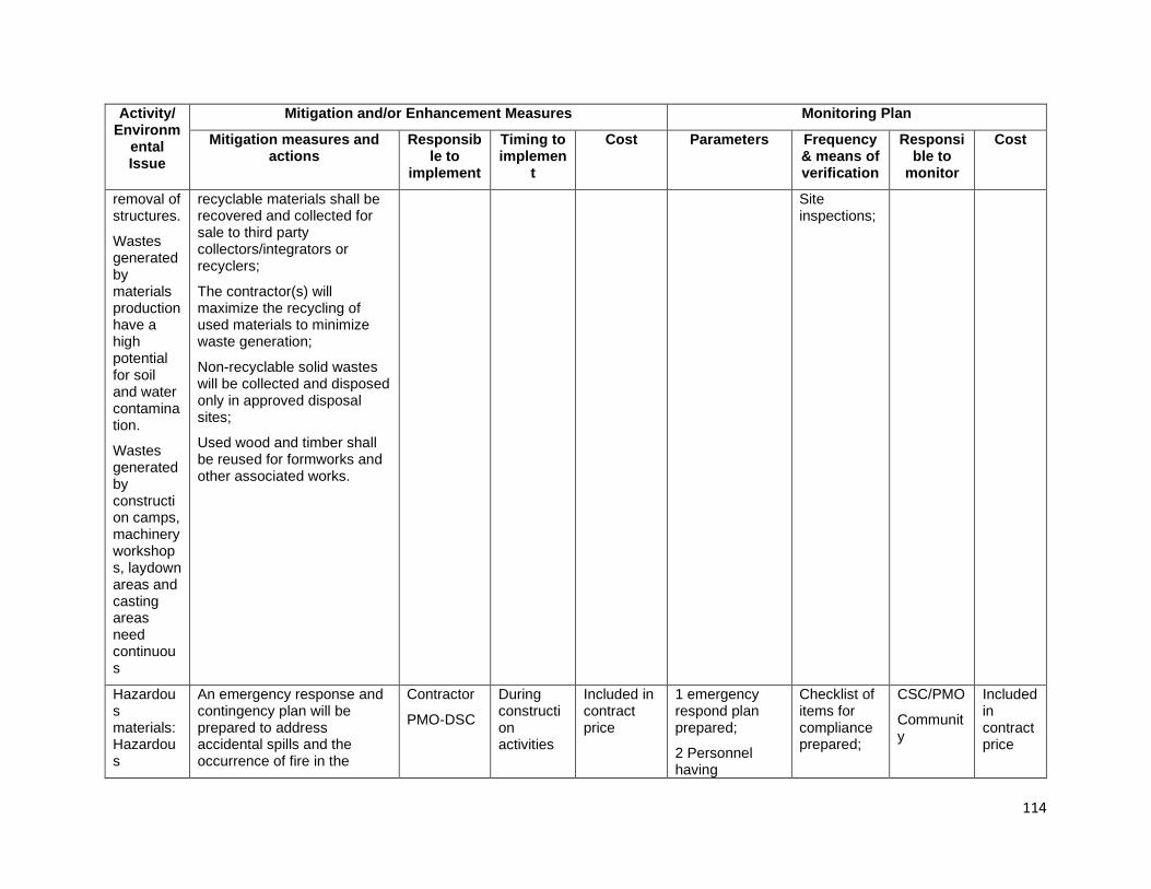
114
Activity/ Environm
ental Issue
Mitigation and/or Enhancement Measures Monitoring Plan
Mitigation measures and actions
Responsible to
implement
Timing to implemen
t
Cost Parameters Frequency & means of verification
Responsible to
monitor
Cost
removal of structures.
Wastes generated by materials production have a high potential for soil and water contamination.
Wastes generated by construction camps, machinery workshops, laydown areas and casting areas need continuous
recyclable materials shall be recovered and collected for sale to third party collectors/integrators or recyclers;
The contractor(s) will maximize the recycling of used materials to minimize waste generation;
Non-recyclable solid wastes will be collected and disposed only in approved disposal sites;
Used wood and timber shall be reused for formworks and other associated works.
Site inspections;
Hazardous materials: Hazardous
An emergency response and contingency plan will be prepared to address accidental spills and the occurrence of fire in the
Contractor
PMO-DSC
During construction activities
Included in contract price
1 emergency respond plan prepared;
2 Personnel having
Checklist of items for compliance prepared;
CSC/PMO
Community
Included in contract price

115
Activity/ Environm
ental Issue
Mitigation and/or Enhancement Measures Monitoring Plan
Mitigation measures and actions
Responsible to
implement
Timing to implemen
t
Cost Parameters Frequency & means of verification
Responsible to
monitor
Cost
materials have the potential to contaminate the environment if spilled or cause a fire or explosion if handled incorrectly.
contractor construction camp and facilities;
Staff and workers involved in the management and utilization of oils, fuel and lubricants are shall be properly trained in the handling, storage and dispensing of such materials;
Petroleum, oil and lubricants shall be stored in securely locked, fenced and properly designated areas away from water courses/bodies;
All storage containers shall be in good condition at all times with clear and proper labelling, regularly checked for leakage, and repaired or replaced as necessary;
The Contractor(s) shall be required to display safety information in all work areas and to train workers in the safe use of hazardous materials, including the provision of protective equipment;
Hazardous materials shall always be stored in areas free from floods; and discharge of oil-contaminated
knowledge on this issue
3-5 Fuel and hazardous substances located in paved areas, containers in good condition and proper labelling;
6 No hazardous waste discharged to around;
7-8 necessary material and equipment provided
site inspections;
Visual assessment
members to monitor
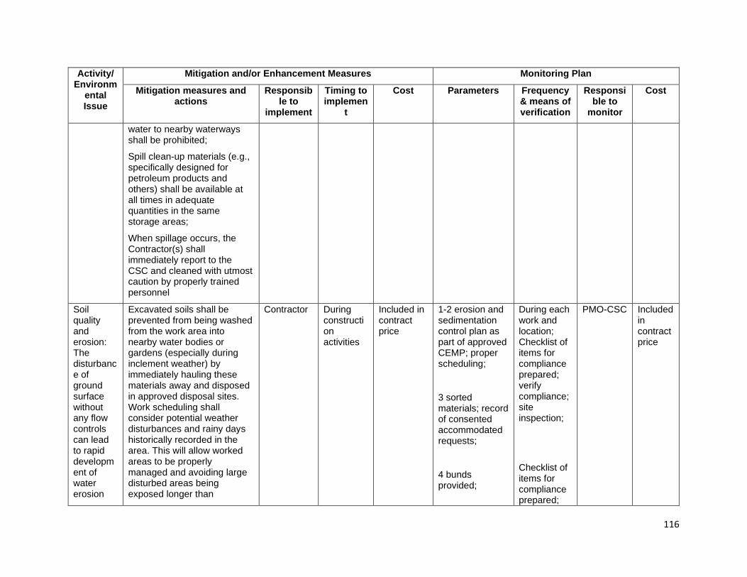
116
Activity/ Environm
ental Issue
Mitigation and/or Enhancement Measures Monitoring Plan
Mitigation measures and actions
Responsible to
implement
Timing to implemen
t
Cost Parameters Frequency & means of verification
Responsible to
monitor
Cost
water to nearby waterways shall be prohibited;
Spill clean-up materials (e.g., specifically designed for petroleum products and others) shall be available at all times in adequate quantities in the same storage areas;
When spillage occurs, the Contractor(s) shall immediately report to the CSC and cleaned with utmost caution by properly trained personnel
Soil quality and erosion: The disturbance of ground surface without any flow controls can lead to rapid development of water erosion
Excavated soils shall be prevented from being washed from the work area into nearby water bodies or gardens (especially during inclement weather) by immediately hauling these materials away and disposed in approved disposal sites. Work scheduling shall consider potential weather disturbances and rainy days historically recorded in the area. This will allow worked areas to be properly managed and avoiding large disturbed areas being exposed longer than
Contractor During construction activities
Included in contract price
1-2 erosion and sedimentation control plan as part of approved CEMP; proper scheduling;
3 sorted materials; record of consented accommodated requests;
4 bunds provided;
During each work and location; Checklist of items for compliance prepared; verify compliance; site inspection;
Checklist of items for compliance prepared;
PMO-CSC Included in contract price

117
Activity/ Environm
ental Issue
Mitigation and/or Enhancement Measures Monitoring Plan
Mitigation measures and actions
Responsible to
implement
Timing to implemen
t
Cost Parameters Frequency & means of verification
Responsible to
monitor
Cost
during high intensity rainfall events and lead to sheet erosion of all loose materials off a disturbed surface,
The removal of unsuitable materials can provide surfaces on the excavation which store water then release large volumes when the capacity of excavation is exceeded
necessary. Stockpiling of base and sub-base materials shall be also kept to a minimum to avoid being exposed longer than necessary;
Removed topsoil shall be stored in separate heaps and located in stable areas for later re-use for site rehabilitation. Spoils shall be prohibited from being dumped over the side of slopes and hills;
Excavated materials shall be sorted as either suitable (able to be reused) and unsuitable (to be disposed of) materials. The Contractor(s) shall accommodate requests of local people to utilize such materials for levelling their property with the consent of the CSC(s) and PMO for proper documentation;
Materials are not to be disposed/stockpiled near water courses;
Balance cut and fill requirements to minimize impacts from extraction of aggregates;
5 volume recorded;
6 drainage provided;
7 QMP prepared and approved, consents/permit obtained
verify compliance
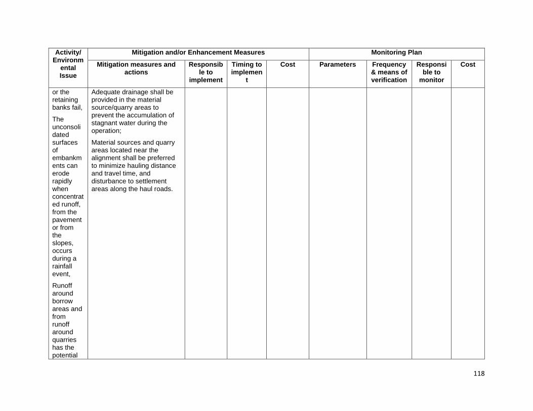
118
Activity/ Environm
ental Issue
Mitigation and/or Enhancement Measures Monitoring Plan
Mitigation measures and actions
Responsible to
implement
Timing to implemen
t
Cost Parameters Frequency & means of verification
Responsible to
monitor
Cost
or the retaining banks fail,
The unconsolidated surfaces of embankments can erode rapidly when concentrated runoff, from the pavement or from the slopes, occurs during a rainfall event,
Runoff around borrow areas and from runoff around quarries has the potential
Adequate drainage shall be provided in the material source/quarry areas to prevent the accumulation of stagnant water during the operation;
Material sources and quarry areas located near the alignment shall be preferred to minimize hauling distance and travel time, and disturbance to settlement areas along the haul roads.

119
Activity/ Environm
ental Issue
Mitigation and/or Enhancement Measures Monitoring Plan
Mitigation measures and actions
Responsible to
implement
Timing to implemen
t
Cost Parameters Frequency & means of verification
Responsible to
monitor
Cost
to cause off-site soil erosion away from the excavation or quarry face
Terrestrial flora: Vegetation removal, tree clearing; re-vegetation -
Impacts on flora
The contractor shall conduct a tree inventory (species and size) during the staking of the alignment in the pre-construction stage, and trees that may be removed will be agreed with PMO and landowners prior to cutting. Trees to be removed will be clearly marked on site drawing/plan;
Vegetation clearing shall be kept to a minimum, and occur only within the designated construction limits;
Vegetation clearance during staking and demarcation activities, especially of trees along the roadside shall be minimized. Trees that may be felled shall be clearly marked and only these marked trees shall be removed;
Contractor
During construction activities
Included in contract price
1 Tree species and size identified and marked;
2 and 3 area affected, and trees removed checked against plan;
4 awareness provided; employee induction training conducted; number of induction trainings done
At start of clearing work;
Site inspection
Prior to start of work; documentation of induction training including attendance sheets
CSC/PMO to verify
Included in contract price
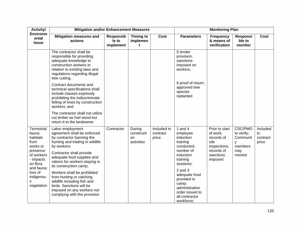
120
Activity/ Environm
ental Issue
Mitigation and/or Enhancement Measures Monitoring Plan
Mitigation measures and actions
Responsible to
implement
Timing to implemen
t
Cost Parameters Frequency & means of verification
Responsible to
monitor
Cost
The contractor shall be responsible for providing adequate knowledge to construction workers in relation to existing laws and regulations regarding illegal tree cutting.
Contract documents and technical specifications shall include clauses expressly prohibiting the indiscriminate felling of trees by construction workers; and
The contractor shall not utilize cut timber as fuel wood but return it to the landowner
5 tender provision, sanctions imposed on workers;
6 proof of return; approved tree species replanted
Terrestrial fauna: habitats from works or presence of workers - Impacts on flora and fauna; loss of indigenous vegetation
Labor employment agreement shall be enforced by contractor banning the hunting and trading in wildlife by workers;
Contractor shall provide adequate food supplies and rations for workers staying in its construction camp;
Workers shall be prohibited from hunting or catching wildlife including fish and birds. Sanctions will be imposed on any workers not complying with the provision
Contractor During construction activities
Included in contract price
1 and 4 employee induction training conducted; number of induction training sessions;
2 and 3 adequate food provided in camp; administrative order issued to all contractor workforce;
Prior to start of work; records of site inspections; records of sanctions imposed
CSC/PMO to verify; Community members may monitor
Included in contract price

121
Activity/ Environm
ental Issue
Mitigation and/or Enhancement Measures Monitoring Plan
Mitigation measures and actions
Responsible to
implement
Timing to implemen
t
Cost Parameters Frequency & means of verification
Responsible to
monitor
Cost
and all sanctions to be recorded;
The contractor will be responsible for providing awareness to construction workers regarding fauna in the area. Contract documents and technical specifications will include clauses expressly prohibiting the poaching of fauna by construction workers and making the contractor responsible for imposing sanctions on any workers who are caught trapping, killing, poaching, being in possession of or having poached fauna;
Any potential seed source such as earth and organic materials that may be attached to machinery shall be removed by washing prior to deployment to the work areas; and
Non-indigenous plant species shall not be used during replanting/re-vegetation works.
number of sanctions imposed;
5 vehicles and equipment properly washed;
6 indigenous plant species used and re-established in project area
Aquatic fauna and flora
Pollutant loading of storm water will include the construction of water quality basins to receive and treat
Contractor During constructi
Included in contract price
1. Soil Erosion and Sediment Control Plan
During each work and location; Checklist of
CSC/PMO to verify; Community
Included in

122
Activity/ Environm
ental Issue
Mitigation and/or Enhancement Measures Monitoring Plan
Mitigation measures and actions
Responsible to
implement
Timing to implemen
t
Cost Parameters Frequency & means of verification
Responsible to
monitor
Cost
storm water runoff from the proposed roadway. Strict adherence to the Soil Erosion and Sediment Control Plan should eliminate negative water quality impacts due to sediment loading.
Work for the bridge abutments and piers will be performed with the use of coffer dams and sealing off of sediments which will then be appropriately disposed of offsite.
Given the immense size of the river, and the degraded nature of these aquatic environments, it is anticipated that the project will not result in any significant impact to aquatic habitats. Additionally, the project will not create a physical barrier to fish movement and will not adversely affect migrating fish.
on activities
prepared and implemented;
2 and 3 turbidity in river/stream water limited and controlled
items for compliance prepared; verify compliance; site inspection;
members may monitor
contract price
Invasive alien species: Biological impacts from introduced
Prior to commence works, the contractor will arrange to review the site and determine whether there is or is not any infestations of invasive species in the area.
Contractor During construction activities
Included in contract price
1-2 survey and inventory if the area is infested with any invasive species;
At start of clearing work;
Site inspection
CSC/PMO to verify; Community members may monitor
Included in contract price
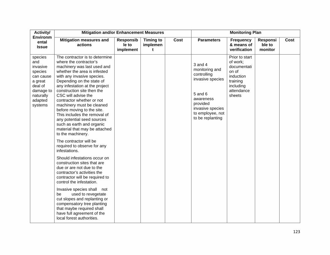
123
Activity/ Environm
ental Issue
Mitigation and/or Enhancement Measures Monitoring Plan
Mitigation measures and actions
Responsible to
implement
Timing to implemen
t
Cost Parameters Frequency & means of verification
Responsible to
monitor
Cost
species and invasive species can cause a great deal of damage to naturally adapted systems
The contractor is to determine where the contractor’s machinery was last used and whether the area is infested with any invasive species. Depending on the state of any infestation at the project construction site then the CSC will advise the contractor whether or not machinery must be cleaned before moving to the site. This includes the removal of any potential seed sources such as earth and organic material that may be attached to the machinery.
The contractor will be required to observe for any infestations.
Should infestations occur on construction sites that are due or are not due to the contractor’s activities the contractor will be required to control the infestation.
Invasive species shall not be used to revegetate cut slopes and replanting or compensatory tree planting that maybe required shall have full agreement of the local forest authorities.
3 and 4 monitoring and controlling invasive species
5 and 6 awareness provided invasive species to employee, not to be replanting
Prior to start of work; documentation of induction training including attendance sheets

124
Activity/ Environm
ental Issue
Mitigation and/or Enhancement Measures Monitoring Plan
Mitigation measures and actions
Responsible to
implement
Timing to implemen
t
Cost Parameters Frequency & means of verification
Responsible to
monitor
Cost
Control and avoidance of the introduction of invasive species is the contractor’s responsibility and this also extends to any sub-contractors that are working under his control.
Endangered species: rare and endangered species known may occur in the zone of the construction and can be affected
Regularly monitoring and maintain a database of the occurrence of rare and endangered species of plant or animal and take actions to avoid their disturbance during construction works through isolation of their habitats or adjustment of timing of works
Contractor During construction activities
Included in contract price
awareness and training provided to employee; monitoring undertaken
Prior to start of work; records of site inspections; records of sanctions imposed
CSC/PMO to verify; Community members may monitor
Included in contract price
Access and traffic safety: Movement of traffic and pedestrians through construction zones is
The Contractor(s) shall prepare a traffic management plan detailing temporary diversion where necessary and the associated management measures (reference can be made from DOW’s “Safe Traffic Control at Road Works Field Guide”);
Contractor During construction activities
Included in contract price
1 traffic management plan prepared and approved;
2 to 5 any complaints received; action taken in response;
Once for traffic management plan; daily visual observations;
Compliance verification
CSC/PMO to verify; Community members may monitor
Included in contract price

125
Activity/ Environm
ental Issue
Mitigation and/or Enhancement Measures Monitoring Plan
Mitigation measures and actions
Responsible to
implement
Timing to implemen
t
Cost Parameters Frequency & means of verification
Responsible to
monitor
Cost
hazardous due to irregular traffic patterns, disturbed ground surfaces and excavations,
Road safety during construction is reduced due to rapidly changing road conditions, loss of roadside furniture, warning systems and lighting.
Signs and other appropriate safety measures shall be provided on site to indicate construction works are being undertaken;
Local administration and village officials shall be consulted in the event that access to a village may be disrupted any time and temporary access arrangements provided accordingly;
Construction vehicles will use local access roads, or negotiate access with landowners to obtain access to material extraction sites; where local roads are used, these will be rehabilitated to their original condition after the completion of work;
Road safety protection shall be provided in the vicinity of the work site to protect the general public. This shall include advance notifications of commencement of works, installing safety barriers as necessary, and providing signages or markings on the work areas.
approvals from local/village administration and officials; cleanliness maintained; road safety protection devices provided and visible at all times;
to be done to ensure activities meet mitigation requirements
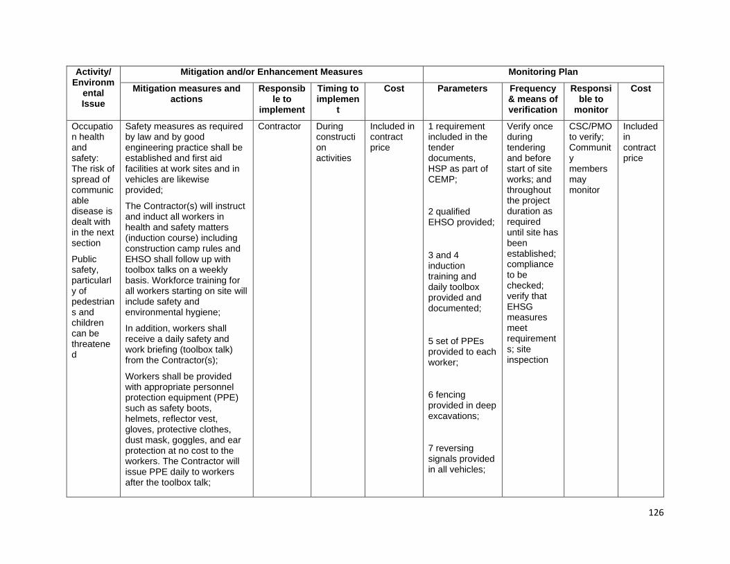
126
Activity/ Environm
ental Issue
Mitigation and/or Enhancement Measures Monitoring Plan
Mitigation measures and actions
Responsible to
implement
Timing to implemen
t
Cost Parameters Frequency & means of verification
Responsible to
monitor
Cost
Occupation health and safety: The risk of spread of communicable disease is dealt with in the next section
Public safety, particularly of pedestrians and children can be threatened
Safety measures as required by law and by good engineering practice shall be established and first aid facilities at work sites and in vehicles are likewise provided;
The Contractor(s) will instruct and induct all workers in health and safety matters (induction course) including construction camp rules and EHSO shall follow up with toolbox talks on a weekly basis. Workforce training for all workers starting on site will include safety and environmental hygiene;
In addition, workers shall receive a daily safety and work briefing (toolbox talk) from the Contractor(s);
Workers shall be provided with appropriate personnel protection equipment (PPE) such as safety boots, helmets, reflector vest, gloves, protective clothes, dust mask, goggles, and ear protection at no cost to the workers. The Contractor will issue PPE daily to workers after the toolbox talk;
Contractor During construction activities
Included in contract price
1 requirement included in the tender documents, HSP as part of CEMP;
2 qualified EHSO provided;
3 and 4 induction training and daily toolbox provided and documented;
5 set of PPEs provided to each worker;
6 fencing provided in deep excavations;
7 reversing signals provided in all vehicles;
Verify once during tendering and before start of site works; and throughout the project duration as required until site has been established; compliance to be checked; verify that EHSG measures meet requirements; site inspection
CSC/PMO to verify; Community members may monitor
Included in contract price
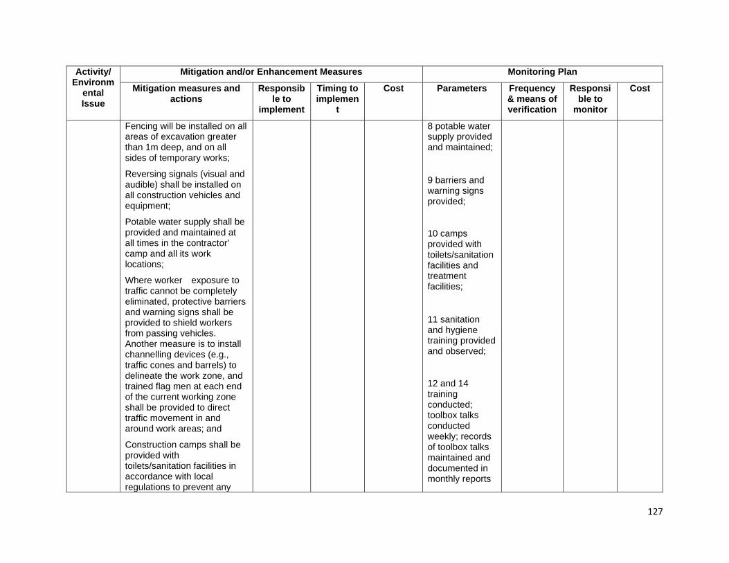
127
Activity/ Environm
ental Issue
Mitigation and/or Enhancement Measures Monitoring Plan
Mitigation measures and actions
Responsible to
implement
Timing to implemen
t
Cost Parameters Frequency & means of verification
Responsible to
monitor
Cost
Fencing will be installed on all areas of excavation greater than 1m deep, and on all sides of temporary works;
Reversing signals (visual and audible) shall be installed on all construction vehicles and equipment;
Potable water supply shall be provided and maintained at all times in the contractor’ camp and all its work locations;
Where worker exposure to traffic cannot be completely eliminated, protective barriers and warning signs shall be provided to shield workers from passing vehicles. Another measure is to install channelling devices (e.g., traffic cones and barrels) to delineate the work zone, and trained flag men at each end of the current working zone shall be provided to direct traffic movement in and around work areas; and
Construction camps shall be provided with toilets/sanitation facilities in accordance with local regulations to prevent any
8 potable water supply provided and maintained;
9 barriers and warning signs provided;
10 camps provided with toilets/sanitation facilities and treatment facilities;
11 sanitation and hygiene training provided and observed;
12 and 14 training conducted; toolbox talks conducted weekly; records of toolbox talks maintained and documented in monthly reports
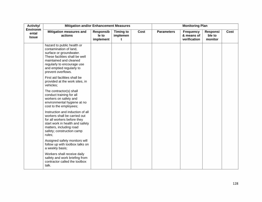
128
Activity/ Environm
ental Issue
Mitigation and/or Enhancement Measures Monitoring Plan
Mitigation measures and actions
Responsible to
implement
Timing to implemen
t
Cost Parameters Frequency & means of verification
Responsible to
monitor
Cost
hazard to public health or contamination of land, surface or groundwater. These facilities shall be well maintained and cleaned regularly to encourage use and emptied regularly to prevent overflows.
First aid facilities shall be provided at the work sites, in vehicles;
The contractor(s) shall conduct training for all workers on safety and environmental hygiene at no cost to the employees;
Instruction and induction of all workers shall be carried out for all workers before they start work in health and safety matters, including road safety; construction camp rules;
Assigned safety monitors will follow up with toolbox talks on a weekly basis;
Workers shall receive daily safety and work briefing from contractor called the toolbox talk.
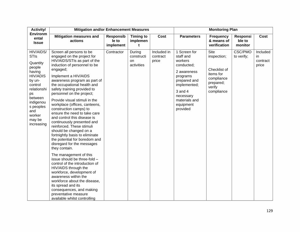
129
Activity/ Environm
ental Issue
Mitigation and/or Enhancement Measures Monitoring Plan
Mitigation measures and actions
Responsible to
implement
Timing to implemen
t
Cost Parameters Frequency & means of verification
Responsible to
monitor
Cost
HIV/AIDS/STIs
Quantity people having HIV/ADIS by un-control relationships between indigenous peoples and worker may be increasing
Screen all persons to be engaged on the project for HIV/AIDS/STIs as part of the induction of personnel to be engaged;
Implement a HIV/AIDS awareness program as part of the occupational health and safety training provided to personnel on the project;
Provide visual stimuli in the workplace (offices, canteens, construction camps) to ensure the need to take care and control this disease is continuously presented and reinforced. These stimuli should be changed on a fortnightly basis to eliminate the potential for boredom and disregard for the messages they contain.
The management of this issue should be three-fold – control of the introduction of HIV/AIDS through the workforce, development of awareness within the workforce about the disease, its spread and its consequences, and making preventative measure available whilst controlling
Contractor
During construction activities
Included in contract price
1 Screen for staff and workers conducted;
2 awareness programs prepared and implemented;
3 and 4 necessary materials and equipment provided
Site inspection;
Checklist of items for compliance prepared; verify compliance
CSC/PMO to verify;
Included in contract price

130
Activity/ Environm
ental Issue
Mitigation and/or Enhancement Measures Monitoring Plan
Mitigation measures and actions
Responsible to
implement
Timing to implemen
t
Cost Parameters Frequency & means of verification
Responsible to
monitor
Cost
external vectors that may introduce the disease.
Physical cultural resources: PCRs may uncover during construction activities
Instructed to keep watch for relics that may be uncovered during excavations, and local communities will be consulted to identify potential sites of concern, such as graveyards or taboo areas;
Should any potential items be located, the PMO through the CSC shall be immediately informed and work stoppage be immediately implemented;
The PMO with the assistance of the CSC, and in cooperation with local leaders, will determine if the item is of potential significance and contact DOW to pass the information to the relevant department in the government who will be invited to inspect the site;
Work shall stop to allow time for inspection, removal or in-situ preservation of the PCR and until the relevant government agency indicates works can re-commence; and
Until the government has responded to this invitation,
Contractor and approved service provider (sub-contractor)
During construction activities
Included in contract price
1 chance finds procedure established in CEMP;
2 to 5 artifacts, sites or other PCR discovered, proper authorities informed; documented and secured; site secured; communities informed
1 once during CEMP review to ensure chance finds procedures included;
2 to 7 site inspections and assessment; as triggered number of days of work suspension
CSC/PMO to verify
Included in contract price
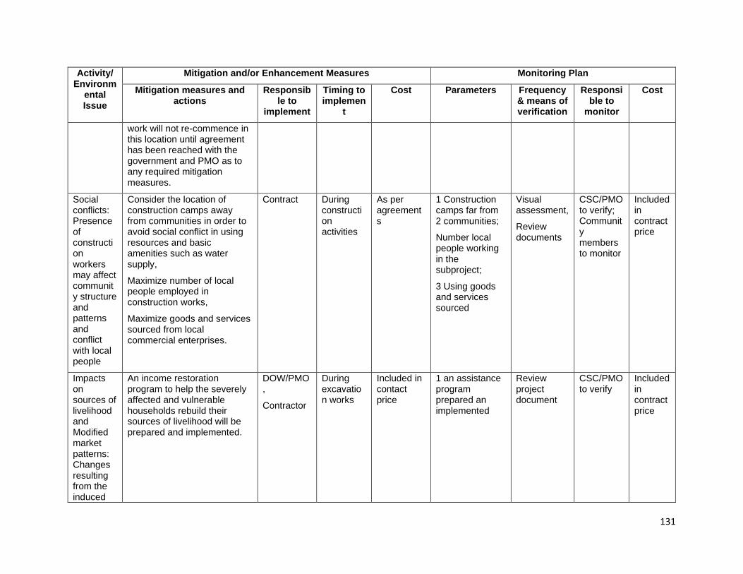
131
Activity/ Environm
ental Issue
Mitigation and/or Enhancement Measures Monitoring Plan
Mitigation measures and actions
Responsible to
implement
Timing to implemen
t
Cost Parameters Frequency & means of verification
Responsible to
monitor
Cost
work will not re-commence in this location until agreement has been reached with the government and PMO as to any required mitigation measures.
Social conflicts: Presence of construction workers may affect community structure and patterns and conflict with local people
Consider the location of construction camps away from communities in order to avoid social conflict in using resources and basic amenities such as water supply,
Maximize number of local people employed in construction works,
Maximize goods and services sourced from local commercial enterprises.
Contract During construction activities
As per agreements
1 Construction camps far from 2 communities;
Number local people working in the subproject;
3 Using goods and services sourced
Visual assessment,
Review documents
CSC/PMO to verify; Community members to monitor
Included in contract price
Impacts on sources of livelihood and Modified market patterns: Changes resulting from the induced
An income restoration program to help the severely affected and vulnerable households rebuild their sources of livelihood will be prepared and implemented.
DOW/PMO,
Contractor
During excavation works
Included in contact price
1 an assistance program prepared an implemented
Review project document
CSC/PMO to verify
Included in contract price
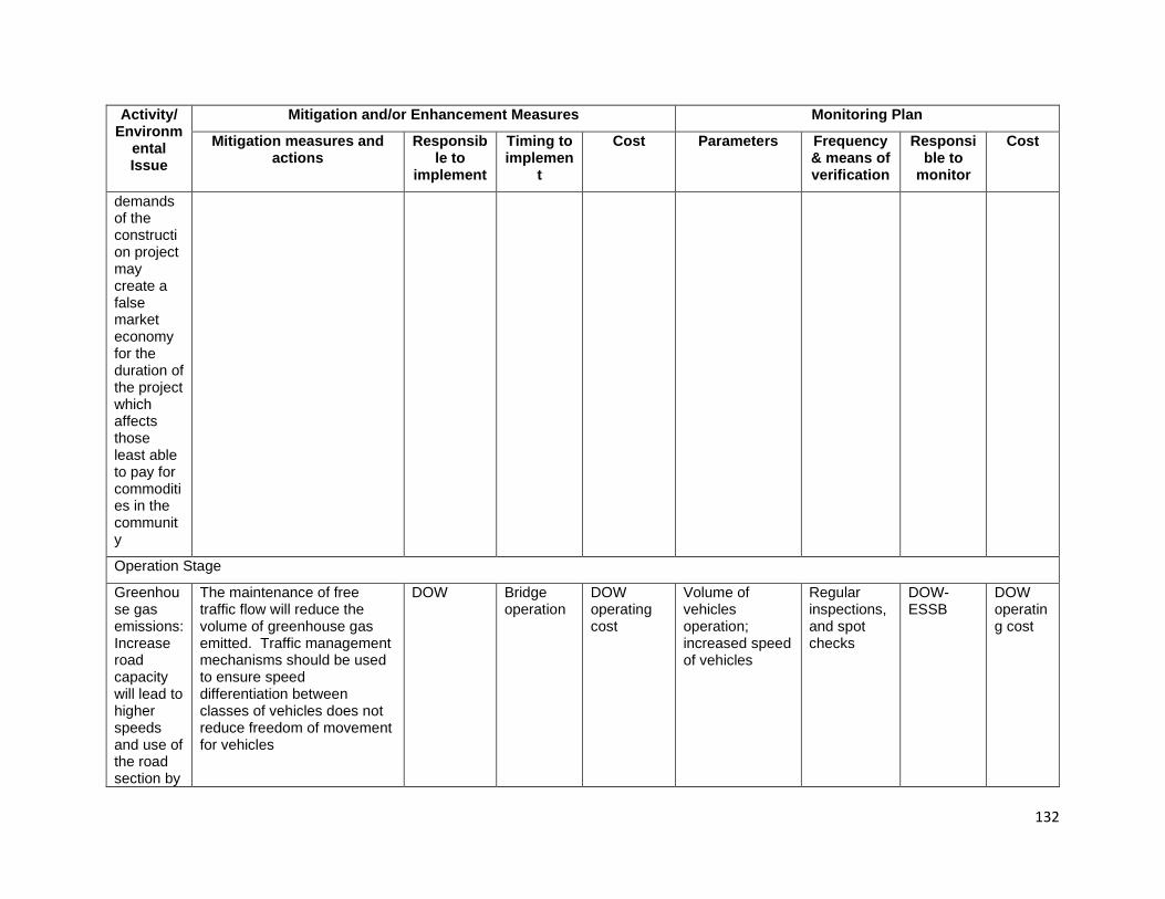
132
Activity/ Environm
ental Issue
Mitigation and/or Enhancement Measures Monitoring Plan
Mitigation measures and actions
Responsible to
implement
Timing to implemen
t
Cost Parameters Frequency & means of verification
Responsible to
monitor
Cost
demands of the construction project may create a false market economy for the duration of the project which affects those least able to pay for commodities in the community
Operation Stage
Greenhouse gas emissions: Increase road capacity will lead to higher speeds and use of the road section by
The maintenance of free traffic flow will reduce the volume of greenhouse gas emitted. Traffic management mechanisms should be used to ensure speed differentiation between classes of vehicles does not reduce freedom of movement for vehicles
DOW
Bridge operation
DOW operating cost
Volume of vehicles operation; increased speed of vehicles
Regular inspections, and spot checks
DOW-ESSB
DOW operating cost
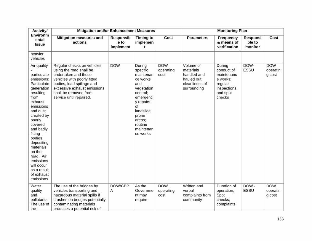
133
Activity/ Environm
ental Issue
Mitigation and/or Enhancement Measures Monitoring Plan
Mitigation measures and actions
Responsible to
implement
Timing to implemen
t
Cost Parameters Frequency & means of verification
Responsible to
monitor
Cost
heavier vehicles
Air quality - particulate emissions: Particulate generation resulting from exhaust emissions and dust created by poorly covered and badly fitting bodies depositing materials on the road. Air emissions will occur as a result of exhaust emissions.
Regular checks on vehicles using the road shall be undertaken and those vehicles with poorly fitted bodies, load spillage and excessive exhaust emissions shall be removed from service until repaired.
DOW
During specific maintenance works and vegetation control; emergency repairs of landslide prone areas; routine maintenance works
DOW operating cost
Volume of materials handled and hauled out; cleanliness of surrounding
During conduct of maintenance works; regular inspections, and spot checks
DOW-ESSU
DOW operating cost
Water quality and pollutants: The use of the
The use of the bridges by vehicles transporting and hazardous material spills if crashes on bridges potentially contaminating materials produces a potential risk of
DOW/CEPA
As the Government may require
DOW operating cost
Written and verbal complaints from community
Duration of operation; Spot checks; complaints
DOW -ESSU
DOW operating cost
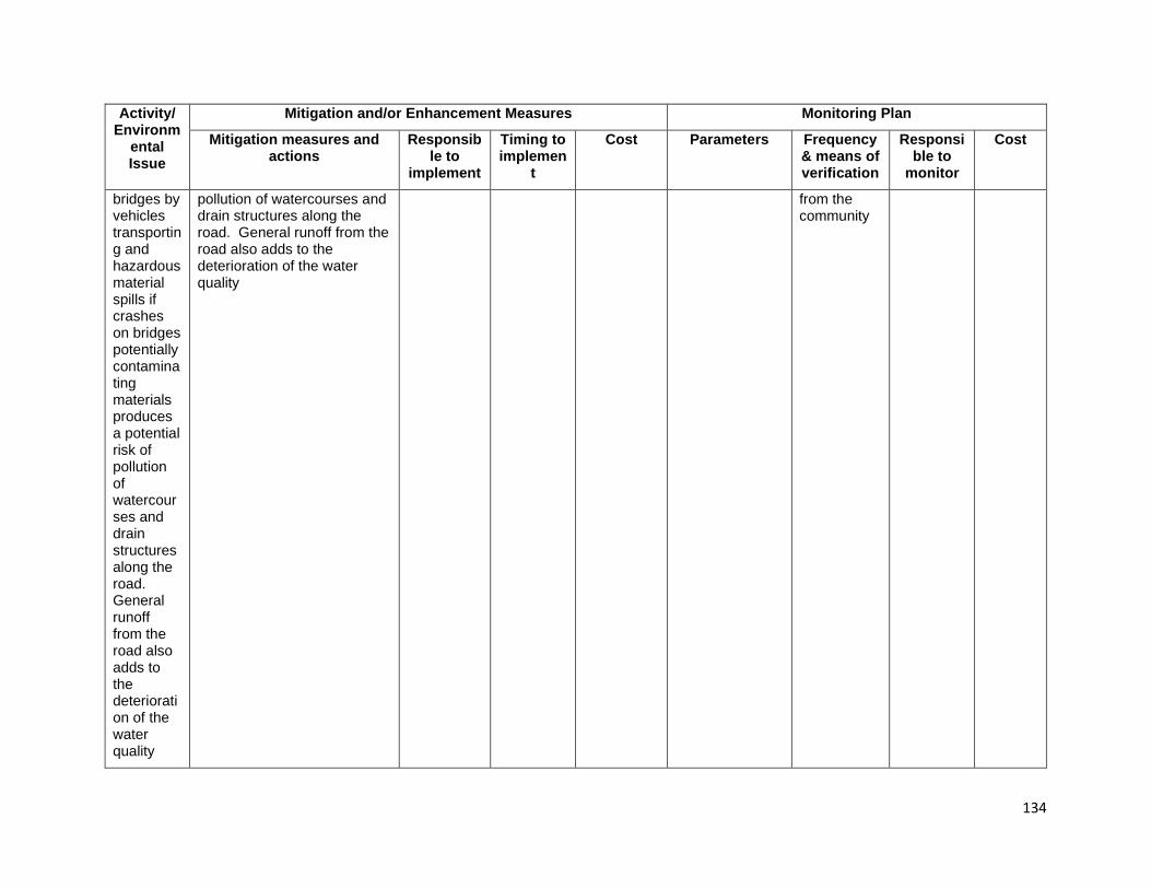
134
Activity/ Environm
ental Issue
Mitigation and/or Enhancement Measures Monitoring Plan
Mitigation measures and actions
Responsible to
implement
Timing to implemen
t
Cost Parameters Frequency & means of verification
Responsible to
monitor
Cost
bridges by vehicles transporting and hazardous material spills if crashes on bridges potentially contaminating materials produces a potential risk of pollution of watercourses and drain structures along the road. General runoff from the road also adds to the deterioration of the water quality
pollution of watercourses and drain structures along the road. General runoff from the road also adds to the deterioration of the water quality
from the community

135
Activity/ Environm
ental Issue
Mitigation and/or Enhancement Measures Monitoring Plan
Mitigation measures and actions
Responsible to
implement
Timing to implemen
t
Cost Parameters Frequency & means of verification
Responsible to
monitor
Cost
Road noise: Increased traffic volumes, vehicle sizes and operating speed will increase traffic noise on the highway
Reduce speed limits, regularly check the competence of vehicle exhausts and enforce restrictions on use of horns and vehicle noise standards in areas sensitive to road noise, such as schools and hospitals.
DOW/CEPA
During routine maintenance works
DOW operating cost
Written and verbal complaints from community; accident/incident registry maintained by authorities
Duration of operation; Spot checks; compiled data
DOW-ESSB
DOW operating cost
Riverbank and scour protection: Rip-rap, gabion baskets will be used appropriately to protect abutments and river-banks up and downstream. These structures may be damaged
The frequency of preventive maintenance inspections and implementation of sustained maintenance on designed structures will be increased. A system of monitoring, reporting and maintenance shall be developed consistent with the concept of this investment subproject
DOW/CEPA
During routine maintenance works
DOW operating cost
Written and verbal complaints from community; accident/incident registry maintained by authorities
Duration of operation; Spot checks; compiled data
DOW DOW operating cost
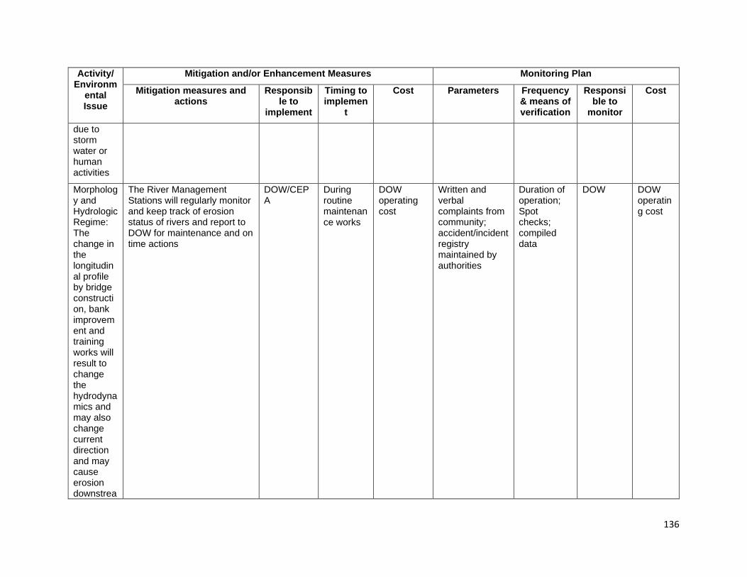
136
Activity/ Environm
ental Issue
Mitigation and/or Enhancement Measures Monitoring Plan
Mitigation measures and actions
Responsible to
implement
Timing to implemen
t
Cost Parameters Frequency & means of verification
Responsible to
monitor
Cost
due to storm water or human activities
Morphology and Hydrologic Regime: The change in the longitudinal profile by bridge construction, bank improvement and training works will result to change the hydrodynamics and may also change current direction and may cause erosion downstrea
The River Management Stations will regularly monitor and keep track of erosion status of rivers and report to DOW for maintenance and on time actions
DOW/CEPA
During routine maintenance works
DOW operating cost
Written and verbal complaints from community; accident/incident registry maintained by authorities
Duration of operation; Spot checks; compiled data
DOW DOW operating cost

137
Activity/ Environm
ental Issue
Mitigation and/or Enhancement Measures Monitoring Plan
Mitigation measures and actions
Responsible to
implement
Timing to implemen
t
Cost Parameters Frequency & means of verification
Responsible to
monitor
Cost
m and river morphology

138
Table 9-4 Environmental Management Plan (EMP) and Monitoring Matrix for Relocated Bridge to New Locations (6 Bridges) Activity/Environmental Issue
Mitigation and/or Enhancement Measures Monitoring Plan
Mitigation measures and actions Responsible to implement
Timing to implement Cost Parameters
Frequency & means of verification
Responsible to monitor Cost
PRE-CONSTRUCTION STAGE Land clearance – temporary and permanent land acquisition
1. DOW has prepared a land
acquisition and resettlement plan for detailed compensation and supporting policies,
2. The Contractor(s) will accordingly coordinate with related authority(ies) and locals to undertake inventory for the loss of land and assets;
3. The Contractor(s) will negotiate with local people for compensation of temporary land acquisition based on the loss and time of occupation.
DOW/PMO Contractor
Before construction phase During construction works
State budget (counterpart fund) Included in contract price
1 RPs are prepared and clearance, 2 and 3 Compensation progress and satisfaction of affected persons An assistance program prepared and implemented
(1) review project documents, (2 - 3) Survey by questionnaires and direct interview
DOW/PMO CSC/PMO
State budget (counterpart fund) Included in contract price
Preparation and approval Contractor’s Environmental Management Plan (CEMP)
1. The Contractor is required to prepare and submit a Contractor’s Environmental Management Plan (CEMP) based on the Contractor's actual detailed construction methodologies, work program, management of construction activities and management of workforce for review and approval by CSC,
2. The Contractor(s) commencement works only the CEMP approved by CSC,
3. The CSC may withhold payments and/or stop construction due to CEMP non-compliance and/or in the event of serious or repeated violations of the conditions stipulated herein.
Contractor No later than 28 days after the Commencement Date
Included in contract price
1 -2 CEMPs prepare and approved, 3 compliance with CEMP
(1-3) Review contractor’s documents and reports
CSC/PMO Included in contract price
Preparation and clearance associated plans: Health and Safety Management Plan, Traffic Management Plan, Site Security Management Plan, Quarry Management Plan,
1. The Contractor requires to submit the plans to CSC for review and approval.
2. The Contractor(s) commencement works only the Plans approved by CSC,
Contractor
Before commencing works on sites During construction works
Included in contract price
1 Plans prepared and approved, 2 compliance with the Plans
(1-2) review contractor and CSC’s documents and reports
CSC/PMO Included in contract price

139
Activity/Environmental Issue
Mitigation and/or Enhancement Measures Monitoring Plan
Mitigation measures and actions Responsible to implement
Timing to implement Cost Parameters
Frequency & means of verification
Responsible to monitor Cost
HIV/AIDS/STI Awareness plan Getting Environment Permit (PEs) and agreements of associated activities such as Borrow Pits, Quarry Areas and disposal areas
1. Licenses and Eps: for materials extraction and spoil disposal will be obtained in advance and before work commences from the appropriate authorities including CEPA.
2. The Contractor shall identify and prepare a Spoils Disposal Agreement with the local landowners for its waste deposition, and meet requirements of GoPNG,
3. Before beginning works the contractor should be Pes and agreement to CSC and PMO
Contractor Before commencing works on sites During construction works
Included in contract price
1-3 EPs and agreements obtained and displayed at the construction site offices
Review contractor’s document, Inspection by checklist
CSC/PMO Included in contract price
Workforce Mobilization 1. As far as possible, labor shall come from the communities traversed by the Highlands Highway. But where this is not possible due to the absence of skills appropriate to the requirements, workers hired from off-site shall be provided briefing of village protocols as part of awareness training;
2. As many local workers as possible will be hired and trained for the construction activities. In order to avoid clan conflicts over access to employment, it is important that local workers are sourced from each of the customary land areas along the highway;
3. The contractor shall ensure that workers’ actions outside work site are controlled and village customs and traditions are always observed;
4. The contractor will identify one member of their staff to be the liaison between the ward councilor, village leaders and
Contractor After issuance of Notice to Proceed (NTP) and prior to commencement of construction activities During construction works
Included in contract price
1 -3 agreements reached with village leaders; number hired; checklist of mobilization requirements prepared and signed off when completed; 4 contractors contact person identified; 5 adequate housing, cooking and dining areas, potable water, and sanitation and drainage facilities provided as per agreed specifications;
(1-4) Daily progress as required; Once unless there is personnel turnover; Site inspections; (5) Once during mobilization, daily for hygiene and housekeeping; Once for (6-10) during mobilization; periodic spot-checking during operation
CSC/PMO to verify; Community members to monitor Contractor activities
Included in contract price
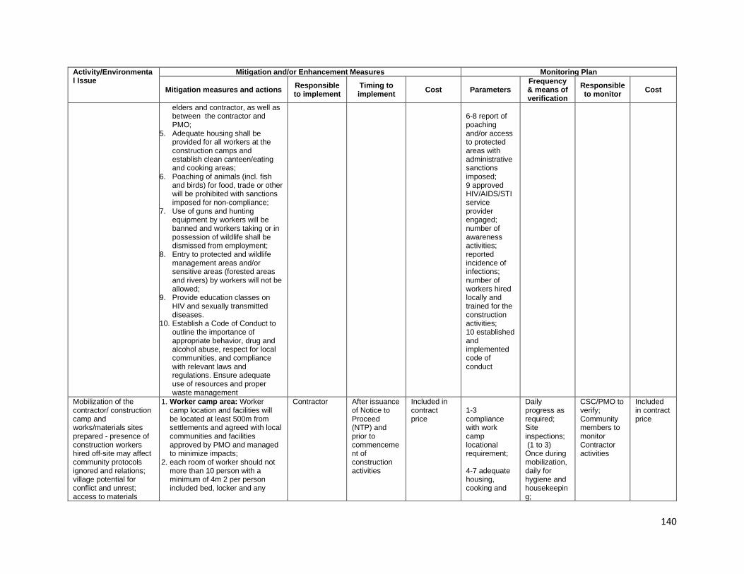
140
Activity/Environmental Issue
Mitigation and/or Enhancement Measures Monitoring Plan
Mitigation measures and actions Responsible to implement
Timing to implement Cost Parameters
Frequency & means of verification
Responsible to monitor Cost
elders and contractor, as well as between the contractor and PMO;
5. Adequate housing shall be provided for all workers at the construction camps and establish clean canteen/eating and cooking areas;
6. Poaching of animals (incl. fish and birds) for food, trade or other will be prohibited with sanctions imposed for non-compliance;
7. Use of guns and hunting equipment by workers will be banned and workers taking or in possession of wildlife shall be dismissed from employment;
8. Entry to protected and wildlife management areas and/or sensitive areas (forested areas and rivers) by workers will not be allowed;
9. Provide education classes on HIV and sexually transmitted diseases.
10. Establish a Code of Conduct to outline the importance of appropriate behavior, drug and alcohol abuse, respect for local communities, and compliance with relevant laws and regulations. Ensure adequate use of resources and proper waste management
6-8 report of poaching and/or access to protected areas with administrative sanctions imposed; 9 approved HIV/AIDS/STI service provider engaged; number of awareness activities; reported incidence of infections; number of workers hired locally and trained for the construction activities; 10 established and implemented code of conduct
Mobilization of the contractor/ construction camp and works/materials sites prepared - presence of construction workers hired off-site may affect community protocols ignored and relations; village potential for conflict and unrest; access to materials
1. Worker camp area: Worker camp location and facilities will be located at least 500m from settlements and agreed with local communities and facilities approved by PMO and managed to minimize impacts;
2. each room of worker should not more than 10 person with a minimum of 4m 2 per person included bed, locker and any
Contractor After issuance of Notice to Proceed (NTP) and prior to commencement of construction activities
Included in contract price
1-3 compliance with work camp locational requirement; 4-7 adequate housing, cooking and
Daily progress as required; Site inspections; (1 to 3) Once during mobilization, daily for hygiene and housekeeping;
CSC/PMO to verify; Community members to monitor Contractor activities
Included in contract price

141
Activity/Environmental Issue
Mitigation and/or Enhancement Measures Monitoring Plan
Mitigation measures and actions Responsible to implement
Timing to implement Cost Parameters
Frequency & means of verification
Responsible to monitor Cost
sites and any new operation not permitted or agreed creating local conflicts and environmental impacts
other personal furniture provided and space area
3. Work and camp sites will be
cleaned up to the satisfaction of the landowner and/or local community after use;
4. Water supply: The Contractor shall provide safe potable water for food preparation, drinking and bathing compliant with the relevant national technical regulations issued by the Department of Health, and other applicable Laws,
5. Sanitary Facilities: In every
camp site, separate and adequate lavatory facilities (toilets and washing areas) shall be provided for the use of male and female workers. Toilet facilities should also be provided with adequate clean water, soap, and toilet paper. Such facilities shall be conveniently accessible and shall be kept in clean and hygienic conditions;
6. Where workers of both sexes are employed, there shall be displayed outside each block of latrine and urinal, a notice in the language understood by the majority of the workers “For Men Only” or “For Women Only” as the case may be;
7. Sanitary arrangements, latrines and urinals shall be provided in every work place on the following scale: Where female workers are employed, there shall be at least one latrine for every 25 females or part thereof; Where males are employed, there shall be at least one latrine for every 25 males or part thereof;
dining areas, potable water, 8-12 sanitation and drainage facilities provided as per agreed specifications; 13 waste bins provided to every campsite; 14 signs and security requirements provided; safe access provided; 15 established first-aid base necessary facilities and person in charge
(4 to 15) during mobilization; periodic spot-checking during operation

142
Activity/Environmental Issue
Mitigation and/or Enhancement Measures Monitoring Plan
Mitigation measures and actions Responsible to implement
Timing to implement Cost Parameters
Frequency & means of verification
Responsible to monitor Cost
8. Wastewater Management:
Water from kitchens, showers etc. shall be discharged into a conservancy tank for removal from the Site or pass through an oil screener before discharge;
9. Wastewater from construction camps, even after the settling and oil/water separator treatment shall still not be allowed to be discharged into river systems directly. They can be discharged into ditches, smaller creeks before being disposed into the rivers;
10. At every construction camp there must be at least one septic tank or holding tank. The wastewater from the holding tank shall not be discharged into any watercourses. The wastewater shall be periodically transported away by a water tank to the nearest treatment plant or treated by the site wastewater treatment system ;
11. Sewage tanks shall be designed and installed by the Contractor(s) in accordance with the National Design Code for construction of camps.
12. Discharge of treated wastewater must comply with the discharge limit according to the PNG’s regulation and standards
13. Solid Waste Management: The Contractor shall provide refuse bins with lids for all Worker ‘camp; refuse shall be collected and removed from the camp at least twice per week; and domestic waste shall be transported to the approved refuse disposal site in covered containers or trucks; and
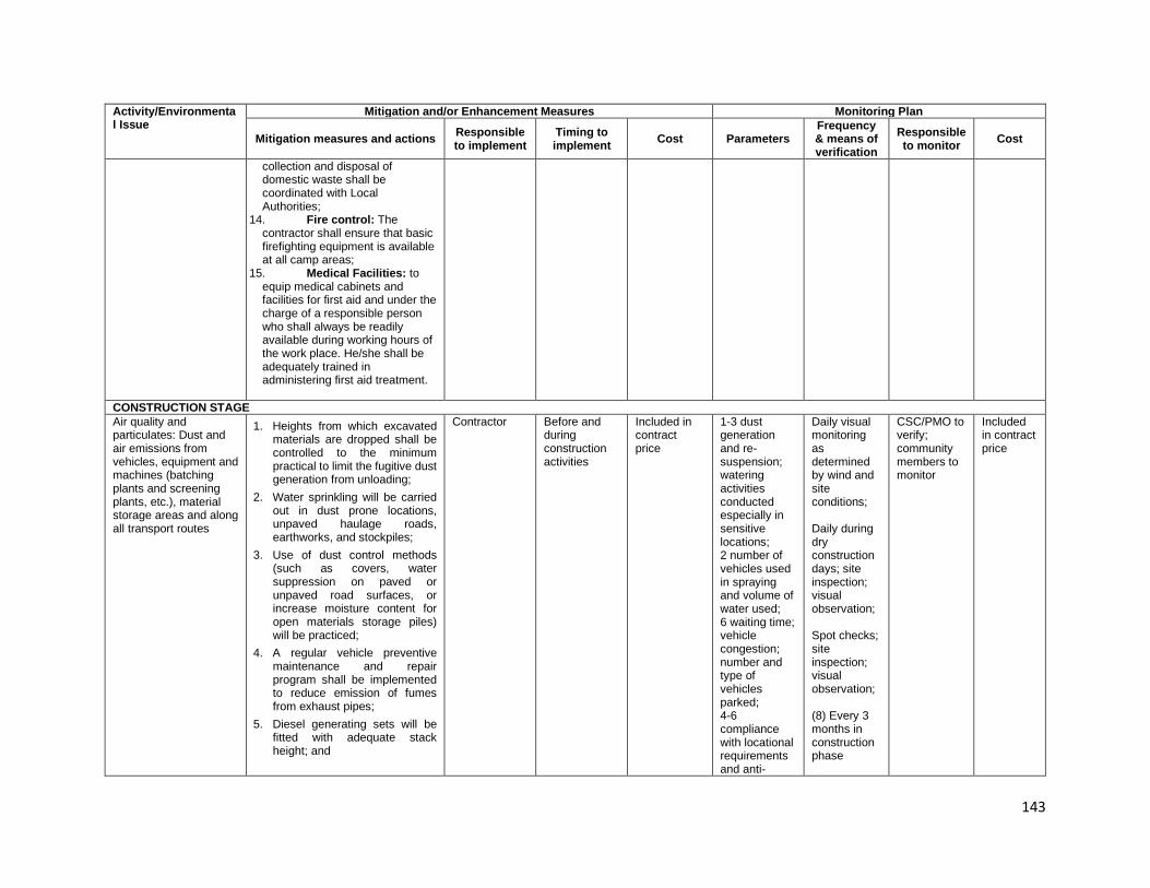
143
Activity/Environmental Issue
Mitigation and/or Enhancement Measures Monitoring Plan
Mitigation measures and actions Responsible to implement
Timing to implement Cost Parameters
Frequency & means of verification
Responsible to monitor Cost
collection and disposal of domestic waste shall be coordinated with Local Authorities;
14. Fire control: The contractor shall ensure that basic firefighting equipment is available at all camp areas;
15. Medical Facilities: to equip medical cabinets and facilities for first aid and under the charge of a responsible person who shall always be readily available during working hours of the work place. He/she shall be adequately trained in administering first aid treatment.
CONSTRUCTION STAGE Air quality and particulates: Dust and air emissions from vehicles, equipment and machines (batching plants and screening plants, etc.), material storage areas and along all transport routes
1. Heights from which excavated materials are dropped shall be controlled to the minimum practical to limit the fugitive dust generation from unloading;
2. Water sprinkling will be carried out in dust prone locations, unpaved haulage roads, earthworks, and stockpiles;
3. Use of dust control methods (such as covers, water suppression on paved or unpaved road surfaces, or increase moisture content for open materials storage piles) will be practiced;
4. A regular vehicle preventive maintenance and repair program shall be implemented to reduce emission of fumes from exhaust pipes;
5. Diesel generating sets will be fitted with adequate stack height; and
Contractor Before and during construction activities
Included in contract price
1-3 dust generation and re-suspension; watering activities conducted especially in sensitive locations; 2 number of vehicles used in spraying and volume of water used; 6 waiting time; vehicle congestion; number and type of vehicles parked; 4-6 compliance with locational requirements and anti-
Daily visual monitoring as determined by wind and site conditions; Daily during dry construction days; site inspection; visual observation; Spot checks; site inspection; visual observation; (8) Every 3 months in construction phase
CSC/PMO to verify; community members to monitor
Included in contract price
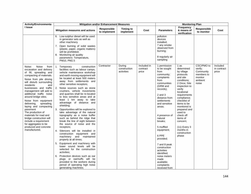
144
Activity/Environmental Issue
Mitigation and/or Enhancement Measures Monitoring Plan
Mitigation measures and actions Responsible to implement
Timing to implement Cost Parameters
Frequency & means of verification
Responsible to monitor Cost
6. Low-sulphur diesel will be used in generator sets as well as other machinery
7. Open burning of solid wastes (plastic, paper, organic matters) will be prohibited;
8. Monitoring air quality parameters: Temperature, PM10, PM2.5
pollution devices installed; 7 any smoke observed from burning; 8 regularly air sampling
Noise: Noise from excavation and delivery of fill, spreading and compacting of materials. Noise from pile driving will disturb surrounding residents and businesses and traffic management will add to additional traffic noise around bridge sites. Noise from equipment delivering, spreading, laying and compacting pavement The production of materials for road and bridge construction will include a requirement for aggregates to be produced and concrete manufactured.
1. Temporary construction facilities such as labour camps, vehicle maintenance workshop and earth moving equipment will be located at least 500 meters away from settlements and other sensitive receptors;
2. Noise sources such as stone crushers, vehicle movements and quarries shall be re-located to less sensitive areas and at least 1 km away to take advantage of distance and shielding;
3. Opportunities will be explored to take advantage of the natural topography as a noise buffer such as behind the ridge that break the line of sight between the source of noise and the receptors;
4. Silencers will be installed in construction equipment and machinery and maintained properly at all times;
5. Equipment and machinery with lower sound levels will be selected for the construction activities;
6. Protection devices such as ear plugs or earmuffs will be provided to the workers during period of operating high noise generating machines;
Contractor During construction activities
Included in contract price
1 permission to be sought from community; complaints from communities (GRM and records); 2 and 3 distance from settlements and sensitive areas; 4 presence of natural breaks; 5 muffled equipment; 6 PPE provided; 7 and 8 peak construction activities identified; noise meters made available; complaints received from
1 as determined by village protocols and site conditions; 2 Once; Site inspection to verify locational requirements compliance; checklist of items to be monitored is prepared and used to check off items of concern; (11) Every 3 months in construction phase
CSC/PMO to verify; Community members to monitor ambient noise
Included in contract price
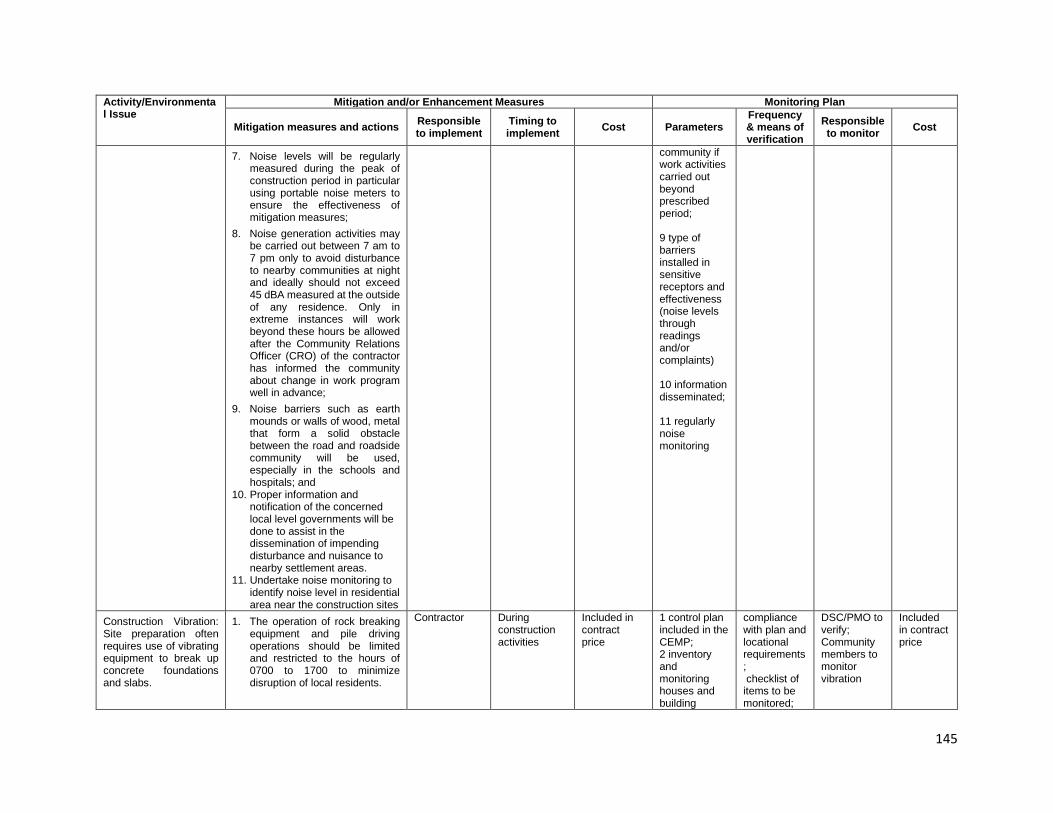
145
Activity/Environmental Issue
Mitigation and/or Enhancement Measures Monitoring Plan
Mitigation measures and actions Responsible to implement
Timing to implement Cost Parameters
Frequency & means of verification
Responsible to monitor Cost
7. Noise levels will be regularly measured during the peak of construction period in particular using portable noise meters to ensure the effectiveness of mitigation measures;
8. Noise generation activities may be carried out between 7 am to 7 pm only to avoid disturbance to nearby communities at night and ideally should not exceed 45 dBA measured at the outside of any residence. Only in extreme instances will work beyond these hours be allowed after the Community Relations Officer (CRO) of the contractor has informed the community about change in work program well in advance;
9. Noise barriers such as earth mounds or walls of wood, metal that form a solid obstacle between the road and roadside community will be used, especially in the schools and hospitals; and
10. Proper information and notification of the concerned local level governments will be done to assist in the dissemination of impending disturbance and nuisance to nearby settlement areas.
11. Undertake noise monitoring to identify noise level in residential area near the construction sites
community if work activities carried out beyond prescribed period; 9 type of barriers installed in sensitive receptors and effectiveness (noise levels through readings and/or complaints) 10 information disseminated; 11 regularly noise monitoring
Construction Vibration: Site preparation often requires use of vibrating equipment to break up concrete foundations and slabs.
1. The operation of rock breaking equipment and pile driving operations should be limited and restricted to the hours of 0700 to 1700 to minimize disruption of local residents.
Contractor During construction activities
Included in contract price
1 control plan included in the CEMP; 2 inventory and monitoring houses and building
compliance with plan and locational requirements; checklist of items to be monitored;
DSC/PMO to verify; Community members to monitor vibration
Included in contract price

146
Activity/Environmental Issue
Mitigation and/or Enhancement Measures Monitoring Plan
Mitigation measures and actions Responsible to implement
Timing to implement Cost Parameters
Frequency & means of verification
Responsible to monitor Cost
Vibration from pile driving will disturb local businesses and residents. Transport of construction materials will also generate periodic vibration associated with loaded trucks.
2. All houses in the vicinity of these works should be subject to a dilapidation survey before and after construction to assess the impact of construction. Any complaints regarding vibration along transport routes should be assessed on a case by-case basis.
3. Monitor complaints of illness from roadside residences with local health authorities that may be vibration related, such as nausea, dizziness.
vicinity of construction sites 1 and 3 local people and village chiefs consulted, compensated for any damaged
as required; site inspections or spot checks
Water quality and pollutants: Ground disturbance will result in highly turbid runoff being generated which will add to existing high levels of turbidity in local waterways, Runoff from materials storage areas and materials production areas generates turbid runoff unless contained, Bridge construction, adjacent to and over waterways, has a high risk of spillage of materials into watercourses during construction. These may liquid or solid and have the potential to pollute before any controls can be implemented
1. Petroleum, oils and lubricants will be stored in containers/dedicated enclosures with sealed floors and located away from water bodies;
2. Stockpile areas and storage areas for hazardous substances shall be located away from water bodies;
3. Diversion ditches will be dug around material stockpiles;
4. Interference with natural water flow in rivers, watercourses or streams within or adjacent to work sites shall be avoided or minimized. Abstraction from rivers will only be allowed after permission from PMO and shall not be done immediately near the vicinity of bridges.
5. Solid wastes, debris, spent oil or fuel from construction machinery or plant, construction material, or waste vegetation removed from work sites will not be dumped in or near streams, rivers or waterways;
6. Spoil and material stockpiles will not be located near waterways,
Contractor During construction activities
Included in contract price
1 secured storage away from waterbodies; 2 obstructions; stockpiles verified for locational requirements compliance; 3-4 diversion ditches provided; permission granted by PMO; 5-6 cleanliness of work areas; settling ponds provided; availability of approved disposal sites; 7-8 approved plan and timeliness of response; available approved sites for disposal;
As maybe required; site inspection; checklist of items for compliance prepared; During each work and location; checklist of items for compliance prepared; site inspection; (9) Every 3 months in construction phase
DSC/PMO, Community members to monitor water quality
Included in contract price
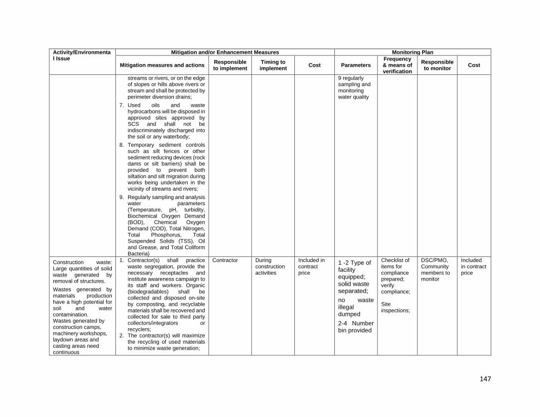
147
Activity/Environmental Issue
Mitigation and/or Enhancement Measures Monitoring Plan
Mitigation measures and actions Responsible to implement
Timing to implement Cost Parameters
Frequency & means of verification
Responsible to monitor Cost
streams or rivers, or on the edge of slopes or hills above rivers or stream and shall be protected by perimeter diversion drains;
7. Used oils and waste hydrocarbons will be disposed in approved sites approved by SCS and shall not be indiscriminately discharged into the soil or any waterbody;
8. Temporary sediment controls such as silt fences or other sediment reducing devices (rock dams or silt barriers) shall be provided to prevent both siltation and silt migration during works being undertaken in the vicinity of streams and rivers;
9. Regularly sampling and analysis water parameters (Temperature, pH, turbidity, Biochemical Oxygen Demand (BOD), Chemical Oxygen Demand (COD), Total Nitrogen, Total Phosphorus, Total Suspended Solids (TSS), Oil and Grease, and Total Coliform Bacteria)
9 regularly sampling and monitoring water quality
Construction waste: Large quantities of solid waste generated by removal of structures. Wastes generated by materials production have a high potential for soil and water contamination. Wastes generated by construction camps, machinery workshops, laydown areas and casting areas need continuous
1. Contractor(s) shall practice waste segregation, provide the necessary receptacles and institute awareness campaign to its staff and workers. Organic (biodegradables) shall be collected and disposed on-site by composting, and recyclable materials shall be recovered and collected for sale to third party collectors/integrators or recyclers;
2. The contractor(s) will maximize the recycling of used materials to minimize waste generation;
Contractor
During construction activities
Included in contract price
1 -2 Type of facility equipped; solid waste separated; no waste illegal dumped 2-4 Number bin provided
Checklist of items for compliance prepared; verify compliance; Site inspections;
DSC/PMO, Community members to monitor
Included in contract price

148
Activity/Environmental Issue
Mitigation and/or Enhancement Measures Monitoring Plan
Mitigation measures and actions Responsible to implement
Timing to implement Cost Parameters
Frequency & means of verification
Responsible to monitor Cost
3. Non-recyclable solid wastes will be collected and disposed only in approved disposal sites;
4. Used wood and timber shall be reused for formworks and other associated works.
Hazardous materials: Hazardous materials have the potential to contaminate the environment if spilled or cause a fire or explosion if handled incorrectly.
1. An emergency response and contingency plan will be prepared to address accidental spills and the occurrence of fire in the contractor construction camp and facilities;
2. Staff and workers involved in the management and utilization of oils, fuel and lubricants are shall be properly trained in the handling, storage and dispensing of such materials;
3. Petroleum, oil and lubricants shall be stored in securely locked, fenced and properly designated areas away from water courses/bodies;
4. All storage containers shall be in good condition at all times with clear and proper labelling, regularly checked for leakage, and repaired or replaced as necessary;
5. The Contractor(s) shall be required to display safety information in all work areas and to train workers in the safe use of hazardous materials, including the provision of protective equipment;
6. Hazardous materials shall be stored in areas free from floods at all times; and discharge of oil-contaminated water to nearby waterways shall be prohibited;
7. Spill clean-up materials (e.g., specifically designed for petroleum products and others)
Contractor PMO-DSC
During construction activities
Included in contract price
1 emergency respond plan prepared; 2 Personnel having knowledge on this issue 3-5 Fuel and hazardous substances located in paved areas, containers in good condition and proper labelling; 6 No hazardous waste discharged to around; 7-8 necessary material and equipment provided
Checklist of items for compliance prepared; site inspections; Visual assessment
CSC/PMO Community members to monitor
Included in contract price

149
Activity/Environmental Issue
Mitigation and/or Enhancement Measures Monitoring Plan
Mitigation measures and actions Responsible to implement
Timing to implement Cost Parameters
Frequency & means of verification
Responsible to monitor Cost
shall be available at all times in adequate quantities in the same storage areas;
8. When spillage occurs, the Contractor(s) shall immediately report to the CSC and cleaned with utmost caution by properly trained personnel
Soil quality and erosion: The disturbance of ground surface without any flow controls can lead to rapid development of water erosion during high intensity rainfall events and lead to sheet erosion of all loose materials off a disturbed surface, The removal of unsuitable materials can provide surfaces on the excavation which store water then release large volumes when the capacity of excavation is exceeded or the retaining banks fail, The unconsolidated surfaces of embankments can erode rapidly when concentrated runoff, from the pavement or from the slopes, occurs during a rainfall event, Runoff around borrow areas and from runoff around quarries has the potential to cause off-site soil erosion away from the excavation or quarry face
1. Excavated soils shall be prevented from being washed from the work area into nearby water bodies or gardens (especially during inclement weather) by immediately hauling these materials away and disposed in approved disposal sites. Work scheduling shall take into account potential weather disturbances and rainy days historically recorded in the area. This will allow worked areas to be properly managed and avoiding large disturbed areas being exposed longer than necessary. Stockpiling of base and sub-base materials shall be also kept to a minimum to avoid being exposed longer than necessary;
2. Removed topsoil shall be stored in separate heaps and located in stable areas for later re-use for site rehabilitation. Spoils shall be prohibited from being dumped over the side of slopes and hills;
3. Excavated materials shall be sorted as either suitable (able to be reused) and unsuitable (to be disposed of) materials. The Contractor(s) shall accommodate requests of local people to utilize such materials for levelling their property with the consent of the CSC(s) and PMO for proper documentation;
Contractor During construction activities
Included in contract price
1-2 erosion and sedimentation control plan as part of approved CEMP; proper scheduling; 3 sorted materials; record of consented accommodated requests; 4 bunds provided; 5 volume recorded; 6 drainage provided; 7 QMP prepared and approved, consents/permit obtained
During each work and location; Checklist of items for compliance prepared; verify compliance; site inspection; Checklist of items for compliance prepared; verify compliance
PMO-CSC Included in contract price

150
Activity/Environmental Issue
Mitigation and/or Enhancement Measures Monitoring Plan
Mitigation measures and actions Responsible to implement
Timing to implement Cost Parameters
Frequency & means of verification
Responsible to monitor Cost
4. Materials are not to be disposed/stockpiled near water courses;
5. Balance cut and fill requirements to minimize impacts from extraction of aggregates;
6. Adequate drainage shall be provided in the material source/quarry areas to prevent the accumulation of stagnant water during the operation;
7. Material sources and quarry areas located near the alignment shall be preferred to minimize hauling distance and travel time, and disturbance to settlement areas along the haul roads.
Terrestrial flora: Vegetation removal, tree clearing; re-vegetation - Impacts on flora
1. The contractor shall conduct a tree inventory (species and size) during the staking of the alignment in the pre-construction stage, and trees that may be removed will be agreed with PMO and landowners prior to cutting. Trees to be removed will be clearly marked on site drawing/plan;
2. Vegetation clearing shall be kept to a minimum, and occur only within the designated construction limits;
3. Vegetation clearance during staking and demarcation activities, especially of trees along the roadside shall be minimized. Trees that may be felled shall be clearly marked and only these marked trees shall be removed;
4. The contractor shall be responsible for providing adequate knowledge to construction workers in relation to existing laws and regulations regarding illegal tree cutting.
Contractor
During construction activities
Included in contract price
1 Tree species and size identified and marked; 2 and 3 area affected, and trees removed checked against plan; 4 awareness provided; employee induction training conducted; number of induction trainings done 5 tender provision, sanctions imposed on workers;
At start of clearing work; Site inspection Prior to start of work; documentation of induction training including attendance sheets
CSC/PMO to verify
Included in contract price

151
Activity/Environmental Issue
Mitigation and/or Enhancement Measures Monitoring Plan
Mitigation measures and actions Responsible to implement
Timing to implement Cost Parameters
Frequency & means of verification
Responsible to monitor Cost
5. Contract documents and technical specifications shall include clauses expressly prohibiting the indiscriminate felling of trees by construction workers; and
6. The contractor shall not utilize cut timber as fuel wood but return it to the landowner
6 proof of return; approved tree species replanted
Terrestrial fauna: habitats from works or presence of workers - Impacts on flora and fauna; loss of indigenous vegetation
1. Labor employment agreement shall be enforced by contractor banning the hunting and trading in wildlife by workers;
2. Contractor shall provide adequate food supplies and rations for workers staying in its construction camp;
3. Workers shall be prohibited from hunting or catching wildlife including fish and birds. Sanctions will be imposed on any workers not complying with the provision and all sanctions to be recorded;
4. The contractor will be responsible for providing awareness to construction workers in regard to fauna in the area. Contract documents and technical specifications will include clauses expressly prohibiting the poaching of fauna by construction workers and making the contractor responsible for imposing sanctions on any workers who are caught trapping, killing, poaching, being in possession of or having poached fauna;
5. Any potential seed source such as earth and organic materials that may be attached to machinery shall be removed by washing prior to deployment to the work areas; and
Contractor During construction activities
Included in contract price
1 and 4 employee induction training conducted; number of induction training sessions; 2 and 3 adequate food provided in camp; administrative order issued to all contractor workforce; number of sanctions imposed; 5 vehicles and equipment properly washed; 6 indigenous plant species used and re-established in project area
Prior to start of work; records of site inspections; records of sanctions imposed
CSC/PMO to verify; Community members may monitor
Included in contract price
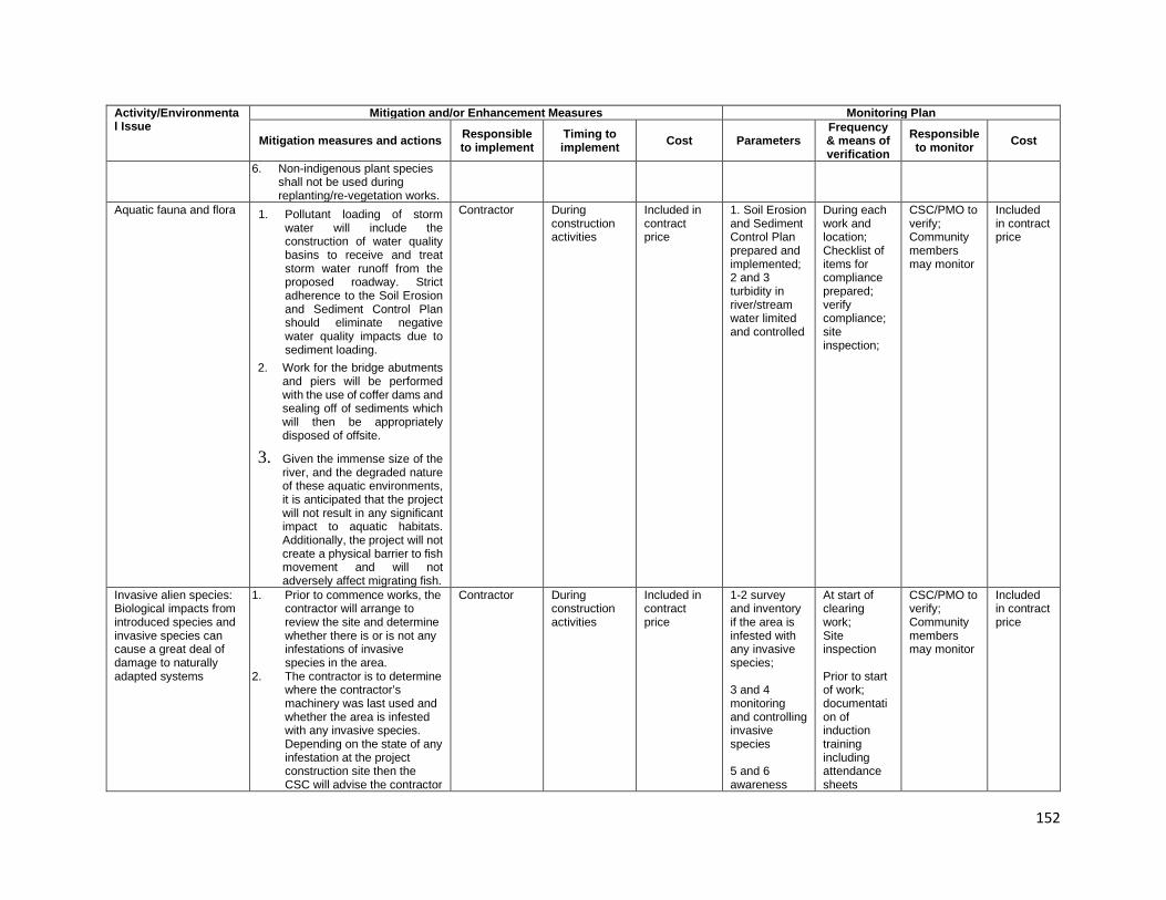
152
Activity/Environmental Issue
Mitigation and/or Enhancement Measures Monitoring Plan
Mitigation measures and actions Responsible to implement
Timing to implement Cost Parameters
Frequency & means of verification
Responsible to monitor Cost
6. Non-indigenous plant species shall not be used during replanting/re-vegetation works.
Aquatic fauna and flora 1. Pollutant loading of storm water will include the construction of water quality basins to receive and treat storm water runoff from the proposed roadway. Strict adherence to the Soil Erosion and Sediment Control Plan should eliminate negative water quality impacts due to sediment loading.
2. Work for the bridge abutments and piers will be performed with the use of coffer dams and sealing off of sediments which will then be appropriately disposed of offsite.
3. Given the immense size of the river, and the degraded nature of these aquatic environments, it is anticipated that the project will not result in any significant impact to aquatic habitats. Additionally, the project will not create a physical barrier to fish movement and will not adversely affect migrating fish.
Contractor During construction activities
Included in contract price
1. Soil Erosion and Sediment Control Plan prepared and implemented; 2 and 3 turbidity in river/stream water limited and controlled
During each work and location; Checklist of items for compliance prepared; verify compliance; site inspection;
CSC/PMO to verify; Community members may monitor
Included in contract price
Invasive alien species: Biological impacts from introduced species and invasive species can cause a great deal of damage to naturally adapted systems
1. Prior to commence works, the contractor will arrange to review the site and determine whether there is or is not any infestations of invasive species in the area.
2. The contractor is to determine where the contractor’s machinery was last used and whether the area is infested with any invasive species. Depending on the state of any infestation at the project construction site then the CSC will advise the contractor
Contractor During construction activities
Included in contract price
1-2 survey and inventory if the area is infested with any invasive species; 3 and 4 monitoring and controlling invasive species 5 and 6 awareness
At start of clearing work; Site inspection Prior to start of work; documentation of induction training including attendance sheets
CSC/PMO to verify; Community members may monitor
Included in contract price

153
Activity/Environmental Issue
Mitigation and/or Enhancement Measures Monitoring Plan
Mitigation measures and actions Responsible to implement
Timing to implement Cost Parameters
Frequency & means of verification
Responsible to monitor Cost
whether or not machinery must be cleaned before moving to the site. This includes the removal of any potential seed sources such as earth and organic material that may be attached to the machinery.
3. The contractor will be required to observe for any infestations.
4. Should infestations occur on construction sites that are due or are not due to the contractor’s activities the contractor will be required to control the infestation.
5. Invasive species shall not be used to revegetate cut slopes and replanting or compensatory tree planting that maybe required shall have full agreement of the local forest authorities.
6. Control and avoidance of the introduction of invasive species is the contractor’s responsibility and this also extends to any sub-contractors that are working under his control.
provided invasive species to employee, not to be replanting
Endangered species: rare and endangered species known may occur in the zone of the construction and can be affected
1. Regularly monitoring and maintain a database of the occurrence of rare and endangered species of plant or animal and take actions to avoid their disturbance during construction works through isolation of their habitats or adjustment of timing of works
Contractor During construction activities
Included in contract price
awareness and training provided to employee; monitoring undertaken
Prior to start of work; records of site inspections; records of sanctions imposed
CSC/PMO to verify; Community members may monitor
Included in contract price
Access and traffic safety: Movement of traffic and pedestrians through construction zones is hazardous due to irregular traffic
1. The Contractor(s) shall prepare a traffic management plan detailing temporary diversion where necessary and the associated management measures (reference can be
Contractor During construction activities
Included in contract price
1 traffic management plan prepared and approved;
Once for traffic management plan; daily visual observations;
CSC/PMO to verify; Community members may monitor
Included in contract price

154
Activity/Environmental Issue
Mitigation and/or Enhancement Measures Monitoring Plan
Mitigation measures and actions Responsible to implement
Timing to implement Cost Parameters
Frequency & means of verification
Responsible to monitor Cost
patterns, disturbed ground surfaces and excavations, Road safety during construction is reduced due to rapidly changing road conditions, loss of roadside furniture, warning systems and lighting.
made from DOW’s “Safe Traffic Control at Road Works Field Guide”);
2. Signs and other appropriate safety measures shall be provided on site to indicate construction works are being undertaken;
3. Local administration and village officials shall be consulted in the event that access to a village may be disrupted any time and temporary access arrangements provided accordingly;
4. Construction vehicles will use local access roads, or negotiate access with land owners to obtain access to material extraction sites; where local roads are used, these will be rehabilitated to their original condition after the completion of work;
5. Road safety protection shall be provided in the vicinity of the work site to protect the general public. This shall include advance notifications of commencement of works, installing safety barriers as necessary, and providing signages or markings on the work areas.
2 to 5 any complaints received; action taken in response; approvals from local/village administration and officials; cleanliness maintained; road safety protection devices provided and visible at all times;
Compliance verification to be done to ensure activities meet mitigation requirements
316. Occupation health and safety: The risk of spread of communicable disease is dealt
1. Safety measures as required by law and by good engineering practice shall be established and first aid facilities at work sites and in vehicles are likewise provided;
2. The Contractor(s) will instruct and induct all workers in health and safety matters (induction course) including construction
Contractor During construction activities
Included in contract price
1 requirements included in the tender documents, HSP as part of CEMP; 2 qualified EHSO provided;
Verify once during tendering and before start of site works; and throughout the project duration as required until site has been
CSC/PMO to verify; Community members may monitor
Included in contract price

155
Activity/Environmental Issue
Mitigation and/or Enhancement Measures Monitoring Plan
Mitigation measures and actions Responsible to implement
Timing to implement Cost Parameters
Frequency & means of verification
Responsible to monitor Cost
with in the next section Public safety, particularly of pedestrians and children can be threatened
camp rules and EHSO shall follow up with toolbox talks on a weekly basis. Workforce training for all workers starting on site will include safety and environmental hygiene;
3. In addition, workers shall receive a daily safety and work briefing (tool box talk) from the Contractor(s);
4. Workers shall be provided with appropriate personnel protection equipment (PPE) such as safety boots, helmets, reflector vest, gloves, protective clothes, dust mask, goggles, and ear protection at no cost to the workers. The Contractor will issue PPE on a daily basis to workers after the tool box talk;
5. Fencing will be installed on all areas of excavation greater than 1m deep, and on all sides of temporary works;
6. Reversing signals (visual and audible) shall be installed on all construction vehicles and equipment;
7. Potable water supply shall be provided and maintained at all times in the contractor’ camp and all its work locations;
8. Where worker exposure to traffic cannot be completely eliminated, protective barriers and warning signs shall be provided to shield workers from passing vehicles. Another measure is to install channelling devices (e.g., traffic cones and barrels) to delineate the work zone, and trained flag men at each end of the current working zone shall be provided to direct
3 and 4 induction training and daily toolbox provided and documented; 5 set of PPE provided to each worker; 6 fencing provided in deep excavations; 7 reversing signal provided in all vehicles; 8 potable water supply provided and maintained; 9 barriers and warning signs provided; 10 camps provided with toilets/sanitation facilities and treatment facilities; 11 sanitation and hygiene training provided and observed; 12 and 14 training
established; compliance to be checked; verify that EHSG measures meet requirements; site inspection

156
Activity/Environmental Issue
Mitigation and/or Enhancement Measures Monitoring Plan
Mitigation measures and actions Responsible to implement
Timing to implement Cost Parameters
Frequency & means of verification
Responsible to monitor Cost
traffic movement in and around work areas; and
9. Construction camps shall be provided with toilets/sanitation facilities in accordance with local regulations to prevent any hazard to public health or contamination of land, surface or groundwater. These facilities shall be well maintained and cleaned regularly to encourage use and emptied regularly to prevent overflows.
10. First aid facilities shall be provided at the work sites, in vehicles;
11. The contractor(s) shall conduct training for all workers on safety and environmental hygiene at no cost to the employees;
12. Instruction and induction of all workers shall be carried out for all workers before they start work in health and safety matters, including road safety; construction camp rules;
13. Assigned safety monitors will follow up with toolbox talks on a weekly basis;
14. Workers shall receive daily safety and work briefing from contractor called the toolbox talk.
conducted; toolbox talks conducted weekly; records of toolbox talks maintained and documented in monthly reports
HIV/AIDS/STIs Quantity people having HIV/ADIS by un-control relationships between indigenous peoples and worker may be increasing
1. Screen all persons to be engaged on the project for HIV/AIDS/STIs as part of the induction of personnel to be engaged;
2. Implement a HIV/AIDS awareness program as part of the occupational health and safety training provided to personnel on the project;
Contractor
During construction activities
Included in contract price
1 Screen for staff and workers conducted; 2 awareness program prepared and implemented; 3 and 4 necessary materials and
Site inspection; Checklist of items for compliance prepared; verify compliance
CSC/PMO to verify;
Included in contract price
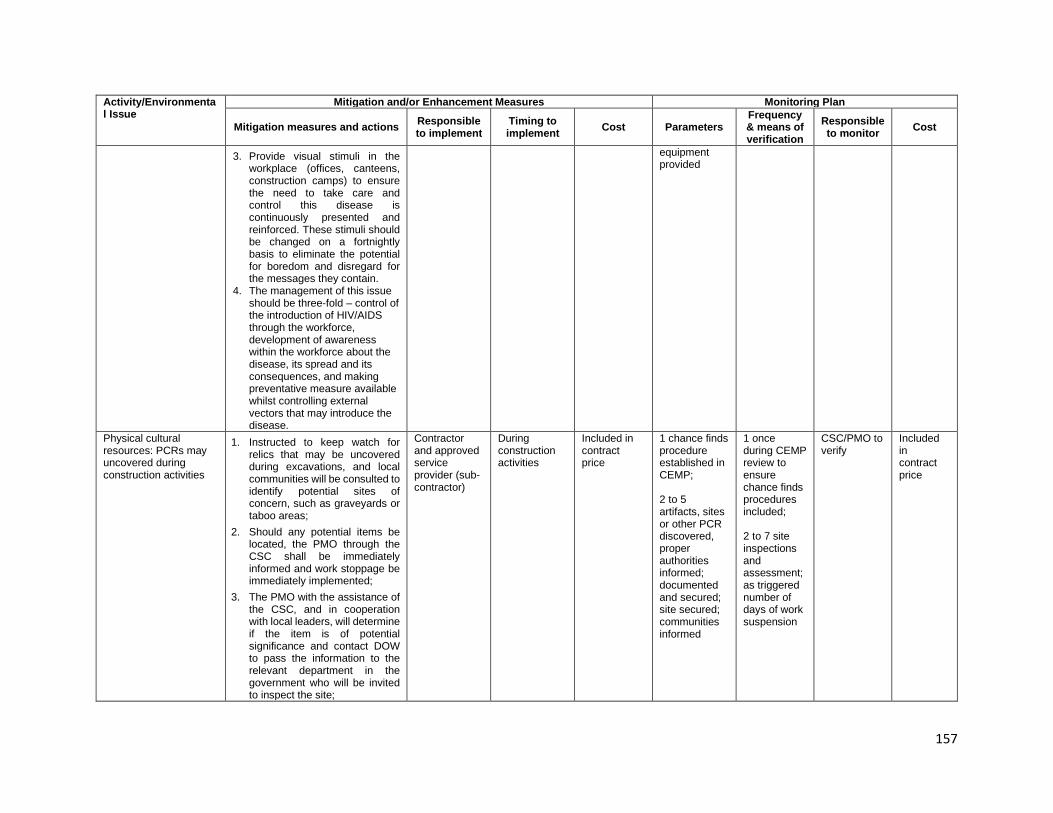
157
Activity/Environmental Issue
Mitigation and/or Enhancement Measures Monitoring Plan
Mitigation measures and actions Responsible to implement
Timing to implement Cost Parameters
Frequency & means of verification
Responsible to monitor Cost
3. Provide visual stimuli in the workplace (offices, canteens, construction camps) to ensure the need to take care and control this disease is continuously presented and reinforced. These stimuli should be changed on a fortnightly basis to eliminate the potential for boredom and disregard for the messages they contain.
4. The management of this issue should be three-fold – control of the introduction of HIV/AIDS through the workforce, development of awareness within the workforce about the disease, its spread and its consequences, and making preventative measure available whilst controlling external vectors that may introduce the disease.
equipment provided
Physical cultural resources: PCRs may uncovered during construction activities
1. Instructed to keep watch for relics that may be uncovered during excavations, and local communities will be consulted to identify potential sites of concern, such as graveyards or taboo areas;
2. Should any potential items be located, the PMO through the CSC shall be immediately informed and work stoppage be immediately implemented;
3. The PMO with the assistance of the CSC, and in cooperation with local leaders, will determine if the item is of potential significance and contact DOW to pass the information to the relevant department in the government who will be invited to inspect the site;
Contractor and approved service provider (sub-contractor)
During construction activities
Included in contract price
1 chance finds procedure established in CEMP; 2 to 5 artifacts, sites or other PCR discovered, proper authorities informed; documented and secured; site secured; communities informed
1 once during CEMP review to ensure chance finds procedures included; 2 to 7 site inspections and assessment; as triggered number of days of work suspension
CSC/PMO to verify
Included in contract price

158
Activity/Environmental Issue
Mitigation and/or Enhancement Measures Monitoring Plan
Mitigation measures and actions Responsible to implement
Timing to implement Cost Parameters
Frequency & means of verification
Responsible to monitor Cost
4. Work shall stop to allow time for inspection, removal or in-situ preservation of the PCR and until the relevant government agency indicates works can re-commence; and
5. Until the government has responded to this invitation, work will not re-commence in this location until agreement has been reached with the government and PMO as to any required mitigation measures.
Social conflicts: Presence of construction workers may affect community structure and patterns and conflict with local people
1. Consider the location of construction camps away from communities in order to avoid social conflict in using resources and basic amenities such as water supply,
2. Maximize number of local people employed in construction works,
3. Maximize goods and services sourced from local commercial enterprises.
Contract During construction activities
As per agreements
1 Construction camps far from 2 communities; Number local people working in the subproject; 3 Using goods and services sourced
Visual assessment, Review documents
CSC/PMO to verify; Community members to monitor
Included in contract price
Impacts on sources of livelihood and Modified market patterns: Changes resulting from the induced demands of the construction project may create a false market economy for the duration of the project which affects those least able to pay for commodities in the community
1. An income restoration program to help the severely affected and vulnerable households rebuild their sources of livelihood will be prepared and implemented.
DOW/PMO, Contractor
During excavation works
Included in contact price
1 an assistance program prepared an implemented
Review project document
CSC/PMO to verify
Included in contract price
OPERATION STAGE Greenhouse gas emissions: Increase road capacity will lead to higher speeds and use of the road section by heavier vehicles
1. The maintenance of free traffic flow will reduce the
DOW
Bridge operation
DOW operating cost
Volume of vehicles operation; increased speed of vehicles
Regular inspections, and spot checks
DOW-ESSB DOW operating cost

159
Activity/Environmental Issue
Mitigation and/or Enhancement Measures Monitoring Plan
Mitigation measures and actions Responsible to implement
Timing to implement Cost Parameters
Frequency & means of verification
Responsible to monitor Cost
volume of greenhouse gas emitted. Traffic management mechanisms should be used to ensure speed differentiation between classes of vehicles does not reduce freedom of movement for vehicles
Air quality - particulate emissions: Particulate generation resulting from exhaust emissions and dust created by poorly covered and badly fitting bodies depositing materials on the road. Air emissions will occur as a result of exhaust emissions.
2. Regular checks on vehicles using the road shall be undertaken and those vehicles with poorly fitted bodies, load spillage and excessive exhaust emissions shall be removed from service until repaired.
DOW
During specific maintenance works and vegetation control; emergency repairs of landslide prone areas; routine maintenance works
DOW operating cost
Volume of materials handled and hauled out; cleanliness of surrounding
During conduct of maintenance works; regular inspections, and spot checks
DOW-ESSU DOW operating cost
Water quality and pollutants: The use of the bridges by vehicles transporting and hazardous material spills if crashes on bridges potentially
1. The use of the bridges by vehicles transporting and hazardous material spills if crashes on bridges potentially contaminating materials produces a potential risk of pollution of watercourses and drain structures along the road.
DOW/CEPA
As the Government may require
DOW operating cost
Written and verbal complaints from community
Duration of operation; Spot checks; complaints from the community
DOW -ESSU
DOW operating cost

160
Activity/Environmental Issue
Mitigation and/or Enhancement Measures Monitoring Plan
Mitigation measures and actions Responsible to implement
Timing to implement Cost Parameters
Frequency & means of verification
Responsible to monitor Cost
contaminating materials produces a potential risk of pollution of watercourses and drain structures along the road. General runoff from the road also adds to the deterioration of the water quality
General runoff from the road also adds to the deterioration of the water quality
Road noise: Increased traffic volumes, vehicle sizes and operating speed will increase traffic noise on the highway
1. Reduce speed limits, regularly check the competence of vehicle exhausts and enforce restrictions on use of horns and vehicle noise standards in areas sensitive to road noise, such as schools and hospitals.
DOW/CEPA
During routine maintenance works
DOW operating cost
Written and verbal complaints from community; accident/incident registry maintained by authorities
Duration of operation; Spot checks; compiled data
DOW-ESSB
DOW operating cost
River-bank and scour protection: Rip-rap, gabion baskets will be used appropriately to protect abutments and river-banks up and downstream. These structures may be damaged due to storm water or human activities
2. The frequency of preventive maintenance inspections and implementation of sustained maintenance on designed structures will be increased. A system of monitoring, reporting and maintenance shall be developed consistent with the concept of this investment subproject
DOW/CEPA
During routine maintenance works
DOW operating cost
Written and verbal complaints from community; accident/incident registry maintained by authorities
Duration of operation; Spot checks; compiled data
DOW DOW operating cost
Morphology and Hydrologic Regime: The change in the longitudinal profile by bridge construction, bank improvement and training works will result to change the hydrodynamics and may also change current
3. The River Management Stations will regularly monitor and keep track of erosion status of rivers and report to DOW for maintenance and on time actions
DOW/CEPA
During routine maintenance works
DOW operating cost
Written and verbal complaints from community; accident/incident registry maintained by authorities
Duration of operation; Spot checks; compiled data
DOW DOW operating cost
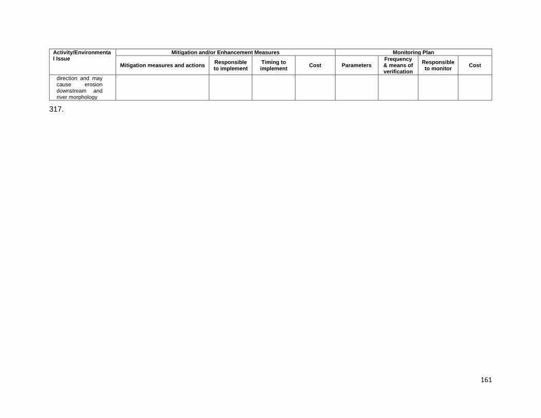
161
Activity/Environmental Issue
Mitigation and/or Enhancement Measures Monitoring Plan
Mitigation measures and actions Responsible to implement
Timing to implement Cost Parameters
Frequency & means of verification
Responsible to monitor Cost
direction and may cause erosion downstream and river morphology
317.

162
Table 9-5: Environmental Management Plan for Repair/Reinforcement of Existing Bridges (23 Bridges) Activity/Environmental Issue
Mitigation and/or Enhancement Measures Monitoring Plan
Mitigation measures and actions Responsible to implement
Timing to implement Cost Parameters
Frequency & means of verification
Responsible to monitor Cost
REPAIR/REINFORCEMENT STAGE Air quality and particulates: Dust and air emissions from vehicles, equipment and machines
9. A regular vehicle preventive maintenance and repair program shall be implemented to reduce emission of fumes from exhaust pipes;
10. Diesel generating sets will be fitted with adequate stack height; and
11. Low-sulphur diesel will be used in generator sets as well as other machinery
12. Open burning of solid wastes (plastic, paper, organic matters) will be prohibited;
Contractor Before and during construction activities
Included in contract price
1-3 compliance with locational requirements and anti-pollution devices installed; 4 any smoke observed from burning;
Daily visual monitoring as determined by wind and site conditions;
CSC/PMO to verify; community members to monitor
Included in contract price
Noise: Noise from equipment delivering, spreading, laying
12. Silencers will be installed in construction equipment and machinery and maintained properly at all times;
13. Equipment and machinery with lower sound levels will be selected for the construction activities;
14. Protection devices such as ear plugs or ear muffs will be provided to the workers during period of operating high noise generating machines;
15. Noise levels will be regularly measured during the peak of construction period in particular using portable noise meters to ensure the effectiveness of mitigation measures;
16. Noise generation activities may be carried out between 7 am to 7 pm only to avoid disturbance to nearby communities at night and ideally should not exceed 45 dBA measured at the outside
Contractor During construction activities
Included in contract price
1 presence of natural breaks; 2 muffled equipment; 3 PPE provided; 4 and 5 peak construction activities identified; noise meters made available; complaints received from community if work activities carried out beyond prescribed period;
Site inspection to verify locational requirements compliance; checklist of items to be monitored is prepared and used to check off items of concern;
CSC/PMO to verify; Community members to monitor ambient noise
Included in contract price
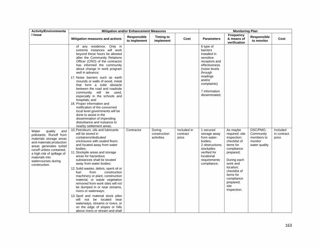
163
Activity/Environmental Issue
Mitigation and/or Enhancement Measures Monitoring Plan
Mitigation measures and actions Responsible to implement
Timing to implement Cost Parameters
Frequency & means of verification
Responsible to monitor Cost
of any residence. Only in extreme instances will work beyond these hours be allowed after the Community Relations Officer (CRO) of the contractor has informed the community about change in work program well in advance;
17. Noise barriers such as earth mounds or walls of wood, metal that form a solid obstacle between the road and roadside community will be used, especially in the schools and hospitals; and
18. Proper information and notification of the concerned local level governments will be done to assist in the dissemination of impending disturbance and nuisance to nearby settlement areas.
6 type of barriers installed in sensitive receptors and effectiveness (noise levels through readings and/or complaints) 7 information disseminated;
Water quality and pollutants: Runoff from materials storage areas and materials production areas generates turbid runoff unless contained, a high risk of spillage of materials into watercourses during construction.
10. Petroleum, oils and lubricants will be stored in containers/dedicated enclosures with sealed floors and located away from water bodies;
11. Stockpile areas and storage areas for hazardous substances shall be located away from water bodies;
12. Solid wastes, debris, spent oil or fuel from construction machinery or plant, construction material, or waste vegetation removed from work sites will not be dumped in or near streams, rivers or waterways;
13. Spoil and material stock piles will not be located near waterways, streams or rivers, or on the edge of slopes or hills above rivers or stream and shall
Contractor During construction activities
Included in contract price
1 secured storage away from water-bodies; 2 obstructions; stockpiles verified for locational requirements compliance;
As maybe required; site inspection; checklist of items for compliance prepared; During each work and location; checklist of items for compliance prepared; site inspection;
DSC/PMO, Community members to monitor water quality
Included in contract price
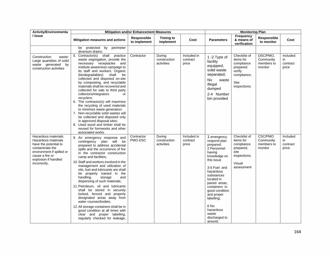
164
Activity/Environmental Issue
Mitigation and/or Enhancement Measures Monitoring Plan
Mitigation measures and actions Responsible to implement
Timing to implement Cost Parameters
Frequency & means of verification
Responsible to monitor Cost
be protected by perimeter diversion drains;
Construction waste: Large quantities of solid waste generated by construction activities
5. Contractor(s) shall practice waste segregation, provide the necessary receptacles and institute awareness campaign to its staff and workers. Organic (biodegradables) shall be collected and disposed on-site by composting, and recyclable materials shall be recovered and collected for sale to third party collectors/integrators or recyclers;
6. The contractor(s) will maximize the recycling of used materials to minimize waste generation;
7. Non-recyclable solid wastes will be collected and disposed only in approved disposal sites;
8. Used wood and timber shall be reused for formworks and other associated works.
Contractor
During construction activities
Included in contract price
1 -2 Type of facility equipped, solid waste separated; No waste illegal dumped 2-4 Number bin provided
Checklist of items for compliance prepared; verify compliance; Site inspections;
DSC/PMO, Community members to monitor
Included in contract price
Hazardous materials: Hazardous materials have the potential to contaminate the environment if spilled or cause a fire or explosion if handled incorrectly.
9. An emergency response and contingency plan will be prepared to address accidental spills and the occurrence of fire in the contractor construction camp and facilities;
10. Staff and workers involved in the management and utilization of oils, fuel and lubricants are shall be properly trained in the handling, storage and dispensing of such materials;
11. Petroleum, oil and lubricants shall be stored in securely locked, fenced and properly designated areas away from water courses/bodies;
12. All storage containers shall be in good condition at all times with clear and proper labelling, regularly checked for leakage,
Contractor PMO-DSC
During construction activities
Included in contract price
1 emergency respond plan prepared; 2 Personnel having knowledge on this issue 3-5 Fuel and hazardous substances located in paved areas, containers in good condition and proper labelling; 6 No hazardous waste discharged to around;
Checklist of items for compliance prepared; site inspections; Visual assessment
CSC/PMO Community members to monitor
Included in contract price

165
Activity/Environmental Issue
Mitigation and/or Enhancement Measures Monitoring Plan
Mitigation measures and actions Responsible to implement
Timing to implement Cost Parameters
Frequency & means of verification
Responsible to monitor Cost
and repaired or replaced as necessary;
13. The Contractor(s) shall be required to display safety information in all work areas and to train workers in the safe use of hazardous materials, including the provision of protective equipment;
14. Hazardous materials shall be stored in areas free from floods at all times; and discharge of oil-contaminated water to nearby waterways shall be prohibited;
15. Spill clean-up materials (e.g., specifically designed for petroleum products and others) shall be available at all times in adequate quantities in the same storage areas;
16. When spillage occurs, the Contractor(s) shall immediately report to the CSC and cleaned with utmost caution by properly trained personnel
7-8 necessary material and equipment provided
Aquatic fauna and flora 4. Pollutant loading of storm water will include the construction of water quality basins to receive and treat storm water runoff from the proposed roadway. Strict adherence to the Soil Erosion and Sediment Control Plan should eliminate negative water quality impacts due to sediment loading.
Contractor During construction activities
Included in contract price
1. Soil Erosion and Sediment Control Plan prepared and implemented;
During each work and location; Checklist of items for compliance prepared; verify compliance; site inspection;
CSC/PMO to verify; Community members may monitor
Included in contract price
Access and traffic safety: Movement of traffic and pedestrians through construction zones is hazardous due to irregular traffic patterns, disturbed
6. The Contractor(s) shall prepare a traffic management plan detailing temporary diversions where necessary and the associated management measures (reference can be made from DOW’s “Safe Traffic
Contractor During construction activities
Included in contract price
1 traffic management plan prepared and approved; 2 to 5 any complaints
Once for traffic management plan; daily visual observations;
CSC/PMO to verify; Community members may monitor
Included in contract price
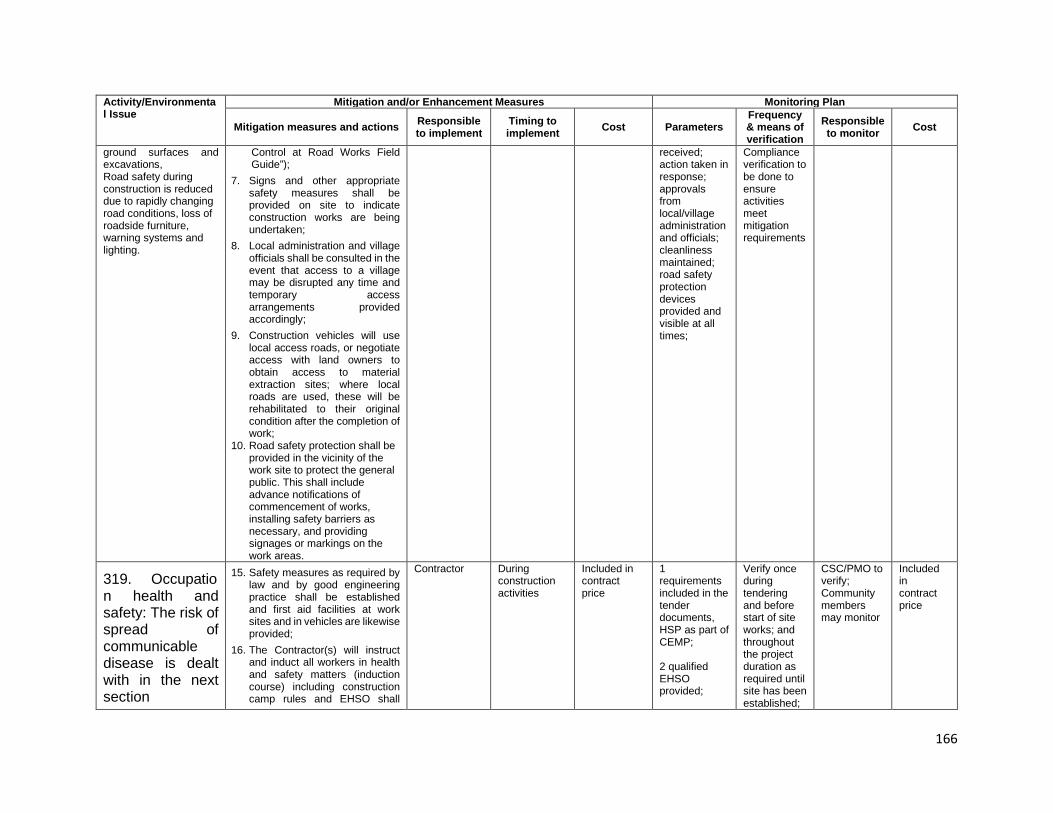
166
Activity/Environmental Issue
Mitigation and/or Enhancement Measures Monitoring Plan
Mitigation measures and actions Responsible to implement
Timing to implement Cost Parameters
Frequency & means of verification
Responsible to monitor Cost
ground surfaces and excavations, Road safety during construction is reduced due to rapidly changing road conditions, loss of roadside furniture, warning systems and lighting.
Control at Road Works Field Guide”);
7. Signs and other appropriate safety measures shall be provided on site to indicate construction works are being undertaken;
8. Local administration and village officials shall be consulted in the event that access to a village may be disrupted any time and temporary access arrangements provided accordingly;
9. Construction vehicles will use local access roads, or negotiate access with land owners to obtain access to material extraction sites; where local roads are used, these will be rehabilitated to their original condition after the completion of work;
10. Road safety protection shall be provided in the vicinity of the work site to protect the general public. This shall include advance notifications of commencement of works, installing safety barriers as necessary, and providing signages or markings on the work areas.
received; action taken in response; approvals from local/village administration and officials; cleanliness maintained; road safety protection devices provided and visible at all times;
Compliance verification to be done to ensure activities meet mitigation requirements
319. Occupation health and safety: The risk of spread of communicable disease is dealt with in the next section
15. Safety measures as required by law and by good engineering practice shall be established and first aid facilities at work sites and in vehicles are likewise provided;
16. The Contractor(s) will instruct and induct all workers in health and safety matters (induction course) including construction camp rules and EHSO shall
Contractor During construction activities
Included in contract price
1 requirements included in the tender documents, HSP as part of CEMP; 2 qualified EHSO provided;
Verify once during tendering and before start of site works; and throughout the project duration as required until site has been established;
CSC/PMO to verify; Community members may monitor
Included in contract price
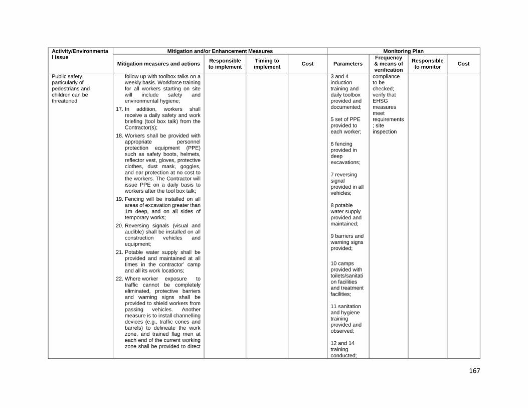
167
Activity/Environmental Issue
Mitigation and/or Enhancement Measures Monitoring Plan
Mitigation measures and actions Responsible to implement
Timing to implement Cost Parameters
Frequency & means of verification
Responsible to monitor Cost
Public safety, particularly of pedestrians and children can be threatened
follow up with toolbox talks on a weekly basis. Workforce training for all workers starting on site will include safety and environmental hygiene;
17. In addition, workers shall receive a daily safety and work briefing (tool box talk) from the Contractor(s);
18. Workers shall be provided with appropriate personnel protection equipment (PPE) such as safety boots, helmets, reflector vest, gloves, protective clothes, dust mask, goggles, and ear protection at no cost to the workers. The Contractor will issue PPE on a daily basis to workers after the tool box talk;
19. Fencing will be installed on all areas of excavation greater than 1m deep, and on all sides of temporary works;
20. Reversing signals (visual and audible) shall be installed on all construction vehicles and equipment;
21. Potable water supply shall be provided and maintained at all times in the contractor’ camp and all its work locations;
22. Where worker exposure to traffic cannot be completely eliminated, protective barriers and warning signs shall be provided to shield workers from passing vehicles. Another measure is to install channelling devices (e.g., traffic cones and barrels) to delineate the work zone, and trained flag men at each end of the current working zone shall be provided to direct
3 and 4 induction training and daily toolbox provided and documented; 5 set of PPE provided to each worker; 6 fencing provided in deep excavations; 7 reversing signal provided in all vehicles; 8 potable water supply provided and maintained; 9 barriers and warning signs provided; 10 camps provided with toilets/sanitation facilities and treatment facilities; 11 sanitation and hygiene training provided and observed; 12 and 14 training conducted;
compliance to be checked; verify that EHSG measures meet requirements; site inspection
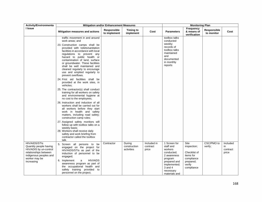
168
Activity/Environmental Issue
Mitigation and/or Enhancement Measures Monitoring Plan
Mitigation measures and actions Responsible to implement
Timing to implement Cost Parameters
Frequency & means of verification
Responsible to monitor Cost
traffic movement in and around work areas; and
23. Construction camps shall be provided with toilets/sanitation facilities in accordance with local regulations to prevent any hazard to public health or contamination of land, surface or groundwater. These facilities shall be well maintained and cleaned regularly to encourage use and emptied regularly to prevent overflows.
24. First aid facilities shall be provided at the work sites, in vehicles;
25. The contractor(s) shall conduct training for all workers on safety and environmental hygiene at no cost to the employees;
26. Instruction and induction of all workers shall be carried out for all workers before they start work in health and safety matters, including road safety; construction camp rules;
27. Assigned safety monitors will follow up with toolbox talks on a weekly basis;
28. Workers shall receive daily safety and work briefing from contractor called the toolbox talk.
toolbox talks conducted weekly; records of toolbox talks maintained and documented in monthly reports
HIV/AIDS/STIs Quantity people having HIV/ADIS by un-control relationships between indigenous peoples and worker may be increasing
5. Screen all persons to be engaged on the project for HIV/AIDS/STIs as part of the induction of personnel to be engaged;
6. Implement a HIV/AIDS awareness program as part of the occupational health and safety training provided to personnel on the project;
Contractor
During construction activities
Included in contract price
1 Screen for staff and workers conducted; 2 awareness program prepared and implemented; 3 and 4 necessary materials and
Site inspection; Checklist of items for compliance prepared; verify compliance
CSC/PMO to verify;
Included in contract price

169
Activity/Environmental Issue
Mitigation and/or Enhancement Measures Monitoring Plan
Mitigation measures and actions Responsible to implement
Timing to implement Cost Parameters
Frequency & means of verification
Responsible to monitor Cost
7. Provide visual stimuli in the workplace (offices, canteens, construction camps) to ensure the need to take care and control this disease is continuously presented and reinforced. These stimuli should be changed on a fortnightly basis to eliminate the potential for boredom and disregard for the messages they contain.
8. The management of this issue should be three-fold – control of the introduction of HIV/AIDS through the workforce, development of awareness within the workforce about the disease, its spread and its consequences, and making preventative measure available whilst controlling external vectors that may introduce the disease.
equipment provided
Social conflicts: Presence of construction workers may affect community structure and patterns and conflict with local people
4. Consider the location of construction camps away from communities in order to avoid social conflict in using resources and basic amenities such as water supply,
5. Maximize number of local people employed in construction works,
6. Maximize goods and services sourced from local commercial enterprises.
Contract During construction activities
As per agreements
1 Construction camps far from 2 communities; Number local people working in the subproject; 3 Using goods and services sourced
Visual assessment, Review documents
CSC/PMO to verify; Community members to monitor
Included in contract price
OPERATION STAGE Greenhouse gas emissions: Increase road capacity will lead to higher speeds and use of the road section by heavier vehicles
3. The maintenance of free traffic flow will reduce the volume of greenhouse gas emitted. Traffic
DOW
Bridge operation
DOW operating cost
Volume of vehicles operation; increased speed of vehicles
Regular inspections, and spot checks
DOW-ESSB DOW operating cost

170
Activity/Environmental Issue
Mitigation and/or Enhancement Measures Monitoring Plan
Mitigation measures and actions Responsible to implement
Timing to implement Cost Parameters
Frequency & means of verification
Responsible to monitor Cost
management mechanisms should be used to ensure speed differentiation between classes of vehicles does not reduce freedom of movement for vehicles
Air quality - particulate emissions: Particulate generation resulting from exhaust emissions and dust created by poorly covered and badly fitting bodies depositing materials on the road. Air emissions will occur as a result of exhaust emissions.
4. Regular checks on vehicles using the road shall be undertaken and those vehicles with poorly fitted bodies, load spillage and excessive exhaust emissions shall be removed from service until repaired.
DOW
During specific maintenance works and vegetation control; emergency repairs of landslide prone areas; routine maintenance works
DOW operating cost
Volume of materials handled and hauled out; cleanliness of surrounding
During conduct of maintenance works; regular inspections, and spot checks
DOW-ESSU DOW operating cost
Water quality and pollutants: The use of the bridges by vehicles transporting and hazardous material spills if crashes on bridges potentially contaminating materials produces a potential risk of pollution of
2. The use of the bridges by vehicles transporting and hazardous material spills if crashes on bridges potentially contaminating materials produces a potential risk of pollution of watercourses and drain structures along the road. General runoff from the road also adds to the deterioration of the water quality
DOW/CEPA
As the Government may require
DOW operating cost
Written and verbal complaints from community
Duration of operation; Spot checks; complaints from the community
DOW -ESSU
DOW operating cost
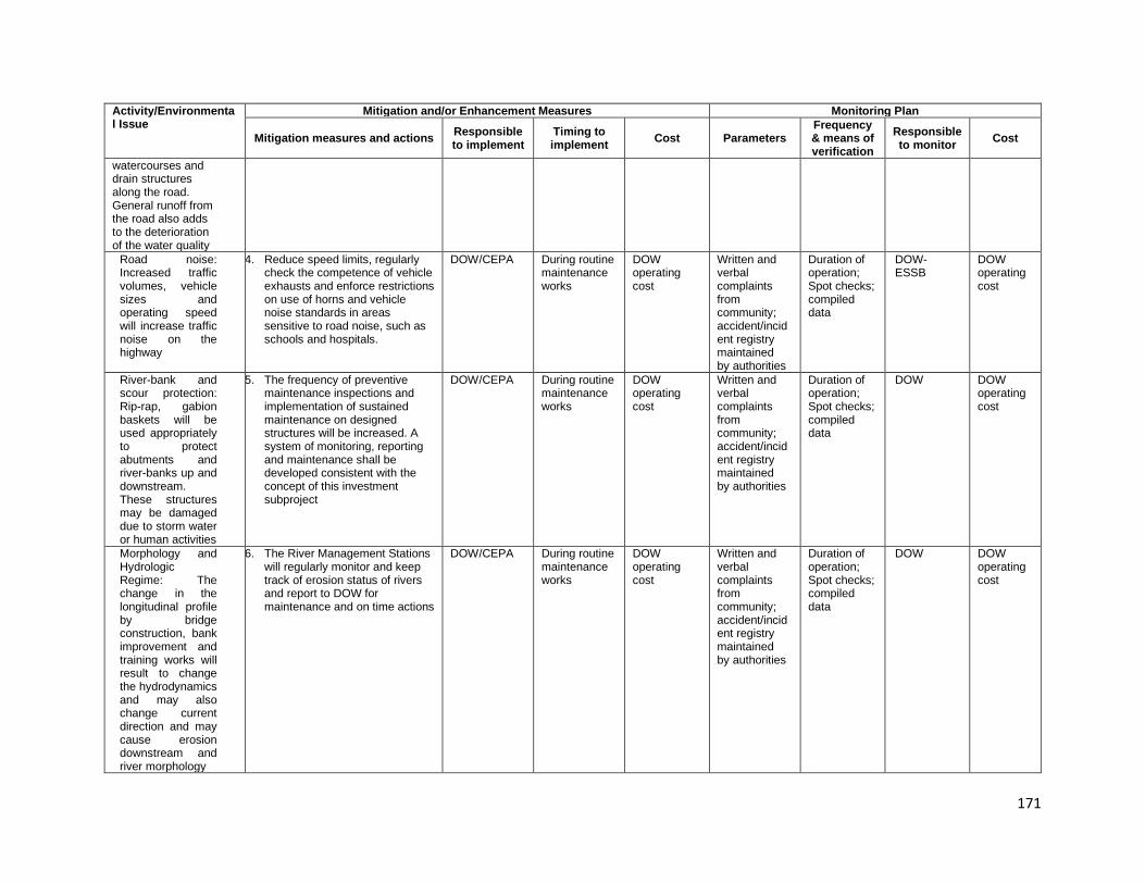
171
Activity/Environmental Issue
Mitigation and/or Enhancement Measures Monitoring Plan
Mitigation measures and actions Responsible to implement
Timing to implement Cost Parameters
Frequency & means of verification
Responsible to monitor Cost
watercourses and drain structures along the road. General runoff from the road also adds to the deterioration of the water quality
Road noise: Increased traffic volumes, vehicle sizes and operating speed will increase traffic noise on the highway
4. Reduce speed limits, regularly check the competence of vehicle exhausts and enforce restrictions on use of horns and vehicle noise standards in areas sensitive to road noise, such as schools and hospitals.
DOW/CEPA
During routine maintenance works
DOW operating cost
Written and verbal complaints from community; accident/incident registry maintained by authorities
Duration of operation; Spot checks; compiled data
DOW-ESSB
DOW operating cost
River-bank and scour protection: Rip-rap, gabion baskets will be used appropriately to protect abutments and river-banks up and downstream. These structures may be damaged due to storm water or human activities
5. The frequency of preventive maintenance inspections and implementation of sustained maintenance on designed structures will be increased. A system of monitoring, reporting and maintenance shall be developed consistent with the concept of this investment subproject
DOW/CEPA
During routine maintenance works
DOW operating cost
Written and verbal complaints from community; accident/incident registry maintained by authorities
Duration of operation; Spot checks; compiled data
DOW DOW operating cost
Morphology and Hydrologic Regime: The change in the longitudinal profile by bridge construction, bank improvement and training works will result to change the hydrodynamics and may also change current direction and may cause erosion downstream and river morphology
6. The River Management Stations will regularly monitor and keep track of erosion status of rivers and report to DOW for maintenance and on time actions
DOW/CEPA
During routine maintenance works
DOW operating cost
Written and verbal complaints from community; accident/incident registry maintained by authorities
Duration of operation; Spot checks; compiled data
DOW DOW operating cost

172
173
D. Environmental Claims and Penalty System 320. As part of the compliance framework, if non-compliance with environmental safeguards regulations are discovered by CSC during the site supervision, 2% values of interim payment of the Contractor of this month will be held back. The Contractor will be given a grace period (determined by CSC) to repair the violation. If the Contractor performs the repairs within the grace period (confirmed by CSC), no penalty is incurred and keeping money will be pay for the next month. However, if the Contractor fails to successfully make the necessary repairs within the grace period, the Contractor will pay the cost for a third party to repair the damages (deduction from keeping money). 321. In case of SCS not detected of non-compliance with environmental safeguards regulations of the Contractor, they will be responsibility payment to repair the violation. E. Estimated Budget for EMP Implementation
1. Supervision of EMP Implementation by CSC 322. The cost for CSC to supervise EMP implementation in accordance with the EMP and the project bidding and contractual documents is integrated in the contract package with the CSC. Potential bidder for this package will be responsible to study environmental management requirements of the EIA and EMP to prepare and offer cost estimation for EMP supervision during the construction. It is considered as one of the criteria for assessing the capability of the potential CSC in supervising EMP implementation.
2. Implementation of EMP by Contractor 323. The cost for organization, training, dissemination, procurement, operation of equipment, and labour for implementation of mitigation measures in and out of the site in accordance with the EMP and project bidding and contractual document requirements is integrated in the construction package. Contractor(s) will be responsible to study, prepare alternatives and offer cost estimation for these activities. The Contractor can refer the cost estimation for the environmental quality monitoring program as Annex D. 324. It is considered as one of the criteria for assessing the capacity of the Contractor in the future and compliance level of the Contractor. In case of violations, the Client can impose penalties or hire other unit to participate in solving arising problems.
174
10. CONCLUSIONS AND RECOMMENDATION
325. The IEE Volume 1 bridges were conducted at during the feasibility study using a screening process to determine the extent and type of environmental impact during each phase of the project--preconstruction, construction and operation. 326. Based on the information and data collected at this stage, this report has outlined and identified potential direct, indirect, cumulative and induced impacts and risks of the project, the sources of new nuisances, analyses and clearly indicates negative impacts in each phase of this project:
i. Pre-construction phase: main impacts are removal of some vegetation and negligible run-off, noise, vibration and emissions from machinery and vehicles during establishment of the contractors’ camp, concrete plants, quarrying, stockpiling and storage of material.
ii. Construction phase: based on the analysis and forecast on impacts and risk of potential pollution, this report has indicated that main impacts are air quality and particulates, construction waste, water quality and pollutants, soil erosion, safety, removal of unsuitable materials, construction of bridges, and production and storage of materials.
iii. Operation phase: main impacts are road safety and noise from the road traffic. The new bridges are expected to reduce traffic accidents due to better signing and other safety features, and refuse noise due to new bridge decks and replacement of steel bridges.
327. By using the conceptual model, as described in section V, to assess cumulative environmental impacts, the IEE revealed that the project has 11activities that will have a “high impact”, 50 activities will have a “medium impact” and 66 activities will have a “low impact” on the physical environment, biological environment and socio-economic environment. The scale of these impacts will be assessed in further during the Detailed Design phase. At present, the IEE reveals that there are no significant and irreversible environmental impacts. Most bridges (40 bridges) are located in remote areas. Homes, businesses, vegetable plots, etc. at other bridge sites are located more than 100m from each end of the bridge. Therefore, construction impacts such as noise, air pollution, and vibration on the communities will be minimal, yet the contractor is required to implement measures to ensure these impacts are kept to a minimum. The highest impact will be from runoff of material from embankment construction, removal and constructing bridge piers. The communities downstream that use the rivers for washing and drinking water may be affected by the runoff. Special measures and procedures are proposed in the EMP for addressing this impact. 328. The type of works identified in the Feasibility Study stage of the Package 1 of SHHIP-Tranche 2 include (i) in-situ replacement bridge construction at existing locations, (ii) relocation bridge construction at new locations, and (iii) repair/reinforcement of existing bridges. The Environmental Management Plans (EMPs) are prepared for three (3) major activities, as depicted in Table 9-3, Table 9-4, and Table 9-5. Following stages of Detailed Engineering Design, these EMPs will be developed to be specific at each bridge location. 329. The IEE specifies the institutional responsibilities required for the environmental management of the Volume 1 of SHHIP-Tranche 2. The DOW/PMO will be responsible for implementing the EMP with the assistance of the Construction Supervision Consultant(s). 330. CEPA, local authority and local community should regularly inspect and monitor the environmental commitment of the project owner and the contractor(s) as well as coordinate to solve environmental problems arising during Package 1 of SHHIP-Tranche 2 implementation.
175
ANNEXES Annex A: List of Bridges for SHHIP-Tranche 2 Annex B: List of International Treaties and Agreements to which PNG is a signatory Annex C: Results of Ecological Survey Undertaken by SHHIP Team and Research & Conservation Foundation (Goroka, EHP) in December 2019 Annex D: Cost Estimated for Environment Quality Monitoring,
Annex E: Location Map of Package 1 for Environmental Quality Monitoring Annex F: Public Consultation Meetings Annex G: References

176
Annex A: List of Bridges for SHHIP-Tranche 2
No. BR. Name Drawing STA
Length (m)
Width (m) Lane
Grade Evaluation
Engineer’ Final Recommendation
1 Erap River Bridge 46+500 76 (25.5+25+25.5) 10.0 2 331. D New Bridge
2 Maralumi River Bridge 55+600 29.0 10.0 2
B New Bridge
3 Ramu River Bridge 64+400 30.5 (1span) 9.5 2 C
New Bridge
4 Clean Water River Bridge 77+800 29.0 ([email protected]) 10.0 2
B Repair, Reinforcement
5 Leron River Bridge 100+300 143.9 (55.6+46.3+42) 9.0 2
B Repair, Reinforcement
6 GorambamPam River Bridge 113+000 61.2
(20.6+20+20.6) 10.0 2 B Repair,
Reinforcement
7 Ngaraburam River Bridge 116+350 21.1 (1 span) 10.0 2
B Repair, Reinforcement
8 Little Maniang River Bridge 120+450 21.0 (1 Span) 10.0 2
B Repair, Reinforcement
9 Mutsing River Bridge 122+600 61.2 (20.6+20+20.6) 10.0 2
C Repair, Reinforcement
10 Zumin River Bridge 133+000 68 (2@34) 10.0 2 D
(Baily bridge)
New Bridge
11 Yafatz River Bridge 137+100 21.0 (1 span) 9.9 2 B Repair,
Reinforcement
12 Umi River Bridge 140+500 160 ([email protected]) 9.9 2 B Repair,
Reinforcement
13 Bintia River Bridge 151+000 29.0 ([email protected]) 10.0 2 C Repair,
Reinforcement
14 Ohman River Bridge 153+000 21.0 (1 span) 10.0 2 C Repair,
Reinforcement
15 Utwini River Bridge 157+150 21.0 (1 span) 10.0 2 B Repair,
Reinforcement
16
Bitjia River Bridge -1 (New) 157+450 50.0([email protected]) 4.9 1
C Repair, Reinforcement
Bitjia River Bridge -2 (Old) 157+450 49.2 ([email protected]) 2@4.
9 1 D
New Bridge
17 Watarais River Bridge 160+900 21.0 (1span) 9.9 2
B Repair, Reinforcement
18 Singsing River Bridge 164+850 41.1
(20.6+20.5) 9.9 2 C Repair,
Reinforcement

177
No. BR. Name Drawing STA
Length (m)
Width (m) Lane
Grade Evaluation
Engineer’ Final Recommendation
19 Yung Creek Bridge 167+100 30.0 (1 span) 9.5 2 C Repair,
Reinforcement
20 Undono Creek Bridge 178+000 21.6 (1span) 4.1 1
C New Bridge
21 Tapiruna River Bridge 180+000 27.7 (1span) 4.1 1
C New Bridge
22 Darasimpi River Bridge 198+900 27.6 (1span) 4.1 1
C New Bridge
23 Luwin River Bridge 200+350 10.0 (1 span) 4.0 1 C New Bridge
24 Namupimpa River Bridge 206+100 18.7 (1 span) 4.1 1
C New Bridge
25 Benapa River Bridge 211+000 37 (12.4+24.6) 4.1 1 C New Bridge
26 Iyunopa River Bridge 215+700 36.1 (1span) 10.0 2
B Repair, Reinforcement
27 Orompanka River Bridge 221+100 21.3 (1 span) 9.6 2
B Repair, Reinforcement
28 Nonompinka River Bridge 221+400 15.2 (1 span) 9.6 2
B Repair, Reinforcement
29 Honerangka River Bridge 223+400 18.3 (1span) 9.6 2
B Repair, Reinforcement
30 Ofiga River Bridge 223+900 24.4 9.6 2 B Repair,
Reinforcement
31 Umbaka River Bridge 224+800 12.5 (1 span) 9.4 2
B Repair, Reinforcement
32 Kingkio River Bridge 234+800 15.5 (1 span) 4.2 1 D New Bridge
33 Avani River Bridge 237+500 18.5 (1span) 4.2 1 D New Bridge
34 Kafetina River Bridge 240+350 36.0 (1 span) 9.9 2
C Repair, Reinforcement
35 Kamanotina River Bridge 249+250 24.5 (1 Span) 5.0 1
D New Bridge
36 Kuronka River (Hebganofi) 249+450 18.0 4.1 1
D New Bridge
37 Berefi River 250+650 24.0 4.1 1 D New Bridge
38 Dirty Wara River 258+000 49.0 (1 Span) 4.1 1 D New Bridge
39 Siguya River 266+250 18.0 4.1 1 C New Bridge
40 Yasifo River 271+450 18.0 (1 span) 4.1 1 D New Bridge
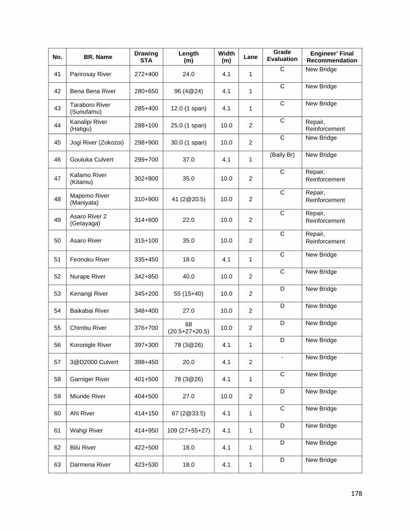
178
No. BR. Name Drawing STA
Length (m)
Width (m) Lane
Grade Evaluation
Engineer’ Final Recommendation
41 Parirosay River 272+400 24.0 4.1 1 C New Bridge
42 Bena Bena River 280+650 96 (4@24) 4.1 1 C New Bridge
43 Taraboro River (Sunufamu) 285+400 12.0 (1 span) 4.1 1
C New Bridge
44 Kanalipi River (Hatigu) 288+100 25.0 (1 span) 10.0 2
C Repair, Reinforcement
45 Jogi River (Zokozoi) 298+900 30.0 (1 span) 10.0 2 C New Bridge
46 Gouluka Culvert 299+700 37.0 4.1 1 (Baily Br) New Bridge
47 Kafamo River (Kitamu) 302+800 35.0 10.0 2
C Repair, Reinforcement
48 Mapemo River (Maniyata) 310+900 41 ([email protected]) 10.0 2
C Repair, Reinforcement
49 Asaro River 2 (Getayaga) 314+600 22.0 10.0 2
C Repair, Reinforcement
50 Asaro River 315+100 35.0 10.0 2 C Repair,
Reinforcement
51 Feonoku River 335+450 18.0 4.1 1 C New Bridge
52 Nurape River 342+850 40.0 10.0 2 C New Bridge
53 Kenangi River 345+200 55 (15+40) 10.0 2 D New Bridge
54 Baikabai River 348+400 27.0 10.0 2 D New Bridge
55 Chimbu River 376+700 68 (20.5+27+20.5) 10.0 2
D New Bridge
56 Koronigle River 397+300 78 (3@26) 4.1 1 D New Bridge
57 3@D2000 Culvert 398+450 20.0 4.1 2 - New Bridge
58 Garniger River 401+500 78 (3@26) 4.1 1 C New Bridge
59 Miunde River 404+500 27.0 10.0 2 D New Bridge
60 Ahl River 414+150 67 ([email protected]) 4.1 1 C New Bridge
61 Wahgi River 414+950 109 (27+55+27) 4.1 1 D New Bridge
62 Bilu River 422+500 18.0 4.1 1 D New Bridge
63 Darmena River 423+530 18.0 4.1 1 D New Bridge
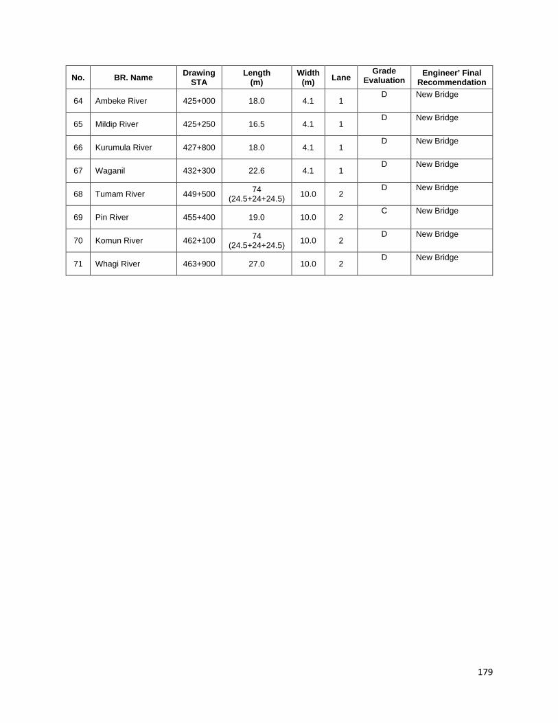
179
No. BR. Name Drawing STA
Length (m)
Width (m) Lane
Grade Evaluation
Engineer’ Final Recommendation
64 Ambeke River 425+000 18.0 4.1 1 D New Bridge
65 Mildip River 425+250 16.5 4.1 1 D New Bridge
66 Kurumula River 427+800 18.0 4.1 1 D New Bridge
67 Waganil 432+300 22.6 4.1 1 D New Bridge
68 Tumam River 449+500 74 (24.5+24+24.5) 10.0 2
D New Bridge
69 Pin River 455+400 19.0 10.0 2 C New Bridge
70 Komun River 462+100 74 (24.5+24+24.5) 10.0 2
D New Bridge
71 Whagi River 463+900 27.0 10.0 2 D New Bridge

180
Annex B: List of International Treaties and Agreements to which PNG is a Signatory
Year Treaty/Convention/Agreement
1951 International Plant Protection Convention, Rome 1954 International Convention for the Prevention of Pollution of the Sea by Oil, London 1956 Plant Protection Agreement for the South East Asia and Pacific Region, Rome 1969 International Convention on Civil Liability for Oil Pollution Damage, Brussels
1971 RAMSAR Convention on Wetlands of International Importance, especially waterfowl habitat
1972 International Convention on the Prevention of Marine Pollution by Dumping of Wastes and other Matter, London, Mexico City, Moscow
1972 Convention on the World Cultural Heritage and Natural Heritage
1973 International Convention on International Trade in Endangered Species of Wild Fauna and Flora, Washington (CITES Treaty)
1973 International Convention on the Conservation of Migratory Species of Wild fauna and Flora
1976 International Convention on the Conservation of Nature in the South Pacific, Apia
1976 International Convention on the Prohibition of Military or any other Hostile Use of Environmental Modification Techniques, New York
1982 United Nations Convention on the Law of the Sea, Montego Bay 1982
1986 International Convention for the Protection of the Natural Resources and Environment of the South Pacific (SPREP Convention)
1992 International Convention on Biological Diversity, Rio de Janeiro
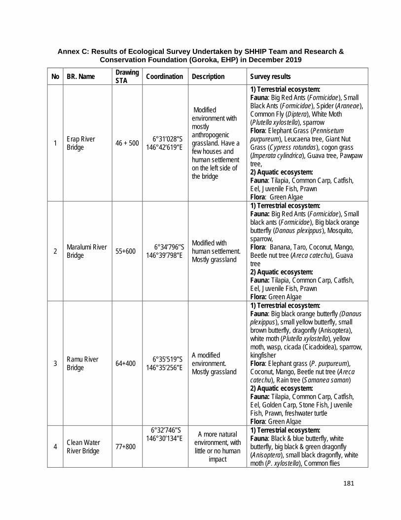
181
Annex C: Results of Ecological Survey Undertaken by SHHIP Team and Research & Conservation Foundation (Goroka, EHP) in December 2019
No BR. Name Drawing STA Coordination Description Survey results
1 Erap River Bridge 46 + 500 6°31’028’’S
146°42’619’’E
Modified environment with mostly anthropogenic grassland. Have a few houses and human settlement on the left side of the bridge
1) Terrestrial ecosystem: Fauna: Big Red Ants (Formicidae), Small Black Ants (Formicidae), Spider (Araneae), Common Fly (Diptera), White Moth (Plutella xylostella), sparrow Flora: Elephant Grass (Pennisetum purpureum), Leucaena tree, Giant Nut Grass (Cypress rotundas), cogon grass (Imperata cylindrica), Guava tree, Pawpaw tree, 2) Aquatic ecosystem: Fauna: Tilapia, Common Carp, Catfish, Eel, Juvenile Fish, Prawn Flora: Green Algae
2 Maralumi River Bridge 55+600 6°34’796’’S
146°39’798’’E Modified with human settlement. Mostly grassland
1) Terrestrial ecosystem: Fauna: Big Red Ants (Formicidae), Small black ants (Formicidae), Big black orange butterfly (Danaus plexippus), Mosquito, sparrow, Flora: Banana, Taro, Coconut, Mango, Beetle nut tree (Areca catechu), Guava tree 2) Aquatic ecosystem: Fauna: Tilapia, Common Carp, Catfish, Eel, Juvenile Fish, Prawn Flora: Green Algae
3 Ramu River Bridge 64+400 6°35’519’’S
146°35’256’’E A modified environment. Mostly grassland
1) Terrestrial ecosystem: Fauna: Big black orange butterfly (Danaus plexippus), small yellow butterfly, small brown butterfly, dragonfly (Anisoptera), white moth (Plutella xylostella), yellow moth, wasp, cicada (Cicadoidea), sparrow, kingfisher Flora: Elephant grass (P. purpureum), Coconut, Mango, Beetle nut tree (Areca catechu), Rain tree (Samanea saman) 2) Aquatic ecosystem: Fauna: Tilapia, Common Carp, Catfish, Eel, Golden Carp, Stone Fish, Juvenile Fish, Prawn, freshwater turtle Flora: Green Algae
4 Clean Water River Bridge 77+800
6°32’746’’S 146°30’134’’E A more natural
environment, with little or no human
impact
1) Terrestrial ecosystem: Fauna: Black & blue butterfly, white butterfly, big black & green dragonfly (Anisoptera), small black dragonfly, white moth (P. xylostella), Common flies
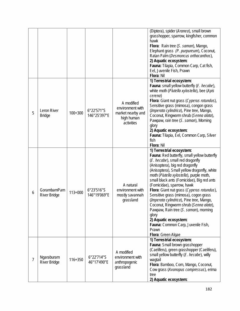
182
(Diptera), spider (Aranea), small brown grasshopper, sparrow, kingfisher, common hawk Flora: Rain tree (S. saman), Mango, Elephant grass (P. purpureum), Coconut, Ratan Palm (Desmoncus orthacanthos), 2) Aquatic ecosystem: Fauna: Tilapia, Common Carp, Cat fish, Eel, Juvenile Fish, Prawn Flora: Nil
5 Leron River Bridge 100+300 6°22’571’’S
146°25’397’’E
A modified environment with
market nearby and high human
activities
1) Terrestrial ecosystem: Fauna: small yellow butterfly (E. hecabe), white moth (Plutella xylostella), bee (Apis cerena) Flora: Giant nut grass (Cyperus rotundus), Sensitive grass (mimosa), congon grass (Imperata cylindrica), Pine tree, Mango, Coconut, Ringworm shrub (Senna alata), Pawpaw, rain tree (S. saman), Morning glory 2) Aquatic ecosystem: Fauna: Tilapia, Eel, Common Carp, Silver fish Flora: Nil
6 GorambamPam River Bridge 113+000 6°23’516’’S
146°19’069’’E
A natural environment with mostly savannah
grassland
1) Terrestrial ecosystem: Fauna: Red butterfly, small yellow butterfly (E. hecabe), small red dragonfly (Anisoptera), big red dragonfly (Anisoptera), Small yellow dragonfly, white moth (Plutella xylostella), purple moth, small black ants (Fomicidae), Big red ants (Fomicidae), sparrow, hawk Flora: Giant nut grass (Cyperus rotundus), Sensitive grass (mimosa), cogon grass (Imperata cylindrica), Pine tree, Mango, Coconut, Ringworm shrub (Senna alata), Pawpaw, Rain tree (S. saman), morning glory 2) Aquatic ecosystem: Fauna: Common Carp, Juvenile Fish, Prawn Flora: Green Algae
7 Ngaraburam River Bridge 116+350 6°22’714’’S
46°17’490’’E
A modified environment with anthropogenic grassland
1) Terrestrial ecosystem: Fauna: Small brown grasshopper (Caeliferu), green grasshopper (Caeliferu), small yellow butterfly (E. hecabe), willy wagtail Flora: Bamboo, Corn, Mango, Coconut, Cow grass (Axonopus compressus), erima tree 2) Aquatic ecosystem:
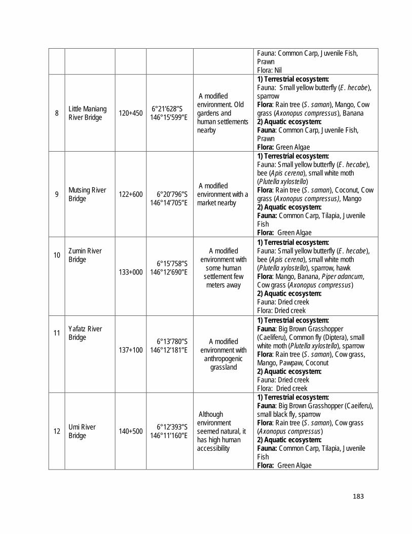
183
Fauna: Common Carp, Juvenile Fish, Prawn Flora: Nil
8 Little Maniang River Bridge 120+450 6°21’628’’S
146°15’599’’E
A modified environment. Old gardens and human settlements nearby
1) Terrestrial ecosystem: Fauna: Small yellow butterfly (E. hecabe), sparrow Flora: Rain tree (S. saman), Mango, Cow grass (Axonopus compressus), Banana 2) Aquatic ecosystem: Fauna: Common Carp, Juvenile Fish, Prawn Flora: Green Algae
9 Mutsing River Bridge 122+600
6°20’796’’S 146°14’705’’E
A modified environment with a market nearby
1) Terrestrial ecosystem: Fauna: Small yellow butterfly (E. hecabe), bee (Apis cerena), small white moth (Plutella xylostella) Flora: Rain tree (S. saman), Coconut, Cow grass (Axonopus compressus), Mango 2) Aquatic ecosystem: Fauna: Common Carp, Tilapia, Juvenile Fish Flora: Green Algae
10
Zumin River Bridge
133+000
6°15’758’’S 146°12’690’’E
A modified
environment with some human
settlement few meters away
1) Terrestrial ecosystem: Fauna: Small yellow butterfly (E. hecabe), bee (Apis cerena), small white moth (Plutella xylostella), sparrow, hawk Flora: Mango, Banana, Piper adancum, Cow grass (Axonopus compressus) 2) Aquatic ecosystem: Fauna: Dried creek Flora: Dried creek
11
Yafatz River Bridge
137+100
6°13’780’’S 146°12’181’’E
A modified
environment with anthropogenic
grassland
1) Terrestrial ecosystem: Fauna: Big Brown Grasshopper (Caeliferu), Common fly (Diptera), small white moth (Plutella xylostella), sparrow Flora: Rain tree (S. saman), Cow grass, Mango, Pawpaw, Coconut 2) Aquatic ecosystem: Fauna: Dried creek Flora: Dried creek
12 Umi River Bridge 140+500 6°12’393’’S
146°11’160’’E
Although environment seemed natural, it has high human accessibility
1) Terrestrial ecosystem: Fauna: Big Brown Grasshopper (Caeiferu), small black fly, sparrow Flora: Rain tree (S. saman), Cow grass (Axonopus compressus) 2) Aquatic ecosystem: Fauna: Common Carp, Tilapia, Juvenile Fish Flora: Green Algae

184
13 Bintia River Bridge 151+000 6°8’212’’S
146°7’369’’E
A modified environment. The river is dried with little no aquatic life
1) Terrestrial ecosystem: Fauna: Big black orange butterfly (Daanaus plexippus) common flies (Diptera), Dragonfly (Anisoptera), small white moth (Plutella xylostella), Small black ants (Fomicidae), Cicada (Cicadoidea, sparrow, Flora: Rain tree, Mango, Banana, Coconut, Cow grass (Axonopus compressus) 2) Aquatic ecosystem: Fauna: Common Carp, Juvenile Fish, Prawn Flora: Green Algae
14 Ohman River Bridge 153+000 6°7’885’’S
146°6’476’’E
A modified environment with anthropogenic grassland
1) Terrestrial ecosystem: Fauna: Brown butterfly, common flies (Diptera), worms (oligochaeta), Dragonfly (Anisoptera), bee (Apis cerena), small white moth (Plutella xylostella), sparrow, kingfisher, Flora: Rain Tree (S. saman), Banana, Mango, Coconut, Cow grass (Axonopus compressus) 2) Aquatic ecosystem: Fauna: Common Carp, Juvenile Fish, Prawn Flora: Green Algae
15 Utwini River Bridge 157+150 6°7’333’’S
146°4’273’’E
Modified environment. The river/creek is dried up with not much life
1) Terrestrial ecosystem: Fauna: Small yellow butterfly (E. hecabe), common flies (Diptera), small black ants (Fomicidae), bee (Apis cerena), small white moth (Plutella xylostella), hawk Flora: Cow grass, Mango, Coconut, Banana, Rain Tree (S. saman), Elaeocarpus 2) Aquatic ecosystem: Fauna: Nil Flora: Nil
16 Bitjia River Bridge (1 & 2) 157+450 6°7’454’’S
146°4’148’’E
A modified environment. Seemed deserted by humans. No human settlement
1) Terrestrial ecosystem: Fauna: Yellow butterfly (E. hecabe), dragonfly (Anisoptera). Ants (Fomicidae), sparrow Flora: Mango, Coconut, Banana, soft pitpit, cow grass (Axonopus compressus), Legume grass 2) Aquatic ecosystem: Fauna: Juvenile Fish, Prawn Flora: Green Algae
17 Watarais River Bridge 160+900 6°7’379’’S
146°2’520’’E
Modified environment with human interaction and settlement
1) Terrestrial ecosystem: Fauna: Yellow butterfly (E. hecabe), common flies (Diptera). Brown butterfly,

185
mosquito, snail, wasp (Hymenoptera), silver dragonfly (Anispotera) Flora: Fern, Mango, Piper adancum, Rain tree (S. saman) 2) Aquatic ecosystem: Fauna: Common Carp, Tilapia, Prawn Flora: Green Algae
18 Singsing River Bridge 164+850 6°9’269’’S
146°2’511’’E Modified with some human interactions
1) Terrestrial ecosystem: Fauna: Common flies (Diptera), Big green grasshopper, white moth (Plutella xylostella), brown moth Flora: Coconut, Rain Tree (S. saman) Cow grass (Axonopus compressus) 2) Aquatic ecosystem: Fauna: Common Carp, Tilapia, Juvenile Fish, Prawn Flora: Green Algae
19
Yung Creek Bridge
167+100
6°10’188’’S 146°2’741’’E
Modified with human settlement and little aquatic
life. Situated on the foot of Kassam
Pass with mostly grassland and
shrubs on one side of the bridge
1) Terrestrial ecosystem: Fauna: Yellow butterfly (E. hecabe), common flies (Diptera), hawk Flora: Mango, Rain Tree (S. saman), Pawpaw, Piper adancum, Cow grass (Axonopus compressus) 2) Aquatic ecosystem: Fauna: Common Carp, Juvenile Fish, Prawn Flora: Green Algae
20 Undono Creek Bridge 178+000 6°13’105’’S
146°1’709’’E
A modified environment with human settlement and food gardens
1) Terrestrial ecosystem: Fauna: Yellow butterfly (E. hecabe), Big black butterfly (Daanaus plexippus), sparrow, hawk Flora: Soft pitpit, Rain tree (S. saman), Banana, Piper adancum, hoop pine, long spine grass (Cenchrus longispinus) 2) Aquatic ecosystem: Fauna: Common Carp, Tilapia, Juvenile Fish, Prawn Flora: Green Algae
21 Tapiruna River Bridge 180+000 6°13’526’’S
146°0’944’’E A modified environment with food gardens
1) Terrestrial ecosystem: Fauna: Cicada (Cicadoidea), Yellow butterfly (E. hecabe), Blue moth. Big black orange butterfly (Daanaus plexippus), hawk Flora: Coffee, Rain tree (S. saman), Banana, Piper adacum, Palm, Red Pandanus (P. julianetti), Avacado, casuarina, Bamboo, hoop pine 2) Aquatic ecosystem: Fauna: Common Carp, Tilapia, Juvenile Fish, Prawn Flora: Green Algae

186
22
Darasimpi River Bridge
198+900
6°16’960’’S 146°55’463’’E
Old human settlement
consisting of domesticated
plants now taken over by
anthropogenic grassland.
1) Terrestrial ecosystem: Fauna: Small white moth (Plutella xylostella), sparrow Flora: Piper adancum, soft pitpit 2) Aquatic ecosystem: Fauna: Juvenile Fish, Prawn Flora: Green Algae
23 Luwin River Bridge 200+350 6°16’288’’S
146°54’998’’E
Modified with human settlement meters away. Had coffee gardens and domesticated plants
1) Terrestrial ecosystem: Fauna: Yellow butterfly (E. hecabe), mosquito, hawk Flora: Banana, Piper adancum, Pandanus (P. julianneti), Coffee, Bamboo, soft pitpit 2) Aquatic ecosystem: Fauna: Common Carp, Juvenile Fish, Prawn Flora: Green Algae
24 Namupimpa River Bridge 206+100 6°16’984’’S
145°52’517’’E
Modified with coffee plants, pine, bamboo and other domesticated plants
1) Terrestrial ecosystem: Fauna: Yellow butterfly (E. hecabe), Small purple moth, sparrow, Flora: Pitpit, rain tree (S. saman), Bamboo, Pine tree, Coffee, Banana 2) Aquatic ecosystem: Fauna: Common Carp, Tilapia, Juvenile Fish, Prawn Flora: Green Algae
25 Benapa River Bridge 211+000 6°17’426’’S
145°52’387’’E
Modified with human settlement far off but old food gardens on one side
1) Terrestrial ecosystem: Fauna: Small green grasshopper (Caeliferu), Yellow butterfly (E. hecabe), Cicada (Cicadoidea), sparrow Flora: Soft pitpit, rain tree (S. saman), Bamboo, Pine, Coffee, Banana
2) Aquatic ecosystem: Fauna: Common Carp, Juvenile Fish, Prawn Flora: Green Algae
26 Iyunopa River Bridge 215+700 6°18’005’’S
145°50’267’’E Modified with human settlement, not much insect life
1) Terrestrial ecosystem: Fauna: Grasshopper (Caeliferu), Ants (Foricidae), Worm (Oligochaeta) Flora: Soft pitpit, rain tree (S. saman), Bamboo, Pine tree, Coffee 2) Aquatic ecosystem:
Fauna: Common Carp, Tilapia, Black Carp, Golden Carp, Juvenile Fish, Prawn Flora: Green Algae
27 Orompanka River Bridge 221+100 6°18’328’’S
145°48’059’’E A modified environment with 1) Terrestrial ecosystem:
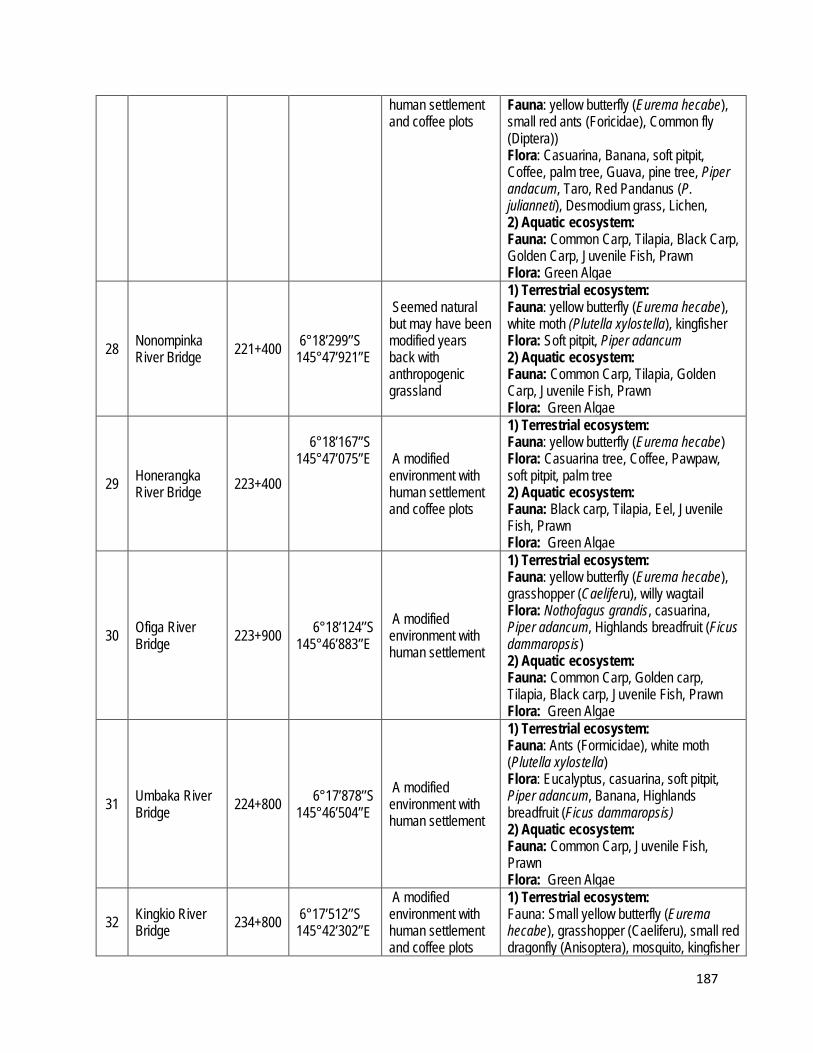
187
human settlement and coffee plots
Fauna: yellow butterfly (Eurema hecabe), small red ants (Foricidae), Common fly (Diptera)) Flora: Casuarina, Banana, soft pitpit, Coffee, palm tree, Guava, pine tree, Piper andacum, Taro, Red Pandanus (P. julianneti), Desmodium grass, Lichen, 2) Aquatic ecosystem: Fauna: Common Carp, Tilapia, Black Carp, Golden Carp, Juvenile Fish, Prawn Flora: Green Algae
28 Nonompinka River Bridge 221+400 6°18’299’’S
145°47’921’’E
Seemed natural but may have been modified years back with anthropogenic grassland
1) Terrestrial ecosystem: Fauna: yellow butterfly (Eurema hecabe), white moth (Plutella xylostella), kingfisher Flora: Soft pitpit, Piper adancum 2) Aquatic ecosystem: Fauna: Common Carp, Tilapia, Golden Carp, Juvenile Fish, Prawn Flora: Green Algae
29 Honerangka River Bridge 223+400
6°18’167’’S 145°47’075’’E A modified
environment with human settlement and coffee plots
1) Terrestrial ecosystem: Fauna: yellow butterfly (Eurema hecabe) Flora: Casuarina tree, Coffee, Pawpaw, soft pitpit, palm tree 2) Aquatic ecosystem: Fauna: Black carp, Tilapia, Eel, Juvenile Fish, Prawn Flora: Green Algae
30 Ofiga River Bridge 223+900 6°18’124’’S
145°46’883’’E A modified environment with human settlement
1) Terrestrial ecosystem: Fauna: yellow butterfly (Eurema hecabe), grasshopper (Caeliferu), willy wagtail Flora: Nothofagus grandis, casuarina, Piper adancum, Highlands breadfruit (Ficus dammaropsis) 2) Aquatic ecosystem: Fauna: Common Carp, Golden carp, Tilapia, Black carp, Juvenile Fish, Prawn Flora: Green Algae
31 Umbaka River Bridge 224+800 6°17’878’’S
145°46’504’’E A modified environment with human settlement
1) Terrestrial ecosystem: Fauna: Ants (Formicidae), white moth (Plutella xylostella) Flora: Eucalyptus, casuarina, soft pitpit, Piper adancum, Banana, Highlands breadfruit (Ficus dammaropsis) 2) Aquatic ecosystem: Fauna: Common Carp, Juvenile Fish, Prawn Flora: Green Algae
32 Kingkio River Bridge 234+800 6°17’512’’S
145°42’302’’E
A modified environment with human settlement and coffee plots
1) Terrestrial ecosystem: Fauna: Small yellow butterfly (Eurema hecabe), grasshopper (Caeliferu), small red dragonfly (Anisoptera), mosquito, kingfisher
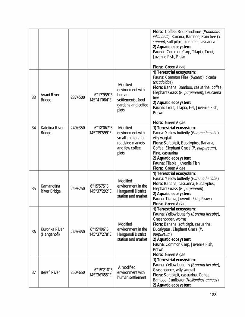
188
Flora: Coffee, Red Pandanus (Pandanus juliannetti), Banana, Bamboo, Rain tree (S. saman), soft pitpit, pine tree, casuarina 2) Aquatic ecosystem: Fauna: Common Carp, Tilapia, Trout, Juvenile Fish, Prawn Flora: Green Algae
33 Avani River Bridge 237+500 6°17’959’’S
145°41’084’’E
Modified environment with human settlements, food gardens and coffee plots
1) Terrestrial ecosystem: Fauna: Common Flies (Diptera), cicada (cicadoidae) Flora: Banana, Bamboo, casuarina, coffee, Elephant Grass (P. purpureum), Leucaena tree 2) Aquatic ecosystem: Fauna: Trout, Tilapia, Eel, Juvenile Fish, Prawn
Flora: Green Algae 34 Kafetina River
Bridge 240+350 6°18’067’’S
145°39’599’’E Modified environment with small shelters for roadside markets and few coffee plots
1) Terrestrial ecosystem: Fauna: Yellow butterfly (Eurema hecabe), eilly wagtail Flora: Soft pitpit, Eucalyptus, Banana, Coffee, Elephant Grass (P. purpureum), Pine, casuarina 2) Aquatic ecosystem: Fauna: Tilapia, Juvenile Fish Flora: Green Algae
35 Kamanotina River Bridge 249+250 6°15’575’’S
145°37’292’’E
Modified environment in the Henganofi District station and market
1) Terrestrial ecosystem: Fauna: Yellow butterfly (Eurema hecabe) Flora: Banana, casuarina, Eucalyptus, Elephant Grass (P. purpureum) 2) Aquatic ecosystem: Fauna: Tilapia, Juvenile Fish, Prawn Flora: Green Algae
36 Kuronka River (Henganofi) 249+450 6°15’496’’S
145°37’278’’E
Modified environment in the Henganofi District station and market
1) Terrestrial ecosystem: Fauna: Yellow butterfly (Eurema hecabe), Grasshopper, worms Flora: Banana, soft pitpit, casuarina, Eucalyptus, Elephant Grass (P. purpureum) 2) Aquatic ecosystem: Fauna: Common Carp, Juvenile Fish, Prawn Flora: Green Algae
37 Berefi River 250+650 6°15’218’’S 145°36’655’’E
A modified environment with human settlement
1) Terrestrial ecosystem: Fauna: Yellow butterfly (Eurema hecabe), Grasshopper, willy wagtail Flora: Soft pitpit, casuarina, Coffee, Bamboo, Sunflower (Hellianthus annuus) 2) Aquatic ecosystem:

189
Fauna: Tilapia.Juvenile Fish Flora: Green Algae
38 Dirty Wara River 258+000 6°14’594’’S
145°34’072’’E
A modified environment with human settlement, food and coffee gardens
1) Terrestrial ecosystem: Fauna: Small Yellow butterfly (Eurema hecabe), Big black stripped blue butterfly, White moth, worms, ants, willy wagtail Flora: Bamboo, soft pitpit, Banana, Coffee, elephant grass (P. purpureum) 2) Aquatic ecosystem: Fauna: Common Carp, Tilapia, Trout, Juvenile Fish Flora: Green Algae
39 Siguya River 266+250 6°14’480’’S 145°31’089’’E
Modified environment with little human settlement and mini roadside market
1) Terrestrial ecosystem: Fauna: Small Yellow butterfly (Eurema hecabe), White moth, worms, ants Flora: Casuarina, soft pitpit, cow grass (Axonopus compressus), Piper adancum 2) Aquatic ecosystem: Fauna: Small Trout, Tilapia, Juvenile Fish, Prawn Flora: Green Algae
40 Yasifo River 271+450 6°15’327’’S 145°36’655’’E
Modified environment with human settlement and a small roadside market
1) Terrestrial ecosystem: Fauna: Yellow butterfly (Eurema hecabe), sparrow, willy wagtail Flora: Soft pitpit, Sunflower (Hellianthus annuus), rain tree (S. saman), Cow grass (Axonopus compressus) 2) Aquatic ecosystem: Fauna: Juvenile Fish, Prawn Flora: Green Algae
41 Parirosay River 272+400 6°13’531’’S 145°28’394’’E
A modified environment with human settlement, food gardens and new coffee plots
1) Terrestrial ecosystem: Fauna: Yellow butterfly (Eurema hecabe), Grasshopper Flora: Pine, soft pitpit, casuarina, coffee 2) Aquatic ecosystem: Fauna: Trout, Tilapia, Juvenile Fish, Prawn Flora: Green Algae
42 Bena Bena River 280+650 6°11’251’’S
145°25’957’’E
A modified environment with a quarry on one side. The other side had human settlements and old food gardens
1) Terrestrial ecosystem: Fauna: Willy wagtail (Rhipidura leucophrys), Yellow butterfly (Eurema hecabe), dragonfly, sparrow Flora: Rain tree (S. saman), Coffee, soft pitpit, Cow grass (A. compressus), Eucalyptus 2) Aquatic ecosystem: Fauna: Common Carp, Tilapia, Juvenile Fish Flora: Green Algae
43 Taraboro River (Sunufamu) 285+400 6°10’148’’S
145°24’761’’E A modified environment with coffee gardens.
1) Terrestrial ecosystem: Fauna: Yellow butterfly (Eurema hecabe)

190
Water was quite low
Flora: Gum tree (Eucalyptus), rain tree (S. saman), Bamboo, Piper adancum, Banana, Casuarina, Coffee 2) Aquatic ecosystem: Fauna: Trout, Tilapia Flora: Nil
44 Kanalipi River (Hatigu) 288+100 6°8’851’’S
145°24’397’’E
A modified environment with human settlement and stone quarry on one side
1) Terrestrial ecosystem: Fauna: Yellow butterfly (Eurema hecabe) Flora: Bamboo, soft pitpit, rain tree (S. saman) 2) Aquatic ecosystem: Fauna: Common carp, tilapia, juvenile fish
Flora: Green Algae
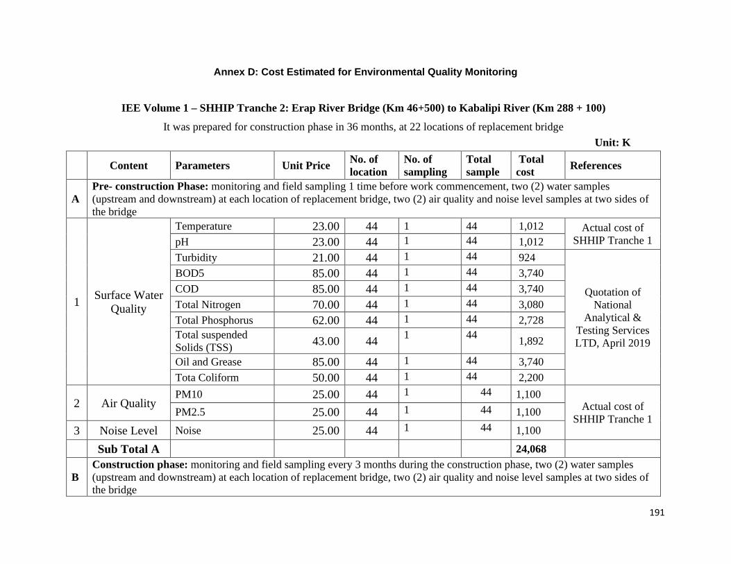
191
Annex D: Cost Estimated for Environmental Quality Monitoring
IEE Volume 1 – SHHIP Tranche 2: Erap River Bridge (Km 46+500) to Kabalipi River (Km 288 + 100)
It was prepared for construction phase in 36 months, at 22 locations of replacement bridge Unit: K
Content Parameters Unit Price No. of location
No. of sampling
Total sample
Total cost References
A Pre- construction Phase: monitoring and field sampling 1 time before work commencement, two (2) water samples (upstream and downstream) at each location of replacement bridge, two (2) air quality and noise level samples at two sides of the bridge
1 Surface Water Quality
Temperature 23.00 44 1 44 1,012 Actual cost of SHHIP Tranche 1 pH 23.00 44 1 44 1,012
Turbidity 21.00 44 1 44 924
Quotation of National
Analytical & Testing Services LTD, April 2019
BOD5 85.00 44 1 44 3,740 COD 85.00 44 1 44 3,740 Total Nitrogen 70.00 44 1 44 3,080 Total Phosphorus 62.00 44 1 44 2,728 Total suspended Solids (TSS) 43.00 44 1 44 1,892
Oil and Grease 85.00 44 1 44 3,740 Tota Coliform 50.00 44 1 44 2,200
2 Air Quality PM10 25.00 44 1 44 1,100
Actual cost of SHHIP Tranche 1 PM2.5 25.00 44 1 44 1,100
3 Noise Level Noise 25.00 44 1 44 1,100
Sub Total A 24,068
B Construction phase: monitoring and field sampling every 3 months during the construction phase, two (2) water samples (upstream and downstream) at each location of replacement bridge, two (2) air quality and noise level samples at two sides of the bridge

192
1 Surface Water Quality
Temperature 23.00 44 12 528 12,144 Actual cost of SHHIP Tranche 1 pH 23.00 44 12 528 12,144
Turbidity 21.00 44 12 528 11,088
Quotation of National
Analytical & Testing Services LTD, April 2019
BOD5 85.00 44 12 528 44,880 COD 85.00 44 12 528 44,880 Total Nitrogen 70.00 44 12 528 36,960 Total Phosphorus 62.00 44 12 528 32,736 Total suspended Solids (TSS) 43.00 44 12 528 22,704
Oil and Grease 85.00 44 12 528 44,880 Tota Coliform 50.00 44 12 528 26,400
2 Air Quality PM10 25.00 44 12 528 13,200
Actual cost of SHHIP Tranche 1 PM2.5 25.00 44 12 528 13,200
3 Noise Level Noise 25.00 44 12 528 13,200
Sub Total B 288,816
TOTAL (A+B) in Kina 312,884 in USD ( K1 = USD 0.294, as of October 2019) 91,988
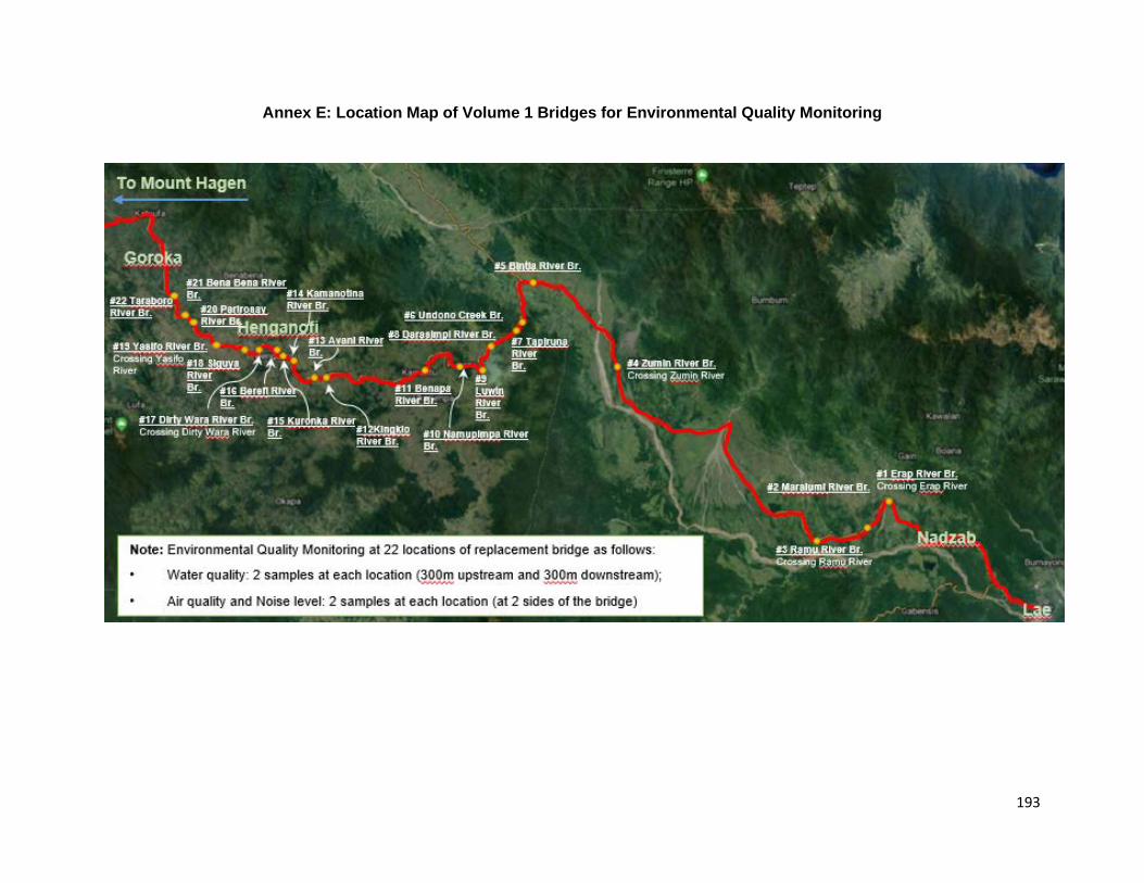
193
Annex E: Location Map of Volume 1 Bridges for Environmental Quality Monitoring

194
Annex F: Public Consultation Meetings Various consultation and information dissemination activities have been conducted as part of the SHHIP tranche 2 preparation. This included consultation and awareness activities with key stakeholders including the affected communities, governments at the Provincial, district and local levels, transport entrepreneurs, businesses, and the general public, amongst others. Summary of such key activities is presented as below.
Date
Venue
Attendants Key Issues/Queries/Feedback
17 Jul’19
Four Mile Area, Kainantu
32 participants registered (12 females), altogether around 60 estimated participants (approx. 25 females) in the event. Most of them preferred not to register their names (was accepted).
SHHIP consultation and awareness-building focused on overall Program components, current status, social and environmental impacts (both adverse and beneficial ones), social/community infrastructure support, resettlement requirements, legacy issues, etc. Feedback, queries and responses received have been primarily related to the pending legacy issue in the area, dust control during works, employment opportunities, women participation, trainings, etc. Appropriate responses were made by the social specialist, CRO and Project Manager (Lalio Erasi) for the section.
16 Aug’19
Miunde, Jiwaka
87 participants including 43 female participants
SHHIP consultation and awareness-building focused on overall Program components, current status, social and environmental impacts (both adverse and beneficial ones), social/community infrastructure support, resettlement requirements, legacy issues, etc. Feedback, queries and responses received have been primarily related to the pending legacy issue in the area, dust control during works, employment opportunities, women participation, trainings, etc. Appropriate responses were made by the Social and Environmental Specialists and the CRO.
16 Aug’19
Ku, Simbu
45 participants including 18 female participants
SHHIP consultation and awareness-building focused on overall Program components, details on Tranches 1 and 2 including current status, social and environmental impacts (both adverse and beneficial ones), social/community infrastructure support, resettlement requirements, legacy issues, etc. Feedback, queries and responses received have been primarily related to resettlement, legacy issues, adverse impact mitigations, employment opportunities,
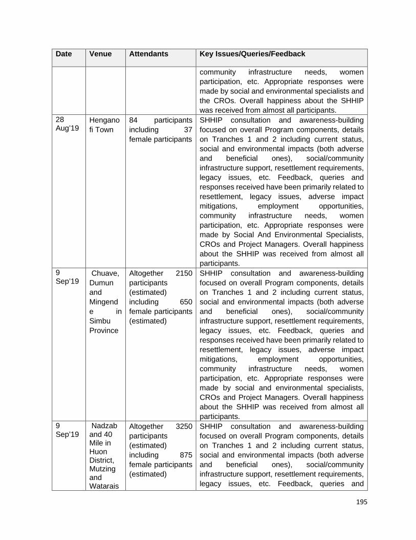
195
Date
Venue
Attendants Key Issues/Queries/Feedback
community infrastructure needs, women participation, etc. Appropriate responses were made by social and environmental specialists and the CROs. Overall happiness about the SHHIP was received from almost all participants.
28 Aug’19
Henganofi Town
84 participants including 37 female participants
SHHIP consultation and awareness-building focused on overall Program components, details on Tranches 1 and 2 including current status, social and environmental impacts (both adverse and beneficial ones), social/community infrastructure support, resettlement requirements, legacy issues, etc. Feedback, queries and responses received have been primarily related to resettlement, legacy issues, adverse impact mitigations, employment opportunities, community infrastructure needs, women participation, etc. Appropriate responses were made by Social And Environmental Specialists, CROs and Project Managers. Overall happiness about the SHHIP was received from almost all participants.
9 Sep’19
Chuave, Dumun and Mingende in Simbu Province
Altogether 2150 participants (estimated) including 650 female participants (estimated)
SHHIP consultation and awareness-building focused on overall Program components, details on Tranches 1 and 2 including current status, social and environmental impacts (both adverse and beneficial ones), social/community infrastructure support, resettlement requirements, legacy issues, etc. Feedback, queries and responses received have been primarily related to resettlement, legacy issues, adverse impact mitigations, employment opportunities, community infrastructure needs, women participation, etc. Appropriate responses were made by social and environmental specialists, CROs and Project Managers. Overall happiness about the SHHIP was received from almost all participants.
9 Sep’19
Nadzab and 40 Mile in Huon District, Mutzing and Watarais
Altogether 3250 participants (estimated) including 875 female participants (estimated)
SHHIP consultation and awareness-building focused on overall Program components, details on Tranches 1 and 2 including current status, social and environmental impacts (both adverse and beneficial ones), social/community infrastructure support, resettlement requirements, legacy issues, etc. Feedback, queries and
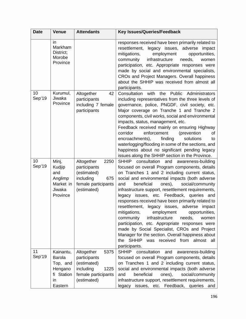
196
Date
Venue
Attendants Key Issues/Queries/Feedback
in Markham District; Morobe Province
responses received have been primarily related to resettlement, legacy issues, adverse impact mitigations, employment opportunities, community infrastructure needs, women participation, etc. Appropriate responses were made by social and environmental specialists, CROs and Project Managers. Overall happiness about the SHHIP was received from almost all participants.
10 Sep’19
Kurumul, Jiwaka Province
Altogether 42 participants including 7 female participants
Consultation with the Public Administrators including representatives from the three levels of governance, police, PNGDF, civil society, etc. Major coverage on Tranche 1 and Tranche 2 components, civil works, social and environmental impacts, status, management, etc. Feedback received mainly on ensuring Highway corridor enforcement (prevention of encroachments), finding solutions to waterlogging/flooding in some of the sections, and happiness about no significant pending legacy issues along the SHHIP section in the Province.
10 Sep’19
Minj, Kudjip and Anglimp Market in Jiwaka Province
Altogether 2250 participants (estimated) including 675 female participants (estimated)
SHHIP consultation and awareness-building focused on overall Program components, details on Tranches 1 and 2 including current status, social and environmental impacts (both adverse and beneficial ones), social/community infrastructure support, resettlement requirements, legacy issues, etc. Feedback, queries and responses received have been primarily related to resettlement, legacy issues, adverse impact mitigations, employment opportunities, community infrastructure needs, women participation, etc. Appropriate responses were made by Social Specialist, CROs and Project Manager for the section. Overall happiness about the SHHIP was received from almost all participants.
11 Sep’19
Kainantu, Barola Top, and Henganofi Station in Eastern
Altogether 5375 participants (estimated) including 1225 female participants (estimated)
SHHIP consultation and awareness-building focused on overall Program components, details on Tranches 1 and 2 including current status, social and environmental impacts (both adverse and beneficial ones), social/community infrastructure support, resettlement requirements, legacy issues, etc. Feedback, queries and
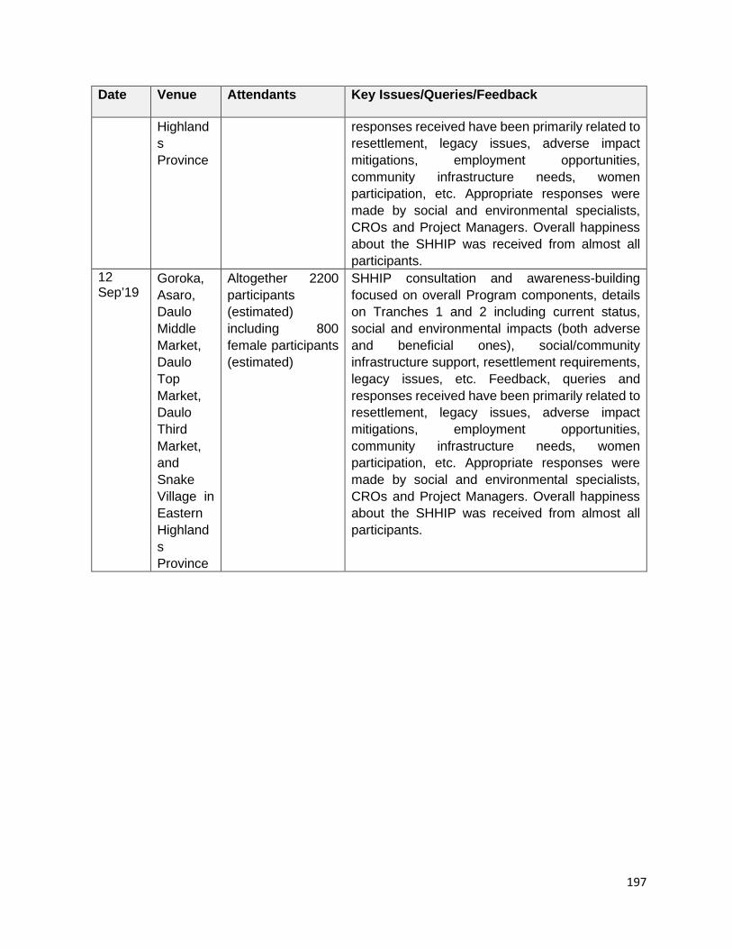
197
Date
Venue
Attendants Key Issues/Queries/Feedback
Highlands Province
responses received have been primarily related to resettlement, legacy issues, adverse impact mitigations, employment opportunities, community infrastructure needs, women participation, etc. Appropriate responses were made by social and environmental specialists, CROs and Project Managers. Overall happiness about the SHHIP was received from almost all participants.
12 Sep’19
Goroka, Asaro, Daulo Middle Market, Daulo Top Market, Daulo Third Market, and Snake Village in Eastern Highlands Province
Altogether 2200 participants (estimated) including 800 female participants (estimated)
SHHIP consultation and awareness-building focused on overall Program components, details on Tranches 1 and 2 including current status, social and environmental impacts (both adverse and beneficial ones), social/community infrastructure support, resettlement requirements, legacy issues, etc. Feedback, queries and responses received have been primarily related to resettlement, legacy issues, adverse impact mitigations, employment opportunities, community infrastructure needs, women participation, etc. Appropriate responses were made by social and environmental specialists, CROs and Project Managers. Overall happiness about the SHHIP was received from almost all participants.

198
Annex G: References
1. A Geological Synthesis of Papua New Guinea, Bureau of Mineral Resources, Geology and Geophysics, Department of Natural Resources, Australian Government Publishing Service, 1977.
2. Climate Change Vulnerability Assessment Report of SHHIP conducted on June 2017.
3. District and Provincial Profiles - National Research Institute.
4. Environmental Impact Assessment, Highlands Highway Rehabilitation Project, Volume 2- WB/SMEC, 2002.
5. Initial Environmental Examination Report, SHHIP, February 2017.
6. National Population and Housing Census, 2011.
7. National Weather Service, Papua New Guinea
8. Pacific Climate Futures Program; Climate Futures Exploration Tool, 2012.
9. Papua New Guinea Policy on Protected Areas.
10. Papua New Guinea Rural Development Handbook
11. Protected areas of PNG CEPA, 2017.
Web link source: 1. Available at Oct 2019. http://www.diva-gis.org/gdata; Indicative Highlands Highway
alignment (reconstructed overlay), SHHIP PPTA 2016.
2. Available at Oct 2019. https://population.un.org/wpp/Download/Standard/Population/
3. Available at Oct 2019. https://www.epa.gov/green-book/green-book-national-area-and-county-level-multi-pollutant-information.