Fodder shrub and tree species in the Highlands of southern Mexico
Upload
khangminh22Category
view
0download
0
For additional information contact:
Wildlands ProjectP.O. Box 455Richmond, VT 05477802/[email protected]
©2003 by the Wildlands Project. Cover illustration: Bighorn sheep ©J.C.AmberlynDesign and layout by Todd Cummings
May 2003
Lead Authors
Dave Foreman • Kathy Daly • Reed Noss • Matt Clark
Kurt Menke • David R. Parsons • Robert Howard
New Mexico HighlandsWildlands Network
VISIONConnecting the Sky Islands to the Southern Rockies
Contributing Authors
Tom Butler, Jen Clanahan, Kim Crumbo, Jeff Davis, Barbara Dugelby, Randy GrayBob Langsenkamp, Pete Morton, Paul Polechla, Melissa SavagePeter Stacey, Joe Truett, Kim Vacariu
Jen ClanahanRocky Mountain Director2260 Baseline Rd #205Boulder, CO 80302720/[email protected]

ii W I L D L A N D S P R O J E C T
Dedication and Acknowledgement .........................................................................................................viExecutive Summary .................................................................................................................................1
Chapter 1- Introduction.......................................................................................................................................41.A. Elements of the New Mexico Highlands Wildlands Network Vision ......................................................81.B. The Biological Importance of the New Mexico Highlands Region ........................................................91.C. The New Mexico Highlands Wildlands Network Vision.......................................................................10
Chapter 2 – Regional Overview ........................................................................................................................122.A. Justification of Planning Area Boundary..............................................................................................142.B. Vegetation Types in the New Mexico Highlands Region.....................................................................172.C. Socioeconomic Setting.......................................................................................................................212.D Protection and Land Use Status..........................................................................................................23
Chapter 3 – Ecological Wounds........................................................................................................................393.A. Wounds to the Land...........................................................................................................................42
Wound 1: Loss and Decline of Species ...............................................................................................42Wound 2: Loss and Degradation of Ecosystems..................................................................................43Wound 3: Loss and Decline of Natural Processes................................................................................48Wound 4: Fragmentation of Wildlife Habitat ......................................................................................49Wound 5: Invasion of Exotic Species ..................................................................................................50Wound 6: Pollution ............................................................................................................................51Wound 7: Climate Change.................................................................................................................53
Chapter 4 – Mission and Goals.........................................................................................................................544.A. Mission ..............................................................................................................................................544.B. The Precautionary Approach to Ecosystem Conservation ...................................................................544.C. Healing the Wounds Approach to Ecological Restoration ...................................................................554.D. Healing the Wounds Goal-Setting ......................................................................................................564.E. Objectives ..........................................................................................................................................57
Chapter 5 – Approach .......................................................................................................................................595.A. Ecological Wildlands Network Design Principles .................................................................................595.B. The Importance of Connectivity .........................................................................................................625.C. The Problem of Climate Change ........................................................................................................645.D. Guidelines for Ecological Design of Protected Areas ...........................................................................675.E. Top-down Regulation and Rewilding..................................................................................................685.F. Fieldwork ...........................................................................................................................................705.G. Expert Review ....................................................................................................................................72
CONTENTS

N E W M E X I C O H I G H L A N D S W I L D L A N D S N E T W O R K V I S I O N iii
Chapter 6 – Focal Species .................................................................................................................................736.A. Focal Species Planning .......................................................................................................................736.B. Selection of Focal Species for the New Mexico Highlands Wildlands Network....................................736.C. Focal Species Habitat Mapping Analyses ............................................................................................756.D. Focal Species Profiles and Management Recommendations ...............................................................88
Chapter 7 – Network Design Process and SITES Analysis ............................................................................1157.A. The Three Track Approach ...............................................................................................................1157.B. Expert Design...................................................................................................................................1167.C. The SITES Selection Algorithm .........................................................................................................1177.D. Model Output..................................................................................................................................1207.E. Inputs to SITES.................................................................................................................................1227.F. SITES Selection Results .....................................................................................................................140
Chapter 8 – New Mexico Highlands Wildlands Network Design................................................................1458.A. New Mexico Highlands Wildlands Network Overview......................................................................1458.B. Wildlands Network Unit Classification and Management Guidelines ................................................1468.C. Network Design Summary ...............................................................................................................1518.D. Irreplaceability and Vulnerability ......................................................................................................1528.E. Progress Towards Goals....................................................................................................................1548.F. New Mexico Highlands Wildlands Network Unit List........................................................................1568.G. Assumptions and Limitations............................................................................................................174
Chapter 9 – Implementing a Wildlands Network- Conservation Action ....................................................1769.A. Goal 1 – Protection and Recovery of Native Species.........................................................................1779.B. Goal 2 – Protection and Restoration of Native Habitats ....................................................................1799.C. Goal 3 – Protection, Restoration, and Maintenance of
Ecological and Evolutionary Processes.............................................................................. 1859.D. Goal 4 – Protection and Restoration of Connectivity ........................................................................1879.E. Goal 5 – Control of Exotic Species ...................................................................................................1999.F. Goal 6 – Reduction of Pollution and Restoration of
Areas Degraded by Pollution.............................................................................................2009.G. Goal 7 – Manage Landscapes and Populations to
Provide Opportunities for Adaptation and Adjustment to Climate Change ........................2009.H. Call to Action ...................................................................................................................................2019.I. Compatible Conservation Initiatives ................................................................................................ 2029.J. Socioeconomic Benefits and Opportunities ......................................................................................2119.K. Monitoring.......................................................................................................................................2199.L. Conclusion .......................................................................................................................................220
Literature Cited ...................................................................................................................................221
GIS Data Sources.................................................................................................................................233

iv W I L D L A N D S P R O J E C T
List of Figures
Figure 1.1 North American Megalinkage Map .......................................................................................6Figure 1.2 Wildlands Conservation Planning along the spine of the continent........................................7Figure 2.1 Bailey’s Ecoregions ..............................................................................................................13Figure 2.2 New Mexico Highlands Relationship to other Wildlands Networks .....................................16Figure 2.3 National Forests and Grasslands...........................................................................................24Figure 2.4 National Park Service and Fish and Wildlife Service Lands....................................................26Figure 2.5 BLM Lands and Protected Areas...........................................................................................28Figure 2.6 Designated Wilderness Areas ...............................................................................................30Figure 2.7 Military Lands ......................................................................................................................34Figure 2.8 State Owned Lands and NM Dept. of Game and Fish Lands ...............................................36Figure 2.9 Private Lands Managed for Conservation.............................................................................38Figure 3.1 Dam Locations.....................................................................................................................45Figure 3.2 Oil and Gas Wells.................................................................................................................52Figure 5.1 Conceptual core, linkage, compatible-use lands model .....................................................59Figure 5.2 Suggested geometric principles of reserve design................................................................60Figure 5.3 Conservation area design principles based on Soulé ............................................................60Figure 5.4 Edge effects .........................................................................................................................62Figure 5.5 A hypothetical example of metapopulation dynamics..........................................................63Figure 5.6 Schematic diagram of a reserve relative to latitudinal changes in temperatures ...................64Figure 5.7 Two Paths of Interaction Cascades.......................................................................................69Figure 6.1 Wolf Prey Availability............................................................................................................76Figure 6.2 Vegetative Biomass ..............................................................................................................77Figure 6.3 Terrain Ruggedness..............................................................................................................78Figure 6.4 Population Density...............................................................................................................79Figure 6.5 Road Density .......................................................................................................................80Figure 6.6 Potential Wolf Habitat Suitability..........................................................................................81Figure 6.7 Lion Prey Availability ............................................................................................................82Figure 6.8 Potential Lion Habitat Suitability ..........................................................................................84Figure 6.9 American Marten Prey Availability........................................................................................85Figure 6.10 American Marten Associated Vegetation Types...................................................................86Figure 6.11 Potential American Marten Habitat Suitability ....................................................................87Figure 7.1 Planning Unit Status ..........................................................................................................119Figure 7.2 SITES Inputs for Black Bear.................................................................................................123Figure 7.3 SITES Inputs for Mountain Lion..........................................................................................124Figure 7.4 SITES Inputs for Grizzly Bear ..............................................................................................125Figure 7.5 SITES Inputs for Wolf .........................................................................................................126Figure 7.6 SITES Inputs for American Marten......................................................................................127Figure 7.7 SITES Inputs for Bighorn Sheep..........................................................................................128Figure 7.8 SITES Inputs for Beaver ......................................................................................................129Figure 7.9 SITES Inputs for Elk Winter Range ......................................................................................130Figure 7.10 SITES Inputs for Elk Summer Range ..................................................................................131Figure 7.11 SITES Inputs for Old Growth Forest ..................................................................................132Figure 7.12 SITES Inputs for Roadless Areas.........................................................................................133Figure 7.13 SITES Input for Important Bird Areas ................................................................................134Figure 7.14 SITES Input for Species Listed Globally as being Critically Imperiled .................................135Figure 7.15 SITES Inputs for Species Listed Globally as being Imperiled ..............................................136

N E W M E X I C O H I G H L A N D S W I L D L A N D S N E T W O R K V I S I O N v
Figure 7.16 SITES Inputs for Species Listed by New Mexico as Critically Imperiled..............................137Figure 7.17 SITES Inputs for Vegetation Representation ......................................................................138Figure 7.17b GAP Vegetation Classification (legend for Figure 7.17) ...................................................139Figure 7.18 SITES Results Control Run................................................................................................140Figure 7.19 SITES Results Protected Areas Locked In, Urban Areas Locked Out blm:0.0 .....................141Figure 7.20 SITES Results Protected Areas Locked In, Urban Areas Locked Out, blm: 0.2 ...................142Figure 7.21 SITES Results Protected Areas Locked In, Urban Areas Locked Out, blm: 0.3 ...................143Figure 7.22 SITES Results Protected Areas Locked In, Urban Areas Locked Out, blm: 0.1 ...................144Figure 8.1 Distribution of Units in WND.............................................................................................151Figure 8.2 New Mexico Highlands Wildlands Network Design ...........................................................149Figure 8.3 Unit Clusters ......................................................................................................................153Figure 8.4 Progress Toward Goals ......................................................................................................156Figure 9.1 Roadkill and Barriers ..........................................................................................................190Figure 9.2 Sandia Case Study .............................................................................................................193Figure 9.3 Resource Extraction Employment as a Percent of Total Employment..................................213Figure 9.4 Components of Total Personal Income, New Mexico .......................................................214
List of Tables
Table 1.1 Birds that meet the end of their range in the New Mexico Highlands .................................10 Table 2.1 National Park Service Lands in NM Highlands .....................................................................25Table 2.2 National Wildlife Refuges in NM Highlands .........................................................................25Table 2.3 BLM Areas of Critical Environmental Concern in NM Highlands ...........................................27Table 2.4 Congressionally Designated Wilderness Areas in NM Highlands ...........................................29Table 2.5 National Forest Wilderness Study Areas in NM Highlands ....................................................31Table 2.6 Forest Service Inventoried Roadless Areas (RARE II) in NM Highlands ...................................31Table 2.7 Preliminary Proposed BLM Wilderness Areas in NM Highlands .............................................32Table 2.8 Wild and Scenic Rivers .........................................................................................................33Table 2.9 Military Installations .............................................................................................................33Table 2.10 Tribal lands in NM Highlands .............................................................................................35Table 2.11 State Game and Fish Lands ................................................................................................35Table 2.12 Private Protected Lands .....................................................................................................37Table 2.13 Private Ranches Managed for Conservation .......................................................................37Table 3.1 Chart of Wounds and Proximate Causes ..............................................................................41Table 3.2 Number of Animals Killed by the Wildlife Services Program in NM ......................................43Table 3.3 Native New Mexican Wildlife that no longer exist ...............................................................43Table 3.4 Native New Mexican Wildlife extirpated from the state .......................................................44Table 3.5 Landscape and regional consequences of livestock grazing in streams in the arid West .......46Table 3.6 The 21 Most Endangered Ecosystems of the U.S. .................................................................47Table 3.7 New Mexico Documented Animal Crashes .........................................................................49Table 6.1 Focal species categories .......................................................................................................75Table 7.1 Target Goals for SITES inputs .............................................................................................121Table 8.1 Distribution of units in the Wildlands Network Design........................................................151Table 8.2 Results of Vulnerability Assessment......................................................................................154Table 8.3 Achievement of Conservation Goals for the New Mexico Highlands...................................155Table 9.1 Priority Barriers for Mitigation Initiatives to Restore Connectivity ........................................191Table 9.2 Major Growth Areas in Sandia and Manzano region...........................................................194

N E W M E X I C O H I G H L A N D S W I L D L A N D S N E T W O R K V I S I O N 1
EXECUTIVE SUMMARYNew Mexico Highlands Wildlands Network Vision
W hat would it take for wolves and bighorn sheepto thrive again in the high country of NewMexico? How can we assure that river otters and
beavers will find healthy, flowing waters to raise their young,and the forested foothills habitat of black bear will remainfree of sprawling housing developments? What naturalprocesses that create and shape diverse wildlife habitats mustbe restored and allowed to operate freely across the land-scape? If, in the coming decades, conservation action in NewMexico focused on creating a network of conservation areasthat could protect the state’s rich natural heritage for gener-ations to come, what would that system look like?
The Wildlands Project and our partner, the NewMexico Wilderness Alliance, posed these questions whendrafting a vision for land protection in New Mexico’s moun-tainous uplands. The New Mexico Highlands sit at an eco-logical crossroads. Located at the southern end of the RockyMountains, the western edge of the Great Plains, the north-ern end of the Sierra Madre Occidental, the northern part ofthe Chihuahuan Desert, and the southeastern edge of theGreat Basin, the region contains an extraordinary diversityof terrain, climates, habitats, and species. This great biolog-ical and geographic variety encompasses cacti and reptilesinhabiting dry desert floors, fish and migratory birds mov-ing along cottonwood-lined rivers, and black bear andmountain lion roaming pine-clad mountain ranges.
The region’s natural legacy has been severely compro-mised, however, by destructive forestry and livestock graz-ing, development, pollution, and disruption of naturalprocesses. Collectively, these human impacts—or ecologicalwounds—to the land have degraded ecosystems and frag-mented wildlife habitats. While some scientists and policy-makers recognize these threats, strategies to restore and pro-tect biological diversity have not yet been implemented at ascale that comprehensively addresses these wounds andbegins to heal them.
This document sets out that agenda for renewal—a pro-posed New Mexico Highlands Wildlands Network com-prised of core wild areas, compatible-use lands, andwildlife linkages designed to restore and protect the

2 W I L D L A N D S P R O J E C T
healthy ecosystems back together—including missingspecies and natural processes. We call this rewilding.
ResultsThe proposed New Mexico Highlands Wildlands
Network meets a broad set of conservation objectives, suchas protecting at least 10% of each of the planning region’smajor vegetative communities, and at least 25% of scarce orthreatened vegetation types; at least 50% of potential wolf,black bear, and elk habitat; and 100% of roadless areas andremnant old-growth forests. The wildlands network meetsits goals in part by assuring landscape connectivity betweenthe Gila National Forest in New Mexico and the San Juanand Rio Grande National Forests in Colorado. By expandingand linking designated wilderness areas between these threenational forests and improving stewardship of all publiclands in the planning area, habitat for robust populations ofnative species would be conserved.
Two especially critical north-south linkages were iden-tified:
• the Glorieta–Manzano linkage that connects theManzano and Sandia Mountains north to the San PedroMountains, Ortiz Mountains, and Sangre de CristoRange; and
• the Gila–Mt. Taylor–Jemez linkage that connects theGila region with northern New Mexico.
These landscape connections are highly threatened;without concerted conservation action to protect them, thelarge complexes of conservation land in the northern andsouthern part of the New Mexico Highlands region wouldbecome increasingly isolated. In the coming decades, wide-ranging wildlife would likely find an impervious barrier ofroads, development, and humanized lands blocking theirmigration.
The proposed New Mexico Highlands WildlandsNetwork includes:
• 4.5 million acres of core wild areas on federal publicland (2.3 million acres of current wilderness areas orequivalent, and 2.2 million acres recommended forwilderness designation);
• 9.6 million acres of compatible-use lands on existingpublic land (recommended for more ecologically benignmanagement); and
• 460,000 acres of wildlife linkages (a mix of federal,state, tribal, and private land).
region’s natural heritage. The primary goals of the networkare to conserve the region’s natural communities, sustainhealthy populations of native wildlife that depend uponthose habitats, and restore key natural processes across thelandscape.
MethodsTo determine the size and location of the cores and
linkages, we employed a three-track planning approachthat attempted to capture in the proposed network:
• natural community diversity (representing roughly 36 veg-etation types, from Chihuahuan Desert Scrub to RockyMountain Alpine Forb Tundra);
• special elements (including roadless areas, old-growthforests, identified Important Bird Areas, and endan-gered species occurrences); and
• key habitats and linkages for focal species (are useful surro-gates for planning and managing nature reservesbecause their needs represent factors necessary to main-taining ecological integrity).
For regional conservation planning, it is useful to choosefocal species that need large areas, are sensitive to human dis-turbance, or are critical ecological actors. If well chosen, focalspecies can help measure whether a wildlands network isfunctional. Without focal species analysis, there is no practi-cal way of knowing where on the landscape protected areasare needed, how big they should be, and where linkagesbetween conserved lands are necessary for wildlife movement.
The suite of focal species chosen for the New MexicoHighlands region includes gray wolf, grizzly bear, blackbear, elk, American marten, bighorn sheep, mountain lion,beaver, and otter. These focal species represent most of theregion’s ecological communities and natural processes, andalso address the major habitat threats.
The Wildlands Project emphasizes planning for theneeds of large carnivores and other “keystone” species. Justas an arch crumbles if its keystone is removed, ecosystemscan unravel when key members of the land community areabsent. There is persuasive scientific evidence that large car-nivores such as wolves and mountain lions are vitally impor-tant to the health of the land community.
To ensure that such species will have adequate habitat tothrive, it is necessary to protect and restore big, intercon-nected wildlands. Because large predators require extensivespace and connectivity, the modeling of their habitatrequirements is a key tool in wildlands network design. Inshort, the Wildlands Project’s approach to landscape-scaleconservation is to help Nature heal, to put the pieces of

N E W M E X I C O H I G H L A N D S W I L D L A N D S N E T W O R K V I S I O N 3
We recommend that 3.6 million acres of public landreceive further study for possible inclusion in the network,and identified 4.6 million acres (federal, state, tribal, andprivate lands) in the planning region as areas of high biolog-ical significance, but made no recommendations for theirmanagement. We recognized several private ranches com-prising about 1.4 million acres that currently are managedfor conservation; they are important wildlife habitat, as aremany tribal lands.
We recognize that criteria used in this design, such asspecies distributions and restoration of large-scale ecologicalprocesses, are more meaningful within a larger, regional con-text, and are not constrained by political boundaries. In thisregard, the Wildlands Project has initiated a regional wild-lands network design process that is developing, with part-ner organizations, conservation plans for adjacent regions. Tothe south, the proposed Sky Islands Wildlands Network wasreleased in 2000. To the north, the Southern RockiesWildlands Network design will be published in 2003.
Tied together, these and other proposed wildlands net-works will eventually stretch from northern Mexico to theYukon—what we call the Spine of the ContinentMegaLinkage. The ultimate goal is a continental-scalewildlife movement corridor, a broad zone of landscape con-nectivity in which thriving human communities, farms,ranches, and managed timberlands coexist with vibrantwildlife populations.
Conservation ActionIs it realistic to dream of wolves chasing elk through the
Jemez Mountains, or grizzly bears again established fromnorthern Mexico to the Yukon? Can such a bold vision forprotecting wilderness and wildlife in New Mexico and alongthe Spine of the Continent ever become reality? We believethe answer is yes. The backdrop for all contemporary conser-vation planning is a global extinction crisis unparalleled inthe past 65 million years. This extraordinary moment intime requires us to think larger in space and time about theneeds of wild Nature.
A wildlands network on the scale proposed here couldbe created incrementally over the coming decades, if peoplebelieve it is a vision worth striving toward. It will requirenetworks of people working to protect networks of land.New Mexico is well known for its great beauty and cultural
diversity; humans have lived in the New Mexico Highlandsfor thousands of years. We believe that most people love theland, love its wildlife, and have a desire to participate in con-serving the natural landscapes upon which humaneconomies depend. Toward this end, the Wildlands Projectsupports democratic, participatory actions at every scale—from local to national—that would help conserve big, wild,interconnected habitats in the New Mexico Highlands.
Priorities for advancing such efforts include:
• developing a statewide network of individuals andorganizations that share a common vision for protectingnative species through a linked system of wildlands;
• establishing an outreach and education program focusedon decision-makers, government agencies, conservationorganizations, and local citizens that communicateslandscape ecology principles; and
• campaigns to conserve specific wilderness areas andlinkages identified in the proposed network.
For any wildlands network to become reality, the con-cerns of local citizens, tribes, governments, ranchers, outdoorrecreationists, sportsmen, wildlife watching organizations,and other stakeholders must be addressed. Indeed, since thevast majority of the proposed New Mexico HighlandsWildlands Network is existing public land, progress willrequire engaging government agencies at the federal, state,and local levels. These agencies, along with conservationorganizations, biologists, local decision-makers, tribal lead-ers, and wilderness advocates, are among the intended audi-ences for this document.
The vision of the Wildlands Project is one of thrivinghuman communities imbedded in a landscape of diversity,ecological richness, and good health. The challenge is tochart the way ahead on a broad, landscape scale, and the NewMexico Highlands Wildlands Network Vision seeks to dojust that. This is an ambitious but achievable proposal basedon science and opportunity; it assumes that political realityis ever-changing, but that ecological reality—Nature’s bot-tom line—is immutable. Through careful analysis andvisionary planning, it proposes a system of conservationlands that will allow all members of the land community toflourish. It offers a chance for future generations—of bears,wolves, and people—to experience the beauty and diversityof the New Mexico Highlands.

4 W I L D L A N D S P R O J E C T
• Isolation of protected areas and fragmentation of habi-tat between protected areas;
• Extirpation or extinction of native species, especiallykeystone and foundation species;1
• Loss or degradation of ecological processes, especiallyfire, natural hydrology, and predation;
• Invasion by disruptive exotic species;• Pollution and consequent ecological problems;• Global climate change and atmospheric ozone depletion.
Drawing on Leopold (1937), the Wildlands Project callsthese wounds.
It is important to understand that national parks,wilderness areas, and wildlife refuges have accomplishedmuch good conservation, however. Without existing pro-tected areas systems in North America, the state of Naturewould be far grimmer. The problem is twofold: there havenot been enough protected areas, and the areas that havebeen protected generally were not selected using biologicalor ecological criteria. Hence, many kinds of ecosystems—especially the most productive—are not well represented.
To heal these wounds, conservation must now 1) addressvery large landscapes, ultimately continental in scope, and 2)attempt ecological restoration based on rewilding (Soulé andTerborgh 1999). Instead of mere island-like protected areas,a continental wildlands network of core wild areas, wildlifelinkages, and compatible-use lands is needed to meet thehabitat requirements of focal species and to support naturaldisturbance regimes. Moreover, this network must be basedon the scientific approach of rewilding (Soulé and Noss1998), which recognizes the fundamental role of top-downregulation of ecosystems by large carnivores (Terborgh et al.2001; Miller et al. 2001), and large carnivores’ need forsecure core habitats, largely roadless, and for habitat connec-tivity between core wild areas (Soulé and Noss 1998; Souléand Terborgh 1999). Fully protected cores such as wilder-ness areas are central to this approach.
While such a continental vision is bold and ambitious,it follows in the footsteps of early conservation visionaries.In the 1920s and 1930s, eminent ecologist Victor Shelford
1Keystone species, affect the structure, function or composition of an ecosystem significantly through their activities, with the effect disproportionate to their numer-ical abundance (Power et al. 1996). Foundation species, like keystone species, enrich ecosystem function in a unique and significant manner, but occur at muchhigher densities.
Earth is now clearly in a mass extinction event—the 6thGreat Extinction in the last 500 million years (Diamond1992; Leakey and Lewin 1995; Pimm 2001; Wilson 2002).Although this mass extinction began 40,000 years ago whenbehaviorally modern humans spread out from Africa (Martinand Klein 1984; Diamond 1992; Ward 1997; Klein andEdgar 2002), it has reached monumental proportions at thebeginning of the 21st century. Unlike previous mass extinc-tions, which were caused by physical forces (asteroid strikes,geological events), this 6th Extinction is caused solely by theimpact of Homo sapiens (Soulé 1983; Mayr 2001). It is wide-ly recognized that direct killing by humans, habitat destruc-tion and fragmentation, invasion and competition by alienspecies, disease, and pollution are the general causes of cur-rent extinctions (Wilcove et al. 1998). Stemming thisalarming tide of extinction will require conservation visionand action at local, regional, and continental scales.
Both the traditional conservation and modern conserva-tion biology movements have long recognized that protect-ed areas are the best way to safeguard species and habitat. In1980, Soulé and Wilcox wrote that protected areas were “themost valuable weapon in our conservation arsenal” (Souléand Wilcox 1980:4). Protected areas (national parks,wilderness areas, wildlife refuges, etc.) have been central tothe strategy of conservationists in North America andthroughout the world (Hendee et al. 1990; Foreman andWolke 1992; Foreman 1999; Nash 2001).
In the early 20th century, however, ecologists recog-nized that traditional protected areas were proving inade-quate; species and ecosystems were still being lost (Shelford1926; Shelford 1933; Leopold 1937). Although the goals ofprotected areas have included the preservation of an endur-ing resource of wilderness (The Wilderness Act 1964, Scott2001) and of self-regulating ecosystems (Soulé pers. comm.),protected areas and protected area systems have fallen shortbecause of:
• Poor ecosystem representation in protected areas anddegradation of ecosystems both within and outside protected areas;
1. INTRODUCTION

N E W M E X I C O H I G H L A N D S W I L D L A N D S N E T W O R K V I S I O N 5
and the Ecological Society of America called for a carefulinventory and planning for a United States system of natu-ral areas protecting all ecosystem types (Shelford 1926;Shelford 1933). Wilderness Society co-founder BentonMacKaye based his vision for the Appalachian Trail onregional planning (Sutter 2002). In drafting the WildernessAct, Howard Zahniser planned for a national system ofwilderness areas (Scott 2001). The world-class system ofnational parks, wildlife refuges, wild and scenic rivers, andwilderness areas in Alaska was the result of decades of care-ful planning by government and citizens to protect entireecosystems and represent all habitats in Alaska (Nash 2001).More recently, conservation groups have undertaken huge,detailed, statewide inventories of potential wilderness areasin Western states (New Mexico BLM Wilderness Coalition1987; Arizona Wilderness Coalition 1987; Utah WildernessCoalition 1990; Price et al. 1998; California Wild HeritageCampaign 2002).
Much conservation work is urgent, responding toimmediate threats to wildlands and wildlife, and oppor-tunistic, taking advantage of new political alignments andland availability to protect certain areas. However, this workneeds to be based on an overarching vision and careful long-term planning to be most effective. For example, Reed Nossproposed a wildlands network for the state of Florida in themid-1980s (Noss 1987a). Florida state agencies and TheNature Conservancy then did detailed planning to refine thenetwork (Cox et al. 1994). With this solid, scientificallydefensible vision in place, the Florida state legislature thenwas persuaded to appropriate $3.2 billion to acquire wildlifehabitat. Another $3 billion was appropriated when the firstfund was exhausted. Without the vision and careful plan-ning, this would not have happened. Similarly, the releaseof the Sky Islands Wildlands Network Conservation Plan(Foreman et al. 2000) has led to conservation groups,landowners, and federal, state, and county agencies workingtogether to protect and restore biological diversity across theregion. Without the kind of detailed citizen conservationistwork that developed statewide wilderness area proposalsbeginning in the 1960s, the current 106 million-acreNational Wilderness Preservation System would be farsmaller and less ecologically representative.
In 1991, leading conservation biologists and citizenconservationists formed the Wildlands Project to continuevisionary conservation planning, but with a view encom-passing all of North America and grounded in recent eco-logical research and theory (Wildlands Project/Wild Earth1992, Wildlands Project 2001). The strategic conceptbehind the Wildlands Project and its cooperators is that pro-ducing science-based wildlands network designs and clear
conservation visions leads to more effective on-the-groundefforts by all conservation organizations and individuals, andbetter planning by agencies.
In November of 1997, the Wildlands Project conveneda workshop of 30 biological experts to discuss the issues ofscience-based conservation area design (now called wildlandsnetwork design by the Wildlands Project). The workshopresulted in a volume edited by Soulé and Terborgh,Continental Conservation, which presents the state-of-the-artguidelines for wildlands network design (Soulé andTerborgh 1999). The New Mexico Highlands WildlandsNetwork is based on these scientific principles. NMHWNis also part of a continental vision by the Wildlands Projectand its many partners.
The strategy of the Wildlands Project is to design avisionary continental network of regional wildlands net-works, identify the steps necessary for conservation of speciesand processes within those networks, communicate thedesigns and visions, and work to catalyze and coordinatetheir creation. Such continental conservation must be trans-boundary, with cooperation between nations, states, andprovinces in design and management of wildlands networks.Many groups throughout the world have been inspired bythe Wildlands Project’s vision and are developing similarwildlands networks (Johns 2001).
Of highest priority to the Wildlands Project is recon-necting, restoring, and rewilding four MegaLinkages thatwill tie North American ecosystems together for wide-rang-ing species and ecological processes. These MegaLinkagesare 1) Pacific, from Baja California to Alaska; 2) Spine of theContinent, from Central America to Alaska through theRocky Mountains and other ranges; 3) Appalachian, fromFlorida to New Brunswick; and 4) Boreal, from Alaska tothe Canadian Maritimes (see Figure 1.1). (However, otherimportant regions falling outside these MegaLinkagesshould not be neglected.) The New Mexico HighlandsWildlands Network Vision is a key part of this continentalvision, linking the Sky Islands Wildlands Network andSouthern Rockies Wildlands Network in the Spine of theContinent MegaLinkage (Figure 1.2).
Designing this North American MegaLinkage Visionand helping conservationists across the continent to make itreality will 1) strengthen conservation groups and others inthe urgent and local defense of places and species; 2)strengthen longer-term wilderness and endangered speciescampaigns, and ecological restoration; 3) heal fragmentationin both the ecological landscape and the conservation move-ment; and 4) inspire conservationists and the public withhope for the future.

6 W I L D L A N D S P R O J E C T
Across the continent,many animals no longerhave space to flourish asnatural habitat has beenfragmented into “islands”surrounded by a sea of development. This map of four proposed wildlife linkages—“MegaLinkages”—presents a hopefulvision for reconnecting North America’swildest places. If human land uses within theMagaLinkages can accommodate wide-rangingcarnivores such as wolves and cougars, these animalscould again fulfill their vital role in healthy ecosystems.
The shaded areasrepresent generalplanning regions,inwhich a systemof conservationlands should bedeveloped.
Figure 1.1 North American Megalinkage Map

N E W M E X I C O H I G H L A N D S W I L D L A N D S N E T W O R K V I S I O N 7
The shaded areas representplanning area boundaries,not a specific proposal for a system of conservation lands.
Continental MegaLinkages
Yellowstone to YukonConservation Initiative
Heart of the WestWildlands Network
Southern RockiesWildlands Network
New Mexico HighlandsWildlands Network
Sky IslandsWildlands Network
Sierra Madre OccidentalWildlands Network
Area ofDetail
Figure 1.2 Wildlands Conservation Planning along the spine of the continent

Healing the Wounds Goal-SettingEcological restoration is now recognized as essential in con-servation. Wildlands networks approach restoration through“healing-the-wounds” goal-setting.
Expert DesignThe initial wildlands network design is mapped based onexpert opinion.
Three-track ApproachWildlands networks are designed by a three-track approachof ecosystem representation, special elements, and focalspecies planning. A wildlands network strives to representall ecosystems and to identify and protect rare species occur-rences and other sites of high biodiversity values in core wildareas. Wildlands networks are also based on the habitatneeds of focal species—organisms used in planning andmanaging protected areas because their requirements forsurvival represent factors important to maintaining ecologi-cally healthy conditions.
Focal Species Modeling The initial wildlands network design is tested and revised bycomputer modeling techniques that variously include statichabitat modeling, SITES, PATCH, and Least Cost PathAnalysis. These tools can be used to demonstrate theamount, location and connectedness of habitat needed forlong-term population viability, minimize the costs of con-servation by selecting the smallest overall area needed tomeet specified conservation goals, and offer predictions con-cerning the consequences of landscape change for the popu-lation viability of each species.
FieldworkOn the ground fieldwork is necessary for inventorying roadsystems, potential wilderness boundaries, ecological condi-tion, focal species presence, barriers to wildlife movement,and special elements to improve the accuracy of the wild-lands network design.
Wilderness Areas as CoresWildlands networks are anchored by a core system ofWilderness Areas on public lands and large private core areasmanaged for biodiversity.
Conservation on Private LandsPrivate lands, voluntarily managed for conservation bylandowners serve as cores, linkages and compatible- uselands in wildlands networks.
8 W I L D L A N D S P R O J E C T
1.A. Elements of the New MexicoHighlands Wildlands Network VisionWildlands network design is distinguished from all otherconservation area design approaches—whether traditional orscience-based—by the combination of several specific ele-ments. Compared to other conservation groups, theWildlands Project places relatively more emphasis on main-taining, buffering, and connecting existing wilderness areas;“rewilding” landscapes that have been compromised by suchfactors as habitat fragmentation and loss of large carnivoresand natural disturbance regimes; and communicating theecological values of wilderness. The integration of all ofthese elements in wildlands network design offers a compre-hensive and effective approach to large-scale conservationplanning and implementation. By sharing these elements,wildlands networks across the continent are consistent andconnect with one another.
Each of these elements is discussed elsewhere in thisdocument; here they are briefly identified:
RewildingWildlands networks are explicitly based on the scientificapproach of rewilding, which emphasizes large core wildareas, functional connectivity across the landscape, and thevital role of keystone species and processes, especially largecarnivores.
ELEMENTS OF A WILDLANDS NETWORK VISION
• Rewilding
• Healing the Wounds Goal-Setting
• Expert Design
• Three-Track Approach
• Focal Species Modeling
• Fieldwork
• Wilderness Areas as Cores
• Conservation on Private Lands
• Compatible-Use Lands
• Linkages to Other Wildlands Networks
• Specific Units
• Unit Classification and Management Guidelines
• Focal Species Management Recommendations
• Conservation Action
• Cataloging Compatible Conservation Initiatives
• Economic Incentives
• Expert Review
• Continental Vision

N E W M E X I C O H I G H L A N D S W I L D L A N D S N E T W O R K V I S I O N 9
Compatible-Use LandsIn addition to core wild areas and wildlife linkages, publicand private lands managed for compatible resource andrecreational use are a key part of wildlands networks andprovide habitat and dispersal connectivity for a wide varietyof species.
Linkages to other Wildlands NetworksConnectivity within a wildlands network is a fundamentalpart of wildlands network design, but connectivity to adja-cent wildlands networks is also important for wide-rangingspecies and ecological processes.
Specific UnitsWildlands networks are built from many individual units ofland, including federal, state, county, tribal, and private,specifically proposed or recognized as cores, linkages, andcompatible-use lands.
Unit Classification and Management GuidelinesWildlands networks have consistent detailed managementrecommendations and guidelines for the different land unitclassifications proposed.
Focal Species Management RecommendationsManagement recommendations for focal species are createdthrough an exhaustive literature review and consultationwith biologists and conservation groups in order to assistpublic and private land managers in the conservation andrecovery of these important species.
Conservation ActionA wildlands network vision is an abstract exercise unless animplementation plan is conceptualized simultaneously.Wildlands network design and planning for implementationmust proceed on parallel tracks at the same time and withconstant feedback.
Cataloging Compatible Conservation InitiativesIn any region where a wildlands network design effort isunderway, there are many other complementary conserva-tion efforts going on as well, which are incorporated in thewildlands network vision. Awareness of the many compati-ble conservation efforts in the NM Highlands will improvecommunication and collaboration, help to eliminate dupli-cation of effort, and foster a climate in which more effectiveimplementation becomes possible.
Economic IncentivesWildlands network visions propose economic incentives thatpromote human interaction with the land that conserves,rather than destroys, wild Nature.
Expert ReviewCritical, ongoing review of wildlands network visions by sci-entists and conservation groups is an important way ofensuring accuracy and effectiveness.
Continental VisionThe New Mexico Highlands Wildlands Network is part ofthe Wildlands Project's continental vision for a NorthAmerican Wildlands Network initially based on 4MegaLinkages. The New Mexico Highlands is part of theSpine of the Continent MegaLinkage from Central Americato the Arctic along the Sierra Madre and Rocky Mountains.
1.B. The Biological Importance of theNew Mexico Highlands Region
Peter Stacey, Ph.D.—University of New Mexico Biology Department
Although New Mexico is best known for its vibrant cultur-al diversity, including well-established Native American,Hispanic, and Anglo traditions, it also is an importantregion biologically, as an area where many of the majorprovinces of western North America come together. Forexample, the grasslands and deciduous forests of the GreatPlains reach into the eastern half of the state, and manyspecies of plants and animals that are typical of the easternUnited States are found there. In southeastern New Mexico,the isolated Sacramento and Guadalupe Mountains containelements of both the southern Rocky Mountains and thewest Texas highland flora and fauna. Southern New Mexicoforms the northern limit of the two great desert provinces ofnorthern Mexico: the grasslands and scrub communities ofthe Chihuahuan Desert in the southeast, and the diversecacti and tree communities of the Sonoran Desert in thesouthwest. In between these two desert regions lie severalmountain chains, including the Black, San Mateo, andMagdalena mountains, which form the northern terminus ofthe Sierra Madre range; in these mountains are found manyplants and animals typical of the Sky Islands of Arizona andnorthern Mexico. Western New Mexico is part of theColorado Plateau geologic province, and here the grassland,sagebrush, and piñon-juniper communities typical of theGreat Basin predominate. Finally, completing the sweep ofthe compass, the higher elevation areas of the northern partof the state form the southern terminus of the RockyMountains, including vast pine and spruce-fir forests thatstretch almost unbroken northward into Canada.
Because each of these desert, grassland, and mountainprovinces have their own unique flora and fauna, NewMexico is exceptional in the United States for the large num-

10 W I L D L A N D S P R O J E C T
are not always entirely clear, perhaps because of humaninduced changes in habitat, or in response to natural fluctu-ations in the environment (for example, Chihuahuan ravensand peccaries moving northward, and black-billed magpiesmoving southward). For all of these species, the preservationof wildland networks that allow for the linkages between thedifferent biological provinces, and the movement of bothplants and animals into suitable but currently unoccupiedhabitats, is a critical conservation priority. In addition, asthere are major environmental changes from global warm-ing, these areas will become even more important. Allorganisms must be able to adapt to the rapid changes inweather patterns, including changes in average temperatureand seasonal rainfall patterns as well as heightened extremes(intense heat, severe storms, major conflagrations and freakthaws), that are expected to occur in the next hundred years.For many plant and animal species with limited distribu-tions, individuals will not be able to change fast enoughgenetically, and therefore populations must be able to moveto new locations in response to the altered environment, orthe species will face extinction.
1.C. The New Mexico HighlandsWildlands Network VisionDuring the 20th Century, most conservation work wasdefensive. Citizen conservationists fought to protect wild-lands and wildlife against dams, logging, mining, roadbuilding, development, and bad grazing practices. The1964 Wilderness Act clearly states that its purpose is to pro-tect natural areas from threats of development:
In order to assure that an increasing population, accompa-
nied by expanding settlement and growing mechanization,
does not occupy and modify all areas within the United
States and its possessions, leaving no lands designated for
preservation and protection in their natural condition, it is
hereby declared to be the policy of the Congress to secure
Table 1.1 Birds that meet the end of their range in the New Mexico Highlands
Western edge of range Southern edge of range Eastern edge of range Northern Edge of Range
Red-headed Woodpecker Gray Jay Piñon Jay Crissal Thrasher
Brown Thrasher Clark’s Nutcracker Bendire’s Thrasher Black Hawk
Eastern Phoebe Boreal Owl Hepatic Tanager Elf Owl
Chimney Swift Three-toed Woodpecker Flammulated Owl Red-faced Warbler
Mississippi Kite Black-billed Magpie Calliope Hummingbird Montezuma Quail
Northern Bobwhite Blue Grouse Gambel’s Quail Vermilion Flycatcher
Scissor-tailed Flycatcher White-tailed Ptarmigan Cassin’s Kingbird
ber of species that reach either the western, northern, east-ern, or southern edges of their distributions within 150miles of the center of the state. Table 1.1 of birds reachingthe edges of their ranges in New Mexico illustrates this.
The public and private lands of New Mexico constitutecritical zones of contacts or linkages between all the differ-ent biological provinces in the region. These areas areextremely important not only because of their inherent bio-logical diversity, but also because of the role they play in nat-ural processes at both the ecological and evolutionary timescales. For example, it is believed that evolutionary adapta-tion and the process of speciation often occur most rapidly atthe edge of a specie’s range, where populations encounterenvironments that can be very different both physically andbiologically from those at the center of their distribution.As a result, these areas can become “hotspots” of evolution-ary response to new and changing conditions. Over shortertime scales, the geographic distribution of plants and ani-mals is never static, but is constantly adjusting to bothshort-term environmental and climatic fluctuations, and tohuman pressures. For example, when there are extendedperiods of wet and mild weather, many southern species mayextend their range northward for several decades, and thenbe pushed back during succeeding drought cycles.
Humans also have played an increasingly important rolein modifying the distribution and local abundances ofspecies. During the last two hundred years, many carnivoreslike jaguars and wolves, as well as other persecuted speciessuch as pronghorns and black-tailed prairie dogs, have beendriven to local extinction in New Mexico. As cultural atti-tudes about the values of biological diversity and conserva-tion change, many of the expatriated animals either areexpanding their ranges from refugia (jaguars, coatis,Aplomado falcons from the south; bald eagles and ospreysfrom the north) or are being actively reintroduced (Mexicanwolves, lynx, black-tailed prairie dogs). Other species aremoving into previously unoccupied habitat for reasons that

N E W M E X I C O H I G H L A N D S W I L D L A N D S N E T W O R K V I S I O N 11
for the American people of present and future generations
the benefits of an enduring resource of wilderness [1964
Wilderness Act].
Samuel Hays, one of the great conservation historiansand a citizen conservationist who campaigned for the 1975Eastern Wilderness Areas Act, writes “wilderness proposalsare usually thought of not in terms of perpetrating some‘original’ or ‘pristine’ condition but as efforts to ‘save’wilderness areas from development” (Hays 1996).
Without the dedicated effort of citizen conservationiststo stop the exploitation of wild places, dams would flood theGrand Canyon, Gila Wilderness Area, Dinosaur NationalMonument, and other “protected” areas; oil and gas wellsand pipelines would crisscross the Arctic National WildlifeRefuge and Bob Marshall Wilderness Area; hardly anyancient forest would exist in the National Forests andNational Parks; DDT would likely have brought the baldeagle and peregrine falcon to extinction; paved scenic high-ways would wind along ridgetops in most National Parks.Without citizen suits to protect endangered species, dozensof species of native fishes, birds, amphibians, mammals, andinvertebrates would be no more. Without books, articles,scientific papers, and public educational materials, hardlyanyone would be aware of the threats to Nature.
Some criticize conservationists for these defensiveactions, for fighting “brush fires,” and for “doom-and-gloom” prophesizing. But without them, Earth would befast becoming unlivable for many species—includinghumans. The state of Nature would be far more bleak thanit currently is. Nonetheless, it is not enough for conserva-tionists to only react to urgent threats against Nature. Toomuch talk of the looming dark of mass extinction, global cli-mate change, and a thoroughly domesticated Earth leavespeople depressed, distraught, and without hope—and with-out the energy to take action.
Throughout 20th Century conservation, citizens, scien-tists, and land managers have also worked positively for afuture where humans and wild Nature can coexist. Inherentin the statement of purpose for the Wilderness Act (quotedabove) is a positive vision for the future as well as a reactionagainst unbridled development. Near the beginning of thischapter, examples were given of how conservation has a longheritage of envisioning a positive future. Nonetheless, thisaspect of conservation did not come fully into its own untilthe spring of 1991 when Michael Soulé suggested a meetingof a few leaders to develop a hopeful hundred-year vision ofwhat they would like North America to be. Out of thatcame the Wildlands Project.
The Wildlands Project’s vision for rewilding NorthAmerica does not replace or diminish the need for vigilantdefense against schemes to domesticate the whole landscape,but it does add a positive blueprint for all conservation work,a context for wildlands and wildlife defense. This vision isdistinctive because it is:
BoldHopefulScientifically crediblePractically achievable
The combination of these four characteristics is unprece-dented in conservation. Of particular note is the combina-tion of hopefulness with a practical blueprint of how toachieve the vision. Human beings—conservationists are noexception—need hope to carry on. The New MexicoHighlands Wildlands Network Vision is one of hopefulnessand “do-ability.” By bringing together networks of peopleto work toward a positive future where networks of wildlandcoexist with a civilized human community, we may at lastachieve harmony between humans and Nature.

12 W I L D L A N D S P R O J E C T
Highlands has four subregions: Mogollon Highlands (alsoincluded in the Sky Islands Wildlands Network), NewMexico Southern Rockies (also included in Southern RockiesWildlands Network), Middle Rio Grande Basin and Range,and White Sands-Sacramento Mountains.
Mogollon HighlandsThe Mogollon Highlands are largely made up of the
Gila National Forest, which, with the adjacent ApacheNational Forest in Arizona, contains one of the greatWilderness Area complexes in the United States, a region ofancient ponderosa pine forests, high mountain grasslands,and rock-rimmed river canyons echoing with the howls ofreintroduced Mexican wolves. Also part of this subregionare the San Mateo Mountains division of the Cibola NationalForest, BLM lands in the Continental Divide area north ofthe Gila, and private ranches on the east. The existing com-plex of the Gila and Aldo Leopold Wilderness Areas and theprivate Ladder Ranch totals over one million acres.Additional Wilderness Area designations proposed on theGila and Apache National Forests would double the pro-tected acreage. Only four relatively minor through roadswould then fragment a 115-mile east-west sweep ofWilderness Areas. Additional Wilderness Areas are pro-posed elsewhere on the Gila NF, surrounding BLM lands,and as additions to the Apache Kid and WithingtonWilderness Areas in the San Mateo Mountains.
Middle Rio Grande Basin and RangeThe basin and range country between the Gila and
Santa Fe National Forests is a patchwork of various units ofthe Cibola National Forest, scattered BLM lands, Bosque delApache and Sevilleta National Wildlife Refuges, El MalpaisNational Monument and National Conservation Area, andTed Turner’s Pedro Armendaris Ranch. Between these landsare a variety of private and state lands ranging from highlyabused watersheds to well-managed ranches. Of particularimportance to wildlife connectivity are the Pueblo andNavajo reservations. Mountains, mesas, plains, and canyonslie scattered across this big empty. Some of the least-visitedpublic lands in the United States rise on the horizon fromthe few paved highways. Pronghorn herds running with thewind and flights of thousands of cranes, geese, and ducks
2. REGIONAL OVERVIEW
Ecological DescriptionThe New Mexico Highlands sit at an ecological cross-
roads. Located at the southern end of the Rocky Mountains,the western edge of the Great Plains, the northern end of theSierra Madre Occidental, the northern part of theChihuahuan Desert, and the southeastern edge of the GreatBasin, it contains a diversity of terrain, climates, and habi-tats. The geographic variety within the New MexicoHighlands planning boundary encompasses an ecologicallysignificant and biologically diverse region, from the cactiand reptiles that inhabit the dry desert floors, fish and migra-tory birds that move along cottonwood-lined rivers, up topine-clad mountain ranges, which provide habitat for manycreatures, including bighorn, elk, bear, and mountain lion.The New Mexico Highlands region is at the hub of six majorecoregions, all of which blend together in New Mexico: theupper Gila Mountains Forest, the Colorado Plateau, theRocky Mountain Forest, the Chihuahuan Desert, the GreatPlains-Short Grass Prairie, and a small fraction of theMexican Highlands-Shrub Steppe (Bailey 1994). The wild-lands network boundary incorporates and proposes to pro-tect some lands from each of these six ecoregions (Figure2.1).
Geographic DescriptionThe Rocky Mountains ends its curve across North
America in northern New Mexico. This southern “tailbone”of the Rockies divides the Colorado Plateau in the northwestpart of the state from the High Plains in the northeast. NearSanta Fe, the Southern Rockies meet the Ortiz, San Pedro,Sandia and Manzano Mountain ranges, which rise up alongthe Rio Grande Rift Valley. The Chihuahuan Desert extendsits influence up along the Rio Grande Valley as far north asAlbuquerque. The Mogollon Highlands, which form thecentral portion of the Arizona-New Mexico Mountains,dominate the southwestern portion of the planning regionand abut the northwestern edge of the Chihuahuan Desert.The Gallinas, Capitan, Sierra Blanca, and Sacramento moun-tain ranges together form the eastern arm of the Arizona-New Mexico Mountains. The Gallinas and Capitan moun-tains mark the western limit of the Southern ShortgrassPrairie. South of the Capitans, the Sacramento Mountainsrise out of Chihuahuan Desert grasslands. The New Mexico

N E W M E X I C O H I G H L A N D S W I L D L A N D S N E T W O R K V I S I O N 13
Figure 2.1 Baileys Ecoregions

14 W I L D L A N D S P R O J E C T
thundering like a living storm characterize the Middle RioGrande Basin and Range.
Existing Wilderness Areas are Bosque del ApacheNWR, Cebolla and West Malpais in the El Malpais NCA,and Sandia and Manzano on the Cibola National Forest. TheNew Mexico Wilderness Alliance (NMWA) has developedproposals for several dozen BLM Wilderness Areas (seeSection 2.D for a listing with acreages) and is preparing pro-posals for additional Wildernesses in the National Forests ofNew Mexico.
Private ranches hostile to wildlife, proposed subdivi-sions, I-40 and I-25, other roads, and abused lands presentexisting and future challenges to wildlife movement andconnectivity throughout the Middle Rio Grande Basin andRange subregion. Only careful planning now can ensurethat mountain lions, elk, bighorn sheep, pronghorn, blackbears, wolves, and other species will be able to continue tomove across this landscape.
New Mexico Southern RockiesThe Rocky Mountains terminate in northern New
Mexico in two high ranges on either side of the Rio Grande:the San Juan-Jemez and the Sangre de Cristos. The Rockiesbring the topography, forests, and wildlife of Canada andAlaska south into New Mexico, with the southernmost habi-tat for wolverine, lynx, American marten, ptarmigan, andboreal owl.
Existing Wilderness Areas here are the Pecos, WheelerPeak, Latir Peak, Bandelier, San Pedro Parks, Chama RiverCanyon, and Cruces Basin. Taos Pueblo manages Blue Lakeas a wilderness. The South San Juan and WeminucheWilderness Areas are just across the border in Colorado. TheNew Mexico Wilderness Alliance proposes several BLMWilderness Areas and is developing Wilderness Area pro-posals for Forest Service roadless areas.
Private ranches hostile to wildlife, proposed subdivi-sions, highways, other roads, and abused lands present exist-ing and future challenges to wildlife movement and connec-tivity throughout the New Mexico Southern Rockies subre-gion. Only careful planning now can ensure that mountainlions, elk, bighorn sheep, black bears, wolves, lynx,American marten, and other species will be able to continueto move across this landscape from and into Colorado.
White Sands-SacramentoThe southeastern part of the New Mexico Highlands
primarily consists of White Sands Missile Range and theLincoln National Forest. Additional lands are managed byBLM, NPS, FWS, Mescalero Apache tribe, and privatelandowners.
Current protected areas are San Andres NWR andWhite Sands NM in White Sands Missile Range, and theCapitan Mountains and White Mountain Wilderness Areasin the northern Lincoln National Forest. The NMWA pro-poses several Wilderness Areas on BLM lands and is devel-oping proposals for Forest Service roadless areas. The hugeWhite Sands Missile Range is a key component of theWildlands Network here and protects important ecosystemsand wildlife habitat. Here is a landscape of startling con-trasts: black lava snaking across a desert sea beneath thesouthernmost once-glaciated peak in the United States.
The Lincoln National Forest is heavily fragmented byprivate property, subdivisions, resorts, and abused lands.Moreover, towns and extensive development in the Tularosa-Alamogordo area separate it from WSMR to the west.Otero Mesa, with nearly half a million acres of wildernessproposed by the New Mexico Wilderness Alliance, is justsouth of the Sacramento Mountains. Oil and gas explorationand extraction immediately threaten it.
2.A. Justification of Planning AreaBoundaryThe first step in wildlands network design is the delineationof the planning area boundary (Figure 2.1). Regional con-servation planning boundaries should be justified ecological-ly, although political and social considerations may modifythe outline of the planning area. Initially, the planningboundary for the New Mexico Highlands did not includethe Mogollon Highlands, the Sacramento Mountains, or theHigh Plains of the northeastern part of the state. Experts inthe New Mexico Highlands Working Group participated inmapping sessions that resulted in recommendations toexpand the boundary to include these areas.
Unlike most wildlands networks undertaken by theWildlands Project and its cooperators, the New MexicoHighlands is not so much a coherent ecological region (e.g.Southern Rockies), but an ecological crossroads. Its primarypurpose is to provide wildlife movement connectivitybetween the Sky Islands Wildlands Network (SIWN) andthe Southern Rockies Wildlands Network (SRWN) as partof the Spine of the Continent MegaLinkage. Indeed, SIWNand SRWN overlap about half of the area in the NMHWN.Another purpose of the NMHWN is to protect wildlandsbetween SIWN and SRWN for their own sake as areas ofimportant biological diversity, wilderness, and wildlife habi-tat value. The New Mexico Highlands also overlaps with alater-to-be-planned Chihuahuan Desert Wildlands Networkto the south and southeast.
Although the state name “New Mexico” is used in thename for the New Mexico Highlands Wildlands Network,

N E W M E X I C O H I G H L A N D S W I L D L A N D S N E T W O R K V I S I O N 15
it is important to understand that not all of the state of NewMexico is included. This does not imply that New Mexicowildlands outside the NMHWN (such as the Otero Mesacomplex of proposed wilderness areas) are of lesser impor-tance for conservation, but these will be included in otherplanning efforts.
Adjoining Wildlands NetworksThe New Mexico Highlands planning boundary literal-
ly serves to “link” the planning boundaries of several wild-lands network designs that extend beyond the borders ofNew Mexico (see Figure 2.2). (In fact, the original workingname for the wildlands network was the New Mexico Link.)These collaborative planning efforts include the Sky IslandsWildlands Network, the Southern Rockies WildlandsNetwork, the Grand Canyon Wildlands Network, and afuture Chihuahuan Desert Wildlands Network. Because ofthis, the New Mexico Highlands planning boundaries arenot justified ecologically to the degree most other wildlandsnetwork planning boundaries are. Moreover, NMHWN isunusual in that state lines were used as a convenient termi-nus for portions of the northern and western boundaries,where the above-mentioned wildlands networks overlap.The specific rationale for selecting the planning area bound-ary is as follows:
Northern Boundary JustificationThe New Mexico-Colorado state line serves as a logical
cut-off point for planning purposes, as the Southern RockiesWildlands Network extends the vision of rewilding andlandscape connectivity northward into the Sangre de Cristoand San Juan mountains of Colorado. The New Mexico por-tion of the Southern Rockies, comprised of the Sangre deCristo, San Juan (Tusas), and Jemez mountain ranges, is theoverlap zone between the NMHWN and the SRWN. (TheNMHWN and SRWN are jointly mapping proposed cores,linkages, and compatible-use lands that straddle the border.)The southern limit of ranges for lynx, gray wolf, Americanmarten, wolverine, white-tailed ptarmigan, and boreal owlextend into the planning boundary from the north.
Eastern Boundary JustificationThe southeastern boundary follows the eastern edge of
the Sacramento and Capitan mountains of the LincolnNational Forest. Farther north, the Gallinas Peak area of theCibola National Forest is included. From this point, thenortheast boundary sweeps eastward to include a swath ofthe High Plains. Although private lands dominate thisregion, the boundary extends to include the rough canyon
country of the Sabinoso Wilderness Study Area (BLM), theCanadian River Roadless Area of the Kiowa NationalGrasslands, and the Maxwell National Wildlife Refuge asoutlying cores not connected to the rest of the wildlands net-work. The northern terminus of the eastern boundary is theNew Mexico-Colorado state line. The eastern boundary,south of the Las Vegas National Wildlife Refuge, was select-ed to encompass the easternmost extent of all of the moun-tain ranges of New Mexico and occurrences of ponderosapine (Petran Montane Conifer Forest).
Southern Boundary JustificationThe southwestern boundary overlaps the Sky Islands
Wildlands Network by including the Gila National Forest,as well as the San Mateo Mountains of the Cibola NationalForest. Thus, the planning boundary takes in the headwa-ters of the Gila and Mimbres Rivers of the MogollonHighlands. The southern boundary includes the recoveryarea for the Mexican gray wolf. The Mogollon Highlandsalso include the northeastern limit for ranges of the coat-imundi, collared peccary, red-faced warbler, magnificenthummingbird, common black hawk, Gila monster, Arizonacoral snake, Arizona sycamore, Chihuahua pine, Mexicanpinon, Arizona white oak, Mexican blue oak, silverleaf oakand other Madrean species. The southeastern boundaryincorporates the San Andres Mountains of the White SandsMilitary Reservation, the proposed Organ MountainsWilderness Area, and the Sacramento Mountains of theLincoln National Forest.
Western Boundary JustificationThe western boundary follows the New Mexico/Arizona
border in the south, and in the north skirts the easternboundaries of the Zuni and Navajo Indian Reservations(both of which are in the flatter parts of the Colorado Plateauand thus not truly a part of the New Mexico Highlands) tothe Colorado state line. The boundary includes the ZuniMountains and Mt. Taylor units of the Cibola NF and theJicarilla ranger district of the Carson NF. The badlands andcanyons of the Bisti/De-Na-Zin Wilderness, Ashi-Sle-PahWSA, and Chaco Canyon National Historic Park are includ-ed as outlying cores not connected to the rest of the wild-lands network. The Grand Canyon Wildlands Project over-laps the central part of the western boundary to provide avision of rewilding and landscape connectivity westwardinto the Grand Canyon region.

16 W I L D L A N D S P R O J E C T
Figure 2.2 New Mexico Highlands Relationship to other Wildlands Networks

N E W M E X I C O H I G H L A N D S W I L D L A N D S N E T W O R K V I S I O N 17
2.B. Vegetation Types in the New MexicoHighlands RegionA longstanding goal of scientific conservation is to protectrepresentative samples of all plant communities to capturethe full spectrum of biological and environmental variation(Shelford 1926; Noss 1992). A first step in doing so is toclassify and map the plant communities in a region.
The New Mexico Highlands planning area has excep-tional diversity thanks to the convergence of major terrestri-al systems: Southern Rocky Mountains, Great Plains,Colorado Plateau, Chihuahuan Desert, and the SierraMadres. Plant communities within the region are broadlyorganized by type as tundra, forest, woodland, scrub, grass-land, desert scrub, and wetlands/riparian by David E. Brownin his landmark Biotic Communities: Southwestern United Statesand Northwestern Mexico (1994). Throughout the region,these plant communities occur as either distinct communi-ties occupying large areas almost exclusively, or as commu-nities lying close together or interdigitated. In particular,wetland and riparian plant communities are too small or iso-lated to be identified on regional maps. The following briefdescriptions of plant communities in the New MexicoHighlands region are based largely on Brown’s BioticCommunities. Included with the major plant communitydivisions are short lists of important vertebrate species,although some of the species listed may be locally extirpat-ed.
TUNDRAVertebrates associated with Alpine Tundra include bighorn sheep,least chipmunk,Colorado chipmunk, yellow-bellied marmot, pika,vagrant and masked shrews.
Alpine Tundra (11,500-13,000 feet)
The alpine tundra found in New Mexico consists of rel-atively small, isolated areas above timberline, dotting themain crest of the San Juan and Sangre de Cristo Mountainsfrom southern Colorado to just northeast of Santa Fe. Alongthis crest, the alpine vegetation zone is relatively diversefloristically. At least 143 vascular plant taxa have beenreported there, although many of these are also found atlower elevations. A grass-like cover with few shrubs is thetypical form taken by this vegetation.
Due to the harsh climate, few mammals live and breedin the alpine tundra. One species that does inhabit this zoneis the pika. Other mammals breeding within the alpinezone, or sharing the border zone with subalpine forest andmeadow, include the Colorado and least chipmunks, yellow-bellied marmot, and the vagrant and masked shrews.
BOREAL AND COLD-TEMPERATE FORESTS AND WOODLANDSVertebrates associated with the following forest and woodlandtypes include gray wolf, grizzly bear, black bear, mountain lion,elk, mule deer, American marten, Abert’s squirrel, red squirrel,northern goshawk, Mexican spotted owl, vagrant and dwarfshrews.
Rocky Mountain Subalpine Conifer Forest (8,000-12,000 feet)
These cold, wet spruce-fir forests receive an average of25 to 40 inches of precipitation annually. Engelmann spruceis the most common tree on these high slopes and can reachheights of over 80 feet and ages of over 250 years. It oftengrows with subalpine fir or its more southern form, corkbarkfir. Blue spruce is sometimes found with Engelmann spruceor in small single-species stands, especially in canyons thatdescend into the lower montane forest. In wetter areasRocky Mountain maple, Bebb willow, Scouler willow, blue-berry elder, and bitter cherry grow among the spruce and firtrees. Ridges and other dry, windy sites sometimes host lim-ber and bristlecone pine. The only well-represented shrub inthe spruce-fir forest is dwarf juniper. Otherwise, shrubs areuncommon, except in certain seral stages, natural openings,and at forest edges.
Natural openings and edge areas are critical for bearsand elk that forage on the shrubs and herbaceous plants.Few reptiles and amphibians are found at this cold elevation,which is better suited to elk, mule deer, marten, least chip-munk, and Clark's nutcracker.
Rocky Mountain Montane and Madrean Conifer Forests(6,500-9,500 feet)
This category includes the mixed pine forest, ponderosapine forest, and aspen subclimax communities.
Mixed Conifer Forest (8,000-9,500 feet). Below thecold, moist cap of spruce-fir, mixed conifer forests grow in adiscontinuous belt and lead downward to the warmer, drierpine forests. Up to 150 feet tall and 200-400 years old,Douglas-fir usually grows with true firs and/or Engelmannspruce near its upper elevation limit and with ponderosapine, white fir, Mexican white pine, and blue spruce at lowerelevations. Aspen is an important early succession species.Like spruce-fir forest, mature mixed conifer forests receiverelatively high rainfall (25-30 inches annually) and are oftendense, having high canopy cover and concentrated litteraccumulation that limits undergrowth. Fires, blowdowns,and other natural disturbances occasionally cause openings

18 W I L D L A N D S P R O J E C T
in the canopy where a meager understory flora may develop,including such common species as mountain snowberry,raspberry, and wild strawberry.
Ponderosa Pine Forest (6,500-8,000 feet).The region’s most extensive forest type is the ponderosa pine,which receives 18-26 inches of precipitation annually.Ponderosa pine often grows in pure stands, with individualsup to 125 feet tall. While ponderosa pine dominates the for-est, southwestern white pine, Douglas-fir, white fir, andquaking aspen are often present at middle and higher eleva-tions. Understory shrubs are uncommon except for fir,found at higher elevations in mature pine forests, andFendler's deerbrush (especially in forest openings). Brackenfern is a common understory plant. Old-growth ponderosapine forests are often park-like, with scattered older treesinterspersed with sporadic clusters of their descendants.Recurrent light fires, which have little effect on older pines,most likely gave rise to these park-like conditions in pre-set-tlement times. Today such old-growth stands are very raredue to logging, while other areas are overly dense due to acombination of livestock grazing, logging, and fire suppres-sion.
Gambel oak and New Mexico locust often dominatelower and rockier areas near ponderosa pine. The deciduousGambel oak is of great importance, affecting the distribu-tion of several species of wildlife. Deer browse the foliage,while wild turkeys, squirrels, and other wildlife eat theacorns.
Aspen Subclimax Communities (6,500-10,000 feet).Aspen is the main pioneer after fire or other disturbance inthe conifer forests. In areas where conifers have beenremoved by fire, blowdown, or logging, aspen forms densestands of cloned trees from rootstocks that can be thousandsof years old. In many areas, the aspen growth then createsthe shade necessary to nurture young conifers, which areintolerant of the intense sunlight found in forest gaps. Insuch areas, these conifers generally overtake the aspen in 70-100 years. Aspen clones are less common now and face anuncertain future because of fire suppression and intensebrowsing by deer and other herbivores (including domesticcattle) that favor young stands of this short-lived species.
Understory shrubs in aspen stands include Arizona rose,currants, and gooseberries. A rich variety of grasses andherbs lives beneath aspen including wheat grasses, asters,few-flowered golden-rod, lupines, and mintleaf beebalm.When not heavily grazed or logged, aspen stands also pro-vide abundant food and cover for some 200 species of ani-mals including black bears, elk, mule deer, and northerngoshawks.
Great Basin Conifer Woodland (5,000-7,500 feet)
This piñon-juniper woodland is one of the most exten-sive vegetative types in the Southwest. It favors a rockyhabitat, usually with thin soil, and is cold-adapted.Dominant trees include Rocky Mountain juniper, Utahjuniper, one-seed juniper, and Rocky Mountain piñon. Withrainfall sparse (ranging between 10 and 20 inches annually),these trees rarely grow taller than 40 feet and typically occurin an open (woodland) setting. Grasses comprise the domi-nant understory plants, including Bouteloua, Hilaria,Agropyron, Sporobolus, and Muhlenbergia species. At lower ele-vations shrubs include snakeweed, threadleaf groundsel,shrub live oak, Rhamnus species, and Wright's silktassel,while at higher elevations Gambel oak, mountain mahoga-nies, and sumacs are more common.
Piñon-juniper woodland is prime winter range for elkand mule deer and provides critical wintering habitat formany species of birds. Important bird species that dependon this vegetation type include the gray flycatcher, Scott'soriole, and black-throated gray warbler.
SCRUBLANDSVertebrates associated with the following scrublands include bobcat,mule deer, rock squirrel, cliff chipmunk, and eastern cottontail.
Great Basin Montane Scrubland (7,500-9,000 feet)
This zone is composed largely of deciduous species,although evergreens are found and may dominate locally.The vegetation takes the form of a thicket from 2 to 20 feetin height, which may be dense or relatively open. This veg-etation type most commonly occurs above the Great Basinconifer woodland and below subalpine conifer forest. Lowrainfall coupled with poor soils are the primary factors pre-cluding the establishment of montane conifer forests. Thedominant species is a shrub form of Gambel oak. Otherimportant species include mountain-mahoganies, snowber-ries, serviceberries, cliffrose, and New Mexican locust.Common associates include aspen, hoptrees, and hackberry.
Great Basin montane scrub is an important vegetationtype for mule deer and several bird species, which rely onsnow-free hillsides for winterfeeding.
Interior Chaparral (3,500-6,500 feet)
Interior chaparral occupies foothill, mountain slope, andcanyon habitats, with poorly developed and coarse soils,positioned above semidesert grassland. Shrub live oak is themost widespread species, often accompanied or locally dom-inated by birchleaf mountain-mahogany, skunkbush sumac,silktassels, and ceanothus. Hollyleaf buckthorn and cliffrose

N E W M E X I C O H I G H L A N D S W I L D L A N D S N E T W O R K V I S I O N 19
are less common, but still associated with chaparral, alongwith manzanita at higher elevations. In its higher, moisterreaches, chaparral is often integrated with Madrean ever-green woodland. Here the chaparral is found among Emoryoak, Arizona white oak, and junipers, and is gradually over-come by taller ponderosa pine and piñon.
Fire is an important regenerative force in the chaparralcommunity, and most chaparral species sprout readily fromremaining root crowns. Individual plants may be hundredsof years old, although the aboveground portions representgrowth only since the last fire. Notable exceptions to rapidpost-fire root-sprouting are desert ceanothus, deerbrush,pointleaf manzanita, and Pringle manzanita. These speciesproduce prolific seed crops which may be stored in the soilfor decades, germinating readily only after fire.
GRASSLANDSVertebrates associated with the following grasslands includeMexican gray wolf, grizzly bear, elk, mule deer, pronghorn, badg-er, northern pocket gopher, black-tailed prairie dog, Gunnison’sprairie dog, white-sided jackrabbit,black-footed ferret, bison, fer-ruginous hawk, aplomado falcon, and golden eagle.
Subalpine Grassland (8,500-11,500 feet)
Subalpine grassland is dominated by perennial bunch-grasses (Festuca, Agropyron, Stipa, Poa, Muhlenbergia) andintermittent forbs including, among others, species of flea-bane or wild-daisy, larkspur, aster, yarrow, vetch, and clover.The presence of less palatable forbs and grasses is generallygreater on cattle ranges at the expense of the native bunch-grasses, while secondary grasses usually replace the morevaluable forbs where cattle or sheep are pastured.
Important wildlife represented in this zone include themarmot, gray-collared chipmunk, and least chipmunk,along with their predators, e.g., the long-tailed weasel,ermine, badger, and red fox. The grizzly bear was oftenfound in these open areas, which likely contributed to itsextirpation from the Southwest. Other large mammals suchas the mule deer, elk, bighorn sheep, and coyote (and nowextirpated gray wolf) migrate to and from these other highelevations.
Montane Grassland (6,000-8,500 feet)
Montane grassland occurs in flat spaces with poorlydrained soils unsuitable for tree growth. Characteristicplants may include flowering herbs in the genera Lupinus,Aster, Penstemon, and Viola, and introduced perennial forbssuch as Verbascum. Overgrazing often leads to encroach-
ment by perennial scrub (Artemisia, Chrysothamnus, Senecio).While not often extensive, Montane grassland is nonethelessimportant to the meadow-affiliated animals of the montaneconifer forest, such as pocket gophers, wild turkeys, and elk.
Plains Grassland (4,000-7,500 feet)
Plains grasslands most common in the Southwest aremixed or short-grass prairies dominated by blue gramaand/or other gramas, growing with varying amounts offorbs. Among other important grasses are buffalo grass (inthe northern portions of the area), plains lovegrass, Indianrice grass, and alkali sacaton. Livestock grazing and fire sup-pression have often allowed cholla, snakeweed, soaptreeyucca, rabbitbrush, junipers, and others to invade the grass-lands. In North America, the plains grassland is by far themost important biotic community in the evolutionary his-tory and development of the continent’s grassland biota.
Vertebrates representative of the Plains grasslandsinclude pronghorn, bison, the Gunnison and black-tailedprairie dogs, swift fox, and the plains pocket gopher.
Semidesert Grassland (3,600-4,600 feet)
This warm-temperate semidesert grassland, found in orsurrounding Chihuahuan Desert, is the geographical andevolutionary center for a diverse flora and fauna. Dominantgrasses are typically black grama and tobosa; forbs are sea-sonally abundant. Cacti include prickly pears, cane cholla,barrel cactus, and pincushions, while dry-tropic stem andleaf succulents are well-represented by sotols, beargrasses,and agaves. Overgrazing and drought have caused yucca,mesquite, acacia species, snakeweed, burroweed, pricklypear, ocotillo, and creosote to encroach on the original peren-nial bunchgrass composition of semidesert grasslands. Also,reduction and elimination of grasses by livestock has facili-tated the invasion of woody and shrubby species by openingstands of grass, thereby reducing the incidence of fire andeventually eliminating it in some locations. Shrubs, cacti,and forbs now dominate the grasses in vast landscapes, insome places completely overtaking them.
DESERTLANDSVertebrates associated with the following desertlands include desertbighorn sheep, pronghorn,collared peccary, California leaf-nosedbat, lesser long-nosed bat, Mexican long-nosed bat, desert pocketgopher,kit fox, Gila monster, black-tailed jackrabbit, Merriam’skangaroo rat, and desert tortoise.

20 W I L D L A N D S P R O J E C T
Montane Riparian (5,600-7,500 feet)
Canyon bottom riparian forests that may develop alongperennial and near-perennial streams in mountain regionsrepresent this vegetation type. In these areas narrowleaf cot-tonwood, bigtooth maple, box elder, Arizona alder, and sev-eral willow species form a riparian series that may be inter-spersed with Gambel oak, ponderosa pine, white fir, andaspen of neighboring montane coniferous forest. Shrubs areoften dominant, including blueberry elder, red-osier dog-wood, thin-leaf alder, and chokecherry.
Riparian Scrubland (below 5,500 feet)
Riparian scrub may be a simple disclimax association ofintroduced saltcedar (tamarisk) or an elaborate and diversi-fied association containing dozens of species. The largeGoodding and smaller willow species are often present,along with Baccharis species, saltcedar, aster, horsetails,heliotrope, burrobrushes, camphorweed, and cowpen daisy.Segments of large rivers in this zone are washed so heavilyduring flooding that they are able to support only the mostbasic riparian scrublands.
Marshland/Ciénega
Deep and better-watered marshes are frequently inun-dated, often mildly saline, and are surrounded by bulrushes,saltgrass, cattail, and reeds. They occur in poorly drainedsoils and springs, and pluvial lakes and rivers, and are oftenbordered by scrublands of saltcedar (exotic), arrow-weed,and mesquite. Because of their scarcity, marshlands in thisarea are especially important for nesting and migratingbirds, water-dwelling mammals, and amphibians.Development of water resources abutting marshlands in theinterior Southwest will eliminate many marshland habitats.Diminished water tables destroy permanent surface waters,and obligate aquatic communities disappear.
Great Basin Desertscrub (4,000-7,200 feet)
This most northerly of North American deserts evolvedfrom both cold temperate and warm temperate vegetation.In this system, plant dominants with cold temperate affini-ties, such as sagebrushes, saltbushes, and winterfat, areaccompanied by those evolving in warmer climates, such asrabbitbrush, blackbrush, hopsage, and horsebrush. Speciesdiversity is fairly low in this vegetation type, with individ-ual plant communities typically dominated by a singleshrub. Fire, grazing and browsing are the dominant forcesinfluencing succession. However, even prior to 1900, graz-ing by domestic animals had significantly reduced theherbaceous vegetation throughout the area. Where grazinghas been heavy, non-native species such as cheatgrass bromeand Russian thistles have come to dominate locally.
Chihuahuan Desertscrub (2,300-4,900 feet)
Chihuahuan desertscrub is generally characterized bythe diploid form of creosotebush (Larrea tridentata), tarbrush(Flourensia sp.), and viscid acacia on the plains and low hillsof the desert, with occasional ocotillos, allthorn, andmesquite interspersed throughout. Saltbrush and mesquiteare locally abundant, usually on fine-grained, sandy soils atlow elevations. Higher elevations contain many species ofyucca, agave, and sotols, intermixing with higher semidesertgrassland. Cacti are not as dominant as in the SonoranDesert and are usually low-growing. Species locally abun-dant are cane cholla, prickly pears, smaller hedgehogs,Turk's heads, and rainbow cactus.
RIPARIAN/WETLANDSVertebrates within the following riparian habitats include beaver,river otter, black bear, wild turkey, Southwestern willow flycatcher,yellow-billed cuckoo, American dipper, black-headed grosbeak, yel-low-breasted chat, and warbling vireo.
Arctic-Boreal Wetlands (6,500-9,800 feet)
Within and adjacent to subalpine forests and grasslandsare numerous perennial streams and other aquatic habitats,bordered by shrub willows and other winter deciduousshrubs. Occasionally blue spruce, aspen, and other treespecies are interspersed within these wetlands. These areasare important southernmost breeding habitats for a typical-ly northern avifauna including Lincoln’s sparrow, white-crowned sparrow, and MacGillivray’s warbler. Many sub-alpine grassland meadows possess high water tables, so thatsmall marshy ponds or ciénegas are common features.Beaver dams are locally present, and streamsides are fre-quently marshy.

N E W M E X I C O H I G H L A N D S W I L D L A N D S N E T W O R K V I S I O N 21
2.C. Socioeconomic SettingThe socioeconomic setting of the New Mexico HighlandsWildlands Network (NMHWN) planning area is one of themost complex in the United States, and varies widely acrossthe planning region. Rural, sparsely populated, and eco-nomically struggling large counties are interspersed byurban areas of high technology, high education, and consid-erable wealth in the population centers of Albuquerque,Santa Fe, Rio Rancho, Socorro, and Taos. The predominantindustries historically have been farming, ranching, mining,and logging. These industries have had major impacts onthe land, and all are now in economic decline. The histori-cal and traditional land ownership and land use patternswithin this socioeconomic setting have correspondingly hadmajor impacts on the development of the New MexicoHighlands Wildlands Network Vision.
Outside the major cities, the population density hasgenerally been less than five people per square mile, the eth-nic makeup is predominantly Native American andHispanic, the average educational level is less than 12 years,and the median household income is 80% of the U.S. aver-age (U.S. Department of Commerce 2001). NativeAmerican populations and cultures include Navajo, Apache,Pueblo, and Ute, some of which have been present in thearea for millennia. Hispanic populations and culture havebeen present for about four centuries, particularly along theRio Grande and its tributaries in northern New Mexico.Anglo ranching and mining populations and culture havebeen present since the mid-1800s. Anglo urban and subur-ban populations and culture have grown dramatically in thepast fifty years, and now represent the majority. Educationallevels are very low on the Navajo Reservation and in manynorthern New Mexico rural areas, but Los Alamos has one ofthe highest concentrations of Ph.D.s and other advancededucational degrees in the U.S. The data below is largelytaken from the U.S. Department of Commerce Bureau ofEconomic Analysis 1998 Regional Fact Sheets (BEAR-FACTS).
Demographic TrendsIn 1846, the New Mexico population was approximate-
ly 95,000, with 60,000 Hispanics and Anglos, and 35,000Indians. Anglo settlers moved into New Mexico in the1850s, primarily to homestead, to ranch, and to seek wealthin mining. The 2000 Census shows the population of NewMexico is 1,819,046, with a 20.1% population growth since1990, compared to 13.2% for the United States as a whole(U.S. Department of Commerce 2001). The NMHWNplanning area experienced more rapid population growththan the eastern, south-central, southwest, or northwest por-
tions of New Mexico. Population has increased more rapid-ly in the urban centers of Albuquerque, Santa Fe, and recent-ly Rio Rancho than in the rural areas of New Mexico. Thereare about 1.5 million people within the NMHWN planningarea, but about 600,000 live in five urban areas.
Population density in the NMHWN planning area istypically less than five people per square mile, and almostalways less than 20 people per square mile. Within theNMHWN planning area, only in a relatively few towns,including Grants, Silver City, Socorro, Taos, and Truth orConsequences, do population densities reach suburban (20-100 people/sq. mi.) or urban (greater than 100 people/sq.mi.) levels. Because of the area's climate and low cost of liv-ing, there has been a marked increase in retirement fromother parts of the country, with resulting sprawl. The resultis a much more urban interface with both wildland andwildlife.
Like other Western states, New Mexico is facing aquickly growing human population, the impacts of whichfurther threaten its ecological integrity. New Mexico’s pop-ulation is projected to increase 62% between 1990 and2020, and 121% by 2050 (Theobald 2001). The amount ofdeveloped land will inevitably increase along with this pop-ulation growth, with a projected 1,457,000 acres to bedeveloped between 1990 and 2020 (see Graph 1). Thisrapid population growth and development will increasepressures upon wildlands and wildlife in the comingdecades. In particular, suburban and exurban developmentthreatens several key wildlife linkages between the GilaNational Forest (in the Sky Islands Wildlands Network) andthe Santa Fe National Forest (in the Southern RockiesWildlands Network). Now is the time to plan for antici-pated population growth and resource demands, and to pre-serve the quality of life, while safeguarding the biodiversityof the New Mexico Highlands region.

22 W I L D L A N D S P R O J E C T
Economic TrendsIn the NMHWN planning area, extraction of cop-
per, silver, and gold date to the Spanish era, but miningactivity was modest until the 1880s, after the railroadshad arrived. In New Mexico, copper has been of muchgreater value than silver or gold. Some lead and zinc,usually found in association with copper, also weremined in north-central New Mexico. Gold and silverdeclined in economic importance in the early 1900s; leadand zinc peaked in the early 1950s. In recent years, cop-per also has declined in economic importance, althoughproduction tonnage is up. Uranium was a major miner-al of economic importance in 1976, but since then ura-nium production has fallen by 97.8%.
Although petroleum and natural gas are the eco-nomic giants of the mineral resources industry in NewMexico, they are largely absent and of no current eco-nomic importance in the NMHWN planning area. Coaland potash, also economically important elsewhere inNew Mexico, likewise are of no importance in theNMHWN planning area.
Within the NMHWN planning area, the primaryagrarian activities have always been farming and ranch-ing. Subsistence farming has been practiced by NativeAmericans for centuries, and later (beginning in the1600's) by Spanish settlers along the Rio Grande andsome of its tributaries. Agricultural crop production hascontinued to grow, to $512,635,000 in 1999. Therehave been many mostly small, irrigated agriculturallands in the riparian bottomlands of the area, and alsodry land agriculture in the uplands, with the major cropsbeing hay, onions, pecans, and corn for cattle feed.Ranching—first of sheep under Spain and Mexico, then
of cattle after the Civil War and particularly after thecoming of the railroads in 1879-1880—became a majorcomponent of the area's economy.
New Mexico has one of the lowest, if not the lowest,wage levels in the country, with 14% of NM families liv-ing below or at the poverty level (The Santa Fe NewMexican 2001). According to the CommerceDepartment, New Mexico has the third lowest per capi-ta income in the nation, with a median earning of$18,734/year. The median household income is $33,096per year (2000 inflation-adjusted dollars), ranking NewMexico 45th in the country, and well under the nationalmedian household income of $41,343. New Mexico'sleading source of income is non-labor income such asinvestment income (dividends, interest, and rent) andtransfer payments (unemployment insurance, govern-ment welfare, and retirement income including SocialSecurity, Medicare, and pensions).
The economic base of the NMHWN planning areahas broadened over the past 25 years, even in resource-dependent communities. Economic sectors other thanthe traditional mining, timbering, farming and ranchingindustries have experienced more rapid growth. From1976 to 1999, service jobs grew 187.6%; finance, insur-ance, and real estate jobs grew by 94.1%; wholesale andretail trade jobs grew by 89.4%; and government jobsgrew by 66.9%, while mining jobs fell by 36.7%.During this same period, travel and tourism jobsincreased from 29,900 to 68,300, or 128.4% (NewMexico Business Journal 2001).
Areas in the West near large concentrations of pub-lic lands have become increasingly attractive to newmigrants since the 1990s. The “New West” trend toward
(DATA FROM THEOBALD 2001)
Graph 1 New Mexico Development and Population Trends

N E W M E X I C O H I G H L A N D S W I L D L A N D S N E T W O R K V I S I O N 23
future. Areas listed and acreages given are for the NMHighlands region only, not for the entire state of NewMexico unless so stated.
National ForestsLarge National Forests have been part of the NM
Highlands landscape for over 100 years. Congressauthorized the President to withdraw public lands asforest reserves in 1891. With the “Organic Act” in1897, these reserves were renamed National Forests. In1907, the National Forests were transferred from theDepartment of the Interior to the Department ofAgriculture. The New Mexico Highlands regionincludes five National Forests and one NationalGrassland totaling 9.9 million acres (see Figure 2.3).
1. The Carson National Forest is located in northernNew Mexico and is entirely contained in the NMHighlands Planning Boundary. It has five unitstotaling 1.6 million acres.
2. The Cibola National Forest is situated in the centerof the NM Highlands. It has eight units in centralNew Mexico totaling 2.1 million acres, withdrawnin 1905 and 1906. Cibola managers also administerthe Kiowa National Grassland, which covers166,000 acres in northeastern New Mexico.
3. The Gila National Forest in west-central and south-western New Mexico has two units totaling 2.7 mil-lion acres, administered with the New Mexico por-tion of the Apache NF at 650,000 acres, for a totalof 3.3 million acres. The Gila was withdrawn in1899 and 1905 and the Apache in 1898.
4. The Lincoln National Forest has two units in theNM Highlands Region, totaling 972,000 acres, andwas withdrawn in 1902 and 1907.
5. The Santa Fe National Forest is entirely within theNM Highlands. It has six units in northern NewMexico totaling 1.7 million acres. Parts of it wereone of the first forest reserves withdrawn in 1892.Additional withdrawals took place in 1905.
An additional area more or less under the ForestService is Valles Caldera National Preserve of 94,319acres. Formerly a private ranch, it was purchased by thefederal government and is under special management bya board of trustees composed of federal and state officialsand private citizens. The Santa Fe NF largely surroundsit in the Jemez Mountains.
economics driven by tourism, recreation, and retire-ment—which is so pronounced in Arizona, northernUtah, and parts of Colorado—has somewhat bypassedNew Mexico (USA Today 2001). This “New West” ispopulated predominantly by college-educated workersin professional or service occupations, or by those whoare retired. They are coming to these areas, even as long-standing industries upon which the prosperity of theseareas was once based contract and decline. The expansivetracts of public land are not becoming less important aseconomic assets to communities in these areas, but arebecoming more important because of the high valuesincreasing numbers of people attach to the amenitiesassociated with these public lands.
2.D. Protection and Land Use Status Despite its ecological diversity and historic leading rolein wilderness conservation, New Mexico has a small per-centage of its land area in protected areas compared toother western public lands states. For example, 6 per-cent of Arizona and 13 percent of California are protect-ed as Wilderness Areas whereas only 2.2 percent of NewMexico is so protected. Moreover, New Mexico has asmaller acreage of potential Wilderness Areas than havemost other states in the West. This is partly becauseone-third of New Mexico is in the Great Plains with verylittle public land and where mechanized agriculture hastamed the wildland. In addition, New Mexico has beensettled by Europeans longer than other states in theAmerican West. Spanish settlers arrived 400 years agoand New Mexico was the first cattle frontier after Texas.These factors cause New Mexico to have the second low-est acreage of public land in the West. Most important-ly, however, both the terrain and climate of New Mexicoare generally less extreme than in the rest of the West,thereby allowing year-round livestock grazing and agreater density of roads (Foreman and Wolke 1992).
New Mexico has been at the forefront of public landsconservation for more than 80 years. Aldo Leopolddeveloped his idea of Wilderness Areas here in the early1920s, and the Forest Service established the world’sfirst Wilderness Area in the Gila in 1924. The RioGrande in northern New Mexico was the first NationalWild and Scenic River in 1968 and the Bisti was the firststand-alone Bureau of Land Management WildernessArea in 1984 (Foreman and Wolke 1992).
Following is a survey of land ownership categorieswith status on land protection and prospects for the

24 W I L D L A N D S P R O J E C T
Figure 2.3 National Forests and Grasslands

N E W M E X I C O H I G H L A N D S W I L D L A N D S N E T W O R K V I S I O N 25
National ParksYellowstone became the world's first National Park in
1872. An “Organic Act” for the National Park Servicebecame law in 1916. Thirteen units of the National ParkSystem are in the New Mexico Highlands region totaling348,290 acres. (Table 2.1 and Figure 2.4):
Table 2.1. National Park Service Lands in NM Highlands
Name Acres
Aztec Ruins National Monument 321
Bandelier National Monument 32,900
Capulin Volcano National Monument 79
Chaco Culture National Historical Park 34,821
El Malpais National Monument 117,006
El Morro National Monument 1,038
Fort Union National Monument 69
Gila Cliff Dwellings National Monument 527
Pecos National Monument 6,524
Petroglyph National Monument 7,127
Salinas Pueblo Missions National Monument 1,071
White Sands National Monument 145,030
Zuni - Cibola National Historical Park 439
National Wildlife RefugesTheodore Roosevelt established the first National
Wildlife Refuge in 1903. Five National Wildlife Refugesare in the NM Highlands region totaling 354,396 acres(Table 2.2 and Figure 2.4):
Table 2.2 National Wildlife Refuges in NM Highlands
Name Acres
Bosque del Apache 57,059
Las Vegas 9,317
Maxwell 3,587
San Andres 56,774
Sevilleta 227,659

26 W I L D L A N D S P R O J E C T
Figure 2.4 National Park Service and Fish and Wildlife Service Lands

N E W M E X I C O H I G H L A N D S W I L D L A N D S N E T W O R K V I S I O N 27
Bureau of Land Management (BLM)Lands
Until the Taylor Grazing Act in 1934, the public landswere largely unmanaged and unregulated. With the TaylorAct, grazing districts were established and the GrazingService was set up to administer leases. In 1946, theGrazing Service was combined with the General LandOffice, which had handled disposal of the public domain forhomesteading and other transfers, to form the Bureau ofLand Management. After the so-called BLM Organic Act in1976 (formally known as the Federal Lands Policy andManagement Act or FLPMA), BLM became a full-fledgedland management agency. The NM Highlands region con-tains portions or all of six Bureau of Land ManagementDistricts: Farmington, Albuquerque, Taos, Socorro,Roswell, and Las Cruces. Under FLPMA, the BLM isauthorized to establish and manage Areas of CriticalEnvironmental Concern (ACECs), which total 232,072 acresin the NM Highlands. The purposes of Areas ofEnvironmental Concern are to recognize, protect, and man-age unique or sensitive resources on BLM lands.
Wilderness AreasThe Forest Service established the first Wilderness Area
in the Gila National Forest administratively in 1924. In1964, the Wilderness Act was passed, which gaveCongressional protection to Wilderness Areas and directedthe Park Service and Fish and Wildlife Service to study theirroadless lands for recommendations as Wilderness and theForest Service to study its remaining Primitive Areas forWilderness recommendation. The BLM Organic Act in1976 directed BLM to study its roadless lands forWilderness recommendation. In all cases, Congress mustpass legislation before an area is designated Wilderness. Inthe NM Highlands region, numerous bills from 1964 to1990 have designated National Forest, National ParkService, National Wildlife Refuge, and Bureau of LandManagement Wilderness Areas. Other areas remain underagency review and consideration by Congress.
The New Mexico Highlands region has 23 designatedWilderness Areas, totaling 1.6 million acres; threeCongressionally designated USFS Wilderness Study Areas
Table 2.3. BLM Areas of Critical Environmental Concern in NM Highlands
Name Acres Name Acres
Agua Caliente 703 La Cienega 4,264
Agua Fria 10,822 Ladron 62,629
Angel Peak 248 Log Jam 240
Aztec Gila 6,457 Lonesome Ridge 3,322
Badlands 1,366 Lost Pine 81
Bald Eagle 2,180 McGregor Black Gramma Grassland 3,721
Ball Ranch 1,278 Ojito 16,107
Bear Creek 1,470 Ojo Caliente 14,916
Black Mesa 2,101 Ojo Caliente/Black Mesa 3,917
Bluewater 51 Pecos River Complex 3,723
Box Canyon 660 Pronoun Cave 1,178
Cabezon 5,964 Racecourse 2,522
Canyon Tapia 359 Racecourse/Black Mesa 35
Chosa Draw Cave Complex 2,851 Sacramento Escarpment 3,212
Dark Canyon 1,537 San Antonio Gorge 377
Dona Ana Mountains 1,459 San Luis Mesa Raptor 10,462
Elk Springs 10,304 Simon Canyon 3,716
Embudo Canyon 1,810 Sombrilo 8,635
Gila Middle Box 837 Tent Rock 5,478
Halfway House 41 Tinajas 3,463
Hogback 10,384 Twin Angels 45
Horse Mountain 7,536 Winter Range 8,960
Jones Canyon 651

28 W I L D L A N D S P R O J E C T
Figure 2.5 BLM Lands and Protected Areas

N E W M E X I C O H I G H L A N D S W I L D L A N D S N E T W O R K V I S I O N 29
Monument, because of the WSMR overlap, or in ChacoCanyon National Historical Park. Nor has Wilderness beenproposed for the roadless area in El Malpais NationalMonument. Conservationists may revisit these oversightsand make Wilderness Area proposals in the future.
In 1971, the Forest Service administratively began astudy of its additional roadless lands for possible Wildernessrecommendation (RARE—the Roadless Area Review andEvaluation). Because of gross inaccuracies and a strong biasagainst Wilderness in that study, the Forest Service wasforced by conservationists to begin again; RARE II was con-ducted from 1977 to 1979. RARE II identified additionalroadless areas in New Mexico, for a total of 2,137,776 acres(Table 2.6). Conservation groups proposed 1,816,000 acresfor Wilderness, but the 1980 New Mexico Wilderness AreasAct designated only 609,060 acres1 as new National ForestWilderness (Foreman and Wolke 1992).
On the Santa Fe National Forest, the Forest Service laterinventoried additional roadless areas in its National ForestManagement Plan. In response to the Forest Service’sRoadless Area Conservation review (May 2000), aGeographic Information Systems analysis by the NewMexico Wilderness Alliance identified 1,067,425 more acres(uninventoried) of potential roadless areas in the NationalForests of New Mexico, all greater than 5,000 acres in size,as well as 900,951 acres of potential roadless areas between1,000 and 5,000 acres that are adjacent to currentWilderness or inventoried roadless areas.
The USFS and Congress have yet to determine the fateof many of the RARE II inventoried roadless areas.Controversy and expensive litigation have resulted from pro-posed actions in these areas. In response to overwhelmingpublic support for permanent protection of all roadless areas,the USFS, under an executive order by former President BillClinton, released a draft environmental impact statementand conducted hundreds of public hearings around the coun-try, gathering approximately 1.6 million public comments,the vast majority of which were in favor of stronger protec-tions. On February 17, 2000 the USFS released a record ofdecision, creating a National Roadless Area ConservationRule that granted protections for all inventoried roadlessareas from permanent road building and many extractiveuses. This decision was the greatest single action to protectwilderness ever taken on the National Forests.Unfortunately, this rule has been undercut and essentiallyoverturned by the Bush Administration. Conservationgroups nationwide are watchdogging roadless areas to pre-vent development.
(WSA) totaling 90,000 acres; and fifty BLM WSAs, totaling962,00 acres (Table 2.4, Table 2.5, Figure 2.6). As of early2003, there are 662 individual Wilderness Areas, totaling106 million acres, in the United States. Although thisseems to be a significant amount, Wilderness Areas make uponly 4.4 percent of the land area of the United States, andnearly half of this is in Alaska.
As required by the Wilderness Act, the National ParkService and the Fish and Wildlife Service inventoried road-less areas and made wilderness designation recommenda-tions to Congress between 1964 and 1974. Three areas inBosque del Apache National Wildlife Refuge were desig-nated as Wilderness in 1975, and a Bandelier NationalMonument Wilderness was established in 1976. Wildernessqualifying lands also exist on the San Andres NWR, but noWilderness has been recommended because the area isentirely within White Sands Missile Range (WSMR). Norhas Wilderness been recommended for qualifying lands onthe large Sevilleta NWR because of deed restrictions.However, Sevilleta is managed as a natural area with verylimited public access. The NPS did not recommendWilderness for roadless areas in White Sands National
1These acreages are for the entire state.
Table 2.4. Congressionally Designated WildernessAreas in NM Highlands
Name Acres
Apache Kid (NF) 44,733
Bandelier (NPS) 24,500
Bisti / De-Na-Zin (BLM) 38,396
Blue Range (NF) 35,117
Bosque del Apache (NWR) 30,287
Capitan Mountains (NF) 34,403
Cebolla (BLM) 61,742
Chama River Canyon (NF) 47,586
Cruces Basin (NF) 18,684
Dome (NF) 5,185
Gila (NF) 559,324
Latir Peak (NF) 20,945
Manzano Mountain (NF) 36,656
Pecos (NF) 220,689
San Pedro Parks (NF) 41,360
Sandia Mountains (NF) 37,302
West Malpais (BLM) 39,958
Wheeler Peak (NF) 19,640
White Mountain (NF) 46,920
Withington (NF) 18,807

30 W I L D L A N D S P R O J E C T
Figure 2.6 Designated Wilderness Areas

N E W M E X I C O H I G H L A N D S W I L D L A N D S N E T W O R K V I S I O N 31
Table 2.5. National Forest Wilderness Study Areas in the NM Highlands
Name Acres
Columbine Hondo 43,705
Hell Hole 19,497
Lower San Francisco 26,446
Table 2.6. Forest Service Inventoried Roadless Areas (RARE II) in NM Highlands2
Name Acres Name Acres
Apache Kid Contiguous 67,570 Guadalupe 13,623
Apache Mountain 17,539 Hell Hole 19,497
Aspen Mountain 23,843 Ignacio Chavez Contiguous 994
Barranca 6,374 Jemez National Recreation Area 54,237
Brushy Mountain 7,204 Largo 12,754
Brushy Springs 5,747 Latir Peak Rare II Inventory Area 3,570
Bull Canyon Rare II Study Area 11,507 Lower San Francisco 26,446
Bull-Of-The-Woods 487 Madre Mountain 19,855
Chama Wild and Scenic River 7,373 Meadow Creek 34,212
Caballo 8,281 Mother Hubbard 5,915
Canadian River 7,466 Mt. Taylor 6,358
Canjilon Mt. Rare II Study Area 7,968 Nolan 13,128
Canones Pedernal 13,676 Osier Mesa Rare II Study Area 2,836
Canyon Creek 9,839 Pecos Wild and Scenic River 5,891
Cerro Alesna 6,187 Pecos Wilderness Contiguous Areas 60,490
Chama Wild Contiguous Area 2,122 Peralta 13,536
Columbine-Hondo Wilderness Study Area 43,705 Polvadera 15,885
Comales Canyon Rare II Area 3,106 Potential Ski Area 2,675
Contiguous To Black and Aldo Leopold Wilderness 122,722 Poverty Creek 8,777
Contiguous To Blue Range Wilderness 3,983 Proposed Sipapu Ski Area Expansion 1,280
Contiguous To Gila Wilderness and Primitive Area 80,865 Research Natural Area 511
Corral 9,396 Ranger Cabin 6,127
Cruces Basin Rare II Study Area - E 1,680 Ryan Hill 34,246
Cruces Basin Rare II Study Area - NW 3,560 SPN 131,116
Datil 13,964 San Jose 16,957
Devils Creek 90,489 San Pedro Parks Wilderness Contiguous Areas 4,417
Dry Creek 26,768 Sawyers Peak 59,889
East Fork Jemez Wild and Scenic River 3,344 Scott Mesa 39,526
East Fork Wild and Scenic River 20 Sierra Negra Rare II Study Area 9,465
Enchanted Lakes 1,270 Stone Canyon 6,807
Eagle Peak 34,083 T Bar 6,834
Elk Mountain 6,560 Taylor Creek 17,869
Erosion 39,607 Tesuque 9,114
Frisco Box 39,065 The Hub 7,512
Grace Tract 999 Wagon Tongue 11,430
Gila Box 23,806 Wahoo Mountain 23,141
Goat Spring 5,757 White Cap 8,0392 This table includes some roadless areas not originally identified in RARE II, but later identified in the Santa Fe NF plan.

32 W I L D L A N D S P R O J E C T
The Federal Lands Policy and Management Actrequired the BLM to study their lands for Wilderness suit-ability. The BLM determined which lands met the criteriafor Wilderness, and those areas were designated asWilderness Study Areas. WSAs are generally managed topreserve their Wilderness characteristics until Congressmakes a final decision as to whether the area will be desig-nated as Wilderness. In 1986, the BLM proposedWilderness designation for 28 WSAs, totaling 761,159acres (including state and private land) in the state of NewMexico. The New Mexico BLM Wilderness Coalition pro-
posed 55 Wilderness Areas, totaling 1,879,289 acres, for thestate (Fish 1987). The New Mexico Wilderness Alliance hasjust completed an extensive reinventory of BLM roadlessareas and will be making new Wilderness Area recommen-dations (Table 2.7). These proposed Wilderness Areas areincluded as core wild areas in the NMHWN. Designationand protection of some 4 million acres of additional NF,BLM, NPS, and NWR Wildernesses in New Mexico is a keycomponent of the NM Highlands Wildlands NetworkVision.
Table 2.7 Preliminary Proposed BLM Wilderness Areas in NM Highlands (proposed by NMWA)
Proposed Wilderness Area AcresP Proposed Wilderness Area AcresPAcres
Ah-Shli-Sle-Pah Proposed Wilderness 17,569 Mesa Gallina Proposed Wilderness 34,990
Alexander Mountain Proposed Wilderness 6,034 Monte Seco Proposed Wilderness 30,075
Antelope Proposed Wilderness 22,248 Ojito Proposed Wilderness 12,633
Antelope South Proposed Wilderness 6,831 Organ Mountains Proposed Wilderness 20,437
Big Yucca North Proposed Wilderness 12,807 Padilla Gonzalez Proposed Wilderness 11,579
Big Yucca Proposed Wilderness 6,805 Penasco Canyon Proposed Wilderness 7,830
Brushy Mountain Proposed Wilderness 18,312 Penasco Peak Proposed Wilderness 308
Cabezon Proposed Wilderness 10,568 Petaca Pinta Proposed Wilderness 14,015
Carrizozo Lava Flow Proposed Wilderness 24,825 Point of Rocks Canyon Proposed Wilderness 4,202
Cebolla Proposed Wilderness Additions 10,603 Polvadera Mountain Proposed Wilderness 15,636
Cerritos de Jaspe Proposed Wilderness 7,007 Presilla Proposed Wilderness 15,779
Cerro Cuate Proposed Wilderness 10,510 Presilla SE Proposed Wilderness 11,293
Cerro de la Olla Proposed Wilderness 14,342 Red Hill Proposed Wilderness 34,202
Cerro Pomo Proposed Wilderness 60,121 Redhouse Mountain Proposed Wilderness 11,464
Chain of Craters Proposed Wilderness 22,078 Rim Rock Canyon Proposed Wilderness 13,924
Chama River Canyon Proposed WA Additions 14,734 Rincon del Cuervo Proposed Wilderness 49,011
Chamisa–Banco Breaks Proposed Wilderness 49,235 Rio Grande Gorge Proposed Wilderness 46,320
Chupadera Proposed Wilderness Addition 8,531 Rio San Antonio Proposed Wilderness 14,342
Crest Garden Proposed Wilderness 16,525 Sabinoso Proposed Wilderness 17,863
Culp Canyon Proposed Wilderness 11,293 Sacramento Escarpment Proposed Wilderness 5,105
Devil’s Backbone Proposed Wilderness 27,446 San Luis Proposed Wilderness 10,107
Empedrado Proposed Wilderness 12,042 Sierra de la Cruz Proposed Wilderness 11,360
Header Rock Proposed Wilderness 3,272 Sierra Ladrones Proposed Wilderness 59,518
Horse Mountain Proposed Wilderness 9,304 S. Caballo Mountains Proposed Wilderness 23,478
Ignacio Chavez Proposed Wilderness 37,103 Split Lip Flats Proposed Wilderness 14,506
Jornada del Muerto Proposed Wilderness 42,530 Stallion Proposed Wilderness 59,027
La Lena Proposed Wilderness 18,657 Talavera Proposed Wilderness 8,157
La Montanera Proposed Wilderness 12,391 Techado Mesa Proposed Wilderness 11,365
Little Black Peak Proposed Wilderness 18,411 Tejana Mesa Proposed Wilderness 9,614
Loma de las Canas Proposed Wilderness 22,652 Timber Mountain Proposed Wilderness 8,890
Magdalena Mountains Proposed Wilderness 17,875 Turtle Mountain Proposed Wilderness 5,673
Manzano Proposed Wilderness Addition 3,005 Veranito Proposed Wilderness 11,858
Mariano Mesa Proposed Wilderness 9,611 Volcano Hill Proposed Wilderness 27,185
Mesa Crotalo Proposed Wilderness 10,501 West Malpais Proposed Wilderness Addition 3,073

N E W M E X I C O H I G H L A N D S W I L D L A N D S N E T W O R K V I S I O N 33
National Wild and Scenic Rivers SystemThe 1968 National Wild and Scenic Rivers Act estab-
lished a system to protect outstanding free-flowing riversand streams. Of the 8 rivers immediately designated by theact, the first listed was 53 miles of the Rio Grande in north-ern New Mexico. Since then, additional Wild and ScenicRivers have been designated in the NM Highlands region(see Table 2.8).
The primarily native grass rangelands were used forlivestock grazing and small-scale mining operations until1950, when all nonfederal co-use contracts were rescinded.With the exception of feral horses, livestock has not grazedmost of these lands for over 40 years (although the exoticoryx ranges through WSMR). Thus, the WSMR supports asignificant tract of healthy Chihuahuan Desert grassland.Indeed, the White Sands facility contains the finest remain-ing examples of Chihuahuan Desert grasslands and shrub-
Conservation groups in New Mexico are proposingother river segments for inclusion in the National Wild andScenic Rivers System. Those recommendations will later beincorporated in the New Mexico Highlands WildlandsNetwork.
Military There are two major military installations in the NM
Highlands planning region (Figure 2.7).
White Sands Missile Range The White Sands Missile Range (WSMR) is the largest
military installation in the NM Highlands region by far,covering approximately 2.3 million acres. This area has beenin use since the 1940s as a military weapons proving ground.Reserves and facilities located entirely within WSMRboundaries include the San Andres National WildlifeRefuge (U.S. Fish and Wildlife Service), the White SandsNational Monument (WSNM; National Park Service), andthe National Aeronautics and Space Administration (NASA)White Sands Test Facility. The Jornada ExperimentalRange (US Forest Service) also overlaps over a portion ofWSMR.
WSMR has cooperative agreements with the NewMexico Department of Game and Fish (NMDGF), US Fishand Wildlife Service, Bureau of Land Management, the USForest Service, and The Nature Conservancy. The NewMexico State University Cooperative Fisheries and WildlifeResearch Unit (NMSUCRU) of the National BiologicalService conducts research within WSMR.
Table 2.8 Wild and Scenic Rivers
Wild and Scenic River Agency Length
Rio Grande BLM 53 miles (52 Wild, 1 Recreational)
Rio Chama BLM and Forest Service 24.6 miles (21.5 Wild, 3.1 Scenic)
East Fork Jemez River Forest Service 11 miles (4 Wild, 5 Scenic, 2 Recreational)
Pecos River Forest Service 21.5 miles (13.5 Wild, 7 Recreational)
lands in the United States and represents the best protectedarea of Chihuahuan Desert ecosystems in the world, provid-ing habitat for hundreds of species including desert bighornsheep, the endemic White Sands pupfish, and the OrganMountains chipmunk (The Nature Conservancy 2002).Restricted access into WSMR, along with ecologically sen-sitive management, has helped to maintain its biologicaldiversity and integrity.
Kirtland Air Force BaseLocated near Albuquerque, New Mexico, KAFB is one
of the largest installations in the Air Force MaterielCommand. The base covers over 30,000 acres and employsabout 20,000 people. KAFB began in the late 1930s as anArmy Air Corps training field. The current mission isresearch and development. The Natural Resources missionis to maintain awareness of the land condition and preventhabitat destruction. Holdings include desert grasslands, andfoothills and canyons of the Manzano Mountains. It includesparts of the Cibola National Forest, Madera, Otero, andBonito Canyons. The eastern portion of Kirtland is animportant wildlife linkage in the NMHWN.
Table 2.9 Military installations
Military Installation Acres
Ft. Wingate 20,657
Kirtland Air Force Base 30,061
Un-named Military Lands 7,759
White Sands Missile Range 2,327,750
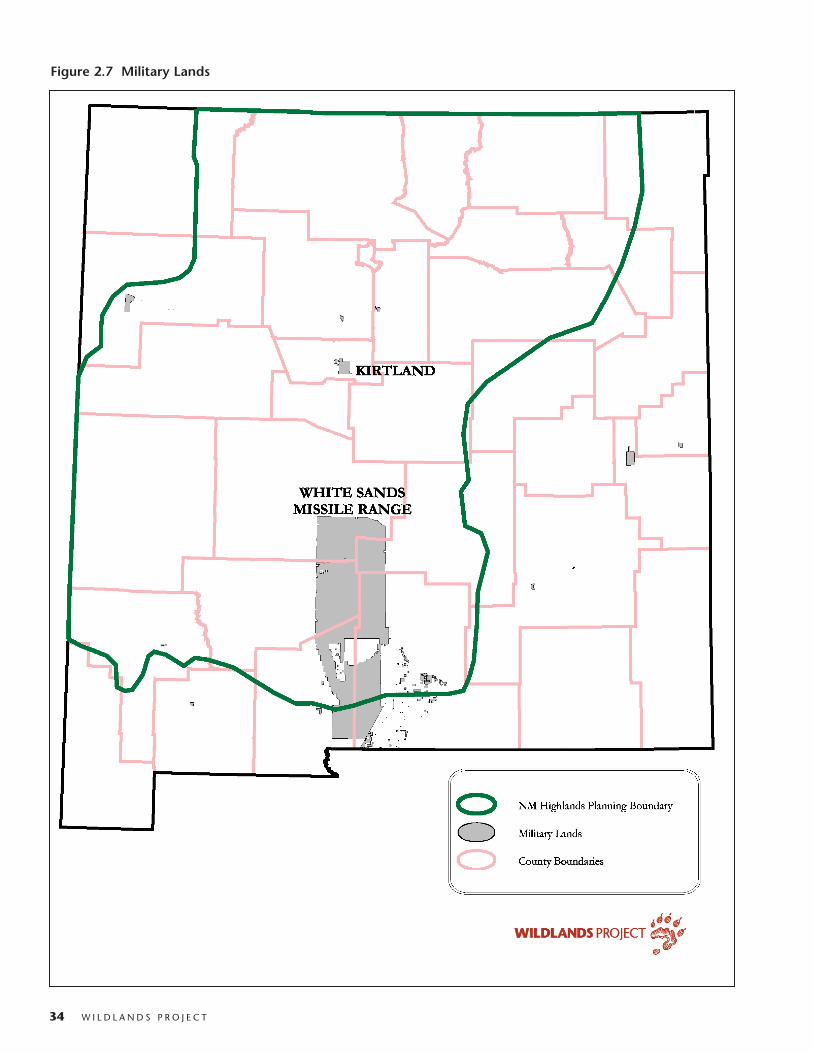
34 W I L D L A N D S P R O J E C T
Figure 2.7 Military Lands

N E W M E X I C O H I G H L A N D S W I L D L A N D S N E T W O R K V I S I O N 35
Tribal LandsApproximately 10 percent of the New Mexico
Highlands planning area is comprised of Native Americanpueblos and reservations. Moreover, several tribes and pueb-los have purchased private ranchlands near their reservations.These tribal lands include areas of high wildlife, biodiversi-ty, and watershed value. From the standpoint of wildlifemovement linkages between the Sky Islands WildlandsNetwork and the Southern Rockies Wildlands Network,some tribal lands are crucial and cooperation between tribesand conservationists is essential for the success of theNMHWN. For example, the New Mexico WildernessAlliance is working closely with Sandia and Zia pueblos onwilderness and land management issues of mutual interest.
The New Mexico Highlands Wildlands Network rec-ognizes that tribal lands are sovereign. Such lands aremapped as part of the wildlands network only in recognitionof good land management practices by the particular puebloor tribe, and because of their vital importance as habitat andto overall patterns of wildlife movement in the region. Thefollowing table shows the tribal lands of particular impor-tance to the NMHWN.
State Trust LandsUpon statehood in 1912, New Mexico was given mil-
lions of acres of public land. The state constitution man-dates that these trust lands be managed to provide maxi-mum income to the state for support of schools. In general,they have not been open to public use, and have been leased,with very little state oversight, to ranchers and oil and gascompanies. State lands are often “checkerboarded” throughfederal lands, making management difficult. Unlike mostwestern states, the NM State Land Office is an independentagency with an elected commissioner (in other states, thecommissioner is appointed by the governor). New Mexicohas been fortunate to have conservation-oriented commis-sioners for much of the last 20 years. The NM Fish and
Game Department pays an annual fee for access on statelands for holders of hunting and fishing licenses. BLM andthe state land office have begun land trades to block up landsfor better management, particularly in BLM WSAs. Statelands in the NM Highlands planning area total 3.7 millionacres (Figure 2.8)
State Wildlife Management AreasIn addition to lands managed by the NM State Land
Office, the NM Department of Game and Fish (NMDGF)has acquired lands for wildlife management (Figure 2.6).These areas are generally managed for hunting and fishingand have relatively low road density.
State ParksThere are also several State Parks in the NM Highlands
region, but most are quite small and are generally managedas campgrounds (Figure 2.8). The State Parks that are com-ponents of the NM Highlands Wildlands Network are:
- Rio Chama State Recreation Area and El Vado Lake and Heron Lake State Parks (50,540 acres)
- Los Pinos State Recreation Area
County and City LandsThe City of Albuquerque and Bernalillo County have a
fine system of open space areas, including a strip of landbetween Albuquerque and the Sandia MountainsWilderness Area.
Table 2.10 Tribal Lands in NM Highlands
Name Unit**
Taos Pueblo Blue Lake Private Core Wild Area
Jicarilla Apache Res. and private lands* Dispersal Linkage and Compatible-Use
Zia Pueblo* Wildlife Linkage and Compatible-use
Jemez and Santo Domingo Pueblos* Dispersal Linkages
Santa Clara Pueblo* Dispersal Linkage
Sandia Pueblo* Compatible-use
Isleta Pueblo* Wildlife Linkage and Compatible-use
Mescalero Apache Reservation* Dispersal Linkage
*Only portions of reservation included. ** For unit descriptions please see section 8.
Table 2.11 State Game and Fish Lands
Name Acres
Eliot Barker 5,508
Bill Humphries 5,339
Marquez 11,836
Colin Neblett 32,057
Salt Lake 638
Edward Sargent 20,092
Urraca 8,381

36 W I L D L A N D S P R O J E C T
Figure 2.8 State Owned Lands and NM Dept. of Game and Fish Lands

N E W M E X I C O H I G H L A N D S W I L D L A N D S N E T W O R K V I S I O N 37
Private Protected LandsThe Nature Conservancy owns several ranches and pre-
serves with conservation easements in the NM Highlandsregion. TNC has also helped purchase other private landsfor sale to the federal agencies. Lama Canyon, Ball Ranch,the Trust for Public Land, the Biophilia Foundation, andAudubon also own land that is managed for conservation(Figure 2.9, Table 2.12.)
Private Ranches Managed forConservation
There are several private ranches in the New MexicoHighlands region managed for their natural values. (Figure2.9, Table 2.13; see Compatible Conservation InitiativesSection, section 9.I.). Additional private ranches managedfor conservation have been identified and will later be incor-porated in the NMHWN design. Such lands are mapped as
part of the wildlands network in recognition of good landmanagement practices by the landowner, and because oftheir vital importance as habitat and to overall patterns ofwildlife movement in the region. Private land owners with-in the New Mexico Highlands are encouraged to participatein voluntary actions to protect linkages, private cores andnative species. (See Chapter 9 for more information).
ConclusionTaken together, these federal, tribal, state, city, and pri-
vate protected areas are a significant existing foundation fora New Mexico Highlands Wildlands Network. Tying exist-ing and proposed protected areas into an adequate and justi-fiable wildlands network is the purpose of this conservationvision. Protecting additional areas and bringing much bet-ter management to public and private lands is vital if theecological wounds to the land are to be healed.
Table 2.12 Private Protected Lands
Name Owner or Easement Holder Acres
Crest of Montezuma Trust for Public Land 1,076
D-Diamond Ranch Winston 4,856
GOS The Nature Conservancy 152
Gila River Farm The Nature Conservancy 128
Gila Riparian Reserve The Nature Conservancy 1,000
Lama Canyon Preserve Lama Canyon 250
Mimbres River Preserve The Nature Conservancy 742
Ortiz Mountain Ranch/Ball Ranch Ball Ranch 13,279
Pritzlaff Ranch Biophilia Foundation 3,104
Randall Davey Audubon Center National Audubon Society 135
Rattlesnake Springs Preserve The Nature Conservancy 8
Rio Nutria Preserve The Nature Conservancy 1,127
Sabo Preserve The Nature Conservancy 23
Santa Fe Canyon Preserve The Nature Conservancy 184
Thornton Ranch Trust for Public Land 7,636
Table 2.13 Private Ranches Managed for Conservation
Name Acres
Berrenda Creek Ranch 24,335
Double Lightning Ranch 18,600
Double H Ranch 128,374
Ladder Ranch 184,160
Lake Valley Ranch 50,435
Pedro Armendaris Ranch 374,106
Philmont Scout Ranch 135,487
Vermejo Park Ranch 579,373

38 W I L D L A N D S P R O J E C T
Figure 2.9 Private Lands Managed for Conservation

N E W M E X I C O H I G H L A N D S W I L D L A N D S N E T W O R K V I S I O N 39
Area is not a healthy landscape; in fact, without restorationits health will continue to decline (Sydoriak et al. 2000).
Efforts to protect the land and create a sustainablehuman society in the New Mexico Highlands will come tonaught without understanding these wounds and theirunderlying causes, and then attempting to heal them. Morethan sixty years ago, Leopold (1937) worried that “our ownconservation program for [New Mexico] has been in a sensea post-mortem cure.” Medicine for the land, or ecologicalrestoration, has advanced much in the last sixty years (or sowe trust). Perhaps we can raise this Lazarus of a landscape torobust good health. It is, at the very least, our duty as citi-zens to try.
There are several ways to categorize ecological wounds.The Wildlands Project follows a medical diagnosis approachof differentiating between wounds or illnesses (pathology)and the causes (etiological agents that perturb natural sys-tems). As an analogy, cigarette smoking is not a human ill-ness, but it can be a cause of several illnesses, includingemphysema, lung cancer, mouth and throat cancer, and heartdisease. Likewise, grazing by domestic livestock is not awound to the land, but it can cause or contribute to severallandscape wounds. The New Mexico Highlands Visionidentifies actual land wounds or illnesses and then considersthe anthropogenic causes for each. Just as a medical doctorseeks not only to treat the symptoms and the disease, butalso tries to understand the root cause(s) of the illness, so doecological “doctors” healing the wounds of the land (a ther-apeutic approach with specific therapies to return to ahealthy functioning system).
The ultimate result of anthropogenic wounds to theland is today’s extinction crisis—the most serious since theend of the dinosaurs 65 million years ago (Soulé 1980;
Leopold came to understand land health and ecologicalwounds from his experience in New Mexico and Arizonafrom 1909 to 1924 and trips to the Sierra Madre inChihuahua in the mid-1930s. In 1937, he wrote:
For it is ironical that Chihuahua, with a history and a ter-
rain so strikingly similar to southern New Mexico and
Arizona, should present so lovely a picture of ecological
health, whereas our own states, plastered as they are with
National Forests, National Parks and all the other trappings
of conservation, are so badly damaged that only tourists and
others ecologically color-blind, can look upon them without
a feeling of sadness and regret (Leopold 1937).
Far ahead of his time in his ability to wisely read thestory of the land, Leopold understood that free Apaches keptsettlement out of the Northern Sierra Madre Occidental wellinto the 20th century. Without livestock grazing and withhealthy populations of mountain lions and wolves, mountainecosystems in Mexico were ecologically healthy, whereassimilar mountain ecosystems in the United States weredeeply wounded (Leopold 1937). Unfortunately, sinceLeopold’s time, the mountain fastness of northern Mexicohas been as carelessly exploited as the southwestern UnitedStates.
In recent years, ecological and historical researchers havegreatly improved our understanding of the ecologicalwounds in the New Mexico Highlands planning area. Evenin the best-protected areas, such as National Parks andWilderness Areas currently ungrazed by domestic livestock,pre-existing ecological damage may continue to persist(Sydoriak et al. 1999). For example, with continuing ero-sion due to past overgrazing and fire suppression and with-out wolves, the Bandelier National Monument Wilderness
3. ECOLOGICAL WOUNDS
Aldo Leopold wrote:
One of the penalties of an ecological education is that one lives alone in a world of wounds…. An ecologist must either harden his shell and make believe
that the consequences of science are none of his business, or he must be the doctor who sees the marks of death in a community that believes itself well and
does not want to be told otherwise (Leopold 1972; Ehrlich 1997).

40 W I L D L A N D S P R O J E C T
Wilson 1992; Soulé 1996). Wilcove et al. (1998) list inorder of importance the current causes of extinction in theUnited States:
Habitat destructionNon-native (alien) speciesPollutionOverexploitationDisease
Reading and Miller (2000) show that overexploitationwas a more important cause of extinction historically inNorth America and remains a highly important cause inmuch of the world today. They would include disease withalien species. Drawing from the above, the WildlandsProject categorizes wounds to the land in the following way:
1) Loss and decline of native species.2) Loss and degradation of ecosystems.3) Loss and decline of natural processes.4) Invasion by exotic species and diseases.5) Fragmentation of habitat.6) Pollution.7) Climate change.
Each of these wounds has more than one cause, and sev-eral of the causes contribute to more than one wound (Table3.1). The overall impact of these wounds is greater thantheir sum and they are highly interactive and overlapping.Among the specific causes of these wounds are:
1) Overhunting, overfishing, trapping, and poaching.2) Predator and “pest” extermination
(shooting, poisoning, trapping).3) Removing native animals and plants for collectors.4) Livestock grazing.5) Logging and fuelwood collection.6) Mining.7) Energy extraction.8) Industrial “recreation.”9) Off-road vehicle abuse.10) Urban, suburban, and “ranchette” sprawl.11) Agricultural clearing.12) Intentional or accidental releases of non-native species.13) Road building.14) Fire suppression.
1A few of these species still survive elsewhere. Most are extinct.
15) Dam construction.16) Irrigation diversions.17) Groundwater depletion.18) Channelization of streams and rivers.19) Fencing.20) Agricultural and forestry biocides.21) Global warming.22) Human overpopulation (the fundamental cause).
The human history of the New Mexico Highlands is alitany of anthropogenic wounds to terrestrial and aquaticcommunities. Even the earliest humans in the region, theClovis culture of big game hunters, around 13,000 years ago(calendar years or 11,000 uncalibrated radiocarbon yearsago), deeply wounded the land by causing the Pleistocenemegafauna extinction, in which 33 out of 45 genera of largemammals in North America became extinct (Martin andKlein 1984). Martin and Burney (1999) identify 27 speciesof mammals larger than 100 pounds that became extinct inthe western United States alone at that time. The over-whelming evidence points to human hunting as the majorcause (Martin and Klein 1984; Ward 1997; Flannery 2001).Among the animals lost in what is now New Mexico weremammoths, mastodons, camels, horses, tapirs, shrub oxen,musk oxen, llamas, peccaries, bison, mountain goats, moun-tain deer, giant ground sloths, glyptodonts, dire wolves,saber-toothed cats, shortfaced bears, American lions,American cheetahs, and giant condors (Martin and Klein1984; Ward 1997).1 Some authorities, including PaulMartin of the University of Arizona, believe that the plantcommunities of the region are still in disequilibrium fromthis loss—an example of a long-festering ecological woundprecipitated by the cessation of much top-down regulationand seed dispersal (Martin and Burney 1999; Barlow 2001).
With the arrival of Europeans in New Mexico 400 yearsago, the land again suffered deep and debilitating wounds.Bogan et al. (1998), Scurlock and Finch (1997), and Allen etal. (1998) provide excellent overviews of ecological woundsin New Mexico. Bogan et al. (1998) discuss the ecologicalwounds caused by “grazing, fire suppression, logging, damsand water diversion, biocides, agriculture, fragmentation ofwildlands by roads and other construction, introduction ofnonindigenous plants and animals, and urbanization” in theU.S. Southwest, including the New Mexico Highlands plan-ning area.

N E W M E X I C O H I G H L A N D S W I L D L A N D S N E T W O R K V I S I O N 41
Table 3.1. Chart of Wounds and Proximate Causes
Loss and Loss and Loss and decline Invasion by Habitat Pollution Climate decline of degradation of natural exotic species fragmentation change
Proximate Causes species of ecosystems disturbance and diseases
Overhunting, overfishing, trapping, poaching X X X
Predator and "pest" extermination X X X
Livestock grazing X X X X X X
Logging and fuelwood collection X X X X X X
Mining X X X X X X
Oil and gas development X X X X X X
Industrial recreation X X X X X X
Off road vehicle abuse X X X X X X
Development/Sprawl X X X X X X X
Agricultural clearing X X X X X X
Introduction of exotic species X X X X
Road building X X X X X X X
Fire suppression X X X X X
Dam construction X X X X X X
Irrigation diversions X X X X
Groundwater depletion X X X X
Channelization of streams and rivers X X X X
Fencing X X X
Agricultural and forestry biocides X X X X
Global warming X X X X X X
Human population growth X X X X X X X
SOURCES: LAROE ET AL. 1995; MAC ET AL. 1998; WILCOVE ET AL. 1998; DONAHUE 1999; RICKETTS ET AL. 1999; MALCOLM AND MARKHAM 2000; MOONEY AND HOBBS 2000.

42 W I L D L A N D S P R O J E C T
3.A. Wounds to the LandThis section contains a discussion of the major wounds,while Section 4 will present the goals and objectives of theNew Mexico Highlands Wildlands Network Vision, whichare designed to heal the wounds. The seven major woundsin the New Mexico Highlands are:
• LOSS AND DECLINE OF SPECIES. Many species of nativeanimals—especially carnivores, large ungulates, andkeystone rodents—have been extirpated or greatlyreduced in numbers.
• LOSS AND DEGRADATION OF ECOSYSTEMS.
Watersheds, stream channels, and riparian forests havebeen damaged almost beyond measure. Beginning inthe 1870s with cutting for mine timbers, railroad ties,and firewood, and continuing to the present day withindustrial logging operations, all forest types in theregion have been degraded. Since the 1880s, due tograzing by domestic livestock, grasslands, woodlands,forests, and desert scrubland have been deeply wound-ed.
• LOSS AND DECLINE OF NATURAL PROCESSES, INCLUD-
ING DISTURBANCE. Over a century of fire suppressionhas eliminated a natural disturbance regime vital to theintegrity and function of forest, woodland, and grass-land ecosystems. With the extermination or decline oflarge carnivores, vital top-down regulation of preyspecies has lessened. Through degradation of water-sheds and flood-control engineering, natural floodingand other hydrological processes have been lost.
• FRAGMENTATION OF HABITAT. The region has beenfragmented by roads, dams, and other works of civiliza-tion, potentially isolating wide-ranging species in non-viable habitat islands.
• INVASION BY EXOTIC SPECIES AND DISEASES.
Aggressive and disruptive exotic species (plants, ani-mals, and microorganisms) have invaded or been pur-posefully introduced, threatening ecosystem integrityand the survival of individual species.
• POLLUTION. Forest insect spraying, mines, feedlots, fac-tories, smelters, power plants, automobiles, and urbanareas have spread biocides, heavy metals, toxic wastes,and chemicals in the air, land, and water, affectingspecies, ecosystems, and climate.
• CLIMATE CHANGE. Global warming, changes in precip-itation patterns, changes in soil moisture, and rising sealevels will change habitat and behavior of many species.
Wound 1: Loss and Decline of SpeciesCauses: During the past 200 years or so, native animals—
carnivores, large ungulates, keystone rodents, and other species—have been extirpated or greatly reduced in numbers by 1) trapping,2) market hunting, 3) competition from domestic livestock, 4) dis-eases introduced by settlers and domestic livestock, 5) livestock fenc-ing, 6) predator and rodent control, 7) trophy and fur hunting, 8)collecting, and 9) transformation of natural habitats for differenthuman uses.
Desert bighorn sheep, Rocky Mountain bighorn sheep,pronghorn, and even mule deer were nearly extirpated by1900. Bison, elk, and Aplomado falcons were extirpatedfrom New Mexico. The Mexican wolf was extirpated in thewild, as was the gray wolf in northern New Mexico.Mountain lions and black bears also declined sharply. Twokeystone rodents—beavers and prairie dogs—sufferedtremendous declines. Some of these losses were partiallyreversed in the 20th century. Rocky Mountain bighornsheep have been reintroduced and viable herds now exist inseveral areas of the state, but desert bighorn sheep persistonly in the Hatchets and San Andres Mountains, and are stillconsidered critically imperiled in New Mexico (NMDGF2002a). Pronghorn and mule deer have recovered fromintensive hunting in the late 1800s and early 1900s. Elkwere reintroduced and have become widespread, but bisonhave only been reintroduced as limited confined herds (e.g.Philmont Scout Camp and Ft. Wingate). Still, none of thesespecies thrive in natural patterns of abundance and distribu-tion, and many more are in steep decline.
American trappers entered New Mexico (then part ofnewly independent Mexico) in the 1820s (Hafen and Rister1950). At this time, beavers were abundant in the RioGrande watershed. By the 1840s, beavers were functionallyextinct in the region, as they were throughout what is nowthe western United States (Beck 1962), Pollock andSuckling 1998). Market and hide hunters killed off thesouthern herd of bison in the 1870s (Matthiessen 1987). InNew Mexico, mining camps sprang up in the 1870s, draw-ing market hunters who slaughtered elk, pronghorn, deer,bighorn sheep, and turkey to feed the miners.
From the 1880s on, many ranchers encouraged theslaughter of wild ungulates, seeing them as competitorswith cattle and sheep for forage. Domestic sheep transmit-ted diseases to both desert and Rocky Mountain bighorns,causing their near-extinction. Rocky Mountain elk wereextirpated from New Mexico by 1909 (Findley et al. 1975;Bogan et al. 1998). Native American hunting may have

N E W M E X I C O H I G H L A N D S W I L D L A N D S N E T W O R K V I S I O N 43
aquatic organisms in the Southwest can be traced to the con-struction of dams, either for water storage or flood control,and to other developments on or near waterways, such asdiversion structures and drainages of wetlands.”
The Rio Grande system in New Mexico has a highdegree of fish endemism (30%) (Bogan et al. 1998), but of 6endemics, 3 no longer occur (Rio Grande shiner, phantomshiner, and Rio Grande bluntnose shiner) in New Mexico(Bogan et al. 1998; Bestgen and Platania 1990), and 2 (RioGrande chub and Rio Grande silvery minnow) have declinedsharply in range and population (Bogan et al. 1998). Lossand degradation of habitat, chemical pollution, overex-ploitation, and exotic species are the main causes of loss anddecline of native fish species in New Mexico (Bogan et al.1998).
Wound 2: Loss and Degradation of EcosystemsCauses: Watersheds, stream channels, and riparian forests have
been severely damaged by 1) trapping-out of beavers, 2) livestockgrazing, 3) water diversions, 4) groundwater pumping, 5) dams,6) fuelwood cutting, 7) agricultural clearing, and 8) watersheddamage from a variety of human activities. Beginning in the1870s, all forest types in the region have been degraded by 1) cut-ting for mine timbers, railroad ties, and firewood; and continuing tothe present day with 2) industrial saw timber operations, 3) exotictree pathogens, 4) increased ignition frequency by humans, 5) firemanagement, and 6) grazing impacts on seedling establishment.High mountain meadows, grasslands, and woodlands have beendisrupted and degraded by livestock grazing and fire suppression.
All types of ecosystems in New Mexico—alpine tundra,forests, woodlands, grasslands, riparian/wetlands, anddesertscrub—have been degraded by human activities ofvarious kinds.
In arid New Mexico, water is generally the limitingresource. Some 80 percent of vertebrate species in the desertSouthwest are dependent on riparian areas for at least part of
largely extirpated elk from the Jemez Mountains even beforeSpanish settlement (Lang and Harris 1984; Bogan et al.1998). Livestock fencing has disrupted the movement ofpronghorn to seasonal water sources, leading to their rapiddecline and now allowing only an agonizingly slow recovery.
With their natural prey gone, wolves, grizzlies, andmountain lions turned to cattle and sheep (Mackie et al.1982; Bogan et al. 1998). In the United States, theDepartment of Agriculture’s Predatory Animal and RodentControl agency (PARC) used traps, guns, and poison to tryto completely exterminate predators, including bobcats,lynx, wolverines, and coyotes (Dunlap 1988). By the mid-1930s, grizzlies were extirpated and wolves were functional-ly extirpated from New Mexico (Brown 1983; Brown 1985).Mountain lion populations were greatly reduced. Prairiedogs were functionally exterminated by a taxpayer-spon-sored, government poisoning program that continues today.The “Wildlife Services” Program (formerly “AnimalDamage Control”) continues to kill thousands of predatorsevery year (Table 3.2). Many ranchers disliked prairie dogsbecause of the mistaken belief that they damage the range.The black-footed ferret was lost from the region because ofthe massive decline of prairie dogs (Miller et al. 1996).Prairie dogs and predators also fell victim to so-calledvarmint hunters.
Bogan et al. (1998) report, “In New Mexico andArizona, 11 of 40 (27.5%) land bird species known to havedeclined in numbers over the last 100 years may have doneso because of degradation and destruction of riparian habi-tats (DeSante and George 1994).” Belsky et al. (1999)report that “a recent U.S. Forest Service report found live-stock grazing to be the fourth major cause of species endan-germent in the United States and the second major cause ofendangerment of plant species (Flather et al. 1994).” Boganet al. (1998) conclude, “Most declines and extirpations of
Table 3.2 Number of Animals Killed by the WildlifeServices Program in NM Fiscal Year 1999
Beavers 63
Bobcats 176
Coyotes 7,269
Gray Foxes 28
Kit Foxes 22
Red Foxes 6
Swift Foxes 16
Mountain Lions 19
SOURCE: WILDLIFE SERVICES ANNUAL TABLES, 1999
SOURCE: NEW MEXICO DEPARTMENT OF GAME AND FISH, 2002A.
Table 3.3 Native New Mexican Wildlife that No Longer Exist
Rio Grande Bluntnose Shiner Notropis simus simus
Phantom Shiner Notropis orca
New Mexico TympanuchusSharp-tailed Grouse phasianellus hueyi
Hot Springs SigmodonCotton Rat fulviventer goldmani
Merriam’s Elk Cervus elaphus merriami
Florida Mountainsnail Oreohelix florida

44 W I L D L A N D S P R O J E C T
their life cycle (Noss and Peters 1995). In Arizona and NewMexico, more than 100 federally and state listed species areassociated with cottonwood-willow bosques (Noss andPeters 1995). Over half of the threatened and endangeredspecies in New Mexico and Arizona became so because ofriparian losses (Suckling 1996b). Arizona and New Mexicohave lost 90 percent of pre-settlement riparian ecosystems(Noss et al. 1995). Between 1780 and 1980 wetlands inNew Mexico declined by 33% (Dahl 1990; Bogan 1998).
The near-extermination of beavers from the Rio Grandebasin by 1840 began the degradation of watersheds andriparian areas. Beaver dams had created extensive wetlands,controlled floods, stored water for slow release throughoutthe year, and provided high-quality habitat for many species,including the endangered Southwestern willow flycatcherand the endangered Gila trout (Bogan et al. 1998; Knopfand Scott 1990). Some watercourses were staircases ofbeaver ponds for many miles. Without beaver dams, wet-lands shrunk and seasonal floods ran unchecked (Pollock andSuckling 1998; Bogan et al. 1998). Major river systems inthe New Mexico Highlands have also been degraded byhuman-made dams and diversions (Szaro 1989; Crawford etal. 1993; Bogan et al. 1998; Figure 3.1).
Bogan (1998) provides an overview of wounds to theRio Grande and its cottonwood-willow bosques, writing,“Only 27% of the [Middle Rio Grande bosque] forested in1935 still supports forests. The flow regime of the river hasbeen altered significantly, with lower peak flows, whichmeans that cottonwood regeneration rarely occurs.”
The loss of flooding disturbance to cottonwood forests,combined with livestock’s fondness for seedlings, has led toless diversity in age classes. Farley et al. (1994) concludethat diversity of neotropical migrant songbirds is “maxi-mized by simultaneous availability of [riparian forest] vege-tation of different ages.” Farley et al. (1994) further report,“Knopf (1989) and Howe and Knopf (1991) proposed that,without human intervention to control the spread of nonna-tive species and enhance recruitment of native species, anear-complete replacement of the native plant communityin the Rio Grande Valley could take place within the [twen-ty-first] century.”
Allen et al. (1998) report
One of the most remarkable changes in southwestern land-
scapes involved late nineteenth and early twentieth century
channel entrenchment. Between 1865 and 1915, arroyos
developed in alluvial valleys of the southwestern United
States across a wide variety of hydrological, ecological, and
cultural settings.
Table 3.4 Native New Mexican Wildlife Extirpatedfrom the State
Birds
Sage Grouse Centrocercus urophasianus
Sharp-tailed Grouse Tympanuchus phasianellus
Fish
Shovelnose Sturgeon Scaphirhynchus platorynchus
Spotted Gar Lepisosteus oculatus
American Eel Anguilla rostrata
Golden Trout Oncorhynchus aguabonita
Colorado River OncorhynchusCutthroat Trout clarki pleuriticus
Beautiful Shiner Cyprinella formosa mearnsi
Bonytail Chub Gila elegans
Palomas Pupfish Cyprinodon sp
Freshwater Drum Aplodinotus grunniens
Amphibians
Western Boreal Toad Bufo boreas
Lowland Leopard Frog Rana yavapaiensis
Mammals
Gray Wolf Canis lupus *
Grizzly Bear Ursus arctos
Black-footed Ferret Mustela nigripes
Mink Mustela vison energumenos
Wolverine Gulo gulo
Lynx Lynx lynx
American Bison Bos bison**
*Canis lupus baileyi reintroduced, other subspecies extirpated
**Native populations of bison have been extirpated from New Mexico,although the species has been reintroduced in several areas as confined herds(e.g., Philmont Scout Camp, Ft. Wingate, Carson N.F. & Vermejo Park Ranch).
SOURCE: BIOTA INFORMATION SYSTEM OF NEW MEXICO – DEPARTMENT OFGAME AND FISH, CONSERVATION SERVICES DIVISION, 2002

N E W M E X I C O H I G H L A N D S W I L D L A N D S N E T W O R K V I S I O N 45
Fig. 3.1 Dam Locations

46 W I L D L A N D S P R O J E C T
SOURCE: BELSKY ET AL. 1999
The grazing of domestic cattle and sheep has been theprimary cause of watershed and stream destruction (Belskyet al. 1999), and of degradation of grassland and desertshrubland ecosystems (see Table 3.5). Cattle and sheep werebrought to New Mexico with the Spanish in 1600. PuebloIndians and Navajos soon adopted livestock herding. After1788, “several hundred thousand sheep” ranged NewMexico (Bogan et al. 1998; Denevan 1967). Overgrazingbegan very early, then, in parts of New Mexico, althoughlarge areas were not grazed by livestock because of lack ofsettlement due to Comanche, Apache, Ute, and Navajo raid-ing. Anglo ranchers moved into parts of New Mexico in the1850s. With the confinement of the tribes to reservations by
the 1880s, both Anglo and Spanish ranchers filled the state.Cattle populations in New Mexico exploded from 137,000in 1880 to 1,380,000 in 1889 (Wooton 1908; Williams1986; Bogan et al. 1998). Sheep numbers were 619,000 in1870 (Denevan 1967), 2,000,000 in 1880, and 5,400,000in 1884 (Wooton 1908; Bogan et al. 1998). Drought struckNew Mexico in 1891-1893, killing 50-75 percent of thetotal cattle population. “Witnesses stated that a personcould stand at one carcass and throw rocks to others nearby”(Ferguson and Ferguson 1983).
Bogan et al. (1998) summarize the impact of grazing onNew Mexico ecosystems:
The extremely high historical stocking rates and concomi-
tant overgrazing and livestock preferences for certain more
palatable plants (for example, grasses) led to significant
alterations in the species composition of vegetation across
the Southwest (Leopold 1924; Cottam and Stewart 1940;
Cooper 1960; Buffington and Herbel 1965; Humphrey
1987; Grover and Musick 1990; Archer 1994; Fleischner
1994; Pieper 1994). Cool-season grasses and other pre-
ferred forage species declined (Bohrer 1975), while unpalat-
able and weedy species, such as broom snakeweed and
shrubs, such as creosotebush and mesquite, increased
(Wooton 1908; Bahre and Shelton 1993).…Livestock also
altered vegetation composition by serving as an agent for
the spread of weedy and nonindigenous plant species such
as Lehmann lovegrass (Warshall 1995). Concentrated live-
stock use of riparian zones has had particularly significant
negative ecological effects (General Accounting Office
1988; Szaro 1989; Bahre and Shelton 1993; Fleischner
1994).…Overgrazing is also widely considered a major
trigger of soil erosion, flooding, and arroyo cutting in the
Southwest (Wooton 1908; Leopold 1924; Cooperrider and
Hendricks 1937; Cottam and Stewart 1940; Smith 1953;
Cooke and Reeves 1976; Bahre and Bradbury 1978;
Branson 1985; Bahre 1991)….
Long-term livestock grazing has diminished andchanged herbaceous vegetation in piñon-juniper woodlands(Branson 1985; West and Van Pelt 1987; Miller andWigand 1994) “leading to widespread desertification ofunderstory conditions (Gottfried et al. 1995)” (Bogan et al.1998). Bare and exposed soils have decreased infiltrationcapacity and are highly vulnerable to accelerated erosion andgully formation (Wilcox and Wood 1988). Since the cattlecrash 100 years ago, herds have built back up in NewMexico (cattle numbers on Western rangelands increasedfrom 25,500,000 in 1940 to 54,400,000 in 1990 (Belsky etal. 1999). Some desert grasslands were transformed into cre-osotebush desert by the overgrazing/drought/soil erosion
Table 3.5. Landscape and regional consequences of livestock grazing in streams and riparian ecosystems in the arid West
• Downstream waters have higher temperatures
and sediment loads.
• Downstream flood levels are higher.
• Quantity of water to downstream ecosystems is
lower during low-flow periods.
• Forested connectors and wildlife migratory routes between
high and low elevation ranges are lost.
• The diversity and abundance of migratory birds
and wildlife are reduced.
• Habitat mosaic is homogenized.
• Corridors for migration of salmonids and other
species are fragmented.
• Areas set aside for human recreation are
reduced in quality.
• Commercial and recreational fishing opportunities
are reduced.
• Domestic water supplies require more filtration and treat-
ment by water-treatment plants, leading to
higher utility rates.
• More sediment is deposited in lakes and reservoirs,
thus reducing reservoir life and hydroelectric capacity.
• Sediments in water damage hydroelectric turbines.
• Higher sediment loads increase maintenance
costs of irrigation canals.

N E W M E X I C O H I G H L A N D S W I L D L A N D S N E T W O R K V I S I O N 47
“triple-whammy.” During naturally occurring, periodicdroughts, livestock grazing is especially destructive, as cat-tle will eat everything they can before dying—after whichvegetative recovery is nearly impossible. In much of NewMexico, despite the improvement from near-desertified con-ditions at the turn of the century, millions of acres of graz-ing lands remain in only poor or fair condition. Riparianareas are considered by many authorities to be in their worstcondition ever (Belsky et al. 1999; Chaney et al. 1990; USDI1994). Aldo Leopold (1937) wrote, “I sometimes wonderwhether semi-arid mountains can be grazed at all withoutultimate deterioration.” His question remains unanswered.
During the 1800s, bosques along the Rio Grande wereheavily cut for fuelwood and timber, thereby degradingriparian forest and understory vegetation (Scurlock 1988;Farley et al. 1994). This cutting of mesquite, cottonwood,willow, and other tree species degraded wildlife habitat andled to greater erosion of channels. Agricultural clearingalong the Rio Grande and its tributaries eliminated ordegraded the most productive and extensive bosques. Water
diversion for irrigation and later for mining, the downcut-ting of arroyos (lowered streambeds in arroyos interceptground water at a greater depth, thus drawing the watertable down), and groundwater pumping for agriculture,mining, and urban use have lowered the water table, result-ing in dried-up cienégas, dewatered rivers, and dyingbosques (Van Cleave 1935; Farley et al. 1994). This loss ofhabitat and diminishment of ecological resilience hasencouraged the spread of exotic species and the eliminationof sensitive native species. Watersheds were damaged notonly by livestock grazing, but also by the widespreadclearcutting of piñon-juniper and oak woodlands for minetimbers and fuelwood (Bahre 1998).
Too few have heeded Leopold’s (1937) warning:“Somehow the watercourse is to dry country what the face isto human beauty. Mutilate it and the whole is gone.” After World War II, commercial saw timber operationsincreased on National Forests in New Mexico, as they didthroughout the National Forest System (Clary 1987).Current overstocking of forests was caused purposefully bythe USFS and industry to maximize tree growth for fiberproduction. They wanted to eliminate old-growth forestsand replace them with what they believed were “more effi-cient young forests.” Old-growth ponderosa pine forests arelisted as one of the 21 most endangered ecosystems in theUnited States (Table 3.6.; Noss and Peters 1995). For allArizona and New Mexico National Forests, the SouthwestForest Alliance reports, “About 90 percent of the old-growthhas been liquidated, including 98 percent of the old-growthponderosa pine.” Wallace Covington, forestry professor atNorthern Arizona University, says, “I’ve made it clear for 20years there’s been a population crash of old-growth treesleave the damn things alone.”
He also writes, “The cumulative effects of old-growthlogging, non-native species introductions, overgrazing,predator control, and fire exclusion have been ecosystemsimplification so great that Southwestern forest ecosystemsare at risk of catastrophic losses of biological diversity”(Suckling 1996a, 1996b; Pollock and Suckling 1997).
Bogan et al. (1998) summarize the health of NewMexico forests as follows:
Fire suppression, commercial forestry practices, and over-
grazing have pervasively altered the structure and species
composition of most southwestern forests (U.S. Forest
Service 1993; Covington and Moore 1994). Old-growth
forests have been greatly reduced by high-grading and
even-aged management practices that targeted the most
valuable old trees, especially ponderosa pine. In addition,
until 20 years ago, snags (dead trees) were systematically
Table 3.6. The 21 Most EndangeredEcosystems of the U.S.
The New Mexico Highlands contains two of the ecosystemsconsidered the most endangered in the U.S. (Noss and Peters1995).
South Florida Landscape
Southern Appalachian Spruce-Fir Forest
Longleaf Pine Forest and Savanna
Eastern Grasslands, Savannas, and Barrens
Northwestern Grasslands and Savannas
California Native Grasslands
Coastal Communities in the lower 48 States and Hawaii
Southwestern Riparian Forests
Southern California Coastal Sage Scrub
Hawaiian Dry Forest
Large Streams and Rivers in the Lower 48 States and Hawaii
Cave and Karst Systems
Tallgrass Prairie
California Riparian Forests and Wetlands
Florida Scrub
Ancient Eastern Deciduous Forest
Ancient Forest of Pacific Northwest
Ancient Red and White Pine Forest, Great Lakes States
Ancient Ponderosa Pine Forest
Midwestern Wetlands
Southern Forested Wetlands

48 W I L D L A N D S P R O J E C T
removed as fire and forest health hazards, while extensive
road networks aided those who poached fuelwood (poachers
often focused on snags). Hence, most managed forests now
lack desired numbers of large-diameter snags, which serve
important ecological roles such as cavity-nesting sites for
many breeding birds (Thomas et al. 1979; Hejl 1994) and
probably for many bats as well (H. Green, U.S. Forest
Service, personal communication; M. Bogan U.S.
Geological Survey, Albuquerque, New Mexico, unpub-
lished data). Today’s forests are characterized by unnatural-
ly dense stands of young trees, a variety of forest health con-
cerns, increasing potential for widespread insect population
outbreaks (Swetnam and Lynch 1993), and unnatural crown
fires (Covington and Moore 1994; Sackett et al. 1994;
Samson et al. 1994).
Aspen stands declined 46% in area in New Mexico andArizona between 1962 and 1986, largely due to fire sup-pression (U.S. Forest Service 1993; Bogan et al. 1998). It iswidely believed that the spread of piñon-juniper woodlandsinto grasslands is a result of fire suppression and overgrazing,but Allen et al. (1998) report, “Several authors have sug-gested that pinyon-juniper expansion may instead representrecovery from prehistoric fuel harvesting, at least in thoseareas that were heavily populated within the last 1,000 years(Samuels and Betancourt 1982; Kohler 1988).”
Wound 3: Loss and Decline of Natural ProcessesCauses: Natural fire, which is vital to the health of forest,
woodland, and grassland ecosystems in New Mexico, has been large-ly eliminated by over a century of 1) livestock grazing and 2) firesuppression. Natural over-the-bank stream flooding, which is keyfor the reproduction, maintenance, and recovery of riparian commu-nities, has been lost because of 1) watershed destruction, 2) dams, 3)stream diversions, and 4) flood-control structures. The removal ordecline of large carnivores has lessened or eliminated top-down regu-lation of ecosystems. Logging, grazing, and other habitat alter-ations have disrupted natural herbivory, nutrient cycling, waterinfiltration and carbon sequestration.
Simberloff and his co-authors (1999) identify fire,hydrology, and predation as the ecologically most essentialnatural processes to restore. All have been severely disrupt-ed in New Mexico.
Recent ecological research has demonstrated the impor-tant role played by predation in top-down regulation ofecosystems (Soulé and Noss 1998; Terborgh et al. 1999).Extirpation of the wolf and population reduction of themountain lion through predator extermination programshave disrupted ecological integrity in New Mexico throughthe behavioral and population release of prey animals. Forexample, elk overbrowsing harms the regeneration of aspen
(Moir 1993; Allen 1996; Bogan et al. 1998). After wolvesreestablished a functional presence in Yellowstone, browsingof aspens and willows declined due to the impact of wolfpacks on elk behavior. Loss of predators was discussed inWound 1 and the necessary role of top-down regulation willbe discussed in Section 5.E.
Most ecosystems in New Mexico coevolved with fre-quent fire. Before about 1900, most montane forests burnedin accordance with the two-to-seven-year wet-dry cyclesassociated with the El Niño-Southern Oscillation (Swetnamand Betancourt 1990, 1998; Swetnam and Baisan 1996).Misunderstanding the ecological role of natural fire in theseecosystems led the Forest Service and other land managers toaggressively try to put out fires from about 1906 on. Inaddition to fighting fires, the Forest Service deliberatelyencouraged overgrazing by cattle and sheep to eliminategrass that carried the natural, cool, ground fires (Savage andSwetnam 1990; Swetnam 1990; Swetnam and Baisan 1996;Bogan et al. 1998). By the 1960s, increasing numbers of sci-entists recognized fire’s important role, but such ideas wereheresy to many foresters and ranchers, who viewed wildlandfires as a threat to forage and timber production.
Bogan et al. (1998) conclude, “Fire suppression over thepast century pervasively affected many southwestern ecosys-tems (Covington and Moore 1994).” The reduction in firefrequency combined with overgrazing by cattle and sheephas allowed woody plants to out-compete grasses (competi-tion from grasses was as significant as fire in keeping pineand juniper stands from becoming too dense and extensive).Consequently, snakeweed, creosote bush, prickly pear, chol-la, acacia, mesquite, and piñon-juniper woodland haveinvaded and replaced grasslands. This has changed the bal-ance of natural ungulates that graze and browse. Forestedareas have been extensively degraded by the combination offire control and overgrazing. By eliminating frequent, cool,ground fires in forests, land managers have allowed the fuelload to build up, thereby creating conditions for destructiveconflagrations and crown fires (Humphrey 1958; Fule andCovington 1994; Morgan and Suckling 1995; Suckling1996a; Pollock and Suckling 1997; Bahre 1998).
The control of natural fires has increased the timebetween fires, which has allowed enough time for seedlingsto develop into trees large enough to withstand the occa-sional light surface fires. This has also led to the expansionof forests over grasslands and increases in tree density with-in forests and woodlands (Leopold 1949; Fisher et al. 1987;Houston 1994).
Although Native Americans may have set fires, Allen etal. (1998) conclude that “fire frequencies were probably con-trolled primarily by climate and fuel dynamics, rather than

N E W M E X I C O H I G H L A N D S W I L D L A N D S N E T W O R K V I S I O N 49
by ignition source.”Allen et al. (1998) report that
The importance of intense livestock grazing as a cause of the
disruption of natural fire regimes is confirmed by the com-
parison of different case studies. A few sites in northern
New Mexico and Arizona that were grazed by sheep and
goats owned by Spanish colonists and Navajos (Dine) show
fire frequencies declining in the early nineteenth century, or
earlier, and corresponding to the documented timing of
pastoral activities in these areas (Savage and Swetnam 1990;
Touchan et al. 1996; Baisan and Swetnam 1997). In con-
trast, remote sites with no evidence of early, intensive graz-
ing sustained some surface fires into the middle of the twen-
tieth century, when aerial firefighting resources began to be
most effective in suppressing fires (Grissino-Mayer 1995).
Finally, a remote mountain in northern Sonora, Mexico,…
where neither intensive livestock grazing nor effective fire
suppression has occurred, shows episodic surface fires burn-
ing throughout the twentieth century.
Riparian woodlands were naturally maintained in thesouthwestern United States by flooding from snowmelt inthe spring and thunderstorms in the summer. Degradationof watersheds, loss of the functional role of beavers, artificialdams, water diversions, groundwater pumping, channeliza-tion, and flood control structures have largely eliminatedthis natural disturbance regime, as discussed in Wound 2.Simberloff et al. (1999) discuss the many benefits of natural-ly fluctuating water levels (flooding and low flows) instreams. Elimination of natural flooding has allowed exotictamarisk to outcompete native cottonwood and willow.
Wound 4: Fragmentation of Wildlife Habitat Causes: Wildlife habitat in the region has been fragmented by
1) highways, roads, and vehicle ways; 2) dams, irrigation diver-sions, and dewatering of streams; 3) destruction and conversion ofnatural habitat; and 4) other works of civilization, such as power-lines, fences, and urban and ranchette development. Fragmentationhas severed historic wildlife migration routes and has potentiallyisolated wide-ranging species in nonviable habitat islands.Expanding human populations and development continue to frag-ment habitat.
Michael Soulé and John Terborgh (1999) remind us that“connectivity is not just another goal of conservation: it isthe natural state of things.”
Dams on the Rio Grande and other rivers and smallerdams on headwater streams, irrigation, diversion dams; anddewatered and degraded stretches of once-perennial streamshave fragmented the habitat for native fish, amphibians, andaquatic invertebrates (Crawford et al. 1993; Bogan 1998).
Table 3.7: New Mexico Documented AnimalCrashes (Division of Government Research 2002)
Year Species Deaths
1997 deer 565
elk 142
bear 12
pronghorn 5
1998 deer 601
elk 128
bear 7
pronghorn 11
mountain lion 1
1999 deer 323
elk 80
bear 7
pronghorn 4
mountain lion 1
2000 deer 668
elk 149
bear 18
pronghorn 13
mountain lion 2
2001 deer 656
elk 160
bear 30
pronghorn 8
mountain lion 4
Totals
deer 2813
elk 659
bear 74
pronghorn 1
mountain lion 8
TOTAL 3595

50 W I L D L A N D S P R O J E C T
and ecosystems at a regional scale, their presence undoubt-edly degrades the ecological integrity of the New MexicoHighlands Wildlands Network. Thus the challenge is toimplement initiatives that will make the transportationinfrastructure compatible with the “ecological infrastruc-ture” defined by the wildlands network design.
A documented example of the extent to which habitatfragmentation from roads has increased in New Mexico isfrom the Jemez Mountains. Road length increased from 719km in 1935 to 8,433 km in 1981, and the “[e]stimated totalarea of road surfaces grew from 0.13% of the map area in1935 (247 ha) to 1.67% in 1981 (3,132 ha)” (Allen et al.1998).
Wound 5: Invasion of Exotic Species Causes: Ecosystems and the survival of individual native
species have been threatened by aggressive and disruptive exotic species(plants, animals, and pathogens) that have 1) invaded from otherwounded areas, 2) escaped from cultivation, or 3) been deliberatelyintroduced.
Conservation biologists now recognize exotic species asa leading cause of extinction, second only to habitat destruc-tion (Wilcove et al. 1998). In New Mexico, non-nativeplants and animals are a serious cause of endangerment ofnative species. Some of these destructive invaders weredeliberate introductions; some escaped from cultivation;others hitchhiked in. Most do well in disturbed habitats.
Among plants, tamarisk (salt cedar), a native of theMiddle East, was planted ornamentally in the late 1800s. Itspread through cattle-damaged riparian areas, and it benefitsfrom dams and flood-control levees, which prevent naturalcycles of drying and flooding with which native species (cot-tonwoods, willows) evolved. Tamarisk is not a major habi-tat or food source for native species, although it does providecritical interim nesting habitat for the endangeredSouthwestern willow flycatcher in a few areas where nativevegetation has been lost. As a phreatophyte, tamarisk sucksup large amounts of water through its roots and transpiresthis moisture into the air, thereby drying up springs andstreams upon which native species depend. The eliminationof seasonal flooding by upstream dam construction hasallowed tamarisk and Russian olive to dominate large areas(Dick-Peddie 1993; Farley et al. 1994).
George Cox, professor emeritus of ecology at San DiegoState University and retired in Santa Fe, reports (2001) that“New Mexico now has about 390 established alien plantspecies or 11 percent of the state’s flora. Alien speciesincluded one family and species of fern, 50 families and 270species of dicots, and 5 families and 119 species of mono-cots.…The number of species of alien plants has increased
Conversion, fragmentation, and degradation of bosques haveharmed riparian-dependent birds and other species. Habitatfor wide-ranging species such as wolf, mountain lion, lynx,pronghorn, and bighorn sheep has been fragmented byroads, fences, agriculture, and urban, suburban, andranchette development. Artificial treelines in grassland areasfragment habitat for grassland birds (O’Leary and Nyberg2000).
Interstate highways 40 and 25 are formidable barriers tomany kinds of wildlife. Two-laned paved roads cause manydeaths of animals trying to cross. Dirt roads fragment thelandscape for wolves, mountain lions, and other species vul-nerable to opportunistic poaching. For example, at least fivereleased Mexican wolves were shot alongside roads in theApache National Forest in 1998, and two have been killedby automobile collisions. Even dirt tracks can fragment thelandscape for slow-moving reptiles and amphibians.
Highways and railways have traditionally been designedfor the movement of humans and commodities. Societyenjoys the benefits of fast transportation, yet often disregardsthe negative environmental consequences of this conven-ience, including the deaths of millions of animals (see 5.F. fora more detailed discussion of impacts). From 1997 to 2001,there have been 3,595 documented game animal crashes inNew Mexico, involving deer, elk, pronghorn, black bear andmountain lion (see Table 3.7; Division of GovernmentResearch 2002). Because many accidents go unreported,this figure only gives an indication of actual road mortalityrates, and does not include the thousands of smaller mam-mals, reptiles and amphibians that suffer the same fate.Accidents involving wildlife not only impact wildlife popu-lations; they are a deadly hazard to motorists as well. Byworking to address this issue, both motorist safety and con-nectivity for wildlife will benefit simultaneously.
Roads and roadsides cover approximately one percent ofthe United States, yet an estimated 15-20% of the land isdirectly affected by roads and vehicles (Jackson and Griffin2000). With the explosion of motorized vehicle use inAmerica in the past century, there has been a lack ofresources dedicated to conduct the necessary research and toimplement proper mitigation strategies that would help toalleviate the negative impacts our growing transportationinfrastructure has upon wildlife populations. Highwayshave the potential to undermine ecological processesthrough the fragmentation of wildlife populations, restric-tion of wildlife movements, and the disruption of gene flowand metapopulation dynamics (Oxley et al. 1974; Garlandand Bradley 1984; Trombulak and Frissell 2000; Jacksonand Griffin 2000). Although it is difficult to assess thecumulative impacts caused by these “barriers” to wildlife

N E W M E X I C O H I G H L A N D S W I L D L A N D S N E T W O R K V I S I O N 51
Wound 6: Pollution Causes: Mines, feedlots, factories, smelters, power plants, agri-
cultural and forestry biocides, automobiles and other motor vehicles,and urban areas have spread heavy metals, toxic wastes, and chem-icals in the air, land, and water, adversely affecting species, ecosys-tems, and climate.
A full discussion of pollution is beyond the scope of thisplan. However, it should be noted that concentrations ofDDT and other biocides remain in New Mexico ecosystemsfrom their heavy application for forestry and agriculturalpurposes in the 1950s and 1960s (Bogan et al. 1998).Between 1955 and 1963, for example, 1,384,267 pounds ofDDT was sprayed on the 1,181,300 acres of the Santa Fe andCarson National Forests (Brown et al. 1986; Bogan et al.1998). New Mexico is ranked 7th in the country in overallon-site and off-site releases of toxic chemicals, for a total of262,276,177 pounds in 1999 (EPA 2000).
Oil and gas development is also a source of pollution,habitat destruction, erosion, and hydrologic alteration. Evenpreliminary exploration for these fossil fuels requires thedevelopment of numerous roads to accommodate heavymachinery. The new roads associated with the thousands ofwells, pipes, power lines, drill pads and other surface debrisalters hydrological patterns, increases erosion, promotes thespread of exotic and noxious weeds and affects water quality(Figure 3.2).
Nonpoint sources of pollution are responsible for over91% of the degradation in New Mexico's 3,080 impairedstream miles (New Mexico Water Quality ControlCommission 2000). Sources of impairment include agricul-ture, hydrologic and habitat modification, and recreationalactivities. Agriculture and recreational activities are the pri-mary sources and causes of nutrients, siltation, reducedshoreline vegetation, and bank destabilization, which impairaquatic life in 83% of New Mexico's surveyed lake acres(New Mexico Water Quality Control Commission 2000).
almost threefold since the first publication of the state’s florain 1915.…Since 1980, ten new families and 134 species ofaliens have appeared, a rate of increase of 6.7 species per year.The number of alien species is thus increasing exponential-ly.…The total number of woody plants, in fact, has morethan doubled since 1980.”
Heavy sheep grazing in the late 1800s so damaged highmountain meadows that “moist meadows in the JemezMountains…are often dominated now by nonindigenousplants such as Kentucky bluegrass, white clover, and dande-lion (Allen 1989; Wolters 1996)” (Bogan et al. 1998).
At least 75 exotic species of fish are present in NewMexico (Boydstun et al. 1995; Bogan et al. 1998). Murray(1996) discusses the ecological impacts of stocking natural-ly fishless high mountain lakes in the American West withexotic trout. Aquatic invertebrates extirpated from suchlakes after stocking include beetles, midges, dragonflies,water striders, mayflies, water fleas, copepods, and side-swimmers. In the New Mexico Highlands region, Murray(1996) writes, “Introducing new fish species has resulted indeterioration of genetic integrity of native races such as Gilatrout (Oncorhynchus gilaea) within the Gila Wilderness, RioGrande cutthroat trout (O. clarki virginalis) in the PecosWilderness….”. Moreover, some dams were built in thePecos Wilderness to raise the water level of natural lakes forthe sole reason of supporting exotic trout and the sport fish-ers who catch them (Murray 1996).
Exotic ungulates, including Barbary sheep, gemsbok(oryx), and ibex, were introduced into New Mexico for sporthunting in the 1960s and 70s (Findley et al. 1975), but lit-tle is known about their impact on native species and habi-tats (Bogan et al. 1998). These animals have since spreadover wider areas. Feral horses and burros have been presentin New Mexico since Coronado’s expedition in 1541. Feralcattle continue to range in areas where commercial livestockgrazing has been halted, such as the Gila River in the GilaWilderness Area.

52 W I L D L A N D S P R O J E C T
Fig. 3.2. Oil and Gas Wells
Obtained from the New Mexico PetroleumRecovery Research Center—a division ofNew Mexico Tech.30,000 wells fall within NewMexicoHighlands planning boundary

N E W M E X I C O H I G H L A N D S W I L D L A N D S N E T W O R K V I S I O N 53
Wound 7: Climate ChangeCauses: Factories, smelters, power plants, agricultural waste,
automobiles, chemicals causing ozone depletion, and deforestation allcontribute to global warming and subsequent climate change.
Based on projections made by the IntergovernmentalPanel on Climate Change and results from the UnitedKingdom Haley Centre’s climate model, which accounts forboth greenhouse gases and aerosols, temperatures in NewMexico could increase from three to five degrees Fahrenheitby the year 2100 (IPCC 1998). This could lead to increasesin extreme storms, the severity and number of flash floods,the extent and severity of forest fires, and the duration, fre-quency and severity of drought (EPA 1998; Longstreth1999; UCS 2002). Evidence suggests that the warming ofthe past century already has resulted in marked ecologicalchanges, including changes in growing seasons (Myneni et -al. 1997); Menzel and Fabian 1999), species ranges (Thomas and Lennon 1999; Parmesan et al. 1999) and pat-terns of seasonal breeding (Beebee 1995; Brown et al. 1999;Crick and Sparks 1999).
Climate is the single most important factor determin-ing the geographic distributions of species and major vege-tation types (Holdridge 1947; Brown and Lomolino 1998).The potential exists for significant reductions in the geo-graphic extent of some ecosystems, changes in ecosystemprocesses such as productivity, and changes in the distribu-tions and abundances of individual species (Malcolm andPitelka 2000). Species have shifted their distributions in thepast in response to changing climates; however, estimates ofthe rate of warming suggest that it may occur relativelyquickly, some 10 times faster than the warming at the endof the recent glacial maximum, for example (Brown andLomolino 1998). Fragmentation of habitat exacerbates theimpact of climate change by making it more difficult forspecies to move north or to higher elevations in response towarming. Climate also plays a central role in determiningthe disturbance regime of an area, such as the frequencies of
forest fires or hurricanes. The effects of climate change onecosystems and species are likely to be exacerbated in ecosys-tems that area already under pressure from human activities,including air and water pollution, habitat destruction andfragmentation and the introduction of invasive species.
Invasive species thrive and have their most seriouseffects in ecosystems already disturbed by human activities.Climate change could represent a new form of disturbance tonatural ecosystems and thus could provide new opportuni-ties for invasive species to flourish and displace native species(Malcolm and Pitelka 2000). An important feature of manyinvasive species is that they are effective at dispersing andhave high reproductive rates. These features may enablethem to colonize disturbed or vacated habitats before nativespecies.
The dramatic reductions in populations sizes of manyspecies of plants and animals due to habitat conversion andhabitat destruction not only increase the risks of extinction,but also make migration more difficult because of the dis-tances between remaining patches and the difficulties ofmigrating through an often inhospitable human-dominatedlandscape. If suitable habitat conditions disappear, or shiftin position faster than populations can respond, extinctionswill occur (Malcolm et al. 1998). The result will be lessdiverse ecosystems, and potentially, ecosystems that fail toperform the diverse set of functions that they once did.
Ecosystems are inherently complex and difficult tomodel, and our ability to predict exactly how species andecosystems will respond to a changing climate is limited.There is a risk that reserves set up today will lose the speciesand environments they were meant to protect. See section5.C. for a discussion of climate change and wildlands net-work design.
With minor modifications, these seven wounds andtheir causes are applicable in varying degrees to all terrestri-al ecosystems in North America and the rest of the world.

54 W I L D L A N D S P R O J E C T
4.A. MissionThe mission of the New Mexico Highlands WildlandsNetwork Vision is to protect and rewild the New MexicoHighlands. The conservation vision justifies and providesreferences for design decisions for a wildlands network madeup of core wild areas, wildlife movement and riparian link-ages, and compatible-use lands. The conservation visionproposes 1) to protect remaining natural habitats, nativespecies, and natural processes; and 2) to heal the region’s eco-logical wounds by developing and implementing a conser-vation plan for the region.
4.B. The Precautionary Approach toEcosystem Conservation by Kim Crumbo, Grand Canyon Wildlands Council
The usual land management approach, the so-called “assim-ilative capacity approach,” assumes that nature is highlyresilient to anthropogenic disturbance and pollution. It alsoassumes that we have the capability of measuring the extentof our harm to the ecosystem and that we can do so in timeto reverse damaging behavior (Hey 1992; see Kuhlmann1997). A growing number of scholars and conservationistsadvocate the “precautionary approach” to addressing actionsaffecting ecosystems (Kuhlmann 1996, 1997; Raffenspergerand Tickner 1999). This concept reverses the burden ofproof by requiring proponents of anthropogenic change toprove that the proposed actions will not harm species andhabitats, rather than requiring conservationists to prove ahigh likelihood of ecological damage or species loss beforehalting an activity (Hey 1992; Kuhlmann 1997). The ulti-mate goal of precaution is working with nature, not againstit (Raffensperger and Tickner 1999).
Precautionary ActionThe conservation of ecosystems and species, a daunting task for
humans, has been thwarted in part by insufficient and inappropri-ate use of science, particularly in the way that scientific uncertaintyis reported and incorporated into decisionmaking. Ecological systemsare complex, and our understanding of them will always include sci-entific uncertainty. However, we assert that such uncertainty mustnot be used to avoid responsible ecological decisionmaking. Failingto act today to conserve ecosystems and prevent species extinction will
4. MISSION AND GOALS
have significant social and ecological costs tomorrow (Lichatowich etal. 2000).
Escalating rates of habitat loss and fragmentation makeprotection and restoration of native biodiversity an urgentneed (Soulé 1985; Soulé and Terborgh 1999; see Meffe et al.1997). Conservation biology is the scientific community’saction-oriented response to the biodiversity crisis (Soulé1985). Deferring action until endangered biological com-munities are fully described and threats completely quanti-fied or predicted is irresponsible for at least two reasons: (1)analytical certainty is unachievable, and (2) irreversible harmmay result (Shaffer 1990; Santillo et al. 1999; seeLichatowich et al. 2000). While the precautionary approachembraces the Hippocratic Oath’s injunction, “First Do NoHarm,” it also demands that any errors in judgement shouldlead to excess, rather than inadequate, protection(Wingspread 1998; Santillo 1999). Precautionary action isdeliberate action grounded in humility.
Proposed land management actions should be based ondecisions that adequately account for scientific uncertainty.These decisions should (Wingspread 1998; Lichatowich etal. 2000):
• be made in an open and accountable process that includessharing with all participants;
• be based on disclosed standards for justifying conclu-sions; and
• include full disclosure of value judgments and assump-tions that underlie the interpretation of data and infor-mation.
To implement the precautionary approach, decisionmakers must select alternatives that (Wingspread 1998;Santillo et al. 1999; Lichatowich et al. 2000):
• avoid harm and the potential for serious or irreversibledamage to ecosystems;
• err on the side of conservation;• expand and not foreclose future conservation and actions
and options;• consider "no action";• provide high-quality scientific research for timely detec-
tion of actual or potential adverse impacts;

N E W M E X I C O H I G H L A N D S W I L D L A N D S N E T W O R K V I S I O N 55
restoration can “never achieve an exact reproduction of a sys-tem” that existed at some previous time. Instead, they rec-ommend,
Thus, restoration should be aimed at returning to the point
on this trajectory of change that would have obtained in the
absence of human disturbance, rather than trying to repli-
cate the precise system that once was present (Simberloff et
al. 1999:66).
Therefore, the Wildlands Project works to put all thepieces back into an ecosystem instead of trying to recreate apoorly understood ecosystem at some arbitrary point beforesignificant human disruption.
Restoration needs to be done on a landscape level forthree reasons:
1) Wide-ranging species require large areas;
2) Ecological disturbance (such as fire) can only be restoredin a large area;
3) The “dynamic, nondeterministic character of naturalcommunities requires restoration of large areas in orderto promote the long-term viability and adaptability ofpopulations and communities” (Simberloff et al.1999:69).
Less than landscape-scale restoration produces “ecologi-cal museum pieces--single representatives of communitiesthat, although present because of unusually large restorationand maintenance investments, do not exist in any ecologi-cally meaningful way” (Simberloff et al. 1999:71). A med-ical analogy would be keeping an otherwise terminally illpatient permanently on life support at high cost.
The specific restoration approach adopted by the NewMexico Highlands Wildlands Network Vision is based onhealing the ecological wounds discussed in the previouschapter. In general, NMHWN follows the direction fromContinental Conservation: “Restoration methods for wildlandscan be divided into three categories: control of invasive non-indigenous species; reestablishment of natural abiotic forces;and reintroduction or augmentation of native species”(Simberloff et al. 1999:72). These are therapeutic approach-es.
The New Mexico Highlands Wildlands NetworkVision is also based on Rewilding (Chapter 5), which calls forthe recovery of large carnivores and protection of the vastcore habitats they need and connectivity between cores(Soulé and Noss 1998). Ecological restoration and rewildingare closely related. Loss of large carnivores is a commonresult of human disruption. Not only are species lost, butthe important ecological process of top-down regulationthrough predation is lost. Rewilding, then, is healing the
• recognize that action to protect ecosystems is necessary,even in the presence of uncertainty; and
• shift the burden of proof to those who advocate poten-tially harmful action.
A precautionary land management approach (e.g., awildlands network design) recognizes that wild conditionsclosely approximate the complex context in which nativespecies evolved, much more so than any conditions that wecan create through piecemeal, invasive management(Alverson et al. 1994; Noss 1995). Protecting and restoringnatural processes (biotic and abiotic) and elements (or parts)on a landscape scale provides a logical, precautionaryapproach for conserving native biodiversity.
Resolution of today's human-induced biodiversity crisisdemands deliberate action, but we need to appreciate sci-ence’s revelation of ecological complexity and the enormityof what we do not know about natural systems (Alverson etal.1994). Knowledge will always be imperfect, consequent-ly management interventions in natural areas must notexceed the minimum necessary to maintain or restore natu-ral ecosystems. This accords with the precautionary princi-ple, and its most rigorous interpretation applies to wilder-ness.
4.C. Healing the Wounds Approach toEcological RestorationUntil recently, conservation has focused primarily on pro-tecting wildlands and wildlife from development and fur-ther wounding. A hallmark of recent conservation is eco-logical restoration (in medical terminology, a therapeuticapproach and the application of specific therapies). True eco-logical restoration consists of more than traditional, piece-meal tinkering. It demands restoring missing biological ele-ments (e.g., large carnivores, prairie dogs, native grasses) andabiotic processes (e.g., fire, flooding). Unfortunately, muchof what is called “ecological restoration” today falls far shortof the mark. Soulé (1996) warned against “restoration” thatseeks only to put back the process, but not the community.Soulé wrote that “it is technically possible to maintain eco-logical processes, including a high level of economically ben-eficial productivity, by replacing the hundreds of nativeplants, invertebrates and vertebrates with about 15 or 20introduced, weedy species.” The contributors to ContinentalConservation caution that “process and function are no sub-stitute for species” (Simberloff et al. 1999:67).
Chapter 4, “Regional and Continental Restoration,”(Simberloff et al. 1999) in Continental Conservation (Souléand Terborgh 1999), provides state-of-the-art guidance forwildlands restoration. In setting goals, the question “the fullrange of native species and ecosystems when?” must beanswered. Simberloff and his co-authors explain that

56 W I L D L A N D S P R O J E C T
wounds caused by loss of large carnivores.Ecological restoration within designated Wilderness
Areas may be necessary in special circumstances to restoreecological integrity. Mechanized equipment may be neces-sary in certain cases (Sydoriak et al. 2000; Landres et al.2000; Soulé 2001). However, Crumbo (unpub.) cautions:
All management decisions affecting wilderness, including
restoration or visitor use, should conform to the minimum
requirement concept derived from the Wilderness Act
(Section 4(c)). In wilderness, any management action must
be based on the minimum intervention necessary to achieve
wilderness conservation goals. Wilderness’s minimum
requirement concept simply comprises the most rigorous
interpretation of a general precautionary approach applica-
ble to all public lands.
Unfortunately, even the largest protected areas are spatially
inadequate to maintain native biodiversity (Noss and
Cooperrider 1994; Newmark 1995). Many reserves,
including Wilderness Areas, may require some degree of
active management since they are simply too small and iso-
lated for essential ecological processes to operate naturally.
But management actions in Wilderness, if deemed neces-
sary at all, must be viewed as interim measures and the
minimum action taken to achieve the long-term goal of a
wild, self-sustaining wilderness (see Noss et al. 1999).
Such management actions are specific therapies with the
aim of returning the patient (a Wilderness Area) to being a
fully functioning system.
4.D. Healing the Wounds Goal-SettingA conservation strategy is more likely to succeed if it hasclearly defined and scientifically justifiable goals and objec-tives. Goal setting must be the first step in the conservationprocess, preceding biological, technical, and political ques-tions of how best to design and manage such systems.Primary goals for ecosystem protection should be compre-hensive and idealistic so that conservation programs have avision toward which to strive over the decades. A series ofincreasingly specific objectives and action plans should fol-low these goals and be reviewed regularly to assure consis-tency with primary goals and objectives (Noss 1992).
In the twenty-first century, wildlands and wild speciesare imperiled by human activities. Restoration will come tonaught if further wounding of the land is not halted.Therefore, each of the seven goals used by the WildlandsProject is two-part: first, protection to prevent additionalwounding, and second, efforts to heal existing wounds.These are broad, overarching goals that are tied to haltingand healing a major wound. Specific quantitative goals used
in the site selection algorithm are presented in Chapter 7.The general and ambitious goals below should drive the con-servation process over the decades, but explicit quantitativegoals are necessary for guiding initial site selection andmeasuring progress (Margules and Pressey 2000).
• Goal 1: Permanent protection of extant native speciesfrom extinction or endangerment, and recovery of allspecies native to the region.
• Goal 2: Permanent protection of all habitat types fromfurther degradation and loss, and restoration of degrad-ed habitats.
• Goal 3: Permanent protection of the functioning of eco-logical and evolutionary processes, and restoration andmaintenance of disrupted ecological and evolutionaryprocesses.
• Goal 4: Protection of the land from further fragmenta-tion, and restoration of functional connectivity for allspecies native to the region.
• Goal 5: Prevention of the further spread of exoticspecies, and elimination or control of exotic species pres-ent.
• Goal 6: Prevention or reduction of the further intro-duction of ecologically harmful pollutants into theregion, and removal or containment of existing pollu-tants.
• Goal 7: Manage landscapes and populations to provideopportunities for adaptation and adjustment to climatechange.
The goals of the New Mexico Highlands WildlandsNetwork Vision are based on its mission of protecting natu-ral habitats, species, and processes, and of healing the eco-logical wounds of the region. Healing-the-wounds goal-set-ting also directs the selection of focal species (see Chapter 6).Focal species have been selected whose viability or recoveryis tied to NMHWN’s seven goals. There is a somewhat log-ical order to the implementation steps that aim to achievethese seven goals. For instance, the reintroduction of carni-vores into certain regions will first require the restoration ofvegetation and prey before the ecosystem is able to supportthem. Strategies to increase the biomass food base mayinclude revitalizing the vegetation through the reintroduc-tion of fire, reversing the encroachment of woody vegetationinto former grasslands and savannas, and replacing livestockwith native grazers that are available to predators. However,reintroduction of formerly extirpated predators like the wolfmay ultimately help restore native vegetation through top-down regulation of grazers and browsers (Soulé and Noss

N E W M E X I C O H I G H L A N D S W I L D L A N D S N E T W O R K V I S I O N 57
6. Halting of further soil erosion and restoration of eroded areas.
7. Halting of further wetlands loss and restoration of degraded wetlands.
8. Development of a strategy to identify and purchase key privatelands.
9. Development of a strategy to bid on federal and state grazing allotments in riparian areas.
10. Promotion of efforts to protect all native forests (old-growth and other generally intact forests) and restore large areas of previously logged or degraded forests so that they recover old-growth characteristics (Cooper 1960; Simberloff et al. 1999; Suckling 1996b).
11. Implementation of ecological grazing management that allowsfor restoration of natural forest and grassland conditions and processes (Morgan and Suckling 1995, Simberloff et al. 1999).
12. Protection of all native grasslands and restoration of areas previously overgrazed and degraded.
13. Restoration of native ungulates and keystone species to grassland ecosystems.
Objectives for Goal 3: Protection, Restoration,and Maintenance of Ecological and EvolutionaryProcesses
14. Implementation of a comprehensive program to restore natural fire to the landscape, while respecting the special constraints on management in Wilderness Areas.
15. Development of a strategy to modify or end domestic livestock grazing so that its role in disrupting natural fire cycles is eliminated or greatly reduced (Suckling 1996a).
16. Restoration of native carnivores to historic range when and where it is appropriate.
17. Implementation of management policies that allow natural insect and disease outbreaks to take their course.
18. Allowance of natural flooding to occur where feasible. On waterways with reservoirs, attempt to mimic seasonal
flooding cycles through timed releases.
19. Removal of unnecessary dams, levees, channelization, and jetty jacks from rivers to allow natural flooding and hydrologic cycles to be restored.
Objectives for Goal 4: Protection and Restorationof Connectivity
20. Identification of all riparian linkages and areas important for
1998). Thus, goals and the objectives for achieving them areintegrally connected. Because of the complexity of ecosys-tems, it is not always clear what action should be the pre-requisite for another.
4.E. ObjectivesAlthough general goals should be idealistic more than prag-matic, specific objectives should be practical. The followingobjectives should be read in this light. For example, not allsmall riparian patches can be identified, let alone protected;nor can all watersheds be restored to ecological health.These objectives, then, are recommended to the highestdegree practical.
Objectives for Goal 1: Protection and Recovery of Native Species
1. Maintenance of the viability of focal species. This requireslarge core protected areas and functional landscape con-nectivity, as well as redundancy in the system, due toprobable but unpredictable natural and anthropogenicchanges in the future.
2. Protection, recovery, or reintroduction of all reduced-in-numberor missing large and mid-sized carnivores native to the region.These include wolf, grizzly bear, river otter, lynx,wolverine, American marten, and black-footed ferret.Real recovery is not just the presence of the species inpart of its range, but presence in ecologically effectivedensities and distributions (Soulé et al. submitted).
3. Protection, recovery, or reintroduction of reduced-in-number ormissing ungulates, keystone rodents, fish, amphibians, andother native species. These include bison, bighorn sheep,elk, pronghorn, beaver, prairie dog (spp.), northerngoshawk, Mexican spotted owl, and Rio Grande cut-throat trout.
Objectives for Goal 2: Protection and Restorationof Native Habitats
4. Identification and protection of all riparian forest patches.This includes very small stands where possible (Skagenet al. 1998).
5. Protection and restoration of watersheds and watercourses suchthat they can support focal species and maintain regionalecosystem integrity. This restoration program shouldinclude removal of exotic species, including cattle, fromriparian areas (or much better management), planting ofriparian trees and shrubs, restoration of natural popula-tions of beavers (Pollock and Suckling 1998), and ero-sion control structures (Simberloff et al. 1999).

58 W I L D L A N D S P R O J E C T
wildlife movement.
21. Development of management standards and legal protection for such linkage areas.
22. Prevention of road construction, logging, off-road-vehicle use, mining, and other disruptive activities in Forest Service and BLM roadless areas.
23. Closure, revegetation, and/or recontouring of old logging roadsand other roads and ORV routes that no longer serve a legitimate purpose.
24. Identification of barriers causing fragmentation of habitat.
25. Identification and protection of corridors through barriers that allow for focal species movement.
26. Promotion of the modification of barriers (highways, etc.) to allow the safe movement of wildlife.
Objectives for Goal 5: Control of Exotic Species27. Implementation of a comprehensive program to remove, control,
and mitigate exotic species. These include plants and animals such as tamarisk, rainbow trout, and bass.
28. Prevention or minimization of new introductions of exotic plants and animals.
29. Implementation of a comprehensive program to control nonnative pests and disease organisms.
30. Prevention or minimization of new introductions of nonnative pests and disease organisms.
Objectives for Goal 6: Reduction of Pollution andRestoration of Areas Degraded by Pollution
29. Promotion of closure and remediation of polluting mines and the restoration of river ecosystems that have been poisoned by mining activities.
30. Promotion of remediation projects to clean up polluted sites (including nuclear waste), especially those that affect surface and ground water.
31. Discouragement of additional mining and oil and gas development in ecologically sensitive areas.
32. Reduction of sediment loads in streams and rivers to natural levels.
Objectives for Goal 7: Manage Landscapes andPopulations to Provide Opportunities forAdaptation and Adjustment to Climate Change
Efforts to lessen the detrimental effects on species andecosystems from climate change should focus on maintain-
ing habitats as well as on maintaining overall ecosystemstructure and species composition.
33. Institution of land management actions that will compensate for ecological disruption caused by climate change.
34. Prevention or reduction of further introduction of agents that cause global warming.
35. Protection of ecosystems along latitudinal and altitudinal gradients to allow for species movement in response to climate change.
36. Creation of a reserve network that contains redundant populations, maximum connectivity, and protection of areas that offer significant heterogeneity in topography, habitat and microclimate.
37. Reduction of external anthropogenic environmental stresses that limit species abilities to adapt to climate change.
38. Development of biodiversity-friendly management schemes in the landscapes surrounding core areas (Malcolm and
Markham 1997). This includes reduction of fragmen-tation of natural habitats and establishment of linkagesthat function as habitat rather than as mere transit lanes(Simberloff et al. 1992).
A Prescription for Healing the WoundsThese goals and objectives are “clearly defined and sci-
entifically justified,” and are based on “a vision toward whichto strive over the decades” (Noss 1992). However, while thegoals and objectives of a conservation vision should be bold,even audacious, they should also be achievable. For the NewMexico Highlands Wildlands Network Vision, specificimplementation steps address these points (see Chapter 9).Action plans will be developed for each implementationstep.
The New Mexico Highlands planning team believesthat a healing-the-wounds approach is an excellent way toanalyze conservation problems and to accomplish visionarybut achievable goals across a landscape. Healing the woundsis also a powerful metaphor that can move conservationiststo action and can inspire the public. Healing ecologicalwounds can change people from conquerors to plain citizensof the land community (Leopold 1949). Unless we heal thewounds, we will have a continent “wiped clean of old-growth forests and large carnivores”; we will “live in a con-tinent of weeds” (Soulé and Terborgh 1999). If we canachieve our goals to heal the wounds, we can restore integri-ty to ecological systems and safeguard the rich biodiversityof the New Mexico Highlands. To succeed at this will leadto a healthy and more sustainable relationship between nat-ural and human communities.

N E W M E X I C O H I G H L A N D S W I L D L A N D S N E T W O R K V I S I O N 59
Wildlands Network DesignA Wildlands Network Design is a map-based complex
of proposed cores, linkages, and compatible-use lands in anecologically defined region. The New Mexico HighlandsDesign is based on the principle of rewilding (protecting andrestoring native ecosystems and large wilderness) and thethree-track approach of protecting habitat for focal species(species important to maintaining ecologically healthy con-ditions or useful for large-scale reserve design), representinga broad diversity of habitat types, and protecting places withconcentrated occurrences of rare species and other “specialelements.”
5.A. Ecological Wildlands NetworkDesign PrinciplesDuring the twentieth century, two general pathways forselecting and designing conservation areas evolved. The firstpath was followed by government agencies and private con-servation groups to select and configure candidate NationalParks, Wilderness Areas, and other traditional conservationareas. This approach was based primarily on landscape beau-ty and outdoor recreational value (and all too often on thelack of commercial value). The second path was charted byscientists to select and configure ecologically important areasfor protection and restoration of biological and ecologicalvalues. The New Mexico Highlands Wildlands Networkexplicitly blends these two paths.
Core, Linkage, and Compatible-Use Lands The now widely accepted model for wildlands network
design was described by Noss (1992):
A regional reserve system consists of three basic ingredients:
core reserves, multiple-use (buffer) zones, and corridors.
Select your core reserves first, then interconnect and buffer
them across the landscape. For many species, properly man-
aged multiple-use zones will function as corridors. An
archipelago of core reserves in a matrix with low road den-
sity and low-intensity human activities will function well
for most native species. Multiple-use zones at a landscape
scale can be corridors at a regional scale. Whenever possi-
ble, however, significant core reserves should be linked by
corridors containing roadless interiors.
5. APPROACH
The New Mexico Highlands Wildlands Networkbuilds on the prescription of Noss (1992). NMHWN pro-poses four classes of core reserves, three classes of linkages(originally called corridors by Noss), and four classes of com-patible-use lands (called multiple-use zones or buffers byNoss) (Figure 5.1). Because so-called “multiple-use” as prac-ticed by the United States Forest Service and Bureau of LandManagement often does not result in responsible land man-agement, NMHWN uses the term “compatible-use land”instead of “multiple-use zone,” although these zones areindeed intended for multiple (albeit non-destructive) human(as well as wildlife) uses. Details on these proposed classes ofprotected areas are found in Chapter 8. Also refer to theNew Mexico Highlands Wildlands Network Map in Section8.C.
Figure 5.1. Conceptual core, linkage, compatible-use model.
General Conservation Area Design PrinciplesPrinciples for conservation area design were first pro-
posed by ecologists in the 1970s (Figure 5.2; Terborgh1974; Diamond 1975; Wilson and Willis 1975; Diamondand May 1976). As summarized by Noss and Cooperrider(1994:138-139):
Later incorporated into the World ConservationStrategy (IUCN 1980), the rules state that, all elsebeing equal:
A. Large reserves are better than small reserves.B. A single large reserve is better than a group of small
ones of equivalent total area.
Figure 5.1. Conceptual core, linkage, compatible-use model.

60 W I L D L A N D S P R O J E C T
C. Reserves close together are better than reserves far apart.D. Reserves clustered compactly are better than reserves in a line.E. Reserves connected by corridors are better than unconnected
reserves.F. Round reserves are better than long, thin ones.
These rules were the topic of sometimes-heated aca-demic debate, nevertheless, a general scientific consensusabout conservation area design has emerged over the lastdecade. In 1990, the conservation strategy for the northernspotted owl offered five reserve design principles “widelyaccepted among specialists in the fields of ecology and con-servation biology” (Thomas et al. 1990; Wilcove andMurphy 1991). Noss and Cooperrider (1994) updated thosefive and added a noteworthy sixth principle (Noss andCooperrider 1994: 141):
1. Species well distributed across their native range are lesssusceptible to extinction than species confined to smallportions of their range.
Figure 5.2. Suggested geometric principles, derivedfrom island biogeographic studies, for the designof natural reserves.
In each of the six cases labeled A to F, species extinctionrates will be lower for the reserve design on the left than forthe reserve design on the right (adapted from Diamond1975).
2. Large blocks of habitat, containing large populations ofa target species, are superior to small blocks of habitatcontaining small populations.
3. Blocks of habitat close together are better than blocks farapart
4. Habitat in contiguous blocks is better than fragmentedhabitat.
5. Interconnected blocks of habitat are better than isolatedblocks; corridors or linkages function better when habi-tat within them resembles that preferred by targetspecies.
6. Blocks of habitat that are roadless or otherwise inacces-sible to humans are better than roaded and accessiblehabitat blocks.
Similarly, Soulé (1991) summarized conservation areadesign as follows (Figure 5.3.):
A. Bigger is better.B. Single large is usually better than several small.C. Large native carnivores are better than none.D. Intact habitat is better than artificially disturbed.E. Connected habitat is usually better than fragmented.
Figure 5.3. Conservation area design principlesbased on Soulé (1991).

N E W M E X I C O H I G H L A N D S W I L D L A N D S N E T W O R K V I S I O N 61
These modern guidelines of conservation planning areessentially empirical generalizations. Although exceptionswill occur, empirical generalizations serve to direct conser-vation area design when case-specific data are insufficient—as they usually are.
Noss (1995; see Noss et al. 1997 for more discussion)suggested several other fundamental principles to considerin conservation area design:
• Ecosystems are not only more complex than we think,but more complex than we can think (Egler 1977).
• The less data or more uncertainty involved, the moreconservative a conservation plan must be (i.e., the moreprotection it must offer).
• Natural is not an absolute, but a relative concept.• In order to be comprehensive, biodiversity conservation
must be concerned with multiple levels of biologicalorganization and with many different spatial and tem-poral scales.
• Conservation biology is interdisciplinary, but biologymust determine the bottom line (for instance, whereconflicts with socio-economic objectives occur).
• Conservation strategy must not treat all species as equalbut must focus on species and habitats threatened byhuman activities (Diamond 1976).
• Ecosystem boundaries should be determined by refer-ence to ecology, not politics.
• Because conservation value varies across a regional land-scape, zoning is a useful approach to land-use planningand reserve network design.
• Ecosystem health and integrity depend on the mainte-nance of ecological processes.
• Human disturbances that mimic or simulate naturaldisturbances are less likely to threaten ecologicalintegrity than are disturbances radically different fromthe natural regime.
• Ecosystem management requires cooperation amongagencies and landowners and coordination of inventory,research, monitoring, and management activities.
• Management must be adaptive.• Natural areas have a critical role to play as benchmarks
or control areas for management experiments, and asrefugia from which areas being restored can be recolo-nized by native species.
Of all these principles, bigness is probably the bestaccepted (Soulé and Simberloff 1986; Wilcove and Murphy1991; Noss 1992). One argument in support of protectinglarge areas of habitat is the species-area relationship: the
larger the area, the more habitats and species it will contain(see review in Noss and Csuti 1997). Indeed, this relation-ship has been described by naturalists and biogeographerssince the 1700s (Browne 1983) and can help identify reservesize thresholds for species conservation. Species-area curvesfor isolated areas are steeper than curves for sample areaswithin extensive habitat areas. The point of intersection ofthe current species-area regression line, for species in parks,and the estimated historic species-area regression line indi-cates the minimum area needed to avoid loss of species as aconsequence of isolation (Gurd et al. 2001).
Species-area relationships do not always argue for largesize of individual reserves; many cases exist in which a largenumber of smaller reserves will contain more species than asmall number of larger reserves of equivalent total area, espe-cially if one considers taxa, such as plants and invertebrates,that do not show strong area dependence but have manyspecies with localized distributions. The strongest supportfor bigness of individual reserves, particularly when they areeffectively isolated from other reserves with similar habitat,comes from considerations of population viability for specieswith large home ranges and/or low population densities,such as large carnivores (Noss et al. 1996). A larger block ofsuitable habitat will usually support a larger population. Allelse being equal, large populations are less vulnerable thansmall populations to extinction as a result of deterministic orstochastic factors.
Much recent research suggests that small areas, espe-cially when isolated, tend to lose diversity over time.Newmark’s (1987, 1995) studies of mammals in nationalparks, for example, showed that mammal species have beenlost from all but the largest complexes of parks in NorthAmerica. The smaller the park, the greater the losses. Thesmallest parks have had up to seven mammal species disap-pear since legal protection of the parks. For mammals in theAlleghenian-Illinoian mammal province of eastern NorthAmerica, the estimated minimum area requirement tomaintain populations of all species is 5037 km2, roughly1.25 million acres (Gurd et al. 2001). Canadian parks small-er than this have lost species since their establishment(Glenn and Nudds 1989; Gurd and Nudds 1999).Although the relationship between population size andextinction probability is not as clear for plants as it is foranimals, some studies show that smaller populations of habi-tat-specialist plants on smaller patches are more likely to goextinct than larger populations on larger patches (Quintana-Ascencio and Menges 1996).
Physical and biotic edge effects can be serious problemsfor small reserves with high perimeter/area ratios (Figure5.4; Noss 1983). Among forest communities, deleterious

62 W I L D L A N D S P R O J E C T
edge effects are best documented for closed canopy foresttypes. Forest interior species may be sensitive to a variety ofedge-related environmental changes. Increased blow-downpotential may extend at least two tree-heights into a stand(Harris 1984; Franklin and Forman 1987). Some kinds ofexternal influences, such as invasions of weedy species, pen-etrate much farther—perhaps five kilometers or more into aforest (Janzen 1986). Increased rates of nest predation andbrood parasitism may extend hundreds of meters from forestedges (Wilcove et al. 1986).
Core wildlands, if designed according to the needs of themost area-demanding species, will generally be large enoughthat edge effects from their boundaries should not be a sig-nificant problem. Edge effects from internal fragmentation,such as that caused by road-building and clearcutting, willbe a threat until artificially disturbed habitats are restored.
5.B. The Importance of ConnectivityConnectivity—the antithesis of fragmentation—is anotherwell accepted principle of conservation planning that is crit-ical to incorporate in wildlands network designs. Althougharguments over the benefits versus costs of particular corri-dor designs continue (e.g., Noss and Harris 1986; Simberloffand Cox 1987; Noss 1987b; Bennett 1990; Hobbs 1992;Simberloff et al. 1992; Noss 1993), conservation biologistsagree that local populations functionally connected by natu-ral movements are less subject to extinction than popula-
Figure 5.4. A demonstration of how intrusiveroads fragment interior forest habitat, and increaseedge effects on two forests with similar total area.
tions isolated by human activity. Well-designed studies ofcorridors generally show that they provide connectivity forthe species of interest (Beier and Noss 1998). Corridors orlinkages can be expected to function better when habitatwithin them resembles that preferred by target species. Forexample, although it is not known exactly which types ofhabitats all species associated with old-growth forests willtravel through, older forests are likely to provide better link-ages for these species than clearcuts or very young forests.
Some specific guidelines follow from the connectivityprinciple. They include:
• All else being equal, wide swaths of suitable habi-tat are better than narrow corridors.
• Linkages longer than normal dispersal distancesfor a target species should be sufficiently wide orhave enough “stepping stone” habitat patches toprovide for resident individual home ranges.
• Animals usually follow a path of least resistancewhen moving through a landscape, thus ridgelines,adjacent parallel slopes, and riparian networks arenatural movement linkages.
• Planners should base connectivity designs on theneeds of species most sensitive to fragmentation.
(See Noss 1992, 1993 and Noss and Cooperrider 1994for a more comprehensive discussion.)
It is important to note that connectivity for manyspecies is often provided by a system of “stepping stone”habitats rather than by a discrete, linear corridor. For exam-ple, a recent study of red squirrels (Sciurus vulgaris) in north-ern England and Scotland showed that squirrels can moveconsiderable distances through a fragmented landscape bytraveling through a series of stepping-stone forest patches(Hale et al. 2001). Recent enlargement of these stepping-stones through conifer plantings has reconnected the land-scape (from the perspective of the squirrels) and allowed sub-stantial genetic mixing across a distance of approximately100 km. Because the squirrels at either end of this restoredlinkage zone were originally mating randomly, this mixingis returning the squirrel population to its original geneticstructure (Hale et al. 2001). A recent multiscale analysis oflandscape connectivity in New Mexico identified criticalstepping-stone patches that, when removed from the land-scape, cause large changes in connectivity (Keitt et al. 1997).It was shown that habitat loss has a highly scale-dependenteffect on landscape connectivity. The Mount Taylor regionpreviously was not considered important habitat, because itcontains relatively few Mexican spotted owls; however, theanalysis highlighted Mount Taylor as a stepping-stone link-

N E W M E X I C O H I G H L A N D S W I L D L A N D S N E T W O R K V I S I O N 63
5.5.). In addition, wide connections would diminish theratio of edge to core, and that could reduce the spread ofexotics that presently move via disturbed conditions.
The management of connectivity becomes progressivelymore complicated as scale increases (Miller et al. 1998).Whereas connections within a single protected area may berelatively simple, movement that crosses agency, state, andinternational boundaries increases the number of managingpartners and adds complexity. Connecting two protectedareas that are already separated by roads and human settle-ments increases the number of social, economic, and enforce-ment dimensions. These considerations need to beaddressed.
Interregional connectivity between WildlandsNetworks is crucial for many wide-ranging species, and maybecome more crucial as climate changes. For example, con-nectivity between the Southern Rockies Wildlands Networkand the New Mexico Highlands Wildlands Network will becrucial if lynx that are currently being reintroduced insouthern Colorado are to successfully establish territories insuitable habitat within the Southern Rockies of northernNew Mexico (albeit global warming will likely make thesouthern areas less suitable over time). Likewise, if therecently reintroduced Mexican wolf is to successfully expandits currently limited range into suitable habitat farthernorth, connectivity between the Sky Islands and the New
ing owl populations in southern New Mexico and Arizona topopulations in Colorado and Utah (Keitt et al. 1997).
Such biological connections should permit movement ofanimals, energy, and materials over long distances. Forexample, salmon returning to Idaho from the Pacific Oceanare important sources of protein that help improve produc-tivity of grizzly bear populations (as well as other animals).Biological connections provide for natural dispersal of indi-viduals within an area, seasonal migration of groups, genet-ic exchange between populations, and ability to shift naturalranges in response to climate change. So issues of scale comeinto play in planning connections (and issues of scale can beamong the most difficult to understand).
Biological connectivity remains a complex topic.Different species can react to the same habitat linkage as atravel conduit, a permanent home, a sink with insufficientresources to maintain long-term persistence, an agent in dis-ease transmission, a vehicle that promotes contact with anexotic competitor, or an avenue that provides increased con-tact with a predator. Some species, such as songbirds, aremore susceptible to the negative effects of edges than areother species, such as deer, which often benefit.
Despite those complicating factors, connectivity insome form is essential for many species, especially large ani-mals, which cannot maintain viable populations in small,isolated areas (Frankel and Soulé 1981; Noss and Harris1986; Soulé 1991; Beier 1993; Noss and Cooperrider 1994).It should be remembered, however, that while large animalsmay be excellent for estimating reserve size, they should notbe the sole choice for planning connections because they canmove across gaps in habitat that are inhospitable to smallerspecies. For example, American martens (Martes americana)do not cross treeless expanses much wider than 100m inwinter (Koehler and Hornocker 1977), a distance easily tra-versed by most other carnivores. Linkage design and man-agement should consider width requirements necessary formovement of the larger focal species, but planners shouldalso consider the degree of connectivity that the least vagilefocal species needs to maintain viability.
If connections are designed as avenues for long distancedispersal, consideration should be given to linkages wideenough to house residents of the focal species (Noss andCooperrider 1994). Such linkages resemble historical con-ditions of connectivity. Many vertebrate species allow dis-persing juveniles of their species to pass through their terri-tory. In addition, the typical dispersal pattern for manypolygynous mammals is for females to remain fairly close tothe area where they were raised, whereas males make thelong distance movements (Greenwood 1980; Dobson 1982).Areas wide enough to house residents would allow femalesto disperse, and that could be important for natural restock-ing of extirpated colonies in a metapopulation (see Figure
Figure 5.5. A hypothetical example of metapopula-tion dynamics.
Subpopulations are connected by dispersal, which may keeplocal populations from going extinct (the “rescue effect”) andthus stabilizes the metapopulation. In this example, two sub-populations (each marked by an “x”) have recently goneextinct. Dispersal from other subpopulations allows for theseareas to be recolonized. The subpopulation in the lower right isnot receiving any immigrants, perhaps because developmentsor other barriers lie between it and other subpopulations.Should this isolated subpopulation go extinct, it can only berecolonized by restoration of dispersal corridors or active rein-troduction by humans (Noss 1992).

64 W I L D L A N D S P R O J E C T
Mexico Highlands will be essential. Fortunately, the NewMexico Highlands are still relatively unfragmented for dis-persal movement by focal species, except for a few seriousmovement barriers shown in Figure 9.1.
Practically, it is better to preserve existing linkages thanto try to reconstruct them. Natural habitat should not bechanged to create artificial linkages, as that could have dele-terious effects in a highly heterogeneous landscape wheretwo subspecies exist in close proximity geographically butstill may be separated genetically a million years or more(Sánchez 1996).
Alternatives to restoring biological connections havebeen presented (Simberloff and Cox 1987; Simberloff et al.1992). For example, areas large enough to hold residentscould be linked like stepping-stones between reserves, butstepping-stones can easily become habitat sinks for somespecies. Small populations that cannot move between habi-tat islands would have a higher probability of inbreedingdepression or demographic problems than connected popu-lations (Simberloff and Cox 1987). Those isolated habitatpatches would also be more susceptible to poaching.Therefore, “stepping stones” may provide connectivity forsome species, while they may be deleterious to others.
Another alternative suggests that managers capture andtranslocate animals between isolated populations. While itmay be physically possible to move animals between sites,there may not be any functional benefit. Homing behaviorand excessive movement from the release site have beenmajor problems in carnivore translocations, resulting indrastically reduced survival (see review by Linnel et al.1997). Several mountain lions translocated over 400 km inNew Mexico returned to their original territories (Logan etal. 1996). A young male tiger (Panthera tigris) translocatedto a new area was quickly killed by the resident male(Seidensticker et al. 1976).
Most importantly, neither of these alternatives is aviable attempt to restore ecologically healthy expanses ofland. Indeed, both tactics can functionally serve to perpetu-ate existing patterns of habitat fragmentation. Thus, largeanimals may persist in patches (at least over the short-term),but their numbers may remain too small for natural selec-tion to act, and they would have little impact on ecosystemprocesses. Additionally, processes such as fire, nutrientcycling, grazing, and flooding would remain altered by iso-lation and reduced scale. At the present level of knowledge,protecting and restoring connections is a better step towardrestoring ecological integrity.
5.C. The Problem of Climate ChangeLarge cores of natural habitat and connectivity among thesecores may also reduce the rate of extinctions that will
undoubtedly occur with anthropogenic climate change.Global warming and associated effects—such as changes inprecipitation patterns, soil moisture, and sea level—willmake a great deal of habitat unsuitable for existing species(Figure 5.6.). Paradoxically, natural climate change has beenas much a force of speciation as extinction in the history ofEarth. Nevertheless, the largest climate changes of the past,such as those apparently caused by asteroid impacts, wereassociated with mass extinction events (Sepkoski 1998;Hewitt 2000). The current period of global warming isproblematic because 1) it appears to be more rapid than anyother change over the last 10,000 years and possibly muchlonger, and 2) it is being played out on a new court—a worldhighly fragmented and degraded by human activities.
Figure 5.6. Schematic diagram of a reserve relativeto latitudinal changes in temperatures.
Shaded regions show suitable remaining habitat for a givenspecies. The range limit of the species moves north as a result ofglobal climate change, making the reserve ineffective. (Adaptedfrom Peters and Darling 1985).

N E W M E X I C O H I G H L A N D S W I L D L A N D S N E T W O R K V I S I O N 65
• Shape of core wild areas is also important. Morerounded boundaries, without intrusions and cher-rystem roads, protect against fragmentation andedge effects.
• Natural vegetation, such as old-growth forests,riparian forests, and healthy grasslands, deservesfull protection to retain and restore its ecologicalintegrity.
• Connectivity between core wild areas for large car-nivores and other wide-ranging species and alongstreams for aquatic and riparian-dependent speciesis important.
Wilderness Areas as CoresIn Continental Conservation, Noss et al. (1999a) report,
“Experience on every continent has shown that only in strict-ly protected areas are the full fauna and flora of a region like-ly to persist for a long period of time.” What are these strict-ly protected areas? “A distinguishing characteristic of corewild areas is limited human access—that is, low road densi-ty or, ideally, roadlessness.”
The New Mexico Highlands Wildlands Network isbased on a core system of Wilderness Areas. Despite weak-nesses and inconsistencies in the 1964 Wilderness Act andecologically degrading federal agency management, theNational Wilderness Preservation System and state wilder-ness systems (such as New York’s) have proven to be themost effective means of protecting large areas in the U.S.(Foreman 1995). Designated and proposed WildernessAreas make up 16.7% of the federal lands in the NMHighlands planning area.
Anticonservationists, some resource managers, andpost-modern deconstructionist academics have confused themeaning of wilderness (it literally means “self-willed land”[Vest 1985]). Even many conservationists are unclear aboutthe mandates of the Wilderness Act. In using WildernessArea designation as the cornerstone for a wildlands network,some basics about the Wilderness Act need to be understood(Foreman 2000).
First, Wilderness Areas are not human exclusion zones.A wide range of non-motorized recreational activities is per-mitted, including hunting and fishing. However,Wilderness Areas are not solely recreational areas. In thevarious definitions of Wilderness in the act, both experien-tial and ecological values are prominent and consideredcompatible.
Second, the Wilderness Act has different criteria for can-didate Wilderness Areas than for management of WildernessAreas after designation. For example, there is no require-ment that an area must be pristine or even roadless to be des-
Justification of AreasAn important part of science-based wildlands network
design is justification of the areas and boundaries selected.The following are some general considerations used in theNew Mexico Highlands Wildlands Network to develop siteselection criteria and goals and to guide the configuration ofreserve networks (Soulé and Terborgh 1999).
• Protection of roadless areas on federal lands asWilderness Areas is its own justification.
• Large carnivores, many other species, keystoneprocesses (like natural fire), and natural vegetationneed large core wild areas. Size is important.
Intact ecosystems appear to have considerable resistanceand resilience to climate change (Noss 2001). Because thereis a lag time between climate change and vegetationalchange, the vegetation at any point in time is a legacy ofclimatic conditions decades or centuries earlier (Sprugel1991; Millar and Woolfenden 1999). Mature trees can sur-vive long periods of unfavorable climate (Brubaker 1986).Large unfragmented blocks of forest maintain a microcli-mate that is often appreciably different from that in largeopenings such as clear-cuts. When a forest is fragmented bylogging, sunlight and wind penetrate from forest edges andcreate strong microclimatic gradients up to several hundredmeters wide (Franklin and Forman 1987; Chen and Franklin1990; Laurance 1991, 2000; Chen et al. 1992; Baker andDillon 2000). As a forest becomes progressively fragment-ed, the ratio of edge to interior habitat increases until theinertia characteristic of mature forests is broken.Fragmented forests likely will have less resistance andresilience to climate change than intact forests. The samerelationship may be true for other ecosystems, such as shrub-lands, but the physical edge phenomenon has not been wellstudied outside forests.
Fire is a complicating factor in the question of howecosystems will respond to a changing climate. Many foresttypes and other plant communities depend on fire for theirpersistence. The rapid rate at which fire regimes can changein response to changes in climate suggests that changes infire regimes may have greater effects on the distributions ofspecies than the direct influences of temperature or precipi-tation. Generally, hotter, drier conditions tend to increasefire frequency, which shifts vegetation toward more fire-tol-erant species (Clark 1990; Swetnam 1993; Veblen et al.1999).
Please see section 9.G. for a discussion of strategies formanaging landscapes to enhance their ability to maintainbiodiversity in the face of climate change.

66 W I L D L A N D S P R O J E C T
ignated as Wilderness. “Pristine,” which is an ultimateword like “unique,” does not appear in the Wilderness Act.However, after designation, there may be no permanentroads or use of mechanized equipment (except for certainadministrative needs, usually of the emergency kind)(Foreman 1998). Section 2(c) of the 1964 Wilderness Actstates:
A wilderness, in contrast with those areas where man and
his works dominate the landscape, is hereby recognized as
an area where the earth and its community of life are
untrammeled by man, where man himself is a visitor who
does not remain. An area of wilderness is further defined to
mean in this Act an area of undeveloped Federal land retain-
ing its primeval character and influence, without perma-
nent improvements or human habitation, which is protect-
ed and managed so as to preserve its natural conditions and
which (1) generally appears to have been affected primarily
by the forces of nature, with the imprint of man’s work sub-
stantially unnoticeable; (2) has outstanding opportunities
for solitude or a primitive and unconfined type of recre-
ation; (3) has at least five thousand acres or is of sufficient
size as to make practicable its preservation and use in an
unimpaired condition; and (4) may also contain ecological,
geological, or other features of scientific, educational, sce-
nic, or historical value (The Wilderness Act 1964).
Note that this definition uses the phrases “earth and itscommunity of life” and “protected and managed to preserveits natural condition” before the phrase “has outstandingopportunities for solitude or a primitive and unconfined typeof recreation.” Ecological concerns were clearly on theminds of the drafters of the Wilderness Act. Furthermore,the wording “which generally appears to have been affectedprimarily by the forces of nature, with the imprint of man’swork substantially unnoticeable”1 clearly shows thatCongress did not believe candidate areas had to be pristine.
Designation of an area as Wilderness does not preventfuture management to restore natural ecological conditions,such as reintroduction of wolves or beavers, restoration ofnatural fire, control of exotic species, or ecological restorationsuch as planting willow and cottonwood wands alongdegraded streams. Some Wilderness designation legislationhas specifically called for restoration measures. In the 1999Dugger Mountain (Alabama) Wilderness Act, for example,the Forest Service is directed to use equipment and an exist-ing road to remove a fire tower. After removal, the road is to
be permanently closed. In other cases, areas have been des-ignated as Potential Wilderness Additions to allow ecologi-cal restoration and removal of nonconforming structures oruses. After restoration, the area automatically becomesWilderness, with roads closed and mechanized equipmentbanned.
Conservationists should not be shy about proposingless-than-pristine areas for Wilderness designation so long asthey acknowledge the intrusions (Soulé 1992). Theseinclude areas with roads, past logging, and other unnaturaldisturbances. Ecological and experiential (recreational andaesthetic) justifications need to be made for proposing suchareas, however. In the New Mexico Highlands WildlandsNetwork, areas in prime wolf habitat with minor roads areproposed for Wilderness in order to protect this vulnerablespecies from road-borne harassment and poaching. The goalof Wilderness designation is not only to prevent destructionof untrammeled places, but also to help ecosystems becomeself-regulated (self-willed, untrammeled) again.
In a scientific assessment and preliminary reserve designfor the Klamath-Siskiyou region on the California-Oregoncoast, Noss (1999) wrote, “Somewhat to our surprise, road-less areas on public lands turned out to function well as thebasic ‘building blocks’ of our reserve design.” The “surprise”resulted from the prior awareness that, in many regions,remaining roadless areas represent a biased subset of avail-able habitats—generally, high-elevation areas and otherplaces difficult to access. Elsewhere, Noss and his co-authors(1999b) wrote, “A surprisingly large number of conservationgoals for the [Klamath-Siskiyou] region can be met throughprotecting and linking key roadless areas with high biologi-cal values.…Important habitats and other natural featuresnot represented in roadless areas can be protected throughconservation actions on a relatively small area of additionalpublic and private lands.”
Wilderness Area designation is the tried and true way toprotect roadless areas. A wildlands network withoutWilderness Areas is incomplete. Continental Conservationputs it this way:
Conservation strategies that lack meaningful core areas are
naïve, arrogant, and dangerous. Such approaches assume a
level of ecological knowledge and understanding—and a
level of generosity and goodwill among those who use and
manage public lands—that are simply unfounded (Noss et
al. 1999a).
1 Emphasis added

N E W M E X I C O H I G H L A N D S W I L D L A N D S N E T W O R K V I S I O N 67
Senator Henry Jackson agreed with Church, saying, “Itis my hope to correct this false so-called ‘purity theory’which threatens the strength and broad application of theWilderness Act” (Jackson 1973).
Senator James Buckley (brother of William F. Buckleyand now a federal judge) quoted Aldo Leopold, who wrote“In any practical program the unit areas to be preservedmust vary greatly in size and degree of wildness.” Buckleythen said, “The distortion of this approach by efforts tostraitjacket the Wilderness Act into some kind of ‘purer-than-driven-snow’ standard has no merit at all” (Buckley1973). Congressman John Saylor, the prime sponsor of theWilderness Act in the House, said, “The act they [the ForestService] tell us, is too narrow, too rigid, and too pure in itsqualifying standards. Very frankly, those who take this posi-tion are wrong” (Saylor 1973).
The Wilderness Act does not require candidate areas tobe roadless. Under this gross misinterpretation, develop-ment of a Wilderness Area proposal can become a technicalexercise of determining if a vehicle route is a “road” or a“way,” even though the 1964 Wilderness Act does notrequire an area to be without roads or free of past humanimpacts to be designated as Wilderness (Dickerman 1973;Foreman 1998). (Under federal definitions, a “road” hasbeen constructed and maintained, while a “way” has beencreated merely by the passage of motor vehicles.) Once des-ignated as Wilderness, though, an area is to be permanentlyprotected from roads and mechanized intrusions.
Ecological Selection and Design CriteriaDuring the last 20 years, ecological values have begun
to supersede scenery and recreation as the fundamental goalsfor Wilderness Area selection. Protecting an area for its eco-logical value, rather than its scenic or recreational opportu-nities, requires looking at a completely different set of char-acteristics and examining how an area fits into the context ofthe larger natural landscape.
Inspiring scenery, high-country lakes, splendid camp-sites, interesting trails, good fishing—all these were quali-ties sought in candidate Wilderness Areas. Qualities moreimportant today, recognizing that we are in the midst of anextinction crisis, are habitat for sensitive species (includinglarge carnivores), unusual plant communities, plant commu-nities not well represented in protected areas, winter range,migration routes, and hot spots of biodiversity.
Human IntrusionsHuman intrusions, including constructed roads and
unconstructed vehicle ways, grazing facilities, logged areas,power lines, old mines, and other human impacts, should be
5.D. Guidelines for Ecological Design ofProtected Areas
Traditional Selection CriteriaBoth conservation groups and land managing agencies
have traditionally used standards of quality and purity toselect candidate areas for protection and for drawing bound-aries around such areas. For example, candidate NationalParks had to be of “National Park quality”—possessingworld-class scenery or natural wonders. CandidateWilderness Areas needed to be of “wilderness quality”—sce-nic and inviting for non-mechanized recreation. Boundaryselection has often carved out scenically “lower quality” por-tions of wild areas. Often these “lower quality” areas were ofgreater ecological importance than the areas protected; com-monly, they were at lower elevations with higher productiv-ity.
Federal agencies have used the purity standard ostensi-bly to protect only those areas that appear to be withouthuman impact. Purity has also been used as a subterfuge bythe agencies to eliminate areas with timber, minerals, orother exploitable resources. Both the Forest Service andBureau of Land Management have set standards of wilder-ness purity not required by the Wilderness Act (Cutler1977). For example, in the Forest Service’s 1971-72 roadlessarea review and evaluation (RARE), the Southwest RegionalForester decreed that areas had to be truly roadless.Consequently, tire tracks that remained visible into the nextseason excluded thousands of acres from being identified asroadless. In 1972, the Forest Service proposed to removeseveral thousand acres of the Gila Primitive Area from pro-tection because of the faint sign of a long-abandoned airstrip.
In the early 1970s, the Forest Service stridently opposeddesignating Wilderness Areas in the East because of theirpurity dogma. Members of Congress, including the cham-pions of the 1964 Wilderness Act, made it clear that purityhad not been their intent. Senator Frank Church, the floormanager of the Wilderness Act, said that the Forest Service:
…would have us believe that no lands ever subject to
past human impact can qualify as wilderness, now or ever.
Nothing could be more contrary to the meaning and intent
of the Wilderness Act. The effect of such an interpretation
would be to automatically disqualify almost everything, for
few if any lands on this continent—or any other—have
escaped man’s imprint to some degree.
This is one of the great promises of the Wilderness Act. We
can dedicate formerly abused areas where the primeval scene
can be restored by natural forces (Church 1973).

68 W I L D L A N D S P R O J E C T
inventoried and carefully mapped and described. If intru-sions are little used or substantially unnoticeable, the affect-ed area should be included within a Wilderness Area pro-posal. If an intrusion is noticeable or currently in use, itsvisual impact, level of use, purpose, and importance shouldbe weighed against the ecological values that would be pro-tected or restored by closing or mitigating the intrusion andincluding the land in a Wilderness Area or other protectiveclassification.
SizeThe larger a protected area, the better. Size helps to
buffer the interior of natural areas from edge effects and roadimpacts, provides greater habitat, protects a more diversearea, and allows an area to be returned to a natural distur-bance regime. A small, isolated area requires more humanintervention for a longer time to restore and maintain natu-ral processes of disturbance, top-down regulation, and soforth. The relationship between the size of an area and thenumber of species it supports was a key generalization in thedevelopment of the theory of island biogeography(MacArthur and Wilson 1967).
Rounded BoundariesFor the same reasons that size is important, so are
rounded boundaries. A long, narrow area has little interiorhabitat and is poorly buffered from road impacts, poachers,and edge effects. An amoeba-shaped area with many lobesis also compromised because of the relative narrowness of thelobes. By contrast, rounded boundaries create a self-buffer-ing effect, protecting land within from these deleterious dis-turbances.
CherrystemsBoth agencies and conservation groups have proposed
many Wilderness Areas that have long, narrow exclusionsfor roads up canyon bottoms or along ridges. These “cher-rystems” severely compromise the protection of an area andeffectively reduce its size, with all the consequences dis-cussed above. The creation of cherrystems in protected areaboundaries should be avoided if at all possible. If completeclosure of cherrystem roads is politically impossible, limit-ing access to agency personnel or grazing permitteesthrough a locked gate should be proposed.
Landscape ContextAgencies (and often conservation groups) have treated
Wilderness Areas, National Parks, and other protected areasas stand-alone units (islands) without regard to their land-scape context. For protection of ecological values, context is
highly important. Are other potential Wilderness Areasnearby? If so, boundary proposals should reduce the gapbetween separate Wilderness Areas to reduce isolation. Evenif past human intrusions (e.g. logging) or roads separate theareas, Wilderness boundaries should be brought as closetogether as possible. It is often desirable to propose closinga road to join two formerly separated Wilderness Areas.
HabitatIn many cases, existing Wilderness Areas or roadless
areas are restricted to mountains or low productivity habi-tats. Habitat that is more ecologically valuable, despite dirtroads, jeep trails, or other intrusions, may lie outside theboundary. Such areas should be considered for Wildernessrecommendation from the standpoint of the ecologicalrequirements of focal species. For NMHWN, proposedWilderness boundaries would close some dirt roads and waysup canyon bottoms because such areas are important habitatfor the riparian-dependent birds, mammals, fish, and reptilesthat are vulnerable to road-borne poaching or disruption.Similarly, prime wolf habitat that may have dirt roads orother intrusions is proposed for inclusion in WildernessAreas.
RiparianIn arid landscapes, riparian areas and available water are
extremely important to a wide range of species. Skagen etal. (1998) recommend that all riparian areas, no matter howsmall, be preserved for migrating birds. Wherever possible,therefore, the New Mexico Highlands Wildlands Networkincludes riparian areas in proposed Wilderness Areas, Wildand Scenic Rivers, linkages, and other protected areas, evenif they have suffered from some human impact. See section9.B. for further discussion of Riparian Linkages.
The marriage of traditional wilderness advocacy and sci-ence-based wildlands network design can be a happy one forwild Nature. By embracing and applying these ecologicalprinciples for design and boundary selection of WildernessAreas, conservation groups can make their campaigns toexpand the National Wilderness Preservation System con-tribute more effectively to regional wildlands networks -andto the overarching goal of protecting the full range of nativebiodiversity and halting the extinction crisis.
5.E. Top-down Regulation and RewildingIn 1999, the Wildlands Project formally resolved that “thelong-term goal of reserve design [for the Wildlands Project]is rewilding.” In short, rewilding is “the scientific argumentfor restoring big wilderness based on the regulatory roles oflarge predators” (Soulé and Noss 1998). Rewilding is used

N E W M E X I C O H I G H L A N D S W I L D L A N D S N E T W O R K V I S I O N 69
dance of herbivores (leaf-eating monkeys and ants, rodent
seed predators). The herbivores have apparently been
“released” from the population control imposed, directly or
indirectly, by the large predators. As a result, the entire
island ecosystem is crashing.
Another frequent consequence of the absence of large
carnivores is a remarkable increase in abundance of smaller
predators (mesopredators), largely because the top carni-
vores normally prey upon and inhibit the foraging of their
smaller counterparts (Figure 5.7). Several studies have sug-
gested that this “demographic release” of mesopredators
as an ultimate goal of the New Mexico Wildlands Network.Wilderness advocates have used rewilding as a general termfor many years (Davis 1991; Foreman 1992). In this gener-al sense it refers to “allowing or helping ecological and evo-lutionary processes reassert themselves across the landscape”(Butler pers. comm. 2000).
Rewilding is built, in part, on recent scholarship show-ing that ecosystem integrity is often dependent on the func-tional presence of large carnivores (Terborgh et al. 1999;Estes et al. 1978; 1998; Henke and Bryant 1999; Rogersand Caro 1998; Kullberg and Ekman 2000). Along withphysical habitat heterogeneity, climate, and biological inter-actions such as competition and disease, top carnivores canhave a major influence on the numbers and distribution ofother species in a geographic area.
Michael Soulé and Reed Noss (1998) explain:
Studies are demonstrating that the disappearance of
large carnivores often causes [many continental and marine]
ecosystems to undergo dramatic changes, many of which
lead to biotic simplification and species loss (Mills et al.
1993). On land, these changes are often triggered by
exploding ungulate populations. For example, deer, in the
absence of wolves and cougars, have become extraordinarily
abundant and emboldened in many rural and suburban
areas throughout the United States, causing both ecological
and economic havoc (McShea et al. 1977; Nelson 1997;
McLaren and Peterson 1994).
Following extirpation of the wolves in Yellowstone
National Park, large populations of elk overbrowsed ripari-
an vegetation in many areas. Beaver, having nothing to eat,
abandoned large valleys, and beaver ponds and riparian
habitat greatly diminished, impoverishing the local biodi-
versity. Where wolves have returned, elk herds don't dally
as long near streams, and one might hope for the return of
the missing beaver ponds, an ecological irony given that
beaver are a prey item of wolves.
Current studies in South America by John Terborgh and
his colleagues are showing that the absence of carnivore con-
trol on herbivores (tapir, monkeys, rodents, insects) can pre-
cipitate a rapid loss of plant species diversity. Construction
of a reservoir in Venezuela caused flooding of a vast area,
now known as Lago Guri. Many of the islands thus created
lack the larger predators (jaguar, puma, Harpy Eagle), and
on these islands the reproduction and replacement of many
species of canopy trees has come to a halt. On middle-sized
islands, even though 60-70 species of trees coexist in the
canopy, only a handful of species are represented in young
recruits. Terborgh et al. believe that the primary factor in
the failure of canopy trees to reproduce is the superabun-
Figure 5.7. The loss or absence of carnivores canhave multiple effects on their prey species and theentire system.
With few or no large carnivores, populations of ungulates andmesopredators can increase, demonstrating a numerical release.Ungulates and mesopredators may also change their feedinghabits, reproduction rates, and diurnal/nocturnal activities; thisis known as behavioral release. The cascade of effects may alsolead to intense competition among former prey species,demonstrating competitive exclusion (Shaffer 1983; Beier 1993;Beier 1996; Terborgh et al. 1999; Sweanor et al. 2000).
Large Carnivores
Prey(Large Ungulates)
(BR,NR)
Mesopredators(BR,NR)
Small Vertebrate
Prey
FrogsLizards Snakes
Waterfowl Shore BirdsSongbirds
Upland GameBirds
Rabbits Hares
Rodents(CE)
Vegetation
Invertebrates(CE)
Ecological Release
Behavioral Release (BR)
Numerical Release (NR)
Competitive Exclusion(CE)
Two Paths of Interaction Cascades

70 W I L D L A N D S P R O J E C T
such as house cats, foxes, and opossums causes severe
declines in many songbirds and other smaller prey animals
(Soulé et al. 1988; Palomares et al. 1995; Coté and
Sutherland 1997; Terborgh et al. 1999). Studies by Crooks
(1997 and pers. comm.) in isolated remnants of scrub habi-
tat in southern California are showing that the presence of
coyotes, the top carnivore in these fragments, is associated
with the restriction of house cats to the edges of the frag-
ments.
Finally, in some situations the absence of top predators
can lead to intense competition among former prey species
for space or food, eventuating in one species of competitor
eliminating many others (Terborgh et al. 1999). Often
referred to as the “Paine effect” (after R. Paine, who first
demonstrated the keystone effects of predatory starfish;
Paine 1966), this is yet another example of the indirect, but
profound, consequences of eliminating large predators
(Figure 5.7).
Soulé and Noss (1998) summarize the case for rewilding:
Three major scientific arguments constitute the rewild-
ing argument and justify the emphasis on large predators.
First, the structure, resilience and diversity of ecosystems
are often maintained by top-down ecological (trophic)
interactions that are initiated by top predators (Terborgh
1988, Terborgh et al. 1999). Second, wide-ranging preda-
tors usually require large cores of protected landscapes for
foraging, seasonal movement, and other needs; they justify
bigness. Third, connectivity is also required because core
reserves are typically not large enough in most regions; they
must be linked to insure long-term viability of wide-rang-
ing species.…In short, the rewilding argument posits that
large predators are often instrumental in maintaining the
integrity of ecosystems; in turn, the large predators require
extensive space and connectivity.
Of course, large carnivores are not the only factors thatstructure biological communities, nor is top-down regula-tion universal. The reintroduction of large carnivores, byitself, will not guarantee ecosystem health. Other keystonespecies, among them beaver, woodpeckers, bison, and bur-rowing mammals and tortoises, create habitats that supportlarge assemblages of dependent species. Moreover, manyecosystems are maintained in a particular structure and com-position by recurring natural disturbances, such as fire andflooding (Pickett and White 1985; Noss and Cooperrider1994). Often these physical factors overwhelm the effects ofbiological interactions, at least for a period of time after thedisturbance event. In open-structured forests such as pon-derosa pine and longleaf pine, frequent ground fires are
arguably the primary determinant of ecosystem structure,function, and composition (Platt et al. 1988; Noss andCooperrider 1994; Franklin et al. 2000). Thus, disturbanceregimes and other physical factors set the stage upon whichpredator-prey relationships and other biological interactionstake place. Conservation must strive to sustain all of the nat-ural processes characteristic of a region, not just predation.Nevertheless, where native large carnivores have been extir-pated from a region, their reintroduction and recovery isoften central to conservation strategy.
As Soulé and Noss (1998) state, “Our principal premiseis that rewilding is a critical step in restoring self-regulatingland communities.” They claim two non-scientific justifica-tions as well: 1) the ethical issue of “human responsibility,”and 2) “the subjective, emotional essence of ‘the wild’ orwilderness. Wilderness is hardly ‘wild’ where top carnivores,such as cougars, jaguars, wolves, wolverines, grizzlies, orblack bears, have been extirpated. Without these compo-nents, nature seems somehow incomplete, truncated, overlytame. Human opportunities to attain humility are reduced.
Rewilding establishes a scientific basis for the need forbig Wilderness complexes. Here science buttresses thewants and values of wilderness recreationists. BigWilderness Areas are not only necessary for inspiration and atrue wilderness experience, but are necessary for the protec-tion and restoration of ecological integrity and native speciesdiversity. The New Mexico Highlands Wildlands NetworkVision follows this rewilding approach—consequentlyNMHWN proposes a network of protected areas that willsafeguard and restore the ecological integrity and the humanwilderness experience of an ecologically diverse and remark-able landscape.
5.F. FieldworkWithout fieldwork and on-the-ground expertise, wildlandsnetwork design is only an abstraction on a map. A strongfield program contributes current data, greater credibility,and a broader constituency into conservation area design andimplementation. As data sources are often outdated or par-tially inaccurate, extensive ground-truthing of draft protect-ed area boundaries and land conditions is crucial for a wild-lands network design to have defensible boundaries andmanagement recommendations for each unit. The NewMexico Wilderness Alliance, a partner in the New MexicoHighlands, has an ongoing inventory program to ground-truth roadless areas statewide, while the New MexicoHighlands Wildlands Network design team focused itsfieldwork upon key barriers, linkages, and compatible-uselands within the proposed network.
Fieldwork conducted simultaneously with wildlandsnetwork design provides a baseline for monitoring areas dur-

N E W M E X I C O H I G H L A N D S W I L D L A N D S N E T W O R K V I S I O N 71
ship patterns and current and planned development projects.Surveys also investigate where barriers such as highways,developments, and fences interrupt the natural movement ofterrestrial animals. Each type of barrier will require thedevelopment of a different survey methodology. After thelinkage surveys in 2001, data were compiled into reports foreach area. This information helped to identify both oppor-tunities and barriers for wildlife movement, which furtherinformed the wildlands network design. Aside from theobvious barrier of roads, there are other barriers that willeventually need to be studied and documented. Theseinclude, but are not limited to, railroads, housing develop-ments, oil and gas developments, fences, agricultural areas,mines and gravel pits, clear-cuts, large water impoundmentsand dams (affecting both terrestrial and aquatic focalspecies), power lines, and areas of high road density. Theseother types of barrier surveys have not yet been conducted,but should be initiated in the future.
Underpass SurveyIn addition to road mortality, highways impact wildlife
by the direct loss of habitat, degradation of habitat quality,habitat fragmentation, road avoidance due to noise andhuman activity, increased human exploitation, reducedaccess to vital habitats, and population fragmentation(VanDyke et al. 1986b; Forman 2000; Trombulak andFrissell 2000). Roadkill and road avoidance especially harmthreatened and endangered species and large carnivores withlow reproductive rates, low population densities, and largehome ranges (Ruediger 1996). The recognition that high-ways can have such deleterious effects is of special concern forthe New Mexico Highlands Wildlands Network.
The highway underpass survey was designed to assessthe level of effective connectivity under and over highwaysfor black bear, mountain lion, bobcat, wolf, desert bighornsheep, deer and elk. A pilot project survey, conducted dur-ing the summer of 2001, identified and documented under-passes that could be or are being used by these species, aswell as potential overpass zones. Key stretches of highwaythat divide wildlands were identified, and then surveyed bydriving and/or hiking the length of highway in the linkagezone. The location (via GPS), dimensional measurements(height, width, length), and photographs were taken for eachunderpass and culvert encountered. From this dimensionaldata, an “openness index” was derived (height Xwidth)/length) for each underpass. This index can helpassess the utility of a given underpass to wildlife. Opennessis particularly important for ungulates such as deer and elk,which will generally only use underpasses that have a highdegree of openness. Other variables were also documented,such as topography, entrance conditions (darkness, obstruc-
ing implementation, identifies management problems thatneed immediate attention (such as areas of illegal off-roadvehicle use, development, or severe overgrazing), and priori-tizes areas in need of more detailed studies. Additionally, avolunteer field program offers an unparalleled opportunityto build a group of people who become committed advocatesfor the implementation of the wildlands network. There israrely a more dedicated advocate for wildlands than someonewho has had the privilege to experience it on the ground.
Core / Roadless SurveysIntensive fieldwork is needed to develop final bound-
aries for Wilderness Area proposals. Jim Catlin and othersinvolved with the reinventory of Utah BLM roadless areasfine-tuned the methodology, which was then adapted by theSky Island Alliance and New Mexico Wilderness Alliance toreflect a more ecological approach. Both organizations haveprinted detailed field study guides and survey forms for theirstaff members and volunteers (SIA 1997, NMWA 1999);these are available to other groups conducting similar analy-ses2.
The New Mexico Wilderness Alliance has four majorfield data collection programs that support the New MexicoHighlands: 1) general impression of the aesthetic, inspira-tional, and recreational wilderness values of the area; 2) tech-nical study of human intrusions and impacts in and aroundthe area, and development of a draft wilderness boundary; 3)scientific inventory of biological and ecological characteris-tics and values; and 4) inventory of “invisible” issues, such asexisting leases or proposed developments. BecauseNMWA’s mission is focused on Wilderness, its work is pri-marily centered on Wilderness Areas and potentialWilderness Areas, not on the wider wildlands network areas,although data are often gathered on these areas in the processof assessing potential roadless areas.
Information gained from NMWA’s wilderness invento-ry process has not only led to the creation of proposedwilderness area boundaries, but has also helped to informunit descriptions for the New Mexico Highlands WildlandsNetwork.
Linkage SurveyThe Linkage Survey is designed to assess the level of
effective connectivity for focal species and ecological process-es provided by landscape linkages. This involves identifyingthe species that may use or require a particular linkage as atravelway, threats to connectivity function, and any signifi-cant impediments and barriers that affect the linkage.Therefore, extensive “on the ground” investigation musttake place, along with background research on land owner-
2 For more information, contact: Matt Skroch, Sky Island Alliance, P.O. Box 41165, Tucson, AZ 85717. (520) 624-7080. E-mail: [email protected] or Michael Scialdone, New Mexico Wilderness Alliance, P.O. Box 25464, Albuquerque, NM 87125. (505) 843-8696. E-mail: [email protected].

72 W I L D L A N D S P R O J E C T
tion, etc.), substrate, wildlife tracks, fencing, lighting, prox-imity to developments, and the quality of cover/habitat oneach side of the underpass. In addition, locations along thehighway that appeared to be potentially passable weremapped. This survey documented many of the underpassesof the interstate highways in the planning region (I-25 andI-40), as well as existing problems and potential opportuni-ties related to wildlife movement across these highway cor-ridors.
Information that was gained from fieldwork, work-shops, roadkill data from the New Mexico Department ofEnvironment, and consultation with the New Mexico Gameand Fish Department was used to assess the relative level ofconnectivity provided by the underpasses. The results willalso be used to make recommendations for future modifica-tions of structures, identify future fieldwork and implemen-tation steps, and to further inform the wildlands networkdesign.
Additional Fieldwork Required
Ecological Conditions SurveyAn Ecological Conditions Survey assesses the ecological
health of a given area. This type of survey helps to identifyecologically intact areas that have high quality wildlife habi-tat and habitat structure, as well as areas that have beenwounded or degraded by various agents, such as logging,off-road vehicle use, livestock grazing, invasive species, etc.Biologists and experts should assess the health of range con-ditions and riparian areas, and identify indicator species andexotic species. In addition, jeep tracks and roads should beidentified, documented and assessed for their ecologicalimpact. Those routes that are determined to serve littlefunctional purpose and are ecologically deleterious should beproposed for closure. Access for recreation and other usesprovided by routes will need to be weighed against theirnegative impacts. Important features to study and mapinclude: healthy riparian areas and wetlands, presence (orabsence) of focal species, rare and endangered species andecosystem types, and other special elements. Similarly,important areas in the wildlands network design that are“wounded” should be identified, catalogued and mapped forfuture restoration projects.
Tracking SurveyThe Tracking Survey is designed to gather data along
transects over an extended period of time in order to betterunderstand the movements of animals such as mountainlion, wolf, black bear, lynx, elk and other terrestrial focalspecies. Gaining more information about the movementpatterns of wide-ranging focal species within and beyond theNew Mexico Highlands will further inform future iterationsof the wildlands network design.
Linkage SurveyA comprehensive study should be conducted for all of
the linkages in the New Mexico Highlands planning region.An exemplary model for such a study is given by the SouthCoast Missing Linkages Project in California3, whereby 15linkages of crucial biological value have been identified thatare likely to be irretrievably compromised by developmentprojects in the next decade, unless immediate conservationaction occurs. The study will provide detailed descriptionsof both the threats to, and the opportunities for conservingconnectivity, and will help forge an inter-agency conserva-tion coalition for each linkage. This initiative shows aneffective collaboration between non-profit organizations,federal and state agencies, private foundations, and dedicat-ed volunteers to protect and restore threatened lands thatprovide crucial connectivity. If such a study were complet-ed within the next decade in the New Mexico Highlandsregion, conservation of key linkages could be achieved vialand acquisitions and conservation easements at a cost far lessthan those now proposed in Southern California, wheredevelopment pressures have driven up the price of privatelyowned lands. Although there is a promising window ofopportunity in New Mexico Highlands, certain linkagesremain threatened.
5.G. Expert ReviewCritical, ongoing review of wildlands network conservationplans is an important way of ensuring that the stated goalswill be met, local knowledge is incorporated, and bias isminimized. Since the beginning of New Mexico HighlandsWildlands Network, regular review from regional andnational experts, including focal species specialists,botanists, ecologists, economic users of the land, recreation-ists, and other conservationists, has been solicited, received,and incorporated. This group of people has reviewedNMHWN in workshops, interviews, documents, and in thefield, and advised us on the mission, goals, objectives, focalspecies, methodology, data sources, implementation strategyand compatible conservation initiatives taking placethroughout the state. Biologists with expert knowledge ofthe chosen focal species have reviewed all of the focal speciesaccounts, as well as the methodology and results of the focalspecies modeling (Chapter 6). Their insight and advice wereinvaluable for making improvements to the models, theaccounts, and the management recommendations. No indi-vidual scientist, naturalist, or conservationist has all theright answers for effecting effective continental scale conser-vation. Thus, we must rely on the knowledge, wisdom, andintuition of many minds to develop rigorous and practicalwildlands network designs.
3 For more information, contact Kristeen Penrod at (626) 599-9585, www.scwildlands.org

N E W M E X I C O H I G H L A N D S W I L D L A N D S N E T W O R K V I S I O N 73
6.A. Focal Species PlanningIt is not feasible to determine the habitat needs of viablepopulations of all native species, so it is necessary to focus onthose species that can act as surrogates or umbrellas.Planning for a suite of species provides a better umbrellafunction than planning for any single species, because therange of habitats covered is greater (Carroll et al. 2oo3). Pastfailures involving single-species protection efforts haveunderlined the benefits of multiple-species approaches toecosystem and ecoregion conservation (Miller et al. 1999).
Planning for rewilding is based largely on careful selec-tion of a suite of focal species. Focal species are organismsused in planning and managing nature reserves because theirrequirements for survival represent factors important tomaintaining ecologically healthy conditions (Miller et al.1999). Ultimately, questions of ecological patterns andprocesses cannot be answered without reference to thespecies that live in a landscape (Lambeck 1997). The habi-tat requirements of viable populations of a suite of focalspecies can be used to define landscape-level parameters suchas patch size and connectivity, as well as preferred habitattype. These parameters would include adequate habitat areaand type to satisfy focal species home-range requirementsand adequate habitat connectivity for migration and disper-sal. The habitat requirements of a well-chosen suite of focalspecies should also be of adequate size and quality to satisfythe requirements of most other species.
Representation and special element themes point towhich areas should be included in reserves, but focal speciesanalysis identifies additional high-value habitats andaddresses the questions (Miller et al. 1999):
• What is the quality of habitat?• How much area is needed? • In what configuration should we design
components of a reserve network?
The emphasis that the Wildlands Project places on focalspecies stems from persuasive evidence that large carnivoresand other keystone species play extraordinarily importantroles in ecosystem functioning. As discussed in Chapter 5,in order to ensure the long-term existence and functioning
6. FOCAL SPECIES
of populations of focal species, especially large carnivores, itis necessary to protect and restore big, interconnected wildareas. And because large carnivores require extensive spaceand connectivity, the modeling of their habitat requirementson the landscape is a key tool in wildlands network design(Soulé and Noss 1998).
Focal Species Analyses are one vital part of the three-track approach (focal species, special elements, and represen-tation) discussed in chapter 7 (see sections 7.A, 7.B, 7.C).Relying on only one or two of these tracks may not providesufficient protection for the biodiversity of a large region.However, combining the three tracks of conservation plan-ning strategies provides a comprehensive approach thatguides the development of a terrestrial network of core wildareas, wildlife linkages, and compatible-use lands.
6.B. Selection of Focal Species for theNM Highlands Wildlands NetworkFocal species for the New Mexico Highlands were selectedthrough multiple workshops and consultation with wildlifebiologists and experts on conservation planning. First a pre-liminary list of focal species’ was developed using informa-tion from the scientific literature and advice from localexperts with intimate knowledge of wildlife in New Mexico.This list was then refined by experts on conservation plan-ning based on a species value as a focal species within theNew Mexico Highlands. For example, lynx and wolverinewere considered to be appropriate focal species for theSouthern Rockies Ecoregion, but since New Mexico is onthe periphery of their historical range, they were removedfrom consideration.
Potential focal species included those that are suscepti-ble to extirpation (or currently extirpated from NewMexico), have large home ranges, poor dispersal and colo-nizing abilities, vulnerable to human persecution or region-al threats, specialized habitat requirements and/or low pop-ulation densities (Lambeck 1997; Miller et al. 1999).Species were considered if they have large effects on com-munity structure and function or have effects that are dis-proportionately large relative to their abundance (Power etal. 1996; Miller et al. 1999). When the density of a key-stone species falls below some threshold, the diversity of

74 W I L D L A N D S P R O J E C T
defined habitat association, (3) a known life history, prefer-ably through an ongoing study or monitoring, and (4)potential for regional viability or reintroduction (Miller etal. 1999). However, other umbrella species include thosehighly sensitive to the alteration of ecological processes orlandscape patterns, whose protection would enhance survivalof other species somewhat less sensitive to the same threats(Lambeck 1997). The umbrella function of carnivores(where protection of large areas of wild habitat incidentallyprotects many other species or ecosystems) is fairly high,although coverage of localized rare species or communitiesmay be inadequate (Carroll et al. 2003).
Habitat Quality Indicators—species that require nat-ural habitat of high ecological integrity and that provide anearly warning system because they are sensitive to ecologicalchanges. Habitat quality indicators are useful in assessingand monitoring quality of habitat. Important prey speciesfor carnivores are included in this category.
Wilderness Quality Indicators—species that are sensi-tive or vulnerable to human disturbance or exploitation andthus require remote, wilderness habitat.1 These speciesembody the true essence of “rewilding.” Most of thesespecies have been extirpated or reduced to low numbers,therefore they need to be reintroduced or augmented. Therecan be some confusion around this term because manyspecies that use wilderness may not be dependent upon it,although they may benefit from it (Hendee and Mattson inpress). Some species (such as wolf and mountain lion) wouldonly be considered wilderness quality indicators in portionsof their range (i.e. areas where they are persecuted byhumans), thus a good way to protect their habitat would beto designate it (or manage it) as wilderness.
Note that some of the focal species are also considered“flagship species,” charismatic animals, like wolves andeagles, which build popular support for the protected area.Please see Chapter 9 for discussion of the flagship qualitiesof the wolf, grizzly bear, mountain lion, bighorn sheep, andelk.
The focal species were used to directly informGeographic Information System (GIS) development of thewildlands network design. We used a site-selection algo-rithm, SITES, to select a subset of the study region thatwould most efficiently (i.e. in the least area) capture the besthabitat for all focal species. For further discussion of howfocal species were used to develop the wildlands networkdesign, please see section 7.C.
1 This refers to wilderness in its true sense—large, wild areas, not necessarily federally designated Wilderness Areas. However, large, wild areas not protected asWilderness are vulnerable to development and other degrading uses.
species in an ecosystem virtually always decreases, triggeringecological chain reactions ending with degraded or simpli-fied ecosystems (Estes and Palmisano 1974; Terborgh et al.1999; Crooks and Soulé 1999; Jackson et al. 2001; Terborghet al. 2001; Soulé et al. submitted).
“Healing the wounds” goal-setting also influences theselection of focal species. We attempted to select focalspecies whose viability or recovery is tied to our seven goals:native species recovery, habitat protection and restoration,restoration of processes, protection and restoration of land-scape connectivity, elimination or control of exotic species,prevention or reduction of pollutants, and management ofthe landscape to provide for adaptation to climate change.The final suite of focal species chosen for the New MexicoHighlands region is: gray wolf, grizzly bear, black bear, elk,American marten, bighorn sheep, mountain lion, beaver and otter.
This suite of focal species represent most of the majorecological communities and natural processes and alsoaddresses the major habitat threats in the region. Similar tothe focal-species selection process applied by Carroll et al.(2001), the group of focal species for New Mexico Highlandsincludes species that use rugged terrain (grizzly bear, moun-tain lion, bighorn sheep) as well as those that avoid suchareas (wolf, beaver, otter), and species that are relatively tol-erant of human activities (black bear, elk) and habitat gener-alists that are less tolerant of human activity (grizzly bear).
The New Mexico Highlands Wildlands Network sci-ence committee identified several different kinds of focalspecies based on ecological factors:
Keystone Species—species that affect the structure,function, or composition of an ecosystem significantlythrough their activities, with the effect disproportionate totheir numerical abundance (Power et al. 1996). Thesespecies have important ecological value, as their extirpationor decline in abundance may lead to cascades of direct andindirect changes on more than a single trophic level, ulti-mately leading to significant losses of biodiversity (Terborghet al. 1999). In addition, some keystone species cover largeand ecologically diverse areas in their daily or seasonal move-ments; protection of enough area to assure a viable popula-tion provides habitat and resources to many other speciesmore restricted in range (hence, these are also umbrellaspecies; see below).
Umbrella Species—species whose protection enhancesthe survival of other species with more limited needs orlower vulnerability. Many umbrella species exhibit some ofthe following qualities: (1) large area requirements, (2) a

N E W M E X I C O H I G H L A N D S W I L D L A N D S N E T W O R K V I S I O N 75
Table 6.1 Focal species categories
Keystone Umbrella Habitat Quality Wilderness Quality Focal Species Indicator Indicator
Wolf X X X
Grizzly bear X X X
Mountain Lion X* X X
Black Bear X X
Marten X
Bighorn Sheep X X
Elk X X (as prey)
Beaver X X
Otter X X**
* Indicates that the species may play a keystone role, either alone or in concert with other species.
** There is some disagreement among experts on the use of otter as habitat quality indicator, therefore we include it as a hypothesis to be tested.
6.C. Focal Species Habitat MappingAnalysesThe Wildlands Project is applying static habitat suitabilitymodeling of focal species, generally based on resource selec-tion functions (Boyce and McDonald 1999) in all of its cur-rent designs, following the methods of Carroll et al. (2001).2
When high quality pre-existing digital habitat data wereavailable, they were used as inputs to SITES. When suchdata were not available, spatial analyses were conducted toidentify potential habitat. Three species fell into this cate-gory, the wolf, marten and mountain lion; please see Chapter7 for descriptions of the habitat data used for the other focalspecies. These GIS models were constructed with data lay-ers representing landscape features influencing habitat suit-ability for each species (see the accompanying compact disk“Natural History Characteristics of Focal Species in the NewMexico Highlands Wildlands Network” for a more in-depthdiscussion of habitat suitability for each of these species).The models were raster-based and combined the input fac-tors in an additive overlay using ArcView SpatialAnalyst/Model Builder 2.0a. Each input grid was classifiedto represent its value as potential habitat. The parametersthat were deemed to have a positive effect on habitat (i.e.,low road density, low human population density, optimumterrain ruggedness, high prey availability etc.) received equalweight. The range for each of these inputs ranged from fourto zero points per pixel, four being defined as optimal habi-tat and 0 being non-habitat. Parameters that were identifiedas having a negative effect on habitat (areas within 1 km ofinterstates, and urban areas) were assigned a value of nega-tive four.
We emphasize that the habitat models used for thisassessment are preliminary models based on expert knowl-edge. These models will need to be revised as new knowl-edge accumulates. In particular, empirical data on habitatuse by the focal species in the study region should be col-lected to “validate” the models, i.e., test the reliability oftheir predictions. In the case of the wolf and grizzly bear,model validation within the study region must await furtherreintroduction and recovery efforts.
Wolf Habitat Suitability ModelWolves (Canis lupus) are habitat generalists whose main
requirement is ample prey. They also require remote areaswith little human access, because human persecution is themain cause of wolf mortality. They hunt in packs and tendto pursue their prey, so require flatter terrain. Thus, the wolfmodel consisted of the combination of a prey availabilityindex, a vegetative biomass index, a terrain ruggednessindex, human population density, road density, interstatehighways, and urban areas. These layers were combined inan additive overlay to derive potential wolf habitat.
Prey AvailabilityPrey availability is the key indicator for whether an area
is habitable by wolves. The prey availability index was gen-erated under the assumption that lands outside of elk or deerrange do not constitute wolf habitat. The habitat ranges forthe main prey species were combined via an arithmetic over-lay; therefore, this index is a measure of prey diversity, notbiomass. Biomass data would have been preferable but werenot available statewide for all species.
2 In future wildlands network designs, the Wildlands Project will also employ a dynamic, individual-based population model, PATCH (Schumaker 1998). PATCHlinks information on habitat suitability, corresponding to mortality risk and habitat productivity, to demographic information on each focal species. The modeltracks the population as individuals are born, disperse, and die and allows the landscape to change through time. Hence, predictions can be made concerning theconsequences of landscape change for the population viability of each species (Noss et al. 2002). See Carroll et al. (in press) for an example of how PATCH wasapplied to forecast the success of wolf restoration in the Southern Rockies (including the northern New Mexico Highlands).

76 W I L D L A N D S P R O J E C T
Fig 6.1 Wolf Prey Availability
The prey species included were: elk (Cervus elaphus),mule deer (Odocoileus hemionus), white-tailed deer (O. virgini-anus), javelina (Tayassu tajacu), pronghorn (Antilocapra amer-icana), mountain cottontail (Sylvilagus nuttallii), desert cot-tontail (S. audubonii), eastern cottontail (S. floridanus), white-tailed jackrabbit (Lepus townsendii), black-tailed jackrabbit(L. californicus), beaver (Castor canadensis), and raccoon(Procyon lotor). Prime habitat was defined as where elk anddeer habitats overlap, and these areas were weighted thehighest. To derive the necessary model inputs, white-taileddeer and mule deer habitats were first combined to create adeer habitat layer. Then the union of deer and elk habitatwas computed. Finally, habitat that consisted of either deer,elk, or a combination, was derived and used to clip all theother prey species ranges. Therefore, no prey habitat wasincluded if it fell outside of elk or deer habitat.
Weighted prey values for wolf model
Deer and Elk habitat 8 points
Deer habitat 4 points
Elk habitat 4 points
Javelina 1 point
Pronghorn 0.5 points
Cottontail rabbit 0.25 points
Jackrabbit 0.25 points
Beaver 0.25 points
Raccoon 0.25 points

N E W M E X I C O H I G H L A N D S W I L D L A N D S N E T W O R K V I S I O N 77
Vegetative BiomassThis dataset was included to augment the prey avail-
ability index, as a measure of potential ungulate forage. Thishad the effect of doubling the weight of prey in the model.This was done due to the importance of prey on wolf habi-tat. This dataset is a measure of the average vegetative bio-mass in kilograms per square kilometer and was created bycomputing the average biomass from an image obtained
during each month of the growing season in the year 2000(March through October). Although it includes all vegeta-tion responses, including those that may not be ungulatefood, it generally provides a good measure of ungulate for-age across the study area. The data were classified into eightcategories, each representing subsequent increases in vegeta-tive biomass. The highest degree of biomass was weightedat four points per pixel and the lowest 0 points.
Fig 6.2 Vegetative Biomass

78 W I L D L A N D S P R O J E C T
Terrain RuggednessWolves need flatter terrain to accommodate their hunt-
ing style of packs strategically pursuing ungulates over longdistances. To model this variable terrain ruggedness wasassessed with a moving window analysis of a 30 meter digi-tal elevation model obtained from the National ElevationDataset. The elevation of each 30 meter cell was comparedto the elevation of each of the eight surrounding cells. Thesum difference in elevation between a cell and the eight sur-rounding cells became the value for terrain ruggedness(Riley et al. 1999). The dataset was classified by naturalbreaks in the data into eight categories.
Unfortunately, there have been no studies on how toquantify this variable for wolves or any other similar species.Therefore experts were consulted to determine weights forthe model. The least rough categories were weighted as a
positive habitat factor and the increasingly rugged terraincategories were weighted as increasingly negative for wolfhabitat.
Fig 6.3 Terrain Ruggedness
Levels of roughness for wolf terrainruggedness model
Smoothest 4 points
4 points
4 points
2 points
1 point
0 points
-2 points
Roughest -4 points

N E W M E X I C O H I G H L A N D S W I L D L A N D S N E T W O R K V I S I O N 79
Human Population DensityThis was added to the model to help identify rural areas
due to wolves’ susceptibility to human caused mortality andtheir avoidance of populated areas. The data were based on2000 US Census data by block measured in persons per km2.This dataset represents areas with high human populationsquite well. However, it does not adequately representunpopulated areas. This is due to the fact that in rural areasthe blocks are very large and actually cover portions of some
Fig 6.4 Human Population Density
designated Wilderness Areas. However, it was assumedthat in combination with the road density layer, humanpresence and human impacts to the environment would bewell represented. Areas with less than 4 persons per squarekilometer were defined as prime habitat (4 points), areaswith 4 to 10 persons per km2 were considered marginalhabitat (1 point), and areas with more than 10 persons perkm2 were considered non-habitat and given a weight ofnegative four.

80 W I L D L A N D S P R O J E C T
Areas with less than 0.4 km/km2 were considered primehabitat (4 points) for this variable, areas between 0.4 and 1.0km/km2 were considered marginal (1 point), and any areawith greater than 1.0 km/km2 was given a weight of nega-tive one.
Interstate highways and urban areas were added to themodel so that urban areas with a population over 5,000 per-sons and areas within one kilometer of an interstate could beeliminated as potential habitat. Interstate highways werebuffered by one kilometer and assigned a weight of negativefour along with urban areas. Note that interstates and dirtroads have different impacts on wolves. Interstates may bemovement barriers, and may result in fatal collisions, butdirt roads provide access to poachers. Therefore, in someareas where there is strong hostility towards wolves, dirtroads may even be more lethal to wolves than interstates.
Road Density, Interstate Highways and UrbanAreas
For carnivores in general, the impacts of high road den-sity have been well documented and thoroughly reviewed(e.g., Noss et al. 1996, Carroll et al. 2001). Roads may havedirect impacts to carnivores and carnivore habitats, includ-ing roadkill, blocking movement, habitat fragmentation,changes in prey numbers or distribution, and providingincreased access for legal or illegal killing (see NaturalHistory Characteristics of Focal Species in the New MexicoHighlands Wildlands Network for further discussion). Insome cases, the relationship between road density and habi-tat suitability for large carnivores has been quantified (Thiel1985; Jensen et al. 1986; Mech et al. 1988; Fuller 1989;Mladenoff et al. 1995). To represent this impact on habitata road density layer was generated from the TIGER roaddatabase.3
Fig 6.5 Road Density
3Note that there are some inconsistencies in the TIGER database, but it was the best road data available.

N E W M E X I C O H I G H L A N D S W I L D L A N D S N E T W O R K V I S I O N 81
Potential wolf habitat classes
poor 1-5
marginal 6-10
good 11-15
optimum 16-20
Potential Wolf Habitat The final raster layer had pixel values of negative thir-
teen to twenty. It was classified into five habitat categories:non-habitat, poor, marginal, good, and optimum. All neg-ative values in the model output were assigned to the non-habitat category. The positive values were evenly dividedinto the four remaining habitat classes.
Fig 6.6 Potential Wolf Habitat Suitability

82 W I L D L A N D S P R O J E C T
Mountain Lion Habitat Suitability ModelMountain lions (Puma concolor) are also habitat general-
ists, occupying all major vegetative community types thatsupport prey. They prefer more rugged terrain than wolvesas it provides cover for denning habitat and for ambushingprey. Due to their susceptibility to human caused mortalitythey tend to occupy less densely populated areas. Thus, themountain lion model used many of the same data sources aswere used in the wolf model. The inputs for the lion modelwere: prey availability, terrain ruggedness, human popula-tion density, road density, urban areas and interstates.
Prey AvailabilityThis model worked under the same assumption of the
wolf prey availability model—lands outside of elk or deerrange do not constitute habitat. The prey species for lionincluded elk, mule deer, white-tailed deer, bighorn sheep(Ovis canadensis), pronghorn, javelina, mountain cottontail,desert cottontail, eastern cottontail, white-tailed jackrabbit,black-tailed jackrabbit, marmot (Marmota flaviventris), por-cupine (Erethizon dorsatum), and raccoon.
Fig 6.7 Lion Prey Availability

N E W M E X I C O H I G H L A N D S W I L D L A N D S N E T W O R K V I S I O N 83
Levels of roughness for mountain lion terrainruggedness model
Smoothest 0 points
1 point
2 points
2.5 points
3 points
4 points
3 points
Roughest 2 points
Terrain RuggednessAs noted, mountain lions prefer rougher terrain than
wolves. The same dataset that was used in the wolf modelwas used here; however, the rougher terrain was weighted asoptimal by expert opinion. The rougher the terrain, thehigher it was weighted, with the exception of the tworoughest categories. These were assigned decreasingweights with the assumption that the increasingly roughterrain became detrimental (due to steepness and unsuit-ability for prey) past a certain point.
Human ImpactsThis parameter was measured with the same datasets
used in the wolf model: human population density, roaddensity, interstate highways, and urban areas. The threedatasets were classified into the same categories as well. Theonly difference was in the weights assigned, because lions arenot quite as sensitive to human impacts as wolves.Therefore, the middle category of road density (0.4 – 1.0km/km2) and population density (4 – 10 persons/km2) wereassigned weights of 2 instead of the weight of 1 used forwolves. The areas within one kilometer of interstates and allurban areas were negative weights of 4, just as for wolves.
Potential Lion HabitatThe final raster layer had pixel values of negative eight
to sixteen. It was classified into five habitat categories: non-habitat, poor, marginal, good, and optimum (Figure 6.8.).All negative values were assigned to the non-habitat catego-ry. The positive values were evenly divided into the fourremaining habitat classes: poor (1-4), marginal (5-8), good(9-12), optimum (13-16).
Weighted prey values for mountain lion model
Deer and elk habitat 7 points
Deer habitat 4 points
Elk habitat 3 points
Bighorn Sheep 1 point
Pronghorn 1 point
Javelina 1 point
Cottontail, jackrabbit, 0.25 points
marmot, porcupine, and raccoon

84 W I L D L A N D S P R O J E C T
Fig 6.8 Potential Lion Habitat Suitability

N E W M E X I C O H I G H L A N D S W I L D L A N D S N E T W O R K V I S I O N 85
American Marten Habitat SuitabilityModel
Martens (Martes americana) are habitat specialists thatlive in old-growth spruce-fir forests and prey primarily onsmall mammals. The model for marten was based on affili-ation with certain vegetation types and prey availability.These two parameters were limited to elevations above8,000 feet. The analysis was limited to areas north ofInterstate 40. This is because martens will use patches ofhabitat that are interconnected by unfavorable forest types,but will avoid habitat patches that are separated by largeopen areas. South of I-40, all of the preferred habitat is frag-mented enough to be unusable by this standard.
Prey AvailabilityMartens are documented to prey primarily on vole
(Clethrionomys spp., Microtus spp., and Phenacomys spp.) andpine squirrels (Tamiasciurus spp). The habitat ranges forsquirrels and voles in the study area were obtained fromNM-GAP. There were seven species of vole and one squir-rel species included in the prey availability model: southernred-backed vole (C. gapperi), prairie vole (M. ochrogaster),mexican vole (M. mexicanus), montane vole (M. montanus),meadow vole (M. pennsylvanicus), long-tailed vole (M. longi-caudus), heather vole (P. intermedius), and the red squirrel (T.hudsonicus). The ranges for these species were given equalweight in an arithmetic overlay to generate the prey avail-ability.
Fig 6.9 American Marten Prey Availability

86 W I L D L A N D S P R O J E C T
Associated VegetationMarten are documented to prefer late successional
forests dominated by conifers, alpine and sub-alpine conifer-ous forests and meadows. Vegetation types included were:
Fig 6.10 American Marten Associated Vegetation Types
ponderosa pine, Douglas fir, white fir, blue spruce, limberpine, bristlecone pine, subalpine fir, Englemann spruce,Thurber fescue, alpine sedge and alpine avens (NM GAP2001). All vegetation types were weighted equally.

N E W M E X I C O H I G H L A N D S W I L D L A N D S N E T W O R K V I S I O N 87
Fig 6.11 Potential American Marten Habitat Suitability
Potential Marten HabitatWith no negative model variables, the results ranged
from zero to ten points per pixel. This range was equally
classified into five habitat categories: non-habitat (0), poor(0-2.5), marginal (2.5-5), good (5-7.5), and optimum7.5–10).

88 W I L D L A N D S P R O J E C T
6.D. Focal Species Profiles andManagement Recommendations Focal species planning requires species-specific informationconcerning habitat needs, life history characteristics, popula-tion viability, area requirements, sensitivities and threats,reasons for inclusion as a focal species, and recommendationsfor conserving or recovering the species. Management rec-ommendations for focal species are a key part of the NewMexico Highlands Wildlands Network Vision. These rec-ommendations have been drafted through an exhaustive lit-erature review and discussions with scientists and conserva-tion groups.
For a full discussion of each of these focal species, pleasesee the comprehensive Natural History Characteristics of FocalSpecies in the New Mexico Highlands Wildlands Network by biol-ogist David R. Parsons in the attached compact disk. Thefollowing summary of the natural history, justification, andmanagement recommendations are adapted from that docu-ment (except for the otter, which is adapted from a report byPaul Polechla). The full focal species accounts also includehistoric, current, and potential distribution, foraging andreproductive behavior, and much greater detail on habitatrequirements, population dynamics, movements, ecologicalinteractions and life history traits.
Gray Wolf (Canis lupus) 4
History and Current Status The gray wolf (Canis lupus) was widely distributed
throughout the NM Highlands planning area, but was extir-pated from the entire region by the mid 1900s (Brown1983; Bednarz 1988). Ongoing reintroduction efforts ledby the U.S. Fish and Wildlife Service have a goal of restor-ing a population of at least 100 wolves to the Apache andGila National Forests (USFWS 1996). Gray wolves are pro-tected as endangered, threatened, or reintroduced “experi-mental” populations by the Endangered Species Actthroughout the conterminous United States. Note thatthere is some debate about the historic range of the Mexicanwolf, and about gray wolf taxonomy and genetics.
Ecology and HabitatThe gray wolf was primarily associated with mountain-
ous areas and occupied habitats ranging from foothill grass-lands to subalpine meadows. It requires large core areas forpopulation persistence and safe linkages between patches ofsuitable habitat. Ecologically, the gray wolf is a top carni-vore that serves to maintain ecosystem stability and promote
overall biological diversity on a landscape scale.The abundance and availability of hoofed mammalian
prey species (e.g., deer and elk) dictate the potential forwolves to inhabit an area (Fuller 1997). Otherwise, the graywolf is a habitat-generalist, historically occupying all majorvegetative community types that supported large ungulatesin the Northern Hemisphere, except tropical rain forests andarid deserts (Goldman 1944; Young 1944; Mech 1970;Fuller 1997).
Areas of approximately 1000 km2 or greater withinfoothill or mountainous terrain with the following charac-teristics generally represent potentially occupied range forgray wolves: 1) persistent populations of deer and/or elk; 2) low densities of humans and roads; and 3) either connect-ed by linkages of suitable habitat to, or not more than 80 kmfrom, areas of suitable gray wolf habitat of at least 10,000km2. Large core areas are necessary to provide a source ofdispersing gray wolves to recolonize smaller areas which areindividually unlikely to sustain viable populations over longperiods of time. The relative quality of wolf habitat isinversely related to density of humans, livestock, pets, androads and directly related to the level of favorable humanattitudes toward wolves.
Population Structure and ViabilityA viable wolf population requires a large, wild area, ade-
quate prey, and security from excessive human exploitation(Fritts and Carbyn 1995; Fuller 1997; Haight et al. 1998).A review of the relevant literature by Fritts and Carbyn(1995) suggests that core areas of suitable habitat in therange of 8,000-26,000 km2 are required to support viablewolf populations. Alternatively, a complex of smaller areas(500-3000 km2) of suitable wolf habitat connected by effec-tive dispersal linkages could accomplish the same conserva-tion objective for wolves (Fritts and Carbyn 1995; Noss et al.1996; Haight et al. 1998). Vucetich et al. (1997) predictedthat wolf populations of fewer than 100 individuals may beinadequate for long-term wolf survival. Habitat fragmenta-tion on a scale that precludes effective dispersal of wolvesmay result in genetic deterioration of isolated local popula-tions, which tend to be comprised of closely related individ-uals (Wayne et al. 1995).
Because gray wolves have large territorial requirements,large areas are required to ensure population viability (Soulé1980; Fritts and Carbyn 1995; Noss et al. 1996). Mech(1995b:544) defined candidate areas for wolf recovery as“extensive wilderness areas with, or near, minimal areas oflivestock grazing or human residences.” However, in the
4 From the standpoint of restoring ecological function, a gray wolf is a gray wolf, so we have kept our recommendations at the species level and refrained from delving into the issues and uncertainty surrounding the subspecies debates (Parsons pers. comm.).

N E W M E X I C O H I G H L A N D S W I L D L A N D S N E T W O R K V I S I O N 89
West and Southwest, where most Wilderness Areas andpublic lands are grazed by domestic livestock, creativeincentives to induce ranchers to modify traditional livestockhusbandry practices in ways that lessen the potential for live-stock depredation by wolves (or to switch to other morewolf-friendly income-producing endeavors) may be neces-sary to ensure long-term survival of wolf populations in oth-erwise high-quality wolf habitat (Rasker and Hackman1996; D. Parsons, pers. comm.).
MovementsWolves are capable of dispersing hundreds of kilome-
ters, with two documented dispersals exceeding 840 km(Fritts 1983; Boyd et al. 1995). Weaver et al. (1996) exam-ined several studies of wolf dispersal and calculated an aver-age dispersal distance of 85 km, with males dispersingslightly farther than females. In recolonizing wolf popula-tions, where suitable habitats are not fully occupied bywolves, mean dispersal distances tend to be somewhat longer(113-144 km) (Boyd et al. 1995; Wydeven et al. 1995). Thepropensity for dispersal and capability of long dispersal dis-tances make gray wolves highly successful in colonizing suit-able, unoccupied habitats within about 85 km of extantsource populations (Weaver et al. 1996).
The presence of discrete habitat linkages for dispersalseems to be less important to wolves than to most otherspecies (Fritts and Carbyn 1995). Perhaps the most usefulmovement pathways for wolves are characterized by broad,heterogeneous linkages free of barriers to their movement(e.g., highways and developed areas) and protected fromhuman-caused mortality (Noss et al. 1996; Forbes and Boyd1997). Under a metapopulation scenario, protection of dis-persing wolves is critical to the long-term occupancy ofpatches of suitable wolf habitat (Haight et al. 1998).Natural recolonization of wolves in Montana resulted fromwolves using connected habitats along the Rocky Mountainsto disperse from Canada (Boyd et al. 1995). Thurber et al.(1994) found that wolves were attracted to a lightly-used,closed pipeline road and to secondary gravel roads and usedthem as a travel ways. Thus, lightly-used or mostly closedunpaved roads within potential linkages may not be detri-mental to, and may enhance, wolf movement through thelinkage. Human interference (e.g., heavily-traveled roads,settlements, and killing of wolves), rather than distance, willmost likely limit the movement of wolves between suitablehabitat patches (Forbes and Boyd 1997).
Sensitivities and ThreatsIn most areas of North America humans are the primary
cause of mortality among wolves (Fritts and Mech 1981;
Peterson et al. 1984; Ballard et al. 1987; Fuller 1989; Boydet al. 1995; Fritts et al. 1995; Forbes and Theberge 1996;Bangs et al. 1998). Actual causes include legal and illegalshooting and trapping; vehicle collisions; “control” of live-stock-depredating wolves; poisoning, and displacement ofwolves through harassment or intentional translocationseventually leading to death from other causes. In a coloniz-ing wolf population in Wisconsin, humans caused 72% ofmortality from 1979 to 1985, but only 22% from 1986 to1992 (Wydeven et al. 1995), suggesting an increasing levelof tolerance for wolves by humans following recolonization(see also Mech 1995a). In contrast, Meier et al. (1995) foundthat 52% of documented wolf mortality in Denali NationalPark and Preserve in Alaska was caused by intraspecific strife(wolves killing other wolves). They theorized that this levelof intraspecific strife was a normal consequence of wolf terri-toriality in the absence of extensive human interference.
Wolves are adaptable and are not generally affected bynon-intensive human activities within otherwise suitablehabitat, except by the human activities that might facilitatethe killing or elimination of wolves, as would obviously bethe case with illegal shooting, predator control, vehicle col-lisions, or elimination of prey (Fritts and Carbyn 1995; Nosset al. 1996; Fuller 1997). Because of high human-causedmortality, wolves generally occur where both road andhuman densities are low (Fuller et al. 1992). However,Mech (1995a) notes that improved public attitudes andincreased human tolerance toward wolves has led to wolvesoccupying areas of higher road density in Minnesota.
Since humans cause significant mortality in many graywolf populations, isolation or protection from humans or ahigh level of tolerance by humans increase the quality ofgray wolf habitat. Except for the possibility of vehicle colli-sions, roads per se have little direct effect on potential habi-tat use by wolves. Wolves show a slight aversion up to about1 km from well-traveled roads, but readily use lightly-trav-eled, closed, or unplowed roads as travel ways (Thurber et al.1994; James and Stuart-Smith 2000). The primary negativeeffect of roads relates to the access they provide for humansto enter wolf-occupied areas and kill wolves (Mech et al.1988). Following the initiation of moose hunting in Alaska,Thurber et al. (1994) observed that wolves tended to avoid awell-traveled highway (previously not avoided by wolves)and subsequently established pack territories did not crossthe highway. Thus, roads may influence spatial distributionof packs (Thurber et al. 1994).
Generally, wolf populations do not survive in areas withroad densities >0.6 km/km2 (Thiel 1985; Jensen et al. 1986;Mech et al. 1988; Fuller 1989: Mladenoff et al. 1995; butsee Mech 1995a). In Wisconsin, Mladenoff et al. (1995)

90 W I L D L A N D S P R O J E C T
found that road densities did not exceed 0.23 km/km2 incore and sensitive areas (e.g., den and rendezvous sites) with-in pack territories. The relationship between road densityand wolf survival has not been elucidated for more openlandscapes in the West (Weaver et al. 1996), but greater vis-ibility and openly expressed hostility toward wolves by someinterest groups suggest that even lower road densities maybe necessary here.
Negative interactions between wolves and livestock orpets, although not common, usually cause human animositytoward wolves, which often results in illegal killing oragency-initiated control of wolves (Mech 1995a). Wolvestend to avoid human settlements and developments (Paquetet al. 1996; Thurber et al. 1994) and are sensitive to distur-bances near active den sites (Weaver et al. 1996). InMinnesota, wolves persist in areas where human densities areless than 4 persons/km2 and road densities <0.70 km/km2
and in areas where human densities are <8 persons/km2 androad densities <0.50 km/km2 (Fuller et al. 1992). W.Robinson placed the critical threshold for human populationdensity at somewhere between 6 and 12 persons per squaremile (2.3-4.6 persons/km2) (Klinghammer 1975:433).
Thus, the relative quality of wolf habitat is inverselyrelated to density of humans, livestock, pets, and roads anddirectly related to the level of favorable human attitudestoward wolves.
Justification and Focal ValueKeystone. By preying on deer, elk, and other ungulates
and killing mesopredators such as coyotes, gray wolvesappear capable of exerting a top-down regulation of ecosys-tems (Terborgh et al.1999; Miller et al. 2001). Recentresearch from Yellowstone National Park suggests that thepresence of wolves in a landscape may not only affect preynumbers, but also the behavior of prey species such as elk(Cervus elaphus), which in turn can affect the recruitment ofcertain tree species and cause shifts in vegetation communi-ties (Ripple and Larsen 2000). Results of extensive researchstrongly suggest that, under certain circumstances, graywolf predation can 1) suppress and dampen oscillations ofprey populations; 2) cause a more even distribution of preyacross the landscape, thus reducing potential habitat dam-age; 3) affect the composition of vegetative communities; 4)enhance biological diversity by contributing to the suppres-sion of mesopredator populations; and 5) promote ecosystemstability. Empirical evidence and contemporary ecologicaltheory suggest that gray wolves likely play a keystone role inecosystems (Miller et al. 2001). Certainly, the case for top-down regulation of ecosystems is strengthened when oneconsiders the collective predation effects of the full suite of
top carnivores present (see Gasaway et al. 1992).Further evidence of top-down ecosystem effects of
wolves is provided by White et al. (1998). They attributethe decline of aspen stands in national parks in the RockyMountains of North America, at least in part, to an increasein elk populations resulting from the elimination of preda-tion by wolves. Elk very effectively browse young aspens,which can prevent their regeneration. Human-causedchanges in fire regimes also contribute to the decline ofaspens. White et al. (1998:457) conclude that “existing dataprovide strong evidence to support the role of top-downprocesses (e.g., predation and human-caused fires) in thelong-term structuring of montane trembling aspen commu-nities.”
Wilderness Quality Indicator. Gray wolves tend toavoid or become extirpated from areas characterized by evenmoderate densities of roads and humans. Thus, large coreareas with wilderness qualities (especially low road andhuman densities) may be required for the protection andpreservation of viable populations of gray wolves. Wolvesare not necessarily wilderness-dependent, but they do bene-fit from wilderness. Typically, species that favor wildernessare species that are directly persecuted or are associated withhabitats that humans convert to other forms (Mattson 1997).Wolves do not require wilderness areas ecologically (especiallyin areas with high human tolerance like Poland andMinnesota), but in many areas (such as the AmericanSouthwest) they do need wilderness socially, due to humanintolerance. Wolves qualify as wilderness indicators only inregions where they are persecuted. Without significantchanges in human values and culture in the Southwest,wolves will need habitat that is remote from negative humanbehavior if they are to survive in viable numbers (Mattson1997).
Umbrella. Because of its need for large territories anduse of a variety of habitats, protection of habitat for a viablepopulation of gray wolves will protect linked habitats formany other species (Noss et al. 1996). Because gray wolvestend to be habitat generalists, the extent of biological diver-sity conservation conferred by wolf conservation dependsgreatly on the juxtaposition of suitable gray wolf habitat andregional concentrations of biological diversity (Noss et al.1996).

N E W M E X I C O H I G H L A N D S W I L D L A N D S N E T W O R K V I S I O N 91
MANAGEMENT RECOMMENDATIONS
Reintroduce Wolves. Studies need to be conducted todetermine the amount and distribution of potentially suit-able wolf habitat and the feasibility of wolf reintroductionwithin the NM Highlands planning area. If feasible, rein-troduction plans should be developed and implemented assoon as practicable.
Establish Refugia. Refugia and habitat connectivityare essential for wolf recovery to occur (Boyd et al. 1995).Wolf population growth and survival will likely be limitedby humans and their developments (i.e., increased road andhuman density within otherwise suitable wolf habitat). Theintegrity and security of suitable wolf habitat must be pro-tected by maintaining core refugia with low road and humandensities (Fuller et al. 1992). Areas in excess of 8000 km2
characterized by suitable wolf habitat should be consideredfor refuge designation. Measures to increase native ungulateprey populations within refugia (e.g., restoration of naturalfire regimes and curtailment of ungulate hunting) wouldenhance their value for wolf conservation. Protected refugiawould serve as reservoirs, contributing to the recovery ormaintenance of population viability of adjacent populations.Human hunting and trapping of wolves should be prohibit-ed in refugia (Lariviere et al. 2000). We recommend fullprotection for wolves in core refugia, even following theirdelisting as endangered or threatened species. It is assumedhere that refugia will not contain private lands; or, if they do,only lands whose owners are supportive of wolf protectionwill be included.
Areas of suitable wolf habitat in excess of 500 km2
should be protected and enhanced to support subpopulationsof gray wolves. Eventual levels of protection in these areasshould be consistent with long-term conservation goals forgray wolves and responsive to potential conflicts withhuman endeavors (Mech 1995a).
Protect and Restore Linkages. Few remaining patchesof suitable gray wolf habitat are large enough to guaranteelong-term population persistence. Movement of wolvesamong subpopulations separated by less suitable habitats isessential to the long-term genetic health and viability of arestored metapopulation of gray wolves in the NMHighlands. Wildlife movement linkages will best servewolves if road densities are kept below 0.4 km/km2; humandensities are below 4 persons/km2; linkage lengths (i.e., dis-tances between patches of suitable habitat) do not exceed 80km; and wolves are accorded full protection within desig-nated movement linkages.
Land management agencies should strive to restore non-functional or diminished linkages and protect existing link-ages where possible. Development authorities and interestsshould be made aware of the critical importance of habitatlinkages.
Road Closures. Indirectly, because they providehuman access, roads are the most significant contributingfactor to wolf mortality. In critical core wild areas and link-ages between them where existing road densities exceedsuitability thresholds or human-caused mortality is docu-mented, some nonessential roads (e.g., off-road vehicle trailsand dirt roads) should be closed. The Wildlands Projectdoes not advocate the closing of important thoroughfares orpaved roads or highways.
Public Outreach. Public interest in wolves and theirrestoration and management runs very high (Kellert et al.1996). Human communities in or near occupied or poten-tially suitable wolf habitat tend to be rural and generallyhave the most negative attitudes toward wolves (Kellert etal. 1996; Schoenecker and Shaw 1997). Successful wolfrecovery must be sensitive and responsive to the needs ofhuman communities (Mech 1995a; Kellert et al. 1996;Rasker and Hackman 1996).
Difficulties surrounding wolf restoration and manage-ment are largely social and political (Clarkson 1995; Bangset al. 1998; Parsons 1998). Bangs and Fritts (1996:412)predict that “wolf restoration will for some time continue tobe unnecessarily controversial, expensive, complex and chal-lenging.” Boitani (1995) believes that wolf conservation isaccomplished by psychology and education. Kellert et al.(1996) assert that increased education about wolves oftenreinforces existing views or attitudes rather than changingthem; but, contrary to this assertion, Fritts et al. (1995) statethat continued emphasis on education is essential to success-ful restoration and management of wolves. Ultimately, thefate of wolves in most of North America is more a functionof human tolerance than of nature reserve availability (Frittsand Carbyn 1995). We believe that effective public outreachand involvement programs are essential to successful graywolf recovery efforts.
Habitat Restoration. Habitat enhancement thatimproves the carrying capacity for and productivity of ungu-late populations would potentially support higher wolf pop-ulations (Boertje et al. 1995). We favor restoration or mim-icking of natural processes (e.g., fire) to achieve habitatimprovements.

92 W I L D L A N D S P R O J E C T
Wolf-Livestock Conflicts. Rates of depredation ondomestic livestock by wolves in North America are low—ranging from 0.23 to 3.0 per 1000 cattle and 0.54 to 2.66per 1000 sheep (Bangs et al. 1995)—but, nevertheless, causesubstantial controversy and anti-wolf sentiment. Bangs etal. (1995) believe that livestock damage prevention, controlof depredating wolves, and compensation programsimproved communications with agriculturists and their tol-erance of carnivores and reduced animosity between the ruralpublic and resource agencies. Further, they believe thatthese results enhance success of recovery and long-term con-servation of wolf populations.
Some control of “problem” wolves will, undoubtedly, benecessary. But such control should 1) not substantiallyimpede the progress of recovery efforts, 2) be limited to spe-cific offending animals, and 3) be tied to incentives forchanges in livestock management practices that furtherreduce the potential for conflicts, especially on public lands.
The Defenders of Wildlife compensation program forowners of livestock killed or injured by wolves should becontinued, with modifications that provide incentives forlivestock operators to improve management and reduce thepotential for depredation by wolves. Substantial thoughtand effort should be applied to the development of econom-ic incentives for wolf recovery—the Defenders of Wildlife“Wolf Country Beef” project being one example. Voluntaryretirement of livestock grazing permits on public landsshould be vigorously pursued.
Management Zones. As wolves move into agriculturalzones and areas with higher densities of humans, conflictswith humans—particularly livestock depredation andkilling of pets by wolves—will increase proportionately tothe availability and vulnerability of livestock and pets (Mech1995a). Such conflicts, left unresolved, lead to public andpolitical opposition or agency reluctance to pursue wolfrecovery (Mech 1995a). Public demand for resolution ofwolf-human conflicts may be best addressed through a zonedmanagement approach (Clarkson 1995; Mech 1995a).Under such an approach, protections for wolves would beincrementally relaxed from cores and linkages to compatible-use lands to high-intensity human use areas. This couldand, according to Mech (1995a), should include very liberal(or even unregulated) killing of wolves by landowners andthe general public in areas where wolf recovery is deemedincompatible with human activities. Protected zones shouldbe as large as possible because wolf populations require largeareas and wolves disperse over long distances (Clarkson1995). Consideration should be given to protecting wolvesin pockets of suitable habitat that may lie outside of broad-
er protected zones. Such a scheme, while more difficult tomanage, may support more wolves in more areas (Mech1995a). The scale and configuration of a zoning schemerequires careful consideration of wolf recovery and conserva-tion goals, management capabilities, and potential conflictswith human activities (Clarkson et al. 1995; Mech 1995a;Haight et al. 1998).
Monitoring. Once wolf reintroduction programs havebeen initiated, monitoring becomes a critically importantmanagement activity. Monitoring programs should focus onpopulation status, causes of mortality, disease, wolf-humanconflicts, and threats to habitat quality and quantity and torecovery success (Fuller et al. 1992; Mech 1995a; Wydevenet al. 1995). Linkages between subpopulations could beidentified by radiotracking movements of dispersing wolves.Making a “best guess” from a map often misses the mark.
Managers need to identify and map source subpopula-tions, sink subpopulations, and those vulnerable to extinc-tion because of small size or poor connectivity. Long-termmonitoring of trends in key source and vulnerable subpopu-lations could help managers determine how various mortal-ity factors affect metapopulation dynamics and how humandevelopments may degrade habitat and linkages. In theabsence of adequate monitoring data, management recom-mendations should be purposefully conservative.
Multi-jurisdictional Planning. Conservation plan-ning for large carnivores must be conducted over vast spatialscales and must consider connectivity between regional pop-ulations, as well as among local subpopulations (Noss et al.1996). Land areas large enough to support a viablemetapopulation of wolves will likely encompass a multitudeof jurisdictions. Multi-agency coordination will be impor-tant for successful wolf restoration and management (Frittsand Carbyn 1995; Mladenoff et al. 1995). Establishment ofregional planning authorities through appropriate means(e.g., legislative or administrative) should be encouraged andpursued.
Educate Managers and the Public. Wildlife managersand policy makers need a thorough understanding of wolfecology in order to establish appropriate policies and makesound management decisions. In addition, the public needsaccurate information and knowledge about wolves to informtheir opinions and values and their understanding of appro-priate management measures. Knowledge is the key toinformed conservation actions and advocacy by both agen-cies and the public.

N E W M E X I C O H I G H L A N D S W I L D L A N D S N E T W O R K V I S I O N 93
Mountain Lion (Puma concolor)
History and Current StatusThe mountain lion (Puma concolor) is widely distributed
throughout the NM Highlands planning area. It is prima-rily associated with mountainous areas and occupies habitatsranging from desert scrub to subalpine meadows. Themountain lion preys primarily on large ungulates, especiallydeer and elk. It requires large core areas for population per-sistence and safe linkages between patches of suitable habi-tat. The mountain lion is a partially protected big game ani-mal in New Mexico, and the statewide population isbelieved to be in excess of 1000 animals. Until better pro-tections are in place, continued habitat fragmentation, hunt-ing, and disruption of dispersal linkages between habitatpatches will cause reductions in mountain lion populationsby increasing extinction risks within isolated subpopula-tions.
Ecology and HabitatMountain lions occupy “broken and mountainous”
country in New Mexico from the Pecos River westward(Findlay 1975). They are expected to occupy most suitablehabitats within the NM Highlands planning area unlesshuman-caused mortality or habitat degradation has extirpat-ed local populations. Areas of approximately 200 km2 orgreater within foothill or mountainous terrain with the fol-lowing characteristics generally represent potentially occu-pied range for mountain lions: 1) viable populations of deerand/or elk; 2) suitable terrain and vegetative cover for hid-ing, stalking, and denning; 3) relatively low densities ofhumans and roads; and 4) either connected by linkages ofsuitable habitat to, or not more than 13 km from, areas ofsuitable mountain lion habitat of at least 2590 km2. Thelarge core areas are necessary to provide a source of dispers-ing mountain lions to recolonize smaller areas which areindividually unlikely to sustain viable populations over longperiods of time. The New Mexico Gap Analysis Project(Thompson et al. 1996) identified about 44,372 km2 ofpotential mountain lion habitat within New Mexico. TheNMDGF (1997) believes this to be a minimum estimate(also, Bill Dunn, NMDGF, pers. comm.).
Mountain lions are “habitat generalists” and occupy awide range of habitats. Physical and structural characteris-tics of the terrain and vegetation are important in determin-ing habitat suitability (Seidensticker et al. 1973; Lindzey1987). The presence of large ungulate prey that is vulnera-ble to mountain lion predation is considered an essentialhabitat component (Bailey 1931; Seidensticker et al. 1973;Ackerman et al. 1982; Koehler and Hornocker 1991).
Mountain lion density appears to be directly related to thedensity of large ungulate prey species (Hornocker 1970;Seidensticker et al. 1973; Hemker et al. 1984; Logan et al.1996; Pierce et al. 2000). Mountain lion habitat has beendescribed as rough, broken foothills, canyons, and moun-tainous country in association with montane forests, shrub-lands, and piñon-juniper woodlands with available water(Findlay 1975; Fitzgerald et al. 1994). Physical ruggednessof the terrain, which provides stalking cover and den sites, isa commonly-mentioned attribute of good mountain lionhabitat (Bailey 1931; Young 1946; Seidensticker et al. 1973;Koehler and Hornocker 1991; Fitzgerald et al. 1994; Beier1996). No mountain lion home ranges extended more than1-2 km from mountainous terrain in the San AndresMountains, where adjacent desert basins did not support sig-nificant numbers of native ungulate prey (Sweanor et al.2000).
Population Structure and ViabilitySweanor et al. (2000) found that mountain lions in
southern New Mexico exhibit a metapopulation structure ofsubpopulations separated by expanses of unsuitable habitatlinked by dispersing lions. Males dispersed about 3 timesfarther than females and were more likely to cross largeexpanses of unsuitable habitat. Males were probably mostresponsible for genetic exchange between subpopulations.Population viability modeling in southern California byBeier (1996) predicted that patches of suitable habitat in therange of 1000-2200 km2 are required to ensure the persist-ence of a population of mountain lions for at least 100 years.He stressed that these should be considered “minimumareas,” and that much larger areas or periodic immigrationor translocation of lions would be required for longer-termpersistence of the population. Smaller patches of mountainlion habitat have higher probabilities of population extinc-tions and must rely on linkages to larger, viable populationsfor persistence. Emphasizing the importance of immigra-tion to small populations, Beier (1993) predicted that amountain lion population could persist in an area as small as600-1600 km2 provided up to 3 males and 1 female immi-grated to the area per decade. Beier (1993) cautions that hismodel results apply to mountain lion densities observed inthe Santa Ana Mountains of California (1 adult per 100km2), and should be adjusted for local adult lion densitiesand other parameters elsewhere. Mountain lion densitiesobserved in the San Andres Mountains of New Mexico wereabout 2 adults per 100 km2 (Logan et al. 1996).
Smaller patches of suitable habitat may also be impor-tant within linkages between larger patches, especially fordispersal of females, whose genes may flow in a “stepping

94 W I L D L A N D S P R O J E C T
stone” pattern relayed by subsequently dispersing offspring(Beier 1996). Beier (1995) observed dispersing mountainlions (8 males and 1 female) using a series of small, transienthome ranges during dispersal in southern California.Refugia of large patches (>1000 km2) of suitable mountainlion habitat, where mountain lions are not subjected tohuman-caused mortality, would support persistent sourcepopulations for rescuing (by producing emigrants) decliningpopulations in smaller surrounding patches (Beier 1996;Weaver et al. 1996, Sweanor et al. 2000). The success ofrefugia as population sources could be increased by enhanc-ing habitat productivity and eliminating hunting withinrefugia (Weaver et al. 1996). The distance between refugiashould be informed by the dispersal patterns and capabilitiesof mountain lions (Weaver et al., 1996; Sweanor et al. 2000),especially females because they disperse only about a third asfar as males.
MovementsMean dispersal distances in the San Andres Range (NM)
were 13 km for 21 females and 116 km for 13 males(Sweanor et al. 2000). Average dispersal distance for bothsexes of mountain lions derived from several studies was 85km (Weaver et al. 1996). Sweanor et al. (2000) observedthat no breeding adults with established home rangesmigrated between subpopulations. Dispersing mountainlions are typically not sexually mature. Female mountainlions often remain in their natal home range, resulting in theformation of matrilines.
Reported barriers to successful movement and dispersalof mountain lions include hard-surfaced roads, multi-lanehighways, urban development, and artificial lighting atnight (Beier 1993; Beier 1995; Van Dyke et al. 1986a; Ruthet al. 1998; Sweanor et al. 2000). Mountain lions dispersingfrom the San Andres Mountains crossed up to 100 km ofunsuitable habitat, including two animals that crossed theRio Grande; and movements through inhospitable habitatwere generally direct and of short duration (Sweanor et al.2000). Vehicle collisions were the single greatest cause ofmortality for resident mountain lions in fragmented habitatsin southern California (Beier 1995) and Florida (Maehr et al.1991). However, Beier (1995) monitored one lion that suc-cessfully used an underpass to cross a freeway 16 times in 8months. Sweanor et al. (2000) documented 7 successful sur-face crossings of 4-lane U.S. Highway 70 prior to its expan-sion to 6 lanes. Following the widening, only two attempt-ed crossings were documented; both cats were struck andkilled by vehicles.
Beier (1995), working in an area fragmented by urban-ization, concluded that dispersing mountain lions will use
linkages that are located along natural travel routes, haveample woody cover, have underpasses integrated with road-side fencing at high-speed road crossings, lack artificial out-door lighting, and have less than 1 human dwelling per 16ha. Presumably, similar features would promote movementacross desert bajadas between core areas, but field work onthis issue is needed. Small patches of suitable habitat (e.g.,130 km2) enhance linkages between larger patches, eventhough they may not be continuously occupied by mountainlions (Beier 1996). For large carnivores, dispersal is mainlyan issue of circumventing barriers to long-range movements(e.g., highways or developed areas) and minimizing human-caused mortality (e.g., shooting, trapping, or being struckby vehicles) (Beier 1993; Noss et al. 1996).
Sensitivities and ThreatsVan Dyke et al. (1986b) found that mountain lions
established home ranges in areas free of recent (<6 years) log-ging activity, with lower than average road densities, andfew or no permanent, human disturbance sites. The roaddensity in their Kaibab Plateau study area was 0.4 km/km2.They suggested that areas experiencing permanent or repeat-ed habitat alteration, even if the human presence is tempo-rary, are less suitable for mountain lions; and that areas withcontinuing, concentrated human presence or residence areunsuitable, even if habitat impacts are minimal. Lions inareas near humans abandoned crepuscular activity periods,and peak activity switched to night hours (Van Dyke et al.1986b).
Logan et al. (1996) presented a detailed synopsis of caus-es of mountain lion mortality, which include legal and ille-gal shooting and trapping by humans, intraspecific aggres-sion (lions killing lions), vehicle collisions, research-relatedcapture injuries, disease (especially septicemic plague), prey-inflicted injuries, and starvation. Humans were the majorcause of death in hunted mountain lion populations (Loganet al. 1996), and depredation control was the leading causeof death for a mountain lion population in southeasternArizona (Cunningham et al. 2001). Logan and Sweanor(2001) argue that hunting of mountain lions by humansmay significantly alter the natural selection process andreduce the genetic health of hunted populations.
Justification and Focal ValueKeystone. By preying on deer, elk, and other ungulates
and killing mesopredators such as coyotes and bobcats,mountain lions may contribute to the top-down regulationof ecosystems by the suite of top predators present.Mountain lion predation may 1) dampen oscillations of preypopulations and cause a more even distribution of prey across

N E W M E X I C O H I G H L A N D S W I L D L A N D S N E T W O R K V I S I O N 95
the landscape, thus reducing potential habitat damage; 2)enhance biological diversity by contributing to the suppres-sion of mesopredator populations; and 3) promote ecosystemstability (Hornocker 1970; Logan et al. 1996; Logan andSweanor 2001). Empirical evidence that mountain lionsplay a keystone role in ecosystems is largely lacking (Noss etal. 1996), thus the suggestion of their contribution to sucha role is based largely upon ecological theory (Miller et al.2001).
Wilderness Quality Indicator. Mountain lions tendto avoid or become extirpated from areas characterized bythe presence of roads, human activities (e.g., logging), andhuman occupation. Thus, large core areas with wildernessqualities are required for the protection and preservation ofviable populations of mountain lions. As is the case withwolves, mountain lions are not necessarily wilderness-dependent, but they do benefit from wilderness. Mountainlions qualify as wilderness indicators only in regions wherethey are persecuted.
Umbrella. Because of its need for large territories anduse of a variety of habitats, protection of habitat for a viablepopulation of mountain lions will protect interconnectedhabitats for many other species (Noss et al. 1996). Low pop-ulation density due to large territorial requirements, espe-cially for males, renders mountain lion populations particu-larly sensitive to habitat fragmentation (Beier 1996).
MANAGEMENT RECOMMENDATIONS
Establish Refugia and Adopt a Zone ManagementApproach. Perhaps the most effective management actionfor the mountain lion would be the establishment of largestrategically located refugia, where mortality of mountainlions would be limited to natural causes. Areas in the rangeof 1000-3000 km2 or larger characterized by suitable moun-tain lion habitat should be considered for refuge designation.Measures to increase native ungulate prey populations (suchas restoration of natural fire regimes and full protection ofungulates) within these refugia would enhance their valuefor mountain lion conservation. Protected refugia wouldserve as reservoirs, contributing to the restocking of adjacentpopulations depleted by hunting or other causes (Lindzey1987; Logan et al. 1996; Logan and Sweanor 2001). Loganand Sweanor (2001) propose a “zone management” scheme,including a protected refugia zone, for conserving mountainlion populations in New Mexico. We support this approach
and recommend that the New Mexico Department of Gameand Fish implement such a management scheme.
Protect and Restore Linkages. Few remaining patchesof suitable mountain lion habitat are large enough to guar-antee long-term persistence of their mountain lion popula-tions (Logan and Sweanor 2001). Movement of lions amongsubpopulations separated by unsuitable habitats is essentialto the long-term genetic health and viability of the largermetapopulation of mountain lions in the NM Highlandsarea. Human-caused habitat fragmentation and barriers toanimal movements are the greatest threats to mountain lionpopulations and the most difficult threats to prevent.Habitat linkages will best serve mountain lions if they arelocated along natural travel routes, have ample woody cover,include underpasses integrated with roadside fencing wherehigh-speed roads cross linkages, are free of artificial outdoorlighting, and have less than 1 human dwelling unit per 40acres.
Land management agencies should strive to restorenonfunctional or diminished linkages and protect existinglinkages. Development authorities and interests should bemade aware of the critical importance of habitat linkages.
Limit Hunting of Adult Females. Persistence ofmountain lion populations is particularly sensitive to thepresence of breeding females. Since females tend to disperseover much shorter distances than males, the potential forimmigration of females into isolated habitat patches may bethe key to reestablishment of extirpated subpopulations.Adult females may have dependent kittens at any time ofthe year (Logan et al. 1996). Orphaned cubs less than 9months old usually die, and older dependent cubs are morelikely to die when their mother is killed (Logan and Sweanor2001). Thus, the prevention of over-hunting of the adultfemale segment of established lion populations will enhancepopulation persistence. If human hunting of lions is to con-tinue, quota systems that terminate hunting seasons when apredetermined number of females have been killed shouldbe implemented (Ross et al. 1996; Lindzey 1987; Logan andSweanor 2001).5
Limit Take of Mountain Lions in Small HabitatPatches. Game managers should be particularly sensitive tothe potential for over-hunting mountain lions, especiallyfemales, in small habitat patches. Hunting regulationsshould contain measures to prevent the extirpation of small,isolated populations. Measures may include quota systems
5 Until ecologically effective distribution and density of mountain lions have been established, the Wildlands Project recommends severe curtailment of hunting of native carnivores.

96 W I L D L A N D S P R O J E C T
as just described or eliminating hunting, especially in areasthat are critical stepping stones within important linkagesbetween larger populations. There should be no hunting inany habitat patch that is truly isolated, and no killing offemales in any patch smaller than 400 km2.
Limit Mountain Lion Control. Wildlife and land man-agement agencies should encourage livestock husbandrypractices that reduce depredation by mountain lions. Non-lethal solutions to depredation problems should be activelysought. Lethal control of mountain lions should be limitedto identified “problem” animals. Government assistance incontrolling problem predators should be conditioned uponsubsequent corrective action by livestock operators.Controlling mountain lion populations to increase big gamepopulations has not been demonstrated to be effective,except in very specific, localized situations (e.g., bighornsheep restoration).
Monitoring. Admittedly, mountain lion populationsare difficult and expensive to monitor at a level necessary toinform management decisions. We believe that with largecore areas (including some refugia), aggressive protection ofhabitat linkages, and the conservative hunting recommen-dations mentioned above, no expensive monitoring ofmountain lions would be necessary. In areas where frag-mentation or the potential for over-hunting is an issue,Sweanor et al. (2000:807) recommend long-term monitor-ing :
“Agencies that manage cougars in fragmented habitats need
to identify and map subpopulations that are sources, sinks,
and vulnerable to extinction because of small size or poor
connectivity. Long-term monitoring of trends in key source
and vulnerable subpopulations could help managers deter-
mine how human off-take affects metapopulation dynamics
and how developments may degrade habitat and linkages.
Corridors linking patches of interest could be identified by
radiotracking movements of dispersing subadults.”
Beier (1996) also recommends the use of radio teleme-try to identify important linkages. In the absence of ade-quate monitoring data, management recommendationsshould err on the side of maximum protection for mountainlions.
Multi-jurisdictional Planning. Beier (1996:318) con-cluded that the main obstacle preventing the conservation ofa mountain lion metapopulation in his study area is “the lackof regional planning authority.” He described a 2 km longtravel route that fell within the jurisdictions of three coun-
ties and two incorporated cities. Land areas large enough tosupport a viable metapopulation of mountain lions will like-ly encompass a multitude of jurisdictions. Establishment ofregional, multi-jurisdictional planning authorities throughappropriate means (e.g., legislative or administrative) shouldbe encouraged and pursued.
Educate Managers and the Public. Wildlife managersand policy makers need a thorough understanding of moun-tain lion ecology in order to establish appropriate policiesand make sound management decisions (Logan and Sweanor2001). In addition, the public needs accurate informationand knowledge about mountain lions to inform their opin-ions and values and their understanding of appropriate man-agement measures (Logan and Sweanor 2001). Knowledgeis the key to informed conservation advocacy and actions byboth agencies and the public.
Black Bear (Ursus americanus)
Note: A comprehensive, 8-year field investigation of black bearecology in New Mexico was recently completed (Costello etal. 2001). Transmitter collars were placed on 239 bears.Both field study sites were within the NM Highlands plan-ning area—the Sangre de Cristo Mountains in the north andthe Mogollon Mountains in the south. We are most fortu-nate to have current site-specific information for the blackbear, and we rely heavily upon the Costello et al. (2001)report for the following information unless otherwise attrib-uted.
History and Current StatusHistorically, black bears were widely distributed
throughout all major forested regions (deciduous and conif-erous) in North America (Hall 1981). In the early 1900s,black bear distribution in New Mexico was greatly reducedby unregulated hunting, trapping, and use of poisons byboth private individuals and government predator controlagents. In 1917, J. Stokely Ligon estimated the statewidepopulation of black and brown bears at 157 (Bailey 1931).Subsequent estimates for black bears were 660 in 1925,3000 in 1967, and nearly 6000 today (Costello et al. 2001).
Black bears are currently distributed throughout thewooded foothills and coniferous forests of the major moun-tain ranges in the NM Highlands planning area—Sangre deCristo, San Juan, Jemez, Zuni, Sandia, Manzano, Magdelena,San Mateo, and Mogollon Mountains and associated ranges.The black bear is considered a game species by the NewMexico Department of Game and Fish, and most popula-tions within the NM Highlands planning area are hunted.Populations in the NM Highlands planning area seem rela-tively secure.

N E W M E X I C O H I G H L A N D S W I L D L A N D S N E T W O R K V I S I O N 97
Ecology and HabitatBlack bears function ecologically as omnivores but
mostly consume herbaceous material, fruits, seeds, and nuts(Pelton 2000). Black bears disperse seeds, often considerabledistances from where they were eaten, and in their occasion-al role as carnivores, may belong to a suite of top carnivores(potentially including mountain lions, gray wolves, andgrizzly bears) that collectively regulate other animal andplant populations and ecological processes (Gassaway et al.1992; Terborgh et al. 1999).
In New Mexico, black bears showed a strong tendencyto select closed forest/woodland habitat types, and more than80% of all bear locations were in these types. Shrublandsreceived limited use and open grasslands and woodlands(e.g. savannas) were generally avoided by black bears, exceptwithin 500 m of closed-canopy habitat edges. These obser-vations were consistent with other studies of black bear habi-tat use (Lindzey and Meslow 1977; LeCount and Yarchin1990). Forest openings produce important foods for bears(Boileau et al. 1994; Verts and Carraway 1998; Pelton2000). However, these openings should be small and occurwithin a matrix of large contiguous forested tracts with min-imum human disturbances (Pelton 2000). Six additionalcomponents of preferred habitat are: water sources, escapecover, sources of hard or soft mast foods in fall, spring andsummer feeding areas, movement linkages, and winter den-ning habitat (Vanderheyden and Meslow 1999; Pelton2000). Chaparral scrub provides important escape cover inSouthwestern habitats (Pelton 2000).
The absence or failure of mast crops (acorns and pinenuts) significantly reduces subsequent reproductive per-formance (often causing population-wide reproductive fail-ure) of female black bears (Pelton 2000; Costello et al.2001). Spring and summer foods are important to the revi-talization of black bears emerging from winter dens, espe-cially females with cubs. Carrion, grasses, berries, andinsects, especially ants, bees, and wasps, provide importantnutrients at this time of year (Verts and Carraway 1998;Harding 2000; Pelton 2000).
Population Structure and ViabilityThe fragmented arrangement of suitable habitat in the
NM Highlands area favors a metapopulation structure forblack bear populations. Metapopulations are comprised ofseveral smaller interconnected subpopulations, whose indi-vidual viability is critical to the long-term persistence of themetapopulation.
For identifying small tracts of suitable black bear habi-tat in New Mexico, Costello et al. (2001:95) designated a
"minimum sustainable population" as 50 bears, but their useof this terminology was not intended to denote populationviability (C. Costello, pers. comm.). A more appropriateinterpretation of this term would be a subpopulation inhab-iting a relatively isolated tract of suitable habitat withpotential connectivity to larger habitat blocks. According tothe authors, such a population could be supported withinabout 300 km2 of contiguous suitable habitat in northernportions of the NM Highlands planning area and about 500km2 in southern portions. They also consider patches ofsuitable habitat sufficient in size to support 1-2 bears (>20km2) as potentially important habitat, provided these patch-es lie within 15 km of patches greater than 300 km2 in size.
A major goal of the NM Highlands Wildlands NetworkVision is to preserve or restore evolutionary processes in nat-ural systems, which requires long-term population viabilityfor resident species. Genetic variation within and amongindividuals comprising populations of animals and otherorganisms is the currency of evolution. In short, genes thatconfer advantages to individuals are selected over time(because their carriers are more fit and survive longer) andnon-advantageous genes are not selected as often. As a gen-eral rule, the preservation of “evolutionarily importantamounts of quantitative genetic variation” requires effectivepopulation sizes of “at least several hundreds of individuals”(Lande and Barrowclough 1987:119; but see Lande 1995).Franklin (1980) recommended an effective population size of500 for long-term conservation. Rudis and Tansley (1995)recommend a metapopulation of five interconnected sub-populations of black bears totaling 1,000-1,500 animals asthe minimum conservation goal for Florida. Following the“precautionary principle” (Meffe and Carroll 1997:546), werecommend core refugia that are large enough to support aneffective population of at least 500 black bears. This trans-lates to an actual population of about 1000 bears, excludingcubs. Such populations would have a high probability oflong-term viability and persistence.
Using density estimates of Costello et al. (2001), coreareas of suitable black bear habitat should equal or exceed6,000 km2 in northern mountainous regions within the NMHighlands planning area and 11,000 km2 in southernregions. Alternatively, subpopulations comprising ametapopulation of 1,000-1,500 bears (Rudis and Tansley1995) should each contain at least 50 bears and be intercon-nected by functional linkages. Thus, northern subpopula-tions would require blocks of interconnected suitable habi-tat of at least 300 km2 each, and southern subpopulationswould need blocks of at least 500 km2. Per Costello et al.(2001), smaller subpopulations should not be discounted aslacking conservation value, especially if linked to larger sub-

98 W I L D L A N D S P R O J E C T
populations. The sum of these interconnected blocks shouldtotal 6,000-9,000 km2 in northern regions and 11,000-16,000 km2 in southern regions.
MovementsBlack bears move for the purposes of finding food, dis-
persing as subadults, finding mates, and finding suitabledens (Pelton 2000). Movement routes with thick coveralong ridge tops, saddles, side drainages, streams, and riversprovide safe passage to important food resources (Pelton2000). Bears often use long-established trails consisting ofindividual foot impressions in the substrate (LeCount 1986;Reimchen 1998). These trails may represent "corridors ofleast resistance" (Reimchen 1998) through natural habitats.
The tendency of females to establish home ranges in ornear their natal home range (Pelton 2000) significantlyaffects the rate of re-establishment of extirpated subpopula-tions. If distances between core populations and isolatedhabitats are large, translocations (especially of females) maybe necessary to reestablish a population.
Threats and SensitivitiesBlack bears avoid roads, especially in areas open to hunt-
ing (Brody and Pelton 1989; Powell et al. 1996). Bears mayreact to increases in road density by shifting home ranges toareas of lower road densities (Brody and Pelton 1989;VanderHeyden and Meslow 1999). Roads increase mortali-ty through the facilitation of legal and illegal killing andvehicle collisions (Brody and Pelton 1989; Powell et al.1996; Powell et al. 1997; Pelton 2000). The New MexicoDepartment of Game and Fish (2000) recommends that roaddensities not exceed 0.8 km/km2 in black bear habitat.Roadless areas smaller than average bear home ranges likelyhave insufficient escape value for bears (Powell et al. 1997).Powell et al. (1997) state that large roadless areas are anessential component of suitable bear habitat in the SouthernAppalachians. We suspect that roadless areas are equallyimportant to bear survival and habitat suitability in the NMHighlands. On the other hand, lightly used or seasonallyclosed roads may serve as travel routes and seasonal feedingsites for bears (Pelton 2000). However, bears have a greaterchance of being shot or hit by a car while using these roads.
Bears are highly likely to abandon and change dens fol-lowing human disturbance (Goodrich and Berger 1994).Periods of activity during winter (when food is generallyunavailable) may increase body attrition, resulting in repro-ductive failure, starvation, or poor nutritional/physical con-dition upon emergence from dens. Poor condition may pre-dispose black bears to other mortality factors. Reproductivesuccess of black bears is strongly influenced by the previous
season’s production of acorns and juniper berries. Failedmast production for two consecutive years usually results incomplete reproductive failure the following year.
Most mortality of adult black bears in the SouthernRockies is human-caused by legal hunter kills, illegal kills,depredation kills, and automobile collisions (Fitzgerald et al.1994). Legal kills of bears by hunters tend to be higher inyears with shortages of natural foods, presumably becausebears travel farther and more of the time and often leavesecure habitats in search of food. Natural causes of mortali-ty include predation (by other black bears, grizzly bears,wolves, and mountain lion), diseases and parasites (not con-sidered a major factor), and starvation; but natural mortalityrates for adult bears are low compared to human causes(Paquet and Carbyn 1986; Schwartz and Franzmann 1991;Mattson et al. 1992; Smith and Follman 1993; Pelton 2000;Costello et al. 2001).
Justification and Focal ValueHabitat Quality Indicator. Black bears occur in low
densities, require large contiguous or connected areas forpopulation persistence, avoid roads and open areas, and havea relatively low reproductive potential; and subadult femalesrarely disperse from their natal areas. These qualities makeblack bears particularly sensitive to habitat fragmentation,which is a threat to habitat quality throughout the NMHighlands. Black bears rely upon a variety of seasonally-available foods, which contribute to the habitat quality for avariety of other species in the region.
Umbrella. Black bears have large area requirements forpopulation persistence. They require a variety of forest,woodland, and shrubland habitats for feeding, hiding, anddenning. Protection of habitat for viable populations ofblack bears will, by inclusion, protect the habitats of manyother species.
MANAGEMENT RECOMMENDATIONS
Establish Refugia. Black bears suffer from high levelsof human-caused mortality in areas with roads or access byoff-road vehicles. Legal protection does not eliminate poach-ing. Persistent, viable populations are essential to the long-term survival of this species and would serve as importantsources of dispersing bears (primarily males) for rescuingdeclining populations in surrounding areas. Protected areasin the range of 6,000 km2 in the northern part of the plan-ning area and 11,000 km2 in the southern part of the plan-ning area, or larger, characterized by preferred black bearhabitat, should be considered for refuge designation.

N E W M E X I C O H I G H L A N D S W I L D L A N D S N E T W O R K V I S I O N 99
Designated refuges should be roadless, or have low densitiesof roads with an access management plan that protects bearsduring critical periods. Hunting should be prohibited or atleast severely restricted in refuge areas.6 Natural disturbanceregimes should be allowed to operate within refugia, andprescribed fire may be a useful tool for improving black bearhabitat.
Protect Subpopulations. Management practices shouldconsider the vulnerability of local, isolated black bear popu-lations to extinction. Management considerations shouldinclude habitat protection and enhancement, prohibition oftake, and population augmentation through translocation ofbears (especially females) from source populations. Areas ofsuitable black bear habitat exceeding 300 km2 in northernareas and 500 km2 in southern areas should be protected.
Protect and Restore Linkages. Thick, continuous covershould be retained along ridge tops, gaps, ravines, and ripar-ian linkages and around water sources. This will provide safeaccess for bears to seasonal food and water resources and fordispersing bears to patches of suitable unoccupied habitat.Where high-speed roads cross, linkages should includeunderpasses integrated with roadside fencing.
Road Closures. Roads are the most significant con-tributing factor to black bear mortality, because they providehuman access to occupied habitats, and humans cause mostbear mortality. Some nonessential roads (e.g., off-road vehi-cle trails and dirt roads) should be closed in critical core areasand linkages between them where existing road densitiesexceed suitability thresholds (0.8 km/km2) or illegal killingis documented. The Wildlands Project does not advocatethe closing of important thoroughfares, paved roads, orhighways.
Retain Large Trees, Snags, and Fallen Logs. Largetrees, snags, and logs provide important denning sites, espe-cially for female black bears. Thus, preservation of old-growth forests will likely enhance survival and reproductivesuccess. In addition, slash from logged areas piled in or nearthe edge of standing timber may provide additional den sitesfor bears.
Conduct Annual Mast Surveys. Production of acornsand, secondarily, juniper berries is strongly correlated toblack bear reproductive success in New Mexico. Thus,reproductive declines or failures can be reasonably predicted.
Hunt quotas should be adjusted to avoid over-hunting fol-lowing reproductive failures. The lag effect of missing agecohorts on future reproductive potential of black bear popu-lations should be considered in hunt quota adjustments.
Monitoring. Black bear populations are particularlysensitive to over-hunting, especially of females. Monitoringis important for the establishment of sustainable kill limits.The accuracy of various population estimating methods andindices varies considerably, potentially causing ill-advisedmanagement decisions (Kane and Litvaitis 1992; Noyce andGarshelis 1997). Managers should include multiple estima-tors and indices in ongoing black bear monitoring programs(Kane and Litvaitis 1992; Pelton 2000).
Multi-jurisdictional Planning. Conservation plan-ning for large carnivores must be conducted over vast spatialscales and must consider connectivity between regional pop-ulations as well as among local subpopulations (Noss et al.1996). Land areas large enough to support a viablemetapopulation of black bears will likely encompass a mul-titude of jurisdictions. Establishment of regional planningauthorities through appropriate means (e.g., legislative oradministrative) should be encouraged and pursued.
Educate Managers and the Public. Wildlife managersand policy makers need a thorough understanding of blackbear ecology in order to establish appropriate policies andmake sound management decisions. In addition, the publicneeds accurate information and knowledge about black bearsto inform their opinions and values and their understandingof appropriate management measures. Knowledge is the keyto informed conservation actions and advocacy by both agen-cies and the public.
American Marten (Martes americana)
History and Current StatusAmerican martens occupied temperate and boreal
forests of the Rocky Mountains from northern New Mexicoto Alaska; the Sierra Nevada, Cascade and Coastal ranges ofCalifornia, Oregon, and Washington; most of Canada; andthe Great Lakes and Northeast regions of the United States(Hall 1981). Their distribution is discontinuous in thesouthern Rocky Mountains because climate change isolatedsuitable habitats on the tops of mountains following thePleistocene epoch (Gibilisco 1994). Findley et al. (1975)depict the historic range of martens in New Mexico as far
6 Until ecologically effective distributions and densities of black bears have been established, the Wildlands Project recommends severe curtailment of hunting of native carnivores.

100 W I L D L A N D S P R O J E C T
south as the Mogollon Mountains, Black Range, SacramentoMountains, and Guadalupe Mountains but provide norecords of specimens south of Santa Fe. Bailey (1931)described marten as uncommon in the Sangre de Cristo andSan Juan Mountains, which he believed marked the south-ern limit of their range. He attributed their scarceness totrapping pressure for their valuable pelts.
Marten populations at the edge of their distributionalrange (such as those in the southern Rocky Mountains) arenaturally unstable and are especially vulnerable to localextirpation as a result of over-trapping, habitat alterations,and fragmentation of forested environments. The presenceof American martens in New Mexico has been documentedgenerally north of Santa Fe in the San Juan and Sangre deCristo Mountains. Reports of martens in the JemezMountains have not been verified (B. Long, pers. comm.).While the presence of martens has been documented in theNM Highlands planning area, little is known about the sta-tus, trends, or potential long-term viability of extant popu-lations.
Ecology and Habitat American martens in the intermountain West are “habi-
tat-specialists” that occupy structurally complex, late suc-cessional forests dominated by conifers (Buskirk and Powell1994; Thompson and Curran 1995). Martens will usepatches of preferred habitat that are interconnected by otherforest types, but will avoid similar patches that are separat-ed by large open areas (Buskirk and Powell 1994). Thisexplains why marten populations no longer exist in manysmall mountain ranges in post-glacial time and why recolo-nization of potentially suitable, but isolated, habitats has notoccurred (Buskirk and Powell 1994; Gibilisco 1994).Habitat that has become “highly fragmented” (e.g., habitatpatches <200 km2 separated by >5 km with <50% overheadcover) is not likely to be used by martens (Buskirk andPowell 1994).
Areas of approximately 40 km2 or greater within high-elevation mesic coniferous forest types with the followingcharacteristics generally represent potentially occupiedrange for American martens:
1) >20% of forest stand in old-growth age classes (Soutiere1979; Steventon and Major1982; Buskirk et al. 1989;Berg and Kuehn 1994; Thompson and Harestad 1994);
2) >30% canopy closure (Buskirk and Powell 1994);3) small openings with high understory plant diversity
(Thompson and Harestad 1994; Koehler andHornocker 1977);
4) complex vertical and horizontal structure with an abun-
dance of snags and large woody debris that breeches thesnow surface in winter (Buskirk and Ruggiero 1994;Buskirk and Powell 1994);
5) forested connectivity within and between patches ofsuitable habitat (Buskirk and Powell 1994); and
6) an abundance of small mammalian prey (Strickland etal. 1982; Buskirk and Ruggiero 1994; Martin 1994).
Population Structure and ViabilityA metapopulation structure has not been described for
marten populations; but, intuitively, this type of dispersedpopulation structure seems plausible for the naturally dis-continuous and anthropogenically fragmented habitats thatexist in the southern portions of its range (Buskirk andRuggiero 1994), including the NM Highlands. Slough(1994) proposed that populations in excess of 50 animalswere necessary for short-term viability and that over 500animals were required to assure long-term fitness and genet-ic adaptability of a marten population. Assuming an evensex ratio for untrapped populations (Powell 1994), thiswould equate to an adult population of 150-250 martens,which accords with the estimate of a minimum of 237martens for population viability by Thompson and Harestad(1994). Simulated immigration of one pair of martens peryear was sufficient to prevent extinction, even with specifiedlevels of trapping and logging. Smaller populations benefitfrom periodic infusions of immigrants from larger, moregenetically diverse populations.
Assuming a population density of 1.2 individuals/km2,core populations in reserves of 200-400 km2 would be nec-essary to support nearby subpopulations in patches of suit-able habitat ranging from 40-200 km2. Multiple popula-tions of minimum viable size or larger connected by suitablehabitat linkages further ensure long-term survival ofAmerican martens in a region (Thompson and Harestad1994).
MovementsData on the dispersal and migrational movements of
martens are scarce (Buskirk and Ruggiero 1994). Factorsimportant to successful marten dispersal and persistence ofisolated populations include size of habitat islands, distancebetween habitat islands, distance to large core populations,and the nature of the zones that separate populations(Gibilisco 1994). Martens will travel through forested areasthat are otherwise not preferred habitat and have beenknown to traverse alpine tundra (1.1 km), forests with<25% canopy cover (>10 km), extensive burned forest (>20km), and large rivers (>100 m) (Slough 1989; Buskirk andPowell 1994).

N E W M E X I C O H I G H L A N D S W I L D L A N D S N E T W O R K V I S I O N 101
Reported dispersal distances for juvenile martens rangefrom 27-60+ km (Weckwerth and Hawley 1962; Stricklandand Douglas 1987). American martens tend to avoid openareas, but may travel up to 3 km from forested cover pro-vided some physical cover (e.g., talus fields) is available(Streeter and Braun 1968; Buskirk and Powell 1994; Potvinet al. 1999). Distances of more than 5 km of unforested landbelow the conifer zone are believed to present a completebarrier to dispersal (Gibilisco 1994). Martens’ observedreluctance to cross areas lacking overhead cover suggests theimportance of linkages with overhead cover to the coloniza-tion of patches of suitable habitat devoid of martens, thegenetic and/or demographic augmentation of small subpop-ulations, and the persistence and viability of marten popula-tions (Buskirk and Ruggiero 1994).
Sensitivities and ThreatsAmerican marten populations fluctuate dramatically
(up to an order of magnitude in less than a decade) in directresponse to fluctuations in prey populations (Buskirk andRuggiero 1994; Martin 1994; Powell 1994). Americanmartens are easily trapped, have high pelt values, have rela-tively low recruitment rates, and are vulnerable to over-trap-ping (Strickland 1994). Because marten reproductive ratesare low, they are slow to recover from population declines(Buskirk and Ruggiero 1994).
Population declines resulted from exploitation ofmartens for their valuable fur and habitat alterations causedby logging (Strickland 1994). American marten populationsdecline following clear-cut logging at all but very small(0.5-3 ha) scales (Soutiere 1979; Buskirk and Ruggiero1994; Thompson and Colgan 1994; Thompson andHarestad 1994; Forsey and Baggs 2001). Clear-cuttingremoves overhead cover, removes large-diameter coarsewoody debris, and tends to convert mesic sites to xeric siteswith associated changes in prey communities to less pre-ferred species (Buskirk and Ruggiero 1994).
Small populations are at increased risk of extinctionfrom natural catastrophes (e.g., severe storms and fires) andother random events that effect the survival and reproduc-tion of individuals (e.g., an unusually skewed sex ratio);environmental conditions or ecological relationships (e.g.,reduced food supply or increased population levels of com-petitors or carnivores); and genetic health of the population(e.g., inbreeding and genetic drift) (Meffe and Carroll 1997).
Justification and Focal ValueHabitat Quality Indicator. Decline of American
marten populations due to habitat loss is indicative of moreinsidious forest management problems—specifically, far too
much logging, not nearly enough old-growth forest preser-vation, the inability to regenerate forest ecosystems to priorlevels of complexity and the general lack of long-term,broad-scale vision in forest planning (Thompson andHarestad 1994).
MANAGEMENT RECOMMENDATIONS
Establish Refugia. Many relict populations ofAmerican martens owe their existence to refuges wherefurbearers were protected or inaccessible. Refuges providepopulation reservoirs for dispersal to surrounding areas(Strickland 1994). However, much of the knowledge neces-sary to inform refuge design, such as the required sizes andmaximum distances separating refugia, is lacking (Buskirkand Ruggiero 1994). Based upon published population via-bility assessments, population density estimates, and disper-sal distances, we recommend the establishment of refugia inall patches of suitable habitat of 40 km2 or larger. Refugiain the size range of 200-400 km2 or larger are preferred.Refugia smaller than 200 km2 must be connected by forest-ed cover with >50% canopy closure and no farther than 50km from two or more other refugia and, preferably, one inexcess of 200 km2. In the absence of suitable linkagebetween refugia smaller than 200 km2, supplementation ofsmall populations with at least one pair of adults per year isrecommended.
Protect Subpopulations. Schneider and Yodzis (1994)suggest that a system of multiple linked marten subpopula-tions (supported through landscape-level habitat protection)will be necessary to ensure the long-term persistence ofmartens in a given region. Management practices shouldconsider the vulnerability of local, isolated marten subpopu-lations to extinction (Buskirk and Ruggiero 1994; Gibilisco1994; Schneider and Yodzis 1994). Management consider-ations should include habitat protection and enhancement,dispersal linkages among subpopulations, prohibition oftake, and subpopulation augmentation through transloca-tion of martens from larger populations. Populations thathave persisted since prehistoric times likely represent local-ly adapted forms and warrant greater protection than popu-lations created through translocations (Buskirk andRuggiero 1994).
Protect and Restore Linkages. Because martens willnot travel far from overhead forest cover, direct links of for-est cover with greater than 50% canopy cover among suit-able habitat blocks are essential and recommended (Witmeret al. 1998).

102 W I L D L A N D S P R O J E C T
Reintroduce Martens to Suitable Habitats.Reintroductions have successfully re-established Americanmarten populations in many areas (Slough 1994). Alltranslocation attempts where 30 or more martens werereleased were successful. Quality of habitat is important tothe success of reintroductions (Slough 1994).Reintroduction should be considered for areas of suitablehabitat of sufficient size (>40 km2) to support a subpopula-tion of martens (Buskirk and Ruggiero 1994).
Monitoring. Because fitness is difficult to assess inmarten populations, population density is probably the mostuseful and attainable measure of population fitness and habi-tat quality (Buskirk and Ruggiero 1994). Martens are sen-sitive to habitat loss or degradation. Resource managersmust implement effective monitoring strategies to detecteffects of land management practices on habitat quality andnumerical abundance and density of martens (Buskirk andRuggiero; Raphael 1994). Promising techniques for moni-toring marten populations are snow tracking, sooted trackplates, and baited remote camera stations (Bull et al. 1992;Buskirk and Ruggiero 1994; Raphael 1994; Zielinski andKucera 1995).
Forest Planning. The Wildlands Project prefers thatsuitable habitat conditions for American martens and otherfocal species be achieved through the restoration of naturalprocesses, especially in core refugia. In compatible-uselands, where logging is an accepted land use and martenconservation is a conservation objective, forest plans shouldprovide sufficient old-growth coniferous forest to ensure thelong-term survival and viability of American martens.Thompson and Harestad (1994) recommend the followingtimber harvest strategy for mature conifer-dominatedforests, which they predict will increase the forest’s carryingcapacity for American martens: dispersed timber removal in1-3 ha cuts of less than 25% of total stems with no morethan 20-30% total forest removal. These criteria should beapplied over the maturation cycle for old-growth spruce-firforests at the landscape scale. The proportion of old-growthspruce-fir forest should exceed 20% at the landscape scale atany given time. Forest management should promote coarsewoody debris and snags larger than 80 cm in diameter in for-est communities identified as winter resting habitat formartens (Buskirk et al. 1989; Witmer et al. 1998). Themost important consideration for forest planners is thedynamic extent and configuration of the remaining forestfollowing the application of a timber harvest prescription(Potvin et al. 1999). Of course, forest planning should rarelybe single-species oriented and should follow an approach
that will benefit entire ecosystems and their full suite ofoccupants. The adverse effects of roads and logging practicesshould be fully considered and minimized. The WildlandsProject opposes the construction of new roads in existingroadless areas and advocates the closure of many existing butunnecessary roads in publicly-owned forest lands.
Fire. Fire is an important agent in creating forest diver-sity. "A mosaic of forest communities supporting discontin-uous fuel types can…be expected to result in smaller andgenerally cooler fires, which would result in less martenhabitat being replaced though time and space." Koehler andHornocker (1977:504). High-intensity fires that consumecoarse woody debris and large snags are not beneficial tomartens (Strickland et al. 1982), as martens tend to avoidlarge openings created by fire.
Educate Managers and the Public. Wildlife managersand policy makers need a thorough understanding of martenecology in order to establish appropriate policies and makesound management decisions. In addition, the public needsaccurate information and knowledge about martens toinform their opinions and values and their understanding ofappropriate management measures. Knowledge is the keyto informed conservation actions and advocacy by bothagencies and the public.
Bighorn Sheep (Ovis canadensis ssp.)
History and Current StatusBighorn sheep were distributed throughout the moun-
tainous regions of western North America and adjacent rivervalleys and prairies from southwestern Canada to northwest-ern Mexico, including most mountain ranges within theNM Highlands planning area (Findley et al. 1975; Hall1981; Shackleton et al. 1999). Two subspecies of bighornsheep—Rocky Mountain (O. c. canadensis) and desert (O. c.mexicana)—are sparsely distributed throughout the NMHighlands in steep, rugged mountainous terrain. RockyMountain bighorns were found in the San Juan, Jemez, andSangre de Cristo Mountains in the north, but unregulatedhunting resulted in extirpation from New Mexico by 1903(Frey and Yates 1996). Native populations of desertbighorns survived until recently only in the San AndresMountains of south-central New Mexico (NMDGF 2001a).Several populations of both subspecies have been reestab-lished through reintroduction efforts.
The status of bighorn populations in the NMHighlands planning area is tenuous; once relatively abun-dant, bighorn sheep are now one of the rarest ungulates in

N E W M E X I C O H I G H L A N D S W I L D L A N D S N E T W O R K V I S I O N 103
North America (Valdez and Krausman 1999). The RockyMountain bighorn is considered by the New MexicoDepartment of Game and Fish (NMDGF) as a game species,and the desert bighorn is protected as a state-level endan-gered species. As of 2002, populations of Rocky Mountainbighorn sheep occurred in the following locations within theNM Highlands planning area: Latir Wilderness, WheelerPeak, Pecos Wilderness, Manzano Mountains, Turkey Creek(Gila National Forest), and San Francisco River (GilaNational Forest) (NMDGF 2001b; E. Goldstein, pers.comm.). Populations of desert bighorn sheep occur in theSierra Ladrones, Fra Cristobal Mountains, and San AndresMountains, with three additional populations south of theNM Highlands planning area in the New Mexico “bootheel”(NMDGF 2001a; E. Goldstein, pers. comm.).
Ecology and HabitatTypical habitat for bighorn sheep occurs in river canyons
and benches, foothills, and mountains on or near rugged ter-rain with steep slopes. Essential habitat components forbighorn sheep are food, water, open space, and escape terrain(Krausman et al. 1999). Bighorn sheep seldom venture farfrom steep, rugged escape terrain (with slopes of 27-85º),which provides protection from terrestrial predators(Johnson and Swift 2000). For desert bighorn sheep, Dunn(1994) recommended slopes of 60% or greater. In additionto rugged physical terrain, bighorns require high-visibilityhabitats dominated by grasses and low shrubs (Fitzgerald etal. 1994; Krausman et al. 1999; Shackleton et al. 1999).Fire suppression has resulted in degradation of some bighornsheep habitat by the encroachment of dense, tall shrubs andconifers (Singer et al. 2000b).
Bighorn sheep can meet a considerable amount of theirwater requirement from metabolic processes (oxidation) orfrom direct consumption of succulent vegetation, snow, orice (Krausman et al. 1999; Krausman and Shackleton 2000).However, during hot, dry seasons when water loss due tothermoregulation is high and vegetative moisture content islow, nearby (<3.2 km) water is considered essential forbighorns (Smith et al. 1991; Dunn 1994; Krausman et al.1999; Krausman and Shackleton 2000). Suitable lambinghabitat for Rocky Mountain bighorns may require waterwithin 1000 m, and southerly aspects are preferred (Smith etal. 1991; Zeigenfuss et al. 2000).
Seasonal and special “ranges” to which adult bighornsshow a high degree of fidelity may include summer, winter,spring (lambing), fall (rutting), and salt lick ranges(Shackleton et al. 1999). Bighorns are unable to forage effi-ciently where snow depths exceed 25 cm. Under these con-ditions, they seek southerly slopes or wind-swept ridges near
suitable escape terrain where forage remains available, orthey migrate to lower elevations (Krausman and Shackleton2000). Often, a lack of a suitable seasonal range (especiallywinter range) or special range (especially lambing range)limits overall suitability of an area for bighorn sheep (Smithet al. 1991).
Population Structure and ViabilitySuitable habitat for bighorn sheep tends to be com-
prised of climax vegetation types that change slowly andoccur in “islands” within and among mountain ranges(Douglas and Leslie 1999; Singer et al. 2000c). Naturalhabitat patchiness tends to cause individual herds to besmall and disjunct in their distribution. Low reproductivepotential, the tendency of ewes to have strong fidelity totheir natal home ranges, the distance between patches ofsuitable habitat, and barriers to dispersal between patchesresult in infrequent colonizations of vacant habitats bybighorns (Bleich et al. 1990; Douglas and Leslie 1999;Singer et al. 2000c).
Thus, bighorn sheep appear to be predisposed to ametapopulation structure, where limited interchange (most-ly by rams) occurs among smaller, geographically separatedsubpopulations (Lande and Barrowclough 1987; Bleich et al.1990; Singer et al. 2000c). Singer et al. (2000c) speculatethat bighorns historically existed mostly in metapopulationsand that human disturbances have accelerated extinctionrates causing a current state of population disequilibriumand the existence of much unoccupied habitat. Douglas andLeslie (1999) believe that habitat fragmentation and localextinctions of subpopulations have led to effective popula-tion sizes that may be orders of magnitude smaller than thecensus count, and that small populations cannot persistwithout reproductive interactions with nearby populations.The need to preserve and restore functioning metapopula-tions is underscored by the fact that about two-thirds of allRocky Mountain and California (O. c. californiana) bighornsheep populations have less than 100 individuals (Gross etal. 2000). Today, populations in New Mexico range from25-300 animals for 6 populations of Rocky Mountainbighorns and 9-71 animals for 6 populations of desertbighorns (E. Goldstein and Z. Parsons, pers. comm.).
Bleich et al. (1990) defined the general requirements fora bighorn sheep preserve size as (1) sufficient suitable unoc-cupied habitat for future establishment of subpopulationsand (2) large enough to support populations with long-termgenetic health and the potential for long-term evolutionaryprocesses to occur. Design recommendations are based onmean population densities of 1.0 bighorn/km2 of suitablehabitat, preferred minimum subpopulation size of 125

104 W I L D L A N D S P R O J E C T
Sensitivities and threatsBighorn sheep tend to be intolerant of humans and their
activities and have abandoned home ranges followingincreases in human activity (Krausman et al. 1999). Areaswithin 150 m of high-use areas are considered unsuitablehabitat (Smith et al. 1991). However, bighorn sheep appar-ently can and do habituate to many predictable, nonthreat-ening human activities, such as rock quarries, busy high-ways, and residential areas (Fitzgerald et al. 1994; Johnsonand Swift 2000).
Areas with high densities of domestic and exotic sheepand goats, cattle, feral burros, or elk are considered unsuit-able for bighorn sheep because of food competition, diseasetransmission, and possibly behavioral avoidance of cattle bybighorns (Smith et al. 1991; Krausman et al. 1999;Krausman and Shackleton 2000). Domestic sheep andgoats, and exotic relatives of bighorn sheep, such as mouflonsheep (Ovis ammon musimon), barbary sheep (Ammotraguslervia), and ibex (Capra ibex), carry diseases that are oftenlethal to bighorns, compete for limited food resources, andmay cause genetic pollution through interbreeding withbighorns (Smith et al. 1991). About 85% of the San AndresMountains (NM) herd of desert bighorns died from a viru-lent outbreak of contagious ecthyma caused by scabies mites(Psoroptes ovis). Other causes of bighorn sheep mortalityinclude vehicle collisions, natural accidents, drowning, andfence entanglement (Krausman et al. 1999).
Predation is unlikely to limit bighorn populations inareas with adequate escape terrain, but may explain theirabsence in areas deficient in escape terrain (Krausman et al.1999; Shackleton et al. 1999). However, predation bymountain lions has been documented or is suspected to be amajor limiting factor in some bighorn populations, especial-ly recently translocated populations (Krausman et al. 1999).In most (perhaps all) cases in which mountain lions endan-ger small populations of bighorn sheep, the impact of pre-dation has been exacerbated by disease (e.g., scabies andpneumonia – Logan and Sweanor 2001), woody plant inva-sion due to overgrazing or fire suppression (Sweitzer et al.1997), or artificially high lion populations subsidized byyear-round livestock operations (E. Rominger, NMDGF,pers. comm.).
Justification and Focal ValueHabitat Quality Indicator. Bighorn sheep are habitat
specialists that graze in steep, rugged terrain. While natu-rally discontinuous, habitats required by bighorns havebecome increasingly fragmented by human activities. Inaddition, important dispersal and migration routes havebeen rendered ineffective by human-caused barriers to
bighorns, minimum metapopulation size of 400 bighorns,and maximum inter-patch distances within a metapopula-tion of 20 km (Smith et al. 1991; Singer et al. 2000b).However, habitat patches of 10 km2 or more near similarsized or larger patches or within potential migration or dis-persal linkages should be protected for their potential to pro-vide seasonal, special, or temporary habitats, habitat forsmall interconnected subpopulations, and “stepping stones”for migration or dispersal movements (Krausman andLeopold 1986; Bleich et al. 1990).
MovementsDispersal is important to bighorn sheep for recoloniza-
tion of unoccupied suitable habitat patches, gene flowamong subpopulations, maintenance of the evolutionarypotential of metapopulations, for discovery of newly-createdsuitable habitat caused by fires or removal of livestock(Bleich et al. 1990; Singer et al. 2000c). Generally, bighornsheep are considered to be poor dispersers and colonizers ofunoccupied habitats (Gross et al. 2000); nevertheless, mod-erate rates of dispersal are critical to the survival and long-term persistence of self-perpetuating metapopulations ofbighorn sheep. Singer et al. (2000c) found that most colo-nizations of new habitat (n=24) by dispersing bighorns from31 translocated populations were of patches 10-15 km dis-tant; and Gross et al. (2000) computed that the maximumprobability of dispersal was to a patch 12.3 km away.
Under natural conditions most bighorn sheep popula-tions migrate seasonally among ranges separated by dis-tances of 8-18 km with elevation changes that may exceed1,000 m (Shackleton et al. 1999; Krausman and Shackleton2000; Singer et al. 2000b). Rocky Mountain bighorns maymigrate as far as 64 km annually and desert bighorns as faras 30 km (Singer et al. 2000a). The absence of migration insome present-day herds may be the result of human-causedhabitat alterations and fragmentation and barriers withintraditional migration routes (Singer et al. 2000a).
Singer et al. (2000c) found that, compared to potentialhabitat linkages not used by bighorns, linkages used bybighorns to recolonize vacant habitat patches were charac-terized by fewer water barriers, more open vegetation, andmore rugged, broken terrain. Barriers that impede move-ment of bighorn sheep include sheer cliffs, wide valley floors,swift or wide rivers, lakes or reservoirs, dense vegetationwith low horizontal visibility (<30%), fences (if notdesigned for wildlife passage), motorized recreational activi-ties, domestic livestock (especially sheep), concrete linedcanals, highways (state, federal, and interstate) with 600 ormore vehicles per day, and high-density centers of humanactivity (Bleich et al. 1990; Smith et al. 1991; Fitzgerald etal.1994; Johnson and Swift 2000; Zeigenfuss et al. 2000).

N E W M E X I C O H I G H L A N D S W I L D L A N D S N E T W O R K V I S I O N 105
bighorn movements. Bighorns are intolerant of human dis-turbances and activities, except in situations where the pre-dictability of nonthreatening human activity results inhabituation by bighorns. The presence and persistence ofbighorn populations is a clear indicator of the quality of theinterconnected steep-sloped habitats they require.
Wilderness Quality Indicator. “Mountain sheep epit-omize wilderness. They occupy some of the most inaccessi-ble, rugged, and spectacular habitats in North America.Their ability to negotiate precipitous terrain is leg-endary….Only the most adventurous and hardy outdoorenthusiasts dare to tread in such hostile habitats of temper-ature extremes and rugged terrain.” (Valdez and Krausman1999:3).
MANAGEMENT RECOMMENDATIONS
Krausman and Shackleton (2000:533) summarize man-agement needs for bighorn sheep as follows: “Habitat forbighorn sheep still exists in the west, but managers (and thepublic) have to ensure that sufficient habitat is protected,that movement linkages remain open, that human distur-bance is reduced or kept to a minimum, and that transmis-sion of diseases from livestock is eliminated 7 . Only if theseare accomplished will efforts to enhance viable populationsof bighorn have a chance to be successful.”
Reestablish Populations. Transplantation has beenproven to be an effective means of reestablishing bighornsheep in vacant suitable habitats (Douglas and Leslie 1999).Over half of extant populations of bighorns in the westernU.S. result from translocations (Singer et al. 2000a). Singeret al. (2000b) developed the following seven point restora-tion plan: (1) survey existing populations; (2) conduct GIS-based habitat assessments; (3) review of habitat assessmentsby a scientific advisory panel; (4) convene interagency panelto discuss metapopulation management and plan restorationprojects; (5) draft interagency restoration and managementplans; (6) conduct restoration activities, such as transloca-tions; and (7) monitor populations and evaluate success ofrestoration efforts. Singer et al. (2000a) noted that translo-cation success was about twice as high when founders camefrom indigenous populations as compared to previouslytranslocated herds. They further recommended that thefounder herd size be 41 or more animals, that translocationareas be at least 20 km from domestic sheep, and that migra-tion routes among seasonal ranges be free of barriers tobighorn movements. Singer et al. (2000c) recommended
that founders be selected from more than one source popula-tion; and Singer et al. (2000d) cautioned that removals ofreintroduction stock should be only from increasing sourcepopulations and should not exceed 5% of the source popula-tion annually.
Protect Habitats. Bighorn sheep require specializedhabitats that are in short supply in the NM Highlands area;and bighorn populations are few and generally small. Nofurther degradation of suitable bighorn sheep habitat shouldoccur.
Improve Habitats. Many habitats may be suitable forbighorns with certain improvements. Where forests anddense shrubs have invaded otherwise suitable bighorn habi-tat, prescribed fires that mimic natural historical fire regimesmay reestablish necessary forage quantity and quality andvisibility for bighorns. Development of reliable watersources may improve habitats for bighorns (Krausman andShackleton 2000); but Krausman and Leopold (1986) cau-tion that provision of water sources may increase competi-tion for food resources by attracting other ungulates, such asmule deer. Additionally, opportunities for predation mayincrease at or near water sources (Z. Parsons, pers. comm.).
Minimize Human Disturbances. Managers shouldmonitor levels and effects of human activities in crucialbighorn habitats and implement measures to reduce or elim-inate human disturbances that may jeopardize the long-termhealth and persistence of bighorn populations (Krausmanand Shackleton 2000).
Protect and Restore Linkages. Singer et al. (2000a)found that sheep populations that migrate among seasonalranges are more successful than those that don’t or can’tmigrate. Most bighorn sheep populations exist in the formof metapopulations, which require periodic movement ofindividuals among subpopulations for long-term viabilityand persistence (Bleich et al. 1990; Singer et al. 2000b).Managers should recognize key habitat linkages and preventor eliminate barriers to critical bighorn movements betweenpatches of suitable habitats.
Remove Domestic Sheep. The presence of domesticsheep within 20 km of existing bighorn herds or habitatssuitable for the restoration of bighorns poses serious prob-lems for bighorn sheep protection and restoration efforts(Singer et al. 2000a). With domestic sheep nearby, thepotential for transmission of lethal diseases to bighorn herds
7 Underlining added for emphasis.
106 W I L D L A N D S P R O J E C T
is very high, because bighorn rams wander widely during rutand have been known to breed domestic sheep and carry dis-eases back to their herd (Gross et al. 2000; Ramey et al.2000). Ramey et al. (2000) suggest that the most cost-effec-tive solution may be to buy out and retire domestic sheepallotments on public lands. Similar incentives may induceprivate livestock operators to stop grazing domestic sheepnear bighorn herds or habitats suitable for bighorn restora-tion.
Eliminate Cattle Grazing in Bighorn Habitat. Ahigh degree of dietary overlap exists between bighorn sheepand cattle (Krausman et al. 1999; Shackleton et al. 1999).Singer et al. (2000a) found that translocated populations ofbighorns increased faster on ranges where cattle were absentand that translocation success rate declined by 27% whencattle grazed restoration areas. A study in Nevada docu-mented that bighorn sheep density was three times higher inungrazed versus grazed (by domestic cattle) habitats(Krausman et al. 1999). Given the fragile nature of bighornpopulations, every ecologically-sound advantage should besought to enhance populations and the success of reestab-lishment efforts.
Multi-Jurisdictional Planning. Douglas and Leslie(1999) advised that, where bighorn sheep populations crossjurisdictional boundaries (which is nearly always the case),agencies and private landowners develop joint managementplans and strategies to ensure long-term persistence ofbighorn sheep populations.
Educate Managers and the Public. Wildlife managersand policy makers need a thorough understanding ofbighorn sheep ecology in order to establish appropriate poli-cies and make sound management decisions. In addition,the public needs accurate information and knowledge aboutbighorn sheep to inform their opinions and values and theirunderstanding of appropriate management measures.Knowledge is the key to informed conservation actions andadvocacy by both agencies and the public.
Elk (Cervus elaphus nelsoni)
History and Current Status Historically, elk (Cervus elaphus ssp.) ranged throughout
the plains and mountains of the United States except in NewEngland, the Southeast, most of Texas, and the desertregions of the Southwest (Hall 1981; Peek 1982). Two sub-species of elk originally inhabited New Mexico: C. e. nelsoni
(Rocky Mountain elk) in the Sangre de Cristo, San Juan, andJemez Mountains in the north; and C. e. merriami (Merriam’selk) in the Mogollon, Datil, Gallina, Sacramento, White,and Guadalupe Mountains in the south. Merriam’s elkbecame extinct around 1900, while the Rocky Mountain elkwas driven to near or possibly complete extirpation in north-ern New Mexico in the early 1900s (Bailey 1931).
Rocky Mountain elk have been restored to virtually allsuitable range in New Mexico through restocking programs(Peek 1982) and may exceed their historical abundance(Truett 1996). The elk is managed by the New MexicoDepartment of Game and Fish as a game mammal, and mostpopulations within the NM Highlands planning area arehunted.
Ecology and Habitat Elk tend to associate with forest edges (the interface of
forests and openings, also called “ecotones”), and require amosaic of early, forage-producing stages and later, cover-forming stages in close proximity (Skovlin 1982; Thomas etal. 1988; Verts and Carraway 1998). Use of available forageby elk decreases with distance from cover, with about 90%of foraging occurring within 120 m of adequate cover (Vertsand Carraway 1998). The quality or “effectiveness” of habi-tat for elk is a function of (1) size and spacing of cover andforage stands, (2) cover quality, (3) roads open to vehiculartraffic, and (4) quantity and quality of forages (Thomas et al.1988).
Because elk are an ecotone species, optimum elk habitatcontains patches of forest stands that vary between beingdense enough to provide good thermal and hiding cover andopen enough to promote good growth of forage (Skovlin1982). Elk tend to respond positively to both natural (e.g.,fire) and man-induced (e.g., clearcuts) disturbance regimes,provided the effect is a patchy environment where openingsare small. A diversity of crown closures in cover stands andforaging areas on winter range will provide foraging optionsfor elk in response to varying weather and snow conditions(Thomas et al. 1988). Adult females select calving groundsin ecotones where cover, forage, and water are interspersed(<400 m) (Peek 1982; Fitzgerald et al. 1994).
Elk tend to concentrate their habitat use to areas with-in 0.8 km of a reliable water source (Skovlin 1982). Wisdomand Thomas (1996) speculated that elk were historicallysparse or absent across vast areas of arid and semi-arid range-lands of western North America, owing to the scarcity ofopen water. More recent establishment of elk populations inthese areas appear to be associated with water developments,such as the widespread construction of stock tanks and guz-zlers on livestock allotments.

N E W M E X I C O H I G H L A N D S W I L D L A N D S N E T W O R K V I S I O N 107
Population Structure and ViabilityLaCava and Hughes (1984) calculated minimum viable
population size for short-term conservation of elk to be 214animals within discrete populations sharing the same range,where the bull:cow ratio was assumed to be 7:100. Theycautioned that long-term conservation assurance wouldrequire populations about 10 times larger (Franklin 1980).A bull:cow ratio of 7:100 is indicative of a heavily huntedelk population. Using LaCava and Hughes’ (1984) formu-las, the minimum viable population size for short-term con-servation of an unhunted population with a bull:cow ratio of40:100 would be 63 animals. LaCava and Hughes (1984)further caution that, because these are estimates, managersshould strive to maintain higher population sizes as a pre-cautionary measure. To be most conservative, we favor along-term conservation approach and advocate increasingthese estimates by a factor of 10. Thus, we propose that dis-crete hunted populations of elk contain at least 2000 animalsand that unhunted populations contain at least 600 animals.Assuming an average density of 1 elk/km2, minimum patchsizes of suitable elk habitat should be 600 km2 and 2000km2 for unhunted and hunted populations, respectively.
Population regulation in elk appears to be both a foodmediated and density dependent phenomenon. Elk popula-tions respond to forage quality and quantity (Peek 1982;Coughenour and Singer 1996); and survival of elk calvesdecreases as population density increases (Singer et al. 1997).Singer et al. (1997) documented both increased winter star-vation and summer predation of elk calves in response toincreased population size.
MovementsExpansion of elk herds into suitable habitats and the
movement of individual elk among distinct populations hasbeen documented (Adams 1982). Van Dyke et al. (1998)theorized that dispersal of elk to new ranges likely occurs inresponse to population growth as the density of the popula-tion approaches or exceeds the carrying capacity of the for-mer range.
Elk populations exhibit a variety of migration patterns,including migrating from winter range to a transitional(spring-fall) range and then to summer range and vice versa;migrating directly from winter to summer range and viceversa; and remaining on the same range (usually the winterrange) year round (Adams 1982; Peek 1982; Bear 1989;Fitzgerald et al. 1994). Elk migrate in response to snowdepth, leaving high-elevation summer ranges when snowdepth exceeds 40-50 cm (Skovlin 1982; Fitzgerald et al.1994). Distances covered by migrating elk herds vary great-ly (2.4-129 km), depending on local conditions and avail-
ability of suitable habitat (Skovlin 1982). Human settlements have caused elk to alter traditional
migration routes (Skovlin 1982). When traveling, elk oftencross small openings (<150 m) but skirt the edges of largeropenings (Winn 1976). Elk tend to use forested travel lanesadjacent to open meadows, as well as riparian areas anddrainage bottoms, to move through semi-open habitat com-plexes (Skovlin 1982). The value of habitat linkages for elkis potentially maximized if they are at least 366 m wide(Thomas et al. 1988).
Sensitivities and ThreatsElk tend to avoid areas of human activity (Morrison et
al. 1995; Phillips and Aldredge 2000). Elk are displacedfrom areas near logging and oil well operations to areas thatprovide security by vegetative cover or topographic barriers(Skovlin et al. 1989; van Dyke and Klein 1996). Because elkhave strong home range fidelity, temporary displacement hasthe effect of reducing home range size for the duration of thedisturbance (Edge et al. 1985). In winter, the additionalenergy demands placed on elk after disturbance by winterrecreationists may adversely affect elk survival, especially onpoor winter ranges (Thomas et al. 1988).
Elk tend to avoid areas where cattle are present if otheroptions exist, but will tolerate some cattle use when no cat-tle-free habitat is available (Christensen et al. 1993). In cen-tral Arizona, Wallace and Krausman (1987) found that thedistribution and habitat use by elk changed significantlywhen cattle were introduced to the range. Wisdom andThomas (1998) summarized the evidence for competitionbetween cattle and elk; they concluded that the potential forexploitative competition between the two ungulates washigh, owing to strong similarities in diet and areas of use. Ifcattle graze on elk winter range from spring throughautumn, little grass may remain for elk in the winter, andelk winter ranges can be significantly degraded (Nelson1982). Considerable overlap also occurs in the diets of elkand domestic sheep, and elk apparently abandon areas beinggrazed by domestic sheep (Nelson 1982; Peek 1982;Fitzgerald et al. 1994).
Elk tend to underutilize habitats near roads, especiallyduring hunting season and when nearby hiding cover isscarce (Canfield et al. 1986; Millspaugh et al. 2000).Compared to habitat use in roadless areas (the standard forcomparison), Lyon (1983) found that habitat use by elkdeclined to 75% at a road density of 1 mi/mi2 and to only10% at a road density of 7 mi/mi2. Many elk are killed fromcolliding with vehicles on roads and highways. While high-way mortalities may be substantial, there is no evidence tosuggest that this source of mortality limits elk populations.

108 W I L D L A N D S P R O J E C T
Elk mortality is mostly due to predation on calves,hunting, and winter starvation (Peek 1982; Fitzgerald et al.1994; Ballard et al. 2000). Important elk predators includeblack bear, mountain lion, gray wolf, grizzly bear, and coy-ote (Peek 1982; Taber et al. 1982). Generally, young, old,sick, malnourished, and physically debilitated animals sufferhigher rates of predation. Severe winter weather causesincreased elk mortality and may predispose the followingyear’s calf crop to increased mortality rates because of lowbirth weights or late birth dates (Taber et al. 1982).Harassment by humans may force elk onto inferior winterrange resulting in increased mortality (Taber et al. 1982).
Justification and Focal ValuePrey (Habitat Quality Indicator for carnivores). Elk are
important prey for gray wolf, mountain lion, black bear, andgrizzly bear. As carrion, they support a wide range of scav-engers and decomposers in the ecosystem.
Umbrella. Because elk range over large areas, migrateseasonally, and use a variety of habitats, protection of habitatfor a viable population of elk will potentially protect thehabitats of many other species. Elk prefer ecotones, whichtend to support greater biological diversity; thus, elk con-servation will likely benefit many other species and key eco-logical processes. However, elk can adapt to a wide varietyof environmental conditions, and thus may not function wellas a true umbrella species for ecotone species. Other ecotonespecies may have more stringent environmental require-ments than elk. Assumptions about the benefits of elk man-agement for other species have not been studied extensively,and further research is warranted. Elk strongly avoid humandisturbances and may function as an umbrella for a widevariety of other species that respond negatively to roads andother indices of human disturbance.
MANAGEMENT RECOMMENDATIONS
Preserve and Restore Habitat. Available winter foragelimits elk populations (NMDGF 2001c), therefore probablythe most critical management need for elk is the preserva-tion and restoration of winter ranges with adequate forage.Domestic livestock management on critical elk winterranges should support the goal of providing adequate winterforage for elk populations. This may require the establish-ment of some livestock-free winter ranges. Winter recre-ationists should be restricted to locations >650m from elkwintering areas and concentrated in small areas with abun-dant topographic relief. Drainages adjacent to winter recre-
ation areas should be designated as security areas for elk(Cassirer et al. 1992).
Where allowed, timber harvests should be planned andscheduled to ensure a continuum of adequate amounts of elkthermal and hiding cover and foraging areas (Canfield et al.1986). Resource extraction activities should not be con-ducted on seasonal ranges when elk are present. Protectedcalving areas are also critically important for the persistenceand viability of elk populations. Roads should be closed andactivities known to disturb elk (e.g., logging, mining, live-stock grazing, off-trail hiking) should be prohibited in crit-ical calving areas from May 1 to June 30.
Establish Refugia. Elk behavior and use of the land-scape are abnormal and restricted in the vicinity of roads,human activities, and domestic livestock. Populationdynamics, especially adult sex ratios and age structure, aresignificantly altered by human hunting. A network of pro-tected refuges is necessary to allow elk populations theopportunity to be influenced by natural ecological and evo-lutionary processes, or, in other words, to preserve their “nat-uralness.” Each refuge should be at least 1000 km2 in sizeand linked by suitable linkages to allow for interchange ofelk among these natural populations. For migratory elkherds, refugia should include at least 600 km2 each of sum-mer and winter range and a protected migration routebetween seasonal ranges. Also, critical calving areas for thepopulation should be within the refuge boundary.
Restore Native Large Carnivores. Reintroduction andprotection of extirpated carnivores such as the wolf and griz-zly bear will likely benefit elk populations by checking pop-ulation growth, improving overall population health, andcreating a more natural ecological/wilderness condition(Peek 1982). Modern ecological theory and empirical evi-dence strongly suggest that top carnivores exert a control-ling influence over entire ecosystems through a cascade ofregulatory effects across the various trophic levels of theecosystem—the so called “top-down effect” (Palomares et al.1995; Terborgh et al. 1999; Miller et al. 2001). A majoreffect of top carnivores is the limitation and stabilization ofpopulations of large herbivores such as elk (Kunkel andPletscher 1999). This, in turn, prevents overutilization ofprimary producers (primarily plants) and may promote agreater diversity of primary consumers (e.g., insects andsmall mammals), smaller carnivores, and omnivores.Generally, biological diversity is positively correlated toresilience stability (i.e., ability to rapidly recover from dis-turbance) of ecosystems (Odum 1993).

N E W M E X I C O H I G H L A N D S W I L D L A N D S N E T W O R K V I S I O N 109
Beaver (Castor canadensis)
History and Current StatusBeavers historically occurred in streams, ponds, and
lakes throughout North America, except in the arctic tun-dra, Florida peninsula, and southwestern deserts (Jenkinsand Busher 1979). Populations were extirpated or reducedto near extinction throughout most of the beaver’s historicrange by the early 1900s, but reintroduction programs havesuccessfully restored beavers to many parts of their formerrange (Jenkins and Busher 1979; Naiman et al. 1988).However, present populations represent a small fraction ofhistorical numbers of beavers (Naiman et al. 1988). In NewMexico, beavers were historically abundant in most water-sheds, but were eliminated by trapping from many streamsand rivers and reduced to extremely low numbers elsewhereby the end of the 19th century (Bailey 1931). The NewMexico Department of Game and Fish actively restockedbeavers throughout the state between 1947 and 1958(NMDGF 2001d).
Beavers are distributed throughout much of their for-mer range in New Mexico, but most are found in the north-ern mountains (San Juan, Jemez, and Sangre de Cristo)(NMDGF 2001d). They also occur in the MogollonMountains, and along the Canadian, Gila, Pecos, and RioGrande river drainages (NMDGF 2001d). They are widelydistributed in low-gradient streams and rivers and lakesthroughout the NM Highlands planning area, but thepotential exists for expansion of populations. The beaver ismanaged as a furbearer in New Mexico and may be huntedor trapped in unlimited numbers in many areas within theNM Highlands planning area.
Ecology and Habitat The following attributes contribute to habitat suitabil-
ity for beavers: (1) stable aquatic systems with adequate,permanent water (Allen 1983); (2) channel gradients lessthan 15%; (3) wide valley floors; and (4) adequate suppliesof quality food resources (Williams 1965; Suzuki andMcComb 1998). Suitability of beaver habitat may bereduced by nearby railways, roads, and land clearing activi-ties (Slough and Sadleir 1977). Streams and lakes exhibit-ing extreme annual fluctuation in flow volumes or water lev-els have little value as beaver habitat (Allen 1983).
In lotic systems, stream gradient is the most significantfactor affecting habitat suitability. In Colorado, most beavercolonies occupied stream valleys with less than 6% gradient;90% of all colonies observed were in reaches with less than12% gradient; and no colonies were found in streams withgradients of 15% or more (Retzer et al. 1956). Moreover,
Promote and Restore Natural Disturbance Regimes.The restoration of natural fire regimes, especially in wilder-ness areas, will restore a mosaic of vegetative communitiesthat benefit elk (Peek 1982). Prescribed burning is a usefulmanagement tool for improving elk habitat.
Road Closures. Road traffic and various outdoor recre-ational activities (such as off-road vehicle use, hunting, andcross-country skiing) have been shown to adversely affecthabitat suitability for elk, except at very low road densities.Human disturbances in wintering areas cause increased ener-gy demands and in calving areas cause declines in reproduc-tive success. Road closures may minimize dislocation of elkfrom prime habitat, enhance habitat effectiveness and suit-ability, and increase elk survival. In many areas, seasonalroad closures may be adequate or light (<4 trips/day) admin-istrative use may be acceptable. Managers should strive forroad densities of less than 0.6 km/km2 and, where possible,close roads and recreational trails that traverse critical habi-tats, such as calving and wintering areas during seasonal useby elk.
Monitoring. Monitoring is essential to determine thestatus and condition of herds and to establish conservationobjectives and sustainable hunt quotas. Changes in rangeuse by elk populations may occur in response to changes inpopulation size or alterations of the habitat (van Dyke et al.1998). Van Dyke et al. (1998) recommend systematicreevaluation of elk population range boundaries at leastevery 10 years.
Multi-jurisdictional Planning. Conservation plan-ning for large, migratory ungulates must be conducted overlarge spatial scales and must consider landscape connectivi-ty. Land areas large enough to support a viable elk popula-tion will likely encompass a multitude of jurisdictions.Again, establishment of regional planning authoritiesshould be pursued.
Educate Managers and the Public. Wildlife managersand policy makers need a thorough understanding of elkecology in order to establish appropriate policies and makesound management decisions. In addition, the public needsaccurate information and knowledge about elk to informtheir opinions and values and their understanding of appro-priate management measures. Knowledge is the key toinformed conservation actions and advocacy by both agen-cies and the public.

110 W I L D L A N D S P R O J E C T
only streams with valleys that are wider than the streamchannel provide suitable habitat for beavers. Valley widthsthat equal or exceed 46 m are considered most suitable(Allen 1983). Marshes, ponds, and lakes associated withadequate food resources also provide suitable habitat forbeavers.
Generally, dam building is limited to 1st to 4th orderstreams that are 15 m or less wide and have gradients of 4%or less (Gurnell 1998). Hydrogeomorphological effects ofdam building by beavers include: stream flow stabilization,attenuation of peak flood flows; raised water tables; increasedhydrologic complexity in riparian areas; increased streamchannel complexity; increased sediment storage anddecreased sediment yields by streams; sorting of bed sedi-ments creating greater benthic substrate diversity; increaseddecomposition of organic matter and release of nutrientswithin the stream ecosystem; and, generally, increased loticand riparian habitat diversity and stability (Gurnell 1998).
Population Structure and ViabilityBeaver populations consist of non-overlapping colonies
spaced about 1 km apart along streams, each defending a ter-ritory of about 2-3 ha (Allen 1983; Fitzgerald et al. 1994).Typically, a colonized area consists of a series of ponds ofvarying ages, sizes, and depths (Rutherford 1964). Fryxell(2001) demonstrated that a regional population comprisedof several individual beaver colonies is similar in manyrespects to a metapopulation, where individual colonies areanalogous to subpopulations within a metapopulation struc-ture. Colonies occupying the most suitable habitats aremore reproductively successful and provide a source of dis-persing beavers. Dispersers periodically recolonize vacanthabitats where former resident colonies have been eliminat-ed due to negative net production over time or various sto-chastic events. Thus, while many individual colonies arerandomly winking out and subsequently being recolonized,other colonies tend to exhibit long-term persistence, and rel-ative stability is maintained throughout the larger popula-tion (Fryxell 2001). Estimates of minimum viable popula-tion sizes for beavers are not available.
MovementsTypically, all beavers (most at two years of age) disperse
from their natal colonies in April and May, but it may takeseveral months for dispersers to ultimately settle in suitablehabitats (Fitzgerald et al. 1994; Sun et al. 2000). Fitzgeraldet al. (1994) noted an average dispersal distance is about 7km and that most dispersal movements are less than 16 km.Entire beaver colonies may move to new stream sectionswhen local food supplies become scarce (Fitzgerald et al.1994).
Sensitivities and ThreatsPredators of beavers include wolf, coyote, bears, river
otter (Lutra canadensis), mink (Mustela vison), lynx (Lynxcanadensis), bobcat (Lynx rufus), and mountain lion (Jenkinsand Busher 1979; Fitzgerald et al. 1994). Other causes ofdeath include hunting and trapping by humans, starvation,drowning during floods, and epizootics of tularemia(Fitzgerald et al. 1994).
In New Mexico, the beaver may be hunted or trapped inunlimited numbers from October 15 through April 30,except in the Valles Caldera National Preserve, Rio GrandeWild and Scenic River, Orilla Verde and Santa Cruz LakeNational Recreation Sites, Valle Vidal/Greenwood area, stateparks, National Parks and Monuments, National WildlifeRefuges, state Wildlife Management Areas, most of LosAlamos County, and the Gila, Cibola, Lincoln, and ApacheNational Forests (NMDGF 2002).
Justification and Focal ValueHabitat Quality Indicator. Beavers prefer aspens, wil-
lows, cottonwoods and alders, which occur in high-qualityriparian ecosystems (Allen 1983). Degraded riparian ecosys-tems, usually the result of overgrazing by domestic ungu-lates, are generally unsuitable for beavers. Beavers enhancethe quality of habitats they occupy for themselves and manyother species (Naiman et al. 1988).
Keystone. Beavers are classic “keystone” species in thattheir activities significantly affect ecosystem function to adegree that is disproportionate to their numerical abundance(Miller et al. 1999). These effects stem from the beaver’sability to physically alter aquatic systems and from theirconcentrated herbivory near water bodies (Jenkins andBusher 1979; Naiman et al. 1988; Gurnell 1998). Naimanet al. (1988) and Gurnell (1998) identified the followingecological effects: stabilization of stream flows; increasedwetted surface area (i.e. benthic habitat); elevation of watertables, causing changes in floodplain plant communities;creation of forest openings; creation of conditions favoringwildlife that depend upon ponds, pond edges, dead trees, orother new habitats created by beavers; enhancement ordegradation of conditions for various species of fish; replace-ment of lotic invertebrate taxa (e.g., shredders and scrapers)by lentic forms (e.g., collectors and predators); increasedinvertebrate biomass; increased plankton productivity;reduced stream turbidity; increased nutrient availability;increased carbon turnover time; increased nitrogen fixationby microbes; increased aerobic respiration; increasedmethane production; reduced spring and summer oxygenlevels in beaver ponds; and increased ecosystem resistance to

N E W M E X I C O H I G H L A N D S W I L D L A N D S N E T W O R K V I S I O N 111
an areas or managed in ways that promote the recovery ofwoody riparian plants, especially aspen, willow, cottonwood,and alder.
Use Beavers as Agents for Restoring Streams andWatersheds. Beavers have been shown to be effective agentsfor restoring degraded streams and watersheds, and shouldbe used in this capacity wherever feasible. In critical reach-es, managers should recognize the beaver’s ability to improveits own habitat and consider supplemental feeding duringthe establishment period.
Close Additional Areas to Harvesting of Beavers.Legal beaver harvests in New Mexico are small and of littleeconomic consequence compared to the potential ecologicalbenefits and services provided by beavers. In addition to cur-rently closed areas, beaver harvesting should be prohibitedin the Santa Fe and Carson National Forests and in all core,linkage and compatible-use lands identified in this plan,except where significantly adverse economic impact mayresult from their activities.
Educate Managers and the Public. Wildlife managersand policy makers need a thorough understanding of beaverecology in order to establish appropriate policies and makesound management decisions. In addition, the public needsaccurate information and knowledge about beavers to informtheir opinions and values and their understanding of appro-priate management measures. Knowledge is the key toinformed conservation actions and advocacy by both agen-cies and the public.
River Otter (Lontra canadensis)
Adapted from an unpublished report for the WildlandsProject by Paul J. Polechla Jr., A Review of the Natural Historyof the River Otter (Lontra canadensis) in the Southwestern UnitedStates with special reference to New Mexico.
History and Current StatusOtters (Lontra canadensis) were found in all major water-
ways of the United States and Canada until at least the 18thcentury, but they have been extirpated over large areas dueto damming and settlement of rivers, draining of wetlands,hunting and trapping, siltation, pesticides and other formsof human encroachment (Toweill and Tabor 1982). Of thethirteen species of otters in the world, twelve are consideredendangered and are listed on the CITES treaty on AppendixI (Foster-Turley et al. 1990). The Nearctic river otter (Lontracanadensis) is considered endangered in four (Colorado,
perturbations. Beaver ponds undergo predictable successionover long time periods from open water ponds to marshes toseasonally flooded meadows (Naiman et al. 1988). Manymountain meadows in the NM Highlands are the result ofpast beaver activities (NMDGF 2001d). Removal of beaversfrom an area can cause their dams to deteriorate, increasingrunoff and gully formation, lowering water tables, andreducing biological diversity (NMDGF 2001d). Watermanagement by beavers aids recovery of overgrazed, erodedstream banks, which improves habitats for many species(Jenkins and Busher 1979; Albert and Trimble 2000).Beavers are being used as ecological restoration agents indegraded riparian ecosystems on the Zuni IndianReservation in east-central New Mexico and elsewhere(Albert and Trimble 2000).
MANAGEMENT RECOMMENDATIONS
The recommendations of Bailey (1931:219) remainvalid and appropriate today:
On almost all the mountain streams they should be pro-
tected and encouraged. A series of beaver ponds and dams
along the headwaters of a mountain stream would hold
back large quantities of mountain water during the danger-
ous flood season and equalize the flow of the streams so that
during the driest seasons the water supply would be great-
ly increased in the valleys. Beaver ponds not only hold
water but distribute it through the surrounding soil for
long distances, acting as enormous sponges as well as reser-
voirs. A series of ponds also increases the fishing capacity
and furnishes a safe retreat for the smaller trout and protec-
tion from their enemies. In addition a protected beaver
colony is one of the most interesting features of mountain
or forest, as with protection the animals become less wary
and more diurnal in their habits so that they can be readily
observed and studied by those traveling and camping in
wild regions.
Restore Beaver Colonies. Beavers should be restored toall drainages where they historically occurred, especially inheadwater and low-order streams. Reintroductions shouldproceed immediately in stream reaches with suitable habitat.
Improve Potential Beaver Habitat. Trees and shrubspreferred by beavers for food and construction materials tendto sprout vigorously after fires. Natural fire regimes shouldbe restored, initially through prescribed natural fires if nec-essary. Domestic ungulates should be excluded from ripari-

112 W I L D L A N D S P R O J E C T
Indiana, Kansas, and Nebraska) of the 49 states where itonce occurred, and is still legally trapped in 28 states(Polechla in press). In New Mexico it is considered bothextirpated and endangered, even though most of the state isunsurveyed and reports of otters continue to surface(Polechla 2000). Bailey (1931) claimed the subspeciesoccurred in three principal drainages in New Mexico: theGila/San Francisco/San Juan/Colorado River, the Rio Chama/Pecos/Rio Grande, and the Canadian/Arkansas/Mississippi River drainage. The species saw adecline in New Mexico in the late 1890s to early 1900s dueto the increase in human population, unregulated over-trap-ping, over-grazing, intensive irrigation, mining withoutreclamation, over-logging, and organic pollution.
The Southwestern river otter (or Sonoran river otter, asit is sometimes known) (Lontra canadensis sonora) is the mostimperiled mammal (Polechla 2000; Melquist et al. in press)in the most endangered habitat in New Mexico and thesouthwestern United States: the riparian zone (Dick-Peddie1993; Cole et al. 1996; Bogan et al. 1998). The subspecieswas listed under the Natural Heritage Global Rank as"G5T1" (G5 = Demonstrably Secure; T1 = Very Rare)(Arizona Game and Fish Department 1995). No remnantwild population of southwestern river otters has been docu-mented to date, though a number of reports from amateurnaturalists and professional biologists are made annually.Very few of the tributaries of the Colorado River and RioGrande have been surveyed and many river otters of othersubspecies have been translocated from areas outside of thesewaters (Polechla 2000). Southward and eastward dispersalcould have occurred from animals introduced in recent yearsin Colorado or Arizona (New Mexico Department of Gameand Fish 1991).
Ecology and HabitatRiver otters occur in wetlands in every major biome
including grasslands, temperate deciduous forest, temperaterain forest, semi-tropical forests, boreal forests, and deserts.River otters occupied virtually every estuarine, riverine,lacustrine, and palustrine aquatic habitats (Polechla inprep.). The essential aspect of river otter habitat is the pres-ence of wetlands, the most imperiled habitat in theSouthwest. Native fish fauna also constitute an endangeredcomponent of the region.
About 17 different semi-aquatic situations have beencited as being used by otters in the Southwest. The bodiesof water inhabited by otters range from man-made ones (e.g.stock and hatchery ponds, reservoirs, spillways, and borrowditches) to permanent and intermittent bodies of water thatare either lotic (flowing) or lentic (pooled). Minimum esti-
mated flows are 10 cubic feet (.28 m3) per second (Fitzgeraldet al. 1994). Otters also require heavy bank cover (rocks,vegetation and debris piles), and haul-out sites suitable forleaving and entering the water. Otters take advantage ofavailable natural crevices for shelter and for their natal dens,occasionally modifying it. Wild and reintroduced otters areknown to use rock cavities, log jams, hollow logs, and bur-rows of other animals (e.g., muskrat and beaver) (Boone1983; Foy 1984; Reeves 1988).
Several biologists have correlated otter presence withcertain environmental parameters. In a translocation studyin Colorado, Malville (1986) found that “otters were select-ing pools with higher densities of beaver den entrances andhigh numbers of exposed boulders.” Translocated otters inArizona preferred areas with high canopy cover that shadednaturally created crevices and cavities (such as rock piles andold beaver and muskrat dens) that are close to deep pools ofwater (Christensen 1984). In northern Utah, Bich (1988)identified habitats (such as mountain valleys, beaver ponds,and wetlands) with abundant vegetative escape cover adja-cent to streams with a low gradient as favorable otter habi-tat. The commonality among these studies is that ottersinhabit areas with ample cover and water volume, and thepresence of beaver. In New Mexico, otters have been docu-mented occurring in permanent streams, beaver ponds, theconfluence of two streams, large coldwater reservoirs, andprominent small reservoirs (Polechla 2000).
Otters require an abundant food base of fish and crus-taceans, supplemented with semi-aquatic amphibians,insects, birds and small mammals. Information on specificprey species in New Mexico is not available, however it isspeculated that all of the 69 native fish, and 46 introducedfish, as well as one salamander, crayfish, 12 species of frogs,13 species of toads, 9 species of turtles, and some lizards,snakes and birds could be regarded as potential prey. In thepast, the otter was condemned as a menace to trout fisheries,but studies have demonstrated that the bulk of its diet ismade up of small nongame fish (Greer 1955).
Population Structure and ViabilityMean home range estimates vary from 1 to 78 km lin-
ear distance along rivers and from 9 to 57 square km inmarshes (Melquist and Dronkert 1987). After a period ofacclimation, translocated otters in the arid climate ofArizona had a 14.4 to 15.7 km linear range (Christensen1984). Reintroduced otters in Colorado settled down to amean home range of 32 km (ranging from 5 to 71 km)(Mack 1985). Density estimates vary from one otter per 3.9km waterway to one otter per 17 km waterway along rivers(Melquist and Dronkert 1987). Otters translocated in the

N E W M E X I C O H I G H L A N D S W I L D L A N D S N E T W O R K V I S I O N 113
population, possible contamination of prey species due topesticides and heavy metals, and other types of human dis-turbances contributed to otter decline and ultimate extirpa-tion (Jones and Schmitt 1997). Most mortality is thoughtto occur from trapping (Hoffmeister 1986) and road kills(Melquist and Hornocker 1983). Roads are deathtraps forotters; they do not like to go under bridges and will insteadclimb over the road to avoid the bridge, which results innumerous roadkills. They also tend to walk along roads andbe killed.
Habitat destruction and water pollution, sometimesdue to cattle grazing, have an impact as well (Christensen1984; Fitzgerald et al. 1994). Surface mining and oil andgas development may also seriously impact otter populationby affecting water quality, habitat and prey availability(Rudd et al. 1986). Residues of pesticides, including mer-cury, DDT and Mirex have all been reported from otter tis-sues (Toweill and Tabor 1982). River otters are susceptibleto bioaccumulation of persistent toxins such as industrialpollutants, heavy metals, and chlorinated hydrocarbons(Melquist and Dronkert 1987; Ben-David et al. 2001).Otters are also at risk from human recreation activities,including power-boating, disturbance, and fisheries manage-ment practices (Waller et al. 1999).
Justification and Focal ValueUmbrella. Although not a classic umbrella species, the
otter may function as one for long stretches of river orstream. If a river supports otters, it is likely to support otherspecies dependent on healthy river ecosystems as well. Theriver otter has large area requirements (long stream stretch-es) and a defined habitat association (streams and rivers).The protection of otters in New Mexico requires the protec-tion of watersheds and maintenance of water quality, whichin turn require ecologically sound forestry and cattle ranch-ing practices. Therefore, protection of the otter will protecta large number of both aquatic and terrestrial species.
Habitat Quality Indicator. To support a viable popu-lation of otters, a stream must be in good ecological condi-tion, including adequate permanent water flows with lowsediment loads, an abundant food base, and heavy bankcover (rocks, vegetation and debris piles). Degraded ripari-an ecosystems are generally unsuitable for otters. There issome disagreement among experts on the use of otter ashabitat quality indicator, therefore we include it as a hypoth-esis to be tested.
mountains of Colorado occurred at a density of one otter per10.2 km (Malville 1986).
Very little direct evidence of mating or reproduction hasbeen recorded in the Southwest. The ultimate test ofwhether or not remnant populations can hold on or expandor if translocated populations can become established is ifotters can reproduce and recruit their offspring into the nextreproducing generation.
MovementsArid areas act as barriers to otter dispersal, whereas
drainage systems act as primary avenues of dispersal and cor-ridors of genetic flow (Pohle 1920; Van Zyll de Jong 1972).Overland dispersal is dependant on distance between thedivide between two drainages and the nature of the inter-vening country (Van Zyll de Jong 1972). Overland disper-sal across mesic areas of mountain passes is more likely thandispersal across arid deserts. Otters are so semi-aquatic thatthey physiologically cannot adapt to waterless conditions,making some arid areas true barriers (Reed-Smith 2001). InNew Mexico, natural barriers to otter dispersal include theLlano Estacado, Jornado del Muerto, San Simeon Valley,Animas Valley, Playas Valley, Hachita Valley, and the Plainsof San Agustin.
Little information is available on movement of otters inthe Southwest, but in other parts of North America, riverotters travel distances of up to 42 km per day for dispersinganimals in established populations (Melquist and Hornocker1983). Most daily movements of single animals and familygroups are less than 10 km per day. This varies with seasonand they move less during the winter (Melquist et al. inpress). The average daily distance moved by translocatedotters on the Verde River in Arizona was only 0.63 km(Christensen 1984). Post-release movement averaged 12.8km (range 1-47 km) for translocated otters in RockyMountain National Park in Colorado (Mack 1985).
Threats and SensitivitiesAlthough the most important predators of river otters
are humans, they are also preyed upon by bald eagle, graywolf, coyote, domestic dog, red fox, bobcat, mountain lionand black bear (Frey and Yates 1996; Melquist et al. inpress). Dogs may pose a serious threat to otter populationsin developing or heavily used recreational areas (Melquistand Hornocker 1983).
Habitat alteration (e.g., adverse modification of bankconfigurations along rivers, destruction of riparian vegeta-tion, and draining of wetlands), indiscriminant shooting,overtrapping of beaver, overgrazing, lack of minimumstream flow, erosion and subsequent siltation, decline of fish

114 W I L D L A N D S P R O J E C T
MANAGEMENT RECOMMENDATIONS
Conduct comprehensive otter surveys. The NewMexico Game and Fish Commission declared the river otterto be extirpated in the state before any comprehensive searchhad been conducted. Polechla (2000) surveyed the upperRio Grande in New Mexico obtaining 22 records, 17 histor-ical and 5 new hearsay records. Otter surveys need to bedone in Los Pinos River, Navajo River, San Juan River, GilaRiver, San Francisco River, Vermejo River, More River,Canadian River, Pecos River, and Rio Chama, since otterswere known to occur there historically or are reported to bethere now.
Reintroduce otters, if sonora subspecies is extinct. Ifany members of the southwestern river otter are present, fullprotection under the Endangered Species Act should be pro-posed, with a recovery plan and critical habitat designated.If the sonora subspecies is extinct, otters should be reintro-duced in suitable sections of the rivers where they wereknown to occur historically, and when study shows adequatehabitat exists. Factors that may have caused the actual ornear extirpation of the otter in New Mexico may be too faradvanced to allow for the species' successful restoration(Hubbard et al. 1979). Before reintroduction is considered,comprehensive habitat studies should be conducted.
Target future reintroduction efforts to lower elevationriver segments. Some of the best, unpopulated otter habitatis the low elevation reaches of large rivers. Once reintro-duced at lower elevations, otters can rapidly expandupstream as conditions dictate. Some conservationistsoppose river otter reintroduction to stream segments that arecritical habitat for endangered native fish species. However,otters are much more likely to prey on abundant fish specieswhich many times are competitors with the endangeredspecies.
Aquatic management. Management recommenda-tions for the upper Rio Grande include (Polechla 2000):
• Conserve existing native riparian vegetation.• Review prescribed burn and let burn policies to avoid
crown fires.• Restrict cattle grazing in or near riparian areas.• Stabilize eroding banks and arroyos.• Undertake extensive cleanups of river basins polluted by
past mineral extraction, intensive agriculture or otherresource uses.
• Clean up mine tailings on the Red River.• Restore water flow on the Rio Costilla from intermit-
tent to permanent stream status.• Increase public information and education efforts
regarding otters and other wildlife.• Institute a comprehensive beaver management
program.• Model possible interactions between Rio Grande
Cutthroat trout, whirling disease and river otters.• Minimize disturbance in shoreline habitats: Locate
trails, roads, picnic areas, campgrounds and other recre-ational facilities away from riparian and shoreline habi-tats.
Research and Monitoring. If an adequate native popu-lation is found or otters are translocated into New Mexico,research is needed to determine their movements, surviv-ability and biology.
• Continue to monitor water quality on the Red Riverwith more sophisticated techniques.
• Institute an assessment of methyl mercury in fish in theRed River.
• Monitor recreational activities that degrade riparianforests and marshes, erode the banks, or reduce beaverand fish populations.
• Monitor the concentrations of contaminants in waterand bioaccumulation of toxic compounds in fish, rein-troduced river otter and other semi-aquatic mammals.

N E W M E X I C O H I G H L A N D S W I L D L A N D S N E T W O R K V I S I O N 115
7.A. The Three-Track ApproachThe theories, concepts, principles, methods, and techniquesof conservation biology provide a basis for identifying keysites to be protected as core wild areas, connecting sites intoa functional network that will maintain viable populationsof all species and allow natural processes to operate, andidentifying restoration and stewardship actions across aregion needed for full ecological recovery. This process hasbecome known as science-based conservation planning. It isnot science for the sake of science—it is science in the serv-ice of conservation.
The methodology for the New Mexico HighlandsWildlands Network is an adaptation of previous assessmentsand reserve selection and design projects applied over thelast 15 years (e.g., Noss 1987a; Bedward et al. 1992; Presseyet al. 1993, 1994; Noss et al. 1999; Foreman et al. 2000;Groves et al. 2000, 2002; Margules and Pressey 2000;Poiani et al. 2000; Possingham et al. 2000; Pressey andCowling 2001; Pressey and Taffs 2001; Long et al. 2002;Noss et al. 2002). The “three-track method” was firstapplied to the Klamath-Siskiyou ecoregion in northwesternCalifornia and adjacent Oregon (Noss et al. 1999). Severalyears of research and development went into this methodol-ogy, and it continues to evolve as new techniques of analysisand display of data are developed, but its basic componentsare simple. The method seeks to serve several basic and well-accepted goals of biological conservation (Noss andCooperrider 1994):
• Representing all kinds of ecosystems, across their natu-ral range of variation, in protected areas;
• Maintaining viable populations of all native species innatural patterns of abundance and distribution;
• Sustaining ecological and evolutionary processes withintheir natural ranges of variability; and
• Building a conservation network that is adaptable toenvironmental change.
In order to serve these goals, our methodology inte-grates three basic planning approaches that conservationbiologists have pursued over the last several decades. Untilrecently, these approaches have usually been pursued sepa-rately, but the state of the art in conservation planning nowcombines the three:
• Protection of special elements—identifying, map-ping, and protecting rare species occurrences (particu-larly “hotspots” where occurrences are concentrated),watersheds with high biological values, imperiled natu-ral communities, and other sites of high biodiversityvalue;
• Representation of habitats—inclusion of a full spec-trum of habitat types (e.g., vegetation, abiotic habitats,aquatic habitats) in protected areas or other areas man-aged for natural values;
• Conservation of focal species—identifying and pro-tecting key habitats of wide-ranging species and othersof high ecological importance or sensitivity to distur-bance by humans.
Together, these three tracks constitute a comprehensiveapproach to biological conservation. Integrating the resultsof site selection algorithms, population models, and otherquantitative approaches with qualitative data and the expe-rience and intuition of biologists and managers, is a defensi-ble strategy for the protection of biodiversity (Noss et al.1997; Pressey and Cowling 2001). This strategy forms thebasis for this assessment. We emphasize, however, that thisreport is not the “final say” on what sites need to be protect-ed in the New Mexico Highlands planning area or how they
7. NETWORK DESIGN PROCESSAND SITES ANALYSIS

116 W I L D L A N D S P R O J E C T
might be protected. As acknowledged in The NatureConservancy’s handbook on ecoregional planning,Designing a Geography of Hope (Groves et al. 2000:3-3),“the result of most ecoregional planning efforts is an identi-fication of generalized areas of biodiversity significance,not conservation sites where the targets, threats, and strate-gies/plans to abate threats have been analyzed with consid-erably more rigor than in ecoregional planning” (emphasisin original). In other words, there is more work to be done!
Moreover, emphasizing ecological values has led theNew Mexico Highlands Wildlands Network to select anddesign protected areas, including Wilderness Areas, withsomewhat different standards from those of quality and puri-ty used in the past. The specific standards used in boundarydelineation—beyond the site-selection algorithm (SITES)described below—are based on the general conservation areadesign principles discussed in Chapter 5. In addition, thefactors discussed in Chapter 5 were important considerationsin the assignment of vulnerability scores to identified clus-ters, as will be discussed in Chapter 8.
7.B. Expert DesignAs discussed in section 5.G., it is essential to have local andregional experts closely involved in the creation of a wild-lands network design. For the New Mexico Highlands, webegan by drafting the Wildlands Network with expert opin-ion, revised it based on expert review on several occasions,then modified the WND based on the results of the SITESanalysis to create the final WND. However, in subsequentWildlands Network Designs (for example, the NorthernAppalachian/Southern Canadian Shield Wildlands NetworkDesign) the Wildlands Project will begin by completing allnecessary static and dynamic modeling (e.g. PATCH,Schumaker 1998), and selection algorithms (SITES,Andelman et al. 1999; or the recently released SPOT soft-ware, Shoutis 2002) with expert input on the boundary, dataquality, model inputs, target goals, and model results andthen incorporate additional expert input from both biolo-gists and conservationists to create the final wildlands net-work design.
The initial drafting of the New Mexico HighlandsWND involved the following procedure:
First, identification of existing and potential large corewild complexes on public and private land. The distin-guishing characteristic of core complexes is roadlessness ornear roadlessness on public lands and roadlessness or tightlycontrolled road access on private lands. AdditionalWilderness Area designations were proposed for the public
lands core complexes. The 4 primary core wild complexes(<500,000 acres) in NMHWN are the Gila-Aldo Leopold-Ladder Ranch complex in the southwest, the PedroArmendaris Ranch-Bosque del Apache NWR complex inthe south-central, the Wheeler Peak-Valle Vidal-Philmont-Vermejo Ranch complex in the northeast, and the South SanJuan-Weminuche complex in Colorado adjacent to thenorthwest. Secondary core wild complexes (<100,000 acres) between these are the San Mateo Mountains, Quebradas-Sevilleta East, Ladron-Sevilleta West, El Malpais, CabezonCountry, and Pecos (See Figure 8.3).
Second, identification of wildlife movement linkageson public and private lands between the core wild complex-es. Within these major linkages are existing and proposedsmaller core wild areas (Wilderness Areas on public lands,and private lands managed for conservation), proposedwildlife linkage units, and compatible-use lands of publicand private ownerships. The two primary north-south link-ages are 1) West: Gila-Datil-Malpais-Cabezon-Jemez-Chama-San Juans-Weminuche; and 2) East: Gila-SanMateos-Armendaris-Quebradas-Sandias-Pecos-Wheeler-Vermejo. Several secondary linkages tie these together fur-ther. In addition, a complex of cores, linkages, and compat-ible-use lands to the southeast in White Sands MissileRange and the Lincoln National Forest are linked to the restof the NMHWN through the Pedro Armendaris-Bosque delApache-Quebradas core complexes.
Third, identification of difficult gaps and barriers with-in the wildlands network. The most critical gaps and barri-ers are private lands and development along US 60 betweenthe Gila-San Mateos-Magdalenas and northwest to theMalpais and northeast to Ladron-Sevilleta; I-40 east ofGrants between the Malpais and Mt. Taylor; Abo Pass on US60 between Sevilleta and the Manzanos; I-40 east ofAlbuquerque in Tijeras Canyon between the Manzanos andSandias; and subdivisions and I-25 in Glorieta Pass in theSandias northeast to the Pecos; and between the Lincoln NFand the rest of the NMHWN. See section 9.D for a morethorough discussion of barriers and Figure 9.1 for a map ofhigh priority barriers in relation to linkages within the wild-lands network. The SITES analysis was then used to identi-fy gaps in the current expert-designed Wildlands NetworkDesign, identify additional areas of biological significance,and find an efficient solution towards meeting our planninggoals.

N E W M E X I C O H I G H L A N D S W I L D L A N D S N E T W O R K V I S I O N 117
7.C. The SITES Selection AlgorithmThe process of wildlands network design fundamentallyaddresses two questions: “where should the network compo-nents (especially cores and linkages) specifically be located?”and, “how large should the network be?” In this section, wedescribe the use of the conservation area selection algorithmSITES 1.0 (Andelman et al. 1999) to systematically identifya set of areas within the state that would meet planning tar-gets related to the New Mexico Highlands WildlandsNetwork’s goals and objectives. Goals for the special ele-ments, representation, and focal species tracks are all statedquantitatively as input to SITES. Selection algorithms suchas SITES highlight the most important areas (“nodes”)around which, in addition to existing protected areas, awildlands network can be built (Noss and Harris 1986).These nodes are aggregated and shaped into core areas andlinkages according to the ecological principles of reservedesign discussed in chapter 5 (Noss et al. 2002). This set ofareas, along with a number of other input layers, was used todraft a wildlands network consisting of current and proposedcore wild areas, compatible-use lands, and linkages.
Conservation assessments and wildlands networkdesigns typically have depended on manual mapping todelineate network components, and on somewhat subjectivescoring procedures to compare and prioritize these compo-nents (see Noss et al. 2001 for examples of these procedures).We used a more systematic and efficient site selection proce-dure to integrate the large number of map layers and thelarge size and diverse types of data sets in the wildlands net-work design process. The reserve selection software SITES(v1.0) was used to assemble an initial set of sites in NewMexico Highlands that best represents a selected set of ele-ments at chosen target levels. The resulting portfolio wasthen adjusted based on expert knowledge and other data lay-ers.
Using a “simulated annealing” selection algorithm,SITES attempts to minimize portfolio “cost” while maxi-mizing the representation of multiple conservation elementsin an efficient set of sites, where each site is composed ofmultiple planning units. This set of objectives constitutesthe “Objective Cost Function” defined as:
Total Portfolio Cost = (cost of selected sites) + (penaltycost for not meeting the stated target level for each element)+ (cost of spatial dispersion of the selected sites as measuredby the total boundary length of the portfolio).
In other words, the algorithm seeks to minimize TotalPortfolio Cost by selecting the set of planning units thatcovers as many elements as possible, as “cheaply” as possible,
in as geographically compact a set of sites as possible.In the sections below, the variables used for a SITES
analysis are described. We ran the SITES model withnumerous combinations of input levels, varying each inputto assess the outcome based on project goals. For example,we varied the target levels for different elements (e.g.,marten habitat, endangered species locations, old-growthforest remnants, etc.). We also ran the model with existingprotected areas locked in and locked out, thereby allowingus to assess how these areas influenced the model (see Figure7.18 for the “control run”). The ultimate objective was to“find the set of sites that met stated goals for all targetgroups in an efficient manner, while also meeting the gener-al criteria of reserve design (e.g., connectivity, minimal frag-mentation)” (Noss et al. 2001:19). The inputs used in thefinal model are explained below.
Planning UnitsSITES strives to meet target goals by selecting combi-
nations of “planning units,” with each planning unit con-taining a proportion of the total area or number of occur-rences of one or more targets. Hexagonal planning unitswere used for the New Mexico Highlands WildlandsNetwork Design analysis. A hexagonal shape was selectedover other shapes or entities (e.g. square cells, watersheds)because the unit size remains constant (planning units thatvary widely in size can present problems for the SITES algo-rithm), approximates a circle, which has a low edge to arearatio, and provides a relatively smooth output (as comparedwith similar sized square cells). A planning unit size of1000 ha (Figure 7.1) was chosen because this was larger thanthe resolution of the coarsest input data set and providedoutput that had sufficient resolution for the purposes of thisstudy. To facilitate the representation of existing protectedlands in the SITES model, all the protected lands boundarieswere intersected with the planning unit layer (see Protectionand Land Use Status, section 2.D.). The result is that someplanning units are smaller than 1000 hectares in size, andirregularly shaped. A total of 20,615 planning units wereused for the analysis, 82% of which were 1000 ha, and 8%of which were between 500 and 1000 ha.
Planning Unit StatusSITES allows certain user-identified planning units to
be locked into or out of the final output. Those units lockedinto the process are included in the final selection regardlessof how they affect the objective cost function. Althoughthese units are not considered “elements” to be representedat a specific target level, they are nonetheless used by SITESin identifying a best set of units. Strictly protected lands are

118 W I L D L A N D S P R O J E C T
the foundation of a wildlands network design, so all cur-rently protected lands were “locked in”, including all con-gressionally designated Wilderness Areas, National WildlifeRefuges managed by the USFWS, National Parks andMonuments, and the several large private ranches with con-servation easements (Ted Turner’s Ladder, PedroArmendaris, and Vermejo Park Ranches). Because thisdesign is primarily concerned with identifying a network ofwildlands or restorable lands, planning units that intersect-ed Interstate Highways, large urban areas such asAlbuquerque, and the heavily populated sections of the mid-dle Rio Grande were “locked out” (Figure 7.1). A total of2783 planning units were locked in and 714 were lockedout.
Site CostA “cost” for each planning unit is included in the total
cost function. Cost can be a financial value, the weighted-sum of area and suitability for conservation goals (e.g., Stoms1999), or some other value. Each unit is assigned a costbased on its size, most of which were 1000 ha, with theexception of the conserved lands that were intersected withthe planning unit layer. With a nearly uniform unit cost,the model is driven by its input elements and attempts tominimize total area.
Penalty CostThe SITES algorithm will try harder to meet the
assigned targets for elements with higher “penalty” valuesthan those with lower values. Thus, if one target element
was very important, and had to be represented in the final setof sites, one might assign a penalty cost of 1000, as opposedto the default of 1.0. In the model, all elements were giventhe same penalty cost factor of 1.0 (i.e., no element had ahigher intrinsic value of being included in the final portfo-lio).
Boundary Length ModifierUnlike many previous algorithms, which often neglect-
ed the configuration of sites and resulted in fragmented port-folios that are difficult to manage (Briers 2002; McDonnellet al. 2002), the simulated annealing algorithm employedby SITES includes a “boundary length modifier” whichallows planners to achieve a compact design by clusteringselected sites or placing them adjacent to existing protectedareas (Andelman et al. 1999; Possingham et al. 2000).SITES allows the user to control the amount of “clumping”of sites in the output portfolio. This is accomplished by con-trolling the weight given to minimizing the total length ofthe portfolio boundary (i.e., the sum of the circumferences ofall clumps of planning units in the portfolio). A boundarylength modifier of 0 results in no influence over clumping,whereas increasing the modifier value gives relatively greaterimportance to boundary costs and results in greater clump-ing (i.e., a high boundary length modifier would create theextreme of a single clump of planning units in the shape ofa circle). As discussed in Chapter 5, minimizing the edge toarea ratio helps retain the ecological integrity of protectedareas by decreasing the amount of edge effect and allowingfewer intrusions.

N E W M E X I C O H I G H L A N D S W I L D L A N D S N E T W O R K V I S I O N 119
Fig 7.1 Planning Unit Status

120 W I L D L A N D S P R O J E C T
7.D. Model OutputThe SITES algorithm uses a process termed “simulatedannealing.” Through many iterations (thousands to mil-lions) of the model, this technique gradually “hones in” on aset of planning units that best meet the target conservationgoals, while minimizing cost. The model was run 10 times,each with one million annealing iterations. SITES selectedthe run that best met the target goals, with the least cost, asthe “Best” run for that set of 10 runs. SITES also creates asummary file, called Sum Runs, which indicates the numberof times (out of 10) a planning unit was included in the finalset of planning units. Identification of planning units thatwere selected in a number of runs of the SITES model,though not necessarily appearing in the “Best” (lowest cost)solution, provides flexibility to decision making and high-lights potential linkages between core wild areas. By defini-tion, units selected multiple times have higher irreplaceabil-ity than units selected few times (Noss et al. 2002).Planning units that had high Sum Runs values (4-10) wereused to help delineate the final NMHWND.
Element Target Levels for SITES AnalysisSITES identifies the number and configuration of plan-
ning units that most efficiently and compactly represent theidentified elements at target levels specified by the investi-gator (Table 7.1). Thus, although SITES will help rank areasto meet target goals, these goals must be set ahead of time.To a large extent, the number of elements and their targetlevels determine the size of the Best and Sum Runs outputs.
The particular percentages assigned to each goal are nec-essarily subjective (albeit not truly arbitrary) and were deter-mined empirically by applying multiple goal scenarios andobserving the mapped results. Hence, the SITES algorithmshould be seen as a decision-support tool, used to combineavailable data with expert judgment, not as a “black box”that yields an optimal mathematical solution. Conservationplanning remains an art as well as a science!
There have been few studies that attempt to address thequestion of how much representation is enough to protectbiodiversity in perpetuity. To complicate matters, theanswer is likely region and species (or process) specific. In arecent assessment for the Greater Yellowstone Ecosystemand Utah-Wyoming Rocky Mountains Ecoregion, Noss etal. (2002) used as 25% representation of each wetland vege-tation type and 15% of all other vegetation and geoclimatictype as planning goals (see Anderson et al. 1999 for similarguidelines). Soulé and Sanjayan (1998) question whetherspecific conservation targets are helpful in protected areasplanning, and caution against the setting of interim targets,or of final targets that are unrealistically (for biodiversity’s
sake) low. Margules et al. (1988) conclude, “[T]he beliefthat biological diversity is ‘reasonably secure’ or ‘as welltaken care of as possible’ with the dedication of one or a fewwell chosen reserves in an ecological domain is unfounded.The reality is that a very large number of reserves seems tobe necessary to secure biological diversity.”
For the New Mexico Highlands Wildlands NetworkDesign, target levels were chosen that best reflected ourgoals of rewilding, restoration, and the recovery of focalspecies, especially the wide-ranging carnivores, and nativeterrestrial and freshwater ecosystems, while also being polit-ically realistic (see Table 7.1). Thus, potential habitat forthose species/elements that are wide-ranging, or whose habi-tat in New Mexico Highlands is restricted or represents amajor percentage of the total remaining habitat in theSouthwest, were given the relatively high target goals: 95%for beaver habitat, 95% for globally critically imperiledspecies (G1) and globally imperiled species (G2), 95% forAmerican marten, 95% for bighorn sheep, and 50% forpotential wolf, lion, black bear, and grizzly bear habitat, and50% for occupied elk habitat. Particularly important natu-ral community types such as large wetlands were alsoassigned relatively high target levels of 25%. Barren andalpine vegetation types, which are generally over-represent-ed (relative to other vegetation types) in current protectedareas, were given low target rates of 10%, and all other veg-etation types were given target rates of 15 to 20%. The fewremaining old-growth forest patches were given a target rateof 100%. Similarly, remaining roadless areas were given tar-get rates of 98%. Important Bird Areas were given a targetgoal of 50%.

N E W M E X I C O H I G H L A N D S W I L D L A N D S N E T W O R K V I S I O N 121
Table 7.1 Target Goals for SITES Inputs
Focal Species Goal (%) Focal Species Goal (%)
Grizzly Bear Cores 50 Black Bear Stepping Stones 50
Elk Winter Range Cores 50 Northern Mountain Lion Cores 50
Elk Winter Range Minimum Patches 50 Southern Mountain Lion Cores 50
Elk Summer Range Cores 50 Mountain Lion Minimum Patches 50
Elk Summer Range Minimum Patches 50 Mountain Lion Stepping Stones 50
Beaver Habitat (with 200m buffer) 95 American Marten Cores 95
Bighorn Sheep Minimum Patches 95 American Marten Minimum Patches 95
Bighorn Sheep Stepping Stones 95 American Marten Stepping Stones 95
Northern Black Bear Cores 50 Wolf Cores 50
Southern Black Bear Cores 50 Wolf Minimum Patches 50
Black Bear Minimum Patches 50 Wolf Stepping Stones 50
Representation of Vegetation Types Goal (%) Representation of Vegetation Types Goal (%)
Barren 10 Riverine/Lacustrine 25
Basin/Playa 25 Rocky Mountain Alpine Forb Tundra 10
Broadleaf Evergreen Interior Chaparral 15 Rocky Mountain Alpine Graminoid Tundra 10
Chihuahuan Broadleaf Deciduous Desert Scrub 15 Rocky Mountain Lower Montane Conifer Forest 15
Chihuahuan Broadleaf Evergreen Desert Scrub 15 Rocky Mountain Montane Deciduous Scrub 15
Chihuahuan Desert Scrub 15 Rocky Mountain Montane Forested/Shrub Wetlands 25
Chihuahuan Foothill-piedmont Desert Grassland 15 Rocky Mountain Montane Scrub And Interior Chaparral 15
Chihuahuan Lowland/Swale Desert Grassland 25 Rocky Mountain Subalpine And Montane Grassland 10
Graminoid Wetlands 25 Rocky Mountain Upper Montane Conifer Forest 10
Great Basin Broadleaf Deciduous Desert Scrub 15 Rocky Mountain/Great Basin Closed Conifer Woodland 15
Great Basin Foothill-Piedmont Grassland 20 Rocky Mountain/Great Basin Open Conifer Woodland 15
Great Basin Lowland/Swale Grassland 25 Rock Outcrop 20
Great Basin Microphyllous Desert Scrub 15 Short Grass Steppe 25
Madrean Closed Conifer Woodland 15 Southwest And Plains Forested/shrub Wetlands 25
Madrean Lower Montane Conifer Forest 15 Subalpine Broadleaf Forest 10
Madrean Open Oak Woodland 15 Subalpine Conifer Forest 10
Mid-grass Prairie 25 Tall Grass Prairie 25
Plains-mesa Broadleaf Sand-scrub 15 Upper Montane Open Conifer Woodland 10
Special Elements Goal (%)
Roadless Areas 98
G1 Species 95
G2 Species 95
S1 Species 50
Important Bird Areas - Accepted 50
Important Bird Areas - Proposed 50
Old-growth Forest (with a 500m buffer) 100

122 W I L D L A N D S P R O J E C T
7.E. Inputs to SITESFollowing the three-track approach, we used the SITES soft-ware to determine the best set of sites to meet the set targetgoals for eight focal species, six special elements and thirty-six vegetation types.
Focal species inputsThe habitat of eight focal species were used as inputs to
SITES.1 The available data ranged from currently occupiedhabitat, potential habitat derived from static habitat models(discussed in Chapter 6), and potential numbers of animalsan area could support. Ideally we would have included thelatter in every case so that meta-populations could be repre-sented in the final set of chosen sites. However, at this timethe data needed to represent each focal species to this level ofdetail are not available.
Where data permitted, focal species habitats were divid-ed into core areas, minimum patch areas, and stepping-stones for the wide-ranging mammals. Core areas were
defined as high-quality habitat areas large enough to enablea population of the species to survive over the long term.Minimum patch areas were defined as areas consisting ofgood habitat but were too small to be considered core areas.These areas would provide habitat for a small population fora period of time, contribute to overall metapopulation size,and also potentially serve as buffers to the core areas.Stepping-stones constitute satisfactory habitat but are sosmall that they would serve as only temporary habitat formigrating or dispersing animals. Categorizing focal specieshabitat in this way allowed us to set separate target goals foreach habitat type and ensured that enough of each type wasprotected in the final set of chosen sites to provide connec-tivity and integrity in the network design. Please seeChapter 6 and the Natural History Characteristics of FocalSpecies in the New Mexico Highlands Wildlands Network for thescientific reasoning behind the sizes of cores, minimumpatches, and stepping stones chosen for each of the followingfocal species.
1 The otter was not included in the SITES analysis because we were unable to obtain reliable maps of suitable habitat. We explored creating a static habitat model forthe otter, but the data necessary to create it were not available.

N E W M E X I C O H I G H L A N D S W I L D L A N D S N E T W O R K V I S I O N 123
Fig 7.2 SITES Inputs for Black Bear
Black Bear (Ursus americanus)Habitat occupied by black bears was broken into core
habitat areas (>6000 km2 in the northern portion and >11,000 km2 in the southern portion), minimum patch areas(>300 km2 in the northern portion and >500 km2 in thesouthern portion), and stepping stones (patches that are at
least 20 km2 and are within 15 km of other patches andcores) (Figure 7.2). The two northern core areas were usedas a separate input from the one southern core are to ensurethat SITES would preserve core bear habitat throughout theregion. Minimum patch areas and stepping stones wereincluded as separate elements in SITES to ensure thatenough of each type was represented in the WND.

124 W I L D L A N D S P R O J E C T
Mountain Lion (Puma concolor)The good and optimum habitat cells from the habitat
suitability model were pulled from the static habitat modeloutput (see Section 6.C.). These habitat areas were dividedinto core habitat areas (>1000 km2), minimum patch areas(>100 km2), and stepping stones (patches that are at least 10km2 in size and are within 13 km of other patches or cores)
(Figure 7.3). The model identified nine core areas coveringa total of 84,000 km2. The core areas were divided intonorthern (five) and southern (four) to ensure that a sufficientamount of each core area would be preserved in the finalWND. Minimum patch areas and stepping stones wereincluded as separate elements in SITES to ensure thatenough of each type was represented in the WND.
Fig 7.3 SITES Inputs for Mountain Lion

N E W M E X I C O H I G H L A N D S W I L D L A N D S N E T W O R K V I S I O N 125
Grizzly Bear (Ursus arctos horribilis)This data set was derived from a model created by David
Mattson and Troy Merrill in which they appraised the bio-physical suitability of Arizona and New Mexico for restora-tion of grizzly bears (Mattson and Merrill in print). The dataconsisted of an Arc/Info grid with cells representing the car-rying capacity of the region as grizzly bears per 100 km2
(Figure 7.4). Only areas larger than 10,000 km2 were usedfor the SITES analysis. The potential density of bears perpolygon was then calculated by multiplying the total area ofeach polygon, in 100 km2 units, by the average number ofbears determined to be able to inhabit each area. This num-ber was used as the ‘Weight’ in SITES.
Fig 7.4 SITES Inputs for Grizzly Bear

126 W I L D L A N D S P R O J E C T
Wolf (Canis lupus)The good and optimum cells from the habitat suitabil-
ity model were pulled from the model output (see Section6.C.). These habitat areas were broken into core habitatareas (>8,000 km2), minimum patch areas (>500 km2), andstepping stones (patches that are at least 100 km2 and are
within 80 km of other patches or cores) (Figure 7.5). Onecore was identified in the northern section and one in thesouthern section, totaling 37,000 km2. Each habitat typewas included as a separate element in SITES to ensure thatenough of each type was represented in the WND.
Fig 7.5 SITES Inputs for Wolf

N E W M E X I C O H I G H L A N D S W I L D L A N D S N E T W O R K V I S I O N 127
American Marten (Martes americana)The good and optimum cells from the habitat suitabil-
ity model were pulled from the model output (see Section6.C). These habitat areas were broken into core habitat areas(>200 km2), minimum patch areas (areas >40 km2), and
stepping stones (areas at least 5 km2 and less than 60 forest-ed km from other patches and cores) (Figure 7.6). Three coreareas were identified totaling 8,000 km2. Each habitat typewas included as a separate element in SITES to ensure thatenough of each type was represented in the WND.
Fig 7.6 SITES Inputs for American Marten

128 W I L D L A N D S P R O J E C T
Bighorn Sheep (Ovis canadensis)Information on bighorn sheep consisted of
presence/absence data obtained from NM GAP (Thompsonet al. 1996). No core areas were identified from the data, asall currently occupied bighorn sheep habitat patches are toosmall to support viable populations, which highlights thenecessity of large-scale restoration of bighorn habitat.
However, one minimum patch area was identified, defined asany habitat area at least 125 km2 in size. Stepping stoneswere also identified, defined as any area of at least 10 km2,within 20 km of other habitat patches (Figure 7.7). Since solittle habitat was identified in the NM Highlands planningarea, a very high target goal of 95% was set for both the min-imum patch areas and the stepping stones.
Fig 7.7 SITES Inputs for Bighorn Sheep

N E W M E X I C O H I G H L A N D S W I L D L A N D S N E T W O R K V I S I O N 129
Beaver (Castor canadensis)Beaver habitat polygons from the NM GAP program
were buffered by 200 meters to ensure that the watershedscontaining suitable habitat were well represented in theSITES output (Figure 7.8). A very high target goal of 95%
was set for this species because it is the only riparian focalspecies used as a SITES input, and water is such an impor-tant resource in the region. A high goal also increases theprobability that enough riparian habitat is protected to sup-port river otters.
Fig 7.8 SITES Inputs for Beaver

130 W I L D L A N D S P R O J E C T
Elk (Cervus elaphus)Data on elk habitat were obtained from the Rocky
Mountain Elk Foundation and consisted of occupied elkwinter range and summer range. These habitat areas werebroken into core habitat areas (>1000 km2) and minimumpatch areas (>600 km2). The core areas were divided into
winter range and summer range to ensure that a sufficientamount of each type would be preserved in the final WND(Figure 7.9 and 7.10). Minimum patch areas were includedas a separate element to ensure that enough of each type wasrepresented in the WND.
Fig 7.9 SITES Inputs for Elk Winter Range

N E W M E X I C O H I G H L A N D S W I L D L A N D S N E T W O R K V I S I O N 131
Fig 7.10 SITES Inputs for Elk Summer Range
Special ElementsOther special elements chosen for the New Mexico Highlands Wildlands Network Design included inventoried and
wilderness qualifying areas, roadless areas, old-growth forest, Audubon Important Bird Areas, and locations of G1 and G2species.

132 W I L D L A N D S P R O J E C T
Old-growth ForestData on old-growth forests were obtained from the
Center for Biological Diversity, which applied the currentRegion 3 U.S. Forest Service definitions of “old-growth”.This dataset includes inventories completed by the ForestService using remote sensing, stand information, and fieldverification, as well as inventories done by Forest Guardiansusing stand information and field verification. Old-growthpatches inside designated Wilderness were not included inthis dataset, but this does not alter the results since all cur-rent Wilderness Areas were locked in. Remaining old-
Fig 7.11 SITES Inputs for Old-Growth Forest
growth forests outside designated Wilderness occupy lessthan 5% of their historical extent and are threatened by thesame factors that caused their historic decline (Talberth et al.1997). In general, old-growth forests have greater ecologi-cal integrity than cut-over lands and merit permanent pro-tection The old-growth polygons were buffered by 500meters to ensure that this quickly disappearing and extreme-ly valuable habitat was adequately protected (Figure 7.11).The buffer also served to create single old-growth polygonswhere small areas of old-growth forest were fragmented intosmall patches.

N E W M E X I C O H I G H L A N D S W I L D L A N D S N E T W O R K V I S I O N 133
Roadless areas and inventoried and wildernessqualifying areas
Public conservation lands including designatedWilderness, USFWS National Wildlife Refuges, andNational Parks and Monuments comprise only 6% of theNew Mexico Highlands planning area. If other regions areany indication, many of these areas were likely conserved fornon-biological reasons, such as scenery, recreation, or becausethey lacked potential for resource extraction (Noss andCooperider 1994; Noss et al. 1999a). Additionally the NewMexico Highlands region still has many roadless areas that
remain unprotected. These include the New MexicoWilderness Alliance BLM Citizen’s Wilderness Proposal andUS Forest Service inventoried roadless areas and additionalun-inventoried US Forest Service lands identified by a GISanalysis by the New Mexico Wilderness Alliance (Figure7.12). Based on the unarguable ecological values of roadlessareas, it was assumed that all remaining roadless lands needimmediate protection and thus a very high target goal wasset for these areas (Hitt and Frissell 1999; Noss et al. 1999a,1999b; Wilcove et al. 2000; DeVelice and Martin 2001;Strittholt and DellaSala 2001).
Fig 7.12 SITES Inputs for Roadless Areas

134 W I L D L A N D S P R O J E C T
Audubon Important Bird AreasThese are places that are critical to birds during some
part of their lifecycle (Figure 7.13).2 Nominated sites arereviewed by a technical committee made up of ornitholo-gists and regional experts. Descriptions of these areas wereprovided by the Rocky Mountain Bird Observatory. Eacharea meets one or more of the following criteria:
• The area harbors federal or state endangered or threat-ened species.
• The area contains rare or unique habitat within New
Mexico or has exceptional examples of natural habitat.• The area has large concentrations of breeding, migrating,
or wintering populations of waterfowl, shorebirds, wad-ing birds, raptors, or landbirds.
• The area is important to long-term avian research ormonitoring areas.
• The area has large concentrations of New MexicoPartners in Flight conservation priority species.
Fig 7.13 SITES Input for Important Bird Areas
2 Please see http://www.audubon.org/chapter/nm/nm/rdac/iba/criteria.htm for a more detailed list of criteria.

N E W M E X I C O H I G H L A N D S W I L D L A N D S N E T W O R K V I S I O N 135
G1, G2, and S1 speciesOccurrence records for imperiled species were obtained
from the NM Natural Heritage Program, who provided thedata via NMHWND 1000 ha planning unit ID.Occurrences classified as extirpated, fossil, and historic wereeliminated. This left 122 occurrences of species that are crit-ically imperiled globally (G1) (Figure 7.14), 817 of species
that are imperiled globally (G2) (Figure 7.15), and 827 ofspecies that are critically imperiled in New Mexico(S1) (Figure 7.16).3 The density of occurrences per planningunit was then multiplied by 100 to create a weight compa-rable to other SITES inputs, most of which were in km2 ofhabitat.
3 G1 = Critically imperiled globally because of extreme rarity or because of some factor(s) making it especially vulnerable to extinction. Typically 5 or fewer occurrencesor very few remaining individuals (<1000) or acres (<2000) or linear miles (<10).
G2 = Imperiled globally because of rarity or because of some factor(s) making it very vulnerable to extinction or elimination. Typically 6 to 20 occurrences or few remain-ing individuals (1000 to 3000) or acres (2000 to 10,000) or linear miles (10 to 50).
S1 = Critically imperiled in the state or province because of extreme rarity or because of some factor(s) making it especially vulnerable to extirpation from the state.Typically 5 or fewer occurrences or very few remaining individuals (<1000) (Natureserve.org 2002).
Fig 7.14 SITES Input for Species Listed Globally as being Critically Imperiled

136 W I L D L A N D S P R O J E C T
Fig 7.15 SITES Inputs for Species Listed Globally as being Imperiled

N E W M E X I C O H I G H L A N D S W I L D L A N D S N E T W O R K V I S I O N 137
Fig 7.16 SITES Inputs for Species Listed by New Mexico as Critically Imperiled

138 W I L D L A N D S P R O J E C T
Vegetation RepresentationRepresentation of all distinct natural communities
within conservation landscapes and protected areas networksis a long-standing goal of biodiversity conservation (Nossand Cooperrider 1994). Representation analysis providesthe “coarse filter” to ensure the inclusion of the many speciesfor which few data exist and of species with narrow habitat
requirements that may not be covered by the suite of focalspecies. Vegetation types from NM GAP (Thompson et al.1996) were included to ensure that each vegetation type waswell represented in the final set of chosen sites (Figure 7.17).See vegetation classification legend in Figure 7.17b. Targetgoals ranged from 25% for riparian classes to 10% for bar-ren classes.
Fig 7.17 SITES Inputs for Vegetation Representation

N E W M E X I C O H I G H L A N D S W I L D L A N D S N E T W O R K V I S I O N 139
Fig 7.17b Gap Vegetation Classification

140 W I L D L A N D S P R O J E C T
7.F. SITES Selection ResultsWe had SITES report the Sum Runs results, which identifyall planning units that were in the selected set at least oncein the 10 model runs. The Control Run (Figure 7.18) showswhich individual hexagons need to be protected in order tomeet the goals, without taking into account currently pro-tected land, urban areas, or connectivity. The value of scarce
water sources and rich river valleys is demonstrated in thisControl Run, which identified much of the Rio Grande val-ley as biologically important. Comparing this Control Runwith a map of human population density (see Figure 6.4.)helps to explain some of the current conflicts betweenhuman uses and endangered species along the Rio Grande.
Fig 7.18 SITES Results Control Run

N E W M E X I C O H I G H L A N D S W I L D L A N D S N E T W O R K V I S I O N 141
Fig 7.19 SITES Results-Protected Areas Locked In, Urban Areas Locked Out, blm: 0.0
Effect of various boundary modifiers.The next three figures show the results of different
boundary modifiers (Figure 7.19, 7.20, 7.21). After evalu-ating different boundary modifiers, we decided upon a fairly
small boundary modifier of 0.10, which resulted in a finalportfolio composed of fewer single, outlying planning units,but still reflected much of the output generated by an“unconstrained” run (see Figure 7.22).

142 W I L D L A N D S P R O J E C T
Fig 7.20 SITES Results-Protected Areas Locked In, Urban Areas Locked Out, blm: 0.2

N E W M E X I C O H I G H L A N D S W I L D L A N D S N E T W O R K V I S I O N 143
Fig 7.21 SITES Results-Protected Areas Locked In, Urban Areas Locked Out, blm: 0.3

144 W I L D L A N D S P R O J E C T
Final SITES Result The final SITES result locked in the planning units con-
sisting of designated Wilderness and Ted Turner’s three largeranches, and locked out the planning units covering highlydeveloped and urbanized areas (Figure 7.22). The units thatwere selected more than four times were used to delineatethe major cores and linkages of the NMHWND. Thisamounted to 9,314 units or 40.17% of the planning area.
The final SITES results were used to revise the expert-driv-en Wildlands Network Design described in 7.B. The SITESresults highlighted unidentified linkages and emphasizedthe ecological importance of hundreds of thousands of acresof tribal lands, private lands, state lands and BLM lands thatwere not in the expert-driven wildlands network design (seeFigure 8.2).
Fig 7.22 SITES Results-Protected Areas Locked In, Urban Areas Locked Out, blm: 0.1

N E W M E X I C O H I G H L A N D S W I L D L A N D S N E T W O R K V I S I O N 145
8. NEW MEXICO HIGHLANDS WILDLANDS NETWORK DESIGN
8.A. New Mexico Highlands WildlandsNetwork OverviewThe New Mexico Highlands Wildlands Network is a keypart of the Spine of the Continent MegaLinkage, and bridgesthe gap between the Sky Islands Wildlands Network(released in 2000) and the Southern Rockies WildlandsNetwork (in press). With the release of NMHWN andSRWN in the spring of 2002-2003, and release of the Heartof the West Wildlands Network soon after, detailed wild-lands network designs and conservation visions based onrewilding will be proposed between the Mexican border andYellowstone National Park.
The New Mexico Highlands Wildlands Network willpartially meet its goals by protecting and rewilding habitatand landscape connectivity between the Gila National Forestin New Mexico and the San Juan and Rio Grande NationalForests in Colorado. Large Wilderness Area complexes cur-rently exist in these three national forests. Between thesegreat wilderness complexes lies a potential network ofNational Forests, Bureau of Land Management lands,National Park units, National Wildlife Refuges, state gamelands, private preserves, private ranches managed for conser-vation, and Native American lands. The federal public landsinclude a variety of designated and proposed WildernessAreas and other protected areas. However, existing landownership, development, and management patterns leave anumber of critical gaps and bottlenecks that currentlyimpede and could eventually choke off wildlife movement.The New Mexico Highlands Wildlands Network is prima-rily designed to protect and restore connectivity between theGila and the southern Colorado Wilderness Areas. Animportant secondary purpose is to protect and restore wildhabitat and connectivity within the boundaries of theNMHWN—an exceptionally diverse landscape with habi-tat for jaguar and thick-billed parrot in the south and forlynx and wolverine in the north, and elevations ranging fromlazy river valleys with cottonwood and willow to alpine tun-dra on jagged peaks.
8. NEW MEXICO HIGHLANDS WILDLANDS NETWORK DESIGN
In general, National Forest and BLM lands not proposedfor Wilderness designation or for further study of theirpotential wilderness values are recommended for manage-ment as wildlife movement linkages and compatible-uselands. In these areas, road density should be decreased andecologically harmful resource extraction should be halted ormodified. By expanding and linking Wilderness Areas andbringing better stewardship to federal lands in the NewMexico Highlands, habitat will be protected for focalspecies, including wide-ranging carnivores and sensitivenative birds and fish. Private ranches managed for conserva-tion by their owners are recognized as important naturalareas and wildlife habitat, as are many tribal lands.
Two major linkages are proposed on either side of theRio Grande. On the west, the Gila National Forest wouldbe connected through proposed Wilderness Areas in thesouthern units of the Cibola National Forest to El MalpaisNational Monument, north to the Mt. Taylor-CabezonCountry complex of proposed Wilderness Areas, andthrough Zia Pueblo lands to the Jemez Mountains in theSanta Fe National Forest. On the east, Ladder Ranch and theApache Kid Wilderness Area would be linked across the RioGrande to Bosque del Apache NWR and Pedro ArmendarisRanch, north to Sevilleta NWR through the Quebradascomplex of proposed BLM Wilderness Areas, and then far-ther north through the Manzano, Sandia, Ortiz, and SanPedro Mountains to Glorieta Pass in the Sangre de CristoMountains of the Santa Fe National Forest.
Most of the wildlands network in the San Juan-Jemezrange and the Sangre de Cristo Range is in the Santa Fe andCarson National Forests and two large private ranches,Philmont Boy Scout Ranch and Vermejo Ranch. Additionalparts of the wildlands network are owned and managed bythe BLM, several pueblos, the Jicarilla Apache tribe, theNew Mexico Department of Game and Fish, and privatelandowners. Two complexes of compatible-use lands wouldlink the Sangre de Cristos to the San Juans across the RioGrande.

146 W I L D L A N D S P R O J E C T
ment (including bicycles, hang gliders), no commercial log-ging, and no new mining claims. In addition, predator con-trol and trapping should be prohibited, unless necessary forrecovery of extirpated native species or elimination of exoticspecies.
Restorative Management (Simberloff et al. 1999): Inaddition, these areas should be managed to restore and pro-tect natural ecological conditions. Allowed restorative man-agement might include:
• Manual thinning of fire-suppressed (and artificiallydense) stands of naturally open-structured forest types(e.g., ponderosa pine) before reintroduction of fire (onlyin areas not yet designated as Wilderness except inextreme circumstances). Only the minimum tools nec-essary should be employed. No commercial sales of tim-ber should be allowed.
• Reintroduction of fire, either by allowing natural fires toburn or by prescribed fires that mimic natural fires inintensity, frequency (return interval), and seasonality.Fire management activities such as cutting down largesnags and prophylactic clearing of fire lines should notbe allowed.
• Road closures and, where necessary, revegetation andrecontouring.
• Soil inoculation with mycorrhizal fungae, where neces-sary to reestablish native vegetation.
• Control or (where possible) removal of exotic species(including non-native game fish, birds, and mammals).Where there is no other practical alternative for removalof exotic plants, judicious use of herbicides may beallowed.
• Phasing out of domestic livestock grazing, especially inriparian and other sensitive areas, except where exem-plary livestock management is being practiced andpredators are accepted or where livestock are demon-strably useful as a management tool (e.g., to controlnon-native grasses). Standards for exemplary use are notyet established.
• Restoration of damaged watersheds and watercoursesthrough willow and cottonwood wand planting, loose-rock grabens, and reintroduction of beaver.
• Reintroduction of extirpated native species, includinglarge carnivores.
All restorative management should be conducted under“minimum tool” (The Wilderness Society 1998) and “pre-cautionary principle” (Crumbo unpub.; see section 4.B.)standards and should be sensitive to maintaining a sense ofwilderness.
8.B. Wildlands Network UnitClassification and ManagementGuidelinesTraditional conservation areas (e.g., National Parks,Wilderness Areas, and National Wildlife Refuges in theUnited States) generally have clear guidelines for manage-ment that have been developed over decades. Guidelines forscience-based conservation areas, such as those included inthe New Mexico Highlands Wildlands Network, are still inthe process of development and refinement. The guidelinesbelow are based on those in the Sky Islands WildlandsNetwork Conservation Plan, which were based on ReedNoss’s original classification system (Noss 1992). Furtherdiscussion and revision is encouraged. The suggested guide-lines for ecological restoration in Wilderness Areas may becontroversial among some conservationists and wildernessrecreationists (Sydoriak et al. 1999; Soulé 2001). With thisunderstanding, the following management guidelines arerecommended for the different land unit classifications inthe proposal.
1. Core Wild Areas (Noss et al. 1999a)
a. Study AreasPublic land areas that need additional fieldwork to
determine final Wilderness Area boundary recommenda-tions. An entire study area will not necessarily be proposedfor Wilderness; much of it may be recommended as a link-age or compatible-use land.
b. Core Wilderness: Federal Wilderness Areas Existing or proposed Wilderness Areas on National
Forests, BLM lands, National Park units, and NationalWildlife Refuges. Also included are Wilderness RecoveryAreas, where significant restorative management is needed.
Prohibited Uses: These areas will be managed inaccordance with the 1964 Wilderness Act, specifically withno permanent roads, no use of motorized/mechanized equip-
The huge White Sands Missile Range is a key compo-nent of the Wildlands Network here and protects importantecosystems and wildlife habitat. WSMR is well connectedto the rest of the NMHWN through the Armendaris Ranchand Bosque del Apache NWR, but the Lincoln NationalForest is isolated from the rest of the Wildlands Networkexcept through long expanses of relatively flat private ranch-lands. Nonetheless, the Lincoln National Forest is a cruciallink between the New Mexico Highlands WildlandsNetwork and a future Chihuahuan Desert WildlandsNetwork.

N E W M E X I C O H I G H L A N D S W I L D L A N D S N E T W O R K V I S I O N 147
Permitted Uses. Human use should be managed toprotect the ecological integrity of the area. In general, per-mitted uses include traditional wilderness recreation (hik-ing, backpacking, horsepacking, canoeing, river running),scientific study and research conducted under wildernessprinciples, and recreational hunting and fishing that doesnot degrade the ecological integrity of the area or jeopardizethe reintroduction of carnivores.
c. Core Agency: Non-Wilderness Protected PublicAreas
National Parks, National Wildlife Refuges, and someState Parks, State Wildlife Areas, City and County OpenSpace, and other protected public lands that are not desig-nated or proposed as Wilderness Areas.
Prohibited Uses: There should be no commercial log-ging, livestock grazing, vehicle use off designated roads,trapping, or predator control (except when absolutely need-ed for endangered or threatened species recovery).
Restorative Management: The same principles as forCore Wilderness should apply, except that wilderness restric-tions need not apply.
Permitted Uses: Core Agency areas might have roads(though the overall road density should be no more than 0.5mile/square mile), constructed campgrounds, visitor centers,and the like.
d. Core Private: Private Hot Spot Reserves andConservation Ranches
Private Hot Spot Cores include private nature reservesmanaged by The Nature Conservancy, National AudubonSociety, and land trusts. These are areas not managed aswilderness. Also included here are large private ranches withcontrolled road access and managed for biodiversity conser-vation purposes.
e. Core Private WildernessOther Private Cores include private land managed
essentially as wilderness with conservation easements. Suchareas are under voluntary management as wilderness on largeprivate ranches where large carnivores are accepted. (Nosuch areas exist in the NMHWN yet, but several are beingdiscussed.)
2. Compatible-use Lands (Buffers) (Groom et al. 1999)
In general, three classes of Compatible-use Lands (LowUse, Moderate Use, and Transportation Use) include allNational Forests and BLM land in the region not classified
or proposed as Wilderness, some state parks, state wildlifeareas, city and county open space, as well as state trust landwhere necessary. Private lands with conservation easementsare considered Private Compatible-use. In the NMHWN,compatible-use lands provide most of the connectivitybetween core wild areas.
Primary Ecological Functions of Compatible-use Lands
• Ameliorate edge effects on core wild areas (insulate corewild areas from intensive land use).
• Provide a suitable habitat matrix for animals to movebetween core wild areas (i.e., enhance connectivity).
• Provide supplemental habitat for populations of nativespecies inhabiting core wild areas, and stabilize popula-tion dynamics.
• Protect developed areas from depredating large mam-mals that reach relatively high densities in core wildareas.
a. Low Use Compatible-use LandsLow road density (no more than 0.5 mile/square mile)
and low-intensity uses. Uses might include:
• Primitive recreation, including mountain bike andvehicle use on designated dirt roads only (no vehicle useoff-road). Mountain bikes may be allowed on designat-ed trails.
• Low impact, small, developed campgrounds accessibleby vehicle, and some dispersed camping areas.
• Hunting and fishing (though not of rare or imperiledspecies).
• Ecologically sensitive and predator-friendly livestockgrazing, but not in riparian or other highly sensitiveareas.
• Limited low-intensity silviculture (light selective cut-ting of previously logged forest followed by road oblit-eration and closure) and restoration thinning. Cuttingof large trees should be prohibited and the goal shouldbe to restore old-growth conditions and natural fireregimes.
• Limited habitat manipulation for focal plant and animalspecies.
• Restorative management, including those listed forWilderness Areas, but without full wilderness restric-tions.
• No road construction, vehicle use, or resource extractionin roadless areas of 1000 acres or larger.

148 W I L D L A N D S P R O J E C T
Management Criteria• Road density no more than 0.25 mile/square mile.• Limited developed sites (campgrounds, etc.).• When intersecting main traveled roads, linkages should
include wildlife underpasses, tunnels, bridges, viaducts,speed bumps, and other structures that allow wildlife tocross roads safely.
• No trapping or predator control, except when necessaryto protect sensitive species.
• No logging, except thinning to prepare for restorationof natural fire regime.
• Restorative management as appropriate.• No motor vehicle or mountain bike use off designated
roads.• Seasonal closures of activity where necessary (to protect
bighorn sheep lambing, peregrine falcon nesting, etc.).• No road construction, vehicle use, or resource extraction
in roadless areas of 1000 acres or larger.
(Note: these guidelines do not fully apply to DispersalLinkages.)
a. Riparian LinkageLinkages along rivers, including National Wild, Scenic,
and Recreational Rivers. The primary purpose here is toprotect continuous habitat for aquatic species (native fish,beaver, river otter, and invertebrates) and for riparian wood-land-dependent species (Southwestern willow flycatcher).
b. Wildlife Movement LinkageTerrestrial linkages for wildlife seasonal movement, dis-
persal, and movement between cores. Areas should be man-aged primarily for movement by specific terrestrial specieswith management guidelines based on the needs of thosespecies.
c. Dispersal Linkage Areas of federal, state, private, or mixed land that may
not provide good habitat, but are generally safe for wildlifedispersal from one core habitat to another.
Current laws, regulations, policies, and managementtechniques for federal lands do not deal with many of theissues raised in the Wildlands Network Unit ClassificationSystem. Therefore, at least two workshops are proposed tobring together experts from government, academia, conser-vation groups, and land-use groups to develop guidelines for1) ecological restoration in Wilderness Areas and 2) man-agement for linkages and compatible-use lands.
b. Moderate Use Compatible-use LandsHigher road density (but still no more than 1
mile/square mile) and more intensive use. In addition tothose for UL areas, uses might include:
• Larger developed campgrounds and heavier recreationaluse, including dispersed camping and hunter camps(but motorized vehicles and mountain bikes stillrestricted to designated routes).
• Low-intensity silviculture (light selective cutting ofpreviously logged forest followed by road obliterationand closure) and restoration thinning. Cutting of largetrees should be prohibited and the goal should be torestore old-growth conditions and natural fire regimes.
• Habitat manipulation to favor focal wildlife species, butwith the goal of returning areas to self-regulated func-tioning.
• No road construction, vehicle use, or resource extractionin roadless areas of 1000 acres or larger.
c. Transportation Compatible-use LandsThe lands along roads dividing adjacent core wild areas.
Management should be primarily guided by preventing andmodifying barriers to wildlife movement.
d. Private Compatible-Use LandsPrivate lands voluntarily managed to protect wildlife
and restore ecosystems. These include working ranchesunder ecologically oriented management.
3. Landscape Linkages (Corridors) (Dobson et al. 1999)
There are three classes of linkages in the New MexicoHighlands Wildlands Network: Riparian Linkages, WildlifeMovement Linkages, and Dispersal Linkages.
Primary Function of Linkages
• Provide dwelling habitat, as extensions of core wildareas.
• Provide for seasonal movement of wildlife (e.g., elk,pronghorn, and bighorn sheep migrations).
• Provide for dispersal and genetic interchange betweencore wild areas (tie metapopulations together).
• Allow for latitudinal and elevational range shifts withclimate change.
• Allow for uninterrupted flows of natural processes (e.g.,fire, flood, wind).

N E W M E X I C O H I G H L A N D S W I L D L A N D S N E T W O R K V I S I O N 149N E W M E X I C O H I G H L A N D S W I L D L A N D S N E T W O R K V I S I O N 149
Compatible-Use Lands
Moderate Use
Low Use
Private
Other Areas
Wildlife Linkage
Areas of HighBiological Significance
Study Area
Dispersal Linkage
C0re Wild Areas
Existing CoreWild Areas
(Wilderness and Core agency)
Proposed Core Wild Areas
Private Core Wild Areas
Figure 8.2 New Mexico Highlands Wildlands Network Design


N E W M E X I C O H I G H L A N D S W I L D L A N D S N E T W O R K V I S I O N 151
4. Areas of High Biological Significance These areas are critical towards meeting the target goals
for focal species, special elements and representation (table7.1) and thus we recognize their significance in the NewMexico Highlands. These areas include a mix of private,tribal, state and BLM lands. We encourage future study ofthe ecological value of these lands, but specific managementrecommendations have not been proposed.
The Wildlands Project respects the rights and recog-nizes the responsibilities of private property ownership andacknowledges the importance of private ownership in thepreservation of biological diversity. Private land ownerswithin the New Mexico Highlands Wildlands Networkplanning boundary are encouraged to participate in volun-tary actions to protect wildlife linkages and native species.Such voluntary actions may include taking advantage of fed-eral and state programs that pay land owners for conserva-tion of their lands; sale or donation of conservation ease-ments to land trusts or conservancies; changes in manage-ment to protect ecological property values; or sale or dona-tion of land to conservation buyers (see Section 9.J for moreinformation on these options). While such voluntaryoptions are being considered, we strongly encourage privatelandowners and public land managers to avoid activities thatwould diminish the ecological values of these lands.
8.C. Network Design SummaryUsing the approach and methods described in Chapters 5, 6,and 7, we designed a wildlands network proposal for the
Table 8.1
Unit Percentage of WND Acres
Core Wild Areas (Current Wilderness and Agency Cores) 9.5 2,309,211
Inventoried and Wilderness Qualifying 9.1Areas and Wilderness Study Areas 2,209,310
Core Private 5.8 1,417,019
Wildlife Linkage 1.9 457,566
Study Area 14.7 3,580,005
Public Compatible-use LandsLow Use 5.5 1,345,202
Public Compatible-use LandsModerate Use 34.0 8,281,753
Private Compatible-use LandsLow Use .5 133,691
Areas of High Biological Significance 18.9 4,598,607
TOTAL 100 24,332,364
Core Wild Areas (Current Wilderness andAgency Cores)Inventoried and Wilderness Qualifying Areasand Wilderness Study AreasCore Private
Wildlife Linkage
Study Area
Public Compatible Use Lands - Low Use
Public Compatible Use Lands - Moderate Use
Private Compatible Use Lands - Low Use
Areas of High Biological Significance
New Mexico Highlands (Figure 8.2). This design includes5,935,540 acres of core wild areas (including currentWilderness, core agency, proposed Wilderness, and privatecores); 9,760,646 acres of compatible-use lands (public andprivate); 457,566 acres of wildlife linkages and 4,482,534acres of high biological significance (Table 8.1, Figure 8.1).We also proposed 3,580,005 acres that should be studied forinclusion in the network as core wild areas, compatible-uselands, or linkages.
Figure 8.1. Distribution of Units in WND.
N E W M E X I C O H I G H L A N D S W I L D L A N D S N E T W O R K V I S I O N 151

152 W I L D L A N D S P R O J E C T
designs, the Wildlands Project will apply a spatially explic-it, dynamic model of population viability for focal species(PATCH: Schumaker 1998), which will allow us to incorpo-rate considerations of site context as well as content in irre-placeability analyses. Dynamic, spatially-explicit modelingpermits predictions of source-sink dynamics and identifica-tion of crucial linkages between core areas. Model outputcan be used to assess the contribution of a particular site orcluster of sites to the overall viability of metapopulations offocal species across a study region.
Vulnerability AnalysisVulnerability evaluates potential threats to a site caused
by past, current, and future human activities. Vulnerabilitywas assessed on the basis of expert opinion and consensusabout the threats faced by each site, taking into accountavailable quantitative data. Data on threat factors are typi-cally sparse, and combining them into a single measure ofrisk is not straightforward. Nevertheless, experts familiarwith a region can usually agree on a general scoring of sitevulnerability, especially when presented with available dataon threats and given the opportunity to discuss the issuesfreely in a consensus-building process. A workshop of localscientists and activists was held to assess the vulnerability ofeach unit to various threats on a scale of one to ten. We dis-played region-wide data on various threats to the biologicalintegrity of the wildlife and wild places of New Mexico.
This included data portraying road density, grazingallotments, housing projections/census growth, roadkilllocations of mountain lion, black bear, deer, and elk, rail-roads, dams, and oil and gas wells. We also displayed mapsof land ownership, and threatened and endangered species,which are not direct threats but they may portray somethreats indirectly, and thus were useful to have available forworkshop participants.
We would have also liked to use data on exotic speciesdistribution and recreational use (especially ORV use) butwere unable to obtain such data. The group of experts eval-uated the data available, in combination with their on-the-ground knowledge and came to a consensus on the score foreach threat in each unit cluster. Although not completelyprecise, this method utilized the real-world experience andexpertise of these local experts. The threats assessed were:
• Dams, dewatering of streams, diminished water quality,and overall hydrologic alteration;
• Damage from off road vehicle use, snowmobiling, skiarea development, and other recreational impacts;
• Road development, road density, roadkill, and fragmen-tation;
8.D. Irreplaceability and VulnerabilityThe Wildlands Project is currently using a multi-criteriamethod for scoring unit clusters (i.e., aggregations of plan-ning units defined by watersheds or other natural featuresand/or by political boundaries) by irreplaceability and vul-nerability, as developed by Reed Noss and his colleagues ina recent assessment of the Greater Yellowstone Ecosystem(Noss et al. 2002 and references therein). Two fundamentalconsiderations in deciding which sites are most critical toinclude in a conservation network are the inherent biologi-cal value of each unit and the risk that each site will dimin-ish in value if current trends continue. Australian biologistBob Pressey and colleagues formalized a system for scoringsites along the two axes of biological value and threat, whichthey have termed irreplaceability and vulnerability (Presseyet al. 1994; Margules and Pressey 2000; Pressey andCowling 2001). For this assessment, the wildlands networkdesign was divided into 19 major clusters and scored each interms of its irreplaceability and vulnerability. There was notenough information on threats to dispersal linkages andareas of high biological significance, so these areas were notincluded in this analysis. (Please see Figure 8.3 and section8.F. for ecological descriptions of each unit cluster.) Unitclusters range in size from 98,957 ha to 1,341,040 ha andtotal 7,199,396 ha. Note that the Gila National Forest wasnot included in this analysis because we consider the Gila tobe more focal to the neighboring Sky Islands WildlandsNetwork.
Irreplaceability Analysis The irreplaceability axis is a quantitative measure of the
biological value of a site, expressed as the extent to which thesite contributes to defined conservation goals. The irre-placeability concept is flexible, in that it can be applied toany kind of conservation goal, from protecting wild areas torepresenting a full range of habitat classes, and to multiplecombinations of goals. Sites that possess unique features andvalues exceeding other sites possess high irreplaceability,whereas sites with features and values found in many othersites are relatively replaceable. The higher the irreplaceabil-ity of a site, the more strongly conservation goals are com-promised if the site is not protected.
We completed a preliminary scoring of irreplaceabilityfor the 19 major clusters of New Mexico Highlands, butwere uncomfortable with the results because they reflectedonly the contents of individual unit clusters, not their con-textual value in the broader landscape. Contextual consider-ations were lacking because, due to time and budget con-straints, we were not able to conduct dynamic populationmodeling for focal species. In future wildlands network

N E W M E X I C O H I G H L A N D S W I L D L A N D S N E T W O R K V I S I O N 153
Figure 8.3 Unit Clusters

154 W I L D L A N D S P R O J E C T
Eleven major vegetation types are poorly represented incurrent protected areas. Within the New MexicoHighlands, less than 3% of Chihuahuan lowland/swaledesert grassland and less than 4% of mid-grass prairie, shortgrass steppe, Madrean open oak woodland, and Great Basinlowland/swale grassland are protected. There are six vegeta-tion types with absolutely zero representation in a public orprivate protected areas: tall grass prairie, plains-mesabroadleaf sand-scrub, Chihuahuan desert scrub, broadleafevergreen interior chaparral, graminoid wetlands andMadrean lower montane conifer forest.
As Table 8.3 and Figure 8.4 demonstrate, the proposedwildlands network of cores, linkages and compatible-uselands are a great improvement overall, but still somewhatweak in a few areas, namely beaver habitat (64.4% of target),marten habitat (74.9% of target), and G1 species (78% oftarget). This highlights the need for additional restorationand habitat protection on the state, tribal, private and BLMlands shown in Figure 8.2 as areas of high biological signif-icance.
The proposed wildlands network design meets statedgoals for grizzly bear, mountain lion, wolf, roadless areas, S1species, and important bird areas. The proposed wildlandsnetwork meet the target goals for core habitat for the blackbear and elk, but the goals for the minimum patches andstepping stones fell short, highlighting the need for greaterefforts towards restoring connectivity for these species. Theadditional areas of high biological significance are needed inorder to meet the stated goals for elk, bighorn sheep, blackbear, marten, G2 species and vegetation representation.Even with these additional areas of biological significance,the goals of beaver habitat, G1 species and old growth werenot met, although we came quite close (97.9%, 90.1% and99.2% of target, respectively).
• New developments, housing, and sprawl;• Oil, gas, and coal bed methane development (and asso-
ciated road building and water issues);• Inappropriate grazing; and• Timber issues (logging, thinning, and altered fire
regimes).
Results of Vulnerability AnalysisThe results of the expert-driven vulnerability analysis
are shown in Table 8.2. This demonstrates the numerousthreats that the two major linkages between the Sky Islandsand the Southern Rockies face—the Cabezon-Mt. Taylor andGlorieta-Manzano complexes were rated among the top fourmost vulnerable areas. Abating current threats, and pro-tecting these areas from future threats should be a high pri-ority. However, this does not mean that areas with low vul-nerability should be ignored. Areas of high and irreplace-able biological value deserve conservation action even if nothighly threatened today, and protection of these areas whilethey are relatively ecologically intact is more efficient thanhaving to restore them in the future. As sites achieve somemeasure of protection or are lost to development, vulnera-bility should be re-scored.
Table 8.2. Results of Vulnerability Assessment
Complex Vulnerability Acres
Sacramento-Sierra Blanca Mountains 53.3 1,588,843
Cabezon-Mt Taylor 45.2 1,124,346
Jemez Complex 44.8 1,221,433
Glorieta-Manzano Core/Linkage 43.5 447,447
Rio Chama 39.3 531,291
San Juan-Chama River Linkage 38.0 244,533
Caballo Mountains 37.8 422,531
Southern Sangre de Cristo-San Juan Link 36.3 898,512
Gila-Datil Linkage 35.3 244,641
Ladron-Magdalena 33.8 922,247
Quebradas 29.7 623,918
Southern Sangre de Cristo Cores 27.5 1,215,455
Malpais-Datil Linkage 26.7 1,570,834
Northern San Juan Cores 25.4 314,480
Northern Sangre de Cristo-San Juan Link 22.8 486,567
Northern Sangre de Cristo Cores 19.7 1,362,102
Bosque del Apache-Armendaris 18.2 631,779
San Mateo Mountains 13.5 625,626
White Sands 8.0 3,313,844
8.E. Progress Towards Goals As discussed in section 7.D, the New Mexico HighlandsWildlands Network seeks to achieve a number of focalspecies, special elements and representation conservationgoals. We evaluated how well the proposed network ofcores, linkages, study areas and compatible-use landsachieves these goals, both with and without the addition ofareas of high biological importance. As Table 8.3 demon-strates, existing core protected areas provide insufficient pro-tection for most of the focal species and special elements,with the exception of Important Bird Areas. For example,only 14.8% of black bear cores, patches and stepping stones(meeting 29.6% of a 50% goal), 14% of beaver habitat, only15% of marten cores, patches and stepping stones, 16% ofG1 species, and only a small fraction of old growth forest arecurrently protected.

N E W M E X I C O H I G H L A N D S W I L D L A N D S N E T W O R K V I S I O N 155
Table 8.3 Achievement of conservation goals for the New Mexico Highlands.
TARGETS Percentage of Target Met
Focal Species
Grizzly Bear Cores 50 48.7 100.0 100 +51.3
Elk Winter and Summer Range Cores and Minimum Patches 50 25.0 93.4 100 +75.0
Beaver Habitat (with 200m buffer) 95 15.0 64.4 97.9 +82.9
Bighorn Sheep Minimum Patches and Stepping Stones 95 31.0 95.2 100 +69.0
Northern and Southern Black Bear Cores, Minimum Patches and Stepping Stones 50 29.6 93.5 100 +70.4
Northern and Southern Mountain Lion Cores, Minimum Patches and Stepping Stones 50 32.2 100 100 +67.8
American Marten Cores, Minimum Patches and Stepping Stones 95 15.8 74.9 100 +84.2
Wolf Cores, Minimum Patches and Stepping Stones 50 29.1 100 100 +70.9
Focal Species Average 28.3 90.2 99.7 +71.4
Special Elements
Roadless Areas 98 11.1 100 100 +88.9
G1 Species 95 17.0 78.0 90.1 +73.1
G2 Species 95 14.7 92.2 100 +85.3
S1 Species 50 37.9 100 100 +62.1
Important Bird Areas- Accepted and Proposed 50 94.1 100 100 +5.9
Old Growth Forest (with a 500 m buffer) 100 1.5 99.2 99.3 +97.8
Special Element Average 29.4 94.9 98.4 +69.0
Representation of Vegetation Types
36 vegetation types* 10-25% 59.0 97.3 100 +41.0
Total Average 30.8 92.5 99.2 +68.4
CurrentProtectedCores
CurrentProtectedCores
Proposed units of WND(current and proposedcores, linkages, studyareas and compatibleuse lands)
Proposed units of WND and areas of high biological significance
Total change (%)
Goal (%)
* See Table 7.1 for individual goals

156 W I L D L A N D S P R O J E C T
the unit descriptions. However, fieldwork has not beencompleted for much of the New Mexico HighlandsWildlands Network. Mapped boundaries and proposed unitclassifications are still rough. The NMWA will completefield studies and boundary proposals for potential NationalForest Wilderness Areas by 2004. As part of this work, pro-posals for wildlife linkages and low and medium compati-ble-use lands will also be refined. The completion of thiswork will eliminate the study areas on the map and listedbelow. Many study areas and vague boundaries were alsopart of the original Sky Islands Wildlands Network. In thetwo years since SIWN’s release, the Sky Island Alliance,New Mexico Wilderness Alliance, and Arizona WildernessCoalition have greatly refined the SIWN design throughfieldwork. New iterations of the NMHWN map and unitdescriptions will be published periodically as fieldwork andfinal proposals are completed.
Note: Although the Gila National Forest and areas around it are partof the New Mexico Highlands Wildlands Network, they are alsopart of the Sky Islands Wildlands Network where wildlands net-work units have already been classified and described. Therefore,the units in and around the Gila National Forest are not describedin this plan.
Figure 8.4. Increases in achieving conservation goals by protecting the proposed wildlands network designand areas of high biological significance.
Thinking about implementing a wildlands networkdesign of millions of acres, over various ownerships, man-agements, and ecological conditions, is a bit overwhelming.We believe this exercise will help the Wildlands Project,land trusts, agencies, private land owners, and concerned cit-izens focus on the areas that are the most threatened andmost ecologically irreplaceable. Although conservationaction must be somewhat opportunistic, we believe theresults can aid decision-making by identifying areas thatwill contribute the most to explicit conservation goals. AsNoss et al. (2002) suggest, conservationists should follow aninformed opportunism, taking advantage of conservationopenings as they arise, but with explicit recognition of thetrade-offs involved.
8.F. New Mexico Highlands WildlandsNetwork Unit ListThe NMHWN map and proposed unit classifications aredrafts. They are not yet complete and will be revised in thefuture. The New Mexico Wilderness Alliance has donedetailed fieldwork and study of potential BLM WildernessAreas in the NMHWN, and the final proposals for theseBLM areas are incorporated in the NMHWN map and in
Focal Speci
es Habitat
Special
Elements
Representat
ion
0
20
40
60
80
100
Progress Toward Goals
Current Cores (agency, wilderness,BLM wilderness study, private)
WND (current cores, proposedcores, linkages and compatible uselands)WND + Areas of High BiologicalSignificance outside the WND

N E W M E X I C O H I G H L A N D S W I L D L A N D S N E T W O R K V I S I O N 157
Southern Rocky Mountains Subregion
Northern Sangre de Cristo Core Complex
General Description The high country of the Sangre deCristo Mountains from Palo Flechado Pass to the Coloradoborder. WND areas include Carson NF, state game lands,Taos Pueblo lands, and private lands managed for conserva-tion (Vermejo Ranch and Philmont Scout Ranch).
Ecological Values Old-growth forests, recovering GreatPlains grassland, many streams. American marten, blackbear, mountain lion, and major elk populations are present.Bighorn sheep in Columbine Hondo; recently reintroducedinto Latir Peaks. Potential recovery area for lynx, wolverine,and river otter. High potential for gray wolf recovery onVermejo Ranch. Bison, prairie dogs, Rio Grande cutthroattrout, and potential black-footed ferret reintroduction onVermejo.
Status Wheeler Peak and Latir Wilderness Areas, TaosPueblo Blue Lake reserve, New Mexico Wilderness Alliancedeveloping Wilderness Area proposals for Wheeler and LatirPeaks additions, Columbine Hondo, and possibly for areas inValle Vidal. Road closures and a good vehicle managementplan for Valle Vidal have created several large roadless areas.Vermejo is well managed for conservation, wildlife, and eco-logical restoration. NMDGF areas are generally protected.
Recommendations Develop and campaign for newWilderness Area and Wild and Scenic River designations onNational Forests. Gain controlled release of gray wolves inVermejo. Continue research for river otter reintroduction.
Justification Contains vital large, relatively intact habitatarea for focal species. Essential linkage between Sky IslandsWildlands Network and Southern Rockies WildlandsNetwork.
Further Study Develop Wilderness Area and Wild andScenic River proposals. Study potential for lynx, wolverine,and river otter reintroduction.
Vulnerability Ski area and resort development, ranchettes,small paved roads, ORVs, logging threats, risk of cata-strophic fire, mine pollution affecting streams (especiallyRed River), and oil and gas exploration and extraction.
Individual Units in Northern Sangre de Cristo Core Complex
Core AgencyColin Nesblett State Wildlife Area (NMDGF) Elliott Barker State Wildlife Area (NMDGF) Urraca State Wildlife Management Area (NMDGF)
Core WildernessLatir Peak Wilderness Area (Carson NF)Wheeler Peak Wilderness Area (Carson NF)
Core PrivateBlue Lake Wilderness (Taos Pueblo) Philmont Scout Ranch (Boy Scouts of America) Vermejo Park Ranch (Turner)Vermejo Ranch Cimarron Section (Turner)Vermejo Ranch Greenwood Section (Turner)
Core Wilderness StudyCapulin Peak Study Area (Carson NF)Columbine-Hondo WSA (Carson NF)La Cueva Study Area (Carson NF)Latir Peak Additions (Carson NF)Little Costilla Peak Study Area (Carson NF)Shuree Study Area (Carson NF)Valle Vidal Study Area (Carson NF)Wheeler Peak Additions (Carson NF)
Core Wilderness Study/Compatible Use LowElephant Rock Study Area (Carson NF)
Transportation Compatible-Use AreaArroyo Hondo (Carson NF, Taos Ski Valley)Valle Vidal road network
Note: Acreages for all Core Wilderness, Core Agency, Core Private, and Proposed Core Wilderness can be found in Section 2.D.

158 W I L D L A N D S P R O J E C T
Individual Units in SouthernSangre de Cristo-San Juans Link
Proposed Core WildernessRincon del Cuervo Proposed Wilderness (BLM)
Compatible Use Low/MediumLas Tampas (Carson NF/BLM)
Compatible Use MediumEl Rito (Carson NF/BLM)
Riparian LinkageCanon del Rio Grande (BLM, private)
Southern Sangre de Cristo-San Juans Link
General Description National Forest and BLM land inPilar region linking the Sangre de Cristos (northern PecosWA) and San Juans (Jawbone Mt.). Rio Grande Canyon.
Ecological Values Habitat for pronghorn, elk, mountainlion, black bear.
Status Generally unprotected, heavily grazed by livestock,logged, firewood cutting, open to ORVs.
Recommendations Restrict vehicle use to designatedroads and reduce road density. Address overgrazing and log-ging issues.
Justification May offer a good linkage, but is probably lessvaluable than northern link.
Further Study Research value as a linkage. Identify poten-tial areas for reintroduction and protection of river otter andRio Grande cutthroat trout.
Vulnerability Ongoing resource extraction, including log-ging and fuelwood cutting. Possible ranchette developmenton private land. Development along Rio Grande.Snowmobile and other ORV abuse. Altered fire regime.
Individual Units in Northern Sangre de Cristo-San Juan Link
Core WildernessRio Grande National Wild & Scenic River (BLM)
Proposed Core WildernessCerro de la Olla Proposed Wilderness (BLM)Rio Grande Gorge Proposed Wilderness (BLM)
Compatible Use MediumArroyo Punche (BLM)Lama (Carson NF)
Northern Sangre de Cristo-San Juan Link
General Description An expanse of Carson NF, BLM, state,and private land that provides a wildlife movement linkagebetween Northern Sangre de Cristos (Columbine-Hondo)and San Juans (San Antonio Mountain). Includes BLM landin Colorado. High sagebrush steppe. Rio Grande Gorge.
Ecological Values Probably the best and most practicallinkage for elk, mountain lion, black bear, lynx, and wolfbetween Sangres and San Juans. Good pronghorn habitat.Rio Grande Wild and Scenic River. Potential reintroduc-tion sites for river otter and Rio Grande cutthroat trout.
Status Except for Rio Grande WSR, federal land is unpro-tected.
Recommendations Develop management recommenda-tions and Wilderness Area proposals to enhance areas aswildlife habitat and movement linkages for sensitive focalspecies. Continue research on river otter and Rio Grandecutthroat trout.
Justification Necessary to protect movement opportunitiesbetween wild cores in San Juans and Sangres.
Further Study Determine value as a linkage and whetherwide-ranging species are currently using it. Identify mostimportant sites and routes for further protection efforts.
Vulnerability Private land could be subdivided. Potashmining (ongoing and potential). Wide-open landscapeattractive to poachers and ORV enthusiasts. Also overgraz-ing, private water diversion, and dewatering of streams.

N E W M E X I C O H I G H L A N D S W I L D L A N D S N E T W O R K V I S I O N 159
Southern Sangre de Cristo (Pecos) Core Complex
General Description The southern end of the Sangre deCristos, including Pecos Wilderness Area. Primarily SantaFe and Carson NFs with some private lands mixed in.
Ecological Values Southern tip of Rocky Mountains,southernmost range of American marten, ptarmigan, andboreal owl. Large tracts of old-growth forest and a 400,000acre roadless area. Strong bighorn sheep herd. Mountainlion and elk habitat.
Status Pecos Wilderness is only 223,000 acres but at leastanother 150,000 acres could be added. Pecos River is a Wildand Scenic River.
Recommendations Strong forest thinning effort near set-tlements, other efforts to restore natural fire conditions.Control overgrazing. Add lands to Pecos Wilderness.
Justification One of most important core wild habitats inSouthwest, key part of Spine of Continent MegaLinkage.
Further Study Finalize recommendations for Wildernessadditions. Develop sensible, scientific fire managementplan. Study linkage area across I-25 between Glorieta Mesaand Pecos, especially near Glorieta Pass. Study Camino Realarea between Pecos and Palo Flechado Pass for conservationrecommendations.
Vulnerability Potential for catastrophic crown fires becauseof altered fire regime, worse potential for salvage loggingand poorly conceived logging to reduce fire threat. Growingsubdivisions along Pecos River and around mountains, par-ticularly near Santa Fe. Overgrazing a continuous problem.Relatively intense recreational use, including ORV use out-side of Pecos WA. ORVs and snowmobiles are a problemnorth of the Pecos.
Individual Units in Southern Sangre de Cristo Core Complex
Core AgencyPecos National Monument Pecos National Wild and Scenic River
Core WildernessPecos Wilderness Area (Carson and Santa Fe NFs)
Core Wilderness StudyGascon Addition to Pecos WA (Santa Fe NF) Santa Barbara Additions to Pecos WA (Santa Fe NF)Santa Fe/Glorieta Addition to Pecos WA (Santa Fe NF)Camino Real Study Area (Carson NF)
Core Wilderness Study/Compatible Use Low/MediumElk Mountain/Barillas Peak Study Area to Pecos (Santa Fe NF)
Compatible Use Low/MediumGlorieta Mesa (Santa Fe NF)
Transportation Compatible-Use Cowles/Pecos (Santa Fe NF)

160 W I L D L A N D S P R O J E C T
Northern San Juans (Tusas) Core Complex
General Description Carson NF in high country of SanJuans just south of Colorado line from Cruces Basin WAto San Antonio Mt., and south to Hwy. 64.
Ecological Values Although broken by some roads andsome previous logging, this is a fairly intact wildlandscomplex providing important habitat for focal speciesand other wildlife. Lynx have visited this area fromColorado; potential for river otter. This region supportsAmerican marten, mountain lion, and black bear, largeelk herds and high-elevation pronghorn.
Status Only Cruces Basin Wilderness Area (18,000acres) is protected. However, the complex has a fairvehicle management policy with vehicles restricted todesignated roads resulting in de facto roadless areas.Heavy sheep and cattle grazing causing degredation(even in Wilderness).
Recommendations Develop Wilderness Area proposalsfor additions to Cruces Basin and for de facto roadlessareas. Develop program to buy-out high country graz-ing allotments. Study linkage to south.
Justification Part of the vast wilderness complex of theWeminuche and South San Juan Wilderness Areas to thenorth in Colorado. Vital connection to the south.
Further Study Develop Wilderness Area proposals.Research if lynx are present. Explore options for improv-ing ranchland management.
Vulnerability Uncontrolled snowmobile use is a prob-lem between Cruces Basin and the South San Juans.Overgrazing continues. Additional logging of old-growth possible. Heavy logging on private lands to
Individual Units in Northern San JuansCore Complex
Core WildernessCruces Basin Wilderness Area (Carson NF)
Proposed Core WildernessRio San Antonio Proposed Wilderness (Carson NF/BLM)
Core Wilderness StudyCanada del Oso Study Area (Carson NF)Cruces Basin Additions (Carson and Rio Grande NFs)Lagunitas/Jawbone Study Area (Carson NF)
Core Wilderness Study/Compatible Use Low/MediumCisneros Study Area (Carson NF, BLM)
Compatible Use LowLos Pinos State Recreation Area (NMDGF)San Antonio Mountain (Carson NF/BLM)
Compatible Use MediumLos Pinos North (BLM/Carson NF)
Compatible Use TransportationTres Piedras Road Network (Carson NF)

N E W M E X I C O H I G H L A N D S W I L D L A N D S N E T W O R K V I S I O N 161
San Juans (Tusas)-Chama River Linkage
General Description Southwestern part of the Carson NFfrom Hwy 64 to US 84. A more fragmented, developedlandscape than to the north. Private lands hold several vil-lages.
Ecological Values Some good forest stands, high mountainmeadows, and streams.
Status Generally managed for grazing, firewood, and log-ging. Canjilon Mt., Bull Canyon, and Sierra Negra areRARE II areas not selected for Wilderness.
Recommendations Protect roadless areas as Wilderness.Establish vehicle management plan that closes unnecessaryroads and restricts vehicles to designated roads. Develop asensible fire thinning effort, particularly around settlementsand homes.
Individual Units in San Juans-Chama River Linkage
Core Wilderness StudyCanjilon Mt Study Area (Carson NF)Sierra Negra/Bull Canyon Study Area (Carson NF)
Compatible Use ModerateBurned Mountain (Carson NF)Mogote Ridge (Carson NF)
Justification Although this area is fragmented and far frompristine, it may be the best linkage for wildlife movementbetween Jemez and the San Juans.
Further Study Develop Canjilon Mt., Bull Canyon, and Sierra Negra Wilderness Area proposals. Evaluate complexas habitat and linkage for focal species and other sensitivespecies. Compare with Chama River to Sargent linkage.
Vulnerability Continued fragmentation from logging,construction, ORVs, and snowmobiles. Altered fire regimeand hydrological regime (dams and water diversions).Severe overgrazing.

162 W I L D L A N D S P R O J E C T
Rio Chama Complex
General Description Private, state, BLM, and Santa Feand Carson NFs land along the Rio Chama above AbiquiuReservoir.
Ecological Values Important wildlands complex in mid-to high elevations. Rio Chama important river. Large elkherd. Potential Rio Grande cutthroat habitat?
Status Chama River Canyon Wilderness Area, Rio ChamaWild and Scenic River, several NMDGF properties, and aBLM WSA are protected. However, the river is highly frag-mented by dams (El Vado, Abiquiu) and diversions. Landownership is a patchwork with some of the potentially besthabitat in private ownership.
Recommendations Additional NF and BLM land shouldbe designated as Wilderness Areas.
Justification Important habitat in and of itself, this com-plex offers an alternate linkage between the Jemez and SanJuans in Colorado.
Further Study Finalize proposal for additions to ChamaWilderness Area. Research linkage value between El Vadoand Sargent State Wildlife Management Areas.
Vulnerability Subdivision threats on private land. Damsalter natural hydrological process.
Individual Units in Rio Chama Complex
Core AgencyChama National Wild & Scenic RiverEdward Sargent State Wildlife Management Area(NMDGF) Humphries State Wildlife Management Area
(NMDGF)
Core WildernessChama River Canyon Wilderness Area (Carson & Santa Fe
NFs)
Proposed Core WildernessChama River Canyon Proposed WA Additions (Carson
NF, Santa Fe NF, BLM)
Core Wilderness StudyCorral Canyon Study Area (Santa Fe NF)
Dispersal LinkageEl Vado-Humphries-Sargent Dispersal Linkage (Jicarilla
Apache Game Ranches)
Compatible Use LowEl Vado-Heron-Rio Chama State Recreation Areas Wolf Draw/Pollywog (Santa Fe NF)
Compatible Use MediumGallina (Santa Fe NF)Las Viejas Mesa (Carson NF/BLM)
Compatible Use TransportationChama River (Santa Fe NF)

N E W M E X I C O H I G H L A N D S W I L D L A N D S N E T W O R K V I S I O N 163
Individual Units in Jemez Complex
Core AgencyBandelier NM (NPS) East Fork Jemez National Wild and Scenic River
Core WildernessBandelier NM Wilderness Area (BNM)Dome Wilderness Area (Santa Fe NF)San Pedro Parks Wilderness Area (Santa Fe NF)
Core Wilderness StudyCaballo Mt/Turkey Ridge Study Area (SFNF/VGNP)Dome Wilderness Addition (Santa Fe NF)East Fork Jemez River Study Area (SFNF/VGNP)Frijoles/Cerro Pelon Study Area (Santa Fe NF)Polvadera/Canones/Cebolla Study Area (SFNF/VGNP)Rio de la Oso Study Area (Santa Fe NF/BLM)San Pedro Parks Additions (Santa Fe NF)Sierra de los Valles Study Area (Santa Fe NF/VGNP)White Rock Canyon (Santa Fe NF)
Core Wilderness Study/Compatible Use LowCaja del Rio Plateau (Santa Fe NF/BLM)
Core Wilderness Study/Compatible Use Low/MediumNaciemento/Jemez River Study Area (Santa Fe NF)Peralta Canyon Study Area (Santa Fe NF)
Wildlife Linkage/Compatible Use Low/MediumJarosa (Santa Fe NF)
Compatible Use LowSanta Clara Creek (Santa Clara Pueblo)Valle Grande National Preserve (Santa Fe NF)
Jemez Complex
General Description The Jemez Mts with land in Santa FeNF, Bandelier NM, Valles Grandes National Preserve, andIndian pueblos.
Ecological Values Old-growth forests, large elk herd,Jemez Mt salamander, exceptional high elevation grasslands.Mountain lion and black bear habitat. Valles Caldera is oneof the largest and youngest collapsed calderas in the world.
Status San Pedro Parks WA, Dome WA, Bandelier WA,and Valles Grandes National Preserve are protected, but sev-eral NF roadless areas are not. Has been heavily logged andgrazed, many subdivisions on private inholdings, high firedanger. Much fragmentation.
Recommendations Designate more Wilderness Areas,restrict vehicles to designated roads, reduce road density,control excessive grazing, halt logging of mature trees,encourage sensible thinning of unnaturally dense stands andcontrolled burns, with the long-term goal of restoring thenatural fire regime.
Justification Very important habitat for many species.Vital connection between Gila and San Juans.
Further Study Conduct inventory and develop finalWilderness Area proposals.
Vulnerability Vulnerable to catastrophic fire and to ill-conceived logging plans disguised as fire management,development pressures, continued poor livestock grazing,excessive roads and destructive ORV policy on NF. High elkpopulations, without ecological influence from wolves, arechanging vegetation and causing erosion. Spread of exoticbluegrass due to overgrazing. Erosion from high road den-sity. Small dams alter stream hydrology.

164 W I L D L A N D S P R O J E C T
NEW MEXICO HIGHLANDS WESTSUBREGION
Cabezon-Mt. Taylor Complex
General Description A complex of volcanic peaks andplugs, mesas, canyons, and flats west of Albuquerque.Cibola NF, BLM, Indian pueblo lands, state, and private.
Ecological Values Remote wildland most valuable as link-age between Jemez and Mt. Taylor and further south, espe-cially as a “stepping stone” for Mexican spotted owls (Kiettet al. 1997), as well as far ranging species such as black bearand mountain lion. Potential for ecological restorationshowpiece. Portions are extremely abused from overgrazingand poor agricultural practices. The Rio Puerco is infamousas a textbook-case of abuse and erosion.
Status Several BLM Wilderness Study Areas and NF road-less areas. Focus of major effort by New Mexico WildernessAlliance for a Wilderness Area bill.
Recommendations Continue outreach to locals. Politicalorganizing to build support for Wilderness designations andrestoration.
Justification A keystone in linking Sky Islands WildlandsNetwork with Southern Rockies Wildlands Network.
Further Study Continue to work with Zia and Jemez andother pueblos on conservation cooperation and role of reser-vations as parts of a key wildlife movement linkage betweenMt. Taylor and Jemez.
Vulnerability Continued overgrazing, fragmentation byroads and ORVs (especially dirtbikes), continued sheet andgully erosion, continued invasion by exotic species(tamarisk, etc.) Almost all water is diverted from naturalflow. Altered fire regime. Mature trees around Mt. Taylorare threatened by logging. Oil and gas development threat-ens remaining roadless “outlier” areas near the Bisti-De NaZin.
Individual Units in Cabezon-Mt. Taylor Complex
Core AgencyMarquez State Wildlife Area (NMDGF)
Proposed Core Wilderness AreasCabezon Proposed Wilderness (BLM)Cerro Cuate Proposed Wilderness (BLM)Chamisa–Banco Breaks Proposed Wilderness (BLM)Empedrado Proposed Wilderness (BLM)Ranger Cabin Proposed Wilderness (Cibola NF)Ignacio Chavez Proposed Wilderness (BLM)La Lena Proposed Wilderness (BLM)Mesa Crotalo Proposed Wilderness (BLM)Ojito Proposed Wilderness (BLM)San Luis Proposed Wilderness (BLM)
Core Wilderness StudyMt. Taylor (Cibola NF)
Compatible Use LowCebolleta Mesa (Cibola NF)Gobbler Spring (Cibola NF)Ojo del Espiritu Santo
Compatible Use MediumLa Jara Mesa (Cibola NF)Rio Puerco Ecological Restoration Area (BLM, SFNF)San Mateo Mesa (Cibola NF, BLM)Zia Pueblo ReservationChama River (Santa Fe NF)

N E W M E X I C O H I G H L A N D S W I L D L A N D S N E T W O R K V I S I O N 165
Individual Units in Malpais-Datil Complex
Core AgencyEl Malpais NCA (BLM)El Malpais National Monument (NPS)El Morro National Monument
Core PrivateDouble H Ranch
Core WildernessCebolla Wilderness Area (BLM)West Malpais Wilderness Area (BLM)
Proposed Core WildernessChain of Craters Proposed Wilderness (BLM)Cebolla Proposed Wilderness Additions (BLM)Cerritos de Jaspe Proposed Wilderness (BLM)Monte Seco Proposed Wilderness (BLM)Techado Mesa Proposed Wilderness (BLM)West Malpais Proposed Wilderness Addition (BLM)
Core Wilderness StudyCrosby Mountains (Cibola NF)Datil Mountains (Cibola NF)Sawtooth Mountains (Cibola NF)
Wildlife LinkageMadre Mountain-El Malpais Linkage (BLM, state, private)Rio San Jose/Horace Mesa (BLM, state, private, Acoma
Pueblo)
Compatible Use Low/Dispersal LinkageNorth Plains (BLM, state, private)
Compatible Use LowEl Malpais Adjacent (BLM)
Compatible Use Low/Medium/Core Wilderness StudyZuni Mountains (Cibola NF)
Malpais-Datil Complex
General Description High country of lava flows, plains,mesas, and small mountains between Mt. Taylor (Grants)and US 60 (Datil). Mix of NPS, BLM, Cibola NF, private,state, and Acoma Pueblo lands.
Ecological Values One of youngest and most diverse lavaflows in US, some of best Colorado Plateau red rock featuresin NM, potential for large pronghorn herd and plains elk.
Status El Malpais National Monument (NPS) and NationalConservation Area (BLM) protect the lava flow and someredrock. El Malpais NCA has two Wilderness Areas and oneWilderness Study Area. NF roadless areas in Gallinas.Checkerboarded with private in center of linkage.
Recommendations Try to consolidate BLM-privatecheckerboard. Designate more Wilderness Areas.
Justification Most obvious wildlife linkage between Gilaand Mt. Taylor.
Further Study Research ways for wildlife to get throughbottleneck of I-40 around Grants (evaluate fieldwork thathas already been done, and determine further study needs).Research best linkage: Zuni Mtns., El Malpais, and AcomaPueblo. Develop Wilderness Area proposals in Datil andGallinas Mtns.
Vulnerability I-40 is a severe bottleneck. Private landssusceptible to development. Logging and high road densityare threats in Zuni Mtns. Aquifer depletion. Altered fireregime.

166 W I L D L A N D S P R O J E C T
Gila-Datil Linkage
General Description High elevation, sparsely populatedalong both sides of US 60 from Arizona border to Datil.Some large blocks of BLM, but otherwise heavily checker-boarded with private and state.
Ecological Values High elevation grassland with scatteredponderosa pine and some pinyon-juniper. Potential for largeherds of pronghorn and plains elk.
Status Several BLM Wilderness Study Areas; New MexicoWilderness Alliance has final Wilderness Area proposals.
Recommendations Designate Wilderness Areas on BLM.
Justification A necessary wildlife movement linkagebetween the Gila and northern New Mexico.
Further Study Research potential for pronghorn, elk, andMexican wolf. Study movement possibilities for mountainlion and other focal species.
Individual Units in Gila-Datil Linkage
Proposed Core WildernessCerro Pomo Proposed Wilderness (BLM)Horse Mountain Proposed Wilderness (BLM)Red Hill Proposed Wilderness (BLM)Mariano Mesa Proposed Wilderness (BLM)Tejana Mesa Proposed Wilderness (BLM)
Dispersal LinkageNester Draw/Alegres Mountain (private, state, BLM)Top of the World (BLM, private, state)
Compatible Use MediumChihuahua Lake (BLM)
Vulnerability Potential subdivisions and ranchettes withincreased road density, proposed coal strip mining couldharm Zuni Salt Lake, and would certainly harm areas tonorth where mining would occur. Ground water pumping.Overgrazing.

N E W M E X I C O H I G H L A N D S W I L D L A N D S N E T W O R K V I S I O N 167
Ladron-Magdalena Complex
General Description BLM, Cibola NF, mixed with stateand private lands. High desert country, punctuated bymountains such as the Sierra Ladrones, Bear, Polvadera,Chupadera and Magdalena Mountains, some of which sup-port forest ecosystems.
Ecological Values Black bear, mountain lion, potentialMexican spotted owl habitat. Reintroduced desert bighornsheep in Ladrones; bighorn are rumored to have been sight-ed in the Magdalena Mtns., which if true means they havedispersed south, possibly through the Polvadera Mtns.
Status Sierra Ladrones protected as WSA; Wilderness Areaproposal completed by NMWA for Sierra Ladrones,Polvadera Mtn. and adjacent BLM units in Magdalena Mtns.Inventory complete for Magdalena Mtns., and underway forBear Mtns. and adjacent areas.
Recommendations Designate BLM Wilderness Areas.Develop Wilderness Area proposal for greaterMagdalena/Ryan Hill roadless area.
Justification Key wildlife movement corridor on west sideof Rio Grande.
Further Study Research Ladron-Polvadera-Magdalenalinkage, especially for desert bighorn. Complete inventoriesand Wilderness Area proposals for National Forests.
Vulnerability Overgrazing; increasing ORV use and heavyhunting pressure; oil and gas drilling, mining, and logging.Development on private lands between Magdalena andPolvadera Mountains and elsewhere could sever linkages.Ongoing ranchette development in “Willow Springs,”between Devil’s Backbone and I-25. Altered fire regimethreatens bighorn recovery.
Individual Units in Ladrone-MagdalenaComplex
Core AgencySevilleta NWR West (FWS)
Proposed Core WildernessPolvadera Mountain Proposed Wilderness (BLM)Sierra Ladrones Proposed Wilderness (BLM)Devil’s Backbone Proposed Wilderness (BLM)Header Rock Proposed Wilderness (BLM)Magdalena Mtns. Proposed Wilderness (BLM)
Core Wilderness StudyBear Mountains (Cibola NF)Goat Springs (Cibola NF)Magdalena Mountains/Ryan Hill (Cibola NF, BLM)
Core Wilderness Study/Compatible Use Low/MediumSouthern Gallinas Mountains (Cibola NF)
Core Wilderness Study/Compatible UseLow/Medium/Wildlife LinkageSan Lorenzo/Socorro (BLM, state)
Wildlife LinkageMilligan Gulch (BLM, state, private)
Dispersal Linkage Magdalena-Bear East and West Dispersal Linkage
(private, BLM, state)Magdalena-Sevilleta Dispersal Linkage
(private, BLM, state)
Compatible Use Low/Wildlife LinkageChupadera Mountains North (BLM)
Compatible Use LowLadron North (BLM)Magdalena Mountains (Cibola NF, BLM)
Compatible Use MediumWest Side Rio Grande (BLM)

168 W I L D L A N D S P R O J E C T
San Mateo Mountains Complex
General Description Primarily comprised of FS, adjacentBLM, and private in intervening valleys. Large north-southtrending mountain complex, south of the Plains of SanAugustine.
Ecological Values Elk, deer, mountain lion, and blackbear habitat. Potential habitat for Mexican wolf. Largestands of mixed conifer, and old-growth stands. PotentialMexican spotted owl habitat. Extensive pronghorn habitatin Plains of San Augustine. One of the wildest mountainranges in Southwest.
Status Mt. Withington and Apache Kid Wilderness Areas.Additional inventoried roadless areas. Wilderness Area pro-posals for BLM adjacent roadless complete by NMWA.Inventory complete for San Mateo National Forest lands,proposal pending. Valleys are largely intact, with low roaddensity, yet are overgrazed in areas.
Recommendations Designate BLM Wilderness Areas.Develop Wilderness Area proposals for Cibola NationalForest.
Justification Important large wildlands complex northeastof the Black Range and southwest of Magdalena Mtns.Refugia for focal species and other wildlife, as well as a link-age connecting Gila to areas north in NM Highlands.
Vulnerability Overgrazing issues; increasing ORV use andheavy hunting pressure; logging and development couldsever connectivity between adjacent mountain ranges on pri-vate lands in intervening valleys. Altered hydrologicalregime from loss of beavers.
Individual Units in San Mateo MountainsComplex
Core WildernessApache Kid Wilderness Area (Cibola NF)Withington Wilderness Area (Cibola NF)
Proposed Core WildernessAlexander Mountain Proposed Wilderness (BLM)Penasco Canyon Proposed Wilderness (BLM)Penasco Peak Proposed Wilderness (BLM)Point of Rocks Canyon Proposed Wilderness (BLM)
Core Wilderness StudyApache Kid Additions (Cibola NF)San Jose (Cibola NF and BLM)Whitecap (Cibola NF)Withington Additions (Cibola NF)
Core Wilderness Study/Compatible Use Low/MediumWest San Mateos (Cibola NF)
Dispersal LinkageSan Mateo-Double H Dispersal Linkage (BLM, state,
private)

N E W M E X I C O H I G H L A N D S W I L D L A N D S N E T W O R K V I S I O N 169
NEW MEXICO HIGHLANDS EAST SUBREGION
Glorieta-Manzano Core/Linkage Complex
Note: See section 9.D for a more in-depth description of the threats tothe Sandias and Manzanos.
General Description The chain of fault-block mountains(Manzanos, Sandias) east of the Rio Grande and the expanseof plain and small mountains from the Sandias northeast toSan Pedro Mtns., Ortiz Mtns and Sangre de Cristos. CibolaNF, military, Isleta Pueblo, private.
Ecological Values Mountain lions and black bears inmountains. Bighorn in Manzanos; once were present inSandias. Important flyway for hawks and other migratorybirds. New (small) elk herd identified in Manzanos, may befrom Gallinas Mountains.
Status Sandia and Manzano Wilderness Areas,Albuquerque open space lands afford some protected“buffer,” other NF lands unprotected. Isleta lands inManzanos de facto wilderness.
Recommendations Work with Isleta and military on pro-tecting their lands between the Sandias and Manzanos.Develop wildlife movement corridors under I-25 in TijerasCanyon and through proposed subdivisions to northeast ofSandias. Oppose San Pedro development and/or work withdevelopers to mitigate impacts on wildlife.
Justification Crucial as the linkage betweenSevilleta/Quebradas and the Sangre de Cristos, and as localrefugia for species such as mountain lion and black bear.
Further Study Research looming threats that would fur-ther isolate the Sandias and Manzanos. Identify the best andmost secure routes through barriers, for a future under-pass/wildlife corridor proposal.
Vulnerability Sandias are extremely vulnerable to com-plete isolation (Manzanos less so, but share the same poten-tial fate). Mountain lions and black bears in Sandias couldbecome island populations and eventually wink out. High
Individual Units in Glorieta-ManzanoCore/Linkage
Core AgencyFoothills (Cibola NF, City of Albuquerque Open Space)Manzanita Mountains (Cibola NF, DoD)
Core WildernessManzano Mountain Wilderness Area (Cibola NF)Sandia Mountain Wilderness Area (Cibola NF)
Proposed Core WildernessManzano Proposed Wilderness Addition (BLM)
Core Wilderness StudyPalomas Peak (Cibola NF, BLM)Sandia Wilderness Additions (Cibola NF)Manzano Wilderness Additions (Cibola NF)
Wildlife LinkageAbo Pass (private, BLM, state)Guadalupe Peak (Isleta Pueblo)
Dispersal LinkageSandia-Caja del Rio Dispersal Linkage (private, BLM, state,
Pueblo)Sandia-Jemez Dispersal Linkage (private, state, BLM, Pueblo) Santa Fe/Sandia (private, BLM, state)
Compatible Use LowCedro Peak (Cibola NF)
Compatible Use Low/MediumManzanos (Cibola NF)
Compatible Use MediumLas Huertas/Crest/Ski Area (Cibola NF)
Compatible Use TransportationTijeras Canyon (private, Cibola NF, NMHD)
hunting pressure may exacerbate the situation. Subdivisionsare ringing the Sandias, quickly eliminating potentialwildlife corridors; San Pedro Mtns. and the San Pedro Riverare threatened by large-scale development. Land grant heirsclaim Manzano Wilderness and wish to develop it. Goldmining, road building, and ORVs causing more fragmenta-tion. Fragmentation along US 60 in Abo Pass area.Bighorns and other wildlife killed by trains in Abo Pass.

170 W I L D L A N D S P R O J E C T
Individual Units in Quebradas Complex
Core AgencySevilleta NWR East (FWS)
Proposed Core WildernessLoma de las Canas Proposed Wilderness (BLM)Presilla Proposed Wilderness (BLM)Presilla SE Proposed Wilderness (BLM)Stallion Proposed Wilderness (BLM)Veranito Proposed Wilderness (BLM)La Montanera Proposed Wilderness (BLM)Padilla Gonzalez Proposed Wilderness (BLM)Sierra de la Cruz Proposed Wilderness (BLM)
Compatible Use LowQuebradas Proposed National Monument (BLM, state)
Quebradas Complex
General Description The remote, largely undevelopedarea of canyons, little mountains, and mesas on the east sideof the Rio Grande between White Sands Missile Range andthe Manzanos. Largely BLM and the east half of SevilletaNWR.
Ecological Values Some of the northernmost parts ofChihuahuan Desert with ocotillo. Mountains and canyonsprovide refugia for mountain lion and black bear.
Status Sevilleta NWR is very well protected as a long-termresearch facility, has breeding facilities for Mexican wolves.Several BLM Wilderness Study Areas need permanent pro-tection. NMWA has final boundary proposals for QuebradasWilderness Complex.
Recommendations Continue to push for protection.Push for closed unless marked open policy for ORVs.
Justification An excellent example of high ChihuahuanDesert at its northern end. A linchpin for wildlife move-ment (especially mountain lions) from White Sands MissileRange to the Manzanos.
Further Study Research wildlife use and movement. Thespecific linkage between Sevilleta and the Manzanos needs tobe studied.
Vulnerability Grazing practices, expanding ORV abuses,exotic species.

N E W M E X I C O H I G H L A N D S W I L D L A N D S N E T W O R K V I S I O N 171
Bosque del Apache-Armendaris Complex
General Description South of Socorro on both sides ofRio Grande and I-25. World-renowned bird-watchingmecca. Rio Grande bosques, lava flows, fault-block moun-tains, and Chihuahuan Desert grasslands.
Ecological Values Inestimable value to wintering water-fowl and other birds. Pedro Armendaris Ranch is one of thebest-protected and managed large areas in the West.Bighorn sheep in Fra Cristobal Mtns.; Aplomado falcons arebeing restored. Habitat for bison, pronghorn, and mountainlions. Healthiest stretch of middle Rio Grande, providingpotential habitat for the endangered Rio Grande silveryminnow and Southwest willow flycatcher. Large areasungrazed by cattle.
Status Bosque del Apache NWR has three designatedWilderness units. Pedro Armendaris Ranch is owned by TedTurner and is being managed for wildlife restoration.Several BLM WSAs and other areas proposed for Wildernessby NMWA. Rio Grande is a dying river, despite valiantefforts on the part of the Bosque del Apache and the PedroArmendaris to restore their sections of the river’s bosque.
Recommendations Designate BLM Wilderness Areas,control overgrazing by cattle, secure water rights forinstream flow.
Justification A great natural area complex with extraordi-nary wildlife values. Pedro Armendaris is a model for pri-vate land management. Bosque del Apache is a vital outdooreducation resource. This complex may be the connectinghub for the entire NMHWN: Gila and San Mateo Mtns. tothe west, White Sands to east, Sangre de Cristos to north,Caballo Mtns. to the south.
Further Study Encourage ecological research on restora-tion of bosque and recovery of extirpated or imperiledspecies.
Vulnerability Continued diversion of water from RioGrande and channelization threatens the larger complex andmany species. Potential for further fragmentation of thiswildlands complex, especially between the Quebradas andMagdalenas. Overgrazing on BLM lands.
Individual Units in Bosque del Apache-Armendaris Complex
Core AgencyBosque del Apache NWR (FWS)
Core PrivatePedro Armendaris Ranch (Turner)
Core WildernessChupadera Wilderness Area (Bosque del Apache NWR)Indian Wells Wilderness Area (Bosque del Apache NWR)Little San Pasqual Wilderness Area (Bosque del Apache NWR)
Proposed Core WildernessAntelope Proposed Wilderness (BLM)Antelope South Proposed Wilderness (BLM)Big Yucca North Proposed Wilderness (BLM)Big Yucca Proposed Wilderness (BLM)Jornada del Muerto Proposed Wilderness (BLM)Chupadera Proposed Wilderness Addition (BLM)
Compatible Use LowMiddle of Nowhere (BLM)

172 W I L D L A N D S P R O J E C T
WHITE SANDS-SACRAMENTO SUBREGION
Caballo Mountains Complex
General Description Primarily BLM with scattered stateand private inholdings. High desert mountain range, witha strong Chihuahuan Desert influence.
Ecological Values Potential desert bighorn habitat (rangeis adjacent to Fra Cristobal range where they are currentlybeing reintroduced).
Status Currently unprotected. Wilderness Area proposalscomplete by NMWA.
Recommendations Designate BLM Wilderness Areas.
Justification This long, wild mountain range is a signifi-cant wildlands complex east of the Rio Grande. Potentialdesert bighorn habitat.
Individual Units of Caballo MountainsComplex
Proposed Core WildernessBrushy Mountain Proposed Wilderness (BLM)Redhouse Mountain Proposed Wilderness (BLM)Southern Caballo Mountains Proposed Wilderness (BLM)Timber Mountain Proposed Wilderness (BLM)Turtle Mountain Proposed Wilderness (BLM)
Dispersal LinkageCaballo-Lake Valley
Further Study Research connectivity north to FraCristobals and south across I-25 to Robledos/Las Uvas.
Vulnerability Overgrazing issues; high road density andincreasing ORV use; historic and ongoing mining.Recreational mining threatens bighorn recovery.
White Sands Complex
General Description Vast White Sands Missile Rangewith White Sands NM and San Andres NWR and OrganMtns. in south, and remote BLM lands to west. ChihuahuanDesert grassland, pinyon-juniper, and remote and wild SanAndres Mountains.
Ecological Values WSMR may have the healthiest desertgrasslands in the Southwest and provides important habitatfor wildlife. Site of a path-breaking mountain lion study.
Status WSMR is closed to public, but a wide variety ofactivities goes on, some ecologically benign, some harmful,but much of the range remains natural.
Recommendations Work with The Nature Conservancyon WSMR management. Study BLM lands betweenWSMR and Armendaris for potential Wilderness designa-tions and dispersal linkages. Allow hunters to eliminate orat least control the exotic ungulate oryx.
Justification This is the biggest block of secure habitat inthe Southwest, a source area for mountain lions, and poten-tially a major ecological research area.
Individual Units in White Sands Complex
Core AgencySan Andres National Wildlife RefugeWhite Sands National Monument
Proposed Core WildernessCarrizozo Lava Flow Proposed Wilderness (BLM)Little Black Peak Proposed Wilderness (BLM)Organ Mtns. Proposed Wilderness (BLM)Rim Rock Canyon Proposed Wilderness (BLM)Talavera Proposed Wilderness (BLM)
Compatible Use Low/MediumWhite Sands Missile Range (DoD)
Compatible Use MediumSouthern Jornada (BLM)
Further Study Research connectivity for mountain lionsbetween San Andreas and adjacent ranges.
Vulnerability Changing military missions could conceiv-ably change management. Exotic oryx could spread offWSMR.

N E W M E X I C O H I G H L A N D S W I L D L A N D S N E T W O R K V I S I O N 173
Sacramento-Sierra Blanca Mtns. Complex
General Description Lincoln NF, BLM, MescaleroApache, mixed private lands in the Sierra Blanca andSacramento Mountains.
Ecological Values High forested mountain peaks sur-rounded by Chihuahuan Desert grasslands. Highlands pro-vide habitat for mountain lion, black bear and endemicamphibian species. Chihuahuan Desert grasslands providehabitat for pronghorn, many reptiles and birds, and arepotential habitat/reintroduction sites for peregrine falcon.
Status Two wilderness areas, White Mountain WA andCapitan Mtn. WA. Several roadless areas in Sacramentos andother public lands are largely unprotected.
Recommendations Inventory National Forest lands forpotential wilderness. Halt proposed oil and gas develop-ment.
Justification Important wildlife habitat in southeasternportion of NM Highlands– ultimate connection to futureChihuahuan Desert Wildlands Network.
Further Study Study potential dispersal linkages betweenSacramento Mtns./Sierra Blanca and San Andreas Mtns. tothe west, as well as Gallinas Mountains to the north andGreater Otero Mesa/Guadalupe Mtns. to the south andsoutheast.
Vulnerability Ranchette development on private lands;logging, altered fire regime and pressure for “thinning” andsalvage logging; high road density; ORVs; ski area-associat-ed development; overgrazing in desert grasslands; major oiland gas development proposed/imminent just south insouthern Sacramento Mtns. and Otero Mesa.
Individual Units of Caballo MountainsComplex
Core WildernessCapitan Mountains Wilderness (Lincoln NF)White Mountain Wilderness (Lincoln NF)
Proposed Core WildernessCrest Garden Proposed Wilderness (BLM)Culp Canyon Proposed Wilderness (BLM)Culp Canyon South (BLM)Sacramento Escarpment Proposed Wilderness (BLM)
Core Wilderness StudyAlamo Peak (Lincoln NF)Brown Canyon (Lincoln NF)Capitan Mountains Wilderness Additions (Lincoln NF)Carrizo Mountains (Lincoln NF)Cuevo Canyon (Lincoln NF)Gavilan Ridge (Lincoln NF)Grapevine Canyon (Lincoln NF)Jeffries Peak (Lincoln NF)Lincoln Canyon (Lincoln NF)Patos Mountain (Lincoln NF)Red Cloud Study Area (Cibola NF)Sacramento Escarpment (Lincoln NF)Vera Cruz Mountains (Lincoln NF)Well Canyon (Lincoln NF)
Dispersal LinkageGallinas-Manzano Dispersal Linkage (private)Sacramento-Sierra Blanca (Mescalero Apache Reservation)Smokey Bear to Gallinas Dispersal Linkage (private/state)
Compatible Use ModerateGallinas Mountains (Cibola NF)
Compatible Use Low/ModerateSacramento Mountains (Lincoln NF)Smokey Bear (Lincoln NF)

174 W I L D L A N D S P R O J E C T
grams for every species. By focusing on the needs of a suiteof focal species, supplemented by protection of special ele-ments and representation of a broad spectrum of habitattypes, however, NMHWN hopes to come close to protect-ing all native species. Still, the necessary level of protectionto maintain biodiversity is unknown.
2. A complementary conservation plan(s) may be need-ed to protect those species and ecosystems not included inthe NMHWN. The Nature Conservancy’s emphasis on pro-tection of biological hotspots makes its ecoregional plans forthe ecoregions in New Mexico (such as the Arizona/NewMexico Mountains Ecoregional Conservation Analysis and theSouthern Rocky Mountains Ecoregional Assessment andConservation Blueprint) complementary to NMHWN’semphasis on rewilding. Collaborative efforts to restore theRio Grande are also complementary to NMHWN.
3. NMHWN attempts to catalog all the compatibleconservation initiatives by other groups in the region. Theseindependent initiatives play important roles in implement-ing various aspects of the NMHWN Vision. While theseinitiatives may support the wildlands network in part or inwhole, they are not necessarily affiliated with the WildlandsProject or the New Mexico Highlands Wildlands Network.There are doubtless other compatible conservation initia-tives missed in NMHWN. When identified, they will beadded to future iterations of the plan.
4. Similar wildlands network designs will be completedfor adjacent ecological regions (including the Grand Canyonregion and the Chihuahuan Desert), and appropriate con-nectivity between regions will be identified here or in adja-cent wildlands network designs.
5. Final Wilderness Area proposals are not complete forthis first iteration. As more field research is completed, thestudy units currently identified in this document1 may beproposed as various mixtures of Wilderness Areas, wilder-ness recovery areas, compatible-use lands, and wildlifemovement linkages.
6. Socioeconomic data and recommendations are incom-plete.
7. Future iterations of NMHWN will greatly benefitfrom increased interaction and collaboration with NativeAmerican tribes and pueblos with lands in the planningboundary.
Outliers
Outliers are existing and proposed protected areas that arenot linked to the rest of the wildlands network.
8.G. Assumptions and Limitations The individuals and organizations involved in developingthe New Mexico Highlands Wildlands Network have beenguided by several assumptions and constrained by limita-tions in data. It is important to acknowledge these assump-tions and limitations in interpreting the results of the analy-ses and implementing the plan. NMHWN is a vision thatapplies the science of conservation biology to land-use plan-ning and management and is heavily informed by biologicaldata and current ecological theory. The Wildlands NetworkVision uses the best available scientific information in map-ping and prioritizing places for conservation action.
1. NMHWN does not analyze or directly address theneeds of all native species or even all sensitive, threatened,and endangered species, as it would be essentially impossi-ble to develop research, monitoring, and management pro-
Outliers in the New Mexico Highlands
Core AgencyChaco Culture National Historical ParkPetroglyph National MonumentSalinas Pueblo Missions National MonumentCapulin Volcano National MonumentFt. Union National MonumentLas Vegas NWR (FWS)Maxwell NWR (FWS)
Core WildernessBisti-De Na Zin Wilderness Area (BLM)
Proposed Core WildernessAh-Shli-Sle-Pah Proposed Wilderness (BLM)Mesa Gallina Proposed Wilderness (BLM)Petaca Pinta Proposed Wilderness (BLM)Sabinoso Proposed Wilderness (BLM)Split Lip Flats Proposed Wilderness (BLM)Volcano Hill Proposed Wilderness (BLM)
Core Wilderness StudyAnton Chico Study Area (Santa Fe NF)Canadian River Canyon Study Area (Cibola NF)
Compatible Use MediumCerro Verde (BLM)
1 The Wilderness Study Units identified in this document are not limited to congressionally designated WSAs, BLM selected WSAs, or Forest Service RARE II areas,but to those areas we propose for in-depth field study to determine how they should be designated and managed.

N E W M E X I C O H I G H L A N D S W I L D L A N D S N E T W O R K V I S I O N 175
8. Generally, the Wildlands Project believes thatregional, comprehensive conservation strategies have to beimplemented over the long term (in the range of 100 yearsor more). This first iteration of the NMHWN is, however,relatively short-term (20 years or so). Later iterations willidentify long-term recovery goals.
9. Detailed analysis will need to be done later on thesocial and economic impacts of NMHWN and on econom-ic incentives and compatible-use options. Future studies byNMHWN will better evaluate market-based economicincentives for the protection of Nature.
Technical LimitationsEvery effort was made to use the best available scientif-
ic data in the region. Many groups and individuals areworking to fill in the data gaps, and the wildlands networkdesign will be periodically updated as new informationbecomes available. However, a number of limitations havebeen recognized.
1. Biological data used in the development of NMHWNare not complete and their accuracy is uneven. For example,data on element occurrences obtained from the New MexicoNatural Heritage Program show many “holes” with nooccurrences. It is not possible, at present, to distinguish holesthat result from absence of surveys from holes that reflect trueabsences of occurrences. Additionally, the old-growth forestdata are incomplete and need to be updated.
2. Field checking of biological data is not finished;much fieldwork remains to be done.
3. The SITES algorithm does not guarantee an optimalsolution, i.e., the most efficient design possible, given a setof goals. Rather, the solution selected in each run will be atleast slightly different from those selected in other runs.Even the “best” (lowest-cost or most efficient) of 10 or 100runs is usually different from the best of another 10 or 100runs. For this reason, we relied more on the “summed runs”(Sum Runs) output from SITES, which indicates how manytimes each planning unit was selected in the various runs.
A planning unit that was selected over and over again isconsidered to have greater irreplaceability than one selectedfewer times by the algorithm.
4. Calculating the true biological irreplaceability of anarea is impossible. Hence, the analysis used objective esti-mates of irreplaceability based on the extent to which differ-ent planning units (and ultimately clusters) contributed tostated conservation goals, as expressed by the SITES results.
5. Estimating the vulnerability of sites objectively isconsiderably more difficult than estimating irreplaceability,and no well-accepted quantitative index suitable for multi-ple criteria exists. Therefore, we relied on estimates of vul-nerability derived from expert consensus, a reasonable buthighly subjective approach.
6. Goals for each focal species in the SITES analysis aresomewhat arbitrary, and could be improved with a more in-depth population viability analysis for each species. Infuture wildlands networks, the Wildlands Project will beusing PATCH analysis. PATCH is a dynamic, individual-based model that provides information on extinction riskand viability. It provides predictions of population persist-ence over time, identifies likely source and sink areas, andilluminates the potential demographic and distributionalconsequences of landscape change (Noss et al. 2002).
7. Goals for the representation analysis were also some-what arbitrary. We would have liked to set the goals basedon the difference between current and historic distribution,but this information is not available.
In short, the New Mexico Highlands WildlandsNetwork Vision is a work in progress. Future revisions willbenefit from additional research, data gathering, field study,and public involvement. Involvement by conservationists,outdoor recreationists, economic users of the land, local res-idents, private landowners, scientists, organizations, institu-tions, and agency managers will lead to iterative improve-ments. New information, comments, and suggestions arewelcomed.

176 W I L D L A N D S P R O J E C T
Metaphors are useful for picturing complex operationsand one may serve to explain implementing NMHWN.Picture a jigsaw puzzle. The completed wildlands networkis the picture on the cover of the jigsaw puzzle box. Insidethe box are all of the different puzzle pieces (implementationsteps) that, when fitted together, will make the completepicture (the Wildlands Network Vision). These steps or“pieces” are all the different campaigns and action items nec-essary to realize the conservation vision goals. The wholepuzzle will not be put together in one fell swoop as conser-vationists did for, say, the Alaska National Interest LandsConservation Act. Rather, different cooperating groups willplace separate pieces down on the table from time to time.
How are the pieces placed on the table? Through amyriad of activities including: lobbying, litigation, organiz-ing, public relations, working with government agencies,fundraising, writing new legislation, writing managementplans, monitoring, track and sign surveys, doing scientificresearch, applying scientific results, working with privatelandowners, facilitating land purchases and exchanges, eco-logical restoration, engaging volunteers in activities andadvocacy. Different conservationists have expertise in usingdifferent tools, and circumstances often dictate which toolsare appropriate to reach certain goals. There also may besome new tools in the box with which no one is yet expert.
Many individuals and organizations are currently work-ing toward a wilder New Mexico. This document is intend-ed to support those efforts by documenting the importanceof the region and providing scientific arguments for itspreservation and restoration. An early step in developing animplementation plan is to catalog all the compatible conser-vation initiatives ongoing in the region. (See section 9.I. fora list of many of the compatible conservation initiativesoccurring in this region, with contact information for groupsinvolved.) In many cases, an implementation step embracesanother group’s conservation initiative. In the New MexicoHighlands planning area, other organizations, agencies,landowners, and scientists have programs that complementand help implement NMHWN. These programs are not
9. IMPLEMENTING A WILDLANDS NETWORK – CONSERVATION ACTION
Goals: 1) Protect all native species from extinction and
restore all extirpated native species.2) Protect all habitat types and restore all degraded
habitats.3) Protect and restore the functioning of ecological
and evolutionary processes.4) Prevent fragmentation and restore functional
connectivity of the land.5) Eliminate or control exotic species.6) Prevent or reduce the further introduction of
ecologically destructive pollutants into the region.7) Manage landscapes and populations to provide
opportunities for adaptation and adjustment to cli-mate change.
Edward Abbey warned that sentiment without action isthe ruin of the soul. Similarly, a wildlands network designwithout an implementation strategy—while not the ruin ofthe soul—is not of much practical value for protecting andrestoring wild Nature. Wildlands network design anddevelopment of a corresponding implementation (conserva-tion action) plan are two sides of a single process. Whilesome work on wildlands network design precedes consider-ation of implementation, and while wildlands networkdesign should not be self-limited by implementation con-siderations, the two cannot be considered in isolation. Topush the envelope of what is possible does not mean oneignores the envelope. After all, an implementation plan con-tains the action steps to realize the goals and objectives of aWildlands Network Vision.
The New Mexico Highlands Wildlands NetworkVision comprises the wildlands network proposal, a map-based design; and a conservation action plan, which includespolicy recommendations and specific actions. The latter ismeant to inspire and instruct those working to make thewildlands network design a reality. It will take individuals,communities, and governments all working on many differ-ent aspects of the plan for decades to complete the network.

N E W M E X I C O H I G H L A N D S W I L D L A N D S N E T W O R K V I S I O N 177
9.A. Goal 1: Protect native species fromextinction or endangerment. Recover alllarge carnivores and ungulates and otherspecies native to the region.There has already been some discussion of actions necessaryto restore or protect ecologically effective populations of thefocal species. Please see Chapter 6 for these recommendedactions. In addition, there will be a need to safeguard manyother declining species. Keystone species such as the beaverand black-footed ferret need to be restored as well as theAmerican marten and lynx. There is also a need to conductcampaigns, such as those by Animal Protection of NewMexico, to prevent an attempt to reinstate the spring bearhunt and to find alternative methods of funding statewildlife programs other than those that depend on directkilling of wildlife.
Key activities in achieving this goal also include the following:
• Assist wolf recovery by reducing wolf/livestockconflicts. This can be done by reintroducing wolvesdirectly into the Gila Wilderness Area and by requiringranchers to collect cow carcasses to prevent wolves fromacquiring a taste for livestock.
• Assess the feasibility of reintroducing of the grizzlybear to the large Wilderness Areas of the Gila andApache National Forests.
• Gain successful reintroduction or recovery of thenorthern river otter in the Upper Rio Grande andtributaries.
• Encourage the Forest Service and Bureau of LandManagement to fulfill their duty of monitoringManagement Indicator Species and SensitiveSpecies and to take necessary action to preventdecline of native species.
necessarily associated with the New Mexico HighlandsWildlands Network, and many predate it. These groups arepursuing their own goals under their own direction, butNMHWN recognizes them as important efforts in realizingthe overall network goals, and the Compatible ConservationInitiative section should be viewed for a more comprehen-sive look at what is necessary to begin to implementNMHWN. Implementation of the New Mexico HighlandsWildlands Network does not require or suggest a single cam-paign. Indeed, such an approach could make implementa-tion much more difficult.
From this perspective, wildlands network implementa-tion is not something entirely new or conceptually difficult.Most of the steps necessary to implement NMHWN arewell known within the conservation community and thereare many skilled practitioners. These include legislative des-ignation of new Wilderness Areas and Wild and ScenicRivers; influencing National Forest and BLM managementplans; encouraging conservation easements on private land;reintroducing extirpated species; and ecosystem restoration.
Of course, identifying the goals is simpler than achiev-ing them. The New Mexico Highlands Wildlands Networkapproaches these goals from a slightly different perspectivethan other conservation plans have before. In fact, a shift inperspective of how humans view Nature, and their place init, may be necessary before the goals can be reached. It maytake decades or even generations to realize the vision putforth by NMHWN. The many ongoing activities requiredalong the way include: ensuring there are politicians inoffice who are friendly to conservation, strengthening publiceducation on ecological issues, and supporting forward-thinking agency staff infusing conservation principles andpriorities from within.
In this chapter, the goals and objectives discussed inChapter 4 are broken down further to focus on some of thekey implementation steps. This is by no means an exhaus-tive list, but includes some of the more critical steps towardachieving the goals. Some efforts listed under a particulargoal may in fact help achieve other goals as well. For exam-ple, as shown in Table 3.5, livestock grazing affects the envi-ronment in several ways, and reducing or eliminating it in aparticular area may help achieve several different goals. Tohelp conservation partners understand how to realizeNMHWN, some suggested management practices andexamples of success stories from other Wildlands NetworkDesigns are included under each goal as well. Finally, theeconomics of a Wildlands Network and a method to moni-tor success of implementation are discussed.

178 W I L D L A N D S P R O J E C T
Mexico’s northern Sierra Madres are critical habitat to anumber of imperiled species, including the thick-billed par-rot. Once ranging north into the mountains of Arizona andNew Mexico, this stunning green-and-red bird is now lim-ited to the Sierra Madre Occidental, where perhaps only1500 breeding pairs remain. The thick-billed parrot eatspine nuts, and usually nests in the cavities of old-growthtrees—which are disappearing rapidly from Mexico, as wellas throughout the world.
In 2000, a landmark conservation initiative spearhead-ed by the Wildlands Project, Naturalia, and Pronatura, pro-tected 6000 acres of breeding habitat for the thick-billedparrot. Residents of Ejido Cebadillas—the private landcooperative that owns the forest—agreed to defer loggingfor at least 15 years. In exchange, conservation groups willcompensate members of the ejido for some of their lost rev-enue while helping to foster sustainable community devel-opment. Conservationists will also help design a sustainableforestry program on the remaining Ejido Cebadillas landholdings, and will assist community members in assessingthe viability of ecotourism. One of the most exciting aspectsof this historic agreement is that it provides a model for col-laboration between conservationists and ejidos that own eco-logically valuable land. With the protection of crucial thick-billed parrot habitat in Ejido Cebadillas, the first privatelyowned core area needed to anchor a wildlands network innorthern Mexico is in place.
Success story from Sky Islands WildlandsNetwork Design – Working with agencies toprotect landscapes
Success story from Sierra Madre OccidentalWildlands Network – Cooperating with communities to protect rarespecies and insure economic benefits
The biggest threat to wildlife is loss of habitat, somany conservation efforts proactively focus on habitat pro-tection and restoration (see Goal #2). Nevertheless, someconservation plans are initiated as a response to species lossresulting from habitat destruction that has alreadyoccurred. An example of this situation is the SonoranDesert Conservation Plan (SDCP) in Pima County,Arizona, where the listing of an endangered species causedofficials to seek a broader habitat protection measurethrough a multi-species habitat conservation plan.
The Sonoran Desert Conservation Plan is a response tothe listing of the cactus ferruginous pygmy owl as an endan-gered species by the U.S. Fish and Wildlife Service. An areaof habitat for the owl, as well as other species of concern, waslocated in Tucson’s primary new home construction zone.Facing legal battles with developers and the Fish andWildlife Service over construction in this owl habitat, PimaCounty officials developed a multi-species habitat conserva-tion plan. The SDCP, scheduled for official adoption in2003, identifies a core biological zone in which developmentwill be reduced or eliminated depending on species protec-tion requirements. The SDCP also identifies less valuablelands where development can continue to occur, givingbuilders an opportunity to plan for the future without facingfuture legal and permit challenges. The SDCP processincludes species identification, mapping, and linkage deter-mination, which led Pima County to seek input from theWildlands Project and the Sky Island Alliance. The sciencefrom the Sky Islands Wildlands Network Conservation Planwas used to help justify and shape the SDCP and to reaffirmthe county’s selection of areas identified for protection ofbiodiversity and connectivity.

N E W M E X I C O H I G H L A N D S W I L D L A N D S N E T W O R K V I S I O N 179
9.B. Goal 2: Protect all habitat typesfrom further degradation and loss.Restore degraded habitats. Strictly protected, core wild areas are essential for a land-scape to retain or recover its ecological integrity. These coreswill need to be surrounded and linked by large tracts of landmanaged in ways that complement the functions of thecores. Riparian forest patches and entire watersheds willneed protection. Use of the Clean Water Act to obtainOutstanding National Resource Waters designation forwatersheds on public and private land is an effective, yetinfrequently used tool. As federally designated Wildernessis the most protective land designation, expanding theamount of land under this level of protection will be critical.In addition to preventing extractive industries from degrad-ing public lands, conservationists must work with privatelandowners who are interested in protecting their land.
Key activities in achieving this goal also include the fol-lowing:
• Identify and prioritize roads qualifying for closureand reduce overall road density on public lands.
• Control expansion of illegal travel ways and closeall non-system roads and vehicle trails.
• Incorporate the recommendations of NMHWNinto Forest Plan revisions for the Cibola, Gila,Lincoln, Santa Fe, and Carson National Forests.
• Encourage purchase of federal and state grazingallotments by conservation-friendly entities inareas important to the NMHWN. These allotmentsshould then be permanently retired.
• Prepare and pass Wilderness Area proposals. Fieldstudy, documentation, ecological justification, and pro-posal development are needed.
• Keep existing roadless areas intact by completingroadless area inventories on US Forest Service andBLM lands.
Off Road Vehicles have tremendous ecological effects, including soil com-
paction and erosion, reduced water infiltration rates, spreadof invasive weeds, and various negative effects on birds, otherwildlife and vegetation (Eckert et al. 1979; Iverson et al.1981; Adams et al. 1982; Wilshire and Webb 1983). Off-
road vehicles and all other motorized vehicles (dirtbikes, all-terrain vehicles and four-wheel drive vehicles) should be pro-hibited in all core wild areas, study areas, wetlands and ripar-ian zones and other public lands of high biological signifi-cance (see Figure 8.2), except for legitimate, permitted usesfor research, monitoring and law enforcement.Unauthorized vehicle routes and single-track routes must beclosed. Off-road vehicles and other motorized vehiclesshould be restricted to designated two-track roads where ithas been shown (through an Environmental Assessment orEnvironmental Impact Statement) that the routes will notcause significant adverse environmental impacts. All exist-ing designated routes should be fully analyzed for theirdirect, indirect and cumulative impacts, be authorizedthrough a public planning process, and have monitoring andenforcement plans in place (Southern Rockies ForestNetwork 2002). These designated routes should be mini-mized to meet the road density standards for compatible-uselands and linkages discussed in section 8.B.
Management Guidelines for Conservation ofRoadless Areas The protection of roadless areas in the New MexicoHighlands is paramount to securing many of the “core wildareas” of the NMHWN. In order to protect and restore thefollowing sixteen roadless area characteristics, specific man-agement guidelines must be implemented. The guidelinesbelow were adapted from the New Mexico WildernessAlliance’s comments on the National Forest Service RoadlessArea Policy.
• Prohibit road construction and reconstruction.• Prohibit all extractive uses and ground disturbing activ-
ities (including artifact collecting from archeologicalsites).
• Close all unclassified roads, with vigorous enforcement ofclosures.
• Reclaim, recontour, and revegetate unclassified roads. • Prohibit improvement of unclassified roads within road-
less/unroaded areas.• Effectively close all classified roads that do not serve an
essential purpose, or are ecologically deleterious.• Implement a “closed unless marked open” policy for all
roads and routes in roadless areas.• Extend roadless/unroaded area boundaries out to the clas-
sified roads that define a particular roadless/unroadedarea.
• Minimize cherrystems and intrusions, and eliminatewherever possible.
• Eliminate or control exotic and invasive species (flora andfauna).

180 W I L D L A N D S P R O J E C T
R I PA R I A N L I N K A G E S A N D W E T L A N D S
by Randy Gray, Conservation Biologist New Mexico Wilderness Alliance
Riparian and wetland areas make up less than 2% of theland area in the Southwest but support the highest densityand abundance of plants and animals. However, riparianforests have experienced dramatic loss and degradation dueto wood cutting, draining, livestock grazing, diversions,pumping and construction of dams. Regeneration of nativecommunities is often prevented by invasive species of plants,a drop in the water table, and alterations of surface flooding(which promotes cottonwood regeneration), due to dam con-struction. In addition, the floodplains between levees areperiodically mowed, preventing regrowth of native willowsand cottonwoods, the dominant tree species of the ripariansystems.
The Rio Grande River system is the largest riparian sys-tem within the New Mexico Highlands and a major inter-national migration corridor for birds and mammals. TheRio Grande’s riparian woodlands, called bosques, have beenreduced to remnants, and these are being overtaken by exot-ic species such as salt cedar. Still, even these remnantbosques are critical migration routes and nesting areas forbirds as well as maternity sites for bats.
Montane riparian areas within the mountains of theNew Mexico Highlands are also important to wildlife. Inparticular, these high canyon bottoms are important habitatfor Mexican spotted owls. Historical evidence suggests that
• Close areas that are habitat for sensitive, threatened andendangered species to all forms of recreation seasonally,or as needed to protect them.
• Implement a 1 mile per square mile maximum road den-sity forest-wide.
• Allow primitive non-motorized recreation on existingtrails, but maintain trails to minimize resource damagesuch as accelerated erosion and disturbance to sensitivespecies of wildlife.
• Limit semi-primitive motorized recreation to designatedroads outside roadless areas. Prohibit all motorizedcross-country travel and trailblazing.
• Prohibit human developments.• Manage for primitive access to sacred sites for study and
traditional cultural uses.• Prohibit low over-flights of all aircraft except in case of
emergency.• Remove unused and unneeded water impoundments,
dams, and water diversions.• Prohibit the construction of any new water develop-
ments, dams, or diversions.
Success story from the Sky Island Alliance—Reducing road density on public lands
The Sky Island Alliance (SIA) is a regional non-profitorganization whose work is based on the Sky IslandsWildlands Network Design, located directly to the south-west of NMHWN. The Sky Island Alliance and theCoronado National Forest cooperatively work to assessimpacts of roads within the forest boundary, then work toclose and restore roadbeds that are found to be detrimentalto ecological integrity.
Following an extensive survey by hundreds of volun-teers, results show that over 25% of all roads surveyed arenon-system, unmapped roads. This correlates to 1000 milesof undocumented, user-created roads on the National Forestlandscape, or an average of over 2.5 mi/mi2 on roaded por-tions of the National Forest. The current management planfor the Coronado showed that they were in violation of theroad density standard for the National Forest. In fact, mostNational Forests in the West are in violation of this stan-dard. Amendments to the management plan include guide-lines for endangered species, and these gave SIA additionalsupport for their case to close roads.
Encouraging the Forest Service to establish a partner-ship with them took some effort in the beginning. Staff hadspent a good deal of time building relationships with ForestService employees. The SIA volunteers also wrote many let-ters asking that roads be closed. SIA even worked with alocal paper on a feature article on the problems of roads andan op-ed with other community groups to generate pressure.Eventually the Forest Service agreed. SIA proposes whichroads to close and the Forest Service goes through anapproval process. A recent court ruling states that the ForestService does not now have to go through the NationalEnvironmental Policy Act process to close wildcat, or unau-thorized, roads making efforts a bit easier now than earlier.These projects include closure of roads, decompaction ofroad surfaces, revegetation, and erosion control. SIA pro-vides the labor and tools and much of the funding (SIA canclose a road much more cheaply than can the Forest Service).
This effort would not have happened had SIA not builtrelationships with Forest Service staff, been persistent (theywere told ‘no’ many times), and recruited a strong volunteerforce.

N E W M E X I C O H I G H L A N D S W I L D L A N D S N E T W O R K V I S I O N 181
Grazing
Domestic livestock has contributed to most of the majorwounds in the New Mexico Highlands. Much free-rangecattle ranching on federal, state, and private lands continuesto degrade the land and impede ecological restoration.However, some ecologically oriented ranchers in the NewMexico Highlands planning area have had very good resultswith modified grazing practices. They have restored dam-aged lands, including riparian areas, and learned to coexistwith native wildlife, including carnivores.
Among conservation organizations, various approacheshave been suggested for dealing with the problems ofdomestic livestock, ranging from the complete eliminationof livestock grazing on public lands to accommodatingwidespread grazing to prevent subdivision and ranchettedevelopment on private land. Other conservationists haveproposed innovative solutions to resolving the real conflictsbetween the traditional range livestock industry and biolog-ical diversity protection.
Two serious conflicts exist between parts of the rangelivestock industry and Nature conservation: 1) intoleranceamong some ranchers for wildlife (especially elk, wolves,mountain lions, and prairie dogs); and 2) poor livestockmanagement that results in continued overgrazing and landabuse. Some grazing permittees on public lands continue to
this owl species may have once been widely distributedalong mature gallery riparian forests at lower elevations.
Many smaller stream channels weave across the land-scape from the adjacent Black Range, San Mateo, Manzano,and Magdalena Mountains, eventually connecting with theRio Grande. Major rivers such as the Jemez, Chama and RioPuerco connect the Rio Grande to many other streams with-in the mountains and highlands. Many of these watercours-es support or once supported riparian woodlands. The inter-connection of all riparian areas allows wildlife to movethrough the landscape.
Wetlands serve as scarce but critical breeding sites foramphibians. Although many of the wetlands only holdwater following the summer monsoons, many species offrogs and toads migrate to these sites to breed and deposittheir eggs, before returning underground until the followingyear. The larvae quickly develop into adults and move to thesurrounding watershed.
The wetlands along the Rio Grande and other rivers areimportant wintering areas for waterfowl and shorebirds thatmove south along the corridor each year in the fall. Each yearhundreds of thousands of ducks, geese, shorebirds and sand-hill cranes move into the wetlands and floodplains of the RioGrande and tributary rivers and streams.
illegally kill mountain lions, black bears, and wolves.Moreover, livestock compete for forage with native grazersand browsers.
Poor grazing management practices continue to degradeor impede the recovery of riparian areas and uplands. Toprotest even weak efforts by the Forest Service to improvelivestock management, some permittees have refused to paygrazing fees or accept any oversight by the government, andhave even threatened violence against government employ-ees. In the settlement of a lawsuit filed by the Center forBiological Diversity and other conservation groups, theForest Service are required to keep cattle out of riparian areasalong 230 miles of rivers in streams across Arizona and NewMexico, including the Gila, San Francisco, Blue and Verderivers. In many cases, the Forest Service will spend moremoney fencing off riparian areas than they receive in grazingfees for an entire allotment or even more than the value ofthe allotment.
Grazing Solutions and Recommendations
Some ranchers operating on both public and privatelands have shown that excellent and experimental cattlemanagement can allow riparian and upland restoration.Some ranchers have embraced restoration of natural fire.Other ranchers have protected or restored endangeredspecies on their ranches, including the Chiricahua leopardfrog, Rio Grande chub, and black-tailed prairie dog. A fewranchers on public and private lands have publicly support-ed recovery of the endangered Mexican wolf. Several ranch-ers now avoid any lethal predator control and argue thatgood livestock management can prevent predation on cattle.
Despite promising innovations by good ranchers, muchcommercial livestock grazing in the New Mexico Highlandsis clearly incompatible with maintaining and restoring ahealthy landscape and with the recovery of native species.NMHWN encourages practical, fair approaches to the graz-ing issue based on the following principles:
• Livestock grazing is not appropriate on all public landsin the region.
• Excellent livestock management can be compatiblewith recovery of some native species, including largecarnivores.
• A grazing permit on public lands is a privilege, not aright.
• Grazing by domestic livestock on public lands must bemanaged to allow healing the wounds of degradedecosystems.
• Recovery of the wolf and other carnivores must beaccepted in public lands livestock management.

182 W I L D L A N D S P R O J E C T
G R A S S B A N K S
by Bob Langsenkamp, former manager of Valle Grande Grassbank
The original Grass Bank is located in extreme south-western New Mexico and southeastern Arizona astride theAnimas and Peloncillo Mountains. It is comprised largely ofprivate lands, and affects portions of Coronado NationalForest, BLM and state trust lands. This Grass Bank wasstarted on the 299,727 acre Gray Ranch, which was onceconsidered for acquisition by the U. S. Fish and WildlifeService because of its extraordinary biodiversity. The con-cept of the Animas Grass Bank works roughly like this:ranchers from adjacent, participating ranches (part of theMalpais Borderlands Group) pool their herds and movethem from ranch to ranch and from pasture to pasture with-in ranches. This allows for long periods of rest after ratherintense grazing. Further, these long rest periods allow thegrasses to grow and cure to provide the fine fuels needed tocarry a fire and to restore fire to its historic place in theecosystem. Fire reinvigorates the fire-adapted grasses andthe species that depend on them and kills the invasive shrubsthat might otherwise eventually take over much of the grass-land. In many cases, where the shrub invasion is severe,perennial grasses are out-competed and eliminated, thusleaving the soil between the woody plants bare to erosion.These long rotations also allow the forage species to recoverbefore being grazed again. Also, as part of this program,ranchers must donate a conservation easement on their ranchto prevent development. In some areas of New Mexico,housing development is a major threat.
The way Grass Banks are currently conceived, opera-tions may require a subsidy, or reduction in herd sizes some-where to create the pasture capacity necessary to create aGrass Bank. Some of the increased costs may be offsetthrough improved range conditions, which may lead to bet-ter weight gains of livestock. Changes in management stylewould be necessary in most cases, on both the Grass Bankand the home ranges. Some changes might include betterhusbandry practices, fencing livestock out of riparian areas,changing season of grazing use, more frequent rotationthrough more and smaller pastures, brush clearing or thin-ning, etc.
• Recovery and maintenance of healthy populations ofungulates (elk, bighorn sheep, pronghorn antelope, etc.)must be accepted in public lands livestock manage-ment.
• Where livestock grazing is incompatible with ecosys-tem recovery and the protection and recovery of nativespecies, including large carnivores, fair solutions for thegrazing permittee and taxpayer should be worked out.
In particular, the following opportunities have shownpromise:
Predator-Friendly Ranching Thoughtful modifica-tion of traditional grazing practices can greatly reduce pre-dation on cattle. For example, Jim Winder, of HeritageRanches in Deming, NM, has no problem with coyote pre-dation on calves. He manages his cows so they calve in Aprilwhen coyotes have abundant natural food. Ranchers whoclaim problems with coyotes often manage their herds sothat their cows calve in January, when coyotes have very lit-tle natural food.
Depredation Compensation Defenders of Wildlifehas established a fund to pay for any livestock killed bywolves. Between August 1987 and October 2002,Defenders has paid 210 ranchers a total of $242,097.19 forlivestock depredations by wolves in Montana, Idaho,Wyoming, Arizona, and New Mexico. Most of this has beenin the Northern Rockies; however, several individuals in theNew Mexico Highlands have taken advantage of this pro-gram. Defenders of Wildlife writes:
Our goal is to shift economic responsibility for wolf recov-
ery away from the individual rancher and toward the mil-
lions of people who want to see wolf populations restored.
When ranchers alone are forced to bear the cost of wolf
recovery, it creates animosity and ill will toward the wolf.
Such negative attitudes can result in illegal killing.

N E W M E X I C O H I G H L A N D S W I L D L A N D S N E T W O R K V I S I O N 183
Grass Banks are not a panacea for all ecological ills onthe western rangelands, and should not be viewed as analternative to livestock reduction campaigns like theNational Public Lands Grazing Campaign. Grass banks onthose lands where permits could be retired would be prob-lematic in that even after buying out a grazing allotment,taxpayers would be denied conservation benefits—includingclean water, increased fish and other wildlife, and livestock-free recreation—if livestock are not permanently removed.Also the same subsidies that supported ranching on thatallotment before—for water developments, fencing, preda-tor control, planning, resource monitoring—would neces-sarily continue to maintain the allotment as a grass bank forother ranchers. The aim of Grass Banks and similar initia-tives should always be ecological restoration and sustainabil-ity, and the result of sustainability can often mean greatereconomic stability for the rancher.
Voluntary Retirement Option Andy Kerr (1998a andb) has proposed the Voluntary Retirement Option. Heargues:
It would be easier—and more just—for the federal govern-
ment to fairly compensate the permit holders as it reduces
cattle numbers. Since the government spends substantially
more than it receives for grazing, in a few years the savings
realized by reducing livestock numbers can pay for the com-
pensation. It would be less expensive—fiscally and politi-
cally—for the agency to simply buy out the problematic
grazing permit and save extensive planning, monitoring,
research, public involvement, appeal, litigation and politi-
cal costs. Below is a solution…that requires less govern-
ment regulation. Federal law should be changed to:
• Allow a permit holder to choose to not exercise any or all
of the grazing permit. There would be no penalty t o
the permittee for not grazing. This would give desirable
flexibility to ranching operations, decrease livestock grazing
damage, and could also increase the value of the permit in
the event the permittee later wished to sell. An allotment
with more forage is more attractive to both prospective live-
stock operators and conservation buyers.
• Allow existing permittees who hold federal grazing permits
to sell or donate their grazing permit to the federal govern-
ment, which would then retire the allotment.
• A permittee could choose to sell to the federal government,
receiving fair market value for their interests in the permit.
Money to fund tax deductions and for acquisition of permits
by federal agencies could be funded from the Land and
Water Conservation Fund, by reducing agency grazing
budgets, reallocating US Department of Agriculture ani-
mal damage control subsidies, by using the Range
Betterment Fund, or earmarking that small fraction of the
federal grazing fee that actually makes it into the federal
treasury.
• Alternatively, a permittee could be compensated for retiring
their interest by an individual environmentalist, a state fish
and wildlife agency, a private conservation organization, a
hunting and fishing club, or anyone else. If it was in the
form of a donation to the government, a federal income tax
deduction would be available.
• Reaffirm that grazing the public lands is a privilege, not a
right.
• Any legislation must expressly state that this change in law
in no way increases or diminishes any vested interest the
permittee may or may not have in public land grazing; that
grazing the public lands is still a privilege and any reduc-
tion in grazing by the government is not a compensable loss
to the permittee.
• Existing laws designed to protect the environment would
not change. The administering agencies could still choose
(or be ordered by a court) to reduce, eliminate or further
condition grazing to protect the environment or other pub-
lic values.
Grazing Permit Reform Facilitated by Karl Hess Jr.,a group of progressive ranchers and open-minded conserva-tion leaders met on several occasions recently to develop ajoint position on grazing reform. Using a market approach,they have proposed that:
• Anyone can bid on a public land grazing permit,whether they have base property or not, and whetherthey are a rancher, conservation group, or sportsman.
• Whoever holds a grazing permit can choose not to grazelivestock (currently a permittee who does not graze canlose the permit).
• A permittee can sublease a grazing permit to anotherrancher or to a conservation or hunting group who willnot run livestock.
This is a potentially workable approach so long as it isclear that a lessee or sublessee would not exercise control orhave special rights on the federal grazing lease other thanthose privileges associated with grazing or not grazing.

184 W I L D L A N D S P R O J E C T
Holding a grazing lease, whether one chooses to graze or notgraze, should not confer the ability to open up federal landto other uses.
Buyout In some cases, the best solution for conserva-tionists is to simply buy a ranch or base property with a fed-eral or state grazing lease. Unfortunately, though, thisapproach is beyond the financial capabilities of most conser-vation groups at present.
State Lease Bidding Several conservation groupshave successfully outbid ranchers for state land grazing per-mits. As of August 2000, Forest Guardians had 3500 acresof New Mexico State Land under lease along four differentrivers, and none are being grazed. Moreover, ForestGuardians has organized volunteers for hands-on ecologicalrestoration, such as planting of willow and cottonwood toheal past grazing wounds.
To close this section, here’s a look at one of the ecosys-tem types in the region and how to restore it.
G R A S S L A N D E C O S Y S T E M R E S T O R AT I O N
by Joe Truett, Turner Endangered Species Fund
A century ago grasslands occupied a large proportion ofthe landscape within the New Mexico Highlands region.Often woody plants co-existed with grasses, resulting inmesquite or yucca savanna at low elevations, juniper orscrub-oak savanna at intermediate elevations, and open pon-derosa pine forests or montane meadows within forests athigh elevations (Dick-Peddie 1993). The past century hasseen a major increase in the proportion of woody plants at allelevations (Humphrey 1958; Buffington and Herbel 1965;Savage 1991; Dick-Peddie 1993; Burgess 1995). This inva-sion of woody species, attributable to grazing, reductions infire frequency, and sometimes other factors, continues today(Wright 1980; Brown 1982; McPherson 1995).
Herein we are concerned not so much with grasslands asthey are classified by botanists but with how keystonespecies (e.g., wolf, bison, elk, prairie dogs, and black-footedferrets) respond to grasslands and changes therein.Generally speaking the welfare of these animals depends pri-marily on a grassland’s (1) vegetation structure (e.g., grassheight and density, woody plant abundance and distribu-tion), (2) ability to sustain grazing, and (3) susceptibility andresilience to fire. It is well known that grasslands at higherelevations receive more precipitation (Brown 1982) and thusproduce a greater biomass of grass and grazers (Cable 1975;
Coe et al. 1976; Sala et al. 1988) than do grasslands at lowerelevations. At given elevations, soil texture and depth andvegetation composition influence carrying capacity for graz-ers, resilience to grazing and fire, and tendency for brushencroachment (McAuliffe 1995; Sundt & Vincent 1999).
Grassland plant communities in the New MexicoHighlands, similarly to plant communities in general, arenot tightly co-evolved species groupings but rather assem-blages of opportunistic species, each responding individual-ly to local influences of climate, soils, grazing, fire, and otherfactors (Hunter et al. 1988; Thompson 1988). Because theseinfluences have changed over the millennia and continue tochange, some on rather short time scales, biologists cannotexpect to find a time-specific template for restoration thatrepresents an “ecological optimum.”
Rancher and conservation biologist alike seem to havedecided that “optimum” in Southwestern grasslands meansfewer woody plants and more grass. The potential econom-ic return often instructs the former and the image of theearly historic (pre-livestock) condition the latter. But early-historic (pre-livestock) grasslands in most of the project areahad unexpectedly few large wild herbivores (e.g., bison, elk)(Truett 1996), carnivores expected to feed on large herbi-vores (e.g., wolves) (Brown 1983:19,20), and small grazersdependent on large ones (e.g., black-tailed prairie dogs)(Hubbard and Schmitt 1984:30). This explains why thegrass looked so luxuriant to the Europeans who arrivedbefore cattle. It also suggests that “early historic” is not nec-essarily the best template for restoration of most of our focalspecies.
If we move back in time a thousand years, we have nobetter luck at finding a template partial to our focal species.Many of the agriculture-based aboriginal peoples were nearthe zenith of their populations at that time, and ravenouslymeat-hungry (Spielmann and Angstadt-Leto 1996). Theyundoubtedly overcropped the large animals (Allen 1996;Truett 1996; Cannon 2000). Faunal remains of archaeolog-ical sites indicate that bison and elk were scarce or absent inmost project area grasslands (Truett 1996) except those bor-dering on the Great Plains (Speth and Scott 1989). Wolvesprobably were scarce as well.
Moving backwards 2000 years and to the smallerhuman populations associated with a more primitive agri-culture in the project area (McGregor 1965), we can surmisebetter times for bison, elk, and wolves. However, becausethe richness of the archaeological record diminishes withtime since occupation, and with diminishing human popu-lation size, we find few archaeological sites that tell muchabout the biota that was present. One exception in our areais an extensive bison deposit in Bat Cave at the edge of the

N E W M E X I C O H I G H L A N D S W I L D L A N D S N E T W O R K V I S I O N 185
San Augustin Plain (Dick 1965).Moving farther back, to 12,000 years ago, we find an
apparent abundance and diversity of large herbivores andcarnivores stupendous by later standards (Anderson 1984).Humans take most of the blame for exterminating thismegafauna during the following 2000 years. Aside fromimporting surrogates from Africa and elsewhere, restora-tionists will find it fruitless to try to rebuild ecosystemsusing a Pleistocene template.
We derive an intuitively more satisfying image of theoptimum if we abandon the search for a past Eden and builda model based on the land’s capability, a biodiversity vision,and broad-based human preferences. Most people enjoy see-ing large herbivores in grasslands, some for economic rea-sons, some for the hunting potential, and some for aestheticreasons. History and science show that modest levels ofgrazing can be sustained in the project area, whether by cat-tle or by bison and elk.
If we have large grazers we can have large predators (aslong as we don’t eat all the grazers ourselves). Large grazersalso benefit prairie dogs and thus black-footed ferrets, bur-rowing owls, and other “dogtown” species (Truett et al. inpress), all of which add diversity.
If we want to increase the carrying capacity of the grass-lands for large herbivores and the cascade of other speciesbenefited by them, we need more grass. We can get moregrass over the short term by temporarily reducing grazingpressure in areas currently overutilized by livestock (e.g.,cattle) or wild grazers (e.g., elk). We can get more grass inthe long term by reversing the encroachment of woodyspecies. The most cost-effective strategy seems to be judi-ciously reducing grazing so as to increase the fine fuels need-ed to carry a fire, and then burning (McPherson 1995).Recurring fires will reduce woody plants and ultimately leadto more grass production (Wright 1980; McPherson 1995).Burning usually will not (McPherson 1995), and probablyshould not, remove all woody plants over large areas. Suchremoval would reduce the diversity of species, both plantand animal. It would also reduce the abundance of somespecies with a strong public constituency, e.g., mule deer,and scaled and Gambel’s quail. The optimum goal probablyis to reduce but not eliminate woody plants in most projectarea grasslands.
In sum, the time-honored tradition of using NewMexico grasslands for human sustenance tends to clear themof their large, wild animals. This process began more than10,000 years ago and continues today. The most spectacu-lar and numerous disappeared at Pleistocene’s end, largelyfrom overhunting by humans according to current theory,and will never return. Others diminished or perished at the
hand of aboriginal agriculturists before the beginning of thelast millennium. A century or so ago industrial peoplesdelivered the final coup, removing the last large wild graz-ers, the last large predators.
A wide array of interests—city dweller, rancher, envi-ronmentalist—probably would concur that New Mexicangrasslands need more grass and more large grazers. But notall agree which large grazers are preferable, or that grasslandsalso need more small grazers, (e.g., prairie dogs) and morecarnivores. To some extent, it will be a contradiction ofhuman nature to reconstruct grassland ecosystems wheremost of the productivity flows through wild animals and notthrough us or our domesticates. To overcome this utilitari-an mindset is the real challenge in the rewilding of New Mexico.
9.C. Goal 3: Protect the functioning ofecological and evolutionary processes.Restore and maintain disrupted ecologi-cal and evolutionary processes, includinga natural fire disturbance regime, preda-tor/prey dynamics, insect outbreaks, nat-ural succession, and flood regimes.
Some of the steps necessary to reach this goal have beendiscussed in other sections. For example the steps to ensurethe restoration of wolves will help reinstate predation andrestoring beaver will help will re-establish natural flooding.There is still a lot of scientific uncertainty in the attempts torestore these processes, which is one of the reasons why it isso important to prevent natural processes from being dis-rupted in the first place.
The recent “Cerro Grande” fire in the Santa Fe NationalForest demonstrates the dangerous situation created by thecumulative effects of over-grazing, logging, road construc-tion, and continued fire suppression in forest ecosystems.The reintroduction of fire into roadless areas must be han-dled very carefully. A sensible thinning program based onstrict ecological criteria will most likely have to take placeprior to the reintroduction of fire in order to dramaticallyreduce the chances of catastrophic crown fires. “Low thin-ning” practices must be followed. The largest trees are leftstanding while the smaller diameter, suppressed, understorytrees are thinned. Guidelines should allow for flexibility toaccount for site condition differences, yet dictate that thelarger trees (over 16 inches dbh) remain untouched. Spacingshould be highly variable and favor the largest, healthiesttrees. Thinning by hand, with non-motorized methods, isrecommended to prevent damage to residual trees, damageto soil and the construction of new roads. After regular fireregimes have been reintroduced, the need for thinning will

186 W I L D L A N D S P R O J E C T
be eliminated or greatly reduced.Key activities in achieving this goal also include the fol-
lowing:
• Create a technical working group, involving publicand private entities, to devise improved manage-ment plans on state and federal lands.
• Identify eligible free flowing river segments in theNew Mexico Highlands and secure Wild andScenic River designation or other protective legis-lation.
• Influence management plans for each of theNational Forests and BLM districts so that theyreflect the conservation elements of the NewMexico Highlands Wildlands Network Vision.
• Support carefully designed ecological restoration offire-dependent forest types and a return to morenatural fire regimes, including thinning of smalldiameter trees followed by prescribed fire in thewild-urban interface.
Restoring a natural fire regime will be a critical step inthis goal. Below is a piece on the role of fire in ponderosapine forest restoration.
P O N D E R O S A P I N E F O R E S TR E S T O R AT I O N
by Melissa Savage, Forest Ecologist, the Four Corners Institute
For thousands of years, ponderosa pine forests haveinhabited the dry mountains and mesas of the Southwest.Fire was an integral part of the natural dynamics of this pinelandscape throughout its history, but only one type of fire.In the ponderosa pine ecosystem, light surface fires regular-ly burned in the understory of the forest, flames creepingalong the ground, licking at the bark of the big trees, occa-sionally flaring up in tongues of flame as a snag or a clumpof seedlings burned. Fires prepared a seedbed for seedlinggermination, killed insects and pathogens, returned nutri-ents to the soil, thinned excess germination and created apatchy spatial structure that helped maintain biologicaldiversity (Dahm and Geils 1997, Swetnam and Betancourt1998, Kaufmann et al. 1998).
Such “patchy” forests are often described as mosaics--heterogeneous landscapes that support several kinds of agestructure and species composition, depending on the timesince the last burn. These fires shaped the character of the
forest, creating open, park-like stands in most places, withwidely-spaced fire-resistant large trees. Early military expe-ditions, finding that they could gallop their horses throughthe forests, were reminded of parks by the open stands oflarge old pines (Simpson 1852).
Beginning about a century ago, human activities in theregion caused dramatic changes in ponderosa ecosystems.Especially important was the completion of the railroad inthe last decades of the 19th century, which gave ready accessto a market, and made the raising of large herds of sheep andcattle economically feasible. Grazing by domestic livestockwas directly responsible for the disappearance of fires in theseforests, as the livestock removed the grassy fine fuels thatcarried the fires on the forest floor (Savage and Swetnam1990a). Studies of historical fire return interval, establishedby dating scars in tree rings suggest that fire commonlyburned every 8 to 26 years on average (Swetnam 1990).With grazing, fires simply stopped in most places.Moreover, pine seedlings, no longer killed by fire, began tocolonize in vast numbers under mature trees, and to invademeadows. Aided by an extremely warm and wet climate inthis century, these seedlings flourished. Tree-ring evidencesuggests that the 20th century was the most climaticallyfavorable for tree reproduction in 2000 years (Grissino-Mayer 1996).
Ponderosa pine forests are now familiar to us as extreme-ly dense forests filled with young trees which have estab-lished in the 20th century—the “doghair” stands that arechoked and stagnant (Weaver 1951, Cooper 1960,Covington et al. 1997). These high fuel load forests nowsupport big, intense fires that kill most large trees in thestands, instead of the light, surface fires that leave big treesunharmed. Such forests are far from a dynamic steady-statethat reflects a healthy, natural ecosystem.
There is serious interest now in the Southwest in therestoration of more natural forest structure and processes,including the safe reintroduction of surface fires. A strongscientific consensus has developed that these forests needtreatments, although the right formula for restoration hasnot yet been found (Covington and Moore 1994; Allen et al.2002). A broad range of ecologically-based restorationapproaches, based on site-specific designs, is still beingdeveloped throughout the Southwest. No single restorationapproach for all the diverse ponderosa pine forests will work.
The primary goal of restoration in ponderosa pine standsis the reduction of excessive fuel loads in order to create morenatural structures and processes. This reduces both thethreat of high-intensity fire and unhealthy competition inunnaturally dense stands. Treatments can also restore theintegrity of the forest stand grassland mosaic and recreate a

N E W M E X I C O H I G H L A N D S W I L D L A N D S N E T W O R K V I S I O N 187
robust understory of grasses and forbs. Restoration shouldbe based on ecological principles such as the integration ofprocess and forest structure, the retention of big and oldtrees, the retention of groups of trees with interlockingcrowns, the retention of snags for wildlife habitat, the reten-tion of an appropriate proportion of the 20th century cohort,the avoidance of the introduction of exotics through seeding,protection from overgrazing, and sensitivity to wildlife habi-tat. It is especially important to retain or create spatial het-erogeneity, which reflects the diversity of the original forestsof the region, as well as the needs of a wide variety of wildlife(Allen et al. 2002).
Commercial logging of ponderosa pine forests is oftensuggested as a way to prevent the intense fires that can causehigh mortality. But the effect of logging on fire frequencyand severity is poorly understood. Careless logging oftenleaves so much slash that later fires are destructive.
Even where logging slash is minimized, the forest thatregenerates on the site will be more homogenous and even-aged, and subsequent fires are likely to destroy the stand.Logging also brings a range of disabilities to the forest, fromsoil compaction to the exportation of nutrients from the site.Most important, commercial logging usually requires theharvest of larger trees which are the basis for restored foreststructure.
Small-scale prescribed fires have been a primary strate-gy for the restoration of forest mosaics like those producedby natural fire regimes and for the prevention of intense,stand-destroying fires. These controlled burns have beenvery successful in mimicking the patchy, low-intensity char-acteristics of natural fires. They are often conducted off sea-son to remove small-diameter fuels. Prescribed fires must beaccompanied in most cases by thinning of small-diametertrees to prevent the fires from becoming destructive crownfires (Moore et al. 1999). How many trees to thin must beanswered in a restoration plan based on local conditions,including site-specific structure, composition and function,often known as “reference conditions.” Regardless of localconditions, it will be prudent to keep all old and large trees,in most cases all trees over 16 inches in diameter, since treeslarger than this are currently scarce in the Southwestern pon-derosa pine forest (Pollock and Suckling 1997).
Restoration efforts need to have a basis in sound ecolog-ical knowledge of the ecosystem (Morgan et al. 1994;Landres et al. 1999). While the primary objective is oftenthe reduction of the risk of destructive crown fires, restora-tion activities must take care to avoid further damage to theforests during the restoration. Care should be taken to avoidintroducing exotic species during treatment (i.e. seeding theunderstory after burning). A robust understory must be fos-
tered, so that light fires will be carried by fine fuels on a reg-ular basis. Wildlife concerns must be addressed, often bypreserving some areas of dense forests, especially duringrestoration, so that treatments do not harm wildlife popula-tions. Ecological monitoring of the effect of treatments is acrucial part of good restoration. Treatments should be con-servative, leaving trees that may be thinned later but providea buffer against unexpected mortality from prescribed firesor other events.
In the end, we will need real large-scale landscaperestoration trials to know how best to restore ponderosaforests. We also need the social and political will to supportecological management of our forests. A conservativeapproach to forest restoration means a commitment to long-term management, protection from overgrazing and log-ging, reintroduction of a natural surface fire cycle, and pro-tection of wildlife resources. Our understanding of the nat-ural functioning of forests is limited, even in forests thathave been as intensively studied as ponderosa pine. Wemust begin to restore ponderosa pine forests conservatively,with a respect for the uncertainty in our understanding ofecosystems.
9.D. Goal 4: Protect the land from fur-ther fragmentation. Protect and restorefunctional connectivity for wide-rangingspecies native to the region.
Restoring connectivity would be easier if larger sectionsof land were managed by a single entity, since checker board-ed landscapes create difficult management issues. Landswaps to aggregate continuous land within one agency orowner may be beneficial, but not all exchanges are beneficialto the public, even if they do assemble disjunctive land.
In the NM Highlands, and across most of the UnitedStates, much of the land critical for large-scale connectivityis in private hands or part of tribal lands. Finding commonground and working with private landowners, tribes, andland trusts will be critical.
Key activities in achieving this goal also include the fol-lowing:
• Work with the land trust community to identifyand protect threatened wildlife linkages.
• Secure Wild and Scenic status for river segments inthe Upper Rio Grande river system.
• Develop legislative or administrative protectionstandards for linkages and compatible-use areas onfederal lands.

188 W I L D L A N D S P R O J E C T
• Cooperate with willing landowners on manage-ment plans compatible with NMHWN.
• Work with county and state planners to supportand guide open space acquisition and protectionefforts on reserve lands so that they prioritize keylinkages and meet the management guidelines forNMHWN.
• Work with tribes and pueblos to identify landsimportant for preservation and restoration.
• Protect all National Forest and BLM roadless areasof 1000 acres or more. Encourage the Forest Serviceto enforce the existing Roadless Initiative and to opposeefforts to rescind it. Declare a moratorium on roadbuilding and logging in National Forest and BLM road-less areas of 1000 acres or more.
• Address the barriers posed by major transportationcorridors such as Interstate 25 and 40, and advo-cate for wildlife crossings, land bridges and similarmitigation.
Restoring Connectivity Across BarriersThroughout North America, wildlife biologists, engi-
neers, and transportation departments have become moreinvolved in restoring habitat connectivity across human-cre-ated barriers, and some efforts have been quite successful.With the construction of 22 underpasses, wildlife fencing,and 2 specially engineered overpasses, Banff National Parkin Alberta has succeeded in cutting ungulate roadkill by 96percent and allowing safe passage across the Trans-CanadaHighway for elk, deer, black bear, grizzly bear, wolves andcoyotes. Wildlife fencing and 24 underpasses have beeninstalled along I-75 in the Florida Everglades to reduce roadmortality for the black bear and the endangered Florida pan-ther. From tortoise underpasses in California, badger tun-nels in the Netherlands, to salamander tunnels inMassachusetts, state highway departments, federal highwaydepartments and local communities are working together toprevent roadkill and restore connectivity.
In order to systematically address this complex issue,Jackson and Griffin (2000) recommend the following strat-egy: 1) recognize the potential long-term effects of highwaysand railways on wildlife populations and advocate morestrongly for appropriate mitigation measures; 2) documentthe impacts of transportation infrastructure on wildlife pop-
ulations; 3) conduct landscape analysis to identify “connec-tivity zones” and use these analyses to engage transportationplanners earlier in the planning process; 4) enlist transporta-tion engineers to help solve technical problems; and 5)design and conduct good monitoring studies to effectivelyevaluate various mitigation techniques.
Jackson and Griffin (2000) go on to give more specificrecommendations for mitigation measures:
• Avoidance of highway fencing and Jersey barriers whennot used in association with wildlife passage structures;
• Use of small (e.g. 2’ x 2’) amphibian and reptile passageswherever roadways pass along the boundary betweenwetlands and uplands;
• Use of oversized culverts and expanded bridges atstream crossings;
• Selective use of viaducts instead of bridges at importantstream or river crossings;
• Use of landscape-based analyses to identify “connectivi-ty zones” where a variety of mitigation efforts can beconcentrated to maintain ecosystem processes;
• Selective use of wildlife overpasses and large wildlifebridges within “connectivity zones”; and
• Monitoring and maintenance plans to ensure that miti-gation systems continue to function over time and thatknowledge gained from these projects can be used tofurther refine our mitigation techniques.
Some of these steps have already been taken during thedevelopment of the New Mexico Highlands WildlandsNetwork, while the other steps will be a part of futureimplementation activities. Animal crash locations providedby the Division of Government Research at the Universityof New Mexico and the New Mexico State Highway andTransportation Department document the widespreadimpact of the transportation infrastructure on focal speciessuch as elk, black bear and mountain lion, and identifiesproblem areas on highways (see Figure 9.1). In addition,expert workshops and consultation with the New MexicoDepartment of Game and Fish resulted in the identificationof sixteen key barriers that bisect the wildlands networkdesign and are known sites of wildlife mortality (see Table9.1). Field research further documented the ecological situ-ation of these barriers (e.g. existence of fencing, surroundingvegetation, proximity to development) and examined exist-ing crossing structures (see section 5.F). This provides afoundation for collaboration between federal and state agen-cies, non-profit organizations, engineers and concerned localcommunities.
In general, culverts, bridges and fencing on highways in

N E W M E X I C O H I G H L A N D S W I L D L A N D S N E T W O R K V I S I O N 189
the New Mexico Highlands have been designed primarily tocontrol the movement of water and cattle, not for the safepassage of wildlife. As mentioned in the mountain lion focalspecies summary (section 6.D.), research conducted on radio-collared mountain lions in the San Andreas and OrganMountains by Sweanor et al. (2000) documented seven suc-cessful surface crossings of four-lane U.S. Highway 70 priorto its expansion to six lanes. Following the widening, onlytwo attempted crossings were documented, both whichresulted in death for the mountain lions. The results of thisresearch underscore the importance of incorporating mitiga-tion for wildlife into future highway projects and expan-sions.
While underpasses do increase permeability of barriersfor some wildlife, without proper design and wildlife fenc-ing, they are insufficient to prevent many collisions withwildlife. An example of a mitigation project in NMHighlands planning region can be found along U.S. 550from Aztec to the Colorado border. Recently completed bythe New Mexico State Highway and TransportationDepartment, in consultation with the New MexicoDepartment of Game and Fish, this project is designed toreduce the high rate of deer and vehicle collisions. This mit-igation effort involved enlarging three culverts with anopenness index [(height x width)/length]) larger than 1.0,and installing three miles of 8-foot deer fencing on bothsides of the highway to funnel deer to the culverts. Deergates are located every 0.5 miles that allow deer trappedalong the road to escape (Watson pers. comm.). While tar-geted at preventing collisions with deer, this project is like-ly to benefit other species as well, and is a model on whichto build for other priority areas across the state.
There are many factors to take in consideration regard-ing wildlife crossing structures, from target species, to place-ment and design. Issues related to topography, local ecolo-gy, land status and conservation opportunities, and develop-ment trends must all enter into the equation. While an in-depth discussion of technical issues related to crossing struc-ture design and the advantages and disadvantages of variousmitigation strategies are beyond the scope of this document,it is important to note there is a growing body of literatureand research on this topic, as well as a rising public interest. For more information on recommended specifications for underpasses, overpasses and fencing, see the Wildlife Crossings Toolkit websitehttp://www.wildlifecrossings.info/beta2.htm, a valuableclearinghouse of information for wildlife biologists, trans-portation planners, and engineers.
The financial support needed to spur on such initiatives
will be a key-determining factor. Funding may be availablethrough the Transportation Equity Act of the 21st Century(TEA-21), which provides substantial funding for highways,highway safety, public transportation, and environmentalenhancement projects.
Many states use these funds for bike paths, nature trailsand the like, but they may also earmark money for projectsaimed at securing safe passage for wildlife, and consequent-ly, enhancing human safety. When reauthorized in 2003,the federal government highway construction and improve-ment projects supported with TEA-21 dollars should con-sider structures that facilitate wildlife movement and, whereappropriate, mandate their installation (Humane Society ofthe U.S. 2002). This program is in danger of being cut alto-gether and thus it is essential to garner support from a diver-sity of interests to protect it and then to direct those fundsto ensure connectivity.

190 W I L D L A N D S P R O J E C T
Fig 9.1 Roadkill and Priority Barriers

N E W M E X I C O H I G H L A N D S W I L D L A N D S N E T W O R K V I S I O N 191
* PRIORITY BA
RRIERS Large M
amm
als Affected
Issues/Com
ments (based on fi
eldwork &
roadkill data)Recom
mendations (based on data, w
orkshops & consultation)
I-25 @ RATO
N PA
SS black bear, mountain lion,
Highw
ay has no app
arent crossing structures; Field research is needed; p
ossible site for overpasses and other
(Vermejo>Johnson M
esa)bobcat, deer, elk
imp
ermeable, evidenced by high roadkill incidence
mitigation strategies strategies
I-25 @ G
LORIETA
black bear, m
ountain lion, Railroad, highw
ay, fencing & develop
ment; high road
Further field research;imp
rove fencing to funnel wildlife under
(Glorieta M
esa >Pecos) bobcat, deer, elk
kill numbers; docum
ented use of culverts by wildlife
highway; enlarge culverts and p
ossible site for an overpass
I-25@ Bosq
ue deer, m
ountain lionSightings of m
ountain lions where C
hupadera M
tns. Further field research is needed; enlarge culverts and im
prove
(Bosque N
WR>
meet highw
ay. This crossing forms a natural
fencing to funnel wildllife under highw
ay.C
hupadera M
tns.)corridor dow
n to RIo Grande River Valley/ Bosq
ue.
I-25 @ LA
BAJA
DA
black bear, mountain lion,
Site of 2 mountain lion roadkills and at least 1 black
Further field research is needed to determine m
itigation strategy(O
rtiz>Jemez M
tns.)deer
bear; lack of underpasses/culverts m
ay be a problem
I-25 @ H
ATCH
Several sites of high roadkill incidence, south of Field research is needed to determ
ine mitigation strategy; enlarge
(Caballo> Lake Valley/
deer, mountain lion
Caballo Reservoir and north of H
atchculverts and im
prove fencing to funnel w
ildlife under highway
Las Uvas M
tns.)
I-40 @ G
RAN
TS elk, m
ountain lionD
evelopm
ent, fencing, highway and railroad im
pede
Enlarge culverts and imp
rove fencing to funnel wildlife under highw
ay(El M
alpais >M
t.Taylor)connectivity; docum
ented elk migration corridor
I-40 @ TIJERA
S CYN
. black bear, m
ountain lion,D
evelopm
ent, highway and lack of viable underp
asses Enlarge culverts and im
prove fencing to funnel w
ildlife under(Sandia>M
anzano Mtns.)
bobcat, deerim
pede m
ovement; docum
ented black bear and highw
ay; possible site for an overp
assm
ountain lion roadkill
HW
Y 60 @ A
BO PA
SS bighorn sheep
, Railroad is a docum
ented cause of mortality for
Determ
ine app
ropriate m
itigation strategies, such as noise maker
(Manzano>Los Pios M
tns.)m
ountain lionbighorn sheep
and cattlefor q
uiet trains, possible site for an overp
ass
US 70 @
ORG
AN
PASS
mountain lion, black bear,
Widening of this highw
ay has been documented to
Further field research is needed to determine m
itigation strategy; (San A
ndreas>Organ
bighorn sheep, deer
be a barrier for mountain lion and bighorn sheep
; p
ossible site for an overpass
Mtns.)
high roadkill incidence
US 70 @
Lincoln NF
black bear, mountain lion,
Highw
ay is being widened in sections; high roadkill
Further research needed to determine focus areas and m
itigation elk, deer, hognose skunk
incidence along entire length; NM
DG
&F w
orking on strategies
mitigation for deer/vehicle accidents in H
ondo Valley area
US 82 @
Lincoln NF
black bear, mountain lion,
High roadkill incidence along entire length
Further research is needed to determine focus areas and m
itigation elk, deer
strategies
US 54
High deer/vehicle accident incidence; N
MD
G&
F Im
plem
entation of prop
osal and monitor success
(From C
arizozo deer
prop
oses enlarged underpasses &
deer fencing to Vaughn)
at 2 sites
HW
Y 550 H
igh deer/vehicle accident incidence; NM
SH&
TDM
onitor success(A
nimas River Bridge
deerhas p
ut up 3 m
iles of deer fencing with deer gates
to Colorado Border)
& 3 enlarged underp
asses
HW
Y 180 & 52
Mexican w
olf, black bear,Several sites of high roadkill incidence; near Reserve,
Further research needed to determine focus areas and m
itigation (Blue Range>G
ila)m
ountain lion, deer, elkBlue Range W
ilderness, Greenw
ood Canyon,
strategiesLittle Burro M
tns.
HW
Y 90M
exican wolf, black bear,
High roadkill incidence along section in G
rant County
Further research needed to determine focus areas and m
itigation (Burro M
tns.)m
ountain lion, deer, elkstrategies
Table 9.1 Prio
rity barriers fo
r mitig
ation
initiatives to
restore co
nn
ectivity
* not listed in order of priority

192 W I L D L A N D S P R O J E C T
Case Study: The Sandia-ManzanoRegion- A Highly Threatened Linkage
Within the New Mexico Highlands WildlandsNetwork, there is one threatened landscape connection thatis of primary and urgent concern: the Sandia-Manzano-Ortizwildlands complex. The Sandia Mountains, located in theheart of the New Mexico Highlands, have become increas-ingly insularized from adjacent wildlands, creating a “chokepoint” in the string of mountainous wildlands east of the RioGrande Valley. Without immediate conservation action thislinkage may be permanently lost. Dialogue and cooperationis needed between concerned citizens, federal and state agen-cies, developers and non-profit organizations to address thecomplex issues surrounding these lands—the outcome ofwhich will determine the fate of the region’s biodiversity.
SettingThe Sandia-Manzano Mountains are adjoining ranges
approximately 65 miles long that form the eastern side ofthe Rio Grande Rift in central New Mexico. Includingwooded foothills, the east-west width is about 6-8 miles,with mesas, canyons and dry plains on either side.Geologically, the mountains are tilted fault blocks with anabrupt west face escarpment and a less steep slope dippingeastward. Elevations range from 10,687 ft. in the Sandiasand 10,098 ft. in the Manzanos down to 6,500 ft. in sur-rounding foothills. The two main ranges have a distinct sep-aration marked by the prominent Tijeras fault and canyonthrough which a major commercial highway, I-40, has beenrouted. The lower ranges (7,000 – 8,000 ft.) of the north-ern Manzanos are referred to as the Manzanitas Mountains.At a regional scale, these mountains link the Los PiñosMountains of the Sevilleta National Wildlife Refuge northto the San Pedro / Ortiz Mountains and beyond to the JemezMountains, Glorieta Mesa and the Southern Rockies.
The Sandia-Manzanos are a southern outlier of theRocky Mountains. Subalpine spruce-fir at the highest ele-vation grades downward into white fir, Douglas fir and pon-derosa pine. Gambel oak and ponderosa pine are dominantsin the transition zone. Further downslope, below 7,000 ft.are piñon pine/juniper woodlands. Spreading out from thewoodlands are grama grasslands and shrublands dotted withcactus and yucca. This series of mountain ranges providesignificant habitat for a wide range of species, and are recog-nized as a very important flyway for migrating raptors.
Land Ownership and ManagementLand ownership in these mountain ranges is mixed, but
features some large public holdings (see Figure 9.2). Muchof the Sandia and Manzano Mountains are owned and man-
aged as a part of the Cibola National Forest. In the 1970s,the conservation community recognized the increasinghuman impacts in this region, and had the foresight to pushfor wilderness designation for these wild mountain ranges.Despite opposition from the U.S. Forest Service, Congresspassed the Endangered American Wilderness Act of 1978which designated 13 new Wilderness Areas in the UnitedStates, including the Sandia Mountain and ManzanoMountain Wilderness Areas. The designation of the Sandiaunit was a precedent, for it was the first wilderness directlyadjacent to the “sights and sounds” of a major city.
The Bureau of Land Management owns and manages asmall tract in the northeastern Sandia foothills, and a signif-icant parcel in the Ortiz Mountains. Private land in theOrtiz Mountains has come up for sale, presenting an impor-tant conservation and restoration opportunity. In thefoothills of the Manzanos, a small BLM Wilderness StudyArea lies alongside the northwestern boundary of the wilder-ness. The Albuquerque Open Space owns and manageslands in the western foothills adjacent to the SandiaWilderness. The Sandia and Isleta reservations, located inthe Sandia and Manzano mountains respectively, along withKirtland Airforce Base in the Manzanitas, constitute signif-icant habitats that abut USFS public lands. This complex offederal, tribal and open space land is set within a matrix ofprivate ownership.
Human Use and ImpactsThe Sandia Mountains are renowned as the striking
watermelon-colored backdrop of the Albuquerque-RioRancho metropolitan areas. Not only do the Sandias providea beautiful and dramatic vista, they also provide a host ofrecreational opportunities to the public, from hiking, horse-back riding and mountain biking to skiing, climbing, hunt-ing, wildlife watching and even hang gliding. While recre-ational opportunities are a great asset to residents and visi-tors, the cumulative effects from increasing visitation havedegraded certain areas.
Despite wilderness designation on 37,877 acres, humanpopulations and roads now encircle the Sandia Mountains(see Figure 9.2 for major growth areas). The paved SandiaCrest National Scenic Byway 526 climbs to the top of theSandias from the east side, which accesses several destinationpoints, including the Sandia Peak Ski Area, associatedtramway and restaurant, developed recreation sites and radiotowers. Outside of public lands and protected Wilderness,the Sandias are experiencing extensive urban sprawl, whichexploded during the 1990s and continues today. Primewildlife habitat is being replaced by housing, paved roads,and golf courses. Lower elevation lands susceptible to devel-

N E W M E X I C O H I G H L A N D S W I L D L A N D S N E T W O R K V I S I O N 193
Figure 9.2 Sandia Mountain Region

194 W I L D L A N D S P R O J E C T
opment, due in part to private ownership, remain importantforaging habitat for black bears. The intrusion of humandevelopment deeper into this zone is partially responsible forthe rise in human-bear conflicts in this area over the past twodecades.
Threats to the WestThe entire western side of the Sandias, from I-40 to the
Sandia Pueblo has been developed, and forms the easternedge of Albuquerque’s northeast heights. Although somerecent housing developments adjacent to the foothills, suchas the “High Desert” Highlands and Trailhead subdivisions,have taken environmental mitigation more seriously, thecollective impact of development of Albuquerque on thewestern side of the Sandias is extensive and precludes anyhabitat connectivity in that direction.
West of the Manzano Mountains is the infamous TomeLand Grant, where the abandoned road network of thedefunct Horizon Development Corporation still criss-crossthe landscape. Other than a gravel mine, the only develop-ments on the western side are the Rio Del Oro and Casa
Table 9.2: Major Growth Areas in Sandia and Manzano region
# Growth Area Description
1 Placitas recent expansion, i.e. 1990s
2 Diamond Subdivision new infrastructure, few or no new houses built
3 La Madera recent expansion, i.e. 1990s
4 Overlook Subdivision new infrastructure, few or no new houses built
5 San Pedro Creek Estates Subdivision recent expansion, i.e. 1990s
6 Paa-ko Subdivision recent expansion, i.e. 1990s
7 Campbell Ranch planning stage
8 San Pedro older villages, fewer lots available
9 Sandia Knolls older villages, fewer lots available
10 Tierra Encantado new infrastructure, few or no new houses built
11 Edgewood recent expansion, i.e. 1990s
12 Sandia Park older villages, fewer lots available
13 Vallecitos Estates Subdivision recent expansion, i.e. 1990s
14 Richland Meadows Subdivision recent expansion, i.e. 1990s
15 Woodlands Subdivision recent expansion, i.e. 1990s
16 Cedar Crest older villages, fewer lots available
17 Tijeras older villages, fewer lots available
18 Tablizon Subdivision recent expansion, i.e. 1990s
19 Tranquillo Pine recent expansion, i.e. 1990s
20 Ponderosa Pine recent expansion, i.e. 1990s
21 Meadowlake Subdivision recent expansion, i.e. 1990s
22 Las Maravillas Subdivision new infrastructure, few or no new houses built
23 Rio Del Oro Subdivision new infrastructure, few or no new houses built
Colorado subdivisions, which consist of smaller develop-ments and scattered ranchettes. Without appropriate pro-tection measures, it is possible that the western side of theManzanos could one day resemble that of the developedSandia foothills.
Threats to the EastLands on the eastern side of the Sandia-Manzano chain
are composed primarily of private lands, including thelower-lying South Mountain and San Pedro Mountains.While some large private lands to the east remain intact,many are under intense development pressure. Such devel-opment is quickly cutting off what little dispersal linkagesremain that connect the Sandias to South Mountain, SanPedro Mountains and Ortiz Mountains. Residential villagesfrom La Madera and San Pedro Estates subdivision south-ward through Paa-ko, Sandia Park and Cedar Crest overSedillo Hill to Edgewood and Moriarity have coalesced intoone exurbia, extending nearly the entire length of the “EastMountains”, which supports a population of approximately70,000 people.

N E W M E X I C O H I G H L A N D S W I L D L A N D S N E T W O R K V I S I O N 195
species. Beyond Placitas is open desert grassland on a mix ofprivate and tribally owned land, a terrain radically differentthan the montane forests of the Sandias. The Sandias remainconnected northeast to the Ortiz Mountains only via thexeric, sparsely-wooded Hagan Basin, which is primarily usedfor cattle grazing. While still mostly undeveloped, over-grazing and extensive fencing are problematic for wildlife inthe Hagan. Linkages from the Sandia-Ortiz complex northto the Jemez Mountains or northeast to Glorieta Mesa andSanta Fe Mountains may be important for wide-rangingspecies such as mountain lion and black bear. However,Interstate 25 is an obstacle with two confirmed mountainlion roadkills within the past 5 years, and at least one blackbear roadkill in the La Bajada Hill area, which lies directlybetween the Ortiz and Jemez Mountains (see Table 9.1 andFigure 9.2).
Threats to the SouthThe linkage between the Sandias and the Manzanita-
Manzanos to the south is all but completely severed by I-40,one of the busiest expressways in the West. Six lanes ofhighway, paralleled by a two-lane frontage road, create a for-midable barrier to wildlife. Upon investigation, only twoculverts were found to go completely under this barrier.Both are long, dark, narrow and on a fairly steep grade—conditions uninviting for most wildlife species. The utilityof these for wildlife movement has not been studied, but arethought to be insufficient. One incident that illustrates thisproblem occurred in mid October 2002, when a black bearsow and her cub were killed by a semi-truck on I-40 nearEdgewood, as they attempted to cross during morning traf-fic. Incidents such as this could be avoided with well-designed mitigation efforts. The New Mexico Departmentof Game and Fish is currently radio-collaring and tracking“nuisance bears” in this area to determine movements, homerange, and impacts associated with removal and relocation.They expect to discover how much I-40 acts as a barrier tobear travel between the Sandia and the Manzano ranges andwhat impact that might have on the genetic diversity of bearpopulations (Albuquerque Journal 2001). A similar studyconducted on mountain lions in this area would be equallyvaluable in order to assess connectivity (or lack thereof)between these mountain ranges.
The Manzano range to the south is set in a rural ranch-land matrix, although the northern Manzanita subsectionhas recently succumbed to exurban development. TheManzanitas are also the site of a large cement plant, whichhas developed and cleared extensive acreage for its industri-al complex and quarries. South of Moriarity, the irrigatedEstancia Valley is a heavily settled agricultural basin, which
Perhaps the most controversial of the East Mountaindevelopments is a huge master-planned community (4,000homes, two golf courses and a resort hotel) proposed byCampbell Ranch Farming Corporation, on private land inthe foothills of “Monte Largo” in the San Pedro Mountains.Approximately 8,000 acres of the property is slated fordevelopment in order to create a self-contained communityof four tightly clustered villages, which could potentiallybring more than 10,000 new residents to the area alongNorth 14 Highway. The current proposal has run intoopposition from East Mountain communities and planningcommissions, due in part to its very large scale. Indeed,environmental problems abound, from questions related towater consumption, to increased traffic congestion and pol-lution – not to mention extensive habitat modification andfragmentation in a narrowing wildlife linkage. TheCampbell Ranch Master Plan document states:
Biologically important areas such as riparian and aquatic
habitats, wildlife migration corridors, and potentially suit-
able habitat for threatened or endangered species will be
identified and mapped. Survey results are intended to pro-
vide the Campbell Ranch planners with locations of sensi-
tive natural resources that occur on the property.
Recommendations will be made regarding the best ways to
protect these areas and avoid habitat loss or fragmentation
from impacts associated with development activities
(Campbell Ranch Master Plan).
The results of the survey should help to inform appro-priate land-use planning, if it also takes into considerationthe relationship of the property to adjacent wildlands.However, serious concerns remain in regards to the scale andlocation of the proposed developments and a projectedwidening of the adjacent North 14 Highway to supportincreased traffic flows. The East Mountain Area Plan, adopt-ed by the Bernalillo County Commission, calls for the con-trol of residential development in the East Mountain Area toprevent deterioration of the environmental and rural charac-ter, and proposes to establish design guidelines for the pro-tection of wildlife migration routes, among other factors(EMAP 1992). If indeed development is to occur in thissensitive area, meaningful dialogue should occur betweendevelopment, government and conservation interests toaddress mutual concerns for protecting key lands for region-al habitat connectivity.
Threats to the NorthTo the north of the Sandias, the bedroom and retirement
communities along SR-165 to Placitas are now a maze ofimpediments to wildlife movement, especially for larger

196 W I L D L A N D S P R O J E C T
forms the eastern boundary of the Manzanos. Between thesouthern end of the Manzanos and the Los Piños Mountains,a railroad is routed through Abo Canyon. The New MexicoDepartment of Game and Fish reports that trains in the 5-mile long section of Abo Pass have killed at least 17 bighornsheep and one bear in the last 15 years (Bill Dunn pers.comm.). This is a serious mortality sink for the bighornsheep population in the Manzanos that needs to be addressedthrough field assessments and mitigation efforts.
InsularizationThe cumulative effect of human developments and
activities described above is the “insularization” of theSandias from adjacent wildlands. This problem is exempli-fied by the bighorn sheep population of the Sandias, whichnumbered more than 100 in 1970. Disturbance from urbandevelopment, heavy recreational use, feral dogs and poach-ing are believed to be responsible for the local extirpation ofbighorn in the Sandias (Bison-M Database). Perhaps anuninterrupted linkage to the less developed Manzanos(where a population of approximately 30 reintroducedBighorn Sheep now reside) would have helped prevent their
decline. Unfortunately, I-40 was again the fragmenting bar-rier separating the two populations. Will the Sandias everagain be able to host a thriving population of bighorns? Orwill this insularized mountain range continue to lose flag-ship species such as the bighorn sheep, turkey, mountainlion and black bear? If so, not only will the SandiaWilderness have lost its wild essence, it will inevitably faceecological deterioration and permanent loss of biodiversity asa consequence.
Due to the level of development and habitat fragmenta-tion that has already occurred in this portion of theNMHWN, only coordinated conservation and mitigationefforts, on behalf of a host of interests in the area, will savethe Sandia-Manzano Mountains from complete insulariza-tion and associated downward spiral of extinctions. As ourpopulation continues to grow, other mountain ranges andwildlands in the NMHWN Planning Region may suffer thesame fate unless land-use planning at all levels incorporatesthe principles of conservation biology and wildlands net-work design into the framework of human development pat-terns, land management, and wildlife management practices.

N E W M E X I C O H I G H L A N D S W I L D L A N D S N E T W O R K V I S I O N 197
serving connectivity, and help forge an inter-agency conser-vation coalition for each linkage. This will be achieved viatwo one-day workshops on each linkage. The outcome willbe a detailed comprehensive report describing threats to andconservation opportunities for each of the 15 unprotectedimportant linkage areas, which will guide the coalition'seffort to protect each critical linkage.
SCWP has completed the first round of workshops,focused on laying the biological foundation for protection ofeach linkage, and the project has been met with great enthu-siasm. SCWP and its partners are now heading into the fieldphase of the project. The second round of workshops on con-servation design and delivery are scheduled for April/May of2003. Eleven project partners have participated in thisendeavor, including county, state, and federal agencies andnon-profit organizations, and four of these partners havehelped with funding.
Another conservation success in the South Coast ecore-gion is the Coal Canyon project. It was a joint effortbetween California State Parks, the Wildlands Conservancy,CalTrans, and Hills for Everyone. Paul Beier’s research onmountain lion movements in the region confirmed theimportance of the linkage between the Santa Ana Mountains(Cleveland National Forest) and Puente-Chino Hills (ChinoHills State Park). One mountain lion's home range spannedFreeway 91, and he was documented using the underpassesover twenty times during an 18-month period.
When a developer proposed track housing on the northside of Freeway 91, the Coalition for Coal Canyon raisedmoney through California State Parks, the WildlandsConservancy, and Hills for Everyone to purchase enoughland on either side of the freeway to secure protection of thelinkage from one protected area to the other, and buffer thelinkage from any further encroachment. CalTrans has closedthe Coal Canyon off ramp, and State Parks will be rippingup the pavement and restoring the riparian and upland veg-etation. State Parks saw the need for the connection, becausethey wanted to protect their own conservation investment,Chino Hills State Park. This project enjoyed collaborationbetween different agencies as well as between agencies andconservation organizations. It is hoped that restoration willalso allow species from other taxonomic groups to movebetween these core habitat areas.
Successes from Wildlands NetworkDesigns in California—Protecting wildlife linkages
In California, regional work on wildlands protectionand habitat linkages is proving to be highly successful. TheCalifornia Wildlands Project, a project of the CaliforniaWilderness Coalition (CWC), has completed wildlandsplanning for three ecoregions in the state, including theSouth Coast. In November 2000, more than 200 land man-agers and conservation biologists working in the SouthCoast region participated in the Missing LinkagesConference in San Diego, an event coordinated by CWC andco-sponsored by numerous organizations and agencies fromaround the state. Participants identified critical wildlifelinkages in need of protection, resulting in the enormousaccomplishment of mapping priority linkages throughoutthe entire state of California.
Since then, the California Wildlands Project, with part-ner organizations and state and federal agencies, has suc-ceeded at integrating a Wildlands vision into conservationwork around the state. Numerous organizations now utilizeWildlands Conservation Plans for their regions to identifyimportant habitat linkages and as conservation blueprints toguide their strategic planning processes.
The South Coast Wildlands Project (SCWP) trans-formed a Wildlands vision into an organization, thanks tothe dedication and hard work of conservationists in thatregion. The SCWP has had great success in bringing all ofthe necessary players together to create a team working oncritical linkages. Sixty critical linkages were identified with-in the South Coast ecoregion at the Missing LinkagesConference, plus 7 major linkages to other ecoregions, and 2cross-border linkages to Baja California, Mexico. SCWPconducted a formal evaluation of these 69 linkages based onbiological irreplaceability and vulnerability to urbanization.This process identified 15 linkages of crucial biological valuethat are likely to be irretrievably compromised by develop-ment projects in the next decade unless immediate conser-vation action occurs.
SCWP is currently developing on-the-ground conserva-tion designs for these 15 critical linkages. They will alsoprovide detailed descriptions of the opportunities for con-

198 W I L D L A N D S P R O J E C T
Preservation 2000 – Florida WildlandsSuccess Story by Steve Gatewood
Florida has been a leader in conservation land acquisi-tion since creating the Environmentally Endangered Landsprogram in the early 1970s. Up through the 1980s, severalhundred million dollars was spent to acquire almost half-a-million acres of land through this and other land acquisitionprograms like Save Our Rivers and Conservation andRecreation Lands. But the acquisitions often were notfocused on the top priority lands from an ecological perspec-tive nor coordinated effectively through the many agenciesresponsible for these acquisitions. During the late 80s, TheNature Conservancy of Florida acknowledged that availableprivate funds would never be enough to protect key ecolog-ical resources of the state under the development pressuresustained by the fastest growing population in the country,and that the hundreds of millions of dollars spent by thestate also was inadequate.
TNC staff and the staff of the Florida Natural AreasInventory developed a list of key lands (over 1.5 millionacres) and estimated costs (valued at around $2.6 billion dol-lars) to begin a truly effective land acquisition program.After extensive lobbying by TNC and many other groups, in1990, Florida created the Preservation 2000 program, allo-cating $3 billion dollars over the next 10 years ($300 mil-lion per year).
Based on the pioneering work of Dr. Larry Harris and atthe time PhD. student Reed Noss (now Wildlands Project’sChief Scientist), the ecological concepts of cores and connec-tivity were being seriously discussed in Florida. Since a sec-tion of the Preservation 2000 legislation directed that aneeds assessment be done to prioritize lands for acquisition,TNC, Florida Audubon, and the Florida Department ofNatural Resources agreed to host a “charrette” designprocess to use all available published information and com-bine that with the expert opinion of ecologists and others tocreate a statewide map. In 1991, a 3-day workshop was heldwith 40 participants that resulted in a consensus map of“Ecological Resource Conservation Areas.” This process and
map went a step farther than just identifying priority acqui-sition areas. It also identified a “network of green” through-out Florida that represented “areas of conservation interestwhere acquisition, conservation easements, tax incentives,regulatory programs, zoning and other tools should be usedto maintain landscapes of mixed land use and where com-patible activities such as forest land, range land, low intensi-ty agriculture and some urban uses are integrated properlyto allow ecosystems to sustain an adequate level of function-al stability and to provide landscape linkages for the move-ment of species, maintenance of ecological processes and pro-tection of biological diversity.”
Specifically, the map proposed 3.2 million acres foracquisition and 6.3 million acres for less-than-fee protection.At the time, there were approximately 8.1 million acres ofpublic land in the state, or 21%, but not all of it dedicatedto resource conservation. Ultimately about a third of thestate (29.8%) would need to be publicly owned and most ofit would need to be managed in a manner sensitive to eco-logical considerations. The remaining private lands pro-posed for conservation (16.8%) would support non-intrusiveuses, where appropriate development is designed and inte-grated such that it does not compromise natural resourcevalues or fragment resource connections. The total is equiv-alent to 47% of the state of Florida.
Subsequent to the initial charrette process, the FloridaGame and Fresh Water Fish Commission conducted a GISbased analysis of wildlife habitat needs, “Identifying theGaps in Florida's Wildlife Habitat System,” and the FloridaGreenways Commission created the “ECONET” project,also a GIS-based effort to map both ecological and recre-ational greenways. There was considerable overlap in whatwas included in the maps from each of these programs andeach is currently used to design land acquisition and otherresource conservation projects. In addition, “ForeverFlorida” was created in 2000 to extend acquisition programswith an additional $3 billion through 2010. P2000 result-ed in the protection, through acquisition of both fee simpletitle and conservation easements, of over 1.1 million acres.

N E W M E X I C O H I G H L A N D S W I L D L A N D S N E T W O R K V I S I O N 199
9.E. Goal 5: Prevent the spread of exoticspecies. Eliminate or control exoticspecies.
Exotic species are now the second greatest threat(behind habitat loss) to biodiversity. Key activities inachieving this goal include the following:
• Eliminate or control exotic species, especially bull-frog, crawfish, nonnative fish, nonnative grasses(especially those that change fire regime), speciesthat alter soil chemistry, and exotic pathogens,such as white pine blister rust.
• Develop a strategy that provides screening and adecision-making process on exotics imported forpets, science, agriculture, etc.
• Develop a strategy that prevents the planting orrelease of known invasive exotics on state as well asfederal levels.
• Urge USDA to adopt effective controls on importsof foreign wood and establish a monitoring systemto detect introductions of forest pests.
• Develop a manual for land managers and privateland owners, that not only identifies the most prob-lematic exotics and invasives, but gives useful rec-ommendations for how to control, and/or eliminatethese species in an ecologically sensitive manner.
• Restrict activities that cause soil disruption andthat introduce exotics in sensitive areas, such asoff-road vehicles and livestock grazing.
Below are recommendations made by several conserva-tion organizations, coordinated by the Wildlands Center forPreventing Roads, to the Bureau of Land Management inNovember 2001. They asked the BLM to consider the fol-lowing concerning a Notice of Intent to prepare anEnvironmental Impact Statement (EIS) on the problemsposed by noxious weeds and other invasive species and on theconservation and restoration of native vegetation, water-sheds, and wildlife habitat.
The spread of noxious weeds has clearly become one of the
major threats to ecosystem health across BLM lands in the
western United States. This analysis should carefully con-
sider the relationship between the spread of noxious weeds
and of another major threat to ecosystem health across these
lands: motorized vehicle use. Facilitating the spread of
noxious weeds, in fact, is one of the key environmental
impacts of motorized vehicle use. Motorized vehicles both
carry the seeds of invasive species throughout BLM lands
(including areas not yet affected by noxious weed invasions)
and facilitate establishment of these species by disturbing
soil. Motorized vehicles should only be permitted on spe-
cific and designated routes carefully evaluated (in a full
NEPA process) for their appropriateness for such use, it
should only be permitted where the BLM has sufficient
resources to fully monitor the impacts of and enforce restric-
tions on such use, and motorized use should always be pro-
hibited unless a given route is posted as open for such use.
Additionally, the BLM should restrict or eliminate the use
of motorized vehicles in habitat areas not already affected by
noxious weed invasions and prohibit motorized use in leg-
islatively or administratively proposed wilderness areas,
inventoried roadless areas, and in Wilderness Study Areas.
Similarly, the BLM must consider the role of livestock graz-
ing in contributing to the spread of noxious weeds and the
resulting loss of ecosystem health. Livestock may be more
prolific at spreading invasive weeds than any other human
use or activity. Reducing and eliminating inappropriate
livestock grazing must be considered as a viable manage-
ment alternative for many lands covered in the EIS.
Herbicides can be very useful in controlling invasive plants
but can easily be misused as well. Moreover, the BLM must
focus its energies on addressing the underlying causes of
noxious weed spread (e.g., motorized vehicle use, livestock
grazing) rather than post-hoc control efforts, which are
challenging at best.
Arguably the most effective way of restoring watershed
health and wildlife habitat, especially as related to noxious
weed invasions, is through road obliteration and revegeta-
tion. Road removal allows habitat directly destroyed by
roads to recover, reconnects fragmented habitat, restores
hydrological function, and reduces edge effects.
Revegetation and slope stabilization reduces sedimentation,
improving aquatic habitat. Finally, fully obliterated and
recontoured roads decrease motorized access, reducing road-
kill and poaching and slowing invasions of non-native
plants whose seeds are dispersed by motorized vehicle use.
Road obliteration is an extremely effective way to restore
soil and hydrological function, secure terrestrial and aquat-
ic wildlife habitat, decrease habitat fragmentation, dramat-
ically reduce noxious weed invasions, and recover native
ecosystems.

200 W I L D L A N D S P R O J E C T
9.F. Goal 6: Prevent or reduce the furtherintroduction of ecologically destructivepollutants into the region. Clean up polluted lands, waters, and air in thewildlands network that harm native biodiversity.
The many sources of pollution that degrade air quality,water quality, and the health of humans and wildlife include:cars, industrial factories, chemicals from mines, two-strokeengines, fertilizers, household chemicals, and oil and gasdevelopment. Key activities in achieving this goal includethe following:
• Prohibit oil and gas well development in ecologi-cally sensitive areas. This could be a particular prob-lem in the San Juan region in the north of the NMHighlands planning area. The Bush administrationwill be pushing for a great deal of development.
• Clean up and eliminate the release of toxic, longlasting chemicals like dioxin, mercury, and PCBs tothe air, water, and land.
• Reduce emissions by power plants, strictly enforceregulations on emissions and disallow any tradingof rights to pollute.
• Create mass transit systems that can adequatelysubstitute for cars, thereby reducing traffic conges-tion, global warming, and air pollution.
• Promote the development of alternative energysources, such as wind and solar – both of whichhave a promising future in New Mexico. Promotethe development of more efficient, cleaner fuels and fuelcell technology.
• Prevent further production of nuclear waste. Inthe meantime, ensure safe transportation and storage ofexisting radioactive waste.
9.G. Goal 7: Manage Landscapes andPopulations to Provide Opportunities forAdaptation and Adjustment to ClimateChange. Uncertainty about the responses of ecosystems to climatechange notwithstanding, there are strategies for managinglandscapes that may enhance their ability to maintain biodi-versity. Among the strategies suggested by Noss (2001) forforests generally—and which also apply to other ecosys-tems—are the following:
• Represent ecosystems across environmental gradi-ents in protected areas. This strategy will help assurethat some resilient and resistant ecosystem types persistand, if ecosystems are protected intact along such gradi-ents, will facilitate dispersal of organisms to favorablemicrosites as conditions change.
• Protect climatic refugia at multiple scales.Paleontological and modern evidence shows that cli-matic refugia have been crucial to the persistence ofsome species during periods of unfavorable regional cli-mate, whether warmer or colder than the climatic con-ditions under which they evolved. These refugia occurfrom regional down to local scales.
• Protect primary forests. Old forests (and othermature ecosystems) demonstrate considerable inertiaduring climate change. Some stands may persist untilfavorable conditions for regeneration return.
• Avoid fragmentation and provide connectivity.Intact ecosystems will be more resistant to the effects ofglobal warming than fragmented ecosystems, largelydue to the reduced impact of edge effects. Connectivity,which can be provided by maintaining habitat linkagesparallel to climatic gradients and minimizing artificialbarriers to dispersal, is a prudent strategy under any cli-mate-change scenario (Hobbs and Hopkins 1991; Noss1993).
• Provide buffer zones. Buffer zones (e.g., compatible-use lands) surrounding reserves will reduce edge effectsand provide opportunities for adjusting the boundariesof reserves to the new species distributions expected.
• Practice low-intensity forestry and prevent conver-sion to plantations. In this sense, low-intensityforestry is that which does not impose a disturbance

N E W M E X I C O H I G H L A N D S W I L D L A N D S N E T W O R K V I S I O N 201
regime radically different from the one species native tothe system have adapted to over evolutionary time.Clear-cutting and intensive site preparation, in particu-lar, can destroy the mycorrhizae-plant linkage and makeadjustment to changing conditions more difficult.
• Maintain natural fire regimes. How fire regimes willshift with global warming is uncertain. Although, inthe short term, fire suppression enhances carbon storage(Tilman et al. 2000), the threats to biodiversity fromlack of fire in some ecosystem types will outweigh anyadvantages of increased carbon sequestration. Besides,many fires are virtually impossible to suppress. The bestpolicy is probably to allow forests to adapt to changingfire regimes with minimal intervention.
• Maintain diverse gene pools. Both within commer-cially important trees and in other forest species gener-ally, high genetic diversity will facilitate adaptation to achanging climate. In managed forests, there is somemerit to planting at least some stock adapted to warmerclimates.
• Protect the most acutely threatened species ex situas well as in situ. If, as some models predict, the dis-tributions of certain species will be squeezed out of exis-tence as the climate warms, these species may need to bemaintained in botanical and zoological gardens untilfavorable conditions return.
• Identify and protect functional groups and key-stone species. Some species are more important thanothers, in terms of their functional roles in the ecosys-tem. Identifying such species and groups—and main-taining them, not just in minimally viable but in eco-logically optimal populations—assumes increasedimportance when ecological conditions are unstable.
In addition to helping species adapt to climate change,it is essential that immediate action be taken around theglobe to reduce both the rate and amount of global warm-ing. Urgent reductions in carbon dioxide and other green-house gas emissions are required to prevent the possibility ofwidespread, and in some cases, catastrophic, species loss(Malcolm et al. 2002).
9.H. Call to ActionAn outreach plan for the New Mexico Highlands WildlandsNetwork will be designed to inspire and mobilize a diversepopulation spanning the entire region. We will develop aneducation program that focuses on large landscape conserva-tion and its benefits to Nature as well as human communi-ties. We will launch initiatives that will bring togetherdiverse interests and provide opportunities for collaborationand creative problem solving.
Partnership with conservation organizations, tribalagencies, private landowners and government agencies willbe integral to successful implementation of the New MexicoHighlands Wildlands Network. Communication and col-laboration (critical to the plan’s success) starts in theCompatible Conservation Initiatives section (Section 9.I.)which identifies programs already underway, potential part-nerships and opportunities. Society and Nature benefitwhen we take a comprehensive, long-term and large-scaleapproach to public policy and when one hand knows whatthe other is doing. With the release of this plan we step upour efforts in the region and offer a perspective includingthese points below:
• Strategy and conservation action are crafted within thecontext of the goals of the Wildlands Project (protect-ing/restoring native biodiversity and habitat, establish-ing and protecting habitat connectivity, restoring eco-logical processes, etc.);
• The New Mexico Highlands Wildlands Network has itsfoundations in conservation biology;
• The vocabulary (core wild areas, compatible-use lands,linkages, connectivity, rewilding, etc.) is drawn fromboth science and from our vision for the future;
• Compatible programs and efforts promote and comple-ment the overall wildlands network.
The final phase of outreach and education is interactionwith the public. Here again, working with other groupswill be vital to the Vision’s success. Each group will havedifferent constituencies and different connections. Eachgroup will also be able to reach different audiences.Distribution of the Vision to interested parties, as well asinformative brochures and visual educational materials, willassist in engaging the regional population and local com-munities in the decision-making process. Dissemination ofthe plan to interested parties will begin the process of pub-lic outreach, but creating widespread public support willrequire communication with additional local organizationsand people. Partner organizations should incorporate con-cepts relevant to network implementation into their media

202 W I L D L A N D S P R O J E C T
and education plans. Through a network of people andorganizations conducting education and outreach programsto a variety of audiences (schools, community groups, etc.),Wildlands Project and partner organizations can successful-ly protect and restore a network of wildlands in NewMexico.
One tool that may be helpful in reaching the public isdiscussing the perils facing flagship species. Flagship speciesare charismatic animals, like wolves and eagles, which buildpopular support for a protected area. There are several exam-ples of flagship species found within the New MexicoHighlands. One example is the wolf - perhaps more thanany other animal, the gray wolf is a powerful indicator ofshifting attitudes of North Americans toward the naturalworld (Kellert et al. 1996). Opinion polls consistentlydemonstrate broad public support for wolf restoration andconservation; however negative views are sometimes preva-lent among people living near existing or proposed wolfpopulations (Kellert et al. 1996; Schoenecker and Shaw1997). A recent poll by Decision Research found that vot-ers in NM supported wolf restoration 59% to 38%. Becausethese species can sometimes be controversial as well, politi-cians often avoid involving themselves in issues relating tothem. This often leaves the species unprotected or even alto-gether absent from its historic range which is contrary to thewill of the people. The public needs to be brought into thedebate to ensure species conservation.
Other species such as the grizzly bear, mountain lion,bighorn sheep and elk are also flagship species. Both thebighorn sheep and the elk have large organizations dedicat-ed to their survival—the Foundation for North AmericanWild Sheep and the Rocky Mountain Elk Foundation,respectively. The elk are even the symbol of a major civicorganization—the Benevolent and Protective Order of theElks (BPOE). In 1867, founders of the BPOE chose the elkas their symbol because they desired a readily identifiablecreature of stature, indigenous to America. The restorationof elk from their near extirpation in the early 1900s is a con-servation success story. Conservation programs that benefitthese species should readily capture the public’s interest andsupport including that of these mainstream groups.
9.I. Compatible Conservation Initiatives In the New Mexico Highlands planning area, other
organizations, agencies, landowners, and scientists haveongoing programs that complement and help implementthe New Mexico Highlands Wildlands Network Vision.These programs are not necessarily associated with the NMHighlands effort and many predate it. These groups andagencies are pursuing their own goals under their own direc-
tion, but the New Mexico Highlands Wildlands NetworkVision recognizes them as important efforts in realizing theproject's overall goals and objectives. The following listincludes initiatives known as of publication date of thisVision. Additional initiatives will be added as they are iden-tified. Awareness of the many compatible conservationefforts in the NM Highlands will improve communicationand collaboration between organizations, agencies, and indi-viduals working to implement “pieces” of the NMHighlands Wildlands Network, help to eliminate duplica-tion of effort, and foster a climate in which more effectiveimplementation becomes possible.
Large Landscape Conservation Planning
The Wildlands Project is a non-profit, international con-servation organization working to reconnect, restore andrewild North America through a series of continental“Megalinkages.” These Megalinkages are made up of multi-ple Wildlands Network Designs including protected CoreWild Areas, Wildlife Linkages and Compatible-Use Lands.Implementation of this Megalinkage vision is currentlyunderway via several initial Wildlands NetworkConservation Plans connecting ecoregions along the spine ofthe Rocky Mountains (including the New MexicoHighlands Wildlands Network) and also in theNortheastern U.S. Contact: www.wildlandsproject.org
Grand Canyon Wildlands Network (GCWN) The GrandCanyon Wildlands Council is designing a wildlands net-work vision, based on rewilding principles similar to thosein the NM Highlands Vision, for the planning area to thewest of the NM Highlands in the Grand Canyon region ofArizona. The council is a non-profit, science-based conser-vation organization working to create a dynamic conserva-tion area network that ensures the existence, health, and sus-tainability of all native species and natural ecosystems in theGrand Canyon ecoregion. The Wildlands Council is region-ally unique in its commitment to advancing its missionthrough hands-on scientific research, employing experts inbiology, hydrology, geology, and other conservation sciences.Contact: (928) 556-9306.
New Mexico Carnivores Working Group This workinggroup is comprised of representatives from public agenciesand the private sector involved in all aspects of carnivoremanagement (surveys, research, monitoring, etc.). Goals ofthis group include, but are not limited to:
• identify umbrella species that can be used as surrogatesfor connectivity;

N E W M E X I C O H I G H L A N D S W I L D L A N D S N E T W O R K V I S I O N 203
• address issues related to landscape level habitat frag-mentation, in particular important highway and rail-road permeability issues;
• prioritize corridors most in need of protection and mit-igation;
• develop site-specific recommendations for priority areas• assess engineering considerations for wildlife crossing
structures;• create a process by which public agencies can collaborate
with the private sector to conserve and/or restore impor-tant habitats for carnivores and their prey and to providehabitat connectivity to facilitate their safe movement,dispersal, and genetic interchange between populations.
Contact: Mark Watson, (505) 476-8115; [email protected].
Sky Islands Wildlands Network (SIWN) is based on rewil-ding principles similar to those used in the NMHWN, andis being implemented in a 10.5-million-acre planning arealocated to the southwest of the New Mexico Highlands, andoverlaps with NM Highlands in the Gila National Forest.Although much of the SIWN planning area is public landcontaining Compatible-Use and Core Wild Areas, SIWNalso contains substantial private lands already managed forconservation purposes, including ranches and refuges. TheWildlands Project’s Southwest field office, located in Tucson,Arizona, is currently working with regional land trusts toinform private landowners in Wildlife Linkages of the manyavailable conservation opportunities existing through pri-vate, state, and federal agencies and organizations. Contactthe Wildlands Project’s Southwest field office at: (520) 884-0875.
Southern Rockies Wildlands Network (SRWN) is based onrewilding principles similar to those underlying the NewMexico Highlands Wildlands Network. The project's goalis the design and implementation of a wildlands networkvision for the entire Southern Rockies Ecoregion that willprotect and restore biologically critical wildlands and recon-nect them with wildlands in adjacent regions, including theNM Highlands to the south. The SRWN Vision is beingdesigned and written through the joint efforts of theWildlands Project and the Southern Rockies EcosystemProject. Contact: Wildlands Project (720) 565-8630;Southern Rockies Ecosystem Project (303) 258-0433.
The Nature Conservancy has completed workshops, eco-logical analyses, and initial mapping for the ApacheHighlands Ecoregion in the Arizona/New MexicoMountains and the Sonoran Desert Ecoregion. Both overlapinto the NM Highlands Wildlands Network. Contact:(505) 988-3867.
Public Lands and Open Space
Bernalillo County Open Space Project Bernalillo County'shistory with open space began in 1996 when a state consti-tutional amendment was passed to allow counties to fundthe purchase of open space. In 1998, voters approved a .50property tax mil levy that raised $7.8 million from 1998-2000. These funds were used to purchase 1500 acres of openspace in the East Mountains, North Valley, and South Valley.In November 2000, voters supported a .25 property tax millevy for county open space acquisition and management.The 2000 mil levy will last for six years and helps the coun-ty begin to plan and manage the newly acquired properties.Currently, Bernalillo County is initiating planning andneeded restoration on several of these properties. Contact:(505) 768-4240.
Coalition for New Mexico Wilderness is a network of 250businesses and other organizations working together to sup-port wilderness protection in New Mexico. A primary focusof the group is to demonstrate the important connectionsbetween wilderness protection and compatible economicdevelopment. Contact: (505) 242-1522.
The National Public Lands Grazing Campaign promotesthe authorization and funding of a voluntary federal grazingpermit buyout program. NPLGC believes permit buyout isa fiscally prudent, politically expedient, socially compassion-ate, and environmentally beneficial way to end grazing oninappropriate federal public lands. To promote recovery ofnative ecosystems and save taxpayer funds, NPLGC supportslegislative reform to allow retirement of federal grazing per-mits voluntarily relinquished by public land grazing per-mittees and lessees to the federal government in exchange for$175 per animal unit month. Contact: (503) 978-1054.
New Mexico Wilderness Alliance (NMWA) is a non-profitorganization dedicated to the protection, restoration, andcontinued enjoyment of New Mexico’s wildlands andWilderness Areas. NMWA has a major fieldwork effortunderway to update citizens’ Wilderness Area proposals forBLM lands in New Mexico, many of which are within theNew Mexico Highlands planning area. NMWA is alsobeginning fieldwork for National Forests in New Mexicowithin the NM Highlands Wildlands Network. NMWAincorporates conservation biology principles in the creationof wilderness area proposals, and supports the vision of a con-nected network of people working to protect networks ofwildlands in New Mexico and beyond. Contact: (505) 843-8696.

204 W I L D L A N D S P R O J E C T
NMWA Otero Mesa Campaign — NMWA is opposing oiland gas development in the Greater Otero Mesa Area bystressing the importance of the region's biological, cultural,and wilderness values. NMWA decries the lack of a com-prehensive wilderness inventory or scientific data in theBLM's Final Environmental Impact Statement. After oiland gas development is prevented, NMWA will work todesignate over 520,000 acres of Otero Mesa as Wilderness.Contact: (505) 843-8696 or www.nmwild.org.
The San Juan Citizens Alliance and allied organizationshave proposed a conservation biology-based Wild San JuansAlternative, for management of the 2 million-acre San JuanNational Forest, which stretches to the New Mexico stateline near Cumbres Pass. The Citizens Plan for the Wild SanJuans incorporates wilderness protection for roadless landsadjacent to the South San Juans Wilderness Area and small-er roadless areas along the southern flanks of the San JuanMountains. The San Juan Citizens Alliance has also initiat-ed a program to monitor oil and gas development on theJicarilla District of the Carson NF, which includes criticalhabitat for Mexican spotted owl. The monitoring program'sintent is to safeguard the last undeveloped pockets of criti-cal habitat on this heavily industrialized ranger district.Contact: (970) 259-3583.
Private Lands
The Conservation Fund, Southwest Land Alliance, andArchuleta County have devised a conservation plan for theNavajo River basin which drains the area along the state linebetween Chama, NM and Chromo, CO. This includesacquisition of conservation easements on several large privateranches. Contact: (505) 982-5355.
Cottonwood Gulch Foundation owns and operates a private540-acre Ecological Preserve in the Zuni Mountains. Thispreserve serves as basecamp for a summer camp-community,and as a launching point for outings that span the FourCorner states. The summer program has an emphasis onyouth wilderness experiential education, as well as the natu-ral and cultural history of the Southwest. CottonwoodGulch also has ongoing forest restoration projects and exper-iments on their property. Contact: (505) 248-0563.
Heritage Ranches Through the assistance of the HeritageRanch Institute Advisory board, Jim Winder is using theWildlands Project’s compatible-use management guidelines(see section 8.B.) to direct management of his ranches. Aspart of this effort, Jim has reintroduced the endangered Rio
Grande chub on a restored stream on his Heritage Ranchesproperty, and has arranged to have his ranch included as partof the wolf recovery zone in cooperation with the USFWS.Contact: (505) 267-4227.
New Mexico Public Interest Research Group NMPIRG is apublic interest advocacy organization with 4000 membersstatewide. NMPIRG works on environmental and con-sumer issues including working to protect important privatelands and influence land use decisions in New Mexicothrough a transfer of development rights approach. In addi-tion, NMPIRG works with New Mexico's congressionalrepresentatives and state and local elected officials to createenergy policies that will increase New Mexico's use of cleanrenewable energy sources such as wind and solar power.Contact: (505)254-1244.
Predator-Friendly Beef Two private efforts are promotingpredator-friendly ranching. Will and Jan Holder, who ranchin the Apache NF (AZ), are producing and marketingErvin’s Natural Beef. Jim Winder in New Mexico producesand markets Wolf Country Beef (see Heritage Ranches,above). Both have publicly supported recovery of theMexican wolf. In addition, Defenders of Wildlife is assist-ing ranchers with predator-friendly beef operations throughits predator compensation fund and other programs.Contact: Will Holder (520) 428-0033; Jim Winder (505)267-4227; Defenders of Wildlife: (520) 623-9653.
Regional Land Trusts Numerous land trusts in the NMHighlands are dedicated to conservation of private land toprotect biological, cultural, economic, and historic resources.These land trusts use a variety of methods to carry out theirmissions, including outright purchase of land from willingsellers, purchase of conservation easements from willing sell-ers, management of donated conservation easements, andgrassbanking arrangements. Contact: Land Trust Alliance,www.lta.org or (970) 245-5811, or the Wildlands Project tofind a land trust operating in your region.
Turner Endangered Species Fund (TESF) On TESF'sLadder Ranch, cattle have been replaced with bison, wolfholding pens have been constructed and are being used aspart of the Mexican wolf recovery plan, black-tailed prairiedogs have been reintroduced, and other threatened andendangered species recovery projects are planned. TESF alsooperates the Arrmendaris and Vermejo Ranches in the NewMexico Highlands region. Contact: (406) 556-8500.

N E W M E X I C O H I G H L A N D S W I L D L A N D S N E T W O R K V I S I O N 205
Valle Grande Grassbank The Conservation Fund’s ValleGrande Grass Bank in New Mexico is a unique partnershipbetween ranchers, environmentalists, and Forest Service per-sonnel, which has developed into an on-the-ground demon-stration project in landscape rehabilitation and sustainableranching. Goals of the project are: a) improve the ecologicalhealth of the public grazing lands for the benefit of all crea-tures dependent on them – from juncos to jackrabbits andcurlews to cowboys; b) strengthen the economic and envi-ronmental foundation of northern New Mexico’s ranchingtradition; c) demonstrate that ranchers, conservationists, andagency personnel can work together for the good of the landand the people who depend on it. Contact: (505) 984-2871.
Tribal Lands
Diné Citizens Against Ruining our Environment Membersof the Navajo Nation are actively campaigning to preventleach uranium mining on its lands in northern New Mexico,where residents are already suffering from disease and deathafter a half century of uranium mining during the Cold War.Uranium mining would contaminate the primary source ofdrinking water for more than 15,000 Diné people andAnglo teachers and health care workers in Crownpoint,Coyote Canyon, Mariano Lake and Smith Lake. Contact:[email protected].
Taos Pueblo—Blue Lake Tribal Wilderness The CarsonNational Forest, created in 1906, carved away thousands ofacres of what was originally Taos Pueblo land. This land,viewed as sacred by the native Indians, surrounded andincluded Blue Lake: a vital religious shrine in the TaosPueblo religion. For many years, the Taos Pueblo lobbiedand organized to have their claim to these lands recognized,as this sacred site became increasingly degraded due to over-use and vandalism. In 1970, President Nixon signed a billto return 48,000 acres of the Carson National Forest, includ-ing Blue Lake, in trust for the sole use of the Taos Pueblo.Since that time, the Taos Pueblo has shown exemplary landstewardship and continues to manage the area as a tribalwilderness, allowing restricted access to the tribe for subsis-tence and ceremonial uses. Contact: (505) 758-9593.
Sandia Pueblo The Sandia Pueblo maintained a landclaim to the western face of the Sandia Mountains, an arearegarded as sacred to their people. The pueblo worked withpublic agencies, private landowners, and non profit organi-zations such as the New Mexico Wilderness Alliance to set-tle their claim and work out agreements with a goal to pro-tect the cultural, scenic, and wildlife habitat values of the
Sandias for the long term, while respecting private landrights and maintaining public access to the public lands inquestion. In February 2003, a settlement agreementresolved the Sandia Pueblo's claims giving them the rightsto use the land for religious ceremonies and other purposes,while the U.S. Forest Service retains administrative jurisdic-tion over the property to ensure continued public access toaffected areas. The Sandia Pueblo has worked to incorporatetheir tribally-owned parcels in the Evergreen Hills andPiedra Lisa areas within the trust area, to be managed con-sistent with Wilderness designation. In addition, the pueblohas removed cattle from their lands on the west of theSandias, allowing these grasslands to rest, so that in thefuture these lands can support a herd of bison. Contact:(505) 346-2454.
Zia Pueblo The Zia Pueblo, in collaboration with theNew Mexico Wilderness Alliance, seeks to gain transfer oraffordable purchase of approximately 13,000 acres of BLMlands surrounding the Ojito Wilderness Study Area (WSA),with the intent to consolidate these lands and create conser-vation easements that will permanently protect their naturalresources, while still providing public access into OjitoWSA for the purposes of primitive recreation, education,religious ceremonies, and scientific research. The Zia Puebloalso supports creation of an Ojito Wilderness Area. Contact:(505) 867-3623.
Zuni Salt Lake Coalition This coalition, comprised of theZuni Tribal Council, Center for Biological Diversity,Citizen’s Coal Council, Sierra Club’s Environmental JusticeProgram, and the Water Information Network is working tostop the Salt River Project’s proposed Fence Lake coal stripmine, which would be located only a few miles from thesacred Zuni Salt Lake. Groundwater pumped for this minewould destroy the delicate balance of water and salt found inthis rare high desert oasis, with unknown consequences forthis delicate ecosystem. The New Mexico WildernessAlliance has proposed BLM Wilderness Areas adjacent toZuni Salt Lake that would offer further protections for thearea. Contact: (520) 623-5252 or [email protected].
Species Recovery
Center For Biological Diversity The Center has an ongo-ing and effective program of protecting threatened andendangered species and their critical habitat through litiga-tion upholding existing conservation laws. As a settlementto a lawsuit in 1998, the Forest Service agreed to remove cat-

206 W I L D L A N D S P R O J E C T
tle from 230 miles of streams in the Gila National Forest ofNew Mexico. The Center also plays a lead role in theNational Public Lands Grazing Campaign. Contact: (520)623-5252.
Defenders of Wildlife For the last decade Defenders hasworked to win the release of Mexican gray wolves into thewild. The reintroduction of wolves to Arizona was a land-mark in species conservation. Now in its fourth year, theMexican wolf recovery program can be considered a biolog-ical success. Breeding pairs have stayed together uponrelease, have reared pups born in the wild, and are huntingnative prey. Defenders continues to work with local citizens,ranchers, and scientists to achieve FWS's goal of 100Mexican wolves in the Apache and Gila National Forests inArizona and New Mexico. Contact: (520) 623-9653.
Endangered Species Coalition (ESC) works to defend theEndangered Species Act against various efforts that mightreduce its effectiveness. In New Mexico, the ESC is involvedin several issues that affect the state's endangered species.Working with the Alliance for the Rio Grande Heritage,ESC is making progress to restore the Rio Grande's ecosys-tem and to protect species such as the silvery minnow andthe Southwestern willow flycatcher. ESC and the NMHighlands project are particularly compatible in that theefforts include protection of similar focal species, such as theMexican gray wolf, Mexican spotted owl, black-footed ferret,bighorn sheep and others. Contact: (505) 248-0118.
Gila Trout Recovery New Mexico Trout, USFWS, andthe NM Department of Game and Fish are working torestore the endangered Gila trout to streams in the Gila andAldo Leopold Wilderness Areas, parts of which are locatedwithin the NM Highlands planning area. Contact: (800)862-9310.
Hawks Aloft, Inc. works with Randall Davey AudubonCenter in Santa Fe to identify Important Bird Areas in NewMexico that provide essential habitat for one or more speciesduring some portion of the year. Contact: ChristopherRustay <[email protected]>. Hawks Aloft also conductssurveys of the distribution, density, and productivity ofoccupied ferruginous hawk nests in New Mexico as a func-tion of active prairie dog towns. Contact:<[email protected]>.
HawkWatch International (HWI) and the CibolaNational Forest are working to learn more about raptors andtheir migration through this portion of the Rocky Mountain
Flyway. The Manzano Mountains project site within theNM Highlands planning area is one of 15 locations in theHWI network of migration study sites. The informationgathered in these studies enables us to better understand theecology, status, and conservation needs of raptor populationsin North America. Because raptors feed at the top of theirfood pyramids, occupy large home ranges, inhabit mostecosystems, and are sensitive to environmental contamina-tion and other human disturbances, they serve as importantbiological indicators of ecosystem health. Contact: (801)484-6808.
New Mexico Department of Game and Fish Efforts bydozens of state and federal wildlife managers are bringingbighorn sheep back to northern New Mexico. The LatirPeak Wilderness is the last piece of alpine tundra in NewMexico that does not have this native sheep. As a key step-ping stone to genetic intermingling, relocating 56 bighornsheep from the Pecos Wilderness near Mora are being relo-cated to the Latir. NM Game and Fish believes that puttingbighorn back in the Latir will bridge the gap between exist-ing populations in New Mexico and southern Colorado. Thegoal is for the Latir herd to reach 100, which could happenwithin six years. In addition, notable efforts are being madeby the NMDGF to reduce roadkill occurrences (primarily forwhite-tailed deer, but also for the benefit of multiple species)on certain segments of highway in New Mexico by improv-ing underpass design, erecting fencing to funnel wildlifemovement under the highway, and developing recommen-dations based on the movement dynamics of local wildlife,engineering feasibility and the likelihood of success.Contact: (800) 862-9310.
New Mexico State Highway and Transportation Departmentis working to reduce traffic impacts to wildlife. In conjunc-tion with the New Mexico Department of Game and Fish,the NMSHTD is developing recommendations for roadwayengineering changes in areas where high wildlife mortalityoccurs. Structural changes such as “deer gates” and “deerguards” are being considered, which would also benefitmany other types of wildlife. Contact: (505) 841-2700.
New Mexico Wildlife Federation (NMWF) is a statewidenon-profit organization of sportsmen, conservationists andother concerned citizens dedicated to the protection of theenvironment and the wise use of our natural resources. TheNew Mexico Wildlife Federation is the state affiliate of theNational Wildlife Federation, and works for restoration,conservation and sound management of wildlife. Contact:(505) 299-5404.

N E W M E X I C O H I G H L A N D S W I L D L A N D S N E T W O R K V I S I O N 207
Rocky Mountain Elk Foundation (RMEF) The RMEF'smission is to ensure the future of elk and other wildlife byconserving, restoring and enhancing natural habitats. In theNM Highlands, the RMEF is working with the CibolaNational Forest and the New Mexico Department ofWildlife to restore several thousand acres of habitat for elkand other wildlife. The RMEF recently acquired the DoubleH Ranch, a 135,129 acre ranch that forms a very importantlinkage between two portions of the Cibola National Forest(see Figure 2.9 and Figure 8.2). RMEF is also funding pre-scribed burns and other restoration projects on the CibolaNational Forest. Contact: (800) 225-5355.
Southern Rockies Wolf Restoration Project is a coalition ofregional and national conservation organizations whose mis-sion is to ensure the restoration of wolves to their ecologicalrole in the Southern Rocky Mountains. One of the best loca-tions to restore wolves in the Southern Rockies, as shown byhabitat and prey analysis, is northern New Mexico and thecontiguous habitat in the South San Juan Mountains ofsouthern Colorado. Contact: 720-565-8630.
Share With Wildlife serves the New Mexico Departmentof Game and Fish through funding of studies of little-knownspecies and for critical research projects. Funding is gener-ated through a New Mexico state income tax refund check-off and from individual donations. Examples of projects nowfunded and underway are studies of New Mexicoamphipods, Bell's vireo research, development of a teacher'sguide to bird biology, and surveys for uncommon or rarebutterflies in the Sacramento Mountains. Contact: (800)862-9310.
Southwest Research and Information Center works to pro-mote effective citizen action for environmental, health, andeconomic issues. In the NM Highlands, the InformationCenter is working closely with community-based organiza-tions to ensure that high-quality mining reclamation plansare in place by assigned deadlines in order to reduce ecosys-tem damage. Contact: (505) 262-1862.
Turner Ranches Ted Turner’s has three ranches located inthe New Mexico Highlands planning area which have pro-grams to restore and recover native species. Projects include:Ladder Ranch, NM—Black-tailed prairie dog reintroduc-tion; a Mexican gray wolf pre-release facility, which haswhelped four litters for release into Blue Range WolfRecovery Area in Arizona; Las Animas Creek drainagerestoration, and fish and frog reintroductions, including Rio
Grande cutthroat trout, suckers, chub and leopard frogs.Vermejo Park Ranch, NM—captive rearing facility for black-footed ferrets; black-tailed prairie dog colony restoration;developing a Mexican gray wolf experience center to accli-mate wolves prior to reintroduction to wild. ArmendarisRanch, NM—Desert bighorn sheep reintroductions; work-ing with the Peregrine Fund and USFWS to develop plansfor reintroduction of aplomado falcons; black-tailed prairiedog reintroductions and research. Contact: (406) 556-8500.
U.S. Fish and Wildlife Service With cooperation from theArizona Game and Fish Department and the New MexicoDepartment of Fish and Game, USFWS is reintroducingMexican wolves to the Apache and Gila National Forests,with the objective of reestablishing a population of at least100 wolves in the area. As of October 2002, 35-40 Mexicanwolves are free-ranging between the village of Alpine, AZ,the upper Eagle Creek region in the Apache NF (AZ), andthe western regions of the Gila Wilderness (NM). Thesewolves represent eight distinct packs, all of which producedoffspring in 2002. The packs now contain a mix of adults,subadults, and pups. The status of some released wolves isunknown, as well as the total number of pups born in thewild in 2002. Contact: (800) 862-9310.
River and Riparian Protection and Restoration
Alliance for Rio Grande Heritage is a broad network ofriver protection and restoration groups promoting a publicawareness and action campaign with a goal of creatingexplicit protection for stream flows being drawn upon bydeveloping communities. Contact: (505) 982-8626.
American Water Resources Association and the Pueblo of SantaAna in central New Mexico are implementing a large-scalerestoration effort on the middle Rio Grande. The overalleffort involves 1000 acres of river floodplain rehabilitation.Five decades of poor river management (dams, levies, jettyjacks, etc.) have changed the river from a wide, shallow sed-iment laden river to a narrow, entrenched sediment starvedsystem. Spring flows no longer overbank the historic flood-plain and non-native salt cedar and Russian olive trees nowdominate the riparian vegetation communities. As a resultof these changes, habitat for two federally listed endangeredspecies, the Rio Grande silvery minnow and theSouthwestern willow flycatcher, has been greatly dimin-ished. The Pueblo has partnered with several federal agen-cies and private foundations to plan and implement variouscomponents of the restoration program. Contact: (505) 924-3668.

208 W I L D L A N D S P R O J E C T
Amigos Bravos is a river advocacy group in New Mexicodedicated to preserving both the ecological and culturalrichness of the Rio Grande watershed. Included in thegroup's many initiatives is a mine pollution cleanup cam-paign which recently resulted in a state-approved reclama-tion plan to stop mining runoff into the Red River nearQuesta, NM. Amigos Bravos is also promoting a river otterrestoration project along the Rio Grande and has establisheda River Otter Working Group to explore the feasibility ofreestablishing a population within the Upper Rio Grandewatershed in the NM Highlands. Contact: (505) 758-3874.
Bosque del Apache National Wildlife Refuge staff use manyconservation tools to promote conservation and restorationon the refuge, including removal of invasive species such assalt cedar, or “tamarisk.” Originally introduced as an orna-mental plant and for erosion control, tamarisk has taken overvast areas and has low wildlife value. This exotic is beingcleared and areas planted with cottonwood, black willow,and understory plants to restore native bosques which havemuch higher value for wildlife. Contact: (505) 835-1828.
Center for Biological Diversity is taking action to bringWild and Scenic protection to the many worthy rivers andstreams in New Mexico. In 1996, the Center and the Taos-based river advocacy group Amigos Bravos successfullybrought suit against the Forest Service for their failure tostudy and identify potential Wild and Scenic Rivers on fourNew Mexico National Forests. Under the resulting agree-ment, the Forest Service identified over 500 miles of riversand streams as eligible for Wild and Scenic status, includingthe East, Middle, and West Forks of the Gila River, NegritoCreek, Animas Creek, the Rio Peñasco, the Vallecitos River,the Sacramento River, and Las Huertas Creek.Congressional approval will ultimately be required toinclude these rivers and streams in the national Wild andScenic system. Contact: (520) 623-5252, Ext. 308.
Rio Grande Restoration (RGR) provides advocacy andsupport for riparian restoration projects along the RioGrande. In conjunction with local, state, federal agenciesand governments, and private landowners, RGR is current-ly working on a 5-acre Bosque Restoration DemonstrationProject in Albuquerque. The site will show the differencesbetween a restored bosque and unrestored bosque. Otherprojects in the Middle Rio Grande Valley are also underway.Contact: (505) 266-3609.
Rio Grande-Rio Bravo Basin Coalition is a multi-national,multi-cultural organization whose purpose is to help local
communities restore and sustain the environment,economies, and social well-being of the Rio Grande-RioBravo Basin. The group's many projects include workingwith other coalition members to restore the silvery minnowin the middle Rio Grande. Contact: (915) 532-0399.
Save Our Bosque Task Force was established to address theproblem of degradation of the bosque (riparian forests) alongthe Middle Rio Grande of New Mexico. The Task Force isfocused on habitat enhancement and public education. TheTask Force focuses on a 45-mile reach of river from SanAcacia Diversion Dam downstream to the San MarcialRailroad Bridge, called the Socorro Valley. Contact: (505)835-1828.
Tribes involved with Rio Grande River RestorationA number tribes and pueblos are involved in developingand/or implementing projects on their lands to restorewatersheds of the Rio Grande and the bosque ecosystem ofthe Rio Grande corridor. Sandia, Isleta, Santa Clara, andSanta Ana Pueblos, are among those with Rio Granderestoration initiatives.
World Wildlife Fund is cooperating with Rio GrandeRestoration on a “Restoration Vision for the Rio Grande.”This vision focuses on river and riparian restoration alongthe Rio Grande corridor that will ensure the survival of “stop-over” habitats for migrating waterfowl. Contact: (505) 525-9537.
General Conservation and Restoration
Center for Biological Diversity (CBD) and Southwest ForestAlliance have worked with the Forest Service and privatebusinesses to develop a ponderosa pine forest thinning proj-ect on the Gila National Forest that will protect large trees,reduce unnatural wildfire danger, and provide wood for fur-niture making and heating pellets. Todd Schulke of CBDsays, “We’re talking about setting up small, appropriatelysized businesses for rural communities, businesses that don’tdo damage to the forest” (AP 2000). Contact: (505) 388-8799.
City of Albuquerque Open Space Division manages andrestores local ecosystems at 25 separate open space landsaround Albuquerque, totaling 26,313 acres. The OpenSpace Division is involved in reforestation, wetland restora-tion, creation of more open water areas to promote beaverpopulations, removal of non-native species, riverbankrestoration to promote regeneration of cottonwood

N E W M E X I C O H I G H L A N D S W I L D L A N D S N E T W O R K V I S I O N 209
seedlings, and fuel removal. The Open Space Division alsocooperates with the National Park Service to manage thePetroglyph National Monument. Contact: (505) 873-6620.
Forest Conservation Council (FCC) is administering awildlands protection and restoration program consisting ofthree major strategies: a) terrestrial ecosystem protectionconsisting of proposed reserves in roadless areas, old growthforests, native grasslands, rare habitat types, and habitatsoccupied by a suite of focal species; b) landscape linkages;and c) aquatic ecosystem protection consisting of reserves inkey watersheds and sources of clean water and riparian areas.Needed work includes closure and obliteration of ecological-ly harmful roads in sensitive watersheds, reintroduction ofkey ecological processes such as fire and floods, revegetatingdenuded areas with native plant and tree species, stream andfish habitat recovery, and reintroduction of native species,including top carnivores. The work of FCC to date has par-ticularly concentrated on design and advocacy of a wildlandsrecovery strategy for the Southern Rocky Mountains.Contact: (505) 986-1163.
Forest Guardians is currently operating five campaigns inthe NM Highlands planning area: Conservation Leasing—Forest Guardians currently leases about 3000 acres of ripar-ian habitat on New Mexico State Lands. All leases excludelivestock, and cottonwoods are planted to restore wildlifehabitat and improve water quality. FG is currently litigat-ing in state court to make conservation leasing available toall citizens. Santa Fe River Preserve—Forest Guardians isrestoring three miles of the Santa Fe River owned by the cityof Santa Fe as part of an environmental education projectwith local schools. Native Ecosystems—developing andimplementing wildlands recovery strategies to protect andrestore the biological diversity of the American Southwest.Southwest Forests—aims to protect and restore key biologicalcomponents of Southwestern forest ecosystems through legaladvocacy, public support, ending commercial logging onpublic lands, and promoting sustainable forestry on privateand state lands. Headwaters Campaign—to clean up pollutedwaterways, ensure adequate streamflows, end livestock graz-ing in sensitive watersheds and grasslands and restore theRio Grande's ecological integrity. Contact: (505) 988-9126.
Four Corners Sustainable Forests Partnership works to thinfire-suppressed and overgrazed forests in New Mexico andhelp local businesses use the cuttings to create products andjobs. The partnership's mission is to prevent wildfires,restore forest health, and boost rural economies. Several
demonstration projects are underway to identify foresthealth needs, types of products that can be produced fromthinning operations, and communities that can best benefitfrom the process. Contact: (505) 476-3337.
Great Plains Restoration Council Working for a long-term goal of connecting a million-acre swath of wild prairiegrassland from New Mexico to Canada. The area, intendedto be a safe zone for prairie animals and plants and the coreanchor for the proposed Buffalo Commons, overlaps with theNM Highlands planning area on its eastern edge. Contact:(972) 504-6223.
Jobs and Biodiversity Coalition This local citizens groupis dedicated to developing both the political capacity and thelocal infrastructure needed to provide sustainable, livingwage jobs for those most in need, while restoring the healthof local forests at the same time. An example of this group'swork is development of community-based, sustainableforestry and a local forest products industry to support thateffort. The coalition, based in Silver City, NM, is made upof environmental groups, federal agencies, local and region-al governments, and educational institutions. Contact:(505) 388-1604.
New Mexico Audubon Society One of New MexicoAudubon's most important programs, the identification ofImportant Bird Areas (IBAs), is helping to locate and docu-ment wildland bird habitats in the NM Highlands region.The Randall Davey Audubon Center in Santa Fe encom-passes 135 acres of wildlife habitat, is bounded by thousandsof acres of National Forest and Santa Fe River Watershedland, and provides safe habitat in which plants and animalsthrive. Approximately 130 species of birds can be found inor over the various ecosystems of this sanctuary. Contact:(505)983-4609.
New Mexico State Land Office With a partial mission topreserve and improve the health of state lands, this agencyworks to bring together state and local government employ-ees and communities in various restoration efforts. Recentlythey have funded a cooperative project among theEnvironmental Protection Agency, Western New MexicoUniversity, and private citizens to restore Maudes Creek eastof Silver City, NM. The project stabilized banks and chan-nels and improved habitat through the planting of willows,cottonwoods, and Apache plume. Contact: (505) 827-5760.

210 W I L D L A N D S P R O J E C T
Republicans for Environmental Protection (REP) Known as“the environmental conscience of the GOP,” REP America isan independent non-profit organization that has no affilia-tion with the Republican National Committee or any otherpolitical party. REP is actually REP America, a nationalmembership organization with offices in Albuquerque, NewMexico. REP America was formed in response to the decid-edly anti-environment direction of the Republican-con-trolled 104th Congress. REP wants the GOP to return toits once great conservation traditions when it took the leadin environmental protection, and is currently focusing onenergy and pollution issues. Contact: (505) 889-4544.
Tree New Mexico is dedicated to ensuring sustainableforests in urban and rural communities and natural areasthrough restoration, public education and advocacy.Activities include a River Restoration Program. Contact:http//:treenm.com; (505) 265-4554.
Other Conservation Initiatives
Animal Protection of New Mexico (APNM) is a state-widenon-profit organization that advocates the rights of all ani-mals by effecting systemic change that results in theirhumane treatment. APNM accomplishes its work througheducation, direct community services and animal advocacy.APNM plays a key role as watchdog on NM hunting regu-lations, especially in regards to mountain lion, black bear,and elk. Contact: http://www.apnm.org/index.html.
Center For Biological Diversity is continuing to take legalactions to protect the rights of endangered species under theEndangered Species Act. The Center recently succeeded inforcing the Forest Service to reconsider and expand desig-nated critical habitat for the Mexican spotted owl in theSouthwest and within the NM Highlands planning area.Other successful actions have included removing cows fromhundreds of miles of rivers and streams in the Sky Islandsand New Mexico Highlands. Contact: (520) 623-5252.
Conservation Funding Project is forming a coalition tocampaign for a state funding mechanism that would benefita wide range of conservation projects in New Mexico,including at the city and county level. Contact: (505) 883-9197.
Continental Divide Trail Alliance is continuing its workto complete the 3100-mile Continental Divide Trail alongthe spine of the Rockies from Idaho to Mexico, running
through the heart of the NM Highlands. The Alliance iscooperating with its members, the general public, and fed-eral agencies in developing a Continental Divide NationalScenic Trail Master Plan and Corridor designation that willprotect the trail and its associated ecosystems. (303) 838-3960.
Ecology and Law Institute (ELI) has several categories oflow-cost professional and legal services that help supportgrassroots environmental campaigns. Those services includeassessing economic benefits of ecosystem protection, assess-ing economic costs of natural resource extraction, map-basedreserve systems, inventories of endangered habitat types, cri-tiques of land management projects, litigation under federalenvironmental statutes, Freedom of Information Act work,GIS work, and designing of environmental education curric-ula. Contact: (505) 986-1163.
New Mexico Wildlife Alliance aims to expand fundingmechanisms for wildlife and habitat conservation in NewMexico, through legislation and/or a constitutional amend-ment at the state level. In addition, it promotes expandingthe directive of the NM Department of Game and Fish tofocus more resources and attention on conservation of non-game species. Contact: (505) 843-8696.
Sevilleta National Wildlife Refuge (SNWR) has many on-going conservation projects: Species Reintroduction—SNWRhosts a captive wolf management facility holding up to fivefamily groups of Mexican gray wolves for the purpose of fos-tering wild characteristics and behavior prior to release;Habitat Restoration—recently completed a project to restorewetlands and a section of the Rio Salado to their originalstates; Exotic Species Control—an exotic species survey andmapping project is underway to catalog salt cedar, Russianolive, and perennial pepperweed; Monitoring Programs—con-ducting surveys for pronghorn antelope, birds, bighornsheep, silvery minnow, and Southwestern willow flycatcher.Contact: (505) 864-4021.
Southwest Environmental Center The Center is a non-prof-it organization dedicated to protecting the environment insouthern New Mexico and neighboring areas through grass-roots education and activism. Its mission is to foster under-standing and concern for the Southwest's natural heritage,and promote action for its protection and restoration.Contact: (505) 522-5552.
The Southwest Regional Gap Analysis Project (SWReGAP)is an update of the Gap Analysis Program’s mapping and

N E W M E X I C O H I G H L A N D S W I L D L A N D S N E T W O R K V I S I O N 211
assessment of biodiversity for the five-state region encom-passing Arizona, Colorado, Nevada, New Mexico, and Utah.It is a multi-institutional cooperative effort coordinated bythe U.S. Geological Survey. The primary objective of theupdate is to use a coordinated mapping approach to createdetailed, seamless Geographic Information System maps ofland cover, all native terrestrial vertebrate species, land stew-ardship, and management status, and to analyze this infor-mation to identify those biotic elements that are underrep-resented on lands managed for their long-term conservationor are “gaps.” GAP products are provided to the public andthose entities charged with land use research, policy, plan-ning, and management. Contact: (505) 646-1084.
UNM Center For Wildlife Law — Wild Friends ProgramWild Friends is a network of students, teachers and mentorswho support wildlife and seek common-ground solutions towildlife issues. Wild Friends take a pledge to protect thewild creatures among us. They are currently working to passa Joint Memorial in the NM State Legislature commendingthe New Mexico Black Tailed Prairie Dog Working Groupfor using a common-ground approach to develop a conserva-tion and management plan and requesting that a legislativecommittee make recommendations for funding options forthe 2004 species survey and working group staff. They arealso working to develop and pass a Joint Memorial related tothe mitigation and prevention of wildlife roadkill in NewMexico. Contact: http://wildfriends.unm.edu/.
Upper Gila Watershed Alliance The Upper GilaWatershed Alliance (UGWA), which covers the regionimmediately to the southwest of the NM Highlands plan-ning area, recognizes a vital and necessary connectionbetween individual and collective rights and responsibilitiesas landowners and community members and the long-termstewardship of the Upper Gila River Valley and Watershed.The UGWA seeks ways and means to bring people andorganizations together in constructive dialogue and activi-ties aimed at clear communication, education, land restora-tion, research, and local economic health. Contact: (505)535-4291.
The USGS/BRD Land Use History of North America(LUHNA) Program is seeking to understand the relation-ships between human land use and land cover change frompre-European settlement to the present, and to understandthe implications of these interactions. LUHNA Phase I: Aseries of pilot projects was conducted from 1995-1998 andresulted in the publication of “Perspectives on the Land UseHistory of North America.” Colorado Plateau LUHNA has
developed a website of more than 300 interlinked pages syn-thesizing a vast body of research on the land use and landcover history of the Colorado Plateau. The website empha-sizes the effects of human and natural forces on the ecosys-tems of this biologically and culturally diverse ecoregion ofthe Southwest, including parts of Arizona, Colorado, NewMexico, and Utah. Contact: www.biology.usgs.gov/luhna.
Western Environmental Law Center (WELC) An inde-pendent, non-profit environmental law firm, WELC pro-vides legal assistance, often pro bono, to activists, conserva-tion groups, Native Americans and rural governments seek-ing to protect and restore important lands in the Southwest.WELC's Southwest office, in Taos, NM, is currentlyinvolved in major cases that may result in significant pro-tection for wildlands within the NM Highlands, includingpredator protection, salvage logging prevention, wild andscenic rivers protection, river restoration, and land use andmining restoration initiatives. Contact: (505) 751-0351.
WILD PAC is the first and only professional politicalorganization dedicated solely to supporting proven leadersand electing new champions at the federal, state and locallevels who will defend and advocate protection of America'spublic lands, particularly Wilderness. With the support andenthusiasm of local and national conservation leaders, WILDPAC is organizing fundraising events around the countryand building a network of active and politically engagedpublic lands supporters. In 2002, WILD PAC became thethird largest environmental PAC at the federal level.Contact: www.wildpac.org.
9.J. Socioeconomic Benefits andOpportunitiesThe Wildlands Project believes that Nature has its ownintrinsic value and that humans have a responsibility to pro-tect biodiversity, yet we respect that many of our colleaguein the conservation community are addressing the economicvalue of nature and nature’s services. We provide this sectionas a brief introduction to the topic.
For human inhabitants of a Wildlands Network plan-ning area, the socioeconomic implications of wildlands pro-tection represent both new opportunities and new chal-lenges. These include rethinking the ways in which the landis used and managed, making commitments for a betterquality of life, recognizing the importance of “ecologicalservices” provided by healthy ecosystems, creating a founda-tion for long-term economic stability by addressing newmarkets, products, and services, and taking advantage ofprogrammatic incentives. Given a typical rural socioeco-

212 W I L D L A N D S P R O J E C T
nomic setting, there is a critical role for information sharingand education about the many socioeconomic benefits andopportunities made available through implementation ofthe Wildlands Network Vision.
Rethinking Land Use and ManagementA necessary first step to realize the benefits and oppor-
tunities of nearby wildlands networks is for every individual,family, and community to rethink their approaches to landuse and land management. Historically our approach towestern lands has been one of resource extraction—huntingwildlife, logging old-growth trees, mining valuable miner-als—and often exporting those resources outside the region.Even farming and ranching—through inappropriate plow-ing or overgrazing—have often led to erosion and topsoilloss or to permanent loss of desirable vegetative cover.
A new approach requires viewing the entire landscapeand natural world as a living resource where the social andeconomic health of the individual and the community isinextricably tied to the health of the landscape. Land usewill need to shift away from unsustainable extractive uses,and both private and public land management will need toshift toward rewilding, restoration, and sustainable, holisticlandscape health.
Quality of Life BenefitsQuality of life issues are a concern of every segment of
society, particularly in rural areas where economic pressuresand impending residential development may lead to majorlifestyle changes. Thousands of families in the New MexicoHighlands are affected by uncertainty due to “boom andbust” economic cycles, increasing traffic congestion, subdi-vision encroachment on open space, air and water pollution,and fears that we are destroying the natural world for futuregenerations.
Wildlands conservation can be an effective, ethicalresponse to many of the threats that reduce quality of life forresidents of New Mexico. For many years, protecting nativeecosystems has been a recognized tool for improving the wellbeing of sensitive species, but now it is also recognized as aneffective method for ensuring the quality of life of currentand future generations of humans.
There are other social benefits and opportunities pro-vided by nearby wildlands networks, including aestheticbenefits, shorter commutes, improved residential housingopportunities, stabilization of local economies, and educa-tional, cultural, and recreational opportunities. Aestheticbenefits derive from sights of pleasing and natural landscapesand materials, the smells of fresh and natural soils and
plants, the sounds of birds and other wildlife, and the “feel”of walking and moving in a natural environment.
Educational opportunities provided by nearby wild-lands networks include those of the “outdoor classroom,”ofreal plants, animals, and functioning ecosystems to teachfrom, and the benchmarks of wholeness and health set by thenatural world. Cultural opportunities provided by nearbywildlands networks include the potential for developing acloser cultural, as well as personal, relationship with the landand for culturally valuing the whole landscape and Naturerather than just resources or agriculture alone. Recreationalbenefits and opportunities provided by nearby wildlandsnetworks—including hiking, bird watching, wildlife view-ing, camping, hunting, fishing, and cross-country skiing—are important to local residents, city dwellers and tourists.These activities clearly benefit local economies and quality oflife, although we must take care that our use does notdestroy those very things that provide the benefits.
Ecological Services BenefitsHealthy ecosystems provide a complete life support sys-
tem for all species, including humans. This life support sys-tem provides numerous “ecological services” that make lifepossible and give it meaning. Research sponsored by theNational Science Foundation has estimated this valueworldwide at between $16 and $54 trillion per year(Constanza et al. 1997). These benefits are provided to allindividuals and communities within and adjacent to a wild-lands network.
Ecological Services• Air we breathe is filtered and oxygenated by plants.• Water we drink is purified by wetlands.• Food we eat is grown in soils fertilized and
renewed by ecosystem processes.• Climates are tempered and made livable by the
effects of regional ecosystems.• Floods, droughts, and fires are mitigated by intact
ecosystems.• Pollination of beneficial plants and dispersal of
seeds is assured.• Beneficial byproducts are provided, such as anti-
toxins and nutrients.• A wild, healthy genetic pool of plants is maintained
in healthy ecosystems.• Undisturbed natural beauty gives spiritual and

N E W M E X I C O H I G H L A N D S W I L D L A N D S N E T W O R K V I S I O N 213
Wilderness Provides For Multiple Uses
Wilderness allows for myriad multiple human uses–the quality of which is enhanced by the lack of con-flicts with motorized uses. Hunting, fishing, horsebackriding, day-hiking, backpacking and camping, climbing,cross-country skiing and snowshoeing, canoeing, kayaking,rafting and swimming, as well as wildlife-viewing and sci-entific research, are all activities allowed in designatedwilderness. In addition, livestock grazing, where previouslyestablished, is allowed in Wilderness.1
Wilderness Benefits Rural Communities
Wilderness resources provide New Mexico’s ruralcommunities with a comparative advantage over otherrural areas for diversifying their economy by enhancingtheir ability to attract and retain businesses and a tal-ented workforce. In addition, visitors to wildlands staylonger and spend more money in local economies than non-wildland, “drive-by” tourists. Just the presence of, or theknowledge of, nearby wildlands may draw travelers – andbusinesses – to a community. By attracting visitors, wilder-ness increases spending in local businesses, which increasessales and county revenues. Wilderness also protects the sce-nic backdrops that improve property values, increasingcounty revenues. Public wildlands provide rural communi-ties with a rich endowment of amenity resources that aremanaged by public agencies at very little cost to local com-munities.
Figure 9.3 Resource Extraction Employment as a Percent of Total Employment
intellectual stimulation.[Note the referenced paper has 17 categories of services!]H O W W I L D E R N E S S C O N T R I B U T E S T ON E W M E X I C O ’ S E C O N O M Y
by Pete Morton
Opponents of wilderness argue that protecting publiclands as Wilderness locks up resources, locks out people, andis bad for the economy. But the facts just don’t bear out thistired rhetoric. Protecting public lands provides many eco-nomic benefits and maintains the natural capital that formsthe foundation of New Mexico’s identity, quality of life, andeconomic well-being. Designation of additional Wildernessis a sound economic diversification strategy for rural com-munities in New Mexico.
New Mexico’s Economy Rests On Protecting Our NaturalAmenities
Our high quality of life attracts and retains a tal-ented and educated workforce – an important reasonfor businesses to locate and stay in New Mexico.Advances in telecommunications have allowed light manu-facturing firms, as well as “knowledge-based” service firms,to locate in remote areas with desirable lifestyles. NewMexico’s rural economies are increasingly based on these“knowledge-based” industries, which require a talented
Wilderness and New Mexico Jobs
Service Sector: 28% of the state’s jobs. Includes jobs in busi-ness services, health care, engineering, computer and legal serv-ices, as well as those associated with recreation and tourism.
Logging and Wood Products (SIC24): In 1993, generatedthree tenths of one percent (.3%) of the state’s jobs.
Mining, Oil and Gas: In 1993 (before recent layoffs), generated2.4% of the state’s jobs
New Mexico’s Economy Is Not Based On NaturalResource Extraction
Wilderness opponents incorrectly argue that,because logging, mining, and other development arenot allowed, wilderness is a drain on New Mexico’seconomy. Extractive industries generate only a small per-centage of New Mexico jobs, and these jobs are projected todecline in relative importance through 2045.
1 Many conservationists and ecologists see this as a huge loophole in the Wilderness Act and are working to create some “cow-free” Wilderness Areas (i.e. SteensMountain Wilderness and the Oregon Badlands Wilderness proposal).

214 W I L D L A N D S P R O J E C T
Wilderness conserves the scenic landscapes thatattract retirees to rural communities, boosting localeconomies and helping replace economic decline inextractive industries. Retirees’ non-labor income comesfrom dividends, interest and rent from investments, SocialSecurity, pension and retirement funds, home equity gains,and other payments. In 1993, non-labor income accountedfor 32% of total personal income in New Mexico.
Wilderness Provides High-Quality Recreation Experiences
• Wildlife watching, angling and hunting inject billionsin direct and secondary expenditures into New Mexico’seconomy.
• By barring roadbuilding and motorized use, designatedwilderness protects habitat for birds and wildlife. In1996, people participating in wildlife-related recreationin New Mexico, including bird watching, spent $429million on equipment and trip-related expenses.
• Wilderness protects water quality in our rivers andlakes, providing a high quality fishing experience.
• Wilderness is one of the only public land managementcategories that provides a high-quality hunting experi-ence for those offended by the increasing use of ORVs inthe backcountry. In 1996, hunters and anglers in NewMexico spent over $329 million on equipment and trip-related expenses.
Figure 9.4 Components of Total Personal Income, New Mexico
Other Benefits of Wilderness
Wildlands provide these ecological services atvirtually no cost to local communities and residents.
• Wilderness protects watersheds and clean water, reduc-ing water treatment costs for local residents. In theWest, 96% of the population is dependent on watersupplies provided by our public lands.
• Wilderness keeps topsoil intact, decreasing stream sed-imentation and reservoir dredging costs, while provid-ing flood control that protects property values.
• Wilderness provides economies of scale by sustaininghabitat for a suite of species, many of which are imper-iled or listed as threatened or endangered. This land-scape approach to habitat conservation is more cost-effective than focusing on individual species.
• Increasing the supply of wilderness habitat on the pub-lic estate may reduce the demands on private landown-ers to supply habitat for endangered species.
Economic Benefits and Opportunities forCommunities
Economic BenefitsEcological services provide not only our life support sys-
tem, but also indirect economic benefits to communities(Constanza et al. 1997). For example, a healthy, functioningwetlands system can eliminate the need for a costly water fil-tration plant. Economic values can also be assigned to eco-logical services by determining the amount of money andtime outdoor recreationists will spend to enjoy ecologicalamenities such as viewing rare plants and birds, hiking inWilderness Areas, or fishing in undisturbed waters. As thedollar value of ecological services becomes better document-ed, protection of ecosystems will play an increasingly impor-tant role in economic development decisions. Neighboringcommunities are already seeing direct economic benefits.
The lessons of the Yellowstone wolf recovery programprovide us with one example.
“… wolf restoration has benefited local economies by bring-
ing in more tourist dollars. Since wolves returned to
Yellowstone National Park in 1995, the region has a seen a
$10 million increase in economic activity, indicating that
wolves are clearly having a positive impact on the economy
of the greater Yellowstone area. Moreover, US Fish and
Wildlife Service studies project that the wolf reintroduction
program will continue to attract more park visitors, even-
tually bringing an additional $23 million annually to

N E W M E X I C O H I G H L A N D S W I L D L A N D S N E T W O R K V I S I O N 215
new opportunities for catering to the ecotourism market.For instance, birding alone generates millions of dollars inannual revenues for lodging, transportation, guides, food,and product services in southeastern Arizona communities.Butterfly watching is also emerging as a growth business insome areas.
Economic Incentives for Private Landowners
Approximately 70% of the land in the United States isprivately owned. Even in western states where a large per-centage of the state is in federal ownership, private lands arestill critical to biodiversity because they often encompassriparian and wetland habitats. In addition, private landsoften provide critical linkages between federal land holdingsand serve as movement corridors for wildlife. (See Chapter2 for a detailed depiction of the land ownership status of theNew Mexico Highlands.)
Land Protection Tools
Many tools are available for protection of natural areasor features on private land. An excellent reference to thesetechniques is the Rincon Institute's publicationConservation Options for Landowners (Vint et al. 1998),which lists 23 land protection tools for achieving variouslandowner goals. Land protection goals may be for personalland or for neighboring lands. Income goals may be for one-time income or for continuing income. Tax savings goalsmay be for reducing income taxes, reducing estate taxes,reducing gift taxes, reducing property taxes, or offsetting oravoiding capital gains tax. Lifestyle goals may be to retainland ownership and/or to continue to live and/or work on theland.
Placing a Conservation Easement on land, provided itreduces the property's fair market value, can help minimizeproperty, estate, and income taxes, depending on the indi-vidual situation. Special Use Valuation of land, where avail-able, helps minimize estate tax. Bargain Sale of land to aconservation organization can minimize or avoid capitalgains tax, particularly when coupled with a prior donation ofa conservation easement. Outright Donation of ConservationLand naturally provides exemption from capital gains tax.Conservation Easement Donation can substantially reduce oravoid estate tax.
Purchase of Development Rights, Limited Development, andLeasing Your Land with a conservation management agree-ment are all tools that generate revenue while protecting theland and retaining ownership. Sale With Reserved Life Estateand Sale/Leaseback techniques provide greater revenue andallow continued living/working on the land. Charitable
Yellowstone. Successful wolf recovery in Yellowstone has
introduced a new source of revenue into the area. Visitors
to the park now rank the wolf as the number one animal
they come to see, thereby creating new demand for near-by
lodging, guided wolf-watching tours and a variety of wolf-
related merchandise” (Defenders of Wildlife 2001).
These direct economic benefits are possible becausecommunities near protected conservation areas offer a clean,healthy, highly desirable lifestyle that invites long-term eco-nomic investment from those who value natural areas. Suchinvestments can come from existing businesses and agricul-tural interests as they adapt to new economic opportunities.Investment can also come from new residents with home-based businesses that rely on telecommunications andovernight delivery services, and from other small businessowners who relocate their facilities so they can live and workin areas where a high quality of life is assured for the future.In addition, retirees with stable incomes are attracted to suchareas for reasons of safety, health, and natural beauty.
Long-term, desirable population and economic growthis likely because threats to quality of life (sprawl, traffic con-gestion, industrialization, air and water pollution) arereduced in areas where land is managed to protect Naturerather than exploit it. There is wide agreement among com-munity planners that when land use practices damageNature, the local economy is weakened because the areabecomes less attractive for newcomers. Protection of wild-lands and surrounding compatible-use lands reduces threatsto quality of life and creates an attractive foundation for sus-tainable economic growth.
Assured but moderate population increases, and theprospect of steady economic growth based on stable, “clean”service industries and a committed population, encouragesexisting businesses to stay in operation. This diversifies theeconomy as more types of business opportunities and jobsare created, and insulates the community from unpre-dictable, boom-and-bust industrial cycles.
Economic Benefits and Opportunities for Families andIndividuals
The economic benefits and opportunities provided bywildlands network conservation to communities obviouslyextend to the families and individuals in the communities.In addition, families or individuals can pursue opportunitiesbeyond those available to communities. One example is newbusiness opportunities in the ecotourism industry. Thegrowing popularity of viewing, photographing, and experi-encing sensitive plants, animals, and wildlands has opened

216 W I L D L A N D S P R O J E C T
Remainder Trust and Charitable Gift Annuity tools can gener-ate income if used in combination with a conservation ease-ment.
Deed Restrictions, Mutual Covenants with neighbors,Management Agreements with conservation organizations, andLeasing Your Land to conservation organizations are all toolsthat allow continued individual or family ownership, resi-dence, use, and control of land.
The techniques of Donate A Remainder Interest whileretaining a Reserved Life Estate as well as Donate Land By Willalso provide options to continue to live on the land andensure its protection in the absence of heirs.
When land is to be sold, by choice or necessity, landprotection can be ensured by tools such as sale to a conserva-tion organization of a private Conservation Buyer, often incor-porating Installment Sale, Right of First Refusal, PurchaseOption, Reverter deed provision, or Conditional Transfer provi-sion techniques.
Conservation Easements are perhaps the most importanttechnique, including their sale, which (with some types of
Land Protection Tools
(from Vint et al. 1998, with permission)
Bargain Sale
Charitable Gift Annuity Trust
Conservation Buyer
Conservation Easement Donation
Conservation Easement Sale
Deed Restrictions
Donating Conservation Land
Donating Trade Land
Donating Land by Will
Donating a Remainder Interest
Donations of Undivided Partial Interests
Installment Sale
Leasing Your Land
Like-Kind Exchange
Limited Development
Management Agreement
Mutual Covenant
Purchase Option
Reverter or Conditional Transfer
Right of First Refusal
Sale/Leaseback
Sale With Reserved Life Estate
Special Use Valuation
easements) is also known as Purchase of Development Rights,and they rely heavily on the role of Land Trusts.
Specific Programs
There are many existing federal, state, and local pro-grams specifically providing economic incentives to encour-age activities that are beneficial for the ecosystem. Theseprograms can serve as tools to protect and/or restore ecolog-ically important areas. Most of these have to do with privateland management, and they should be promoted as aspectsof Wildlands Network implementation. The programs list-ed below provide economic incentives for private landown-ers.
Additional information about these programs can beobtained from the agencies listed in each program descrip-tion. The federal agencies can be found in the local tele-phone directory in the Government section, e.g., underAgriculture, Department of, or USDA.
U.S. Federal Programs (adapted from USDA 1999)
• Forest Resource Management Program (or Rural ForestryAssistance Program) provides matching funds to stateagencies to support their on-the-ground technical assis-tance programs and thus provides the foundation uponwhich other landowner assistance programs are built.Administered by the U.S. Forest Service.
• Forestry Incentives Program provides technical, education-al, and financial assistance to help landowners defray thecosts of making long-term investments in tree planting,forest stand improvement, and site preparation for nat-ural regeneration. Administered by the U.S. ForestService and Natural Resources Conservation Service.
• Grassland Reserve Program seeks to protect privatelyowned grasslands important to biological diversity andgrazing operations. The program provides cost shareagreements or easements (10 year to permanent) as wellas restoration costs. As of publication, the Secretary ofAgriculture has yet to decide whether the NaturalResources Conservation Service or the Farm ServicesAgency will administer the program.
• Conservation Reserve Program seeks to provide farmincome support and environmental protection. Farmersand ranchers can enter into 10 to 15 year contracts withUSDA to take highly erodible land and other environ-mentally sensitive cropland out of production by apply-ing protective vegetative cover best suited for wildlife.

N E W M E X I C O H I G H L A N D S W I L D L A N D S N E T W O R K V I S I O N 217
This is the nation’s largest private lands multi-yearretirement program. Administered by the U.S. FarmService Agency.
• Environmental Quality Incentives Program provides up to75% cost share of locally approved conservation prac-tices. Administered by the Natural ResourcesConservation Service.
• Wetlands Reserve Program pays for the restoration ofdegraded wetlands and funds permanent and thirty-yeareasements. Administered by the Natural ResourcesConservation Service.
• Wildlife Habitat Incentive Program helps landownersimprove wildlife habitat on private lands through tech-nical assistance and cost-share agreements.Administered by the Natural Resources ConservationService.
• Partners for Wildlife Program provides cost share andtechnical assistance for a variety of projects focused onwildlife. Administered by the U.S. Fish and WildlifeService.
Economic Incentives for Agricultural Producers
Farmers, ranchers, and timber producers can benefiteconomically from available land protection programs andconservation programs. In addition, organic farmers benefitfrom an intact ecosystem since there remains the full rangeof birds to help control insects. In some cases, traditionalfamily incomes can be continued and additional income canbe generated if agricultural producers participate in volun-tary conservation efforts to protect the ecosystem values oftheir properties. Proximity to protected lands also offersnew opportunities for agricultural producers to diversifyincome by participating in land service contracts for habitatrestoration and ecosystem management, and by offeringservices such as the “ecotourism” opportunities describedabove. While the price of agricultural commodities is drop-ping, the price of ecotourism services is rising, making eco-tourism an attractive replacement for or augmentation oftraditional agricultural operations. Additional incentives forranchers are discussed above in the grazing section (see sec-tion 9.B.).
• Voluntary donation or sale of conservation easements to landtrusts, land protection organizations, or local governments.
Although conservation easements are generally availableto all private landowners, they hold particular value toagricultural producers. Conservation easements can betailored to the financial and operating needs of thelandowner, and can allow continuation of most tradi-tional operations.
• Voluntary sale of lands with particular conservation value.Landowners adjacent to or within wildlands networksmay opt to sell part or all of their lands to willing con-servation buyers.
• Ecosystem-friendly crop production. Some native plants canhave a wide market for their seeds or other properties.Growing native plants for seeds or for their medicinal orhealth-enhancing benefits can provide agricultural pro-ducers with an alternative or additional source ofincome.
• Land service contracts with state and federal land managementagencies. Private landowners may opt to provide servic-es to land managers such as feed production, habitatrestoration, and ecosystem management in areas pro-tected for wildlands values.
• Federal tax credits for protecting endangered species. The fed-eral government is considering new programs thatwould reduce tax liabilities of landowners who agree toprotect sensitive species.
• Value as an “educational laboratory.” Agricultural pro-ducers who adopt new operational methods that con-serve ecological values can market their expertise to thepublic and interested institutions through demonstra-tions and tours, books and videos, and speaking engage-ments.
• Continuation of USDA Conservation Programs. TheGrassland Reserve Programs, Wetlands ReserveProgram, and Wildlife Habitat Programs allow farmersand ranchers to enter into 10-year or longer agreementsto protect wildlife habitat, wetlands, or riparian buffers.Those acreages with less than permanent easementsshould be renewed once the contract expires.

218 W I L D L A N D S P R O J E C T
T O TA L E C O N O M I C VA L U E O F AN E T W O R K O F W I L D L A N D S
Reprinted with permission from Crown of the Canyons Atlascopyright 1999, The Wilderness Society
Wildland ecosystems represent natural capital capableof producing a wide range of goods and services for society.Some of these outputs, such as timber, are freely exchangedin formal markets where value is quantified in terms of price.However many other outputs, such as watershed protection,carbon storage, scenic beauty, trophy caliber wildlife, andnative fish, for example, contribute to our quality of life, butare without formal markets and therefore without prices.
The fact that wilderness benefits are not priced does notmean they have no value, only that market indicators of thevalue do not exist. Although highly valued by society, thesenon-market goods and services are typically underproducedby private markets. The underproduction of non-marketresources by private markets is one justification for publicownership of a wildland network.
To facilitate informed investment decisions about pub-licly owned wildlands, economic analysis must take intoconsideration both market and non-market values using atotal economic valuation framework. The benefits generat-ed by a network of wildlands include: biodiversity conserva-tion, ecological services, human development, cultural her-itage, science and education, management, commercial,community, on-site recreation, off-site benefits, and passiveuse benefits.
Biological diversity includes the full array of nativespecies, the genetic information they contain, the communi-ties they form, and the landscapes they inhabit. In 1990, theEnvironmental Protection Agency cited the accelerating lossof biodiversity through habitat loss and habitat fragmenta-tion as one of the princial threats to human welfare.Biodiversity is our “green infrastructure,” our living naturalcapital, necessary to sustain our life support systems, butundervalued by private markets. The irreversible impact ofspecies extinction, scientific concern over the loss of biodi-versity, poor biological inventories, and inadequate informa-tion on the economic benefits of conserving wildlandresources form a strong argument for a network of wildlandson the public estate.
There is also a growing recognition of the scientific andmanagement value of a network of wildland. By limitingmotorized access, wildlands provide valuable protection ofarcheological and paleontological resources for future schol-ars. Wildlands also provide a continuous source of informa-tion on the structure and function of natural communities—information that is prerequisite for successful resource
management. The composition and structure of existingvegetation in wildlands is rich in information about the his-torical patterns and processes necessary for sustaining biodi-versity outside the wildland network.
The amenity-based development occurring throughoutthe American West is partially based on the environmental,recreational, and scenic amenity resources generated on pub-lic wildlands. Wild land resources enhance the quality of lifefor local residents and indirectly benefit rural communitiesby attracting and retaining non-recreation businesses andretirees. Hunting and fishing outfitters also gain commer-cial benefits from wildlands by providing a primitive envi-ronment for their clients to experience. Wilderness also gen-erates off-site benefits. For example, wildlands in the GrandStaircase Escalante National Monument provide habitat formountain lion and black bear that may be consumed eitherthrough hunting or viewing pleasure (i.e., watchablewildlife) outside the wildland network. Wildlands also serveas valuable scenic backdrops for resorts and residences onadjacent lands—enhancing property values and tax rev-enues.
Wildland recreation results in a variety of individualand social benefits including: personal development (spiritu-al growth, improved physical fitness, self-esteem, self-confi-dence, and leadership abilities); social bonding (greater fam-ily cohesiveness and higher quality of life); therapeutic andhealing benefits (stress reduction helping to increase workerproductivity and reduce illness and absenteeism at work);and social benefits (increased national pride).
Wilderness is a place for spiritual experiences and hasinspired the creation of art, photography, literature, poetryand music. Wilderness is also a place to restore mental andphysical health, stimulate creativity, achieve self-realization,and improve group leadership skills. Wildlands providecurrent and future generations of Americans with a frontier-like environment to reclaim their cultural identify and feedtheir souls.
Economists and the courts have also recognized thatwildlands generate substantial passive use benefits includingoption, existence, and bequest values. Option value is likean insurance premium that people are willing to pay overand above their expected recreation benefits to maintain theoption, for themselves or for their children, of visiting wild-lands in the future. Existence value is the psychic value aperson enjoys from just knowing that a wild land networkexists — regardless of whether the person will ever visit anarea. Bequest value represents what the current generationmight be willing to pay to bequest wildlands to future gen-erations. Researchers have found that the passive use bene-

N E W M E X I C O H I G H L A N D S W I L D L A N D S N E T W O R K V I S I O N 219
Another way to implement through economics is tochange the way the tax system works. Currently millions ofdollars in tax breaks and other subsidies are given to resourceextractors and polluters. For example, the Forest Serviceloses millions of dollars each year by paying for the con-struction and maintenance of logging roads (Talberth andMoskowitz 2000). Instead the government should subsidizeactivities that are repairing or protecting the natural envi-ronment and tax those that destroy it. Tax Shift, a book pub-lished by Northwest Environment Watch provides a gooddeal of information on this subject (Durning and Bauman1998).2 One organization that is putting this idea intopractice is Taxpayers for Common Sense. Through theirGreen Scissors program they work to cut wasteful and envi-ronmentally harmful spending, subsidies, and tax breaks.This program brings together fiscal conservatives and con-servationists in a unique and therefore often successful part-nership.
Although the new social and economic opportunitiesassociated with wildlands protection have proven merit, peo-ple are traditionally resistant to adopting new lifestyles andjobs. Achieving full implementation of wildlands networkdesigns will require working with residents to address theirconcerns and listen to their ideas. There is a critical role forinformation sharing and education about the many socioe-conomic benefits and opportunities made available throughimplementation of the Wildlands Network Vision. Thisimplies that socioeconomic change will come about onlywith significant, sustained, and cooperative education andoutreach efforts.
9.K. MonitoringImplementing and managing a region-wide wildlands net-work is an ambitious and long-term undertaking. Many ofthe actions proposed in the NMHWN will take years toimplement; some will take decades. How will success bemeasured? Only through continual and rigorous spot-checking and evaluation can one be sure that the goals arebeing achieved. All regional conservation plans mustinclude a commitment to continual and long-term ecologi-cal monitoring and evaluation as well as to adjusting theVision and associated management according to new infor-
mation (Noss et al. 1997).There are many different kinds of monitoring, but the
focus here will be primarily on effectiveness monitoring.Monitoring can be and should be done on many differentscales, e.g. by watershed, region, species abundance, etc.
There are six steps to monitoring, according Noss andCooperrider (1994). These are:
Scoping The scoping phase involves the identificationand definition of the problems and issues to beaddressed by a monitoring program.
Inventory During the inventory phase, gather existinginformation about the elements and conditions withwhich the project is concerned. This will give the base-line to which monitoring data will be compared.
Experimental Design and Indicator Selection Inthe experimental design phase, one works out thedetails of the monitoring program by selecting the indi-cators and the sampling methods. The effectiveness ofmonitoring programs is highly dependent on the selec-tion of key indicators that act as surrogates for thehealth of communities or entire ecosystems. Selectedindicators may measure species populations, biologicaldiversity, natural community structure or composition,productivity, air or water quality, energy flux, and sys-tem stresses.
Sampling In the sampling phase, one collects dataaccording to the experimental design.
Validation of Models The validation phase serves toverify how well the indicators correspond to the phe-nomena with which the project is concerned.
Data Analysis/Management AdjustmentPeriodically researchers and managers should take abreak from project activities to assess their overallprogress based on monitoring results and use that infor-mation to give feedback to management.
The three key levels at which to monitor within a wild-lands network are: species (viability), unit (species compo-sition, status of focal species populations, habitat quality,invasions), and network or region (processes: migration,predation, functional connectivity, fire, hydrologic function-ing). For the NMHWN, three key elements will be central
2 Durning, A. T. and Y. Bauman. 1998. Tax Shift: How to help the economy, improve the environment, and get the tax man off our backs. Seattle, WA: NorthwestEnvironment Watch. Can be downloaded for free at www.northwestwatch.org.
fits of wilderness are typically greater than other benefits. Tofully account for the economic benefits of a wildland net-work, public land management agencies should use a totaleconomic valuation framework when developing and evalu-ating land management alternatives.

220 W I L D L A N D S P R O J E C T
to direct measurements: land (acres, management status),species (abundance, distribution, presence/absence, behav-ior), and natural processes (integrity or restoration of).Indirect measurements will include such elements as roads,habitat quality, and harm to species.
The Monitoring Program itself needs to be developed,planned, and initiated. It is proposed that the MonitoringProgram for the New Mexico Highlands WildlandsNetwork be primarily developed and implemented by theWildlands Project, and the data collection, documentation,and archiving also be with the Wildlands Project.
9.L. ConclusionHistorically, the U.S. has approached conservation and envi-ronmental protection separately. The federal government“puts” issues like air quality in the EPA, National Forestmanagement in Agriculture and Endangered Species inInterior. The very fragmentation of these programs has ledto challenges. The Wildlands Project and our partners chal-lenge society to take another look and begin to address eco-logical problems in a comprehensive long term way. TheNew Mexico Highlands Vision offers one approach to inte-grate the many threats and solutions that face Nature.
Numerous organizations and individuals are alreadyworking toward achieving the vision. And many more willbe needed. This section provides a starting place, a guide-line, for achieving a healthy functioning ecosystem. The
Wildlands Project is interested in forming an ecoregion-wide coalition to make the work more efficient.
Soon, New Mexico Highlands can enjoy successes likethe Sky Island Wildlands Network Design enjoyed inOctober 2002. A day-long workshop was organized to edu-cate and motivate people around the region. Over 250 indi-viduals attended from broadly different areas of interest,including ranchers, government agencies, conservationgroups (over 100 different groups), land trusts, universities,private researchers, scientists, private landowners, founda-tions, and interested members of the public. Some were newto the Wildlands Network concept and many are alreadyworking on their own small piece of the puzzle. Now all theplayers realize how successful their cumulative effort hasbeen. The inspiration of this gathering was amazing. Wehave the same opportunity to bring together different inter-ests for a common conservation goal in New Mexico.
We hope this document will prove to be a useful tool forall who share this vision, and will inform, inspire and sup-port the conservation work of groups and individualsthroughout the New Mexico Highlands. While it some-times seems like an overwhelming task to preserve biodiver-sity, it can be accomplished one step at a time, as has beenshown in the success stories from other WildlandsNetworks. In regions across North America, and beyond,conservationists are laying down those puzzle pieces thatwill create the big picture. Together we are all strongerthan the sum of our parts.
How much wilderness does it take to fulfill the needs of civilization? That really isn’t
the key question. What counts more is whether each succeeding generation must settle
for an increasingly degraded world and know the experience of the past from books
and pictures only. Must the future be satisfied with mediocrity because nothing better
will be known?
—Michael Frome, 1974

N E W M E X I C O H I G H L A N D S W I L D L A N D S N E T W O R K V I S I O N 221
Ackerman, B. B., F. G. Lindzey, T. P. Hemker. 1982. Predictive energeticsmodel for cougars. In: Proceedings of International Cat Symposium, ed. S. D.Miller and D D. Everett. Kingsville, Texas.
Adams, A. W. 1982. Migration. In: Elk of North America: ecology and management,ed. J. W. Thomas and D. E. Toweill. Harrisburg, PA: Stackpole Books.
Adams, J. A., E. S. Endo, L. H. Stolvy, P. G. Rolands, and H. B. Johnson. 1982.Controlled experiments on soil compaction produced by off-road vehicles inthe Mojave Desert, California. Journal of Applied Ecology 19:167-175.
Albert, S. and T. Trimble. 2000. Beavers are partners in riparian restoration onthe Zuni Indian Reservation. Ecological Restoration 18(2):87-92.
Albuquerque Journal, A-20. 2002. “State To Track Human Impact on Bears,”20 June 2002.
Allen, A. W. 1983. Habitat suitability index models: Beaver. U.S. Fish andWildlife Service. FWS/OBS-82/10.30 Revised.
Allen, C. D. 1989. Changes in the landscape of the Jemez Mountains, NewMexico. Ph.D. dissertation. University of California, Berkeley. 346 pp.
Allen, C. D. 1996. Elk response to the La Mesa fire and current status in theJemez Mountains. In: Fire effects in southwestern forests: proceedings of the secondLaMesa fire symposium, ed. C. D. Allen. USDA Forest Service GeneralTechnical Report RM-GTR-286.
Allen, C. D., J. L. Betancourt, and T. W. Swetnam. 1998. Landscape changes inthe Southwestern United States: techniques, long-term data sets, andtrends. In: Perspectives on the land-use history of North America: a context forunderstanding our changing environment, ed. T.D. Sisk. U.S. GeologicalService, Biological Resources Division, Biological Science ReportUSGS/BRD/BSR-1998-0003. 71-84.
Allen, C. D., M. Savage, D. A. Falk, K. F. Suckling, T. W. Swetnam, T. Schulke,P. B. Stacey, P. Morgan, M. Hoffman, and J. T. Klingel. 2002. Ecologicalrestoration of southwestern ponderosa pine ecosystems: a broad perspective.Ecological Applications 12:1418-1433.
Alverson, W. S., W. Kuhlmann, and D. M. Waller. Wild Forests: ConservationBiology and Public Policy. Washington, D.C.; Covelo, CA: Island Press. 300pages.
Andelman, S., I. Ball, F. Davis, and D. Stoms. 1999. SITES V 1.0: An analyti-cal toolbox for designing ecoregional conservation portfolios. A manual pre-pared for the Nature Conservancy.
Anderson, E. 1984. Who’s who in the Pleistocene: a mammalian bestiary. In:Quaternary extinctions: a prehistoric revolution, ed. P. S. Martin and R. G. Klein.Tucson, AZ: University of Arizona Press.
Anderson, M., P. Comer, D. Grossman, C. Groves, K. Poiani, M. Reid, R.Schneider, B. Vickery, and A. Weakley. 1999. Guidelines for representing eco-logical communities in ecoregional conservation plans. Boston, MA: The NatureConservancy.
Archer, S. 1994. Woody plant encroachment into southwestern grasslands andsavannas: rates, patterns, and proximate causes. In: Ecological implications oflivestock herbivory in the West, ed. M. Vavra, W. A. Laycock, and R. D. Pieper.Denver, CO: Society for Range Management.
Arizona Game and Fish Department. 1995. Status designations notebook.Phoenix, AZ: Heritage Data Management Systems.
Arizona Wilderness Coalition. 1987. Arizona Wilderness.Bahre, C. J. 1991. A legacy of change: historic human impact on vegetation of the
Arizona borderlands. Tucson, AZ: University of Arizona Press. 321 pp.Bahre, C. J. 1998. Late 19th century human impacts on the woodlands and
forests of Southeastern Arizona’s Sky Islands. Desert Plants 14(1): 8-21. Bahre, C. J. and D. E. Bradbury. 1978. Vegetation change along the Arizona-
Sonora border. Annals of the Association of American Geography 68:145-165.Bahre, C. J. and M. L. Shelton. 1993. Historic vegetation changes, mesquite
increases, and climate in southeastern Arizona. Journal of Biogeography20:489-504.
Bailey, R. G., P. E. Avers, T. King, and W. H. McNab (eds.). 1994. Ecoregionsand subregions of the United States. Washington D.C.: USDA Forest Service.
Bailey, V. 1931. Mammals of New Mexico. U.S. Department of Agriculture,Bureau of Biological Survey, Washington, D.C., North American Fauna No.53:303-312.
Baisan, C. H. and T. W. Swetnam. 1997. Interactions of fire regime and land-use history in the central Rio Grande Valley. Fort Collins, CO: U.S.Department of Agriculture, U.S. Forest Service, Research Paper, RM-RP-330
Baker, W. L. and G. K. Dillon. 2000. Plant and vegetation responses to edges
in the Southern Rocky Mountains. In: Forest fragmentation in the SouthernRocky Mountains, eds. R.L. Knight, F.W. Smith, S.W. Buskirk, W.H.Romme, and W.L. Baker. Boulder, CO: University Press of Colorado.
Ballard, W. B., J. S. Whitman and C. L. Gardener. 1987. Ecology of an exploit-ed wolf population in south-central Alaska. Wildlife Monographs 98: 1-54.
Ballard, W. B., H. A. Whitlaw, B. F. Wakeling, R. L. Brown, J. C. deVos Jr.,and M. C. Wallace. 2000. Survival of female elk in northern Arizona. Journalof Wildlife Management 64(2):500-504.
Bangs, E. E., S. H. Fritts, D. R. Harms, J. A. Fontaine, M. D. Jimenez, W. G.Brewster, and C. C. Niemeyer. 1995. Control of endangered gray wolves inMontana. In: Ecology and conservation of wolves in a changing world, eds. L. N.Carbyn, S. H. Fritts, and D. R. Seip. Edmonton, Alberta: CanadianCircumpolar Institute, University of Alberta.
Bangs, E. E., S. H. Fritts, J. A. Fontaine, D. W. Smith, K. M. Murphy, C. M.Mack, and C. C. Niemeyer. 1998. Status of gray wolf restoration inMontana, Idaho, and Wyoming. Wildlife Society Bulletin 26(4):785-798.
Barlow, C. 2001. The Ghosts of Evolution: Nonsensical Fruit, Missing Partners, andOther Ecological Anachronisms. NY: Basic Books.
Bear, G. D. 1989. Seasonal distribution and population characteristics of elk inEstes Valley, Colorado. Colorado Division of Wildlife. Special Report0(65):I-VI, 1-14.
Beck, W. A. 1962. New Mexico: A History of Four Centuries. Norman, OK:University of Oklahoma Press.
Bednarz, J. C. 1988. The Mexican wolf: biology, history, and prospects forreestablishment in New Mexico. Albuquerque, NM: U.S. Fish and WildlifeService, Endangered Species Report No. 18.
Bedward, M., R. L. Pressey, and D. A. Keith. 1992. A new approach for select-ing fully representative reserve networks: addressing efficiency, reservedesign, and land suitability with an iterative analysis. Biological Conservation62:115-125.
Beebee, T. J. C. 1995. Amphibian breeding and climate. Nature 374: 219-220. Beier, P. 1993. Determining minimum habitat areas and habitat corridors for
cougars. Conservation Biology 7(1):94-108.Beier, P. 1995. Dispersal of juvenile cougars in fragmented habitat. Journal of
Wildlife Management 59(2):228-237.Beier, P. 1996. Metapopulation models, tenacious tracking, and cougar conser-
vation. In: Metapopulations and wildlife conservation, ed. D. R. McCullough.Covelo, CA: Island Press.
Beier, P. and R. F. Noss. 1998. Do habitat corridors provide connectivity?Conservation Biology 12(6): 1241-1252.
Belsky, A. J., A. Matzke, and S. Uselman. 1999. Survey of livestock influenceson streams and riparian ecosystems in the western United States. Journal ofSoil and Water Conservation, First Quarter 1999. 419-431.
Ben-David, M., L. K. Duffy, and R. T. Bowyer. 2001. Biomarker responses inriver otters experimentally exposed to oil contamination. Journal of WildlifeDiseases 37(3):489-508.
Bennett, A.F. 1990. Habitat corridors: their role in wildlife management and conser-vation. Victoria, Australia: Arthur Rylah Institute for EnvironmentalResearch, Department of Conservation and Environment.
Berg, W. E. and D. W. Kuehn. 1994. Demography and range of fishers andAmerican martens in a changing landscape. In: Martens, sables, and fishers:biology and conservation, eds. S. W. Buskirk, A. S. Harestad, M. G. Raphael,and R. A. Powell. Ithaca, NY: Comstock Publishing Associates.
Bestgen, K. R. and S. P. Platania. 1990. Extirpation and notes on the life histo-ry of Notropis simus simus and Notropis orca (Cypriniformes; Cyprinidae) fromthe Rio Grande, New Mexico. Occasional papers of the Museum ofSouthwestern Biology 6:1-8.
Bich, J. P. 1988. The feasibility of river otter reintroduction in northern Utah.MS thesis.Logan, UT: Utah State University.
Bleich, V. C., J. D. Wehausen, and S. A. Holt. 1990. Desert-dwelling mountainsheep: conservation implications of a naturally fragmented distribution.Conservation Biology 4(4):383-390.
Boertje, R. D., D. G. Kelleyhouse, and R. D. Hayes. 1995. Methods for reduc-ing natural predation on moose in Alaska and Yukon: an evaluation. In:Ecology and conservation of wolves in a changing world, eds. L. N. Carbyn, S. H.Fritts and D. R. Seip. Edmonton, Alberta: Canadian Circumpolar Institute,University of Alberta.
Bogan, M. A. 1998. Changing landscapes of the middle Rio Grande. In: Statusand trends of the nation’s biological resources, eds. M.J. Mac, P. A. Opler, C. E.
LITERATURE CITED

222 W I L D L A N D S P R O J E C T
Puckett Haecker, and P. D. Doran. Reston, VA: Department of the Interior,U.S. Geological Survey.
Bogan, M. A., C. D. Allen, E. H. Muldavin, S. P. Platania, J. N. Stuart, G. H.Farley, P. Mehlhop, and J. Belnap. 1998. Southwest. In: Status and trends ofthe nation’s biological resources, eds. M.J. Mac, P. A. Opler, C. E. PuckettHaecker, and P. D. Doran. Reston, VA: Department of the Interior, U.S.Geological Survey. 543-592.
Bohrer, V. L. 1975. The prehistoric and historic role of the cool-season grassesin the Southwest. Ethnobotany 29:199-207.
Boileau, R., M. Crete, and J. Huot. 1994. Food-habits of the black bear, Ursusamericanus, and habitat use in Gaspesie Park, eastern Quebec. CanadianField-Naturalist 108(2):162-169.
Boitani L. 1995. The Italian way of saving wolves and shepherds. Abstracts ofInternational Symposium “Wolves and humans 2000”, Duluth, USA 1995.Abstract No 41: 23-24.
Boone, D. B. 1983. Nongame wildlife investigations. Job No. 16: River ottersurvey. Federal Aid Project No. W-103-R-13. Austin, TX: Texas Parks andWildlife Department.
Boyce, M. S., and L. L. McDonald. 1999. Relating populations to habitats usingresource selection functions. Trends in Ecology & Evolution 14:268-272.
Boyd, D. K., P. C. Paquet, S. Donelon, R. R. Ream, D. H. Pletscher, and C. C.White. 1995. Transboundary movements of a recolonizing wolf populationin the Rocky Mountains. In: Ecology and conservation of wolves in a changingworld, eds. L. N. Carbyn, S. H. Fritts and D. R. Seip. Edmonton, Alberta:Canadian Circumpolar Institute, University of Alberta.
Boydstun, C., P. Fuller, and J. D. Williams. 1995. Nonindigenous fish. In: Ourliving resources: a report to the nation on the distribution, abundance, and health ofU.S. plants, animals, and ecosystems, eds. E. T. LaRoe, G. S. Farris, C. E.Puckett, P. D. Doran, and M. J. Mac. Washington, D.C: Department of theInterior, National Biological Service.
Branson, F. A. 1985. Vegetation changes on western rangelands. Denver, CO:Range Monograph 2, Society for Range Management. 76 pp.
Briers, R. A. 2002. Incorporating connectivity into reserve selection procedures.Biological Conservation 103:77-83.
Bright, C. 1998. Life out of bounds: Bioinvasion in a borderless world. New York;London: W.W. Norton and Company. 287 pages.
Brody A. J. and M. R. Pelton. 1989. Effects of roads on black bear movementsin western North Carolina. Wildlife Society Bulletin 17(1):5-10.
Brown, D. E. 1982. Biotic communities of the American Southwest—UnitedStates and Mexico. Desert Plants 4(1-4):1-342.
Brown, D. E. (ed.) 1983. The wolf in the Southwest: The making of an endangeredspecies. Tucson, AZ: University of Arizona Press. 195pp.
Brown, D. E. 1985. The grizzly in the Southwest. Norman, OK: University ofOklahoma Press.
Brown, D. E. 1994. Biotic Communities: Southwestern United States andNorthwestern Mexico. Salt Lake City: University of Utah Press.
Brown, D.E. and Lowe, C.H. 1980. Biotic Communities of the Southwest,University of Utah Press. Originally published as G.T.R. RM-78 by RockyMountain Forest and Range Experiment Station. U.S. Forest Service, U.S.Department of Agriculture.
Brown, D. E., S. M. Hitt, and W. H. Moir (eds.). 1986. The path from here:integrated forest protection for the future. Integrated pest managementworking group. Albuquerque, NM: U.S. Forest Service, Southwest RegionalOffice. 1986-0-676-098/20078. 194 pp. + exhibits a-o.
Brown, J. H. and M. V. Lomolino. 1998. Biogeography. Sunderland, MA: SinauerAssociates, Inc.
Brown, J. L. S. H. Li, and N. Bhagabati. 1999. Long-term trend toward earlierbreeding in an American bird: a response to global warming? Proceedingsof the National Academy of Sciences of the United States of America 96:5565-5569.
Browne, J. 1983. The secular ark: studies in the history of biogeography. New Haven,CT: Yale University Press.
Brubaker, L. B. 1986. Responses of tree species to climatic change. Vegetation67:119.
Buckley, J. 1973. Eastern Wilderness Areas Act. Congressional Record Senate.January 11, 1973:
Buffington, L. C. and C. H. Herbel. 1965. Vegetation changes on a semi-desertgrassland range. Ecological Monographs 35:139-164.
Bull, E. L., R. S. Holthausen, and L. R. Bright. 1992. Comparison of 3 tech-niques to monitor marten. Wildlife Society Bulletin 20:406-410.
Bureau of Economic Analysis, 1998. Regional Economic Information System,U.S. Department of Commerce.
Burgess, T. L. 1995. Desert grassland, mixed shrub savanna, shrub steppe, orsemidesert scrub? The dilemma of coexisting growth forms. In: The desertgrassland, eds. M. P. McClaren and T. R. VanDevender. Tucson, AZ:University of Arizona Press. 346pp.
Buskirk, S. W. and R. A. Powell. 1994. Habitat ecology of fishers and American
martens. In: Martens, sables, and fishers: biology and conservation, eds. S. W.Buskirk, A. S. Harestad, M. G. Raphael, and R. A. Powell. Ithaca, NY:Comstock Publishing Associates.
Buskirk, S. W. and L. F. Ruggiero. 1994. American marten. In: The scientific basisfor conserving forest carnivores: American marten, fisher, lynx, and wolverine in thewestern United States, eds. L. F. Ruggiero, K. B. Aubry, S. W. Buskirk, L. J.Lyon, and W. J. Zielinski. Fort Collins, CO: USDA Forest Service, RockyMountain Forest and Range Experiment Station, General Technical ReportRM-254.
Buskirk, S. W., S. C. Forrest, M. G. Raphael, and H. J. Harlow. 1989. Winterresting site ecology of marten in the central Rocky Mountains. Journal ofWildlife Management 53(1):191-196.
Butler, T. 2000. Editor of Wild Earth Journal. Personal communication withDave Foreman.
Cable, D. R. 1975. Influence of precipitation on perennial grass production inthe semidesert Southwest. Ecology 56:981-986.
California Wild Heritage Campaign. 2002. Retrieved from <http://www.cali-forniawild.org/>.
Canfield, J. E., L. J. Lyon, and J. M. Hillis. 1986. The influence of viewing angleon elk hiding cover in young timber stands. USDA Forest Service,Intermountain Research Station. Research Paper INT-371.
Cannon, M. D. 2000. Large mammal relative abundance in pithouse and puebloperiod archaeofaunas from southwestern New Mexico: resource depressionamong the Mimbres-Mogollon? Journal of Anthropological Archaeology19:317-347.
Carroll, C., R. F. Noss, and P. C. Paquet. 2001. Carnivores as focal species forconservation planning in the Rocky Mountain region. Ecological Applications11:961-980.
Carroll, C., R. F. Noss, P. C. Paquet, and N. H. Schumaker. In press. Integratingpopulation viability analysis and reserve selection algorithms into regionalconservation plans. Ecological Applications.
Carroll, C., M.K. Phillips, N.H. Schumaker, and D.W. Smith. 2003. Impactsof landscape change on wolf restoration success: Planning a reintroductionprogram using static and dynamic spatial models. Conservation Biology 17:(2) : 536-548.
Cassirer, E. F., D. J. Freddy, and E. D. Ables. 1992. Elk responses to disturbanceby cross-country skiers in Yellowstone National Park. Wildlife SocietyBulletin 20(4):375-381.
Chaney, E., W. Elmore, and W. S. Platts. 1990. Livestock grazing on Western ripar-ian areas. Denver, CO: U.S. Environmental Protection Agency, Region 8. 45pp.
Chen, J., and J. F. Franklin. 1990. Microclimatic pattern and basic biologicalresponses at the clearcut edges of old-growth Douglas-fir stands. NorthwestEnvironmental Journal 6:424-425.
Chen, J., J. F. Franklin, and T. A. Spies. 1992. Vegetation response to edge envi-ronments in old-growth Douglas-fir forests. Ecological Applications 2:387-396.
Christensen, K. M. 1984. Habitat selection, food habits, movements, and activ-ity patterns of reintroduced river otters (Lutra canadensis) in central Arizona.MS thesis. Flagstaff, AZ: Northern Arizona University.
Christensen, A. G., L. J. Lyon, and J. W. Unsworth. 1993. Elk management inthe northern region: considerations in forest plan updates or revisions.USDA Forest Service, Intermountain Research Station. General TechnicalReport INT-303.
Church, F. 1973. The Wilderness Act Applies to the East. Congressional RecordSenate. January 16, 1973.
Clark, J. S. 1990. Fire and climate change during the last 750 years inNorthwestern Minnesota. Ecological Monographs 60:135-159.
Clarkson, P. L. 1995. Recommendations for more effective wolf management.In: Ecology and conservation of wolves in a changing world, eds. L. N. Carbyn, S.H. Fritts and D. R. Seip. Edmonton, Alberta: Canadian CircumpolarInstitute, University of Alberta.
Clary, D. A. 1987. Timber and the Forest Service. Lawrence, KS: University Pressof Kansas.
Coe, M. J., D. H. Cumming, and J. Phillipson. 1976. Biomass and productionof large African herbivores in relation to rainfall and primary production.Oecologia 22:341-354.
Cole, R. A., M. R. Hatch, and P. R. Turner. 1996. Diversity of aquatic habitatsin New Mexico. New Mexico Journal of Science 36:255-275.
Constanza, R., R. d’Arget, R. de Groot, S. Farber, M. Grasso, B. Hannon, K.Limburg, S. Naeem, R. V. O’Neill, J. Paruelo, R. G. Raskin, P. Sutton, andM. van den Belt. 1997. The value of the world’s ecosystem services and nat-ural capital. Nature 387(6239):253-260.
Cooke, R. R. and R. W. Reeves. 1976. Arroyos and environmental change in theAmerican Southwest. Oxford: Clarendon Press. 213 pp.
Cooper, C. F. 1960. Changes in vegetation, structure, and growth of southwest-ern pine forests since white settlement. Ecological Monographs 30:129-164.

N E W M E X I C O H I G H L A N D S W I L D L A N D S N E T W O R K V I S I O N 223
Cooperrider, C. K. and B. A. Hendricks. 1937. Soil erosion and stream flow onrange and forest lands of the upper Rio Grande watershed in relation to landresources and human welfare. U.S. Department of Agriculture. TechnicalBulletin 567. Washington, D.C. 88 pp.
Costello, C. 2002. Wildlife Researcher, Hornocker Wildlife Institute - WildlifeConservation Society. Personal communication with David R. Parsons.
Costello, C. M., D. E. Jones, K. A. Green Hammond, R. M. Inman, K. H.Inman, B. C. Thompson, R. A. Deitner, and H. B. Quigley. 2001. A studyof black bear ecology in New Mexico with models for population dynamicsand habitat suitability. Final Report, Federal Aid in Wildlife RestorationProject W-131-R. Santa Fe, NM: New Mexico Department of Game andFish.
Cote, I. M. and W. J. Sutherland. 1997. The effectiveness of removing predatorsto protect bird populations. Conservation Biology 76: 105-112.
Cottam, W. P. and G. Stewart. 1940. Plant succession as a result of grazing andof meadow desiccation by erosion since settlement in 1862. Journal ofForestry 38:613-626.
Coughenour, M. B. and F. J. Singer. 1996. Elk population processes inYellowstone National Park under the policy of natural regulation. EcologicalApplications 6(2):573-593.
Covington, W. W. and M. M. Moore. 1994. Southwestern ponderosa pine foreststructure: changes since Euro-American settlement. Journal of Forestry92:39-47.
Covington, W. W., P. Z. Fulé, M. M. Moore, S. C. Hart, T. E. Kolb, J. N. Mast,S. S. Sackett, and M. R. Wagner. 1997. Restoring ecosystem health in pon-derosa pine forests of the Southwest. Journal of Forestry 95:23-29.
Cox, G. 2001. Increasing invasion of alien plants. Santa Fe Botanical GardenNewsletter. Vol. 9, No. 1.
Cox, J., R. Kautz, M. MacLaughlin, and T. Gilbert. 1994. Closing the gaps inFlorida’s wildlife habitat conservation system. Tallahassee, FL: Florida Gameand Fresh Water Fish Commission.
Crawford, C. S., A. C. Cully, R. Leutheuser, M. S. Sifuentes, L. H. White, andJ. P. Wither. 1993. Middle Rio Grande ecosystem; bosque biological man-agement plan. Albuquerque, NM: Middle Rio Grande BiologicalInteragency Team, U.S. Fish and Wildlife Service. 291 pp. + maps.
Crick, J. Q. P. and T. H. Sparks. 1999. Climate change related to egg-layingtrends. Nature 399:423-424.
Crooks, K. 1997. Tabby go home: House cat and coyote interactions in south-ern California habitat remnants. Wild Earth 7(4): 60-63.
Cunningham, S. C., W. B. Ballard, and H. A. Whitelaw. 2001. Age structure,survival, and mortality of mountain lions in southeastern Arizona.Southwestern Naturalist 46(1):76-80.
Cutler, R. 1977. Memo: “Policy for evaluating Wilderness potential of NationalForest roadless and undeveloped areas” Assistant Secretary of Agriculture tochief, Forest Service, November 2, 1977.
Dahl, T. E. 1990. Wetland losses in the United States 1780s to mid-1980s.Washington, D.C.: U.S. Fish and Wildlife Service. 13 pp.
Dahm, C. W. and B. W. Geils, technical editors. 1997. An assessment of forestecosystem health in the Southwest. Fort Collins, CO: USDA Forest ServiceGeneral Technical Report RM-GTR-295.
Davis, J. 1991. A minority view. Wild Earth 1(4): 5-6.Decker, J. and J. Crompton. 1990. Business location decisions: The relative
importance of quality of life and recreation, park, and cultural opportuni-ties. Journal of park and recreation administration. Vol. 8(2).
Defenders of Wildlife. 2001. Restoring wolves to the Northern Rockies.Retrieved from <http://www.defenders.org/wildlife/wolf/ynpfact.html>.
Denevan, W. M. 1967. Livestock numbers in nineteenth-century New Mexicoand the problem of gullying in the Southwest. Annals of the Association ofAmerican Geography 57:691-703.
DeSante, D. F. and T. L. George. 1994. Population trends in the landbirds ofwestern North America. In: A century of avifaunal change in western NorthAmerica, eds. J. R. Jehl, Jr. and N. K. Johnson. Studies in Avian Biology15.
DeVelice, R.L. and J.R. Martin. 2001. Assessing the extent to which roadlessareas complement the conservation of biological diversity. EcologicalApplications 11(4):1008-1018.
Diamond, J. M. 1975. The island dilemma: Lessons of modern biogeographicstudies for the design of natural preserves. Biological Conservation 7:1027-1029.
Diamond, J. M. 1976. Island biogeography and conservation: Strategy and lim-itations. Science 193:1027-1029.
Diamond, J. M. 1992. The Third Chimpanzee. New York: HarperCollins.Diamond, J. M. and R. M. May. 1976. Island biogeography and the design of
natural reserves. In: Theoretical Ecology: Principles and Applications, ed. R. M.May. Philadelphia, PA: W. B. Saunders.
Dick, H. W. 1965. Bat Cave. School of American Research, Monograph No. 27,Santa Fe, New Mexico. 114pp.
Dickerman, E. 1973. Eastern Wilderness Areas. Congressional Record Senate.February 21, 1973. 44-54.
Dick-Peddie, W. A. 1993. New Mexico vegetation: past, present, and future.Albuquerque, NM: University of New Mexico Press. 244 pp.
Dobson, F. S. 1982. Competition for mates and predominantly juvenile maledispersal in mammals. Animal Behavior 30:1183-1192.
Donahue, D. L. 1999. The Western range revisited: Removing livestock from publiclands to conserve native biodiversity. Norman, OK: University of OklahomaPress. 352 pages.
Douglas, C. L. and D. M. Leslie Jr. 1999. Management of bighorn sheep. In:Mountain sheep of North America, eds. R. Valdez and P. R. Krausman. Tucson,AZ: University of Arizona Press.
Dunlap, T. R. 1988. Saving America’s wildlife: Ecology and the American mind,1850-1990. Princeton, NJ: Princeton University Press.
Dunn, W. C. 1994. Evaluation of desert bighorn sheep habitat in New Mexico.Federal Aid in Wildlife Restoration Project W-127-R-7 (Job 4), FinalReport. Santa Fe, NM: New Mexico Department of Game and Fish.
Dunn, W. C. 2002. Supervising Biologist- Predator and GamebirdManagement, New Mexico Department of Game and Fish. Personal com-munication with David R. Parsons.
Durning, A. T. and Y. Bauman. 1998. Tax Shift: How to help the economy, improvethe environment, and get the tax man off our backs. Seattle, WA: NorthwestEnvironment Watch. Can be downloaded for free at www.northwest-watch.org.
East Mountain Area Plan. 1992. Retrieved from East Mountain Legal DefenseFund website <http://www.emldf.org/campbell_hell/EMAP_pg12.htm>.
Eckert, R. E., Jr., M. K. Wood, W. H. Blackburn, and F. F. Peterson. 1979.Impacts of off-road vehicles on infiltration and sediment production of twodesert soils. Journal of Range Management 32(5).
Edge, W. D., C. L. Marcum, and S. L. Olson. 1985. Effects of logging activitieson home-range fidelity of elk. Journal of Wildlife Management 49(3):741-744.
Egler, F. 1977. The Nature of Vegetation: Its Management and Mismanagement.Norfolk, CT: Aton Forest.
Ehrlich, P. R. 1997. A World of Wounds: Ecologists and the Human Dilemma.Oldendorf/Luhe, Germany: Ecology Institute.
EPA Office of Environmental Information. 2000. Accessed fromwww.epa.gov/tri.
Estes, J. A. and J. F. Palmisano. 1974. Sea otters: their role in structuringnearshore communities. Science 185:1058-1060.
Estes, J. A., N. S. Smith, and J. F. Palmisano. 1978. Sea otter predation andcommunity organization in the western Aleutian Islands, Alaska. Ecology59:822-833.
Estes, J. A., M. T. Tinker, T. M. Williams, and D. F. Doak. 1998. Killer whalepredation on sea otters linking oceanic and nearshore ecosystems. Science282:473-475.
Farley, G. H., L. M. Ellis, J. N. Stuart, and N. J. Scott, Jr. 1994. Avian speciesrichness in different-aged stands of riparian forest along the Middle RioGrande, New Mexico. Conservation Biology 8(4):1098-1108.
Ferguson, D. and N. Ferguson. 1983. Sacred Cows at the Public Trough. Bend, OR:Maverick Publications. 15 pp.
Findley, J. S., A. H. Harris, D. E. Wilson, and C. Jones. 1975. Mammals of NewMexico. Albuquerque, NM: University of New Mexico Press. 360 pp.
Fisher, R. F., M. J. Jenkins and W. F. Fisher. 1987. Fire and the prairie forestmosaic of Devils Tower National Monument. American Midland Naturalist117:250-257.
Fitzgerald, J. P., C. A. Meany, and D. M. Armstrong. 1994. Mammals ofColorado. Niwot, CO: Denver Museum of Natural History and UniversityPress of Colorado.
Flader, S. L., and J. B. Callicott, eds. 1991. The river of the mother of God and otheressays by Aldo Leopold. Madison, WI: University of Wisconsin Press.
Flannery, T. 2001. The Eternal Frontier: An Ecological History of North America andIts Peoples. NY: Atlantic Monthly Press.
Flather, C. H., L. A. Joyce, and C. A. Bloomgarden. 1994. Species endanger-ment patterns in the United States. USDA Forest Service Gen. Tech. Rep.RM-241.
Fleischner, T. L. 1994. Ecological costs of livestock grazing in western NorthAmerica. Conservation Biology 8:629-644.
Forbes, G. J. and J. B. Theberge. 1995. Influences of a migratory deer herd onwolf movements and mortality in and near Algonquin Park, Ontario. In:Ecology and conservation of wolves in a changing world, eds. L. N. Carbyn, S. H.Fritts, and D. R. Seip. Edmonton, Alberta: Canadian Circumpolar Institute,University of Alberta.
Forbes, G. J. and J. B. Theberge. 1996. Cross-boundary management ofAlgonquin Park wolves. Conservation Biology 10(4):1091-1097.
Forbes, S. H. and D. K. Boyd. 1997. Genetic structure and migration in nativeand reintroduced Rocky Mountain wolf populations. Conservation Biology11(5):1226-1234.

224 W I L D L A N D S P R O J E C T
Foreman, D. 1995. Wilderness Areas and National Parks: the foundation for anecological nature reserve network. Wild Earth 5(4):60-63.
Foreman, D. 1998. Around the Campfire: The ever-robust wilderness idea andErnie Dickerman. Wild Earth 8(3):i-4.
Foreman, D. 1999. The Wildlands Project and the rewilding of North America.Denver University Law Review 76(2):535-553.
Foreman, D. and K. Daly. 2000. An ecological approach to wilderness area des-ignation. Wild Earth 10(4):66-72.
Foreman, D. and H. Wolke. 1992. The Big Outside. New York: CrownPublishers.
Foreman, D., K. Daly, B. Dugelby, R. Hanson, R. E. Howard, J. Humphrey, L.Klyza Linck, R. List, and K. Vacariu. 2000. Sky islands wildlands network con-servation plan. Tucson, AZ: The Wildlands Project.
Forman, Richard T. T. 2000. Estimate of the area affected ecologically by theroad system in the United States. Conservation Biology 14 (2000):31-35.
Forsey, E. S. and E. M. Baggs. 2001. Winter activity of mammals in riparianzones and adjacent forests prior to and following clear-cutting at CopperLake, Newfoundland, Canada. Forest Ecology and Management 145(3):163-171.
Foster-Turley, P., S. Macdonald, and C. Mason. 1990. Otters: an action plan fortheir conservation. Broadville, IL: Kelvyn Press.
Foy, M. K. 1984. Seasonal movement, home range, and habitat use of river otterin southeastern Texas. College Station, TX: Texas A&M University.
Frankel, O. H. and M. E. Soulé. 1981. Conservation and Evolution. Cambridge,MA: Cambridge University Press.
Franklin, I. R. 1980. Evolutionary change in small populations. In: Conservationbiology: an evolutionary-ecological perspective, eds. M. E. Soulé and B. A. Wilcox.Sunderland, MA: Sinauer Associates, Inc.
Franklin, J. F. and R. T. T. Forman. 1987. Creating landscape patterns by forestcutting: Ecological consequences and principles. Landscape Ecology 1:5-18.
Franklin, J. F., D. Perry, R. F. Noss, D. Montgomery, and C. Frissell. 2000.Simplified forest management to achieve watershed and forest health: a cri-tique. Report of the Scientific Panel on Ecosystem Based ForestManagement. Seattle, WA: National Wildlife Federation.
Frey, J. K. and T. L. Yates. 1996. Mammalian diversity in New Mexico. In: NewMexico’s natural heritage: biological diversity in the Land of Enchantment, eds. E.A. Herrera and L. F. Huenneke. New Mexico Journal of Science 36.
Fritts, S. H. 1983. Record dispersal by a wolf from Minnesota. Journal ofMammalogy 64:166-167.
Fritts, S. H. and L. N. Carbyn. 1995. Population viability, nature reserves, andthe outlook for gray wolf conservation in North America. Restoration Ecology3(1):26-38.
Fritts, S. H. and L. D. Mech. 1981. Dynamics, movements, and feeding ecolo-gy of a newly protected wolf population in northwestern Minnesota. WildlifeMonographs 80:1-79.
Fritts, S. H., E. E. Bangs, J. A. Fontaine, W. G. Brewster, and J. R. Gore. 1995.Restoring wolves to the northern Rocky Mountains of the United States. In:Ecology and conservation of wolves in a changing world, eds. L. N. Carbyn, S. H.Fritts and D. R. Seip. Edmonton, Alberta: Canadian Circumpolar Institute,University of Alberta.
Fryxell, J. M. 2001. Habitat suitability and source-sink dynamics of beavers.Journal of Animal Ecology 70:310-316.
Fule, P. Z. and W. W. Covington. 1995. Comparisons of fire regimes and standstructures in unharvested petran and madrean pine forests. In: Biodiversityand management of the Madrean archipelago: the sky islands of southwestern UnitedStates and northwestern Mexico, eds. DeBano, L. F., P. F. Ffolliott, A. Oretega-Rubio, G. J. Gottfried, R. H. Hamre, and C. B. Edminster. Fort Collins,CO: Gen. Tech. Rep. RM-GTR-264. U.S. Department of Agriculture,Forest Service, Rocky Mountain Forest and Range Experiment Station. 408-415.
Fuller, T. K. 1989. Population dynamics of wolves in north-central Minnesota.Wildlife Monographs 105:1-41.
Fuller, T. K. 1997. Guidelines for gray wolf management in the northern Great LakesRegion. Second Edition. Ely, MN: International Wolf Center.
Fuller, T. K., W. E. Berg, G. L. Radde, M. S. Lenarz, and G. B. Joselyn. 1992.A history and current estimate of wolf distribution and numbers inMinnesota. Wildlife Society Bulletin 20:42-55.
Garland, T., Jr. and W. G. Bradley. 1984. Effects of a highway on Mojave Desertrodent populations. The American Midland Naturalist 111: 47-56.
Gasaway, W. C, R. D. Boertje, D. V. Grangaard, D. G. Kellyhouse, R. O.Stephenson, and D. G. Larsen. 1992. The role of predation in limitingmoose at low densities in Alaska and Yukon and implications for conserva-tion. Wildlife Monographs 120:1-59.
General Accounting Office. 1988. Public rangelands: some riparian areas restoredbut widespread improvements will be slow. Washington, D.C.: GeneralAccounting Office. 85 pp.
Gese, E. M. and L. D. Mech. 1991. Dispersal of wolves (Canis lupus) in north-
eastern Minnesota, 1969-1989. Canadian Journal of Zoology 69:2946-2955.Gibilisco, C. J. 1994. Distributional dynamics of modern Martes in North
America. In: Martens, sables, and fishers: biology and conservation, eds. S. W.Buskirk, A. S. Harestad, M. G. Raphael, R. A. Powell. Ithaca, NY:Comstock Publishing Associates.
Glenn, S.M., and T.D. Nudds. 1989. Insular biogeography of mammals inCanadian parks. Journal of Biogeography 16:261-268.
Goldman, E. A. 1944. Part II. Classification of wolves. In: The wolves of NorthAmerica. eds. S. P. Young and E. A. Goldman. New York: DoverPublications, Inc.
Goldstein, E. 2002. Bighorn Sheep Program Coordinator, New MexicoDepartment of Game and Fish. Personal communication with David R.Parsons.
Goodrich, J. M. and J. Berger. 1994. Winter recreation and hibernating blackbears, Ursus americanus. Biological Conservation 67(2):105-110.
Goodstein, E.B. 1994. Jobs and the environment: The myth of a national trade-off.Washington, D.C.: Economic Policy Institute.
Gottfried, G. J., T. W. Swetnam, C. D. Allen, J. L. Betancourt, and A. Chung-MacCoutbrey. 1995. Pinyon-juniper woodlands of the middle Rio Grandebasin, New Mexico. In: Ecology, diversity, and sustainability of the middle RioGrande basin, eds. D. M. Finch and J. A. Tainter. U.S. Forest Service GeneralTechnical Report RM-268.
Greenwood, P.J. 1980. Mating systems, philopatry and dispersal in birds andmammals. Animal Behaviour. 28:1140-1162.
Greer, K. R. 1955. Yearly food habits of the river otter in the Thompson LakesRegion, Northwestern Montana, as indicated by scat analysis. AmericanMidland Naturalist 54:299-313.
Grissino-Mayer, H. D. 1995. Tree-ring reconstructions of climate and fire his-tory at El Malpais National Monument, New Mexico. Tucson, AZ: Ph.D.dissertation, University of Arizona. 407 pp.
Grissino-Mayer, H. D. 1996. A 2,129-year reconstruction of precipitation fornorthwestern New Mexico, USA. In: Tree rings, environment, and humanity,eds. J. S. Dean, D. M. Meko, T. and Swetnam. Tucson, AZ: The Universityof Arizona. pp. 191-204.
Gross, J. E., F. J. Singer, and M. E. Moses. 2000. Effects of disease, dispersal,and area on bighorn sheep restoration. Restoration Ecology 8(4S):25-37.
Grover, H. D. and H. B. Musick. 1990. Shrubland encroachment in southernNew Mexico, U.S.A.: an analysis of desertification processes in the AmericanSouthwest. Climatic Change 17:305-330.
Groves, C. R., L. Valutis, D. Vosick, B. Neely, K. Wheaton, J. Touval, and B.Runnels. 2000. Designing a geography of hope: a practitioner’s handbook for ecore-gional conservation planning. Arlington, VA: The Nature Conservancy.
Groves, C. R., D. B. Jensen, L. L. Valutis, K. H. Redford, M. L Shaffer, J. M.Scott, J. V. Baumgartner, J. V. Higgins, M. W. Beck, and M. G. Anderson.2002. Planning for biodiversity conservation: putting conservation scienceinto practice. BioScience 52:499-512.
Gurd, D. B., and T. D. Nudds. 1999. Insular biogeography of mammals inCanadian parks: a re-analysis. Journal of Biogeography 26:973-982.
Gurd, D. B., T. D. Nudds, and D. H. Rivard. 2001. Conservation of mammalsin eastern North American wildlife reserves: how small is too small?Conservation Biology 15:1355-1363.
Gurnell, A. M. 1998. The hydrogeomorphological effects of beaver dam-build-ing activity. Progress in Physical Geography 22(2):167-189.
Hafen, L. R. and C. Coke Rister. 1950. Western America: the exploration, settlement,and development of the region beyond the Mississippi. Englewood Cliffs, NJ:Prentice-Hall.
Haight, R. G., D. J. Mladenoff, and A. P. Wydeven. 1998. Modeling disjunctgray wolf populations in semi-wild landscapes. Conservation Biology12(4):879-888.
Hale, M. L., P. W. W. Lurz, M. D. F. Shirley, S. Rushton, R. M. Fuller, and K.Wolff. 2001. Impact of landscape management on the genetic structure ofred squirrel populations. Science 293:2246-2248.
Hall, E. R. 1981. The mammals of North America. Second Edition. New York:John Wiley and Sons.
Harding, L. 2000. Differential habitat use, behavior, and movements of blackbears on the East Tavaputs Plateau, UT. Provo, UT: M.S. Thesis, BrighamYoung University.
Harris, L.D. 1984. The fragmented forest: Island biogeography theory and the preser-vation of biotic diversity. Chicago, IL: University of Chicago Press.
Hays, S. P. 1996. The trouble with Bill Cronon’s wilderness. EnvironmentalHistory 1(1):30.
Hejl, S. J. 1994. Human-induced changes in bird populations in coniferousforests in western North America during the past 100 years. Studies in AvianBiology 15:232-246.
Hemker, T. P. 1982. Population characteristics and movement patterns ofcougars in southern Utah. Logan, UT: M.S. Thesis, Utah State University.
Hemker, T. P., F. G. Lindzey, and B. B. Ackerman. 1984. Population character-

N E W M E X I C O H I G H L A N D S W I L D L A N D S N E T W O R K V I S I O N 225
istics and movement patterns of cougars in southern Utah. Journal of WildlifeManagement 48:1275-1284.
Hendee, J. C., G. H. Stankey, and R. C. Lucas. 1990. Wilderness Management.Golden, CO: Fulcrum Publishing.
Henke, S. E. and F. C. Bryant. 1999. Effects of coyote removal on the faunalcommunity in western Texas. Journal of Wildlife Management 63:1066-1081.
Hewitt, G. 2000. The genetic legacy of the Quaternary ice ages. Nature405:907-913.
Hey, E. 1992. The precautionary concepts in environmental policy and law:Institutionalizing caution. Georgetown International Environmental Law Review4:303.
Hitt, N. P., and C. A. Frissell. 1999. Wilderness in a landscape context: a quan-titative approach to ranking aquatic diversity areas in western Montana.Presented at the Wilderness Science Conference.
Hobbs, R. J. 1992. The role of corridors in conservation: solution or bandwag-on? Trends in Ecology and Evolution 7:389-392.
Hobbs, R. J., and A. J. M. Hopkins. 1991. The role of conservation corridors ina changing climate. In: Nature conservation: the role of corridors, eds. D. A.Saunders and R. J. Hobbs. Surrey Beatty and Sons, Chipping Norton, NSW.
Hoffmeister, D. F. 1986. Mammals of Arizona. Tucson, AZ: University of ArizonaPress.
Holdridge, L. R. 1947. Determination of world plant formations from simpleclimatic data. Science 105:367-368.
Hornocker, M. G. 1970. An analysis of mountain predation upon mule deer andelk in the Idaho Primitive Area. Wildlife Monographs 21.
Houston, M. A. 1994. Biological diversity: The coexistence of species on changing land-scapes. Cambridge, MA: Cambridge University Press. 681 pp.
Howard, R. J. and J. S. Larson. 1985. A stream habitat classification system forbeaver. Journal of Wildlife Management 49(1):19-25.
Howe, W. H. and F. L. Knopf. 1991. On the imminent decline of Rio Grandecottonwoods in central New Mexico. Southwest Naturalist 36:218-224.
Hubbard, J. P., and C. G. Schmitt. 1984. The black-footed ferret in NewMexico. New Mexico Department of Game and Fish, Endangered SpeciesProgram. 118pp.
Hubbard, J. P., M. C. Conway, H. Campbell, G. Schmitt, and M. D. Hatch.1979. Handbook of species endangered in New Mexico. New MexicoDepartment of Game and Fish.
Humphrey, R. R. 1958. The desert grassland: a history of vegetational changeand an analysis of causes. Botanical Review 24(4):193-252.
Humphrey, R. R. 1987. 90 years and 535 miles: vegetation changes along theMexican border. Albuquerque: University of New Mexico Press. 448 pp.
Hunter, M. L., Jr., G. L. Jacobson, Jr., and T. Webb III. 1988. Paleoecology andthe coarse-filter approach to maintaining biological diversity. ConservationBiology 2:375-385.
Intergovernmental Panel on Climate Change (IPCC). 1998. The regionalimpacts of climate change: An assessment of vulnerability, 8.4.6.
International Union for the Conservation of Nature and Natural Resources(IUCN). 1980. Gland, Switzerland: World Conservation Strategy.
Iverson, R. M., B. S. Hinckley, and R. M. Webb. 1981. Physical effects of vehic-ular disturbance on arid landscapes. Science 212:915-917.
Jackson, H. 1973. Eastern Wilderness Areas Act. Congressional Record Senate.January 11, 1973.
Jackson, S. D. and C. R. Griffin. 2000. A strategy for mitigating highwayimpacts on wildlife. In: Wildlife and highways: Seeking solutions to an ecologicaland socio-economic dilemma, eds. T. A. Messmer and B. West. The WildlifeSociety.
Jackson, J. B. C., M. X. Kirb, W. H. Berher K. A. Bjorndal, L. W. Botsford, B.J. Bourque, R. H. Bradbury, R. Cooke, J. Erlandsson, J. A. Estes, T. P.Hughes, S. Kidwell, C. B. Lange, H. S. Lenihan, J. M. Pandolfi, C. H.Peterson, R. S. Steneck, M. J. Tegner and R. R. Warner. 2001. Historicaloverfishing and the recent collapse of coastal ecosystems. Science 293: 629-638.
James, A. C. and A. K. Stuart-Smith. 2000. Distribution of caribou and wolvesin relation to linear corridors. Journal of Wildlife Management 64(1):154-159.
Janzen, D. H. 1986. The eternal external threat. In: Conservation biology: The sci-ence of scarcity and diversity, ed. M.E. Soulé. Sunderland, MA: SinauerAssociates.
Jenkins, S. H. and P. E. Busher. 1979. Castor canadensis. Mammalian Species120.
Jensen, W. F., T. K. Fuller, and W. L. Robinson. 1986. Wolf, Canis lupus, dis-tribution on the Ontario-Michigan border near Sault Ste. Marie. TheCanadian Field-Naturalist 100:363-366.
Johns, D. 2001. The Wildlands Project outside North America. In: SeventhWorld Wilderness Congress symposium: science and stewardship to protect and sustainwilderness values, eds. A. Watson and J. Sproull. 2001, November 2-8; PortElizabeth, South Africa.
Johnson, J. and R. Rasker. 1995. The role of economic and quality of life vari-
ables in rural business location. Journal of Rural Studies, 11(4), 405-416.Johnson, T. L. and D. M. Swift. 2000. A test of a habitat evaluation procedure
for Rocky Mountain bighorn sheep. Restoration Ecology 8(4S):47-56.Jones, C. and C. G. Schmitt. 1997. Mammal species of concern in New Mexico.
In: Life among the muses: Papers in honor of James S. Findley, eds. T. L. Yates, W.L. Gannon, and D. E. Wilson. Albuquerque, NM: Museum of SouthwesternBiology, University of New Mexico.
Kane, D. M. and J. A. Litvaitis. 1992. Age and sex composition of live-capturesand hunter-killed samples of black bears. Journal of Mammalogy 73(1):215-217.
Kaufmann, M. R., L. S. Huckaby, C. M. Regan, and J. Popp. 1998. ForestReference Conditions for Ecosystem Management in the SacramentoMountains, New Mexico. Fort Collins, CO: USDA Forest Service GeneralTechnical Report RMRS-GTR-19.
Keitt, T. H., D .L. Urban, and B. T. Milne. 1997. Detecting critical scales infragmented landscapes. Conservation Ecology [online]1(1):4. Available athttp://www.consecol.org/vol1/iss1/art4
Kellert, S. R., M. Black, C. R. Rush, and A. J. Bath. 1996. Human culture andlarge carnivore conservation in North America. Conservation Biology10(4):977-990.
Kerr, A. 1998a. The voluntary retirement option for federal public grazing per-mittees. Rangelands 20(5):26-29.
Kerr, A. 1998b. The voluntary retirement option for federal public land graz-ing permittees. Wild Earth 8(3):63-67.
Kerr, A. and M. Salvo. 2000. Livestock grazing in the National Park andWilderness preservation systems. Wild Earth 10(2):45-52.
Klein, R. G. and B. Edgar. 2002. The dawn of human culture. New York: JohnWiley & Sons.
Klinghammer, E., editor. 1975. The behavior and ecology of wolves: proceed-ings of the symposium on the behavior and ecology of wolves. New York:Garland STPM Press.
Knopf, F. L. 1989. Riparian wildlife habitats: More, worth less, and under inva-sion. In: Restoration, creation, and management of wetland and riparian ecosystemsin the American West, technical coordinators. K. Mutz, D. Cooper, M. Scott,and L. Miller. Boulder, CO: Society of Wetland Scientists, Rocky MountainChapter.
Knopf, F. L. and M. L. Scott. 1990. Altered flows and created landscapes in thePlatte River headwaters. 1840-1990. In: Management of dynamic ecosystems,ed. J. M. Sweeney. West Lafayette, IN: The Wildlife Society, North-centralsection.
Koehler, G. M. and M. G. Hornocker. 1977. Fire effects on marten habitat inthe Selway-Bitteroot wilderness. Journal of Wildlife Management 41(3):500-505.
Koehler, G. M. and M. G. Hornocker. 1991. Seasonal resource use amongmountain lions, bobcats, and coyotes. Journal of Mammalogy 72(2):391-396.
Kohler, T. A. 1988. Long-term Anasazi land use and forest reduction: a casestudy from Southwest Colorado. American Antiquity 53:537-564.
Krausman, P. R. and B. D. Leopold. 1986. The importance of small populationsof desert bighorn sheep. Transactions of 51st North American Wildlife andNatural Resources Conference: 52-61. Washington, D.C.: WildlifeManagement Institute.
Krausman, P. R. and D. M. Shackleton. 2000. Bighorn sheep. In: Ecology andmanagement of large mammals in North America, eds. S. Demarais and P. R.Krausman. Upper Saddle River, NJ: Prentice Hall.
Krausman, P. R., A. V. Sandoval, and R. C. Etchberger. 1999. Natural historyof desert bighorn sheep. In: Mountain sheep of North America, eds. R. Valdezand P. R. Krausman. Tucson, AZ: University of Arizona Press.
Kuhlmann, W. 1996. Wildlife’s Burden. In: Biodiversity and the Law, ed. W.J.Snape III. Washington, D.C.; Covelo, CA: Island Press. Pages 189-201.
Kuhlmann, W. 1997a. Can the precautionary principle protect us from imperi-al ecology? Wild Earth 7(3):67-71.
Kuhlmann, W. 1997b. Making the law more ecocentric: Responding to Leopoldand Conservation Biology. Duke Environmental Law and Policy Forum 7:133-165.
Kullberg, C. and J. Ekman. 2000. Does predation maintain tit communitydiversity? Oikos 89:41-45.
Kunkel, K. and D. H. Pletscher. 1999. Species-specific population dynamics ofcervids in a multipredator ecosystem. Journal of Wildlife Management63(4):1082-1093.
LaCava, J. and J. Hughes. 1984. Determining minimum viable population lev-els. Wildlife Society Bulletin 12(4):370-376.
Lambeck, R. J. 1997. Focal species: A multi-species umbrella for nature conser-vation. Conservation Biology 11(4): 849-856.
Lande, R. 1995. Mutation and conservation. Conservation Biology 9(4):782-791.Lande, R. and G. F. Barrowclough. 1987. Effective population size, genetic vari-
ation, and their use in population management. In: Viable populations for con-servation, ed. M. E. Soulé. Cambridge, MA: Cambridge University Press.

226 W I L D L A N D S P R O J E C T
Landres, P., P. Morgan, and F. J. Swanson. 1999. Overview of the use of naturalvariability concepts in managing ecological systems. Ecological Applications9:1179-1188.
Landres, P., M. Brunson and L. Merigliano. 2000. Naturalness and wildness:The dilemma and irony of ecological restoration in wilderness. Wild Earth10(4):77.
Lang, R. and A. H. Harris. 1984. The faunal remains from Arroyo Hondo Pueblo,New Mexico: a study in short-term subsistence change. Santa Fe, NM: School ofAmerican Research Press. 316 pp.
Lariviere, S., H. Jolicoeur, and M. Crete. 2000. Status and conservation of thegray wolf (Canis lupus) in wildlife reserves of Quebec. Biological Conservation94(2):143-151.
LaRoe, E. T., G. S. Farris, C. E. Puckett, P. D. Doran, and M. J. Mac, eds. 1995.Our living resources: a report to the nation on the distribution, abundance and healthof U.S. plants, animals and ecosystems. Washington, D.C.: U.S. Department ofthe Interior, National Biological Service. 530 pp.
Laurance, W.F. 1991. Edge effects in tropical forest fragments: Application of amodel for the design of nature reserves. Biological Conservation 57:205-219.
Laurance, W.F. 2000. Do edge effects occur over large spatial scales? Trends inEcology and Evolution 15:134-135.
Leakey, R. and R. Lewin. 1995. The Sixth Extinction. New York: Doubleday.LeCount, A. L. 1986. Black bear field guide. Special Report Number 16.
Phoenix, AZ: Arizona Game and Fish Department.LeCount, A. L. and J. C. Yarchin. 1990. Black bear habitat use in east-central
Arizona. Technical Report Number 4. Phoenix, AZ: Arizona Game and FishDepartment.
Leopold, A. S. 1924. Grass, brush, timber, and fire in southern Arizona. Journalof Forestry 12:1-10.
Leopold, A. S. 1937. Conservationist in Mexico. American Forests 43:118-120.Leopold, A. S. 1949. A Sand County Almanac. 1975 Reprint. New York: Oxford
University Press. 226 pages.Leopold, A. S. 1972. “Round River-A Parable.” Round River: From the Journals of
Aldo Leopold. New York: Oxford University Press. P. 165.Lichatowich, J. et al. 2000. Missoula Statement: Conservation Decisions in the Face
of Uncertainty. Summary statement produced from a meeting entitled“Managing Human Activities in Ecosystems in the Face of LargeUncertainties: A Statement of Standards and Strategy.” Missoula, MT:Boone and Crockett Club.
Lindzey, F. G. 1987. Mountain lion. In: Wild furbearer management and conserva-tion in North America, eds. M. Novak, J A. Baker, M E. Obbard, and B.Malloch. Ontario, Canada: Ministry of Natural Resources.
Lindzey, F. G. and E. C. Meslow. 1977. Home range and habitat use by blackbears in southwestern Washington. Journal of Wildlife Management 41:413-425.
Lindzey, F. G., W. D. Van Sickle, S. P. Laing, and C. S. Mecham. 1992. Cougarresponse to manipulation in southern Utah. Wildlife Society Bulletin 20:224-227.
Linnell, J. D. C., J. Odden, M. E. Smith, R. Aanes, and J. Swenson. 1997.Translocation of carnivores as a method for problem animal management: areview. Biodiversity Conservation 6:1245-1257.
Logan, K. A. and L. L. Sweanor. 2001. Desert puma: evolutionary ecology and con-servation of an enduring carnivore. Washington, D.C.: Island Press.
Logan, K. A., L. L. Sweanor, T.K. Ruth, and M. G. Hornocker. 1996. Cougarsof the San Andres Mountains, New Mexico. Final Report, Federal Aid inWildlife Restoration Project W-128-R. Santa Fe, NM: New MexicoDepartment of Game and Fish.
Long, B. 2001. Independent Wildlife Researcher, New Mexico Department ofGame and Fish. Personal communication with David R. Parsons.
Long, R., P. MacKay, C. Reining, B. Dugelby, and K. Daly. 2002. Maine wild-lands network vision: a scientific approach to conservation planning in Maine.Richmond, VT: Wildlands Project.
Longstreth, J. 1999. Public health consequences of global climate change in theUnited States—some regions may suffer disproportionately. EnvironmentalHealth Perspectives 107(Supp 1): 169-179.
Lyon, J. L. 1983. Road density models describing habitat effectiveness for elk.Journal of Forestry 81(9):592-594, 613.
Mac, M. J., P. A. Opler, C. E. Puckett Haecker, and P. D. Doran. 1998. Statusand trends of the nation’s biological resources. 2 vols. Reston, VA: U.S.Department of the Interior, U.S, Geological Survey.
MacArthur, R. H. and E. O. Wilson 1967. The theory of island biogeography.Princeton, NJ: Princeton University Press.
Mack, C. M. 1985. River otter restoration in Grand County, Colorado. MS the-sis. Fort Collins, CO: Colorado State University.
Mackie, R. J., K. L. Hamlin, and D. V. Pac. 1982. Mule Deer. In: Wild mammalsof North America: biology, management, economics, eds J. A. Chapman and G. A.Feldhammer. Baltimore: Johns Hopkins University Press.
Maehr, D. S., E. D. Land, and M. E. Roelke. 1991. Mortality patterns of pan-
thers in southwest Florida. Proceedings of the Annual Conference of theSoutheastern Association of Fish and Wildlife Agencies 45:201-207.
Malcolm, J. R. and A. Markham. 1997. Climate Change Threats to the NationalParks and Protected Areas of the United States and Canada. Washington,D.C.: World Wildlife Fund.
Malcolm, J. R. and A. Markham. 2000. Global warming and terrestrial biodiversi-ty decline. Washington, D.C.: World Wildlife Fund.
Malcolm, J. R. and L. F. Pitelka. 2000. Ecosystems and Global Climate Change:A review of potential impacts on U.S. terrestrial ecosystems and biodiversi-ty. Pew Center on Global Climate Change.
Malcolm, J. R., A. W. Diamond, A. Markham, F. X. Mkanda, and A. M.Starfield. 1998. Biodiversity: species, communities, and ecosystems. In:Handbook on Methods for Climate Change Impact Assessment and AdaptationStrategies, Version 2.0., eds. J. F. Feenstra, I. Burton, J. B. Smith, and R. S.J. Tol. United Nations Environmental Program.
Margules, C. R., and R. L. Pressey. 2000. Systematic conservation planning.Nature 405:243-253.
Margules, C. R., A. O. Nicholls and R. L. Pressey. 1988. Selecting networks ofreserves to maximize biological diversity. Biological Conservation 43: 63-76.
Martin, P. S. and D. Burney. 1999. Bring back the elephants! Wild Earth9(1):57-64.
Martin, P. S. and R. G. Klein, editors. 1984. Quaternary extinctions. Tucson, AZ:University of Arizona Press.
Martin, S. K. 1994. Feeding ecology of American martens. In: Martens, sables,and fishers: biology and conservation, eds. S. W. Buskirk, A. S. Harestad, M. G.Raphael, and R. A. Powell. Ithaca, NY: Comstock Publishing Associates.
Matthiessen, P. 1987. Wildlife in America. New York: Viking. Mattson, D. J. 1997. Wilderness-dependent wildlife - the large and the carniv-
orous. International Journal of Wilderness 3:34-38.Mattson, D. J., R. R. Knight, B. M. Blanchard. 1992. Cannibalism and preda-
tion on black bears by grizzly bears in the Yellowstone ecosystem 1975-1990. Journal of Mammalogy 73(2):422-425.
Mayr, E. 2001. What evolution is. New York: Basic Books.McAuliffe, J. R. 1995. Landscape evolution, soil formation, and Arizona’s desert
grasslands. In: The desert grassland, eds. M. P. McClaran and T. R.VanDevender. Tucson, AZ: University of Arizona Press. 346pp.
McDonnell, M. D., H. P. Possingham, I. R. Ball, and E. A. Cousins. 2002.Mathematical methods for spatially cohesive reserve design. EnvironmentalModeling and Assessment 7:107-114.
McGregor, J. C. 1965. Southwestern archaeology. Second edition. Urbana, IL:University of Illinois Press. 511pp.
McLaren, B. E. and R. O. Peterson. 1994. Wolves, moose and tree rings on IsleRoyale. Science 266: 1555-1558.
McPherson, G. R. 1995. The role of fire in the desert grasslands. In: The desertgrassland, eds. M. P. McClaran and T. R. VanDevender. Tucson, AZ:University of Arizona Press. 346pp.
McShea, W. J., H. B. Underwood, and J. H. Rappole 1997. The science of over-abundance: Deer ecology and population management. Washington, D.C.:Smithsonian Institution Press.
Mech, D. L. 1995a. The challenge and opportunity of recovering wolf popula-tions. Conservation Biology 9(2):270-278.
Mech, D. L. 1995b. What do we know about wolves and what more de we needto learn? In: Ecology and conservation of wolves in a changing world, eds. L. N.Carbyn, S. H. Fritts and D. R. Seip. Edmonton, Alberta: CanadianCircumpolar Institute, University of Alberta.
Mech, L. D. 1970. The wolf: the ecology and behavior of an endangered species. NewYork: Natural History Press, Doubleday Publishing Company.
Mech, L. D. and S. H. Fritts. 1987. Parvovirus and heartworm found inMinnesota wolves. Endangered Species Technical Bulletin 12:5-6.
Mech, L. D., S. H. Fritts, G. L. Radde and W. J. Paul. 1988. Wolf distributionand road density in Minnesota. Wildlife Society Bulletin 16: 85-87.
Meffe, G. K. and C. R. Carroll. 1997. Principles of conservation biology. Second edi-tion. Sunderland, MA: Sinauer Associates, Inc.
Meier, T. J., J. W. Burch, L. D. Mech, and L. G. Adams. 1995. Pack structureand genetic relatedness among wolf packs in a naturally-regulated popula-tion. In: Ecology and conservation of wolves in a changing world, eds L. N.Carbyn, S. H. Fritts and D. R. Seip. Edmonton, Alberta: CanadianCircumpolar Institute, University of Alberta.
Melquist, W. E. and A. E. Dronkert. 1987. River otter. In: Wild furbearer man-agement and conservation in North America, ed. M. Novak. Toronto, Ontario:Ontario Ministry of Natural Resources.
Melquist, W. E. and M. G. Hornocker. 1983. Ecology of river otters in west cen-tral Idaho. Wildlife Monographs 83:1-60.
Melquist, W. E., P. J. Polechla, and D. E. Toweill. In Press. River otter (Lontracanadensis). In: Wild mammals of North America, eds. G. Feldhamer and B.Thompson.
Menzel, A. and P. Fabian. 1999. Growing season extended in Europe. Nature

N E W M E X I C O H I G H L A N D S W I L D L A N D S N E T W O R K V I S I O N 227
397:659-660.Meyer, S. 1992. Environmental and economic prosperity: testing the environmental
impact hypothesis. Cambridge, MA: Massachusetts Institute of Technology.Millar, C. I., and W.B. Woolfenden. 1999. The role of climatic change in inter-
preting historical variability. Ecological Applications 9:1207-1216.Miller, B., R. Reading, J. Strittholt, C. Carroll, R. F. Noss, M. E. Soulé, O.
Sanchez, J. Terborgh, D. Brightsmith, T. Cheeseman, and D. Foreman.1998. Using focal species in the design of reserve networks. Wild Earth 8(4):81-92.
Miller, B., B. Dugelby, D. Foreman, C. Martinez del Rio, R. F. Noss, M.Phillips, R. Reading, M. E. Soulé, J. Terborgh, and L. Willcox. 2001. Theimportance of large carnivores to healthy ecosystems. Endangered SpeciesUpdate 18(5): 202-210.
Miller, R. F. and P. E. Wigand. 1994. Holocene changes in semiarid pinyon-juniper woodlands. BioScience 44:465-474.
Mills, L. S., M. E. Soulé, and D. F. Doak. 1993. The history and current statusof the keystone species concept. BioScience 43:219-224.
Millspaugh, J. J., G. C. Brundige, R. A. Gitzen, and K. J. Raedeke. 2000. Elkand hunter space-use sharing in South Dakota. Journal of WildlifeManagement 64(4):994-1003.
Mladenoff, D. J., T. A. Sickley, R. G. Haight and A. P. Wydeven. 1995. Aregional landscape analysis and prediction of favorable gray wolf habitat inthe northern Great Lakes region. Conservation Biology 9:279-294.
Moir, W. H. 1993. Alpine tundra and coniferous forest.In: New Mexico vegetation:past, present, and future, ed. W. A. Dick-Peddie. Albuquerque, NM:University of New Mexico Press. 244 pp.
Moisey, N. and M .S. Yuan. 1992. Economic significance and characteristics ofselect wildland-attracted visitors to Montana. In: The economic value of wilder-ness, eds. C. Payne, J. M. Bowker, and P. Reed. USDA Forest Service, GTRSE-78.
Mooney, H. A., R. J. Hobbs. 2000. Invasive Species in a Changing World.Washington D.C.: Island Press.
Moore, M. M, W. W. Covington, and P. Z Fulé. 1999. Reference conditions andecological restoration: a Southwestern ponderosa pine perspective. EcologicalApplications 9:1266-1277.
Morgan, D. and K. Suckling. 1995. Grazing is the major cause of forest healthproblems in southwestern forests. Flagstaff, AZ: The Southwest ForestAlliance.
Morgan, P., G. H. Aplet, J. B. Haufler, H. C. Humphries, M. M. Moore, and W.D. Wilson. 1994. Historical range of variability: a useful tool for evaluatingecosystem change. Journal of Sustainable Forestry 2:87-111.
Morrison, J. R., W. J. De Vergie, A. W. Alldredge, A. E. Byrne, and W. W.Andree. 1995. The effects of ski area expansion on elk. Wildlife SocietyBulletin 23:481-489.
Morton, P. 1999. The economic benefits of wilderness: theory and practice.University of Denver Law Review 76(2). University of Denver College of Law.
Morton, P. 2000. Wildland economics: theory and practice. In: Proceedings:Wilderness Science in a Time of Change, eds. D. N. Cole and S. F. McCool. Proc.RMRS-P-000. Ogden, UT: U.S. Department of Agriculture, Forest Service,Rocky Mountain Research Station.
Murray, M. P. 1996. Natural processes: wilderness management unrealized.Natural Areas Journal 16:55-61.
Myneni, R. B., C. D. Keeling, C. J. Tucker, G. Asrar, and R. R. Nemani. 1997.Increased plant growth in the northern high latitudes from 1981 to 1991.Nature 386:698-702.
Naiman, R. J., C. A. Johnston, and J. C. Kelley. 1988. Alteration of NorthAmerican streams by beaver. BioScience 38:753-762.
Nash, R. F. 2001. Wilderness and the American mind. Fourth edition. New Haven,CT: Yale University Press.
Nelson, J. R. 1982. Relationships of elk and other large herbivores. In: Elk ofNorth America: ecology and management, eds. J. W. Thomas and D. E. Toweill.Harrisburg, PA: Stackpole Books.
Nelson, R. 1997. Heart and blood: Living with deer in America. New York: Knopf,Inc.
New Mexico BLM Wilderness Coalition. 1987. Wildlands: Statewide Proposal.New Mexico Department of Game and Fish. 1991. Checklist of extinct, extir-
pated, and vanishing wildlife of New Mexico. Santa Fe, NM: EndangeredSpecies Program.
New Mexico Department of Game and Fish. 1997. Long range plan of the man-agement of cougar in New Mexico 1997-2004. Santa Fe, NM: New MexicoDepartment of Game and Fish.
New Mexico Department of Game and Fish. 2000. 050105 Black Bear (Ursusamericanus). In: Biota Information System of New Mexico (BISON).Version 1/2000. http://151.199.74.229/states/nm.htm.
New Mexico Department of Game and Fish. 2001a. Biota information systemof New Mexico - desert bighorn sheep (050681).
New Mexico Department of Game and Fish. 2001b. Biota information system
of New Mexico - Rocky Mountain bighorn sheep (050680).New Mexico Department of Game and Fish. 2001c. 050215 Elk (Cervus elaphus
nelsoni). In: Biota Information System of New Mexico (BISON). Version7/2001. http://151.199.74.229/states/nm.htm.
New Mexico Department of Game and Fish. 2001d. Biota information systemof New Mexico: version 7/2001 - American beaver (050115).
New Mexico Department of Game and Fish. 2002a. Biota information systemof New Mexico. Santa Fe, New Mexico.
New Mexico Department of Game and Fish. 2002b. Big game and furbearerrules and information: April 1, 2002 through March 31, 2003. Santa Fe,NM.
New Mexico Water Quality Control Commission. 2000. New Mexico report onwater quality: National water quality inventory: Report to Congress –Water quality and water pollution control in New Mexico. NMED/SWQ-00/1.
New Mexico Wilderness Alliance. 1999. Wilderness boundaries, roads, andimpacts inventory guide. Albuquerque, NM: New Mexico WildernessAlliance.
Newmark, W. D. 1987. A land-bridge island perspective on mammalian extinc-tions in western North American parks. Nature 325:430-432.
Newmark, W. D. 1995. Extinction of mammal populations in western NorthAmerican parks. Conservation Biology 9:512-526.
Noss, R. F. 1983. A regional landscape approach to maintain diversity. BioScience33:700-706.
Noss, R. F. 1987a. Protecting natural areas in fragmented landscapes. NaturalAreas Journal 7: 2-13.
Noss, R. F. 1987b. Corridors in real landscapes: a reply to Simberloff and Cox.Conservation Biology 1: 159-164.
Noss, R. F. 1992. The Wildlands Project land conservation strategy. Wild EarthSpecial Issue 1992.
Noss, R. F. 1993. Wildlife corridors. In: Ecology of greenways, eds. D. S. Smithand P. C. Hellmund. Minneapolis, MN: University of Minnesota Press.
Noss, R. F. 1995. Maintaining ecological integrity in representative reserve networks.World Wildlife Fund Canada/United States.
Noss, R. F. 1999. A reserve design for the Klamath-Siskiyou ecoregion. WildEarth 9(4):71-76.
Noss, R. F. 2001. Beyond Kyoto: forest management in a time of rapid climatechange. Conservation Biology 15:578-590.
Noss, R. F., and A. Y. Cooperrider. 1994. Saving Nature’s Legacy: Protecting andRestoring Biodiversity. Washington, D.C.; Covelo, CA: Island Press. 416pages.
Noss, R. F. and B. Csuti. 1997. Habitat fragmentation. In: Principles of conserva-tion biology, eds. G.K. Meffe and R.C. Carroll. 2nd edition. Sunderland, MA:Sinauer Associates.
Noss, R. F., and L. D. Harris. 1986. Nodes, networks, and MUM’s: preservingdiversity at all scales. Environmental Management 10:299-309.
Noss, R. F. and R. L. Peters. 1995. Endangered Ecosystems: A Status Report onAmerica’s Vanishing Habitat and Wildlife. Washington, D.C.: Defenders ofWildlife.
Noss, R. F., E. T. LaRoe III, and J. M. Scott. 1995. Endangered Ecosystems of theUnited States: A Preliminary Assessment of Loss and Degradation. BiologicalReport 28, National Biological Survey, Washington, D.C. 68 pages.
Noss, R. F., H. B. Quigley, M. G. Hornocker, T. Merrill, and P. C. Paquet. 1996.Conservation biology and carnivore conservation in the Rocky Mountains.Conservation Biology 10(4):949-963.
Noss, R. F., M. A. O’Connell, and D. D. Murphy. 1997. The science of conservationplanning: habitat conservation under the Endangered Species Act. Washington,D.C.: Island Press.
Noss, R. F., E. Dinerstein, B. Gilbert, M. Gilpin, B. J. Miller, J. Terborgh, andS. Trombulak. 1999a. Core areas: Where nature reigns. In: Continental con-servation: scientific foundations of regional reserve design networks eds. M. E. Souléand J. Terborgh. Covelo, CA and Washington, D.C.: Island Press.
Noss, R. F., J. R. Strittholt, K. Vance-Borland, C. Carroll and P. Frost. 1999b.A conservation plan for the Klamath-Siskiyou ecoregion. Natural AreasJournal 19(4): 392–411.
Noss, R. F., G. Wuerthner, K. Vance-Borland and C. Carroll. 2001. A biologi-cal conservation assessment for the Greater Yellowstone Ecosystem: Reportto the Greater Yellowstone Coalition and The Nature Conservancy.
Noss, R. F., C. Carroll, K. Vance-Borland, and G. Wuerthner. 2002. A multi-criteria assessment of the irreplaceability and vulnerability of sites in theGreater Yellowstone Ecosystem. Conservation Biology 16:895-908.
Noyce, K. V. and D. L. Garshelis. 1997. Influence of natural food abundance onblack bear harvests in Minnesota. Journal of Wildlife Management 61(4):1067-1074.
Nudel, M. 2001. Email press release of 07/06/2001 by Martha Nudel, Directorof Communications, Land Trust Alliance, 202-638-4725, [email protected],Website: http://www.lta.org}

228 W I L D L A N D S P R O J E C T
O’Leary, C. H. and D. W. Nyberg. 2000. Treelines between fields reduce thedensity of grassland birds. Natural Areas Journal 20:243-249.
Odum, E. P. 1993. Ecology and our endangered life support systems. Second Edition.Sunderland, MA: Sinauer Associates, Inc.
Oxley, D. J., M. B. Fenton and G. R. Carmody. 1974. The effects of roads onpopulations of small mammals. Journal of Applied Ecology 11: 51-59.
Paine, R. T. 1966. Food web complexity and species diversity. AmericanNaturalist 100:65-75.
Palomares, F., P. Gaona, P. Ferreras, and M. Delibes. 1995. Positive effects ongame species of top predators by controlling smaller predator populations:an example with lynx, mongooses, and rabbits. Conservation Biology9(2):295-305.
Paquet, P. C. and L. N. Carbyn. 1986. Wolves, Canis lupus, killing denningblack bears, Ursus americanus, in the Riding Mountain National Park area.Canadian Field-Naturalist 100(3):371-372.
Paquet, P. C, J. Wierzchowski, and C. Callaghan. 1996. Effects of human activ-ity on gray wolves in the Bow River Valley, Banff National Park, Alberta.In: A cumulative effects assessment and futures outlook for the Banff Bow Valley,eds. J. C. Green, C. Pacas, S. Bayley, and L. Cornwell. Ottawa, Ontario:Department of Canadian Heritage.
Parmesan, C., N. Ryrholm, C. Stefanescu, J. K. Hill, C. D. Thomas, H.Descimon, B. Huntley, L. Kaila, J. Kullberg, T. Tammaru, W. J. Tennent,J. A. Thomas, and M. Warren. 1999. Poleward shifts in geographical rangesof butterfly species associated with regional warming. Nature 399: 579-583.
Parsons, D. R. 1998. “Green fire” returns to the Southwest: reintroduction ofthe Mexican wolf. Wildlife Society Bulletin 26(4):799-807.
Parsons, Z. 2002. Biologist, Turner Endangered Species Fund. PersonalCommunication with David R. Parsons.
Peek, J. M. 1982. Elk (Cervus elaphus). In: Wild mammals of North America: biolo-gy, management, and economics, eds. J. A. Chapman and G. A. Feldhamer.Baltimore, MD: The Johns Hopkins University Press.
Pelton, M. R. 2000. Black Bear. In: Ecology and management of large mammals inNorth America, eds. S. Demarais and P. R. Krausman. Upper Saddle River,NJ: Prentice Hall.
Peters, R. L. and J .D. S. Darling. 1985. The greenhouse effect and naturereserves. BioScience 35:707-717.
Peterson, R. O, J. D. Woolington, and T. N. Bailey. 1984. Wolves of the KenaiPeninsula, Alaska. Wildlife Monographs 88:1-52.
Phillips, G. E. and A. W. Alldredge. 2000. Reproductive success of elk follow-ing disturbance by humans during calving season. Journal of WildlifeManagement 64(2):521-530.
Phillips, S. 1998. Windfalls for wilderness: Land protection and land value inthe Green Mountains. Paper presented at the National WildernessConference, Seattle, Washington.
Pickett, S. T. A., and P. S. White. 1985. The ecology of natural disturbance andpatch dynamics. Orlando, FL: Academic Press.
Pieper, R. D. 1994. Ecological implications of livestock grazing. In: Ecologicalimplications of livestock herbivory in the West, eds. M. Vavra, W. A. Laycock, andR. D. Pieper. Denver, CO: Society for Range Management.
Pierce B. M., V. C. Bleich, and R. T. Bowyer. 2000. Social organization ofmountain lions: does a land-tenure system regulate population size? Ecology81(6):1533-1543.
Pimm, S. L. 2001. The world according to Pimm. New York: McGraw-Hill.Platt, W. J., G. W. Evans, and S. L. Rathbun. 1988. The population dynamics
of a long-lived conifer (Pinus palustris). American Naturalist 131:491-525.Pohle, H. 1920. Die unterfamilie der Lutrinae. (Eine systematish-tiergeo-
graphische studie an dem material der Berliner Museen) Archiv furNaturgeschichte: Funfundachtizigster Jahrgang 85, 1919, abt. A, heft 9.
Poiani, K. A., B. D. Richter, M. G. Anderson, and H. E. Richter. 2000.Biodiversity conservation at multiple scales: functional sites, landscapes, andnetworks. BioScience 50:133-146.
Polechla, P. J. 2000. Ecology of the river otter and other wetland furbearers inthe upper Rio Grande. Final report to Bureau of Land Management.Albuquerque, NM: Museum of Southwestern Biology, University of NewMexico.
Pollock, M. M. and K. Suckling. 1997. Presettlement conditions of ponderosapine forests in the American Southwest. Unpublished report.
Pollock, M.M. and K. Suckling. 1998. Beaver in the American Southwest.Flagstaff, AZ: The Southwest Forest Alliance.
Possingham, H. P., I. R. Ball, and S. Andelman. 2000. Mathematical methodsfor identifying representative reserve networks. In: Quantitative methods forconservation biology, eds. S. Ferson and M. Burgman. New York: Springer-Verlag.
Potvin, F., R. Courtois, and L. Belanger. 1999. Short-term response of wildlifeto clear-cutting in Quebec boreal forest: multiscale effects and managementimplications. Canadian Journal of Forest Research 29(7):1120-1127.
Powell, R. A. 1994. Structure and spacing of Martes populations. In: Martens,
sables, and fishers: biology and conservation, eds. S. W. Buskirk, A. S. Harestad,M. G. Raphael, and R. A. Powell. Ithaca, NY: Comstock PublishingAssociates.
Powell, R. A., J. W. Zimmerman, D. E. Seaman, and J. F. Gilliam. 1996.Demographic analysis of a hunted black bear population with access to arefuge. Conservation Biology 10(1):224-234.
Powell, R. A., J. W. Zimmerman, and D. E. Seaman. 1997. Ecology and behav-iour of North American black bears: home ranges, habitat and social organization.New York: Chapman and Hall.
Power, M. E., D. Tilman, J. E. Estes, M. A. Menge, W. J. Bond, L. S. Mills, G.Daily, J. C. Castilla, J. Lubchenco, and R. T. Paine. 1996. Challenges in thequest for keystones. BioScience 46: 609-620.
Power, T. M. 1996. Lost landscapes and failed economies: the search for a value of place.Covelo, CA: Island Press.
Pressey, R. L. and R. M. Cowling. 2001. Reserve selection algorithms and thereal world. Conservation Biology 15:275-277.
Pressey, R. L. and K. H. Taffs. 2001. Scheduling conservation action in produc-tion landscapes: priority areas in western New South Wales defined by irre-placeability and vulnerability to vegetation loss. Biological Conservation100:355-376.
Pressey, R. L., C. J. Humphries, C. R. Margules, R. I. Vane-Wright, and P. H.Williams. 1993. Beyond opportunism: key principles for systematic reserveselection. Trends in Ecology & Evolution 8:124-128.
Pressey, R. L., I. R. Johnson, and P. D. Wilson. 1994. Shades of irreplaceabili-ty: towards a measure of the contribution of sites to a reservation goal.Biodiversity and Conservation 3:242-262.
Price, T., K. Walker, and J. Catlin. 1998. Utah Wilderness Inventory. WildEarth 8(4): 74-77.
Quintana-Ascencio, P. F., and E. S. Menges. 1996. Inferring metapopulationdynamics from patch-level incidence of Florida scrub plants. ConservationBiology 10:1210-1219.
Raffensperger, C. and J. Tickner (eds.). 1999. Protecting Public Health and theEnvironment: Implementing the Precautionary Principle. Washington, D.C.;Covelo, CA: Island Press. 385 pages.
Ramey, R. R., G. Luikart, and F. J. Singer. 2000. Genetic bottlenecks resultingfrom restoration efforts: the case of bighorn sheep in Badlands NationalPark. Restoration Ecology 8(4S):85-90.
Raphael, M. G. 1994. Techniques for monitoring populations of fishers andAmerican martens. In: Martens, sables, and fishers: biology and conservation, eds.S. W. Buskirk, A. S. Harestad, M. G. Raphael, and R. A. Powell. Ithaca,NY: Comstock Publishing Associates.
Rasker, R. 1994. A new look at old vistas: The economic role of environmentalquality in Western Public Lands. University of Colorado Law Review 65:369-99.
Rasker, R. and A. Hackman. 1996. Economic development and the conservationof large carnivores. Conservation Biology 10(4):991-1002.
Reading, R. and B. Miller, eds. 2000. Endangered animals: A reference guide to con-flicting issues. Westport, CT: Greenwood Press.
Reed-Smith, J. 2001. North American river otter Lontra (Lutra) canadensis: hus-bandry notebook. 2nd edition. Grand Rapids, MI: John Ball Garden.
Reeves, K. A. 1988. Summer diet and status of river otters on Redwood Creek.MS Thesis. Arcata, CA: Humboldt State University.
Reimchen, T. E. 1998. Diurnal and nocturnal behavior of black bears, Ursusamericanus, on bear trails. Canadian Field-Naturalist 112(4):698-699.
Retzer, J. L., H. M. Swope, J. D. Remington, and W. H. Rutherford. 1956.Suitability of physical factors for beaver management in the RockyMountains of Colorado. Colorado Department of Game, Fish and Parks.Technical Bulletin 2.
Ricketts, T. H., E. Dinerstein, D. M. Olson, C. J. Loucks, W. Eichbaum, D.DellaSala, K. Kavanagh, P. Hedao, P. T. Hurley, K. M. Carney, R. Abell, S.Walters. 1999. Terrestrial Ecoregions of North America: A ConservationAssessment. World Wildlife Fund- United States and Canada. Washington,D.C.: Island Press.
Riley, S. J., S. D. DeGloria, and R. Elliot. 1999. A terrain ruggedness index thatquantifies topographic heterogeneity. Intermountain Journal of Sciences 5:23-27.
Ripple, W. J. and E. J. Larsen. 2000. Historic aspen recruitment, elk, andwolves in northern Yellowstone National Park, USA. Biological Conservation95: 361-370.
Rogers, C. M. and M. J. Caro. 1998, Song sparrows, top carnivores and nest pre-dation: a test of the mesopredator release hypothesis. Oecologia 116: 227-233.
Rominger, E. 2002. Independent Wildlife Researcher, New Mexico Departmentof Game and Fish. Personal communication with David R. Parsons.
Ross, I. R., M. G. Jalkosky, and J. R. Gunson. 1996. The quota system of cougarharvest management in Alberta. Wildlife Society Bulletin 24(3):490-494.
Rudis, V. A. and J. B. Tansley. 1995. Regional assessment of remote forests and

N E W M E X I C O H I G H L A N D S W I L D L A N D S N E T W O R K V I S I O N 229
black bear habitat from forest resource surveys. Journal of WildlifeManagement 59(1):170-180.
Rudzitis, G. and H. E. Johansen. 1989. Amenities, migration, and non-metro-politan regional development. Report to the National Science Foundation.Moscow, NM: Department of Geography, University of New Mexico.
Ruediger, B. 1996. The relationship between rare carnivores and highways. In:Transportation and Wildlife: Reducing Wildlife Mortality and Improving WildlifePassageways Across Transportation Corridors. Proceedings from the TransportationRelated Wildlife Mortality Seminar, eds. Gary Evink et al. Federal HighwayAdministration, p. 24-38.
Ruth. T. K., K. A. Logan, L. L. Sweanor, M. G. Hornocker, and L. J. Temple.1998. Evaluating cougar translocation in New Mexico. Journal of WildlifeManagement 62(4):1264-1275.
Rutherford, W. H. 1964. The beaver in Colorado. Colorado Department ofGame, Fish and Parks. Technical Publication 17.
Sackett, S. S., S. Haase, and M. G. Harrington. 1994. Restoration of south-western ponderosa pine ecosystems with fire. In: Sustainable ecological systems:implementing an ecological approach to land management, eds. W. W. Covingtonand L. F. DeBano. U.S. Forest Service General Technical Report RM-247.
Sala, O. E., W. J. Parton, L. A. Joyce, and W. K. Lauenroth. 1988. Primary pro-duction of the central grassland region of the United States. Ecology 69:40-45.
Samson, F. B., E. L. Adams, S. Hamilton, S. P. Nealey, R. Steele, and D. Van DeGraaf. 1994. Assessing forest ecosystem health in the inland West.Washington, D.C.: Forest Policy Center. 19 pp.
Samuels, M. L. and J. L. Betancourt. 1982. Modeling the long-term effects offuelwood harvests on piñon-juniper woodlands. Environmental Management 6:505-515.
Santillo, D., P. Johnson, and R. Stringer. 1999. The precautionary principle inpractice: A mandate for anticipatory preventative action. In: Protecting PublicHealth and the Environment: Implementing the Precautionary Principle, eds. C.Faffensperger and J. Tickner. Washington, D.C.; Covelo, CA: Island Press.Pages 36-50.
Savage, M. 1991. Structural dynamics of a southwestern pine forest underchronic human influence. Annals of the Association of American Geographers81(2):272-289.
Savage, M. and T. W. Swetnam. 1990a. Early and persistent decline in fire fre-quency in a pine forest of the American Southwest. Ecology 71: 2374-2378.
Savage, M. and T. W. Swetnam. 1990b. Early and persistent fire decline in aNavajo ponderosa pine forest. Ecology 70:2374-2378.
Saylor, J. 1973. Legislation to save Eastern Wilderness. Congressional RecordHouse of Representatives. January 11, 1973.
Schneider, R. R. and P. Yodzis. 1994. Extinction dynamics in the Americanmarten (Martes americana). Conservation Biology 8(4):1058-1068.
Schoenecker, K. A. and W. W. Shaw. 1997. Attitudes toward a proposed rein-troduction of gray wolves in Arizona. Human Dimensions of Wildlife 2:42-55.
Schumaker, N. H. 1998. A user’s guide to the PATCH model.EPA/600/R_98/135. Corvallis, OR: U.S. Environmental Protection Agency,Environmental Research Laboratory.
Schwartz, C. C. and A. W. Franzmann. 1991. Interrelationship of black bears tomoose and forest succession in the northern coniferous forest. WildlifeMonographs 113.
Scott, D. W. 2001. A Wilderness-forever future. Washington, D.C.: PewWilderness Center.
Scurlock, D. 1988. The Rio Grande bosque: Ever changing. New MexicoHistorical Review 63:131-140.
Scurlock, D. and D. M. Finch. 1997. A historical overview. In: Songbird Ecologyin Southwestern Ponderosa Pine Forests: A Literature Review, eds. W. Block andD. M. Finch. Gen. Tech. Rep. RM-GTR-292. Fort Collins, CO: U.S.Department of Agriculture, Forest Service, Rocky Mountain Forest andRange Experiment Station.
Seidensticker, J. C., M. G. Hornocker, W. V. Wiles, and J. P. Messick. 1973.Mountain lion social organization in the Idaho Primitive Area. WildlifeMonograph 35.
Seidensticker, J. C., R. K. Lahiri, K. C. Das, and A. Wright. 1976. Problemtiger in the Sundarbans. Oryx. 8:267-73.
Sepkoski, J. J., Jr. 1998. Rates of speciation in the fossil record. PhilosophicalTransactions of the Royal Society of London Series B - Biological Sciences353(1366):315-326.
Shackleton, D. M., C. C. Shank, and B. M. Wikeem. 1999. Natural history ofRocky Mountain and California bighorn sheep. In: Mountain sheep of NorthAmerica, eds. R. Valdez and P. R. Krausman. Tucson, AZ: University ofArizona Press.
Shaffer, M. L. 1983. Determining minimum population sizes for the grizzlybear. International Conference on Bear Research and Management 5:133-130.
Shaffer, M. L. 1990. Population viability analysis. Conservation Biology 4:39-40.Shelford, V. E. 1926. Naturalist’s guide to the Americas. Baltimore, MD: Williams
and Wilkins.Shelford, V. E. 1933. Ecological Society of America: A nature sanctuary plan
unanimously adopted by the Society. December 28, 1932. Ecology 14: 240-245.
Shoutis, D. 2002. SPOT: The Spatial Portfolio Optimization Tool. A manualprepared for the Nature Conservancy.
Simberloff, D. and J. Cox. 1987. Consequences and costs of conservation corri-dors. Conservation Biology 1:63-71.
Simberloff, D., J. A. Farr, J. Cox, and D. W. Mehlman. 1992. Movement corri-dors: Conservation bargains or poor investments? Conservation Biology 6:493-504.
Simberloff, D. J., D. Doak, M. Groom, S. Trombulak, A. Dobson, S. Gatewood,M. E. Soulé, M. Gilpin, C. Martinez del Rio, and L. Mills. 1999. Regionaland Continental Restoration. In: Continental conservation: scientific foundationsof regional reserve design networks eds. M. E. Soulé and J. Terborgh. Covelo, CAand Washington, D.C.: Island Press.
Simpson, J. H. 1852. Journal of a military reconnaissance from Santa Fe, New Mexicoto the Navajo Country. Philadelphia, PA: Lippincott, Grambo and Company.
Singer, F. J., A. Harting, K. K. Symonds, and M. B. Coughenour. 1997. Densitydependence, compensation, and environmental effects on elk calf mortalityin Yellowstone National Park. Journal of Wildlife Management 61(1):12-25.
Singer, F. J., C. M. Papouchis, and K. K. Symonds. 2000a. Translocations as atool for restoring populations of bighorn sheep. Restoration Ecology 8(4S):6-13.
Singer, F. J., V. C. Bleich, and M. A. Gudorf. 2000b. Restoration of bighornsheep metapopulations in and near western national parks. Restoration Ecology8(4S):14-24.
Singer, F. J., M. E. Moses, S. Bellew, and W. Sloan. 2000c. Correlates to colo-nizations of new patches by translocated populations of bighorn sheep.Restoration Ecology 8(4S):66-74.
Singer, F. J., E. Williams, M. W. Miller, and L. C. Zeigenfuss. 2000d.Population growth, fecundity, and survivorship in recovering populations ofbighorn sheep. Restoration Ecology 8(4S):75-84.
Skagen, S. K., C. P. Melcher, W. H. Howe, and F. I. Knopf. 1998. Comparativeuse of riparian corridors and oases by migrating birds in southeast Arizona.Conservation Biology 12:896-909.
Skovlin, J. M. 1982. Habitat requirements and evaluations. In: Elk of NorthAmerica: ecology and management, eds. J. W. Thomas and D. E. Toweill.Harrisburg, PA: Stackpole Books.
Skovlin, J. M., L. D. Bryant, and P. J. Edgerton. 1989. Timber harvest affectselk distribution in the Blue Mountains of Oregon. USDA Forest Service,Pacific Northwest Research Station. Research Paper PNW-RP-415.
Sky Island Alliance. 1997. Volunteer Field Guide. Tucson, AZ: Sky IslandAlliance.
Slough, B. G. 1989. Movements and habitat use by transplanted marten in theYukon Territory. Journal of Wildlife Management 53(4):991-997.
Slough, B. G. 1994. Translocations of American martens: an evaluation of fac-tors in success. In: Martens, sables, and fishers: biology and conservation, eds. S.W. Buskirk, A. S. Harestad, M. G. Raphael, and R. A. Powell. Ithaca, NY:Comstock Publishing Associates.
Slough, B. G. and R. M. F. S. Sadleir. 1977. A land capability classification sys-tem for beaver (Castor canadensis Kuhl). Canadian Journal of Zoology55(8):1324-1335.
Smith, E. R. 1953. History of grazing industry and range conservation devel-opments in the Rio Grande Basin. Journal of Range Management 6:405-409.
Smith, M. E. and E. H. Follman. 1993. Grizzly bear, Ursus arctos, predation ofa denned adult black bear, U. americanus. Canadian Field-Naturalist107(1):97-99.
Smith, T. S., J. T. Flinders, and D. S. Winn. 1991. A habitat evaluation proce-dure for Rocky Mountain bighorn sheep in the Intermountain West. GreatBasin Naturalist 51:205-225.
Soulé, M. E. 1980. Thresholds for survival: maintaining fitness and evolution-ary potential. In: Conservation biology: an evolutionary-ecological perspective, eds.M. E. Soulé and B. A. Wilcox. Sunderland, MA: Sinauer Associates.
Soulé, M. E. 1983. What do we really know about extinction? In: Genetics andconservation, eds. C. M. Schonewald-Cox et al. Menlo Park, CA: Benjamin-Cummings.
Soulé, M. E. 1985. What is conservation biology? BioScience 35: 727-734Soulé, M. E. 1991. Land use planning and wildlife maintenance: guidelines for
conserving wildlife in an urban landscape. Journal of the American PlanningAssociation 57:313-323.
Soulé, M. E. 1992. A vision for the meantime. Wild Earth Special Issue:7-8.Soulé, M. E. 1996. The end of evolution? IUCN World Conservation 1/96. Soulé, M. E. 2001. Should wilderness by managed? In: Return of the wild—The
future of our natural lands, ed. T. Kerasote. Washington, D.C.: Island Press.Soulé, M. E. and R. F. Noss. 1998. Rewilding and biodiversity: Complementary
goals for continental conservation. Wild Earth 8(3)18-28.

230 W I L D L A N D S P R O J E C T
Soulé, M. E. and Sanjayan, M. A. 1998. Conservation targets: Do they help?Science 279: 2060-2061.
Soulé, M. E., and D. Simberloff. 1986. What do genetics and ecology tell usabout the design of nature reserves? Biological Conservation 35:19-40.
Soulé, M. E. and J. Terborgh, editors. 1999. Continental Conservation: Scientificfoundations of regional reserve networks. Washington, D.C.: Island Press.
Soulé, M. E. and B. A. Wilcox. 1980. Conservation biology: Its scope and chal-lenge. In: Conservation biology: An evolutionary-ecological perspective, eds. M. E.Soulé and B. A. Wilcox. Sunderland, MA: Sinauer Associates.
Soulé, M. E., D. T. Bolger, A. C. Alberts, J. Wright, M. Sorice, and S. Hill.1988. Reconstructed dynamics of rapid extinctions of chaparral-requiringbirds in urban habitat islands. Conservation Biology 2:75-92.
Soulé, M. E., J. A. Estes, J. Berger and C. Martinez del Rio. Submitted. Recoverygoals for ecologically effective numbers of endangered keystone species.(Submitted to Conservation Biology).
Soutiere, E. C. 1979. Effects of timber harvest on marten in Maine. Journal ofWildlife Management 43(4):850-860.
Speth, J. D. and S. L. Scott. 1989. Horticulture and large-mammal hunting: therole of resource depletion and the constraints of time and labor. In: Farmersas hunters: the implications of sedentism, ed. S. Kent. Cambridge, England:Press Syndicate of the University of Cambridge.
Spielmann, K. A. and E. A. Angstadt-Leto. 1996. Hunting, gathering, andhealth in the prehistoric Southwest. In: Evolving complexity and environmentalrisk in the prehistoric Southwest, eds. J. A. Tainter and B. B. Tainter.Proceedings Volume 24, Santa Fe Institute studies in the Sciences ofComplexity. Menlo Park, CA: Addison-Wesley Publishing.
Sprugel, D. G. 1991. Disturbance, equilibrium, and environmental variability:what is “natural” vegetation in a changing environment? BiologicalConservation 58:1-18.
Stein, E. R., A. H. McLeod, M. Hyde, and M. Brogden. 2001. Purchase of devel-opment rights: Conserving lands, preserving Western livelihoods, jointly publishedby the Western Governor’s Association, Trust for Public Land, and NationalCattlemen’s Beef Association. 26pp.
Steventon, J. D. and J. T. Major. 1982. Marten use of habitat in a commercial-ly clear-cut forest. Journal of Wildlife Management 46:175-182.
Stoms, D. A. 1999. Worked example for the Northern Sierra Nevada ecoregion.In: Sites: An Analytical Toolbox for Ecoregional Conservation Planning,available at www.biogeog.ucsb.edu/projects/tnc/toolbox.html.
Streeter, R. G. and C. E. Braun. 1968. Occurrence of pine marten, Martes amer-icana, (Carnivora:Mustelidae) in Colorado alpine areas. The SouthwesternNaturalist 13:449-451.
Strickland, M. A. 1994. Harvest management of fishers and American martens.In: Martens, sables, and fishers: biology and conservation, eds. S. W. Buskirk, A.S. Harestad, M. G. Raphael, and R. A. Powell. Ithaca, NY: ComstockPublishing Associates.
Strickland, M. A. and C. W. Douglas. 1987. Marten. In: Wild furbearer manage-ment and conservation in North America eds. M. Novak, J. A Baker, and M. E.Obbard. North Bay, Ontario: Ontario Trappers Association.
Strickland, M. A., C. W. Douglas, M. Novak, and N. P. Hunziger. 1982.Marten. In: Wild mammals of North America eds. J. A. Chapman and G. A.Feldhamer. Baltimore, MA: The Johns Hopkins University Press.
Strittholt, J. R., and D. A. DellaSala. 2001. Importance of roadless areas in bio-diversity conservation in forested ecosystems: a case study—Klamath-Siskiyou ecoregion, U.S.A. Conservation Biology 15(6):1742-1754.
Suckling, K. 1996a. Fire and forest ecosystem health in the AmericanSouthwest: A brief primer. Flagstaff, AZ: Southwest Forest Alliance.
Suckling, K. 1996b. Forests Forever! A plan to restore ecological and economicintegrity to the Southwest’s National Forests and forest dependent commu-nities. Flagstaff, AZ: The Southwest Forest Alliance.
Sun, L, D. Muller-Schwarze, and B. A. Schulte. 2000. Dispersal pattern andeffective population size of the beaver. Canadian Journal of Zoology 78:393-398.
Sundt, P. C. and K. R. Vincent. 1999. Influences of geomorphology on vegeta-tion in the Animas Creek Valley, New Mexico. In: Toward integrated research,land management, and ecosystem protection in the Malpais Borderlands: Conferencesummary, eds. G. J. Gottfriend, L. G. Eskew, C. G. Curing, and C. B.Edminster. USDA Forest Service report RMRS-P-10. 136pp.
Sutter, Paul S. 2002. Driven wild. Seattle, WA: University of Washington Press.Suzuki, N. and W. C. McComb. 1998. Habitat classification models for beaver
(Castor canadensis) in the streams of the central Oregon Coast Range.Northwest Science 72(2):102-110.
Sweanor, L. L., K. A. Logan, and M. C. Hornocker. 2000. Cougar dispersal pat-terns, metapopulation dynamics, and conservation. Conservation Biology14(3):798-808.
Sweitzer, H. A., S. H. Jenkins, and J. Berger. 1997. Near-extinction of porcu-pines by mountain lions and consequences of ecosystem change in the GreatBasin desert. Conservation Biology 11(6):1407-1417.
Swetnam, T. W. 1990. Fire history and climate in the southwestern UnitedStates. In: Effects of fire management on Southwestern natural resources. USDAForest Service GTR RM-191. pp. 6-17.
Swetnam, T. W. 1993. Fire history and climate change in giant sequoia groves.Science 262:885-889.
Swetnam, T. W. and C. H. Baisan. 1996. Fire histories of montane forests in theMadrean borderlands. In: Effects of fire on Madrean province ecosystems; sympo-sium proceedings, eds. P. F. Ffolliott, L. F. DeBano, M. B. Baker, G. J.Gottfried, G. Solis-Garza, C. B. Edminster, D. G. Neary, L. S. Allen, and R.H. Hamre. U.S. Department of Agriculture, Forest Service, GeneralTechnical Report, RM-GTR-289.
Swetnam, T. W. and J. L. Betancourt. 1990. Fire-Southern oscillation relationsin the Southwestern United States. Science 249:1017-1020.
Swetnam, T. W. and J. L. Betancourt. 1998. Mesoscale disturbance and ecolog-ical response to decadal climatic variability in the American Southwest.Journal of Climate 11:3128-3147.
Swetnam, T. W. and A. M. Lynch. 1993. Multi-century, regional-scale patternsof western spruce budworm history. Ecological Monographs 63:399-424.
Sydoriak, C., C. Allen, and B. Jacobs. 2000. Would ecological restoration makethe Bandelier Wilderness more or less of a Wilderness? Wild Earth10(4):83-90.
Szaro, R. C. 1989. Riparian and forest and scrubland community types ofArizona and New Mexico. Desert Plants 9:70-135.
Taber, R. D., K. Raedeke, and D. A. McCaughran. 1982. Population character-istics. In: Elk of North America: ecology and management, eds. J. W. Thomas andD. E. Toweill. Harrisburg, PA: Stackpole Books.
Talberth, J., Cameron, D., and Rupp, S. 1997. Old growth forests in theAmerican Southwest. Santa Fe, NM: Southwest Forest Alliance and ForestGuardians.
Terborgh, J. 1974. Preservation of natural diversity: The problem of extinctionprone species. BioScience 24: 715-722.
Terborgh, J. 1988. The big things that run the world—A sequel to E. O.Wilson. Conservation Biology 2:402-403.
Terborgh, J., J. Estes, P. Paquet, K. Ralls, D. Boyd-Heger, B. Miller, R. Noss.1999. The role of top carnivores in regulating terrestrial ecosystems. In:Continental conservation: scientific foundations of regional reserve design networkseds. M. E. Soulé and J. Terborgh. Covelo, CA and Washington, D.C.: IslandPress.
Terborgh, J., L. Lopez, P. Nunez V., M. Rao, G. Shahabuddin, G. Orihuela, M.Riveros, R. Ascanio, G. H. Adler, T. D. Lambert, and L. Balbas. 2001.Ecological meltdown in predator-free forest fragments. Science 294: 1923-1926.
The Nature Conservancy. 2002. About the Chapter. Retreived from<http://nature.org/wherewework/northamerica/states/newmexico/about/index.html>.
The Wilderness Act. 1964. Public Law 88-577 (16 U.S. C. 1131-1136) 88th
Congress, Second Session, September 3, 1964. In: The Wilderness ActHandbook, third edition (revised), ed. J. Watson. Washington, D.C.: TheWilderness Society.
Theobald, D. M. 2001. Technical description of mapping historical, current andfuture housing densities in the US using Census block groups. Available onthe webt at: http://ndis.nrel.colostate.edu/davet/dev_patterns.htm
Thiel, R. P. 1985. Relationship between road densities and wolf habitat suit-ability in Wisconsin. American Midland Naturalist 113:404-407.
Thomas, C. D. and J. J. Lennon. 1999. Birds extend their ranges northwards.Nature 399: 213-213.
Thomas, J. W., R. G. Anderson, C. Maser, and E. L. Bull. 1979. Snags. In:Wildlife habitats in managed forests; the Blue Mountains of Oregon andWashington, ed. J. W. Thomas. U.S. Department of Agriculture. AgricultureHandbook 553, Washington, D.C.
Thomas, J. W., D. A. Leckenby, M. Henjum, R. J. Pedersen, and L. D. Bryant.1988. Habitat-effectiveness index for elk on Blue Mountain winter ranges.USDA Forest Service, Pacific Northwest Research Station. GeneralTechnical Report PNW-GTR-218.
Thomas, J. W., E. D. Forsman, J. B. Lint, E. C. Meslow, B. R. Noon, and J.Verner. 1990. A conservation strategy for the Northern Spotted Owl.Portland, OR: USDA Forest Service, USDI Bureau of Land Management,USDI Fish and Wildlife Service, and USDI National Park Service.
Thompson, B. C., P. C. Crist, J. S. Prior-Magee, R. A. Deitner, D. L. Garber,and M. A. Hughes. 1996. Gap analysis of biological diversity conservation inNew Mexico using geographic information systems. Research Completion Report,Research Work Order No. 13, New Mexico. Las Cruces, NM: CooperativeFish and Wildlife Research Unit.
Thompson, I. D. and P. W. Colgan. 1994. Marten activity in uncut and loggedboreal forests in Ontario. Journal of Wildlife Management 58(2):280-288.
Thompson, I. D. and W. J. Curran. 1995. Habitat suitability for marten of sec-ond-growth balsam fir forest in Newfoundland. Canadian Journal of Zoology

N E W M E X I C O H I G H L A N D S W I L D L A N D S N E T W O R K V I S I O N 231
73(11):2059-2064.Thompson, I. D. and A. S. Harestad. 1994. Effects of logging on American
martens, and models for habitat management. In: Martens, sables, and fishers:biology and conservation, eds. S. W. Buskirk, A. S. Harestad, M. G. Raphael,and R. A. Powell. Ithaca, NY: Comstock Publishing Associates.
Thompson, R. S. 1988. Vegetation dynamics in the western United States:modes of response to climatic fluctuations. In: Vegetation history, eds. B.Huntley and T. Webb III. Boston, MA: Klawer Academic Publishers.803pp.
Thurber, J. M., R. O. Peterson, T. D. Drummer, and S. A. Thomasma. 1994.Gray wolf response to refuge boundaries and roads in Alaska. Wildlife SocietyBulletin 22(1):61-68.
Tilman, D., P. Reich, H. Phillips, M. Menton, A. Patel, E. Vos, D. Peterson, andJ. Knops. 2000. Fire suppression and ecosystem carbon storage. Ecology81:2680-2685.
Touchan, R., C. D. Allen, and T. W. Swetnam. 1996. Fire history and climaticpatterns in ponderosa pine and mixed conifer forests of the JemezMountains, Northern New Mexico. In: Fire effects in southwestern forests: pro-ceedings of the second La Mesa Fire Symposium, March 29-31, 1994, ed. C. D.Allen.
Toweill, D. E. and J. E. Tabor. 1982. River otter. In: Wild Mammals of NorthAmerica, eds. J. A. Chapman and G. A. Feldhamer. Baltimore, MD: JohnsHopkins University Press.
Trombulak, S. C. and C. A. Frissell. 2000. Review of the ecological effects ofroads on terrestrial and aquatic communities. Conservation Biology 14(1): 18-30.
Truett, J. C. 1996. Bison and elk in the American Southwest: in search of thepristine. Environmental Management 20(2):195-206.
Truett, J. C., M. Phillips, K. Kunkel, and R. Miller. In Press. Bison and biodi-versity: a review with implications for management. Great Plains Research.
U. S. Department of Agriculture. 1999. Landowner Assistance Programs FS-640.U. S. Department of Commerce. 2001. United States Census. Retrieved October
14, 2002, retrieved from www.census.gov.U. S. Department of Interior. 1994. Rangeland reform ’94, draft environmental
impact statement. Washington, D.C.: Bureau of Land Management.U. S. Department of Interior, Fish and Wildlife Service and U.S. Department of
Commerce, Bureau of the Census. 1996. National Survey of Fishing,Hunting and Wildlife-associated recreation.
U. S. Environmental Protection Agency. 1998. Climate change and NewMexico. www.epa.gov/oppeoee1/globalwarming/impacts/stateimp/newmex-ico/index.html.
U. S. Fish and Wildlife Service. 1996. The reintroduction of the Mexican wolfwithin its historic range in the United States: final environmental impactstatement. Albuquerque, NM: U.S. Fish and Wildlife Service.
U. S. Fish and Wildlife Service. 2000. Endangered and threatened wildlife andplants; 12-month finding for a petition to list the black-tailed prairie dog asthreatened. Federal Register 65(24):5476-5488.
U. S. Forest Service. 1993. Changing conditions in southwestern forests andimplications on land stewardship. Albuquerque, NM: U.S. Forest Service,Southwest Region. 8 pp.
Union of Concerned Scientists. 2002. Early warning signs of global warming:downpours, heavy snowfalls and flooding. Retrieved from:http://www.ucsusa.org/warming/gw_downpours.html.
Utah Wilderness Coalition. 1990. Wilderness at the Edge. Valdez, R. and P. R. Krausman. 1999. Description, distribution, and abundance
of mountain sheep in North America. In: Mountain sheep of North America,eds R. Valdez and P. R. Krausman. Tucson, AZ: University of ArizonaPress.
Van Cleave, M. 1935. Vegetative change in the Middle Rio Grande conservan-cy district. M.S. thesis. Albuquerque, NM: University of New Mexico.
van Dyke, F. G., R. H. Brocke and H. G. Shaw. 1986a. Use of road track countsas indices of mountain lion presence. Journal of Wildlife Management 50: 102-109.
van Dyke, F. G., R. H. Brocke, H. G. Shaw, B. B. Ackerman, T. P. Hemker, andF. G. Lindzey. 1986b. Reactions of mountain lions to logging and humanactivity. Journal of Wildlife Management 50(1):95-102.
van Dyke, F. G. and W. C. Klein. 1996. Response of elk to installation of oilwells. Journal of Mammalogy 77(4):1028-1041.
van Dyke, F. G., W. C. Klein, and S. T. Stewart. 1998. Long-term range fideli-ty in Rocky Mountain elk. Journal of Wildlife Management 62(3):1020-1035.
Van Zyll de Jong, C. G. 1972. A systematic review of the Nearctic andNeotropical river otters (Genus Lutra, Mustelidae, Carnivora). Life SciencesContribution Royal Ontario Museum 80:1-104.
VanderHeyden, M. and E. C. Meslow. 1999. Habitat selection by female blackbears in the central Cascades of Oregon. Northwest Science 73(4):283-294.
Veblen, T. T., T. Kitzberger, R. Villalba, and J. Donnegan. 1999. Fire history innorthern Patagonia: the roles of humans and climatic variation. Ecological
Monographs 69:47-67.Verts, B. J. and L. N. Carraway. 1998. Land mammals of Oregon. Berkeley, CA:
University of California Press.Vest, J. H. 1985. Will of the land. Environmental Review Winter:321-329.Vint, M., M. Briggs, L. Carder, and L. Propst. 1998. Conservation Options for
Landowners. Tucson, AZ: The Rincon Institute. 72pp.Vucetich, J. A., R. O. Peterson, and T. A. Waite. 1997. Effects of social struc-
ture and prey dynamics on extinction risk in gray wolves. ConservationBiology 11(4):957-965.
Wagner, F. H., R. Foresta, R. B. Gill, D. R. McCullough, M. R. Pelton, W. F.Porter, and H. Salwasser. Wildlife Policies in the U.S. National Parks. 1995.Washington, D.C.; Covelo, CA: Island Press. 242 pages.
Wallace, M. C. and P. R. Krausman. 1987. Elk, mule deer, and cattle habitatsin central Arizona. Journal of Range Management 40(1):808-83.
Waller, A. J., C. A. Sime, G. N. Bissell, and B. G. Dixon. 1999. Semi-aquaticmammals. In: Effects of recreation on Rocky Mountain wildlife: A reviewfor Montana. Montana Chapter of the Wildlife Society. Available online atwww.montanatws.org.
Ward, P. D. 1997. The call of distant mammoths. New York: Springer-Verlag.Warshall, P. 1995. Southwestern sky island ecosystems. In: Our living resources:
A report to the nation on the distribution, abundance, and health of U.S. plants, ani-mals, and ecosystems, eds. E. T. LaRoe, G. S. Farris, C. E. Pucket, P. D. Doran,and M. J. Mac. Washington, D.C.: U.S. Department of Interior, NationalBiological Service.
Watson, Mark. 2002. Habitat Biologist, New Mexico Department of Game andFish. Personal communication with Matt Clark.
Wayne, R. K., N. Lehman, and T. K. Fuller. 1995. Conservation genetics of thegray wolf. In: Ecology and conservation of wolves in a changing world, eds. L. N.Carbyn, S. H. Fritts, and D. R. Seip. Edmonton, Alberta: CanadianCircumpolar Institute, University of Alberta.
Weaver, H. 1951. Fire as an ecological factor in Southwestern ponderosa pineforests. Journal of Forestry 49:93-98.
Weaver, J. L., P. C. Paquet, and L. F. Ruggiero. 1996. Resilience and conserva-tion of large carnivores in the Rocky Mountains. Conservation Biology10(4):964-976.
Weckwerth, R. P. and V. D. Hawley. 1962. Marten food habits and populationfluctuations in Montana. Journal of Wildlife Management 26:55-74.
West, N. E. and N. S. Van Pelt. 1987. Successional patterns in pinyon-juniperwoodlands. In: Proceedings—Pinyon-juniper conference, ed. R. L. Everett. U.S.Forest Service General Technical Report INT-215.
White, C. A., C. E. Olmsted, and C. E. Kay. 1998. Aspen, elk, and fire in theRocky Mountain national parks of North America. Wildlife Society Bulletin26(3):449-462.
Wilcove, D. S., and D. D. Murphy. 1991. The spotted owl controversy and con-servation biology. Conservation Biology 5:261-262.
Wilcove, D. S., C. H. McLellan, and A. P. Dobson. 1986. Habitat fragmenta-tion in the temperate zone. In: Conservation Biology: The science of scarcity anddiversity, ed. M. E. Soulé. Sunderland, MA: Sinauer Associates.
Wilcove, D. S., D. Rothstein, J. Bubow, A. Phillips, and E. Losos. 1998.Quantifying threats to imperiled species in the United States. BioScience48(8): 607-615.
Wilcove, D. S., D. S. Voilcove, D. Rothstein, J. Dubow, A. Phillips, E. Losos.2000. Leading threats to biodiversity-what’s imperiling U.S. species. In:Precious heritage-the status of biodiversity in the United States, eds. B. A. Stein,L. S. Kutner, and J. S. Adams. The Nature Conservancy and the Associationfor Biodiversity information. New York: Oxford University Press. 399 pp.
Wilcox, B.P., and M.K. Wood. 1988. Factors influencing infiltrability of semi-arid slopes. Journal of Range Management 41:197-206.
Wildlands Project. 2001. Great Dreams. 10th Anniversary Publication. Richmond,VT: Wildlands Project.
Wildlands Project/Wild Earth. 1992. Wild Earth Special Issue.Wildlife Services Annual Tables. 1999. WS Annual Tables. Retrieved from
<http://www.aphis.usda.gov/ws/pubs.html>.Williams, J. L. 1986. New Mexico in maps. Albuquerque, NM: University of
New Mexico Press. 409 pp.Williams, R. M. 1965. Beaver habitat and management. Idaho Wildlife Review
17(4):3-7.Wilshire, H. G. and R. H. Webb. 1983. Environmental effects of off-road vehicles:
impacts and management in arid regions. New York: Springer Verlag.Wilson, E. O. 1992. The Diversity of Life. Cambridge, MA: Harvard University
Press,.Wilson, E. O. 2002. The Future Of Life. New York: Alfred A. Knopf.Wilson, E. O. and E. O. Willis. 1975. Applied biogeography. In: Ecology and evo-
lution of communities, eds. M. L. Cody and J. M. Diamond. Cambridge, MA:Belknap Press of Harvard University Press.
Wingspread Statement on the Precautionary Principle. 1998. Statement result-ing from the Precautionary Principle Conference at the Wingspread

232 W I L D L A N D S P R O J E C T
Conference Center, Racine, Wisconsin, January 23, 1998. Winn, D. S. 1976. Terrestrial vertebrate fauna and selected coniferous habitat
types on the north slope of the Uinta Mountains. Wasatch National ForestSpecial Report. Salt Lake City, UT: USDA Forest Service.
Wisdom, M. J., and J. W. Thomas. 1996. Elk. In: Rangeland wildlife, ed. P. R.Krausman. Denver, CO: Society For Range Management.
Witmer, G. W., S. K. Martin, and R. D. Sayler. 1998. Forest carnivore conser-vation and management in the interior Columbia Basin: issues and environ-mental correlates. USDA Forest Service, Pacific Northwest Research Stationand USDI Bureau of Land Management. General Technical Report PNW-GTR-420.
Wolters, G. L. 1996. Elk effects on Bandelier National Monument meadows andgrasslands. In: Fire effects in southwestern forests: proceedings of the second La Mesafire symposium, ed. C. D. Allen. U.S. Forest Service General Technical ReportRM-GTR-286.
Wooton, E. O. 1908. The range problem in New Mexico. AgricultureExperiment Station Bulletin 66. Las Cruces, NM: New Mexico College ofAgriculture and Mechanical Arts. 46 pp.
Wright, H. A. 1980. The role and use of fire in the semidesert grass-shrub type.USDA Forest Service General Technical Report INT-85. 24pp.
Wydeven, A. P., R. N. Schultz, and R. P. Thiel. 1995. Monitoring of a recover-ing gray wolf population in Wisconsin, 1979-1991. In: Ecology and conserva-tion of wolves in a changing world, eds. L. N. Carbyn, S. H. Fritts, and D. R.Seip. Edmonton, Alberta: Canadian Circumpolar Institute, University ofAlberta.
Young, S. P. 1944. Part I. Their history, life habits, economic status, and con-trol. In: The wolves of North America, eds. S. P. Young and E. A. Goldman.New York: Dover Publications, Inc.
Young, S. P. 1946. History, life habits, economic status, and control, Part 1. In:The puma, mysterious American cat, eds. S. P. Young and E. A. Goldman.Washington, D.C.: The American Wildlife Institute.
Yuan, M. S. and N. A. Christensen. 1992. Wilderness-influenced economicimpacts on portal communities: the case of Missoula, Montana. In: The eco-nomic value of wilderness, eds. Payne et al. USDA Forest Service, GTR SE-78.
Zeigenfuss, L. C., F. J. Singer, and M. A. Gudorf. 2000. Test of a modified habi-tat suitability model for bighorn sheep. Restoration Ecology 8(4S):38-46.
Zielinski, W. J., and T. E. Kucera. 1995. American marten, fisher, lynx, andwolverine: survey methods for their detection. USDA, Forest Service, PacificSouthwest Research Station. General Technical Report PSW-GTR-157.

N E W M E X I C O H I G H L A N D S W I L D L A N D S N E T W O R K V I S I O N 233
Large private parcels being managed for conservation from the TurnerEndangered Species Fund, Jim Winder, the New Mexico WildernessAlliance, Trust for Public Land and the Southern Rockies EcosystemProject.
Indian reservation boundaries from the Bureau of Indian Affairs.
Lands owned and managed by conservation groups from The NatureConservancy, the Audubon Society, and the Trust for Public Lands.
Wilderness proposal boundaries from the New Mexico Wilderness Alliance(http://www.nmwild.org/).
State and county boundaries from New Mexico Resource GeographicInformation System Program (http://rgis.unm.edu/).
Shaded relief images and the terrain ruggedness index were derived from digi-tal terrain data in the form of a 30 meter digital elevation model from theUSGS National Elevation Dataset.
LANDSAT false color composite image of the Sandia Mountains from the EarthData Analysis Center (http://edac.unm.edu/).
Wildlands Network Design boundaries from the Wildlands Project.
INFRASTRUCTURE
Road density was derived from the US Census Bureau TIGER roads from theNew Mexico Resource Geographic Information System Program(http://rgis.unm.edu/).
Roads used in the GIS analysis to locate additional USFS UninventoriedRoadless Areas were obtained from the Carson, Cibola, Gila/Apache,Lincoln and Santa Fe National Forests.
Interstates from the New Mexico Resource Geographic Information SystemProgram.
Major roads from the New Mexico Resource Geographic Information SystemProgram.
Major towns, rivers, and lakes from the New Mexico Resource GeographicInformation System Program.
2000 US Census data was used to generate human population densities. Thiswas obtained from the NM Bureau of Business and Economic Research(http://www.unm.edu/~bber/).
2000 Census blocks from the New Mexico Resource Geographic InformationSystem Program.
Oil and Gas Wells from the New Mexico Petroleum Recovery Research Center.
Dams from the USGS National Atlas(http://www.nationalatlas.gov/atlasftp.html).
BIOLOGICAL DATA
Brown and Lowe’s biotic communities from the New Mexico GAP AnalysisProgram (Brown and Lowe 1980).
Dick-Peddie vegetation from Resource Geographic Information System fromthe New Mexico GAP Analysis Program (Dick-Peddie 1993).
New Mexico GAP vegetation from the New Mexico GAP Analysis Program(Thompson et al. 1996).
Old-growth forest remnants from the Center for Biological Diversity.
Elk summer and winter habitat from the Rocky Mountain Elk Foundation.
S1, G1 and G2 species by planning unit hexagon from the New Mexico NaturalHeritage Program.
Habitat ranges for the prey species of wolf, mountain lion, and American martenfrom the New Mexico GAP Analysis Program (Thompson et al. 1996).
Vegetation associated with American marten habitat from the New MexicoGAP Analysis Program (Thompson et al. 1996).
Black bear habitat from a study conducted by the New Mexico Department ofGame and Fish, the Hornocker Wildlife Institute, Ecosystem Modeling, andthe New Mexico Cooperative Fish and Wildlife Institute (Costello et al.2001).
Potential grizzly bear habitat from Troy Merrill and Dr. David Mattson.
Big horn sheep and beaver habitat ranges for from the New Mexico GAPAnalysis Program (Thompson et al. 1996).
Important bird areas created from descriptions provided by the New MexicoChapter of the Audubon Society and Rocky Mountain Bird Observatory.
Vegetative biomass derived from the Moderate Resolution ImagingSpectroradiometer (MODIS - http://modis-land.gsfc.nasa.gov/).
LAND STATUS/PROTECTION
Land ownership (BLM, USFS, DOE, DOD, USDA, NPS, BOR, USFWS, Tribal,State, State Parks, and private) from the New Mexico Resource GeographicInformation System Program (http://rgis.unm.edu/).
National Forest boundaries, USFS Inventoried Roadless Areas, and USFSGrazing Allotments from the USFS Roadless Initiative web page(http://roadless.fs.fed.us/).
Designated Wilderness, BLM Wilderness Study Areas, BLM Areas of CriticalEnvironmental Concern, and BLM Grazing Allotments from the NewMexico office of the Bureau of Land Management.
NMDGF Wildlife Areas from the New Mexico Department of Game and Fish.
GIS DATA SOURCES
Copyright © 2022 FDOKUMEN