Kapaa Highlands AA
45
An Archaeological Assessment for the Proposed Kapa`a High- lands Phase II Project, Kapa`a Ahupua`a, Kawaihau, Kaua`i TMK (4) 4-3-3: 1 By Nancy McMahon, M.A. Prepared for: Three Stooges LLC By Exploration Associates, Ltd MAY 2012 EXPLORATION ASSOCIATES LTD 3-2600 KAUMUALII HWY 1300-306, LIHUE, HAWAII 96766 T 808.639.6695 [email protected]
Transcript of Kapaa Highlands AA

An Archaeological Assessment for the Proposed Kapa`a High-lands Phase I I Project, Kapa`a Ahupua`a, Kawaihau, Kaua`i
TMK (4) 4-3-3: 1
By
Nancy McMahon, M.A.
Prepared for:
Three Stooges LLC
By
Exploration Associates, Ltd
MAY 2012
EXPLORATION ASSOCIATES LTD
3-2600 KAUMUALII HWY 1300-306, LIHUE, HAWAII 96766 T 808.639.6695 [email protected]

INTRODUCTION 2
Project Background 2
Scope of Work 2
Methods 6
HISTORICAL BACKGROUND 7
From Puna District to Kawaihau District 7
Heiau of Kapa`a 10
The Mahele: Kapa'a Land Commission Awards 11
Early Historic Accounts of Kapa`a (1830's-1900's) 12
20th Century History of Kapa`a (1900 - Present) 14
PREVIOUS ARCHAEOLOGICAL RESEARCH 16
Archaeological Studies and Sites in Kapa`a Ahupua`a 16
Pattern of Archaeological Sites in Kapa`a 23
RESULTS OF FIELD CHECK 25
RECOMMENDATIONS 30
REFERENCES 31
APPENDIX A 36
Photos of the Area Surveyed 36
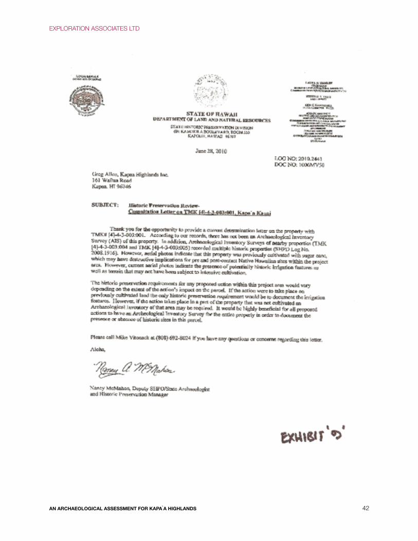
APPENDIX B 41
State Historic Preservation Letter (June 2010) Requesting Survey 41
EXPLORATION ASSOCIATES LTD
AN ARCHAEOLOGICAL ASSESSMENT FOR KAPAA HIGHLANDS 2

LIST OF FIGURES
Figure 1. USGS Map of the Project Area. 3
Figure 2. Tax Map showing project area location. 4
Figure 3. Survey Map of the project location. 4
Figure 4. Aerial View of the Kapa`a Highlands Phase II Looking West. 5
Figure 5. Aerial View of the Kapa`a Highlands Phase II Looking Mauka. 5
Figure 6. Map showing previous archaeological studies in Kapa`a. 19
Figure 7. Map showing previously documented archaeological sites in Kaiwaihau. 23
Figure 8. Entrance off Olohena Road looking Makai in the distance the Solar Farm 26
Figure 9. Remnant Road with Cattle Grazing in the Distance. 27
Figure 10. Lower Elevation of the Project Area on the dirt road. 28
Figure 11. View Across the Project Area, Facing Makai and Northeast. 29
Figure 12. Looking at the Roof of Kapa`a Middle School. 30
LIST OF TABLES
Table 1. Heiau of Kapa`a 10
Table 2. Mahele Land Claims in Kapa`a Ahupua`a 11
Table 3. Previous Archaeological Studies in Kapa`a 16
Table 4. Historic Properties in Kapa`a Ahupua`a 20
EXPLORATION ASSOCIATES LTD
AN ARCHAEOLOGICAL ASSESSMENT FOR KAPA`A HIGHLANDS 1

INTRODUCTION
Project BackgroundAt the request of Three Stooges LLC., Exploration Associates Ltd. (EAL) conducted an archaeological assessment of a
parcel of land (referred to hereafter as Kapa`a Highlands Phase II) in Kapa`a (in TMK 4-3-3:1) (Figures 1 & 2). The survey
was accomplished to address any historic preservation or cultural impact issues that might be raised by the proposed
development.
The proposed development, Kapa`a Highlands Phase II, proposes to develop approximately 97-acres into a single-family
and multi-family residential subdivision. Approximately 69 acres will be subdivided into single family lots ranging from
5,000 to 8,000 square feet and multi-family lots from 1 acre to 5 acre parcels. A total of 683 multi-family units and 86
single family units are planned. Open space encompassing 14.3 acres will be developed.
Scope of WorkArchaeological and Historical Concerns
The purpose of this archaeological assessment is to address any archaeological and/or historical concerns. The
assessment included a surface survey and a report detailing methods and any finds. The archaeological assessment
does not meet the requirements of an inventory-level survey per the rules and regulations of (State Historic Preservation
Division/Department of Land and Natural Resources) SHPD/DLNR. However, the level of work is sufficient enough to
address site types, locations, and allow for future work recommendations.
The scope of work includes:
• Historical research included study of archival sources, historic maps, Land Commission Awards and previous
archaeological reports to construct a history of land use and to determine if archaeological sites have been recorded
on or near this property.
• Field inspection of the project area identified any surface archaeological features and investigated and assessed the
potential for impact to such sites. The assessment identified any sensitive areas that may require further investigation
or mitigation before the project proceeds.
• Preparation of a report included the results of the historical research and the fieldwork with an assessment of
archaeological potential based on that research with recommendations for further archaeological work, if appropriate. It
also provided mitigation recommendations if there were archaeologically sensitive areas that need to be taken into
consideration.
EXPLORATION ASSOCIATES LTD
AN ARCHAEOLOGICAL ASSESSMENT FOR KAPA`A HIGHLANDS 2

Figure 1. USGS Map Showing Project Area
EXPLORATION ASSOCIATES LTD
AN ARCHAEOLOGICAL ASSESSMENT FOR KAPA`A HIGHLANDS 3

Figure 2. Tax Map showing project location.E
Figure 3. Survey Map of project area location.
EXPLORATION ASSOCIATES LTD
AN ARCHAEOLOGICAL ASSESSMENT FOR KAPA`A HIGHLANDS 4

Figure 4 Aerial View of the Kapa`a Highlands Phase II Looking West.
Figure 5. Aerial View of Kapa`a Highlands Phase III Looking Mauka.
EXPLORATION ASSOCIATES LTD
AN ARCHAEOLOGICAL ASSESSMENT FOR KAPA`A HIGHLANDS 5

MethodsOn January 3, 2012 and April 25, 2012 a field inspection of the Kapa`a Highlands project area was conducted by
Exploration Associates Ltd. archaeologist Nancy McMahon, M.A. Survey transects oriented north-south were spaced
apart 10 m. where it was passable as guinea grass very thick. Field observations were recorded and photographs were
taken of the project area. The work was conducted under the overall supervision of principal archaeologist Nancy
McMahon, M.A.
Historical research included a review of previous archaeological studies on file at the State Historic Preservation Division
of the Department of Land and Natural Resources; studies of documents at Hamilton Library of the University of Hawai`i,
Kapa`a and Lihu`e Public Library, Kauai Musuem, Kaua`i Historical Society and study of maps at the Survey Office of the
Department of Land and Natural Resources. Nineteenth-century Land Commission Award claim records were accessed
via the Internet from the Mahele Database prepared by Waihona `Aina Corp.
Natural Setting/Project Area
The Property is located north of Kapa`a town on former cane lands situated on a bluff adjacent to the coastal plain of
Kapa`a Town. It is bordered by Olohena Road to the north and the Kapa`a Bypass Road on the south and east sides of
the project. Kapa`a Intermediate School is near the middle of the north portion of the property. Kapa`a Highlands Phase II
is 97 acres, a development consisting of 163.125 acres. One of the parcel and has an existing solar farm and equipment
building already existing on this lot (Kapa`a Highlands Phase I).
The southern border of the project area, along the by-pass road, is elevated approximately 55 feet above msl. The
project area rises in elevation to the northern border approximately 130 feet above msl or an average upslope of less
than 5%. There are particular areas of the property with 20% slopes. The project area is currently fallow and is vegetated
with Guinea Grass (Panicum maximum), Koa Haole (Leucaena leucocephala), and Java Plum (Syzygium cumini). Sugar
cane cultivation was the last previous use of the property over fifteen years ago. Due to the poor soil, strong trade winds
and the salt spray from the ocean, the viability of agricultural crops is limited. Solar farming, goats and cattle are the
current activities on the land.
Foote et al (1972) described the soil in this area as Lihue-Puhi association, deep, nearly level to steep, well drained soils
with fine texture and moderately fine texture subsoil. Permeability is moderately rapid, run-off is slow and erosion hazard
is slight. The mean annual rainfall throughout the study area is about 22 inches per year. Average temperatures in the
region range from the 60s to the low 90s, Fahrenheit. Temperature differences between day and night are about 15
degrees. The consistent direction of the tradewinds is from the northeast at between 10 and 15 miles per hour.
EXPLORATION ASSOCIATES LTD
AN ARCHAEOLOGICAL ASSESSMENT FOR KAPA`A HIGHLANDS 6

HISTORICAL BACKGROUND
From Puna District to Kawaihau DistrictThe ahupua`a of Kapa`a belongs in the ancient district of Puna, one of five ancient districts on Kaua`i (King 1935: 228).
Puna was the second largest district on Kaua`i, behind Kona, and extended from Kipu, south of Lihue to Kama`oma`o`o,
just north of Kealia. For taxation, educational and judicial reasons, new districts were created in the 1840's. The Puna
District, with the same boundaries became the Lihu`e District, named for an important town in that district. In 1878, King
Kalakaua in securing a future name for the new Hu`i Kawaihau, created the new district of Kawaihau. This new district
encompassed the ahupua`a ranging from Olohena on the south to Kilauea on the north. Subsequent alterations to district
boundaries in the 1920's left Kawaihau with Olohena as its southernmost boundary and Moloa'a as its northernmost
boundary (King 1935:222).
Traditional and Legendary Accounts of Kapa`a
A more in depth study of the legends and mythology of Kapa`a can be found in the Cultural Impact Assessment for the
Proposed Kapa`a Highlands Phase II (EAL 2012). Just a few of some legends are included in this report.
Palila and Ka`ea
High in the mauka region of Kapa`a in the Makaleha mountains at a place called Ka`ea, is reported to be the supernatural
banana grove of the Kaua`i kupua or demigod Palila, grandson of Hina (Handy and Handy 1972:424). Joseph Akina for
Ka`oko`a Newspaper in 1913 describes Pahla's banana grove:
The stalk could hardly be surrounded by two men, and was about 35 feet high from the soil to the
lowest petiole. The length of the cluster from stem to lowest end of the bunch of bananas was about 1
3/4 fathoms long (one anana and one muku). There were only two bananas on each about 4 inches
around the middle. There were just two bananas, one on the east side and one on the west, each
about a foot or more in length. The one on the east side was tartish, like a waiawi (Spanish guava) in
taste and the one on the west was practically tasteless. The diameter of the end of the fruit stem of
this banana seemed to be about 10 feet. This kind of banana plant and its fruit seemed almost
supernatural... (Akina, 1913:5).
Ka Lulu o Mo`ikeha
Kapa`a was the home of the legendary Mo`ikeha. Born at Waipi`o on the island of Hawai`i, Mo`ikeha sailed to Kahiki
(Tahiti), the home of his grandfather Maweke, after a disastrous flood. On his return to Hawai`i, he settled at Kapa`a,
Kaua`i. Kila, Mo`ikeha's favorite of three sons by the Kaua`i chiefess Ho`oipoikamalani, was born at Kapa'a and was said
EXPLORATION ASSOCIATES LTD
AN ARCHAEOLOGICAL ASSESSMENT FOR KAPA`A HIGHLANDS 7

to be the most handsome man on the island. It was Kila who was sent by his father back to Kahiki to slay his old
enemies and retrieve a foster son, the high chief La`amaikahiki (Handy and Handy 1972:424; Beckwith 1970:352-358;
Kalakaua 1888:130-135; Fornander 1916, vol.4 pt.1:160). Mo`ikeha's love for Kapa`a is recalled in the `olelo no`eau: Ka
lulu o Mo`ikeha i ka laula o Kapa`a. "The calm of Moikeha in the breadth of Kapa`a" (Pukui, 1983: 157).
"Lulu-o-Mo`ikeha" is described as being situated "near the landing and the school of Waimahanalua" (Akina, 1913: 5).
The landing in Kapa`a was known as the Makee Landing and was probably constructed in the late 1870s, along with the
Makee sugar mill. Today, in place of the old Makee Landing is part of a breakwater located on the north side of Mo`ikeha
Canal near the present day Coral Reef Hotel, and approximately half-a-mile north of Waikaea Bridge.
Akina (1913) tells the story of how Mo`ikeha's son, Kila stocks the islands with the fish akule, kawakawa and `opelu.
When Kila travels to Kahiki, he seeks out his grandfather Maweke and explains that he is the child of Mo`ikeha. When
Maweke asks Kila if Mo`ikeha is enjoying himself, Kila answers with the following chant:
My father enjoys the billowing clouds over Pohaku-pili,
The sticky and delicious poi,
With the fish brought from Puna,
The broad-backed shrimp of Kapalua,
The dark-backed shrimp of Pohakuhapai,
The potent awa root of Maiaki`i,
The breadfruit laid in the embers at Makialo,
The large heavy taros of Keahapana
The crooked surf of Makalwa too
The bending hither and thither of the reed and rush blossoms,
The swaying of the kalukalu grasses of Puna The large, plump, private parts of my mothers,
Of Ho`oipoikamalanai and Hinau-u, The sun that rises and sets,
He enjoys himself on Kaua`i,
All of Kaua`i is Mo`ikeha's. (Akina, 1913: 6)
Maweke was delighted and when the boy is questioned as to his purpose, Kila tells his grandfather he is seeking fish for
his family. Maweke tells Kila to lead the fish back to his homeland. This is how Kila led the akule, kawakawa and opelu to
Hawai`i.
Paka`a and the wind gourd of La`amaomao (Keahiahi)
Kapa`a also figures prominently in the famous story of Paka`a, and the wind gourd of La`amaomao. Paka`a was the son of
Kuanu`uanu, a high-ranking retainer of the Big Island ruling chief Keawenuie`umi (the son and heir to the legendary
EXPLORATION ASSOCIATES LTD
AN ARCHAEOLOGICAL ASSESSMENT FOR KAPA`A HIGHLANDS 8

chief Umi), and La`amaomao, the most beautiful girl of Kapa`a and member of a family of high status kahuna.
Kuanu`uanu left the island of Hawai`i, traveled throughout the other islands and finally settled on Kaua`i, at Kapa`a. It was
there that he met and married La`amaomao, although he never revealed his background or high rank to her until the day
a messenger arrived, calling Kuanu`uanu back to the court of Keawenuia` umi.
Intent on seeking out his real father and making himself known to him, Paka`a prepared for the journey to the Big Island.
His mother presented to him a tightly covered gourd containing the bones of her grandmother, also named La`amaomao,
the goddess of the winds. With the gourd and chants taught to him by his mother, Paka`a could command the forces of
all the winds in Hawai`i. While this story continues on at length about Paka`a and his exploits on the Big Island and later
on Moloka`i, it will not be dwelt upon further here. It is important to note that several versions of this story do include the
chants which give the traditional names of all of the winds at all the districts on all the islands, preserving them for this
and future generations (Nakuina 1990; Rice 1923:69-89; Beckwith 1970:86-87; Thrum 1923:53-67; Fomander 1918-19
vol. 5 pt.1:78- 128).
Frederick Wichman (1998:84) writes that Paka`a grew up on a headland named Keahiahi. Here, Paka`a learned to catch
malolo, his favorite fish. After studying the ocean and devising his plan to fabricate a sail, Paka`a wove a sail in the shape
of a crab claw and tried it out on his uncle's canoe. One day, after going out to catch malolo, he challenged the other
fishermen to race to shore. He convinced them to fill his canoe with fish suggesting it was the only way he could truly
claim the prize if he won:
The fishermen began paddling toward shore. They watched as Paka`a paddled farther out to sea and
began to fumble with a pole that had a mat tied to it. It looked so funny that they began to laugh, and
soon they lost the rhythm of their own paddling. Suddenly Paka`a's mast was up and the sail filled with
wind. Paka`a turned toward shore and shot past the astonished fishermen, landing on the beach far
ahead of them. That night, Paka`a, his mother, and his uncle had all the ma`o`o they could eat
(Wichman 1998:85).
Kaweloleimakua
Kapa`a is also mentioned in traditions concerning Kawelo (Kaweloleimakua), Ka`ililauokekoa (Mo`ikeha's daughter, or
granddaughter, dependent on differing versions of the tale), the mo 'o Kalamainu'u and the origins of the hina`i hinalea or
the fish trap used to catch the hinalea fish, and the story of Lonoikamakahiki (Fornander 1917, vol.4 pt.2:318, vol.4 pt.
3:704- 705; Rice 1923:106-108; Thrum 1923:123-135; Kamakau 1976:80).
Kalukalu grass of Kapa`a
"Kiimoena kalukalu Kapa`a" or "Kapa`a is like the kalukalu mats" is a line from a chant recited by Lonoikamakahiki.
Kalukalu is a sedge grass, apparently used for weaving mats (Fornander 1917, Vol. IV, Pt. 2, pp. 318-19). Pukui (1983:
187) associates the kalukalu with lovers in "ke kalukalu moe ipo o Kapa`a; the kalukalu of Kapa`a that sleeps with the
lover". According to Wichman (1998:84), "a kalukalu mat was laid on the ground under a tree, covered with a thick pile of
grass, and a second mat was thrown over that for a comfortable bed", thus the association with lovers. Kaua`i was
famous for this peculiar grass, and it probably grew around the marshlands of Kapa`a. It is thought to be extinct now, but
an old-time resident of the area recalled that it had edible roots, "somewhat like peanuts." Perhaps it was a famine food
source (Kapa`a Elementary School 1933:VI).
EXPLORATION ASSOCIATES LTD
AN ARCHAEOLOGICAL ASSESSMENT FOR KAPA`A HIGHLANDS 9

Heiau of Kapa`aDuring their expeditions around Hawai`i in the 1880's, collecting stories from ka po`e kahiko, Lahainaluna students
stopped in Kapa`a and Kealia and gathered information regarding heiau of the region. All together, fourteen heiau were
named in Kapa`a and Kealia, suggesting the two ahupua`a were probably more politically significant in ancient times.
Table 1 lists the names of the ten heiau identified in the ahupua`a of Kapa`a, their location if known, their type, and
associated chief and priest.
Table 1. Heiau of Kapa‘a
Name Location Type Associated
Mailehuna Kapa‘a (Mailehuna is the
area of the present day
Kapa'a School)
unknown Kiha, Kaumuali‘i/
Lukahakona
Pueo Kapa‘a unknown Kiha, Kaumuali‘i/
Lukahakona
Pahua Kapa‘a/Kealia unknown Kiha/ Lukahakona
Kumalae Kapa‘a/Kealia unknown Kiha/ Lukahakona
Waiehumalama Kapa‘a/Keilia unknown Kiha/ Lukahakona
Napu‘upa‘akai Kapa‘a/Kealia unknown Kiha/ Lukahakona
Noeamakali`i Kapa‘a/Kedlia "heiau for birth of Kaua‘i
Chiefs, like Holoholoku"
Unknown
Pu'ukoa Kapa‘a/Kealia "unu type heiau" Unknown
Piouka Kapa‘a/Kealia "unu type heiau" Unknown
Una Kapa‘a/Kealia Unknown Kiha/ Lukahakona
Mano Kapa‘a/Kealia Unknown Kiha/ Lukahakona
Kuahiahi Kapa‘a (govn't
school stands on site now)
Unknown Kaumuali‘i/
Lukahakona
Makanalimu Upland of Kawaihau Unknown Kaumuali‘i
Kaluluomoikeha Kapa‘a Unknown Mo‘ikeha
The exact locations of these heiau are unknown. The locations of two of the heiau correlate with the locations of wahi
pana which are known to be in close to Kuahiahi and Kaluluomo'ikceha. Kuahiahi (also spelled Kaahiahi and Keahiahi) is
the rocky headland at the north end of Kapa`a where the first Kapa`a School was once located. Kaluluomo`ikeha is
thought to be the general area near the Mo`ikeha Canal and the present day Coral Reef Hotel
EXPLORATION ASSOCIATES LTD
AN ARCHAEOLOGICAL ASSESSMENT FOR KAPA`A HIGHLANDS 10

The Mahele: Kapa'a Land Commission AwardsThe Organic Acts of 1845 and 1846 initiated the process of the Mahele, the division of Hawaiian lands, which introduced
private property into Hawaiian society. In 1848 the crown and the ali`i received their lands. The common people received
their kuleana in 1850. It is through records for Land Commission Awards (LCAs) generated during the Mahele that
specific documentation of traditional life in Kapa`a Ahupua`a comes to light.
During the Mahele, Kapa'a was taken as Crown Lands (Office of the Commissioner of Public Lands of the Territory of
Hawaii, 1929). The i1i of Paikahawai and Ulakiu in Kapa`a Ahupua`a were retained as Government Lands.
Table 2. Mahele Land Claims in Kapa`a Ahupua`a
LCA Number Ahupua‘a Claimant ´Ili of the
Ahupua‘a
Land Use Number of
‘Āpana
3243 (See 3971) Kapa‘a Honolii, Ioane
Kahana, Kupanihi Village
6 lo‘i (uncult), house lot
2 (2 acres, 1 rood, 1 ord)
3554 Kapa‘a Keo Kahanui Puhi Vil-lage
15 lo‘i, house lot
2 (7 acres, 1 rood, 17 rods)
3638 Kapa‘a Huluili Maeleele Ka-loko Village
12-15 lo‘i, house lot
2 (5 acres, 1 rood, 19 rods)
8247 Kapa‘a Ehu Moalepe / Noalepe 20 lo‘i, 1 (3 roods)
8837 Kapa‘a Kamapaa Ulukiu lalo Awawaloa Ulu-kiu
3 lo‘i, 2 lo‘i, house lot
1 (2 acres, 2 roods, 27rods)
8843 Kapa‘a Kiau Apopo Ka-lolo Village
6 (5) lo‘i and kula, house lot
2 (2.75 acres,3 rods)
10564 Kapa‘a Oleloa, Daniel
Hikinui farm fishpond, 10 lo‘i
The land claims during this period show that only five individuals were awarded land parcels in the relatively large
ahupua`a of Kapa`a. The five awardees include Kiau (#08843), Kamapaa (#08837), Mane Honolii (#03971) Hulili (#03638)
and Ehu (#08247). In addition, two land claims (#10564 and #03554, 3559) were not awarded in Kapa`a. Four of the five
awardees received multiple parcels which show similarities. All four had lo`i or irrigated kalo fields on the mauka side of
the lowland swampy area, sometimes extending a short distance up into small, shallow gulches and valleys. Many of
these lo`i parcels name pali or hills/cliffs as boundaries. Each LCA also had a separate house lot located on the makai
side of the swamp, near the beach. Three of the land claims name ponds on their lands, including Puhi Pond (LCA
#03554), Fishponds in Kupanihi 'Ili (LCA #03971) and Hahanui 'Ili (LCA #10564). Loko Kihapai may be the same as the
Fishpond in Hahanui as it was named in the same land claim. The other two loko are associated with house lots, situated
on the makai edge of the Kapa'a swamplands suggesting modification of the natural swamplands. Other natural and
EXPLORATION ASSOCIATES LTD
AN ARCHAEOLOGICAL ASSESSMENT FOR KAPA`A HIGHLANDS 11

cultural resources mentioned in the LCAs include freshwater springs, pig pens, hau bushes, hala clumps, streams,
`auwai, and kula or pasturelands.
Interestingly, the residential "village" of Kapa'a did not exist as a single entity, but was a series of probably small
settlements or compounds, perhaps even individual house lots which stretched along the shoreline of the ahupua`a and
included (south to north) Kupanihi (Makahaikupanihi), Kalolo (Kaulolo), Puhi, and Uluki.
The fifth individual, Ehu (LCA #08247), was the only person to be awarded a single parcel in the upland area of Kapa`a,
Moalepe Valley, approximately five miles one mile southwest of the project area. In 1848, when Ehu made his claim, he
was the only one living there. A few years later, according to Honolii's testimony to support Ehu's claim, "There are no
houses and no people now living on the land. Ehu found himself lonely there, all his neighbors having either died or left
the land. Ehu now lives in Wailua." Evidently Ehu may have been the last person to live at and cultivate in the traditional
way, the far mauka region of Kapa`a.
Early Historic Accounts of Kapa`a (1830's-1900's)Although most of the historic record documents for Kaua`i in this period revolve around missionary activities and the
missions themselves, there was indication that the Kapa`a area was being considered for new sugar cane experiments,
similar to those occurring in Koloa. In a historic move, Ladd and Company received a 50 year lease on land in Koloa from
Kamehameha III and Kaua`i Governor Kaikio`ewa of Kaua`i. The terms of the lease allowed the new sugar company "the
right of someone other than a chief to control land" and had profound effects on "traditional notions of land tenure
dominated by the chiefly hierarchy" (Donohugh, 2001: 88). In 1837, a very similar lease with similar terms was granted to
Wilama Ferani, a merchant and U.S. citizen based in Honolulu (Hawai`i State Archives, Interior Dept., Letters, Aug. 1837).
The lease was granted by Kauikeaouli for the lands of Kapa`a, Kealia and Waipouli for twenty years for the following
purpose:
...for the cultivation of sugar cane and anything else that may grow on said land, with all of the right for some place to
graze animals, and the forest land above to the top of the mountains and the people who are living on said lands, it is to
them whether they stay or not, and if they stay, it shall be as follows: They may cultivate the land according to the
instructions of Wilama Ferani and his heirs and those he may designate under him... (Hawai`i State Archives, Interior
Dept., Letters, Aug. 1837).
Unlike Ladd & Company which eventually became the Koloa Sugar Company, there is no further reference to Wilama
Ferani and his lease for lands in Kapa`a, Kealia and Waipouli. In a brief search for information on Honolulu merchant,
Wilama Ferani, nothing was found. It is thought that perhaps Wilama Ferani may be another name for William French, a
well known Honolulu merchant who is documented as having experimented with grinding sugar cane in Waimea, Kaua`i
at about the same time the 1837 lease for lands in Kapa`a, Kealia and Waipouli was signed (Joesting, 1984: 152).
In 1849, son of Wai`oli missionary, William P. Alexander, recorded a trip he took around Kaua`i. Although, he focuses on
the larger mission settlements like Koloa and Hanalei, he does mention Kapa`a.
A few miles from Wailua, near Kapa`a we passed the wreck of a schooner on the beach, which once belonged to Capt.
Bernard. It was driven in a gale over the reef, and up on the beach, where it now lies. A few miles further we arrived at
Kealia. We had some difficulty crossing the river at this place, owing to the restiveness of our horses. The country here
near the shore was rather uninviting, except the valley which always contained streams of water (Alexander, 1991: 123).
EXPLORATION ASSOCIATES LTD
AN ARCHAEOLOGICAL ASSESSMENT FOR KAPA`A HIGHLANDS 12

In later years, the notorious Kapa`a reef was to become the location of many shipwrecks once a landing was built there in
the 1880s.
The first large scale agricultural enterprise in Kapa`a began in 1877 by the Makee Sugar Plantation and the Hui Kawaihau
(Dole, 1916: 8). The Hui Kawaihau was originally a choral society begun in Honolulu whose membership consisted of
many prominent names, both Hawaiian and haole. It was Kalalaua's thought that the Hui members could join forces with
Makee, who had previous sugar plantation experience on Maui, to establish a successful sugar corporation on the east
side of Kaua`i. Captain Makee was given land in Kapa`a to build a mill and he agreed to grind cane grown by Hui
members. Kalakaua declared the land between Wailua and Moloa`a, the Kawaihau District, a fifth district and for four
years the Hui attempted to grow sugar cane at Kapahi, on the plateau lands above Kapa`a. After a fire destroyed almost
one half of the Hui's second crop of cane and the untimely death of one of their principal advocates, Captain James
Makee, the Hui began to disperse and property and leasehold rights passed on to Makee's son-in-law and new Makee
Plantation owner, Colonel Z.S. Spalding (Dole, 1916: 14).
As part of the infrastructure of the new plantation, a sugar mill was erected and the Makee Landing was built in Kapa'a
during the early years of the Makee Sugar Plantation. Following Captain Makee's death, Colonel Spalding took control of
the Plantation and in 1885 moved the mill to Kealia (Cook, 1999: 51). The deteriorating stone smokestack and landing
were still there well into the 1900s (Damon, 1931:359). Conde and Best (1973:180) suggest that railroad construction for
the Makee Plantation started just prior to the mid 1890's. There is one reference to a railroad line leading from the Kapa`a
landing to Kealia in 1891. During Queen Lili`uokalani's visit to Kaua`i in the summer of 1891, the royal party was treated to
music by a band, probably shipped in from O`ahu. "The band came by ship to Kapa`a and then by train to
Kealia" (Joesting, 1984:252). This line is depicted on a 1910 USGS map which shows the line heading south from Kealia
Mill and splitting near the present Coral Reef Hotel, one finger going to the old Kapa'a Landing (Makee Landing) and
another line heading mauka, crossing the present Mo`ikeha Canal, traveling southwest up Lehua Street and through what
is now goat pasture, along a plateau and into the mauka area behind Kapa`a swamplands. This railroad line was part of a
twenty mile network of plantation railroad with some portable track and included a portion of Kealia Valley and in the
mauka regions of the plateau lands north of Kealia (Conde and Best, 1973:180).
By the late 1800's, Makee Plantation was a thriving business with more than one thousand workers employed (Cook,
1999:51). Hundreds of Portuguese and Japanese immigrants found work on Makee Plantation and the new influx of
immigrants required more infrastructure. In 1883, a lease for a school lot was signed between Makee Sugar Company
and the Board of Education (Kapa`a School, 1983: 9). Stipulations found in the Portuguese immigrant contracts with
Makee Sugar Company stated that "children shall be properly instructed in the public schools" (Garden Island, April 1,
1983). The original Kapa`a School was constructed in 1883 on a rocky point adjacent to the Makee Sugar Company
railroad. Traditionally, this point was known as Kaahiahi (Kapa`a School, 1983: 10). In 1908, Kapa`a School was moved to
its present site directly mauka and up the hill at Mailehune.
As in much of the rest of Hawai`i, the Chinese rice farmers began cultivating the lowlands of Kapa`a with increasing
success in the latter half of the 1800s. Several Hawaiian kuleana owners leased or sold their parcels mauka of the
swamp land to Chinese rice cultivators. Other Chinese rice cultivators appeased to the government for swamplands first
leasing and later buying. As a result of the growing rice and sugar industries, the economic activity displaced the house
lot kuleana on the makai side of the marsh for increasing commercial and residential development (Lai, 1985:148-161).
Narrow wagon roads gave way to macadamized roads in the early part of the 20th century. This new road was called the
Kaua`i Belt Road and parts of it are thought to have followed the "Old Government Road" (Cook, 1999). In Kapa`a, the
present day Kuhio Highway probably follows the same route as the original Government Road and subsequent Kaua`i
EXPLORATION ASSOCIATES LTD
AN ARCHAEOLOGICAL ASSESSMENT FOR KAPA`A HIGHLANDS 13

Belt Road. The location of the kuleana awards in Kapa`a indicates that the majority of the house lots were situated along
the Government Road. LCA 3243 names a "road" as one of its boundaries.
20th Century History of Kapa`a (1900 - Present)In the early 1900's, government lands were auctioned off as town lots in Kapa`a to help with the burgeoning plantation
population. One kama`aina mentioned that in the 1930's and 1940's, the area north of Mo`ikeha Canal in Kapa`a was
mostly settled by Portuguese families (Bushnell et al. 2002). The Japanese were also very prominent in the 1920s and
1930s largely replacing the Chinese merchants of the turn of the century in the Kapa`a business sector (Bushnell et al.
2002). The Board of Health, Territory of Hawaii ran a dispensary in Kapa`a at the makai edge of Niu Street near the
Kapa`a Beach Park parking lot, adjacent to the bike path starting 1926. The lot is presently vacant. A Fire Station was
once located in the area now occupied by the Coral Reef Hotel and a Courthouse and jail cell once stood at the location
of the present Kapa`'a Neighborhood Center. It is not known when these structures were removed or abandoned.
In 1913, Hawaiian Canneries opened in Kapa`a at the site now occupied by Pono Kai Resort (Cook, 1999: 56). Through
the Hawaiian Organic Act, Hawaiian Canneries Company, Limited purchased the land they were leasing, approximately
8.75 acres, in 1923 (Bureau of Land Conveyances, Grant 8248). A 1923 sketch of the cannery shows only four
structures, one very large structure assumed to be the actual cannery and three small structures makai of the cannery. A
1933 historic photograph of Kapa`a Town shows an ironwood windbreak on the makai side of the cannery adjacent to
the railroad. By 1956, 1.5 million cases of pineapple were being packed. By 1960, 3400 acres were in pineapple and
there were 250 full time employees and 1000 seasonal employees for the Kapa`a Cannery (Honolulu Advertiser, March
20, 1960). In 1962, Hawaiian Canneries went out of business due to competition from third world countries.
The Ahukini Terminal & Railway Company was formed in 1920 to establish a railroad to connect Anahola, Kealia, Kapa`a
to Ahukini Landing and "provide relatively cheap freight rates for the carriage of plantation sugar to a terminal
outlet" (Conde and Best, 1973: 185). This company was responsible for extending the railroad line from the Makee
Landing, which was no longer in use, to Ahukini Landing, and for constructing the original Waika`ea Railroad Bridge and
the Mo`ikeha Makai Railroad Bridge.
In 1934, the Lihu`e Plantation Company absorbed the Ahukini Terminal & Railway Company and Makee Sugar Company
(Conde and Best, 1973: 167). The railway and rolling stock formerly owned by Makee Sugar Company became the
Makee Division of the Lihu`e Plantation. At this time, besides hauling sugar cane, the railroad was also used to haul
plantation freight including "fertilizer, etc... canned pineapple from Hawaiian Canneries to Ahukini and Nawiliwili, pineapple
refuse from Hawaiian Canneries to a dump near Anahola and fuel oil from Ahukini to Hawaiian Canneries Co.,
Ltd." (Hawaiian Territorial Planning Board, 1940: 11). Former plantation workers and kama`aina growing up in Kapa`a
remember when the cannery would send their waste to the pineapple dump, a concrete pier just north of Kumukumu
Stream (State Site No. 50- 30-08-789) by railroad. The structure is built over the water where the rail cars would dump
the pineapple waste. The current would carry the waste to Kapa`a which would attract fish and sharks (Bushnell et al.
2002).
Lihu`e Plantation was the last plantation in Hawaii to convert from railroad transport to trucking (Conde and Best, 1973:
167). "By 1957 the company was salvaging a part of their plantation railroad, which was being supplanted by roads laid
out for the most part on or close to the old rail bed" (Ibid: 167). By 1959, the plantation had completely converted over to
trucking. The Cane Haul Road which begins near the intersection of Haua`ala Road and Kuhio Highway is thought to
date to the late 1950s and follows the alignment of the old railroad until just before or near `Alibi Point.
EXPLORATION ASSOCIATES LTD
AN ARCHAEOLOGICAL ASSESSMENT FOR KAPA`A HIGHLANDS 14

Severe floods in Kapa`a in 1940 led to the dredging and construction of the Waika`ea and Mo`ikeha Canals sometime in
the 1940s (Hawaii Territorial Planning Board, 1940: 7). Although the Waika`ea Canal, bordering the Kapa`a Pineapple
Cannery, had been proposed as early as 1923, nothing was constructed until after the floods (Bureau of Land
Conveyances, Grant 8248). A Master Plan for Kapa`a, published in 1940, asks the Territorial Legislature for funds to be
set aside for the completion of a drainage canal and for filling makai and mauka of the canal (Hawaii Territorial Planning
Board, 1940:7). In 1955, reports came out on the dredging for coral proposed for the reef fronting Kapa`a Beach Park
(Garden Island Newspaper, September 21, 1955). The coral was to be used for building plantation roads. This dredging
was later blamed for accelerated erosion along Kapa`a Beach (Garden Island Newspaper, October 30, 1963).
Today, there are several sea walls along the Kapa`a Beach Park to check erosion. Old time residents claim the sandy
beach in Kapa`a was once much more extensive than it is now (Bushnell et al. 2002).
Kealia Town slowly dispersed after the incorporation of Makee Sugar Company into Lihu`e Plantation in the 1930s. Many
of the plantation workers bought property of their own and moved out of plantation camps. The plantation camps which
bordered Kuhio Highway were disbanded in the 1980s. The Lihu`e Plantation began to phase out in the last part of the
20th century. Kapa`a Town suffered after the closing of the Kapa`a Cannery, however the growing tourist industry helped
to ease the economic affects of the Cannery's closing.
EXPLORATION ASSOCIATES LTD
AN ARCHAEOLOGICAL ASSESSMENT FOR KAPA`A HIGHLANDS 15

PREVIOUS ARCHAEOLOGICAL RESEARCH
Archaeological Studies and Sites in Kapa`a Ahupua`aThe following table outlines the archaeological research (Table 3) and historic properties (Table 4) identified in Kapa`a
Ahupua`a. These tables are followed by discussion of the research and historic properties. Table 3 provides a list of
archaeological research conducted within Kapa'a Ahupua`a, including columns for source, location, nature of study, and
findings. The locations of these archaeological studies are shown in Figure 4. Table 4 is a list of known historic properties
within the ahupua`a and includes columns for state site numbers, site type, location and reference. The locations of
identified sites within Kapa`a Ahupua`a are shown in Figure 5.
Table 3. Previous Archaeological Studies in coastal Kapa`a.
Source Location Nature of Study Findings
Bennett 1931 Island wide ldentifies 2 sites:
Site 110 Taro terraces and
bowl and Site 111 A large
simple dirt Hawaiian ditch
Archaeological
Reconnaissance
Identifies 2 sites: Site 110
Taro terraces and bowl and
Site 111 A large simple dirt
Hawaiian ditch
Handy and Handy 1972 Archipelago-wide Native Planter study Discusses "highly developed
irrigation system"
Ching 1976 Just south of the Waikaea
Drainage Canal
Archaeological
Reconnaissance
No significant findings
Hammatt
1981
Upland Kapa'a Archaeological
Reconnaissance
No significant findings
Hammatt
1986
Upper reaches of the
Makaleha stream valley.
Archaeological
Reconnaissance
No significant findings
Hammatt
1991
Along Kuhio .
Highway
Subsurface Testing Identifies two sub-surface
cultural layer sites
Kikuchi and Remoaldo
1992
Around Kapa'a Town Cemeteries of Kauai Identifies six cemeteries
Spear 1992 South side Waikaea Canal,
mauka of Kuhio Highway.
(TMK: 4-5-05:04, 09)
Monitoring Report Designated subsurface site
50-30-08-547
EXPLORATION ASSOCIATES LTD
AN ARCHAEOLOGICAL ASSESSMENT FOR KAPA`A HIGHLANDS 16

Source Location Nature of Study Findings
Chaffee, Burgett & Spear
1994a
A house lot near the corner
of Kukui and Ulu Streets in
mauka Kapa'a Town. (TMK:
4-5-09:10)
Archaeological Inventory
Survey
No significant findings
Chaffee, Burgett & Spear
1994b
Mamane Street
Kapa'a Town. (TMK:
4-5-09:51
Archaeological Inventory
Survey
No significant findings
Hammatt, Ida & Chiogioji
1994
Proposed bypass routes
mauka of Kapa'a Town
Archaeological Assessment No new field work, reviews
literature
Hammatt, Ida & Folk 1994 South side Waikaea Canal,
mauka of Kuhio Highway
(TMK: 4-5-05:06)
Archaeological Inventory
Survey
Weak cultural layer
designated site 50-30-08-
748
Kawachi 1994 Inia Street (Jasper) TMK
4-5-08:33
Burial Report
.
Designates Site 50-30-08-
871
McMahon 1994 "behind the armory in
Kapa'a near the god stones"
The location is uncertain &
"Buzz's near the Coconut
Marketplace"
Documents
second hand
report of burials
in two locations
Bones in 3 places reported
from behind the armory, 16
bodies reported from the
Buzz' s restaurant. No site
numbers assigned
Creed, Hammatt, Ida,
Masterson & Winieski 1995
Kapa'a Sewer line project,
Kuhio Highway, south and
central Kapa'a Town
Archaeological Monitoring
Report
Documents cultural layer of
site -1848 and (an enlarged)
site -1849 & recovery of
thirty burials at sites —867,
-868, -871, & -1894
Jourdane 1995 1382-A `Inia Street, makai of
Kuhio Highway, central
Kapa'a Town
Burial Report Site 626
McMahon 1996 South side Waikaea Canal,
mauka of Kuhio Highway
(TMK: 4-5-05:08)
Archaeological Inventory
Survey
No significant cultural
material
Hammatt, Chiogioji, Ida &
Creed 1997
Test excavations focused
inland of Kapa'a Town
Archaeological Inventory
Survey
Four test trenches were
excavated inland of Kapa'a
Town
Borthwick
and Hammatt 1999
Kapa'a Seventh-Day
Adventist Church at 1132
Kuhio Highway
Archaeological Monitoring
and Burial Treatment Plan
Monitoring was indicated as
this parcel lay within the
designated Site 50-30-08-
1848.
EXPLORATION ASSOCIATES LTD
AN ARCHAEOLOGICAL ASSESSMENT FOR KAPA`A HIGHLANDS 17

Source Location Nature of Study Findings
Bushnell and Hammatt
2000
Seventh-Day
Adventist Church, makai of
Kuhio Highway, south of the
Waikaea Canal
Archaeological Monitoring
Report
Minimal findings (one
piece of worked bone)
Callis 2000 Kapa'a Beach Park Burial Removal and
Archaeological Monitoring
Report
Human Burial
Perzinski and Hammatt
2001
KuhioHighway on the
margins of the Waikaea
Canal
Archaeological Monitoring
Report
No significant cultural
material
Elmore and Kennedy 2003 Kuhio Highway Archaeological Monitoring
Report
No significant cultural
material
Dega, Michael F. and James
Powell
2003
Kuhio Highway Archaeological Monitoring
Report
Human Burials
•
Van Ryzin, Karl and Hallett
Hammatt, 2004
Water Reservoir Archaeological Assessment No significant findings
EXPLORATION ASSOCIATES LTD
AN ARCHAEOLOGICAL ASSESSMENT FOR KAPA`A HIGHLANDS 18

Figure 6. Map showing previous archaeological studies in Kapa`a.
EXPLORATION ASSOCIATES LTD
AN ARCHAEOLOGICAL ASSESSMENT FOR KAPA`A HIGHLANDS 19

Table 4. Historic Properties in Kapa‘a Ahupua‘a
Site #
50-30-08-
Ahupua‘a Site Type/ Name
(if any)
Location Site Constraints Reference
B001 Kapa‘a Historic Cemetery South of bend of
Kapa‘a Stream, a
kilometer mauka
from Kuhiö Hwy
Appears to be a
discrete historic
cemetery
Kikuchi and
Remoaldo 1992
B002 Kapa‘a Historic Cemetery Just mauka from
Kuhiö Highway,
south of Kapa‘a
Stream
Appears to be a
discrete historic
cemetery
Kikuchi and
Remoaldo 1992
B003 Kapa‘a Kapa‘a Public
Cemetery
South of Kanaele
Road, one
kilometer inland of
Kuhiö Highway
Appears to be a
discrete historic
cemetery
Kikuchi and
Remoaldo 1992
B004 Kapa‘a Historic Cemetery North of Apopo
Road, one
kilometer inland of
Kuhiö Highway
Appears to be a
discrete historic
cemetery
Kikuchi and
Remoaldo 1992
B013 Kapa‘a Historic Cemetery Just mauka from
Kuhiö Highway,
north of the
Waikaea Canal
Appears to be a
discrete historic
cemetery
Kikuchi and
Remoaldo 1992
B014 Kapa‘a All Saints
Episcopal Church
Cemetery
Just mauka from
Kuhiö Highway,
south of the
Waikaea Canal
Appears to be a
discrete historic
cemetery
Kikuchi and
Remoaldo
1992:62-65
547 Kapa‘a sub-surface
features including
a firepit and a
possible house
foundation
South of bend of
Waikaea Canal,
mauka of Kuhiö
Highway
Archaeological
monitoring in the
vicinity is
recommended
Spear 1992:3
626 Kapa‘a Burial Inia Street, makai
of Kuhiö Highway,
central Kapa‘a
Consultation and
monitoring in
vicinity indicated
Jourdane 1995
748 Kapa‘a Minimal findings, a
weak cultural layer
(buried A-horizon)
South of the bend
of the Waikaea
Canal, mauka of
Kuhiö Highway
Considered no
longer significant
within project area
Hammatt et al.
1994
789 Kapa‘a/ Kealia Historic Road Coastal Cane Haul
Road near
Kawaihau Road
turn off
Perzinski et al.
2000
EXPLORATION ASSOCIATES LTD
AN ARCHAEOLOGICAL ASSESSMENT FOR KAPA`A HIGHLANDS 20

Site #
50-30-08-
Ahupua‘a Site Type/ Name
(if any)
Location Site Constraints Reference
867 Kapa‘a 1 set of human
remains
Kukui Street, just
mauka of Kuhiö
Highway, Kapa‘a
Town
Consultation and
monitoring in
vicinity indicated
Creed et al.
1995:50
868 Kapa‘a 1 set of human
remains
Lehua Street
mauka of Kuhiö
Highway, Kapa‘a
Town
Consultation and
monitoring in
vicinity indicated
Creed et al.
1995:50
871 Kapa‘a 13 sets of human
remains (Creed et
al. 1995:50)
Inia Street, makai
of Kuhiö Highway
Consultation and
monitoring in
vicinity indicated
Kawachi 1994;
Creed et al.
1995:50
1848 Kapa‘a Cultural layer and
sub-surface
features
Along Kuhiö
Highway between
Wana Road and
the Waikaea
Drainage Canal
Archaeological
monitoring in the
vicinity is
recommended
Hammatt 1991;
Creed et al. 1995
1849 Kapa‘a Cultural layer and
sub-surface
features; Creed et
al. 1995:53
expands
boundaries to incl.
burial
sites, -
626, -867, -868
-871, and -1894
Along Kuhiö
Highway between
Inia Street and
Kauwila Street
extending to the
coast
Consultation and
monitoring in
vicinity indicated
Hammatt 1991;
Creed et al. 1995
1894 Kapa‘a 11 sets of human
remains
Ulu Street, just
north of Kuhiö
Highway, Kapa‘a
Town
Consultation and
monitoring in
vicinity indicated
Creed et al.
1995:50
2075 Kapa‘a/Ke ãlia Highway Bridge
Foundation (old
Kaua‘i Belt Road)
Kuhiö Highway at
Kapa‘a/ Keãlia
River
Bushnell et al.
2002:55
2076 Kapa‘a Petroglyph Rocky coast
below former cane
haul road (Site
-789)
Preservation Bushnell et al.
2002:55
2077 Kapa‘a Concrete steps
(related to historic
beach pavilion)
Near present
Kapa‘a Beach
Park Pavilion
Bushnell et al.
2002:55
EXPLORATION ASSOCIATES LTD
AN ARCHAEOLOGICAL ASSESSMENT FOR KAPA`A HIGHLANDS 21

Site #
50-30-08-
Ahupua‘a Site Type/ Name
(if any)
Location Site Constraints Reference
2078 Kapa‘a Historic Railway
Alignment (2
Railroad Bridges,
& RR Culvert
Foundation)
Both railroad
bridges span the
Moikeha Canal;
the RR culvert
foundation is
located north of
the Kapa‘a
Swimming Pool.
Bushnell et al.
2002:55
EXPLORATION ASSOCIATES LTD
AN ARCHAEOLOGICAL ASSESSMENT FOR KAPA`A HIGHLANDS 22

Figure 7. Map showing previously documented archaeological sites in Kawaihau.
The majority of study areas are located within urban Kapa'a along the shoreline and away from the mountain areas.
Pattern of Archaeological Sites in Kapa`aThe pattern of archaeological studies in Kapa`a Ahupua`a is somewhat skewed with a dozen projects in urban Kapa`a
Town and very little work along the coast (Figure 4). Major archaeological sites have been found in the Kapa`a Town area
including extensive cultural layers with burials and other cultural features underlying Kuhio Highway near All Saints Gym
and near the older part of Kapa`a Town between Waika`ea Canal and Kapa`a Beach Park, makai of Kuhio Highway
(Hammatt 1991; Kawachi 1994; Creed et al. 1995; Jourdane 1995; Callis 2000). The mauka-makai extent of these
EXPLORATION ASSOCIATES LTD
AN ARCHAEOLOGICAL ASSESSMENT FOR KAPA`A HIGHLANDS 23

cultural layers has not been clearly defined. These extensive cultural deposits associated with pre-historic and early
historic habitation are known to exist in a relatively narrow sand berm that makes up the physiogeography of Kapa`a. The
areas mauka of Kapa`a Town are marshy although much of it has been filled in recent decades. The five kuleana awarded
during the Mahele are located adjacent to the present highway. The more mauka studies (Spear 1992, Chaffee et al.
1994a & 1994b, Hammatt et al. 1994, 1997, McMahon 1996) are thought to be located towards the mauka fringe of the
sand berm, approaching more marshy conditions and have generally reported no significant or minimal findings. Less
than 1.5 km to the south of Waika`ea Canal is another extensive subsurface, cultural deposit which is associated with a
pre-contact fishing encampment located at the southern boundary of Waipouli adjacent to Uhalekawa`a Stream (Waipouli
Stream) and the ocean (Hammatt et al. 2000).
Anticipated sites based on historic and archaeological studies in mauka Kapa`a would be evidence of cane cultivation like
ditches and possible terracing for lo'i cultivation with nearby habitation sites.
EXPLORATION ASSOCIATES LTD
AN ARCHAEOLOGICAL ASSESSMENT FOR KAPA`A HIGHLANDS 24

RESULTS OF FIELD CHECK
On January 3 and April 25, 2012 Exploration Associates Ltd. archaeologist Nancy Mc Mahon, M.A. made a field
inspection on proposed Kapa`a Highlands project area. Access was made via Olohena Road (two gates).
Survey transects oriented north-south were conducted within the project area. Attempts were made to look for any
remnant plantation ditches. Only old access dirt roads were found. No terraces or habitation sites were scene. No
archaeological sites were observed.
Cattle and goats were grazing in the now pasture land. KIUC’s solar farm and equipment facility have been already built.
On the upper flats of the near the project area on the State Land is Kapa`a Middle School.
Figure 8. Entrance off Olohena Road looking makai in the distance the Solar Farm
EXPLORATION ASSOCIATES LTD
AN ARCHAEOLOGICAL ASSESSMENT FOR KAPA`A HIGHLANDS 25

Figure 9. Remnant Road with Cattle Grazing in the Distance.
EXPLORATION ASSOCIATES LTD
AN ARCHAEOLOGICAL ASSESSMENT FOR KAPA`A HIGHLANDS 26

Figure 10. Lower Elevation of the Project Area on the dirt road.
EXPLORATION ASSOCIATES LTD
AN ARCHAEOLOGICAL ASSESSMENT FOR KAPA`A HIGHLANDS 27

Figure 11. View Across the Project Area, Facing Makai and Northeast.
EXPLORATION ASSOCIATES LTD
AN ARCHAEOLOGICAL ASSESSMENT FOR KAPA`A HIGHLANDS 28

Figure 12. Looking at the Roof of Kapa`a Middle School.
EXPLORATION ASSOCIATES LTD
AN ARCHAEOLOGICAL ASSESSMENT FOR KAPA`A HIGHLANDS 29

RECOMMENDATIONS
The field checks examined the areas of proposed impact and found no archaeological sites or historic preservation
concerns in the vicinity of any of the parcel. We recommend no further historic preservation work. As always, if in the
unlikely event that any human remains or other significant subsurface deposits are encountered during the course of
development activities all work in the immediate area should stop and the State Historic Preservation Division should be
promptly notified.
EXPLORATION ASSOCIATES LTD
AN ARCHAEOLOGICAL ASSESSMENT FOR KAPA`A HIGHLANDS 30

REFERENCES
Akina, Joseph1913 "I Ke hou i Ka Lulu-o-Moikeha i ka laula o Kapa 'a", Kuokoa. May 2-9, 1913.
Bishop Museum Archives HEN Place Names, Kaua`i.
Alexander, William Patterson1991 "A Tour of Kaua`i in 1849: Private Journal of William DeWitt Alexander," The
Kaua `i Papers, Kaua`i Historical Society, A Kaua`i Historical Society Publication, Lihue, Kaua`i, HI.
Beckwith, Martha1970 Hawaiian Mythology, The University Press of Hawai' i, Honolulu.
Bennett, Wendell C.1931 The Archaeology of Kaua' i, Bishop Museum Bulletin 80, Honolulu, HI.
Bishop Museum Archives HEN I: 214 "Heiaus of Kealia and Kapa`a" and "Well Known Things [or Places]".
HEN I: 215 "Famous Things mentioned by Two Men".HEN I: 216 "Heiaus from Kapa'a to Kealia" and "Things for which Kapa'a was Known".
Bureau of Land ConveyancesGrant 8248
Bushnell, K.W., Melanie Mann, Douglas Borthwick, Tony Bush, Todd Tulchin, David Shide-ler and Hallett H. Hammatt
2002 Archaeological Inventory Survey for the Proposed Kapa'a/Kealia Bike and Pedestrian Path, Kapa'a and Kealia, Kawaihau District, Kaua'i Island, Hawaii (TMK 4-5, 4-6-14, 4-7-03 & 04). Cultural Surveys Hawai' i, Inc. Kailua, HI.
Chafee, David B., Berdena Burgett and Robert L. Spear1994a An Inventory Survey of a Kukui Street Houselot, Kapa'a Ahupua'a, Kawaihau
District, Puna, Island of Kaua' i (TMK: 4-5-09:10), SCS Inc., Kaneohe, HI.1994b An Inventory Survey of a Mamane Street Houselot, Kapa'a Ahupua'a, Kawaihau
District, Puna, Island of Kaua'i (TMK: 4-5-09:51), SCS Inc., Kane' ohe, HI.Ching, Francis K. W.
1968 Archaeological Surface Survey; Wailua State Park, Kaua'i, State of Hawaii, Dept. of Land and Natural Resources, Honolulu, HI.
EXPLORATION ASSOCIATES LTD
AN ARCHAEOLOGICAL ASSESSMENT FOR KAPA`A HIGHLANDS 31

1976 Letter Report: Archaeological Reconnaissance - Report, Kapa'a "Wastewater Treatment and Disposal System, ARCH 14-96, Letter to R. M Towill Corporation, ARCH, Lawai, Kaua`i, HI.
Conde, Jesse C. and Gerald M. Best1973 Sugar Trains, Narrow Gauge Rails of Hawaii, Glenwood Publishers, Felton, CA.
Cook, Chris1999 "Kaua' i, the Garden Island: A Pictorial History of the Commerce and Work of the
People", Donning Co., Virginia Beach, VA.
Creed, Victoria, Hallett H. Hammatt, Gerald K. Ida, Ian Masterson and John Winieski1995 A Summary of the Archaeological Monitoring for the Kapa'a Sewerline Project
Waipouli and Kapa'a Ahupua`a, Puna Disctric, Kaua`I (TMK:4-3-09 and 4-5-03 to11), Cultural Surveys Hawaii, Kailua, HI.
Damon, Ethel M.1934 The Heiau at Wailua, The Kaua`i Historical Society by the Garden Island Press,
Lihu' e, Kaua' i, HI.
1931 Koamalu, two vols. Privately printed at the Honolulu Star-Bulletin Press, Honolulu.Dega, Michael F. and James Powell
2003 Archaeological Monitoring During Phase I of the ICauai Rural Fiber Optic Duct Lines Project, Kaua`i Island, Hawai`i. Scientific Consultant Services
Dole, Charles S.1916 "The Hui Kawaihau" pp.8-15. A Paper read at the November meeting of the Kauai
Historical Society on November 16, 1916. In Lihue, Kaua'i.Donohugh, Donald
2001 The Story of Koloa, A Kaua`i Plantation Town, Mutual Publishing, Honolulu, HI.Foote, Donald E. E. L. Hill, S. Nakamura and F. Stevens
1972 Soil Survey of the Islands of Kaua`I, 0`ahu, Maui, Molokai and Lanai, State of Hawai`i U.S. Department of Agriculture, U.S. Government Printing Office, Washington D.C.
Fomander, Abraham1916-19 Fomander Collection of Hawaiian Antiquities and Folk-Lore, with translations
edited and illustrated with notes by Thomas G. Thrum, Volume 4, First series, 1916 - 1917 notes by Thomas G. Thrum, Memoirs of the Bernice P. Bishop Museum, Vols. 4, 5, 6, Honolulu, HI.
Garden Island Newspaper1955 "Geologists Says Kapa'a Coral Removal No Threat to Town". September 21, 1955.
1963 "Kapa'a Blames Federal Role As Erosion Continues. Says Barrier on Reef is Required". October 30, 1963.
1983 "Centennial Year, Kapa'a School Wants Pix of its 100 Years". April 1, 1983.
EXPLORATION ASSOCIATES LTD
AN ARCHAEOLOGICAL ASSESSMENT FOR KAPA`A HIGHLANDS 32

Giambelluca, Thomas W., Michael A. Nullet and Thomas A. Schroeder1986 Rainfall Atlas of Hawai`i, Department of Land and Natural Resources, Honolulu, HI.
Hammatt, Hallett H.1981 Archaeological Reconnaissance of 52.56 Acres for a Proposed subdivision,
TMK:4-6-13-1, Kapa'a, Puna, Kaua'i Island, ARCH Report 14-236, Prepared for Waialeale Partners.
1986 Archaeological Reconnaissance of the Makaleha Springs Water Source Development, Kapa' a, Kaua'i TMK: 4-6-01:1, Cultural Surveys Hawaii, Kailua, HI.
1991 Archaeological Subsurface Testing for the Proposed Kapa'a Sewer line, Wailua, Olohena, Waipouli and Kapa`a, Kauaei, Cultural Surveys Hawaii, Kailua, HI.
Hammatt, Hallett H., Rodney Chiogioji, Gerald K. Ida and Victoria S. Creed1996 An Archaeological Inventory Survey for the Kuhio Highway Widening and Bypass
Options Within the Ahupua'a of Wailua, South Olohena, North Olohena, Wai-pouli & Kapa'a, Island of Kaua`i, Cultural Surveys Hawaii, Inc., Kailua, HI.
Hammatt, Hallett H., Gerald K. Ida and William H. Folk1994 Archaeological Inventory of a 1.87-Acre Parcel, Kapa`a, Kaua`I (TMK 4-5-05:6),
Rev. August 1994, Cultural Surveys Hawai`i, Kailua, HI.Handy, E.S. Craighill and Elizabeth G. Handy
1972 Native Planters in Old Hawaii: Their Life, Lore, and Environment, B.P. Bishop Museum Bulletin 233, B.P. Bishop Museum, Honolulu, HI.
Hawaii State Archives1837 Interior Department, Land, Incoming Letter. August 1837.
1882 Interior Department, Letter book, Vol. 20, p. 426, Letter from Spalding to the Honorable Jacob Hardy, Circuit Judge—Fourth Circuit Kaua`i.
Hawaiian Territorial Planning Board1940 Master Plan of the Town of Kapa'a, In collaboration with the Kaua`i CountyBoard
of Supervisors, Publication No. 8. Advertiser Publishing Co., Honolulu, HI.
Honolulu Advertiser1997 "Amfac to put more land up for sale: Tracts on Kaua`i, Big Island" by Mike Gor-
don. July 7, 1997. Section Bl.1960 "Kaua`i Tries to See into Future. March 20, 1960.
Joesting, Edward1984 Kaua`i, The Separate Kingdom, University of Hawaii Press and Kaua`i Museum
Association, Ltd., Honolulu.Jourdane, Elaine
1995 Inadvertent Discovery of Human Remains at 1382-A Inia Street, Kapa`a, Kaua`i (Kapa'a Sewerline Project Laterals) Site 626, SHPD, Honolulu, HI.
EXPLORATION ASSOCIATES LTD
AN ARCHAEOLOGICAL ASSESSMENT FOR KAPA`A HIGHLANDS 33

Kalakaua, David1888 The Legends and Myths of Hawaii, Edited by R.M. Dagget, Charles L. Webster
and Co., New York.Kamakau, Samuel Manaiakalani
1976 The Works of the People of Old, Na Ham a ka Po' e Kahiko, Bishop Museum Spe-cial Publication, No. 61, Honolulu, HI.
Kapa`a Elementary School1982 ICapa' a School 1883-1983: A "Century of Knowledge". Kapa ̀a Elementary, Kapa' a,
ICauasi.
Kawachi, Carol T.1994 Inadvertent Burial at 1316 Inia Street (Jasper) TMK 4-5-08:33, Kapa`a, Kawaihau,
Kau& I 50-30-08-871, State Historic Preservation Division, Honolulu, HI.Kikuchi, William K. and Susan Remoaldo
1992 Cemeteries of Kaua'i, Volume 1, Kaua'i Community College and University of Ha-wai'i, Puhi, ICaua'i, HI.
King, Robert D.1935 "Districts in the Hawaiian Islands" In Coulter, John Wesley (compiler)
A Gazetteer of the Territory of Hawaii, University of Hawaii Research Publications, No. 11, University of Hawaii, Honolulu, Hi.
Lai, Violet L. assisted by Kum Pui Lai1985 He Was a Ram, Wong Aloiau of Hawaii, Published for the Hawaii Chinese History Cen-
ter and the Wong Aloiau Association by University Press of Hawaii, Honolulu.McMahon, Nancy A.
1994 Inadvertent Burial Find, Kapa' a, Kawaihau, Kaua`i, SHPD, Honolulu, HI.1996 Archaeological Inventory Survey for 5 Unit Apartment, TMK: 4-5-05:8, Kapa`a, Ka-
waihau, Kauai, Exploration Associates, LTD., Koloa, Kaua`i, HI.Nakuina, Moses K.
1990 The wind Gourd of La' amaoma, Translated by Esther T. Mookini and Sarah Nakoa, Kalamaku Press, Honolulu.
Office of the Commissioner of Public Lands1929 Indices of Awards, Made by the Board of Commissioners to Quiet Land Title in the Ha-
waiian Islands.Pukui, Mary Kawena
1983 ' (Melo No'eau: Hawaiian Proverbs and Poetical Sayings, Bishop Museum Special Publication No.71, Bishop Museum Press, Honolulu, HI.
1986 Hawaiian Dictionary, 2nd Edition, University of Hawaii Press, Honolulu, HI.
1974 Place Names of Hawaii, University of HawaiiPress, Honolulu, HI.
EXPLORATION ASSOCIATES LTD
AN ARCHAEOLOGICAL ASSESSMENT FOR KAPA`A HIGHLANDS 34

Rice, William Hyde1974 Hawaiian Legends, Bernice P. Bishop Museum Bulletin 3, Honolulu, HI; originally
published 1923, Kraus Reprint, Millwood, New York, N.Y.
1923 Hawaiian Legends, Bernice P. Bishop Museum Bulletin 3, Honolulu.
Spear, Robert L.1992 Letter Report Concerning Monitoring for the Cost-U-Less Project Kapa'a, Kaua`i,
HI.(TMK: 4-5-5:4&9), Scientific Consultant Services Inc., Honolulu, HI.
Thrum, Thomas G.1906 "Heiaus and Heiau Sites Throughout the Hawaiian Islands, ICaual, in: Hawaiian
Almanac and Annual 1907, pp. 36-48, Honolulu, HI.
1923 More Hawaiian Folk Tales, A.C. McClurg & Co., Chicago, IL.
Wickman, Frederick B.1998 Kaua'i Ancient Place Names and Their Stories. University of Hawaii Press:
Honolulu
EXPLORATION ASSOCIATES LTD
AN ARCHAEOLOGICAL ASSESSMENT FOR KAPA`A HIGHLANDS 35

APPENDIX A
Photos of the Area Surveyed
EXPLORATION ASSOCIATES LTD
AN ARCHAEOLOGICAL ASSESSMENT FOR KAPA`A HIGHLANDS 36

View of Project Area from the gate at the top of Olohena Road.
EXPLORATION ASSOCIATES LTD
AN ARCHAEOLOGICAL ASSESSMENT FOR KAPA`A HIGHLANDS 37

Solar Farm and Equipment Buildings.
Cattle Grazing in the Project Area.
EXPLORATION ASSOCIATES LTD
AN ARCHAEOLOGICAL ASSESSMENT FOR KAPA`A HIGHLANDS 38

Fence in the left side of photo indicating property boundary.
EXPLORATION ASSOCIATES LTD
AN ARCHAEOLOGICAL ASSESSMENT FOR KAPA`A HIGHLANDS 39

Goats Grazing in the Project Area.
EXPLORATION ASSOCIATES LTD
AN ARCHAEOLOGICAL ASSESSMENT FOR KAPA`A HIGHLANDS 40

APPENDIX B
State Historic Preservation Letter (June 2010) Requesting Survey
EXPLORATION ASSOCIATES LTD
AN ARCHAEOLOGICAL ASSESSMENT FOR KAPA`A HIGHLANDS 41
EXPLORATION ASSOCIATES LTD
AN ARCHAEOLOGICAL ASSESSMENT FOR KAPA`A HIGHLANDS 42

EXPLORATION ASSOCIATES LTD
AN ARCHAEOLOGICAL ASSESSMENT FOR KAPA`A HIGHLANDS 43


![3V_XR] @aa SRU]j SReeVcVU - Daily Pioneer](https://static.fdokumen.com/doc/165x107/6323fac6117b4414ec0c90ed/3vxr-aa-sruj-sreevcvu-daily-pioneer.jpg)