Reconstruction of Network Coded Sources From Incomplete Datasets
Upload
independentCategory
view
4download
0
1
SurfaceInsituDatasetsforMarineClimatologicalApplicationsOceanObs’09CommunityWhitePaper(Draft,14May2009)
Leadauthors:
ScottD.Woodruff NicolaScott Chair,JCOMMExpertTeamonMarineClimatology Co‐Chair,JCOMMTaskTeamonNOAAEarthSystemResearchLaboratory Delayed‐ModeVOSData;(ESRL/PSD3),325Broadway MetOfficeBoulderCO80305‐3328,USA Edinburgh,EH113XQ,[email protected] [email protected]+1303497‐6747 +44(0)1315287312
Contributingauthors:DavidI.Berry,NOCS,UK;[email protected],COAPS,USA;[email protected],IORAS,Russia;[email protected],DeutscherWetterdienst;[email protected],NOCS,UK;[email protected],NOAA/NCDC,USA;[email protected],DeutscherWetterdienst;[email protected],Dept.ofDefence,Australia;[email protected],EnvironmentCanada;[email protected],NCAR,USA;[email protected]‐MinZhang,NOAA/NCDC,USA;Huai‐[email protected]öllner,DeutscherWetterdienst;[email protected]
ExecutiveSummary
Updating long‐term surface marine climatological datasets raises complex datamanagementquestions—fallingoutside theoperationalcontext—thatneed tobecarefullyaddressed and adequately resourced for the next‐decade ocean observing system.Consistentclimatologicalproductsarerequiredformonitoringandstudyingglobalclimatechange, and accurately identifying secular trends over the past two centuries. Thoseproducts require improved and better characterized observational data and metadata,ranging fromtheearliest shipmeteorologicalobservations to theplethoraofother insitudataemergingfromthecontemporaryoceanobservingsystem.Theseobservationsarealsourgently required to support global atmospheric reanalyses and a range of otherapplicationswithbroadsocietalandcommercialbenefits.
Inthecontextofthoserequirements,themainobjectivesofthispaperaretodiscussthe current management of climatological datasets, and propose specific modernizationsteps. The status of the in situ observing systems important for marine climatologicalapplicationsisreviewedin thecontextofavailablesatellitedata,consideringtheextenttowhich application requirements are met by existing real‐time and delayed‐mode datadeliverymechanisms.Requirementsformaintainingsampling,redundancy,andconsistencyare discussed;and for improveddataset constructionmethods.Ourrecommendations forimprovements indatamanagementand archival include:accessing newobservationsandmetadatathroughdigitisationactivities;andenhancingthevalueandutilizationofexistingobservations,e.g.withimprovedmetadata,qualitycontrolanduncertaintycharacterization.
2
1.IntroductionShipboard marine meteorological observations have long formed the basis of
climatological charts and atlases for shipping (WMO 2001), and recognition of theimportance of more uniform marine data led to the first international meteorologicalconference (Maury 1854). For many years the focus remained on defining averageconditions of marine climatology, such as the 30‐year “normal” (WMO 1983). Majoradditionaluserstodayincludeclimatechangeprojections,researchintoclimatevariability,atmospheric reanalyses, engineering design, military applications, and operationalplanning.
Owing to the need for long‐term data consistency, the data and metadatarequirements for marine climatology can be more demanding than those for operationalapplications such as Numerical Weather Prediction (NWP), and need to be taken intoaccount when planning and implementing the future marine observing system. In achangingclimate the need for long‐term,consistentdatasets isobvious,andproductsandprocessingmethodsmustbeflexibleandwelladaptedtoallowtheaccuraterepresentationofchangingenvironmentalconditions.
The largest freely available repository of global in situ surfacemarine data is theInternational Comprehensive Ocean‐Atmosphere Data Set (ICOADS) (Worley CWP).Togetherwith historical ship data back to the late 17th century rescued fromworldwidearchives, ICOADS integrates data from several observing systems now coordinated byJCOMM, including Voluntary Observing Ships (VOS, Kent CWP), moored buoys (MeldrumCWP, McPhaden CWP), and surface drifters (Keeley CWP). Integration of operationalobservations, together with research and historical data, into climate archives such asICOADSrequirescarefulassessmentandcharacterization.
In support of global climate studies, WMO introduced the Marine ClimatologicalSummaries Scheme (MCSS) in 1963 to facilitate international exchange, quality control(QC), and management of delayed‐mode (DM) VOS data (from paper or electroniclogbooks). Today however, the MCSS only partly fulfills our marine climatologyrequirements. Thus starting in 2007 two JCOMM1 Task Teams (TTs) were formed tomodernizetheseparatedatamanagementandclimatologicalproductfunctionsoftheMCSS,on Delayed‐Mode VOS Data management (TT‐DMVOS), and Marine‐meteorological andOceanographicClimatologicalSummaries(TT‐MOCS).
Priorities for marine climatology have been guided through two related series ofWorkshops(CLIMAR;Charpentieretal.2008andMARCDAT;Kentetal.2006).Updatestothe“dynamic”part(WMO2003,Gulev2005)oftheWMOGuidetotheApplicationsofMarineClimatology (WMO 1994) represent an important outcome from the CLIMAR series, andworkshopsareplannedfor2010and2012.
In sec. 2 of this paper we discuss the requirements for marine climatologicalinformation,intermsofuserapplications,datacharacteristics,samplingrequirements,dataavailability and accessibility, and products. Sec. 3 reviews the current data managementstatus, separately for major platform types including ships, research vessels (R/V), and
1 Joint WMO (World Meteorological Organisation)‐IOC (Intergovernmental Oceanographic Commission)TechnicalCommissionforOceanographyandMarineMeteorology(JCOMM).WithinJCOMM,theExpertTeamonMarine Climatology (ETMC) (http://www.wmo.int/pages/prog/amp/mmop/data_management_en.html) ischargedwithreviewingrequirementsfromtheGlobalClimateandOceanObservingSystems(GCOSandGOOS)forclimatologicaldatasets(GCOS2003),takingaccountoftheneedforqualityandintegration,anddeterminingprocedures and principles for the development and management of global and regional oceanographic andmarinemeteorologicalclimatologicaldatasets.Thoseresponsibilitiesalsocross‐cutotherJCOMMprogrammes,including the Ship Observations Team (SOT) and the Expert Teams on Sea Ice andWindWaves and StormSurges(ETSIandETWS).
3
moored and drifting buoys. Prospects for expansion and validation of the recent climaterecordwith remotely sensed data are briefly noted, but discussed in more depth in, e.g.BourassaCWP,BreivikCWP,DonlonCWP,andRaynerCWP.Sec.4lookstofutureproposeddata management improvements, focusing respectively on MCSS and ICOADS, and sec. 6providesasetofspecificrecommendations.2.Requirementsformarineclimatologicalinformation2.1Applications
Marinedatamanagementprogramshaveoftenbeendevelopedtomeetoperationalrequirements. Historically these were for climatological information, thus observationsextractedfromships’ logbookswereusedtoproducewindandcurrentcharts(e.g.Maury1854; Deutsche Seewarte 1885, 1893, 1897; see also Lewis 1996), and later extensivemeteorological atlases (e.g.BartholomewandHerbertson1899). As thecapacity forNWPdevelopedtheoperationalrequirementemergedfornearreal‐time(RT)data.Bythe1970s,shipreportswereaugmentedwithdatafrommooredanddriftingbuoys,andsatellitedatainincreasingquantities.Againsttheseevolvingoperationalrequirements,theneedremainsforhigh‐qualitydatasets formarineclimatological applications.The futurechallenge is todefinetheseapplications,toconsidertheirdataandmetadatarequirements,andtoensurethat those requirements are considered alongside the operational requirements at theobservingsystemplanningstage.
Anobviousrequirementforlong‐termconsistentdatasetsisformonitoringchangesin the state of the climate system. This requires observational samples long andhomogenousenoughforidentifyingseculartrendsandmulti‐decadalvariabilityagainstthebackgroundofinterannualanddecadalvariability.Multi‐decadaldatasetsareessential,andcentury or longer datasets extremely desirable. Sea surface temperature (SST), sea‐stateand sea‐ice, air temperature, humidity, sea level pressure (SLP), and winds are EssentialClimate Variables (ECVs) (GCOS 2003); clouds and weather also are critical for marineclimatology—withthefullestrangeofthesedataonlyreportedbyVOS.
TheparticularrequirementsforSSTanalyses(RaynerCWP)emphasisetheneedformultivariateobservationsto interpretandadjusttheSSTobservations, forcomprehensiveplatformandinstrumentalmetadata,andforindependentdatafrommultipleplatformsandinstrumentstoallowthequantificationandreductionofdatabiases.Long‐termconsistentdatasetsareneededtoinitialiseandverifyclimatemodelsforlong‐termclimateprediction,forclimateassessments(e.g. IPCCAR4),andclimatechangedetectionandattribution(e.g.Santeretal.2006).TherequirementsforsurfacefluxdatasetsarediscussedinFairallCWP.
While marine data form only one of many datastreams required for globalatmosphericanalyses(TrenberthCWP),theirfutureprogresswillcontinuetobenefitfromimprovements in the quality and coverage of the underlying in situmarine data, both asinput and for product validation. The systematic feedback into climate archives ofinformationfromreanalyses(e.g.Compoetal.2006)characterisingthequalityofinputdataisanimportantplanforthefuture.
Although satellite data are becoming increasingly reliable and extensive, in situobservationsremaincritical todetectandresolve biases in theremotely senseddata. Forexample,most satellite‐based SSTproducts require reference to in situmeasurements toremove large‐scale biases due to varying atmospheric composition. Conversely, satellitedata(likereanalysesandNWP)couldservemoreimportantQCrolesforthemanagementofinsitudata.Satellitedataalsocanhelptoimprovelongtime‐seriesgeneratedfrominsituproductsalone(e.g.Kaplanetal.2003,Rayneretal.2003).
4
2.2DatacharacteristicsClimateapplicationsideallyrequiredataofconsistentqualityover longperiods. In
reality the observations are temporally and spatially heterogeneous, as methods,instruments, andplatformschange, togetherwith datamanagementandarchival.What isrequiredthereforeisascompleteacharacterisationaspossibleofeachobservation.Ideallyeverymarine “report” should include a unique identifier, such as a ship callsign orWMObuoynumber,fortheoriginatingplatform.Thisidentifiershouldlinkthereporttodetailedmetadataabouttheplatformandeachreportedmeasurement.Thisinformation,alongwithotherdetailssuchastheoriginalsourcearchiveordataprocessingroute,canthenbeusedtocharacterisetheobservationsandapplyadjustmentswhereappropriate.
Observationalcharacteristicscanalsovaryaccordingtothecodesandformatsusedto report or archive the data, the original units of the observation, any unit conversionsapplied,and themethods used tocalculate derivedparameters such as relativehumidity.Archivesshouldalwaysretaintheoriginalobservationasmade,andforobservations thathave been converted complete metadata should be retained about the processing andconversionsapplied.
2.3Samplingrequirements
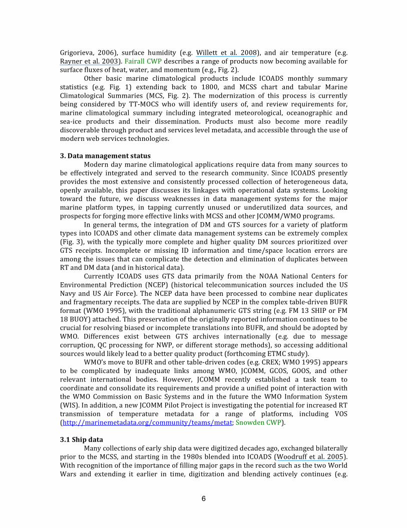
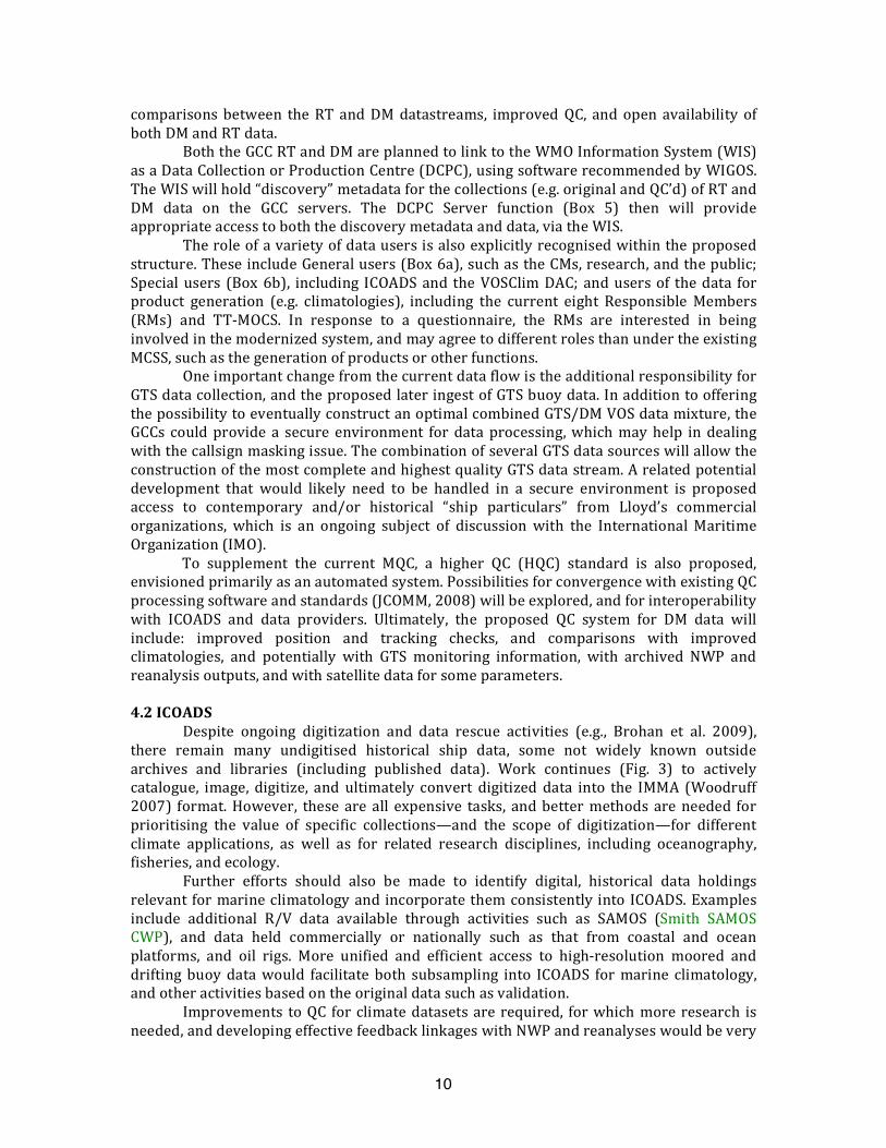
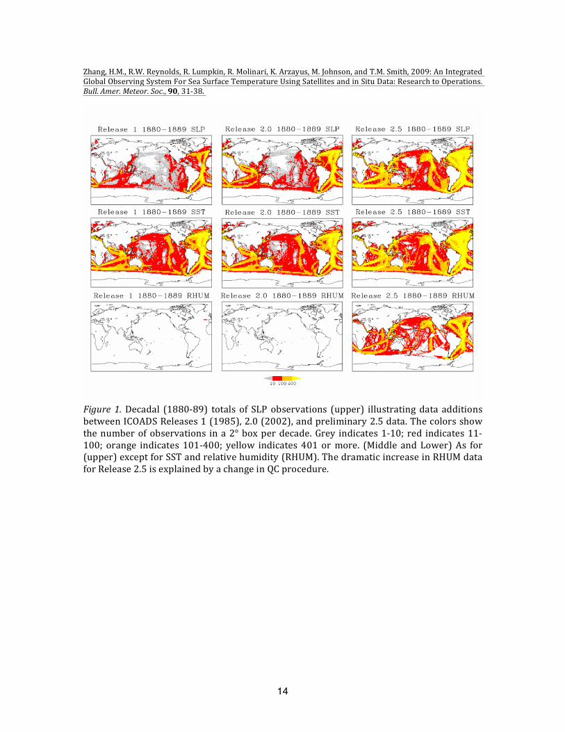
Samplingrequirementsformarineclimatologyarenotwelldefinedduetothesheernumbers of different contributing platforms (and variables) and the irregular spatial andtemporaldistributionofobservations(e.g.Fig.1).Dataadequacywilldependonthequalityofeachmeasurement(includingtheavailabilityofobservingmetadataandinformationonotherenvironmental parameters thatmayaffect dataquality), thenaturalvariability, andonthespatiotemporalcorrelationscalesofthefieldanditsobservationalerrors.Accuracyrequirementsaredefinedin,e.g.OOSDP(1995)andFairallCWP.
Progress toward the assessment of the adequacy of the observing system againstuser requirementshasbeenmade in recentyears. Several climatological griddeddatasetsnowcontainuncertaintyestimates(e.g.Rayneretal.2003,SmithandReynolds2004,Berryand Kent 2009) and some characterisation of the relationship between observationnumbersandgridboxuncertaintyhasbeenmade(KentandBerry2008).ObservingSystemSimulation Experiments have been used to describe the first steps toward design of anintegrated observing system of in‐situ and satellites to satisfy a particular SST climaterequirement(Zhangetal.2009).Moreanalysesarerequiredtomakeassessmentsagainstarangeofaccuracyrequirementsforallvariablesandusingavarietyoftechniques.Formostvariables, the present in situ sampling is largely uneven (Fig. 1) and strategies should beresearchedformoreoptimalsampling,inparticularwhencombinedwithmultiplesatelliteobservationsthatprovidebetterspatialcoverage(e.g.Zhangetal.2006).Thehomogeneityissue is important not only to regional climate change patterns, but also to reduceuncertaintiesassociatedwithaliasesduetounevensampling.
Although the heterogeneity of the surfacemarine climatological observing systemcausesproblemsforconsistency,thediversityofobservingmethodsandplatformsallowsthe observations fromdifferentmethods tobecomparedandhelpensure that systematicbiasesfromaparticularobservationtypeorindividualplatformcanbedetected.
2.4Dataavailabilityandaccessibility
Marineclimatologicaldataaregenerallyarchivedinavarietyoflocations,andoftenfurtherseparatedaccordingtoplatformtypes.However,inrecognitionoftheimportanceofcollatingandsharinginternationallyVOSlogbookdatadispersedacrossnationalarchives,WMO in 1963 established the MCSS. Eight countries were designated as ResponsibleMembers(RMs)toarchiveandprocessthedataandpublishclimatologicalsummaries.Two
5
GlobalDataCollectingCentres(GCCs)wereestablishedin1993inGermanyand theUKtoenhance the flowandQCof thedata.ArchivesofRTshipobservations (andmanymarineandotherdatatypes)sharedonWMO’sGlobalTelecommunicationSystem(GTS)areoftenheldbyNationalMeteorologicalandHydrologicalCentres(NMHSs).SomeNMHSsalsoholdlonger‐termarchives,forexampletheUKMetOfficeandDeutscherWetterdienst.Dataareeventually archived in World Data Centres, such as the NOAA National Climatic andOceanographicDataCenters(NCDCandNODC).
ThecollectionofbuoyobservationsisoverseenbytheDataBuoyCooperationPanel(MeldrumCWP).ManymooredbuoyobservationsareavailableviatheNOAANationalDataBuoyCenter (NDBC)throughinternationalco‐operation,buta completearchiveofcoastalandopen‐oceanmooredbuoysisnotpresentlyavailablefromasinglesource.Driftingbuoydata are also available from a variety of sources, but Canada’s Integrated Science DataManagement (ISDM) operates the Responsible National Oceanographic Data Center(RNODC) for Drifting Buoys (Keeley CWP) archiving many of the data. Tide gaugemeasurements, inmanycasesarereportedwithassociatedmeteorologicalmeasurements,are managed under the Global Sea Level Observing System (GLOSS) (Merrifield CWP).Meteorologicaldatafromcoastalandfixedoceanplatforms,andislandstations,appeartobelargelygovernedbynational,commercial,orterrestrialdatasystems.
ManyofthesediversedatastreamshavebeenunifiedintoICOADS(WorleyCWP).ItsVOScomponentbuildsondataexchangedunderMCSS,togetherwithbilateralexchangesofmanyadditionaldata.GTSorDMdatafromdriftingandmooredbuoys,high‐resolutionR/Vdata,near‐surfaceoceanographicprofilemeasurements,andotherODASarealsoincludedforrecentdecades.PlatformandinstrumentalVOSmetadataregularlypublishedbyWMO(1955; Pub. 47) are also blended (Kent et al. 2007). ICOADS observations(http://icoads.noaa.gov/) are made available in the uniform International MaritimeMeteorological Archive (IMMA) format (Woodruff 2007). Each individual report containstheobservationsofECVsandothermeteorologicalandoceanographicvariablesreportedbya given platform at one time and place, together with available metadata—includingmetadataaddedbytheICOADSprojecttocarefullytrackeachnewdatasource.
Additional in situ marine data of climatological importance, but not yet regularlyintegratedintobasicdatasetssuchasMCSSandICOADS,include:sea‐icedata,historicalandhigh‐resolutionmeteorologicalandoceanographic data (e.g. SmithUnderwayCWP),wavedatafrombuoysandODAS(SwailCWP),OceanSITES timeseriesstations(SendCWP),andmeteorologicalobservationsmadeattidegaugelocations.Insomecases,thesedatastreamsalso are not yet well integrated into JCOMM operations. Moreover, beyond the VOSmetadata (WMO 1955), much more work is needed within JCOMM to consolidate (andrescue historically) similar metadata for buoys and ODAS.While improved integration ofthese and other more specialized data and metadata could reap many benefits for dataaccess and research, significant investments appear to be required for re‐tooling existingformats and processing systems, such as are being addressedunder theWMO IntegratedGlobalObservingSystems(WIGOS)initiative.
2.5Products
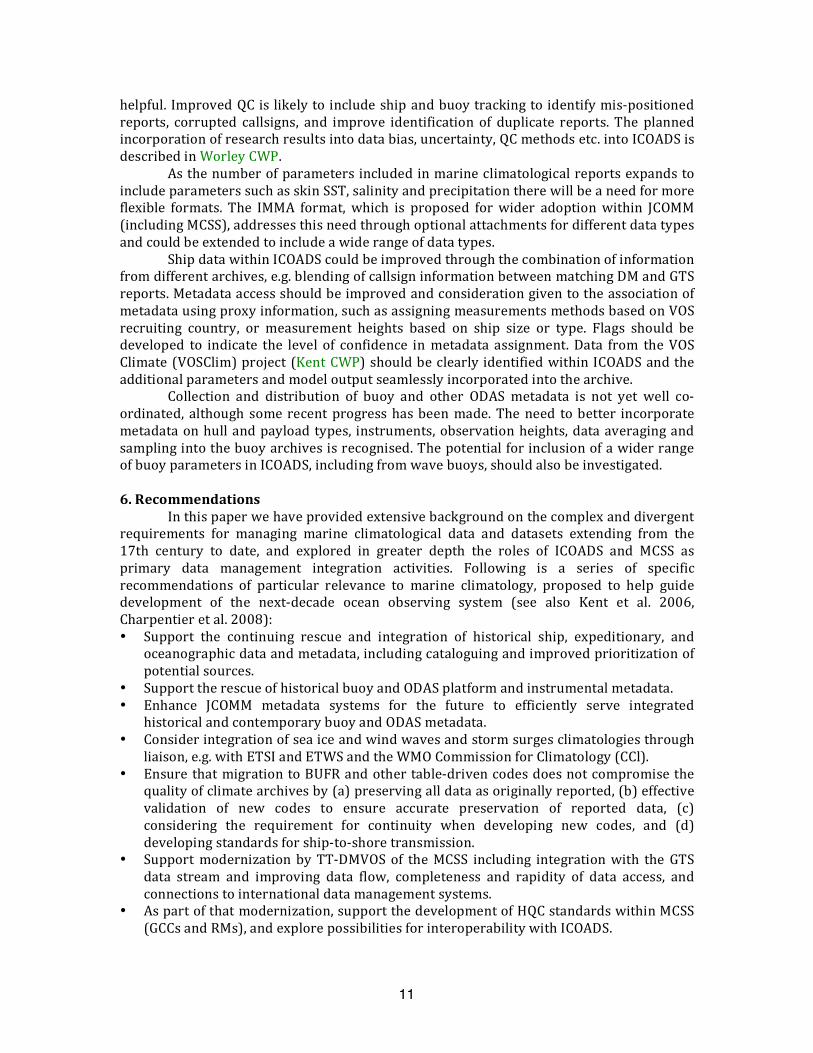
Building on the extensive archives available from the MCSS, ICOADS, andindependentsources(suchassatellitedatastartinginthe20thcentury),manywidelyusedoperational,reanalysis,andclimateanalysisproductshavebeenconstructed,e.g.analysesusing techniques such as optimal interpolation, and generally considering one variable inisolation. In that area so far SST (with sea‐ice) has received the most attention (e.g.Woodruffet al.2008,RaynerCWP),butproducts have alsobeensuccessfullyconstructedfor SLP (e.g. Allan and Ansell 2006), visually estimated VOS wave data (e.g. Gulev and
6
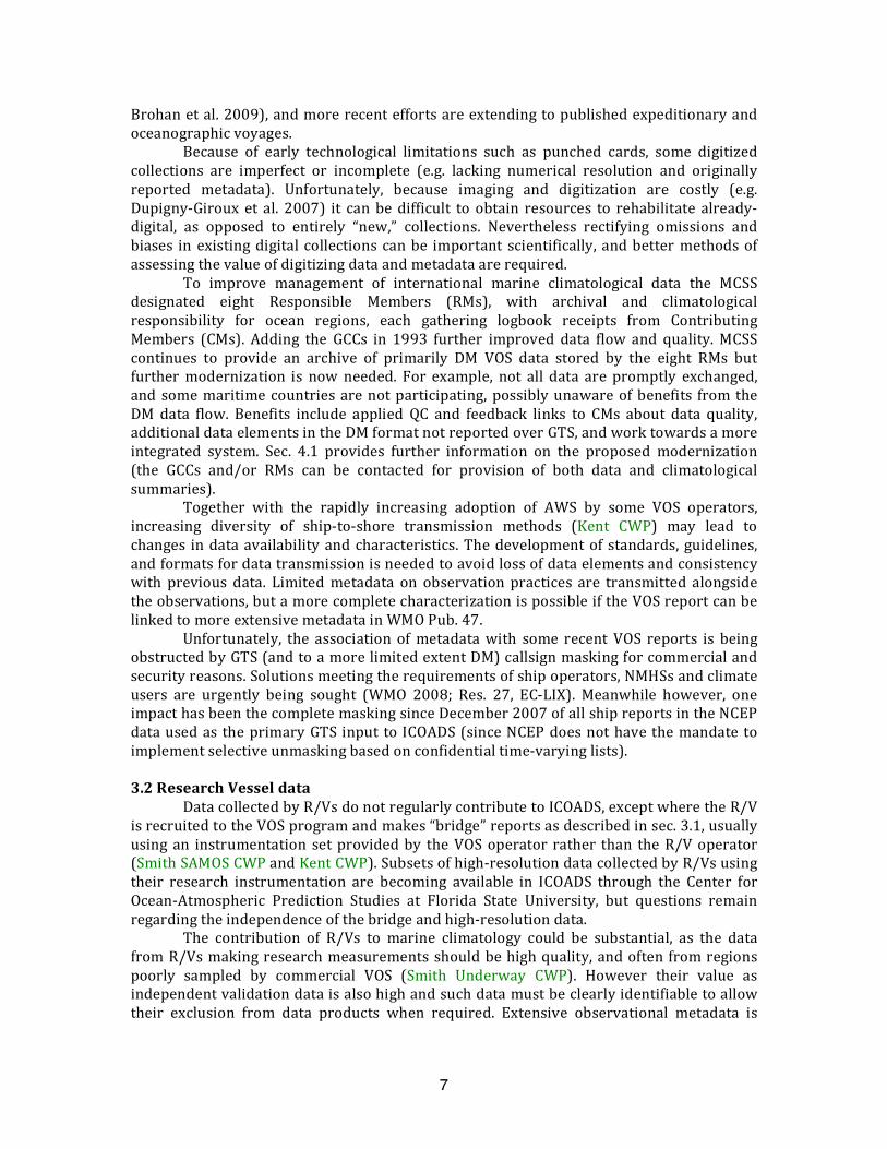
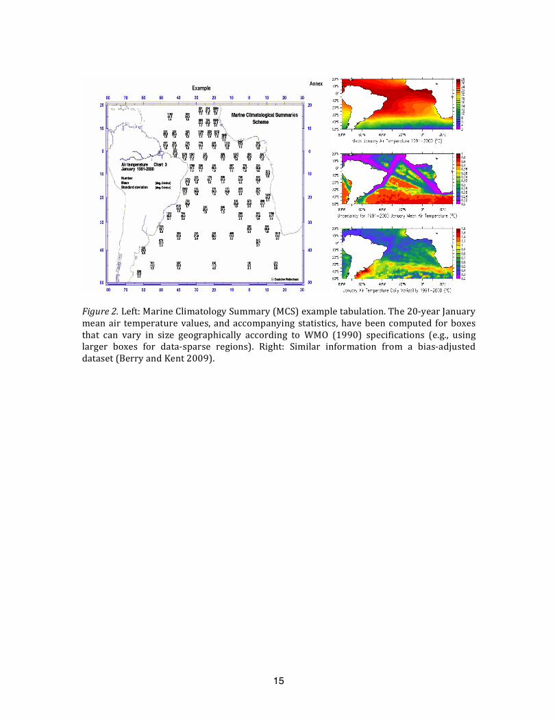
Grigorieva, 2006), surface humidity (e.g. Willett et al. 2008), and air temperature (e.g.Rayneretal.2003).FairallCWPdescribesarangeofproductsnowbecomingavailableforsurfacefluxesofheat,water,andmomentum(e.g.,Fig.2).
Other basic marine climatological products include ICOADS monthly summarystatistics (e.g. Fig. 1) extending back to 1800, and MCSS chart and tabular MarineClimatological Summaries (MCS, Fig. 2). The modernization of this process is currentlybeing considered by TT‐MOCS who will identify users of, and review requirements for,marine climatological summary including integrated meteorological, oceanographic andsea‐ice products and their dissemination. Products must also become more readilydiscoverablethroughproductandserviceslevelmetadata,andaccessiblethroughtheuseofmodernwebservicestechnologies.
3.Datamanagementstatus
Moderndaymarineclimatologicalapplicationsrequiredata frommany sources tobe effectively integrated and served to the research community. Since ICOADS presentlyprovides themost extensive and consistently processed collection of heterogeneous data,openly available, this paper discusses its linkageswith operational data systems. Lookingtoward the future, we discuss weaknesses in data management systems for the majormarine platform types, in tapping currently unused or underutilized data sources, andprospectsforforgingmoreeffectivelinkswithMCSSandotherJCOMM/WMOprograms.
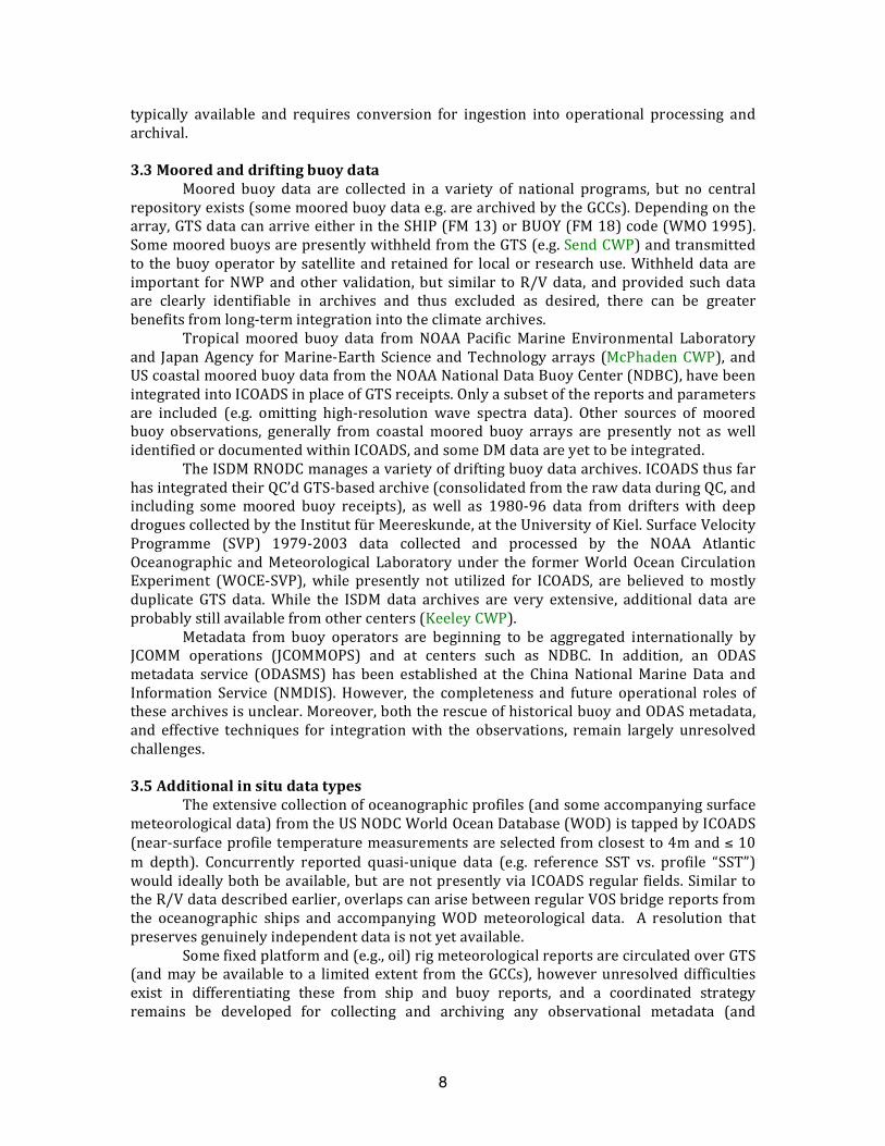
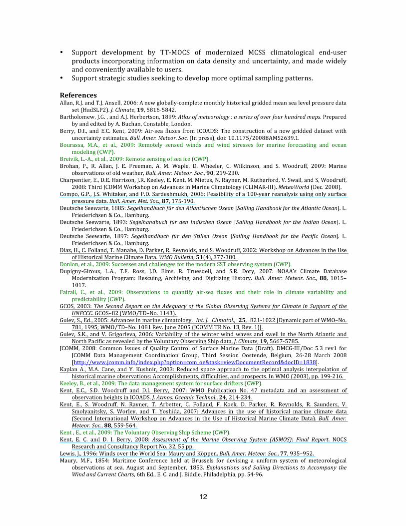
In general terms, the integration ofDMand GTS sources for a variety of platformtypesintoICOADSandotherclimatedatamanagementsystemscanbeextremelycomplex(Fig. 3),with the typicallymore complete andhigher qualityDM sources prioritized overGTS receipts. Incomplete or missing ID information and time/space location errors areamong theissues thatcancomplicate thedetectionandeliminationofduplicatesbetweenRTandDMdata(andinhistoricaldata).
Currently ICOADS uses GTS data primarily from the NOAA National Centers forEnvironmental Prediction (NCEP) (historical telecommunication sources included the USNavy andUSAir Force). TheNCEPdata have beenprocessed to combinenear duplicatesandfragmentaryreceipts.ThedataaresuppliedbyNCEPinthecomplextable‐drivenBUFRformat(WMO1995),withthetraditionalalphanumericGTSstring(e.g.FM13SHIPorFM18BUOY)attached.ThispreservationoftheoriginallyreportedinformationcontinuestobecrucialforresolvingbiasedorincompletetranslationsintoBUFR,andshouldbeadoptedbyWMO. Differences exist between GTS archives internationally (e.g. due to messagecorruption,QCprocessing forNWP,ordifferent storagemethods), soaccessingadditionalsourceswouldlikelyleadtoabetterqualityproduct(forthcomingETMCstudy).
WMO’smovetoBUFRandothertable‐drivencodes(e.g.CREX;WMO1995)appearsto be complicated by inadequate links among WMO, JCOMM, GCOS, GOOS, and otherrelevant international bodies. However, JCOMM recently established a task team tocoordinateandconsolidateitsrequirementsandprovideaunifiedpointofinteractionwiththeWMO Commission on Basic Systems and in the future theWMO Information System(WIS).Inaddition,anewJCOMMPilotProjectisinvestigatingthepotentialforincreasedRTtransmission of temperature metadata for a range of platforms, including VOS(http://marinemetadata.org/community/teams/metat;SnowdenCWP).
3.1Shipdata
Manycollectionsofearlyshipdataweredigitizeddecadesago,exchangedbilaterallyprior to theMCSS, andstarting in the1980sblended into ICOADS(Woodruffet al.2005).WithrecognitionoftheimportanceoffillingmajorgapsintherecordsuchasthetwoWorldWars and extending it earlier in time, digitization and blending actively continues (e.g.
7
Brohanetal.2009),andmorerecenteffortsareextendingtopublishedexpeditionaryandoceanographicvoyages.
Because of early technological limitations such as punched cards, some digitizedcollections are imperfect or incomplete (e.g. lacking numerical resolution and originallyreported metadata). Unfortunately, because imaging and digitization are costly (e.g.Dupigny‐Giroux et al. 2007) it can be difficult to obtain resources to rehabilitate already‐digital, as opposed to entirely “new,” collections. Nevertheless rectifying omissions andbiases in existingdigital collectionscanbe important scientifically, andbettermethodsofassessingthevalueofdigitizingdataandmetadataarerequired.
To improve management of international marine climatological data the MCSSdesignated eight Responsible Members (RMs), with archival and climatologicalresponsibility for ocean regions, each gathering logbook receipts from ContributingMembers (CMs). Adding the GCCs in 1993 further improved data flow and quality.MCSScontinues to provide an archive of primarily DM VOS data stored by the eight RMs butfurthermodernization is nowneeded. For example, not all data are promptly exchanged,and somemaritimecountriesarenotparticipating,possiblyunawareofbenefits fromtheDM data flow. Benefits include applied QC and feedback links to CMs about data quality,additionaldataelementsintheDMformatnotreportedoverGTS,andworktowardsamoreintegrated system. Sec. 4.1 provides further information on the proposed modernization(the GCCs and/or RMs can be contacted for provision of both data and climatologicalsummaries).
Together with the rapidly increasing adoption of AWS by some VOS operators,increasing diversity of ship‐to‐shore transmission methods (Kent CWP) may lead tochanges indataavailabilityandcharacteristics.Thedevelopmentof standards,guidelines,andformatsfordatatransmissionisneededtoavoidlossofdataelementsandconsistencywith previous data. Limitedmetadata on observationpractices are transmitted alongsidetheobservations,butamorecompletecharacterizationispossibleiftheVOSreportcanbelinkedtomoreextensivemetadatainWMOPub.47.
Unfortunately, the association ofmetadatawith some recent VOS reports is beingobstructedbyGTS(andtoamorelimitedextentDM)callsignmaskingforcommercialandsecurityreasons.Solutionsmeetingtherequirementsofshipoperators,NMHSsandclimateusers are urgently being sought (WMO 2008; Res. 27, EC‐LIX). Meanwhile however, oneimpacthasbeenthecompletemaskingsinceDecember2007ofallshipreportsintheNCEPdatausedastheprimaryGTSinput toICOADS(sinceNCEPdoesnothavethemandate toimplementselectiveunmaskingbasedonconfidentialtime‐varyinglists).
3.2ResearchVesseldata
DatacollectedbyR/VsdonotregularlycontributetoICOADS,exceptwheretheR/VisrecruitedtotheVOSprogramandmakes“bridge”reportsasdescribedinsec.3.1,usuallyusing an instrumentation setprovidedby theVOSoperator rather than theR/Voperator(SmithSAMOSCWPandKentCWP).Subsetsofhigh‐resolutiondatacollectedbyR/Vsusingtheir research instrumentation are becoming available in ICOADS through the Center forOcean‐Atmospheric Prediction Studies at Florida State University, but questions remainregardingtheindependenceofthebridgeandhigh‐resolutiondata.
The contribution of R/Vs to marine climatology could be substantial, as the datafromR/Vsmakingresearchmeasurementsshouldbehighquality,andoftenfromregionspoorly sampled by commercial VOS (Smith Underway CWP). However their value asindependentvalidationdataisalsohighandsuchdatamustbeclearlyidentifiabletoallowtheir exclusion from data products when required. Extensive observational metadata is
8
typically available and requires conversion for ingestion into operational processing andarchival.
3.3Mooredanddriftingbuoydata
Moored buoy data are collected in a variety of national programs, but no centralrepositoryexists(somemooredbuoydatae.g.arearchivedbytheGCCs).Dependingonthearray,GTSdatacanarriveeitherintheSHIP(FM13)orBUOY(FM18)code(WMO1995).SomemooredbuoysarepresentlywithheldfromtheGTS(e.g.SendCWP)andtransmittedto thebuoyoperatorbysatelliteandretainedfor localorresearchuse.Withhelddataareimportant forNWPandothervalidation,but similar toR/Vdata, andprovided suchdataare clearly identifiable in archives and thus excluded as desired, there can be greaterbenefitsfromlong‐termintegrationintotheclimatearchives.
Tropical moored buoy data from NOAA Pacific Marine Environmental Laboratoryand JapanAgency forMarine‐Earth ScienceandTechnologyarrays (McPhadenCWP), andUScoastalmooredbuoydatafromtheNOAANationalDataBuoyCenter(NDBC),havebeenintegratedintoICOADSinplaceofGTSreceipts.Onlyasubsetofthereportsandparametersare included (e.g. omitting high‐resolution wave spectra data). Other sources of mooredbuoy observations, generally from coastal moored buoy arrays are presently not as wellidentifiedordocumentedwithinICOADS,andsomeDMdataareyettobeintegrated.
TheISDMRNODCmanagesavarietyofdriftingbuoydataarchives.ICOADSthusfarhasintegratedtheirQC’dGTS‐basedarchive(consolidatedfromtherawdataduringQC,andincluding some moored buoy receipts), as well as 1980‐96 data from drifters with deepdroguescollectedbytheInstitutfürMeereskunde,attheUniversityofKiel.SurfaceVelocityProgramme (SVP) 1979‐2003 data collected and processed by the NOAA AtlanticOceanographic andMeteorological Laboratory under the formerWorld Ocean CirculationExperiment (WOCE‐SVP), while presently not utilized for ICOADS, are believed to mostlyduplicate GTS data.While the ISDM data archives are very extensive, additional data areprobablystillavailablefromothercenters(KeeleyCWP).
Metadata from buoy operators are beginning to be aggregated internationally byJCOMM operations (JCOMMOPS) and at centers such as NDBC. In addition, an ODASmetadata service (ODASMS) has been established at the China NationalMarine Data andInformation Service (NMDIS).However, the completeness and future operational roles ofthesearchivesisunclear.Moreover,boththerescueofhistoricalbuoyandODASmetadata,and effective techniques for integrationwith the observations, remain largely unresolvedchallenges.
3.5Additionalinsitudatatypes
Theextensivecollectionofoceanographicprofiles(andsomeaccompanyingsurfacemeteorologicaldata)fromtheUSNODCWorldOceanDatabase(WOD)istappedbyICOADS(near‐surfaceprofiletemperaturemeasurementsareselectedfromclosestto4mand≤10m depth). Concurrently reported quasi‐unique data (e.g. reference SST vs. profile “SST”)wouldideallybothbeavailable,butarenotpresentlyviaICOADSregularfields.SimilartotheR/Vdatadescribedearlier,overlapscanarisebetweenregularVOSbridgereportsfromthe oceanographic ships and accompanyingWODmeteorological data. A resolution thatpreservesgenuinelyindependentdataisnotyetavailable.
Somefixedplatformand(e.g.,oil)rigmeteorologicalreportsarecirculatedoverGTS(andmaybeavailable toa limitedextent from theGCCs),howeverunresolveddifficultiesexist in differentiating these from ship and buoy reports, and a coordinated strategyremains be developed for collecting and archiving any observational metadata (and
9
accounting for differences arising frommanual versus automated observing systems). Insomecasescommercialinterestsalsomaycomplicatedataandmetadataavailability.
Since approximately 1983, the US Coastal‐Marine Automated Network (C‐MAN)operated by NDBC has provided coastal‐interface (e.g. pier or lighthouse based) dataaroundtheUScoastline,withinstrumentationsimilaritiestomooredbuoys.Theproximityofthesemeasurementstoshoreraisesquestionsabouthomogeneitywithopenoceandata.Similarnetworksmayexist(orhavehistorically)inothercountries,butcoastal(andisland)datapresentlygenerallyarehandledoutsideJCOMM.
Meteorological observationshave beenmade formany years alongside tide gaugemeasurements.TidegaugedataunderGLOSSarecirculatedovertheGTSinCREXformat;somedatafromUSstationsareavailableinC‐MANformat.TidegaugeCREX/C‐MANreportsare available fromNCEPback to about 2000, but presently included in ICOADSonly to alimited degree. Inclusion of such land‐baseddata raises data homogeneity questions, andavailabilityofinstrumentalmetadataforthemeteorologicalinstrumentsisunknown.
4.Proposeddatamanagementimprovements4.1MCSS
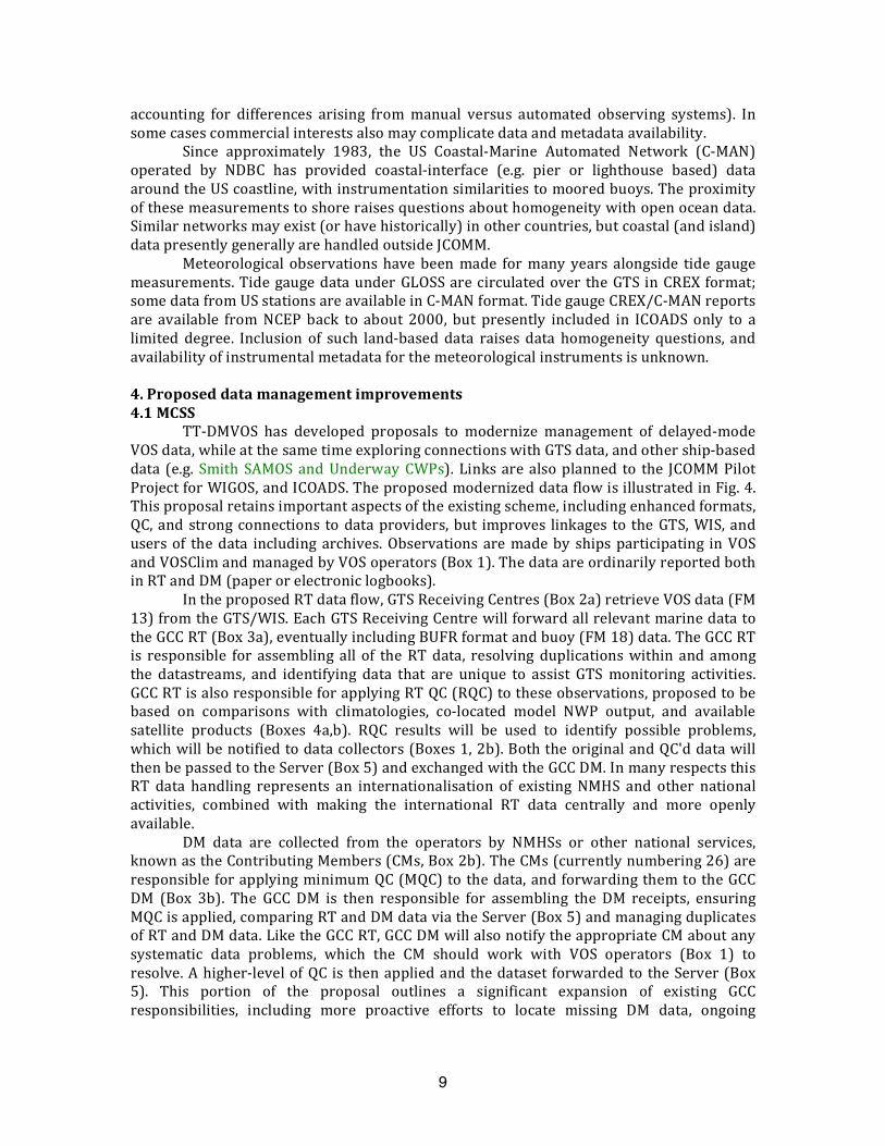
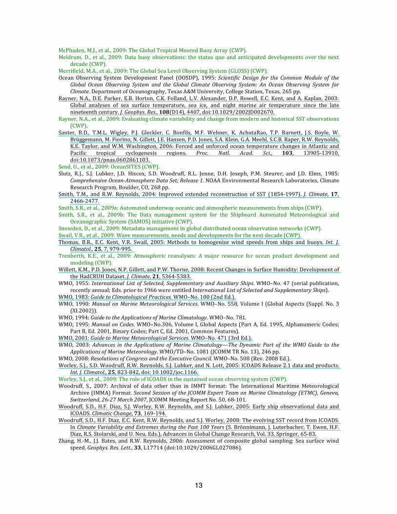
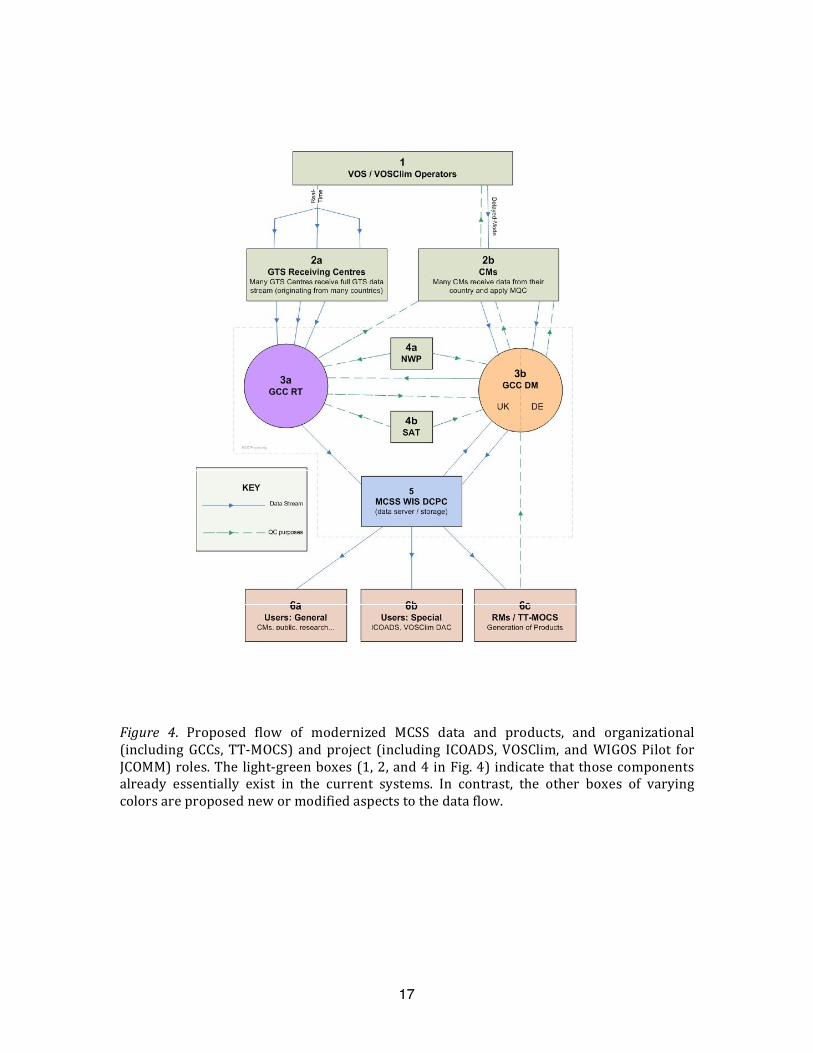
TT‐DMVOS has developed proposals to modernizemanagement of delayed‐modeVOSdata,whileatthesametimeexploringconnectionswithGTSdata,andothership‐baseddata (e.g. Smith SAMOS andUnderwayCWPs).Linksarealsoplanned to the JCOMMPilotProjectforWIGOS,andICOADS.TheproposedmodernizeddataflowisillustratedinFig.4.Thisproposalretainsimportantaspectsoftheexistingscheme,includingenhancedformats,QC,and strongconnections to dataproviders,but improves linkages to theGTS,WIS,andusersof thedata including archives.Observations aremadebyshipsparticipating inVOSandVOSClimandmanagedbyVOSoperators(Box1).ThedataareordinarilyreportedbothinRTandDM(paperorelectroniclogbooks).
IntheproposedRTdataflow,GTSReceivingCentres(Box2a)retrieveVOSdata(FM13)fromtheGTS/WIS.EachGTSReceivingCentrewillforwardallrelevantmarinedatatotheGCCRT(Box3a),eventuallyincludingBUFRformatandbuoy(FM18)data.TheGCCRTis responsible for assembling all of theRTdata, resolving duplicationswithin and amongthe datastreams, and identifying data that are unique to assist GTS monitoring activities.GCCRTisalsoresponsibleforapplyingRTQC(RQC)totheseobservations,proposedtobebased on comparisons with climatologies, co‐located model NWP output, and availablesatellite products (Boxes 4a,b). RQC results will be used to identify possible problems,whichwillbenotifiedtodatacollectors(Boxes1,2b).BoththeoriginalandQC'ddatawillthenbepassedtotheServer(Box5)andexchangedwiththeGCCDM.InmanyrespectsthisRT data handling represents an internationalisation of existing NMHS and other nationalactivities, combined with making the international RT data centrally and more openlyavailable.
DM data are collected from the operators by NMHSs or other national services,knownastheContributingMembers(CMs,Box2b).TheCMs(currentlynumbering26)areresponsibleforapplyingminimumQC(MQC) to thedata,andforwardingthemtotheGCCDM (Box 3b). The GCC DM is then responsible for assembling the DM receipts, ensuringMQCisapplied,comparingRTandDMdataviatheServer(Box5)andmanagingduplicatesofRTandDMdata.LiketheGCCRT,GCCDMwillalsonotifytheappropriateCMaboutanysystematic data problems, which the CM should work with VOS operators (Box 1) toresolve.Ahigher‐levelofQCis thenappliedand thedatasetforwarded to theServer(Box5). This portion of the proposal outlines a significant expansion of existing GCCresponsibilities, including more proactive efforts to locate missing DM data, ongoing
10
comparisons between theRT andDMdatastreams, improved QC, and open availability ofbothDMandRTdata.
BoththeGCCRTandDMareplannedtolinktotheWMOInformationSystem(WIS)asaDataCollectionorProductionCentre(DCPC),usingsoftwarerecommendedbyWIGOS.TheWISwillhold“discovery”metadataforthecollections(e.g.originalandQC’d)ofRTandDM data on the GCC servers. The DCPC Server function (Box 5) then will provideappropriateaccesstoboththediscoverymetadataanddata,viatheWIS.
Theroleofavarietyofdatausersisalsoexplicitlyrecognisedwithintheproposedstructure.TheseincludeGeneralusers(Box6a),suchastheCMs,research,andthepublic;Special users (Box6b), including ICOADS and theVOSClimDAC; andusersof thedata forproduct generation (e.g. climatologies), including the current eight Responsible Members(RMs) and TT‐MOCS. In response to a questionnaire, the RMs are interested in beinginvolvedinthemodernizedsystem,andmayagreetodifferentrolesthanundertheexistingMCSS,suchasthegenerationofproductsorotherfunctions.
OneimportantchangefromthecurrentdataflowistheadditionalresponsibilityforGTSdatacollection,andtheproposedlateringestofGTSbuoydata.InadditiontoofferingthepossibilitytoeventuallyconstructanoptimalcombinedGTS/DMVOSdatamixture,theGCCscouldprovidea secureenvironment for dataprocessing,whichmayhelp in dealingwiththecallsignmaskingissue.ThecombinationofseveralGTSdatasourceswillallowtheconstructionofthemostcompleteandhighestqualityGTSdatastream.Arelatedpotentialdevelopment that would likely need to be handled in a secure environment is proposedaccess to contemporary and/or historical “ship particulars” from Lloyd’s commercialorganizations, which is an ongoing subject of discussionwith the InternationalMaritimeOrganization(IMO).
To supplement the current MQC, a higher QC (HQC) standard is also proposed,envisionedprimarilyasanautomatedsystem.PossibilitiesforconvergencewithexistingQCprocessingsoftwareandstandards(JCOMM,2008)willbeexplored,andforinteroperabilitywith ICOADS and data providers. Ultimately, the proposed QC system for DM data willinclude: improved position and tracking checks, and comparisons with improvedclimatologies, and potentially with GTS monitoring information, with archived NWP andreanalysisoutputs,andwithsatellitedataforsomeparameters.4.2ICOADS
Despite ongoing digitization and data rescue activities (e.g., Brohan et al. 2009),there remain many undigitised historical ship data, some not widely known outsidearchives and libraries (including published data). Work continues (Fig. 3) to activelycatalogue, image, digitize, and ultimately convert digitized data into the IMMA (Woodruff2007) format.However, theseareall expensive tasks, andbettermethods are neededforprioritising the value of specific collections—and the scope of digitization—for differentclimate applications, as well as for related research disciplines, including oceanography,fisheries,andecology.
Further efforts should also be made to identify digital, historical data holdingsrelevantformarineclimatologyandincorporatethemconsistently intoICOADS.Examplesinclude additional R/V data available through activities such as SAMOS (Smith SAMOSCWP), and data held commercially or nationally such as that from coastal and oceanplatforms, and oil rigs. More unified and efficient access to high‐resolution moored anddrifting buoydatawould facilitate both subsampling into ICOADS formarine climatology,andotheractivitiesbasedontheoriginaldatasuchasvalidation.
Improvements toQC forclimatedatasetsare required, forwhichmoreresearch isneeded,anddevelopingeffectivefeedbacklinkageswithNWPandreanalyseswouldbevery
11
helpful. ImprovedQCis likelyto includeshipandbuoytrackingtoidentifymis‐positionedreports, corrupted callsigns, and improve identification of duplicate reports. The plannedincorporationofresearchresultsintodatabias,uncertainty,QCmethodsetc.intoICOADSisdescribedinWorleyCWP.
Asthenumberofparameters includedinmarineclimatologicalreportsexpandstoincludeparameterssuchasskinSST,salinityandprecipitationtherewillbeaneedformoreflexible formats. The IMMA format, which is proposed forwider adoptionwithin JCOMM(includingMCSS),addressesthisneedthroughoptionalattachmentsfordifferentdatatypesandcouldbeextendedtoincludeawiderangeofdatatypes.
ShipdatawithinICOADScouldbeimprovedthroughthecombinationofinformationfromdifferentarchives,e.g.blendingofcallsigninformationbetweenmatchingDMandGTSreports.Metadataaccessshouldbeimprovedandconsiderationgiventotheassociationofmetadatausingproxyinformation,suchasassigningmeasurementsmethodsbasedonVOSrecruiting country, or measurement heights based on ship size or type. Flags should bedeveloped to indicate the level of confidence inmetadata assignment.Data from theVOSClimate (VOSClim)project (KentCWP)shouldbeclearly identifiedwithinICOADSandtheadditionalparametersandmodeloutputseamlesslyincorporatedintothearchive.
Collection and distribution of buoy and other ODAS metadata is not yet well co‐ordinated, althoughsomerecent progress hasbeenmade.Theneed tobetter incorporatemetadataonhullandpayload types, instruments,observationheights,dataaveragingandsamplingintothebuoyarchivesisrecognised.ThepotentialforinclusionofawiderrangeofbuoyparametersinICOADS,includingfromwavebuoys,shouldalsobeinvestigated.6.Recommendations
Inthispaperwehaveprovidedextensivebackgroundonthecomplexanddivergentrequirements for managing marine climatological data and datasets extending from the17th century to date, and explored in greater depth the roles of ICOADS and MCSS asprimary data management integration activities. Following is a series of specificrecommendations of particular relevance to marine climatology, proposed to help guidedevelopment of the next‐decade ocean observing system (see also Kent et al. 2006,Charpentieretal.2008):• Support the continuing rescue and integration of historical ship, expeditionary, and
oceanographicdataandmetadata,includingcataloguingandimprovedprioritizationofpotentialsources.
• SupporttherescueofhistoricalbuoyandODASplatformandinstrumentalmetadata.• Enhance JCOMM metadata systems for the future to efficiently serve integrated
historicalandcontemporarybuoyandODASmetadata.• Considerintegrationofseaiceandwindwavesandstormsurgesclimatologiesthrough
liaison,e.g.withETSIandETWSandtheWMOCommissionforClimatology(CCl).• Ensure thatmigrationtoBUFRandothertable‐drivencodesdoesnotcompromisethe
qualityofclimatearchivesby(a)preservingalldataasoriginallyreported,(b)effectivevalidation of new codes to ensure accurate preservation of reported data, (c)considering the requirement for continuity when developing new codes, and (d)developingstandardsforship‐to‐shoretransmission.
• Supportmodernization byTT‐DMVOSof theMCSS including integrationwith the GTSdata stream and improving data flow, completeness and rapidity of data access, andconnectionstointernationaldatamanagementsystems.
• Aspartofthatmodernization,supportthedevelopmentofHQCstandardswithinMCSS(GCCsandRMs),andexplorepossibilitiesforinteroperabilitywithICOADS.
12
• Support development by TT‐MOCS of modernized MCSS climatological end‐userproducts incorporatinginformationondatadensityanduncertainty,andmadewidelyandconvenientlyavailabletousers.
• Supportstrategicstudiesseekingtodevelopmoreoptimalsamplingpatterns.
ReferencesAllan,R.J.andT.J.Ansell,2006:Anewglobally‐completemonthlyhistoricalgriddedmeansealevelpressuredata
set(HadSLP2).J.Climate,19,5816‐5842.Bartholomew,J.G.,andA.J.Herbertson,1899:Atlasofmeteorology:aseriesofoverfourhundredmaps.Prepared
byandeditedbyA.Buchan,Constable,London.Berry, D.I., and E.C.Kent, 2009:Air‐sea fluxes from ICOADS: The constructionof a newgriddeddatasetwith
uncertaintyestimates.Bull.Amer.Meteor.Soc.(Inpress),doi:10.1175/2008BAMS2639.1.Bourassa, M.A., et al., 2009: Remotely sensed winds and wind stresses for marine forecasting and ocean
modeling(CWP).Breivik,L.‐A.,etal.,2009:Remotesensingofseaice(CWP).Brohan, P., R. Allan, J. E. Freeman, A. M. Waple, D. Wheeler, C. Wilkinson, and S. Woodruff, 2009: Marine
observationsofoldweather,Bull.Amer.Meteor.Soc.,90,219‐230.Charpentier,E.,D.E.Harrison,J.R.Keeley,E.Kent,M.Mietus,N.Rayner,M.Rutherford,V.Swail,andS,Woodruff,
2008:ThirdJCOMMWorkshoponAdvancesinMarineClimatology(CLIMAR‐III).MeteoWorld(Dec.2008).Compo,G.P.,J.S.Whitaker,andP.D.Sardeshmukh,2006:Feasibilityofa100‐yearreanalysisusingonlysurface
pressuredata.Bull.Amer.Met.Soc.,87,175‐190.DeutscheSeewarte,1885:SegelhandbuchfürdenAtlantischenOzean[SailingHandbookfortheAtlanticOcean].L.
Friederichsen&Co.,Hamburg.Deutsche Seewarte, 1893: Segelhandbuch für den Indischen Ozean [Sailing Handbook for the Indian Ocean]. L.
Friederichsen&Co.,Hamburg.Deutsche Seewarte, 1897: Segelhandbuch für den Stillen Ozean [Sailing Handbook for the Pacific Ocean]. L.
Friederichsen&Co.,Hamburg.Diaz,H.,C.Folland,T.Manabe,D.Parker,R.Reynolds,andS.Woodruff,2002:WorkshoponAdvancesintheUse
ofHistoricalMarineClimateData.WMOBulletin,51(4),377‐380.Donlon,etal.,2009:SuccessesandchallengesforthemodernSSTobservingsystem(CWP).Dupigny‐Giroux, L.A., T.F. Ross, J.D. Elms, R. Truesdell, and S.R. Doty, 2007: NOAA’s Climate Database
Modernization Program: Rescuing, Archiving, and Digitizing History.Bull. Amer. Meteor. Soc., 88, 1015–1017.
Fairall, C., et al., 2009: Observations to quantify air‐sea fluxes and their role in climate variability andpredictability(CWP).
GCOS, 2003:The SecondReport on theAdequacy of theGlobalObserving Systems for Climate in Support of theUNFCCC.GCOS–82(WMO/TD–No.1143).
Gulev,S.,Ed.,2005:Advancesinmarineclimatology. Int.J. Climatol., 25, 821‐1022[DynamicpartofWMO–No.781,1995;WMO/TD–No.1081Rev.June2005(JCOMMTRNo.13,Rev.1)].
Gulev, S.K., andV.Grigorieva, 2006:Variability of thewinterwindwaves and swell in theNorthAtlantic andNorthPacificasrevealedbytheVoluntaryObservingShipdata,J.Climate,19,5667‐5785.
JCOMM, 2008: Common Issues of Quality Control of Surface Marine Data (Draft). DMCG‐III/Doc 5.3 rev1 forJCOMM Data Management Coordination Group, Third Session Oostende, Belgium, 26‐28 March 2008[http://www.jcomm.info/index.php?option=com_oe&task=viewDocumentRecord&docID=1838].
Kaplan A.,M.A. Cane, and Y. Kushnir, 2003: Reduced space approach to the optimal analysis interpolation ofhistoricalmarineobservations:Accomplishments,difficulties,andprospects.InWMO(2003),pp.199‐216.
Keeley,B.,etal.,2009:Thedatamanagementsystemforsurfacedrifters(CWP).Kent, E.C., S.D. Woodruff and D.I. Berry, 2007: WMO Publication No. 47 metadata and an assessment of
observationheightsinICOADS.J.Atmos.OceanicTechnol.,24,214‐234.Kent, E., S. Woodruff, N. Rayner, T. Arbetter, C. Folland, F. Koek, D. Parker, R. Reynolds, R. Saunders, V.
Smolyanitsky, S. Worley, and T. Yoshida, 2007: Advances in the use of historical marine climate data(Second International Workshop on Advances in the Use of Historical Marine Climate Data).Bull. Amer.Meteor.Soc.,88,559‐564.
Kent,E.,etal.,2009:TheVoluntaryObservingShipScheme(CWP).Kent, E. C. and D. I. Berry, 2008: Assessment of the Marine Observing System (ASMOS): Final Report. NOCS
ResearchandConsultancyReportNo.32,55pp.Lewis,J.,1996:WindsovertheWorldSea:MauryandKöppen.Bull.Amer.Meteor.Soc.,77,935–952.Maury, M.F., 1854: Maritime Conference held at Brussels for devising a uniform system of meteorological
observations at sea, August and September, 1853.Explanations and SailingDirections to Accompany theWindandCurrentCharts,6thEd.,E.C.andJ.Biddle,Philadelphia,pp.54‐96.
13
McPhaden,M.J.,etal.,2009:TheGlobalTropicalMooredBuoyArray(CWP).Meldrum,D.,etal.,2009:Databuoyobservations: thestatusquo andanticipateddevelopmentsover thenext
decade(CWP).Merrifield,M.A.,etal.,2009:TheGlobalSeaLevelObservingSystem(GLOSS)(CWP).Ocean Observing SystemDevelopment Panel (OOSDP), 1995:Scientific Design for the Common Module of the
Global Ocean Observing System and the Global Climate Observing System: An Ocean Observing System forClimate.DepartmentofOceanography,TexasA&MUniversity,CollegeStation,Texas,265pp.
Rayner,N.A.,D.E.Parker,E.B.Horton,C.K.Folland,L.V.Alexander,D.P.Rowell,E.C.Kent,andA.Kaplan,2003:Global analyses of sea surface temperature, sea ice, and night marine air temperature since the latenineteenthcentury.J.Geophys.Res.,108(D14),4407,doi:10.1029/2002JD002670.
Rayner,N.A.,etal.,2009:EvaluatingclimatevariabilityandchangefrommodernandhistoricalSSTobservations(CWP).
Santer, B.D., T.M.L. Wigley, P.J. Gleckler, C. Bonfils, M.F. Wehner, K. AchutaRao, T.P. Barnett, J.S. Boyle, W.Brüggemann,M.Fiorino,N.Gillett,J.E.Hansen,P.D.Jones,S.A.Klein,G.A.Meehl,S.C.B.Raper,R.W.Reynolds,K.E.Taylor,andW.M.Washington,2006:Forcedandunforcedoceantemperaturechanges inAtlanticandPacific tropical cyclogenesis regions. Proc. Natl. Acad. Sci., 103, 13905‐13910,doi:10.1073/pnas.0602861103.
Send,U.,etal.,2009:OceanSITES(CWP).Slutz, R.J., S.J. Lubker, J.D. Hiscox, S.D. Woodruff, R.L. Jenne, D.H. Joseph, P.M. Steurer, and J.D. Elms, 1985:
ComprehensiveOceanAtmosphereDataSet;Release1.NOAAEnvironmentalResearchLaboratories,ClimateResearchProgram,Boulder,CO,268pp.
Smith, T.M., and R.W. Reynolds, 2004: Improved extended reconstruction of SST (1854‐1997). J. Climate,17,2466‐2477.
Smith,S.R.,etal.,2009a:Automatedunderwayoceanicandatmosphericmeasurementsfromships(CWP).Smith, S.R., et al., 2009b: The Data management system for the Shipboard Automated Meteorological and
OceanographicSystem(SAMOS)initiative(CWP).Snowden,D.,etal.,2009:Metadatamanagementinglobaldistributedoceanobservationnetworks(CWP).Swail,V.R.,etal.,2009:Wavemeasurements,needsanddevelopmentsforthenextdecade(CWP).Thomas, B.R., E.C. Kent, V.R. Swail, 2005: Methods to homogenize wind speeds from ships and buoys. Int. J.
Climatol.,25,7,979‐995.Trenberth, K.E., et al., 2009: Atmospheric reanalyses: A major resource for ocean product development and
modeling(CWP).Willett,K.M.,P.D.Jones,N.P.Gillett,andP.W.Thorne,2008:RecentChangesinSurfaceHumidity:Developmentof
theHadCRUHDataset.J.Climate,21,5364‐5383.WMO,1955: International ListofSelected,Supplementary andAuxiliaryShips.WMO–No.47(serialpublication,
recentlyannual;Eds.priorto1966wereentitledInternationalListofSelectedandSupplementaryShips).WMO,1983:GuidetoClimatologicalPractices.WMO–No.100(2ndEd.).WMO,1990:ManualonMarineMeteorologicalServices.WMO–No.558,VolumeI (GlobalAspects(Suppl.No.3
(XI.2002)).WMO,1994:GuidetotheApplicationsofMarineClimatology.WMO–No.781.WMO,1995:ManualonCodes.WMO–No.306,VolumeI,GlobalAspects(PartA,Ed.1995,AlphanumericCodes;
PartB,Ed.2001,BinaryCodes;PartC,Ed.2001,CommonFeatures).WMO,2001:GuidetoMarineMeteorologicalServices.WMO–No.471(3rdEd.).WMO, 2003:Advances in the Applications of Marine Climatology—The Dynamic Part of theWMO Guide to the
ApplicationsofMarineMeteorology.WMO/TD–No.1081(JCOMMTRNo.13),246pp.WMO,2008:ResolutionsofCongressandtheExecutiveCouncil.WMO–No.508(Rev.2008Ed.).Worley,S.J.,S.D.Woodruff,R.W.Reynolds,S.J.Lubker,andN.Lott,2005:ICOADSRelease2.1dataandproducts.
Int.J.Climatol.,25,823‐842,doi:10.1002/joc.1166.Worley,S.J.,etal.,2009:TheroleofICOADSinthesustainedoceanobservingsystem(CWP).Woodruff, S., 2007: Archival of data other than in IMMT format: The International Maritime Meteorological
Archive(IMMA)Format.SecondSessionoftheJCOMMExpertTeamonMarineClimatology(ETMC),Geneva,Switzerland,2627March2007,JCOMMMeetingReportNo.50,68‐101.
Woodruff, S.D.,H.F.Diaz, S.J.Worley,R.W.Reynolds, and S.J. Lubker, 2005:Early ship observational data andICOADS.ClimaticChange,73,169‐194.
Woodruff,S.D.,H.F.Diaz,E.C.Kent,R.W.Reynolds,andS.J.Worley,2008:TheevolvingSSTrecordfromICOADS.InClimateVariabilityandExtremesduringthePast100Years(S.Brönnimann,J.Luterbacher,T.Ewen,H.F.Diaz,R.S.Stolarski,andU.Neu,Eds.),AdvancesinGlobalChangeResearch,Vol.33,Springer,65‐83.
Zhang,H.‐M., J.J. Bates, andR.W.Reynolds, 2006:Assessment of composite global sampling: Sea surfacewindspeed.Geophys.Res.Lett.,33,L17714(doi:10.1029/2006GL027086).
14
Zhang,H.M.,R.W.Reynolds,R.Lumpkin,R.Molinari,K.Arzayus,M.Johnson,andT.M.Smith,2009:AnIntegratedGlobalObservingSystemForSeaSurfaceTemperatureUsingSatellitesandinSituData:ResearchtoOperations.Bull.Amer.Meteor.Soc.,90,31‐38.
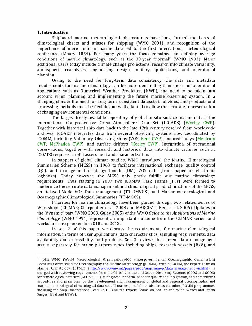
Figure 1. Decadal (1880‐89) totals of SLP observations (upper) illustrating data additionsbetweenICOADSReleases1(1985),2.0(2002),andpreliminary2.5data.Thecolorsshowthenumberofobservations ina2°boxperdecade.Grey indicates1‐10; red indicates11‐100; orange indicates 101‐400; yellow indicates 401 ormore. (Middle andLower)As for(upper)exceptforSSTandrelativehumidity(RHUM).ThedramaticincreaseinRHUMdataforRelease2.5isexplainedbyachangeinQCprocedure.
15
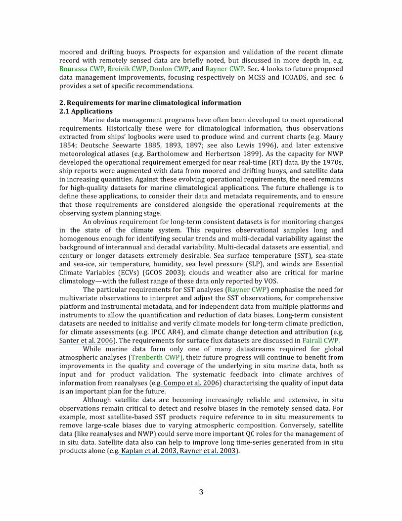
Figure2.Left:MarineClimatologySummary(MCS)exampletabulation.The20‐yearJanuarymeanair temperaturevalues,andaccompanying statistics,havebeencomputed forboxesthat can vary in size geographically according to WMO (1990) specifications (e.g., usinglarger boxes for data‐sparse regions). Right: Similar information from a bias‐adjusteddataset(BerryandKent2009).
16
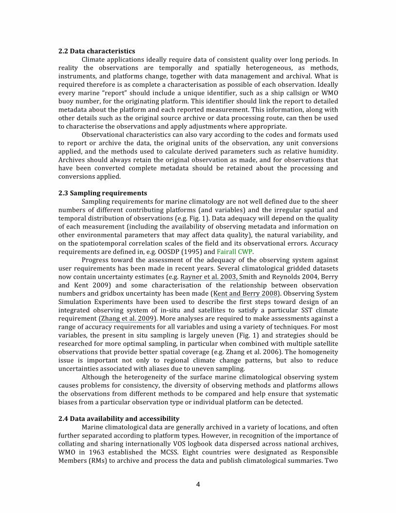
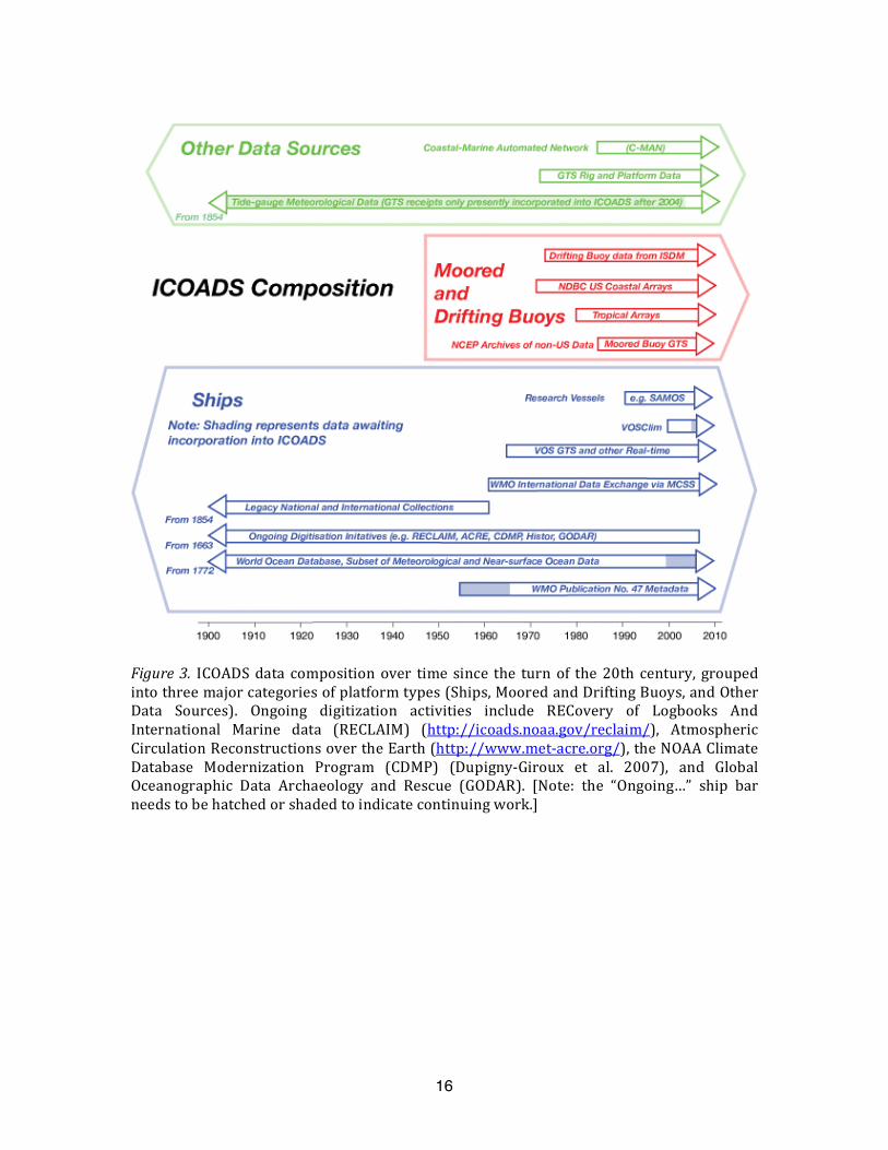
Figure3. ICOADSdatacomposition over timesince the turn of the20thcentury, groupedintothreemajorcategoriesofplatformtypes(Ships,MooredandDriftingBuoys,andOtherData Sources). Ongoing digitization activities include RECovery of Logbooks AndInternational Marine data (RECLAIM) (http://icoads.noaa.gov/reclaim/), AtmosphericCirculationReconstructionsovertheEarth(http://www.met‐acre.org/),theNOAAClimateDatabase Modernization Program (CDMP) (Dupigny‐Giroux et al. 2007), and GlobalOceanographic Data Archaeology and Rescue (GODAR). [Note: the “Ongoing…” ship barneedstobehatchedorshadedtoindicatecontinuingwork.]
17
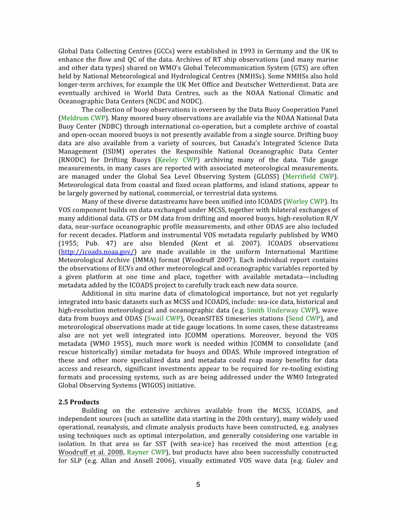
Figure 4. Proposed flow of modernized MCSS data and products, and organizational(including GCCs, TT‐MOCS) andproject (including ICOADS, VOSClim, andWIGOSPilot forJCOMM)roles.The light‐greenboxes (1,2,and4inFig.4) indicate thatthosecomponentsalready essentially exist in the current systems. In contrast, the other boxes of varyingcolorsareproposednewormodifiedaspectstothedataflow.
Copyright © 2022 FDOKUMEN