Persistent Scatterers Interferometry detects and measures ground subsidence in Lisbon
Upload
independentCategory
view
1download
0
This article appeared in a journal published by Elsevier. The attachedcopy is furnished to the author for internal non-commercial researchand education use, including for instruction at the authors institution
and sharing with colleagues.
Other uses, including reproduction and distribution, or selling orlicensing copies, or posting to personal, institutional or third party
websites are prohibited.
In most cases authors are permitted to post their version of thearticle (e.g. in Word or Tex form) to their personal website orinstitutional repository. Authors requiring further information
regarding Elsevier’s archiving and manuscript policies areencouraged to visit:
http://www.elsevier.com/copyright

Author's personal copy
Research papers
Submerged notches and doline sediments as evidence forHolocene subsidence
N. Evelpidou a,n, P.A. Pirazzoli b, J.-F. Sali�ege c, A. Vassilopoulos d
a Faculty of Geology and Geoenvironment, National and Kapodistrian University of Athens, Panepistimiopolis, Zografou, 15784 Athens, Greeceb CNRS-Laboratoire de Geographie Physique, 1 Place Aristide Briand, 92195 Meudon cedex, Francec CNRS-UMR 7209. Archeozoologie, Archeobotanique : Societes, Pratiques et Environnements. 55, rue Buffon Paris, Franced GeoEnvironmental Institute, Naxou 2-4, Doukissis Plakentias, Chalandri, 15238 Athens, Greece
a r t i c l e i n f o
Article history:
Received 28 November 2010
Received in revised form
21 April 2011
Accepted 4 May 2011Available online 24 May 2011
Keywords:
Submergence
Tidal notch
Doline
Bioerosion
Earthquake
Co-seismic displacement
Corinth Gulf
a b s t r a c t
The possibility of Holocene subsidence along the northern coast of the Corinth Gulf is often mentioned
in the literature; however, systematic detailed evidence that submergence (e.g. of archaeological
remains) does not simply depend from eustatic sea-level rise is most often missing. In this paper, a new
detailed study of submerged tidal-notch profiles along the limestone coast has shown that periods of
sea-level stability are intercalated with periods of rapid subsidence or gradual relative sea-level rise.
It appears that most of the sites considered, seem to have been affected by a relatively recent co-seismic
subsidence of about half a meter, whereas during the longer period, by stages of relative sea-level
stability and/or gradual relative sea-level rise. This evidence of subsidence is confirmed by radiocarbon
dating in doline sediments, suggesting that during certain periods, a relative sea-level rise was much
faster than the raising suggested by glacio-eustatic or hydro-isostatic estimations. Juxtaposing a list of
known earthquakes occurred in the area shows that several earthquakes (e.g. the 1981 one for the
easternmost sites considered) are potential candidates for the recent co-seismic displacements and
thus supporting the geomorphological interpretations.
& 2011 Elsevier Ltd. All rights reserved.
1. Introduction
Separating the Peloponnese from the Greek mainland, the Gulfof Corinth is a major geomorphic feature and neotectonic grabenin Greece and the most seismically active zone in Europe.Together with the Euboean graben, it is often considered as anaccommodation area at the western-propagating tip of the NorthAnatolian Fault.
The Gulf of Corinth is a graben – and not an asymmetric simplehalf graben – because there are active normal faults on both sides(Moretti et al., 2003). Its depocenter, previously located nearbythe northern shore, has been moving towards the southern shoreand has been interpreted, as a result of N–S crustal extensiondominating in the region over the last 5 Ma (Sebrier, 1977;Mercier et al., 1979), or even the last 13 Ma according to LePichon and Angelier (1979). This can be explained as a resultconsistent with the focal mechanisms of earthquakes (Bernardet al., 1997). Deep seismic profiles confirm the asymmetry of thegraben and indicate a maximum Plio-Quaternary sedimentary
thickness ranging from 1.5 to 2.0 km at the centre of the Gulf , to1.0 km farther to the east, together with a maximum fault throwof 3.5 km (Myrianthis, 1982, 1984). Stiros (1988) has proposedthat the Gulf of Corinth may primarily reflect lateral spreading(N–S) in response to E–W compression from the Hellenic arc.
A major peculiarity of the Corinth Gulf is the pattern of verticalmovements, with subsidence prevailing along the north coast anduplift along the southern one, as this is testified by the develop-ment of spectacular marine terraces. This resulted in an at least10-km northward shift of the Gulf in less than 0.5 Ma.
Uplift along the southern coast is not uniform, but it takes itsmaximum value in the central part of the Gulf and fades out to itsends (known as ‘‘bourrelet Corinthien’’, Corinthian bulge, accord-ing to Dufaure (1975), Sebrier (1977), Pirazzoli et al. (2004)).However, several attempts to estimate uplifting rates of thesouthern coast are available (e.g. from flights of Upper Quaternarymarine terraces according to Sebrier (1977), Keraudren and Sorel(1987), Keraudren et al. (1995), Armijo et al. (1996); fromHolocene raised shorelines according to Jackson et al. (1982),Pirazzoli et al. (1994); and from uplifted ancient harbours (Stiroset al., 1996; Stiros 1998)). Near the south coast of the gulf,riverbeds are highly incised, giving evidence of long-term uplift.Along the south coast, quaternary uplift rates gradually increasefrom Ancient Corinth to around Mavra Litharia, where they reach
Contents lists available at ScienceDirect
journal homepage: www.elsevier.com/locate/csr
Continental Shelf Research
0278-4343/$ - see front matter & 2011 Elsevier Ltd. All rights reserved.
doi:10.1016/j.csr.2011.05.002
n Corresponding author. Tel.: þ30 210 7274927; fax: þ30 210 8056448.
E-mail addresses: [email protected] (N. Evelpidou),
[email protected] (P.A. Pirazzoli), [email protected] (J.-F. Sali �ege),
[email protected] (A. Vassilopoulos).
Continental Shelf Research 31 (2011) 1273–1281
Author's personal copy
a maximum of about 2 mm/yr (Pirazzoli et al., 2004), and thendecrease westwards.
On the contrary, information on subsidence rates of thenorthern coast is extremely limited. Along the north coast theriverbeds discharging southwards to the Corinth Gulf and espe-cially those derived from Mt. Parnassos, become at the end oftheir course almost horizontal and buried by sediments whichhave maximum thickness of 2 m. In addition, many springsdischarge underwater. From such evidence Sweeting (1961),among others, suggested that erosion has been relatively recentlyreplaced by deposition. This is correlated to relative sea-level risethat was considered compatible with that deduced from thesubmergence of certain ancient remains, such as at Siphai (build-ings of the 4th c. BC with at least 1.5 m of submergence) and atKirra (mole of the 5th c. BC with at least 1.5 m of submergence)and even on the south coast of the Corinth Gulf near St. Vasiliosarea (underwater wall of unknown age, with at least 1 msubmergence plus 0.4 m additional submergence at the time ofthe 1981 earthquake (Stiros et al., 2007)). At Kirra (Itea), at a shortdistance from a quay of the modern harbour, remains of anancient wall can be observed reaching the water surface from ashallow depth. Close to Itea, the existence of several submergedharbour constructions have been reported by Negris (1904): anancient mole 5 m wide, built on quarry stones of 20–60 kg, linkingthe two islets of St. Constantine and St. Athanasius (less than1 km distant from Cape Tripori) has been reported 2.5–3 m deepsuggesting, according to Negris (1904), a submergence of 3.7–4 m.
Another submerged mole of unknown age in the same bay isreported at the village of Galaxidi: its inner wall is described byNegris (1904) as vertical, with an irregular upper surface under1.25 m of water and a base at depth of 2.7 m.
However, rates of subsidence along the north coast of CorinthGulf are not necessarily expected to be uniform. Because theuplift of the southern Gulf is correlated with the bathymetryalong its axis (Stiros, 1988), a symmetrical subsidence on thenorthern side of the graben can be expected, i.e. a maximumsubsidence in the Galaxidi area.
In this paper we examine new information about the rates andthe modality of subsidence along the north coast of the CorinthGulf. This can be estimated from submerged profiles of marinenotches and from new radiocarbon dating of sediments coredfrom a doline (Fig. 1). Furthermore these results are also com-pared with information from already known archaeological sub-merged remains which were correlated with earthquakesoccurred in the area during historical times.
2. Methods
Extended field work took place in three different stages, allaiming to collect information on subsidence along the northerncoast of the Corinth Gulf. In August 1992, preliminary occasionalunderwater observations by Paolo A. Pirazzoli and Stathis Stiroswere carried out along the western part of the Gulf, giving theevidence of Holocene submergence near Galaxidi: two submergednotches at �25710 and �80710 cm; and at Vivadis bay: asingle submerged notch at �40710 cm. In June 2000, coringstook place in the doline near Itea, using a 40 mm diameterDachnowsky manual sampler by Paolo A. Pirazzoli and StathisStiros in order to study the sediments and provide information onthe Holocene palynological evolution and possibly on the localsubsidence rate. Initially, Pascal Bernard had indicated the position
Fig. 1. Location map.
N. Evelpidou et al. / Continental Shelf Research 31 (2011) 1273–12811274

Author's personal copy
of such doline. The first core (C3), drilled a few meters distance fromthe eastern limestone wall, and was interrupted by hard impedi-ment at 2.8 m depth. A second core (C4) was therefore made closerto the central part of the depression, near the limit between thevegetated and the bare mud surfaces. This second core had to beinterrupted for lack of extension pieces at a depth of 5.7 m, beforehaving reached any hard layer. In July 2010, a more systematicunderwater survey along the limestone cliffs of the central part ofthe northern coast of the Gulf was carried out by boat by NikiEvelpidou, Andreas Vassilopoulos and Paolo A. Pirazzoli, in theframework of a COST-ES0701 Action. Limestone rock in all this areais favourable to bioerosion in the midlittoral zone. This enabled thediscovery, at almost all investigated sites, of submerged notches atvarious depths for a distance of about 60 km (Table 2 and Fig. 4).
On limestone formations, tidal notch development is often aconsequence of the bioerosion produced by endolithic organisms
and surface feeders that graze upon epi- and endolithic algae. Thebioerosion rate is generally maximum near mean sea-level (MSL)and decreases gradually towards the upper and lower limits of theintertidal range. This fact produces notch profiles that will betypically reclined U- or V-shaped. This vertex is located near MSL,whereas the base of the notch appears near the lowest tide andthe top near the highest tide level (Pirazzoli, 1986; Evelpidouet al., in press). In this vertical zone, which is very narrow in theMediterranean, parallel vegetational belts are better developed.Additionally, eroding cyanobacteria, patellaceous gastropods(limpets) and chitons are more abundant (Laborel and Laborel-Deguen, 2005). They all contribute by eating the vegetationalbelts, eroding the underlying rock and enabling the development,in sites sheltered from strong wave action, of a tidal notch. Thetidal notch profile is a very useful sea-level indicator, because itprovides information for the duration that MSL remained at thenotch vertex level. Moreover, the current position of the notchprovides evidence for the speed (slow or even sudden) of itsemergence or submergence (Pirazzoli, 1986, 2005; Evelpidouet al., in press). In a moderately exposed site, continuous waveaction may splash sea water onto the notch roof, and thus shiftingthe top of the notch upwards, above the highest tide level.
As noted by Higgins (1980), fresh-water coming from underwatersprings, tends to float at the surface of sea water, dissolve thelimestone rock, contributing to the production of intertidal undercuts(e.g. between Itea and Galaxidi). During field work we noticed thatfor certain cliff profiles where the limestone rock tends to protrudeabove the waterline, a kind of visor just above the water surface isproduced, especially where the tidal notch is not present. Such avisor, that might resemble to a tidal notch for which only the roof ispreserved, and the base is missing, can be found alone, or above asubmerged notch and should not be confused with a tidal notch.
Various tidal notch profiles for submerged notches resultingfrom different combinations of RSL in sheltered areas have beensummarised graphically by Evelpidou et al. (in press, Fig. 1) hereupdated in Fig. 2. They allow to qualitatively distinguish, e.g.type-b or type-c profiles (resulting from a co-seismic subsidenceevent), from type-d profiles (resulting from an apparently gradualrelative sea-level rise) and from type-e profiles (a co-seismicsubsidence followed by gradual relative sea-level rise).
Unfortunately, tidal notches cannot be dated directly and infor-mation about the duration of various sea-level positions can only bededuced from assumptions on the rate of intertidal bioerosion oflimestone, which often ranges in Mediterranean between 0.2 and1 mm/yr (Pirazzoli, 1986; Evelpidou et al., in press). These two limitvalues will be used to roughly estimate the possible duration for theperiods of relative sea-level stability, which is necessary to theinward deepening of the observed notch profiles.
Samples from corings that took place in the Itea doline were usedfor datings. For the calibration of radiocarbon-dated sediments of the
Fig. 2. Erosion notch profiles on limestone rock: (a–e) submerged tidal notch
profiles resulting from combinations of RSL in sheltered areas during 2000 yrs,
assuming a maximum bioerosion rate of 0.5 mm/yr and a tidal range of 40 cm and
(f) visor shape developed near a fresh-water spring.
Fig. 3. Map of historical earthquakes with M45.6 having occurred in the area
investigated. The locations correspond to the epicentres and the numbers to their
dates in years AD.
N. Evelpidou et al. / Continental Shelf Research 31 (2011) 1273–1281 1275

Author's personal copy
Itea doline, Reimer et al. (2009) has been used, in conjunction withStuiver and Reimer (1993).
The historical earthquakes with magnitude greater than 5.6,capable to produce significant ground deformation, havingoccurred in Corinth Gulf, have been listed (Fig. 3 and Table 1)and compared with the field work results. They have been
Table 1Date, location, magnitude and region of historical earthquakes with M45.6
occurred in the Gulf of Corinth area.
Year Longitude Latitude Magnitude Intensity Region
�480 23.300 37.900 6.3 Salamina
�420 22.800 38.000 6.0 Corinth
�373 22.200 38.200 6.8 X Heliki
�347 22.500 38.400 6.0 Delphoi
�303 22.700 38.000 6.6 IX Sikyon
�279 22.400 38.400 6.8 IX Delphoi
23 22.100 38.300 6.3 VIII Aeghio
61 22.000 38.200 6.3 VIII Achaia
74 22.900 37.900 6.3 VIII Corinth
361 22.600 38.400 6.9 IX Delphoi
521 22.900 38.000 6.3 VIII Corinth
543 22.800 38.000 6.2 VIII Corinth
551 22.700 38.400 7.0 X Chaironia
551 21.800 38.300 6.5 IX Naupactos
580 22.800 38.000 6.3 VIII Corinth
996 22.400 38.300 6.8 IX Galaxidi
1250–1260? 22.380 38.383 0.0 IX? Galaxidi
1321 23.300 38.300 6.3 VIII Thebes
1402 22.410 38.110 7.0 IX Xylocastro
1462 21.833 38.400 0.0 VIII–IX Nafpaktos
1660 22.400 38.300 6.4 VIII Galaxidi
1703 21.800 38.400 6.1 VII Naupaktos
1714 21.800 38.300 6.3 VIII Naupaktos
1725 23.000 37.900 6.0 VII Corinth
1742 22.600 38.100 6.7 VIIIþ Trikala
1748 22.200 38.200 6.6 IX Aeghio
1753 22.500 38.100 6.2 VIII Zachole
1754 21.900 38.400 6.0 VII Naupaktos
1756 21.900 38.400 6.8 VIIIþ Naupaktos
1769 22.100 38.400 6.8 lVIII Desfina
1775 22.900 37.900 6.4 VIII Corinth
1785 21.700 38.200 6.0 Patra
1785 21.700 38.200 6.5 IX Patra
1794 22.400 38.300 6.7 Galaxidi
1804 21.700 38.200 6.4 IX Patra
1806 21.800 38.200 6.2 VIII Patra
1817 22.100 38.300 6.6 IX Aeghio
1853 23.400 38.400 6.6 X Thebes
1853 23.400 38.300 6.3 VIII Thebes
1858 22.880 37.870 6.5 X Corinth
1861 22.160 38.250 6.7 X Valimitica
1887 22.650 38.050 6.5 VIII Xylokastro
1888 22.110 38.230 6.3 IX Valimitika
1889 22.000 38.400 7.0 VIII Ftere
1893 23.250 38.310 6.3 VIII Thebes
1909 22.200 38.250 6.0 Corinth Gulf
1928 23.120 38.080 6.5 Siphai
1930 23.170 37.800 6.1
1931 23.270 38.220 5.7 Platees
1938 22.470 38.270 5.9 Corinth Gulf
1953 23.170 37.880 5.7 Agii Theodoroi
1965 22.260 38.380 6.6 Panormos
1965 22.400 38.370 6.4 St. Constantine
1970 22.560 38.340 6.2 Itea
1972 22.380 37.960 6.2 Feneos
1975 22.650 38.240 5.7 Corinth Gulf
1975 21.980 38.110 5.7
1981 22.970 38.230 6.6 Thisvi
1981 23.120 38.170 6.3 Agios Vassilios
1981 23.260 38.240 6.4 Platees
1992 22.450 38.300 6.2 Corinth Gulf
1993 22.160 38.330 6.1 Agios Nikolaos
1995 22.270 38.400 6.5 Penteoria
1997 22.280 38.410 5.7 Penteoria
Ta
ble
2M
ea
sure
me
nts
of
un
de
rwa
ter
ge
om
orp
ho
log
ica
lfe
atu
res
alo
ng
the
no
rth
ern
coa
sto
fC
ori
nth
Gu
lf(t
he
acc
ura
cyo
fv
ert
ica
lm
ea
sure
me
nts
ise
stim
ate
dto
71
0cm
).
Loca
lity
Occ
urr
en
ceo
f
pre
sen
t-d
ay
no
tch
Up
pe
rsu
bm
erg
ed
no
tch
Low
er
sub
me
rge
dn
otc
hD
ep
th
Sit
en
o.
(Fig
.1
)
Lon
g.
Ea
st
(de
gre
es)
Lat.
No
rth
(de
g.)
Ro
of
de
pth
(cm
fro
mS
L)
Pro
file
Ge
ne
sis
(Fig
.2
)
Ro
of
de
pth
(cm
fro
mS
L)
Pro
file
Ge
ne
sis
(Fig
.2
)
Ab
rasi
on
pla
tfo
rm(m
)
Ne
arb
yse
a
flo
or
(m)
Ve
rte
xd
ep
th
(cm
)
He
igh
t
(cm
)
Ve
rte
xd
ep
th
(cm
)
He
igh
t
(cm
)
12
2.9
82
38
.18
0V
iso
r2
11
05
70
b9
1(e
rod
ed
?)
�1
00
13
0d
�4
.1
22
2.9
04
38
.18
8S
ma
ll2
03
05
9b
79
n.m
.n
.m.
d4
.95
.9
32
2.8
47
38
,22
82
50
no
b2
32
90
18
0e
3.9
4.1
42
2.7
32
38
.30
1V
iso
r(n
ea
ra
fre
sh-
wa
ter
spri
ng
)
��
��
��
n.m
.n
.m.
52
2.6
92
38
.31
8N
o,
vis
or?
22
19
53
bn
.m.
n.m
.n
.m.
e3
.88
.6
62
2.6
42
38
.35
4v
iso
r2
23
76
0b
��
�3
.7n
.m.
72
2.5
76
38
.28
1n
o3
22
24
2b
n.m
.n
.m.
n.m
.e
4.2
n.m
.
8N
ea
r
do
lin
e
22
.41
63
8.4
12
Vis
or
(ne
ar
afr
esh
-
wa
ter
spri
ng
)
40
65
72
b�
��
�n
.m.
92
2.4
83
38
.39
5S
ma
ll5
05
04
0b
16
09
01
20
e�
3.2
10
22
,51
33
8,3
58
No
24
22
35
b�
60
�3
0�
10
0?
d�
3.3
Viv
ad
isb
ay
22
,17
83
8,2
13
No
40
45
45
e�
��
�n
.m.
n.m
.¼n
ot
me
asu
red
N. Evelpidou et al. / Continental Shelf Research 31 (2011) 1273–12811276
Author's personal copy
deduced from a geographical data base based on Papazachos andPapazachou (2003).
3. Results
3.1. Analytical comments to underwater observations
We provide below some comments that are complementary toTable 2 and Fig. 4.
At Site 1 (Fig. 4a) the present-day notch is absent. Below thevisor, an upper notch with a vertex at �56710 cm, suggeststhe occurrence of a co-seismic subsidence of about half a meter.The 1 m inward depth of the notch indicates the occurrence of arelatively stable sea-level during a period long enough (one to fivemillennia, depending on the rate of bioerosion) to enable its fulldevelopment. The absence of the present-day notch, replaced by avisor revealing the proximity of a fresh-water spring, suggeststhat the co-seismic displacement could have been a relativelyrecent event. The fact that the height of the upper notch (70 cm)largely exceeds the local tidal range may indicate the occurrenceof some gradual relative sea-level rise during the period of notchdevelopment. Below, in a depth of �2.2 m, a lower notch isdeveloped with a similar inward depth. Part of its roof has been
eroded by the development of the upper notch. The height of thelower notch (about 130 cm) suggests the occurrence of about onemeter of gradual relative sea-level rise during the period of itsdevelopment (again one to a few millennia).
At Site 2 (Fig. 4b) the situation is similar to that at the precedingsite, with the difference that the visor is absent, replaced by a hardlydistinguishable present-day notch. An upper notch with a vertex at�50710 cm suggests, again, a relatively recent co-seismic subsi-dence of about half a meter. According to its height (one decimetreless than for Site 1), this notch seems to have been less affected bygradual relative sea-level rise during its period of development.According to its inward depth (30 cm), it might have lasted between3 and 15 centuries. Deeper, a lower notch was not clear enough tobe measured during our survey, but Fig. 4b suggests the possibilityof a relative sea-level history similar to that of Site 1.
At Site 3, no clear notch could be observed between the presentsea-level and �230 cm, where a high undercut (that should beconfirmed) seems to occur.
At Site 4, below a visor at sea-level near which an importantspring occurs, no submarine notch could be observed.
At Site 5 (Fig. 4c), no present-day notch is clearly distinguishable,while a visor may appear locally. A submerged notch, betweenabout �22 and �75 cm, testifies a recent co-seismic subsidence of
Fig. 4. Underwater photographs of submerged notches along the northern coast of the Gulf of Corinth (arrows indicate the retreat points of the notches, i.e. former MSL
positions before co-seismic movements; in case co-seismic displacement is uncertain, a question mark has been added near the arrow): (a) Site 1; (b) Site 2; (c) Site 5;
(d) Site 6; (e): Site 7; (f) Site 10; (g) Site 8; (h) Site 9; (i) underwater notch on the western side of Vivadis bay.
N. Evelpidou et al. / Continental Shelf Research 31 (2011) 1273–1281 1277
Author's personal copy
about half a meter. This notch was developed during a period ofstable sea-level and/or of slight gradual relative sea-level rise lastingbetween 190 and 950 yrs.
At Site 6, below a well developed visor, a very clear tidal notchcan be observed (Fig. 4d). Its vertex is at 52710 cm below sea-level and its inward depth is about 37 cm. It therefore suggeststhe occurrence of a recent co-seismic subsidence of about half ameter, followed by a relative sea-level stability during a periodranging (depending on the bioerosion rate) between four andeighteen centuries.
At Site 7, the present-day notch is absent and a regular tidalnotch is developed continuously with a vertex at 53710 cmbelow sea-level (Fig. 4e). Its inward depth is 22 cm. As for Site 6 itsuggests the occurrence of a recent co-seismic subsidence, but itis now possible to narrow the following period of relative sea-level stability to between 2 and 11 centuries. Deeper, though noclear notch could be identified during the survey, the analysis ofcertain underwater photographs (e.g. Fig. 4e) of the rock profilemay suggest the occurrence of gradual relative sea-level rise.
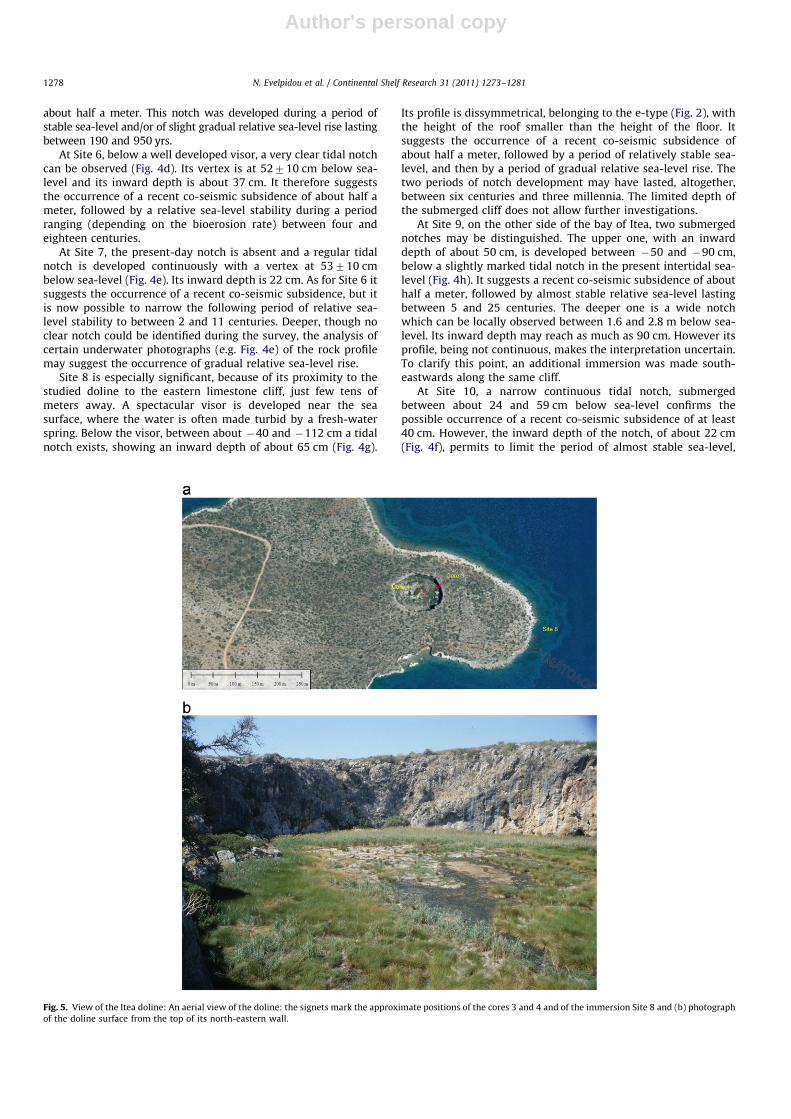
Site 8 is especially significant, because of its proximity to thestudied doline to the eastern limestone cliff, just few tens ofmeters away. A spectacular visor is developed near the seasurface, where the water is often made turbid by a fresh-waterspring. Below the visor, between about �40 and �112 cm a tidalnotch exists, showing an inward depth of about 65 cm (Fig. 4g).
Its profile is dissymmetrical, belonging to the e-type (Fig. 2), withthe height of the roof smaller than the height of the floor. Itsuggests the occurrence of a recent co-seismic subsidence ofabout half a meter, followed by a period of relatively stable sea-level, and then by a period of gradual relative sea-level rise. Thetwo periods of notch development may have lasted, altogether,between six centuries and three millennia. The limited depth ofthe submerged cliff does not allow further investigations.
At Site 9, on the other side of the bay of Itea, two submergednotches may be distinguished. The upper one, with an inwarddepth of about 50 cm, is developed between �50 and �90 cm,below a slightly marked tidal notch in the present intertidal sea-level (Fig. 4h). It suggests a recent co-seismic subsidence of abouthalf a meter, followed by almost stable relative sea-level lastingbetween 5 and 25 centuries. The deeper one is a wide notchwhich can be locally observed between 1.6 and 2.8 m below sea-level. Its inward depth may reach as much as 90 cm. However itsprofile, being not continuous, makes the interpretation uncertain.To clarify this point, an additional immersion was made south-eastwards along the same cliff.
At Site 10, a narrow continuous tidal notch, submergedbetween about 24 and 59 cm below sea-level confirms thepossible occurrence of a recent co-seismic subsidence of at least40 cm. However, the inward depth of the notch, of about 22 cm(Fig. 4f), permits to limit the period of almost stable sea-level,
Fig. 5. View of the Itea doline: An aerial view of the doline: the signets mark the approximate positions of the cores 3 and 4 and of the immersion Site 8 and (b) photograph
of the doline surface from the top of its north-eastern wall.
N. Evelpidou et al. / Continental Shelf Research 31 (2011) 1273–12811278
Author's personal copy
necessary for notch development, to between two and elevencenturies. Deeper, the profile of a lower, larger notch remainsuncertain.
As aforementioned, slightly more to the west two smallsubmerged notches had been observed near Galaxidi, as well asa single submerged notch at �40710 cm at Vivadis Bay (Fig. 4i).For the latter, a period of notch development between 4 and 20centuries, possibly including some gradual relative sea-level rise,can be deduced.
3.2. Analysis of doline sediments
The closed, almost circular depression of the doline, which isdeveloped on a small limestone promontory gently sloping to thesea from an elevation of 32 m, located near Cape Tripori, at about3812405000N–2212405000E, approximately 2 km south of Itea village,on the western side of Itea bay is about 90 m wide and its surfaceis covered by herbaceous peaty vegetation, except near the baremuddy centre of the depression (Fig. 5). Due to its location in thevicinity of sea level and to the fact that the donile was probablysupplied by a fresh-water source, as suggested by a fresh-waterarrival near the sea surface east of the donile (Site 8). The surfaceof the doline sediments is close (with 71 m accuracy) to thepresent sea-level. It can be therefore assumed that it followedmore or less, through the watertable, the recent changes in therelative sea-level.
The palynological study initially scheduled unfortunately couldnot be achieved. According to an unpublished pollen diagram,produced by Mich�ele Den�efle and Anne-Marie Lezine, there is noevidence of salt water penetration inside the doline and no marinemicro-organism was found, though the environment becomes moresalty in the upper part of the sediments.
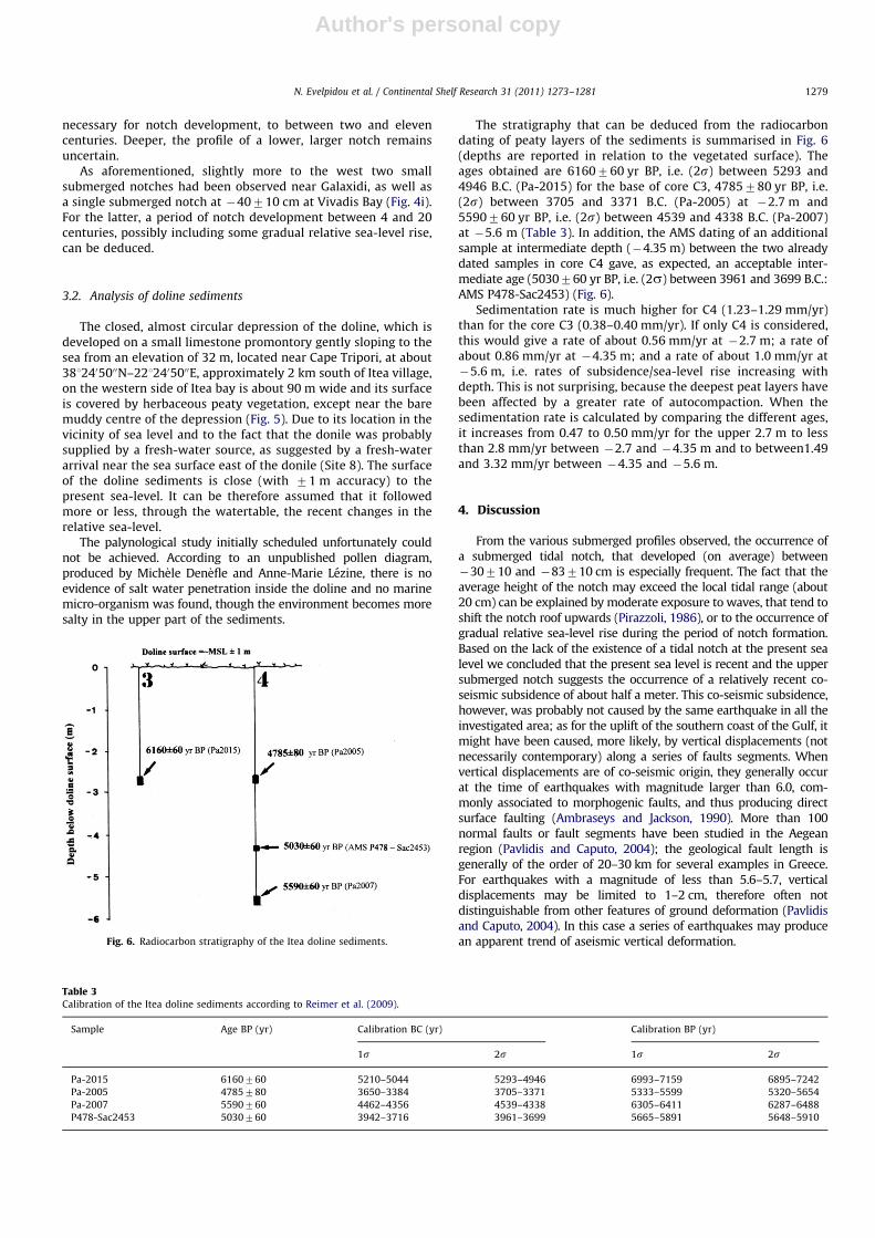
The stratigraphy that can be deduced from the radiocarbondating of peaty layers of the sediments is summarised in Fig. 6(depths are reported in relation to the vegetated surface). Theages obtained are 6160760 yr BP, i.e. (2s) between 5293 and4946 B.C. (Pa-2015) for the base of core C3, 4785780 yr BP, i.e.(2s) between 3705 and 3371 B.C. (Pa-2005) at �2.7 m and5590760 yr BP, i.e. (2s) between 4539 and 4338 B.C. (Pa-2007)at �5.6 m (Table 3). In addition, the AMS dating of an additionalsample at intermediate depth (�4.35 m) between the two alreadydated samples in core C4 gave, as expected, an acceptable inter-mediate age (5030760 yr BP, i.e. (2s) between 3961 and 3699 B.C.:AMS P478-Sac2453) (Fig. 6).
Sedimentation rate is much higher for C4 (1.23–1.29 mm/yr)than for the core C3 (0.38–0.40 mm/yr). If only C4 is considered,this would give a rate of about 0.56 mm/yr at �2.7 m; a rate ofabout 0.86 mm/yr at �4.35 m; and a rate of about 1.0 mm/yr at�5.6 m, i.e. rates of subsidence/sea-level rise increasing withdepth. This is not surprising, because the deepest peat layers havebeen affected by a greater rate of autocompaction. When thesedimentation rate is calculated by comparing the different ages,it increases from 0.47 to 0.50 mm/yr for the upper 2.7 m to lessthan 2.8 mm/yr between �2.7 and �4.35 m and to between1.49and 3.32 mm/yr between �4.35 and �5.6 m.
4. Discussion
From the various submerged profiles observed, the occurrence ofa submerged tidal notch, that developed (on average) between�30710 and �83710 cm is especially frequent. The fact that theaverage height of the notch may exceed the local tidal range (about20 cm) can be explained by moderate exposure to waves, that tend toshift the notch roof upwards (Pirazzoli, 1986), or to the occurrence ofgradual relative sea-level rise during the period of notch formation.Based on the lack of the existence of a tidal notch at the present sealevel we concluded that the present sea level is recent and the uppersubmerged notch suggests the occurrence of a relatively recent co-seismic subsidence of about half a meter. This co-seismic subsidence,however, was probably not caused by the same earthquake in all theinvestigated area; as for the uplift of the southern coast of the Gulf, itmight have been caused, more likely, by vertical displacements (notnecessarily contemporary) along a series of faults segments. Whenvertical displacements are of co-seismic origin, they generally occurat the time of earthquakes with magnitude larger than 6.0, com-monly associated to morphogenic faults, and thus producing directsurface faulting (Ambraseys and Jackson, 1990). More than 100normal faults or fault segments have been studied in the Aegeanregion (Pavlidis and Caputo, 2004); the geological fault length isgenerally of the order of 20–30 km for several examples in Greece.For earthquakes with a magnitude of less than 5.6–5.7, verticaldisplacements may be limited to 1–2 cm, therefore often notdistinguishable from other features of ground deformation (Pavlidisand Caputo, 2004). In this case a series of earthquakes may producean apparent trend of aseismic vertical deformation.Fig. 6. Radiocarbon stratigraphy of the Itea doline sediments.
Table 3Calibration of the Itea doline sediments according to Reimer et al. (2009).
Sample Age BP (yr) Calibration BC (yr) Calibration BP (yr)
1s 2s 1s 2s
Pa-2015 6160760 5210–5044 5293–4946 6993–7159 6895–7242
Pa-2005 4785780 3650–3384 3705–3371 5333–5599 5320–5654
Pa-2007 5590760 4462–4356 4539–4338 6305–6411 6287–6488
P478-Sac2453 5030760 3942–3716 3961–3699 5665–5891 5648–5910
N. Evelpidou et al. / Continental Shelf Research 31 (2011) 1273–1281 1279
Author's personal copy
Some of the notch profiles observed, particularly those at acertain depth, seem especially high in relation to the tidal rangeand even to wave exposure and the roof and floor of the notch arenot marked enough to be interpreted as of co-seismic origin andmeasured in detail. However, subsequent analysis of underwaterphotographs revealed in some cases the reality of notch occur-rence. For this reason (or due to rough sea near the cliff), severalmeasurements are missing from Table 2. These too high profilesresult more likely from a gradual relative sea-level rise (Fig. 2d).On the other side, at Site 2, the upper part of the profile of thelower notch (Fig. 4b) seems shorter than the lower part of theprofile, suggesting: (i) that also the lower notch was submergedco-seismically and (ii) that a gradual relative sea-level rise occurredduring its development (Fig. 2e).
In the eastern part of the surveyed transect Sites 1 and 2, mayreflect a sea-level history different from that in the western part,since no notch could be observed at Sites 3 and 4.
Sites 5–9 experienced all a relatively recent co-seismic sub-sidence of about half a meter, since a new notch has not yet beenformed in the present sea-level. It is not possible to specify thatthis subsidence corresponds to a particular seismic event, ratherthan to more than one fault segments. Nevertheless, the compar-ison of notch profiles make it possible to specify that the period ofrelative sea-level stability following the seismic event lastedbetween two centuries and one millennium (Sites 7 and 10).These episodes are ensued elsewhere by longer periods includinggradual relative sea-level rise or co-seismic subsidence of amountsnot large enough to leave individual geomorphological marks.
On the other hand, the depth of the roof of the upper submergednotch, of the order of two decimetres in several cases, could havepermitted only a very limited period of gradual relative sea-levelrise, during which a tidal notch could not leave clear morphologicalmarks on the limestone rock. From the very limited development ofthe present-day notch one may deduce that the sea-level remainedat the level of the present intertidal range for only a limited period.It seems logical, therefore, to ascribe the relatively recent co-seismicsubsidence of about half a meter that has been deduced fromvarious underwater rock profiles, to one or more major seismicevents that occurred not more than one to a few centuries ago.
Finally, concerning the lower submerged notch, a more detailedsurvey would be necessary, with much more frequent comparisonsbetween underwater rock profiles, before attempting a tentativeinterpretation that could be based on reliable observations.
Among the indicators of relative sea-level change that can beidentified also after submergence, are the archaeological andgeomorphological ones. Beachrocks, a geomorphological sea-levelindicator, correspond to ancient beach sediments that have beenlithified by calcium carbonate, generally within the former inter-tidal range, and therefore indicate the approximate position of aformer shoreline. For example, we observed an undated bea-chrock between �1.3 and �1.5 m in the St. Nikolaos Bay thattestifies a recent relative sea-level rise of about the same amount.
The above information about submergence having occurredduring historical time does not contain clear evidence of tectonicsubmergence, because it could be (and has been ascribed in thepast) an effect of eustatic sea-level rise.
Geologists would like to have rates of vertical displacement tobe of use in modelling. However, the potential rates of relativesea-level rise of GIA (glacio-isostatic adjustment) origin do notgenerally exceed a fraction of mm/yr in the Mediterranean duringthe last 6000 yrs (e.g. Lambeck, 1996), whereas the rate of sub-sidence deduced from the sediments of the Itea doline, between thedepths of �2.7 and �5.6 m, assuming that the sedimentation ratein the doline mimicked relative sea-level change, exceeds by oneorder of magnitude any tentative GIA estimation of local sea-levelrise. In particular, the dataset obviously shows an increase in
sedimentation rate between 5030 and 4785 (1.65 m of accumula-tion in 105–385 yrs) according to the error ranges (4–16 mm/yr ofaccumulation), which is much higher than before and after, provid-ing evidence of acceleration in the relative sea-level rise, i.e. of theoccurrence of a rapid subsidence movement.
The submerged-notch information examined in this paper,showing that submergence was not gradual, but occurred byjumps, has confirmed that all the northern coast of Corinth Gulf isaffected by tectonic subsidence and thus this subsidence takesplace, most often, at the time of seismic events.
A rapid analysis of Fig. 3 and Table 1 is sufficient to notice thatthere are many recent events, since no present notch has yet beenformed in the present sea-level, which might have caused a co-seismic vertical displacement of about half a meter along thenorthern coast of the Gulf. It is not possible to specify which wasthe most probable earthquake at each investigated site, but thereare several potential candidates for almost each site, especiallybecause magnitudes 46.0 can be expected for co-seismic dis-placements of the order of about half a meter. In particular, theGalaxidi and Itea areas are especially frequently mentioned. Evenfor the easternmost Sites 1 and 2, a recent subsidence of abouthalf a meter could have been caused, at least in part, by one of the1981 tremors (Stiros et al. 2007); to be noted that subsidencecaused by the same 1981 earthquake has been documented alsoon the southern coast of the Gulf, e.g. at Mavrolimni, Skinos andStavra (Stiros and Pirazzoli, 1998).
The only certain result is that, contrary to the south coast ofthe Gulf, no evidence of uplift was found along the entire north-ern coast. However, the quantification of the subsidence rate hasremained an illusory task, because this rate is variable in spaceand time. It varies in space because, like the uplift of the southerncoast of the Gulf, is controlled by the asymmetry of the tectonicgraben, it is expected to increase gradually towards the centralpart of the coast which is facing the most uplifted part of thesouth coast. It is also variable in time because the average rate ofsubsidence, assuming that it can be determined exactly at a givensite, will give an average value between periods of relative sea-level stability, periods of gradual subsidence (not necessarilyaseismic) and of sudden co-seismic subsidence movementsoccurring at the time of major earthquakes.
The effects of these earthquakes are also limited in space andtime, because the normal faulting surface of major earthquakesusually does not exceed distances of 20–30 km, so that severalearthquakes are necessary to result to the subsidence of a coastover 100 km long. A limitation also exists in time, because acertain time of tectonic stress accumulation is necessary before anew earthquake can occur at the same site or in a nearby area,and because the average rate of subsidence will vary with theduration of that period of time.
The subsidence rate that can be deduced with various assump-tions from submerged archaeological remains depends essentiallyfrom the period of construction and the initial emergence of theremains (which are generally estimated with wide ranges ofuncertainty) and from the sum of tectonic movements that haveoccurred locally since that time.
The rate of subsidence that can be deduced from dolinesediments also depends from the assumptions made (e.g. thatthe surface of the doline sediments followed more or less thechanges in the relative sea-level). In addition, it includes auto-compaction effects that cannot be extrapolated to the nearbylimestone cliffs, and provides only average values for periods ofthe last 6 millennia, probably including the eustatic rise and thetectonic events that have occurred at that place during the lateHolocene.
Finally, the reconstruction of a possible sequence of tectonicevents that can be deduced from submerged erosion profiles
N. Evelpidou et al. / Continental Shelf Research 31 (2011) 1273–12811280

Author's personal copy
includes, most often, periods of relatively stable sea-level, inter-rupted by co-seismic vertical displacements and possibly by otherperiods of gradual relative sea-level rise. If sequences of suchevents can be tentatively deduced from erosion profiles of lime-stone cliffs, even with acceptable estimations of the amount ofcertain vertical co-seismic displacements, the duration of timeremains affected by wide ranges of uncertainty. Nevertheless, animportant conclusion of the present study is that there has beenin most places of the north coast a relatively recent co-seismicsubsidence of the order of half a meter, that occurred probably nomore than one or two centuries ago. A comparison with the list ofhistorical earthquakes with magnitude 45.6 (the only strong-enough tremors capable to produce significant ground deforma-tion) and especially those with magnitude 46 for a verticaldisplacement of about half a meter (Fig. 3, Table 1), shows thatseveral seismic events, even quite recent, can be candidate toexplain the recent vertical co-seismic movement. Smaller earth-quakes are also very frequent in the area (not shown). Theyprobably also contribute, more or less everywhere over the longterm, to gradual relative and apparently sea-level rise.
5. Conclusions
On contrary to the south coast of the Corinth Gulf, no evidenceof uplift was found along the entire studied northern coast of theGulf. Most of the sites considered have been affected by arelatively recent co-seismic subsidence of about half a meter,whereas the subsidence rate is variable in space and time. Duringa longer period, the studied area has been influenced by stages ofrelative sea-level stability and/or gradual relative sea-level rise.
Subsidence is confirmed by radiocarbon dating in doline sedi-ments, suggesting that during certain periods, around 4800 yrs BP,the relative sea-level rise was much faster than the raising suggestedby glacio-eustatic or hydro-isostatic estimations, justifying theconclusion that the area was subsiding.
Since no present notch has yet been formed in the present sea-level, the events occurred in the upper submerged notch arerecent. Juxtaposition of known earthquakes occurred in the areashows that there are several potential candidates for almost eachsite, especially because magnitudes 46.0 can be expected for co-seismic displacements of the order of about half a meter.
Acknowledgement
Part of this work was supported by COST Action ES0701‘‘Improved constraints on models of Glacial Isostatic Adjustment’’.We thank S.C. Stiros for his help during field work and valuableinformation, N. Tsoukalas for providing language help and the twoanonymous reviewers for useful suggestions that contributed toimprove a previous version of this paper. This study is a contributionto the IGCP Project 588 (preparing for coastal change).
References
Ambraseys, N.N., Jackson, J.A., 1990. Seismicity and associated strain of centralGreece between 1890 and1988. Geophys. J. Int. 101, 663–708.
Armijo, R., Meyer, B., King, G.C.P., Rigo, A., Papanastassiou, D., 1996. Quaternaryevolution of the Corinth Rift and its implications for the Late Cenozoicevolution of the Aegean. Geophys. J. Int. 126 (1), 11–53.
Bernard, P., et al., 1997. The Ms¼6.2, June 15, 1995 Aigion earthquake (Greece:evidence for low-angle normal faulting in the Corinth rift. J. Seismol. 1,131–150.
Dufaure, J.J., 1975. Le relief du Peloponn�ese. Th�ese Lettres, Univ. Paris IV 1422pp.Evelpidou, N., Pirazzoli, P.A., Vassilopoulos, A., Tomasin, A., Holocene submerged
shorelines on Theologos area (Greece). Zeits. Geomorphol., in press.Higgins, C.G., 1980. Nips, notches and the solution of coastal limestone: an
overview of the problem with examples from Greece. Estuar. Coast. Mar. Sci.10, 15–30.
Jackson, J.A., Gagnepain, J., Houseman, G., King, G.C.P., Papadimitriou, P., Soufleris,C., Virieux, J., 1982. Seismicity, normal faulting, and the geomorphologicaldevelopment of the Gulf of Corinth (Greece): the Corinth earthquakes ofFebruary and March 1981. Earth Planet. Sci. Lett. 57, 377–397.
Keraudren, B., Sorel, D., 1987. The terraces of Corinth (Greece). A detailed record ofeustatic sea-level variations during the last 500,000 years. Mar. Geol. 77,99–107.
Keraudren, B., Faulgu�eres, C., Bahain, J.J., Sorel, D., Yokoyama, Y., 1995. Nouvellesdatations radiometriques des terrasses marines de Corinthie (Peloponn�eseseptentrional, Gr�ece). C.R. Acad. Sci. Paris 320 (IIa), 483–489.
Laborel, J., Laborel-Deguen, F., 2005. Sea-level indicators, biologic. In: Schwartz,M.L. (Ed.), Encyclopedia of Coastal Science. Springer, pp. 833–834.
Lambeck, K., 1996. Sea-level change and shore-line evolution in Aegean Greecesince Upper Palaeolithic time. Antiquity 70 (269), 588–611.
Le Pichon, X., Angelier, J., 1979. The Hellenic Arc and Trench system: a key to theneotectonic evolution of the Eastern Mediterranean area. Tectonophysics 60,1–42.
Mercier, J., Delibassis, N., Gauthier, A., Jarrige, J., Lemeille, F., Philip, H., Sebrier, M.,Sorel, D., 1979. La neotectonique de l’arc Egeen. Rev. Geol. Dyn. Geogr. Phys.21, 67–92.
Moretti, I., Sakellariou, D., Lykousis, V., Micarelli, L., 2003. The Gulf of Corinth: anactive half graben? J. Geodyn. 36 (1–2), 323–340.
Myrianthis, M., 1982. Geophysical study of the epicentral area of AlkyonidesIslands earthquakes, central Greece. Geophysical Transactions, Eotvos LorandGeophysical Institute of Hungary 28/2, 5–17.
Myrianthis, M., 1984. Graben formation and associated seismicity in the Gulf ofCorinth (Central Greece). In: Dixon, R., Robertson, A. (Eds.), Geological Evolu-tion of the Eastern Mediterranean, Geological Society. Special Publications,London, pp. 701–707.
Negris, P., 1904. Vestiges antiques submerges. Athen. Mitteilungen 29, 340–363.Papazachos, V., Papazachou, K., 2003. Greek Earthquakes, third ed., Ziti, Thessaloniki,
pp. 288.Pavlidis, S., Caputo, R., 2004. Magnitude versus faults’ surface parameters:
quantitative relationships from the Aegean Region. Tectonophysics 380,159–188.
Pirazzoli, P.A., 1986. Marine notches. In: van de Plassche, O. (Ed.), Sea-levelResearch: A Manual for the Collection and Evaluation of Data. Geo Books,Norwich, pp. 361–400.
Pirazzoli, P.A., 2005. Marine erosion features and bioconstructions as indicators oftectonic movements, with special attention to the eastern Mediterranean area.Zeits. Geomorphol. Suppl. 137, 71–77.
Pirazzoli, P.A., Stiros, S.C., Arnold, M., Laborel, J., Laborel-Deguen, F., Papageorgiou,S., 1994. Episodic uplift deduces from Holocene shorelines in the PerachoraPeninsula Corinth area, Greece. Tectonophysics 229, 201–209.
Pirazzoli, P.A., Stiros, S.C., Fontugne, M., Arnold, M., 2004. Holocene and Quatern-ary uplift in the central part of the southern coast of the Corinth Gulf (Greece).Mar. Geol. 212, 35–44.
Reimer, P.J., Baillie, M.G.L., Bard, E., Bayliss, A., Beck, J.W., Blackwell, P.G., BronkRamsey, C., Buck, C.E., Burr, G.S., Edwards, R.L., Friedrich, M., Grootes, P.M.,Guilderson, T.P., Hajdas, I., Heaton, T.J., Hogg, A.G., Hughen, K.A., Kaiser, K.F.,Kromer, B., McCormac, F.G., Manning, S.W., Reimer, R.W., Richards, D.A.,Southon, J.R., Talamo, S., Turney, C.S.M., van der Plicht, J., Weyhenmeyer,C.E., 2009. IntCal09 and Marine09 radiocarbon age calibration curves,0–50,000 years cl BP. Radiocarbon 51, 1111–1150.
Sebrier, M., 1977. Tectonique recente d’une transversale �a l’arc Egeen. Le golfe deCorinthe et ses regions peripheriques. Th�ese 3�eme cycle Univ. Paris, IX, 137pp.
Stiros, S.C., 1988. Model for the N. Peloponnesian (C. Greece) uplift. J. Geodyn. 9,199–214.
Stiros, S.C., 1998. Archaeological evidence for unusually rapid Holocene uplift ratesin an active normal faulting terrain: Roman harbour of Aigeira, Gulf of Corinth,Greece. Geoarchaeology 13, 731–741.
Stiros, S., Pirazzoli, P.A., Rothaus, R., Papageorgiou, S., Laborel, J., Arnold, M., 1996.On the date of construction of Lechaion, western harbor of Corinth, Greece.Geoarchaeology 11, 251–263.
Stiros, S.C., Pirazzoli, P.A., 1998. Late Quaternary coastal changes in the Gulf ofCorinth, Greece. Guidebook, Geodesy Lab., Patras University 49pp.
Stiros, S., Psimoulis, P., Pitharouli, S., 2007. Geodetic constraints to the kinematicsof the Kapareli fault, reactivated during the 1981, Gulf of Corinth earthquakes.Tectonophysics 440, 105–119.
Stuiver, M., Reimer, P.J., 1993. Extended 14C data base and revised Calib 3.0 14Cage calibration programme. Radiocarbon 35, 215–230.
Sweeting, M., 1961. Report on the geomorphogeny of the Parnassos-Ghiona regionof Greece. Geological Reconnaissance, 41a, Institute of Geology and MineralExploration (formerly Institute of Geologh and subsurface Research), Athens.
N. Evelpidou et al. / Continental Shelf Research 31 (2011) 1273–1281 1281
Copyright © 2022 FDOKUMEN