Tidal notches: a sea-level indicator of uncertain archival trustworthiness
9
This article appeared in a journal published by Elsevier. The attached copy is furnished to the author for internal non-commercial research and education use, including for instruction at the authors institution and sharing with colleagues. Other uses, including reproduction and distribution, or selling or licensing copies, or posting to personal, institutional or third party websites are prohibited. In most cases authors are permitted to post their version of the article (e.g. in Word or Tex form) to their personal website or institutional repository. Authors requiring further information regarding Elsevier’s archiving and manuscript policies are encouraged to visit: http://www.elsevier.com/copyright
-
Upload
independent -
Category
Documents
-
view
0 -
download
0
Transcript of Tidal notches: a sea-level indicator of uncertain archival trustworthiness

This article appeared in a journal published by Elsevier. The attachedcopy is furnished to the author for internal non-commercial researchand education use, including for instruction at the authors institution
and sharing with colleagues.
Other uses, including reproduction and distribution, or selling orlicensing copies, or posting to personal, institutional or third party
websites are prohibited.
In most cases authors are permitted to post their version of thearticle (e.g. in Word or Tex form) to their personal website orinstitutional repository. Authors requiring further information
regarding Elsevier’s archiving and manuscript policies areencouraged to visit:
http://www.elsevier.com/copyright
Author's personal copy
Tidal notches: A sea-level indicator of uncertain archival trustworthiness
Paolo A. Pirazzoli a, Niki Evelpidou b,⁎a CNRS-Laboratoire de Géographie Physique, 1 Place Aristide Briand, 92195 Meudon cedex, Franceb Faculty of Geology and Geoenvironment, National and Kapodistrian University of Athens, Panepistimiopolis, Zografou, 15784 Athens, Greece
a b s t r a c ta r t i c l e i n f o
Article history:Received 7 June 2012Received in revised form 3 November 2012Accepted 5 November 2012Available online 15 November 2012
Keywords:Tidal notchSea-level changeBioerosion
In this paper, after a short summary on the processes and rates of bioerosion that contribute to the deepeningof a tidal-notch profile, some Mediterranean case-studies are presented, where a tidal notch is preventedeither from forming or from being preserved. Furthermore, as shown also in a complementary paper, therecent global sea-level rise is preventing the development of new tidal notches in the present mid-littoralzone. This very useful sea-level indicator, of past temporary standstills of the relative sea level in carbonaterock areas, is of great value in assisting interpretations of relative sea-level change in locations where it ispreserved. The possibilities of absence of formation or of preservation, however, imply that it should beinterpreted carefully before reconstructing local relative sea-level histories. In particular, the lack of fossiltidal notches cannot be relied upon to interpret the absence of past periods of relative sea-level stabilization.
© 2012 Elsevier B.V. All rights reserved.
1. Introduction
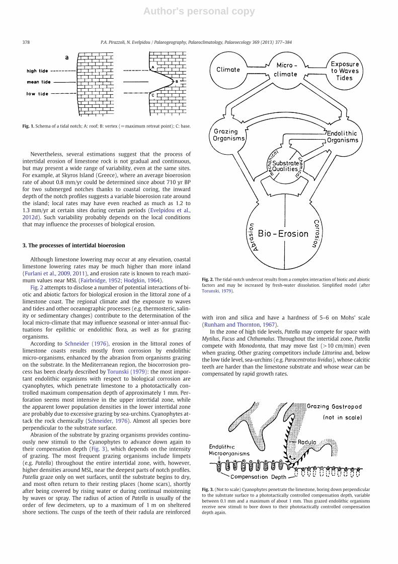
Marine notches are often mentioned in the coastal literature,e.g.: Kaye (1957), Emery (1962), Higgins (1980), Spencer (1988),Laborel and Laborel-Deguen (1996), Kelletat (1997), and Rust andKershaw (2000). They include abrasion (wave-cut) notches, structuralnotches, and infralittoral, supralittoral and midlittoral notches(Pirazzoli, 1986). Among midlittoral notches, the best sea-level indica-tors are indeed tidal notches, that are known to undercut cliffs of car-bonate rock formations, especially in microtidal marine areas. If sealevel remains relatively stable, tidal notches assume typically a recum-bent V-shaped or U-shaped profile with a vertex located near MSL, aroof near the highest tide level and a base near the lowest tide level(Fig. 1).
We shall consider here only tidal notches resulting from purelybioerosional processes in sheltered places, in the absence of organicaccretions that may develop on the base of the notch at exposedsites, especially in warmer waters, with the effect of modifying thenotch profile and its possibilities of adaptation to changes in sea level.
Different tidal notch profiles resulting from slow or rapid sea-levelchanges in sheltered sites have been listed for various cases of relativesea-level fall by Pirazzoli (1986, Fig. 4) and relative-sea level rise byEvelpidou et al. (2011, Fig. 1).
In this paper, after summarizing the rates and the processes ofbioerosion that contribute to the deepening of the notch profile, sev-eral cases will be highlighted, in which a tidal notch is prevented fromforming. It will also be recalled that tidal notches are no more forming
at sea level, as a consequence of the recent global sea-level rise(Evelpidou et al., 2012b). It will be concluded that fossil tidal notchescan be useful to interpret relative sea-level changes in places wherethey could form and have been preserved, but also that the lack offossil tidal notches does not provide evidence of the absence of pastsea-level standstills.
2. Intertidal erosion rates in carbonate rocks
The time necessary for the development of tidal notches can be esti-mated from dated fossil features, or fromMicro-ErosionMeasurements(MEM) carried out in the field. Although erosion rates reaching asmuchas 5 mm/yr have been estimated at the Sunda Straits (Verstappen,1960, p.12), from a coral boulder thrown by the tsunami of the 1883Krakatau eruption, the rate of maximum undercutting (near MSL)varies with the rock type and the local climate. It has been roughly esti-mated of the order of 1 mm/yr (Laborel et al., 1999); however this isonly a first order value, while lower rates are generally observed inhard limestones, especially in non tropical areas. For example, mea-sured intertidal MEMmay range from 0.31 to 3.01 mm/yr on intertidalreef limestone at Grand Cayman Island in the tropics (Spencer, 1985),but also between 0.09 and 0.349 mm/yr in the Gulf of Trieste (northernMediterranean) (Furlani et al., 2011). For a more detailed list of esti-mates, including several other MEM and related references, seeEvelpidou et al. (2012d, Table 1). If only the Mediterranean regionis considered, available estimations indicate a possible variabilitybetween 0.2 and about 1 mm/yr; these two limit values are oftenused to roughly estimate the possible duration of relative sea-level sta-bility necessary for the inward deepening of observed notch profiles,assuming that they are formed under uniform lithological, biologicaland climatic conditions.
Palaeogeography, Palaeoclimatology, Palaeoecology 369 (2013) 377–384
⁎ Corresponding author.E-mail addresses: [email protected] (P.A. Pirazzoli), [email protected]
(N. Evelpidou).
0031-0182/$ – see front matter © 2012 Elsevier B.V. All rights reserved.http://dx.doi.org/10.1016/j.palaeo.2012.11.004
Contents lists available at SciVerse ScienceDirect
Palaeogeography, Palaeoclimatology, Palaeoecology
j ourna l homepage: www.e lsev ie r .com/ locate /pa laeo
Author's personal copy
Nevertheless, several estimations suggest that the process ofintertidal erosion of limestone rock is not gradual and continuous,but may present a wide range of variability, even at the same sites.For example, at Skyros Island (Greece), where an average bioerosionrate of about 0.8 mm/yr could be determined since about 710 yr BPfor two submerged notches thanks to coastal coring, the inwarddepth of the notch profiles suggests a variable bioerosion rate aroundthe island; local rates may have even reached as much as 1.2 to1.3 mm/yr at certain sites during certain periods (Evelpidou et al.,2012d). Such variability probably depends on the local conditionsthat may influence the processes of biological erosion.
3. The processes of intertidal bioerosion
Although limestone lowering may occur at any elevation, coastallimestone lowering rates may be much higher than more inland(Furlani et al., 2009, 2011), and erosion rate is known to reach maxi-mum values near MSL (Fairbridge, 1952; Hodgkin, 1964).
Fig. 2 attempts to disclose a number of potential interactions of bi-otic and abiotic factors for biological erosion in the littoral zone of alimestone coast. The regional climate and the exposure to wavesand tides and other oceanographic processes (e.g. thermosteric, salin-ity or sedimentary changes) contribute to the determination of thelocal micro-climate that may influence seasonal or inter-annual fluc-tuations for epilithic or endolithic flora, as well as for grazingorganisms.
According to Schneider (1976), erosion in the littoral zones oflimestone coasts results mostly from corrosion by endolithicmicro-organisms, enhanced by the abrasion from organisms grazingon the substrate. In the Mediterranean region, the biocorrosion pro-cess has been clearly described by Torunski (1979): the most impor-tant endolithic organisms with respect to biological corrosion arecyanophytes, which penetrate limestone to a phototactically con-trolled maximum compensation depth of approximately 1 mm. Per-foration seems most intensive in the upper intertidal zone, whilethe apparent lower population densities in the lower intertidal zoneare probably due to excessive grazing by sea-urchins. Cyanophytes at-tack the rock chemically (Schneider, 1976). Almost all species boreperpendicular to the substrate surface.
Abrasion of the substrate by grazing organisms provides continu-ously new stimuli to the Cyanophytes to advance down again totheir compensation depth (Fig. 3), which depends on the intensityof grazing. The most frequent grazing organisms include limpets(e.g. Patella) throughout the entire intertidal zone, with, however,higher densities around MSL, near the deepest parts of notch profiles.Patella graze only on wet surfaces, until the substrate begins to dry,and most often return to their resting places (home scars), shortlyafter being covered by rising water or during continual moisteningby waves or spray. The radius of action of Patella is usually of theorder of few decimeters, up to a maximum of 1 m on shelteredshore sections. The cusps of the teeth of their radula are reinforced
with iron and silica and have a hardness of 5–6 on Mohs' scale(Runham and Thornton, 1967).
In the zone of high tide levels, Patella may compete for space withMytilus, Fucus and Chthamalus. Throughout the intertidal zone, Patellacompete with Monodonta, that may move fast (>10 cm/min) evenwhen grazing. Other grazing competitors include Littorina and, belowthe low tide level, sea-urchins (e.g. Paracentrotus lividus), whose calciticteeth are harder than the limestone substrate and whose wear can becompensated by rapid growth rates.
Fig. 1. Schema of a tidal notch; A: roof; B: vertex (=maximum retreat point); C: base.
Fig. 2. The tidal-notch undercut results from a complex interaction of biotic and abioticfactors and may be increased by fresh-water dissolution. Simplified model (afterTorunski, 1979).
Fig. 3. (Not to scale) Cyanophytes penetrate the limestone, boring down perpendicularto the substrate surface to a phototactically controlled compensation depth, variablebetween 0.1 mm and a maximum of about 1 mm. Thus grazed endolithic organismsreceive new stimuli to bore down to their phototactically controlled compensationdepth again.
378 P.A. Pirazzoli, N. Evelpidou / Palaeogeography, Palaeoclimatology, Palaeoecology 369 (2013) 377–384

Author's personal copy
A richly illustrated study helping to recognize intertidal bioerosionalmarks left by boring sponges, chitons, gastropods, bivalves and seaurchins has been published by Kázmér and Taboroši (2012).
4. The recent global sea-level rise and depletion of tidal notches
A complementary paper, Evelpidou et al. (2012b), has broughtevidence that tidal notches are not forming any more in the presentmid-littoral zone of the Aegean Sea, even in areas favorable to theirdevelopment, but also that they are often replaced by a fossil tidalnotch at a depth of about −20 to −30 cm. The recent depletion oftidal notches is ascribed to the recent increasing rates of the globalsea-level rise, greater than bioerosion rates, which has been occurringsince the second half of the 19th century (Donnelly et al., 2004;Church and White, 2006; Holgate, 2007; Kemp et al., 2011) and,according to altimetric satellites (Cazenave and Nerem, 2004;Nerem et al., 2006; Cazenave and Llovel, 2010), has been even accel-erating to 3.3±0.4 mm/yr since 1993. Evelpidou et al. (submitted forpublication) provided also a chronological correlation with a coastalcore at Naxos, showing that the slightly submerged fossil notch wasstill active in the 18th century, just before the beginning of the globalsea-level rise. Specifically, the uppermost fossilized shoreline (35±
5 cm) has been detected by a submerged tidal notch in severalCycladic islands (Naxos, Keros, Iraklia, Paros, Antiparos and Sifnos).The mean inward depth of 18.5 cmmay correspond to a period of rel-ative sea-level stability between 185 and 925 yr long, assuming itformed in uniform lithological, biological and climatic conditionsamong the various islands. This shoreline has been dated at 232±35 yr BP (i.e. at AD 1718±35) by a Cerastoderma shell collected at adepth of 63 cm from core NA2 at Naxos near St. Georgios(Evelpidou et al., 2010, 2012c); this brings evidence that the submer-gence of the uppermost tidal notch had probably not yet started inthe early 18th century.
5. Results: some field cases of absence of development or ofpreservation of tidal notches
The absence of development or of preservation of tidal notches oc-curs mainly when the relative sea level changes exceed the localbioerosion rate in the intertidal zone, when the rock quality is unfa-vorable and when the local coastal environment becomes detrimentalto endolithic or grazing organisms (e.g. for changes in salinity, tem-perature, pH, or sedimentation). Examples of tidal notches thatcould develop at some locations, but did not or have not been pre-served at some nearby sites of the same rock for unexplained reasons,are included in Sections 5.1 and 5.2. Section 5.3 includes an exampleof limestone stratification unfavorable to tidal notch development.Sections 5.4 to 5.7 include examples of the absence of an active tidalnotch at sea level, while fossil tidal notches have been submergedby the relative sea-level rise. Finally, Section 5.8 reports various pos-sible explanations for the absence of a present-day notch at Taormina,suggested by Kershaw and Antonioli (2004).
5.1. Hiraeon
Erosional marks left by superimposed ripple notches cut intoMesozoic limestone cliffs at Cape Melagkasi (22°50′56.8″E, 38°1′30″N), west of Hiraeon (Corinth Gulf), correspond to at least four formershorelines developed at about 3.2±0.2, 2.6±0.2, 1.7±0.2 and 1.1±0.2 m above present sea level (Fig. 4). Three of them could be datedby using Lithophaga or Chthamalus shells collected in growth position,at elevations consistent with the fossil notch levels (Pirazzoli et al.,1994). Taking into account the fact that lithophagid shells tendto incorporate host-rock carbon and provide therefore apparent
Fig. 5. Same place as Fig. 4. The notches vanish eastwards on the same rock.
Fig. 4. Erosional marks at Cape Melagkasi, west of Hiraeon, correspond to four raisedshorelines. Scale is 2 m, looking northwestwards (after Pirazzoli et al., 1994).
379P.A. Pirazzoli, N. Evelpidou / Palaeogeography, Palaeoclimatology, Palaeoecology 369 (2013) 377–384

Author's personal copy
radiocarbon ages that can be 350 to 400 yr older than their real age(Evelpidou et al., 2012e), it can be said that the raised tidal notchesof Hiraeon have been uplifted by episodic co-seismic uplifts duringthe last 6000 yr.
In the same area, Kershaw and Guo (2001) noted lateral variation inthe height of notches, indicating differential uplift due to fault controland also that important variations in the bedrock's resistance to erosionwere affecting the resulting notch profiles. All this contributed indeed tocomplicate the interpretation of the local tectonic history.
Cooper et al. (2007) propose that these notches occur mainly dur-ing periods of climatic stability, when bio-productivity of boring andgrazing biota is expected to reach a maximum, allowing rapid notchformation. Nevertheless, it can be noted in Fig. 5, showing the sameplace of Fig. 4, that the notches may vanish eastwards on the same
rock. A period of overall climatic stability does not seem therefore anecessary condition and other local inhibitions to bio-productivitymust have an influence. Although it can hardly be decided whetherthe notches were not formed for unknown reasons, or if they havebeen eroded after their formation, it can only be observed that tidalnotches may be present at some locations, but not at some nearbysites.
5.2. Antikythira
Nine ripple notches, 3 to 7 cm deep, may be distinguishedbetween +1.1 m and +2.7 m on a hard limestone cliff on the eastside of the small Bay of Potamos (Antikythira, Greece) (23°17′37.19″E, 35°53′9.95″N) (Fig. 6). Five of these tidal notches havebeen dated by radiocarbon and three others by correlation withvermetid rims. These tidal notches result from a series of rapid butsmall subsidences, at intervals of about 200–250 yr, which occurredbetween 4000 and 1700 yr BP. A sudden upheaval reaching locally2.7 m took place in 365 AD, raising simultaneously the wholesequence of notches (Pirazzoli et al., 1982). From these series ofdated fossil tidal notches it can be deduced that the intertidalbioerosion rate may be estimated, in this case, at 0.2 to 0.3 mm/yr(Pirazzoli, 1986).
It can also be observed in Fig. 6 that if the notches have been wellpreserved in the foreground, only the uppermost (the most recent)raised shoreline has left some marks of erosion on the nearby cliff.
5.3. Sikinos
An example of the influence of limestone substrate qualities onthe absence of reliable tidal notch development is provided fromSikinos (Cyclades, Greece) (25°6′46.63″E, 36°41′57.76″N). We veri-fied here, after several submersions along the south coast of the islandin August 2011, that the local lithology, with slopes towards the sea ofshallow-thickness limestone beddings, makes identification of a cleartidal notch almost impossible, at the present sea level or even at anydepth (Fig. 7); in Sikinos, at such sites, the selective widening of jointsmay have completely prevented the development of reliable tidalnotches at any depth.
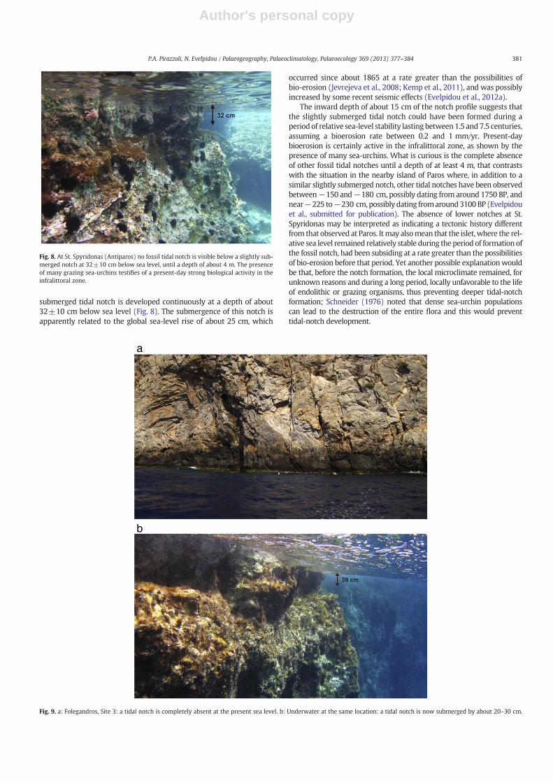
5.4. Antiparos
On the outcrop of crystalline limestone of St. Spyridonas (25°5′38.73″E, 37°4′33.13″N), an islet slightly north of Antiparos, nopresent-day tidal notch exists in the midlittoral zone, but a slightly
Fig. 7. Sikinos. The local limestone stratigraphy with shallow-slope beddings towards the sea produces at many levels false notches that are of no use as sea-level indicators.
Fig. 6. Potamos, Antikythira. Sea corrosion has cut nine superimposed tidal notches onthe limestone cliff between +1.1 and +2.7 m. The base of the meter rests on the notchat +1.5 m (after Pirazzoli et al., 1982).
380 P.A. Pirazzoli, N. Evelpidou / Palaeogeography, Palaeoclimatology, Palaeoecology 369 (2013) 377–384
Author's personal copy
submerged tidal notch is developed continuously at a depth of about32±10 cm below sea level (Fig. 8). The submergence of this notch isapparently related to the global sea-level rise of about 25 cm, which
occurred since about 1865 at a rate greater than the possibilities ofbio-erosion (Jevrejeva et al., 2008; Kemp et al., 2011), and was possiblyincreased by some recent seismic effects (Evelpidou et al., 2012a).
The inward depth of about 15 cm of the notch profile suggests thatthe slightly submerged tidal notch could have been formed during aperiod of relative sea-level stability lasting between1.5 and 7.5 centuries,assuming a bioerosion rate between 0.2 and 1 mm/yr. Present-daybioerosion is certainly active in the infralittoral zone, as shown by thepresence of many sea-urchins. What is curious is the complete absenceof other fossil tidal notches until a depth of at least 4 m, that contrastswith the situation in the nearby island of Paros where, in addition to asimilar slightly submerged notch, other tidal notches have been observedbetween−150 and−180 cm, possibly dating from around 1750 BP, andnear−225 to−230 cm, possibly dating fromaround3100BP (Evelpidouet al., submitted for publication). The absence of lower notches at St.Spyridonas may be interpreted as indicating a tectonic history differentfrom that observed at Paros. Itmay alsomean that the islet, where the rel-ative sea level remained relatively stable during the period of formation ofthe fossil notch, had been subsiding at a rate greater than the possibilitiesof bio-erosion before that period. Yet another possible explanationwouldbe that, before the notch formation, the local microclimate remained, forunknown reasons and during a long period, locally unfavorable to the lifeof endolithic or grazing organisms, thus preventing deeper tidal-notchformation; Schneider (1976) noted that dense sea-urchin populationscan lead to the destruction of the entire flora and this would preventtidal-notch development.
Fig. 9. a: Folegandros, Site 3: a tidal notch is completely absent at the present sea level. b: Underwater at the same location: a tidal notch is now submerged by about 20–30 cm.
Fig. 8. At St. Spyridonas (Antiparos) no fossil tidal notch is visible below a slightly sub-merged notch at 32±10 cm below sea level, until a depth of about 4 m. The presenceof many grazing sea-urchins testifies of a present-day strong biological activity in theinfralittoral zone.
381P.A. Pirazzoli, N. Evelpidou / Palaeogeography, Palaeoclimatology, Palaeoecology 369 (2013) 377–384

Author's personal copy
5.5. Folegandros
At Folegandros (Cyclades) (24°53′46.21″E, 36°38′20.8″N) a tidalnotch is completely absent at the present sea level (Fig. 9a). However,at the same location underwater, a tidal notch is now submerged byabout 20–30 cm (Fig. 9b). The notch probably developed before the19th century and was then submerged by the sea-level rise duringthe last two centuries.
5.6. Kineta
At Kineta area (Saronic Gulf) there isn't a tidal notch at present sealevel, while there is a continuous submerged tidal notch at a depth of66 cm. Its height (99 cm), much larger than the tidal range, suggestsa gradual relative sea level rise at a rate smaller than the localbioerosion rate (Fig. 10), which could also be ascribed to recent tec-tonic movements of the wider area. According to the date AD1482–1952 obtained from a peat sample at about −33 cm at theneighboring area of Korphos (Nixon et al., 2009), the upper part ofthe notch profile was still developing at that time. Part of the submer-gence of this notch may be ascribed to the recent rapid sea level rise.
5.7. Attika
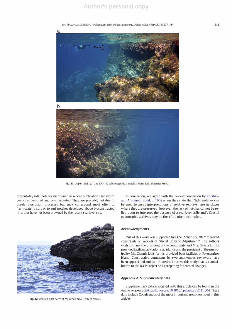
At eastern Attika, at least five (EA1–5) submerged notches havebeen recognized at −28±10 cm (EA1), −65±10 cm (EA2), −111(EA3), −130±10 cm (EA4), −460±10 cm (EA5) respectively(Fig. 11a, b) and an uplifted one at about +20±10 cm (EA6)
(Fig. 12). Both the upper (EA1) and the EA3 notch seem continuousfor more than 60 m in several cases, but only in a few cases bothnotches may be visible at the same site. At the same area, submergedbeachrocks exist from approximately sea level down to a maximumdepth of 1.8 m (Fig. 13), which are under OSL dating. No tidal notchis visible at present sea level, and the upper notch has only recentlybeen submerged mainly because of the sea level rise. A more detaileddiscussion for this area will take place elsewhere (Evelpidou et al.,submitted for publication).
5.8. Taormina
Kershaw and Antonioli (2004) have been the first to highlight thatsignificant gapsmay exist in the notch dataset at any site, by comparingfeatures of limestone bedrock at modern sea level, where a notch isabsent, with a well formed notch occurring at c. +5 m, of mid-Holocene age, in the same location at Taormina (Sicily) (15°20′39.29″E, 37°54′34.78″N). Among the possible explanations for theabsence of a present-day notch at Taormina, they listed: i) the differ-ence in relative sea-level change, with synchronous coastal upliftand sea-level rise (mid-Holocene) contrasting continuous coastaluplift and more or less stable sea level (modern times); ii) climaticchange between the mid-Holocene and the present time; iii) bioticdifferences (e.g. induced by the presence of organic rims); andiv) co-seismic control in tectonically active areas, that they considerhowever unlikely for the east Sicily coastline. They conclude that theless problematic explanation for Taormina would be the differencebetween relative sea-level rise between the two periods, with stablerelative sea level to cut the +5 m notch, and relative sea-levelfall (=coastal uplift) (in spite of the recent global sea-level of1–2 mm/yr that they did not ignore) in modern times.
6. Discussion and conclusions
Cooper et al. (2007) consider that climate stability is necessary fornotch formation. The database of Mediterranean notches gathered byBoulton and Steward (submitted for publication) does not confirm,however, any clustering of notches in periods of stable or unstable cli-mate. In a preceding study (Evelpidou et al., 2012b) and in this paperwe show, from a comparison between intertidal erosion rates in car-bonate rocks and the recent global sea-level rise during the last twocenturies, that the latter is sufficient to explain the recent depletionof tidal notches in the present mid-littoral zone, in spite of a warmingtemperature that should have facilitated sustained erosion. We havealso provided some new examples (Antiparos, Folegandros andKineta) of slightly submerged notches that correspond to the condi-tions prevailing before the recent global sea-level rise, i.e. duringthe period 600 to 150 cal yr BP, that is considered of significantrapid climate change by Mayewski et al. (2004). Examples havebeen shown of sites (Hiraeon, Antikythira), where fossil tidal notcheswere well marked on certain rocks, but were inexplicably absent fromnearby sites with the same rock and exposure. Examples from easternAttika area, where only the upper submerged notch is visible in somesites while in other sites only the lower notch is visible, may beexplained by the local micro-climate that could influence the epilithicor endolithic flora and the grazing organisms.
We have also provided the example of an island (Sikinos) wherethe quality of the limestone rock prevents reliable tidal-notch devel-opment to be recognized. Finally, we have discussed two case studiesof Antiparos and Taormina where tidal notches could develop at cer-tain periods, but, apparently and inexplicably, not at other periods.
In all cases, like in a complementary paper (Evelpidou et al., 2012b),we have verified that present-day tidal notches are not forming any-more near sea level, while a fossil tidal notch at 20 to 30 cm belowsea level, which developed before the sea-level rise of the 19thand 20th centuries, was often found. In our opinion, most of the
Fig. 10. A continuous submerged tidal notch at a depth of −66 cm at Kineta area(Saronic Gulf).
382 P.A. Pirazzoli, N. Evelpidou / Palaeogeography, Palaeoclimatology, Palaeoecology 369 (2013) 377–384
Author's personal copy
present-day tidal notches mentioned in recent publications are worthbeing re-measured and re-interpreted. They are probably not due topurely bioerosion processes but may correspond most often tofresh-water visors or to surf notches developed above bioconstructedrims that have not been drowned by the recent sea-level rise.
In conclusion, we agree with the overall conclusion by Kershawand Antonioli (2004, p. 166) when they state that “tidal notches canbe used to assist interpretations of relative sea-level rise in placeswhere they are preserved; however, the lack of notches cannot be re-lied upon to interpret the absence of a sea-level stillstand”. Coastalgeomorphic archives may be therefore often incomplete.
Acknowledgments
Part of this work was supported by COST Action ES0701 “Improvedconstraints on models of Glacial Isostatic Adjustment”. The authorswish to thank the president of the community and Mrs. Gavala for theprovided facilities at Koufonissia islands and the president of themunic-ipality Mr. Giannis Lidis for his provided boat facilities at Folegandrosisland. Constructive comments by two anonymous reviewers havebeen appreciated and contributed to improve this study that is a contri-bution to the IGCP Project 588 (preparing for coastal change).
Appendix A. Supplementary data
Supplementary data associated with this article can be found in theonline version, at http://dx.doi.org/10.1016/j.palaeo.2012.11.004. Thesedata include Google maps of themost important areas described in thisarticle.
Fig. 11. Upper (EA1) (a) and EA3 (b) submerged tidal notch at Porto Rafti (Eastern Attika).
Fig. 12. Uplifted tidal notch at Marathon area (Eastern Attika).
383P.A. Pirazzoli, N. Evelpidou / Palaeogeography, Palaeoclimatology, Palaeoecology 369 (2013) 377–384

Author's personal copy
References
Boulton, S.J., Steward, I.S., submitted for publication. Holocene coastal notches in theMediterranean region: Palaeoseismic or Palaeoclimatic indicators?
Cazenave, A., Llovel, W., 2010. Contemporary sea level rise. Annual Review of MaterialsResearch 2, 145–173.
Cazenave, A., Nerem, R.S., 2004. Present-day sea level change: observations and causes.Reviews of Geophysics 42 (3), RG3001 (1–20).
Church, J.A., White, N.J., 2006. A 20th century acceleration in global sea-level rise.Geophysical Research Letters 33, L01602 http://dx.doi.org/10.1029/2005GL024826.
Cooper, F.J., Roberts, G.P., Underwood, C.J., 2007. A comparison of 103–105 year uplift rateson the South Alkyonides Fault, central Greece: Holocene climate stability and theformation of coastal notches. Geophysical Research Letters 34 (14) (art. no, L14310).
Donnelly, J.P., Cleary, P., Newby, P., Ettinger, R., 2004. Coupling instrumental andgeological records of sea level change: evidence from southern New England ofan increase in the rate of sea-level rise in the late 19th century. GeophysicalResearch Letters 31 (article no. L05203).
Emery, K.O., 1962. Marine geology of Guam. United States Geological Survey ProfessionalPaper 403-B, B1–B76.
Evelpidou, N., Pavlopoulos, K., Vassilopoulos, A., Triantaphyllou, M., Vouvalidis, K.,Syrides, G., 2010. Paleogeographical record in western Naxos (Greece) and sealevel changes in the Upper Holocene. Geodynamica Acta 34 (5–6), 233–240.
Evelpidou, N., Pirazzoli, P.A., Vassilopoulos, A., Tomasin, A., 2011. Holocene submergedshorelines on Theologos area (Greece). Zeitschrift für Geomorphologie 55, 31–44.
Evelpidou, N., Melini, D., Pirazzoli, P., Vassilopoulos, A., 2012a. Evidence of a recentrapid subsidence in the S-E Cyclades (Greece): an effect of the 1956 Amorgosearthquake? Continental Shelf Research 39–40, 27–40.
Evelpidou, N., Kampolis, I., Pirazzoli, P.A., Vassilopoulos, A., 2012b. Global sea-level rise andthe disappearance of tidal notches. Global and Planetary Change http://dx.doi.org/10.1016/j.gloplacha.2012.05.013.
Evelpidou, N., Pavlopoulos, K., Vassilopoulos, A., Triantafyllou, M., Vouvalidis, K.,Syrides, G., 2012c. Holocene palaeogeographical reconstruction of the westernpart of Naxos island (Greece). Quaternary International 266, 81–93.
Evelpidou, N., Vassilopoulos, A., Pirazzoli, P.A., 2012d. Submerged notches on the coastof Skyros Island (Greece) as evidence for Holocene subsidence. Geomorphology141–142, 81–87.
Evelpidou, N., Vassilopoulos, A., Pirazzoli, P.A., 2012e. Holocene emergence in EuboeaIsland (Greece). Marine Geology 295–298, 14–19.
Evelpidou, N., Melini, D., Pirazzoli, P.A., Vassilopoulos, A., submitted for publication.Evidence of repeated late Holocene rapid subsidences in the S-E Cyclades (Greece)deduced from submerged notches. Continental Shelf Research.
Fairbridge, R.W., 1952. Marine erosion. Proc. 7th Pacif. Sci. Cong., 3, pp. 347–359.Furlani, S., Cucchi, F., Forti, F., Sossi, A., 2009. Comparison between coastal and inland
Karst limestone lowering rates in the northeastern Adriatic Region (Italy andCroatia). Geomorphology 104, 73–81.
Furlani, S., Cucchi, F., Biolchi, S., Odorico, R., 2011. Notches in the Northern Adriatic Sea:genesis and development. Quaternary International 232 (1–2), 158–168.
Higgins, C.G., 1980. Nips, notches, and the solution of coastal limestone: an overview of theproblem with examples from Greece. Estuarine and Coastal Marine Science 10, 15–30.
Hodgkin, E.P., 1964. Rate of erosion of intertidal limestone. Zeitschrift für Geomorphologie8, 385–392.
Holgate, S.J., 2007. On the decadal rates of sea level change during the twentiethcentury. Geophysical Research Letters 34, L01602 (4 pp.).
Jevrejeva, S., Moore, J.C., Grinsted, A., Woodworth, P.L., 2008. Recent global sea levelacceleration started over 200 years ago? Geophysical Research Letters 35, L08715http://dx.doi.org/10.1029/2008GL033611.
Kaye, C.A., 1957. The effect of solvent motion on limestone solution. Journal of Geology65, 35–46.
Kázmér, M., Taboroši, D., 2012. Bioerosion on the Small Scale— Examples from the Tropicaland Subtropical Littoral. Monostori Jubilee Volume, 7. Hantkeniana, pp. 37–94(Budapest).
Kelletat, D., 1997. Mediterranean coastal biogeomorphology: processes form and sea-levelindicators. In: Briand, F., Maldonado, A. (Eds.), Transformations and Evolution ofMediterranean Coastline:Monaco: Bull. Inst. of Oceanography, special, 18, pp. 209–226.
Kemp, A.C., Horton, B.P., Donnelly, J.P., Mann, M.E., Vermeer, M., Rahmstorf, S., 2011.Climate related sea-level variations over the past two millennia. Proceedings ofthe National Academy of Science 108, 11017–11022.
Kershaw, S., Antonioli, F., 2004. Tidal notches at Taormina, east Sicily: why is themid-Holocene notchwell-formed, but nomodern notch is present in the same locality?Quaternaria Nova VIII, 155–169.
Kershaw, S., Guo, L., 2001. Marine notches in coastal cliffs: indicators of relative sea-levelchange, Perachora Peninsula, central Greece. Marine Geology 179, 213–228.
Laborel, J., Laborel-Deguen, F., 1996. Biological indicators of Holocene sea-level and climaticvariations of rocky coasts of tropical and subtropical regions. Quaternary International31, 53–60.
Laborel, J., Morhange, C., Collina-Girard, J., Laborel-Deguen, F., 1999. Littoral bioerosion,a tool for the study of sea-level variations during the Holocene. Bulletin. GeologicalSociety of Denmark 45, 164–168.
Mayewski, P.A., et al., 2004. Holocene climate variability. Quaternary Research 62,243–255.
Nerem, R., Leuliette, E., Cazenave, A., 2006. Present-day sea-level change: a review.Comptes Rendus Geosciences 338, 1077–1083.
Nixon, F.C., Reinhardt, E.G., Rothaus, R., 2009. Foraminifera and tidal notches: datingneotectonic events at Korphos, Greece. Marine Geology 257, 41–53.
Pirazzoli, P.A., 1986. Marine notches. In: Van de Plassche, O. (Ed.), Sea-level Research: AManual for the Collection and Evaluation of Data. Geo Books, Norwich, pp. 361–400.
Pirazzoli, P.A., Thommeret, J., Y., Laborel, J., Montaggioni, L.F., 1982. Crustal blockmovementsfrom Holocene shorelines: Crete and Antikythira (Greece). Tectonophysics 86, 27–43.
Pirazzoli, P.A., Stiros, S.C., Arnold, M., Laborel, J., Laborel-Deguen, F., Papageorgiou, S.,1994. Episodic uplift deduced from Holocene shorelines in the Perachora Peninsula,Corinth area, Greece. Tectonophysics 229, 201–209.
Runham, N.W., Thornton, P.R., 1967. Mechanical wear of the gastropod radula; a scanningelectron microscope study. Journal of Zoology (London) 153, 445–452.
Rust, D., Kershaw, S., 2000. Holocene tectonic uplift patterns in northeastern Sicily:evidence from marine notches in coastal outcrops. Marine Geology 167, 105–126.
Schneider, J., 1976. Biological and inorganic factors in the destruction of limestonecoasts. Contributions to Sedimentology 6, 1–112.
Spencer, T., 1985.Weathering rates on a Caribbean reef limestone: results and implications.Marine Geology 69, 195–201.
Spencer, T., 1988. Limestone coastal morphology: the biological contribution. Progressin Physical Geography 12 (1), 66–101.
Torunski, H., 1979. Biological erosion and its significance for themorphogenesis of limestonecoasts and for nearshore sedimentation (Northern Adriatic). Senckenbergiana Maritima11, 193–265.
Verstappen, H.T., 1960. On the geomorphology of raised coral reefs and its tectonicsignificance. Zeitschrift für Geomorphologie 4, 1–28.
Fig. 13. Submerged beachrocks at Porto Rafti area (Eastern Attika) at a depth of −1.8 m.
384 P.A. Pirazzoli, N. Evelpidou / Palaeogeography, Palaeoclimatology, Palaeoecology 369 (2013) 377–384