Deep seawater inherent optical properties in the Southern Ionian Sea
Upload
independentCategory
view
3download
0
Chapter 26Submarine Mass-Movements Along the Slopesof the Active Ionian Continental Marginsand Their Consequences for Marine Geohazards(Mediterranean Sea)
Silvia Ceramicola, Daniel Praeg, Marianne Coste, Edy Forlin, Andrea Cova,Ester Colizza, and Salvatore Critelli
Abstract The Ionian margins of Calabria and Apulia (IMCA) have been affectedby mass movements of varying style, scale and age. Here we present examples ofseabed and subsurface features identified along more than 400 km of the IMCAfrom multibeam seabed imagery and subbottom profiles acquired by OGS since2005. Four different types of mass movement phenomena are recognized withexpression at seabed and in the shallow subsurface: (1) mass transport complexes(MTCs) within intra-slope basins, (2) isolated slide scars (ISS) along open slopes,(3) slope-parallel sediment undulations (SPSU) recording block-rotations linked tofluid migration, and (4) headwall and sidewall scarps (HSC) in submarine canyons.Preliminary analyses of sedimentary processes suggest that both open-slope failurescapable of triggering tsunamis and retrogression of canyon headwalls within 1–3 kmof the Calabrian coast represent potential geohazards for coastal populations andoffshore infrastructures.
Keywords Slope failures • Morpho-bathymetry • Seismics • Marine geohazards• Calabrian and Apulian margins
S. Ceramicola (�) • D. Praeg • M. Coste • E. Forlin • A. CovaOGS (Istituto Nazionale di Oceanografia e di Geofisica Sperimentale), Borgo Grotta Gigante 42c,34010 Trieste, Italye-mail: [email protected]
E. ColizzaDipartimento di Matematica e Geoscienze, Universita di Trieste, Trieste 34126, Italy
S. CritelliDipartimento di Scienze della Terra, Universita della Calabria, Arcavacate di Rende (CS)87036, Italy
S. Krastel et al. (eds.), Submarine Mass Movements and Their Consequences, Advancesin Natural and Technological Hazards Research 37, DOI 10.1007/978-3-319-00972-8 26,© Springer International Publishing Switzerland 2014
295
296 S. Ceramicola et al.
26.1 Introduction
Gravity-driven submarine processes on continental margins are important geomor-phic agents for transporting sediments downslope into deep-marine environments.Advances in shallow geophysical surveying methods have significantly improvedour ability to map and describe the morpho-sedimentary features that recordsubmarine mass movements over time (Chiocci and Ridente 2011). Any activity thataffects the seabed represents a potential geohazard. An improved understanding ofthe spatial distribution and timing of geomorphic features related to mass movementis relevant both to understanding triggering factors (e.g. seismicity, faulting, fluidmigration), and to assessing potential hazards for offshore infrastructures andadjacent coastal areas (e.g. tsunamis).
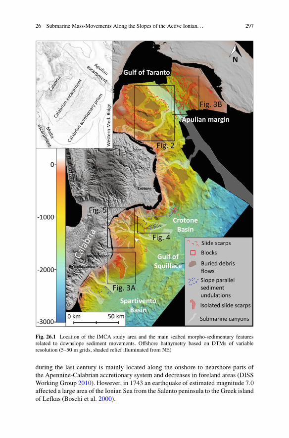
The Ionian margins of Calabria and Apulia (IMCA) provide an interestinglaboratory to study active sedimentary processes related to submarine failures(Fig. 26.1). The two tectonically-active margins lie on opposite sides of the suturedue to the subduction of the African and Adrian plates beneath southern Italy, andcontain a variety of slope settings related to different tectonic activity (Rossi andSartori 1981; Sartori 2003). The seabed dynamics of the IMCA and its linkagesto deeper structures are currently being examined at OGS in the context of theItalian projects MAGIC and RITMARE, with the overall aim of defining andmapping geological features and processes that may constitute geological risks forsurrounding coastal areas.
In this paper, we present examples of seabed and subsurface features identifiedfrom multibeam and subbottom data acquired over the last several years from theIMCA, supplemented by public seismic data held by OGS. The objective is todescribe the variety of features related to mass movements, and to assess theirpotential hazard for coastal areas and offshore infrastructures.
26.2 Geological Setting
The IMCA includes two margins affected by subduction and accretionary tectonism.The Ionian Calabrian margin (ICM) records two main processes: compression andfore-arc extension during the SE advance of the Calabrian accretionary prism sincethe late Miocene (Sartori 2003), and rapid uplift (up to 1 mm/year) of onshore andshallow shelf areas since the mid-Pleistocene (Westaway 1993). This has resulted insteep slopes (3–8ı) in the south, landward of the deep-water Crotone and Spartiventoforearc basins, and irregular slopes (2–4ı) in the north across the offshore extensionof the southern Apennine thrust-fold belt, where intraslope basins of the westernGulf of Taranto correspond to piggy-back structural highs and lows (Fig. 26.1).The passive Ionian Apulian margin (IAM) is the result of westward subductionof the Adria plate under the southern Apennines, resulting in a steep (4–6ı) slopecharacterised by several morphological steps resulting from the uneven structuralsetting of the underling Mesozoic carbonate platform. The seismicity of the IMCA
26 Submarine Mass-Movements Along the Slopes of the Active Ionian. . . 297
Fig. 26.1 Location of the IMCA study area and the main seabed morpho-sedimentary featuresrelated to downslope sediment movements. Offshore bathymetry based on DTMs of variableresolution (5–50 m grids, shaded relief illuminated from NE)
during the last century is mainly located along the onshore to nearshore parts ofthe Apennine-Calabrian accretionary system and decreases in foreland areas (DISSWorking Group 2010). However, in 1743 an earthquake of estimated magnitude 7.0affected a large area of the Ionian Sea from the Salento peninsula to the Greek islandof Lefkas (Boschi et al. 2000).
298 S. Ceramicola et al.
26.3 Data and Methods
This study is primarily based on high-resolution geophysical data (multibeam andsubbottom profiles) acquired by the RV OGS Explora during campaigns in 2009 and2005. Swath bathymetric data were acquired over an area of about 30,000 km2 usingReson 8150 (12 kHz) and 8111 (100 kHz) multibeam systems to obtain DTMs ofvariable cell size (5–50 m). Subbottom data consist of ca. 10,000 line-km of Chirpprofiles (2–7 kHz). Our interpretive method consists of mapping seabed morpho-bathymetric elements in relation to acoustic facies identified on the sub-bottomprofiles, in order to identify the principal tectonic and sedimentary features of themargin. Linkages to deeper structures are made using public multichannel seismicdatasets (Videpi Project), held in a digital database at OGS.
26.4 Results
The seabed morphology and subsurface data together allow the recognition of fourmain types of mass movement phenomena along the slopes of the IMCA: masstransport complexes (MTCs) within intra-slope basins, isolated slide-scars (ISS)and slope-parallel sediment undulations (SPSU) on open slopes, and headwall andsidewall scarps in submarine canyons (HSC).
26.4.1 Mass Transport Complexes (MTCs)Within Intra-slope Basins
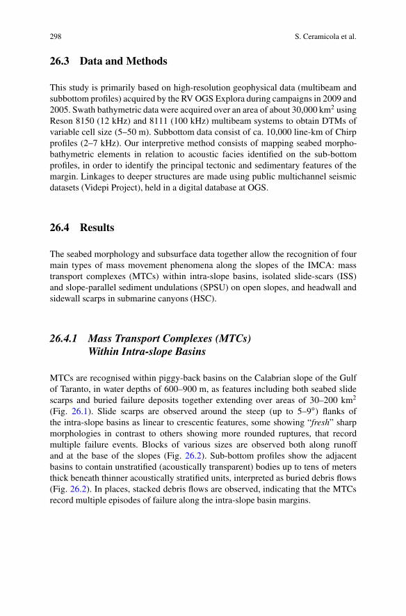
MTCs are recognised within piggy-back basins on the Calabrian slope of the Gulfof Taranto, in water depths of 600–900 m, as features including both seabed slidescarps and buried failure deposits together extending over areas of 30–200 km2
(Fig. 26.1). Slide scarps are observed around the steep (up to 5–9ı) flanks ofthe intra-slope basins as linear to crescentic features, some showing “fresh” sharpmorphologies in contrast to others showing more rounded ruptures, that recordmultiple failure events. Blocks of various sizes are observed both along runoffand at the base of the slopes (Fig. 26.2). Sub-bottom profiles show the adjacentbasins to contain unstratified (acoustically transparent) bodies up to tens of metersthick beneath thinner acoustically stratified units, interpreted as buried debris flows(Fig. 26.2). In places, stacked debris flows are observed, indicating that the MTCsrecord multiple episodes of failure along the intra-slope basin margins.
26 Submarine Mass-Movements Along the Slopes of the Active Ionian. . . 299
Fig. 26.2 Examples of mass transport complexes (MTCs) within intra-slope piggy-back basins ofthe Ionian Calabrian margin. Location is indicated in Fig. 26.1. Chirp sonar profile AB across abasin shows slide scarps and blocks above an unstratified debris flow deposit
26.4.2 Isolated Slide Scars on Open Slopes (ISS)
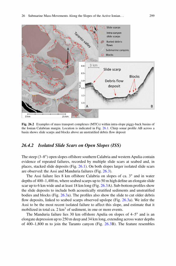
The steep (3–8ı) open slopes offshore southern Calabria and western Apulia containevidence of repeated failures, recorded by multiple slide scars at seabed and, inplaces, stacked slide deposits (Fig. 26.1). On both slopes larger isolated slide scarsare observed: the Assi and Manduria failures (Fig. 26.3).
The Assi failure lies 8 km offshore Calabria on slopes of ca. 3ı and in waterdepths of 400–1,400 m, where seabed scarps up to 50 m high define an elongate slidescar up to 6 km wide and at least 18 km long (Fig. 26.3A). Sub-bottom profiles showthe slide deposits to include both acoustically stratified sediments and unstratifiedbodies and blocks (Fig. 26.3a). The profiles also show the slide to cut older debrisflow deposits, linked to seabed scarps observed upslope (Fig. 26.3a). We infer theAssi to be the most recent isolated failure to affect this slope, and estimate that itmobilized in total ca. 2 km3 of sediment, in one or more events.
The Manduria failure lies 30 km offshore Apulia on slopes of 4–5ı and is anelongate depression up to 250 m deep and 34 km long, extending across water depthsof 400–1,800 m to join the Taranto canyon (Fig. 26.3B). The feature resembles
300 S. Ceramicola et al.
Fig. 26.3 Isolated slide scars on the Calabrian and Apulian open slopes (locations in Fig. 26.1).(A) Assi failure, the Chirp profile (a) shows the upper failure to include stratified and unstratifiedsediments, and to cut older debris flow deposits; (B) Manduria failure, the Chirp profile (b2) showsslide scarps and deposits, while the multichannel profile (b2) suggests a link to faults
a canyon, but is in part bounded by seabed slide scarps that are linked to seabedblocks and subsurface slide deposits on subbottom profiles (Fig. 26.3b). A concaveaxial profile includes two knick-points at 900 m and at 1,190 m depths, suggestingretrogressive failure activity. The total volume of the feature is estimated at 13 km3.No deposits are observed at the base of the slide as they have probably been redis-tributed into the Ionian abyssal plain via the Taranto canyon. Seismic lines showthat the Manduria failure coincides with faults in the Mesozoic carbonate platform(Fig. 26.3) suggesting a possible tectonic control on the localization of failures.
26.4.3 Slope-Parallel Sediment Undulations (SPSU)
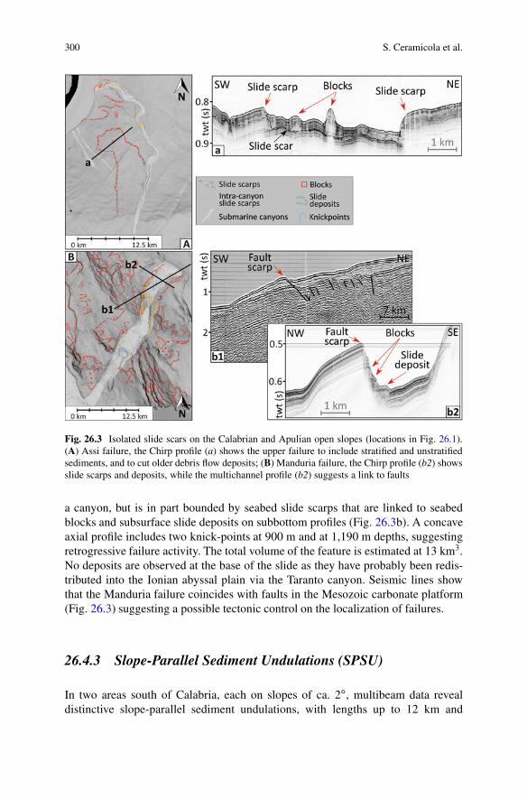
In two areas south of Calabria, each on slopes of ca. 2ı, multibeam data revealdistinctive slope-parallel sediment undulations, with lengths up to 12 km and
26 Submarine Mass-Movements Along the Slopes of the Active Ionian. . . 301
Fig. 26.4 Slope-parallel seabed undulations (SPSU) of the southern Calabrian margin (seeFig. 26.1). Top right: bathymetric profiles across the two areas of asymmetric SPSU, locationof profile A–B shown at left. C and D are Chirp profiles showing interpreted faults and fluid escapepipes
spacing of 0.6–1.4 km (Fig. 26.1). The undulations are up to 100 m in relief andasymmetric in profile, with steeper upslope-facing flanks (Fig. 26.4 top-right). Onsubbottom profiles they consist of stratified sediments, mainly conformable withseabed to form anticline-like structures, but laterally discontinuous across seaward-dipping surfaces beneath their troughs interpreted as fault planes (Fig. 26.4c, d).The stratified sediments also contain inclined zones of high amplitudes near seabed,resembling fluid escape pipes (Andresen 2012). The SPSU are interpreted as fault-bounded sediment blocks recording downslope rotation in association with fluidmigration, comparable to slope-parallel undulations observed elsewhere, notably onthe Nile fan (Loncke et al. 2004; Migeon et al. 2013; Praeg et al. 2013).
The undulations provide evidence of a linkage between seabed sediment de-formation and subsurface fluid flow. An interpretation of rotated sediment-blocksis consistent with evidence from deeper seismic profiles across the eastern area,showing the SPSU to form part of a folded/faulted Pleistocene interval developed
302 S. Ceramicola et al.
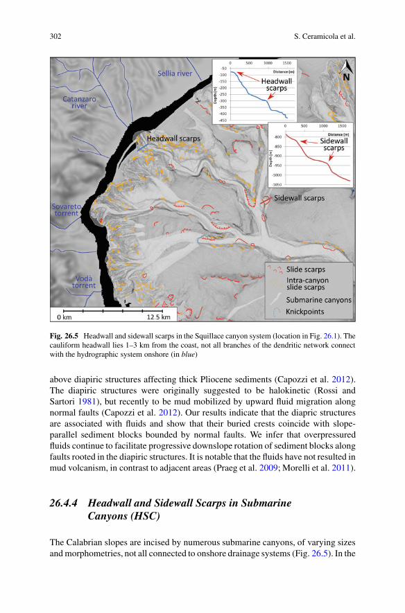
Fig. 26.5 Headwall and sidewall scarps in the Squillace canyon system (location in Fig. 26.1). Thecauliform headwall lies 1–3 km from the coast, not all branches of the dendritic network connectwith the hydrographic system onshore (in blue)
above diapiric structures affecting thick Pliocene sediments (Capozzi et al. 2012).The diapiric structures were originally suggested to be halokinetic (Rossi andSartori 1981), but recently to be mud mobilized by upward fluid migration alongnormal faults (Capozzi et al. 2012). Our results indicate that the diapric structuresare associated with fluids and show that their buried crests coincide with slope-parallel sediment blocks bounded by normal faults. We infer that overpressuredfluids continue to facilitate progressive downslope rotation of sediment blocks alongfaults rooted in the diapiric structures. It is notable that the fluids have not resulted inmud volcanism, in contrast to adjacent areas (Praeg et al. 2009; Morelli et al. 2011).
26.4.4 Headwall and Sidewall Scarps in SubmarineCanyons (HSC)
The Calabrian slopes are incised by numerous submarine canyons, of varying sizesand morphometries, not all connected to onshore drainage systems (Fig. 26.5). In the
26 Submarine Mass-Movements Along the Slopes of the Active Ionian. . . 303
Gulf of Taranto, the canyons extend 50–70 km offshore to join the Taranto canyon,which drains 250 km to the Ionian abyssal plain. South of Calabria canyons extendup to 70 km into the Crotone-Spartivento fore-arc basins (Morelli et al. 2011).Seismic profiles across the Squillace canyon in the Crotone basin show incision ofrelatively young (Pleistocene) sediments (Capozzi et al. 2012). All of the canyonsare marked by semi-circular scarps, overlapping along their headwalls and isolatedalong sidewalls (Fig. 26.1), recording smaller-scale failures. The largest canyonsystem is located in the Gulf of Squillace (Fig. 26.1), where the headwall has atotal perimeter of 62 km and an area of ca. 630 km2. The canyon system is highlydendritic, the first-order branches of the cauliform headwall extending to within 1–3 km of the coastline. Headwall scarps are on average 30 m high and 60 m long, witha density of occurrence of ca. 50/km2. Sidewall scarps are bigger in size (50–150 mhigh and 50–500 m long on average) with a lower density of occurrence (12/km2).
Headwall and sidewall scarps show that failures of the canyon walls representsan important mechanism for their retrogressive growth. Considering only headwallscarps in the first-order canyon branches of the Squillace system, we estimate thevolume of sediment removed by failure to be of the order of 6 km3. Retrogressivescars are observed to be larger where canyons cut structural highs (e.g. Squillace),suggesting ongoing adjustment to tectonically-created topography.
26.5 Discussion – Mass Movements and Geohazardsin the IMCA
The four types of mass movement described above constitute different degrees ofmarine geohazard for the Ionian coastal and deep-sea areas.
The slopes of the IMCA are marked by seabed slide scarps, which are partic-ularly abundant along the Calabrian and Apulian margins of the Gulf of Taranto(Fig. 26.1). MTCs of the western Gulf of Taranto are located away from the coastsin water depths of �600 m and confined in intra-slope basins, and so do not representa significant hazard for coastal areas. Nonetheless, they record a history of recurrentfailure that is likely to be linked to seismogenic activity along the Apenninic belt,thus reflecting a wider potential for seismically-triggered failures. The Apulianslope is dissected by slide scars (Fig. 26.1), some of which appear to be linked tofaults (Fig. 26.3B). This is interesting as this area has been considered seismicallyquiet, and raises the question of to what extent the observed failures may reflectdistal versus proximal effects of seismicity. In our opinion, seismicity represents asignificant potential trigger for geohazards along the IMCA in the Gulf of Taranto.
Isolated slide scars (ISS) on the Calabrian and Apulian open slopes also reflecta potential for larger submarine failures that may be capable of triggering tsunamisor anomalous waves. Tsunami modelling has been performed for the Assi slide,one scenario showing the area most affected to be the adjacent coast betweenRoccella Jonica and Monasterace (Fig. 26.1), where waves up to 1 m high couldcause damage to coastal infrastructures (Zaniboni et al. 2012). Thus future open-slope failures similar to Assi could constitute geohazards for adjacent coastal areas,
304 S. Ceramicola et al.
as well as for deep-sea infrastructures (pipelines, cables etc.). A better understandingof failures on the IMCA is relevant to the monitoring of tsunamigenic failures in theMediterranean Sea, where tsunami early-warning systems are less effective than inopen oceans. This is an important issue as, in contrast to earthquakes, tsunamigenicfailures can be monitored.
Slope-parallel seabed undulations (SPSU) represent a low potential hazardbecause they record slow gravity-driven deformation of slope sediments. However,the SPSU are associated with fluid pipes that we infer to reflect fluid overpressuresassociated with underlying mud diapirs. A sudden release of fluid overpressurescould present a hazard for deep-sea infrastructures, as reflected in near-by mudvolcanoes (Praeg et al. 2009).
Retrogressing canyon headwalls represent an important geohazard along thesouthern Calabrian margin, where they are located within 1–3 km of the coastline(see also Morelli et al. 2011). Headwall regression can lead to coastal erosion,with risks for coastal infrastructures (highways, harbours, railways). Retrogressivecanyon erosion has caused of the repeated collapse of the pier of the harbour of CiroMarina (Casalbore et al. 2012), which could have been avoided with more efficientgeohazard assessment and coastal management. We recommend monitoring andhigher sensibility of national and regional stakeholders to this important issue.
26.6 Conclusions
The Ionian margins of Calabria and Apulia, including the Gulf of Taranto, providea natural laboratory to study submarine geohazards, due to ongoing convergenttectonism and a wide range of mass failure phenomena. Mapping of over 400 kmof the IMCA show the seabed and shallow subsurface to contain four main types ofsedimentary record of failure over time: (1) mass transport complexes within intra-slope basins, (2) isolated slide scars along open slopes, (3) slope-parallel sedimentundulations recording gravity-driven block rotations linked to over pressured fluids,and (4) headwall and sidewall scarps in submarine canyons. Preliminary analysesof sedimentary processes occurring along the IMCA indicates that open-slopefailures capable of triggering tsunamis represent potential geohazards both forcoastal populations and for deep-sea infrastructures, whereas retrogression ofcanyon headwalls lying <1–3 km off the Calabrian coast represents an importantgeohazard that requires regular monitoring. Seismic hazard remains a major issueto be addressed in the IMCA.
Acknowledgments The seabed dynamics of the IMCA are being examined in the context ofthe Italian projects MAGIC (MArine Geohazards along the Italian Coasts), funded by the CivilProtection Department, and Ritmare (La ricerca italiana per il mare), funded by the Ministry ofUniversity and Research (MIUR). Data were acquired during four campaigns of the r/v OGSExplora: in 2005 for three projects, HERMES (EC Integrated Project), MESC (collaboration with
26 Submarine Mass-Movements Along the Slopes of the Active Ionian. . . 305
the University of Trieste) and WGDT (collaboration with the University of Calabria), all fundedby OGS, and in 2009 for MAGIC. All campaigns were coordinated by Riccardo Ramella. Alldata were processed and interpreted at OGS; Andrea Caburlotto and Dario Civile of OGS arethanked for contributions to the mapping. This work as well as Marianne Coste’s PhD programmeare funded in the framework of MAGIC and Ritmare. Global Mapper software was customizedfor MAGIC interpretative purposes. The software package IHS Kingdom Suite is provided viaan Academic Grant. The authors thank Sebastien Migeon and Dimitris Sakellariou for theirconstructive reviews.
References
Andresen KJ (2012) Fluid flow features in hydrocarbon plumbing systems: what do they tell usabout the basin evolution? Mar Geol 332–334:89–108
Boschi E, Guidoboni E, Ferrari G, Mariotti D, Valensise G, Gasperini P (2000) Catalogue of strongItalian earthquakes from 461 B.C. to 1997. Ann Geophys 43(4):609–868
Capozzi R, Artoni A, Torelli L, Lorenzini S, Oppo D, Mussoni P, Polonia A (2012) Neogene toQuaternary tectonics and mud diapirism in the Gulf of Squillace (Crotone-Spartivento Basin,Calabrian Arc, Italy). Mar Pet Geol 35(1):219–234
Casalbore D, Bosman A, Chiocci FL (2012) Study of recent small-scale landslides in geologicallyactive marine areas through repeated multibeam surveys: examples from the Southern Italy. In:Yamada Y et al (eds) Submarine mass movements and their consequences, Advances in naturaland technological hazards research 31. Springer, Dordrecht, pp 573–582
Chiocci FL, Ridente D (2011) Regional-scale seafloor mapping and geohazard assessment. Theexperience from the Italian project MaGIC (Marine Geohazards along the Italian Coasts). MarGeophys Res 32:13–23
DISS Working Group (2010) Database of Individual Seismogenic Sources (DISS), Version 3.1.1:a compilation of potential sources for earthquakes larger than M 5.5 in Italy and surroundingareas. http://diss.rm.ingv.it/diss/. Accessed 31 Jan 2013
Loncke L, Mascle J, Fanil Scientific Parties (2004) Mud volcanoes, gas chimney, pockmarks andmounds in the Nile deep-sea fan (Eastern Mediterranean): geophysical evidences. Mar Pet Geol21:669–689
Migeon S, Ceramicola S, Praeg D et al (2014) Post-failure processes on the continental slopeof the central Nile deep-sea fan: interactions between fluid seepage, sediment deformationand sediment-wave construction. In: Krastel S, Behrmann J-H, Volker D, Stipp M, BerndtC, Urgeles R, Chaytor J, Huhn K, Strasser M, Harbitz CB (eds) Submarine mass movementsand their consequences, 6th international symposium. Springer, Switzerland/Heidelberg/NewYork/Dordrecht/London, pp 117–127
Morelli D, Cuppari A, Colizza E, Fanucci F (2011) Geomorphic setting and geohazard-relatedfeatures along the Ionian Calabrian margin between Capo Spartivento and capo Rizzuto (Italy).Mar Geophys Res. doi:10.1007/s11001-011-9130-4
Praeg D, Ceramicola S, Barbieri R, Unnithan V, Wardell N (2009) Tectonically driven mudvolcanism since the late Pliocene on the Calabrian accretionary prism, central MediterraneanSea. Mar Pet Geol 26:1849–1865
Praeg D, Ketzer JM, Augustin AH et al (2014) Fluid seepage in relation to seabed deformationon the central Nile deep-sea fan, part 2: evidence from multibeam and sidescan imagery. In:Krastel S, Behrmann J-H, Volker D, Stipp M, Berndt C, Urgeles R, Chaytor J, Huhn K, StrasserM, Harbitz CB (eds) Submarine mass movements and their consequences, 6th internationalsymposium. Springer, Switzerland/Heidelberg/New York/Dordrecht/London, pp 141–150
Rossi S, Sartori R (1981) A seismic reflection study of the external Calabrian Arc in the northernIonian Sea (eastern Mediterranean). Mar Geophys Res 4:403–426

306 S. Ceramicola et al.
Sartori R (2003) The Tyrrhenian back-arc basin and subduction of the Ionian lithosphere. Episodes26(3):217–221
Westaway R (1993) Quaternary uplift of Southern Italy. J Geophys Res 98:21741–21772Zaniboni F, Tinti S, Pagnoni G, Ceramicola S, Planinsek P, Marson I (2012) Evaluation of tsunami
hazard associated to the Assi submarine landslide along the Ionian Calabrian margin, Italy.EGU General Assembly, Vienna, Austria. GeophysResAbstr14:EGU2012-8569-1
Copyright © 2022 FDOKUMEN