Structural features of mud volcanoes and the fold system of the Mediterranean Ridge, south of Crete
18
New information on the geometry of t folds and faults editerranean Ridge is provided from long range a w sidescan sonar ow frequency echosounder profiles, and gra Training Throu search cruise. Symm Pliocene-Quate sediments, but also most areas of the north-northeast directed subduction of the African plate below the Eurasian with hinge lines subparallel to the trend of the ridge. owever, the hinge line part of the area with highest concentration of mud lcanoes and produce an irregular U-shape fold belt. Some of the folds show an intrusive nucleus and, in some of them, mud reccia appears to have flowed from the folds into the troughs. The mud volcanoes consist of domes of interlayered pelagic sediments and mud breccias containing sediments and rock fragments of Late Aptian to Pleistocene ages. ud breccia flows are mainly extruded radially from vents, although rare fissure extrusions are also observed. T mud volcanoes have an irregular to elliptical shape, with diameters up to 16 km. The distribution of mud volcanoes in the area is irregular, but they are more frequent in an area called the Olimpi Field. Faults in the uppermost part of the Mediterranean Ridge are rare. ost of the faults are normal and subparallel to fold limbs. In addition, N20”E and NlOO”Esubvertical faults are found controlling the shape of the mud volcanoes. 1. uction The Mediterranean Ridge is an elongated bathy- metric high in the Eastern Mediterranean located to the south of and following the Hellenic Arc (Fig. 1). The origin of this ridge has been consid- et al., 1978; among others) to be the result of the subduction of the Afri plate in the Eastern 1972; Spakman, 1986). The subducti consequence of the plate convergence Cretaceous to present times (Gealey, ered for more than twenty years (Ryan et al., et al., 1989). This ridge was 1971; Hsti and Ryan, 1973; and later, Belderson accretionary ridge or complex 0025-3227/96/$15.00 0 1996 Elsevier Science B.V. All rights reserved SSDIOO25-3227(96)00155-7 interpreted as an (Woodside, 1977;
-
Upload
independent -
Category
Documents
-
view
3 -
download
0
Transcript of Structural features of mud volcanoes and the fold system of the Mediterranean Ridge, south of Crete

New information on the geometry of t folds and faults editerranean Ridge is provided from long range a w sidescan sonar
ow frequency echosounder profiles, and gra Training Throu search cruise. Symm Pliocene-Quate sediments, but also most areas of the north-northeast directed subduction of the African plate below the Eurasian with hinge lines subparallel to the trend of the ridge. owever, the hinge line part of the area with highest concentration of mud lcanoes and produce an irregular U-shape fold belt. Some of the folds show an intrusive nucleus and, in some of them, mud reccia appears to have flowed from the folds into the troughs.
The mud volcanoes consist of domes of interlayered pelagic sediments and mud breccias containing sediments and rock fragments of Late Aptian to Pleistocene ages. ud breccia flows are mainly extruded radially from vents, although rare fissure extrusions are also observed. T mud volcanoes have an irregular to elliptical shape, with diameters up to 16 km. The distribution of mud volcanoes in the area is irregular, but they are more frequent in an area called the Olimpi Field.
Faults in the uppermost part of the Mediterranean Ridge are rare. ost of the faults are normal and subparallel to fold limbs. In addition, N20”E and NlOO”E subvertical faults are found controlling the shape of the mud volcanoes.
1. uction
The Mediterranean Ridge is an elongated bathy- metric high in the Eastern Mediterranean located to the south of and following the Hellenic Arc (Fig. 1). The origin of this ridge has been consid-
et al., 1978; among others) to be the result of the subduction of the Afri plate in the Eastern 1972; Spakman, 1986). The subducti consequence of the plate convergence Cretaceous to present times (Gealey,
ered for more than twenty years (Ryan et al., et al., 1989). This ridge was 197 1; Hsti and Ryan, 1973; and later, Belderson accretionary ridge or complex
0025-3227/96/$15.00 0 1996 Elsevier Science B.V. All rights reserved SSDIOO25-3227(96)00155-7
interpreted as an (Woodside, 1977;

96 J. Galindo-Zaldivar et al./Marine Geology I32 ( 1996) 95-I 12
NNE
Fig. 1. Location of the study area (A) and geological sketch of the Hellenic subduction zone (modified from Le Pichon et al., 1982 and Lallemant et al., 1994) (B). fl=Pliny trench. St= Strabo trench. MR = Mediterranean Ridge. HT= Hellenic trenches. OHA =Outer Hellenic Arc. a =crust of the upper plate; 6 ==crust of the lower plate; c = undeformed sediments of the lower plate; d=deformed sediments in the Mediterranean Ridge accretionary complex; e = Hellenic trenches sediments; and v = mud volcanoes.
Le Pichon et al., 1982; Cita and Camerlenghi, 1990; Lallemant et al., 1994), because it is an elongated body of sediments deformed under com- pression, located above a subducting plate, and lying parallel to the oceanic trench associated with the subduction. However, this accretionary com- plex is different from those of other subduction zones like southwestern Japan and the Andean Margin, because there is also a trench system (the Hellenic trenches) located between the accretionary complex and the structural high and volcanic arc, as a result of back-thrusting beneath the northern edge of the accretionary complex.
In the uppermost sector of the Mediterranean Ridge, many depressions are interpreted as struc- tures formed by the dissolution of the Messinian evaporite layers (Belderson et al., 1978; Jongsma
et al., 1983; Camerlenghi and constitute anoxic basins (Cita, principal bathymetric feature oft Ridge is the ‘cobblestone to (in Hersey, 1965) or the (Belderson et al., 1972) which is zade by lineations of very open depressions and ri subparallel to the elongation of the Ridge in each area. These lineat interpreted as olistostromes ( mega-ripples (Emery (Hieke et al., 1973; systems (Stride et al., Le Pichon et al., 1982; Lallemant et al., 1994), folds r&ted to a thrust system ( Kenfon 264 al., 1982), and folding and collapse structures promoted by deformation and salt dissolution in an evaporite-bearing accretionary complex (Camerlenghi and Cita, 1987; Kastens et al., 1992). These structures, together with the deformed evap- orite layers beneath, greatly reduce the seismic penetration in the seismic reflection profiles.
In addition to the previous structures, Cita et al. ( 1981) and Camerlenghi et al. ( 1992) show the presence of generally dome-shaped mud volcanoes in several sectors of the uppermost area of the Mediterranean Ridge. Mud volcanoes and mud diapirs are very common structures at subduction zones, both in accretionary prisms and on the subducted plates seaward of the trench system (Biju Duval et al., 1982; Westbrook and Smith, 1983; Barber and Brown 1988); and they have been analyzed in detail in the Barbados accretion- ary prism (Brown and Westbrook, 1988; Henry et al., 1990) and elsewhere (e.g. Higgins et al., 1974; see also Ivanov et al., 1996.this volume).
The aim of this paper is the analysis of the main morphological and structural features of the mud volcanoes along with the associated fold and fault systems in a sector of the uppermost part of the Mediterranean Ridge located between 24”-25’4O’W and 33”10’-34’4O’N. The analysis makes use of the geophysical data and the cores obtained during the 1993 Training Through Research cruise (TTR-3). A secondary goal is to integrate the shallow structures of this area into the general tectonic framework of the Mediterranean Ridge.

Fig. 2. Location of seismic and sonar profiles. I =depth contour lines. 2 = MAK-1 sidescan sonar line; thick dotted line represent the position of the records shown in other figures. 3= OKEAN sidescan sonar and seismic lines; thick line represent the position of the records shown in other figures. #=OKEAN sidescan sonar line. Labels FWWII show the location of the profiles and sonar images of the Figs. 5-10.

98 J. Gahdo-Zaldivm et al./Murine Geology 132 ( 1996) 95-1 I2
multichannel seismic system. The track lines were laid out in such a way th t a sidescan sonar mosaic of the entire study area could be made.
The MAK-1 sonar system is towed about 100 m above the sea floor. It carries a high resolution sidescan sonar system that can operate at frequen- ties of 30 and 100 kHz. In the lower frequency mode, the system maps out a strip of sea floor 2000 m wide, but in the higher frequency mode, the width is only 500 m. The high backscatter areas are shown in black in the MAW images. The MAK-1 obtains a high resolution subbottom profile simultaneously with the sidescan image using a profiler that operates at a frequency of 6 Khz and has a penetration of up to 70 m below the sea floor. The mean vessel speed is between 1 and 2 knots during MAK-1 operations. The delay between the time the ship crosses a given position and the time when the towed MAK-1 system crosses the same location may be from 25 to 40 minutes in areas of 1800 to 2300 m depth.
A 12 kHz echosounder provided bathymetric information and was used as an aid in locating specific sampling targets on the sea floor. In addi- tion, submarine TV recordings were made along transects across two mud volcanoes.
Gravity and Kasten cores taken during the cruise were made for studying the lithological and structural features of the uppermost part of the sedimentary sequence. The lengths of the gravity cores varied from OS2 to 4.91 m, generally as a function of sediment type.
The sonar and seismic profiles and the cores were positioned by a GPS satellite navigation system.
3. Acoustic reflectivity and lithnlogy
TWO main types of sediments are identified in the sonar images on the basis of acoustic reflectiv- ity. Gravity cores show that areas with low acoustic reflectivity zones are formed by mud, silt, and marls, with intercalation of sapropel and tephra layers. These constitute the standard pelagic sedi- mentary record of this area. The high reflectivity zones are areas characterised by the occurrence either of mud breccias, generally covered by a thin
layer of pelagic se the OKEAN and system; Volgin and or of centimetric to decimetric interc mud breccias and pelag breccias consist of a mud matrix with micro of Late Aptian to Ple et al., 1992; Cita et al., 1996this volume), floating clasts of sands and mudstone, with ir millimetric to several centimetres. abundant than clasts mainly inside or near cores show that the internal structure of t cias is chaotic. The presence of gas in cores from the Napoli from core mousse-like
Dome was inferred from the smell, expansion on deck, and from the texture of some of the muds. , *
The geometry of the mud volcano field could be determined from the images of the long range sidescan sonar (OKEAN) (Fig. 4), by taking into account the difference in acoustic reflectivity of the pelagic sediments and the breccias extruded by the mud volcanoes. he volcanoes, including the associated mud breccia flows representing their erupted products, have plan view shapes that vary between elliptical and irregular. Elliptical volca-
cl a
b
:.i*; :.:.-, ITI *. . : . ::.. .y. 5’: . C
d
2 m
Fig. 3. Sketch of a gravity core (TTR3-93G) where intercal- ations of mud breccias in the pelagic sediments are observed (see also Cita et al., 1996this volume). Base of Leipzig volcano (33”46AO’N, 2P39.5 I’E). a = pelagic sediments; b = sapropel; c = massive fine mud breccia; and d= massive coarse mud breccia.

Fig. 4. Long range sidescan sonar (OKEAN) mosaic (Limonov et al., 1994) of the studied area (A) and interpretation sketch (B) with positions of the main mud volcanoes (I) and linear features (2) that correspond to fold axes except in the Inner Deformation Front where may be related to south dipping reverse faults. Mud dome Napoli has been dotted in because it does not show high backscatter. High backscatter in black. a=sharply curved fold axes; b =curred fold axes; and c =straight fold axes. Boxed in area shows location of Olimpi Field.
100 .I. Gahdo-Zaldirpar et al./Marine Seology 132 ( 1996) 95-112
noes are elongated in an E-W to NW-SE direc- tion. The latter orientation is the most common. The sizes of the volcanoes are quite variable. Many of them have diameters greater than 1 km but not exceeding the 16 km diameter of the Gelendzhik volcano (Fig. 4). The distribution of the mud volcanoes is irregular in the study area, although they are more common in the Olimpi field (Fig. 4).
MAK- 1 system. with slopes on than 5”, although locally reac (Napoli dome,
The geometry of the individual mud volcanic structures and the mud breccia flows of the Maidstone (Fig. 5), Toronto (Fig. 6), Milford- Haven (Fig. 7), Moscow (Fig. 8) and Napoli (Fig. 9) mud volcanoes is established from the high resolution profiles and sonar images of the
located up to 100 m above th area. Ring depressions are developed around most of the mud volcanoes. The pression is very well defined around the Napoli me (Fig. 9) where it reaches depths as much as 100 m below t rounding seafloor.
The Maidstone v very well marked shape. The ellipse h minor axis of 3.7 km, and the axial ratio is 1:0.62.
Fig. 5. High resolution sidescan sonar (MAK-I ) image of Maidstone volcano (A) and profile (B). (A’) Interpretation of sonar image. (B’) Interpretation of profile. I = pelagic sediments; 2 = mud breccia; 3 = surface lineations in sonar image and reflectors in the high resolution profile; 4 =anticline; 5 = syncline; 6 = overthrust of mud breccias on ~xlqic sediments; 7=normal fault; and d=location of the profile in the sonar image.

Fig. 6. High resolution sidescan sc nar (MAK-1) image of Toronto volcano (A), high resolution profile (B), and seismic profile (C ) over a different part of the mud volcano. (A’) Interpretation of sonar image. (B’) Interpretation of high resolution profile. (C’) Interpretation of seismic pro%. 2 = pelagic sediments, 2 =mud breccia. 3 = surface lineations in sonar image and reflectors in the profiles. 4 = antickkr 5 - J - pyncline. 6 = probable emission point and emission point. 7= overthrust edge of mud breccia flows; at the mud volcano boundary, the flows overlap the pelagic sediments. 8 = location of the profile in the sonar image.
This volcano has a conical shape, with a small, angular peak. A mud breccia flow with a maximum length of less than one kilometre is located at the northeastern boundary, breaking the perfect ellipti- cal shape. The mud breccias appear in the high resolution sonar images and subbottom profiles
as highly reflective, massive sediment, without internal reflectors, that overlap or overthrust the folded and faulted pelagic sediments. tions subparallel to the volcano elongation are observed on the surface of the mud breccia flows. The reflection-free spot on the northeast flank is

J. Galindo-Zaldivar et al./kfarirte Geology 132 ( 1996) 95-l 12
Fig. 7. High resolution sidescan sonar (MAK-1) image of Milford-Haven volcano (A) and profile (B). (A’) Interpretation of sonar image, (B’) Interpretation of profile. 1 =pelagic sediments. 2 =mud breccia, 3 = surface lineations in sonar image and reflectors in the high resolution profile, 4 = anticline. 5 = syncline, 6 =emission point. 7= fault. 8 = overthrust edge of mud breccia flows; at the mud volcano boundary, the flows overlap the pelagic sediments. 9=location of the profile in the sonar image,
considered by Woodside and Volgin ( 19969this volume) to be a brine pool lying above a NW-SE fault.
The Leipzig mud volcano also has an elliptical base (Fig. 4) elongated in a NW-SE direction. This volcano is 4.5 km in length and 3 km in width. If its contour is fit to an ellipse, its axial ratio is 1:0,67.
The Milford-Haven mud volcano (Figs. 4 and 7) is composed of two main structures. The east- ernmost one has an irregular outline. Both struc- tures comprise a complex volcano with E-W elongation and a maximum diameter of 3.3 km. The bathymetric profile across the northeast flank of the volcano is asymmetric, with the uppermost area and the emission point located on the eastern side. Highly reflective materials erupted from the emission point are bounded by subvertical N20”E and NlOO”E fault planes that both offset the mud volcano and also deform the pelagic sediments. The emission point is located along a N20”E fault. On the southeastern side of the high resolution profile, the mud breccia has flowed over a fold of the pelagic sediments.
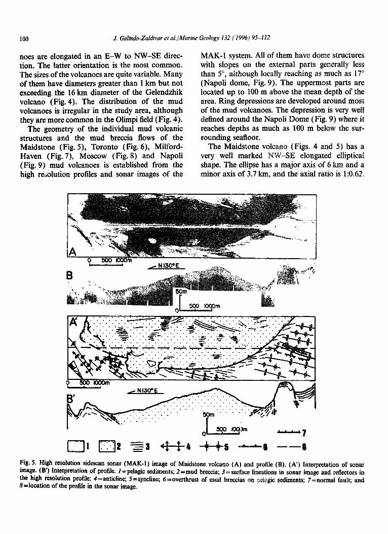
The Toronto mud volcano (Figs. 4 and 6) has The Moscow mud volcano (Figs. 4 and 8) has a circular shape, slightly elliptical with an E-W an elliptical base elongated in a NW-SE direction. elongation, although its boundary is irregular in Its major axis has a length of 7.7 km, its minor detail. Its diameter is between 6 and 10 km. The axis is 4.8 km long, and its axial ratio is 1:0.62. MAK-1 line crossed the southwest flank of the The shape of the main relief structure along the
mud volcano, giving a broa to the subbottom profiler record; the structure is probably more like the crossing of the NE-S in Fig. 6C) because the summit appears to have a small peak seen near the east (bottom) side of t MA&l image. The latest mud flow clearly ema- nates from this point, behind which there is an acoustic shadow. The mud breccia overlaps pelagic sediments deformed by folds. The on the limbs of the folds is 6”. seismic profile that crosses t indicates that the dome is sediments and sedimentary rocks without inte reflectors; the internal events parallel to bathymetry are thought to be either the base of a gas hydrate zone or an artifact of the seismic system. In the sonar images, hneaments of several kilometres in length are identified; and their geom- etry shows that there are several superposed mud breccia flows. To the northern side of the sonar image, one of the highly reflective mud breccia flows is ponded in a depression within a syncline. The lobate shape of the boundary of the Toronto mud volcano is due, at least partially, to the superposition of the erupted mud breccias on the folded surface of the pelagic sediments.
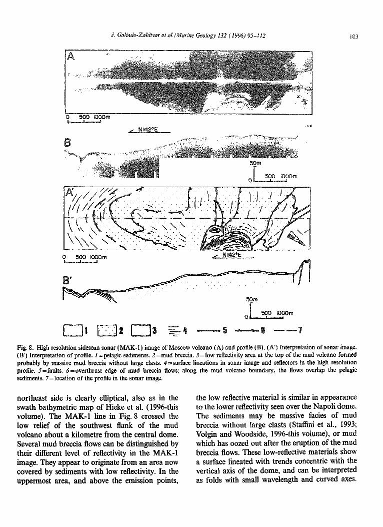
Fig. 8. High resolution sidescan sonar (MAK-I ) image of Moscow volcano (A) and profile (B). (A’) Interpretation of sonar image. (B’) Interpretation of profile. 2 =pelagic sediments. 2 =mud breccia. 3=low reflectivity area at the top of the mud volcano formed probably by massive mud breccia without large clasts. 4=surface lineations in sonar image and reflectors in the high resolution profile. 5=faults. 6=overthrust edge of mud breccia flows; along the mud volcano boundary, the flows overlap the pelagic sediments. 7=location of the profile in the sonar image.
northeast side is clearly elliptical, also as in the swath bathymetric map of Hieke et al. (1996-this volume). The MA&l line in Fig. 8 crossed the low relief of the southwest flank of the mud volcano about a kilometre from the central dome. Several mud breccia flows can be distinguished by their different level of reflectivity in the MAIL-1 image. They appear to originate from an area now covered by sediments with low reflectivity. In the uppermost area, and above the emission points,
the low reflective material is similar in appearance to the lower reflectivity seen over the Napoli dome. The sediments may be massive facies of mud breccia without large clasts (Staffini et al., 1993; Volgin and Woodside, 1996~this volume), or mud which has oozed out after the eruption of the mud breccia flows. These low-reflective materials show a surface lineated with trends concentric with the vertical axis of the dome, and can be interpreted as folds with small wavelength and curved axes.

104 J. Gdimio-Zaldiw et al.lMariue Geology 132 (1996) 95-112
. . . . . , . . . . . . . . . . , . . . . . . . . . . . . . . . . . . . . . . . . . . . . . . . , , . ., . * . . . . . . * . . . . . . . . . . * . . * . . . . . * . * . . . . . . . . . . . . . . . . . . . . . . . . . .
Fig. 9. High resolution sidescan sonar (MAK-1) image of Napoli dome (A) and profile (B). (A’) Interpretation of sonar image. (B’) Interpretation of profile. 2 = pelagic sediments. 2 =mud breccia. 3 = surface lineations in sonar image and reflectors in the high resolution profile. 4=edges of the slopes around the top area. 5=contact of mud breccias and the pelagic sediments. 6=location of the profile in the sonar image.
The highly reflective mud breccia flows are limited Napoli where they are inferred to be pits where to the north by an E-W oriented fault (northeast- active fluid venting is taking place. ern side of Fig. 8B) and overlie the folded pelagic The Napoli dome (Fig. 9) is a circular volcanic sediments (southeastern side of Fig. 8B). Along structure with a large crestal area and limb slopes and to the north of the fault can be seen highly as great as 17”, greater than for the other mud reflective patches similar to ones observed on volcanic structures. Unlike most of the other mud

reflectivity dome.
s
N AK-1 (Fig. 10) sidesca
profiles deforms at least the Pliocene t sediments in the study area. The seismic profiles sh observed in the although locally, some of them are fault-related. In addition, the boundaries of the ridges, the interfingering and curvilinear outline of the ridges in plan view, and the generally gently arched form of many of them are better explained by folds than by faults. The folds are symmetric in general, with a mean wavelength of 750 m, hinge lines of several km, and periclinal terminations over sev- eral hundreds of metres. The geometrical features are similar to those of other folds described for other areas of the Mediterranean Ridge by Stride et al. ( 1977), Le Pichon et al. ( 1982) and Lallemant et al. ( 1994). They are very open folds with amplitudes less than 50 m. Although the trends of the folds are generally subparallel to the orienta- tion of the Mediterranean Ridge (Kastens et al., 1992; Kenyon et al., 1982; Lallemant et al., 1994; Le Pichon et al., 1982; Philip, 1989), they are
sediments can be followed from the anticlines down to the synclines, with the apparent thickness of the layers as mea remaining approximat
ever, in other folds, although it is possible to ow the layers, an increase in bed thickness
from anticlines to synclines (e.g. n some of these folds, the anticlines
have smaller and more angular hinge areas than the synclines. Layers that are well identified in the synclines are not observed in the anticlinal areas where materials without internal reflectors seem to intrude the nucleus of the anticlines (Fig. IN). In other folds, this geometry is even more developed, and the anticlines are clearly intrusive and sepa- rated from the synclines by faults located along their limbs (e.g. Fig. 10F ). These faults have a bathymetric signature and produce a morphology similar to those of crests and valleys. The crestal areas are formed by the fault-bounded anticlines and the depressions are located where ponded sediments are identified in the synclines. The
106 J. Galhdo-Zaldivar et al./kfarine Geolog}) 132 (1996) 95-112
(a) (b)
Fig. 10. Deep tow sonar imascs (MAK-1) and high resolution subbottom profiles of folds and mud volcanoes (from A to I ), and interpretations (from A’ to I’). Increase in deformation from A to I. (A and B) Symmetric folds. (C, D and E) Folds with narrow anticlines and broad synclines, (F and G) Narrow anticlines are bounded by normal faults. (H) Extrusion of mud breccias from fold limbs to synch1 areas. (I) Stvor dome with extrusions of mud breccias from the limb areas. MAK-1 line Ml6 (A, D, I); MAW line Ml7 (F, G); MAIL-1 line Ml9 (B, C, E, H).
MAK-1 images show the emission of highly reflective materials from the faults located along the limbs of the anticlines, into the synclines (Fig. 10H). Moreover, in the region of the Stvor dome, it is possible to observe highly reflective mud breccia flows that erupted from faults located on the flanks of domes adjacent to the synclines (Fig. 101). The uppermost region of the domes remain covered by low reflectivity material, proba- bly pelagic sediments. This geometry is similar to that observed on the Moscow mud volcano (Fig. 8), although there the high reflectivity mud breccia flows are more developed and the low reflectivity on this dome may have other causes.
Although the orientations of fold axes in the fold system vary in different sectors, they formed
during a single deformation stage because the orientation of the hinge lines vary continuously, without interference between the different trends (Fig. 4), from N-S in the west to E-W in the south around the Toronto dome and NNE-SSW to the east. The fold system is probably formed in a Quaternary compressive setting, because folds deform the Plio-Quaternary sediments; and appre- ciable thickness variations between anticlines and synclines are not observed in most of the profiles.
6. Fault systems
The fault systems of this area have different features in each sector. The most abundant frac-

n than were observed in this
images is very irregular. This agrees well
the E-W oriented ones are the most a Noting their position south of the trenches, the scarps may be interpreted as the surface expression of northeast vergent reverse faults,
7.1. Structures and age uf the mud volcanoes
Mud volcanoes studied in this area are conical or dome-like in form. They are generally polygenic because they are formed by more than one mud breccia flow (Figs. 6-8) with intercalated pelagic sediments (Fig. 3). Mud breccia flows are predomi- nantly erupted from small emission points, and fissure emissions are less abundant. Taking into account their morphology, the mud volcanoes can
uced around the area of quence of the accommo the loss of material at de
is collapse structures around the principal eruption vanov et al., 1996~this volume), the
presumed deep origin oft erupted rocks in most of the volcanoes (e.g. Lat tian muds from deep within the sedimentary pile in the Toronto mud volcano), and the local character of these depres- sions suggest that this second mechanism may have less importance here in the formation of ring depressions. The development of ring depressions around the salt diapirs (Seni and Jackson, 1983) is very similar. Hieke et al. (1996-this volume) consider that the rim synclines around the diapirs are the result of salt dissolution; however, in this study it is considered less likely because there is no other evidence for salt dissolution, for example, depressions along the fault systems and around smaller mud volcanoes, and there is ample evidence of collapse structures around mud volcanoes in

108 J. Galindo-Zaldivar et al./Marine Geology I32 ( 1996) 95-I I2
areas like the Black Sea where salt is not present of the folds, indicates that t in the upper sedimentary section. formed in recent times.
Mud volcanoes erupt mud breccias with abun- dant matrix and a chaotic structure. Several authors (Barber and Brown, 1988; Pickering et al., 1988) have proposed that the development of mud volcanoes and mud diapirs are important processes in the formation of chaotic melanges typical of accretionary prisms. Cita et al. ( 1981) and Ryan et al. (1982) show that the structures and lithologi- cal features of the mud breccias of the Prometheus dome, located further west on the Mediterranean Ridge, and the Argille Scagliose of Cretaceous age of the Apennines have similarities. Mud volcanoes studied on land (e.g. Higgins and Saunders, 1974) often appear to be smaller than those observed in the studied area; however drilling has shown that the conduits beneath such fields of mud volcanoes have roughly the same diameters as the mud volcanoes observed on the Mediterranean Ridge, and drilled ‘sills’ of old mud flows may be hundreds of metres thick (Higgins and Saunders, 1974).
Folds are symmetric, as observed in ot cent areas of the Mediterranean Ridge by et al. (1977) and Le Pichon et al. (198 are incompatible with the vergent character of the structures proposed for this area by Philip ( 1989) because the observed folds are dissimilar from t asymmetric folds that would develop if they were related to thrust surfaces at depth. The fact that the folds are generally not vergent suggests that deformation should be not rotational in t block but that there is probably a de
Mud volcanoes of this region have been active at least since the early part of the Late Pleistocene (Emiliana huxleyi Zone) as shown by the ages of the older pelagic sediments found in gravity cores over the mud breccia flows (Cita et al., 1996-this volume). However the activity of mud volcanoes may have started earlier because only the u.pper few metres of sediments in these features are studied in the gravity cores, Gravity cores show that all the mud volcanoes which were analyzed, except for some cores of Leipzig, are covered by a thin layer of Holocene pelagic sediments less than 2 m thick. This indicates that most of the volcanoes are inactive at present but that they have been active until recent times.
surface at depth. This detachment should be located at a minimum depth of several hundred of meters, the mean depth of compensation for the fold system (Le Pichon et al., 1982); and computa- tions of the hydrostatic balance between the dia- piric sediments and the host sediments confirm that the minimum source depth for the mud is between 600 and 1000 m (Camerlenghi et al., 1995). It is possible to recognise folded reflectors in the seismic profiles to depths of 0.6 s ( )9 but the low seismic penetration does not permit the imaging of such a detachment surface at or below that depth.
7.3. Origin, evolution, and tectonic sethg of the mud volcanoes
7.2. Fold systems and shallow fractures
The high resolution seismic and MAK-1 subbot- tom profiles confirm that the relief observed along the crest of the Mediterranean Ridge arises mainly from folding, as was inferred also by Stride et al. ( 1977) and Le Pichon et al. ( 1982). The correlation between bathymetric and structural highs, along with the consistency in layer thickness variation between the anticlinal and synclinal areas in most
Yamagata and Ogawa (1989) show that mud volcanoes are the surface manifestation of mud diapirs which have breached the seafloor after formation by the upward movement of mud with fluid overpressure from depths of few kilometres (1.5-3 km), at least partially as a response to lithostatic load. Camerlenghi et al. (1995) sug- gested that the presence of thermogenic gas in the sediments requires a source depth of at least 3.1 km; however, a maximum depth of from 5 to 7 km was estimated on the basis of the assumed depth of penetration of the detachment surface from the southern side of the Mediterranean Ridge. This maximum depth would be less if the source of the overpressured fluids was the detach- ment plane along backthrusts dipping southward from the Hellenic Trench. Certainly the Late Cretaceous and more recent ages of extruded mud
nent which can be driven by
mud breccia incorporates clasts of the walll rocks as well as water which decreases the density and effective viscosity of the mud. This produc increase in the buoyancy of these materials ( et al., 1982). The fact that in some of the volcanoes only post-Cretaceous materials have been dated (Premoli Silva et al., 1996this volume) suggests that other detachment levels may occur in post- Cretaceous mud layers.
An initial hypothesis was that the release of overpressured fluid driving the extrusion of mud breccias from depth was facilitated by cross-cutting faults related to the transpressive shear zone along the Pliny and Strabo Trenches. This idea arose from observation of the geographic concentration of mud volcanoes along the southwest extension of the Pliny Trench. It is also known that mud volcanoes may form along deep-seated shear zones (e.g. Barber et al., 1986). Although there does not seem to be an alignment of mud volcanoes along
volcanoes, generally with single emission points, elliptic ;to irregular base, dome shape, and diame- ters that in many cases are greater than 1 can be as great as 16 km in the case Gelendzhik volcano. ost of the volcanoes have ring depressions that are probably a consequence of the load of the volcano on poorly consolidated sediments. Mud breccia flows overlap or overthrust the folded and faulted pelagic sediments, or pond in seafloor depressions, producing lobate bound- aries for some of the volcanoes (e.g. Toronto).
The distribution of the mud volcanoes is irregu- lar, but they are preferentially located in the area of the Olimpi Field. These volcanoes have been active in recent times, but most of them are inactive at present as indicated by the presence of pelagic sediments over the mud breccia flows, as observed in the cores. Mud volcanoes may be one of the

110 J. Galindo-Zaldivar et al.lMarine Geology 132 ( 1996) 95-I 1’2
main mechanisms for the formation of chac?tic melanges in accretionary complexes; however, mbd volcanic structures of the size of those described in this paper have not been recognised previously in field studies.
Folds observed in the study area are symmetric with a mean wavelength of 750 m, they deform sediments to a depth of several hundred metres, and they are formed probably in the hanging wall of a detachment. Fold axis trends are variable but form irregular arcuate trends around the area with the greatest number of mud volcanoes.
Most of the faults observed in the uppermost area of the Mediterranean Ridge are subparallel to the fold limbs. In addition, NlOO”E and N20”E subvertical faults deform the pelagic sediments and define the boundaries of some mud breccia flows. Along the Inner Deformation Front in the north- ern part of the study area, scarps identified with a predominantly E-W trend may correspond to south dipping reverse faults.
Mud volcanoes are the surface expression of mud brought up from depths within the accretion- ary prism where Cretaceous or more recent muds are mobilized. The upward flow through the accre- tionary complex is probably induced initially by hydrodynamic and pumping processes and later by gravitational density contrast stresses.
This research was carried out in the framework of the International Training Through Research Programme which receives financial support from UNESCO (Tredmar Programme), the European Scientific Foundation through its Network on Advanced Study Workshops on Mediterranean Marine Geosciences, the Russian Committee of Geology, Moscow State University, the Netherlands Foundation for Sea Research (SOZ), UK. Natural Environment Research Council (NERC), the Spanish Consejo Superior de Investigacienes Cientificas (CSIC), and the Universities of Milan, Granada, Cad& and Barcelona. The subsidy of the projects PB93-114%CO3-01 and PB90-0853 de la D.G.I.C.Y T. is much appreciated. Furthermore,
the authors would like to thank the o and the technical staff of their cooperation during the Yuzhmorgeologiya enterprise ( Russia) which supplied and operate equipment and the ship. “we thank Dr. T and au anonymous referee for their mentc on this manuscript.
eferences
Barber, T. and Brown, K., 1988. Mud diapirism: the origin of melanges in accretionary complexes? Geology Today, (May-June), 88: 89-94.
Barber, A.J., Tjokrosapoetro, S. and Charlton, T.R., 1986. Mud volcanoes, shale diapirs, wrench faults, and melanges in accretionary complexes, eastern Indonesia. AAPG Bull., 70( 11): 1729-1741.
Belderson, R.H., Kenyon, N.H. and Stride, A.H., 1972. Comparison between narrow beam and conventional echo- soundings from the Mediterranean Ridge. Mar. Geol., 12: Ml l-Ml5
Belderson, R.H., Kenyon, N.H. and Stride, A.H., 1978. submarine salt-karst formation on the Hellenic Outer Eastern Mediterranean. Geology, 6: 716-720.
Biju-Duval, B., Le Quellec, P., Mascle, A., Renard, V. and Valery, P., 1982. Multibeam bathymetric survey and high resolution seismic investigations on the Barbados Ridge complex (eastern Caribbean): a key to the knowledge and interpretation of an accretionary wedge. Tectonophysics, 86: 275-304.
Brown, KM. and Westbrook, G.K., 1988. Mud diapirism and subcretion in the Barbados Ridge accretionary complex: the role of fluids in accretionary processes. Tectonics, 7: 613-640.
Camerlenghi, A. and Cita, M.B., 1987. Setting and tectonic evolution of some eastern Mediterranean deep-sea basins. Mar. Geol., 75: 31-55.
Camerlenghi, A. and McCoy, F., 1990. Physiography and Structure of Bacino Bannock (Eastern Mediterranean). Geo- Mar. Lett., 10: 23-30.
Camerlenghi, A., Cita, M.B., Hieke, W. and Ricchiuto, T., 1992. Geological evidence for mud diapirism on the Mediterranean Ridge accretionary complex. Earth Planet. Sci. Lett., 109: 493-504.
Camerlenghi, A., Cita, M.B., Della Vedova, B., Fusi, N., Mirabile, L. and Pellis, G., 1995. Geophysical evidence of mud diapirism on the Mediterranean Ridge accretionary complex. Mar. Geophys. Res., 17: 115-141.
Campillo, A.C., Maldonado, A. and Mauffret, A., 1992. Stratigraphic and Tectonic Evolution of the Western Alboran Sea: Late Miocene to Recent. Geo-Mar. L&t., 12: 165-172.
Cita, M.B., 1991. Anoxic Basins of the Eastern Mediterranean: An overview. Paleoceanography, 6: 133-141.
Cita, M.B. and Camerlenghi, A., 1990. The Mediterranean

265-283. Gealey, WK., 1988. late tectonic; evolution of
Mediterranean-Middle East region. Tectonophysics, 1 285-306.
Henry, P., Le Pichon, X., Lallemant, S., Foucher, J.P., Westbrook, 6. and HobaiFt, ., 1990. ud volcano field seaward of the Barbados Accretionary Complex: A deep- towed side scan sonar survey. J. Geophys. Res., 95: 8917-8929.
Hersey, J.B., 1965. Sedimentary basins of the Mediterranean Sea. In: W.F. Whitard and W. Bradshaw (Editors), Submarine Geology and Geophysics. Proc. I7 Symp. Colston Res. Sot. London, pp. 75-91.
Hieke, W., Sigl, W. and Fabricius, F., 1973. orphological and structural aspects of the Mediterranean Ridge SW of the Peloponesus (Ionian Sea). Bull. Sot. Geol. Greece, 10: 109-126.
Hieke, W., Werner, F., Dehghani, G.A. and Schenke, H.W., 1996. Olimpi mud diapir field (Mediterranean Ridge): physiography and structural aspects. Mar. Geol., 132: 63-93.
Higgins, G.E. and Saunders, J.B., 1974. Mud volcanoes: their nature and origin. Vehandl. Naturf. Ges. Basel, 84: 101-152.
Hsti, K.J. and Ryan, W.F.B., 1973. Summary of the evidences for extensional and compressional tectonics in the Mediterranean. Init. Rep. DSDP, 13: 1011-1059.
Huchon, P., Lyberis, N., Angelier, J., Le Pichon, X. and Renard, V., 1982. Tectonics of the Hellenic Trench: a Synthesis of sea-beam and submersible observations. Tectonophysics, 86: 69-l 12.
Ivanov, M.K., Limonov, A.F. and Van Weering, Tj.C.E., 1996. Comparative characteristics of the Black Sea and Mediterranean Sea mud volcanoes. Mar. Geol., 132: 253-271.
Jackson, M.P.A. and Talbot, C.J., 1986. External shapes, strain rates and dynamics of salt structures. Geol. Sot. Am. Bull., 97: 305-323.
a~retio~a~ complex. Tectonophysi n, X., Lyberis, N., Angelier, J. and
Strain distribution over East synthesis incorporating new sea-beam data. Tectonophysics, 86: 243-274.
Limonov, A.F., Woodside, J.M. and Ivanov, M.K. (Editors), 1994. Mud volcanism in the Mediterranean and Black Seas and shallow structure of the Eratosthenes Seamount.
p. Mar. Sci. 64, 173 pp. . 1972. Active tectonics of the
egion. Geophys. J.R. Astron. Sot., 30: 109-185. ulder, C.J., Lehner, P. and Allen, C.K., 1975. Structural evolution of the Neogene salt basins in the eastern Mediterranean and Red Sea. Geol. Mijnbouw, 54; 208-221.
Philip, H., 1989. Plio-Quaternary evolution of the stress field in Mediterranean zones of subduction and collision. Ann. Geophys., 5B: 301-320.
Pickering, K.T., Agar, S.M. and Ogawa, Y., 1988. Genesis and deformation of mud injections containing chaotic basalt- limestone-chert associations: examples from the southwest Japan forearc. Geology, 16: 881-885.
Premoli Silva, I., Erba, E., Spezzaferri, S. and Cita, M.B., 1996. Variation in age of the diapiric mud breccia along and across the axis of the Mediterranean Ridge accretionary complex. Mar. Geol., 132: 175-202.
Ryan, W,F.B., Stanley, D.J., Hersey, J.B., Fahlquist, J.B. and Allen, T.D., 1971. The tectonics and Geology of the Mediterranean Sea. In: A. Maxwell (Editor): The Sea. Wiley, New York, 4: 387-492.
Ryan, W.F.B., Kastens, K.A. and Cita, M.B., 1982. Geological evidence concerning compressional tectonics in the Eastern Mediterranean. Tectonophysics, 86: 213-242.
Seni, S.J. and Jackson, M.P.A., 1983. Evolution of salt structures, East Texas Diapir Province: Sedimentary record of halokinesis. AAPG, 67(8): 1219-1244.

112 .I. Galindo-Zaldivar et al./Marine Geology 132 ( 1996) 95-l 12
Spakman, W., 1986. Subduction beneath Eurasia in connection with the Mesozoic Tethys. Geol. Mijnbouw, 65: 143-153.
Stafhni, F., Spezzaferri, S. and Aghib, F.S., 1993. Mud diapirism of the Mediterranean Ridge: sedimentological and micropaleontological study of the mud breccia. Riv. it. Paleontol. Stratigr., 99( 2): 225-254.
Stride, A.H., Belderson, R.H. and Kenyon, N.H., 1977. Evolving miogeoanticlines of the East Mediterranean (Hellenic, Calabrian and Cyprus outer ridges). Philos. Trans. R. Sot. London, 284: 255-285.
Volgin, A. and Woodside, J., 1996. Sidescan sonar images of mud volcanoes from the Mediterranean Ridge: possible
causes of variations in backscatter intensity. 132: 39-53.
eel.,
Westbrook, G.K. and Smith, M.J., 11983. Long decoliement and mud volcanoes: evidence from the Barbados Ridge complex for the role of high pore-fluid pressures in the development of an accretionary complex. Geology, 11: 279-283.
Woodside, J.M., 1977. Tectonic elements of the eastern Mediterranean Sea. Mar. Geophys. Res., 3: 317-354.
Yamagata, T. and Ogawa, Y., 1989. Role of mud diapirism for the formation of chaotic rocks. J. Geol. Sot. Jpn., 95: 297-310.