Stream-valley systems of the Brazilian Cerrado: impact assessment and conservation scheme
20
AQUATIC CONSERVATION: MARINE AND FRESHWATER ECOSYSTEMS Aquatic Conserv: Mar. Freshw. Ecosyst. 16: 713–732 (2006) Published online in Wiley InterScience (www.interscience.wiley.com) DOI: 10.1002/aqc.807 Stream-valley systems of the Brazilian Cerrado: impact assessment and conservation scheme KARL M. WANTZEN a, *, ALBERTO SIQUEIRA b , CA ´ TIA NUNES DA CUNHA c and MARIA DE FA ´ TIMA PEREIRA DE SA ´ d a Max-Planck-Institute for Limnology, Working Group Tropical Ecology, Plo ¨n, Germany b Department of General Geology, Institute of Exact and Earth Sciences, Federal University of Mato Grosso, Cuiaba ´, Brazil c Department of Botany and Ecology, Institute of Bioscience, Federal University of Mato Grosso, Cuiaba ´, Brazil d Post Graduation Program in Development and Environment, Federal University of Alagoas, Maceio ´-AL, Brazil ABSTRACT 1. The Cerrado, a seasonal savanna vegetation, is one of the largest biomes in the Neotropics. Conversion of Cerrado into agroecosystems has caused severe alterations in the species composition, functioning and habitat structure of streams and rivers. 2. As a case study for the Cerrado, the environmental quality of stream-valley systems was investigated in the catchment of the Tenente Amaral River near the city of Jaciara, Mato Grosso, Brazil. 3. Interpreting a Landsat-7 image of the area, and using a rapid assessment protocol with airborne and field observations, 481 first-order streams were identified in the catchment area (875.36 km 2 ), equivalent to an average of 0.55 springs per square kilometre. The total stream density was 0.83 km km 2 . 4. Only the uppermost headwater zones of the streams were unimpaired (8.5% of the stream channels). The largest part of the studied stream sectors were moderately (59.3%) or strongly (32.2%) impaired. 5. The greatest impact was caused by erosion. Sediments released by gully erosion alone were calculated as 2:6 10 6 m 3 of sediments in the upper zone of one tributary of the Tenente Amaral River. The sediments had deleterious effects on fauna and flora. 6. The highly erosion-prone stream valleys in the Cerrado require full protection. In the transition area between agroecosystems and hillslopes, buffer zones consisting of a replanted interfluvial Cerrado tree vegetation and a vegetated buffer strip should be planted. Apart from erosion protection, these strips can provide valuable income for the farmers through selling non-wood products. 7. The legal situation providing the baseline for the protection of the Cerrado streams is reviewed, including the efforts of the Brazilian states and collaboration of UNESCO. *Correspondence to: K. M. Wantzen, Konstanz University, Institute of Limnology, Postfach M659, 78457 Konstanz, Germany. E-mail: [email protected] Copyright # 2006 John Wiley & Sons, Ltd.
Transcript of Stream-valley systems of the Brazilian Cerrado: impact assessment and conservation scheme

AQUATIC CONSERVATION: MARINE AND FRESHWATER ECOSYSTEMS
Aquatic Conserv: Mar. Freshw. Ecosyst. 16: 713–732 (2006)
Published online in Wiley InterScience(www.interscience.wiley.com) DOI: 10.1002/aqc.807
Stream-valley systems of the Brazilian Cerrado: impactassessment and conservation scheme
KARL M. WANTZENa,*, ALBERTO SIQUEIRAb, CATIA NUNES DA CUNHAc
and MARIA DE FATIMA PEREIRA DE SAd
aMax-Planck-Institute for Limnology, Working Group Tropical Ecology, Plon, GermanybDepartment of General Geology, Institute of Exact and Earth Sciences, Federal University of Mato Grosso,
Cuiaba, BrazilcDepartment of Botany and Ecology, Institute of Bioscience, Federal University of Mato Grosso, Cuiaba, BrazildPost Graduation Program in Development and Environment, Federal University of Alagoas, Maceio-AL, Brazil
ABSTRACT
1. The Cerrado, a seasonal savanna vegetation, is one of the largest biomes in the Neotropics.Conversion of Cerrado into agroecosystems has caused severe alterations in the species composition,functioning and habitat structure of streams and rivers.2. As a case study for the Cerrado, the environmental quality of stream-valley systems was
investigated in the catchment of the Tenente Amaral River near the city of Jaciara, Mato Grosso,Brazil.3. Interpreting a Landsat-7 image of the area, and using a rapid assessment protocol with airborne
and field observations, 481 first-order streams were identified in the catchment area (875.36 km2),equivalent to an average of 0.55 springs per square kilometre. The total stream density was0.83 kmkm�2.4. Only the uppermost headwater zones of the streams were unimpaired (8.5% of the stream
channels). The largest part of the studied stream sectors were moderately (59.3%) or strongly(32.2%) impaired.5. The greatest impact was caused by erosion. Sediments released by gully erosion alone were
calculated as 2:6� 106 m3 of sediments in the upper zone of one tributary of the Tenente AmaralRiver. The sediments had deleterious effects on fauna and flora.6. The highly erosion-prone stream valleys in the Cerrado require full protection. In the transition
area between agroecosystems and hillslopes, buffer zones consisting of a replanted interfluvialCerrado tree vegetation and a vegetated buffer strip should be planted. Apart from erosionprotection, these strips can provide valuable income for the farmers through selling non-woodproducts.7. The legal situation providing the baseline for the protection of the Cerrado streams is reviewed,
including the efforts of the Brazilian states and collaboration of UNESCO.
*Correspondence to: K. M. Wantzen, Konstanz University, Institute of Limnology, Postfach M659, 78457 Konstanz, Germany.E-mail: [email protected]
Copyright # 2006 John Wiley & Sons, Ltd.

8. We suggest that it is possible to transfer this management strategy to similar biomes in theseasonal tropics provided that the tree species lists are carefully adapted to the regional flora.Copyright # 2006 John Wiley & Sons, Ltd.
KEY WORDS: Cerrado; stream; Brazil; decision-support system; buffer zone; non-wood products; erosion;
catchment
INTRODUCTION
By draining the landscape, streams integrate over large areas. This does not only influence theirgeochemical character but it also implies that large-scale conversion of natural ecosystems into man-madesystems causes severe changes in the structure of running-water ecosystems. Consequently, streammanagement strategies need to include the whole stream valley (Likens, 2001). This paper focuses onstreams in the Cerrado, a specific biome in Brazil and central South America. The term ‘Cerrado’ describesa seasonal savanna vegetation, ranging from grassy (‘campo limpo’) and slightly bushy (‘campo sujo’) toscattered tree vegetation (‘Cerrado sensu stricto’) and semideciduous forest (‘Cerradao’). The nativeCerrado flora is highly diverse: 6671 vascular plant taxa were registered for this biome in Brazilian territory(Mendonca et al., 1998). Apart from distinct biogeographic patterns, Cerrado vegetation reveals a very highlocal variation resulting from soil and water-table conditions (Eiten, 1982) and fire effects (Coutinho, 1990).Although the semideciduous xeromorphic woody vegetation invokes the impression of dryness, a dense webof stream valleys is woven through the Cerrado. Cerrado streams and their valleys form a functional unitwhich consists of the stream channel (which often has a solid bedrock channel), the fringing wetlands, thegallery forests, hillside campo wetlands (so-called ‘veredas’), and the transition zone to the Cerrado forestor shrub vegetation (Oliveira-Filho et al., 1989; Eiten, 1982; Wantzen, 2003). Veredas are characterized bythe seasonal rising of the water table to the soil surface (Eiten, 1982). The black, sandy soils accumulateorganic matter and are very sensitive to erosion (Wantzen and Nunes da Cunha, unpublished data). Theflora of vereda belts is dominated by graminoids and forbs and is clearly distinct from the woody vegetationabove and below them (Ribeiro and Walter, 1998; Araujo et al., 2002). Gallery forests follow the borders ofthe streams and their physiognomy and flora is generally distinct from the neighbouring vegetation(Figure 1). In some places, the streams run in deep and shady escarpments of the tertiary sandstoneformations and are bordered by tall rainforest-like vegetation.
The Cerrado is } after the Mata Atlantica } the second most threatened biome in the Neotropics(Klink and Machado, 2005). It once covered about 2 million km2 or 20% of the Brazilian territory (Ratteret al., 1997); more recent studies estimate that it may have covered up to 25% of it (Mantovani, 2003).Local measurements (Santos et al., 1997) and global assessments (Mittermeier et al., 1999) state that morethan half of the Cerrado vegetation has already been destroyed and converted into diverse land-use forms,especially cultivation of soy bean, cotton, corn, sugar cane and pasture. Agroindustrial landuse also impliesan intensive application of agrochemicals (fertilizers, herbicides and pesticides) which may becometransported by wind and rain over large distances (Laabs et al., 2000). Owing to large-scale deforestation,gallery forests are often the last reserves of woody vegetation in wide areas of the Cerrado (see satelliteimage, Figure 2(a)). Large-scale development programmes have caused a situation in which most of theoxisol soil areas suitable for agriculture are under the plough today, with considerable side-effects (IBAMA,2005). The main causes for erosion problems in the Cerrado are deforestation and earth road construction(which cause excess of surface water), together with mining and insufficient application of soil-conservingmethods, such as contour tillage and direct plantation (Couto, 1990; Wantzen, 1999; IBAMA, 2005). Innatural veredas the groundwater level is very high, especially during the rainy season (10–50 cm below thesoil surface, Wantzen and Nunes da Cunha, unpublished data). Once an event with excess surface dischargehas removed the vegetation (e.g. on a cattle track), an erosion gully develops which may remain
K.M. WANTZEN ET AL.714
Copyright # 2006 John Wiley & Sons, Ltd. Aquatic Conserv: Mar. Freshw. Ecosyst. 16: 713–732 (2006)
DOI: 10.1002/aqc

unvegetated for decades. Reestablishment of plants often fails through lack of nutrients, as the topsoil layerhas been removed and the underlying tertiary sandstone is extremely nutrient-poor (Wantzen, 2003).Moreover, recurring bank slumping, instability of the gully bottom and the sand deposits preventsustainable establishment of vegetation. During high rainfall events, the gullies periodically deepen owingto bottom erosion and lateral inflow of groundwater and surface water which follows the landscapegradient. Often, erosion gullies in the Cerrado become deep enough to reach the dry-season groundwaterlayer, so that a continuous flow of water mobilizes sediments and carries them into the streams. These deepgullies, locally called ‘vocorocas’, develop a dendritic pattern caused by lateral groundwater pipes andsinkholes and may cover large areas. This type of erosion gully is very difficult to control (Salomao, 1999).In addition to the occurrence in veredas, many vocorocas of the Cerrado high plains are found near naturalsprings. Two factors that favour the development of these erosion gullies there are (a) the high amounts ofrainfall in the high plains and (b) the highly non-cohesive and porous sandy soils that develop from thedisaggregation of rocky hills of friable Mesozoic sandstone. The landforms of these sand deposits areslightly sloped terraces surrounding the spring areas. When these soils are still covered by the nativeCerrado vegetation, the natural system acts as a sponge for the heavy rainfall, favouring water infiltrationrather than runoff; but the opposite situation occurs where the natural vegetation has been removed(Vasconcelos, 1998; Siqueira, 2004). Under these circumstances, the runoff water can easily remove thetopmost superficial material (comprising a mixture of organic matter and sand). Lines of erosion (gullies,ravines) can be formed in the steeper areas of the terraces (Salomao, 1999).
A variety of demands on their use complicates the development of conservation strategies in smallcatchments in the Cerrado. Stream water is often diverted for irrigation and fish farming, and consequentlysome streams have been observed to switch from permanent to periodic discharge. Water extraction forirrigation is still not severe in the study area; however, the increasing trend from single crops to two cropsper year (for soybean) and from soybean to cotton is likely to make it a future problem which may havenegative effects both on stream ecosystems and on the groundwater level. In the gallery forests, there isconsiderable game hunting and poaching activity, especially on paca (Agouti paca), cutia (Dasyprocta aguti)and tapir (Tapyrus terrestris). Moreover, uncontrolled use of timber and construction of aquaculture pondscause concern, for example by the spread of exotic fish species (e.g. the voracious African catfish Clariassp.) into the stream systems which flow towards the sensitive Pantanal wetland (Junk et al., in press). Whenbush fires from the Cerrado burn the margins of the gallery forests, grasses, ferns, bamboos and lianasinvade them (Felfili and Silva, 1992). These plants, along with the dead wood, facilitate consecutive fireswith increased heat and amount of damage, as shown in Amazonia (Cochrane and Laurance, 2002). The
Figure 1. Sketch of the vegetation sequence from the Cerrado sensu stricto to the gallery forest showing the position of the veredawetlands. VBS: vegetated buffer strip.
STREAM-VALLEY SYSTEMS OF THE BRAZILIAN CERRADO 715
Copyright # 2006 John Wiley & Sons, Ltd. Aquatic Conserv: Mar. Freshw. Ecosyst. 16: 713–732 (2006)
DOI: 10.1002/aqc

streams also become extensively modified by the erosion impacts. Massive increases in sediment load reducethe diversity of geomorphic structures and thus of habitats for biological communities in streams (Bartleyand Rutherfurd, 2005). Large quantities of eroded soil that are washed into the channel change the habitatquality by covering surfaces and by grinding away biofilms and plants so that diversity and biomass ofbenthic organisms is reduced (Wantzen, 1998b, 2006). The diverse fauna of fish (Agostinho et al., 2005) andthe other aquatic vertebrates in Cerrado streams is similarly threatened, e.g. Curvier’s dwarf caimans(Paleosuchus palpebrosus) and side-necked turtles (Bufocephala vanderhaegei). Formerly large populationsof fish which gave their names to many streams (e.g. ‘Corrego Piraputanga’, named after Brycon microlepis,a characoid fish) are gone today.
Figure 2. (a) Landsat 5 satellite image of the research area. Insert: position of the study area within South America.
K.M. WANTZEN ET AL.716
Copyright # 2006 John Wiley & Sons, Ltd. Aquatic Conserv: Mar. Freshw. Ecosyst. 16: 713–732 (2006)
DOI: 10.1002/aqc

The Cerrado provides a large number of ecosystem services. It bears one of the largest groundwaterreserves in South America, the Aquifero Guaranı (Araujo et al., 1995; Rocha, 1997). Six of the eight mostimportant Brazilian hydrographic basins have their origins in the Cerrado. The streams and their borderingwetlands receive and transform the allochthonous organic inputs from the gallery forest, thereby acting as afilter for dissolved and suspended matter, and enabling a large number of animal and plant species tocoexist (Wantzen and Junk, 2000). Many species are yet unknown or are just being described (Reid, 1984;Bispo et al., 2005) and the importance of the Cerrado plants for pharmaceutical use is only scarcelyunderstood (Ribeiro et al., 1999; Guarim Neto and Morais, 2003). The sponge effect of the stream wetlandsbuffers the flashy discharge changes from local rainfall events. Even during the seasonal drought of 2–4months, the studied streams never fell dry, but the average discharge was reduced to about a half or two-thirds of the average rainy season discharge (Wantzen, 2003).
For conservation purposes, information is needed on the extent of these ecosystems, which measures canbe taken for impact assessment and recuperation, and which laws can be used to protect and/or restore theareas. In order to define riparian buffer zone widths, a large body of data is required (for example, a GISmodel of erosion risk and thorough landscape studies; see Wissmar et al. (2004)) yet these data are rarelyavailable for small tropical catchments. The rate and extent of the destruction of the Cerrado stand in sharpcontrast to the importance of the ecosystem for biodiversity maintenance and water budget, both of whichare still scarcely studied. Funds for implementing restoration measures are equally scarce. Thus, assessmentof the environmental state of the Cerrado streams needs to be done in a fast, simple and low-cost manner.The legal background for conservation and recuperation need to be assessed, and simple and feasiblepractices should be suggested. Protective measures need to be implemented immediately in order to avoid
Figure 2. (b) The Tenente Amaral River catchment. Numbers refer to river names. (1) Corrego Brilhante, (2) Corrego TenenteAmaral, (3) Corrego Verde, (4) Corrego Saia Branca.
STREAM-VALLEY SYSTEMS OF THE BRAZILIAN CERRADO 717
Copyright # 2006 John Wiley & Sons, Ltd. Aquatic Conserv: Mar. Freshw. Ecosyst. 16: 713–732 (2006)
DOI: 10.1002/aqc

future curative measures, which are much more expensive. Despite the shortcomings in linking informationfrom disciplines such as limnology, botany, law and remote sensing, it is precisely this multidisciplinaryapproach that may help in finding adequate solutions. This paper presents (a) an overview of theenvironmental threats that are leading to the degradation of the Cerrado stream ecosystems; (b) a methodfor assessing riparian and stream condition, which also forms the basis for identifying priority areas formanagement, and (c) a range of strategies for addressing some identified management problems.
Study site
The Tenente Amaral River in Mato Grosso was chosen for study because it is representative of theenvironmental situation in the Central-Western part of Brazil and because there is a good database from aprevious long-term study (e.g. Wantzen, 1997, 2003; Vasconcelos, 1998) and from a river zonation study(Siqueira, 2004). The Tenente Amaral River is a medium-sized fifth-order river which has its main source atthe Santa Fe Farm (for a description of the habitats see Wantzen (2003, 2006)). After 46.5 km, it flows intothe Sao Lourenco River, one of the major tributaries to the Pantanal wetland, at the city of Jaciara(168 020 3000S, 548 590 4500W). The largest tributary to the Tenente Amaral River is the Saia Branca stream,21 km in length. The discharge at the second-order stretch at Santa Fe Farm is about 0.6m3 s�1 (Wantzen,2003) and increases to about 50m3 s�1 at its confluence. Above the city of Jaciara, a hydroelectric powerplant (2.560 kW) was established which deviates parts of the 30m high waterfall Cachoeira da Fumaca(‘Smoke Fall’). The narrow stony canyon and the rapids near the city of Jaciara make the river a muchsought-after site for river rafting, therefore a state conservation unit (Estrada Parque Cachoeira daFumaca, of 10 000 ha) has been established.
The geomorphology of the valleys has three distinct elements. Some of the first-order streams flow oversandstone, which is covered with porous and deep sandy-silt soils. This type is found in the eastern part ofthe catchment. Here, the streams are bordered with gallery forest and/or hillside vereda wetlands. (Moredetailed information on habitats and vegetation can be found in Wantzen (2003) and Oliveira-Filho et al.(1989).) The second type, with shale and silt bedrock, covered with shallow and impermeable soilsassociated with echeloned (staircase-like) terraces, is bordered by tall forest on well-drained soils. This typeoccurs mainly in the western part of the catchment.
The middle reach of the Tenente Amaral and its tributaries run in straight-lined channels with generallyescarped borders. They have gallery forests and vereda wetlands, which occur as a result of the highgroundwater level. The lowest stretch of the Tenente Amaral, near its confluence with the Sao LourencoRiver, has characteristics of a meandering floodplain river, with sandy-silty bed sediments, and alluvialfloodplain forest (for a description of the floodplain river habitats in Upper Paraguay catchment; seeWantzen et al. (2005)).
A revision of the legal situation for protecting the gallery forest } stream systems in the Cerrado
In spite of its large extent and rapid habitat destruction, less than 2% of the Cerrado area is currentlyprotected in conservation units (Mantovani, 2003). The Brazilian Forest Code (Law 4.771 from 1965)initially defined the term ‘Cerrado’ as ‘other forms of vegetation’ and not as a type of forest, which did notprovide much protection. Only in 18.07.1989, federal law 7.803 included this biome by adding }3, art. 16 tothe Forest Code, which prohibited the total deforestation of private proprieties. By that time, however, thefront of land-clearing for industrial agriculture had already moved far north and nearly reached the borderbetween the Cerrado and the Amazonian forests. Today, large former Cerrado areas are completely devoidof native vegetation. The Instituto Brasileiro do Meio Ambiente e dos Recursos Naturais Renovaveis(IBAMA) estimates that 67% of the Cerrado is ‘strongly modified’ because of deforestation, erosion andspill of pesticides, while only 20% is in a ‘preserved state’ (IBAMA, 2005).
K.M. WANTZEN ET AL.718
Copyright # 2006 John Wiley & Sons, Ltd. Aquatic Conserv: Mar. Freshw. Ecosyst. 16: 713–732 (2006)
DOI: 10.1002/aqc
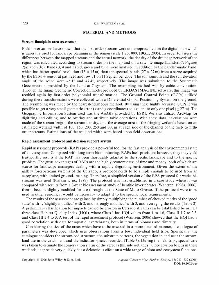
The present Forest Code includes two conservation concepts. The ‘Permanent Preservation Areas’(‘areas de preservacao permanente’, APPs) ‘are those covered or not by native vegetation, with theenvironmental function of preserving the hydrological resources, the landscape, the geological stability,the biodiversity, the gene flow of the fauna and flora, to protect the soil and ensure the wellbeing of thehuman populations’ (Machado, 2004). Within this context, all forests bordering watercourses and theirspring areas are permanently preserved, independent of their biome. Today, however, gallery forests areprotected only to a small width according to the size of the river that they border. The breadth of theprotected margins varies between the federal law and the different state laws (Table 1). The secondconservation tool of the Forest Code, the ‘Legal Reserve’, is an ‘area necessary to the sustainable use of thenatural resources, to the conservation and rehabilitation of the ecological processes, to the biodiversityconservation and to the shelter and protection of the native fauna and flora within rural properties’(Machado, 2004). When deforesting a natural site, a part of the area has to be protected. At present, the sizeof this area must be determined according to a provisory legislative measure (MP 2.166-67, of 24.08.2001)which made alterations and additions to the Forest Code by establishing three kinds of Legal Reserves. Ifthe land is located in forest of the Legal Amazonia (i.e. all states of the Amazon Basin), the reserve musthave 80%; in Cerrado located on the Legal Amazon (including the State of Mato Grosso and parts of theStates of Tocantins and Goias), the reserve must have 35%, while in the rest of the country the reserve mustbe at least 20% for areas of forest, or other types of native vegetation.
Considering the importance of the streamside vegetation, several Brazilian states make efforts todevelop additional conservation tools. In Minas Gerais, a special law (law 13,047, of 17.12.1998) requiresthat the exploitation of Cerrado areas larger than 100 ha (in addition to the APP or Legal Reserve)needs a special permit, and the warranty that 2% becomes either protected or replanted in patches orstrips between the crop fields. The State of Mato Grosso has created a special programme for theconservation and restoration of headwaters and gallery forests of the streams in the years 2004 to 2008 inorder to restore degraded river margins (decree 1,409 from 21.03.2003). Mato Grosso do Sul has developeda special kind of tax to provide benefits for municipalities which establish conservation units that preservewatercourses (law 2,193, from 18.12.2000). Recently, the Secretary for Environment of the State of SaoPaulo has shown intentions to include the gallery forests of the State into the carbon credit market of theKyoto Protocol (Amorim, 2004). The Federal decree 4,703, of 21.05.2003, includes the Cerrado as one ofthe Brazilian biomes that will be studied in a special biodiversity programme according to the Agenda 21,PRONABIO. All these examples show much-needed efforts to improve the conservation of the Cerradoand its stream systems. The current situation of the small catchments in the Cerrado is still far from thedesirable state.
Table 1. The width of the protected river margins, according to the federal law and the laws of the States of Mato Grosso(complementary law 38, of 21.11.1995) and Goias (Edict 01/2002-N)
River maximum width (m) Minimum width of the preserved river margin (m)
Federal law Mato Grosso Goias
Springs 50 100 200410 30 50 3010–50 50 50 5050–200 100 100 100200–600 200 200 2005600 500 500 500
STREAM-VALLEY SYSTEMS OF THE BRAZILIAN CERRADO 719
Copyright # 2006 John Wiley & Sons, Ltd. Aquatic Conserv: Mar. Freshw. Ecosyst. 16: 713–732 (2006)
DOI: 10.1002/aqc
MATERIAL AND METHODS
Stream floodplain area assessment
Field observations have shown that the first-order streams were underrepresented on the digital map whichis generally used for landscape planning in the region (scale 1:250 000; IBGE, 2005). In order to assess thedifferences between the mapped streams and the actual network, the density of the drainage network of theregion was calculated according to stream order on the map and on a satellite image (Landsat-7; Figures2(a) and 2(b)). Bands 3, 4 and 5 (red, green and blue) were analysed in addition to the panchromatic band,which has better spatial resolution ð15� 15 mÞ than the spectral bands ð27� 27 mÞ from a scene acquiredby the ETMþ sensor at path 226 and row 71 on 11 September 2002. The sun azimuth and the sun elevationangle of the scene were 45.18 and 47.48, respectively. The image was submitted to the SystematicGeocorrection provided by the Landsat-7 system. The resampling method was by cubic convolution.Through the Image Geometric Correction model provided by ERDAS IMAGINE software, this image wasrectified again by first-order polynomial transformation. The Ground Control Points (GCPs) utilizedduring these transformations were collected with a Differential Global Positioning System on the ground.The resampling was made by the nearest-neighbour method. By using these highly accurate GCPs it waspossible to get a very small geometric error (x and y coordinates) equivalent to only one pixel ð�27 mÞ: TheGeographic Information System used was the ArcGIS provided by ESRI. We also utilized ArcMap fordigitizing and editing, and to overlay and attribute table operations. With these data, calculations weremade of the stream length, the stream density, and the average area of the fringing wetlands based on anestimated wetland width of 100, 150, 200, 250 and 300m at each side of the channel of the first- to fifth-order streams. Estimations of the wetland width were based upon field observations.
Rapid assessment protocol and decision support system
Rapid assessment protocols (RAPs) provide a powerful tool for the fast analysis of the environmental stateof an ecosystem. Compared with long-term biomonitoring, RAPs lack precision; however, they may yieldtrustworthy results if the RAP has been thoroughly adapted to the specific landscape and to the specificproblem. The great advantages of RAPs are the highly economic use of time and money, both of which arescarce for landscape managers dealing with a rapidly degrading environment. Given the extent of thegallery forest-stream systems of the Cerrado, a protocol needs to be simple enough to be used from anaeroplane, with limited ground-truthing. Therefore, a simplified version of the EPA protocol for wadeablestreams was used (Plafkin et al., 1989). The protocol was first established in a case study where it wascompared with results from a 3-year bioassessment study of benthic invertebrates (Wantzen, 1998a, 2006),then it became slightly modified for use throughout the State of Mato Grosso. If the protocol were to beused in other regions, it would be necessary to adapt it to the specific local requirements.
The results of the assessment are gained by simply multiplying the number of checked marks of the ‘goodstate’ with 1, ‘slightly modified’ with 2, and ‘strongly modified’ with 3, and averaging the results (Table 2).A preliminary classification for impacts caused by erosion in Cerrado streams can be established by using athree-class Habitat Quality Index (HQI), where Class I has HQI values from 1 to 1.6, Class II 1.7 to 2.3,and Class III 2.4 to 3. A test of the rapid assessment protocol (Wantzen, 2006) showed that the HQI had agood correlation with data for aquatic invertebrates, both in terms of biomass and diversity.
Considering the size of the areas which have to be assessed in a more detailed manner, a catalogue ofparameters was developed which uses observations from a few, individual field trips. Specifically, thecatalogue considers the stream-bed structure, the substrate patterns, the vegetation in and near the stream,land use in the catchment and the indicator species recorded (Table 3). During the field trips, special carewas taken to estimate the conservation status of the veredas (hillside wetlands). Once erosion begins in thesewetlands, it spreads very quickly has a deleterious effect on a wide range of biota and ecosystem functions.
K.M. WANTZEN ET AL.720
Copyright # 2006 John Wiley & Sons, Ltd. Aquatic Conserv: Mar. Freshw. Ecosyst. 16: 713–732 (2006)
DOI: 10.1002/aqc

Table 3. Rapid assessment protocol for field observations
Item Good conditions (1) Slight impact (2) Strong impact (3) Special alert if . . .present
Channel Diverse (alternatingriffle and run)
Incised until 1mdepth
Deeply incised orbraided
Check for point sourcesof pollution(organic/toxic)
Margins Natural vegetation Slightly erodedroot zones
Strongly erodedroot zones or sanddeposits
Large number of treetrunks, large sanddeposits
Substrate type Natural, diverse, withbiofilm cover, rockystretches withmacrophytes
Patches withdeposits of erodedmaterial
Whole streambottom coveredwith erodedmaterial, or, ifrocky, no biofilms
Rooted macrophytes onrapids,e.g. Podostemaceae(especially valuablehabitats)Mobile substrates
Water Crystal clear Slightly turbid Very turbid Reddish plumes of water
Aquaticinvertebrates
Stonefly larvaepresent in leaf packsand on solidsubstrates
No stonefly, butbaetid larvaepresent on sanddeposits
No aquaticanimalsobservable(semiaquatic bugsmay be present)
Were any fish observed?
Assessment Sum� 1 Sum� 2 Sum� 3 Average:
Table 2. Rapid assessment protocol for airborne observations. (Airborne observations from 150 to 200m height, logged every1000–2000ma)
Item Good conditions (1) Slight impact (2) Strong impact (3) Special alert if . . .present
TransitionzoneCerrado–vereda
Cerrado strip present,well developed
Remnants ofCerrado, camposujo
Plantations downto the uppermargin of thestream valley
Erosion gullyCattle tracksEarth roads cuttingcontour lines
Streamvalley, upperpart
Natural veredavegetation(grass and Mauritiapalms)
Shrub vegetationand grass patches
Erosionalinterfluves withshrub vegetationpresent and baresand patches
Erosion gullyCattle tracks
Stream valley,lower part(floodplain)
Natural gallery forest Shrub vegetationand grass patches
Agricultural land,habitation
Aquaculture pondsDie-back of trees due tosand deposition
Stream channel Diverse structures(rocks, meanders,alternating coveredand open spaces)
Modified(deviation ofwater)
Strongly modified(dams, channels)
Waterfall (special casefor conservation)
Water colour Crystal clear Slightly turbid Very turbid Reddish plumes of water
Assessment Sum� 1 Sum� 2 Sum� 3 Average:
aDepending on the speed of the aircraft.
STREAM-VALLEY SYSTEMS OF THE BRAZILIAN CERRADO 721
Copyright # 2006 John Wiley & Sons, Ltd. Aquatic Conserv: Mar. Freshw. Ecosyst. 16: 713–732 (2006)
DOI: 10.1002/aqc

For example, shrubs (e.g. Tibouchina) are invading vereda areas (Wantzen and Nunes da Cunha,unpublished data). Additional data, such as the dimensions of eventual erosion gullies, should be takenusing a GPS. For identification of the indicator organisms, a dipnet and some basic knowledge of benthicinvertebrates is needed. The calculation for the field protocol (Table 3) is identical to the airborne protocol(Table 2). If data from both protocols are available, the results can be averaged.
Some specific observations are so characteristic for a certain impact situation that they can beimmediately used to indicate a conservation or restoration activity. A decision-support scheme wasdeveloped, based on field experience and discussions with stakeholders (farmers, conservationists andmembers of the State environmental protection agency).
RESULTS AND DISCUSSION
Estimation of the stream-forest system areas of the Tenente Amaral River
The length and density of the streams was very high in the study area (Table 4). The length of the mainchannel was 46.5 km and the drainage area was 875.36 km2. Owing to the better resolution of the visuallyinterpreted Landsat-7 images compared with the IBGE map, a large number of first-order streams could beidentified, and the total stream length of the catchment doubled from 305.6 to 723.3 km. Abundance ofstreams was very high, with a total of 481 first-order streams in the area, equivalent to an average of 0.55spring sources per square kilometre. Considering that many small sources were observed in the field but notfrom the satellite image, the number of individual sources is probably higher. The total stream density was0.83 kmkm�2. Based on estimates of the width of the fringing wetlands of the streams and rivers (includinghillslope vereda wetlands and swamp forests), 23.5% of the catchment comprised wetland areas, more thanhalf of which were from first- and second-order streams.
Rapid assessment of habitat quality
Airborne and field observations revealed a range of different impact strengths in the study area. Accordingto the habitat quality index, only the uppermost headwater zones of the streams were unimpaired (8.5% ofthe stream channel length belonged to HQI Class I). The largest part of the studied stream sectors weremoderately or strongly impaired (59.3% had HQI II, 32.2% had HQI III). Nearly all first-order streamssurveyed in the area began showing signs of habitat deterioration about 500m below the springs. Even ifrecovery occurred owing to preserved gallery forest, the accumulating effects of sequences of erosion gulliesresulted in no unimpaired section being found in sections with a stream order greater than 2. In theupper section of the streams, the gallery forest vegetation often remained in a near-natural state so that
Table 4. Stream length and density data
Stream order First Second Third Fourth Fifth
No. of streams 481 80 18 6 1Total length (km) 441.95 152.85 77.72 32.64 18.16Density (km*km
�2) 0.50 0.17 0.09 0.02 0.83Wetland width (m)a,b 200 300 400 500 600Wetland perimeter (km)a 1033.96 352.92 165.79 68.85 36.35Wetland area (ha)a 9646.69 4956.38 3210.06 1672.02 1088.70Wetland relative size (%)a 11.0 5.7 3.7 1.9 1.2
aEmpirical values, based upon field observations, aerial surveys and satellite imagery.bIncluding both sides of the stream.
K.M. WANTZEN ET AL.722
Copyright # 2006 John Wiley & Sons, Ltd. Aquatic Conserv: Mar. Freshw. Ecosyst. 16: 713–732 (2006)
DOI: 10.1002/aqc
even degraded streams gave a first impression of being well-preserved. However, permanent movement ofmobilized sand sediments derived from the erosion gullies drastically reduced benthic fauna and flora evenwhere stable artificial substrata were provided (Wantzen, 1998b).
The headwaters of the second-largest tributary, the Brilhante River, were eroded beginning from itsupper spring area which received surface runoff water from an earth road. Several small to medium-sizederosion gullies (60–120m length, 3.5–6m depth, and 12–21m width) entered the stream 50–300m below thespring (Fett, 2000). In the middle reach, there were two large gullies more than 2 km long, 6–18m deep, and30–60m wide. The volume of the gullies was estimated as 2:6� 106 m3: The enormous inputs of the erodedmaterial caused strong braiding of the middle reach and die-back of the Mauritia palms along the channel.Therefore, the habitat quality index changed from 1.5 in the springs to 2.5 in the first 500m of the channeland did not improve until the tributary, Brihante, flowed into the Tenente Amaral River.
The headwaters of the Tenente Amaral River were slightly better protected; however, they also showedareas of die-back of natural vegetation caused by sand deposition. Volume measurements of a singleerosion gully showed that at least 70 000m3 of sediments were released onto the stream bed between 1984and 1997 (Paul Rawiel, pers. comm.) Below the mouth of this erosion gully, solid loads of 60 t of sedimentper day were measured during strong rainfall events (Wantzen, 2003). Long-term field observations reveal apermanent deterioration in the environmental state of the headwaters. The stretch above the erosion gully,which was used as a reference site with a habitat quality index of 1.2 in 1995 (Wantzen, 1997, 1998b)worsened to 1.8 in 2005 (Wantzen, pers. obs.). In 2005, the river had a habitat index of 2.8 below the mouthof the erosion gully, improved to 2.0 after a passage through a gallery forest, and declined to 2.3 after theconfluence with the Brilhante stream until it reached the city of Jaciara. The other tributaries to the TenenteAmaral River (Saia Branca and Corrego Verde) revealed similar patterns. During an aerial survey of theTenente Amaral River from its source to the city of Jaciara in 2001, we observed more than 10 cattle tracksrunning towards the stream channel which are indicative of the beginning of erosion. At about 30 sitesalong the same stretch, spread of the shrub Tibouchina sp. indicated conversion of erosion-sensitive vereda
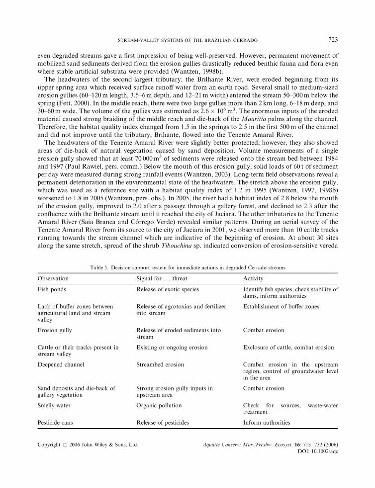
Table 5. Decision support system for immediate actions in degraded Cerrado streams
Observation Signal for . . . threat Activity
Fish ponds Release of exotic species Identify fish species, check stability ofdams, inform authorities
Lack of buffer zones betweenagricultural land and streamvalley
Release of agrotoxins and fertilizerinto stream
Establishment of buffer zones
Erosion gully Release of eroded sediments intostream
Combat erosion
Cattle or their tracks present instream valley
Existing or ongoing erosion Exclosure of cattle, combat erosion
Deepened channel Streambed erosion Combat erosion in the upstreamregion, control of groundwater levelin the area
Sand deposits and die-back ofgallery vegetation
Strong erosion gully inputs inupstream area
Combat erosion
Smelly water Organic pollution Check for sources, waste-watertreatment
Pesticide cans Release of pesticides Inform authorities
STREAM-VALLEY SYSTEMS OF THE BRAZILIAN CERRADO 723
Copyright # 2006 John Wiley & Sons, Ltd. Aquatic Conserv: Mar. Freshw. Ecosyst. 16: 713–732 (2006)
DOI: 10.1002/aqc

wetlands into secondary Cerrado vegetation owing to groundwater level changes (Wantzen and Nunes daCunha, unpublished data). Adequate management of the groundwater interactions, therefore, seems to bethe key to the solution of the erosion problem (see below).
Several observations made during the rapid assessment indicate immediate threats and emphasize thenecessity of mitigating measures (Table 5).
Strategy for conservation and restoration of Cerrado stream-valley systems
A conservation strategy for Cerrado stream valleys has to cope with several problems. In many cases,the farmland has been resold after logging of a permanent reserve and prosecution of these pastenvironmental crimes is difficult. The conservation laws protect strips with a metrically defined distancefrom the stream margin (see Introduction and Table 1). The width indicated does not often consider thereal borders of the ecosystems which need protection. Most farmers interviewed were well aware of theenvironmental problems; however, their investments are bound to global markets (soybean, corn, sugar)and for economic reasons degraded areas are abandoned rather than restored. Therefore, restorationand conservation strategies are only applicable if they are economically and technically feasible for thestakeholders. As a solution to this multiplicity of problems, we suggest a zonal concept for conservationand economically feasible restoration of altered Cerrado stream valleys (Figures 1 and 3). Threezones should be established } an inner zone, a transition zone and an outer zone each with different levelsof conservation and management. The inner zone, including the stream channel, the vereda wetlands,swamp forest and gallery forest needs full protection. By law, this zone is already preserved as permanentreserve (APP); however, lack of personnel to control the maintenance of the laws, lack of awareness
Vereda
cattle
erosion
cerrado
Figure 3. Remnants of native vegetation at the Tenente Amaral stream. On the left side of the picture, a buffer zone of Cerrado forestprotects the stream valley from the impacts of the agricultural area. On the right side, the buffer zone has been drastically reduced, and
cattle tracks initialize the erosion process.
K.M. WANTZEN ET AL.724
Copyright # 2006 John Wiley & Sons, Ltd. Aquatic Conserv: Mar. Freshw. Ecosyst. 16: 713–732 (2006)
DOI: 10.1002/aqc

of environmental problems among landowners, and the ‘old’ erosion gullies, bring about a deterioration ofthe stream valleys that is not only persistent but accelerating. A campaign to improve awareness ofthe value of riparian wetlands and to enforce the conservation laws is needed. The transition zone betweenthe protected zone and the plantations on the interfluves should be replanted with buffer strips ofinterfluvial Cerrado vegetation, which can be partially used for the extraction of non-woody products (seebelow).
The border between these Cerrado strips and the agricultural farmland should be protected with aVegetated Buffer Strip (VBS), e.g. with a 3–5m broad grass strip (Figure 1). VBSs offer several advantagesfor landscape management, as they reduce the erosion at the margins of the agricultural fields and thetransfer of agrochemicals (pesticides, herbicides and fertilizer) into the natural areas via surface runoff (forreviews, see, for example, Osborne and Kovacic, 1993; Haycock et al., 1997). The outer zone comprises thecurrent agricultural use zones, which would be managed with best management practices which are, in largepart, already used, e.g. direct sowing, contour tillage, etc.
Non-wood products
In contemporary markets, the sale of non-wood products from ornamental, pharmaceutical and fruit-producing tree species may yield considerable return. Moreover, many of the native tree species found inthe Cerrado provide at least one of these non-wood products (for a review, see Guarim Neto and Morais,2003). Thus, planting a combination of different Cerrado tree species may produce a valuable income forthe farmers who agree to replant Cerrado strips. These areas should never be logged. Much research is stillneeded to identify the best combinations of tree species according to the different soil types (Close et al.,2005); however, some common regional species have already been proposed for plantation in this region(Table 6).
Management of soil organic matter
A major constraint for agriculture in the Cerrado zone is the lack of soil organic matter (SOM) thatprevents fertilizers and pesticides from percolating from the rooted zone into the groundwater (Laabs et al.,2000). Therefore, improvement of SOM concentrations would simultaneously reduce losses ofagrochemicals from root zones and improve agricultural production by increasing the residence time ofthese substances. However, woody material, which might serve as a basis for SOM improvement measures,is scarce in the Cerrado. Apart from deforestation for land clearing, wood is used in large amounts for theoven-drying process of soybeans after the harvest. Therefore, it is necessary to replant wood for SOMproduction. Exotic, fast-growing plant species such as eucalypt and pine are not recommended, as they maychange the characteristics of the ecosystem and lower the groundwater level (Abelho and Graca, 1996).Instead, selected areas should be replanted with native Cerrado species that grow quickly and produce theSOM basic material. They should be interspersed with the preserved non-wood extraction areas which serveas refuges for fauna and as seed banks for herbs and grasses. Sequential logging of these selected parts ofthe Cerrado buffer strips and comminution of the woody material by a mobile shredding and pelletingdevice could provide material which could be sputtered with nutrient solutions, dried, and loosely dug intothe topsoil. This machine could be run by a company which attends the farmers of a region so that time/cost efficiency is warranted. The farmers might produce biomass in secondary forests which could besequentially clearcut in 5–10-year cycles in a way that their ecological functions as wildlife corridors andlandscape units remain. A list of species that could be used for this purpose is given in Table 7. Thesuccession types are indicative of the management style. Pioneers grow quickly and have low wooddensities, while climax species grow slowly and often need specific soil conditions (see Parolin, 2001).
STREAM-VALLEY SYSTEMS OF THE BRAZILIAN CERRADO 725
Copyright # 2006 John Wiley & Sons, Ltd. Aquatic Conserv: Mar. Freshw. Ecosyst. 16: 713–732 (2006)
DOI: 10.1002/aqc

Restoration of erosion gullies
The large number of erosion gullies in the stream valleys is not surprising as practically all factors describedin the Universal Soil Loss Equation (USLE; Wishmeier, 1984) facilitate natural and man-made erosion inthe Cerrado (Baccaro, 1999). They all need to be considered in restoration plans for eroded catchments.The slope of the valleys is often steep (8–20%), the texture of the soils is very sandy, and much energy is
Table 6. Plants suitable for the production of non-wood products in the Cerrado of Mato Grosso
Scientific name Common name Used part Use
Acrocomia aculeata (Jacq.)Lodd. ex Mart.
Bocaiuva Fruits Food
Alibertia edulis (Rich.)A. Rich. ex DC.
Marmelada bola Leaves Jellies and sweets
Altenanthera dentata (Moe.)Schey
Cerramicina Leaves Pharmaceutic
Anacardium humile St. Hil. Cajuzinho do campo Nuts and pulp, roots Food, roots are used to treat venerealdiseases
Anemopaegma arvense(Vell.) Stellfeld ex de Souza
Catuaba Roots Pharmaceutic use (anti-inflammatory,stimulating)
Annona coriacea Mart. Araticum do cerrado Leaves and fruits Lectins, foodBowdichia virgilioides Kunth Sucupira Seeds Pharmaceutic (anti-rheumatic)Brosimum gaudichaudi Trec. Inhare, mama cadela Roots Pharmaceutic (liver diseases), foodCamarea ericoides St. Hil. Arnica de batata Leaves Pharmaceutic use (bronchitis, syphilis,
anaemia)Caryocar brasiliensis Camb. Pequi Fruits Food, pharmaceutic, cosmeticsCopaifera martii Hayne Guaranazinho Sap Pharmaceutic (wound healing)Croton urucurana Baill. Sangra-d’agua Sap and bark Pharmaceutic (wound healing),
ornamentalDimorphandra molis Benth. Barbatimao-de-folha-
miudaBark Antimicrobial, insecticidal,
pharmaceuticDypterix alata Vog Baru, cumbaru Nuts FoodDuguetia furfuracea(A.St.-Hil.) Saff
Sofre de rim quemquer
Leaves Pharmaceutic (diuretic)
Genipa americana L. Jenipapo Stem bark Pharmaceutic (anti-inflammatory,antianaemic)
Himathathus obovatus(M. Arg.) Woods
Angelica Leaves Pharmaceutic
Hymenaea spp. Jatoba Sap, fruits Pharmaceutic, foodKielmeyera coriacea Mart Pau santo Bark AntibacterialLafoensia pacari St. Hil. Mangava-brava Bark Pharmaceutic (wound healing)Macrosiphonia velameM. Arg.
Velame Roots Pharmaceutic (analgetic,anti-inflammatory)
Mauritia flexuosa L. f. Buriti Fruits, leaves Food, fibrePalicourea rigida Kunth Douradao Leaves, stem Pharmaceutic (anti-rheumatic, diuretic)Palicourea xanthophyllaM. Arg.
Douradinha Leaves Pharmaceutic (infections,kidney diseases)
Rudgea viburnoides(Cham.) Benth.
Congonha do campo Bark Pharmaceutic (anti-rheumatic)
Simaba ferruginea St. Hil. Calinga Leaves, bark Pharmaceutic (anti-rheumatic woundhealing)
Stryphnodendron adstringens(Mart.) Coville
Barbatimao Bark High tannin content
Vochysia rufa Mart. Pau doce Wood Pharmaceutic (diarrhoea, cholera)
K.M. WANTZEN ET AL.726
Copyright # 2006 John Wiley & Sons, Ltd. Aquatic Conserv: Mar. Freshw. Ecosyst. 16: 713–732 (2006)
DOI: 10.1002/aqc
released during the intense, seasonal rainfall. The vegetation cover does not stabilize the soil sufficiently,especially in the ‘vereda’ wetlands (Wantzen and Nunes da Cunha, unpublished data). Erosion gullies maydevelop extremely quickly. We were informed that the large erosion gully at the Santa Fe Farm developedin one rainy night after cutting clear an earth road in 1984 with an initial depth of 3m and a length of about30m (A. Schneider, Jaciara, pers. comm.).
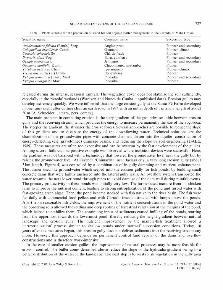
The main problem in combating erosion is the steep gradient of the groundwater table between erosiongully and the receiving stream, which provides the energy to increase permanently the size of the vocoroca.The steeper the gradient, the stronger the erosive forces. Several approaches are possible to reduce the slopeof this gradient and to dissipate the energy of the downflowing water. Technical solutions are thechannelization of the groundwater pipes with concrete channels driven into the aquifer, construction ofenergy-deflecting (e.g. gravel-filled) drainage basins, and reducing the slope by soil engineering (DAEE,1989). These measures are often too expensive and can be overrun by the fast development of the gullies.Among several failures, one positive example was observed where technical devices were successful. Here,the gradient was not balanced with a technology that lowered the groundwater level near the gully but byraising the groundwater level. At Fazenda ‘Chimarrita’ near Jaciara city, a very long erosion gully (about3 km length, Figure 4) was controlled by a combination of in-gully damming and nutrient enhancement.The farmer used the groundwater which seeped into the erosion gully for fish ponds, by building smallconcrete dams that were tightly anchored into the lateral gully walls. An overflow system transported thewater towards the next lower pond through pipes to avoid damage of the dam wall during rainfall events.The primary productivity in these ponds was initially very low. The farmer used manure from his chickenfarm to improve the nutrient content, leading to strong eutrophication of the pond and turbid water withfast-growing green algae. Then, the pond became stocked with fish native to the river basin. The fish werefed daily with commercial food pellets and with Cerrado insects attracted with lamps above the ponds.Apart from reasonable fish yields, the improvement of the nutrient concentrations in the pond water andthe bordering soils allowed the settling and deep rooting of terrestrial vegetation at the margins of the pond,which helped to stabilize them. The continuing input of sediments caused infilling of the ponds, startingfrom the uppermost towards the lowermost pond, thereby reducing the height gradient between naturallandscape and erosion gully. The nutrient improvement by the manure/fish treatment allowed a‘terrestrialization’ process similar to shallow ponds under ‘normal’ succession conditions. Today, 10years after the measures began, this erosion gully does not deliver sediments into the receiving stream anymore. However, this approach depends on permanent control (and repair) of the dams and overflowconstructions and is therefore work-intensive.
In the case of smaller erosion gullies, the improvement of natural processes may be more feasible forerosion control. The buffer zones described above reduce the slope of the hydraulic gradient owing to abetter distribution of the water in the landscape. The next step is to reestablish vegetation in the gully area
Table 7. Plants suitable for the production of wood for soil organic matter management in the Cerrado of Mato Grosso
Scientific name Common name Succession type
Anadenanthera falcata (Benth.) Speg. Angico preto Pioneer and secondaryCalophyllum brasiliensis Camb. Guanandi Pioneer–climaxCasearia sylvestris Sw. Cha-de-frade PioneerDypterix alata Vog. Baru, cumbaru Pioneer and secondaryGenipa americana L. Jenipapo Pioneer and secondaryGuazuma ulmifolia Kunth Chico-magro, mutamba PioneerTabebuia ochracea Cham. Ipe-amarelo Pioneer–climaxTrema micrantha (L.) Blume Periquiteira PioneerXylopia aromatica (Lam.) Mart. Pindaıba Pioneer and secondaryXylopia emarginata Mart. Pindaıba Pioneer
STREAM-VALLEY SYSTEMS OF THE BRAZILIAN CERRADO 727
Copyright # 2006 John Wiley & Sons, Ltd. Aquatic Conserv: Mar. Freshw. Ecosyst. 16: 713–732 (2006)
DOI: 10.1002/aqc

in a sustainable way. Several studies suggest how to introduce woody vegetation in erosion gullies andgallery forests (Rodrigues et al., 1999; Rodrigues and Leitao-Filho, 2000); however, most of them are verycost-intensive. We observed the development of several erosion gullies during 13 years and natural plantsuccession occurred only in areas where: (a) the substrate was sufficiently stabilized, (b) the soil receivedadditional nutrients, and (c) the water supply was controlled. At Fazenda ‘Santa Fe’, water access to anerosion gully was reduced by contour tillage far above the upper end of the erosion gully so that thebaseflow in the gully was reduced to 5L s�1. Dramatic flow events (up to 100L s�1) occurred only duringrain storms. The nearby vegetation delivered large amounts of seeds (e.g. Vochysia haenkeana), but in spiteof a high density of saplings (about 2000–5000 ind.m�2) none of them established successfully through lackof nutrients. Later, the farmer enriched the soil nutrient content by applying pelleted manure and pomace(fruit residue). This enrichment caused a rapid growth of filamentous algae in the gully rivulet and intensivecolonization of the margins with herbaceous plants; however, the substrate mobility still preventedsuccession of woody plants. In an experiment, we split sugar canes and fixed them to the bottom of theerosion gully with stakes. Splitting the canes enhanced rooting, and the large carbohydrate reserves in thecanes provided sufficient energy for the plants to sprout from each node. The vertical sprouts, in turn,retained further organic particles during flow-pulse events. A year after the experiment, the bottom of thearea was significantly more stable than the untreated area, and growth of woody plants (Cecropiapachystachya) was observed. In the past 20 years, we never observed spread of sugarcane plants from thefields into the Cerrado habitats; therefore this technique appears to cause no risk from invasive plantspecies. Care has to be taken to select non-invasive species. Other species often suggested for erosioncombat, e.g. Vetiver grass (Vetiveria zizanioides), are listed as invaders (at least the fertile races of thespecies) by the USDA Forest Service (USDA, 2005). Once the erosion gully has a better equilibrium in
dams
contourtillage
chickenfarm
galleryforest
Figure 4. Unusual taming of a large erosion gully. A system of dams inside the gully accumulates water and nutrients and allows fishponds to develop. A patch gallery forest of the Brilhante stream (lower left) is still in a near-natural stage.
K.M. WANTZEN ET AL.728
Copyright # 2006 John Wiley & Sons, Ltd. Aquatic Conserv: Mar. Freshw. Ecosyst. 16: 713–732 (2006)
DOI: 10.1002/aqc

terms of water, nutrient and sediment dynamics attained by the measures described above, we suggestimproving natural succession by planting or seeding out pioneer species and local gallery forest tree species,which can also provide economic benefits after successful establishment (Table 8).
CONCLUSIONS
Cerrado streams and their valleys represent a landscape unit which bears a high and largely unknownbiodiversity and which is extremely sensitive to erosion impacts. Compared with human alterations knownfrom other areas, such as excessive use of fertilizers, pesticides, input of sewage, release of exotic species,etc., the erosion effects are the most severe threat for Cerrado streams, which most urgently needrestoration. All streams studied in the area have shown severe impairment of their habitat quality, andconservation and restoration measures are overdue. The strategy proposed here } i.e. strict conservation ofthe most sensitive core zone of the stream valleys and reestablishment of native woody vegetation in thetransition to the interfluves, with additional protection from grassy vegetated buffer strips } appears to be
Table 8. Plants suitable for replanting stabilized erosion gullies in the Cerrado of Mato Grosso
Scientific name Common name Height (m) Economically useful productsDiameter (cm)
Anadenanthera peregrina (L) Spreng. Angico 15m Wood50 cm
Buchenavia tomentosa Eichl. Tarumarana 15m Wood30 cm
Cecropia pachystachya Chamb. Embauba 20m Wood20 cm
Cordia glabrata Mart. Louro branco 15m Wood50 cm
Hancornia speciosa Gomez Mangaba 12m Fruits15 cm
Hymenaea stigonocarpa (Mart.) Jatoba do cerrado 15m Wood40 cm
Inga spp. Inga 8m Fruits for wildlife25 cm
Myracrodruon urundeuva (Fr. All.) Engl. Aroeira 15m Wood60 cm
Qualea multiflora Mart. Pau-de-tucano 15m Wood25 cm
Rapanea guianensis Aubl. Caapororoca 10m Fruits for birds25 cm
Sclerolobium paniculatum Vog. Taxi-branco 15m Wood60 cm
Stryphnodendron adstringens (Mart.) Coville Barbatimao 8m Tannins25 cm
Tapirira guianensis Aubl. Pau-pombo 10m Fruits for birds, wood40 cm
Vismia guianensis (Aubl.) Choisy Pau-de-lacre 15m Bioactive aromatic compounds, wood30 cm
Xylopia aromatica (Lam.) Mart. Pindaıba 15m Wood and spices20 cm
Xylopia emarginata Mart. Pindaıba-d’agua 15m Wood20 cm
STREAM-VALLEY SYSTEMS OF THE BRAZILIAN CERRADO 729
Copyright # 2006 John Wiley & Sons, Ltd. Aquatic Conserv: Mar. Freshw. Ecosyst. 16: 713–732 (2006)
DOI: 10.1002/aqc

technically and economically feasible, as non-wood products provide an increasing economic return. Thecosts for the farmers consist of expenses for replanting the buffer strips (which can be reduced if rootstocksof Cerrado are still present) and a reduction of a very small portion of the agricultural production areawhich needs to be sacrificed for establishing of vegetated buffer strips. In the case of cattle ranches, theremay be additional costs for improving fences. On the other hand, the benefits include the reduction of soilloss to erosion, the additional income from the extraction of non-woody products (which can beconsiderable if these products can be used for the pharmaceutical industry) and the maintenance ofgroundwater levels which are of utmost importance for the local agriculture and for the water budget of thelandscape. By reducing erosion impacts, not only the stream valleys but also the agricultural fields willbenefit, as erosion has an impact on soil fertility (Tengberg et al., 1997). This integrated approach wouldintrinsically preserve the landscape functions of the Cerrado stream-valley systems which are (a) bufferingthe hydrological variability and maintenance of the continuous flow of the springs, (b) buffering theregional climatic effects, (c) buffering the impacts of agrochemicals, and (d) protecting soils and preventingerosion. The stream type (‘Cerrado Streams’; Wantzen, 2003) can be found in old, weathered catchmentswith tropical seasonal climates; therefore the conservation strategy suggested here may be useful in otherparts of the world, too, provided that the tree species lists are carefully adapted to the regional flora.
ACKNOWLEDGEMENTS
This paper resulted from cooperation between the Universidade Federal de Mato Grosso in Cuiaba and the Max-Planck-Institut fur Limnologie, Plon, Germany, under the Governmental Agreement on Technological Developmentbetween Germany and Brazil. The German Ministry of Science and Technology (BMBF, reg. no. 0339373B), theDeutsche Gesellschaft fur Technische Zusammenarbeit (GTZ, TOEB PN: 90.2136.1) and the Brazilian ResearchCouncil (CNPq, reg. no. 690001/97-5) have given financial and technical support. Travel grants were provided by theDLR-IB project BRA 02-26 to K.M.W. and C.N.C. Paul Rawiel measured and calculated the volume of the erosiongully. Thanks to Professor F.X. de Tavares Salomao, UFMT, for discussions on erosion gully development. The rapidassessment protocol was developed in cooperation with the leader of the Department of Aquatic ResourceConservation of the Mato Grosso State EPA, FEMA, Daniela Maimoni Figuereido. Nelson Laturner, from the StateConservation Unit at FEMA added information on the legal situation of gallery forests. Wolfgang J. Junk, AndrewBrooks and Vali Pott made valuable comments on the manuscript.
REFERENCES
Abelho M, Graca MAS. 1996. Effects of eucalyptus afforestation on leaf litter dynamics and macroinvertebratecommunity structure of streams in central Portugal. Hydrobiologia 324: 195–294.
Agostinho AA, Thomaz SM, Gomes LC. 2005. Conservation of the biodiversity of Brazil’s inland waters. ConservationBiology 19: 646–652.
Amorim C. 2004. Mata ciliar pode virar nova moeda em mercado de credito de carbono. Folha de Sao Paulo } Online.Electronic Citation: www.folha.com.br/ [31 August 2004].
Araujo LM, Franca AB, Potter PE. 1995. Aquifero Gigante do MERCOSUL no Brasil, Argentina, Paraguai eUruguai: Mapas hidrologicos. Technical report, UFPR e Petrobras, Curitiba, PR, Brazil.
Araujo GM, Barbosa AAA, Arantes AA, Amaral AF. 2002. Composicao florıstica de veredas no Municıpio deUberlandia, MG. Revista Brasileira de Botanica 25: 475–493.
Baccaro CAD. 1999. Processos erosivos no domınio do Cerrado. In Erosao e Conservacao dos Solos: Conceitos, Temas eAplicacoes, Guerra AJF, da Silva AS, Botelho RGM (eds). Bertrand Brazil: Rio de Janeiro; 195–227.
Bartley R, Rutherfurd I. 2005. Measuring the reach-scale geomorphic diversity of streams: application to a streamdisturbed by a sediment slug. River Research and Applications 21: 39–59.
Bispo PC, Neves CO, Froehlich CD. 2005. Two new species of Perlidae, Plecoptera, from Mato Grosso State, WesternBrazil. Zootaxa 795: 1–6.
K.M. WANTZEN ET AL.730
Copyright # 2006 John Wiley & Sons, Ltd. Aquatic Conserv: Mar. Freshw. Ecosyst. 16: 713–732 (2006)
DOI: 10.1002/aqc

Close DC, McArthur C, Hagermann AE, Fitzgerald H. 2005. Differential distribution of leaf chemistry in eucalyptseedlings due to variation in whole-plant nutrient availability. Phytochemistry 66: 215–221.
Cochrane MA, Laurance WF. 2002. Fire as a large-scale edge effect in Amazonian forests. Journal of Tropical Ecology18: 325.
Coutinho LM. 1990. Ecological effects of fire in Brazilian Cerrado. In Ecological Studies 84: Fire in the Tropical Biota:Ecosystem Processes and Global Challenges, Goldammer JG (ed.). Springer: Berlin; 273–291.
Couto EG. 1990. O uso da terra e o garimpo na bacia do Rio Sao Lourenco, Mato Grosso } reflexos no ambiente.Technical report, FEMA, UFMT und CCA, Mato Grosso, Brazil.
DAEE. 1989. Controle de erosao: bases conceituais e tecnicas; diretrizes para o planejamento urbano e regional;orientacoes para o controle de bocorocas urbanas. Technical report, Departamento de Aguas e Energia Eletrica(DAEE) da Secretaria de Energia e Saneamento, Sao Paulo, Brazil.
Eiten G. 1982. Brazilian ‘savannas’. In Ecology of Tropical Savannas, Huntley BJ, Walker BH (eds). Springer: Berlin;25–47.
Felfili JM, Silva MC. 1992. Floristic composition, phytosociology and comparison of cerrado and gallery forests atFazenda Agua Limpa, Federal District, Brazil. In Nature and Dynamics of Forest–Savanna Boundaries, Furley PA,Proctor JA, Ratter JA (eds). Chapman & Hall: London; 393–415.
Fett LP. 2000. Controle dos processos erosivos na Bacia do Rio Brilhante MT como subsıdio da recuperacao de areasdegradadas. Masters thesis, Instituto de Biociencias, Universidade Federal de Mato Grosso, Brazil.
Guarim Neto G, Morais RG. 2003. Recursos medicinais de especies do Cerrado de Mato Grosso: um estudobibliografico. Acta Botanica Brasileira 17: 561–584.
Haycock N, Burt T, Goulding K, Pinay G (eds). 1997. Buffer Zones: Their Processes and Potential in Water Protection.Quest Environmental: Harpenden, UK.
IBAMA. 2005. Ecossistemas Brasileiros } Cerrado. Electronic citation: http://www.ibama.gov.br/ [13 January2005].
IBGE. Instituto Brasileiro de Geografia e Estatıstica 2005. Carta do Brasil ao Milionesimo. Folha SD 21 Cuiaba.Electronic citation: http://www2.ibge.gov.br/pub/Cartas e Mapas/Carta Internacional ao Milionesimo/shape/ [02April 2005].
Junk WJ, da Silva CJ, Wantzen KM, Nunes da Cunha C, Nogueira F. In press. The Pantanal of Mato Grosso: status ofecological research, actual use, and management for sustainable development. In The Wetlands Handbook, Maltby E(ed.). Blackwell Science: Oxford.
Klink CA, Machado RB. 2005. Conservation of the Brazilian Cerrado. Conservation Biology 19: 707–713.Laabs VW, Amelung AA, Pinto M, Wantzen KM, da Silva CJ, Zech W. 2002. Pesticides in surface water,sediments and rainfall of the north-eastern Pantanal basin, Brazil. Journal of Environmental Quality 31:1636–1648.
Laabs VW, Amelung W, Pinto AA, Altstaedt A, Zech W. 2000. Leaching and degradation of corn and soybeanpesticides in an Oxisol of the Brazilian Cerrados. Chemosphere 41: 1441–1449.
Likens GE. 2001. Biogeochemistry, the watershed approach: some uses and limitations. Marine and FreshwaterResearch 52: 5–12.
Machado PAL. 2004. Direito Ambiental Brasileiro. Malheiros Ed.: Sao Paulo.Mantovani W. 2003. A degradacao dos biomas brasileiros. In Patrimonio Ambiental Brasileiro, Ribeiro WC (ed.).Universidade de Sao Paulo, Imprensa Oficial do Estado de Sao Paulo: Sao Paulo; 369–439.
Mendonca RC, Felfili JM, Walter BMT, Silva MC, Resende AV, Filgueiras TS, Nogueira PE. 1998. Flora vascular doCerrado. In Cerrado } Ambiente e Flora, Sano SM, Almeida SP (eds). EMBRAPA-CPAC: Planaltina, DF, Brazil;289–556.
Mittermeier RA, Myers N, Mittermeier CG. 1999. Hot Spots } Earth’s Biologically Richest and Most EndangeredTerrestrial Ecoregions. CEMEX, Conservation International: New York.
Oliveira-Filho AT, Shepherd JG, Martins FM, Stubblebine WH. 1989. Environmental factors affecting physiognomicand floristic variation in an area of cerrado in central Brazil. Journal of Tropical Ecology 5: 413–431.
Osborne LL, Kovacic DA. 1993. Riparian vegetated buffer strips in water-quality restoration and stream management.Freshwater Biology 29: 243–258.
Parolin P. 2001. Growth, productivity and use of trees in white water floodplains. In The Central Amazon Floodplain:Actual Use and Options for a Sustainable Management, Junk WJ, Ohly JJ, Piedade Maria TF, Soares GM (eds).Backhuys: Leiden, The Netherlands; 375–391.
Plafkin JL, Barbour MT, Porter KD, Gross SK, Hughes RM. 1989. Rapid Bioassessment Protocols for Use in Streamsand Rivers RPBS. EPA/440/4-89/001, United States Environmental Protection Agency: Columbus, Ohio.
Ratter JA, Ribeiro JF, Bridgewater S. 1997. The Brazilian Cerrado vegetation and threats to its biodiversity. Annals ofBotany 80: 223–230.
STREAM-VALLEY SYSTEMS OF THE BRAZILIAN CERRADO 731
Copyright # 2006 John Wiley & Sons, Ltd. Aquatic Conserv: Mar. Freshw. Ecosyst. 16: 713–732 (2006)
DOI: 10.1002/aqc

Reid JW. 1984. Semiterrestrial meiofauna inhabiting a wet campo in Central Brasil, with special reference to theCopepoda Crustacea. Hydrobiologia 118: 95–111.
Ribeiro JF, Walter BMT. 1998. Fitofisionimas do bioma Cerrado. In Cerrado } Ambiente e Flora, Sano SM, AlmeidaSP (eds). EMBRAPA-CPAC: Planaltina, DF, Brazil; 89–166.
Ribeiro SP, Braga AO, Silva CHL, Fernandes GW. 1999. Leaf polyphenols in Brazilian Melastomataceae: sclerophylly,habitats, and insect herbivores. Ecotropica 5: 137–146.
Rocha GF. 1997. O grande manancial do Cone Sul. Estudos Avancados da Universidade de Sao Paulo 30: 191–212.Rodrigues RR, Leitao-Filho HF. 2000. Matas Ciliares } Conservacao e Recupercao. EDUSP, University of Sao PauloPublishers: Sao Paulo.
Rodrigues RR, Monteiro JRB, Barros LTLP, Albuquerque L, Pinto V, Borges LMK, Tolello VM, Martins AL. 1999.Metodologia para Recuperacao de Areas Degradadas Pela Agricultura: Estudo de Caso do Rio Brilhante, Jaciara, MT.IBAMA: Cuiaba, Brazil.
Salomao FXT. 1999. Controle e prevencao dos processos erosivos. In Erosao e Conservacao dos Solos: Conceitos, Temase Aplicacoes, Guerra AJ, da Silva AS, Botelho RGM (eds). Bertrand Brazil: Rio de Janeiro; 229–267.
Santos MV, Rosa JW, Chaves HML, Ribeiro M, Meneses PR, Leite AS, Alvarenga FS, Silva MVF, Oliveira RB. 1997.Mapping of the Gallery Forests and marshes of the Gama cabeca-de-veado environmental area: evolution ofdegradation in the period between 1953–1992 and the estimation of their original areas. In Proceedings of theInternational Symposium on Assessment and Monitoring of Forests in Tropical Dry Regions with Special Reference toGallery Forests, Imana-Encinas J, Kleinn C (eds). University of Brasilia Publishers: Brasilia; 69–76.
Siqueira A. 2004. Zoneamento paisagıstico de parte do Vale do Rio Tenente Amaral, como subsıdio ao Plano deManejo da Estrada-Parque Cachoeira da Fumaca, Jaciara, Mato Grosso. Fundacao Estadual do Meio Ambiente deMato Grosso. Technical report, Cuiaba, Mato Grosso, Brazil.
Tengberg A, Stocking M, Dechen SCF. 1997. The impact of erosion on soil productivity } an experimental designapplied in Sao Paulo State, Brazil. Geografiska Annaler 79: 95–107.
USDA Forest Service. 2005. Regional invasive exotic plant species list. Electronic citation: http://www.se-eppc.org/fslist.cfm [10 April 2005].
Vasconcelos TNN. 1998. Interpretacao morfopedologica da Bacia do Rio Tenente Amaral } Jaciara-MT: condicaobasica para sua caracterizacao ambiental. Masters thesis, Instituto de Biociencias, Universidade Federal de MatoGrosso, Cuiaba, Brazil.
Wantzen KM. 1997. Influence of Man-made Siltation on Habitat Structure and Biotic Communities of Cerrado Streamsof Mato Grosso. H. Utz: Munich.
Wantzen KM. 1998a. Abschatzung der Umweltwirkungen von anthropogen bedingter Bodenerosion auf dieFliessgewasser mittels Biomonitoring, Mato Grosso, Brasilien Analysis of environmental impacts of man-madesoil erosion on running water ecosystems using biomonitoring in Mato Grosso, Brazil. Technical report, DeutscheGesellschaft fur Technische Zusammenarbeit GTZ GmbH, Eschborn, Germany.
Wantzen KM. 1998b. Effects of siltation on benthic communities in clear water streams in Mato Grosso, Brazil.Verhandlungen der Internationalen Vereinigung fur theoretische und angewandte Limnologıe 26: 1155–1159.
Wantzen KM. 1999. Effects of suspended sediments on aquatic organisms in streams in the Upper Rio Paraguay Basin.In Proceedings of the 3rd SHIFT-Workshop in Manaus 1998, Lieberei R, Voss K, Bianchi H (eds). University ofHamburg, Hamburg, Germany.
Wantzen KM. 2003. Cerrado streams } characteristics of a threatened freshwater ecosystem type on the tertiary shieldsof South America. Amazoniana 17: 485–502.
Wantzen KM. 2006. Physical pollution: effects of gully erosion on benthic invertebrates of a tropical clear-water stream.Aquatic Conservation: Marine and Freshwater Ecosystems 16: 733–749.
Wantzen KM, Junk WJ. 2000. The importance stream-wetland-systems for biodiversity: a tropical perspective. InBiodiversity in Wetlands: Assessment, Function and Conservation, vol. 1, Junk WJ, Gopal B, Davis JA (eds). Backhuys:Leiden; 11–34.
Wantzen KM, Drago E, da Silva CJ. 2005. Aquatic habitats of the Upper Paraguay River–Floodplain system and partsof the Pantanal Brazil. Ecohydrology and Hydrobiology 5: 107–126.
Wishmeier W. 1984. The USLE } some reflections. Journal of Soil and Water Conservation 39: 105–107.Wissmar RC, Beer WN, Timm RK. 2004. Spatially explicit estimates of erosion-risk indices and variable riparian bufferwidths in watersheds. Aquatic Sciences 66: 446–455.
K.M. WANTZEN ET AL.732
Copyright # 2006 John Wiley & Sons, Ltd. Aquatic Conserv: Mar. Freshw. Ecosyst. 16: 713–732 (2006)
DOI: 10.1002/aqc