Species-based versus habitat-based evaluation for conservation status assessment of habitat types in...
7
Journal for Nature Conservation 19 (2011) 269–275 Contents lists available at ScienceDirect Journal for Nature Conservation jou rn al h omepage: www.elsevier.de/jnc Species-based versus habitat-based evaluation for conservation status assessment of habitat types in the East Aegean islands (Greece) Maria Panitsa a,∗ , Nikos Koutsias a , Ioannis Tsiripidis b , Anastasios Zotos a , Panayotis Dimopoulos a a Department of Environmental and Natural Resources Management, University of Ioannina, G. Seferi 2, GR-30100 Agrinio, Greece b Department of Botany, School of Biology, Aristotle University of Thessaloniki, GR-54124 Thessaloniki, Greece a r t i c l e i n f o Article history: Received 16 December 2009 Received in revised form 28 March 2011 Accepted 11 April 2011 Keywords: Conservation assessment Conservation mapping Habitats diversity Island ecosystems Multi-criteria analysis a b s t r a c t This paper describes an integrated GIS-based methodology for conservation value assessment using the traditional species-based and a habitat-based multi-criteria evaluation. The methodology was applied to 49 small islands and islets in the East Aegean area, belonging to a SCI Natura 2000 site. The species- based (botanical approach) conservation status assessment attributes a specific weight to the parameter of endemism, while the multi-criteria evaluation (MCE) approach emphasises the criteria of diversity, rarity, naturalness, replaceability and threat on each habitat type in combination with the number of significant taxa. The conservation values attained from the two approaches are significantly correlated, but the multi-criteria approach is more effective as it includes all the habitat types within the study area in the 25% of the polygons with the highest conservation values. Furthermore, results from the multi- criteria analysis were more in line with subjective assessments of the conservation value of the habitat types than the ones obtained by the botanical approach. © 2011 Elsevier GmbH. All rights reserved. Introduction The European Habitats Directive (92/43/EU) introduced the concept of a pan-European ecological network of protected sites entitled Natura 2000. EU Member States are obliged to estab- lish conservation measures to maintain or restore a favourable conservation status and develop monitoring systems for surveil- lance of the effectiveness of the conservation measures applied (Dimopoulos, Bergmeier, & Fischer, 2006; Mander, Mitchley, Xofis, Keramitsoglou, & Bock, 2005). The contribution and the effectiveness of the Natura 2000 network to biodiversity conser- vation at species level has been assessed in different areas by Dimitrakopoulos et al. (2004), Majorano et al. (2007) and Chiarrucci et al. (2008). With the exception of a few habitat types recognised only on the basis of geomorphological and abiotic features, the great majority of the sites are defined by vegetation types (Evans 2006), follow- ing the phytosociological classification of European vegetation (e.g. Papastergiadou et al. 1997). Most evaluation methods for nature conservation and enhancement of biodiversity at species and habi- tat level at a European scale, therefore use vegetation as more indicative of the structure and functioning of terrestrial ecosystem Abbreviations: EU, European Union; SCI, Site of Community Importance; MCE, multiple criteria evaluation; GIS, Geographic Information System; IUCN, Interna- tional Union for Conservation of Nature. ∗ Corresponding author. Tel.: +30 26410 74187; fax: +30 26410 74176. E-mail address: [email protected] (M. Panitsa). (Kent & Coker 1992; van der Maarel 2005) because of its ecologi- cal complexity compared to single categories of taxa (Margules & Sarkar 2007). The assessment of the conservation value of different areas is usually based on scoring or iterative techniques. Scoring proce- dures use several criteria to score areas and rank them according to an accumulation of scores. These procedures are considered less effective than the modern iterative approaches of systematic conservation planning, based on the concepts of complementarity and irreplaceability (Margules & Pressey 2000; Margules & Sarkar 2007; Margules et al. 2002; Pressey & Nicholls 1989). However, in order to apply the latter methods a relatively comprehensive data set of biodiversity surrogates is needed. Scoring procedures may therefore comprise an initial step to nature conservation evalua- tion where more detailed data are lacking. The scarcity of resources that many Mediterranean countries face, particularly in the south and east, dictates that a realistic conservation plan should involve some form of prioritisation among the possible conservation tar- gets (Vogiatzakis et al. 2006). Endemic and/or threatened species are often used in order to set conservation priorities (Bonn et al. 2002) but a wide range of other criteria have been used in nature conservation for this prioritisation (Heywood & Watson 1995) including naturalness, replaceability, threat, floristic-phytocoenotic value and rarity (Dimopoulos et al. 2000; Loidi 1994; Machado 2004). These criteria are applied using scoring techniques or in more sophisticated methods such as the multi-criteria analysis (Boteva et al. 2004; Margules & Sarkar 2007; Margules & Usher 1981; Pressey & Nicholls 1989). 1617-1381/$ – see front matter © 2011 Elsevier GmbH. All rights reserved. doi:10.1016/j.jnc.2011.04.001
Transcript of Species-based versus habitat-based evaluation for conservation status assessment of habitat types in...

Sa
Ma
b
a
ARRA
KCCHIM
I
celcl(XevDe
boiPcti
mt
1d
Journal for Nature Conservation 19 (2011) 269– 275
Contents lists available at ScienceDirect
Journal for Nature Conservation
jou rn al h omepage: www.elsev ier .de / jnc
pecies-based versus habitat-based evaluation for conservation statusssessment of habitat types in the East Aegean islands (Greece)
aria Panitsaa,∗, Nikos Koutsiasa, Ioannis Tsiripidisb, Anastasios Zotosa, Panayotis Dimopoulosa
Department of Environmental and Natural Resources Management, University of Ioannina, G. Seferi 2, GR-30100 Agrinio, GreeceDepartment of Botany, School of Biology, Aristotle University of Thessaloniki, GR-54124 Thessaloniki, Greece
r t i c l e i n f o
rticle history:eceived 16 December 2009eceived in revised form 28 March 2011ccepted 11 April 2011
eywords:
a b s t r a c t
This paper describes an integrated GIS-based methodology for conservation value assessment using thetraditional species-based and a habitat-based multi-criteria evaluation. The methodology was appliedto 49 small islands and islets in the East Aegean area, belonging to a SCI Natura 2000 site. The species-based (botanical approach) conservation status assessment attributes a specific weight to the parameterof endemism, while the multi-criteria evaluation (MCE) approach emphasises the criteria of diversity,
onservation assessmentonservation mappingabitats diversity
sland ecosystemsulti-criteria analysis
rarity, naturalness, replaceability and threat on each habitat type in combination with the number ofsignificant taxa. The conservation values attained from the two approaches are significantly correlated,but the multi-criteria approach is more effective as it includes all the habitat types within the study areain the 25% of the polygons with the highest conservation values. Furthermore, results from the multi-criteria analysis were more in line with subjective assessments of the conservation value of the habitat
ned b
types than the ones obtaintroduction
The European Habitats Directive (92/43/EU) introduced theoncept of a pan-European ecological network of protected sitesntitled Natura 2000. EU Member States are obliged to estab-ish conservation measures to maintain or restore a favourableonservation status and develop monitoring systems for surveil-ance of the effectiveness of the conservation measures appliedDimopoulos, Bergmeier, & Fischer, 2006; Mander, Mitchley,ofis, Keramitsoglou, & Bock, 2005). The contribution and theffectiveness of the Natura 2000 network to biodiversity conser-ation at species level has been assessed in different areas byimitrakopoulos et al. (2004), Majorano et al. (2007) and Chiarruccit al. (2008).
With the exception of a few habitat types recognised only on theasis of geomorphological and abiotic features, the great majority
f the sites are defined by vegetation types (Evans 2006), follow-ng the phytosociological classification of European vegetation (e.g.apastergiadou et al. 1997). Most evaluation methods for natureonservation and enhancement of biodiversity at species and habi-at level at a European scale, therefore use vegetation as morendicative of the structure and functioning of terrestrial ecosystemAbbreviations: EU, European Union; SCI, Site of Community Importance; MCE,ultiple criteria evaluation; GIS, Geographic Information System; IUCN, Interna-
ional Union for Conservation of Nature.∗ Corresponding author. Tel.: +30 26410 74187; fax: +30 26410 74176.
E-mail address: [email protected] (M. Panitsa).
617-1381/$ – see front matter © 2011 Elsevier GmbH. All rights reserved.oi:10.1016/j.jnc.2011.04.001
y the botanical approach.© 2011 Elsevier GmbH. All rights reserved.
(Kent & Coker 1992; van der Maarel 2005) because of its ecologi-cal complexity compared to single categories of taxa (Margules &Sarkar 2007).
The assessment of the conservation value of different areas isusually based on scoring or iterative techniques. Scoring proce-dures use several criteria to score areas and rank them accordingto an accumulation of scores. These procedures are consideredless effective than the modern iterative approaches of systematicconservation planning, based on the concepts of complementarityand irreplaceability (Margules & Pressey 2000; Margules & Sarkar2007; Margules et al. 2002; Pressey & Nicholls 1989). However, inorder to apply the latter methods a relatively comprehensive dataset of biodiversity surrogates is needed. Scoring procedures maytherefore comprise an initial step to nature conservation evalua-tion where more detailed data are lacking. The scarcity of resourcesthat many Mediterranean countries face, particularly in the southand east, dictates that a realistic conservation plan should involvesome form of prioritisation among the possible conservation tar-gets (Vogiatzakis et al. 2006).
Endemic and/or threatened species are often used in order to setconservation priorities (Bonn et al. 2002) but a wide range of othercriteria have been used in nature conservation for this prioritisation(Heywood & Watson 1995) including naturalness, replaceability,threat, floristic-phytocoenotic value and rarity (Dimopoulos et al.
2000; Loidi 1994; Machado 2004). These criteria are applied usingscoring techniques or in more sophisticated methods such as themulti-criteria analysis (Boteva et al. 2004; Margules & Sarkar 2007;Margules & Usher 1981; Pressey & Nicholls 1989).
2 ture C
iAaete
tntDtss&tstm
sWkmtoutss
imclEGoacum
S
mA((Aoo8if
eirarzst
70 M. Panitsa et al. / Journal for Na
GIS techniques are increasingly applied in nature conservationssues and many of them use vegetation communities as a basis.costa et al. (2005) combined land cover mapping with vegetationnalyses of coastal dunes. Dimitrakopoulos et al. (2004) and Botevat al. (2004), similarly applied GIS technology to examine the effec-iveness of the Natura 2000 network in Crete (Greece) and also tovaluate and map the conservation significance of habitats.
Lang and Langanke (2005) and Bock et al. (2005) suggestedhat the multi-scale GIS tools are also suitable for use outside thearrow focus of Natura 2000 sites monitoring and they stressedheir wider application potential for nature conservation purposes.ecision-making schemes can be supported within GIS software,
hus allowing the testing of different conservation options andcenarios based on spatial analysis of existing data for habitatuitability assessment or modelling (Ortigosa et al. 2000; Store
Kangas 2001). Stalmans et al. (2001) refer to the major advan-ages of GIS in environmental management, due to its capacity totore the information gathered in long-term monitoring programs,hus capturing the wealth of knowledge from one generation of
anagers and researchers to the next.Carter et al. (2006) presented a rapid approach for modelling
pecies–habitat relationships, while Store and Kangas (2001) andu and Smeins (2000) used multi-criteria evaluation, expert
nowledge for GIS-based habitat suitability modelling and aultiple-scale habitat modelling approach for rare plant conserva-
ion. Pressey and Logan (1998) gave the specification of an eligibler adequate habitat reserve to ensure long-term viability of individ-al species; Kirkpatrick (1983) and Margules et al. (1988), startedhe focus on the cost of conservation when they proposed modelsupporting the selection and design of sites for protected habitattatus.
The aim of the present paper is formulated with the question ofmproving the known approaches in order to optimize and make
ore objective the assessment of the conservation status of plantommunities (and their habitat types), as well as of their concernedandscapes. We selected 49 small islands and islets situated in theast Aegean in a designated Site of Community Importance of thereek Natura 2000 network: (a) to assess the conservation valuef habitats using the species based (traditional botanical) approachnd a habitat based multi-criteria approach; and, (b) to produceonservation significance maps based on the different methodssed and to compare them and their implications on conservationanagement.
tudy area
Four small island groups included in the designated Site of Com-unity Importance of the Natura 2000 network in Greece, namelyrki, Lipsi, Agathonisi and Kalolimnos situated in the East Aegean
49 small islands and islets in total), comprise the studied areaFig. 1). Each one of the four groups includes a larger island, beingrki, Lipsi, Agathonisi and Kalolimnos themselves, and a numberf offshore islets. The total surface area of the site is 12,407 ha,f which the terrestrial and the marine parts cover 4160 ha and247 ha, respectively. The site consists of 45 islets with sizes rang-
ng from 0.05 ha to 50 ha and four small islands with sizes rangingrom 386.6 ha for Farmakonisi to 1593 ha for Lipsos.
Each islet consists of a low altitude land formation with the high-st point being 277 m a.s.l. on Lipsos. The geological profiles of theslands are quite uniform, characterised by low grade metamorphicocks, although conglomerate layers, marls and marly limestonesre also present. The smaller islets are dominated by psammitic
ocky formations. The area belongs to the sub-humid bioclimaticone with mild winters. Detailed information about the islet names,urface, altitude, degree of geographical isolation and exact posi-ion, climate, geology and geomorphology, as well as the flora,onservation 19 (2011) 269– 275
vegetation and ecology of the area and the human impacts affectingeach islet is given in Panitsa and Tzanoudakis (1998, 2001). Variousfactors affect plant species richness and endemism on land-bridgeislands but habitat diversity, of which elevation is a surrogate, isthe most important (Panitsa et al. 2010); the combined effect ofarea and environmental heterogeneity is superior to area alonein explaining species richness (Panitsa, Tzanoudakis, Triantis, &Sfenthourakis, 2006).
Methods
Vegetation survey, community classification and mapping
To represent the ecological variation in the study area andto provide data for community classification, 169 relevés weresampled using the Braun–Blanquet method (Mueller-Dombois &Ellenberg 1974). All the plant communities are described by at leastfive relevés to ensure each habitat type is adequately representedin the data set. For each relevé, a detailed protocol was compiledincluding a list of the species present, environmental data includingaspect, slope and altitude, as well as characteristics of vegetationstructure such as, life-form, height and percentage cover of all dis-tinguished layers (van der Maarel 2005).
The total data set of 169 sample plots was stored and edited bythe TURBOVEG ver. 2 database system (Hennekens and Schaminée2001). Vegetation and habitat type mapping was then carried outusing manual photo-interpretation of a series of aerial photographsand organised in a GIS environment. Classification of relevés wasassisted by the two-way indicator species analysis (TWINSPAN)(Hill 1979).
Conservation value assessment methods
Species based (botanical) approachGiven that, there is usually no information available for all
species, selecting priority areas for conservation by targetingendemic and/or threatened species may be the first step towardsan effective reserve network (Bonn et al. 2002). The number ofimportant plant taxa such as endemic, rare, threatened/vulnerableon each islet and island was used here, as the sole criterion in thebotanical approach. Narrow endemics such as Aegean endemics,East Aegean endemics or single island endemics provide evidencefor the paleogeographical history of each area, as well as its phyto-geographical connections to other areas. Using this approach, thearea (map polygon, island, islet, etc.) with the highest number ofimportant taxa receives the highest score.
Habitat based (multi-criteria) approachFor the multiple criteria evaluation (MCE) approach the infor-
mation received from several habitat-based criteria was combinedinto a single evaluation index. The most commonly used criteriaare diversity, rarity, naturalness, threat of human interference andreplaceability (Margules & Usher 1981; Usher 1986). The numberof endemic, rare and vulnerable or threatened taxa in each poly-gon can be used as an additional criterion. The latter criterion wasapplied in the present study using the number of important taxa ineach map polygon.
For each criterion a numerical value was assigned to each ofthe 145 mapped polygons according to the criteria described inTable 2; polygons including settlements were excluded. UsingESRI® ArcMap 9.3, the various criteria were combined into a sin-gle index by spatial overlay techniques and reclassified to definethe final conservation classes. The application of the multi-criteria
evaluation in a GIS environment is an additive technique wherebythe criterion scores are standardised; the total score for each alter-native is calculated by multiplying each criterion score by its weightfactor and then adding the results (Store & Kangas 2001).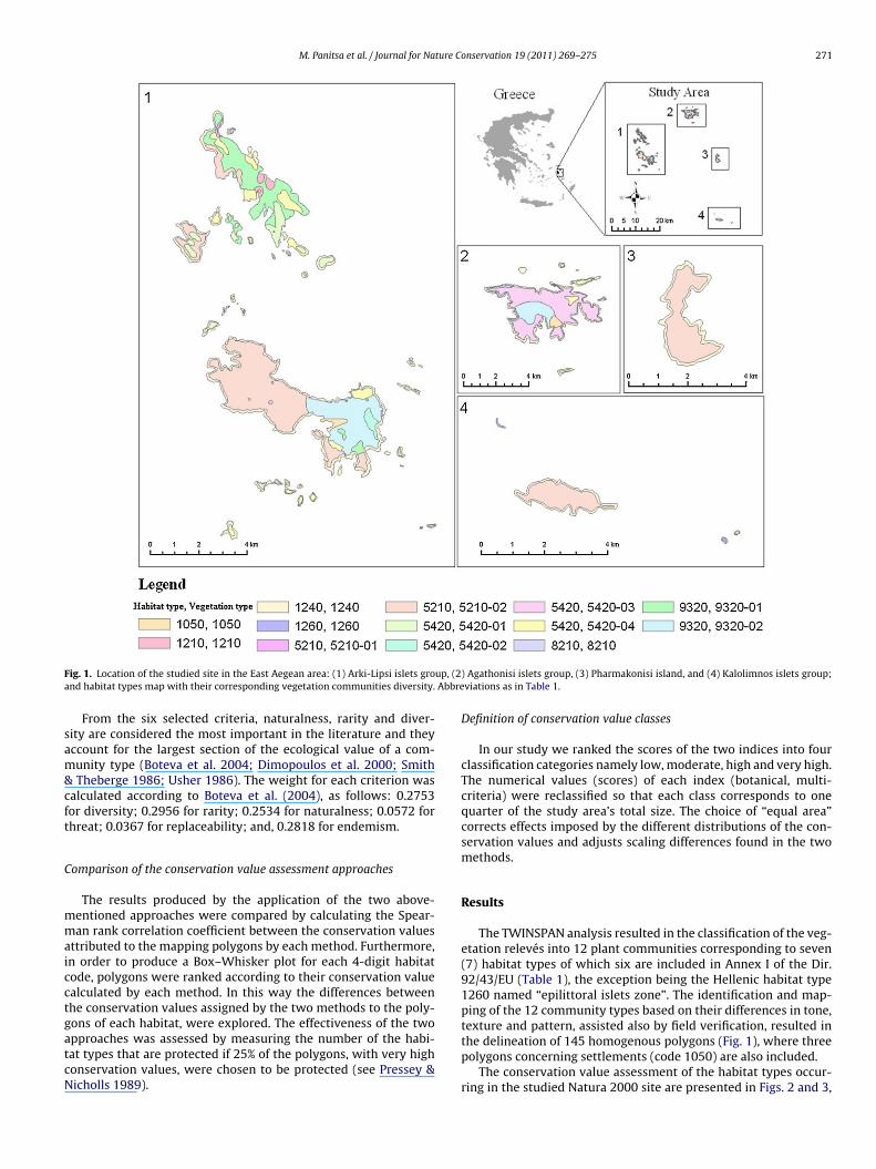
M. Panitsa et al. / Journal for Nature Conservation 19 (2011) 269– 275 271
F up, (2a Abbre
sam&cft
C
mmaicctgatcN
ig. 1. Location of the studied site in the East Aegean area: (1) Arki-Lipsi islets grond habitat types map with their corresponding vegetation communities diversity.
From the six selected criteria, naturalness, rarity and diver-ity are considered the most important in the literature and theyccount for the largest section of the ecological value of a com-unity type (Boteva et al. 2004; Dimopoulos et al. 2000; Smith
Theberge 1986; Usher 1986). The weight for each criterion wasalculated according to Boteva et al. (2004), as follows: 0.2753or diversity; 0.2956 for rarity; 0.2534 for naturalness; 0.0572 forhreat; 0.0367 for replaceability; and, 0.2818 for endemism.
omparison of the conservation value assessment approaches
The results produced by the application of the two above-entioned approaches were compared by calculating the Spear-an rank correlation coefficient between the conservation values
ttributed to the mapping polygons by each method. Furthermore,n order to produce a Box–Whisker plot for each 4-digit habitatode, polygons were ranked according to their conservation valuealculated by each method. In this way the differences betweenhe conservation values assigned by the two methods to the poly-ons of each habitat, were explored. The effectiveness of the two
pproaches was assessed by measuring the number of the habi-at types that are protected if 25% of the polygons, with very highonservation values, were chosen to be protected (see Pressey &icholls 1989).) Agathonisi islets group, (3) Pharmakonisi island, and (4) Kalolimnos islets group;viations as in Table 1.
Definition of conservation value classes
In our study we ranked the scores of the two indices into fourclassification categories namely low, moderate, high and very high.The numerical values (scores) of each index (botanical, multi-criteria) were reclassified so that each class corresponds to onequarter of the study area’s total size. The choice of “equal area”corrects effects imposed by the different distributions of the con-servation values and adjusts scaling differences found in the twomethods.
Results
The TWINSPAN analysis resulted in the classification of the veg-etation relevés into 12 plant communities corresponding to seven(7) habitat types of which six are included in Annex I of the Dir.92/43/EU (Table 1), the exception being the Hellenic habitat type1260 named “epilittoral islets zone”. The identification and map-ping of the 12 community types based on their differences in tone,texture and pattern, assisted also by field verification, resulted in
the delineation of 145 homogenous polygons (Fig. 1), where threepolygons concerning settlements (code 1050) are also included.The conservation value assessment of the habitat types occur-ring in the studied Natura 2000 site are presented in Figs. 2 and 3,
272 M. Panitsa et al. / Journal for Nature Conservation 19 (2011) 269– 275
Table 1Vegetation types with their corresponding habitat types, mapping codes and assignment in high-rank vegetation syntaxa. The habitat type not included in Annex I of Dir.92/43/EU is called Hellenic and is indicated with h. All other habitat types are included in Annex I of the Dir. 92/43/EEC.
Habitat types Vegetation type/community Mapping code High-rank syntaxa (Class, Order, Alliance)
5420 Phrygana/Genista acanthoclada–Sarcopoteriumspinosum comm.
5420-01 CISTO-MICROMERIETEA JULIANAE Oberd. 1954;Cisto-Micromerietalia Oberd. 1954; Hypericoempetrifolii-Micromerion graecae Barbero et Quezel1989.
5420 Phrygana/Erica manipuliflora–Genistaacanthoclada comm.
5420-02 CISTO-MICROMERIETEA JULIANAE Oberd.1954;Cisto-Micromerietalia Oberd. 1954; Cistion orientaleOberd. 1954.
5420 Phrygana/Euphorbiaacanthothamnos–Sarcopoterium spinosumcomm.
5420-03 CISTO-MICROMERIETEA JULIANAE Oberd. 1954;Cisto-Micromerietalia Oberd. 1954; Hypericoempetrifolii-Micromerion graecae Barbero et Quezel1989.5420 Phrygana/Sarcopoterium spinosum comm. 5420-04
8210 Aegean calcareous cliffs with chasmophyticcommunities
8210 ASPLENIETEA (Br.-Bl. in Meier et Br.-Bl. 1934)Oberd. 1977; Cirsietalia chamaepeucis Horvat inHorvat, Glavac et Ellenberg 1974; Inulionheterolepidis Horvat in Horvat, Glavac et Ellenberg1974.
9320 Olea and Ceratonia forests and matorrals/Olea& Ceratonia open woodlands
9320-01 QUERCETEA ILICIS Br.-Bl. ex A. de Bolos 1950;Pistacio-Rhamnetalia alaterni Rivas-Mart. 1975;Oleo-Ceratonion siliquae Br.-Bl. ex Guinochet etDrouineau 1944.
9320 Low evergreen scrub communities/Pistacialentiscus comm.
9320-02
1210 Annual vegetation of driftlines/Salsolo-Cakiletum aegypticae Costa etManz 1981
1210 CAKILETEA MARITIMAE Tx. et Preising ex Br.-Bl. etTx. 1952; Euphorbietalia peplis Tx. 1950;Euphorbion peplis Tx. 1950.
1240 Sea cliffs vegetation in the salt-spray zone ofthe Mediterranean/vegetation of crevices onrocky seacliffs
1240 CRITHMO-LIMONIETEA Br.-Bl. in Br.-Bl., Roussineet Negre 1952; Crithmo-Limonietealia Molinier1934; Crithmo-Frankenion hirsutae Mayer 1995.
126h Epilittoral islets zone/phryganic-halophyticand chasmo-halophytic communities
1260 CRITHMO-LIMONIETEA Br.-Bl. in Br.-Bl., Roussineet Negre 1952/CISTO-MICROMERIETEA JULIANAEOberd. 1954.
5210 Juniperus oxycedrus arborescentmattoral/Juniperus macrocarpa comm.
5210-01 QUERCETEA ILICIS Br.-Bl. ex A. de Bolos 1950;Pistacio-Rhamnetalia alaterni Rivas-Mart. 1975;Oleo-Ceratonion siliquae Br.-Bl. ex Guinochet et5210 Juniperus phoenicea arborescent 5210-02
oacH(stfts5rc
TD
mattoral/Juniperus phoenicea comm.
n the basis of the two approaches. The botanical approach exhibits significant (p < 0.01) positive correlation (0.522) with the multi-riteria approach according to the Spearman rank order correlation.owever, there are some differences between the two approaches
see Fig. 4) which concern mainly the median of the rank of con-ervation values within habitat types, as well as, for some habitats,he range of the rank of conservation values. The most striking dif-erences between the two approaches were found for the habitatsypes 1260 and 9320. On the other hand the evaluation of the con-
ervation values was more or less similar for the habitat types 5210,420 and 8210. These differences mean that if 25% of the highestanked polygons, based on the two assessment methods are to beonserved, then only three habitat types (5210, 5420, and 9320)able 2escription of the criteria used for the multi-criteria evaluation method.
Criterion Values Description
Diversity 0–35 It is the number of plant species diveroriginally in the sampling sites, at polthe median value within each polygo
Rarity 1–10 Rarity concerns geographical distribucommon, frequent to abundant, medi<10–100%.
Replaceability 1–10 Replaceability or resilience after distutransformation by natural or human crelict vegetation. In case of an intense
Threat 1–10 The indication of the threat criterion
(fragility), the dispersal capacity of thranges from 1 (aggressive communitidecreasing, species combination chanthe threat related to succession due to
Naturalness 0–10 Naturalness assessment follows Machsystems.
Number of significant taxa 0–5 The total number of endemic, rare an
Drouineau 1944.
would be included when applying the botanical approach, whileall habitats types are included using the multi-criteria approach(Table 3).
Conservation assessment values of habitat types
Habitat type 8210 receives relatively low values according to thebotanical approach (Table 3) since it is not rich in endemic chasmo-
phytes and the floristic rarity index is low, although it obtains thehighest conservation value according to MCE due to the inaccessi-bility of the rock cliffs, and the subsequent low intensity or totalabsence of human induced disturbances.sity in each polygon recorded through the relevés. To express diversity, recordedygon level, an IDW (Inverse Distance Weighted) interpolation was applied andn was estimated.tion for syntaxa or plant communities. 1 corresponds to widespread andum to large, 50–>100% while 10 corresponds to local, one to few, small,
rbance is the capability of a vegetation type to recover after destruction or strongauses. 1 corresponds to pioneer annual communities while 10 corresponds to
human disturbance no possibility of natural recovery is expected.to each plant community is correlated to its sensitivity to habitat changese competing species and the degree of accessibility of the plant community. Ites with negative effect on surrounding vegetation) to 10 (stand number rapidlyging, few to many vulnerable species) (Dimopoulos et al. 2006). In certain islets
the abandonment of grazing may coexist with intensive grazing.ado (2004), with scores from 0 for artificial system to 10 for natural virgin
d vulnerable or threatened taxa registered on each polygon.

M. Panitsa et al. / Journal for Nature Conservation 19 (2011) 269– 275 273
the bo
itftt1i
vdtattemi
hrtwa
weaatm
Fig. 2. Map showing the conservation value assessment based on
Habitat type 1260 is by definition small-scaled (it always occursn small patches) and for this reason it is frequently very difficulto properly map, especially at the scale 1:25,000 which was usedor habitat mapping. It received the highest score for the descrip-or of naturalness, due to the presence of islet specialised plantaxa (Bergmeier and Dimopoulos 2003; Panitsa & Tzanoudakis998; Panitsa & Tzanoudakis 2001) and the absence of human
mpacts.Habitat type 5210 attained rather similar (high) conservation
alues for both approaches, due to the high scores for naturalness,iversity and floristic rarity (a criterion strictly connected withhe number of important taxa used by the MCE and the botanicalpproaches). Human impacts increase the threats on this habitatype and the respective vegetation types and subtypes, of whichhe communities with Juniperus phoenicea are common and coverxtensive areas, while the communities with J. oxycedrus subsp.acrocarpa, are very restricted and are present only on the largest
slands studied (Panitsa & Tzanoudakis 2001).Habitat type 1210 is not common in the investigated area, while
abitat type 1240 is very common and covers extensive coastalock areas. Moderate scores for diversity and rarity in contrast withhe rather high scores for naturalness (for both habitat types), asell as for replaceability (for 1240) explain the results for the MCE
pproach.The high scores for both approaches of the habitat type 9320
ere due to the rather high number of important taxa and the mod-rate to high scores for naturalness and diversity. These evergreen
nd low woodland communities suffer from human impacts suchs intensive grazing, excessive livestock numbers, as well as struc-ural degradation due to repeated fires and land clearing as also butore intensively the phryganic communities of habitat type 5420
tanical approach in the islets groups (1–4), as mentioned in Fig. 1.
and that is why they receive rather low scores for both approaches.They are represented in the studied area by four different phry-ganic communities (Table 1) and this explains the heterogeneityobserved.
Discussion
Comparative evaluation of the two approaches
The conservation value assessment of the habitat types occur-ring in the studied Natura 2000 site on the basis of two approaches(Figs. 2 and 3), as well as the correlations between the conserva-tion values as a result of these approaches, give fairly similar results.This is also supported from the significant and relatively high cor-relation found between the conservation values attributed to themapped polygons by each method.
The MCE approach included all the habitat types in 25% of thehighest ranked polygons, while the botanical approach succeededto conserve only three habitat types. As habitat representationis often considered an important conservation aim (Pressey &Nicholls 1989) the multi-criteria method thus appears more effec-tive.
Among the two different conservation value assessmentapproaches there are two different approximations; the speciesbased and the habitat types or vegetation units based. When focus-ing on species, the traditional botanical approach is the simplestand easiest way to achieve an initial assessment of the conser-
vation value of an area based on the number of important taxa(endemic, protected, threatened, rare, etc.) When focusing on habi-tat types or vegetation units, the criterion of important taxa shouldbe combined with other criteria such as those of diversity, rarity,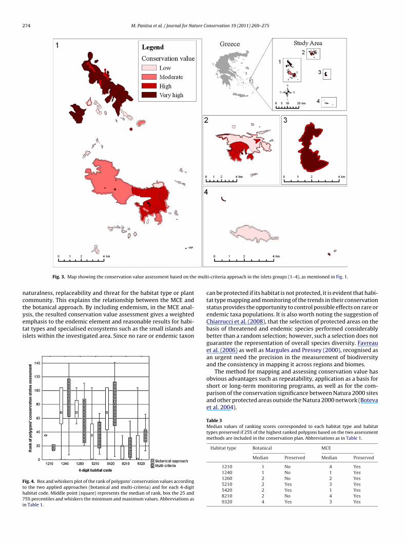
274 M. Panitsa et al. / Journal for Nature Conservation 19 (2011) 269– 275
e mult
nctyeti
Fth7i
Fig. 3. Map showing the conservation value assessment based on th
aturalness, replaceability and threat for the habitat type or plantommunity. This explains the relationship between the MCE andhe botanical approach. By including endemism, in the MCE anal-sis, the resulted conservation value assessment gives a weighted
mphasis to the endemic element and reasonable results for habi-at types and specialised ecosystems such as the small islands andslets within the investigated area. Since no rare or endemic taxonig. 4. Box and whiskers plot of the rank of polygons’ conservation values accordingo the two applied approaches (botanical and multi-criteria) and for each 4-digitabitat code. Middle point (square) represents the median of rank, box the 25 and5% percentiles and whiskers the minimum and maximum values. Abbreviations as
n Table 1.
i-criteria approach in the islets groups (1–4), as mentioned in Fig. 1.
can be protected if its habitat is not protected, it is evident that habi-tat type mapping and monitoring of the trends in their conservationstatus provides the opportunity to control possible effects on rare orendemic taxa populations. It is also worth noting the suggestion ofChiarrucci et al. (2008), that the selection of protected areas on thebasis of threatened and endemic species performed considerablybetter than a random selection; however, such a selection does notguarantee the representation of overall species diversity. Favreauet al. (2006) as well as Margules and Pressey (2000), recognised asan urgent need the precision in the measurement of biodiversityand the consistency in mapping it across regions and biomes.
The method for mapping and assessing conservation value hasobvious advantages such as repeatability, application as a basis for
short or long-term monitoring programs, as well as for the com-parison of the conservation significance between Natura 2000 sitesand other protected areas outside the Natura 2000 network (Botevaet al. 2004).Table 3Median values of ranking scores corresponded to each habitat type and habitattypes preserved if 25% of the highest ranked polygons based on the two assessmentmethods are included in the conservation plan. Abbreviations as in Table 1.
Habitat type Botanical MCE
Median Preserved Median Preserved
1210 1 No 4 Yes1240 1 No 1 Yes1260 2 No 2 Yes5210 2 Yes 3 Yes5420 2 Yes 1 Yes8210 2 No 4 Yes9320 4 Yes 3 Yes
ture Co
hbatcpc
C
ati
hatmniad(tEtmb
A
oi(aATval
R
A
B
B
B
B
C
C
D
D
M. Panitsa et al. / Journal for Na
Finally, it should be noted that the two approaches presentedere are applicable for areas where there are not appropriate distri-ution and ecological data for biodiversity surrogates, as well as forlready established conservation networks in order to set conserva-ion and management priorities. In such cases, scoring techniquesan be prove to be a convenient tool for management bodies forlanning conservation in certain Natura 2000 sites (local scale) andonservation policy at a national scale.
oncluding remarks
The two approaches proposed and tested in this study, forssessing the conservation status of habitat types contributeowards establishing a reliable and objective tool that could bentegrated with a monitoring scheme.
The MCE analysis was more effective in terms of the number ofabitat types it conserves when 25% of the highest ranked polygonsre conserved. MCE gave results that were more in line with theraditional thinking on the conservation value of habitat types as
easured by the number of important taxa they host. Scoring tech-iques, although less sophisticated than iterative ones, can help
n habitat types and areas prioritisation, especially at a local scalend in areas where adequate data sets of biodiversity surrogateso not exist. They can form the basis for the subsequent six-year2006–2012) monitoring report that is needed to track trends inhe conservation status of both habitats and species in Greece andurope, in the frame of the Dir. 92/43/EU. The critical role of GIS forhe input, management, processing, spatial analysis, cartographic
odelling and visualisation of environmental parameters shoulde acknowledged.
cknowledgements
The authors appreciate the fund received by the Greek Ministryf Environment, Regional Planning and Public Works (YPEXODE),n the framework of floristic studies at the East Aegean area1994–2000) and the Greek Natura 2000 habitat types mappingnd documentation project (1999-2000) and logistic support by thethens University team (Department of Biology, Section of Botany).he authors thank the two anonymous reviewers who providedaluable comments on a previous version of this manuscript. Theuthors also thank Sandra Coles, M.Sc. and K. Chalvatzi, M.Sc., foringuistic corrections.
eferences
costa, A., Carranza, M. L., & Izzi, C. F. (2005). Combining land cover mapping ofcoastal dunes with vegetation analysis. Applied Vegetation Science, 8, 133–138.
ergmeier, E., & Dimopoulos, P. (2003). The vegetation of islets in the Aegean andthe relation between the occurrence of islet specialists, island size, and grazing.Phytocoenologia, 33, 447–474.
ock, M., Rossner, G., Wissen, M., Remm, K., Langanke, T., Lang, S., et al. (2005).Spatial indicators for nature conservation from European to local scale. EcologicalIndicators, 5, 322–338.
onn, A., Rodrigues, A. S. L., & Gaston, K. J. (2002). Threatened and endemic species:Are they good indicators of patterns of biodiversity on a national scale? EcologyLetters, 5, 733–741.
oteva, D., Griffiths, G., & Dimopoulos, P. (2004). Evaluation and mapping of theconservation significance of habitats using GIS: An example from Crete, Greece.Journal for Nature Conservation, 12, 237–250.
arter, G. M., Stolen, E. D., & Breininger, D. R. (2006). A rapid approach to modellingspecies–habitat relationships. Biological Conservation, 127, 237–244.
hiarrucci, A., Bacaro, G., & Rocchini, D. (2008). Quantifying plant species diversityin a Natura 2000 network: Old ideas and new proposals. Biological Conservation,141, 2608–2618.
imitrakopoulos, P. G., Memtsas, D., & Troumbis, A. (2004). Questioning the effec-
tiveness of the Natura 2000 Special Areas of Conservation strategy: The case ofCrete. Global Ecology and Biogeography, 13, 199–207.imopoulos, P., Bergmeier, E., Sykora, K., & Papastergiadou, E. (2000). Evaluationsystem of the relative importance of vegetation syntaxa for nature conservationin Greece. Biologia, 55, 57–67.
nservation 19 (2011) 269– 275 275
Dimopoulos, P., Bergmeier, E., & Fischer, P. (2006). Natura 2000 habitat types ofGreece evaluated in the light of distribution, threat and responsibility. Biologyand Environment, 106B, 175–187.
Evans, D. (2006). The habitats of the European Union Habitats Directive. Biology andEnvironment, 106B, 167–173.
Favreau, J. M., Drew, C. A., Hess, G. R., Rubino, M. J., Koch, F. H., & Eschelbach, K. A.(2006). Recommendations for assessing the effectiveness of surrogate speciesapproaches. Biodiversity and Conservation, 15(12), 3949–3969.
Hennekens, S. M., & Schaminée, J. H. (2001). TURBOVEG, a comprehensive database management system for vegetation data. Journal of Vegetation Science, 12,589–591.
Heywood, V. H., & Watson, R. T. (Eds.). (1995). Global biodiversity assessment. Cam-bridge, UK: Cambridge University Press.
Hill, M. O. (1979). TWINSPAN. A Fortran program for arranging multivariate data inan ordered two-way table by classification of the individuals and attributes. Ithaca,New York: Ecology and Systematics, Cornell University.
Kent, M., & Coker, P. (1992). Vegetation description and analysis: A practical approach.Chichester, UK: John Wiley, Sons.
Kirkpatrick, J. B. (1983). An iterative method for establishing priorities for the selec-tion of nature reserves: An example from Tasmania. Biological Conservation, 25,127–134.
Lang, S., & Langanke, T. (2005). Multiscale GIS tools for site management. Journal forNature Conservation, 13, 185–196.
Loidi, J. (1994). Phytosociology applied to nature conservation and land manage-ment. In Y. Song, H. Dierschke, & X. Wang (Eds.), Applied vegetation ecology (pp.17–30). Shangai: East China Normal Univ. Press.
Machado, A. (2004). An index of naturalness. Journal for Nature Conservation, 12,95–110.
Majorano, L., Falcucci, A., Garton, E. O., & Boitani, L. (2007). Contribution of the Natura2000 network to biodiversity conservation in Italy. Conservation Biology, 21(6),1433–1444.
Mander, U., Mitchley, J., Xofis, P., Keramitsoglou, I., & Bock, M. (2005). Earth observa-tion methods for habitat mapping and spatial indicators for nature conservationin Europe. Journal for Nature Conservation, 13, 690–773.
Margules, C. R., & Pressey, R. L. (2000). Systematic conservation planning. Nature,405, 243–253.
Margules, C. R., & Sarkar, S. (2007). Systematic conservation planning. New York:Cambridge Univ. Press.
Margules, C. R., & Usher, M. B. (1981). Criteria used in assessing wildlife conservationpotential: A review. Biological Conservation, 21, 79–109.
Margules, C., Nicholls, A., & Pressey, R. (1988). Selecting networks of reserves tomaximize biological diversity. Biological Conservation, 43, 63–76.
Margules, C. R., Pressey, R. L., & Williams, P. H. (2002). Representing biodiversity:Data and procedures for identifying priority areas for conservation. Journal ofBiosciences, 27(Suppl. 2), 309–326.
Mueller-Dombois, D., & Ellenberg, H. (1974). Aims and methods of vegetation ecology.New York, USA: John Wiley and Sons.
Ortigosa, G. R., De Leo, G. A., & Gatto, M. (2000). VVF: Integrating modelling and GISin a software tool for habitat suitability assessment. Environmental Modellingand Software, 15, 1–12.
Panitsa, M., & Tzanoudakis, D. (1998). Contribution to the study of the Greek flora:Flora and vegetation of the islands Agathonisi and Pharmakonisi East Aegeanarea, Greece. Willdenowia, 28, 95–116.
Panitsa, M., & Tzanoudakis, D. (2001). A floristic investigation of the islet groups Arkiand Lipsi East Aegean area, Greece. Folia Geobotanica, 36, 265–279.
Panitsa, M., Tzanoudakis, D., Triantis, K., & Sfenthourakis, S. (2006). Patterns ofspecies richness on very small islands: The plants of the Aegean archipelago.Journal of Biogeography, 33(7), 1223–1234.
Panitsa, M., Trigas, P., Iatrou, G., & Sfenthourakis, S. (2010). Factors affecting plantspecies richness and endemism on land-bridge islands—An example from theEast Aegean archipelago. Acta Oecologica, 36, 431–437.
Papastergiadou, E., Dafis, S., Dimopoulos, P., & Lazaridou, T. (1997). Syntaxonomictypology of Greek habitats. Folia Geobotanica, 32(3), 335–341.
Pressey, R. L., & Logan, V. S. (1998). Size of selection units for future reserves and itsinfluence on actual versus targeted representation of features: A case study inwestern New South Wales. Biological Conservation, 85, 305–319.
Pressey, R. L., & Nicholls, A. O. (1989). Efficiency in conservation evaluation: Scoringversus iterative approaches. Biological Conservation, 50, 199–218.
Smith, P. G. R., & Theberge, J. B. (1986). A review of criteria for evaluating naturalareas. Environmental Management, 10, 715–734.
Stalmans, M., Balkwill, K., Witkowski, E., & Rogers, K. H. (2001). A landscape eco-logical approach to address scaling problems in conservation management andmonitoring. Environmental Management, 28, 389–401.
Store, R., & Kangas, J. (2001). Integrating spatial multi-criteria evaluation and expertknowledge for GIS-based habitat suitability modelling. Landscape and UrbanPlanning, 55, 79–93.
Usher, M. (Ed.). (1986). Wildlife conservation evaluation. London: Chapman and Hall.van der Maarel, E. (2005). Vegetation ecology—an overview. In E. van der Maarel
(Ed.), Vegetation ecology (pp. 1–51). Oxford, UK: Blackwell Publishing.
Vogiatzakis, I. N., Mannion, A. M., & Griffiths, G. H. (2006). Mediterranean ecosys-tems: Problems and tools for conservation. Progress in Physical Geography, 30,175–200.
Wu, X. B., & Smeins, F. E. (2000). Multiple-scale habitat modelling approach for rareplant conservation. Landscape and Urban Planning, 51, 11–28.