Buckling analysis of laminated composite plates containing ...
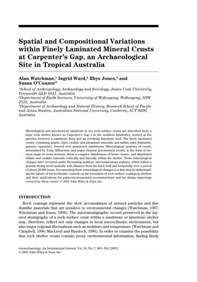
Geoarchaeology: An International Journal, Vol. 16, No. 7, 803–824 (2001)� 2001 John Wiley & Sons, Inc.
shortstandard
GEA(Wiley) RIGHT BATCH
Spatial and Compositional Variations
within Finely Laminated Mineral Crusts
at Carpenter’s Gap, an Archaeological
Site in Tropical Australia
Alan Watchman,1 Ingrid Ward,2 Rhys Jones,3 andSusan O’Connor3
1School of Anthropology, Archaeology and Sociology, James Cook University,
Townsville QLD 4811, Australia2Department of Earth Sciences, University of Wollongong, Wollongong, NSW
2522, Australia3Department of Archaeology and Natural History, Research School of Pacific
and Asian Studies, Australian National University, Canberra, ACT 0200,
Australia
Mineralogical and geochemical variations in ten rock surface crusts are described from alarge rock shelter known as Carpenter’s Gap 1 in the southern Kimberley, formed at thejunction between a sandstone floor and an overlying limestone roof. The finely laminatedcrusts, containing quartz, clays, oxalate and phosphate minerals, and sulfate salts (bassanite,gypsum, epsomite), formed over quartz-rich sandstones. Mineralogical analyses of crusts,determined by X-ray diffraction, and major element geochemical trends, in the form of ele-ment maps of cross sections, show a complex distribution of hemi-, mono-, and dihydratedsulfate and oxalate minerals vertically and laterally within the shelter. These mineralogicalchanges have occurred under fluctuating moisture and temperature regimes, which follow ageneral drying trend spatially with distance from the back wall and temporally over a periodof about 20,000 years. Documenting these mineralogical changes is a first step in understand-ing the nature of microclimatic controls on the formation of rock surface coatings in sheltersand their implications for palaeoenvironmental reconstructions and for dating engravingscovered by these crusts. � 2001 John Wiley & Sons, Inc.
INTRODUCTION
Rock coatings represent the slow accumulation of aerosol particles and finedustlike materials that are sensitive to environmental changes (Watchman, 1987;Watchman and Jones, 1998). The microstratigraphic record preserved in the lay-ered stratigraphy of a rock surface crust within a sandstone or limestone sheltermay, therefore, reflect not only changes in local microclimatic environment, butalso major regional fluctuations such as moisture and temperature (Watchman andCampbell, 1996; MacLeod and Haydock, 1996). In order to examine the possibilitythat rock shelter crusts contain proxy environmental information, finding finely
WATCHMAN, WARD, JONES, AND O’CONNOR
804 VOL. 16, NO. 7
shortstandard
GEA(Wiley) LEFT BATCH
layered crusts that have formed over a long period is necessary. Several rock shel-ters in northern Australia provide suitable material for testing this hypothesis.
This paper documents the trends in mineralogical and geochemical variationsacross the microstratigraphy of ten rock surface crusts from selected locations atthe Carpenter’s Gap 1 rock shelter, Western Australia. We do not cite age deter-minations for any rock engravings, but we do make a significant contribution toestablishing confidence in using oxalate minerals for that purpose at this and othersites in the northern part of Western Australia. Caution about dating the engravingsat Carpenter’s Gap 1 without first carrying out basic research on the crusts iswarranted because of the need to establish reliability in the age determinations,since rock art dating is still regarded as controversial. Similar coatings over cupulesin the Keep River area (Northern Territory) have recently been dated without de-tailed mineralogical analyses, and those determinations are regarded more as in-dications of environmental change rather than as minimum age estimates for theengravings (Watchman et al., 2000a). A single age estimate for a painted engravingin the Victoria River area (Northern Territory) is disputable because the basic min-eralogical and off-art dating has not been done (Watchman et al., 2000b).
The traditional owners of the site have supported our strategy to study the crustsin the shelter before attempting to date the engravings, and while approving of thesampling of crusts off-art, they have not consented to the removal of mineral coat-ings over the engravings. We respect their wishes and, therefore, have not initiallyaimed at dating the engravings. Despite this shortcoming, the information reportedhere provides the basic geoarchaeological framework for future studies dating rockart in the Kimberley area. The work is part of a long-term research objective at-tempting to link evidence of human activities within rock shelters in northern Aus-tralia, such as the engraved bird tracks and circular depressions, and the environ-ments of the surrounding region during the long history of occupation.
Carpenter’s Gap 1 is located near the Windjana Gorge National Park, at the south-ern end of the Kimberley region, Western Australia (Figure 1). The Lennard Riverhas cut Windjana Gorge through the Napier Range, a remnant of a Devonian fring-ing reef, 300 km long, formed around 350 million years ago adjacent to the KingLeopold Ranges when the Canning Basin to the south was filled by a tropical sea.The shales and other soft sediments laid down in front of the reef have eroded toform valleys, leaving the limestone reefs exposed (Playford, n.d.).
Low trees and shrubs of the savanna occupy the dry gravel slopes of ridges anderoded hill slopes, and most of the surrounding plains are covered in ephemeraland annual grasses. Pockets of rainforest grow in fire shadows, close to permanentwater (McConnell and O’Connor, 1997) and near Carpenter’s Gap 1.
The study site lies within the drier part of the tropical subhumid to humid regionof northern Australia. Mean annual precipitation decreases southward from morethan 1400 mm near the Mitchell Plateau in the north to less than 400 mm near theGreat Sandy Desert, most of which falls during the summer monsoon season fromNovember to April (Bureau of Meteorology, 1996). Rainfall is highly variable, andindividual events such as tropical cyclones account for much of the yearly total.

VARIATIONS WITHIN FINELY LAMINATED MINERAL CRUSTS AT CARPENTER’S GAP
GEOARCHAEOLOGY: AN INTERNATIONAL JOURNAL 805
shortstandard
GEA(Wiley) RIGHT BATCH
Figure 1. Location map of the study area (Carpenter’s Gap 1 in Windjana Gorge National Park, Kim-berley).
The southern Kimberley region around Carpenter’s Gap receives approximately 540mm per year. Average maximum temperatures exceed 35�C around November and30�C in June. Mean annual evaporation ranges from about 2000 mm near the coastto 4000 mm further inland
The rock shelter known as Carpenter’s Gap 1, named after a narrow gorgenearby, is approximately 3 km southeast of the Lennard River and was excavatedbetween 1993 and 1994 by Sue O’Connor. The large shelter has formed at the un-conformity between the Devonian limestone and the underlying micaceous sand-stone and siltstone. The shelter, measuring 25 � 13 m, is situated within a naturalembayment in the ridge. Although the shelter opens to the northeast, the back wallreceives early morning sunlight for only a few minutes and is not affected by directrain (Figure 2). A series of large rock-falls along the mouth of the shelter forms atrap for sediments behind which is developed a thick, medium to coarse sanddeposit containing flaked stone artefacts and organic debris (O’Connor, 1995;McConnell and O’Connor, 1997). The major minerals in the deposit are quartz,calcite, muscovite, biotite, albite, microcline, and kaolinite. Carpenter’s Gap 1 isone of the oldest radiocarbon-dated sites in Australia, with evidence of Aboriginaloccupation extending from about 40,000 years ago. Published age estimates rangefrom 39,700 � 1000 yr B.P. (NZA 3802, O’Connor, 1995) to 42,800 � 1850 yr B.P.
WATCHMAN, WARD, JONES, AND O’CONNOR
806 VOL. 16, NO. 7
shortstandard
GEA(Wiley) LEFT BATCH
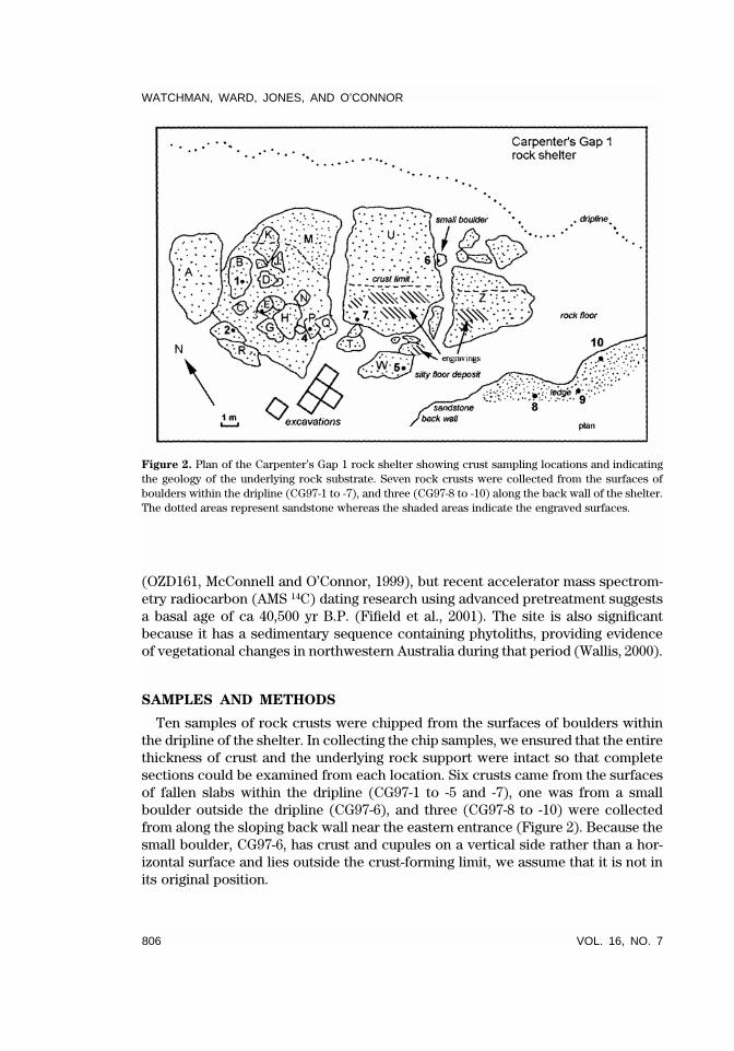
Figure 2. Plan of the Carpenter’s Gap 1 rock shelter showing crust sampling locations and indicatingthe geology of the underlying rock substrate. Seven rock crusts were collected from the surfaces ofboulders within the dripline (CG97-1 to -7), and three (CG97-8 to -10) along the back wall of the shelter.The dotted areas represent sandstone whereas the shaded areas indicate the engraved surfaces.
(OZD161, McConnell and O’Connor, 1999), but recent accelerator mass spectrom-etry radiocarbon (AMS 14C) dating research using advanced pretreatment suggestsa basal age of ca 40,500 yr B.P. (Fifield et al., 2001). The site is also significantbecause it has a sedimentary sequence containing phytoliths, providing evidenceof vegetational changes in northwestern Australia during that period (Wallis, 2000).
SAMPLES AND METHODS
Ten samples of rock crusts were chipped from the surfaces of boulders withinthe dripline of the shelter. In collecting the chip samples, we ensured that the entirethickness of crust and the underlying rock support were intact so that completesections could be examined from each location. Six crusts came from the surfacesof fallen slabs within the dripline (CG97-1 to -5 and -7), one was from a smallboulder outside the dripline (CG97-6), and three (CG97-8 to -10) were collectedfrom along the sloping back wall near the eastern entrance (Figure 2). Because thesmall boulder, CG97-6, has crust and cupules on a vertical side rather than a hor-izontal surface and lies outside the crust-forming limit, we assume that it is not inits original position.
VARIATIONS WITHIN FINELY LAMINATED MINERAL CRUSTS AT CARPENTER’S GAP
GEOARCHAEOLOGY: AN INTERNATIONAL JOURNAL 807
shortstandard
GEA(Wiley) RIGHT BATCH
Methodology
The 1997 field season, from March 12–14, was undertaken at the end of the wetseason under humid conditions, so we could also study algae and other microor-ganic growths on the rock surfaces. A plan was drawn of the rock shelter to indicatethe distribution and composition of fallen ceiling blocks and the extent of devel-opment of dark brown encrusted coatings. Crust sampling points were alsomarkedon the plan (Figure 2). Physical descriptions of encrusted blocks were made afterthe blocks had been categorized alphabetically starting with the block in the west-ern part of the shelter. During the on-site work, samples of atmospheric dust weredirectly collected as fallout onto carbon-coated adhesive films. These natural dustsamples were later examined by scanning electron microscope (SEM). In addition,the shelter floor deposit was disturbed to produce localized dust, which was col-lected on adhesive film. Loosely bonded dust that had settled and accumulated ona stable back wall ledge was also removed for analysis.
Each crust sample was sectioned twice at right angles and normal to the surfaceto provide four rectangular pieces for measurement of thickness (using callipers)and microstratigraphic examination. Microstratigraphic examinations consisted ofbinocular observations of color, texture and layering, and X-ray diffraction for themineralogy (general area diffraction detection spectrometry, GADDS) on un-mounted sections. Scanning electron microscope energy dispersive X-ray analyses(SEM/EDXA) of major element compositions were made on polished sections ofimpregnated crusts. The petrographic observations and color photographs takenof the cross sections were used to determine crust microstratigraphy.
For the geochemical analyses and element mapping of each cross section, back-scattered X-rays were initially used to indicate the relative locations of heavy andlight elements. Element maps were obtained to produce more sensitive records ofthe relative abundances of a range of individual elements across each section. Theelement maps were achieved using a JEOL JXA-840A Scanning Electron Micro-probe. Elemental energy dispersive spectra (EDS) were obtained as a series of 256� 256 pixel bit maps for a standard set of elements ranging from sodium (Z � 11)to iron (Z � 26). A “Moran Scientific” computer program was used for a scanningrate of 60 ms/point at a beam current of 5 nA, for a total period of 90 min.
The mineralogy of dust samples was analyzed by conventional X-ray diffraction(XRD) and the diffracted peaks identified using standard search-matching proce-dures. Mineralogical patterns of rock crusts were obtained using a SiemensGADDS. The GADDS microdiffractometer is analogous to automated Debye-Scherer photography, in which diffracted X-ray spots or rays produced from afocused X-ray beam are intercepted by a sealed proportional area detector at ap-proximately 25� 2� per second. Copper K X-rays were generated from a targetmaintained at 40 kV and 52 mA. A prediffraction graphitemonochromator produceda parallel beam of X-rays that passed through a 100m collimator before striking thesample. Detector settings (15� and 30� 2�, and 3 and 15 chi respectively) were setto cover X-rays diffracted through an angular range of 5� to 42� 2�. Diffracted
WATCHMAN, WARD, JONES, AND O’CONNOR
808 VOL. 16, NO. 7
shortstandard
GEA(Wiley) LEFT BATCH
spectral data were interpreted using “EVA (1997)” evaluation software, and thesubsequent abundances of the identified mineral phases were computed using aSIROQUANT (Sietronics Pty. Ltd.) spectral peaks program.
For radiocarbon dating, the basal layers of five crusts and three intermediatelayers in CG97/3, all rich in calcium-oxalate, were removed by Watchman in theJCU preparation laboratory using a battery-powered engraving tool fitted with afine dental burr. After testing for amino acids and other organic compounds usinggas chromatography (none were found), the powders were immersed in warm di-lute sulfuric acid in a reaction vessel through which nitrogen flowed. Potassiumpermanganate was added to the reactants, and the resulting carbon dioxide fromthe oxidation of oxalate ions (Gillespie, 1997) was collected at liquid nitrogen tem-perature in glass tubes. The separate tubes of gas were converted into graphite-coated iron at the Australia Nuclear Science and Engineering Organisation, LucasHeights, Sydney (OZD and OZE laboratory numbers) and at the Lawrence Liver-more National Laboratories, California, (CAMS laboratory numbers) for AMS 14Cdating.
RESULTS
Dust collected as fallout from the air at Carpenter’s Gap in 1997 consisted es-sentially of quartz, clay minerals, and salt (NaCl). The low quantity of clay in thedust made clay mineral characterization impossible. Loosely bound dust on thestable rock ledge consisted of quartz, gypsum, clay (muscovite-type), Fe-Ti oxides,phosphate minerals, and small amounts of pollen. Dust particles stirred up fromthe floor contained kaolinite, gypsum, and NaCl. A previous mineralogical analysisof a carbonate rock flake indicated calcite as the major mineral with small amountsof syngenite (K2Ca(SO4)2.H2O), quartz, and muscovite (Chris Tilley, personal com-munication).
The rock crusts generally cover fine-grained micaceous sandstone. Crust mi-crostratigraphy, observed under binocular microscope, was not identical to thebackscattered electron image and element X-ray maps because of differences be-tween the broad properties of reflected light and subtle variations in geochemistry.Crust thickness ranged from less than 0.2 mm to slightly more than 4 mm. Thesurface layers in the crusts are generally cryptocrystalline to microcrystalline andcomposed of several thin layers. Thick coatings are found on large stable blocksof rock close to the western back wall of the shelter (samples 1–4), whereas thin-ner crusts lie on rocks further to the east and along the wall near the shelterentrance. The variations in thickness and age of crust initiation, together with un-derlying rock type, indicate that most of the encrusted rocks had stable exposedsurfaces capable of forming crust for at least 20,000 years. Weathering of crusts onsome rocks indicates that the coatings may not persist where localized erosion isprevalent. The relatively young age for crust development in sample CG97/5, andthe fact that the rock surface is just above the present floor level, probably indicatesthat the encrusted surface was buried by sediment and exhumed in recent times.
VARIATIONS WITHIN FINELY LAMINATED MINERAL CRUSTS AT CARPENTER’S GAP
GEOARCHAEOLOGY: AN INTERNATIONAL JOURNAL 809
shortstandard
GEA(Wiley) RIGHT BATCH
A possible implication for the shelter floor sediments is that the top part of thedeposit could have been stripped off, perhaps in the mid-Holocene, down to thelevel corresponding to about 17 ka (Wallis, 2000:113).
Under binocular microscope, the general depositional sequence in the thickcrusts comprises a pale orange-brown clay and silt at the base, followed by alter-nating pale and dark bands in the centre, and fine dark and light-colored lamina-tions near the surface (Figures 3–6). The sequence of alternating light and darklaminae reflects changes in grain size, porosity, and mineral composition. Micro-unconformities are evident in CG97/1, 3, and 4 where small flakes of crust werelost before the resulting depressions were subsequently filled by silty components(Figures 3, 5, and 6). Small dome-shaped accumulations of pale salt componentsand gypsum-rich lenses are also evident. Apart from these small irregularities, thecrusts generally show continuous deposition of materials.
Tiny black particles, a mixture of carbonized plant remains (charcoal) and bio-tite, are dispersed throughout all crusts. The pale orange-brown bands and lightlaminations contain fewer black particles than the darker layers, but the overallpresence of the dark particles is ubiquitous. Concentrations of tiny black particlesin dark bands may be indicative of concentrated local burning possibly related tohuman activity in the shelter.
Thin discontinuous laminations of bright red haematite were observed in theupper finely laminated parts of CG97/4. Because rock paintings are present on thecurrent surface of this sloping block, and on the steeply sloping lintel of the ceilingsituated just above rock P (CG97/4), the buried red layer in the crust probablyindicates a previous episode of painting. Based on the age depth curve (Figure 7),the painting is approximately 1800 years old. Small bright red and yellow particlesin CG97/2 possibly indicate traces of ochre dust stirred up during the preparationof ochre for painting.
The mineralogical and geochemical analyses indicate a complex sequence ofsalts and mineral phases within the Carpenter’s Gap 1 rock-shelter crusts(Table I). Whewellite (CaC2O4.H2O), weddellite (CaC2O4.2H2O), whitlockite(Ca18Mg2H2(PO4)14), bassanite (CaSO4.0.5H2O), quartz (SiO2), calcite (CaCO3), an-kerite (Ca(FeMg)(CO3)2), dolomite (CaMg(CO3)2), and several silicate minerals(albite, muscovite, and kaolinite) were the major identifiable phases in thecrusts. Minor phases of gypsum (CaSO4.2H2O), anhydrite (CaSO4), epsomite(MgSO4.7H2O), halite (NaCl), and polyhalite (K2Ca2Mg(SO4)4.2H2O) were alsofound. Analyses of floor sediments indicate a mineralogical content mostly com-prising quartz, albite, calcite, muscovite, biotite, and microcline, so finding the sameminerals in crusts is not surprising if the floor is a local dust source. The presenceof oxalate, sulfate, and chloride minerals requires chemical, evaporation, and mi-crobiological mechanisms of formation.
The mineralogical variations within and between each of the crust samples couldsignal microenvironmental differences within the shelter. Microclimatic changes,including different water seepage courses, could also influence microbiologicalhabitats. Local and regional environmental conditions are likely to control dust

WATCHMAN,WARD,JO
NES,AND
O’CONNOR
810VOL.
16,NO.7
shortstandard
GE
A(W
iley)LE
FT
BA
TC
H
Figure 3. Cross section of CG97/1 showing the mineralogical compositions of different layers, angular unconformity, and age of basal oxalate. Theblack line indicates the approximate position of the unconformity (u/c).
VARIATIONS WITHIN FINELY LAMINATED MINERAL CRUSTS AT CARPENTER’S GAP
GEOARCHAEOLOGY: AN INTERNATIONAL JOURNAL 811
shortstandard
GEA(Wiley) RIGHT BATCH
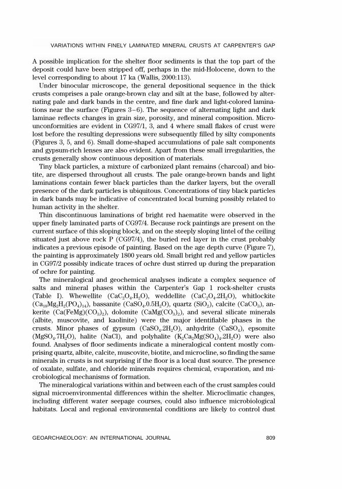
Fig
ure4.M
agni
fied
view
ofth
eCG97
/2cr
ossse
ctio
nill
ustrat
ing
the
sequ
ence
ofm
iner
alsin
differ
entlaye
rsan
dth
eag
eof
oxalat
ein
theba
sall
ayer
.
WATCHMAN,WARD,JO
NES,AND
O’CONNOR
812VOL.
16,NO.7
shortstandard
GE
A(W
iley)LE
FT
BA
TC
H
Figure 5. Cross section of CG97/3 indicating the mineralogical compositions in the layers, the age estimates for oxalate minerals in different layers,and the presence of an angular unconformity. The crack is an artefact of the section preparation.
VARIATIONS
WITHIN
FINELY
LAMINATED
MINERALCRUSTS
ATCARPENTER’S
GAP
GEOARCHAEOLO
GY:AN
INTERNATIONALJO
URNAL
813
shortstandard
GE
A(W
iley)R
IGH
TB
AT
CH
Figure 6. Enlarged view of a cross section through CG97/4 showing the alternating laminations in two of the layers in the crust. The mineralogicalcompositions of the laminations and the age of the oxalate in the basal layers are also shown.

WATCHMAN, WARD, JONES, AND O’CONNOR
814 VOL. 16, NO. 7
shortstandard
GEA(Wiley) LEFT BATCH
Figure 7. Age-depth curve based on age of oxalate carbon and depth of layer within crusts from Car-penter’s Gap 1. Note that CG97/3 shows textural evidence indicating an erosional period at the angularunconformity between adjacent layers in which approximately 2 mm of crust was lost. The diamondshape indicates the estimated depth of the dated basal layer presuming that erosion had not removedpart of the crust.
generation, particularly following the drying out of water-borne sediments erodedfrom the surrounding rocks. The distribution and abundances of mineral and saltphases in each crust are summarized in Table I and the AMS 14C results are listedin Table II.
Sample 1 (CG97/1) was collected from the loose edge of a boulder in the centerof the face of fallen sandstone block B (see Figure 2 for locations and block iden-tifications). This block, like all the other stable blocks in the shelter, does not showevidence of crust formation on the vertical faces or the underside, indicating thatprocesses leading to crust formation take place only on sloping and sub-horizontal
VARIATIONS
WITHIN
FINELY
LAMINATED
MINERALCRUSTS
ATCARPENTER’S
GAP
GEOARCHAEOLO
GY:AN
INTERNATIONALJO
URNAL
815
shortstandard
GE
A(W
iley)R
IGH
TB
AT
CH
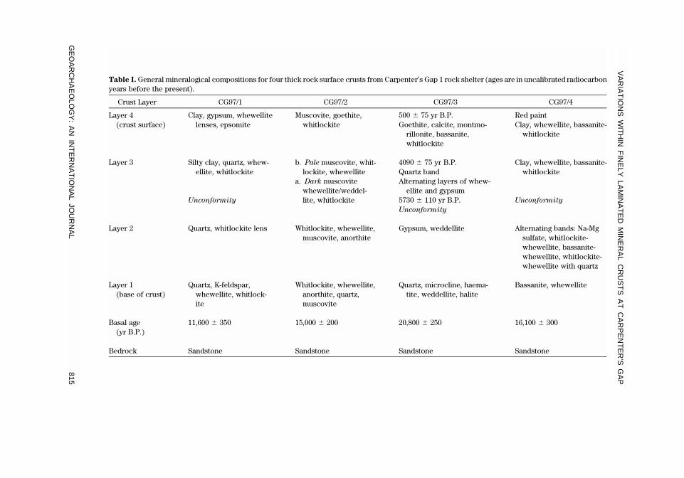
Table I. General mineralogical compositions for four thick rock surface crusts from Carpenter’s Gap 1 rock shelter (ages are in uncalibrated radiocarbonyears before the present).
Crust Layer CG97/1 CG97/2 CG97/3 CG97/4
Layer 4(crust surface)
Clay, gypsum, whewellitelenses, epsomite
Muscovite, goethite,whitlockite
500 � 75 yr B.P.Goethite, calcite, montmo-
rillonite, bassanite,whitlockite
Red paintClay, whewellite, bassanite-
whitlockite
Layer 3 Silty clay, quartz, whew-ellite, whitlockite
Unconformity
b. Pale muscovite, whit-lockite, whewellite
a. Dark muscovitewhewellite/weddel-lite, whitlockite
4090 � 75 yr B.P.Quartz bandAlternating layers of whew-
ellite and gypsum5730 � 110 yr B.P.Unconformity
Clay, whewellite, bassanite-whitlockite
Unconformity
Layer 2 Quartz, whitlockite lens Whitlockite, whewellite,muscovite, anorthite
Gypsum, weddellite Alternating bands: Na-Mgsulfate, whitlockite-whewellite, bassanite-whewellite, whitlockite-whewellite with quartz
Layer 1(base of crust)
Quartz, K-feldspar,whewellite, whitlock-ite
Whitlockite, whewellite,anorthite, quartz,muscovite
Quartz, microcline, haema-tite, weddellite, halite
Bassanite, whewellite
Basal age(yr B.P.)
11,600 � 350 15,000 � 200 20,800 � 250 16,100 � 300
Bedrock Sandstone Sandstone Sandstone Sandstone

WATCHMAN, WARD, JONES, AND O’CONNOR
816 VOL. 16, NO. 7
shortstandard
GEA(Wiley) LEFT BATCH
Table II. Results of the radiocarbon ages determinations for oxalate minerals in crusts at Carpenter’sGap 1 (OZD and OZE from the Australian Nuclear Science and Technology Organization, Sydney, andCAMS from the Lawrence Livermore AMS Laboratory, California).
CrustIdentification
Depth in Crust(* � base) (mm) AMS Lab. N.
Graphite(�g)
Radiocarbon Age(uncalibrated yr B.P.)
CG97/1 2.1–*2.2 OZE-239 90 11,600 � 350CG97/2 3.1–*3.2 OZE-240 75 15,000 � 200CG97/3a 0.1–0.2 OZD-217 95 500 � 75CG97/3b 0.5–0.65 CAMS-45674 150 4090 � 70CG97/3c 1.2–1.3 CAMS-45673 110 5730 � 110CG97/3d 3.0–*3.1 OZE-241 40 20,800 � 250CG97/4 3.8–*3.9 OZE-242 60 16,100 � 300CG97/5 0.2–*0.3 OZE-243 200 3000 � 50
surfaces. The sandstone block had been incised with a broad series of sharp linesmeasuring 10 mm wide and 8 mm deep, but no mineral coating is associated withthe grooves. The significance of the man-made incised lines is unknown.
Sample CG97/1 contains four relatively distinct layers. The basal layer is datedto 11,600 � 350 yr B.P. (OZE 239) and essentially consists of quartz, potassiumfeldspar, whewellite, and whitlockite. Overlying the basal layer is a lens rich inquartz and whitlockite, which is clearly visible in element maps by high concentra-tions of Si and P, respectively. This lens is unconformably overlain by a very finesilty clay layer containing mainly quartz, whewellite, and whitlockite. The angularunconformity was probably formed during the mid-Holocene at the same time asother similar erosional features (for example, in CG97/3). The surface layer of clayand whewellite includes thin lenses of gypsum and epsomite, characterized in el-ement maps by the presence of Ca and S.
Sample 2 was collected from a partly exfoliated rock (230 � 13 mm) in thenorthern corner of block R, which lies in the deepest recess of the shelter near thewestern back wall. The block is a very large flat boulder that had previously brokeninto four pieces. Extensive dark brown crust covers most of the horizontal surface,but it has not developed down any of the sub-vertical sides. Flaking and scabbyerosion of the coating is evident. The base of CG97/2 formed about 15,000 � 200yr B.P. (OZE 240, Figure 4). The pale brown silty deposit mostly contains whitlock-ite, whewellite, anorthite, quartz, and muscovite. The depositional sequence thengrades upward into darker and finer grained material containing whitlockite,whew-ellite, and muscovite with lenses of granular anorthite. The upper dark laminationsconsist primarily of muscovite, whewellite (minor weddellite), and whitlockite, andthese layers alternate with pale layers containing similar minerals. The relativeproportions of the minerals affect the perceived color difference between dark andpale layers. The pale muscovite-rich surface covers a series of fine dark laminationsconsisting mainly of goethite and whitlockite. Backscatter imaging shows a relativelyhomogenous sequence throughout the crust comprising Ca, P, S, and minor K.
VARIATIONS WITHIN FINELY LAMINATED MINERAL CRUSTS AT CARPENTER’S GAP
GEOARCHAEOLOGY: AN INTERNATIONAL JOURNAL 817
shortstandard
GEA(Wiley) RIGHT BATCH
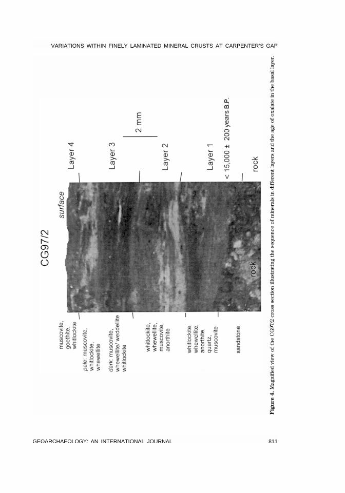
Samples 3 and 4 came from blocks E and P, respectively, from fallen blocks lyingmidway between the back wall and dripline. Block E bears one encrusted incisedline about 80 mm long and 2 mm wide, with an adjacent line cut into the coating.The northeastern edge of the block has several engraved lines cut into the hardsandstone, but crust has not formed in them.
In CG97/3 the basal layer was dated at 20,800 � 250 yr B.P. (OZE 241, Figure 5).Three additional age determinations were measured for laminations in the upperparts of this thick crust. A layer about 0.1 mm thick whose base is 1.3 mm beneaththe modern surface gave an age for oxalate formation at 5730 � 110 yr B.P. (CAMS45673). The layer whose base is at 0.65 mm depth has oxalate dated to 4090 � 70yr B.P. (CAMS 45674). The surface layer of crust containing oxalate, excavated toa depth of 0.2 mm, yielded an age of 500 � 75 yr B.P. (OZD217). While quartz andwhewellite occur throughout the crust, the microstratigraphy also shows concen-trations of discrete mineral phases. An angular unconformity is visible in a sectionof crust indicating an hiatus during the early Holocene, before 5700 years ago.Element maps reveal that quartz is concentrated near the base of the crust and ina layer about a third of the way down from the surface. Gypsum and weddelliteare concentrated in narrow bands in the lower part of the crust. Microcline, ka-olinite, haematite, weddellite, and halite occur near the base of the crust whereasgoethite, calcite, montmorillonite, bassanite, and whitlockite were deposited in re-cent times. An inverse trend is observed between the abundances of sulfate andwhewellite throughout the crust, also corresponding to alternating S- and P-richbands in element maps.
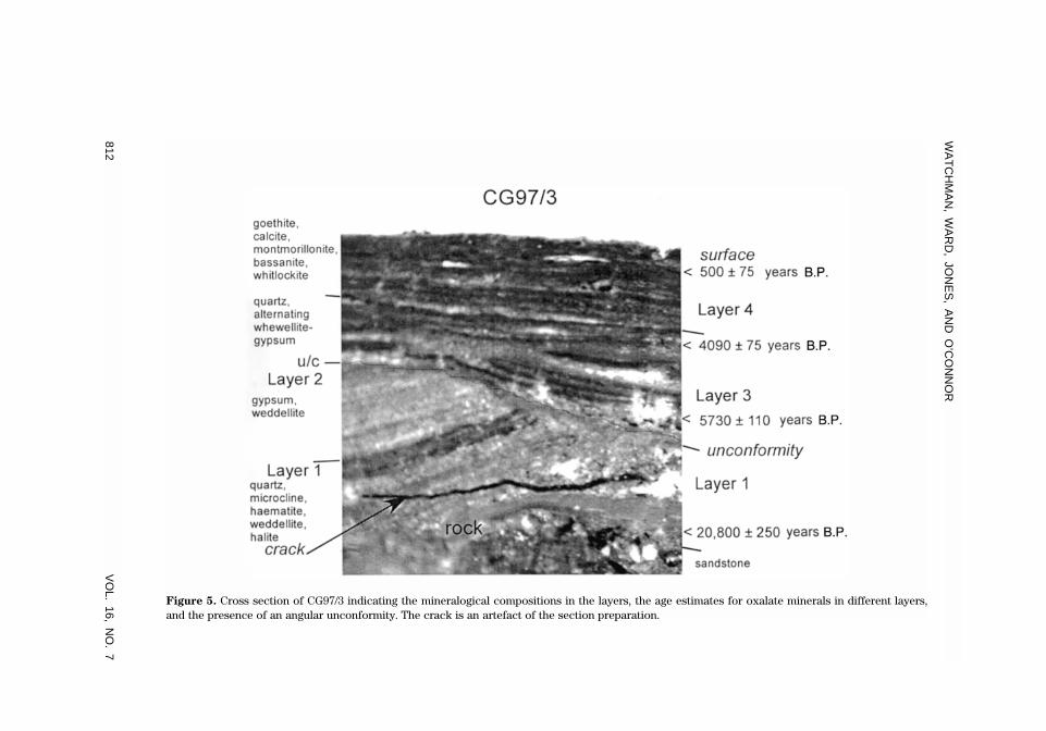
The crust in CG97/4 is well stratified and compositionally variable (Figure 6).The basal layer gives a radiocarbon age for oxalate formation of 16,100 � 300 yrB.P. (OZE 242). While there are no obvious signs of physical erosion in the 4 mm-thick crust, the possibility of several disconformable relationships cannot be dis-counted. Possible breaks in sedimentation occur about halfway up the sequenceand one-third the way down from the surface. The crust sequence can be dividedbroadly into lower and upper units, with the lower unit containing alternating andcompositionally distinct bands, and the upper unit being more finely laminated.The pale orange-brown lower unit contains a layer of bassanite-whewellite at thebase, followed by a band of whitlockite-whewellite, and then repetitive bands ofbassanite-whewellite and whitlockite-whewellite (distinguished by the relativelyhigh concentrations of S and P, respectively). A layer of Na-Mg sulfate interruptsthis cycle and signals the start of a new cycle of mineral deposition. The mineral-ogical sequence then comprises phosphate-oxalate, Na-Mg sulfate, and bassanite-oxalate in separate laminations. This fine banding ceases near the center of thecrust, giving way to dark laminations of clay, whewellite, bassanite, and minorphosphate. Quartz is more prevalent in the lower unit than in the upper parts ofthe crust. Element mapping reveals an iron-rich layer of orange red paint just be-neath the present surface.
Sample 5 was chipped from a large slab of rock (block W) to the east of the
WATCHMAN, WARD, JONES, AND O’CONNOR
818 VOL. 16, NO. 7
shortstandard
GEA(Wiley) LEFT BATCH
excavation. The crust at CG97/5 is extremely thin compared to the previous sam-ples (less than 0.5 mm). A radiocarbon age of 3000 � 500 yr B.P. (OZE 243) wasobtained for oxalate at the base of the coating. Phosphate and S-rich layers havedeveloped on the sandstone rock, followed by a series of relatively uniform layersconsisting principally of oxalate, quartz, clay, and gypsum, with several thin K- andS-rich layers. A carbonate-rich layer consisting of calcite-dolomite-ankerite wasthen deposited above a band of whitlockite. Whewellite, clay, and granular quartzare present throughout the sequence.
Sample 6 was collected from a small boulder found lying on its side near theedge of block U, and it is the only object with a crust outside the dripline. Thethickly encrusted and hollowed surface was lying directly against the side of theadjacent boulder, making it extremely difficult for someone to make the depres-sions. In addition, and by contrast, crust has formed on one side (nearest block U),but not on the top surface unlike all other surfaces in the shelter. We thereforebelieve the small boulder has rolled from the interior of the shelter, from withinthe dripline, to its present location. The crust on the small boulder CG97/6 is verysimilar in color and composition to the crust in CG97/5. Although slightly thicker(2 mm), it is essentially composed of the same mineralogical and geochemicalstratigraphy. While no age determination is yet available for the basal oxalate layerin this crust, an age of less than 5000 years is expected because of the comparativeage and thickness of CG97/5. Carbonate-rich minerals, muscovite, and albite-an-orthite feldspars are also present in GADDS spectra of this crust.
Sample 7 was obtained from the surface of large rock fall U, but within thedripline zone and close to the excavation. Crust sample CG97/7 is extremely thin(less than 0.3 mm) and of similar composition and texture to both CG97/5 and 6.The fine laminations of the crust contain alternating concentrations of P, S, andoxalate minerals within the general clay and quartz assemblage.
Samples 8–10 were collected from the eroding, thin, orange-brown crusts on thesloping back wall of the shelter. These crusts, near the eastern entrance, essentiallycontain the same minerals despite their range in thickness (0.1–0.6 mm). The mostheavily laminated crust is CG97/8, which contains whitlockite, granular quartz, clay,and minor gypsum in regular fine stratifications. The other two crusts have dis-torted and fractured laminations but essentially the same mineralogy. Crust CG97/9 also contains amorphous components in addition to the minerals describedabove. Particles of quartz are larger in samples 9 and 10, than in 8. Oxalate mineralsare only present as accessory components and not major constituents in the sam-ples CG97/8–10, making radiocarbon dating difficult.
The age of oxalate formation and the depth of their respective micro-excavatedlayers (Figure 7) indicates that crust CG97/3 has been eroded much more thanother coatings, as indicated by the micro-unconformity observed in cross section.The rate of crust formation is variable between sampling sites with the averagebeing 0.25 mm/millennium. Because the coatings that cover the engravingsappear to be less than 1 mm thick, the engravings are probably less than 5000years old.
VARIATIONS WITHIN FINELY LAMINATED MINERAL CRUSTS AT CARPENTER’S GAP
GEOARCHAEOLOGY: AN INTERNATIONAL JOURNAL 819
shortstandard
GEA(Wiley) RIGHT BATCH
DISCUSSION
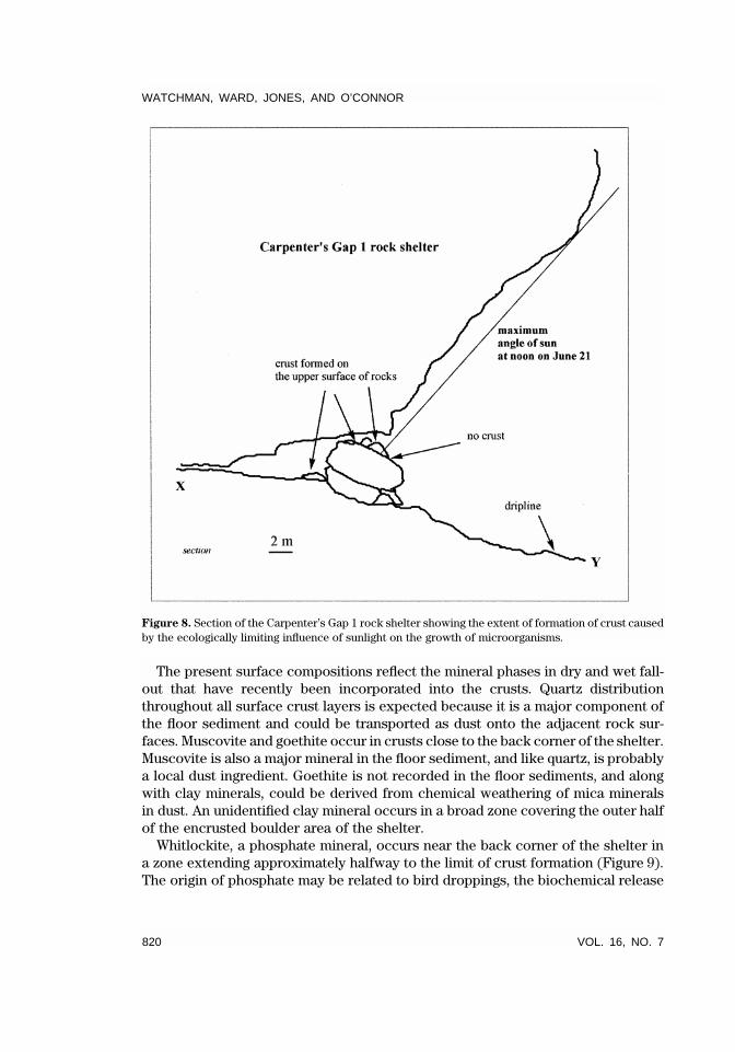
Natural and human processes affect the crusts that form on the surfaces of ledgesand rock slabs. The compositions of crusts, therefore, represent the outcome of allprocesses affecting the rocks throughout their exposure history. If the exposurehistory and formational processes were uniform, then the crust compositionswould be homogeneous. However, our findings of mineralogical and geochemicalvariations between sampling locations and within crusts about 20,000 years old,indicate that shelter environments have undergone frequent changes. Thesechanges are either the product of variations in the compositions of primary depo-sitional components, modifications of dust ingredients by microorganisms, diage-netic alterations of indurated dust, or a combination of these processes. Microor-ganisms provide the critical function in formation of the crusts because thedistribution of the crust is spatially dependent on the limit of sunlight penetrationin the shelter. The extent of crust formation in the shelter reflects the sensitivityof microorganisms to ultraviolet light, with no crust forming beyond the area ofmaximum shadow even though apparently suitable areas are within the dripline(Figures 2, 8, and 9).
Localized floor disturbances produce dust which becomes incorporated in crusts,whereas only a small percentage of components come from outside the shelter.The major source of the floor deposits is from in situ weathering of the micaceoussandstone on which the limestone was deposited. The sandstone itself was origi-nally deposited as a fluvial sediment derived from the weathering of Proterozoicgranitic rocks, so, on weathering, it releases grains and minerals characteristic ofwater-borne weathering products. Periodic bursts of intense tropical rain bringclay, silt, and sand into the shelter from weathering of the unconformable contactbetween limestone and sandstone, and these components can later become dust.
Angular unconformities in the finely laminated deposits indicate erosion andsubsequent deposition of new crust components. The timing of a major erosionalepisode, prior to ca. 5730 yr B.P. provides evidence, albeit tenuous, for significantloss of crusts and probably floor sediments in the early Holocene. Similar micro-unconformities in the other crusts indicate that early Holocene erosion was intenseand widespread in various parts of the shelter. Such erosion could possibly explainthe apparent hiatus in occupation during the late Pleistocene which has been at-tributed to abandonment of the rock shelter (O’Connor, 1995).
The finely laminated crusts, formed on stable rock surfaces over 20,000 years,contain hydrated salts that reflect changes in the microenvironment. Macrobotan-ical remains and phytoliths in the floor sediments indicate variability in annualrainfall and water availability in the region (Wallis, 2000) over the period of crustformation, and provide supporting evidence for changes observed in the crusts.During the last glacial maximum (LGM), arid conditions prevailed (rainfall inferredat 350–400 mm/annum) and Chenopodiaceae first appeared (Wallis, 2000:324).Even during this dry period, at least one crust (CG97/3) began to form. Three othercrusts (1, 2, and 4) started to form immediately after the LGM. The moisture regimein the shelter, rather than annual rainfall, appears to control crust formation.
WATCHMAN, WARD, JONES, AND O’CONNOR
820 VOL. 16, NO. 7
shortstandard
GEA(Wiley) LEFT BATCH
Figure 8. Section of the Carpenter’s Gap 1 rock shelter showing the extent of formation of crust causedby the ecologically limiting influence of sunlight on the growth of microorganisms.
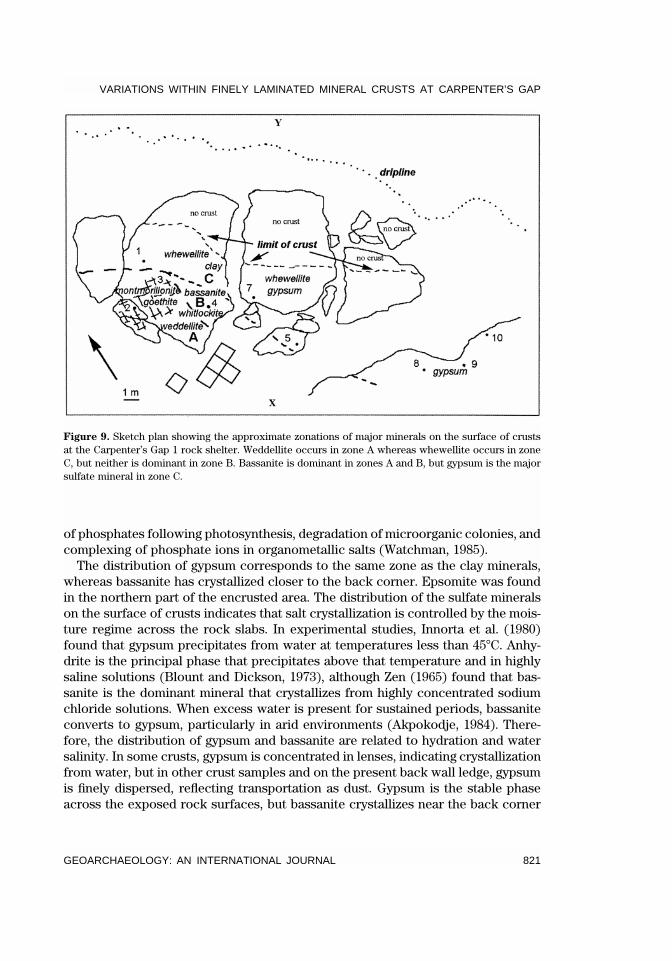
The present surface compositions reflect the mineral phases in dry and wet fall-out that have recently been incorporated into the crusts. Quartz distributionthroughout all surface crust layers is expected because it is a major component ofthe floor sediment and could be transported as dust onto the adjacent rock sur-faces. Muscovite and goethite occur in crusts close to the back corner of the shelter.Muscovite is also a major mineral in the floor sediment, and like quartz, is probablya local dust ingredient. Goethite is not recorded in the floor sediments, and alongwith clay minerals, could be derived from chemical weathering of mica mineralsin dust. An unidentified clay mineral occurs in a broad zone covering the outer halfof the encrusted boulder area of the shelter.
Whitlockite, a phosphate mineral, occurs near the back corner of the shelter ina zone extending approximately halfway to the limit of crust formation (Figure 9).The origin of phosphate may be related to bird droppings, the biochemical release
VARIATIONS WITHIN FINELY LAMINATED MINERAL CRUSTS AT CARPENTER’S GAP
GEOARCHAEOLOGY: AN INTERNATIONAL JOURNAL 821
shortstandard
GEA(Wiley) RIGHT BATCH
Figure 9. Sketch plan showing the approximate zonations of major minerals on the surface of crustsat the Carpenter’s Gap 1 rock shelter. Weddellite occurs in zone A whereas whewellite occurs in zoneC, but neither is dominant in zone B. Bassanite is dominant in zones A and B, but gypsum is the majorsulfate mineral in zone C.
of phosphates following photosynthesis, degradation of microorganic colonies, andcomplexing of phosphate ions in organometallic salts (Watchman, 1985).
The distribution of gypsum corresponds to the same zone as the clay minerals,whereas bassanite has crystallized closer to the back corner. Epsomite was foundin the northern part of the encrusted area. The distribution of the sulfate mineralson the surface of crusts indicates that salt crystallization is controlled by the mois-ture regime across the rock slabs. In experimental studies, Innorta et al. (1980)found that gypsum precipitates from water at temperatures less than 45�C. Anhy-drite is the principal phase that precipitates above that temperature and in highlysaline solutions (Blount and Dickson, 1973), although Zen (1965) found that bas-sanite is the dominant mineral that crystallizes from highly concentrated sodiumchloride solutions. When excess water is present for sustained periods, bassaniteconverts to gypsum, particularly in arid environments (Akpokodje, 1984). There-fore, the distribution of gypsum and bassanite are related to hydration and watersalinity. In some crusts, gypsum is concentrated in lenses, indicating crystallizationfrom water, but in other crust samples and on the present back wall ledge, gypsumis finely dispersed, reflecting transportation as dust. Gypsum is the stable phaseacross the exposed rock surfaces, but bassanite crystallizes near the back corner

WATCHMAN, WARD, JONES, AND O’CONNOR
822 VOL. 16, NO. 7
shortstandard
GEA(Wiley) LEFT BATCH
presumably from saline solutions. The identification of epsomite (MgSO4.7H2O) andhalite (NaCl) indicates that such saline conditions exist in the present environment.Their presence on the contemporary surface and absence in laminations withincrusts may indicate that the shelter is drier and more saline than in the past.
Oxalate minerals were only detected in accessory amounts in CG97/8–10, alongthe sloping back wall near the entrance to the shelter. Whewellite has precipitatedin a narrow zone stretching across half the encrusted area in contrast to weddellite,which has formed near the back corner. The presence of weddellite near the backcorner of the shelter indicates that the deep recess of the shelter stays cool anddamp for longer periods because the dihydrate is known to form at a lower tem-perature than whewellite (Weidemann and Bayer, 1988; Noller et al., 1986). Wed-dellite is also found at depth within the crusts (CG97/2 and 3) and before 5730 yearsago, indicating that cool, damp conditions prevailed in the past. While oxalate min-erals may precipitate from oxalic acid excreted from lichen, or from the interactionof organic acids in rain water (Hofmann and Bernasconi, 1998), these sources areunlikely at Carpenter’s Gap. Lichen are not found on the surfaces of blocks in theshelter and, while rain splash and spray penetrate inside the dripline, the arealdistribution of crust indicates that the encrusting processes are restricted withinthe main part of the shelter.
Small amounts of carbonate are present in samples of crust located near thedripline zone, but carbonate was not found on the surface of crusts near the backof the shelter. This may indicate that carbonate particles in dust are not uniformlydistributed, that carbonate near the back wall is preferentially weathered (chemi-cally dissolved or metabolised by microorganisms), or that carbonate is a stablephase near the dripline. The absence of carbonate minerals where oxalate mineralsdominate needs further research to establish whether chemical and/or biologicalprocesses convert carbonate to oxalate (Ford et al., 1994) or sulfate (Arnold andZehnder, 1991).
CONCLUSIONS AND FUTURE WORK
The mineralogical variations within the ten rock surface crusts from Carpenter’sGap 1 rockshelter indicate a complex relationship of formation and stability ofboth oxalate minerals and evaporative salts under variable microclimatic condi-tions. Direct rain and intense sunlight appear to limit crust formation, indicatingthat microorganic habitat is critical to oxalate deposition and crust formation. Nearthe entrance of the shelter, the low quantities of oxalate minerals at the surface ofcrusts indicate the limited supply of oxalic acid and the unfavorable habitat formicroorganisms. Hemi-, mono- and dihydrated salts have formed in specific zonesaccording to microclimatic influences and the availability of inorganic and organiccomponents through time and space.
Alternating pale and dark laminations in crusts, while evident in Pleistocene-agelayers, become more marked during the Holocene, possibly reflecting cyclical wet-dry phases whose frequency exceeds the short-term El Nino–La Nina events.
VARIATIONS WITHIN FINELY LAMINATED MINERAL CRUSTS AT CARPENTER’S GAP
GEOARCHAEOLOGY: AN INTERNATIONAL JOURNAL 823
shortstandard
GEA(Wiley) RIGHT BATCH
Matching the fine-scale layering to vegetational and regional climatic changes isproblematic because of the lateral compositional variability that we have uncov-ered.
Understanding the environmental significance of such fine-scale laminations inrock surface crusts has only just begun, and much more detailed investigations areunderway. Additional analyses are planned to shed light on the origins of the min-eral phases and their environments of formation. Stable carbon, oxygen, and sulfurisotopic analyses of minerals within laminated crusts may provide further infor-mation about the sources of components and possible proxy environmental infor-mation. Mineralogical analyses and age estimates for laminated crusts on bouldersuncovered during the excavation will be compared with the surface crusts to builda picture of crust evolution prior to 20,000 years ago. We also plan to monitor thepresent variations in temperature and relative humidity within the shelter to de-termine contemporary climatic influences on mineral crystallisation and microor-ganic growth.
Boulders near the front of the shelter are engraved with animal tracks and cu-pular depressions, and we aim to date the basal layers of the encrusted engravingsto determine minimum ages for their production. The variability in thickness, age,and composition of the crusts has vindicated the caution with which we ap-proached the dating of the encrusted engravings. Combining microexcavation(Watchman et al., 2000a) with our understanding of the microclimatic controls inthe composition, and micromorphology of rock crusts will enable us to reliablydetermine minimum ages for the engravings.
We thank the Australian Institute of Aboriginal and Torres Strait Islander Studies for their researchgrant for our Rock Art Dating Project (G97/6095), which provided funds for field work and analyses ofthe rock surface crusts. Mr. Johnny Marr, senior owner, and the Bunuba Aboriginal Corporation gavepermission to carry out work at the site. We also thank Dr. Graeme Ward for administrative assistance,Dr. Ewan Lawson and Dr. John Southon for AMS, Dr. Kevin Blake and Dr. Sharon Ness formineralogicalanalyses, and Dr. John Magee for constructive comments. Watchman’s research was supported by anAustralian Research Council Post Doctoral Fellowship (F39700686).
REFERENCES
Akpokodje, E.G. (1984). The occurrence of bassanite in some Australian arid-zone soils. Chemical Ge-ology, 47, 361–364.
Arnold, A., & Zehnder, K. (1991). Monitoring wall paintings affected by soluble salts. In A. Belloli & I.Averkieff (Eds.), The conservation of wall paintings (pp. 103–135). London: Courtauld Institute ofArt and the Getty Conservation Institute.
Blount, C.W., & Dickson, F.W. (1973). Gypsum-anhydrite equilibria in systems CaSO4-H2O and CaSO4-NaCl-H2O. American Mineralogist, 58, 323–331.
Bureau of Meteorology. (1996). Kimberley, western Australia. Climatic survey January 1996. Canberra:Australian Government Publishing Service.
Fifield, L.K., Bird, M.I., Turney, C.S.M., Hausladen, P.A., Santos, G.M., & di Tada, M.L. (2001). Radiocar-bon dating of the human occupation of Australia prior to 40ka B.P.—successes and pitfalls. Radio-carbon, in press.
Ford, B., MacLeod, I.D., & Haydock, P. (1994). Rock art pigments from the Kimberley region of Western
WATCHMAN, WARD, JONES, AND O’CONNOR
824 VOL. 16, NO. 7
shortstandard
GEA(Wiley) LEFT BATCH
Australia: Identification of the minerals and conversion mechanisms. Studies in Conservation, 39,57–69.
Gillespie, R. (1997). On human blood, rock art and calcium oxalate: Further studies on organic carboncontent and radiocarbon age of materials relating to Australian rock art. Antiquity, 71, 430–437.
Hofmann, B.A., & Bernasconi, S.M. (1998). Review of occurrences and carbon isotope geochemistry ofoxalate minerals: Implications for the origin and fate of oxalate in diagenetic and hydrothermalfluids.Chemical Geology, 149, 127–146.
Innorta, G., Rabbi, E., & Tomadin, L. (1980). The gypsum-anhydrite equilibrium by solubility measure-ments. Geochimica et Cosmochimica Acta, 44, 1931–1936.
MacLeod, I., & Haydock, P. (1996). Research into the conservation of rock paintings in the West Kim-berley, unpublished report. Canberra: Australian Institute of Aboriginal and Torres Strait IslanderStudies.
McConnell, K., & O’Connor, S. (1997). 40,000 year record of food plants in the Southern KimberleyRanges, Western Australia. Australian Archaeology, 45, 20–31.
McConnell, K., & O’Connor, S. (1999). Carpenter’s Gap Shelter 1: A case for total recovery. In M.-J.Mountain & D. Bowdery (Eds.), Taphonomy: The analysis of processes from phytoliths tomagafauna(pp. 23–34), Research Papers in ANH, No. 30. Canberra: ANH Publications, Research School ofPacific and Asian Studies, The Australian National University.
Noller, B.N., Currey, N., Ayers, G., Gillett, R., Harrison, A., & Rasmussen, R.A. (1986). Alligator RiversRegion Institute Annual Research Summary for 1985–86 (pp. 53–55). Canberra: Australian Govern-ment Publishing Service.
O’Connor, S. (1995). Carpenter’s Gap rockshelter 1: 40,000 years of Aboriginal occupation in the NapierRanges, Kimberley, WA. Australian Archaeology, 40, 58–59.
Playford, P. (n.d.). Geology of Windjana Gorge, Geiki Gorge and Tunnel Creek national parks. Geologicalsurvey of western Australia. Como, Perth: Department of Conservation and Land Management.
Wallis, L.A. (2000). Phytoliths, late Quaternary environment and archaeology in tropical semi-arid north-west Australia. Unpublished doctoral dissertation, Australian National University, Canberra, Australia.
Watchman, A. (1985). Mineralogical analysis of silica skins covering rock art. In R. Jones (Ed.), Ar-chaeological research in Kakadu National Park (pp. 281–289), Special Publication No. 13. Canberra:Australian National University.
Watchman, A.L. (1987). Preliminary determinations of the age and composition of mineral salts on rockart surfaces in the Kakadu National Park. In W.R. Ambrose & J.M.J. Mummery (Eds.), Archaeometry:Further Australasian studies (pp. 36–42). Canberra: Department of Prehistory, Australian NationalUniversity.
Watchman, A., & Campbell, A. (1996). Micro-stratigraphic analyses of laminated oxalate crusts in north-ern Australia. In M. Realini & L. Toniolo (Eds.), II International Symposium, The oxalate films in theconservation of works of art (pp. 409–535). Bologna: Editeam.
Watchman, A., & Jones, R. (1998). Dating rock images in the tropical monsoon region of northernAustralia. Australian Aboriginal Studies, 2, 64–70.
Watchman, A.L., David, B., McNiven, I., & Flood, J. (2000a). Micro-archaeology of engraved and paintedrock surface crusts at Yiwaralarlay (The Lightning Brothers site), Northern Territory, Australia.Journal of Archaeological Science, 27, 315–325.
Watchman, A.L., Tacon, P., Fullagar, R., & Head, L. (2000b). Minimum ages for pecked rock markingsfrom Jinmium, northwestern Australia. Archaeology in Oceania, 35, 1–10.
Weidemann, H.G., & Bayer, G. (1989). Formation of whewellite and weddellite by displacement reac-tions. Proceedings, The oxalate films in the conservation of works of art (pp. 127–135). Milan: CentroC.N.R. Gino Bozza.
Zen, E-An. (1965). Solubility measurements in the system CaSO4-NaCl-H2O at 35�, 50�, and 70�C and oneatmosphere pressure. Journal of Petrology, 6, 124–164.
Received June 16, 2000
Accepted for publication March 12, 2001
Copyright © 2022 FDOKUMEN