Intraplate termination of transform faulting within the Antarctic continent
Upload
independentCategory
view
0download
0
www.gia.az
1958-ъи илдян няшр олунурИздается с 1958 года
№1 (276)Published since 1958

F.Kadirov, S.Mammadov, R.Reilinger, S.McClusky
XƏBƏRLƏR • YER ELMLƏRİ ■ ИЗВЕСТИЯ • НАУКИ О ЗЕМЛЕ ■ PROCEEDINGS • THE SCIENCES OF EARTH
82 AZƏRBAYCAN MİLLİ ELMLƏR AKADEMİYASININ XƏBƏRLƏRİ, YER ELMLƏRİ, №1, 2008
© F.Kadirov, S.Mammadov, R.Reilinger, S.McClusky, 2008
SOME NEW DATA ON MODERN TECTONIC DEFORMATION AND ACTIVE FAULTING IN AZERBAIJAN (ACCORDING TO GLOBAL POSITIONING
SYSTEM MEASUREMENTS)
Fakhraddin Kadirov1 and Samir Mammadov1, Robert Reilinger2 and Simon McClusky2
1 – Geology Institute, Azerbaijan National Academy of Sciences, Baku, Azerbaijan
2 – Department of Earth, Atmospheric, and Planetary Sciences Massachusetts Institute of Technology, Cambridge, MA, USA
Abstract Global Positioning System (GPS) observations in Azerbaijan and surrounding areas of the Caucasus region are providing quantitative constraints of the geometry of active fault systems, and rates of pre-sent-day deformation. West of 48° E longitude, the Main Caucasus Trust Fault (MCT) follows the sharp change in slope along the south side of the Greater Caucasus as is well known from prior seismic, geophysical, and geologic studies. How-ever, east of this longitude the MCT turns sharply to the south, crossing the Kura Depression and extending along the western side of the Caspian Sea (here called the West Caspian Fault; WCF). While the MCT is predominantly a thrust fault west of 48°E longitude, the WCF is a pure right-lateral, strike slip fault with a slip rate of 11 ± 1 mm/yr south of the Absheron Peninsula. We also document shortening of 4 ± 1 mm/yr along the northern side of the Greater Caucasus in Dagestan on a roughly E-W striking fault that turns to the south inland of the north Caspian shoreline. This fault configuration implies that the Baku area is at the junction of four fault systems, the MCT, the West Caspian Fault, the North Caspian Fault, and the Central Caspian Seismic Zone. The rate of convergence on the MCT decreases from east to west from 10 ± 1 mm/yr at 48° E longitude to 4 ± 1 mm/yr in northwestern Azerbaijan (~46°E longi-tude). In eastern Azerbaijan, there is no evidence of active shortening in the Lesser Caucasus or Kura Depression, indicating that any deformation in this area is below present velocity uncertainties (± 0.5 mm/yr). The present-day pattern of hori-zontal motions in aggregate suggests that the Lesser Caucasus and Kura Depression are rotat-ing coherently (i.e., little or no internal deforma-
tion) in a counterclockwise sense about a pole located near the NE corner of the Black Sea, re-sulting in the observed W to E increase in the rate of convergence along the MCT. These new, quantitative constraints on fault activity provide an improved physical basis for estimating earth-quake hazards in Azerbaijan. Introduction Azerbaijan is caught in the active continent-continent collision of the Arabian plate with Eurasia (Mckenzie, 1972; Sengor et al., 1985; Philip et al., 1989). Plate tectonic reconstructions provide only broad constraints on the timing of the initial collision of the Arabian Plate with Eurasia of between 10 – 30 Ma BP (e.g., Robert-son, 2000; Allen et al., 2004), and indicate that the rate of northward motion of Arabia relative to Eurasia has remained more or less constant at about 20 mm/yr since collision began (McQuar-rie et al., 2003; Reilinger et al., 2006a). These reconstructions imply that Arabia has progressed from 200 – 600 km “into” space formerly occu-pied by Eurasian continental lithosphere. This “intrusion” of Arabia into Eurasia continues to be accommodated by lithospheric shortening on roughly E-W striking thrust faults and lateral dis-placement of lithosphere out of the collision zone along right-lateral strike-slip faults (McKenzie, 1972; Sengor et al., 1985; Jackson, 1992; Kadi-rov, 2004; Reilinger et al., 2006b). These re-gional tectonic processes give rise to earthquakes that have devastated the Caucasus region throughout recorded history. In this paper we use Global Positioning System (GPS) observations in and around Azerbaijan to estimate present-day surface motions. The ob-

SOME NEW DATA ON MODERN TECTONIC DEFORMATION………....
XƏBƏRLƏR • YER ELMLƏRİ ■ ИЗВЕСТИЯ • НАУКИ О ЗЕМЛЕ ■ PROCEEDINGS • THE SCIENCES OF EARTH
83
served motions (site velocities) allow us to iden-tify zones of rapid strain accumulation that we interpret as resulting from deep slip on faults that are presently locked at crustal depths and will likely give rise to future earthquakes. The GPS-derived surface motions allow estimation of fault geometry, slip rates, and locking depths (e.g., Okada, 1992), thereby providing an improved physical basis for estimating regional earthquake hazards. For example, the estimated rate of slip on the deep, freely sliding section of the Main Caucasus Thrust Fault (MCT) determined by GPS observations of surface motion, and esti-mates of slip in prior earthquakes (from study of historic and pre-historic earthquakes) allows es-timation of the time required to accumulate suffi-cient strain to generate an earthquake, or equiva-lently, the earthquake recurrence time for indi-vidual fault segments (assuming the time-predictable earthquake model; Shimazaki, and Nakata, 1980). Furthermore, the total coseismic slip from prior earthquakes, together with esti-mates of the locking depth of the fault (from the wavelength of the GPS deformation field), and the length of fault segments (from geological and geophysical studies) allow estimation of the magnitude of future events. Thus, our GPS ob-servations have the potential to constrain the tim-ing and magnitude of future earthquakes. GPS network and Data Processing Figure 1 shows the present configuration of the GPS network, developed by the Geology Institute, Azerbaijan National Academy of Sciences in col-laboration with Massachusetts Institute of Tech-nology, superimposed on a simplified tectonic map. The network consists of 18 survey-mode sites and a continuously recording GPS station at the Geology Institute in Baku. The network was established during the period 1998 – 2007 with most survey stations measured from 3-5 times. The GPS data were processed, and uncertainties were estimated, using the GAMIT/GLOBK soft-ware (King and Bock, 2004; Herring, 2004) fol-lowing procedures described in Reilinger et al. (2006b). Briefly, the raw GPS observations were processed in a two step approach (Dong et al., 1998). In the first step, loosely constrained esti-mates of station coordinates, orbital and Earth ori-entation parameters, and atmospheric zenith de-lays were determined from dual frequency GPS
carrier phase observations using GAMIT. Data from the Azerbaijan GPS network were analyzed along with raw GPS data from other continuously operating GPS stations in the region. In the second step, a global Kalman filter (GLOBK) was used to estimate a consistent set of station coordinates and velocities by combining the daily, loosely con-strained solutions from step 1 and their associated covariances. As part of this second step, a 6 pa-rameter transformation was estimated by minimiz-ing the horizontal velocities of 49 globally distrib-uted International GNSS Service (IGS) stations with respect to the IGS00 realization of the Inter-national Terrestrial Reference Frame 2000 (ITRF 2000) no-net-rotation reference frame. A random walk noise of 1 mm/√yr was also added to the ve-locity uncertainties for each site. Finally, the ve-locities were rotated into a Eurasian fixed frame to facilitate interpretation. Figure 2 shows a map of GPS-derived site velocities within the territory of Azerbaijan (listed in Table 1) in the context of selected GPS velo-cities in surrounding areas. Velocities are shown in a Eurasia-fixed reference frame determined by minimizing motions for GPS stations that have been observed well and are broadly distributed across the Eurasian plate. No velocity was estimated for the Geology Institute, Baku station because of the short period of operation (established in 2007). Velocity uncertainties are mostly less than 0.6 mm/yr (1 sigma), allowing fairly precise estimates of convergence across the Caucasus mountain system (i.e., uncertainties are ~ 5% of the total convergence rate). Discussion On a broad scale, the GPS velocity field clearly illustrates the NNE motion of Azerbaijan and adjacent regions of the Lesser Caucasus with respect to Eurasia south of the MCT (Figure 2). The most pronounced feature of the velocity field is the decrease in site velocities across the MCT (i.e., between KURD and MEDR, and BILE and SHIK). Sites along the MCT show reduced, but significant NE motion that we interpret as being due in part to strain accumulation on this thrust fault (i.e., the fault is locked at crustal levels). In addition, there is a tendency for motions south of the MCT within the Kura Depression and Lesser Caucasus to increase in rate from W to E along strike of the mountain range.
F.Kadirov, S.Mammadov, R.Reilinger, S.McClusky
XƏBƏRLƏR • YER ELMLƏRİ ■ ИЗВЕСТИЯ • НАУКИ О ЗЕМЛЕ ■ PROCEEDINGS • THE SCIENCES OF EARTH
84
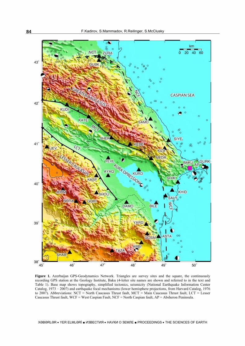
Figure 1. Azerbaijan GPS-Geodynamics Network. Triangles are survey sites and the square, the continuously recording GPS station at the Geology Institute, Baku (4-letter site names are shown and referred to in the text and Table 1). Base map shows topography, simplified tectonics, seismicity (National Earthquake Information Center Catalog, 1973 – 2007) and earthquake focal mechanisms (lower hemisphere projections, from Harvard Catalog, 1976 to 2007). Abbreviations: NCT = North Caucasus Thrust fault, MCT = Main Caucasus Thrust fault, LCT = Lesser Caucasus Thrust fault, WCF = West Caspian Fault, NCF = North Caspian fault, AP = Absheron Peninsula.
SOME NEW DATA ON MODERN TECTONIC DEFORMATION………....
XƏBƏRLƏR • YER ELMLƏRİ ■ ИЗВЕСТИЯ • НАУКИ О ЗЕМЛЕ ■ PROCEEDINGS • THE SCIENCES OF EARTH
85
Table 1 Azerbaijan GPS site locations, velocities, and 1-sigma uncertainties
Long. (deg)
Lat. (deg)
E&N Rate (mm/yr)
E&N + (mm/yr)
SITE
50.329 40.404 GURK 49.814 40.372 BAKU 49.426 40.025 5.20 2.17 0.52 0.51 SHIK 49.237 39.818 5.16 6.45 1.40 1.42 KHID 49.120 41.066 0.99 0.74 0.53 0.52 SIYE 49.020 39.676 6.87 6.14 1.35 1.37 SALY 48.993 40.870 1.27 2.47 0.79 0.75 KIZA 48.796 38.635 ASTA 48.717 39.497 6.06 12.28 0.53 0.52 BILE 48.551 40.614 2.67 4.78 0.52 0.51 MEDR 48.529 41.595 0.87 1.53 0.54 0.53 SAMU 48.419 38.706 5.33 12.42 0.57 0.55 GOSM 48.388 38.952 5.65 12.66 0.56 0.55 YARD 48.148 40.333 3.57 10.36 0.66 0.62 KURD 47.863 40.975 0.56 4.83 0.52 0.51 KEBE 47.250 41.132 0.74 5.86 0.51 0.51 SHEK 47.146 40.626 1.71 4.90 0.70 0.66 YEVL 47.143 40.190 AYAQ 46.511 41.652 0.19 5.31 0.51 0.51 KATE
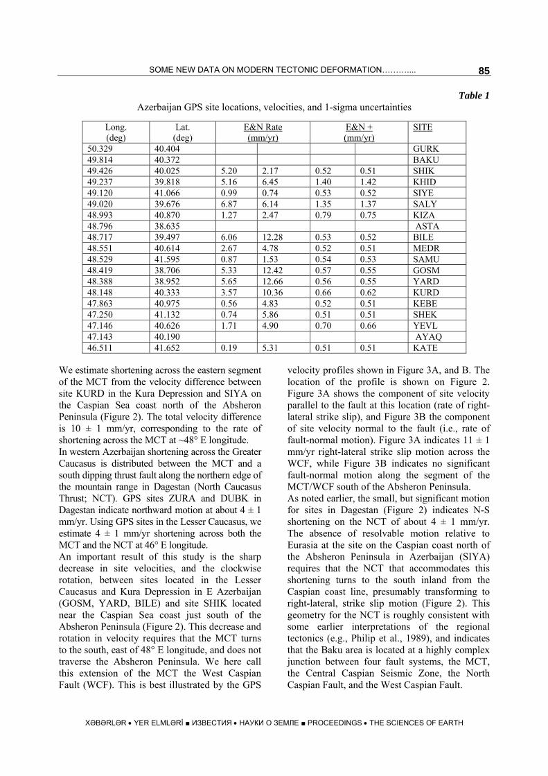
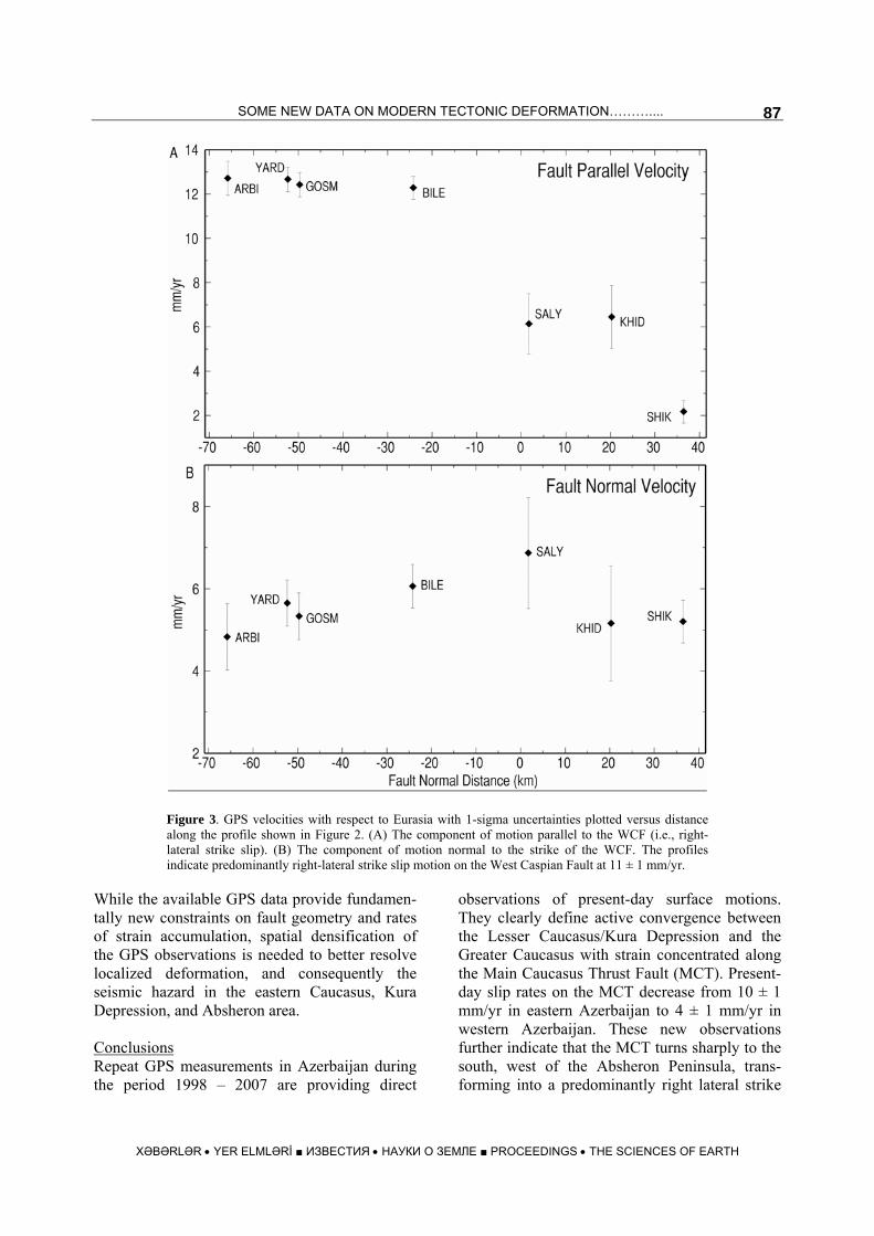
We estimate shortening across the eastern segment of the MCT from the velocity difference between site KURD in the Kura Depression and SIYA on the Caspian Sea coast north of the Absheron Peninsula (Figure 2). The total velocity difference is 10 ± 1 mm/yr, corresponding to the rate of shortening across the MCT at ~48° E longitude. In western Azerbaijan shortening across the Greater Caucasus is distributed between the MCT and a south dipping thrust fault along the northern edge of the mountain range in Dagestan (North Caucasus Thrust; NCT). GPS sites ZURA and DUBK in Dagestan indicate northward motion at about 4 ± 1 mm/yr. Using GPS sites in the Lesser Caucasus, we estimate 4 ± 1 mm/yr shortening across both the MCT and the NCT at 46° E longitude. An important result of this study is the sharp decrease in site velocities, and the clockwise rotation, between sites located in the Lesser Caucasus and Kura Depression in E Azerbaijan (GOSM, YARD, BILE) and site SHIK located near the Caspian Sea coast just south of the Absheron Peninsula (Figure 2). This decrease and rotation in velocity requires that the MCT turns to the south, east of 48° E longitude, and does not traverse the Absheron Peninsula. We here call this extension of the MCT the West Caspian Fault (WCF). This is best illustrated by the GPS
velocity profiles shown in Figure 3A, and B. The location of the profile is shown on Figure 2. Figure 3A shows the component of site velocity parallel to the fault at this location (rate of right-lateral strike slip), and Figure 3B the component of site velocity normal to the fault (i.e., rate of fault-normal motion). Figure 3A indicates 11 ± 1 mm/yr right-lateral strike slip motion across the WCF, while Figure 3B indicates no significant fault-normal motion along the segment of the MCT/WCF south of the Absheron Peninsula. As noted earlier, the small, but significant motion for sites in Dagestan (Figure 2) indicates N-S shortening on the NCT of about 4 ± 1 mm/yr. The absence of resolvable motion relative to Eurasia at the site on the Caspian coast north of the Absheron Peninsula in Azerbaijan (SIYA) requires that the NCT that accommodates this shortening turns to the south inland from the Caspian coast line, presumably transforming to right-lateral, strike slip motion (Figure 2). This geometry for the NCT is roughly consistent with some earlier interpretations of the regional tectonics (e.g., Philip et al., 1989), and indicates that the Baku area is located at a highly complex junction between four fault systems, the MCT, the Central Caspian Seismic Zone, the North Caspian Fault, and the West Caspian Fault.
F.Kadirov, S.Mammadov, R.Reilinger, S.McClusky
XƏBƏRLƏR • YER ELMLƏRİ ■ ИЗВЕСТИЯ • НАУКИ О ЗЕМЛЕ ■ PROCEEDINGS • THE SCIENCES OF EARTH
86
Figure 2. GPS-derived velocity field, and 95% confidence ellipses for Azerbaijan and surrounding areas of the Caucasus region shown with respect to Eurasia. Site velocities outside the territory of Azerbaijan are from Reilinger et al. (2006). The location and width (brackets) of the velocity profiles along (Figure 3A) and across (Figure 3B) the southern extension of the Main Caucasus Thrust Fault (West Caspian Fault) is also shown
SOME NEW DATA ON MODERN TECTONIC DEFORMATION………....
XƏBƏRLƏR • YER ELMLƏRİ ■ ИЗВЕСТИЯ • НАУКИ О ЗЕМЛЕ ■ PROCEEDINGS • THE SCIENCES OF EARTH
87
Figure 3. GPS velocities with respect to Eurasia with 1-sigma uncertainties plotted versus distance along the profile shown in Figure 2. (A) The component of motion parallel to the WCF (i.e., right-lateral strike slip). (B) The component of motion normal to the strike of the WCF. The profiles indicate predominantly right-lateral strike slip motion on the West Caspian Fault at 11 ± 1 mm/yr.
While the available GPS data provide fundamen-tally new constraints on fault geometry and rates of strain accumulation, spatial densification of the GPS observations is needed to better resolve localized deformation, and consequently the seismic hazard in the eastern Caucasus, Kura Depression, and Absheron area. Conclusions Repeat GPS measurements in Azerbaijan during the period 1998 – 2007 are providing direct
observations of present-day surface motions. They clearly define active convergence between the Lesser Caucasus/Kura Depression and the Greater Caucasus with strain concentrated along the Main Caucasus Thrust Fault (MCT). Present-day slip rates on the MCT decrease from 10 ± 1 mm/yr in eastern Azerbaijan to 4 ± 1 mm/yr in western Azerbaijan. These new observations further indicate that the MCT turns sharply to the south, west of the Absheron Peninsula, trans-forming into a predominantly right lateral strike
F.Kadirov, S.Mammadov, R.Reilinger, S.McClusky
XƏBƏRLƏR • YER ELMLƏRİ ■ ИЗВЕСТИЯ • НАУКИ О ЗЕМЛЕ ■ PROCEEDINGS • THE SCIENCES OF EARTH
88
slip fault with a slip rate of 11 ± 1 mm/yr south of the Absheron Peninsula. We here name this south-striking extension of the MCT the West Caspian Fault. GPS-derived motions in the North Caucasus of Dagestan and along the Caspian coast in Azerbaijan north of the Absheron Peninsula require that thrust faulting along the south-dipping North Caucasus Thrust in Dages-tan turns to the south inland of the Caspian coast, presumably accommodating right-lateral strike slip motion on the “North Caspian Fault”. These interpretations of the GPS velocity field place Baku at the junction of four active fault systems, the MCT, the North and West Caspian faults (likely right-lateral, strike slip), and the Central Caspian Seismic Zone. More focused geodetic monitoring of surface motions are needed in the Baku region and Kura Depression, as well as in the immediate vicinity of other active faults to constrain better fault locations, interactions, and locking depths to provide an improved basis for evaluating earthquake hazards. Acknowledgments We are grateful to the survey personnel who assisted with the field observations in Azerbaijan, and the many individuals that maintain the global IGS stations used in our analysis. The maps in this paper were generated using the public domain Generic Mapping Tools (GMT) software (Wessel and Smith, 1995). This work was supported in part by the Geology Institute, Azerbaijan National Academy of Sciences and NSF Grant EAR-0337497 to MIT.
REFERENCES
ALLEN, M., JACKSON, J., WALKER, R. 2004. Late Ceno-
zoic reorganization of the Arabia-Eurasia collision and the comparison of short-term and long-term deformation rates. Tectonics, 23, doi: 10.1029/2003TC001530.
DONG, D., HERRING, T.A., KING, R.W. 1998. Estimating regional deformation from a combination of space and terrestrial geodetic data. J. Geodesy, 72, 200-211,
HERRING, T.A. 2004. GLOBK: Global Kalman filter
VLBI and GPS analysis program version 4.1, Massachusetts Institute of Technology. Cambridge. MA.
JACKSON, J. 1992. Partitioning of strike-slip and conver-gent motion between Eurasia and Arabia in eastern Turkey. J. Geophys. Res., 97, 12471–-12479.
KADIROV, F.A. 2004. Gravity model of lithosphere in the Caucasus-Caspian Region. In: South Caspian Basin: Geology, geophysics, oil and gas content. Geology Institute, Azerbaijan National Academy of Sciences. Publishers Nafta Press. Baku, Azerbaijan.
KING, R. W., BOCK, Y. 2004. Documentation of the MIT GPS analysis software: GAMIT. Mass. Inst. of Technol. Cambridge.
McKENZIE, D.P. 1972. Active tectonics of the Mediter-ranean region. Geophys. J. R. Asron. Soc., 30, 239-243.
McQUARRIE, N., STOCK, J., VERDEL, C, WERNICKE, B.P. 2003. Cenozoic evolution of Neotethys and implications for the causes of plate motions. Geophys. Res. Lett., 30(20), 2036, doi:10.1029/2003GL017992.
OKADA, Y. 1992. Internal deformation due to shear and tensile faults in a half-space. Bull. Seismol. Soc. Am., 82, 1018-1040.
PHILIP, H., CISTERNAS, A., GVISKIANI, A., GORSH-KOV, A. 1989. The Caucasus: An actual example of the initial stages of continental collision. Tectonophysics, 161, 1–21.
REILINGER, R., McCLUSKY, S., ArRAJEHI, A., MAHMOUD, S., RYAN, A., GHEBREAB, W., OGUBAZGHI, G., AL-AYDRUS. A. 2006a. Geodetic constraints on rupturing of the continental lithosphere along the Red Sea. MARGINS Newsletter, 17, 16-19.
REILINGER, R. S. and 22 others. 2006b .GPS constraints on continental deformation in the Africa-Arabia-Eurasia continental collision zone and implications for the dynamics of plate interactions. J. Geophys. Res., BO5411, doi:10.1029/2005JB004051.
ROBERTSON, A.H.F. 2000. Mesozoic-Tertiary tectonic evolution of a south Tethyan ocean basin and its margins in southern Turkey. In: Tectonics and Magmatism in Turkey and the Surrounding Area, edited by E. Bozkurt, J.A. Winchester, and J.D.A. Piper, Geol. Soc. Spec. Pub. London, 173, 97-138.
SENGOR, A.M.C., GORUR, N., SAROGLU, F. 1985. Strike-slip faulting and related basin formation in zones of tectonic escape: Turkey as a case study. In: Strike-slip Faulting and Basin Formation (Biddle, K.T. and N. Christie-Blick, eds.), Society of Econ. Paleont. Min. Sec. Pub.,37, 227-264.
SHIMAZAKI, K., NAKATA, T. 1980. Time-predictable recurrence model for large earthquakes. Geophys. Res. Lett. 7, 279-282.
WESSEL, R., SMITH, W.H.F. 1995. New version of the Generic Mapping Tools released. EOS Trans AGU, 76, 329.
ПЕРЕЧЕНЬ СТАТЕЙ, ОПУБЛИКОВАННЫХ В 2007 ГОДУ
XƏBƏRLƏR • YER ELMLƏRİ ■ ИЗВЕСТИЯ • НАУКИ О ЗЕМЛЕ ■ PROCEEDINGS • THE SCIENCES OF EARTH
176 AZƏRBAYCAN MİLLİ ELMLƏR AKADEMİYASININ XƏBƏRLƏRİ, YER ELMLƏRİ, №1, 2008
CONTENTS
Geology Institute of ANAS – 70
Ali-Zadeh Ak.A. – Azerbaijan geological science can be proud of its famous history ............................................... 3
Scientific-organization activity
Ismail-Zadeh A.J. – Problem directions in field of Azerbaijan geology and geography in 2007 ............................... 7
Geology and geophysics
H.H.Guliyev – About the interior structure of the Earth within the non-classical linearized approach ..................... 18 Tagiyev M.F. – Basin modelling in Azerbaijan: the state and perspectives development ......................................... 32 Gadjiev A.N. – The regularities of folding manifestation of South-Caspian megadepression and geo-
dynamic aspects of oil-and-gas content................................................................................................................. 43 Ismail-Zadeh A.J., Yemelyanova Ye.N., Veliyev Z.A., Lyatifova Ye.N. – Problems of Lesser Cau-
casus Sevan-Akera zone metallogeny ................................................................................................................... 55 Mustafayev G.V. – About the sources of metals in the fields of the South slope of the Greater
Caucasus and ore forming system “mantle-ore” ................................................................................................... 67 Kalandarov B.G. – Typomorphic features of the sphalerite of polymetallic fields of Lesser Caucasus
(the Azerbaijan part) ............................................................................................................................................. 76 Kadirov F., Mammadov S., Reilinger R., McClusky S. – Some new data on modern tectonic deforma-
tion and active faulting in Azerbaijan (according to Global Positioning System measurements)...............................82 Safarov I.B., Shirinov N.M. – Theoretical and experimental research of pressure influence on iso-
tropic elastic properties of magmatic rocks........................................................................................................... 89
Development of oil and gas deposits
Abasov M.T., Jalalov G.I. – The problems of the underground hydrogasdinamics ............................................... 100 Kazimova T.Sh. – About determination of the parameters of a creeping gas bed according to the data
of hydrodynamic investigations of wells............................................................................................................. 112 Strekov A.S., Nazirov K.V. – The study of the influence of drilling fluids on the filtration properties
of rocks................................................................................................................................................................ 118
Geography
Budagov B.A.,Mamedov R.M., Alizadeh E.K., Imanov F.A., Mardanov I.E., Iskenderov A.I. – Natural and anthropogenesis accidents in the territory of Azerbaijan................................................................. 121
Kashgay R.M. – Formation of river flow, its rational utilization and ways of redistribution in the ter-ritory of Azerbaijan ............................................................................................................................................. 134
Eyyubov N.H. – Economic-geographical problems of improvement of population settlement of Azer-baijan Republic.................................................................................................................................................... 144
Jubilees
Ali-Zadeh Ak.A. – Academician B.A. Budagov’s 80th anniversary ........................................................................ 151 Ali-Zadeh Ak.A., Ismail-Zadeh A.J. – Prominent representative of Azerbaijan geological science (to
the 85-th anniversary of corresponding member of ANAS F.S.Akhmedbeyli) .................................................. 153
Studies about scientists
Budagov B.A. – Coryphaeus of science (Glazovskaya Maria Alfredovna) ............................................................. 154
ПЕРЕЧЕНЬ СТАТЕЙ, ОПУБЛИКОВАННЫХ В 2007 ГОДУ
XƏBƏRLƏR • YER ELMLƏRİ ■ ИЗВЕСТИЯ • НАУКИ О ЗЕМЛЕ ■ PROCEEDINGS • THE SCIENCES OF EARTH
177AZƏRBAYCAN MİLLİ ELMLƏR AKADEMİYASININ XƏBƏRLƏRİ, YER ELMLƏRİ, №1, 2008
Legal provision of science
Enactment of Cabinet of Ministers of Azerbaijan Republic on approving “Programme of arrangements
on development, investigation and using of ecologically friendly technology of metal extraction from ore fields of Azerbaijan”............................................................................................................................. 157
Agreement of free access and open scientific-technical information exchange for NIS countries-members .............................................................................................................................................................. 162
Summary ................................................................................................................................................................. 168
Copyright © 2022 FDOKUMEN