Soil physical properties of high mountain fields under bauxite mining
8
Ciênc. agrotec., Lavras, v. 37, n. 5, p. 419-426, set./out., 2013 SOIL PHYSICAL PROPERTIES OF HIGH MOUNTAIN FIELDS UNDER BAUXITE MINING Propriedades físicas do solo de campos altimontanos sob interferência da mineração de bauxita Dalmo Arantes de Barros 1 , José Aldo Alves Pereira 2 , Mozart Martins Ferreira 3 Bruno Montoani Silva 3 , Diógenes Ferreira Filho 4 , Gleisson de Oliveira Nascimento 2 ABSTRACT Mining contributes to the life quality of contemporary society, but can generate significant impacts, these being mitigated due to environmental controls adopted. This study aimed to characterize soil physical properties in high-altitude areas affected by bauxite mining, and to edaphic factors responses to restoration techniques used to recover mined areas in Poços de Caldas plateau, MG, Brazil. The experiment used 3 randomized block design involving within 2 treatments (before mining intervention and after environmental recovery), and 4 replicates (N=24). In each treatment, soil samples with deformed structures were determined: granulometry, water-dispersible clay content, flocculation index, particle density, stoniness level, water aggregate stability, and organic matter contend. Soil samples with preserved structures were used to determine soil density and the total volume of pores, macropores, and micropores. Homogenization of stoniness between soil layers as a result of soil mobilization was observed after the mined area recovery. Stoniness decreased in 0.10-0.20 m layer after recovery, but was similar in the 0-0.10 m layer in before and after samples. The recovery techniques restored organic matter levels to pre-mining levels. However, changes in soil, including an increase in soil flocculation degree and a decrease in water-dispersible clays, were still apparent post-recovery. Furthermore, mining operations caused structural changes to the superficial layer of soil, as demonstrated by an increase in soil density and a decrease in total porosity and macroporosity. Decreases in the water stability of aggregates were observed after mining operations. Index terms: Environmental recovery, physical soil quality, soil recovery. RESUMO A mineração contribui para a qualidade de vida da sociedade contemporânea, porém pode gerar impactos significativos, sendo esses mitigados em função dos controles ambientais adotados. Neste trabalho objetivou-se caracterizar as propriedades físicas do solo, mediante a influência de empreendimentos minerários, avaliando as respostas dos atributos edáficos frente às técnicas utilizadas para a recuperação de áreas degradadas pela mineração de bauxita na região do planalto de Poços de Caldas, MG. O delineamento experimental foi concebido com 3 blocos casualizados, com 2 tratamentos (antes da intervenção minerária e depois da recuperação ambiental), e 4 repetições (N=24). Em cada situação, por meio das amostras com estruturas deformadas foram determinados: granulometria, argila dispersa em água, índice de floculação, densidade de partículas, índice de pedregosidade, estabilidade de agregados em água e teor total de matéria orgânica, por meio das amostras com estrutura preservada foram determinadas: densidade do solo, volume total de poros, macroporos e microporos. Após a recuperação da área minerada, ocorreu homogeneização da pedregosidade entre as camadas, decorrente do revolvimento e, consequentemente, da sua redução na camada de 0,10 a 0,20 m; os processos de recuperação da área minerada propiciaram manutenção dos teores de matéria orgânica, aumento do grau de floculação do solo e redução da argila dispersa em água; a intervenção minerária proporcionou alterações estruturais na camada superficial do solo, evidenciadas pelo aumento na sua densidade, redução na porosidade total e macroporosidade; houve redução da estabilidade de agregados em água após a intervenção minerária. Termos para indexação: Recuperação ambiental, qualidade física do solo, recuperação do solo. (Received in may 6, 2013 and approved in june 27, 2013) INTRODUCTION Mining is an important contributor to the improvement of living conditions in today’s society (CARVALHO, 2011). However, mining activities may also lead to significant environmental impacts (LONGO et al., 2011). In many cases, environmental impacts from mining 1 Universidade Federal de Lavras/UFLA – Departamento de Ciência Florestal/DCF – Cx. P. 3037 – 37200-000 – Lavras – MG – Brasil – [email protected] 2 Universidade Federal de Lavras/UFLA – Departamento de Ciência Florestal/DCF – Lavras – MG – Brasil 3 Universidade Federal de Lavras/UFLA – Departamento de Ciência do Solo/DCS – Lavras – MG – Brasil 4 Universidade Federal de Lavras/UFLA – Departmento de Ciências Exatas/DEX – Lavras – MG – Brasil activities can be mitigated by the use of appropriate environmental controls and ecological restoration techniques. Soil is the basic substrate that supports all life on Earth (FERREIRA, 2010). The development of methods to assess soil quality is challenging (MELLONI et al., 2008) in part because the ascertainment of soil quality depends
-
Upload
independent -
Category
Documents
-
view
1 -
download
0
Transcript of Soil physical properties of high mountain fields under bauxite mining

Soil physical properties of high mountain... 419
Ciênc. agrotec., Lavras, v. 37, n. 5, p. 419-426, set./out., 2013
SOIL PHYSICAL PROPERTIES OF HIGH MOUNTAINFIELDS UNDER BAUXITE MINING
Propriedades físicas do solo de campos altimontanos sob interferência da mineração de bauxita
Dalmo Arantes de Barros1, José Aldo Alves Pereira2, Mozart Martins Ferreira3
Bruno Montoani Silva3, Diógenes Ferreira Filho4, Gleisson de Oliveira Nascimento2
ABSTRACT Mining contributes to the life quality of contemporary society, but can generate significant impacts, these being mitigated
due to environmental controls adopted. This study aimed to characterize soil physical properties in high-altitude areas affected bybauxite mining, and to edaphic factors responses to restoration techniques used to recover mined areas in Poços de Caldas plateau,MG, Brazil. The experiment used 3 randomized block design involving within 2 treatments (before mining intervention and afterenvironmental recovery), and 4 replicates (N=24). In each treatment, soil samples with deformed structures were determined:granulometry, water-dispersible clay content, flocculation index, particle density, stoniness level, water aggregate stability, andorganic matter contend. Soil samples with preserved structures were used to determine soil density and the total volume of pores,macropores, and micropores. Homogenization of stoniness between soil layers as a result of soil mobilization was observed after themined area recovery. Stoniness decreased in 0.10-0.20 m layer after recovery, but was similar in the 0-0.10 m layer in before and aftersamples. The recovery techniques restored organic matter levels to pre-mining levels. However, changes in soil, including an increasein soil flocculation degree and a decrease in water-dispersible clays, were still apparent post-recovery. Furthermore, mining operationscaused structural changes to the superficial layer of soil, as demonstrated by an increase in soil density and a decrease in total porosityand macroporosity. Decreases in the water stability of aggregates were observed after mining operations.
Index terms: Environmental recovery, physical soil quality, soil recovery.
RESUMO A mineração contribui para a qualidade de vida da sociedade contemporânea, porém pode gerar impactos significativos, sendo
esses mitigados em função dos controles ambientais adotados. Neste trabalho objetivou-se caracterizar as propriedades físicas dosolo, mediante a influência de empreendimentos minerários, avaliando as respostas dos atributos edáficos frente às técnicas utilizadaspara a recuperação de áreas degradadas pela mineração de bauxita na região do planalto de Poços de Caldas, MG. O delineamentoexperimental foi concebido com 3 blocos casualizados, com 2 tratamentos (antes da intervenção minerária e depois da recuperaçãoambiental), e 4 repetições (N=24). Em cada situação, por meio das amostras com estruturas deformadas foram determinados:granulometria, argila dispersa em água, índice de floculação, densidade de partículas, índice de pedregosidade, estabilidade de agregadosem água e teor total de matéria orgânica, por meio das amostras com estrutura preservada foram determinadas: densidade do solo,volume total de poros, macroporos e microporos. Após a recuperação da área minerada, ocorreu homogeneização da pedregosidadeentre as camadas, decorrente do revolvimento e, consequentemente, da sua redução na camada de 0,10 a 0,20 m; os processos derecuperação da área minerada propiciaram manutenção dos teores de matéria orgânica, aumento do grau de floculação do solo e reduçãoda argila dispersa em água; a intervenção minerária proporcionou alterações estruturais na camada superficial do solo, evidenciadaspelo aumento na sua densidade, redução na porosidade total e macroporosidade; houve redução da estabilidade de agregados em águaapós a intervenção minerária.
Termos para indexação: Recuperação ambiental, qualidade física do solo, recuperação do solo.
(Received in may 6, 2013 and approved in june 27, 2013)
INTRODUCTION
Mining is an important contributor to theimprovement of living conditions in today’s society(CARVALHO, 2011). However, mining activities may alsolead to significant environmental impacts (LONGO et al.,2011). In many cases, environmental impacts from mining
1Universidade Federal de Lavras/UFLA – Departamento de Ciência Florestal/DCF – Cx. P. 3037 – 37200-000 – Lavras – MG – Brasil – [email protected] Federal de Lavras/UFLA – Departamento de Ciência Florestal/DCF – Lavras – MG – Brasil3Universidade Federal de Lavras/UFLA – Departamento de Ciência do Solo/DCS – Lavras – MG – Brasil4Universidade Federal de Lavras/UFLA – Departmento de Ciências Exatas/DEX – Lavras – MG – Brasil
activities can be mitigated by the use of appropriateenvironmental controls and ecological restorationtechniques.
Soil is the basic substrate that supports all life onEarth (FERREIRA, 2010). The development of methods toassess soil quality is challenging (MELLONI et al., 2008)in part because the ascertainment of soil quality depends

BARROS, D. A. de et al.420
Ciênc. agrotec., Lavras, v. 37, n. 5, p. 419-426, set./out., 2013
on the corresponding extension of its benefits to humans.Assessing soil quality is also challenging because soilquality can vary in accordance with its original compositionand it is strongly linked to anthropogenic activities(ARAÚJO; KER; NEVES, 2012). Corrêa and Bento (2010)recommend that scientists study the restoration of minedecosystems to strengthen knowledge of edaphologicalsystems and to develop effective techniques that canimprove the physical quality of substrates.
Studies focusing on the environmental recoveryand restoration of high-altitude mining fields are scarce.However, the demand for new technologies that canrecover landscapes in these types of phyto-physiognomies is high (BARROS et al., 2012). Therefore,the aim of this study was to characterize the physicalproperties of soil in high-altitude areas affected by bauxitemining operations, and to assess the responses of edaphicfactors to restoration techniques used to recover minedareas in the plateau region of Poços de Caldas, MinasGerais, Brazil.
MATERIALS AND METHODS
The study area was located in the plateau regionof Poços de Caldas, Minas Gerais, Brazil (46º27’10"W e21º54’00"S). The plateau region is located within amountainous range area at altitudes varying between1,000 to 1,600 m. This area encompasses the drainagenetworks of the Paraná River hydrographic basin, whichis a sub-basin of the Rio Grande (GATTO et al., 1983).The study area has a highland subtropical, Cwb-typeclimate according to Köppen’s climate classificationsystem (i.e., the region is mesothermal with mild summersand dry winters). The rainy season extends from Octoberto March, with an average annual rainfall of 1,482 mm(PREFEITURA MUNICIPAL DE POÇOS DE CALDAS-PMPC, 1992).
The region lies within the boundaries of the AtlanticForest in South America, and it is composed ofmountainous and high-mountain ombrophilous forests(VELOSO; RANGEL FILHO; LIMA, 1991) as well as galleryforests and highland fields (GUIMARÃES et al., 2008).The soil in the study area was classified according toEmpresa Brasileira de Pesquisa Agropecuária-Embrapa(2006) as typical dystrophic Red Nitosol. Red Nitosol soilsare red in color and are typically porous, well-structured,and acidic. The soil in the study area contained a highamount of clay and gravel and was located on stronglyundulating terrain.
Open-pit mining, method usually employed bymining companies in the plateau region of Poços de Caldas,
was technically developed and adapted over time,depending on the geological and topographical featuresof the region, as well as the market demands. The mining iscarried out in the open, usually with descendingadvancement, which presents the best conditions fordevelopment and the ease it provides at the moment of theenvironmental recovery (WILLIAMS, 2001).
Once mining activity ceases, topographicalreshaping is initiated via the scattering of topsoil (0-0.10 mlayer, rich in organic matter and potential source of plantpropagules) previously stored during the stripping of soil,followed by the subsoiling (GARDNER; BELL, 2007),sometimes crossed. Finally the definitive draining systemis implantated and the revegetation of the area is donethrough specific technical procedures for each field reality.In the cases studied, there was no correction of pH andsoil fertilization.
The quality of restored soils was assessed in thisexperiment by using a randomized block design. Becauseof uncertainty related to the homogeneity of experimentalareas and to control for possible variations inherent to themining process, the experimental design used threerandomized blocks within two treatments (before the miningintervention and after environmental recovery) and fourreplicates were evaluated in each block.
Between January and August 2012, soil sampleswith deformed structures were collected at depths of 0 to0.10 m and 0.10 to 0.20 m. These samples were assessedfor granulometry and water-dispersible clay content(without added chemical dispersants) using theBouyoucos method, and measurements of the flocculationindex, particle density, stoniness (EMBRAPA, 1997).Samples were collected maintaining the soil, relatively, intheir natural aggregates, to estimate the water-stableaggregates. Additional data were collected from aggregatesieving results including the percentage of aggregatesretained in each sieve, the mean weighted diameter ofparticles, the mean geometric diameter of particles, aswell information about macro- and micro-aggregates.These data were collected pursuant to the methodsdescribed in Madari et al. (2005). Organic matter contentwas also assessed in soil samples according to previouslydescribed methods (EMBRAPA, 2007).
Concomitantly, soil samples with preservedstructures were collected at depths of 0 to 0.10 m by thevolumetric ring method using an Uhland sampler. This wasnecessary given the large amount of gravel at greater depthsthroughout the soil profile. The following attributes wereassessed in these samples: soil bulk density, total pore volume,macroporosity, and microporosity (EMBRAPA, 1997).

Soil physical properties of high mountain... 421
Ciênc. agrotec., Lavras, v. 37, n. 5, p. 419-426, set./out., 2013
An analysis of variance (ANOVA) was used tocompare treatment means for the soil parameters assessedin this study. The means of the two treatments were directlycompared using an ANOVA F-test. A factorial arrangementwas used for comparisons of the stoniness index values at0-0.10 m and 0.10-0.20 m depths both before mining andafter recovery.
RESULTS AND DISCUSSION
Granulometry analyses of soil samples in naturalareas and in recovered areas treated after bauxite miningshowed that there was no significant differences in thegranulometric soil fractions across textural classes for thedepths that were assessed. In all situations studied, soilsbelonged to the clay texture class and had clay contentsranging from 537.6 to 563.3 g kg-1 These data confirm thatthe soil profiles were texturally homogeneous.
Although soil horizon inversion is an inherentnegative environmental consequence of the bauxite miningprocess (BARROS et al., 2012), the results obtained in thisstudy were in accordance with those expected since thetextural composition of the soil does not vary very muchduring its exploitation (FERREIRA, 2010). During theenvironmental recovery process, the first 0.10 or 0.20 m ofsoil are stripped prior to mining and the soil is used later inthe recovery process as the primary source of nutrients,microorganisms, and propagules for regeneration of theexploited area. Importantly, Nitosols are characterized bytexturally homogeneous soil profiles (EMBRAPA, 2006;GREGO; COELHO; VIEIRA, 2011).
During ANOVA analyses performed on thestoniness index values, a significant interaction wasobserved between the treatments and the sampling depths(0 to 0.10 m and 0.10 to 0.20 m). In the natural area (i.e.,before mining intervention) the stoniness index at the 0 to0.10 m depth (20.92%) was significantly lower than thevalue found at the 0.10 to 0.20 m depth (46.42%) (Figure 1).These results help to explain the difficulties encounteredduring sampling soils with preserved structures at depthslower than 0.10 m.
After recovery of the mined areas, stoniness indexvalues in the different layers were not significantly differentfrom each other, and the values were 21.50% for soils from 0to 0.10 m in depth and 29.00% for soils from 0.10 to 0.20 m indepth. These results are probably a result of thehomogenization of the soil and the remaining concretionsafter mining, as well as by horizon inversion and the effectson soil that are inherent to topographical reshaping. Miningoperations are known to cause the restructuring of the naturalorganization of soil profiles (LUNARDI NETO et al., 2008).
Figure 1 – Stoniness index values for soils collected atdifferent depths before mining intervention and after theenvironmental recovery of bauxite deposits in the plateauregion in Poços de Caldas, Minas Gerais, Brazil.Means with the same lower case letters for treatments and thesame upper case letter for depths were not statistically differentfrom each other when they were evaluated with the F-test at a5% significance level. Coefficient of Variation = 50.0%.
The stoniness index at the 0 to 0.10 m depth did notdiffer significantly between the values found in the naturalarea (20.92%) and in the recovering area (21.50%). Incontrast, for the 0.10-0.20 m depth, the values found forthe stoniness index were significantly different betweentreatments, which helped to confirm the existence ofchanges in the subsurface caused by the mining process.
Soil preparation operations during environmentalrecovery activities of mined areas may expose soil surfacesto rains and flooding and exacerbate erosion (PANACHUKIet al., 2011). The results of this study seem to confirmthose previous findings, since we observed a lowerflocculation index value in the area before miningintervention when compared to the recovering area for thetwo depths studied (Table 1). Further, the water-dispersibleclay contents were higher in the area before miningintervention took place (Table 1).
Similar results were found by Lunardi Neto et al.(2008) and Mendes, Pereira and Melloni (2006). Theseauthors state that decreases in the flocculation index maycause serious problems because dispersible clays canobstruct pores and reduce infiltration rates, whichcontribute to increased surface runoff and consequently,erosion. We expected to observe higher organic mattercontents in the natural area, since the integrity of thephysical, chemical, and biological components of this soilsystem remained intact. However, no differences in organicmatter content were observed in the samples collectedbefore mining and after recovery. It is possible that anincrease in microbial activity occurred after mining,
BARROS, D. A. de et al.422
Ciênc. agrotec., Lavras, v. 37, n. 5, p. 419-426, set./out., 2013
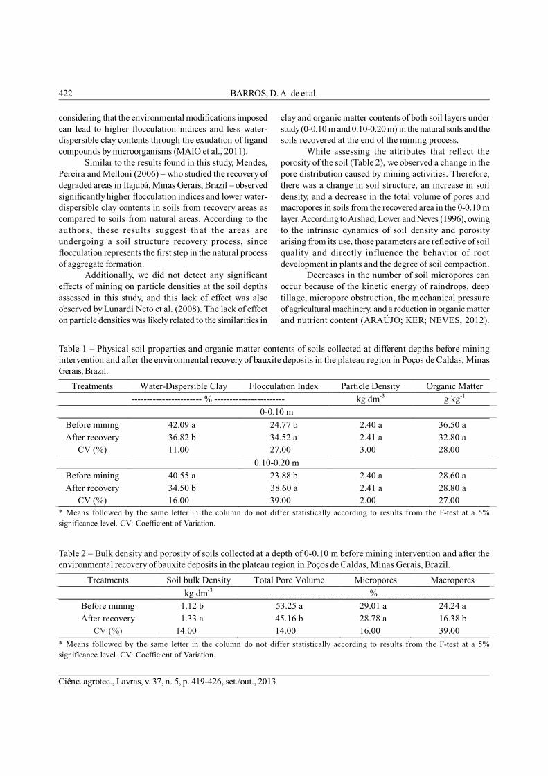
considering that the environmental modifications imposedcan lead to higher flocculation indices and less water-dispersible clay contents through the exudation of ligandcompounds by microorganisms (MAIO et al., 2011).
Similar to the results found in this study, Mendes,Pereira and Melloni (2006) – who studied the recovery ofdegraded areas in Itajubá, Minas Gerais, Brazil – observedsignificantly higher flocculation indices and lower water-dispersible clay contents in soils from recovery areas ascompared to soils from natural areas. According to theauthors, these results suggest that the areas areundergoing a soil structure recovery process, sinceflocculation represents the first step in the natural processof aggregate formation.
Additionally, we did not detect any significanteffects of mining on particle densities at the soil depthsassessed in this study, and this lack of effect was alsoobserved by Lunardi Neto et al. (2008). The lack of effecton particle densities was likely related to the similarities in
clay and organic matter contents of both soil layers understudy (0-0.10 m and 0.10-0.20 m) in the natural soils and thesoils recovered at the end of the mining process.
While assessing the attributes that reflect theporosity of the soil (Table 2), we observed a change in thepore distribution caused by mining activities. Therefore,there was a change in soil structure, an increase in soildensity, and a decrease in the total volume of pores andmacropores in soils from the recovered area in the 0-0.10 mlayer. According to Arshad, Lower and Neves (1996), owingto the intrinsic dynamics of soil density and porosityarising from its use, those parameters are reflective of soilquality and directly influence the behavior of rootdevelopment in plants and the degree of soil compaction.
Decreases in the number of soil micropores canoccur because of the kinetic energy of raindrops, deeptillage, micropore obstruction, the mechanical pressureof agricultural machinery, and a reduction in organic matterand nutrient content (ARAÚJO; KER; NEVES, 2012).
Table 1 – Physical soil properties and organic matter contents of soils collected at different depths before miningintervention and after the environmental recovery of bauxite deposits in the plateau region in Poços de Caldas, MinasGerais, Brazil.
* Means followed by the same letter in the column do not differ statistically according to results from the F-test at a 5%significance level. CV: Coefficient of Variation.
Table 2 – Bulk density and porosity of soils collected at a depth of 0-0.10 m before mining intervention and after theenvironmental recovery of bauxite deposits in the plateau region in Poços de Caldas, Minas Gerais, Brazil.
* Means followed by the same letter in the column do not differ statistically according to results from the F-test at a 5%significance level. CV: Coefficient of Variation.
Treatments Water-Dispersible Clay Flocculation Index Particle Density Organic Matter ----------------------- % ----------------------- kg dm-3 g kg-1
0-0.10 m Before mining 42.09 a 24.77 b 2.40 a 36.50 a After recovery 36.82 b 34.52 a 2.41 a 32.80 a
CV (%) 11.00 27.00 3.00 28.00 0.10-0.20 m
Before mining 40.55 a 23.88 b 2.40 a 28.60 a After recovery 34.50 b 38.60 a 2.41 a 28.80 a
CV (%) 16.00 39.00 2.00 27.00
Treatments Soil bulk Density Total Pore Volume Micropores Macropores kg dm-3 ---------------------------------- % -----------------------------
Before mining 1.12 b 53.25 a 29.01 a 24.24 a After recovery 1.33 a 45.16 b 28.78 a 16.38 b
CV (%) 14.00 14.00 16.00 39.00

Soil physical properties of high mountain... 423
Ciênc. agrotec., Lavras, v. 37, n. 5, p. 419-426, set./out., 2013
There were, however, no significant differences inmicroporosity observed between the soils assessed in thisstudy (Table 2). Aratani et al. (2009) found similar resultsthat depended upon the degree of soil mechanization fordifferent types of soil management in the state of São Paulo.Our results obtained through the analyses of soil sampleswith non-deformed structures may deviate slightly fromvalues for other soils in the region due the high concretioncontent already previously discussed. Gonçalves et al.(2011) – who worked with dystroferric Red Nitosol (Alfisol)soils in the state of Paraná, Brazil – found soil densityvalues ranging from 0.90 to 1.38 kg dm-3.
Within the context of this study, changes in soilstructure may facilitate the establishment of exotic speciesand suppress the presence of more sensitive nativespecies, which could result in changes to the floral structureof the fields. Hence, the occurrence of exotic species atrestoration sites should be monitored as they represent anecological hazard, especially in regards to theenvironmental recovery processes (SOCIETY FORECOLOGIAL RESTORATION-SER, 2004).
Decreases in macroporosity and total pore volumeof the soil correspond to less space being available foradequate soil aeration and oxygen diffusion from the soilto plants. Therefore, given the same moisture content,aeration porosity will likely be lower in recovered soilswhen compared to that found in natural areas.
Soil aggregation was assessed by the stabilityof soil aggregates in water. We observed lower particle
diameter values in soils after recovery activities in minedareas for the two depths under study (Table 3). Thesedata demonstrate the sensitivity of using soil aggregateindicators to detect physical changes in the soil arisingfrom mining activity. It is noteworthy that even thelowest mean particle diameter observed in this study(4.78 mm at 0-0.10 m in depth in recovered soils) wasbigger than the 4.30 mm mean geometric particle diameter(MGD) that was found in sub-savannah oxidic Latosol(Oxisol) areas from similar soil depths by Oliveira et al.(2004). Hence, our results suggest that there was goodstructuring of the Nitosols, which were able to maintaingood soil quality indicator levels even after intensemining activity.
According to Madari et al. (2005), soils with highstructural stability show good aggregation. The highestaggregate concentrations in this study occurred in theparticle size classes that were larger than 2.00 mm (Table3), and soils from the area before mining had significantlyhigher values for such aggregates. However, for theother size classes the highest aggregate percentageswere generally found in recovery areas. This was truefor all treatments except for particle size classes smallerthan 0.105 mm where no significant differences werefound.
Reductions in soil aggregation were likely aconsequence of topographical reshaping activities and othermechanical practices used in the environmental recoveryprocess. These activities can cause the destruction of larger
Table 3 – Mean geometric diameter (MGD), mean weighted diameter (MWD), and size distribution of soil aggregatescollected at different depths before mining intervention and after the environmental recovery of bauxite deposits in theplateau region in Poços de Caldas, Minas Gerais, Brazil.
* Means followed by the same letter in the column do not differ statistically according to results from the F-test at a 5%significance level. Ma: Macroaggregates; Mi: Microaggregates. CV: Coefficient of Variation.
Treatments MGD MWD Aggregate sizes (mm)
Ma Mi 8.0-2.0 2.0-1.0 1.0-0.5 0.5-0.25 0.25-0.105 < 0.105
------ mm ------ ------------------------------------ % ---------------------------------------------
0-0.10 m Before mining 4.90 a 4.96 a 99.0 a 0.4 b 0.3 b 0.1 b 0.1 b 0.1 b 99.8 a 0.2 b After recovery 4.78 b 4.91 b 96.8 b 1.4 a 0.9 a 0.4 a 0.2 a 0.3 a 99.5 b 0.5 a
CV (%) 4.00 2.00 0.10 57.00 0.10-0.20 m
Before mining 4.91 a 4.96 a 99.1 a 0.5 b 0.1 b 0.1 b 0.1 b 0.1 a 99.8 a 0.2 a After recovery 4.79 b 4.91 b 97.7 b 1.0 a 0.7 a 0.3 a 0.2 a 0.1 a 99.7 a 0.3 a
CV (%) 2.00 1.00 0.20 66.00

BARROS, D. A. de et al.424
Ciênc. agrotec., Lavras, v. 37, n. 5, p. 419-426, set./out., 2013
soil aggregates. Similar results were found by Garbiate etal. (2011) and they concluded that more intensive practicescreated lower mean particle diameter values, which areindicative of soil aggregate destruction.
By analyzing the distribution of macro- andmicroaggregates in soil samples, it was possible to seethat macroaggregates were the predominant form in bothsoil layers (Table 3). There was a statistically significantreduction in macroaggregates in the 0-0.10 m layer aftermining intervention. For the 0.10-0.20 m layer, the trendwas not significant. Although no significant changes inorganic matter content occurred after mining activities forboth layers under study, there was an increase in the particleflocculation indices, which suggests that the soil is still inthe process of recovery and structural reshaping.Considering that changes occurred in natural conditionsas a consequence of the physical and chemical changes tothe mined area, it is believed that these changes may alsoaffect biological processes associated with soil aggregation(Moreira; Siqueira, 2006).
CONCLUSIONS
Following the recovery of soils in the mined area,there was a homogenization of stoniness between soillayers as a consequence of soil mobilization. Thesechanges were verified by a reduction in stoniness in the0.10-0.20 m soil layer.
Environmental recovery practices and processesin the studied mined area maintained organic matter levels,increased the degree of soil flocculation, and reducedwater-dispersible clay content.
Mining activities caused structural changes in thesuperficial layer of the soil, which was evidenced byincreases in soil density and decreases in the total porosityand macroporosity of the soil.
There was a reduction in water aggregate stabilityafter mining, although indicator levels were stillreasonably good and likely attributable to the recoveryprocess.
In summary, physical properties of the soil affectedby the mining process did not show excessive variations.Hence, we recommend a reduction in the number ofpasses of machinery and equipment over the soil, whichwould help to optimize operations performed duringpreparation of the area. Additionally, other studies shouldbe conducted on the behavior of these environments inthe presence of mining activities. These studies wouldbe valuable for consolidating the scientific knowledgeneeded to replicate environmental restoration techniques
in areas degraded by mining activities. Lastly, werecommend that the amount of topsoil obtained duringstrip mining be increased for the maintenance of soilorganic matter levels.
ACKNOWLEDGEMENTS
The authors thank the Brazilian Aluminum Companyfor intellectual and logistical support and for grantingaccess to the study area. The authors also thank the ForestScience Department for its technical and scientific supportand FAPEMIG for its scientific support. We are grateful toprofessors Julio Silvio de Sousa Bueno Filho, João JoséGranate de Sá e Melo Marques, administrative techniciansDulce and Doroteo, and the field assistant José Fernandesfor their assistance with this research. This study wasfunded by a grant from CAPES.
REFERENCES
ARATANI, R. G. et al. Qualidade física de um LatossoloVermelho acriférrico sob diferentes sistemas de uso emanejo. Revista Brasileira de Ciência do Solo, Viçosa,v.33, n.3, p.677-687, mai./jun., 2009.
ARAÚJO, E. A.; KER, J. C.; NEVES, J. C. L. Qualidade dosolo: conceitos, indicadores e avaliação. RevistaBrasileira de Tecnologia Aplicada nas CiênciasAgrárias, Guarapuava, v.5, n.1, p.187-206, jan./abr., 2012.
ARSHAD, M. A.; LOWER, B.; GROSSMAN, B. Physicaltests for monitoring soil quality. In: DORAN, J. W.;JONES, A. J. (Eds.). Methods for assessing soil quality.Madson: Soil Science Society of America, v.49, p.123-141, 1996.
BARROS, D. A. et al. Characterization of the bauxitemining of the Poços de Caldas alkaline massif and itssocio-environmental impacts, Revista Escola deMinas, Ouro Preto, v.65, n.1, p.127-133, jan./mar.,2012.
CARVALHO, R. P. B. Contribuições da análise degeosssistemas na recuperação de áreas degradadas pormineração. Caderno de Geografia, Belo Horizonte, v.21,n.36, p.13-28, jul./dez., 2011.
CORRÊA, R. S.; BENTO, M. A. B. Qualidade doSubstrato Minerado de Uma área de EmpréstimoRevegetada no DF. Revista Brasileira de Ciênciado Solo, Viçosa, v.34, n.4, p. 1435-1443, jul./ago.,2010.

Soil physical properties of high mountain... 425
Ciênc. agrotec., Lavras, v. 37, n. 5, p. 419-426, set./out., 2013
EMPRESA BRASILEIRA DE PESQUISAAGROPECUÁRIA – EMBRAPA. Centro Nacional dePesquisa de Solos. Manual de métodos de análise desolo. 3 nd ed. Rio de Janeiro: Embrapa Solos, 2007,193p.
EMPRESA BRASILEIRA DE PESQUISAAGROPECUÁRIA - EMBRAPA. Centro Nacional dePesquisa de Solos. Sistema brasileiro declassificação de solos. 2nd ed. Rio de Janeiro: EmbrapaSolos, 2006, 306p.
EMPRESA BRASILEIRA DE PESQUISAAGROPECUÁRIA – EMBRAPA. Centro Nacional dePesquisa de Solos. Manual de métodos de análise desolos. 2nd ed. Rio de Janeiro: Embrapa Solos, 1997,212p.
FERREIRA, M. M. Caracterização física do solo. In:QUIRIJN, J. L. (Org.). Física do Solo. Viçosa:Sociedade Brasileira de Ciência do Solo, v.1, p.1-27,2010.
GARBIATE, M. V. et al. Interril erosion from areaunder burned and green sugarcane harvested by handand mechanically. Revista Brasileira de Ciência doSolo, Viçosa, v.35, n.6, p.2145-2155, nov./dez., 2011.
GARDNER, J. H.; BELL, D. T. Bauxite miningrestoration by Alcoa World Alumina Australia inWestern Australia: social, political, historical, andenvironmental contexts. Restoration Ecology,Washington, v.15, n.4, p.3-10, dec, 2007.
GATTO, L. C. S. et al. Capítulo II - Geomorfologia:Geologia, Geomorfologia, Pedologia, Vegetação e UsoPotencial da Terra. In: _____. Projeto Radambrasil.SF23 – Rio de Janeiro e SF24 – Vitória. Rio de Janeiro,p.305-384, 1983.
GONÇALVES, A. C. A. et al. Influência da densidadedo solo na estimativa da umidade em um NitossoloVermelho distroférrico, por meio da técnica de tdr.Revista Brasileira de Ciência do Solo, Viçosa, v.35,n.5, p.1551-1559, set./out., 2011.
GREGO, C. R., COELHO, R. M.; VIEIRA, S. R. Critériosmorfológicos e taxonômicos de Latossolo e Nitossolovalidados por propriedades físicas mensuráveisanalisadas em parte pela geoestatística. Revista
Brasileira de Ciência do Solo, Viçosa, v.35, n.2, p.337-350, mar./abr., 2011.
GUIMARÃES, J. C. C. et al. Dinâmica do componentearbustivo-arbóreo de uma floresta de galeria aluvialno planalto de Poços de Caldas, MG, Brasil. RevistaBrasileira de Botânica, São Paulo, v.31, n.4, p.621-632, out./dez., 2008.
LONGO, R. M.; RIBEIRO, A. I.; MELO, W. J.Recuperação de solos degradados na exploraçãomineral de cassiterita: biomassa microbiana eatividade da desidrogenase. Bragantia, Campinas,v.70, n.1, p.132-138, 2011.
LUNARDI NETO, A. et al. Atributos físicos do soloem área de mineração de carvão influenciados pelacorreção da acidez, adubação orgânica e revegetação.Revista Brasileira de Ciência do Solo, Viçosa, v.32,n.4, p.1379-1388, jul./ago., 2008.
MADARI, B. E. et al. No tillage and crop rotationeffects on soil aggregation and organic carbon in aRhodic Ferralsol from southern Brazil. Soil & TillageResearch, Amsterdam, v.80, n.1-2, p.185-200, jan.,2005.
MAIO, M. M. et al. Atributos físicos do solo,adubado com lodo de esgoto e silicato de cálcio emagnésio. Revista Ceres, Viçosa, v.58, n.6, p.823-830,nov./dez., 2011.
MELLONI, R. et al. Avaliação da qualidade de solossob diferentes coberturas florestais e de pastagem nosul de minas gerais. Revista Brasileira de Ciência doSolo. Viçosa, v.32, n.6, p.2461-2470, nov./dez., 2008.
MENDES, F. G.; PEREIRA, E. G.; MELLONI, R. Osatributos físicos do solo no estudo da qualidade deáreas impactadas, em Itajubá/MG. Cerne, Lavras, v.12,n.3, p.211-220, jul./set., 2006.
MOREIRA, F. M. S.; SIQUEIRA, J. O. Microbiologia eBioquímica do Solo. 2nd ed. Lavras: UFLA, 2006, 729p.
OLIVEIRA, G. C. et al. Caracterização química e físico-hídrica de um Latossolo Vermelho após vinte anos demanejo e cultivo do solo. Revista Brasileira deCiência do Solo, Viçosa, v.28, n.2, p.327-336, mar./abr.,2004.

BARROS, D. A. de et al.426
Ciênc. agrotec., Lavras, v. 37, n. 5, p. 419-426, set./out., 2013
PANACHUKI, E. et al. Perdas de solo e de água einfiltração de água em Latossolo Vermelho sobsistemas de manejo. Revista Brasileira de Ciência doSolo, Viçosa, v.35, n.5, p.1777-1785, set./out., 2011.
PREFEITURA MUNICIPAL DE POÇOS DE CALDAS -PMPC. Plano Diretor Municipal. Poços de Caldas, MG:Prefeitura Municipal de Poços de Caldas, 1992. Availableat: <http://www.pocosdecaldas.mg.gov.br>. Accessedon: Feb 1, 2012.
SOCIETY FOR ECOLOGIAL RESTORATION - SER.Princípios da SER International sobre a
restauração ecológica. Tucson: Society forEcological Restoration International, 2004.Available at: <http://www.ser.org>. Accessed on:Dec 9, 2012.
VELOSO, H. P.; RANGEL FILHO, A. L. R.; LIMA, J. C. A.Classificação da vegetação brasileira adaptada a umsistema universal. Rio de Janeiro: IBGE, 1991, 88p.
WILLIAMS, D. Memorial da Companhia Geral deMinas: seus 65 anos (1935 – 2000) e apontamentos damineração no planalto de Poços de Caldas. Poços deCaldas: Alcoa, 2001, 151p.